Horrocks Beach Structure Plan - Government of Western ...
445
PROPOSED STRUCTURE PLAN VOLUME 1: Report Lots 110, 115, 500 & 116 White Cliffs Road HORROCKS BEACH SHIRE OF NORTHAMPTON Allerding Associates Town Planners, Advocates & Subdivision Designers PREPARED FoR: Horrocks Syndicate PREPARED By: Allerding & Associates AUGUST 2010 DEPARTMENT OF PLANNING 2 1 SL:r 2U'/O FILE I
-
Upload
khangminh22 -
Category
Documents
-
view
0 -
download
0
Transcript of Horrocks Beach Structure Plan - Government of Western ...

-~---
PROPOSED STRUCTURE PLAN
VOLUME 1: Report
Lots 110, 115, 500 & 116 White Cliffs Road
HORROCKS BEACH
SHIRE OF NORTHAMPTON
Allerding Associates
Town Planners, Advocates & Subdivision Designers
PREPARED FoR:
Horrocks Syndicate
PREPARED By:
Allerding & Associates
AUGUST 2010
DEPARTMENT OF PLANNING
2 1 SL:r 2U'/O
FILE I

TABLE OF CONTENTS
VOLUME 1
Allerding Associates
1.0 INTRODUCTION ............ G .... O ••••••••••••••••••••••••••••• O •••••••••••••••••••••••• " •••••• 0." ••••••••••••••• 1
2.0 STRUCTURE PLAN AREA.III ••••••••••••••••.•.•••.•••••.•••••• o .............................................. 3
2.1 LOCATION ...................................................................................................... 3
3.0 SITE ANAl, YSIS .0 ••••••••••••••••••••••••••••••••• 0 ••••••• 0 ••••••••••••• 110.0 ••••••••••• 0 .... 0 •••••••••••• ,. ••• " ••• 111 5
3.1 LANDFORM, TOPOGRAPHY AND LAND CAPABILITY .................................................. 5 3.2 CONSERVATION AND ENVIRONMENT .................................................................... 5
4.0 CONTEXT ANALYSIS ....................................................................................... 10
4.1 STATUTORY PLANNING FRAMEWORK ................................................................. 10 4.2 STRATEGIC PLANNING FRAMEWORK .................................................................. 10
5.0 THE STRUCTURE PLAN ................................................................................... 20
5.1 STRUCTURE PLAN THEMES AND OBJECTIVES ..................................................... 20 5.2 DESIGN RATIONALE ....................................................................................... 20 5.3 INTERFACE WITH EXISTING TOWNSITE & SURROUNDING LAND ............................... 20 5.4 COMMERCIAL CENTRES ................................................................................. 21 5.5 NATURAL FEATURES ...................................................................................... 22 5.6 STREET BLOCK LAYOUT & STREET NETWORK .................................................... 22 5.7 TRANSPORT CORRIDORS FOR PEDESTRIANS & CyCLiSTS ....................................... 23 5.8 RESIDENTIAL DENSITIES ................................................................................ 23 5.9 SCHOOLS & COMMUNITY FACILITIES ................................................................ 23 5.10 OPEN SPACE ................................................................................................ 23 5.11 PuBLIC UTILITIES .......................................................................................... 24
6.0 CONCLUSION .... 0 ......... " •••• <:10.0 •••••••• ,,"' ............ 0 ... 00 •••••••• e> ••••••••••• CI •• OOII.CI •••••• ".O •••••• O ••••••• 26
ANNEXURE 1 - PROPOSED STRUCTURE PLAN
HORROCKS STRUCTURE PLAN: AUGUST 201 O.DOC

TABLE OF CONTENTS
VOLUME 2
ANNEXURE 1 - PROPOSED STRUCTURE PLAN
ANNEXURE 2 - PREVIOUS STRUCTURE PLAN PROPOSAL NOVEMBER 2007
ANNEXURE 3 -PREVIOUS STRUCTURE PLAN PROPOSAL MAY 2007
ANNEXURE 4 - GHD FLoRA AND FAUNA SURVEY
ANNEXURE 5 - CORRESPONDENCE FROM DEC
ANNEXURE 6 - VEGETATION & FLoRA MANAGEMENT PLAN
ANNEXURE 7 - FAUNA MANAGEMENT PLAN
TABLE OF CONTENTS
VOLUME 3
ANNEXURE 8 - ZONING PLAN
ANNEXURE 9 -INFRASTRUCTURE REPORT
ANNEXURE 10 - CORRESPONDENCE FROM WATER CORPORATION
ANNEXURE 11 - LocAL WATER MANAGEMENT STRATEGY
ANNEXURE 12 - CORRESPONDENCE FROM WESTERN POWER
ANNEXURE 13 - MAUNSELL DESKTOP ENVIRONMENTAL ASSESSMENT

1.0 INTRODUCTION
Allerding Associates
A comprehensive structure plan report was prepared and submitted to the Shire of Northampton in May 2007 primarily comprising land zoned 'Development' under the Shire of Northampton TPS8. Most of this area had been previously zoned by the Shire and endorsed by the Hon Minister for Planning for the specific purpose of the Horrocks Townsite expansion.
The May 2007 plan provided for a mixture of lots from residential (small lot) subdivision, special residential (2000m2 to 1 hectare) to rural residential (1-4 hectares and rural living size lots (4 - 40 hectares). The May 2007 plan is included as Annexure 2.
The purpose of the Structure Plan was to guide the future expansion (subdivision and development) of land surrounding the Horrocks townsite, taking into account the environmental attributes of the land, the prevailing strategic planning framework and the existing town layout. Such a Structure Plan is a statutory requirement as a precursor to the subdivision of the subject land under the Shire of Northampton's TPS8.
The May 2007 plan was supported by the Shire of Northampton for the purpose of advertising and forwarded to the Western Australian Planning Commission (WAPC) for consent to advertise. Upon consideration by the WAPC, it was subsequently resolved to proceed to advertise only part of the structure plan as it related to the residential component along White Cliffs Road, as well as rural living lots to the north of the structure plan area. The balance of the 'Development' area and those immediately adjoining has been earmarked for further structure planning consideration at a later time.
An amended structure plan (November 2007) was advertised and endorsed by the Shire of Northampton in April 2008 and that plan, together with the Structure Plan report dated June 2008, was forwarded to the WAPC for endorsement in July 2008. A copy of that version of the Structure Plan is included as Annexure 2
The WAPC advised, via a letter dated December 2008 that whilst the WAPC supports "the concept of developing the structure plan area for the intended uses and its view that it would be premature to endorse the proposed structure plan in the absence of crucial water management information. "
The November 2007 plan & accompanying report dated June 2008 has since been updated to address those concerns raised in the WAPC's correspondence and also address matters raised by the Department of Environment and Conservation.
The updated plan is referred to as the August 2010 plan and this is included as Annexure 1. It is this plan that approval is sought for from the Shire of Northampton and the Western Australian Planning Commission
This report provides an overall context to this structure plan as amended and justification for the endorsement by the Shire of Nort~ampton and the WAPC.
The Structure Plan is compiled into 2 volumes being:
HORROCKS STRUCTURE PLAN: AUGUST 2010 PAGE 1

Allerding Associates
e Volume 1 contains the report and Annexure 1 (being the Structure Plan).
<I) Volume 2 contains only the Annexures (Annexure 1, being the structure plan, is again reprinted and contained in Volume 2).
Horrocks Structure Plan: August 2010 PAGE 2

2.0 STRUCTURE PLAN AREA
2.1 Location
Allerding Associates
Horrocks is located in the Shire of Northampton, approximately 25 kilometres west of the Northampton townsite. The City of Geraldton is located approximately 70 kilometres to the south.
The land the subject of this Structure Plan is located to the immediate east of the Horrocks townsite. It is generally bounded to the south by Horrocks Road and the northern boundaries of Lots 112 and 114. The eastern boundary of the Structure Plan area is to Lot 27. Broad acre farming properties abut the subject land to the east.
A plan is included as Figure 1 depicting the location of the subject land.
HORROCKS STRUCTURE PLAN: AUGUST 2010 PAGE 3

I 39
D Meadow 100
Wannoo Bill Roadhouse
Jo TOOLONG
N.R. •. R.
175 D Nerren
Nerren
~ 53 ~
Kalbarri Rainbow Jungle *
Bluff Pt~ 8
Horrocks" 19 4
Wallabi laO Group "\
~ -< Ma
Houtman Abrolhos Easter
Group "'-
\~~v~~; Geraldton lhedral Pe/saert
Group
~~ ;;C ... l.£I IY ..... W )
Allerding Associates
82 -I Cl Woo!gorong
D I Pinegrove ("J
I '--
55
DYuin
Gabyon
Bunna 102
/
(
LOCATION PLAN All rding DRIIWING NU::~:. ·~=·· DillE. Ass Tciafes ~~SH~E_HO_R~SP~L-_"_)~_2_00_7 __ r...~No;'n;~~~------~~~~------~
3 1011 Newcastle Street. P<rth \V.II. 6000 .,.......~... HORROCKS PH. (08) 9328 5555 FAX. (08) 9328 5559 ~~ SHIRE OF NORTHAMPTON
WW\\'.p lann ingwa.conl ___ . .. _~-..
Figure 1
Horrocks Structure Plan: August 2010 PAGE 4

3.0 SITE ANALYSIS
3.1 Landform, Topography and Land Capability
Allerding Associates
Maunsell consultants prepared an Environmental Report over the subject land dated August 2004. The Maunsell report was included in the Structure Plan report dated June 2008. However this report has been superseded by the Flora and Fauna Survey dated March 2010, undertaken by GHD. The Maunsell report has been included in the report as Annexure 13 for reference purposes where applicable, but has been practically superseded by the recommendations under the GHD Flora and Fauna survey report of March
. 2010 which has been included as Annexure 4 to this report.
The Maunsell report reveals that, from west to east, the Horrocks area is comprised of calcareous sands of marine origin at the coastline, which are characterised by formed dunes and beach deposits, some of which have been stabilised by vegetation and other means.
Further to the east, tamala limestone of Pleistocene ongm is exposed as near-shore platforms and forms a plateau inland from the above-mentioned dunes.
Laterite with overlying quartz sands and underlying weathered rock lie further inland. Such soil type is described as the Northampton Block, which contains rounded undulating hills 'of Precambrian rocks and flat topped mesas of Jurassic and Triassic sediments.
To the south of the Structure Plan area lay recent alluvial and colluvial soils along with Palaeozoic sandstone, each associated with the Bowes River.
With respect to topography, the Structure Plan area is in an elevated position due to the limestone plateau upon which it sits. As noted in the Maunsell report the plateau is characterised by deposited calcareous sands and sandy top soil. These elements combine to form a ridge located to the east of the scarp.
The above-mentioned ridge runs in a north-westerly direction across the Structure Plan area and contains several peaks at a level of RL 105 metres. At the northern extent of the ridge, it rises to a maximum RL of roughly 115 metres.
3.2 Conservation and Environment
Bushland
Typical vegetation types associated with the wider locality include Acacia/Banksia scrub, scrub heath coastal association and Eucalyptus Sclerophyll Woodland.
HORROCKS STRUCTURE PLAN: AUGUST 2010 PAGES

Allerding Associates
With specific regard to the Structure Plan area, much of the land is cleared as is visible from the aerial photography included at Figure 2. However, the Sensitive Coastal Area identified by the environmental constraints mapping within the Maunsell Environmental Report is noted. This area contains a range of vegetation that would need to be retained.
Further, the environmental constraints mapping shows the possible location of two instances of declared rare flora, being, Caladenia bryce ana. The population of Caladenia bryceana has been previously recorded. However discussions with CALM have indicated that surveys in 2002-04 have been unable to identify the population.
The western-most instance of this vegetation is located, generally, within the existing townsite and is not affected by this structure plan. The eastern most case is to be located in Special Residential allotments where there would be capacity to retain the vegetation within designated areas, afforded formal protection by a future development guide plan.
In response to these findings, a Spring Survey was undertaken in 2006, by Dingle & Bird Environmental, however, again no Caladenia bryceana populations were found although it was noted in the Survey that with the low rainfall in the area that if Caladenia bryceana were present on the subject land they may have remained dormant during the time of the Survey.
The 2006 Spring Survey did not find any of the Caladenia bryceana population within the structure plan area. The owners have advised that they acknowledge that there is a potential population of Caladenia bryceana on site.
In August 2009 GHD Pty Ltd (GHD) completed a Vegetation, Flora and Fauna Survey and the findings of that survey are incorporated into the Flora and Fauna report dated March 2010. A copy of this report is provided in Annexure 4. This later survey did confirm the presence of the Caladenia bryceana on site.
The Vegetation, Flora and Fauna Survey was then reviewed by the Department of Environment and Conservation (DEC) and the DEC identified a number of issues not adequately addressed in the structure plan. The DEC, in correspondence dated 2 February 2010 (copy included in Annexure 6) recommended that the structure plan address certain issues prior to adoption. The structure plan report and the structure plan design has been revised to address the issues identified by DEC.
The Vegetation, Flora and Fauna Survey report was prepared in March 2010 and subsequently, a meeting was held with all stakeholders to discuss the findings of the report. At the meeting it was agreed by all stakeholders that a site inspections would be conducted in order to ascertain the location and the extent of areas that would be required to be set aside for the retention of native vegetation and that this information would be contained within a subsequent report being the Flora Management Plan.
HOITocks Structure Plan: August 2010 PAGE 6

Allerding Associates
Accordingly, in response to the DEC letter and the findings of the Flora and Fauna Survey a flora management plan has been prepared. A copy of the Flora Management Plan is included as Annexure 6
In compiling the Vegetation and Flora Management Plan and based upon the findings as a result of the stakeholder site inspection, a map was prepared identifying Proposed Areas for Retention of Native Vegetation (Annexure 6, Appendix A). The location and configuration of public open space has been revised in the August 2010 structure plan in order to protect those areas considered worthy of protection by the DEC.
The Vegetation and Flora Management Plan and the revised Structure Plan design has addressed those matters raised in the Flora and Fauna Survey and the DEC letter.
All subdivision and development is to meet the requirements of the Vegetation and Flora Management Plan.
Fauna
Maunsell also undertook a study of CALM's Threatened Fauna database. Such search revealed the presence of a number of fauna species in need of special protection, species that are rare or likely to become extinct, or priority taxa, being:
G Carnaby's Black Cockatoo; G Peregrine Falcon; .. Tammar Wallaby; • Bush Stone Curlew; and • Hooded Plover.
It is considered that the protection of these animals would be maintained through the preservation of priority vegetation areas and wildlife corridors. To this end, the proposed structure plan will retain open space to the north of the townsite and make provision for a significant number of large rural smallholding lots which would accommodate remnant vegetation and facilitate the free movement of animals.
The Flora and Fauna Survey undertaken by GHD also addresses the matter of fauna.
In addition, a Fauna Management Plan has been prepared and is included in Annexure 7. The revised subdivision design provides that the major and minor linkages within the Structure Plan area can be preserved.
All subdivision and development is to be consistent with the Fauna Management Plan.
Wetlands and Damplands
No wetlands or damp lands have been identified in the structure plan area.
H01Tocks Structure Plan: August 2010 PAGE 7

Streams and Water Courses
Allerding Associates
Bowes River is located to the south of the Structure Plan area. There is no immediate interface requiring detailed consideration for the purpose of this Structure Plan.
Foreshore Reserves
The designated coastal foreshore is illustrated in the Zoning Plan at Annexure 6. Appropriate interfacing with this area has been incorporated into the Structure Plan in relation to the coastal environment as outlined later in this report.
Heritage
The Environmental Constraints Plan identifies two aboriginal sites in the vicinity of Whaleboat Cove and a further 5 sites located in the general area surrounding Bowes River.
It is noted that the majority of the sites are located in the sensitive costal area and/or an odour buffer associated with the sewer treatment plant. Thus, the land within which these sites are contained would be unavailable for urban development in any case and have been excluded from the Structure Plan.
Bushfire Protection
The Commission's Development Control Policy 3.7 'Fire Planning' and the Fire and Emergency Services Authority of Western Australia (FESA) Planning for Bushfire Protection document outline measures to ensure adequate fire protection for new subdivisions and related developments. Proper strategic land use planning, good sub divisional layout, and development criteria will ensure the least possible exposure to damage by fire and the best possible response should fire occur.
The landowner will prepare a Bushfire Management Strategy prior to any subdivision being undertaken within the Structure Plan area.
Horrocks Structure Plan: August 2010 PAGES

Horrocks Structure Plan: August 2010
Allerding Associates
Fip;urO! 2·
11:")!~UL:I!i
~H ~f o r lCORn..: , 1t4 11'1
PAGE 9

4.0 CONTEXT ANALYSIS
4.1 Statutory Planning Framework
Shire of Northampton Town Planning Scheme No.8
Allerding Associates
The subject land is zoned Rural under Council's Town Planning Scheme No. S (TPSS) and is within the Special Control Area being "DA1 - Development Area." It abuts a range of other zones and reserves including a Parks and Recreation reserve, Rural zone, Foreshore Conservation and Dune Protection reservation, Residential zone and Town Centre zone. The Structure Plan design (as outlined below) has been careful to interface appropriately with these zones. A zoning plan is provided at Annexure S.
Under Clause 6.7.4.1 of TPSS, Council is prohibited from significant development or recommending approval to a subdivision application in the Development zone until such Structure Plan is in place for the subject portion of the zone.
approving significan t time as a
Clause 6.7.3.2 of the Scheme guides future subdivision to the Structure Plan approved for the land.
While the fmal decision on subdivision ultimately rests with the WAPC it is considered unlikely that the Commission would be prepared to approve a subdivision application over the land prior to (or inconsistent with) an approved Structure Plan contrary to the provisions of the Scheme and the strategic planning for the area as outlined below.
Clause 6.7.6.1 of TPSS identifies the range of issues that a Structure Plan should address and it is considered that this report and the accompanying Structure Plan, address each of those matters.
Conservation Reserve
Conservation areas have been created to the northwest of the Horrocks townsite and along the coastal foreshore reserve. These areas are proposed to be preserved in the Structure Plan.
4.2 Strategic Planning Framework
Western Australian Planning Commission Statement of Planning Policy No. 1 -State Planning Framework Policy (Variation No.2)
This Statement of Planning Policy brings together existing State and regional policies and plans which apply to land use and development in Western Australia into a State Planning Framework. It also restates and expands upon the key principles of the State Planning Strategy in planning for sustainable land use and development.
HORROCKS STRUCTURE PLAN: AUGUST 2010 PAGE 10

Allerding Associates
The Policy sets out the key principles relating to environment, community, economy, infrastructure and regional development which should guide the way in which future planning decisions are made. It also provides a range of strategies and actions which support these principles generally and for each of the ten regions of the State. The proposed Structure Plan meets the key principles of the State Planning Framework with respect to the following:
Environment
• The Structure Plan promotes the conservation of ecological systems and the biodiversity they support including ecosystems, habitats, species and genetic diversity by identifying priority vegetation areas and associated fauna.
Community
• Future population growth of the area is accommodated within the design including housing choice and diversity to suit the needs of different households and the services they require.
• A local commercial centre is proposed and has been centrally located such that they would be readily accessible to nearby residential, rural living and tourist locations.
Economy
• The proposal has identified sites for tourism accommodation and facilities taking into account of their special location and servicing needs. The locality is dependant upon tourism and proximity to commercial and non-commercial fisheries, therefore reliance on these industries is likely to continue for the foreseeable future.
Infrastructure
• The structure planning process will ensure providers of infrastructure will have regard to planning policies and strategic land use planning when making their investment decisions. This will ensure that land use and development are closely integrated with the provision of required infrastructure services.
Regional Development
• This policy states that planning should assist communities of the ou tlying regions in achieving the opportunities comparable with towns of the southwest despite their isolation, size and climatic disadvantages.
• The proposed Structure Plan assists in the better co-ordination of land uses, high standards of development and the availability of land, physical and social services to make regional communities sustainable in the long term.
Horrocks Structure Plan: August 2010 PAGE 11

Allerding Associates
Western Australian Planning Commission Statement of Planning Policy No. 2-Environmental and Natural Resources Policy
The key to sustainability in the planning sector is integrating ecological, economic and social considerations into decision-making.
In order to meet the objectives of sustainability, there is a clear need to protect land, air and water, vital resources that support a diverse range of flora, fauna and ecosystems, from unacceptable levels of loss or degradation. The proposed Structure Plan identifies these environmental and natural resources and identifies how the planning of the locality addresses the protection of these resources.
Western Australian Planning Commission Statement of Planning Policy No.2. 6 - State Coastal Planning Policy
SPP No. 2.6 represents the highest order of coastal planning policy in Western Australia (refer to Policy DC 6.1 - Coastal Planning Policy as outlined below).
It is considered that the proposed Structure Plan is broadly consistent with the measures outlined in the Policy with particular regard to:
., The achievement of appropriate setbacks as outlined above;
., The Structure Plan is well-setback from foreshore areas.
• The maintenance of public access to and enjoyment of the coastline;
., The plan reinforces the public ownership of a coastal foreshore reserve;
EI The Plan affords the protection of natural, indigenous, visual and cultural features of the coast;
EI The discharge of waste into coastal areas is avoided by the plan;
€I The continued use of the coast for recreation, conservation, tourism and fishing is maintained; and,
e Urban development shall be concentrated in and around an existing settlement with established infrastructure and services (though it is recognised that such infrastructure and services would need to be upgraded as part of the future subdivision and development of the land).
We note the 2006 amendment made to the Policy, which limits building height within 300 metres of the HSD to (generally) a maximum of 5 storeys and not exceeding 21 metres in height. The structure plan proposes development that is consistent with this height limitation as the structure plan provides for lower-density residential and rural living development.
Horrocks Structure Plan: August 2010 PAGE 12

Allerding Associates
Western Australian Planning Commission Statement of Planning Policy No.2. 9 - Water Resources
The Commission's SPP No. 2.9 states that planning should contribute to the protection and wise management of water resources by ensuring local and regional planning strategies, structure plans, schemes, subdivisions, strata subdivision and development applications adopt the policy measures outlined in the document. These policy measures are addressed in the Local Water Management Strategy prepared as part of this Structure Plan.
Western Australian Planning Commission Statement of Planning Policy No. 3 -Urban Growth and Settlement
The Structure Plan meets the following objectives of SPP No.3 in relation to new urban growth and settlement:
e To promote a sustainable and well planned pattern of settlement across the State, with SUfficient and suitable land to provide for a wide variety of housing, employment, recreation facilities and open space.
@ To build on existing communities with established local and regional economies, concentrate investment in the improvement of services and infrastructure and enhance the quality of life in those communities.
@ To coordinate new development with the efficient, economic and timely provision of infrastructure and services. '
The proposal intends to capitalise on the opportunity for growth around the existing townsite by providing new areas of urban development including residential lots and rural small holdings. Economic growth will be focused on employment opportunities by the identification of appropriate 'day-use,' ecotourism and overnight accommodation sites.
Policy No. DC 6.1 - Country Coastal Planning Policy
The above policy identifies 3 objectives to guide coastal subdivision and development, being:
e 'To encourage orderly and balanced development on and adjacent to the coast consistent with the protection of coastal resources.
@ To protect, conserve and enhance, as appropriate, coastal resources.
e To permit public access to the coast consistent with the protection of coastal resow·ces. '
In order to achieve these objectives, the policy identifies a range of development principles and ecological guidelines, which this Structure Plan is considered to satisfy by reason that it:
@ Avoids the linear expansion of towns along the coast and, rather, concentrates expansion in an existing centre and designated local centres;
Horrocks Structure Plan: August 2010 PAGE 13

Allerding Associates
.. A foreshore reserve separates development from the coast and public access to the coast is maintained by the plan;
.. The visual amenity of the foreshore is maintained - the Structure Plan takes into account view-scapes associated with landmarks, the topography of the land, view points, scenic routes and pathways;
.. Resultant development would not cast shadows on the beach and nor would it increase wind velocities. Reference is made to height limitations as outlined above. At the same time, the Structure Plan exceeds the setback requirements of the Commission's Policy;
.. Resultant development would be fully serviced in accordance with the normal requirements of the relevant agencies;
.. The future development of the land would not result in discharge into the water circulation pattern and nor would natural drainage patterns, near-shore sediment transport patterns or water quality be impacted upon;
.. Through the designations and provISiOns of the Structure Plan, permanent structures would be located on stable landforms and have been subject to appropriate geotechnical investigations where required;
.. The Structure Plan is located largely on un-vegetated portions of land thus minimising the degree of clearing required;
til The Structure Plan formalises recreational access points thus limiting the potential for off-road vehicles to degrade dune systems;
.. The subject area is generally away from the foreshore area, behind the existing townsite and, thus, a foreshore management plan is not required in this instance; and
.. The Structure Plan responds to the landscape, cultural and environmental attributes of the land.
Greater detail is provided in relation to the above-factors through closer discussion of the specific design elements of the plan as outlined later in this report.
Batavia Coast Strategy December 2001
The report does not identify a projected popUlation for individual urban centres. However, it does recognise that Horrocks has potential for expansion into surrounding private and publicly-held holdings adjacent to the existing townsite.
H01TOCJcS Structure Plan: August 2010 PAGE 14

Allerding Associates
Detailed comment on servIcmg is provided later in this report, however, generally, it is considered that this Structure Plan would have the impact of satisfying strategic planning requirements in terms of identifying 'preferred expansion areas and development considerations'.
Horrocks is recognised as a potential future local centre, located centrally between an overnight accommodation site at Little Bay to the north and a major day-use recreation site at Bowes River to the south. This entire stretch of coast is termed as Day Use Precinct 3 - Horrocks, which is to be managed by the Shire of Northampton according to the Strategy.
The function of a local centre is to 'provide localised services to surrounding areas and low-key tourism and recreation/ holiday facilities.' In addition, Horrocks is recognised as an important maritime centre offering both commercial and recreational shelter, moorings, a jetty and other facilities between more major centres.
The Strategy identifies a range of criteria that both urban expansion proposals (including for Horrocks) and proposals incorporating a rural-living element, should satisfy. It is considered that these criteria are generally reflected in the range of matters to be addressed in structure plans as identified by Clause 6.7.6.1 of Council's Town Planning Scheme No.8. Thus, it is considered that the range of information contained within this report (prepared on the basis of Clause 6.7.6.1) effectively addresses each of the criteria contained within the Strategy.
In terms of the more site-specific Local Strategy within the wider document, Horrocks is contained within Sector H of the Horrocks-Port Gregory Precinct. The Local Strategy confinns the range of ownership types within the town and its surrounds, froni local government and freehold to unallocated crown land. The Local Strategy also identifies a number of recommendations for future management including public agency management in places, sitespecific transferral to public agencies and cooperative management arrangements between the public and private sectors.
Geraldton Region Plan
The Geraldton Region Plan predicts an intensification of development pressure for Horrocks, stemming from its reputation as a coastal/tourist destination. Such expansion would be, however, limited until such time as servicing (sewer, roads and other services) and strategic constraints have been dealt with.
Shire of Northampton Draft Local Planning Strategy - September 2007
The document contains a settlement strategy, which confirms that population growth may be satisfied within existing townsites in an expanded form. Existing towns offer a level of community services, infrastructure and employment that would be beneficial to a growing population.
With respect to the timing of townsite expansion, the Strategy recognises that the improvement and upgrading of service/utilities would represent a catalyst to growth (and vice versa).
Horrocks Structure Plan: August 2010 PAGE 15

Allerding Associates
The proposed Structure Plan includes a Rural Living component at the northern outskirts of the (expanded) Horrocks townsite and such outcome is consistent with the Strategy, which explains that such 'alternative form of settlement' ... 'satisfies a legitimate lifestyle demand, and attracts residents and development that contribute to the socio-economic well-being of the general community.' Finally, the strategy recognises the beneficial impact of this form of subdivision on maintaining and enhancing landscape values. Accordingly, the Strategy seeks to 'positively' encourage rural small holdings around Horrocks.
The land surrounding the Horrock's Townsite is located within the Coastal Precinct. This Precinct is recognised as containing a range of recreational assets but, at the same time, is an area of high environmental quality and landscape amenity with particular regard to Bowes River, its bays and beaches.
The Strategy recognises that the Precinct is experiencing development pressure as a result of its proximity to townsites such as Horrocks and the ongoing progress of the coastal route from Kalbarri to Horrocks.
It is considered that the proposed Structure Plan reflects and respects the various strategies and principles identified for the Precinct with particular regard to the following:
.. It realises appropriate development and land use activities while protecting the rural amenity and high landscape values of the area;
(II Public enjoyment of the coast is protected while compatible development is facilitated in coastal areas;
.. The high visual amenity of the coastal road is maintained; and
• Urban development is concentrated in and around existing developments.
The Horrocks townsite itself is situated within its own Precinct. The townsite is described as 'small' with a population less than 150 persons in 1991. This has however expanded with incremental land releases undertaken by the Shire of Northampton. It is dependent upon tourism and proximity to commercial and non-commercial fisheries. Reliance on these industries is likely to continue for the foreseeable future.
Importantly, the Strategy recognises that there is 'significant' scope to expand the town to the east and acknowledges that a Structure Plan is required to facilitate and guide such expansion. By way of helping to resolve the issue of service provision, the Strategy confirms that a new sewer system has now been constructed in the townsite.
Horrocks Structure Plan: August 2010 PAGE 16

Allerding Associates
The opportunity for an integrated and innovative subdivision design is confirmed by the local government ownership of much of the land to the east of the townsite as described by the Precinct overview. A preference has been identified for land to be released in the southern extent of the Development zone though both northern and southern areas have been designated (for future expansion).
The Strategy identifies a range of principles and strategies for the ongoing development of the townsite. It is considered that the Structure Plan reflects and responds to these elements with particular regard to the following:
s It realises appropriate development and land use activities while protecting the environmental and high landscape values of the area;
It A range of housing options are facilitated by the Structure Plan;
It Services, infrastructure and accommodation would improve as a result of the Structure Plan;
s The development facilitated by the plan would not prejudice the longer-term sustainable use of the coast for conservation, recreation, fishing and tourism;
ell Public use of and access to the coast is maintained and enhanced;
ell Sufficient commercial and industrial land is proposed and a diversity of local businesses is facilitated;
ell Urban development would be adequately serviced and infrastructure provided.
Shire of Northampton Draft Local Planning Scheme No. 10
The Draft Local Planning Scheme No 10 has been advertised and the Shire of Northampton is presently reviewing submissions. The draft scheme identifies this area as Special Control Area 6 and requires the preparation of a structure plan prior to development proceeding, (Horrocks Development Area)
The structure plan is consistent with the provisions of the draft Scheme.
Horrocks Structure Plan: August 2010 PAGE 17

Draft Horrocks Beach Expansion Strategy
Allerding Associates
The draft Horrocks Beach Expansion Strategy has been advertised and in June 2009, Council resolved to endorse the Draft Horrocks Beach Expansion Strategy for the purposes of further community consultation only.
Since this time, Shire staff have been working together with the Department for Planning & Infrastructure and the Strategy has not progressed given that the Western Australian Planning Commission are likely to embark on a major review of the Batavia Coast Strategy which is to include a review of the major growth townsites within the region. As part of the Batavia Coast Strategy Review there may be scope to consider an increase in density above that shown on the Draft Horrocks Beach Expansion Strategy.
Notwithstanding, the Structure Plan is consistent with the Draft Horrocks Beach Expansion Strategy.
Horrocks Beach Coastal Plan 1993
The Coastal Plan seeks to designate a management framework to guide future use and development of coastal areas at Horrocks. It proposes a number of strategies for this area as outlined below:
• Little Bay may be able to accommodate more formal use in the long term;
• The limestone ridge behind Little Bay may be able to accommodate a look out as may the top of the escarpment;
• The existing rubbish tip should be relocated (this has now occurred);
., Development on top of the ridge should be setback to avoid negative visual impact on the townsite and foreshore area;
• The Bowes River Mouth should be provided with a greater degree of amenity.
4.3 Existing and Future Land Use
The Horrocks townsite is presently comprised of low density residential with limited instances of commercial development. As indicated previously in this report, such development has occurred in response to a need to service the local tourism and fishing industries.
Land to the west and northwest of the townsite is used for conservation/recreation purposes while to the south and east the subject area is comprised of a combination of vacant land and land used for broadacre farming.
Horrocks Structure Plan: August 2010 PAGE 18

Allerding Associates
It is considered that the discussion of the strategic planning framework of the area previously in this report provides sufficient comment on the intended future land use of the locality.
In addition, any future urban development will have due regard to the principles outlined in the WAPC's Liveable Neighbourhoods policy. Liveable Neighbourhoods exists as an operational policy for the design and assessment of structure plans (regional, district and local) and subdivision for new urban (predominantly residential) areas in the metropolitan area and country centres, on greenfield and large urban infill sites. Any development must therefore be considered with regard to the provisions of this policy.
4.4 Transport Routes
Recently constructed and future road connections between Kalbarri and Horrocks would reinforce accessibility to the townsite and thus it's designated local centre functions.
The Batavia Coast Strategy confirms that Horrocks is classified as 'Priority l' for new jupgraded 2-whee1 drive access on public roads. In this regard, a new coastal road connection is proposed to better connect Horrocks with Port Gregory to the north while an upgrading of the access road east to Northampton is also anticipated.
4.5 Local and Regional Centres
Horrocks is a local centre, providing a limited range of goods and services to the town's residents and tourist population. Nearby Northampton is the Shire's major settlement and provides district-level services. Higher-order needs are provided at the regional capital, Geraldton, which is located some 70 kilometres to the south. The development at Horrocks is intended to reinforce and consolidate the primacy of Northampton through the provision of local level commercial facilities within Horrocks itself as well as retaining primary services and facilities within the Northampton townsite.
Horrocks Structure Plan: August 2010 PAGE 19

5.0 THE STRUCTURE PLAN
5.1 Structure Plan Themes and Objectives
Allerding Associates
The modified structure plan has been prepared with a view to maximising the residential and rural living land use and development of Horrocks and its surrounds in a sustainable manner. This is to be achieved by balancing the environmental, topographical, servicing and recreation needs/attributes of the locality while retaining a focus on growth around the existing townsite. A copy of the amended structure plan is included as Annexure 1.
5.2 Design Rationale
By way of elaborating on the above statement, the following factors were important in determining the rationale for design across the structure plan area:
• Capitalising on the opportunity for growth around the existing townsite;
• Identification of appropriate 'day-use,' eco-tourism and overnight accommodation sites;
• Capitalising of viewscapes and natural topography;
• Servicing and access;
• Transition between land uses;
• Open space distribution; and
• Providing an interface and a relationship to the existing Horrocks townsite.
5.3 Interface with Existing Townsite & Surrounding Land
The existing Horrocks Townsite is predominantly located within 150 metres of the coast line. The Horrocks Development Plan, prepared by the Shire of Northampton, identifies future expansion at a density of R20, located to the east of the existing townsite and west of the limestone ridge. The Development Plan identifies future development up to the intersection of Glance Street and Mitchell Street to the north and the Dune Conservation area to the east.
The existing Horrocks townsite is separated from the bulk of the structure plan by a steep ridge located along the eastern edge of the town. A Geotechnical Assessment of the escarpment has been undertaken by the landowner and any development and or subdivision will be consistent with the recommendations of the geotechnical report.
Horrocks Structure Plan: August 2010 PAGE 20

Allerding Associates
Notwithstanding, it is considered appropriate to locate higher density (in comparison to the remainder of the structure plan) urban allotments adjacent to the townsite are an appropriate interface, to generate a critical mass capable of supporting the servicing required and the proposed commercial areas. The primacy of the Horrocks townsite in line with the strategic planning framework for the area is also reinforced by this arrangement.
The proposed urban residential land is anticipated at a density of R20 with some R30 in close proximity to the commercial area. Opportunities for higher densities can be further examined at the detailed planning stage.
Open space areas are located giving due consideration to the designated conservation area, surrounded by residential allotments overlooking the space to ensure that there is adequate surveillance of conservation areas while maintaining a delineation between public and private space.
5.4 Commercial Centres
A local commercial centre is proposed in the form of mixed use servicecommercial-tourist sites. This site has been centrally located such that they would be readily accessible to nearby residential, rural living and tourist locations.
The centre will accommodate minor subordinate convenience shopping and mixed tourist uses that will complement the primacy of the existing commercial uses \vithin the townsite. The centres have been located such that it is evenly spaced and on a high-profIle corner site, to provide for long term sustainability.
It is anticipated that other less-intense commercial activities would be located in the various tourist (day use, eco and overnight) areas identified in the structure plan.
Whilst the local commercial centre was located on the western side of White Cliffs Road on the earlier versions of the Structure Plan, it is considered more desirable to have the commercial centre on the eastern side of White Cliffs Road. This would ensure that the site is of a sufficient site to accommodate any future tourist uses, including the possibility of a caravan park or other form of tourist accommodation.
The August 2010 plan also includes a new Public Open Space reserve on the eastern side of White Cliffs Road, adjacent to the proposed local commercial centre. The DEC has requested this Public Open Space area be reserved due to the environmental significance of that area.
The Structure Plan provides for a road linkage from White Cliffs Road that will separate the POS and commercial site and will then form a four way intersection with the Mitchell Street extension.
Horrocks Structure Plan: August 2010 PAGE 21

Allerding Associates
It is noted that the commercial centre site would have to be rezoned prior to any subdivision or development.
5.5 Natural Features
The plan responds to the natural features of the land in the following manner:
@ The road layout facilitates a lot pattern that would take advantage of views to the Indian Ocean; and,
e The plan nominates a number of lookouts and other tourist nodes at key environmental/ geographic features such as Stinky Point and Little Bay.
5.6 Street Block Layout & Street Network
The street block and street network layouts have been based on a traditional grid design consistent with contemporary planning principles and in order to facilitate a robust, permeable design allowing ease of implementation.
Streets and block modules have been orientated to take advantage of viewscapes over the Indian Ocean and coastline.
Distributor roads have been identified to accommodate traffic into the townsite and to the north of the townsite.
The extension of Mitchell Street is proposed to facilitate a fully permeable townsite layout with both the existing and future sections to be fully connected. Along the ridge escarpment a direct lot interface is provided on the public open space. This interface is preferred because:
C!> The area does not provide a logical thoroughfare for vehicle traffic to access destinations.
@ The development seeks to enhance the pedestrian environment and amenity along the section of the escarpment and Public Open Space (POS) by removing traffic.
C!> There is a ready supply of other lookouts providing views over the Horrocks coastline.
@ The Structure Plan provides strong and legible pedestrian links to this area forming part of the district level pedestrian network.
Prior to the time of subdivision Detailed Area Plans will be prepared if required and provide detailed consideration of the interface treatments between residential lots and open space.
Horrocks Structure Plan: August 2010 PAGE 22

5.7 Transport Corridors for Pedestrians & Cyclists
Allerding Associates
This matter would be granted further consideration at detailed design stage following the adoption of the structure plan. However, it is considered that the identification of a series of nodal points (recreation/tourist/commercial etc) that are well-connected through a permeable and logical street layout would be in the best interests of creating effective corridors for pedestrian and cyclist movement (particularly along foreshore areas). The pedestrian treatment of land along the scarp is shown as Annexure 1. The plan included in Annexure 1 also identifies the primary pedestrian pathway continuing through the proposed residential area to the north of the Mitchell Street extension.
5.8 Residential Densities
The structure plan allows for the creation of lots at a predominant density of R20 with some areas around the commercial area of R30. Some flexibility may be required in accommodating a range of densities at the detail planning stage. The current designs prepared to date have provided in the order of 400 residential lots, but these are based on larger lot sizes in the order of 800m2 -
1,000m2 ; consistent with the currently sought lot sizes in the area. However, the density of R20 and grid layout has been maintained to provide opportunity for greater consolidation of lot sizes in accordance with WAPC objectives as the residential market in the area matures.
The Rural Residential element of the structure plan provides for approximately 40 lots.
5.9 Schools & Community Facilities
The Structure Plan doesn't nominate any specific school or community facilities. The existing townsite currently contains areas for community use while a district high school is located at nearby Northampton. Senior High School services would be provided in Geraldton.
With the proximity and primacy of the Northampton town site, it is not intended that these sorts of facilities would be replicated within the Horrocks town site.
5.10 Open Space
The structure plan area is well catered for through regional conservation and foreshore areas depicted on Structure Plan 2 of 2.
The Structure Plan provides for more public open space that the standard requirement of 10% open space as required for residential areas under the policies of the Western Australian Planning Commission.
Horrocks Structure Plan: August 2010 PAGE 23

Allerding Associates
The Public Open Space reserves have been distributed to provide easy access for all residents and have been located in areas to ensure a mix between providing active and passive open space and other areas that the DEC has requested be retained for either flora and or fauna protection. In some instances they also act as pedestrian corridors and interface with regional conservation zones while a higher degree of residential amenity could be expected for lots surrounding the open space.
5.11 Public Utilities
An Infrastructure Report has been prepared by Maunsell in January 2004 (Annexure 9). That report confirmed that the topography and landforms of the Structure Plan area are suitable for the construction of roads and services. More specific comment on each of the services are provided below.
Sewerage
Reticulated sewer is available to residential lots though it is not required for rural residential lots. Rural residential lots would be serviced through on-site effluent disposal systems.
Water Supply
A necessary prerequisite to subdivision and development will be obtaining the necessary approvals from the Water Corporation to supply water to the proposal. Preliminary discussions with the Water Corporation indicate adequate capacity exists to accommodate the proposal. Refer Annexure 10 which includes correspondence from the Water Corporation in regard to water supply.
Staging will be dependent upon final servicing arrangements but generally be in a south to north direction. Shorter term development is dependent on the availability of water as follows:
• Stage 1, is the area for capacity exists under the current water allocation
E> Stage 2 covers areas within the Water Supply Operating Licence Area
• Stage 3 covers those areas outside the Water Supply Operating Licence Areas.
In addition, and in response to the Department of Water, a Local Water Management Strategy has been prepared and is included in Annexure 11. This Local Water Management Strategy has been accepted by the Department of Water and a copy of the response from the Department of Water is also included in Annexure 11. The strategy is consistent with water sensitive urban design principles and will be effected as part of the subdivision works.
H01Tocks Structure Plan: August 2010 PAGE 24

Drainage
Allerding Associates
Residential lots and street networks would drain into the local drainage network, which would gravitate to open space areas where drainage areas would be landscaped appropriately.
Drainage from the Structure Plan area is addressed in the Local Water Management Strategy included in Annexure 11.
Gas
Reticulated gas supply is not proposed.
Electricity
Power supply is 'readily available' through existing HV mains. Appropriate easements and access points would need to identified and created through the subdivisional process. Correspondence from Western Power is included in Annexure 12
Communication Services
The telecommunications capacity of the existing townsite is insufficient to cater for the expansion facilitated by this Structure Plan. However, such services could be adequately upgraded via a fibre-optic link from Northampton or, alternatively, a satellite link/mini-exchange. This is a matter that will be contemplated as part of normal subdivision considerations.
Horrocks Structure Plan: August 2010 PAGE 25

6.0 CONCLUSION
Allerding Associates
This report has provided justification for the Structure Plan proposed in terms of the strategic and statutory planning framework of the land, its natural attributes and from a design perspective.
The outcome proposed is based on contemporary and sustainable planning principles that reflect both State and local objectives for the growth of Horrocks and the Region as a whole. It also balances the environmental, economic and social issues associated with such expansion.
It is intended that Horrocks will complement and support the primacy of the Northampton town site and the additional population generated will consolidate the existing services and facilities.
The Structure Plan is intended as a long term plan for development within the town site over a twenty year period.
In light of this, we believe that the Structure Plan as proposed would effectively and appropriately guide future subdivision and development of Horrocks over the coming years, providing certainty to government, landowners and the general community alike.
Horrocks Structure Plan: August 2010 PAGE 26

I I I I I I I I I I I I I I I II I II I
Annexure 1 Structure Plan December 2010


www.Rllerdingassoc.com


IIIIIIIIIIIIIIIIIIIII
Annexure2Previous Structure Plan Proposals
November 2007

NORTHDRAWING NUMBER: SHE HOR SP cSSSo.
LEGEND: Subject Land.
125 Hamersley Road, Subiaco WA 6008 PH: {08) 9382 3000 FAX; (08) 9382 3005
www.allerdingassoc.coin
SCALE 1 10000 OnciKAL PLA.N SIZE; Al
HORROCKSSHIRE OF NORTHAMPTON
AllerdingAssociates
STRUCTURE PLANPlan 1 of 2

iI
i
!
!
1
1
i
i
i

IIIIIIIIIIIIIIIIIIIII
Annexure3 Previous Structure Plan Proposal
May 2007


Annexure4GHD Flora and Fauna Survey
I I I I I I II II IIIIII I I I II

III
CLIENTS! PEOPLE PERFORMANCE
IIIII
Seaview FarmsII
March 2010
IIIIIIIIIII
Horrocks Beach DevelopmentFlora and Fauna Survey

III 023
IContentsI
iExecutive SummaryI 11. Introduction11.1I 1
22. MethodologyI 22.12
I 3
53. Desktop Assessment
II 7
7
I 71
I12
I 12143.12 Fauna
164. Field Investigation ResultsII
Requirement for Referral 365.
II 6. Conclusions and Recommendations 47
476.1 Conclusions
I61/24450/14057
II
78
3.13.2
3.4
3.5
5.1 Vegetation Clearing
5.2 Requirement for Referral
162128
36
36
5
56
4.14.24.3
Background
1.2 Scope of Work
Horrocks Beach DevelopmentFlora and Fauna Survey
Desktop Assessment
2.2 Vegetation and Flora Survey
2.3 Fauna Survey
Project Area Location
Climate
3.3 Geology and Soils
Reserves and Conservation Areas
Rivers and Wetlands
3.6 Public Drinking Water Catchment Areas
3.7 Environmentally Sensitive Areas
3.8 Previous Reports3.9 Vegetation
3.10 Diseases and Pathogens
3.11 Flora
Vegetation
Flora
Fauna

III 029
I6.2 Recommendations 48
I 497. Limitations497.1
I 49
8. References 50
ITable Index
I 8Table 1Table 2
I 10Table 3
17
I Table 418
Table 5I 2627Table 6
Table 7I 3233Table 8
I Table 937
Table 10
I 54Table 11
55
I Table 12
56
I Table 13 59Table 14
72
I 72Table 15Table 16
I 73
I61/24450/14057
II
Vegetation Extent and StatusRegional Assessment of Vegetation Extent (Shepherd, 2005) Geraldton Sandplain IBRA RegionGovernment of Western Australia (2000) Vegetation Condition ScaleProject Area Vegetation Types, Description and Condition RatingDepartment of Agriculture and Food Declared Plant Control Classes.Environmental Weed Rating DefinitionsMigratory and Marine Species listed for the Project Area on the EPBC Protected Matters Search Tool Habitat types recorded in the Survey AreaAssessment of Project Against Ten Clearing PrinciplesConservation Categories and Definitions for EPBC Act listed Flora and Fauna SpeciesConservation Codes and Descriptions for DEC Declared Rare and Priority Flora Species.Significant Flora Species identified in the Threatened Flora Database and EPBC Act Protected Matters Search Results
DEC Priority Fauna CodesThreatened fauna occurring, or likely to occur, in the Project Area as indicated by the EPBC Act Protected Matters Search Tool and the DEC'S Threatened Fauna Database search
Horrocks Project Area Flora ListWestern Australia Wildlife Conservation Act (1950)Conservation Codes
Horrocks Beach DevelopmentFlora and Fauna Survey
Survey Limitations7.2 Report Limitations

III 0HD
ITable 17
75IIIIIIIIIIIIIII
61/24450/14057
II
Expected and Recorded Fauna List, Horrocks Project Area
52525252525252
Locality MapProject Area LayoutProject Area Environmental Constraints Project Area Vegetation TypesProject Area Vegetation Condition Project Area Significant Flora Records Project Area Fauna Habitat
AppendicesAB cD
Figure IndexFigure 1Figure 2Figure 3Figure 4Figure 5Figure 6Figure 7
Horrocks Beach DevelopmentFlora and Fauna Survey
FiguresFlora VegetationFauna

II
gnaII
Executive SummaryIIII »
II
I»
I »
I »
I »
I »
I »
I»I »
I »
I61/24450/14057
II
Seaview Farms commissioned GHD to undertake a Vegetation, Flora and Fauna Survey for the proposed development site - Lots 110, 112, 114 and 115 at Horrocks (the Project Area) in the Shire of Northampton. The purpose of the survey is to undertake an appropriate examination and description of the existing environment and provide adequate information to the Department of Environment and Consen/ation to assist in the approvals process.
Horrocks Beach DevelopmentFlora and Fauna Survey
Baseline flora, vegetation and fauna surveys were undertaken for the Project Area. The following conclusions on environmental aspects are made:
Dieback susceptible vegetation occurs in the Project Area; however, the area is considered unlikely to support an infestation of Phytophthora cinnamomr.
Vegetation condition throughout the Project Area ranged from Condition 1-2 (Pristine or Nearly So - Excellent) to Condition 6 (Completely Degraded). The main disturbance factor was from historical clearing for the purpose of agricultural activities;
A total of 221 flora taxa from 72 families were recorded from the Project Area, representing a medium to high level of diversity;
One Declared Rare Flora species (Caladenia bryceana subsp. cracens) was recorded during the field survey at a known location. This location is proposed to be protected as part of Public Open Space. No other DRF were recorded from the Project Area;
One Priority 1 species (Melaleuca huttensis) was recorded from the Project Area. This taxon was dominant across the Project Area and was also recorded to the north and south of the Project Area. No other Priority Flora species were recorded from the Project Area;
No other significant plants species were recorded from the Project Area;
A total of 40 weed species were recorded from the Project Area, dominated by grasses and associated pasture species. Three Declared Plants and one Weed of National Significance were recorded from the Project Area;
A total of 33 birds, 6 mammals (1 native) and 3 reptiles were recorded from the Project Area;
The vegetation of the Project Area is identified by Beard (1976) is considered to be Depleted or Vulnerable, with 32% and 18.9% of the pre-European extent considered to be remaining in the Geraldton Sandplains Interim Biogeographic Regionalisation for Australia (IBRA) region (Shepherd, 2005);
A total of 15 vegetation types were recorded from the Project Area, the majority of which fall in to the broad-scale mapping of Beard (1976);
No Threatened or Priority Ecological Communities were recorded from the Project Area;

IIIIIIIIIIIIIIIIIII
ii61/24450/14057
II
Horrocks Beach DevelopmentFlora and Fauna Survey
» Protected fauna species are known to occur or considered likely to occur in the Project Area. No threatened fauna species were recorded in the Project Area during the reconnaissance fauna survey. Threatened fauna species known to occur in the general area, as identified in the desktop assessment, are generally unlikely to use the Project Area for breeding or refuge purposes;
» No Protected fauna species were recorded during the field survey;
» A number of Environmental Protection and Biodiversity Conservation Act Marine and Migratory Listed species were recorded from the Project Area;
> An examination of the DEC’S Ten Clearing Principles applied against the finding of this flora and fauna assessment and any clearing of native vegetation within the Project Area has been assessed to be:
- At variance with clearing principles (cl), (c3), (e1) and (e4); and
- May be at variance with clearing principles (al), (b3), (b4) and (h4).
> With regards to significant flora (Clearing Principle c): the “at variance” assessment has not been deemed to be significant, due to the Declared Rare Flora known from the Project Area will be protected as part of any structure plan; and the Priority 1 species is considered to be abundant in the local area.
» With regards to the vegetation extent remaining in the Project Area (Clearing Principle e): consideration may be given by the DEC to the allowance of clearing of this vegetation (with conditions). However, as this vegetation is already considered to be Vulnerable in extent, any application for clearing may be declined.
» On the basis of this assessment, the application for a clearing permit from the DEC may not be granted. This Project is considered likely require referral to the Environmental Protection Authority for any approval to clear vegetation.

III QHD
I1. Introduction
I1.1
IIIIIII
1.2III Baseline flora, vegetation and fauna surveys were undertaken for the Project Area.
IIII
161/24450/14057
II
All work was undertaken with reference to the following Environmental Protection Authority (EPA) guidance statements:
As part of the environmental approvals process GHD Pty Ltd (GHD) met with the Department of Environment and Conservation (DEC) in order to delineate a clear process for Seaview Farms to achieve environmental and planning approvals.
GHD understands that Seaview Farms has previously undertaken flora surveys on the property at Horrocks that have identified a known location of the Declared Rare Flora (DRF) species Caladenia bryceana subsp. cracens.
To adequately assess the proposed project, the DEC has indicated that further surveys (vegetation, flora and fauna) are required. The DEC indicated that the reasons for the requirement for further surveys are such that previous surveys did not provide adequate information.
The Shire of Northampton identified Horrocks as a location that will undergo significant future population growth. Seaview Farms are progressing plans to subdivide property at Horrocks (Lots 110, 112, 114 and 115) (the Project Area). The Shire of Northampton Horrocks Structure Plan includes urban and lifestyle blocks with a mixed use commercial area and is expected to be finalised by the Western Australian Planning Commission in 2009.
Horrocks Beach DevelopmentFlora and Fauna Survey
BackgroundHorrocks is located on the Mid-West coast of Western Australia, approximately 20 km west of Northampton and approximately 50 km north from Geraldton (Figure 1, Appendix B).
Scope of WorkSeaview Farms commissioned GHD to undertake a Vegetation, Flora and Fauna Survey for the proposed development site (the Project Area) (Figure 2, Appendix B). The purpose of the survey is to undertake an appropriate examination and description of the existing environment and provide adequate information to the DEC to assist in the approvals process.
» EPA (2004a). Guidance Statement No. 51, Terrestrial Flora and Vegetation Surveys for Environmental Impact Assessment in Western Australia -, and
I EPA (2004b). Guidance Statement No. 56, Terrestrial Fauna Surveys for Environmental Impact Assessment in Western Australia.
Detailed methodology undertaken to achieve the scope of work is indicated in Section 2 (Methodology).

IIII
Methodology2.II
2.1
II »
Listed wetlands (refer to Section 3.5);»I »
»
I >
I »
»
I »
Threatened or othenwise protected Fauna; (refer to Section 3.12).I
III »
I »
I »
I1
I261/24450/14057
II
The biological survey of the Project Area was broken into two components: a desktop assessment and a field assessment.
Adjoining land use including conservation reserves or other listed areas such as Bush Forever sites or Red Book sites; (refer to Section 3.4);
For the purposes of this flora and vegetation assessment, a rel6v6 is defined as an unconfined survey area in which a general statement about the floristic composition of the location can be made.
Horrocks Beach DevelopmentFlora and Fauna Survey
Broad vegetation types shown in existing mapping (e.g. Beard (various), Heddle et al., 1980); (refer to Section 3.9.1);
Public Drinking Water Catchment Areas; (refer to Section 3.6);
Environmentally Sensitive Areas (refer to Section 3.7);
Quadrat sampling sites were an area of 10 m x 10 m and the position of each site was recorded using a GPS unit. A minimum of two (2) quadrats within each identified vegetation type was undertaken (where possible);
In addition to quadrat sampling, a rel6v6^ of the entire Survey Area was undertaken to ensure that all vegetation types were covered during the survey.
Desktop AssessmentThe desktop assessment was carried out prior to the field survey in order to consider biological constraints, which may be in the vicinity of the Project Area. The following factors were reviewed:
Threatened Ecological Communities (refer to Section 3.9.3);
Declared Rare and Priority Flora; (refer to Section 3.11.1); and
Remnant vegetation clearing in relation to statutory requirements; (refer to Section 3.9.2);
2.2 Vegetation and Flora SurveySuitably qualified GHD Ecologists undertook a vegetation and survey between the 26”’ and 28'” August, 2009. Work was completed with reference to the EPA Guidance Statement No. 51 (2004a): Terrestrial Flora and Vegetation Surveys for Environmental Impact Assessment in Western Australia.
The survey was undertaken according to the following process:
Vegetation types were identified by means of a combination of aerial photography and field observation;

IIIIIIIIIIIIIIIIIII
361/24450/14057
II
Horrocks Beach DevelopmentFlora and Fauna Survey
» A search of the Department of Environment and Conservation’s (DEC) Declared Rare and Priority Flora database and the Environmental Protection and Biodiversity Conservation Act 1999 (EPBC Act) Protected Matters Search Tool was undertaken to identify expected significant flora for the area;
» Suitable habitat for Declared Rare and Priority Flora species was searched during the survey to determine the presence of recorded and previously unrecorded threatened flora; and
» Where field identification of plant taxa was not possible, specimens were collected in a systematic manner so that they could be later identified at the Western Australian Herbarium by comparison with the reference collection and use of identification keys. Nomenclature of the species follows that of FloraBase (2009).
The fauna survey was undertaken according to the following process:
» The fauna survey was limited to a Level 1 reconnaissance fauna survey;
» An opportunistic recording of species, including pest, declared or feral animals. Habitats were examined using non-systematic techniques, with non-systematic (diurnal) observation undertaken throughout the Project Area:
- The Project Area was searched for amphibians, reptiles, and mammals. Surveys comprised of searching ground layer (overturning logs, rocks and leaf litter) and low vegetation (under bark and in tree stumps) and recording all individuals observed. Species presence was also determined via secondary evidence, in the form of scats, tracks, burrows and remains.
- While conducting vegetation and flora surveys in the Project Area, opportunistic observations were made of any other vertebrates (or signs of their presence). Fauna taxa observed or heard will be noted (particularly bird species), and indirect evidence (such as scats, tracks, diggings, nests, feathers, bones, pellets [Triggs, 2004]) indicating the current or recent presence of species also noted;
» Identification of any habitats of significance; and
2.3 Fauna SurveySuitably qualified GHD Ecologists undertook a fauna survey between the 26"’ and 28"’ August, 2009. Work was completed with reference to the EPA Guidance Statement No. 56 (2004b): Terrestrial Fauna Surveys for Environmental Impact Assessment in Western Australia.
» The vegetation types and their boundaries were delineated, recording vegetation composition, condition rating, weed species and evidence of disturbance;
» Vegetation was rated according to the Bush Forever vegetation condition scale (Government of Western Australia, 2000);
» The presence of potential Threatened Ecological Communities (TECs) in the area was assessed;
III 023
IIIIIIIIIIIIIIII
61/24450/14057 4
II
The fauna field survey was conducted in conjunction with the field vegetation and flora survey.
» An assessment of the value of the Project Area in providing habitat and facilitating movement between conservation areas.
Horrocks Beach DevelopmentFlora and Fauna Survey

IIII
3. Desktop AssessmentI
3.1
II
Climate3.2
II
Mean Maximum Temperature; 34.2°C (February) to 18.4°C (July)II 18.3°C (February) to 7.4°C (August and»
I 448 mm>
»
»I 317.6 mm (June 1923)»
Source: Bureau of Meteorology (2009)
IIIIIII
561/24450/14057
II
Horrocks Beach DevelopmentFlora and Fauna Survey
The climate of the Project Area is best described as Mediterranean, characterised by hot dry summers and mild wet winters. The closest operating Bureau of Meteorology station located to the Project Area is at Nabawa (c.5O km east of Horrocks). Recorded climatic data for this weather station is presented in Graph 1 and summarised as follows:
Mean Minimum Temperature:September)
Mean Annual Rainfall:
Mean Annual Rain Days:
Highest Recorded Daily Rainfall
Highest Monthly Rainfall
77.7 days
95 mm (10 March 2000)
Project Area LocationThe area surveyed (Project Area) is located to the north and east of the existing Horrocks townsite and comprises an area of approximately 715 ha. Examination of threatened flora species extended beyond the boundary of the Project Area during this survey. The boundary of the Project Area is identified in Figure 2 (Appendix B).

III f A ’ I
IIIIIII Graph 1
I3.2.1 2009 ClimateI
I3.3I
II I
»
I I
II
661/24450/14057
II
Nabawa Temperature and Rainfall (data source: Bureau of Meteorology, 2009)
The region surrounding the Project Area has received an average - to slightly above average Winter rainfall. Geraldton Airport received 274 mm of rain in Winter 2009 (June - August) against a long-term average of 257.6 mm. Kalbarri received 217.5 mm of rain in Winter 2009 (June - August) against a long-term average of 204.9 mm.
Horrocks Beach DevelopmentFlora and Fauna Survey
Geology and SoilsThe Project Area is located at the northern extent of the Geraldton soil-landscape zone of the Greenough province. Coastal dunes, consisting of deep yellow sands overlying Tamala limestone, and alluvial flats are found in this area (Tille, 2006).
The Geological Survey of Western Australia (1971) describes the soils of the Project Area as comprising:
Qs: Dune and beach sands-white calcareous and quartzose sands;
Czl: Laterite with overlying quartz sand and underlying highly weathered rock; and
Qpc: Coastal Limestone: and overlying podsolised sand - eolianite and leached quartz sands.

IIII
3.4 Reserves and Conservation Areas
II 3.5 Rivers and Wetiands
II 3.6
II 3.7
IIII No other ESAs are located within close proximity to the Project Area.
3.8
II >
I »
»
II
61/24450/14057 7
II
Bowes River is located approximately 2.7 km south of the Survey Area (Figure 1, Appendix B). The nearest wetland area is the Hutt Lagoon (Port Gregory) approximately 30 km north of the Project Area,
No reserves or conservation areas occur within the Project Area. Oakabella Nature Reserve, which is approximately 20 km to the south east, is the nearest conservation reserve (data source: DEC Managed Lands and Waters GIS Database).
A small ESA is located in the south western corner of the Project Area (Department of Environment and Conservation 2009a). This ESA is associated with the presence of a Declared Rare Flora (DRF) (Caladenia bryceana subsp. cracens). The location of the ESA, however, does not directly correspond with the location of the DRF due to changes in quality of mapping over time.
Horrocks Beach DevelopmentFlora and Fauna Survey
Maunsell (2004). Desktop Environmental Assessment for Horrocks Structure Planning. Unpublished report for Hille, Thompson and Delfos Surveyors and Planners, August 2004.
Connell Wagner (2006). Horrocks Spring Vegetation Sun/ey, Seaview Farms. Unpublished report by Dingle & Bird Environmental, 26 October 2006.
ENV (2008 various). Letter reports detailing outcomes of surveys undertaken to locate Caladenia bryceana subsp. cracens. Unpublished letter reports for Seaview Farms.
Previous ReportsA number of previous reports have been completed for the Project Area. These include:
Environmentally Sensitive AreasEnvironmentally Sensitive Areas (ESAs) are subject to definition under Section 51B of the Environmental Protection Act (1986) and may include areas such those requiring special management attention to protect important scenic values, fish and wildlife resources, historical and cultural values, and other natural systems or processes.
Public Drinking Water Catchment AreasThe Project Area is not located within any gazetted Public Drinking Water Supply Areas protected under the Country Areas Water Supply Act 1947. The nearest Public Drinking Water Supply Area identified is Horrocks Beach Water Reserve, located approximately 2 km north east of the Project Area (Department of Water, 2009). This Reserve does not directly intersect the Project Area.

III Id ’ i»)
III 3.9 Vegetation
I 3.9.1
I» 359 - Shrublands; acacia & banksia scrub.
I 3.9.2
IIIII Table 1 Vegetation Extent and Status
Class ClassificationI Presumed Extinct Probably no longer present in the bioregion
Endangered" < 10% of pre-European extent remains
I Vulnerable* 10-30% of pre-European extent exists
Depleted* < 30% and up to 50% of pre-European extent exists
Least ConcernIII
61/24450/14057 8
II
Horrocks Beach DevelopmentFlora and Fauna Survey
Vegetation in a Regional Context
A vegetation type is considered under represented if there is less than 30% of its original distribution remaining. From a purely biodiversity perspective, and not taking into account any other land degradation issues, there are several key criteria now being applied to vegetation in States where clearing is still occurring (Environmental Protection Authority, 2000), namely:
» Larry Smith Planning (2009). Horrocks Beach Expansion Strategy: Draft for Public Discussion. Unpublished report for Shire of Northampton, May 2009.
An examination of relevant biological aspects of each report will be discussed in each section below.
» Clearing which would put the threat level into the class below should be avoided.
Such status can be delineated into five classes (Table 1).
> 50% pre-European extent exists and subject to little or no degradation over a majority of this area.
Note: * or a combination of depletion, loss of quality, current threats and rarity gives a comparable status
The extent of the vegetation in the Project Area is considered to be of Vulnerable or Depleted vi'\lb 32% (2055 ha) and 18.9% (8383 ha) of the pre-European extent
Vegetation Types
The vegetation of the Project Area is identified by Beard (1976) as likely to contain the following vegetation associations:
» The “threshold level” below which species loss appears to accelerate exponentially at an ecosystem level is regarded as being at 30% of the pre-European / pre-1750 extent for the vegetation type;
» A level of 10% of the original extent is regarded as being a level representing Endangered, and
» 129 - Bare areas; drift sand; and

IIIIIIIIIIIIIIIIIII
961/24450/14057
II
remaining of Vegetation Association 129 and 359, respectively, within the Geraldton Sandplains Interim Biogeographic Regionalisation for Australia (IBRA) region (Shepherd, 2005) (Table 2).
Horrocks Beach DevelopmentFlora and Fauna Survey
The Shire of Northampton is listed as containing 18.6% of its vegetation extent remaining (Shepherd et al., 2002).

Table 2 Regional Assessment of Vegetation Extent (Shepherd, 2005) Geraldton Sandplain IBRA Region
Remaining
129 Bare areas; drift sand 6419.783 2055.326 32.0 22.1
359 44412.001 8383.923 18.9 0.0
61/24450/14057 10Horrocks Beach DevelopmentFlora and Fauna Survey
VegetationAssociation Association DescriptionNumber
Shrublands; acacia & banksia scrub
Northwest portion of the Project Area.
Occurrence in Project Area
CurrentExtent (Ha) in Geraldton % Sandplain Plain IBRA region
Majority of the Project Area.
% Current Extent in IUCN Class l-IV Reserves
PreEuropean Extent (Ha) in Geraldton SandplainIBRA region

IIII
3.9.3IIIII 3.9.4
IIIIIIIIII
1161/24450/14057
II
Possible TECs that do not meet survey criteria are added to the DEC’S Priority Ecological Community (PEC) Lists under Priorities 1, 2 and 3. These are ecological communities that area adequately known; are rare but not threatened, or meet criteria for Near Threatened. PECs that have been recently removed from the threatened list are placed in Priority 4. These ecological communities require regular monitoring. Conservation Dependent ecological communities are placed in Priority 5.
Horrocks Beach DevelopmentFlora and Fauna Survey
A search of the DEC’S Threatened Ecological Communities (TEC) database was undertaken for the Project Area (Appendix C). No TECs are known to be located within the Project Area. No Priority Ecological Communities are known within or in the vicinity of the Project Area. A Priority 1 Ecological Community: Shrublands of the Northampton Area - dominated by Melaleuca species over exposed Kockatea Shale, is identified within 10 km of the Project Area. This ecological community will not be impacted by the Project.
Connell Wagner (2006) does not define vegetation types or associations within the Project Area during their search of the Declared Rare Flora taxon Caladenia bryceana subsp. cracens and associated habitat.
A search was undertaken of the DEC’S TEC database. No TECs protected under the Environment Protection and Biodiversity Conservation Act 1999 are known to be present within the Project Area (Department of Environment, Water, Heritage and the Arts, 2009b).
Vegetation Types Previously Recorded
Maunsell (2004) states that regional scale descriptive information about vegetation within the vicinity of the Project Area is limited. Maunsell (2004) indicates that the Horrocks Beach Coastal Plan (Department of Planning and Urban Development, 1993) provides descriptions of dune vegetation (foredune, swales and stabilised dunes). Maunsell further indicates that in 1995, during a survey of proposed road alignment options between Horrocks and Kalbarri, Ecologia provided broad descriptions of the vegetation within the vicinity of the Project Area includes: Acacia/Banksia scrub, scrub heath coastal associations and Eucalyptus sclerophyll woodland.
Threatened Ecological Communities
Ecological communities are defined as ‘naturally occurring biological assemblages that occur in a particular type of habitat’ (English and Blythe, 1997). Threatened Ecological Communities (TECs) are ecological communities that have been assessed and assigned to one of four categories related to the status of the threat to the community, i.e. Presumed Totally Destroyed, Critically Endangered, Endangered, and Vulnerable.
Some TECs are protected under the EPBC Act. Although TECs are not formally protected under the State Wildlife Conservation Act 1950, the loss of, or disturbance to, some TECs trigger the EPBC Act. The EPA’s position on TECs states that proposals that result in the direct loss of TECs are likely to require formal assessment.

IIII
3.10
IIIIII
3.11 Flora
IIIIIIIII
61/24450/14057 12
II
A search of the Department of Environment and Conservation’s Threatened Flora Databases for Declared Rare and Priority Flora known to occur or likely to occur within the vicinity of the Project Area (10 km buffer). Descriptions of the flora taxa recorded from the search are presented in Table 12, Appendix B.
Of note: there are two location records of the DRF Caladenia bryceana subsp. cracens. One of these records is an old (outdated) recorded from the 1980s and the accuracy
The locations of these taxa are presented in Figure 3, Appendix A. Two of the identified flora taxa are located within the boundaries of the Project Area: the DRF Caladenia bryceana subsp. cracens; and the Priority 1 Melaleuca huttensis.
Horrocks Beach DevelopfflentFlora and Fauna Survey
An Environment Protection and Biodiversity Conservation Act 1999 {EPBC Act) Protected Matters Search was undertaken for the Project Area. Seven EPBCAct protected flora (5 Endangered and 2 Vulnerable) were identified as occurring or likely to occur within a 10 km buffer of the Project Area. These species are included in Table 12, Appendix B.
3.11.1 Significant Flora
Flora species considered to be significant are listed under the Commonwealth Environment Protection and Biodiversity Conservation Act 1999 and the State Wildlife Conservation Act 1950. The DEC also keeps a list of Priority species that are not listed under legislation but for which the DEC feels there is cause for concern, or for which not enough information is known (Table 10 and Table 11, Appendix B).
Diseases and PathogensPhytophthora cinnamomi threatens over 2300 (40%) of different plant species in Western Australia. Once the pathogen infects the roots, the plant may begin to show symptoms of 'dying back’, hence the common name used for the pathogen: Dieback. However, for many species ‘sudden death’ is a better description. Introduced following European settlement, Phytophthora cinnamomi is a soil-borne pathogen that kills a wide range of native plant species in the south west of Western Australia by attacking their root system. Phytophthora cinnamomi can also survive and reproduce on a wide range of native plant species without killing them. It has a widespread but discontinuous range in areas of the south-west with an annual rainfall above 400 mm (Dieback Consultative Council, 2001).
Indigenous species most affected by Phytophthora cinnamomi belong to four families: Proteaceae, Epacridaceae, Papilionaceae, and Myrtaceae. Not all genera within a family or all species within a genus are necessarily susceptible.
The Project Area occurs within this area and is considered likely to contain species susceptible to the Phytophthora cinnamomi pathogen. The field survey assessed the presence of Dieback in the Project Area (see Section 4.1.4).
Four Declared Rare Flora (DRF) and 11 Priority Flora taxa were identified in the DEC search area.

IIIIIIIIIIIII
I
I »
»
II I
»
IIII
1361/24450/14057
II
and location of the record cannot be verified. This record is indicated to occur immediately south-west of the Project Area with a location of “Horrocks”. The other record has been re-checked a number of times, and is confirmed as a known location of this DRF taxon.
Connell Wagner (2006) did not record any significant flora taxa from the Project Area. The search for Caladenia bryceana subsp. cracens was unsuccessful, deemed to be due to the dry 12 months preceding the survey.
Horrocks Beach DevelopmentFlora and Fauna Survey
3.11.2 Significant Flora Previously Recorded
Maunsell (2004) indicated that a search of the (then) Department of Conservation and Land Management’s Threatened (Declared Rare) Flora database. Declared Rare and Priority Flora list and the Western Australian Herbarium database indicated seven DRF, six Priority 1, three Priority 3 and one Priority 4 species within the vicinity of the Project Area. Of these threatened flora, Maunsell (2004) indicates that only the DRF Caladenia bryceana subsp. cracens occurs within the Project Area.
ENV (2008) did not positively identify mature flowering specimens of the DRF Caladenia bryceana subsp. cracens from the Project Area, but did record a total of seven (7) vegetative leaves recorded from one location. This DRF was identified in its mature stage with the location also confirmed by staff from the DEC (C. Page, pers. comm.). ENV (2008) indicated the presence of a Priority 1 Melaleuca huttensis from the Project Area but did not report on the numbers or extent of this species.
Larry Smith Planning (2009) utilised Coffey Environments to undertake a search of the DEC’S Declared Rare and Priority Flora database as well as review the Western Australian Herbarium specimen database for priority species opportunistically collected in the area of interest. In addition to the species recorded by this report’s DEC database searches, Larry Smith Planning (2009) includes:
Acacia pelophila Priority 1;
Acacia latipes subsp. licina Priority 3;
Anthrotroche myoporoides Priority 2;
Baeckea sp. Nolba (M.E. Trudgen MET21632) Priority 1;
Philotheca wonganensis Declared Rare Flora; and
Verticordia chrysostachys var. pallida Priority 3
Comparing the results of the Larry Smith Planning (2009) DEC database searches, to that undertaken for this report, it appears that the search by Larry Smith Planning has been undertaken over larger search area and encompassed an increased number of significant flora taxa.

IIII
3.12 Fauna
IIIIIIIIIIIIIII
1461/24450/14057
II
In the vicinity of the Project Area. Maunsell (2004) indicates that in 1995, during a survey of proposed road alignment options between Horrocks and Kalbarri, Ecologia recorded 56 species of birds, 9 species of mammals (6 introduced and 3 native), 12 reptile species and no amphibians.
Horrocks Beach DevelopmentFlora and Fauna Survey
3.12.1 Existing Fauna Records
A search of NatureMap (2009) records was undertaken for the Project Area, inclusive of a 10 km buffer. The NatureMap records show that 4 amphibian, 2 bird species, 2 mammal species and 5 reptile species have been officially recorded as present within the NatureMap search area (Table 17, Appendix D).
3.12.2 Significant Fauna
The conservation of fauna species and their significance status is currently assessed under both State and Commonwealth Acts. The acts include the Western Australian Wildlife Conservation Act (1950); and the Environment Protection and Biodiversity Conservation Act 1999.
CommonwealthThe significance levels for fauna used in the EPBC Act are those recommended by the International Union for the Conservation of Nature and Natural Resources (IUCN). A description of Conservation Categories delineated under the EPBC Act and the circumstances under which a project will trigger referral to the DEWHA are described Appendix D.
The EPBC Act also protects migratory species that are listed under the following International Agreements:
► Appendices to the Bonn Convention (Convention on the Conservation of Migratory Species of Wild Animals) for which Australia is a range state under the Convention;
» The Agreement between the Government of Australia and the Government of the Peoples Republic of China for the Protection of Migratory Birds and their Environment (CAMBA);
I The Agreement between the Government of Japan and the Government of Australia for the Protection of Migratory Birds and Birds in Danger of Extinction and their Environment (JAMBA);
t The Agreement between the Government of Australia and the Government of the Republic of Korea on the Protection of Migratory Birds (ROKAMBA); and
I Listed migratory species also include species identified in other international agreements approved by the Commonwealth Environment Minister.
The Act also protects marine species on Commonwealth lands and waters.

IIIIIIIIIIIIIIIIIII
1561/24450/14057
II
In Western Australia, the DEC also produces a supplementary list of Priority Fauna, these being species that are not considered Threatened under the Western Australian Wildlife Conservation Act (1950) but for which the Department feels there is a cause for concern. These species have no special legislatory protection, but their presence would normally be considered. Such taxa need further survey and evaluation of conservation status before consideration can be given to declaration as threatened fauna. Levels of Priority are described in Table 15, Appendix D.
AssessmentFrom the DEWHA and DEC databases, a number of protected fauna species were identified as potentially occurring within the Project Area (Table 16, Appendix D ).
Horrocks Beach DevelopmentFlora and Fauna Survey
It should be noted that some species that appear in the EPBC Act Protected Matters Search Tool may not occur within the specified area, as the search provides an approximate guidance to matters of national significance that require further investigation. The records from the DEC searches of threatened fauna provide more accurate information for the general area; however some records of sightings or trappings can be dated and often misrepresent the current range of threatened species.
StateThe Wildlife Conservation Act (1950) uses a set of Schedules but also classifies species using some of the IUCN categories (Table 14, Appendix D).

IIII
Field Investigation Results4.I
4.1 Vegetation
I 4.1.1
II
4.1.2
IIIIII »
»
I »
I
IIII
61/24450/14057 16
II
Impact on vegetation condition also occurs from grazing from feral pigs, and from the dieback impact of the plant pathogen Phytophthora cinnamomi.
Vegetation Types have been mapped in Figure 4, Appendix A. Photographs and quadrat descriptions are in Appendix C.
Fire activity is not recent, with the last major fire occurring in the mid-196O’s (R. Reynolds, R. Johnson, pars, comm.) towards the northern end of Horrocks townsite (centre and north of the Project Area).
Horrocks Beach DevelopmentFlora and Fauna Survey
Vegetation Condition
The majority of the native vegetation within the Project Area has been historically impacted from agricultural activities, with a large proportion cleared for sheep/wheat purposes. Sheep have been historically grazed right up to the cliff edge of the limestone areas immediately east of the Horrocks townsite, however this is now limited to east of the White Cliffs Road alignment.
Completeness of structural levels;
Extent of weed invasion;
The vegetation in the Project Area was given a condition rating based on the Bush Forever (Government of Western Australia, 2000) vegetation condition ratings scale. This scale recognises a level of intactness of vegetation, which is defined by the following:
Vegetation Description
A total of 15 vegetation types were recorded from the Project Area during this study. The majority is Cleared / Degraded vegetation resulting from agricultural activities. Table 4 summarises the vegetation types recorded in the Project Area.
Historical disturbance from tracks and other clearing or dumping;
The potential for natural or assisted regeneration.
The ratings in this scale are described in Table 3. Vegetation condition across the Project Area is mapped in Figure 5, Appendix A.

III eiaII Table 3 Government of Western Australia (2000) Vegetation Condition Scale
Classification Description
I 1
I 2 Excellent
I Very Good3
Good4II Degraded5
I 6
IIIIIIII
61/24450/14057 17
II
Pristine or nearly No obvious signs of disturbance so
Vegetation structure altered, obvious signs of disturbance
Basic vegetation structure severely impacted by disturbance. Scope for regeneration but not to a state approaching good condition without intensive management.
The structure of the vegetation is no longer intact and the area is completely or almost without native species
CompletelyDegraded
Vegetation structure significantly altered by very obvious signs of multiple disturbance, retains basic vegetation structure or ability to regenerate it
Horrocks Beach DevelopmentFlora and Fauna Survey
Assigned Number
Vegetation structure intact, disturbance affecting individual species, and weeds are non- aggressive species

Table 4 Project Area Vegetation Types, Description and Condition Rating
Dominant Species Location
1 Cleared! Degraded Pasture grasses and weeds: 6
2 Acacia rostellifera, Spinifex longifolius
3 Acacia rostellifera, pasture grasses and weeds 5
4 2-3
5
6 Eucalyptus grove 2
61/24450/14057 18
Regrowth Acacia shrubland
Melaleuca huttensis heath
Melaleuca cardiophylla scrub
Horrocks Beach DevelopmentFlora and Fauna Survey
2 to Not Applicable
Majority of south-east portion of Project Area. Includes roads and small sections near sand quarry, old rubbish tip and housing.
Northern end of large blowout north of Horrocks tovmsite
Vegetation Condition
Recently cleared agricultural areas along the western side of White Cliffs Road and north east
Melaleuca cardiophylla, Rhagodia preissii, Diplolaena 2-4grandiflora, Templetonia retusa, Stylobasiumspathulatum, Acanthocarpus preissii, Dianellarevoluta Cassytha racemosa
South-western portion of Project Area, west of White Cliffs Road. On shallow limestone soils
Eucalyptus dolichochera, Melaleuca cardiophylla, M. huttensis, Templetonia retusa, Rhagodia preissii
South-western portion of Project Area, west of White Cliffs Road. On shallow limestone soils
Melaleuca huttensis, Stylobasium spathulatum,Acanthocarpus preissii, Dianella revoluta, Austrostipa macalpinei, Thysanotus manglesianus, Trachymene pilosa, Calandrinia spp.
Mobile sand dunes with scattered native plants
South-western portion of Project Area, west of White Cliffs Road. On shallow limestone soils, particularly along exposed cliff edge.
Vegetation Brief DescriptionType
(Ti?

Dominant Species Location
7 3-5
8
9 2-4
10 2
11 3
12 3-4
61/24450/14057 19
Mixed Myrtaceous heath (on limestone)
Horrocks Beach DevelopmentFlora and Fauna Survey
Acacia roste/lifera, Melaleuca huttensis, Templetonla retusa, Phyllanthus calycinus, Dlplolaena mollis, Olearia axillaris, Austrostipa spp.
Vegetation Condition
Low coastal heath on foredunes
Mosaic - mixed low heath
Coastal scrub on mobile dunes
“Mix of Vegetation Type 9 and 10”
Mixed open Acacia scrub
Acacia rostellifera, Olearia axillaris, Acanthocarpus preissii, Senecio pinnatifolius, Tetragon a implexicoma, Threlkeldia diffusa
Rhagodia preissii, Stylobasium spathulatum, Olearia axillaris, Acanthocarpus preissii, Senecio pinnatifolius, Tetragona implexicoma, Threlkeldia diffusa, Carpobrotus virescens, Spinifex longifolius
Mix of Vegetation Type 9 and 10. Major differences is that this veg type occurs on coastal sand, and is flat in topography, and is likely to be underlain by limestone at a relatively shallow depth. Contains Melaleuca huttensis within 5 m of beach.
Acacia rostellifera, Pittosporum angustifolium, Pimelea microcephala, Diplolaena mollis, Zygophyllum fruticulosum, Trachymene pilosa, Guichenotia ledifolia, Austrostipa spp.
Melaleuca cardiophylla, M. huttensis, Thryptomene baeckeacea, Templetonla retusa, Phyllanthus calycinus, Diplolaena mollis, Olearia axillaris, Austrostipa spp.
Coastal limestone strip at LittleBay. Extends north beyond Project Area.
Coastal limestone strip at LittleBay. Extends north beyond Project Area.
Vegetation surrounding old rubbish tip site. Grades north into Acacia shrubland, south into Melaleuca heath / scrub, west into coastal scrub.
Coastal strip along Little Bay Road, south of Little Bay
Along White Cliffs Road, northern end of Project Area, both sides of road.
Vegetation Brief Description Type
2-4 (some Vegetation north of Horrocks, areas n/a) surrounding blowout

Dominant Species Location
13
14 Allocasuarina grove Small grove of Allocasuarina campestris 3
15
61/24450/14057 20
North-east corner of Project Area, from White Cliffs Road
Vegetation Condition
North-east corner of Project Area, from White Cliffs Road
Horrocks Beach DevelopmentFlora and Fauna Survey
Very Open Banksia woodland over Myrtaceous scrub
Banksia prionotes, Melaleuca huttensis, Leucopogon 4sp. Mid West, Acacia rostellifera, A. spathulifolia. Thryptomene baeckeacea, Jacksonia rigida, Mesomelaena pseudostygia, Dianella revoluta
Vegetation Brief DescriptionType
South east corner of ProjectArea, north of Horrocks Water Tank
Mosaic of low open Banksia prionotes, Melaleuca huttensis, Grevillea 3 (dieback Banksia woodland and leucopteris, Leucopogon sp. Mid West, Acacia affected)mixed Myrtaceous rostellifera, A. spathulifolia, Thryptomene baeckeacea scrub

IIII
4.1.3IIIII
4.1.4III i)
ii)II
4.1.5
I No Priority Ecological Communities were recorded from the Project Area.
I 4.2 Flora
II Dominant families recorded from the Project Area were:
» Asteraceae (daisies) 19 taxa;
I2161/24450/14057
II
GHD concurs with the comments made by the DEC, and as such considers that it the presence of the Dieback pathogen in the Project Area is unlikely.
Phytophthora cinnamomi is known to be uncommon in areas containing coastal limestone.
However, the Melaleuca dominated scrublands and heaths on the limestone areas do not fit into any of these Associations. The broad-scale nature of Vegetation Association mapping does not allow for small vegetation types to be adequately picked up. Within the Project Area, these the Melaleuca dominated scrublands and heaths tend to merge into each other, depending on soil depth and closeness to the coast. These vegetation types are not considered to be regionally significant, with similar Melaleuca dominated scrublands and heathlands relatively common in the regional area on limestone. Within the local area, better quality, less disturbed Melaleuca vegetation types were observed occurring the north of the Project Area, along the cliff edges north of Little Bay.
The field survey recorded a total of 221 flora taxa from 71 families within the Project Area. The Project Area is considered to contain a medium to high level of diversity, based on the fact that a number of different habitats (coast, limestone, deep sands) are present. The diversity of flora taxa recorded is considered to be slightly elevated due to the presence of weed species. Of the 221 flora taxa, 40 are weed / introduced species.
Horrocks Beach DevelopmentFlora and Fauna Survey
there are currently no confirmed infestations of Phytophthora cinnamomi north of the Eneabba area; and
Threatened Ecological Communities
No Threatened Ecological Communities were recorded from the Project Area.
Regional Significance of the Vegetation
Vegetation Types 2, 12, 13 and 15 can be considered to be comparable to the broader Vegetation Association Descriptions of Beard (Table 2). The coastal scrub vegetation (Types 8 and 9) are considered to be fairly representative of coastal vegetation of the southern half of Western Australia with all species common along the coast.
Diseases and Pathogens
Dieback caused by the infestation of Phytophthora cinnamomi is considered to be rife through the Project Area. Dieback susceptible vegetation occurs throughout the Project Area.
Comments from the DEC (2"" February 2009) indicate that it is unlikely for Phytophthora cinnamomi to occur in the area as:

III (223
IPoaceae (grasses) 17 taxa;»
I 13 taxa;»
12 taxa;»
9 taxa; and»I 8 taxa.»
I Dominant genera recorded from the Project Area were:
Caladenia 5 taxa;»
I Melaleuca 5 taxa;»
Acacia 5 taxa; and>
Grevillea 4 taxa.I »
For a full list of flora taxa recorded from the Project Area, see Table 13, Appendix B.
I 4.2.1 Significant Fiora Species
IIIIIII
Declared Rare Fiora Caladenia bryceana subsp. cracens basal leafPlate 1
I No other Declared Rare Flora species were recorded from the Project Area.
I2261/24450/14057
II
Myrtaceae (melaleuca)
Papilionaceae (peas)
Proteaceae (banksia, grevillea)
Orchidaceae (orchids)
Horrocks Beach DevelopmentFlora and Fauna Survey
Declared Rare FloraOne Declared Rare Flora (DRF) taxon was recorded from the Project Area: Caladenia bryceana subsp. cracens was relocated at the known location. No mature plants were recorded during the field survey. Three basal leaves of this DRF were recorded from this site. Two other common orchid species were also recorded at this location.

IIIIIIIIIII Plate 2
IIIIIIII
2361/24450/14057
II
This taxon was typically growing between 0.5 and 1.5 m tall and was in full flower at the time of survey.
Declared Rare Flora Drakaea concolor basal leaf from north of the Project Area
Horrocks Beach DevelopmentFlora and Fauna Survey
Priority FloraThe Priority 1 flora species Melaleuca huttensis was recorded from the Project Area. This species was considered to form a dominant portion of the flora recorded, and was located in coastal areas to limestone areas and also in deeper sands in the north east.
Of note, a Declared Rare Flora species Drakaea concolor was recorded to the northeast of the Project Area during the field sun/ey. A total of 41 basal leaves of this species were recorded in a small area approximately 500 m north-east of the Project Area boundary. Habitat for this species was not recorded within the Project Area.

IIIIIIIIII Plates
IIIIIIII Plate 4 Priority 1 flora taxa Melaleuca huttensis
No other Priority Flora taxa were recorded from the Project Area.
I61/24450/14057 24
II
maMelaleuca huttensis occurring as dominant species in scrub-heath vegetation (Left) and close to the coast (Right)
Figure 6 (Appendix A) shows the spread of records across the Project Area. This taxon was also considered to be relatively common in similar vegetation to the north and south of the Project Area.
Horrocks Beach DevelopmentFlora and Fauna Survey

IIIIII
I
I I
»
None of these species are considered to be rare or threatened.
I 4.2.2
IIIIIIII Among the factors considered in categorising declared plants are:
»
»I »
»
II
2561/24450/14057
II
Declared PlantsWeeds that are, or may, become, a problem to agriculture or the environment can be formally classified as Declared Plants under the Agriculture and Related Resources Protection Act, 1976 (ARRP Act). The Department of Agriculture and Food (DAFWA) and the Agriculture Protection Board maintains a list of Declared Plants for Western Australia. If a plant is declared for the whole of the State or for particular Local Government Areas, all landholders are obliged to comply with the specific category of control. Declarations specify a category, or categories, for each plant according to the control strategies or objectives which the Agriculture Protection Board believes are appropriate in a particular place.
Horrocks Beach DevelopmentFlora and Fauna Survey
Locally Significant Flora SpeciesNo plant species occurring at the limit of or exhibiting an extension to their known range was recorded from the Project Area.
Weed Species
A total of 40 weed and introduced species were recorded from the Project Area. These were dominated by the grasses (Poaceae), daisies (Asteraceae) and peas (Papilionaceae), all of which form a dominant component of pasture.
Three taxa were recorded from the Project Area as filling in a gap in their recorded range:
Weeds of National SignificanceThe spread of weeds across a range of land uses or ecosystems is important in the context of socio-economic and environmental values. The assessment of Weeds of National Significance (WONS) is based on four major criteria: invasiveness: impacts; potential for spread; and socio-economic and environmental values.
One WONS was recorded from the Project Area: Tamarix aphylla (Athel Pine) was recorded from Little Bay in the west of the Project Area.
Dysphania sphaerosperma;
Triglochin trichophora; and
Poa drummondiana.
The impact of the plant on individuals, agricultural production and the
Community in general.
Whether it is already established in the area, and
The feasibility and cost of possible control measures.
These Declared Plants are divided into 5 classes, which are detailed in Table 5.

III SB
II Table 5 Department of Agriculture and Food Declared Plant Control Classes.
Description
IP1
IP2
II P3
I P4
I P5 Infestations on public lands must be controlled.
II
»
I »
I
IIIII
2661/24450/14057
II
Weeds were rated in broad groups such as high impact, medium impacts and low impacts, rather than rank them from the worst to the least important weed. The final
Eradicate infestation to destroy and prevent propagation each year until no plants remain. The infested area must be managed in such a way that prevents the spread of seed or plant parts on or in livestock, fodder, grain, vehicles and/or machinery.
Control infestation in such a way that prevents the spread of seed or plant parts within and from the property on or in livestock, fodder, grain, vehicles and/or machinery. Treat to destroy and prevent seed set all plants.
Prevent the spread of infestation from the property on or in livestock, fodder, grain, vehicles and/or machinery. Treat to destroy and prevent seed set on all plants.
Prohibits movement of plants or their seeds within the State. This prohibits the movement of contaminated machinery and produce including livestock and fodder.
Environmental WeedsThe Environmental Weed Strategy for Western Australia (1999) developed a set of criteria for the assessment and rating of weeds in terms of their environmental impact on biodiversity. The criteria were determined through a workshop involving participants from the (then) CALM, CSIRO, the (then) Agriculture Western Australia, the (then) Water and Rivers Commission and relevant community group representatives.
Horrocks Beach DevelopmentFlora and Fauna Survey
The classes are specifically applied to municipal areas including shires, councils, and cities, and may not necessarily be broadly applied to the whole state.
Three Declared Plants pursuant to the Agriculture and Related Resources Protection Act 1976 were recorded from the Project Area:
Tamarix aphylla: Athel Pine (PI);
Emex australis; Doublegee (PI, P3, P4, P5); and
Echium plantagineum: Paterson’s Curse (PI, P3, P4).
Of note, Emex australis does not have any control codes applicable to the Shire of Northampton; and Echium plantagineum has only the PI control code applicable to the Shire of Northampton.
Control Class Code

IIIIIIII
Environmental Weed Rating DefinitionsI Definition
I High
I Moderate
IMild
I Low
II
5 taxa;II 20 taxa;I
Mild 7 taxa; and»
I Low 6 taxa»
II
2761/24450/14057
II
A weed species scoring one of the criteria. A mild rating would indicate monitoring of the week and control where appropriate
A weed species would score none of the criteria. A low ranking would mean that this species would require a low level of monitoring.
A weed species would have to score yes for two of the above criteria. Rating a weed species as moderate would indicate that control or research effort should be directed to it if funds are available, however it should be monitored (possibly a reasonably high level of monitoring).
Horrocks Beach DevelopmentFlora and Fauna Survey
A weed species would have to score yes for all three criteria. Rating a weed species as high would indicate prioritising this weed for control and/or research i.e. prioritising funding to it
criteria arrived following workshop activities and review and evaluation by weed experts were:
Weed species in Western Australia also include taxa that have yet to be advised of a rating level, and those taxa not considered by this process. Within the Project Area, the following environmental weed ratings have been allocated:
High
Moderate
Table 6
Environmental Weed Rating
» Invasiveness - ability to invade bushland in good to excellent condition or ability to invade watenways. (Scored as yes or no).
» Distribution - wide current or potential distribution including consideration of known history of wide spread distribution elsewhere in the world. (Scored as yes or no).
» Environmental Impacts - ability to change the structure, composition and function of ecosystems. In particular an ability to form a monoculture in a vegetation community. (Scored as yes or no).
The rating of each weed was to be determined by the following scoring system (Table 6).

III .9
IFauna4.3
III
4.3.1II A full list of observed fauna is provided in Table 17, Appendix D.
4.3.2
IIIII Assessment:
III
Assessment:
II
61/24450/14057 28
II
The Project Area does not contain optimal habitat for this species. The species may fly over the area however; the potential for this species to utilise the Project Area is considered to be low.
The Project Area does not contain optimal habitat for this species. The species may fly over the area however; the potential for this species to utilise the Project Area is considered to be low.
The Level 1 reconnaissance fauna survey was conducted over a period of 3 days, in conjunction with the vegetation and flora survey. The fauna survey examined terrestrial vertebrate fauna species only, and was limited to diurnal searches. The climate during the field survey was variable, with wind, sun and rain all occurring over the duration. The survey was conducted during an optimal time for a field flora survey, which results in a likely paucity of fauna records (particularly reptiles). The lack of a record of amphibians within the Project Area was somewhat surprising, with residual moisture present from Winter rains and human habitation.
The desktop assessment indicated that a number of protected fauna may occur within the Survey Area (refer to Section 3.12.2). The habitat requirements of these species and the likelihood of their occurrence in the Project Area (with information from the field survey) are considered as follows:
Horrocks Beach DevelopmentFlora and Fauna Survey
Fauna Species
The reconnaissance fauna survey recorded 33 bird species, 6 mammal species (one native), three reptile species and no amphibians.
Threatened and Priority Fauna
No threatened fauna species were recorded during the field survey.
Tristan Albatross (Diomedea exulans exulans] Endangered, Listed Marine, Listed Migratory [EPBC Act 1999]The Tristan Albatross is a migratory marine species. It forages in open waters within the Atlantic Ocean and generally remains in the marine environment apart from during its breeding season, where nesting occurs on Inaccessible Island and Gough Island (DEWHA, 2009b).
Indian Yellow-nosed Albatross (Thalassarche cartenj Vulnerable, Listed Marine, Listed Migratory [EPBC Act 19991
Global populations of the Indian Yellow-nosed Albatross are estimated at between 160,000 and 180,000 birds. The species breeds on islands of the southern Indian Ocean. The species generally occupies inshore and offshore waters while in Australasian waters, concentrating in areas with calm seas and light winds (DEWHA, 2009b).
Ph

IIIIIIIII Assessment:
IIII Assessment:
IIII
Assessment:
II
61/24450/14057 29
II
Horrocks Beach DevelopmentFlora and Fauna Survey
This species is considered likely to occur in the Project Area. Habitat suitable for refuge (breeding and foraging) occurs in the Project Area. This species was not recorded in the Project Area, but has been recorded in the vicinity (NatureMap).
The Project Area does not contain optimal habitat for this species. The species may fly over the area however; the potential for this species to utilise the Project Area is considered to be low.
There are a number of species suitable as forage in the north and east of the Project Area (banksia and myrtaceous scrub). The Project Area does not contain habitat suitable for refuge or breeding for this species. This area is at the extreme northern end of this species’ range, and while it may use the north and east of the Project Area it is likely to be as a vagrant.
Peregrine Falcon (Falco peregrinus) Schedule 4 [WC Act 1950]The Peregrine Falcon has a wide global range, occurring in many countries around the world. It is currently assessed as Least Concern in the ICUN Red List of Threatened Species, as global population trends are thought to be relatively stable (Birdlife International, 2008).
Carnaby’s Black Cockatoo (Calyptorhynchus latirostris] Endangered [EPBC Act 1999] Schedule 1 [WC Act 1950]Carnaby's Black-Cockatoo occurs in uncleared or remnant native eucalypt woodlands, especially those that contain Salmon Gum and Wandoo, and in shrubland or kwongan heathland dominated by Hakea, Dryandra, Banksia and Grevillea species (DEWHA, 2009b).
Australian Lesser Noddy (Anous tenuirostris melanops] Vulnerable, Listed Marine [EPBC Act 1999]The Australian Lesser Noddy is a gregarious, marine species, with flock sizes increasing during breeding season then breaking down into smaller flocks for the remainder of the year. It is usually only found around its breeding islands in the Houtman Abrolhos. it is considered likely that they may leave the breeding islands for short periods in between breeding seasons and that they may forage widely during this time (DEWHA, 2009c).
Shy Albatross, Tasmanian Shy Albatross (Thalassarche cauta cauta] Vulnerable, Listed Marine, Listed Migratory [EPBC Act 19991The Shy Albatross is thought to occur all over Australian coastal waters below 25* S. It is less pelagic than other Albatross species and has been known to enter bays and harbours. Breeding occurs on Islands of the south of Tasmania (DEWHA, 2009b).
Assessment: The Project Area does not contain optimal habitat for this species.The species may fly over the area however; the potential for this species to utilise the Project Area is considered to be low.

IIIIII
Assessment:IIII Assessment:
III
Assessment:
IIII Assessment:
II
61/24450/14057 30
II
This species may occur in the Project Area. It is known to occur in similar habitat to the south and north of the Project Area. This species was not recorded during this survey.
The Project Area does not contain optimal habitat for this species. The species may fly over the area however; the potential for this species to utilise the Project Area is considered to be low.
Horrocks Beach DevelopmentFlora and Fauna Survey
Southern Giant-Petrel (Macronectes giganteus] Endangered, Listed Marine, Listed Migratory [EPBC Act 1999]The Southern Giant-Petrel is a migratory species which breeds on sub-Antarctic and Antarctic islands. It disperses widely during the Antarctic winter and can be found off South America, South Africa, Australian and New Zealand. They are a marine species. There majority of their feeding is done at the ocean surface however they will occasionally dive for food (DEWHA, 2009c).
The Project Area does not contain optimal habitat for this species. The species may fly over the area however; the potential for this species to utilise the Project Area is considered to be low.
Northern Giant-Petrel (Macronectes halli] Vulnerable, Listed Marine, Listed Migratory [EPBC Act 1999]This species breeds in the sub-Antarctic and migrates to areas off the Australian mainland during the winter months. They are commonly seen in inshore waters along the southern coast of Australia between Freemantle and Sydney. Their diet is made up offish and scavenged meet from dead carcases (i.e. penguins and seals), they are also known to follow fishing boats to scavenge offal (DEWHA, 2009c).
White-browed Babbler (western wheatbelt) {Pomatostomus superciliosus ash byi) Priority 4 [DEC]This species inhabits eucalypt forests and woodlands where they create bulky domed nests for breeding and roosting. They forage near the ground where they forage on insects and seeds. The species is generally restricted to larger fragments of remnant vegetation as they do not seem to cope well with introduced edges (Garnett and Crowley, 2000).
Bush Stonecurlew {Burhinus grallarius] Priority 4 [DEC]This species is a nocturnal feeding insectivore that inhabits open forest and woodlands. It prefers habitats with high levels of fallen vegetable matter on the ground. Feeding usually occurs in open country and birds will often feed on paddocks or stubble when occurring in agricultural areas. Breeding pairs will generally occupy stable territories (Birdlife International 2008b).
This species may occur in the Project Area. It has been recorded in the vicinity in the past (NatureMap). Habitat is considered to be suitable within northern and eastern portions of the Project Area.

IIIIII
Assessment:IIIIIIII
Assessment:
IIIII
3161/24450/14057
II
The Project Area does not contain optimal habitat for this species. The species may fly over the area however; the potential for this species to utilise the Project Area is considered to be low.
Horrocks Beach DevelopmentFlora and Fauna Survey
This species has been recorded from the Project Area in the past (NatureMap). Habitat is considered to be suitable within the Project Area, however, this species prefers dense thickets which are more prevalent to the north and east of the Project Area. Much of the Project Area has been subject to historical disturbance, reducing the risk that this species will utilise the Project Area exclusively. This species was not recorded during the field survey.
This species is known to occur in relatively coastal areas in the region. Although invertebrates were not specifically targeted during this survey. Shield-back Trapdoor Spider burrows are relatively distinctive, and a search for burrows was included during the reconnaissance survey. No burrows were recorded during this survey. This species is considered unlikely to occur in the Project Area due to the relatively open nature of the vegetation.
Shield-backed Trapdoor Spider (Idiosoma nigrum) Schedule 1 [WC Act 1950]
The Shield-backed Trapdoor Spiders are found in eucalypt-acacia dry woodlands and schlerophyll open forests in the south-west of Australia. They construct burrows of up to 32 cm with leaf and twig trip-lines radiating out from the mouth. The spiders wait in the burrow entrance and dart out to capture prey that disturbs the trip-lines. The species is under threat due to habitat loss and clearing (DEWHA, 2009x?).
Tammar Wallaby (Macropus eugenii derbianus) Priority 5 [DEC]Tammar Wallabies generally occur in areas of dense shrub or in more open pasture including coastal scrub, heath, dry sclerophyll woodland and mallee. Males can reach up to 10 kg but the average size is 7.5 kg, females tend to be smaller with an overage of 5.5 kg and the largest only reaching 6 kg. They are grazers and may be found to aggregate on foraging sites.
Assessment:
Soft-plumaged Petrel (Pterodroma mollis) Vulnerable, Listed Marine [EPBC Act 1999]Known breeding grounds for this species are restricted to Maatsuyker Island, off southern Tasmania. The species is generally restricted to marine environments and is most numerous between 30S and 50S in the southern Indian Ocean and between 30S and 60S in the South Atlantic. Their diet consists of cephalopods, fish and crustaceans (DEWHA, 2009c).

III e.’iL>
IIII Table 7
I Species Status Comment
II May occur in the Project Area as a vagrant.
II May occur in the Project Area as a vagrant.
I May occur in the Project Area as a vagrant.
III Marine May occur in the Project Area as a vagrant.
III
61/24450/14057 32
II
Fork-tailed SwiftApus pacificus
Yellow-nosedAlbatross
Cattle Egret
Ardea ibis
Great Skua
Catharacta skua
Migratory and Marine Species listed for the Project Area on the EPBC Protected Matters Search Tool
Has been recorded (this survey) to fly over the Project Area. This species was recorded using the updraft of the cliff edges to fly between areas of foraging habitat.
Migratory and Marine SpeciesA number of Migratory and/or Marine species, protected under the EPBC Act, may occur in the Project Area. Most migratory species, if occurring in the area, will be present as foraging species during the winter. Many of these migratory species are considered common in Western Australia and do not have special protection under the Western Australian Wiidiife Conservation Act 1950. Table 7 provides comment on the likelihood of these species occurring in the Project Area.
A number of other Migratory and Marine Listed fauna species were recorded during this survey and are listed in Table 17, Appendix D.
Thalassarche chlororhynchos
May occur in the Project Area. Not recorded during the field survey.
Migratory (BONN) May occur in the Project Area as a vagrant.
Marine
Horrocks Beach DevelopmentFlora and Fauna Survey
Migratory (CAMBA,JAMBA), Marine
Migratory (CAMBA, JAMBA,ROKAMBA)
Marine
Migratory (CAMBA)
Marine
Migratory (CAMBA, JAMBA)
Marine
Migratory (JAMBA)
Marine
White-bellied SeaEagle
Haiiaeetus leucogaster
Great Egret
Ardea alba
Rainbow Beeeater
Merops ornatus

IIII
4.3.3
II
4.3.4
IIIIIIII Habitat types recorded in the Survey AreaTabie 8
PhotoHabitat TypeIIIII
3361/24450/14057
II
Leaf litter is present throughout the Project Area due to age since last fire, which is suitable for small mammals and reptile species.
Cleared / Degraded: includes open fields and pasture, roads, and firebreaks
Remaining habitat, particularly the open woodland areas are small and isolated, restricting movement to larger fauna and bird species.
Horrocks Beach DevelopmentFlora and Fauna Survey
Based on the field survey, habitat exists for a diverse range of fauna species in the Project Area. This habitat is somewhat degraded, however, due to the historical clearing undertaken for agricultural purposes. Weed species have invaded a lot of the Project Area, and, combined with Dieback impacts, has opened out the scrub and woodlands. Better quality habitat is restricted to smaller areas, particularly limestone dominated heaths, and areas to the north of the Project Area, which remain contiguous with other, larger habitat.
The vegetation and habitat types located in the Project Area are considered to be relatively common in the local area, with similar fauna habitat exists in the areas surrounding the Project Area. Better quality, more extensive habitat occurs to the north of the Project Area.
Introduced Fauna Species
A total of six introduced fauna species were recorded from the Project Area (1 bird species, 5 mammal species) and are listed in Table 17, Appendix D. The Laughing Turtle-dove and European Rabbit were the most commonly observed throughout the Project Area.
Habitat Types and Habitat Linkages
Six main habitat types were identified within the Project Area: Cleared/Degraded; Mobile Sand Areas; Open Acacia scrubland; Mixed Low Scrub / Heath on Limestone; Mixed Coastal Scrub on Sand; and Open Banksia Woodlands over Low Scrub / Heath. These habitat types are shown in Table 8, and are mapped in Figure 7 (Appendix A).

IIII
Habitat Type Photo
II
Mobile Sand AreasIIII
Open Acacia Scrubland
IIIIIIIII
3461/24450/14057
II
Mixed Low Scrub / Heath on limestone
Horrocks Beach DevelopmentFlora and Fauna Survey
li-

III CUB
IHabitat Type Photo
IIIIII .'c
III 4.3.5
IIIIII
3561/24450/14057
II
L-.'
Open Banksia Woodland over Low Scrub / Heath
Fauna Impacts
Clearing of vegetation in the Project Area is considered to likely to have an impact on fauna species. If managed carefully, it is not considered that the clearing of vegetation will significantly alter the fauna habitat of the region. Disturbance is most likely to occur on a local scale, impacting individual animals, rather than a species. The Project Area adjoins similar contiguous vegetation and habitat to the north.
Impacts are likely to occur to individual animals and include:
» Loss of habitat and feeding areas. There will be a loss of refuge vegetation and associated foraging resources; and
» Harm/deaths/displacement of individual animals. This may occur during clearing activities.
Horrocks Beach DevelopmentFlora and Fauna Survey
/I";
Mixed Low Coastal Scrub on Sand
■
r’

IIII
5. Requirement for ReferralIII »
»I »
IIII Any clearing of native vegetation within the Project Area has been assessed to be:
IIIII 5.2
II
3661/24450/14057
II
An examination of the Ten Clearing Principles applied against the finding of this flora and fauna assessment is undertaken in Table 9.
With regards to the vegetation extent remaining in the Project Area (Clearing Principle e): consideration may be given by the DEC to the allowance of clearing of this vegetation (with conditions). However, as this vegetation is already considered to be Vulnerable in extent, any application for clearing may be declined.
On the basis of this assessment, the application for a clearing permit from the DEC may to be declined.
Horrocks Beach DevelopmentFlora and Fauna Survey
Any clearing of native vegetation will require a permit under Part V of the Environmental Protection Act 1986, except where exemptions apply under Schedule 6 of the Act or are prescribed in the Environmental Protection (Clearing of Native Vegetation) Regulations 2004, and not in an ESA.
» At variance with clearing principles (c1), (c3), (el) and (e4); and
I May be at variance with clearing principles (a1), (b3), (b4) and (h4).
With regards to significant flora (Clearing Principle c): the “at variance” assessment has not been deemed to be significant, due to the fact that: the Declared Rare Flora known from the Project Area will be protected as part of any structure plan; and the Priority 1 species is considered to be abundant in the local area.
Biodiversity significance
Land degradation
Ground and surface water quality.
These principles apply to all lands throughout Western Australia. If the project involves significant impacts other than on native vegetation, or the clearing is exempt under Section 51C but is considered likely to have a significant impact, it should be referred to the EPA for consideration.
5.1 Vegetation ClearingClearing applications are assessed against ten principles outlined in Schedule 5 of the Environmental Protection Amendment Act 2003. These principles aim to ensure that all potential impacts resulting from removal of native vegetation can be assessed in an integrated way. The principles address three main environmental areas:
Requirement for ReferralThe results of this biological survey indicate that the clearing of the vegetation, flora and fauna habitat within the Project Area is considered likely to require referral to the EPA.

Assessment of Project Against Ten Clearing PrinciplesTable 9
Principle Criteria Assessment Outcome
3761/24450/14057
a) Native vegetation should not be cleared if it comprises a high level of biological diversity.
Horrocks Beach DevelopmentFlora and Fauna Survey
al) Native vegetation should not be cleared if it is representative of an area of outstanding biodiversity in the Bioregion.
a4) Native vegetation should not be cleared if it has higher ecosystem diversity than other native vegetation of that local area.
Not considered to be at variance with clearing principle.
Not considered to be at variance with clearing principle.
Not considered to be at variance with clearing principle.
a2) Native vegetation should not be cleared if it has higher diversity of indigenous aquatic or terrestrial plant or fauna species than native vegetation of that ecological community in good or better condition in the Bioregion.
a3) Native vegetation should not be cleared if it has higher diversity of indigenous aquatic or terrestrial plant or fauna species than the remaining vegetation of that ecological community in the local area.
The remnant native vegetation within the Project Area is generally considered to be in a Good or better condition.
Other areas within the vicinity of the Project Area are considered to contain vegetation and associated fauna habitat in better condition. Other equivalent or better areas occur outside the Project Area, due to less historical disturbance.
Native vegetation within the Project Area is not considered to have a higher ecosystem diversity than other native vegetation of that local area.
Other equivalent or better areas occur outside the Project Area, due to less historical disturbance.
Remnant native vegetation was not considered to contain a higher diversity of indigenous aquatic or terrestrial plant or fauna species than the remaining vegetation of that ecological community in the local area.
Other equivalent, or better areas occur outside the Project Area (particularly to the north), due to less historical disturbance.
221 flora taxa and 42 fauna species were recorded within May be at variance the Project Area. Approximately 20% of the flora taxa were with clearing principle, weed species, indicating that the diversity of nativevegetation has been reduced by historical clearing andongoing agricultural practices. The Project Area isconsidered to contain a medium to high level of diversity.
Other equivalent or better areas occur outside the ProjectArea, due to less historical disturbance.

Principle Criteria Assessment Outcome
61/24450/14057 38
bl) Native vegetation should not be cleared if it is or is likely to be habitat for fauna that is declared Specially Protected under the Wildlife Conservation Act.
Considered unlikely to be variance with clearing principle.
a5) Native vegetation should not be cleared if it has higher genetic diversity than the remaining native vegetation of that ecological community.
Horrocks Beach DevelopmentFlora and Fauna Survey
Other equivalent or better areas occur outside the Project Area, due to less historical disturbance.
b) Native vegetation should not be cleared if it comprises the whole or a part of, or is necessary for the maintenance of, a significant habitat for fauna indigenous to Western Australia.
Native vegetation is not considered to have a higher genetic Not considered to be at diversity than the remaining native vegetation of that variance with clearingecological community. principle.
Where native vegetation remained, it is generally considered to contain habitat for a number of fauna species, including threatened fauna.
In the main, the habitat in the Project Area is considered to contain areas likely to be used by protected fauna for foraging purposes rather than breeding or for refuge. As such, protected fauna are not likely to be resident within the Project Area.
Habitat within the Project Area is generally considered to have been reduced in quality due to historical clearing activities. Better quality, more continuous habitat occurs to the north of the Project Area.
Habitat within the Project Area should be retained, where possible.
s

Principle Criteria Assessment Outcome
61/24450/14057 39Horrocks Beach DevelopmentFlora and Fauna Survey
b3) Native vegetation should not be cleared if it is or is likely to be habitat for fauna that is othenwise significant.
b4) Native vegetation should not be cleared if it provides significant habitat for fauna species in the local area.
Considered unlikely to be variance with clearing principle.
May be at variance with clearing principle.
b2) Native vegetation should not be cleared if it is or is likely to be habitat for Priority Listed Fauna.
Where native vegetation remained, it is generally considered to contain habitat for a number of fauna species, including threatened fauna.
In the main, the habitat in the Project Area is considered to contain areas likely to be used by protected fauna for foraging purposes rather than breeding or for refuge. As such, protected fauna are not likely to be resident within the Project Area.
Habitat within the Project Area is generally considered to have been reduced in quality due to historical clearing activities. Better quality, more continuous habitat occurs to the north of the Project Area.
Habitat within the Project Area should be retained, where possible.
Remnant native vegetation within the Project Area is May be at varianceconsidered to provide significant habitat for fauna species in with clearing principle, the local area, largely due to the fact that much of thesurrounding area has been cleared of native vegetation.Similar or better condition fauna habitat is known to occur inthe local area. Larger, continuous habitat occurs north ofthe Project Area.
Where larger areas of remnant vegetation occurs within theProject Area, consideration of management options shouldbe undertaken to retain habitat corridors, and protect areasof continuous habitat.
Habitat remains within the Project Area that exists in a largely cleared landscape.
Where larger areas of remnant vegetation occurs within the Project Area, consideration of management options should be undertaken to retain habitat corridors, and protect areas of continuous habitat.

Principle Criteria Assessment Outcome
61/24450/14057 40Horrocks Beach DevelopmentFlora and Fauna Survey
Not considered to be at variance with clearing principle.
b6) Native vegetation should not be cleared if it forms, or is part of, an ecological linkage that is necessary for the maintenance of fauna.
b5) Native vegetation should not be cleared if it maintains ecological functions and processes that protect significant habitat for fauna.
b7) Native vegetation should not be cleared if it provides significant habitat for fauna communities (assemblages) and meta-populations.
Not considered to be at variance with clearing principle.
May be at variance with clearing principle.
The Project Area is not considered to contain significant habitat for faunal assemblages that is not also present adjacent to the Project Area.
The Project Area is not considered to contain a set of geographically isolated fauna populations.
Although much of the Project Area has been impacted by historical clearing for agricultural purposes, the remaining vegetation is fairly extensive and provides fauna habitat. The clearing of native vegetation is considered likely alter ecological functions and processes that protect locally significant habitat.
Similar or better condition fauna habitat is known to occur in the local area. Larger, continuous habitat occurs north of the Project Area.
Where larger areas of remnant vegetation occurs within the Project Area, consideration of management options should be undertaken to retain habitat corridors, and protect areas of continuous habitat.
One major ecological linkages run through the Project Area, particularly related to remnant native vegetation along the limestone cliffs west of White Cliffs Road. Much of the area contains bushland contiguous with the surrounding area. This linkage is unlikely to be severed by the proposed development.
The Project Area contains isolated remnants that may be useful for larger mammals and bird species to use as stepping stones.
Where larger areas of remnant vegetation occurs within the Project Area, consideration of management options should be undertaken to retain habitat corridors, and protect areas of continuous habitat.

Principle Criteria Assessment Outcome
61/24450/14057 41Horrocks Beach DevelopmentFlora and Fauna Survey
c2) Native vegetation should not be No flora species at the ends of known ranges or in Not at variance withcleared if it is necessary for the continued geographical isolation were recorded from the Project Area, clearing principle. in situ existence of other significant flora.
d2) Native vegetation should not be cleared if it is necessary for the maintenance of Threatened Ecological Communities listed under theCommonwealth Environment Protection and Biodiversity Conservation Act 1999.
No EPBC Act TECs or associated native vegetation will be will be impacted by the proposed works.
Not at variance with clearing principle.
At variance with clearing principle.
c1) Native vegetation should not be cleared if it is necessary for the continued in situ existence of populations of Declared Rare Flora under the Wildlife Conservation Act 1950.
c3) Native vegetation should not be cleared if it is necessary for the continued in situ existence of significant habitat for priority flora species published by the Department of Environment and Conservation.
d1) Native vegetation should not be cleared if threatened ecological communities listed under theCommonwealth Environment Protection and Biodiversity Conservation Act 1999 are present.
Not at variance with clearing principle.
d) Native vegetation should not be cleared if it comprises the whole or a part of, or is necessary for the maintenance of a threatened ecological community.
At variance with clearing principle.
c) Native vegetation should not be cleared if it includes, or is necessary for the continued existence of, rare flora.
Priority Flora species were recorded from the Project Area. Melaleuca huttensis (Priority 1) vras recorded from the Project Area. This species was extremely common in the Project Area, forming a dominant part of many vegetation types. This species was recorded to the north and south of the Project Area.
No significant habitat for the continued existence of Priority Flora species will be impacted by the proposed works.
No TECs will be impacted by the proposed works.
No TECs are known from the vicinity of the Project Area.
One Declared Rare Flora is known from the area (Caladenia bryceana subsp. cracens), and was recorded during the field survey.
Seaview Farms has indicated that the location (and surrounds) of this DRF will be protected as part of Public Open Space.
No other DRF were recorded from the Project Area

Principle Criteria Assessment Outcome
el) Native vegetation should not be
61/24450/14057 42Horrocks Beach DevelopmentFlora and Fauna Survey
d3) Native vegetation should not be cleared if other significant ecological communities are present.
d4) Native vegetation should not be cleared if it is necessary for the maintenance of other significant ecological communities.
e2) Native vegetation should not be cleared if an ecological community represents less than 30% of its original extent or clearing would reduce the representation of any ecological community to less than 30% of its original extent in the Bioregion (or subregion where applicable).
No other significant ecological communities area known from the Project Area
At variance with the clearing principle.
Not at variance with clearing principle.
No DEC listed TECs or associated native vegetation will be Not at variance with will be impacted by the proposed works. clearing principle.
Vegetation Associations known from the Project Area are considered to be Depleted (32%) or Vulnerable (18.9% remaining) within the Geraldton Sandplains IBRA region
Not at variance with clearing principle.
of native vegetation in an area that has been extensively cleared.
d5) Native vegetation should not be No Priority Ecological Communities are known to occurcleared if it is necessary for the continued within the Project Area.in situ existence of significant examplesof priority threatened ecologicalcommunities published by theDepartment of Environment andConservation.
e) Native vegetationshould not be cleared if it cleared if the remaining native vegetation is significant as a remnant represents less than 30%. or the clearing
would reduce the representation of remaining native vegetation to less than 30% in the Bioregion (or subregion where applicable).
No information is available to delineate extents of ecological Unknown if at variance communities within the Bioregion Vegetation Associations with clearing principle, known from the Project Area are considered to be Depleted (32%) or Vulnerable (18.9% remaining) within the GeraldtonSandplains IBRA region

Principle Criteria Assessment Outcome
61/24450/14057 43Horrocks Beach DevelopmentFlora and Fauna Survey
e4) Native vegetation should not be cleared if the remaining native vegetation represents less than 30% or the clearing would reduce the representation of remaining native vegetation to less than 30% in the Local Area.
e6) Native vegetation should not be cleared if clearing would reduce any ecological community to less than 1 % of the Local Area.
f1) Native vegetation should not be cleared if it is growing in a watercourse or wetland that has been identified as having significant environmental values.
There are no wetlands or watercourses that have been identified as having significant environmental values occurring within or in the vicinity of the Project Area.
At variance with clearing principle.
e5) Native vegetation should not be cleared if an ecological community represents less than 30% of its original extent or clearing reduce the representation of any ecological community to less than 30% of its original extent in the Local Area.
variance with clearing principle.
Not at variance with clearing principle.
Not considered to be at variance with clearing principle.
Not at variance with clearing principle.
There is no information available to delineate extents remaining in the Local Area. The Shire of Northampton is listed as containing 18.6% of its vegetation extent remaining (Shepherd et al., 2002). This is considered to be Vulnerable.
There is no information available to delineate extents of ecological communities remaining in the Local Area. No TECs will be impacted by the proposed works. . The Shire of Northampton is listed as containing 18.6% of its vegetation extent remaining (Shepherd et al., 2002). This is considered to be Vulnerable
e3) Native vegetation should not be cleared if clearing would reduce an ecological community to less than 1% of the Bioregion (or subregion where applicable)
There is no information available to delineate extents of ecological communities remaining in the Local Area. No TECs will be impacted by the proposed works. . The Shire of Northampton is listed as containing 18.6% of its vegetation extent remaining (Shepherd et al., 2002). This is considered to be Vulnerable
f) Native vegetation should not be cleared if it is growing in, or in association with, an
No information is available to delineate extents of ecological Not considered to be at communities within the Bioregion. No TECs will beimpacted by the proposed works. Vegetation complexeswithin the survey area are considered to be of LeastConcern (i.e. greater than 30% remaining).

Principle Criteria Assessment Outcome
No wetlands or watercourses occur in the Project Area.
61/24450/14057 44Horrocks Beach DevelopmentFlora and Fauna Survey
f4) Native vegetation should not be cleared if it is growing in other watercourses or wetlands.
g1) Native vegetation should not be cleared if wind or water erosion of soil is likely to be increased (on or off site).
f2) Native vegetation should not be cleared if it provides a buffer area for watercourses and wetlands identified in criteria (f1) and (12).
Short-term Soil erosion will occur within this project due to landscape development requirements. Long-term soilerosion can be mitigated by use of appropriate rehabilitation principle, regimes.
g3) Native vegetation should not be cleared if water logging is likely to be increased (on or off site).
f3) Native vegetation should not be cleared if water tables are likely to change and adversely affect ecological communities that are wetland or groundwater dependent.
Soils in the project area have a low risk of waterlogging. It expected that waterlogging would not be increased as much of the native vegetation has already been cleared from the Project Area.
The clearing of the Project Area is considered unlikely to alter water tables, or alter ecological communities that are wetland or groundwater dependent.
Not considered to be at variance with clearing principle.
Not considered to be at variance with clearing principle
Not considered to be at variance with clearing principle.
Not considered to be at variance with clearing
g) Native vegetation should not be cleared if the clearing of the vegetation is likely to cause appreciable land degradation.
Not considered to be at variance with clearing principle.
Riparian vegetation is not present in the Project Area.
There are no wetlands or watercourses that have been identified as having significant environmental values occurring within or in the vicinity of the Project Area.
The EPA Position Statement No 4 Environmental Protection Not at variance with of Wetlands has as a goal, no net loss of wetland values clearing principle, and functions.
g2) Native vegetation on land with soils No vegetation on soils with significantly low (or high) pH will with high or low pH should not be cleared, be impacted by the proposed works.
Acid sulphate soils are not considered to be disturbed bythe proposed project as any acid generating material is considered to be associated with coal bearing ores which will not be disturbed by the project.

Principle Criteria Assessment Outcome
61/24450/14057 45
h) Native vegetation should not be cleared if the clearing of the vegetation is likely to have an impact on the environmental values of any adjacent or nearby conservation area.
g4) Native vegetation should not be cleared if land salinisation is likely to be increased (on or off site).
h4) Native vegetation should not be cleared if it provides habitats not well represented on conservation land.
There are no conservation areas within the vicinity of the Project Area.
The potential clearing of native vegetation is considered unlikely to cause deterioration in the quality of surface or underground waters within the nearest drinking water area to the north-east.
Not at variance with clearing principle.
Not at variance with clearing principle.
h2) Native vegetation should not be cleared if that vegetation provides a buffer to a conservation area.
h3) Native vegetation should not be cleared if the land contributes to an ecological linkage to a conservation area.
Not considered to be at variance with clearing principle.
Not at variance with clearing principle.
Horrocks Beach DevelopmentFlora and Fauna Survey
It is not known whether the habitats in the Project Area May be at variance occur on conservation land. Fauna habitats are considered with clearing principle, to be in better condition to the north of the Project Area.
not be cleared if the clearing of the vegetation is likely to cause
The Project Area is not located in an area which is also a proclaimed Public Drinking Water Source Area under the CAWS Act.
i) Native vegetation should i1) Native vegetation should not be cleared if clearing the vegetation will reduce the quality of surface or underground water in proclaimed,
deterioration in the quality gazetted or declared areas or of surface or underground catchments.water.
Soil salinity may alter in the Project Area (on or off site) by the clearing of native vegetation.
The clearing of the Project Area is considered not to significantly alter salinity on or offsite
h1) Native vegetation should not be There are no conservation areas within the vicinity of thecleared if it contributes significantly to the Project Area.environmental values of a conservationarea.
The clearing of vegetation is likely to impact on an Not at variance withecological linkage. However, the majority of this linkage will clearing principle, be protected (cliff edge / limestone ridge). In addition, thereare no conservation areas within the vicinity of the projectarea.

Principle Criteria Assessment Outcome
61/24450/14057 46Horrocks Beach DevelopmentFlora and Fauna Survey
i4) Native vegetation should not be cleared if the clearing is likely to alter the water regimes of groundwater-dependent ecosystems (GDEs) on or off site, causing degradation to the biological communities associated with these systems.
cleared if it is likely to lead to an incremental increase in peak flood height.
The clearing of native vegetation is not considered to cause Not at variance with any alteration to flood duration or flood height, particularly if clearing principle, management actions are included to mitigate runoff volumeand speed.
The clearing of native vegetation is not considered to cause Not at variance with any alteration to flood duration or flood height. clearing principle.
Not considered likely to be at variance with clearing principle.
Not at variance with clearing principle.
The clearing of native vegetation will alter the regimes of surface or ground waters within the Project Area. No known groundvrater-dependent ecosystems are known within or within the vicinity of the Project Area.
i2) Native vegetation should not be cleared if sedimentation, erosion, turbidity or eutrophication of water bodies on or off site is likely to be caused or increased.
j) Native vegetation should j1) Native vegetation should not be not be cleared if clearingthe vegetation is likely tocause, or exacerbate, theincidence of flooding.
The clearing of native vegetation is not considered to alter the quality of surface or ground waters within the Project Area.
j2) Native vegetation should not be cleared if it is likely to lead to an incremental increase in duration of flood peak.
i3) Native vegetation should not be cleared if water tables are likely to change significantly altering salinity or pH.
Sedimentation, erosion and turbidity are considered likely to Not considered to be at increase during the clearing of the Project Area. However, variance with clearing this can be mitigated using appropriate management principle,techniques.

III 2za
I6. Conclusions and Recommendations
I6.1 Conclusions
IIIIIIIIIIIIII
4761/24450/14057
II
Horrocks Beach DevelopmentFlora and Fauna Survey
The following conclusions on environmental aspects are made:
» The vegetation of the Project Area is identified by Beard (1976) is considered to be Depleted or Vulnerable, with 32% and 18.9% of the pre-European extent considered to be remaining in the Geraldton Sandplains Interim Biogeographic Regionalisation for Australia (IBRA) region (Shepherd, 2005);
» A total of 15 vegetation types were recorded from the Project Area, the majority of which fall in to the broad-scale mapping of Beard (1976);
> No Threatened Ecological Communities were recorded from the Project Area. No Priority Ecological Communities were recorded from the Project Area;
» Dieback susceptible vegetation occurs in the Project Area; however, the area is considered unlikely to support an infestation of Phytophthora cinnamomr,
» Vegetation condition throughout the Project Area ranged from Condition 1-2 (Pristine or Nearly So - Excellent) to Condition 6 (Completely Degraded). The main disturbance factor was from historical clearing for the purpose of agricultural activities;
» A total of 221 flora taxa from 72 families were recorded from the Project Area, representing a medium to high level of diversity;
» One Declared Rare Flora species (Caladenia bryceana subsp. cracens) was recorded during the field sun/ey at a known location. This location is proposed to be protected as part of Public Open Space. No other DRF were recorded from the Project Area;
» One Priority 1 species (Melaleuca huttensis) was recorded from the Project Area. This taxon was dominant across the Project Area and was also recorded to the north and south of the Project Area. No other Priority Flora species were recorded from the Project Area;
» No other significant plants species were recorded from the Project Area;
» A total of 40 weed species were recorded from the Project Area, dominated by grasses and associated pasture species. Three Declared Plants and one Weed of National Significance were recorded from the Project Area;
» A total of 33 birds, 6 mammals (1 native) and 3 reptiles were recorded from the Project Area;
» Protected fauna species are known to occur or considered likely to occur in the Project Area. No threatened fauna species were recorded in the Project Area during the reconnaissance fauna survey. Threatened fauna species known to occur in the general area, as identified in the desktop assessment, are generally unlikely to use the Project Area for breeding or refuge purposes;
» No Protected fauna species were recorded during the field survey;

IIII
»
I »
II »
I»
II »
I 6.2 RecommendationsA number of recommendations can be made from the results of the field assessment:
I >
I »
I »
»
I»
I»
III
4861/24450/14057
II
A number of Marine and Migratory Listed species were recorded from the Project Area; and
An examination of the Ten Clearing Principles applied against the finding of this flora and fauna assessment and any clearing of native vegetation within the Project Area has been assessed to be:
Horrocks Beach DevelopmentFlora and Fauna Survey
Continued liaison with the DEC with regards to key environmental issues and concerns present within the Project Area;
The protection of the known location of the DRF Caladenia bryceana subsp. cracens (GHD understands that Seaview has already made commitments to ensure that this will be location will be not be disturbed);
The minimisation of the clearing of native vegetation (where possible) for any proposed subdivision within the Project Area.
Retention of vegetation and associated habitat (where possible) within the Project Area for the protection of the Priority 1 flora species Melaleuca huttensis and fauna habitat;
- At variance with clearing principles (c1), (c3), (el) and (e4); and
- May be at variance with clearing principles (a1), (b3), (b4) and (h4).
With regards to significant flora (Clearing Principle c): the “at variance” assessment has not been deemed to be significant, due to the fact that: the Declared Rare Flora known from the Project Area will be protected as part of any structure plan; and the Priority 1 species is considered to be abundant in the local area.
With regards to the vegetation extent remaining in the Project Area (Clearing Principle e): consideration may be given by the DEC to the allowance of clearing of this vegetation (with conditions). However, as this vegetation is already considered to be Vulnerable in extent, any application for clearing may be declined.
On the basis of this assessment, the application for a clearing permit from the DEC may not be granted. This Project is considered likely require referral to the Environmental Protection Authority for any approval to clear vegetation.
Maintenance of native vegetation (where possible) along proposed roads to facilitate the retention of fauna movement and ecological corridors;
The preferred use of local native flora species for rehabilitation purposes (where required) and for ornamental purposes in any subdivision landscaping (streetscapes and residential gardens).

IIII
7. LimitationsI
7.1
III
7.2IIIIIIIIIII
4961/24450/14057
II
For these investigations GHD has conducted desktop data searches and a field survey. The conclusions of this report were based on the information gathered during these investigations and thus reflect the environment of the survey area at the time of survey. GHD accepts no responsibility for any variation in the flora present in the survey area due to natural and seasonal variability.
Where reports, searches, any third party information and similar work have been performed and recorded by others the data is included and used in the form provided by others. The responsibility for the accuracy of such data remains with the issuing authority, not with GHD.
Horrocks Beach DevelopmentFlora and Fauna Survey
Report LimitationsThis report presents the results of a Level 2 flora and reconnaissance fauna survey, and desktop findings, prepared for the purpose of this commission. The fauna survey was limited to a Level 1 reconnaissance fauna survey. GHD is aware that at the Project Area location, the EPA Guidance Statement No. 51 indicates that a Level 2 fauna survey is preferred. The data and advice provided herein relate only to the project described herein and must be reviewed by a competent scientist before being used for any other purpose. GHD accepts no responsibility for other use of the data.
J'lr)
Survey LimitationsThe GHD field survey was carried out during only one season, and in one year. Complete surveys require multiple surveys, at different times of year, and over a period of a number of years, to enable full survey of all species present. Some flora species, such as annuals, are only available for collection at certain times of the year, and others are only identifiable at certain times (such as when they are flowering). Additionally, climatic and stochastic events (such as fire) may affect the presence of plant species. Species that have a very low abundance in the area are more difficult to locate, due to above factors.

IIII
References8.IIIIIIIIIIIIIII
61/24450/14057 50
II
Horrocks Beach DevelopmentFlora and Fauna Survey
Department of Water (2009) Geographic Data Atlas of Western Australia. Accessed online at: http://water.wa.qov.au/Tools/Maps+and+atlases/default.aspx on 21/08/2009.
Bureau of Meteorology (2009) Climate Averages for Australian Sites - Kalbarri, Australian Government Bureau of Meteorology. Available at:http://www.bom.gov.au/climate/averages/tables/cw_001018.shtml on [08/05/09].
Department of the Environment, Water, Heritage and the Arts (DEWHA, 2009b) Environment Protection and Biodiversity Conservation Act Protected Matters Search Tool: Area coordinates. Accessed online at: http://www.environment.qov.au/erin/ert/epbc on [20/08/2009].
Department of the Environment, Water, Heritage and the Arts (DEWHA, 2009c) Biodiversity: Species Profile and Threats Database. Accessed online at:http://www.environment.qov.au/cqi-bin/sprat/public/sprat.pl on [11/08/2009].
Department of Environment and Conservation (2009a) Native Vegetation Map Viewer. Accessed online at: https://secure.dec.wa.gov.au/idelve/nv/ on 08/05/09.
Department of Environment and Conservation and Western Australian Museum (2009) NatureMap: Mapping Western Australia’s biodiversity. Accessed online at: http://naturemap.dec.wa.gov.au on 11/05/2009
Beard, J.S. (1976) Vegetation Survey of Western Australia: The Vegetation of the Ajana Area, Western Australia. Vegmap Publications, Perth.
Birdlife International (2008) Falco peregrinus. In: IUCN 2009. IUCN Red List of Threatened Species. Version 2009.1. Accessed online at: www.icunredlist.orq on [24/08/09]
Birdlife International (2008b) Burhinus grallarius. In: IUCN 2009. IUCN Red List of Threatened Species. Version 2009.1. Accessed online at: www.icunredlist.orq on [24/08/09]
Department of the Environment, Water, Heritage and the Arts (DEWHA, 2009a). Australian Heritage Database Place Details: Kalbarri National Park (1978 boundary), Ajana Kalbarri Rd, Kalbarri, WA, Australia. Accessed online at:http://www.environment.qov.au/cqibin/ahdb/search.pl?mode=place detail&place id=9686 on [11/05/09].
Department of the Environment, Water, Heritage and the Arts (DEWHA, 2009x) Australian Biological Resources Study - Species Bank. Accessed online at:http://www.environment.qov.au/biodiversitv/abrs/online-resources/species-bank/index.htmlon [25/08/09]
Department of Environment and Conservation (2009b) Dieback Indicators: Common Indicator Species for the Presence of Disease caused by Phytophthora cinnamoni. Accessed online at:http://www.dec.wa.gov.au/com ponent/option,com_docman/ltemid,548/gid,3291/task,doc_det ails/on [11/05/09].
SIB

IIIIIIIIIIIIIIIIIII
5161/24450/14057
II
WetlandBase (2009) The Western Australian Wetlands Database. State of Western Australia. Accessed online at: http://spatial.aqric.wa.qov.au/wetlands/framesetup.asp on [08/05/09].
Horrocks Beach DevelopmentFlora and Fauna Survey
English, V and Blythe, J. (1997) Identifying and Conserving Threatened Ecological Communities in the South West Botanical Province. Unpublished report for the Department of Conservation and Land Management to Environment Australia.
Triggs, B. (2004). Tracks, scats and other traces: A field guide to Australian mammals. Oxford University Press, Australia.
Environmental Protection Authority (2000). Environmental protection of native vegetation in Western Australia: clearing of native vegetation, with particular reference to the agricultural area. Position Statement No. 2. Environmental Protection Authority, Western Australia.
Shepherd (2005) Pre-European Vegetation- Western Australia (NVIS compliant version). Department of Agriculture and Food, Western Australia.
Tille, P. (2006) Soil - landscapes of Western Australia’s Rangelands and Arid Interior. Resource Management Technical Report 313. Department of Agriculture and Food, Government of Western Australia. Accessed online at:http://www.asris.csiro.au/downloads/state_agencies/tr2007_slwarai_ptille_nomaps.pdf on[24/08/09].
Dieback Consultative Council (2001) Phytophthora cinnamomi and Disease Caused by it. A Protocol for Identifying Protectable Areas' and their Priority for Management. Dieback Consultative Council, Perth, Western Australia.
Geological Survey of Western Australia (1971) Geraldton - Houtman Abrolhos. l” edition. Sheet SH 50-1 and part of Sheet SH 49-4. 1:250,000 Geological Series. Accessed online at: http://www.qeoscience.qov.au/bin/mapserv36?map=/public/http/www/qeoportal/250/index.m ap&mode=browse&laver=map250&quervon=true on [20/08/09]
Shire of Northampton (2008) Town Planning Scheme No. 6. Northampton District Scheme. Prepared by the Department for Planning and Infrastructure, Updated 25 August 2008. Accessed online athttp://www.planninq.wa qov.au/The+planninq+system/Reqion+schemes/Local+planninq+schemes/557 aspx on [08/05/09].
Northern Agricultural Catchment Council (2009) Where is Phytophthora Dieback? NACC Brochure. Accessed online at: http://nacc.com.au/uploaddocs/Dieback%20NACCA5(4).pdf on [24/08/09].
Garnett, S. T. & Crowley G. M. (2000) The Action Plan for Australian Birds 2000, pp 351 - 352 Taxon Summary, White-browed Babbler (western wheatbelt) assessed online at: http://www.environment.qov.au/biodiversitv/threatened/publications/action/birds2000/pubs/wb rowed-babbler.pdf on [24/08/09]

IIIIIII Appendix A
FiguresII Figure 1 Locality Map
Figure 2 Project Area LayoutI Project Area Environmental ConstraintsFigure 3
I Project Area Vegetation TypesFigure 4
Project Area Vegetation ConditionFigure 5
I Figure 6 Project Area Significant Flora Records
Figure 7 Project Area Fauna HabitatIIIIIII
61/24450/14057
II
Horrocks Beach DevelopmentFlora and Fauna Survey
>'■ 1 T*

II 300,000250,000
IIIIII §
IIIIII §
II
300,000250.000
LEGENDI Project Area
I0 2.5 20
I Figure 1CLIENTS! PEOPLEjPERFORMANCE
I the product being inaccurate, incomplete Datasource: Landgate: Travellers Mas
uitaWe in any way and for any reason. Edition. GHD: Project Area - 200908. Created-2004 by: miogue. xntan
I
61-24450 020 NOV 2009
KilometresMap Projection: Transverse Mercator
Horizontal Datum: Geocentric Datum of Australia (GOA) Grid: Map Grid of Australia 1994. Zone 50
1:500,000 (atA4)5 10 15
ss
s85
Seaview Farms Biological Survey
Job Number Revision
Date
Locality MapG\61\24450\GIS\mxds\61-24450-E001 mxd 76 Forrest Street Geraldton WA 6530 T6’l 8 9964 3677 F 61 8 9921 7^97 Egetmaiieghd com au Wwwwghd.com.au© 2009. While GHD has taken care to ensure the accuracy of this product. GHD and LANDGATE make no representations or warranties about its accuracy, completeness or suitability for any particular purpose GHD and LANDGATE cannot accept liability of any kind (whether in contract, tort or otherwise) for any expenses, losses, damages and/or costs (including indirect or consequential damage) which are or may be incurred as a result of
----- -X -------------X. ---------Q, unsuitable in anyway and for any reason.

II 250,000245,000
III
§.
IIIIIIIIIII
250,000
II
2.000
I clients>eopie|pebformance
II
61-24450020 NOV 2009
Seaview Farms Biological Survey
Metres Geographic Coordinate System
Horizontal Datum: Geocentric Datum of Australia 1994
245,000
LEGEND
§I
§!■
8
I
0 250 500Job Number
Revision Date
1:50,000 (atA4)1,000 1,500
Project Area Figure 2G\61\24450\GIS\mxdsV61-2445O-eO02 mxd 76 Forrest Street Geraldton WA6530 161 8 9964 3677 F 61 8 9921 79^7 Egetmaiieghdcom au Wwwwghd,com.au© 2009 While GHD has taken care to ensure the accuracy of this product, GHDand LANDGATE (SLIP) make no representations or warranties about its accuracy, completeness or suitability for any particular purpose GHD and LANDGATE (SLIP) cannot accept liability of any kind (whether in contract tort or otherwise) for any expenses, losses, damages and/or costs (including indirect or consequential damage) which are or may be incurred as a rssUt of the product being inaccurate, incomplete or unsuitable in any way and for any reason.Data Source: GHD: Project Area - 200906; Landgate: Cadastre - 20090619. Hutt 2006 Mosaic - 2006. Created by: miogue, xntan
j ! Project Area
I 1 Cadastre

II 256.000250.000
IIIIIIIIIIIIII
266,000250,000
LEGENDI I I Environmentally Sensitive Area
I2,400
I clients! PEOPLE Iperformance
II
61-24450020 NOV 2009
Priority 3 - Poorly Known Taxa
Priority 4 - Rare Taxa
Project AreaEnvironmental Constraints
MetresMap Projection; Transverse Mercator
■ntal Datum Geocentric Datum of Australia (GDA) Grid Map Grid of Australia 1994, Zone 50
Declared Rare & Priority Specie*(R) Declared Rare Flora - Extant Taxa
Priority 1 - Poorly Known Taxa
/\ Priority 2 - Poorly Known Taxa
I , J Project AreaI I Cadastre
0 300 6001:60,000 (atA4)
1,200 1,800Seaview Farms Biological Survey
Job Number Revision
Date
Figure 3G \61\24450\GIS\mxd8\61-24450-E008 mxd 76 Forrest Street Geraldton WA6530 T 61 8 9964 3677 F61 8 9921 7997 Egetmail@ghd com au Wwww.ghd.com.au© 2009 While GHD has taken care to ensure the accuracy of this product, GHO and LANDGATE (SLIP). DEC make no representations or warranties about Its accuracy, completeness or suitability for any particular purpose. GHD and LANDGATE (SUP). DEC cannot accept liability of any kind (whether in contract, tort or otherwise) for any expenses, losses, damages and/or costs (including indirect or consequential damage) which are or may be incurred as a result of the product being inaccurate, incomplete or unsuitable in any way and for any reason Data Source: GHD: Project Area - 200908; Landgate: Cadastre • 20090819, Hutt 2006 Mosaic - 2006; DEC; Declared Rare & Priority Species Ref No 21-0809 - 20090812, Environmentally Sensitive Areas - 20050530. Created by: miogue, xntan

247.00C 250.000
248,500 250,000LEGEND
Survey Area
LIS
600
Figure 4CLIENTSi PEOPLE I PERFORMANCE
5!-,
■-’■5k.
61-24450020 NOV 2009
Seaview Farms Biological Survey
Metres
Map Projection; Transverse MercatorHorizontal Datum; Geocentric Datum of Australia (GDA)
Grid; Map Grid of Australia 1994, Zone 50
§5
6 - Eucalyptus grove
7 - Mosaic - mixed low heath
8 - Coastal scrub on mobile dunes
9 - Low coastal heath on foredunes
10 - Mixed Myrtaceous heath
1 - Cleared / Degraded
2 ■ Mobile sand & native scattered plants
3 - Regrowth Acacia shrubland
4 - Melaleuca huttensis heath
! I 5 - Melaleuca cardiophylla scrub
11 - Mix of 9 and 10
12 - Mixed open Acacia scrub
13 - Mosaic of low open Banksia woodland & mixed myrtaceous scrub
14 - Allocasuarina grove
15 - Very open Banksia woodland over Myrtaceous shrubland
'' '*• >«!«■
Job Number Revision
Date
Project AreaVegetation Type
GA6H2445(HGis\mxds\6,-24450-E006.mxd 76 Forrest Street GeraldtOR WA 6530 T61 8 9964 3677 F61 89921 7997 [email protected] Wwww.ghd.com.au© 2009. While GHD has taken care to ensure the accuracy of this proAict, GHD and LANDGATE (SLIP) make no representations or warranties about its accuracy, completeness or suifablity for any particular purpose. GHD and LANDGATE (SUP) cannot accept I i abiity of any kind (whether in contract, tort or otherwise) for any expenses, losses, damages and/or costs (including indirect or consequential damage) which are or may be incurred as a result of the product being inaccurate, incomplete or unsuitable in any way and for any reason.Data Soiree: Landgate: Hutt 2006 Mosaic - 2006; GHD: Vegetation Type - 20090914, Survey Area • 200908. Created by; miogue, xntan
1:15,000 (atA3)0 75 150 300 450
sOiBtei-
Ma®
■‘a.

247,000 248,500 250,000
£»..
• «
:-v
i' ■ h
-Is-V
s
248,500 250,000LEGEND
I
600
Figure 5CLIENTS PEOPLE I PERFORMANCE
>*'5-
61-24450020 NOV 2009
Seaview FarmsBiological Survey
Metres
Map Projection: Transverse MercatorHorizontal Datum: Geocentric Datum of Australia (GDA)
Grid; Map Grid of Austr^ia 1994, Zone 50
aS
I s 5
•
Survey Area Vegetation Conditionn 1 - Pristine
■I 2 - Excellent
Job NumberRevision
Date
Project AreaVegetation Condition
G:t6H24460tGiamxdst6i-2«450-E004,mxd 76 Forrest Street Geraldton WA 6530 T61 8 9964 3677 F 61 8 9921 7997 [email protected] Wwww.ghd.com.au© 2009. While GHD has taken care to ensure the accuracy of this product. GHD and LANDGATE (SUP) make no representations or warranties about Its accuracy, completeness or suitability for any particular purpose, GHD and LANDGATE (SLIP) cannot accept liability of any kind (whether in contract, tort or otherwise) tor my expenses, losses, damages and/or costs (including indirect or consequential damage) which are or may be incurred as a result of the product being inaccurate, incomplete or unsuitable in any way and for any reason.Data Source: Landgate: Hutt 2006 Mosaic - 2006; GHD: Vegetation Condition - 20090914. Survey Area - 200908. Created by: miogue. xntan
» ■■
a-'.;- a• s';;*;
f 7,.:
•. 7'.:
1:15,000 (at A3)0 75 150 300 450
■1 ■
** - \
3 - Very Good
4-Good
5 - Degraded
6 - Completely Degraded
IB b--' h
.A-t

246,000 250.000
246,000 248,000 250,000LEGEND
Survey Area
Tamarix aphylla
800
Figure 6CLIENTSI PEOPLE I PERFORMANCE
61-24450020 NOV 2009
Seaview Farms Biological Survey
VVVVV
MetresMap Projection: Transverse Mercator
Horizontal Datum: Geocentric Datum of Australia (GDA)Grid: Map Grid of Australia 1994, Zone 50
Echium plantagineum
Melaleuca huttensis
Significant Flora
Caladenia bryceana subsp. cracens
Drakaea concolor
Project AreaSignificant Flora Records
GA6H24450tGistmxd8\6i-24450-E007 mx<i 7 76 Forrest Street Geraldton WA 6530 T 61 8 9964 3677 F 61 8 9921 7997 [email protected] Wwww.ghd.com.au© 2009. While GHD has taken care to ensure the accuracy of this product, GMO and LANDGATE (SLIP) make no representations or warranties about its accuracy, completeness or suitablity for any particular purpose. GHO and LANDGATE (SLIP) cannot accept liability of any kind (whether in contract, tort or otherwise) for wiy expenses, losses, damages and/or costs (including indirect or consequential damage) which are or may be incurred as a result of the product being ^accurate, incomplete or unsuitable in any way and for any reason.Data Source: Landgate: Hutt 2006 Mosaic - 2006; GHD: Survey Area • 200908, Significant Flora - 20091'. Created by: miogue, xntan
1:20,000 (at A3)0 100 200 400 600
Job Number Revision
Date

250.000
247.DOO 240.500 250.000
LEGEND
il'.J Survey Area
600
Figure 7CLIENTSI PEOPLE iPERFORMANCE
61-24450024 NOV 2009
Seaview FarmsBiological Survey
MetresMap Projection: Transverse Mercator
Horizontal Datum: Geocentric Datum ol Australia (GDA)Grid: Map Grid of Australia 1994, Zone 50
4. Mixed Low ScrubMeatn on Limestone
5. Mixed Coastal Scrub on Sand
6. Open Banksia Woodland over Low Scnjb/Heattl
§I
§
Fauna Habitat lypa !■■■ 1. ClearedfDegraded
jjai .l 2. Mobile Sand Areas mi 3. open Acacia Scrubland
a : A
Job NumberRevision
Date
Project AreaFauna Habitat Types
0\6i\24C8WGis\mxds\6i-24450-E009.nwd ~ Forrcst Street Geraldton WA 6530 T61 8 9964 3677 F 61 8 9921 7997 [email protected] Wwww.ghd.com.aue 2009. While GHD hw taken c«e to ensure the accuracy of thia product. GHD and LANDGATE (SLIP) make no repreienlafons or wananlies about its accuracy, comptrteness or suitablity for any particular purpose. GHD and LANDGATE (SLIP) cannot accept liablity of any kind (whether to contract, tort or otherwise) for any expenses, losses, damages and/or costs (indudtog indrect or consequenfal damage) which arc or may be incurred as a result of the product being inaccurate, incomplete or unsuitable in any way and for arry reason.Data Source; Landgale; Hutt 2006 Mostoc - 2006; GHD: Survey Area • 200908. Fauna Habitat Types - 20091124. Created by: miogue. xntan
Ne1:15,000 (at A3)0 75 150 300 450
I
1 >

IIIIIIIIIIIIIIIIIIII 61/24450/14057
IHorrocks Beach DevelopmentFlora and Fauna Survey
Flora Conservation Categories Significant Flora SpeciesEnvironmental Weed Criteria Flora Species List
Appendix B
Flora

IIIII Conservation Category Definition
Extinct Taxa not definitely located in the wild during the past 50 years
I Extinct in the Wild Taxa known to survive only in captivity
Critically Endangered
I Endangered Taxa facing a very high risk of extinction in the wild in the near future
Taxa facing a high risk of extinction in the wild in the medium-termVulnerable
I Near Threatened Taxa that risk becoming Vulnerable in the wild
Conservation Dependent
I Data Deficient (Insufficiently Known)
I Least Concern Taxa that are not considered Threatened
IIIIIIIIII 61/24450/14057
IHorrocks Beach DevelopmentFlora and Fauna Survey
Taxa suspected of being Rare, Vulnerable or Endangered, but whose true status cannot be determined without more information.
Taxa facing an extremely high risk of extinction in the wild in the immediate future
Taxa whose survival depends upon ongoing conservation measures. Without these measures, a conservation dependent taxon would be classified asVulnerable or more severely threatened.
Table 10 Conservation Categories and Definitions for EPBC Act listed Flora and Fauna Species

IIII Table 11
I Conservation Code Description
R: Declared Rare Flora - Extant Taxa
II
PI: Priority One - Poorly Known Taxa
II P2: Priority Two - Poorly Known Taxa
I P3: Priority Three - Poorly Known Taxa
I P4: Priority Four - Rare Taxa
IIIIIIIII 61/24450/14057
I
X: Declared Rare Flora - Presumed Extinct T axa
Taxa which are considered to have been adequately surveyed and which, whilst being rare (in Australia), are not currently threatened by any identifiable factors. These taxa require monitoring every 5-10 years.
Taxa which are known from several populations, and the taxa are not believed to be under immediate threat (i.e. not currently endangered), either due to the number of known populations (generally >5), or known populations being large, and either widespread or protected. Such taxa are under consideration for declaration as 'rare flora’ but are in need of further survey.
Taxa which have not been collected, or otherwise verified, over the past 50 years despite thorough searching, or of which all known wild populations have been destroyed more recently, and have been gazetted as such.
Horrocks Beach DevelopmentFlora and Fauna Survey
Taxa which are known from one or a few (generally<5) populations, at least some of which are not believed to be under immediate threat (i.e. not currently endangered). Such taxa are under consideration for declaration as 'rare flora’, but are in urgent need of further survey.
Taxa which have been adequately searched for and are deemed to be in the wild either rare, in danger of extinction, or otherwise in need of special protection, and have been gazetted as such.
Taxa which are known from one or a few (generally <5) populations which are under threat, either due to small population size, or being on lands under immediate threat, e g. road verges, urban areas, farmland, active mineral leases, etc., or the plants are under threat, e.g. from disease, grazing by feral animals etc. May include taxa with threatened populations on protected lands. Such taxa are under consideration for declaration as 'rare flora’, but are in urgent need of further survey.
Conservation Codes and Descriptions for DEC Deciared Rare and Priority Fiora Species.

Table 12 Significant Flora Species identified in the Threatened Flora Database and EPBCAct Protected Matters Search Results
Description ’ Preferred Habitat ’ DistributionSpecies Conservation Code Data Source1
Blackallia nudiflora Priority 3* Jui-Sep WA-Herb
Declared Rare* Aug-Sep
Vulnerable**
Caladenia elegans Declared Rare* Jul-rAug
Endangered**
Caladenia hoffmanii Declared Rare* Aug-Oct
Endangered**
Diuris recurve Priority 4* Jul-Aug Loam. Winter-wet areas
Eremophila brevifolia Priority 2* Jul-Sep DEFL
Eucalyptus blaxellii Declared Rare* Aug-Nov EPBC
Vulnerable**
Eucalyptus cuprea Shallow soils over granite EPBCDeclared Rare* Aug-Nov
Endangered**
Gastrolobium propinquum Priority 3* Jun-Sep WA-Herb
61/24450/14057 Horrocks Beach DevelopmentFlora and Fauna Survey
Mallee, 1-4 m high, bark smooth. Fl. white, cream
Clay or sandy clay with granite. On hills or breakaways, plains
Grey sand, clay. Rocky hillsides, creek flats
Southwest BotanicalProvince: Avon Wheatbelt, Geraldton Sandplains,Jarrah Forrest
Southwest BotanicalProvince: Avon Wheatbelt,Geraldton Sandplains
Caladenia bryceanasubsp. cracens
Sand over limestone. South of Kalbarri in low heath on limestone hills; north in winter-moist flats
Clayey loam. Winter-wetclay flats
Southwest BotanicalProvince: Geraldton Sandplains
Southwest BotanicalProvince: Geraldton Sandplains
Southwest BotanicalProvince: Geraldton Sandplains
Southwest BotanicalProvince: Avon Wheatbelt,Geraldton Sandplains
Southwest BotanicalProvince: Geraldton Sandplains
Southwest Botanical Province: Avon Wheatbelt,Geraldton Sandplains
Shrub, 0.3-1 m high, often with spinescent branchlets. Fl. white, pink
Tuberous, perennial, herb,0.2-0.3 m high. Fl. yellow, brown
Tuberous, perennial, herb,0.2-0.3 m high. Fl. yellow
Mallee, 2.5-5 m high, bark rough to 1.5 m, box-type. Fl. white
Low, bushy shrub, to 1(—1.8) m high. Fl. orange, yellow, red
Clay, clay-loam or sandy clay soils, granite, shale. Hills, flats, drainage lines, winter-wet areas
Clay, loam, laterite, granite. Rocky outcrops and hillsides, ridges, swamps and gullies
Erect, spindly shrub, 0.9-2(-3.6) m high. Fl. white, pink, blue
Tuberous, perennial, herb,0.13-0.3 m high. Fl. green, yellow, red
FloweringTime’
EPBC, DEFL& WA-Herb
EPBC&DEFL
DEFL & WA- Herb
Tuberous, perennial, herb,0.03-0.08 m high. Fl. green, yellow
EPBC, DEFL& WA-Herb

Description ’ Preferred Habitat' Distribution'Species Conservation Code Data Source
Priority 3* Aug-Oct WA-Herb
Grevillea leptopoda Priority 3* Aug-Sep DPLIST
Hypocalymma longifolium Declared Rare* Aug-Sep EPBC
Endangered**
Melaleuca huttensls Priority 1* Jun-Sep
Declared Rare* Herb Aug
Endangered**
Scaevola oldfleldii Priority 3* WA-Herb
Serlchonus gracillpes Priority 3* Aug-Sep
Sep-Dec Sandy gravelly soils WA-Herb
Priority 1* Aug-Sep WA-Herb
61/24450/14057
Sand, loam, clay. Near rivers
Southwest BotanicalProvince: Geraldton Sandplains
Southwest Botanical Province: Avon Wheatbelt,Geraldton Sandplains
Verticordia densiflora var. Priority 3*roseostella
Southwest BotanicalProvince: Avon Wheatbelt,Geraldton Sandplains
Ptemstylis sp.Northampton (S.D.Hopper 3349)
Vlttadinia cervicularis var. occidentalls
Spreading to erect shrub,0.6-1.5 m high. Fl. white, cream
Brown-yellow sandy clay, brown clay loam, laterite. Slopes, near crests of hills, winter-wet areas
Southwest BotanicalProvince: Geraldton Sandplains
Southwest BotanicalProvince: Geraldton Sandplains
Southwest BotanicalProvince: Geraldton Sandplains
Southwest BotanicalProvince: Geraldton Sandplains
Southwest BotanicalProvince: Avon Wheatbelt,Geraldton Sandplains
Horrocks Beach DevelopmentFlora and Fauna Survey
Annual, herb, more than 0.3 m high. Fl. white, purple, blue
Open shrub, 0.4-1.3 m high. Fl. pink, white
Rounded, erect, branching, woody shrub, to 1.5 m high. Fl. yellow
Red sandy clay over granite, brown sandy clay loam with laterite gravel, yellow-brown sandy loam over sandstone. Rock crevices, rocky gullies, margins of summits and basal slopes of mesas, near rock outcrops
Light yellow or beige sand. Lower slopes of undulating plains, sandplains
White/orange-brown sand, gravel, laterite, sandstone, limestone. Disturbed edges of quarries, slopes
Geleznowla verrucosa subsp. Kalbarri (L.M. Broadhurst 123)
Grey sand or clay, sandstone. Rocky breakaways, swampland
Upright shrub, to 3 m high, bark gnarled, white to grey. Fl. cream, yellow
Open shrub, to 1 m high. Fl. white, cream
Evergreen shrub, 0.2-0.7 mhigh. Fl. white, pink
Erect shrub, to 2.3 m high. Fl. Aug-Dec white
EPBC, DEFL& WA-Herb
DEFL & WA- Herb
Loam & lateritic gravel, sand, clay
DEFL & WA-Herb
FloweringTime’

WAHERB: Western Australian Herbarium Specimen Database
DEFL Threatened (Declared Rare) Flora Database^DEC Declared Rare and Priority Flora Database and WA Herbarium Database Search
DP List Declared Rare and Priority Flora List‘State
“Commonwealth
61/24450/14057 Horrocks Beach DevelopmentFlora and Fauna Survey
Data Source FloraBase accessed online at http://florabase.calm.wa.qov.au/ on 03/07/2009

IIII Table 13 Horrocks Project Area Flora List
I Family Genus Species Common Name Status
Aizoaceae Carpobrotus virescens Coastal Pigface
Mesembryanthemum crystallinumAizoaceae IceplantI Aizoaceae Tetragonia implex icoma Bower Spinach
Amaranthaceae Ptilotus divaricatus Climbing Mulla Mulla
I Apiaceae Trachymene pilosa Native Parsnip
Apocynaceae Alyxia buxifolia Dysentery Bush
I Agave americanaAsparagaceae Century Plant
Asparagaceae Dichopogon tyleri
I Asparagaceae Lomandra maritima
SomerbaeaAsparagaceae laxiflora Purple Tassels
ThysanotusAsparagaceae mangelsianus Fringed LilyI Arcfofheca calendulaAsteraceae Cape Weed
Centaurea melitensis Maltese CockspurAsteraceae
I Chthonocephalus pseudevaxAsteraceae Woolly Groundheads
Euchiton sphaericusAsteraceae Star Cudweed
I HyalospermaAsteraceae cotula
Asteraceae Hypochaerls glabra Smooth Catsear
Millotia myosotidifollaAsteraceaeI Olearla axillarisAsteraceae Coastal Daisybush
Podotheca angustifoliumAsteraceae Sticky Longheads
I Reichardia tingitana False SowthistleAsteraceae
oppositifolia subsp. oppositifoliaAsteraceae Rhodanthe
I Senecio pinnatifoliusAsteraceae
Asteraceae Senecio sp. (insufficient material)
Asteraceae Sonchus Rough Sowthistle *I asper
Asteraceae Sonchus oleraceus Common Sowthistle
Asteraceae Urospermum picroides False Hawkbit *
I anthemoidesAsteraceae Ursinia Ursinia
Asteraceae Wa/fz/a acuminata Orange Immortelle
I Waitzia podolepisAsteraceae
Echium plantagineum Paterson's Curse •DPBoraginaceae
I Halgania bebranaBoraginaceae
I 61/24450/14057
IHorrocks Beach DevelopmentFlora and Fauna Survey

IIII Genus Species Common Name StatusFamily
Brassica tournefortii Mediterranean TurnipBrassicaceaeI Cakile maritima Sea RocketBrassicaceae
Raphanus raphanistrum Wild RadishBrassicaceae
I SennaCaesalpiniaceae glutinosa subsp. chatelainiana
Caryophyllaceae Petrorhagia dubia
I Caryophyllaceae Polycarpon tetraphyllum Fourleaf Allseed
Silene French CatchflyCaryophyllaceae gallica
Casuarinaceae Allocasuarina campestrisI Allocasuarina humilis Dwarf SheoakCasuarinaceae
Celastraceae Stackhousia monogyna
I Chenopodiaceae Dysphania sphaerosperma
Barrier SaltbushChenopodiaceae Enchylaena tomentosa
I preissii subsp. obovataChenopodiaceae Rhagodia
Rhagodia preissii subsp. preissiiChenopodiaceaeChenopodiaceae Salsola tragus Roly PolyI diffusaChenopodiaceae Threlkeldia Coast Bonefruit
Colchicaceae Wurmbea sp. (insufficient material)
I Bonamia Felty BellflowerConvolvulaceae rosea
Crassula Dense StonecropCrassulaceae colorata
I Crassula colorata var. acuminata Dense StonecropCrassulaceae
Citrullus Pie MelonCucurbitaceae lanatus
I Aphanopetalum clematideumCunoniaceae
Cyperaceae Isolepis cernua var. setiformis
?squamatumCyperaceae LepidospermaI scabrumCyperaceae Lepidosperma
LepidospermaCyperaceae squamatum
I Cyperaceae Mesomelaena pseudostygia
grandiflorus Large Flowered BogrushCyperaceae Schoenus
I preissiiDasypogonaceae Acanthocarpus
Needle Leaved Guinea FlowerDilleniaceae Hibbertia acerosa
hypericoides Yellow ButtercupsDilleniaceae HibbertiaI spicata subsp. spicataDilleniaceae Hibbertia
hastifolia WarrineDioscoreaceae Dioscorea
I Drosera humilisDroseraceae
I 61/24450/14057
IHorrocks Beach DevelopmentFlora and Fauna Survey

IIII Genus Species Common Name StatusFamily
Ecdeiocoleaceae Ecdeiocolea monostachya
I sp. Mid West (J.S. Beard 7388)Epacridaceae Leucopogon
Beyeria cinereaEuphorbiaceae
I Euphorbia boophthona Gascoyne SpurgeEuphorbiaceae
Euphorbia boophthona Gascoyne SpurgeEuphorbiaceae
I Euphorbia terracina Geraldton Carnation WeedEuphorbiaceae
Phy Han th us calycinus False BoroniaEuphorbiaceae
Euphorbiaceae Phyllanthus scaberI microphylia Small PorantheraEuphorbiaceae Poranthera
Erodium cicutarium Common StorksbillGeraniaceae
I Geraniaceae Erodium Blue Heronsbillcygnorum
Goodeniaceae Dampiera altissima Tall Dampiera
I GoodeniaGoodeniaceae berardiana
Lechenauitia linarioides Yellow LeschenaultiaGoodeniaceae
Scaevo/a crassifolia Thick-leaved Fan-flowerGoodeniaceaeI Scaevo/a tomentosa Ragged Leaf FanflowerGoodeniaceae
Gyrostemonaceae Gyrostemon racemiger
I Gyrostemon ramuiosus CorkybarkGyrostemonaceae
Anigozanthos humiiis CatspawHaemodoraceae
I Haemodoraceae Anigozanthos sp. (insufficient material) Kangaroo Paw
Conostylis stylidioidesHaemodoraceae
I Dianelia revoiuta Blueberry LilyHaemodoraceae
Glischrocaryon Common PopflowerHaloragaceae aureum
Caesia sp. Wongan (K.F. Keneally 8820)HemerocallidaceaeI micrantha Sand LilyHemerocallidaceae Corynotheca
Dianelia revoiuta Blueberry LilyHemerocallidaceae
I Hemerocallidaceae Stypandra glauca Blind Grass
Tricoryne elatior Yellow Autumn LilyHemerocallidaceae
I laxus var. laxusOrthrosanthus Morning IrisIridaceae
Patersonia occidentalis Purple FlagIridaceae
Triglochin trichophoraJuncaginaceaeI Lachnostachys eriobotrya LambswoolLamiaceae
Lamiaceae Pityrodia loxocarpa
I Westringia dampieriLamiaceae
I 61/24450/14057
IHorrocks Beach DevelopmentFlora and Fauna Survey

IIII Family Genus Species Common Name Status
CassythaLauraceae Dodder Laurelracemose
I CassythaLauraceae sp. (insufficient material) Dodder Laurel
Loranthaceae Amyema preissii Wireleaf Mistletoe
I flohbundaLoranthaceae Nuytsia Christmas Tree
coronopifolia msMalvaceae Alyogyne
Sida calyxhymeniaI Malvaceae Tall Sida
Mimosaceae Acacia idiomorpha
Acacia rostellifera Summer-scented WattleMimosaceaeI Acacia saligna Orange WattleMimosaceae
spathulifoliaMimosaceae Acacia
I /tcac/a xanthinaMimosaceae White-stemmed Wattle
Macarthuria australisMolluginaceae
I Eremophila glabra subsp. albicans Tar BushMyoporaceae
Myoporum insulare Blueberry T reeMyoporaceae
Myrtaceae Calothamnus glaberI CalothamnusMyrtaceae homalophyllus Murchison Clawflower
Calothamnus oldfieldiiMyrtaceae
I paucifloraMyrtaceae Darwinia
Eremaea bracteataMyrtaceae
I Eucalyptus dolichoceraMyrtaceae
MelaleucaMyrtaceae campanae
Melaleuca cardiophylla Tangling MelaleucaI Myrtaceae
Myrtaceae Melaleuca depressa
P1Myrtaceae Melaleuca huttensis
I MelaleucaMyrtaceae systena
Myrtaceae Thryptomene baeckeacea
I Myrtaceae Thryptomene racemulosa
Nyctaginaceae Commicarpus australis Perennial Tar Vine
I Jasminum calcariumOleaceae
Caladenia ?bryceana subsp. cracens Dwarf Spider Orchid DRFOrchidaceae
Caladenia bicalliataOrchidaceaeI Caladenia flavaOrchidaceae Cowslip Orchid
Caladenia longicauda subsp. borealis Daddy-long-legs Spider OrchidOrchidaceae
I Orchidaceae Caladenia sp. (insufficient material)
I 61/24450/14057
IHorrocks Beach DevelopmentFlora and Fauna Survey

IIII Common Name StatusFamily Genus Species
aff. magnifica Common Donkey OrchidOrchidaceae Diuris
I Drakaea concolor DRFOrchidaceae
Thelymitra sp. (insufficient material)Orchidaceae
I Oxalidaceae Oxalis perennans
Fumaria capreolata Whiteflower FumitoryPapaveraceae
I Bossiaea spinescensPapilionaceae
ChohzemaPapilionaceae racemosum
Papilionaceae Daviesia divaricata subsp. lanulosa ms MarnoI Silky GlycinePapilionaceae Glycine canescens
Gompholobium tomentosum Hairy Yellow PeaPapilionaceae
I Iso trap is sp. Shark Bay (M.E. Trudgen 7170)Papilionaceae
Jacksonia rigidaPapilionaceae
I Papilionaceae Leptosema aphyllum
Lupinus cosentinii Western Australian Blue LupinPapilionaceae
Melilotus indicus Common MelilotPapilionaceaeI Templetonia retusa Cockles TonguesPapilionaceae
Trifolium hirtum Rose CloverPapilionaceae
I Pittosporum angustifoliumPittosporaceae
Bunched Kerosene GrassAristida contortaPoaceae
I Poaceae Austrostipa elegantissima Showy Feathergrass
macalpineiPoaceae Austrostipa
I Avena barbate Bearded OatPoaceae
Bromus diandrus Great BromePoaceae
Ehrharta brevifolia subsp. cuspidate Annual Veldt GrassPoaceaeI longiflora Annual Veldt GrassPoaceae Ehrharta
Ehrharta sp. (insufficient material)Poaceae
I Lamarckia GoldentopPoaceae aurea
Neurachne alopecuroidea Foxtail Mulga GrassPoaceae
I Fountain GrassPoaceae Pennisetum setaceum
Poa drummondiana Knotted PoaPoaceae
Annual CatstailRostraria cristatePoaceaeI pumilaRostraria RoughtailPoaceae
Pigeon GrassPoaceae Setaria sp. (insufficient material)
I Spinifex longifolius Beach SpinifexPoaceae
I 61/24450/14057
IHorrocks Beach DevelopmentFlora and Fauna Survey

IIII StatusFamily Genus Species Common Name
Triad ia danthonioidesPoaceae
I ComespermaPolygalaceae integerrimum
ComespermaPolygonaceae scoparium Broom Milkweed
I Emex australis •DPPolygonaceae Doublegee
Calandrinia brevipedat^ Short Stalked PurslanePortulacaceae
I Calandrinia granuliferaPortulacaceae
Primulaceae Anagallis arvensis Pimpernel
Anagallis arvensis var. caerulea PimpernelPrimulaceaeI Banksia attenuate Slender BanksiaProteaceae
fraseri var. ashbyiProteaceae Banksia
I Banksia prionotesProteaceae Acorn Banksia
Conospermum stoechadis Common SmokebushProteaceae
I Grevillea ?eriostachya (insufficient material) Flame GrevilleaProteaceae
Proteaceae Grevillea argyrophylla Silvery-leaved Grevillea
GrevilleaProteaceae commutateI Grevillea leucopteris White Plume GrevilleaProteaceae
Proteaceae Hakea Djarnokmurdrecurve
I Clematis linearifoliaRanunculaceae
DesmocladusRestionaceae asper
I Lepidobolus preissianusRestionaceae
Stenanthemum intricatumRhamnaceae
I Rhamnaceae Stenanthemum pomaderroides
?spermacocea (insufficient material)Rubiaceae Opercularia
OperculariaRubiaceae spermacoceaI Opercularia vaginata Dog WeedRubiaceae
coenilescensRutaceae Boronia
I grandifloraRutaceae Diplolaena Wild Rose
Rutaceae Diplolaena mollis
I Geleznowia verrucosa subsp. verrucosaRutaceae
Anthobolus foveolatusSantalaceae
Exocarpos Broom BallartSantalaceae sparteusI Diplopeltis petiolarisSapindaceae
littorea Yellow TailflowerSolanaceae Anthocercis
I ferocissimumSolanaceae Lycium African Boxthorn
I 61/24450/14067
IHorrocks Beach DevelopmentFlora and Fauna Survey

IIII Genus Species Common Name StatusFamily
NicotianaSolanaceae glauca Tree Tobacco
I Solanaceae Nicotiana occidentalis subsp. hesperis
Solanaceae Solanum nigrum Black Berry Nightshade
I Solanaceae Solanum oldfieldii
Solanaceae Solanum symonii
I Sterculiaceae Guichenotia ledifolia
Sterculiaceae Lasiopetalum angustifolium Narrow Leaved Lasiopetalum
Sterculiaceae Rulingia borealisI Stylidium elongatumStylidiaceae Tall Triggerplant
Stylidiaceae Stylidium kalbarriense
I StylobasiumSurianaceae spathulatum Pebble Bush
*WONS, DPTamaricaceae Tamarix aphylla Athel Tree
I floribundaThymelaeaceae Pimelea
Pimelea gilgianaThymelaeaceae
Pimelea microcephala Shrubby RiceflowerThymelaeaceaeI Parietaria cardiostegiaUrticaceae
floribundus subsp. floribundusViolaceae Hybanthus
I Clematicissus angustissimaVitaceae
fruticulosumZygophyllaceae Zygophyllum Shrubby Twinleaf
I Where: * = weed species, + = planted species, DP = Declared Plant, WONS = Weed of National Significance, DRF =Declared Rare Flora, P1 = Priority 1
IIIIIII 61/24450/14057
IHorrocks Beach DevelopmentFlora and Fauna Survey

IIIIIII Appendix C
VegetationIResults of DEC TEC SearchI Field Survey Quadrat Data
IIIIIIIIIII 61/24450/14057
IHorrocks Beach DevelopmentFlora and Fauna Survey

III
<[email protected]>III Hi Mark.
IIIIIIIII Kind regards,
IMonica Hunter
IEcologist - Threatened Ecological Community Database
I Department of Environment and Conservation, Kensington
Ph: 9334 0116 Fax: 9334 0300III
It would be appreciated if any occurrences of threatened and priority ecological communities encountered by you in the area could be reported to this Department to ensure their ongoing management.
An invoice for $220 (includingGST) for the supply of this information will be forwarded.
To;cc: Subject: Results of TEC/PEC Search - (Horricks search area - Northampton area) (Ref:Mark
Logue - GHD on behalf of Seaview Farms - 61\23879 )
Attached are the conditions under which this information has been supplied. The information supplied should be regarded as an indication only of the threatened and priority ecological communities that may be present.
Please note not all priority ecological communities are currently recorded on our database. You may like to view the current list in related documents at http://www.dec.wa.gov.au/management-and-protection/threatened-species/wa-s-thre atened-ecological-communities.html.
A search was undertaken on the Department's Threatened Ecological Communities database. Please note that there are no known occurrences of threatened ecological communities recorded within this boundary.
I refer to your request on the 11* of August 2009 for information on threatened and priority ecological communities occurring within the search area provided.
From: "Hunter, Monica” <[email protected]> on 17/08/2009 02:12:28 PMRepository: 6124450 Seaview Farms Vegetation, Flora and Fauna Survey

IIII Quadrat 1
Location: 248715 mE, 6857834 mN (Zone 50)I Topography: Gentle west hilltop above limestone cliff Rocks: nil
Logs: 2-10% Branches: 2-10 % Leaves: 2-10 %
I Bare Ground: 2-10 %
Soil Type: Pale Sand over limestone
I Field Vegetation Description: Melaleuca huttensls thicket
Vegetation Condition: 2-3
I other: Disturbances; urban clearing, fire breaks, rabbits, drought
J
II a
IIIIII
Plate 1: Vegetation located in Quadrat 1
IIIII
11*1

II msII Table 1 Species List for Quadrat 1
I Family Genus Species Common Name
2-10Apiaceae Trachymene pilosa Native Parsnip 0.1
I Sowerbaea laxrflora 0.2 <2Asparagaceae Purpie Tassels
C <2Asparagaceae Thysanotus manglesianus Fringed Lily
I Smooth Catsear 0.15 2-10Asteraceae Hypochaeris glabra
0.05 <2Asteraceae Millotia myosotidifolia
I <2Asteraceae Sonchus oleraceus Common Sowthistle 0.1
Halgania 1 <2Boraginaceae bebrana
I tournefortii Mediterranean Turnip 0.5 <2Brassicaceae Brassica
0.75 2-10Chenopodiaceae Rhagodia preissii subsp. preissii
I Convolvulaceae Bonamia Felty Bellflower 0.2 <2rosea
Crassula Dense Stonecrop 0.02 <2Crassulaceae colorata var. acuminata
I 0.05 <2Cyperaceae Isolepis cernua var. setiformis
0.5 <2Dasypogonaceae Acanthocarpus preissii
I c 10-30Dioscoreaceae Dioscorea hastifolia Warrine
0.15 <2Euphorbiaceae Phyllanthus calycinus False Boronia
I 0.3 <2Haemodoraceae Conostylis stylidioides
0.5 <2Hemerocallidaceae Dianella revoluta Blueberry Lily
30-70Myrtaceae Melaleuca huttensls PI 1.1I Austrostipa macalpinei 0.8 <2Poaceae
Ehrharta longiflora Annual Veldt Grass 0.2 <2PoaceaeI longiflora Annual Veldt Grass 0.2 <2Poaceae Ehrharta
I 0.1 <2Portulacaceae Calandrinia brevipedata
<2Calandrinia granulifera 0.05Portulacaceae
I arvensis var. caerulea Pimpernel 0.15 <2Primulaceae Anagallis
0.1 2-10Restionaceae Desmocladus asper
I 1.9 2-10Surianaceae Stylobasium spathulatum Pebble Bush
C <2Vitaceae Clematicissus angustissima
III
Short StalkedPurslane
Height CoverageStatus (m) %

IIII Quadrat 2
Location: 248645 mE, 6857782 mN (Zone 50)I Topography: Slope West Rocks: 2-10 %
Branches: 2-10 % Leaves: 2-10 %Logs: 2%
I Bare Ground: 10-30%
Soil Type: Sand over limestone
I Field Vegetation Description: Melaleuca cardlophylla shrub thicket
IIIIIIIII
Plate 2: Vegetation located in Quadrat 2
IIIII
Vegetation Condition: 3
Other: Disturbances; rabbit grazing, fire?

IIII Species List for Quadrat 2Table 2
I Genus SpeciesFamilyTetragon ia implex Icoma 0.7 <2Aizoaceae
II Sonchus * 0.1 <2Asteraceae oleraceus
Boraginaceae Echium plantagineum *DP 0.02 <2I Brassicaceae Brassica 0.02 <2
Chenopodiaceae Rhagodia <2I 1.1
I <2
II Dodder Laurel <2racemosa
10-30campanae
I cardiophylla
II Pimpernel *
0.4asper
IIIIII
2-10<2
<22-10<2
ShrubbyRiceflower
CommonName
DenseStonecrop
Tangling Melaleuca
Short StalkedPurslane
Height CoverageStatus (m) %
ThymelaeaceaeVitaceae
PImeleaClematicissus
1.20.02
C
0.050.50.5
WarrineWarrine
1.20.1
0.10.050.05
CrassulaceaeCyperaceae Dasypogonaceae
HibbertiaDioscorea Dioscorea Phyllanthus WestringiaCassythaMelaleuca
brevipedata granulifera arvensis
microcephalaangustissima
Common Sowthistle Paterson's Curse______MediterraneanTurnip
Bower SpinachClimbing Mulla MullaNative Parsnip
<22-10<2<2 <2
PortulacaceaePortulacaceaePrimulaceaeRestionaceae
MelaleucaOxalisPittosporumAustrostipa
CalandriniaCalandriniaAnagallisDesmocladus
PtilotusTrachymeneThysanotus
perennans angustifolium macalpinei
0.7CC
0.41C
1.1
1.30.21.10.6
>70 <2<2<2
<2<2
<2<2<2<2
AmaranthaceaeApiaceae Asparagaceae
tournefortii preissii subsp. obovata_____colorata var.
Crassula acuminataLepidosperma squamatumAcanthocarpus preissii_____
spicata subsp. spicata hastifolia hastifolia scaber dampieri
Dilleniaceae Dioscoreaceae Dioscoreaceae EuphorbiaceaeLamiaceaeLauraceae Myrtaceae
MyrtaceaeOxalidaceae Pittosporaceae Poaceae
divaricatus pilosa mangelsianus

IIII Quadrat 3
Location: 248840 mE, 6857595 mN (Zone 50)
I Topography: West gentle Rocks: nil
Logs: <2 % Branches: <2 % Leaves:10-30 %
I Bare Ground; 30-70 %
Soil Type: Sand (pale)
I Field Vegetation Description: Melaleuca huttensis thicket
Vegetation Condition: 2
I other: Disturbances; rabbits
IIIIIIII
Plate 3: Vegetation located in Quadrat 3
IIIII

IIII Table 3 Species List for Quadrat 3
I GenusNative Parsnip
I *
Olearia 1.2 <2Asteraceae axillaris
I <2Asteraceae Sonchus oleraceus 0.05
Brassicaceae Brassica tournefortli * 0.1 <2
I 1.2 <2Chenopodiaceae Rhagodia
<2Crassulaceae Crassula 0.05
II False Boronia
III
0.8 <2Papilionaceae Templetonia retusa
II
Calandrinia brevipedata 0.2 <2Portulacaceae
IIIIII
Summer- scented Wattle
DenseStonecrop
30-70<2
AcanthocarpusHibbertia
AustrostipaEhrharta
Broom MilkweedShort Stalked Purslane
0.3C2
1.30.3
1.10.3
1.30.8
0.90.7
0.050.150.250.40.90.2
0.05C__0.151C
huttensiscosentinii
<2<2
MyrtaceaePapilionaceae
PoaceaePoaceae
PatersoniaCassythaAcacia
MelaleucaLupinus
Calandrinia Clematis Desmocladus Opercularla Clematicissus
TrachymeneThysanotusHypochaeris
Triodia_____Comesperma
macalpineilongiflora
danthonioldesscoparlum
<2<2
<2<2<2
DasypogonaceaeDilleniaceae
occidentallsracemose rostelllfera
<2<22-10<22-10<2
<2<2
<2<2<2<2<2
<2<2<2
CommonName
WesternAustralian BlueLupin_______CocklesTongues
Annual Veldt Grass
Height CoverageStatus (m) %
o?T~ c_0.05
FamilyApiaceaeAsparagaceae Asteraceae
IridaceaeLauraceaeMimosaceae
DroseraPhyllanthus Conostylis Dianella Stypandra Tricoryne
preissii subsp. preissii_____colorata var. acuminata preissii_____spicata subsp. spicata_____humllis_____calycinus stylidioides revoluta_____glauca______elatior
PI *
PortulacaceaeRanunculaceaeRestionaceae Rubiaceae Vitaceae
Droseraceae_____EuphorbiaceaeHaemodoraceaeHemerocallidaceaeHemerocallidaceaeHemerocallidaceae
PoaceaePolygonaceae
Speciespilosa______manglesianus glabra
granulifera linearifolia asper______spermacocea angustlssima
SmoothCatsear_____CoastalDaisybushCommon Sowthistle MediterraneanTurnip
Blueberry Lily Blind GrassYellow AutumnLily_________Purple Flag

IIII Quadrat 4
Location: 248330 mE 6858554 mN (Zone 50)
I Topography: Gentle west hilltop above limestone cliff Rocks: 10-30 %
Logs: <2% Branches: 2-10 % Leaves: 30-70 %
I Bare Ground; 10-30 %
Soil Type: Sand over limestone
I Field Vegetation Description: Low Melaleuca cardiophylla with Eucalyptus sp. grooves.
Vegetation Condition: 2
I other: n/a
IIIIIIII
Plate 4: Vegetation located in Quadrat 4
IIIII

IIII Table 4 Species List for Quadrat 4
I Genus SpeciesFamily
Bower Spinach
IChenopodiaceae Rhagodia 0.6 <2I
IDodder Laurel
II
asper
IIIIIIIIIII
TanglingMelaleuca
CommonSowthistle
2-10<210-30
10-30
LepidospermaHibbertia
campanae cardiophylla
0.5 <2
<2
2^
0.2
T2
0.4
AizoaceaeAsparagaceaeAsteraceae
BeyeriaCassytha Eucalyptus Melaleuca Melaleuca
MelaleucaTempletoniaDesmocladus
TetragoniaLomandra Sonchus
prelssii subsp. obovata squamatumspicata subsp. spicata_____cinerea
huttensisrefuse
implex icoma maritime oleraceus
racemose dollchocera
PICockles Tongues
Common Name Status Height Coverage(m) %0.3 <20?2 <0?i <
CyperaceaeDilleniaceae
MyrtaceaePapilionaceaeRestionaceae
EuphorbiaceaeLauraceae Myrtaceae Myrtaceae Myrtaceae

II * •
II Quadrat 5
Location: 247742 mE, 6859767 mN (Zone 50)
I Topography: East Medium Rocks: 0%
Logs: <2% Branches: 2-10 % Leaves: 2-10 %
I Bare Ground: 10-30 %
Soil Type: Sand over ?limestone
I Field Vegetation Description: N/A
Vegetation Condition: 3-4
I other: Disturbances; old rubbish tip, rabbits
IIIIIIII
Plate 5: Vegetation located in Quadrat 5
IIIII

II (BlipII Table 5 Species List for Quadrat 5
I SpeciesFamily Genus
Trachymene pilosaApiaceae
I*
I Olearia axillaris 0.5 2-10Asteraceae
Reichardia tingitana * 0.3 <2AsteraceaeII
Chenopodiaceae Rhagodia 1.2 <2
I 0.1 <2Colchicaceae Wurmbea
III
PI
III
0.6 <2Thymelaeaceae Pimelea
I fruticulosum 1.1 2-10Zygophyllaceae Zygophyllum
IIII
0.31.4
1.00.72.0
2-10<2Cockies
Tongues
Mediterranean * Turnip
AsparagaceaeAsparagaceaeAsteraceae
AsteraceaeAsteraceaeBrassicaceae
EuphorbiaceaeEuphorbiaceae HemerocallidaceaeMimosaceae
PoaceaeRutaceaeSolanaceae
MelaleucaTempletonia
huttensis refuse
macalpinei mollis littorea
0.870.150.1
0.70.9
0.510.81.9
1.21.0
2-102-10
0.3 C0.02
DasypogonaceaeEuphorbiaceae
MyrtaceaePapilionaceae
PittosporumAustrostipa
preissii subsp. preissiisp.(insufficient
_____________ material) Acanthocarpus preissii Euphorbia boophthona
PhyllanthusPhyllanthusDianella Acacia
pinnatifolius podolepis toumefortii
Blueberry LilySummer- scented Wattle
LomandraThysanotusHypochaeris
AustrostipaDiplolaenaAnthocercis Yellow
____________ Tailflower microcephala Shrubby
Riceflower Shrubby Twinleaf
<2<2<2
2-10<2<2 <2
<2<2<2
<2<2<2
<2<2
CommonNameNativeParsnip
GascoyneSpurge_____False Boronia
angustifolium____________elegantissima Showy
Feathergrass
Status Height Coverage(m) %OJ TlO
PittosporaceaePoaceae
maritime manglesianus glabra
SenecioWaitziaBrassica
calycinus scaber revoluta rostellifera
Smooth Catsear Coastal Daisybush False Sowthistle

II GE.II Quadrat 6
Location: 246310 mE, 6862209 mN (Zone 50)
I Rocks: 2-10%Topography: West gentle cliff top
Logs: <2% Branches: 2-10 % Leaves:10-30 %
I Bare Ground: 10-30%
Soil Type: Pale sand over limestone
I Field Vegetation Description: Mixed Myrtaceae heath
Vegetation Condition: 2
I other: Disturbances; tracks, some weeds.
IIIIIIII
Plate 6: Vegetation located in Quadrat 6
IIIII
L
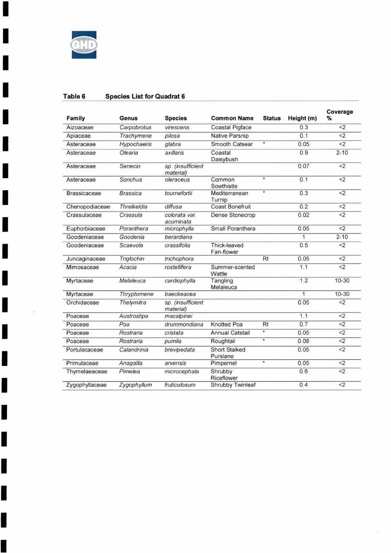
II GEE'II Table 6 Species List for Quadrat 6
I Genus Common Name
II Asteraceae Senecio 0.07 <2
Asteraceae Sonchus 0.1 <2
I <2Brassicaceae Brassica tournefortii 0.3
I Small Poranthera
I Rl
I Myrtaceae Melaleuca cardlophylla 1.2 10-30
II *
I *
I Zygophyllaceae Zygophyllum fruticulosum 0.4 <2
IIIIII
<22^
Coverage%
Thick-leavedFan-flower
10-30
PrimulaceaeThymelaeaceae
AnagallisPimelea
ThryptomeneThelymitra
arvensis microcephala
Status Height (m)0?36?i 00509
0.20^
0.05
“oT
1.1“oT0^0080^
0.05”0^
<2
<20.05TT
10^
JuncaginaceaeMimosaceae
MyrtaceaeOrchidaceae
TriglochinAcacia
CarpobrotusTrachymeneHypochaerisOlearia
ThrelkeldiaCrassula
sp. (insufficient material)_____oleraceus
diffusa colorata var. acuminata microphylla berardiana crassifolia
trichophora rostellifera Summer-scented
Wattle________Tangling Melaleuca
Coastal Pigface Native Parsnip Smooth CatsearCoastalDaisybush
CommonSowthistle_____MediterraneanTurnip________Coast BonefruitDense Stonecrop
Knotted Poa Annual Catstail RoughtailShort Stalked Purslane______PimpernelShrubbyRiceflower_____Shrubby Twinleaf
<2
<22-10
<2
<2
baeckeaceasp. (insufficient material)_____macalpinei drummondiana cristate pumila brevipedata
PoaceaePoaceae PoaceaePoaceaePortulacaceae
PorantheraGoodeniaScaevola
ChenopodiaceaeCrassulaceae
EuphorbiaceaeGoodeniaceaeGoodeniaceae
AustrostipaPoa RostrariaRostrariaCalandrinia
FamilyAizoaceaeApiaceaeAsteraceaeAsteraceae
Species virescens pilose glabra axillaris
Rl*

II QL;II Quadrat 7
Location: 246730 mE, 6862208 mN (Zone 50)
I Topography: Flat Rocks: 0%
Logs: <2 % Branches: 2-10 % Leaves: 2-10%
I Bare Ground; >70%
Soil Type: Loamy sand
I Field Vegetation Description: Open mixed Acacia scrubland
IIIIIIII .-e/i -F
IPlate 7: Vegetation located in Quadrat 7
IIIII
Vegetation Condition: 3
Other: Disturbances; weeds, grazing by kangaroos and rabbits
111
jip' -
'f • y;

IIII Table 7 Species List for Quadrat 7
I Genus<2
I 0.1 <2Asteraceae 0.1 <2Brassicaceae Brassica h 0.05 <2
I Rl 0.1 2-100.1 <2
Lauraceae C 2-10racemosaI Mimosaceae rostellifera 2-104
3 2-10
I 2-101Poaceae Roughtail 0.15 <2Portulacaceae Calandhnia 0.05 <2
I Primulaceae Pimpernel 0.15 <2Rutaceae mollis 1.3 <2Sterculiaceae ledifolia 0.3 <2
I Thymelaeaceae Pimelea microcephala 1.6 2-10
Vitaceae Clematicissus C <2Zygophyllaceae Zygophyllum Shrubby Twinleaf 1 <2I
IIIIIIIII
ShrubbyRiceflower
CassythaAcacia
angustifolium macalpinei pumila granulifera arvensis
angustissimafruticulosum
PittosporumAustrostipaRostraria
AnagallisDiplolaenaGuichenotia
TrachymeneHypochaeris Podotheca
sphaerosperma colorata Dense Stonecrop
Dodder LaurelSummer-scented Wattle
Sticky LongheadsMediterraneanTurnip
PittosporaceaePoaceae
Species pllosa glabra angustifoliumtournefortii
Chenopodiaceae DysphaniaCrassulaceae Crassula
FamilyApiaceaeAsteraceae
HeightcoverageCommon Name Status (m) %Native Parsnip 0.1Smooth Catsear *

II oil.II Quadrat 8
Location: 247071 mE, 6861844 mN (Zone 50)
I Topography: West gentle Rocks: 0%
Logs: <2 % Branches: 2-10 % Leaves: 10-30%
I Bare Ground: 30-70%
Soil Type: Sand over limestone
I Field Vegetation Description: Open mixed Acacia scrubland
Vegetation Condition: 3
IIIIIIIII
Plate 8: Vegetation located in Quadrat 8
IIIII
other: Disturbances; grazing by roos and rabbits

IIII Table 8 Species List for Quadrat 8
I Genus Common Name2-10
I <2* 0.1<2Asteraceae 1.4
Asteraceae Sonchus oleraceus <2
I <2Brassicaceae Brassica tournefortii Mediterranean Turnip *Chenopodiaceae Rhagodia 1.1 <2
<2I Dodder Laurel <2Mimosaceae rostellifera 4.5 2-10
I 1.2 2-10PoaceaePoaceae 0.0.5 <2Primulaceae Anagallis 0.1 <2
I Yellow Tailflower <2Solanaceae Anthocercis 1.42-10Sterculiaceae Guichenotia ledifolia 0.72-10Pimelea 1.5I 1.2 <2
IIIIIIIIII
0.8
Summer-scentedWattle
ThymelaeaceaeZygophyllaceae Zygophyllum
RoughtailPimpernel
0.1
AustrostipaRostraria
macalpinei pumilaarvensis var. caerulea littorea
TrachymeneHypochaerisOlearia
Native Parsnip Smooth Catsear Coastal Daisybush Common Sowrthistle
preissii subsp.obovata
Dasypogonaceae Acanthocarpus preissiiLauraceae Cassytha racemose
Acacia
Height CoverageStatus (m) %
6?O5Speciespilose glabra axillaris
microcephala Shrubby Riceflower fruticulosum Shrubby Twinleaf
FamilyApiaceaeAsteraceae

II GEBII Quadrat 9
Location: 247307 mE, 6862222 mN (Zone 50)I Topography: West gentle Rocks: 0%
Logs: <2 % Branches: 10-30 % Leaves: 10-30%
I Bare Ground: 10-30%
Soil Type: Pale sand over limestone
I Field Vegetation Description: Mixed Acacia and Proteaceae and Myrtaceae scrub heath
Vegetation Condition: 3
I other: Disturbances; ?dieback, rabbit grazing, ?fire.
IIIIIIII
Plate 9: Vegetation located in Quadrat 9
IIIII

II sailII Table 9 Species List for Quadrat 9
I Genus
IIIII Native Parsnip
III P1
II
Orange Immortelle
IIIIII
PimpernelMediterraneanTurnip
Shrubby Riceflower Blueberry Lily Common Popflower
3 oJ0 3
0.20 5 C~
0.450.45
0.4 0 9 005 C1.9’
<2 <22-10
<2
C oT”09“
oT"0.25
ProteaceaeProteaceaeRestionaceae
AcaciaWaitziaCaladenia
DioscoreaCassytha Thryptomene
OleariaPhyllanthusClematicissusTrachymeneSenecio
calycinus stylidioides macalpinei arvensistoumefortii
spathulifolia acuminatalongicauda subsp. borealis hastifoliaracemose baeckeacea
White Plume Grevillea False Boronia
WarrineDodder Laurel
Coastal DaisybushFalse Boronia
Felty BellflowerHairy Yellow Pea
1.9 oT”0 45
0.1
<2
30-70
10-30
<2
<2
%2-10
Height CoverageCommon Name Status (m)
0.150.10.20.150.050.10.3
Haloragaceae DesmocladusHemerocallidaceae Drosera
Pimelea microcephalaDianella revolutaGlischrocaryon aureumThryptomeneGrevillea
MyrtaceaeOrchidaceae Papilionaceae Poaceae Primulaceae
PhyllanthusConostylis Austrostipa AnagallisBrassica
Juncaginaceae Lauraceae Mimosaceae Mimosaceae Myrtaceae
RhamnaceaeThymelaeaceae Vitaceae
FamilyApiaceaeAsteraceaeAsteraceaeAsteraceaeAsteraceaeBrassicaceaeChenopodiaceae Leucopogon
DioscoreaceaeDroseraceae EpacridaceaeEuphorbiaceaeHaemodoraceae
glabrapreissii subsp. obovata_____axillaris calycinus angustissima pilosesp. (insufficient material) asper hu mills
baeckeacea leucopteris
Convolvulaceae HypochaerisDasypogonaceae Rhagodia
SpeciesStenanthemum intricatumAcanthocarpus preissii Bonamla roseaGompholobium tomentosumTriglochin trichophoraAcacia spathulifolia
sp. Mid West (J.S. Beard 7388)
Smooth Catsear

IIII Quadrat 10
Location: 247659 mE, 6861440 mN (Zone 50)
I Topography: South gentle Rocks: 0%
Logs: 2-10% Branches: 10-30 % Leaves: 30-70 %
I Bare Ground: 10-30 %
Soil Type: Pale sand
I Field Vegetation Description: Myrtaceous and Proteaceous scrub with Acacia
Vegetation Condition: 3
I other: Disturbances; grazing by rabbits, dieback
jf
IIIIIIII
Plate 10: Vegetation located in Quadrat 10
IIIII
a

II GUEII Table 10 Species List for Quadrat 10
I Genus Common Name
IIIII Djarnokmurd
IIIIIIIIIII
Summer-scentedWattle
MimosaceaeMyrtaceaePapilionaceae
1
1.91.4T4
10-3030-70
PoaceaeProteaceaeRestionaceae
Acacia spathulifoliaThryptomene baeckeaceaDaviesia divaricata subsp. Marno
lanulosamacalpineirecurva
axillaris hypericoides hastifolia microphylla stylidioides rostellifera
Native ParsnipSmooth Catsear Coastal Daisybush Yellow ButtercupsWarrineSmall Poranthera
AustrostipaHakeaDesmocladus asper
<2
SpeciesTrachymene pilosaHypochaeris glabraOleariaHIbbertlaDioscorea Poranthera
FamilyApiaceaeAsteraceaeAsteraceaeDilleniaceaeDioscoreaceaeEuphorbiaceaeHaemodoraceae ConostylisMimosaceae Acacia
Height CoverageStatus (m) %
0 1 zio* 0?05 <
1.3 <i <C <2005 Ol <Z5

II QL-;II Quadrat 11
Location: 249760 mE, 6859995 mN (Zone 50)I Rocks: 0%
Leaves: 10-30%
I Bare Ground: 30-70%
IIIIIIIIII
Plate 11: Vegetation located in Quadrat 11
IIIII
Vegetation Condition: 4
Other: Disturbances; ?dieback, rabbits, old clearing activities
Soil Type: Sand over deep limestone
Field Vegetation Description: Very open Banksia woodland over Myrtaceous shrubland
Topography: East Medium
Logs: <2 % Branches: <2 %

IIII Table 11 Species List for Quadrat 11
I Genus Common Name
IAristida
I 0.6 <2Epacridaceae Leucopogon
I *
*
II *
IIIIIIIIIII
10-30
2-102-10
0.4
oT”
0 10 050 05 oT'
oT”0,4
ThryptomeneMesomelaena pseudostygiaBanksia prionotes
contorta
Sand LilyAnnual Veldt Grass Blueberry Lily Purple Tassels
UrsiniaCowslip Orchid Smooth Catsear Native Parsnip
<2
2^
Acorn BanksiaBunched Kerosene Grass
Height CoverageStatus (m) %
T? o7
07
Papilionaceae JacksoniaAsteraceae UrsiniaOrchidaceae CaladeniaAsteraceae HypochaerisApiaceae TrachymenePortulacaceae CalandriniaDroseraceae DroseraHemerocallidaceae Corynotheca Poaceae Ehrharta
DianellaSowerbaea laxifloraStenanthemum intricatum
HaemodoraceaeAsparagaceae Rhamnaceae
FamilyMyrtaceaeCyperaceaeProteaceaePoaceae
glabra pilosa granulifera humilis micrantha longiflora revoluta
Species baeckeacea
sp. Mid West (J.S. Beard 7388) rigida anthemoidesflava

IIII Quadrat 12
Location: 246256 mE, 6860931 mN (Zone 50)I Topography: West medium Rocks: 0%
Branches: <2 % Leaves: 10-30%Logs: <2 %
I Bare Ground: 10-30%
Soil Type: Sand unconsolidated front dune
I Field Vegetation Description: Stabilised foredune
Vegetation Condition: 3
I other: Disturbances; fire past 10 years
IIIIIIII
Plate 12: Vegetation located in Quadrat 12
IIIII

II GHQII Table 12 Species List for Quadrat 12
I Genus2-10
I Aizoaceae 0.8 2-10Asteraceae 1.1 2-10Asteraceae Reichardia 0.4 2-10
I Asteraceae False Hawkbit 0.2 <21 2-10
0.5 10-30I 0.05 <2
0.6 2-10
I <21.1
Ehrharta 0.4 <2Poaceae
I Poaceae Ehrharta Annual Veldt Grass * 0.6 <20.1 <2*1.1 2-10
I 0.25 <2Portulacaceae
* 0.02 <2arvensislittorea 1 <2I Solanaceae Nicotiana Tree Tobacco * 0.5 <2
Urticaceae Parietaria 0.3 <2
IIIIIIIII
LamarckiaSpinifexCalandrinia
Coast Bonefruit Dense Stonecrop
PoaceaePoaceae
AnagallisAnthocercis
implexicomaaxillaris
Summer-scentedWattle____________
brevifolia subsp. Annual Veldt Grass *cuspidatalongiflora
UrospermumChenopodiaceae Rhagodia
colorata var.acuminata
Dasypogonaceae Acanthocarpus preissiiMimosaceae Acacia rostellifera
CarpobrotusTetragoniaOlearia
tingitana picroides preissii subsp. obovata diffusa
GoldentopBeach SpinifexShort Stalked Purslane______PimpernelYellow Tailflower
Height CoverageCommon Name Status (m) %Coastal Pigface 0.3Bower SpinachCoastal DaisybushFalse Sowthistle
PrimulaceaeSolanaceae
aurea longifolius brevipedata
Chenopodiaceae ThrelkeldiaCrassulaceae Crassula
glauca cardiostegia
FamilyAizoaceae
Speciesvirescens

II SUBII Quadrat 13
Location: 246049 mE. 6862008 mN (Zone 50)I Topography: Flat Rocks: 0%
Logs: 2-10% Branches: 10-30 % Leaves: 30-70 %
I Bare Ground: 2-10 %
Soil Type: Sand 50 m from beach
I Field Vegetation Description: Coastal scrub heath
Vegetation Condition: 2-3
I other: Disturbances: rabbits, fire
II
.-. BII
Be
IIII
Plate 13: Vegetation located in Quadrat 13
IIIII
Sis
1: . J :>•
CT
■Ioa
jps^aa&ttai

II GUEII Table 13 Species List for Quadrat 13
IIIIIIIIIIIIIIIII
1.3Ts T4 ^2 c“
1.6T3
Height Coverage%2-10
2^10
<2 "2^10
2-102-102-10
30-70
MelaleucaMelaleucaThryptomeneAustrostipaClematisAnthocercisZygophyllum
PhyllanthusPoranthera Cassytha Acacia
cardiophylla huttensis racemulosa macalpinei linearifolia littorea fruticulosum
False Boronia Small Poranthera Dodder LaurelSummer-scented Wattle____________Tangling Melaleuca
Yellow TailflowerShrubby Twinleaf
Common Name Status (m) Bower Spinach 0.9Native Parsnip 0.1Coastal Daisybush 1
TT oT oT c“
TTMyrtaceae Myrtaceae Myrtaceae Poaceae Ranunculaceae SolanaceaeZygophyllaceae
Family GenusAizoaceae TetragoniaApiaceae TrachymeneAsteraceae Olearia axillarisDasypogonaceae Acanthocarpus preissiiEuphorbiaceae Phyllanthus calycinusEuphorbiaceae Poranthera microphyllaLauraceae Cassytha racemoseMimosaceae Acacia rostellifera
Species implexicomapilose

II QLII Quadrat 14
Location: 247573 mE, 6860595 mN (Zone 50)I Rocks: 0%Topography: west very gentle
Logs: 0% Branches: 2-10 % Leaves: 10-30%I Bare Ground: 2-10%
Soil Type: Sand
I Field Vegetation Description: Open mixed Acacia shrubland
Vegetation Condition: 4
I other: Disturbances; grazing by kangaroos and rabbits, weeds
IIIIIIII
Plate 14: Vegetation located in Quadrat 14
IIIII

II QL;II Table 14 Species List for Quadrat 14
I Genus
III *DP
IIIII Shrubby Twinleaf
IIIIIIII
1.707TT
c
2-10<22-10
<22-10
Annual Veldt Grass Roughtail
LoranthaceaeMimosaceae
preissii rostellifera
1.5yr” ai? a?”0?05’1
PimpernelBlack BerryNightshade______Shrubby Riceflower
10-30
2-10
AustrostipaEhrhartaRostrariaCalandriniaAnagallisSolanum
asper plantagineum tournefortii boophthona terracina
macalpinei longiflora pumila granulifera arvensisnigrum
Star Cudweed Smooth Catsear Coastal Daisybush Rough Sowthistle Paterson's Curse Mediterranean Turnip * Gascoyne SpurgeGeraldton Carnation * Weed______________Wireleaf MistletoeSummer-scentedWattle
Common NameBower SpinachNative Parsnip
<2 <22-10 <22-102-10 <2 <2 <22-10 <2
Height CoverageStatus (m) %
0.05C0.020.151.60.20.40.20.90.3
AmyemaAcacia
TetragoniaTrachymene pilosaThysanotus manglesianusEuchiton sphaericusHypochaeris glabraOlearia axillarisSonchusEchiumBrassicaEuphorbiaEuphorbia
Poaceae Poaceae Poaceae Portulacaceae Primulaceae Solanaceae
FamilyAizoaceae Apiaceae AsparagaceaeAsteraceae Asteraceae Asteraceae Asteraceae Boraginaceae BrassicaceaeEuphorbiaceae Euphorbiaceae
Thymelaeaceae Pimelea microcephalaUrticaceae Parietaria cardiosteglaZygophyllaceae Zygophyllum fruticulosum
Speciesimplex icoma

IIII Releve 1
Location: 248555 mE, 6858243 mN (Zone 50)I Table 15 Species List for Reldve 1
I StatusGenus Common Name
I *DP
I Summer-scented WattleP1
IIIIIIIIIIIII
LyciumZygophyllum
MelaleucaJasminum Calandrinia AnagallisClematisAnthocercis
Tetragon laOleariaEchium
brevipedata arvensis linearifolia littorea ferocissimum fruticulosum
huttensiscalcarium
Yellow Tailflower African Boxthorn Shrubby Twinleaf
Bower Spinach Coastal Daisybush Paterson's Curse Mediterranean Turnip Barrier Saltbush
Short Stalked Purslane Pimpernel
BoraginaceaeBrassicaceae Chenopodiaceae DasypogonaceaeMimosaceae Myrtaceae Oleaceae Portulacaceae Primulaceae Ranunculaceae Solanaceae Solanaceae Zygophyllaceae
BrassicaEnchylaena Acanthocarpus preissiiAcacia rostellifera
FamilyAizoaceaeAsteraceae
Speciesimplexicoma axillaris plantagineum toumefortii tomentose

II <33^II Releve 2
Location: 0247724 mE, 6859823 mN (Zone 50)I Table 16 Species List for Rel6v6 2
I Status
I ms
IIIIIIIIIIIIII
Common NameDysentery Bush
FamilyApocynaceaeAsteraceaeLamiaceaeMalvaceaeRutaceae
GenusAlyxiaWaitziaPityrodiaAlyogyneDiplolaena
Species buxifolia podolepis loxocarpa coronopifolia mollis

IIII Releve 3
Location: 247471 mE, 6859733 mN (Zone 50)
I Field Vegetation Description: Mixed Coastal Scrubland
IIIIIIII S'. t';,
Plate 15: Releve’ 3IIIIIIII

II CEBII Table 17 Species List for Rel6v6 3
I Genus Common Name Status
II Coast Bonefruit
I P1huttensis
I *
Short Stalked PurslaneIShrubby TwinleafZygophyllum
IIIIIIIIIII
PortulacaceaeUrticaceae Zygophyllaceae
CalandriniaParietaria
Perennial Tar Vine Annual Veldt Grass
AcaciaMelaleucaThryptomene baeckeacea Commicarpus australisEhrharta brevifolia subsp.
cuspidate_____brevipedata cardiostegia fruticulosum
Thick-leaved Fan-flower Summer-scented Wattle
Coastal Pigface Bower Spinach Climbing Mulla Mulla Coastal Daisybush
MimosaceaeMyrtaceae Myrtaceae Nyctaginaceae Poaceae
CarpobrotusTetragonia PtilotusOlearla axillarisSenecio pinnatifoliusThrelkeldia diffusaAcanthocarpus preissiiScaevola crassifolia
rostellifera
FamilyAizoaceaeAizoaceae AmaranthaceaeAsteraceaeAsteraceaeChenopodiaceaeDasypogonaceaeGoodeniaceae
Speciesvirescens implexicoma divaricatus

IIII Rel6v6 4
Location: 247519 mE, 6861828 mN (Zone 50)
I Table 18 Species List for Relev6 4
I Common Name StatusGenus
I *
II
Dianella
II
PIIIIII Dog Weed
IIIII
ProteaceaeProteaceaeProteaceaeProteaceaeRestionaceae
PatersoniaAcaciaAcaciaMelaleuca
Stypandra glaucaOrthrosanthus laxus var. laxus
Yellow ButtercupsWarrine
Hemerocallidaceae HemerocallidaceaeIridaceae Iridaceae Mimosaceae Mimosaceae Myrtaceae Myrtaceae Myrtaceae Orchidaceae Orchidaceae Papilionaceae
Rubiaceae Stylidiaceae Thymelaeaceae
leucopteris preissianus vaginata kalbarriense floribunda
Slender Banksia Acorn Banksia Common Smokebush White Plume Grevillea
Native Parsnip Purple Tassels Smooth Catsear
Blueberry LilyBlind Grass Morning Iris Purple FlagSummer-scented Wattle
stylidioidessp. Wongan (K.F.Keneally 8820) re valuta
Speciespilose laxiflora glabra
PapilionaceaePoaceae
occidentalis rostellifera spathulifoliadepressa
Melaleuca huttensisThryptomene baeckeaceaCaladenia flava Cowslip OrchidThelymitra sp. (insufficient material)Isotropis sp. Shark Bay (M.E._____________ Trudgen 7170)_______Jacksonia rigidaAustrostipa macalpineiBanksia attenuateBanksia prionotesConospermum stoechadisGrevilleaLepidobolusOperculariaStylidiumPimelea
FamilyApiaceae AsparagaceaeAsteraceae Celastraceae Cyperaceae Dilleniaceae Dioscoreaceae Haemodoraceae Hemerocallidaceae
TrachymeneSowerbaeaHypochaerisStackhousia monogynaLepidosperma scabrumHibbertia hypericoidesDioscorea hastifollaConostylisCaesia

IIII Releve 5
Location: 248777 mE, 6860035 mN (Zone 50)
If 3!
IIIIIIII Plate 16:
IIIIIIII

II (lLLj’II Table 19 Species List for Relevd 5
I StatusGenus Common NameLomandra
I Brassicaceae*dubia
French Catchfly
II Dioscorea WarrineDioscoreaceae
Acacia rostellifera Summer-scented WattleMimosaceae
I Tangling Melaleuca
cosentinii
I PoaceaeProteaceae
DesmocladusRestionaceaeIoldfieldii
Pimelea floribundaI Shrubby RiceflowerPimelea microcephala
IIIIIIIII
AustrostipaBanksia
PetrorhagiaSilene
MelaleucaMelaleucaMelaleucaLupinus
DiplolaenaSolanum
aspermollis
Smooth CatsearMediterranean Turnip
Myrtaceae Myrtaceae Myrtaceae Papilionaceae
RutaceaeSolanaceae
campanae cardlophylla huttensis
macalpinei fraseri var. ashbyl
Western Australian BlueLupin
HypochaerisBrassica
glabra tournefortii
P1*
Caryophyllaceae Caryophyllaceae Casuarinaceae DasypogonaceaeDilleniaceae
ThymelaeaceaeThymelaeaceae
gallicaAllocasuarina campestrisAcanthocarpus preissilHibbertia spicata subsp. spicata
hastifolia
Speciesmaritima
FamilyAsparagaceaeAsteraceae

II QUDII Releve 6
Location: 247198 mE, 6859428 mN (Zone 50)
I Table 20 Species List for Rel6v6 6
I StatusGenus Common Name
Asteraceae axillaris
I *AsteraceaeThick-leaved Fan-flowerGoodeniaceaeDodder LaurelLauraceae racemosa
I rostellifera Summer-scented WattleMimosaceae*barbata Bearded OatPoaceae
Annual Catstailcristata
I Broom Ballartsparteus
IIIIIIIIIIII
PoaceaeSantalaceae
CarpobrotusOleariaUrospermumScaevolaCassytha Acacia Avena
picroldes crassifolia
Coastal PigfaceCoastal DaisybushFalse Hawkbit
Speciesvirescens
RostrariaExocarpos
FamilyAizoaceae

IIII Rel6v6 7
Location: 246319 mE, 6860679 mN (Zone 50)
IIIIIIIII
Plate 17: Releve’ 1IIIIIIII
-5 ■

II GIE;I
Table 21 Species List for Rel6v6 7
I Genus Common Name Status*
I AizoaceaeAsteraceaeAsteraceae *
I Goodeniaceae Scaevola Thick-leaved Fan-flowerinsulareI barbata
Bromus diandrus Great Brome *PoaceaeYellow Tailflower
I African Boxthorn *
Shrubby Twinleaf
IIIIIIIIIIIII
UrospermumChenopodiaceae Rhagodia
littorea ferocissimum
AnthocercisLycium
Urticaceae ParietariaZygophyllaceae Zygophyllum
SolanaceaeSolanaceae
MyoporumAvena
picroides preissii subsp. obovata crassifolia
cardiostegiafruticulosum
Blueberry TreeBearded Oat
Iceplant Bower Spinach Coastal Daisybush False Hawkbit
MyoporaceaePoaceae
FamilyAizoaceae
SpeciesMesembryanthemum crystalllnumTetragonia implex icomaOlearia axillaris

IIIIIII Appendix D
FaunaIFauna Conservation CodesI Threatened Fauna Database Search
I Expected and Recorded Fauna
IIIIIIIIII 61/24450/14057
IHorrocks Beach DevelopmentFlora and Fauna Survey

IIII EPBC Act Fauna Conservation Categories
II extinct in the wild,»
»
I »
»
(See Table 10)I »
IIIIIIII
»
I »
»
I »
»
»II 61/24450/14057
I
critically endangered,
endangered, or
vulnerable.
Horrocks Beach DevelopmentFlora and Fauna Survey
Listed threatened species and ecoiogicai communitiesAn action will require approval from the Environment Minister if the action has, will have, or is likely to have a significant impact on a species listed in any of the following categories;
Vuinerabie speciesAn action has, will have, or is likely to have a significant impact on a vulnerable species if it does, will, or is likely to:
lead to a long-term decrease in the size of an important population of a species, or
reduce the area of occupancy of an important population, or
fragment an existing important population into two or more populations, or
adversely affect habitat critical to the survival of a species, or
disrupt the breeding cycle of an important population, or
modify, destroy, remove or isolate or decrease the availability or quality of habitat to the extent that the species is likely to decline, or
» lead to a long-term decrease in the size of a population, or
» reduce the area of occupancy of the species, or
» fragment an existing population into two or more populations, or
» adversely affect habitat critical to the survival of a species, or
» disrupt the breeding cycle of a population, or
» modify, destroy, remove, isolate or decrease the availability or quality of habitat to the extent that the species is likely to decline, or
» result in invasive species that are harmful to a critically endangered or endangered species becoming established in the endangered or critically endangered species' habitat*, or
» interfere with the recovery of the species.
* Introducing an invasive species into the habitat may result in that species becoming established. An invasive species may harm a critically endangered or endangered species by direct competition, modification of habitat, or predation.
Criticaiiy endangered and endangered speciesAn action has, will have, or is likely to have a significant impact on a critically endangered or endangered species if it does, will, or is likely to:

IIIIII »
»
I »
IIIIIIIIIIIII 61/24450/14057
IHorrocks Beach DevelopmentFlora and Fauna Survey
Listed migratory speciesAn action will require approval from the Environment Minister if the action has, will have, or is likely to have a significant impact on a listed migratory species. Note that some migratory species are also listed as threatened species. The criteria below are relevant to migratory species that are not threatened.
An action has, will have, or is likely to have a significant impact on a migratory species if it does, will, or is likely to:
» result in invasive species that are harmful a vulnerable species becoming established in the vulnerable species' habitat*, or
» interferes substantially with the recovery of the species.
An important population is one that is necessary for a species' long-term survival and recovery. This may include populations that are:
‘Introducing an invasive species into the habitat may result in that species becoming established. An invasive species may harm a migratory species by direct competition, modification of habitat, or predation.
key source populations either for breeding or dispersal,
populations that are necessary for maintaining genetic diversity, and/or
populations that are near the limit of the species range.
‘Introducing an invasive species into the habitat may result in that species becoming established. An invasive species may harm a vulnerable species by direct competition, modification of habitat, or predation.
1. habitat utilised by a migratory species occasionally or periodically within a region that supports an ecologically significant proportion of the population of the species, or
2. habitat utilised by a migratory species which is at the limit of the species range, or
3. habitat within an area where the species is declining.
Listed migratory species cover a broad range of species with different life cycles and population sizes. Therefore, what is an ecologically significant proportion of the population varies with the species (each circumstance will need to be evaluated).
» substantially modify (including by fragmenting, altering fire regimes, altering nutrient cycles or altering hydrological cycles), destroy or isolate an area of important habitat of the migratory species, or
» result in invasive species that is harmful to the migratory species becoming established* in an area of important habitat of the migratory species, or
» seriously disrupt the lifecycle (breeding, feeding, migration or resting behaviour) of an ecologically significant proportion of the population of the species.
An area of important habitat is:

IIIIIIIIIII
•Translocating or introducing a pest species may result in that species becoming established.
I ••The Commonwealth marine area includes any airspace over Commonwealth waters
IIIIIIII 61/24450/14057
I
modify, destroy, fragment, isolate or disturb an important or substantial area of habitat such that an adverse impact on marine ecosystem functioning or integrity in a Commonwealth marine area results, or
result in persistent organic chemicals, heavy metals, or other potentially harmful chemicals accumulating in the marine environment such that biodiversity, ecological integrity, social amenity or human health may be adversely affected.
Horrocks Beach DevelopmentFlora and Fauna Survey
The Commonwealth marine environmentAn action will require approval from the Environment Minister if:
have a substantial adverse effect on a population of a marine species or cetacean including its life cycle (e.g. breeding, feeding, migration behaviour, and life expectancy) and spatial distribution, or
result in a substantial change in air quality** or water quality (including temperature) which may adversely impact on biodiversity, ecological integrity, social amenity or human health, or
» the action is taken in a Commonwealth marine area and the action has, will have, or is likely to have a significant effect on the environment, or
» the action is taken outside a Commonwealth marine area and the action has, will have, or is likely to have a significant effect on the environment in a Commonwealth marine area.
An action has, will have or is likely to have a significant impact on the environment in a Commonwealth marine area if it does, will, or is likely to:
result in a known or potential pest species becoming established in the Commonwealth marine area*, or

IIII Western Australia Wildlife Conservation Act (1950) Conservation CodesTable 14
I Conservation Code Description
Schedule 1
I Schedule 2
I Schedule 3
I Schedule 4
ITablets DEC Priority Fauna CodesI (Species not listed under the Wildlife Conservation Act <1950), but for which there is some concern).
Conservation Code DescriptionI Priority 1 Taxa with few, poorly known populations on threatened lands.
Priority 2II Priority 3
I Priority 4
IPriority 5
IIIII 61/24450/14057
I
“...fauna that is rare or likely to become extinct, are declared to be fauna that is in need of special protection.”
“...fauna that is presumed to be extinct, are declared to be fauna that is in need of special protection.”
“...birds that are subject to an agreement between the governments of Australia and Japan relating to the protection of migratory birds and birds in danger of extinction, are declared to be fauna that is in need of special protection.”
Taxa in need of monitoring. Taxa which are not considered threatened but are subject to a specific conservation program, the cessation of which would result in the species becoming threatened within five years.
“...fauna that is in need of special protection, othenwise than for the reasons mentioned [in Schedule 1 - 3]"
Taxa which are known from few specimens or sight records, some of which are on lands not under immediate threat of habitat destruction or degradation.
Horrocks Beach DevelopmentFlora and Fauna Survey
Rare taxa. Taxa which are considered to have been adequately surveyed and which, whilst being rare (in Australia), are not currently threatened by any identifiable factors. These taxa require monitoring every 5-10 years.
Taxa with few, poorly known populations on conservation lands. Taxa which are known from few specimens or sight records from one or a few localities on lands not under immediate threat of habitat destruction or degradation, e.g. national parks, conservation parks, nature reserves. State forest, vacant Crown Land, water reserves, etc.

Conservation Status
Family Genus Species Common Name EPBC Act DEC
Birds
MarineAccipitridae Haliaeetus ieucogaster White-bellied Sea-Eagle
Migratory
MarineApus pacificusApodidae Fork-tailed Swift
Migratory
MarineArdeidae Ardea alba Great Egret, White Egret
Migratory
MarineArdea ibisArdeidae Cattle Egret
Migratory
Burhinus grallariusBurhinidae Bush Stonecurlew Priority 4
Cacatuidae Calyptorhynchus latirostris Carnaby's Black-Cockatoo, Short-billed Black-Cockatoo Endangered Schedule 1
Endangered
Diomedeidae Diomedea exulans exjians Tristan Albatross Marine
Migratory
Vulnerable
Diomedeidae Thalassarche carteri Indian Yellow-nosed Albatross Marine
Migratory
Vulnerable
Diomedeidae Thalassarche cauta cauta Shy Albatross, Tasmanian Shy Albatross Marine
Migratory
61/24450/14057
Table 16 Threatened fauna occurring, or likely to occur, in the Project Area as indicated by the EPBC Act Protected Matters Search Tool and the DEC’S Threatened Fauna Database search
Horrocks Beach DevelopmentFlora and Fauna Survey

MarineThalassarche chlororhynchosDiomedeidae Yellow-nosed Albatross, Atlantic Yellow-nosed Albatross
Migratory
Falconiformes Falco peregrinus Peregrine Falcon Schedule 4
VulnerableAnousLaridae tenuirostris melanops Australian Lesser Noddy
Marine
Laridae Catharacta skua Great Skua Marine
MarineMeropsMeropidae omatus Rainbow Bee-eater
Migratory
Pomatostomidae Pomatostomus superciliosus ashbyi White-browed Babbler (western wheatbelt) Priority 4
Endangered
MacronecfesProcellariidae giganteus Southern Giant-Petrel Marine
Migratory
Vulnerable
Procellariidae Macronectes halli Northern Giant-Petrel Marine
Migratory
VulnerableProcellariidae Pterodroma mollis Soft-plumaged Petrel
Marine
Mammals
Macropodidae Macropus eugenii derbianus Tammar Wallaby Priority 5
Insects
Idiopidae Idiosoma nigrum Shield-backed Trapdoor Spider Schedule 1
61/24450/14057 Horrocks Beach DevelopmentFlora and Fauna Survey

Table 17 Expected and Recorded Fauna List, Horrocks Project Area
Status Status Status Status
Family Genus Species Common Name EPBC WCAct DEC Exotic/Domestic NatureMap Survey
Birds
Accipitridae Accipiter cirrhocephalus Collared Sparrowhawk Mi X
Accipitridae Elanus caeruleus Black-shouldered Kite Mi X
Accipitridae Haliaeetus leucogaster White-bellied Sea-Eagle Mi. Ma X
PandionAccipitridae haliaetus Osprey Mi. Ma X
Alcedinidae Streptopelia senagalensis Laughing Turtle-Dove X
AnasAnatidae superciliosus Pacific Black Duck Mi X
TadornaAnatidae tadornoides Australian Shelduck Mi X
Artamidae Artamus cinereus Black-faced Woodswallow X
Burhinidae Burhinus grallarius Bush Stone-curlew P4 X
CoracinaCampephagidae novaehollandiae Black-faced Cuckoo-shrike Ma X
CorvusCorvidae coronoides Australian Raven X
Cracticidae Cracticus tibicen Australian Magpie X
Cuculidae Cacomantis flabelliformis Fan-tailed Cuckoo Ma X
Cuculidae Chrysococcyx basalis Horsfield's Bronze Cuckoo Ma X
GrallinaDicruridae cyanoleuca Australian Magpie-lark Ma X
Dicruridae Rhipidura leucophrys Willie Wagtail X
Falconidae Falco cenchroldes Australian Kestrel Mi. Ma X
Falconidae Falco peregrinus macropus Peregrine Falcon Mi S4 P1 X
61/24450/14057 Horrocks Beach DevelopmentFlora and Fauna Survey

Status Status Status Status
Family Genus Species Common Name EPBC WCAct DEC Exotic/Domestic NatureMap Survey
Hirundinidae Hirundo Welcome Swallow Maneoxena X
Laridae Larus novaehollandiae Silver Gull Ma X
Larus pacificus Pacific GullLaridae Ma X
SternaLaridae bergii Crested Tern Ma X
Maluridae Malurus Fairy-wren Speciessp. X
Lichenostomus virescensMellphagidae Singing Honeyeater
Mellphagidae Manorina flavigula Yellow-throated Miner X
australisMotacillidae Af)thus Australian Pipit X
Oreoica gutturalisPachycephalidae Crested Bellbird X
rufivsntrisPachycephalidae Pachycephala Rufous Whistler X
Pelecanidae Pelecanus conspicillatus Australian Pelecan Ma X
PhalacrocoraxPhalacrocoracidae melanoleucos Little Pied Cormorant X
PhalacrocoraxPhalacrocoracidae sulcirostris Little Black Cormorant X
Phalacrocoracidae Phalacrocorax varies Pied Cormorant X
Psittacidae Cacatua roseicapilla Galah X
Psittacidae Platycercus Australian Ringneckzonarius X
FulicaRallidae atra Eurasian Coot X
Mammals
OwsBovidae aries Domestic Sheep + X
Canidae Vulpes vulpes Red Fox * X
Felidae Felis catus Feral Cat X
61/24450/14057 Horrocks Beach DevelopmentFlora and Fauna Survey

Q2D
Status Status Status Status
Genus SpeciesFamily Common Name EPBC WCAct DEC Exotic/Domestic Natu reMap Survey
OryctolagusLeporidae cuniculus European Rabbit X
Macropodidae Macropus Macropod speciessp. X
Macropodidae Macropus eugenii derbianus Tammar P5 X
Muridae Wus musculus House Mouse X
Sus scrofaSuidae Feral Pig X
Reptiles
CtenophorusAgamidae Dragon speciessp. X
CtenophorusAgamidae reticulatus Western Netted Dragon X
PogonaAgamidae minor minor Dwarf Bearded Dragon X
SimoselapsElapidae littoralis West Coast Banded Snake X
Gekkonidae Gehyra variegata X
Gekkonidae Nephurus man Barking Gecko X
Pygopodidae Pygopus lepidopodus Common Scaly-foot X
Scincidae Cryptobiepharus buchananii X
Amphibians
Hylidae Litoria adelaidensis Slender Tree Frog X
Hylidae Litoria moorei Motorbike Frog X
Helioporus aibopunctatusMyobatrachidae Western Spotted Frog X
Limnodynastes dorsalisMyobatrachidae Western Banjo Frog X
61/24450/14057 Horrocks Beach DevelopmentFlora and Fauna Survey

I 1
IIIIIIIIII
GHDII
©GHD 2009
II Document Status
Approved for IssueReviewerAuthorI Name Signature Name Signature Date
01/12/20090 J Foster A Nagle A Nagle
J Foster A Nagle A Nagle 09/03/20101IIII 61/24450/14057
J
This document is and shall remain the property of GHD. The document may only be used for the purpose for which it was commissioned and in accordance with the Terms of Engagement for the commission. Unauthorised use of this document in any form whatsoever is prohibited.
Horrocks Beach DevelopmentFlora and Fauna Survey
RevNo.
76 Forrest Street Geraldton WA 6530PO BOX 164 Geraldton WA 6531T: (08) 9920 9400 F: (08) 9921 7997 E: [email protected]

I I I I I I I I I I IIII I I II I I I
Annexure5Correspondence from DEC

III E>
I .■!. tei99z.Sr [email protected]
"NORTHAMPTON SHIRE COUNCIL
I11 FEB 2010I
IO*"’ PVir RiifKJC/XJ >«♦* BwsAffrrin
II Dear Hayley
IIIIIII
Sincerely,III Cc; Jerom Hurley, Department of Planning
III
; pi?‘.. ./ ■ "■
Government of Western AustraliaDepartment of Environment and Conservation
A number of the issues identified in the report are not addressed adequately in the existing structure plan. I have attached DEC’S comments in relation to this. DEC recommends that a new structure plan be developed which addresses these issues before it is adopted by the Northampton Shire and WAPC.
Proposed Structure Plan, Lot 110,112,114 and 115, Horrocks and White Cliffs Road, Flora and Fauna Survey
Ms Hayley WilliamsPrincipal PlannerShire of NorthamptonPO Box 61NORTHAMPTON WA 6535
The proponent should also be aware that the survey identifies one flora species and a number of fauna species listed under the Commonwealth Environmental Protection and Biodiversity Conservation (EPBC) Act that may be impacted by this proposal therefore it may require referral. It is the proponent’s responsibility to determine if a proposal requires referral. Please contact the Department of the Environment, Water, Heritage and the Arts Community Information Unit on 1800 803 772 for further information. Please also see the attached fact sheets regarding the EPBC act.
Please note that DEC Geraldton District has reviewed the available information in relation to nature conservation issues and potential impacts on DEC managed areas only. For guidance on managing issues on which the DEC Geraldton District does not provide site specific advice, you are referred in the first instance to the environmental planning policies and criteria for Western Australia published by WAPC, EPA, DEC and other agencies with responsibilities in environmental protection.
Midwest Region: Isl Floor, The Foreshore Centre, 201 Foreshore Drive, GeraldtonPhone: (08) 9921 5955 Fax: (08) 9921 5713
Postal Address: PO Box 72, Geraldton, Western Australia 6531 www.dec.wa.gov.au
wa.gov.au
Fite; k :: ,5-. (O
gX
I refer to our recent telephone conversation regarding the Seaview Farms Structure Plan in reference to the flora and fauna survey recently completed by GHD. The Department of Environment and Conservation (DEC), Geraldton District received a copy of the report for this survey in December 2009 and has since reviewed the document in relation to the existing structure plan, completed by Allerding and Associates in June 2008.
If you have any queries relating to this advice, please contact Catherine Page, Operations Officer on 9921 5955.
9921 5955
9921 5713
Your ref.Our ref: 2007/2860
Enquiries: Catherine Page
Phone:
Fax:
Email:
DavWRoseDistrict Manager
' Geraldton District2 February 2009

IIIII
1) General Comments
I i
IHowever, DEC considers it unlikely for Phytophthora cinnamomi to occur in the area as:
III 2) Regional Significance in relation to Beard’s Mapping
IIIIIIIIIII
Position statement 2 also states that when the EPA is assessing a proposal, where the proposal will result in a reduction below 30% of the pre-European extent, alternative mechanisms are to be put forward to address the protection of biodiversity. The current structure plan does not address this issue.
The area contains two Beard’s vegetation types. Vegetation type 129, described by Beard as bare areas and drift sand and vegetation type 359, described as Acacia and Banksia shrubland.
Further to this, the report states that only 18% of the pre-European extent of the vegetation in the shire of Northampton remains.
- There is an error on page 10. The IBRA region for the project area is listed as the Ord Victoria Plain. It is assumed that this is supposed to be the Geraldton Sandplains IBRA region, as this is the IBRA region referred to in the remainder of the report
Comments from the Department of Environment and Conservation in relation to the Flora and Fauna Survey Report, completed by GHD, November 2009
Recommendation 1 -The structure plan should address the protection of biodiversity, as per the EPA Position Statement 2.
On page 10 of the report, vegetation association 359 is listed as having 18.9% remaining of its pre-European extent, which is below the 30% threshold and Vegetation 129 is identified as having 32% of the pre European extent remaining. If further clearing occurs as a result of this proposal, it may fall below the 30% threshold
- The report states that the majority of the project area is infested with dieback {Phytophthora cinnamomi) however no evidence is presented to support this claim. Sample information would confirm the presence of this pathogen. If present, a hygiene management plan to minimise the spread of the pathogen would be required.
The EPA position statement number 2, "Protection of Native Vegetation in Western Australia," states that the threshold level below which species loss accelerates exponentially is 30% of the pre-clearing extent for that vegetation type.
Proposed Structure Plan, Lot 110,112,114 and 115, Horrocks and White Cliffs Road, written by Allerding and Associates, June 2008
l-J
i
i) There are currently no confirmed infestations of Phytophthora cinnamomi north of the Eneabba areaii) Phytophthora cinnamomi is known to be uncommon in areas containing coastal limestone.

I1
IIIIIIIIIIIIIIIIIIII
3) Regional Significance of Vegetation Types identified by GHD
GHD identified a total of 15 communities to occur within the project area. The regional significance of these communities is discussed on page 21 of the report and is examined further below.
The vegetation condition survey identified the area adjacent to White Cliffs road to be in the best condition. Much of this area is proposed to be cleared. No reference has been made in the current structure plan to the condition of the vegetation to be retained.
Recommendation 4 - Vegetation retained public open should be in the best possible condition for that vegetation community
Recommendation 2-Where the significance of the vegetation communities is unknown, communities that are uncommon in the area should be protected.
Recommendation 3- Community 4, Melaleuca huttensis heath should be retained.
4) Vegetation Condition
The report states that communities 2, 12, 13, and 15 are directly comparable with the vegetation association descriptions of Beard. The report does not directly link the vegetation communities with any of the Beards associations, but it is assumed that GHD consider vegetation community 2 to be comparable with Beards Association 129 because of it’s location in the landscape. This is conceivable, as the description for this association is more a description of the landscape values than of the vegetation. It is also assumed that GHD consider communities 12, 13, and 15 to be comparable with Beard’s vegetation association 359, because they contain Acacia and Banksia species.
Association 359 is described by Beard as "Acacia and Banksia Shrubland". Communities 13 and 15 are described by GHD as Banksia woodlands, containing Acacia species, which fits the Beard s description. Communities 13 and 15 also have a number of other species in common, however, vegetation community 12 does not contain any Banksia species and the species composition is quite different. The species associated with community 12 are more fitting of an Acacia rostellifera dominated coastal community, than a Banksia shrubland.
The report also says that the Melaleuca dominated communities over limestone do not fit any of the Beards Associations and it describes them as being relatively common in the area. However, no evidence has been provided to support this. Community 4 dominated by the priority 1 species' Melaleuca huttensis has not been recorded anywhere else.
It is however, considered plausible that communities 8 and 9 are representative of other coastal communities found in the south west of Australia, as stated in the report.
Therefore DEC considers the regional significance of vegetation communities1,3,4,5,6,7,10,11,12 and 14 to be unknown.

IIII S) Significant Flora
Declared Rare Flora (DRF)
IIIII
Priority Flora
II GHD has since provided DEC with the following information: I
IIIIIIIIII
The priority 1 flora Melaleuca huttensis was recorded from the area.The report does not state how many plants approximately occur in the area however DEC recently contacted GHD for further information regarding this.
Recommendation 5 - All of the critical habitat for the Caladenia bryceana subspecies cracens should be retained. If this is not feasible, as much as possible of this species critical habitat should be retained surrounding the known population
Recommendation 6- A management plan is to be created for the area of public open space containing the population of Caladenia bryceana subspecies cracens. The aim of this management plan should be to protect the population and minimise threats.
In order to protect this species, DEC recommends that as much as possible of community 4,Melaleuca huttensis heath be retained, as per DEC'S recommendation 3.
There is some degree uncertainty regarding the exact numbers of plants that occur within the proposal area. Further to this, little is known about the occurrence of this species outside of the project area. M.huttensis is currently only known from 11 collections. Therefore it is difficult to predict the impact this proposal will have on this species.
“Based on the size of plants and area covered by each plant, the estimate ranges from a minimum of 21,000 plants (at <2% coverage) to 735,000 plants (at 70% coverage). Likely estimate will fall somewhere in between the two. I would expect that a figure of 150,000 - 200,000 plants would be more suitable.” Joshua Foster, Senior Ecologist, GHD, via email, January 2010.
The DRF species Caladenia bryceana subspecies cracens occurs within the proposal area. There is a statutory requirement to protect this species and its critical habitat under the state Wildlife Conservation (WC) Act (1950) and the Commonwealth EPBC Act (1999). Whilst the proponent has completed a number of surveys in the area, it is difficult to accurately predict the full extent of this population, as it is an annual species which is highly sensitive to seasonal changes. Therefore DEC supports the retention of this species known critical habit. The critical habitat for this species in this area is Myrtaceae dominated shrublands over limestone. The effect the removal of critical habitat will have on this species is unknown, however a larger area will offer the known population better protection.
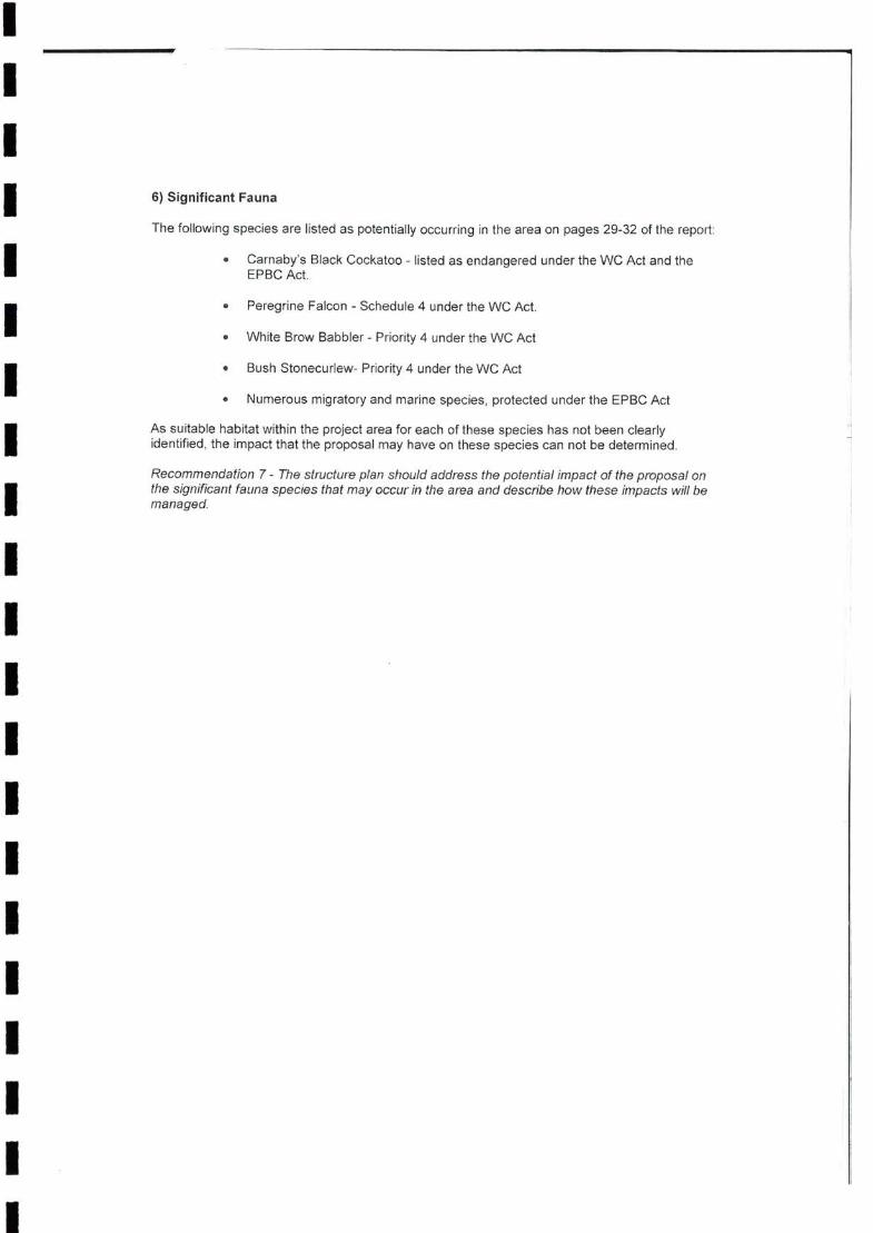
IIII 6) Significant Fauna
The following species are listed as potentially occurring in the area on pages 29-32 of the report;
IPeregrine Falcon - Schedule 4 under the WC Act.I White Brow Babbler - Priority 4 under the WC Act
Bush Stonecurlew- Priority 4 under the WC ActI Numerous migratory and marine species, protected under the EPBC Act
IIIIIIIIIIIIII
Recommendation 7 - The structure plan should address the potential impact of the proposal on the significant fauna species that may occur in the area and describe how these impacts will be managed.
As suitable habitat within the project area for each of these species has not been clearly identified, the impact that the proposal may have on these species can not be determined.
1i
Carnaby’s Black Cockatoo - listed as endangered under the WC Act and the EPBC Act.

Annexure6 Vegetation & Flora Management Plan
I I I IIIII I I I I I I I I I I I I I

III
CLIENTS I PEOPLE I PERFORMANCE
IIIIIIIIIIIIIIIIII

III D!i J- i
IContentsI
11. IntroductionI 1.1
I 32. Background Information
II 73. Vegetation
II
104. Flora
II 145. References
II 6
Table 218I
I Proposed Areas for the Retention of Vegetation 16
II
61/25241/14425
II
12
Baseline Vegetation, Flora and Fauna Studies
GHD Response to DEC Letter
April Stakeholder Meeting
On-site Confirmation
General Principles
Management of Cleared Vegetation
Planting Guide
Weed Control
4.14.24.3
2.12.22.3
2.4
3.1
3.2
3.3
3.4
Project Background
1.2 Purpose and Scope
101112
3
4
4
4
7778
Examination of Areas Proposed for Retention of Vegetation
Vegetation and Flora Management Plan for the Project Area
Horrocks Beach DevelopmentVegetation and Flora Management Plan
Table IndexTable 1
Figure IndexFigure 1
Significant Flora
Potential Impacts
Management Strategies
LLi

IIIIIIIIIIIIIIIIIII
61/25241/14425
II
Horrocks Beach Development Vegetation and Flora Management Plan
AppendicesA FiguresB Vegetation and Flora Management Plan

IIII
1. IntroductionI1.1
IIIIIIIIIIIIII
1
II
A number of recommendations proposed by the DEC for examination in this management plan include:
» Recommendation 1 - The structure plan should address the protection of biodiversity, as per the ERA Position Statement 2.
I Recommendation 2 - Where the significance of the vegetation communities is unknown, communities that are uncommon in the area should be protected.
» Recommendation 3 - Community 4, Melaleuca huttensis heath should be retained.
» Recommendation 4 - Vegetation retained public open should be in the best possible condition for that vegetation community.
» Recommendation 5 - All of the critical habitat for the Caladenia bryceana subspecies cracens should be retained. If this is not feasible, as much as possible of this species critical habitat should be retained surrounding the known population.
» Recommendation 6 - A management plan is to be created for the area of public open space containing the population of Caladenia bryceana subspecies cracens. The aim of this management plan should be to protect the population and minimise threats.
GHD Pty Ltd (GHD) completed a Vegetation, Flora and Fauna Survey for the proposed development site - Lots 110, 112, 114 and 115 at Horrocks for Seaview Farms in August 2009. The Department of Environment and Conservation (DEC) consequently reviewed the proposed structure plan completed by Allerding & Associates (June, 2008) and identified a number of issues not adequately addressed in the existing structure plan.
It was recommended by the DEC in a letter dated the 2"“ February 2010 (DEC, 2010), that a new structure plan be developed which addresses the identified issues before it is adopted by the Shire of Northampton and the WAPC.
Project BackgroundThe Shire of Northampton has identified Horrocks as a location that will undergo significant future population growth. Horrocks is located on the Mid-West coast of Western Australia within the Shire of Northampton, approximately 20 km west of Northampton and approximately 50 km north of Geraldton (GHD, 2010: Figure 1)).
To provide for the anticipated population growth in Horrocks, Allerding & Associates prepared a proposed structure plan for endorsement by the Shire of Northampton and the Western Australian Planning Commission (WAPC) in June 2008. The land subject to this Structure Plan includes Lots 110, 112, 114 and 115 Horrocks and White Cliffs Road.

III 123
I1.2
IIIIIIIIIIIIIII 61/25241/14425 2
II
The recommendations have been previously addressed in a GHD (2010) response to the comments from the DEC letter (dated 2'*' February 2010). These responses will be adapted in this management plan such that this plan can be used as a stand-alone document.
Purpose and ScopeThis Vegetation and Flora Management Plan addresses these recommendations and is proposed for inclusion in an updated structure plan for the subject land.

IIII
Background Information2.I
2.1
I»
I»
I »
I »
I »
I 2.1.1
I »
I »
I »
»II »
I »
I »
I 61/25241/14425 3
II
Larry Smith Planning (2009). Horrocks Beach Expansion Strategy: Draft for Public Discussion. Unpublished report for Shire of Northampton, May 2009.
GHD Pty Ltd (2010). Horrocks Beach Development: Flora and Fauna Survey. Unpublished report for Seaview Farms, March 2010.
Maunsell (2004). Desktop Environmental Assessment for Horrocks Structure Planning. Unpublished report for Hille, Thompson and Delfos Surveyors and Planners, August 2004.
Connell Wagner (2006). Horrocks Spring Vegetation Survey, Seaview Farms. Unpublished report by Dingle & Bird Environmental, 26 October 2006.
ENV (2008 various). Letter reports detailing outcomes of surveys undertaken to locate Caladenia bryceana subsp. cracens. Unpublished letter reports for Seaview Farms.
Vegetation and Flora outcomes
The major vegetation and flora outcomes of these studies were:
Baseline Vegetation, Flora and Fauna StudiesA number of studies have been completed within the Project Area, namely:
The vegetation of the Project Area is identified by Beard (1976) is considered to be Depleted or Vulnerable, with 32% and 18.9% of the pre-European extent considered to be remaining in the Geraldton Sandplains Interim Biogeographic Regionalisation for Australia (IBRA) region (Shepherd, 2005);
A total of 15 vegetation types were recorded from the Project Area, the majority of which fall in to the broad-scale mapping of Beard (1976);
No Threatened or Priority Ecological Communities were recorded from the Project Area;
Vegetation condition throughout the Project Area ranged from Condition 1-2 {Pristine or Nearly So - Excellent) to Condition 6 {Completely Degraded). The main disturbance factor was from historical clearing for the purpose of agricultural activities;
A total of 221 flora taxa from 72 families were recorded from the Project Area, representing a medium to high level of diversity;
One Declared Rare Flora species {Caladenia bryceana subsp. cracens) was recorded during the field survey at a known location. This location is proposed to be protected as part of Public Open Space. No other DRF were recorded from the Project Area;
One Priority 1 species {Melaleuca huttensis) was recorded from the Project Area. This taxon was dominant across the Project Area and was also recorded to the

IIIII »
»III
2.3
III
2.4 On-site ConfirmationIII »
III »
II 61/25241/14425 4
II
Following the Stakeholder meeting, an on-site examination of the areas proposed for the retention of vegetation was undertaken. Members attending the on-site confirmation were from GHD Pty Ltd, the DEC (Geraldton) and Seaview Farms.
north and south of the Project Area. No other Priority Flora species were recorded from the Project Area;
No other significant plants species were recorded from the Project Area;
A total of 40 weed species were recorded from the Project Area, dominated by grasses and associated pasture species. Three Declared Plants and one Weed of National Significance were recorded from the Project Area.
April Stakeholder MeetingThe majority of the DEC Recommendations were examined during a stakeholder meeting on the 15"^ of April 2010. Stakeholders attending the meeting were from Seaview Farms; the Shire of Northampton, GHD Pty Ltd, the DEC (Geraldton), and Allerding & Associates.
The outcome of the Stakeholder meeting was the production of a map detailing areas proposed to be set aside for the purposes of retaining vegetation, habitat and locations of significant flora and habitat for significant fauna.
The boundaries of areas proposed for the retention of vegetation were confirmed and mapped (Figure 1). These areas are examined in more detail in Table 1, and the following comments are considered valid;
Area 1 covers the largest proportion of vegetation proposed to be retained. This area was mapped with Catherine Page (DEC Geraldton) and Seaview Farms in early May 2010 using a hand-held GPS, and maps used produced for the GHD Flora and Fauna survey. Boundaries used for this area incorporated existing cleared firebreaks. Area 1 contains the best condition vegetation; Melaleuca huttensis heath vegetation type; a known location and habitat of the Declared Rare Flora (DRF) Caladenia bryceana subsp. cracens' known location and habitat for the Priority 1 Melaleuca huttensis, and direct linkage to a reserve vested in the Shire of Northampton.
Area 2 includes a small Eucalyptus grove on shallow (exposed limestone) soils. Seaview Farms indicated that they were unlikely to include areas where soils were as shallow as this for housing due to geotechnical issues. Seaview Farms indicated that there were other areas similar to this particularly those closer to the cliff edge (vested in the Shire of Northampton) west of the Project Area. Seaview
2.2 GHD Response to DEC LetterIn the response to the DEC’S Letter (dated 2"*^ February 2010), GHD (2010a) addressed the Recommendations proposed by the DEC.

IIIII »
III »
I »
I»I
IIIIIIII 561/25241/14425
II
Area 4 is a relatively degraded area of vegetation. It contains known locations and habitat of the Priority 1 species Melaleuca huttensis. Seaview Farms indicated that this area is considered to be a useful buffer for a proposed caravan park that may be situated on the north side of Area 4.
Area 5 includes Banksia woodland and an Allocasuarina grove on the eastern side of the area. Seaview Farms has indicated that any potential clearing in this area for residential purposes will be minimal and limited to building envelopes (and required infrastructure).
Areas 6 and 7 are Banksia woodland and have been included as areas preferred to be retained to the potential to support significant fauna.
The following table indicates the merits of the areas selected (Table 1).
Farms indicated that some of these areas would also be likely to be included in public open space.
Area 3 is a corridor approximately 100 - 150 m wide, providing a stepping stone corridor between existing Shire of Northampton open space and a large area of vegetation (Area 4) to the east of White Cliffs Road. Area 3 has the potential to be shifted (north or south) depending on the final layout of the proposed town centre at the conjunction of the proposed Mitchell Street extension and White Cliffs Road The size of Area 3 will not be reduced as part of any shift. Both the DEC and Seaview Farms have agreed that Area 3 will provide a vegetated corridor between residential areas to the south and the residential area to the north.

Examination of Areas Proposed for Retention of VegetationTable 1
Area Size Vegetation Community Fauna Corridor
1 3.6 Least Concern Yes Yes Yes Yes No
Eucalyptus Grove2 0.8 Least Concern Excellent No No Yes Yes No
Least Concern3 1.5 Yes No Yes Yes No
Least Concern Degraded No4 4.7 No Yes Yes No
5 38.8 Least Concern; ?Yes No Yes Yes Yes
Vulnerable
Allocasuarina grove
Vulnerable Good No No Yes Yes Yes6 5.8
7 10.7 Vulnerable Good No No Yes Yes Yes
6
Protection of Biodiversity (Beard Vegetation Associations)
Melaleuca cardiophylla scrub
Melaleuca cardiophylla scrub
Melaleuca cardiophylla sc'ub
Mixed Open Acacia scnjb,
Mosaic of low open Banksia woodland and mixed Myrtaceous scrub
Very Open Banksia woodland over Myrtaceous scrub
VegetationCondition
Habitat for DRF
No - vegetation remnant (link as stepping stone)
No - vegetation remnant (link as stepping stone)
Very Good - Excellent
Location of DRF
Habitat for Significant Fauna (from GHD, 2010)
Very Open Banksia woodland over Myrtaceous scrub
Yes - also linked via Shire of Northampton open space to west
Yes - to adjacent bushland north and east out of Project Area
Melaleuca hutlensis heath;
No - vegetation remnant (link as stepping stone)
Excellent - Very Good
Yes - also linked via Shire of Northampton open space to west
Yes - also linked via Shire of Northampton open space to west
Good - Very Good
Melaleuca huttensis heath;
Habitat of Priority Flora
Location of PriorityFlora

IIII
3. VegetationI
3.1
II
»
I »
»
I I
»
I »
II»
I3.2
III
3.3
IIII
761/25241/14425
II
Horrocks Beach Development Vegetation and Flora Management Plan
Where non-local plants are to be used as ornamental plantings, Water Wise species are strongly suggested.
Planting will combine a number of methods, including: hydromulching/seeding, tubestock planting, jute matting, and/or direct seeding. The use of tube-stock is generally preferred and could be combined with advanced plantings in larger pots to create an instant effect.
Management of Cleared VegetationGreen waste includes trees, bushes and undergrowth generated from clearing activities. Green waste will be utilised where possible, to minimise the amount of waste requiring disposal. It is suggested that seed material should be salvaged where possible prior to the clearing of vegetation. Firewood timber will be removed from site for use. A proportion of the vegetation will be mulched or chipped and stockpiled for use in rehabilitation. Green waste that cannot be milled, mulched or chipped due to excessive sand, rock or other impediment, will be stacked and burnt.
progressively rehabilitating and monitoring disturbed areas with native vegetation where appropriate; and
raising the awareness of the workforce about conservation issues through environmental awareness training.
Planting Guide
Local provenance species should be utilised for street-scaping and landscaping purposes where possible, and utilised in areas proposed for rehabilitation.
General PrinciplesApproximately half of the Project Area has been historically cleared for agricultural purposes, with the remainder occurring as remnant native vegetation.
The Project will be designed, constructed and operated to minimise the impacts on remnant vegetation by:
avoiding clearing of native vegetation where possible, particularly of large trees;
defining the area to be cleared on maps and supervising clearing activities (see Figure 1 - note: areas to be finalised by a redeveloped structure plan;
confining temporary work areas to previously disturbed areas, where practicable:
parking vehicles and machinery in designated areas;
ensuring that effective dust control measures are implemented;
retaining topsoil, subsoil, root stock and cleared vegetation in designated areas for use in rehabilitation;
f EH'

III . ■ SI,'
VlilO
IIII
3.4 Weed ControlII
»
I»
I »
»
I integrate the weed control program with a potential bushland restoration program.»
I 3.4.1
II Acceptable methods may include:
»
I »
I »
II
861/25241/14425
II
Displaced weed material is to be disposed of off site in an appropriate, approved location, where there is no potential of seed dispersal. Where areas of ground are
Mechanical Removal including bulldozing, blade ploughing, brushcutters, slashers, mowers etc.
Horrocks Beach DevelopmentVegetation and Flora Management Plan
Weed Control Techniques
In areas proposed for retention of vegetation, identified weed species should be removed where possible, taking care not to dislodge seeds, off cut limbs, or leave rootstock in the ground. Weed removal should be timed to minimise weed germination and seed dispersal. Care should be taken to minimise disturbance to existing juvenile natives and any disturbance to the soil.
The management of weeds throughout the Project Area should form part of any vegetation management plan. This is to ensure the greatest protection of remnant vegetation, and minimise the spread of weed species. Suggested objectives for weed control are to:
On larger woody weeds, cutting the trunk and poisoning the remaining stump with concentrated glyphosate herbicide.
Spraying actively growing leaves with glyphosate herbicide.
Hand removal of the entire plant taking care not to leave plant material or dislodge
During plant establishment the landscape works should be checked regularly for plant health and weed invasion. Regular inspections will reduce the potential for minor infestations becoming major problems. Weed control and ongoing plant maintenance will be carried out by the landscape contractor for a period of 12 months. All rubbish related to landscape works is to be removed by the landscape contractor before it is allowed to accumulate. During the maintenance period the contractor shall undertake the following (as required): regular watering, weeding, mulching and other activities to promote healthy growth and the replacement of any dead or dying plants within this period.
»seeds.
identify and control existing weeds with the highest priority for control - e.g. noxious weeds such as Athel Pine (Tamarix aphylla). Paterson’s Curse (Echium plantagineum) and Doublegee (Emex australis)',
where possible, prevent introduction of additional weed species;
where possible, prevent further encroachment of weeds into bushland areas;
minimise any detrimental effects of a weed control program on native vegetation; and

IIIIIIIIIIIIIIIIIII
961/25241/14425
II
Horrocks Beach Development Vegetation and Flora Management Plan
disturbed from the weed removal, the soil is to be tamped into place and covered with site leaf litter or site mulch (free from weed seed) to avoid erosion.

IIII
4. FloraI
4.1
II 4.1.1
IIIIIIIIII Plate 1 Basal leaf of a Caladenia bryceana subsp. cracens
II
1061/25241/14425
II
Preferred habitat for this taxon within the vicinity of the Project Area is low heath over limestone hills. The vegetation types within the Project Area considered to provide suitable habitat include Vegetation Types 4, 5, 7, 10 and possibly 11 (GHD, 2010a).
Horrocks Beach DevelopmentVegetation and Flora Management Plan
Significant FloraWithin the Project Area there are two flora taxa of conservation significance: the Declared Rare Flora (DRF) orchid Caladenia bryceana subsp. cracens, and the Priority 1 Melaleuca huttensis.
Caladenia bryceana subspecies cracens (Declared Rare Flora)
The DRF orchid is only known from one location (Area 1, Figure 1). This taxon was recorded from shallow soils over limestone within the Melaleuca huttensis heath. A maximum of seven plants have been recorded from this location.
■ - i '

IIII
4.1.2
IIIIIIIIII Plate 2 Melaleuca huttensis (foreground) shrub
4.2 Potential ImpactsI4.2.1 Land Disturbance
ILoss of individual plants;
I Loss of habitat;
Soil erosion;
I Weed invasion and establishment; and
Habitat fragmentation.
I61/25241/14425 11
II
Horrocks Beach DevelopmentVegetation and Flora Management Plan
The area of land to be disturbed as part of the proposed development has yet to be finalised. The potential impacts arising from land disturbance include:
Melaleuca huttensis (Priority 1)
The Priority 1 Melaleuca huttensis is widely distributed within and adjacent to the Project Area (see GHD, 2010). An estimate of population size indicate that there may be 150,000 - 200,000 plants within the Project Area. Habitat for this species was variable, recorded from locations of shallow soil over limestone within low heath and scrub, to deeper sands associated within Banksia woodlands. This taxon was widely observed across the Project Area (and beyond) including from relatively degraded areas; near coastal situations (see Plate 2); and vegetation in excellent condition.

III \\ ■»; J
IWeed Invasion4.2.2
IIII 4.2.3 Introduced Fauna
II 4.3
IIIIIIIII
61/25241/14425 12
II
During the development of the Project Area the following management strategies are suggested:
The planning process for the proposed development of the Project Area have led to the demarcation of areas of vegetation and associated habitat to be retained (Figure 1). It is anticipated that within these areas, disturbance to natural vegetation will be minimised.
Weed species may impact on the biodiversity of the Project Area by reducing the viability and robustness of populations of conservation-significant flora species. The composition of the vegetation types may also be impacted by weed species through competition, which often results in a simplified (reduced) vegetation type.
A large proportion of the Project Area has been historically disturbed from agricultural activities, which have deliberately (and accidentally) introduced plant species palatable to livestock (see Section 3.4). The spread of such taxa along firebreaks and roadsides within the Project Area is relatively common.
Introduced fauna species in natural ecosystems have the potential to impact on flora species resulting in the decline of the invaded flora community. Within the Project Area the impact from feral pigs and rabbits was relatively common, with disturbance to soil and vegetation evident. Disturbance from introduced fauna can alter the vegetation structure and enhance the likelihood of invasion of weed species.
Horrocks Beach DevelopmentVegetation and Flora Management Plan
Management StrategiesSurveys for the presence of conservation significant flora species have been undertaken. Population size, location and preferred habitat have been mapped.
Vegetation retention zones to be clearly marked and sign-posted;
Minimal disturbance to the areas not required for the Project Area development;
Appropriate use of fencing of the location (and associated habitat) of the DRF Caladenia bryceana subsp. cracens to be undertaken;
No unauthorised entry to be allowed into the vegetation retention zones;
No unauthorised off-track driving;
Use of local provenance seed (particularly Melaleuca huttensis) and areas set aside for rehabilitation and landscaping;
Land disturbance requirements will be included in contracts with all earthmoving and land clearing contactors;
Training on the identification, location and reporting of conservation significant flora taxa will be included in any environmental induction and environmental awareness sessions;

IIII
I
I I
I »
IIIIIIIIIIIII
1361/25241/14425
II
Training on land clearing procedures will be included in any environmental induction and environmental awareness;
An appropriate fire management plan should be put in place during the development of the Project Area to minimise the risk to vegetation and conservation significant flora.
A conservation significant flora identification guide will be made available to development personnel;
Horrocks Beach Development Vegetation and Flora Management Plan

IIII
5. ReferencesIIIIIIIIIIIIIII
61/25241/14425 14
II
GHD Pty Ltd (2010a). Horrocks Development - Structure Plan Support: GHDResponse to DEC Letter. Unpublished Report for Seaview Farms, March 2010.
Maunsell (2004). Desktop Environmental Assessment for Horrocks Structure Planning. Unpublished report for Hille, Thompson and Delfos Surveyors and Planners, August 2004.
ENV (2008 various). Letter reports detailing outcomes of surveys undertaken to locate Caladenia bryceana subsp. cracens. Unpublished letter reports for Seaview Farms.
Connell Wagner (2006). Horrocks Spring Vegetation Survey, Seaview Farms. Unpublished report by Dingle & Bird Environmental, 26 October 2006.
GHD Pty Ltd (2010). Horrocks Beach Development: Flora and Fauna Survey. Unpublished report for Seaview Farms, March 2010.
Larry Smith Planning (2009). Horrocks Beach Expansion Strategy: Draft for Public Discussion. Unpublished report for Shire of Northampton, May 2009.
Horrocks Beach DevelopmentVegetation and Flora Management Plan

IIIIIII Appendix A
I Figures
IIIIIIIIIII
61/25241/14425
II
Horrocks Beach DevelopmentVegetation and Flora Management Plan
‘ ' I

247.000 250.000
--X--=2i
Locality Map5
KALBAMU
§<£>■
24’.000 248.500 250.000
Priority 2 - Poorty Known Taxa
Priority 3 - Poorty Known Taxa □Priority 4 - Rare Taxa
600 750
Seaview Farm
CLIENTS (people I PERFORMANCE
!■
61-25241A28 MAY 2010
MetresMap Projection: Transverse Mercator
Horizontal Datum: Geocentric Datum of Australia (GDA)Grid: Map Grid of Australia 1994, Zone 60
AAAAA
Seaview FarmStructure Plan Assistance
Area For Minimal Clearing- Building Envelopes Areas Preferred To Be Retained As Well Minimum Areas Proposed For Retention (i.e. no clearing)
i
I
0 75 150Job Number
RevisionDate
INDIAN OCEAN
Proposed Areas ForRetention Of Native Vegetation
OJ8H2524HGiSttiap.iMXDi8i25Z4i_tioi.mxd GHD House, 239 Adelaide Terrace Perth WA 6004 T61 86222 8222 F61 86222 8555 [email protected] Wwww.ghd.com.aue 2010. While GHD has taken care to ensure the accuracy of this product, GHD and DEC. LANDGATE (SLIP) make no representations or warranties about its accuracy, completeness or suitability for any particular purpose. GHD and DEC, LANDGATE (SLIP) cannot accept liability of any kind (whether in contract, tort or otherwise) for any expenses, losses, damages and/or costs (including indirect or consequential damage) which are or maybe incurred as a result of the product being inaccurate, incomplete or unsuitable in anyway and for any reason.Data Source: GHD: Retention Areas • 20100527, Study Area - 20090820; DEC: Declared Rare and Priority Aora - 20090824; Landgate: Hutt 2006 Mosaic - 20100527, Roads -20100527. Created by; kdralu
*.l' i' ;
1:15,000 (at A3) 300 450
>F- A-
» •
LEGENDO Place Name Declared Rare & Priority Species Reads Retention Areas
(R) Declared Rare Flora - Extant Taxa [ J Study Area
Priority 1 - Poorly Known Taxa
TO

IIIIIII Appendix B
I Vegetation and Flora Management Plan
IIIIIIIIIII
61/25241/14425
II
Horrocks Beach DevelopmentVegetation and Flora Management Plan

Table 2 Vegetation and Flora Management Plan for the Project Area
Reference No. Management Measure Phase of Project
1.1 Pre-Construction
1.2 Pre-Construction
1.3 Pre-Construction
1.4 Construction
1.5 All phases
1.6 Large trees should be retained where possible. Construction
1.7 Lay-down areas will be constructed on previously disturbed areas. Construction
1.8 Pre-construction
61/25241/14425
Vegetation communities in the best possible condition will be retained in accordance with the Vegetation and Flora Management Plan.
The retention of fauna corridors within the Project Area will be made through the retainment of the vegetation communities identified in the Vegetation and Flora Management Plan.
Vegetation clearing will be undertaken in accordance with an approved Construction Environmental Management Plan (CEMP).
Horrocks Beach DevelopmentVegetation and Flora Management Plan
Habitat for conservation significant flora will be retained in accordance with the Vegetation and Flora Management Plan
The relevant staff will be inducted into the requirements of the Vegetation and Flora Management Plan and the Construction Environmental Management Plan. The objectives of the awareness training include:
» Vegetation and Flora requiring protection;
» Risk of encountering significant flora and actions to be taken;
» Weed management practices; and
» Vegetation and flora hygiene practices.
All staff, contractors and field personnel will meet all requirements of the Wildlife Conservation Act 1950.

IIIIIIIIIIII GHD
I©GHD 2010
II Document Status
t
Approved for IssueReviewerAuthor
DateName Signature Name SignatureI J Foster0 M Scott J Foster
J Foster J FosterA M Scott
III
61/25241/14425
II
This document is and shall remain the property of GHD. The document may only be used for the purpose for which it was commissioned and in accordance with the Terms of Engagement for the commission. Unauthorised use of this document in any form whatsoever is prohibited.
RevNo.
Horrocks Beach DevelopmentVegetation and Fiora Management Plan
76 Forrest Street Geraldton WA 6530PO BOX 164 Geraldton WA 6531T: (08) 9920 9400 F: (08) 9921 7997 E; [email protected]

Annexure7Fauna Management Plan
I I I I I IIIIIII I IIIIIIII

II CLIENTS I PEOPLE ^PERFORMANCE
IIIIIIIIII
Seaview FarmsIIII
August 2010
IIIIIIIIIIIIII
IIIIII » INFRASTRUCTURE | MINING & INDUSTRY | DEFENCE | PROPERTY & BUILDINGS | ENVIRONMENT
II
Horrocks Beach DevelopmentFauna Management Plan

II aiioI
ContentsII 11. Introduction
II 22. GHD Reconnaissance Fauna Survey
I163. Fauna Impacts and Management MeasuresI 3.1
I 18References4.
I3I
14
I Table 3
Table 4IIIIIII 61/25241/14312
I
2.12.22.3
1.11.21.3
Project BackgroundPurpose and ScopeObjective of the Plan
Habitat Types Recorded in the Project AreaMigratory and Marine Species listed for the Project Area on the EPBC Protected Matters Search ToolExpected and Recorded Fauna List, Horrocks Project AreaFauna Management Plan for the Project Area
Locality MapProject Area Fauna Habitat Types
2021
2327
2226
1616
277
111
Habitat Types and Habitat LinkagesRecorded and Expected Fauna Species Significant Fauna Risk Assessment
Table IndexTable 1Table 2
Figure IndexFigure 1 Figure 2
Horrocks Beach DevelopmentFauna Management Plan
Potential Fauna Impacts3.2 Management Measures
AppendicesA Expected and Recorded FaunaB Fauna Management Plan

IIII 1. Introduction
I 1.1
IIIIIIII
1.2
II 1.3
IIIII 161/25241/14312
I
One of the recommendations (Recommendation 7) proposed by the DEC was that “the structure plan address the potential impact of the proposal on the significant fauna species that may occur in the area and describe how these impacts will be managed”.
Horrocks Beach DevelopmentFauna Management Plan
Project BackgroundThe Shire of Northampton has identified Horrocks as a location that will undergo significant future population growth. Horrocks is located on the Mid-West coast of Western Australia within the Shire of Northampton, approximately 20 km west of Northampton and approximately 50 km north of Geraldton (Figure 1).
Objective of the Plan
The Horrocks Beach Development Project involves the clearing of remnant native vegetation in a predominantly rural farming and residential landscape. This Fauna Management Plan outlines the procedures for minimising impacts on fauna and the management measures to be implemented for the Project.
GHD Pty Ltd (GHD) completed a Vegetation, Flora and Fauna Survey for the proposed development site - Lots 110, 112, 114 and 115 at Horrocks for Seaview Farms in August 2009. The Department of Environment and Conservation (DEC) consequently reviewed the proposed structure plan completed by Allerding & Associates (June, 2008) and identified a number of issues not adequately addressed in the existing structure plan.
It was recommended by the DEC in a letter dated the 2"'^ February 2010 (DEC, 2010), that a new structure plan be developed which addresses the identified issues before it is adopted by the Shire of Northampton and the WAPC.
Purpose and ScopeThis Fauna Management Plan addresses this recommendation and is proposed for inclusion in an updated structure plan for the subject land.
To provide for the anticipated population growth in Horrocks, Allerding & Associates prepared a proposed structure plan for endorsement by the Shire of Northampton and the Western Australian Planning Commission (WAPC) in June 2008. The land subject to this Structure Plan includes Lots 110, 112, 114 and 115 Horrocks and White Cliffs Road.

II
-.223II 2. GHD Reconnaissance Fauna Survey
IIII
2.1 Habitat Types and Habitat Linkages
I 2.1.1
III 5. Mixed Coastal Scrub on Sand; and
IIIIIIII 261/25241/14312
I
Based on the field survey, habitat exists for a diverse range of fauna species in the Project Area. However, the majority of habitat is somewhat degraded due to the historical clearing undertaken for agricultural purposes. Weed species have invaded a large proportion of the remaining vegetation within of the Project Area, and has opened out the scrub and woodland areas.
GHD (2010) completed a reconnaissance fauna survey concurrently with a vegetation and flora survey for the proposed development site - Lots 110, 112, 114 and 115 (the Project Area) at Horrocks for Seaview Farms in August 2009.
Horrocks Beach DevelopmentFauna Management Plan
Better quality habitat is restricted to smaller areas, particularly limestone dominated heaths, and areas to the north of the Project Area, which remain contiguous with other, larger habitat outside the Project Area. Remaining habitat, particularly the open woodland areas are small and isolated, restricting movement to larger fauna and bird species. Leaf litter is present throughout the Project Area due to age since last fire, which is suitable for small mammals and reptile species.
The habitat types located in the Project Area are considered to be relatively common in the local area, and similar fauna habitat exists in the areas surrounding the Project Area. Better quality, more extensive habitat occurs to the north of the Project Area.
3. Open Acacia scrubland;
4. Mixed Low Scrub / Heath on Limestone;
6. Open Banksia Woodlands over Low Scrub / Heath.
These habitat types are shown in Table 1, and are mapped in GHD (2010) Figure 7 (included here).
1. Cleared/Degraded;
2. Mobile Sand Areas;
The purpose of the survey was to undertake an appropriate examination and description of the existing environment and provide information to the DEC to assist in the approvals process.
A summary of findings from this survey with regards to fauna is provided in Sections 2.1 to 2.3.
Habitat TypesSix main fauna habitat types were identified within the Project Area as follows:

IIII Habitat Value
IIIIIIIII
Table 1 Habitat Types Recorded in the Project Area
I PhotoHabitat Type
IIIIII 361/25241/14312
I
I
Some of the taller trees have value as potential nesting habitat; however, no hollows were observed in the trees on this site, and as a result do not provide habitat to significant fauna such as the Black-Cockatoo species. The Banksia woodlands may, however, provide some food resources for these species during foraging.
Horrocks Beach DevelopmentFauna Management Plan
A total of six (6) habitats were recorded in the Project Area (GHD, 2010). Photographs of habitat types are displayed in Table 1.
1. Cleared / Degraded; includes open fields and pasture, loads, and firebreaks
The habitats west of White Cliffs Road along the limestone ridge, and the Banksia woodland in the north-east corner are considered to hold the highest habitat values of the site. This is primarily due to vegetation being in good condition, and, in the northeast corner, direct linkage to adjacent bushland.
There are large areas in the Project Area that are completely degraded, and offer little habitat value. These disturbed areas are located primarily in the centre of the Project Area associated with agricultural activities. This area has created edge effects, with weed invasion into habitat areas along the White Cliffs Road and Banksia woodland areas.
2.1.2Where landscapes have been highly modified through land clearing for agricultural activities and urbanisation, extensive fauna habitat loss has resulted. As a consequence, remaining remnants of native vegetation are of high importance. Trees, especially mature specimens, provide feeding and breeding habitat, and may be important locations for refuge. A healthy and diverse understorey is important habitat for mammals and reptiles. The survey area also has a number of microhabitats that would be utilised by reptile species, such as areas of thick leaf litter, logs and loose sand.

II
"t ■'
II Habitat Type Photo
II
2. Mobile Sand Areas
IIII 3. Open Acacia Scrubland
IIIIIIIIII 461/25241/14312
IHorrocks Beach DevelopmentFauna Management Plan
4. Mixed Low Scrub! Heath on limestone
T'- I -J

IIII Habitat Type Photo
IIIIIIIIIIIIIIII 561/25241/14312
I
6. Open Banksia Woodland over Low Scrub / Heath
Horrocks Beach DevelopmentFauna Management Plan
5. Mixed Low Coastal Scrub onSand

IIII
2.1.3
IIIIIII »
I »
I »
IIIIIII 661/25241/14312
IHorrocks Beach DevelopmentFauna Management Plan
Ecological LinkagesFauna corridors and habitat linkage are important to allow animals to move between areas of resource availability. Such corridors are important for ground and aerial fauna, providing cover, resources, and linking areas suitable for rest and reproduction.
One of the greatest concerns for fauna survival is the potential for the lack of fauna corridors between habitat remnants. Habitat corridors are important in areas where extensive clearing has occurred to help overcome the effects of habitat fragmentation. These corridors assist in maintaining genetic diversity through connection of gene pools, enabling the recolonising of disturbed areas and the provision of habitat. Where contiguous bushland areas can not be maintained a connection can still be maintained through “stepping stones”, which are isolated patches of vegetation close enough together to allow certain species to move between them. Stepping stones are primarily of importance to very mobile species such as birds. Birds often require 'flyways’, vegetated areas along a bush corridor, which they can use to move between habitat areas. These corridors can provide shelter from predators and rest sites.
Major Linkage 1: A major linkage along the cliffs west of the Project Area (west of White Cliffs Road) linking intact bushland south of the Project Area to the coastal vegetation and cliffs north of the Project Area;
Major Linkage 2: A major linkage along the limestone ridge (west of White Cliffs Road) linking currently intact bushland to the south of the Project Area to vegetation east of the mobile sand (blowout) but west of White Cliffs Road and into bushland to the north of the Project Area; and
Minor Linkage 1: A minor linkage using fragmented patches of vegetation (stepping stones) from the limestone ridge west of White Cliffs Road through vegetation on the eastern side of the road (south of the proposed Mitchell Street extension) to link with intact vegetation to the north east outside the Project Area.
The potential for the clearing of native vegetation is considered unlikely to alter Major Linkage 1, due to vegetation present in an existing Shire of Northampton reserve along the cliffs west of White Cliffs Road and proposed public open space as part of required coastal setbacks along Little Bay Road.
Major Linkage 2 will have a minor disruption to the linkage by the clearing of vegetation for residential areas located either side of the Mitchell Street extension. A continuous link will remain along the cliff edge, and into the bush along the edge of the large mobile sand (blowout). The retention of a large area of Public Open Space south-east of the blowout will assist in the maintenance of the ecological linkage and associated stepping stones.
Minor Linkage 1 is unlikely to be significantly altered. It will remain as a series of stepping stones between vegetation to the north and east of the Project Area and vegetation along the cliff face west of White Cliffs Road.
Project Area LinkagesA number of ecological linkages are present in the Project Area:

IIII 2.2
I»
II »
»
I»I»
I»
III 2.3
IIIIIII 761/25241/14312
IHorrocks Beach DevelopmentFauna Management Plan
Significant Fauna Risk AssessmentGHD (2010) assessed the habitat requirements and the likelihood of their occurrence in the Project Area (with information from the field survey) for the significant fauna species identified in the desktop assessment. The risk assessment inclusive of an examination of the suitable habitat within the Project Area for each of the threatened fauna species is provided in Sections 2.3.1 and 2.3.2.
A total of 33 birds, 6 mammals and 3 reptiles were recorded from the Project Area during the fauna survey.
A total of six introduced fauna species were recorded from the Project Area (1 bird species, 5 mammal species). The Laughing Turtle-dove and European Rabbit were the most commonly observed throughout the Project Area.
The desktop assessment indicated that a number of significant fauna species are known or considered likely to occur in the Project Area;
Threatened fauna species known to occur in the general area, as identified in the desktop assessment, are in general unlikely to use the Project Area for breeding or refuge purposes; and
No threatened fauna species were recorded in the Project Area during the reconnaissance fauna survey. However, a number of Environmental Protection and Biodiversity Conservation Act Marine and Migratory Listed species were recorded from the Project Area.
Expected and recorded fauna species for the Project Area are provided in Table 3, Appendix A.
Recorded and Expected Fauna Species
GHD (2010) makes the following conclusions with regards to fauna species for the Project Area:
A search of NatureMap (2009) records undertaken for the Project Area, inclusive of a 10 km buffer show that 4 amphibian, 2 bird species, 2 mammal species and 5 reptile species have been officially recorded as present within the NatureMap search area;
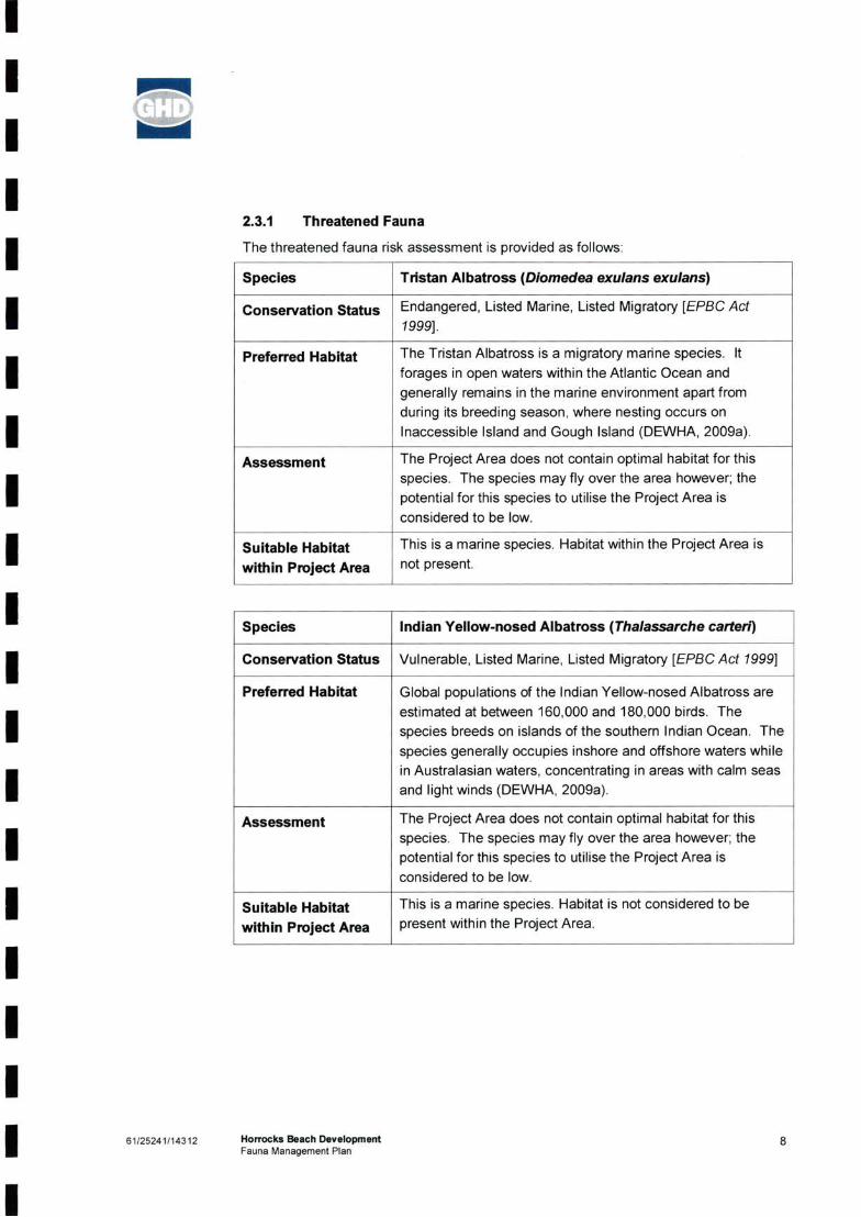
IIII
2.3.1 Threatened Fauna
I The threatened fauna risk assessment is provided as follows:
Species Tristan Albatross {Diomedea exulans exulans]
I Conservation Status
Preferred HabitatII
Assessment
III Indian Yellow-nosed Albatross (Thalassarche carteri}Species
I Conservation Status Vulnerable, Listed Marine, Listed Migratory [EPBCAct 1999]
Preferred Habitat
II
Assessment
IIIIII 861/25241/14312
I
This is a marine species. Habitat within the Project Area is not present.
Suitable Habitat within Project Area
This is a marine species. Habitat is not considered to be present within the Project Area.
Horrocks Beach DevelopmentFauna Management Plan
The Project Area does not contain optimal habitat for this species. The species may fly over the area however; the potential for this species to utilise the Project Area is considered to be low.
Global populations of the Indian Yellow-nosed Albatross are estimated at between 160,000 and 180,000 birds. The species breeds on islands of the southern Indian Ocean. The species generally occupies inshore and offshore waters while in Australasian waters, concentrating in areas with calm seas and light winds (DEWHA, 2009a).
Suitable Habitat within Project Area
Endangered, Listed Marine, Listed Migratory [EPBC Act 1999].
The Tristan Albatross is a migratory marine species. It forages in open waters within the Atlantic Ocean and generally remains in the marine environment apart from during its breeding season, where nesting occurs on Inaccessible Island and Gough Island (DEWHA, 2009a).
The Project Area does not contain optimal habitat for this species. The species may fly over the area however; the potential for this species to utilise the Project Area is considered to be low.

II
OLDII Species
I Conservation Status Vulnerable, Listed Marine, Listed Migratory [EPBCAct 1999]
Preferred HabitatII
Assessment
III
Species Carnaby’s Biack Cockatoo (Calyptorfiynchus latirostris)
I Conservation Status Endangered [EPBCAct 1999] Schedule 1 [WCAct 1950]
Preferred HabitatII
Assessment
IIIIIII 61/25241/14312 9
IHorrocks Beach DevelopmentFauna Management Plan
Habitat within the Project Area is present within habitat type: Open Banksia Woodland over Low Scrub / Heath (refer to Table 2 and Figure ).
Shy Aibatross, Tasmanian Shy Aibatross [Thalassarche cauta cauta]
The Shy Albatross is thought to occur all over Australian coastal waters below 25’ S. It is less pelagic than other Albatross species and has been known to enter bays and harbours. Breeding occurs on Islands of the south of Tasmania (DEWHA, 2009a).
This is a marine species. Habitat is not considered to be present within the Project Area.
Carnaby's Black-Cockatoo occurs in uncleared or remnant native eucalypt woodlands, especially those that contain Salmon Gum and Wandoo, and in shrubland or kwongan heathland dominated by Hakea, Dryandra, Banksia and Grevillea species (DEWHA, 2009a).
There are a number of flora species suitable as forage in the north and east of the Project Area (banksia and myrtaceous scrub). The Project Area does not contain habitat suitable for refuge or breeding for this species. This area is at the extreme northern end of this species’ range, and while it may use the north and east of the Project Area it is likely to be as a vagrant.
The Project Area does not contain optimal habitat for this species. The species may fly over the area however; the potential for this species to utilise the Project Area is considered to be low.
Suitable Habitat within Project Area
Suitable Habitat within Project Area

IIII Species Peregrine Falcon (Falco peregrinus]
Conservation Status Schedule 4 [WC Act 1950]IPreferred Habitat
II Assessment
IIII
Species Australian Lesser Noddy {Anous tenuirostris melanops]
I Conservation Status Vulnerable, Listed Marine [EPBC Act 7999]
Preferred HabitatIII
Assessment
IIIII 61/25241/14312 10
I
Suitable Habitat within Project Area
Suitable Habitat within Project Area
This is a marine species. Habitat is not considered to be present within the Project Area.
The Peregrine Falcon has a wide global range, occurring in many countries around the world. It is currently assessed as Least Concern in the ICON Red List of Threatened Species, as global population trends are thought to be relatively stable (Birdlife International, 2008a).
The Project Area does not contain optimal habitat for this species. The species may fly over the area however; the potential for this species to utilise the Project Area is considered to be low.
Horrocks Beach DevelopmentFauna Management Plan
Habitat within the Project Area is present in the north-west corner within habitat type: Mixed Low Scrub/Health on Limestone due to the presence of limestone cliffs in this area (refer to Table 2 and Figure ). Habitat for this species is also located to the west, outside the Project Area.
The Australian Lesser Noddy is a gregarious, marine species, with flock sizes increasing during breeding season then breaking down into smaller flocks for the remainder of the year. It is usually only found around its breeding islands in the Houtman Abrolhos. It is considered likely that they may leave the breeding islands for short periods in between breeding seasons and that they may forage widely during this time (DEWHA, 2009b).
This species is considered likely to occur in the Project Area. Habitat suitable for refuge (breeding and foraging) occurs in the Project Area. This species was not recorded in the Project Area, but has been recorded in the vicinity (DEC and WAM, 2009).

IIII Species
I Conservation Status Priority 4 [DEC]
Preferred HabitatIII Assessment
III
Species Bush Stonecurlew (Burhinus grallarius]
I Conservation Status Priority 4 [DEC]
Preferred Habitat
III Assessment
IIIII 1161/25241/14312
I
Suitable Habitat within Project Area
Habitat within the Project Area is present within habitat type: Open Banksia Woodland over Low Scrub/Heath (refer to Table 2 and Figure ). Habitat for this species is also located to the north and south, outside the Project Area.
White-browed Babbler (western wheatbelt) (Pomatostomus superciliosus ashbyi)
Habitat within the Project Area is present within habitat type: Open Banksia Woodland over Low Scrub/Heath. This habitat type is fragmented in the Project Area and this species may avoid the area due to the level of disturbance.
Horrocks Beach DevelopmentFauna Management Plan
Suitable Habitat within Project Area
This species is a nocturnal feeding insectivore that inhabits open forest and woodlands. It prefers habitats with high levels of fallen vegetable matter on the ground. Feeding usually occurs in open country and birds will often feed on paddocks or stubble when occurring in agricultural areas. Breeding pairs will generally occupy stable territories (Birdlife International, 2008b).
This species may occur in the Project Area. It is known to occur in similar habitat to the south and north of the Project Area. This species was not recorded during the fauna survey.
This species inhabits eucalypt forests and woodlands where they create bulky domed nests for breeding and roosting. They forage near the ground where they forage on insects and seeds. The species is generally restricted to larger fragments of remnant vegetation as they do not seem to cope well with introduced edges (Garnett and Crowley, 2000).
This species may occur in the Project Area. It has been recorded in the vicinity in the past. Habitat is considered to be suitable within northern and eastern portions of the Project Area.

IIII Species Southern Giant-Petrel (Macronectes giganteus)
Conservation StatusIPreferred Habitat
III Assessment
III Species Northern Giant-Petrel (Macronectes halli)
Conservation Status Vulnerable, Listed Marine, Listed Migratory [EPBCAct 1999]I Preferred Habitat
II
AssessmentIIIIII 1261/25241/14312
I
This is a marine species. Habitat is not considered to be present within the Project Area.
Suitable Habitat within Project Area
Horrocks Beach DevelopmentFauna Management Plan
Suitable Habitat within Project Area
The Project Area does not contain optimal habitat for this species. The species may fly over the area however; the potential for this species to utilise the Project Area is considered to be low.
This is a marine species. Habitat is not considered to be present within the Project Area.
The Project Area does not contain optimal habitat for this species. The species may fly over the area however; the potential for this species to utilise the Project Area is considered to be low.
The Southern Giant-Petrel is a migratory species which breeds on sub-Antarctic and Antarctic islands. It disperses widely during the Antarctic winter and can be found off South America, South Africa, Australian and New Zealand. They are a marine species. The majority of their feeding is done at the ocean surface however they will occasionally dive for food (DEWHA, 2009b).
This species breeds in the sub-Antarctic and migrates to areas off the Australian mainland during the winter months. They are commonly seen in inshore waters along the southern coast of Australia between Freemantle and Sydney. Their diet is made up of fish and scavenged meet from dead carcases (i.e. penguins and seals), they are also known to follow fishing boats to scavenge offal (DEWHA, 2009b).
Endangered, Listed Marine, Listed Migratory [EPBC Act 1999]

IIII Soft-plumaged Petrel (Pterodroma mollis]Species
Conservation Status Vulnerable. Listed Marine [EPBCAct 1999]I Preferred Habitat
III Assessment
III Tammar Wallaby (Macmpus eugenii derbianus)Species
Conservation Status Priority 5 [DEC]
I Preferred Habitat
II
Assessment
IIIIII 1361/25241/14312
IHorrocks Beach DevelopmentFauna Management Plan
This is a marine species. Habitat is not considered to be present within the Project Area.
This species has been recorded from the Project Area in the past (DEC and WAM, 2009). Habitat is considered to be suitable within the Project Area, however, this species prefers dense thickets which are more prevalent to the north and east of the Project Area. Much of the Project Area has been subject to historical disturbance, reducing the risk that this species will utilise the Project Area exclusively. This species was not recorded during the field survey.
Habitat within the Project Area is present in most areas except the cleared/degraded and mobile sand areas.
The Project Area does not contain optimal habitat for this species. The species may fly over the area however; the potential for this species to utilise the Project Area is considered to be low.
Suitable Habitat within Project Area
Suitable Habitat within Project Area
Known breeding grounds for this species are restricted to Maatsuyker Island, off southern Tasmania. The species is generally restricted to marine environments and is most numerous between SOS and SOS in the southern Indian Ocean and between SOS and 60S in the South Atlantic. Their diet consists of cephalopods, fish and crustaceans (DEWHA, 2009b).
Tammar Wallabies generally occur in areas of dense shrub or in more open pasture including coastal scrub, heath, dry sclerophyll woodland and mallee. Males can reach up to 10 kg but the average size is 7.5 kg, females tend to be smaller with an overage of 5.5 kg and the largest only reaching 6 kg. They are grazers and may be found to aggregate on foraging sites.

IIII Species Shield-backed Trapdoor Spider (Idiosoma nigrum}
Conservation Status Schedule 1 [WC^cf 1950]I Preferred Habitat
III Assessment
IIII 2.3.2
IIII Table 2
I Species Status Comment
III 61/25241/14312 14
IHorrocks Beach DevelopmentFauna Management Plan
Suitable Habitat within Project Area
Migratory and Marine Species listed for the Project Area on the EPBC Protected Matters Search Tool
Suitable habitat for the Shield-backed Trapdoor spider is not considered to be present in the Project Area.
Most migratory species, if occurring in the area, will be present as foraging species during the winter. Many of these migratory species are considered common in Western Australia and do not have special protection under the Western Australian Wildlife Conservation Act 1950
The Shield-backed Trapdoor Spiders are found in eucalypt- acacia dry woodlands and schlerophyll open forests in the south-west of Australia. They construct burrows of up to 32 cm with leaf and twig trip-lines radiating out from the mouth. The spiders wait in the burrow entrance and dart out to capture prey that disturbs the trip-lines. The species is under threat due to habitat loss and clearing (DEWHA, 2009c).
This species is known to occur in relatively coastal areas in the region. Although invertebrates were not specifically targeted during this survey. Shield-back Trapdoor Spider burrows are relatively distinctive, and a search for burrows was included during the reconnaissance survey. No burrows were recorded during this survey. This species is considered unlikely to occur in the Project Area due to the relatively open nature of the vegetation.
This species was recorded during the fauna survey.This species was recorded using the updraft of the cliff edges to fly between areas of foraging habitat.
Migratory (CAMBA)Marine
Migratory and Marine SpeciesThe desktop assessment indicated that a number of Migratory and/or Marine species, protected under the EPBC Act, may occur in the Project Area.
The Migratory and Marine Listed fauna species risk assessment is provided in Table 2.
A number of other Migratory and Marine Listed fauna species were recorded during the fauna survey and are listed in Table 3, Appendix A.
White-bellied SeaEagleHaliaeetus leucogaster

IIII Species Status Comment
IIII Fork-tailed Swift
Apus pacificus
II
Marine
IIIIIIIIII 1561/25241/14312
I
Yellow-nosedAlbatross
May occur in the Project Area. Not recorded during the field survey.
Thalassarche chlororhynchos
Migratory (CAMBA,JAMBA), Marine
May occur in the Project Area as a vagrant. Not recorded during the field survey.
Horrocks Beach DevelopmentFauna Management Plan
May occur in the Project Area as a vagrant. Not recorded during the field survey.
May occur in the Project Area as a vagrant. Not recorded during the field survey.
May occur in the Project Area as a vagrant. Not recorded during the field survey.
Great SkuaCatharacta skua
Cattle EgretArdea ibis
Rainbow Bee-eater Migratory (JAMBA)Merops ornatus Marine
Migratory (BONN)
Marine
Migratory (CAMBA,JAMBA)Marine
Migratory (CAMBA, May occur in the Project Area as a JAMBA, ROKAMBA) vagrant. Not recorded during the fieldMarine
Great EgretArdea alba

IIII 3. Fauna Impacts and Management Measures
I 3.1
IIIIIII
3.2
I»I»
I»
I »
I »
»
I Native wildlife are not to be fed;»
»
I »
I 1661/25241/14312
IHorrocks Beach DevelopmentFauna Management Plan
No domestic dogs to be brought into the construction areas;
Rubbish will be removed from construction areas;
Vegetation communities in the best possible condition will be retained in accordance with the Vegetation Management Plan;
The retention of fauna corridors (refer to Section 2.1.3) within the Project Area will be made through the retainment of the vegetation communities identified in the Vegetation Management Plan, where possible;
Vegetation clearing will be undertaken in accordance with an approved Construction Environmental Management Plan (CEMP) or similar;
All staff, contractors and field personnel will meet all requirements of the Wildlife Conservation Act 1950',
Management MeasuresThe following management measures will be incorporated into the Structure Plan to manage the potential impacts to significant fauna species within the Project Area:
No deliberate lighting of fires within construction areas;
Machinery is to be checked prior to start-up for the presence of native wildlife; and
» Loss of fauna corridors in the area which allow larger mobile species (mammals and birds) to disburse and migrate between remnants of vegetated areas. Removal of vegetation may increase their susceptibility to predation and limit disbursal.
» During the construction phase, waste, including food scraps, may assist undesirable fauna species to increase by providing a food resource.
Potential Fauna ImpactsIt is considered likely that clearing of vegetation in the Project Area will have an impact on fauna species. Minimal impact is expected to occur on significant fauna species as a result of the Project.
If managed carefully, it is not considered that the clearing of vegetation will significantly alter the fauna habitat of the region. Disturbance is most likely to occur on a local scale, impacting individual animals, rather than a species. The Project Area adjoins similar contiguous habitat to the north of the Project Area.
Impacts are likely to occur to individual animals and include:
» Loss of habitat and feeding areas. There will be a loss of refuge vegetation and associated foraging resources;
» Harm/deaths/displacement of individual animals. This may occur during clearing activities; and

IIIIIIIIIIIIIIIIIIII 1761/25241/14312
I
Noise and vibration impacts will be managed in accordance with the CEMP;
Works will cease on sighting of a significant fauna species which might be at risk of injury in the Project Area. Works will recommence once the animal has moved on;
During clearing activities, the work site will be left in a safe condition at the end of each working day to ensure animals are not subject to harm from the clearing works;
Horrocks Beach DevelopmentFauna Management Plan
» The speed of vehicle movement is to be reduced between dusk and dawn within construction areas.
» No open pits! trenches will be left open overnight in the Project Area;
» During construction works, the area will be inspected each morning to ensure no fauna have been trapped during the previous evening. A Regional DEC Officer or designated representative will be contacted to facilitate removal if necessary;
» No native fauna (including venomous snakes) will be deliberately impaired or killed during Project works;
» Where possible, clearing will be undertaken at a time of year that is least likely to impact on breeding or nesting species;
» Barriers to native fauna movement will be minimised where possible;
» Large trees which contain numerous nests should be retained where possible;
» Lay-down areas will be constructed on previously disturbed areas;
» The movement of machinery and vehicles will be minimised or restricted at dusk and dawn and during night-time hours;
» The relevant staff will be inducted into the requirements of the Fauna Management Plan and the Construction Environmental Management Plan. The objectives of the awareness training include:
- Fauna requiring protection;- Risk of encountering significant fauna and actions to be taken;- Fauna handling and registered personnel; and- Fauna and flora hygiene practices.
These management measures are provided in a tabular format in Appendix B.

IIII 4. References
IIIIIIIIIIIIIIII 1861/25241/14312
I
Allerding and Associates (June 2008) Town Planners, Advocates and Subdivision Designers. Proposed Structure Plan Lots 110, 112, 114 and 115 Horrocks and White Cliffs Road, Horrocks Shire of Northampton. Report prepared for Horrocks Syndicate.
Department of Environment and Conservation and Western Australian Museum (2009) NatureMap: Mapping Western Australia’s biodiversity. Accessed online at: http://naturemap.dec.wa.gov.au on [11/05/2009].
Horrocks Beach DevelopmentFauna Management Plan
Department of the Environment, Water, Heritage and the Arts (DEWHA, 2009b) Biodiversity: Species Profile and Threats Database. Accessed online at: http://www.environment.qov.au/cqi-bin/sprat/public/sprat.Dl on [11/08/2009].
Department of the Environment, Water, Heritage and the Arts (DEWHA, 2009a) Environment Protection and Biodiversity Conservation Act Protected Matters Search Tool: Area co-ordinates. Accessed online at: http://www.environment.qov.au/erin/ert/epbc on [20/08/2009].
Garnett, S. T. & Crowley G. M. (2000) The Action Plan for Australian Birds 2000, pp351 - 352 Taxon Summary, White-browed Babbler (western wheatbelt) assessed online at:http://www.environment.gov.au/biodiversity/threatened/publications/action/birds2000/pubs/wbrowed-babbler.pdf on [24/08/09].
GHD Pty Ltd (2010) Seaview Farms Horrocks Beach Development Flora and Fauna Survey. Ref: 61/24450/14057. March 2010.
Birdlife International (2008a) Falco peregrin us. In: IUCN 2009. IUCN Red List of Threatened Species. Version 2009.1. Accessed online at: www.icunredlist.org on [24/08/09]
Birdlife International (2008b) Burhinus grallarius. In: IUCN 2009. IUCN Red List of Threatened Species. Version 2009.1. Accessed online at: www.icunredlist.org on [24/08/09]
Department of Environment and Conservation (2010) Letter addressed to Ms Hayley Williams for the Proposed Structure Plan, Lot 110, 112, 114 and 115, Horrocks and White Cliffs Road, Flora and Fauna Survey. Dated 2 February 2010. Ref: 2007/2860.
Department of the Environment, Water, Heritage and the Arts (DEWHA, 2009c) Australian Biological Resources Study - Species Bank. Accessed online at: http://www.environment.qov.au/biodiversitv/abrs/online-resources/species-bank/index.htmlon [25/08/09]

IIIII
FiguresII Figure 1 Locality Map
Figure 7 Project Area Fauna Habitat TypesIIIIIIIIIIIII 61/25241/14312 19
IHorrocks Beach DevelopmentFauna Management Plan

I300,000260,000
IIIIIIIIIIIII
I
III 300,000250,000
LEGEND
Project Area
II 0 2.5 20
Figure 1C LIE N T S |PE OPLE jPE RFO RM ANCE Locality Map
Iiplete Of unsuitable in any way and for any reasonAtlas - 2004 Edition; GHD: Project Area - 200908 Created by: miogue.s. xntan
I
61-244500 20 NOV 2009
1:500,000 (atA4) 5 10 15
I(O
KilometresMap Projection: Transverse Mercator
Horizontal Dafijm: Geocentric Datum of Australia (GDA) Grid: Map Grid of Australia 1994, Zone 50
II
Seaview Farms Biological Survey
I
Job Number Revision
Date
G:\61\24450\GIS\mxds\61-24450-E001.mxd 76 Forrest Street Geraldton WA 6530 T 61 8 9964 3677 F 61 8 9921 7997 [email protected] Wwww.ghd.com.auO 2009. While GHD has taken care to ensure the accuracy of this product. GHD and LANDGATE make no representations or warranties about its accuracy, completeness or suitability for any particular purpose. GHD and LANDGATE cannot accept liability of any kind (whether in contract, tort or otherwise) for any expenses, losses, damages and/or costs (including indirect or consequential damage) which are or may be incurred as a result of the product being inaccurate, incomeData Source: Landgate: Travellers /

248,500
*• ; -■L\'- ;■
sAeiSti ? V?
V.
248,500 250 000LEGEND
Survey Area
600
Figure 7CLIENTS [peoples PERFORMANCE
“S
61-24450024 NOV 2009
4. Mixed Low Scrub/Heath on Limestone
5. Mixed Coastal Scrub on Sand
6. Open Banksia Woodland over Low Scrub/Heath
Seaview FarmsBiological Survey
MetresMap Projection; Transverse Mercator
Horizontal Datum: Geocentric Datum of Australia (GDA)Grid: Map Grid of Australia 1994, Zone 50
sI
i* --'1
Job Number Revision
Date
250,000
WrTr-
a
-■'-A
Project AreaFauna Habitat Types
Gi6H24689\Gisimxd8i6i-24450-E009.mx<j 76 Fofrest Street GeraldtOH WA6530 T61 8 9964 3677 F61 8 9921 7997 [email protected] Wwww.ghd.com.aue 2009. While GHD has taken care to ensure the accuracy of this procfcjct, GHD and LANDGATE (SLIP) make no representations or warranties about its accuracy, completeness or suitabSity for any particular purpose. GHD and LANDGATE (SUP) cannot accept liability of any kind (whether in contract, tort or otherwise) tor any expenses, losses, damages and/or costs (including indirect or consequential damage) which are or may be incurred as a result of die product being inaccurate, incomplete or unsuitable in any way and for any reason.Data Source: Landgate: Hutt 2006 Mosaic • 2006: GHD: Survey Area - 200906, Fauna Habitat Types - 200S1124. Created by: miogue, xntan
Fauna Habitat Type1- Cleared/Degradec
I 2. Mobile Sand Areas
3. Open Acacia Scrubland
1
A's;
1:15,000 (at A3)0 75 150 300 450
K Ti

IIIII VOLUME 3: Annexures 8-13
II HORROCKS BEACHI SHIRE OF NORTHAMPTON
II
..
I»
IIII
DEPARTMENT GF PLANNING
I 2 3 DEC 2010
I Spk) I 0214Fl! •- J
II D£CEMB£r2010
II
*'Z 1
Lots 110, 115, 500 & 116 White Cliffs Road
PROPOSED STRUCTURE PLAN
Prepared For:Horrocks SyndicateRrepareh By:Allerding & Associates
AllerdingAssociates
Town Planners, Advocates 8s Subdivision Designers
*4
I
I Xt - .gj rs.'t

III
Table of ContentsIVolume 2I
I Annexure 1 - Endorsed Structure PlanAnnexure 2 - Previous Structure Plan Proposal November 2007I Annexure 3 -Previous Structure Plan Proposal May 2007
I Annexure 4 - GHD Flora and Fauna SurveyAnnexure 5 - Correspondence from DEC
I Annexure 6 - VEGETATION & Flora Management Plan
Annexure 7 - Fauna Management PlanII
Table of Contents
I Volume 3
IAnnexure 8 - Zoning Plan
I Annexure 9 - Infrastructure Report
Annexure 10 - Correspondence from Water Corporation
I Annexure 11 - Local Water Management Strategy
Annexure 12 - Correspondence from Western PowerI Annexure 13 - Maunsell Desktop Environmental Assessment
IIIII

II IIIIIIIIIIIIIIII I I I
Annexure8 Zoning Plan

IIIIIIIIIIIIIIIIIIIII

IIIIIIIIIIIIIIIIIIIII

II LEGEND
I LOCAL SCHEME RESERVESFORESHORE CONSERVATION & DUNE PROTE(
PARKS AND RECREATIONI PUBLIC PURPOSES
I ZONESRESIDENTIAL
I TOWN CENTRE
RURAL
I OTHERTrzoIEfc t II ■ I 1 I B
R cooes
NO ZONESCHEME BOUNDARY
I LOCAL GOVERNMENT BOUNDARY
TOWNSITE - LAND ACT
IIIIIIIIII VERSION No 1
I SHIRE OF NORTHAMPTONTOWN PLANNING SCHEME NO 8I ( DISTRICT SCHEME )
I
SPECIAL CONTROL AREA-DEVELOPMENT AREA (SEE SCHEME TEXT)
WSD
PUBLIC PURPOSES DENOTED AS FOLLOWS:
WATER SUPPLY, SEWERAGE & DRAINAGE

I III I I I I I I I I I I I I IIIII
Annexure9Infrastructure Report

II
maunsellII Horrocks Infrastructure Study Report
IIIIIIIIIIIIIIIII
HTb Surveyors & Planners
January 2004

II
(Q) maunsellII Horrocks infrastructure Study Report
IIII
Prepared byMaunsell Australia Pty LtdI 19 Durlachsr Street
PO Box 263
I Geraldton 6531
Western Australia
ABN 20 093 846 925
I Tel +61 8 9921 8299Fax +61 8 9921 7265
II January 2004
I 71100600.00
I © Maunsell Australia Pty Ltd 2004
IIIII
The information contained in this document produced by Maunsell Australia Pty Ltd is solely for the use of the Client identified on the cover sheet for the purpose for which it has been prepared and Maunsell Australia Pty Ltd undertakes no duty to or accepts any responsibility to any third party who may rely upon this document
All rights reserved. No section or element of this document may be removed from this document, reproduced, electronically stored or transmitted in any form without the written permission of Maunsell Australia Pty Ltd.
Horrocks Infrastructure Study ReportRevision A January 2004G:\Maunsell Au8tralla\711 - Civil\71100600.00 - Horrocks Strat Planning\Doc\Horrocks Infrastructure Study.doc
Prepared forHTD Surveyors & Planners

IIIII Document Horrocks Infrastructure Study Report
I Ref
Date January 2004I Revision A
IDescription Horrocks Infrastructure Study ReportI
IIIIIIIIIIII
ApprovedRobert StawarzGeraldton Regional Manager
OriginatorRobert Stawarz
Horrocks Infrastructure Study ReportRevision A January 2004G:\Maunsell Australia\711 - Clvil\71100600.00 - Horrocks Strat Planning\Doc\Horrocks Infrastructure Study.doc
71100600.00g:\maunsell australia\711 - civil\71100600.00 - horrocks strat planning\doc\horrocks infrastructure study.doc
CheckedRobert Stawarz

IIII Table of Contents
IIIII 3.0
IIIIIIIIIIII
Existing Water Suppiy InfrastructureExisting Water Corporation Operating Licence Area Existing Western Power Infrastructure
89
10
12223333445567
Appendix 1Appendix 2Appendix 3
Horrocks Infrastructurs Study ReportRevision A January 2004G:\Maunseli Austraiia\711 - Civii\71100600.00 - Horrocks Strat Pianning\Doc\Horrocks infrastructure Study,doc
IntroductionInfrastructure Services2.12.22.32.42.4.12.4.22.4.32.4.42.52.62.7Summary
1.02.0
Topography and EarthworksRoadsStormwaterWater SupplyExisting InfrastructureBorefield Operating Licence LimitationsOperating Licence UpgradesInfrastructure UpgradesSeweragePower SupplyTelecommunications

IIII hitrod uction
IIII Reference is made to HTD Surveyors & Planners Drawing No. 03500PS-2-1-0, Horrocks Structure Plan.
Proposed Lots primarily consist of:-
IIIIIIIIIIIII
1.2.3.4.
Maunsell Australia Pty Ltd have been commissioned to provide a Servicing Infrastnjcture Report for proposed development of land surrounding the existing Horrocks Townsite. This report will contribute to the preparation of a Structure Plan for future subdivisions within the area of the study.
Whilst the whole Structure Plan incorporates land north of the Bowes River and westwards up to the coastline (including Horrocks townsite), the study area for this servicing report only covers land to the north of Horrocks Road, low density residential lots and the tourist site west of White Cliffs Road and all areas to the east of White Cliffs Road.
Horrocks Infrastructure Study ReportRevision A January 2004G:\Maunsell Australia\711 - Civil\71100600.00 - Horrocks Strat Planning\Doo\Horrooks Infrastructure Study.doc
Pagel
Low density Residential (2,000 m’-1 ha)Rural Residential (1 -4 ha)Rural Smallholdings (4 - 40 ha) Tourism Site
1.0

IIII !nfrastructu r© Serv i ces
Topography and EarthworksIIIIIIII 2.2 Roads
II
Various areas of this road may require upgrading with subsequent development applications.
I Typical road construction requirements are as follows:-
IIIIII
The land falls at approximately 7% for 50 - 60 m away from this ridge before flattening out to “softer’ grades of around 2%.
It is anticipated that the majority of earthworks will be limited to road reserves which can readily follow the contour of the land.
Topographical aspects of the subject land pose no unusual challenges to those experienced in this type of landform.
The Shire of Northampton advise that by the end of 2004 White Cliffs Road will be a formed gravel road on a gazetted road reserve through to Port Gregory. This is likely to promote attention to this area through increasing traffic once its existence becomes more publicised.
The majority of the area is anticipated to be readily excavatable to depths required for various infrastructure services and roadworks. Some limestone cap rock may be encountered during the process of service trench excavation but this is not anticipated to present any construction implications with currently available earthmoving and rock breaking equipment.
The study area is situated astride an elevated limestone plateau exposed along the western edge between Horrocks Road and White Cliffs Road. The plateau is overlain with calcareous sands and sandy topsoil which rises to a ridge approximately 150m from the edge of the escarpment. This ridge runs in a north-westerly direction across the study area with several peaks at a contour level of 105m rising to the highest point at the north end (116 m).
bituminous seal with kerbing and underground stormwater pipework, bituminous seal, unsealed shoulders, table drains and culverts with kerbing only at intersections and traffic colouring devices.
up to 2,000 m^ Lots > 2,000 m^ Lots
2.1
Horrocks Infrastructure Study ReportRevision A January 2004G:\Maunsell Australia\711 - Clvll\71100600.00 - Horrocks Strat PlannlnglDoetHorrocks Infrastructure Study.doc
Page 2

IIII
Stormwater
IIIII
2.4 VAfeter SupplyI2.4.1 Existing infrastructure
IIIIIII 2.4.2 Borefieid Operating Licence Limitations
IIII
The existing Operating Licence for the borefield is depicted in Appendix 2. This area incorporates only a small portion of the study area namely the low density residential (< 1 ha) lots west of White Cliffs Road and the four proposed rural smallholdings (4 - 40 ha) abutting Horrocks Road to the south.
Operation of equipment is monitored by a point to point radio control system with units at each bore site and at the treatment plant.
Dedicated compensation basin(s) may be required due to the proximity of this road to the edge of the escarpment overlooking Horrocks Townsite.
An overhead power supply running along the pipeline route feeds the tank and borefield sites with transformers located at each site.
Water Corporation’s master meter for Horrocks is located at the point where this main joins into the Horrocks Road reserve.
This tank site incorporates a water treatment plant and is situated approximately 2 - 3 km from White Cliffs Road along the ridge line at approximately the 95 m contour level. This tank gravity feeds via a 200 mm diameter gravity main into Horrocks townsite.
Honrocks townsite’ potable water supply is provided from a production borefield located approximately 6.0 - 6.0 km north east of the Town. Water is delivered via 100 mm and 150 mm diameter PVC pressure mains from the borefield to an existing 1,000 m’ capacity tank located within the study area (refer Appendix 1).
However, special attention to stormwater controls and disposal may be expected in the areas adjoining the low density residential lots; in particular the proposed road skirting the western boundaries of these lots.
Stormwater disposal should be promoted via soakage in table drains wherever possible to eliminate the necessity for stormwater compensating basins. It is anticipated that this may be suitable in the rural smallholdings lots.
Internal stormwater drainage needs to be dealt with in accordance with the Shire of Northampton’s Land Development Guidelines.
Horrocks Infrastructure Study ReportRevision A January 2004G:\Maunsell Australia\711 - Civil\71100600.00 - Horrocks Strat Planning\Doc\Horrocks Infrastructure Study.doc
Pages

IIIII This licence has a maximum limit of 100 megalitres (ML) drawn from the borefield.
IIII 2.4.3 Operating Licence Upgrades
IIIII 2.4.4 infrastructure Upgrades
III
The water treatment plant at the tank site may be expected to require some upgrade.IIII
Proposed low density residential lots west of White Cliffs Road may still be serviced under the current operating licence but a review of projected average annual consumption would be required to validate this.
The development will probably require the duplication of the existing 1.000 m^ tank. This additional tank will need to be an elevated type to serve most of the proposed allotments.
There are several peaks along the ridge line at a contour level of 105 m (10 m above the contour level at the existing tank site i.e. 95 m). At the very north end of the study area the ground rises to a contour level of115 m. To fully service all of these lots a booster pump station may be required or another tank at this end of the development
The additional 120-130 lots within the study area will almost double the existing demand and hence major infrastructure and licence upgrades will be required.
Operating Licences are controlled by the Office of Water Regulation and any amendments require Ministerial approval.
Existing water supply infrastructure services 100 properties in Horrocks with an average annual consumption of approximately 70 ML. The Shire has recently developed approximately 56 urban lots in town which has stretched the current operating licence almost to its limit.
Horrocks Infrastructure Study ReportRevision A January 2004G:\MaunsellAustralia\711 - Civil\71100600.00 - Horrocks Strat Plannlng\Doo\Horrocks Infrastructure Study.doo
Page 4
To instigate these changes the Developer needs to write to the Water Corporation requesting an extension to the operating licence area with Water Corporation being the preferred service provider. The Water Corporation will refer this on to the Office of Water Regulations. Subject to the capacity of the groundwater acquifer to sustain this extra demand they may decide to approve the extension outright or if there is sufficient justification they may call for expressions of interest for private operators to own and operate an independent water supply system for the development. In this instance an independent borefield supply and delivery system would be most likely required which would also be subject to similar constraints on the capacity of the groundwater acquifer. The Water and Rivers Department would also need to approve this as they have jurisdiction over groundwater bores.

IIIIIIIIIIII 2.5 Sewerage
III 2.6 Power Supply
IIIIII
There is an existing overhead power supply following the Water Corporation's pipelines to the borefields. Western Power have yet to confirm if this is single or three-phase.
Health Department policy allows subdivisions without sewers subject to site suitability for septic tanks and minimum lot sizes of 2.000 m^.
Water Corporation advise that there is generally only one master meter per town supply or scheme. The existing master meter would need to be relocated to the tank site.
It is anticipated that all of these infrastructure upgrades, depending on detailed investigations, may cost anywhere between $0.6 -1.0 M (this excludes the internal subdivisional reticulation). It is likely that all of these upgrade costs plus headworks will be assigned to the development.
The borefield pumps and delivery mains may also require upgrading or alternatively a transfer pump station between the borefield and the storage tanks. The existing 200 mm diameter main from the tank site to Horrocks Road may also require upgrade in size to meet the additional draw on the system (approximately 2,400 m).
Irrespective of this, it is anticipated that Water Corporation may impose a sewerage condition on any planning applications. This would necessarily be subject to an appeal process. Considering the proposed lot sizes indicated and the existing geology, groundwater depth (approximately 40 m) and proximity to the ocean, a successful appeal against any such condition is likely.
Any new infrastructure such as pumping stations will require a power supply and communications link to enable link up to Water Corporation’s remote site monitoring system. It is anticipated that with new Telstra landlines being provided to the development, the tank site would also be served with the borefield radio control system retained.
The tank site (and pump station sites) will require a dedicated right of way or road reserve with a gravelled road access as a minimum. The water supply mains require an easement and access would need to be maintained over the route.
Horrocks is presently fed from an overhead power transmission line across open farmland from the east along an alignment approximating the northern boundary of the 4 proposed rural smallholding lots fronting Horrocks Road.
Horrocks Infrastructure Study ReportRevision A January 2004GiWlaunsell Australia\711 - Civil\71100600.00 - Horrocks Strat Planning\Doo\Horrooks Infrastructure Study.doc
Pages

IIIIIIIIIIII
2.7 Telecommunications
IIIII
Either way, Telstra would respond to each planning approval application as they arise.
IIII
A development of this magnitude may require a new optic fibre link from Northampton if its supply is adequate or alternatively a satellite link and mini exchange may be feasible.
At the boundary to the larger lots the power mains can jump up to an overhead power transmission line system with 10 kVa pole top transformers serving each lot.
The smaller lots (< 5 ha) may be served adequately from the existing H.V. transmission lines with drop down three-phase 63 kVa transformers serving approximately 12 lots each.
Telstra advise that there is limited capacity in the existing infrastructure to cater for any significant developments.
There is some infrastructure in Whitelfflis Road but this is likely also to be insufficient for the proposed developments.
The tourism site will require independent assessment of power supply demand depending on the nature of the development.
Telstra advise that they generally plan infrastructure upgrades on the basis of forecast growth which is assessed from information provided through zoning amendments and WA Planning Commission applications.
An easement would be required to protect the existing overhead power lines as a preference (cost wise) to relocation of these mains.
Western Power requirements are for lots < 5 ha to be served by underground power reticulation. Hence, the smaller low density residential and rural residential lots will require underground power reticulation.
Horrocks Infrastructure Study ReportRevision A January 2004G:\Maunsell Australia\711 - Civil\71100600.00 - Horrocks Strat Planning\Doc\HoiTocks Infrastructure Study.doc
Page 6
Similar access requirements as for the water mains are required for all overhead power lines not within road reserves.
The water tank site and each of the bore sites are provided with a 10 kVa transformer. It is likely that water tank site transformer will need to be upgraded to meet extra power supply demands associated with any additional water booster pumps or transfer pumps. The borefield transformers may need upgrading depending if any bore pump upgrades are required.

IIII Summary
The following are the key elements affecting the development of the study area.
I The topography and landforms are generally favourable to the construction of roads and services.
IExisting water supply infrastructure will require major upgrades including:-I probable duplication of water storage tanks
probable upgrade of water treatment plantI relocation of the master meter
possible borefield and delivery main upgrades or transfer pump station
I possible water reticulation main upgrades
probable water booster pump station or additional storage tanks
I easements over existing water mains and access via dedicated road reserves to the water tank site(s)
power supply (transformer) upgrades to new pumping stations and possibly borefields
IIIIIIIIIII
It is unlikely to require gravity sewerage although sewer conditions may be imposed on any development application.
Power supplies are readily available from existing HV mains to Horrocks although easements and access will be required.
Extensions to the existing Water Corporation Operating Licence for its water supply borefields will be required. This needs Ministerial approval and will be subject to acquifer capacity.
Telecommunications facilities - there is limited capacity within the existing infrastructure servicing Horrocks to cater for this development. Options may be a new optic fibre link from Northampton or a satellite link and mini exchange.
3.0

IIIIIIIIIIIIIIIIIIIII

//
wI
preparai Bta, bm accept.* no responsibility iT racilil^, cadasval or contour
inappropriate use ©T Ums • auon, ir any inaccuracy is Found «iil> die Facility ition. please contact Pacilttie* Mepning InFormatitiK . inai Qa-sn -aacH ir ___ ________ ’’ ?_ r.
’■''Iin fM
"^6856742___________HORROCKS BE44 0318 Screen 10/2/03
mlinf L- _______Section on (0B) B420 2BBB. IF ar
Height Datum i AHO Coordinate System : MCA'14
The Water Corporation has taken duu caro in the naretion of this data, but accepts no responsibility
.WT ciy inaccuracy of facility, cadastral or contour information provided, nor inappropriate use ©F Ums ’
iformation. If any inaccure '' . . - .‘ormaiction on (06) 5420 2066. If any inaccuracy is found mV the cadasvelor contour information, please contact
OOLA to request source data.

..WW'/O'J.I
Haight Datum : AHD
preparation of thia data, but accepts no resporisibi h tij for any inaccuracy of facility, codestrol or contour
DOLA to raqueat source data.
143
M-r\j
Coordinate System : MCAH4
lhe Water Cerporetion has token due cere in the
- S CO
685728^ \ ~HORROCKS BE44 0318 Screen 10/2/03"
ml ormatton. IF any inaccuracy la information, please contact Facili .Section on (0B1A420 2068. If any inaccuracy is
the cadastral or contour information, please
for any inaccuracy of Facility. codestrol or contour information provided, nor inapproprialo use of this *
^nrormation. Jf any inaccuracy la found -ith the facility . sontact Facilities Mapping Information
'in.-Q tr . . found NllllI contact

I
100I
r-'
r-..i
I
I
I
s
y
preporetlon of this doto. but occepti no responsibilitij for any inoccuracy of focihty, codasIrol ur coniatir jnrormotion provided, nor inoppropnoto use of Uns '
* p ®"y •'Accuracy is found with the facilitiiiriLnr fnM t«nn la______ l_ r_
!
I
I
sestHtd?!^ &}CQ
inf\i
aO'
6860G03 "HORROCKS BE44 0318 Screen 10/2/03
tor any inaccuracy of facility, codasIrel ur contour information provided, nor inoppropnoto use of Uns '
* p ®"y tt^ccurocy IS found with the facilityinformation, please contact facilities Mopp.r.g Informatinn Soetien on (08^^420 2068. If ony inaccuracy is found witti
the cadastral or contour infcw-motion, please contact OOLA to request source data.
I!
I
i NOP-.'(j(.;K': !A!\K >i 'Wi '00.8I I! 'J/.OI CA'-' 1000 ni.iI
Height Datum ; AHP_______ Coordinate System ? MCAR^
The Water Corporation has taken due care in the

□ub/HHb
*P'^®®’^''^*®* ^®PP“'9 Inl ornirtUonSection on IBB) ^420 20SB. IT any ineccuracii is (oimd with
•k. ^_.j__.___I __ _______ . ._p_ t-*s, ?
6661921HORROCKS "BE-44 0318 Screen 10/2/03
RO >
T
ction on I0B)®)420 2066. If any the cadastral or contour inrormation. please conLact
DOLA to request source data.
Height Ootum : AHO Coordinate System : The Water Corporation has taken due care in the
preparation of this data, but accepts no responsibility For any inaccuracy of faeili ty. cadastral or contour inrormalion provided, nor inappropriate use of ihis •
information. If any inaccuracy is found with die facilityC_ —kJ i_« -. -

IIII
zIIIIIIIIIIIIIIIII

bBb250?
* A
b
WOlOCirOi tf IK nnrai
Coordinate ; MCAS4
Mapping Information
U)
m U) (M
Ths Walsp Cop| preparation of L
for any inacr--
, ) or contournor inapproprieta use of this
GBseaiaHORROCKS BE44 0317 Screen 23/ia/03
III I I I I I I I III I I IIIIII I
. 1
Saction on IBB) B420 2068. If 7tha cadsib-^or contour intoraiotion, ploi
OQLA to request source date.
aawas-*-
Ths Waler Corporation has taken due care in the preparation of this data, but accepts no responsibility
for any inaccuracy of the Operating License Areas. For legal definition of Operating Li contact the Manager. Technic * Ohico Of Water negulotion,
Vator Corporation enquires ers Corporate & Regulatory Planning
Haight Datum : AHD
The Water Cr----------eparation of for any inaccurac information proti
The Water Corporation has taken due care in the preparation of this data, but accepts no responsibility
for any inaccurocy of facility, cadastral —----- --information provided, nor inappropriate i ....
inlormation. If any inaccurocy is found with the facility inf ormation, ploojo^_COT_toct Facilities Mapping Informatior.
any inaccuracy is found with iformation, please contact
I Uperatinq License Areas, Technical Services, at the
.... on (0B)R2I3 0100. are to be directed to the
} Branch, on (08) R420 2078

III
txisting Western Po'wer InfrastructyreAppendix 3I z
IIIIIIIIIIIIIIIII

II
IMIIIII
fl
IIIIIIIIIII zw/zry Ht/.
I(^^£^TS.^ PotJs^I User tgnr61c)Fis/NTMap
( T Il «« 1
I-------- ► Printed; WedJan 07 10:53:36 2004 »6r:^A"C '11 AraOXWF AMH f7onA «;nb 124864387.68602116
\ \\ \ \ \ \
\II
///
\ s
\.\ X 'V'
\X
X
\
//
41’
1-_____

III Our Ref;
Fax; 08 8923 4966
I !17 December 2009
I i ■
I Attention; Hayley Williams
IIII area-
Dewefrjfwnwnts within the Operating License Area
III
D®V‘Ctopnwrt» outside the Operating License A^ea
Ia
IIIIIII
'm
CORPOHaTION
Shire Of NorthamptonPO Box 61NORTHAMPTON WA 6535
S]
Midwest Region
45 Cadiedml Avenue GcrjIdconWA 6530
PO Box « GoraWi»nWA6S3l
Padeenq 13 13 7S AceouxEnq 13 13 83 Tectinicil Enq 13 13 9S Fax (OS) 5923 9966
www.'Ani tereo rpoi'u non eorrt.Qu ABN 28 003 934 Pl?
BHiRE OF NORTHAMPTONNORTHAMPTON HORROCKS BEACH STRUCTURE PLAN
Your Ref; 10,5.10/OCR,7045GN1 200e 0061B VOl Doc 563398
Enquiries Phil BaleDiraciTel: 08 99234942
For developments that are Icxzated within the Operating license area the Corporation is obligated to providing the water and sewerage services and will also receive a Comindnsty Service Obligation Irom Govemmsrr, to cover the shortilall in the co« in running tfi© scheme that is not covered by the revenue obtained from the water and sewerage charges.
The Corporation as a service provider will initiated planning and investigalion for increases In allocation or anemativa supplies if and when it becomes necessaiv.
The Water Corporation has a water supply and sewerage operating license area for Horrocks Beach as shown on the attached plans and it is noted that a portion of the Urban Residenlial area is located outside the waler supply operating license area.
The operating license areas are issued to service providers like the Water Coiporation by the Economic Regulation Authority (ERA) to provide water and wastewater services, and it is the service provider's role to carry out the planning and investigation for developments within the operating license
The Water Corporation recently met with the Mr, Reg Reynolds to clarity the provision of water and wastewater services tor the Horrocks Beach Structure Plan,
If a developer's land or a portion of their land is outsid© the license area tlien it is the responsibility of the developer to larry out the planning and investigation for these services, they ther^ can approach service provider to make an application to the Economic Regulation Authority (ERA) to grant an operating license or an extension to an existing license.
The ERA when granting an operating ficense of an extension will be making a Government commitment for the provision of Comnuinily Service Obligation to the licensed senrice provider.
The developer should be working with the DoW and seivice providers to determine wliat invealigation is required to provide a sustainable water supply for the Horrocks Beach Structure Plan.
The Corporation is granted a water allocation from the Opartment of Water (DoW) to provide a waler supply scheme to service a town.

IIIIIIII
Of a combination of the above.I 1. Expand Local Groundwater Scheme
IIIIII 3. Desalination
IIIIII
Using holiday home use for Horrocks the number of additional lots could be in the order of approximately 240, but if the water demand is assumed to be permanent residential then the number of additionaJ lots would only be in tfie order of 50.
1. Expand local groundwater scheme.2- pipeline from Northampton.3. Desalination
Cun-ent Water Corporation Water Supply Scheme capacity within the Horrocks Beach Operating License Area
2. Pipeline from Northampton
The Corporation's long term waler .supply planning forth® Horrocks Is the construction of a pipsline end headworks infrastmeture from Northampton and upgradirig of the Allanooka - Northampton pipeline. The Corporation will be required carry out an investigation for an Increased allocation from the Allanooka borefield for only the lota within the license area and then make an application to OoW ior tnis Increase.
The Corporation's has from DoW A water allooalion of 100,000 kl per year for the land within the operating license area with 32,000 kl per year currently being consumed by the town residents.
The estimated number of lots that can be senred from the current water supply scheme is dependant upon the assumed total waie.r demands and their demography. The current usage for Horrocks is 170 kl/lot/year for holiday home use when this is compared to Kalbarri of 310 kl/lol/year which is permanent residential use.
Then if granted, works may include the construction of new bores and mains whkih the developer may be required to prefund.
FuturB Water Supply Planning for Horrocks withirt the Operating License Area
The Corporation has not completed any detailed planning for the Horrocks water supply scheme but a number of options could be considered for securing a waler supply within the license area but all these options will require Department of Water (DoW) approval.
Tha current annual water allocation fo.’^ the Horrocks bore field from DoW is 100,000 kl and the current town site is using on average 32,000 kl per year.
If the allocation was to become fully used then the Corporation will carry out an investigation to increase the allocation for only the lots within the license area and then make an application lo DoW for an increase. DoW will only approve the increase if it determined that the aquifer can sustain ths adcStional extraction.
DoW Wil! only approve tfta increase if it doterrriined that the Allanoolo aquifer can sustain the additional extraction. The Corporation is yet to determine tfte budget cost of these works and the developer may be required to prefund.
The Corporation'e altemative long term water supply planning for the Horrocks is the construction of a desalination plant treating groundwater or seawater. This infrastructure will require a number of environmental and DoW approvals for a sustainable water supply for the Horrocks town site.

III
Wastewater
II
Should you nave any queries, please do not hesitate to contact the Enquiries Officer.
IIIIIIIIIIIIIIII
PHIL GAkELAND DEVELOPMENT OFFICERMID WEST REGION
The Corporation has wastewater plannino for the Horrocks Beach Structure Plan with the Urban Residential land entirely witfiin the wastewater operating license area.
The developer will be required to provide all reticulation mains and contribute to water supply headworks and may also be required to prefund headworks infrastructure as needed.
The developer will be requited to provide all reticulation mains and contribute to water supply headworks and may also be required to prefund headworks infrastnjcture as needed.

t W »|*1U «fau IWTB
k v>t km
<i«3i337STOllh.H««.Min«IOCI!S Date'!>rirtl»f;l4/t«i»U:J6:10 QxrtilS^SSSrMfflwSTCKrH^rtlSiriir^
lsi_ _!;i!
WATER OPe^^A-TWC,Li<ei'4<.e AAeA
» »»P.
.T>«»?teC^;,-.«taa„hK«fc I
ii I
f
i ■JWV

(Al
i
I !
Uire>4^ Ar<2ePK
7lkllOOS (BE IiBEPnnied: IWM/OS G:2S;19 CflWCiBieSnianiMMSiZwcai itagmOaSini-AHD "■
, ---- --------- Mtac Clri -wrWirwr orAuM »«hU>MEKm>«i;Au.
Ihc KWM CavBifien brxvinKasvfcT'
larMd rW a,_______bm, tM( iHicr^
II
«f Ui cr^mss Uui trt Kem rarcpxvMrI rf ^t»tr, ensu^a otto mfi±A iQf»tfmwcuAH' Cs Wnoctsn lT*w w
te-ocw <*bS rniTaJa rfowJr Dito» BmantirfFcUArRtenraA* neVe4<vCatttfC>9i<haM hRTie^^CniW? bhdSiB Ai*r<dan94 ra» ffar^taeiac* ■taS^Ol (■rtmttc<HrawrwJO«M;«nnK» MO'lEEL
JI
"I!
585633?___SOTOlte>4^.20
i!
i

IIIIIIIIIIIIIIIIIIIII
Annexure 10 Correspondence from Water
Corporation

IDI
Our Ref;I Fax; 08 9923 4968
I 17 December 2009 • id
i ■II Attention: Hayley Williams
III
provider's role to carry out the planning and investigation for developments vjithin the operating license
I Deve!o^nfi«sftts within the Operating License Area
IIII the tteveloper to cany out the planning and investigation for these sejvices. they then can approach a
service provider to make an aoplication to the Economic Renuiatinn ica ik\
II IIIII
Shire Of NorthamptonPO Box 6lNORTHAMPTON WA 6535
SHlflE OF NORTHAMPTONNORTHAMPTON HORROCKS BEACH STRUCTURE PLAN
Midwest Region
4S Cathedril Avenue GerjIdronWA 6530
PO Box 43 GQnildi:«nWA£S3l
FaUcenq 13 13 7S AecoixKEnq 13 13 93 Tedinical Enq I 3 13 SS Ftw (OS) 5923 9 966
VWVWi'Afllterfiei’pOl’urioilcOfTi.auABN 23 M3 939 51/
Your Ref; 10,S.iafOCRl7045QN1 2006 0061B VOl Doc 563390
Enqifirtes Phil BaleDifBClTel: 08 9923 4042
The Water corporation has a water supply and sewerage operating license area for Horrocks Beach as shown on the attached plans and it is noted that a piortion of the Uitan Residenlial area is located outside the waler supply operating license area.
The Corporation as a service provider will initiated planning and investigation for increases In allocation or artemahva supplies if and when it becomes necessai^.
The operating license areas are issued to service providers like the Water Corporation by the Economic RegulaUon Authority (ERA) to provide watar and wastewater services, ano II is the service
D*V4(toj|Mnertter. outside the Operatiitg License Area
If a developer's land or a portion of their land is outside the license area then it is the responsfciiity of the developer to carry out the planning and investigation for these sejvices. they then can approach a service provider to make an application to the Economic Regulation Authority (ERA) to grant an operating license or an extension to an existing license.
The ERA when granting an operating license or an extension will be making a Qcn/emment commitmenl for the provision of Community Service Obligation to the licensed service provider.
rhe developer should be working with the DoW and eeivice providers to determine what investigation IS required to provide a sustainable water supply for the Horrocks Beach Structure Plan.
The Water Corporation recently met with lhe Mr. Reg Reynolds to clarify the provision of water and wastewater services for the Horrocks Beach Stmoture Plan.
l-or developments that are located within the operating license area the Corporation is obligated to providing the water and sewerage services and will also receive a Community Service Obligation frem Govemrnen’. to cover the shortfall in the cost in running the scheme that is not covered by the revenue Obtained from the water and sewerage charges.
Th© Corporation is granted a water allocation from the Department of Water (DoW) to pravide a waler supply schenne to service a town.

IIIIIIII
Or a combination of the above.
I 1. Expand Local Groundwater Scheme
IIIIII
Itje goggratign'^ernafae long term water supply planning fpr the Horrocks is the construction of a
IIIIII
Cun-ent Water Corporation Water Supply Scheme capacity within the Horrocks Beach Operating License Area
desalination plant treating groundwater or seawater. This infrastructure will’ret^uire a riurntier of environmental and DoW approvals for a sustainable water supply for ttte Horrocks town site.
Using holiday home use tor Horrocks the number of additional lots could toe In the order of approximately 240. but if the water demand is assumed to be permanent residential then the number of additionaJ lots would only be in tfie order of 50.
2. Plpellrw from Northampton
The Corporation's long term waler supply planning for the Horrocks Is the consVuctlon of a pipeline and headworks infrastructure from Nonhampton and upgrading of the Allanooka - Northampton ppeline. The Corporation will be required carry out an investigation for an Increased allocation from the Allanooka borefieW for only the lots within the license area and then make an application to DoW for this Increase.
The current annual water albcation fo.'- the Horrocks bore field from DoW is 100,000 ki and the current town site is using on average 32.000 kl per year.
If the allocation was to become fully used then the Corporation will carry out an investigation to increase the allocation for only the lots within the license area and then make an application to DoW for an increase, DoW will only approve the increase if it determined that the aquifer can sustain the addftional extraction.
DoW wilt only approve ths increase it it determined that the Alianoo|<a aquifer can sustain the additional extraction. The Corporation is yet to determine tfre budget cost of these works and the developer may be required fo prefund.
3. DKfeaHnattcin
I hen it granted, works may include the construction of new bores and mains which the developer may be required to prefund.
The Corporation's has from DoW a water allocalion of 100,000 kl per year for the land within foe operating license area with 32,000 kl per year currently being consumed by the town residents.
The estimated number of ids that can be served from the current water supply scheme is dependant upon foe assumed total ware]- demands and their demography. The current usage for Horrocks is 170 kl/lot/year tor holiday home use when this is compared to Kalbarri of 310 kl/lot/year which is permanent residential use.
Future Water Supply Planning for Horrocks wiihir* the Operating License Area
The Corporation has not completed any detailed planning for the Horrocks water supply scheme but a number of options could be considered ior securing a water supply within the license area but all these options will require Department of Water (DoW) approval.
1. Expand local groundwater scheme.2. pipeline from Northampton.3. Desalination

III Wastewater
II Should you have any queries, please do not hesrtata Io contact the Enquiries Officer.
7yIIIIIIIIIIIIIIII
PHIL GAiELAND DEVELOPMENT OFFICERMID WEST REGION
The Corporation has wastewater planning for the Horrocks Beach Structure Plan with the Urban Residential land entirely wittiin the wastewater operating license area,
The developer will be requited to provide all reticulation mains and contribute Io water supply headworks and may also be required to prefund headworks infrastructure as needed.
The developer will be required to provide all reticulation mains and contribute to water supply headworks and may also be required to prefund headworks infrastructure as needed.

6f
I
I
-c
ajesllh*HillK30in»»OaG Date WWIaJ; WWU:36:1» CortrialESyslBilzMajS^^K^iDSiyiTwi)------------
I
II
■ ■» -r >■----
f
i‘S5 ’"T** ?“ r ^rr■*■ . : .-•»« prn-*«**W.««fa O-Tw,i«.. t*. rft„ k
•^L. nW- iMtftir, tffcn0n.ii ert=aH»t^Ktrf»-i^iftCTtfw.<OTB>nyiftt|»«l^W
6i5fi337 ■ --------------
• VJA-TER SUPPLVAAeAi
;
■'
i<b««^ncwnw»i*Ai «fM«am»w ............... ..dwtWOT Mra*^new« tnxM Vai—-r. -------------------
inMQK •

I
i
I
J
1
! Ai?e^x
i
'^sasmf___ _______ ______soT3iB?4^>i.a ifciwnos oae nra: is/w/w UziKis CecmtiaK ftuan; Hiiwi zmeM i^'ii Daniiii: ahd ' ’'
II
Bai»<u>a-rt<*r|R9>WOTrf*«Uia?;n»s= Ulr^ «i arr, c«»»* o atfw »hi™uw ibwAjI j ir ■«ncTWx i»« r Ca Ji. . . B^xwirhWrabiilwrffiWwJ ia-o3«l <sc£ nddM^r «■>**•
iaRr«*a«ftf<b><KMmre*;|jBMrahrSibteri«9dsi 9i n*. ITmi* bwsan «»^«aSfc*al (Kgtitfi: >Ln>M>4CRK»«».nKt PA0-2SL
iII

IIIIIIIIIIIIIIIIIIIII
AnnexureII Local Water Management Strategy

II
Your Ref: Seaview Farms
I Our Ref: RF351-04/WRD68752
Enquiries: Ms Kerry Wray
I (08) 9965 7400
n. I. ■'I ■'i
5i C:„.
■ -•
S SE P •If
Attn: Andrew Nagle
IDear Andrew
I Local Water Management Strategy, Seaview Farms (July 2009)
II
Yours simIII September 7, 2009
IIIIIIII
E
i
I
The Department of Water (DoW) thanks you for addressing and including the additional information as requested. The additions and revisions have been assessed as adequate and vve have no further comments. The Western Australian Planning Commission may now be advised.
Miowesl Gascoyne Region 81 Forrest Street Geraldton Western Australia 6530 PO Eo:< 73 Geraldton Western Australia 6531
Telephone (OS) 9965 7400 Facsimile (OSi 9964 5983'/f•.'AY.tcf,'.’.--2.
(
!
GHDPO Box 164GERALDTON WA 6531 i
i
I
■.■■■■
i
If you wish to discuss this issue furtlier please contact the Midwest Gascoyne Region office on (08) 8865 7400.
Department of WaterGovernment of Western Australia
ii
i S ! ® -T,. ©Si
D^iieu ColemanA/Program Manager, Water Resource ManagementMidwest Gascoyne Region

III CLIENTS ^PEOPLE ^PERFORMANCE
IIIII
Seaview FarmsIII
July 2009
IIIII
JIIIII
Report for Seaview Farms, Horrocks Land Development
Local Water Management Strategy
INFRASTRUCTURE | MINING & INDUSTRY | DEFENCE | PROPERTY & BUILDINGS | ENVIRONMENTJ...;;.:,,jj\.jjiLii|jiw»i»iiiiiMWiiiwwii!W.iiiiwiiii«iiiimiiiiiiwiiwi"iiiiiiwiiBWiMiwwiiJBiM»iwiwiiiiiiiiiiii^ ................................ ...x; •
lb

IIII
ContentsI1. Introduction 5I 1.1
I 71.3
82. Proposed Development
I 82.1
I 2.3
103. Design Criteria
I 103.11011
I 12
154. Pre-Development Environment
I 154.14.2 15
15I 164.4174.5 Surface and Groundwater Flows and Quality
I Water Conservation Strategy 195.195.1
I 19195.3
I stormwater Management Strategy 216.216.127I 247. Groundwater Management Strategy
II
261/23926/88537
II
5
6
88
Surface Water Quantity
6.2 Surface Water Quality
Seaview Fanns, Horrocks Land DevelopmentLocal Water Management Strategy
Water Conservation
3.2 Water Quantity Management
3.3 Water Quality Management
3.4 Commitment to best management practice
Existing Information
Site Conditions
4.3 Geotechnical Investigation
Environmental
Planning Context
1.2 Principles and Objectives
Previous Studies
Key Elements of the Structure Plan
2.2 Public Open Space Landscape
Previous Landuse
Background
5.2 Relevance to development
Wastewater

IIIII
268. Monitoring
I 8.1
I 9. The Next Stage 29
I 3110. References
I11I
II 22
Table 6
IIIIIII
361/23926/88537
II
Table 3
Table 4
Table 5
2424
26
27
2929
Planning Framework Water Sensitive Design
Seaview Farms environmental features
Examples of a streamline design rainwater tank
Seaview Farms 100 yr Indicative Flows
Bubble up pit examples
2327
27
29
59
202526
141517
Table 7
Table 8
Table 9
Water management objectives and strategies
Recommended BMPs for varying levels of development
Seaview Farms soil characteristics
Identified catchment parametersPre and post development flows (m’/s) for Seaview Farms
Total storage required to maintain pre-development flows
Suitable BMP options for Seaview Farms
ANZECC guidelines for water quality parameters
Roles and Responsibilities
Seaview Farms, Horrocks Land DevelopmentLocal Water Management Strategy
Recommended program pre and post-development
8.2 Contingency Action Plan
Figure IndexFigure 1
Figure 2
Figure 3
Figure 4
Figure 5
Table IndexTable 1
Table 2
7.1 Groundwater Levels
7.2 Groundwater Quality
9.1 Commitments
9.2 Roles & Responsibilities

IIIIIIIIIIIIIIIIIII
461/23926/88537
II
Seaview Farms, Horrocks Land DevelopmentLocal Water Management Strategy
AppendicesA Horrocks Townsite Expansion StrategyB Geotechnical Investigation Results C Lot 12005 Landfill Site

IIII
1. IntroductionIIII “A proposed structure plan is to contain the following details”;»
(e) ‘‘a written report to explain the mapping and to address the following”
I (viii) “urban water management”.
Planning Context1.1I1.I Figure 1 Planning Framework Water Sensitive Design
STATE GOVERNMENT PLANNING
I DowDPI &WAPC
IStraft^Y
I' StT»teifY
ISeaview FarmsI
III
561/23926/88537
II
1’
SUBDIVISION
DcW water plans .. J Statutory Water Martagement
Drainage Drinking Water Source Protection
Floodplain Martagement
REGIONAL WATER PLANS
LOCAL GOVERNMENT PLANNING APPROVAL
DRAINAGE & WATER MANAGEMENT PLAN
Seaview Farms, Horrocks Land DevelopmentLocal Water Management Strategy
INTEGRATED WATER CYCLE MANAGEMENT catchments, regional scale issues, long term water resource management and ptanniiig.
LOCAL GOVERNMENT PLANNING
Sni'pc/ fed by
DISTRICT STRUCTURE PLAN, LOCAL PLANNING STRATEGY
OR REGION SCHEME AMENDMENT
Supported by Regtonad Water Ma
WATER SENSITIVE URBAN DEVELOPMENT; OevekMxnem scale txjdt OTwonment focus
REGIONAL STRATEGY, REGION SCHEME OR REGIONAL
STRUCTURE PLAN
HBILocai Water Managentm
Suppoited by L^n Water Management Plam
The LWMS has been prepared in accordance with Water Sensitive Design for the Shire of Northampton and State Government Policy framework, as illustrated in Figure
The LWMS will also satisfy the Town Planning Scheme No. 8 Horrocks where it is stated under Section 6.7.6.1;
GHD Pty Ltd were commissioned by Seaview Farms to prepare a Local Water Management Strategy (LWMS) in response to advice from the Western Australian Planning Commission. The preparation of such a plan was necessary to ensure the issue of water management on the site was properly addressed and the LWMS be prepared prior to endorsement of the structure plan.
WATER SENSrr^^ URBAN— DESIGN; local scale responses, buW
environmenl focus

IIIIIII 1.2
I state Government Policies
Liveable Neighbourhoods Edition 4 (WAPC 2004a);»State Water Plan 2007 (Government of WA 2007);»I state Water Strategy (Government of WA 2003); and»
»Istate Government Guidelines and Standards
I stormwater Management Manual for Western Australia (DoE 2004-2007);»»
I National Water Quality Management Strategy (ANZECC & ARMCANZ 2000);»Better Urban Water Management (WAPC October 2008); and»
I Developing a Local Water Management Strategy - Draft (EES 2008).»Shire of Northampton Guidelines for Development
I» Shire of Northampton Town Planning Scheme No 8 Horrocks (2004).
III »
»
II
661/23926/88537
II
Ecosystem Health: To retain natural drainage systems and protect ecosystem health;
Principles and ObjectivesThe following documentation defines the key points and objectives for the LWMS:
Water quality and quantity: maintain or improve the surface and groundwater quality and the water cycle balance within development areas relative to predevelopment conditions;
Water Conservation: To maximise the reuse of stormwater;
Seaview Farms, Horrocks Land DevelopmentLocal Water Management Strategy
The preparation of this LWMS is not supported by a preceding District Water Management Strategy (DWMS) or Regional Water Management Strategy (RWMS). However this document has been prepared according to Better Urban Water Management (2008) and Developing a Local Water Management Strategy - Draft (2008) to address the issues of water management for the site.
The Western Australian Stormwater Management Manual (DoE, 2004-2007) guiding principles in relation to stormwater are as follows:»
Policy Position Acid Sulphate Soils and the Contaminated Sites Act 2003 (DEC 2007).
Decision Process for Stormwater Management in Western Australia (DoE & SRT 2005);
» Shire or Northampton Town Planning Scheme No 6 Northampton District (2004); and

IIII
»
I »
I »
I »
»
II Previous Studies
I »
I »»
IIIIIIII
761/23926/88537
II
Seaview Farms, Horrocks Land DevelopmentLocal Water Management Strategy
Economic Viability: To implement stormwater systems that are economically viable in the long term;
Public Health: To minimise the public risk, including risk of injury or loss of life to the community;
Protection of Property: To protect the built environment from flooding and waterlogging;
Social Values: To ensure that social aesthetic and cultural values are recognised and maintained when managing stormwater; and
Development: To ensure the delivery of best practice stormwater management through planning and development of high quality developed areas in accordance with sustainability and precautionary principles.
1.3Little documentation is currently available for the proposed development site. Further, there are little known environmental studies that have been conducted in the nearby area. The following documents are relevant to the preparation of this LWMS:
Proposed Structure Plan, Lots 110, 112, 114 & 115 Horrocks and White Cliffs Road, Horrocks, Shire of Northampton (2008);
Horrocks Spring Vegetation Survey, Seaview Farms (2006); and
Desktop Environmental Assessment for Horrocks Structure Planning (2004).

IIII
Proposed Development2.I2.1
IIIIIII 2.2
II Previous Landuse2.3
IIIII
861/23926/88537
II
Seaview Farms, Horrocks Land DevelopmentLocal Water Management Strategy
The prepared and submitted Horrocks structure plan provides guidance for the development of approximately 400 residential lots at an average density of R20 and 42 rural residential lots at an average density of 4-40 ha within the identified development zone.
This LWMS is focussed on the residential development that begins 600 m from the White Cliffs Road and Horrocks Road intersection and runs adjacent to White Cliffs Road for approximately 2.8 km. The area is approximately 79 ha of which approximately 18.8 ha will be public open space (PCS).
The study area is mostly a green field site consisting of sand dunes, limestone outcrops and native vegetation. Some existing low density residential housing is found at the southern edge of the study area closest to White Cliff Road.
Under the Shire of Northampton’s Town Planning Scheme 8, Lots 110, 112, 114 and115 Horrocks and White Cliffs Road, Horrocks; have been zoned ‘development’ for the purpose of the Horrocks Townsite Expansion. Currently 166 ha of the 441 ha for Lot112 is proposed for future development. The area abuts a range of other zones and reserves including parks and recreation, residential, rural, town centre and conservation zoning. A draft plan for the Horrocks Townsite Expansion Strategy is presented in Appendix A.
Public Open Space LandscapePublic open spaces are located adjacent to and interface with the designated conservation areas. POS areas within the development will act as community corridors and as such all POS areas will be surrounded by residential allotments. 18.8 ha of the designated development site have been set aside for public open space use.
Key Elements of the Structure PlanThe development area is located approximately 25 km west of the Northampton town site, 70 km north of the City of Geraldton and adjacent to the town site of Horrocks.

IIIIIIIIIIIIIIIII ♦ WIN Site ID
Topography
ICl lEN 7 si PEO ® L E PE ft F OHM ANCS
I961/23926/88537
II
Seaview Farms, Horrocks Land DevelopmentLocal Water Management Strategy
Seaview Farms environmental features
Client Name Horrocks LWMS
Surface Water Monitoring Bore e WIN Site ID
Map Projecbofi LmverMi Transverse Mercaax Honzontal Datum Geocemnc Oetm st Austrafca 1994
Gntf: Ktop Gria of Austmtie. Zone 50
Job Number I 61-23926 Revision A
Date I 09 Jun 2009
G3S1\2Sa3»dtSOHO«*t«<2a9M,npK2WQM ez» niMtOHOwmnAcsumumawaccurKvatMtvesua OHOtnaOATACurrooiAt^Si
kCMi* —Mtititnt KM [KPiMMr n caroM. Cert er emeraMiior try exaerceu. leecn oemefe* eaen MMcra: CaeCuaeav. 3eaSaCim.-r*» vereecvOeH Cimme> MBuMnege
Figure 2aas Adelaide Terrace Perth WA 6004 Auatralia T 61862228222 P 8186222 8555 E permari^oM coTTvau W www aM.com.au
'’^^SangnSISSer>y»^eo ie>eeu^^«e(iwetWOTor»uweecyiM»i^-petb^jJT^ --;-l m;-.

IIII
Design Criteria3.III Water Conservation3.1
IIII
3.2 Water Quantity Management
II
To achieve the above principle the following criteria will be applied:
IIIIII
1061/23926/88537
II
The overall intention of this Seaview Farms LWMS is to achieve the sustainable management of all aspects of the water cycle within the development. Specifically the objectives for integrated urban water management for the development are:
» Minimise total water use. The Western Australian State Water Plan (Government of Western Australia 2007) sets a target of reducing unrestricted annual water consumption to 100 kL/person, including not more than 40 - 60 kUperson/year scheme water.
The design criteria adopted for this LWMS have been based on the design objectives outlined in Better Urban Water Management (Western Australia Planning Commission 2008). This criteria is further outlined in the sections below.
Seaview Farms, Horrocks Land DevelopmentLocal Water Management Strategy
» Substitute drinking quality water with fit-for-purpose water for nondrinking water uses. The State Water Strategy (Government of Western Australia 2003) sets a target of 20% reuse by 2012. The development aims to reduce the use of scheme water by providing an alternative fit for purpose water supply for nondrinking use.
PrincipleThe post development peak flows are to be maintained relative to pre-development conditions, unless otherwise established through determination of ecological water requirements for sensitive environments.
» Ecological protection - For the critical one year average recurrence interval (ARI) event, the post-development dischaige volume and peak flow rates shall be maintained relative to pre-development conditions in all parts of the catchment. Where there are identified impacts on significant ecosystems, maintain or restore desirable environmental flows and/or hydrological cycles as specified by DoW.
» Flood Management - Manage the catchment run-off for up to the 1 in 100 year ARI event in the development area to pre-development peak flows, unless otherwise indicated in an approved strategy or as negotiated with the relevant drainage service provider.
Protect infrastructure and assets from inundation and flooding. Urban development usually results in the removal of significant areas of vegetation and replacement of permeable areas with buildings, roads and paved areas. This results in increased

IIIII
3.3 Water Quality Management
III To achieve the above principle the following criteria will be applied:
IIIII
Water management objectives and strategiesTable 1
I Design CriteriaObjective Strategy
IIIII
1161/23926/88537
II
Seavfew Farms, Horrocks Land DevelopmentLocal Water Management Strategy
volumes and flows of surface runoff, which has the potential to cause flooding and inundation.
» Reduce the average per capita potable water consumption to 100 kL/year.
Minimise total water use in the study area.
Limit potable water use within building and outside the house.
PrincipleMaintain surface and groundwater quality at pre-development levels (winter concentrations) and if possible, improve the quality of water leaving the development area to maintain and restore ecological systems in the sub catchment in which the development is located.
» Protect groundwater as a resource.
Table 1 summarises the objectives and strategies for this LWMS.
> If the pollutant outputs of development (measured or modelled concentrations) exceed catchment ambient conditions, the proponent shall achieve water quality improvements in the development area or, alternatively, arrange equivalent water quality improvement offsets inside the catchment. If these conditions have not been determined, the development should meet relevant water quality guidelines stipulated in the National Water Quality Management Strategy (ANZECC and ARMCANZ 2000).
» Ensure that all run-off contained in the drainage infrastructure network receives treatment prior to discharge to a receiving environment consistent with the Stormwater Management Manual.
» All outflows from subsoils should receive treatment prior to discharge to the stormwater system.

IIII
Objective Strategy Design Criteria
I >
I»
II »
I»
I»
II
»
II
3.4III
The hierarchy of Best Management Practices (BMP) principles is as follows:
II
1261/23926/88537
II
Protect environmental values.
Reduction in the average annual loads of pollutants compared to traditional systems, discharging to the surface water and groundwater.
Seaview Farms, Horrocks Land DevelopmentLocal Water Management Strategy
Maximising infiltration by adopting a stormwater retention system to contain the 1 year ARI storm.
In addition, best management practice strategies reduce risks of flooding on housing and infrastructure while maximising the potential for stormwater to be treated as a resource.
Using structural controls such as swales, in combination with non- structural controls such as education campaigns, to minimise potential pollution of groundwater.
Achieve 60% reduction in TP and 45% reduction in TN relative to developments that do not actively manage stormwater quality.
Infiltration swales / open basins located in POS areas will be designed to accommodate the 100 year storm event.
Floor levels of all habitable building pad levels 0.3 m above the 100 year event flood level.
Commitment to best management practiceIn order to meet the design criteria of reductions in total phosphorus, total nitrogen, total suspended solids and gross pollutants as compared to developments in which water treatment is not undertaken, it is necessary to use a combination of best management practice strategies.
Runoff from impervious surfaces shall be directed to infiltration devices and areas.
Protect infrastructure and Maximise infiltration assets from inundation and opportunities though out flooding. the drainage system.

IIII
1.
I 2.
I 3.
IIIIIIIIIIIII
1361/23926/88537
II
Implement controls at or near the source to prevent pollutants entering the system and/or treat stormwater;
Seaview Farms, Horrocks Land DevelopmentLocal Water Management Strategy
Install in-transit measures to treat stormwater and mitigate pollutants that have entered the conveyance system; and
Implement end-of-pipe controls to treat stormwater, addressing any remaining pollutants prior to discharging to receiving environments.
Structural and non-structural BMP strategies must be used in combination to achieve the required stormwater treatment outcomes. Recommended BMPs in increasing order of scale relevant to Seaview Farms are presented in Table 2.

IIII
Recommended BMPs for varying levels of developmentTable 2
I Development Scale Recommended BMPs
»Residential Lot
I »»
I I
»
I»street Scale
I I
»»I Estate Scale »
I »
I »
I »
I »
IIIII
1461/23926/88537
II
Seaview Farms, Horrocks Land DevelopmentLocal Water Management Strategy
Maximising infiltration by adopting a stormwater retention system to contain the 1 year ARI storm;
Retention / detention (including water quality treatment) within POS, in accordance with the objectives and requirements of Elements 4 (Public Parkland) and 5 (Urban Water Management) of Liveable Neighbourhoods Edition 4;
Using imported fill material with a high phosphorous retention capacity;
Retain existing waterways and aim to restore a pre-development ecology and channel morphology in new and existing waterways; and
Non-structural BMPs such as interpretive signage, garden education programs, publishing a WSUD web-page for the estate and involving residents to engage with existing community catchment groups.
Infiltration measures;
Sediment traps;
Porous pavements (car parking); and
Conveyance bioretention systems.
On site soakage devices, with overflow outlets (Detention);
Water-wise and Nutrient-wise landscaping;
Porous pavements;
Amended topsoils; and
Rainwater tanks for harvesting, detention and reuse.

IIII
Pre-Development Environment4.I
4.1
II 4.2 Site Conditions
IIIIII 4.3
III
Table 3 Seaview Farms soil characteristics
I Depth (m) Permeability (m/day)Soil Layer
Aeolian Sand 0.5-1.4 6.0
II
1561/23926/88537
II
Aeolian sand, residual sand and coastal limestone was intersected over 53 test pits across the site. Table 3 summarises the order of deposition and permeability of each soil layer.
Seaview Farms, Horrocks Land DevelopmentLocal Water Management Strategy
Geotechnical InvestigationGeotechnical works were undertaken by GHD (2009). Major findings indicate near shore the site area is comprised of calcareous sands of marine origin; typically dunes and/or beach deposits stabilised by vegetation and other means. Further east, exposed limestone forms a plateau inland from the above mentioned dunes. Laterite with underlying quartz sands and weathered rock lie further inland.
The existing topography of the site is shown in Figure 2.
The coastline north and south of Horrocks represents a diversity of landforms ranging from flat mobile dune sets to step foredunes backed by vegetated ridges and rocky cliffs. The site for the most part lies in an elevated position atop a limestone plateau and slopes mildly east to west from 60 m AHD towards the exposed limestone cliff at50 m AHD approximately 20 m above the general elevation below. The northern extent of the site lies above an old landfill site and gently slopes from 60 m AHD to 10 m AHD at Three Mile Beach.
Most of the site is covered in moderate to dense natural vegetation ranging from small grasses and shrubs to medium size trees. Various fauna lives throughout the site, including rabbit’s, reptiles, foxes etc. Throughout the site are a number of paths approximately 3 m wide heading in north, south and westerly directions. The paths are generally sandy and accessible through the use of a four wheel drive vehicle
One major watercourse, the Bowes River, exists approximately 4 km from the southern boundary of the proposed site.
Existing InformationDue to the relative isolation of the proposed development from nearby communities and its separation from the surrounding catchments (Bowes River and Hutt River), no detailed surface or groundwater investigations have been undertaken for this site.

IIII
Residual Sand 0-2.5 6.0
I 0.012Coastal Limestone 0.15-2.6
III The results of the geotechnical investigation are presented in Appendix B.
Environmental4.4II » Bush Forever sites;
» World Heritage Sites;I » Areas covered by a threatened ecological community;
» A defined wetland and the area within 50 m of the wetland; and
I » The area covered by vegetation within 50 m of rare flora.
IIIIIII
1661/23926/88537
II
Seaview Farms, Horrocks Land DevelopmentLocal Water Management Strategy
The Department of Environment and Conservation has not classified the risk of acid sulphate soils in and around the site. Acid sulphate soils commonly occur in waterlogged soils such as floodplains, swamps and wetlands. Given that none of these environments exist within the study area, it is unlikely acid sulphate soils will be an issue within the site. This is supported by the fact groundwater was not intercepted by bore holes during the geotechnical investigation, which were sunk to a maximum depth of approximately 6 m below natural surface.
The proposed development site has undergone a vegetation survey due to the presence of possible Declared Rare Flora (DRF), Caladenia Bryceana ssp. Cracens. It is understood an additional flora assessment is being undertaken by GHD. The results of this investigation will determine the impact of development on rare flora within the site. Current documentation on existing vegetation surveys can be found in:
Environmental Sensitive Areas (ESA) are protected under the Environmental Protection (Clearing of Native Vegetation) Regulations 2004 and are determined for their environmental values at state or national levels. ESA include:
» Horrocks Spring Vegetation Survey (Connell Wagner, 2006); and
» Lot 155 Horrocks Beach Survey for Caladenia Bryceana ssp. Cracens (Declared Rafe Flora) (ENV Australia, 2009).
No other ESA needs investigating for the proposed development.
Historically, there has been a significant Aboriginal presence along the Batavia coast, which is reflected in the number of identified sites which occur in the vicinity of the study area, including Horrocks Beach (No. S00003); listed an ethnographic and archaeological site of significance. However Aboriginal Heritage sites do not exist within the development boundary.
Further, the site does not lie on any existing wetlands and consequently, there is no

IIIIIII 4.5
IIII Table 4 Identified catchment parameters
Average Slope (%)Area (ha)CatchmentI 9.21 9.8
10.2 6.32I 65.0 3.03
5.64 16.2
I 320.7 2.05
16.9 7.86
I 5.57 9.6
10.38 3.7
I 13.0 10.99
III
1761/23926/88537
II
The quality of surface water flows generated within and upstream of the site is unmeasured. Surface water quality data of nearby streams receiving water from surrounding catchments have been measured however are not likely to reflect the
Seaview Farms, Horrocks Land DevelopmentLocal Water Management Strategy
The catchment model CatchmentSIM v2.20 was used to calculate the size of catchments impacting the study area, which was used as input data for calculation of runoff into the proposed site. Nine catchments were identified and summarised below in Table 4 (Shown Figure 2).
risk of acid sulphate soils.
A landfill site exists within Lot 114 (Lot 12005) that operated for six years and was closed in 2004. Its location and boundary are presented in Appendix C. Test pit 35 within the geotechnical report recorded household waste rubbish from 0.2 - 1.6 m (GHD 2009). Consequently, under the Contaminated Sites Act 2003, a contaminated sites investigation is recommended to assess this.
Surface and Groundwater Flows and QualitySurface water flow from within the study area is likely to occur in the form of overland flow primarily sheet flow across the site predominately in high sloping areas. Sheet flow is also likely to enter the site from the catchments draining the minor scarp further inland directing flow towards the eastern boundary. Sheet flow is unlikely to be generated in large volumes due to the high permeability of surface soils over the site. This is supported by an absence of defined drainage lines evident within the development area.

IIII
water quality at the proposed development site due to differences in landuse.
IIIIIIIIIIIIIII
1861/23926/88637
II
Therefore it is likely that depth to groundwater within the study area will vary from approximately 8.5 m below ground level to 40 m below ground level, although local geology will also exert influence on these levels.
Inferred groundwater quality from surrounding WIN Sites indicates the groundwater in the region is mildly saline with an average salt content of 1400 mg/L, generally being mildly cloudy and slightly stained. Nutrient and contaminant levels were unmeasured.
Seaview Farms, Horrocks Land DevelopmentLocal Water Management Strategy
Nearby bores from the Department of Water (DOW) WIN database identified 10 bores within 1 km of the study area boundary, of which eight have recorded groundwater level data. Groundwater levels range from 8.53 m below natural surface at Horrocks Beach to 45.72 m below natural surface approximately 0.8 km directly east of the most south eastern point of the development. WIN site 20,000,740, located outside of the development site but in a similar geomorphologic position provides a good indication of groundwater levels around the south western area of the site (18.29 m below natural surface).
Due to the shallow nature of limestone bedrock in some places within the study area, seepage of superficial groundwater is likely immediately around these areas. A geotechnical investigation of the site by GHD (2009) did not intersect groundwater in 53 test pits and six boreholes to a maximum depth of approximately 6 m (GHD 2009).
100 year flood mapping indicated by the SLIP database positions the proposed development well outside of this zone and is at no flooding risk from the nearby Bowes River.

IIII
Water Conservation Strategy5.I
5.1
IIII Rainwater tanks for household water re-use;>
Efficient landscaping and irrigation measures; andI »
Water efficient fixtures and fittings.»
I 5.2
IIII
5.3 Wastewater
IIII
61/23926/88537 19
II
Seaview Farms, Horrocks Land Development Local Water Management Strategy
A reticulated sewer is available for residential lots but not required for rural residential lots. These lots will be serviced through on-site effluent disposal systems. As this development is of a residential nature, it is likely the reticulated sewer will be utilised for wastewater disposal.
The use of water efficient fixtures and fittings extends to household appliances such as washing machines, dishwashers, toilets, showers and taps. The installation of these fixtures represents in-house strategies the individual landowner can incorporate for total in-house water savings.
The incorporation of these strategies is the responsibility of the landowner. Implementation is usually a result of public education campaigns delivered by public bodies such as the Water Corporation.
A series of simple water conservation strategies relevant to the proposed development are listed below. Whilst not mandatory, the following strategies are recommended waterwise practices that both save water and maintain water quality of existing and downstream environments. The Seaview Farms development is capable of incorporating the listed strategies.
Relevance to developmentThe nature of the proposed development is such that it is capable of accommodating the above strategies. The lot sizes are also of sufficient size to accommodate rainwater tanks of varying sizes. Further, rainwater tanks are designed for urban use with limited space, streamlined to fit under eaves of houses (Figure 3).
BackgroundBest Management Practice (BMP) strategies are incorporated into urban design to assist meeting criteria of total phosphorous (TP), total nitrogen (TN), total suspended solids (TSS) and gross pollutant reductions. These strategies occur in various forms, all working towards improving the water quality of a given site. BMP strategies are comprised of source, in-transit and end-of-pipe controls.

IIIIIIIIII Examples of a streamline design rainwater tankFigure 3
IIIIIIIII
2061/23926/88537
II
Seavisw Farms, Horrocks Land DevelopmentLocal Water Management Strategy

IIII
stormwater Management Strategy6.I
6.1
IIII Open swales;
Open drains;
I Infiltrations / bioretention basins;
Roadside soakwells;
I Culverts;Soakwells for roof runoff; and
I Rainwater tanks.
IIIIIII
2161/23926/88537
II
Surface water runoff control will be managed using a series of different structural controls. Examples of these include:
Seaview Farms, Horrocks Land DevelopmentLocal Water Management Strategy
Specifically structural controls proposed herein will be designed to carry low frequency (minor) ARI storms, namely 1 in 1 and 1 in 5 ARI, whilst also conveying and providing flow paths for 1 in 100 ARI flows.
These flow volumes should be used for the appropriate sizing and spacing of stormwater management control structures such as roadside infiltration pits and bioretention basins; and are presented in Table 6. These storages were calculated using DRAINS v2008.08, a hydraulic modelling package used to simulate stormwater drainage systems.
Total post development flows are the addition of pre development and additional post development flows (impervious surfaces) minus the pre development flows for the area covered by impervious surfaces.
To calculate pre and post development stormwater flows within the proposed development, the site was divided into nine catchments (labelled 1 - 9). These catchments are listed in Table 5. Pre development flows were calculated using the Rational Method. Post development flows off impervious areas were also calculated using the Rational Method with a modified runoff coefficient to account for impervious areas.
Surface Water QuantityThe stormwater management strategy for the proposed development will incorporate BMP strategies to mitigate surface water flows and maintain surface water quality. This will include minimising surface water flows entering the site upslope of the eastern boundary.

IIII
Pre and post development flows (m’/s) for Seaview FarmsTable 5
I Design Average Recurrence Interval (ARI)Catchment
1 ini 1 in 5 1 in 10 1 in 100
I 0.055 0.147 0.255 1.178Pre Dev.
4.5431 0.161 0.492 0.883Ad Post Dev.I 0.883 4.5430.161 0.492Total Post Dev.
0.056 0.149 0.259 1.193Pre Dev.I 2.3372 0.083 0.254 0.455Ad. Post Dev.
0.359 0.637 3.1820.122I Total Post Dev.
2.940.143 0.375 0.647Pre Dev.
I 0.137 0.248 1.3103 0.043Ad. Post Dev.
0.181 0.498 0.872 4.147Total Post Dev.
I 0.265 1.220.058 0.153Pre Dev.
2.2740.082 0.248 0.4454 Ad. Post Dev.
I 0.669 3.3080.130 0.378Total Post Dev.
6.6880.332 0.865 1.486Pre Dev.
I 1.346 7.0865 0.235 0.744Ad. Post Dev.
14.3680.597 1.685 2.964Total Post Dev.
I 0.253 0.438 2.0130.095Pre Dev.
4.8506 0.165 0.515 0.929Ad. Post Dev.
I 5.3180.186 0.573 1,030Total Post Dev.
0.058 0.154 0.267 1.232Pre Dev.I 2.9837 0.104 0.320 0.576Ad. Post Dev.
0.699 3.5530.130 0.391Total Post Dev.I 0.034 0.092 0.161 0.7448 Pre Dev.
II
2261/23926/88537
II
Seaview Farms, Horrocks Land DevelopmentLocal Water Management Strategy
Flows(m’/s)

IIII
0.076 0.229 0.409 2.073Ad. Post Dev.
I 0.076 0.229 0.409 2.073Total Post Dev.
0.066 0.176 0.306 1.409Pre Dev.I 9 0.114 0.352 0.632 3.270Ad. Post Dev.
0.130 0.395 0.708 3.625Total Post Dev.II Table 6 Total storage required to maintain pre-development flows
Required Storage (m’)CatchmentI 100 Year ARI1 Year ARI 5 Year ARI 10 Year ARI
1306.11 73.1 179.1 304.6
I 20.0 64.3 116.8 627.62
113.9 617.33 23.0 62.8
I 18.5 59.3 107.6 572.54
598.5 3250.15 103.4 329.8
I 6 96.1 300.2 510.7 2204.1
791.27 44.0 107.9 183.7
I 8 58.7 142.2 240.9 1019.1
94.8 408.19 22.7 55.7II 6.1.1 1 year ARI event
»
I »
I 6.1.2 5 year ARI event
Will be collected in an open drain or swale on the eastern side of White Cliffs Rd»
II
2361/23926/88537
II
Road runoff will be infiltrated as close to source as practical using water sensitive urban design (WSUD) measures such as roadside infiltration pits.
To retain and treat the 1 year ARI event, roofs will be connected to soakwells and where adopted, rainwater tanks.
Seaview Farms, Horrocks Land DevelopmentLocal Water Management Strategy

IIII
to prevent overland flow entering the development.
I »
»I»
II 6.1.3
»
I »
I»
I6.1.4 Best Management Practices
III Road Runoff
IIIII
2461/23926/88537
II
Overland flow paths will be in the form of the proposed road network road reserve, which connect to either POS areas or the land immediately to the west of the development in all sub catchments, allowing conveyance of large flows.
Open drains and swales will contain intermittent rock structures, particularly in high sloping areas, to reduce flow velocities and be vegetated where possible.
Road runoff will be collected by a piped drainage system including roadside infiltration pits.
The option of a flush kerbing draining to adjacent swales was considered, however slopes within individual sub catchments ranging from 2-11 % indicate a more controlled stormwater management system described above represents a more suitable method of containing stormwater flows.
Details of the 1 in 100 yr ARI post-development indicative flow paths and bioretention basin locations are presented in Figure 4.
Seaview Farms, Horrocks Land DevelopmentLocal Water Management Strategy
The proposed road network, which covers an area of 9.60 ha, has a main access road (White Cliffs Rd), that runs along the eastern boundary of the development with 13 access roads entering the elongated development. Due to the residential nature of the development, roads will be kerbed with drainage inlets (with grates) and stormwater runoff will be treated through a connected network of pipes and drainage pits with infiltration and retention capacity designed to both manage stormwater volumes for 5 year ARI events and filter contaminants.
The piped drainage system will overflow to POS areas where possible for additional treatment and infiltration in shallow open bioretention basins via bubble up pits.
Swales / Open Drains
Swales or open drains are suggested along the eastern most boundary to intercept flows entering the site from POS and will be best positioned upslope of White Cliffs Rd. The structures will be open and vegetated where possible to reduce flow velocities.
100 year ARI event
Events greater than the 5-year ARI event will be conveyed via overland flow paths to either POS areas or enter the land immediately to the west of the development as sheet flow where flows are likely to dissipate.

IIIIIIIIIIIIIIIII LEGEND Contours (5 m)
Roads Indicative 100 yr Flow Paths
NeI:iien”s!peo’if PEnFonuzNce
I2561/23926/88537
II
0SUunisiJS
Seaview Farms, Horrocks Land DevelopmentLocal Water Management Strategy
Seaview Farms 100 yr Indicative Flows
Client Name Horrocks LWMS
Job Number I 61-23926 Revision A
Date I 09 Jun 2009
Uap PraiMters Urwerw Transverse i4eR:«lor Hanonw 0«um GeoceWic OmmoT AuMa 19»4
GiW UvGnd oTAuttrM. Zetfe SO
I I Oevetopment Boundary
1^71 Residential Lots
Figure 4 23SA<MaideTerracePwthWA6004Ausbalia T 61 86222 8222 F 6186222 6555 E permailftohcteonuw Vt
I■Ku:tsacaaaQ. janyMsriisar tssisaayVpertcv*petpcea. anaOA''aCustODiAMS>amaeamaje t t»«a> ere er e»e> es noarso as a resUl or me iFOOua Pea, sssoair»s. meemBisw or rfisMliBle « any way to eiy rsasofL
^SOM WntoOHOnastakasearaiaore aesacturaaonNtprBdtictaHOiMOATACUSTOtXaHr^n accapi aaaray * •"? **« • arwawr r n«ae KM er ttoaraaMt to aR>'sto*«M. isasai. aamsgas an« I
OaMsouea OassCuasaan oaaSMMama Tm vawanOaM C>«aM w Svaeadsa

IIII
Bioretention Basins
IIIIIII Figure 5 Bubble up pit examples
I Roof Runoff
III 80% reduction of total suspended solids;»
60% reduction of total phosphorous;»
I 45% reduction of total nitrogen; and»
70% reduction of gross pollutants.»
I 6.1.5
II
2661/23926/88537
II
Runoff generated from roofs will be detained on site within soak wells. Re-use of stormwater through capture in rainwater tanks is also recommended. Additional flow will form overland flow.
Bioretention basins should be located within POS areas where available in the form of shallow grassed depressions with bubble up pits. An example of a “bubble up” pit is presented in Figure 5.
Sea view Farms, Horrocks Land DevelopmentLocal Water Management Strategy
Summary
Water quality and quantity management has been addressed within Section 6 to
Soakwells should be sized at 2% of the constructed impervious area they receive runoff from. Where sizing soakwells to 2% of the constructed impervious area is not possible, soakwells will contain nutrient retention materials to enhance treatment of roof runoff and will be sized to accommodate the 1 in 5 ARI flows. The treatment will achieve at least the following recommendations when compared to untreated runoff:

IIIIII
6.2
IIIIIIII Table 7 Suitable BMP options for Seaview Farms
Development Scale Treatment Option
I Rainwater tanks (water re-use):
On site soakage devices;
I Porous pavements;Residential Lot Scale
I Use of low water soluble fertiliser.
II
2761/23926/88537
II
The quality of the stormwater infiltration and runoff relative to Seaview Farms can be maximised through the following treatment options (Table 7).
ensure the proposed development will not adversely impact the flow of natural drainage running through the site. The adoption of recommended water management practices detailed within this section will maintain pre-development flows within the site and ensure the quality of surface water does not fall below acceptable levels addressed in Section 8.
Seaview Farms, Horrocks Land DevelopmentLocal Water Management Strategy
Water wise landscaping / minimise lawns; and
Surface Water QualityUrban runoff is a significant source of nutrients and other contaminants that discharge to the shallow aquifer. Runoff water quality from roads and other paved surfaces can be variable and is dependent on local soil types, land use, climate, the density of surrounding development and road traffic volumes. There are no significant waterways within the study area, however, the surface water quality is to be managed to ensure that the quality of the receiving groundwater is upheld.
Maintaining predevelopment discharge rates and volumes from developed catchments is expected to prevent the majority of contaminants from reaching the receiving environment by ensuring the majority of flows from high frequency events are detained or infiltrated on site. Provided the initial flow of more significant events is subject to the same detention and treatment received by high frequency events, surface runoff that occurs during more significant events represents a lower risk to water quality. This is because nutrients and other contaminants that represent a threat to water quality are typically transported within the ‘first flush’ of an event.
As there are no significant watenways present within the study area, water quality criteria based upon waterway water quality targets are not applicable. An alternative approach is to develop catchment water quality related design objectives that adopt best management practices (BMPs) for Water Sensitive Urban Design (WSUD).

IIIII street Scale
Porous pavements / asphalt.
II Estate Scale
IIIIIIIIIIII
61/23926/88537 28
II
Seaview Farms, Horrocks Land DevelopmentLocal Water Management Strategy
Use of bioretention /infiltration basins within POS areas;
Publishing WSUD web page educating estate landowners on WSUD practices.
Infiltration devices (roadside soakwells / swales); and
Imported fill with high phosphorous retention capacity; and
I
I
sSi ;a

IIII
Groundwater Management Strategy7.IGroundwater Levels7.1
IIII
7.2
III Non structural controls
»
I >
I Maintenance practices (street sweeping, stormwater system, POS areas).»
Structural Controls
I »
»I»
I Monitoring
II
2461/23926/88537
II
Retention and infiltration of frequent events where possible (soakwells, swales, bottomless manholes);
Inferred groundwater levels within the development are likely to be between 8.5 and 40 m below natural surface, as described in Section 4.5. Groundwater flow direction is generally to the south west. Due to depth of groundwater, it is expected the proposed development will not negatively impact groundwater levels within or immediately surrounding the site.
Planning practices (POS locations and configuration, WSUD promotion in local structure planning);
Seaview Fanns, Horrocks Land DevelopmentLocal Water Management Strategy
Construction practices (construction sites, soil amendment, use of native plantings); and
Creation of ephemeral retention/detention areas within community park/wetland buffers/POS areas; and
Use of Park Avenues for overland conveyance, infiltration, and water quality treatment (bioretention).
Groundwater QualityGroundwater quality management should reflect current levels of best practice in the Perth metropolitan area, which represents a reasonable level of management. A Regional or District Water Management Strategy does not pre-cede this LWMS and thus there are no direct recommendations for the management of groundwater quality. However, the following recommendations are provided as a guide for managing groundwater quality within the Seaview Farms development.
There are currently no known groundwater levels within the Seaview Farms development. No groundwater bores exist within the development boundary. Geotechnical investigations undertaken by GHD (2009) did not intercept groundwater in any of the 53 test pits or six bore holes drilled to a maximum depth of approximately 6 m.

IIIIIIIIIIIIIIIIIII
2561/23926/88537
II
Seaview Farms, Horrocks Land DevelopmentLocal Water Management Strategy
Of most relevance to Seaview Farms are structural controls. The use of bioretention basins or swales with infiltration capacity in POS areas, roadside infiltration pits and rainwater tanks will ensure the safe natural removal of urban contaminants prior to groundwater recharge. Furthermore, the area of structural controls will be sized at 2% of the constructed impervious area they receive runoff from.
» Establishment of regional pre and post-development monitoring network; and
» Annual reporting, including ongoing assessment of BMP’s performance and suitability to provide ongoing guidance and review for future WSUD planning within the Study Area.

IIII
8. MonitoringI
8.1
IIIIIIIIIIIIII
2661/23926/88537
II
Sampling should occur during periods of high flow; however attempts should be made to capture the first flush event (often during summer). One sample taken during first flush and two samples taken in the winter period will be sufficient to measure surface water quality at these sites.
Filtered and unfiltered samples of total nutrient concentrations should be measured to quantify the proportion of dissolved and particulate nutrients generated within the development site, and the method recorded.
There is no groundwater bore network within the site. It is recommended four groundwater bores be installed to measure groundwater levels and quality prior to, during and after the construction phase of the development. One groundwater bore should be installed each in sub catchments 8 and 9, both in the south western most corner of each POS area. Two groundwater bores are recommended within close proximity of one another due to the higher density of residential development up gradient of the proposed bores. In addition, one bore should be installed in sub catchment 6 on the south western most point of the POS area to measure the impact of development up gradient, in the southern area of the site. A bore should also be installed in sub catchment 4 in the southern most corner of the POS area.
To avoid direct reference to ANZECC guidelines, baseline surface and groundwater data established where possible during an 18 month period leading to the construction phase will create reference water quality for later comparison. Groundwater samples should be taken seasonally (January, April, July, October) to measure groundwater
Seaview Farms, Horrocks Land DevelopmentLocal Water Management Strategy
Surface water samples are recommended to be taken from three locations within the site. It is most suitable for these samples to be taken from the inlet structures of roadside infiltration pits. It is most appropriate for three roadside pits to be selected at the discretion of a qualified technician under supervision from a reasonably qualified professional with knowledge of water monitoring programmes. It is recommended these locations be spaced evenly over the site and determined in the UWMP. It is likely pre-development surface water monitoring will not be possible due to the absence of a road drainage system. Sampling should therefore begin at the earliest possible time following construction of the drainage system.
Recommended program pre and post-developmentIt is recommended that monitoring during construction and post-development for a period of two years should occur to determine the management measures for stormwater quality are meeting the design objectives. It is therefore recommended monitoring for 18 months leading to the construction phase be undertaken to establish baseline water quality data for comparison during the construction and post development phases. This should be inclusive of two winter periods.

IIIIII 8.2
IIIIII
Table 8 ANZECC guidelines for water quality parameters
I Units ANZECC Guideline
I FreshwaterNutrients
Chlorophyll a ug/L 3-5
I ug/L 5
ug/L 350Total Nitrogen*I Total Phosphorus ug/L 10
Oxides of nitrogen ug/L 10
I Ammonium ug/L 10
II
2761/23926/88537
II
Seaview Fanns, Horrocks Land DevelopmentLocal Water Management Strategy
Filterable reactive phosphate
It is recommended pre-development monitoring is undertaken based on the proposed post-development monitoring program outlined in Section 8.1 to enable the development of a set of more representative trigger values.
quality with a full chemical analysis to be undertaken. Groundwater levels should also be measured at this time. Monitoring reports and results should be submitted to DoW and the Shire of Northampton annually.
A suggested action plan once the trigger levels have been re-evaluated is if the trigger levels are exceeded in two consecutive monitoring events, is to hold a meeting between the developer, DoW, DEC and other relevant parties to discuss appropriate ways forward.
When developing trigger values for water quality, ANZECC recommends a minimum of 24 months data be available. Due to insufficient data relating to the groundwater quality at the site, trigger values cannot be calculated as per the ANZECC guidelines (80’^ percentile for moderate level of protection and 95*” percentile for high level of protection) (Table 8). As such, interim guidelines will be developed based on the average concentration identified by water quality measured from the site in during the 18 months leading to the construction phase.
Contingency Action PianA site specific contingency action plan with associated trigger values should be developed. As a minimum, the contingency action plan must include communication with DoW and the Shire of Northampton as a priority action when trigger values are breached.

IIII
Units ANZECC GuidelineII 95 % protection 80 % protectionMetals
ug/L 13 140ArsenicI 0.8Cadmium ug/L 0.2
Chromium ug/L 1.0 40.0
I ug/L 2.5Copper 1.4
9.4Lead ug/L 3.4
I ug/L 0.6 5.4Mercury
17Nickel ug/L 11
I 31.0Zinc ug/L 8.0
Other
I uS/cm 300-1500
Turbidity 10-100NTU
I 90 (lower limit)Dissolved oxygen % saturation
6.5-8.0pH
III Source. ANZECC (2000)
IIII
2861/23926/88537
II
Seaview Farms, Horrocks Land DevelopmentLocal Water Management Strategy
Total kjeldahl nitrogen
Total suspended solids
a: Lower EC values are typically associated with rainfall events. During summer, higher values are common
due to water being lost to evaporation.
Electrical conductivity (EC) ®
b: Deep water bodies typically are low in turbidity. Shallow water bodies generally have a higher turbidity due
to wind induced mixing of sediments.

IIII
9. The Next StageI9.1 Commitments
II Detail to the design proposed in the LWMS and compliance with the objectives;»
Detailed stormwater management design; and»
I Specific structural and non structural methods to be implemented.»
9.2
II Table 9 Roles and Responsibilities
Responsibility Requirement and PeriodRole
I At subdivision application
II Landowner then Council
II Landowner
IIII
2961/23926/88537
II
Non-Structural Controls:Land use and Management
Handover to Shire of Northampton at the end of the 12 months defects liability period.
Sediment and erosion control during construction.
Maintenance of DrainageSystem
Seaview Farms, Horrocks Land DevelopmentLocal Water Management Strategy
Design and Construction of LandownerDrainage System
The next stage for water management is to be an UWMP. The UWMP is to be prepared to be consistent with the designs and strategies proposed in this LWMS. The UWMP should address:
Urban Water Management Landowner Plan
Drainage structures to be cleared bi-annually and will become the responsibility of the local authority when the works are handed over at the end of the 12 months defects liability period.
Roles & ResponsibilitiesThe roles and responsibilities for the actions outlined in the LWMS for the proposed Seaview Farms development are presented in Table 9.

IIII
Role Responsibility Requirement and Period
I Landowner
III Landowner
IIIIIIIIIII
61/23926/88537 30
II
Seaview Farms, Horrocks Land Development Local Water Management Strategy
Water Quality Monitoring and Reporting
Non-Structural Controls:Public Awareness Campaign
Monitoring Program (Section 8.1). An annual report is to be prepared by the Landowner to be submitted to the Shire of Northampton for review for a period of 2 years from practical completion.
Sustainable information packs, including educational information regarding non-structural control measures, such as fertiliser application, native gardens, herbicide use, weed control and waste management, to be provided at settlement.

IIII
10. ReferencesIIIIIII
Department of Environment, 2004. Perth Groundwater Atlas 2nd Edition, 2004.IIIIIIII
61/23926/88537 31
II
Department of Health, 2003. Urban Rainwater Collection, available from: <http://www.public.health.wa.gov.aU/cproot/1807/2/Urban_Rainwater_Collection.pdf>
Department of Environment and Swan River Trust, 2005. Decision Process for Stormwater Management in WA, available from:<http://portal.water.wa.gov.au/portal/page/portal/WaterManagement/Stormwater/DecisionProcessStormwaterMgt>
GHJD, 2009. Seaview Farms, Horrocks, Land Development. Geotechnical Investigation Report, June 2009. 61/23926/88708.
Seaview Farms, Horrocks Land DevelopmentLocal Water Management Strategy
ANZECC & ARMCANZ, 2000. National Water Quality Management Strategy, Australian and New Zealand Environment and Conservation Council & Agriculture and Resource Management Council of Australia and New Zealand, Canberra, available from: http://www.mincos.gov.au/ data/assets/pdf_file/0012/316101/nwqmsdoc1.pdf>
Department of Environment, 2007. Policy Position; Acid Sulfate Soils and the Contaminated Sites Act 2003, Contaminated Sites Branch, Department of Environment and Conservation, available from:<http://portal.environment.wa.gov.au/pls/portal/docs/PAGE/DOE_ADMIN/POLICY_REPOSITORY/TAB1144266/29%20JUN%2007_SD_ASS%20POLICY%20POSITION%20_4%20-%20WITH%20SDO%20EDITS_%20_2_.PDF>
Allerding Associates, 2008. Proposed Structure Plan, Lots 110, 112,114 7 115 Horrocks and White Cliffs Road, Horrocks, Shire of Northampton.
Essential Environment Services, 2008. Developing a Local Water ManagementStrategy, available from:http://portal.environment.wa.qov.au/pls/portal/docs/PAGE/ADMIN SRT/REPORTS/APPENDIX%202.%20ACHIEVING%20BETTER%20URBAN%20WATER%20MANAGEMENT%20IN%20WESTERN%20AUSTRALIA.PDF
Connell Wagner Pty Ltd, 2006. Horrocks Spring Vegetation Survey, Seaview Farms.
ANZECC & ARMCANZ, 2000. Australian and New Zealand guidelines for fresh and marine water quality, Australian and New Zealand Environment and Conservation Council & Agriculture and Resource Management Council of Australia and New Zealand, Canberra.
Department of Water, 2004. Stormwater Management Manual for Western Australia, Perth.
Government of Western Australia, 2007. State Water Plan [online], available from: <http://portal.water.wa.gov.au/portal/page/portal/PlanningWaterFuture/StateWaterPlan>.

IIIIIIIIIIIIIIIIIII
61/23926/88537 32
II
Western Australian Planning Commission, 2003. Statement of Planning Policy No 2: Environmental and Natural Resources Policy, Perth
Western Australian Planning Commission, 2003. Planning Bulletin No. 61: Urban Stormwater Management, Perth.
Department of Housing and Works, 2007. 5 Star Plus, Energy Use in House Code, Water Use in House Code, Perth.
Maunsell, 2004. Desktop Environmental Assessment for Horrocks Structure Planning. Maunsell Australia Pty Ltd, 2004.
Government of Western Australia, 2003. A State Water Strategy [online], available from:<http://portal.water.wa.gov.au/portal/page/portal/PlanningWaterFuture/State WaterStrategy
Seaview Farms, Horrocks Land DevelopmentLocal Water Management Strategy
Western Australian Planning Commission, 2003. Planning Bulletin No. 64: Acid Sulphate Soils, Perth.
Swan River Trust, 1999. Swan-Canning Cleanup Program - Action Plan; an Action Plan to Cleanup the Swan-Canning Rivers and Estuary, May 1999.
Shire of Northampton, 2004. Shire or Northampton Town Planning Scheme No 6 Northampton District (2004).
Shire of Northampton, 2004. Shire of Northampton Town Planning Scheme No 8 Horrocks (2004).
Western Australian Planning Commission, 2008. Liveable Neighbourhoods Edition 4, Perth.
Western Australian Planning Commission, 2008. Better Urban Water Management, Perth.
Loh, M. and Coghlan, P, 2003 Domestic Water Use in Perth Western Australia; 1998-2001, Water Corporation, available from:http://www.enerqvratinq.qov.au/librarv/pubs/wa-wateruse.pdf

IIIIIII Appendix A
IIIIIIIIIIII
3361/23926/88537
II
Horrocks Townsite Expansion Strategy
Seaview Farms, Horrocks Land DevelopmentLocal Water Management Strategy

shire of northamptonl:15,000@Al may, 2009
0 300 600 900 1200 ISOOiii
dMKUMXy 2006. «xuraev */■ «n. Prelection MGASO
horrocks beach expansion strategy
larry smith planning
: CUENTmay; 2009 : DATf^089105-2-001-expa-0509: PLAN No
: REVISION LS : PLANNERLS : DRAWN

IIIIII
Appendix BI Geotechnical Investigation ResultsIIIIIIIIIIIII 3461/23926/88537
ISeaview Farms, Horrocks Land DevelopmentLocal Water Management Strategy

IIIIIIII
FiguresIIIIIIIIIIII 61/23926/88706
ISeaview Farms, Horrocks, Land Development Geotechnical Investigation

IIII
KALBARRII MOUNTMAGNET
HORROCKSI MULLEWA
GERALDTON
II
GREAT NORTHERN HIGHWAY
II
NORTH AM
I PERTH YORK
IIIIIIII rev no.
200 eoom0 400 Figure 01GHD GEOTECHNICSSCALE 1:20.000 AT ORIGINAL SIZE
I Plot Date: 20 May. 2009 • 959 AM CadFtoNo; 61*23B26-QFt4wg
I
BIN
job no. 61-23926 A
Seaview Farms Seaview Farms Geotechnical Investigation
CLIENTS I PEOPLE | PERFORMANCE Locality Plan
S?..
scale I N T.S for A3 GHD House. 239 Adelaide Tee Perth WA 6004 PO Box ¥3106 Perth WA 6832 Austra«a
SITE PLANSCALE 1:20000
LOCALITY PLANSCALE: DIAGRAMMATIC
. 1 -
date 1 MAY 2009T 61 3 6222 8222 F 61 8 6222 8555 E permail@ghd com.au W www.ghd.com.au/ghd9eotechnics
I

IIIIIIIIIIIIIIIII
LtUtNU:I BH01 BOREHOLE LOCATION
I TEST PIT LOCATION
PSP01 PERTH SAND PENETROMETER LOCATION Figure 02SCALE 12500 AT ORIGINAL SIZE GHD GEOTECHNICSI IT01Plot Dale: 25 June. 2008 >4:40 PM
I
61-23926A
INDICATIVE LOCATION OF CLIFFLINE (NOT SURVEYED) Seaview Farms
Seaview Farms Geotechnical InvestigationCLIENTS I PEOPLE | PERFORMANCE Gootechnical Tost Locations
Sheet 1 of 4scale l; 2500 for A3
GHD House. 239 Adelaide Tee Perth WA 6004 PO Box Y3106 Perth WA 6832 Australia
job no. rev no.
date! MAY 2009T 61 8 6222 8222 F 61 8 6222 8555 [email protected] Wwww.ghd.com.au/ghdgeotechnicsINFILTRATION TEST LOCATION
CM Filo No; 61.23S26OF2
TP01

1IIIIIIIIIIIIIIIII LCUCINU.
BH01 BOREHOLE LOCATION(NOT SURVEYED)
I TEST PIT LOCATION-'5CLIENTS PEOPLE PERFORMANCEPSP01 PERTH SAND PENETROMETER LOCATION•- Figure 03GHD GEOTECHNICSI SCALE 1 2500 AT ORIGINAL SIZE
INFILTRATION TEST LOCATIONCad Fie Nd: 61-23!>26-QF3<)w9
I
61-23926A
Seaview FarmsSeaview Farms Geotechnical Investigation Geotechnical Test LocationsSheet 2 of 4scale! 1:2500 for A3
GHD House. 239 Adelaide Toe Perth WA 6004 PO Box Y3106 Perth WA 6832 Australia- , IT01 LiJ
Plot DaN 25June,2000> 119PM
job no. rev no.
date i MAY 2009T 61 8 6222 8222 F 61 8 6222 8555 E [email protected](n.au W www ghd.com.au/ghdgeolechnics
TP01

1II 248750E
IIIIIIIIIIIIII
LtUtNU:IBOREHOLE LOCATION
I TEST PIT LOCATIONPSP01 0 25 50 75mPERTH SAND PENETROMETER LOCATION Figure 04GHD GEOTECHNICSI SCALE 1:2500 AT ORIGINAL SIZE
I
61-23926A
INDICATIVE LOCATION OF CLIFFLINE (NOT SURVEYED) job no.
rev no.
, IT01I, < J
PbtDate: ?SJum.2000* 1:23PM
■
■ ••
..V.
Seaview Farms Seaview Farms Geotechnical Investigation
CLIENTS I PEOPLE | PERFORMANCE Gootechnical Test LocationsSheet 3 of 4scale 11:2500 for A3 date | MAY 2009
GHD House. 239 Adelaide Tee Perth WA 6004 PO Box Y3106 Perth WA 6832 Australia T61 8 6222 8222 F 61 862228555 [email protected] Wwww.ghd.com.au/ghdgeotechnicsINFILTRATION TEST LOCATIONCadFleNo 61^30264^4 dug
BH01
248500E

1III 249000E
IIIIIII 248750E I
IIIIII
LtUtNU:I BH01 BOREHOLE LOCATION
I TEST PIT LOCATION
PSP01 PERTH SAND PENETROMETER LOCATION Figure 05GHD GEOTECHNICSI SCALE 1:2500 AT ORIGINAL SIZEIT01 INFILTRATION TEST LOCATION
PbtOata: 25June.200B* 128PM
i
61-23926A
INDICATIVE LOCATION OF CLIFFLINE (NOT SURVEYED) job no.
rev no.
Cad Fite No: 6 J.23926.QF5 dwg
Seaview Farms Seaview Farms Geotechnical Investigation
CLIENTS I PEOPLE | PERFORMANCE Geotechnical Test LocationsSheet 4 of 4scale j 1:2500 for A3 date j MAY 2009
GHD House. 239 Adelaide Tee Perth WA 6004 PO Box Y3106 Perth WA 6832 AusIraBa T 61 8 6222 3222 F 61 862228555 [email protected] Wwww.ghd.cora.au/ghdgeoledinics

IIIIII
Appendix AI Test Pit Logs
I TP01 to TP53
IIIIIIIIIIII 61/23926/88706
I
Seaview Farms, Horrocks. Land Development Geotechnical Investigation

IIII
Explanatory Notes to Soil Logs
IIIIIIIIIIIIIIII 61/23926/880706
I
The top section of the log is self explanatory giving details of the project including the client, location, date, equipment type, job number, contractor, test pit dimensions and survey data. The main part of the log provides details and physical parameters of the material (soil and rock) relative to a depth scale. This also includes the depth of the standing water tables and geological units intersected.
Rock strength terms are defined below based on Point Load Strength Index. Note that in the absence of point load testing, estimated strengths are used based on the field guide in AS 1726 -1993.
Rock material weathering terms are defined below. Note that the terms are a combination of those used in AS 1726 - 1981 & 1993. The description of carbonate rock types and soils in accordance with the classification given in Clark, A.R. and Walker, B.F. Geotechnique, 1977, 27(1), 93-99.
All geotechnical logging is carried out in general accordance with Australian Standard AS 1726 - 1993 “Geotechnical site investigations”. The description of soils is based on the Unified Soil Classification System (Table Al, AS 1726-1993).
Extremely Weathered Rock (EW)
Rock is weathered to such an extent that it has “soil" properties i.e. it either disintegrates or can be remoulded in water.
Highly Weathered Rock (HW)
Rock is weathered to such an extent that it shows considerable change in appearance and loss in strength. Material is still a rock but normally very weak.
Slightly Weathered Rock (SW)
Rock is slightly discoloured but shows little or no change of strength from fresh rock.
Fresh Rock (FR)
Rock shows no sign of decomposition or staining.
Moderately Weathered Rock (MW)
Rock is weathered to such an extent that it shows a visible change in appearance with significant loss in strength.
<33
Residual Soil (RS)
Soil developed on extremely weathered rock, the mass structure and substance fabric are no longer evident, there is a large change in volume but the soil has not been significantly transported.

IIII Term Letter SymbolPoint Load Strength Index ls<so} MPa
Extremely Low ELI <0.03 Very Low VL >0.03 < 0.1
LowL
>0.1 < 0.3I Medium
M >0.3 < 1High H
>1 <3I Very High VH >3 <10
Extremely High EH >10
I Table 1
Moisture Condition
IIII Consistency / Relative Density
I Term Abbreviation Undrained Shear Strength kPa
Very Soft VS Si 2 I Soft
S >12 <25
FirmF >25 < 50I StiffSt >50<100
Very Stiff VSt >100 <200 I Hard H >200
Table 2
IIII 61/23926/880706
I
The consistency of cohesive soils is based on the undrained shear strength and is generally estimated, with or without the aid of a pocket penetrometer or hand vane testing. Terms used to describe consistency include:
► Wet (W); Feels cool, darkened in colour. Cohesive soils usually weakened and free water forms on hands when remoulding. Granular soils tend to cohere.
► Dry (D); Looks and feels dry. Cohesive soils usually hard, and friable or powdery, well dry of plastic limit. Granular soils are cohesionless and free-running.
► Moist (M); Feels cool, darkened in colour. Cohesive soils can be moulded by hand. Granular soils tend to cohere.
The relative density of non-cohesive soils is described in terms of the density index. It is not possible to make an assessment of the density index without some form of test on an undisturbed or in situ sample. Terms used to describe relative density include:
Terms used to describe the moisture condition of the soils encountered, based on appearance and feel, include:

IIII Term Abbreviation Density index (%)
Very Loose VLI <15
Loose L
>15 <35 Medium Dense MD >35 s 65I Dense
D >65 < 85
Very Dense VD>85 I
Table 3
Where consistency or relative density has not been determined this is noted by the abbreviation “ND”.
I Sample Type
I Field Records / Comments
Details the type and value of field testing in accordance with the following format:I ► SPT - Standard Penetration Test
> U63 - 63mm diameter Thin Walled Tube Sample
I > SV - Hand Shear Vane Test
I PP - Pocket Penetrometer Test
I This section also details additional observations such as excavation rates and sample numbers.
Water Observations
IIIIIIII 61/23926/880706
I
Groundwater seepage from the sides of the excavation is indicated in the “Water” column, with arrows pointing into the pit. Ponded water levels, observed in the base of the excavation, are indicated by a conventional surface water indicator.
Details of laboratory testing and retrieved sample intervals. Disturbed samples are indicated with the abbreviation “D”. Rock lump samples are indicated with the abbreviation “R”.
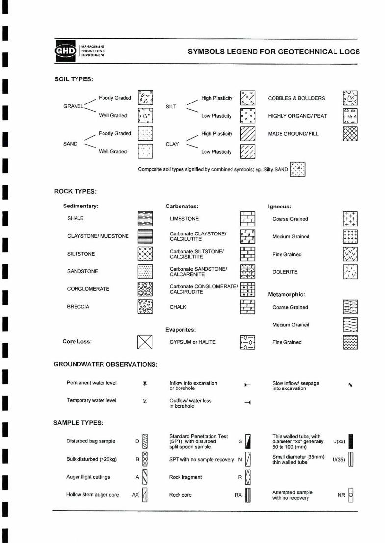
II
SYMBOLS LEGEND FOR GEOTECHNICAL LOGSISOIL TYPES:I
Cl.Poorly Graded High Plasticity COBBLES & BOULDERS
GRAVEL SILTI Well Graded Low Plasticity HIGHLY ORGANIC/PEAT
Poorly Graded High Plasticity MADE GROUND/ FILLI SAND CLAYWell Graded Low Plasticity
II ROCK TYPES:
Sedimentary: Carbonates: Igneous:
I SHALE LIMESTONE Coarse Grained
CLAYSTONE/ MUDSTONE Medium GrainedI SILTSTONE Fine Grained
I SANDSTONE DOLERITE
CONGLOMERATEI Metamorphic:
BRECCIA CHALK Coarse Grained
I Medium GrainedEvaporites:
Core Loss: GYPSUM or HALITE Fine GrainedIGROUNDWATER OBSERVATIONS:
I Permanent water level
I Temporary wafer level 5
SAMPLE TYPES:I IDisturbed bag sample S U(xx)
I SPT with no sample recovery N /Bulk disturbed (>20kg) U(35)
Auger flight cuttings A Rock fragmentI R
Hollow stem auger core AX Rock core RX NR C
II
'' •) <
MANAOEMCNT ENGINEEKINQENVItONJUENF
• 6*
Inflow Into excavation or borehole
Carbonate SILTSTONE/ CALCISILTITE
Carbonate SANDSTONE/ CALCARENITE
Attempted samplewith no recovery
Slow inflow/ seepage into excavation
AV
Carbonate CLAYSTONE/ CALCILUTITE
Carbonate CONGLOMERATE/CALCIRUDITE
Outflow/ water loss in borehole
S
Small diameter (35mm) thin walled tube
/// /•// V//
Thin walled tube, with diameter "xx" generally 50 to too (mm)
Composite soil types signified by combined symbols; eg. Silly SAND / \
2 ii st .11. .'I.
Standard Penetration Test (SPT). with disturbed split-spoon sample
✓szvw
++++ + + + 4 + 444
1+ 11 I V V IXXX
XXX
O 9
0^ <
“IB X
X
T~rTjT
• • yr»
Tf rcz
Mra

II TP01
Sheet 1 of 1
II Job No.: 61/23926
Equipment: JCB Backhoe
Bucket Size (m): 0.5 Not RecordedIstrata Descriptioni
II SM
I 1SP
I 0.5 0.5
II 1.0 1.0
II
1.5 1.5
II
2.0I 2.0
II 2.5 2.5
II 3.0
I
GHD
I
Client:Project:
MASAOEMENreN<JINEE!!INOENVISONMENr
(type; colour; fines plasticity or particle characteristics; minor components: structure and/or origin)
Sample/Test Records & Comments
s□
£S’a
Reg ReynoldsSeaview Farms, Horrocks
Refusal on limestoneTermination Depth = 0.76m (Refusal)
•tt c 3
s ’5) o oO
M • ;.;.x< •
SANDRed brown, fine to medium grained, sub angular to sub rounded.RESIDUAL SAND
o a OK
Logged;Processed: Checked:
CMHCMH
04-May-0925-Jun-09
Coordinates; E 248 678, N 6857 904
Ground Surface Elevation: +1.0mAHD Total Depth: 0.8m
Commenced: 04-May-09 Completed: 04-May-09
Contractor: - Operator; Stuart
c o
s22 O
V
3 co
I Q
Excavation Width (m): 0.7Excavation Length (m): 3.0 Orientation/ Bearing:
“c o •o c o o £315 o
"d"
TEST EXCAVATION LOG
O)
Test PitNo.:
TJi <0
x;o Q
SILTY SANDBrown, fine grained, sub angular to sub rounded. Contains occasional roots.TOPSOIL/SUBSOIL
I1 o £ o
§ s §2 UJg -3.d <ni I
dZ
I
0.761*0.24]
4) Q.
» £ If
* '55 > c
u 0) c Q
.1?O)
3 Q12 o
5 1^1*0 7q

II TP02
Sheet 1 of 1
IJob No.: 61/23926I Equipment; JCB Backhoe
Bucket Size (m): 0.5I Not Recorded
Strata Description
Ii
II SP
!
I 0.5 0.5
I ■o
i
I 1.0 1.01.00
BI a>
I1.5 1.5
I DM
I2.0I 2.0
II 2.5 2.5Termination Depth = 2.50m (Target Depth)
i
II 3.0 3.0
I
85I §
IS
Client: Project:
Reg ReynoldsSeaview Farms, Horrocks
SampleZTest Records& Comments
(type; colour; fines plasticity or particle characteristics; mirror components; structure and/or origin)
SILTY SANDBrown, fine grained, sub angular to sub rounded. Contains occasional roots.TOPSOIL/SUBSOIL________________________SANDYellow brown, fine to mecBum grained, sub angular to sub rounded.RESIDUAL SAND
d z ® D. E ID W
CMH
CMH
04-May-09
25-Jun-09
0.20 (40 M)
><----- X MD X -D X
c JS o 111 ODC
"T"
E
tO
T03
sQ
Coordinates; E 248 795, N 6857 856
Ground Surface Elevation: +1 .Om AHD Total Depth; 2.5m
Commenced: 04-May-09 Completed: 04-May-Q9
Contractor: - Operator: Stuart
st03o
MANACSMENTeNGINCEXIN^ENVMOMMENr
TEST EXCAVATION LOG Test Pit
No.:
Excavation Width (m): 0,7Excavation Length (m): 3.0 Orientation/ Bearing:
.2
c <3£aeoS
§
§ q:
§2(D (d
I t©
<09
lU
if a go f > "■
Wo8?X ' 4 ■ .
J« • •
K • •
Logged:
Processed:
Checked;
§11 .2 O
c □oTO o g o

ITP03
Sheet 1 of 1i
Job No.: 61/23926I Equipment; JCB Backhoe
Bucket Size (m): 0.5I Checked;
Strata Description
I 85 Q>SI
<0 00I L
X
II ■X
X0.6 0.5-'x
X
II 1.0 1.0-
II
1.5 1.5-
II
2.0I 2.0-
II 2.5 2.5-
II 3.0 3.0-
I
GHD
,x •
Client:Project:
Reg ReynoldsSeaview Farms, Horrocks
(type: colour fines plasticity or particle characteristics; minor components: structure and/or origin)
u1Io
Sample/Test Records
& Comments
MANAGSWENr eNoiNCtmNOENVIRONMSNr
Refusal on linnestoneTermination Depth = 1.10m (Refusal)
SILTY SANDBrown, fine grained, sub angular to sub rounded. Contains occasional roots.TOPSOIL / RESIDUAL SAND
1I
I1
c O
8 •o. o o 0) o
Coordinates; E 248 822, N 6857 750
Ground Surface Elevation: +1 .Om AHD
1.101-0’01
04-May-09
25-Jun-09
CALCARENITEWhite, fine to medium grained, sub angular to angular. Contained strongly cemented nodules to 30mm inside a weakly cemented sandy matrix. COASTAL LIMESTONE
6 z J£ exE n ifl
.X.-. *.*x
*•? - X
iE
I □
CMH
CMH
8 U)
<u Q
Total Depth; 1.1m
Commenced; 04-May-09 Completed: 04-May-09
Contractor: - Operator: Stuart
J, o
8(/)ta> a
*D § o S 3 .2 o S
"d"
5
o a> O 01
1I3
C o la o i;:S
JO O
TEST EXCAVATION LOG Test Pit
No.;
Logged:
Processed:
VV
Cxi
OPK
I o
o
5 £
§5 zUJ e
Excavation Width (m): 0.7
Excavation Length (m); 3.0
Orientation/ Bearing: Not Recorded
O)3
2 o
X . ■

II TP04
Sheet 1 of 1
IJob No.: 61/23926I Equipment: JCB Backhoe CMH
CMHBucket Size (m): 0.5I Not Recorded
.5Strata Description
II
/SP
II 0,5 0.5-
II 1.C 1.0-
II
1.5 1.5-
II
2.0I 2.0-
I o>
I 2.5 2.5-
II 3.0 3.0-
I
4)oj
25
s o>o
Reg ReynoldsSeaview Farms, Horrocks
(type: colour; fines plasticity or particle characteristics: minor components: structure and/or origin)
Coordinates: E 248 881. N 6857 488
Ground Surface Elevation: +1 .Om AHD
L-MD
Sample/Test Records & Comments
Client:Project:
Refusal on limestoneTermination Depth = 1.70m (Refusal)
O)o
a. E <0 tn
SILTY SANDBrown, fine grained, sub angular to sub rounded. Contains occasional roots,
yOPSOIL/SUBSOIL _____________________ fSANDYellow brown, fine to medium grained, sub rounded to sub angular.RESIDUAL SAND
SE
j:Q.<V Q
Logged;Processed: Checked:
Total Depth: 1.7m
Commenced: 04-May-09 Completed: 04-May-09
Contractor; - Operator; Stuart
i
fJS u
(A
ta> Q
1.70(-0.70]
10)s w £s* Q
04-May-0925-Jun-09
Io tcIS.2
Excavation Width (m): 0.7Excavation Length (m): 3.0 Orientation/ Bearing:
"c*
■O
o Q e 3
s o'
MANAOEMENT
ENVISONWeNr
TEST EXCAVATION LOG[(GHDi Test Pit
No.:
I X • .
X '.’.Ji.'
O 0) oa
O 0) ?Q
°-g-tn<Ji
CM
s o £&1 o§§ s s o2_j
S z

II TP05
Sheet 1 of 1
II Job No.: 61/23926
Equipment: JCB Backhoe
Bucket Size (m): 0.5I Not Recorded
Strata Description
II D L
N.G.E = No groundwater encounteredMX
XXI
I 0.5 0.5
II 1.0 1.0
II
1.5 1.5
II
2.0I 2.0
II 2.5
II 3.0HI (dL 3.0
I
oI
Ol o
Client:Project:
Reg ReynoldsSeaview Farms, Horrocks
Refusal on limestoneTermination Depth = 0.30m (Refusal)
Sample/Test Records & Comments
.2
ISM
(type; colour fines plasticity or particle characteristics: minor components; slaicture and/or origin)
Excavation Width (m): 0.7Excavation Length (m): 3.0 Orientation/ Bearing:
MANAGEMENF ENGINEERING ENVIRONMCNF
04-MayO925-Jun-OS
SILTY SANDBrown, fine grained, sub angular to sub rounded. Contains occasional roots.TOPSOIL / RESIDUAL SAND
CMHCMH
Coordinates: E 248 739, N 6857 505
Ground Surface Elevation: +1 .Om AMD Total Depth: 0.3m
Commenced; 04-May-09 Completed: 04-May-09
Contractor: - Operator; Stuart
re
IQ
I “□co o
I1
S'g1« a
’ .•’S
CM .
fe. 0 ci • ^2.5
S ‘ 0 • (O
8'CM •
s. (□ 2 ■ _J •
TJi u
£
& Q
TEST EXCAVATION LOG
d zQ.
I co
'llO 0) ua:
Logged;Processed:Checked;
Test PitNo.:
a
Is
0,30I+QZOJ
wC =)
•(5•a oS o
Ic D.2 o
X .

II TP06
Sheet 1 of 1
IJob No.:I 61/23926
Equipment: JCB Backhoe
Bucket Size (m): 0.5I Not Recorded
Strata Description
II D LII
N.G.E. = No groundwater encountered
.XXI
I 0.5 0.5
II 1.0 1.0
II
1.5 1.5-
II
2.0I 2.0
II 2.5 2.5-
II 3.0 3.0-
I
I’.’X
*•?
o
I
Client:Project:
MAMAOEMENrENGIHEERfNQBNVJSONMCNT
Reg ReynoldsSeaview Farms, Horrocks
Refusal on limestoneTermination Depth = 0.34m (Refusal)
(type; colour; fines plasticity or particle characteristics; minor components: structure and/or origin)
sa
w&o
Sample/Test Records & Comments
Io E u
O
CMHCMH
SILTY SANDBrown, fine grained, sub angular to sub rounded. Contains occasional roots.TOPSOIL ! RESIDUAL SAND
Coordinates: E 248 677, N 6857 657
Ground Surface Elevation: +1.0mAHD Total Depth: 0.3m
Commenced: 04-May-09 Completed: 04-May-09
Contractor: - Operator: Stuart
.■s c3ra _o
s tS
04-May<l9
25-Jun-09
5 u
co£S' o
Excavation Width (m): 0.7Excavation Length (m): 3.0 Orientation/ Bearing:
o '<S
Io O £3
'oS
TEST EXCAVATION LOG
a z9Q.
I CO
Test PitNo.:
§ s
0 O'
1 <3 £
S o co CM £
§
2 lil5- oL
-..'K >< c O «)
WSISO 9 UQ^
0.34 j4066l
Logged:Processed:Checked:
§9 Q
g» .J o J=
o X •
a•st I" 1° OTod

II TP07
Sheet 1 of 1
IJob No.:I 61/23926
Equipment: JCB Backhoe
Bucket Size (m); 0.5I Not Recorded
Strata Description
II
.iX
I©
»ra SPI 0.5 0.5-O)sI
I OSO
1.0 D 1.0-1.10I
I1.5 1.5
II
2.0I 2.0
II 2.5-
II •Q 3.0
I
J
1
■O
S
Refusal on limestoneTermination Depth = 1.30m (Refusal)
I
Client:Project:
Reg ReynoldsSeaview Farms, Horrocks
Sample/Test Records & Comments
0.40(.0601
(type; colour; fines plasticity or particle characteristics; minor components; structure and/or origin)
SILTY SANDBrown, fine grained, sub angular to sub rounded. Contains occasional roots.TOPSOIL / SUBSOIL
J "5 u to
t 5Q 5
04-lv1ay-0925-Jun-09
SANDYellow brown, fine to medium grained, sub roundedto sub angular.RESIDUAL SAND
'E
w g ‘5» os (5
CMHCMH
s&
.cI□ c J2 o o ODi:~l“
1.30 (.0 301
Excavation Width (m): 0.7Excavation Length (m): 3.0 Orientation/ Bearing:
Xi
o o £Io So'
S w £8- Q
TEST EXCAVATION LOG
MANAGEMENr ENGIHEERING EHVRONMENF
Test PitNo.:
6 zQ.
tn
c o 'IS o
0) (0 OSM
Logged:Processed:Checked:
&. uS ■ o- -2 5
o £ P S §
g
s z UJ a
ghd
i X , ,
M
’.■’S X. /
0)
Vi od
Coordinates: E 248 786, N 6857 734
Ground Surface Elevation: +1.0mAHD Total Depth: 1.3m
Commenced: 04-May-09 Completed; 04-May-09
Contractor: - Operator: Stuart

II TP08
Sheet 1 of 1I
II Job No.: 61/23926
Equipment: JCB Backhoe
Bucket Size (m): 0.5I Not Recorded Checked:
Strata Description
II L
N.G.E. = No groundwater encounteredMX
XXI
I -0.5 0.5
II
1.0 1.0
II
1.5 1.5
II
2.0I 2.0
II 2.5 2.5
II 3.0 3.0
I
MANAOSMENFENOINESRSNOENViXONMENf
Reg ReynoldsSeaview Farms, Horrocks
Refusal on limestoneTermination Depth = 0.30m (Refusal)
I
Client: Project:
Sample/Test Records & Comments
O)o
(type: colour; fines plasticity or particle characteristics: minor components; structure and/or origin)
ui d z
Coordinates: E 248 579, N 6857 795
Ground Surface Elevation: +1.0mAHD
i!L .—
£ §• Q
CMH
CMH
SILTY SANDBrown, fine grained, sub angular to sub rounded. Contains occasional roots.TOPSOIL / RESIDUAL SAND
04-May-09
25-Jun-09
i.J! s (O
0) a
po 70}
d zGJae n
Total Depth: 0.3m
Commenced: 04-May-09 Completed: 04-May-09
Contractor: - Operator: Stuart
Ji o
U) £
o
c o •S u <E v> in3 o
SM
§ § CM
<a £ £1 o s aSS £
25 z LU O
TEST EXCAVATION LOG
I?
Eo
Test Pit No.:
xs c o
1 a> o
1
.4 •5.= o ® a
.«.> « " o® OK
Logged:Processed:
td
u Z
w X .
Excavation Width (m): 0.7Excavation Length (m): 3.0 Orientation/ Bearing:
o
co o £
I s"d"

II TP09
Sheet 1 of 1
IJob No.:I 61/23926Equipment: JCB Backhoe
Bucket Size (m): 0.5Istrata Description
II D L
N.G.E. = No groundwater encounteredX
XI XX
X
I 0.5 0.5
II 1.C 1.0
II
1.5 1.5
II
2.0I 2.0
II 2.5 2.5
II
3.0
I£ -3.0ol- I
I
Client: Project:
Reg ReynoldsSeaview Farms. Horrocks
Refusal on limestoneTermination Depth = 0.36m (Refusal)
Sample/Test Records & Comments
(type: colour; lines plasticity or particle characteristics; minor components: structure and/or origin)
sfo
(0 £s*Q
a z<uQ.I w
CMH
CMH
04-May-09
25-Jun-09
SILTY SANDBrown, fine grained, sub angular to sub rounded. Contains occasional roots.TOPSOIL / RESIDUAL SAND
Total Depth: 0.4m
Commenced: 04-May-09 Completed: 04-May-09
Contractor: - Operator: Stuart
Coordinates: E 248 539, N 6857 988
Ground Surface Elevation: +1.0mAHD
1•DC o u £■I s
o>
u ic Q.2 o
S w z:
o
s; uIt0) a
c o
aw M
O
SM
TEST EXCAVATION LOG Test Pit
No.:MANAGEMENT ENGINEESIMGENVIRONMENT
hI® OToa
11 O 0) on:
Logged:Processed:Checked:
0.361*064]
Cl
O K
fe x o
o (C
sCMG o 2
Excavation Width (m): 0.7Excavation Length (m): 3.0Orientation/Bearing: Not Recorded

II TP10
Sheet 1 of 1
II Job No.: 61/23926
Equipment: JCB BackhoeI
I Bucket size (m): 0.5 Not Recorded
Strata DescriptionI
III SP
I 0.5 0.5
II 1.0 1.0
II M
1.5 1.5
III 2.0 2.0
II 2.5 2.5Termination Depth = 2.50m (Target Depth)
II 3.0
I
g,o
Client:Project:
(type; colour; fines plasticity or particle characteristics: minor components; structure and/or origin)
SampleZTest Records & Comments
II
Reg ReynoldsSeaview Farms, Horrocks
MD-D
MANAOEMENr5NOINJESINOENVISONMENr
Coordinates: E 248 710, N 6858 051
Ground Surface Elevation: +1.0mAHD Total Depth: 2.5m
Commenced: 04-May-09 Completed: 04-May-09
Contractor; - Operator: Stuart
1
SILTY SANDBrown, fine to medium grained, sub rounded. Contains occasional roots.TOPSOIL / SUBSOILSANDYellow, fine to medium grained, sub rounded. RESIDUAL SAND
CMHCMH
04-May-0925-Jun-09
1£3S
r*o.8o)
ozQ.e
C
.1□)o
I
c .28 IE <0 w Q
TS’S w £Q.ts
E.£ o
C/3 £ §■ o
TEST EXCAVATION LOG
o’ a
O 01 oq:
S co tn CM
fe O oiUJ
X o 2 o (d C'J
2 g ILI
S -3.0 col
i¥£&O
!
Test PitNo.:
Logged:Processed: Checked:
Excavation Width (m); 0.7Excavation Length (m): 3.0 Orientation/ Bearing:
o .■s
o U £IoS"d"
2.501-1 50J
iM * . ’ •
K • •

II TP11
Sheet 1 of 1
II Job No.: 61/23926
Equipment: JCB Backhoe CMHCMH
Bucket Size (m): 0.5I Not Recorded
Strata Description
II X D
■ iX
I Ji
SP
I 0.5 0.5
I MD
I1.0
IM D
130I B
1.5 liO 1.5
II
2.0I 2.0
I Termination Depth = 2.20m (Target Depth)
I -2.5 2.5
II 3.0
I
I
Client:Project:
Reg ReynoldsSeaview Farms, Horrocks
X XXX
Sample/Test Records & Comments
(type: colour; fines plasticity or particle characteristics; minor components: structure and/or origin)
WA'/AOEMEWENGINEERIMOENVIKO'^MSNr
Coordinates: E 248 665, N 6858 123
Ground Surface Elevation: +1.0mAHD
9
O (O £ & Q
SANDYellow brown, fine to medium grained, sub rounded.RESIDUAL SAND
2.20(-1301
SILTY SANDBrown, fine to medium grained, sub rounded.Contains occasional roots.TOPSOIL! SUBSOIL
Total Depth: 2.2m
Commenced: 04-May-09 Completed: 04-May-09
Contractor: - Operator: Stuart
04-May-0925-Jun-09
Q. E nj (O
(♦0 751
T a>s w £Q.Q I
Excavation Width (m): 0.7Excavation Length (m): 3.0 Orientation/ Bearing:
o5•oco O SIoS
§<M
6o gI o
•J*0)
£ & Q
TEST EXCAVATION LOG
c
Io
Is
1 r1.0
Test Pit No.:
•E . o 2-rS -3.0 1*11
1« 5 sS
L
Logged:Processed: Checked:
..2>= g. o a 2; so ® m
1°(CodI}

TP12Sheet 1 of 1
IJob No.: 61/23926Equipment: JCB Backhoe
Bucket Size (m): 0.5 Not Recorded
Strata DescriptionI
3
0.5 0.5X
II 1.0 1.0
Ii
I1.5 1.5
II
2.0I 2.0
II 2.5 2.5
II 3.0 3.0UJ
Q
I
1
Is
c o
o
5SM
{type; colour; fines plasticity or particle characteristics: minor components; structure and/or origin)
Sample/Test Records & Comments
Refusal on limestoneTermination Depth = 0.60m (Refusal)
Ciient:Project:
Reg ReynoldsSeaview Farms. Horrocks
5 EI£6 a
I I
0.3m: Contains white grey, tine grained, sub rounded limestone cobbles and boulders up to 400mm in size.
!I
X • .;.x x’*’
•.’5
<oU g —J
CMHCMH
o z o Q. E <Q
CO
Coordinates: E 248 467, N 6858 140
Ground Surface Elevation: +1.0nnAHD Total Depth: 0.6m
Commenced: 04-May-09 Completed: 04-May-09
Contractor: - Operator: Stuart
§<3 £
SILTY SANDBrown, fine to medium grained, sub rounded.Contains occasional roots,TOPSOIL / RESIDUAL SAND
T0
S
t9 O
O
u <0
t Q
.1.5Q 0) oos "l"
§
§
Logged;Processed;Checked:
04-May-0925-Jun.O9
31
32 OJ§
i
5'S I go *S-
(AoS
Test PitNo.:
TEST EXCAVATION LOG
.’.‘x
V? < • X X’? ’ ’ X
MANAGEMENF ENGIHEERiNGEhVIRQNMeNr
0.60
Excavation Width (m): 0.7Excavation Length (m): 3.0 Orientation/ Bearing:
.0
Co O £3£o E"o'
c 3
s •a oS o
o>
u £ Q.s o
X .

II TP13
Sheet 1 of 1
II Job No.: 61/23926
Equipment; JCB Backhoe
I Bucket Size (m): 0.5 Not Recorded
Strata Description
II 4
wX
I 9X
I XX-0.5 0.5X
Mi
I XX
I■1.0 1.0
II
-1.5 1.5
III 2.0 2.0
II -2.5 2.5
II -3.0 3.0
I
. X
> X
X •
)i.'.
Reg ReynoldsSeaview Farms, Horrocks
(type; colour; fines plasticity or particle characteristics; minor components; structure and/or origin)
Sample/Test Records & Comments
Client:Project:
§ ffi
5Q.Q> Q
o
I§
o
I
Refusal on limestoneTermination Depth = 0.75m (Refusal)
IQ.E(0
coi o
SM
CMHCMH
•o
I
TsiS
CO
Ia> u
CO
tQ)Q
0.751*0251
Excavation Width (m); 0.7Excavation Length (m); 3.0 Orientation/ Bearing:
c .2
J s 3
oSo'
04-May-0925-Jun-09
S fe a aS § CD
£CD s£ o 3S z UJ o
TEST EXCAVATION LOG Test Pit
No.:MAVACJEMENr ENGINEERINO ENVISONMEMF
SILTY SANDBrown, fine to medium grained, sub rounded.Contains <x:casional roots.TOPSOIL / RESIDUAL SAND
Logged:Processed:Checked:
O)3 oOL
£ oSS o t> cjo:T"
2:a
OTod
!s
Coordinates: E 248 491, N 6858 259
Ground Surface Elevation: -H.CmAHD Total Depth: 0.8m
Commenced: 04-May-09 Completed: 04-May-09
Contractor: - Operator: Stuart

II TP14
Sheet 1 of 1
II Job No.: 61/23926
Equipment: JCB Backhoe
I Bucket Size (m): 0.5 Not Recorded Checked;
Strata Description g.Ii cooaI
JSPI MD
I TS0,5 0.5-
II 1.0 1.0-
II
1.5 1.5-
III 2.0 2.0-
II 2.5 2.5-
II
3.0-
I
I
o® g-
Client:Project:
MKNAC£MENr ENG1MEERIN0ENVIRONMBNr
Reg ReynoldsSeaview Farms, Horrocks
Refusal on limestoneTermination Depth = 1.20m (Refusal)
Sample/Test Records & Comments
(type; colour fines plasticity or particle characteristics; minor components; structure and/or origin)
3s5
c
sa o§0 o a>
O QC
"l"
I
SILTY SANDBrown, fine to medium grained, sub rounded. Contains occasional roots.
yOPSOIL/SUBSOIL _____________________SANDYellow brown, fine to medium grained, sub angular to sub rounded.RESIDUAL SAND
CMHCMH
Coordinates: E 248 546, N 6858 404
Ground Surface Elevation; -H.OmAHD Total Depth: 1.2m
Commenced; 04-May-09 Completed; 04-May-09
Contractor: - Operator: Stuart
S OT £ o Q
d z
a.E ra tn
04-May^)925-Jun-09
p §■
Ic o13 o
ra 5SM
o
£ §* o
z - O £ ■ 0 •
I- o o -
u-3.0
0.15 poesj
TEST EXCAVATION LOG Test Pit
No.:
J> u
co
to
Excavation Width (m): 0.7Excavation Length (m): 3.0 Orientation/ Bearing:
o *.sco a £•I s
"d"
a
iX ‘ .
M •
Logged:Processed:
a M
' «s ® .2 .>

II TP15
Sheet 1 of 1
IJob No.:I 61/23926
Equipment: JCB Backhoe
Bucket Size (m); 0.5Istrata Description
I(nodI A
N.G.E. = No groundwater encountered
0.20
I J
I 0.5 0.5
II 1.0 1.0
II
1.5 1.5
II
2.0I 2.0
II 2.5 2.5
II 3.0 3.0-
I
Shd
M •
Client:Project:
MANAGEMCNFENGiMEERINOBNViSOMMENr
{type: colour; fines plasticity or particle characteristics; minor components; structure and/or origin)
sa
aI
Reg ReynoldsSeaview Farms, Horrocks
Sample/Test Records& Comments
Logged:Processed: Checked;
CMHCMH
c o s o U:
s o
SM
5 o
cn £ K
6 z a> Q. E ra
WSILTY SANDBrown, fine to medium grained, sub rounded. Contains occasional roots and white fine grained limestone cobbles up 150mm in size.
ATOPSOIL / RESIDUAL SAND_______________Refusal on limestoneTermination Depth = 0.20m (Refusal)
04-May-0925-Jun-09
40
s (3
212 oS ?? oj
O g —I2 z ill o
0)
TEST EXCAVATION LOG
s£&o
Test PitNo.:
0) S'®
.».> c ™□ 0) O 01 "l"
c 3 To o ’5)
9 o
D)
3 U £
o X .
Excavation Width (m): 0.7Excavation Length (m): 3.0Orientation/ Bear!ng: Not Recorded
Ic•2
§oS3
s"o'
Coordinates: E 248 284, N 6858 524
Ground Surface Elevation: +1.0mAHD Total Depth: 0.2m
Commenced: 04-May-09 Completed: 04-May-09
Contractor; - Operator: Stuart

II TP16Test Pit
No.:Sheet 1 of 1
II Job No.: 61/23926
Equipment: JCB Backhoe
I Bucket Size (m): 0.5 Not Recorded
Strata Description
II D
ISP
I 0.5 0.5-
1II
1.0-MD
II
1.5 1.5-
III 2.0 2.0-
I Termination Depth = 2.30m (Target Depth)
I 2.5 2.5-
II 3.0 3.0-
I
MD-D
sI
Client: Project:
(type: colour; fines plasticity or particle characteristics; minor components; structure and/or origin)
Reg ReynoldsSeaview Farms, Horrocks
SampleZTest Records & Comments
£ a Q
MANAOEMENr ENGIMEE^INQENVISONMeNr
Coordinates: E 248 342, N 6858 659
Ground Surface Elevation: 4-1 .Om AHD
0)
I1.0 I
SANDYellow brown, fine to medium grained, subrounded.RESIDUAL SAND
SILTY SANDBrown, fine to medium grained, sub rounded. Contains occasional roots.TOPSOIL/SUBSOIL
c o
n(9 o
SM
I<EU
W
a.
Total Depth: 2.3m
Commenced: 04-May-09 Completed: 04-May-09
Contractor: - Operator: Stuart
CMHCMH
2.30J.1 3q
6 z o •a £(9
04-May-0925-Jun-08
.2!S
co
Q
Excavation Width (m): 0.7Excavation Length (m): 3.0 Orientation/ Bearing:
"c" o
1 o os: 3
Qs
§ $8
oS1 u £ oS o
ID
o2§ zUJ o
TEST EXCAVATION LOG
0)
Isuxd
.5O 41
5°
O 41 OK
Logged:Processed:Checked:
.■s c3 ■5
io
K.-.
iX ■ . . ■

II TP17
Sheet 1 of 1
II Job No.: 61/23926
Equipment: JCB Backhoe
I Bucket Size (m): 0.5 Not Recorded
Strata Description
II
b-. fl
II 0.5 0.5
OM
I D
o.eo
I O)
Z
1.0 1.0
II
1.5 1.5
III 2.0 2.0
I O)
I 2.5 2.5
II
3.0
I
I
o
I
c o
I sM
JS u
Reg ReynoldsSeaview Farms, Horrocks
(type; colour; fines plasticity or particle characteristics; minor components: structure and/or origin)
Sample/Test Records & Comments
Client:Project:
D-VD
---SP
Refusal on limestoneTermination Depth = 1.10m (Refusal)
MAVAGEMEW ENGINEESIMGENVRONMENr
SANDY GRAVELWhite, sand is fine to medium grained, sub angular to sub rounded, gravel is fine to coarse. RESIDUAL SAND / COASTAL LIMESTONESANDRed brown, fine to medium grained, sub rounded to sub angular.RESIDUAL SAND
Excavation Width (m): 0.7Excavation Length (m); 3.0 Orientation/ Bearing;
“c o
o O £
•I s"o'
CMHCMH
3 to £ Q.
04-May-0925-Jun»09
o zQ.
H (D U)
O)3 o a2 o
’5^1 GP
£o3
(O £
0.2Q
iSItCD Q
TEST EXCAVATION LOG Test Pit
No.:
t.toHJtOl
Logged;Processed:Checked:
CM
tsI I Q
o s
§
r3.d eil—
I co .>*
co 00
c
■<5 uQO
g
Coordinates: E 248 312, N 6858 846
Ground Surface Elevation: +1.0mAHD Total Depth: 1.1m
Commenced: 04-May-09 Completed: 04-May-09
Contractor: - Operator; Stuart
§2o a> o q:

II TP18
Sheet 1 of 1
I Total Depth: 0.9m
Job No.:I 61/23926Equipment: JCB Backhoe
Bucket Size (m): 0.5I Not Recorded
Strata Description
II
X
X
I SP
I 0.5 0.5-0£D
B
I 0.70
I 1.0 1.0
II
1.5 1.5-
II
2.0I 2.0
II 2.5
II 3.0-
I
.ghd'
in -3.C ot -
2
Client: Project:
0.20
Refusal on limestoneTermination Depth = 0.85m (Refusal)
Sample/Test Records& Comments
Reg ReynoldsSeaview Farms, Horrocks
WAVACEMENFENGINEERINGENVIRQNMSNF
MO 5X X ><
c
S§
'4^’c
"s •5 os o
(type; colour fines plasticity or particle characteristics; minor components; structure and/or origin)
Q4-MayO9
25-Jun-09
SILTY SANDBrown, fine to medium grained, sub rounded. Contains occasional roots. TOPSOIL/SUBSOILSANDRed brown, fine to medium grained, sub angular to sub rounded.RESIDUAL SAND
.2>
L
CMH
CMH
d z * Q. E ra w
.2 u
<J> £ & Q
Coordinates: E 248 201, N 6858 945
Ground Surface Elevation: +1 .Om AMD
Commenced: 04-May.09 Completed: 04-May-09
Contractor: - Operator; Stuart
s£
O
Excavation Width (m): 0.7Excavation Length (m); 3.0 Orientation/ Bearing:
"c" o
c o O £
I oS
T2res,t oQ
c2 re o
1 o
TEST EXCAVATION LOG Test Pit
No.:
d I EQ li*
“■S- Eq
OToa
Logged;Processed:Checked:
§■rB.o£'
S - R.
o3 ■
at3Q.2 e>

II TP19
Sheet 1 of 1
IJob No.: 61/23926I Equipment; JOB Backhoe
Bucket Size (m): 0.5 Not RecordedIstrata Description
II it
N.G.E. = No groundwater erxjounteredM
II 0.5 0.5
II 1.0 1.0
II
1.5 1.5
II
■
2.0I 2.0
II 2.5 2.5
II 3.0 3.0
I
I
X •
Client: Project:
Refusal on limestoneTermination Depth = 0.40m (Refusal)
(type; colour: fines plasticity or particle characteristics; minor components; structure and/or origin)
Sample/Test Records& Comments
MAXAGEMENF ENGIHEERING SNVKONMENr
d z
E <!5
0.40 J*O60I
CMH
04-May-09
25-Jun-09
? o iniK Q> Q
X.’.
* .'x
C o 15 a
0)
O
O)3 o ic o.E o
01 ffl u M £ & Q
Logged:
Processed:
Checked:
o"3
tu Q
Reg ReynoldsSeaview Farms, Horrocks
SILTY SANDBrown, fine to medium grained, sub rounded. Has a high content of white fine grained limestone cobbles up to 200mm in size.TOPSOIL / RESIDUAL SAND
Excavation Width (m): 0.7Excavation Length (m): 3.0 Orientation/ Bearing:
,o£o o £€oS
d"
TEST EXCAVATION LOG
0} a
Iswoe
S gCM
o£gX o2oSSCM£
5 zlU
Test PitNo.:
a
o o OQ^
MD
!
f
Coordinates: E 248 136, N 6859 010
Ground Surface Elevation; +1.0mAHD Total Depth: 0.4m
Commenced: 04-IVIay-09 Completed: 04-May-09
Contractor; - Operator: Stuart

II TP20
Sheet 1 of 1
IJob No.: 61/23926I Equipment; JCB Backhoe
Bucket Size (m): 0.5 Not RecordedIstrata Description
I SI
I AN.G.E. = No groundwater encounteredM
IX
I 0.5 0.5
II 1.0 1.0
II
1.5 1.5
II
2.0 2.0III 2.5
II 3.0
I
I
MAMAOEMENFEHGIHEEiUNOENVIRONMENT
Reg ReynoldsSeaview Farms. Horrocks
Client:Project:
Sample/Test Records& Comments
Refusal on limestoneTermination Depth = 0.45m (Refusal)
'.■.x
(type: colour fines plasticity or particle characteristics: minor components; structure and/or origin)
.’’S X.'. . *. 'x
i
SILTY SANDBrown, fine to medium grained, sub rounded. Contains occasional roots and white fine grained limestone cobbles up to 150mm in size. TOPSOIL / RESIDUAL SAND
o z o>Q. E n
CZ)
Logged;Processed;Checked;
Coordinates; E 248 041, N 6859 135
Ground Surface Elevation; +1.0mAHD Total Depth; 0.5m
Commenced: 04-May-09 Completed: O4-May-09
Contractor; - Operator: Stuart
04-MayO925-Jun-09
CWHCMH
O S) oo:”l”
I o
s JS o
■J
I« o
(♦OSS)
TEST EXCAVATION LOG Test Pit
No.:
BS Is(O 04
-O £■
IS 2 ■ IS -
£ g-
2-3.0
s co £Q.9 o
Excavation Width (m): 0.7Excavation Length (m): 3,0 Orientation/ Bearing;
"c' o £ •aco O £.15S"o'
c
■(5 o 'o> £ s 0
O)3 .9 .c2 0
X ■
T.2 (0s,I Q

II TP21
Sheet 1 of 1
IJob No.: 61/23926I Equipment: JCB Backhoe
Bucket Size (m): 0.5I Not Recorded
Strata Description
II N.G.E. = No groundwater encountered
IK
I 0.5 0.5
II 1.0 1.0
II
1.5 1.5
II
2.0I 2.0
II 2.5
II .0 3.0
I
I
Client: Project:
Refusal on limestoneTermination Depth = 0.50m (Refusal)
(type; colour; fines plasticity or particle characteristics: minor components; structure and/or origin)
Reg ReynoldsSeaview Farms, Horrocks
Sample/Test Records & Comments
uj
t£a
MANAG^WENrENGJNEESINOENVIROXMENF
SILTY SANDBrown, fine to medium grained, sub rounded.Contains occasional roots.TOPSOIL! RESIDUAL SAND
CMH
CMH
Coordinates; E 248 146, N 6859 071
Ground Surface Elevation: +1.0mAHD Total Depth: 0.5m
Commenced: 04-May-09 Completed; 04-May-09
Contractor: - Operator: Stuart
0)
£
Q
04-May-09
25-Jun-09
6
*3. £ ra
CO
TJ!IQ
toO
*c Z) m o
'o> o o o O O <l>
o q:L-
MO
c o
o
io 5 O
SM
S -O
o 5?CD <6
CM s §s z lUCD
II
x’»’
-.-.xX.*.
>C.’.
X,’.
TEST EXCAVATION LOG Test Pit
No.:
• X
• • X
Excavation Width (m): 0.7Excavation Length (m); 3.0 Orientation/ Bearing:
Ic o O s s o s
.2^
h (0-8
Logged:
Processed:
Checked:
(ghd)
s

II TP22
Sheet 1 of 1
IJob No.: 61/23926I Equipment: JCB Backhoe CIvW
CMHBucket Size (m): 0.5I Not Recorded
Strata Description
II N.G.E. = No groundwater encountered
/
II 0.5 0.5
II 1.0 1.0
II
1.5 1.5
II
2.0I 2.0
II 2.5
II 3.0 3.0
I
c o o
85 Q
MA'^AOEMENTEHOIHEEKIMOEMVRO'4MEMr
{type; colour; fines plasticity or particle characteristics: minor components: structure and/or origin)
Reg ReynoldsSeaview Farms, Horrocks
Sample/Test Records & Comments
Client: Project:
(M-May-0925-Jun-09
6 za.E ro
u W JC S Q
Total Depth: 0.2m
Commenced: 04-May-09 Completed: 04-May-09
Contractor: - Operator: Stuart
Coordinates: E 247 952, N 6859 158
Ground Surface Elevation: +1.0mAHD
Excavation Width (m): 0.7Excavation Length (m): 3.0 Orientation/ Bearing:
T o2-oco o £
IsSILTY SANDBrown, fine to medium grained, sub rounded. Contains high organic content.
ATOPSOIL/SUBSOIL _________________Refusal on limestoneTermination Depth = 0.15m (Refusal)
•T’
UJ,
£Q
.2.1 C ™ O 111 o q; "l"
TEST EXCAVATION LOG
§•
I-2-55-2 ■ q -
.2rs I
htnod
(D
§
5<5
Test PitNo.:
"uT'Z
S’ o X Q.2 o
X . .
Logged:Processed:Checked:
8 CO
I o
0.15pOBS)
c3
•5_osSM
X » ’

II TP23
Sheet 1 of 1
I Total Depth: 0.5m
Job No.: 61/23926I Equipment: JCB Backhoe
Bucket Size (m): 0.5I Not Recorded
Strata Description
I O
O O)oj)I N.G.E. = No groundwater encountered
II X0.5 0.5-X
II 1.0 1.0-
II
1.5 1.5-
II
2.0I 2.0-
II 2.5 2.5
II .0 3.0-
I
I
Client:Project:
MANAGSMENr ENGINEERINGENVtRQNMENF
Refusal on limestoneTermination Depth = 0.54m (Refusal)
SampleZTest Records & Comments
x.‘.
. *x *■? . X
Reg ReynoldsSeaview Farms, Horrocks
(type: colour; fines plasticity or particle characteristics; minor components: structure and/or origin)
I
c 3 m
SILTY SANDBrown, fine to medium grained, sub rounded. Contains high organic content and white fine grained limestone cobbles and boulders up to 400mm in size.TOPSOIL / RESIDUAL SAND
M • .;.x
Ji.*.
co ■s o
Ui JS O
CMHCMH
J!s to £
Q
O zQ. £ <0 tn
Coordinates: E 247 977, N 6859 300
Ground Surface Elevation: +1.0mAHD
Commenced: 05-May-09 Completed: 05-May-09
Contractor: - Operator: Stuart
Excavation Width (m): 0.7Excavation Length (m): 3.0 Orientation/ Bearing:
"c" o•5X,coo a>
IoSd"
05-May-0925-Jun-09
5 P cc.S o (DS a§SCM s o 3S5
o Q.
■st H- 1“
TEST EXCAVATION LOG
2|-■»>
> cu a E Q
tStSL
i !£
E .Si*** □)
o <vQ
Test PitNo.:
Logged:Processed:Checked:
.2 u (n £ Q.s
0,54. (♦0481
cn .3 .2 £ Q.5 o
X .
O)

II TP24
Sheet 1 of 1
IJob No.: 61/23926I Equipment: JCB Backhoe
Bucket Size (m); 0.5 Not RecordedIstrata Description
III SM
I -0.5 0.5
I 0}
I 1.0
II
1.5 1.5
II
2.d 2.0III 2.5 2.5
II -3.0 3.0
I
.ghd'
I5
MANAGEWNTENGINEhRiNOENVIRONMENr
(type; colour: fines plasticity or particle characteristics; minor components; structure and/or origin)
Client:Project:
Reg ReynoldsSeaview Farms. Horrocks
Sample/Test Records & Comments
Refusal on limestoneTennination Depth = 1.00m (Refusal)
-.1S'g5?
c
I1 o
SILIYSANDBrown, fine to medium grained, sub rounded. Contains high organic content.TOPSOIL/SUBSOIL
SANDBrown, fine to medium grained, sub rounded.Contains white fine grained limestone cobbles up to 200mm in size.RESIDUAL SAND
c.2s
oSM
CMHCMH
O5-May.O925-Jun-09
1.00 [•OOH
0.30HO-roi
6 za.E IB
OT
Logged;Processed: Checked:
os
(O
I Q
£s
(O £
Q
Excavation Width (m): 0.7Excavation Length (m): 3.0 Orientation/ Bearing:
"S' oSTJ Co O£3? O Sd"
oEL
o
TEST EXCAVATION LOG Test Pit
No.:
x*.’ .•.X X*.’
Wx
OQ.
it
I §
1.0 —
ISo o oa: ”l”
CM
o
X o2 <5 (6
g cv £ o2
IUJO
}M ♦ .’.X
X ’
X . .•.« X •
X.'. '.’J X.-.
•.•x> • X
Coordinates: £247999, N 6859 393
Ground Surface Elevation: +1.0mAHD Total Depth; 1.0m
Commenced: 05-May-09 Completed: 05-May-09
Contractor: - Operator: Stuart

II TP25
Sheet 1 of 1
IJob No.: 61/23926I Equipment: JCB Backhoe
Bucket Size (m); 0.5 Not RecordedIstrata Description
III SP
I 0.5
II 1.0 1.0
II
-1.5 1.5
I SHMD
I2.0I 2.0
Termination Depth = 2.10m (Collapsing)
II 2.5 2.5
II 3.0 3.0
I
GHD
0?51*0 75)
>* i $□ o
I
.2
Sa.
Client:Project:
Reg ReynoldsSeaview Farms, Horrocks
(type: colour; fines plasticity or particle characteristics; minor components; structure and/or origin)
6 5 9-Sample/Test Records
& Comments
SANDYellow brown, fine to medium grained, sub angularto sub rounded.RESIDUAL SAND
SILTY SANDBrown, fine to medium grained, sub rounded. Contains high organic content.TOPSOIL/SUBSOIL
CMH
CMH
c3
3O)3 o0)O
SANDBrown grey, fine grained, sub angular. AEOLIAN SAND
s tn JI K
1.65 KISSI
Coordinates: E 247 945, N 6859 487
Ground Surface Elevation: +1.0mAHD Total Depth: 2.1m
Commenced: 05-May-09 Completed: 05-May-09
Contractor; - Operator: Stuart
05-May-09
25-Jun-09
T3
co
a.
s
a:
ao2
ISO QI am ”l”
s a2
zlUQ
Test PitNo.:
Excavation Width (m): 0.7Excavation Length (m): 3.0 Orientation/ Bearing:
o •5 •og a £□5o sd"
TEST EXCAVATION LOG
-0.5
ENGIHEeRINGENVIRONMENF
O
<!5
Logged:
Processed:
Checked:
2.10p.10l
1•. SM
g
1Ol
2
I X . .
X * ’ ' ’
>?*•.-.’J-

II TP26
Sheet 1 of 1
IJob No.; 61/23926I Equipment: JCB Backhoe
Bucket Size (m): 0.5 Not RecordedIstrata Description
II M
.X
I SP
I 0.5 0.5T3
I 0.70
D
I DM
1.0 1.0
I u
I1.5 1.5MD
II
2.0I 2.0
Termination Depth = 2.20m (Collapsing)II 2.5 2.5
II 3.0
I
sg
go>
s
£s
Client:Project:
0.301*0 7q
ENGlMEEItINQiNVWONMENr
{type; colour; fines plasticity or particle characteristics: minor components; structure and/or origin)
Reg ReynoldsSeaview Farms, Horrocks
Sample/Test Records & Comments
I
s
JZs.
c .2 ra u S » J2 O
SM
d zQ.E IS
03
2.20Hio)
CMH
CMH
05-May-09
25-Jun-09
SANDGrey, fine grained, sub angular to sub rounded. AEOLIAN SAND
SILTY SANDBrown, fine to medium grained, sub rounded. Contains high organic contentTOPSOIL/SUBSOIL
<0
<0 .c& Q
Coordinates: E 247 889, N 6859 611
Ground Surface Elevation: +1.0mAHD Total Depth: 2.2m
Commenced: 05-May-09 Completed: OS-May-09
Contractor: - Operator: Stuart
2?'i s
co £ K o Q
.ts c =>
•5)o otS
TEST EXCAVATION LOG
s
o o £ P S §
§ § UJ
S -3.0
Lragged:Processed:
Checked;
Test Pit No.:
Excavation Width (m): 0.7Excavation Length (m): 3.0 Orientation/ Bearing:
.2 ■D
§ a23ao s o s>
oq:
"T"woa}
W*.

II TP27
Sheet 1 of 1
IJob No.: 61/23926I Equipment: JCB Backhoe
Bucket Size (m): 0.5 Not RecordedIstrata Description
II
.X
4-I SP
I 0.5
II o
1.0 1.0
II MO
1.5 1.5
ITermination Depth = 1.70m (Refusal)
I2.0I 2.0
I o>
I 2.5 2.5
II 3.0
I
Is
g H25.s
fQ
Ci lent: Project:
Reg ReynoldsSeaview Farms, Horrocks
(type; colour; fines plasticity or particle characteristics; minor components: structure and/or origin)
SampleZTest Records& Comments
c o fS D
iC
(A <9 o
c
*5)o o
CMHCMH
d z ®
E re
CO
05-May-0925-Jun.O9
1.701-0 70]
£ u
£ □.
Coordinates: E 247 882, N 6859 774
Ground Surface Elevation: +1.0mAHD Total Depth: 1.7m
Commenced: 05-May-09 Completed: 05-May-09
Contractor: - Operator: Stuart
S o
II aS Q
Excavation Width (m): 0.7 Excavation Length (m): 3.0Orientation/ Bearing:
•o§ oS3ISo sd"
TEST EXCAVATION LOG
MANAGEMENT ENGINEERINGENVIRONMENr
hV) ofl
0.5 ■§I
SILTY SANDBrown, fine to medium grained, sub rounded. Contains occasional roots. TOPSOIL/SUBSOILSANDYellow brown, fine to medium grained, sub angular to sub round«i.RESIDUAL SAND
Test PitNo.:
Logged;Processed:Checked:
.3
.1?*«A ‘-g cO 0) oq:
o3 • _J -
2.5 -3.0 III
os £a.s
3
ISM
X

II TP28
Sheet 1 of 1
IJob No.; 61/23926I Equipment: JCB Backhoe
Bucket Size (m): 0.5 Not RecordedIStrata Description
Icoed
II . SP
I 0.5 0.5
II 1.0
II
1.5 1.5MD
II
2.0I 2.0
I cn
Termination Depth = 2.30m (Target Depth)
I 2.5
II 3.0 3.0
I
Client: Project:
MAMAGEMENF ENOINEEHINGENVIWNMENr
_sIH.
£ &□
Reg ReynoldsSeaview Farms, Horrocks
Sample/Test Records & Comments
(type: colour fines plasticity or particle characteristics: minor components: structure and/or origin)
c
.1 OJo o Q> o
05-May-0925-Jun-09
SILTY SANDBrown, fine to medium grained, sub rounded.Contains occasional roots.TOPSOIL/SUBSOILSANDGrey, fine, sub angular to sub rounded.AEOLIAN SAND
CMHCMH
S w
tQ
daQ.E m cn
3 u cn6S' Q
0)
h
c .2 3tf) OS oSM
Excavation Width (m): 0.7Excavation Length (m); 3.0 Orientation/ Bearing:
o
■Oco u23
sT
2.30
fe - O q: - S-2.5 g
§ s
sz lu O
(♦O.soi
TEST EXCAVATION LOG Test Pit
No.:
Logged:Processed:Checked:
ghdt- 1
2?5s C u a>
c JS O 0) cjo;
18 Q>
s •o
1.0 I cn
iX . .
X ’ • ' ’ '
Coordinates: E 247 815, N 6859 977
Ground Surface Elevation: +1.0mAHD Total Depth: 2.3m
Commenced: 05-May4)9 Completed: 05-May-09
Contractor: - Operator: Stuart

II TP29
Sheet 1 of 1
IJob No.: 61/23926I Equipment: JCB Backhoe
Bucket Size (m): 0.5I Checked:
Strata Description
II D L
I SMX
.X
X
I 0.5 0.5
X
I SP
I 1.0 1.0
II MO
1.5 1.5
II
2.0 2.0I MD-D
I Termination Depth = 2.30m (Target Depth)
I 2.5 2.5
II 3.0
I
8g V
Client:Project:
(type; colour; fines plasticity or particle characteristics; minor components: structure and/or origin)
Sampie/Test Records & Comments
Reg ReynoldsSeaview Farms, Horrocks
MANAGEMENF ENGINEMINO ewixoNMCNr
Coordinates: E 247 738. N 6860 107
Ground Surface Bevation: +1.0m AHD
I •o§o£
s
o> 3 .2 .ca.s □
«>1X o2 Q
c o
u £ M
JS o
SANDYellow brown, fine to medium grained, sub roundedto sub angular.RESIDUAL SAND
II
070 COM]
SILTY SANDBrown, fine to medium grained, sub rounded.Contains occasional roots.TOPSOIL / SUBSOILSILTY SANDBrown, fine to medium grained, sub rounded. AEOLIAN / RESIDUAL SAND
CMHCMH
2.30Han
cD
3O)O
o
6 'Z S, Q. E (0
co
7EL
ta>O
05-May-0925-Jun-09
Total Depth: 2.3m
Commenced: 05-May-09 Completed: 05-May-09
Contractor: - Operator: Stuart
Ji s to
tu w S K
TEST EXCAVATION LOG
5 . ts 3 ■ _i.
S.5 -3.0
Test PitNo.:
Logged:Processed:
0.201*0.80)
.2I
ceea
X.’.
M . < ■.‘.X,
log11 O 0) uq:
Excavation Width (m); 0.7Excavation Length (m); 3.0Orientation/ Bearing; Not Recorded
X . . '.’.X.-
X ’ ’ * ’ '
.’.'V X . •, -.’X
V?x*.’.

II TP30
Sheet 1 of 1
IJob No.: 61/23926I Equipment; JCB Backhoe
Bucket Size (m); 0.5I2Strata Description
II L
I SP
AEOLIAN SAND
I 0.5 0.5
II 1.0 1.0
I SP
I MD1.5 1.5
II
2.0 2.0II o>
Termination Depth = 2.40m (Target Depth)
I 2.5
II 3.0
I
MD-D
Reg ReynoldsSeaview Farms. Horrocks
(type; colour fines plasticity or particle characteristics: minor components; structure and/or origin)
Sample/Test Records& Comments
1Iz
Client:Project:
O1 o
o ra 5
SILTY SANDBrown, fine to medium grained, sub rounded. Contains occasional roots.TOPSOIL/SUBSOIL
Coordinates: E 247 730, N 6859 833
Ground Surface Elevation: +1 .Om AHD
c> .2
S != ‘ui• » m O
TTm
Total Depth; 2.4m
Commenced: 05-May-09 Completed: 05-May-09
Contractor: - Operator: Stuart
CMHCMH
o z ffl
E (9
CO
0.25(40.751
c z>
’5j
S Q
-Da
05-May-0925-Jun-09
siu
Q
1.20j.05q
s co
MASAOEMENrENGINEERINGBNVWONMENr
TEST EXCAVATION LOG
§O 0) OK
SANDYellow brown, fine to medium grained, sub angular to sub rounded.RESIDUAL SAND
Test PitNo.:
Logged:Processed:Checked;
>1 I c Q
Q* S’
(S? ojj
-S
fQ
2.40(•1.401
IX ■ . ■ .
,’.4,
. uS ■ fe-2.51 . o2 ■ o - S . g. v> S ’ _J - g.“ rtn tu “3.0
X • •.’.X.
X/.
Excavation Width (m): 0.7Excavation Length (m): 3.0Orientation/Bearing: Not Recorded
"c*oS*0coo2
oS
SANDGrey, fine to medium grained, sub angular to sub rounded.

II TP31
Sheet 1 of 1
I Total Depth; 1,3m
Job No.: 61/23926I Equipment: JCB Backhoe
Bucket Size (m): 0.5IStrata Description
II
X
I SP
I 0.5 0.5-
II 1.0 1.0-
ITermination Depth = 1.30m (Collapsing)I B
1.5 ISO 1.5-
II
2.0I 2.0-
II 2.5 2.5-
II 3.0 3.0-
I
o
I
.2CO) Q>
Client: Project:
Reg ReynoldsSeaview Farms, Horrocks
X XX X X
(type: colour: fines plasticity or particle characteristics; minor components; structure and/or origin)
Sample/Test Records& Comments
0) ■(0 u
OT
£8- a
Logged:Processed:Checked:
CMHCMH
05-May-0925-Jun-09
1.30 to SOI
Coordinates: E 247 564, N 6860 046
Ground Surface Elevation: +1 .Om AHD
Commenced; 05-May-09 Completed: O5-May.O9
Contractor: - Operator: Stuart
SILTY SANDBrown, fine to medium grained, sub rounded.Contains occasional roots.TOPSOIL/SUBSOIL____________________SANDGrey, fine, sub angular to sub rounded,AEOLIAN SAND
to ?IS
L
d z
(Q
£ Ss.S.
UANAGEMENFENGIMEEftlNGENVRONMENr
oHi a o o
o
§5
sILUo
c o
I c: ■55
oSM
TEST EXCAVATION LOG
st0 Q
Test PitNo.;
1ID
80)
13s cns
wod
’E =)3
’5) os (3
3£ Q.2 o
X . .
Excavation Width (m): 0.7Excavation Length (m): 3.0 Orientation/ Bearing: Not Recorded
"c"oS■oco O§oS

II TP32
Sheet 1 of 1
I Total Depth: 1.6m
Job No.: 61/23926I Equipment: JCB Backhoe
Bucket Size (m); 0.5 Not RecordedIstrata Description
I05 o8
I MX
I SP
I 0.5 0.5-
II 1.0 1.0
IMDI
1.5 1.5
I Termination Depth = 1.60m (Collapsing)
I-2.0 2.0-I
I S
I 2.5 2.5
II 3.0
I
a5
ui "3.0
Reg ReynoldsSeaview Farms, Horrocks
Sample/Test Records & Comments
Client:Project:
(type; colour fines plasticity or particle characteristics: minor components: structure and/or origin)
MAMAOEMfNrENOINEERINOtNVISO'EMENr
0.30|M)70) SAND
Grey, fine, sub angular to sub rounded. Contains occasional dead roots.AEOLIAN SAND
<1 « u OT £ & □
SILTY SANDBrown, fine to medium grained, sub rounded.Contains occasional roots.TOPSOIL/SUBSOIL
o' za. E IS
<0
CMHCMH
05-May-0925-Jun-09
Logged:Processed:Checked:
01
IS O)
I o
iII§
Coordinates: E 247 558, N 6859 938
Ground Surface Elevation: +1.0mAHD
Commenced; 05-May-09 Completed: 05-May-09
Contractor: - Operator: Stuart
_5 EL5s. E
i a>Q
Excavation Width (m): 0.7Excavation Length (m): 3.0 Orientation/ Bearing:
o •.sc o o2
s
6C3
C .9S iZ *«O
TEST EXCAVATION LOG Test Pit
No.:
oo> o <J IE Q.
6 x^. .
2
O 0) oct:T"
1.60ho^oj
1^
■E3 rtO ‘5> o g o
S2 o (D
sCME o2 -J

II TP33
Sheet 1 of 1
IJob No.: 61/23926I Equipment; JCB Backhoe
Bucket Size (m); 0.5 Not RecordedIstrata Description
II
•X
X
I SP
I 0.5 0.5JSP
II 1.0 1.0MD
II
1.5 1.5-
II
2.0 2.0I Termination Depth = 2.00m (Target Depth)
II 2.5 2.5
II .0 3.0
I
MD- D
a
Client:Project:
Reg ReynoldsSeaview Farms, Horrocks
Sample/Test Records & Comments
o z
0.30[•0 70)
(type; colour: fines plasticity or particle characteristics; minor components: structure and/or origin)
MANAOEWEWENOINEE5I.no
ENVIRONMENr
GRAVELLY SANDRed brown, sand is fine to medium grained, sub angular to sub rounded, gravel is medium to course grained, sub rounded to rounded limestone.
-\AEOLIAN / RESIDUAL SAND__________________SANDGrey brown, fine to medium grained, sub angular to sub rounded.AEOLIAN / RESIDUAL SAND
CMHCMH
05-May-0925-Jun-09
Ta5
(O
£6 Q
SILTY SANDBrown, fine to medium grained, sub rounded. Contains occasional roots.TOPSOIL/SUBSOIL
0)
I
6 w oc& g £ o to
so sUJ
1 co J=
o □
w
E
t<u O
TEST EXCAVATION LOG Test Pit
No.:
ft-?:
. -.-.t0.50 (*0501
Excavation Width (m): 0.7Excavation Length (m): 3.0 Orientation/ Bearing;
"Z o§co O £.1o Sd"
Logged;Processed:Checked:
2.001-1001
iM ♦ •
1
6 z .2}
s-s I
o a> OK
c o
1 u: M m ZS OSM
Coordinates; E 247 661, N 6859 951
Ground Surface Elevation: +1.0mAHD Total Depth: 2.0m
Commenced: 05-May-09 Completed; 05-May4)9
Contractor: - Operator: Stuart

II TP34
Sheet 1 of 1
II Job No.: 61/23926
Equipment; JOB Backhoe
I Bucket Size (m); 0.5 Not Recorded
Strata Description
IIII -0.5 0,5-
II 1.0 1.0-
II
1.5 1.5-
II MO
I 2.0 2.0-
I Termination Depth = 2.20m (Target Depth)
I -2.5 2.5-
II 3.0-
I
MD-D
g -3.0 nl
I5
Reg ReynoldsSeaview Farms, Horrocks
Sample/Test Records & Comments
s
£K
Client:Project:
0)
£I§g.
(type; colour fines plasticity or particle characteristics; minor components; structure and/or origin)
I
SANDGrey, fine grained, sub rounded. AEOLIAN SAND
Logged;Processed: Checked;
CMHCMH
05-May-0925-Jun-09
®
o£ Q.
o
Coordinates: E 247 706. N 6859 919
Ground Surface Elevation: +1.0mAHD Total Depth: 2.2m
Commenced: 05-May-09 Completed: 05“May-09
Contractor: - Operator: Stuart
£u
03
to Q
O)3 oQ.2 o
2.20H20J
a>
1 04
s o £ &S2 (5 id aS toO2
cI o ’’S u tc tn re O
\ SP
TEST EXCAVATION LOG
MANAO6MEMT CNCINeCSINO ENVKOMWENr
Test PitNo.:
d z .2
re
Excavation Width (m): 0.7Excavation Length (m): 3.0 Orientation/ Bearing:
I c o5•o co O £3Ioo So'
.■5
s. CQ ,>•
■2.1to
oa
I5
f «ji>a

II TP35
Sheet 1 of 1
IJob No.: 61/23926I Equipment: JCB Backhoe
Bucket Size (m): 0.5 Not RecordedIStrata Description
I go
III 0.5 0.5
II 1.0 1.0
II
1.5 1.5
I SP
I2.0I 2.0
I 05
Termination Depth = 2.40m {Target Depth)I 2.5 2.5
II 3.0
I
SshdI
IM . .;.x x.‘.
MANAGEMENT ENOINcetlNOENVUOMMENr
Sample/Test Records & Comments
Ciient: Project:
Reg ReynoldsSeaview Farms, Horrocks
1.60[<«0|
§
£g-Q
sIID>
§
(type; colour, fines plasticity or particle characteristics: minor components; structure and/or origin)
2.40 H«l
SILTY SANDBrown, fine to medium grained, sub rounded.Contains occasional roots.TOPSOIL/SUBSOIL____________________SILTY GRAVELLY SANDBrown, fine to course grained, sub angular to rounded. Contains household waste.FILL / RUBBISH
CMH
CMH
SANDGrey, fine, sub angular to sub rounded. AEOLIAN SAND
d z .S "5. E ra tn
05-May-09
25-Jun-09
n
a>O
TEST EXCAVATION LOG
u W .c<D Q
§o
w ra OSM
.5 s-g 8. co ■>>
ISO <D OKT”
■st
OTo8
Test PitNo.;
Logged:Processed: Checked:
D.20[•o.eoi
§Q
O
s § s g —J ..J
2 ui o.O
Excavation Width (m): 0.7Excavation Length (m): 3.0 Orientation/ Bearing:
oST3Co Os3M*5Sd"
.ts c
"s •5. os o
o>3 £ Q.2 O
X .
Coordinates; E 247 655, N 6859 927
Ground Surface Elevation; +1.0mAHD Total Depth: 2.4m
Commenced: 05-IVlay-09 Completed: 05-May-09
Contractor; - Operator; Stuart

II TP36
Sheet 1 of 1
I Total Depth: 1.8m
Job No.: 61/23926I Equipment: JCB Backhoe
Bucket Size (m): 0.5 Not RecordedIstrata Description
I<z)od
I.X
I*
SPI 0.5 0.5
II MD
1.0 1.0
II
1.5 1.5
II Termination Depth = 1.80m (Collapsing)
2.0 2.0III 2.5
II 3.0
I
.GHD
I
Client:Project:
MANAOEMENF ENGINEERINGENVISONMENr
Reg ReynoldsSeaview Farms. Horrocks
Sample/Test Records & Comments
o z
(type; colour fines plasticity or particle characteristics: minor components; structure and/or origin)
SANDGrey, fine grained, sub angular to sub rounded. AEOLIAN SAND
o zCL £ ra
W
0.40|«16Q1
05-May-09
25-Jun-09
SILPr SANDBrown, fine to medium grained, sub rounded. Contains roots.TOPSOIL/SUBSOIL
CMH
CMH
c o
.B(A
J5 OSM
Coordinates: E 247 759. N 6859 511
Ground Surface Elevation: +1 .Om AHD
Commenced: 05-May-09 Completed: 05-May-09
Contractor: - Operator; Stuart
Q> O
2
=
S
sI
J!S
CO £ Q.
Q
Eifl) o
TEST EXCAVATION LOG
I so 1^
p S’iX . .
X ’ • ’ * ’
Test Pit No.:
1,801-0 Mil
Excavation Width (m): 0.7Excavation Length (m): 3.0 Orientation/ Bearing:
,o *<?
co O £IoS"d"
S - P S ■ g-2.5 I . o £■ <5 - 8 - 8 -5 . ts 3- s: ^3.0
Is ’w>
Q Q) QK
X.’.
•/x
Logged:
Processed:
Checked:

II TP37
Sheet 1 of 1
IJob No.: 61/23926I Equipment: 20t CAT Excavator
Bucket Size (m): 1.0 Not RecordedIStrata Description
II SM>t
N.G.E. = No groundwater encountered
I X
I x0.5 0.5
II 1.0 1.0
II
1.5 1.5
II
2.0 2.0II I
I 2.5
II 3.0
I
a n5
Client:Project:
Reg ReynoldsSeaview Farms, Horrocks
Sample/Test Records & Comments
Refusal on limestoneTermination Depth = 0.47m (Refusal)
(type; colour; fines plasticity or particle characteristics: minor components: structure and/or origin)
MANAGEMENr CNQINEESINOENVlSOMW5Nr
*<•■ > X
SiLTYSANDBrown, fine to medium grained, sub rounded.Contains occasional roots.TOPSOIL / AEOLIAN SAND
EL££s- Q
0.47
CMH
CMH
M '
•••«
d zQ. E (a
(O
0}
uV?
I a
06-May-09
25-Jun-09
Coordinates: E 248 733. N 6857 590
Ground Surface Elevation: +1.0mAHD Total Depth: 0.5m
Commenced: 06-May-09 Completed: 06-May-09
Contractor: - Operator: Geoff
•E D
o ’5> og o
T3
co
<u o
TEST EXCAVATION LOG
&. oS' S-2.5 e £ ■ CD ■ <d s ‘ CM • (O
CD 3-
5 -3.0 di
Logged:
Processed:
Checked;
■2 S
eI- (nod
Test PitNo.:
Excavation Width (m): 1.4Excavation Length (m): 4.0 Orientation/ Bearing;
.2 •o c
£
'5S
o o UK
c o
o S wM
J5 O
O)3 o
jC Q.2 o

II TP38
Sheet 1 of 1
IJob No.: 61/23926I Equipment: 20t CAT Excavator
Bucket Size (m): 1.0I Not Recorded
Strata Description
II N.6.E. = No groundwater encountered
X
I ¥
I •0.5 3.5-
II 1.0 1.0-
II
-1.5 1.5-
II
-2.0I 2.0
II 2.5 2.5
II •0 3.0-
I
35
K ’
Client:Project:
Reg ReynoldsSeaview Farms, Horrocks
(type: colour; fines plasticity or particle characteristics; minor components: structure and/or origin)
SampleZTest Records & Comments
Refusal on limestoneTermination Depth - 0.50m (Refusal)
0.50[■to,soj
1®s
(O £•S. Q» □
d z ® Q. E (Q
CO
c
75CT
J2 o O
s
CMH
CMH
Logged:Processed:
Checked:
s
£■s.9a
Ji(Q
9 Q
c o
o
1 JS oSM
06.MayO9
25-Jun-09
Coordinates: E 248 571, N 6857 792
Ground Surface Elevation: -rl.OmAHD Total Depth; 0.5m
Commenced: 06-May-09 Completed: 06-May-09
Contractor: - Operator: Geoff
Excavation Width (m): 1.4Excavation Length (m): 4.0 Orientation/ Bearing:
g
c s22.<2oS"o'
TEST EXCAVATION LOG
»5
.*.*x’S?< • X
MANAGEMENrENGlNEEAlNeENVlRONMeNF
SILTY SANDBrown, fine to medium grained, sub rounded.Contains occasional roots and very high content of white fine grained limestone cobbles and boulders up to 3CX)mm in size.TOPSOIL / RESIDUAL SAND
>1 I go
o ® on:
MD
Test PitNo.:
Cl
a oO' g; § o2o to
i z§
£ o
CT
.3Q.2 o

Ii
I TP39Sheet 1 of 1
IJob No.: 61/23926I Equipment: 20t CAT Excavator
Bucket Size (m): 1.0I sstrata Description
II D L.X
M.X
X
I SP
I 0.5 0.5
IMD
I 1.0 1.0-
II
1.5 1.5
II
2.0 2.0III 2.5-
II -3.0 3.0
I
&
s5
Reg ReynoldsSeaview Farms, Horrocks
Sample/Test Records & Comments
Refusal on limestoneTermination Depth = 2.20m (Refusal)
Client:Project:
1.00■Rooj
O) oc o
■■s .o
JS o
{type; colour; fines plasticity or particle characteristics; minor components: structure and/or origin)
MANAGSMEHr CNGINEE-UNOENVRONWENr
0^ (♦0 7q
I01
CALCARENITEWhite, fine to course grained, sub angular to angular. Contained strongly cemented nodules to 30mm inside a weakly cemented sandy matrix COASTAL LIMESTONE
SILTY SANDBrown, fine to mecSum grained, sub rounded. Contains occasional roots.TOPSOIL / SUBSOIL
SANDYellow brown, fine to medium grained, sub angularto sub rounded.RESIDUAL SAND
CMH
CMH
06-May-09
25-Jun-09
ffl
W j: s.01a
£S' a
o z J2 Q. E <0 tn
2.20pJO]
Coordinates; E 248 612, N 6858 136
Ground Surface Elevation: +1.0mAHD Total Depth: 2.2m
Commenced: 06-May-09 Completed: 06-May-09
Contractor: - Operator: Geoff
o
I
as c 3
8 5)
■5 0)0
*c o U 2
o S
TEST EXCAVATION LOG Test Pit
No.;
■
O) •
I:r a: ■
o
s s z § sUJ o
Logged:
Processed:
Checked:
VVVVVVVVVVVVVVV
p “ E<=> «oa
o £ 2
tD X . ■
Excavation Width (m); 1.4Excavation Length (m): 4.0Orientation/ Bearing; Not Recorded
in.■s
.1?o q:

II TP40
Sheet 1 of 1
I Total Depth; 0.6m
Job No.: 61/23926I Equipment: 20t CAT Excavator
Bucket Size (m): 1.0 Not RecordedIstrata Description
IV) Ott
I AN.6.E. = No groundwater encountered
II 0.5 0.5
II 1.0 1.0
II
1.5 1.5
II
2.0 2.0III 2.5 2.5
II 3.0
I
L
I
Client: Project:
MANAOEMENF ENGlNEEillNOBNVKONMfiNr
Reg ReynoldsSeaview Farms, Horrocks
Sample/Test Records & Comments
(type; colour; tines plasticity or particle characteristics: minor components; structure and/or origin)
UJ O z
Refusal on limestoneTermination Depth = O.60m (Refusal)
0.60|.04q
CMHCMH
06-Uay-0g25-Jun-[)9
> • Xx-'‘
s£Q
S -3.0 cqI I
d z Ji CL E (0
(Z)
X ’
X.’. . .*X
Excavation Width {m): 1.4Excavation Length (m): 4.0Orientation/ Bearing:
c o o £
o2
d"
S
§
®s (O .cK a> Q
g2 o (6
1 CM S
2
Coordinates: E 248 344, N 6853 409
Ground Surface Elevation; +1.0mAHD
Commenced: 06-May-09 Completed: 06“May-09
Contractor: - Operator; Geoff
JSM
?&S:. E
? o o
TEST EXCAVATION LOG Test Pit
No.:
SILTY SANDBrown, fine to medium grained, sub rounded. Contains occasional roots and high content of white fine grained limestone cobbles up to 200mm in size.TOPSOIL! RESIDUAL SAND
Logged:Processed:Checked:
s■11
o> 5 u Z s o
X ■ . ■
.ts c
o 'cn £ s o

II TP41
Sheet 1 of 1
IJob No.: 61/23926I Equipment: 20t CAT Excavator
Bucket Size (m); 1.0 Not RecordedIstrata Description
I laI X
AM
X
X
4-/I SP
I 0.5 0.5-oso
B
I 070
I 1.0 1.0-
II
1.5 1.5-
II
2.0 2.0-III 2.5 2.5-
II 3.0-
I
GHD
o
I
Reg ReynoldsSeaview Farms, Horrocks
L- MD
XXXXX
Refusal on limestoneTermination Depth = 0.70m (Refusal)
Client:Project:
Sample/Test Records & Comments
(type; colour; lines plasticity or particle characteristics: minor components; structure and/or origin)
§
MANAOEMENF ENGINEERING environmenf
13
c o
o £ (0 3 aSM
tuIO
CMH
CMH
0.20 [■ho.eoj
c
73 CT O o 0) Q
o z 3 Q. E ra Vi
Logged:
Processed:
Checked:
o s£ & Q
O>
as o
06-Vlay-09
25-Jun-09
Excavation Width (m): 1.4Excavation Length (m): 4.0 Orientation/ Bearing:
o S? o o a3.« s "o'
9-tMoa
TEST EXCAVATION LOG Test Pit
No.:
0>75 u (O
0) a
SILTY SANDBrown, fine to medium grained, sub rounded. Contains occasional roots and white fine grained limestone cobbles up to 150mm in size.
ATOPSOIL / SUBSOIL ____________________SANDRed brown, fine to medium grained, sub angular to sub rounded.RESIDUAL SAND
0.70l«30j
CM
oUJ
e o2
8-r2 -3.0 Ml
“S I»•
UK “l“
Coordinates: E 248 327, N 6858 783
Ground Surface Elevation: +1.0mAHD Total Depth: 0.7m
Commenced: 06-May-09 Completed: 06-May-09
Contractor: - Operator: Geoff

II TP42
Sheet 1 of 1
Ii Job No.: 61/23926
Equipment: 20t CAT Excavator
Bucket Size (m): 1.0 Not RecordedIi
Strata Description
II L-
MD
II 0.5 0.5
S
I X
X*
X
I 1.0 1.0
II
1.5 1.5
II
2.0I 2.0
II 2.5 2.5
II 3.0 3.0
I
sOl
5
Reg ReynoldsSeaview Farms, Horrocks
5
Client:Project:
Refusal on limestoneTermination Depth = 0.85m (Refusal)
Sample/Test Records & Comments
(type; colour; fines plasticity or particle characteristics; minor components; stnjcture and/or origin)
c .2S £ s? ra O
SM
o w £S' Q
c
re .2 D)O
s o>3-W "B
o z 2 E re
a>
0,85
SILTY SANDBrown, fine to medium grained, sub rounded. Contains occasional roots and white fine grained limestone cobbles up to 300mm in size.. TOPSOIL / RESIDUAL SAND
CMH
CMH
X ’
•.•X
.’.’X
X?
■.*.X
I§
X-.- ’.•.X
X ’ . ’
.X
06-May-09
25-Jun-09
sTJ=
Q
sg a <T>R (D
o o
s o
MANAOEMEHrCNOIMEERINOENVISONMfiNr
TEST EXCAVATION LOG Test Pit
No.:
Logged:
Processed:
Checked:
Excavation Width (m): 1.4Excavation Length (m): 4.0 Orientation/ Bearing:
,o
CoOfl)3
OS
"d"
.2 S56o
o -1 o £ Q. 2 Q
X .
Iso s ■p
Coordinates: E 248 098, N 6859 218
Ground Surface Elevation: +1 .Om AHD Total Depth: 0.9m
Commenced; 06-May-09 Completed: 06-May-09
Contractor: - Operator; Geoff

II TP43
Sheet 1 of 1
IJob No.: 61/23926I Equipment: 20t CAT Excavator
Bucket Size (m): 1.0I Not Recorded
Strata Description
II X D
X.X
II 0.S 0.5MD
II 1.0 1.0
II
1.5 1.5-SP
II
2.0I 2.0
II 2.5 2.5
II 3.0 3.0
I
GHD
MD-D
Refusal on limestoneTermination Depth = 2.60m (Refusal)
(type; colour fines plasticity or particle characteristics: minor components; structure and/or origin)
Sample/Test Records & Comments
?
Client:Project:
Reg ReynoldsSeaview Farms, Horrocks
2I
Coordinates: E 247 947, N 6859 546
Ground Surface Elevation: +1 .Om AMD
CMHCMH
SANDRed brown, fine to medium grained, sub angular to sub rounded.RESIDUAL SAND
SANDGrey brown, fine to medium grained, sub angular to sub rounded.AEOLIAN / RESIDUAL SAND
SILTY SANDBrown, fine to medium grained, sub rounded. Contains occasional roots.TOPSOIL/SUBSOIL
06-May-0925-Jun-09
e; ono
CO
4> O
uW
Q
i£
Q
O)
o2 Q.
2 o
c ■2
8
(Q5
Total Depth: 2.6m
Commenced: 06-May-O9 Completed: 06-May-09
Contractor: - Operator: Geoff
Excavation Width (m): 1.4Excavation Length (m): 4.0 Orientation/ Bearing:
.2 •oco o23t)os
5Isc»oZ
MANACEMEHfENQINSEMINGtNVRONWeNr
TEST EXCAVATION LOG Test Pit
No.:
U5 CJ
o £x o £CDS o> R S
§ -J2 zUJ Q
O Z .2 Q.
I w
Vi S’ ® EQ 3! 0)
O QI on:T"
QI
(o«d
160(.1.80)
Logged:Processed:Checked:
I
tIt.'.-.____
SP

TP44Sheet 1 of 2
IJob No.: 61/23926I Equipment: 20t CAT Excavator CMH
CMHBucket Size (m): 1.0I
strata Description
II D L
.X
I ’’S’ ►
SP
I 0.5 0.5
II 1.0 1.0MD
I . SP
I oS
1.6 1.5
II
2.0I 2.0
II 2.5 2.5
II 3.50
3,0
I
MD-D
iS -3.0 wl
s
>O
I5
Client:Project:
Reg ReynoldsSeaview Farms, Horrocks
(type; colour fines plasticity or particle characteristics: minor components; structure and/or origin)
SampleZTest Records & Comments
MAMAOEMEWENGINEESINOENViXQNMENr
Coordinates: E 247 877, N 6859 872
Ground Surface Elevation: +1.0mAHD
SANDGrey brown, fine grained, sub angular to sub rtjunded.AEOLIAN / RESIDUAL SAND
SANDYellow brown, fine to medium grained, sub angular to sub rounded.RESIDUAL SAND
o 2 JI Q. E n w
SILTY SANDBrown, fine to medium grained, sub rounded. Contains occasicxial roots.TOPSOIL/SUBSOIL
I
1,20H)20]
■I
0.30 (,0 701
Total Depth; 3.5m
Commenced; 06-May-09 Completed: 06-May-09
Contractor: - Operator: Geoff
06-May-09
25-Jun-09
iX ■ . ■.
'.’.A.-M • ' • '
TEST EXCAVATION LOG
I •DCO Q
£
oS
0)s tnJC uQ>Q
.2s C/3 £S' Q
§
cq
6 o
1 o2 o
s IN to
0 2
Test PitNo.:
ISM
Logged:
Processed:Checked:
C =3
■II o
Excavation Width (m); 1.4Excavation Length (m): 4.0Orientation/ Beari ng: Not Recorded
5
I? o <u oq:

II TP44
Sheet 2 of 2
I Total Depth; 3.5m
Job No.: 61/23926I Equipment: 20t CAT Excavator
Bucket Size (m): 1.0 Not RecordedIstrata Description
IU)o8I
II -3.5 3.5-Termination Depth = 3.50m (Target Depth)
II -4.0 4.0-
II
-4.5 4.5
II
5.0I 5.0
II -5.5 5.5-
II 6.0
I
Reg ReynoldsSeaview Farms, Horrocks
Sample/Test Records & Comments
sUJ
££& Q
Client;Project:
□)3 oZQ.2 o
(type; colour; fines plasticity or particle characteristics; minor components; structure and/or origin)
06-May-0925-Jun4)9
SANDYellow brown, fine to medium grained, sub angularto sub rounded.RESIDUAL SAND
0)ra uM
Io
CMHCMH
3,50H.50}
O
J! 5
Coordinates: E 247 877. N 6859 872
Ground Surface Elevation: +1.0mAHD
Commenced: 06-May-09 Completed: 06-May-09
Contractor: - Operator: Geoff
d Z 0)Q. E re
? § c J2 O 0) OQi “d“
c
I £ tn5 o
MASAOSMENF ENGIMSERINQENVIRO'^MENF
TEST EXCAVATION LOG
1u tn
t L
§
§ £1 o2 e> S 8 £
§tu g -6.0
Test PitNo.:
Logged:Processed:Checked:
.■2
8*S1°
c D
3□>
S o
Excavation Width (m): 1.4Excavation Length (m): 4.0 Orientation/ Bearing:
.o ‘■5s2.1E
o
5

II TP45
Sheet 1 of 2
IJob No.: 61/23926I Equipment: 20t CAT Excavator
Bucket Size (m): 1.0Istrata Description
O)
III 0,5 0.5
II 1.0 1.0
II
1.5 1.5
II
2.0I 2.0-
I <n
I 2.5 2.5SP
II 3.003.0 3.0
I
SSHD
4 so
I
L-
Sampie/Test Records& Comments
Client:Project:
Reg ReynoldsSeaview Farms, Horrocks
(type; colour; fines plasticity or particle characteristics; minor components; structure and/or origin)
ENGINEC5IMGtNvwovMeNr
I
I□
c .28 iC IO w 2 (JSM
SANDGrey, fine, sub angular to sub rounded. AEOLIAN SAND
SANDGrey, fine grained, sub angular to sub rounded. Contains occasional roots.AEOLIAN SAND/TOPSOIL
SANDGrey, fine to course grained, angular to rounded.Contains mostly tip fill consisting of household rubbish, tree logs, limestone boulders etc.FILL/RUBBISH
CfytiCMH
2.50J.1S0J
o Z 4) a £ (0
co
4)
s co X KQ> o
Coordinates: E 247 662. N 6859 914
Ground Surface Elevation: +1,0m/yHD Total Depth: 3.0m
Commenced: 06-May-09 Completed: 06-May-09
Contractor: - Operator: Geoff
e
sIIo
0.30 [*0.703
06-May-0925-Jun-09
TJi8 wt
TEST EXCAVATION LOG Test Pit
No.:
«5ISO 4> oo:
fxj
& o or
X o £ o (JOCMR tsj £ o 3 s lUO
IM . .’.X
M ’ • ’
I*.’.
WoS
Logged;Processed: Checked:
a c 3
3 °O “■4> O
Ii
Excavation Width (m): 1.4Excavation Length (m): 4.0Orientation/Bearing: Not Recorded
c.2coo23
'oS
"d"

II TP45
Sheet 2 of 2
I Total Depth: 3.0m
Job No.: 61/23926I Equipment: 20t CAT Excavator
Bucket Size (m): 1.0IStrata Description £I
III 3.5 3.5
II 4.0 4.0
II
4.5 4,5-
II
5.0 5.0III 5.5 5.5-
II 6.0 5.0-
I
J
OflJ oq;I
3— w S-s
Client:Project:
MANAGEMENrENGINEERINGENVaONMENF
Reg ReynoldsSeaview Farms, Horrocks
(type; colour fines plasticity or particle characteristics: minor components: structure and/or origin)
6
Q. E
SampleZTest Records & Comments
c3 w oTO o g o
CMH
CMH
Logged:Processed:
Checked;
.25
co XQ.Q
06-May4)9
25-Jun-09
.g •ag o23
oS
Coordinates: E 247 662, N 6859 914
Ground Surface Elevation: +1.0mAHD
Commenced: 06-May-09 Completed: 06-May-09
Contractor: - Operator; Geoff
*o (O £ Q.« Q
K a> o
3 u
2 O I
TEST EXCAVATION LOG
&0 cc s s s <6
§(O
O2 ..J
UJ0
Test PitNo.:1^
o 5 s-
«mcs
Excavation Width (m): 1.4Excavation Length (m): 4.0Orientation/ Bearing: Not Recorded

II TP46
Sheet 1 of 1
IJob No.; 61/23926I Equipment; 20t CAT Excavator
Bucket Size (m): 1,0 Not RecordedIstrata Description
II M L
SPII 0.5
II 1.0 1.0
II
1.5 1.5
II
2.0 2.0III 2.5
II 3.0 3.0
I
I
Client:Project:
Reg ReynoldsSeaview Farms, Horrocks
(type; colour fines plasticity or particle characteristics; minor components; structure and/or origin)
5E
IQ
Refusal on limestoneTermination Depth = 1.10m (Refusal)
SampleZTest Records & Comments
o> o
manacsmenf
ENOIN EEflING ENVIHONftrENr
.« c 3 re o ’5) o o 01 ts
1.10 l-onil
SILTY SANDBrown, fine to medium grained, sub rounded. Contains occasional roots. TOPSOIL/SUBSOIL______________________SANDGrey, fine grained, sub angular to sub rounded. AEOLIAN SAND
CMHCMH
c
o
s re O
Oi ■
I- to
g ■ o d - ft -2.5
Coordinates: E 247 712, N 6859 696
Ground Surface Elevation; +1.0mAHD Total Depth: 1.1m
Commenced: 06-May-09 Completed: 06-May-09
Contractor: - Operator: Geoff
0.5 o S c o
g s
o zo.e re (/)
06-May-0925-Jtjn-09
Excavation Width (m): 1.4Excavation Length (m); 4.0 Orientation/ Bearing:
c o S ? o o 2
oS
CD
2 CD
toCJ s§IS
TEST EXCAVATION LOG Test Pit
No.:
□g,
o ®
I? is o ® on:
Logged;Processed: Checked:
o3
OT JC Q. « Q
oIE o
a
ii
I1°
0.201.0.801

II TP47
Sheet 1 of 1
Ii Job No.: 61/23926I Equipment: 20t CAT Excavator
Bucket Size (m): 1,0 Not RecordedIstrata Description
III 0^
(*0.70) SP
I 0.5 0.5
II 1.0 1.0
II
1.5 1.5
II
2.0 2.0I Termination Depth = 2.10m (Collapsing)
II 2.5 2.5
II 3.0
I
I5
(type; colour; fines plasticity or particle characteristics; minor components; structure and/or origin)
Sample/Test Records & Comments
Client:Project:
Reg ReynoldsSeaview Farms. Horrocks
MANAGEMtNFENOINtESINGENVISONMENr
SANDGrey, fine grained, sub angular to sub rounded, AEOLIAN SAND
SANDGrey, fine grained, sub angular to sub rounded. Contains occasional roots.TOPSOIL/SUBSOIL
CMH
CMH
®
o w
I Q
c3 15O) Os0
d z ® o.E re
(O
c tS s M— w !S 5SP
2.10l-nq
O6-May.O9
25-Jun-09
I!£Sa.
x:& a
Coordinates: E 247 749, N 6859 423
Ground Surface Elevation: +1.0mAHD Total Depth: 2.1m
Commenced: 06-May-09 Completed: 06-May-09
Contractor: - Operator: Geoff
•o
I c8V
.2
I □sO)
L-
.2 o co £
o
TEST EXCAVATION LOG
O)o u
2 O
Test PitNo.:
Excavation Width (m): 1.4Excavation Length (m): 4.0 Orientation/ Bearing;
.2 *<s ’•5 § o £ a $ o So'
jS 5
woa
Logged:
Processed:
Checked:
I I §K s o o
sR £
§ —I -J
5 lU5 -3.0
5
o S 5: IX §11 o ® o or "T"

II TP48
Sheet 1 of 1
IJob No.: 61/23926I Equipment: 20t CAT Excavator
Bucket Size (m); 1.0 Not RecordedIstrata Description
I a.I
II SP
I 0.5 0.5
1
II 1.0 1.0
II
1.5 1.5-
II
2.0 2.0ITermination Depth = 2.20m (Target Depth)I
I 2.5 2.5
II 3.0 3.0
I
L-MO
o
I
Client:Project:
Reg ReynoldsSeaview Farms, Horrocks
(type; colour; fines plasticity or particle characteristics; minor components; structure and/or origin)
Sample/Test Records & Comments4
CMH
CMH
c .28 tc w (A (S O
2.20l-IJOI
SANDGrey, fine grained, sub angular to sub rounded. Contains occasional roots. TOPSOIL/SUBSOILSANDGrey, fine grained, sub angular to sub rounded. AEOLIAN SAND
t□
a8 in
I□at o _]
u ic Q.2 Q
Excavation Width (m): 1.4Excavation Length (m); 4.0 Orientation/ Bearing:
oS ■D
§ o2a .2SF
2IS
Coordinates: E 247 842, N 6859 279
Ground Surface Elevation: +1.0m/\HD Total Depth: 2.2m
Commenced: 06-May-09 Completed: 06-May-09
Contractor: - Operator: Geoff
06-May-09
25-Jun-09
a8
co x:S. a> Q
0.20[«0d0)
i e- 5 re u
*O) o o 4> O
WANAGEWENrENGIMEERiNOEHVIRONMENr
Test Pit No.;
TEST EXCAVATION LOG
I®in ea
Logged:
Processed:
Checked:
o® Q.
« >O 0) oa "T"
o a
&5g1 £02

TP49Sheet 1 of 1
IJob No.: 61/23926j
I Equipment: 20t CAT Excavator CMHCMH
Bucket Size (m): 1.0 Not RecordedIstrata Description
II!
X
I SP
I 0.5 0.5
II o
1.0 1.0
II
1.5 1.5
II
2.0 2.0II
I
I 2.5 2.5
II 3.0 3.0
!I
(Qs
Client:Project:
MANAOEMENr EHGiMEERINOEhVIRONMENr
Reg ReynoldsSeaview Farms, Horrocks
L- MD
Refusal on limestoneTermination Depth = 1.70m (Refusal)
Sample/Test Records & Comments
oi o
(type; colour; fines plasticity or particle characteristics; minor components: structure and/or origin)
0.25[-0.751
SILTY SANDBrown, fine grained, sub angular to sub rounded. Contains roots.TOPSOIL/SUBSOIL
Coordinates: E 247 935, N 6859 257
Ground Surface Elevation: +1.0mAHD
ffl m u « .c& O
SANDGrey, fine grained, sub angular to sub rounded. Contains occasional white fine grained limestone cobbles up to 300mm in size.AEOLIAN / RESIDUAL SAND
d z ffl
E (0
I o
g
06-May-0925-Jun-09
!
I£E
i o o
1.70(-0.70]
I I
Logged:Processed:Checked;
Total Depth; 1.7m
Commenced; 06-May-09 Completed: OB-May-09
Contractor; - Operator: Geoff
g
ICM
o g
UJ c
a>s
co
& Q
TEST EXCAVATION LOG
2O 0)
.1.? c .2 o o oorT
CN
I<•,;.! SM
to oS
Test PitNo.:
IExcavation Width (m): 1.4Excavation Length (m): 4.0 Orientation/ Bearing;
T oS■o c o o £
oS

II TP50
Sheet 1 of 1
IJob No.: 61/23926I Equipment: 20t CAT Excavator
Bucket Size (m): 1.0 Not RecordedIstrata Description
II It
N.G.E. = No groundwater encounteredMX
II X0.5 0.5
X
II 1.0 1.0
II
1,5 1.5
II
2.0 2.0III 2.5 2.5
II 3.0 3.0
I
o
I
X.-. ■ .*x V?
■ . X
Client:Project:
Reg ReynoldsSeaview Farms. Horrocks
Sample/Test Records& Comments
Refusal on limestoneTermination Depth = 0.60m (Refusal)
MANXGEMENr ENCIMEEniNGENVIROSMENr
(type; colour; tines plasticity or particle characteristics: minor components: structure and/or origin)
®
iS w £
&a
CMHCMH
X . ’ .
o S
0.60l-Kado]
o Z o aE IS «
06-May-0925-Jun-09
aE
5Q 1
SM
3
Coordinates: E 248 066, N 6859 258
Ground Surface Elevation: +1.0mAHD Total Depth: 0.6m
Commenced: 06-May-09 Completed: 06-May-09
Contractor: - Operator: Geoff
o <u OQ^"l"
c2
zUJ o
TEST EXCAVATION LOG
SILTY SANDBrown, fine grained, sub angular to sub rounded. Contains occasional roots and white fine grained limestone cobbles up to 250mm in size. TOPSOIL ! RESIDUAL SAND
Test PitNo.:
o> o -J
X
o X .
CM
6 v> £ & §2 (5 <d
s w £
□
Excavation Width (m): 1.4Excavation Length (m): 4.0Orientation/ Bearing;
Iw3 .!».>
Logged:Processed:Checked:
.ts c
w ’6
s G
Q>
C S’

II TP51
Sheet 1 of 1
I Total Depth; 0.9ni
Job No.: 61/23926I Equipment: 20t CAT Excavator
Bucket Size (m): 1.0 Not RecordedIstrata Description
IV3 o8
I AM
X
/SP
II 0.5 0.5
II 1.0 1.0
II
-1.5 1.5
II
2.0 2.0II cn
I 2.5 2.5
II 3.0
I
o
I
Client:Project:
Refusal on limestoneTermination Depth = 0.90m (Refusal)
Sample/Test Records & Comments
(type: colour: fines plasticity or particle characteristics; minor components: structure and/or origin)
8£ 8- Q
CMH
CMH
Iu
’c Z) •3 u ‘o)
o
o z 5EIO
CO
SILTY SANDBrown, fine grained, sub angular to sub rounded. Contains occasional roots.
A TOPSOIL / SUBSOIL _____________________SANDRed brown, fine to medium grained, sub angular to sub rounded.RESIDUAL SAND
06-May-09
25-Jun-09
"S'0) uj io
go>
1
IO ““
Coordinates: E 248 280, N 6858 857
Ground Surface Elevation: +1 .Om AHD
Commenced: 06-May-09 Completed: 06-May-09
Contractor: - Operator; Geoff
Reg ReynoldsSeaview Farms, Horrocks
S8
JS o
MANAOEMENr£NGIMEERINOgNVHONMgNr
TS
co
t o O
TEST EXCAVATION LOG
A§2.1H)4O|
Test PitNo.:
Logged;
Processed:
Checked:
Iso 0) ud: T”
VVVsCALCARENITEWhite, fine to course grained, sub angular to angular. Contained strongly cemented nodules to 30mm inside a weakly cemented sandy matrix. COASTAL LIMESTONE
h—1
Excavation Width (m); 1.4Excavation Length (m): 4.0 Orientation/ Bearing;
.0 ‘*5
co O o
.1 oSo'
0.90l+oiq
O)
3 o f Q.s o
o a:
s X o
o (6
§ CM s o 2 _i
LXJ g -3.0

ITP52I Sheet 1 of 1
IJob No.: 61/23926I Equipment: 20t CAT Excavator
Bucket Size (m): 1.0 Not RecordedIstrata Description
II
Ji
I SP
I 0.5 0.5c
II 1.0 1.0
II
1.5 1.5
II
2.0 2.0III 2.5 2.5
II 3.0 3.0
I
.ghd’
Ss
Is
Reg ReynoldsSeaview Farms. Horrocks
Client:Project:
Refusal on limestoneTermination Depth = 1.20m (Refusal)
Sample/Test Records & Comments
(type; colour; fines plasticity or particle characteristics; minor components; structure and/or origin)
MA'X*OEMENrENGINEE9INOENVISOMMtNr
01
s (0
I
SANDYellow brown, fine to medium grained, sub angularto sub rounded.RESIDUAL SAND
SILTY SANDBrown, fine grained, sub angular to sub rounded. Contains occasional roots.TOPSOIL/SUBSOIL
II
CMHCMH
O6-May.O925-Jun-09
0.301.0 701
I
1.20(-020J
c O
o o0) O
d Z £ Q. E (S
CO
o UJ
(Uo
s I-1. I®
so2
SUJ C
TEST EXCAVATION LOG
Excavation Width (m); 1.4Excavation Length (m): 4.0 Orientation/ Bearing:
T oSc o O
In '5 S
"d"
Ji.'.
ISM
Test Pit No.:
Logged:Processed:Checked:
IX ' . ' .’.A
m’*’
.‘.K
1 co
t0) O
.$ >.= o c c Q £ o
c JS o <u uoi ”l”
Coordinates: E 248 400, N 6858 623
Ground Surface Elevation: +1.0m/\HD Total Depth: 1.2m
Commenced; 06-May-09 Completed: 06-May-09
Contractor: - Operator; Geoff

II
IIIII
Appendix CI Lot 12005 Landfill Site
IIIIIIIIIIIII 61/23926/88537 35
ISeaview Farms, Horrocks Land DevelopmentLocal Water Management Strategy

I17-08-2009 12:07PM FfiOM-SHIRE OF NORTHAMPTON +08 99341072 7-289 P.002/002 F-293I
IIIIIIIIIIIIIIIIIII

IIIIIIIIIII GHD
II © GHD 2009
IDocument Status
I Reviewer Approved for IssueAuthorSignature Name Signature Date
M Stovold1 H BrookesIIIII 61/23926/88537
ISeaview Farms, Horrocks Land Development Local Water Management Strategy
This document is and shall remain the property of GHD. The document may only be used for the purpose for which it was commissioned and in accordance with the Terms of Engagement for the commission. Unauthorised use of this document in any form whatsoever is prohibited.
RevNo. Name
H Brookes
GHD House, 239 Adelaide Tee. Perth, WA 6004P.O. Box Y3106, Perth WA 6832T: 61 8 6222 8222 F: 61 8 6222 8555 E: [email protected]

I I I I I I I I I I I IIIIIIIIII
Annexure 12 Correspondence from Western Power

IIII
westernpowerIIII Feasibility StudyIII Project Name:
IDQM NO: NF010008
I Customer Name: Seaview Farms
I Proposed Load: 3MVA
Anticipated Connection Date: 2010IIIIIII
Lot 110,114,115, Horrocks Road and White Cliffs Road
■/>
/ /'■
• ! y
>fl9

1. Introduction
IIII
!IZ
III
X J
Iz.I
-.4-I GTNS/S
Figun 1 - Location of the proposed 3 MVA load.IIIII DM#: 6604700V1
Page 2
I ■X
►
I
/
1
I■-'i
A'
ProposedSubdivision NFO10008
I k
/ /
JI I I
Western Power has been requested to conduct a feasibility study for the connection of a3000 kVA (see DM#: 6601410) residential subdivision at Lot 110, 114, 115, Horrocks Road and White Cliffs Road, Horrocks. There are a total of 10 stages and 600 lots, i.e. a number of 60 lots per stage. The subdivision is expected to begin in the North where rural lots will be developed and towards south over time, where the development will be urban lots.
>-
Figure 1 below shows the location of the proposed new load and the surrounding distribution network.
.1 rA-xI '
I
J
/ !
A,. .
V'-' _ V
v . A
1r . -■

2. Study Details
IIII
3. Conclusion
IIIIIIIIIIII DM#: 6604700V1
Page 3
II
If a new 33kV feeder was to be built, the customer would be required to pay a marginal capacity contribution cost towards the new feeder construction and new feeder circuit breaker if required. Capacity created by the new feeder would be approximately 15 MVA. Therefore the estimated marginal capacity contribution of the new customer would be approximately 20%.
Transmission Planning section have advised that at present there is sufficient substation capacity in Geraldton substation (DM# 6615931). However, the Northampton feeder is currently rated at 190A. The feeder will not be able to supply the proposed load without the following reinforcements:
Due to the dynamic nature of the transmission and distribution network, if the new development were to proceed, further studies would be required at the time to determine the final network requirements.
A Statcom, an ERG or a new 33kV feeder will be required to supply the proposed load. If the customer decided to go with the Statcom or ERG solution, they would be required to pay full cost for the Statcom or ERG as they are not covered under the Distribution Headwork Policy. Customer should take note that the idea of Statcom installation is still new and being assessed by Western Power.
It is anticipated that the proposed load could not be supplied from the Geraldton substation via the Northampton feeder.
1. Install a 2MVA Statcom at the Port Gregory leg of Northampton feeder; OR2. Install a ERG at customer’s location where its generation will vary over time
according to the load take-up: OR3. Build a 33kV feeder from the newly proposed Northampton substation. The
substation is anticipated to complete in year 2018. A new circuit breaker may be required at the new Northampton substation.
Approved by: Sisira Jayaratne Date: 11/11/2009
Prepared by:Josephine Nga Date: 11/11/2009
Note that the details in this feasibility study are only indicative and non-binding. To provide a firm connection proposal and cost, a formal application to Western. Power will need to be made, in accordance with our current connection policies.

I III I I I I I I IIIIIIIIIII
Annexure 13 Maunsell Environmental Report 2004

I A
II maunsellIIIIIIII /
IIIIIIIIII
a»5»
Ry
Ajf A'ii>;VM xpft'Sxy
BB’s
Desktop Environmental Assessment for Horrocks Structure Planning
Hille, Thomson and Oelfos Surveyors and PlannersAugust 2004
I'ts

II
maunsellII z
IIII
Prepared byMaunsell Australia Pty LtdI Level 1.629 Newcastle Street
PO Box 81
Leederville 6902
I Western Australia
ABN 20 093 846 925
I Tel +61 8 9281 6100
Fax +61 8 9281 6295
II
August 2004
I71100600
I ® Maunsell Australia Ply Ltd 2004
IIIIII
Desktop Environmental Assessment for Horrocks Structure Rannlng Revision C August 2004U:\pjh\Horrock8\Report\Horrocks Structure Ptennlng.doc
The information contained In tills document produced by Maunsell Australia Pty Ltd Is solely for the use of the Client identified on the cover sheet for the purpose for which it has been prepared and Maunsell Australia Pty Ltd undertakes no duty to or accepts any responsibility to any third party who may rely upon this document
Prepared forHille, Thompson and Delfos Surveyors and Planners
Desktop Environmental Assessment for Horrocks StructurePlanning
All rights reserved. No section or element of this document may be removed from this document, reproduced, electronically stored or transmitted in any form without the written permission of Maunsell Australia Pty Ltd. ____________________

IIII Quality Information
Z"
I Document Desktop Environmental Assessment for Horrocks Structure Planning
RefI Date August 2004
I Prepared by Paul Holmes
Reviewed by Jane Wilshaw
II Revision History
AuthorisedI Revision Revision Date DetailsName/Position Signature
c 16/08/2004IIIIIIIIIII
Desktop Environmental Assessment for Horrocks Structure Planning Revision C /Vrgust 2004U:\pJh\Horrocka\Roport\HorTock5 Structure P1annlna.doc
Chris Tatam Director Transport Infrastructure / Environmental
71100600u:\pJh\horTocks\report\horrooks structure planning.doo

IIII Table of Contents
z'1.0I
I 2.0
I 2.33.0
IIIIIII 4.0
IIIIIII
1.11.21.3
1111222355558810101010111113 1313141515161616171818212325413162023 31
Flora and Vegetation - Database Results and List of Vascular Flora Control Codes for Declared PlantsCALM State Threatened Ecological Community DatabaseDEH National Threatened Ecological Community DatabaseFauna - Database Search ResultsHeritage - Database Search Results
Desktop Environmental Assessment for Horrocks Structure Planning Revision C August 2004U:\pjh\Horrocks\Report\Horrock8 Structure Planning.doc
Geology and SoilsFtora and VegetationFauna
Evaluation of Existing Environment3.13.1.13.1.23.23.2.13.2.23.33.3.13.3.23.43.4.13.4.23.53.5.13.5.23.63.6.13.6.23.73.7.13.7.2
IntroductionPurpose/Background Information Study Objectives/ScopeStudy Area
Background Biological Information2.12.2
Flora of significanceMethod of EvaluationExisting EnvironmentThreatened Ecological Communities & Conservation Significance of Vegetation Method of EvaluationExisting EnvironmentWeedsMethod of EvaluationExisting EnvironmentFauna and Fauna HabitatsMethod of EvaluationExisting EnvironmentCoastal ValuesMethod of EvaluationExisting EnvironmentHeritageMethod of EvaluationExisting EnvironmentEuropean HeritageMethod of EvaluationExisting Environment
Constraints and Opportunities Analysis4.1 Constraints Potentially Affecting Structure Plan and Subdivision Design4.2 Constraints Potentially Affecting Site Development and Allotment use ConclusionsReferences
Appendix AAppendix BAppendix CAppendix DAppendix EAppendix F
5.06.0

IIII 1.0 Introduction
Purpose/Background InformationIII 1.2 Study ObjectivesZScope
II
VIII 1.3 Study Area
IIIIII Pagel
III
The study area is within the Shire of Northampton, north of the Bowes River, immediately east of the Horrocks Townsite (Figure 1.1). The study area, for the purposes of this investigation, is bounded by the following coordinates (unless otherwise specified):
240 OOOmE, 6 870 OOOmN260 OOOmE, 6 850 OOOmN (GDA 94 Zone 50).
Maunsell Australia Pty. Ltd. has been commissioned to undertake a desktop environmental assessment of an area surrounding the existing Horrocks Townsite. The subject land is being rezoned to “Special Control Area" allow the preparation of a Structure Plan to facilitate further development of the Townsite. Outcomes from the environmental assessment as documented here will contribute to preparation of the Horrocks Structure Plan.
review of available literature, including a search of relevant databases, summarising the extent of known biological information and environmental policy areas;desktop flora survey. Including search of the Department of Conservation and Land Management (CALM) Threatened Flora databases, CALM State Threatened Ecological Communities (TECs) database, the Department of Environment and Heritage (DEH) National TEC database and the WA Herbarium records of flora known in the vicinity of the study area; desktop fauna survey, including search of CALM and WA Museum databases; description of wetland and coastal values and appropriate buffers;database search of known sites of Aboriginal and European Heritage; and provision of a report incorporating a constraints and opportunities analysis using all existing information about the natural values of the site, recommendation for further survey work and maps.
Desktop Environmental Assessment for Horrocks Structure Planning Revision C August 2004 U:\pJh\Horrocks\Report\Horrocks Structure Planning.doc
The Scope of Works for the Desktop Environmental Assessment encompasses;
1.1

IIII 2.0 Background Biological Information
Geology and SoilsIIIIII
2.2 Flora and Vegetation
IIIIIIII Page 2
III
To the south there are areas of recent alluvial and colluvial soils and palaeozoic sandstone associated with the Bowes River.
Tamala Limestone of Pleistocene origin is exposed as nearshore platforms and forms a plateau inland of the active dune areas. To the north of the study area the Tamala Limestone has developed into spectacular cliffs rising up to 76m from sea level (Piayford eial. 1970).
The Northampton System comprises remnants of the Victoria Plain visible as flat topped mesas (the Moresby Range), surrounded by dissected undulating country on rocks of the Northampton Block. This landscape results in a well-marked catenary sequence, scrub heath on mesa tops, Melaleuca-Hakea thicket on steep scarp slopes and Acacia acuminata scrub with Hakea and Eucalyptus loxophleba on lower undulating country on Proterizoic granites and granulites. The dominant species of the mesa top scrub heaths is determined by the presence/absence of laterite. Where laterite is present Beard (1976) recorded Gastroloblum oxyiobioides and Casuarina campestris (now Allocasuarina campestris) as abundant accompanied by species of Dryandra, Bossiaea, Calothamnus, Hakea, Melaleuca and Verticordia. On sand, the community is taller and more open
Further inland laterite with overlying quartz sands and underlying highly weathered rock occurs (Playford etal. 1970). This area is known as the Northampton Block which is characterised by rounded undulating hills of Precambrian rocks and flat topped mesas of Jurassic and Triassic sediments. These mesas are commonly capped with laterite and represent remnants of the Victoria Plain which are now known as the Moresby Range.
Desktop Environmental Assessment for Horrocks Structure Planning Revision C August 2004U:\pJh\Horrocks\ReportUHorrocks Structure Plannlng.doc
As a function of its near coastal location, soils within the study area are of relatively recent origin. Calcareous sands of marine origin form dunes and beach deposits. A variety of characteristic dune formations occur typically stabilised by herbfield vegetation and enhanced by artificial stabilisation techniques (Halpern Glick Maunsell 1995).
The Greenough System is associated with coastal limestone and extends along the coast from Kalbam' to Dongara. Beard (1976) describes the vegetation of this system as comprising Acacia rcstellifera and Melaleuca cardiophylla thickets on rocky ridges, Acacia-Banksia scrub on sand covered limestone. Acacia rcstellifera low forest on alluvial flats and Acacia ligulata scrub on recent (coastal) dunes.
Beard (1976):The study area is located in the Irwin Botanical District of the South Western Botanical Province (Beard 1976). Beard (1976) describes the Irwin Botanical District in terms of vegetation systems based on the concept of a “particular series of plant communities recum'ng in catenary sequence or mosaic pattern linked to topographic, pedological and/or geological features”. The current study area is located in the Greenough System and may also contain elements of the Northampton System.
z2.1

IIIIIIIIIIIIII 2.3 Fauna
IIII Pages
III
Ecologia (1995) also provide broad descriptions of the vegetation in their study of proposed road alignment options between Horrocks and Kalbarrl. Within the current study area vegetation associations identified include Acacia/Banksia scrub, scrub heath coastal association and Eucalyptus sclerophyll woodland.
and includes Banksia spp.. Acacia rostellifara, Dryandra, Casuarina, Conospemum, Eremaea and Gastrolobium.
The Horrocks Beach Coastal Plan (Department of Planning and Urban Development 1993) provides descriptions of dune vegetation. Species such as Spinifex hirsutes, Spinifex longifolius, Tetragonia decumbens and Salsola kali are identified as colonisers of primary dunes. Swales behind the foredunes are reported to support a greater number of species including Tetragonia decumbens, Calocephalus brownii, Carpobrotus virescens, Isolepis nodosa and Spinifex longifolius. A thicket of Acac/a rostellifara, Dioscoria, Melaleuca, Clematis microphylla and Hardenbergia comptoniana occurs on the slopes of stable dunes. Taller shrubs such as Scaevola crassifolia and Pimelea pauciflora also occur in this association on leeward slopes.
Halpern Glick Maunsell (1995) describes the vegetation of the coastal dunes in similar terms to those used in the Horrocks Beach Coastal Plan. Vegetation associations identified are foredune herbfields, sheltered swales and stable dune climax communities with similar species as those detailed above.
Other Studies:Regional scale descriptive information about vegetation appears to be limited. The Draft Batavia Coast Strategy (Landvision 2001) provides a brief description of vegetation which is taken from Beard (1974,1976).
Beard’s (1976) broad scale (1:1,000,000) mapping of the Murchison identifies the following vegetation units as occurring within the study area:
■ abSi- Acac/a-Sanksia shrubland;• eeMr.aigSi -Acacia acuminata (jam) scrub with scattered Eucalyptus loxophleba (York Gum);• mhSc - Melaleuca thicket; and• X2SZC - heterogeneous, mixed Proteaceae-Myrtaceae scrub heath.
OosWop Environmental Assessment for Horrocks Structure Planning Revision C August 2004U:\pjh\Horrocks\Report\Horrocks Structure Planning.doc
The components of the terrestrial vertebrate founa of Western Australia can generally be considered as having affinities to one of three biogeographic zones that occur across the continent (Tyler 1979; Beard 1990; Schrodde 1989). These are the Torresian (Northern), Eyrean (Central) and Bassian (Southern) divisions. Within Western Australia these zones correspond to the Kimberley division, the south-west in the area of reliable winter rainfall, and the arid zone in the intervening area which is characterised by irregular rainfall, high temperatures and high evaporation rates. The study area lies within the southern Bassian zoogeographic region.

IIIIIIIIIIIIIIIIIIIII
A total of 18 species of native mammals potentially occur in the region (representing the families Vespertilionidae, Muridae, Tarsipedoidea, Dasyurtdae and Macropodidae) (Ecologia 1995). However, only three native mammals were confirmed during the Ecologia (1995) survey, the Echidna {Tachyglossus aculeatus), the Spinifex Hopping Mouse {Notomys alexis) and the Western Grey Kangaroo (Macmpus fuliginosus).
Storr at al. (1983) a number of reptiles were limited to a coastal distribution in the south-west zone (predominantly skinks, pygopodids and gekkos) and other species that were known to be primarily arid zone (Eryean) species.
A field survey of the Horrocks to Kalbarri Coastal Road (Ecologia 1995) recorded 56 species of birds, three native and six introduced mammals, 12 reptiles and no amphibians.
The survey found the highest number of avifauna in Acacia shrublands and the lowest in farmland, woodland and heath habitats. Many of the bird species were recorded within wetland habitats north of Port Gregory
Skink species (family Scincidae) comprised 50% of the total number of reptiles recorded followed by the elapids (front fanged snakes) comprising 12% of all reptiles.
Desktop Environmental Assessment for Horrocks Structure Planning Revision C August 2004U:\pJh\Horrock5\Report\Horrocks Structure Plannlng.doc Page 4
Z ............................................................................................................................................................................storr at al (1983) provide a comprehensive list of Herptofauna in the Geraldton region (the study area extending from the Houtman Abrolhos east 30-50km inland, south to Green Head and north to Kalbarri). The study listed 46 genera and 97 species of amphibians and reptiles from 12 families (Leptodactylidae, Hylidaa, Chelonidae, Gekkonidae, Pygopodidaa, Agmidaa, Scincidaa, Varanidaa, Typhlopidae, Boidae, Elapidaa and Hydrophiidaa). Storr at al. (1983) note that this region experiences a marked latitudinal gradient in rainfall from the north-east to south-west (doubling in annual rainfall). Therefore many species in this region are south-west species at the northern extent of their distribution or arid zone species at the southern limit of their distribution.

IIII 3.0 Evaluation of Existing Environment
z3.1 Flora of significanceI 3.1.1 Method of Evaluation
II 3.1.2 Existing Environment
IIIIIIIIIII Pages
III
Desktop Environmental Assessment for Horrocks Structure Planning Revision C August 2004U:\pJh\Hofrocks\Report\Horrocks Structure Plannlng.doc
A search was undertaken for Declared Rare and Priority flora via CALM'S Threatened (Declared Rare) Flora database, Declared Rare and Priority Flora list and the Western Australian Herbarium database.
A search of CALM'S Threatened Flora database revealed seven Declared Rare Flora, six Priority 1, three Priority 3 and one Priority 4 species within the vicinity of the project area (Appendix A). These are described in Table 3.1.

1
zTable 3-1 Summary of threatened flora known to occur within the vicinity of the study area
Orchidaceae DRF
Orchidaceae DRF
Orchidaceae DRF
Rhamnaceae Cryptandra nudiflora F.Muell. P3 Shrub, ca 0.3 m high. Fl. white, pink, Sep. Loamy clay, sandy clay.
Orchidaceae Diurisrecurva D.L.Jones P4 Tuberous, perennial, herb, 0.2-0.3 m high. Fl. yellow, brown, Jul-Aug.
Myoporaceae Spotted Eremophila PI Erect, spindly shrub, 0.9-2(-3.6) m high. Fl. white, pink, blue, Jul-Sep.
Proteaceae DRF
Pages
Caladenia hofftnanii H opper & - A.P.Br. subsp. hoffmanii
Tuberous, perennial, herb, ca 0.18 m high. Fl. white, red, cream. Aug. Clay over laterite. Lateritic ridges, swamps and gullies.
Eremophila brevifolia (A.DC.)F.Muell.
Tuberous, perennial, herb. 0.2-0.3 m high. Fl. yellow, Jul-Aug. Clayey loam. Winter-wet clay flats.
Caladenia bryceanaR.S.Rogers subsp. cracensHoppers A.P.Br.
Mallee, 1-4 m high, bark smooth. Fl. white, cream, Aug-Nov. Grey sand, clay. Rocky hillsides, creek flats.
Tuberous, perennial, herb, 0.03-0.08 m high. Fl. green, yellow, Aug- Sep. Sand over limestone. South of Kalbarri In low heath on limestone hills; north in winter-moist flats
Eucalyptus blaxelliiL.A.S.Johnson & K.D.Hill
Caladenia elegans Hopper &A.P.Br
Desktop Environmental Assessment for Horrocks Structure Planning Revision C August 2004U:^h\Horrocks\Report\Horrocks Structure Planning.doc
FamilyMimosaceae
CALM Listing Description (Florabase 2003)__________________________PI Dense, spreading shrub, 0.9-2 m high. Fl. yellow, Jul-Aug. Clay.
Saline creeklines.
Taxon____________________ Common NameAcacia pelophila R.S.Cowan & -Maslin
(I

z
Papilionaceae Hutt River Poison P1
Rutaceae P3
Myrtaceae P1 Description unknown.
Orchidaceae DRF
Rhamnaceae Stenanthemum gracilipes Diels PI
Pag. 7
Not currentP3 Erect shrub, to 2.3 m high. Fl. white. Aug-Dec. Sand, loam, clay.
Near rivers.
Gastrolobium propinquum C.A,Gardner
Shrub, 0.3-0.7 m high. Fl. white, cream, Aug-Sep. Sandy loam & sandstone conglomerate. Rocky gullies, hillslopes.
Erect, slender shrub, 0.3-1.5 m high. Fl. orange, yellow, purple, Jul- Aug. Sandy or clayey soils. Drainage lines, winter-wet areas.
Rounded, erect, branching, woody shrub, to 1.5 m high. Fl. yellow, Aug-Oct. White/orange-brown sand, gravel, laterite, sandstone, limestone. Disturbed edges of quarries, slopes.
Desktop Envkonmanta! Assessment for Horrocks Structure Planning Revision C August 2004 U:\pjh\Horrocks\Report\Horrocks Structure Planning.doc
Gelaznowia verrucosa Turcz. subsp. fbrmosa L.M.Broadh. ms
Melaleuca huttensls CravenAustral.Syst.Bot.12:881-882(1999)
FamilyProteaceae
Taxon____________________ Common NameEucalyptus cuprea Brooker & Mallee Box Hopper
Ollgochaetochilussp. Northampton(S. D. Hopper 3349)Pterostylis sp. NorthamptonScaevola oldheldll F.Muell.
OrchidaceaeGoodeniaceae
CALM Listing Description (Florabase 2003)_____________________________DRF Mallee, 2.5-5 m high, bark rough to 1.5 m, box-type. Fl. white, Aug-
Nov. Shallow soils over granite.

IIIIIII 3.2
Method of Evaluation3.2.1IIII Table 3-2
III Critically Endangered
IEndangered
IIIIII
A search of the Western Australian Herbarium database revealed no additional threatened flora species. A total of 188 vascular plant taxa representing 119 genera and 56 families have previously been recorded for the study area (a full list is provided in Appendix A).
Threatened Ecological Communities & Conservation Significance of Vegetation
Conservation categories for Threatened Ecological Communities recognised by CALM and the WA Minister for the Environment (English and Blyth 1997)
A search of both CALM'S State Threatened Ecological Communities (TEC’s) database and DEH’s National TEC database was undertaken for any TEC's in the study area.
DefinitionAn ecological community which has been adequately searched for but for which no representative occurrences have been located. The community has seen found to be totally destroyed or so extensively modified throughout its ange that no occurrence of it is likely to recover its species composition and/or structure in the foreseeable future.An ecological community that has been adequately surveyed and found to save been subject to a major contraction in area and/or that was originally of limited distribution and is facing severe modification or destruction throughout Its range in the immediate future, or is already severely degraded throughout ts range but capable of being substantially restored or rehabilitated. An ecological community that has been adequately surveyed and found to lave been subject to a major contraction in area and/or was originally of Imited distribution and Is In danger of significant modification throughout its range or severe modification or destruction over most of its range in the near future.
TEC’sEcological communities are defined as naturally occurring biological assemblages that occur in a particular type of habitat (Government of Western Australia, 2000). English and Blyth (1997,1999) have developed a procedure for identifying and assigning TECs to one of four categories depending on the threat to the community (Table 3.2).
CodePresumed Totally
Destroyed
Z ------------------------------------------------------------------------------------------------------------------Of the threatened flora listed In Table 3.1 the DRF Caladenia bryceana subsp. bryceana occurs within the project area (Figure 3.1).
Desktop Environmental Assessment for Horrocks Structure Planning Revision C August 2004U:\pJh\Horrocks\Report\Horrock8 Structure Plannlng.doc Page 8

IIIIIIIII Conservation categories for Threatened Ecological Communities under the EPBC Act
II
VulnerableIIII
Alternate Evaluation of Vegetation Significance
IIIIII
Possible TECs that do not meet survey criteria or are not adequately defined are added to CALlUlJsfPrtdrity Ecological Community Lists under Priorities 1,2 and 3. These categories are ranked in order of priority for survey and/or definition of the community, and evaluation of conservation status, so that consideration can be given to their declaration as TECs. Ecological communities that are adequately known, and are rare but not threatened or meet criteria for Near Threatened, or that have been recently removed from the threatened list, are placed in the Priority 4 category. These communities require regular monitoring. Conservation Dependent ecological communities are placed in Priority 5.
A vegetation community is considered to have regional conservation significance if it supports populations of DRF, is restricted to specific geomorphological features or is isolated in the landscape. A vegetation community is considered to have local conservation significance when it supports priority flora, provides refuge to flora and fauna in times of drought or represents an uncommon species assemblage or structural diversity.
Commonwealth legislation also protects vegetation communities classified as threatened. Under the Environment Protection and Biodiversity Conservation (EPBC) Act 1999, a person must not take an action that is likely to have a significant impact on a listed TEC without approval from the Minister for the Environment and Heritage. The three categories of TEC listed in the EPBC Acts are summarised in Table 3.3.
Oefinition_____________________________________________________An ecological community that has been adequately surveyed and is found to be declining and/or has declined in distribution and/or condition and whose ultimate security has not yet been assured and/or a community that is still widespread but is believed likely to move into a category of higher threat in [he near future if threatening processes continue or begin operating hroughout its range.
CodeCritically
Endangered
DefinitionA community can be included in the Critically Endangered category if, at that time, it is facing an extremely high risk of extinction in the wild in the mmediate future.____________________________________________
Endangered A community can be included in the Endangered category if, at that :ime, it is not critically endangered and is facing a very high risk of extinction in the wild in the near future.A community can be Included in the Vulnerable category if, at that time, t is not critically endangered or endangered, and is facing a high risk of extinction in the wild in the medium-term future
CodeVulnerable
Table 3-31999
Desktop Environmental Assessment for Horrocks Structure Planning Revision C August 2004U;\pjh\Hon*ocks\Report\Horrock8 Structure Pianning.doc Page 9

IIIII 3.2.2 Existing Environment
IIIIIIII 3.3 Weeds
3.3.1 Method of Evaluation
II 3.3.2 Existing Environment
III Page 10
III
The Department of Agriculture (Geraldton Office) was contacted for information regarding declared and noxious weeds in the area.
The role of areas of remnant vegetation in providing linkages/corridors may also be important. The Batavia Coast Strategy (Landvision 2001) identifies coastal areas of Unallocated Crown Lands between Port Gregory and Horrocks as having conservation and coastal landscape significance. The granulite country east of the Horrocks coastal area is also identified as having 'Important landscape values in both its natural and modified states”.
Further inland, where large scale clearing has occurred as a result of agriculture, intact remnant vegetation is likely to be of greater conservation significance.
It appears that no regional scale vegetation studies have been undertaken and accordingly, it is difficult to draw firm conclusions about the conservation significance of vegetation within the project area. The coastal dune vegetation communities are likely to be well replicated beyond the area and are therefore not likely to be regarded as having a high conservation value. They are, however, of considerable importance in maintaining dune stability and preserving coastal processes.
A study by English and Blyth (1997) listed the Community ‘Moresby Range', which occurs in the vicinity of Horrocks Beach as ‘under consideration" as a TEC. This community is described as ‘Melaleuca megacephala and Hakea pycnoneura thicket on stony slopes of the Moresby Range'. This community was not listed as a TEC due to insufficient information at the time of evaluation. Communities listed as TEC's by English and Blyth from this study form the basis of the CALM TEC database (Appendix C) and a search of the current CALM database does not include the 'Moresby Range' Community, or any other TEC's in the vicinity of the Horrocks Beach area. Results of the DEH TEC database (Appendix D) search for the project area indicates that no nationally listed TEC's occur within or in the immediate vicinity of Horrocks Beach.
Desktop Environmental Assessment for Horrocks Structure Planning Revision C August 2004U:\pjh\Horrocks\Report\Horrock5 Structure Plannirtg.doc
The following Declared Plants (DP) occur within the local area, although the infestations are restricted to the immediate Bowes River environs and/or are located more thanlOkm from the study area (A. Howittpers.comm.):
• Thom Apple (Datura spp. P3);• Variegated Thistle (SIlybum mahanum P2&3): and

IIII z
Skeleton weed (Chondn'Ila juncea P1&2).
I An explanation of the Control Codes P1, P2 etc is provided in Appendix B.
III 3.4 Fauna and Fauna Habitats
I 3.4.1 Method of Evaluation
III
Table 3-4 Western Australian Threatened Fauna categories
I Code Category
S1 Schedule 1 Fauna which is rare or likely to become extinct.
Schedule 2II S4 Schedule 4 Fauna that is otherwise in need of special protection.
IIIIII
A search of CALM’S Threatened Fauna database and the WA Museum’s database for reptiles, mammals, birds and amphibians was undertaken to identify fauna species likely to be found in the vicinity of the project area.
In addition to the lists of Scheduled Fauna CALM also maintains a list of Priority Fauna. This Includes species that have been removed from the Scheduled list and other species that are poorly known or infrequently recorded. Four classifications are recognised (Table 3.5).
Threatened FaunaFauna species that are rare, threatened with extinction or considered to have high conservation value are protected by law under the Western Australian Wildlife Conservation Act 1950. Classification of Rare and Endangered fauna under the Wildlife Conservation (Specially Protected Fauna) Notice 2001 recognises four distinct schedules of taxa (Table 3.4).
Paterson’s Curse {Echium plantagineum P1); Saffron Thistle {Carthamus lanatus P1); Caster-oil (Ricinus communis')-,African Box thorn {Lycium ferocissimum); and Soursob (Oxalis pes-caprae)
5253
=auna which are presumed to be extinct.________________________________Schedule 3 Birds which are subject to an agreement between Australia and the governments
of China (CAMBA) and Japan (JAMBA) relating to the protection of migratory birds and birds in danger of extinction.
Additional low priority and non-declared weeds potentially occurring in the study area include (A Howitt pars, comm.}:
Desktop Environmental Assessment for Horrocks Structure Planning Revision C August 2004 U:\pJh\Horrockstfieport\Horroclcs Structure Ptannlng.doc Page 11

IIII
CALM Priority Fauna categoriesI Code
II Commonwealth Environment Protection and Biodiversity Conservation Act 1999
II Table 3-6 Categories of threatened species under the EPBCAct 1999
Code Category Criteria
Ex ExtinctIE Endangered
I 7 Vulnerable
II
Migratory Bird Agreements
IIIIIIII
JAMBA and CAMBA cover certain species of avifauna, particularly transequatorial waders. These agreements are intended to secure the "protection of migratory birds and birds in danger of extinction and also for the management and protection of their environments".
Estimates of risk of extinction are based on prescribed criteria that include an assessment of population size and threatening processes. Additional categories exist under the EPBC Act 1999 for listed threatened species and ecological communities (critically endangered, conservation dependant and extinct in the wild) but none of these apply to the fauna of the study area.
Fauna that are considered Rare and Endangered at a national level are listed under Schedule 1 of the EPBC Act 1999. The species classifications under the Act are indicated in Table 3.6.
The species is facing a very high risk of extinction in the wild in the near future.
The species is not considered endangered but is facing a high risk of extinction in the wild in the medium-term future.
At a national level the EPBC Act provides for protection of migratory waterbirds through the Convention on Migratory Species (Bonn Convention) and international treaties such as the Japan-Australia and China- Australia Migratory Bird Agreements (JAMBA and CAMBA). In addition, the Ramsar Convention protects wetlands of international importance. Species listed under JAMBA are also protected under Schedule 3 of the Western Australian Wildlife Conservation Act 1950.
PI
P3P4 IPriortty 4
Taxa with few, poorly known populations on threatened lands. Taxa with few, poorly known populations on conservation lands.Taxa with several, poorly known populations, some on conservation lands. Taxa in need of monitoring.
Category
Priority 1 Priority 2 Priority 3
There is no reasonable doubt that the last member of the species has died.
ZTable 3-5
Dasktop Environmental Assossmant for Horrocks Structura Planning Revision C August 2004 U:\pJh\Horrocfcs\Report\HorTocks Structure Plannlng.doc Page 12

IIIIII
Schedule 1 (Fauna which is Rare or likely to become Extinct)
II Schedule 4 (Fauna which is Otherwise Specially Protected)
IIIIII
3.5 Coastal Values
I 3.5.1 Method of Evaluation
IIIIII
A search of the WA Museum’s database did not reveal any additional threatened fauna. A total of 7 mammals, 11 birds, 5 amphibians and 24 reptiles have been recorded in the vicinity of the project area. The results of this search are provided in Appendix E.
Hooded Plover {Thinornis rubricolis rubricolis} P4 - this species occurs along the margins and shallows of salt lakes and along sandy beaches and could again, therefore occur in the vicinity of the study area.
The results of the desktop search indicate that one Schedule 1, one Schedule 4 and three Priority fauna (P4) species potentially occur within the study area. A summary of their habitats and status is provided below. Unless otherwise stated, the following information is provided by CALM (2002) (Appendix E).
The coastal environment was assessed by reviewing the Batavia Coast Strategy (Landvision 2001), the State Coastal Planning Policy (Policy No. 2.6, June 2003) and through a site familiarisation visit undertaken in 2003.
Priority TaxaTam mar Wallaby {Macropus eugenil derbiansus) P4 - this species prefers thickets of Melaleuca, Sheoak or other large shrubs associated with grassland. There are two records north of Horrocks Beach from about 1970 and it is possible but unlikely that the species still occurs in the area.
Bush Stonecurlew {Burhinus grallarlus) P4 - this species is a well camouflaged, ground nesting bird which prefers to 'freeze' rather than fly when disturbed. It inhabits open woodland rangelands and may occur in the vicinity of the study area.
Peregrine Falcon {Falco peregrinus) -ihis species is an occasional visitor to areas of open woodland and along margins with cleared land. It may occur sporadically In the vicinity of the study area.
Carnaby’s Black-Cockatoo {Calyptorhynchus latirostris) - this species moves in flocks to feeding areas throughout the coastal plain and forest areas, but breeding occurs mainly in the eastern forests and wheatbelt.
Desktop Environmental Assessment for Horrocks Structure Planning Revision C August 2004 U:\pjhVHorrocks\Raport\HorTocks Structure PJannlng.doc Page 13
Z3.4.2 Existing Environment

IIIIIIIIII One major watercourse, the Bowes River, occurs on the southern border of the project area.
Coastal Values
IIIIIIIIIII
The Bowes rivermouth is an important area for recreatbnal fishing and surfing, and is an area of potential Aboriginal Heritage significance (Landvision 2001).
The coastline north and south of Hon'ocks represents a diversity of coastal landforms ranging from flat mobile dune sets to steep foredunes backed by vegetated ridges and rocky cliffs (Landvision 2001). The shoreline is constantly changing in configuration influenced by coastal processes, predominantly longshore currents transporting sediment to the inshore zone and aeolian transport of sand.
There are no wetlands within the project area, however several locally and regionally important wetlands (eg Utcha Swamp Reserve) occur north of Port Gregory. These wetlands are known to support a diversity of avifauna (Ecologia 1995).
The inshore lagoon surrounded by fringing reef at Horrocks provides a natural anchorage and is of high value as a recreational and tourist area providing protected waters for swimming, fishing and other activities. The inshore lagoon and outer reefs are also of ecological value providing a nursery for juvenile fish and western rock lobster and supporting a diverse marine flora and fauna (Landvision 2001).
At present these areas are subject to increased recreational use on weekends and public holidays. Further increase in the number of users on a regular basis is likely to place pressure on the ecological values of the area. Activities such as off-road driving will impact on already unstable dune systems and is likely to increase dune and shoreline erosion. Visual amenity and the lifestyle and character of the Horrocks Beach Townsite may also be affected.
The coastline from Bowes River to Little Bay has high local significance because of its ecological and recreational value. Infrastructure, recreational and commercial fishing and tourism are examples of the competing pressures on the central Batavia coast. The Horrocks coastline (Bowes River mouth to Little Bay) remains relatively unaffected by coastal infrastructure (eg port operations) that occurs in other localities (eg Geraldton and Port Gregory).
The Horrocks Beach coastal area is characterised by sandy beaches of variable width protected by offshore reefs and backed by unstable vegetated dunes. The parabolic dune systems are highly mobile fed by sediments derived from erosion of unstable foredunes to the south. Sediment accretion is typical at rivermouths such as the Bowes and floods accelerate shoreline deposition and erosion as sediments from river catchments are transported into the coastal environment (Landvision 2001).
Desktop Environmental Assessment for Horrocks Structure Planning Revision C August 2004 U:\pJh\Horrocks\Report\HoiTocks Structure Pianning.doe Page 14
Z3.5.2 Existing Environment

IIIIIIIIIIIIII 3.6 Heritage
I 3.6.1 Method of Evaluation
IThe Native Title Tribunal was also contacted.
IIIII
Several searches of the Department of Indigenous Affairs' Sites Register to establish the existence of any sites in the vicinity of the project area have been undertaken, the most recent in June 2004.
setback areas are required to conserve and enhance coastal values and to protect development from coastal processes in the 1 in 100 year planning period;
setback distance should also take into account ecological values, landscape, seascape, visual amenity, heritage, public access, recreation and safety as well as the specific physical processes outlined above. In the case of the coastline adjacent to the proposed development area a total setback of 100m from the HSD is expected.
The Coastal Management Plan will also need to address requirements for coastal setbacks in accordance with Department of Planning and Infrastructure (DPI) Development Control Policy 6.1 Country Coastal Planning Policy (DC 6.1) (DPI, 2003) and the State Coastal Planning Policy No 2.6 (June 2003). In this regard, DPI (2003) indicates the following in relation to coastal setback distances:
setback areas are calculated by adding the distance for absorbing acute erosion (extreme storm sequence), distance to allow for historic trend (chronic erosion or accretion) and the distance to allow for sea level change;
the setback area is defined by the minimum distance from the Horizontal Setback datum (HSD). The HSD is the line, determined in regard to physical or biological features of the coast, from which a setback can be applied and will vary depending on shoreline characteristics (eg. dunal systems, rocky shorelines, low energy mangroves, cyclonic storm inundation areas);
Desktop Environmental Assessment for Horrocks Structure Planning Revision C August 2004 U:\pjh\HorrocksWeport\Horrocks Structure Planning.doc Page 15
/ ’
In the event of development of the Horrocks Beach Townsite, the planning framework established to guide such development, including the proposed Structure Plan, will need to incorporate measures responding to constraints associated with the susceptibility of the adjacent coastal zone to disturbance and damage as a result of inappropriate human activity within the zone. In this regard, if there is an existing Coastal Management Plan for the Horrocks Beach area, the Structure Plan should demonstrate how future development will be integrated with initiatives presented in the management plan. However, if a Coastal Management Plan for the Horrocks Beach area does not already exist, such plan should be prepared as an adjunct of the Structure Plan, thereby ensuring effective integration of the two plans

IIII z
3,6.2 Existing EnvironmentIII Table 3-7 Sites of Aboriginal Heritage Significance
Site Name Site Type StatusI Gray Gorge
UnreliableS00003 Artefact UnreliableI S00004 ReliableS00403 Reliable
Horrocks Beach ReliableI ReliableArtefact, Midden Reliable Interim Register
IIIII 3.7 European Heritage
3.7.1 Method of Evaluation
III Page 16
III
To identify any sites of European Heritage significance in the vicinity of the project area, searches of the Heritage Council of Western Australia's database, the Australian Heritage Commission’s Register of the National Estate, and of the Shire of Northampton's Municipal Inventory have been undertaken.
Eight known sites of Aboriginal Heritage significance occur in the vicinity of the study area. Information on these sites is provided in Table 3.7. Historically, there has been a significant Aboriginal presence along the Batavia coast (Landvision 2001) and although this is reflected in the number of known sites in the vicinity of Horrocks, It is possible that other as yet unrecorded sites of ethnographic or archaeological significance may exist, particularly in the vicinity of the Bowes River.
Desktop Environmental Assessment for Horrocks Structure Planning Revision C August 2004U:\pJh\Horrocks\Roport\Horrocks Structure Planntng.doc
In this instance, it is understood that the project area is held in freehold title and accordingly. Native Title would not normally apply. However, to eliminate any uncertainty, it would be prudent for the landholders / proponents of the Structure Plan to seek specific legal advice on this matter.
Native Title refers to the rights and interests of Aboriginal and Torres Strait Islander people in land and waters, according to their traditional laws and customs, and is promulgated through the Native Title Act 1993. The Native Title Tribunal administers Native Title applications and assists in matters pertaining to the Act. Three Native Title Applications have been lodged with the Tribunal over the broader region that includes the project area. These are:
. Mullewa Wadjati Community (NNTT number WC96/93);• Naaguja Peoples (NNTT number WC97/73); and. Hutt River People (NNTT number WC001/1).
Horrocks - N’hampton Rd Horrocks Midden
Site ReliabilityUnreliable
Bowes River Mouth South Horrocks Beach
17164 (ID)17464 (ID)18433 (ID)
Site No/IDS02494 SOI 714
PaintingBurial, Artefact, Midden ArtefactBurial, Artefact, Midden
Permanent Register Permanent RegisterInterim Register Permanent RegisterInterim Register
Willi Gulli ComplexBowes River
hterim Register =>ermanent Register
EngravingBurial, Artefact, Midden

IIII
3.7.2 Existing Environment
I Two sites of heritage significance are iocated in the vicinity of the study area.
IIIIIIIIIIIIIIII
Willi Gulli Homestead is located on Horrocks Beach Road about 5.5km ESE of Horrocks Townsite. This homestead is regarded as the second oldest homestead in the district and is considered significant due to its association with early settlement of the Northampton region and development of the pastoral and agricultural industry in the local area. The homestead is constructed from local materials and has survived with much of its original fabric and cultural landscape intact.
Horrocks beach is listed under the Shire’s Municipal Inventory as a site of “very high social significance as the holiday and summer recreation location for Northampton". Horrocks beach is not, however, listed under the Register of the National Estate by the WA Heritage Commission. The Shire's management recommendations include the addition of interpretive material and signage to provide an understanding of the heritage significance to the community (Refer to Appendix F).
The Willow Gully Homestead (consisting of the main house, outbuildings and stone fences also referred to as Willi Gulli) Is listed on the WA Heritage Council Register and the Register of the National Estate. This homestead is located close to, although not within, the study area.
Desktop Environmental Assessment For Horroeks Structure Planning Revision C August 2004 U:\pJh\Horrocks\Report\Horrooks Structure Planning.doc Page 17

IIII 4.0 Constraints and Opportunities Analysis
z
III
4.1 Constraints Potentially Affecting Structure Plan and Subdivision Design
III
Declared Rare FloraIIIIIIIIIII
Alternatively, the design of the Structure Plan and subsequent development could be modified to avoid the risk of impact on the DRF. In this regard, a 200m buffer around known locations would be required as a minimum (A Chant pers. comm.). Additionally a field survey to relocate the species and Identify additional areas of suitable habitat will be required prior to any ground disturbing activities. This survey will need to be undertaken in August/Septemberto ensure identification of orchid species if possible. It is also likely that preparation ofa
Based on desktop analyses undertaken, the presence of declared rare flora (DRF) Caladenia bryceana subsp. cracens is regarded as the only environmental issue with the potential to constrain to development opportunity (i.e. Structure Plan and subdivision design) within parts of the study area.
Constraints potentially affecting structure plan and subdivision design are most appropriately addressed prior to initiation of the rezoning process as they have the potential to affect the overall suitability of the project area for human development and structure plan and subdivision design.
For the purpose of this study environmental constraints are defined as environmentally sensitive areas of ecological and heritage significance in a local and/or regional context. The following analysis aims to Identify the known constraints within the Horrocks Beach project area so that environmental impacts on sensitive areas may be avoided wherever possible.
As discussed there is a previously recorded population of the Declared Rare Flora (DRF) species Caladenia bryceana subsp. cracens within the study area. Discussions with CALM have Indicated that surveys in the previous two years have been unable to relocate the population of (A Chant pers comm.). CALM has indicated that the site is regarded as still protected.
Environmental constraints associated with the Horrocks project fall into two categories:• constraints with the potential to affect structure plan and subdivision design; and• constraints with the potential to affect site development and the use of individual allotments.
Disturbance or destruction of a DRF population is prohibited under the Wildlife Conservation Act 1950, National Parks and Wildlife Act 1972 and EPBC Act 1999. Should the development impact on the DRF population a potentially lengthy formal approvals process would be required before the development could proceed. Extensive local and regional DRF searches (outside areas proposed to be disturbed) may be required to locate other populations, in the event that insufficient additional occurrences of the species were found to enable CALM to determine that its protection within the project area was no longer necessary, formal State and Commonwealth Government approvals processes (including preparation of management plans to ensure protection of the known DRF population/s) would be required.
Desktop Environmental Assessment for Horrocks Structure Planning Revision C August 2004 U:\pjh\Horrocks\Report\Horrocks Structure Planning.doc Page 18

IIII z
Iother Environmental Issues
IIIIIIIIIIIII Page 19
III
Although no specific constraints associated with the following environmental issues have been identified, these factors still have the potential to affect the Structure Plan and subsequent development. Accordingly, it is appropriate that they should also be addressed prior to the initiation of the rezoning process:
VegetationNo constraints associated with vegetation communities or areas of regionally significant vegetation (aside from areas containing DRF) have been identified through the current desktop study. However, there is some potential for vegetation communities of regional significance to occur within the project area. This possibility therefore needs to receive further attention through field investigation.
FaunaSeveral Scheduled and Priority species could possibly occur within or in the vicinity of the project area (Section2.3). Again, this possibility therefore needs to receive further attention through field investigation.
Threatened Species Management Plan in consultation with CALM would be required to ensure suitable management of the Declared Rare Caladenia bryceana subsp. cracens.
All of these sites could be prone to disturbance either as a direct result of the proposed development or (more probably) as a result of increased human activity in the area as a consequence of this development. It should also be noted that an eighth site occurs approximately 1.8 kilometres east of the north eastern extremity of the Structure Plan area although because of this separation, it should not be as susceptible as the other sites to development related disturbance.
vegetation of significance; fauna;Aboriginal Heritage; andEuropean Heritage.
Aboriginal HeritageAn electronic search of the Department of Indigenous Affairs' (DIA) Sites Register conducted on 01 June 2004 identified seven known sites in the near environs of the Structure Plan area as follows;
four sites within the Sensitive Coastal Area, two adjacent to the Bowes River mouth (the more easterly of which appears to be within the area identified for future development) and two in the vicinity of Whaleboat Cove;one site within the south eastern extremity of the area identified for future development; and two sites adjacent to the Bowes River mouth, although these appear to be beyond the Structure Plan area.
Desktop Environmental Assessment for Horrocks Structure Planning Revision C August 2004 U:\pJh\Horrocks\Roport\Horrocks Structure Plannlng.doc

IIII z
IIIIIIIIIIIIIIIII
An aKernative but less secure approach to managing the possibility of as yet unidentified sites of Aboriginal Heritage significance occurring within the Structure Plan area would be for all ground disturbing development related activities to be supervised by an appropriately qualified and experienced person, the objective being to ensure:
If the Department regards the documentation submitted as adequate, it forwards it to the Aboriginal Cultural Materials Committee (ACMC) for formal consideration. Having considered the information submitted, the Committee then provides its advice on the application to the Minister. The Minister is not obliged to accept the Committee's advice but cannot determine the application prior to receiving this advice.
In the event that disturbance of a known site cannot be avoided, prior approval would be required from the Minister for Indigenous Affairs pursuant to Section 18 of the Aboriginal Heritage Act 1972 for its disturbance. The Section 18 process requires submission of appropriate documentation to the DIA for initial review and this would normally include information from specialist archaeological and ethnographic investigations undertaken for the particular project.
When it provides written advice regarding know Aboriginal Heritage sites within a particular area, the DIA always emphasises that as yet unknown sites may also exist within the area and that it Is an offence under the Aboriginal Heritage Actio knowingly or unknowingly disturb a site of Aboriginal Heritage significance without prior approval from the Minister. In this instance, because of the number of already recorded sites within and adjacent to the Structure Plan area, it would probably be appropriate to acknowledge the probability that other as yet unrecorded sites may also occur. As such, it is probable that the DIA would recommend that specialist archaeological and ethnographic surveys should be undertaken prior to commencement of development to reduce the risk of inadvertent disturbance of any unrecorded site through development related activity. Outcomes from these surveys would then provide the basis for management of any newly identified sites in consultation with the DIA.
Prom the time of lodgement, processing of a Section 18 application to the point of determination by the Minister could take about nine weeks and as the ACMC meets only every second month, the overall process can be time-consuming.
Desktop Environmental Assessment for Horrocks Structure Planning Revision C August 2004 U:\p|h\Horrocks\Report\Horrocks Structure Pfannlng.doc Page 20
Desirably, disturbance of the sites should be avoided and measures implemented in this regard could include: design of any subsequent subdivision within the Future Development area to accommodate the sites;integration of the sites within the coastal zone with management strategies for the zone; integration of the sites in the vicinity of the Bowes River with management strategies for the river;clear demarcation of the sites in the event of any nearby ground disturbing development related activities that could result in their inadvertent disturbance (it may also be desirable to have any such works supervised by a suitably qualified person to ensure that appropriate action would be initiated in the event that any material of Aboriginal origin was encountered).

IIII z
III
Constraints Potentially Affecting Site Development and Allotment use4.2IIIIIIIIIIIIII
Constraints potentially affecting site development and allotment use relate to:
immediate identification of any material of Aboriginal origin encountered; and initiation of appropriate consequent action/s.
This approach is regarded as a less secure option than completion of prior surveys as it will only enable Identification of sites at which there is some residual physical material (eg remnant artefacts). Additionally, if a new site is encountered, reacting to consequent requirements could have time and cost implications for the project. Conversely, completion of prior surveys enables a more proactive approach to management of any additional site/s encountered.
It is recognised that this issue is appropriately addressed through the rezoning and development management processes. However, as previously indicated, the Structure Plan should identify the need for these matters to be addressed in this way.
Management of human pressures on the coastal zone Conservation AreasThe project area adjoins the area designated for coastal conservation over a distance of about nine kilometres and as allotments within the project area are taken up, there is the potential for human pressures on the adjacent coastal zone to increase.
These constraints also need to be considered at the rezoning stage, principally in terms of ensuring that the rezoning amendment incorporates provisions that wilt enable the issues to be adequately addressed during subsequent stages of the land use development process.
maintenance of landform and soil stability during development related site earthworks (and the related issue of native vegetation clearing):management of human pressures on the coastal zone Conservation Areas; management of rural type land uses within proposed Rural Residential and Rural Smallholding lots.
Maintenance of landform and soil stabilityLandforms and soils throughout the project area are prone to mobilisation following disturbance of the stabilising vegetation cover. Initial development within the project area will result in direct disturbance through earthworks and clearing. Measures to restabilise disturbed areas will therefore need to be Implemented as part of the initial development process. To ensure this occurs, the proposed rezoning amendment should incorporate provisions requiring the preparation and implementation of a landform/soil/earthworks management plan.
Desktop Environmental Assessment for Horrocks Structure Planning Revision C August 2004 U;\pih\Horrocks\ReporttHorrocks Structure Planning,doc Page 21

IIII 5.0 Conclusions
f
IIIIIIIIIIIIII Page 23
III
As indicated in Section 4, there are several issues that will need to be addressed in responding to these potential constraints and completion of the following further investigations would assist in this regard:
• Spring flora and vegetation survey undertaken in the months of August-September when flowering of DRF and priority species is prominent - this survey should fulfil the requirements of ERA Position Statement No. 3 (ERA 2002) appropriate to the Geraldton Sand plain bioregion.
Archaeological and Ethnographic Aboriginal Heritage surveys - because of the historical indigenous use of the area and the proximity to Bowes River, proactive surveys would reduce the risk of delay as a result of encountering previously unrecorded material orsite/s during development-
Management plan for the coastal conservation area - In the event that such a plan does not already exist, it should be prepared in consultation with the relevant State and Local
While issues relating to where development can occur within the Structure Plan area will need to be resolved during the process of finalising the Plan, it is recognised that those relating to how development within the Structure Plan should be managed are appropriately addressed through zoning provisions. However, as it will form part of the overall planning and management framework for future development at Horrocks, the Structure Plan needs to establish an appropriate context for subsequent phases of the planning and development control processes (the subsequent rezoning amendment for example).
Landform/soil/earthworks management plan - this should be prepared in consultation with the relevant State and Local Government bodies (eg Shire of Northampton, Agriculture WA and the Departments of CALM and Environment).
A brief fauna survey of the project area prior to construction to determine if threatened fauna are irtilising the area - the fauna survey should be incorporated into the flora and vegetation survey and if direct or indirect evidence of threatened species Is identified, CALM should be consulted regarding appropriate management.
Desktop Environmental Assessment for Horrocks Structure Planning Revision C August 2004U:\pJh\Horrock8\Report\Horrocks Structure Planning.doc
Additionally, preparation of the following management plans prior to the commencement of initial site development would also assist in safeguarding against adverse impacts associated with the potential constraints:
The desktop environmental assessment of the Horrocks Structure Plan area indicates that potential environmental constraints need to be considered in the following contexts:
• issues such as the occurrence of Declared Rare Flora and existence of Aboriginal Heritage sites which have the potential to influence where development can occur within the Structure Plan area; and
• issues such as the maintenance of landform and soil stability and the control of rural type uses which have the potential to influence how development within the Structure Plan area should be managed.

IIII z
IIIIIIIIIIIIII Page 24
III
Depending on the outcome of the referral, application to the Commissioner of Soil and Land Conservation may need to be made prior to clearing.
Government bodies (eg Shire of Northampton and the Departments of Planning and Infrastructure, CALM and Environment) to cater for increased pressure on these areas.
To facilitate consideration of assessment requirements, the rezoning amendment would need to be supported by appropriate environmental documentation incorporating for example outcomes from the Aboriginal Heritage and the flora, vegetation and fauna surveys.
Documentation supporting the proposed amendment would also need to address environmental issues associated with the provision of services and infrastructure, particularly In the event that the larger Rural Residential and Rural Smallholding lots were to depend on on-site facilities. Relocation of the tip site and the buffer around the sewage treatment plant should also need to be addressed in this context.
Desktop Environmental Assessment for Horrocks Structure Planning Revision C August 2004U:\pjh\Horrocks\Report\Horrocks Structure Pianning.doc
It also needs to be recognised that, for the following reasons, any rezoning amendment providing for further development within the Horrocks Townsite, once adopted by the Shire of Northampton, would probably require referral to the Department of Environment! Environmental Protection Authority for determination of environmental review requirements:
• the extent of the project area and its proximity to the coastal zone;the known occurrence of Declared Rare Flora within the project area; andthe requirement for clearing of remnant native vegetation to facilitate the proposed development.

IIII 6.0 References
zBeard, J, S. (1974). Vegetation Survey of W.A: Murchison Map 1:1,000 000, UWA Press Perth.I
IBeard, J.S (1990). Piant Life of Western Australia. Kangaroo Press, WA.
II Department of Planning and Urban Development (1993). Horrocks Beach Coastal Plan.
IIIIIIIIII Page 25
III
English, V.J. and Blyth, J (1999). Development and Application of procedures to identify and conserve threatened ecological communities in the Southwest Botanical Province of Western Australia. Pacific Conservation Biology 5:124-138.
Government of Western Australia (2000). Bush Forever Volume 1. Policies, principles and processes. Department of Environmental Protection, Perth, Western Australia.
Halpern Glick Maunsell (1995). Wastewater Infrastructure Planning for Town of Horrocks. Final Report. Prepared for the Water Authority of Western Australia.
English, V.J. and Blyth, J (1997). Identifying and Conservation of Threatened Ecological Communities in the South West Botanical Province. Project number N702, Final Report to Environment Australia. Department of Conservation and Land Management. Como. Western Australia
Schrodde. R. (1989). Origins. Radiations and Sifting in the Australasian Biota- Changing Concepts from New Data and Old. Aust. Sits. Bot. Soc. Newsletter. Number 60. September. 1989.
EPA (2002). Terrestrial Biological Surveys as an Element of Biodiversity Protection. Position Paper No. 3. Environmental Protection Authority, Perth, Western Australia.
Playford, P.E., Huiwitz, R.C., Peers, R. & Baxter, J.L. 1970,1: 250 000 Geological Series - Explanatory Notes: Geraldton, Geological Survey of Western Australia. Adelaide.
Department of Planning and Infrastructure (2003). statement of Planning Policy No 2.6. In: State Coastal Planning Policy. Prepared under section 5AA of the town planning and development Act 1928.
Landvision 2001. Batavia Coast Strategy. Draft for Public Comment. Prepared for the Batavia Coast Coastal Planning Group.
Ecologia (1995). Coastal Road Horrocks to Kalbarri. Draft Preferred Alignment Statement. Prepared for Main Roads Western Australia.
Beard, J. S (1976). ‘Description of Vegetation’. In: Beard, J.S., Bums, A.C., and Parker, J.S. Vegetation Survey of Western Australia, Explanatory memoir to 1:250 000 Map Sheet, Geraldton, and Veg map publications Perth.
Desktop Environmental Assessment for Horrocks Structure Planning Revision C August 2004 U:\pjh\Horrocks\Roport\Horrocks Structure Planning.doc

IIII z
IIIIIIIIIIIIIIIII
Tyler, M.J. (1979). Herpetofaunal relationships of South America with Australia. In: The South American Herpetofauna: its origin, evolution and dispersal. Ed. W.E. Duellman. Monographs of the Museum of Natural History of The University of Kansas 7: 73-106.
Storr, G.M., Hanlon. T.M.S. & Dunlop. J.N. Herpetofauna of the Geraldton Region, Western Australia.In: Rec. West. Aust. Mus. 1983,10 (3):215-234.
Desktop Environmental Assessment for Horrocks Structure Planning Revision C August 2004 U:\p|h\Horrock8\Report\HorTocI(S Structure Planning.doc Page 26

IIII
Figures
I Figure 1.1 Location Map Horrocks Beach Structure Plan
Figure 3.1 Environmental Constraints Horrocks Beach Structure Plan
IIIIIIIIIIIII Pages
III
Desktop Environmental Assessment for Horrocks Structure Planning Revision C August 2004U:\pjh\Horrocks\Raporl\Horrocks Structure Plannlng.doc

IIII Figure 1.1 Location Map Horrocks Beach Structure Pian
IIIIIIIIIIII PUi
maunstiI DHC
I Page 2
III
Desktop Environmental Assessment for Horrocks Structure Planning Revision C August 2004U:tplh\Horrocks\Report\Homocks Structure Plennlng.doo
LooatSon Map Ho<TO»k« Beaon Struoture Plan

IIII
Figure 3.1 Environmental Constraints Horrocks Beach Structure Plan
II
jgend
II
ConfttralMc
IIIIIIII wpwtB Hie
tftWflSifI
II Pages
III
3X22^_
Desktop Environmental Assessment for Horrocks Structure Planning Revision C August 2004U:\pJh\Horroek8\Report\Horrod(8 Structure Plannlng.doc
Environmental Conctnlntc HorroehE Beaoh atrusture Plan
KVI
o>x
CbClirKl Rm Flcra A lOtp^ UKM
BBBewtW/tOroamUn *««»
JSSBono’IMIm
------ tt<»>lCaanU
-------- hArtCkrMxvtoeAtal^tuiaweMdiatMM
■ MaaijnsSu*
W&-A
“■;7K

IIII z
IIIIIIIIIIIIIIIII
Desktop Environmental Assessment for Horrocks Structure Planning Revision C August 2004 U:\pjh\Horrocks\Report\HorTocks Structure Plannlng.doc
Appendix A Flora and Vegetation - Database Results and List of Vascular Flora

IIII z
I Status
III Aizoaceae
clavellatumsubsp.
IAmaranthaceae
IAnthericaceaeI
I Apiaceae
AsteraceaeII ms
*
I subsp. rosea
I occidentalis P1var.
BoraginaceaeIIIII
Arthropodium Dichopogon Thysanotus Tricoryne
EchiumHalgania
Eryngium Trachymene
Carpobrotus Disphyma Tetragortia Tetragonia
PtilotusPtilotusPtilotusPtilotus
virescens crassifolium decumbens implexicoma
sp- oppositIfOlius dimorphum sp.
eriotrichus helichrysoides manglesil villosiflorus
Angianthus Brachyscome CephalosorusGnephosis Hyalosperma Olearia Podotheca Reichardia Rhodanthe Rhodanthe Rhodanthe Ursinia Vittadinia Waitzia
Desktop Environmental Assessment for Horrocks Structure Planning Revision C August 2004 U:\plh\Horrocks\Report\Horrocks Structure Plannlng.doc
pinnatifidum pilose
Algae Callophycus Codium Cystophyllum
Dictyopteris Lenoimandia Padina Platythalia Zonaria
plantagineum bebrana
sp. capillipes manglesianus elatior
secundispiralis muelleri fraserisp. tumeriana
cunninghamii Iberidifolia carpesioides tenuissima cotula dampieri gnaphalioides tingitana chlomcephala manglesii spicata anthemoides cervicularis nitida
WESTERN AUSTRALIAN HERBARIUM DATABASE RESULTSFamily____________ Taxon __________Algae

IIII z
I Statussericiflora
Caesalpiniaceae Labichea lanceolata subsp. lanceolataI Caryophyllaceae Polycarpon tetraphyllum
Casuarinaceae Casuarlna obesaI Chenopodiaceae subsp. obovafa
I subsp. tragus
Colchicaceae
ICunoniaceae Aphanopetalum clematideum
I Cyperaceae Cyperus gymnocaulos
Dasypogonaceae Lomandra maritima
I Dilleniaceae
I subsp. spicata
Dioscoreaceae DIoscorea hastifolia
I Euphorbiaceae
I Geraniaceae Erodium cicutarium
Goodeniaceae
IIIIIII
HibbertlaHibbertlaHibbertlaHibbertlaHibbertla
PhyllanthusPhyllanthus Ricinus
WurmbeaWurmbea
densiflora monantha
Desktop Environmental Assessment for Horrocks Structure Ranning Revision C August 2004U:\pjh\HorrocksVReport\Horrock8 Structure Planning.doc
WESTERN AUSTRALIAN HERBARIUM DATABASE RESULTSFamily____________ Taxon
Halgania
altissima lindleyi berardiana humifusa canescens crassifolia humifusa phlebopetala porocarya tomentosa
Dampiera Dampiera Goodenia Scaevola aff. Scaevola Scaevola Scaevola Scaevola Scaevola Scaevola
Rhagodia Salsola SalsolaThrelkeldia
calycinus scaber communis
pnelssii tragus tragus diffusa
acerosa hypericoides potentilliflora spicata spicata

IIIII Status
virgata
Gyrostemonaceae Tersonia cyathifloraI Haemodoraceae
IIridaceae Patersonia occidentalis
I Juncaceae Juncus radula
Lamiaceae
ILauraceae Cassytha racemosa
I Loganiaceae Logania litoralis
LoranthaceaeI subsp. linophylla
Mimosaceae Acacia Sect. Phyllod. (rncrobotrya sens lat)
I biglandulosavar.
IP1
goadbytI var.
I Myoporaceae Eremophila glabra subsp. albicans
Myrtaceae
II R
IIII
AmyemaAmyema
subsp.subsp.
var. subsp. var.
AnigozanthosConostylis Conostylis Conostylis
humilis candicans prolifera stylidioides
fitzgeraldii linophylla
Desktop Environmental Assessment for Horrocks Structure Planning Revision C August 2004U;\pjh\Horrocks\Report\Horrocks Structure Planning.doc
eriobotrya loxocarpa dampieri
LachnostachysPityrodia Westringia
humilis calcicola
AcaciaAcaciaAcaciaAcaciaAcaciaAcaciaAcacia AcaciaAcaciaAcaciaAcacia
Calytrix Chamelaucium Eremaea Eucalyptus Eucalyptus Eucalyptus
ebracteata arachnaeaobtusa
fraseri uncinatum ebracteata arachnaea camaldulensis cuprea
alata blakelyi brumalis ericifolia idiomorpha microbotrya pelophila pulchella restiacea rostellifera xanthina
------ -----------WESTERN AUSTRALIAN HERBARIUM DATABASE RESULTS
Family____________ TaxonScaevo/a

IIII z
I Status
subsp. subangusta
IP1I
vimineaI subsp.
I Oleaceae Jasminum calcarium
Orchidaceae subsp. cracens
I borealis
IOxalidaceae * Oxalis comiculata
I Papilionaceae
I subsp. hakeoides
III Phormiaceae Stypandra glauca
PoaceaeIIIII
P4 PN R
AustrostipaEriachne
nitida ovata
ms R ms R
Desktop Environmental Assessment for Horrocks Structure Ranning Revision C August 2004U:\pJh\Horrocks\Report\Horrock8 Structure Pianning.doc
WESTERN AUSTRALIAN HERBARIUM DATABASE RESULTS Family____________ Taxon_____
EucalyptusEucalyptus Hypocalymma Melaleuca aff. Melaleuca MelaleucaMelaleucaMelaleucaMelaleuca Melaleuca Melaleuca Scholtzia Thryptomene
CaladeniaCaladeniaCaladeniaCaladeniaCyaniculaDiurisOligochaetochilus sp.A/ort/7ampton(S.D.Hopper 3349)
BossiaeaBossiaea Chorizema Davlesia Daviesia Gastrolobium Gastrolobium GompholobiumIndigoferaIsotropis LeptosemaLotus Mirbelia Nemcia Swainsona
eriocarpasfxnescensracemosumhakeoidespedunculataoxylobioidespropinquum glutinosumoccidentalissp.S/jarff SaXM.E.Trudgen 7170)macrocarpumaustralisspinosareticulatacanescens
obtusiflora subangusta angustifolium megacephala cardiophylla depressa huttensis sp. teretifolia uncinata vininea laxiflora baeckeacea
bryceana elegans hoffmanii x longicauda longicauda subsp. gemmaterecurva
PI ms ms PN

IIII z
I Status
*
IPolygalaceae
I Primulaceae * Anagallis arvensis caeruleavar.
ProteaceaeII subsp. commutata
IRanunculaceae Clematis linearifolia
I Restionaceae Desmodadus asper
Rhamnaceae borealisvar.
IRutaceae
I subsp. for/nosa P3ms
I Santalaceae
Sapindaceae subsp. subintegra
ISolanaceae ilicifoliasubsp.I
I Sterculiaceae Commersonia gaudichaudii
IIII
foveolatus sparteus
huegelii petiolaris pinifolia
P3P1
Anthocerds Anthocerds Solanum Solanum
DiplopeltisDiplopeltisDodonaea
Comesperma Muehlenbeckia
CryptandraCryptandraStenanthemum
arbutiHora nudillora gradlipes
alopecuroidea pumila longlfolius triandra
Desktop Environmental Assessment for Horrocks Structive PlanrMns Revision C August 2004U:\pjh\Hofrocks\Report\Horrocks Structure Pianning.doc
borealis flabellifolia
ilicifolia littorea oldHeldii symonii
BanksiaDryandra DryandraGrevillea Grevillea Grevillea Grevillea Grevillea Isopogon
subsp. var.
WESTERN AUSTRALIAN HERBARIUM DATABASE RESULTSFamily___________ Taxon
NeurachneRostraria Spinifex Themeda
AnthobolusExocarpos
Boronia Diplolaena Geleznowia Geleznowia
cyrrmsa grarrdiflote verrucosa verrucosa
attenuate borealis sessilis argyrophylla commutata intricata leucopteris pinaster divergens
calymega adpressa

IIII z
I Status
borealisvar.
I Stylidiaceae
I Surianaceae Stylobasium spathulatum
ThymelaeaceaeII Urticaceae Parietaria debilis
yerbenaceae * Laritana camara
I Violaceae Hybanthus calycinus
Vitaceae Clematicissus angustissima
I Zygophyllaceae
IIIIIIIIII
ZygophyllumZygophyllum
PimeleaPimeleaPimelea
StylidiumStylidiumStylidiumStylidium
brunonianum elongatum piliferum septentfionale
fruticulosum simile
angustifolia floribunda gilgiana
angustifolium malvifolla
Desktop Environmental Assessment for Horrocks Structure Planning Revision C August 2004U:\pJh\Horrocks\Report\Horrocks Structure Planning.doc
WESTERN AUSTRALIAN HERBARIUM DATABASE RESULTSFamily____________ Taxon_____
LasiopetalumRulingia

^SSTag----
.luWOnnaia:,'.’. _«
'1. G*«wi«**n*».
?i.« twm’n* V »«»m«y»-t«w».> 0 Hcff«»I»»»
. .?« Ui;rraen'oiM laii'icKMa iilMpinii
;.f5<eeA!4ir-mso 'ttf na^ i^
i«ln»«<fciiherbM»J'fS5nS»wlG» ii iTCTiftTn
'. . A
ItjA-ttro »«r>r» >TM
§?
<
cc
£§
g
JasjKra-____________
^SSS^SiiSS...
Ia■II s sIM
, fiNe uwst CTSTrtt IntK-rGr .tMMMtV«£««£.„
tas?*. , , a»/U-ime.-U:*^..»<>«-* CH**"}r>>«>r.ur.>«MaKUeWmMltuUi
■A::.:.. L'l. ru4«l».# ;
ter|BpfcSEEE^=iE?j&-wisa4tc .......
i.«.(siti asnk5i^i«—
4&g 1^ t6a»irtIrt«(r«.T««sanl»LT.Hrtli«rt«»<«Pw10»7L»,
---- ^SSsagSSSSS^SS^gSBki------—----
:(« Um wtn tl U-rttu-TTtn 12 MIC ilitmiL »IV«>«r*, »»tte»»afc<r<n 0 »»<ow 4aW '•» :/fc*J
.■S?i'ira!“-------------------------------------------- .............................................................................................
f lflfc»rW>rt(fl»I»»ajr^W «JV«ni«««
10loi111
33:1
=ias=;£^^^
-“■'Sb^;4r3-

Dtois
4B
^t>^jtoffi8in|)t(i6<S.gH0BwifW|)n?gES
I w
POPID LAT 11 1
eis.s' H i4^29‘36.i" ?pic
111
=|E Er.
_ 4___..... 1~h
JR
■■ ------------------------------------------------------------
---i-EEPRI
>Z-PRI
IfZZZphi___
—
LONG !VESTING PURPOSE ^^■39:y;n4<^8'42:ri------------'PHI---------
;r2eXiS^:STO4^46-'r'vER- ....
0i!!3-2^
SPECIESAcaoa pejophifa EE_________ Cai’adsnia’bryceana subsp. cracensCafadenia elegans ‘2_‘^ '
’ E; EEEEZCaladenia elegansCaladeniaeiegmsCaladenia elegans Csladeni^legan^LEE Z:. ;_____ EC^adenjaeSegans _ _________Calad^ia hpllmanii subsp. tolironii ?^!r:jLfe?un/a E-EE__E ' EEfemophila breviloliaEremophila breviloliaEijcal)5tus bJaxSiiEE _ _ __ '
E -D
” fI IH 1 a
6 E8''19'O5.6- 114'^'34.6-^PiC ^^1
7B J28''17'^'|lW'53.1-'' .........7C Wir55.5'!lt4''27^r:
... 40A’'^’28>2r3T0^itt4;2^:b^VE^j'lOB 14''29'_24.O' i 2
4A E2^1'01.riU4*29'23.i-iEfe-iKSiSSISSsc:_-4 ----------------..•-..-u-
-ry
Eucab'ptuslilaxeiiii ........ .. ______ __j^gfostytis sp.NorihampIonfS.D.Hopper 3349) pn
Slenanthemum gracilipes

IIII Appendix B Control Codes for Declared Plants
z
IIIIIIIIIIIIIIIII
Desktop Environmental Assessment for Horrocks Structure Planning Revision C August 2004U:\pJh\Hon'od(s\Report\Horrock8 Structure Plannlng.doc

IIII z
DEPARTMENT OF AGRICULTURE WESTERN AUSTRAUA
I DECLARED PLANT LIST
I standard Control Codes (these may vary for individual plants)
I Pl
REQUIREMENTS
I Prohibits movement
P2
I REQUIREMENTS
I P3
REQUIREMENTSITreat to destroy and prevent seed set all plants:-
II
Treatment must be done prior to seed set each year.
I Of the remaining infested area:-
II
Properties with less than 2 hectares of infestation must
IIIII
Aim is to eradicate infestation
This prohibits the movement of contaminated machinery and produce including livestock and fodder.
The infested area must be managed in such a way that prevents the spread of seed or plant parts within and from the property on or in livestock, fodder, grain, vehicles and/or machinery.
• where plant density is 1-10 per hectare treat 100% of infestation
• where plant density is 11-100 per hectare treat 50% of infestation
• where plant density is 101-1000 per hectare treat 10% of infestation
The movement of plants or their seeds is prohibited within the State.
within 100 metres inside of the boundaries of the infestationwithin 50 metres of roads and highwater mark on waterwayswithin 50 metres of sheds, stock yards and houses
Aims to control infestation by reducing area and/or density of
infestation
Treat all plants to destroy and prevent propagation each year until no plants remain. The infested area must be managed In such a way that prevents the spread of seed or plant parts on or in livestock, fodder, grain, vehicles and/or machinery.
Desktop Environmental Assessment for Horrocks Structure Planning Revision C August 2004U:\pjh\Horrock8\Report\HorTock8 Structure Planning.doc

IIII
treat the entire infestation.I Additionai areas may be ordered to be treated.
I P4
REQUIREMENTS
I Treat to destroy and prevent seed set ali plants:-
III Additional areas may be ordered to be treated.
II
P5 Infestations on public lands must be controlled.
I REQUIREMENTS
IIIIIIII
Aims to prevent infestation spreading
beyond existing boundaries of infestation.
Treatment must be done prior to seed set each year. Properties with less than 2 hectares of infestation must treat the entire infestation.
• within 100 metres inside of the boundaries of the infested property
• within 50 metres of roads and highwater mark on waterways
• within 50 metres of sheds, stock yards and houses
The infested area must be managed In such a way that prevents the spread of seed or plant parts within and from the property on or in livestock, fodder, grain, vehicles and/or machinery.
In the case of P4 infestations where they continue across property boundaries there is no requirement to treat the relevant part of the property boundaries as long as the boundaries of the infestation as a whole are treated. There must be agreement between neighbours in relation to the treatment of these areas.
Desktop Environmental Assessment for Horrocks Structure Planning Revision C August 2004U:\pJh\Horrocks\Report\Horrocks Structure Planning.doc
Special considerations

IIII z
IIIIIIIIIIIIIIIII
Desktop Environmental Assessment for Horrocks Structure Planning Revision C August 2004U;tp]h\Horrocks\Roport\Horroeka Structure Plannlng.doc
Appendix C CALM State Threatened Ecological Community Database

IIIII List of Communltfes on CALM'S Threatened Ecotoglcal Community data base
Community name
I 1, SCP20a Banksia allenuaia wxJdland over species rich dense shrubtends EN 6> li)
2.TOOUBIN CRA)I); CRA)1UCRC) EN
I 3.-S_CP10b CR B) li) EN
CR B)«) EN
I CRD)i).CRB)il)
CRBX). CRB)ii) EN
I EN
CRB) If) EN
IENB)ii)
I 13. 5CP30a
U.,?gP.19
ENI ■T7,.gCP.3S CR B) n) EN
Stromaloilto community of strstificd hyporsalino coQslal lakes VN D)
I Scott Ri cioUon ENB)i).£NB)B)
21, SCFIS
I23^CP3b VNB)
I 24. CAVES SCP01 lily Ni 1 Of Caves of the Swan CR B) i). CR B) ii) EN
f of Caves of (he Lecuwin CR B) 1), CR B) K> EN
IIIIII
Aquatic Root Mol Ct Naturalislo RIdgo
Shrublands on souHtom Swan Coastal Plain Ironstones (BusscIton area)
Sedgolanda in Holoccno dune swales of the southern Swan Coastal Plain
Siromololile like microbialito community of coastal Iroshwatcr takes (Lake Ridtmond)
Communttios □( Tumulus Springs (Organic Mound Springs. Swan Coastal Plain)
Aquatic Root Mat Cd Coastal Plain
CR A)i),CRA) II). CR B)i). CR B)il)
Eucalyptus catophylla - Eucalyptus maiginata woodlands on sandy day soils of lhe souUxjm Swan Coastal Plain
Rimsitmo Pools and Cave Structures Fotmod by Microbial Acirvity on f«1arino Gliuricluius
Shrublands and woodands of (ho oasimn side of tho Swan Coastal Plain
Desktop Environmental Assessment for Horrocte Structure Ranning Revision C August 2CX)4U;\pjh\Horrocks\Report\Horrocks Structure Pbnning.doc
15. SCPO21G, SCP3a
IB, Thotis«
19-SCO-TT IBQN-STQNE
LCflbthmtgrgf^klfilg stromatolite like freshwator micrdjialile community of coastal brackish takes (Lake Clifton)
Eucalyptus catopijytla - Xanlborrhoca prelssii woodlands and shrublands. Swan Coastal Plain
Eucalyptus calopitylla woodlands on heavy soils of Iho BOuUtom VN B) Swan Coastal Plain
Pcrchod wxsiiands of tho Whcatbclt region with extonsivo stands of living Swamp Sheoak (Casuarina obosa) and Paporbark (Afe/eteuca sirobaphylla} across tho lake floor.
Category under Commonweatth Envinnmantal ProlocUon and Biodivanity Act
6. Richmond- {nio^
ENEN
CRA)«).CRB)li).CR C}
£NB)ii)
29. CAVES
Category of Threat and criteria met under WA criteria
7, Mound Sprinns SCP
Perth to Glngin ironstono Association
Shrublands and woodlands on Muchea Limoslono
SNublands on c^caroous sSts of the Swan Coastal Plain
Southern wot shrublands. Swan Coastal Plain
Eucalyptus calophyila - Kingla ousiratis woodlands on heavysotfs. Swan Coastal Plairt
Community Identifier
Collilris proissii (or Melaleuca lanceotola) forests and woodlands, VN B) Swan Coastal Rain
Forests and woodlands of deep seasorral wetlands of (ho Swan VN C) Coastal Plain
Banksia attonuata and/or Eucalyptus tnarginata woodlands of the EN B) i). EN B) i) easiom sido of the Swan Coaslol Plain
VNB)ENB)ii)
CRBUi)
12 . Auqusb microbial
igjjTHIRON11 .MUCHEA LIMESTONE

IIIII
30, CAVES tEEUWlNQ2 EN
I EN
EN
Sa-MONTANEOtI CR B) li) EN
C^lhamnus granilicus heaths on souOi west coastal granites VN B)
III
VNAJ
IEN B) ii)
I VNA>, VN B)
I PDA). POB)
I VN A), VN B)
IIIIIII
so. Themeda Grawtands
CR S) i). CRB) li)CR 0)0. CRB) II)
32. CAVESteeuwiNoa
Clay flats ossomblagos of fhe Irwn RIvof: Sedgotands and grasslands wth patches of Eucalyptus loxophfoba and scoflered E. cami^dufonsls met Acacia ocumlnaia and A. roseWa shrubland on brown sandfloam over day flats of the Irvwn Rivor.
Heath domlnalod by one or more of Ragelia mogxophota. Kunaoa pfaoslans and Allocastianna eontfiostria on ndgos and slopes of Ihc chert hilts of the Coombordalo flortstic ro^wt.
Hofb rich saline slttublotKis in clay pansHerb rich shrublands in clay pansDenso shrublartds on clay RatsShruMands on dry day fids
Perched froshnwitof wetlands of tho horthom Whoatbell dominated by oxlensive stands of living Bticalypfiis camaldulonaia (Rivcf Red Gum) aaoss tho lake floor.
Montane Tliictet and Heath of the Souil) West Botanical Provwce. above approximately 9U0m above sea level.
fi1..gQ0tn^fdatechEflhas
Desktop Environmental Assessment for Horrocks Structure Planning Revision C August 2004U:\pJh\Horrock5\Report\HoiTocks Structure Plannlng.doc
43. Camerons Camerons Cavo Trogtobrtic Commumiy
Unwooded froshwaior wetlands of tho southom Whoatbell of Western Australia, dominated by Muehlenbockia horrida subsp. obdilo and Tod/comio verrucosa across the Itfto ftooc
Flats
6?.9iUGrarKWSystem
System
CR B) il)CRC)
Aquatic Community Number 2 at Cmm of the Leouwfn CR B) 1), CR 8) il)
Aquatic Root Mat Commimliy Number 3 of Caves of the Lcouwin CR B) i), CR B) II)
34, MEEIUP SBANJTCS 36. SCP07
37.SCP0B
3&-SCPD9
Jg.JggPlOq42. MonHa s-jvarnp
Plant assemWagw of tho Btltorang«t System (Beard 1976); KWalouca fibfolta - Aliocasuialna composfns thiekol on cl^ sands over lalorrto on slopes and rtdgos; open malloo over mixed scrub on yotlow sand over gravel on woslom slopes; Eucati^lui loxophlebn woodland over saruly clay foam or rocky clay on loiWT stopes and croowinos: and mixed scrub or scrub dominated by Dodonaoa inaoquifolia over fod/btown loamy soBs on the slopes and ridges
ZkgAVgS
Plant assombioges of tho Koolanooka System (Beard 1976): AfiooKitahna campostrto scrub over red loom on hiH stopen; Shrubs and emergent m^leos on shallow foam rod over massive ironstone on stoop rocky slopes; Euadyptus obf>anoonsis subsp. obbanoonsis maltoo and Acacia sp. soub with scattered AliocoauBrina hucQQrmna over red team and ironstono on tho upper stopes and eummlls; Eucatyplia loxopblaba woodland over scrub on the footsii^s: and mixed Acacia sp. scrub on granilo
Capo Rango R&nipcde CommunityAcec/a lostcihfera low forest with scattered Eucalyptus camaldukfnsis on Groonough Alluvial Flats,
fhemeda grasslands of Pilbara Region. Grassland plains dominated by the perennial Themeda (kar^too grass) and many annual Iwrbs orxl pfosscs.
Aquatic Root Mat Communlly Number 4 of Caves of the Leouwin CR B) I). CR 8) ii) Naluralislo Ridge
VN B)VNB) VN B)
• . £NB)li) PD B)
45, Bund era46. Gtoot^ounh River Flats

IIIII
VN A). VN D)
IVine thickets on coastal sand dunes of Dampw PeninsutoI vuc>
ZSUffllffiSSSOX. m tind< Little Lindesaw Veqotalion Ci EN B)ii)
Russell Riwgo mixed thicket r»7ffipteFns VN B), VN C)
7^, Fwiooto ttonsiic community IRnckv SnnncK VUB)
I ?4-_ HotWands and HetWandfl and Bunch Gmsstands on oviwuw lundto dunes VUB) atonqskto saline oiava takes * •
Ih. tnodnq System VNA)
UiW'i'<«w<niillff FtortstiLCimniunin DI
I y7.Lcstxmar« CoomaliQ Ft«
ENB)h)
gCLJbedaSQak Thoda Soak famforosl VUA), VUB)I Bl . Walcott Intel Walcoll Inlet raintorosi swamps VUB)
B2_RQe-Rivcf Roe Rtver swamp rainfotoat VUB)
IIIIIIIIIII
Mtiaiouca hutsgolii - Mototeuco aixnaa sbrubinnds on Itmostono EN B) Hi) f tdgos (Gibson e( al. 1994 type 26a]
CR B)i) CR B)tf)
Plant assemblages o( iho Moonagiii System (Board 1976); Acacia scrub oi rod soit on hitte; Acacia scrub with scattered Eucalyptus loxophlotxi and Eucalyptus oloosa on red loam flirts on Iho fooihtlis.
Desktop Environmental Assessment for Horrocks Structure Planning RevlstonC August 2004U:\pjh\Horrocks\Report\Horrocks Structure Planning.doc
wmimllQ FtortStiC CommunitYA1.2
76. tcaueuf- goonmiftPoTMte Community DI
00 Moenaoln System

IIII z
IIIIIIIIIIIIIIIII
Desktop Environrnental Assessment for Horrocks Structure Planning Revision C August 2004U:\pjh\Horrocks\Report\Horrocks Structure Plannlng.doc
Appendix 0 DEH National Threatened Ecological Community Database

IIII Lisico Geological Conimunilics Page I of 2
»• ,II Threatened Species and Ecological Communities
IIIII Endangered 16 Jul 00 Details
Endangered 16 Jul 00 DetailsI Endangered 16 Jul 00 Details
Endangered 16 Jul 00 DetailsI Endangered 16 Jul 00 Details
Endangered Details
I Endangered Details
Endangered
I Endangered 16 Jul 00 Details
Endangered 16 Jul 00 Details
I Endangered 16 Jul 00 Details
I littpi/Avww.deli.gov.au/cgi-bin/sprut/publie/publiclookii pcommunilics.pl 18/08/2004
IIII
04 Apr0104 Apr 0116 Jul 00 Details
StatusEndangered
Desktop Environmental Assessment for Horrocks Structure Planning RevisbnC August 2004 U:\pjh\Horrocks\R0port\Horrocks Structure Piannlng.doc
You are here: DEH Home > Biodiversity > Threatened Species & Ecological Communities
National List of Threatened Ecological Communities
Effective View
16 Jul 00 Details
Australian Gmemmeiit_____________f** Oqrartment of the Environment and Heritage
I
Under the EPBC Act new categories have been added lor listed threatened species and ecological communities. Critically endangered, conservation dependant and extinct in the wild have been added to the previous categories ol endangered, vulnerable and extinct lor threatened species and critically endangered and vulnerable have been added to the previous category of endangered lor ecological communities.
CommunityAquatic Root Mat Community 1 in Caves of the Leeuwin Naturalists Ridge
Aquatic Root Mat Community 2 In Caves ol the Leeuwin Naturalists Ridge
Aquatic Root Mat Community 3 in Caves of the Leeuwin Natureliste RidgeAquatic Root Mat Community 4 in Caves ol the Leeuwin Naturaliste Ridge
Aquatic Root Mat Community in Caves of the Swan Coastal Plain
Assemblages ol plants and Invertebrate animals ol tumulus (organic mound) springs ol the Swan Coastal PlainBluegrass (Dichanthium spp.) dominant grasslands of the Brigalow Belt Bioregions (North and South)Brigalow (Acacia harpophylla dominant and co-domlnanf)
New nominations lor species and ecological communities will be assessed under the EPBC Act by the Threatened Species Sclentilic Committee (TSSC) according Io the criteria for the new categories and listed accordingly. The TSSC will reconsider the status ol the initial national list of threatened species and communities In line with the new refined EPBC categories as information is updated and made available for assessment.
Buloke Woodlands of the Riverina and Murray-Darling Depression BioregionsCotymbia calophylla - Kingia australis woodlands on heavy soils of the Swan Coastal Plain
Corymbia calophylla - Xanthorrhoea preissii woodlands and shniblands of the Swan Coastal PlainCumberland Plain Woodlands
At the commencement of lhe Environment Protection and Biodiversity Conservation Act 1999 (EPBC Act) the national list ol threatened species, ecological communities and threatening processes consisted only ol those previously listed under the Endangered Species Protection Act

IIIII Lisieu ix'oiogicui Communiucs Pjigc2ol2
II
Endangered 16 Jul 00 Details
I Endangered 16 Jul 00 Delans
Endangered Details
I Endangered Details
Endangered
I Endangered 16 Jul 00 Details
Endangered 16 Jul 00 Details
IDetails
I Details
I Last updated;
I ©Co ot Australia 2004
II
lillp://www.ilcli.pi)v.;iii/cgl-hin/sprat/public/puliliclix!ku|)com inunilies.pl IS/OS/’IKWIIIII
21 Mar 03 04 Apr 0116 Jul 00 Details
04 Apr0104 Apr 0116 Jul 00 Details
16 Jul 00 Details16 Jul 00 Details
Critically EndangeredEndangered
EndangeredEndangered
Eastern Stirling Range Montano Heath ond Thicket Eastern Suburbs Banksia Scrub of the Sydney Region Grassy White Box WoodlandsMabi Forest (Complex Nolophyll Vine Forest 5b)
Endangered EndangeredEndangeredCritically EndangeredEndangered
Desktop Environmental Assessment For Horrocks Structure Planning Revision C August 2004U:\pjh\HorTocks\RepotttHortocks Structure Plannlng.doc
Department oFthe Environment and Heritage GPO Box 787 Canberra ACT 2601 Australia Telephone: +61 (0)2 6274 1111
Natural Temperate Grassland ot the Southern Tablelands of NSW and the Australian Capital TerritoryPerched Weilands of the Whealbell region with extensive stands of living sheoak and paperbark across the lake floor (Toolibin Lake)Sodgolands in Holocene dune swales ol lhe southern Swan Coastal PlainSemi-evergreen vine thickets of lhe Brigalow Bell (North and South) and Nandewar BioregionsShale/Sandstone Transition Forest
Shrublands and Woodlands ol the eastern Swan Coastal PlainShrublands and Woodlands on Muchea Limestone ol the Swan Coastal PlainShrublands and Woodlands on Perth Io Gingin ironstone (Perth to Gingin Ironstone association) ol the Swan Coastal PlainShrublands on southern Swan Coastal Plain ironstonesSilurian Limestone Pomaderris Shrubland ol lhe South East Comer and Australian Alps BioregionsSwamps ol the Fleurieu Peninsula
16 Jul 00 Details 16 Jul 00 Details 16 Jul 00 Details 08 Oct Details 0216 Jul 00 Details
The community ol native species dependent on natural discharge of groundwater from lhe Groat Artesian BasinThromboMe (microbial) community ol coastal freshwater lakes Endangered ol the Swan Coastal Plain (Lake Richmond)

IIII Appendix E Fauna - Database Search Results
z
IIIIIIIIIIIIIIIII
Desktop Environmental Assessment for Horrocks Structure Planning Revision C August 2004U:\p|h\Horrock8\Report\Horrock8 Structure Planning.doc

IIIIIIII fXjiir Mr Bininibridgc
REQUEST KORTlIREyU’ENEI) FAUNA INFOHMAllONI I refer Io your rcrjuesl of 12 March for infornialion on ihrcatciied fauna tKtiirriiig in the Horrocks IloTwh ®Bench area.
A search was undertaken for tins area of ihc Department's Ihrcalcned l-niina dniabase. whichI (Sclicdulc 4J. Attached aic print otils fnini iliese databuses where recoidK were found.
III If you tctiuite any further details, or wish Io discuss ihrcalcned fauna iiiaiiageinenl, please coiilaci
my Senior Ziudogisl, Dr Peter Mawson on IIS 93340421.
I Yours sincerely
I19 Match, 2003I
IIIII
Desktop Environmental Assessment for Horrocks Structure Ranning Revision C August 2004U:\pjh\Horrocks\Report\Horrocks Structure Ranning.doc
Pvtu-r (hell(OH)9J34O45-J <O0)9.VUO278 pclefo(rt tfalin.w.i,p»v .;ju
for Keiran McNainuniACTING EXECUI IVE DIRECI OK
Mr Mike BrainibridgeHalpern Glick Maunsell Piv Lid POBosSLLEEDERVILLE V/A 6902
WILDLIFE BRANCH: 17 DB; Feii-,rAvcraie,Tc<:IUK)ta(y ftiifc. Waoern PrKin!:LKaniri,-ltir,.'/ecOem Aijstr'ato tii I Phenc; (08) 9334 0455 rait.(Oat “IM W7B Wlwie wv/«n.ilu.ebaicnelPrwt,r! Ader^-,.-: LocLed Ikrp lO-l. Bendfir Dchvciy Cernre. Bentley. Weamn Aesaalia 6983
■«0ur Rev. O!.n Reff’lqbirt'F'
Pficni-.
i-.tx.
f UHiI.
h would he appreciated if any |»)pulalions of thieatened fauna cncounlered by you in Hie area could be reported Io this Dcpanmcnl Io ensure Ihcir ongoing inanagcnienl.
Allached also ate the conditions under which this infornialion has been supplied. Your alieniion is specifically drawn Io Ihc sixth point thal refers Io the rcquirciiienl to tindeilake field invesligalions
RECEIVED2 0 HAR 2M3
include.s species which are declared as 'Hare „r likely Io heamie e.’clioci (Schedule 1)'^ liiril.i prolecteil iiiiilcr oil inteliiolionol ngreeiiieiit (Schedule 3)', and 'tMer sneciallv oroiecial luuno f Vrtli.-xalxio .lY’ __________ -a ...... «•. . > ... . . ' ' '
An invoice for S1 l().t)() (includes GS T), being the scl charge for the supply of Ibis infornialion, will be fonvarded.
D f PA ? M C N f or
ConservationA N f) L A rd D M A N A O f M £ N 1
for Hie accuiale dcicrniinaiion ol Ihrcalcned fauna occurrence al a siic. The inforntalion snpplieil should lie legarded as an indicalion only of the ihrealencd fauna lliiil may be presenl.
ItestemU Sy;. Irtr rscitcl
sS
Ii

IIII
AttnchniemII
All requests for d.iln Io lie mmJe in writing to the Executive Dirvetor, Dcpiitiincnl of .'Mttrtn Mint t »>i<l K><..___ _ ___ ’
I - lu iMiicr (tig.tnisaiions. nor he used lor Jinv purposeOllier Ihun for the projevi for which they have been provided without the prior consent of the
II contacted for guidance on the picscnialion ofTlirealeiied Fauna informalion.
IIIIIIIIIIII
Il should be noled that the supplied duln do not neccs.sarily reprcscnl a comprehensive J* tt..sI.' - . r.i , ; .r. . .. . . . .
a^uni of survey carried out wiiliin a spcciFicd area. Tlic receiving organisation should ctnploy a
Desktop Environmental Assessment for Horrocks Structure Manning Revision C August 2004U:\pjh\Horrock8\Report\HorTock& Structure Planning.doc
i
J
Receiving organisations should nolc that while every effon has been made Io prevent errors and oinisbions in the data, they may be prc.sent. Tlie nepartment of Conservation and land
neiy not be used in repnits wllhuul the written |>erniis.sioir of !lie ICxccuiive Director, Depanmen! of Conservation and leind Managcnieai. Reports may only show generalised localion.s or, where necessary, show specific locations without identifying species. The Senior Zoologist is Io be
Manageinenl accepts no responsibilily for this,
* Receiving organisations must also recognise that the database is subject Io continual updaling and antendnicnl, and such considerations should he litkcn into account by the user.
listing of the Tltrealcncd Fauna of the arc.i
hkl’ARTMENT OF CONSERVATION AND l^ND MANAGEMENT
TIIREATHNEDliAlJNAJNFtJRIM^
Conditions In Respect Of Supply Of Infunnation
p.. - -, It 1 - .... »*. I./IH. 1.1111 ,
Conservation and Ijind Manageinenl, zMlenlion; Senior ZjiologisI, Wihilife Branch.
other ih-m^or rt 'o other organisalioiis, nor be used for any purpe-
Executive Director, Deptitntteiil of Coiiservation and Lind Maiiagcnicnl.
* Specific locality infuinuiiion for Tlirealencd Riuna is regtiided a.s confidential, and should be treated as such by receiving organisalions. Specific locality infonnalion for nitetileiicd Fauna
in question. Ils comprehensiveness is dcpendenl of the
biologisl/zoologist, if reipiired, to undeitalie ,i survey of lite arcii under consideration.
* Acknowledgment ol the Dcpanntenl of Conservtilion and Land Manngentenl ns Ihc source of data is Io Ik made in any published material. Copies of all such publications ate Io be forwarded Io the Dcparlmenl of Conserviiiioii and bind Manageinenl. Alleiilion; Senior ZoologisI, Wildlife Bnmeii.

IIII
Tlic search of I he dalabiise iiidivaled thal lhe following threatened and priority faiI Ilina occur in the
likely Io become Exlinctt
II
Priority I’nxM
II occur ill the area in i|ueslii>n.
‘,’”0'*".' ‘’'"“I'' niMcolisi IM mis species occurs along lhe marginsandI sIiaHows of salt lakes and along siiiulv beaches.
IIIIIIIIIII
>0 the eastern forests and ivhcatbcll south of Three Springs.
S'eliediile -I (Fauna wliicli is Olhenvise Siieciallv l■rotecledl
!
JhT*",*;,unconinion and prefers areas will, tocky cIitK. wniercoursvs or ii|wn woodhind. May occur in ilie area in question.
mniniar Wallaby (T/orropo.v eugciiii Jerbianus} IM This species prefers thickets of Melaleuca ..tieoak or other large shrubs a.swciated with grassland. There are two records no,11, of Horrocks Beach Iron, about 1970 aiul 11 is possible but unlikely that the species still occurs in the area.
Busi, .Stonemrlei, Kr«tlari„.i} IM A well cainounaged. grouml nesting bird whichprefers to freeze’ rather diai, Uy when dislurlicd. It inhabits open woo,led rangelands and may
Cr,r„aby-s Black-Cockaloo iC«lypl„rl,yncl,u.i hlinKlrisy This species rrc<|Utnls protcaceons senibs and heaths and adjacent eucalypi woodlands ami also feetfs in pine plantations. Brecling occurs mainly in lhe eastern forests and whealhell sonit. ..n r......
are.i in (pteslion.
Schedule I (Fauna which is Han, nr
i
i:
Desktop Environmental Assessment for Horrocks Structure Planning Revision C August 2004 U:\pjh\Horrocks\Report\Horrocks Structure Planning .doc Page 26

IIII wesiei II Ausuuiiun iviuscuni »^ugc J or i
I ••
I *1
II V i
II © 2002 western Austrelan Museun
IIIII (
i
II 13/03/03hllp://2O3.3O.234.I68/
I Page 28
III
l\;iroki<UcDryttKuk-s Z»n«i«r«/Ji^wl,V|lA\j Lttpsflllriu aii.flralix y risroaiilarii i \ii-Av 1
PSiiUrtidae Cafyviorhyufhiis J<«irojfrij|VHAV|I’ltuyeerats
J*iinialutiis siriiiium v» av >
OiitrjilnklM i'hiirailriHs w|
Desktop Environmental Assessment for Horrocks Structure Planning Revision C August 2004U:\pih\Horrocks\Report\Horrock8 Structure Planning.doc
iLaiidji;SieriuiSleeiui uilfHk u nincrularsaiyjkyyi
MAliineUe ^^^i^urlts laiitbeni
iuniJM Pttrz/ina y/wwte<»|Vli;Wj
lubitriinisfvu.'x j
Cup)rijt« 1:1 KMl WdJnii Aiiuulun Muwitn
a»llcvicd Ivlwccn/^-ZS-OOW. l U.OOOO and-28.5000. 1 NJOW
•* tUvliini io Options
latdeci longtied >nidec2 ionod<{26.0000 |ll4.0000 |20.SCM)0 '|ll4,5<

IIII Western Australian Museum
III
i
III © 2002 VVeslern Austraten Museum
IIIII i
I <1 —,-^J
I 13/03/03http;//203.30.234,)68/
for Horrocks Structure PlanningI Page 29
III
id
eii^enii rierhiantixi\n!i\i M<icr<jp»sMftcropus fohiisiits cnilAracrnsiS’il-.wi
Muridte Wlli ll:\V|KittlUi rattusi\-ihwi
Mninmuls colkvlcd bchveen •28.0000. 114.0000 and -28.5000. 114 5000IRiHirn H> Oplltnh Pawl
I'tulu^i44c rricluiilirtts riiliJn'ulit vrz(pf«J<iiVH wj
VEtpenjliunitbcNyciitptifbts /ifoffrayiiyuy^' I
rqtyiiphl ® »0? WeJWm AMUraJi»n Moicuni
i
rugu 1 o( 1
latdeci longdeel _^taW«2 ionedoca___|2B.oooo |n4.oooo'**|2a,sooo “|n4.5oao
Desktop Environmental AtRevision C August 2004 U;\pjh\Horrock5\Report\Horrocks Structure Plarwiing.doc

IIII western Australian Museum Page I of I
II r*
I
I i
III ©2002 Western AusUaliiin Museum
IcHiydocl Iatdoc3
Ii
II i
III 11 IJ
I liltp://203.30.234.168/ 13/03/03
I Rage 30
III
Desktop Environmental Assessment (or Horrocks Structure Ranning Revision C August 2004U:\p)h\Horrocks\Report\Horrocks Structure Planning.doe
CcktoMdaeDif)li)iiaciyliix grnnarlensix graitarienxisiyn-yyitickym viincxatuiytt.'WifteiewniHiii W/irvi} VH-.W 1Sirtifiliiinii ipinigemi
ScIncidiKCrypiahh’ftiKtriix plasiaecphaliixfyii:\\i Egvfnia kiHsiiivnAvi h'riMa lincvpiinciulaMi ifJ fj-mio itKieprilitni vij:\vi MorelhSa bmteriivfi-\yi \lonlhia fiiiriMteeUittaiMhV--1
lalilect__ 1011911001 laldocJ lonoitora(SB.OOOO |l 14.0000 |2a.SOOO ”|"4 5ooo'l,pl,l«inil«:
liuiiiphtiiypMd/ixauxtniHxp.uwiC* Wmcni AtnmlUn Miwom
volletwd bciwecn— -28.0000, 114.0000 imd ’28.5000.114.5000
IRvturn.htQuLiiHh'AfaltirdATCleHDphniiix niiieitkitiix niactif(H».$i V{U\vi
V^Cteiitjphi>rux HUt /HjOsivU-^viI ('ifndithfinfs rriiailttm.t | v H tW j
BtMtbrAniarexki iliowoiii 3<iMi4-<,fi»iviv.>vi
rtariJactlraiiiyutvphlf xrniifaxciittinvnyvi/’icuUrchiy flHshnfi$iY«,\vjl'xendtnuijii nnfJj/»lisivjtwjSiuiusdiipx

IIII Appendix F Heritage - Database Search Resuits
z
IIIIIIIIIIIIIIIII
Desktop Environmental Assessment for Horrocks Structure Planning Revision C August 2004U:\p|h\Horrocks\Report\Horrock8 Structure Planning.doc

5?? Heritage Council of Western Australia Page 1 of 2
&tn
i ABOUT US I OEVELOPMENT | INSURANCE I ASSISTANCE | PUBLICATIONS | CASE STUDIES | EDUCATION |
Comprehensive Report
RESULTS LIST
[Backto Place Record}
WHAT IS THE REGISTERHorrocks BeachHOW ARE PLACES NOMINATED
ASSESSMENT PROCESS
IMPUCATXONS OP REGISTRAnON
L6A:Land: I Reserve Let/Location Pl^/Olagram Vol/Foiio
General SpedflcPresent Use SOCIALRECREATIONAL Other
Historical SOCIALRECREATIONAL Other
Array■
General Specifle
DEMOGRAPHIC SETTLEMENT & MOBILTTY Settlements
Registration r
littp://regisler.herilage.wa.gov.au/coniprchensiverEpott.htnil?pIacc_scq=29993 17/03/03
HERITAGE COUNCIL OF WESTERN AV STR ALIA,
( ‘•ELP I M£^IA I WHArs NEW I LINKS.)^JiEEsrAUlillWlUi:.
QUICK SEARCHADVANCED SEARCH
Three Hile Beach/Bay
Horrocks Rd. Horrocks
Northampton
I3
II
Historic Themes:
33I-
aS'XS gS'
IPlace Name:
HCWA Place No: 0892Q
Other Name: Location:
Construction Date: Place Type:
Use:
Architectural Style:
Construction Materials:
y
illO ET
o S
t-lHls
1

xHeritage Coun.-il of Western AustraliaIM Page 2 of 2
Ofltaib: I PateStatus
Status DateJ Adopted 1996-04't9
las el sue (disclaimer } © cepyrigM 2000 heritage council of western australia
3
t'i
http://regisler.herilagc.wa.gov.au/comprchcnsi vctepoitJitinl?pIacc_seq=29993 I7/O3A)31.
J ■g
UOlog DebiUc (ether):
siSi
Usllng Tygn
Municipal Inventory
sII
!
JII a ?X
}
Associations:Bibliography:
ii;;-
iSii
iog-
n

IIII z
AHC Register of the National Estate - Place name query Page I of I
IRegister of the National Estate Database
II [ RNE search | AHC Homa | Oisclaimor | ©)
Sites within or near ‘horrocits'
I Found 5 records:
. Houtman Abrolhos Marine Area. Geraldton, WA (Registered)
• IndlgenouS-Place. Horrocks, WA (Reglslered)I . Lynton CoDylcl HIrIng Pepot, Henderson Tee, Lynton, WA (Registered)
. Moore River to Murchison River Area. Geraldton Hwy. Geraldton, WA (indicailye^PJace)
I • Willow Gully Homestead Complex, Horrocks Rd, Horrocks, WA (Registefed)
II [ RNE search | AHC Home | Disclaimer | ©)
IIII I
I 17/03/03hltp'7/www,ahc.guv,au/cgi-bin/regislcr/fseaivli.pl
I Page 34
III
The Register ol the National Estate has been compiled since 1976, The Commission is In the process ol developing ond/or upgrading ollicial statements ol significance lor places listed prior to 1991,
Desktop Environmental Assessment for Horrocks Structure Hanning Revision C August 2004U:\pjh\Horrocks\Report\Horrocks Structure Planning,doc
Report produced: 17/3/2003RNEDB URL: http7/www,aho,gov.au/reglstGr/easydalabase/databaso.hlml
AVSTBAIUN HEKItAiGB cosoassxw

IIII
z AMU KCgisrcroi inc iNaiionai nsiaie - riace name query Page I of 3
I Register of the National EstateAy STHAUAN HEKTiAGE
DatabaseI 1I RNC srarch | AII.CHww | OlsrInInxT | $ ]
I Willow GnUy Homeslead Complex, Horrocks WA
IIIIIIIIII 17/03/03hllp;//www.ahc.gov.au/cgi-bin/rcgisicr/silc.pl?00‘)687
I PaaeSS
III
Desktop Environmental Assessment for Horrocks Structure Planning Revision C August 2004U:\pjh\Horrocks\Report\Horrocks Structure Pl8nnlng.doc
Datobnsc Number: 009687 Flic Number: 5/03/144/0004
Class: Historic Legal Status: Registered (24/06/1997)
Deseriplion: History;Willi Gulli Homestead is part of a property called the Bowes that was initially establisited in 1850 by William Burges who, with his brother Lockicr in IJW9, was one of the first white settlers to come to the district. It was from the Buwes. in 1853, that William Burges lobbied the Covawr to improve the availability of labour and to modify the restrictive land tenure system. Both these issues were subscqifcntly addressed. To alleviate the labour shortage a convict hiring depot was established at Lynion. Port Gregory, with convicts brought there principally to build roads and permanent buildings. Convicts also worked in the mines and os shepherds and farm hands for local settlers and. in time, those with lickets-oMeave moved into private employment throughout the district. One notable convict from this time was Joseph Lucas Horrocks wlio w.rs sent to Lynton its u medical supcrinieivdcni after formerly being convicted of forgery*. The nearby beach bears his name. In the lute 1850s John Williams, who was a former overseer for Burges from 1854-61. look up Willi Gulli ns a separate run and .i lc.nsc was eventually granted in 1861. The properly is situated on the Bowes River, near Sandy Gully. 3 miles (4.Skins) from the coast. Construction of the iromesiead begun in the 186(h to house the growing Williams family. Most of the buildings were erected over the following ten years: making this homestead the second oldest in the district after Bowes Estate. Williams hud married Honora Morrissey of the pioneer family at Mount Erin Station and they had twelve children, not all of whom survived. It is possible that the local stone used in the constmclion of the homestead may have been quarried by lickcboMeavc men from llic Lynton convict hiring depot, though it is likely that a gixxJ deal of the stone is field nx.'k. Tickct«or*leave men were employed to build the house, collages, bants, servants quarters, stables and walled gardens. The government of the day itiflucnccd llic way in which land could be subdivided, sold and used. In 1896 Governor John J^rrest introduced (he Agricultural Purchase Land (APL) Act. allowing for closer sctilcment in the colony and pnwiding for non-rcncwal of some leuscs and fur the icsumption of others. Pastoral land generally was divided into small forms and taken for ugriciiliure. John Williams property was broken into smaller holdings in the early 1900s. following (he liun-rcnewal of pastoral leases resulting from the APL Act of 1896. The WiltiHuis faiuity bought the homestead block, while family members bought farms (hat were previously part of the pastoral lease, such as Sylvan Vale, Easihrook, Ingu Vale. Sleepy Farm and Rivcidew. 1*he homeslead bliKk lemaincd in the Williams family until c 1938, when it was purchased by Arthur Johnson, whose family retained control until 1989, when the farm was divided up into four parccks. In 1989 a smullcr homestead block wa.s excised and .sold in 1992 under the new heritage provisions in Northampton Shire Council's Town Planning Scheme. Over the life of the farm, a large complex of buildings in stone and framed constniciion developed. While some of these have fallen into ruin. Willy Giilly nevertheless rcIlccLs a .significant component of the I:uro|xan pastoral settlement of the Port Gregory/Northampton region. 'Tlic magnitude of the ewnplex and the quantity of tmildings ihal have survived is
■
i
statement of SignUIcnnce : As the second oldest homestead in the Northampton district, Willi Gulli Homestead (which include.s the main hou.se, several ouibulldtng.s and stone fences), is significant for its a.ssocialion with the .scillcmcnl of the Northampton region and lite development of its pastoral and agricultural industry*. The extensive use of lix-al building material illusirates the relative remoteness of the area in the mid-ninciecnth century. The availability of l.'thour at thattime, particularly cheap convict and tickei-of-lcavc labour. i.s rcnccied in (he extensive u.sc of hand worked stone, both in the buildings and the stibslantial stonewall fencing (Criterion A.4). Willi Gulli is a rare example of on intact pastoral homestead that has survived with much of its original fabric and cultural landscape intact (Criterion B.2). Willi Gulli is a colic-stvc complex that is unifuMl by a consistency in its period of construction, in its form and in the finish of its built elements. These .'(esthetic values are furtlicr reinforced by the unu.sual stone walling that, by physically linking the buildings and defining tlie paddocks, articulates the homestead witliin the wider cultural landscape (Criterion li. I).

IIII z Ai-iu Kcgisieroi inc i^auonai tsiaic - t-iacc name query Page 2 ol 3
IIIIIIIIIIII 17/03/03htip;//www.iihc.gDv.au/c£i-biti/regislcr/silc,pl 7009687
II Page 36
III
Tin; Resistn uflltc Nztinna) Eslale lui bern cunipilcd since 1976. The Ci>inniissi<m ism the of developing andfnr upj^ntdingofTinal uatenienisof signiricancc for places listed prior to 1991.
Repon pnxJutxd: 17/3/2003 RNEDI) UR],: htip://wv.w.abc.gov.au/fvgisicr/casydatab2se/daiabAB9.htinl
Desktop EnvIronmentBl Assessment for Horrocks Structure Planning Revision C August 2004U:\pJh\Horrocks\RepoitlHorrocics Structure Pi8nning.doc
Localion : Aboiil 5ba. Horrocks Road. S.Skm east-south east of Hotrocks. including; original coluige; |>resent house*. Slone outbuildings; stone walls; and plantings. The road forms the caslcm and southern boundary, lhe Bowes River forms ihc western boundary and the northern boundary is a shared fence line.
Bibllngruphy:CONSERVATION PLAN 1993CONSIDINE AND GRIFTfl llS, TOWN PLANNING SCHEME 6.1993,NORTHAMPTON SHIRE COUNCILMUNICIPAL INVENTORY, NORTHAMPTON. 1992-5 BRUCE CALLOW & AS.SOCIATES.
Condition and Integrity : First Cottage: highly authentic, fair to poor condition. Main House: medium to high autixnticily. predominantly gotNl u> very pexv. Dam and Smokchtnisc.- medium to higli autiieniicity, fair condition, floor pour. Olive Cottage; highly authentic, fair condition. ptx»r areas. Stables: authentic, poor condilimt, now stabilised. Shearing Shed: highly authentic, fair cunditton. (1996)
ycl. ihc Indtgcttous cultural values of lhe homestead comple.^ have noi been identified, documented or a.<»e.sscd by the Australian Heritage Commission.
comparable to other significant local properties such os Oakubellu which also had its origiiu in Burges' initial scitlcmcnt nl the Bowes.Physical description; Willi Gulli Homestead comprises several stone vemaciiiar farm buildings and structures that arc in a simple colonial Georgian style, ntc complex, dating fnmt the 1860$. consists of an original cottage, a present main house, several ouUntildings including Olive Cottage and the smoke house, an associated .set of stone walls, some significant plantings and various feaiutcs associated w ith lhe history and use of the site. The setting is picturesque with the tree lined Bow es River nearby. Dtc main house is ptnilioned to enjoy the views toward tire river, while at the same time taking advantage of cooling SCO brcczc-s. Random rubble stone walls arc o fundamental element within the complex. They link the various buildings and provide both visual and spatial definitiort to the range of attached gardetu and paddocks. The walls are alMwt I in high and 23cms thick and at several places steps Iwve been erected on each side to ollow easy access. The origin.-il cottage is of local limestone construction with shingles under the corrugated iron roof. Tltis three rtwmcd building, which appears to have been built in sections, features two distinctive fiiqilaces. It has had various arcs including blacksmith shop and worker's quarters and traces of flagstone floor icmain. The main house, also of local limestone, is of linear construction set out along the north-south axis. The building is arranged along a spine well with an enclosed verandah, bath and laundry on the west side. The verandah is believed to hove been enclosed in the l950s-60s. All other rooms are built off the east side as is an open verandah which in turn opens onto a garden that is enclosed by n stone wall beyond. The romns have no direct connection fmm one to titc otltcr, lhe accc-sx being along the verandahs. The original floors were of t imber although some of these have been replaced In concrete. The original shingle rrtof remains under the mine recent comigatcd iron. The vestibule, bathroom and hiundry arc all accretions of unceriuin date and appear to be built onto an existing garden wall. A large covered space along the spine wall links the house to the iw« storey b.im. Tlic two storey bam attached to the main house Iuk an otiic that wa.s used formerly as a school uxtm ond fnt ponies and dances when entertaining. The upper floor is reached by a .solid external sloim staircase at the top of which is Ihc original worxkn dwr. Evidence of an earlier ponico and stair rail remain. 'Hie original flagstone flooring has been removed from one tuoin, but flagging icmains external to the Iwm on Ihc ca.5t side. The upper floor is limber and lhe whole roofed in corrugated iron. Attached at an oblique an^c to the corner of lhe bam i.s another stone building described as lhe smoke house. The former kitchen to the south west i.s now known as Olive Cottage. This building is of a neatly coursed stone finish with a corrugated iron nxif. The framed corrugated iion sltcaring shed adjacent to the road daic.s from c 1910. An earlier wootshed/shearing shed collapsed (possibly a.s a rc.solt of fire) and no longer cxi.Ms. Apart from a partially ruined smble block all the other buildings arc in fairly sound condition with v.irinus floor materials including flagstone, limber and rammed ants nest. Willi Gulli is Ihc Atwriginal name, it is said to mean salt gully. AJi llw trees in llie urchaid which Williams planted died from lhe salt which seeped up from the underlying soil. Nearby sandstone caves conmin Aboriginal rock art and hav-e been entered into the Register of the National Estate.

IIII
z nnv rcgisiei ui mu natiuiiui t^tuw - riucc numc query Hagc 3 of J
I I HN !•; «careli | AIICI loniA-1 Dlficlolnwr | BI
IIIIIIIIIII
17/03/03hllp://www.ahc.gov.uu/cgi-bin/rcgislcr/silc.pl7009687
II Pages?
III
Dssklop Environmental Assessment tor Horrocks Structure Hanning Revision C August 2004UrtpJhtHorrocksIReporttHorrocla Structure Plannlng.doc

IIII
z*
II n:M -JMvej eofx psAiassB
I III HCWANO. SITE NO. 30
f PT,A<?F BKTAH S
II
PHOTnnRAPH/jgyyTrnI t
II
OWNER.SHIP AND OTHER sTTF. nETAll.Sf.
II
Deiliea Date;I WSTOHtCaBEMEs Population: Sealementond Mobility.
Izzoitceeso 19I es:w £00S-}i«W"es
I Page 40
III
i
Desktop Environmental Assessment for Horrocks Structure Planning Revision C August 2004U:\plh\HorrockstRoport\Horrocl(s Structure Pbnning.doc
Estimated/KuownIndicate Sources e.g. fattndailon stone, dated plans;
Lot/Loeation; Reserve DctaOs;
Purpose:Occupier Name: Uas onrner been contacted?
Film No.: Not Photographed. Neg No.:Date;
;■ i
DATF-SCoastruction DBtc(s)t fium cl900
USEfSIOFPI.ACROriginal Use: Holiday Campsite and beach. Later and Cnirenl Vsc(s): Holiday town
and beach.
Name of Place: Horricks BeachAny Former or Other Names: Three Mile Beach ! Bay T^pe of Place: Townsitc and beach.Addreat/Loealion: Honoeks Road, Hoiroclts. Local Govemmeot Authority: Shire of Northaoipton. Map Reference:Area of Site:
I
Owner Namo: Shim of Nonhsniplo]i.Address/phone/Cies: C/TtVoI/Folio:DiagraoVPIan:Vesting: by the Johnson Family of Willi Culli Occupied (Yes/No)Public AccessibiU^: Open lense Details (c.g. mining):
aaM isesisss
SHIRE OF NORI HAMPTON MUNICll’AL INVENTORY
date OF ASSESSMENT: 14/10/93 LAST REVISION DATE:
•1 )
19OU. ^^,0lt?E6680 351ll« NOicMtf/N MCWd

IIII
z
Itt;ti •JEH-8Z ®®!1 psAiaosa
InESCRBTlgW.
I Walls. N/A Roof.
IiiI I!1I I i
II J
I fliHoirodo Beach has Miy Mgh hlsiorlc onJ social sign^icaitce as ihe Iwliday and sunitner
I i1I Ij
■!
f/onhamplonflem, Dec 1993. Hotiocks
IData;
IIes:« £002-a«w>e2
II Page 41
III
CoQsinjctloD Materials:Mixiincatioos:Extent oferigioal fabric remaining Intact; General Condition:
gteVIQVSMWOSClauined by The National Trust (yes/nol Register ofthe National Estate fyesZao) Local autboriiy (ycs/gQ)
Desktop Environmental Assessment for Horrocks Structure Planning Revision C August 2004U:\pjh\HorTocks\Roport\HorTocks Structure Plannlng.doc
I
1!
1
During the 1920! accommodation generally consisted of bough and ti-lree “camps", renewed each year. In the late 1930s Ihe camping ground was vested by the owners in the Northampton Road Board. Throughout the 19509 and 60s Horrocks continued to be a major holiday destination and work commenced on llie caravan park. Health and planning concerns resulted in the removal of foreshore dwellings in the late 1970s. The name "Horrocks" came into general Ivfr ’“•““V of Northampton as the result of resenreh and at Ihe suggestion of
MANAGEMENT CATEGORY and ttFrOMMF.NPATlONS;Horrocks Beach needs to bo identified under Ihe Municipal Inventory as a sin oj Impanant social and historic herUage to the Northampton district Interpretive material and signage should be located at appropriate locations to provide an understanding of Ihe heritage significance of Ihe place.
Date:Dale:
SUPPORTING INFORMATIONPhotographs: Northampton Historical Society Blbllognphy: Toni Mahony, "Comping al Horrocks", Coastal Plan, July 1993. DPVD.
Dtsenption of the plan and ill telling; Hoiroclu Beach is located some 2 km north of the mouth of the Bowes River. The township comprises several streets, principally of Iwliday houses, that look out across the beach. There is a caravan park, general store and recreation factlllies.
1i1 <
(Add Ilistoiy comments when appropriate)Origmlly known as Three Mile Beach, Horrocks Beach has been the traditional holiday location Ibr the people of the Northampton district since the very early days of settlement. People camped in the same locations each year in tents and Inter make shift shacks which existed until quite recent times when larger and more substantial houses wore built following the subdivision of land into residential lots. Most of the houses are for holiday accommodation although there are now many permanent residents. Old photographs in the Northampton Historical Society's collection Illustrate the substantial and ordered nature of Ihe holiday shacks and tents in the early days when a Urge proportion of Ihe families from surrounding districts spent the summer camped at the beach.
Ij'Is
„?“'^'2IOT7£668O 19PlftC Nv.4 X
01 eitoircegao aaiHs Noiduu/^ tnajC0-d <L6Z9t8Z6
11
i
SIATIWXNT OESIGWICANCE (Addressing the lignilleuneo criteria)
recreation location for Northampton.

IIIIII
SHIRE OF NORTHAMPTON MUNICIPAL liWENTORY
I HCWA NO. 1914 SITE NO. 3 i
Ft.iCE DETAILS
II rRAPH/SKJETCH
II 5
IIIII i
I 3<!.eT»>£66a0 SaiHS NOlcMIzN UOEski 6S:>X £Q(aZ-iM4-BZ<!£S9I8Z6 Qt
SWili
I Page 42
III
Desktop Environmental Assessment for Horrocks Structure Rannlng Revision C August 2004U:\pJh\Horrock8\Report\HoiTock8 Structure Ptannlng.doc
UfIS VJCU'tiTltw *lo»oy b»ni IM»»| extwnil Auk. Rttfiiti VUwariiuiMilltlinc, ptMibly Uw maiul bmnM«a«l.
DATE OF ASSESSMENT: 14/10/1993 LAST REVISION DATE : 13/02/46
Film No.: 4N^No.:9A, IDA. HA I2A. Dnie: 14/10/1993
ArnulMimiaMi.
SUcNo. 31
Mnp Referenu: Bouts S.E. 1:25000, S56 N, 254 E AMC Area of Site:
Address/Localion: Hunocks Road, adjacent to tin Bottw River, near Saiidv Cully Local Government Authority: Shire of Nonluimpton
Nrano of Place: Willorv Cully MomeatCad and Oulbuildinaa Any Former or Other Nomo: Willi Gulli.Type of Place: Homestead, Oulbuildinjj and walled .vatda
■I-

IIII z
I»:tl •'tn-8Z 9811 P8M956i|II I DracriptloB coat'd
II Iiuree!
I II the fton, the ve^dah ends have been enclo^d, eiU..r «» „ v^ ZTlyZ
I I access.
II III I
I II
I III III I
I II
II Page 44
III
Desktop Environmental Assessment for Horrocks Structure Planning Revision C August 2004U:\pJh\Horrocks\Report\HorTOCks Structure Ptannlng.doc
90 *d <!£Z9TeS6
The property was bre^en up in the early I900s fotlowing the nQn*ivnewai of pastoral leasK resulting from tlie Agricultural Purchase Land Act of 1896. "nie Williams fanitly bought the homestead block, while fismily members purchased farms diet were previously port of the pastoral lease, such as Sylvan Vale, Easthrook, Inga Vale. Slteppy Farm and Riverdew. The homestead block remained in the Williams family until cl938 when it was purchased by Mr Arthur Johnson. (Lyn Diepeveen, Northampton Historical Society)
I
i
(Add Hiitary commenu when appropriate)Will Gulli was Mleinally pan of William Buisaa' lease - The Bowes (Sile 141). However, in the late 18S0s Mr John Williams, who was a fonner ovcrseci for Burges, took it up as a separate run, of which the lease was granted in 1861. The property is situated on the Bowes River near Sandy Gully, three miles from the coast. The Willi Gulli homestead and outbuildings were built during the 1860s to bouse the growing Williams family. It is thought (anocdotal) that the local stone used to build the homestead was quarried by ticket-of-leave men Horn the Lynton Hiring Station (Site 26). They wore employed to build the house, cottages, barns, servants' quarters, stables and walled gardens.
The separate dining/kitchen building has been cement rendered and the render may have to be lemoved and restored to orrest the deterioration that is occurring. The daily room, wlicre cheeses were mode and stored is of particular interest in terms of the day to day activities and self sufficiency of homestead life. The stables al the bottom of the rear walled yard have the roof md walls collapsing and are in urgent need of repair or stabilisation. The collection of buddings to the north of the homestead, comprising two storey barn, laundry, storerooms and the separate staff quartets, cum original homestead, all need further investigation and study as docs the whole complex.
An^We?d «««n8«'ar building.
another (mird) walled eardenforehard or „-imal';;;dm"^^^^^^^shearing shed, thoucht iq be cl95g hntk hu nc wsa,!,— re-_____
^c^mestead itself hw > simple plan forni. similar to olhc« in the district (Mid Io be based on
jj
P.wC<«4«568» >501 zioTPceeae aaiHS NoidMUrif uoad aoist caas-fwu-ffi
the Bowes model, (see Site No.141), with the rooms all adjacent in n long row whh no inferonnccting doors, but with an access verandah down both long sides (east and west) On the front (rost), the verandah ends have been enclosed, either originally or vero early on, with masonry. The rear verandah has been enclosed with timber studwork and sheet asbestos on the west, possibly for weather control as well as providing covered, internal
All lhe buildings are stone Imwever, over time, the homestead walls have been cement render^. This was probably an attempt to control damp but has only caused the stone walls to fret and deteriorate. The present owners are currently removing the render and concrete and restoring the original stone work. The three main rooms and verandahs hove concrete floors which may have replaced original floor finishes. The concrete may be adding to deterioration of walls by trapping moisture. Recently lhe concrete floors to verandas has been broken back and removed along the walls to allow them to breathe and ultimately all concrete against walls
, should be removed.
corrugated iron, shearing shed, thought to be C1959 built by Gus Hosken [i'oi

IIII
z
In:n sell peziesea
«I «
I I-H.ta bed,rtcir^on and iha Slam because of the excellent aulheniicty and integrin of its te
«industry in the Sate, and locally with the Williams family.
III SUPPORTING INFORMATION
I PREVIOUS LISTINGS
IiI
III
20 d 26Z9TaZe
II Pag«45
III
«
«
Pbococraphe:fflbliogrophy: Feilman (111); Considine * CrifGlhi, 19M. Ua Four HamauaA.
Desktop Environmental Assessment for Horrocks Structure Planning Revision C August 2004U:\pJh\Horrocks\Report\Horrocks Structure Piannlng.doc
theaiia was recommended in the -Draft' repon and teas carried out tn l»9d by Gnfiiths&Considtne in the report The Four//omeiicza*". All fiunrr n,.v.i~..„ applications for the sne should refw Io the Consenation Report Ibt guidance.
?iAi< tUEMEVr VArLGOrtV and RECOMMENDATIONS; the r*'**’ — — ■
She No. 31 ■! iPaRoNo.<I(0lfE668l) IS le i
01 zzatKsesa aaiie t^ujwa.'N MOMd boiSi coBZ-auu-ez i j
Hertiage Council of WA (ya/no) Interim Listing Date: 23/t)l/<(6Qassili by The National Trust (xi^no) Classified Date: 06/12/82Register of the National Estate (g^no) D8 No. 009687 File No. 5/03/144/0004 Local authority (yes/QQ) Date:
60'd TdlOl I
■
R
I i
i
^li ^996 0*’ protection under the Municipal
onto the Store Begitter a/Htiiiage Placts.