History of Asian eolian input to the West Philippine Sea over the last one million years
8
History of Asian eolian input to the West Philippine Sea over the last one million years Shiming Wan a, b, ⁎, Zhaojie Yu a, c , Peter D. Clift b, 1 , Hanjie Sun a , Anchun Li a , Tiegang Li a a Key Laboratory of Marine Geology and Environment, Institute of Oceanology, Chinese Academy of Sciences, Qingdao 266071, China b School of Geosciences, University of Aberdeen, Meston Building, Kings College, Aberdeen, AB24 3UE, United Kingdom c Graduate University of Chinese Academy of Sciences, Beijing 100049, China abstract article info Article history: Received 17 July 2011 Received in revised form 10 February 2012 Accepted 12 February 2012 Available online 17 February 2012 Keywords: Eolian dust East Asian monsoon Clay minerals Glacial–interglacial West Philippine Sea International Marine Past Global Change Study (IMAGES) The eolian component in Pacific Ocean sediments has been recognized as providing a direct link between the continental loess and marine δ 18 O climate records over orbital timescales since 500 ka. Here we extend this eolian record over the past one million years. We constructed high-resolution clay mineral stratigraphies based on δ 18 O chronology in sediments from the International Marine Past Global Change (IMAGES) Core MD06-3050 from the West Philippine Sea in order to trace the sources of clay minerals and reconstruct proxy records of past changes in the Asian eolian input to the basin since 1.0 Ma. The clay mineral assemblage in Core MD06-3050 mainly consists of smectite (~65%) and illite (~25%), with minor kaolinite (~5%) and chlorite (~ 5%). Provenance analysis suggests that smectite was derived mainly from the weathering of volca- nic rocks on Luzon island, whereas illite, chlorite and kaolinite were mainly transported as eolian dust by the East Asian winter monsoon from central Asia. Illite/smectite values in Core MD06-3050 are generally higher and more variable during glacial periods and lower during interglacials, suggesting that higher eolian input to the West Philippine Sea generally co-varied with East Asian winter monsoon intensity and more aridity in continental Asia since 1.0 Ma. Spectral analysis further reveals the close link between the extent of high- latitude glaciation, East Asian winter monsoon intensity and eolian input to the West Philippine Sea at eccen- tricity (100 ka), obliquity (41 ka) and precession (23 ka) bands since 1.0 Ma. © 2012 Elsevier B.V. All rights reserved. 1. Introduction Eolian dust, which is terrestrial material transported by atmo- spheric circulation, is a significant component of many deep-sea sed- iments (Rea, 1994). Each year, an estimated 2000 million tons of eolian dust is emitted into the atmosphere, 75% of which is deposited on the land and 25% in the ocean (Shao et al., 2011). The emitted and deposited dust participates in a range of physical, chemical and bio- geological processes, during which it profoundly affects the energy balance of the Earth system (Park et al., 2010). The iron in eolian dust is vital to ocean productivity and ocean–atmosphere CO 2 ex- change (Cassar et al., 2007). Despite this importance the controls on eolian dust emissions are not well defined. Asia is one of the most im- portant dust source regions in the world. Observational evidence im- plies that dust originating from Asia has significant influence on marine sedimentation and climate on a global scale (Rea, 1994; Tanaka and Chiba, 2006). Asian dust has been transported to wide areas of the Pacific Ocean (Duce et al., 1980; Rea, 1994; Husar et al., 2001), and has reached North America (McKendry et al., 2001) and even Greenland (Biscaye et al., 1997). Because of the reliability and uniformity of dating techniques using δ 18 O chronology in marine sediments, eolian dust preserved in the Pacific Ocean can be used as a high-resolution climatic archive for the source re- gion. Marine dust records can also be directly linked to the loess-soil se- quence in the Chinese Loess Plateau and to the δ 18 O timescale since at least 500 ka (Hovan et al., 1989). However, dust records for Asia are scarce compared with the long-term (million year scale) and high-resolution (2–3 ka timescale) records for Africa derived from the tropical Atlantic (Tiedemann et al., 1994), as well as in the Arabian (deMenocal, 1995), and Mediterranean Seas (Trauth et al., 2009). Lack of long-term Asian eo- lian dust records in the deep-sea prevents us from testing for links be- tween Asian continental and marine records on orbital-timescales. In this study we present the first high-resolution Asian eolian record from the West Philippine Sea spanning over one million years. The West Philippine Sea is an ideal location to reconstruct the history of Asian eo- lian deposition because it is located downwind of the East Asian winter monsoon that carries Asian dust to the southeast (Zhang et al., 1993; Tsai et al., 2009; Shao et al., 2011). More importantly, the West Philippine Sea is largely shielded from the influence of suspended materials from the East Asian rivers by the island of Luzon (Fig. 1). Moreover, the very different mineral assemblages found in sediment eroded from the Palaeogeography, Palaeoclimatology, Palaeoecology 326–328 (2012) 152–159 ⁎ Corresponding author. Tel.: + 86 532 8289 8535; fax: + 86 532 8289 8526. E-mail address: [email protected] (S. Wan). 1 Present address: Department of Geology and Geophysics, Louisiana State University, Baton Rouge, LA 70803, USA. 0031-0182/$ – see front matter © 2012 Elsevier B.V. All rights reserved. doi:10.1016/j.palaeo.2012.02.015 Contents lists available at SciVerse ScienceDirect Palaeogeography, Palaeoclimatology, Palaeoecology journal homepage: www.elsevier.com/locate/palaeo
Transcript of History of Asian eolian input to the West Philippine Sea over the last one million years
Palaeogeography, Palaeoclimatology, Palaeoecology 326–328 (2012) 152–159
Contents lists available at SciVerse ScienceDirect
Palaeogeography, Palaeoclimatology, Palaeoecology
j ourna l homepage: www.e lsev ie r .com/ locate /pa laeo
History of Asian eolian input to the West Philippine Sea over the last onemillion years
Shiming Wan a,b,⁎, Zhaojie Yu a,c, Peter D. Clift b,1, Hanjie Sun a, Anchun Li a, Tiegang Li a
a Key Laboratory of Marine Geology and Environment, Institute of Oceanology, Chinese Academy of Sciences, Qingdao 266071, Chinab School of Geosciences, University of Aberdeen, Meston Building, Kings College, Aberdeen, AB24 3UE, United Kingdomc Graduate University of Chinese Academy of Sciences, Beijing 100049, China
⁎ Corresponding author. Tel.: +86 532 8289 8535; faE-mail address: [email protected] (S. Wan
1 Present address: Department of Geology and GeophyBaton Rouge, LA 70803, USA.
0031-0182/$ – see front matter © 2012 Elsevier B.V. Alldoi:10.1016/j.palaeo.2012.02.015
a b s t r a c t
a r t i c l e i n f oArticle history:Received 17 July 2011Received in revised form 10 February 2012Accepted 12 February 2012Available online 17 February 2012
Keywords:Eolian dustEast Asian monsoonClay mineralsGlacial–interglacialWest Philippine SeaInternational Marine Past Global ChangeStudy (IMAGES)
The eolian component in Pacific Ocean sediments has been recognized as providing a direct link between thecontinental loess and marine δ18O climate records over orbital timescales since 500 ka. Here we extend thiseolian record over the past one million years. We constructed high-resolution clay mineral stratigraphiesbased on δ18O chronology in sediments from the International Marine Past Global Change (IMAGES) CoreMD06-3050 from the West Philippine Sea in order to trace the sources of clay minerals and reconstructproxy records of past changes in the Asian eolian input to the basin since 1.0 Ma. The clay mineral assemblagein Core MD06-3050 mainly consists of smectite (~65%) and illite (~25%), with minor kaolinite (~5%) andchlorite (~5%). Provenance analysis suggests that smectite was derived mainly from the weathering of volca-nic rocks on Luzon island, whereas illite, chlorite and kaolinite were mainly transported as eolian dust by theEast Asian winter monsoon from central Asia. Illite/smectite values in Core MD06-3050 are generally higherand more variable during glacial periods and lower during interglacials, suggesting that higher eolian input tothe West Philippine Sea generally co-varied with East Asian winter monsoon intensity and more aridity incontinental Asia since 1.0 Ma. Spectral analysis further reveals the close link between the extent of high-latitude glaciation, East Asian winter monsoon intensity and eolian input to the West Philippine Sea at eccen-tricity (100 ka), obliquity (41 ka) and precession (23 ka) bands since 1.0 Ma.
© 2012 Elsevier B.V. All rights reserved.
1. Introduction
Eolian dust, which is terrestrial material transported by atmo-spheric circulation, is a significant component of many deep-sea sed-iments (Rea, 1994). Each year, an estimated 2000 million tons ofeolian dust is emitted into the atmosphere, 75% of which is depositedon the land and 25% in the ocean (Shao et al., 2011). The emitted anddeposited dust participates in a range of physical, chemical and bio-geological processes, during which it profoundly affects the energybalance of the Earth system (Park et al., 2010). The iron in eoliandust is vital to ocean productivity and ocean–atmosphere CO2 ex-change (Cassar et al., 2007). Despite this importance the controls oneolian dust emissions are not well defined. Asia is one of the most im-portant dust source regions in the world. Observational evidence im-plies that dust originating from Asia has significant influence onmarine sedimentation and climate on a global scale (Rea, 1994;Tanaka and Chiba, 2006). Asian dust has been transported to wideareas of the Pacific Ocean (Duce et al., 1980; Rea, 1994; Husar et al.,
x: +86 532 8289 8526.).sics, Louisiana State University,
rights reserved.
2001), and has reached North America (McKendry et al., 2001) andeven Greenland (Biscaye et al., 1997).
Because of the reliability and uniformity of dating techniques usingδ18O chronology inmarine sediments, eolian dust preserved in the PacificOcean can be used as a high-resolution climatic archive for the source re-gion. Marine dust records can also be directly linked to the loess-soil se-quence in the Chinese Loess Plateau and to the δ18O timescale since atleast 500 ka (Hovan et al., 1989).However, dust records forAsia are scarcecompared with the long-term (million year scale) and high-resolution(2–3 ka timescale) records for Africa derived from the tropical Atlantic(Tiedemann et al., 1994), as well as in the Arabian (deMenocal, 1995),andMediterranean Seas (Trauth et al., 2009). Lack of long-term Asian eo-lian dust records in the deep-sea prevents us from testing for links be-tween Asian continental and marine records on orbital-timescales.
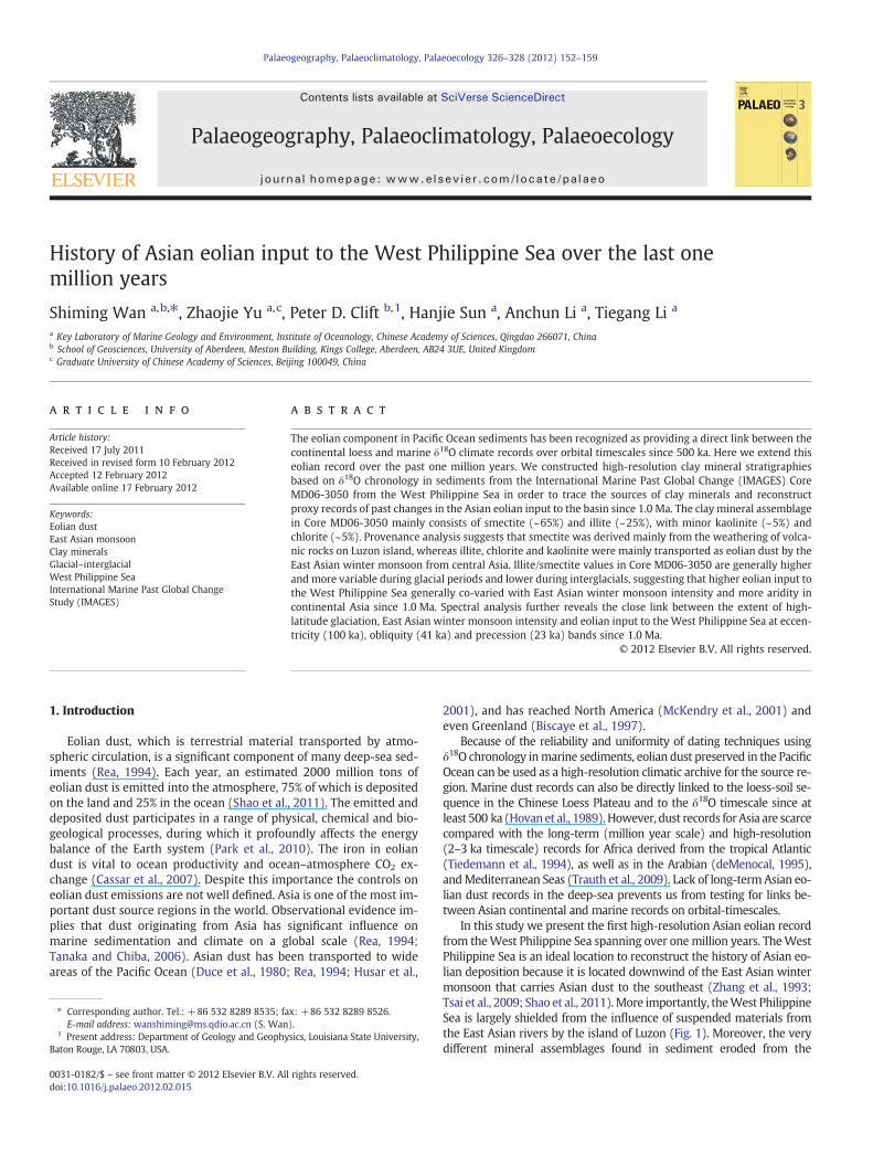
In this study we present the first high-resolution Asian eolian recordfrom theWest Philippine Sea spanning over one million years. TheWestPhilippine Sea is an ideal location to reconstruct the history of Asian eo-lian deposition because it is located downwind of the East Asian wintermonsoon that carries Asian dust to the southeast (Zhang et al., 1993;Tsai et al., 2009; Shao et al., 2011).More importantly, theWest PhilippineSea is largely shielded from the influence of suspended materials fromthe East Asian rivers by the island of Luzon (Fig. 1). Moreover, the verydifferent mineral assemblages found in sediment eroded from the
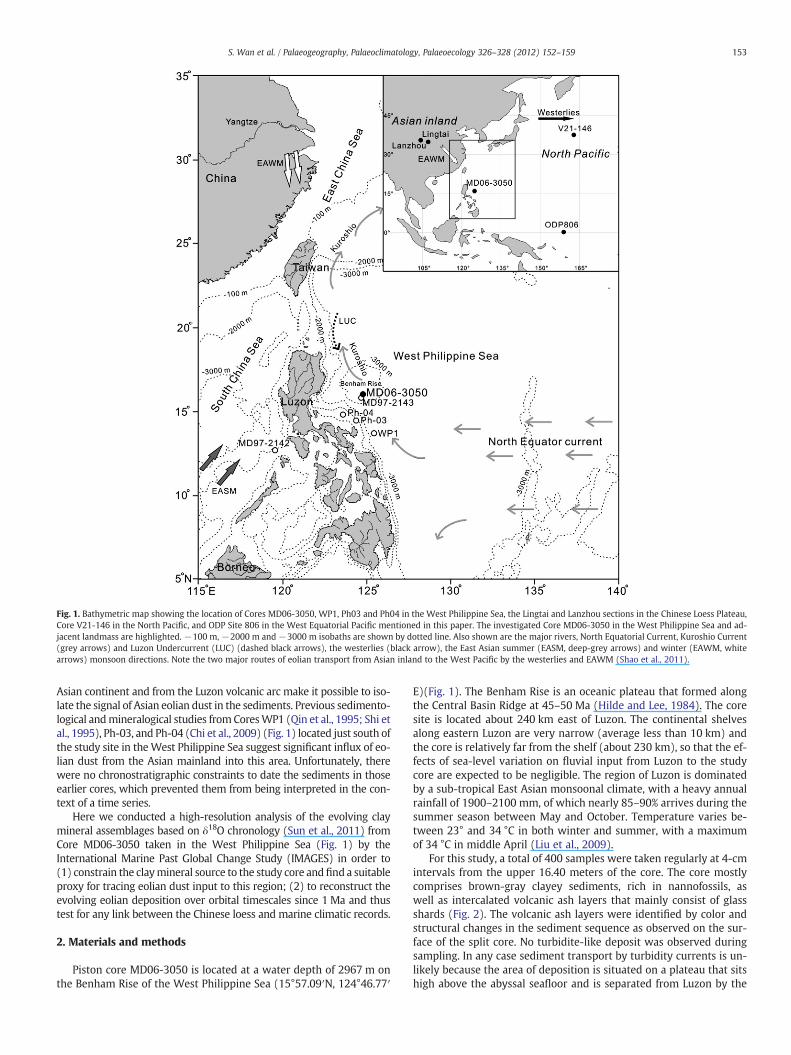
Fig. 1. Bathymetric map showing the location of Cores MD06-3050, WP1, Ph03 and Ph04 in the West Philippine Sea, the Lingtai and Lanzhou sections in the Chinese Loess Plateau,Core V21-146 in the North Pacific, and ODP Site 806 in the West Equatorial Pacific mentioned in this paper. The investigated Core MD06-3050 in the West Philippine Sea and ad-jacent landmass are highlighted. −100 m, −2000 m and−3000 m isobaths are shown by dotted line. Also shown are the major rivers, North Equatorial Current, Kuroshio Current(grey arrows) and Luzon Undercurrent (LUC) (dashed black arrows), the westerlies (black arrow), the East Asian summer (EASM, deep-grey arrows) and winter (EAWM, whitearrows) monsoon directions. Note the two major routes of eolian transport from Asian inland to the West Pacific by the westerlies and EAWM (Shao et al., 2011).
153S. Wan et al. / Palaeogeography, Palaeoclimatology, Palaeoecology 326–328 (2012) 152–159
Asian continent and from the Luzon volcanic arc make it possible to iso-late the signal of Asian eolian dust in the sediments. Previous sedimento-logical andmineralogical studies fromCoresWP1 (Qin et al., 1995; Shi etal., 1995), Ph-03, and Ph-04 (Chi et al., 2009) (Fig. 1) located just south ofthe study site in theWest Philippine Sea suggest significant influx of eo-lian dust from the Asian mainland into this area. Unfortunately, therewere no chronostratigraphic constraints to date the sediments in thoseearlier cores, which prevented them from being interpreted in the con-text of a time series.
Here we conducted a high-resolution analysis of the evolving claymineral assemblages based on δ18O chronology (Sun et al., 2011) fromCore MD06-3050 taken in the West Philippine Sea (Fig. 1) by theInternational Marine Past Global Change Study (IMAGES) in order to(1) constrain the claymineral source to the study core andfind a suitableproxy for tracing eolian dust input to this region; (2) to reconstruct theevolving eolian deposition over orbital timescales since 1 Ma and thustest for any link between the Chinese loess and marine climatic records.
2. Materials and methods
Piston core MD06-3050 is located at a water depth of 2967 m onthe Benham Rise of the West Philippine Sea (15°57.09′N, 124°46.77′
E)(Fig. 1). The Benham Rise is an oceanic plateau that formed alongthe Central Basin Ridge at 45–50 Ma (Hilde and Lee, 1984). The coresite is located about 240 km east of Luzon. The continental shelvesalong eastern Luzon are very narrow (average less than 10 km) andthe core is relatively far from the shelf (about 230 km), so that the ef-fects of sea-level variation on fluvial input from Luzon to the studycore are expected to be negligible. The region of Luzon is dominatedby a sub-tropical East Asian monsoonal climate, with a heavy annualrainfall of 1900–2100 mm, of which nearly 85–90% arrives during thesummer season between May and October. Temperature varies be-tween 23° and 34 °C in both winter and summer, with a maximumof 34 °C in middle April (Liu et al., 2009).
For this study, a total of 400 samples were taken regularly at 4-cmintervals from the upper 16.40 meters of the core. The core mostlycomprises brown-gray clayey sediments, rich in nannofossils, aswell as intercalated volcanic ash layers that mainly consist of glassshards (Fig. 2). The volcanic ash layers were identified by color andstructural changes in the sediment sequence as observed on the sur-face of the split core. No turbidite-like deposit was observed duringsampling. In any case sediment transport by turbidity currents is un-likely because the area of deposition is situated on a plateau that sitshigh above the abyssal seafloor and is separated from Luzon by the
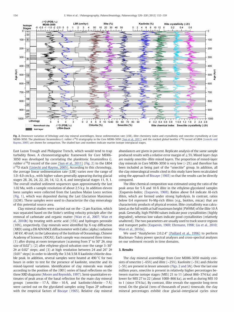
Fig. 2. Downcore variation of lithology and clay mineral assemblages, linear sedimentation rate (LSR), illite chemistry index and crystallinity and smectite crystallinity at CoreMD06-3050. The planktonic foraminifera G. rubber δ18O stratigraphy in the Core MD06-3050 (Sun et al., 2011) and the stacked global benthic δ18O record of LR04 (Lisiecki andRaymo, 2005) are shown for comparison. The shaded bars and numbers indicate marine isotope interglacial stages.
154 S. Wan et al. / Palaeogeography, Palaeoclimatology, Palaeoecology 326–328 (2012) 152–159
East Luzon Trough and Philippine Trench, which would tend to trapturbidity flows. A chronostratigraphic framework for Core MD06-3050 was developed by correlating the planktonic foraminifera G.rubber δ18O record of the core (Sun et al., 2011) (Fig. 2) to the LR04δ18O stack (Lisiecki and Raymo, 2005). According to this chronology,the average linear sedimentation rate (LSR) varies over the range of1.0–4.0 cm/k.y., with higher values generally appearing during glacialstages 28, 26, 24, 22, 20, 14, 12, 8, 4, and interglacial stages 11, 9, 1.The overall studied sediment sequences span approximately the last1.02 Ma, with a sample resolution of about 2.5 k.y. In addition elevenloess samples were collected from the Lanzhou Malan Loess section(Fig. 1), which was deposited during the Last Glaciation Maximum(LGM). These samples were used to characterize the clay mineralogyof this potential source area.
Clay mineral studies were carried out on the b2 μm fraction, whichwas separated based on the Stoke's settling velocity principle after theremoval of carbonate and organic matter (Wan et al., 2007; Wan etal., 2010b) by treating with acetic acid (15%) and hydrogen peroxide(10%), respectively. Clay minerals were identified by X-ray diffraction(XRD) using aD8ADVANCEdiffractometerwith CuKα (alpha) radiation(40 kV, 40 mA) in the Laboratory of the Institute of Oceanology, ChineseAcademy of Sciences (IOCAS). Each sample was measured three times:(1) after drying at room temperature (scanning from 3° to 30° 2θ, stepsize of 0.02°); (2) after ethylene-glycol solvation over the range 3–30°2θ at 0.02° steps; and (3) at high resolution between 24 and 26° 2θ(0.01° steps) in order to identify the 3.54/3.58 Å kaolinite/chlorite dou-ble peak. In addition, several samples were heated at 490 °C for twohours in order to test for the presence of kaolinite, smectite and itsmixed-layered variations. Identification of clay minerals was madeaccording to the position of the (001) series of basal reflections on thethree XRD diagrams (Moore andReynolds, 1997). Semi-quantitative es-timates of peak areas of the basal reflection for the main clay mineralgroups (smectite−17 Å, illite−10 Å, and kaolinite/chlorite−7 Å)were carried out on the glycolated samples using Topas 2P softwarewith the empirical factors of Biscaye (1965). Relative clay mineral
abundances are given in percent. Replicate analysis of the same sampleproduced results with a relative error margin of ±5%. Mixed layer claysare mainly smectite–illite mixed layers. The proportion of mixed-layerclay minerals in Core MD06-3050 is very low (b2%) and therefore hasbeen included as being part of the “smectite” group. In addition, allthe clay mineralogical results cited in this study have been recalculatedusing the approach of Biscaye (1965) so that the results can be directlycompared.
The illite chemical composition was estimated using the ratio of thepeak areas for 5 Å and 10 Å illite in the ethylene-glycolated samples(Esquevin-Index; (Esquevin, 1969). Ratios above 0.4 indicate Al-richillites, which are formed under strong hydrolysis. In contrast, ratiosbelow 0.4 represent Fe-Mg-rich illites (e.g., biotites, micas) that arecharacteristic products of physical erosion. Illite crystallinity was calcu-lated as the fullwidth at halfmaximumheight (FWHM)of the illite 10 Åpeak. Generally, high FWHM values indicate poor crystallinities (highlydegraded), whereas low values indicate good crystallinities (relativelyunaltered). The two parameters are usually used to track source regionsand transport paths (Esquevin, 1969; Ehrmann, 1998; Liu et al., 2010;Wan et al., 2010a).
We used “AnalySeries 2.0.2.4” (Paillard et al., 1996) to performBlackman–Tukey power spectral analyses and cross-spectral analyseson our sediment records in time domains.
3. Results
The clay mineral assemblage from Core MD06-3050 mainly con-sists of smectite (~65%) and illite (~25%). Kaolinite (~5%) and chlorite(~5%) are present in lesser amounts (Figs. 2 and 3A). Over the last onemillion years, smectite is present in relatively higher percentages be-tween marine isotope stages (MIS) 21 to 11 (about 866–374 ka) andlower for MIS 27 to 22 (about 1000–866 ka), as well as during MIS 10to 1 (since 374 ka). By contrast, illite reveals the opposite long-termtrend. On the glacial (tens of thousands of years) timescale, the claymineral percentages exhibit clear glacial–interglacial cycles since
Fig. 3. Ternary (a) and correlation (b) diagram showing variation in clay minerals compositions of sediments from core MD06-3050 (this study), Luzon (Liu et al., 2009) and In-donesia (Gingele et al., 2001) rivers, Taiwan rivers (Wan et al., 2007; Liu et al., 2008), Yangtze River (Wan et al., 2007), East China Sea shelf (Zhou et al., 2010), loess from ChineseLoess Plateau (Shi et al., 1997 and this study).
155S. Wan et al. / Palaeogeography, Palaeoclimatology, Palaeoecology 326–328 (2012) 152–159
1.0 Ma except for a few periods, most notably MIS 18–20. In general,illite, chlorite and kaolinite show a similar pattern of cyclic change,with higher values during glacial periods when illite reaches ~30%,chlorite ~6% and kaolinite ~6% but lower during interglacial periods.In contrast, smectite displays an opposing trend with decreasedvalues (~58%) during glacials and increased values (~70%) during in-terglacials (Fig. 2).
The illite chemical index varies greatly between 0.08 and 1.00,with an average value of 0.36 (Fig. 2), indicating that illite is typicallyrich in Fe-Mg and was formed in an environment dominated bystrong physical erosion. The crystallinities of illite and smectite variesbetween 0.19–0.53° Δ2θ and 1.13–2.51° Δ2θ, with average values ofabout 0.28° and1.66°Δ2θ, respectively. According to the crystallinity cat-egories of Ehrmann (1998), such illite has good crystallinity (relativelyunaltered), while smectite has moderate crystallinity. Illite chemicalindex and crystallinity, as well as smectite crystallinity all show noclear glacial–interglacial cycles.
4. Discussion
4.1. Clay mineral sources
A prerequisite for the interpretation of clay mineral assemblages inmarine sediment cores is a detailed knowledge of the potential sourceareas, as well as the mode and strength of transport processes involved(e.g., Liu et al., 2003; Wan et al., 2007). The most important sedimentsource to this study area is nearby Luzon, which forms part of a rapidlydeforming island arc, where the Eurasian Plate (Sundaland block)and the Philippine Sea Plate converge across two major subductionzones, the east-dipping Manila Trench in the eastern South China Seaand the west-dipping East Luzon Trough (Hall, 1996; Liu et al., 2009).Luzon island consists mainly of Cretaceous to Quaternary andesitic–basaltic volcanic and volcaniclastic sedimentary rocks (Liu et al., 2009).The rapid chemical weathering of volcanic rocks in wet and humid re-gions often produces a high abundance of smectite (Chamley, 1989),and indeed the major rivers in west and central Luzon carry sedimentthat is now dominated by smectite (average 78%), with minor amountsof kaolinite (15%) and chlorite (4%), but very scarce illite (2%) (Liu etal., 2009). A rough estimate suggests that the four main Luzon rivers(i.e., Pampanga, Agno, Cagayan and Vigan Rivers) deliver a total load ofabout 16×106 tons of suspended sediment annually to the adjacent
deep-sea around the island (Liu and Li, 2011). We conclude that riverseroding Luzon supplied most of the smectite to the study site.
The low-temperature alteration of submarine basalts may be an-other source of smectite (Neil et al., 2004). However, smectite pro-duced by in-situ alteration of submarine basalt is unlikely to betransported to the study core in the absence of deep-water bottomcurrents in the study area (Kawabe and Fujio, 2010). Crucially, be-cause these volcanic rocks are submarine they are not strongly erod-ed as is the case with subaerial sources, meaning that their alterationproducts tend to stay where they are formed. Moreover, the rate oflow-temperature (0–3 °C) alteration of submarine basalt in the alka-line seawater is far lower than weathering on land at high tempera-ture (23–34 °C) in the presence of carbonic, acid-rich groundwater(Aumento et al., 1976). Furthermore, the crystallinity and percent ofsmectite in sediments from Core MD06-3050 display a set of strongperiodicities at 150 ka, 100 ka, 41 ka, 30 ka and 23 ka (Fig. 4), sug-gesting a climatic control on the formation of smectite. The 23 ka-long cycle (precession) is also recognized as the dominant periodicityof the East Asian summer monsoon (Wang et al., 2008) and the 30 kaband has been interpreted to reflect the influence of long-term ENSO-like forcing, as well as glacial–interglacial cyclicity on the East Asiansummer monsoon (Beaufort et al., 2003). Both these cycles aremuted in records of bottom water temperature in the Pacific Ocean(Waelbroeck et al., 2002). Therefore, we exclude alteration of subma-rine basalts as a primary contributor of smectite to the core site.
We further conclude that the alteration of submarine tephra isalso not a significant source of smectite to the study core because vol-canic eruptions in Luzon are intermittent, as revealed by tephrostrati-graphic records from Cores MD97-2142 and MD97-2143 from thewest and east side of Luzon island (Fig. 1) (Ku et al., 2009). The volu-metrically limited, intercalated tephra layers (Fig. 2) cannot supplythe high volumes of smectite (~65%) found through the core. Thefact that the ash and surrounding layers in the core are not character-ized by increased smectite further argues that these cannot be theprimary source of smectite.
However, erosion from Luzon cannot explain the high content ofillite (average 25%) in Core MD06-3050 (Fig. 3a) because the sedi-ment of the major rivers in the west and central Luzon presentlyhas only 2% illite (Liu et al., 2009). Even under colder drier, climaticconditions during glacial periods the bedrock geology of Luzon doesnot favor the generation of illite as an erosion product. Clay mineral
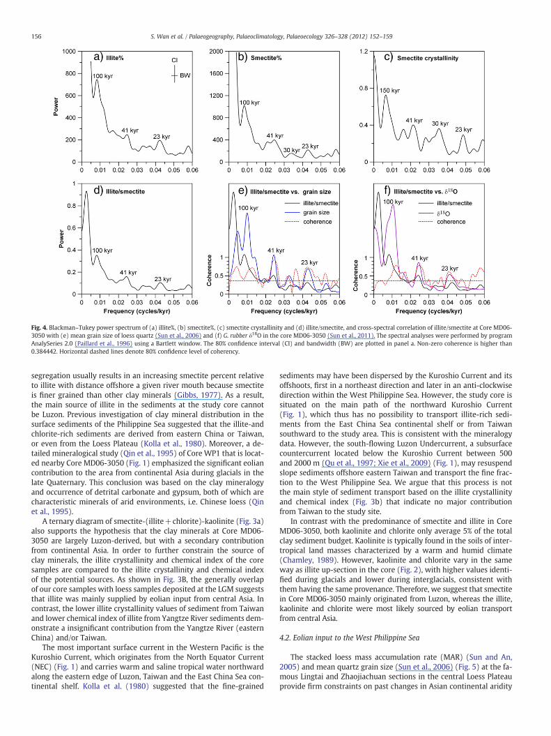
Fig. 4. Blackman–Tukey power spectrum of (a) illite%, (b) smectite%, (c) smectite crystallinity and (d) illite/smectite, and cross-spectral correlation of illite/smectite at Core MD06-3050 with (e) mean grain size of loess quartz (Sun et al., 2006) and (f) G. rubber δ18O in the core MD06-3050 (Sun et al., 2011). The spectral analyses were performed by programAnalySeries 2.0 (Paillard et al., 1996) using a Bartlett window. The 80% confidence interval (CI) and bandwidth (BW) are plotted in panel a. Non-zero coherence is higher than0.384442. Horizontal dashed lines denote 80% confidence level of coherency.
156 S. Wan et al. / Palaeogeography, Palaeoclimatology, Palaeoecology 326–328 (2012) 152–159
segregation usually results in an increasing smectite percent relativeto illite with distance offshore a given river mouth because smectiteis finer grained than other clay minerals (Gibbs, 1977). As a result,the main source of illite in the sediments at the study core cannotbe Luzon. Previous investigation of clay mineral distribution in thesurface sediments of the Philippine Sea suggested that the illite-andchlorite-rich sediments are derived from eastern China or Taiwan,or even from the Loess Plateau (Kolla et al., 1980). Moreover, a de-tailed mineralogical study (Qin et al., 1995) of Core WP1 that is locat-ed nearby Core MD06-3050 (Fig. 1) emphasized the significant eoliancontribution to the area from continental Asia during glacials in thelate Quaternary. This conclusion was based on the clay mineralogyand occurrence of detrital carbonate and gypsum, both of which arecharacteristic minerals of arid environments, i.e. Chinese loess (Qinet al., 1995).
A ternary diagram of smectite-(illite+chlorite)-kaolinite (Fig. 3a)also supports the hypothesis that the clay minerals at Core MD06-3050 are largely Luzon-derived, but with a secondary contributionfrom continental Asia. In order to further constrain the source ofclay minerals, the illite crystallinity and chemical index of the coresamples are compared to the illite crystallinity and chemical indexof the potential sources. As shown in Fig. 3B, the generally overlapof our core samples with loess samples deposited at the LGM suggeststhat illite was mainly supplied by eolian input from central Asia. Incontrast, the lower illite crystallinity values of sediment from Taiwanand lower chemical index of illite from Yangtze River sediments dem-onstrate a insignificant contribution from the Yangtze River (easternChina) and/or Taiwan.
The most important surface current in the Western Pacific is theKuroshio Current, which originates from the North Equator Current(NEC) (Fig. 1) and carries warm and saline tropical water northwardalong the eastern edge of Luzon, Taiwan and the East China Sea con-tinental shelf. Kolla et al. (1980) suggested that the fine-grained
sediments may have been dispersed by the Kuroshio Current and itsoffshoots, first in a northeast direction and later in an anti-clockwisedirection within the West Philippine Sea. However, the study core issituated on the main path of the northward Kuroshio Current(Fig. 1), which thus has no possibility to transport illite-rich sedi-ments from the East China Sea continental shelf or from Taiwansouthward to the study area. This is consistent with the mineralogydata. However, the south-flowing Luzon Undercurrent, a subsurfacecountercurrent located below the Kuroshio Current between 500and 2000 m (Qu et al., 1997; Xie et al., 2009) (Fig. 1), may resuspendslope sediments offshore eastern Taiwan and transport the fine frac-tion to the West Philippine Sea. We argue that this process is notthe main style of sediment transport based on the illite crystallinityand chemical index (Fig. 3b) that indicate no major contributionfrom Taiwan to the study site.
In contrast with the predominance of smectite and illite in CoreMD06-3050, both kaolinite and chlorite only average 5% of the totalclay sediment budget. Kaolinite is typically found in the soils of inter-tropical land masses characterized by a warm and humid climate(Chamley, 1989). However, kaolinite and chlorite vary in the sameway as illite up-section in the core (Fig. 2), with higher values identi-fied during glacials and lower during interglacials, consistent withthem having the same provenance. Therefore, we suggest that smectitein Core MD06-3050 mainly originated from Luzon, whereas the illite,kaolinite and chlorite were most likely sourced by eolian transportfrom central Asia.
4.2. Eolian input to the West Philippine Sea
The stacked loess mass accumulation rate (MAR) (Sun and An,2005) and mean quartz grain size (Sun et al., 2006) (Fig. 5) at the fa-mous Lingtai and Zhaojiachuan sections in the central Loess Plateauprovide firm constraints on past changes in Asian continental aridity
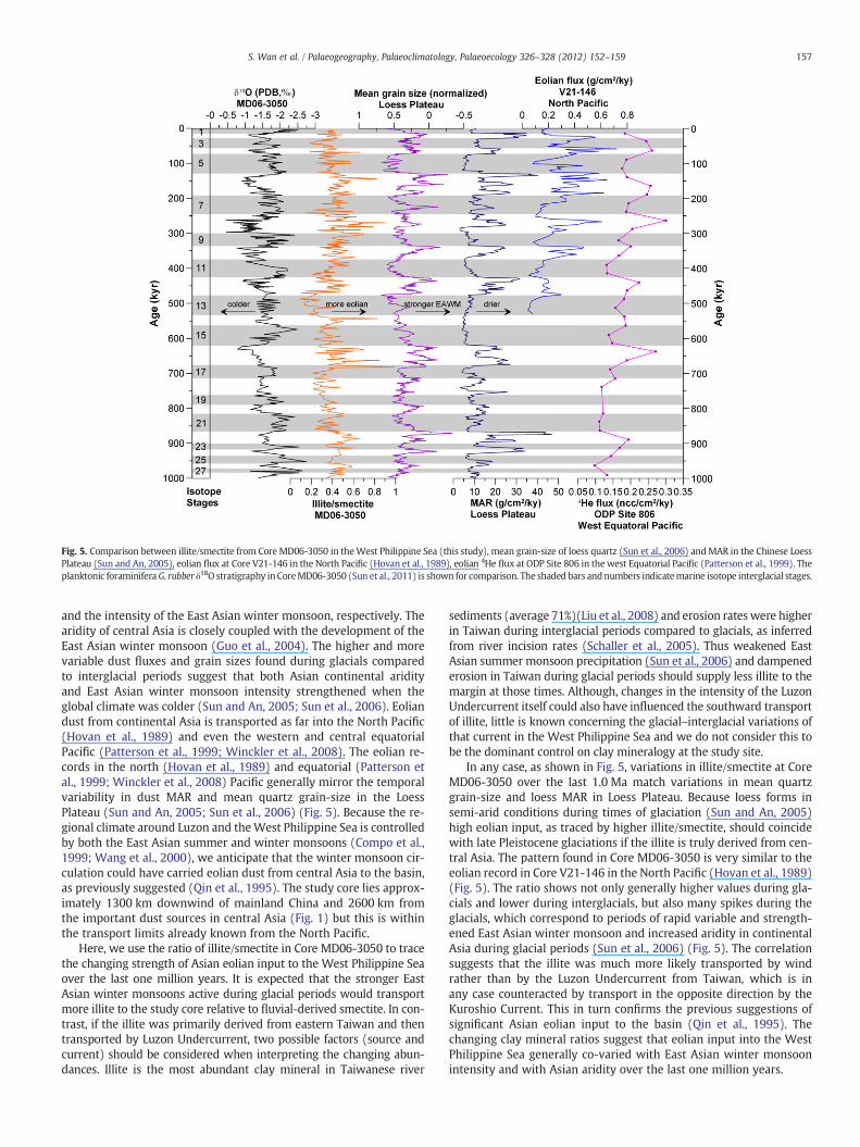
Fig. 5. Comparison between illite/smectite from CoreMD06-3050 in theWest Philippine Sea (this study), mean grain-size of loess quartz (Sun et al., 2006) andMAR in the Chinese LoessPlateau (Sun and An, 2005), eolian flux at Core V21-146 in the North Pacific (Hovan et al., 1989), eolian 4He flux at ODP Site 806 in the west Equatorial Pacific (Patterson et al., 1999). Theplanktonic foraminiferaG. rubber δ18O stratigraphy inCoreMD06-3050 (Sun et al., 2011) is shown for comparison. The shaded bars andnumbers indicatemarine isotope interglacial stages.
157S. Wan et al. / Palaeogeography, Palaeoclimatology, Palaeoecology 326–328 (2012) 152–159
and the intensity of the East Asian winter monsoon, respectively. Thearidity of central Asia is closely coupled with the development of theEast Asian winter monsoon (Guo et al., 2004). The higher and morevariable dust fluxes and grain sizes found during glacials comparedto interglacial periods suggest that both Asian continental aridityand East Asian winter monsoon intensity strengthened when theglobal climate was colder (Sun and An, 2005; Sun et al., 2006). Eoliandust from continental Asia is transported as far into the North Pacific(Hovan et al., 1989) and even the western and central equatorialPacific (Patterson et al., 1999; Winckler et al., 2008). The eolian re-cords in the north (Hovan et al., 1989) and equatorial (Patterson etal., 1999; Winckler et al., 2008) Pacific generally mirror the temporalvariability in dust MAR and mean quartz grain-size in the LoessPlateau (Sun and An, 2005; Sun et al., 2006) (Fig. 5). Because the re-gional climate around Luzon and theWest Philippine Sea is controlledby both the East Asian summer and winter monsoons (Compo et al.,1999; Wang et al., 2000), we anticipate that the winter monsoon cir-culation could have carried eolian dust from central Asia to the basin,as previously suggested (Qin et al., 1995). The study core lies approx-imately 1300 km downwind of mainland China and 2600 km fromthe important dust sources in central Asia (Fig. 1) but this is withinthe transport limits already known from the North Pacific.
Here, we use the ratio of illite/smectite in Core MD06-3050 to tracethe changing strength of Asian eolian input to the West Philippine Seaover the last one million years. It is expected that the stronger EastAsian winter monsoons active during glacial periods would transportmore illite to the study core relative to fluvial-derived smectite. In con-trast, if the illite was primarily derived from eastern Taiwan and thentransported by Luzon Undercurrent, two possible factors (source andcurrent) should be considered when interpreting the changing abun-dances. Illite is the most abundant clay mineral in Taiwanese river
sediments (average 71%)(Liu et al., 2008) and erosion rateswere higherin Taiwan during interglacial periods compared to glacials, as inferredfrom river incision rates (Schaller et al., 2005). Thus weakened EastAsian summer monsoon precipitation (Sun et al., 2006) and dampenederosion in Taiwan during glacial periods should supply less illite to themargin at those times. Although, changes in the intensity of the LuzonUndercurrent itself could also have influenced the southward transportof illite, little is known concerning the glacial–interglacial variations ofthat current in the West Philippine Sea and we do not consider this tobe the dominant control on clay mineralogy at the study site.
In any case, as shown in Fig. 5, variations in illite/smectite at CoreMD06-3050 over the last 1.0 Ma match variations in mean quartzgrain-size and loess MAR in Loess Plateau. Because loess forms insemi-arid conditions during times of glaciation (Sun and An, 2005)high eolian input, as traced by higher illite/smectite, should coincidewith late Pleistocene glaciations if the illite is truly derived from cen-tral Asia. The pattern found in Core MD06-3050 is very similar to theeolian record in Core V21-146 in the North Pacific (Hovan et al., 1989)(Fig. 5). The ratio shows not only generally higher values during gla-cials and lower during interglacials, but also many spikes during theglacials, which correspond to periods of rapid variable and strength-ened East Asian winter monsoon and increased aridity in continentalAsia during glacial periods (Sun et al., 2006) (Fig. 5). The correlationsuggests that the illite was much more likely transported by windrather than by the Luzon Undercurrent from Taiwan, which is inany case counteracted by transport in the opposite direction by theKuroshio Current. This in turn confirms the previous suggestions ofsignificant Asian eolian input to the basin (Qin et al., 1995). Thechanging clay mineral ratios suggest that eolian input into the WestPhilippine Sea generally co-varied with East Asian winter monsoonintensity and with Asian aridity over the last one million years.
158 S. Wan et al. / Palaeogeography, Palaeoclimatology, Palaeoecology 326–328 (2012) 152–159
We also consider alternative mechanisms for causing the temporalchange in the relative abundance of illite versus smectite. Smectite con-tents could have changed through time without any major changes ofillite. Input of smectite from Luzon to the West Philippine Sea couldbemodified by several processes, such as changes of themonsoon rain-fall on the Luzon and accompanying changes of the intensity of thephysical erosion and chemical weathering of the rocks on the island(Liu et al., 2009). For example, MIS 13 (533–478 ka) is shown to be anunusual period with the lowest ratios of illite/smectite (Fig. 5), suggest-ing the weakest eolian input and/or the strongest fluvial supply since1.0 Ma. The low illite/smectite is consistent with a weakened EastAsian winter monsoon inferred from the loess grain-size (Sun et al.,2006), but contrasts with the stable or slightly increased aridity of cen-tral Asia, as reflected by faster eolianMAR in the Loess Plateau (Sun andAn, 2005) and the North Pacific (Hovan et al., 1989; Patterson et al.,1999) (Fig. 5). Moreover, it is noteworthy that the smectite percentageand crystallinity also display abnormally high values during this inter-glacial MIS 13 (Fig. 2), suggestive of more chemical weathering at thattime. Because the smectite mainly originated from the weathering ofvolcanic rocks in Luzon, as discussed above, and because a moderatelinear correlation between the chemical index of alteration (CIA) andsmectite crystallinity was observed for clay-fraction sediments inLuzon rivers (Liu et al., 2009), more and higher crystallinity smectitein MIS 13 sediments may indicate an exceptionally strengthened EastAsian summer monsoon at that time. This inference is consistent withthe loess Fe record in northern China (Yin andGuo, 2008), which arguesfor an unusually warm and wet climate from low to middle latitude inEast Asia during MIS 13.
4.3. Spectral analysis
In order to better understand the dynamic link between the changesin eolian input on orbital timescales and those of high-latitude ice-sheetvariations and East Asian winter monsoon intensity, we performed aBlackman–Tukey spectral analysis and cross-spectrum analysis on theproxy records since 1.0 Ma (Fig. 4). Spectral analysis shows that illitepercent and illite/smectite ratios have a set of strong periodicities corre-sponding to the orbital eccentricity (100 ka), obliquity (41 ka) and pre-cession (23 ka) bands over the last 1.0 Ma (Fig. 4). This observation isconsistentwith the dominant periodicity identified in East Asianwintermonsoon proxy records during the Pleistocene (Ding and Liu, 1998; Sunet al., 2006). Cross-spectral analysis between illite/smectite and loessgrain-size, as well as illite/smectite and δ18O in Core MD06-3050shows very high non-zero coherences (>80%) between the three pa-rameters at eccentricity (100 ka), obliquity (41 ka) and precession(23 ka) bands (Fig. 4), further revealing the close link between high-latitude climate change, East Asianwintermonsoon intensity and eolianinput to the West Philippine Sea since 1.0 Ma. It should be emphasizedthat illite/smectite essentially reflects the contribution of eolian illiterelative to fluvial suspended smectite into the study area, rather thanabsolute flux. Further work is needed to quantify the flux of eoliandust, fluvial suspended materials, and intermittent volcanic ash to thestudy core, but this does not affect the main conclusions of this studyand the links between eolian flux and the strength of the East Asianwinter monsoon.
5. Conclusions
In order to trace the source of clay minerals to Core MD06-3050 inthe West Philippine Sea and thus reconstruct the orbital-scale varia-tions of Asian eolian deposition in the basin, we analyzed clay mineralassemblages at high-resolution based on a δ18O chronology. We drawthe following conclusions from this work:
(1) The clay mineral assemblage at Core MD06-3050 mainly con-sists of smectite (~65%) and illite (~25%), with minor kaolinite (~5%)and chlorite (~5%). Clay mineral analysis combined with comparison
to other eolian proxy records in the Loess Plateau and North PacificOcean suggests that smectite was derived mainly from the weather-ing of volcanic rocks on the island of Luzon, whereas illite, chloriteand kaolinite were primarily transported as eolian dust from centralAsia by the East Asian winter monsoon. The Kuroshio Current cannothave transported the illite-rich sediments from the East China Seacontinental shelf or Taiwan to the study area as previously suggested.
(2) The ratio of illite/smectite in sediments taken from CoreMD06-3050 was applied to trace the strength of Asian eolian inputinto the West Philippine Sea. The ratio was generally higher andmore variable during glacials and lower during interglacials, suggest-ing that the eolian input to the West Philippine Sea has generally co-varied with East Asian winter monsoon intensity and the aridity ofcentral Asia since 1.0 Ma. Eolian input was much weakened and ac-companied by more and higher crystallinity smectite during the un-usually warm and wet MIS 13 (533–478 ka). Cross-spectral analysisfurther reveals the close link between high-latitude climate change,East Asian winter monsoon intensity and eolian input to the WestPhilippine Sea at major orbital periods since 1.0 Ma.
Acknowledgments
We wish to thank the scientific party and crew of the MarionDufresne for coring the samples in the West Philippine Sea. We thankDr. Hanchao Jiang for kindly providing the loess samples. We especiallythank two anonymous reviewers for thorough and constructive re-views. Funding for this research was supported by the National NaturalScience Foundation of China (41076033, 40976026), Knowledge Inno-vation Program of CAS (KZCX2-YW-229) and the National BasicResearch Programof China (2007CB411703, 2007CB815903). PC thanksthe HanseWissenschaftskolleg for the time to think about the develop-ment of the Asian monsoon.
References
Aumento, F., Mitchell, W.S., Fratta, M., 1976. Interaction between seawater and oceaniclayer two as a function of time anddepth, 1. Field evidence. The CanadianMineralogist14, 269–290.
Beaufort, L., de Garidel-Thoron, T., Linsley, B., Oppo, D., Buchet, N., 2003. Biomass burn-ing and oceanic primary production estimates in the Sulu Sea area over the last 380kyr and the East Asian monsoon dynamics. Marine Geology 201, 53–65.
Biscaye, P.E., 1965. Mineralogy and sedimentation of recent deep-sea clay in the AtlanticOcean and adjacent seas and oceans. Geological Society of America Bulletin 76,803–832.
Biscaye, P.E., Grousset, F.E., Revel, M., VanderGaast, S., Zielinski, G.A., Vaars, A., Kukla, G.,1997. Asian provenance of glacial dust (stage 2) in the Greenland Ice Sheet Project2 Ice Core, Summit, Greenland. Journal of Geophysical Research-Oceans 102,26765–26781.
Cassar, N., Bender, M.L., Barnett, B.A., Fan, S., Moxim, W.J., Levy, H., Tilbrook, B., 2007.The Southern Ocean biological response to Aeolian iron deposition. Science 317,1067–1070.
Chamley, H., 1989. Clay Sedimentology. Springer, New York.Chi, Y., Li, A.C., Jiang, F.Q., Wan, S.M., 2009. Assemblage and provenance of clay min-
erals off the east of Luzon Island. Marine Sciences 33, 80–88.Compo, G.P., Kiladis, G.N., Webster, P.J., 1999. The horizontal and vertical structure of
east Asian winter monsoon pressure surges. Quarterly Journal of the Royal Meteo-rological Society 125, 29–54.
deMenocal, P.B., 1995. Plio-Pleistocene African Climate. Science 270, 53–59.Ding, Z.L., Liu, T.S., 1998. Forcing mechanisms for East-Asia monsoon variations during
the late Pleistocene. Chinese Science Bulletin 43, 1497–1510.Duce, R.A., Unni, C.K., Ray, B.J., Prospero, J.M., Merrill, J.T., 1980. Long-range atmospher-
ic transport of soil dust from Asia to the tropical north pacific – temporal variabil-ity. Science 209, 1522–1524.
Ehrmann, W., 1998. Implications of late Eocene to early Miocene clay mineral assem-blages in McMurdo Sound (Ross Sea, Antarctica) on paleoclimate and ice dynam-ics. Palaeogeography Palaeoclimatology Palaeoecology 139, 213–231.
Esquevin, J., 1969. Influence de la composition chimique des illites sur le cristallinite.Bulletin de Centre Recherche Pau 3, 147–153.
Gibbs, R.J., 1977. Clay mineral segregation in the marine environment. Journal ofSedimentary Petrology 47, 237–243.
Gingele, F.X., De Deckker, P., Hillenbrand, C.D., 2001. Clay mineral distribution in sur-face sediments between Indonesia and NW Australia – source and transport byocean currents. Marine Geology 179, 135–146.
Guo, Z.T., Peng, S.Z., Hao, Q.Z., Biscaye, P.E., An, Z.S., LIU, T.S., 2004. Late Miocene–Pliocenedevelopment of Asian aridification as recorded in the Red-Earth Formation in north-ern China. Global and Planetary Change 41, 135–145.
159S. Wan et al. / Palaeogeography, Palaeoclimatology, Palaeoecology 326–328 (2012) 152–159
Hall, R., 1996. Reconstructing Cenozoic SE Asia. In: Hall, R., Blundell, D. (Eds.), TectonicEvolution of SE Asia: Geological Society, London, Special Publications, pp. 153–184.
Hilde, T.W.C., Lee, C.S., 1984. Origin and evolution of the West Philippine Basin – a newinterpretation. Tectonophysics 102, 85–104.
Hovan, S.A., Rea, D.K., Pisias, N.G., Shackleton, N.J., 1989. A direct link between theChina loess and marine delta-O-18 records – aeolian flux to the North Pacific. Nature340, 296–298.
Husar, R.B., Tratt, D.M., Schichtel, B.A., Falke, S.R., Li, F., Jaffe, D., Gasso, S., Gill, T.,Laulainen, N.S., Lu, F., Reheis, M.C., Chun, Y., Westphal, D., Holben, B.N.,Gueymard, C., McKendry, I., Kuring, N., Feldman, G.C., McClain, C., Frouin, R.J.,Merrill, J., DuBois, D., Vignola, F., Murayama, T., Nickovic, S., Wilson, W.E., Sassen,K., Sugimoto, N., Malm, W.C., 2001. Asian dust events of April 1998. Journal ofGeophysical Research-Atmospheres 106, 18317–18330.
Kawabe, M., Fujio, S., 2010. Pacific ocean circulation based on observation. Journal ofOceanography 66, 389–403.
Kolla, V., Nadler, L., Bonatti, E., 1980. Clay mineral distributions in surface sediments ofthe Philippine Sea. Oceanologica Acta 3, 245–250.
Ku, Y.P., Chen, C.H., Song, S.R., Iizuka, Y., Shen, J.J.S., 2009. A 2 Ma record of explosivevolcanism in southwestern Luzon: Implications for the timing of subducted slabsteepening. Geochemistry, Geophysics, Geosystems 10.
Lisiecki, L.E., Raymo, M.E., 2005. A Pliocene-Pleistocene stack of 57 globally distributedbenthic delta O-18 records. Paleoceanography 20.
Liu, Z.F., Li, X.J., 2011. Discussion on smectite formation in South China Sea sediments.Quaternary Sciences (In Chinese with English abstract) 31, 199–206.
Liu, Z.F., Trentesaux, A., Clemens, S.C., Colin, C., Wang, P.X., Huang, B.Q., Boulay, S., 2003.Clay mineral assemblages in the northern South China Sea: implications for EastAsian monsoon evolution over the past 2 million years. Marine Geology 201,133–146.
Liu, Z.F., Tuo, S.T., Colin, C., Liu, J.T., Huang, C.Y., Selvaraj, K., Chen, C.T.A., Zhao, Y.L.,Siringan, F.P., Boulay, S., Chen, Z., 2008. Detrital fine-grained sediment contributionfrom Taiwan to the northern South China Sea and its relation to regional oceancirculation. Marine Geology 255, 149–155.
Liu, Z.F., Zhao, Y.L., Colin, C., Siringan, F.P., Wu, Q., 2009. Chemical weathering in Luzon,Philippines from clay mineralogy and major-element geochemistry of river sedi-ments. Applied Geochemistry 24, 2195–2205.
Liu, Z.F., Colin, C., Li, X.J., Zhao, Y.L., Tuo, S.T., Chen, Z., Siringan, F.P., Liu, J.T., Huang, C.Y.,You, C.F., Huang, K.F., 2010. Clay mineral distribution in surface sediments of thenortheastern South China Sea and surrounding fluvial drainage basins: sourceand transport. Marine Geology 277, 48–60.
McKendry, I.G., Hacker, J.P., Stull, R., Sakiyama, S., Mignacca, D., Reid, K., 2001. Long-range transport of Asian dust to the Lower Fraser Valley, British Columbia, Canada.Journal of Geophysical Research-Atmospheres 106, 18361–18370.
Moore, D.M., Reynolds, R.C., 1997. X-Ray Diffraction and the Identification and Analysisof Clay Minerals. Oxford University Press, Oxford, United Kingdom.
Neil, R.B., Jose, H., Karlis, M., 2004. Low-temperature alteration of submarine basaltsfrom the Ontong Java Plateau. In: Fitton, J.G., Mahoney, J.J., Wallace, P.J.,Saunders, A.D. (Eds.), Origin and Evolution of the Ontong Java Plateau: GeologicalSociety, London, Special Publications, pp. 259–273.
Paillard, D., Labeyrie, L., Yiou, P., 1996. Macintosh program performs time-series anal-ysis. Eos, Transactions American Geophysical Union 77, 379.
Park, S.U., Ahn, H.J., Park, M.S., 2010. Direct shortwave radiative forcing of the Asiandust aerosol on dust emission. Theoretical and Applied Climatology 101, 179–190.
Patterson, D.B., Farley, K.A., Norman, M.D., 1999. He-4 as a tracer of continental dust: A1.9 million year record of aeolian flux to the west equatorial Pacific Ocean. Geochi-mica et Cosmochimica Acta 63, 615–625.
Qin, Y., Chen, L., Shi, X., 1995. Eoliandeposition in theWest Philippine Sea. Chinese ScienceBulletin 40, 1595–1597.
Qu, T.D., Kagimoto, T., Yamagata, T., 1997. A subsurface countercurrent along the eastcoast of Luzon. Deep Sea Research Part I: Oceanographic Research Papers 44,413–423.
Rea, D.K., 1994. The Paleoclimatic Record Provided by Eolian Deposition in the Deep-Sea - the Geologic History of Wind. Reviews of Geophysics 32, 159–195.
Schaller, M., Hovius, N., Willett, S.D., Ivy-Ochs, S., Synal, H.A., Chen, M.C., 2005. Fluvialbedrock incision in the active mountain belt of Taiwan from in situ-produced cos-mogenic nuclides. Earth Surface Processes and Landforms 30, 955–971.
Shao, Y., Wyrwoll, K., Chappell, A., Huang, J., Lin, Z., McTainsh, G., Mikami, M., Tanaka, T.,Wang, X., Yoon, S., 2011. Dust cycle: An emerging core theme in Earth system science.Aeolian Research 2, 181–204.
Shi, X.F., Chen, L.R., Li, K.Y., Wang, Z.L., 1995. Study on minerageny of the clay sedimentin the west of Philippine Sea. Marine Geology & Quaternary Geology 15, 61–72.
Shi, Y., Dai, X., Li, J., Wang, J., 1997. Origin and significance of clay minerals in the lastinterglacial loess in Lanzhou area, North-Central China. Marine Geology & QuaternaryGeology 17, 87–94.
Sun, Y.B., An, Z.S., 2005. Late Pliocene-Pleistocene changes in mass accumulation ratesof eolian deposits on the central Chinese Loess Plateau. Journal of GeophysicalResearch-Atmospheres 110.
Sun, Y.B., Clemens, S.C., An, Z.S., Yu, Z.W., 2006. Astronomical timescale and palaeocli-matic implication of stacked 3.6-Myr monsoon records from the Chinese LoessPlateau. Quaternary Science Reviews 25, 33–48.
Sun, H.J., Li, T.G., Sun, R.T., Yu, X.K., Chang, F.M., Tang, Z., 2011. Calcareous nannofossilbioevents and microtektite stratigraphy in the Western Philippine Sea during theQuaternary. Chinese Science Bulletin 56, 2732–2738.
Tanaka, T.Y., Chiba, M., 2006. A numerical study of the contributions of dust source re-gions to the global dust budget. Global and Planetary Change 52, 88–104.
Tiedemann, R., Sarnthein, M., Shackleton, N.J., 1994. Astronomic timescale for the PlioceneAtlantic Delta-O-18 and dust flux records of ocean drilling Program Site-659. Paleo-ceanography 9, 619–638.
Trauth, M.H., Larrasoana, J.C., Mudelsee, M., 2009. Trends, rhythms and events in Plio-Pleistocene African climate. Quaternary Science Reviews 28, 399–411.
Tsai, F.J., Liu, T.H., Hsu, S.C., Hsu, C.W., Shiu, C.J., Chen, W.N., Tu, J.Y., 2009. Southeast-ward transport of Asian dust: source, transport and its contributions to Taiwan.Atmospheric Environment 43, 458–467.
Waelbroeck, C., Labeyrie, L., Michel, E., Duplessy, J.C., McManus, J.F., Lambeck, K.,Balbon, E., Labracherie, M., 2002. Sea-level and deep water temperature changesderived from benthic foraminifera isotopic records. Quaternary Science Reviews21, 295–305.
Wan, S.M., Li, A.C., Clift, P.D., Stuut, J.B.W., 2007. Development of the East Asian mon-soon: mineralogical and sedimentologic records in the northern South China Seasince 20 Ma. Palaeogeography Palaeoclimatology Palaeoecology 254, 561–582.
Wan, S.M., Li, A.C., Clift, P.D., Wu, S.G., Xu, K.H., Li, T.G., 2010a. Increased contributionof terrigenous supply from Taiwan to the northern South China Sea since 3 Ma.Marine Geology 278, 115–121.
Wan, S.M., Tian, J., Steinke, S., Li, A.C., Li, T.G., 2010b. Evolution and variability of theEast Asian summer monsoon during the Pliocene: evidence from clay mineral re-cords of the South China Sea. Palaeogeography Palaeoclimatology Palaeoecology293, 237–247.
Wang, P.X., Prell, W.L., Blum, P., 2000. Proceedings of the Ocean Drilling Program. InitialReports, 184. Texas A&M University, College Station.
Wang, Y.J., Cheng, H., Edwards, R.L., Kong, X.G., Shao, X.H., Chen, S.T., Wu, J.Y., Jiang,X.Y., Wang, X.F., An, Z.S., 2008. Millennial- and orbital-scale changes in the EastAsian monsoon over the past 224,000 years. Nature 451, 1090–1093.
Winckler, G., Anderson, R.F., Fleisher, M.Q., Mcgee, D., Mahowald, N., 2008. Covariantglacial–interglacial dust fluxes in the equatorial Pacific and Antarctica. Science320, 93–96.
Xie, L.L., Tian, J.W., Hu, D.X., Wang, F., 2009. A quasi-synoptic interpretation of water massdistribution and circulation in thewesternNorth Pacific II: Circulation. Chinese Journalof Oceanology and Limnology 27, 955–965.
Yin, Q.Z., Guo, Z.T., 2008. Strong summer monsoon during the cool MIS-13. Climate ofthe Past 4, 29–34.
Zhang, J., Liu, S.M., Lu, X., Huang, W.W., 1993. Characterizing Asian Wind-Dust Trans-port to the Northwest Pacific-Ocean - Direct Measurements of the Dust Flux for 2Years. Tellus Series B: Chemical and Physical Meteorology 45, 335–345.
Zhou, X.J., Li, A.C., Wan, S.M., Meng, Q.Y., 2010. Clay minerals in surfacial sediments ofthe East China Sea shelf: distribution and provenance. Oceanologia Et LimnologiaSinica 41, 667–675.