factors affecting performance and functionality of rural - UoN ...
C
O
Hw
OS
a
ARAA
KHTDHP
1
iIhdaahac
tooaat
(v
1h
ARTICLE IN PRESSG ModelULHER-2676; No. of Pages 7
Journal of Cultural Heritage xxx (2012) xxx–xxx
Available online at
www.sciencedirect.com
riginal article
istorical coastal urban landscapes digital documentation and temporal studyith 2D/3D modeling functionality: The case of Thessaloniki, Greece
lga Georgoula ∗, Anastasios Stamnas , Petros Patias , Charalampos Georgiadis , Vassiliki Fragkoulidouchool of Rural and Surveying Engineering, Department of Cadastre, Photogrammetry and Cartography, Aristotle University of Thessaloniki, Thessaloniki, Greece
r t i c l e i n f o
rticle history:eceived 19 June 2012ccepted 11 October 2012vailable online xxx
eywords:istorical citiesemporal studyigital reconstructionistorical images
a b s t r a c t
The study refers to the visual representation of the coastal front of the historical center of Thessalonikiin northern Greece and its changes that have occurred through the years. Most of the old town wasdestroyed by fire on August 18, 1917. A few years later, the French architect and archeologist ErnestHébrard proposed the reconstruction of the city centre, but his plans were never fully implemented.Since then, a series of interventions changed the form of the old town and consequently the coastalcityscape. The research was initially based on the photogrammetric processing of archive aerial images(1938) of Thessaloniki’s city centre. Besides the vertical images, high oblique aerial images dated backto 1932, proved to be a significant source of information. A rich archive of old photographic material,sketches, drawings and gravures of the coastal forehead of the city was also used. Ortho-images of thecoastal front, derived from laser scanning (2010), and a 3D model of the historical city center, derived
hotogrammetryfrom the stereo photogrammetric process of aerial images (1990), contributed decisively at the multitemporal study of the city front. The main outcomes of the present documentation study are the 3Drepresentation (at scale of 1:200, accuracy 5 cm) of temporal changes of a part of the coastal front of thehistorical center of Thessaloniki and the 2D representation (at scale 1:100, accuracy 1–2 cm) of thesechanges with respect to variations on skyline, lacunas, interventions in old buildings, etc.. Introduction
High technology tools, used in the production of geometricnformation, virtual environments, spatial information systems andnternet applications, are also widely used for the documentation ofistorical cities. The quality of data, the processing methods and theisplay techniques, which are applied in spatial recording and man-gement, represent the major factors for a detailed documentation,nalysis and visual reconstruction of the past. Therefore, culturaleritage protection and planning of historic urban environmentsre closely related to the methodology and the tools used in variousase studies.
The complexity, concerning the cultural heritage documen-ation and management of an urban historical context, tendsbviously to increase when this context has gradually transformedr even completely changed. In this case, the lack of cartographic
Please cite this article in press as: O. Georgoula, et al., Histtemporal study with 2D/3D modeling functionality: The case ohttp://dx.doi.org/10.1016/j.culher.2012.10.007
nd mainly photogrammetric data, renders the graphic restitutionnd visual representation of the “past” difficult or quite impossibleask. This case applies either when the object of study is a single
∗ Corresponding author. Tel.: +30 23 10 99 60 96; fax: +30 23 10 99 61 28.E-mail addresses: [email protected] (O. Georgoula), [email protected]
A. Stamnas), [email protected] (P. Patias), [email protected] (C. Georgiadis),[email protected] (V. Fragkoulidou).
296-2074/$ – see front matter © 2012 Published by Elsevier Masson SAS.ttp://dx.doi.org/10.1016/j.culher.2012.10.007
© 2012 Published by Elsevier Masson SAS.
entirely destroyed building or a block of structures of the samecondition.
Coastal fronts and coastal urban cityscapes are often dynamic,living entities, continually changing because of natural and human-influenced social, economic and cultural processes. Coastal historicenvironments reflect the maritime history and the unique anddistinctive character of many communities, as well. The study oftemporal changes of such environments involves, on the one hand,the knowledge of local architecture and urban morphology and,on the other, the development and the application of up-to-datetechniques for their documentation, essentially during the restora-tion process. Nowadays, innovative approaches are required toresearch and record the past and the present of these coastal urbancityscapes in order to create a platform for their regeneration andrevitalisation.
2. Aim and methodology
Most of the old town of Thessaloniki, in N. Greece, was destroyedby fire on August 18, 1917. Since then, a series of interventions
orical coastal urban landscapes digital documentation andf Thessaloniki, Greece, Journal of Cultural Heritage (2012),
changed the form of the old town and consequently the coastalcityscape (Fig. 1). In particular, as regards the building stock alongthe coastal front of the historical centre of Thessaloniki, a radicalchange can be observed from the beginning of the 20th century

ARTICLE IN PRESSG ModelCULHER-2676; No. of Pages 7
2 O. Georgoula et al. / Journal of Cultural Heritage xxx (2012) xxx–xxx
fore th
ucaiaiiibsw
m[bdtuct
hrwamt1dmndthov
3T
3
a
Fig. 1. Aerial images of Thessaloniki: a: be
ntil today. The White Tower, the unique monument of the 15thentury along the waterfront, a two storey building, widely knowns Olympos-Naoussa, built in 1926, Aristotle’s square and otherndividual buildings built in the 1950s, testify the rich urban andrchitectural history of the coastal cityscape. Nowadays, the var-ous morphological aspects of the silhouette of the coastal frontndicate a series of changes and consequences concerning the qual-ty of life in the historical centre. A dense urban environment cane observed. Two storey buildings have been replaced by eighttorey apartment buildings, although the urban tissue along theaterfront remained quite intact for almost a century.
In bibliography, one can find studies concerning the photogram-etric reconstruction of individual historical buildings facades
1–3]. In many cases, single amateur photographs and postcard inooks or private collections were a unique source of information forocumenting or reconstructing a destroyed building [4–6]. Instead,he purpose of this study is not the documentation of an individ-al destroyed building but the visual representation of the entireoastal front of the historical center of Thessaloniki and its changeshat have occurred through the years.
The research for suitable cartographic, photogrammetric andistorical data has been proved to be indispensable for the tempo-al study and visual representation of changes occurred along theaterfront. Finding and acquiring this divers kind of data has not
lways been simple. Based on data and information collected, theost proper-to-follow methodologies have been chosen. Within
his framework, vertical aerial images, dated back to 1938 up to990, and high oblique aerial images of Thessaloniki’s city centre,ated to 1932, have been used. A rich archive of old photographicaterial, sketches, drawings and gravures, dated back to the begin-
ing of the 20th century, representing destroyed buildings thaton’t exist anymore, have been collected. Finally, ortho-images ofhe coastal front, derived from laser scanning of the coastal fore-ead of the city, are been used. It is obvious, that the processingf this heterogeneous data demanded the combination of a wideariety of photogrammetric techniques.
. A case study: the historical coastal urban landscape ofhessaloniki
Please cite this article in press as: O. Georgoula, et al., Histtemporal study with 2D/3D modeling functionality: The case ohttp://dx.doi.org/10.1016/j.culher.2012.10.007
.1. Historical evolution of Thessaloniki
Thessaloniki is Greece’s second major economic, industrialnd political centre, a major transportation hub and an important
Fig. 2. Images taken along the coastal front of Thessaloniki showing:
e fire of 1917; b: after the fire; c: in 2010.
commercial port for the rest of southeastern Europe. Thessalonikiwas founded around 315 BC and due to the city’s rich and diversehistory, significant changes took place through years, formingits urban structure and social and spatial character. Thessalonikistill houses a great amount of architectural treasures, especiallyChristian and Byzantine monuments. Several early Christian andByzantine monuments of Thessaloniki were added to the UNESCOWorld Heritage list in 1988.
Most of the old center of the city was destroyed by the GreatThessaloniki Fire of 1917 (Fig. 1b), started accidentally by an unat-tended kitchen fire on August 18, 1917. A few years later, the Frencharchitect and archeologist Ernest Hébrard proposed the reconstruc-tion of the city centre, but his plans were never fully implemented.During World War II, the city suffered considerable damage frombombing. After the war, Thessaloniki was rebuilt with large-scaledevelopment of new infrastructure. Since then, a series of inter-ventions changed the form of the old town and consequently thecoastal cityscape.
3.2. Present architectural character of the city and of the coastalfront
Thessaloniki was rebuilt and recovered fairly quickly after thewar. This recovery included both a rapid growth in its population,as well as an impressive development of new, modern infrastruc-ture and industrial enterprises throughout the 1950s, 1960s and1970s. Most of the urban development of that period was, how-ever, without a proper plan, causing traffic and zoning problemsthat remain to this day. The city’s historic centre includes axes,diagonal streets and monumental squares, with a street grid thatcan channel traffic hardly. The centre houses a significant numberof Byzantine monuments but also the remaining monuments of therecent past (1850–1930), influenced mainly from eclecticism.
The coastal front (Fig. 2) of the city’s historic centre expandsfrom Eleftherias square, then meets Aristotle’s square, and endsnear the White Tower. Eleftherias Square, where the Jews of Thes-saloniki were rounded up to be sent to the death camps duringWorld War II, is located on the west end of the coastal front ofthe city’s historic centre. Aristotle’s square, with its monumentalaxis so that looking uphill from the square one can see the city’s
orical coastal urban landscapes digital documentation andf Thessaloniki, Greece, Journal of Cultural Heritage (2012),
Byzantine walls and the Upper Town, is the main city square of thecity.
It is located on Nikis avenue, on the city’s waterfront, in thecity center. It was designed by Ernest Hébrard in 1918 and most
a: Eleftherias square; b: Aristotle’s square; c: the White Tower.

Please cite this article in press as: O. Georgoula, et al., Historical coastal urban landscapes digital documentation andtemporal study with 2D/3D modeling functionality: The case of Thessaloniki, Greece, Journal of Cultural Heritage (2012),http://dx.doi.org/10.1016/j.culher.2012.10.007
ARTICLE IN PRESSG ModelCULHER-2676; No. of Pages 7
O. Georgoula et al. / Journal of Cultural Heritage xxx (2012) xxx–xxx 3
Fig. 3. Aerial images of Thessaloniki’s coastal front dated back to: a: 1938; b: 1951; c: 1965; d: 1978; e: 1990; f: a 2003 satellite image.
Fig. 4. High oblique aerial images, dated back to 1932, showing the coastal front of the city.
ARTICLE IN PRESSG ModelCULHER-2676; No. of Pages 7
4 O. Georgoula et al. / Journal of Cultural Heritage xxx (2012) xxx–xxx
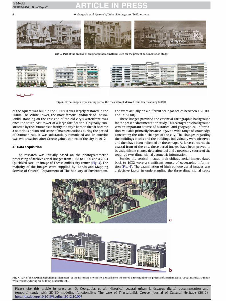
Fig. 5. Part of the archive of old photographic material used for the present documentation study.
coast
o2losaow
4
pQmS
Fw
Fig. 6. Ortho-images representing part of the
f the square was built in the 1950s. It was largely restored in the000s. The White Tower, the most famous landmark of Thessa-
oniki, standing on the east end of the old city’s waterfront, wasnce the south-east tower of a large fortification. Originally con-tructed by the Ottomans to fortify the city’s harbor, then it became
notorious prison and scene of mass executions during the periodf Ottoman rule. It was substantially remodeled and its exterioras whitewashed after Greece gained control of the city in 1912.
. Data acquisition
The research was initially based on the photogrammetric
Please cite this article in press as: O. Georgoula, et al., Histtemporal study with 2D/3D modeling functionality: The case ohttp://dx.doi.org/10.1016/j.culher.2012.10.007
rocessing of archive aerial images from 1938 to 1990 and a 2003uickBird satellite image of Thessaloniki’s city centre (Fig. 3). Theajority of the images were supplied by “Lands and Mapping
ervice of Greece”, Department of The Ministry of Environment,
ig. 7. Part of the 3D model (building silhouettes) of the historical city centre, derived froith recent texturing on building silhouettes (b).
al front, derived from laser scanning (2010).
and were actually on a different scale (at scales between 1:20,000and 1:15,000).
These images provided the essential cartographic backgroundfor the present documentation study. This cartographic backgroundwas an important source of historical and geographical informa-tion, valuable primarily because it gave a wide range of knowledgeconcerning the urban changes of the city. The changes regardingthe buildings blocks and the buildings individually were observedand then have been indicated on these maps. As far as concerns thecoastal front of the city, these aerial images have been proved tobe a significant change detection tool and a necessary source of therequired two-dimensional geometric information.
orical coastal urban landscapes digital documentation andf Thessaloniki, Greece, Journal of Cultural Heritage (2012),
Besides the vertical images, high oblique aerial images datedback to 1932 were a significant source of geographic informa-tion (Fig. 4). The examination of high oblique aerial images wasa decisive factor in understanding the three-dimensional space
m the stereo photogrammetric process of aerial images (1990) (a) and a 3D model

ARTICLE IN PRESSG ModelCULHER-2676; No. of Pages 7
O. Georgoula et al. / Journal of Cultural Heritage xxx (2012) xxx–xxx 5
c resti
rr
potd
5
faihc
aiptcggm
oawww
Fig. 8. Geometric information extraction through graphi
epresented in these historical images. Particularly informationegarding e.g. the number of stories was valuable in many cases.
Thereby, the present study is based on a rich archive of oldhotographic material, sketches, drawings and gravures [7–12],f the coastal forehead of the city (Fig. 5). Finally, orthophotos ofhe coastal front, derived from laser scanning (Fig. 6), contributedecisively at this multi temporal study.
. Processing and results
The visual representation of temporal changes along the coastalront of the historical centre of Thessaloniki, with respect to vari-tions on skyline, lacunas, interventions in old buildings, etc. wasnitially performed through the photogrammetric processing of theistorical vertical aerial images from 1938 to 1990 of Thessaloniki’sity centre.
The photogrammetric image processing of these aerial images,t scales between 1:20,000 and 1:15,000, varied mainly accord-ng to the number of images in each stripe, the available controloints and the existence of camera’s internal orientation parame-ers. Control points measured by GPS or identified in up-to-dateadastre maps 1:5000, provided by “The Hellenic Military Geo-raphical Service”, were used for the geometric correction andeoreferencing of aerial images and the creation of orthophotoaps of Thessaloniki’s city centre.The photogrammetric image processing of the data, comprising
f the control and tie point measurement, bundle adjustment, DSM
Please cite this article in press as: O. Georgoula, et al., Histtemporal study with 2D/3D modeling functionality: The case ohttp://dx.doi.org/10.1016/j.culher.2012.10.007
nd orthophoto generation was done with the commercial soft-are package Leica Photogrammetry Suite (LPS, Leica Geosystems),hich offered functionalities for a complete photogrammetricorking process.
Fig. 9. Orthophotos of the West coastal front of the city, derived from laser scan
tution methods (a) using a high oblique aerial image (b).
Orthophoto maps of the historic city center have been createdusing these aerial images acquired in 1938, 1951, 1965, 1978 and1990. Moreover, the Digital Elevation Model (DEM) extraction pro-cess has been applied to stereo pairs of images for year 1938 and1990. Besides, a 3D model (building volumes and silhouettes) ofthe historic city centre (Fig. 7) derived manually from the stereophotogrammetric process of aerial images (1990) and has provedto be very useful in this study, while giving a visual impression ofthe whole urban area and of the coastal front in particular [13].
High oblique aerial images, have been proved to be very useful toproperly identify buildings and landmarks and to extract geometricinformation through graphic restitution methods, using perspec-tive images representing objects of known dimensions (fac ade orground plan) (Fig. 8). This method consists of the implementationof:
• the horizon line and the two vanishing points;• the 90◦ circle of view framework, the ground line and the view-
point;• the picture plane (measure bar) necessary to define measure-
ments.
The information given above was used to rectify terrestrial ama-teur images as long as to represent the three-dimensional volumesof buildings.
The creation of rectified images (at scale 1:100) of buildingfac ades (Fig. 11), using terrestrial amateur images, was performedthrough the digital geometric rectification and the estimation of
orical coastal urban landscapes digital documentation andf Thessaloniki, Greece, Journal of Cultural Heritage (2012),
the scale parameters according to the known geometry of a smallnumber of buildings that still exist e.g. Olympos-Naoussa.
For the creation of the current state of the building facades alongthe Thessaloniki coastline, laser scanner and photogrammetry
ning (2010), showing the first three building blocks along the waterfront.
ARTICLE IN PRESSG ModelCULHER-2676; No. of Pages 7
6 O. Georgoula et al. / Journal of Cultural Heritage xxx (2012) xxx–xxx
e same
tTaj
Fc
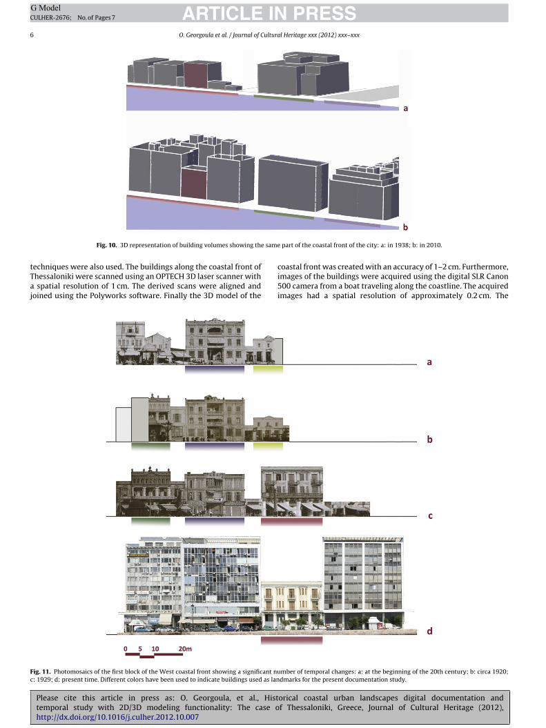
Fig. 10. 3D representation of building volumes showing th
Please cite this article in press as: O. Georgoula, et al., Histtemporal study with 2D/3D modeling functionality: The case ohttp://dx.doi.org/10.1016/j.culher.2012.10.007
echniques were also used. The buildings along the coastal front ofhessaloniki were scanned using an OPTECH 3D laser scanner with
spatial resolution of 1 cm. The derived scans were aligned andoined using the Polyworks software. Finally the 3D model of the
ig. 11. Photomosaics of the first block of the West coastal front showing a significant nu: 1929; d: present time. Different colors have been used to indicate buildings used as lan
part of the coastal front of the city: a: in 1938; b: in 2010.
orical coastal urban landscapes digital documentation andf Thessaloniki, Greece, Journal of Cultural Heritage (2012),
coastal front was created with an accuracy of 1–2 cm. Furthermore,images of the buildings were acquired using the digital SLR Canon500 camera from a boat traveling along the coastline. The acquiredimages had a spatial resolution of approximately 0.2 cm. The
mber of temporal changes: a: at the beginning of the 20th century; b: circa 1920;dmarks for the present documentation study.
ING ModelC
ultura
ifw
tmctc
6
tndgdIan
fteame
[
[
ARTICLEULHER-2676; No. of Pages 7
O. Georgoula et al. / Journal of C
mages acquired along with the laser scanner 3D model were usedor the production of orthophotos (Fig. 9) of the building facadesith a pixel size of 0.5 cm.
Therefore, the visual representation of temporal changes, fromhe beginning of the 20th century until 2010, has been imple-
ented, as long as, data existed for the coastal front. Theombination of all information given through this processing ledo the creation of 3D models of buildings of the coastal front of theity and photomosaics of building’s facades (Figs. 10 and 11).
. Conclusion and further work
Consequently, when the objects, individual buildings or clus-ers, exist, the essential technical tools and the know-how areow at our disposal in order to complete a detailed and accurateocumentation. In contrary, when the object and its context haveradually transformed or completely changed, the methodology isetermined by the available data that differs obviously in quality.
n that case, classical photogrammetric working methods as wells graphic methods, instead of advanced image processing tech-iques, can be used and provide reliable products.
The main goal of this study is to document the entire coastalront of Thessaloniki. Therefore, a multi temporal GIS concerninghe coastal front will be developed, including historical data for
Please cite this article in press as: O. Georgoula, et al., Histtemporal study with 2D/3D modeling functionality: The case ohttp://dx.doi.org/10.1016/j.culher.2012.10.007
ach building, year of construction, ownership, urban data such asrea and height, number of floors of each building, constructionorphology and typology, morphological architectural features,
tc. so as this system will be updated with every new data.
[
[
PRESSl Heritage xxx (2012) xxx–xxx 7
References
[1] A.D. Styliadis, L.A. Sechidis, Photography-based fac ade recovery & 3D mod-eling: a CAD application in Cultural Heritage, J. Cult. Herit. 12 (3) (2011)243–252.
[2] P.M. Lerones, J. Llamas Fernández, Á. Melero Gil, J. Gómez-García-Bermejo, E.Zalama Casanova, A practical approach to making accurate 3D layouts of inter-esting cultural heritage sites through digital models, J. Cult. Herit. 11 (1) (2010)1–9.
[3] H.M. Yilmaz, M. Yakar, S.A. Gulec, O.N. Dulgerler, Importance of digital close-range photogrammetry in documentation of cultural heritage, J. Cult. Herit. 8(4) (2007) 428–433.
[4] I. Kalisperakis, M. Rova, E. Petsa, G.E. Karras, On multi-image reconstructionfrom historic photographs, Proceedings XIX CIPA International Symposium,Antalya, Turkey, 2003.
[5] G.E. Karras, E. Petsa, Metric information from uncalibrated single-images,Proceedings XVII CIPA International Symposium, Olinda, Brasil, 1999.
[6] E. Petsa, S. Kouroupis, G.E. Karras, Inserting the Past in Video Sequences,Proceedings XVIII CIPA International Symposium, Postdam, Germany,2001.
[7] G. Anastasiades, E. Hekimoglou, Thessaloniki: history of roads in pictures,1920–1960, University Studio Press, Thessaloniki, Greece, 1997.
[8] G. Anastasiades, E. Hekimoglou:, The faces of memory: the photograph in inter-war, Thessaloniki, University Studio Press, Thessaloniki, Greece, 1998.
[9] E. Hekimoglou, D. Esra, Thessaloniki 100 years ago: the hanging step to theWest, University Studio Press, Thessaloniki, Greece, 1998.
10] A. Karadimou-Yerolympou, The Reconstruction of Thessaloniki after the Fireof 1917: A Landmark in the History of the City and the Development of GreekUrban Planning, University Studio Press, Thessaloniki, Greece, 1995.
11] M. Lieberg, E. Hekimoglou, J. Lieberg, Thessaloniki 1944: photographicdocuments by Jean Lieberg, University Studio Press, Thessaloniki, Greece,
orical coastal urban landscapes digital documentation andf Thessaloniki, Greece, Journal of Cultural Heritage (2012),
1999.12] A.P.E. Vakalopoulos, Memories of Old Thessaloniki, Malliaris Paedia, Thessa-
loniki, Greece, 1993.13] P. Patias, “Cultural Heritage Documentation”, International Summer School
“Digital Recording and 3D Modeling”, Aghios Nikolaos, Crete, Greece, 2006.
Copyright © 2022 FDOKUMEN