Historical and Recent Environmental Changes of the Ombrone Delta (Central Italy)
9
Journal of Coastal Research, Special Issue No. 61, 2011 344 Journal of Coastal Research SI 61 344-352 MCRR3-2010 Conference Proceedings 2011 Historical and Recent Environmental Changes of the Ombrone Delta (Central Italy) C Tarragoni 1 , P Bellotti 2 , L Davoli 3 , B.M Petronio 4 and M Pietroletti 5 ABSTRACT TARRAGONI, C., BELLOTTI, P., DAVOLI, L., PETRONIO, B.M and PIETROLETTI, M., 2011. Historical and Recent Environmental Changes of the Ombrone Delta (Central Italy). In: Micallef, A. (ed.), MCRR3-2010 Conference Proceedings, Journal of Coastal Research, Special Issue, No. 61, pp. 344-352. Grosseto, Tuscany, Italy, ISSN 0749-0208. Reconstruction of shoreline variations in the area of the Ombrone delta apex has been achieved by comparing aerial photos acquired in 1995, 1998, 2004 and 2006. This reconstruction allowed to define the recent evolution of the Ombrone delta area in terms of erosional and progradation rates. Comparison with older erosional and progradation rates derived from Bellotti et al. (1999a) evidences increasing erosional rates along the delta apex during the investigated interval. Moreover, it has been possible to identify the importance of mouth bar growth as a recurrent mechanism for confining narrow sea stretches. These results have been used as reference for inferring the genesis of a set of four older beach ridges and a lake reported in historical maps. According to previous studies, the modern ponds (locally known as “chiari”) are remnants of the old lake observed in historical maps. Based on the morphological analysis and reconstruction herein proposed the origin of the modern Chiaro Grande pond and Chiaro del Porciatti ponds is independent from that of the old lake, and likely reflects the growth of bars offshore the Ombrone River delta. Lake avulsion during main flood events, however, may have represented an additional contribute to the sourcing of the ponds, as supported by the evidence of washover breaks that connect the ponds with the area at their back where the lake existed until the end of 19 th century. ADDITIONAL INDEX WORDS: Ombrone River delta, shorelines evolution, ponds. INTRODUCTION The Ombrone River delta, on the southern Tuscany coast (Fig. 1A), is located within the Grosseto plain, an alluvial plain filled by plio-quaternary deposits. The Grosseto plain is confined by coastal mountain belts extending down to Castiglione della Pescaia, to the north, and by Monti dell’Uccellina to the south. DOI: 10.2112/SI61-001.1 received XX; accepted XX ©Coastal Education & Research Foundation 2011 The Ombrone River enters the southern part of the Grosseto plain with a meandering course and becomes more linear and gently arched toward southwest, 8 km from the river mouth. North of the Ombrone River, the Emissario San Rocco Channel crosses the plain along an E-W direction that becomes ENE-WSW in its final part (ca. 6.5 km). The Ombrone River delta (Fig. 1C) is a wave dominated delta (GALLOWAY, 1975). It is characterised by a single distributary and by a cuspate strand plain with small coastal basin bordered by different beach ridges (Innocenti & Pranzini, 1993). These coastal basins are locally named “chiari”. 1 Dipartimento di Scienze della Terra, Università degli Studi di Roma “La Sapienza”. P.le A. Moro, 5 – 00185, Rome, Italy Tel:+390649914823 [email protected] 2 Dipartimento di Scienze della Terra, Università degli Studi di Roma “La Sapienza”. P.le A. Moro, 5 – 00185, Rome, Italy Tel:+390649914822, [email protected] www.cerf-jcr.org 3 Dipartimento di Scienze della Terra, Università degli Studi di Roma “La Sapienza”. P.le A. Moro, 5 – 00185, Rome, Italy Tel: +390649914802 [email protected] 4 Dipartimento di Chimica, Università degli Studi di Roma “La Sapienza”. P.le A. Moro, 5 – 00185, Rome, Italy Tel: +390649913723 [email protected] 5 ISPRA (Istituto Superiore Protezione e Ricerca Ambientale). Via Curtatore, 3, 00185 – Rome, Italy Tel: +390650074220 [email protected]
-
Upload
independent -
Category
Documents
-
view
3 -
download
0
Transcript of Historical and Recent Environmental Changes of the Ombrone Delta (Central Italy)

Journal of Coastal Research, Special Issue No. 61, 2011
344
Journal of Coastal Research SI 61 344-352 MCRR3-2010 Conference Proceedings 2011
Historical and Recent Environmental Changes of the Ombrone
Delta (Central Italy)
C Tarragoni1, P Bellotti2, L Davoli3, B.M Petronio4 and M Pietroletti5
ABSTRACT
TARRAGONI, C., BELLOTTI, P., DAVOLI, L., PETRONIO, B.M and PIETROLETTI, M., 2011. Historical
and Recent Environmental Changes of the Ombrone Delta (Central Italy). In: Micallef, A. (ed.), MCRR3-2010
Conference Proceedings, Journal of Coastal Research, Special Issue, No. 61, pp. 344-352. Grosseto, Tuscany,
Italy, ISSN 0749-0208.
Reconstruction of shoreline variations in the area of the Ombrone delta apex has been achieved by comparing
aerial photos acquired in 1995, 1998, 2004 and 2006. This reconstruction allowed to define the recent evolution
of the Ombrone delta area in terms of erosional and progradation rates. Comparison with older erosional and
progradation rates derived from Bellotti et al. (1999a) evidences increasing erosional rates along the delta apex
during the investigated interval. Moreover, it has been possible to identify the importance of mouth bar growth as
a recurrent mechanism for confining narrow sea stretches. These results have been used as reference for inferring
the genesis of a set of four older beach ridges and a lake reported in historical maps. According to previous
studies, the modern ponds (locally known as “chiari”) are remnants of the old lake observed in historical maps.
Based on the morphological analysis and reconstruction herein proposed the origin of the modern Chiaro Grande
pond and Chiaro del Porciatti ponds is independent from that of the old lake, and likely reflects the growth of
bars offshore the Ombrone River delta. Lake avulsion during main flood events, however, may have represented
an additional contribute to the sourcing of the ponds, as supported by the evidence of washover breaks that
connect the ponds with the area at their back where the lake existed until the end of 19th century.
ADDITIONAL INDEX WORDS: Ombrone River delta, shorelines evolution, ponds.
INTRODUCTION
The Ombrone River delta, on the southern Tuscany coast
(Fig. 1A), is located within the Grosseto plain, an alluvial
plain filled by plio-quaternary deposits.
The Grosseto plain is confined by coastal mountain belts
extending down to Castiglione della Pescaia, to the north, and
by Monti dell’Uccellina to the south.
DOI: 10.2112/SI61-001.1 received XX; accepted XX
©Coastal Education & Research Foundation 2011
The Ombrone River enters the southern part of the Grosseto
plain with a meandering course and becomes more linear and
gently arched toward southwest, 8 km from the river mouth.
North of the Ombrone River, the Emissario San Rocco
Channel crosses the plain along an E-W direction that
becomes ENE-WSW in its final part (ca. 6.5 km). The
Ombrone River delta (Fig. 1C) is a wave dominated delta
(GALLOWAY, 1975). It is characterised by a single distributary
and by a cuspate strand plain with small coastal basin
bordered by different beach ridges (Innocenti & Pranzini,
1993). These coastal basins are locally named “chiari”.
1Dipartimento di Scienze della Terra,
Università degli Studi di Roma
“La Sapienza”. P.le A. Moro,
5 – 00185, Rome, Italy
Tel:+390649914823
2Dipartimento di Scienze della Terra,
Università degli Studi di Roma
“La Sapienza”. P.le A. Moro,
5 – 00185, Rome, Italy
Tel:+390649914822,
www.cerf-jcr.org
3Dipartimento di Scienze della Terra,
Università degli Studi di Roma
“La Sapienza”. P.le A. Moro,
5 – 00185, Rome, Italy
Tel: +390649914802
4Dipartimento di Chimica,
Università degli Studi di Roma
“La Sapienza”. P.le A. Moro,
5 – 00185, Rome, Italy
Tel: +390649913723
5ISPRA (Istituto Superiore Protezione
e Ricerca Ambientale).
Via Curtatore, 3,
00185 – Rome, Italy
Tel: +390650074220
Historical and Recent Environmental Changes of the Ombrone Delta (Central Italy)
_____________________________________________________________________________________________
Journal of Coastal Research, Special Issue No. 61, 2011
345
Figure1. Location of the study area (A and B), close-up of the Grosseto plain and Ombrone delta (C) and detail of the delta apex (D).
This work illustrates the results of a morphological study
conducted on the Ombrone delta apex, between Emissario San
Rocco and Monti dell’Uccellina (Fig. 1C); in addition to the
morphological study, some chemical analyses have been
performed on water samples from the ponds.
The study area shows marked morphological differences
between the left and right wings. The former is characterized
by closely-spaced beach ridges, abruptly bending WSW; sand
dunes separated by narrow depressions are also present near
the river mouth. The right wing shows higher and more
continuous beach ridges that bend more gently toward the
river mouth; here the sand dunes are separated by wider and
deeper depressions compared to the left wing, some of which
host ponds (chiari; Fig. 1D). The beach ridges are interpreted
as preserved ancient shorelines. Their temporal evolution is
reconstructed on the basis of historical maps, modern aerial
photos of the area and limited bathymetric data, in order to
determine the related genesis of the ponds. Regarding
chemical analyses, two set of superficial water samples have
been collected in order to study seasonal changes of the
following parameters: biochemical oxygen demand (BOD),
Cl-, NO3- and PO4
- content.
Chemical oxygen demand (COD) was not determined
because of the high Cl- content (ranging from 13 to 24 g/L). In
fact, COD determination is based on oxidation of organic and
inorganic compounds present in the water with K2Cr2O7 in
H2SO4 medium and Cl- content must be < 1 g/L.
METHODS AND MATERIALS
Morphological analysis was carried out using
aereophotographs (ALISUD flight, 1995) and available
satellite images (http://maps.live.it, 1998; Google Earth, 2004
and http://www.visual.paginegialle.it, 2006), historical maps
(Archivio di Stato, 1823, 1832, 1851, 1871 e 1883; tavoletta
IGM - Bocca d’Ombrone, 1929, 1985), single beam
echosounding maps (Istituto Idrografico della Marina, 1977),
bathymetric and topographic profiles cross-strike to the
shoreline (E. Pranzini, 2006, unpublished data) and newly
acquired single beam echosounding data from the ponds.
Shoreline variation has been studied using 23 images of the
investigated coastal area derived from
http://www.visual.paginegialle.it and 14 images from
http://maps.live.it.

Tarragoni et al.
_____________________________________________________________________________________________
Journal of Coastal Research, Special Issue No. 61, 2011
346
These images have been imported in Google Earth for
digitalization of the shoreline. Vector data relative to the 1998
(maps.live), 2004 (Google Earth) and 2006 (Pagine Gialle)
shorelines were then saved as .kml files and used for
comparison with the vector data of the 1995 shoreline
position.
Also available data on older shorelines (between 1929 and
1995) were taken into account for comparison aimed at
detecting significant changes in shoreline trends (Fig. 4).
A sediment core retrieved from Chiaro Grande pond allowed
to sample 35 cm of sand; however no chronological
information could be obtained. No core was retrieved from the
two ponds of the Chiaro del Porciatti because of the extensive
presence of vegetation.
In addition to the above data, chemical analyses on water
samples from the ponds have been performed as well. The
oxygen dissolved in water was determined according to the
Winkler method (L. Winkler, 1888). The method is based on a
set of chemical reaction in which the dissolved oxygen is
converted to a chemical equivalent quantity of iodine that is
determined iodometrically.
The oxygen saturation percentage was calculated as ratio
between the measured oxygen and the oxygen solubility in
water, taking into account the temperature-oxygen solubility
relationship (Table 1).
Table1: Oxygen solubility at different water temperatures.
Temperature- Oxygen Solubility Relationship
Temperature (°C) Oxygen Solubility (mg/L)
0 14.6
5 12.8
10 11.3
15 10.2
20 9.2
25 8.6
100 0
Biochemical oxygen demand (BOD) was determined by
testing the difference in oxygen content in two identical water
samples. The dissolved oxygen of one sample is determined
immediately, whereas the second sample is stored in the
absence of light at 20 °C and the residual oxygen is
determined after five days. The resulting value (in milligrams
per liter) is an indicator of the relative organic strength of
sewage or other polluted waters.
Orthophosphate determination was carried out
photometrically (λ=710 nm) after the reaction between
orthophosphate ions and molybdate ions in concentrated
sulphuric acid and the reduction of the molybdophosphoric
acid obtained with ascorbic acid.
Nitrate concentration was determined photometrically
(λ=552 nm) after the reaction between nitrate ions and a
benzoic acid derivative in concentrated sulphuric acid.
Cl- determination was carried out using the Mohr titration
method (Mohr, 1877): water sample (pH 7-8) was titrated
with 0.1 M AgNO3 solution against K2Cr2O7 indicator.
DATA ANALYSIS
Shoreline variations
The comparison of four shoreline positions recording their
migration during a 12 year interval (spanning between 1995
and 2006) allows to define coastal erosion and progradation
and estimate their rates.
For the left wing the comparison “step by step” (1995-1998,
1998-2004 and 2004-2006) underlines the increasing of the
shoreline trait evidencing erosion; the left wing appears stable
during the 2004-2006 interval, also due to the presence of a
rigid barrier at the apical area.
For the left wing the same comparison shows the increasing
of the shoreline trait evidencing stability and erosion; the
shoreline trait evidencing progradation is shorter.
Overall, the comparison between 1995 and 2006 images
highlights the retreat of the shoreline of the apical area and the
enlarging of the wings: greater part of the eroded sediment
from the apex is variably distributed along the wings, with a
preferential northward dispersion (Figs. 2 and 3).
Figure2. Estimates of shoreline variations in the Ombrone delta area
identified by different colours. Stable areas in light grey, retreating or
prograding areas in dark grey and black, respectively. The same
colour code is used for the pie charts expressing percentages (A-B-C-
D refer to the distinct sectors reported in Tab. 2).
Historical and Recent Environmental Changes of the Ombrone Delta (Central Italy)
_____________________________________________________________________________________________
Journal of Coastal Research, Special Issue No. 61, 2011
347
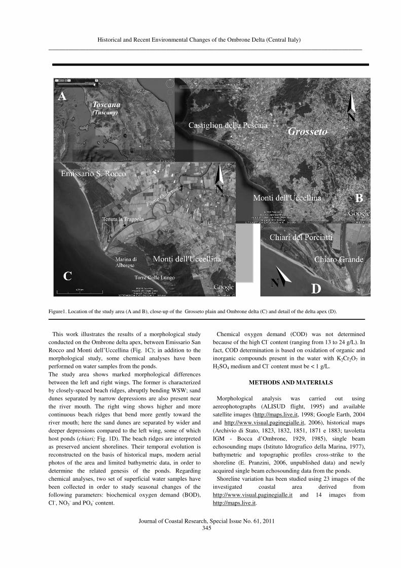
Figure3. View of the delta apex with the successive shorelines
highlighted.
The values of accretion/erosion rates have been compared
with the similar values calculated for the 1973-1995 interval.
In addition, records of shoreline variations after 1929 (Fig. 4)
illustrate erosion, at variable rates, of different sectors of the
Ombrone River delta apex (Bellotti et alii, 1999a,b; E.
Pranzini, 2001).
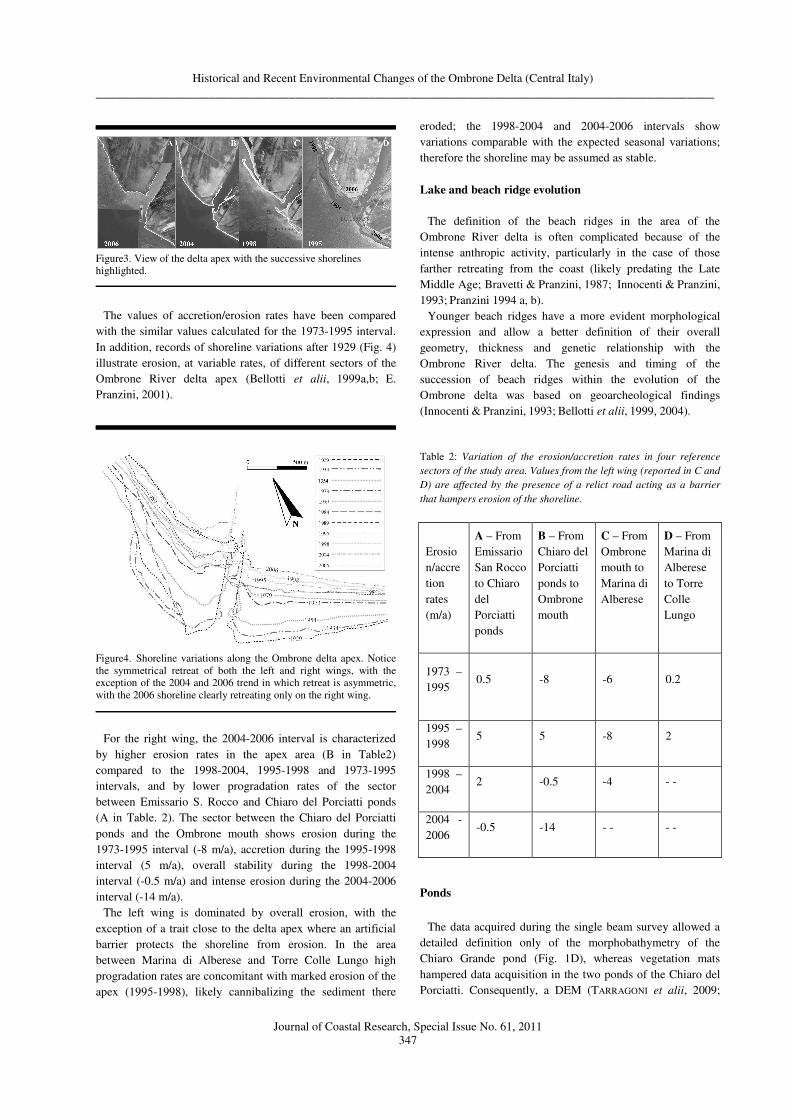
Figure4. Shoreline variations along the Ombrone delta apex. Notice
the symmetrical retreat of both the left and right wings, with the
exception of the 2004 and 2006 trend in which retreat is asymmetric,
with the 2006 shoreline clearly retreating only on the right wing.
For the right wing, the 2004-2006 interval is characterized
by higher erosion rates in the apex area (B in Table2)
compared to the 1998-2004, 1995-1998 and 1973-1995
intervals, and by lower progradation rates of the sector
between Emissario S. Rocco and Chiaro del Porciatti ponds
(A in Table. 2). The sector between the Chiaro del Porciatti
ponds and the Ombrone mouth shows erosion during the
1973-1995 interval (-8 m/a), accretion during the 1995-1998
interval (5 m/a), overall stability during the 1998-2004
interval (-0.5 m/a) and intense erosion during the 2004-2006
interval (-14 m/a).
The left wing is dominated by overall erosion, with the
exception of a trait close to the delta apex where an artificial
barrier protects the shoreline from erosion. In the area
between Marina di Alberese and Torre Colle Lungo high
progradation rates are concomitant with marked erosion of the
apex (1995-1998), likely cannibalizing the sediment there
eroded; the 1998-2004 and 2004-2006 intervals show
variations comparable with the expected seasonal variations;
therefore the shoreline may be assumed as stable.
Lake and beach ridge evolution
The definition of the beach ridges in the area of the
Ombrone River delta is often complicated because of the
intense anthropic activity, particularly in the case of those
farther retreating from the coast (likely predating the Late
Middle Age; Bravetti & Pranzini, 1987; Innocenti & Pranzini,
1993; Pranzini 1994 a, b).
Younger beach ridges have a more evident morphological
expression and allow a better definition of their overall
geometry, thickness and genetic relationship with the
Ombrone River delta. The genesis and timing of the
succession of beach ridges within the evolution of the
Ombrone delta was based on geoarcheological findings
(Innocenti & Pranzini, 1993; Bellotti et alii, 1999, 2004).
Table 2: Variation of the erosion/accretion rates in four reference
sectors of the study area. Values from the left wing (reported in C and
D) are affected by the presence of a relict road acting as a barrier
that hampers erosion of the shoreline.
Erosio
n/accre
tion
rates
(m/a)
A – From
Emissario
San Rocco
to Chiaro
del
Porciatti
ponds
B – From
Chiaro del
Porciatti
ponds to
Ombrone
mouth
C – From
Ombrone
mouth to
Marina di
Alberese
D – From
Marina di
Alberese
to Torre
Colle
Lungo
1973 –
1995 0.5 -8 -6 0.2
1995 –
1998 5 5 -8 2
1998 –
2004 2 -0.5 -4 - -
2004 -
2006 -0.5 -14 - - - -
Ponds
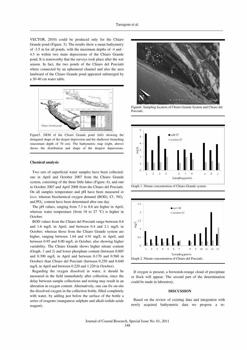
The data acquired during the single beam survey allowed a
detailed definition only of the morphobathymetry of the
Chiaro Grande pond (Fig. 1D), whereas vegetation mats
hampered data acquisition in the two ponds of the Chiaro del
Porciatti. Consequently, a DEM (TARRAGONI et alii, 2009;
Tarragoni et al.
_____________________________________________________________________________________________
Journal of Coastal Research, Special Issue No. 61, 2011
348
VECTOR, 2010) could be produced only for the Chiaro
Grande pond (Figure. 5). The results show a mean bathymetry
of -3.5 m for all ponds, with the maximum depths of -4 and -
4.5 m within two main depressions of the Chiaro Grande
pond. It is noteworthy that the surveys took place after the wet
season. In fact, the two ponds of the Chiaro del Porciatti
where connected by an ephemeral channel and also the area
landward of the Chiaro Grande pond appeared submerged by
a 30-40 cm water table.
Figure5. DEM of the Chiaro Grande pond (left) showing the
elongated shape of the deeper depression and the shallower branching
(maximum depth of 70 cm). The bathymetric map (right, above)
shows the distribution and shape of the deepest depressions.
Chemical analysis
Two sets of superficial water samples have been collected:
one in April and October 2007 from the Chiaro Grande
system, consisting of the three little lakes (Figure. 6), and one
in October 2007 and April 2008 from the Chiaro del Porciatti.
On all samples temperature and pH have been measured in
loco, whereas biochemical oxygen demand (BOD), Cl-, NO3-
and PO4- content have been determined after one day.
The pH values, ranging from 7.3 to 8.6 are higher in April,
whereas water temperature (from 18 to 27 °C) is higher in
October.
BOD values from the Chiaro del Porciatti range between 0.6
and 1.6 mg/L in April, and between 0.4 and 2.1 mg/L in
October; whereas those from the Chiaro Grande system are
higher, ranging between 1.64 and 4.91 mg/L in April, and
between 0.95 and 8.00 mg/L in October, also showing higher
variability. The Chiaro Grande shows higher nitrate content
(Graph. 1 and 2) and lower phosphate content (between 0.005
and 0.390 mg/L in April and between 0.170 and 0.560 in
October) than Chiaro del Porciatti (between 0.250 and 0.640
mg/L in April and between 0.220 and 1.220 in October).
Regarding the oxygen dissolved in water, it should be
measured in the field immediately after collection, since the
delay between sample collections and testing may result in an
alteration in oxygen content. Alternatively, one can fix on-site
the dissolved oxygen in the collection bottle, filled completely
with water, by adding just below the surface of the bottle a
series of reagents (manganese sulphate and alkali-iodide-azide
reagent).
Figure6. Sampling location of Chiaro Grande System and Chiaro del
Porciatti.
Graph 1. Nitrate concentration of Chiaro Grande system.
Graph 2. Nitrate concentration of Chiaro del Porciatti.
If oxygen is present, a brownish-orange cloud of precipitate
or flock will appear. The second part of the determination
could be made in laboratory.
DISCUSSION
Based on the review of existing data and integration with
newly acquired bathymetric data we propose a re-
Historical and Recent Environmental Changes of the Ombrone Delta (Central Italy)
_____________________________________________________________________________________________
Journal of Coastal Research, Special Issue No. 61, 2011
349
interpretation of the coastal evolution along the area of the
Ombrone delta during the past tow century.
Shoreline variations
Comparison of four shoreline positions recording their
migration during a 12 year interval (spanning between 1995
and 2006) allows to define coastal erosion and progradation
and estimate their rates. The results, reported in Table 2, are in
accordance with the fact that the sediment eroded from the
apex is largely dispersed toward the north. Dominant
northward sediment dispersal is also supported by the
following evidences:
• the area undergoing accretion on the right wing
(north of Emissario San Rocco) is greater than the
area eroded from the same wing, thus implying a
surplus of sediment likely supplied from the south
(Fig. 2),
• the occasional formation of bars showing shore-
parallel elongation toward north. For example, the
1995 spit extended continuously from the left to the
right wing, before it was cut at the river mouth (Fig.
3),
• a submerged bar extending northward from the left
wing to the right wing, with shore-parallel elongation
(Fig. 9).
Lake and beach ridge evolution
The analysis of historical maps has provided evidence of a
lake located behind the XVII – XVIII century beach ridge
(Innocenti and Pranzini 1993). This evidence is further
supported by the present day morphology of the area that
hosted the lake, which is markedly flat and is still periodically
drowned under a water table up to 30-40 cm high. According
to Bellotti et alii, (2004), that identified remnants of the lake
on historical maps, the lake underwent progressive shrinking
during the 20th century, by this giving rise to the ponds.
However, based on the revision of the historical maps, and
their comparative analysis with present day images (Google
Earth), we suggest that the ponds originated independently
from the lake evolution.
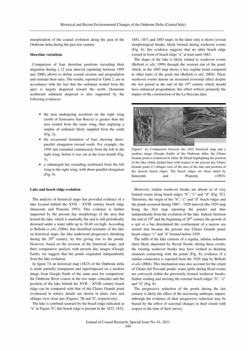
In figure 7A an historical map (1823) of the Ombrone delta
is made partially transparent and superimposed on a modern
image from Google Earth of the same area for comparison:
the Ombrone River course in the two maps coincides and the
position of the lake behind the XVII – XVIII century beach
ridge can be compared with that of the Chiaro Grande pond
(evidenced in white); details are shown in plain view and
oblique view close-ups (Figures. 7B and 7C, respectively).
The lake is confined seaward by the beach ridge indicated as
“a” in Figure 7C; this beach ridge is present in the 1823, 1832,
1851, 1871 and 1883 maps; in the latter only it shows several
morphological breaks, likely formed during washover events
(Fig. 8); this evidence suggests that no other beach ridge
existed in front of beach ridge “a” at least until 1883.
The shape of the lake is likely related to washover events
(Bellotti et alii, 1999) through the western rim of the pond,
which, in the 1883 map shows a less regular trend compared
to other traits of the pond rim (Bellotti et alii, 2004). These
washover events denote an increased erosional effect despite
the wet period at the end of the 19th century which should
have enhanced progradation; this effect reflects primarily the
impact of the construction of the La Steccaia dam.
Figure7. A) Comparison between the 1823 historical map and a
modern image (Google Earth) of the Ombrone delta; the Chiaro
Grande pond is evidenced in white. B) Detail highlighting the position
of the lake (white dashed line) with respect to the present day Chiaro
Grande pond; C) oblique view of the area of the lake and position of
the ancient beach ridges. The beach ridges are those dated by
Innocenti and Pranzini (1993).
Moreover, similar washover breaks are absent or of very
limited extent along beach ridges “b”, “c” and “d” (Fig. 7C).
Therefore, the origin of the “b”, “c” and “d” beach ridges and
the ponds occurred during 1883 – 1929 interval (the 1929 map
being the first map reporting the ponds) and thus
independently from the evolution of the lake. Indeed, between
the end of 19th and the beginning of 20th century the growth of
a spit or a bar determined the confinement of a narrow sea
stretch that became the present day Chiaro Grande pond;
beach ridges “c” and “d” formed before 1929.
The infill of the lake consists of a regular, tabular sediment
sheet likely deposited by fluvial floods; during these events,
the existing washover breaks may have worked as draining
channels connecting with the ponds (Fig. 8); evidence of a
similar connection is reported from the 1929 map by Bellotti
et alii (2004). This mechanism may also account for the origin
of Chiaro del Porciatti ponds: water spills during flood events
are conveyed within the previously formed washover breaks,
further eroding and incising the external beach ridges “b”, “c”
and “d” (Fig. 8).
The progressive reduction of the ponds during the last
century is likely the effect of the increasing anthropic impact,
although the evidence of their progressive reduction may be
biased by the effect of seasonal changes in their extent with
respect to the time of their survey.
Tarragoni et al.
_____________________________________________________________________________________________
Journal of Coastal Research, Special Issue No. 61, 2011
350
Figure8. View of the study area in 1998. A: Chiaro del Porciatti
ponds; B: Chiaro Grande pond; C: recent-most pond; D: spit and
submerged part of a bar extending northward from the delta apex; E:
smaller spit on the right wing of the delta apex. Also sediment plumes
indicating northward dispersal can be observed.
Ponds
As remarked above, the Chiaro Grande pond formed after
the growth of a spit that confined a narrow sea stretch. A
modern analogue of this mechanism has been identified ca.
600 m offshore the Ombrone River mouth; here, the DEM of
the submerged delta area shows the presence of a bar that
delimits landward an area with maximum depth of 3.5-4 m
(Figure. 9).
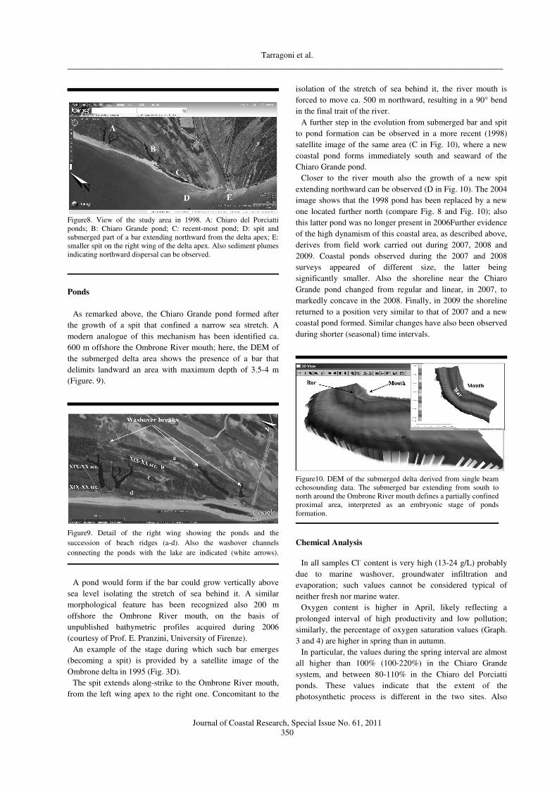
Figure9. Detail of the right wing showing the ponds and the
succession of beach ridges (a-d). Also the washover channels
connecting the ponds with the lake are indicated (white arrows).
A pond would form if the bar could grow vertically above
sea level isolating the stretch of sea behind it. A similar
morphological feature has been recognized also 200 m
offshore the Ombrone River mouth, on the basis of
unpublished bathymetric profiles acquired during 2006
(courtesy of Prof. E. Pranzini, University of Firenze).
An example of the stage during which such bar emerges
(becoming a spit) is provided by a satellite image of the
Ombrone delta in 1995 (Fig. 3D).
The spit extends along-strike to the Ombrone River mouth,
from the left wing apex to the right one. Concomitant to the
isolation of the stretch of sea behind it, the river mouth is
forced to move ca. 500 m northward, resulting in a 90° bend
in the final trait of the river.
A further step in the evolution from submerged bar and spit
to pond formation can be observed in a more recent (1998)
satellite image of the same area (C in Fig. 10), where a new
coastal pond forms immediately south and seaward of the
Chiaro Grande pond.
Closer to the river mouth also the growth of a new spit
extending northward can be observed (D in Fig. 10). The 2004
image shows that the 1998 pond has been replaced by a new
one located further north (compare Fig. 8 and Fig. 10); also
this latter pond was no longer present in 2006Further evidence
of the high dynamism of this coastal area, as described above,
derives from field work carried out during 2007, 2008 and
2009. Coastal ponds observed during the 2007 and 2008
surveys appeared of different size, the latter being
significantly smaller. Also the shoreline near the Chiaro
Grande pond changed from regular and linear, in 2007, to
markedly concave in the 2008. Finally, in 2009 the shoreline
returned to a position very similar to that of 2007 and a new
coastal pond formed. Similar changes have also been observed
during shorter (seasonal) time intervals.
Figure10. DEM of the submerged delta derived from single beam
echosounding data. The submerged bar extending from south to
north around the Ombrone River mouth defines a partially confined
proximal area, interpreted as an embryonic stage of ponds
formation.
Chemical Analysis
In all samples Cl- content is very high (13-24 g/L) probably
due to marine washover, groundwater infiltration and
evaporation; such values cannot be considered typical of
neither fresh nor marine water.
Oxygen content is higher in April, likely reflecting a
prolonged interval of high productivity and low pollution;
similarly, the percentage of oxygen saturation values (Graph.
3 and 4) are higher in spring than in autumn.
In particular, the values during the spring interval are almost
all higher than 100% (100-220%) in the Chiaro Grande
system, and between 80-110% in the Chiaro del Porciatti
ponds. These values indicate that the extent of the
photosynthetic process is different in the two sites. Also

Historical and Recent Environmental Changes of the Ombrone Delta (Central Italy)
_____________________________________________________________________________________________
Journal of Coastal Research, Special Issue No. 61, 2011
351
values during autumn are different, resulting lower than 50%
in the Chiaro Grande system and between 50-80% in the
Chiaro del Porciatti ponds.
Graph 3. Oxygen saturation percentage of the Chiaro Grande system.
Graph 4. Oxygen saturation percentage of the Chiaro del Porciatti
ponds.
In general, oxygen saturation percentage of Chiaro Grande
system respect that of Chiaro dei Porciatti is higher in spring
and smaller in autumn, with the exception of the values of
water samples coming from stations a, b and c. These stations
are located in a small lake surrounded by beach deposits
deprived of any vegetation (Fig. 6).
These differences can be explained considering the different
extent of the photosynthetic activity related to the presence of
vegetation. Where the photosynthetic activity is higher, a
greater amount of organic matter is present. Consequently, the
oxygen consumption for the organic matter transformation is
higher, in accordance with BOD values reported above; thus,
given the persistence of biologically degradable organic
compounds, the amount of oxygen present in the water is
expected to further decrease with time.
Differences regarding NO3- and PO4
- concentrations are
observed between the Chiaro Grande system and the Chiaro
del Porciatti ponds. The NO3- content in the Chiaro Grande
system is greater than in the Chiaro del Porciatti ponds
(Graph. 1 and 2), whereas PO4- concentrations show an
opposite behavior, probably due to the different use of the
surrounding land: as pasture in the first case and as farm land
in the last.
CONCLUSIONS
We propose an interpretation for the evolution of the
Ombrone River delta apex during the last two centuries. It is
known that this area was characterised by an overall
progradation trend since the 15th century Renaissance period;
this trend inverted in the late 19th century, following the
building of La Steccaia dam (between 1875 and 1879), with
consequent landward migration of the shoreline.
Erosion processes included washover events capable of
breaching the beach ridges containing a lake reported in
historical maps until 1883. Only during a limited interval
between 19th and 20th century a progradation trend was re-
established, during which the ponds originated. Later on
(second half of 20th century), a renewed erosional phase
determined the concomitant retreat of the Ombrone delta apex
and limited advance of the wings.
The morphological study in the area of the Ombrone delta
apex, by means of comparing historical maps and aerial
images, allowed:
• Evaluate shoreline retreat during the 1995-2006
interval and evidence the progressive erosion of the
delta apex at increasing rates.
• Recognize that the ponds formed independently from
the progressive shrinking of a pre-existing lake; this
lake was located behind the beach ridge dated 17th-
18th century; therefore the ponds in front of it likely
formed in a later interval encompassed between 1883
(date of the recent-most map reporting the lake) and
1929 (date of the first map reporting the ponds).
• Propose a mechanism for the origin of the Chiaro
Grande pond based on the closure of a narrow sea
stretch consequent to the emersion of a bar.
• Propose a mechanism for the origin of the Chiaro del
Porciatti ponds that takes into account fluvial flood
events and avulsion through washover breaks; the
average depth of 3.5-4 m of the ponds is in
accordance with the erosional potential of flood
events.
In addition to the above morphological study, chemical
analysis on samples from the Chiaro Grande and Chiaro del
Porciatti ponds have been performed. These revealed greater
production of organic matter in the Chiaro Grande system,
related to a higher concentration of NO3- that likely reflects
farming activity in the surrounding land.
These results show the relevance of reconstructing shoreline
evolution and coastal dynamics as reference for evaluating
future changes and addressing management issues.

Tarragoni et al.
_____________________________________________________________________________________________
Journal of Coastal Research, Special Issue No. 61, 2011
352
LITERATURE CITED
Autori Vari (2010) – Progetto V.E.C.T.O.R. Rapporto di
fine progetto. Unpublished report.
Bellotti P. (2000) – Il modello morfo-sedimentario dei
maggiori delta tirrenici italiani. Boll. Soc. Geol. It., 119,
777-792.
Bellotti P., Caputo C., Davoli L., Evangelista S.,
Garzanti E., Moretti Foggia F. & Valeri P. (1999a) - La
piana deltizia del Fiume Ombrone (Toscana meridionale):
morfologia - tessitura e composizione dei sedimenti -
architettura del sottosuolo. Atti del convegno "Le pianure,
conoscenza e salvaguardia. Il contributo delle scienze della
terra". Università degli Studi di Ferrara, 8 -11 November
1999.
Bellotti P., Caputo C., Davoli L., Evangelista S. & Valeri
P. (1999b) – Lineamenti morfologici e sedimentologici
della piana deltizia del Fiume Ombrone (Toscana
meridionale). Boll. Soc. Geol. It., 118, 141-147.
Bellotti P., Caputo C., Davoli L., Evangelista S.,
Garzanti E., Pugliese F. & Valeri P. (2004) - Morpho-
sedimentary characteristics and Holocene evolution of the
emergent part of the Ombrone river delta (southern
Tuscany). Geomorphology, 61, 71-90.
Bellotti P., Chiocci F.L., Milli S., Tortora P. & Valeri P.
(1994) – Sequence stratigraphy and depositional setting of
the Tiber Delta: integration of high-resolution seismics,
well-logs and archaeological data. Journ. Sedim. Res., 64
(B), 416-432.
Bravetti L. & Pranzini G. (1987) - L'evoluzione
quaternaria della pianura di Grosseto (Toscana): prima
interpretazione dei dati del sottosuolo. Geografia fisica e
Dinamica Quaternaria, 10, 85-92.
Della Rocca B., Mazzanti R. & Pranzini E. (1987) –
Studio geo-morfologico della Pianura di Pisa. Geografia
Fisica e Dinamica Quaternaria, 10, 56-84.
Galloway W. E. (1975) – Process frame work for
describing in the morphologic and stratigraphic evolution of
deltaic depositional system. In: Deltas, Model for
Exploration, Ed. Broussard M.L., Houtson Geol. Soc., 87-
98.
Innocenti L. & Pranzini E. (1993) - Geomorphological
evolution and sedimentology of the Ombrone river delta,
Italy. Journal of Coastal Research, vol. 9, No. 2, 481-493.
Mohr C.F. (1877) – Lehrbuch der chemisch-analytischen
titrimethode. Braunschweig, Viewig, 1877.
Pranzini E. (1994a) - The erosion of the Ombrone river
delta (Italy). Littoral 94, Lisbona, Portogallo, 26-29
September 1994.
Pranzini E. (1994b) – Bilancio sedimentario ed
evoluzione storica delle spiagge. Il Quaternario 7, 197-204.
Pranzini E. (2001) – Updrift river mouth migration on
cuspate deltas: two examples from the coast of Tuscany
(Italy). Geomorphology, 38, 125-132.
Romano P., Santo A. & Voltaggio M. (1994) –
L’evoluzione geo-morfologica della Pianura del Fiume
Volturno (Campania) durante il tardo Quaternario
(Pleistocene medio superiore-Olocene). Il Quaternario, 7
(1), 41-56.
Tarragoni C, Bellotti P., Davoli L. & Chiocci F. L.
(2009) - Recent evolution of the apical area of Ombrone
River Delta (Southern Tuscany). Epitome Geoitalia 2009,
FIST Journal, 3: 417-418. (Poster at the Geo04 disciplinary
session “Geografia fisica e geomorfologia”). Rimini, 9 - 11
September 2009.
Winkler L. (1888) - Die Bestimmung des in Wasser
Gelösten Sauerstoffes. Berichte der Deutschen Chemischen
Gesellschaft, 21: 2843–2855.