High resolution geospatial surveying techniques provide new insights into rock-art landscapes at...
21
High-resolution geospatial surveying techniques provide new insights into rock-art landscapes at Shuwaymis, Saudi Arabia Many parts of the Arabian Peninsula contain rock art that has received minimal archaeological attention or has not yet been thoroughly surveyed. In 2001 an exten- sive rock-art complex called Shuwaymis, Ha’il Province, Saudi Arabia was brought to the attention of the Saudi General Commission for Tourism and Antiquities. This paper sets out the results of the first high-resolution geospatial mapping and recording of rock art at this remote site. The research saw the innovative use of a differential GPS to record rock-art panels to within 5 mm of accuracy at the site of Shuwaymis-2, the first time that such technology has been used to record rock art in the Arabian Pen- insula. With such technology it was possible to show which of eighty-three late pre- historic rock-art panels surveyed were in their original position and which had fallen, and to demonstrate that there was spatial homogeneity of rock-art styles and composi- tion across the site. The mapping recorded multiple panels of cattle, ibex, equid, large cat and other animals. The depictions of lions and cattle in particular indicate that the rock art must have been engraved no later than the early Holocene humid phase (c.10–6 ka BP). Keywords: rock art, Shuwaymis, Saudi Arabia, DGPS, GIS, late prehistoric, landscapes Richard Jennings 1 , Ash Parton 1 , Huw S. Groucutt 1 , Laine Clark-Balzan 1 , Paul Breeze 2 , Nick A. Drake 2 , Abdullah Alsharekh 3 , Michael D. Petraglia 1 1 School of Archaeology, Research Laboratory for Archaeology and the History of Art, University of Oxford, Oxford, OX1 2HU, UK 2 Department of Archaeology, College of Tourism and Archaeology, King Saud University, PO Box 2454, Riyadh, 11451, Saudi Arabia 3 Department of Geography, King’ s College London, Strand, London, WC2R 2LS, UK e-mails: [email protected]; [email protected]; [email protected]; [email protected]; [email protected]; [email protected]; [email protected]; [email protected] Introduction The interpretation of activity variation across landscapes setting is becoming an increasing focus of rock-art research. Advances in geospatial survey techniques, increased avail- ability of satellite and photographic imagery and the devel- opment of spatial datasets for mapping and analysis open up new possibilities for studying rock art and human behav- iour in its wider environmental contexts, particularly in remote locations (e.g. McClure, Balaguer & Auban 2008; Aubry, Luis & Dimuccio 2013; Bourdier 2013; Jennings et al. 2013; Olsen 2013). Such techniques have great poten- tial to build on existing rock-art research in Saudi Arabia, which has traditionally focused on the interpretation of rock-art styles and inscriptions rather than on the systematic evaluation of rock-art panels from a landscape perspective (e.g. Anati 1974; Khan 2007; Al Talhi 2012). One key locality in northern Saudi Arabia is Shuway- mis, Ha’il Province (39°53’30”E, 26°09’02”N; Fig. 1). 1 Arab. arch. epig. 2014: 25: 1–21 (2014) Printed in Singapore. All rights reserved
Transcript of High resolution geospatial surveying techniques provide new insights into rock-art landscapes at...
High-resolution geospatial surveying techniquesprovide new insights into rock-art landscapes atShuwaymis, Saudi Arabia
Many parts of the Arabian Peninsula contain rock art that has received minimalarchaeological attention or has not yet been thoroughly surveyed. In 2001 an exten-sive rock-art complex called Shuwaymis, Ha’il Province, Saudi Arabia was broughtto the attention of the Saudi General Commission for Tourism and Antiquities. Thispaper sets out the results of the first high-resolution geospatial mapping and recordingof rock art at this remote site. The research saw the innovative use of a differentialGPS to record rock-art panels to within 5 mm of accuracy at the site of Shuwaymis-2,the first time that such technology has been used to record rock art in the Arabian Pen-insula. With such technology it was possible to show which of eighty-three late pre-historic rock-art panels surveyed were in their original position and which had fallen,and to demonstrate that there was spatial homogeneity of rock-art styles and composi-tion across the site. The mapping recorded multiple panels of cattle, ibex, equid, largecat and other animals. The depictions of lions and cattle in particular indicate that therock art must have been engraved no later than the early Holocene humid phase(c.10–6 ka BP).
Keywords: rock art, Shuwaymis, Saudi Arabia, DGPS, GIS, late prehistoric,landscapes
Richard Jennings1, Ash Parton1,Huw S. Groucutt1, LaineClark-Balzan1, Paul Breeze2,Nick A. Drake2, AbdullahAlsharekh3, Michael D.Petraglia11School of Archaeology,Research Laboratory forArchaeology and the History ofArt, University of Oxford,Oxford, OX1 2HU, UK2Department of Archaeology,College of Tourism andArchaeology, King SaudUniversity, PO Box 2454,Riyadh, 11451, Saudi Arabia3Department of Geography,King’s College London, Strand,London, WC2R 2LS, UKe-mails: [email protected];
IntroductionThe interpretation of activity variation across landscapessetting is becoming an increasing focus of rock-art research.Advances in geospatial survey techniques, increased avail-ability of satellite and photographic imagery and the devel-opment of spatial datasets for mapping and analysis openup new possibilities for studying rock art and human behav-iour in its wider environmental contexts, particularly inremote locations (e.g. McClure, Balaguer & Auban 2008;
Aubry, Luis & Dimuccio 2013; Bourdier 2013; Jenningset al. 2013; Olsen 2013). Such techniques have great poten-tial to build on existing rock-art research in Saudi Arabia,which has traditionally focused on the interpretation ofrock-art styles and inscriptions rather than on the systematicevaluation of rock-art panels from a landscape perspective(e.g. Anati 1974; Khan 2007; Al Talhi 2012).
One key locality in northern Saudi Arabia is Shuway-mis, Ha’il Province (39°53’30”E, 26°09’02”N; Fig. 1).
1
Arab. arch. epig. 2014: 25: 1–21 (2014)Printed in Singapore. All rights reserved
Shuwaymis contains some of the finest and mostnumerous rock-art panels in the whole of the ArabianPeninsula. The locality first received recognition as a siteof exceptional importance in rock-art research only asrecently as 2001, when a local schoolteacher, MahboubHabbas al-Rashheedi, who was shown the rock art bylocal Bedouin, brought it to the attention of the Saudi Gen-eral Commission of Tourism and Antiquities (Bednarik &Khan 2002). Such is the significance of the Shuwaymisrock-art locality that after preliminary surveys of Shuway-mis-1 and Shuwaymis-2 (Al-Saud & Khan 2005; Bednarik& Khan 2005), two rock-art sites situated on sandstone es-carpments on either side of a relict river valley, this regiontogether with the Jubbah rock-art complex in the Nefuddesert were put forward in 2012 by the Permanent Delega-tion of Saudi Arabia to UNESCO for World Heritage sta-tus. A selection of its panels has also been recently
photographed using advanced image technology tech-niques (Olsen 2013).
A considerable amount of research lies ahead in terms ofrecording the rock art of the Shuwaymis region, includingmapping the whole site extent, which is currently unknown.In recognition of this fact, the Saudi General Commissionfor Tourism and Antiquities commissioned Oxford Univer-sity’s Palaeodeserts Project, a major multidisciplinaryresearch project currently investigating links between Pleis-tocene and Holocene environmental change and human dis-persals in the Arabian Peninsula, to undertake a detailedfield survey of Shuwaymis-2 and to place the entire rock-art locality in its wider geographical context. The Palaeode-serts team had undertaken a similar project in the Jubbahregion in 2011, where the relationship between rock art,palaeolakes and prehistoric archaeological sites wasexplored (Crassard et al. 2013; Jennings et al. 2013).
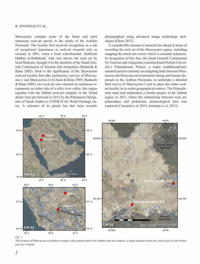
Fig. 1.The location of Shuwaymis in relation to major wadi systems and to the Jubbah rock-art complex, a major location where the same style of Late Prehis-toric art is found.
2
R. JENNINGS ETAL.
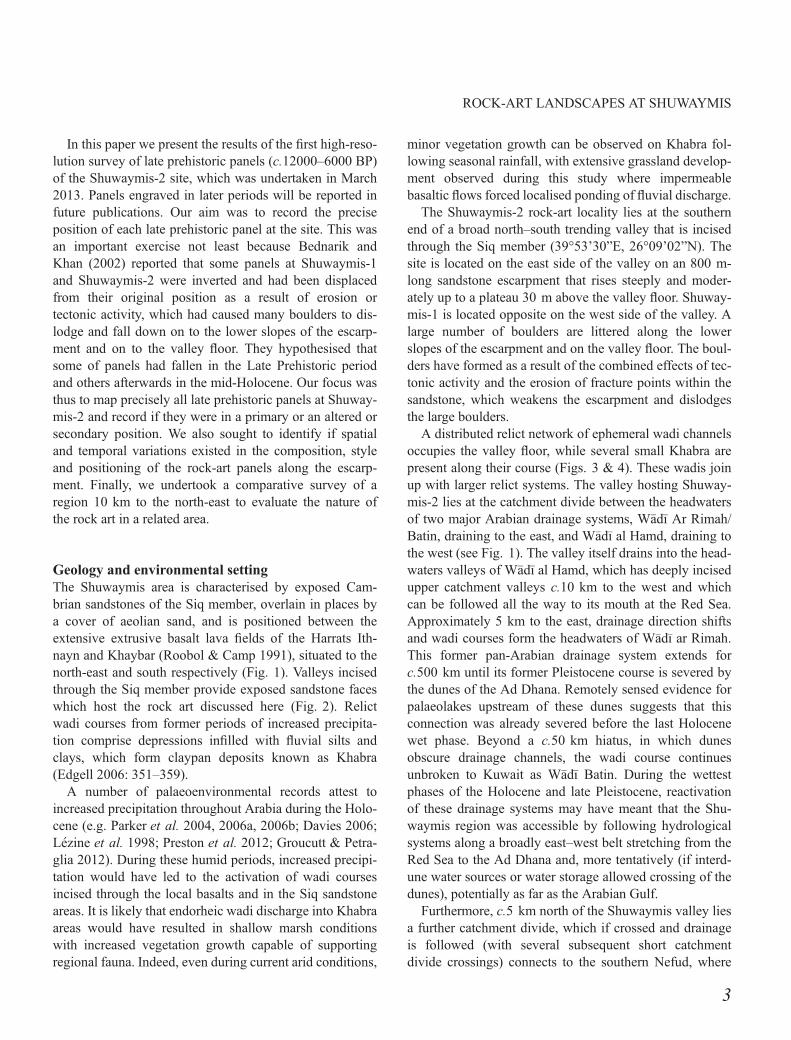
In this paper we present the results of the first high-reso-lution survey of late prehistoric panels (c.12000–6000 BP)of the Shuwaymis-2 site, which was undertaken in March2013. Panels engraved in later periods will be reported infuture publications. Our aim was to record the preciseposition of each late prehistoric panel at the site. This wasan important exercise not least because Bednarik andKhan (2002) reported that some panels at Shuwaymis-1and Shuwaymis-2 were inverted and had been displacedfrom their original position as a result of erosion ortectonic activity, which had caused many boulders to dis-lodge and fall down on to the lower slopes of the escarp-ment and on to the valley floor. They hypothesised thatsome of panels had fallen in the Late Prehistoric periodand others afterwards in the mid-Holocene. Our focus wasthus to map precisely all late prehistoric panels at Shuway-mis-2 and record if they were in a primary or an altered orsecondary position. We also sought to identify if spatialand temporal variations existed in the composition, styleand positioning of the rock-art panels along the escarp-ment. Finally, we undertook a comparative survey of aregion 10 km to the north-east to evaluate the nature ofthe rock art in a related area.
Geology and environmental settingThe Shuwaymis area is characterised by exposed Cam-brian sandstones of the Siq member, overlain in places bya cover of aeolian sand, and is positioned between theextensive extrusive basalt lava fields of the Harrats Ith-nayn and Khaybar (Roobol & Camp 1991), situated to thenorth-east and south respectively (Fig. 1). Valleys incisedthrough the Siq member provide exposed sandstone faceswhich host the rock art discussed here (Fig. 2). Relictwadi courses from former periods of increased precipita-tion comprise depressions infilled with fluvial silts andclays, which form claypan deposits known as Khabra(Edgell 2006: 351–359).
A number of palaeoenvironmental records attest toincreased precipitation throughout Arabia during the Holo-cene (e.g. Parker et al. 2004, 2006a, 2006b; Davies 2006;L�ezine et al. 1998; Preston et al. 2012; Groucutt & Petra-glia 2012). During these humid periods, increased precipi-tation would have led to the activation of wadi coursesincised through the local basalts and in the Siq sandstoneareas. It is likely that endorheic wadi discharge into Khabraareas would have resulted in shallow marsh conditionswith increased vegetation growth capable of supportingregional fauna. Indeed, even during current arid conditions,
minor vegetation growth can be observed on Khabra fol-lowing seasonal rainfall, with extensive grassland develop-ment observed during this study where impermeablebasaltic flows forced localised ponding of fluvial discharge.
The Shuwaymis-2 rock-art locality lies at the southernend of a broad north–south trending valley that is incisedthrough the Siq member (39°53’30”E, 26°09’02”N). Thesite is located on the east side of the valley on an 800 m-long sandstone escarpment that rises steeply and moder-ately up to a plateau 30 m above the valley floor. Shuway-mis-1 is located opposite on the west side of the valley. Alarge number of boulders are littered along the lowerslopes of the escarpment and on the valley floor. The boul-ders have formed as a result of the combined effects of tec-tonic activity and the erosion of fracture points within thesandstone, which weakens the escarpment and dislodgesthe large boulders.
A distributed relict network of ephemeral wadi channelsoccupies the valley floor, while several small Khabra arepresent along their course (Figs. 3 & 4). These wadis joinup with larger relict systems. The valley hosting Shuway-mis-2 lies at the catchment divide between the headwatersof two major Arabian drainage systems, W�ad�ı Ar Rimah/Batin, draining to the east, and W�ad�ı al Hamd, draining tothe west (see Fig. 1). The valley itself drains into the head-waters valleys of W�ad�ı al Hamd, which has deeply incisedupper catchment valleys c.10 km to the west and whichcan be followed all the way to its mouth at the Red Sea.Approximately 5 km to the east, drainage direction shiftsand wadi courses form the headwaters of W�ad�ı ar Rimah.This former pan-Arabian drainage system extends forc.500 km until its former Pleistocene course is severed bythe dunes of the Ad Dhana. Remotely sensed evidence forpalaeolakes upstream of these dunes suggests that thisconnection was already severed before the last Holocenewet phase. Beyond a c.50 km hiatus, in which dunesobscure drainage channels, the wadi course continuesunbroken to Kuwait as W�ad�ı Batin. During the wettestphases of the Holocene and late Pleistocene, reactivationof these drainage systems may have meant that the Shu-waymis region was accessible by following hydrologicalsystems along a broadly east–west belt stretching from theRed Sea to the Ad Dhana and, more tentatively (if interd-une water sources or water storage allowed crossing of thedunes), potentially as far as the Arabian Gulf.
Furthermore, c.5 km north of the Shuwaymis valley liesa further catchment divide, which if crossed and drainageis followed (with several subsequent short catchmentdivide crossings) connects to the southern Nefud, where
3
ROCK-ART LANDSCAPES AT SHUWAYMIS
further instances of rock art similar to that of Shuwaymisare known, such as the Jubbah rock-art complex (Khan2007; Jennings et al. 2013).
MethodologyThe study utilised a form of differential Global PositioningSystem (DGPS) known as a Real-Time Kinematic Global
Navigation Satellite System (RTK-GNSS) to record thelocation of rock-art panels at Shuwaymis-2. This surveymethod enables highly detailed and accurate (c.5 mm) col-lection of geospatial data, which may then be analysedusing Geographic Information System (GIS) software.This represents a significant advance over conventionalGPS survey devices, which can only record spatial pointsto a 5 m level of accuracy. This has significant implica-
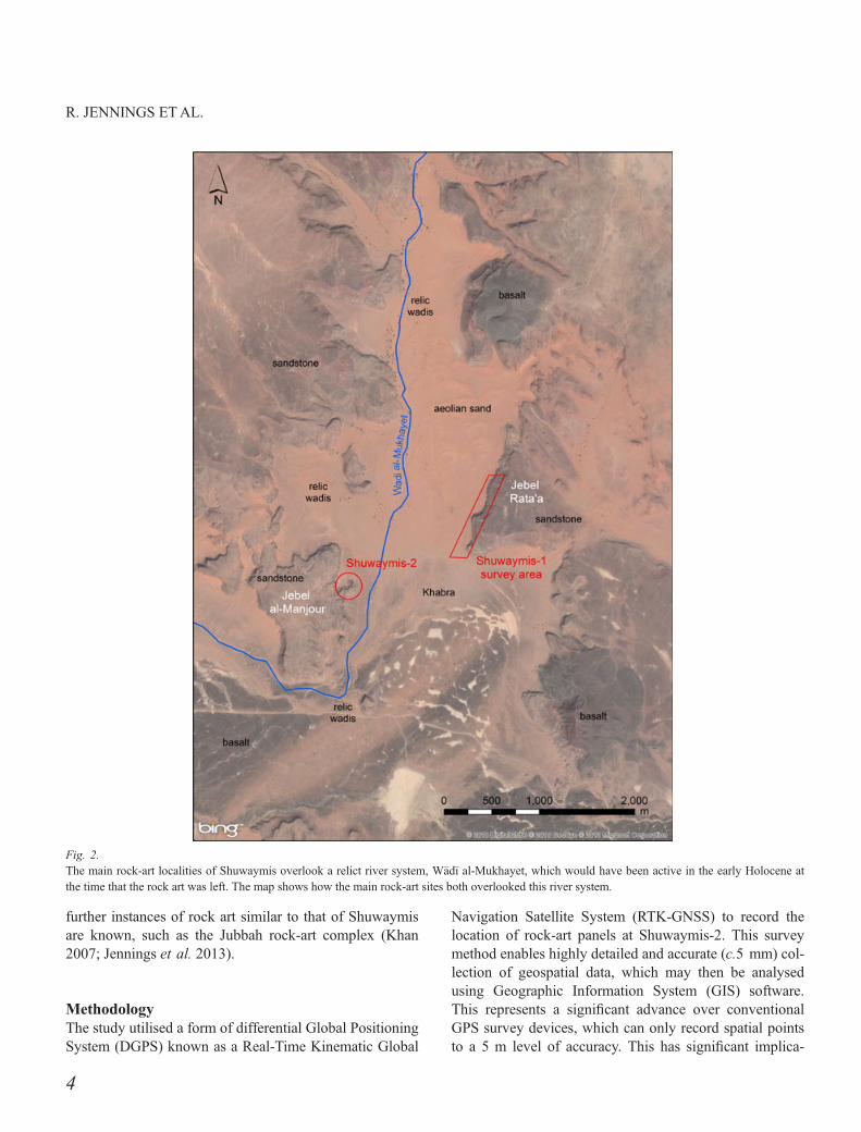
Fig. 2.The main rock-art localities of Shuwaymis overlook a relict river system, W�ad�ı al-Mukhayet, which would have been active in the early Holocene atthe time that the rock art was left. The map shows how the main rock-art sites both overlooked this river system.
4
R. JENNINGS ETAL.
tions for rock-art studies as the position and orientation ofindividual panels can now be recorded on a single boulder.A Leica Viva GNSS system was employed, comprising aLeica GS10 base station and rover connected to a LeicaGS15 controller.
Shuwaymis-2 was selected for the survey because itcontains a dense concentration of rock-art panels andbecause it has never been systematically mapped before.Given our ability to record panels to 5 mm accuracy lev-els, each boulder and escarpment face was thoroughly andcomprehensively inspected for evidence of rock art.Numerous variables were recorded for each panel. Thevariables derived from those used in the Jubbah rock-artsurvey (Jennings et al. 2013). Key ones included panelcomposition, style, number of phases, evidence of super-imposition, coordinates, elevation, extent, density, orienta-tion, condition (variation in the degree of weathering orpatination), completeness (whole, fragmented or dislodgedfragment of a larger panel) and its setting, which involveddetermining whether a panel was in a primary or an alteredposition. If a panel was engraved directly into a rock faceor was upright on a boulder, it was classed in most casesas being in a primary position. A panel on a boulder was
classed as being in an altered position if it was inverted,was a fragment of a larger panel, could be refitted to anexisting panel or a boulder with rock art had fallen in sucha way that the panel could not have been engraved fromits current position.
The range of variables used in this study allowed for anobjective and quantitative interpretation of the spatialvariation of rock art at Shuwaymis-2. Sites were groupedinto clusters according to whether they were situatedwithin 30 m of each other. Arc GIS 10.1 was used to ana-lyse the data and base maps derive from Bing Maps. Eachpanel was photographed and linked to the spatial database.
A number of rock-art styles are present at Shuwaymis.As is the case for elsewhere in Arabia, none has yet beendirectly dated. Khan has put forward the most detailed rel-ative chronology for Arabian rock art (2007: 341). Heidentified four key phases: Neolithic, Chalcolithic, BronzeAge and Iron Age. He devised these phases based on thestyle and superimposition of rock art at multiple localitiesacross the Peninsula, as well as from observations ofpatina and animal ecology. Our paper focuses on his Neo-lithic and Chalcolithic phases which, because of the lackof dating we call ‘Late Prehistoric’ (see Jennings et al.
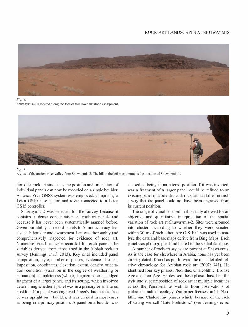
Fig. 3.Shuwaymis-2 is located along the face of this low sandstone escarpment.
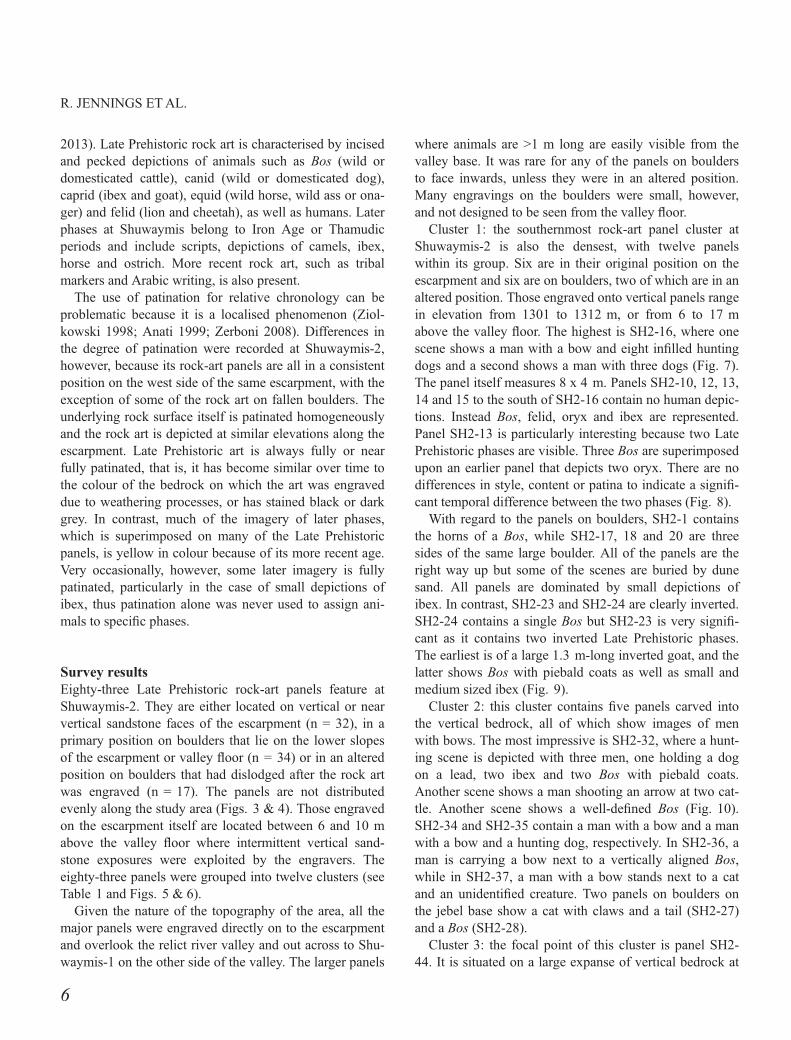
Fig. 4.Aview of the ancient river valley from Shuwaymis-2. The hill in the left background is the location of Shuwaymis-1.
5
ROCK-ART LANDSCAPES AT SHUWAYMIS
2013). Late Prehistoric rock art is characterised by incisedand pecked depictions of animals such as Bos (wild ordomesticated cattle), canid (wild or domesticated dog),caprid (ibex and goat), equid (wild horse, wild ass or ona-ger) and felid (lion and cheetah), as well as humans. Laterphases at Shuwaymis belong to Iron Age or Thamudicperiods and include scripts, depictions of camels, ibex,horse and ostrich. More recent rock art, such as tribalmarkers and Arabic writing, is also present.
The use of patination for relative chronology can beproblematic because it is a localised phenomenon (Ziol-kowski 1998; Anati 1999; Zerboni 2008). Differences inthe degree of patination were recorded at Shuwaymis-2,however, because its rock-art panels are all in a consistentposition on the west side of the same escarpment, with theexception of some of the rock art on fallen boulders. Theunderlying rock surface itself is patinated homogeneouslyand the rock art is depicted at similar elevations along theescarpment. Late Prehistoric art is always fully or nearfully patinated, that is, it has become similar over time tothe colour of the bedrock on which the art was engraveddue to weathering processes, or has stained black or darkgrey. In contrast, much of the imagery of later phases,which is superimposed on many of the Late Prehistoricpanels, is yellow in colour because of its more recent age.Very occasionally, however, some later imagery is fullypatinated, particularly in the case of small depictions ofibex, thus patination alone was never used to assign ani-mals to specific phases.
Survey resultsEighty-three Late Prehistoric rock-art panels feature atShuwaymis-2. They are either located on vertical or nearvertical sandstone faces of the escarpment (n = 32), in aprimary position on boulders that lie on the lower slopesof the escarpment or valley floor (n = 34) or in an alteredposition on boulders that had dislodged after the rock artwas engraved (n = 17). The panels are not distributedevenly along the study area (Figs. 3 & 4). Those engravedon the escarpment itself are located between 6 and 10 mabove the valley floor where intermittent vertical sand-stone exposures were exploited by the engravers. Theeighty-three panels were grouped into twelve clusters (seeTable 1 and Figs. 5 & 6).
Given the nature of the topography of the area, all themajor panels were engraved directly on to the escarpmentand overlook the relict river valley and out across to Shu-waymis-1 on the other side of the valley. The larger panels
where animals are >1 m long are easily visible from thevalley base. It was rare for any of the panels on bouldersto face inwards, unless they were in an altered position.Many engravings on the boulders were small, however,and not designed to be seen from the valley floor.
Cluster 1: the southernmost rock-art panel cluster atShuwaymis-2 is also the densest, with twelve panelswithin its group. Six are in their original position on theescarpment and six are on boulders, two of which are in analtered position. Those engraved onto vertical panels rangein elevation from 1301 to 1312 m, or from 6 to 17 mabove the valley floor. The highest is SH2-16, where onescene shows a man with a bow and eight infilled huntingdogs and a second shows a man with three dogs (Fig. 7).The panel itself measures 8 x 4 m. Panels SH2-10, 12, 13,14 and 15 to the south of SH2-16 contain no human depic-tions. Instead Bos, felid, oryx and ibex are represented.Panel SH2-13 is particularly interesting because two LatePrehistoric phases are visible. Three Bos are superimposedupon an earlier panel that depicts two oryx. There are nodifferences in style, content or patina to indicate a signifi-cant temporal difference between the two phases (Fig. 8).
With regard to the panels on boulders, SH2-1 containsthe horns of a Bos, while SH2-17, 18 and 20 are threesides of the same large boulder. All of the panels are theright way up but some of the scenes are buried by dunesand. All panels are dominated by small depictions ofibex. In contrast, SH2-23 and SH2-24 are clearly inverted.SH2-24 contains a single Bos but SH2-23 is very signifi-cant as it contains two inverted Late Prehistoric phases.The earliest is of a large 1.3 m-long inverted goat, and thelatter shows Bos with piebald coats as well as small andmedium sized ibex (Fig. 9).
Cluster 2: this cluster contains five panels carved intothe vertical bedrock, all of which show images of menwith bows. The most impressive is SH2-32, where a hunt-ing scene is depicted with three men, one holding a dogon a lead, two ibex and two Bos with piebald coats.Another scene shows a man shooting an arrow at two cat-tle. Another scene shows a well-defined Bos (Fig. 10).SH2-34 and SH2-35 contain a man with a bow and a manwith a bow and a hunting dog, respectively. In SH2-36, aman is carrying a bow next to a vertically aligned Bos,while in SH2-37, a man with a bow stands next to a catand an unidentified creature. Two panels on boulders onthe jebel base show a cat with claws and a tail (SH2-27)and a Bos (SH2-28).
Cluster 3: the focal point of this cluster is panel SH2-44. It is situated on a large expanse of vertical bedrock at
6
R. JENNINGS ETAL.
an altitude of 1306 m, some 8 m above the valley floor.The escarpment here is strewn with boulders and there area few vertical faces to the left and right of this panel. SH2-44 shows an impressive infilled ibex and a verticallydrawn Bos, both of which are obscured beneath a scene oflater camels (Fig. 11). Fragmentary panels on boulders inan altered position below and up to 10 m to the north wereprobably once part of this panel. These include an erodedhuman figure (SH2-64), a man with an equid (SH2-49)and a man with a Bos (SH2-56 & 58). Panel SH2-57,which shows the fragmented horn of a Bos and an infilledequid, cannot be in its primary position as the rock art ispartially obscured by a large boulder on which it rests. It issame for SH2-52, where an ibex is partially hidden behindan adjacent boulder in an altered context.
Other panels in a primary context in cluster 3 include anequid on panel SH2-41, which is on the same contour asthe main panel, an infilled cat on panels SH2-54, which islocated on a boulder on the valley floor, and a man stand-ing behind a Bos higher up the escarpment on panel SH2-67. Conceivably, the boulders in an altered position in thiscluster could be associated with SH2-67 given the repeti-tion of the scene here of a man and a Bos with long horns.Elsewhere there are also a few smaller boulders with rockart that appear to fit the boulder size and are thus unlikelyto have become detached from another panel. Theseinclude SH2-43, 47, 60 and 63, which contain smallimages of equid, Bos and ibex.
Cluster 4: two low-density south-facing panels withimages of ibex (SH2-68 and SH2-69) and a third isolatedbut larger panel also containing an ibex (SH2-72) make upthis cluster. Good-quality vertical rock surfaces are sparsein this area. No rock art was found on any of the surround-
ing boulders to suggest that the panels had once been moresubstantial.
Cluster 5: the five panels of this cluster initially allappear in situ. Panel SH2-83 is on a vertical rock face; thefour other panels are on boulders. SH2-83 is a higher-den-sity panel with multiple scenes including an infilled ibexbeing attacked by a pack of dogs, a human and two oryx,a hunting scene comprising dogs and five figures withbows, three Bos on top of each other and a felid biting thehead of a stick-figured man. The position of this panel issignificant because it is at a juncture in the escarpmentwhere it begins to angle to the east. The views from thispoint are more extensive than almost all other panels.
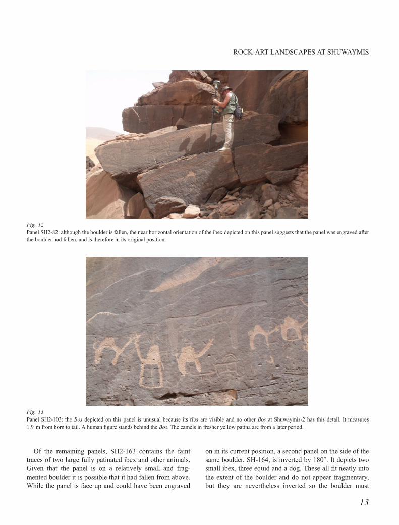
Panel SH2-82 contains three impressively drawn ibexon a larger boulder mid-way up the escarpment. It is unli-kely to have fallen from SH2-83 above because the ibexare not drawn in line with the angled bedding planes ofthe boulder. Rather, they are on a near-horizontal plane(Fig. 12). Panel SH2-91 on the base of the escarpmentcontains a finely engraved felid on its upper boulder that isprobably in situ given that it is also horizontal. On a boul-der directly below the felid, however, is a scene with out-lines of five ibex that are obscured by a large boulder. Thelower part of the panel could thus be a fallen boulder froman earlier phase, as it seems impossible that the art wasdrawn in situ. Small dogs make up panels SH2-90 andSH2-92.
Cluster 6: two rock-art panels form this cluster. SH2-98under a rock overhang shows a man with a bow, an equidand two dogs and a vertically drawn Bos. The panel issimilar in style and in the range of animals as SH2-83 incluster 4. SH2-100 on the valley floor below shows asmall Bos that bears no direct link to SH2-98 above.
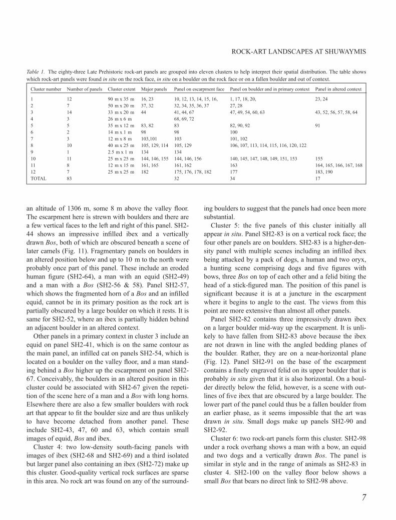
Table 1. The eighty-three Late Prehistoric rock-art panels are grouped into eleven clusters to help interpret their spatial distribution. The table showswhich rock-art panels were found in situ on the rock face, in situ on a boulder on the rock face or on a fallen boulder and out of context.
Cluster number Number of panels Cluster extent Major panels Panel on escarpment face Panel on boulder and in primary context Panel in altered context
1 12 90 m x 35 m 16, 23 10, 12, 13, 14, 15, 16, 1, 17, 18, 20, 23, 242 7 50 m x 20 m 37, 32 32, 34, 35, 36, 37 27, 283 14 33 m x 20 m 44 41, 44, 67 47, 49, 54, 60, 63 43, 52, 56, 57, 58, 644 3 26 m x 6 m 68, 69, 725 5 35 m x 12 m 83, 82 83 82, 90, 92 916 2 14 m x 1 m 98 98 1007 3 12 m x 8 m 103,101 103 101, 1028 10 40 m x 25 m 105, 129, 114 105, 129 106, 107, 113, 114, 115, 116, 120, 1229 1 2.5 m x 1 m 134 13410 11 25 m x 25 m 144, 146, 155 144, 146, 156 140, 145, 147, 148, 149, 151, 153 15511 8 12 m x 15 m 161, 165 161, 162 163 164, 165, 166, 167, 16812 7 25 m x 25 m 182 175, 176, 178, 182 177 183, 190TOTAL 83 32 34 17
7
ROCK-ART LANDSCAPES AT SHUWAYMIS
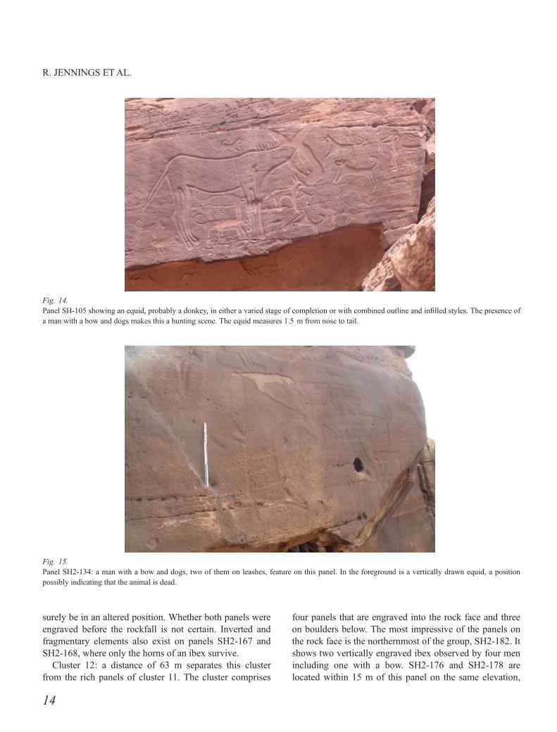
Cluster 7: between clusters 6 and 7 Late Prehistoric rockart is absent for 114 m. The reason for the absence of rockart here is likely to be geological: this section of theescarpment contains many small boulders and few of thelarge vertical rock surfaces on which panels are typicallyfound. This changes at SH2-103 where there is a detailed
depiction of a Bos with very large horns and exposed ribsengraved onto a sheer rock surface (Fig. 13). Two panelsare found on large boulders 8–12 m below the Bos. Theseare similar to SH2-103 in terms of their realism. SH2-101shows a dog chasing an equid, a hyena chasing an equidwith forward-facing horns and an equid with a mane being
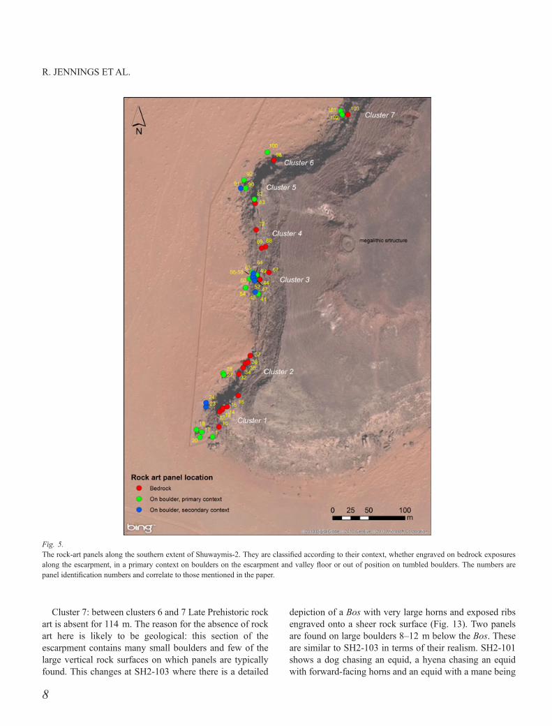
Fig. 5.The rock-art panels along the southern extent of Shuwaymis-2. They are classified according to their context, whether engraved on bedrock exposuresalong the escarpment, in a primary context on boulders on the escarpment and valley floor or out of position on tumbled boulders. The numbers arepanel identification numbers and correlate to those mentioned in the paper.
8
R. JENNINGS ETAL.

bitten by a dog, while SH2-102 shows a piebald Bos withforward-facing horns.
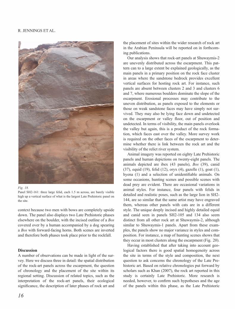
Cluster 8: arguably the most visually impressive LatePrehistoric rock-art panel of the study area is SH2-105,which marks the start of a dense concentration of ten pan-els within a 40 x 25 m section of the escarpment. This2.5 m-long x 1.5 m-high panel contains the striking depic-tion of a highly detailed equid surrounded by eleven dogs
and a man with a bow (Fig. 14). The deep incisions of thisstyle resemble panels seen at Shuwaymis-1; otherwise it israre on this escarpment. SH2-129, an equally rich rock-artpanel located on the same contour line as the equid(1313 m above sea level or 10 m above the valley floor),marks the northern extent of the cluster. This panelcontains three Bos but these are almost undetectablebeneath numerous camel depictions from a later era. Both
Fig. 6.Rock-art panels at the northern extent of Shuwaymis-2.
9
ROCK-ART LANDSCAPES AT SHUWAYMIS
SH2-105 and SH2-129 face south-west directly towardsShuwaymis-1.
The eight other panels of the cluster are found on largeboulders located between and below SH2-105 and SH2-129. The rock art on panel SH2-106 is very eroded but ison the inside of a boulder facing the cliff. It contains fivemedium-sized ibex and two dogs. Two small ibex followthe horizontal bedding planes of a boulder in SH2-107, asdo a small ibex on SH-115 and a medium-sized ibex and adog on SH2-120. A large dog 1 m across is prominent inSH2-116 while a large equid with two dogs feature inSH2-114. The last two boulders of the cluster are on thefoot of the escarpment and, as a result of being so exposedto the elements, are heavily weathered. SH2-113 is ofthree heavily eroded people with slightly bent legs, while
SH2-122 contains faint ibex horns and traces of a man.Another man in the panel with his hands above his headcould potentially be Late Prehistoric but may be of a laterperiod. Iron Age and later imagery also cover the panel.
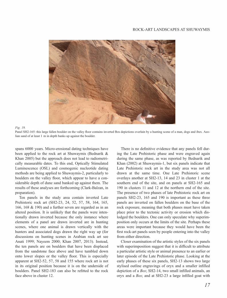
Cluster 9: this cluster is in fact made up of only SH2-134 because this panel is more than 30 m from the nextnearest in situ Late Prehistoric panel. The panel is fairlywell preserved and highly visible on a large section ofrock face 7 m above the valley floor. It is a hunting scenecomprising a man with a bow, hunting dogs on leashesand their presumably dead prey, a vertically positionedequid (Fig. 15). The realistic style of the panel is the sameas SH2-105 in cluster 7, although its preservation is not asgood.
Cluster 10: eleven rock-art panels form part of this clus-ter. The geology in this part of the escarpment is condu-cive to the formation of large vertical surfaces ideal forrock art. Three panels are located on a sheer cliff face 6–7m above the valley floor surface at an altitude ofc.1314 m. Panel SH2-144 is one of the most impressive ofthe site. It features a large lion measuring 2 m long andalmost 1 m high (Fig. 16). The claws, open mouth andpenis are all visible, while its coat is a speckled colourowing to it being repecked, probably during the Iron Age,as its moderate patination resembles that of camels fromthat era. A man with a bow and at least two dogs accom-pany the lion on the panel. Further along the same contour,up to five small dogs attacking two ibex are on panel SH2-146, while a Bos, a small ibex, dogs and schematichumans are visible on SH2-156 beneath a series of denseIron Age imagery.
This cluster contains a panel with indisputable evidenceof Late Prehistoric rock art in an altered context. The panelin question, SH2-155, is situated on a large fallen boulderthat rests on the escarpment 6 m above the valley floor(Fig. 17). The panel measures 4 x 1.5 m and contains twofinely pecked ibex facing each other, with one being pur-sued by two dogs. While the ibex are accessible andupright and could conceivably have been engraved afterthe boulder had fallen, the panel actually continues behindan adjacent fallen boulder. In this hidden part of the panel,three ibex in a similar style to the two visible ones canclearly be made out behind the concealing boulder. Thisproves that at least the concealed part of the panel wasengraved before the boulder had fallen.
Seven other panels on boulders appear to be in situbecause the rock art is orientated the right way up and thedepictions are generally smaller to fit proportionallywith the size of the boulder surface. Interestingly, panel
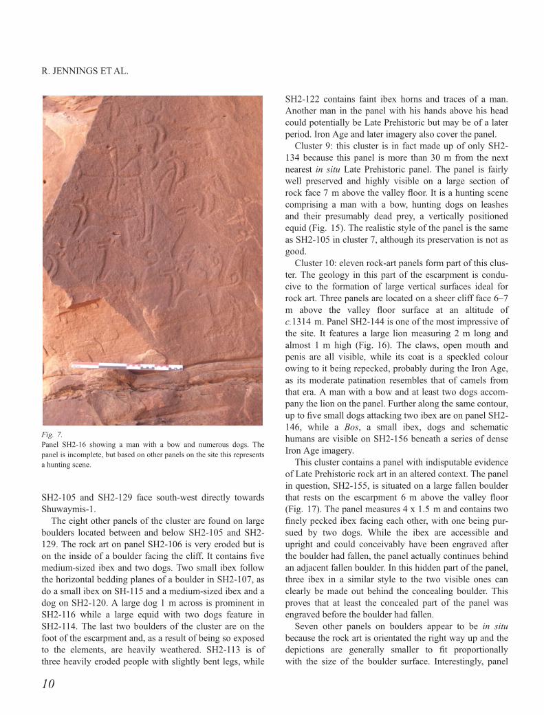
Fig. 7.Panel SH2-16 showing a man with a bow and numerous dogs. Thepanel is incomplete, but based on other panels on the site this representsa hunting scene.
10
R. JENNINGS ETAL.
SH2-148 contains two phases of Late Prehistoric activity.The evidence takes the form of a large infilled Bos andadjacent infilled ibex being superimposed over stylisedibex horns, with other ibex in a similar stylised form pres-ent elsewhere in the panel. SH2-145 shows the outline ofan equid on the up side of boulder, while four small ibex
and two equid are similarly positioned in SH2-149. Smallibex and Bos on SH2-151 cross the bedding plane of aboulder to be the right way up, while small ibex are simi-larly aligned on SH2-147 and on SH2-153. Finally, at leastfive dogs are depicted on panel SH2-140, which is locatedon a boulder surrounded by dune sand on the valley floor.
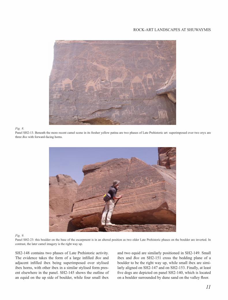
Fig. 8.Panel SH2-13. Beneath the more recent camel scene in its fresher yellow patina are two phases of Late Prehistoric art: superimposed over two oryx arethree Bos with forward-facing horns.
Fig. 9.Panel SH2-23: this boulder on the base of the escarpment is in an altered position as two older Late Prehistoric phases on the boulder are inverted. Incontrast, the later camel imagery is the right way up.
11
ROCK-ART LANDSCAPES AT SHUWAYMIS

Cluster 11: the largest Late Prehistoric panel at Shuway-mis-2 falls in this cluster of eight panels. SH2-161 extendsacross a large rock face measuring 12 m across and 8 mhigh and is 4 m above the valley floor. The panel is actu-ally three closely aligned rock faces but because the rockart is contiguous over them it is treated as a single panel.Face ‘A’ contains a hunting scene with four humans withbows, five dogs and a Bos all drawn following the beddingplanes of the rock; face ‘B’ shows three large felid, each1.5 m long and drawn one on top of the other (Fig. 18);and face ‘C’ contains multiple depictions of ibex. SH2-162 is the only other panel engraved into the rock face inthis cluster. It is a much smaller panel and shows two don-keys and a man seemingly shrugging his shoulders.
The remaining six panels of this cluster are on boulders,with four of these regarded as being in an altered context.The most impressive and convincing is SH2-165. Thispanel measures 6 x 3 m, is engraved on a large boulder onthe valley floor (Fig. 19) and contains two phases of rockart. The earliest phase consists of up to five Bos measuringup to 0.7 m. These are upside down and follow the bed-ding planes of the boulder. The second phase of rock artconsists of three ibex, at least one man with a bow andtwo dogs. This scene partially overlaps the Bos scene.These are engraved perpendicular to the bedding plane ofthe boulder so were most likely drawn prior to the collapseof the boulder as a hunting scene when, as has been shownat SH2-134, animals are drawn vertically when dead.
Fig. 10.Panel SH2-32: this scene shows a typical Bos. It measures 0.70 m across and has a piebald or spotted coat and large flaring horns. It is uncertainwhether wild or domesticated species of cattle are depicted but the piebald coat may indicate that it is a domesticated species.
Fig. 11.Panel SH2-44: obscured by large camel imagery on this panel are a vertically drawn Bos, and a second Bos with an adjacent felid.
12
R. JENNINGS ETAL.
Of the remaining panels, SH2-163 contains the fainttraces of two large fully patinated ibex and other animals.Given that the panel is on a relatively small and frag-mented boulder it is possible that it had fallen from above.While the panel is face up and could have been engraved
on in its current position, a second panel on the side of thesame boulder, SH-164, is inverted by 180°. It depicts twosmall ibex, three equid and a dog. These all fit neatly intothe extent of the boulder and do not appear fragmentary,but they are nevertheless inverted so the boulder must
Fig. 12.Panel SH2-82: although the boulder is fallen, the near horizontal orientation of the ibex depicted on this panel suggests that the panel was engraved afterthe boulder had fallen, and is therefore in its original position.
Fig. 13.Panel SH2-103: the Bos depicted on this panel is unusual because its ribs are visible and no other Bos at Shuwaymis-2 has this detail. It measures1.9 m from horn to tail. A human figure stands behind the Bos. The camels in fresher yellow patina are from a later period.
13
ROCK-ART LANDSCAPES AT SHUWAYMIS
surely be in an altered position. Whether both panels wereengraved before the rockfall is not certain. Inverted andfragmentary elements also exist on panels SH2-167 andSH2-168, where only the horns of an ibex survive.
Cluster 12: a distance of 63 m separates this clusterfrom the rich panels of cluster 11. The cluster comprises
four panels that are engraved into the rock face and threeon boulders below. The most impressive of the panels onthe rock face is the northernmost of the group, SH2-182. Itshows two vertically engraved ibex observed by four menincluding one with a bow. SH2-176 and SH2-178 arelocated within 15 m of this panel on the same elevation,
Fig. 14.Panel SH-105 showing an equid, probably a donkey, in either a varied stage of completion or with combined outline and infilled styles. The presence ofa man with a bow and dogs makes this a hunting scene. The equid measures 1.5 m from nose to tail.
Fig. 15.Panel SH2-134: a man with a bow and dogs, two of them on leashes, feature on this panel. In the foreground is a vertically drawn equid, a positionpossibly indicating that the animal is dead.
14
R. JENNINGS ETAL.

some 6 m above the valley floor. These comprise singleibex and Bos depictions. Panel 175 on a slight higher con-tour shows two ibex, with one being bitten by a felid.
Of the panels on boulders, SH2-177 is probably in a pri-mary context as two small ibex are on the front face of a
boulder, but an incised line on the panel ends abruptly tosuggest the boulder may have fallen. Panel 183 appears tobe in an altered context as an infilled Bos and a dog followthe bedding plane of the sandstone boulder, which becauseit is fallen is at 45°. Likewise, panel SH2-190 is in altered
Fig. 16.Panel SH2-144: the ‘Lion of Shuwaymis’, measuring 2 m in length, is the most impressive of the twelve felid depictions at Shuwaymis-2. Its speckledappearance comes from it being repecked in later times.
Fig. 17.Panel SH2-155: two impressive ibex, identifiable because of their backward-curving horns, form the upper part of this panel. The panel continues to theleft behind a boulder, indicating that it is uncertain whether these ibex are in a primary or an altered context.
15
ROCK-ART LANDSCAPES AT SHUWAYMIS
context because two men with bows are completely upsidedown. The panel also displays two Late Prehistoric phaseselsewhere on the boulder, with the incised outline of a Boscovered over by a human accompanied by a dog spearinga Bos with forward-facing horns. Both scenes are invertedand therefore both phases took place prior to the rockfall.
DiscussionA number of observations can be made in light of the sur-vey. Here we discuss three in detail: the spatial distributionof the rock-art panels across the escarpment, the questionof chronology and the placement of the site within itsregional setting. Discussion of related topics, such as theinterpretation of the rock-art panels, their ecologicalsignificance, the description of later phases of rock art and
the placement of sites within the wider research of rock artin the Arabian Peninsula will be reported on in forthcom-ing publications.
Our analysis shows that rock-art panels at Shuwaymis-2are unevenly distributed across the escarpment. This pat-tern can to a large extent be explained geologically, as themain panels in a primary position on the rock face clusterin areas where the sandstone bedrock provides excellentvertical surfaces for hosting rock art. For instance, suchpanels are absent between clusters 2 and 3 and clusters 6and 7, where numerous boulders dominate the slope of theescarpment. Erosional processes may contribute to theuneven distribution, as panels exposed to the elements orthose on weak sandstone faces may have simply not sur-vived. They may also be lying face down and undetectedon the escarpment or valley floor, out of position andundetected. In terms of visibility, the main panels overlookthe valley but again, this is a product of the rock forma-tion, which faces east over the valley. More survey workis required on the other faces of the escarpment to deter-mine whether there is link between the rock art and thevisibility of the relict river system.
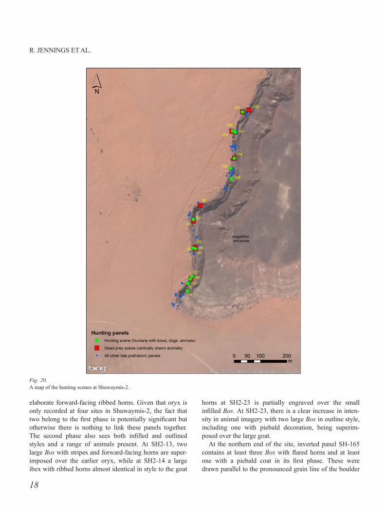
Animal imagery was reported on eighty Late Prehistoricpanels and human depictions on twenty-eight panels. Theanimals depicted are ibex (43 panels), Bos (39), canid(37), equid (19), felid (12), oryx (4), gazelle (1), goat (1),hyena (1) and a selection of unidentifiable animals. Onsome occasions, hunting scenes and possible scenes withdead prey are evident. There are occasional variations inanimal styles. For instance, four panels with felids indetailed and realistic poses, such as the large lion in SH2-144, are so similar that the same artist may have engravedthem, whereas other panels with cats are in a differentstyle. The unique deeply incised and highly detailed equidand canid seen in panels SH2-105 and 134 also seemdistinct from all other rock art at Shuwaymis-2, althoughsimilar to Shuwaymis-1 panels. Apart from these exam-ples, the panels show no major variance in styles and com-position. For instance, a map of hunting scenes shows thatthey occur in most clusters along the escarpment (Fig. 20).
Having established that after taking into account geo-logical factors there is good spatial homogeneity acrossthe site in terms of the style and composition, the nextquestion to ask concerns the chronology of the Late Pre-historic art. Based on relative chronologies put forward byscholars such as Khan (2007), the rock art reported in thisstudy is certainly Late Prehistoric. More research isneeded, however, to confirm such hypotheses and the ageof the panels within this phase, as the Late Prehistoric
Fig. 18.Panel SH2-161: three large felid, each 1.5 m across, are barely visiblehigh up a vertical surface of what is the largest Late Prehistoric panel onthe site.
16
R. JENNINGS ETAL.
spans 6000 years. Micro-erosional dating techniques havebeen applied to the rock art at Shuwaymis (Bednarik &Khan 2005) but the approach does not lead to radiometri-cally measurable dates. To this end, Optically StimulatedLuminescence (OSL) and cosmogenic nucleotide datingmethods are being applied to Shuwaymis-2, particularly toboulders on the valley floor, which appear to have a con-siderable depth of dune sand banked up against them. Theresults of these analyses are forthcoming (Clark-Balzan, inpreparation).
Ten panels in the study area contain inverted LatePrehistoric rock art (SH2-23, 24, 52, 57, 58, 164, 165,166, 168 & 190) and a further seven are regarded as in analtered position. It is unlikely that the panels were inten-tionally drawn inverted because the only instance whereelements of a panel are drawn inverted are in huntingscenes, where one animal is drawn vertically with thehunters and associated dogs drawn the right way up (fordiscussions on hunting scenes in Arabian rock art seeAnati 1999; Nayeem 2000; Khan 2007, 2013). Instead,the ten panels are on boulders that have been displacedfrom the sandstone face above and have tumbled downonto lower slopes or the valley floor. This is especiallyapparent at SH2-52, 57, 58 and 155 where rock art is notin its original position because it is on the underside ofboulders. Panel SH2-183 can also be refitted to the rockface above in cluster 12.
There is no definitive evidence that any panels fell dur-ing the Late Prehistoric phase and were engraved againduring the same phase, as was reported by Bednarik andKhan (2002) at Shuwaymis-1, but six panels indicate thatLate Prehistoric rock art in the study area was not alldrawn at the same time. One Late Prehistoric sceneoverlays another at SH2-13, 14 and 23 in cluster 1 at thesouthern end of the site, and on panels at SH2-165 and190 in clusters 11 and 12 at the northern end of the site.The presence of two phases of late Prehistoric rock art onpanels SH2-23, 165 and 190 is important as these threepanels are inverted on fallen boulders on the base of therock exposure, meaning that both phases must have takenplace prior to the tectonic activity or erosion which dis-lodged the boulders. One can only speculate why superim-position only occurs at the limits of the site. Perhaps theseareas were important because they would have been thefirst rock-art panels seen by people entering into the valleyfrom either direction.
Closer examination of the artistic styles of the six panelswith superimposition suggest that it is difficult to attributea particular artistic style or animal presence to an earlier orlater episode of the Late Prehistoric phase. Looking at theearly phases of these six panels, SH2-13 shows two largestylised outline engravings of oryx and a smaller infilleddepiction of a Bos; SH2-14, two small infilled animals, anoryx and a Bos; and at SH2-23 a large infilled goat with
Fig. 19.Panel SH2-165: this large fallen boulder on the valley floor contains inverted Bos depictions overlain by a hunting scene of a man, dogs and ibex. Aeo-lian sand of at least 1 m in depth banks up against the boulder.
17
ROCK-ART LANDSCAPES AT SHUWAYMIS
elaborate forward-facing ribbed horns. Given that oryx isonly recorded at four sites in Shuwaymis-2, the fact thattwo belong to the first phase is potentially significant butotherwise there is nothing to link these panels together.The second phase also sees both infilled and outlinedstyles and a range of animals present. At SH2-13, twolarge Bos with stripes and forward-facing horns are super-imposed over the earlier oryx, while at SH2-14 a largeibex with ribbed horns almost identical in style to the goat
horns at SH2-23 is partially engraved over the smallinfilled Bos. At SH2-23, there is a clear increase in inten-sity in animal imagery with two large Bos in outline style,including one with piebald decoration, being superim-posed over the large goat.
At the northern end of the site, inverted panel SH-165contains at least three Bos with flared horns and at leastone with a piebald coat in its first phase. These weredrawn parallel to the pronounced grain line of the boulder
Fig. 20.A map of the hunting scenes at Shuwaymis-2.
18
R. JENNINGS ETAL.
when it was in its original position. Today they are theopposite way up. This scene is then partially overlain by ahunting scene containing four dogs, two humans and threeibex, which when drawn would have been in a verticalposition. A similar pattern is evident on the inverted boul-der panel at SH2-190, where the first phase is denoted bythe outline of a Bos with large flared horns, and the secondby a Bos with forward-facing horns being speared by ahuman and pursued by hunting dogs. Again, the presenceof incised and infilled styles and of the same animals inboth phases makes it hard to distinguish any significantcultural or temporal differences between them. The onlypoints one could raise is that the panels with humans andhunting scenes are in the second phase in both instances.Furthermore, none of the big cats are overlain on the site,indicating they were either from the latter phase or werefrom the first phase but were left untouched.
To provide an initial assessment of the potential for fur-ther concentrations of rock art in the Shuwaymis region, asingle valley of comparable geological and geomorpho-logical character to that hosting the Shuwaymis-1 andShuwaymis-2 sites was investigated (see Fig. 1). This val-ley and its tributaries (at 40°01’43”E, 26°12’17”N,c.14 km to the north-east of SH-1) are incised through theCambrian Siq sandstone for a distance of c.8 km in abroadly west–east orientation, and potentially formed aspart of the initial headwaters of palaeo-wadi Ar Rimah/Bati. A rapid assessment was performed to estimate rock-art localities within the surveyed areas of the valley, butbecause of time constraints only the southern face of theprimary east–west valley (c.5 km in length) was investi-gated, along with a shorter stretch of the northern face.Despite the rapidity and limited extent of the survey, atotal of seventeen rock-art localities were identified withinthe valley (sites SH-17, 19–20 and 22–35), many consist-ing of multiple panels exhibiting several periods of rockart. Late Prehistoric rock art included Bos and equid repre-sentations comparable to those of Shuwaymis-1 & Shu-waymis-2, along with abstract human figures, and wasidentified at five locations (SH-17, 22, 23, 27 & 30) withdense panels present at SH-17 and SH-23 being similar tothose at Shuwaymis-2. Our results highlight the need formany more rock-art surveys to be undertaken at Shuway-mis. That the area is so extensive and rich in panels makesit a highly significant location of Late Prehistoric rock artin Arabia.
Shuwaymis is certainly of importance geographically asit is situated on the confluence of the W�ad�ı Ar Rimah/Ba-tin and W�ad�ı al Ham drainage systems, which flow east
into the Euphrates River and west into the Red Sea,respectively. Jubbah palaeolake is also accessible to thenorth (Garrard, Harvey & Switsur 1981; Jennings et al.2013). Indeed, there are many similarities between LatePrehistoric rock-art representations at Jubbah and Shuway-mis. Most of the animals and human imagery at Shuway-mis-2 are in the ‘Jubbah’ realistic style, a name first givento Late Prehistoric rock art from this neighbouring region(Parr et al. 1978). There are some differences in content,however, such as the paucity of hunting dogs and absenceof large cats at Jubbah compared to Shuwaymis. Bothrock-art localities are similar in their links to watersources: Shuwaymis, as we have seen, overlooked a rivervalley while rock-art panels at Jubbah overlooked lacus-trine environments (Jennings et al. 2013). Overall, it isvery plausible that populations may have moved throughthe Shuwaymis valley in Late Prehistory, when the earlyHolocene climate was more humid than today, and therange of animal species depicted in the rock art could besustained in the valley and in neighbouring geographicalareas, such as Jubbah.
In addition to the rock art, numerous megalithic struc-tures in the Shuwaymis region stand testament to denseperiods of human occupation in the area in late prehistory.One impressive tomb is visible on the plateau above theescarpment, and there are many more, including a mega-lithic cemetery at Al-Ha’it, which contains thousands ofstructures. Owing to the remoteness and inaccessibility ofthe region and the recent discovery of the rock art, how-ever, none of these monuments has been investigated.Moreover, no archaeological excavations have yet takenplace to attempt to place rock art into its wider culturallandscape. All of this lies ahead. Surface inspection at thebase of Shuwaymis-1 revealed numerous lithic artefactsranging from Middle Palaeolithic to Iron Age, and previ-ous surveys indicated the presence of numerous stonesappropriate for engraving the rock art (Bednarik & Khan2002). Middle Palaeolithic finds included a Levallois flakewhile Neolithic and later assemblages were characterisedby a proliferation of raw material types, with quartz andsiliceous stones being the most common. There were noNeolithic arrowheads in the collection, such as thosefound close to rock-art localities at Jubbah (Crassard et al.2013).
ConclusionThe high-resolution spatial rock-art survey of Shuwaymis-2 presented in this study represents the first detailed
19
ROCK-ART LANDSCAPES AT SHUWAYMIS
mapping of one of the Arabian Peninsula’s richest petro-glyph localities. The use of DPGS survey equipment torecord each individual panel represents a significantadvance in recording rock art in its spatial setting andenables accurate intra-site spatial comparisons betweendifferent rock-art elements at the site. The combination ofintensive survey and photographic recording also providesan invaluable record for further study; without requiringphysical travel to the remote site itself, these data willallow any interested scholars to undertake primaryresearch.
DGPS recording has enabled individual precisionrecording of eighty-three Late Prehistoric rock-art panelsas well as many more from later periods, which will be thefocus of further research. For the first time individualpanels can be interpreted in their landscape setting, interms of how they relate to rock art around them andwhether they are in a primary or an altered position. Theresults show that seventeen panels are no longer in theiroriginal position as a result of rockfall stemming from ero-
sion and tectonic activity in the region. The in situ panelsall overlook a relict river valley which, given evidencefrom elsewhere in Arabia, would have been active andsupporting grassland and shrub-land habitats in the earlyHolocene. It is this type of environment that we mustinterpret in order to understand the human populations thatleft indelible and unforgettable reminders of their worldon the sandstone rocks of the Shuwaymis region in lateprehistory.
AcknowledgementsWe thank His Royal Highness Prince Sultan bin Salman, President ofthe General Commission for Tourism and Antiquities, and Prof. AliGhabban, Vice President for Antiquities and Museums, for permissionto carry out this study. We wish to thank our Saudi colleagues from theSCTA, especially Jamal Omar, Habeeb Turki and the people of the Shu-waymis area for their support and assistance with the field investiga-tions. Our thanks to Dr Maria Guagnin for her helpful comments on themanuscript. The research was funded by the European Research Council(no. 295719, to MDP).
ReferencesAnati, E. 1974. Rock art in central Arabia 4:
corpus of the rock engravings (parts III &IV). (Institut Orientaliste, 4). Louvain:Institut Orientaliste, Universit�e Catholiquede Louvain.
Anati, E. 1999. The Rock art of the Negevdesert. Near Eastern Archaeology 62/1:22–34.
Aubry, T., Luis, L. & Dimuccio, L.A. 2013.Nature vs. Culture: present-day spatialdistribution and preservation of open-airrock art in the Coa and Douro RiverValleys (Portugal). Journal ofArchaeological Science 39/4: 848–866.
Bednarik, R.G. & Khan, M. 2002. The SaudiArabian rock art mission of November2001. Atlal 17: 75–99.
Bednarik, R.G. & Khan, M. 2005. ScientificStudies of Saudi Arabian Rock Art. RockArt Research 22/1: 49–81.
Bourdier, C. 2013. Rock art and socialgeography in the Upper Paleolithic.Contribution to the socio-cultural functionof the Roc-aux-Sorciers rock-shelter(Angles-sur-l’Anglin, France) from theviewpoint of its sculpted frieze. Journal ofAnthropological Archaeology 32/4: 368–382.
Clark-Balzan, L. in preparation. Usingabsolute dating methods to investigate the
development of rock art styles in SaudiArabia.
Crassard, R., Petraglia, M., Parker, A.G.,Parton, A. et al. 2013. Beyond the Levant:first evidence of a Pre-Pottery NeolithicIncursion into the Nefud Desert, SaudiArabia. PLoS ONE: doi: 10.1371/journal.pone.0068061.
Davies, C. 2006. Holocene paleoclimates ofsouthern Arabia from lacustrine depositsof the Dhamar highlands, Yemen.Quaternary Research 66/3: 454–464.
Edgell, H.S. 2006. Arabian Deserts: Nature,Origin and Evolution. Dordrecht:Springer.
Garrard, A.N., Harvey, C.P.D. & Switsur, V.R.1981. Environment and settlement duringthe Upper Pleistocene and Holocene atJubba in the Great Nefud, NorthernArabia. Atlal 5: 137–148.
Groucutt, H.S. & Petraglia, M.D. 2012. ThePrehistory of the Arabian Peninsula:Deserts, Dispersals, and Demography.Evolutionary Anthropology 21: 113–125.
Jennings, R.P., Shipton, C., al-Omari, A. &Alsharekh, A. et al. 2013. Rock artlandscapes beside the Jubbah palaeolake,Saudi Arabia. Antiquity 87/337: 666–683.
Khan, M. 2007. Rock Art of Arabia AcrossTwelve Thousand Years. Riyadh:
Department of Ministry of Antiquities andMuseums.
Khan, M. 2013. Rock art of Arabia. Arts 2:447–475.
L�ezine, A., Sali�ege, J-F., Robert, C., Wertz, F.& Inizan, M.L. 1998. Holocene lakes fromRamlat as-Sab’atayn (Yemen) illustrate theimpact of monsoon activity in southernArabia. Quaternary Research 50/3: 290–299.
McCLure, S.B., Balaguer, L.M. & Auban, J.B.2008. Neolithic rock art in context:Landscape history and the transition toagriculture in Mediterranean Spain.Journal of Anthropological Archaeology27/3: 326–337.
Nayeem, M.A. 2000. The rock art of Arabia:Saudi Arabia, Oman, Qatar, the Emirates& Yemen. Hyderabad: HyderabadPublishers.
Olsen, S. 2013. Arabian Rock Art Heritage.The application of advanced imagingtechnology to Saudi Arabian rock art.Accessed 22/11/2013. http://saudi-archaeology.com/sites/shuwaymis/
Parker, A.G., Eckersley, L., Smith, M.M. &Goudie, A.S. et al. 2004. Holocenevegetation dynamics in the northeasternRub’al-Khali desert, Arabian Peninsula: aphytolith, pollen and carbon isotope study.
20
R. JENNINGS ETAL.
Journal of Quaternary Science 19/7: 665–676.
Parker, A.G., Goudie, A.S., Stokes, S. & White,K. et al. 2006a. A record of Holoceneclimate change from lake geochemicalanalyses in southeastern Arabia. QuaternaryResearch 66/3: 465–476.
Parker, A.G., Preston G., Walkington, H. &Hodson, M.J. 2006b. Developing aframework of Holocene climatic changeand landscape archaeology for the lowerGulf region, southeastern Arabia. ArabianArchaeology and Epigraphy 17/2: 125–130.
Parr, P.J., Zarins, J., Ibrahim, M. & Waechter,J. et al. 1978. Preliminary report on thesecond phase of the northern provincesurvey 1397/1977. Atlal 2: 29–50.
Preston, G.W., Parker, A.G., Walkington, H.J.,Leng, M.J. & Hodson, M.J. 2012. Fromnomadic herder-hunters to sedentaryfarmers: The relationship between climatechange and ancient subsistence strategiesin south-eastern Arabia. Journal of AridEnvironments 86: 122–130.
Roobol, M.J. & Camp, V.E. 1991. Explanatorynotes to the geologic map of the Cenozoiclava fields of Harrats Khaybar, Ithnayn,and Kura, Kingdom of Saudi Arabia(Geosciences map GM-131). Jiddah:Ministry of Petroleum and Mineralresources.
Al-Saud, A. & Khan, M. 2005. Rock art andEpigraphic Survey of Jubbah andShuwaymis, Northern Saudi Arabia (2003/1426H). Atlal 19: 49–54.
Al Talhi, D. 2012. Almulihiah: a rock artsite in the Hail region, Saudi Arabia.Arabian Archaeology and Epigraphy 23/1: 92–98.
Zerboni, A. 2008. Holocene rock varnish onthe Messak plateau (Libyan Sahara):Chronology of weathering processes.Geomorphology 102: 640–651.
Ziolkowski, M.C. 1998. A study of thepetroglyphs from Wadi al-Hayl, Fujairah,UAE. Arabian Archaeology andEpigraphy 9: 64–69.
21
ROCK-ART LANDSCAPES AT SHUWAYMIS