HERRING RIVER RESTORATION PROJECT DEVELOPMENT ...
364
HERRING RIVER RESTORATION PROJECT DEVELOPMENT OF REGIONAL IMPACT APPLICATION --December 2019-- APPLICANT: TOWN OF WELLFLEET
-
Upload
khangminh22 -
Category
Documents
-
view
0 -
download
0
Transcript of HERRING RIVER RESTORATION PROJECT DEVELOPMENT ...

HERRINGRIVERRESTORATIONPROJECT
DEVELOPMENTOFREGIONALIMPACTAPPLICATION
--December2019--
APPLICANT:
TOWNOFWELLFLEET


TownofWellfleet
HerringRiverRestorationProject DevelopmentofRegionalImpactApplication
1
TableofContents
FrequentlyUsedTerms 5
AcronymsandAbbreviations 8
1. RequiredDocuments 111.A.Applicationcoversheet 111.B.LetterfromCCNS 131.C.USGSQuadrangleFigures 151.DCertifiedAbuttersList 201.E.ListofRequiredPermits 25
2. ExecutiveSummary 27
3. DetailedProjectDescription 293.AOverview 293.A.1HistoryofDegradation 293.A.2CumulativeEffectsofTidalRestriction 303.A.3LocalProjectGovernance 323.A.4ExtensiveProjectBenefits 333.A.5Science-basedPlanPresentedforDRIApproval 343.A.6On-goingMonitoringandAdaptiveManagement 36
3.BProjectElementsandPhasing 383.B.1Phasing 393.B.1.1Phase1 393.B.1.2PotentialFuturePhases 42
3.B.2TideControlElements 423.B.2.1ChequessettNeckRoad(CNR)BridgeandWaterAccessFacility 443.B.2.2RemovalofHighTossRoadCauseway 473.B.2.3WaterControlStructureatPoleDikeRoad 483.B.2.4MillCreekWaterControlStructure 49
3.B.3.MitigationMeasures 513.B.3.1ChequessettYachtandCountryClub 513.B.3.2Low-LyingRoadCrossingsandCulverts 523.B.3.3ElevationofHighTossRoad 553.B.3.4MitigationWorkonOtherPrivateProperty 553.B.3.5TideBarriertoProtectWay#672 56
3.B.4SecondaryVegetationandMarshManagementActions 573.B.4.1VegetationManagement 573.B.4.2MarshManagement 58
4. RegionalPolicyPlanAnalysis 594.AWaterResources(WR) 594.A.1ExistingConditions 594.A.1.1SalinityofSurfaceWaters 594.A.1.2WaterandSedimentQuality 59
4.A.2PostRestorationConditions 614.A.2.1SalinityofSurfaceWaters 61

TownofWellfleet
HerringRiverRestorationProject DevelopmentofRegionalImpactApplication
2
4.A.2.2WaterandSedimentQuality 624.A.3ResponsetoRPPWaterResourcesGoalandObjectives 62ObjectiveWR1–Protect,preserveandrestoregroundwaterquality 63ObjectiveWR2–Protect,preserveandrestorefreshwaterresources 65ObjectiveWR3–Protect,preserveandrestoremarinewaterresources 66ObjectiveWR4–Manageandtreatstormwatertoprotectandpreservewaterquality 67
4.BWetlandResources(WT) 694.B.1ExistingWetlandResourcesConditions 694.B.1.1SedimentTransportandSoils 694.B.1.2WetlandHabitatsandVegetation 70
4.B.2PostRestorationWetlandResourceConditions 774.B.2.1SedimentTransportandSoils 774.B.2.2WetlandHabitatsandVegetation 784.B.2.3WetlandImpactsAssociatedwithTidalControlElementsandMitigation 81
4.B.3ResponsetoWetlandResourcesObjectives 84ObjectiveWT1–Protectwetlandsandtheirbuffersfromvegetationandgradechanges 85ObjectiveWT2–Protectwetlandsfromchangesinhydrology 86ObjectiveWT3–Protectwetlandsfromstormwaterdischarges 87ObjectiveWT4–Promotetherestorationofdegradedwetlandresourceareas 87
4.CWildlifeandPlantHabitat(WPH) 904.C.1ExistingConditions 904.C.1.1AquaticSpecies 904.C.1.2Rare,Threatened,andEndangeredSpecies 914.C.1.3TerrestrialWildlife 93
4.C.2PostRestorationConditions 944.C.2.1AquaticSpecies 944.C.2.2Rare,Threatened,andEndangeredSpecies 954.C.2.3TerrestrialWildlife 97
4.C.3ResponsetoWildlifeandPlantHabitatObjectives 99ObjectiveWPH1–Maintainexistingplantandwildlifepopulationsandspeciesdiversity 99ObjectiveWPH2–Restoredegradedhabitatsthroughuseofnativeplantcommunities 102ObjectiveWPH3–Protect,preserverarespecieshabitat,vernalpools,bufferstovernalpools103
ObjectiveWPH4–ManageInvasivespecies 103
4.DCommunityDesign(CD) 1064.D.1ExistingConditions 1064.D.2PostRestorationConditions 1074.D.3ResponsetoCommunityDesignObjective 107ObjectiveCD3–Avoidadversevisualimpactsfrominfrastructureandscenicresources 107
4.ECoastalResiliency(CR) 1094.E.1ExistingConditions 1094.E.2PostRestorationConditions 1094.E.2.1HydrodynamicModelingParameters 1104.E.2.2RelationshiptoFEMA100-YearFloodPlain 1114.E.2.3RelationshiptoSeaLevelRise 112

TownofWellfleet
HerringRiverRestorationProject
DevelopmentofRegionalImpactApplication
3
4.E.3ResponsetoCoastalResiliencyObjectives 113
ObjectiveCR2-Planforsealevelrise,erosionandfloods 113
ObjectiveCR3-Reducevulnerabilityofbuiltenvironmenttocoastalhazards 114
4.FTransportation(TR) 116
4.F.1ExistingConditions 116
4.F.2PostRestorationConditions 116
4.F.2.1ChequessettNeckRoadBridge 116
4.F.2.2MillCreekWaterControlStructure–ConstructionStagingandTrafficManagement 120
4.F.2.3HighTossRoad–ConstructionStagingandTrafficManagement 120
4.F.2.4PoleDikeRoadWaterControlStructureandOtherLow-lyingRoadWork 121
4.F.3ResponsetoTransportationObjective 122
ObjectiveTR1–Improvesafety,eliminatehazardsforusersoftransportationsystem 123
4.GCulturalHeritage(CH) 125
4.G.1ExistingConditions 125
4.G.2PostRestorationConditions 126
4.G.3ResponsetoCulturalHeritageObjectives 127
ObjectiveCH2–Protect,preservearcheologicalresources,assetsfromalteration,relocation 127
ObjectiveCH3–Preserve,enhancepublicaccessandrightstoandalongtheshore 128
ObjectiveCH4–Protect,preservetraditionalagricultureandmaritimedevelopmentanduses129
5. OverviewofAdaptiveManagement 1315.AWhatisAdaptiveManagement? 131
5.BStructureoftheHRAMP 132
5.CDefinetheProblem 132
5.DIdentifyObjectives,PerformanceMeasuresandManagementOutcomes 133
5.ESelectManagementActionsandPolicies 136
5.FPredictOutcomesandConsequences 138
5.GEvaluatePredictedOutcomesConsideringTradeoffsandRisks 139
5.HDecision-makingDuringImplementation 140
5.IDesignandImplementTargetedMonitoringProgram 141
6. ProjectBudgetingandFundingInformation 1426.ABreakdownofCosts 142
6.BMitigation 143
6.CPhasingandFunding 143
7. References 145
8.Attachments8.AProjectManagementFormandProgrammaticAgreement 151
8.BHerringRiverAdaptiveManagementPlan 152
8.CGroundwaterStudies 153
8.DStormwaterCalculationsforEngineeredStormwaterManagementStructures 154
8.ENHESPCorrespondenceandDraftHabitatManagementPlanOutline 155
8.FProjectChronology 156
8.GSupportLetters 157

TownofWellfleet
HerringRiverRestorationProject
DevelopmentofRegionalImpactApplication
4
8.HDesignPlans 158
8.H.1ProjectElements 158
8.H.2Mitigation 158
8.H.3FederalStructuresonFederalLand 158
ListofFiguresandTables
Figure1-1.USGSLocus 16
Figure1-2.SignificantNaturalResourceAreas 17
Figure1-3.WaterResources 18
Figure1-4.NHESPEstimatedandPriorityHabitats 19
Figure1-5.AbuttingNon-federalParcels,Phase1 21
Figure3-1.ProjectFeaturesandHerringRiverSub-basins 38
Figure3-2.ExtentofHerringRiverRestorationProject,Phase1 39
Figure3-3.BoxBeamBridgeLayoutwithTideControlStructures 45
Figure3-4.VisualizationofChequessettNeckRoadBridge,lookingsouthwest(Fuss&O'Neill) 46
Figure4-1.ExistingWetlandTypes,PotentialExtentofFullProject 72
Figure4-2.WetlandTypesatStartofPhase1 73
Figure4-3.WetlandTypesatEndofPhase1andFullProjectArea 74
Figure4-4.ExtentofHerringRiverRestorationProject,Phase1 75
Figure4-5.AcresofdeadtreesvisiblefromPoleDikeRoad 106
Figure5-1.FundamentalobjectivesoftheHerringRiverRestorationProject 133
Figure5-2.Sub-objectivesandperformancemeasuresfundamentalobjective:RestoreHydrography 135
Figure5-3.ComparisonoftheMHWLevelsfortheFullHerringRiverRestorationProjectintheLower
HerringRiverSub-basinAmongDifferentPlatformPolicies 137
Table3-1.AverageWaterElevationsunderMaximumPhase1RestorationConditionsbySub-basin 42
Table3-2.ExistingandProposedLowLyingRoadsandCulvertSizeandElevation 54
Table4-1.ExistingandProposedWetlandHabitatTypes,Phase1ProposedConditions(Acres) 76
Table4-2.SummaryofWetlandProtectionActResourceAreaImpactsforTideControlElements 82
Table4-3.SummaryofWetlandProtectionActResourceAreaImpactsforMitigationElements 83
Table4-4.SummaryofCombinedWetlandResourceAreaImpacts,TideControlandMitigation 84
Table5-1.ComparisonofAdaptiveManagementPlanandRegionalPolicyPlanObjectives 134
Table5-2.Illustrativeperformancemeasures,predictivemethodsandmonitoringapproachforsub-
objectives 136
Table6-1.BreakdownofCostsforPhase1 142

TownofWellfleet
HerringRiverRestorationProject DevelopmentofRegionalImpactApplication
5
FrequentlyUsedTerms AdaptiveManagementPlan—Theplanunderwhichadaptivemanagementdecision-makingforcontinuedprojectimplementationwillbebasedonsystemresponsetoincrementalincreasesintidalexchange.SeeSection5ofthisapplicationforathoroughdiscussiononAdaptiveManagement
Berm—Amoundorbankofearth,usedespeciallyasabarrier.
Biota—Thecombinedfloraandfaunaofaregion.
Brackishwater—Watercontainingamixtureofseawaterandfreshwater;containsdissolvedmaterialsinamountsthatexceednormallyacceptablestandardsformunicipal,domestic,andirrigationuses.
Brackish—Amixtureoffreshandsaltwatertypicallyfoundinestuarineareas;ofintermediatesalinity.
Bufferzone—Ingeneral,abarrierbetweensensitivewildlifehabitatandlandusessuchasagricultureorurbandevelopment.Atransitionalzoneintendedtoprovideforcompatibilityofnearbydissimilaruses.Inregulatorycontextincludesthe100-footbufferzoneregulatedundertheMassachusettsWetlandsProtectionActaswellasthe50-footfilterstripregulatedundertheWellfleetEnvironmentalProtectionRegulations.
Datum—Abaseelevationusedasareferencefromwhichtoreckonheightsordepths.
Ebbtide—Thetidedefinedwhenthemovementofthetidalcurrentisawayfromtheshoreordownatidalriverorestuary.
Ecosystem—Abasicfunctionalunitofnaturecomprisingbothorganismsandtheirnonlivingenvironment,intimatelylinkedbyavarietyofbiological,chemical,andphysicalprocesses.
Ecologicalrestoration—Thereturnofanecosystemtoacloseapproximationofitsconditionpriortodisturbance.UsedspecificallyhereintorefertoEcologicalRestorationLimitedProjectspursuantto310CMR10.11.
Estuarine—Of,relatingto,orfoundinanestuary.
Estuary—Thewidepartofariverwhereitnearsthesea;wherefreshandsaltwatermixinasemienclosedbodyofwater.
Fauna—Animals,especiallytheanimalsofaparticularregionorperiod,consideredasagroup.
Floodplain—Anareaadjacenttoalake,stream,oceanorotherbodyofwaterlyingoutsidetheordinarybanksofthewaterbodyandperiodicallyfilledbyfloodflows.Oftenreferredtoasthearealikelytobefilledbythe100-yearflood(baseflood).
Flora—Plantsconsideredasagroup,especiallytheplantsofaparticularcountry,region,ortime.

TownofWellfleet
HerringRiverRestorationProject DevelopmentofRegionalImpactApplication
6
Freshwaterwetlands—IncontextofWEPR,definedper2.03(2)andincludingisolatedwetlandsand
vernalpools
Groundwater—Waterthatpenetratestheearth'ssurfacefromprecipitationandfrominfiltrationfrom
streams;waterpresentbelowgroundfrompondsandlakes;waterthatflowsorpondsunderground.
Halophyte—Salt-tolerantvegetation.
Hydraulic—Oforinvolvingafluid,especiallywater,underpressure.
Hydrodynamicmodeling—Themodelingoftheflowfield,circulation,andwatersurfaceelevations
withinawaterbodydrivenbyexternalconditions,includingtides,winds,inflows,outflows.
Hydrology—Thescientificstudyoftheproperties,distribution,andeffectsofwaterontheearth's
surface,inthesoilandunderlyingrocks,andintheatmosphere.
Intertidalhabitat—Thetidalareabetweenthemeanlowerlowwater(MLLW)andmeanhigherhigh
water(MHHW)whichisalternatelyexposedandcoveredbywatertwicedaily.
Invasivespecies—Aspeciesthatisanon-native(exotic)totheecosystemunderconsiderationand
whoseintroductioncausesorislikelytocauseeconomicorenvironmentalharmorharmtohuman
health.
Jurisdictionalwetlands—Wetlandresourceareasunderthejurisdictionoflocal,stateorfederal
regulatoryprograms.
Marsh—Acommontermappliedtodescribetreelesswetlandscharacterizedbyshallowwaterand
abundantemergent,floating,andsubmergedwetlandflora.Typicallyfoundinshallowbasins,onlake
margins,alonglowgradientrivers,andincalmtidalareas.Marshesmaybefresh,brackishorsaline,
dependingontheirwatersource(s).
Meansealevel—ThearithmeticmeanofhourlyheightsobservedovertheNationalTidalDatumEpoch.
MHHW—MeanHigherHighWater,theaverageofthehigherhighwaterheightofeachtidalday
observedovertheNationalTidalDatumEpochorotherspecifiedshorterseries.
MHW—MeanHighWater,theaverageheightofallthehightides.
MHWS—MeanHighWaterSpring,theaverageheightthroughouttheyearoftwosuccessivehigh
watersduringthoseperiodsof24hourswhentherangeofthetideisatitsgreatest.
MLLW—MeanLowerLowWater,theaverageofthelowerlowwaterheightofeachtidaldayobserved
overtheNationalTidalDatumEpochorotherspecifiedshorterseries.
MLW—MeanLowWater,theaverageheightofalllowwaterheights.

TownofWellfleet
HerringRiverRestorationProject DevelopmentofRegionalImpactApplication
7
NorthAmericanVerticalDatum(NAVD)—AllelevationspresentedinthisprojectarebasedontheNAVD88.NAVD88replacedNationalGeodeticVerticalDatumof1929(NGVD29)asaresultofgreateraccuracyandtheabilitytoaccountfordifferencesingravitationalforcesindifferentareasbasedonsatellitesystems.Withintheprojectarea,NAVD88is0.86feetlowerinelevationthanNGVD29.
RegulatoryOversightGroup—AsuccessortotheTWGestablishedbyMEPA,tocontinuetheparticipationfromrepresentativesofregulatoryauthoritieshavingjurisdictionoverprojectactivitiesundertheSpecialReviewProcedureafterClass1infrastructureconstructioniscommencedandtheprojectbeginstheadaptivemanagementphase.
Restoration—SeeEcologicalRestoration
Saline—Of,relatingto,orcontainingsalt;salty.
Salinity—Ameasureofthesaltconcentrationofwater;highersalinitymeansmoredissolvedsalts.
Saltmarsh—Acoastalhabitatconsistingofsalt-resistantplantsresidinginanorganic-richsediment.
Sedimentation—Thedepositionoraccumulationofsediment.
Speciesofconcern(federaldefinition)—AninformaltermthatreferstothosespecieswhichUSFWSbelievesmightbeinneedofconcentratedconservationactions(formerlyknownasCategory1or2Candidate).
Springtides—ThetidesresultingwhenthegravitationalforcesexertedontheEarthbythesunandmoonareactinginthesamedirection.
Submergedaquaticvegetation(SAV)—Aquaticvegetationthatcannottoleratedryconditionsandbecauseofthis,livewiththeirleavesatorbelowthewatersurface.
Subsidence—Themotionofasurface(usually,theEarth'ssurface)asitshiftsdownwardrelativetoadatumsuchassealevel.
Subtidalhabitat—AreasbelowmeanlowerlowwaterMLLWthatarecoveredbywatermostofthetime.
Swamp—Aseasonallyfloodedbottomlandwithmorewoodyplantsthanamarshandbetterdrainagethanabog.
Threatenedspecies(federaldefinition)—Anyspecieswhichislikelytobecomeanendangeredspecieswithintheforeseeablefuturethroughoutallorasignificantportionofitsrange.
Tidalflushing—Theactionofsaltwaterenteringanestuaryduringhightides.Itrenewsthesalinityandnutrientstotheestuaryandremovesartificiallyintroducedtoxinsintheenvironment.
Tidalmarsh—Wetlandswithfreshwater,brackishwater,orsaltwateralongtidalshores.

TownofWellfleet
HerringRiverRestorationProject DevelopmentofRegionalImpactApplication
8
Tidalprism—Thevolumeofwaterthatflowsintoandoutofamarsh.
Topography—Thegeneralconfigurationofalandsurface,includingitsreliefandthepositionofitsnaturalandman-madefeatures.
Turbidity—Therelativeclarityofwater,whichdependsinpartonthematerialinsuspensioninthewater.
Wetlands—PursuanttotheU.S.ArmyCorpsofEngineers(FederalRegister,1982)andtheEnvironmentalProtectionAgency(FederalRegister,1980)jointlydefinewetlandsas:Thoseareasthatareinundatedorsaturatedbysurfaceorgroundwateratafrequencyanddurationsufficienttosupport,andthatundernormalcircumstancesdosupport,aprevalenceofvegetationtypicallyadaptedforlifeinsaturatedsoilconditions.Wetlandsgenerallyincludeswamps,marshes,bogs,andsimilarareas.Wetlandsarealsodefinedunderapplicablelocalandstateregulatoryprograms.
AcronymsandAbbreviations
ACEC AreasofCriticalEnvironmentalConcern
ADA-compliant AmericanswithDisabilitiesActcompliant
APE AreaofPotentialEffect
BMP BestManagementPractice
BVW BorderingVegetationWetlands
CCC CapeCodCommission
CCNS CapeCodNationalSeashore
CES CoastalEngineeringStructure
CWA CleanWaterAct
CNR ChequessettNeckRoad
CYCC ChequessettYachtandCountryClub
CZM MassachusettsOfficeofCoastalZoneManagement
DER MassachusettsDivisionofEcologicalRestoration
DRI DevelopmentofRegionalImpact
EFDC EnvironmentalFluidDynamicsCode
EFH Essentialfishhabitat
EIR EnvironmentalImpactReport
EIS EnvironmentalImpactStatement

TownofWellfleet
HerringRiverRestorationProject DevelopmentofRegionalImpactApplication
9
EIS/EIR EnvironmentalImpactStatement/EnvironmentalImpactReport
FEMA FederalEmergencyManagementAgency
FHR FriendsofHerringRiver
GHG Greenhousegas
GIS GeographicInformationSystem
HREC HerringRiverExecutiveCouncil
HRRP HerringRiverRestorationProject
HRSG HerringRiverStakeholdersGroup
HRTT HerringRiverTechnicalTeam
MassDEP MassachusettsDepartmentofEnvironmentalProtection
MassDOT MassachusettsDepartmentofTransportation
MEPA MassachusettsEnvironmentalPolicyAct
MESA MassachusettsEndangeredSpeciesAct
MHW MeanHighWater(seedefinitionabove)
MHHW MeanHigherHighWater(seedefinitionabove)
MHWS MeanHighWaterSpring(seedefinitionabove)
MLW MeanLowWater(seedefinitionabove)
MLLW MeanLowLowerWater(seedefinitionabove)
MOU MemorandumofUnderstanding
NationalRegister NationalRegisterofHistoricPlaces
NEPA NationalEnvironmentalPolicyAct
NHESP NaturalHeritageandEndangeredSpeciesProgram
NHPA NationalHistoricPreservationActof1966
NMFS NationalMarineFisheriesService
NOAA NationalOceanicandAtmosphericAdministration
NOI NoticeofIntent
NPS NationalParkService
NRCS NaturalResourcesConservationService
ROD RecordofDecision
SDM StructuredDecision-Making
SLAMM SeaLevelAffectingMarshesModel
SRP SpecialReviewProcedure

TownofWellfleet
HerringRiverRestorationProject DevelopmentofRegionalImpactApplication
10
THPO TribalHistoricPreservationOfficer
TWG TechnicalWorkingGroup
USACE U.S.ArmyCorpsofEngineers
USEPA U.S.EnvironmentalProtectionAgency
USFWS U.S.FishandWildlifeService
WEPR WellfleetEnvironmentalProtectionRegulations
WPA MassachusettsWetlandProtectionAct

TownofWellfleet
HerringRiverRestorationProject DevelopmentofRegionalImpactApplication
11
1. RequiredDocuments 1.A.Applicationcoversheet (See following page. The original signed form is provided with the application package.)

TownofWellfleet
HerringRiverRestorationProject DevelopmentofRegionalImpactApplication
12

TownofWellfleet
HerringRiverRestorationProject DevelopmentofRegionalImpactApplication
13
1.B.LetterfromCCNS

TownofWellfleet
HerringRiverRestorationProject DevelopmentofRegionalImpactApplication
14

TownofWellfleet
HerringRiverRestorationProject DevelopmentofRegionalImpactApplication
15
1.C.USGSQuadrangleFigures(See following pages)

TownofWellfleet
HerringRiverRestorationProject DevelopmentofRegionalImpactApplication
16
Figure 1-1 USGS Locus
Cape Cod National Seashore
Town of Truro
Town of Wellfleet
Pole Dike Road
High Toss Road
Mill Creek Water Control Structure
Chequessett Neck Road Bridge
Source: 1) ESRI, USA Topo Map, 2017 2) National Park Service, Basin and Park Boundaries, 2017
Herring River Restoration ProjectWellfleet and Truro, Massachusetts
Path
: J:\F
451-
003
Frie
nds
of H
errin
g R
iver
- C
ape
Cod
Com
mis
sion
DR
I_20
16-0
125\
04 G
RAP
HIC
S\M
XD\D
RI\F
451_
003_
Fig0
1_Pr
ojec
tAre
a.m
xd
USGS Locus
Dra
win
g D
ate:
201
9/12
/10
© 2
019
ESS
Gro
up, I
nc.
Project Element
Shown for Informational Purposes
Town Boundary
Cape Cod National Seashore Boundary
0 1,250 2,500Feet

TownofWellfleet
HerringRiverRestorationProject DevelopmentofRegionalImpactApplication
17
Figure 1-2 Significant Natural Resource Areas
Cape Cod National Seashore
Town of Truro
Town of Wellfleet
Pole Dike Road
High Toss Road
Mill Creek Water Control Structure
Chequessett Neck Road Bridge
Source: 1) ESRI, USA Topo Map, 2017 2) National Park Service, Basin and Park Boundaries, 2017 3) Cape Cod Commission, Wetlands 2018
Herring River Restoration ProjectWellfleet and Truro, Massachusetts
Path
: J:\F
451-
003
Frie
nds
of H
errin
g R
iver
- C
ape
Cod
Com
mis
sion
DR
I_20
16-0
125\
04 G
RAP
HIC
S\M
XD\D
RI\F
451_
003_
Fig0
2_Si
gnifi
canN
atlR
esou
rces
.mxd
Cape Cod CommissionSignificant Natural Resources
Dra
win
g D
ate:
201
9/12
/10
© 2
019
ESS
Gro
up, I
nc.
Project Element
Shown for Informational Purposes
Town Boundary
Cape Cod National Seashore Boundary
Wellhead Protection Area
Wetlands
0 1,250 2,500Feet

TownofWellfleet
HerringRiverRestorationProject DevelopmentofRegionalImpactApplication
18
Figure 1-3 Water Resources
Cape Cod National Seashore
Town of Truro
Town of Wellfleet
Pole Dike Road
High Toss Road
Mill Creek Water Control Structure
Chequessett Neck Road Bridge
Source: 1) ESRI, USA Topo Map, 2017 2) National Park Service, Basin and Park Boundaries, 2017 3) Cape Cod Commission, Wetlands 2018
Herring River Restoration ProjectWellfleet and Truro, Massachusetts
Path
: J:\F
451-
003
Frie
nds
of H
errin
g R
iver
- C
ape
Cod
Com
mis
sion
DR
I_20
16-0
125\
04 G
RAP
HIC
S\M
XD\D
RI\F
451_
003_
Fig0
3_W
ater
Res
ourc
es.m
xd
Cape Cod CommissionWater Resources
Dra
win
g D
ate:
201
9/12
/10
© 2
019
ESS
Gro
up, I
nc.
Legend
Project Element
Shown for Informational Purposes
Town Boundary
Cape Cod National SeashoreBoundary
Wellhead Protection Areas
Identified Freshwater Recharge Areas
Potential Plume from Landfill,Treatment Plant, or Hazardous WasteSite
Final US EPA TMDL
Preliminary Estuaries to be refinedunder Mass. Estuaries Project
Greater Watershed Boundaries
0 1,250 2,500Feet

TownofWellfleet
HerringRiverRestorationProject DevelopmentofRegionalImpactApplication
19
Figure 1-4. NHESP Estimated and Priority Habitats
Cape Cod National Seashore
Town of Truro
Town of Wellfleet
Pole Dike Road
High Toss Road
Mill Creek Water Control Structure
Chequessett Neck Road Bridge
Source: 1) ESRI, USA Topo Map, 2017 2) National Park Service, Basin and Park Boundaries, 2017 3) NHESP, Estimated and Priority Data, 2017
Herring River Restoration ProjectWellfleet and Truro, Massachusetts
Path
: J:\F
451-
003
Frie
nds
of H
errin
g R
iver
- C
ape
Cod
Com
mis
sion
DR
I_20
16-0
125\
04 G
RAP
HIC
S\M
XD\D
RI\F
451_
003_
Fig0
4_N
atur
alH
erita
ge.m
xd
Natural Heritage EndangeredSpecies Program Estimated
and Priority Habitats
Dra
win
g D
ate:
201
9/12
/10
© 2
019
ESS
Gro
up, I
nc.
0 1,250 2,500Feet
Project Element
Shown for InformationalPurposes
Town Boundary
Cape Cod NationalSeashore Boundary
NHESP Priority Habitatsof Rare Species
NHESP EstimatedHabitats of Rare Wildlife

TownofWellfleet
HerringRiverRestorationProject
DevelopmentofRegionalImpactApplication
20
1.DCertifiedAbuttersList
Abutterswereidentifiedasownersofparcelswithin300feetoftheprojectwatercontrolelements:
ChequessettNeckRoadBridge(includingtheadjacentconstructionstagingarea),PoleDikeRoadwater
controlstructure,andHighTossRoadremoval.Parcelswereidentifiedasabuttingiftheywerewithin:
a)300feetofthepropertylinewherethelimitofdisturbance(LOD)extendsbeyondtheTown-owned
right-of-way(ROW);or
(b)300feetoftheedgeoftheROWwheretheLODdoesnotextendbeyondtheROW.
Theabuttingnon-federalparcelsareshownonFigure1-5.
AcorrespondinglistofabutterswascompiledandcertifiedbytheTownofWellfleetAssessor.Three
setsoflabelsfromthecertifiedlistofabuttersareenclosedwiththeapplication.Thelistofabuttersis
providedonthefollowingpages.
AtthetimetheCapeCodCommissionmailsthenoticeofthepublichearingtothelistofabutters,the
TownwillsendacourtesynoticeofthepublichearingtootherparcelownersintheHerringRiverflood
plain.

TownofWellfleet
HerringRiverRestorationProject DevelopmentofRegionalImpactApplication
21
Figure 1-5. Abutting Non-federal Parcels, Phase 1

TownofWellfleet
HerringRiverRestorationProject DevelopmentofRegionalImpactApplication
22

TownofWellfleet
HerringRiverRestorationProject DevelopmentofRegionalImpactApplication
23

TownofWellfleet
HerringRiverRestorationProject DevelopmentofRegionalImpactApplication
24
Herring River Restoration Project | 300-foot Abutters | Certified 23 Aug 2019
MAP PARCEL EXTN NAME MAILING STREET CITY STATE ZIP LOCAL
7 69 0 LARSEN P REED 161 CLINTON RD BROOKLINE MA 02446 1136 BROWNS NECK RD
7 70 0 KERBER JORDAN E & MORAN MARY H 19 WEST PLEASANT ST HAMILTON NY 13346 1130 BROWNS NECK RD
7 71 0 WOOD DARROW 75 HENRY ST #6K BROOKLYN NY 11201 1116 BROWNS NECK RD
7 72 0 THEILMAN WARD & THEILMAN MARYLOU E, TRUSTEES 40 VALLEY VIEW DR AMHERST MA 01002 1100 BROWNS NECK RD
7 73 0 ICKLAN WILLIAM & JOAN F C/O ICKLAN JOHN E & SAMUEL K 209 W 13TH ST APT 9 NEW YORK NY 10011 1090 BROWNS NECK RD
7 74 0 PALINO CHRISTIAN & MARINI MICHELA, TRUSTEES 2936 MADELINE ST OAKLAND CA 94602 1080 BROWNS NECK RD
7 75 0 GOLDBERG MANUEL & HELEN A 514 LUMINARY BLVD OSPREY FL 34229 1070 BROWNS NECK RD
7 76 0 WELLFLEET CONSERVATION TRUST PO BOX 84 WELLFLEET MA 02667 0 POLE DIKE RD
8 220 0 VANDERSCHMIDT HANNELORE F & GEORGE F 225 COLES NECK RD WELLFLEET MA 02667 225 COLES NECK RD
8 266 0 FODASKI ELIZABETH & KATE & BAKER RICHARD & LUBOW GENE & JACOBSON LAWRENCE & JACOBS LIN 115 WILLOW ST APT 2C BROOKLYN NY 11201 55 MARSH END
8 267 0 JACOBS LINDA & BARBARA & LUBOW GENE J 24 5TH AVE #1612a NEW YORK NY 10011 45 MARSH END
8 268 0 CARBONI BARBARA 122 ALBEMARLE RD NEWTON MA 02460 1060 BROWNS NECK RD
8 270 0 TOWN OF WELLFLEET CONSERVATION COMMISSION 300 MAIN STREET WELLFLEET MA 02667 0 COLES NECK RD OFF
8 310 0 CARIANI KAREN 629 WATERTOWN ST UNIT B NEWTON MA 02460 1050 BROWNS NECK RD
8 311 0 PALLEY MARIAN L & PALLEY HOWARD A, TRUSTEES 11 NORTH TOWNVIEW LANE NEWARK DE 19711 33 MARSH END
8 319 0 WELLFLEET CONSERVATION TRUST PO BOX 84 WELLFLEET MA 02667 0 BROWNS NECK RD OFF
12 231 0 MURRAY-BROWN ANDREW 10 MAST HILL RD HINGHAM MA 02043 245 HIGH TOSS RD
12 234 0 BESSETTE RODOLPHE G JR& JEAN C BOX 141 WELLFLEET MA 02667 255 HIGH TOSS RD
12 235 0 HIRSCH JONATHAN H & MEEK ROBERT P 72 WARREN AVE UNIT 202 BOSTON MA 02116 25 WAY #672
12 252 0 ROSENKRANTZ LOUISE, TURITZ EUGENE & ROSENKRANTZ DEBORAH TRUSTEES 2124 DERBY ST BERKELEY CA 94705 1107 BROWNS NECK RD
12 253 0 KELLEY EVELYN S 1115 BROWNS NECK RD WELLFLEET MA 02667 1115 BROWNS NECK RD
12 254 0 LANGTON CHRISTINE & SPIELBERG IVAN 365 W 25TH ST APT 16J NEW YORK NY 10001 39 BROWNS NECK RD
12 255 0 MORRILL RICHARD C & FISH LESLIE ANN, TRUSTEES BOX 413 WELLFLEET MA 02667 1175 BROWNS NECK RD
12 266 0 BIRENBAUM HELEN B TRUSTEE 108 WILLOW ST BROOKLYN NY 11201 1162 BROWNS NECK RD
12 267 0 MITCHELL PAULA A TRUSTEE C/O INVESTORS SECURITY TRUST 5246 RED CEDAR DR STE 101 FT MEYERS FL 33907 1170 BROWNS NECK RD
12 268 0 HOPKINS GRACE 1172 BROWN'S NECK RD WELLFLEET MA 02667 1172 BROWNS NECK RD
12 269 0 FORIST MELINDA D 1155 BROWN'S NECK RD WELLFLEET MA 02667 1155 BROWNS NECK RD
12 270 0 SPIELBERG IVAN & LANGTON CHRISTINE 365 W 25TH ST #16J NEW YORK NY 10001 1135 BROWNS NECK RD
18 5 0 HALLORAN KATHERINE H 9 COACH RD LEXINGTON MA 02420 1360 CHEQUESSETT NECK RD
19 81 0 CHEQ YACHT & COUNTRY CLUB PO BOX 779 WELLFLEET MA 02667 680 CHEQUESSETT NECK RD
19 91 0 EURICH DONALD A & LAZARUS JILL 7 WALNUT ST NEWTONVILLE MA 02460 1065 CHEQUESSETT NECK RD
19 92 0 CURRIER CHARLES B & LUCY A 1045 CHEQUESSETT NECK RD WELLFLEET MA 02667 1045 CHEQUESSETT NECK RD

TownofWellfleet
HerringRiverRestorationProject DevelopmentofRegionalImpactApplication
25
1.E.ListofRequiredPermits
Agency/RegulatoryAuthority Permit/Approval StatusFederal U.S.DepartmentoftheInterior–NationalParkService
NEPAReview Complete(RecordofDecisionpublishedJune21,2016)
U.S.EnvironmentalProtectionAgency
U.S.CleanWatersAct-NPDESConstructionGeneralPermit
Tobefiled
U.S.ArmyCorpsofEngineers IndividualPermitpursuanttoSection404ofCleanWaterActandSection10ofRiversandHarborsAct
Tobefiled
U.S Department of the Interior - National Park Service
ReviewunderSection106oftheNationalHistoricPreservationAct
Complete
U.S.FishandWildlifeService ReviewunderSection7oftheFederalEndangeredSpeciesAct
Tobecompleted
NOAAFisheries EssentialFishHabitatReview-Magnuson-StevensFisheryConservationandManagementAct
Tobecompleted
FederalConsistencyReview(through MA Coastal Zone Management)
ReviewunderCoastalZoneManagementActof1972
Tobereviewed
U.S.CoastGuard BridgePermit DeterminationofNon-Applicabilitytoberequested.
U.S.EPA NationalPollutionDischargeEliminationSystem(NPDES)Permit
Tobefiled
State ExecutiveOfficeofEnergyandEnvironmentalAffairs
MassachusettsEnvironmentalPolicyAct(MEPA)(MGLC.30,s61-62H)Review
Complete(MEPACertificateissuedJuly15,2016)
MassachusettsDepartmentofEnvironmentalProtection-WetlandsandWaterways
Section401WaterQualityCertification(314CMR9.00)
Tobefiled
MassachusettsDepartmentofEnvironmentalProtection-WetlandsandWaterways
Chapter91WaterwaysLicensingandPermitting(310CMR9.00)
Tobefiled
MassachusettsDepartmentofEnvironmentalProtection-WetlandsandWaterways
MassachusettsWetlandsProtectionAct(MGLC131,s40and40A)–OrdersofConditionsfromWellfleetandTruroConservationCommissions
TobefiledwithlocalConservationCommissions
MassachusettsHistoricalCommission
StateHistoricRegisterReview PNFhasbeenfiled.ProgrammaticAgreementinplace.

TownofWellfleet
HerringRiverRestorationProject
DevelopmentofRegionalImpactApplication
26
MassachusettsDepartmentof
Transportation
BridgePermitforChequessettNeckRoad
Bridge
Tobefiled
MassachusettsNaturalHeritage
andEndangeredSpeciesProgram
HabitatManagementandMonitoringPlan MEPACertificatenotes
NHESPcommentsthatit
appearsthattheProject
qualifiesforMESAHabitat
ManagementExemption.
ADraftHabitat
Managementand
MonitoringPlanwillbe
submittedandreviewed
byNHESPpursuantto321
CMR10.14(15)
RegionalCapeCodCommission DevelopmentofRegionalImpactReview:
ScopingDetermination
Scopingdecisionissued
March7,2019
CapeCodCommission DevelopmentofRegionalImpactReview Tobefiled
Local-WellfleetWellfleetConservation
Commission
OrderofConditions–Massachusetts
WetlandsProtectionActandLocalBylaws
Tobefiled
Local-Truro
TruroConservationCommission OrderofConditions–Massachusetts
WetlandsProtectionActandLocalBylaws
Tobefiled
TownofWellfleet
HerringRiverRestorationProject DevelopmentofRegionalImpactApplication
27
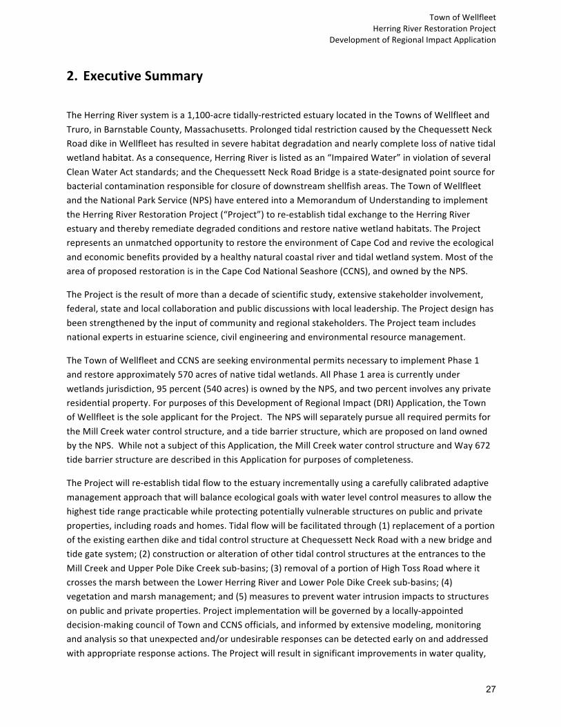
2. ExecutiveSummary TheHerringRiversystemisa1,100-acretidally-restrictedestuarylocatedintheTownsofWellfleetandTruro,inBarnstableCounty,Massachusetts.ProlongedtidalrestrictioncausedbytheChequessettNeckRoaddikeinWellfleethasresultedinseverehabitatdegradationandnearlycompletelossofnativetidalwetlandhabitat.Asaconsequence,HerringRiverislistedasan“ImpairedWater”inviolationofseveralCleanWaterActstandards;andtheChequessettNeckRoadBridgeisastate-designatedpointsourceforbacterialcontaminationresponsibleforclosureofdownstreamshellfishareas.TheTownofWellfleetandtheNationalParkService(NPS)haveenteredintoaMemorandumofUnderstandingtoimplementtheHerringRiverRestorationProject(“Project”)tore-establishtidalexchangetotheHerringRiverestuaryandtherebyremediatedegradedconditionsandrestorenativewetlandhabitats.TheProjectrepresentsanunmatchedopportunitytorestoretheenvironmentofCapeCodandrevivetheecologicalandeconomicbenefitsprovidedbyahealthynaturalcoastalriverandtidalwetlandsystem.MostoftheareaofproposedrestorationisintheCapeCodNationalSeashore(CCNS),andownedbytheNPS.
TheProjectistheresultofmorethanadecadeofscientificstudy,extensivestakeholderinvolvement,federal,stateandlocalcollaborationandpublicdiscussionswithlocalleadership.TheProjectdesignhasbeenstrengthenedbytheinputofcommunityandregionalstakeholders.TheProjectteamincludesnationalexpertsinestuarinescience,civilengineeringandenvironmentalresourcemanagement.
TheTownofWellfleetandCCNSareseekingenvironmentalpermitsnecessarytoimplementPhase1andrestoreapproximately570acresofnativetidalwetlands.AllPhase1areaiscurrentlyunderwetlandsjurisdiction,95percent(540acres)isownedbytheNPS,andtwopercentinvolvesanyprivateresidentialproperty.ForpurposesofthisDevelopmentofRegionalImpact(DRI)Application,theTownofWellfleetisthesoleapplicantfortheProject.TheNPSwillseparatelypursueallrequiredpermitsfortheMillCreekwatercontrolstructure,andatidebarrierstructure,whichareproposedonlandownedbytheNPS.WhilenotasubjectofthisApplication,theMillCreekwatercontrolstructureandWay672tidebarrierstructurearedescribedinthisApplicationforpurposesofcompleteness.
TheProjectwillre-establishtidalflowtotheestuaryincrementallyusingacarefullycalibratedadaptivemanagementapproachthatwillbalanceecologicalgoalswithwaterlevelcontrolmeasurestoallowthehighesttiderangepracticablewhileprotectingpotentiallyvulnerablestructuresonpublicandprivateproperties,includingroadsandhomes.Tidalflowwillbefacilitatedthrough(1)replacementofaportionoftheexistingearthendikeandtidalcontrolstructureatChequessettNeckRoadwithanewbridgeandtidegatesystem;(2)constructionoralterationofothertidalcontrolstructuresattheentrancestotheMillCreekandUpperPoleDikeCreeksub-basins;(3)removalofaportionofHighTossRoadwhereitcrossesthemarshbetweentheLowerHerringRiverandLowerPoleDikeCreeksub-basins;(4)vegetationandmarshmanagement;and(5)measurestopreventwaterintrusionimpactstostructuresonpublicandprivateproperties.Projectimplementationwillbegovernedbyalocally-appointeddecision-makingcouncilofTownandCCNSofficials,andinformedbyextensivemodeling,monitoringandanalysissothatunexpectedand/orundesirableresponsescanbedetectedearlyonandaddressedwithappropriateresponseactions.TheProjectwillresultinsignificantimprovementsinwaterquality,

TownofWellfleet
HerringRiverRestorationProject DevelopmentofRegionalImpactApplication
28
rarespecieshabitat,fisheries,andrecreationalopportunitiesthroughouttheHerringRiverfloodplainwhileimprovingitsresiliencyandabilitytoadapttotheeffectsofclimatechange.Restoredtidalwetlandswillsignificantlyreducegreenhousegasemissionsbyreclaiminglostcarbonstorageandreducingmethaneemissions.
TheProjecthasbeendevelopedoverseveralyearsinpartnershipwiththeTownofWellfleet,NPS,andmembersofthecommunity.Ateachstageofprojectdevelopment,theProjectteamhasworkedcloselywithfederal,stateandlocalentitiestoaccountfortheirinterestsandpotentialconcerns.TheProjecthascompletedreviewundertheMassachusettsEnvironmentalPolicyAct(MEPA),andreceiveditsCertificateofComplianceonJuly15,2016(EEA#14272).PhasingoftheProjectiscontemplatedintheFinalEnvironmentalImpactReport(EIR),andtheimpactsofPhase1arewithinthescopeofimpactsidentifiedintheFinalEIR.
BecausetheProjectwasrequiredtoprepareanEIRunderMEPA,theProjectrequiresreviewbeforetheCommissionasaDRI.AstheCommissionstatedinitscommentletter(July8,2016)totheMEPAOfficeontheProject’sFinalEIR,“[t]heproject’soutcomesanticipatedanddesiredbytheproponentswillbringbroadecologicalbenefitstotheHerringRiversysteminWellfleetandTruro,andasaresultwilllikelybenefithumanhealthandthelocalandregionaleconomy.However,theproposedchangesassociatedwiththeproject,includingtotheexistingman-madestructureswithintheestuarysuchastheChequessettNeckRoad(CNR)dike,andupstreamdikes,culverts,androadways,arenotwithoutimpactstonaturalresources.”TheCommission’sMEPAcommentletteralsonoted,“[t]hislarge-scaleecologicalrestorationprojectdoesnotfitneatlyintotheCapeCodCommission’sregulatoryframework.”ManyoftheissuestypicallyapplicabletoDRIprojectsarenotapplicabletothisProject.Accordingly,theTownappliedforaLimitedScopeDevelopmentofRegionalImpactreviewonJanuary2,2019.OnMarch7,2019,theCommissionissuedaDevelopmentofRegionalImpactScopingDecision“establishingthegoalsandobjectivesfromSection6ofthe2019RPP[RegionalPolicyPlan]thatwillbeconsideredbytheCommissionduringDRIreviewindeterminingtheProject'sconsistencywiththe2019RPP.”
TheProjectrepresentsauniqueopportunitytorestoresignificantecologicalresourcesandecosystemservices(includingsocialandeconomicbenefitstothecommunity)providedbyahealthyestuary.ThisApplicationdemonstratesthattheProjectisconsistentwiththe2019RegionalPolicyPlan(RPP).
ThisApplicationdescribestheProjectineightnumberedsections.Section1.0providesrequireddocumentation.Section2.0consistsofthissummary.Section3.0providesadescriptionoftheProject,includingphasing,tidecontrolelements,mitigation,andgovernance.Section4.0containsananalysisoftheProject’sconsistencywiththeRPPgoalsandobjectivesidentifiedintheCommission’sscopingdecision.Section5.0providesadescriptionoftheAdaptiveManagementPlanthatwillguideimplementationoftidalrestoration.Section6.0providesinformationonProjectbudgetingandfunding.Section7.0providesacompletelistofreferencesusedinthedevelopmentoftheapplication.Section8.0containsdocumentsreferredtothroughouttheapplicationincludingaProgrammaticAgreementbetweentheNPSandStateHistoricPreservationOffice,HerringRiverAdaptiveManagementPlan,projectchronology,lettersofsupport,anddesignplansfortidecontrolelementsandmitigation.

TownofWellfleet
HerringRiverRestorationProject DevelopmentofRegionalImpactApplication
29
3. DetailedProjectDescription 3.AOverviewTheHerringRiversystemisoneofthelargesttidally-restrictedestuariesintheNortheast.TheHerringRiverestuaryencompassesanearly1,100-acrefloodplainandmorethan11milesofwaterways.Historically,theriversupportedavibranttidalriverecosystemandoneofthelargestnurseriesforcommercialandrecreationalfishandshellfishonCapeCod.The1909constructionofa900-footearthendikeandtidecontrolstructureacrossthemainentrancetoHerringRivercreatedthetidalrestrictionandensuingenvironmentaldegradation.TheTownofWellfleet,BarnstableCounty,Massachusetts,andtheNationalParkService(NPS)proposetorestorenaturaltidalwetlandhabitatstolargeportionsoftheHerringRiverestuaryinandadjacenttoCapeCodNationalSeashore(CCNS),byre-establishingtidalexchangetotheriveranditsconnectedsub-basins.
Duetoamorethanacenturyoftidalrestriction,approximately10acresoutoftheoriginal1,100acresofsaltmarshremain.TheHerringRiverRestorationProject(Project)representsauniqueopportunitytorestoreasignificantnativetidalmarshsystemandthemanyecologicalandcommunitybenefitsahealthyestuaryprovidestosurroundingcommunitiesandtheregion.
TheProjectwillreconnectHerringRiverwithCapeCodBayandtheGulfofMaine,therebyrestoringthenaturalcoastalfoodwebthatnumerousfish,shellfish,birdsandotherwildlifedependonfortheirsurvival.Restoringtheestuaryisanimportantsteptoincreasefishpopulationsandenhancetheregion’scommercialandrecreationalfisheriesandshellfisheries.TheProjectisbasedonleading-edgeestuarinescienceandwillserveasamodelforrestoringotherestuariesinMassachusettsandalongAmerica’scoasts.
IncreasedtidalexchangewillbeachievedbyreplacingaportionoftheChequessettNeckRoaddikewithanewwatercontrolstructurewithtidegatestoreconnecttheHerringRiverestuarytoWellfleetHarborandCapeCodBay.Additionally,newwatercontrolstructureswithtidegateswillbeconstructedtocontroltidesintheMillCreekandUpperPoleDikeCreeksub-basins(SeeFigure3-1).Tidalexchangewillbeincreasedincrementallyovertime,usinganadaptivemanagementprocess(SeeSection5andSection8.B.)Marshmanagement(e.g.,channelclearingtoimprovedrainageandsedimentsupplementationtoelevatesubstrate)andvegetationmanagementactivitiesalsoareproposedtoenhancerestoration.
3.A.1HistoryofDegradationHistorically,theHerringRiverwasthelargesttidalestuarycomplexontheOuterCapeandincludedabout1,100acresofsaltmarsh,intertidalflats,andopen-waterhabitats(HRTC2007).TheHerringRiversystemwasdramaticallyalteredin1909whentheTownofWellfleetconstructedtheChequessettNeckRoaddikeatthemouthoftheHerringRiverwiththegoalofreducingthepresenceofsaltmarshmosquitoes.ThedikerestrictedtidesintheHerringRiverandreducedthetiderangefromapproximately10feetonthedownstreamharborsidetoabouttwofeetupstreamofthedike.By

TownofWellfleet
HerringRiverRestorationProject DevelopmentofRegionalImpactApplication
30
restrictingtheflowofoceantidesandsaltwater,thedikehadimmediateanddevastatingeffectsonthetidalsystemandthecommunitybenefitsprovidedbytheriveranditsassociatedestuarinewetlands.
Bythemid-1930s,theHerringRiver,nowartificiallyalteredfromasaltwatertomostlyafreshwatersystem,waschannelizedandstraightened.Between1929and1933,theChequessettYachtandCountryClub(CYCC)constructedanine-holegolfcourseintheadjoiningMillCreekfloodplain.SeveralhomeswerealsobuiltatlowelevationsintheformerHerringRiverfloodplain.
Bythe1960s,thedike’soriginaltidegateshadrusted(frozen)inanopenposition,increasingtidalrangeandsalinityinthelowerHerringRiver.ThiscausedperiodicinundationofCYCCgolfcourseandotherprivateproperties.In1973,theTownofWellfleetrequiredthatthedikeberepairedtoaccommodateanadromousfishpassage.Asaresult,theMassachusettsDepartmentofPublicWorksrebuiltthedikein1974(HRTC2007).Followingreconstruction,tideheightmonitoringbytheCCNSshowedthatthenewtidegateopeningwastoosmalltoachievethetideheightsrequiredbytheOrderofConditionsissuedbytheWellfleetConservationCommission.In1977,theMassachusettsAttorneyGeneralissuedaninjunctionrequiringtheTowntocedecontrolofthediketotheMassachusettsDepartmentofEnvironmentalQualityEngineering(nowtheDepartmentofEnvironmentalProtection[MassDEP])sothatincreasedtidalflowcouldbeattainedtothelevelmandatedbytheOrderofCondition(HRTC2007).
In1980,alargedie-offofAmericaneels(Anguillarostrata)andotherfishdrewattentiontothepoorwaterqualityintheHerringRiver.TheMassachusettsDivisionofMarineFisheries(DMF)andNPSidentifiedthecauseofthefishkillashighacidityandaluminumtoxicityresultingfromdikingandmarshdrainage(SoukupandPortnoy1986).Thesluicegateopeningwasincreasedto20inchesin1983.Thatyear,CCNSscientistsdocumentedsummertimedissolvedoxygendepletionsandriverherring(Alosaspp.)killsforthefirsttime(Portnoy1991).TheNPSthenimplementedmeasurestoprotectriverherringbyblockingtheiremigrationfromupstreampondstopreventthefishfromenteringanoxicwaters(HRTC2007).
ConcernsaboutfloodingofprivatepropertiesandincreasedmosquitopopulationspreventedtheTownfromopeningthetidegatefurther.NPSmosquitobreedingresearchconductedfrom1981to1984foundthatmosquitoes,(OchlerotatuscantatorandO.canadensis),werebreedingabundantlyintheHerringRiver.However,estuarinefish,importantmosquitopredators,couldnotaccessbreedingareasbecauseoflowtidalrange,lowsalinity,andhighacidity(Portnoy1984).In1984,theTownincreasedthesluicegateopeningto24inches,whereithassinceremained(HRTC2007).
In1985,theDMFclassifiedshellfishbedsintherivermouthas“prohibited”duetofecalcoliformcontamination.In2003,waterqualityproblemscausedMassDEPtolistHerringRiveras“impaired”underthefederalCleanWaterActSection303(d)forlowpH,highmetalconcentrations,andpathogens.Morerecently,NPSresearchersidentifiedbacterialcontaminationasanotherresultofrestrictedtidalflowandreducedsalinity(PortnoyandAllen2006).
3.A.2CumulativeEffectsofTidalRestriction
HerringRiver’swetlandresourcesandnaturalecosystemfunctionshavebeenseverelyalteredanddamagedbymorethan100yearsoftidalrestrictionandsaltmarshdrainagecausedbytheexistingCNR

TownofWellfleet
HerringRiverRestorationProject
DevelopmentofRegionalImpactApplication
31
dike.ArangeofwaterqualityandotherecologicalproblemswillcontinueuntiltheProjectreconnects
theriverandwetlandswiththemarineenvironment.Theevidenceoftheseproblemsinclude:
● MassachusettsDEPhasdesignatedHerringRiverasan“ImpairedWater”inviolationofCleanWater
Actstandardsforhighaluminum,lowpH,highfecalcoliformbacteriaandafishpassagebarrier.
● Waterqualityintheriverisimpairedyear-round.DatameasuredbytheUSGeologicalSurveyover
multipleyearsshowthatdissolvedoxygeninriverwaterregularlyfallsbelowestablishedthresholds
forcausingstressandmortalityforfishandotheraquaticlife.
● TheMassachusettsDMFhasdesignatedtheCNRdikeasapointsourceofbacterialcontamination,
resultingintheclosureofonceharvestableshellfishbedsupstreamanddownstreamofthedikedue
topoorwaterquality.
● Tidalrestriction,alongwithstreamchannelizationandditchdrainage,hasloweredwaterlevels
abovethedikecausingthemarshplaintosink2-3feet.Becausetidalrestrictionsradicallyaffectthe
processesofsedimentationonthesaltmarshsurfaceandtheaccumulationofbelowgroundorganic
material(peat),muchofthedikedHerringRiverfloodplainhassubsideduptothreefeetrelativeto
currentmeansealevel(PortnoyandGiblin1997).Coastalmarshesmustincreaseinelevationata
rateequaltoorgreaterthantherateofsea-levelrisetopersist.Thisincreaseinelevation
(accretion)mustoccurtopromotethegrowthofsaltmarshvegetationandgraduallyincreasethe
elevationofthemarshsurface.DikinghaseffectivelyblockedsedimentfromreachingtheHerring
Riverfloodplainandpreventednecessaryaccretion.Inaddition,drainagehasincreasedtherateof
organicpeatdecompositionbyaeratingthesedimentandcausedsedimentporespacestocollapse.
TheseprocesseshavecontributedtotheseverehistoricandcontinuingsubsidenceintheHerring
River’sdikedwetlands.
● Prolongedexposureofdrainedsaltmarshpeattoaircausesittodecomposeandreleasesulfuric
acidintosurroundingsoilsandreceivingwaters.Acidsulfatesoilsareamajorproblemcovering
hundredsofacresoforiginalHerringRivermarshes.Absentregularsaturationbysaltwater,these
soilsleachtoxicacidityandaluminumintoremainingsurfacewater,killingaquaticanimals.
● Coastalresiliencyhasbeendiminishedduetoalterationofnaturalsedimentprocessesandsalt
marshsurfacesubsidence.
● Eliminationoftidalfloodingandsalinityhasresultedinalossofsaltmarshandotherformsof
estuarinehabitat.Asnotedabove,approximately10acresoutofanoriginal1,100acresofsalt
marshremain.
● Lowersalinityandlossofestuarinevegetationhasallowednon-nativePhragmitestoinvadethesaltmarshabovethedike,anduplandshrubsandtreestoinvadeaboveHighTossRoad,wherewater
levelsrarelyreachtheoriginalmarshsurface.
● Changesinmarshvegetationhaveledtoanincreaseinmethane-emittingpondedfreshwater
wetlandsandareductionincarbon-storingtidalwetlands,contributingtoanetwarmingeffecton
theclimate.

TownofWellfleet
HerringRiverRestorationProject DevelopmentofRegionalImpactApplication
32
● Riverherringandotheranadromousfishspeciesthatoncethrivedintheriverhavebeendepletedduetopoorwaterqualityandobstructionstomigratorypassage.
Fortunately,thedamagingenvironmentaleffectsofdisconnectingtheriverfromthemarineenvironmentcanbereversedovertimewiththereturnoftidalflow.Asdescribedbelow,theTownofWellfleetandtheCCNShavedevelopedarestorationplantoreversethedegradedconditionsintheHerringRiversystem.
3.A.3LocalProjectGovernanceAlocalprojectgovernancestructurehasbeenestablishedtooverseePhase1restorationandensurecompliancewithregulatoryrequirementsandpermitconditions,includingadherencetomaximumwaterlevels.TheTownofWellfleetandCCNSrecentlyenteredintoanewMemorandumofUnderstanding(MOUIVin2019)toprovidethemanagementframeworkforimplementation.1
MOUIVsetsforththestructureanddecision-makingprocessfortheProject.MOUIVestablishesaHerringRiverExecutiveCouncil(HREC)consistingofthreemembersfromWellfleetandtwofromCCNStoberesponsibleforapprovingallmajorProjectimplementationdecisionsandactivities.TheHREC'sresponsibilitiesinclude,butarenotlimitedto,establishingandprovidingpolicydirection;reviewingandapprovingtheProject'sAdaptiveManagementPlan;monitoringProjectprogress;modifyingoralteringProjectinfrastructurewatercontrolstructureopenings(afterreceivingtechnicalinputfromthemembersoftheHerringRiverTechnicalTeam(HRTT)),andensuringthattheProjectcomplieswithapplicableregulationsandlaws.TheHRECmembershavebeenappointed,andwillcontinuetomeetasneededduringthepermittingandconstructionphases.
TheHRECistheentityresponsibleforimplementationdecision-makingduringPhase1restoration.TheHRECmayseekinputfromvarioussources,including,butnotlimitedto,theHRTT.CurrentparticipantsintheHRTTincludetheTownofWellfleet,NationalParkService,U.S.FishandWildlifeService,NationalOceanicandAtmosphericAdministration,USDA/NaturalResourcesConservationService,andMassachusettsDepartmentofFishandGame-DivisionofEcologicalRestoration.MOUIValsoidentifiestheHerringRiverStakeholderGroup(HRSG)asasourceforadvisoryinputonProjectimplementationissues.HRECmeetingsarealsoopentothepublicandtheHRECwillconsiderpubliccommentinitsdecision-making.
Amongitsresponsibilities,theHRECwilladoptatidegatemanagementpolicytoachievePhase1restoration,afterreceivingtechnicalinputfromthemembersoftheHRTT.Thetidegatemanagement
1 TheTownsofWellfleetandTruroandtheCapeCodNationalSeashore(CCNS)enteredintosuccessivememorandaofunderstanding(MOUs)tostudythefeasibilityofrestoration(MOUIin2005),developaconceptualrestorationplan(MOUIIin2007)andagreetoimplementtherestorationplan(MOUIIIin2016).TruroisnotapartytothesupersedingMOUIVandhasadoptedanewroleasaninterestedmunicipalstakeholderfullysupportingtheecologicalrestorationobjectivesoftheProject.

TownofWellfleet
HerringRiverRestorationProject DevelopmentofRegionalImpactApplication
33
policywillincludeprotocolsforongoingrestorationactivityandforassessingpossibleresponsesduringemergencystormevents.Thepolicywillsetforthproposedtidegateconfigurationsandothermanagementactionsandidentifythepartiesresponsibleforeachaction.Thepolicywillensureadherencetoenvironmentalpermitconditionsandtheoperationandmaintenancerequirementsforeachstructure.Itisenvisionedthataninitialtidegatemanagementpolicyofsufficientdetailwillbeincludedinwetlandspermitapplications.
OncetheHREChasapprovedatidegatemanagementpolicy,itwilldesignatethepartiesresponsiblefor:(1)coordinatingwiththeNPSandTowntocarryoutauthorizedactionsand(2)analyzing,compiling,andsummarizingmonitoringdata,modelingoutput,fieldobservations,andotherinformation.Duringthisprocess,membersoftheHRTTwillprovideongoingadvisorytechnicalinputtotheHREC.Third-partyorganizationsmaybeengagedtoimplementapprovedmanagementactions,fieldmonitoring,dataanalysis,andpublicoutreachactivities.
MOUIValsoconfirmsthatCCNSandtheTownofWellfleet,respectively,willcontinuetoowntheinfrastructuretheyowntodayortobebuiltonlandtheyeachown.Forexample,MillCreekwatercontrolstructureandWay672tidebarrierwillbebuiltonCCNSpropertyandownedbyNPS.TheChequessettNeckRoadandPoleDikeRoadwatercontrolstructures,andtheelevatedroadsegmentsandculvertsinWellfleetwillbeownedbytheTownofWellfleet.Ownerswillhavelong-termresponsibilityforinfrastructuremaintenance.InaccordancewithMOUIV,theownersofthedifferentelementsofProjectinfrastructuremayengagetheservicesofthird-partyentitiestoconstruct,operateandmaintainProjectinfrastructure,orperformthesefunctionsthemselves.Theownersalsoagreetoworkcooperativelytoensurecompliancewithallpermitconditions,noticingrequirementsandotherenvironmentalcomplianceobligations.
3.A.4ExtensiveProjectBenefitsTheHerringRiverRestorationProjectistheresultofrigorousscientificstudy,extensivestakeholderinvolvementandpublicdiscussionswithlocalleadership.Astrongcommitmenttolocalengagementhasmarkedthedecade-longjourneyfromideatoconcept,andfromconcepttodesign.Projectplanningandevaluationbeganin2005andhasincludedmorethan50communitymeetingsandpresentations,100one-on-onemeetingswithpropertyowners,125technicalmeetingswithprojecttechnicalteammembersandconsultants,andTownandNPSstaff.Achronologyofeventsinthecommunity-basedrestorationeffortispresentedinSection8.F.Thisoutreachhashelpedtobuildstrong,broadbasedsupportfortheProject,evidencedbythesupportlettersalsofoundinSection8.G.
Thecommunitycommitmentandbroad-basedsupportoftheProjectstemfromtheextensiveecologicalandcommunitybenefitsthatthereturnoftidalflowtotheHerringRiversystemwillgenerateincluding,butnotlimitedto:
● ReconnectingtheHerringRiverestuarytoCapeCodBayandtheGulfofMainetorecovertheestuary’sfunctionsas:(1)anurseryformarineanimals,and;(2)asourceoforganicmatterforexporttonear-shorewaters.

TownofWellfleet
HerringRiverRestorationProject DevelopmentofRegionalImpactApplication
34
● Restoringthenaturalcoastalfoodwebtosupportnumerousfishandbirdspeciesandotherwildlifethatdependonhealthycoastalmarshhabitatsandprocessesfortheirmigrationandsurvival.
● ReopeningwaterwaystoimprovemigrationandspawningforavarietyoffishspeciesincludingRiverHerring,AmericanEel,StripedBassandWinterFlounder,aswellasDiamond-backTerrapin.
● Enhancinghabitattoincreaselocalfishproduction;andremovephysicalimpedimentstomigratoryfishpassagetorestoreonce-abundantriverherringandeelruns.
● ProtectingandenhancingharvestableshellfishresourcesbothwithintheestuaryandinreceivingwatersofWellfleetHarbor.Re-openingandexpandingshellfishbedswillbenefitthelocaleconomy;in2018theshellfishharvestinWellfleetwasvaluedat$7.2million.Shellfishhabitatrestorationwillalsohelptosustainlocalshellfishingjobs,whichareestimatedtonumber400-450.2
● Enhancingcoastalresiliencybyrestoringnormalsedimentdepositionneededtoallowthemarshtogainelevationandmitigateimpactsofsealevelrise,andbyconstructingstate-of-the-arttidalcontrolinfrastructuretoprotectlow-lyingroadsandotherstructures.
● Re-establishingtheestuarinegradientofnativesalt,brackish,andfreshwatermarshhabitatsinplaceoftheinvasivenon-nativeanduplandplantsthathavecolonizedmostpartsofthedegradedfloodplain.
● Enhancingopportunitiesforcanoeing,kayaking,andwildlifeviewingoveradiversityofrestoredwetlandandopen-waterhabitatsincluding6milesofwaterwaysforrecreationandtourism.Tourismaccountsfornearly$11millionannuallytothelocalcommunityandsupportsjobs.
● Generatingapproximately$624millioninlocalandregionaleconomicbenefitsoverthelifeoftheprojectbasedoneconomicstudiesofothercoastalrestorationprojects.
● Combatingclimatechangebyreturninglostcarbonstoragevolumeandreducingmethaneemissionsfromdeterioratedsaltmarsh.Apreliminaryestimateindicatesthat,sincetheCNRdikewasbuiltin1909,theHerringRiverhasemitted730,000metrictonsofCO2equivalents,comparabletoemissionsfrom155,000USautosoperatingforoneyear.3
● Re-establishingthenaturalcontrolofnuisancemosquitoesbyrestoringtidalrangeandflushingtoconditionsthatarenotconducivetomosquitohabitat,andbyincreasingaccessforfishthatpreyonmosquitolarvae.Anotherunfortunateconsequenceofthe1909dikingofHerringRiverhasbeentoincreasefreshwaterswamphabitatsuitableforthemosquitospeciesmorelikelytocarryviruses.Restorationoftidesandsaltywaterwillreplacemuchofthishabitatthatisconducivetovirus-bearingfreshwatermosquitoeswithhealthysaltmarshesthroughoutmuchoftheestuary.
3.A.5Science-basedPlanPresentedforDRIApprovalTheProjectistheresultofmorethanthreedecadesofscientificstudyincludingmorethan230technical
2 Civetta,Nancy.WellfleetShellfishDepartment.Presentation toHerringRiverStakeholderGroup.November6,2019.3Kroeger,KD,Gonneea,ME,etal.2019.Climaticimpactsoftidalrestrictionandrestoration:Fullcarbonandgreenhousegasbudgets,withradiativeforcingcalculations.SocietyofWetlandScientistsAnnualMeeting,Baltimore,MD.

TownofWellfleet
HerringRiverRestorationProject DevelopmentofRegionalImpactApplication
35
studies,peer-reviewedscientificarticles,andotherdatasources,whicharelistedontwenty-twopages
containedintheFinalEnvironmentalImpactReport(FEIR),andadecadeofstakeholderengagement.
Strongtechnicaldirectionandtechnicalinputfromdozensofnationalexpertsinenvironmental
managementandestuarinesciencehaveshapedtheProject.
HydrodynamicmodelingstudiesbytheconsultingfirmWoodsHoleGroupformthebasisofdesign
requirementsfortheoverallrestorationprogram,includingtheneedforinfrastructuremodifications
andadditionstoprotectexistinginfrastructureandstructuresfromincreasedwaterlevels.Theprimary
floodprotectionobjectiveistopreventadversefloodingimpactstothebuiltenvironmentfrom
increasedwaterlevelsthroughouttheProjectarea,includingduringstormevents.Allfloodprotection
mitigationmeasureshavebeendesignedtopreventimpactsuptothemodeledstorm-of-recordtidal
surgewithappropriatefreeboard.4Thisstormsurgehasonlybeensustainedthroughmultipletide
cyclesonce,duringtheblizzardof1978,andthusisaveryconservativefloodprotectiondesign
standard.
In2016,theProjectobtainedfederalandstateapprovalsofitsFEIRdevelopedinaccordancewiththe
NationalEnvironmentalPolicyAct(NEPA);NPSDirector’sOrder12;andtheMassachusetts
EnvironmentalPolicyAct(MEPA).TheFEIRselectedapreferredalternativefortheHerringRiver
RestorationProject.Theselectedalternativeissupportedbyextensiveassessmentofexistingconditions
aswellasmodelingandpredictionsforrestoredecologicalconditions.ThescientificbasisfortheFEIR
waslargelydrawnfromaseriesofstudiesconductedbyNPSresearchersandothers,beginninginthe
1980sandsummarizedintheHerringRiverConceptualRestorationPlanin2007.Atwo-dimensional
hydrodynamicmodelwasdevelopedthatestablishedthefeasibilityoftidalrestorationandanalyzedthe
effectsofrestoringtidalflowtodifferentpartsoftheestuary.Thisincludedthreedifferentscenariosfor
sealevelriseoverthenext50yearsandanalysisofnumerouscombinedstormevents.Themodelwas
alsousedtodevelopandanalyzealternativesfortheFEIRbasedonbalancingdegreesoftidal
restorationwithnecessarymeasurestopreventinundationofstructures.Sincethecompletionofthe
FEIR,theTown,CCNSandothershaveengagedadditionalinputfromstakeholders,abutters,and
technicalexperts,whichhashelpedtorefineProjectplans. BecausetheProjectwasrequiredtoprepareanEIRunderMEPA,theProjectrequiresreviewbeforethe
CapeCodCommissionasaDRI.
TheTownnowseeksDRIauthorizationtoimplementallPhase1projectelementsandassociated
mitigationasdescribedinthisapplication.OnMarch7,2019,theCommissionissuedaDevelopmentof
RegionalImpactScopingDecision“establishingthegoalsandobjectivesfromSection6ofthe2019RPP 4Thestorm-of-recordreferstoamodelsimulationofthesignificantcoastalfloodingeventinFebruary1978(WoodsHoleGroup(WHG),2012).Itshouldbenotedthatthestorm-of-recordhasnocorrelationtotheFEMAFloodInsuranceRateMap100-yearevent(1%annualprobabilityofoccurrence).FEMA-predictedfloodlevelsduringthe100-yearstormeventareatelevationstenfeetto13feetthroughouttheProjectArea.ThecurrentCNRdikeisnotaFEMA-designatedfloodcontrolstructureandtheredesignedstructurewilllikewisenotbeaFEMA-designatedfloodcontrolstructure.Forthesereasons,theProjectwillhavenoeffectontheFEMA-predicted100-yearfloodelevationsortheextentofthe100-yearFIRMfloodplainwithintheHerringRiverbasin.SeeSection4.2.Eformorediscussion.

TownofWellfleet
HerringRiverRestorationProject
DevelopmentofRegionalImpactApplication
36
[RegionalPolicyPlan]thatwillbeconsideredbytheCommissionduringDRIreviewindeterminingthe
Project'sconsistencywiththe2019RPP.”Theapplicationrespondstothescopeofreviewsetforthin
theCommission’sMarch7,2019decision.
SincetheCommissionbeganitsreviewoftheProjectduringtheMEPAprocess,theProjecthasevolved
inwaysthatprovidegreaterprotectionoffloodplainpropertiesandstructures.ThescopeoftheProject
hasbeenfurtherdefined,detailedplanshavebeendevelopedformeasurestoprotectpublicand
privatestructures,andfurtherdiscussionsandagreementswithpropertyownershavetakenplace.
3.A.6On-goingMonitoringandAdaptiveManagementTheproposedadaptivemanagementplanisarigorousscience-basedprocessofpredictingsystem
responsestorestorationactions;monitoringsystemconditionsbefore,duringandaftermanagement
actionsareimplemented;comparingthepredictedandobservedsystemresponsestoupdatethe
understandingofthesystemresponsetomanagementactions;andusingtheresultstoinformand
refinemanagementactions.Informationobtainedfrommonitoringimprovestheabilitytopredict
futureoutcomesandmakebetter‘adaptive’decisionsregardingtheselectionofappropriate
managementactionsthroughoutthecourseofimplementation.
Extensivemonitoringisunderwayorisbeingplannedtodocumentbaselineconditionsand,once
implementationbegins,measureongoingsystemresponsestorestorationoftidalflow.Table8B-1
foundinSection8.Bofthisapplicationprovidesasummaryoftheperformancemeasures,prediction
toolsandmonitoringmethodsthatwillbeemployedforeachrestorationobjectiveandsub-objective.
Bywayofexampletodemonstratehowachievementofaparticularrestorationgoalwillbemonitored,
shellfishissuesaredescribedbelow.5Restorationobjectivesincludemaximizinghabitatqualityfor
nativeestuarineanimals,includingshellfish,andalsominimizingadverseimpactstoshellfishbedsin
WellfleetHarbor.Extensivemonitoringwilloccurduringimplementationtomeasureenhancementsto
shellfishresourcesandtoprotectagainstunanticipatedimpactstoshellfishresources.Monitoring
activitieshavebeenpresentedinmultiplepublicforumsco-sponsoredbyFHRandtheWellfleetShellfish
AdvisoryBoard.6
Recentandongoingmonitoringeffortstoaddressshellfishhabitatobjectivesaredescribedbelow.Each
ofthese,alongwithadditionalworkthatisstillunderconsideration,willcontinueorwillberepeatedat
theappropriatestageaftertherestorationprojectbegins.
• NationalSeashoreMonthlyWaterQualityMonitoring:Since2005,scientistsfromtheNational
Seashorehavesampledwaterqualityat6-11stationsfromRoute6toWellfleetHarboreach
month.Variablesanalyzedincludedissolvedoxygen,pH(acidity),nitrogen,phosphorus,silica,iron,
5Monitoringeffortsforotherrestorationobjectivesandsub-objectivesaresummarizedinTable8B-1ofthe
HerringRiverAdaptiveManagementPlan,foundinAttachment8.B. 6 Videorecordingsofthesemeetingscanbeseenathttp://www.friendsofherringriver.org/Videos.

TownofWellfleet
HerringRiverRestorationProject DevelopmentofRegionalImpactApplication
37
chlorophyll,andsuspendsediment.Thedataprovidealong-termtrendofwaterqualitythroughouttheHerringRiverfloodplain.
• ContinuousReal-TimeWaterLevelandWaterQualityNetwork:In2017FriendsofHerringRiverinstalled5stations(4inHerringRiver,1inWellfleetHarbor)equippedwithinstrumentsthatmeasurewaterlevel,salinity,temperature,dissolvedoxygen,andpHat15-minuteintervals.Thedataprovidebothlong-termtrends(monthstoyears)andshort-termchanges(hourstodays)ateachlocation.DatacanbeviewedonapublicwebsitetoallowanyonetotrackchangesastheProjectisimplemented.(https://v2.wqdatalive.com/public/820)
• 2013-2015WaterQualityandEstuarineHabitatAssessmentfromHighTosstotheHarbor:TheNationalSeashoreconductedtwostudiesbetween2013and2015;onetoassessmovementofnutrients,carbon,andsedimentinthedownstreamandupstreamreachesoftheriver,andtheothertostudybaselineinventoriesofbenthicinvertebratesandfoodwebs.Thesestudiesprovideinformationonnutrientstatusandparticlemovementfromtherivertotheharborandwillberepeatedastherestorationprojectisimplemented.ANPSpublicationdocumentingthisworkisunderreview.
• USGSWaterQualityMonitoring:TheU.S.GeologicalSurveycollecteddataattheChequessettNeckRoaddikefrom2015into2018.Datacollectionwillbereinitiatedin2020.Thisstudyusesanautomateddevicetosamplewaterpassingthroughthedikeduringebbandfloodtidestoseparatelyanalyzewatermovinginandoutoftheriverandduringvariedtidalevents.Samplesareanalyzedfornutrientsandsuspendedsediment.AUSGSreportcoveringdatacollectedsofariscurrentlyunderreviewandwillbereleasedin2020.
• SurficialSedimentSamplesinAquacultureAreas:Samplesofthetop2-3inchesofsedimentweretakenatmultiplesitesnearMayoBeach,EggIsland,andPowersLandingbyNationalSeashorescientistsin2006,2010,and2017.Thesamplesanalyzedthepercentoforganicmaterialandtheamountsoffineandcoarsesediment.DescribingthesebaselinesedimentcharacteristicsofWellfleetHarboriskeytounderstandingcurrentsedimentationtrendstoinformhowthesystemmayrespondtoreconnectionwiththeHerringRiver.
• HarborSedimentandBathymetricMapping:In2019theNationalSeashore,FriendsofHerringRiver,andCenterforCoastalStudiesbeganamulti-parameterstudytodescribethesedimentcharacteristicsandseafloorelevationinaquacultureareasclosetotheriver.ThisstudyinvolveshighresolutionandhighlyaccuratedataobtainedbyGPS-basedgroundsurvey,drone-basedaerialphotography,andboat-basedside-scansonar.Thedataproductwillbeadetailedmapoftheareadepictingbottomelevations,channeldimensions,tidalshoals,andflatsthatwillshowhowWellfleetHarborchangesfromseason-to-seasonandastherestorationprojectisimplemented.
• CharacterizationofHerringRiverSediment:Similartotheharbormappingproject,theNationalSeashoreisexaminingsedimentfromtheriverandfloodplainupstreamofChequessettNeckRoad

TownofWellfleet
HerringRiverRestorationProject DevelopmentofRegionalImpactApplication
38
andissurveyingelevationsacrossthemarshtounderstandthepre-restorationconditionsandassesshowsedimentmaymigratethroughoutthesystemwhentherestorationprojectisunderway.
• FecalColiform:NationalSeashoreandcooperatingscientistscollecteddatathatwerepublishedin2009thatdocumentedhowtherestorationprojectwouldimprovewaterqualityinshellfishingareasthatarenowclosedtoharvestduetobacterialcontamination.Thesamplingconductedforthisresearchwillberepeatedatleastoncepriortothebeginningoftherestorationprojectandwillberepeatedagainthroughouttheimplementationperiodtoquantifyandconfirmtheconclusionscitedinthepublication(PortnoyandAllen2009).
Figure 3-1. Project Features and Herring River Sub-basins
ChequessettNeckRoadandPoleDikeRoadwatercontrolstructuresaretobeownedbyTownofWellfleet.Road/culvertworkisonroadsownedbyeitherTownofWellfleetorTownofTruro.MillCreekWaterControlStructureistobeownedbyNPS.
3.BProjectElementsandPhasingTheTownofWellfleetisseekingaDRIpermittoimplementPhase1oftherestoration:1)tidecontrolelementstoconstructorretrofitwatercontrolstructuresorremoverestrictionsinordertoincrementallyrestoreandcontroltidalexchange;2)mitigationmeasurestopreventimpactstopublic

TownofWellfleet
HerringRiverRestorationProject DevelopmentofRegionalImpactApplication
39
orprivatestructuresresultingfromrestoredtidalflow,and3)vegetationandmarshmanagementmeasuresimplementedwithintheProjectareatomaximizethebenefitsofrestoredtidalflowandenhanceestuarinehabitats.Thissectionstartswithadiscussionofprojectphasing,andthendescribesthethreetypesofelementsnecessarytoproceedwithPhase1.
Figure 3-2. Extent of Herring River Restoration Project, Phase 1
3.B.1PhasingTheProject’sMEPAcertificatecontemplatesthattheProjectrestorationwilloccurinphases.TheenvironmentalpermitapplicationspresentlybeingdevelopedseekapprovaltoimplementPhase1oftheProject.AnyproposedfutureincreasesinwaterlevelsbeyondthoseapprovedinpermitsforPhase1wouldrequirepermitamendmentsornewpermits—withfullregulatoryreviewandopportunitiesforpublicinput—aswellasagreementswithpropertyownersforanynecessarymeasurestoprotectstructuresfromtheeffectsoftidalrestoration.
3.B.1.1Phase1Phase1oftheProjectproposestorestoreuptoapproximately570acresoftidalwetlands(Figure3-2).DuringPhase1,thenewChequessettNeckRoadBridgeandtidegatesandtheMillCreekwatercontrolstructurewilleventuallybeconfiguredtoallowpartialtidalflowintoHerringRiverandMillCreekupto

TownofWellfleet
HerringRiverRestorationProject DevelopmentofRegionalImpactApplication
40
amaximumwaterlevelspecifiedforeachrespectivebasin.Thus,Phase1includespartialrestorationoftidesintheMillCreeksub-basinfollowingimplementationofmitigationmeasuresdesignedtopreventtidalwaterintrusionimpactstotheCYCCgolfcourseresultingfromtheProject.TidalflowinMillCreekwillbemanagedbytidegatesettingsattheMillCreekwatercontrolstructuresothatwaterlevelswillnotimpactanyprivatestructures.Phase1willexcludetidesfromtheUpperPoleDikeCreeksub-basintoprotectseverallow-lyingprivatepropertiesthatwouldrequiremitigationmeasurestopreventtidalflowimpacts.ThePoleDikeCreekcrossingwillbeequippedwithtidegatesthatallowunidirectionalflow(drainageonly)whilepreventinganytidalflowfromenteringUpperPoleDikeCreekbasinasaresultofPhase1restoration.MaximumwaterlevelsinallareasoftheestuaryaffectedbyPhase1tidalrestorationwillbekeptbelowelevationsthatcouldimpactanystructuresthatarenotprotectedbyPhase1floodprotectionmeasures.Asnotedabove,waterlevelswillbecontinuouslymonitoredthroughoutthesystemusinganestablishedContinuousReal-TimeWaterLevelandWaterQualityNetwork.Ifdatashowthatwaterlevelsarehigherthananticipatedlevelsduringearlystagesofrestoration,thiscouldbeaddressedbyslowingthepaceorreducingthesizeoftidegateopenings,orclosinggatesentirely.Suchactionswouldreducethetiderangeasmanagementalternativesareevaluated.
Predictedmeanwatersurfaceelevationsineachsub-basinattheendpointofPhase1arepresentedinTable3-1below.ThesewatersurfacelevelswereestablishedusingmultiplehydrodynamicmodelingscenariostodeterminethemaximumPhase1areaofrestorationthatcanbeachievedwhilepreventingimpactstounprotectedstructures.TheoverallPhase1restorationobjectiveswillbeachievedbythefollowingactions:
• Openingtidegates(i.e.,numberofgatesopenedandsizeofopenings)onthenewChequessettNeckRoadBridge.UnderPhase1,meanhighwaterwillbeincreasedtoamaximumlevelof3.6feetNAVD88intheLowerHerringRiver,whichwillrestoreapproximately570acres.Thetidegateswillbeopenedincrementallyoveranumberofyearswhilecarefulmonitoringofecosystemresponsesisundertaken,andmaybeclosedatanytimeifconditionswarrant.
Themeanhighwater(MHW)valueof3.6feetNAVD88wasbasedonthecurrent19-yeartidalepochanddeterminedusingthehydrodynamicmodel(WoodsHoleGroup,2012)foraspecificgateconfigurationrepresentingthePhase1endpoint.ThispredictedvalueofMHWrepresentstheconditionattheendpointofPhase1.ItisexpectedthattherewouldbenumerousotherrestorationstepsintheadaptivemanagementprocesswithMHWvalueslessthan3.6feetNAVD88.ThewaterlevelsinLowerHerringRiverwillbecontinuouslymonitoredthroughouttherestorationprojectandshort-termtidalbenchmarkswillbecomputedandupdatedforeachmonthforagivengateconfiguration.Asnotedabove,monitoringequipmentusedtomeasurewaterlevelsinthelowerriverandMillCreekisalreadyinplaceanddatacanbeviewedinreal-time.7
• Restoringapproximately21acres(includedinthe570acresnotedabove)intheMillCreeksub-basinwithawaterlevelof2.5feetduringMeanHighWaterSpring(MHWS).8Hydrodynamic
7 Ibid. 8MeanHighWaterSpringisadefinedtidaldatumthatistheaverageofthesuccessivepairofhighesttidesduringspring tide range.This valuewasdeterminedusing thehydrodynamicmodel (WoodsHoleGroup,2012) for the

TownofWellfleet
HerringRiverRestorationProject DevelopmentofRegionalImpactApplication
41
modelingprojectionsindicatethatfornormaltidesconcurrentwitha100-yearrainfallevent,thepeakwatersurfaceelevationwouldbe3.1feet,andfora10-yearstormsurgeconcurrentwitha100-yearrainfallevent,thepeakwatersurfaceelevationwouldbe3.7feet.Thistheoreticalpeakwatersurfaceelevationof3.7feetforacombined10-yearstormsurge/100yearrainfalleventhasneverbeenrecorded.Evenifitweretooccur,thiswatersurfaceelevationwouldnotadverselyaffectanystructuresintheMillCreeksubbasin.9
• DrainagewillbesignificantlyimprovedduringPhase1byclearingchannelstoremoveaccumulatedsedimentinMillCreekandbyothermeasuresthatdecreaselowtidesinthemainriverbasin.
• NotidalrestorationisproposedfortheUpperPoleDikeCreeksub-basinundercurrentpermitapplicationsforPhase1.HydrodynamicmodelsshowthatPhase1Projectimplementationwillnotcauseanincreaseinpeakwaterlevelsoverexistingconditionsduringcombinedtidalsurgeandprecipitationstormevents.AtfullPhase1tidalflow,thepeakwaterlevelduringacombination10-yearstormand100-yearprecipitationeventis2.9feetinUpperPoleDikeCreek,whichisthesameasexistingconditionsfora100-yearprecipitationevent(stormsurgewouldnotreachUpperPoleDikeCreekunderexistingconditions.)DrainagedatacollectedfromUpperPoleDikeCreekindicatedthatthepeakofthesurgeandtheprecipitationwouldnotoccuratthesametime.Thisinformationwasincorporatedintothemodeltoproducethewatersurfaceelevationsforthecombinedevents.ThetidecontrolatPoleDikeRoadandimproveddrainageinLowerPoleDikeCreekwilllowerthemeanwatersurfaceelevationbeforethestormtoalowerstartingpoint,providingmorevolumeofwaterstorageinUpperPoleDikeCreekthanispresentlyavailable.
• Maximumwaterlevels(includingunderstormconditions)duringPhase1willbekeptbelowtheelevationofthelowest-lyingunprotectedstructure.Onceimplementationbegins,hydrodynamicmodelswillbeupdatedbasedoncontinuousmonitoringofwaterlevelsasthetidegatesattheChequessettNeckRoadBridgeareopenedincrementally.ThiswillallowongoinghydrodynamicmodelrefinementduringtheearlystagesoftidalrestorationtoverifythatthepermittedmaximumPhase1waterlevelsforthemainHerringRiverbasincorrespondwithobservedconditions.
If,duringtheearlystages10ofPhase1tidalrestoration,refinedmodelingindicatesthatthepermittedmaximumPhase1waterlevelsforthemainHerringRiverbasincouldcausewaterlevelsanywhereintheProjectareatoexceedelevationsofthelowestlow-lyingstructures,proactiveadaptivemanagementactionswillbeimplementedtopreventimpacts.AdaptivemanagementactionscouldincludereducingthepermittedmaximumPhase1waterlevelsallowedinthemainHerringRiverbasinbyclosingtidegates,drainageimprovementswithinsub-basins,and/oradditionalon-sitemitigationforlow-lyingstructures(suchasraisingstructuresorconstructingberms).Refinedmodelingresultsand current19-yeartidalepoch. 9Thecombinationofprecipitationandsurgeconditionsusedinthisanalysishaveneveroccurredintheobservedhistoricrecord.Thisindicatestheextremenatureoftheconditionsbeingconsideredandtheoverallconservativenatureoftheassessment.Itislikelythatthesecombinationconditionsmayneveroccur.(WoodsHoleGroup,2017)10 ThedurationofthefirststageofPhase1restorationdependsonmultiplevariablesrelatedtosystemresponsetorestorationandadaptivemanagementdecisionsmadeduringimplementation.

TownofWellfleet
HerringRiverRestorationProject DevelopmentofRegionalImpactApplication
42
adaptivemanagementactionswillbedeterminedandimplemented(ifnecessary)duringtheearlystagesofPhase1tidalrestoration,wellbeforewaterlevelshaveanypotentialtoimpactlow-lyingstructures.
Table 3-1. Average Water Elevations under Maximum Phase 1 Restoration Conditions by Sub-basin
Sub-Basin
PhaseI FullRestoration
MeanHighWaterSpring MeanHighWaterSpring Storm-of-Record
AverageWaterElevation
(feet)
Area(acres)
AverageWaterElevation
(feet)
Area(acres)
Area(acres)
LowerHerringRiver 4.2 147 5.6 156 165
MidHerringRiver 3.4 84 4.5 87 73
LowerPoleDikeCreek 3.8 103 4.8 106 146
UpperPoleDikeCreek N/A 0 4.1 92 120
MillCreek 2.5 21 4.7 71 80
DuckHarbor 3.5 68 4.3 108 119
UpperHerringRiver 3.0 68 3.4 103 132
LowerBoundBrook 2.5 63 4.2 71 86
UpperBoundBrook 2.4 12 2.9 56 148
Thisapplicationandotherlocal,stateandfederalpermitapplicationsbeingdevelopedfortheProjectseekauthorizationtoimplementPhase1oftherestoration.AnyincreaseintidelevelsbeyondthelevelsspecifiedinPhase1permitswouldrequirepermitamendmentsornewpermits,andwouldbesubjecttoagreementswithlandownersforanymeasuresnecessarytoprotectstructuresfromtheeffectsoftidalrestoration.
3.B.1.2PotentialFuturePhasesFuturephasesmayproposetoincreasewaterlevelsabovethemaximumwaterlevelauthorizedinPhase1andmayincludeincreasing/initiatingtidalrestorationintheMillCreekandUpperPoleDikeCreeksub-basins.AnyfutureproposalstoincreasewaterlevelsabovethemaximumwaterlevelauthorizedinPhase1willrequirepermitamendmentsornewpermitsaswellasconsentofpropertyownersforsite-basedmitigationofpotentialstructuralimpacts.
3.B.2TideControlElementsPhase1oftheProjectwillinvolveconstructionofallmajorwatercontrolinfrastructureandallowtidalrestorationtonearlytwo-thirds(570acres)ofthefullrestorationarea(890acres),whileminimizing

TownofWellfleet
HerringRiverRestorationProject
DevelopmentofRegionalImpactApplication
43
effectsonprivateland.TheextentofPhase1restorationisshowninFigure3-2.Approximately540
acresor95%ofthePhase1restorationareaiswithintheCCNSandownedbytheNPS.
ForthepurposesofthisDRIapplication,theprojectsiteconsistsoftheparcelswithinthelimitsof
disturbancefortheconstructionofthreewatercontrolelements:
• TheexistingChequessettNeckRoadwatercontrolstructure(replacingaportionofthedikewitha
newbridgeandtidegates);
• HighTossRoad(removingtheportionthatcrossestheestuaryandblockstidalflow;and
• PoleDikeCreekwatercontrolstructurewhereitcrossesPoleDikeRoad(installingatidegate).
Thesethreewatercontrolelementsaredescribedinfurtherdetailbelow.Plansshowingexisting
conditionsandproposedlimitsofdisturbancefortheprojectelementsareprovidedinSection8.H.
Afourthwatercontrolmeasure,theMillCreekwatercontrolstructure,isnotsubjecttoCapeCod
CommissionActreviewbecauseconstructionofthewatercontrolstructurebyNPSonfederalland
constitutesapurelyfederalactivity.Moreover,thefederalgovernmentwillretainownershipofthe
structureoncebuilt.Pursuanttofundamentalprinciplesoffederalsupremacyandsovereignimmunity,
suchfederalactivitiesarenotgovernedbystateorlocalregulationsabsentanexplicitwaiverby
Congressofsovereignimmunity.Accordingly,NPSwillpursueallpermitsforthisstructurethatare
applicable.However,toprovideafullpictureoftherestorationproject,theMillCreekwatercontrol
structureisdescribedherein.11TheMillCreek,ChequessettNeckRoadandPoleDikeRoadwater
controlstructureswillbeconstructedandoperablewhenrestorationcommences.
Thelimitsofdisturbanceincludethefootprintoftherespectivewatercontrolelementandanyancillary
areanecessaryduringconstruction(i.e.,stagingareas).ThelimitsofdisturbancefortheChequessett
NeckRoadBridgeandHighTossRoadtidecontrolelementsconsistentirelyoflandownedbyeitherthe
TownofWellfleetorNationalParkService.ThePoleDikeCreekelementwillhaveimpactsbeyondthe
Right-of-Waythatwillrequiretemporaryandpermanenteasements;theneedforeasementshasbeen
discussedwithownersoftheaffectedproperties,eachofwhomhasprovidedwrittenconsenttoshow
workontheirpropertyonpermitapplications.Thelimitsofdisturbancearedistinguishedfromareasof
mitigationactivityadjacenttoorinthevicinityofthewatercontrolelements,whichincludemeasures
suchasroadelevation/culvertenlargementwork,ormarsh/channelwork,necessarytoenhancethe
restorationprocessandprotectpublicandprivatestructuresfromdamageresultingfromthereturnof
11 OtheraspectsoftheProjectonfederallandorinvolvingNPSaresubjecttoCapeCodCommissionActreview
becauseeither:(1)Principlesoffederalsupremacydonotgovernbecausetheactionisnotapurelyfederalactivity
onfederalland,butratheranactivityundertakenbyanon-federalentitytoimproveanon-federallyowned
structure(e.g.,ChequessettNeckRoadbridge)orright-of-way(e.g.,roadelevationworkontownroads),even
wherethestructureorrightofwayisotherwiseonfederallandor(2)apurelyfederalactivityonfederallandmust
neverthelesscomplywithstateorlocalrequirementsbecauseCongresshasexplicitlywaivedsovereignimmunity
withrespecttotheparticulartypeofregulationoractivity(e.g.,undertheCleanWaterAct,Congresshaswaived
sovereignimmunitywithrespecttoregulationsaddressingsolelywaterquality;accordingly,somefederalactivities
suchasvegetationmanagementorchannelclearingaresubjecttostateandlocallawsthatregulatewaterquality).
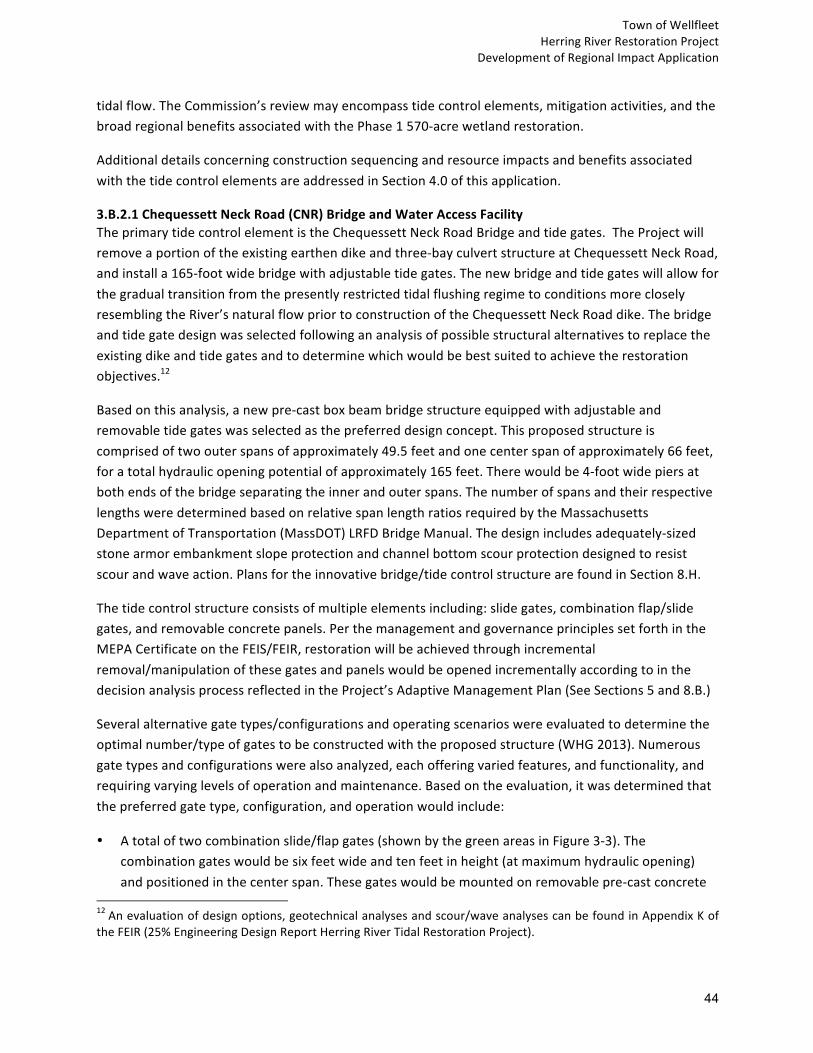
TownofWellfleet
HerringRiverRestorationProject
DevelopmentofRegionalImpactApplication
44
tidalflow.TheCommission’sreviewmayencompasstidecontrolelements,mitigationactivities,andthe
broadregionalbenefitsassociatedwiththePhase1570-acrewetlandrestoration.
Additionaldetailsconcerningconstructionsequencingandresourceimpactsandbenefitsassociated
withthetidecontrolelementsareaddressedinSection4.0ofthisapplication.
3.B.2.1ChequessettNeckRoad(CNR)BridgeandWaterAccessFacilityTheprimarytidecontrolelementistheChequessettNeckRoadBridgeandtidegates.TheProjectwill
removeaportionoftheexistingearthendikeandthree-bayculvertstructureatChequessettNeckRoad,
andinstalla165-footwidebridgewithadjustabletidegates.Thenewbridgeandtidegateswillallowfor
thegradualtransitionfromthepresentlyrestrictedtidalflushingregimetoconditionsmoreclosely
resemblingtheRiver’snaturalflowpriortoconstructionoftheChequessettNeckRoaddike.Thebridge
andtidegatedesignwasselectedfollowingananalysisofpossiblestructuralalternativestoreplacethe
existingdikeandtidegatesandtodeterminewhichwouldbebestsuitedtoachievetherestoration
objectives.12
Basedonthisanalysis,anewpre-castboxbeambridgestructureequippedwithadjustableand
removabletidegateswasselectedasthepreferreddesignconcept.Thisproposedstructureis
comprisedoftwoouterspansofapproximately49.5feetandonecenterspanofapproximately66feet,
foratotalhydraulicopeningpotentialofapproximately165feet.Therewouldbe4-footwidepiersat
bothendsofthebridgeseparatingtheinnerandouterspans.Thenumberofspansandtheirrespective
lengthsweredeterminedbasedonrelativespanlengthratiosrequiredbytheMassachusetts
DepartmentofTransportation(MassDOT)LRFDBridgeManual.Thedesignincludesadequately-sized
stonearmorembankmentslopeprotectionandchannelbottomscourprotectiondesignedtoresist
scourandwaveaction.Plansfortheinnovativebridge/tidecontrolstructurearefoundinSection8.H.
Thetidecontrolstructureconsistsofmultipleelementsincluding:slidegates,combinationflap/slide
gates,andremovableconcretepanels.Perthemanagementandgovernanceprinciplessetforthinthe
MEPACertificateontheFEIS/FEIR,restorationwillbeachievedthroughincremental
removal/manipulationofthesegatesandpanelswouldbeopenedincrementallyaccordingtointhe
decisionanalysisprocessreflectedintheProject’sAdaptiveManagementPlan(SeeSections5and8.B.)
Severalalternativegatetypes/configurationsandoperatingscenarioswereevaluatedtodeterminethe
optimalnumber/typeofgatestobeconstructedwiththeproposedstructure(WHG2013).Numerous
gatetypesandconfigurationswerealsoanalyzed,eachofferingvariedfeatures,andfunctionality,and
requiringvaryinglevelsofoperationandmaintenance.Basedontheevaluation,itwasdeterminedthat
thepreferredgatetype,configuration,andoperationwouldinclude:
• Atotaloftwocombinationslide/flapgates(shownbythegreenareasinFigure3-3).The
combinationgateswouldbesixfeetwideandtenfeetinheight(atmaximumhydraulicopening)
andpositionedinthecenterspan.Thesegateswouldbemountedonremovablepre-castconcrete
12Anevaluationofdesignoptions,geotechnicalanalysesandscour/waveanalysescanbefoundinAppendixKof
theFEIR(25%EngineeringDesignReportHerringRiverTidalRestorationProject).

TownofWellfleet
HerringRiverRestorationProject DevelopmentofRegionalImpactApplication
45
panels.Thecombinationgatesprovideincreasedcontrolofthelowwater,meantidelevel,andtidalrangewithintheHerringRiversystem.Thecombinationgatesallowforadditionalflowoutofthesystem,providingtheabilityfornon-linearexchangeofwaterfluxthatcanshiftthemeantidelevelandallowforincreaseddrainagecapacityifdesired.Additionally,thetwocombinationflap/slidegateswillallowthenewbridgestructuretoapproximateexistingconditionsatthecurrentdike,whichconsistofasingleslidegateandtwotimberflapgates.
• Atotalofsevenslidegates(shownbytheyellowareasinFigure3-3).Theslidegateswouldalsobesixfeetwideandtenfeetinheight(maximumhydraulicopening)andmountedonremovablepre-castconcretepanels.Fiveofthesegateswouldbepositionedinthecenterspan,whileonegatewouldbecontainedineachoftheouterspans.Althoughonlysixgateswouldberequired,aseventhgatewouldbeaddedforredundancyandincaseofoperationfailureofoneoftheotherprimarygates.Thisadditionalgatewouldalsoallowforcontinuedoperationofadamagedorcompromisedgatestructurethatisscheduledfor,orundergoing,repairormaintenance.
Figure 3-3. Box Beam Bridge Layout with Tide Control Structures
• Atotalofeightremovablepre-castconcretepanels(shownbythegrayareasinFigure3-3).Eachofthesepanelswouldbeapproximately12.5feetwide.Therewouldbe4panelsineachoftheouterspans.
ThisproposedconfigurationwasdevelopedbyidentifyingthemaximumandminimumwaterlevelsattainablewithintheHerringRiversystemgiventheforcingtidallevelsinWellfleetHarborusingtidalcontrol.Theflexibilityofthisdesignmodelallowsforanyfeasiblewaterleveltobeattainablethroughtherangeofadjustablegateopeningsand/orremovedpanelsenabledbytheproposeddesignconfiguration.AnOperationsandMaintenance(O&M)PlanwillbedevelopedaspartoffinaldesignandwillbesubmittedinconjunctionwiththeNoticeofIntent,asrequiredbyWetlandsProtectionActregulations.AninitialtidegatemanagementpolicywillbesubmittedwiththeNoticeofIntent,andthesubsequentselectionoftidegateopeningswillbeguidedbytheProject’sAdaptiveManagementPlan(seeSection5).

TownofWellfleet
HerringRiverRestorationProject
DevelopmentofRegionalImpactApplication
46
Thenewbridgewillalsoincludeenhancedparking,pedestrianaccess,andviewing/fishingplatforms,
improvedstormwatermanagement,andimprovedaestheticsfromburialofoverheadutilities(See
Figure3-4andasdescribedinSection4.0ofthisapplication.)
Inadditiontothestructuralalternativesanalysisthatledtoselectionoftheboxbeambridgestructure
(FAO2013),otheraspectsofbridgedesignevolvedthroughanassessmentofalternativesconducted
withinputfromCCNSandWellfleetofficialsandlocalcitizens.Preliminarybridgedesignswere
presentedanddiscussedatpublicannualmeetingsoftheFriendsofHerringRiverin2014and2015.A
seriesofalternativesforwateraccessandportagedesignelementswereevaluatedinlightofmultiple
designobjectivesincludingcost,ADAaccessibility,resourceareaimpactsandvisualimpacts(FAO2015).
Thewateraccessandportagedesignalternativeswerereviewedina2015meetingwithtownPolice,
FireandPublicWorksDepartments,SelectboardmembersandCCNSofficialsforcommentandselection
ofapreferredapproach.Theinputfromthismeetingprovidedtheprojectteamwithdirectiononbridge
design,materialsandaesthetics.
LiketheexistingCNRdike,thenewdesignisnotproposedtoserveasadesignatedFEMAfloodcontrol
structure(SeeSection4.2.Eformorediscussion).Thenewbridgewillhaveafinalsurfaceelevation
similartotheexistingdike(slopedbetween11.7and12.6feet,comparedtothepresent11.3feet).
AccordingtotheFloodInsuranceRateMaps(FIRM)releasedbyFEMA,during100-yearstormevent
tideswhenthecurrentCNRdikewouldbeovertopped,floodwateralsowouldentertheHerringRiver
floodplainatotherlocationsalongCapeCodBay.Therefore,increasingtheheightoftheChequessett
NeckRoadstructurewouldnotpreventfloodingintheestuaryduringastormsurge.Retainingthe
existingelevationoftheroadwayandstructurewillalsopreserveruralcharacter,whichwasa
communitydesignobjective.
Figure 3-4.Visualization of Chequessett Neck Road Bridge, looking southwest (Fuss & O'Neill)

TownofWellfleet
HerringRiverRestorationProject DevelopmentofRegionalImpactApplication
47
Theproposedbridge/tidegatestructurehasbeenreviewedbyMassDOTandisdesignedtocomply
withtherequirementsoftheMassDOTLoadandResistanceFactorDesign(LRFD)BridgeManualandthe
AmericanAssociationofStateHighwayandTransportationOfficials(AASHTO)LRFDBridgeDesignas
wellasthefollowingdesigncriteria:
• Toservea75-yeardesignlifewithpropermaintenance;
• Tominimizetemporaryandlongtermenvironmentalimpacts;
• ToprovideasafeandsecuremechanismforadjustingandcontrollingflowintotheHerringRiver;
• Toallowforthereconfigurationofthebridge/gatestructuretoprovideamaximumhydraulic
openingmeasuring10feetinheightby165feetinwidth;
• Toprovideastreambedinvertelevationof-4.0feet;
• Toprovideastructurethatcanwithstand,ataminimum,apotentialsealevelriseofupto2.1feet
(thepredictedmaximumsealevelriseover50years);
• Toprovideastructurecapableofprovidingsimilarorenhancedpublicaccess;
• Toprovideastructurerequiringminimalmaintenanceandlowfuturecosts;and
• Todesignthebridgeandgatestructurestowithstandsignificantlateralloadsfromtidalfluctuations,
stormsurgeevents(suchasthe100-yearand500-yearfrequencyfloodevents),andtowithstanda
saltwaterenvironmentwithwaveaction.
3.B.2.2RemovalofHighTossRoadCausewayTheHerringRiverpassesunderHighTossRoad,thesecondroadthatcrossestheriver,approximately
onemileupstreamfromChequessettNeckRoad(Figure3-1).Thewesternportionoftheroadisan
earthenbermcausewaythatwasbuiltacrossthesaltmarshinthe19thcentury.Itisunpavedand
infrequentlytraveledbyvehicles.TheRiverpassesunderHighTossRoadthroughafive-foot-diameter
concreteculvert.Hydrodynamicmodelinghasshownthattheculvertwillcauseamajorrestrictionwhen
tidalflowisincreasedatChequessettNeckRoad.Thecausewaywouldbeovertoppeddailybyseawater
underanyrestorationscenario,andwouldimpedeebbtidedrainage.
CompleteremovaloftheearthencausewayandculvertcrossingofHerringRiveratHighTossRoadisa
tidecontrolcomponentoftheProject.Anaturalchannelwillberestoredtoitspriorwidthof
approximately30feetfortidalwaterconveyance.
Projectproponentsconsideredseveralalternativestoprotecttheportionoftheroadoverthemarsh
surfacefromtidalflow.Thesealternativesrangedfromelevatingtheroadabovethelevelofthe
predictedhightidestoremovingitentirely.Thealternativesconsideredwereultimatelynotsupported
bytheWellfleetBoardofSelectmenforacombinationofreasons,mostnotablythatascomparedtothe
ProjectProposal,thealternativescouldnotprovideaccessforemergencyresponsepersonnel,would
conflictwithoverallrestorationgoalsandadditionalenvironmentalimpactsassociatedwithelevating

TownofWellfleet
HerringRiverRestorationProject DevelopmentofRegionalImpactApplication
48
theroadway,andinvolvedincreasedlong-termmaintenanceandreplacementcosts.TheBoardofSelectmenvotedtoabandonandnotreplacetheearthencausewayandculvertcrossingofHerringRiver(MOTION216-592,May24,2016).Accordingly,roadbedfillandtheHerringRiverculvertwillberemovedandthechannelwillberestoredtomatchthenaturalchannelwidthanddepthaboveandbelowtheroadwaycrossing.Furtherchannelmodifications,asmaybenecessarytoachieveProjectgoals,willbecarriedoutundertheAdaptiveManagementPlan.WorkalongHighTossRoadwillthenprogressfromwesttoeast,withthefillwithinthefloodplainofHerringRiverremovedandstockpiledelsewherewithintheworkarea.Fillremovalwillonlyextendtoapointwherethefinalgradematchestheadjacentwetlandplain.Nootherexcavationorsoilamendmentsareproposedwithinthefootprintoftheearthencauseway.Uponreachingtheproposedfinalgrade,alldisturbedareaswillbeseededwithanativewetlandseedmixture.
Asnotedabove,tomaintainaccesstoexistingpropertieslocatedonWay#672,aportionofHighTossRoadfromWay#672toPoleDikeRoad(travelway)willbeelevatedabovethemodeledstorm-of-record.HighTossRoadwillbeelevatedtoaminimumof6-inchesabovethepredictedwatersurfaceduringthemodeledstormevent(6inchesabove7.0feet.)
3.B.2.3WaterControlStructureatPoleDikeRoadAfterconsultationwithpotentiallyaffectedpropertyownerswithintheUpperPoleDikeCreeksub-basin,awatercontrolstructurewasincludedatthePoleDikeRoadcrossingtopreventpotentialimpactstoprivatestructuresintheUpperPoleDikeCreeksub-basin.Basedonhydrodynamicassessmentofpost-restorationconditionsusingadaptivemanagementsimulations(WoodHoleGroup,2015),itwasdeterminedthatbyraisingtheroadandincreasingtheculvertopeningasdescribedbelow,atidegatestructureshouldbeinstalledattheculverttorestrictflowintoUpperPoleDikeCreek.Accordingly,thePoleDikeRoadculverthasbeendesignedtohaveahydraulicgatestructuretorestrictupstreamflow.Therefore,PoleDikeRoadwillfunctionsimilarlytoacoastalleveeduringstormeventsuptothestorm-of-record.
TheproposeddesignatPoleDikeRoadistoraisetheroadwayfrom4.7to8.8feetNAVD88andtoincreasethesizeoftheculvertfroma36-inchcircularculverttoaneight-foothighbyseven-footwideboxculvertwithacombinationflap/slidegate(Section13).Theproposedfreeboardforthisroadwaysegmentistwofeet.Thecombinationflap/slidegatewillbeabletoregulatetidalflowtotheUpperPoleDikesub-basin,therebyavoidingorlimitingwaterelevations.AnOperationsandMaintenance(O&M)PlanwillbedevelopedaspartoffinaldesignandwillbesubmittedinconjunctionwiththeNoticeofIntent,asrequiredbyWetlandsProtectionActregulations.Again,thisflowcontrolstructurewillonlyprotectagainstfloodingwhenwaterelevationsarelessthanorequaltothestorm-of-record.
NotidalrestorationisproposedfortheUpperPoleDikeCreeksub-basinaspartofPhase1.Hydrodynamicmodelsshowthatwaterlevels(includingunderstormconditions)duringPhase1willnotaffectthelowest-lyingunprotectedstructure.Basedonmodeling,atfullPhase1tidalflow,thepeakwaterlevelduringacombination10-yearstormand100-yearprecipitationeventislowerthanexistingconditionsforthesameevent.

TownofWellfleet
HerringRiverRestorationProject DevelopmentofRegionalImpactApplication
49
3.B.2.4MillCreekWaterControlStructureAsecondarywatercontrolstructureequippedwithtidegatesacrossMillCreekwillallowapartial,controlledre-introductionoftidalexchangeintheMillCreeksub-basintorestore21acresoftidalwetlandsinPhase1whileprotectingstructuresonprivateproperties.TheMillCreekwatercontrolstructurewillbelocatedentirelyonpropertyownedbytheNPS.Therefore,theNPSwillpreparethefinaldesign,pursueallnecessarypermittingandwillsecurefundingtoconstructthewatercontrolstructurewithtidegates.TheMillCreekstructureisnotthesubjectofthispermitrequest,andisdescribedhereinforinformationalpurposes.
Thedesignofthestructureandtidegateswasselectedfollowingananalysisofseveraldesignalternatives.Eachalternativewasevaluatedbasedonenvironmental,constructability,aesthetic,sustainability,andcostfactors.Afterevaluationofcostsandbenefits,asinglesheetpilewallwasselected.Designplansdepictingthelayout,dimension,tidegatestructure(capableofallowingcontrolled,bi-directionaltidalexchangebetweentheHerringRiverandMillCreek),andaccessroadarefoundinSection8.H.ThedesignwasrevisedsothatthelayoutforthestructureiscontainedwithintheCCNSboundary.
ThenewMillCreekwatercontrolstructurewillbeconstructedwithacrestheightof9.5feet.Thisisbasedonamaximum,storm-of-recordhightideonthedownstreamsideof7.5feet,therebyprovidingtwofeetoffreeboardagainstanextremestormevent.Thestructuredesigncontainsfiveculvertsoropenings,eachfivefeetwide,fora25-footwideopeningintotal,andwithadjustablecombinationflap-slidegates,asdescribedbelow.Thetidegatescanbecompletelyclosedtoinflowingtidalwaterifwarrantedbasedonpredictedseverestormconditions.Insuchacase,freshwaterwouldstillbeabletodrainoutofMillCreek.
Heavy-gaugesteelsheetpilesareproposed,whichisthemostcommonmaterialusedforsheetpilewallsduetoitsinherentstrengthwhichincreasesservicelife,andavailabilityandfamiliaritytolocalcontractors,whichreducescosts.Sinceasteelsheetpilewallatthislocationwouldbesubjecttopotentialcorrosion,thewallwillbespecifiedtouseweatheringsteelorASTMA-690high-nickelsteelwithasacrificialthickness.Sacrificialthicknessisanacceptedengineeringmethodforprovidingcorrosionprotectioninamarineenvironment.Thesacrificialthicknesswillallowthewalltobesubjecttocorrosiveactionoverthelifeofthewallandnotresultinastructuralfailureofthesheetpileconstruction.Thisapproachwasselectedtominimizefuturemaintenance,operatingeffortsandcosts.
Acantileveredsteelwalkwayplatformwillbeattachedtotheupstreamsideofthestructuretoprovideasafemeansforstaffcompletinginspections,maintenanceorotheroperatingfunctions.ThisplatformwillbesecuredfromaccessbyunauthorizedusersandbedesignedtocomplywithrelevantOSHArequirements.
Scourprotectionintheformofsoil-filled,vegetatedstonearmorwillbeinstalledimmediatelyupstreamanddownstreamofthestructureanditshydraulicopening,andsoil-filled,vegetatedarticulatedconcreteblockmattingwillprovideastablesurfacealongthesheetingforequipmenttoaccessthehydraulicopeningtoremovedebrisandcompleteotherrequiredmaintenance.TheseProjectelements

TownofWellfleet
HerringRiverRestorationProject DevelopmentofRegionalImpactApplication
50
arecriticaltoprotectthefoundationandstabilityofthestructure,andtoassurethatmaintenancestaffcansafelycompleterequiredactivitiestomaintainunobstructedflowthroughthestructure’shydraulicopening.
Thestructure’stidalcontrolmechanismwillconsistoffiveelectrically-operated,risingstemcombinationslide/flapgates,eachopeningmeasuringapproximatelyfivefeetinwidthbysixfeetinheight.Thegateswillbemountedtoacast-in-placeconcretestructure,whichwillbestructurallyintegratedintothesteelsheetstructure.Thisconcretestructurewillbesupportedbyafoundationoftimberpilesandwillbeconfiguredwithanarrow(lessthanthree-feetwide)concreteapronforminganinvertwherechannelflowtransitsacrossthefootprintofthestructure,toavoidscourandotherpotentialdamage.FunctionalbenefitsprovidedbythetidegatesincludeasafeandsecuremechanismforadjustingandcontrollingflowintoandoutoftheMillCreeksub-basin;andmechanismsthatareeasilyoperated,allowingpersonsofvaryingtechnicalbackgroundandphysicalabilitytooperatingthegates.
Slide-flapgatesarestructuresthatcombinethefeaturesofaslidegatewiththefunctionalityofflapgatebyallowingtheslidingleaftorotateaboutahorizontaltransverseaxisatthetopofthegateopening.Thisfunctionalityistypicallyprovidedtoallowstormflowdrainagefromatidalestuary,whilelimitingtidalsurgeorhightidesintoanestuarythatcouldotherwiseresultindamagetothebuiltenvironment.Forexample,whenthegateispartiallyopen,theopenareabelowthegateleafallowsforbi-directionalflow,whiletheupperportionofthegateopening(wheretheleafislocated)restrictsflowinonedirectiontoagreaterdegree.Asthegatemovestoamorefullyclosedposition,theopenarea(andbidirectionalflow)decreases,resultingintheflowbecomingpredominatelyorentirelyone-directionalduetothefunctionoftheflapgate.Eachgatewillofferoptionstobelockedinaclosedoropenpositionforsecurity.
Accesstothewatercontrolstructurewillbeprovidedbya12-footwidedrivethatwillextendapproximately1,200feetfromOldChequessettNeckRoadtoalocationnearthenorthendofthestructure,whereaturn-aroundareawillbeconstructedtoallowadequateroomforoperation/maintenancevehiclemaneuvers.Asecuritygatewillbeprovidedattheaccessdrive’sentrancetopreventaccessbyunauthorizedvehicles.
ProposedProjectelementshavebeendesignedtomeetthefollowingobjectives:
• Providea75-yeardesignlifewithpropermaintenance;
• Minimizetemporaryandlong-termenvironmentalimpacts;
• Accommodatemodificationstowithstandpotentialfutureovertopping;
• Facilitateeaseofoperationandmaintenance,and;
• Minimizefuturemaintenancecosts.
Ancillaryworkincludesgradingandstabilizationofthetidalchannelimmediatelyadjacenttothestructure,dredgingofaccumulatedsedimentwithinexistingtidalchannelsupstreamanddownstream

TownofWellfleet
HerringRiverRestorationProject DevelopmentofRegionalImpactApplication
51
ofthestructure,andremovalofanearthendikeremnantonthenorthsideofthechannelupstreamoftheproposedstructure.
Tidalchannelsupstreamanddownstreamofthestructurewillbeexcavatedtoremoveaccumulatedsediment;channelswillnotbewidenedaspartofthisactivity.ThechanneldredgingisexpectedtoimprovefreshwaterdrainageoutofMillCreek.Removedsedimentwillbeside-cast,dispersedontotheadjacentmarshareasor,alternatelyhauledfromthesitetobebeneficiallyreusedwithintheHerringRiverbasin,consistentwithenvironmentalpermits.
3.B.3.MitigationMeasuresThissectiondescribesthemitigationmeasuresassociatedwithPhase1tidalrestoration.Allmitigationmeasuresaredesignedtoprotectthesubjectstructuresunderfulltidalrestorationconditions.ForthepurposesofDRIreview,themitigationactivitiesarenotwithintheprojectsitearea,whichconsistsoftheparcelswithinthelimitsofdisturbancefortheconstructionoftheprimarywatercontrolmeasuresneededtorestoretidalflowintheestuary.
3.B.3.1ChequessettYachtandCountryClubCYCCisasemi-privateclubwithanine-holegolfcourselocatedintheMillCreeksub-basinoftheHerringRiver.Currently,portionsoftheCYCCgolfcourseexperienceoccasionalfloodingbygroundwaterandsurfacewaterintheareaofMillCreek.Hydrodynamicmodelingalsoshowsthatundercertainconditionsandabsentmitigationmeasures,portionsoftheCYCCgolfcoursewouldbeaffectedbytheincreasedwaterlevelsintheMillCreeksub-basinascurrentlyproposedinPhase1.Toaddressthis,foranumberofyears,representativesoftheprojectteamandCYCChaveengagedindialoguetodevelopadetailedplanto:(1)seetherestorationprojectsucceed,and;(2)protecttheCYCCgolfcoursefrompotentialadverseimpact.Akeyelementofthismulti-yeareffortisaplantoelevatelowgolfcourseholes.Thisplanincludes:
• Raisingandrenovatingportionsofthefivelowerfairways,tees,greens,roughs,sandtrapsandcartpaths(Holes#s1,6,7,8&9)tomitigateagainstwaterlevelsuptotheelevation6.4feetNAVD88.This6.36-footelevationrepresentsthemaximumwaterlevelthatwouldoccurunderstorm-of-recordconditionswithtidegatesintheMillCreekwatercontrolstructureopen3feethighandthetidegatesintheChequessettNeckRoadwatercontrolstructureopen10feethigh,andfullProjectrestoration(beyondPhase1)hasoccurred;
• ExcavationandthenreconstructionofoneuplandCYCCgolfcoursehole(Hole#2)whichwillprovideaportionoffillneededfortheProject(approximately180,000cubicyards),tobeusedinraisingthefivelowerholesofthegolfcourse.Approximately73,000cubicyardsoffillwillbeusedforotherProject-relatedneedsoutsideoftheCYCCProperty.Thetotalamountoffillremovedfromhole#2andotherareastotalsapproximately253,000cubicyards;

TownofWellfleet
HerringRiverRestorationProject DevelopmentofRegionalImpactApplication
52
• InstallationofnewirrigationonHoles#s1,2,6,7,8&9andrelocationofthepracticeareatoanuplandportionoftheCYCCProperty;and
• ClearingchannelsandmanagingnaturalvegetationonthecourseandintheMillCreeksubbasinasmaybeneededtoimprovedrainageandaugmentrestoration(somechannelswillbeidentifiedandclearedmechanicallytoimprovedrainage,andotherswillbeclearednaturallyasrestorationproceeds).
Inaddition,theplanincludesimprovementsonholes#3,4and5,whicharenotimpactedbyinundation,tomakethemcompatiblewithotherre-constructedholes.PlansforthegolfcourseworkarecontainedinSection8.H.
CYCCandProjectrepresentativeshavejointlyacknowledgedthattheregulatoryapprovalsandfundingtoimplementthegolfcourseworkaredependentonactionsbeyondthecontrolofeitherparty.Accordingly,thisworkandotherpotentialaspectsofmitigation,includingbutnotlimitedtocontingencymeasuresthatmaybeemployedandwouldbenecessaryifpermitsandfundingforthegolfcourseworkdescribedabovearenotsecured,remainunderdiscussionbetweenCYCC,theTownandCCNS.
3.B.3.2Low-LyingRoadCrossingsandCulverts(PoleDike,BoundBrookIslandandOldCountyRoads)TheProjectareaconsistsofseverallow-lyingroadways(LLR)thatarevulnerabletohightidewaterlevelsundertheproposedProject.Theprimarydesignobjectiveofthismitigationmeasureistoelevatetheroadwaystopreventovertoppingduringthestorm-of-record.Theroadsegmentsaretobeelevatedtoaminimumof6inchesabovethepredictedwatersurfaceduringthemodeledstormevent.CurrentdesignplansarepresentedinSection8.H.
Topreventover-topping,theroadsurfacesandculvertsneedtobeelevated.Approximately24,500linearfeetofroadwayareincludedintheProjectarea.Ofthis,approximately10,850linearfeetofroadwillberaised.ElevatingtheseroadsalsorequireswideningtheroadbasesandreplacingsixexistingculvertsandinstallingthePoleDikeRoadwatercontrolstructurewithtidegate.The10,850linearfeet(approximatelytwomiles)ofroadwayisnotcontinuousandismadeofsmallerroadsegments.Whileimpactstowetlandswillbenecessarytowidenroadbases,theimpactsarefaroutweighedbytheoverallwetlandsbenefitsoftheProject.Additionally,atrafficmanagementplanwillbeimplementedtominimizedisruptiontoresidentsandbusinesses.TheseissuesareaddressedinSection4.0ofthisapplication.
Ageotechnicalinvestigationofexistinglow-lyingroadsegmentsandassociatedculvertswasconductedtoassistinthedevelopmentofconstructionplansfortheProjectsite,includingthecutandfilloperations.Theexistingroadsurfaceatlow-lyingareasrangesfrom2.3to5.2feet,whichwillbeelevatedto4.25to7.5feet.Thegoalistoelevatetheexistingroadwaysegmentsabovethestorm-of-recordwithintheProjectarea(3.72to6.88feet)includingfreeboard.Freeboardof0.5feetabovethestorm-of-recordwasselectedtoelevatetheseroadwaysegments.TheactualincreaseinelevationvariesthroughouttheProjectarea.About0to4.5feetoffillisrequiredoverexistinggroundelevationstoachievethefinalsitegrading.Aspartofthere-grading,existingculvertswillbereplacedwithupgradedpipesandboxculvertstructures.

TownofWellfleet
HerringRiverRestorationProject DevelopmentofRegionalImpactApplication
53
Toaccommodatetheincreaseinroadelevation,asideslopetreatmentof3:1(horizontaltovertical)ratiowasselectedtoblendthesideslopesintoexistinggrades,andavoidabrupt,steeptransitionsbetweentheroadandadjacentlandforthesafetyofpedestrians,cyclists,andequestrians.A3:1sideslopeprovidesaslopethatcanbestabilizedwithnaturalvegetationwithoutconcernstoslopestability,andrequiresonlylimitedscourprotection.TheBoundBrookIslandRoadculvertatHerringRiveristheonlylocationwhere3:1sidesloperatiowasnotattainable.Gabionbasketwallsaretobeincludedatthislocationoneachsideoftheroad,onthesideoftheculvertwherethewingwallsaresetclosetotheedgeoftheroad.
Designofthereplacementculvertsincludeaheadwallandwingwallsatthethreeboxculverts.Thewingwallsarenecessaryduetotheheightoftheculvertopeningandslopedownfromtheroadtowardthewatersurface.Constructionofthereplacementculvertswillrequireopencutsthroughtheexistingroadwaytoinstallthereplacementculvertatthestreamcrossings.Theboxculvertswillbeinstalledoveralayerofgeotextilefabricand12inchesofcrushedstonewithincommonborrowandwillbecoveredby12inchesofselectgravelandflexiblepavement.The24-inchreinforcedconcretepipeswillalsobeinstalledovergeotextilefabricand12inchesofcrushedstoneandwillbeoverlaidwith24-inchesofselectgravelandflexiblepavement.
Atemporarybypassforwaterflowwillberequiredateachstreamcrossingduringculvertinstallation.Thehydrauliccapacityofthebypassculvertswillmeetorexceedthecapacityoftheexistingculverts.DredgingrequirementstoinstalltheProject’sculverts,associatedwingwalls,gabionbasketwalls,riprapapron,andfoundationsupportforeachofthesecomponentsincluderemovalofexistingmaterialbeneaththestructureandripraplocations.
Constructionwillbeperformedinstagestomanagetrafficflowduringconstruction.AMaintenanceProtectionofTrafficPlanswasdevelopedinaccordancewiththeFederalHighwayManualUniformTrafficControlDevices.TheDetourPlansandMPOT,whichshowallrequiredroadclosuresanddetours,arecontainedinSection8.H.
Compliancewithstatestormwaterregulationsisrequiredtothemaximumextentpracticableforredevelopmentprojects.Generally,analternativeispracticableifitcanbeimplementedwithinthesitebeingredeveloped,takingintoconsiderationcost,landarearequirements,soils,andothersiteconstraints.TheprimaryconstraintsforthisProjectarethelimitedright-of-way,elevatedgroundwaterandadjacentresourceareas.Practicesthatwillrequireeitheradditionalresourceareaimpactsorimpactstoprivatepropertywillbedefinedasnotpracticableforthepurposesofstormwatercompliance.
Thestormwatertreatmentshownontheplansconsistsoftheinclusionofvegetatedswalesalongtheconstructedroadsections,takingintoaccountthetransversepitchoftheroad,landavailablealongtheroadside,andotherphysicalfeatures.SwaleswillbedesignedtomeetStormwaterManagementStandardstothemaximumextentpracticable.Duetohighelevationofgroundwater,theswaleswillbeconveyanceswales,notbio-infiltrationswales.TheProjectwillfullycomplywiththeprovisionsoftheStormwaterManagementStandardsrequiringthedevelopmentandimplementationofaconstruction-

TownofWellfleet
HerringRiverRestorationProject
DevelopmentofRegionalImpactApplication
54
perioderosionandsedimentationcontrolplan,apollutionpreventionplan,anoperationand
maintenanceplan,andtheprohibitionofillicitdischarges.
Thecriteriausedtosizethesevenproposedreplacementculvertswerebaseduponrecommendations
establishedbyWoodsHoleGroup(WHG)inits“HerringRiverHydrodynamicModelingModelReport”
(2012).TheproposedculvertsarebaseduponthespecificrecommendationsfromWHG,includedina
January23,2015letterreport,exceptfortheDrivewayculvert.Dataontheexistingandproposed
culvertsarepresentedinTable3-2.Unliketheothersixculverts,thePoleDikeRoadculverthasbeen
designedtohaveahydraulicgatestructure.
Table 3-2. Existing and Proposed Low Lying Roads and Culvert Size and Elevation
LocationExisting
Culvert
Existing
Invert
Elevation
(ft)
Existing
Road
Elevation
(ft)
Proposed
Road
Elevation
(ft)
Proposed
Culvert
Heightby
Width(ft)
Proposed
Invert
Elevation
(ft)
Proposed
Crown
Elevation
(ft)
Annual
High
Water
(ft)
Storm-
of-
Record
(ft)
PoleDike
Road
36-inch -1.3 4.7 8.82 8by7 -1.2 6.8 4.94 6.82
Bound
Brook
Island
Roadat
Herring
River
54-inch -3.5 4.0 7.7 8by6 -2.7 5.3 4.73 6.44
Bound
Brook
Island
Roadat
Bound
Brook
24-inch -2.3 2.4 6.4 6by6 -2.2 3.8 4.11 5.53
Old
County
Road
Paradise
Hollow
12-inch 0.3 3.5 6.53 24-inch 0.3 2.3 4.13 5.75
Old
County
RoadLombard
Hollow(S)
Unknow
n 1.05 4.4 5.89 24-inch 1.0 3.0 2.85 3.72
Old
CountyRd
Lombard
Hollow
(N)
Not
FoundNotFound 4.9 5.44 24-inch 1.1 3.1 2.85 3.72
Bound
Brook
Island
Road
Private
Driveway
Not
found Notfound 4.2 7.2 24-inch 0.0 2.0 6.70

TownofWellfleet
HerringRiverRestorationProject DevelopmentofRegionalImpactApplication
55
3.B.3.3ElevationofHighTossRoadHighTossRoad,initscurrentcondition,isapproximatelytwofeetabovethesurroundinggrade,andgivenitselevation,willbeovertoppedathightidesgreaterthanapproximatelythreefeet.Inorderto
maintainaccesstoexistingpropertieslocatedonHighTossRoadorWay#672(alsoknownasRainbowLaneandSnakeCreekRoad),theportionofHighTossRoadfromapproximatelyWay#672toPoleDikeRoadwillbeelevatedtoaminimumof6inchesabovethepredictedwatersurfaceduringthemodeled
stormevent(6inchesabove7.0feet).
TheproposedworkatHighTossRoadhasthreeprimaryobjectivesto:
• RestoreHerringRiveranditsfloodplaintoanaturalizedandunrestrictedstateinthevicinityofHighTossRoadthroughtheremovaloftheculvertonHerringRiverandthefillassociatedwiththe
causewaywithinthefloodplain.
• ElevatethealignmentofHighTossRoadbetweenPoleDikeRoadandWay#672watercontrol
structuretoelevation7.5feettopreventovertoppingoftheroadway.Thisincludes0.5feetoffreeboardabovetheelevationofthemodeledstorm-of-recordof7.0ft.CurrentdesignplansarepresentedinSection8.H.
• Replaceanexistingculvertlocatedapproximately460feetwestofPoleDikeRoadwithalargerdiameterculverttopromotehydraulicconnectionofwetlandsonbothsidesofHighTossRoadat
thislocation.
3.B.3.4MitigationWorkonOtherPrivatePropertyMitigationmeasurestoprotectstructuresonthreeprivatepropertiesfrompotentialimpactsoftidalrestorationaredescribedbelow.Lettersofconsenttodescribethisworkinpermitapplicationshavebeenobtainedfromeachpropertyowner.
BoundBrookIslandRoad
AprivatepropertylocatedoffofBoundBrookIslandRoadisalow-lyingpropertywithastructure
vulnerabletotidalinundationunderPhase1restoration.TheProjecthasreachedagreementwiththepropertyownerstoprovidemeasurestofullyprotectthestructure.
Thepropertyhastwodwellingswithindividualgraveldriveways;proposedmitigationmeasuresincluderelocatingandelevatingtheexistingdrivewayservingthelowerofthetwodwellings.Abench-wall
barrierwillbeinstalledaroundapatioareaofsaiddwellingtoprotectthelowerentrance.Followingconstructionandsiterestoration,thepropertywillbeverysimilartoexistingconditions.Nodetrimentaleffectsonuseofthepropertyareanticipatedandthebeneficialeffectsofreducedpotentialforwater
intrusionarepermanent.
ThepropertyisaccessedviaagravelroadoffofBoundBrookIslandRoad.AspartoftheLLRroadworkdescribedabove,aportionofBoundBrookIslandRoadinthevicinityofthesubjectpropertywillbeelevated,aswillthegravelaccessroadtothedwellings;andaculvertnearthebeginningofthegravel

TownofWellfleet
HerringRiverRestorationProject DevelopmentofRegionalImpactApplication
56
accessroadwillbereplaced.Constructiononthepropertywilllikelynotoccurinphases.Thedrivewayandpatiomaybeconstructedsimultaneously.
MillCreekSub-basin
Privatewellsservingpropertiesat70and80MillCreekLane,respectively,couldbeovertoppedbytidalwaterduringPhase1restoration.Consistentwithagreementsreachedwiththesubjectpropertyowners,eachofthetwowellswillberelocatedtoasiteabovemaximumwaterlevelsunderbothPhase1andalsoforfullrestoration.
3.B.3.5TideBarriertoProtectWay#672Way#672(aportionofwhichisalsoknownasRainbowLaneorSnakeCreekRoad)islocatedadjacenttotheHerringRiver,approximatelyonemileupstreamofChequessettNeckRoad.Thefollowingsectionaddressestheevaluation,selection,anddesignofalternativestructuralconfigurationstoprotectWay#672fromimpactsrelatedtorestorationoftidalflow.
AstructureisbeingproposedtoprotecttheroadandresidentialpropertiesalongWay#672fromrestoredtidalflow,whileminimizingwetlandimpacts,constructioncosts,andoperation/maintenancerequirements.LiketheMillCreekwatercontrolstructure,thisstructureisentirelyonlandownedbytheNPS,andisnotsubjecttoCapeCodCommissionActreviewbecauseconstructionofthestructurebyNPSonfederallandconstitutesapurelyfederalactivity.NPSwillpursueallpermitsforthestructurethatareapplicable.Adescriptionofthestructureisprovidedhereinforinformationalpurposes.
Theassessmentofpotentialimpactstolow-lyingstructuresindicatedthattidalflowcouldtemporarilyreachtwoprivatedrivewaysoffofWay#672,aprivatelow-lyingwellandbothHighTossRoadandWay#672,duringlargercoastalstormeventsunderPhase1restoration.SeveralconceptualdesignalternativeswereevaluatedforatidebarriertobelocatedonCCNSpropertytoprotecttheabove-mentionedstructuresfromtidalflowunderallPhase1conditions.
Thefollowingfivepotentialstructuralconfigurationswereevaluated:earthendike,precastconcretewall,cast-in-placeconcretewall,steelsheetingwall,andtimberbarrierwall.Basedonsevenselectioncriteriathatencompassedphysicalsiteconditions,naturalresourceimpacts,constructability,cost,maintenancerequirementsandsitecompatibility,twoofthefivealternatives(steelsheetingwallandtimberbarrierwall)wereselectedforfurtherevaluation,aswellasathird“hybrid”wallutilizingacombinationofasteelsheeting(belowgrade)andtimberbarrierwall(abovegrade).Thethreealternativesareallsinglewallsandthereforewillhavesimilarafootprintandlayout.Basedontheassessment,theNPSselectedthehybridsteel/timberalternative.
Theproposedstructurewillbedesignedtosatisfythefollowingspecificcriteriathatserveasminimumstandardsfordesignandconstruction:
• Minimizetemporaryandlong-termenvironmentalimpacts;
• Topofdikesetatelevation7.5feet;
• Minimizefuturemaintenancecosts;

TownofWellfleet
HerringRiverRestorationProject DevelopmentofRegionalImpactApplication
57
• Maximizethestructure’sabilitytoadapttofutureconditions(e.g.,easeandcostoffuturealterations);
• Allowforpositiveuplanddrainage,asdeterminednecessarysubsequentdesignphases;
• Provideseepagecutoff,asandifdeterminednecessaryinfuturephasesofdesign,and;
• Withstandlateralloadsandsaltwaterenvironment.
3.B.4SecondaryVegetationandMarshManagementActionsThispermitapplicationalsoencompassespotentialsecondarymanagementactionsonthemarshplainthatareneededtoenhanceecosystemfunctioninconcertwithtidalrestoration.Proposedactionsincludeadditionaldrainageimprovements(e.g.,vegetationremovalandchannelexcavationtoremoveaccumulatedsediments),vegetationmanagement,andsedimentsupplementationtoincreasemarshelevation.Atthetimeofpermitsubmittals,thepreciselocations,methodsandtimingoftheseactivitiesareunknownastheydependinpartonsystemresponsestothereturnoftidalflow.UncertaintiesabouttheimplementationdetailsoftheseactionswillberesolvedastidalrestorationprogressesandtheresponseofthesystemisevaluatedinaccordancewiththeAdaptiveManagementPlandescribedinSection5.0andcontainedinfullinSection8.B.
3.B.4.1VegetationManagementVegetationmanagementisaclassofprojectactivities,alongwithincrementaltidalrestorationandfacilitatingtherecoveryofnaturaltidalmarshchannelnetworksandelevationthatarebeingpursuedaspartoftheadaptivemanagementplan.Thissectionprovidesageneraldescriptionofactivities,methods,andeffects.AmoredetaileddraftVegetationManagementplanisfoundinAppendixF.ThisinformationwillbesupplementedandrefinedduringprojectimplementationandpresentedbytheHRRCwhenappropriateindetailed,site-specificVegetationTreatmentPlans(VTPs)forreviewandcommentbytheRegulatoryOversightGroupandHerringRiverStakeholderGroup(HRSG),andapprovalbytheHREC.
AsPhase1isimplemented,saltwaterwillcausedeclineandmortalitytomuchoftheherbaceousandwoodyfreshwater-dependentanduplandvegetationthathascolonizedthefloodplain.Ifleftstanding,dyinganddeadtreesandlargershrubscouldhamperthere-colonizationofnativesaltmarshplantcommunities.Insomeareascurrentlydominatedbyherbaceous,freshwater-dependentemergentplantspecies,thenon-native,invasivecommonreed(Phragmitesaustralis)couldexpandwhichwouldhaveanumberofdeleteriousecologicalandsocioeconomiceffects,includingdisplacementofnativevegetationandareductioninhabitatqualityforfishandwildlife.ThespecificgoalformanagingvegetationaspartoftheHerringRiverRestorationProjectistosupportthelong-term,sustainablere-colonizationofnativeestuarinevegetationastidalrange,salinityandsedimenttransportprocessesarerestored.
VegetatedareasthatwillbeaffectedateachstageoftidalrestorationwereidentifiedbycomparingNPSvegetationcovertypedatawithspatialdataoutputfromtheEFDChydrodynamicmodel.Activeremovalandmanagementofvegetationwillbelimitedtotheemergentmarshareaswithexistingoccurrencesof

TownofWellfleet
HerringRiverRestorationProject DevelopmentofRegionalImpactApplication
58
commonreed,aswellasshrub-landsandwoodlands.WithintheareaoftheHerringRiverfloodplainaffectedbyregulartidalinundationuptothePhase1projectlimit,approximately43acresiscurrentlydominatedbycommonreed,mostofwhichoccurswithintheLowerHerringRiversub-basin.Shrub-landscompriseabout 179acresandarescatteredthroughoutalloftheHerringRiversub-basinswiththeexceptionofBoundBrook.Thelargestcontiguousstandsofshrub-landcurrentlyoccurinportionsofDuckHarbor,LowerPoleDikeCreek,andtheUpperHerringRiversub-basins.Woodlandscurrentlymakeupapproximately126acresofthePhase1projectarea,withmoststandsoccurringintheLowerHerringRiver,Mid-HerringRiverandLowerPoleDikeCreeksub-basins.Intotal,uptoapproximately348acreswithintheHerringRiverfloodplaincouldrequiresomeformofvegetationmanagementaspartofPhaseOneoftheproject.
Vegetationmanagementwillbeconductedincrementally.ItwillbecloselycoordinatedwithChequesettNeckRoadtidegatemanagementandtheresultingincreasesinwatersurfaceelevations,tidalrange,andsalinity.Generally,vegetationmanagementoperationswouldbeconductedbeforetidalflowsarereintroducedtoagivenareabeforethegroundsurfaceisaffectedbysaltorbrackishwater.Inundationwithsaltwaterthatpromptlyfollowsvegetationremovalisexpectedtobehighlyeffectiveforpreventingorlimitingregrowthofundesirablespeciesandisexpectedtofosterre-colonizationofnativeestuarineplantcommunities.
3.B.4.2MarshManagementRestorationofnaturalstreamchannelconnectivityandmarshsurfaceelevationisamajorcomponentoftheHerringRiverRestorationProject.Marshmanagementisaclassofprojectactivities,alongwithincrementaltidalrestorationandvegetationmanagement,thatwillbepursuedaspartofthecoordinatedadaptivemanagementprogram.
Theseactivitiescannotbedescribedindetailatasite-specificlevelpriortocommencingtherestorationandadaptivemanagementprogram.Manyofthelocationswherethisworkcouldpotentiallybenecessaryareremoteandcurrentlyeithercoveredindense,shrubbyvegetationorunderwater.Theworkisalsodependentonspecificvegetation,micro-topography,andtidalflowcharacteristics.Attemptingtoevaluatepotentialtreatmentsitesanddesignfuturemarshsurfacerestorationactionsbasedonexistingconditionsisafruitlessexercise,sincetheseconditionswillchangeaftertidalexchangeisrestored.Conditionswillalsovarygreatlyamongdifferentlocationsandatdifferentstagesoftherestorationprocess.Therefore,thisbroadsummaryisbasedonthebestinformationavailableandcurrentprojectionsofhowrestoredtidalflowwillgenerallyaffecttheprojectareaaswellasthetypesofinterventionsthatareexpectedtobenecessaryforrestoringnaturalstreamnetworksandmarshelevation.

TownofWellfleet
HerringRiverRestorationProject DevelopmentofRegionalImpactApplication
59
4. RegionalPolicyPlanAnalysisThefollowingsectiondiscusseseachoftheRPPGoalsandObjectivesidentifiedintheMarch2019DRIScopingDecisionissuedforthisProject.TheRPPgoalsandobjectivesareaddressedintheorderinwhichtheyarelistedintheScopingDecision.ForeachcategoryofRPPtopics,thenarrativedescribesexistingconditions,postrestorationconditions,andthewaysinwhichrestorationrespondstoandsatisfiesspecificRPPGoalsandObjectives. 4.AWaterResources(WR)ThissectionreviewstheexistingconditionofwaterresourcesintheHerringRiversystemanddemonstrateshowpostrestorationconditionsmeettheRPPWaterResources(WR)goalandapplicableWRobjectives.
4.A.1ExistingConditions
4.A.1.1SalinityofSurfaceWatersTheexistingChequessettNeckRoaddikehaslimitedtheupstreammeantiderangeinHerringRivertoonly2.2feetcomparedto10.3feetinWellfleetHarbor.InWellfleetHarbor,salinitytypicallyrangesbetween30and32partsperthousand(ppt)(NPSdata,aspresentedinWHG2009).Undercurrentconditions,salinewaterfromWellfleetHarboronlyreachesupstreamtoapproximatelyHighTossRoad,approximately1.2milesupstreamofthedike(Figure3-1intheFEIS).Basedontheanalysisofrootsandrhizomesfrompeatcores,salinitypenetrationsupportedsmoothcordgrass(Spartinaalterniflora)throughoutthehistoricfloodplain(OrsonandRomaninRoman1987).CCNSmonitoringdataconfirmthatwaterswithintheupperestuaryarenowconsistentlyfreshasaresultoftidalrestriction.DownstreamoftheChequessettNeckRoaddike,watersarebrackishtomarinewithmonthlymeansalinitiesof15to27pptduringlowtide.Section3.2oftheFEISprovidesamoredetaileddiscussiononexistingsurfacewatersalinityintheHerringRiverfloodplain(HRRC2016).
4.A.1.2WaterandSedimentQualityTheMassachusettsSurfaceWaterQualityStandardshavedesignatedthelowerportionoftheHerringRiveruptoHighTossRoadasClassSAwaters(314CMR4.05).Thesestandardsreflectthestatusofwaterqualityneededtosupportdesignatedusesofthewaters.ClassSAwatersarerequiredtohaveexcellenthabitatforaquaticlifeandconditionsforrecreationaluse.Inaddition,theHerringRiverestuaryisdesignatedbytheCommonwealthasOutstandingResourceWaters(314CMR4.04).TheHerringRiverreachfromHighTossRoadtotheoutletofHerringPondhasbeendesignatedasClassBwater.ClassBwatersaredesignatedashabitatforfish,wildlife,andotheraquaticlife,includingfortheirreproduction,growthandothercriticalfunctions,migration,andprimaryandsecondarycontactrecreation.Insomecases,wheredesignated,ClassBwatersareasuitablesourceofpublicwatersupply

TownofWellfleet
HerringRiverRestorationProject DevelopmentofRegionalImpactApplication
60
withtheappropriatetreatment.OutstandingResourceWatersincludewatersdesignatedforprotection
basedontheirhighsocio-economic,recreational,ecological,andaestheticvalues.
Plainlynoneofthesestandardsaresatisfiedincurrentconditions.TheHerringRiverestuarycurrently
doesnotmeetthetargeteddesignationcriteriabecauseofdegradedwaterqualityconditions.Overthe
last100years,surfacewaterqualityintheHerringRiverestuaryhasdeclinedbecauseoftheseverely
restrictedtidalflushingoftheestuary,aswellasdrainageofmarshsoilsandsediments.Restrictedtidal
influenceandmarshdrainagehaveresultedinlowpH,increasedmobilizationofaluminumandiron,
sustainedperiodsoflowdissolvedoxygen,andhighlevelsoffecalcoliformbacteria.Waterquality
concerns,includinghighaluminum,lowpH,andhighfecalcoliformbacteria,havealsoresultedinthe
listingoftheHerringRiveronthe303(d)listofimpairedwatersunderthefederalCleanWaterAct
(CWA).Amoredetaileddiscussionondissolvedoxygen,pHandsulfate,nutrients,andfecalcoliform
withintheProjectareacanbefoundinsection3.3.5oftheFEIS(HRRC2016).Thefollowingbulleted
sectionprovidesabriefsummaryofcurrentconditionsforwaterquality.
● Dissolvedoxygen:Anoxicandnear-anoxicconditionsexistregularlyalongthemainstemoftheriver
(Portnoy1991).DissolvedoxygenlevelscollectedattheChequessettNeckRoaddikebytheUSGSin
2016-17showthatconcentrationsfrequentlyfallbelowthe6.0mg/lstandardforClassSAwaters
(314CMR4.05).Dissolvedoxygenlevelsvarywiththetidesandatnearlyeverylowtideduringthe
summer,dissolvedoxygenlevelsarehighlystressfultofishandotheraquaticanimals.Lowdissolved
oxygenresultsfromthecombinationofhighoxygendemandandgreatlyreducedtidalflushing.
Restoredtidalconditionswouldimportcopiousvolumesofoxygen-saturatedseawater.
● pHandSulfate:SaltmarshsoilsintheHerringRiverestuaryarenaturallyrichinsulfurbecausesalt
marshmicrobesusesulfateasanoxidizingagenttodecomposeorganicmatterinanoxicmarsh
sediments.Theprocessproducesdissolvedsulfide,alargefractionofwhichissequesteredasiron-
sulfide.Themineralisnotstableinthecurrentaerobicenvironmentcreatedbydikinganddrainage
ofthesaltmarsh.Asaresult,thesulfidehasreactedwithoxygentoformsulfuricacidwhichhas
acidifiedthesoiltopHlevelslessthan3(roughlythesameacidityasalemon),comparedwiththe
rangeof6.5to8.5stipulatedforClassSAwaters(314CMR4.05).Acidicwatercanresultinalossof
aquaticvegetation,aswellasthekillingoffishandotherorganisms.
● FecalColiform:TheHerringRiverislistedasimpairedforfecalcoliformina0.39squaremilearea
betweenGriffinIslandandWellfleetHarbor(MassDEPetal.2009).MassDEPhasdesignatedthe
ChequessettNeckRoaddikeasapointsourceforbacterialcontamination.In2005,fecalcoliform
concentrationsatninestationsbetweenHighTossRoadandEggIslandwerefoundtobeelevated,
reachingupto1,000coloniesper100mlduringanoutgoingtide(Portnoy&Allen2006).For
reference,shellfishharvestingisprohibitediffecalcoliformconcentrationsexceed14coloniesper
100mlofwater.HighfecalcoliformconcentrationshavekepttheHerringRiverdownstreamofthe
ChequessettNeckRoaddikepermanentlyclosedtoshellfishinginsomeareasandonlyconditionally
approvedinotherareas(FEIS3.3.6)Giventhelowdevelopmentdensityfecalcoliformbacteria
probablyoriginatefromwildlifeintheestuaryandwatershedratherthanfromhumans.
TownofWellfleet
HerringRiverRestorationProject DevelopmentofRegionalImpactApplication
61
● Nutrients:Althoughthereisnodocumentationofspecificanthropogenicornaturalinputs,potentialsourcesofexcessivenutrientswithintheHerringRiverwatershedincludeanimalwasteandatmosphericdeposition.Watershedloadingfromsepticsystemsandrun-offisbelievedtoplayasmallerroleinHerringRivercomparedwithothermoredevelopedestuarinewatersheds.NutrientshaveaccumulatedintheHerringRivermarshsoilsduetothelackoftidalflushing.Re-floodingsedimentsmayreleaseammonium-nitrogenandphosphorus(Portnoy&Gilbin1997)somonitoringofammonium-nitrogenlevelsisplannedduringrestoration
Sedimenttestingformetalsandpesticideswasconductedin2007and2014,andthisinformationischaracterizedintheFEIS.Tomorecomprehensivelydepictexistingconditions,additionalsamplingofsedimentchemicalcharacteristicsiscurrentlyunderwayinconsultationwithMassDEPandUSArmyCorpsofEngineers.ThesedatawillbeincorporatedinSedimentManagementPlanssubmittedforreviewandapprovalbyMassDEPandUSArmyCorpsofEngineersunderSection401Section404WaterQualityCertificationpermitregulations.
4.A.2PostRestorationConditions
4.A.2.1SalinityofSurfaceWatersThereturnoftidalflowtoHerringRiverwillbegintore-establishthesalinitygradientnecessaryforahealthyestuary.ImpactsonsurfacewatersalinityresultingfromProjectactivitiesarebasedprimarilyonahydrodynamicmodelthatwasdevelopedfortheHerringRiverfloodplain(WHG2012).Themodelincludesasimulationofwatersurfaceelevations,salinities,andflowvelocitiesthroughouttheHerringRiver.Seesection4.2.1oftheFEIRforadetaileddescriptionofhydrodynamicmodelingmethodsusedtopredictfuturesalinitiesthroughouttheestuary.Modelresultsaresummarizedintable4-3oftheFEIRandreportedindetailintheFEIR(AppendixB).Undertheproposedconditions,theHerringRiverfloodplainupstreamofHighTossRoadwillchangefromafreshwatersystemtoatidallyinfluenced,salineenvironment,increasingthearealextentoftidalexchangebyanorderofmagnitudeincomparisontocurrentconditions.However,becauseofthelackofasalinitygradientthroughoutthesystemunderexistingconditions,calibrationandvalidationofthemodeledsalinitiesforthemixing,transport,anddiffusionprocesseshaveadegreeofuncertainty.Asrestorationprogresses,increasingthesizeofopeningattheChequessettNeckRoadwatercontrolstructuremayalsoresultingreatersaltpenetrationthanpredictedbythemodelbecauseofnaturalerosion(deepening)ofthetidalchannels,intentionalchannelimprovementsundertakenasmarshmanagementactions,andimprovedlowtidedrainage,alleffectivelyincreasingtherateoftidalflushing.Witheachincrementaltidegateopeningandassociatedmonitoringofwaterelevationsandsalinity,themodelcanbefurthervalidatedandthelevelofuncertaintyreducedforfutureincrementalopenings.Specificuncertainties,hypotheses,monitoringstrategies,andpotentialmanagementactionsaimedataddressingimpactsassociatedwithchangesinsalinitywillbeaddressedintheProject’sadaptivemanagementplan.

TownofWellfleet
HerringRiverRestorationProject DevelopmentofRegionalImpactApplication
62
4.A.2.2WaterandSedimentQualityTidalrestorationwillsubstantiallyimprovewaterandsedimentqualitybyincreasingtherangeofseawaterflows,therebycreatinghighertidesandenhancinglowtidedrainage.Inaddition,theproposedconditionswillsubstantiallydecreaseresidencetimesofflowsfromtheHerringRiverfloodplaintoWellfleetHarborbyatleastafactorof25,whichisexpectedtomaintaindissolvedoxygenconcentrationabovestatewaterqualitystandardsatalltimes.WaterandsedimentqualityimprovementsaremajorobjectivesoftheProjectandareintegralfortherestorationofhabitatconditionsrequiredforthere-establishmentofnativefish,shellfishandotherestuarineanimalpopulations.Improveddissolvedoxygenconcentrationswillbenefitmigratorydiadromousfishaswellasresidentfishandinvertebrates.TheimpactanalysisforthissectionhasbeenbasedonpublishedstudiesoftheHerringRiverandotherestuaries,unpublishedwaterqualityandsedimentdatacollectedbyCCNSandUSGS,andhydrodynamicmodeling(WHG2012).Thefollowingbulletedsectionprovidesabriefsummaryofwaterandsedimentquality.AmoredetaileddiscussiononimpactstowaterandsedimentqualityproposedbytheProject,includingindividualdiscussionsonsoilchemistry,nutrients,pesticides,andfecalcoliformwithintheProjectarea,canbefoundinsection4.3oftheFEIR.
● SoilChemistry:Restoredtidalflushingisexpectedtoreduceacidificationwithinthemid-portionoftheHerringRiverestuarywheresalinewaterwillagainsaturatedrainedpeat.Therateofaerobicdecompositionandacidproductionwithinthesoilwilldecreasesubstantially,andthepHofporewaterandsurfacewaterwillincrease(PortnoyandGiblin1997).Withrestoredsalinities,aluminumandironwillnolongerbeleachedfromthesoiltoreceivingwatersinconcentrationsthatstressaquaticlife.Decreaseddecompositionandincreasedsaturationofsoilporespaceswithwaterwillalsopreventfurthersubsidenceofthemarshsurface.
● FecalColiform:RegulartidalflushingwillsubstantiallydecreasefecalcoliformconcentrationsintheHerringRiverduetoincreasedflushingrates,lowerwatertemperature,andhighersalinityanddissolvedoxygen.(PortnoyandAllen,2006)Thereductionofbacteriaconcentrationswillresultfromthedilutionofcleanerinflowingwaterintothesystem,aswellasthesignificantlyreducedlifespanofbacteriainmoresalinewaters.GreatlyreducedfecalcoliformconcentrationswithinHerringRiverandWellfleetHarborareexpectedtoeventuallyallowforremovaloftheriverfromthe303(d)listforimpairmentbypathogensandleadtothereopeningofonceproductiveareasforshellfishharvesting.
● Nutrients:ConcentrationsofnitrogeninthewetlandsedimentsofHerringRiverhaveremainedhigh.Renewedtidalflushingofacidsulfatesoilswillallowammonium-nitrogentobereleasedintoreceivingwatersovertheshortterm(PortnoyandGiblin1997).However,withtheincreasedvolumeoftidalflushing,nutrientswillbedilutedandremovedfromthesystemwitheachtidecycle.Overall,releasednutrientswillbenefitgrowthofsaltmarshvegetationintherestoredmarsh.
● PesticidesandotherOrganicCompounds:Theprojectproponentsarenotseekingauthorizationtouseanypesticidesincludingherbicides.
4.A.3ResponsetoRPPWaterResourcesGoalandObjectives

TownofWellfleet
HerringRiverRestorationProject DevelopmentofRegionalImpactApplication
63
TheRPPWaterResourcesgoalis“tomaintainasustainablesupplyofhighqualityuntreateddrinkingwaterandprotectpreserveorrestoretheecologicalintegrityoffreshandmarinesurfacewaters.”TheCommission’sscopingdecisionidentifiesthisgoal,inadditiontoWR1,WR2andWR3asapplicabletothisProject.TheScopingDecisionalsoidentifiesWR4asapplicable,butlimitedtothestormwatermanagementassociatedwiththeProject’sproposedwatercontrolstructuresandlow-lyingroadwaysegments.Thestormwatermanagementisproposedinthecontextofredevelopmenttoimprovestormwatermanagementoverexistingconditions,ratherthanaspartofanewdevelopment.StormwatermanagementdesignforengineeredstormwaterstructuresisdescribedinSection8.D.
ObjectiveWR1–Protect,preserveandrestoregroundwaterquality Thisobjectiveseekstoensurethattheprojectprotects,preservesandrestoresgroundwaterquality.TheProjectmeetstheobjectivetoprotect,preserveandrestoregroundwaterquality,asdescribedbelow.TheProjectisnotinaWellheadProtectionArea,orPotentialPublicWaterSupplyAreaasidentifiedontheRPPDataViewer.Therefore,themethodsofdemonstratingcompliancewithobjectiveWR1forprojectswithinsuchareasdonotapply.TheProjectisnotproposingaprivatewastewatersystemorwastewatertreatmentfacility.Therefore,themethodsfordemonstratingcompliancewithobjectiveWR1forprojectsthatcontainaprivatewastewatersystemorwastewatertreatmentfacilitydonotapply.TheProjectwillnotresultinthegenerationofwastewater;andthesite-widenitrogenloadingconcentrationwillnotexceed5ppm.Infact,theProjectwilloverallbenefitnitrogenloading.TheWellfleetLocalComprehensivePlanCommitteeestimatesareductioninnitrogenloadinWellfleetHarborasaresultofimplementingtheHerringRiverrestorationproject.(CapeCodCommissionWatershedReport:WellfleetHarbor,2017)Nitrogenloadingfromrunoffassociatedwithprojectelementswillnotincreaseduetoenhancedstormwatermanagement(seeWR4).Stormwatermanagementmeasuresincludedinthebridgedesignwillimprovetreatmentofrunoff.Elevatedlow-lyingroadwayswillreduceuncontrolledrun-offintowetlandsandimproveconveyance.AllconstructioncontractswillincludeappropriatestormwaterBestManagementPractices.(seeWR4).TheProjectcomplieswithobjectiveWR1inthatitwillprotectandpreservegroundwaterquality,andotherwisehavenoadverseimpacttodown-gradientexistingorproposeddrinkingwaterwells.Thisconclusionisbasedonthefollowinginformation.WR1Response1.TheProjectprotectsallprivatewells.TheProjecthasstudiedthepotentialimpactof

TownofWellfleet
HerringRiverRestorationProject DevelopmentofRegionalImpactApplication
64
restorationonprivatewellsunderPhase1andfullrestorationconditions.(Martinetal,2019,See
Section8.C).ThestudyincorporatesrecentinvestigationsforHerringRiverwhichcorrectlyevaluated
theeffectoftidalrestorationongroundwaterbeneathandadjacenttoanintermittentlyflooded
intertidalestuary.Thesestudiesfoundthattidalrestorationisexpectedtoincreasethemeanwater
levelintheriverandstreams,resultinginaslightincreaseofthewatertableelevationandconsequent
increaseinthicknessofthefreshwaterzoneintheaquifer.Theseinvestigativefindingssupportthe
conclusionthatonlywellsexposedtosaltwaterinundationatthegroundsurfacearoundthecasingare
likelytoexperiencewaterqualityimpactsresultingfromtidalrestorationatHerringRiver.
Basedonthisunderstandingofimpactrisk,atotalofsevenwellswereidentifiedwiththepotentialfor
saltwaterinundationatthegroundsurfaceresultingfromfulltidalrestorationoftheHerringRiver
Estuary.Twoofthesevenwellswillbepluggedandabandoned.Twootherofthesevenwellswouldnot
beaffectedunderPhase1restoration.Mitigationactionshavebeenidentifiedtofullyprotectthe
remainingthreewellspotentiallyaffectedunderPhase1restoration.Ownersoftwoofthethreewells
haveconsentedtorelocationoftheirwells.Thethirdwellwillbeprotectedfromintermittentsaltwater
inundationbyatidecontrolbarrierlocationonCapeCodNationalSeashoreproperty.
WR1Response2.TheRPPWaterResourcesIDataVieweridentifiesa“potentialplume”emanating
fromthecappedWellfleettownlandfilllocatedonColesNeckRoadasanimpairedarea.Thisplumeis
notlocatedwithintheprojectarea.InitscommentletterontheFEIStheCapeCodCommission
requested“moreanalysisabouttherelationshipbetweenhigherwaterlevelsandtidalexchangeinthe
HerringRiver,andpotentialeffectonanyremainingcontaminantswiththeTownofWellfleet’sclosed
landfillsiteonCole’sNeckRoad.
Analysisofthe2018BiennialPost-ClosureMonitoringReportfortheWellfleetMunicipalLandfill(The
JohnsonCompany,2019,SeeSection8.C)concludedthatbasedoncurrentdatatheredoesnotappear
tobeacontaminatedgroundwaterplumeassociatedwiththelandfill.The2005landfillclosurewas
successfulandthatlandfillleachatehasbeenreducedand/orstopped.Thevastmajorityoforganicand
inorganicdatawaseithernon-detectorsignificantlybelowthedrinkingwatercriteria.Theonly
constituentsthatexceedanytypeofstandardarepH,iron,manganese,and1,4-dioxane.Ingeneral,it
appearsthattheup-gradientwellshavesimilarlevelsofcontaminationtowellsthataredown-gradient
ofthelandfill.TherestorationoftheHerringRiverintoasaltwatermarshwillhavesomeeffectonthe
tidalcycleinthevicinityofthelandfill.However,tidalrestorationwillbringsurfacewaternocloserto
thelandfillthanitistoday,>500feet;andgroundwaterlevelsandflowdirectionatthelandfillwillnot
changeasaresultofthetidalrestoration.
WR1Response3.TheProjectdoesnotuse,treat,generate,handle,storeordisposeofHazardousMaterialsorHazardousWastes.Phase1permitsfortheProjectwillnotincludeuseofirrigation,
chemicalfertilizers,orpesticides.Duringconstruction,allcontractorswillberequiredtocomplywith
federalandstatestatutesandbestmanagementpracticesfortreatment,handling,storageorreporting
ofanyhazardousmaterialsorhazardouswastesasapplicable.

TownofWellfleet
HerringRiverRestorationProject DevelopmentofRegionalImpactApplication
65
ObjectiveWR2–Protect,preserveandrestorefreshwaterresources ThisobjectiveseekstoensurethattheProjectprotects,preservesandrestoresfreshwaterresources.TheProjectisnotwithinaFreshwaterRechargeAreaasidentifiedontheRPPDataViewer.Therefore,themethodsfordemonstratingcompliancewithWR2forprojectsinsuchareasdonotapply.However,theProjectwillenhanceandimprovenaturallyoccurringfreshwaterresourceconditionsintheupperreachesoftheHerringRiversystemandthereforecomplieswithWR2.Thisconclusionisbasedonthefollowinginformation. WR2Response1.TheProjectwillrestorethenaturalsalinitygradienttotheHerringRiversystem,andwillimprovenaturally-occurringfreshwaterresourcesintheupperreachesoftheHerringRiversystem.ThereturnoftidalflowtoHerringRiverwillbegintore-establishthesalinitygradientnecessaryforahealthyestuary.ImpactsonsurfacewatersalinityresultingfromProjectactivitiesarebasedprimarilyonahydrodynamicmodelthatwasdevelopedfortheHerringRiverfloodplain(WHG2012).Themodelincludesasimulationofwatersurfaceelevations,salinities,andflowvelocitiesthroughouttheHerringRiver.Seesection4.2.1oftheFEIRforadetaileddescriptionofhydrodynamicmodelingmethodsusedtopredictfuturesalinitiesthroughouttheestuary.Modelresultsaresummarizedintable4-3oftheFEIRandreportedindetailintheFEIR(AppendixB).Undertheproposedconditions,theHerringRiverfloodplainupstreamofHighTossRoadwillchangefromafreshwatersystemtoatidallyinfluenced,salineenvironment,increasingthearealextentoftidalexchangebyanorderofmagnitudeincomparisontocurrentconditions.However,becauseofthelackofasalinitygradientthroughoutthesystemunderexistingconditions,calibrationandvalidationofthemodeledsalinitiesforthemixing,transport,anddiffusionprocesseshaveadegreeofuncertainty.Asrestorationprogresses,increasingthesizeofopeningattheChequessettNeckRoadwatercontrolstructuremayalsoresultingreatersaltpenetrationthanpredictedbythemodelbecauseofnaturalerosion(deepening)ofthetidalchannels,intentionalchannelimprovementsundertakenasmarshmanagementactions,andimprovedlowtidedrainage,alleffectivelyincreasingtherateoftidalflushing.Witheachincrementaltidegateopeningandassociatedmonitoringofwaterelevationsandsalinity,themodelcanbefurthervalidatedandthelevelofuncertaintyreducedforfutureincrementalopenings.Specificuncertainties,hypotheses,monitoringstrategies,andpotentialmanagementactionsaimedataddressingimpactsassociatedwithchangesinsalinitywillbeaddressedintheProject’sAdaptiveManagementPlan(Section5).Tidalrestorationwillsubstantiallyimprovewaterandsedimentqualitybyincreasingtherangeofseawaterflows,therebycreatinghighertidesandenhancinglowtidedrainage.Inaddition,theproposedconditionswillsubstantiallydecreaseresidencetimesofflowsfromtheHerringRiverfloodplaintoWellfleetHarborbyatleastafactorof25,whichisexpectedtomaintaindissolvedoxygenconcentrationabovestatewaterqualitystandardsatalltimes.Evenintheupperreachesoftheestuarywheresignificantchangeinthesalinitygradientisnotanticipated,theincreaseintidalinfluencewillimprovedissolvedoxygen.WaterandsedimentqualityimprovementsaremajorobjectivesoftheProjectandareintegralfortherestorationofhabitatconditionsrequiredforthere-establishmentofnativefish,shellfishandotherestuarineanimalpopulations.Improveddissolvedoxygenconcentrations

TownofWellfleet
HerringRiverRestorationProject DevelopmentofRegionalImpactApplication
66
willbenefitmigratorydiadromousfishaswellasresidentfishandinvertebrates.TheimpactanalysisforthissectionhasbeenbasedonpublishedstudiesoftheHerringRiverandotherestuaries,unpublishedwaterqualityandsedimentdatacollectedbyCCNSandUSGS,andhydrodynamicmodeling(WHG2012).
ObjectiveWR3–Protect,preserveandrestoremarinewaterresources Asdescribedabove,HerringRiverisdesignatedbytheCommonwealthasOutstandingResourceWaters.However,underexistingconditions,HerringRiverisincludedonthe303(d)listofimpairedwatersunderthefederalCleanWaterAct(CWA),andtheexistingChequessettNeckRoaddikeisadesignatedpointsourceforbacterialcontaminationofshellfishbedsinWellfleetHarbor.Marinewaterqualityisseverelydegradedbasedonseveralmeasures,includingpersistentanoxicconditions,highacidity,metals,bacterialcontamination,andaccumulatednutrientsduetolackoftidalflushing.ThisobjectiveseekstoensurethattheProjectprotects,preservesandrestoresmarinewaterresources.TheProjectmeetsthisobjectiveinthattheresultingrestorationofnearnaturaltidalflowwillresultinsignificantimprovementsinthehealthandsustainabilityofmarinewaterresources.Thisconclusionisbasedonthefollowinginformation.WR3Response1.ThereturnoftidalflowtoHerringRiverwillbegintore-establishthesalinitygradientnecessaryforahealthyestuary.(seeWR-2,finding1above)WR3Response2.TidalrestorationwillsubstantiallydecreaseresidencetimesofflowsfromtheHerringRiverfloodplaintoWellfleetHarborbyatleastafactorof25,whichisexpectedtomaintaindissolvedoxygenconcentrationabovestatewaterqualitystandardsatalltimes.WR3Response3.Restoredtidalflushingisexpectedtoreduceacidificationwithinthemid-portionoftheHerringRiverestuarywheresalinewaterwillagainsaturatedrainedpeat.Withrestoredsalinities,aluminumandironwillnolongerbeleachedfromthesoiltoreceivingwatersinconcentrationsthatstressaquaticlife.WR3Response4.RegulartidalflushingwillsubstantiallydecreasefecalcoliformconcentrationsintheHerringRiverduetoincreasedflushingrates,lowerwatertemperature,andhighersalinityanddissolvedoxygen.WR3Response5.Therewillbelittlechangeinnutrientflux,anddependentphytoplankton,ontheseawardsidewithtidalrestoration.IngreenhousemicrocosmexperimentsNPSdidobservethatre-salinationofacidsulfatesoils,typicalofthedrainedwetlandsaboveHighTossRoad,mobilizedammonium-nitrogen;however,thisshouldbeashort-termphenomenon.(PortnoyandGiblin1997).Theammoniumispresentlyadsorbedtoclayparticles.Totheextentthatseawaterreachesthesesediments,ammoniumwilldesorbandwillbeavailableasanitrogensourcetoprimaryproducers,bothphytoplanktonandwetlandvascularplants.However,withanincrementalandslowrestorationoftidalexchange,anyincreasesinammoniumwillbegradual,i.e.notalargepulse.However,withthe

TownofWellfleet
HerringRiverRestorationProject DevelopmentofRegionalImpactApplication
67
increasedvolumeoftidalflushing,nutrientswillbedilutedandremovedfromthesystemwitheachtidecycle.Overall,releasednutrientswillbenefitgrowthofsaltmarshvegetationintherestoredmarsh.Also,withthehighflushingrateinWellfleetHarborproper,thisnitrogenisnotexpectedtocauseexcessalgaeblooms.(DraftCWMP,2014)WR3Response6.Coastalresourcerestoration(i.e.,restorationofsaltmarsh)isnon-traditionalmethodofnutrientremoval.Theprojectwillrestore570acresofsaltmarshandotherestuarinewetlands.TheCapeCodCommissionWatershedReportforWellfleetHarborcitesthattheWellfleetLocalComprehensivePlanCommitteeestimatesareductioninnitrogenloadinWellfleetHarborasaresultofimplementingtheHerringRiverandMayoCreekrestorationprojects.
ObjectiveWR413–ManageandtreatstormwatertoprotectandpreservewaterqualityThisobjectiveseekstoensurethattheprojectprotects,preservesandrestoresgroundwaterquality.Theprojectelementsandassociatedroadwayelevationworknecessarytoprotectroadwaysfromimpactsresultingfromtidalrestorationmeetthestate’sdefinitionforredevelopmentwithrespecttostormwatermanagementunderthisobjective,asdescribedbelow.Thus,theapplicablestandardforstormwatermanagementforredevelopmentistoimprovestormwatermanagementoverexistingconditions.TheprojectmeetsthisstandardbyincorporatingupgradedstormwatermanagementinthedesignoftheCNRbridge,andbyenhancingstormwatermanagementinthedesignofelevatedsegmentsoflow-lyingroads.Thisconclusionisbasedonthefollowinginformation:
WR4Response1.TheProjectimprovessiteconditionstoenhancestormwaterretention,waterqualitytreatmentandrechargecomparedwithexistingconditions.Theimprovementsinstormwatermanagementaredescribedbelow:
• TheChequessettNeckRoadbridgewillbedesignedtoimprovestormwatermanagementandtreatmentovercurrentconditions.
• Undercurrentconditions,stormwaterrunoffgeneratedbytheroadwayapproachestotheChequessettNeckRoaddikedrainstotheRiver/Harborwithlittletonopretreatment.TheproposedstormwatermanagementsystemfortheCNRbridgewillconsistofa“treatmenttrain”approachthatwillremove80%TSSpriortodischargetotheRiver/Harbor.Inthe“treatmenttrain,”runoffgeneratedbytheproposedapproaches(aswellasthenewbridge)willbecapturedbyproprietaryvortexseparatorinletunitsthatwillfunctionasthefirstlevelofpretreatmentpriortodischargingtostormwaterplanter/filterareas.Thesepretreatmentunitswillremovesediment/totalsuspendedsolids(TSS),floatingtrash/debris,oils,andhydrocarbonsfromthestormwaterrunoffwithoutwashingoutpreviouslycapturedpollutants.TreatedflowfromtheseBMPswillthenbeconveyedbynewdrainpipingtostormwaterplanters/filterslocatedoneachside
13TheLimitedScopingDecision(March7,2019)statesthatreviewofthisobjective“islimitedtothestormwatermanagementassociatedwithproposedwatercontrolstructuresandlow-lyingroadways.”

TownofWellfleet
HerringRiverRestorationProject DevelopmentofRegionalImpactApplication
68
ofthebridgethatwillfunctionasasecondarylevelofpretreatment.Runoffdischargedtotheseplanterswillbefilteredbyapproximately24inchesofsoilmediapriortopercolatingintotheunderlyingsoils.
• Treatedstormwaterbeyondtheinfiltrativecapacityoftheunderlyingsoilsandweepholeswillbecapturedbyunder-drainsystemsandconveyedtotheHerringRiverandWellfleetHarbor.Itshouldbenotedthatthesurfaceareaoftheplanters,depthsoffiltermedia,anddepthsofpondingabovethesurfaceofthemediaweredesignedtofullycontainrunoffgeneratedbycontributingdrainageareasduringstormeventsupto,andincluding,thewaterqualitystormevent(withoutovertoppingthewallsoftheplanters).
• Existinglow-lyingroadstobeelevatedcurrentlyhavenostormwatermanagementmeasuresinplace.Inproposedplans,vegetatedswaleshavebeenaddedtosectionsoftheroadwayalongthemarshwhereverpossibletoprovidefornon-erosiveconveyanceandminimizerunoffdirectlyintotheadjacentvegetatedwetlands.DrainageimprovementsonHopkinsDriveattheintersectionwithHighTossRoadwillincludetheinstallationof4deep-sumpcatchbasinsconnectedviamanifoldtoundergroundinfiltrationchambers;thissystem,combinedwithapairofdrywellstobeinstalledfurtherupthehill,willcaptureandinfiltrateexistingrunofffromHopkinsDrivebeforeitreachesHighTossRoad.
• ProposedelevationoflowroadwayswouldmeetthedefinitionofaRedevelopmentProjectasdefinedintheMassDEPStormwaterHandbookandregulatedperSWManagementStandard7intheWPAand401WQCpermittingprocesses.Stormwatermanagementplansforroadwayelevationprojectswillattempttomeeteachofthestatestormwatermanagementstandardstothemaximumextentpracticable.AsrequiredbyWetlandProtectionActregulations,astormwaterreportwillbesubmittedwiththeNoticeofIntenttodemonstratethatallreasonableeffortstomeetthestormwatermanagementstandardshavebeenmade,includingacompleteevaluationofpossiblestormwatermanagementmeasurestocomplywithallstandards,adequatelydocumentstandardsthatcouldbemetonlytothemaximumextentpracticable,andbedesignedataminimumtoimproveexistingconditions.
• Pretreatmentofstormwaterwillbeprovidedtotheextentpracticablealonglow-lyingroadsgiventheadjacencyofwetlandsandhighgroundwater.
• StrictadherencetoallstormwatermanagementstandardswouldimposeahardshipontheProjectbysignificantlyincreasingcostsandconstructiontimelines,andwouldresultinadditionalimpactstowetlandresources.

TownofWellfleet
HerringRiverRestorationProject
DevelopmentofRegionalImpactApplication
69
4.BWetlandResources(WT) 4.B.1ExistingWetlandResourcesConditions
4.B.1.1SedimentTransportandSoilsThegeomorphologysurroundingtheHerringRiverhasbeenprimarilydeterminedbyrelativelyrecent
glacialprocessesandassociatedsea-levelfluctuations,whichcausedthedepositionofmarinesands,
siltsandclays.Assealevelriseslowedabout4,000yearsago,saltmarshplantswereabletocolonize
andaccumulatepeat,whichprovidedthebaseforsaltmarshestodevelop(Roman1987).Material
derivedfromdecayingsaltmarshplants,diurnaltidalexchange,andcoastalstormsurgeseventually
resultedintheaccumulationofapproximately10feetofpeatintheHerringRiverestuary.Whenthe
HerringRiverwasdikedmorethan100yearsago,theseprocesseswereinterruptedandboththesalt
marshandtheunderlyingpeatbegantosubside.Thedike’sblockageoftidalcurrentshasalsoreduced
thedimensionsoftheHerringRiverchannel.TherestrictedtidalexchangeattheChequessettNeck
RoaddikehasdegradedtheecologicalfunctionsoftheHerringRiverestuarythataredependentonand
linkedtotheriver’sproximityandconnectionstoCapeCodBayandWellfleetHarborassourcesof
sediment.
Therearetwosediment-relatedissuesrelevantforthisrestorationproject.First,restoringtidal
exchangeatthedikewillmobilizesedimentthathasaccumulatedwithintheexistingchannelsasa
naturaltidalchannelsystembeginstobere-established.Second,becausethetidalrestrictionhas
causedsubsidenceoftheformermarshsurfaceduringthelast100years,futurechangesinthetidal
watersurfaceelevationsintheHerringRiverwillneedtobemanagedtoassureasuccessfultransition
backtoahealthysaltmarshcommunity.Thefollowingbulletedsectionprovidesabriefsummaryof
sedimenttransportandsoils.Amoredetaileddiscussionontidalchannels,marshsurfaceelevations,
andsoilswithintheProjectareacanbefoundinSection3.4oftheFEIS(HRRC2016).
● Tidalchannels:Becausethevolumeofwaterflowingthroughtheestuarywasgreatlyreducedby
theconstructionoftheChequessettNeckRoaddike,thetidalcreeksintheHerringRiverestuary
thatexistedpriortotheconstructionofthedikehavecompletelyorpartiallyfilledwithsediment.
Sedimenttransportanalysesoftheexistingsystemfoundthatcurrenttidalflowvelocitiesare
sufficienttore-suspendsediment,butonlynearthedike.
● Marshsurfaceelevations:Coastalmarshelevationsmustincreaseatapaceequaltoorgreaterthan
therateofsealevelrisetopromotethegrowthofsaltmarshgrasses.IntheHerringRiverestuary,
the1909dikeconstructiongreatlyreducedtheupstreamtransportofinorganicmarinesediment
fromreachingthesaltmarsheswithinthebasin.Additionally,marshdrainageincreasedtherateof
organicpeatdecompositionbyaeratinganddryingthepeatwhichhascausedsoilporespacesto
collapseandmarshelevationstosubside.Muchoftheformersaltmarshsurfaceisapproximately
onetothreefeetlowerthanthemeanhigh-waterelevationof4.8feetinWellfleetHarbor(Portnoy
andGiblin1997).Ultimately,torestoreahealthysaltmarshintheHerringRiver,theprocessof
marshsurfaceaccretionneedstoberestoredinconjunctionwithrestoredtidelevels.

TownofWellfleet
HerringRiverRestorationProject DevelopmentofRegionalImpactApplication
70
● Methaneemissions:ThetidallyrestrictedHerringRiveriscontributinglargevolumesofmethane(agreenhousegas)intotheatmosphere.Unlikehealthysaltmarshes,whichproducelittlemethane,microbialdecompositioninfreshwaterwetlandsedimentreleasescopiousmethane.ItisestimatedthattheHerringRiveriscurrentlyemitting184metrictonsofmethaneeachyear(Walker2015).Methaneisestimatedtobetwentytimesmorepotentasagreenhousegasthancarbondioxide(FEIR,3.4.4).
4.B.1.2WetlandHabitatsandVegetation Overthelastcentury,reductionsintidalexchangecausedbytheChequessettNeckRoaddikehavedramaticallychangedthevegetationoftheHerringRiverfloodplain,primarilyresultingintheconversionofsaltmarshtolesssalt-tolerant,uplandwoodlandplantcommunitiesandfreshwateremergentmarshandshrubwetlands.Theformerextensivetidalmarshiscurrentlycomprisedofpalustrine(freshwater)wetlandswithasmalleramountofremnantsaltmarshintheLowerHerringRiversub-basin.Estuarinesystemsarethoseinwhichsalinitiesduringtheperiodofaverageannuallowflowexceed0.5ppt(Cowardinetal.1979).Re-establishingestuarinewetlandstoreplacenativeandnon-nativeandvegetationthathascolonizedtheHerringRiverwillhelprestoretheestuary’sfunctionsasanurseryandfeedinggroundformarineandestuarineanimals.
TheProjecthasdevelopedasuiteofecosystemmodelsthatcouldintegratewiththeHerringRiverhydrodynamicmodel(WHG2012)andprovidepredictionsofexpectedfuturestateconditionsfortheadaptivemanagementplan(seeSection5,AdaptiveManagement).Aspartofthateffort,WoodsHoleGroup(WHG)wascontractedtoapplytheSeaLevelAffectingMarshesModel(SLAMM,WarrenPinnacle2012)totheHerringRiverprojectarea.SLAMMwasdesignedandistypicallyusedtoestimateexpectedchangestoregionalcoastalwetlandtypesresultingfrompredictedlong-termsealevelrise(e.g.,50-100years).ItsusefortheHerringRiverprojectisauniqueapplicationofSLAMM.FortheHerringRiver,potentialwetlandchanges,drivenbyincreasedtidalrangecausedbytidegatemanagement,aresimulatedovera5to25yeartimeframeforarelativelysmallspatialarea.TheprocessforadaptingSLAMMandpreparinginputfilesforthispurposeisdescribedindetailinafinalreportpreparedbyWHG(WHG2018).
Toset-upSLAMM,aninputfilerepresentingexistingwetlandcovertypeswasrequired.FortheHerringRiverSLAMMapplication,twowetlanddatasourceswereused:recentvegetationmapdatadevelopedbyCCNSandtheNationalWetlandInventory(NWI)wetlandmaps.ThesedataweresupplementedwithadditionalanalysesusingLiDARelevationdataforgroundelevationandcanopyheight,aswellastidaldatumstodifferentiatebetweenregularly-andirregularly-floodedmarsh.ThefinalresultingwetlandinputlayerisshowninFigure4-3below.ExistingwetlandcovertypecategoriesaredescribedbelowandsummarizedinTable4-1below.Figure4-4showssub-basinlocations.
MarineSub-Tidal:TheSLAMMinputdataidentifies33acresofopenwaterwithintheLowerHerringRiversubbasinwhichsupportsanextensivebedofsubmergedaquaticvegetationincludingwidgeongrass(Portnoy,Phipps,andSamora1987;Snow1975).

TownofWellfleet
HerringRiverRestorationProject DevelopmentofRegionalImpactApplication
71
LowandHighSaltmarsh:Thepreviouslyextensiveareasofsaltmarshwithintheapproximately1,100-acrefloodplainhavenearlyalldevelopedintofreshwaterherbaceousandwoodedhabitats.Currentlyonly70acresofsaltmarshpersistupstreamofthedike,mostlywithintheLowerHerringRiversub-basin.InNewEngland,saltmarshessupportsalt-tolerantvegetationsuchassmoothcordgrass(Spartinaalterniflora),saltmarshhay(Spartinapatens),glasswort(Salacorniavirginica),spikegrass(Distichlisspicata),blackgrass(Juncusgerardii),marshelder(Ivafrutescens),andgroundselbush(Baccharishalimifolia)(NieringandWarren1980;Tiner1987).MuchoftheHerringRiversaltmashareaisdominatedbyinvasivecommonreed(Phragmitesaustralis).Ofthe70acresclassifiedassaltmarshforSLAMM,approximately59acresarelowmarshand11acresarehighmarsh.
Brackishmarsh:TwelveacresofbrackishmarshoccurwithintheProjectarea,mostlywithintheLowerHerringRiversub-basin.TheremainingsmallerareasliewithintheMillCreek,BoundBrook,andPoleDikeCreeksub-basins.IntheHerringRiver,brackishmarshconsistsofdensestandsofinvasivecommonreed(Phragmitesaustralis)withcommonthree-square(Schoenoplectuspungens).
FreshwaterSub-Tidal:Thirty-sixacresoffreshwateraquatichabitatoccursupstreamofHighToss.Althoughwatercolumnsalinityisundetectableintheseareas,bi-directionalflowinfluencedbytidalforcingisapparent.
FreshEmergentMarsh:Thereare334acresoffreshwatermarsh/meadowoccurringwithintheProjectarea.FreshwatermarshhabitatswithintheProjectareaaretypicallydominatedbynarrowleafcattail(Typhaangustifolia)withthefollowingcommonassociates:woolgrass(Scirpuscyperinus),bluejoint(Calamagrostiscanadensis),rushes(Juncusspp.),andAmericanbur-reed(Sparganiumamericana).About222acresoffreshemergentmarshwouldbeimpactedinPhase1oftheproject.
Shrub-ScrubFreshwaterWetlands:Thereare149acresofshrublandhabitatintheProjectarea.Commonwoodyspecieswithinthiscovertypeincludehighbushblueberry(Vacciniumcorymbosum),sweetpepperbush(Clethraalnifolia),swampazalea(Rhododendronviscosum),water-willow(Decodonverticillatus),buttonbush(Cephalanthusoccidentalis),alder(Alnusspp.),andleatherleaf(Chamaedaphnecalyculata).Commonwoodyspecieswithinthedryshrublandhabitatincludenorthernbayberry(Morellapensylvanica),blackoaksaplings(Quercusvelutina),andshadbush(Amelanchierspp.).About102acresofshrub-scrubwetlandswouldbeimpactedinPhase1oftheproject.
Non-TidalWoodedSwamp:Atotalof302acresofwoodlandhabitatcurrentlyoccursintheProjectarea.WoodlandhabitatwithintheHerringRiverfloodplainrepresentsacombinationofseveralforestedcovertypesdominatedbyblackcherry(Prunusserotina),redmaple(Acerrubrum),shadbush,northernarrowwood.(Viburnumrecognitum)sweetpepperbush.andswampazalea.About245acresofnon-tidalwoodedswampwetlandswouldbeimpactedinPhase1oftheproject.

TownofWellfleet
HerringRiverRestorationProject DevelopmentofRegionalImpactApplication
72
Figure 4-1. Existing Wetland Types, Potential Extent of Full Project
HerringRiverProject:Exis3ngWetlandTypes,Poten3alExtentofFullProject
Legend
Non-tidal Wooded Swamp
Fresh Emergent Marsh
Brackish Marsh
Low Salt Marsh High Salt Marsh
Scrub-Shrub Freshwater Wetland
Freshwater Sub-tidal
Marine Sub-tidal
1 0 10.5 Miles±
InputDataforSeaLevelAffec3ngMarshesModel
Lower Herring River
Mill Creek
Lower Pole Dike Creek
Upper Pole Dike Creek
East Pole Dike Creek Middle Herring River
Duck Harbor
Upper Herring River
East Herring River
Lower Bound Brook
Upper Bound Brook

TownofWellfleet
HerringRiverRestorationProject DevelopmentofRegionalImpactApplication
73
Figure 4-2. Wetland Types at Start of Phase 1
HerringRiverProject:WetlandTypesatStartofPhase1
1 0 10.5 Miles±
Lower Herring River
Mill Creek
Lower Pole Dike Creek
Upper Pole Dike Creek
Middle Herring River
Duck Harbor
Upper Herring River
Lower Bound Brook
Upper Bound Brook
InputDataforSeaLevelAffecBngMarshesModel
Legend
Non-tidal Wooded Swamp
Fresh Emergent Marsh
Brackish Marsh
Low Salt Marsh High Salt Marsh
Scrub-Shrub Freshwater Wetland
Freshwater Sub-tidal
Marine Sub-tidal

TownofWellfleet
HerringRiverRestorationProject DevelopmentofRegionalImpactApplication
74
Figure 4-3. Wetland Types at End of Phase 1 and Full Project Area
HerringRiverProject:SLAMM*PredictedWetlandTypesatEndofPhase1andFullProjectArea
1 0 10.5 Miles±
*OutputDatafromSeaLevelAffecGngMarshesModel;Phase1ProjectAreaIncludesExtentofMeanSpringTideswith7ChequesseONeckRoadTideGatesOpen10FeetHigh;FullExtentIncludesAllGatesFullyOpen
Legend
Non-tidal Wooded Swamp
Fresh Emergent Marsh
Brackish Marsh
Low Salt Marsh High Salt Marsh
Scrub-Shrub Freshwater Wetland
Freshwater Sub-tidal
Marine Sub-tidal
Future Phase Affected Habitats
Moderate Subsidence Severe Subsidence
Marsh Surface Subsidence Zones:*
Lower Herring River
Mill Creek
Lower Pole Dike Creek
Upper Pole Dike Creek
Middle Herring River
Duck Harbor
Upper Herring River
Lower Bound Brook
Upper Bound Brook
*SubsidedAreas1-3FeetBelowFutureInter-GdalElevaGon;ManagementIntervenGonCouldbeNecessarytoRestoreInter-GdalVegetaGon

TownofWellfleet
HerringRiverRestorationProject DevelopmentofRegionalImpactApplication
75
Figure 4-4. Extent of Herring River Restoration Project, Phase 1

TownofWellfleet
HerringRiverRestorationProject DevelopmentofRegionalImpactApplication
76
Table 4-1. Existing and Proposed Wetland Habitat Types, Phase 1 Proposed Conditions (Acres)
Marine
SubtidalLowSaltMarsh
HighSalt
Marsh
Brackish
Marsh
FreshEmergent
Marsh
Scrub-Shrub
Freshwater
Wetland
Nontidal
Wooded
Swamp
Freshwater
Subtidal
SubsidedAreasRequiring
MarshSurface
ManagementDuring
Phase1*Ext. Ph.1 Ext. Ph.1 Ext. Ph.1 Ext. Ph.1 Ext. Ph.1 Ext. Ph.1 Ext. Ph1 Ext. Ph.1
Full
Proj.StartEnd
Full
Proj.Start End
Full
Proj.StartEnd
Full
Proj.StartEnd
Full
Proj.Start End
Full
Proj.Start End
Full
Proj.Start End
Full
Proj.StartEnd
Moderate
Subsidence
Severe
Subsidence
LowerHerringRiver
32.5 32.529.346.9 46.9 93.7 10.2 10.2 1.6 10.1 10.1<0.1 1.8 1.8 <0.1 1.8 1.8 0.0 37.1 37.1 0.4 1.3 1.3 0.0 20.6 0.9
MidHerringRiver
<0.1 <0.1 4.6 3.9 3.9 31.5 0.0 0.0 0.3 0.2 0.2 0.0 5.8 5.8 0.3 5.0 5.0 <0.1 45.1 45.1 3.5 6.4 6.4 <0.1 19.7 4.6
UpperHerringRiver
0.0 0.0 3.3 1.9 1.9 7.6 0.0 0.0 3.2 0.0 0.0 0.5 50.0 32.9 8.4 14.4 11.9 0.2 46.4 16.7 1.9 5.6 3.4 0.3 8.8 33.1
MillCreek
0.0 0.0 0.0 2.4 1.8 8.5 0.4 0.2 0.4 1.2 0.6 0.0 9.7 4.6 0.4 6.4 2.4 0.0 25.1 7.7 0.8 0.0 0.0 0.0 11.3 0.0
DuckHarbor
0.0 0.0 1.8 0.0 0.0 15.8 0.0 0.0 <0.1 0.0 0.0 0.2 26.3 21.1 0.7 28.3 7.5 3.1 23.6 20.4 2.6 3.2 1.9 0.5 24.4 3.7
LowerPoleDikeCreek
0.0 0.0 3.4 2.4 2.4 84.7 0.0 0.0 0.6 <0.1 <0.1<0.1 31.7 31.7 0.6 15.0 15.0 <0.1 82.3 82.3 2.4 3.8 3.8 <0.1 39.4 1.8
UpperPoleDikeCreek
0.0 0.0 0.0 0.0 0.0 0.0 0.0 0.0 0.0 0.0 0.0 0.0 56.6 56.6 56.6 24.5 24.5 24.5 14.8 14.8 14.8 3.6 3.6 3.6 0.0 0.0
LowerBoundBrook
0.0 0.0 1.4 1.0 1.0 8.7 0.0 0.0 0.6 0.0 0.0 0.5 54.0 47.1 4.3 12.3 9.1 1.1 8.8 3.7 1.2 1.6 1.6 1.5 13.5 29.7
UpperBoundBrook
0.0 0.0 0.7 0.0 0.0 1.1 0.0 0.0 <0.1 0.0 0.0 0.2 86.7 8.9 2.9 18.4 1.4 0.3 1.3 0.2 <0.1 3.4 1.6 2.7 1.5 2.4
EastPoleDike
0.0 0.0 0.0 0.0 0.0 0.0 0.0 0.0 0.0 0.0 0.0 0.0 7.8 7.8 7.8 15.3 15.3 15.3 13.1 13.1 13.1 5.5 5.5 5.5 0.0 0.0
EastHerringRiver
0.0 0.0 0.0 0.0 0.0 0.0 0.0 0.0 0.0 0.0 0.0 0.0 3.7 3.7 3.7 7.7 7.7 7.7 4.1 4.1 4.1 2.0 2.0 2.0 0.0 0.0
Total 32.5 32.544.558.5 57.9251.610.6 10.4 6.7 11.5 10.9 1.4 334.1222.085.7149.1101.652.2301.7245.217.236.431.116.1 139.2 76.2
*Subsidedareas1-3feetbelowfutureinter-tidalelevation;managementinterventioncouldbenecessarytorestoreinter-tidalvegetation
Source:NationalParkService

77
4.B.2PostRestorationWetlandResourceConditions
4.B.2.1SedimentTransportandSoilsRestorationofsedimenttransportprocessesisacriticalaspectoftheProjectbecauseitwillfosterprocessesneededtorebuildsubsidedmarshplainsandrestorethedimension(widthanddepth)andpatternoftidalchannels.Inaddition,themobilizationofsuspendedloadfinematerialswillhelptorevitalizeecologicalprocessesandresourcesinHerringRiverandWellfleetHarbor.Sedimentdepositiononthemarshplainandaconcurrentincreaseinelevationtothesubsidedsaltmarshsurfaceiscriticalforthere-establishmentandlong-termsustainabilityofmarshhabitat.Inaddition,restoredsedimenttransportprocesseswillconcurrentlyresultinthereturnofnaturalgeomorphologyoftidalchannelswithintheProjectarea.ThisimpactanalysisisbasedprimarilyonfindingsfromaquantitativesedimenttransportstudyoftheHerringRiversystem(seeAppendixBintheFEIS).Thebulletedsectionbelowsummarizesgeneralimpactstosedimenttransportandsoil.Section4.4oftheFEISanalyzesthepotentialimpactofmobilizedsedimentstotheformerHerringRiversaltmarshandtidalchannelsysteminadditionaldetail,includingchangestotidalchannels,marshsurfaceelevation,organicandinorganicmatter,uplandsedimentsources,andbluecarbon.
● ImpactsonSedimentTransport:Inresponsetoincreasedtidalflow,thefinesedimentsthathaveaccumulatedinthetidalchannelsupstreamanddownstreamofthenewwatercontrolstructurewillbemobilizedassuspendedloadandsuspendedfines.Thisprocessisexpectedtobetemporaryandwilldiminishconsiderablyoncethehydrologicsystemreachesequilibriumwithrestoredtidalconditions.Overalongerperiod,bankandbederosionisexpectedtoincreasethedimensionsoftherestoredtidalchannels.Muchofthissedimentmovementwilltakeplaceasbedloadandsuspendedload,andthedurationofthisprocesswilllargelydependontherateatwhichtidesareincrementallyrestored,aswellasthesizeandconfigurationofthefinalChequessettNeckRoadtidegateopening.Inaddition,theincreasedsizeoftheChequessettNeckRoadtidegateopeningwillalterthelong-termsedimenttransportpatternsinthemarsh.Becausethesystemisflood-dominated,therestorationofsedimenttransportprocesseswillprovideasourceofmarinesedimenttothemarshsurfaceandwillbecrucialtotheestablishmentofasustainabletidalmarshsystem.
● BlueCarbon:ChangestosedimenttransportandassociatedaccretionofmarshsurfaceelevationswillalsoaffectcarboncyclingdynamicswithintheHerringRiver.Re-establishingtidalexchangewillsubstantiallyincreasethevolumeofcarbonstoredwithintheHerringRivermarshes.Thisprocessinvolvesthestorageofcarbonfromoutsideofthesystem(sequestration)andtheuptakeofcarbondioxidefromtheatmospherethroughprimaryproductionwithinrestoredtidalhabitatsandburialinthesaltmarshpeatsoils.Itisestimatedthatatfullrestoration,severalhundredmetrictonsofcarbonwouldbeburiedbeneaththefloodplaineachyear,whichisequivalenttotheeliminatingtheemissionsofseveralhundredcars.Asnotedabove,therestorationwillresultinasubstantialreductionofmethaneemissions,whichisanevenmorepotentgreenhousegas.

78
● ImpactsonSoils:Anticipatedphysicalandchemicalchangesinthesoilwillinteractwiththevegetationandwildlifethatwillgrowonandinthesoiltore-establishthecomplexmarshecosystem.Therewillbephysicalchangessuchaswhenporespaceredevelopsasthedriedsoilrespondstobeingsaturatedagainbythetides.TherewillbechemicalchangessuchastheincreaseinthesoilpHasseawaterreturnstothearea;thiswillbeespeciallyimportantforthehighlyacidMaybidVariantSiltyClayLoamsoiltype.Therewillalsobechangesinsoiltextureasthesurfaceeitherlosesorgainssand,silt,orclaydependingonwhethertidalsedimentationprocesseserodeordepositthosematerials.Theorganiccontentofthesoilislikelytoincreaseasfreshand/orsaltmarshpeatsonceagainarecreated.Whilesomeofthecharacteristicsusedtoclassifythesoilintonamedtypesmayrapidlyorslowlychange,anumberofcharacteristicswillnotchangebecausetheyarebasedonthesoil’sparentmaterial.Overall,theremaynotultimatelybeenoughdifferencetorenameasoil,butthechangesareofgreatimportancetotherestoration.
4.B.2.2WetlandHabitatsandVegetationRe-introductionoftidalflowstotheHerringRiverfloodplainwillresultinthewidespreadrestorationofdegradedcoastalwetlandstoestuarinesub-tidalandintertidalhabitats.Basedonhydrodynamicmodeling(AppendixBintheFEIS),salinitywithinrestoredintertidalhabitatwillrangefromnearfull-strengthseawater(approximately30ppt)inthelowerportionsclosertoWellfleetHarbortofreshwater(<5ppt)intheupperreaches.Mid-rangesalinities(5to18ppt)willoccurpredominantlyinthemiddleportionsofthefloodplain.Highsalinity(generally18pptandhigher)willkillsalt-intolerantplantsthathavebecomeestablishedontheformersaltmarshfloodplainandsupportthere-colonizationofnativesaltmarshplants.Inareasfurtherupstreamwherelowtomid-rangesalinitieswillbepresent,amixofbrackishandfreshwaterhydrophytesisexpectedtopersist(FEIR,Section4.5).Theuppermostreachesofthefloodplainwilllikelyshowlittletonochangeintheexistingplantcommunity.
IncreasedtidalexchangeresultingfromtheimplementationofPhase1oftheProjectwillhaveaprofoundeffectontheHerringRiverecosystem.Themajorityofthefloodplainiscomprisedofformertidally-dependentsaltmarshesthatarenowdominatedbyinvasivecommonreed(Phragmitesaustralis),emergentfreshwaterplants,anduplandtreeandshrubspecies.Restoringtidalflowtothefloodplainwilllargelydisplacetheseplantcommunitieswiththepolyhalineinter-tidalhabitatsthatnaturallyoccurredpriortoconstructionoftheChequessettNeckRoaddikein1909.
SLAMMModelingofHabitatChanges:TheprimarypurposeforsettingupandrunningSLAMMfortheHerringRiverprojectistodeveloppredictionsofwetlandhabitatchangeundereachoftheseventidegatemanagementpoliciesincorporatedintotheadaptivemanagementplanatseveraltimestepsoverprojectimplementationtimespansrangingfrom5to25years(seeSection5).TheresultingmodeloutputscanalsoinformadetailedanalysisofexpectedhabitattypesattheendofthePhase1implementationperiod.
However,becauseSLAMMisarelativelysimplemodel,severalecosystemprocessesthatarecriticalforrestorationofinter-tidalhabitatswithintheHerringRiverprojectareacannotbedirectlysimulated.Forexample,SLAMMdoesnotprovidetheabilitytopredictfutureinter-tidalhabitatsinfluencedbyan

79
estuarinesalinitygradient.ToovercomethisfortheHerringRiverapplication,directoutputfromSLAMMwasfilteredbyoutputfromthesalinitymoduleoftheEnvironmentalFluidDynamicsCode(EFDC)hydrodynamicmodel(WHG2012)tocreatesubclassesofpotentialfuturehabitattypesinfluencedbyfresh,brackish,andmarinesalinityranges(WHG2018).TheSLAMMoutputsdepictedinFigures4-2and4-3abovereflectthisfilteringprocess.
TheHerringRiverSLAMMapplicationpredictsfuturehabitattypesusingfuturetidalrangeandsalinitylevelswithoutchangestothepresentmarshsurfaceelevations.SinceareasoftheHerringRiverfloodplainhavesubsidedbyuptothreefeetduetotidalrestrictionsandmarshditching,SLAMMoutputsarebiasedtowardlowerelevationhabitats.Thisincludesprominentareasofsub-tidalandinter-tidalmudflathabitats.
TheHerringRiverSLAMMapplicationoutputsarenotpreciseprojectionsoffuturewetlandhabitattypes.Whilemarshaccretionwillcertainlyoccurastherestorationprojectisimplemented,therateofacretionisnotknownandcannotfeasiblybemodeledduetotheinherentuncertaintiesassociatedwithmultiplevariablesthatwillaffectaccretionratesintheHerringRiversystem.Marshsurfaceswillincreaseinelevationassaltmarshvegetationrecolonizesthefloodplainandbelowgroundbiologicalactivityintherootzonecontributestomarshelevation.Thetidegatemanagementpolicytomaintainartificiallylowtiderangesfortwoormoregrowingseasonsasplantsbecomeestablished(i.e.,“policy2G”,describedinSection11(D)(2))isintendedtohastenthisprocess.Inaddition,theareaswiththegreatestdegreeofsubsidenceareexpectedtofunctionassediment“sinks”,receivinghigherlevelsofnaturalsedimentdepositionastiderangeisincreasedandtherebyaccretingatfasterratesthanotherzones.Similartothe“2G”tidegatemanagementpolicy,the“Sediment”tidegatepolicy(seeSection11(D)(2))isalsodesignedtofavorincreasedsedimentdepositionandretentioninsubsidedareas.
Insummary,thespecifichabitatconditionspredictedbySLAMMarenottheprecisedesiredorexpectedhabitatoutcomesfortheprojectbecausetheydon’taccountformarshaccretionduringrestoration.Nonetheless,theSLAMMoutputsareusefulforillustratinggeneralhabitatchanges(i.e.,fromnon-tidaltotidalmarsh)andfortargetingzonesforenhancedmonitoringandpotentialimplementationofsecondarymanagementactions.Themostsubsidedareasareexpectedtoreceivethegreatestdegreeofsedimentdepositionastidalflowisincreased.Ifsupportedbyhydrodynamic(i.e.,tiderange,hydroperiod)andsediment(i.e.,totalsuspendedsediment,soilbulkdensity,accretionandsurfaceelevation)monitoringdata,tidegatepoliciesandsecondarymanagementactions(suchassupplementationofthesedimentbudget)willbeimplementedtofavorincreasedmarshelevations.Theobjectivesformanagementofsubsidedareaistoestablishmarshelevationsthatsupportasmuchinter-tidalvegetatedhabitataspossible.
SummaryofHabitatChanges:ExistingwetlandhabitattypesareshowninFigure4-1forthefullprojectareaandinFigure4-2forthePhase1projectarea.PotentialfuturehabitattypesattheendofPhase1areshowninFigure4-3.Figure4-3alsodepictsareasofmoderateandseveresubsidencewhichwereprojectedbySLAMMtobetidalflatandsub-tidalhabitats,respectively.Ingeneral,moderatelysubsided

80
areasarelocatedintheDuckHarbor,MiddleHerringRiver,andLowerPoleDikeCreeksub-basins.Theseareas,showninbrownonFigure4-3,areapproximately1-2feetbelowtheexpectedinter-tidalzonewheresaltmarshvegetationcangrow.Throughnaturalaccretionassociatedwithrestoredtidalflowandpotentialmanagementintervention,theseareasareexpectedtoeventuallydevelopintointer-tidalsaltmarsh.Severelysubsidedareas,showinyellowonFigure4-3,locatedprimarilyintheLowerBoundBrooksub-basin,are2-3feetbelowfutureinter-tidalelevationsandwilltakelongerandlikelyagreaterdegreeofmanagementtorecoversufficientelevation.
CoverageofexistingandpotentialfuturehabitattypesprojectedbySLAMMarecomparedforeachsub-basininTable4-1.InadditiontothemoderateandseverelysubsidedareasshownonFigure4-3,elevationsareexpectedtogenerallyincreaseonmarshsurfacesanddecreaseinmarshchannelsthroughoutthefloodplain.TheSLAMMoutputsarebiasedtowardlowerelevationestuarinewetlandtypesandshouldbeconsideredapproximate,relativeprojectionsoffuturewetlandhabitats.SLAMManalysesandothermethodsofpredictingfutureconditionswillimproveastheprojectisimplementedanddatafromtheactualresponseofthesystemarecollectedandassessed.
Restorationwillleadtosignificanttransitionsinhabitattypessystem-wide.Theseincludea12-acreincreaseinmarinesub-tidalhabitatanda193.7-acre(330%)increaseinlowsaltmarsh.Virtuallyallotherhabitattypeswilldecreasesystem-wide,includinga3.7-acredecreaseinhighsaltmarsh,a9.5-acredecreaseinbrackishmarsh,a136.3-acredecreaseinfreshemergentmarsh,a49.5-acredecreaseinscrubshrub,anda228acredecreaseinnon-tidalwoodedswamp.Therelativedegreeofchangeinwaterlevelandsalinityinfluencestheparticularhabitatchangesineachsub-basin.
• LowerHerringRiver:ClosesttothetidalopeningatChequessettNeckRoad,lowsaltmarshwillincrease46.8acres(100%)andmarinesub-tidalhabitatwillincrease3.2acres.Acomparableamountofdecreasedacreagewilloccurinthecategoriesofscrub-shrubfreshwater(1.8acres),non-tidalwoodedswamp(36.7acres),andfreshwatersub-tidalswamp(1.3acres).Thereisnochangeinfreshemergentmarsh.
• MidHerringRiver:TheeffectsofincreasedsalinitywillalsobeapparentinMidHerringRiver,witha4.5-acreincreaseinmarinesub-tidalwherelessthanone-tenthofanacrecurrentlyexists;a27.6acresincreaseoflowsaltmarsh;andaslight0.3-acreincreaseinhighsaltmarsh.Correspondingdecreasesinthefollowinghabitattypeswilloccur:brackishmarsh(0.2acre),Freshemergentmarsh(5.5acres),scrub-shrubfreshwater(5acres),freshwatersub-tidal(6.4acres;andnon-tidalwoodedswamp(41.6acres).
• UpperHerringRiver:InUpperHerringRiver,marinesub-tidalhabitatwillincrease3.3acresandbrackishmarshwillincrease.5acres,wherecurrentlynoneofthesehabitattypesexists.Therealsowillbea5.7-acreincreaseinlowsaltmarshanda3.2-acreincreaseinhighsaltmarsh.Thesehabitatgainscorrespondtoa24.5-acredecreaseinfreshemergentmarsh;an11.8-acredecreaseinscrub-shrubfreshwaterwetland;a14.8-acredecreaseinnon-tidalwoodedswampand3-acredecreaseinfreshwatersub-tidalmarsh.

81
• MillCreek:LimitedrestorationinMillCreekwillresultinlessdramaticchangesinhabitattypes.A6.9-acredecreaseinnon-tidalwoodedswampanda2.4-acredecreaseinscrub-shrubfreshwaterwetlandwillbeoffsetbya6.7-acregaininlowsaltmarshanda.2-acregaininhighsaltmarsh.
• DuckHarbor:InDuckHarbormarinesub-tidal(1.8-acres)andlowsaltmarsh(15.8-acres)willappearwherenonepreviouslyexisted.Thesegainsoffsetdecreasesinfreshemergentmarsh(20.4-acres),scrub-shrubfreshwaterwetland(4.4-acres)andnon-tidalwoodedswamp(17.8-acres).
• LowerPoleDikeCreek:LowerPoleDikeCreekwillseea3.4-acreincreaseinmarinesubtidalhabitatandan82.3-acreincreaseinlowsaltmarshwherelessthanthreeacrescurrentlyexists.Thesegainsoffsetdecreasesinlesssalt-toleranthabitattypes,includinglossesoffreshwateremergentmarsh(31.1acres),scrub-shrubmarsh(15acres)andnon-tidalwoodedswamp(79.9acres)
• UpperPoleDikeCreek:TidalrestorationwillbepreventedfromenteringUpperPoleDikeCreek.Asaresult,habitatchangeswillbeverylimitedinthatsub-basin,andmainlyattributabletoimproveddrainage.
4.B.2.3WetlandImpactsAssociatedwithTidalControlElementsandMitigationInadditiontotherestoration-drivenchangesinwetlandvegetationdescribedabove,therewillbepermanentandtemporary(construction-related)impactstowetlandresourceareasassociatedwiththetidecontrolelementsandmitigationmeasures.Theseimpactsarenecessarytoachievethebenefitsofrestoring570acresoftidalwetlandresources.Thedesignsoftidecontrolmeasuresandelevatedtideprotectionmitigationactionsarebasedonacarefulalternativesassessmenttoselectmeasurescapableofsupportingrestorationobjectiveswhileavoidingorminimizingimpactstowetlandresources.Table4-2providesasummaryofwetlandresourcealterationassociatedwithtidecontrolprojectelements,andTable4-3providesasummaryofwetlandresourcealterationassociatedwithelevatedtideprotectionmitigationmeasures.Table4-4providesasummaryoftidecontrolandmitigationimpacts.Supportingtablesprovidingwetlandresourcealterationsforeachprojectelementandmitigationmeasureareprovidedfollowingthediscussionofwetlandresourceobjectives.

82
Table 4-2. Summary of Wetland Protection Act Resource Area Impacts for Tide Control Elements1
ResourceArea
Units CNRBridge
MillCreekWaterControlStructure
HighTossRoadCauseway
PoleDikeRdWaterControl
StructureTotalImpact
Impact Impact Impact Impact
P T P T P T P T P T
Coastal
LandUnderOcean SF 15,066 6,274 491 8,958 N/A N/A N/A N/A 15,557 15,232
SaltMarsh SF 12,909 4,393 4,274 23,115 N/A N/A N/A N/A 17,183 27,508
CoastalBeach(TidalFlats) SF 7,971 1,078 N/A N/A N/A N/A N/A N/A 7,971 1,078
LandContainingShellfish2 SF 36,713 11,060 N/C N/C N/A N/A N/A N/A 36,713 11,060
LandSubjecttoCoastalStormFlowage3 SF 88,128 103,089 60,586 59,730 N/C N/C N/C N/C 148,714 162,819
Inland
BorderingVegetatedWetlands SF 948 2,419 16,614 7,862 N/A 5,250 15,348 14,183 32,910 29,714
LandUnderWater SF N/A N/A N/A N/A N/A 120 618 85 618 205
InlandBank LF N/A N/A N/A N/A N/A0 100 99 12 99 112
RiverfrontArea4 SF 50,444 45,832 39,064 29,967 N/A 8,170 N/C N/C 89,508 83,969
N/A=NotapplicableN/C=Notcalculatedatthistime1Summarytabledoesnotincluderesourceareaimpactsassociatedwithhabitatconversionproject-wide.ImpactstoBufferZonesandCoastalBankarenotavailableatthistime.ImpactstoFishRunwillbeincludedinCoastalBank,LandUnderOcean,inlandBankand/orLandUnderWater,asappropriate.2LandContainingShellfishreferstothetotalprojectsiteareawithintheboundariesofthemeanhigherhighwater(MHHW)levelsupstreamanddownstreamoftheCNRdike.3LandSubjecttoCoastalStormFlowagereferstothetotalprojectsiteareawithintheboundariesoftheFEMAFloodInsuranceRateMap100-yearfloodzone.Note:LandSubjecttoCoastalStormFlowage(LSCSF)andRiverfrontAreaoverlapwitheachotherandwithotherresourceareas;therefore,anygivensquare-footofimpactedareamightbecountedinmorethanonetablerow,i.e.,impacttoBorderingVegetatedWetland(BVW)fortheHighTossRoadcausewayremovalisalsoimpacttoLSCSFandmaybeimpacttoRiverfrontAreadependingonthelocation.4RiverfrontAreareferstothetotalprojectsiteareawithin200-feetofthemeanhighwater(MHW)lineofperennialstreams(fortidalrivers)orwithin200-feetofthemeanannualhighwater(MAHW)lineofperennialstreams(forinlandrivers

83
Table 4-3. Summary of Wetland Protection Act Resource Area Impacts for Mitigation Elements1
ResourceArea
Units
DrainageAssociatedwithMillCreekWCS
CYCCHighTossRoadElevation
LowLyingRoadElevations
Way#672TideBarrier
TotalImpact
Impact Impact Impact Impact Impact
P T P T P T P T P T P T
Coastal
LandUnderOcean
SF N/A 575 N/A N/A N/A N/A N/A N/A N/A N/A N/A 575
SaltMarsh
SF N/A 2,530 N/A N/A N/A N/A N/A N/A N/A N/A N/A 2,530
CoastalBeach(TidalFlats)
SF N/A N/A N/A N/A N/A N/A N/A N/A N/A N/A N/A N/A
LandContainingShellfish2
SF N/A N/C N/A N/A N/A N/A N/A N/A N/A N/A N/A N/C
LandSubjecttoCoastalStormFlowage3
SF N/A49,530
888,900
N/C178,848
N/C N/C N/C N/C N/C1,067,748
49,530
Inland
BorderingVegetatedWetlands
N/A
N/A37,140
12,000
N/C11,000
18,930
98,685
33,370
9,050
1,110
130,735
90,550
LandUnderWater
N/A
N/A 9,285 600 N/C 0 160 6183,043
485 N/A 1,703 12,488
InlandBank
N/A
N/A N/A 400 N/C 20 20 99 227 77 N/A 596 247
RiverfrontArea4
N/A
N/A39,670
N/A145,736
16,390
1,150
N/C N/C N/C N/C 16,390 186,556
N/A=Notapplicable
N/C=Notcalculatedatthistime1Summarytabledoesnotincluderesourceareaimpactsassociatedhabitatconversionproject-wide.ImpactstoBufferZonesandCoastalBankarenotavailableatthistime.ImpactstoFishRunwillbeincludedinCoastalBank,LandUnderOcean,InlandBankand/orLandUnderWater,asappropriate.2LandContainingShellfishreferstothetotalprojectsiteareawithintheboundariesofthemeanhigherhighwater(MHHW)levelsupstreamanddownstreamoftheCNRdike.3LandSubjecttoCoastalStormFlowagereferstothetotalprojectsiteareawithintheboundariesoftheFEMAFloodInsuranceRateMap100-yearfloodzone.4RiverfrontAreareferstothetotalprojectsiteareawithin200-feetofthemeanhighwater(MHW)lineofperennialstreams(fortidalrivers)orwithin200-feetofthemeanannualhighwater(MAHW)lineofperennialstreams(forinlandrivers).5MitigationatCYCCwillpermanentlyimpact476,100SFofIsolatedVegetatedWetland(IVW)regulatedunderthelocalWPAbylawandatthestatelevelthroughtheWaterQualityCertificationprogram.

84
Table 4-4. Summary of Combined Wetland Resource Area Impacts Associated with Tide Control and Mitigation Elements1
ResourceArea
Units Total
Impact
P T
Coastal
LandUnderOcean SF 15,557 15,807
SaltMarsh SF 17,183 30,038
CoastalBeach(TidalFlats) SF 7,971 1,078
LandContainingShellfish2 SF 36,713 11,060
LandSubjecttoCoastalStormFlowage3 SF 1,216,462 212,349
Inland
BorderingVegetatedWetlands N/A 163,645 120,664
LandUnderWater N/A 4,261 10,135
Bank N/A 746 209
RiverfrontArea4 N/A 105,898 270,525
N/A=NotapplicableN/C=Notcalculatedatthistime1Summarytabledoesnotincluderesourceareaimpactsassociatedwithhabitatconversionproject-wide.ImpactstoBufferZonesandCoastalBankarenotavailableatthistime.ImpactstoFishRunwillbeincludedinCoastalBank,LandUnderOcean,InlandBankand/orLandUnderWater,asappropriate.2LandContainingShellfishreferstothetotalprojectsiteareawithintheboundariesofthemeanhigherhighwater(MHHW)levelsupstreamanddownstreamoftheCNRdike.3LandSubjecttoCoastalStormFlowagereferstothetotalprojectsiteareawithintheboundariesoftheFEMAFloodInsuranceRateMap100-yearfloodzone.4RiverfrontAreareferstothetotalprojectsiteareawithin200-feetofthemeanhighwater(MHW)lineofperennialstreams(fortidalrivers)orwithin200-feetofthemeanannualhighwater(MAHW)lineofperennialstreams(forinlandrivers).
4.B.3ResponsetoWetlandResourcesObjectivesTheWetlandsResourcesgoaloftheRPPistoprotect,preserve,orrestorethenaturalvaluesandfunctionsofinlandandcoastalwetlandsandtheirbuffers.TheProjectmeetsthisgoalbyrestoringthehealthandfunctioningofcoastalwetlandresourcesintheHerringRiverfloodplain.Restorationwillbeaccomplishedbyreturningtidalflowtothesystemincrementallyandinaccordancewithanadaptivemanagementprogram.TherestorationoftidalflowandreconnectionoftheestuarytoCapeCodBaywillrepairthesubstantialdamagetonaturalwetlandfunctionsandecologycausedbytheconstructionofartificialtidecontrolstructuresthroughoutthefloodplain(Seesection3.AofthisApplication.)Theexistingstructureswereexpresslydesignedtopreventtidalflowandunderminethenaturalfunctioningandhealthofcoastalwetlandsresources.Phase1oftherestoration,whichisthesubjectofthisApplication,wouldrestorethehealthandnaturalfunctioningof570acresofdegradedtidalwetlands,includingelevationofmorethan200acresofseverelysubsidedmarshplain.Allwatercontrolmeasuresandmitigationmeasureshavebeendesignedtoavoidorminimizetemporaryandpermanentimpactstoinlandandcoastalwetlandresources,whicharenecessarytoachievetheexpansivebenefitsoftidalwetlandsrestoration.ItisnotedthatPhase1encompassesalltidecontrolinfrastructurenecessaryfor

85
fulltidalrestorationof890acresofdegradedtidalwetlandspendingadditionalpermits,permitamendmentsandagreementswithpropertyownersforanymitigationmeasuresnecessarytoprotectvulnerablestructuresfrompotentialimpactsunderfullrestorationconditions.
ObjectiveWT1–Protectwetlandsandtheirbuffersfromvegetationandgradechanges WetlandsandtheirbuffersmustnotbealteredexceptinthelimitedcircumstancessetforthintheCommission’sWetlandResourcesTechnicalBulletin,andwheretheapplicantcanshowthatthereisapublicbenefit,thatthereisnofeasiblealternative,andtheimpactsfromthealterationhavebeenmitigated.ThelimitedcircumstancesoutlinedintheCommissionsbulletinincludewaterdependentstructuresanduses“designedtoachieveapublicbenefitsuchaswaterqualityimprovement.”Forsuchprojects,“[w]herealterationscannotbeavoided,apublicbenefitshouldbedemonstrated,developmentimpactsshouldbeminimized,andapplicant(sic)mustshowthereisnotfeasiblealternative.”
TheRestorationProjectmeetsobjectiveWT1asshownbythefollowinginformation:
WT1Response1.Thetidecontrolstructuresandmitigationmeasuresthatarethesubjectofthispermitapplicationarewaterdependentstructuresand/oruses.Eachofthetidecontrolstructuresisnecessarytoimplementtherestorationoftidalflowincrementallywhileavoidingharmtoresourceareasandprivateandpublicstructures.Similarly,themitigationmeasuresareneededtoprotectpublicandprivatestructuresfrompotentialadverseimpactsassociatedwiththereturnoftidalflow.TheroleeachtidecontrolstructureandmitigationmeasureplaysintherestorationprojectisdescribedinSection3.B.
WT1Response2.Proposedwaterdependentstructuresandusesarenecessarytoachieveasubstantialpublicbenefit.Thebroadpublicbenefitsassociatedwiththerestorationfacilitatedbythetidecontrolstructuresandprotectivemitigationmeasuresincludes:improvedmarinewaterquality;restorationof570acresofwetlandsandassociatedaquaticandavianhabitat;increasedcarbonstorageandsubstantiallyreducedmethaneemissions;restorationofshellfishhabitat,reconnectionofestuarinewetlandsandhabitatwiththemarineenvironment;elevationofsubsidedmarshandeliminationofacidsulfatesoils;andincreasedwaterwaysaccessandrecreationalopportunities.
WT1Response3.Thedesignofwaterdependentstructuresisbasedonextensiveanalysisofalternatives(seeSection3.B).Thedesignapproachesselectedreflectthedesignsdeemedmosteffectiveatachievingrestorationgoalswhileavoidingorminimizingadverseimpacts,includingavoidanceandminimizationofalterationtowetlandresourceareasandbuffers.Selecteddesignshavebeenfurthermodifiedtoavoidorminimizealterationofwetlandimpactstothemaximumextentpossible.
WT1Response4.Developmentactivityproximatetowetlandsthatisnecessarytoaccomplishtherestorationoftidalwetlandswillresultinminorchangesinvegetation,grade,orsunexposureornutrientinputstowetlandorbufferareas,asdescribedbelow.Thedevelopmentactivityisnecessarytoachievethebroaderpublicbenefitsassociatedwithrestorationof570acresoftidalwetlands:Each

86
projectelementhasbeendesigntoachievethebenefitsofrestorationandavoidorminimizenegativeimpactstowetlandresourcestothemaximumextentpracticable.
• SunexposuremaybealteredbytheMillCreekwatercontrolstructure,wherenostructurecurrentlyexists;andatthenewChequessettNeckRoadbridge,whichwillincludealargerplatformarea.SunexposurewillnotbealteredforanywetlandresourceorbufferproximatetoconstructionofHighTossRoad,PoleDikeCreekwatercontrolstructure,orlowroadelevationwork.
• Gradesadjacenttoelevatedroadwayswillbeincreasedslightly,to3:1.Theincreaseingradeisnecessarytoaccommodatetheelevationandprovidesafepassageforautos,equestrians,bicyclesandpedestrians,whileminimizingtheincreaseinroadsurfaceareaandassociatedimpacttowetlandresourceorbufferarea(seeSection3.B).
• Areasadjacenttoelevatedroadwaysandtidecontrolstructureswillbere-gradedandre-vegetatedwithindigenousspecies,subjecttoOrdersofConditionissuedbytheConservationCommissionsoftheTownsofWellfleetandTruro,respectively(seeSection3.B).
• TheCNRbridgewillincorporateenhancedstormwatermanagementmeasureswhichcaptureandtreatstormwaterrun-offandreducenutrientinputstowetlandresourceareasandbuffers(seeWR-4,finding1,above)
ObjectiveWT2–Protectwetlandsfromchangesinhydrology TheProjectwillrestorehistorichydrology,whichhadbeenalteredbytheintroductionoftidalobstructions.TheRestorationProjectmeetsthisobjectivebasedonthefollowinginformation: WT2Response1.ThisProjectdoesnotproposewaterwithdrawalsgreaterthan20,000gpdinproximitytowetlands.Therefore,themethodsfordemonstratingcompliancewithWT2forsuchprojectsdonotapply.WT2Response2.TheProjectwillimprovestormwatermanagementoverexistingconditions.AsdescribedinWR-4,finding1,theprojectmeetsthedefinitionofredevelopmentunderthestatestormwaterregulations.Thestandardforstormwatermanagementforredevelopmentprojectsisimprovementoverexistingconditions.AsdescribedinSection3.BandWR-4,finding1,theprojectwillsubstantiallyimprovestormwatermanagementoverexistingconditions,resultingingreaterinfiltrationandreducedpotentialforinputsinadjacentwetlandresourcesandbufferareas.WT2Response3.RestorationoftidalflowwillrestorewetlandhydrologyinamannerthatservesapublicpurposebyrestoringestuarinewetlandhabitatandimprovingwaterqualityinaCommonwealthdesignatedOutstandingResourceWater.ThecurrenttidallyrestrictedenvironmentoftheHerringRiverisanartificialconditioncreatedbytheinstallationoftheChequessettNeckRoaddike.TheProjectis

87
seekingpermitsundertheMAWetlandsProtectionAct(WPA)regulations.Theseandotherapplicable
regulationsprotectwetlandsandtheimportantpublicintereststheyserve,includingcleanwater,
protectionfromstormdamage,andprovisionoffisheries,shellfish,andwildlifehabitat.Forexample,
theWPAEcologicalRestorationLimitedProjectprovisionsexplicitlyallowapprovaloftidalrestoration
projectswhilealsoensuringthatthe“builtenvironment”,includingstructuresandinfrastructure,isnot
impactedbysignificantincreasesinwaterlevelsandstormdamage.InthecaseoftheHerringRiver,
wheretheestuaryandthepublicinterestsitsupportshavebecomesoseverelydegradedoverthepast
century,theWPAallowsregulatorstoapprovethereturnoftidalflowtorevivethedamagedriverand
itswetlands,solongastheproposedworkcomplieswithapplicableWPAprovisions.
ObjectiveWT314–Protectwetlandsfromstormwaterdischarges TheRestorationProjectmeetsthisobjectivebasedonthefollowinginformation:
WT3Response1.TheProjectwillimprovestormwatermanagementoverexistingconditions.As
describedinWR-4,finding1,theProjectmeetsthedefinitionofredevelopmentunderthestate
stormwaterbestmanagementpractices.Thestandardforstormwatermanagementforredevelopment
projectsisimprovementoverexistingconditions.AsdescribedinSection3.BandWR-4,finding1,the
Projectwillsubstantiallyimprovestormwatermanagementoverexistingconditions,resultingingreater
infiltrationandreducedpotentialforinputsinadjacentwetlandresourcesandbufferareas.
WT3Response2.TheCNRbridgedesignincludesstormwaterbestmanagementpracticesthatwill
captureandtreatrunofffromthebridgeandalsofromGriffinIslandthatcurrentlyflowsdirectlyinto
SaltMarshandtheHerringRiver.DrainageimprovementsattheintersectionofHighTossRoadand
HopkinsDrivewillalsocaptureandtreatexistingrunofffrombeyondtheProjectfootprint,muchof
whichcurrentlyflowsuntreatedintoBVW.Theelevationoflow-lyingroadwaysisdesignedtodirectthe
majorityofrunofftoswalesinsteadofallowingittocontinueflowingdirectlyintoadjacentwetlands.
ObjectiveWT4–Promotetherestorationofdegradedwetlandresourceareas
AccordingtotheWetlandResourcesTechnicalBulletin,theRegionalPolicyPlan“encouragesthe
restorationofdegradednaturalhabitatsandnaturalcommunities…Measurestorestorealteredor
degradedinlandorcoastalwetlands,including….restorationoftidalflushingareencouraged.”Phase1
oftheHerringRiverRestorationProjectisthelargestcoastalwetlandrestorationprojectonCapeCod.
TheRestorationProjectmeetsthisobjectivebasedonthefollowinginformation:
14 TheLimitedScopingDecision(March7,2019)statesthatreviewofthisobjective“islimitedtothestormwater
managementassociatedwithproposedwatercontrolstructuresandlow-lyingroadways.”

88
WT4Response1.TheProjectwillrestoredegradedwetlandsandimprovenaturalwetlandfunctions,
restorenativevegetation,enhancenaturalcoastalprocesses,functionandsedimentmovement.By
restoringnativetidalwetlandhabitattolargeportionsoftheHerringRiverestuary,theProjectwill:
• Totheextentpracticable,givenadjacentinfrastructureandothersocialconstraints,re-establish
thenaturaltidalrange,salinitydistribution,andsedimentationpatternsoftheformer1,100-
acreestuary;
• Improveestuarinewaterqualityforresidentestuarineandmigratoryanimalsincludingfish,
shellfish,andwaterbirds;
• Protectandenhanceharvestableshellfishresourcesbothwithintheestuaryandinreceiving
watersofWellfleetHarbor;
• Restoretheconnectionbetweentheestuaryandthelargermarineenvironmenttorecoverthe
estuary’sfunctionsas(1)anurseryformarineanimalsand(2)asourceoforganicmatterfor
exporttonear-shorewaters;
• Removephysicalimpedimentstomigratoryfishpassagetorestoreonce-abundantriverherring
andeelruns;
• Re-establishtheestuarinegradientofnativesalt,brackish,andfreshwatermarshhabitatsin
placeoftheinvasivenon-nativeanduplandplantsthathavecolonizedmostpartsofthe
degradedfloodplain;
• Restorenormalsedimentaccumulationonthewetlandsurfaceandtheaccumulationofbelow
groundorganicmaterial(peat)tocountersubsidenceoftheformersaltmarshandtoallowthe
HerringRivermarshestoaccreteinthefaceofsea-levelrise;
• Re-establishthenaturalcontrolofnuisancemosquitoesbyrestoringtidalrangeandflushing,
waterquality,andpredatoryfishaccess;
• Restoretheexpansivemarshesandtidalwatersthatwereonceaprincipalmaritimefocusof
bothNativeAmericansandEuropeansettlersofouterCapeCodinamannerthatpreservesthe
area’simportantculturalresources;
• Minimizeadverseimpactstoculturalresourcesduringprojectconstructionandadaptive
managementphases;
• Minimizeadverseimpactstosurroundinglanduses,suchasdomesticresidences,low-lying
roads,wells,septicsystems,commercialproperties,andprivateproperty,includingCYCC;
• Educatevisitorsandthegeneralpublicbydemonstratingtheconnectionbetweenproductive
estuariesandsaltmarshesandanaturaltidalregime;
• Improvefinfishingandshellfishingopportunities;and
• Enhanceopportunitiesforcanoeing,kayaking,andwildlifeviewingoveradiversityofrestored
wetlandandopen-waterhabitats.

89
WT4Response2.TheProjectwillremovestructurescurrentlylocatedinthefloodhazardarea.ThestructurestoberemovedincludeaportionofHighTossRoadthatcrossesthefloodplain.Theremovalofthissegmentofdirtroadwaywilleliminateanimpedimenttotidalflow.Inaddition,tworesidentialstructurescurrentlylocatedinthefloodhazardareawillberemoved.ThesestructuresarewithintheboundaryofCCNSintheLowerHerringRiverbasinandwouldbeinnundatedbyrestoringtidalflowtothemainriverbasin.Thesepropertiesareatverylowelevationsandwouldbeaffectedearlyonintherestorationprocess.Unlikepotentiallyaffectedstructureselsewhereinthefloodplain,therearenotidecontrolstructuresthatcanminimizeorpreventimpacts.Inlightoftheimportanceoftheseparcelsforachievingthegoalsoftherestoration,andthelackofoptionsforprotectingthestructures,theCCNSnegotiatedwiththeprivateownersandacquiredthetwoproperties.Thestructuresandonsitewastewatertreatmentsystemsoneachpropertywillberemovedpriortotidalrestoration.
WT4Response3.TheProjectwillremoveinvasivespeciesfromwetlandresourceareaswhereitwillimprovethenaturalfunctionsofthewetland.Theroughly1,100-acreHerringRiverfloodplaincurrentlycontainsapproximately45acresofcommonreed.RestorationoftidalexchangewillincreasewatercolumnsalinityintheLowerHerringRiversub-basinto20pptandhigher.Thisrapidincreaseinsalinityandthehigherwaterlevelsareexpectedtoquicklystresscommonreedandleadtodie-offandeventualre-colonizationofnativesaltmarshspecies.Consequently,intheLowerHerringRiversub-basin,therestorationoftidalflowwillbetheprimarymeansofcommonreedcontrol.However,cuttingandremovalofmaterialpriortothereturnoftidalflowwillalsobeconsidered.(SeeSection5.,AdaptiveManagement,subsectiononvegetationmanagementforinformationontheproposedtreatmentandmonitoringofcommonreed.)

90
4.CWildlifeandPlantHabitat(WPH) 4.C.1ExistingConditions
4.C.1.1AquaticSpeciesIntermsofthenumberanddiversityofspecies,estuariesrankalongwithcoralreefsandtropicalrainforestsasthemostproductiveecosystemsonearth.Theyserveasanurseryforforagespeciesandhelpsupportthefoodchainforasustainablefishery.However,thelossoftidalflowandresultingchangesinsalinityhaveprofoundlyinfluencedthediversityofestuarinespeciesinHerringRiver.Ingeneral,theareaimmediatelydownstreamoftheChequessettNeckRoaddikeischaracterizedbyestuarinespeciesthataredependentonmarineconditions.TheabruptchangeinsalinityandtidalflushingintheLowerHerringRiverbasinbetweenthedikeandHighTossRoadresultsinadramaticchangeinspeciesrichnessandabundance,withspeciesmoretolerantoflowersalinitiesbecomingmoredominantasonemoveslandward.UpstreamofHighTossRoadonlyfreshwater-dependentormigratoryanadromous/catadromousspeciesarefound(HRRC2016).
Section3.6oftheFEISincludesinventoriesandobservationsofaquaticfaunathatcurrentlyexistwithintheHerringRiverestuaryandthereceivingwatersofWellfleetHarbor(HRRC2016).Estuarinefish,macroinvertebrates,anadromous/catadromousfish,andshellfisharebrieflysummarizedbelow.
● Estuarinefish:ComparedtoconditionspriortotheconstructionoftheChequessettNeckRoaddike,existingconditionsintheHerringRiverestuaryprovidegreatlyreducedhabitatsforspawning,nursery,andfeedingformanyyoungandadultfishandshellfishspecies.CommonestuarinefishthatcurrentlyusethelowerHerringRiverincludeAtlanticmenhaden(Brevoortiatyrannus),four-spinestickleback(Apeltisquadracus)andmummichog(Fundulusheteroclitus)(Gwilliam2005unpublisheddatainRomanandJames-Pirri2011).
● ShellfishandOtherMacroinvertebrates:Oysters(Crassostreavirginica),quahogs(Mercenariamercenaria),andsoftshellclams(Myaarenaria)constitutethemostcommonshellfishinWellfleetHarborandHerringRiverdownstreamofthedike,withoysterandquahogbeingthetwomostabundantandeconomicallyimportantspecies.NosoftshellclamswerefoundinHerringRiverupstreamoftheChequessettNeckRoaddikeina1984survey.Otherspecies,includingbluemussels,razorclams,surfclams,andbayscallopsarefounddownstreamoftheChequessettNeckRoaddike(TownofWellfleet1995).Duetodegradedhabitatconditions,harvestingofshellfishinHerringRiverisprohibited.DMFhasdesignatedtheChequessettNeckRoaddikeasapointsourceforbacterialcontaminationandclosedshellfishbedsdownstreamoftheChequessettNeckRoaddiketoharvestingduetohighbacteriaconcentrationsinthewater.AstudyconductedbyCCNSbetween2013and2015showedthatthebenthiccommunitycompositiondifferedamongthreesectionsoftheriver,withthefreshwaterUpperHerringRiverhavingacompletelydifferentcommunitycompositionthanthesaltierLowerHerringRiverandDownstreamsectionswhichwerequitesimilar.Amphipodsdominatedthesaltyestuarinesectionswithsignificantco-occurrenceof

91
gastropods,polychaetes,andbivalves.Inthebenthosofthefresh,upstreamsection,larvalinsectsdominatedwithsignificantco-occurrenceofisopodsandbivalves(Foxet.al.2017).
● Anadromous/catadromousfish:Sixmigratoryfishincludingfiveanadromousspecies–alewife(Alosapseudoharengus),bluebackherring(Alosaaestivalis),hickoryshad(Alosamediocris),whiteperch(Moroneamericana),andstripedbass(Moronesaxatilis),alongwithonecatadromousspecies–Americaneel(Anguillarostrata)–arefoundintheHerringRiver.
Historically,theHerringRiverwashometoarobustriverherringfishery.Townrecordsreporttheannualriverherringharvesttobe200,000-240,000fish(thetotalrunwouldhavebeenmuchlarger)(WellfleetTownReports,1889,1890).Morerecently,annualherringcountersusingMassachusettsDMFsample-censusmethodologyhaveestimatedtheriverherringruntobe17,035(2009),12,523(2010),12,523(2011),and8,044(2017)(AssociationtoPreserveCapeCod).TheheadwaterpondsoftheHerringRiverprovideapproximately157acresofspawninghabitatforriverherring.However,thecurrenttwo-footbysix-footsluicegateopeningattheChequessettNeckRoaddikeisundersized,makingitmoredifficultforfishtoreachspawningareas.Whileotherfactors,suchasoffshorefishingandabundanceofpredators,havelikelycontributedtosomeofthedecreaseinriverherringrunsinHerringRiverandotherareasthroughoutthenortheastUnitedStates,constructionofthedikehasbeenamajorfactorinthedecreaseinriverherringwithintheHerringRiversystem(Curleyetal.1972).
4.C.1.2Rare,Threatened,andEndangeredSpeciesAspartofthepermittingprocess,theprojectproponentswillcompleteconsultationsrequiredundertheFederalandMassachusettsEndangeredSpeciesActs.TheHRRPwillrequirecompletionofaBiologicalEvaluationunderSection7oftheEndangeredSpeciesAct,whichwillbecompletedinconsultationwiththeUSFWS.Additionally,theHRRPwilldevelopaHabitatManagementPlanforstate-listedspeciesincoordinationwiththeMassachusettsNaturalHeritageandEndangeredSpeciesProgram(NHESP).
Todate,twofederallythreatenedspecieshavebeenidentifiedaspotentiallyutilizingportionsoftheProjectarea,includingtherufaredknot(Calidriscanutusrufa)andthenorthernlong-earedbat(Myotisseptentrionalis).
● Rufaredknot:Therufaredknotisamedium-sizedshorebirdwhichhasbeenrecordedasaspringmigrantonCapeCod,butismorecommonlypresentasamid-summertoearlyfallmigrant(Harringtonetal.2010a;Harringtonetal.2010b).
● Northernlong-earedbat:Thenorthernlong-earedbatisawidespreadspeciesfoundfromMainetoNorthCarolinaontheUSAtlanticCoast.Duringthesummer,northernlong-earedbatsroostinforestedhabitatunderneathbark.Duringtheevening,northernlong-earedbatscanbefoundforaginginavarietyofforestedandnon-forestedhabitats.Duringwinter,northernlong-earedbatshibernateincavesandmines.Thenorthernlong-earedbatisoneofthespeciesofbatsmostimpactedbythediseasewhite-nosesyndrome,whichwastheprimaryreasonbehindthespecies’listingin2015.

92
Currently,sixstate-listedwildlifespeciesoccurwithintheHerringRiverProjectarea:threebirds,Americanbittern(Botauruslentiginosus),leastbittern(Ixobrychusexilis),andnorthernharrier(Circuscyaneus);tworeptiles,diamondbackterrapin(Malaclemysterrapin)andeasternboxturtle(Terrapenec.carolina);andoneinvertebrate,water-willowstemborer(Papaipemasulphurata).
● Americanbittern:TheAmericanbitternisamedium-sizedbirdthatspendsmostofitstimehiddenamongmarshlandvegetation.Despitethepresenceofpotentialnestinghabitatandcall-playbacksurveyresultsthathavepreviouslyindicatedthepresenceofAmericanbitterns(Erwin,Conway,andHadden2002),thereisnodocumentationofnestingactivityofthisspecieswithintheHerringRiverProjectarea.
● Leastbittern:Theleastbitternisthesmallestmemberoftheheronfamily.Suitablehabitatsincludefreshandbrackishwatermarshes(Gibbsetal.2009).Althoughcall-playbacksurveyresultsindicatethepresenceofleastbitterns(Erwin,Conway,andHadden2002),thereisnodocumentationofnestingactivitywithintheHerringRiverProjectarea.However,morerecentsightingsoftheleastbitternintheHerringRiverfloodplainduringthebreedingseasonmayindicatethatthespeciescouldbenestinsomeyears(Brokern.d.;unpublisheddata).
● Northernharrier:Northernharriers,aslim,long-leggedaccipiter,areuncommonsummerresidentsormigrantsinMassachusetts.Fieldsurveysfrom2004to2006indicatedarelativelysmallbreedingpopulationatCCNSandonetotwonestinglocationswithintheBoundBrooksub-basins(Bowen2006).
● Diamondbackterrapin:Thediamondbackterrapin,amarineturtle,usesbrackishmarshhabitatsforforagingandsandyshorelinehabitatsfornesting.ThebrackishmarshesalongtheperipheryofWellfleetHarborsupportthenorthernmostpopulationontheEastCoast.Terrapinpopulationsweredecimatedinthe19thcenturybyoverharvestingforfood.Theyrecoveredbythemid-20thcentury,butnowfacerenewedpressuresfromlossordegradationofnestinghabitatstodevelopment,increasednestpredationbyraccoonsandskunks,andincreasedadultmortalityfromroadkills(Cook2008a).
● Easternboxturtle:AlthoughlistedasaSpeciesofSpecialConcernundertheMassachusettsEndangeredSpeciesAct(MESA),easternboxturtlesarerelativelycommonterrestrialreptilesonCapeCodthatusedryandmoistwoodlandandfreshwatermarshhabitats(R.Cookpers.comm.2011,asreportedinHRRC2016).PinebarrensandoakthicketspresentinareasadjacenttotheHerringRiverestuaryareoptimalhabitattypesforthisspecies.
● Water-willowstemborer:Thewater-willowstemborerisagloballyrare,noctuidmothfoundonlyonthecoastalplainofsoutheasternMassachusettsandCapeCod.Water-willowstemborerlarvaefeedalmostexclusivelyonwater-willow (Decodonverticillatus),afreshwaterwetlandplantwidelydistributedthroughoutNewEngland.Numerousstandsofwater-willowsupportthestemboreralongthemarginsoftheHerringRiveranditstributaries.

93
Section3.7oftheFEISdescribetheprotectedspeciesandtheircurrentstatuswithintheHerringRiverestuaryingreaterdetail(HRRC2016).
4.C.1.3TerrestrialWildlifeOver450speciesofamphibians,reptiles,fish,birds,andmammalsareknowntoinhabitthediversearrayofupland,wetland,andcoastalecosystemsfoundinCCNSandtheHerringRiverfloodplain.TheProjectareaprovidesyear-roundhabitatformanyofthesespecies,andforothersprovidesseasonalnesting,migration,and/orover-winteringhabitat.Informationonthebirds,mammals,andreptilesandamphibianspresentintheProjectareaarebrieflydescribedbelow.Section3.8oftheFEISprovidesamoredetaileddiscussionontheoccurrenceofterrestrialwildlife,marinemammalsandseaturtles,waterbirds,andotherspeciesthatinhabitSeashorewoodlands,heathlands,grasslands,swamps,marshes,andvernalpools(HRRC2016).
● Birds:CCNSprovidesawidediversityoffreshwater,marine,anduplandhabitatsforroughly370speciesofbirds.About80ofthesebirdspeciesnestonCCNSduringthespringandsummermonths,withtheremainderusingCCNSformigratorystopoversortooverwinter.Freshwatermarshbirds,uplandbirds,andsaltmarshbirdsarefoundintheHerringRiverestuary.Themostcommonlydetectedfreshwatermarshbirdsduringa1999and2000surveyoftheareaweresora(Porzanacarolina),pied-billedgrebe(Podilymbuspodiceps),andVirginiarail(Ralluslimicola)(Erwin,Conway,andHadden2002).
● Mammals:Smallmammals,suchasmice,voles,andshrewsareveryabundantinmarshgrassesaroundHerringRiver.Smallmammalsplayamajorroleintrophicdynamics,consumingplantmaterialandinvertebrates,andinturnservingaspreyforsnakes,raptorialbirds,andsmalltomid-sizedcarnivorousmammals.ThemostcommongroupofmammalsfoundincoastalmarshhabitatsintheNewEnglandregionarerodents,whichareanimportantpreyspeciesforraptors.Commonmammalsofcoastalmarshesincludethemeadowvole(Microtuspennsylvanicus),redfox(Vulpesvulpes),opossum(Didelphisvirginiana),chipmunk(Tamiasspp.),andmuskrat(Ondatrazibethicus)(Smith1997).
● Reptilesandamphibians:InadditiontoitsimportancetothefivespeciesofmigratorymarineturtlesforagingtheoffshorewatersofCapeCod,thereare23speciesofreptilesandamphibianslivingtheirentirelifeatCCNSwithintheHerringRiverprojectvicinity.TurtlespresentonCCNSincludethediamondbackterrapin,easternboxturtle,freshwaterpaintedturtle(Chrysemyspicta);snappingturtle(Chelydraserpentina);thelesscommonmuskturtle,(Sternotherusodoratus);andspottedturtle(Clemmysguttata)(Cook2008b).Frogs,snakes,andsalamanders,includinggreenfrog(Ranaclamitansmelanota),Fowler’stoad(Bufowoodhousiifowleri),easternspadefoot(Scaphiopusholbrooki),easterngartersnake(Thamnophiss.sirtalis),northernwatersnake(Nerodias.sipedon),andthefour-toedsalamander(Hemidactyliumscutatum),usecoastalmarshhabitatssimilartothosefoundattheHerringRiverestuary.

94
4.C.2PostRestorationConditions
4.C.2.1AquaticSpeciesPotentialimpactstoaquaticspecieswereevaluatedbasedonavailableliteratureconcerninglifehistoriesandhabitatrequirements.Additionalinformationconcerningpastandpresentoccurrenceofestuarinefishandmacroinvertebrates,anadromousandcatadromousfish,shellfishintheHerringRiverestuaryandWellfleetHarboralsowasobtainedfromCCNS,andWellfleettownofficialsbasedonfieldwork.Theanalysisalsointegratedthefindingsofthehydrodynamicmodelingoftheestuary,usingthepredictedmeanhighspringtideasthebestapproximationoftheextentoftidalinfluenceandthearealextentofestuarinehabitat.Basedonthisanalysis,underfullrestorationtheproposedarealextentofestuarinehabitatwillincreaseapproximately12to13timesoverthecurrentextent.Additionally,thefullyrestoredhabitatwillincludeapproximately11.5milesofmainstemtidalcreekforusebyresident,aswellas,migratoryandanadromousspecies,providingaccessto160acresofpondhabitatforspawning.
ThedesignofthenewChequessettNeckRoadbridgewilldramaticallyimprovepassageforspeciessuchasriverherring(alewivesandbluebackherring),hickoryshad,whiteperch,Americaneels,andpossiblysearunbrooktrout.Severalspeciesofshellfishthatrelyonsalineconditionswillbeabletorecolonizetidalcreekhabitatupstreamofthenewbridgeandtidegatestructure.TherestorationoftidalexchangetotheHerringRiversystemwillresultinpermanentincreases(whencomparedtoexistingconditions)inspawningandnurseryhabitatforfishspeciesandestuarinemacroinvertebrates.Consequently,theHRRPisexpectedtoleadtocorrespondingincreasesinabundanceandwillconstituteasignificantbeneficialimpactforthoseaquaticspecies.Forshellfishandresidentestuarinefishthesebeneficialimpactswillbelocalandlimitedtotheestuary.Fordiadromousfish,thebenefitswillberegional.InaccordancewiththeMagnuson-StevensFisheriesConservationandManagementAct,anEssentialFishHabitatAssessmenthasbeencompletedandcanbefoundintheFEIS(AppendixF).Animpactanalysisonaquaticspeciesisbrieflysummarizedinthebulletedsectionbelowandcanbefoundinmoredetailinsection4.6oftheFEIS(HRRC2016).
• Estuarinefishandmacroinvertebrates:Therestoredestuarinewatersandsaltmarshwillprovidesubstantiallymorespawningandnurseryhabitatsforbothresidentandtransientfishspeciesaswellasforestuarinemacroinvertebrates,therebygreatlyincreasingtheirabundance.TheHRRPwillalsoimproveaccessto160acresofpondhabitatfordiadromousfishatfullrestoration.ThenewbreidgeandtidegatesatChequessettNeckRoadwillprovidebetterfishpassage(11.5milesoftidalcreekchannelsatfullrestoration)forallfishincludinganadromousandcatadromousspecies.This,combinedwithimprovedwaterqualityandaccesstotheheadwatersoftheriver,willlikelyenhancethesizeoftherunofriverherringandallowforthepossiblereintroductionofsea-runbrooktroutintotheHerringRiverestuary.
• Shellfish:Re-introductionoftidalflowwillvastlyimproveshellfishhabitat.BygreatlyincreasingtheflowofcleansalinewaterfromCapeCodBayintotheHerringRiver,therestorationisexpectedtoreducebacterialconcentrations,whichcausethecurrentclosureoftheshellfishery,tolevelsthat
95
aresafeforshellfishharvesting.Thereductionofbacteriaconcentrationswillresultfromdilutionwithcleanmarinewater,aswellassignificantlyreducingthelifespanofbacteriainthemoresalineandbetter-oxygenatedwaters.RestoredtidalrangeandsalinityupstreamoftheCNRbridgeandtidegateswillalsoallowshellfishtospreadintoareasoftheestuarywheretheyarecurrentlynotfound.Ultimately,therestorationisexpectedtoimprovewaterqualityinWellfleetHarborbyreducingbacterialconcentrations,andlikelywillincreasetheareaintheHarborwhereshellfishcouldbeharvested.TherestorationofhundredsofacresofproductivetidalmarshwillalsogreatlyincreasetheflowofnutrientswhichshouldbenefitshellfishgrowthinWellfleetHarbor.
Thereiscurrentlynoevidencethatsedimentationofshellfishbedsandgrantswilloccur.StudiesandmodelingconductedbyresearchersfromBostonUniversity,UniversityofRhodeIslandandtheWoodsHoleGrouphaveconsistentlydemonstratedthatthenetdirectionofsedimentmovementfollowingtherestorationwillbeupstreamintoHerringRiver.AnyfinesiltsthatmaytravelonoutgoingandincomingtidesareexpectedtoremainsuspendedduringtidalexchangesuchthattheywouldtakeweeksormonthstosettleandbythenwouldeitherflowbackintoHerringRiverorbetransportedoutofthesystemintoCapeCodBay.Thepredominantupstreammovementofsedimentswillcontributetodepositionon,andrestorationofthesaltmarsh,whichwillcontributenutrientsandprovidehabitatforthewildshellfishery.ChannelbathymetryandbottomelevationsofareasneartheWellfleetHarboraquaculturebedswillbemonitoredforsedimentdepositionthroughouttherestoration.AdaptiveManagementmeasureswillbeimplemented,ifnecessary,toavoidorminimizeadverseimpacts.
4.C.2.2Rare,Threatened,andEndangeredSpeciesThedegradedconditionsoftheHerringRiverfloodplainsupportseveralspecieslistedasrare,threatenedorendangeredbytheMassachusettsNaturalHeritageandEndangeredSpeciesProgram(NHESP)ortheUSFWSthataredependentonfreshwateranduplandhabitatsandprobablydidnotoccuronaregularbasisintheHerringRiverbeforeconstructionoftheChequessettNeckRoaddikein1909.Federalandstate-listedspecieswereidentifiedthroughinformalconsultationwiththeUSFWSandNHESPandformallythroughcommentssubmittedtoMEPAbytheNHESPin2008.TheProjectiscontinuingtoworkincoordinationwithNHESPonthedevelopmentofaHabitatManagementPlanforthestate-listedspecies,whichwillbeintegratedwiththeAdaptiveManagementPlananddescribedinsubsequentpermitapplications.AdraftHabitatManagementPlanoutlinethathasbeendevelopedinconsultationwithNHESPisprovidedinAttachment8.H.
BasedonconsultationswithUSFWSandNHESPandtherefinedvegetationchangeanalysisdiscussedpreviouslyinSection4.B,projectedhabitatchangesresultingfromtheproposedconditionsaredescribedonaspecies-by-speciesbasisbrieflyinthebulletedsectionbelow.Additionaldetailisprovidedinsections4.6and4.7oftheFEIS.
• Americanbittern/leastbittern:AlthoughbothAmericanandleastbitternsprimarilyusefreshwatermarshhabitats,bothspeciesalsousebrackishmarshhabitats.Overall,theProjectwillhaveminimalimpactonthequantityandqualityofbitternnestinghabitatandwillsubstantiallyincreasesalt

96
marshhabitatusedbythesebirdsforforaging,nesting,andothernon-breedingbehaviors.NestingactivitybyAmericanBitterns(Stateendangered)andLeastBitterns(StateEndangered)hasnotbeendetectedrecently;nonethelessnestinghabitatisexpectedtoslightlydecreaseinthelowerpartsofthefloodplainandshiftupriveraswetshrublandsbecomewetteranddevelopintoemergentmarshes.IntheLowerHerringRiver,MillCreek,MiddleHerringRiver,LowerPoleDikeCreeksub-basins,existingcat-tailandotherfreshwateremergentplantspecieswillbereplacedbysaltmarshvegetation.Intheuppersub-basins,existingfreshwatermarshhabitatshouldpersist.Additionally,tidalfreshwaterandlowsalinitybrackishmarshareanticipatedtoexpandastheexistingshrublandandwoodlandhabitatsbecomewetterandarereplacedbyherbaceousemergentvegetation.
• Northernharrier:Historically,severalpairsofNorthernharriershavebeenrecordedasnestingwithintheBoundBrooksub-basin(Bowen2006).SmallhabitatchangeswithinBoundBrooksub-basinduetotidalrestorationarenotexpectedtohinderfuturenestingactivity.NorthernharriernestingsitesintheUpperBoundBrooksub-basinareanticipatedtoremainunchangedinPhase1.OtherplantcommunitychangesthroughouttheHerringRiverProjectarealikelywillrestoreandenhanceharrierforaginghabitatasexistingforestisreplacedbyherbaceoustidalfresh,brackish,andsaltmarshwetlands.
• Diamondbackterrapin:Fullrestorationwillexpandhabitatbymorethan750acresforDiamondbackTerrapins(StateThreatened).Terrapinsusetheriverandfringingmarshesforforaging,breedingandnesting.Intheshortterm,thesmallamountofsaltmarshhabitatoccurringupstreamoftheChequessettNeckRoaddike,whichhasrecentlybeenusedbynestingterrapins,(unpublishedMAAudubondata)willlikelybeimpactedastidalrangeincreases.Inaddition,terrapinpassageupstreammaybeimpededwhilethebridgeisbeingconstructedandcouldbeaffectedbyconstructionnoise,vibrations,andotheractivities.However,overthelongterm,tidalrestorationisexpectedtorestorehundredsofacresofnesting,nursery,wintering,andforaginghabitat,allowingdiamondbackterrapinstoalmostfullyreoccupytheirhistoricdistributionwithintheHerringRiverfloodplain.
• Easternboxturtle:IncreasedsalinitiesandhigherwaterlevelsareexpectedtoalterportionsofthedegradedfloodplainthatservesashabitatforEasternBoxTurtle(StateSpecialConcern).However,theseareasareadjacenttoothersuitableEasternBoxTurtlehabitat,including3,500acresprotectedbyCCNS.RestorationoftidalconditionsthroughouttheHerringRiverfloodplainareexpectedtoaffecteasternboxturtlesbyrestoringmoresalineand/orwetterconditionsinareasthathavedriedoutinresponsetodikingoftheriveranddrainageofsaltmarshsoils.Restoredtidalinfluencemayalsolimittheabilityofboxturtlestoaccessfreshwaterforthermoregulationandhydration.Duringperiodsofhighstorm-driventides,itispossiblethatgroupsofturtlesthatoccuronGriffin,BoundBrook,andMerrickIslandsmayberestrictedtothoseislands.However,duringnormaltidalconditions,easternboxturtlesareexpectedtobeabletomoveamongtheislandsandthemainlandalongtheupperboundariesofthefloodplainwhereareasareexpectedtoremainasfreshwaterandperiodicallydry.TheProjectteamandNHESParecurrentlyworkingcloselyto

97
monitorBoxTurtlemovementsunderexistingconditionsandaredevelopingaMonitoringPlantotrackmovementofturtlesduringrestoration.
• Water-willowstemborer:Assessmentofimpactstowater-willow(Decodon)servesasaproxyfordirectimpactstothewater-willowstemborer.Decodonhaslowtolerancetofrequentinundationbysaltwater;therefore,anylong-termexposuretosaltwaterinfluenceislikelytoadverselyaffectitsdistribution.However,increasedwaterlevelsandsubsequentchangefromforestedtopalustrineshrub-andemergent-dominatedhabitatsisexpectedtoincreasetheoccurrenceofDecodonintheupstreamareaswheresalinityoftidallyinfluencedwaterisexpectedtoremainlow.
• Rufaredknot:TherearenorecordsconfirmingthepresenceofredknotintheHerringRiverProjectarea,butbecausetheyhavebeenobservedonCapeCod,theyareassumedtobepresent.Ingeneral,thehabitatchangesassociatedwithrestorationwillbenefitredknot.
• Northernlong-earedbat:HabitatchangesassociatedwithrestorationwillreducetheacreageintheProjectareathatissuitablefornorthernlong-earedbatsfeedingandroosting.However,thewoodedhabitattypesthatwillberestoredtootherestuarinehabitatswilloccurslowly,overmanyyears,arecurrentlydegradedandarecommoninotherpartsofCapeCod.Ifnorthernlong-earedbatsarepresentintheProjectarea,itisunlikelythatlossofalimitednumberofacresofdegradedwoodlandswillhaveadetectableeffectonindividualsorpopulationofbats.
4.C.2.3TerrestrialWildlifeEveninitsdegradedstate,theHerringRiverfloodplainsupportsdiversehabitatsforawidearrayofinvertebrate,reptile,amphibian,bird,andmammalspecies.Tidalrestorationwillinitiatechangestomanyofthesehabitatsthatcouldpotentiallyaffectcertainwildlifepopulations.Mammals,reptiles,andamphibiansareexpectedtograduallyrelocatetosuitablehabitatastheestuaryundergoestheexpectedtransitionfromadegradedfreshwaterwetlandtoafunctioningestuarinewetland.Becauseofthegradualpaceofenvironmentalchangeandtheanimals’mobility,nosignificantadverseimpactsonregionalpopulationsareanticipated.Forbirds,therewillbeasubstantialchangeinthediversityofspeciesusingtheestuary.Speciesdependentonestuarinewetlandswillbecomemoreabundant,whilespeciesdependentonwoodland,shrubland,orheathlandwillbecomelessabundant.Thisestuary-wide,permanentchangeinspeciescomposition,inthecontextofrestoringanow-rareandecologicallycriticalestuarinewetlandecosystem,isconsideredtobeasignificantbeneficialimpact.
DuetothelackofdataregardingthelocalstatusofmostwildlifespeciesandtheirspecificuseoftheHerringRiverfloodplain,thisimpactanalysisisnecessarilybasedonabroadviewofgeneralwildlifehabitatchangespredictedtoresultfromtidalrestoration,includingthepreviouslydiscussedanalysesonwetlandhabitatsandvegetationandonhydrodynamicmodelingoftheestuary(WHG2011).Abriefdiscussiononimpactstobirds,mammals,reptiles,andamphibiansresultingfromincreasedtidalrangeandvaryingsalinitylevelsthroughouttheProjectareacanbefoundinthebulletedsectionbelow,andinadditionaldetailinsection4.8oftheFEIS(HRRC2016).

98
• Birds:Shiftsinaviancommunitystructurefollowingtidalrestorationandincreasesinopen-waterhabitatgenerallyincludeanoverallincreaseinavianabundanceandanaccompanyingtransitionfromacommunitydominatedbygeneralistsandpasserinestoonedominatedbywaterfowl,shorebirds,andwadingbirds(Seigeletal.2005).Severalhighprioritysaltmarsh-andtidalcreek-dependentspeciessuchassaltmarshsparrows(Ammodramuscaudacutus),willets(Tringasemipalmata),greategrets(Ardeaalba),snowyegrets(Egrettathula),osprey(Pandionhaliaetus),andcommonterns(Sternahirundo)areexpectedtobenefitdirectlythroughrestorationofnestingand/orforagingopportunitiesintheHerringRiver.Tidalrestorationwillalsorestorewetlandandopen-waterhabitatsforresidentandmigratorywaterfowlsuchasblackducks(Anasrubripes),commonmergansers(Mergusmerganser),andbufflehead(Bucephalaalbeola),aswellasforshorebirdssuchaswillets,greateryellowlegs(Tringamelanoleuca),andlesseryellowlegs(Tringaflavipes).
• Mammals:Adequatehabitatforforaging,coverandbreedingsiteswouldremainformostspeciesfollowingrestoration.ThegradualrestorationoftidalflowwouldallowtheseanimalstoadjustorshifttheirlocalrangewithintheRiverandfloodplain,ifneededshifttotheabundantuplandhabitatadjacenttotheprojectarea.Smallanimalslikemiceandrabbits,andlargerspeciessuchasdeerandcoyotes,willpersistonmarshhummocksandedges,andareexpectedtousethemarshhabitatsduringlowtides.Saltmeadowcordgrass,forexample,isavaluableforageplantforwhite-taileddeerandprovideshabitatformeadowvoles,whichthenareanimportantfoodsourcefornorthernharriersandotherraptors.
Initialrestorationwillresultingradualreturnoftidalflowtohabitatandaffectmovementsofmeadowvoles,white-footedmiceandothersmallrodents,buteventuallypreferredhabitatswillberestoredandexpanded.Intheshortterm,mediumandlargemammalspeciessuchasraccoon(Procyonlotor),stripedskunk(Mephitismephitis),muskrat(Ondatrazibethicus),riverotter(Lontracanadensis),andwhite-taileddeer(Odocoileusvirginianus)maybedisplacedfromcurrentlyoccupiedhabitat.However,increasedtidalrangeandsalinity,restoredsalt,brackish,andfreshwatermarshhabitatsareanticipatedtoprovidelong-termbenefitswithimprovedwaterquality,moreabundantanddiversepreyspecies,andamoreopen,expansivehabitatstructure.
• Reptilesandamphibians:Snappingturtles(Chelydraserpentine),spottedturtles(Clemmysguttate),andnorthernwatersnake(Nerodiasipedon)inhabitthefreshwaterareasupstreamofHighTossRoad,butcansurviveinbrackishwaterandsaltmarshhabitats.Amphibiansarenotpresentwithinhighsalinityportionsofcoastalenvironments.Increasesintidalrangeassociatedwithrestorationmay,intheshortterm,limitanddisruptreptileandamphibianbreeding,foraging,andnestinginthelowerareasofthefloodplain.However,theseareasarelesslikelytobeoccupiedinitiallyandrestorationisplannedtoproceedatagradualpace,allowinganyaffectedpopulationstorelocatetosuitablehabitat.Inthelongterm,reptileandamphibianpopulationsareanticipatedtoshiftandadjusttheirranges,butnosignificantdeclinesinspeciesdiversityorabundanceisexpected.

99
4.C.3ResponsetoWildlifeandPlantHabitatObjectivesTheWildlifeandPlantHabitatgoaloftheRegionalPolicyPlanistoprotect,preserve,orrestorewildlifeandplanthabitattomaintaintheregion’snaturaldiversity.TheProjectachievesthisgoalbysignificantlyimprovinghabitatforawidevarietyofterrestrial,avianandaquaticwildlife.Restorationofupto570acresofinter-tidalmarshinPhase1willexpandhabitatforspeciesthatthriveinsaltandbrackishmarshenvironments.Saltmarshesareamongthemostproductiveecosystemsontheplanetandprovidefood,shelter,nestingsites,andmigratoryhabitatformanyspeciesofbirds,mammals,andreptiles.RestoringtidestotheHerringRiverwillenhancethequalityandquantityoftheseresourcesandimprovetheirresiliencyinthefaceofincreasedthreatsbysealevelriseandland-basedpollutionandencroachment.
TheProject’sEnvironmentalImpactStatement/Reportcontainsaninventoryofwildlifeandplanthabitats,andincludesprojectionsofpotentialchangesinhabitatrelatedtotherestoration.TheFEIS/FEIRisaugmentedbyadditionalinformationcontainedinthisapplication.Asdescribedbelow,theHRTTisworkingcloselywithMassachusettsNaturalHeritageandEndangeredSpeciesProgram(NHESP)andotherexpertstoestimatechangestohabitatsofstate-listedrarewildlifespecies,andtodevelopaHabitatManagementPlan.Importantly,theProjecthasbeendesignedtoensurethatanychangesintidalflowoccurslowlyandincrementallysothataquatic,avianandland-basedwildlifehavetheabilitytorelocatetoappropriatenearbyhabitat.ExpectedchangestohabitatarelimitedintheupstreamportionsoftheProjectareabecausesalinitylevelstherewillremainlowandwillexperiencenoorarelativelysmalltidalrange.Additionally,tidalflowwillnotberestoredintheUpperPoleDikeCreeksub-basinduringtheProject’sfirstphase.
ThetidecontrolstructureandmitigationactivitiesarewithintheWellfleetHarborAreaofCriticalEnvironmentalConcern(ACEC).Therefore,theProjecthasbeendesignedtoavoidorminimizeimpactstoimportantresources.TherestorationprocesswillbeguidedbytheProject’spermitconditionsandAdaptiveManagementPlanandhasincludedrigorousmonitoringofexistingconditions(manyofwhicharedegraded)andthefutureconditionsthatwilloccurduringtherestorationprocess.Theoverallobjectiveoftheadaptivemanagementprocessistobalancetheoutcomesofthemanyprojectobjectiveswhichthenwillguidemanagementdecisions.
ObjectiveWPH1–Maintainexistingplantandwildlifepopulationsandspeciesdiversity Therestorationoftidalflowwillalterwetlandplanthabitatasdescribedintable4-1andfigures4-1,4-2and4-3(Section4.B.3)inordertoachievetheoverarchinggoalofrestoring570acresofnativetidalwetlandhabitatsandimprovingtheresiliencyoftheHerringRiverfloodplain.AssetforthintheFEIS(Section3.5),wetlandhabitatsandvegetationcoverwithintheHerringRiverfloodplainhavechangeddramaticallysinceEuropeansettlementandtheconstructionofstructureshaverestrictedtidalexchangethroughoutthesystem,mostnotablythebuildingoftheChequessettNeckRoaddikein1909.Historically,saltmarshonceextendedeastofpresentdayRoute6.Duetotidalrestriction,thisonce-extensivetidalmarsh(previouslydominatedbycordgrasses),hasbeendisplacedbywoodyvegetation,invasivespeciesandemergentfreshwaterplants,particularlyintheupperportionofthefloodplain.

100
TheProjectmeetsthisobjectivebasedonthefollowinginformation:
WPH1Response1.AsnotedinresponsetotheWetlandResourcesgoalsandobjectivesabove,increasedtidalexchangeresultingfromtheimplementationofPhase1oftheProjectwillhaveaprofoundeffectontheHerringRiverecosystem.Themajorityofthefloodplainiscomprisedofformertidally-dependentsaltmarshesthatarenowdominatedbyinvasivecommonreed(Phragmitesaustralis),emergentfreshwaterplants,anduplandtreeandshrubspecies.Restoringtidalflowtothefloodplainwilllargelydisplacetheseplantcommunitieswiththepolyhalineinter-tidalhabitatsthatnaturallyoccurredpriortoconstructionoftheChequessettNeckRoaddikein1909.
WPH1Response2.Clearingofinvasivecommonreedandextensivewoodyvegetationwillbeundertakentoachieverestorationobjectives.AsPhase1isimplemented,saltwaterwillcausedeclineandmortalityofmuchoftheherbaceousandwoodyfreshwaterdependentanduplandvegetationthathascolonizedthefloodplain.Ifleftstanding,dyinganddeadtreesandlargershrubscouldhamperthere-colonizationofnativesaltmarshplantcommunities.Insomeareascurrentlydominatedbyherbaceous,freshwater-dependentemergentplantspecies,non-native,invasivecommonreedcouldexpand,whichwouldhaveanumberofdeleteriousecologicalandsocioeconomiceffects,includingdisplacementofnativevegetationandareductioninhabitatqualityforfishandwildlife.Thedistributionofcommonreedwillbecloselymonitoredandintegratedmanagementactionswillbeundertakentopreventcolonizationelsewhereintheprojectarea.
WPH1Response3.VegetationmanagementwillbeconductedinaccordancewithaVegetationManagementPlan.ThespecificgoalformanagingvegetationaspartoftheHerringRiverRestorationProjectistosupportthelong-term,sustainablere-colonizationofnativeestuarinevegetationastidalrange,salinityandsedimenttransportprocessesarerestored.
WPH1Response4.TherearenoknownspecimentressinthePhase1restorationarea.Muchofthesecond-growthforestintheupperreachesofthePhase1restorationareaaswellasareasimmediatelyadjacentwillbeunaffected.
WPH1Response5.Marshmanagementactivitieswillbeundertakentoaugmenttidalrestorationandreverseotherpreviousdirectandindirectalterationsofthesystem’stopography,bathymetry,anddrainagecapacity.Marshmanagementwillbeundertakeninathree-stepprocesstominimizedisturbance:passivemanagementthatallowsnaturaltidalflowtotransportanddepositsedimentonthesaltmarshsurface;tidegatemanipulationtoaugmentnaturaltidalflows;andactivemarshmanagement(SeeSections5.0and8.B).Theprimaryissuestobeaddressedwithmarshmanagementinclude:
• Loss/subsidenceoftheformersaltmarshsurfaceelevation
• Sedimententrainedinmarshchannels,channelblockages
• Historicgridditching,channelization,waterloggedsoils

101
• SpoilpilesadjacenttoditchesandchannelizedreachesoftheHerringRiver
WPH1Response5.TheProjectwillre-gradeandreplantareasdisturbedduringconstructionwithnativevegetationasneededtoenhanceorrestorewildlifehabitat.
WPH1Response6.Asdescribedaboveandsummarizedbelow,theProjectwillenhancewildlifehabitatandmaintainorenhanceopportunitiesforwildlifepassage.TheProjectwillnoterectfencingorotherbarrierstowildlifepassage,orresultinfragmentationofwildlifeandplanthabitat.Fish:• Phase1oftheProjectwillremovebarriersforallfishincludinganadromousandcatadromous
speciesatChequessettNeckRoaddikeandHighTossRoadand,andatfullrestorationwillresultintherestorationof11.5milesoftidalcreekchannels.Atfullrestorationtherewillbesubstantiallymorespawningandnurseryhabitat(enhancedaccessto160acresofcoastalpondatfullrestoration)forbothresidentandtransientfishspeciesaswellasforestuarinemacroinvertebrates,greatlyincreasingtheirabundance.
ShorebirdsandMigratoryBirds:• Tidalrestorationandanincreaseinopenwaterhabitatisexpectedtoleadtoanoverallshiftinthe
compositionofbirdspeciesfromgeneraliststhatthriveinmanyhabitats,towaterfowl,shorebirdandwadingbirdspeciesthatrelyonsaltmarshes.AccordingtotheMassachusettsDivisionofFisheriesandWildlife,theAmericanblackduck,inparticular,shouldbenefitfromsaltmarshrestorationatHerringRiver.
• TheupperreachesofHerringRiveriscurrentlyfreshwatermarsh,inwhichhabitatforbirdsthataredependentonemergentsaltmarshhasbeenseverelydegradedRestorationwillbenefitnestingandforaginghabitatforseveralhighprioritysalt-marshandtidal-creekdependentspeciessuchaswillets,saltmarshsparrows,greatandsnowyEgrets,ospreyandCommonterns,aswellasmigratorywaterfowl.
• Freshwaterandbrackishmarshusedfornestingareasbynorthernharriers(StateThreatened),Americanbitterns(stateendangered)andleastbitterns(StateEndangeredstatus)willslightlydecreaseinthelowerpartsofthefloodplainandshiftupriveraswetshrublandsbecomewetteranddevelopintoemergentmarshes.Overall,theProjectwillhaveminimalimpactonthequantityandqualityofbitternnestinghabitat,andwillsubstantiallyincreasesaltmarshhabitatusedbythesebirdsforforaging,nestingandothernon-breedingbehaviors.
• Restorationofhighsaltmarsh(dominatedbySpartinapatens),whichisdecliningthroughoutWellfleetHarborandotherpartsofCapeCod,willprovidecriticalnestinghabitatforthesaltmarshsparrow,adecliningspeciescompletelyreliantonthishabitatforbreeding.
• Ifnoactionistaken,continuedforestandshrubgrowthandexpansionofnon-native,invasivePhragmiteswilldisplacethemoreopen,herbaceoushabitatsintheupperpartofthesystemthatarerelieduponbyharriersandbitternsfornesting.

102
Reptiles:• ThefullrestorationofHerringRiverwillexpandhabitatbymorethan750acresfordiamondback
terrapins(StateThreatened).Terrapinsusetheriverandfringingmarshesforforaging,breedingandnesting.
• IncreasedsalinitiesandhigherwaterlevelsareexpectedtoalterportionsofthedegradedfloodplainthatservesashabitatforEasternBoxTurtle(StateSpecialConcern).However,theseareasareadjacenttoothersuitableEasternBoxTurtlehabitat,including3,500acresprotectedbytheCapeCodNationalSeashore.TheProjectteamandNHESPareworkingcloselytodevelopaHabitatManagementPlanandforstatelistedspeciesthatwillincludemonitoringmovementsofEasternBoxTurtles.
Mammals:• Adequatehabitatforforaging,coveranddensiteswouldremainformostspeciesfollowing
restoration.ThegradualrestorationoftidalflowwouldallowtheseanimalstoadjustorshifttheirlocalrangewithintheRiver,floodplain,andtheabundantuplandhabitatadjacenttotheprojectarea.Smallanimalslikemiceandrabbits,andlargerspeciessuchasdeerandcoyotes,willpersistonmarshhummocksandedges,andwillusetherestoredmarshduringlowtides.Saltmeadowcordgrass,forexample,isavaluableforageplantforwhite-taileddeerandprovideshabitatformeadowvoles,whichinturnareanimportantfoodsourceforharriersandotherraptors.
WPH1Response7.TheProjectwillnotalterlarge,contiguousun-fragmentedareas,andtherewillbenonewdevelopmentproposedforKeySitesasdefinedintheStateWildlifeActionPlan,andBioMap2CoreHabitatandCriticalNaturalLandscapesasdefinedbytheMassachusettsNaturalHeritageandEndangeredSpeciesProgram.
ObjectiveWPH2–Restoredegradedhabitatsthroughuseofnativeplantcommunities TheProjectmeetsthisobjectivebasedonthefollowinginformation:
WPH2Response1.Ashasbeendescribedabove,theProjectwillreturntidalflowtotheHerringRiverfloodplainincrementally,andthiswillresultintherestorationof570acresofnativetidalmarshattheendofPhase1.Concurrently,managementactionswillbeimplementedthatwillresultintheeliminationorremovalofdegradedhabitat,includingacidsulfatesoils;degradedwaterquality;andinvasivespeciesofvegetationthathasdisplacedsaltmarsh.
WPH2Response2.Transitionsinwetlandhabitattypeshavebeenanalyzedanddemonstratedtoresultinbeneficialwildlifeandplanthabitatchangesasdetailedinsection4.B.3,Table4-1andFigures4-1and4-2,and4-3,andinresponsesonethroughthreetoWetlandResources(WT)objective4(WT4).

103
WPH2Response3.Restorationobjectivesandmanagementactionswillbeguidedbypermittingconditionsandfacilitatedbyanadaptivemanagementplanthatincludesmonitoring,modeling,andevaluationofvegetationmanagementandmarshmanagementactivities.
WPH2Response4.TheProjectwillremovetworesidentialstructurescurrentlylocatedinthefloodhazardarea.ThesestructuresarewithintheboundaryofCCNSintheLowerHerringRiverbasinandwouldbeinundatedbyrestoringtidalflowtothemainriverbasin.Thesepropertiesareatverylowelevationsandwouldbeaffectedearlyintherestorationprocess.Unlikepotentiallyaffectedstructureselsewhereinthefloodplain,therearenotidecontrolstructuresthatcanminimizeorpreventtheseimpacts.Inlightoftheimportanceoftheseparcelsforachievingthegoalsoftherestoration,andthelackofoptionsforprotectingthestructures,theCCNSnegotiatedwiththeprivateownersandacquiredthetwoproperties.Thestructuresandonsitewastewatertreatmentsystemsoneachpropertywillberemovedpriortotidalrestoration.(SeeWT4,Finding2)
ObjectiveWPH3–Protectandpreserverarespecieshabitat,vernalpools,350-footbufferstovernalpoolsTheProjectmeetsthisobjectivebasedonthefollowinginformation:
WPH3Response1.TheProjectwillnotresultinatakeundertheMassachusettsEndangeredSpeciesAct(MESA).TheProject’sMEPACertificatenotesthataccordingtoNHESPtheProjectqualifiesforaMESAHabitatManagementExemption.Accordingly,HRTTisworkingcollaborativelywithNHESPonthedevelopmentofaHabitatManagementPlanforstate-listedspecies,whichwillbesubmittedandreviewedbyNHESPpursuantto321CMR10.14(15).TheProjectalsowillcompletereviewsunderSection7oftheFederalEndangeredSpeciesAct,andEssentialFishHabitatReviewundertheMagnuson-StevensFisheryConservationandManagementAct.WPH3Response2.Increasedsalinityfollowingrestorationwilleliminatesomestandsofwaterwillow,whichisthehostplantforthewater-willowstemborer,aState-threatenedmoth,endemictosoutheasternMassachusetts.However,thishabitatlosswillbelimitedinupstreamareas,wheresalinitylevelswillremainlow,andbecausetidalflowwillnotberestoredinthe174-acreUpperPoleDikeCreekduringtheProject’sfirstphase.Inaddition,standswherewaterwillowiscommonarefoundalongtheedgesofpondsandvernalpoolsneartheprojectarea,solargeareasofhabitatareavailableforthemothtocolonize.TheHRTT,NationalSeashoreandNHESPareworkingcloselytodevelopaHabitatManagementPlanthatwillmonitorchangesinwaterwillowhabitatandimplementcollaborativelydevelopedmanagementmeasuresthatwillensurethelong-termviabilityofthespecieswithinthearea.WPH3Response3.TherearenoknowvernalpoolsorbufferstovernalpoolsintheProjectareaoradjacenttoareasofmitigationactivities.
ObjectiveWPH4–ManageInvasivespeciesTheProjectmeetsthisobjectivebasedonthefollowinginformation:

104
WPH4Response1.TheProjectwillremoveinvasivespeciesfromwetlandresourceareaswhereitwillimprovethenaturalfunctionsofthewetland.Theroughly1,100-acreHerringRiverfloodplaincurrentlycontainsapproximately48acresofcommonreed,mostofwhichoccursintheLowerHerringRiversub-basin.Restorationoftidalexchangewillincreasewatercolumnsalinityinthissub-basinto20pptandhigher.Thisincreaseinsalinityandthehigherwaterlevelsareexpectedtoquicklystresscommonreedandleadtodie-offandeventualre-colonizationofnativesaltmarshspecies.Consequently,intheLowerHerringRiversub-basin,therestorationoftidalflowwillbetheprimarymeansofcommonreedcontrol.However,cuttingandremovalofmaterialpriortothereturnoftidalflowwillalsobeconsidered.(SeeSection5.,AdaptiveManagement,subsectiononvegetationmanagementforinformationontheproposedtreatmentandmonitoringofcommonreed.)
WPH4Response2.TheProjectwillre-establishtheestuarinegradientofnativesalt,brackish,andfreshwatermarshhabitatsinplaceoftheinvasivenon-nativeanduplandplantsthathavecolonizedmostpartsofthedegradedfloodplainupstreamoftheProjectSite.
Pursuantto310CMR10.12(1)(f),theNoticeofIntentwillincludeaplanforinvasivespeciespreventionandcontrol.InvasivevegetationincludesanyplantspeciesrecognizedbytheMassachusettsInvasivePlantAdvisoryGroup(MIPAG)asinvasive,likelyinvasive,orpotentiallyinvasiveinTheEvaluationofNon-NativePlantSpeciesforInvasivenessinMassachusetts(MIPAG,2005).
Specificmanagementmeasuresthatwillbeinstitutedduringconstructioninclude:
• Tominimizethepotentialforintroductionofinvasivespeciestotheprojectarea,contractorvehicles,equipment,andmaterialswillbeinspectedandcleanedofanyvisiblesoil,vegetation,insects,anddebrisbeforebringingthemtotheprojectsite.Cleaningmethodswillinclude,butnotbelimitedto,brushing,scraping,and/ortheuseofcompressedairtoremovevisiblesoilsandvegetation.
• Contractorswillbeinstructedtominimizegrounddisturbanceandvegetationremovalasmuchaspossible,andtoremainwithindesignatedaccesswaysandworkareas.
• Alldisturbedsoilswillbestabilizedandseededwithanativeseedmiximmediatelyfollowingcompletionofworkinthatarea.Allseedmixesshallbefreeofinvasive,non-nativeplantspecies.
• Plantandseedmaterialswillbeofregional,southernNewEnglandgenotypestock.• Anyinvasivevegetationdisturbedduringconstructionwillbestockpiledwithintheworkareaand
removedfromthesitefollowingcompletionofworkinagivenareatopreventspreadofinvasivespeciesfromoneportionoftheworkareatoanother.
ManagementofinvasivespeciesfollowingconstructionandthroughouttherestorationandadaptivemanagementperiodswillbeaddressedintheVegetationManagementPlanandAdaptiveManagementPlandevelopedfortheProject.
ObjectiveWPH5–Promotebestmanagementpracticestoprotectwildlifeandplanthabitatfromtheadverseimpactsofdevelopment

105
TheProjectmeetsthisobjectivebasedonthefollowinginformation:
WPH5Response1.Roadelevationsiteswillberestoredtoexistingconditionsfollowingconstruction.Existingsignagewillberestoredasnecessary.Seedingandsoilstabilizationmeasureswillbeinstalledalongroadwaysinaccordancewithplantingplan,detailsandspecifications.Projectsoilstabilizationandplantingsincludeuseofsalttolerantseedmixalongtheroadways,aswellaslowmarshplantings(Spartinaalternifloraplugs)andhighmarshplantings(SpartinapatensandDistichlisspicataplugs)atspecificwetlandelevationsdisturbedwithinthevicinityofthethreeboxculvertsopenings.Stagingareaswillberestoredtooriginalconditions.Finalpavementrestorationwillbeconducted,andallremainingdisturbedareaswillberestored.WPH5Response2.Biddocumentswillrequirecontractorstoemployerosioncontrolandotherbestpractices,avoidunnecessarydisturbanceofsensitivehabitat,andadheretoallpermitrequirementsandconditionstoensuretheprotectionofwetlandresources,habitat,andwildlife.

106
4.DCommunityDesign(CD)
4.D.1ExistingConditionsCurrently,thereareapproximately700acresofwoodlandsandshrublandsintheHerringRiverfloodplain,whileopenwaterandsaltandbrackishmarshaccountfor88acresprimarilylocatedintheLowerHerringRiversub-basin.Freshwatermarshandmeadowsaccountforapproximately433acreswithinthefloodplain.Theexistinglandscapecharacterdiffersmarkedlybetweentheupperandlowerportionsofthefloodplain,withvegetationchangingdramaticallyfromnorthtosouth.
AnabundanceofhighlyvisibledyingtreesintheLowerPoleDikeCreekandmid-HerringRiversub-basinsisagoodexampleofhowasaltmarshthatbecomesartificiallyisolatedbehindadikeresultsinvegetationchangesthatdonotsupportastableandproductiveecosystem.
Thedeadtreesaremostlyblackcherry,anuplandspeciesthatcannottoleratewater-saturatedsoils.ThespecieshasinvadedthefloodplainbetweenBoundBrookIslandandPoleDikeRoadstothenorth,andHighTossRoadtothesouth.Thetreestookrootfollowingdikingandintensemosquito-controldrainageactivitiesthateffectivelyde-wateredthewetland.Around1984,theCapeCodMosquitoControlProjectvoluntarilystoppedthedrainageactivities
Figure 4-5. Acres of dead trees visible from Pole Dike Road
Therehasbeennofurtherdredgingoftheriveroritstributariessincethen.Overtime,shoalingandplantgrowthintheriverandotherwaterwayshassloweddrainageandallowedthewetlandtoagainbecomewet.There-wettingofsoilswouldinturncauseplantslikeblackcherry,whichrequireanunsaturatedrootzone,todie.Acloserlookmayshowthatotheruplandplantsaredyingtoo.

107
Notethatallthedeadtreesareatlowfloodplainelevations,whilethesamespeciesathigherelevationsalongPoleDikeRoadlookfine.Thissupportstheideathatthemortalityiscausedbyroot-zonefloodingandnotdiseaseorinsectinfestation,althoughtheselattertwocouldbesecondarystressesonalreadyflood-stressedtrees.
4.D.2PostRestorationConditionsBasedonProjectmodelingofexpectedchangestovegetationandhydrology,andtheobservedeffectsofothercoastalhabitatrestorationprojectsintheregionandnationally,theProjectisexpectedtoresultinlong-termviewscapebenefits.Thesebenefitsincludetheabilitytoobservebroadexpansesofopenwater(athightide),saltmarsh,andsaltmeadows.Toreduceaestheticeffectsduringthetemporarymarshtransitionperiod,theProjectwillremovewoodyvegetationonpubliclands(andwithpriorpermissiononprivatelands)beforetreesandshrubsarekilledbysaltwater.Thisworkwillbedoneinstagescorrespondingtheplannedincrementsoftidalrestoration.
TherestorationoftidalflowresultingfromtheProjectwilllikelyimprovethevalueofpropertiesabuttingthefloodplain,whilegeneratingsignificantecological,social,andeconomicbenefitsforthecommunitiesandregion.Evidencesupportsenhancement—notdevaluing—ofpropertyvalues.OthercoastallocationsinWellfleetprovidemanyexamplesofresidentialandcommercialpropertiesincloseproximitytointertidallandforms,frommudflat,toopenwater,tointertidalsaltmarsh.Noneofthesepropertiesareadverselyaffectedbytheircloseproximitytointertidalareas.Tothecontrary,thevalueandrentalincomepotentialofpropertiesabuttingintertidalareasaretypicallyhigherthancomparablepropertiesthatarenotincloseproximitytointertidalareas.Short-termaestheticeffectsduringthemarshtransitionperiodwillbemitigatedbytheremovalofwoodyvegetationwhichwillhastenthegrowthofsalt-tolerantvegetationandacceleratetheappearanceofmarshandrivervistas.
4.D.3ResponsetoCommunityDesignObjective
ObjectiveCD3–Avoidadversevisualimpactsfrominfrastructureandscenicresources TheProjectmeetsthisobjectivebasedonthefollowinginformation:CD3Response1.TheProjectwillresultinanoverallincreaseinscenicviewsoftidalmarshandopenwateravailabletothepublicfromtheChequessettNeckRoadBridge,OldCountyRoad,HighTossRoadandPoleDikeRoad.TheProjectalsowillresultintheremovalofhundredsofacresofcurrentlydeadwoodyvegetation,whichiscurrentlyvisiblefromtheselocalroads.Noneoftheproposedtidalcontrolormitigationactivitieswillinterferewithanexistingviewscape.CD3Response2.TheProjectwillco-locateinfrastructurewithexistinginfrastructureandutilizepreviouslydevelopedimperviousareas:• TheChequessettNeckRoadBridgewillbebuiltonthesiteoftheexistingChequessettNeckRoad

108
dike.Anyincreaseinfootprintandimpervioussurfaceareaisnecessarytoaccommodatepublicaccessviewing,kayakportageandstormwatermanagement.
• ThePoleDikeRoadwatercontrolstructurewillbebuiltundertheexistingPoleDikeRoadsurface,withminimalincreaseinfootprint.
• Allroadwayelevationsprovidedformitigationwillretainthesameroadprofileandcurvature.(SeeT1,findings)
CD3Response3.TheProjectwillrelocateelectricalandtelephoneutilitiesundergroundandunderthebridgedeckoftheChequessettNeckRoadBridge.TheutilitiescurrentlyarestrungonpollsthatcrosstheChequessettNeckRoaddike.CD3Response4.Aestheticsweretakenintoconsiderationinthedesignofallprojectelementswiththeobjectiveofminimizingvisualintrusionandblendingintotheruralenvironment.TheCNRbridge/tidecontrolstructureisdesignedtoincorporatethenecessarycomponentsfortidecontrol,safepedestrian/vehicularaccess,publicviewingwhilereflectingtheruralcharacterofChequessettNeckRoad.Thewidthandcurvatureofroadwayswasretainedtotheextentpracticable.

109
4.ECoastalResiliency(CR)
4.E.1ExistingConditionsMeasurementsindicatethat,relativetosealevel,muchofthedikedHerringRiverfloodplainisupto3
feetbelowitspre-dikeelevation,andlikewisebelowthecurrentelevationofsaltmarshseawardofthe
dike.Coastalmarshesmustincreaseinelevationatapaceequalto,orgreaterthan,therateofsea-level
riseinordertopersist.Man-madeartificialtidalrestrictionhasblockedtheimportantprocessof
sedimentationonthesaltmarsh.Additionally,marshdrainagehasincreasedtherateoforganicpeat
decompositionbyaeratingthesedimentandcausedsedimentporespacestocollapse.Allofthese
processeshavecontributedtoseverehistoricandcontinuingsubsidenceintheHerringRiverdiked
wetlands.
Thesubsidenceanddegradationofthesaltmarshresultingfromdecreasedtidalflowhascreatedlarge,
low-lyingareasvulnerabletosealevelriseandassociatedstormsurge.FEMAhasdesignatedtheestuary
asa“SpecialFloodHazardArea.”TheCapeCodCommissionhascreatedamappingtooltoassessrisk
andvulnerability,aswellasvisualizationsthatshowpotentialimpactsofhurricanesandsealevelrise.
Buildingonthatinformation,andinviewofconcernsoverseverewinterstormsandcoastalfloodingin
2018,thetownsofWellfleetandTruroandtheCapeCodCommissionheldaMunicipalVulnerability
PreparednessstakeholderworkshopinMarch2019.Theworkshopconsideredmajorenvironmentaland
infrastructurethreatstotheregionduetosealevelrise,severeweatherandassociatedstormsurge.
Workshopparticipants,includinglocalofficials,communitystakeholdersandregionalresiliency
planners,foundthat“Addressingclimatechangeimpactsisanurgentmatterfortheseneighboring
OuterCapecommunities...thetownsarevulnerabletostormsurges,coastalerosion,andsealevel
risethatthreatensthebuiltenvironment,drinkingwateraquifer,biodiversityandnaturalresources.”
Theworkshopdesignatedrestorationofsaltmarshandreplacementofculvertsasthetop
recommendationtoimprovecommunityresilience.
4.E.2PostRestorationConditionsThereplacementofdegraded,outdatedinfrastructure,includingtheexistingChequessettNeckRoad
dikeandtidegates,aswellasundersizedculverts,willimproveecosystemandcommunityresiliencyto
climatechangeandrisingsealevels.Sincethedikewasconstructedin1909,theupstreamsaltmarsh
hassubsidedsignificantlyandsealevelhasincreasedresultinginaneffectiveincreaseinwaterheight
upstreamoftheexistingdike.Aprimaryobjectiveoftheprojectistorestorenaturalsedimentation
processesupstream,allowingthemarshtoonceagainaccreteandkeepupwithrisingsealevel.The
restoredmarshwillactasanaturalbuffertostormsandwaveaction.Itwillalsodisplacetheexisting
methane-emittingfreshwaterwetlandsandserveasacarbonsinkthatreducesgreenhousegases
currentlycontributingtoclimatechange.Tidalrestorationwillalsoallowfloodwatersfromcoastal
stormstorecedemorequickly.Thefollowingprojectoutcomesaredirectlyrelatedtoresilience:

110
• Restorationof570acressaltmarshandtidalwetlandsduringPhase1willenhancenaturalstormattenuationandfloodstorage.
• Measurableincreasesintheelevationofthenow-subsidedmarshplainthroughnaturalaccretionofsedimentsandpossiblythinlayerdeposition.
• ReplacementofundersizedculvertsatChequessettNeckRoad,PoleDikeRoad,andotherlow-lyingroads.
• PoleDikeCreektidegateswillbeclosedtoallowdrainageonly,andwillimprovedrainagefollowingstormevents.
• ChequessettNeckRoadandMillCreektidegateswillalsoallowforquickerdrainageofsub-basinsfollowingheavyprecipitationandstormevents.
• ImprovedstormwatermanagementwillbebuiltintotheChequessettNeckRoadbridgeandroadimprovements,toimprovestormdrainageandavoidnegativeimpactstowetlandsandwaterquality.
TheProjectwillalsoresultintheremovalofthreestructuresfromthefloodplain.Twosingle-familyresidencesonWay672havebeenacquiredbyCCNS.Thestructures,includingsub-surfacesepticsystems,willberemovedfromtheproperties.Inaddition,theportionofHighTossRoadconstructedacrossthemarshplainwillberemovedtorestoretidalflow.Belowisadescriptionofthehydrodynamicmodelingparametersusedtodesignprojectelementsandmitigation,andoftheProject’srelationshiptoFEMA100-yearfloodplainandtosealevelrise.
4.E.2.1HydrodynamicModelingParametersHydrodynamicmodelingundertakenbyWoodsHoleGroupisthecoreanalysisusedtopredictwaterlevelchangesandpotentialforstructuralimpactsduetorestorationoftidalflows.ThismodelingprovidesthebasisforthepredictedtidalwaterleveldatumsinTable3-2anddescribedthroughoutthedocument.Thissectionsummarizestheparametersusedinthemodeling,anditsrelationshiptoFEMAfloodplainmapsandpredictionsofsealevelrise.
HydrodynamicmodelingfortheProjectconsidersthefollowingmodelvariables:
• Normaltidalconditions:CasesthatutilizenormaltidalconditionsrepresentaveragetidesoccurringwithintheHerringRiversystembasedonnormalforcingtidesoccurringinWellfleetHarbor.Datautilizedtodevelopthenormaltidalconditionswerecollectedin2007and2010.Theseconditionscorrespondtothesamenormaltidalconditionsutilizedinmodelingefforts(WoodsHoleGroup,2012).ThenormaltidalconditionsincludedassessmentoftidalbenchmarksbasedontheNationalTidalDatumEpochof1983through2001usingtidalconstituentsonly.Therefore,thesesimulationsrepresentanaverageconditionthatwouldoccurundernormalcircumstances.Thesecasesdonotrepresenteveryspecifictidalvariationthatcouldoccur.
• Stormsurgeconditions:TwodistinctstormsurgeconditionswereusedtospecifythepeakwatersurfaceelevationcorrespondingtocoastalstormsurgeeventsinWellfleetHarbor.Theevents

111
correspondtothe10-yearreturnperiodstormsurge(8.3feet)andthestormofrecordforthe
region(9.3feet,Blizzardof1978)(USACE).ThesestormeventswerespecifiedinWellfleetHarbor
andrepresentareasonableexpectedrangeofstormsurgesthatmayaffecttheHerringRiver
system.Morespecificdetailsonthedevelopmentoftheseboundaryconditionsarepresentedin
detailinWoodsHoleGroup(2012).
• Precipitationconditions:Inadditiontothestormsurgescenarios,returnperiodprecipitation-based
eventsweredeveloped.Rainfallconditionswerebasedontheextremeprecipitationtables
developedbyCornellUniversity(http://precip.eas.cornell.edu/)fora10-year(moderate)and100-
year(extreme)returnperiodprecipitationovera24-hourperiod.Averagevaluesforthe24-hour
totalprecipitationamountfortheareawereestimatedfromthesedataandvaluesof5inchesand8
incheswereusedforthe10-yearand100-yearreturnperiodprecipitationamounts,respectively.
Precipitationisaddedtothemodelintwomodes:(1)directinputoverthemodelsurface,which
accountsforrainthatfallsdirectlyinthemodelarea,and(2)dischargeoffreshwaterfromthe
greaterwatershedofeachsub-basin.ThesedischargeconditionsaredifferentforMillCreekand
UpperPoleDikeCreekbasedonthewatershedofeachsub-basin.
• Combinationprecipitationandstormsurgeconditions:Combinedcoastalstormsurgeand
precipitationconditionswerealsomodeled.Combinationsincluded:a)thestormofrecordreturn
periodsurgewitha10-yearreturnperiodprecipitationeventandb)a10-yearreturnperiodsurge
witha100-yearreturnperiodprecipitationevent.Thesecombinationswereselectedbasedon
ongoingstudiesevaluatingthejointprobabilitybetweenprecipitationamountsandstormsurge
levels(Douglas,2015).Thesestudieshaveevaluateddailyandaccumulated2-dayand3-day
precipitationamountsincorrelationwithobservedsurgewaterlevelsinBostonHarbor.Thehighest
rainfallsaregenerallyassociatedwithwaterlevelswithintheinterquartilerangeofthedistribution
(between75thpercentileand25thpercentile),whichmeansthatthelargestprecipitationevents
don’toccurinconcertwiththelargeststormsurgeevents.Outliersandextremeoutliers(storm
surgeevents)inwaterlevelsareassociatedwithrainfallofapproximately50to100mm(or
approximately2to4in,whichisapproximatelya2to10-yearprecipitationreturnperiod).These
datasupporttheco-occurrenceofastormofrecordsurgewitha10-yrprecipitationeventasa
conservativeanalysis.Additionally,thesecombinationconditionshaveneveroccurredinBostonor
Provincetownoverapproximatelythelast100years.Thisillustratestheextreme(andhighly
conservative)natureoftheconditionsbeingconsidered.
4.E.2.2RelationshiptoFEMA100-YearFloodPlainTheProjectdoesnotaffecttheFEMAFloodInsuranceRateMaps(FIRMs)100-yearBaseFloodElevation
(i.e.,“Azone”).ThelatestFEMAFloodInsuranceStudy(FIS)andFIRMsforWellfleetapprovedbythe
Townin2014indicatethatchangestotidalhydrologyresultingfromtheProjectwillhavenoeffecton
FEMA’sregulatory100-yearfloodplainandwillnotalterFEMAfloodinsurancerequirements.The
reasonsforthisare(1)FEMAdoesnotrecognizetheexistingChequessettNeckRoaddikeasaflood
controlstructureand(2)theirmostrecentFISpredictsthe100-yearcoastalstormsurgeenteringthe
HerringRiverbyover-toppingthedike,breachingbarrierdunesatRyderBeachandDuckHarbor(Secret
Beach),andoverwashingalowsegmentofChequessettNeckRoadnearPowersLanding.Therefore,the

112
FEMA-predictedfloodlevelsintheHerringRiverbasinaregovernedbywaterflowingoverlowpointsaroundtheedgeofthefloodplain(i.e.ChequessettNeckRoaddike,RyderBeach,DuckHarbor,andPowersLanding),nottheamountofwaterflowingthroughtheChequessettNeckRoaddike.ThecurrentChequessettNeckRoaddikeisnotaFEMA-designatedfloodcontrolstructureandtheredesignedstructurewilllikewisenotbeaFEMA-designatedfloodcontrolstructure.Forthesereasons,theProjectwillhavenoeffectontheFEMA-predicted100-yearfloodelevationsortheextentofthe100-yearFIRMfloodplainwithintheHerringRiverbasin.SinceitisnotpracticaltoconstructfloodprotectionthatcouldbecertifiedbyFEMAatRyderBeach,DuckHarbor,andPowersLanding,itissimilarlynotpracticableorcost-effectivetoconstructthenewChequessettNeckRoadbridgeandtidegatesforFEMAcertification.ThereforethenewChequessettNeckRoadbridgewillberebuilttoasimilarcrestheightastheexistingdike.
4.E.2.3RelationshiptoSeaLevelRiseWithrespecttoSeaLevelRise,TheWoodsHoleGrouphydrodynamicmodelalsoappliedguidanceprovidedbytheU.S.ArmyCorpsofEngineers(USACE;2009,2011)toaccountfortheeffectsofvariousratesofsealevelriseoverthenext50yearsspecificallyfortheWellfleetHarborarea.Theupstreamsub-basins(e.g.,PoleDikeCreek,BoundBrook,DuckHarbor,UpperHerringRiver)thatarecurrentlynon-tidalremainrelativelyunaffectedbythesealevelriseincrease.Althoughoverthelong-termitmaybetheorizedthatthemeanwatersurfaceelevationwouldincreaseuniformlythroughoutthesystem,thebroad,flatmarshplainsoftheHerringRiversystemcreatehypsometrythatdoesnotproduceuniformwaterlevelincreasesinthesystem.Thisanalysis,combinedwiththeextremecoastalstormmodelingdescribedpreviously,indicatesthatthefreeboardincorporatedintotheProject’sinfrastructuredesignswillpreventsurfacewaterimpactstostructuresandinfrastructureforatleastthenext50yearsunderthemostseveresealevelrisescenarioanalyzed.Additionally,theChequessettNeckRoadbridgeandtidegateshasbeendesignedasawatercontrolstructuresthatcanbemanagedasnecessaryinresponsetofuturesealevelrisetokeepmaximumwaterlevelsbelowelevationsthatcouldimpactstructures.Forexample,throughgatemanagementtheProjecthastheabilitytomanage(lower)futuremeanhighwaterandmaximumwaterlevelsintheLowerHerringRiverandothersub-basins.
Thelonger-termeffectsofsealevelrisebeyond50years,aremoreuncertainanddifficult,ifnotimpossible,toanalyzewithprecision.Assealevelchanges,managersandstakeholdersfortheHerringRiverwillneedtorevisethetidegateoperations,managementplans,andpotentialmitigationmeasures.Dikes,tidegates,andotherprojectelementswillrequiremaintenanceandpossiblyreplacementormodification.Atthattime,plannerswillneedtoassesstheconditionoftheestuary,thetidalconditionsinWellfleetHarborandCapeCodBay,andotherrelatedfactorsandplanforacourseofactionthatcontinuestosupporttheecologicalhealthandfunctionoftheHerringRiverwhilealsoprotectingvulnerableprivatepropertyandpublicinfrastructure.
ItisimportanttonotethatpotentialincreasesinsealeveltotheextentsuggestedbytheMACZMreportandotherswouldhaveeffectsthatgreatlyaltertheentireCapeCodgroundwaterandsurfacewatersystemindependentofthephysicalstatusofdikes,bridges,andwatercontrolstructuresintheHerringRiver.Theseeffectsareoutsidetheinfluenceandscopeoftherestorationprojectandincludea

113
highergroundwatertable,increasedsurficialfreshwaterdischargeintotheriver,andthepotentialforoverwashofstormsurgesatseveralpointsincludingtheChequessettNeckRoaddike,DuckHarbor,BoundBrookandPowersLanding.
4.E.3ResponsetoCoastalResiliencyObjectives TheCommunityResiliencygoaloftheRPPistopreventorminimizehumansufferingandlossoflifeandpropertyorenvironmentaldamageresultingfromstorms,flooding,erosion,andrelativesealevelrise.The Projectmeets this goal by restoring the vitality of coastal resources and the beneficial functionsthey provide for protection from storm surge and sea level rise; by designing water dependentstructures to be resilient to storm surge and relative sea level rise; and by avoiding non-waterdependentdevelopmentinthefloodplain.
ObjectiveCR2-Planforsealevelrise,erosionandfloods TheProjectmeetsthisobjectivebasedonthefollowinginformation:CR2Response1.TheProjectrestoresnaturalcoastalresourcestofunctionandprovidethenaturalbeneficialfunctionsofresilienceandstormsurgeprotection.AprimaryobjectiveoftheProjectistorestorenaturalsedimentationprocessesupstream,allowingthemarshtoaccreteandmaintainelevationwithrisingsealevel.Therestoredsaltmarshwill,inturn,enhancecoastalresilienceasanaturalbuffertostormsandwaveactiontoreduceerosion.Tidalrestorationwillalsoallowfloodwatersfromcoastalstormstorecedemorequickly.Thiswillhelptoprotectroadways,wells,andotherinfrastructure.CR2Response2.AllProjecttidecontrolelementsandmitigationmeasureshavebeendesignedtoaccommodatesealevelrise.Asdescribedabove,hydrodynamicmodelingstudiesformthebasisofdesignrequirementsfortheoverallrestorationprogram,includingtheneedforinfrastructuremodificationsandadditionstoprotectexistinginfrastructureandstructuresfromincreasedwaterlevels.ThefreeboardincorporatedintotheProject’sinfrastructuredesignswillpreventsurfacewaterimpactstostructuresandinfrastructureforatleastthenext50yearsunderthemostseveresealevelrisescenarioanalyzed.Allmeasuresintendedtoprotectstructuresfromthepotentialeffectsoftidalrestorationaredesignedtoprotectthesubjectstructuresunderfulltidalrestorationconditions.Additionalinfrastructureprotectionwilloccurwithundergroundingofutilitiesindesignatedareas.CR2Response3.TheProjectcontributestothereductionofgreenhousegasemissionsthatcontributetoclimatechange.Bluecarbonreferstothecarbonnaturallystoredincoastalwetlandsandseagrassbedsthatwouldotherwisecontributetoatmosphericcarbondioxideloadingandglobalclimatechange.Historically,theHerringRiversaltmarshesabsorbedlargevolumesofcarboninpeatsoils,whichaccumulatedyearafteryearassealevelslowlyincreased.However,decadesofartificialtidalrestrictionhaveledtomassivereleaseofcarbonbyalteringsedimentdepositionandtidalcirculationpatterns.

114
Blockageoftidalflow,andaccompanyingcarbon-ladensediment,hasallowedcarbontoremainsuspendedinthewatercolumnwhereportionsofitarereleasedtotheatmosphereascarbondioxide.Inaddition,conversionofhundredsofacresofsaltmarshtofreshwatermarshhaslikelyincreasedmethaneemissions,addingfurthertogreenhousegasemissionsassociatedwiththedegradedHerringRiverfloodplain.Overaforty-yearperiod,therestorationoftheentireHerringRiverfloodplaincouldresultingreenhousegasemissionsreductionsof300,00metrictonsofCO2equivalent.ForPhase1restoration,thegreenhousegasemissionsreductionbenefitis150,000metrictonsofCO2equivalent.15
ObjectiveCR3-ReducevulnerabilityofbuiltenvironmenttocoastalhazardsTheProjectmeetsthisobjectivebasedonthefollowinginformation:CR3Response1.Asdescribedabove,theProjectwillenhancecoastalresiliencybyrestoringnormalsedimentdepositionneededtoallowthemarshplaintogainelevationandmitigateimpactsofsealevelrise,andbyconstructingstate-of-the-arttidalcontrolinfrastructuretoprotectlow-lyingroadsandotherpublicandprivatestructures.TheresilientdesignoftidecontrolstructuresisdescribedinSection3.B.2ofthisapplication.CR3Response2.TheProjectdoesnotsitenon-waterdependentdevelopmentinacoastalresourcearea.Twoexistingnon-waterdependentresidentialdwellingsinthefloodplainwithintheCCNSboundaryhavebeenacquiredbytheNPS.Thestructuresandassociatedsub-surfacesepticsystemslocatedonWay672(akaRainbowLaneorSnakeCreekRoad)willberemovedpriortorestoration.Inaddition,asegmentofHighTossRoad(referredtohereinasHighTossRoadcauseway)whereitcrossestheHerringRivermarshplainwillbeexcavatedandremoved.TheexistingcausewayandblockstidalflowanditsremovalwillrestoretidalflowbetweenLowerHerringRiver(currentlydownstreamofthecauseway)andMid-HerringRiverandLowerPoleDikeCreek(currentlyupstreamofthecauseway).CR3Response3.Projectmitigationmeasuresincludeelevationofsegmentsoflow-lyingroadswithintheHerringRiverfloodplainthatmaybesusceptibletoinundationaftertidalexchangeisrestored.Incombinationthesesegmentsconstituteapproximatelytwomilesofroadway.Thesearepublicroadsthatcrosstheriverandvarioustributarystreamsandlinkuplandareasthatsurroundtheestuary.Theyrangefrominfrequentlytraveledfireroadstomoderatelybusypavedroads.Themajorlow-lyingroadsidentifiedasaffectedbytheProjectareportionsofHighTossRoad,OldCountyRoad,BoundBrookIslandRoad,PoleDikeRoad,OldChequessettNeckRoad,DuckHarborRoad,andRyderHollowRoad.Alloftheroadsarelowvolumeroads.Withrespecttotheroadsegmentelevations,theCommission’sFEIRcommentletternotesthat“theproposedalterationsarenecessaryandappropriate.”Low-lyingroaddesignsaredescribedinSection3.B.3ofthisapplication,andplansareprovidedinSection8.H.Inaddition,asdescribedinsection3.B.3,mitigationmeasurestoprotectagainstwaterintrusionwillbeinstalledatCYCCandonthreeotherprivateproperties.Thesemeasureshavebeendesignedwiththe
15HerringRiverCarbonProjectFeasibilityStudy.TerraCarbon.Version1.4.August2019

115
supportandconsentofpropertyowners,andhavebeendesignedusingthemodelingparametersaboveandwillbedesignedtoprotectagainstimpactsunderfulltidalrestorationconditions.Thesemeasuresaredescribedinsection3.B.3ofthisapplication.PlansforproposedworkonCYCCpropertyareprovidedinsection8.Hofthisapplication.

116
4.FTransportation(TR) 4.F.1ExistingConditions
ChequessettNeckRoadandPoleDikeRoad,wherenewtidecontrolelementsareproposed,areexisting
pavedtownroads.HighTossRoadisanunpavedsandbermusedprimarilyasafireroad,anditalso
providesaccesstoasmallnumberofprivatepropertiesonadjacentunpavedways,andrecreational
accesstoGriffinIsland.
Inaddition,severalsegmentsoflow-lyingroadsoccurwithintheHerringRiverfloodplainandmaybe
susceptibletoinundationaftertidalexchangeisrestored.Incombinationthesesegmentsconstitute
approximatelytwomilesofroadway.Thesearepublicroadsthatcrosstheriverandvarioustributary
streamsandlinkuplandareasthatsurroundtheestuary.Theyrangefrominfrequentlytraveledfire
roadstomoderatelybusypavedroads.Themajorlow-lyingroadsidentifiedasaffectedbytheProject
areportionsofHighTossRoad,OldCountyRoad,BoundBrookIslandRoad,PoleDikeRoad,Old
ChequessettNeckRoad,DuckHarborRoad,andRyderBeachRoad.
4.F.2PostRestorationConditionsConstructionoftheProject’sprimarytidecontrolelementinvolvestheremovalofapproximately165
feetoftheexistingearthendikeandtidecontrolelementscurrentlyinstalledunderChequessettNeck
Road,andconstructinganewbridgeequippedwithtidegates.Additionaltidecontrolelementsand
mitigationactionswillrequiretheelevationofexistinglow-lyingroadways.Theconstructionoftide
controlelementsandmitigationwillbemanagedtoensurepublicsafetyandminimizedisruptionof
automobile,bicycleandpedestriantrafficduringallphasesofconstruction,asdescribedbelow.
4.F.2.1ChequessettNeckRoadBridgeTheChequessettNeckRoadBridgeReplacementProjectwillbeconstructedinthefollowingfive
stages16:
• Stage1A:Thisstagewillincludethepreparationnecessaryforinstallationofthetemporarybypass/
trafficdiversionroadway.Erosioncontrolswillbeinstalledalongwithtemporarysteelsheeting
requiredtoconstructtheapproachembankmentsforthetemporarybypassbridgeandwater
controlcofferdams.Stonechannelbottomscourprotectionwillalsobeinstalledontheeasternside
ofthetemporarysheetingatthebridgeopening/exitarea.Thisstageofconstructionisexpectedto
last4-6weeks.
• Stage1B:Thisstagewillconsistoftheinstallationofthetemporarybypass/trafficdiversionbridge
andthecompletionofitsapproachembankments(withinthelimitsoftemporarysheeting).
Overheadelectricalutilitieswillbetemporarilydivertedduringthisstagealongthetemporary
16SheetCS-120–ConstructionSequence&WaterControlPlanoftheProjectPlans

117
bypassroute.Attheendofthisstageofconstruction,trafficflowwillbedivertedfromChequessettNeckRoadontothebypassbridge.Thisstageofconstructionisexpectedtolast4-6weeks.
• Stage2:Thisstagewillconsistprimarilyoftheinstallationoftemporarysteelsheetingalongtheharborsideofthedike;theconstructionoftheproposedsouthernbridgepier,abutment,andwingwalls;theinstallationofstonechannelbottomscourprotectionwithinthebridge’ssouthernspanaswellasthebridgeswesternentrance/exitapproacharea;theinstallationofstonearmorembankmentprotectionalongbothsidesofthebridge’ssouthernapproach;andtheinstallationoftheconcretestairwayontheeasternsideoftheroadwayembankment.Additionally,temporarytidegateswillbeinstalledontheharborsideofthesouthernbridgespantocontrolflowforStage3.Thisstageofconstructionisexpectedtolast8-10weeks.
• Stage3:Thisstagewillconsistprimarilyoftheinstallationoftheconstructionoftheproposednorthernbridgepier,abutment,andwingwalls;theinstallationofstonechannelbottomscourprotectionwithinthebridge’snorthernandcentersspans;theinstallationandstonearmorembankmentprotectionalongbothsidesofthebridge’snorthernapproach;theremovaloftemporarysheetingonthewesternsideoftheembankment;andtheinstallationoftheaccessstairwayonthewesternsideoftheroadwayembankmentandtheupperportionoftheaccessstairwayontheeasternsideoftheroadwayembankment.Thisstageofconstructionisexpectedtolast10-12weeks.
• Stage4:Thisstagewillconsistprimarilyoftheinstallationofthebridge’ssuperstructure,approachslabs,andrecreational/viewingplatforms;theremovalofanyremainingtemporarycofferdamsthatwereinstalledfordivertingtidalflows;theconstructionofthenewroadway(includingroadwaybasecourse),itsassociatedimprovements,andguardrailsystem;theinstallationofnewelectricandtelecommunicationutilities;theinstallationoftidegates/panels;andtheinstallationoftheproject’snewstormwatermanagementsystemincludingpre-treatmentcatchbasinsandstormwaterplanters.Thisstageofconstructionisexpectedtolast14-16weeks.
• Stage5:Thisstagewillconsistprimarilyoftheremovaloftemporaryutilitiesalongthetemporarybypassroute;theredirectionoftrafficontothenewbridgeandtheremovaloftemporarysignal;theinstallationofthelowerportionoftheaccessstairwayontheeasternsideoftheroadwayembankmentandportionoftheboardwalkwithinthelimitsofsheeting;theremovalofthetemporarybridgestructure;andtherestorationoftheProjectSite.Thisstageofconstructionisexpectedtolast6-8weeks.
Constructionstaging:TheChequessettNeckRoadBridgeproject’sprimarystagingareaonpropertyownedbytheNPSwillbelocatedwithintheProject’slimitsofdisturbanceonthenorthernsideoftheHerringRiver.Themajorityofthisareaconsistsofuplandwoodedarea.ThepreferredstagingareaisalsowithinthevicinityofeasternboxturtlehabitatmappedbyNHESP,aswellasareasofpotentialculturalresourceandarchaeologicalsensitivity(HerbsterandHeitert2011).APhase1BCulturalResourcesAssessmentwasconductedinspringof2015withthegoalofidentifyingthemostappropriateconstructionstagingandlaydownareasduringtheconstructionofthenewbridge.Project
118
stagingwillworkaroundanyarchaeologicallyorecologicallysensitiveareasandavoidimpactstothese
resources.
Otheroff-sitestagingareastothenorthoftheProjectsitearedeemedprovisionalandsubjectto
revisionorexclusionpendinginitiationandcompletionofdiscussionswiththeTownofWellfleetand/or
NPS(astotheextent,type,andseasonalityofpotentialstaging/storageactivitiesassociatedwiththe
Project).InadditiontothespecificlocationsshownwithintheProjectplans,additionaloff-sitestaging
areasmaybeutilized,subjecttodiscussionandagreementwithrespectivepropertyowners,theTown
ofWellfleet,andtheNPS.TheseincludeapublicparkingareaattheendofDuckHarborRoad,aformer
borrowpitonPoleDikeRoad(currentlyownedbytheTownofWellfleet),andaparkingareaonGriffin
IslandRoad(alsoownedbytheTownofWellfleet).
Bargeswillbemobilizedtothesiteforadditionalstagingofmaterials(e.g.,steelsheeting,pipepiles)
andtoprovideoperatingplatformsforcraneequipmentatvariousstagesofconstruction.Itisexpected
thatthemajorityofbarges,ifnotallbarges,willbelocatedontheharbor-sideoftheembankment;
however,oneormorebargesmaybedeployedontheriver-sideoftheembankment,subjecttothe
engineer'sreviewandacceptanceofthecontractor'sproposedaccessplansubmittalpriorto
construction.Anybargesmobilizedtothesitewillberequiredtobecleanedimmediatelypriorto
transport,beequippedwithspudstosecurethebargefromwaves,currents,andtidalfluctuations,and
beprovidedwithasite-specificfuelingprotocol,spillcontrolandcountermeasureplanandappropriate
spillcontainment/cleanupmaterials.
Pedestrian/Canoe/kayakaccess:TheChequessettNeckRoadBridgeprojectwillenhancetheeaseandsafetyofpublicpedestrianandcanoe/kayakaccesstotheriver.Designfeaturestoimprovepedestrian
accessinclude:
• ADA-compliantviewingplatformsonbothsidesofthebridgestructurealongwithmultiplestairways
thatwillproviderecreationalusers(i.e.canoersandkayakers)withaccesstotheHarborandRiverat
varyingtidelevels.
• 10-footwidelevelbenchareasonbothsidesoftheembankmentthatcanserveasviewing/fishing
areasatthefulltidalrange.
• Anewpermeablegravelparkinglot(adjacenttotheintersectionofChequessettNeckRoadand
DuckHarborRoad)withapermeablegravelpathwayandboardwalkthatwillprovidefull
accessibilityforrecreationalusersontheriversideofthebridge.
• Awiderroadwayembankmentcrestthatwillaccommodate(2)11’-0”travellanesthatwilltieinto
existinglanewidthsatthelimitsofconstruction(refertoSheetCS-121oftheProjectPlans);an8’-0”
wideparkinglaneandadjacent5’-0”widesidewalkthatwillbeconstructedonthewesternsideof
thebridgestructure;a5’-0”widesidewalkwillbeconstructedontheeasternsideofthebridge
structure;andmultiplecrosswalkstoprovidesafepedestrianaccesstobothsidesofthebridge.

119
Publicwateraccessfacilitiesareincorporatedaspartoftheoverallproject,providingsafeportageof
handcarriedrecreationalwatercraftbetweenWellfleetHarborandHerringRiver.Provisionsfora
parkingareaontheinlandside,northofthebridge(alongDuckHarborRoad)withaccesstotheHerring
RiverisincludedaspartoftheCNRbridgeconstruction.Addingpublicwateraccessfacilitiesatthe
proposedCNRbridgesiteisintendedtoimprovesafetyofrecreationalwatercraftusers.Thefollowing
considerationsweretakenintoaccountduringthedevelopmentoftheproposedportageroute
alternativestoaccountforsafeaccessandmaneuverabilitywhileportaging:
• Avoidingsharpturns;
• Avoidingegressnearparkedcars;
• Providingapaththatisaminimumoffivefeetwidththatiseasilytraversedbyasingleperson
utilizingawheeledcarttohelpmaneuverhis/hercraft;
• Minimizinglongitudinalslopesto8.33%orless(assteeperslopesexceeding15%willmake
transitionfromlandtowaterdifficult);
• Providinganaccessiblelaunchbetween9-inchesand2-feetfromthehighestexpectedtidalwater
level;and
• Providinghandrailsorothersupportstructuresincludingstep-downdesignsorropes.
PortageroutesbetweenWellfleetHarborandHerringRiverwerenarroweddowntotwoprimary
locations:(1)fromtheharborsideoftheroadwayembankmenttotheriversideviatheinstallationof
rampand/orstepstructures(adjacenttothenorthendoftheproposedbridge);and(2)fromthe
plannedunpavedparkingareanearthetemporarystagingareatoanewlanding/launchstructureon
theupstreamsideoftheembankment.ItwasnotedthatrecreationalaccesstoWellfleetHarbor(onthe
harborsideofthedike)iscurrentlyprovidedatthegravelaccessareathatexiststothewestofthe
ChequessettNeckRoadandDuckHarborRoadintersection.Inaddition,thenewCNRbridgeincludesa
newcanoe/kayakportageandaccessareaontheGriffinIslandsideofthenewstructure.
Trafficcontrolduringconstruction:TrafficandpedestrianflowacrosstheCNRdikewillbeprovidedthroughouttheconstructionperiod.TwomajoralternativeswereevaluatedtobypasstrafficonCNR
duringtheperiodofconstruction:(1)theconstructionofatemporarybridgecrossingoverHerringRiver
(paralleltotheexistingdike)and(2)theclosureofChequessettNeckRoadbridgeandthediversionof
traffictoDuckHarborandHighTossRoadsfollowingsubstantialimprovementstoaccommodate
divertedtraffic.
TemporarybridgecrossingovertheHerringRiver:InstallingatemporarybridgeadjacenttoCNRwhich
wouldcrosstheHerringRiverandconnecttrafficonbothsidesoftheexistingdikewouldresultinlessof
atemporaryimpacttoon-sitewetlandareasascomparedtothenon-preferredalternative.Theother
majoradvantagetothisapproachisthattrafficismovedtotheside,outsideoftheproposedstructure’s
footprint,allowingthecontractorgreaterflexibilityduringconstruction.Thiswouldresultinashorter
durationofconstructionascomparedtoaphasedconstructionapproachthatutilizedonelane(per

120
phase)oftheexistingdiketopasstrafficthroughouttheconstructionperiod.Ashorterdurationofconstructionwouldresultinlessofatemporaryimpacttoon-sitewetlandresourceareas.
InordertominimizetheProject’slimitofdisturbancetoon-sitewetlandresourceareasasaresultofthismethodoftrafficmanagement,thetemporaryby-passbridgelayoutwasdesignedtojustmeettheminimumradiusrequirementstosafelyaccommodatetheturningmovementsofaWB-62(truck)vehiclewhilestayingwithinthelimitsofscourprotectionrecommendedbyWHG.Thisapproachsafelyaccommodatesemergencyvehiclesandschoolbuses.Tofurtherminimizeimpactstoon-sitewetlandresources,thetemporarybridgesystemhasbeendesignedwithatemporarybridgesuperstructuresystemthatwillspanaboveasignificantsectionoftheriver.Toachievethis,substructureelementsconsistingofpiers/pilebentswillbeusedtoelevateasignificantportionofthesuperstructurewhileearthenabutmentsencompassedbysteelsheetingwillbeusedtocreatethetemporaryapproaches.
Whilethepreferredapproachwillrequiretherentalofatemporarybridgesystemandconstructionoftemporarypiers/pilebentstosupportthesuperstructure,thison-sitealternativetotrafficmanagementwasselectedasthepreferredalternative(incomparisontotheoff-siteDuckHarbor/HighTossRoadapproach)asitwillresultinlessofanimpactonwetlandresourcescomparedtotheoff-sitealternativeofmakingimprovementstoDuckHarborRoadandHighTossRoadtoaccommodatedivertedtraffic.
4.F.2.2MillCreekWaterControlStructure–ConstructionStagingandTrafficManagementTheMillCreekstructureisnotasubjectofthisapplication,butisdescribedbelowforinformationalpurposes.
TheProject’sprimarystagingareaisonpropertyownedbytheNPSandwillbelocatedwithintheProject’slimitsofdisturbanceonthenorthoftheproposedaccessroad,approximately400feetnorthofthenewstructures.Thisareaconsistsofanuplandwoodedarea.ConstructionassociatedwiththeMillCreekwatercontrolstructureisexpectedtolastbetweensixtoeightmonths,subjecttoapplicableTimeofYearrestrictionsandweatherconditions.Becausetheproposedworkwouldoccuroffofpublicroads,notrafficmanagementisproposed.
4.F.2.3HighTossRoad–ConstructionStagingandTrafficManagementAllconstructionvehiclesandpersonnelwillaccesstheworkareaviaPoleDikeRoad,ontheeasternendofHighTossRoad.WorkwillbeginonthewesternendofHighTossRoad.TraditionalconstructionequipmentincludingexcavatorsandbulldozerswillbeusedtoremovetheroadbedfillandtheHerringRiverculvert.WorkalongHighTossRoadwillthenprogressfromwesttoeast,withthefillwithinthefloodplainofHerringRiverremovedandstockpiledelsewherewithintheworkarea.Aftertheremovalofroadbedfillwithinthefloodplainhasbeencompletedandfinaldesigngradeshavebeenachieved,theelevatingofHighTossRoadwillbegininareasasshownontheProjectplans.Constructionequipmentwillbeusedtotransportfillmaterialtobeaddedtotheroadsurfaceinareasthatarecurrentlybelowtheminimumtargetelevationuntiltheentireremainingroadsurfaceisaboveelevation7.5feet.TheculvertontheunnamedstreamontheeasternendofHighTossRoadwillberemovedandreplacedwithanewculvert.TheproposedculvertopeningatHighTossRoadis18inchesindiameterto

121
allowforincreasedhydrauliccapacityandeaseofmaintenance.Basedonthesizeoftheexistingwetlandsouthoftheroadwayatthislocation,thissizeshouldbeadequatetosupportfuturetidalexchange.
Followingthecompletionofconstructionwork,alldisturbedareaswillbegradedandstabilized.Allconstructionvehicles,equipment,andmaterials,includingerosioncontrols,willberemovedfromthesite,andtheseareaswillberestoredtopre-constructionconditions.
Thefirstphaseofconstructionwillinvolvetheinstallationoferosioncontrolsintheworkareasasshownonthedrawings.AttheHerringRiverculvertremovallocation,asiltcurtainwillbeplacedacrosstheHerringRiver.Atlocationsuphillofcutslopes,strawwattles,erosioncontrolmeasures,orsimilarwillbeplacedtodivertrunoffaroundthecutslopeuntilitisstabilized.TheinstallederosioncontrolswillbeinspectedandmaintainedinaccordancewithNPDESConstructionGeneralPermitandotherpermitapprovalsuntiltheconstructionareaisstabilized.
Basedontheresultsofthegeotechnicalanalysis,itisenvisionedthatmostmaterialremovedfromthefloodplainwillbeusedfortheelevatingthetravelwayofHighTossRoad.Whiletheselectedcontractorwilldeterminethemeansandmethodsofconstruction,itisassumedthelikelyfillingoperationforthetravelwaywillproceedfromwesttoeasttominimizethehauldistanceforthematerialthatisremovedfromthefloodplain.Thefillmaterialwillbestockpiledatalocationtobedeterminedandthenusedonthetravelway.Workinthefloodplainandtravelwayarelikelytoproceedsimultaneouslyoncesufficientmaterialhasbeenremovedfromthefloodplaintostartworkonthetravelway.
Oncethefloodplainworkandthefillingoperationforthetravelwayarecomplete,theroadwillbebroughttofinalgradeandstabilizedwithgravelmaterial.Aftertheareaisstabilized,erosioncontrolswillberemoved,andconstructionwillbecomplete.ItisassumedallaspectsassociatedwiththeHighTossRoadwillbecompletedinasingleconstructionseason.
HighTossRoadisaverylowvolumeroad;therefore;large-scaletrafficmanagementmeasuresarenotanticipatedtoberequired.AppropriateconstructionsignageandbarrierswillbeimplementedandmaintainedbytheselectedcontractorandlimitedpolicedetailsorflagmenwillbeusedasdirectedbytheTown.SinceHighTossRoadprovidesaccesstoresidentsonandnearWay#672,theabilitytotraveloverHighTossRoadwillbemaintainedtothemaximumextentpossiblethroughoutconstruction.AnylimitationsonworkhoursforconstructionwillbedeterminedbytheTown.
4.F.2.4PoleDikeRoadWaterControlStructureandOtherLow-lyingRoadWorkTheproposedroadwayalignmentsmaintaintheexistinghorizontalgeometrywithminoradjustmentsinverticalalignmenttoaccommodatetheincreasedelevationandculvertcrossings.Thecenterlineoftheproposedroadsegmentsmatchesthecenterlineoftheexistingroads.Theelevatedroadwaysegmentsaredesignedtotransitionbackintoexistinggeometricalignments.HorizontalandverticalalignmentoftheelevatedroadsegmentsfollowspublishedstandardsbytheMassDOT,AmericanAssociationofState

122
HighwayandTransportationOfficials(AASHTO)GreenBook(2011),andtheFederalHighwayAdministration.
Theproposeddesignmaintainsaconsistentcross-sectiondesignfortheelevatedroads:two11-foottravelwaysandtwothree-footunpavedshoulders.TheMassDOTdesigncriteria(2006)recommendatravellanewidthoften-totwelvefeet.Theexistingroadwayhasanaveragewidthof10.5feet.Forsafetypurposes,theproposedtravellanewidthwasincreasedto11feet.Theproposedalignmentisbasedupontwo11-footpavedtravelwaysandtwo3-footunpavedshoulders.
Theexistingroadwayshavelimitedguardrailsalongthealignment.Theexistingroadwaysareunpostedandarelocatedinanuncongestedarea.Basedoninputreceivedfromthelocalpolicedepartments,theexistingspeedlimitis40MPH.Itisrecommendedthattheelevatedroadwayshaveapostedspeedlimitof35MPH.PerMassDOTHighwayDesignManual,Section3.6.5,thedesignspeedwillbe5MPHoverpostedspeedtolimitwhichaccountsfortrafficvolumesandanticipateddrivercharacteristics.
TocomplywithMassDOTstandards,theproposeddesignincludesinstallationofguardrailsalongtheedgeoftheroadwayintheareaswheretheroadwillbefilledtoraisealignmentabovethestorm-of-recordelevation.MassDOTstandardsrequirethatforaroadwaywithadesignspeedoflessthan40mphguardrailsarenecessaryiftheclearzoneislessthan7-feetwide.Sincetheclearzoneisdefinedasanareawithtraversable,recoverableslope(4H:1Vorflatter),itisnecessarytoputupguardrailsalongnearlytheentiresouthboundsectionofproposedelevatedroadwayandsomeportionsofthenorthboundproposedelevatedlanes.Thedesignincludesapproximately11,900linearfeetofguardrail,comprisedofapproximately7,500linearfeetofguardrailonthesouthboundsideand4,400linearfeetonthenorthboundlanes.
Constructionwillbeperformedinstagestomanagetrafficflowduringconstruction.AMaintenanceProtectionofTrafficPlans(MPOT)wasdevelopedinaccordancewiththeFederalHighwayManualUniformTrafficControlDevices(MUTCD).TheDetourPlansandMPOT,whichshowallrequiredroadclosuresanddetours,arecontainedinSection8.H.
4.F.3ResponsetoTransportationObjectiveThetransportationgoaloftheRPPistoprovideandpromoteasafe,reliable,andmulti-modaltransportationsystem.TheProjectadvancesthisgoalbyincorporatingauto,pedestrianandbicyclesafetyintothedesignoftheChequessettNeckRoadBridgeandroadelevationmeasures.Asacoastalrestorationproject,theHerringRiverRestorationProjectwillnotgeneratenewtraffictripsorimposeanyadditionalburdenonthelocalorregionalroadwaynetwork.
TheProjectwillenhancetransportationsafetyandefficiencybyprovidingsignificantimprovementstoexistingroadinfrastructure,includingthenewCNRBridgeandapproaches,removalofaportionofHighTossRoadand(bymitigation)elevationandculvertreplacementsalongofsegmentsoflowroads.TheCommission’sFEIRcommentletterstatesthat“[i]impactsofthisprojectontheroadwaynetworkshould

123
continuetobedetailedinsubsequentworkandsubmissionstotheCapeCodCommissionunderDRI
review.Wherepavedroadwaysaresignificantlyaltered,accommodationfornon-motoristsshouldbe
maintainedand,totheextentfeasible,improved.Inadditiontopermanentimpacts,temporary
constructionimpactsontheroadwaynetworkshouldbeaddressedinsubsequentanalysisand
submissionstotheCommission.”
Adescriptionofthisworkandrelatedtrafficmanagementduringconstructionisprovidedaboveandis
furtherdetailedonplansforthebridgeandallroadwayelevationworkproposedasmitigation(see
Section13).Inallcases,stormwatermanagementandsafetyareimproved,andaccommodationof
non-motoristsismaintained.Theroadwaydesignplansmaintainexistingroaddimensionsinorderto
maintaintheruralcharacteroflocalroadsandtominimizeimpactstoadjacentwetlands.Traffic
managementplansdevelopedtomaintainsafevehicularandnon-motoristaccessduringroad
constructionaredescribedbelowandareprovidedinSection8.H.
Objective TR1 – Improve safety and eliminate hazards for all users of Cape Cod’s transportationsystem TheProjectmeetsthisobjectivebasedonthefollowinginformation:
TR1Response1.TheRestorationProjectwillnotgeneratenewtraffictripsandthereforepreparationofaTrafficImpactAssessment(TIA)isnotwarranted.AccordingtotheCommission’sTransportation
TechnicalBulletin,“[t]hescopeofaTIAislargelyinformedbythescaleofthepotentialimpacttothe
transportationsystemasapproximatedbytheanticipatednewpeakhourtripsgeneratedbythe
project.”TheProjectisnotanticipatedtogenerate50ormorenewpeakhourtrips,andthereforeis
notrequiredtopresentadetailedanalysisofoff-sitesafetyimpactsofthedevelopmentatStudyArea
locationsandimplementappropriatesafetyimprovements.
TR1Response2.RoaddesignsincorporateallrequiredMassDOTandFHAstandardsforsafety:
• Theproposedbridge/tidegatestructurehasbeenreviewedbyMassDOTandisdesignedtocomply
withtherequirementsoftheMassDOTLRFDBridgeManualandtheAmericanAssociationofState
HighwayandTransportationOfficials(AASHTO)LRFDBridgeDesign(Seesection3.B.2ofthis
Application):
• Todesignthebridgeandgatestructurestowithstandsignificantlateralloadsfromtidalfluctuations,
stormsurgeevents(suchasthe100-yearand500-yearfrequencyfloodevents),andtowithstanda
saltwaterenvironmentwithwaveaction.
• Horizontalandverticalalignmentoftheelevatedroadsegmentsfollowspublishedstandardsbythe
MassDOT,AmericanAssociationofStateHighwayandTransportationOfficials(AASHTO)Green
Book(2011),andtheFederalHighwayAdministration.

124
• InaccordancewithMassDOTstandards,designlowroadelevationsincludesinstallationofguardrailsalongtheedgeoftheroadwayintheareaswheretheroadwillbefilledtoraisealignmentabovethestorm-of-recordelevation
TR1Response3.TheProjecthasdevelopedtrafficmanagementplansforallroadwayconstructionthatmaintainsafevehicular,pedestrianandbicycleaccessduringallstagesofconstruction.Allpropertiesthatrelyontheseroadwaysforaccesswillhavesafeaccessduringallstagesofconstruction.
• Atemporarybypass/trafficdiversionbridgewillprovidevehicular,pedestrianandbicycletrafficovertheportionofChequessettNeckRoadthatcrossesHerringRiverduringallstagesofconstruction.
• Foralllow-lyingroadwork,aMaintenanceProtectionofTrafficPlans(MPOT)wasdevelopedinaccordancewiththeFederalHighwayManualUniformTrafficControlDevices(MUTCD).
• HighTossRoadisaverylowvolumeroad;therefore;large-scaletrafficmanagementmeasuresarenotanticipatedtoberequired.AppropriateconstructionsignageandbarrierswillbeimplementedandmaintainedbytheselectedcontractorandlimitedpolicedetailsorflagmenwillbeusedasdirectedbytheTown.
TR1Response4.Roadwayprofileswillberetainedtothemaximumextentpossibletomaintaintheruralcharacteroftheroads.
• Wherepublicroadsoraccessroadstoprivatepropertyareelevated,thedesignofthesemeasureshasmaintainedclearlinesofsightandavoidedcreatingsightdistanceobstructions.
• Theproposeddesignmaintainsaconsistentcross-sectiondesignfortheelevatedroads:two11-foottravelwaysandtwothree-footunpavedshoulders.TheMassDOTdesigncriteria(2006)recommendatravellanewidthoften-totwelvefeet.Theexistingroadwayhasanaveragewidthof10.5feet.Forsafetypurposes,theproposedtravellanewidthwasincreasedto11feet.

125
4.GCulturalHeritage(CH) 4.G.1ExistingConditionsIdentificationandpreservationofculturalresourceswithintheProjectareaarehighlyimportantcomponentsoftheProject.ToinitiateconsultationwiththeMassachusettsHistoricalCommission(MHC),aProjectNotificationForm(PNF)wascompletedbytheCCNSandfiledin2008.BasedonrecommendationsfromtheMHC,culturalresourceswithintheProjectAreawereassessedthroughaPhase1AarchaeologicalbackgroundresearchandculturalresourcessensitivityassessmentthatwascompletedfortheProjectareain2011.ThisresultedinaProgrammaticAgreementbetweentheMHCandNPS(seeSection8.0ofthisapplication)thatestablishedtheAreaofProjectEffect(APE)17andtheidentificationofarchaeologicalresourcesandresolutionofanypotentialimpactsresultingfromtheProject.Section3.9oftheFEISincludesadetaileddiscussionoftheuniquestewardshiproleoftheNPSforculturalresources,guidingregulationsandpolicies,andthetwocategoriesofculturalresourcesthatwereretainedforanalysis:archaeologicalresourcesandhistoricstructures.TopicscoveredindetailintheFEISarebrieflysummarizedbelow.
● Guidingregulationsandpolicies:TheNationalHistoricPreservationAct(NHPA)(1966,asamended)istheprincipallegislativeauthorityformanagingculturalresourcesassociatedwithNationalParkServiceprojects.Generally,Section106oftheactrequiresallfederalagenciestoconsidertheeffectsoftheiractionsonculturalresourceslistedonordeterminedeligibleforlistingintheNationalRegisterofHistoricPlaces(NationalRegister).OtherimportantlawsorExecutiveOrdersdesignedtoprotectculturalresourcesincludetheNPSOrganicAct,AmericanIndianReligiousFreedomAct,ArchaeologicalResourcesProtectionAct,NationalEnvironmentalPolicyAct(NEPA),ExecutiveOrder11593(ProtectionandEnhancementoftheCulturalEnvironment),andExecutiveOrder13007(IndianSacredSites).
● Archeologicalresources:ArcheologicalresourcesintheProjectareahavebeenassessedusingacombinationofarchivalresearch,sitefileresearch,andwalkoversurveys.ThesewereusedtodocumentknownarcheologicalresourceswithintheHerringRiverrestorationareaandtoidentifyareaswhereunknownarcheologicalresourcesmayexist.Thisinformation,incombinationwithpredictivemodelsdevelopedforarcheologicalresourceselsewhereintheregion,wasthenusedtoplotareasofarcheologicalsensitivity.Stepstoidentify,evaluate,andmitigateanyadverseeffectsonsignificantpropertiesaredefinedinthefinalProgrammaticAgreementdevelopedamongtheconsultingparties(SeeSection8.Aofthisapplication).
● Historicstructures:AlthoughtherearenohistoricstructureslistedintheNationalRegisterintheHerringRiverestuary,adikeapparentlyspannedMillCreeknearitsconfluencewiththeHerringRiver.TheColonialperiodAtwood-HigginsHouseandotherbuildingsassociatedwiththehouselie
17 TheAPEisdefinedastheareasintheestuarybelowthe10-footcontourelevation,andcertainuplandareaswhereprojectimpactsmayoccur,suchasareasaroundCYCC,ChequessettNeckRoaddike,andseverallow-lyingroadsincludingHighTossRoad,BoundBrookIslandRoadandPoleDikeRoad.Source:FEIRSection3.9.2

126
within100metersoftheAreaofProjectEffect(APE)oftherestorationprojectneartheconfluenceofBoundBrookandtheHerringRiverontheeasterntipofBoundBrookIsland(HerbsterandHeitert2011).RecentworkhasdefinedanAtwood-HigginsHistoricDistrict,whichhasbeennominatedfortheNationalRegister.Otherhistoricstructuresmaybeidentifiedandevaluatedastheextentofprojecteffectsarefinalized;stepsnecessarytoidentifyandevaluatehistoricstructuresintheareaofpotentialeffectaredefinedinthefinalProgrammaticAgreement(SeeSection8.Aofthisapplication).
4.G.2PostRestorationConditionsTheCCNSsubmittedaProjectNotificationForm(PNF)fortheProjecttotheMHCin2008.Subsequentlyin2014,theCCNSandMHCexecutedaProgrammaticAgreementtoidentifyandresolveeffectsonarchaeologicalresourcesresultingfromtheProject(SeeSection8.Aofthisapplication).
In2011,thePublicArchaeologyLaboratory(PAL)completedaPhaseIAArcheologicalBackgroundResearchandSensitivityAssessmentreport(HerbsterandHeitert2011)withintheAreaofPotentialEffect(APE)todeterminethepotentialforimpactonculturalresourcesresultingfromfulltidalrestoration.TheresultsofthePhaseIAsurveydeterminedthatseveralpreviouslyknownarcheologicalsiteshavebeenidentifiedadjacenttoproposedprojectimpactareas.Portionsoftheproposedprojectimpactareasarethereforeconsideredsensitiveforthepresenceofpre-ContactNativeAmericanandpost-Contact(HistoricPeriod)archeologicalresources.EffectstoculturalresourceswillberesolvedinaccordancewiththestipulationsdescribedintheProgrammaticAgreementincompliancewithSection106oftheNationalHistoricPreservationActof1966(NHPA).Thesectionbelowbrieflysummarizesexpectedimpactstoculturalresourcesandtheproject’sapproachtoprotectingsensitiveculturalresourcesfrompotentialimpacts.Section4.9oftheFEIScontainsamorecompletediscussionontheeffectsofincreasedtidalelevationsandtidalflows,changestotheChequessettNeckRoaddike,impactsofadaptivemanagementactions,andpotentialimpactsthatwillbeavoided,minimized,ormitigated(HRRC2016).
Increasedtidalelevationsandtidalflow:ModelederosionalpatternsexpectedtooccurbecauseofincreasedtidalflowsdonotoverlapwithanyarchaeologicallysensitiveareasorknownsitesalongthemarginsoftheAPE,andonlyresourceswhichcrosstheexistingchannelsarelikelytobeaffected.Consideringthegreatestleveloferosionpotentialasitrelatestoarcheologicalresources,theonlyarcheologicalresourcesthatcouldpotentiallybeimpactedbyincreasederosionarealongHighTossRoad,andattheintersectionofBoundBrookIslandRoadandtheformerCapeCodRailroadalignment.Noareasofpre-contactsensitivityfallwithinmodelederosionalzonesunderanyofthemodelingscenarios.
ChequessettNeckRoaddike:Thedikeandroadwayarenotconsideredhistoricresources.Anarchaeologicalsurveyofthesurroundingareaswherestagingorstockpilingmayoccuridentifiedlow-densityarchaeologicaldepositsthataredeeplyburiedandwouldnotbeaffectedbysurfaceactivitiesassociatedwiththeconstruction(Herbsteretal2016).

127
Impactsofmanagementactions:Theonlymanagementactionsthatcouldpotentiallyaffectarchaeologicalresourcesarethoseactionswhichwillnecessitategrounddisturbancethatwillprimarilyoccurwithinexistingandformertransportationcorridorsthroughthemodificationofroadwayelevationsorthereplacementofculvertsbeneaththeseroadways.
Potentialadverseimpactstobeavoided,minimized,ormitigated:Tominimizepotentialimpacts,anyarchaeologicallysensitiveareasorsiteswillbeavoided.Ifavoidanceisnotpossible,thenadditionalarcheologicalassessmentand/orsurveywillbeconductedwhereground-disturbingactivitiesaretobeconducted.Thiswillincludeconstructionfootprintsandanyancillaryareasassociatedwithconstruction,iftheseareascorrespondtoarcheologicalsitesorsensitiveareas.Archaeologicalmonitoringwillalsobeconductedduringconstructioninsomepotentiallysensitiveareas.Ifsignificantarcheologicalsitesareidentified,theninaccordancewiththeProgrammaticAgreement,actionstomitigateimpactswillneedtobedevelopedforthesespecificresources.
In2015,PALcompletedPhaseIBarcheologicalinvestigationswithinportionsoftheprojectareaattheprivately-ownedCYCCpropertyandtwoCCNSparcelsonthenorthsideoftheChequessettNeckRoaddike(Herbsteretal2016).Onepotentiallysignificantpre-contactarcheologicalsitewasidentifiedontheCYCCproperty.ProposedimprovementsintheCCNSimpactareawerefoundnottoaffectsignificantculturalresourcesandnoadditionalarchaeologicalinvestigationswererecommended.
In2016,PALcompletedanAddendumPhaseIBarcheologicalsurveywithinaproposedworkareaonfederally-ownedpropertyonthenorthsideoftheriverfromCYCCthatwillprovideaccesstotheMillCreekarea.Noarcheologicalresourcesorculturaldepositswereidentifiedwithintheprojectarea,andnoadditionalarcheologicalinvestigationswererecommended(Herbster2016).
In2018,PALcompletedasecondAddendumPhaseIBarcheologicalsurveywithinadditionalareasofCYCCpropertywhereworkmaybeproposed(HerbsterandLüttge2018)thatidentifiedapotentiallysignificantsite.Totheextentpossible,anyfuturegrounddisturbancewillavoidimpactstoeitherofthetwoCYCCsites.IfavoidanceisnotpossibleandinaccordancewiththeProgrammaticAgreement,additionalarcheologicaltestingwillbecompletedtofullydelineatetheboundariesofthesite.
4.G.3ResponsetoCulturalHeritageObjectivesTheCulturalHeritagegoaloftheRPPistoprotectandpreservethesignificantcultural,historic,andarchaeologicalvaluesandresourcesofCapeCod.TheProjectrespondstothisgoalbyrestoringanativeecosystemandtheenvironmentalandcommunitybenefitssupportedbytheecosystem.Traditionallytheecosystemsupportedcommercialandrecreationalshellfishing,finfishing,andnumerousrecreationalpursuitsthatareimportanttoresidentsandregionaltourism.Moreover,everyelementoftheProjecthasbeendesignedtoretainandreflecttheruralcharacteroftheroadwaysandsurroundingarea.
Objective CH2 – Protect and preserve archeological resources and assets from alteration andrelocationTheProjectmeetsthisobjectivebasedonthefollowinginformation:

128
CH2Response1.TheProject’sactivitiesrelatedtoarchaeologicalsitesandhistoricstructuresaredictatedbyaProgrammaticAgreementexecutedbetweentheDepartmentofInteriorandMassachusettsHistoricalCommission,foundinSection8.A.InaccordancewiththeProgrammaticAgreement,allconstructionactivityanddisturbancewillbedirectedawayfromsignificantarchaeologicalsitessotheyarenotdisturbed.Anypotentialimpactswillbeavoided,minimizedandmitigatedasdescribedaboveandinaccordancewiththeProgrammaticAgreement.
CH2Response2.Majorconstructionactivityfortidecontrolandelevatedtidemitigationisproposedtooccurprimarilyinandadjacenttoexistingtravelwaysandareasofpreviousdisturbance(ChequessettNeckRoad,PoleDikeRoad,HighTossRoad,OldCountyRoad,BoundBrookIslandRoad).AdditionalactivityproposedtooccuronpropertyownedbytheexistinggolfcourseatCYCC,includingexcavationoffillforelevatingportionsofthegolfcourseandlowroads,hasproceededsubjecttoculturalassessmentsundertakenbyPALinaccordancewiththeProgrammaticAgreement.
CH2Response3.Significantarchaeologicalsiteswillbeprotectedfromdevelopment.Approximately540ofthe570acresrestoredinPhase1arewithintheCCNSownedbytheNPS,andanysignificantarchaeologicalsitsonthatlandwillbeprotectedfromdevelopment.WellfleetConservationTrustownsanadditional9acresandanysignificantarchaeologicalsitesonthatlandalsowillbeprotectedfromdevelopment.Anysignificantarchaeologicalsitesonapproximately10acresownedbyCYCCwillbeprotectedfromdevelopmentinaccordancewiththeProgrammaticAgreement.Therearenosignificantculturalresourcesidentifiedontheremaining17acresofprivatelyownedland.
ObjectiveCH3–Preserveandenhancepublicaccessandrightstoandalongtheshore TheProjectmeetsthisobjectivebasedonthefollowinginformation:
CH3Response1.Currently,thereisnowaterwayaccessintoHerringRiver,andnosafeportageformembersofthepublictoaccessHerringRiverforcanoeingorkayaking.ThebridgewillrestorehistoricpublicwaterwayaccesstoHerringRiver,whichexistingpriortoinstallationofthedikein1909.AsdetailedinSection3.B.2,thenewCNRbridgewillenhancetheeaseandsafetyofpublicpedestrianandcanoe/kayakaccesstotheHerringRiver.Thebridgewillalsoprovideasafepedestrianplatformareaforfishcasting,whichisapopularactivityontheexistingdike.
CH3Response2.TheremovalofHighTossRoadwillrestorehistoricwaterwayaccessbetweenLowerHerringRiverandLowerPoleDikeCreek.RecreationalaccessovertheHighTossRoadcausewaytoGriffinIslandwillberedirectedtoChequessettNeckRoad.ThenewbridgeisdesignedwithaddedfeaturestoaccommodaterecreationalaccesstoHerringRiver.
CH3Response3.Portionsoflowroadstobeelevatedaredesignedtomaintainthesamewidthandcurvaturetothemaximumextentpossible,inordertoretaintheruralcharacteroftheroadswhileensuringvehicularandpedestrianaccessandminimizingimpactstoadjacentnaturalresources.
CH4Response4.TheProjectwillrestorescenichistoriclandscapes.

129
• Restorationoftidalflowwillleadtotheremovaloffreshwaterandinvasivespeciesthatarenotsalttolerant.HerbaceousandwoodyvegetationwillberemovedinaccordancewithaVegetationManagementPlan.Asthesespeciesareremovedandtidalflowisincreased,salttolerantwetlandvegetationspecieswillcolonize.BytheendofPhase1oftherestoration,570acresofscenictidalmarshwillberestoredorintransition.
• TheundergroundandunderbridgerelocationofelectricalandtelephonewirescurrentlystrungonpolesacrossChequessettNeckRoadwillhelptorestorethehistoricsceniccharacterofChequessettNeckRoad.TheundevelopmentoftworesidentialstructuresinLowerHerringRiverwillalsoreopenaportionofhistoriclandscape.
CH4Response5.TheProjectwillapplyforChapter91Waterwayslicensesorpermitsforstructures,fillordredginginCommonwealthtidelands,andwilladheretoallapplicablerequirementsforpublicaccesstoandalongtheshore.
ObjectiveCH4–Protectandpreservetraditionalagricultureandmaritimedevelopmentanduses The Project meets this objective based on the following information: CH4Response1.TheProjectmaintainsandrestoresatraditionalindustrythatcontributestoeconomicdiversityandpreserveshistoricaltraditionsintheregion.Shellfisingisannuallya$5millionindustryintheTownofWellfleet,andanimportantelementofthecommunity’squalityoflifeandvisitorappeal.Currentconditionshaveresultedindocumenteddamagetoshellfishinginthecommunity.Currently,waterflowingoutthroughthedikeintoWellfleetHarboratlowebbtidecontainsveryhighconcentrationsofFecalColiformbacteria,andtheChequessettNeckRoaddikeisadesignatedpointsourceforthispollutant.Thesehighbacterialconcentrationsnegativelyimpactshellfishbedsandgrants,andhaveledtheMassachusettsDivisionofMarineFisheriestoclosehundredsofacresofonce-harvestablebedsseawardofthedikeoverthepastdecades.Therestorationwillresultina13-foldincreaseinthevolumeoftidalwaterenteringHerringRiver.ByintroducingcleansalinewaterfromCapeCodBayintotheHerringRiver,therestorationwillreducebacterialconcentrationsthataccountforcurrentshellfishclosurestolimitsthataresafeforshellfishharvesting.Thereductionofbacteriaconcentrationswillresultfromthedilutionofcleanerinflowingwaterintothesystem,aswellasthesignificantlyreducedlifespanofbacteriainmoresalinewaters.Restoredtidalflowwillalsoallowshellfishtospreadintoareasoftheestuarywheretheyarecurrentlynotfound,formingnewshellfishbeds.UltimatelytherestorationwillimprovewaterqualityinWellfleetHarborbyreducingbacterialconcentrations,andmayincreasetheareaintheHarborwhereshellfishmaybeharvested.OvertimeandinaccordancewithproceduressetforthbyMassDMF,itisanticipatedthattheseresourcesmaybereopenedtopublicrecreationalshellfishing.
CH4Response2.TheProjectwillnotinterferewithanyexistingmaritimeactivity,andwillrestoreandenhancehistoricpublicaccesstoHerringRiver.TheproposeddesignoftheCNRbridgeincudesa

130
pedestrianplatformandportageareastoenhancerecreationalmaritimeactivitiessuchascanoeing,kayakingandfishing.CurrentlythereisnosafepublicaccesstolaunchacanoeorkayakinHerringRiver.
CH4Response3.TherearenoknownfarmlandsnotedinhistoricorculturallandscapeinventoriesorlistedintheNationalRegisterofHistoricPlaces.
CH4Response4.NoexistingmaritimeindustrialstructuresormaritimeindustrialbuildingsarelocatedinthePhase1restorationarea.

131
5. OverviewofAdaptiveManagement ThisProjectproposestousearigorousformofadaptivemanagementtoguidetherestorationoftidal
flowintheHerringRiversystem.Adaptivemanagementisavaluableandversatileapproachformany
environmentalrestorationprojectsimplementedoveralongtimeframe.Forexample,inorderfora
nutrientmanagementplantobeconsideredconsistentwiththeCapeCodAreaWideWaterQuality
ManagementPlanUpdate,theCommissionrequiresthatplansincorporateanadaptivemanagement
approach,“toberesponsivetochangesinenvironmentalquality,relativeeffectivenessofimplemented
approaches,identificationofnewtechnology,andunforeseencommunityneeds.”18
Adaptivemanagementprovidestheframeworkwithinwhichalternativemanagementactionscanbe
systematicallyevaluatedduringconsiderationofmultipleprojectobjectives,therebyallowingfor
informedlocalmanagementdecisions.Followingadaptivemanagementguidelines,theProjectwill
restoretidalflowincrementallywhilewaterquality,vegetation,tidelevels,salinity,sedimentmovement
andmanyotherenvironmentalfactorsaremonitoredandcomparedwithpre-restorationconditions
andexpectedchanges.Therateoftidalrestorationcanbeslowed,reversed,orincreasedbasedonthe
systemresponseasindicatedbymonitoringdata.
TheHerringRiverAdaptiveManagementPlan(HRAMP)iscontainedinSection8.B.Thissectionis
intendedtoprovideanoverviewoftheHRAMPandserveasaguidetothemoredetaileddocument.
5.AWhatisAdaptiveManagement?Adaptivemanagementisaniterativeprocessof(1)makingpredictionsregardingoutcomesof
managementactions,(2)monitoringsystemresponsesoncemanagementactionsareimplemented,(3)
comparingpredictedoutcomestoobservedoutcomesofmanagementactions,and(4)usingtheresult
toupdateourunderstandingofsystemresponsestoguidefuturemanagementactions.Information
obtainedfrompost-implementationmonitoringimprovesourabilitytopredictfutureoutcomesand
makebetterdecisionsregardingtheselectionofappropriatefuturemanagementactions.
Adaptivemanagementdiffersfroma‘trialanderror’andotherreactiveprocessesbycomparing
predictedoutcomestoobservedsystemresponsesinordertoimproveourunderstandingofsystem
behaviorthroughcollectionofdatausedtoupdatepredictivemodels,ratherthansimplyrejectingan
actionthatfailedtoelicitthedesiredoutcome.Thus,adaptivemanagementisaprocessfordecision
makingunderevolvingconditionsthatpromotesflexibilitybyadjustingdecisionsasoutcomesfrom
managementactionsandothereventsbecomebetterunderstood.CharacteristicsoftheHerringRiver
RestorationProjectprovidetheconditionsappropriateforusinganadaptivemanagementapproach.
Theseincludeabroadrangeofpotentialsystemresponsestomanagementthatmakeitdifficultto
18Cape Cod Commission, Guidance on Section 208 Plan Update. Obtaining a Consistency Determination, April
2018.

132
determinethebestrestorationpolicyandaseriesofwater-controldecisionsrepeatedovertime.Therefore,anadaptivemanagementframeworkisthemostproductivemethodtoaddressrestorationdecisionsrelatedtomanagingtidalexchangewithintheHerringRiverestuary.
5.BStructureoftheHRAMP TheHRAMPwasdevelopedbytheprojectteamincollaborationwiththeUSGeologicalSurvey(USGS).TheHRAMPestablishestheframeworkfordecisionmakingonhowtooperateadjustabletidegatesatanewCNRbridgetomaximizetheecologicalbenefitsofrestoringtidestotheHerringRiverestuarywhileminimizingadverseimpacts.TheHRAMPconsistsoftwophases:thesetupphaseandtheimplementationoriterativephase.Thesetupphaseconsistsofseveralstepsthatmustbetakenpriortoimplementationofanymanagementaction:
1. DefinetheproblemtobeaddressedbytheProject;2. IdentifyspecificobjectivestobeachievedbytheProject;3. Selectpotentialpoliciesormanagementactionscapableofachievingobjectives;4. Identifypredictedoutcomesorconsequencesofeachpotentialactionwithrespecttothestated
restorationobjectives,basedonextensivebaselinemonitoringandmodeling;5. Developamethodforassessingtrade-offsamongcompetingobjectivesandidentifyingthe
policy,decision,oractionthatismostlikelytoachievetheobjectives;and6. Developandimplementamonitoringprogramtotrackoutcomesofselectedmanagement
activitiesandcompareoutcomeswithpredictions.Thebalanceofthissectionsummarizeseachofthesesixsteps,anddescribesadditionaldetailcontainedintheHRAMPPlanfoundinSection8.B. 5.CDefinetheProblem Aneffectiveadaptivemanagementplanrequiresacleardefinitionoftheproblem,orproblems,tobeaddressedinordertoidentifywhythedecisionneedstobemade,andtheindividualswhocanmakethedecision.Individualsorgroupsthathaveaninterestintheresourcesaffectedandawillingnesstoworkwithothersontheproblem(i.e.,stakeholders)shouldbeidentified.TheProjecthasevolvedovermorethanthreedecadesofscientificstudyandmorethanadecadeofstakeholderengagementledbytheTownofWellfleetandCCNS.Theresponsiveandtransparentcommunityplanningprocesshashelpedtoclarifytheecologicalandsocio-economicproblemsthathavedevelopedundercurrenttidallyrestrictedconditions,andaretobeaddressedbytheProject.TheseissuesaredescribedindetailintheFEIS/FEIRandaresummarizedinSection3.AofthisApplication.Thecommunityplanningprocessalsohasidentifiedissuesofconcernassociatedwithrestoration(e.g.,visualchanges,propertyimpacts,trafficmanagementduringconstruction)thatneedtobetakenintoconsiderationinProjectdesignandimplementation.

133
AsdescribedintheHRAMPcontainedinSection8.B,thedecision-makingprocess(Section5.H)enableslocaldecisionstobemadeinbasedonbestavailablescienceandinformation,andinconsiderationofstakeholderinput. 5.DIdentifyObjectives,PerformanceMeasuresandManagementOutcomesDefiningprojectobjectivesstartswithconsideringwhatyoucareabout:whatistobeachievedand
whattoavoid.Thefocusisonachievingecologicalandsocio-economicobjectivesusingquantifiable
metricstoevaluateprogresstowardsachievementofwell-definedrestorationgoals.Clearlydefined
objectivesarethefoundationofanydecisionprocess.Inadaptivemanagement,predictingthe
consequencesofavailableactionsintermsofmeasurableobjectivesprovidesaclearpathforidentifying
thebestperformingstrategy.Thus,theanalysisstartswithdefiningtheobjectives.
ThefundamentalobjectivesoftheHerringRiverRestorationProjectareshowninFigure5-1.The
fundamentalobjectivesarederived,inpart,fromNPSmanagementpoliciesasarticulatedinthecurrent
GeneralManagementPlanfortheCCNS,whichstatesthattheobjectiveformanagingcoastalwetlands
isto“Restorethenaturalhydrographyandecologyofestuariesinconsultationwithaffected
municipalities”(NPS1998).ThisbroadpolicyhasbeenappliedtotheHerringRiverprojectmore
explicitlythroughtheHRAMP,withdevelopmentofasetofoverarchingfundamentalobjectivesto
restoretheecosystem.
Figure 5-1. Fundamental objectives of the Herring River Restoration Project
ThefundamentalobjectivesoftheHRAMParecompatiblewithRPPgoalsandobjectives.ThissuggeststhatProjectimplementationinaccordancewiththeHRAMwillfurtherthegoalsandobjectivesoftheRPP.Table5-1liststhefundamentalobjectiveswithcorrespondingRPPobjectives.

134
FundamentalObjectiveofHerringRiverAdaptiveManagementPlan
CorrespondingRegionalPolicyPlanObjectives
Restorenaturalhydrography, including tide range
andtopography/bathymetry
WR3:Protect, preserveand restoremarinewater
resources
WT4: Promote the restoration of degraded
wetlandresources
Restoreecologicalfunctionandintegrity,including
salinity,waterquality,andaquatichabitat
WT4: Promote the restoration of degraded
wetlandresources
WP2: Restore degraded habitats through use of
nativeplantcommunities
WP4:Manageinvasivespecies
Minimize adverse impacts to ecological, cultural,
andsocio-economicresources;Minimizethecosts
ofrestoration
TR1: Improve safety and eliminate hazards for all
usersofCapeCod’stransportationsystem
CD3: Avoid adverse visual impacts from
infrastructureandscenicresources
CH2: Protect and preserve archaeological
resourcesandassetsfromalterationorrelocation
CH4: Protect and preserve traditional agricultural
andmaritimedevelopmentanduses
Maximize eco-system services (i.e., benefits
peoplereceivefromtheestuary)
CR2:Planforsealevelrise,erosionandfloods
CR3:Reduce vulnerabilityof built environment to
floods
CH3: Preserve and enhance public access and
rightstoandalongtheshore
Maximize understanding of the project effects to
federal- and state-listed rate, threatened, and
endangeredspecies
WP1: Maintain and protect existing plant and
wildlifepopulationsandspeciesdiversity
WP3: Protect and preserve rare species habitat,
vernalpools,350-footbufferstovernalpools
WP5: Promote best management practices to
protectwildlifeandplanthabitatfromtheadverse
impactsofdevelopment
Table 5-1. Comparison of Adaptive Management Plan and Regional Policy Plan Objectives
Foreachfundamentalobjective,aseriesofsub-objectiveshasbeenidentified.Sub-objectivesare
intendedtoprovidefurtherdefinitionoffundamentalobjectives.Asanexample,toillustratethe
relationshipoffundamentalobjectivesandsub-objectives,Figure5-2showsthesub-objectives
identifiedforthefundamentalobjectiveofRestoringHydrography.

135
Figure 5-2. Sub-objectives and performance measures for fundamental objective: Restore Hydrography
Performancemeasuresarethenidentifiedtomeasureperformanceofthefundamentalobjectivesandsub-objectivesdirectly.Performancemeasuresmustservetwopurposes:1)topredicthowwellamanagementstrategyisexpectedtomeeteachoftheobjectives(i.e.,modelsareusedtomakepredictions),and2)toprovidemetricsusefulformonitoring;i.e.,todeterminehowthesystemisrespondingtoimplementationofamanagementactionandtoevaluateprogresstowardsachievingstatedobjectives.Themonitoringneedsforadaptivemanagementwillbematchedtoon-goingandplannedmonitoringprogramstoidentifygapsandavoidduplication.AnexampleofperformancemeasuresforthefundamentalobjectiveofrestoringhydrographyisprovidedinTable5-2.Acompletelistoffundamentalobjectives,sub-objectivesandperformancemeasuresiscontainedinAttachment8.B.
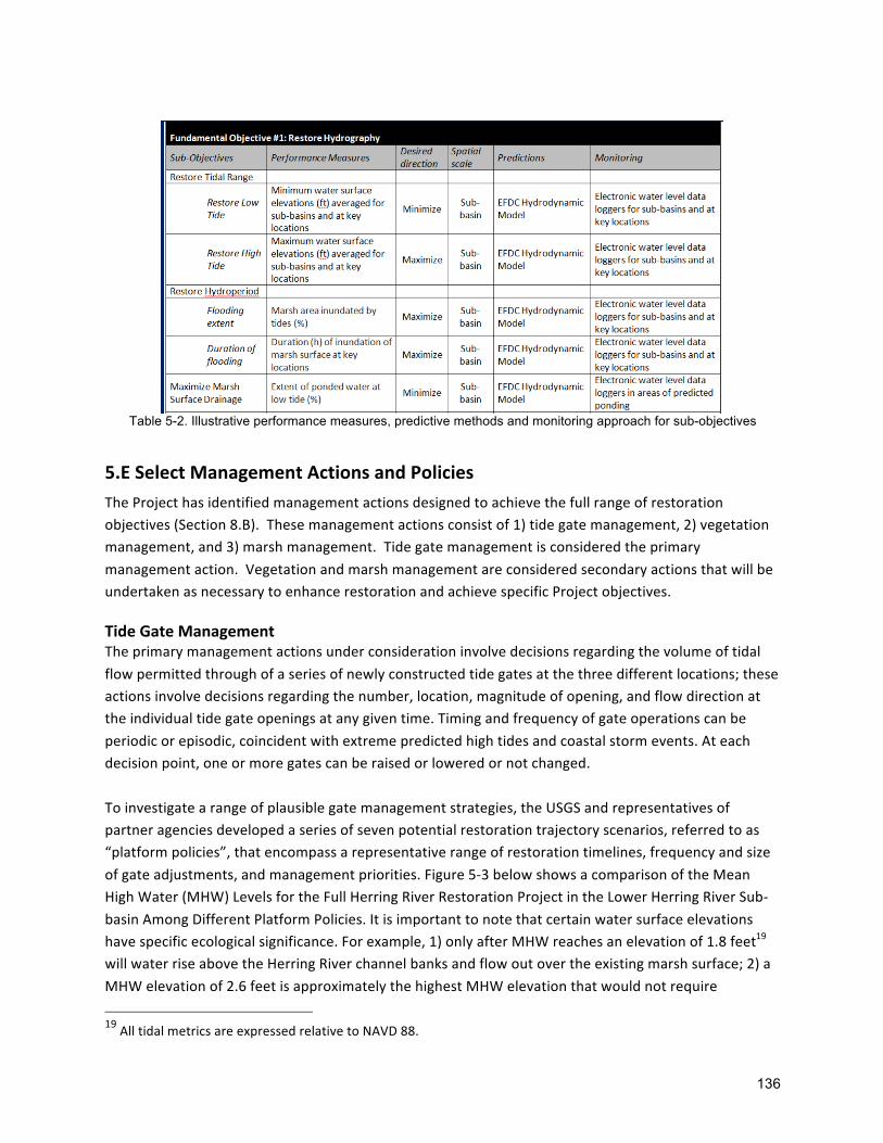
136
Table 5-2. Illustrative performance measures, predictive methods and monitoring approach for sub-objectives
5.ESelectManagementActionsandPoliciesTheProjecthasidentifiedmanagementactionsdesignedtoachievethefullrangeofrestoration
objectives(Section8.B).Thesemanagementactionsconsistof1)tidegatemanagement,2)vegetation
management,and3)marshmanagement.Tidegatemanagementisconsideredtheprimary
managementaction.Vegetationandmarshmanagementareconsideredsecondaryactionsthatwillbe
undertakenasnecessarytoenhancerestorationandachievespecificProjectobjectives. TideGateManagementTheprimarymanagementactionsunderconsiderationinvolvedecisionsregardingthevolumeoftidal
flowpermittedthroughofaseriesofnewlyconstructedtidegatesatthethreedifferentlocations;these
actionsinvolvedecisionsregardingthenumber,location,magnitudeofopening,andflowdirectionat
theindividualtidegateopeningsatanygiventime.Timingandfrequencyofgateoperationscanbe
periodicorepisodic,coincidentwithextremepredictedhightidesandcoastalstormevents.Ateach
decisionpoint,oneormoregatescanberaisedorloweredornotchanged.
Toinvestigatearangeofplausiblegatemanagementstrategies,theUSGSandrepresentativesof
partneragenciesdevelopedaseriesofsevenpotentialrestorationtrajectoryscenarios,referredtoas
“platformpolicies”,thatencompassarepresentativerangeofrestorationtimelines,frequencyandsize
ofgateadjustments,andmanagementpriorities.Figure5-3belowshowsacomparisonoftheMean
HighWater(MHW)LevelsfortheFullHerringRiverRestorationProjectintheLowerHerringRiverSub-
basinAmongDifferentPlatformPolicies.Itisimportanttonotethatcertainwatersurfaceelevations
havespecificecologicalsignificance.Forexample,1)onlyafterMHWreachesanelevationof1.8feet19
willwaterriseabovetheHerringRiverchannelbanksandflowoutovertheexistingmarshsurface;2)a
MHWelevationof2.6feetisapproximatelythehighestMHWelevationthatwouldnotrequire
19AlltidalmetricsareexpressedrelativetoNAVD88.

137
mitigationoflow-lyingroadwaysorproperties;and3)ataMHWelevationof3.6feet,mostoftheLower
HerringRivermarshwouldbefloodedduringspringtides.
ItshouldbenotedthattheHRAMPhasbeendesignedtomeettheprojectneedsforfullrestoration.
However,duringPhase1,theselectedtidegatepolicywouldnotallowwaterlevelstoexceedlevels
allowedunderpermits.ToachievewaterlevelsabovethosepermittedforPhase1restorationwould
requirenewpermitsorpermitamendments.
Figure 5-3. Comparison of the Mean High Water (MHW) Levels for the Full Herring River Restoration Project in the Lower Herring River Sub-basin Among Different Platform Policies(Maximum MHW elevations would be adjusted to
3.6 feet (NAVD88) for Phase 1 of the Project)
Tidegatemanagementstrategiesarereferredtoas“platform”policiesbecausetheyprovidethe
baselineconditionsforanalysisofprojectimpactstowhichsecondarymanagementactivitiescanbe
addedtoimproveperformancewithrespecttospecificprojectobjectives.Secondarymanagement
actions,describedbelow,arethoseotherthanchangestotidegateconfigurationandincludedirect
managementofvegetationandsediment,connectivityoftidalchannelsandpools,andmitigationof
potentiallyadverseprojectimpacts.Secondaryactionswouldbeimplementedinadditiontotidegate
managementtoimproveoverallpolicyperformance.Thepurposeofthedecisionanalysisprocessisto
identifythebestperformingtide-gatemanagementapproachandincorporatesecondaryactionsto
improveperformance,andtoselecttheoverallpolicy(tide-gatemanagementplussecondaryactions)
thatprovidesthebestoutcomesacrosstheobjectives.Thelocation,timing,andotherdetailsof
secondaryactionscannotbeanticipatedinmostcasesuntilaninitialpolicyisimplementedandsome
degreeoftidalexchangeisrestored.Theabilitytodirectsecondaryactionsinreactiontosystem
responsestotheimplementedtidegatepolicyisonewayoflearningfromandadaptingmanagementas
restorationprogresses.
TheHRAMPfoundinSection8.Bcontainsadetaileddescriptionofthefullrangeofpotentialtidegate

138
managementpoliciesandtheprocessbywhichaselectedtidegatemanagementpolicywillbeselected.
Thevariedeffectsoffullyopeningthetidegatesusingdifferentmanagementpoliciesthatencompass
timespansrangingfrom5to25yearsarebeinganalyzedtoidentifythemostadvantageouspolicyfor
tidegatemanagement.DecisionsupportsoftwarehasbeendevelopedforusebytheProjectteamto
comparepolicyoptionsbyevaluatingtrade-offsandriskasrepresentedbyProjectobjectives.Although
developmentandtestingofthedecisionframeworkhasbeencompleted,improvingpredictionsforthe
fullsuiteofecologicalandsocio-economicobjectivesandconductingtrade-off,andriskandsensitivity
analysesusingtheimprovedpredictionsisrequiredbeforeafullyoperationaladaptivemanagement
processcanbeimplemented.Thisprocessisongoingandwillcontinuethrough2020.
Itshouldbenotedthatdecisionsabouttidalgateadjustmentswillbelegallymandatedandsubjectto
regulatoryoversightundertheUSCleanWaterAct,theCoastalZoneManagementAct,theMA
WetlandsProtectionActandWaterwaysregulations,theTownsofWellfleetandTrurowetlandby-laws,
andtheMAEndangeredSpeciesAct.Tidegatemanagementdecisionswillbeconstrainedbyactions
deemednecessarytoprotectpublicandprivatestructureswithintheProjectarea;e.g.,attheendofthe
permittedPhase1oftheproject,themaximummeandailyhightideelevationswouldbelimitedto3.6
feetintheLowerHerringRiverand2.5feetwithintheMillCreeksub-basinwhilenotidalflowwouldbe
allowedintoUpperPoleDikeCreek.
SecondaryVegetationandMarshManagementActionsAsnotedabove,therestorationoutcomesoftidegatemanagementpolicieswillbeaugmentedbythe
selectionofsecondarymanagementactions.Secondarymanagementactionsaredesignedtoaccelerate
ormaximizetherecoveryofestuarinehabitats,enhancethebenefitsoftidalrestoration,andavoidor
reducepotentialadverseecologicalandsocioeconomicimpactsofrestoredtidalflow.Secondaryactions
includemanagementoffloodplainvegetation,modificationofmarshsurfaceelevationsthrough
managementofsedimentsupplyanddistribution,andrestorationofconnectivityandnaturalsinuosity
oftidalcreekstoenhancethecirculationofsaltwaterthroughthesystem.Decisionsregarding
secondaryactionswillinvolvewhereandwhentoimplementmanagementmeasures,whattechniques
touse,andhowtobestcoordinatetheactionswiththetidegatemanagement.Specificdetailsformost
ofthesemeasurescannotbeknownuntilsomedegreeoftidalflowisrestoredandmonitoring
informationisgatheredabouthowtheHerringRiversystemisresponding.
TheHRAMPfoundinSection8.Bprovidesdetailontherangevegetationmanagementandmarsh
managementactivities,howtheywillbeselected,andhowtheywillbeundertaken.TheHRAMPalso
discussesthepotentialinteractionbetweensecondarymanagementactionswithtidegatemanagement
policies.
5.FPredictOutcomesandConsequences
Decisionmakingisfutureoriented–decisionsaremadeafterconsidering“whatwillhappenifanaction
oranalternateactionistaken?”Thus,predictingconsequencesisanessentialpartofanydecision,with
thetypeorcomplexityofthepredictiondependentonthesignificanceoftheoutcomes.Performance,

139
ortheresponseofameasurableattributeforeachProjectobjective,ispredictedundereachtidegateplatformpolicy.Comparingpredictedperformanceacrossallobjectivesprovidesthebasisforselectingapolicy.Recallthateachobjectivehasaperformancemetric(measurableattribute),includingaunitofmeasure,desireddirectionofresponse,andspatialandtemporalscales.Foreachobjective,amethodofpredictionisneededaswellasamethodformonitoringtodeterminewhatactuallyhappensafterimplementingthepolicyinordertoassess,learn,andadapt.InthedevelopmentofmethodsofpredictionandmonitoringfortheHerringRiver,atieredapproachwasused.Tier1predictionsarebestprofessionaljudgmentsdevelopedtheHRRC.Tier2predictionsarethoseprovidedthroughformalelicitationmethodsbysubjectmatterexpertsand,whereappropriate,communitystakeholders.Tier3predictionsaregeneratedbyquantitativemodels.FortheHerringRiver,Tier1predictionshavealreadybeencompiled,butareonlybeingusedtoassessanddevelopfuturedecisionanalyses.Tier2and3predictionswillbeusedfortheactualadaptivemanagementplanandfunctionaldecisionanalysis.Tier3predictionscanonlybeappliedwhenacost-effectivequantitativemodelexistsforagivenobjective.AsshowninTable5-3shownabove,Tier3predictionsexistorareplannedforabouttwo-thirdsoftheHerringRiverobjectives.Wherenoquantitativemodelisavailable,Tier2predictionswillbeelicitedfromtechnicalsubjectmatterexpertsandcommunitystakeholdersthroughformalelicitationprocesses.Thisprocessisunderandwillcontinuethrough2020.Moredetailonpredictedoutcomesforobjectivesandsub-objectives,andthenumericalmodelsused,isfoundintheHRAMPcontainedinSection8.B.
5.GEvaluatePredictedOutcomesConsideringTradeoffsandRisksTradeoffanalysisistheprocessofevaluatingwhichofseveralpotentialcoursesofaction(i.e.,HerringRiverplatformpolicies)offersthebestpossibleoutcome.Theprocessofthisevaluationcanalsoofferinsightintowhereinformationdeficienciesexist–orwhatactionsmustbetakentoimproveresourceoutcomes.Tradeoffanalysisistypicallyperformedbeforeanyactionistaken,anditthereforedependsonpredictionsofhowagivenactionwillaffectoneormoreobjectives.Accuratepredictionsarethereforeafoundationofquantitativedecisionanalysis,andamongthegoalsofatradeoffanalysisistobasedecisionsonthebestavailableinformation.Trade-offanalysissoftwarewillbeusedtoevaluatetheexpectedperformanceandtrade-offsofvariousmanagementstrategies.Thetrade-offanalysiswillhelpidentifywhichplatformpoliciesaremostadvantageousforachievingtheobjectivesbasedonweightedpreferencesandattitudestowardrisktaking.Thesoftwareproducesnumericscoringof“preferred”managementstrategies,butitwillbeuptotheProjecttechnicalteamtoevaluatetheresults,alongwithinputfromstakeholders,permittingagenciesandothersourcestomakeinformedandtransparentdecisionsaboutthemostappropriateactionsatanygivenpointintheprojectimplementationtimeline.Moreinformationaboutthetrade-offanalysisdecision-toolandotherfactorsthatwillbeweighedin

140
trade-offanalysesisprovidedintheHRAMPfoundinSection8.B. 5.HDecision-makingDuringImplementationThegovernanceandadministrativestructureforimplementingtheHRAMPisdescribedinamemorandumofunderstanding(MOU-IV)betweenCCNSandtheTownofWellfleet.MOUIVexplicitlyacknowledgestheresponsibilityoftheTownandCCNSbyestablishingtheHRECastheformal,decision-makingauthorityfortheProject.TheHRECiscomprisedoftwoSelectboardmembersandtheTownAdministratorfromWellfleet,theCCNSSuperintendent,andoneadditionalCCNSrepresentative.MOUIVidentifiestheHRTTasaninformal,intergovernmentalstafftechnicalworkinggroupformedforthepurposeofprovidingtechnicalinputforproject-relateddecisionsasnecessaryorappropriate.InSeptember2017,theHRECestablishedaformalHerringRiverStakeholderGroup(HRSG),a19-memberbodyrepresentingabroadrangeoflocalandregionalinterests.ThepurposeoftheHRSGistocommunicatewithstakeholderswithinthecommunitytoensurethattheirrespectiveinterestsandviewsarewellrepresentedandconsideredbytheHRECandtoprovideadvisoryinputtotheHREConkeyimplementationissues.ARegulatoryOversightGroupwillassistinthepreparationandreviewoftheHRAMPandwillreviewimplementationprogressonanongoingbasis.TheRegulatoryOversightGroupiscalledforundertheSecretary’sMEPACertificatetoinclude,ataminimum,representative(s)fromthefollowingagencies:
• Federal:NPS,USFWS,NOAA,NRCS,EPA,USACE;• State:MEPA,DER,DMF,NHESP,MassDEP,CZM,StateHistoricPreservationOfficer(SHPO);• Regional:CapeCodCommission;• Local:TownofWellfleet,TownofTruro:and• Tribal:MashpeeWampanoagTribe
Thedecision-makingprocessisgroundedonthecollectionandevaluationofmonitoringdataintendedtomeasureperformanceofthespecificobjectivesformulatedfortheadaptivemanagementplan.Theapproachformonitoringanddatacollectionisdiscussedinthefollowingsection.ScientistsatCCNSwillbeprimarilyresponsibleforguidingdatacollection.MembersoftheprojectteamwillreviewmonitoringdataasthebasisforprovidingtechnicalsupporttotheHREC.AsmanagementactionsareimplementedbytheHRECandtheresponseofthesystemismonitored,themembersoftheprojectteamwillcontinuetoassesstheperformanceofmodelsandotherpredictivetoolsbycomparingthoseoutputstoactual,observedoutcomes.TheseresultswillbesummarizedinwrittenreportsbyCCNSandothers,andwillbesharedwiththeHRECtoinformtheselectionofmanagementactionstobeimplementedduringthesubsequenttimeperiod.WrittenreportstotheHRECwilldescribepreviousmanagementactions,dataanalysis,andrecommendationsforfuturemanagementactions.TheHRECwilleitherapprovetherecommendationsorrequestadditionaldatacollectionand/oranalysisforfurtherreviewandpossiblereconsiderationofrecommendedmanagementactions.

141
MoredetailonthecontentofmanagementrecommendationtotheHRECiscontainedintheHRAMPfoundinSection8.B.
5.IDesignandImplementTargetedMonitoringProgramThecollection,analysis,andapplicationofcrediblemonitoringdatatocomparewithpredictionsfrommodelingistheprimarymeansinadaptivemanagementtoassessprogresstowardsmeetingprojectobjectives.Equallyimportantistheabilitytopredictthevariationofexpectedoutcomesacrossarangeofalternativemanagementactionsthatareunderconsideration.Aspreviouslydescribed,inadaptivemanagementoutputdatafrommodelsandotherpredictivemethodsareusedtoconducttrade-offanalysessothatpredictionsofhowmanagementactionsinfluenceobjectivescanbecompared.Aftermanagementactionsareimplemented,monitoringdataareusedtodeterminerealoutcomes,evaluatehowmodelsperformed,andrefinemodelpredictionsabouttheoutcomesoffutureactions.Detailonthemonitoringplanthathasbeenundertakentoestablishbaselineconditionsforeachobjective,andthefuturemonitoringthatwillbeundertakentotrackresponsestomanagementactionsforeachobjectiveiscontainedintheHRAMPfoundinSection8.B.

TownofWellfleetHerringRiverRestorationProject
DevelopmentofRegionalImpactApplication
142
6. ProjectBudgetingandFundingInformationInitscommentletterconcerningtheFEIR,theCommissionaskedtheProjectapplicanttoprovidefurtherdetailconcerningprojectbudgetingandfunding.Inparticular,theCommissionrequesteddetailaboutfundingsourcesandtimelines,abreakdownofcosts,includingcostsofmitigationnecessarytoprotectstructures,andaphasing/fundingplanthatwouldallowtheprojecttocommencepriortofullimplementation.Inresponsetothisrequest,thefollowingpreliminaryestimatesareprovidedbasedonbestavailableinformationatthetimeofthisapplication,andaresubjecttochange. 6.ABreakdownofCostsThepreliminaryestimatedcosttoconstructandimplementPhase1oftherestorationis$47millionoverfiveyears.ThecostperacreofarearestoredisonparwithotherrestorationprojectsintheCommonwealth.AllestimatedcostsaresubjecttochangeasProjectplansevolve.Phase1includesallmajorinfrastructureelementsnecessaryfortidalrestoration:theChequessettNeckRoadbridgeandtidegates,MillCreekwatercontrolstructure,PoleDikeRoadwatercontrolstructure,roadsegmentelevationwork,removalofaportionofHighTossRoad,vegetationmanagement,protectionforstructuresonlowpropertiesandadaptivemanagement(includingongoingmonitoringandmodeling).ThelargestsinglecostelementistheChequessettNeckRoadbridgeandtidegatesatanestimatedcostof$15M.Bycontrast,theMitchellRiverBridgeinChathamwas$14M;andtheMuddyCreekBridge,amuchlesssophisticatedstructure,was$6M.Table10-1showsabreakdownofmajorcostselements.
Table 6-1. Breakdown of Costs for Phase 1
ChequessettNeckRoadBridge $15M(33%)
MillCreekWaterControlStructure $3M(6%)
CYCC $5.5M(12%)
PoleDikeRoadWCSandLowRoadWork $8M(17%)
HighTossRoad $1M(2%)
LowPropertyMitigation $1.1M(2%)
Cultural/Archeological $0.5M(1%)
Contingency $2M(4%)
AdaptiveManagement5years $7.5M(16%)
ProjectManagement $2.5M(5%)
Total $47M(100%)

TownofWellfleetHerringRiverRestorationProject
DevelopmentofRegionalImpactApplication
143
6.BMitigationAllworknecessarytoprotectstructuresonpublicorprivatepropertyfromtheeffectsoftidalrestorationduringPhase1isincludedinthePhase1implementationbudget.Thisincludes$8millioninlowroadelevationandculvertworkontownroadwaysaccountingfor17%oftheimplementationbudget;$5.5millioninmitigationworkonCYCCaccountingfor12%oftheimplementationbudget;and$1.1millioninpreventionforlowproperties,includingtheconstructionoftheWay#672protectionstructure,accountingfor2%oftheimplementationbudget.
6.CPhasingandFundingAlthoughPhase1willbepermittedforpartialrestoration,allinfrastructureelementsareneededtocontroltidelevels.Therefore,fortheimplementationbudgetforPhase1includesallmajorinfrastructureelementsneededforfullrestoration.
TheProjectalreadyhasajumpstartonconstructionandimplementationfunding.TheCommonwealthofMassachusettshasincluded$11millionforconstructionaspartofthestatecapitalinvestmentplan,whichaccountsforroughly25%ofPhase1cost.TheCapeCodNationalSeashoreisseekingfundingtocoverthecostofconstructingtheMillCreekwatercontrolstructure,whichislocatedonpropertyownedbytheNPS.TheNPSisnoteligibletofundinfrastructurethatisnotlocatedonlanditowns.However,theNPSwillcontinuetoprovidetechnicalandadaptivemanagementsupport.MostoftheremainingfundingforPhase1implementationisexpectedtocomefromacombinationoffederalsources,potentiallyaugmentedbyprivategrantsources.TheNPS/CCNSishelpingtocoordinatediscussionswithotherfederalagencypartnersabouthowtheProjectmeetssharedagencyandprogram-specificobjectives.Throughthesediscussions,existingandpotentialfundingopportunitiesarebeingexplored.
TheUSDASmallWatershedsProgramhaspreviouslyprovidedtechnicalassistancefundingfordesignandpermitting,andhasbeenidentifiedasapotentialsourceofsignificantimplementationfunding.USDASmallWatershedsProgramofficialshavevisitedthesiteandconfirmedthatimplementationoftheProjectiseligibleandwouldbeconsistentwithfundinggoalsoftheprogram.ConversationswiththeUSDASmallWatershedsProgramwillcontinueastheProjectmovesfurtherintopermitting.
ThroughtheUSFWS,theNationalCoastalWetlandsConservationProgram,andtheNorthAmericanWetlandsConservationActhavebeenidentifiedaspotentialsources.TheProjectmaybeabletoapplyformultiyearfundingundertheseprograms.

TownofWellfleet
HerringRiverRestorationProject
DevelopmentofRegionalImpactApplication
144
TheNOAACoastalResiliencyandNOAARestorationprogramswhichhavealreadyinvestedin
thedesignandpermittingoftheProject,alsowillbepursuedforimplementationfunding
potential.
TheProjectalsoisincommunicationswiththeNationalParksFoundation,DucksUnlimited,
NationalFisheriesandWildlifeFoundation,TheNatureConservancyandothernon-
governmentalandprivateentitiestoexplorefundingstrategiesandopportunities.
Basedontheprogresstodate,theProjectisontrackfortheremainingfundingtobeinplace
foraconstructionstartincalendaryear2022.TheProjectteamhasanestablishedand
successfultrackrecordworkingwithfederalandstatepartnersandnon-governmental
organizations,havingraisedfundsforenvironmentalassessments,monitoring,modeling,
engineeringdesignandpermitting.

TownofWellfleetHerringRiverRestorationProject
DevelopmentofRegionalImpactApplication
145
7. ReferencesAbdul-Aziz,O.andIshtiag,K.2015.AUser-friendlyModelforPredictingGreenhouseGasFluxesandCarbonStorageinTidalWetlands.BringingWetlandstoMarketProjectFactSheet,accessed12/23/2015.Ashworth,M.J.1982.FeedbackDesignofSystemswithSignificantUncertainty.ResearchStudiesPress,Chichester,UK.Bowen,R.V.2006.StatusandHabitatuseofBreedingNorthernHarriersatCapeCodNationalSeashore.FinalreporttoNationalParkService.27p.Buchman,M.F.2008.NOAAScreeningQuickReferenceTables,NOAAOR&RReport08-1,Seattle,WA,OfficeofResponseandRestorationDivision,NationalOceanographicandAtmosphericAdministration,34p.CapeCodCommission,GuidanceonSection208PlanUpdate.ObtainingaConsistencyDetermination,April2018.CapeCodNationalSeashoreandtheHerringRiverRestorationCommittee(HRRC).2016.HerringRiverRestorationProjectFinalEnvironmentalImpactStatement/EnvironmentalImpactReport,May2016.Cook,R.P.2008a.ReportonReptilesandAmphibiansatCapeCodNationalSeashore.http://www.nps.gov/caco/naturescience/upload/AMPHIBIANS_AND_REPTILES_OF_CAPE_COD_NATIONAL_SEASHORE_2008-2.pdf.Cook,R.P.2008b.IllustratedGuidetoTurtlesatCapeCodNationalSeashore.AccessedonJanuary1,2011at:http://www.nps.gov/caco/naturescience/upload/turtlepage-2.pdf.Cowardin,L.M.,Carter,V.,Fancis,C.G.,andE.T.LaRoe.1979.ClassificationofWetlandsandDeepwaterHabitatsoftheUnitedStates.U.S.DepartmentoftheInterior,FishandWildlifeService,OfficeofBiologicalServices,Washington,D.C.Cumbler,J.T..2014.CapeCod:AnEnvironmentalHistoryofaFragileEcosystem.Curley,J.R.,Lawton,R.P.,Whittaker,D.K.,andJ.M.Hickey.1972.AStudyoftheMarineResourcesofWellfleetHarbor.DivisionofMarineFisheries,DepartmentofNaturalResources,theCommonwealthofMassachusetts,Monographseriesnumber12.37p.Erwin,R.M.,Conway,C.J.,andS.W.Hadden.2002.SpeciesOccurrenceofMarshBirdsatCapeCodNationalSeashore,Massachusetts.NortheasternNaturalist9(1):1-12.Fox,S.E.,A.Mittermayr,M.A.Adams,K.Medeiros,T.Smith,S,Smith,andK.L.Vaughan.TheEcologicalEvaluationofHerringRiver:Apre-restorationcharacterizationofwaterquality,benthiccommunitystructureandfoodwebs,andvegetation.NationalParkService,CapeCod

TownofWellfleetHerringRiverRestorationProject
DevelopmentofRegionalImpactApplication
146
NationalSeashore.Unpublishedreport,2017.FussandO’Neill.2013.TechnicalMemorandum–DikeandControlStructureAlternativesAnalysisHerringRiverSaltMarshRestoration,PreparedforHerringRiverRestorationCommittee.Gibbs,J.P.,Melvin,S.,Reid,F.A.,Lowther,P.,andA.F.Poole.2009.LeastBittern(Ixobrychusexilis),TheBirdsofNorthAmericaOnline(A.Poole,Ed.).Ithaca:CornellLabofOrnithology;RetrievedfromtheBirdsofNorthAmericaOnline:http://bna.birds.cornell.edu/bna/species/017.Gwilliam,E.2005.NektonSamplinginHerringRiver.Unpublishedrawdata.Hamrick,J.M.1996.User’smanualfortheenvironmentalfluiddynamiccomputercode.TheCollegeofWilliamandMary,VirginiaInstituteofMarineScience,SpecialReport328,224pp.HarringtonB.A,Hill,N.P.,andB.Nikula.2010a.ChangingUseofMigrationStagingAreasbyRedKnots:AnHistoricalPerspectivefromMassachusetts.2010.Waterbirds33(2):188-192.Harrington,B.A.,Koch,S.,Niles,L.K.,andK.Kalasz.2010b.RedKnotswithDifferentWinterDestinations:DifferentialuseofanAutumnStopoverArea.Waterbirds33:3,357-363.HazeltonELG,MozdzerTJ,BurdickDM,KettenringKM,WhighamDF.2014.PhragmitesaustralismanagementintheUnitedStates:40yearsofmethodsandoutcomes.AoBPLANTS6:plu001;doi:10.1093/aobpla/plu001Herbster,H.andK.Heitert.2011.PhaseIAArchaeologicalBackgroundResearchandSensitivityAssessmentHerringRiverTidalRestorationProjectCapeCodNationalSeashore,TownsofWellfleetandTruro,BarnstableCounty,Massachusetts.ThePublicArchaeologyLaboratory,Inc.Pawtucket,RhodeIsland.Herbster,H.,S.LüttgeandJ.Horn.2016.PhaseIBIntensive(Locational)ArcheologicalSurvey,HerringRiverTidalRestorationProject,Wellfleet,Massachusetts,NRAPProjectNumberCACO2014A,ARPAPermitNumber2015.CACO.01.PALreportno.2480.02.SubmittedtoFriendsoftheHerringRiver,Wellfleet,MA.146pages.Herbster,H.2016.AddendumPhaseIB(Locational)PhaseIBIntensive(Locational)ArcheologicalSurvey,HerringRiverTidalRestorationProject,Wellfleet,MassachusettsNRAPProjectNumberCACO2014A,ARPAPermitNumber2016.CACO.01.PALreportno.2480.02.SubmittedtoFriendsoftheHerringRiver,Wellfleet,MA.Herbster,H.andS.Lüttge.2018.AddendumPhaseIBIntensive(Locational)ArcheologicalSurvey,HerringRiverTidalRestorationProject,ChequessettYachtandCountryClubReconstructionAreas,Wellfleet,Massachusetts.PALreportno.2480.03.SubmittedtoFriendsoftheHerringRiver,Wellfleet,MA.HerringRiverTechnicalCommittee(HRTC).2007HerringRiverTidalRestorationProject,ConceptualRestorationPlan.October2007.Preparedby:HerringRiverTechnicalCommittee

TownofWellfleet
HerringRiverRestorationProject
DevelopmentofRegionalImpactApplication
147
andENSRforTownsofWellfleetandTruroandtheCapeCodNationalSeashore.
HylandJ.L.andH.Costa.1995.ExaminingLinkagesbetweenContaminantInputsandtheir
ImpactsonLivingMarineResourcesoftheMassachusettsBayEcosystemthroughApplicationof
theSedimentQualityTriadMethod.MassachusettsBaysProgram,MBP-95-03.Preparedby
ArthurD.Little.
Kroeger,KD,Gonneea,ME,etal.2019.Climaticimpactsoftidalrestrictionandrestoration:Full
carbonandgreenhousegasbudgets,withradiativeforcingcalculations.SocietyofWetland
ScientistsAnnualMeeting,Baltimore,MD.
Martin,Larry.EvaluationofthePotentialforPrivate,DomesticWellstobeAffectedby
RestorationofTidalFlowintheHerringRiverBasin,CapeCod,Massachusetts.December2018.
MassachusettsDepartmentofEnvironmentalProtection(MassDEP).MCPMethod1:Soil
CategoryS-2Standards,http://www.mass.gov/dep/cleanup/laws/0975_6b.htm.(AccessedJune
6,2011).
MassachusettsDepartmentofEnvironmentalProtection(MassDEP),U.S.Environmental
ProtectionAgency(USEPA),andENSR.2009.FinalPathogenTMDLfortheCapeCodWatershed.
McCarthy,M.A.,andH.P.Possingham.2007.Activeadaptivemanagementforconservation.
ConservationBiology:TheJournaloftheSocietyforConservationBiology21:956–63.
NationalParkService,U.S.DepartmentoftheInterior(NPS).1998.CapeCodGeneral
ManagementPlan.Retrievedfrom:http://www.nps.gov/caco/parkmgmt/general-management-
plan.htm.
Nichols,J.D.,andB.K.Williams.2006.Monitoringforconservation.TrendsinEcology&Evolution.21:668–673.Nichols,J.D.,Runge,M.C.,Johnson,F.A.,andB.K.Williams.2006.Adaptiveharvestmanagement
ofNorthAmericanwaterfowlpopulations–recentsuccessesandfutureprospects.JournalofOrnithology147:28.
Nichols,J.D.,Johnson,F.A.,Williams,B.K.,andG.S.Boomer.2015.Onformallyintegrating
scienceandpolicy:walkingthewalk.JournalofAppliedEcology.52:539-543.
NieringW.A.andR.S.Warren.1980.VegetationPatternsandProcessesofNewEnglandSalt
Marshes.Bioscience.30:301-307.
Orson,R.AandC.T.Roman.1987.HerringRiverEstuary:HistoricVegetationDevelopmentinAnEvaluationofAlternativesforEstuarineRestorationManagement:TheHerringRiverEcosystem
(CapeCodNationalSeashore).TechnicalReport,NationalParkServiceCooperativeResearch
Unit,RutgersUniversity,NewBrunswick,NewJersey.
Parkhurst,D.L.,Kipp,K.L.,Engesgaard,Peter,andCharlton,S.R.,2004,PHAST:Programfor
simulatingground-waterflow,solutetransport,andmulticomponentgeochemicalreactions:
U.S.GeologicalSurveyTechniquesandMethods68,154p

TownofWellfleet
HerringRiverRestorationProject
DevelopmentofRegionalImpactApplication
148
Portnoy,J.W.1984.SaltmarshdikingandnuisancemosquitoproductiononCapeCod,
Massachusetts.JournaloftheAmericanMosquitoControlAssociation.44:560–564.
Portnoy,J.W.1991.SummerOxygenDepletioninaDikedNewEnglandEstuary.Estuaries.
14(2):122–129.Portnoy,J.W.andJ.Allen.2006.EffectsofTidalRestrictionsandPotential
BenefitsofTidalRestorationonFecalColiformandShellfish-waterQuality.JournalofShellfishResearch.25(2):609–617.
Portnoy,J.W.andA.E.Giblin.1997.EffectsofHistoricTidalRestrictionsonSaltmarshSediment
Chemistry.Biogeochemistry.36:275–303.Portnoy,J.W.,Phipps,C.,andB.A.Samora.1987.Mitigatingtheeffectsofoxygendepletionon
CapeCodanadromousfish.ParkScience.8:12–13.
Portnoy,J.W.andAllen,JennyR.2006.EffectsofTidalRestrictionsandPotentialBenefitsof
TidalRestorationonFecalColiformandShellfish-WaterQuality.JournalofShellfishResearch,Volume25,Number2,pp.609-617.
Quinn,J.G.,Cairns,R.W.,Hartman,P.C.,andJ.W.King.2001Studyoforganiccontaminantsin
coastalpondsandmarshes,CapeCodNationalSeashore.Long-termCoastalEcosystem
MonitoringProgram,CapeCodNationalSeashore,WellfleetMassachusetts.
Roman,C.T.1987.AnEvaluationofAlternativesforEstuarineRestorationManagement:The
HerringRiverEcosystem(CapeCodNationalSeashore).TechnicalReport,NationalParkService
CooperativeResearchUnit,RutgersUniversity,NewBrunswick,NewJersey.
Roman,C.andM.J.James-Pirri.2011.Pre-restorationNektonDataAnalysisandSummary,
HerringRiver,CapeCod.NationalSeashore:PreliminaryAnalysis.November16,2011.
Seigel,A.,HatfieldC.,andJ.M.Hartman.2005.AvianResponsetoRestorationofUrbanTidal
MarshesintheHackensackMeadowlands,NewJersey.UrbanHabitats,Volume3,Number1.
pgs1541-7115.http://www.urbanhabitats.org.
Settelmyer,S.,Swails,E.,Eaton,J.2019.HerringRiverCarbonProjectFeasibilityStudy.
TerraCarbonversion1.4
Smith,H.R.1997.MammalsofWestRiverMemorialPark.InRestorationofanUrbanSaltMarsh:
AnInterdisciplinaryApproach(D.G.Casagrande,ed.)pp.237–252.BulletinNumber100,Yale
SchoolofForestryandEnvironmentalStudies,YaleUniversity,NewHaven,CT.
Smith,S.M.2005.ManualcontrolofPhragmitesaustralisonpondshoresofCapeCodNationalSeashore,Massachusetts,USA.JournalofAquaticPlantManagement43:50–53.
Snow.1975.RecolonizationofsaltmarshspeciesattheHerringRivermarsh,Wellfleet,
Massachusetts.1975.46p.
Soukup,M.A.andJ.W.Portnoy.1986.ImpactsfromMosquitoControl-inducedSulfur
MobilizationinaCapeCodEstuary.EnvironmentalConservation.13(1):47–50.

TownofWellfleetHerringRiverRestorationProject
DevelopmentofRegionalImpactApplication
149
Tiner,R.W.1987.AFieldGuidetoCoastalWetlandPlantsoftheNortheasternUnitedStates.UniversityofMassachusettsPress,Amherst,MA.285pp.TownofWellfleet.2011.ShellfishingMaps.WellfleetHarbor:RecreationalShellfishingAreas.www.wellfleetma.org/Public_Documents/WellfleetMA_Departments/shellfish_dept/shellfish_mapsWalters,C.J.andR.Hilborn.1978.“Ecologicaloptimizationandadaptivemanagement.”AnnualReviewofEcologyandSystematics9,157e188WarrenPinacleConsulting,Inc.2012.SLAMM6.2TechnicalDocumentation,WarrenPinnacleConsulting,Inc.Accessedonlineat:http://warrenpinnacle.com/prof/SLAMM/index.html.Williams,B.K.,Szaro,R.C.,andC.D.Shapiro.2007.Adaptivemanagement:theU.S.DepartmentoftheInteriortechnicalguide.Page84.AdaptiveManagementWorkingGroup,U.S.DepartmentoftheInterior,Washington,DC.Williams,B.K.andF.A.Johnson.1995.“Adaptivemanagementandtheregulationofwaterfowlharvests.”WildlifeSocietyBulletin23,430-436.Williams,B.K.,R.C.Szaro,andC.D.Shapiro.2009.AdaptiveManagement:TheU.S.DepartmentoftheInteriorTechnicalGuide.AdaptiveManagementWorkingGroup,U.S.DepartmentoftheInterior,Washington,DC.Williams,B.K.andE.D.Brown.2012.AdaptiveManagement:TheU.S.DepartmentoftheInteriorApplicationsGuide.AdaptiveManagementWorkingGroup,U.S.DepartmentoftheInterior,Washington,DC.WoodsHoleGroup(WHG).2009.HerringRiverHydrodynamicModeling.DraftModelingReport.PreparedfortheTownofWellfleet(June2009).WoodsHoleGroup(WHG).2011.HydrodynamicModelingDataforHerringRiverRestorationPlan.PreparedfortheCapeCodNationalSeashore.WoodsHoleGroup(WHG).2012HerringRiverHydrodynamicModelingFinalComprehensiveReporttoHRRCandNPS,CapeCodNationalSeashore,Wellfleet,MA.208pp.WoodsHoleGroup(WHG).2012.HerringRiverHydrodynamicModelingforEstuarineHabitatRestoration,Wellfleet,Massachusetts.FinalReport,PreparedforHerringRiverRestorationCommittee.WoodsHoleGroup(WHG).2013HerringRiverRestorationProject:FinalDikeControlStructureHydrodynamicModelingFinalComprehensiveReporttoHRRCandNPS,CapeCodNationalSeashore,Wellfleet,MA.22pp.WoodsHoleGroup(WHG).2016.HerringRiverRestorationProject:MillCreekGroundwaterModel:TechnicalMemorandumtoHRRC,withThirdPartyReviewMemobySanborn-Head,Inc.

TownofWellfleetHerringRiverRestorationProject
DevelopmentofRegionalImpactApplication
150
WoodsHoleGroup(WHG).2017.HydraulicSummaryofMillCreekandUpperPoleDikeCreek.TechnicalMemorandumtoFriendsofHerringRiver,June302017.WoodsHoleGroup (WHG). 2018. Analysis andResults for AdditionalModeling ofUpper PoleDikeCreekandMillCreek.SubmittedtoFriendsofHerringRiver,June29,2018.

TownofWellfleetHerringRiverRestorationProject
DevelopmentofRegionalImpactApplication
151
8. Attachments8.AProjectManagementFormandProgrammaticAgreement(Seefollowingpages)
950 CMR: OFFICE OF THE SECRETARY OF THE COMMONWEALTH
APPENDIX AMASSACHUSETTS HISTORICAL COMMISSION
220 MORRISSEY BOULEVARDBOSTON, MASS. 02125
617-727-8470, FAX: 617-727-5128
PROJECT NOTIFICATION FORM
Project Name: Herring River Tidal Restoration Project
Location / Address: Refer to USGS Locus Map
City / Town: Wellfleet/Truro
Project Proponent: National Park Service and Towns of Wellfleet and Truro
Name: William Burke, Seashore Historian, Cape Cod National Seashore
Address: 99 Marconi Site Road City/Town/Zip/Telephone: Wellfleet, MA 02667
Agency license or funding for the project (list all licenses, permits, approvals, grants or other entitlements beingsought from state and federal agencies).
Agency Name Type of License or funding (specify)
Massachusetts Environmental Policy Act (MEPA) Environmental Impact ReportNational Environmental Policy Act (NEPA) Environmental Impact Study Cape Cod Commission Developments of Regional Impact Wetlands Protection Act Notice of Intent/Order of Conditions Massachusetts Endangered Species Act Review (MESA) MESA ReviewChapter 91 Waterways Chapter 91 License(s)401 Water Quality Certification CertificateACOE Section 404 Application PermitCZM Coastal Consistency Consistency Review Project Description (narrative): The original 1,100 acre Herring River estuary has been severely impacted by long-standing tidal restrictions (See USGS Locus Map). The project seeks to restore the estuary and natural functions to the maximum extent practicable. Measures proposed to change current tidal controls will be developed, during during which public input will be solicited as part of both the Massachusetts Environmental Policy Act (MEPA) and National Environmental Policy Act (NEPA) environmental review processes. Does the project include demolition? If so, specify nature of demolition and describe the building(s) whichare proposed for demolition:The development of the preferred alternative is dependent upon more detailed hydrodynamic modeling, further planning, and additional public input. Existing tidal restrictions such as the Chequesset Neck Road dike structure and crossings along High Toss, Bound Brook Island, Pole Dike, and Old Country Roads may be reconstructed. Low lying properties and roadways potentially affected by restoration activities have been identified. Does the project include rehabilitation of any existing buildings? If so, specify nature of rehabilitationand describe the building(s) which are proposed for rehabilitation. Does the project include new construction?If so, describe (attach plans and elevations if necessary). To be determined in the future. 5/31/96 (Effective 7/1/93) - corrected 950 CMR - 275

950 CMR: OFFICE OF THE SECRETARY OF THE COMMONWEALTH
APPENDIX A (continued)
To the best of your knowledge, are any historic or archaeological properties known to exist within theproject’s area of potential impact? If so, specify. Historic archaeological resources are likely contained within the project area. It is anticipated that restoration activities will require further coordination with the Massachusetts Historic Commission (MHC).
What is the total acreage of the project area? Roughly 1100 Acres. See Attached Vegetation Figure.
Woodland ______________ acres Productive Resources:Wetland________________ acres Agriculture _________________ acresFloodplain______________ acres Forestry ___________________ acresOpen space______________ acres Mining/Extraction ___________ acresDeveloped ______________ acres Total Project Acreage_________ acres
What is the acreage of the proposed new construction? _________________ acres
What is the present land use of the project area? Primarily open space.
Please attach a copy of the section of the USGS quadrangle map which clearly marks the project location.
This Project Notification Form has been submitted to the MHC in compliance with 950 CMR 71.00. _________
Name: William Burke, Seashore Historian
Address: 99 Marconi Site Road
City/Town/Zip: Wellfleet, MA 02667
Telephone: (508) 255 3421 x 16
REGULATORY AUTHORITY
950 CMR 71.00: M.G.L. c. 9, §§ 26-27C as amended by St. 1988, c. 254.
7/1/93 950 CMR - 276

Project Limits
Figure Number
1
Site Locus
Herring River Tidal Restoration ProjectConceptual Restoration Plan
Wellfleet and Truro, MA
SCALE DATE PROJECT NO.
May 2007 04479-003-300
USGS Topographic QuadrangleWellfleet, MA
1:30000
J:\Water\ProjectFiles\P40\4479_CZM\4479003\GIS_May2007\Projects\Fig_Site Locus.mxd
0 2,500 5,0001,250Feet
±

Herring River VegetationUpdated from 2000 aerial photos with 2007 field observations .
. 0 310 620 930 1,240155Meters
Cape Cod National SeashoreNational Park ServiceU.S. Department of the Interior
Date:082007File: HRveg2000_nvc07
Legend
FRESHWATER MARSH
BRACKISH MARSH
SALT MARSH
DUNE GRASSLAND
HEATHLAND GRASSLAND
OLD FIELD HERBACEOUS
WET SHRUB
DRY SHRUBLAND
PINE WOODLAND
DRY DECIDUOUS WOODLAND
DRY DECIDUOUS FOREST
WET DECIDUOUS FOREST
DEVELOPED
HOW THIS MAP WAS MADE:
Seemingly “natural” vegetation communities often containunexpected assemblages of species because of habitatalterations caused by human intervention. For example,Herring River’s diked and drained floodplains have drywoodland communities where wet shrubs and marsheswould be expected to occur. This general vegetation mapof Herring River shows these human-influenced plantcommunities which are very different from the floodplaintypes that would result from restoration of tidal influences.
To make this map, color infra red aerial photos wereinterpreted and assigned vegetation types from a broadclassification system of New England plant communities(Sneddon, Leslie, Vegetation of Cape Cod NationalSeashore Natureserve, 2004). New vegetation classeswere then added based on extensive field observationsto reflect actual vegetation within the tidal-deprivedfloodplain. In particular, the apparent wet woodland typesdominated by red maple interpreted from aerialphotography are actually dry woodlands dominated byblack cherry and shadbush.
FRESHWATER MARSH Typha angustifolia, Scirpus cyperinus,Calamagrostis canadensis, Juncus spp.,Sparganium americanum.
BRACKISH MARSH Phragmites australis, Scirpus pungens.SALT MARSH Spartina alterniflora, Spartina patens,
DUNE GRASSLAND Ammophila breviligulata, Deschampsia flexuosa.HEATHLAND Arctostaphylos uva-ursi, Morella pensylvanica,
Vaccinium angustifolium, Hudsonia ericoides,Hudsonia tomentosa, Corema conradii.
OLD FIELD HERBACEOUS Schizachyrium scoparium, Deschampsia flexuosa,Holcus lanatus, Festuca rubra.
WET SHRUBLAND Vaccinium corymbosum, Clethra alnifolia,Rhododendrum viscosum, Decodon verticillatus,Cephalanthus occidentalis, Alnus spp.,Chamaedaphne calyculata.
DRY SHRUBLAND Morella pensylvanica, Quercus velutina,Amelanchier spp.
PINE WOODLAND Pinus rigida, Gaylusaccia baccatta,Deschampsia flexuosa, Vaccinium angustifolium.
DRY DECID. WOODLAND Prunus serotina, Amelanchier spp.,Viburnum spp.
DRY DECIDUOUS FOREST Quercus velutina, Quercus alba,Fagus grandifolia, Robinia pseudoacacia.
WET DECIDUOUS FOREST Acer rubrum, Rhododendron viscosum,Clethra alnifolia.
TYPE TYPICAL SPECIES
Figure 11

Programmatic AgreementAmong
The Massachusetts State Historic Preservation Officer,The Mashpee Wampanoag Tribe,
The Wampanoag Tribe of Gay Head-Aquinnah,And
Cape Cod National SeashoreRegarding
The Identification and Resolution of Effects Upon Archeological ResourcesResuiting From the Herring River Tidal Restoration Project
WHEREAS, the National Park Service (NPS) in 2008 entered into a ProgrammaticAgreement with the Advisory Council on Historic Preservation (ACHP) and the NationalConference of State Historic Preservation Officers; and
WHEREAS, Cape Cod National Seashore (CACO), a unit of the National Park Service as apart of the U. S. Department of the Interior, is a parfy to that Programmatic Agreement, andhas stewardship responsibilities for the natural and cultural resources within the landscomprising the CACO; and
WHEREAS, CACO, under terms of a Memorandum of Understanding, joined the towns ofTruro and Wellfleet, the U.S. Fish and Wildlife Service, the Natural Resources ConservationService, the National Atmospheric and Oceanic Administration, and the MassachusettsDivision of Ecological Restoration to form the Herring River Restoration Committee(HRRC); and
WHEREAS, CACO, as a partner in the HRRC, is planning to restore tidal exchange to theHerring River estuary (the Herring River Tidal Restoration Project, hereafter referred to asthe Undertaking),located in the towns of Wellfleet and Truro, Massachusetts, and containinglands in federal, municipal, and private ownership (36 CFR 800.16(y)); and
WHEREAS, the Memorandum of Understanding that established the HRRC identified NPSas lead federal agency for purposes of National Environmental Policy Act Q'{EPA) andNational Historic Preservation Act OrI{PA) compliance, and the towns as co-applicantsunder the Massachusetts Environmental Policy Act (MEPA) and Cape Cod CommissionDevelopment of Regional Impact (DRI) Review Process; and
WHEREAS, CACO and the HRRC desire to simultaneously comply with NEPA and Section106 of the National Historic Preservation Act (specifically 36 CFR 800) through preparationof an EIS; and
WHEREAS, the offrce of the Massachusetts State Historic Preservation Officer (SHPO) isreviewing the Undertaking in compliance with applicable federal and state reguiations; and
WHEREAS the Advisory Council on Historic Preservation (ACHP) and the Tribal HistoricPreservation Officers (THPOs) of the federally recognized Wampanoag Tribe of Gay Head

(Aquinnah) and the federally recognized Mashpee Wampanoag Tribe have been invited toconsult on the Undertakingi and
WHEREAS, the Area of Potential Affect (APE) for the Undertaking is the portion of theproject area subject to restored tidal exchange in the Herring River estuary as simulated by ahydrodynamic model developed by the Woods Hole Group, lnc. (WHG 2012), anddesignated upland areas where construction-related impacts may occur, as designated on theattached Appendix A; and
WHEREAS, the potential remains for the presence of unidentified archeological resourcesthat may be eligible for the National Register of Historic Places within the APE for theUndertaking, and this programmatic agreement will guide the identification, evaluation, andprotection processes for these resources to comply with the requirements of the combinedNEPAAIHPA process and Massachusetts state regulations; and
NOW, THEREFORE, the SlIPOs, THPOs and CACO agree that the project shall beimplemented in accordance with the following stipulations in order to take into account theeffects of the undertaking on the archeological resources of Herring River Basin.
Stipulations
CACO shall ensure that the following measures are carried out:
1. Scaled existing and proposed conditions Project plans for the prefened alternative shallbe provided to all signatories for their review and comment as they are developed;
2. An intensive (locational) archaeological survey shall be conducted by anarchaeological consultant meeting qualifications standards within the Secretary of theInterior's Standards and Guidelines for Archeology and Historic Preservation. Thesurvey will be performed within all archeologically sensitive portions of theUndenaking's impact area as defined within "Phase IA Archeological BackgroundResearch and Sensitivity Assessment, Herring River Tidal Restoration Project, Cape CodNational Seashore, Towns of Wellfleet and Truro, Barnstable County, Massachusetts.(PAL, Lnc.2011). This survey shall meet all requirements for such an investigationstipulated within 950 CMR 70;
This investigation will be conducted under an Archaeological Resources Protection Act(ARPlt 16 U.S.C. 47}aa-nrnand its regulations (43 CFR 7) permit and a StateArchaeologist's permit for intensive (locational) archaeological testing (950 CMR 70.11);
Prior to issuance of permits, detailed plans for the intensive (locational) archaeologicalsurvey shall be developed in consultation between CACO, the SHPO, THPOs, and asappropriate, other consulting parties. The survey will be implemented in archeologicallysensitive areas ofproposed ground disturbance prior to any construction activities;
Archaeological collections recovered from NPS lands within the survey area will becataloged using NPS systems to Northeast Region standards and shall be curated atCACO; materials recovered from non-federal public or private lands will be cataloged

a
and curated according to 950 CMR 70 guidelines. The NPS and its consultant will makeevery effort to ultimately keep all federal and non-federal collections together at CACO.It is anticipated that given the limited amount of non-federal lands identified as beingarcheologically sensitive and subject to project disturbance that the NPS and itsconsultant will be able to work on a case-by-case basis with state, town and privatelandowners to achieve this goal.
The completion of intensive survey testing on private property will be contingent onpermission of the landowner.
If archaeological resources are identified, CACO shall apply the National RegisterCriteria of Eligibility (36 CFR 60), and consult with the SHPO and TIIPOs to developand implement a plan, that may include archaeological site examination and/orarchaeological data recovery, to avoid, minimize, or mitigate any adverse effects tosignificant and National Register eligible archaeological resources (36 CFR 800.4 -5).
CACO shall provide the SHPO and the THPOs with review copies of the technicalreport(s) of all field and laboratory investigations (including monitoring) in accordancewith the State Archaeologist's permit regulations (950 CMR 70) and according to aschedule to be specified in the State Archaeologist's permit application and technicalproposal. The final technical report will be prepared by the archeology contractor. Toexpedite the review process, management summaries and end-of-field letters may be usedto communicate the findings for individual phases of the project. No ground disturbingactivities will occur in areas subject to archaeological investigations until the results ofarcheoiogical investigations for that area have been reviewed by the NPS, SHPO andTHPOs. Two copies of the final technical report(s), MHC archaeological site inventoryforms, and a CD-ROM with the report abstract and bibliographic information will besubmitted to the MHC for all technical reports produced as a result of the Project.
CACO shall ensure the performance of all archeological activities associated with thatportion of the design/build contractor's construction work that relates to the stipulationsin this PA and to resource preservation. Personnel from the Northeast RegionArcheology Program (NRAP) will provide technical oversight to assist the permitee incompliance with all aspects of the ARPA and State Archeologists permits that will guidethis investigation.
CACO shall insure compliance withNPS Management Policies and adherence to thepolicies of the Secretary of the Interior's Standards and Guidelines for Archeologlr andHistoric Preservation and to the NPS's Cultural Resources Management Guidelines,Release 5, 1998. CACO will coordinate all submissions to the SHPO and THPOs forreview and concurrence.
6. TRIBAL CONSULTATION
The Tribal Historic Preservation Officers (THPOs) of the Wampanoag Tribe of GayHead-Aquirurah and the Mashpee Wampanoag Tribe will be consulted on all grounddisturbing activities resulting from the restoration of the Herring River estuary and willbe given the opporlunity to comment on the development of and subsequent results of all
4.
5.

archeological invesiigations and any prehistoric and historic materials uncovered dwingarcheolo gical excavations.
The Mashpee Wampanoag tribe maintains aNAGPRA database that documents knownburials that may be present within and around the current APE. This database shall beconsulted during the development of the plans for the intensive (locational) survey. Anyknown buriais shall be avoided during the survey. Unknown burials that may bediscovered either during the survey or during construction shall be treated in compliancewith the terms of Stipulation 8 below.
Ground disturbing activities will be considered to include archeological testing, andTHPOs will be notified a minimum of two weeks in advance of the initiation of testingand construction.
1, SHPO REVIEW SPECIFICATIONS:All submittals to the SIIPO shall be in paper format and shall be delivered to the SHPO'soffrce by US mail, by a delivery service, or by hand. Plans and specifications submittedto the SIIPO shall measure no larger than 17" x 17" paper format (unless another formatis specified in consultation). The SHPO shall review and comment on all adequatelydocumented project submiuals within thirry (30) calendar days of receipt.
8. POST-REVIEW DISCOVERIES:
8a. CACO shall notifr SHPO, THPOs and other signatories if previously unidentifiedarchaeological resources or if human remains are discovered during archeological andconstruction activities, and shall cease all work at that location, and protect the locationfrom further impacts. CACO, SHPO, THPOs and signatories shall consult pursuant to 36CFR 800.13. CACO shall apply the National Register Criteria of Eligibility (36 CFR60), and consult with the SHPO and federally recognized Indian tribes that may attachreligious or cultural significance to the affected property to develop and implement a planto identify and evaluate, and to avoid, or mitigate any adverse effect to, the historic orarchaeological property, or to the human remains found on non-federal propertyconsistent with the Native American Graves Protection and Repatriation Act (I.{AGPRA,25 U.S.C. 3001 et seq and implementing regulations at 43 CFR l0), and theMassachusetts Unmarked Burial Law (Massachusetts General Laws, Chapter 38, $ 6;Chapter 9, $$ 26A and27C; and, Chapter 7, $ 38A; all as amended) and in a mannerconsistent with the ACHP "Policy Statement Regarding Treatment of Burial Sites,Human Remains and Funerary Objects" (February 23,2007;http ://www.achp. gov/docs/hrpolicy0207.pd0.
8b. Any non-Native American human remains found on non-federal property shall betreated in accordance with the Massachusetts Historical Commission "Policy'andGuidelines for Non-Native Human Remains Which Are Over 100 Years Old or Older,"and in a manner consistent with the ACHP "Policy Statement Regarding Treatment ofburial Sites, Human Remains and Funerary Objects" (February 23,2007;http ://www.achp. gov/docs/hrpolicylz}7 .pdt).

9. Should disagreements arise between NPS and SHPO during ttre course of theundertaking or implementation of this Programmatic Agreement, comments wili berequested from the ACHP.
10. Amendments. Any party to this PA may propose to CACO that this PA be amended,whereupon CACO shall consult with the other parties to this PA to consider such anamendment.
11. Termination.11A. If CACO determines ttrat it carurot ensure implementation of the terms of this PA,
or if the SHPO determines that the PA is not being properly implemented, CACOor SFIPO may propose that this PA be terminated.
118. The party proposing to terminate the PA shall so notify all parties to this PA,expiaining the reasons for termination and affording them at least thirty (30) daysto consult and seek alternatives to termination.
l1C. If the terms of this PA have not been implemented by January 1,20t7, this PAshall be considered null and void, and CACO, if it chooses to continue with itsparticipation in the restoration, shall re-initiate its review in accordance with 36CFR 8OO.
Massachusetts State Historic Preservation Office :
ofu*-r3o r 20 /L/Brona Simon, SHPO, Massachusetts State Historic Preservation Officer Date
Advisory Council on Historic Preservation:
Reid Nelson, Director, Office of Federal Agency Programs
Mashpee Wampanoag Tribal Historic Preservation Department:
Date
Ramona Peters, THPO Date
Wampanoag Tribe of Gay Head-Aquinnah Cultural Resource Protection Department:

Bettina Washington, Tribal Historic Preservation Officer
Cape CodNational Sey
Date
r,(c/ r<George Price, Superintendent

TownofWellfleetHerringRiverRestorationProject
DevelopmentofRegionalImpactApplication
152
8.BHerringRiverAdaptiveManagementPlan(Seefollowingpages)

8.B. Herring River Adaptive Management Plan The Project proposes to use a process called “adaptive management” to aid in its performance of the Project. Following adaptive management guidelines, decisions about restoration of tidal flow will be formally analyzed and evaluated while water quality, vegetation, tide levels, salinity, sediment movement and other environmental and socioeconomic factors are monitored and compared with pre-restoration conditions and expected changes. The rate of tidal restoration can be slowed, reversed, or increased based on the system response as indicated by monitoring data. The Project’s approach to adaptive management is described below.
A. What is Adaptive Management? Adaptive management is an inclusive and formal iterative process of making predictions regarding outcomes of management, monitoring the system after management actions are implemented, comparing the predicted outcomes to the observed outcomes, and using the result to formally update our understanding of the system response to our actions. Information obtained from post-implementation monitoring improves our ability to predict future outcomes and make better decisions regarding the selection of appropriate future management actions.
Adaptive management is an extension of the general principles of structured decision-making (SDM), an approach that was developed in the mid-20th century for applications in engineering, operations research, and economics. Adaptive management is a specific application of SDM characterized by those conditions mentioned above, with a focus on reducing the specific uncertainties that hinder our ability to make the best management decisions (Williams and Johnson 1995). Having been applied to natural resource management since the 1970s (Walters and Hilborn 1978), SDM is a logical framework for making decisions by distinguishing those components of a decision that are subjective and values-oriented from those that are objective and science-based. A SDM framework guides a transparent decision-making process by explicitly linking the anticipated outcomes of management alternatives to well-defined objectives and factoring how varied stakeholder viewpoints value these outcomes.
Adaptive management requires careful planning, which can be described as a two-step process: a setup phase and an implementation or iterative phase. In the setup phase, essential components of the decision or problem being faced are identified and developed. The components of the setup phase include:
1. A clear definition of the problem being addressed;
2. Specific objectives to be achieved;
3. Potential policies or management actions (also referred to as alternatives or decisions) that can be selected;
4. Predicted outcomes or consequences of each action with respect to the stated objectives;
5. A method for assessing trade-offs among competing objectives and identifying the policy, decision, or action that is most likely to achieve the objectives; and
6. A monitoring program designed to track outcomes of selected management activities to assess progress towards achieving objectives and to compare with predictions.
The iterative phase involves implementing management actions and the directed monitoring program so that progress can be measured and the predicted outcomes of the action taken can be compared with the actual observed outcomes. As the iterative phase progresses, knowledge of the resource and the
effectiveness of the selected management activities is increased, thereby reducing uncertainty and enhancing the ability to predict the outcomes of subsequent management actions. Reassessment of management alternatives with improved predictions of outcomes can lead to identification of a different strategy as the best management approach to achieving the objectives. Additionally, information and understanding gained during the iterative phase can be used to reassess elements of the initial setup phase, potentially leading to modified or refined objectives, new management actions, or changes to the monitoring approach.
B. Rationale for Adaptive Management for the Herring River Adaptive management differs from ‘trial and error’ and other reactive decision-making processes. Trial and error approaches simply reject an action that failed to elicit a desired outcome. Adaptive management is a process for decision making under evolving conditions that promotes flexibility by adjusting decisions as outcomes from management actions and other events become better understood. By collecting data to track the system’s response to management we can compare our predicted the actual outcomes and improve our understanding of system behavior.
The Herring River Restoration Project is highly conducive to an adaptive management approach. The project involves a broad range of potential system responses to management that make it difficult to determine the best restoration policy and the need to repeat decisions over time. Therefore, an adaptive management framework is the most efficient method for evaluating restoration decisions related to managing tidal exchange within the Herring River estuary.
Collaboration and support of the US Geological Survey (USGS) was initiated by the HRRC in 2014 to begin development of a formal adaptive management decision structure that will help guide management decisions and measure progress toward specific ecological and sociological objectives during restoration of the Herring River. USGS decision scientists are working collaboratively with the project team, Friends of Herring River, other scientists, stakeholders and other interest groups to develop the Herring River Adaptive Management Plan (HRAMP). The HRAMP establishes the framework for decision making on how to operate adjustable tide gates at the new CNR bridge to maximize the ecological benefits of restoring tides to the Herring River estuary while minimizing adverse impacts. The varied effects of opening the tide gates using different management policies encompassing time spans ranging from 5 to 25 years are being analyzed to identify the most advantageous policy for tide gate management. Decision support software has been developed for use by the project team to compare policy options and evaluate trade-offs and uncertainties represented by a comprehensive set of project objectives. Development and testing of the decision framework has been completed. Predictions for the full suite of ecological and socio-economic objectives are being developed and trade-off and risk sensitivity analyses are being conducted to complete a fully operational decision-analysis framework.
The technical team is the primary group that will analyze monitoring data, complete project assessments, and formulate management options for the consideration by the formal decision making group, the Herring River Executive Council (HREC). Tide gate management is expected to continue to the point when gates are open to their fullest extent to achieve the maximum allowable tidal range. In addition to the primary restoration action of increasing tide range, secondary actions will also be implemented before, during, and after the period of tide gate management.
The development of the HRAMP follows a structure common to a decision analysis process:
• Define a comprehensive problem statement,

• Identify management objectives and policy options,
• Predict consequences of the policies,
• Evaluate predicted outcomes considering trade-offs and risk in order to recommend implementation of a preferred policy,
• Design and implement targeted monitoring program to first evaluate baseline conditions and then assess outcomes of management actions.
Each of these is discussed in the following sections.
C. Define a Comprehensive Problem Statement
An effective adaptive management plan requires a clear definition of the problem, or problems, to be addressed in order to identify why the decision needs to be made, and the individuals who can make the decision. Individuals or groups that have an interest in the resources affected and a willingness to work with others on the problem (i.e., stakeholders) should be identified. The problem statement should briefly state the potential range of actions that can be taken, the spatial and temporal scale of the problem, the frequency and timing of the decision(s), the complexity of the problem, uncertainties that make decision making difficult, and any legal, financial, regulatory, or political constraints.
The HREC is the decision-making body that will determine how to manage tide gates while seeking to maximize benefits and minimize adverse impacts over some finite length of time for restoring the Herring River estuary. It is comprised of 2 CCNS representatives (the superintendent and his/her appointee), two Town of Wellfleet (“Town”) Selectboard representatives, and the Town manager.
The primary management actions involve decisions regarding the volume of tidal flow permitted through of a series of newly constructed tide gates at the three different locations; these actions involve decisions regarding the number, location, magnitude of opening, and flow direction at the individual tide gate openings at any given time. Timing and frequency of gate operations can be periodic or episodic, coincident with extreme predicted high tides and coastal storm events. At each decision point, one or more gates can be raised or lowered or not changed.
The Project will also implement secondary management actions to accelerate or maximize the recovery of estuarine habitat, enhance the benefits of tidal restoration, and avoid or reduce potential adverse ecological and socioeconomic impacts of restored tidal flow. Secondary actions include management of floodplain vegetation, modification of marsh surface elevations through management of sediment supply and distribution, and restoration of connectivity and natural sinuosity of tidal creeks to enhance the circulation of salt water through the system. Decisions regarding secondary actions will involve where and when to implement management measures, what techniques to use, and how to best coordinate the actions with the tide gate management. Specific details for most of these measures cannot be known until some degree of tidal flow is restored and monitoring information is gathered about how the Herring River system is responding.
Tide gate management is expected to continue until the point when gates are open to the extent permitted under Phase 1 and the maximum allowable tidal range has been reached. Secondary actions may be implemented before, during, and after the period of tide gate management. Within the project area, decisions involving management of the tide gates will be spatially and temporally separated by the sub-basins. Tide gate management will begin soon after construction of the tidal control structures is

complete. The temporal and spatial resolution of monitoring data outputs used to make condition-based decisions will drive the frequency and timing of tide gate operations.
Secondary actions may range from simple independent decisions, to complex decisions that are conditionally linked to other management actions. The timing of some secondary actions may have a temporal relationship with the tide gate operations, thus requiring coordination with the tide gate management process. For example, removal of vegetation may be recommended to occur prior to restoration of extensive tidal exchange to facilitate work in more conducive, drier conditions.
Tide gate management decisions and secondary action decisions will be based on:
1. Predicted outcomes for multiple project objectives that result from tide gate changes; and
2. The expected range of outcomes in system response to the actions taken.
In general, the range of expected outcomes for tidal conditions (e.g., water surface elevations, tide range) are quite narrow for specific tide gate configurations. However, the ranges of outcomes driven by salinity and sediment transport are broader for individual tide gate openings.
Decisions about tidal gate adjustments will be legally mandated and subject to regulatory oversight under the US Clean Water Act, the Coastal Zone Management Act, the MA Wetlands Protection Act and Waterways regulations, the Towns of Wellfleet and Truro wetland by-laws, and the MA Endangered Species Act. Tide gate management decisions will be constrained by actions deemed necessary to protect public and private structures within the project area; e.g., at the end of the permitted Phase 1 of the project, the maximum mean daily high tide elevations would be limited to 3.6 feet in the Lower Herring River and 2.5 feet NAVD88 within the Mill Creek sub-basin while no tidal flow would be allowed into Upper Pole Dike Creek.
D. Identify Policy Objectives and Management Outcomes 1. Objectives Defining project objectives starts with considering what you care about: what is to be achieved and what to avoid. The focus is on achieving ecological and socio-economic objectives using quantifiable metrics to evaluate progress towards achievement of well-defined restoration goals. Clearly defined objectives are the foundation of any decision process. In adaptive management, predicting the consequences of available actions in terms of measurable objectives provides a clear path for identifying the best performing strategy. Thus, the analysis starts with defining the objectives.
To facilitate the analysis, complex sets of objectives are organized hierarchically. Fundamental objectives articulate the over-arching reasons decision-makers are interested in a particular decision. The fundamental objectives can be generically categorized as benefits (restored ecosystem functions and services) and costs or constraints (potential adverse effects and project costs). Each fundamental objective is made up of, or is influenced by, several sub-objectives and each sub-objective is matched to a performance measure.
Performance measures are developed at the most logical level in the hierarchy, with the aspiration to measure performance of the fundamental objectives directly.
Performance measures must serve two purposes: 1) to predict how well a management strategy is expected to meet each of the objectives (i.e., models are used to make predictions), and 2) to provide

metrics useful for monitoring; i.e., to determine how the system is responding to implementation of a management action and to evaluate progress towards achieving stated objectives. Comparison of the projected and observed performance measure is the basis for learning in adaptive management. The monitoring needs for adaptive management will be matched to on-going and planned monitoring programs to identify gaps and avoid duplication.
Beginning in 2014, the USGS decision-analysis technical team began to collaborate with project technical advisors, Friends of Herring River, Woods Hole Group, and community stakeholders to identify, define, and specify the objectives hierarchy for the HRAMP. This process was conducted over numerous phone conferences, in-person workshops, and public meetings. A process to develop a prototype adaptive management framework was substantially completed by the end of 2017. Objectives and their measurable attributes will continue to be refined and modified as the AM planning process continues and the project moves into the implementation phase. In addition to identifying fundamental objectives and their associated sub-objectives, the team developed detailed definitions and specifications for each objective including performance measures, monitoring methods, units of measurements, spatial and temporal scales of measurement, and desired direction of change (i.e. minimize or maximize).
For the Project, the fundamental objectives are derived, in part, from NPS management policies as articulated in the current General Management Plan for the CCNS, which states that the objective for managing coastal wetlands is to “Restore the natural hydrography and ecology of estuaries in consultation with affected municipalities” (NPS 1998). This broad policy has been applied to the Herring River project more explicitly through the Adaptive Management Plan, with development of a set of overarching fundamental objectives to restore the ecosystem by:
• Restoring natural hydrography, including tide range and topography / bathymetry;
• Restoring ecological function and integrity, including salinity, water quality, and aquatic habitat quality;
• Minimizing adverse impacts to ecological, cultural, and socioeconomic resources;
• Maximizing ecosystem services (i.e., benefits people receive from the estuary);
• Minimizing the costs of restoration; and
• Maximizing understanding of the project effects to federal- and state-listed rare, threatened, and endangered species.
The hierarchy of fundamental objectives, sub-objectives, performance measures, predictive methods, and monitoring design is summarized in Table 8B-1.

Table 8B-1. Objectives and Performance Measures for Herring River Adaptive Management Plan
Fundamental Objective #1: Restore Hydrography Sub-Objectives: Performance Measures: Predictions Monitoring
Restore Tidal Range Restore Low Tide Maximum/Minimum Water Surface
Elevations Averaged for Sub-Basins and at Key Locations
EFDC1 Hydrodynamic Model Electronic Water Level Data Loggers for Sub-Basins and at Key Locations Restore High Tide
Restore Hydroperiod
Frequency of flooding Wetting/Drying of Marsh Surface Averaged at Key Locations
EFDC Hydrodynamic Model Electronic Water Level Data Loggers for Sub-Basins and at Key Locations Duration of flooding Duration of Inundation of Marsh
Surface at Key Locations
Maximize Marsh Surface Drainage Extent of Ponded Water at Low Tide EFDC Hydrodynamic Model Electronic Water Level Data Loggers in Areas of Predicted Ponding
Maximize Marsh Surface Elevation
Marsh surface sediment deposition Accumulation of Sediment at Key Marsh Surface Locations
Baseline Data; Published Values; Expert Judgment/Elicitation
Deposition/Elevation at Surface Elevation Tables and Markers
Below ground organic matter & pore space volume Soil Organic Matter and Bulk Density
Baseline Data; Published Values; Expert Judgment/Elicitation
Soil Sampling Associated with Marsh Surface Elevation Monitoring Sites
Fundamental Objective #2: Restore Ecological Function/Integrity
Sub-Objectives: Performance Measures: Predictions Monitoring Maximize area restored
Appropriate salinity gradient Water Column Salinity Values Averaged for Sub-Basins and at Key Locations
EFDC Hydrodynamic Model Conductivity Data Loggers for Sub-Basins and at Key Locations
1 Environmental Fluid Dynamics Code (Hamrick, J. M., and T. S. Wu. 1997)

Fundamental Objective #2: Restore Ecological Function/Integrity Sub-Objectives: Performance Measures: Predictions Monitoring
Coverage of New England halophytes
Coverage of Native Estuarine Vegetation Types
SLAMM2 Informed by EFDC Model Output
Transect/Plot Cover Estimates; Habitat Mapping
Maximize habitat quality for native estuarine animals
Water Quality Dissolved Oxygen, pH, Residence Time (Flushing), Ammonium
USGS Nutrient Flux Model3; Expert Judgment/Elicitation Informed by EFDC Model
Synoptic Surface Water Quality Monitoring at Key Locations
Benthic Community Species Composition of Benthic Invertebrate Community
Published Values; Expert Judgment/Elicitation
Benthic Sampling at Key Locations
Maximize connectivity for diadromous fish Flow Velocity at Culverts/Crossings EFDC Hydrodynamic Model Fish Passage Success;
Velocity at Culverts
Fundamental Objective #3: Minimize Adverse Impacts Sub-Objectives: Performance Measures: Predictions Monitoring
Minimize risk to public safety
Minimize risk to public at water control structures Probability of Water-related Incidents Tidegate Configuration Observations of Activity
During Peak-use Periods
Minimize risk to public elsewhere Probability of Boating, Transportation, Recreation Incidents in Project Area Expert Judgment/Elicitation Observations of Activity
During Peak-use Periods
Minimize adverse impacts to shellfish beds in harbor
Minimize excess nitrogen export Ammonium Concentration Near Aquaculture Areas
Baseline Data; Published Values; Expert Judgment/Elicitation
Surface Water Quality Monitoring Near Aquaculture Areas
2 Sea Level Affecting Marshes Model (Clough, J. et al. 2012) 3 USGS Nutrient Model (Colman, J. in proc.)

Fundamental Objective #3: Minimize Adverse Impacts Sub-Objectives: Performance Measures: Predictions Monitoring
Minimize fecal coliform levels Fecal Coliform Counts Near Aquaculture Areas
Baseline Data; Published Values; Expert Judgment/Elicitation
Surface Water Quality Monitoring Near Aquaculture Areas
Minimize loss of privacy for abutting property owners Probability of Complaints
Water Surface Elevations and Vegetation Change from Models
Documentation of Incidents
Maximize aesthetics Maximize viewscapes from public vantage points
Horizontal Viewing Distance from Key Locations
Vegetation Change from SLAMM Time Series Photo Stations
Minimize negative appearance of dead woody veg Probability of Complaints Vegetation Change from
SLAMM Time Series Photo Stations
Minimize hydrogen sulfide smell Probability of Complaints Expert Judgment/Elicitation Documentation of Complaints
Minimize community conflict Probability of Issues Lacking Community Consensus Expert Judgment/Elicitation Documentation of Conflicts
and Resolutions
Fundamental Objective #4: Maximize Ecosystem Services Sub-Objectives: Performance Measures: Predictions Monitoring
Maximize Natural Mosquito Control Species Composition and Abundance EFDC Output for Ponding and Salinity; Expert Elicitation
Larvae Counts in Breeding Areas
Maximize greenhouse gas sequestration
Rate of Horizontal and Vertical GHG Fluxes
WBNERR GHG Model4 Informed by EFDC Hydro Model Output; Expert Elicitation
Atmospheric Carbon Exchange; Soil Carbon Accumulation
Maximize shellfishing opportunities (above & below dike) Acres of Open Shellfishing Areas EFDC Hydrodynamic Model Fecal Coliform Counts
Maximize recreational opportunities 4BWM Wetland GHG Model (Abdul-Aziz, O. and Ishtiaq, K. 2015)

Fundamental Objective #4: Maximize Ecosystem Services Sub-Objectives: Performance Measures: Predictions Monitoring
Minimize loss of existing recreational opportunities
Number of Access Points, Parking Areas Expert Judgment/Elicitation Documentation of Lost/Gain
of Access Points
Maximize newly created recreational opportunities
Rate of Increased Recreation Use of Project Area Expert Judgment/Elicitation
Car Counts; User Surveys; Observations of Activity During Peak-use Periods
Fundamental Objective #5: Minimize Cost
Sub-Objectives: Performance Measures: Predictions Monitoring Minimize time to reach fullest extent of restored tide range Time to reach maximum tide range Expert Judgment/Elicitation Project Timeline/Financial
Records
Minimize cost for secondary actions Cost for secondary actions Expert Judgment/Elicitation Project Timeline/Financial Records
Minimize cost for tide gate operations Cost for tide gate operations Expert Judgment/Elicitation Project Timeline/Financial Records
Minimize cost for monitoring Cost for monitoring Expert Judgment/Elicitation Project Timeline/Financial Records

2. Policy Options Tide Gate Management Policies The need to control tidal exchange at the Chequessett Neck Road inlet to the Herring River system resulted in the design of a unique bridge and tide gate structure that consists of a number of tidal control elements that reside beneath the road of the proposed bridge. The complex nature of the proposed structure is the key for allowing the adaptive approach to incrementally restore tidal influence to Herring River. The structure design allows varied flow dynamics due to the large number of available tide gate configurations.
To investigate a range of plausible gate management strategies, the USGS and the HRRC developed a series of seven potential restoration trajectory scenarios, referred to as “platform policies”, which encompass a representative range of restoration timelines, frequency and size of gate adjustments, and management priorities. Figure 8B-1 outlines the annual projected mean high water (MHW) elevation in the Lower Herring River sub-basin for each policy at each year of implementation
Figure 8B-1. Comparison of Predicted Mean High Water (MHW) Levels for the Full Herring River Restoration Project in the Lower Herring River Sub-basin Among Different Platform Policies. Maximum MHW elevations would not exceed 3.6 feet (NAVD88; top dotted line) for Phase 1 of the Project
Platform policies titled “Threshold 5 year”, “Threshold 15 year” and “Threshold 25 year” consist of a time series of incremental tide gate openings that uniformly increase the MHW level in the Lower Herring River sub-basin from the existing elevation to a fully open (i.e. all tide gates set at a 10-foot height opening across the structure’s 165-foot width) MHW condition of 4.3 feet in the defined number of years (i.e. 5, 15, or 25 years) in a relatively linear manner (Figure 8B-1). The “Slow-Fast 15 year” and “Fast-Slow 15 year” policies take contrasting approaches; the “Slow-Fast 15 year” policy changes the tidal range slowly at first, requiring 10 years to reach the 1.8 feet MHW elevation, and then increases the MHW quickly in the last few years to reach a fully

open MHW condition of 4.3 feet (3.6 feet for Phase 1) by the 15th year, while “Fast-Slow 15 year” alters the tidal range quickly to reach the 1.8 feet MHW threshold in the first year, and the proceeds slowly to the final MHW elevation of 4.3 feet (3.6 feet for Phase 1) over the next 14 years. The “2GS” and “Threshold Sediment” policies have specific ecological objectives. The “2GS” platform policy is designed so that each gate opening configuration would remain in place for two growing seasons, with the assumption that vegetation would have time to establish during the new interim conditions. The “Sediment” platform policy is designed to have periodic but temporary large tide gate openings (concurrent with annual or storm tide events) that would promote large amounts of marine-derived sediments to be transported into the Herring River estuarine system to enhance deposition on the subsided former salt marsh surface, followed by periods when the gates would be reconfigured to reduce the tidal range in Herring River. As outlined in Figure 8B-1, these larger tide ranges (i.e. larger gate openings) would occur years 1, 6 and 11 for analytical purposes only; the actual implementation of this policy is dependent on the occurrence of unpredictable tidal events. To achieve a particular MHW elevation, a particular combination of tide gate openings is necessary. Table 8B-2 outlines the number and height of open tide gates that would be necessary to achieve the interim water surface elevations for each of the platform policies.
Table 8B-2. Lower Herring River Mean High Water (MHW) Estimated Modeled Elevations (NAVD88, feet) Predicted for Various Tide Gate Configurations at Chequessett Neck Road
Tide Gate Configuration MHW Elevation (ft, NAVD88)
Number of Gates Gate Height (ft) 1 1 -0.96 1 2 -0.27 1 8 0.37 2 1 -0.27 2 2 0.59 4 1 0.6 7 1 1.43 2 6 1.81 5 2 1.95 6 2 2.19 3 10 2.51 4 6 2.76 4 8 2.94 5 6 3.03 6 6 3.23 7 10 3.63
These tide gate management strategies are referred to as “platform” policies because they provide the baseline conditions for analysis of project impacts to which secondary management activities can be added to improve performance with respect to specific project objectives. Secondary management actions are those other than changes to tide gate configuration and

include direct management of vegetation and sediment, connectivity of tidal channels and pools, and mitigation of potentially adverse project impacts. Secondary actions would be implemented in addition to tide gate management to improve overall policy performance. The purpose of the decision analysis process are to (1) identify the best performing tide-gate management approach, (2) incorporate secondary actions to improve performance, and (3) select the overall management strategy (tide-gate policy plus secondary actions) that provides the best outcomes across the objectives. The location, timing, and other details of secondary actions cannot be anticipated in most cases until an initial policy is implemented and some degree of tidal exchange is restored. The ability to direct secondary actions in reaction to system responses to the implemented tide gate policy is one way of learning from and adapting management as restoration progresses.
Vegetation Management
Vegetation management is a class of project activities, along with incremental tidal restoration and facilitating the recovery of natural tidal marsh channel networks and elevation that are being pursued as part of the adaptive management plan. This section provides a general description of activities, methods, and effects. This information will be supplemented and refined during project implementation and presented by the project team when appropriate in detailed, site-specific Vegetation Treatment Plans (VTPs) for review and comment by the Regulatory Oversight Group and Herring River Stakeholder Group (HRSG), and approval by the HREC.
As Phase 1 is implemented, salt water will cause decline and mortality to much of the herbaceous and woody freshwater-dependent and upland vegetation that has colonized the floodplain. If left standing, dying and dead trees and larger shrubs could hamper the recolonization of native salt marsh plant communities. In some areas currently dominated by herbaceous, freshwater-dependent emergent plant species, the non-native, invasive common reed (Phragmites australis) could expand which would have a number of deleterious ecological and socioeconomic effects, including displacement of native vegetation and a reduction in habitat quality for fish and wildlife. The specific goal for managing vegetation as part of the Herring River Restoration Project is to support the long-term, sustainable recolonization of native estuarine vegetation as tidal range, salinity and sediment transport processes are restored.
Vegetated areas that will be affected at each stage of tidal restoration were identified by comparing NPS vegetation cover type data with spatial data output from the hydrodynamic model. Active removal and management of vegetation will be limited to the emergent marsh areas with existing occurrences of common reed, as well as shrublands, and woodlands. Within the area of the Herring River floodplain affected by regular tidal inundation up to the Phase 1 project limit, approximately 43 acres is currently dominated by common reed, most of which occurs within the Lower Herring River sub-basin. Shrublands comprise about 179 acres and are scattered throughout all of the Herring River sub-basins with the exception of Bound Brook. The largest contiguous stands of shrubland currently occur in portions of Duck Harbor, Lower Pole Dike Creek, and the Upper Herring River sub-basins. Woodlands currently make up approximately 126 acres of the Phase 1 project area, with most stands occurring in the Lower Herring River, Mid-Herring River and Lower Pole Dike Creek sub-basins. In total, up to approximately 348 acres within the Herring River floodplain could require some form of vegetation management as part of Phase 1 of the Project.

Vegetation management will be conducted incrementally and be closely coordinated with CNR Road tide gate management and the resulting increases in water surface elevations, tidal range, and salinity. Generally, vegetation management operations would be conducted before tidal flows are reintroduced to a given area before the ground surface is affected by salt or brackish water. Inundation with saltwater that promptly follows vegetation removal is expected to be highly effective for preventing or limiting regrowth of undesirable species and is expected to foster re-colonization of native estuarine plant communities.
In general, woody species management will be conducted under the oversight and guidance of the CCNS Fire Management Program, contingent on availability of future funding to augment personnel and equipment above present levels. The CCNS Fire Program is implemented according to the Fire Management Plan (FMP), which was reviewed and approved by the National Park Service through the National Environmental Policy Act. The Environmental Assessment (EA) and Finding of No Significant Impact (FONSI) for this program (NPS 2007) authorize mechanical and prescribed fire treatment of up to 500 acres per year within the CCNS boundary. The FMP identifies and maps 21 treatment area categories where activities are authorized for specific purposes, including all tidally restricted wetlands under NPS jurisdiction for the purpose of resource management and maintaining a safe urban-wildlife interface. The entirety of the federally-managed portion of the Herring River project area is within the authorized area for FMP activities. In collaboration with the NPS Integrated Pest Management Program, management of common reed, is also authorized by the FMP.
Prior to the reintroduction of tidal influence to the Herring River, vegetated areas expected to be affected at a given stage will be delineated into manageably-sized treatment units. Site-specific Vegetation Treatment Plans (VTP’s) will be developed for each treatment unit. VTP’s will include, but not be limited to a description of the methods for the removal of above ground tree and shrub material, secondary treatment of downed wood and slash, and the potential use of prescribed fire. Prior to implementation, individual VTP’s will be submitted to the Regulatory Oversight Group for comment and approval. Ecological evaluations will be incorporated into the VTP before any treatment activity occurs. An ecological evaluation is an overall assessment of a proposed treatment area which will review possible impacts to vegetation, water resources, and wildlife, and appropriate mitigation measures. Mitigation measures may include, among other elements, specific timing of treatments to minimize impacts and leaving residual coarse, woody debris for animal cover.
If use of prescribed fire is recommended as part of a VTP, prescribed burn plans will be developed to address a full range of factors concerning conditions under which an area will or will not be burned. All burn plans will be based on the guidelines of the CCNS Fire Management Program and will delineate parameters that address how a burn would be implemented including safety factors, a site description, burn objectives, fuel types, weather factors, size of crew, skill set of crew members, and types of required equipment. Additionally, the burn plan would describe conditions that would not allow a burn to take place, including but not limited to smoke exposure to sensitive areas such as residences and roads and firefighter and public safety.
About 31 acres of the Phase 1 restoration area is in private ownership. As tidal range and salinity are progressively restored, the Project will consult with the affected landowners to develop site-specific VTPs for each property that meets both the Project’s overall ecological objectives and the owner’s preferences. All planning, permitting and on-the-ground work will be funded by the

restoration project. With landowner concurrence, the project will submit individual Notices of Intent with the Wellfleet Conservation Commission and any other required permits. No active vegetation management will be pursued on private lands without landowner approval.
The project will employ measures to avoid adverse ecological and socioeconomic impacts that could potentially be caused by vegetation management. These include:
• Maximizing the amount of work done in winter and during the periods of low visitation by the public
• Maximizing work performed in dry conditions
• Maximizing work done by hand
• Specify use of low ground pressure/amphibious equipment
• Use of erosion controls, including hay bales, silt fences, fiber matting, and other ground surface protections
• Avoiding stump removals and ground disturbance
• Maximizing worker safety
Phragmites Control
Common reed is currently not a dominant plant species within the Herring River floodplain. The roughly 1,100-acre Herring River floodplain currently contains only about 45 acres of common reed. Restoration of tidal exchange will increase water column salinity in the Lower Herring River sub-basin to 20 ppt and higher. This rapid increase in salinity and the higher water levels are expected to quickly stress common reed and lead to die-off and eventual re-colonization of native salt marsh species. Consequently, in the Lower Herring River sub-basin, the restoration of tidal flow will be the primary means of common reed control. However, cutting and removal of material prior to tidal flooding will also be considered.
Because there currently is no salinity in sub-basins upstream of the Lower Herring River, future changes in the coverage, distribution and density of common reed are difficult to predict. As a result, predictions of plant community and habitat changes in the upper portions of the Herring River driven by future incremental increases in salinity are less certain. Following adaptive management protocols, this uncertainty will be reduced as the project is implemented and new monitoring data is collected to refine the salinity component of the hydrodynamic model. Based on documented changes in common reed distribution after tidal restoration commences, it is possible that additional management actions, beyond tidal inundation by high salinity seawater, may be necessary to limit its expansion. During each stage of restoration, as extant freshwater and upland dependent species succumb from low to moderate levels of salinity (approximately 5 to 20 ppt) new areas may become susceptible to common reed colonization.
The initial efforts of a common reed control program in the Herring River will be robust monitoring and early detection involving both:
1. Subbasin specific monitoring of the hydrologic conditions which will be driving vegetation change and,

2. Direct ground and aerial observation and quantification of changes to common reed occurrence and distribution using established transects and plots.
As tides are restored and observations of actual salinity changes are made, the ability to predict subsequent salinity changes will be improved. These improved predictions will direct vegetation monitoring to the areas where the anticipated salinity range would make it more likely for common reed to colonize. If new patches or expanding common reed stands are detected, a decision will be made about whether or not to initiate management. The project team will review all data and other available information and make a management recommendation to the HREC. Since the majority of cases where common reed control will be needed occur within the boundary of CCNS, the NPS will consult with its Integrated Pest Management Program and Exotic Plant Management Team to determine the available Best Management Practices for the given situation.
Generally, some degree of long-term control of common reed can be achieved using a combination of methods to be repeated as necessary. Combined control methods typically involve some form of physical removal followed by techniques that inhibit or limit regrowth. Examples include mowing followed by covering areas with black plastic sheeting or mats and digging out roots followed by regrading and planting of more desirable vegetation that can occupy the site and make it harder for common reed to get established. For the Herring River, one novel method that may be appropriate in some cases would be to mow or cut the stand and then use the Chequessett Neck dike tide gates to maintain high water levels to “drown” the cut stems. Similar techniques have demonstrated some success in other low salinity areas (Smith 2005), but its use in the Herring River will need to be balanced and assessed in concert with other ecological and socioeconomic objectives that may be adversely affected by holding high water levels for extended periods. These and other mechanical and hydrologic-based control methods will be undertaken on a case-by-case basis. Factors to be considered when choosing appropriate methods will be the size and density of the common reed stand, the location and physical character of the site (i.e. accessibility, proximity to the river, degree of soil saturation, etc.), surrounding vegetation and habitat types, and the extent of associated impacts from carrying out the control program, such as erosion and soil compaction from machinery. Common reed control areas will be delineated and specific control methods will be described in Vegetation Treatment Plans, as described previously.
Marsh Management Restoration of natural stream channel connectivity and marsh surface elevation is a major component of the Herring River Restoration Project. Marsh management is a class of project activities, along with incremental tidal restoration and vegetation management that will be pursued as part of the coordinated adaptive management program.
These activities cannot be described in detail at a site-specific level prior to commencing the restoration and adaptive management program. Many of the locations where this work could potentially be necessary are remote and currently either covered in dense, shrubby vegetation or under water. The work is also dependent on specific vegetation, microtopography, and tidal flow characteristics. Attempting to evaluate potential treatment sites and design future marsh surface restoration actions based on existing conditions is not appropriate since these conditions will change after tidal exchange is restored. Conditions will also vary greatly among locations and for different stages of the restoration process. Therefore, this broad summary is based on the best information available and current projections of how restored tidal flow will generally affect the

project area as well as the types of interventions that are expected to be necessary for restoring natural stream networks and marsh elevation.
Decisions about implementing any of the proposed management methods described herein will be made by the HREC, based on recommendations from the project team and will be based on the overarching ecological and socioeconomic objectives articulated in the Adaptive Management Plan. In a similar manner to what is proposed for the vegetation management program, specific plans for restoration of stream channel networks and marsh elevation will be presented in Marsh Treatment Plans (MTPs) for specific management areas that will be identified and delineated after tidal flow is restored.
Justifications for Marsh Management
Although reintroduction of tidal exchange and salinity is the primary component and main driver for restoration of the Herring River floodplain, several other actions would likely be necessary to reverse other previous direct and indirect alterations of the system’s topography, bathymetry, and drainage capacity. After tidal restoration is initiated, these factors could inhibit circulation of saltwater, prevent recolonization of tidal marsh vegetation, create freshwater impoundments, and expand mosquito breeding habitat if not properly managed. The primary issues to be addressed through marsh management are:
• Loss/subsidence of marsh surface elevation: Areas of the Herring River are currently up to three feet lower than saltmarsh surfaces around Cape Cod Bay relative to current sea level. This is the result of three factors: 1) on-going sea level rise in Wellfleet Harbor, 2) lack of sediment supply to maintain marsh elevation, and 3) drainage and erosion of saltmarsh peat. At the current elevations with tidal flow restored, these areas would not support saltmarsh vegetation communities and would not drain properly.
• Sediment entrained in marsh channels, channel blockages: Lack of tidal flushing for more than 100 years has allowed the accumulation of sediment and organic matter in tidal channels and ditches throughout the floodplain. Normally this material would be distributed and deposited on the marsh plain by tidal flow or remain part of the suspended sediment load of the tidal prism flowing between the river and Wellfleet Harbor. With tidal exchange restored, this trapped sediment could cause obstructions to flow in some locations, especially during early stages when flow velocity may not be fast enough to mobilize material.
• Historic grid ditching, channelization, water-logged soils: Like most tidal wetlands in New England, the Herring River floodplain has been dramatically altered by grid ditches created and maintained by regional mosquito control programs since the 1930s. Many stretches of the Herring River have also been channelized to drain the marshes. Ditching and channelization have re-routed the flow of water throughout the floodplain, resulting in drained soils in some locations and continuously saturated, water-logged soils in others. Extensive marsh ditching has also contributed to greater marsh surface subsidence in some locations (see Figure 8B-2).
• Spoil piles: As a customary practice, when channels and mosquito ditches were created or maintained the dredged sediment (a/k/a “spoil”) was disposed in linear mounds adjacent to the channel being worked on. These spoil piles are frequent along the river and channels and in some places are identifiable by topographic mapping (see Figure 8B-3). With tidal exchange restored, spoil piles could block the circulation of saltwater and impede drainage.

Figure 8B-2. Area North of High Toss Road Where Extensive Grid Ditching Has Led to Severe Subsidence of Marsh Surface (Shaded Area)

Figure 8B-3. Dredge Spoil Berms (Red Circles) Along Channelized Segments of the Herring River Recognizable with High Resolution LIDAR Imagery; Some of These Will Be Breached or Removed to Improve Tidal Circulation
Marsh assessment and management will be addressed by a three-step process. The initial step is based on the effects of tidal restoration and the degree to which increased tidal flow passively influences sediment transport dynamics. Second, tide gate management policies (discussed above) will be temporarily altered to facilitate increased sediment deposition and vegetation growth. Extensive monitoring systems will be in place to evaluate how marsh sediment and surface processes are affected by changes to tidal flow. Based on knowledge gained with this information, the third step of marsh restoration methods will be designed and implemented. These will involve direct mechanical manipulations on the marshes and in tidal channels. The three steps are described in detail in the following sections.
Step One: Passive Marsh Management The first tier action is simply to restore tidal flow. In a normal estuary, tidal flow supports the basic ecosystem functions needed to establish and maintain marsh channel networks and surface elevation. Restored tidal exchange in the Herring River will increase flow velocities and will move trapped sediment and erode channels that have narrowed since tides were restricted, resulting in

deeper and wider channels and greater flow volume. A portion of the sediment mobilized by this process will be deposited on marsh surfaces adjacent to the channels and contribute to rebuilding marsh elevation. Although natural deposition rates at saltmarshes in New England are typically low, on average approximately 2-3 millimeters per year, it is reasonable to expect that areas of moderately and severely subsided marsh surfaces would receive greater volumes of accumulated sediment since they are artificially lower than other marsh surfaces and would experience longer periods of inundation and slower flow velocities. Several studies have also documented higher accretion rates at marshes immediately following tidal restoration (i.e., Anifield 1999). Finally, as saltmarsh vegetation is reestablished, accumulation of below-ground organic matter is expected to accelerate. These subsurface metabolic processes are the dominant factor contributing to marsh surface elevation, making up to five times the volume of sediment compared to inorganic surface deposition (Turner et. al., 2000). The vertical and horizontal increase of vegetated saltmarsh would roughen the marsh surface, slowing down tidal flow and further contributing to sediment deposition, which in turn would facilitate below-ground accumulation.
Step Two: Alternate Tide Gate Management Policies
Seven discrete policies of management for new tide gates at the new Chequessett Neck Road bridge have been developed and are being currently analyzed to identify the gate configurations that result in the greatest overall ecological and socioeconomic benefit. Five of the policies (5 year, 15 year, 25 year, 15 year-slow/fast, 15 year-fast/slow) would generally increase tide range in a step-wise fashion over varying lengths of time. The two other policies (“Sediment” and “2GS”) are intended to specifically target sediment dynamics and growth of marsh vegetation. Under the Sediment policy, tide gate openings would normally be made according to the 15-year linear policy. However, during certain coastal storm events and/or predicted astronomical high tides, the gates would be strategically managed to take advantage of high, sediment-laden flows into the river. Gates would remain open throughout the high tide cycle to allow inflowing water and then be closed as tides beginning to recede. Combination slide-flap gates incorporated into the design of the CNR structure would allow water to drain, but the flow would be slower than the incoming tide. This fast-flowing flood tide and slow-flowing ebb tide cycle would produce an asymmetrical tidal hydrology that could deliver and retain a substantial volume of inorganic marine sediment to the Herring River floodplain.
Under the two-growing season tide gate policy (“2GS”), the CNR tide gates would be opened following a generally linear pattern. When the tide range reaches a specified level (still to be determined), tidal hydrology would be maintained at those conditions for a minimum of two growing seasons. This would provide a relatively stable tidal regime during which salt marsh plants could colonize and become established in some areas. The new vegetation would increase surface roughness and promote both surficial deposition of suspended sediment as well as enhanced marsh accretion from below-ground production of organic matter. After a period of maintaining stable marsh hydrology, tide range would be increased again and the process would be repeated within a higher elevation zone. This policy would in effect restore vegetation that would ultimately be sacrificed, but is expected to contribute to marsh surface accretion that would enhance conditions for the establishment of vegetation during later phases of the restoration. Monitoring data collected during the stable tide regime periods would be used to evaluate the effectiveness of the strategy and to refine implementation details for subsequent periods.

Step Three: Active Marsh Management Based on monitoring results documenting changes to marsh surface elevation and tidal circulation, active marsh management measures may be necessary to address all of the project’s objectives. Monitoring variables to be assessed include flood frequency, flood duration, salinity of ponded water, suspended sediment concentration, marsh surface elevation, soil bulk density, and estuarine vegetation species diversity and distribution. If any of these suggest that passive marsh restoration is not occurring at an acceptable trajectory or pace in response to tidal restoration or strategic manipulations to tidal hydrology, implementation of some or all of the active marsh management actions described below will be considered. Because of the spatial and temporal uncertainty in their future application, the descriptions of the actions are necessarily general at this time. If or when any of these are proposed for a specific location, individually or in combination with other management actions, details will be specified in site-specific Marsh Treatment Plans, to be prepared by the HRRC and submitted to the ROG and HRSG for review and comment. Any subsequent permit modifications or amendments would then be submitted for approval by the HREC. In general, active marsh management actions include techniques to maximize tidal circulation and accelerate increases to marsh surface elevation.
Maximize Tidal Circulation and Connectivity: More than 100 years of tidal restriction has led to infilling of the Herring River’s tidal channel network. Virtually all of the natural stream channels have also been compromised by channelization (i.e. straightening) and mosquito ditching. Many, if not most, of the anthropogenic ditches have also accumulated sediment and organic matter. If these channels are not flushed out naturally by increased tidal exchange, active measures to dredge material may be necessary. This could be accomplished with small, tracked, low ground pressure machinery designed especially for this type of work. The overall goals of this effort will be, to the extent practicable, to restore the natural channel network that existed prior to extensive ditching and channelization. This would first require identifying which stream reaches are “natural” and which are anthropogenic. Natural streams would be dredged to the depth of the apparent natural bottom, with the dredge spoil used to fill adjacent mosquito ditches. In some instances, anthropogenic channels would be maintained and improved where no other natural connection is apparent. A preliminary assessment of anthropogenic and natural channels and volume of potentially available sediment for beneficial reuse is provided in Table 8B-3 (note; this assessment is for planning purposes only and assumes an average depth of one foot of entrained sediment throughout all apparent anthropogenic channels).
Table 8B-3. Preliminary Assessment: Existing and Proposed Channel Length and Area, by Sub-Basin, Phase 1 Proposed Conditions
Sub-Basin Existing Proposed, Phase 1
Length (miles) Area (acres) Length (miles) Area (acres)
Lower Herring River 4.2
33.8
2.6 32.0
Middle Herring River 3.6 7.7 2.2 6.9
Lower Pole Dike Creek 5.9 8.0 2.4 3.3
Duck Harbor 4.6 3.7 1.6 2.0

Sub-Basin Existing Proposed, Phase 1
Length (miles) Area (acres) Length (miles) Area (acres)
Upper Herring River 3.7 6.1 2.4 5.4
Lower Bound Brook 3.6 3.3 1.4 2.1
Upper Bound Brook 1.4 2.1 1.1 1.9
Mill Creek 1.2 1.6 1.2 1.6 Total 28.2 66.3 14.9 55.2
In some locations, spoil material that was side cast during the channelization of the Herring River and construction of the mosquito ditches may also be found to prevent tidal circulation and connectivity for estuarine animals. As tidal restoration progresses, these channel blockages if not breached passively by the reintroduction of tides will be removed using small, tracked, low ground pressure machinery. Active improvements to tidal circulation could also include opening up flow to, and in some cases creating, small pannes and pools on the marsh plain to provide habitat for small estuarine fish species, such as mummichogs (Fundulus heteroclitus) that are predators of salt marsh mosquito larvae. Small radial and connector ditches may also be designed to ensure that these pools and pannes are hydraulically connected to the tidal drainage network and that physical access for the fish is maintained.
Accelerate Increases to Marsh Surface Elevation: Tidal restoration is expected to reintroduce large volumes of inorganic marine sediment that will deposit on the Herring River floodplain to enhance the restoration of estuarine vegetation, which in turn will stimulate below ground accumulation of organic matter in the root zone. Both of these processes will eventually contribute to the accretion of the marsh surface. However, the rate at which these processes might occur is dependent on a number of ecological processes that are difficult to predict. Existing rates of sediment deposition and marsh accretion from functional saltmarshes around New England have been estimated to be in the range of 2-6 millimeters per year (Bricker-Urso 1989) and higher in marsh under going tidal restoration (Gonneea, pers. comm. and in press). With the degree of marsh subsidence that has occurred in the Herring River over the last century, natural accretion rates that could occur during the passive processes of sediment transport may be insufficient for the Herring River floodplain to reach elevations to support saltmarsh vegetation. Therefore, it is expected that supplemental supplies of sediment may be necessary to achieve significant gains in saltmarsh and other estuarine vegetation within the current implementation timeline of the project (i.e. up to 25 years). The “Threshold Sediment” policy has been developed to promote accretion of the marsh surface and may be implemented during the restoration process or alternatively, the restoration timeline could be extended beyond 25 years. Rigorous monitoring of salt marsh accretion using Sediment Elevation Tables (SET’s) and feldspar horizon markers being used to document temporal changes in elevation of the restored salt marsh. Other than sediment that may be available from stream channel dredging, the redistribution of historic spoil materials, and the natural erosion (widening and deepening) of tidal channels during the restoration process, no specific sources of external sediment to actively restore marsh surface elevations have yet been identified. The Project may consider linkage to the planned Wellfleet

Harbor dredging project, however no feasibility studies or formal discussions with the Town or U.S. Army Corps of Engineers are currently underway.
E. Predict Consequences of the Policies
Decision making is future oriented – decisions are made after considering “what will happen if an action or an alternate action is taken?” Thus, predicting consequences is an essential part of any decision, with the type or complexity of the prediction dependent on the significance of the outcomes. Performance, or the response of a measurable attribute for each Project objective, is predicted under each tide gate platform policy. Comparing predicted performance across all objectives provides the basis for selecting a policy. Recall that each objective has a performance metric (measurable attribute), including a unit of measure, desired direction of response, and spatial and temporal scales. For each objective, a method of prediction is needed as well as a method for monitoring to determine what actually happens after implementing the policy in order to assess, learn, and adapt.
Prediction of system responses can be quantitative or qualitative. As such, it is imperative to be explicit about underlying predictive models and their assumptions. The degree of uncertainty in these predictions is one significant (but not the only) impediment to making good decisions. Being explicit in predicting outcomes encourages explicit recognition of evolving conditions.
In the development of methods of prediction and monitoring for the Herring River, a tiered approach was used. Tier 1 predictions are best professional judgments developed by the project team. Tier 2 predictions are those provided through formal elicitation methods by subject matter experts and, where appropriate, community stakeholders. Tier 3 predictions are generated by quantitative models. For the Herring River, Tier 1 predictions have already been compiled, but are only being used to assess and develop future decision analyses. Tier 2 and 3 predictions will be used for the actual adaptive management plan and functional decision analysis. Tier 3 predictions can only be applied when a cost-effective quantitative model exists for a given objective. As shown in Table 8B-1, Tier 3 predictions exist or are planned for about two-thirds of the Herring River objectives. Where no quantitative model is available, Tier 2 predictions will be elicited from technical subject matter experts and community stakeholders through formal elicitation processes. This process is underway and will continue into 2020.
The foundational numerical model for the Herring River project is a two-dimensional hydrodynamic model developed by the Woods Hole Group (WHG 2012) using the Environmental Fluid Dynamics Code (EFDC) software package (Hamrick 1996). The EFDC model spatially represents the entirety of the historic Herring River floodplain and has been calibrated and validated to a set of tidal observations collected over full lunar cycles in 2007 and 2010. The model has been used to identify the optimal size of the tide gates at the new Chequessett Neck Road bridge, the Mill Creek dike, and the road culverts to be replaced as part of the restoration project. It has also been used to simulate the extent of tidal exchange under a range of full and partial restoration scenarios. Outputs from the EFDC model include tidal metrics under normal and storm-driven tidal forcing, including water surface elevations, tide range, water column salinity, flow direction and velocity, and hydroperiod (e.g. residence time, flood frequency, flood duration). Data outputs are available for virtually any Herring River location within the model domain and for any time step within the lunar tide cycle.

The EFDC model has also been run to simulate 17 different tide gate configurations at the Chequessett Neck Road bridge in order to understand the hydrodynamic effects of incremental tide gate management (Table 8B-2). Output for these simulations also provide predictions of low and high tide water surface elevations, and other hydrodynamic metrics, averaged by sub-basin and for individual and grouped model nodes. In addition to tabular data output, spatial data have also been compiled to graphically depict the extent of tidal exchange under each of the 17 tide gate configurations. These data were also used to develop the previously-described seven tide gate management platform policies.
In addition to the EFDC hydrodynamic model, other computer-based models have been applied to the Herring River project. The Sea Level Affecting Marshes Model (SLAMM) is open-source software that was originally developed with EPA funding in the 1980s (Warren Pinnacle Consulting 2016). It incorporates a number of input parameters, including Light Detection and Ranging (LiDAR) survey elevations, existing wetland classifications, sea-level rise rates, tide range, and accretion and erosion rates for various wetland habitat types to simulate the dominant processes involved with wetland conversions due to sea-level rise.
Although typically utilized to project wetland changes due to sea-level rise, SLAMM was applied in a unique approach to advance the understanding of how the changing tidal regimes associated with various tide gate scenarios could potentially impact ecological resources and wetland types throughout the Herring River system (WHG 2018). Used in combination, land elevation and tide range are the main drivers of the modeled vegetation predictions. Rather than using SLAMM to predict water level increases that are projected to occur because of sea level rise, this application of SLAMM used different tidal ranges resulting from various tide gate configurations at the Chequessett Neck Road Dike to project how the vegetation would likely respond to changes in tidal conditions. Spatially variable water levels throughout the Herring River system from the EFDC model results were generated for the suite of likely gate openings being considered during adaptive management of the project.
Elicitation planning is currently underway to develop predictions for objectives where use of a quantitative model is not possible or otherwise suitable. Elicitation is a formal process where technical subject matter experts or stakeholders are asked to provide their own informed judgements about how a specific management action, integrated within a platform policy, may influence a specific objective. There are varied methods for conducting formal elicitations, but the basis of the process is to develop data that allow for quantification of uncertainty and also expresses the range of predictions among multiple experts or responders. For the Herring River, two separate elicitation processes are currently being undertaken; one for scientific experts to provide predictions for a number of measurable attributes for several ecological objectives and another for local stakeholders in order to develop information about socioeconomic outcomes that are not addressed by existing ecological models. Table 8B-1 provides a summary of predictive data to be generated through these elicitation processes.
F. Evaluate Predicted Outcomes Considering Tradeoffs and Risks Tradeoff analysis is the process of evaluating which of several potential courses of action (i.e., Herring River platform policies) offers the best possible outcome. The process of this evaluation can also offer insight into where information deficiencies exist – or what actions must be taken to improve resource outcomes. Tradeoff analysis is typically performed before any action is taken, and it therefore depends on predictions of how a given action will affect one or more objectives.
Accurate predictions are therefore a foundation of quantitative decision analysis, and among the goals of a tradeoff analysis is to base decisions on the best available information.
USGS decision scientists have developed the Herring River Decision Support Tool (Smith et al., in press), an application for the HRAMP to facilitate trade-off analyses by performing the comparative scoring automatically and presenting the results in a flexible and informative manner. Although this is only one element of a comprehensive tradeoff analysis it may be one of the more cognitively difficult components because of the need to track outcomes for numerous policies, objectives, and weighting schemes.
Utility functions transform performance metrics into a standardized scale while representing preference for levels of performance and tolerance for levels of risk. Utility curves can take a variety of shapes depending on risk attitude ranging from risk averse to risk acceptance. Default utility curves were created for each objective based on a range of risk attitudes and can be adjusted within the application prior to conducting a trade-off analysis.
Objectives can all be quantified in some way, usually by measuring some physical attribute. For example, mean high water (MHW) elevations and dissolved oxygen (DO) exceedances are both measurable attributes; MHW is measured in feet relative to mean sea level, and DO exceedances are presented as the number of samples with a DO concentration of less than 5 milligrams per liter. It is impossible to compare how well a management strategy (i.e. Herring River tide gate management policy) satisfies both the desired outcomes for MHW and DO because in their measured units there is no natural scale on which the water level and the dissolved oxygen concentration can be directly compared. To accomplish this comparison, an artificial scale, which is referred to as a utility scale is developed.
The utility scale always scores the most undesirable measurement as 0 and the most desirable measurement as a 1, regardless of the original units of measurement. In order to apply this scale, there is a need to define in advance what constitutes a desirable resource outcome. For some objectives we may desire the highest measurements, while for others we would want the lowest measurements. The desirable direction is toward attaining the resource outcome and there is often a point at which an objective has been adequately achieved.
In addition to the advance recording of the direction of the resource response, risk attitude must also be quantified. Risk attitude is harder to assess than direction because it exists on a subjective gradient that must be characterized by carefully considering how various outcomes affect a level of satisfaction. Thinking of risk attitude in terms of satisfaction is a good way to conceptualize terms like “risk accepting” and “risk averse”, which describe how quickly we transition from a utility of 0 to a utility of 1. To identify our risk attitude we need to examine whether our satisfaction grows at a constant rate with increasingly satisfying measurements (which would be a “linear” risk attitude) or whether small initial changes are more satisfying than large changes later on (which could be a “risk accepting”), or even the opposite case in which we are not happy with small initial changes and are only happy with large changes later on (“risk averse”). For example, if 1 DO exceedance makes us twice as happy as 2 exceedances, and 2 makes us twice as happy as 4, we could characterize our attitude as “linear”. If 2 exceedances make us 4 times as happy as 4 exceedances we might be “risk averse.”

Risk attitude is a difficult concept to comprehend, and describing it simply as satisfaction leaves us prone to misinterpretation as we attempt to visualize converting measured values to utility.
G. Recommend Implementation of a Preferred Policy
The governance and administrative structure for implementing the Herring River adaptive management plan is described in a memorandum of understanding (MOU-IV) between CCNS and the Town of Wellfleet.
The executed MOU IV explicitly acknowledges the responsibility of the town and Cape Cod National Seashore by establishing the Herring River Executive Council (HREC) as the formal, decision-making authority for the project. The HREC is comprised of two select board members and town administrator from Wellfleet, and the Cape Cod National Seashore superintendent, and one additional CCNS representative. MOU-IV identifies the Herring River project team as an informal, intergovernmental technical working group formed for the purpose of providing technical input for Project-related decisions as necessary or appropriate. In September 2017, the HREC established a formal Herring River Stakeholder Group (HRSG), a 19-member body representing a broad range of local and regional interests. The purpose of the HRSG is to communicate with stakeholders within the community to ensure that their respective interests and views are well represented and considered by the HREC and to provide advisory input to the HREC on key implementation issues.
The HREC is the entity primarily responsible for executing the adaptive management plan, with technical input from the project team. Simply stated, the team will provide management recommendations to the HREC which will be responsible for authorizing actions at each major decision point. The team will be responsible for coordinating with the NPS and town to carry out authorized actions in accordance with the guidelines outlined in the adaptive management plan and regulatory permit requirements. The team will also have the role of analyzing, compiling, and summarizing monitoring data, modeling output, field observations, and other information, and providing advisory input to the HREC. The HREC and project team may work with third-party organizations to implement agreed upon management actions, field monitoring, data analysis, and public outreach activities.
The Regulatory Oversight Group will assist in the preparation and review of the final AMP and will review implementation progress on an ongoing basis. The Regulatory Oversight Group is called for under the Secretary’s MEPA Certificate to include, at a minimum, representative(s) from the following agencies:
§ Federal: NPS, USFWS, NOAA, NRCS, EPA, USACE; § State: MEPA, DER, DMF, NHESP, MassDEP, CZM, State Historic
Preservation Officer (SHPO); § Regional: CCC; § Local: Town of Wellfleet, Town of Truro: and § Tribal: Mashpee Wampanoag Tribe
The decision-making process is grounded on the collection and evaluation of monitoring data intended to measure performance of the specific objectives formulated for the adaptive management plan. TheHRECmaydesignatethepartiesresponsiblefor(1)coordinatingwiththeNPSandTowntocarryoutauthorizedactionsand(2)analyzing,compiling,andsummarizingmonitoringdata,modelingoutput,fieldobservations,andotherinformation.Duringthisprocess,membersoftheHRTT

willprovideongoingadvisorytechnicalinputtotheHREC.Third-partyorganizationsmaybeengagedtoimplementapprovedmanagementactions,fieldmonitoring,dataanalysis,andpublicoutreachactivities.Data collection will be guided primarily by scientists at CCNS and available to, the project team as the basis for technical advisory input to the HREC. As management actions are implemented and the response of the system is monitored, the project team will assess the performance of models and other predictive tools by comparing those outputs to actual, observed outcomes. These results will be summarized in written reports and form the basis for recommended management actions to be implemented during the subsequent time period. The project team will submit written reports to the HREC that will describe previous management actions, data analysis, and recommendations for future management actions. The HREC will either approve the project team recommendations or request additional data collection and/or analysis for further review and possible reconsideration of recommended management actions.
H. Decision Making During Implementation The project team will use the USGS trade-off analysis software to evaluate the expected performance and trade-offs of various management strategies. The trade-off analysis will help identify which platform policies are most advantageous for achieving the objectives based on weighted preferences and attitudes toward risk taking. The software produces numeric scoring of available management strategies, but it will be up to the HREC and project team to evaluate the results, along with input from the HRSG and other sources to make informed and transparent decisions about the most appropriate actions at any given point in the project implementation timeline. This recognizes the potential that some decisions may carry higher risk than others and that it could be necessary to tolerate some less advantageous effects in the short-term in order to achieve broader, long-term project objectives.
In addition to evaluating trade-offs, while reviewing monitoring data and formulating management options available for advancing the objectives of the Herring River project, the project teamwill consider:
• The current state of the system including:
o Cumulative changes that occurred since commencement of the restoration process
o Specific changes that occurred since implementation of the most recent management actions
o Effects of natural and anthropogenic events that are unrelated to tidal restoration
o Comparison of observed changes with model predictions
o Status and effectiveness of mitigation measures employed to prevent adverse impacts
o Compliance with regulatory requirements and permit conditions
o Stakeholder comments, concerns, and interactions
• Predicted outcomes of recommended management actions:
o Specific details of management actions (e.g., changes in tide gate configurations; methods of proposed secondary management actions)
o Temporal context of management actions (e.g., implications of seasonal effects; anticipated tidal forcing, weather conditions, storms, etc.)

o Spatial context of management actions (e.g., area predicted to be affected by increased tidal exchange; locations of proposed secondary management actions, juxtaposition with other management)
o Expected changes/impacts to be measured through field monitoring (e.g., changes in water surface elevations, salinity, water quality, sediment movement, and vegetation/habitat)
o Confirmation that required mitigation measures are in place to prevent adverse impacts
o Anticipated stakeholder reaction and plans for public outreach/education
• The operational and administrative structure for supporting recommended management actions:
o Review of monitoring effort (e.g., set up of sensors, data loggers, and monitoring studies, and operational needs for assessing predictions derived from hydrodynamic models)
o Assessment of available resources (e.g., staff, equipment, funding, contracts, availability for implementation of management actions, including reversing actions, if needed, to address unforeseen effects)
o Assessment of personnel and funding needs during implementation, monitoring of performance, data analysis, and reporting of results
o Assessment of personnel and funding needs for public outreach and communications
o Permit compliance and regulatory approval during implementation of management actions
The entity designated by the HREC will provide written reports the HREC as the basis for recommended management actions to be implemented. Reports will be prepared and delivered at the end of the calendar year and will include a cumulative documentation of all data and project results to date with detailed emphasis on changes that occurred during the latest reporting period. Reports will be posted online and provided to the HRSG and Regulatory Oversight Group. Best Available Data will be included, but all data may not be fully analyzed, assessed for quality assurance and quality control, or peer-reviewed.
Management Recommendations to the HREC will include:
• A brief summary of all results since Project inception
o Ecological monitoring data: water levels, salinity, water quality, Vvegetation hcange, etc.
o Socioeconomic data: public safety, visual impacts (aesthetics), public access (privacy), recreation, odors, and resolution of conflict among stakeholders, etc.
o Review of all prior management action
o Performance assessment of models and other predictive tools
• A detailed analysis for the reporting period (prior calendar year)
o Statement of previously proposed management actions (“We planned to do…”)
o Description of executed management actions (“We did...”)
o Statement of expected outcomes, i.e. model hypothesis (“We expected to see....”)

o Data presentation of actual observations (“We did see…”)
o Analysis of expected vs. actual outcome
• New management recommendations
o Proposal for new tide gate settings, secondary actions
o Modeled predictions and expected outcomes of proposed management
o Potential vulnerabilities warranting special attention
o Changes or modifications to monitoring plan
o Assessment of financial and personnel resources for continuing management and monitoring plan
I. Design and Implement Targeted Monitoring Program, Evaluate Baseline Conditions, and Assess Outcomes of Management Actions The collection, analysis, and application of credible monitoring data to compare with predictions from modeling are the primary means in adaptive management to assess progress towards meeting project objectives. Equally important is the ability to predict the variation of expected outcomes across a range of alternative management actions that are under consideration. As previously described, in adaptive management output data from models and other predictive methods are used to conduct trade-off analyses so that predictions of how management actions influence objectives can be compared. After management actions are implemented, monitoring data are used to determine real outcomes, evaluate how models performed, and refine model predictions about the outcomes of future actions.
Since the 1970’s, the CCNS has collected most of the research and monitoring data in the Herring River. Much of this work has been done as part of the NPS Northeast Coastal and Barrier Network Inventory & Monitoring Program and CCNS’ Cape Cod Ecosystem Monitoring Program which has included both long-term monitoring and focused research projects. USGS, along with a number of university- and NGO-based study groups, have also contributed significantly to the broad database of pre-restoration monitoring data. CCNS will continue to provide leadership and direction for the science and monitoring program as the Herring River enters the construction phase and as the project is implemented. To conduct all of the monitoring required during the long-term implementation of the adaptive management plan, additional resources including staff time, equipment, technical consultation, and funding will be necessary from the NPS, other federal and state agencies, and other sources.
Table 8B-1 provides an overview of available monitoring methods and predictive tools for each objective within the adaptive management plan. These methods are discussed in detail in this section. Both pre- and post-restoration monitoring activities are addressed.
Objectives – Hydrography and Water Quality. Existing and future tidal conditions and water quality are and will continue to be monitored using electronic sensors and data loggers in a number of monitoring applications for the Herring River project. Electronic sensors are highly accurate (when maintained and calibrated), cost-effective, and capable of unattended continuous logging and data storage for several months. Their use is extremely common in any type of water-related environmental study. There are several types of instruments, but the most commonly used for the Herring River are devices for measuring water surface elevation and

water column salinity levels. Other instruments for continuous data collection in the Herring River are used to collect water quality variables (i.e., temperature, dissolved oxygen, pH, nutrients, and turbidity), other hydrologic data (i.e., flow velocity), and non-water data (i.e., air temperature, atmospheric pressure, and weather variables).
Data provided by automated instruments are the basis for the EFDC hydrodynamic model and many other hydrologic-related predictions incorporated into the trade-off analysis tool (see Table 8B-1). As the restoration project is implemented new data collected through the network of automated sensors will be used to compare the original set of predictions with observed conditions. Observed outcomes will be incorporated into the models and to develop revised predictions to improve subsequent decision-making. Objectives and their measured attributes most reliant on data collection from automated sensors are:
• Tide range
• Hydroperiod
• Marsh surface drainage
• Salinity
• pH
• Dissolved oxygen
• Prevention of flooding of private structures and public roads
In addition to these specific objectives continuous data may also be used for analysis of other water quality and habitat suitability assessments.
Starting in 2017 the Seashore began collaborating with FHR to expand the network of tide monitoring locations as the project advanced toward the construction phase. Several long-term tide, salinity, and water quality monitoring stations were installed. These stations include radio telemetry systems to provide real-time data to the public via Internet. As Phase 1 of the project is implemented, coverage of tide monitoring will expand throughout the floodplain. If or when tidal influence expands beyond the extent of the Phase 1 project area, the tidal monitoring network can be extended into other sub-basins of the Herring River.
Objective – Water Quality: In addition to data collected by automated loggers for dissolved oxygen and pH, water quality data will be supplemented with synoptic grab samples taken from the river and Wellfleet Harbor at several points throughout the floodplain. CCNS has collected seasonal water quality samples since 2005 with the number of locations and frequency of sampling varying because of changes in funding levels and personnel availability. Pending future funding, synoptic sampling will continue up to the construction start and throughout the implementation period of the project. In addition, USGS has installed, and has been operating and maintaining surface water-quality and streamflow monitoring sites in the Herring River since November 2015. The goals of this data collection program are to establish a pre-restoration baseline water-quality dataset, and to evaluate differences in concentrations of nutrients and other water-quality indicators between the Herring River and the receiving waters of Wellfleet Harbor. CCNS and USGS staffs are collaborating to integrate long-term CCNS data and the

USGS nutrient flux data and to develop a strategy for the long-term monitoring of water quality of the river and Wellfleet Harbor as the Project is implemented.
Water quality sampling will also include levels of fecal coliform bacteria to monitor the expected reduction of bacteria exported from the Herring River to Wellfleet Harbor. This will build on a prior study (Portnoy & Giblin 2006) which demonstrated that dilution with seawater resulting from increased tidal exchange would reduce the occurrence of bacteria originating from the river. Additional baseline data for fecal coliform bacteria will be collected before construction begins and will be repeated seasonally as tidal flow is restored. This will be conducted to evaluate the objective to avoid impacts to Wellfleet Harbor aquaculture areas.
Objective – Habitat Quality: Shellfish habitat suitability will be assessed based on changes in tide range, salinity, and substrate condition (i.e. mud, sand, gravel, etc.) in order to quantify expected increases to potential shellfish growing habitat, independent of whether the area can be opened to harvest based on fecal coliform counts.
Objective – Habitat Quality: A comprehensive survey of benthic macroinvertebrates was completed by CCNS as part of a comprehensive assessment of aquatic habitat of the Herring River between 2013 and 2015 (Fox, et. al. 2017). Samples were taken from 92 stations from above High Toss Road and extended seaward to Wellfleet Harbor. This monitoring effort will be repeated periodically as tidal exchange is restored to assess the objective of maximizing habitat quality for native estuarine animals.
Objective – Marsh Surface Elevation Change: Data relating to sediment dynamics and marsh elevation have been collected by CCNS since at least the early 2000s. The most prominent of these datasets are from an array of surface elevation tables (SETs) installed at three locations in the Herring River floodplain. These are part of the larger network established and administered by the NPS to document long-term changes to marsh elevation and accretion rates at coastal parks throughout the Northeast Region. SETs are used in conjunction with feldspar marker horizons to provide information about the vertical position of marsh surfaces in relation to local sea level. These stations will be maintained throughout CCNS, including the Herring River project area, for the duration of the restoration project. The Herring River SET array has been augmented by an additional station, installed in the tidally unrestricted Blackfish Creek salt marsh system to serve as a reference site for the Herring River. Additional SETs and other methods for documenting accretion and marsh surface elevation changes resulting from the Herring River project are also being considered. Alternate methods include direct ground survey measurements along established transects throughout the floodplain. These data will address the objective of marsh surface elevation change. They are also linked to other sediment-related data focused on Wellfleet Harbor, discussed below.
Objectives – Habitat Quality and Marsh Surface and Benthic Elevation Changes: In addition to the sediment deposition and accretion monitoring methods for the marsh surface areas of the Herring River floodplain, information on sediment grain-size; suspended sediment load; and harbor bottom elevations has been collected – and is planned to assess whether any future changes to sediment transport in Wellfleet Harbor are the result of increased tidal exchange in the Herring River. In 2005, 2010 and 2017 sediment samples were collected from the surface of the tidal flats near the Wellfleet Harbor aquaculture areas in order to evaluate grain-size distribution and organic content. As the restoration project proceeds, this sampling will be

repeated and the results compared to the baseline data to help understand whether the restored flow in the Herring River may affect sediment composition in the harbor. Additional sediment related monitoring that will help inform river and harbor sediment dynamics during restoration and to avoid impacts to Wellfleet Harbor aquaculture areas includes benthic habitat mapping to be conducted by the Center for Coastal Studies and USGS suspended sediment sampling at the CNR dike.
Objective – Emergent Vegetation: Long-term vegetation transects and multispectral and low altitude imagery classification are being used to monitor changes to vegetation in the Herring River floodplain resulting from restored tidal exchange. Long-term vegetation transects were established by CCNS in 2004 and vegetation data have been collected at approximate five-year intervals. This will provide at least four data sets of species coverage and distribution before the project is implemented. During the restoration, sampling along the same transects will be conducted at shorter intervals as tidal range is increased. Vegetation transect-plot data will monitor species level changes that occur over the long-term and will be used to assess the objective to restore native halophytic vegetation.
Broad scale changes to wetland habitats will also be monitored using seasonal multispectral imagery and low altitude aerial photography. This will build on the classification and quantification of baseline wetland habitat conditions conducted by CCNS using remote sensing data from 2013 and completed in 2018. This analysis resulted in a stream-lined process for image classification and ground-truthing that will be repeated to update conditions prior to project implementation and as tidal exchange is restored. As a complement to the detailed species-based inventory of the transect-plot sampling, multispectral analysis will provide a more general assessment of changes in habitat types and structure for the entire project area. Aerial based mapping will also provide the ability to monitor a number of hydrologic metrics (e.g. areas of ponded water, changes to tidal channel morphology) and possibly marsh elevation and sediment dynamics.
Objective – Connectivity for Diadromous Fish: Surveys of river herring (Alosa spp.) have been conducted by volunteers managed by Friends of Herring River since 2009 using methods developed by the MA Division of Marine Fisheries and the Association to Preserve Cape Cod. These semi-quantitative counts provide information about the relative abundance of migrating herring from year to year and comparisons with similar herring runs on Cape Cod. In addition, researchers from USGS and UMASS-Amherst have conducted a detailed study of herring movements along the Herring River (Castro-Santos and Alcott, in press) using electronic tagging methods. FHR volunteer counts are expected to continue as long as volunteers are available and the program can be managed. Additional intensive surveys could be performed after tidal flow is restored, pending availability of funding and personnel. In concert with other, indirect hydraulic metrics, such as configuration of tide gates and resulting flow velocities, these data will be used to assess the objective to maximize anadromous fish passage.
Objectives – Recreation and Public Safety: Observations of visitor activity will be used to assess the socio-economic objectives of maximizing recreational opportunities while minimizing risk of injuries or accidents. Potential new recreational opportunities include, but are not limited to, increased access for and quality of kayaking/canoeing, fishing, shellfishing, and hiking. Potential risks include, but are not limited to, increased boating activity near the new CNR bridge, changes in tidal flows that affects recreation, and the inherent increased risk resulting from expected increased activity levels. Refinement of recreational and other socio-economic objectives and

their associated monitoring techniques for baseline and future conditions are still under development by the project team and USGS decision scientists.
Objective – Public Satisfaction: Refinement of objectives and monitoring techniques related to general public satisfaction of project effects, including changes to viewscapes, potential changes in odors, and perceived loss of privacy for residents are under development. It is likely that monitoring will occur through a combination of public surveys and by tracking and documenting incidents and complaints presented to project managers.
Objective – Public Viewscapes: Time series photo documentation used in combination with public surveys are planned to evaluate a number of aesthetically based objectives, including viewsheds from both private residences and public access points. Fixed stations will be established and photographs will be made at regular intervals to track vegetation changes and other factors that contribute to viewshed quality.
Objective – Climate Change: Detailed measurements of carbon storage and fluxes between water, soil, and the atmosphere have been made by the Bringing Wetlands to Market project team since 2016. In addition to establishing the baseline understanding of carbon dynamics in the Herring River, these data will also be applied to a carbon flux model (Abdul-Aziz and Ishtiaq 2015). This model uses relatively simple inputs of salinity, water depth, water temperature, and light to generate predictions of Net Ecosystem Productivity (NEP) under future tidal conditions. Pending available funding and personnel, carbon flux measurements will be repeated until the NEP model can be verified.
Objective – Natural Mosquito Control: Mosquitoes have been monitored in the Herring River by CCNS and Barnstable County Mosquito Control Project primarily using larval counts. Counts of adult mosquitoes and larvae are standard methods for species distribution and population estimates. Other metrics relating to mosquito breeding (i.e., ponded water, salinity levels) will also be used to assess the extent of breeding habitat for fresh, brackish, and saltwater species. Mosquito counts will also continue for the duration of the project.
Objective – Cost: Actual costs, including financial expenditures, human resources, and other costs will be modeled and monitored in the same manner as ecological and socioeconomic objectives. Cost estimates will serve as the model, or prediction, and actual expenditures will provide the monitoring data. As the project is implemented, actual costs will be tracked and compared to cost estimates in a systematic manner to improve future cost estimates and increase efficiency.
Objective – Threatened and Endangered Species: In order to understand how populations of state-listed rare, threatened, and endangered species respond to tidal restoration, implementing monitoring plans for these species and their habitats is a fundamental Project objective. The capacity of the Project to implement these plans and provide timely information to the MA Natural Heritage and Endangered Species Program (NHESP) will be tracked and used to assess the probability that monitoring and reporting can be completed to predict the effects of future management actions. This information will be presented in a detailed Habitat Management Plan, which is under development and will be subject to approval by NHESP.

TownofWellfleetHerringRiverRestorationProject
DevelopmentofRegionalImpactApplication
153
8.CGroundwaterStudies
TechnicalMemorandumonWellfleetLandfillLeachate
TheJohnsonCompany.May21,2019.
Evaluation of the Potential for Private,DomesticWells to beAffected by Restoration of TidalFlowintheHerringRiverBasin,CapeCod,Massachusetts
Martin,Larry.December2018
(Seefollowingpages)

ph (802) 229-4600 fax (802) 229-5876
100 State Street, Suite 600 Montpelier, VT 05602 www.johnsonco.com
TECHNICAL MEMORANDUM TO: Brian Carlstrom, National Park Service
FROM: The Johnson Company DATE: May 21, 2019
RE: Wellfleet Municipal Landfill Memorandum
This memorandum provides an overview of the current status of groundwater contamination within the immediate vicinity of the Wellfleet Municipal Landfill in Wellfleet, Massachusetts, and how the landfill may be affected by Herring River restoration activities. The 2018 Biennial Post-Closure Monitoring Report for the Wellfleet Municipal Landfill and the PowerPoint slides put together by John Portnoy were reviewed for this assessment. It is not clear when the slideshow was put together, but based on current data there does not appear to be a contaminated groundwater plume associated with the landfill. The vast majority of organic and inorganic data was either non-detect or significantly below the drinking water criteria. The only constituents that exceed any type of standard are pH, iron, manganese, and 1,4-dioxane. In general, it appears that the upgradient wells have similar levels of contamination to wells that are downgradient of the landfill.
Figure 1 (attached) shows the analytical results and groundwater flow for the Wellfleet Municipal Landfill. The tables shown on the figure show the results only for an analyte that was detected above a standard in one of the samples in the most recent sampling round. Wells CSAW-3D, CSAW-2D/2S and CSAW-4S appear to be the upgradient wells. Please note that the groundwater elevations are the average of the 1998/1999 sampling events, which are the sampling events with the most recent groundwater elevation data available. The analytical results are from the September 2017 sampling event. Note that the Herring River is located to the north and west of the landfill.
It appears that pH and chloride standard exceedances are unrelated to the landfill: the highest chloride concentration was detected in upgradient well CSAW-4S, and the lowest pH concentration (the concentration furthest outside of the Standard range) was also detected in this well. Regarding iron and manganese, these results were for total metals rather than dissolved, and the high values are likely associated with suspended sediment. In addition, it is not clear that the landfill is the source of these higher values, as upgradient well CSAW-2D had the highest concentration of total Iron, and a higher concentration of total manganese than two out of three downgradient wells.
Regarding 1,4-dioxane, the only well it was measured in above detection limits during the September 2017 sampling was downgradient well CSAW-1D at 0.904 ug/L. This well also had detections of 1,4-dioxane in April 2013, April 2014, and September/December 2016. Upgradient well CSAW-3D had one detection of 1,4-dioxane in October 2014. Downgradient well MW-1 had two detections of 1,4-dioxane, one in April 2015 and one in September 2016. The table inserted on the following page from the 2018 Biennial Report summarizes these results.

Technical Memorandum 2 Wellfleet Municipal Landfill May 21, 2019
The biennial report concluded that based on the low concentrations detected, and the lack of private wells in the vicinity, there are no potential human receptors or human health risk of ingestion associated with the 1,4-dioxane in groundwater. Unlike manganese and iron which are naturally occurring, 1,4-dioxane is a synthetic industrial chemical most commonly used as a stabilizer for chlorinated solvents. As 1,4-dioxane has been detected historically in upgradient well CSAW-3D, it is not clear if the concentration encountered in downgradient well CSAW-1D is reflective of landfill leachate. Furthermore, stable isotope monitoring indicates that landfill leachate is not reaching the Herring River, as detailed in the Portnoy slideshow.
In conclusion, it appears that the 2005 landfill closure was successful and that landfill leachate has been reduced and/or stopped. Furthermore, it appears that there is no longer a contaminated groundwater plume associated with the landfill. There was most likely a contaminated groundwater plume in the past and the landfilling of waste, more likely than not, did have an impact on the environment and the groundwater during landfill operation. However, current conditions indicate very minor, if any, groundwater contamination. The restoration of the Herring River into a salt water marsh, rather than a fresh water marsh, will have some effect on the tidal cycle in the vicinity of the landfill; I believe any affect will be minor and should not significantly impact the groundwater flow from the landfill to the river.
The observations of limited groundwater contamination from this closed landfill may seem unexpected to some; however, I am currently evaluating the groundwater at several historical landfills and they surprisingly also have limited groundwater contamination. It may be that the landfills have been flushed over the years with rain or, in this case, the closure activities have been successful.
Therefore, for the reasons summarized above, I concur with three of Mr. Portnoy’s observations:
• There is no detectable contamination plume in groundwater;• Tidal restoration will bring surface water no closer to the landfill than it is today, >500 ft;• Groundwater levels and flow direction at the landfill will not change as a result of the tidal
restoration.

!A
!A!A
!A
!A
!A
!A
Whi
teta
il La
ne
5.6
5.5
5.7
6.0
5.9
5.8
6.1
CSAW-1D5.76
CSAW-2S6.08
CSAW-2D6.06
CSAW-3D6.11
CSAW-4S6.06
MW-16.00
MW-25.58
Source: Esri, DigitalGlobe, GeoEye, Earthstar Geographics, CNES/Airbus DS, USDA, USGS, AeroGRID, IGN, and the GIS User Community
Figure 1: Groundwater Flow Map and Analytical ResultsWellfleet Municipal Landfill
Wellfleet, Massachusetts
Scale: Project: 58345.10
Drawn by: DEB Reviewed by: SJH
Date: 05/01/2019 Date: 05/02/2019¥0 50 100 150 20025
Feet
C:\Users\dbroderick\OneDrive - VHB\Desktop\Wellfleet\MXDs\Figure 1 Groundwater Flow Map and Analytical Results.mxd
1 " = 100 '
Legend
!AMonitoring Well withGroundwater Elevation1 (ft)
Groundwater Equipotential1
(dashed where inferred)
Notes:(1) Denotes EPA Drinking Water Secondary MCL/guideline.(2) Denotes Massachusetts Drinking Water MCLResults are shown for all analytes which had an exceedance of one of the standards listed in tables above in a sample during
the most recent sampling round.Bold result in table indicates above standard.1Groundwater elevation data only available for the 1998/1999 sampling round. The average GW elevation from the four sampling events for each well was used for the flow map.
Groundwater Flow Direction
Well ID: CSAW-2D CSAW-2S
Sample Date: 9/28/2017 9/28/2017
Analyte Unit Drinking Water Standard Result Result
1,4 Dioxane ug/L 0.3 (2) ND ND
Iron - tota l mg/l 0.3 (1) 80.5 0.738Manganese - tota l mg/l 0.05 (1) 3.39 0.08Chloride mg/l 250 (1) 121 3.2
pH su 6.5 to 8.5 (1) 6.02 6.61
Well ID: CSAW-3D
Sample Date: 9/28/2017
Analyte UnitDrinking Water
Standard Result
1,4 Dioxane ug/L 0.3 (2) ND
Iron - tota l mg/l 0.3 (1) 0.145
Manganese - tota l mg/l 0.05 (1) 0.11Chloride mg/l 250 (1) 74.6
pH su 6.5 to 8.5 (1) 5.38
Well ID: CSAW-4S
Sample Date: 9/28/2017
Analyte UnitDrinking Water
Standard Result
1,4 Dioxane ug/L 0.3 (2) ND
Iron - tota l mg/l 0.3 (1) 22.6Manganese - tota l mg/l 0.05 (1) 0.737Chloride mg/l 250 (1) 253pH su 6.5 to 8.5 (1) 5.15
Well ID: MW-1
Sample Date: 9/28/2017
Analyte Unit Drinking Water Standard Result
1,4 Dioxane ug/L 0.3 (2) ND
Iron - tota l mg/l 0.3 (1) 24.8Manganese - tota l mg/l 0.05 (1) 0.74Chloride mg/l 250 (1) 17.6
pH su 6.5 to 8.5 (1) 6.33
Well ID: CSAW-1D
Sample Date: 9/28/2017
Analyte UnitDrinking Water
Standard Result
1,4 Dioxane ug/L 0.3 (2) 0.904Iron - tota l mg/l 0.3 (1) 78.7Manganese - tota l mg/l 0.05 (1) 5.56Chloride mg/l 250 (1) 50.3
pH su 6.5 to 8.5 (1) 6.11
Well ID: MW-2
Sample Date: 9/28/2017
Analyte UnitDrinking Water
Standard Result
1,4 Dioxane ug/L 0.3 (2) ND
Iron - tota l mg/l 0.3 (1) 17.4Manganese - tota l mg/l 0.05 (1) 2.84Chloride mg/l 250 (1) 12.4
pH su 6.5 to 8.5 (1) 6.09

1
Evaluation of the Potential for Private, Domestic Wells to be Affected by Restoration of Tidal Flow in the Herring River Basin, Cape Cod, Massachusetts
Larry Martin, Hydrogeologist Ft. Collins, CO December 2018
Summary
This report reviews the findings and conclusions of multiple prior investigations into the effects of tidal influence on groundwater and adjacent private domestic water-supply wells at several locations on Cape Cod, Massachusetts. The findings of these investigations were used to evaluate the potential effects of tidal restoration on drinking water wells from the planned Herring River Estuary Restoration Project in Wellfleet, MA.
Importantly, the understanding of interactions between various tidal restoration settings and adjacent groundwater conditions has evolved significantly over the nearly three decades spanned by these investigations. Multiple studies evaluated the effects of tidal restoration on water quality for wells adjacent to a permanently flooded ocean shoreline. This approach was subsequently determined to be inapplicable for evaluating the effects of tidal restoration on groundwater in an intertidal estuary, where the dynamics between tidal flow and groundwater differ substantially from those that occur in an ocean shoreline setting.
More recent investigations for Herring River correctly evaluated the effect of tidal restoration on groundwater beneath and adjacent to an intermittently flooded intertidal estuary. These studies found that tidal restoration is expected to increase the mean water level in the river and streams, resulting in a slight increase of the water table elevation and consequent increase in thickness of the freshwater zone in the aquifer. These investigative findings support the conclusion that only wells exposed to salt water inundation at the ground surface around the casing are likely to experience water quality impacts resulting from tidal restoration at Herring River.
Based on this understanding of impact risk, a total of seven wells were identified with the potential for salt water inundation at the ground surface resulting from full tidal restoration of the Herring River Estuary. Two of those wells will be plugged and abandoned. Mitigation actions have been identified for the other five wells, two of which would not be affected by Phase 1 of the Project. Installation of new wells on these properties in upland locations, and with screened intervals located at proper elevations in the aquifer’s freshwater zone, will maintain quality drinking water for the affected properties.

2
1.0 Purpose and Scope
The purpose of this report is to (1) review the basic science of the freshwater/saltwater relationship in aquifers on Cape Cod, addressing the potential effect of restored tidal flow in the Herring River on groundwater quality, and (2) summarize the key findings of previous hydrological assessments of the effects of tidal restoration in private, domestic wells that are in low-lying areas within the Herring River basin and within a short distance of saltwater at high tide. This report incorporates the work of many investigators over the past several decades. Previous investigations include work by the U.S. Geological Survey, National Park Service, Cape Cod Commission, and others, as noted in the text and attached list of references.
2.0 General Science of the Saltwater-Freshwater Relationship in Coastal Aquifers:
The relationship between freshwater and saltwater in coastal aquifers has been studied by many investigators (e.g. see Fetter (2001), pp. 331-338). Freshwater, being less dense than saltwater, floats on top of saltwater in the shape of a lens within the groundwater system. Infiltration of precipitation provides the source of freshwater. A good example of this type of separation of two liquids with different densities is a bottle of vinegar and oil salad dressing.
The relation between the height of the water table and the thickness of the freshwater lens was discovered independently by W. Badon-Ghyben and A. Herzberg; and is generally referred to as the Ghyben-Herzberg relationship. This relationship expressed as an equation is;
ℎ𝑠 =𝜌𝑓
𝜌𝑠 − 𝜌𝑓(ℎ𝑓)
where; ℎ𝑠 is the depth of freshwater below sea level
𝜌𝑓 is the density of freshwater, 1.000 g/cm3
𝜌𝑠 is the density of saltwater, 1.025 g/cm3
ℎ𝑓 is the elevation of the water table above sea level
Substituting the values for density of freshwater and saltwater into the equation;
ℎ𝑠 =1.000
1.025 − 1.000 (ℎ𝑓)
Yields;
ℎ𝑠 = 40ℎ𝑓
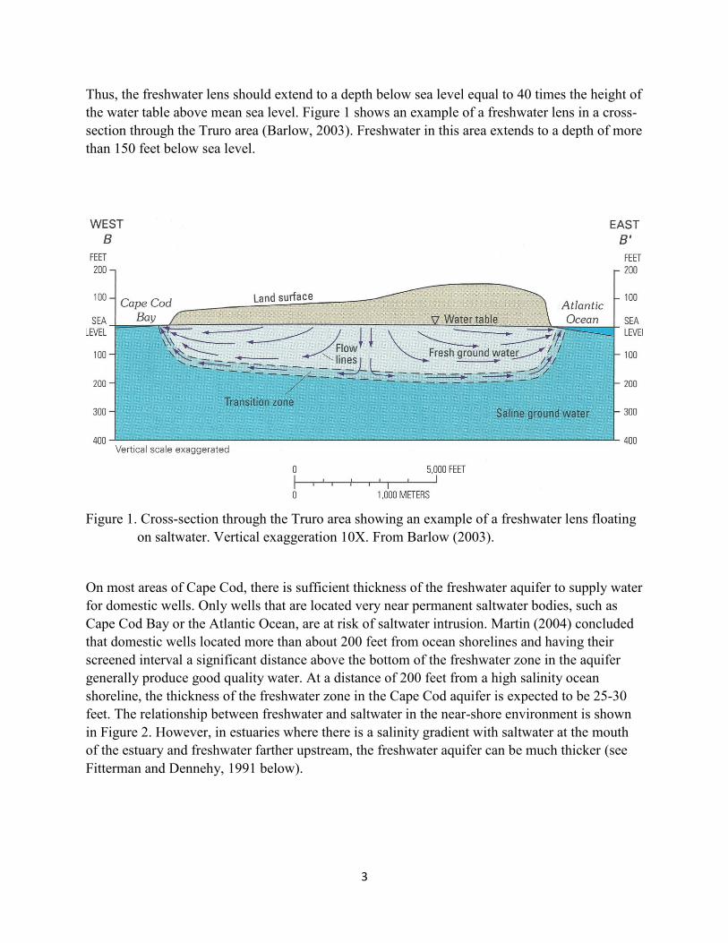
3
Thus, the freshwater lens should extend to a depth below sea level equal to 40 times the height of the water table above mean sea level. Figure 1 shows an example of a freshwater lens in a cross-section through the Truro area (Barlow, 2003). Freshwater in this area extends to a depth of more than 150 feet below sea level.
Figure 1. Cross-section through the Truro area showing an example of a freshwater lens floating
on saltwater. Vertical exaggeration 10X. From Barlow (2003).
On most areas of Cape Cod, there is sufficient thickness of the freshwater aquifer to supply water for domestic wells. Only wells that are located very near permanent saltwater bodies, such as Cape Cod Bay or the Atlantic Ocean, are at risk of saltwater intrusion. Martin (2004) concluded that domestic wells located more than about 200 feet from ocean shorelines and having their screened interval a significant distance above the bottom of the freshwater zone in the aquifer generally produce good quality water. At a distance of 200 feet from a high salinity ocean shoreline, the thickness of the freshwater zone in the Cape Cod aquifer is expected to be 25-30 feet. The relationship between freshwater and saltwater in the near-shore environment is shown in Figure 2. However, in estuaries where there is a salinity gradient with saltwater at the mouth of the estuary and freshwater farther upstream, the freshwater aquifer can be much thicker (see Fitterman and Dennehy, 1991 below).

4
Figure 2. Cross-section showing the relationship between freshwater and saltwater adjacent to a
permanent saltwater body. The thickness of the freshwater zone in the aquifer (z) is equal to 40 times the elevation of the water table above sea level (h). (Barlow, 2003, Figure B-1)
2.1 Saltwater-Freshwater Relationship in Estuaries and Salt Marshes
Niedoroda and April (1975) investigated the relationship of salt and fresh groundwater underlying salt marshes at three locations on the outer part of Cape Cod. They found that the zone of high salinity water from tidal inundation infiltrated only a few feet into the marsh peats and underlying sandy sediments. Salinity at depths of more than 5 feet below the marsh surface showed brackish to almost fresh groundwater. They surmised that the flow of freshwater from adjacent upland areas counteracted the infiltration of saltwater during high tide. Saltwater that had infiltrated the marsh sediments was partially flushed and diluted by the much larger flow of fresh groundwater beneath the marsh peat. Infiltration of saltwater through the marsh sediments occurs only at high tide, whereas the flow of fresh groundwater from the upland areas is continuous.
Barlow (2003) summarized the work of Portnoy and others (1998) and other investigators regarding the relationship of saltwater and freshwater in areas adjacent to estuaries. Groundwater discharge to the estuary is affected by the tidal cycle of the estuary. At high tide, saltwater infiltrates into the near-surface sediments. The saltwater cannot infiltrate very far into the sediments because high tide lasts only a few hours and fresh groundwater is flowing in the opposite (seaward) direction (Figure 3, top). As the tide recedes, fresh groundwater flows from the aquifer, discharging at the estuary shoreline. This flow of fresh groundwater begins to flush saltwater from the near-surface sediments (Figure 3, middle). At low tide, mostly freshwater is being discharged from the aquifer into the estuary. A small amount of saltwater may remain in the near-surface sediments (Figure 3, bottom). This cycle of infiltration of a small amount of saltwater at high tide and flushing by freshwater discharge is repeated with each tide cycle.

5
Figure 3. Reproduction of Figure 62 from Barlow (2003) showing the effects of tides on
underground freshwater and saltwater flow at an estuary shoreline.

6
Barlow (2003) also summarized the work of previous investigators regarding groundwater flow near, and discharge of fresh groundwater to, salt marshes. A typical example of groundwater flow at a salt marsh is provided from investigations at Namskaket Marsh near Orleans (MA), on Cape Cod. A conceptual model of groundwater flow and discharge to the marsh is shown in Figure 4.
Figure 4. Groundwater flow pattern (freshwater) in a typical salt marsh environment. (From Weiskel and others, 2016)
7
Most of the groundwater discharge occurs at the estuary boundary between the upland areas and the edge of the peat beds, and as upward flow through the permeable sediments underlying the creek. Groundwater discharge in the interior vegetated areas of the marsh is limited because the thick overlying marsh peat beds have a low permeability. The low permeability of the peat beds also impedes downward percolation of saltwater at high tide. Additionally, the hydraulic gradient in the peat beds is upward as the fresh groundwater underlying the peat beds is under pressure due to the confining nature of the low-permeability peat beds. This is in contrast with a sandy ocean shoreline beach with no marsh border and where full-strength seawater percolates into the shoreline aquifer up to the elevation of high tide.
2.2 Conceptual model of existing conditions in the Herring River basin
Currently there is no significant amount of tidal inflow to the diked Herring River basin. It is essentially at a continuous state of low tide. Fresh groundwater from adjacent upland areas flows toward and discharges into the stream channels. The stream channels essentially act as drainage ditches, causing the water table in adjacent areas to be lowered. After tidal flow is restored, there will be significant portions of each day when fresh groundwater will not be able to discharge into the stream channels because they are flooded with tidal water. During the period when fresh groundwater flow toward the stream channels is reduced, the water table will rise because there is still groundwater flowing toward the stream channels from adjacent upland areas. In effect, the high tide acts as a dam to freshwater outflow. The net result is a slight rise of the mean water table elevation.
According to the Ghyben-Herzberg relationship, described previously, the thickness of the freshwater zone in the aquifer is directly related to the height of the water table above sea level. The ratio is 1:40; for every foot that the water table is above sea level, the depth to the freshwater-saltwater interface will be 40 feet deep. For example, if restoring tidal flow to the Herring River basin increased the mean water table elevation by 3 inches (¼ foot), then the thickness of the freshwater aquifer would increase by 10 feet. The result could improve existing water quality in wells that currently have their screened interval deep in the freshwater aquifer, near the current transition zone from freshwater to saltwater, because the freshwater-saltwater transition zone will be forced downward.
2.3 Summary of Section 2
A lens of freshwater floats above the saltwater in the Cape Cod aquifer. The freshwater zone in the aquifer extends below sea level a distance equal to 40 times the elevation of the water table above sea level. In general, wells located more than 200 feet from the ocean shoreline will encounter a freshwater zone that is thick enough to provide good quality groundwater for domestic use. The thickness of the freshwater zone in the aquifer is expected to be 25-30 feet at a distance of 200 feet from a high salinity ocean shoreline.

8
Tidal estuaries will have salty water in the near-surface sediments from infiltration of seawater during high tide. However, groundwater underlying the low-permeability peat and marsh sediments will be fresh. The low permeability of peat coupled with upward pressure of fresh groundwater limits the infiltration of saltwater.
Current tidal restriction in Herring River causes a perpetual “low tide” condition that allows groundwater to discharge into stream beds unrestricted by higher tides, thereby lowering the water table. By reintroducing a more natural tidal cycle, the Herring River restoration will cause the water table to rise, and consequently the thickness of the freshwater aquifer will increase.
The basic groundwater science described above suggests that restoration of tidal flow to the Herring River would increase the elevation of the surrounding water table, lower the freshwater/saltwater interface, and thus increase the thickness of the freshwater zone in the aquifer. Hydrogeologic investigations in the Herring River and Mill Creek helped to validate this prediction. Two key points in reaching these conclusions are; 1) there will be a salinity gradient between the mouth of the river and upstream reaches, and 2) tidal restoration will result in an increase in the mean water level in the streams.
3.0 Hydrogeologic Investigations in the Herring River Basin, Mill Creek, and similar hydrogeologic settings
The effect of tidal restoration in the Herring River basin on the freshwater/saltwater relationship in the underlying aquifer has been addressed by several studies using different methods. Some of these studies are summarized in this section.
3.1 Geophysical monitoring wells; Fitterman and others (1989), Fitterman and Dennehy (1991)
Fitterman and others (1989) conducted geophysical surveys on the highlands to the east of the Herring River. They determined that the freshwater aquifer was at least 10 meters (33 feet) thick at the very edge of the flood plain and increased with distance away from the river. They used an analytical equation to evaluate how increased tidal fluctuation in the river would affect the water table adjacent to the stream. They concluded that completely opening the existing tide gates would have no effect on wells in the uplands east of the river because the mean river level would not change, and the area affected by water table fluctuations would be limited to “a few tens of meters” from the river. The distance is of little importance as they were only considering the distance within which tidal flow in the river would affect water table elevations at nearby wells. They did not evaluate the potential effect of tidal restoration on the freshwater/saltwater interface or the thickness of the freshwater zone in the aquifer.
In a subsequent study, Fitterman and Dennehy (1991) installed monitoring wells that verified the results of the geophysical investigation conducted in 1989. They found that the thickness of the freshwater aquifer at four monitoring wells (Figure 5, wells labeled WNW 115-118)) ranged from 18-22 meters (56-72 feet). At two monitoring wells immediately landward of the flood

9
plain of the Herring River (WNW-115 & WNW-117), the thickness of the freshwater aquifer was determined to be approximately 65 and 56 feet respectively.
Fitterman and Dennehy (1991) assumed that completely opening the existing tide gates would cause both static-water and high-tide levels in the Herring River to increase by less than 0.5 meter. They then concluded that such a small increase, compared to the large thickness of the freshwater aquifer, makes it unlikely that the thickness of the freshwater aquifer or the position of the fresh/salty groundwater interface would change at wells in the highlands east of the Herring River. They did acknowledge that wells in the former tidal flood plain areas along High Toss Road could potentially draw salty water due to infiltration of saltwater from the surface or repositioning of the fresh/salty groundwater interface (Fitterman and Dennehy, 1991). Subsequent investigations by Howes and others (1996), Weiskel and others (2016), and Martin (2007) show that infiltration of saltwater penetrates only a few meters below the ground surface in an estuary flood plain and occurs only within the immediate vicinity of areas flooded by saltwater at high tide. Thus, unless a well is flooded at high tide and experiences saltwater infiltration around the casing, it is unlikely to be affected as the screened interval is typically 15-20 feet below ground surface.
Figure 5. Location of USGS geophysical monitoring wells in the Herring River
and Mill Creek basins

10
Two additional geophysical monitoring wells were constructed in September 2003 to facilitate monitoring the depth of the freshwater/saltwater interface in other areas near the flood plain that might be affected by restoration of tidal flow in Herring River and Mill Creek (Wells WNW-133 and WNW-134). Well WNW-141 was constructed in 2004. The locations of wells installed by Fitterman and Dennehy, and subsequent wells installed in 2003 and 2004 are shown on Figure 5.
Figure 6 shows an example of the geophysical log from one of those wells located in upland adjacent to the estuary flood plain. The log clearly shows the low conductivity of the freshwater zone to a depth of about 65 feet, then a transition zone from 65-75 feet, then high conductivity below 75 feet, indicative of salt water.
Figure 6. Example of electromagnetic induction log at Well WNW-117

11
3.2 Namskaket Marsh; Howes and others (1996)
Howes and others (1996) showed that the area in which saltwater infiltrates into the sediments underlying a tidal salt marsh is limited to the area that is regularly inundated and to a depth of 2-3 meters (Figure 7). Deeper sediments adjacent to the tidal flooding are consistently saturated with freshwater, as shown in Figures 3, 4, and 7.
Figure 7. Salinity of groundwater in sediments underlying Namskaket Marsh.
Contour lines are labeled in ppt salinity. (From Howes and others, 1996)
3.3 Wellfleet Harbor; (Portnoy and Martin, 2007)
Portnoy and Martin (2007) investigated tidal fluctuations in groundwater at various distances from a salt-marsh fringed ocean shoreline (Figure 8). They showed that the tidal fluctuation of groundwater levels was greatly dampened, even at short distances from the shoreline in Wellfleet Harbor where the tidal range is 9 feet. Additionally, they showed that there was fresh groundwater (245 μS/cm) at Well # 3, located just 59 feet from the edge of the salt marsh, despite biweekly seawater inundation of the salt marsh during spring tides.
National Park Service staff recently started monitoring groundwater levels and salinity in these wells. Data from these wells are expected to verify the presence of fresh groundwater underlying areas that are regularly inundated by tidal flow.

12
Figure 8. Well locations downstream of the Herring River dike. Portnoy and Martin (2007)
3.4 USGS computer modeling of potential effects of tide restoration in the Herring River
Masterson (2004) conducted a regional investigation of the lower Cape Cod aquifer system. The investigation was designed to improve the understanding of the hydrogeology of the aquifer system and to assess the effects of changing groundwater pumping, recharge conditions, and sea level rise on the groundwater flow system. Near the end of the investigation, after the first draft of the report had been written, Masterson was asked to include an assessment of the effects of tidal restoration in the Herring River basin. The computer model that had been constructed to evaluate the original objectives of the investigation did not include the site-specific data that would be needed to perform the local-scale analyses to assess the effects of tidal restoration.
Output from the hydrodynamic model of tidal flow developed by Spaulding and Grilli (2001) was used to develop four scenarios to assess the effect of restoring tidal flow in the Herring River basin on the altitude of the freshwater/saltwater interface. The four computer model
#1
#4
#2
#3

13
scenarios evaluated combinations of increasing the mean water elevation and changing the salinity distribution in the Herring Basin.
Computer modeling produced mixed results in predicting future conditions of the elevation of the fresh/salt groundwater interface and the thickness of the freshwater zone in the aquifer. The predictions produced by these modeling scenarios are not applicable to the planned restoration of tidal flow in the Herring River system because the model parameter inputs that were used do not reflect the hydrologic conditions of an intertidal estuarine system. The computer model was designed to assess groundwater flow on a regional scale, not to evaluate conditions on a local scale. The model does not mimic the salinity gradient and ebb and flow of saltwater that occur in an intertidal estuary
3.5 Summary of Section 3
Hydrologic investigations in the Herring River basin show that the freshwater zone in the aquifer adjacent to the river flood plain is 33-72 feet thick. Investigations at other locations with similar hydrogeologic conditions show that the area in which saltwater infiltrates into the sediments underlying a tidal marsh is limited to the area that is regularly inundated, and in those locations, infiltration only occurs to a depth of 2-3 meters. The aquifer underlying tidally flooded areas will continue to have a zone of freshwater after tidal flow is restored. Tidal restoration is expected to increase the mean water level in the river and streams, thus slightly raising the surrounding water table, increasing the thickness of the freshwater lens, and lowering the elevation of the salt/freshwater interface. Restoration of tidal flow in the Herring River is not expected to affect adjacent water-supply wells unless a well were regularly inundated by tidal flow at the ground surface.
Masterson (2004) attempted to model the potential effect of tidal restoration in the Herring River system on the depth to the fresh/saltwater interface and thickness of the freshwater lens; however, the model did not mimic the ebb and flow of saltwater in the river system. Therefore, the model outputs are not valid predictions of expected future conditions after tidal restoration in Herring River. Results from multiple investigations strongly support the conclusion that water quality in all wells above the reach of predicted surface-water flooding will not be affected by tidal restoration.
4.0 Investigations of potential effects of restored tidal flow on domestic water-supply wells:
The basic groundwater science described in Section 2 and the hydrogeologic assessments described in Section 3 show that restoration of tidal flow in the Herring River basin is not expected to have an impact on domestic water-supply wells unless the well heads were inundated with salt water at the ground surface.
Larry Martin, author of this report and retired National Park Service Hydrogeologist, conducted several investigations to further assess the potential for restored tidal flow to affect private domestic wells in the Mill Creek and Herring River (Martin, 2004; Martin, 2007).

14
4.1 Martin (2004)
Martin (2004) evaluated the potential for saltwater intrusion by comparing hydrogeologic conditions in the Herring River basin with other, similar areas (Namskaket Marsh, Lieutenant Island, Wellfleet Harbor along Chequessett Neck Road) that are adjacent to saltwater bodies and tidal estuaries. Evaluation included computer modeling of the local groundwater flow system using the predicted tidal conditions that would result from various alternatives of opening or removing the existing tidal control structures (as described in Spaulding and Grilli, 2001). This investigation relied on findings from previous computer modeling of the groundwater flow system (Masterson 2004) that indicated that the thickness of the freshwater aquifer could become thinner for certain simulated conditions.
As a worst-case condition, Martin (2004) evaluated the potential extent of saltwater intrusion as if the restored tidal areas were permanently flooded with seawater, creating a new ocean shoreline at the margin of tidally flooded areas. Analytical modeling of the depth of the freshwater/saltwater interface at various distances from the tidally flooded areas showed that any change in the thickness of the freshwater aquifer would be restricted to an area underlying and immediately adjacent to the newly restored tidal estuaries (within about 200 feet), because the thickness of the freshwater aquifer increases quickly inland from ocean shorelines.
After examining available data for wells at properties adjacent to the ocean shoreline (for example along Chequessett Neck Road west of Wellfleet town center and the Indian Neck area), it was determined that wells constructed less than about 200 feet from the ocean and/or screened near the bottom (less than 10 feet above the freshwater/saltwater interface) of the freshwater aquifer could be susceptible to saltwater intrusion. Wells located more than about 200 feet from ocean shorelines and having their screened interval a significant distance (more than 15 feet) above the bottom of the freshwater zone in the aquifer generally produce good quality water.
Further investigation of existing wells in the Wellfleet area that are located adjacent to salt-water bodies (Wellfleet Harbor and Cape Cod Bay) showed that wells with poor quality water are typically; 1) located less than 100-150 feet from a high salinity oceanic water body, where the freshwater aquifer is thin , and/or 2) have well screens deep enough below the water table to draw water from the transition zone between fresh and salty groundwater. Wells providing good quality groundwater are typically located more than 150 feet from a salt-water body and have the well screen located only a few feet below the water table, which is far above the transition zone.
The 200-foot distance from ocean shorelines was considered a conservative scenario for evaluation of potential impacts on wells in the Herring River and Mill Creek areas because, as has been discussed in previous sections of this report, numerous investigations have shown that there is generally fresh groundwater underlying tidal estuaries. Salt water floods estuaries for only a few hours during each tidal cycle, unlike an ocean shoreline setting where saltwater is continuously present, such as at the edge of Wellfleet Harbor or Cape Cod Bay. In the Herring River estuary, the upward flow of fresh groundwater underlying the salt marshes impedes the

15
infiltration of saltwater. The extent of saltwater in sediments underlying tidal marshes and estuaries is limited to the area flooded with saltwater at high tide, as shown in Figure 7.
In Figures 4 and 19 of the report, Martin (2004) showed conceptual illustrations of the upward relocation of the freshwater/saltwater interface to a higher elevation following tidal restoration. Subsequent field studies have shown that those conceptual illustrations are incorrect. For example, investigations of saltwater infiltration at Namskaket Marsh (Weiskel and others, 2016) clearly show that saltwater infiltrates only a few meters and that freshwater occurs in deeper sediments below the tidal estuary.
4.2 Martin (2007)
After the 2004 report, it was decided that further investigations would be conducted to identify any private domestic wells that could potentially be affected by full tidal restoration. The work began in 2006 by examining well records for homes along Chequesset Neck Road, south of the Herring River dike which border Wellfleet Harbor and the Indian Neck area on the east side of the harbor. Both areas represent the worst-case condition for changes of the fresh/salt water interface, assuming a permanent saltwater body adjacent to the upland. Because the freshwater lens is thinner at the shoreline of a permanent saltwater body, the well’s setback from the shoreline generally needs to be greater than it does for wells within the Herring River estuary.
Basic water chemistry from 24 wells at Indian Neck showed variation in their salt content, but all were below EPA’s maximum limit for drinking water. Many of the wells were less than 250 feet from the shoreline and still yielded good quality drinking water. The wells along Chequesset Neck Road also varied in water quality. Some of the wells within 100-150 feet from the harbor had poor water quality because their screens were set too deep, probably approaching the fresh/saltwater interface. Those that were further from the shoreline had acceptable water quality.
Using the results of the first part of the 2007 report, additional analyses within the Herring River basin were then conducted to identify private properties within 250 feet of areas that would potentially be flooded by salt water during high tides, following restoration of tidal flow. Previous work had shown that the freshwater zone in the aquifer would have sufficient thickness to provide good quality water to wells located more than 200 feet from a saltwater shoreline. However, in order to ensure a conservative and comprehensive analysis, Martin used a distance of 250 feet in the 2006-07 investigation. Those parcels were then individually examined to determine the location of the well on the parcel, the depth of the well, depth of the screened interval, water table elevation, and the salt content of well water. That information allowed an assessment of the potential for saltwater intrusion at those wells on an individual basis.
In the summer 2007, the location of domestic wells adjacent to the Herring River flood plain basin was determined by examination of Assessors’ Atlas maps, information on file at the Truro and Wellfleet Health Departments, and field inspections of individual properties. Wells that were located more than 20-30 feet away from, and at an elevation more than a few feet higher than, potentially flooded areas were deemed to be beyond the area of potential impact from tidal flooding. These criteria were based on the numerous investigations cited previously in this report

16
and from observations of other areas on the outer Cape Cod where there are domestic wells close to tidal wetlands.
The office and field investigations in 2007 showed that most of the private domestic wells identified as potentially “at risk” in the report by Martin (2004) were outside the area of potential tidal flooding and, thus, would not be impacted by restoration of tidal flow. A small number of properties were identified as having wells that could potentially be impacted by full restoration of tidal flow. Wells on seven parcels were identified as at risk of surface inundation by salt water from restoration of full tidal flow. They include three wells on the eastern side of the Lower Herring River sub-basin and four wells in the Mill Creek sub-basin, one on the northern side and three on the southern side. Two of the properties (70 Way 672 and 90 Way 672) on the eastern side of the Lower Herring River have been, or are anticipated to be, acquired by the National Park Service, with buildings removed and wells plugged.
The five remaining wells would be susceptible to saltwater inundation at the ground surface of the casing at various points during the restoration of tidal flow. Since the restoration will proceed in phases, not all these wells would need to be protected at the same time in the restoration. Phase 1 restores a smaller portion of the flood plain with a lower maximum water surface elevation than the full restoration. It covers only a portion of the Mill Creek sub-basin and excludes the Upper Pole Dike Creek sub-basin. The maximum water levels for Phase 1 would only reach three of the five wells in the absence of protective actions. Those include one well in the Lower Herring River sub-basin and two in Mill Creek sub-basin. The other two wells would not be vulnerable to tidal inundation until later phases of the restoration. Options to protect all five of the wells in advance of when water levels would reach them are discussed below.
4.3 Water-supply well at 505 Old Chequessett Neck Road in Mill Creek:
The water-supply well for this property is located about 60 feet east of the house at a surveyed elevation of 4.0 feet NAVD88 (Figure 9). A tributary of Mill Creek called Snake Creek, is south and east of the house. Current plans for tidal restoration are to limit mean high spring tides in the Mill Creek sub-basin to 2.4 feet NAVD88 and the maximum water surface elevation during extreme storm events to 3.7 feet NAVD88 to prevent flooding of unprotected structures. Both tidal elevations are below the ground elevation at the well casing.
In October 2014, I compiled all the available information and wrote a summary report to assess the potential for the well at this property to be affected by tidal restoration (Martin, 2014). The report was not published or distributed.
The report (Martin, 2014) provides clear evidence that the well was drilled too deep. The perforated interval of the well is at a depth of 52-55 feet below ground surface, near the transition zone between the freshwater aquifer and the underlying saltwater. Water pumped from the well has higher concentrations of sodium (115 mg/l) and higher conductivity (683 umhos/cm) than water pumped from the freshwater aquifer at adjacent properties. Based on tide-height model predictions, mean water level in the restored estuary will increase, causing the mean groundwater table elevation in adjacent locations to increase slightly. Based on the

17
Ghyben-Herzberg relationship (see Section 1 of this report), this will result in a thicker freshwater lens and lower elevation of the fresh-salt groundwater interface in areas abutting the estuary, possibly improving water quality at the well.
Figure 9. Site plan of the property at 505 Chequessett Neck Road.
Earlier in this report, several examples were provided to show that tidal marshes are underlain by freshwater, and that saltwater generally does not infiltrate from the surface because it is opposed by the seaward flow of freshwater toward tidal streams. The well at 505 Chequessett Neck Road will not be threatened from surface infiltration of saltwater during Phase 1 of restoration because maximum normal and storm tide water levels will remain below the land surface at this well.

18
4.4 Water-supply well at 27 Way 672 in the Lower Herring River sub-basin
The property at 27 Way 672 is south of High Toss Road, on the east side of the Herring River valley (Figure 10). The existing water-supply well is located in the lowland area on the west side of Way 672. Land surface elevation at the well is 3.2 feet NAVD88.
Figure 10. Site plan of the 27 Way 672 property.
The well completion report for the well is shown in Figure 11. The well is 26 feet deep. The geologic log shows a clay layer from the land surface to a depth of 15 feet. Presumably, sand underlies the clay, as the completion report identifies the water bearing zone from 19-26 feet. The well was completed with PVC casing to a depth of 23 feet and with a well screen from 23-26 feet. Infiltration of rainfall on the adjacent upland areas recharges the freshwater aquifer. Fresh groundwater flows from recharge areas in the uplands toward discharge areas in the stream valley as shown in Figure 4. Figure 12 shows the addition of the well to the schematic cross-section from Figure 4 of this report.

19
Figure 11. Well completion report for the Way 672 well.
Figure 12. Schematic cross-section showing the relationship of the existing well serving Way 672 to hydrogeologic features.
Well

20
Records of water quality from two tests of the well are available. In 1997, the sodium concentration was 35 mg/l and the specific conductance was 284 umhos/cm. In 2015, the sodium concentration was 40 mg/l and the specific conductance was 320 umhos/cm. Specific conductance of water from the well can easily be monitored as a surrogate for salinity. If saltwater was getting into the well, the conductance would increase.
The water quality of the well can be compared with that from a neighboring well serving 255 High Toss Road. That well was constructed and tested in 1988. The well is screened from 31-34 feet below ground surface, but since the ground surface is higher than at the well serving 27 Way 672, the well is screened higher in the freshwater aquifer. The well serving 255 High Toss Road had a sodium concentration of 15 mg/l and specific conductance of 129 umhos/cm, typical of high-quality Cape Cod groundwater.
The well serving 27 Way 672 is located at a ground surface elevation that, absent mitigation measures, would be inundated during Phase 1 of the restoration. In discussions of mitigation options with the landowner, the Project proponents proposed to relocate the well to an upland area on the property that is outside the area of tidal inundation and that would provide good quality potable water for the residence (Figure 13). The water quality data from a comparably located well serving a neighboring property show that relocating the well to the upland location and screening the new well higher in the freshwater aquifer would likely result in water quality equal to or better than the existing well. However, as of the publication date of this report, the property owner has not agreed to the well relocation.
Phase 1 plans include construction of a physical barrier on adjacent NPS property to prevent tidal flow from inundating the properties at #25 and #27 Way 672. This barrier will also prevent salt water inundation of the well at #27 Way 672 and therefore prevent adverse effects on well water quality from tidal restoration. The physical barrier will be built with adequate freeboard above the elevation of the storm of record.
4.5 Water-supply wells at 60, 70, and 80 Mill Creek Lane in the Mill Creek sub-basin:
The land surface elevations at two wells that are on the southern side of the Mill Creek sub-basin are below the maximum water surface elevation under full restoration (3.7’ NAVD88) and near the elevation of the spring high tide (2.4’ NAVD88) for Phase I restoration. Land surface elevation at the wells providing water to the residences at 70 Mill Creek Lane and 80 Mill Creek Lane is 2.6’ NAVD88 for both wells. Wells at 70 and 80 Mill Creek Lane will be replaced with new wells, consistent with the property owners’ permission, at locations above the maximum water surface elevation of even full restoration.
The well serving the residence at 60 Mill Creek Lane is at an elevation of 5.6’ NAVD88, nearly two feet higher than the projected water surface elevation at full restoration. It is unlikely that this well would be affected by the tidal restoration project, but it will be monitored for potential

21
water quality changes. If necessary, project proponents would work with the landowner to either protect this well in place or relocate the well at a higher elevation.
4.6 Summary of Section 4:
The vulnerability criteria of wells in a worst-case situation, i.e. adjacent to a permanent saltwater body, were applied to the estuary landscape throughout the Herring River basin, resulting in a conservative vulnerability screening analysis. Properties within 250 feet of areas that would be inundated by tidal flow were evaluated to assess the potential vulnerability of water-supply wells to salt water inundation. Most wells evaluated are located in upland areas or with sufficient setback from areas that will be inundated and therefore will not be affected by restoration of tidal flow in the Herring River and Mill Creek basins.
Seven wells were identified as having potential impacts during full tidal restoration. Two of those wells are located on properties now, or soon to be, owned by NPS and will be capped and abandoned. Of the five remaining wells identified, three would be susceptible to tidal inundation under Phase 1 of the restoration. One well in Lower Herring River will be protected by a physical barrier that will prevent tidal flow from inundating the well casing. The two wells at risk during Phase 1 in Mill Creek will be replaced with new wells located at higher elevations on those properties.
The two other wells that could be susceptible to water quality impacts in future restoration phases, are located in the Mill Creek basin and are not at risk of inundation during Phase 1.
Summary of findings for the seven wells discussed in Section 4:
• 70 and 90 Way 672: these properties have been, or will be, acquired by the National Park Service prior to tidal restoration, and the wells will be plugged and abandoned.
• 27 Way 672: an offer to relocate this well was declined by the property owner; this well will be protected from salt water inundation by construction of a physical barrier on National Park Service property.
• 505 Old Chequessett Neck Road: the maximum water surface elevation under Phase 1 restoration will be lower than the elevation of the ground surface at the well head and so protection from tidal inundation is not necessary until later phases of the Project.
• 70 and 80 Mill Creek Lane: since these wells would be overtopped by tidal water during Phase 1 restoration, they will be relocated to a location above maximum water levels under both Phase 1 and also for full restoration, consistent with permissions granted by property owners.
• 60 Mill Creek Lane: the well is at a higher elevation than the projected water surface elevation at full tidal restoration and is unlikely to be affected.
22
5.0 Conclusions
Assessment of the potential for tidal restoration to affect private, domestic wells in the Herring River basin has proceeded in a sequential and methodical manner over the past several decades. Numerous analytical and modeling evaluations, and field investigations have been conducted to enhance the scientific understanding of the interaction between tidal flow and groundwater hydrology in the Herring River and other similar Cape Cod estuaries. These studies evolved over time to provide a solid basis for assessing the risk of impacts to water quality in drinking water wells during the restoration of tidal flow into the Herring River estuary.
1. Field investigations and analytical modeling using the Ghyben-Herzberg relationship determined that the freshwater zone in the Cape Cod aquifer should generally be 25-30 feet thick at a distance of 200 feet from a permanently flooded ocean shoreline. However, salinity gradients within estuaries can result in adjacent freshwater aquifers being much thicker than those adjacent to permanently flooded, sandy ocean shorelines. This has been confirmed by test wells driven at the edge of the Herring River estuary.
2. Hydrogeologic conditions of intertidal estuaries differ substantially from those of permanently flooded ocean shorelines. Intertidal estuaries maintain a freshwater aquifer beneath the surface sediments. The intermittent ebb and flood cycles of tidal inundation in an estuary, combined with low permeability of peat and upward pressure of fresh groundwater, limit the infiltration of saltwater to shallow surface sediments.
3. Initial efforts to assess potential effects of tidal restoration in the Herring River basin on nearby domestic water-supply wells assumed (incorrectly) that saltwater fully penetrates sediments underlying tidal estuaries. In addition, some investigations used data inputs and produced findings that are not applicable to the Herring River intertidal estuarine setting because they assumed and/or applied hydrogeologic conditions found along oceanic shorelines with consistently high surface-water salinity.
4. Current tidal restriction in the Herring River basin creates a perpetual “low tide” condition that allows groundwater to continuously discharge to stream channels, unrestricted by high tides. These conditions create an artificially low water table compared to an unrestricted tidal estuary that is flooded by high tides twice daily. By reintroducing a substantially larger, more natural tidal range, the restoration project will increase the mean water level in the system. An increase in mean water level in Herring River will cause the water table within and directly adjacent to the flood plain to rise slightly. Thus, per the Ghyben-Herzberg relationship, the thickness of the aquifer’s freshwater zone, as well as the depth to the fresh/salt groundwater interface, will both increase in locations adjacent to areas of increased tide range.
5. Most private, domestic wells near Herring River are located in upland areas, outside the limits of proposed tidal flooding. These wells will not be affected by restoration of tidal flow.

23
6. Domestic water-supply wells at seven properties were identified as potentially at risk from full restoration of tidal flow. These wells are located in the flood plains of estuarine streams and could be inundated at the ground surface by salt water. Mitigation measures have been identified to protect water quality for five wells that would be susceptible to inundation during Phase 1 of the restoration. The two other wells that could be inundated during future phases of restoration beyond Phase 1 would require mitigation measures (relocation or protection) before additional tidal restoration is implemented.

24
References
Barlow, Paul M., 2003, Ground Water in Freshwater-Saltwater Environments of the Atlantic Coast, U.S. Geological Survey Circular 126, 113 pp https://pubs.er.usgs.gov/publication/cir1262
Fetter, C.W., 2001, Applied Hydrogeology, 4th ed., Prentice Hall publisher, 598 pp.
Fitterman, David V., Glenn A. Brooks, and Stephen L. Snyder, 1989, Geophysical Investigation of Depth to Saltwater Near the Herring River, Cape Cod National Seashore, Wellfleet, Massachusetts, USGS Open-File Report 89-677, 69 pp. https://pubs.er.usgs.gov/publication/ofr89677
Fitterman, David V., and Kevin Dennehy, 1991, Verification of Geophysically Determined Depths to Saltwater Near the Herring River, Cape Cod National Seashore, Wellfleet, Massachusetts, USGS Open-File Report 91-321, 47 pp. https://pubs.er.usgs.gov/publication/ofr91321
Howes, B.L., P.K. Weiskel, D.D. Geohringer and J.M. Teal. 1996. Interception of freshwater and nitrogen transport from uplands to coastal waters: the role of saltmarshes. Pages 287-310 in K.F. Nordstrom and C.T. Roman, editors, Estuarine shores: evolution, environments, and human alterations. John Wiley & Sons, New York.
LeBlanc, Denis R., J.H. Guswa, M.H. Frimpter, and C.J. Londquist, 1986, Ground-water Resources of Cape Cod, Massachusetts, U.S. Geological Survey Hydrologic Atlas 692, 4 sheets https://pubs.er.usgs.gov/publication/ha692
Martin, Larry, 2004, Salt Marsh Restoration at Herring River: An Assessment of Potential Saltwater Intrusion in Areas Adjacent to Herring River and Mill Creek, Cape Cod National Seashore, National Park Service Technical Report NPS/NRWRD/NRTR-2004/319, 25 pp. https://irma.nps.gov/DataStore/Reference/Profile/563504
Martin, Larry, 2007a, Assessment of Potential Saltwater Encroachment in the Herring River Basin, Cape Cod National Seashore NPS/NRPC/WRD/NRTR—2007/370, National Park Service, Ft. Collins, CO. https://irma.nps.gov/DataStore/Reference/Profile/2174236

25
Martin, Larry, 2007b, Memo to John Portnoy, National Park Service, Identification of private domestic wells adjacent to the Herring River flood plain that could be affected by restoration of tidal flow, 8 pp.
Martin, Larry, 2014, Comments regarding the potential for saltwater intrusion at the Nieski water-supply well, unpublished, 9 pp.
Masterson, J.P., 2004, Simulated Interaction Between Freshwater and Saltwater and Effects of Ground-water Pumping and Sea-Level Change, Lower Cape Cod Aquifer System, Massachusetts, U.S. Geological Survey Scientific Investigations Report 2004-5014, 78 pp. https://pubs.er.usgs.gov/publication/sir20045014
Niedoroda A and April R., 1975, Report on Groundwater Flow Beneath Coastal Salt Marshes, University of Massachusetts - National Park Service Cooperative Research Unit, Amherst, MA, 49 pp. https://irma.nps.gov/DataStore/Reference/Profile/104409
Portnoy, John, and Larry Martin, 2007, Tidal Fluctuations in Groundwater Level Normal to a Salt-marsh-fringed Shoreline, Herring River Estuary, Wellfleet (Massachusetts) unpublished, 9 pages https://irma.nps.gov/DataStore/Reference/Profile/2198112
Portnoy, J.W, B.L. Nowicki, C.T. Roman, and D.W. Urish, 1998, The Discharge of Nitrate-Contaminated Groundwater from Developed Shoreline to Marsh-Fringed Estuary, Water Resources Research, Vol. 34, No. 11, pp. 3095-3104
Spaulding, M., and A. Grilli. 2001. Hydrodynamic and salinity modeling for estuarine restoration at Herring River, Wellfleet, Massachusetts. Report to National Park Service. 94 pp.
Weiskel, P.K., Barbaro, J.R., and DeSimone, L.A., 2016, Environmental Conditions in the Namskaket Marsh Area, Orleans, Massachusetts -A Summary of Studies by the U.S. Geological Survey, 1989–2011, U.S. Geological Survey Scientific Investigations Report 2016–5122, 29 pp., https://pubs.usgs.gov/sir/2016/5122/sir20165122.pdf

26
This report was prepared under contract to the Friends of the Herring River by Larry Martin, retired National Park Service Hydrologist Mr. Martin has 40 years of experience as a professional hydrogeologist, including 25 years with the National Park Service. During that time, he authored or coauthored 13 peer reviewed reports along with numerous memos and trip reports specific to the hydrology and hydrogeology of Cape Cod National Seashore. During his 25-year career with the National Park Service, He conducted investigations at more than 90 different park units, resulting in more than 200 reports.

TownofWellfleetHerringRiverRestorationProject
DevelopmentofRegionalImpactApplication
154
8.DStormwaterCalculationsforEngineeredStormwaterManagementStructures(Seefollowingpages)StormwaterManagementDesignInformationforChequessettNeckRoadBridge
Fuss&O’Neill
StormwaterOperation&MaintenancePlan,HighTossRoadandHopkinsDrive
ESSGroup

Attachment F
Stormwater Management System Design
F:\P2012\0636\A13\Deliverables\MassDOT 25% Design Submittal\nsw_mkf_HerringRiverDesignReDesignReport_20140731.docx


F:\P2012\0636\A13\Deliverables\MassDOT 25% Design Submittal\nsw_mkf_HerringRiverDesignReDesignReport_20140731.docx


F:\P2012\0636\A13\Deliverables\MassDOT 25% Design Submittal\nsw_mkf_HerringRiverDesignReDesignReport_20140731.docx


F:\P2012\0636\A13\Deliverables\MassDOT 25% Design Submittal\nsw_mkf_HerringRiverDesignReDesignReport_20140731.docx


F:\P2012\0636\A13\Deliverables\MassDOT 25% Design Submittal\nsw_mkf_HerringRiverDesignReDesignReport_20140731.docx


F:\P2012\0636\A13\Deliverables\MassDOT 25% Design Submittal\nsw_mkf_HerringRiverDesignReDesignReport_20140731.docx

www.essgroup.com
Herring River Restoration Project High Toss Road & Hopkins Drive Stormwater Management Report
Wellfleet, Massachusetts
PREPARED FOR: Friends of Herring River PO Box 796 Wellfleet, Massachusetts 02667
PREPARED BY: ESS Group, Inc. 100 Fifth Avenue, 5th Floor Waltham, Massachusetts 02451
ESS Project No. F451-004
June 30, 2017
2017.06.29 20:01:24 -04'00'

© 2017 ESS Group, Inc. – This document or any part may not be reproduced or transmitted in any form or by any means, electronic, or mechanical, including photocopying, microfilming, and recording without the express written consent of ESS Group, Inc. All rights reserved.
Stormwater Management Report Herring River Restoration Project High Toss Road & Hopkins Drive
Prepared For:
Friends of Herring River PO Box 796
Wellfleet, Massachusetts 02667
Prepared By:
ESS Group, Inc. 100 Fifth Avenue, 5th Floor
Waltham, Massachusetts 02451
ESS Project No. F451-004
June 30, 2017

© 2017 ESS Group, Inc. – This document or any part may not be reproduced or transmitted in any form or by any means, electronic, or mechanical, including photocopying, microfilming, and recording without the express written consent of ESS Group, Inc. All rights reserved.
TABLE OF CONTENTS SECTION PAGE
1.0 INTRODUCTION ..................................................................................................................................... 1 2.0 EXISTING STORMWATER CONDITIONS ............................................................................................. 1
2.1 Soils .................................................................................................................................................. 3 2.2 General Characterization of Wetlands and Vegetation .................................................................... 3
3.0 PROPOSED STORMWATER CONDITIONS AND MANAGEMENT ..................................................... 3 3.1 Proposed Conditions ........................................................................................................................ 3 3.2 Proposed BMPs ................................................................................................................................ 3
High Toss Travelway Level Spreaders ............................................................................................ 4 Hopkins Drive Drywells .................................................................................................................... 4 Hopkins Drive ChamberMaxx Infiltration Chamber .......................................................................... 4
4.0 MASSDEP STORMWATER MANAGEMENT STANDARDS ................................................................. 4 FIGURES Figure 1 Site Locus APPENDICES Appendix A MassDEP Checklist for Stormwater Report Appendix B Operation & Maintenance Plan Appendix C Stormwater Calculations Appendix D NRCS Soil Report Appendix E FEMA Flood Insurance Rate Map Appendix F Long Term Pollution Prevention Plan SITE PLANS (BOUND SEPARATELY)

F451 High Toss Road & Hopkins Drive Stormwater Management Report
1.0 INTRODUCTION
ESS Group, Inc. has performed a stormwater management analysis on behalf of The Friends of Herring River for a segment of the proposed Herring River restoration project, specifically the portion of the project located on High Toss Road and Hopkins Drive in Wellfleet, Massachusetts (referred to as the “Site”). The objective at this Site is to elevate the High Toss Road travelway in advance of restoration of tidal flow to the Herring River and to improve stormwater runoff control on a portion of Hopkins Drive (the “Project”).
The goal of the proposed stormwater management system is to implement low impact development (LID) techniques to the maximum extent practicable within the constraints of the proposed High Toss Road roadway design. The proposed stormwater management system is designed to provide treatment of stormwater runoff through detention and infiltration into the existing subsurface soils.
The following sections describe the proposed stormwater management plan and analysis conducted to ensure compliance with the stormwater requirements of the Massachusetts Department of Environmental Protection (MassDEP) Stormwater Management Standards, which apply a different set of criteria to projects that meet the definition of redevelopment with respect to stormwater management. Through its design, the stormwater management system will mitigate stormwater runoff impacts on water quantity and quality and provide water quality treatment to the maximum extent practicable, as is the requirement for redevelopment. A water quality analysis was performed to estimate the extent to which the required sediment removal can be achieved by the stormwater management system.
2.0 EXISTING STORMWATER CONDITIONS
High Toss Road is an unpaved public way approximately 200 feet easterly of Snake Creek Lane, running westerly to the end at Duck Harbor Lane. Refer to Figure 1, Site Locus. This site falls within the limits of a FEMA flood hazard zone AE as depicted in the FEMA Flood Insurance Rate Map (FIRM) included in Appendix E. Under MassDEP Wetlands Protection regulations, land subject to any inundation caused by coastal storms up to and including that caused by the 100-year storm, surge of record or storm of record, whichever is greater, is protected as Land Subject to Coastal Strom Flowage (LSCSF)
The entire project area is located within the Wellfleet Harbor Area of Critical Environmental Concern (ACEC). The Wellfleet Harbor ACEC, established in 1989, consists of approximately 12,500 acres in the towns of Wellfleet, Truro, and Eastham. The ACEC was established to protect important habitats including barrier beaches, islands, marsh ecosystems, saltwater and freshwater ponds, rivers, bays, and tidal flats.
The Site’s topographic elevation as indicated by the site survey ranges from approximately 2 to 30 feet above the North American Vertical Datum of 1988 (NAVD 88).
High Toss Road does not have any open or closed drainage systems. Hopkins Drive, which is paved, has six leaching basins installed in the shoulder of the road that will upgraded and replaced in proposed conditions.
This section of the report summarizes specific predevelopment site conditions related to stormwater management including hydrologic soil type, presence of wetlands and vegetation, and drainage to discharge points on site.
The existing stormwater system in Hopkins Drive is comprised of three sets of catch basins (one on each side of the road) between Quail Run and High Toss Road. The catch basins have Massachusetts standard

High Toss Road & Hopkins Drive - Stormwater Management Report June 30, 2017
F451 High Toss Road & Hopkins Drive Stormwater Management Report 2
grates with no apparent pipe connection between the catch basins, and no apparent outfall, based on our site observations. Therefore, it appears the catch basins are leaching catch basins. ESS did observe that the catch basins contained accumulated sediment and some standing water, indicating that they need to be cleaned out. It was also noted that pine needles and other vegetative debris accumulate around each catch basin. Pictures of the catch basins from December 2015 are shown below.
Quail Run appears to only have one catch basin, and it is located on the south side of the road about midway between Hopkins Drive and the Quail Run cul-de-sac.
Catch basins at High Toss Road-Hopkins Drive intersection (note accumulated sediment
in road and erosion of High Toss Road)
Catch basin on east side of Hopkins Drive midway between High Toss Road and Quail
Run
Catch basin on west side of Hopkins Drive midway between High Toss Road and Quail Run
Catch basin at northwest corner of High Toss Road-Hopkins Drive intersection (note reflection indicating standing water in catch basin)

High Toss Road & Hopkins Drive - Stormwater Management Report June 30, 2017
F451 High Toss Road & Hopkins Drive Stormwater Management Report 3
2.1 Soils
The Site is generally characterized as low density development with moderate to flat slopes and forested areas with well drained soils. According to the Natural Resources Conservation Service (NRCS) Web Soil Survey, the soils within the majority of the watershed are comprised of Carver Coarse Sand. These soil types are classified as Hydrologic Soil Group A. The low lying wetland areas are comprised of Maybid variant silty clay loam and Freetown and Swansea mucks coastal lowland which are classified as Hydrologic Soil Groups A/D and B/D, respectively, The NRCS Soil Survey of the Site is provided in Appendix D.
2.2 General Characterization of Wetlands and Vegetation
The existing conditions watershed is comprised of woods and roads with varying surface treatments. Jurisdictional vegetated wetland resource areas in the vicinity of the project area were delineated by others in 2015 and were subsequently field-verified by an ESS wetland scientist in 2016.
The project area is also located entirely within the Cape Cod National Seashore Outstanding Resource Water (ORW). ORWs are established by MassDEP and include Class A Public Water Supplies and their tributaries and other waters that provide outstanding socio-economic, recreational, ecological, and/or aesthetic values.
Primary vegetation species along High Toss Road include pitch pine (Pinus rigida), pin oak (Quercus palustris), red maple (Acer rubrum), white oak (Quercus alba), black cherry (Prunus serotina), black locust (Robinia pseudoacacia), shadbush (Amelanchier sp.), winterberry (Ilex verticillata), highbush blueberry (Vaccinium corymbosum), lowbush blueberry (Vaccinium angustifolium), scrub oak (Quercus ilicifolia), bayberry (Myrica pennsylvanica), sweet pepperbush (Clethra alnifolia), southern arrowwood (Viburnum recognitum), poison ivy (Toxicodendron radicans), Tatarian honeysuckle (Lonicera tatarica) and Japanese honeysuckle (Lonicera japonica).
3.0 PROPOSED STORMWATER CONDITIONS AND MANAGEMENT
3.1 Proposed Conditions
The proposed development includes raising the elevation of High Toss Road to 7.5 feet NAVD88 to prevent inundation of the roadway. A portion of Hopkins Drive will also be raised to tie into the proposed elevation of High Toss Road, and to reduce the velocity and volume of Hopkins Drive runoff that crosses High Toss Road.
3.2 Proposed BMPs
The stormwater management system for the High Toss Road travelway is designed to mimic existing conditions due to the limited right-of-way width available, the presence of wetlands resources directly adjacent to the travelway, and the Town’s objective to elevate the road while maintaining its current rural character.
The stormwater management system for Hopkins Drive is designed to improve conditions by reducing the amount of runoff that currently is not collected and runs across and erodes the High Toss Road travelway gravel surface. The design also includes improvements in terms of suspended solids collection and runoff infiltration.

High Toss Road & Hopkins Drive - Stormwater Management Report June 30, 2017
F451 High Toss Road & Hopkins Drive Stormwater Management Report 4
High Toss Travelway Level Spreaders
Construction of the Travelway will require earthwork on both sides of the travelway to allow the raised travelway grades to meet the existing ground elevations. Where necessary, level spreaders – a low point with a level lip - will be placed between the shoulder and the adjacent slopes to capture runoff and reduce its velocity and encourage sheet flow prior to crossing the travelway surface. Level spreaders will be installed in accordance with the latest Massachusetts Stormwater Handbook. Runoff that does not overtop the lip of the level spreaders will infiltrate.
Hopkins Drive Drywells
There are two leaching catch basins approximately midway up the roadway slope between Quail Run and High Toss Road. These structures will be removed and replaced with solid bottom, deep sump catch basins to provide for sediment collection. Each catch basin structure will also have a vented hooded inlet to reduce the amount of floatables, trash, free oils, etc. leaving the deep dump catch basin. The new catch basins will be connected to new drywell structures that will be installed beneath the Hopkins Drive pavement. Dry well structures are pre-cast concrete barrels with uniform perforations surrounded with stone designed to infiltrate captured stormwater.
Hopkins Drive ChamberMaxx Infiltration Chamber
At the bottom of Hopkins Drive, the four existing catch basins will be replaced with four solid bottom, deep sump catch basins, which will also be equipped with oil hoods. The four new catch basins will be connected to a ChamberMaxx infiltration chamber that will be installed below the Hopkins Drive pavement via 10 inch high-density polyethylene (HDPE) header pipes at each end of the chamber. Three rows of chambers will be used, and the footprint of the chamber system and surrounding stone will be approximately 16 feet wide by 31 feet long (496 square feet). The chamber system will accommodate the 10-year storm event.
4.0 MASSDEP STORMWATER MANAGEMENT STANDARDS
The Project has been designed to meet the MassDEP Stormwater Management Standards to the maximum extent practicable in accordance with Standard 7 Redevelopment. A synopsis of how each standard is met is summarized below; Standard 7 is presented first because its provisions affect the other standards.
Standard 7: A redevelopment project is required to meet the following Stormwater Management Standards only to the maximum extent practicable: Standard 2, Standard 3, and the pretreatment and structural best management practice requirements of Standards 4, 5, and 6. Existing stormwater discharges shall comply with Standard 1 only to the maximum extent practicable. A redevelopment project shall also comply with all other requirements of the Stormwater Management Standards and improve existing conditions.
For purposes of the Stormwater Management Standards, redevelopment projects are defined to include maintenance and improvement of existing roadways, including improving existing drainage systems. As described below, the Project meets the requirements of Standards 1, 2, 3, 4, 5, and 6 to the maximum extent practicable.
The two primary constraints for this project are the limited right of way and adjacent resource areas. Practices that would require either additional resource area impacts or impacts to private property would

High Toss Road & Hopkins Drive - Stormwater Management Report June 30, 2017
F451 High Toss Road & Hopkins Drive Stormwater Management Report 5
be defined as not practicable for the purposes of stormwater compliance. The stormwater management plan attempts to meet each of the standards, adequately document standards that could be met, and is designed at a minimum to improve existing conditions.
Standard 1: No new stormwater conveyances may discharge untreated stormwater directly to or cause erosion in wetlands or waters of the Commonwealth.
No new discharges from stormwater conveyances are proposed for this project.
Standard 2: Stormwater management systems shall be designed so that post-development peak discharge rates do not exceed pre-development peak discharge rates. This Standard may be waived for discharges to land subject to coastal storm flowage as defined in 310 CMR 10.04.
The High Toss Road travelway is located within Land Subject to Coastal Storm Flowage. In addition, once the Herring River restoration is implemented, the wetlands along High Toss Road will be subject to daily tidal action. The Project will not change the amount of impervious cover in the Project Area. For these reasons, the Project is not required to match post-development peak discharge rate to the pre-development peak discharge rate. However, where possible, the design seeks to maintain or improve post-development peak discharge rates to the maximum extent practicable.
Standard 3: Loss of annual recharge to groundwater shall be eliminated or minimized through the use of infiltration measures including environmentally sensitive site design, low impact development techniques, stormwater best management practices, and good operation and maintenance. At a minimum, the annual recharge from the post-development site shall approximate the annual recharge from the pre-development site conditions based on soil type. This Standard is met when the stormwater management system is designed to infiltrate the required recharge volume as determined in accordance with the Massachusetts Stormwater Handbook.
The MassDEP Stormwater Handbook states that, for sites comprised solely of C and D soils and bedrock at the land surface, proponents are required to infiltrate the required recharge volume only to the maximum extent practicable. The High Toss Road and Hopkins Drive site is comprised solely of A soils surrounded by A/D and B/D soils within resource areas. The footprint of the proposed level spreader improvement of High Toss Road and of the catch basin and infiltration improvements of Hopkins Drive have been minimized in an attempt to meet this standard to the maximum extent practicable. Infiltration from the BMPs will further aid in groundwater recharge as ground conditions permit.
Standard 4: Stormwater management systems shall be designed to remove 80% of the average annual post-construction load of Total Suspended Solids (TSS). This Standard is met when: (a.) Suitable practices for source control and pollution prevention are identified in a long-term pollution prevention plan, and thereafter are implemented and maintained; (b.) Structural stormwater best management practices are sized to capture the required water quality volume determined in accordance with the Massachusetts Stormwater Handbook; and (c.) Pretreatment is provided in accordance with the Massachusetts Stormwater Handbook.
Suitable practices for source control and pollution prevention are identified in the attached long-term pollution prevention plan included in Appendix F. Infiltration Stormwater BMPs with a minimum of 80 percent TSS removal rates were selected for use on Hopkins Drive. This removal rate is accomplished with a

High Toss Road & Hopkins Drive - Stormwater Management Report June 30, 2017
F451 High Toss Road & Hopkins Drive Stormwater Management Report 6
treatment train comprising a deep sump catch basin pretreatment (25 percent TSS removal) dry wells, and ChamberMaxx storm chambers. The treatment train will provide the required water quality volume. Stormwater runoff along the High Toss Road travelway will either sheet flow across the travelway as it does in the existing condition or naturally infiltrate on the landward side of the travelway.
Standard 5: For land uses with higher potential pollutant loads source control and pollution prevention shall be implemented. The use of infiltration practices without pretreatment is prohibited.
The project does involve land uses with higher potential pollutant loads.
Standard 6: Stormwater discharges within the Zone II or Interim Wellhead Protection Area of a public water supply, and stormwater discharges near or to any other critical area, require the use of the specific source control and pollution prevention measures and the specific structural stormwater best management practices determined by the Department to be suitable for managing discharges to such areas.
Specific source control and pollution prevention measures are identified in the attached long-term pollution prevention plan included in Appendix F.
The site is located within the following resource areas:
• Wellfleet Harbor Area of Critical Environmental Concern (ACEC)
• Cape Cod National Seashore Outstanding Resource Water (ORW)
The Project involves elevating the High Toss Road travelway along its existing alignment and improving the existing stormwater system at the lower end of Hopkins Drive to reduce sheet flow runoff across High Toss Road to the wetlands. The Project will not adversely affect these resources areas and will provide stormwater management improvements where possible.
Standard 7 – see above.
Standard 8: A plan to control construction related impacts including erosion, sedimentation and other pollutant sources during construction and land disturbance activities (construction period erosion, sedimentation, and pollution prevention plan) shall be developed and implemented.
A comprehensive system of erosion and sedimentation controls will be implemented during construction to minimize short-term, construction-related impacts as well as stabilize conditions for permanent operation of the development. These measures include silt fence and silt sock placement along disturbed areas of the property, site stabilization, and a stabilized construction entrance. An online registration and Stormwater Pollution Prevention Plan (SWPPP) in accordance with the National Pollutant Discharge Elimination System (NPDES) Construction General Permit will be submitted prior to construction.
Standard 9: A long term operation and maintenance plan shall be developed and implemented.
An operations and maintenance plan for the proposed stormwater BMPs is attached.
Standard 10: All illicit discharges to the stormwater management system are prohibited.

High Toss Road & Hopkins Drive - Stormwater Management Report June 30, 2017
F451 High Toss Road & Hopkins Drive Stormwater Management Report 7
No known illicit discharges currently exist on the Site. There will be no illicit discharges allowed into the stormwater management system.

www.essgroup.com
Figures

Source: 1) ESRI, Basemap 2016
Herring River Restoration ProjectWellfleet and Truro, Massachusetts
0 1,000 2,000500Feet
Path
: J:\F
451-
002
Frie
nds
of H
errin
g R
iver
- H
igh
Toss
Roa
d P
erm
it Le
vel D
esig
n\04
GR
AP
HIC
S\G
IS\M
XD
\HTR
_Loc
us_M
ap.m
xd
High Toss Road Locus Map
Figure 1
1 inch = 1,000 feet
Dra
win
g D
ate:
201
6/06
/23
© 2
016
ES
S G
roup
, Inc
.!°
Legend
Project Location
High Toss Road Pole Dike Road
Duck Harbor Road
Snake Creek Road (a.k.a. Rainbow Lane)
Herring River

www.essgroup.com
Appendix A MassDEP Checklist for Stormwater Report

swcheck.doc • 04/01/08 Stormwater Report Checklist • Page 1 of 8
Massachusetts Department of Environmental Protection Bureau of Resource Protection - Wetlands Program
Checklist for Stormwater Report
A. Introduction Important: When filling out forms on the computer, use only the tab key to move your cursor - do not use the return key.
A Stormwater Report must be submitted with the Notice of Intent permit application to document compliance with the Stormwater Management Standards. The following checklist is NOT a substitute for the Stormwater Report (which should provide more substantive and detailed information) but is offered here as a tool to help the applicant organize their Stormwater Management documentation for their Report and for the reviewer to assess this information in a consistent format. As noted in the Checklist, the Stormwater Report must contain the engineering computations and supporting information set forth in Volume 3 of the Massachusetts Stormwater Handbook. The Stormwater Report must be prepared and certified by a Registered Professional Engineer (RPE) licensed in the Commonwealth. The Stormwater Report must include:
x The Stormwater Checklist completed and stamped by a Registered Professional Engineer (see page 2) that certifies that the Stormwater Report contains all required submittals.1 This Checklist is to be used as the cover for the completed Stormwater Report.
x Applicant/Project Name x Project Address x Name of Firm and Registered Professional Engineer that prepared the Report x Long-Term Pollution Prevention Plan required by Standards 4-6 x Construction Period Pollution Prevention and Erosion and Sedimentation Control Plan required
by Standard 82 x Operation and Maintenance Plan required by Standard 9
In addition to all plans and supporting information, the Stormwater Report must include a brief narrative describing stormwater management practices, including environmentally sensitive site design and LID techniques, along with a diagram depicting runoff through the proposed BMP treatment train. Plans are required to show existing and proposed conditions, identify all wetland resource areas, NRCS soil types, critical areas, Land Uses with Higher Potential Pollutant Loads (LUHPPL), and any areas on the site where infiltration rate is greater than 2.4 inches per hour. The Plans shall identify the drainage areas for both existing and proposed conditions at a scale that enables verification of supporting calculations.
As noted in the Checklist, the Stormwater Management Report shall document compliance with each of the Stormwater Management Standards as provided in the Massachusetts Stormwater Handbook. The soils evaluation and calculations shall be done using the methodologies set forth in Volume 3 of the Massachusetts Stormwater Handbook. To ensure that the Stormwater Report is complete, applicants are required to fill in the Stormwater Report Checklist by checking the box to indicate that the specified information has been included in the Stormwater Report. If any of the information specified in the checklist has not been submitted, the applicant must provide an explanation. The completed Stormwater Report Checklist and Certification must be submitted with the Stormwater Report.
1 The Stormwater Report may also include the Illicit Discharge Compliance Statement required by Standard 10. If not included in the Stormwater Report, the Illicit Discharge Compliance Statement must be submitted prior to the discharge of stormwater runoff to the post-construction best management practices. 2 For some complex projects, it may not be possible to include the Construction Period Erosion and Sedimentation Control Plan in the Stormwater Report. In that event, the issuing authority has the discretion to issue an Order of Conditions that approves the project and includes a condition requiring the proponent to submit the Construction Period Erosion and Sedimentation Control Plan before commencing any land disturbance activity on the site.

swcheck.doc • 04/01/08 Stormwater Report Checklist • Page 2 of 8
Massachusetts Department of Environmental Protection Bureau of Resource Protection - Wetlands Program
Checklist for Stormwater Report B. Stormwater Checklist and CertificationThe following checklist is intended to serve as a guide for applicants as to the elements that ordinarily need to be addressed in a complete Stormwater Report. The checklist is also intended to provide conservation commissions and other reviewing authorities with a summary of the components necessary for a comprehensive Stormwater Report that addresses the ten Stormwater Standards.
Note: Because stormwater requirements vary from project to project, it is possible that a complete Stormwater Report may not include information on some of the subjects specified in the Checklist. If it is determined that a specific item does not apply to the project under review, please note that the item is not applicable (N.A.) and provide the reasons for that determination.
A complete checklist must include the Certification set forth below signed by the Registered Professional Engineer who prepared the Stormwater Report.
Registered Professional Engineer’s Certification I have reviewed the Stormwater Report, including the soil evaluation, computations, Long-term Pollution Prevention Plan, the Construction Period Erosion and Sedimentation Control Plan (if included), the Long-term Post-Construction Operation and Maintenance Plan, the Illicit Discharge Compliance Statement (if included) and the plans showing the stormwater management system, and have determined that they have been prepared in accordance with the requirements of the Stormwater Management Standards as further elaborated by the Massachusetts Stormwater Handbook. I have also determined that the information presented in the Stormwater Checklist is accurate and that the information presented in the Stormwater Report accurately reflects conditions at the site as of the date of this permit application.
Registered Professional Engineer Block and Signature
Signature and Date
Checklist Project Type: Is the application for new development, redevelopment, or a mix of new and redevelopment?
New development
Redevelopment
Mix of New Development and Redevelopment
2017.06.29 20:02:50 -04'00'

swcheck.doc • 04/01/08 Stormwater Report Checklist • Page 3 of 8
Massachusetts Department of Environmental Protection Bureau of Resource Protection - Wetlands Program
Checklist for Stormwater Report Checklist (continued) LID Measures: Stormwater Standards require LID measures to be considered. Document what environmentally sensitive design and LID Techniques were considered during the planning and design of the project:
No disturbance to any Wetland Resource Areas
Site Design Practices (e.g. clustered development, reduced frontage setbacks)
Reduced Impervious Area (Redevelopment Only)
Minimizing disturbance to existing trees and shrubs
LID Site Design Credit Requested:
Credit 1
Credit 2
Credit 3
Use of “country drainage” versus curb and gutter conveyance and pipe
Bioretention Cells (includes Rain Gardens)
Constructed Stormwater Wetlands (includes Gravel Wetlands designs)
Treebox Filter
Water Quality Swale
Grass Channel
Green Roof
Other (describe):
Standard 1: No New Untreated Discharges
No new untreated discharges
Outlets have been designed so there is no erosion or scour to wetlands and waters of the Commonwealth
Supporting calculations specified in Volume 3 of the Massachusetts Stormwater Handbook included.
Deep sump catch basins, dry wells, ChamberMaxx storm chambers.

swcheck.doc • 04/01/08 Stormwater Report Checklist • Page 4 of 8
Massachusetts Department of Environmental Protection Bureau of Resource Protection - Wetlands Program
Checklist for Stormwater Report Checklist (continued)
Standard 2: Peak Rate Attenuation
Standard 2 waiver requested because the project is located in land subject to coastal storm flowage and stormwater discharge is to a wetland subject to coastal flooding. Evaluation provided to determine whether off-site flooding increases during the 100-year 24-hour storm.
Calculations provided to show that post-development peak discharge rates do not exceed pre-development rates for the 2-year and 10-year 24-hour storms. If evaluation shows that off-site flooding increases during the 100-year 24-hour storm, calculations are also provided to show that post-development peak discharge rates do not exceed pre-development rates for the 100-year 24-hour storm.
Standard 3: Recharge
Soil Analysis provided.
Required Recharge Volume calculation provided.
Required Recharge volume reduced through use of the LID site Design Credits.
Sizing the infiltration, BMPs is based on the following method: Check the method used.
Static Simple Dynamic Dynamic Field1
Runoff from all impervious areas at the site discharging to the infiltration BMP.
Runoff from all impervious areas at the site is not discharging to the infiltration BMP and calculations are provided showing that the drainage area contributing runoff to the infiltration BMPs is sufficient to generate the required recharge volume.
Recharge BMPs have been sized to infiltrate the Required Recharge Volume.
Recharge BMPs have been sized to infiltrate the Required Recharge Volume only to the maximum extent practicable for the following reason:
Site is comprised solely of C and D soils and/or bedrock at the land surface
M.G.L. c. 21E sites pursuant to 310 CMR 40.0000
Solid Waste Landfill pursuant to 310 CMR 19.000
Project is otherwise subject to Stormwater Management Standards only to the maximum extent practicable.
Calculations showing that the infiltration BMPs will drain in 72 hours are provided.
Property includes a M.G.L. c. 21E site or a solid waste landfill and a mounding analysis is included.
1 80% TSS removal is required prior to discharge to infiltration BMP if Dynamic Field method is used.

swcheck.doc • 04/01/08 Stormwater Report Checklist • Page 5 of 8
Massachusetts Department of Environmental Protection Bureau of Resource Protection - Wetlands Program
Checklist for Stormwater Report Checklist (continued)
Standard 3: Recharge (continued)
The infiltration BMP is used to attenuate peak flows during storms greater than or equal to the 10-year 24-hour storm and separation to seasonal high groundwater is less than 4 feet and a mounding analysis is provided.
Documentation is provided showing that infiltration BMPs do not adversely impact nearby wetland resource areas.
Standard 4: Water Quality
The Long-Term Pollution Prevention Plan typically includes the following: x Good housekeeping practices;x Provisions for storing materials and waste products inside or under cover;x Vehicle washing controls;x Requirements for routine inspections and maintenance of stormwater BMPs;x Spill prevention and response plans;x Provisions for maintenance of lawns, gardens, and other landscaped areas;x Requirements for storage and use of fertilizers, herbicides, and pesticides;x Pet waste management provisions;x Provisions for operation and management of septic systems;x Provisions for solid waste management;x Snow disposal and plowing plans relative to Wetland Resource Areas;x Winter Road Salt and/or Sand Use and Storage restrictions;x Street sweeping schedules;x Provisions for prevention of illicit discharges to the stormwater management system;x Documentation that Stormwater BMPs are designed to provide for shutdown and containment in the
event of a spill or discharges to or near critical areas or from LUHPPL;x Training for staff or personnel involved with implementing Long-Term Pollution Prevention Plan;x List of Emergency contacts for implementing Long-Term Pollution Prevention Plan.
A Long-Term Pollution Prevention Plan is attached to Stormwater Report and is included as anattachment to the Wetlands Notice of Intent.Treatment BMPs subject to the 44% TSS removal pretreatment requirement and the one inch rule forcalculating the water quality volume are included, and discharge:
is within the Zone II or Interim Wellhead Protection Area
is near or to other critical areas
is within soils with a rapid infiltration rate (greater than 2.4 inches per hour)
involves runoff from land uses with higher potential pollutant loads.
The Required Water Quality Volume is reduced through use of the LID site Design Credits.
Calculations documenting that the treatment train meets the 80% TSS removal requirement and, if applicable, the 44% TSS removal pretreatment requirement, are provided.

swcheck.doc • 04/01/08 Stormwater Report Checklist • Page 6 of 8
Massachusetts Department of Environmental Protection Bureau of Resource Protection - Wetlands Program
Checklist for Stormwater Report Checklist (continued)
Standard 4: Water Quality (continued)
The BMP is sized (and calculations provided) based on:
The ½” or 1” Water Quality Volume or
The equivalent flow rate associated with the Water Quality Volume and documentation is provided showing that the BMP treats the required water quality volume.
The applicant proposes to use proprietary BMPs, and documentation supporting use of proprietary BMP and proposed TSS removal rate is provided. This documentation may be in the form of the propriety BMP checklist found in Volume 2, Chapter 4 of the Massachusetts Stormwater Handbook and submitting copies of the TARP Report, STEP Report, and/or other third party studies verifying performance of the proprietary BMPs.
A TMDL exists that indicates a need to reduce pollutants other than TSS and documentation showing that the BMPs selected are consistent with the TMDL is provided.
Standard 5: Land Uses With Higher Potential Pollutant Loads (LUHPPLs)
The NPDES Multi-Sector General Permit covers the land use and the Stormwater Pollution Prevention Plan (SWPPP) has been included with the Stormwater Report. The NPDES Multi-Sector General Permit covers the land use and the SWPPP will be submitted prior to the discharge of stormwater to the post-construction stormwater BMPs.
The NPDES Multi-Sector General Permit does not cover the land use.
LUHPPLs are located at the site and industry specific source control and pollution prevention measures have been proposed to reduce or eliminate the exposure of LUHPPLs to rain, snow, snow melt and runoff, and been included in the long term Pollution Prevention Plan.
All exposure has been eliminated.
All exposure has not been eliminated and all BMPs selected are on MassDEP LUHPPL list.
The LUHPPL has the potential to generate runoff with moderate to higher concentrations of oil and grease (e.g. all parking lots with >1000 vehicle trips per day) and the treatment train includes an oil grit separator, a filtering bioretention area, a sand filter or equivalent.
Standard 6: Critical Areas
The discharge is near or to a critical area and the treatment train includes only BMPs that MassDEP has approved for stormwater discharges to or near that particular class of critical area.
Critical areas and BMPs are identified in the Stormwater Report.

swcheck.doc • 04/01/08 Stormwater Report Checklist • Page 7 of 8
Massachusetts Department of Environmental Protection Bureau of Resource Protection - Wetlands Program
Checklist for Stormwater Report Checklist (continued) Standard 7: Redevelopments and Other Projects Subject to the Standards only to the maximum extent practicable
The project is subject to the Stormwater Management Standards only to the maximum Extent Practicable as a:
Limited Project
Small Residential Projects: 5-9 single family houses or 5-9 units in a multi-family development provided there is no discharge that may potentially affect a critical area. Small Residential Projects: 2-4 single family houses or 2-4 units in a multi-family development with a discharge to a critical area Marina and/or boatyard provided the hull painting, service and maintenance areas are protected from exposure to rain, snow, snow melt and runoff
Bike Path and/or Foot Path
Redevelopment Project
Redevelopment portion of mix of new and redevelopment.
Certain standards are not fully met (Standard No. 1, 8, 9, and 10 must always be fully met) and an explanation of why these standards are not met is contained in the Stormwater Report. The project involves redevelopment and a description of all measures that have been taken to improve existing conditions is provided in the Stormwater Report. The redevelopment checklist found in Volume 2 Chapter 3 of the Massachusetts Stormwater Handbook may be used to document that the proposed stormwater management system (a) complies with Standards 2, 3 and the pretreatment and structural BMP requirements of Standards 4-6 to the maximum extent practicable and (b) improves existing conditions.
Standard 8: Construction Period Pollution Prevention and Erosion and Sedimentation Control
A Construction Period Pollution Prevention and Erosion and Sedimentation Control Plan must include the following information:
x Narrative;x Construction Period Operation and Maintenance Plan;x Names of Persons or Entity Responsible for Plan Compliance;x Construction Period Pollution Prevention Measures;x Erosion and Sedimentation Control Plan Drawings;x Detail drawings and specifications for erosion control BMPs, including sizing calculations;x Vegetation Planning;x Site Development Plan;x Construction Sequencing Plan;x Sequencing of Erosion and Sedimentation Controls;x Operation and Maintenance of Erosion and Sedimentation Controls;x Inspection Schedule;x Maintenance Schedule;x Inspection and Maintenance Log Form.
A Construction Period Pollution Prevention and Erosion and Sedimentation Control Plan containing the information set forth above has been included in the Stormwater Report.
swcheck.doc • 04/01/08 Stormwater Report Checklist • Page 8 of 8
Massachusetts Department of Environmental Protection Bureau of Resource Protection - Wetlands Program
Checklist for Stormwater Report Checklist (continued) Standard 8: Construction Period Pollution Prevention and Erosion and Sedimentation Control (continued)
The project is highly complex and information is included in the Stormwater Report that explains why it is not possible to submit the Construction Period Pollution Prevention and Erosion and Sedimentation Control Plan with the application. A Construction Period Pollution Prevention and Erosion and Sedimentation Control has not been included in the Stormwater Report but will be submitted before land disturbance begins.
The project is not covered by a NPDES Construction General Permit.
The project is covered by a NPDES Construction General Permit and a copy of the SWPPP is in the Stormwater Report. The project is covered by a NPDES Construction General Permit but no SWPPP been submitted. The SWPPP will be submitted BEFORE land disturbance begins.
Standard 9: Operation and Maintenance Plan
The Post Construction Operation and Maintenance Plan is included in the Stormwater Report and includes the following information:
Name of the stormwater management system owners;
Party responsible for operation and maintenance;
Schedule for implementation of routine and non-routine maintenance tasks;
Plan showing the location of all stormwater BMPs maintenance access areas;
Description and delineation of public safety features;
Estimated operation and maintenance budget; and
Operation and Maintenance Log Form.
The responsible party is not the owner of the parcel where the BMP is located and the Stormwater Report includes the following submissions:
A copy of the legal instrument (deed, homeowner’s association, utility trust or other legal entity) that establishes the terms of and legal responsibility for the operation and maintenance of the project site stormwater BMPs;
A plan and easement deed that allows site access for the legal entity to operate and maintain BMP functions.
Standard 10: Prohibition of Illicit Discharges
The Long-Term Pollution Prevention Plan includes measures to prevent illicit discharges;
An Illicit Discharge Compliance Statement is attached;
NO Illicit Discharge Compliance Statement is attached but will be submitted prior to the discharge of any stormwater to post-construction BMPs.
www.essgroup.com
Appendix B Operation & Maintenance Plan

www.essgroup.com
Stormwater Operation & Maintenance Plan High Toss Road & Hopkins Drive Wellfleet, Massachusetts PREPARED FOR: Friends of Herring River PO Box 796 Wellfleet, Massachusetts 02667 PREPARED BY: ESS Group, Inc. 100 Fifth Avenue, 5th Floor Waltham, Massachusetts 02451 ESS Project No. F451-004 June 2017

© 2017 ESS Group, Inc. – This document or any part may not be reproduced or transmitted in any form or by any means, electronic, or mechanical, including photocopying, microfilming, and recording without the express written consent of ESS Group, Inc. All rights reserved.
STORMWATER OPERATION & MAINTENANCE PLAN High Toss Road and Hopkins Drive
Prepared for:
Friends of Herring River PO Box 796
Wellfleet, Massachusetts 02667
Prepared by:
ESS Group, Inc. 100 Fifth Avenue, 5th Floor
Waltham, Massachusetts 02451
ESS Project No. F451-004
June 2017

1
TABLE OF CONTENTS SECTION PAGE
OPERATION AND MAINTENANCE PLAN ................................................................................................... 1
Contact Information ................................................................................................................................ 1 Access and Safety Issues ...................................................................................................................... 1 Applicable Easements ............................................................................................................................ 1 Funding Source ...................................................................................................................................... 1 Maintenance Activities Description: ........................................................................................................ 1
Deep Sump Catch Basins and Dry Wells ........................................................................................ 1 ChamberMaxx Stormwater Chamber System ................................................................................. 1
Operations and Maintenance Budget ..................................................................................................... 2
ATTACHMENTS Attachment A ChamberMaxx Inspection and Maintenance Guide Attachment B O&M Checklist

OPERATION AND MAINTENANCE PLAN The operation and maintenance (O&M) plan is required by the Stormwater Management Plan subject to the Massachusetts Department of Environmental Protection (MADEP) Stormwater Handbook. The plan for the proposed infiltrating BMPs is included below.
Contact Information Parties Responsible for Maintenance: Town of Wellfleet Department of Public Works Hopkins Drive Homeowner’s Association 220 West Main Street Wellfleet, MA 02667 Wellfleet, MA 02667 Prepared By: ESS Group, Inc. 100 Fifth Avenue, 5th Floor Waltham, MA 02451 Access and Safety Issues No access or safety issues are anticipated due to the nature of the proposed BMP. No public safety features will be present.
Applicable Easements No easements will be required for this proposed project.
Funding Source Funding for Project construction will come from the Friends of Herring River. The Town of Wellfleet and the Hopkins Drive Homeowner’s Association will be responsible for all maintenance activities thereafter the project.
Maintenance Activities Description: Maintenance activities are adapted from the MADEP Stormwater Handbook.
Deep Sump Catch Basins and Dry Wells Regular maintenance is essential. Deep sump catch basins remain effective at removing pollutants only if they are cleaned out frequently. Inspect or clean deep sump basins at least four times per year and at the end of the foliage and snow removal seasons. Sediments must also be removed four times per year or whenever the depth of deposits is greater than or equal to one half the depth from the bottom of the invert of the lowest pipe in the basin. Clamshell buckets are typically used to remove sediment in Massachusetts. However, vacuum trucks are preferable, because they remove more trapped sediment and supernatant than clamshells. Vacuuming is also a speedier process and is less likely to snap the cast iron hood within the deep sump catch basin.
Dry wells shall be inspected after every major storm in the first few months after construction to ensure proper stabilization and function. Thereafter, dry wells shall be inspected annually.
ChamberMaxx Stormwater Chamber System Refer to the Attachment A: ChamberMaxx Inspection and Maintenance Guide provided by Contech.

High Toss Road & Hopkins Drive – Operations and Maintenance Plan June 2017
2
Operations and Maintenance Budget The Operations and Maintenance Budget will be determined as part of the annual budgeting processes performed by the Town of Wellfleet and the Hopkins Drive Homeowner’s Association.

www.essgroup.com
O&M Plan Appendix A ChamberMaxx Inspection and Maintenance Guide

ChamberMaxx® Inspection and Maintenance Guide
ENGINEERED SOLUTIONS

2 3
ChamberMaxx®
Safety Before entering into any storm sewer or underground retention/detention system check to make sure all OSHA and local safety regulations and guidelines are observed during the maintenance process. Hard hats, safety glasses, steel-toed boots and any other appropriate personal protective equipment shall be worn at all times.
Inspection FrequencyInspections are recommended at a minimum annually. The first year of operation may require more frequent inspections. Frequency of inspections will vary significantly on the local site conditions. An individual inspection schedule should be established for each site.
InspectionsInspection is the key to effective maintenance and is easily performed. Inspections may need to be performed more often in the winter months in climates where sanding operations may lead to rapid sediment accumulations, or in equipment washdown areas. It is very useful to keep a record of each inspection. A sample inspection log is included for your use.
The entire treatment train should be inspected and maintained. The treatment train may consist of an upstream sump manhole, manifold system or pre-treatment HDS device. Inspections should start at the upstream device and continue downstream to the discharge orifice if incorporated into the chamber system.
Pre-Treatment Device InspectionInspection and maintenance procedures provided by the manufacturer should be followed for pre-treatment systems such as a CDS®, Vortechs®, VortSentry® or VortSentry® HS. Expected pollutants will be floatable trash, sediment and oil and grease. Pre-treatement devices are recommended for all detention/retention devices regardless of type.
Containment Row™ Inspection The optional Containment Row consists of a diversion concrete manhole with a weir and a drain down orifice, and a row of chambers placed on woven geotextile. The diversion weir directs the first flush flows into the Containment Row of chambers. The majority of sediment will be captured in the Containment Row due to the extended detention time which allows the particles to settle out. Higher flows overtop (bypass) the weir into the manifold system.
The Containment Row will typically be located in the first row of chambers connected to the diversion manhole. Inspection can be done through accessing the diversion manhole and visually inspecting the Containment Row through the inlet pipe. Inspection ports throughout the system can be used for visual observation and measurement of sediment accumulation using a stadia rod. When the depth of sediment accumulates over 4-inch (102 mm), cleanout is recommended.
Manifold System InspectionThe main manifold pipe can be inspected from the diversion manhole upstream. When a quarter of the pipe volume has been filled with sediment the header system should be maintained.
Visual InspectionMaintenance or further investigation may be required if any of the following conditions exist:
• Evidence of an unusual amount of silt and soil build-up on the surface.
• Clogged outlet drainpipe.
• System does not drain to the elevation of the lowest pipe in dry conditions.
• Evidence of potholes or sinkholes
MaintenanceUnderground stormwater retention/detention systems should be inspected at regular intervals and maintained when necessary to ensure optimum performance. The rate at which the system collects pollutants will depend more heavily on site activities rather than the size or configuration of the system. If accumulated silt is interfering with the operation of the detention system (i.e.: blocking outlet pipes or deposits significantly reduce the storage capacity of the system) it should be removed.
It is easiest to maintain a system when there is no flow entering. For this reason, cleanout should be scheduled during dry weather.
A vacuum truck or other similar devices can be used to remove sediment from the treatment train. Starting upstream, maintain manholes with sumps and any pre-treatment devices (following manufacturer recommended procedures). Once maintenance is complete, replace all caps, lids and covers. It is important to document maintenance events on the Inspection and Maintenance Log.
Header System Maintenance:If maintenance is required, use a high pressure nozzle with rear facing jets to wash the sediments and debris into the diversion manhole. Use the vacuum hose stinger nozzle to remove the washed sediments from the sump of the diversion manhole. It is important to not flush sediments into the chamber system during the maintenance process.

2 3
Figure 1— Containment Row shown with high pressure cleaning nozzle
Containment Row™ MaintenanceIf maintenance is required, a JetVac truck utilizing a high pressure nozzle (sledge dredging tool) with rear facing jets will be required. Insert the nozzle from the diversion manhole into the Containment Row through the inlet pipe. Turn the water feed hose on and feed the supply hose until the nozzle has reached the end of the Containment Row. Withdraw the nozzle slowly.
The tool will backflush the Containment Row forcing debris into the diversion manhole sump. Use the stringer vacuum hose to remove the sediments and debris from the sump of the diversion manhole. Multiple passes may be required to fully cleanout the Containment Row. Vacuum out the diversion manhole and remove all debris. See Figure 1.
Inspection & Maintenance Log Sample Template
ChamberMaxx Location:
Date Depth of Accumulated Name of Maintenance Performed/Notes Sediment Trash Inspector

SUPPORT
• Drawings and specifications are available at www.ContechES.com.
• Site-specific support is available from our engineers.
©2016 Contech Engineered Solutions LLC
Contech Engineered Solutions LLC provides site solutions for the civil engineering industry. Contech’s portfolio includes bridges, drainage, sanitary sewer, stormwater management, and earth stabilization products. For information, visit www.ContechES.com or call 800.338.1122.
NOTHING IN THIS CATALOG SHOULD BE CONSTRUED AS A WARRANTY. APPLICATIONS SUGGESTED HEREIN ARE DESCRIBED ONLY TO HELP READERS MAKE THEIR OWN EVALUATIONS AND DECISIONS, AND ARE NEITHER GUARANTEES NOR WARRANTIES OF SUITABILITY FOR ANY APPLICATION. CONTECH MAKES NO WARRANTY WHATSOEVER, EXPRESS OR IMPLIED, RELATED TO THE APPLICATIONS, MATERIALS, COATINGS, OR PRODUCTS DISCUSSED HEREIN. ALL IMPLIED WARRANTIES OF MERCHANTABILITY AND ALL IMPLIED WARRANTIES OF FITNESS FOR ANY PARTICULAR
PURPOSE ARE DISCLAIMED BY CONTECH. SEE CONTECH’S CONDITIONS OF SALE (AVAILABLE AT WWW.CONTECHES.COM/COS) FOR MORE INFORMATION.
The product(s) described may be protected by one or more of the following US patents: 5,322,629; 5,624,576; 5,707,527; 5,759,415; 5,788,848; 5,985,157; 6,027,639; 6,350,374; 6,406,218; 6,641,720; 6,511,595; 6,649,048; 6,991,114; 6,998,038; 7,186,058; 7,296,692; 7,297,266; related foreign patents or other patents pending.
800.338.1122www.ContechES.com
ENGINEERED SOLUTIONS
ChamberMaxx Maintenance PDF 10/16

www.essgroup.com
O&M Plan Appendix B O&M Checklist

Infiltration System Operation, Maintenance, and Management Inspection Checklist
Project:
Location:
Site Status:
Date:
Time:
Inspector:
MAINTENANCE ITEM SATISFACTORY /UNSATISFACTORY COMMENTS
1. Debris Cleanout (Annual)
Trench/chamber or basin surface clear of debris
Inflow pipes clear of debris
Overflow spillway clear of debris
Inlet area clear of debris
2. Deep Sump Catch Basin (Annual)
Obviously trapping sediment
Greater than 50% of storage volume remaining
3. Dewatering (Annual)
Trench/chamber or basin dewaters between storms
4. Sediment Cleanout of Trench/Chamber or Basin (Annual)

MAINTENANCE ITEM SATISFACTORY /UNSATISFACTORY COMMENTS
No evidence of sedimentation in trench/chamber or basin
Sediment accumulation doesn’t yet require cleanout
5. Inlets (Annual)
Good condition
No evidence of erosion
6. Outlet/Overflow Spillway (Annual)
Good condition, no need for repair
No evidence of erosion
7. Aggregate Repairs (Annual)
Surface of aggregate clean
Top layer of stone does not need replacement
Trench/Chamber or basin does not need rehabilitation
Comments:
Actions to be Taken:

End of Operations & Maintenance Plan

www.essgroup.com
Appendix C Stormwater Calculations

1S
HD-1
2S
HD-2
3S
HD-3
4S
HD-4
5S
HD-5
6S
HD-6 WATERSHED
8S
HD-5 Copy
1P
HD-5 DRY WELL (EXFIL)
2P
HD-6 DRY WELL (EXFIL)
3P
Contech ChamberMAX system
4PCB
Test Pipe Size
Routing Diagram for Hopkins DrivePrepared by ESS Group, Inc., Printed 6/29/2017
HydroCAD® 10.00-20 s/n 01446 © 2017 HydroCAD Software Solutions LLC
Subcat Reach Pond Link

Type III 24-hr 10-yr Rainfall=4.80"Hopkins Drive Printed 6/29/2017 7:07:55 PMPrepared by ESS Group, Inc.
Page 2HydroCAD® 10.00-20 s/n 01446 © 2017 HydroCAD Software Solutions LLC
Time span=0.00-36.00 hrs, dt=0.01 hrs, 3601 pointsRunoff by SCS TR-20 method, UH=SCS, Weighted-CN
Reach routing by Stor-Ind+Trans method - Pond routing by Stor-Ind method
Runoff Area=7,914 sf 6.87% Impervious Runoff Depth=0.47"Subcatchment 1S: HD-1 Flow Length=321' Tc=0.9 min CN=47 Runoff=0.05 cfs 0.007 af
Runoff Area=8,646 sf 6.55% Impervious Runoff Depth=0.47"Subcatchment 2S: HD-2 Flow Length=170' Tc=7.8 min CN=47 Runoff=0.04 cfs 0.008 af
Runoff Area=11,730 sf 9.51% Impervious Runoff Depth=0.51"Subcatchment 3S: HD-3 Flow Length=214' Tc=0.6 min CN=48 Runoff=0.09 cfs 0.012 af
Runoff Area=9,570 sf 11.70% Impervious Runoff Depth=0.56"Subcatchment 4S: HD-4 Flow Length=222' Tc=10.0 min CN=49 Runoff=0.07 cfs 0.010 af
Runoff Area=4,262 sf 61.52% Impervious Runoff Depth=2.46"Subcatchment 5S: HD-5 Flow Length=45' Slope=0.1330 '/' Tc=4.3 min CN=77 Runoff=0.30 cfs 0.020 af
Runoff Area=9,333 sf 6.85% Impervious Runoff Depth=0.47"Subcatchment 6S: HD-6 WATERSHED Flow Length=144' Tc=11.4 min CN=47 Runoff=0.05 cfs 0.008 af
Runoff Area=4,262 sf 61.52% Impervious Runoff Depth=2.46"Subcatchment 8S: HD-5 Copy Flow Length=45' Slope=0.1330 '/' Tc=4.3 min CN=77 Runoff=0.30 cfs 0.020 af
Peak Elev=22.00' Storage=0.009 af Inflow=0.30 cfs 0.020 afPond 1P: HD-5 DRY WELL (EXFIL) Discarded=0.01 cfs 0.019 af Primary=0.02 cfs 0.001 af Outflow=0.03 cfs 0.020 af
Peak Elev=22.00' Storage=0.005 af Inflow=0.05 cfs 0.008 afPond 2P: HD-6 DRY WELL (EXFIL) Discarded=0.00 cfs 0.007 af Primary=0.00 cfs 0.000 af Outflow=0.01 cfs 0.007 af
Peak Elev=5.22' Storage=0.016 af Inflow=0.22 cfs 0.038 afPond 3P: Contech ChamberMAX system Discarded=0.03 cfs 0.038 af Primary=0.00 cfs 0.000 af Outflow=0.03 cfs 0.038 af
Peak Elev=7.00' Inflow=0.30 cfs 0.020 afPond 4P: Test Pipe Size10.0" Round Culvert n=0.013 L=5.0' S=0.0000 '/' Outflow=0.30 cfs 0.020 af

Type III 24-hr 10-yr Rainfall=4.80"Hopkins Drive Printed 6/29/2017 7:07:55 PMPrepared by ESS Group, Inc.
Page 3HydroCAD® 10.00-20 s/n 01446 © 2017 HydroCAD Software Solutions LLC
Summary for Subcatchment 1S: HD-1
Runoff = 0.05 cfs @ 12.07 hrs, Volume= 0.007 af, Depth= 0.47"
Runoff by SCS TR-20 method, UH=SCS, Weighted-CN, Time Span= 0.00-36.00 hrs, dt= 0.01 hrsType III 24-hr 10-yr Rainfall=4.80"
Area (sf) CN Description7,370 43 Woods/grass comb., Fair, HSG A
544 98 Paved parking, HSG A7,914 47 Weighted Average7,370 93.13% Pervious Area
544 6.87% Impervious Area
Tc Length Slope Velocity Capacity Description(min) (feet) (ft/ft) (ft/sec) (cfs)
0.4 124 0.1000 5.09 Shallow Concentrated Flow, Unpaved Kv= 16.1 fps
0.3 106 0.1100 5.34 Shallow Concentrated Flow, Unpaved Kv= 16.1 fps
0.2 91 0.2600 8.21 Shallow Concentrated Flow, Unpaved Kv= 16.1 fps
0.9 321 Total
Subcatchment 1S: HD-1
Runoff
Hydrograph
Time (hours)363432302826242220181614121086420
Flow
(cf
s)
0.050.0450.04
0.0350.03
0.0250.02
0.0150.01
0.0050
Runoff=0.05 cfsType III 24-hr
10-yr Rainfall=4.80"Runoff Area=7,914 sf
Runoff Volume=0.007 afRunoff Depth=0.47"
Flow Length=321'Tc=0.9 min
CN=47

Type III 24-hr 10-yr Rainfall=4.80"Hopkins Drive Printed 6/29/2017 7:07:55 PMPrepared by ESS Group, Inc.
Page 4HydroCAD® 10.00-20 s/n 01446 © 2017 HydroCAD Software Solutions LLC
Summary for Subcatchment 2S: HD-2
Runoff = 0.04 cfs @ 12.30 hrs, Volume= 0.008 af, Depth= 0.47"
Runoff by SCS TR-20 method, UH=SCS, Weighted-CN, Time Span= 0.00-36.00 hrs, dt= 0.01 hrsType III 24-hr 10-yr Rainfall=4.80"
Area (sf) CN Description8,080 43 Woods/grass comb., Fair, HSG A
566 98 Paved parking, HSG A8,646 47 Weighted Average8,080 93.45% Pervious Area
566 6.55% Impervious Area
Tc Length Slope Velocity Capacity Description(min) (feet) (ft/ft) (ft/sec) (cfs)
7.6 100 0.1600 0.22 Sheet Flow, Woods: Light underbrush n= 0.400 P2= 4.80"
0.2 70 0.1300 5.80 Shallow Concentrated Flow, Unpaved Kv= 16.1 fps
7.8 170 Total
Subcatchment 2S: HD-2
Runoff
Hydrograph
Time (hours)363432302826242220181614121086420
Flow
(cf
s)
0.0450.04
0.035
0.030.025
0.020.015
0.010.005
0
Runoff=0.04 cfsType III 24-hr
10-yr Rainfall=4.80"Runoff Area=8,646 sf
Runoff Volume=0.008 afRunoff Depth=0.47"
Flow Length=170'Tc=7.8 min
CN=47

Type III 24-hr 10-yr Rainfall=4.80"Hopkins Drive Printed 6/29/2017 7:07:55 PMPrepared by ESS Group, Inc.
Page 5HydroCAD® 10.00-20 s/n 01446 © 2017 HydroCAD Software Solutions LLC
Summary for Subcatchment 3S: HD-3
Runoff = 0.09 cfs @ 12.06 hrs, Volume= 0.012 af, Depth= 0.51"
Runoff by SCS TR-20 method, UH=SCS, Weighted-CN, Time Span= 0.00-36.00 hrs, dt= 0.01 hrsType III 24-hr 10-yr Rainfall=4.80"
Area (sf) CN Description10,615 43 Woods/grass comb., Fair, HSG A
1,115 98 Paved parking, HSG A11,730 48 Weighted Average10,615 90.49% Pervious Area
1,115 9.51% Impervious Area
Tc Length Slope Velocity Capacity Description(min) (feet) (ft/ft) (ft/sec) (cfs)
0.3 83 0.0720 4.32 Shallow Concentrated Flow, Unpaved Kv= 16.1 fps
0.3 131 0.2300 7.72 Shallow Concentrated Flow, Unpaved Kv= 16.1 fps
0.6 214 Total
Subcatchment 3S: HD-3
Runoff
Hydrograph
Time (hours)363432302826242220181614121086420
Flow
(cf
s)
0.10.090.080.070.060.050.040.030.020.01
0
Runoff=0.09 cfsType III 24-hr
10-yr Rainfall=4.80"Runoff Area=11,730 sf
Runoff Volume=0.012 afRunoff Depth=0.51"
Flow Length=214'Tc=0.6 min
CN=48

Type III 24-hr 10-yr Rainfall=4.80"Hopkins Drive Printed 6/29/2017 7:07:55 PMPrepared by ESS Group, Inc.
Page 6HydroCAD® 10.00-20 s/n 01446 © 2017 HydroCAD Software Solutions LLC
Summary for Subcatchment 4S: HD-4
Runoff = 0.07 cfs @ 12.22 hrs, Volume= 0.010 af, Depth= 0.56"
Runoff by SCS TR-20 method, UH=SCS, Weighted-CN, Time Span= 0.00-36.00 hrs, dt= 0.01 hrsType III 24-hr 10-yr Rainfall=4.80"
Area (sf) CN Description8,450 43 Woods/grass comb., Fair, HSG A1,120 98 Paved parking, HSG A9,570 49 Weighted Average8,450 88.30% Pervious Area1,120 11.70% Impervious Area
Tc Length Slope Velocity Capacity Description(min) (feet) (ft/ft) (ft/sec) (cfs)
9.6 92 0.0760 0.16 Sheet Flow, Woods: Light underbrush n= 0.400 P2= 4.80"
0.2 40 0.0500 3.60 Shallow Concentrated Flow, Unpaved Kv= 16.1 fps
0.2 90 0.1100 6.73 Shallow Concentrated Flow, Paved Kv= 20.3 fps
10.0 222 Total
Subcatchment 4S: HD-4
Runoff
Hydrograph
Time (hours)363432302826242220181614121086420
Flow
(cf
s)
0.07
0.06
0.05
0.04
0.03
0.02
0.01
0
Runoff=0.07 cfsType III 24-hr
10-yr Rainfall=4.80"Runoff Area=9,570 sf
Runoff Volume=0.010 afRunoff Depth=0.56"
Flow Length=222'Tc=10.0 min
CN=49

Type III 24-hr 10-yr Rainfall=4.80"Hopkins Drive Printed 6/29/2017 7:07:55 PMPrepared by ESS Group, Inc.
Page 7HydroCAD® 10.00-20 s/n 01446 © 2017 HydroCAD Software Solutions LLC
Summary for Subcatchment 5S: HD-5
Runoff = 0.30 cfs @ 12.07 hrs, Volume= 0.020 af, Depth= 2.46"
Runoff by SCS TR-20 method, UH=SCS, Weighted-CN, Time Span= 0.00-36.00 hrs, dt= 0.01 hrsType III 24-hr 10-yr Rainfall=4.80"
Area (sf) CN Description1,640 43 Woods/grass comb., Fair, HSG A2,622 98 Paved parking, HSG A4,262 77 Weighted Average1,640 38.48% Pervious Area2,622 61.52% Impervious Area
Tc Length Slope Velocity Capacity Description(min) (feet) (ft/ft) (ft/sec) (cfs)
4.3 45 0.1330 0.17 Sheet Flow, Woods: Light underbrush n= 0.400 P2= 4.80"
Subcatchment 5S: HD-5
Runoff
Hydrograph
Time (hours)363432302826242220181614121086420
Flow
(cf
s)
0.3
0.25
0.2
0.15
0.1
0.05
0
Runoff=0.30 cfsType III 24-hr
10-yr Rainfall=4.80"Runoff Area=4,262 sf
Runoff Volume=0.020 afRunoff Depth=2.46"
Flow Length=45'Slope=0.1330 '/'
Tc=4.3 minCN=77

Type III 24-hr 10-yr Rainfall=4.80"Hopkins Drive Printed 6/29/2017 7:07:55 PMPrepared by ESS Group, Inc.
Page 8HydroCAD® 10.00-20 s/n 01446 © 2017 HydroCAD Software Solutions LLC
Summary for Subcatchment 6S: HD-6 WATERSHED
Runoff = 0.05 cfs @ 12.37 hrs, Volume= 0.008 af, Depth= 0.47"
Runoff by SCS TR-20 method, UH=SCS, Weighted-CN, Time Span= 0.00-36.00 hrs, dt= 0.01 hrsType III 24-hr 10-yr Rainfall=4.80"
Area (sf) CN Description8,694 43 Woods/grass comb., Fair, HSG A
639 98 Paved parking, HSG A9,333 47 Weighted Average8,694 93.15% Pervious Area
639 6.85% Impervious Area
Tc Length Slope Velocity Capacity Description(min) (feet) (ft/ft) (ft/sec) (cfs)11.3 100 0.0600 0.15 Sheet Flow,
Woods: Light underbrush n= 0.400 P2= 4.80"0.1 29 0.0600 3.94 Shallow Concentrated Flow,
Unpaved Kv= 16.1 fps0.0 15 0.0670 5.25 Shallow Concentrated Flow,
Paved Kv= 20.3 fps11.4 144 Total
Subcatchment 6S: HD-6 WATERSHED
Runoff
Hydrograph
Time (hours)363432302826242220181614121086420
Flow
(cf
s)
0.050.0450.04
0.0350.03
0.0250.02
0.0150.01
0.0050
Runoff=0.05 cfsType III 24-hr
10-yr Rainfall=4.80"Runoff Area=9,333 sf
Runoff Volume=0.008 afRunoff Depth=0.47"
Flow Length=144'Tc=11.4 min
CN=47

Type III 24-hr 10-yr Rainfall=4.80"Hopkins Drive Printed 6/29/2017 7:07:55 PMPrepared by ESS Group, Inc.
Page 9HydroCAD® 10.00-20 s/n 01446 © 2017 HydroCAD Software Solutions LLC
Summary for Subcatchment 8S: HD-5 Copy
Runoff = 0.30 cfs @ 12.07 hrs, Volume= 0.020 af, Depth= 2.46"
Runoff by SCS TR-20 method, UH=SCS, Weighted-CN, Time Span= 0.00-36.00 hrs, dt= 0.01 hrsType III 24-hr 10-yr Rainfall=4.80"
Area (sf) CN Description1,640 43 Woods/grass comb., Fair, HSG A2,622 98 Paved parking, HSG A4,262 77 Weighted Average1,640 38.48% Pervious Area2,622 61.52% Impervious Area
Tc Length Slope Velocity Capacity Description(min) (feet) (ft/ft) (ft/sec) (cfs)
4.3 45 0.1330 0.17 Sheet Flow, Woods: Light underbrush n= 0.400 P2= 4.80"
Subcatchment 8S: HD-5 Copy
Runoff
Hydrograph
Time (hours)363432302826242220181614121086420
Flow
(cf
s)
0.3
0.25
0.2
0.15
0.1
0.05
0
Runoff=0.30 cfsType III 24-hr
10-yr Rainfall=4.80"Runoff Area=4,262 sf
Runoff Volume=0.020 afRunoff Depth=2.46"
Flow Length=45'Slope=0.1330 '/'
Tc=4.3 minCN=77

Type III 24-hr 10-yr Rainfall=4.80"Hopkins Drive Printed 6/29/2017 7:07:55 PMPrepared by ESS Group, Inc.
Page 10HydroCAD® 10.00-20 s/n 01446 © 2017 HydroCAD Software Solutions LLC
Summary for Pond 1P: HD-5 DRY WELL (EXFIL)
Inflow Area = 0.098 ac, 61.52% Impervious, Inflow Depth = 2.46" for 10-yr eventInflow = 0.30 cfs @ 12.07 hrs, Volume= 0.020 afOutflow = 0.03 cfs @ 13.18 hrs, Volume= 0.020 af, Atten= 89%, Lag= 66.8 minDiscarded = 0.01 cfs @ 11.33 hrs, Volume= 0.019 afPrimary = 0.02 cfs @ 13.18 hrs, Volume= 0.001 af
Routing by Stor-Ind method, Time Span= 0.00-36.00 hrs, dt= 0.01 hrs / 3Peak Elev= 22.00' @ 13.18 hrs Surf.Area= 0.003 ac Storage= 0.009 afFlood Elev= 22.00' Surf.Area= 0.003 ac Storage= 0.009 af
Plug-Flow detention time= 278.6 min calculated for 0.020 af (100% of inflow)Center-of-Mass det. time= 278.7 min ( 1,108.8 - 830.0 )
Volume Invert Avail.Storage Storage Description#1 13.50' 0.002 af 8.00'W x 8.00'L x 4.50'H Prismatoid x 2
0.013 af Overall - 0.009 af Embedded = 0.004 af x 39.0% Voids#2 14.00' 0.008 af 7.33'D x 4.00'H Vertical Cone/Cylinder x 2 Inside #1
0.009 af Overall - 4.0" Wall Thickness = 0.008 af0.009 af Total Available Storage
Device Routing Invert Outlet Devices#1 Discarded 13.50' 2.410 in/hr Exfiltration X 2.00 over Horizontal area
Phase-In= 0.01' #2 Primary 22.00' 24.0" x 24.0" Horiz. Orifice/Grate C= 0.600
Limited to weir flow at low heads
Discarded OutFlow Max=0.01 cfs @ 11.33 hrs HW=13.59' (Free Discharge)1=Exfiltration (Exfiltration Controls 0.01 cfs)
Primary OutFlow Max=0.00 cfs @ 13.18 hrs HW=22.00' (Free Discharge)2=Orifice/Grate (Weir Controls 0.00 cfs @ 0.17 fps)

Type III 24-hr 10-yr Rainfall=4.80"Hopkins Drive Printed 6/29/2017 7:07:55 PMPrepared by ESS Group, Inc.
Page 11HydroCAD® 10.00-20 s/n 01446 © 2017 HydroCAD Software Solutions LLC
Pond 1P: HD-5 DRY WELL (EXFIL)
InflowOutflowDiscardedPrimary
Hydrograph
Time (hours)363432302826242220181614121086420
Flow
(cf
s)
0.3
0.25
0.2
0.15
0.1
0.05
0
Inflow Area=0.098 acInflow=0.30 cfs
Outflow=0.03 cfsDiscarded=0.01 cfs
Primary=0.02 cfsPeak Elev=22.00'Storage=0.009 af

Type III 24-hr 10-yr Rainfall=4.80"Hopkins Drive Printed 6/29/2017 7:07:55 PMPrepared by ESS Group, Inc.
Page 12HydroCAD® 10.00-20 s/n 01446 © 2017 HydroCAD Software Solutions LLC
Summary for Pond 2P: HD-6 DRY WELL (EXFIL)
Inflow Area = 0.214 ac, 6.85% Impervious, Inflow Depth = 0.47" for 10-yr eventInflow = 0.05 cfs @ 12.37 hrs, Volume= 0.008 afOutflow = 0.01 cfs @ 18.54 hrs, Volume= 0.007 af, Atten= 89%, Lag= 370.3 minDiscarded = 0.00 cfs @ 12.14 hrs, Volume= 0.007 afPrimary = 0.00 cfs @ 18.54 hrs, Volume= 0.000 af
Routing by Stor-Ind method, Time Span= 0.00-36.00 hrs, dt= 0.01 hrsPeak Elev= 22.00' @ 18.54 hrs Surf.Area= 0.001 ac Storage= 0.005 afFlood Elev= 22.00' Surf.Area= 0.001 ac Storage= 0.005 af
Plug-Flow detention time= 551.8 min calculated for 0.007 af (87% of inflow)Center-of-Mass det. time= 492.2 min ( 1,436.4 - 944.1 )
Volume Invert Avail.Storage Storage Description#1 13.50' 0.001 af 8.00'W x 8.00'L x 4.50'H Prismatoid
0.007 af Overall - 0.005 af Embedded = 0.002 af x 39.0% Voids#2 14.00' 0.004 af 7.33'D x 4.00'H Vertical Cone/Cylinder Inside #1
0.005 af Overall - 4.0" Wall Thickness = 0.004 af0.005 af Total Available Storage
Device Routing Invert Outlet Devices#1 Discarded 13.50' 2.410 in/hr Exfiltration over Horizontal area Phase-In= 0.01' #2 Primary 22.00' 24.0" x 24.0" Horiz. Orifice/Grate C= 0.600
Limited to weir flow at low heads
Discarded OutFlow Max=0.00 cfs @ 12.14 hrs HW=13.60' (Free Discharge)1=Exfiltration (Exfiltration Controls 0.00 cfs)
Primary OutFlow Max=0.00 cfs @ 18.54 hrs HW=22.00' (Free Discharge)2=Orifice/Grate (Weir Controls 0.00 cfs @ 0.05 fps)

Type III 24-hr 10-yr Rainfall=4.80"Hopkins Drive Printed 6/29/2017 7:07:55 PMPrepared by ESS Group, Inc.
Page 13HydroCAD® 10.00-20 s/n 01446 © 2017 HydroCAD Software Solutions LLC
Pond 2P: HD-6 DRY WELL (EXFIL)
InflowOutflowDiscardedPrimary
Hydrograph
Time (hours)363432302826242220181614121086420
Flow
(cf
s)
0.050.0450.04
0.0350.03
0.0250.02
0.0150.01
0.0050
Inflow Area=0.214 acInflow=0.05 cfs
Outflow=0.01 cfsDiscarded=0.00 cfs
Primary=0.00 cfsPeak Elev=22.00'Storage=0.005 af

Type III 24-hr 10-yr Rainfall=4.80"Hopkins Drive Printed 6/29/2017 7:07:55 PMPrepared by ESS Group, Inc.
Page 14HydroCAD® 10.00-20 s/n 01446 © 2017 HydroCAD Software Solutions LLC
Summary for Pond 3P: Contech ChamberMAX system
Inflow Area = 1.181 ac, 12.84% Impervious, Inflow Depth = 0.38" for 10-yr eventInflow = 0.22 cfs @ 12.21 hrs, Volume= 0.038 afOutflow = 0.03 cfs @ 12.03 hrs, Volume= 0.038 af, Atten= 88%, Lag= 0.0 minDiscarded = 0.03 cfs @ 12.03 hrs, Volume= 0.038 afPrimary = 0.00 cfs @ 0.00 hrs, Volume= 0.000 af
Routing by Stor-Ind method, Time Span= 0.00-36.00 hrs, dt= 0.01 hrs / 2Peak Elev= 5.22' @ 17.05 hrs Surf.Area= 0.011 ac Storage= 0.016 af
Plug-Flow detention time= 292.1 min calculated for 0.038 af (100% of inflow)Center-of-Mass det. time= 292.1 min ( 1,223.6 - 931.6 )
Volume Invert Avail.Storage Storage Description#1A 3.15' 0.010 af 15.78'W x 30.78'L x 3.52'H Field A
0.039 af Overall - 0.014 af Embedded = 0.026 af x 40.0% Voids#2A 3.65' 0.013 af Contech ChamberMaxx 2016 x 12 Inside #1
Inside= 49.6"W x 25.2"H => 6.63 sf x 7.12'L = 47.2 cfOutside= 49.6"W x 30.0"H => 6.92 sf x 7.12'L = 49.3 cfRow Length Adjustment= +0.32' x 6.63 sf x 3 rows
0.023 af Total Available Storage
Storage Group A created with Chamber Wizard
Device Routing Invert Outlet Devices#1 Discarded 3.15' 2.410 in/hr Exfiltration over Horizontal area #2 Primary 7.90' 24.0" x 24.0" Horiz. Orifice/Grate X 2.00 C= 0.600
Limited to weir flow at low heads
Discarded OutFlow Max=0.03 cfs @ 12.03 hrs HW=3.21' (Free Discharge)1=Exfiltration (Exfiltration Controls 0.03 cfs)
Primary OutFlow Max=0.00 cfs @ 0.00 hrs HW=3.15' (Free Discharge)2=Orifice/Grate ( Controls 0.00 cfs)

Type III 24-hr 10-yr Rainfall=4.80"Hopkins Drive Printed 6/29/2017 7:07:55 PMPrepared by ESS Group, Inc.
Page 15HydroCAD® 10.00-20 s/n 01446 © 2017 HydroCAD Software Solutions LLC
Pond 3P: Contech ChamberMAX system
InflowOutflowDiscardedPrimary
Hydrograph
Time (hours)363432302826242220181614121086420
Flow
(cf
s)
0.240.220.2
0.180.160.140.120.1
0.080.060.040.02
0
Inflow Area=1.181 acInflow=0.22 cfs
Outflow=0.03 cfsDiscarded=0.03 cfs
Primary=0.00 cfsPeak Elev=5.22'
Storage=0.016 af

Type III 24-hr 10-yr Rainfall=4.80"Hopkins Drive Printed 6/29/2017 7:07:55 PMPrepared by ESS Group, Inc.
Page 16HydroCAD® 10.00-20 s/n 01446 © 2017 HydroCAD Software Solutions LLC
Summary for Pond 4P: Test Pipe Size
Inflow Area = 0.098 ac, 61.52% Impervious, Inflow Depth = 2.46" for 10-yr eventInflow = 0.30 cfs @ 12.07 hrs, Volume= 0.020 afOutflow = 0.30 cfs @ 12.07 hrs, Volume= 0.020 af, Atten= 0%, Lag= 0.0 minPrimary = 0.30 cfs @ 12.07 hrs, Volume= 0.020 af
Routing by Stor-Ind method, Time Span= 0.00-36.00 hrs, dt= 0.01 hrsPeak Elev= 7.00' @ 12.07 hrsFlood Elev= 7.90'
Device Routing Invert Outlet Devices#1 Primary 3.65' 10.0" Round Culvert
L= 5.0' CPP, projecting, no headwall, Ke= 0.900 Inlet / Outlet Invert= 3.65' / 3.65' S= 0.0000 '/' Cc= 0.900 n= 0.013, Flow Area= 0.55 sf
Primary OutFlow Max=0.32 cfs @ 12.07 hrs HW=7.00' TW=6.98' (Fixed TW Elev= 6.98')1=Culvert (Inlet Controls 0.32 cfs @ 0.59 fps)
Pond 4P: Test Pipe Size
InflowPrimary
Hydrograph
Time (hours)363432302826242220181614121086420
Flow
(cf
s)
0.3
0.25
0.2
0.15
0.1
0.05
0
Inflow Area=0.098 acInflow=0.30 cfs
Primary=0.30 cfsPeak Elev=7.00'
10.0"Round Culvert
n=0.013L=5.0'
S=0.0000 '/'

www.essgroup.com
Appendix D NRCS Soil Report


www.essgroup.com
Appendix E FEMA Flood Insurance Rate Map


www.essgroup.com
Appendix F Long Term Pollution Prevention Plan

www.essgroup.com
Long-Term Pollution Prevention Plan – High Toss Road and Hopkins Drive Herring River Restoration Project Truro and Wellfleet, Massachusetts PREPARED FOR: Don Palladino President Friends of Herring River PO Box 496 Wellfleet, Massachusetts 02667 PREPARED BY: ESS Group, Inc. 10 Hemingway Drive, 2nd Floor East Providence, Rhode Island 02915 ESS Project No. F453-002 June 30, 2017

© 2017 ESS Group, Inc. – This document or any part may not be reproduced or transmitted in any form or by any means, electronic, or mechanical, including photocopying, microfilming, and recording without the express written consent of ESS Group, Inc. All rights reserved.
Long-Term Pollution Prevention Plan Herring River Restoration Project
Truro and Wellfleet, Massachusetts
Prepared For:
Friends of Herring River Don Palladino, President
PO Box 496 Wellfleet, Massachusetts 02667
Prepared By:
ESS Group, Inc. 10 Hemingway Drive, 2nd Floor
East Providence, Rhode Island 02915
ESS Project No. F453-002
June 30, 2017

© 2017 ESS Group, Inc.
TABLE OF CONTENTS SECTION PAGE
PURPOSE ..................................................................................................................................................... 1 1.0 INTRODUCTION ..................................................................................................................................... 1 2.0 GOOD HOUSEKEEPING ....................................................................................................................... 1
2.1 Material Handling and Waste Management ..................................................................................... 2 2.2 Equipment/Vehicle Fueling ............................................................................................................... 1
3.0 ROUTINE INPSECTION AND MAINTENANCE OF STORMWATER BMPS ........................................ 2 4.0 SPILL PREVENTION AND RESPONSE ................................................................................................ 2 5.0 MAINTENANCE OF LAWNS, GARDENS, AND OTHER LANDSCAPED AREAS ................................ 3 6.0 STORAGE OF FERTILIZERS, HERBICIDES, AND PESTICIDES ........................................................ 3 7.0 PET WASTE MANAGEMENT ................................................................................................................ 3 8.0 MANAGEMENT OF DEICING CHEMICALS AND SNOW ..................................................................... 3 9.0 EMERGENCY CONTACT....................................................................................................................... 3

© 2017 ESS Group, Inc.
PURPOSE
The Long-Term Pollution Prevention Plan has been prepared in general compliance with Minimum Standards 4 and 6 of the Massachusetts Department of Environmental Protection (MassDEP) Stormwater Handbook, which states:
Standard 4:
The Long-Term Pollution Prevention Plan shall include the proper procedures for the following: • Good housekeeping; • Storing materials and waste products inside or under cover; • Vehicle washing; • Routine inspections of stormwater Best Management Practices (BMPs); • Spill prevention and response; • Maintenance of lawns, gardens, and other landscaped areas; • Storage and used fertilizers, herbicides, and pesticides; • Pet waste management; • Operation and management of septic systems; • Proper management of deicing chemicals and snow;
Standard 6:
Source control and pollution prevention are particularly important for critical areas. All projects that have the potential to impact critical areas shall implement a source control and pollution prevention program that includes proper management of snow and deicing chemicals. To protect critical areas, road salt must be properly stored within a Zone II or Interim Wellhead Protection Area or near an Outstanding Resource Water, Special Resource Water, shellfish growing area, bathing beach or cold-water fishery. The use of salt for the deicing of impervious surfaces must be minimized within water supply protection areas and any area near an Outstanding Resource Water, Special Resource Water, fresh water beach, or coldwater fishery. The long-term pollution prevention strategies for sites near critical areas must also incorporate designs that allow for shutdown and containment where appropriate to isolate the system in the event of an emergency spill or other unexpected event.
The Plan is intended to cover High Toss Road and the elevated portion of Hopkins Drive (Project Area)
1.0 INTRODUCTION
This Long-Term Pollution Prevention plan was prepared by ESS Group, Inc. for the High Toss Road and Hopkins Drive portion of the Herring River Restoration Project at the Herring River estuary in the Town of Wellfleet, Massachusetts.
The Town and Hopkins Drive Subdivision (Owners) shall implement this Long-Term Pollution Prevention Plan and proactively conduct operations at the site in an environmentally responsible manner. Compliance with this Long-Term Pollution Prevention Plan does not in any way dismiss the Owner from compliance with other applicable Federal, State or local laws. Certain conditions of other approvals affecting the long term management of the property will be considered part of this Long-Term Pollution Prevention Plan. The owner will become familiar with those documents and comply with the guidelines set forth in those documents.
2.0 GOOD HOUSEKEEPING
The Owners will follow good housekeeping procedures to reduce the possibility of accidental releases and to reduce safety hazards within the Project Area.

Long-term Pollution Prevention Plan June 30, 2017
© 2017 ESS Group, Inc. Page 2
2.1 Material Handling and Waste Management
No waste materials will be handled or stored within the Project Area.
2.2 Equipment/Vehicle Fueling
There is no anticipated equipment or vehicle fueling within the Project Area.
3.0 ROUTINE INSPECTION AND MAINTENANCE OF STORMWATER BMPS
Catch basin grates shall be inspected a minimum of twice per year. Catch basin grates shall be inspected in the spring following snow-melt and in the fall following leaf-drop to verify that inlet openings are not clogged by debris. Additionally, catch basin grates shall be inspected following heavy rainfalls, defined as a storm event exceeding one inch of rainfall within a 24-hour period, to verify that inlet openings are not clogged with debris. Debris shall be removed and disposed of properly.
Refer to the Operation and Maintenance Plan in Appendix B for information regarding stormwater BMPs maintenance requirements.
4.0 SPILL PREVENTION AND RESPONSE
Refer to the most recent version of the Massachusetts Unified Response Manual for the Massachusetts Highway System for spill response procedures, as applicable.
Should materials be used or stored within the Project Area, the following material management practices will be used to reduce the risk of spills or other accidental exposure of materials and substances to stormwater runoff:
1. An effort will be made to store only enough products required to complete the job.
2. All materials stored on site must be stored in a neat, orderly manner in their appropriate containers and, if possible, under a roof or other enclosure.
3. Materials will be kept in their original containers with the original manufacturer’s label.
4. Substances will not be mixed with one another, unless recommended by the manufacturer.
5. Manufacturer’s recommendations for proper use and disposal will be followed.
6. The Operator will perform inspections to ensure the proper storage, use and disposal of materials.
7. Whenever possible, materials which are considered hazardous will be used per the manufacturer’s recommendations in their entirety before disposing of the container.
8. On-site vehicles will be monitored for leaks and receive regular preventative maintenance to reduce the chance of leakage.
9. Petroleum products will be stored in tightly sealed containers that are clearly labeled.
10. All containers will be tightly sealed and stored when not in use. Excess paint will be properly disposed of according to the manufacturer’s instructions or state and local regulations.
The Owner will be responsible for preventing spills in accordance with the project specifications and applicable federal, state and local regulations and will identify an appropriately trained site employee involved with the day-to-day site operations to be the Spill Prevention and Cleanup Coordinator. The name(s) of the responsible spill personnel will be posted in the material storage area(s) and the on-site office. Each employee will be instructed that all spills are to be reported to the Spill Prevention and Cleanup Coordinator.

Long-term Pollution Prevention Plan June 30, 2017
© 2017 ESS Group, Inc. Page 3
Materials and equipment necessary for spill cleanup and control will be kept in the on-site material storage area. Equipment and materials will include, but not be limited to, absorbent booms or mats, brooms, dust pans, mops, rags, gloves, goggles, sand and plastic and metal trash containers, specifically for this purpose. It is the responsibility of the Operator to ensure the inventory will be readily accessible and maintained.
Spills will be contained with granular sorbent materials, sand, sorbent pads, booms, or all of the above to prevent spreading. Spill clean-up should be completed by trained, certified clean-up contractors. Manufacturers’ recommended methods for spill cleanup will be clearly posted and site personnel will be made aware of the procedures and the location of the information and cleanup supplies. Following a spill of oil or hazardous material the Operator will fill out a spill report form. Upon completion of clean-up, spill reports and appropriate completion forms shall be provided to the proper authorities.
5.0 MAINTENANCE OF LANDSCAPED AREAS
The maintenance of landscaped areas in the Project Area Right of Way should use a system that reduces the amount of pesticides and fertilizers used. Pesticide and fertilizer should be avoided. Grass clippings, pruned branches, and any other landscaped waste should be disposed of or composted in an appropriate location. Avoid application of chemicals prior to rainfall events.
6.0 STORAGE OF FERTILIZERS, HERBICIDES, AND PESTICIDES
No fertilizers, herbicides, or pesticides will be stored in the Project Area.
7.0 PET WASTE MANAGEMENT
Residents should be encouraged to pick up after their pets and dispose of waste in the trash.
8.0 MANAGEMENT OF DEICING CHEMICALS AND SNOW
Roadways shall be maintained by the Owners. Snow will not be stock piled on top of stormwater BMPs or near wetland resource areas.
Sand and salt for roadway deicing will not be stored in the Project Area.
Alternatives to sodium chloride (commonly used salt) such as sand or calcium chloride, and reduced application, should be considered and implemented if public safety is not jeopardized.
Before winter begins, the Owners should review snow plowing, deicing, and stockpiling procedures. Areas designated for stockpiling should be cleaned of any debris.
9.0 EMERGENCY CONTACT
TBD

F:\P2012\0636\A13\Deliverables\MassDOT 25% Design Submittal\nsw_mkf_HerringRiverDesignReDesignReport_20140731.docx


TownofWellfleetHerringRiverRestorationProject
DevelopmentofRegionalImpactApplication
155
8.ENHESPCorrespondenceandDraftHabitatManagementPlanOutline(Seefollowingpages)

Commonwealth of Massachusetts
Jack Buckley, Director
Division of Fisheries and Wildlife Field Headquarters, 1 Rabbit Hill Road, Westborough, MA 01581 (508) 389-6300 Fax (508) 389-7890 An Agency of the Department of Fish and Game
www.mass.gov/nhesp
July 8, 2016 Secretary Matthew A. Beaton Executive Office of Environmental Affairs Attention: MEPA Office Holly Johnson, EOEA No. 14272 100 Cambridge St, Suite 900 Boston, MA 02114
Project Name: Herring River Restoration Project Proponent: Cape Cod National Seashore and the Herring River Restoration Committee Project Location: Truro & Wellfleet Project Description: Tidal restoration of large portions of the Herring River flood plain Document Reviewed: Final Environmental Impact Report/ Final Environmental Impact Statement EEA File Number: 14272 NHESP Tracking No: 04-15126
Dear Secretary Beaton: The Natural Heritage & Endangered Species Program (NHESP) of the Massachusetts Division of Fisheries & Wildlife has reviewed the Final Environmental Impact Report (FEIR) / Final Environmental Impact Statement (FEIS) for the Herring River Restoration Project. At this time, the NHESP would like to offer the following comments regarding state-listed species and their habitats. The project site is located within Priority and Estimated Habitat as indicated in the 13th Edition of the MA Natural Heritage Atlas and therefore requires review by the NHESP for compliance with the Massachusetts Endangered Species Act (MESA 321 CMR 10.00). The NHESP has been actively involved in the review of the proposed restoration plan through on-going participation in the Herring River Restoration Technical Working Group. While the NHESP strongly supports habitat restoration, care must be taken to reduce impacts to state-listed species and their habitats. It appears that the proposed project will qualify for a MESA Habitat Management Exemption (321 CMR 10.14 (15)), however, the proposed Habitat Management and Monitoring Plan must be submitted to the NHESP for final review and approval. As stated in Chapter 5, the NHESP is continuing to work closely with the proponent to establish appropriate monitoring and survey activities, as well as design specific sampling protocols. Preliminary data collected to date and over the course of the project implementation will assist in identifying opportunities for avoiding, minimizing, and mitigating impacts to state-listed species. The NHESP looks forward to continued careful coordination with the proponent on the proposed project. We appreciate the opportunity to comment on this project. Please contact Eve Schlüter, Ph.D., Chief of

NHESP File No. 04-15126, Wellfleet, page 2 of 2
Regulatory Review, of our office with any questions about this letter at (508) 389-6346 or [email protected] Sincerely,
Thomas W. French, Ph.D. Assistant Director cc: Margo Fenn, Herring River Restoration Committee George Price, Cape Cod National Seashore
Truro Board of Selectmen Truro Conservation Commission
Truro Planning Board Wellfleet Board of Selectmen Wellfleet Conservation Commission
Wellfleet Planning Board Heather McElroy, Cape Cod Commission DEP Southeastern Regional Office, MEPA Coordinator

Herring River Restoration Project Habitat Management Plan for Phase One Project Activities
for
MA Natural Heritage and Endangered Species Program
Outline, DRAFT – October 2, 2018
1. Introduction
1.1. BriefPhaseOneProjectDescription1.2. PurposeofHabitatManagementPlan
1.3. IntegrationwithCCNSNaturalResourceManagementProgram
1.4. HabitatManagementInRelationtoAdaptiveManagementPlan
1.4.1. TidegateManagementPolicies
1.4.2. VegetationManagement
1.4.3. MarshManagement
2. HistoricHabitatConditions
2.1. EcologicalSettingPriortoDikeConstruction2.2. EcologicalChangeSince1909
3. CurrentStatusofListedSpecies
3.1. Diamond-backterrapin
3.1.1. Briefspeciesdescription3.1.2. PreferredHabitat(s)3.1.3. Pre-restorationmonitoringdata
3.1.3.1. Brennesseldata?
3.1.3.2. Wellfleetdredgeprojectdata?
3.2. Easternboxturtle3.2.1. Briefspeciesdescription3.2.2. PreferredHabitat(s)3.2.3. Pre-restorationmonitoringdata
3.2.3.1. R.CookDatabase(NPS)
3.2.3.2. Oxbowdatasince2015
3.3. AmericanBittern
3.3.1. Briefspeciesdescription3.3.2. PreferredHabitat(s)3.3.3. Pre-restorationmonitoringdata
3.3.3.1. Erwinet.alt.2002
3.3.3.2. MacDougall2015
3.3.3.3. BrokerObservations

3.3.3.4. MASSBirdRecords3.4. LeastBittern;treat bitterns separate or together?
3.4.1. Briefspeciesdescription3.4.2. Pre-restorationmonitoringdata3.4.3. StatusinHerringRiver
3.4.3.1. Erwinet.alt.20023.4.3.2. MacDougall20153.4.3.3. BrokerObservations3.4.3.4. MASSBirdRecords
3.5. NorthernHarrier3.5.1. Briefspeciesdescription3.5.2. PreferredHabitat(s)3.5.3. Pre-restorationmonitoringdata
3.5.3.1. Byrne20063.5.3.2. Bowen20063.5.3.3. MacDougall20153.5.3.4. MASSBirdRecords
3.6. WaterWillowStem-borer3.6.1. Briefspeciesdescription3.6.2. PreferredHabitat(s)3.6.3. Pre-restorationmonitoringdata
3.6.3.1. Mello20063.6.3.2. Mello2015
3.7. NorthernLong-earedBat3.7.1. Briefspeciesdescription3.7.2. PreferredHabitat(s)3.7.3. Pre-restorationmonitoringdata
3.7.3.1. SUNY-ESFData?
4. HabitatDelineationforEachSpeciesinHerringRiver(habitat types based on SLAMM categories)4.1. Diamond-backTerrapin:MarineSubtidal,BrackishMarsh,LowSaltMarsh,HighSaltMarsh,
TidalFlat4.2. EasternBoxTurtle:Upland,Non-tidalWoodedSwamp,Scrub-ShrubFreshwaterWetland4.3. AmericanandLeastBittern(nesting):BrackishMarsh,TidalFreshEmergentMarsh,Fresh
EmergentMarsh;is there enough overlap to treat these species together or should they be separate?
4.4. NorthernHarrier(nesting):TidalFreshEmergentMarsh,FreshEmergentMarsh4.5. WaterWillowStem-borer(Decodon):Non-tidalWoodedSwamp,Scrub-ShrubFreshwater
Wetland4.6. Long-earedBat:Non-tidalWoodedSwamp
5. GISAnalysisofNHESPPriority/EstimatedHabitatsIncrementallyRestoredtoTidalMarsh

5.1. SLAMMDerivedHabitatChangesatSelectedRestorationIncrements5.2. ImplicationsofTidegateManagementPolicies/TemporalAnalysis5.3. VegetationManagement5.4. MarshManagement5.5. DirectImpactsvs.IndirectEffectsofRestoredTidalHabitat
6. Monitoring6.1. SpeciesMonitoringDuringAdaptiveManagementPhase;Each species to include methods,
locations, time of year, frequency, and assessments occupied and unoccupied habitat 6.1.1. Diamond-backterrapin6.1.2. Easternboxturtle6.1.3. Americanbittern6.1.4. Leastbittern;treat bitterns together or separate?6.1.5. Northernharrier6.1.6. Waterwillowstem-borer6.1.7. Northernlong-earedbat
6.2. Long-termMonitoringRegional:PopulationTrend/Context
7. PotentialHabitatManagementActionstoMinimizeAdverseEffects7.1. DirectConstructionImpacts
7.1.1. TimeofYearRestrictions7.1.2. Pre-construction“Sweeps”PriortoActivitiesinDesignatedHabitats7.1.3. ConstructionPracticesThatMinimizeGroundDisturbanceandErosion
7.2. EffectsofTidalMarshHabitatRestoration7.2.1. RecognitionThatAnyAgreedUponManagementIsCommensurateWithEffects7.2.2. ThresholdEffectsWhereManagementMayBeAppropriate7.2.3. PotentialManagementPractices
7.2.3.1. TranslocationofDecodontoUnoccupiedHabitat7.2.3.2. HabitatEnhancementinAreasOutsideHerringRiverProjectArea7.2.3.3. SupportforIncreasedHabitatProtection(i.e. working with CYCC on voluntary
land conservation)7.2.3.4. SupportforSpecies-focusedPublicEducationandOutreach7.2.3.5. SupportforTargetedResearch,Long-termMonitoring

TownofWellfleetHerringRiverRestorationProject
DevelopmentofRegionalImpactApplication
156
8.FProjectChronology(Seefollowingpages)

UpdatedAugust2019 1
ProjectChronology
2005August2005 CapeCodNationalSeashore(CCNS)andTownofWellfleetBoardofSelectmenenteredintoan
MOU(MOUI)toreviewandsummarizethescientificandtechnicalinformationontheHerring
RiversystemsandstudywhetherrestorationofHerringRiverisfeasible.
PursuanttoMOUI,theWellfleetBoardofSelectmenappointedtheHerringRiverTechnical
Committee(HRTC)tocarryoutthefeasibilitystudy.HRTCincludedrepresentativesofCCNS,MA
CoastalZoneManagement’s(CZM)WetlandsRestorationProgram,theWellfleet
Conservation/HealthAgent,WellfleetOpenSpaceCommittee,WellfleetShellfishAdvisory
Committee,WellfleetShellfishConstable,WellfleetHerringWarden,WellfleetNatural
ResourcesAdvisoryCommittee,theChequessettYachtandCountryClub,theTruroBoardof
Selectmen,theUSFish&WildlifeService(USFWS),theNaturalResourcesConservationService
(NRCS),theCapeCodCooperativeExtensionService,theNationalOceanicandAtmospheric
Administration’s(NOAA)RestorationCenter,theBarnstableCountyHealthandHumanServices
Department,andtheChairoftheHerringRiverStakeholdersGroup.
AHerringRiverStakeholdersGroupwasappointedandchargedwithconveyingpublicinput
abouttherestorationtotheHRTC.TheGroupmetseparatelyandconsistedofrepresentatives
ofthetowns,CCNS,potentiallyaffectedlandowners,theshellfish/fishingcommunity,theCape
CodMosquitoControlProject,theMADivisionofMarineFisheries,theNationalOceanicand
AtmosphericAdministration(NOAA)RestorationCenter,andtheNaturalResources
ConservationService(NRCS).
October2005ThefirstHRTCandStakeholdersGroupmeetingswereheldonOctober12,2005.TheHRTCheld
fiveadditionalmeetingsin2005,includingajointmeetingwiththeStakeholdersGroup.The
StakeholdersGroupmetthreemoretimesin2005.
2006
January2006 AFullReportoftheHRTCwassubmittedtotheWellfleetSelectmen,findingthattidal
restorationoftheHerringRiversaltmarshisfeasibleandwouldprovidesubstantialpublic
benefits.
TheHRTCmetthirteentimesthroughout2006tocontinueworkindevelopingtheplan,
includingmeetingswithconsultants,localstakeholders,propertyownersandlocalboards.
August2006Apublicinformationalmeetingwasheldwithlandownersinornearthe100-yearfloodplainon
August21,2006.

UpdatedAugust2019 2
MembersoftheHRTCprovidedupdatestotheWellfleetNon-residentTaxpayersAssociationandWellfleetConservationTrust.September2006MembersofHRTCprovidedanupdatetotheWellfleetConservationCommission.October2006RepresentativesofTheNatureConservancyweregivenatourofthesitebyHRTC,MACoastalZoneManagement,NOAA,andlocalofficials.SenatorKennedyandCongressmanDelahuntaddressedrestorationpartnersattheHerringRiverDikeontheireffortstoobtainfunding.
2007HRTCmeteighttimesin2007tocontinuetechnicalwork,includingmeetingswithstafffromNOAA,CapeCodNationalSeashore,USFWS,MassNaturalHeritageandEndangeredSpeciesProgram,localDepartmentsofPublicWorksandprojectconsultants.March5,2007MembersofHRTCprovidedanupdatetotheCapeCodNationalSeashoreAdvisoryCommission.July2007TheNationalParkServicecommittedfundingtopreparethedraftandfinalEnvironmentalImpactStatement/Report(EIS/EIR).WoodsHoleGroupwasselectedtoundertaketwo-dimensionalmodelingwithagrantfromNOAAtotheTownofWellfleet.August13,2007HRTCmetwithMillCreekabutterstodiscusssensitivityofwatersupplywells.October2007TheHRTCcompletedtheHerringRiverConceptualRestorationPlan(CRP),whichdescribesseveralpossiblewaystorestoretheestuary.November2007 MOUIIwassignedbyCCNS,TruroandWellfleettoaccepttheCRPandmoveforwardwithadetailedrestorationplan.HRTC,havingfulfilleditscharge,wasdissolvedandtheHerringRiverRestorationCommittee(HRRC)wasformedtodevelopthedetailedrestorationplanandoverseetheenvironmentalreviewprocessundertheNationalandMassachusettsEnvironmentalPolicyActs(NEPAandMEPA).MembersincluderepresentativesoftheTownsofWellfleetandTruro,CCNS,USFWS,theMADivisionofEcologicalRestoration(MADER),NOAA’sRestorationCenterandNRCS.From2008-2016HRRCconductedmonthly1-2daylongmeetingstoreviewtechnicalstudiesanddevelopprojectplansfortheenvironmentalassessments.
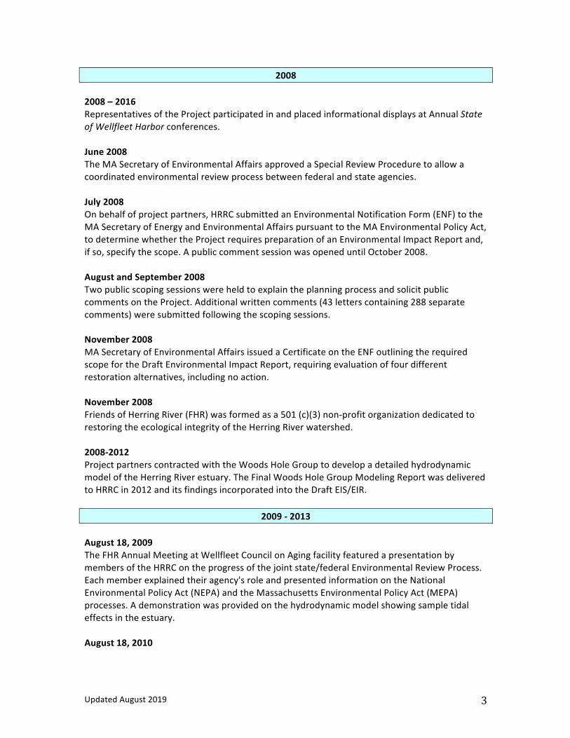
UpdatedAugust2019 3
20082008–2016RepresentativesoftheProjectparticipatedinandplacedinformationaldisplaysatAnnualStateofWellfleetHarborconferences.June2008TheMASecretaryofEnvironmentalAffairsapprovedaSpecialReviewProceduretoallowacoordinatedenvironmentalreviewprocessbetweenfederalandstateagencies.July2008Onbehalfofprojectpartners,HRRCsubmittedanEnvironmentalNotificationForm(ENF)totheMASecretaryofEnergyandEnvironmentalAffairspursuanttotheMAEnvironmentalPolicyAct,todeterminewhethertheProjectrequirespreparationofanEnvironmentalImpactReportand,ifso,specifythescope.ApubliccommentsessionwasopeneduntilOctober2008.AugustandSeptember2008TwopublicscopingsessionswereheldtoexplaintheplanningprocessandsolicitpubliccommentsontheProject.Additionalwrittencomments(43letterscontaining288separatecomments)weresubmittedfollowingthescopingsessions.November2008MASecretaryofEnvironmentalAffairsissuedaCertificateontheENFoutliningtherequiredscopefortheDraftEnvironmentalImpactReport,requiringevaluationoffourdifferentrestorationalternatives,includingnoaction.November2008FriendsofHerringRiver(FHR)wasformedasa501(c)(3)non-profitorganizationdedicatedtorestoringtheecologicalintegrityoftheHerringRiverwatershed.2008-2012ProjectpartnerscontractedwiththeWoodsHoleGrouptodevelopadetailedhydrodynamicmodeloftheHerringRiverestuary.TheFinalWoodsHoleGroupModelingReportwasdeliveredtoHRRCin2012anditsfindingsincorporatedintotheDraftEIS/EIR.
2009-2013August18,2009TheFHRAnnualMeetingatWellfleetCouncilonAgingfacilityfeaturedapresentationbymembersoftheHRRContheprogressofthejointstate/federalEnvironmentalReviewProcess.Eachmemberexplainedtheiragency'sroleandpresentedinformationontheNationalEnvironmentalPolicyAct(NEPA)andtheMassachusettsEnvironmentalPolicyAct(MEPA)processes.Ademonstrationwasprovidedonthehydrodynamicmodelshowingsampletidaleffectsintheestuary.August18,2010

UpdatedAugust2019 4
TheFHRAnnualMeetingatWellfleetCouncilonAgingfacilityfeaturedapresentationbyaHRRCmemberonalternativestoreturnatidalflowtotheriver.August16,2011TheFHRAnnualMeetingatWellfleetCouncilonAgingfacilityfeaturedapresentationdetailingthebenefitsoftheHerringRiverrestorationtothecommunity,waterquality,andhealthofWellfleetHarborandCapeCodBay.ApanelofHRRCmembersparticipatedinaquestionandanswersession.August21,2012TheFHRAnnualMeetingatWellfleetCouncilonAgingfacilityfeaturedapresentationofthehistorical,environmental,andculturalimpactoftheHerringRiveronBoundBrookIslandandthevibrantcommunitythatonceexistedthere.October2012 TheDraftEIS/EIRwasreleased;a60-daypubliccommentperiodcommenced.HRRCsentalettertoallprivatelandownerswhoabuttheHerringRiverestuarypriortothehearing,describingtheProjectandpotentialimpactstoprivateproperties,andinvitinglandownerstocontacttheHRRCforfurtherinformation.November2012 MEPAandtheCapeCodCommissionheldapublichearinginWellfleetontheDEIS/EIR.Over100peopleattendedand43piecesofcorrespondencewith161separatecommentswerereceivedfollowingthehearing.2013NOAAawardedathree-yeargrantof$3milliontoFHRtopreparedesign/engineeringplansandconductscientificanalysesfortheHerringRiverRestorationProject.2012-2016HRRCandFHRcontractedwithWoodsHoleGroupforadditionalhydrodynamicandsedimentmodeling,andcontractedwiththeLouisBergerGrouptodevelopsurveyplansandengineeringdesignsforstructurallyaffectedprivateproperties.HRRCandFHRcontacted,andinmanyinstancesmetdirectlywith,over100propertyownerstodiscusstheirquestionsandconcernsabouttheprojectandtoseekpermissionforsurveyworkonspecificproperties.Thisworkison-going.August2013TheFHRAnnualMeetingatWellfleetCouncilofAgingincludedapresentationonprojectplansandapresentationbyBillBurke,theCapeCodNationalSeashoreHistorianaboutthehistoryoftheHerringRiverEstuaryandnearbyuplandsbasedonarecentlycompiledparkservicearcheologicalreport.
20142014-2017
UpdatedAugust2019 5
TheConsensusBuildingInstitutefacilitateddiscussionsbetweenHRRCandChequessettYachtandCountryClub(CYCC)toenablerestorationoftheHerringRiverecosystem,includingMillCreek,whileprovidingnecessaryfloodprotectionforCYCC’sgolffacilities.TheProjectfundedsurveys,engineering,landplanningandappraisalsneededtodevelopagolfcourseprotectionplanforCYCC.August2014TheFHRAnnualMeetingatWellfleetCouncilofAgingfeaturedapresentationontheConceptualDesignforChequessettNeckRoadDike.October2014MAExecutiveOfficeofEnergyandEnvironmentalAffairsawardedthefirstofaseriesofgrantstoFHRforProjectdesignandengineeringandenvironmentalassessments.October2014andNovember2015TheU.S.GeologicalSurvey(USGS)AdaptiveManagementTeamheldtwostakeholdersmeetingstoexplaintheadaptivemanagementprocessfortheRestorationProjectandengagestakeholdersindevelopingtheadaptivemanagementplan.
2015February4,12and25,2015PublicforumsonroadwayalternationfortheHerringRiverRestorationProjectwereheldinWellfleet(LowroadsandHighTossRoad).June2and24,2015PublicforumsonLow-lyingroadwayalterationsfortheHerringRiverRestorationProjectwereheldinWellfleet(LowroadsandHighTossRoad).August18,2015TheFHRAnnualMeetingatWellfleetCouncilonAgingfacilityfeaturedapresentationbytheAssociationtoPreserveCapeCod;alookatriverherringexperienceintheestuarybytheWellfleetHerringwarden;areportonchangestoChequessettNeckRoadBridgePlans,includingkayakportageaccessprovisionsinresponsetopubliccommentssolicitedduringpublicmeetings;andplannedfunding.October22,29andNovember5,2015TheHerringRiver–ajourneythroughhistoryfromourpasttothepresentseminarserieswaspresentedattheWellfleetPublicLibrary.
2016February11,2016ApublicmeetingonHighTossRoadmarshcrossingwasheldinWellfleet.

UpdatedAugust2019 6
March2016TheWellfleetBoardofSelectmenreceivedadditionalcommentsonHighTossRoadmarshcrossing.April14,2016FHRheldapublicinformationalmeetinginWellfleetpriortotheAnnualTownMeeting.TheplanforremovingHighTossRoadwasoverwhelminglyapprovedbyavoteoftheTownMeeting.June2016 TheFinalEIS/EIRwaspublishedintheFederalRegisterandtheMassachusettsEnvironmentalMonitor.TheCapeCodCommissionheldaJointReviewhearingwiththeMassachusettsEnvironmentalPolicyActUnittoreviewtheFinalEIS/EIR.Morethan100peopleattendedthehearingand12commentlettersweresubmittedfollowingthehearing.July2016TheMASecretaryofEnergyandEnvironmentalAffairsissuedaCertificateontheFinalEnvironmentalReport(FEIR)findingthatitadequatelyandproperlycomplieswithMEPA,andestablishinganewRegulatoryOversightGroup(ROG)fortheProject.July–August2016FHRhostedasummerprogramseriesatWellfleetPublicLibrarytoexplorefacetsoftherestorationprojectincluding:HerringRiverTidalRestorationEffects:Currentandplannedmonitoringprojects;SaltMeetsFresh:Tidalseawater,freshgroundwater,andtheHerringRiverrestoration;TidalWater:AHistoryofWellfleet'sHerringRiver;horseshoecrabresearch;andmarshbirdsofHerringRiver.August2016CapeCodCommissionopenedapublichearing(proceduralonly)ontheHerringRiverRestorationProjectasaDevelopmentofRegionalImpact.Thispublichearingwascontinued.August16,2016TheFHRAnnualMeetingatWellfleetCouncilonAgingfacilityfeaturedaprojectupdate,announcementofthepublicationofabookonthehistoryofHerringRiver,asummaryofcurrentconditionsandrationaleforrestorationincludingsocial,economicandecologicalbenefits.September2016 TheRecordofDecisionontheFinalEIS/EIRwassignedbytheNationalParkServiceNortheastRegionalDirector.September2016MOUIIIwasexecutedbyWellfleetandTruroBoardsofSelectmenandtheNPSNortheastRegionalDirector,settingforththemanagementstructureforthenextphaseoftheRestorationProject.MOUIIIcalledforthecreationoftheHerringRiverExecutiveCouncil(HREC)toprovideProjectpolicydirectionandcoordinateProjectimplementation.
UpdatedAugust2019 7
2017TheHRECmetfourtimesin2017(January9,March9,June7andSeptember25).DuringthistimetheHRECappointedtheHerringRiverStakeholderGroup.(HRSG)toprovideadvisoryinputonkeyimplementationissues.TheHRSGconsistsofnineteenmembersrepresentingbroadinterestsinthecommunity:shellfish/fisheries,conservation/environmentalprotection,floodplainpropertyowners,businesses,navigation,recreation,mosquitocontrol,andtheCapeCodNationalSeashoreAdvisoryCommission.TheHRRCcontinuedmonthlymeetingstoadvanceprojectdesignandpermittingactivities.TheROGwillmeetinJanuarytoreviewpermittingissues.February2017AbriefingforSenatorCyrandRepresentativePeakewashealdattheFriendsofHerringRiveroffice.March2017TheFriendsofHerringRiverandWellfleetShellfishAdvisoryBoardhostedaforumonthesciencebehindthebenefitsoftidalrestorationforshellfishresources.TheHerringRiverRestorationCommittee(HRRC)madearecommendationtotheHerringRiverExecutiveCouncil(HREC)thatthepermitapplicationsseekingauthorizationtoimplementtheRestorationProjectnotincludetheuseofanyherbicidesintheHerringRiverRestorationProjectarea.Thesepermitapplicationswillspecifyothernon-chemicalmethodsofPhragmitescontrol.TheHRECunanimouslysupportedthisrecommendation.ThenewlydesignedFriendsofHerringRiverwebsitewaslaunched,includinguptodateinformationaboutmeetingsheldbytheHRRC,HRECandHRSG,andalsonewreportsandpubicinformationalmaterials.April2017WellfleetTownMeetingrejectedonepetitionedwarrantarticlewhichsoughttostoppermitapplicationsforimprovingHerringRiver,andindefinitelypostponedanotherarticlewithasimilarpurpose.TruroTownMeetingrejectedapetitionedwarrantarticlewhichsoughttostoppermitapplicationsforimprovingHerringRiver.ApublicpresentationontheHerringRiverRestorationProjectwasheldintheTruroTownHall.AnewprojectbrochurewasmailedtoallhouseholdsinTruroandWellfleet.May2017

UpdatedAugust2019 8
TheHRRCandChequessettYacht&CountryClub(CYCC)executedamemorandumofunderstanding(MOU)toadvancetheHerringRiverRestorationProject.TheMOUspellsoutthefloodprotectionmeasurestheprojectwillprovidetoCYCCbeforetidalflowispartiallyrestoredintheMillCreeksub-basin.June–AugustTheFriendsofHerringRiversponsoredmonthlysummerfieldtripstoexplaintheeffectsoftidalrestorationandrestriction.InAugust,theFriendsofHerringRiverAnnualMeetingfeaturedapresentationon“BlueCarbon”thecarbonstoragebenefitsofsaltmarshrestoration.November-DecemberFriendsofHerringRiverpublishedanewsletterexplainingPhase1oftheproject,whichwasmailedtoallhouseholdsandbusinessesinTruroandWellfleet.Individuallettersweresentwiththenewslettertoall300+propertyownersintheHerringRiverfloodplain.
2018TheHRRCcontinuedmonthlymeetingstoadvanceprojectdesignandpermittingactivities.March2018TheFriendsofHerringRiverco-sponsoredaforumonmonitoringtoprotectshellfishresourceswiththeWellfleetShellfishAdvisoryBoard.TheFriendsofHerringRiverco-sponsoredaforumonBlueCarbon,thecarbonstoragebenefitsofsaltmarshrestorationwithClimateMobilizationOuterCapeMobilization.AnewvideoentitledHerringRiverEstuary:RestoringandEcologicalTreasurewasreleasedandpremieredattheCapeCodNaturalHistoryConference.May2018TheFriendsofHerringRiverco-sponsoredaforumonwildlifeinHerringRiverandhabitatchangesresultingfromrestorationwiththeWellfleetConservationTrust,WellfleetNaturalResourcesAdvisoryBoard,WellfleetBayWildlifeSanctuary.TheHRECmetonMay16tolaunchtheHRSG.TheHRSGhelditsfirstmeetingonJune21st.TheHRSGmetagainonJuly25th,andOctober11th.July–August2018

UpdatedAugust2019 9
TheFriendsofHerringRiversponsoredmonthlysummerfieldtripstoexplaintheeffectsoftidalrestorationandrestriction.September2018FriendsofHerringRivercelebrates10thanniversaryannualmeeting.GuestspeakersincludeSenatorJulianCyr,SuperintendentBrianCarlstrom,andMassachusettsDivisionofEcologicalRestorationAssistantDirectorHuntDurey.December2018TruroBoardofSelectmenvotetoremoveTruroasprojectpartner.
2018January2019TownofWellfleetfilesanapplicationwiththeCapeCodCommissionforaLimitedScopeDecision.March2019March7,2019,publichearingonLimitedScopeapplicationbeforetheCapeCodCommissionRegulatorySubcommittee.FollowingthepublichearingthesubcommitteevotedunanimouslytoratifytheproposedLimitedScopeDecision.ThedecisionwasissuedMarch7,2019.June2019HerringRiverStakeholderGroupmeets.AfourthMemorandumofUnderstanding(MOUIV)issignedbytheTownofWellfleetandCapeCodNationalSeashore.MOUIVbecomesthenewgoverningdocumentforprojectimplementation.July-August2019AnewslettercontainingupdatedprojectinformationismailedtoallhouseholdsandhomeownersinWellfleetandTruro.FriendsofHerringRiverBoardmembersmeetwithvariousneighborhoodassociationsandcivicgroupstoupdatethemabouttheproject.September2019TownofWellfleetsubmitsDevelopmentofRegionalImpactapplicationtotheCapeCodCommission.

TownofWellfleetHerringRiverRestorationProject
DevelopmentofRegionalImpactApplication
157
8.GSupportLetters(See following pages) Hon. Julian Cyr, Senator and Hon. Sarah Peake, Representative Wellfleet Shellfish Advisory Board Wellfleet Open Space Committee Wellfleet Natural Resources Advisory Board Dennis O’Connell, Wellfleet Conservation Trust Andrew Gottlieb, Association to Preserve Cape Cod John J. Clarke, Massachusetts Audubon Richard Delaney, Center for Coastal Studies Wayne Klockner, The Nature Conservancy Great Pastures Homeowners Association, Wellfleet Gail Ferguson, Wellfleet The Cumblers, Wellfleet


To: The Wellfleet Selectboard October 10, 2019 Brian Carlstrom, Superintendent, Cape Cod National Seashore Cc: Congressman William Keating Senator Julian Cyr Senator Elizabeth Warren Senator Edward Markey Representative Sarah Peake Friends of Herring River From: The Wellfleet Shellfish Advisory Board Dear Superintendent Carlstrom, and members of the Wellfleet Selectboard: The Wellfleet shellfish Advisory Board at its October 9, 2019 meeting voted unanimously to convey our continued support for the Herring River restoration project as originally conveyed in a letter dated June 19, 2017. Since that time, the makeup of our board has undergone some changes, and we felt it was time to restate our strong support for the project. All in all, there have been over 100 meetings regarding this project including public meetings, and one-on-one individual meetings with private landowners, as well as in other public venues in Wellfleet and Truro. We still believe that restoring controlled tidal flow in line with current science, and closer to a flow rate that existed before installation of the Chequessett Neck Road tide gate will benefit those in the shellfishing community, the residents of Wellfleet, and those species of anadromous fish that use the Herring River estuary to spawn each year. Ever since the original structure was installed over 100 years ago, shellfishing has suffered in the area adjacent to the tide gate due to high levels of fecal coliform present resulting from restricted tidal flushing. Improving the amount of water flowing upstream and downstream of the new dike will surely be of great service towards improving water quality to provide for the needs of the shellfish, anadromous fish and wildlife native to the area. In an era when going GREEN has become all the rage, and climate change is an increasingly apparent threat, it is of particular concern to our board - for the obvious reasons associated with changes in sea level, ocean temperature and acidification, to do anything that would help slow the effects of a changing climate to maintain our robust shellfishing resource. One of the ancillary benefits of salt marsh restoration is in reducing methane emissions (a major contributor in climate change) as outlined in a University of Chicago Marine Biological Laboratory report. In it is a detailed scientific report which considers “The benefits of Restoring tides to reduce methane emissions in impounded wetlands: A new and potent Blue Carbon climate change intervention”. That report could have been written with the Herring River in mind. The Herring River estuary could indeed become a shining example of a successful salt marsh restoration by reversing the negative consequences of blocking tidal flow all those years ago. Please move forward as previously requested in obtaining the necessary permits for the timely construction of a new dike at Chequessett Neck Road. Our board looks forward to seeing a new and improved structure completed within the next 5 years.
, The Wellfleet Shellfish Advisory Board
Dave Seitler - Chair, Chip Benton, Zack Dixon, John Duane Jacob Puffer, Tom Siggia, Rebecca Taylor
T O W N O F W E L L F L E E T 300 MAIN STREET WELLFLEET MASSACHUSETTS 02667
Tel (508) 349-0300 Fax (508) 349-0305 www.wellfleet-ma.gov

TownofWellfleetSelectboardBrianCarlstrom,Superintendent,CapeCodNationalSeashore TheWellfleetOpenSpaceCommitteeisatowncommitteededicatedtolandprotectionforthebenefitofconservation,recreation,andnaturalresourceprotection.AtourmeetingonOctober8,2019theCommitteevotedtosendthisletterofsupportfortheHearingRiverRestorationProject.Thetimingofthisistoensureongoingsupportfortheprojectasitmovesforwardwithpermitapplicationsandfundraising. TheHerringRiverRestorationProjectisanunmatchedopportunitytorestore1,000acresofestuarinemarsh,andthemanyecosystemservicesthatmarshesprovidetotheenvironmentandgreatercommunity.Theseservicesincludeenhancementstohabitatforawiderangeofanimals,birdsandaquaticlife.Ahealthymarshalsohelpstomitigatefloodingfromstorms,andfilterpollutantsfromrun-offbeforetheyreachestuarinewaters.WearealsoimpressedwiththepotentialforahealthyHerringRivermarshsystemtoabsorbcarbonandreduceexistingmethaneemissions,whichincombinationwillhelptocombattheeffectsofclimatechange. AsacommitteededicatedtopreservingthenaturalenvironmentforthebenefitoftheWellfleetcommunity,weseetremendousbenefitintheenhancedrecreationalopportunitiesaffordedbyrestoringsixmilesofriverwayforcanoeing,kayakingandfishing.Improvementstowaterqualityfromrestorationoftidalflushingwillreducefecalcoliformconcentrationsintheriver,whicharenowcontaminatingshellfishbedsdownstreamoftheChequessettNeckRoadDike.Improvedwaterqualityresultingfromtherestorationisexpectedtoleadtothere-openingofshellfishbedsdownstreamofHerringRiverwhichhavebeenclosedfordecades,andcouldhelptorevitalizelocalriverherringpopulations. RestoringHerringRiverwillbringsignificantbenefitstoourcommunityandenvironment,andwillserveasamodelforcoastalrestorationelsewhereonCapeCod,andbeyond.TheWellfleetOpenSpaceCommitteestronglysupportstheHerringRiverRestorationProject. Sincerely,BruceHurter,ChairmanWellfleetOpenSpaceCommittee cc:SenatorElizabethWarrenSenatorEdwardMarkeyCongressmanWilliamKeatingSenatorJulianCyrRepresentativeSarahPeakeFriendsofHerringRiver

NATURALRESOURCESADVISORYBOARD Wellfleet,Massachusetts
300 Main Street Wellfleet, MA, 02667
Wellfleet Board of Selectmen October 14 2019 Wellfleet Town Hall 300 Main Street Wellfleet, MA, 02667 Brian Carlstrom, Superintendent Cape Cod National Seashore 99 Marconi Site Road Wellfleet, MA, 02667
Representing the Wellfleet Natural Resources Advisory Board (NRAB), I am writing to express our continued strong support for the Herring River Restoration Project. NRAB has long been an advocate for restoration of the Herring River estuary. Salt marsh protection was a priority in both Harbor Management Plans (HMP) submitted to the Board of Selectmen/Wellfleet in 1995 and 2006. Both reports are on the Town website, under NRAB. The recommendation to restore the Herring River was a top priority in the 2006 HMP.
The Herring River today is in poor health due to more than a century of tidal restriction caused by the construction of the Chequessett Neck Road dike. Tidal restriction has caused poor water quality, loss of salt marsh, degradation of habitat, and contamination of shellfish beds downstream of the dike in Wellfleet Harbor. These conditions will continue as long as the existing Chequessett Neck Road dike remains in place.
The Towns of Wellfleet and Truro with the Cape Cod National Seashore had the foresight to develop a restoration plan to reverse these degraded conditions.
The Herring River Restoration Project will result in significant improvements in water quality, fisheries and wildlife habitat, and the overwhelming benefits these resources provide to the community and the region.
• Roughly 1,000 acres of salt marsh and other estuarine wetlands-and the habitat and food sources they provide-will be restored;
• Expanded habitat for many species of birds, mammals and reptiles—including rare species—that thrive in salt/brackish marsh;
• 11+ river miles for fish passage will be restored, along with access to 160 pond acres

for spawning. • Water quality will improve in Herring River and Wellfleet Harbor, to the benefit of
residents, shellfishermen, and visitors; • Restored salt marsh will enhance the ability to adapt to sea level rise; • Recreational access to 6 miles of waterways will be restored; • Restoration of healthy salt marsh will capture carbon and reduce methane, resulting in
a substantial reduction of the net volume of greenhouse gases released to the atmosphere.
• The existing Chequessett Neck Road dike, which is no longer functioning to control tidal flow, will be replaced with a state-of-the-art tide control structure, which can be used to limit any storm surge in the estuary.
The Herring River Restoration Project is the result of scientific study and extensive community discussions. Changes in tide levels will be made incrementally, while carefully modeling and monitoring of system responses will allow the project to adjust the rate of change and take other management actions to achieve the benefits of restoration while avoiding or minimizing unintended outcomes. In particular, as Wellfleet is a shellfishing town the project managers have made an especial effort to keep the shellfish community informed on the project and the planned restoration process. The Herring River Restoration Project will restore the health of a unique and environmentally significant resource for the benefit of the community today and for years to come. Sincerely, John Riehl John Riehl, Chair, Natural Resources Advisory Board Cc: Senators Elizabeth Warren and Edward Markey Congressman William Keating Senator Julian Cyr Representative Sarah Peake Friends of Herring River
September 4, 2019
Town of Wellfleet Selectboard Superintendent, Cape Cod National Seashore - by electronic delivery- Dear Selectboard Members and Superintendant: The Board of Trustees of the Wellfleet Conservation Trust (WCT) wishes to demonstrate our support for the progress made by the Herring River Restoration Project and to support the plans to continue to evaluate and proceed as the project goes into the permitting and funding phases. This Board has been continuously aware of the progress of the HR Restoration Project for more than 10 years. In fact, WCT funded the first widely distributed information sheet during the early evaluation period, before the Friends of Herring River was formed and funded. Also, we own several parcels of land within the anticipated flood zone of the project.
We have been impressed with the efforts for transparency, for public awareness, and, especially for the degree of scientific research that has gone into the development of restoration plans. Also, we are impressed by the opportunities to improve the environmental conditions and water quality of the estuary and of the Harbor. We have great confidence in the leadership structure that has evolved. We believe that the leadership team will continue its practice of understanding all aspects of the project and will do what is best for the citizens of the Towns of Wellfleet and the interests of the Cape Cod National Seashore, taking into consideration all those who are impacted by the project.
We urge continuing efforts to progress this project through the permitting and funding stages.
Sincerely,

R. Dennis O'Connell
R. Dennis O'Connell, President
cc: Senator Edward Markey, Senator Elizabeth Warren, Congressman William Keating, Senator Julian Cyr, Representative Sarah Peake, and The Friends of Herring River

100% Recycled Paper 482 Main Street | Dennis, MA 02638
Tel: 508-619-3185 | [email protected] | www.apcc.org
Andrew Gottlieb Executive Director
BOARD OF DIRECTORS
Margo Fenn President
Charles Sumner Vice President
Bob Ciolek Treasurer
Maureen O’Shea Clerk
Michael Corrigan
DeeDee Holt
Thomas Huettner
Pat Hughes
Cheryl Lubin Elysse Magnotto-Cleary
Blue Magruder
Eliza McClennen
Stephen Mealy
Kris Ramsay
Robert Summersgill
Taryn Wilson
October 1, 2019 Town of Wellfleet Board of Selectmen Brian Carlstrom, Superintendent, Cape Cod National Seashore RE: Herring River Restoration Letter of Support The Association to Preserve Cape Cod (APCC) writes to express our strong support for the Herring River Restoration Project in Wellfleet. Founded in 1968, APCC is the Cape Cod region’s leading nonprofit environmental advocacy and education organization. Representing thousands of members across Cape Cod, APCC’s mission is to promote policies and programs that foster the preservation of the Cape’s natural resources. APCC focuses its efforts on the protection of groundwater, surface water, and wetland resources, preservation of open space, the promotion of responsible, planned growth and the achievement of an environmental ethic. One of APCC’s major program areas involves promoting and assisting in salt marsh restoration efforts on Cape Cod, and with good reason. Cape Cod has experienced a critical loss of salt marsh habitat. More than 7,000 acres—or 38 percent—of our salt marshes on Cape Cod have been lost or destroyed due to damming, dredging, filling, ditching and other human development activities. The loss of salt marshes also means the loss of the many valuable ecosystem functions they provide. For example:
• It is estimated that 75 percent of our commercially important fish and shellfish species depend on salt marsh habitat at some point in their life cycles for nurseries and as a source of food.
• Salt marshes attenuate storm flooding and provide a buffer against storm surges.
• Salt marshes filter pollutants from runoff and groundwater before they enter our estuaries.
In addition, we are beginning to understand the significant role salt marshes play in mitigating the effects of climate change. Research shows that salt marshes are able to store more carbon per acre than tropical rain forests. The Herring River Restoration Project has the potential to restore nearly 1,000 acres of salt marsh, reclaiming a substantial percentage of salt marsh habitat previously lost on

100% Recycled Paper 482 Main Street | Dennis, MA 02638
Tel: 508-619-3185 | [email protected] | www.apcc.org
Cape Cod. It is a high priority restoration project for the Cape Cod National Seashore, the town of Wellfleet and many partner agencies and organizations. It has also been a priority project for APCC for many decades; APCC was one of the first voices calling for restoration of the Herring River in the 1970s. The restoration project will significantly improve habitat for a wide variety of wildlife species that thrive in salt and brackish marsh environments. Salt marshes are among the most productive ecosystems on the planet and provide food, shelter, nesting sites and migratory habitat for many species of birds, mammals and reptiles. Restoring tides to the Herring River will enhance the quality and quantity of these resources and improve their resiliency in the face of increased threats by sea level rise and land-based pollution and encroachment. By restoring twice-daily flushing with clean, high-salinity Cape Cod Bay water, the project will improve water quality, especially near the Herring River mouth, resulting in the likely re-opening and expansion of more than 100 acres of harvestable oyster beds. The restoration will also restore several miles of river for fish passage as well as access to 160 pond acres for spawning. By providing improved fish passage, improved water quality and expanded habitat, the project will benefit all species of anadromous and catadromous fish, including river herring (alewife and blueback herring), hickory shad, white perch and American eel. Technical direction for the project has come from a partnership of local, state and federal agencies in consultation with leading estuarine scientists from public, private and university sectors to ensure that the work is founded on a current and peer-reviewed knowledge base. Thanks to an ongoing commitment to public outreach and education on the part of project partners, the project has gained strong local and regional support, and is poised for successful permitting, funding and implementation. For all the reasons cited above, APCC pledges its continued support of this critically important project to ensure that the full potential of the Herring River restoration is achieved. Sincerely,
Andrew Gottlieb Executive Director cc: Congressman William Keating
Senator Julian Cyr Representative Sarah Peake Friends of Herring River

1
October 7, 2019 Brian Carlstrom Superintendent Cape Cod National Seashore 99 Marconi Site Road Wellfleet, MA 02667 Wellfleet Selectboard 300 Main Street Wellfleet, MA 02667 Re: Herring River Restoration project Dear Mr. Carlstrom and Wellfleet Selectboard, On behalf of Mass Audubon, I submit the following letter of support for the Herring River Restoration project. Mass Audubon has a long-held interest in the restoration of the Herring River and has commented numerous times during the project review process. We continue to be strongly supportive of this project because of the important local benefits it will generate, and because it serves as a model for restoring other estuaries along Massachusetts’ and America’s coast. The project will return tidal flow to the 1,000-acre Herring River estuary by replacing the Chequessett Neck Road dike with a new bridge with tide gates. This will reverse the loss of hundreds of acres of salt marsh habitat that has occurred over the past 100 years. Salt marshes provide food, shelter, nesting sites, and migratory habitat for many species of birds, including wintering Black Ducks, state-listed Clapper Rail, and Least Bittern. They restore foraging habitat and open new nesting areas for the state-listed diamondback terrapin at the north edge of its range. The project will also restore nursery habitat for the greatly reduced populations of horseshoe crabs in the Wellfleet harbor system and that spawn on nearby Great Island Restoring tides to the Herring River will enhance the quality and quantity of these resources and improve their resiliency in the face of sea level rise and projected increased storm activity along the coast.

2
This project will restore natural tidal flow to the Herring River, reversing the damage that has occurred since 1909 when the installation of the dike blocked tides that had carried oxygen-rich ocean waters into the Herring River system. By restoring twice-daily flushing with clean, high-salinity Cape Cod Bay water, the Project will improve water quality and increase the flow of nutrients into Wellfleet Harbor, fueling shellfish growth and an increase in harvestable oyster beds. The restoration will allow for fish passage and improvements to habitat for species including Osprey and Common and Roseate Terns, and increase forage fish plankton which will improve striped bass and bluefish feeding opportunities. By restoring healthy coastal wetlands, the project will also enhance climate change resiliency against impacts like sea level rise by acting as a natural floodplain. Restoration of tidal flow will improve water quality and benefit shellfish habitat. A century of tidal restriction has resulted in high concentrations of fecal coliform bacteria in the River, which has led to shellfish closures in Wellfleet Harbor downstream of the Chequessett Neck Road dike. Restoration will reduce bacterial concentrations by flushing cleaner ocean water into Herring River twice daily and by increasing salinity levels in the River that reduce survival time of bacteria. The reduction in fecal coliform concentrations is expected to lead to the reopening of once-productive shellfish beds in Wellfleet Harbor. Sincerely,
John J. Clarke Director of Public Policy & Government Relations cc: Senator Elizabeth Warren Senator Edward Markey Congressman William Keating Senator Julian Cyr Representative Sarah Peake Friends of Herring River

November 7, 2019
Board of Selectmen, Wellfleet Superintendent Brian Carlstrom Cape Cod National Seashore
Dear Mr. Murphy and Mr. Carlstrom:,
The Center for Coastal Studies is dedicated to promoting stewardship of coastal and marine ecosystems in the Gulf of Maine, and to encouraging responsible use and conservation of these ecosystems. We carry out our work through scientific research, education, and collaboration with other institutions and individuals.
The Center’s Seafloor Mapping Program worked closely with many partners both public and private (Cape Cod National Seashore, The Town of Wellfleet, Friends of Herring River and SPAT, Inc.), in funded and pro bono efforts, to better understand the current conditions of Herring River and the surrounding Harbor to improve estimates and/or projections of the potential impacts of tidal restoration on the entire system.
The Herring River Restoration Project is a model for restoring other estuaries in Massachusetts and America’s coast. Reconnecting the Herring River to the Gulf of Maine will let it once again support the natural coastal food web that numerous fish, birds and other wildlife depend on for their survival. Restoring the estuary is an important step to help increase finfish and shellfish populations, revive the region’s commercial and recreational fisheries and increase access for boaters.
The Project will use state-of-the art adaptive management techniques to introduce changes to the natural system carefully, while on-going modeling and monitoring of system responses takes place. This will provide opportunities to adjust the rate of change to achieve maximum restoration benefits while avoiding or minimizing any unintended changes.
We are also encouraged by the Project’s potential to expand the benefits of Blue Carbon on Cape Cod. The Center for Coastal Studies is a founding member of the Cape Cod Climate Change Collaborative, an organization formed to unite the varied expertise and experience of Cape Cod organizations to address the impacts of climate change. Tidal restoration of

Herring River will reduce methane emissions from the system as saltwater wetlands are re-established in place of freshwater wetlands. Avoidance of methane emissions is particularly significant since it is known to be approximately 20 times more potent as a heat trapping gas in the atmosphere than carbon dioxide.
As scientists focused on the health of ocean resources, we often see degradation of marine resource go unaddressed, with devastating long-term consequences. The Herring River Restoration is a rare and important opportunity to reclaim the extensive ecosystem services provided by a healthy 1,000-acre estuary. It will be a living laboratory for future monitoring and research on estuarine restoration. We strongly support the project and offer our assistance to help in facilitating its implementation.
Sincerely
Richard F. Delaney, President and CEO Center for Coastal Studies
CC:
Senator Elizabeth Warren Senator Edward Markey Congressman William Keating Senator Julian Cyr Representative Sara Peake Friends of Herring River

Wellfleet Board of Selectmen Brian Carlstrom, Superintendent, Cape Cod National Seashore October 11, 2019 Dear Selectmen of Wellfleet, and Superintendent Carlstrom, I am writing to express The Nature Conservancy’s strong support for the Herring River Restoration Project. The Nature Conservancy is a global non-profit conservation organization whose mission is to “conserve the lands and waters on which all life depends.” In Massachusetts, the Conservancy has protected some 23,000 acres of crucial natural resources, and TNC leads many science-based projects to keep nature healthy throughout the state. TNC proudly represents the ideals of 28,000 members in Massachusetts and more than one million members globally. We work using the best available science and in collaboration with individuals, local communities, businesses, public agencies, and other nonprofit groups. Herring River today is in poor health due to more than a century of tidal restriction caused by the construction of the Chequessett Neck Road dike. Tidal restriction has resulted in poor water quality, loss of salt marsh, degradation of habitat, and contamination of shellfish beds downstream of the dike in Wellfleet Harbor. These conditions will continue as long as the existing Chequessett Neck Road dike remains in place. Fortunately, the Town of Wellfleet and the Cape Cod National Seashore had the foresight to develop a restoration plan to reverse these degraded conditions. The Herring River Restoration Project will result in significant improvements in water quality, fisheries and wildlife habitat, and the overwhelming benefits these resources provide to the community and the region. These benefits for nature and people include:
• Roughly 1,000 acres of salt marsh and other estuarine wetlands—and the habitat and food sources they provide—will be restored;
• Expanded habitat for many species of birds, mammals and reptiles—including rare species—that thrive in salt/brackish marsh;
• 11+ river miles for fish passage will be restored, along with access to 160 acres of ponds for spawning;
• Water quality will improve in the Herring River and in Wellfleet Harbor, to the benefit of residents, shellfishermen, and visitors;
• Restored salt marsh will enhance coastal storm resiliency and the ability to adapt to sea level rise;
• Recreational access to 6 miles of waterways will be restored; and,
The Nature Conservancy in Massachusetts 99 Bedford Street, Suite 500 Boston, MA 02111
Phone: (617) 532-8360 Cell: (617) 678-6135 [email protected] nature.org/massachusetts

• Restoration of healthy salt marsh will capture carbon and reduce methane, resulting in a substantial reduction of the net volume of greenhouse gases released to the atmosphere.
The Herring River Restoration Project is the result of scientific study and extensive community discussions. Changes in tide levels will be made incrementally, while careful modeling and monitoring of system responses will allow the project’s executors to adjust the rate of change and take other management actions to achieve the benefits of restoration while avoiding or minimizing unintended outcomes. The Herring River Restoration Project will restore the health of a unique and environmentally significant resource for the benefit of the community today and for years to come.
Sincerely,
Wayne Klockner State Director Massachusetts Program The Nature Conservancy Cc: Senator Elizabeth Warren Senator Edward Markey Congressman William Keating Senator Julian Cyr Representative Sarah Peake Friends of Herring River


October 2, 2019 Wellfleet Selectboard; Superintendent, Cape Cod National Seashore Subject: Letter of Support for the Herring River Restoration Project Greetings, I am writing to express my support for the Herring River Restoration Project. I am a resident of Wellfleet who owns real property at 112 West Main Street that is located in the southern most part of the Upper Pole Dike Basin, and within the historic Herring River flood plain. In late 2012 I received a letter from the Town of Wellfleet notifying me that my property would experience increased water levels and increased regulation as a result of a proposed restoration of the Herring River. From that time until the present time, I have attended most, if not all, of the public hearings and informational meetings that have been held in Wellfleet concerning the restoration and its expected effects. While I had long been a supporter of salt marsh restoration generally, I nevertheless had concerns about the impact of this particular project on my own property. My concerns, however, faded as I began to gain a sense of the high level of professional attention and expertise upon which the Herring River Project plans rested. As I followed the public hearings I came to understand that a very slow re-introduction of salt water would be carefully monitored throughout the restoration process, thereby enabling a quick response to any deviation from what earlier modeling had predicted. This adaptive approach, together with the mitigation actions that will be taken to protect private structures, eased my initial concerns about unexpected impacts to my own property. As I am sure you know, it has been a long and complex journey for the proposed restoration. Following the publication of the Herring River Technical Committee’s final report in 2007 (their, “Conceptual Restoration Plan”) the Herring River project has slowly, but steadily, progressed to the point where the restoration is now poised to become a project in fact once the permitting process is finished and funding is in hand. When it is completed the Herring River Restoration project will be the largest restoration of a salt marsh in the Northeast region. People who had been paying attention to local environmental matters have known for some time that Wellfleet erred when the town decided to restrict tidal flow into the Herring River in the early 1900’s. Eventually the consequences of this tidal restriction became obvious to others, like myself, who live in, or close to, the historic flood plain. During the approximately 30 years that I have owned my home on West Main Street I have observed a dead and dying landscape along the side of Pole Dike road (a continuation of West Main Street) in an area that was once a beautiful expanse of salt hay and a healthy spawning ground for several species of marine life. Now when I pass by this area I think of the day when oxygen rich tides are re-introduced, and the journey back to a healthy marsh has begun.

(And, as I have learned more about our changing climate I have come to understand that a healthy salt marsh will provide better protection from the higher tides and stronger storms that we now know we should expect.) I once described the Herring River Restoration Project as our gift to future generations. More recently I have begun to think of it as an act of stepping up to the plate and doing the right thing. When it is completed I believe that it will be a model, as well as an inspiration, for other coastal communities. Sincerely,
Gail Ferguson 130 West Main Street Wellfleet, MA 02667 [email protected] CC: Sen. Elizabeth Warren Sen.Edward Markey Congressman William Keating Senator Julian Cyr Representative Sarah Peake Friends of Herring River

To:WellfleetSelectBoard
From:TheCumblers
Concerning:TheHerringRiverRestoration
Asanenvironmentalist-aprofessorofenvironmentalstudies-andanabuttertotheHerringRiverproject,IhavecarefullylookedatthesciencearoundthestudiesoftheHerringRiverasitisnowandamgreatlyconcerned.TheHerringRiverisinanadvancedstateofdecline,acidificationisincreasing,themarshissinking,andthedrainagefromadegradedmarshiscompromisingshellfishbeds.TherestorationoftheHerringRiverwilldramaticallyreducethesenegativeimpactsontheeco-system.
Therestorationwillalsoincreasetheherringrunandlimitthestressontheherringofdealingwithhighlyacidicandpollutedwateraswellasopeningupmorespacefortheherringtorunthusreducingpredationparticularlyinnarrowculverts.TheflushingoftheHerringRiverwilldefinitelysupportgreaterdiversityofmarinelife,expandthenurseryforjuvenilefishandperhapsevenbecomeaspawningareaforstrippedbass.Sandeels,asignificantfoodsourceforstripedbassandbluefish,willmostlikelyrecolonizethemouthoftheriver.
Withrestoration,theHerringRiverwillbecomeasignificantdestinationforfishersfromaroundtheregion.Itwillalsoprovideanimportantdestinationforcanoeistsandkayakers.Withtheincreasingconcernoversharksatourbeaches,arestoredHerringRiverwillprovideanimportantalternativetouristattractiontotownbeaches.
Wearefull-timeresidentsofWellfleetwhostronglysupporttherestorationoftheHerringRiver.WearealsoabuttersonMillCreek,whichwill,soonwehope,eventuallybepartoftherestoration.Westronglyurgethetowntotakewhateverstepsnecessarytomovethisprojectforward.WehavewatchedtheHerringRiverdegradeoverthe30yearswehaveownedabuttingproperty.AsarecreationalfishermanIhavelongadvocatedtheopeningupoftheHerringRiveriffornootherreasonthantodramaticallyincreasefishingpotentialintown.
Thisprojectislongoverdue.Asconservationistsarguedatthetime(andthecourtsagreed),thedykeshouldneverhavebeenrebuilt50yearsago.Itiswellpasttimewerectifiedthatmistake.Pleasecontinueyoursupportfortherestorationproject.FuturegenerationofWellfleetianswillthankyou.
TheCumblers
380OldChequessettNeckRd
Wellfleet,MA02667

TownofWellfleetHerringRiverRestorationProject
DevelopmentofRegionalImpactApplication
158
8.HDesignPlans 8.H.1ProjectElements
Chequessett Neck Road Bridge: HerringRiverRestorationProjectChequessettNeckRoadBridgeandWaterAccessFacilityConstruction.PermittingDrawingSet.June2018;RevisedNovember12,2019.PreparedbyFuss&O'Neill,Inc.PoleDikeRoadandotherlow-lyingroads:HerringRiverRestorationProject.EngineeringDesigntoElevateLow-LyingRoadwaysandReplaceAssociatedCulverts.PermitPlans–NotforConstruction.May2019.PreparedbyLouisBergerU.S.Inc.HighTossRoadRemoval:HerringRiverRestorationProject.HighTossRoadPermit-LevelDesignPlans.June30,2017;RevisedJune28,2018.PreparedbyESSGroup,Inc.
8.H.2Mitigation
HerringRiverRestorationProject.PermitPlansforLow-LyingPropertyImpactPrevention.Miller-FrederiksenProperty(695BoundBrookIslandRoad).PermitPlans–NotForConstruction.April2018.PreparedbyLouisBergerU.S.Inc.HerringRiverRestorationProject.ChequessettYachtandCountryClubReconfigurationPermit-LevelDesignPlans.DRAFT.September13,2019.PreparedbyESSGroup,Inc.(Note:Anupdatedstampedplansetwillbeprovidedshortlytoreflectanewhaulroadlocation)
8.H.3FederalStructuresonFederalLand
MillCreekWaterControlStructure:HerringRiverRestorationProjectMillCreekWaterControlStructure.ConstructionProjectPermittingDrawingSet.June2018.PreparedbyFuss&O'Neill,Inc.Way672TideBarrier:HerringRiverRestorationProject.Way#672TidalBarrierAlternativesAssessment.ExistingandProposedConditions.June2019.PreparedbyFuss&O'Neill,Inc.(Note:Anupdatedplansetwillbeprovidedshortlyforinformationalpurposes)