Harlem River Watershed and Natural Resources Management ...
49
Harlem River Watershed and Natural Resources Management Plan for the Bronx 2020
-
Upload
khangminh22 -
Category
Documents
-
view
4 -
download
0
Transcript of Harlem River Watershed and Natural Resources Management ...

Harlem River Watershed and Natural ResourcesManagement Planfor the Bronx2020
Harlem RiverWatershed andNatural ResourcesManagement Planfor the Bronx
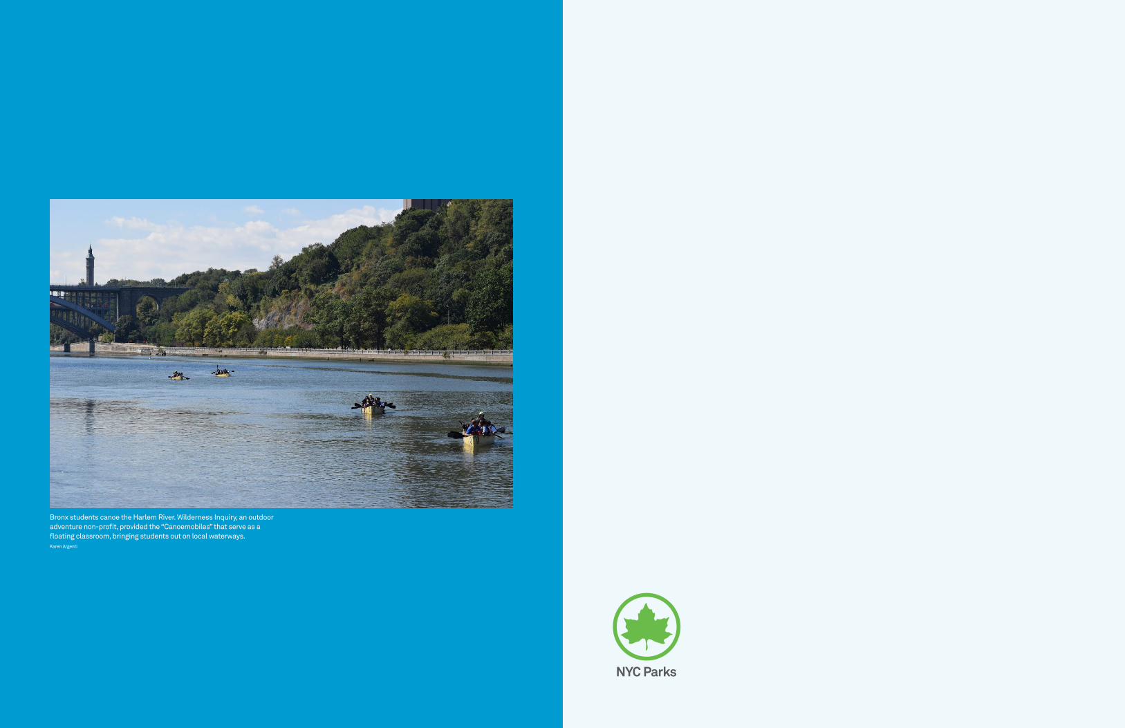
Bronx students canoe the Harlem River. Wilderness Inquiry, an outdoor adventure non-profit, provided the “Canoemobiles” that serve as a floating classroom, bringing students out on local waterways. Karen Argenti

List of Acronyms
Executive Summary
IntroductionKey Stakeholders
Vision & Goals
Other Planning Efforts
About the WatershedGeology & Soils
History of Land Use Changes
Current Land Use and Zoning
Community Demographics
Hydrology
Water Quality
Climate Vulnerability
Ecosystems and Habitats
Goals for the Watershed
6
7
810
14
15
1617
18
24
25
26
31
38
42
48
Strategies & RecommendationsWatershed-wide Strategies and Recommendations
Protect, Restore, and Enhance Natural Resources
Manage Stormwater
Promote Access and Connectivity
Maximize Engagement and Education
Site-Specific Recommendations
Green Infrastructure Opportunities
Van Cortlandt Park Opportunities
Waterfront Opportunities
Tracking and Monitoring
Looking Ahead
Notes
References
Contents
The Harlem River Watershed Plan was prepared with funding provided by the New York State Department of State under Title 11 of the Environmental Protection Fund.
Contact InformationCity of New York Parks and Recreation Forestry, Horticulture, & Natural ResourcesArsenal North 1234 Fifth Avenue New York, NY 10029
Jennifer GreenfeldAssistant CommissionerTelephone: 212-360-1488Email: [email protected]
Marit LarsonChief of Natural Resources Telephone: 212-360-1415Email: [email protected]
Rebecca SwadekSenior Wetlands Restoration Program ManagerTelephone: 212-360-1436Email: [email protected]
Jamie OngEnvironmental Protection Project ManagerTelephone: 718-225-3061 x116, 212-360-1491Email: [email protected]
Katie FriedmanAquatic Ecologist Telephone: 212-360-1429Email: [email protected]
Sara PowellUrban Waters AmbassadorBronx and Harlem Rivers Urban Waters Federal PartnershipTelephone: 212-360-1480Email: [email protected]
5052
53
58
62
64
68
70
79
84
90
92
94
95

6 Harlem River Watershed and Natural Resources Management Plan for the Bronx 7 Executive Summary
BCEQBronx Council for Environmental Quality
BMP Best Management Practice
BOA Brownfield Opportunity Area
CB Community Board
CEQR City Environmental Quality Review
CSO Combined Sewer Overflow (or Combined Sewer Outfall)
CUNY City University of New York
CWA Clean Water Act
DCPNew York City Department of City Planning
DEC New York State Department of Environmental Conservation
DEP New York City Department of Environmental Protection
DO Dissolved oxygen
DOEDepartment of Education
DOHDepartment of Health and Mental Hygiene
DOS New York State Department of State
DSNYNew York City Sanitation Department
EDCEconomic Development Corporation
EIS Environmental Impact Statement
EFH Essential fish habitat
EPA United States Environmental Protection Agency
FVCP Friends of Van Cortlandt Park
GI Green Infrastructure
HEP NY-NJ Harbor & Estuary Program
IEC Interstate Environmental Commission
LTCP Long Term Control Plan
MHPM Mott Haven/Port Morris
MS4 Municipal Separate Storm Sewer System
MTA Metropolitan Transportation Authority
NAC Natural Areas Conservancy
NEPA National Environmental Policy Act
NOAA National Oceanic & Atmospheric Administration
NYC New York City
NYC DOT New York City Department of Transportation
NYS New York State
NYS DOT New York State Department of Transportation
PCBs Polychlorinated Biphenyls
RIPARandall’s Island Park Alliance
SBU South Bronx Unite
SEQR New York State Environmental Quality Review Act
SNAD Special Natural Area District
SWMP Stormwater Management Plan
TPL Trust for Public Land
UHI Urban Heat Island
USACE United States Army Corps of Engineers
USGS United States Geological Survey
UWFPUrban Waters Federal Partnership
VCP Van Cortlandt Park
VCPA Van Cortlandt Park Alliance
List of AcronymsThe Harlem River Watershed in the Bronx is a diverse and dynamic urban system with critical resources that need protection and restoration, as well as exciting opportunities for water quality improvement, greenway expansion, and public engagement. The Harlem River, a 9.3-mile tidal strait separating the Bronx from Manhattan, was transformed over the last century from a complex system of creeks and wetlands to an industrialized corridor. Local community organizations have devoted decades of advocacy to find ways to restore connections to the river, revitalize its watershed and waterfront, and improve water quality.
The Harlem River Watershed and Natural Resources Management Plan (the plan) for the Bronx is a community-informed planning effort, funded by the New York State Department of State (DOS) Local Waterfront Revitalization Program. The plan is intended as a road map for agencies, community partners, and other stakeholders pursuing coordinated resource protection and restoration in the Bronx portion of the Harlem River watershed.
This plan provides a vision and goals for the watershed, while introducing strategies and recommendations to achieve the stated goals. It builds upon past planning efforts by integrating recommendations and priorities, as appropriate, in a watershed context. Each of these components have been reviewed and agreed upon by community members and a Watershed Advisory Committee. The following restoration goals were developed with input from the community:
1. Protect, restore, and enhance natural resources to maximize diverse, native, and continuous ecological communities;
2. Manage stormwater through green infrastructure practices to capture, retain, and treat runoff;
3. Promote access and connectivity to the shoreline and between existing parks and open space; and
4. Engage and educate the public to increase community awareness, environmental protection, and stewardship among diverse stakeholders.
To address these goals, the plan introduces 14 broad strategies, 77 watershed-wide management recommendations, and 97 site-specific recommended actions. These strategies and recommendations each address current conditions of the watershed and threats to ecosystem health detailed in the plan.
Beginning in 2016, NYC Parks developed these recommendations through an iterative process by analyzing ecological and land use data, reviewing previous planning efforts, presenting at public meetings, and incorporating input from community members and 19 technical advisors on the Watershed Advisory Committee. A subset of recommended actions are highlighted as priorities. These either have a clear path to implementation, strong community support, and/or are necessary to address the most critical and immediate threats to the watershed and its resources.
To ensure the long-term sustainability of this plan, NYC Parks will track progress towards completing recommendations and achieving the overall vision of a clean, healthy, and accessible watershed. As we advance projects, our tracking and monitoring efforts will allow us to be responsive and adaptive to changes in condition, new research, and lessons learned during implementation. NYC Parks is committed to working with all lead and partner organizations identified in the plan to achieve the vision of a clean river and healthy watershed that is accessible for all to enjoy.
Executive Summary
Mill Pond Park, pictured above, is the most heavily used riverfront park in the watershed.

98 Harlem River Watershed and Natural Resources Management Plan for the Bronx
__
Hud
son
Rive
r
Long Island Sound
Harlem River
161 ST
BRONX EXP
RFK B
R
CROSS
FORDHAM RD
MO
SHO
LU PKW
YH.HUDSON PKWY
BRO
ADW
AY
MAJ
OR
DEE
GAN
EXP
CONC
OUR
SE
GRAND
± 0Miles
0.5 1
Introduction
The Harlem River, a 9.3-mile tidal strait separating Manhattan and the Bronx, was once a complex system of tidal creeks and wetlands flanking the shoreline. Local communities have depended on the river for boating, fishing, recreation, and transportation since the Lenape Native Americans first inhabited the region. Beginning in the 19th century, the City dredged and channelized the Harlem River and hardened its shorelines to support navigation and industrialization in the New York Harbor.
The Harlem River watershed has been transformed as well by its inhabitants—from primarily forest and agricultural lands to dense urban neighborhoods and paved industrial corridors. These changes, driven by population and manufacturing growth, have negatively impacted the river’s water quality and limited the extent of open space and natural habitat in the watershed.
The Harlem River Watershed and Natural Resources Management Plan (the plan) for the Bronx is a community inspired planning effort, funded by the New York State Department of State’s (DOS) Local Waterfront Revitalization Program. The plan is intended as a road map for agencies, community partners, and other stakeholders in pursuing coordinated resource protection and restoration in the Bronx portion of the Harlem River watershed.
The full extent of the Harlem River watershed includes land in both the Bronx and Manhattan boroughs. However, this plan’s study area does not include the Manhattan portion of the watershed. Instead the study area encompasses the typically under-represented land in the Bronx, south of the Bronx-Westchester County border, which drains naturally (via overland flow and streams) and artificially (via sewers) to the Harlem River and Bronx Kill (henceforth referred to as the watershed).
This plan provides a vision and goals for the watershed, while introducing strategies and recommendations to achieve these goals. It builds upon past planning efforts by incorporating previous recommendations and priorities, as appropriate, in a watershed context. Each of these components has been reviewed and agreed upon by community members and a Watershed Advisory Committee.
Introduction Planning AreaCompiled by Forestry, Horticulture, and Natural Resources May 20, 2019 Data Source: NYC Parks NRG, October 2016
NYC Parks
— Major Roads
— Harlem River Watershed (Bronx portion)
Harlem River Watershed (full extent)
___Study Area
Manhattan
The Bronx
Brooklyn
Queens
8 Harlem River Watershed and Natural Resources Management Plan for the Bronx
The full Harlem River watershed includes land in both the Bronx and Manhattan. For the purposes of this plan, the study area encompasses the Bronx portion of the watershed, outlined in blue.

1110
Local organizations and public agencies play an important role in environmental education, protecting our forests, wetlands, and waterways and engaging in stewarding these natural spaces. Harlem River communities in particular have a long history of successful environmental and social justice advocacy surrounding water quality and open space concerns in the watershed. Some of the key stakeholders that are crucial to the implementation of this Plan are outlined alphabetically below. For a list of additional stakeholders, please see Appendix A.
Local stewardship groups play a large role in the Harlem River Watershed, many of which have been identified by the U.S. Forest Service in their 2017 Stewardship Mapping and Assessment Project (STEW-MAP, page 12). These organizations will also be key to restoring the Harlem River and its watershed in the Bronx.
Bronx Council for Environmental Quality (BCEQ) BCEQ is a not-for-profit group that works to improve the Bronx’s quality of air, land, and water for future generations. They engage locals in fighting for environmental causes and hold community events, plantings, and cleanups. Working with NYC Parks, BCEQ formed a Harlem River Working Group and advocated to recognize a large stretch of the Harlem River Waterfront as a Brownfield Opportunity Area (BOA) under the DOS’s BOA Program, which aids communities affected by brownfield sites to establish a community vision and strategies for redevelopment and community revitalization.
Community Boards (CB) Community boards are local representative bodies that meet regularly to discuss community affairs and meet with City agencies to address local community needs. Land use proposals must seek approval from community boards. There are seven CBs with jurisdiction in the Harlem River watershed.
Local Elected OfficialsPolitical districts that fall within the Harlem River watershed are as follows:• City Council: 11, 14, 15, 16, 8, & 17• State Assembly: 77, 78, 79, 81, 84, & 86• State Senate: 29, 32, 33, & 34• Congressional: 13, 15, & 16
New York City Department of Environmental Protection (DEP) DEP is the city agency that manages NYC’s water supply and treatment. It protects public health and the environment by providing clean water, collecting and treating wastewater, and preventing pollution. The Environmental Protection Agency and the New York State Department of Environmental Conservation require DEP to develop Long-Term Control Plans (LTCPs) to reduce the frequency, duration, and intensity of Combined Sewer Overflow (CSO) events.
New York City Soil and Water Conservation District (SWCD) In partnership with DEP and Parks, and receiving technical support from the U.S. Department of Agriculture’s Natural Resources Conservation Service, SWCD is part of a nationwide network that assists local decision-makers in conserving and protecting soil and water resources. The SWCD’s work involves research, outreach and education, and policy development in the areas of urban soils and green infrastructure.
New York State Department of Environmental Conservation (DEC) DEC is the state regulatory agency overseeing programs to manage water, land, and air pollution, improve natural resources and the environment, and enhance the health, safety, and welfare of New Yorkers. In NYC, DEC regulates impacts to wetlands and waterways, including stormwater and sewage discharges, and is also the approval authority for LTCPs developed by DEP.
New York Department of State (DOS) Office of Planning and Development DOS’ Office of Planning and Development enables the sustainable growth and resilience of NY communities through partnerships with community organizations, government agencies, academia, and other natural resource and social service groups. DOS Local Waterfront Revitalization Program grants provide funding to eligible municipalities for community waterfront revitalization, including the funding for this watershed management plan. DOS also provides resources to New York communities to establish revitalization strategies that return dormant and blighted parcels into productive properties through their Brownfield Opportunity Area (BOA) Program.
Introduction
The NY-NJ Harbor & Estuary Program (HEP) HEP, established in 1987 as one of the Nation’s 28 Estuaries of National Significance, aims to protect and restore healthy waterways and productive habitats, manage sediments, foster community stewardship, educate the public, and improve safe access to waterways. HEP provides a forum to develop and implement actions that improve the health of the NY-NJ Harbor & Estuary through stakeholder engagement and sound science.
Riverkeeper Riverkeeper is a not-for-profit organization that protects the Hudson River and its tributaries to preserve the drinking water and recreational opportunities they provide the Hudson Valley and NYC. They patrol waterways and help to enforce water quality regulations, influence policy and law, and engage communities through outreach.
South Bronx Unite South Bronx Unite is a coalition of South Bronx residents, organizations, and allies working together to improve and protect the social, environmental, and economic future of the Mott Haven/Port Morris neighborhoods—a peninsula community without access to its waterfront where asthma hospitalization rates are eight times the national average.
US Environmental Protection Agency (EPA) EPA is tasked with protecting human health and the environment. It implements the Clean Water Act (CWA) and has approval authority over DEC’s standards and regulations. Through the Urban Waters Federal Partnership (UWFP), EPA also coordinates efforts between federal agencies and community organizations to connect urban communities with and improve their local waterways.
US Geological Survey (USGS) USGS, under the US Department of the Interior, provides reliable scientific information about natural hazards, environmental health, natural resources, and the impacts of climate and land-use change to policy-makers and the public. A partner of the UWFP, they administer environmental research and monitoring programs, including water quality monitoring in the Harlem River, and publish publicly available maps and data sets.
Van Cortlandt Park Alliance The Van Cortlandt Park Alliance preserves, supports, and promotes the recreational, ecological, and historical value of Van Cortlandt Park. The Alliance was formed in 2019, as the result of a merger between the Friends of Van Cortlandt Park and the Van Cortlandt Park Conservancy, to create a single park stewardship organization with a focus on elevating Van Cortlandt Park, the third largest park in New York City, for its 2.5 million park users a year. The Alliance raises funds for programming in the Park, the preservation of its natural areas, the refurbishment of its infrastructure, and the execution of the 2034 Master Plan.
Watershed Advisory CommitteeNYC Parks formed a Watershed Advisory Committee to provide coordinated oversight and direction between government agencies and local nonprofits in the watershed to support this plan. Input from community stakeholders guided the plan’s development and a series of community meetings were held to receive feedback and understand community priorities. Members include:
NYC Department of City Planning
NYC Department of Environmental Protection
NYC Department of Transportation
NYS Department of State
NYS Department of Transportation
US Army Corps of Engineers
US Environmental Protection Agency
US Geological Survey
Bronx Community Boards
Bronx Council for Environmental Quality
Van Cortlandt Park Alliance
The Gaia Institute
New York-New Jersey Harbor & EstuaryProgram
Urban Waters Federal Partnership The Bronx and Harlem River watersheds have been designated one of 20 Urban Waters Federal Partnerships (UWFP) locations. The goal of the UWFP is to reconnect overburdened and economically distressed urban communities with their waterways by improving coordination among federal agencies and collaborating with community-led revitalization efforts.
Community engagement associated with the plan was supported by the US EPA through the Hudson River Foundation and the NY-NJ Harbor & Estuary Program. This plan may not necessarily reflect the views of these organizations, and no official endorsement should be inferred.
Key Stakeholders
CB8
CB7
CB5CB6
CB3
CB4
CB1
± 0Miles
0.5 1
Hud
son
Rive
r
Harlem River
Long Island Sound
Community BoardsCompiled by Forestry, Horticulture, and Natural Resources May 20, 2019Data Source: NYC Parks NRG,Department of City Planning (2016)
NYC Parks
— Community Board
— Major Roads
Harlem River Watershed
The Harlem River watershed spans seven Community Boards. Opposite: Community members interact with NYC Parks staff at one of the public meetings held to solicit feedback during the development of this plan.
Harlem River Watershed and Natural Resources Management Plan for the Bronx

12 Harlem River Watershed and Natural Resources Management Plan for the Bronx 13 Introduction
Hud
son
Rive
r
Harlem River __
161 ST
BRONX EXP
RFK B
R
CROSS
FORDHAM RD
MO
SHO
LU PKW
Y
H.HUDSON PKWY
BRO
ADW
AY
MAJ
OR
DEE
GAN
EXP
CONC
OUR
SE
GRAND
Long Island Sound± 0
Miles0.5 1
Community members identify priorities and opportunities for improving access to the Harlem River during the watershed plan kickoff meeting in Fall 2016.
Locations and Areas of Focus for Stewardship in the WatershedCompiled by Forestry, Horticulture, and Natural Resources, October 04, 2019 Data Source: NYC Parks, USFS Stew-Map 2017
Community Garden/Urban Farm
Education
Food System (eg. CSA, compost)
Park-based
Public Right of Way Care
Water Advocacy/Education
NYC Parks
— Major Roads
— Harlem River Watershed
Over 100 stewardship groups work within the Harlem River watershed in the Bronx.In addition to the locations shown on this map, many groups practice stewardship across the entire watershed (eg. street tree care, advocacy, etc.). Information about each individual stewardship organization is available online: www.nrs.fs.fed.us/STEW-MAP

1514 Introduction
Environmental organizations, universities, and other agencies have conducted numerous planning efforts related to the Harlem River and its waterfront over the past 30 years. This plan builds upon these past planning efforts by integrating recommendations and priorities, as appropriate, in a watershed context. The table below summarizes the major plans from the past decade that were reviewed during development of this plan and indicates how they contribute to the four goals of this plan.
Other Planning Efforts
Port Morris Harlem Riverfront Brownfield Opportunity Area Step 1 Report (BCEQ)
2010 This report identifies six strategic brownfield sites in the Port Morris neighborhood, three of which are along the Harlem River waterfront. Similar to the Harlem River BOA, the report highlights the local community’s desire for a continuous path or greenway along the Harlem River and the need to create new publicly accessible open spaces.
NR
SM
AC
Vision 2020 (NYC DCP) 2011 This NYC Comprehensive Waterfront Plan is a 10-year vision for the future of NYC’s 520 miles of shoreline. The plan includes interventions on the Harlem River shoreline to improve upland pedestrian connections, reduce wave and wake action, and improve educational and recreational access to the waterfront.
NR
EE
Harlem River Greenway Plan (TPL, Harlem River Working Group, Pratt Center for Community Development)
2012 This community-driven visioning document identifies 23 proposed locations for investment centered on building a continuous greenway along the Bronx side of the Harlem River.
NR
SM
AC
EE
Mott Haven/Port Morris Waterfront Plan (South Bronx Unite)
2012 This plan highlights opportunities for increasing public access to open space and the Harlem River waterfront for 100,000+ people in the Port Morris & Mott Haven neighborhoods. The plan is consistent with Vision 2020 & its projects were prioritized in the 2016 NYS DEC Open Space Conservation Plan. In addition the plan’s proposed projects address water quality, climate vulnerability, and tree cover.
NR
SM
AC
EE
Van Cortlandt Park Master Plan 2034 (NYC Parks)
2014 This plan provides recommendations for natural resources restoration projects, greenway and trail improvements. Reconnection of Tibbetts Brook to the Harlem River is included as a priority in the Master Plan.
NR
SM
AC
Sustainable Communities in the Bronx: Leveraging Regional Rail for Access, Growth, and Opportunity (NYC DCP)
2014 This study examines opportunities for transit-oriented development adjacent to existing or proposed Metro-North stations in the Bronx. Recommendations for the two Harlem River stations include increasing waterfront access and implementing green infrastructure.
NR
SM
AC
Harlem River Brownfields Opportunity Area Step 2 Report (BCEQ, NYC Parks)
2015 This Brownfield Opportunity Areas (BOA) report expands on the previous Step 1 Report and explores the potential of revitalizing a nearly five-mile stretch of the Harlem River in the Bronx from 149th Street to the Hudson River using nature-based methods. Eight strategic sites and three strategic connections, all of which are vacant or underutilized brownfield properties, are prioritized for inclusion in the NYS BOA program.
NR
SM
AC
EE
Vision Zero—Bronx Pedestrian Safety Action Plan (NYC DOT)
2015 This plan identifies corridors, intersections, and areas that disproportionately account for pedestrian fatalities and injuries in the Bronx, and recommends priority strategic interventions.
AC
EE
Special Harlem River Waterfront District Expansion (NYC DCP)
2017 The Special Harlem River Waterfront District (SHRWD) encourages waterfront development and increases quality waterfront access in the area generally bounded by 149th Street to the north, Exterior Street to the east, Lincoln Avenue to the south, and the Harlem River to the west. The SHRWD Waterfront Access Plan stipulates that all new development will feature a continuous public walkway along the Harlem River, and that a waterfront park will be created between 144th and 146th Streets.
AC
Harlem River Watershed Hilltop Green Infrastructure Neighborhood Concept Plan (Riverkeeper, NYC SWCD, BCEQ, Bronx CB 8)
2018 This plan details comprehensive green infrastructure opportunities for the neighborhood just south of Van Cortlandt Park, which contributes to two of the largest Harlem River CSOs. The recommendations could help mitigate CSO pollution and localized flooding, while providing other environmental benefits to the neighborhood.
NR
SM
EE
Citywide & East River/Open Water CSO Long Term Control Plan (NYC DEP)
Sent to NYS DEC in 2020
This LTCP identifies the appropriate CSO controls necessary to achieve waterbody-specific water quality standards for the majority of New York Harbor (including the Harlem River), consistent with the Federal CSO Policy and the water quality goals of the Clean Water Act. DEP is conducting an in-depth feasibility analysis of the constructability of daylighting of Tibbetts Brook in the Citywide/Open Waters LTCP. It should be noted that construction is contingent upon land acquisition of the property by the City of New York, engineering, and cost-benefit analyses.
SM
SM StormwaterManagement
Natural ResourcesNR
Access & ConnectivityAC Engagement &
EducationEE
Building off of prior years of advocacy and planning efforts, NYC Parks held three community meetings between 2016 and 2018 to help gather feedback for this plan. The following community vision statement was generated with input from the first public meeting:
The Harlem River watershed is a critical ecological and social resource where clean water, healthy habitats, and public access to these resources are valued and protected. It is a place where environmentally sound practices, policies, education and stewardship help maintain diverse native habitats, improve water quality, and support public health, recreation, and a high quality of life for local and adjacent communities.
In order to make this vision a reality, we defined the following goals for the watershed with input from the community:
Vision and Goals
1. Protect, restore, and enhance natural resources to maximize diverse, native, and continuous ecological communities;
2. Manage stormwater through green infrastructure practices to capture, retain, and treat runoff;
3. Promote access and connectivity to the shoreline and between existing parks and open space; and
4. Engage and educate the public to increase community awareness, environmental protection, and stewardship among diverse stakeholders.
Clockwise from top left: Van Cortlandt Lake in Van Cortlandt Park; Rain garden capturing stormwater runoff; Rail corridor and the Major Deegan Expressway restrict access to the Harlem River; Community meeting at the Bronx Museum of the Arts.
Harlem River Watershed and Natural Resources Management Plan for the Bronx

1716 Harlem River Watershed and Natural Resources Management Plan for the Bronx
The following section provides information on the historical and existing physical, ecological, and social characteristics and conditions of the watershed. This includes a description of the functions of the natural resources and the services they provide, as well as the impacts to and on-going threats facing these resources.
The physical landscape of the Harlem River watershed as we know it today is the result of underlying geology and historical streams that cut through the landscape. From the exposed outcrops of Fordham Gneiss scattered throughout Van Cortlandt Park, to the low-lying wetlands of Tibbetts Brook, these features determined which ecosystems thrived, and how people lived within the watershed. Ultimately, rapid industrialization and urbanization resulted in widespread loss of forests, hardened shorelines, and buried streams that once flowed freely to the Harlem River. Collectively, these actions have altered the natural resources of the watershed and impaired the water quality of the Harlem River.
While it is important to understand how the watershed has been historically impacted, we must also consider current conditions and the potential for future threats. Rising seas, increasing temperatures, and sever storms will continue to influence conditions within the watershed. By understanding the existing conditions and threats to natural resources and water quality within the watershed, we can develop management and restoration strategies and recommendations to achieve ideal watershed conditions.
About the Watershed
About the Watershed
Geology & SoilsThe Harlem River watershed lies within the Highlands Province, a geologic region characterized by mountains consisting of metamorphic and igneous rocks. The Harlem River watershed consists primarily of metamorphic bedrock including Fordham Gneiss, Inwood Marble, Manhattan Formation, and Yonkers Gneiss.1 Many of these formations can be seen throughout the watershed and are best recognized in the rocky outcrops in Van Cortlandt Park.
The underlying bedrock helped form the series of rocky hills and valleys that characterize the watershed’s topography. The rocky hills consist of hard gneiss at or within a few feet of the surface. Valleys were formed from the softer Inwood Marble that was eroded by streams including Tibbetts Brook, the Harlem River, and historical streams including Cromwell’s Creek, Mill Creek, and Bungay Creek, on either side of the Grand Concourse.
Glaciers had a profound impact on the region’s geology as well as its soils. Retreating glaciers during the Pleistocene era (2.6 million to approximately 11,700 years ago) eroded the landscape and deposited material ranging from boulders to gravel and sand across the Bronx. This material forms the basis of the sandy native soils in the watershed which remain in Van Cortlandt Park. The majority of soil found in the watershed today is comprised of urban fill.
Bedrock outcrop on Greystone Avenue, Bronx. Photo: Kris Graves, Urban Omnibus, Architectual League of New York
Depth to bedrock influences the feasibility of constructing green infrastructure in the watershed. In areas where the depth to bedrock is shallow, traditional green infrastructure may be difficult to implement.
± 0Miles
0.5 1
Hud
son
Rive
r
Long Island Sound
161 ST
BRONX EXP
RFK B
R
CROSS
FORDHAM RD
MO
SHO
LU PKW
Y
H.HUDSON PKWY
BRO
ADW
AY
MAJ
OR
DEE
GAN
EXP
CONC
OUR
SE
GRAND
Harlem River
Depth to BedrockCompiled by Forestry, Horticulture, and Natural Resources May 20, 2019Data Source: NYC Parks,Department of Environmental Protection
Shallow
Medium
Deep
— Major Roads
— Harlem River Watershed
16 Harlem River Watershed and Natural Resources Management Plan for the Bronx

1918
Local communities have been dependent on the Harlem River for boating, fishing, recreation, and transport dating back to at least the Lenape Native Americans pre-European contact. Population and manufacturing growth since European arrival in the early 17th century have transformed the Harlem River and its watershed from a network of tidal creeks and wetlands to heavily industrial corridors and dense urban neighborhoods. This transformation has negatively impacted water quality and limited the extent of remaining open space and natural habitats in the watershed.
Prior to industrialization, the Harlem River was not directly connected to the Hudson River. Instead, it was linked through Spuyten Duyvil Creek and tidal marshes at the northern tip of Manhattan—between today’s Marble Hill and Kingsbridge neighborhoods.
The connection of the Harlem River to the Hudson River was constructed in 1895 to support the Harlem Ship Canal. Further dredging and straightening occurred in 1937.2 The canal cut through Spuyten Duyvil Creek’s meanders, which were subsequently filled with rock and dredge spoil. As a result, the
History of Land Use Changesneighborhood of Marble Hill, once part of Manhattan Island, is now connected to the Bronx by filled land. For this reason, it is still formally part of the borough of Manhattan.
Throughout the Harlem River watershed, approximately 25 streams totaling 32 miles in length, many of which were spring-fed, once flowed to the Harlem River. All of these streams were filled or buried throughout the 1900s except for the four remaining miles of Tibbetts Brook.
The Harlem River was also a popular venue for recreation, particularly rowing. From the late 1800s through the 1950s, the Harlem River between Sherman Creek and the 145th Street Bridge rivaled Philadelphia’s Boathouse Row.3 With more than 10 boating clubs and boathouses, more than 1,000 rowers were active along the river in 1902. Today, only one boathouse remains on the Harlem River.
About the Watershed
± 0 0.1 0.2Miles
Hudson River
Harlem River
MANHATTAN
Marble Hill
Inwood Hill Park
THE BRONX
Washington Bridge over Harlem River, 1900. New York Public Library digital collections. Shorpy.com
Aerial imagery from 2018 showing existing conditions of the Harlem River Ship Canal.
Military map from 1777 of Spuyten Duyvil Creek, Kingsbridge and Marble Hill area before the Harlem River Ship Canal was constructed. Map: Claude J. Sauthier
Harlem River Watershed and Natural Resources Management Plan for the Bronx
20 Harlem River Watershed and Natural Resources Management Plan for the Bronx
1979NYC Parks acquires Brook Park, which is named for Mill Brook—a tributary to the Bronx Kill that ran through the area in the nineteenth century before being developed over
2006Construction begins on a new Yankee stadium in Macombs Dam Park; the stadium opens in 2009
2009Mill Pond Park opens; the first new significant park on the Bronx side of the Harlem River in decades
2012A 10-acre section of Macombs Dam Park (Heritage Park) located in the footprint of the former Yankee Stadium opens to the public
2015Bridge Park opens; High Bridge reopens to pedestrians and bicyclists; Croton Filtration Plant opens underground in Van Cortlandt Park following nearly a decade of construction
1899Macombs Dam Park is established
1902Popularity of rowing reaches its peak as boathouses and rowing clubs begin to migrate from the Hudson to the Harlem River; photos from 1902 show at least five boathouses on the Bronx waterfront; number of rowers on the Harlem River reaches nearly 1,000
1906Jerome Park Reservoir opens; built to hold water conveyed to NYC by the New Croton Aqueduct
1912Tibbetts Brook is piped into a nearby sewer; today routed to the Wards Island Wastewater Treatment Plant
1916Part of old Spuyten Duyvil Creek is filled in & Marble Hill (historically part of Manhattan) becomes part of the Bronx mainland
Pre-European Contact (1609)Lenape people live in the area, cultivating agricultural fields through slash and burn techniques & using the local waterways for fishing, hunting, trade, and travel
1639First Bronx settlement by Europeans is established by Jonas Bronck (near present day E. 132nd Street & Lincoln Avenue)
1694Jacobus Van Cortlandt buys the tract of land that will become Van Cortlandt Park; shortly thereafter he dams Tibbetts Brook to power a gristmill, creating a 16-acre millpond today known as Van Cortlandt Lake
1837Construction of High Bridge and Croton Aqueduct through present-day Van Cortlandt Park begins
1841First railroad comes to the Bronx; today’s Metro-North Harlem Line
21 About the Watershed
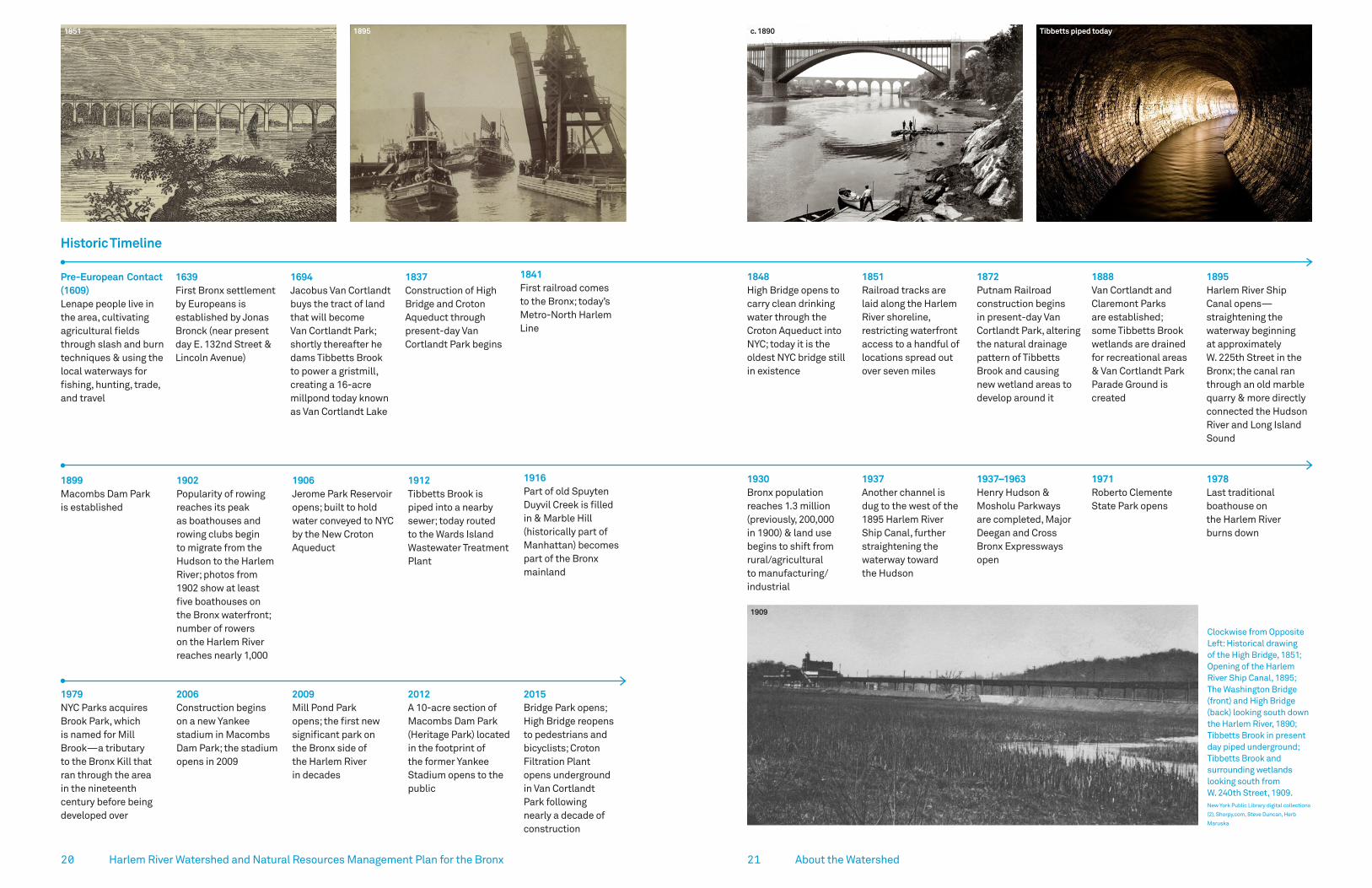
Clockwise from Opposite Left: Historical drawing of the High Bridge, 1851; Opening of the Harlem River Ship Canal, 1895; The Washington Bridge (front) and High Bridge (back) looking south down the Harlem River, 1890; Tibbetts Brook in present day piped underground; Tibbetts Brook and surrounding wetlands looking south from W. 240th Street, 1909. New York Public Library digital collections
(2), Shorpy.com, Steve Duncan, Herb
Maruska
1930Bronx population reaches 1.3 million (previously, 200,000 in 1900) & land use begins to shift from rural/agricultural to manufacturing/industrial
1937Another channel is dug to the west of the 1895 Harlem River Ship Canal, further straightening the waterway toward the Hudson
1937–1963Henry Hudson & Mosholu Parkways are completed, Major Deegan and Cross Bronx Expressways open
1971Roberto Clemente State Park opens
1978Last traditional boathouse on the Harlem River burns down
1848High Bridge opens to carry clean drinking water through the Croton Aqueduct into NYC; today it is the oldest NYC bridge still in existence
1851Railroad tracks are laid along the Harlem River shoreline, restricting waterfront access to a handful of locations spread out over seven miles
1872Putnam Railroad construction begins in present-day Van Cortlandt Park, altering the natural drainage pattern of Tibbetts Brook and causing new wetland areas to develop around it
1888Van Cortlandt and Claremont Parks are established; some Tibbetts Brook wetlands are drained for recreational areas & Van Cortlandt Park Parade Ground is created
1895Harlem River Ship Canal opens—straightening the waterway beginning at approximately W. 225th Street in the Bronx; the canal ran through an old marble quarry & more directly connected the Hudson River and Long Island Sound
Tibbetts piped today1851 1895 c. 1890
1909
Historic Timeline

2322 Harlem River Watershed and Natural Resources Management Plan for the Bronx Section Title
View looking south from the High Bridge toward the MetroNorth train yard. Transportation corridors severely limit access to the Harlem River in the Bronx.

2524 Harlem River Watershed and Natural Resources Management Plan for the Bronx
± 0 0.5 1Miles
Hud
son
Riv
er
Long Island Sound
Harlem River
± 0Miles
0.5 1
161 ST
BRONX EXP
RFK B
R
CROSS
FORDHAM RD
MOSH
OLU PK
WY
H.HUDSON PKWY
BROA
DWAY
MAJ
OR D
EEG
AN E
XP
CON
COURSE
GRAND
Current Land Use and ZoningLand use in the watershed is majority residential (46%), with mixed commercial (18%) areas along major thoroughfares such as the Grand Concourse. Manufacturing (9%) is concentrated along the shoreline, as are the railroads and transportation corridors, which limit public access to the waterfront. The remaining 27% of the watershed is parkland—half of which is Van Cortlandt Park. Located in the northeast corner of the watershed, Van Cortlandt park is the third largest park in New York City.
The majority of open spaces in the watershed are publicly owned, and NYC Parks is the largest public landowner.
Land Use and ZoningCompiled by Forestry, Horticulture, and Natural Resources, May 20, 2019 Data Source: NYCDCP PLUTO Dataset, March 2016
Commercial and Residential
Commercial
Manufacturing and Residential
Manufacturing
Park
Residential
— Major Roads
— Harlem River Watershed
About the Watershed
Students paddling with the Wilderness Inquiry, an outdoor adventure nonprofit. Karen Argenti
Nearly half (46%) of the watershed is zoned residential; the next largest land use (27%) is parkland.
Community DemographicsAbout half of the population of the Bronx, nearly 700,000 people, live within the Harlem River watershed. The Bronx is one of the most ethnically diverse communities in the United States, comprised of predominantly minority residents. There is an 90% chance that any two residents, chosen at random, would be of a different race or ethnicity.4 Fifty-six percent of the total Bronx population identifies as Hispanic or Latino, 45% white, 44% Black or African American, 5% Asian, and 3% as American Indian. Close to 60% of Bronx families speak a language other than English at home.5
The Harlem River watershed in The Bronx also contains the poorest congressional district in the nation (the 16th district), which accounts for the South Bronx neighborhoods of Bedford Park, East Tremont, Fordham, Hunts Point, Melrose, Highbridge, Morrisania, Mott Haven, and University Heights. Thirty-five percent of the population is foreign born in this congressional district and 28% of individuals fall below the poverty line.6
As a result, DEC has identified nearly the entirety of the Harlem River watershed as a potential Environmental Justice area.7 The Mott Haven-Port Morris section of the Bronx, for instance, has an asthma rate eight times the national average coupled with very limited access to green space. 8 Lack of access to green open space has been increasingly recognized as an environmental justice issue, as research has shown green space promotes physical activity, psychological well-being, and the general public health of urban residents.9
The Bronx is a dense, urban hub where approximately 32,000 people live per square mile. There are over 495,000 households and the median age of Bronx residents is 32.8 years. Seventy-one percent of Bronx residents are high school graduates, and there are over 110,000 minority-owned business firms in the Bronx.

2726 Harlem River Watershed and Natural Resources Management Plan for the Bronx
HydrologyGroundwaterThe groundwater table is close to the surface (within 5 ft) across valleys and low-lying areas of the watershed. Shallow depths to groundwater are concentrated along the Tibbetts Brook corridor, in the South Bronx, and at the eastern edge of the watershed along the historic stream corridor. In the South Bronx, shallow groundwater is concentrated in the Mott Haven/Port Morris neighborhood where a historic stream corridor, Mill Brook, runs through the center of the community. Along the shoreline, groundwater levels change with the ebb and flow of the tide. Except during high tides, groundwater generally flows west towards the River.9 Communities with shallow groundwater are prone to flooding. In low-lying coastal communities, such as Mott Haven and Port Morris, this flood risk is amplified. In areas with shallow depth to groundwater, traditional green infrastructure that relies on infiltration may be difficult to implement.
WOODLAW N LAKE
± 0Miles
0.5 1
Hud
son
Rive
r
Long Island Sound
161 ST
BRONX EXP
FORDHAM RD
RFK B
R
CROSS
MO
SHO
LU PKW
Y
HUDSON
BRO
ADW
AY
MAJ
OR
DEE
GAN
EXP
CONC
OUR
SE
GRAND
PKW
Y
H.
Depth to Groundwater (ft)Compiled by Forestry, Horticulture, and Natural Resources May 20, 2019Data Source: Department of EnvironmentalProtection
0–5
5–10
10–15
15–25
25–45
45–85
More than 85
— Major Roads
— Harlem River Watershed
About the Watershed
Van Cortlandt Lake weir and outlet where water is then piped into the combined sewer system.
Surface Water: Tibbetts BrookHistorically, there were approximately 25 streams that drained to the Harlem River. Today, the only remaining free flowing tributary in the watershed is Tibbetts Brook. Tibbetts Brook originates in Westchester County and flows through Van Cortlandt Park. The total drainage area of Tibbetts Brook is 2,508 acres, of which 975 acres are in the Bronx. The remaining 1,533 acres are in Westchester County.11
Tibbetts Brook originally flowed into a vast salt marsh tidally connected to the Harlem River. In 1699, at roughly the head of the tidal creek, Jacobus Van Cortlandt dammed the brook to power two mills, forming Van Cortlandt Lake.12 In 1912, Tibbetts Brook was piped underground into the Broadway sewer, just south of Van Cortlandt Lake, at approximately 242nd Street. This disconnected the brook from the Harlem River and routed it instead to the combined sewer system. Today, it flows 7 miles underground to the Wards Island Wastewater Treatment Plant.
Upstream of Van Cortland Lake, Tibbetts Brook is free-flowing, but has been altered and confined by pipes under the Mosholu Parkway. Fill placed in the former floodplains when the Saw Mill Parkway was constructed also straightened the stream corridor.
Tibbetts Brook looking upstream in Van Cortlandt Park.
Areas of the watershed with shallow depths to groundwater are concentrated along the Tibbetts Brook corridor, in the South Bronx, and at the eastern edge of the watershed along a historical stream corridor. These areas may be more prone to localized flooding.
29
75–100% Impervious Cover
28
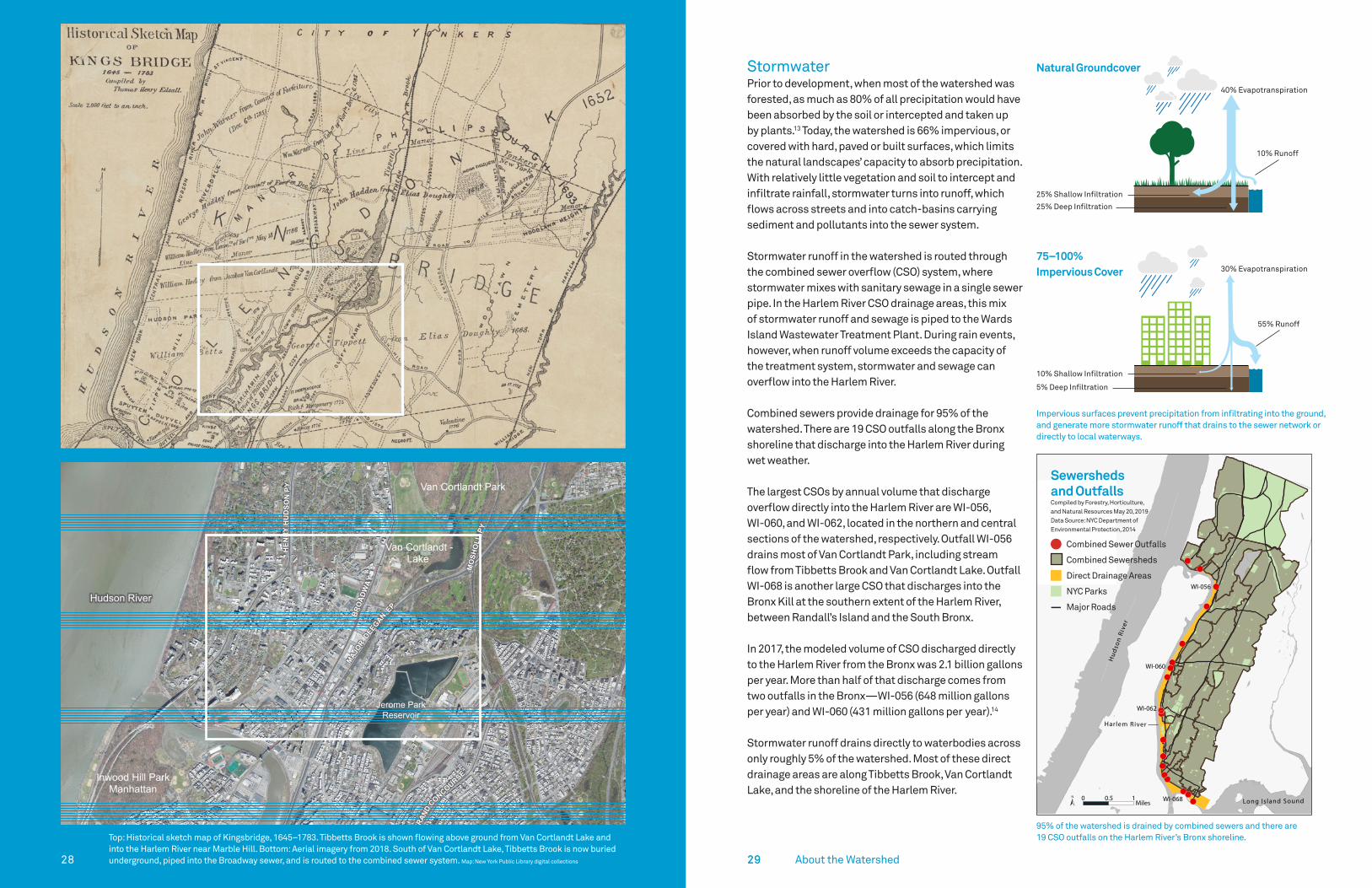
Top: Historical sketch map of Kingsbridge, 1645–1783. Tibbetts Brook is shown flowing above ground from Van Cortlandt Lake and into the Harlem River near Marble Hill. Bottom: Aerial imagery from 2018. South of Van Cortlandt Lake, Tibbetts Brook is now buried underground, piped into the Broadway sewer, and is routed to the combined sewer system. Map: New York Public Library digital collections
StormwaterPrior to development, when most of the watershed was forested, as much as 80% of all precipitation would have been absorbed by the soil or intercepted and taken up by plants.13 Today, the watershed is 66% impervious, or covered with hard, paved or built surfaces, which limits the natural landscapes’ capacity to absorb precipitation. With relatively little vegetation and soil to intercept and infiltrate rainfall, stormwater turns into runoff, which flows across streets and into catch-basins carrying sediment and pollutants into the sewer system.
Stormwater runoff in the watershed is routed through the combined sewer overflow (CSO) system, where stormwater mixes with sanitary sewage in a single sewer pipe. In the Harlem River CSO drainage areas, this mix of stormwater runoff and sewage is piped to the Wards Island Wastewater Treatment Plant. During rain events, however, when runoff volume exceeds the capacity of the treatment system, stormwater and sewage can overflow into the Harlem River.
Combined sewers provide drainage for 95% of the watershed. There are 19 CSO outfalls along the Bronx shoreline that discharge into the Harlem River during wet weather.
The largest CSOs by annual volume that discharge overflow directly into the Harlem River are WI-056, WI-060, and WI-062, located in the northern and central sections of the watershed, respectively. Outfall WI-056 drains most of Van Cortlandt Park, including stream flow from Tibbetts Brook and Van Cortlandt Lake. Outfall WI-068 is another large CSO that discharges into the Bronx Kill at the southern extent of the Harlem River, between Randall’s Island and the South Bronx.
In 2017, the modeled volume of CSO discharged directly to the Harlem River from the Bronx was 2.1 billion gallons per year. More than half of that discharge comes from two outfalls in the Bronx—WI-056 (648 million gallons per year) and WI-060 (431 million gallons per year).14
Stormwater runoff drains directly to waterbodies across only roughly 5% of the watershed. Most of these direct drainage areas are along Tibbetts Brook, Van Cortlandt Lake, and the shoreline of the Harlem River.
Watershed Characterization29
95% of the watershed is drained by combined sewers and there are 19 CSO outfalls on the Harlem River’s Bronx shoreline.
HEN
RYH
UD
SON
PY
MO
SHO
LUPY
GRAN
D
CONCOURSE
BRO
ADW
AY
MAJOR
DEEGANEP
± 0 0.2 0.4Miles
Van Cortlandt Park
Van Cortlandt -Lake
Inwood Hill ParkManhattan
- Harlem River
Hudson River
Jerome Park Reservoir
!
!!!
!
!!
!!!
!
!
!
!!
!!
!
!
WI-062
WI-068
WI-056
Hud
son
Rive
r
Harlem River
Long Island Sound± 0Miles
0.5 1(
(((
(
((
(((
(
(
(
((
((
(
(
WI-060
Sewersheds and OutfallsCompiled by Forestry, Horticulture, and Natural Resources May 20, 2019Data Source: NYC Department ofEnvironmental Protection, 2014
Combined Sewer Outfalls
Combined Sewersheds
Direct Drainage Areas
NYC Parks
— Major Roads
About the Watershed
25% Shallow Infiltration
10% Shallow Infiltration
10% Runoff
40% Evapotranspiration
30% Evapotranspiration
55% Runoff
25% Deep Infiltration
5% Deep Infiltration
Natural Groundcover
Impervious surfaces prevent precipitation from infiltrating into the ground, and generate more stormwater runoff that drains to the sewer network or directly to local waterways.

3130
Building SewerConnection
CombinedSewerOutfall
SewerRegulator
Combined Sewer
To Waste Water Treatment Plant
Building SewerConnection
CombinedSewerOutfall
Combined Sewer
To Waste Water Treatment Plant
Catch Basin Catch Basin
SewerRegulator
Wet Weather ConditionsDry Weather Conditions Water QualityHarlem RiverDEC classifies the Harlem River as a Class I saline surface water. According to DEC, “the best usages of Class I waters are secondary contact recreation and fishing. These waters shall be suitable for fish, shellfish, and wildlife propagation and survival. In addition, the water quality shall be suitable for primary contact recreation, although other factors may limit the use for this purpose.” Primary contact recreational activities involve direct contact with water (e.g., swimming) whereas secondary contact recreational activities (e.g., fishing) typically require less contact.
Point sources, including CSO outfalls on both sides of the river, as well as nonpoint sources (e.g., direct stormwater runoff) influence water quality in the Harlem River. Contaminants transported via mixing and tidal action from CSO and stormwater discharges to the Hudson and East Rivers also impact water quality.
Some pollutants in the river may ultimately bind to the riverbed sediment, which can be harmful to both aquatic organisms and human health. Harlem River sediments, like the rest of the NY Harbor, have been impacted by centuries of industrial waste and urban pollution and contain PCBs and heavy metals.14 These pollutants can harm or kill aquatic organisms and may be transported up the food chain, accumulating in fish or shellfish that
may be harvested and consumed by humans. DEC does not recommend consumption of certain shellfish and finfish caught in or harvested from the Harlem River.16
Due to these multiple sources of both present-day and legacy contaminants (e.g., polluted riverbed sediments), the Harlem River is listed as impaired by DEC for sediments contaminated with PCBs and other toxics, and floatables.
The USGS published a report in 2016 summarizing historical Harlem River water-quality data collected by NYC DEP and other Federal, State, and local organizations dating back to 1945. The report illustrates improvements in water quality over 65 years and emphasizes the importance of a continuous water-quality record to establish trends in environmental conditions.17 Further, the report identified perceived gaps in data (e.g., lack of real-time monitoring) needed to inform management decisions for tracking changes in water quality of the Harlem River following implementation of BMPs, such as green infrastructure.
All CSO outfalls in NYC are identified by signs like this one at outfall WI-060. The sign includes information on how to report any discharge seen during dry weather to NYC DEP.
Beginning in 2017, USGS, with support from EPA, IEC, NYC DEP, and NYC Parks, collected water samples on the Harlem River to assess pollutant levels across transects of the Harlem River. Results show higher bacteria counts closer to the shoreline than in the main river channel. Data are publicly available online via the National Water Information System: https://waterdata.usgs.gov/nwis.
Wakes from boat traffic on the Harlem River stir up sediment along the shoreline, potentially recirculating and suspending pollutants that may be harmful to human health. USGS collected shoreline samples in 2019 that showed elevation concentrations of indicator bacteria following boat wakes along natural (i.e. not bulkheaded) shoreline.
During dry weather (left), combined sewer systems typically direct sewage to treatment plants very effectively. However, during wet weather (right), stormwater can overwhelm combined sewer systems, mix with untreated sewage, and overflow into local waterways. There are 19 CSO outfalls on the Bronx shoreline of the Harlem River, including the largest outfall by volume in the entire city.
Building SewerConnection
CombinedSewerOutfall
SewerRegulator
Combined Sewer
To Waste Water Treatment Plant
Building SewerConnection
CombinedSewerOutfall
Combined Sewer
To Waste Water Treatment Plant
Catch Basin Catch Basin
SewerRegulator
About the Watershed

3332
3
Harlem River – Enterococcus
Note: Sampling conducted when Wards Island WWTP was not at 2xDDWF capacity
Sampling Period(2016)
# Locations
# SamplesDry Wet
LTCP Apr 27 – Jun 9Nov 16 – Nov 19 6 8 38
HSM Jan 4 – Nov 9 1 12 15
Riverkeeper May 1 – Oct 31 2 5 1
Citizen May 1 – Oct 31 5 7 13
Sampling DetailsSampling Results at a Glance
10 12 14 127 8 7
38 52 55 51 6030 26
1
10
100
1,000
10,000
HAR-1/C-Swindler'sCove
HAR-2 HAR-3/C-MuscotaMarsh
HAR-4 H3 HAR-5/R- WashingtonAveBridge
HAR-6 HAR-6
Enterococci,cfu/100mL
30 -----–
Dry Weather DataWet Weather DataDry Weather GeomeanWet Weather Geomean
All Weather Wet Weather
Harlem River Watershed and Natural Resources Management Plan for the Bronx
Pathogen Monitoring in the Harlem RiverThe presence or absence of pathogens—viruses, bacteria, and protozoans that can cause disease in humans—is a key indicator of whether or not the Harlem River is safe for recreation. Pathogens most commonly enter a waterbody via fecal contamination due to CSO discharges, stormwater runoff, or direct animal/human inputs. Monitoring for pathogens is done using an indicator species such as Enterococci, which are bacteria commonly found in the intestines and feces of humans and other warm-blooded animals.
Their presence in the water indicates fecal pollution and the possible presence of harmful pathogens.
Agencies, nonprofits, and community scientists regularly monitor Enterococci in the Harlem River. The figure below shows multiple sampling efforts done by both NYCDEP and citizen scientists during 2016. The data represented were collected from the Harlem River by NYCDEP (through their Long Term Control Plan and Harbor Survey Monitoring programs), Riverkeeper,
AcronymsLTCP Long Term Control Plan
HSM Harbor Survey Monitoring
WWTP Wastewater Treatment Plant
2xDDWF Two times Design Dry Weather Flow
Symbology
• Triangles indicate locations of Combined Sewer Overflow (CSO) outfalls (eg. WI-056).
• Circles indicate locations where water quality samples were collected from the center of the river channel or from the shoreline.
• The orange line is running across the graph at 30 colony forming units (cfu)/100mL, and 35 cfu/100mL is the water quality standard for Enterococci. This standard is based on the geometric mean of samples collected over any consecutive 30-day period. In addition, no more than 10 percent of samples collected in the same 30-day period shall exceed 130 cfu/100mL. Note: A geometric mean is calculated by multiplying the data and taking the root, rather than adding and dividing. Unlike arithmetic mean, a geometric mean tends to dampen the effect of very high or low values to gain a clearer understanding of bacteria concentrations without allowing extreme outliers to skew the data.
About the Watershed
Data and graphic provided by NYCDEP.
The graph on the left shows the spatial distribution of Enterococcus from surface samples collected along the Harlem River just north of the High Bridge on three dates spanning 2017-2019 (all sampling locations along the full stretch of the Harlem River are shown in the map above). Samples were collected by USGS and EPA (all Harlem River locations are shown in the above map), and analyzed by IEC using EPA method 1600. The results shown here are compared to the standard monthly geomean threshold, but is it important to note these are single samples. More samples and analysis are needed to draw any statistically significant conclusions.
__
Hud
son
Rive
r
Long Island Sound
Harlem River
161 ST
BRONX EXP
RFK B
R
CROSS
FORDHAM RD
MO
SHO
LU PKW
Y
H.HUDSON PKWY
BRO
ADW
AY
MAJ
OR
DEE
GAN
EXP
CONC
OUR
SE
GRAND
± 0Miles
0.5 1
Sampling LocationsCompiled by Forestry, Horticulture, and Natural Resources May 20, 2019 Data Source: NYC Parks NRG, October 2016
NYC Parks
— Major Roads
— Harlem River Watershed
Sampling Locations
!
0
5035
100
150
200
250
300
West Center EastCO
LON
Y FO
RM
ING
UN
ITS
(cfu
)/10
0 m
L
10/12/2017 8/29/2019 10/23/2019 Threshold
West
Center
Eastplanned Brid
ge Park South
West Center East
and community scientists during both dry and wet weather (during or following a significant rain event) to capture the potential impacts of CSOs on water quality.
The geometric mean of dry weather samples fell below the water quality standard of 35 cfu/100mL across all sites. In comparison, samples collected during wet weather exceeded the threshold at all sites with the exception of HAR-5 and HAR-6, located at the southern extent of the Harlem River where it meets the East River at Randall’s Island.
The USGS New York Water Science Center, local lead agency for the Bronx & Harlem Rivers Urban Waters Federal Partnership, in coordination with NYC Parks, EPA, and the Interstate Environmental Commission (IEC), collected three sets of Enterococci data from six Harlem River sites during 2017 and 2019 to assess the distribution of pathogens along and across the river’s surface and at depth.
More research is needed to fully assess the statistical significance of any difference between samples from the center channel, where water flows quickly, and samples collected closer to the shoreline, where water tends to be more stagnant. However, these data are intended to help EPA better model pathogen concentrations in New York waterways, and also to inform NYC Parks and other stakeholders about pathogen concentrations along the river’s shorelines where people are more likely to interact with the water. These data are publicly available online.
SAMPLING LOCATION
Sampling Sites
0-30 31-50 51-100 >100Scale (# col/100 mL)

3534 Harlem River Watershed and Natural Resources Management Plan for the Bronx
NYC Parks collaborated with USGS, EPA, and IEC during Summer 2017 to collect water quality samples across transects of the Harlem River, including at Mill Pond Park, seen here.
About the Watershed
3736 Harlem River Watershed and Natural Resources Management Plan for the Bronx
Caption Xim vel iniscii stionse ea con et acerum reped utem que eos in pratur, quodisciatur autem Caption Xim vel iniscii stionse ea con et acerum reped utem que eos in pratur, quodisciatur autem Caption
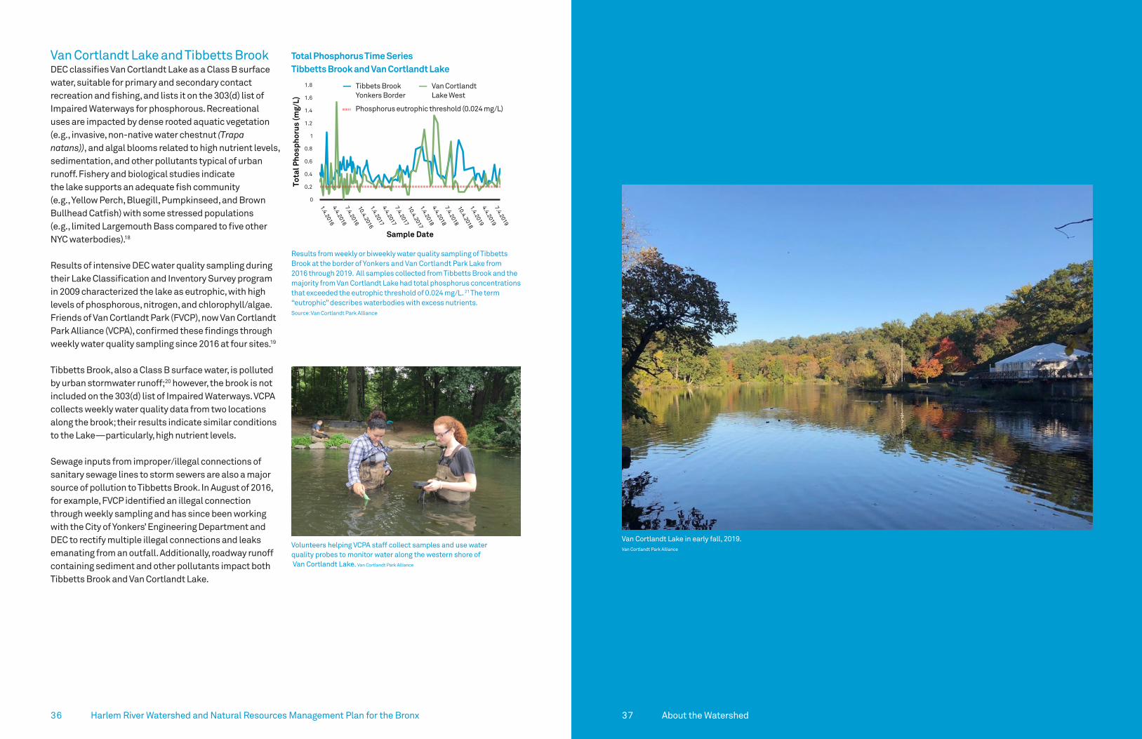
Van Cortlandt Lake and Tibbetts BrookDEC classifies Van Cortlandt Lake as a Class B surface water, suitable for primary and secondary contact recreation and fishing, and lists it on the 303(d) list of Impaired Waterways for phosphorous. Recreational uses are impacted by dense rooted aquatic vegetation (e.g., invasive, non-native water chestnut (Trapa natans)), and algal blooms related to high nutrient levels, sedimentation, and other pollutants typical of urban runoff. Fishery and biological studies indicate the lake supports an adequate fish community (e.g., Yellow Perch, Bluegill, Pumpkinseed, and Brown Bullhead Catfish) with some stressed populations (e.g., limited Largemouth Bass compared to five other NYC waterbodies).18
Results of intensive DEC water quality sampling during their Lake Classification and Inventory Survey program in 2009 characterized the lake as eutrophic, with high levels of phosphorous, nitrogen, and chlorophyll/algae. Friends of Van Cortlandt Park (FVCP), now Van Cortlandt Park Alliance (VCPA), confirmed these findings through weekly water quality sampling since 2016 at four sites.19
Tibbetts Brook, also a Class B surface water, is polluted by urban stormwater runoff;20 however, the brook is not included on the 303(d) list of Impaired Waterways. VCPA collects weekly water quality data from two locations along the brook; their results indicate similar conditions to the Lake—particularly, high nutrient levels.
Sewage inputs from improper/illegal connections of sanitary sewage lines to storm sewers are also a major source of pollution to Tibbetts Brook. In August of 2016, for example, FVCP identified an illegal connection through weekly sampling and has since been working with the City of Yonkers’ Engineering Department and DEC to rectify multiple illegal connections and leaks emanating from an outfall. Additionally, roadway runoff containing sediment and other pollutants impact both Tibbetts Brook and Van Cortlandt Lake.
37
Van Cortlandt Lake in early fall, 2019. Van Cortlandt Park Alliance
Total Phosphorus Time Series Tibbetts Brook and Van Cortlandt Lake
!
0
0.2
0.4
0.6
0.8
1
1.2
1.4
1.6
1.8
1.4.20164.4.20167.4.201610.4.20161.4.20174.4.20177.4.201710.4.20171.4.20184.4.20187.4.201810.4.20181.4.20194.4.20197.4.2019
Tota
l Pho
spho
rus
(mg/
L)
Sample Date
Tibbetts Brook Yonkers Border
VCL Lake West
— Tibbets Brook Yonkers Border
— Van Cortlandt Lake West
Phosphorus eutrophic threshold (0.024 mg/L)
Results from weekly or biweekly water quality sampling of Tibbetts Brook at the border of Yonkers and Van Cortlandt Park Lake from 2016 through 2019. All samples collected from Tibbetts Brook and the majority from Van Cortlandt Lake had total phosphorus concentrations that exceeded the eutrophic threshold of 0.024 mg/L. 21 The term “eutrophic” describes waterbodies with excess nutrients.Source: Van Cortlandt Park Alliance
Volunteers helping VCPA staff collect samples and use water quality probes to monitor water along the western shore of Van Cortlandt Lake. Van Cortlandt Park Alliance
About the Watershed

3938
Climate VulnerabilityUrban Heat Island Effect Urban areas, like most of the Harlem River Watershed, are significantly warmer than surrounding rural or forested areas due to increased heat absorption by buildings and hard surfaces. This phenomenon, called the Urban Heat Island (UHI), can affect communities by exacerbating air pollution and increasing heat-related illness and mortality.
The UHI phenomenon is clearly visible in satellite imagery of the Harlem River watershed. For example, southwest of Van Cortlandt Park, between Broadway and the Major Deegan Expressway, the surface temperature readings are 20 degrees higher than in nearby forested parkland. The cooler temperatures in the watershed are located on the waterfront along the Harlem River, in parks like Van Cortlandt Park, and in neighborhoods with densely tree-lined streets such as Fieldston and parts of Riverdale.
New York City’s climate is changing rapidly. By 2080, average temperatures are predicted to increase by anywhere from 5.3 to 8.8 degrees Fahrenheit, further exacerbating the harmful effects of UHI on human health in the Harlem River watershed.22
According to a 2016 study by Columbia University, over 3,000 New Yorkers could suffer from heat-related deaths per year by the 2080’s. 23 It is critical that our watershed restoration efforts aim to mitigate the effects of UHI.
Inland and Coastal FloodingAverage annual precipitation is also predicted to increase anywhere from 5% to 13% by 2080,24 while even greater increases are expected in frequency, intensity, and duration of extreme storm events.
Additionally, projections for sea level rise in New York City are 18-39 inches by 2080, and as high as 6 feet (72 inches) by 2100.25
These projected increases in precipitation and extreme events, coupled with sea level rise, will impact low-lying areas of the watershed that fall within the 100-year floodplain, particularly along the Harlem River waterfront. In neighborhoods, such as Port Morris and Mott Haven, flooding becomes even more likely given shallow groundwater and the accumulation of runoff from upslope developed areas with limited capacity to absorb stormwater. Looking further inland, the corridor of the Major Deegan, which falls within the 100-year floodplain from West 225th Street to the southern boundary of Van Cortlandt Park, will also be impacted.26
Greater precipitation will also contribute to an overburdened sewer system, making water quality improvements more challenging in the coming decades.
Hud
son
Riv
er
Harlem River __
161 ST
BRONX EXP
RFK B
R
CROSS
FORDHAM RD
MOSH
OLU PK
WY
H.HUDSON PKWY
BROA
DWAY
MAJ
OR D
EEG
AN E
XP
CON
COURSE
GRAND
Long Island Sound± 0Miles
0.5 1
Surface Temperature (F°)Compiled by Forestry, Horticulture, and Natural Resources May 20, 2019Data Source: NASA Thermal Landsat™,10:30 am August 14, 2002, Hunter CollegeUrban Forestry Study
79–95
95–104
104–111
111–118
118–142
— Major Roads
— Harlem River Watershed Border
This heat map image shows the impact that vegetation and water features have on an urban landscape. The trees and water features in Marcus Garvey Park, Manhattan, are nearly 20 degrees cooler than the paved ground in direct sunlight. Opposite: Urban Heat Island effect is seen clearly in the Harlem River watershed; surface temperatures are coolest along the river, in Van Cortlandt Park and the Jerome Park Reservoir, and in densely tree-lined neighborhoods, and are warmest in areas that are predominantly paved with little vegetation.
About the WatershedHarlem River Watershed and Natural Resources Management Plan for the Bronx

4140 Harlem River Watershed and Natural Resources Management Plan for the Bronx
Urban Tree CanopyThere are over 23,000 street trees in the Harlem River watershed, of which the most common species are thornless honey locust (Gleditsia triacanthos), pin oak (Quercus palustris), and Norway maple (Acer platanoides).27 Twenty-five percent of the watershed is covered by tree canopy, and tree canopy cover is highest within sewersheds that drain natural areas including Claremont Park (65%), Van Cortlandt Park (63%), and Spuyten Duyvil Shorefront Park and sections of Henry Hudson Park (45%). Throughout the remainder of the watershed, canopy cover ranges from 35% to < 5%.
Trees in the Harlem River watershed provide various ecological benefits including removing pollutants from the air, wildlife habitat, helping to mitigate the Urban Heat Island effect, and intercepting, retaining, and filtering stormwater. The current tree canopy in the Harlem River watershed is roughly estimated to intercept approximately 89 million gallons of stormwater. If tree canopy were to increase by 10% across the watershed, an additional 35 million gallons of stormwater could potentially be captured annually before it enters the Combined Sewer System.28
Drought stress is one of the leading causes of mortality among young street trees, and increasing temperatures are likely to exacerbate this threat to tree canopy. Street trees also require regular maintenance to survive harsh urban conditions where there may be little space for roots to grow, soils are compacted by foot traffic, road salt and pet waste are dumped, and damage can occur from cars,
construction, or vandalization. Invasive insects, such as the emerald ash borer (EAB) which was confirmed in the city in 2017, will pose a threat to tree canopy both within natural areas and along city streets. Other significant threats to mature tree canopy, which provides the most benefits, include new development and constrained growing spaces.
Twenty-five percent of the watershed is covered by tree canopy. With the exception of sewersheds that drain natural areas like Van Cortlandt Park, canopy cover ranges from 5-35% throughout the remainder of the watershed.
Hud
son
Riv
er
161 ST
BRONX EXP
RFK B
R
CROSS
FORDHAM RD
MOSH
OLU PK
WY
H.HUDSON PKWY
BROA
DWAY
MAJ
OR D
EEG
AN E
XP
CON
COURSE
GRAND
Long Island Sound0
Miles0.5 1
Urban Tree Canopy (2010) by SewershedCompiled by Forestry, Horticulture, and Natural Resources May 20, 2019Data Source: NYC Parks, City of New YorkLiDar (2010)
0%–5%
6%–11%
12%–28%
29%–44%
45%–81%
— Major Roads
— Harlem River Watershed
Pre-street tree planting on Post Ave, Bronx (2008).
Post-street tree planting on Post Ave, Bronx (2012).
About the Watershed

42 Harlem River Watershed and Natural Resources Management Plan for the Bronx
Ecosystems and HabitatsToday, the Harlem River watershed’s remaining natural areas are primarily found in Van Cortlandt Park as well as Spuyten Duyvil Shorefront Park and University Woods. These parks include significant remnant areas of forests, wetlands, and grasslands. Below is a detailed look at Van Cortlandt Park’s ecosystems and habitats.
Area in Habitat Type Watershed (acres)
Forest 740
Estuarine 359
Streams, Lakes, and Ponds 110
Wetlands 30
Grasslands 30
± 0 0.1Miles
0.2
H.H
UD
SON
PK
WY
MOS
HOL
U PK
WY
MAJO
R DEEGAN E
XP
Tibbetts BrookFreshwater Wetland dominated by invasive Phragmites
Tibbetts Brook Floodplain Forest Croton Woods
Upland Forest
Van Cortlandt Park Ecosystems and Habitats
Van Cortlandt Park Forestry and HabitatsCompiled by Forestry, Horticulture, and Natural Resources May 20, 2019Data Source: NYC Parks NRG, NAC ECM
Upland Forest
Forested Wetland
Freshwater Wetland
Water
Grassland
Active Recreation/Maintained Lawn
— Major Roads
Watershed Characterization4343
Top: Exposed estuarine mudflats at Mill Pond Park during low tide; Bottom: Skunk cabbage (Symplocarpus foetidus) growing in the forested wetlands of Van Cortlandt Park.Natural Areas ConservancyAbout the Watershed

4544
Forests current conditions Van Cortlandt Park contains the largest expanses of forests (approximately 650 acres) including the Croton Woods and Northeast and Northwest Forests, with smaller and less well-developed forests around the Allen Shandler Recreation Area and on the margins of both golf courses in the park. Spuyten Duyvil Shorefront Park and University Woods Park encompass smaller swaths of closed canopy forest, six and three acres, respectively. The majority of Van Cortlandt Park’s forests are mature hardwoods (66%); and the remainder are successional hardwoods (25%), forested wetlands (7%), and maritime forests (1%).29 The most common ecological communities found in Van Cortlandt Park’s forests are Coastal Oak-Hickory Forests (17%) and Oak-Tulip Tree Forests (13%).30
These forests attract birds that are uncommon in urban environments, such as the scarlet tanager and red-eyed vireo, and serve as important habitat for mammals, ranging from the southern flying squirrel to at least two pairs of breeding coyotes.
threats The watershed’s forests are threatened by invasive insects and pathogens, including chestnut blight, Dutch elm disease, and beech bark disease which have already significantly altered forest composition and structure. The emerald ash borer is an emerging pest that will inevitably damage ash tree populations in this area. Forests are also vulnerable to colonization by invasive plants following both natural and human disturbance such as over use and other detrimental public impacts. For example, informal trails fragment the forest and degrade habitat. In our urban forests, canopy gaps caused by storms that topple large trees are also a threat to forest health because invasive plants colonize these areas faster than native species.
Streams, Lakes, and other Freshwater Wetland Habitats current conditions Tibbetts Brook is fed by two small tributaries and supports floodplain forests and freshwater wetland habitat. It flows south through Van Cortlandt Park, parallel to the Putnam Greenway, until it is dammed to form Van Cortlandt Lake, which is separated into a 2.4 acre upper basin and 14.3-acre lower basin. Seepage from the lake impoundment and groundwater form a freshwater wetland west of Van Cortlandt Lake.
The Tibbetts Brook Corridor includes a series of 11 distinct but hydrologically connected freshwater wetlands. Floodplain forests on either side of the brook absorb and buffer stormwater runoff, resulting in relatively high habitat quality as indicated by New York State-ranked rare odonates found in the brook such as the blue-fronted dancer (Argia apicalis), the elfin skimmer (Nannothemis bella), and the turquoise bluet (Enallagma divagans).31
Wetlands and vernal pools can be found throughout the Northwest Forest, Croton Woods, and Northeast Forest. These freshwater wetlands provide habitat for a number of amphibian and reptile species. At least three frog species are found in the park: the green frog (Lithobates clamitans), bullfrog (Lithobates catesbeianus), and spring peeper (Pseudacris crucifer). Redback (Plethodon cinereus), two-lined (Eurycea bislineata), and spotted
salamanders (Ambystoma maculatum) rely on floodplain forest, stream, and wetland environments for habitat. Vernal pools provide breeding habitat for spotted salamanders specifically.
threats Stormwater pollution from highways and golf courses can lead to sedimentation and eutrophication in the wetlands and floodplains along Tibbetts Brook’s course, and particularly in Van Cortlandt Lake. In the lake, algae thrive on nutrients from runoff, producing dense mats which reduce dissolved oxygen for aquatic wildlife. Because nearly two-thirds of the Tibbetts Brook watershed is in Yonkers, sources of poor water quality and invasive vegetation come from outside the Park as well and impact wetlands buffering the brook.
Invasive species also pose a threat to native freshwater habitats. Common reed (Phragmites australis) is abundant in many freshwater wetlands of the park, creating monocultures that reduce habitat complexity and wildlife diversity. Water chestnut, a fast-growing exotic invasive plant found within Van Cortlandt Lake, can severely alter the aquatic ecosystem by completely covering the surface of the water in a short time, thereby blocking sunlight from reaching submerged aquatic vegetation and reducing biodiversity and dissolved oxygen available for fish. Emerald ash borer will likely threaten ash tree populations found within Van Cortlandt Park’s forested wetlands in the near future.
Van Cortlandt Lake and the Putnam Greenway. Natural Areas Conservancy
Upland forest in Van Cortlandt Park. Natural Areas Conservancy
Harlem River Watershed and Natural Resources Management Plan for the Bronx About the Watershed

4746
Salt Marsh and Marine Habitat current conditions Most of the historical marsh along the Harlem River shoreline was filled for development by the early-to-mid 1900s. Small pockets of salt marsh have since been restored at Roberto Clemente State Park in 2019 and Inwood Hill Park in 2014. Ongoing salt marsh restoration efforts are underway at Swindler’s Cove. Inwood Hill and Swindler’s Cove Parks are on the Manhattan side of the watershed.
The National Oceanic and Atmospheric Association designated the Harlem River as essential fish habitat for 11 fish species. Its waters provide essential habitat
for spawning, breeding, feeding, or growth for species such as red hake (Urophycis chuss), winter flounder (Pseudopleuronectes americanus), and Atlantic sea herring (Clupea harengus). Harbor seals (Phoca vitulina)also visit the Harlem River, likely following these fish that serve as a source of food.32
Shellfish that filter and clean water, such as the common blue mussel (Mytilus edulis), ribbed mussel (Geukensia demissa), and eastern oyster (Crassostrea virginica), occur near the low tide line on rocks, pilings, or other shells north of the University Heights Bridge.33
A number of pollution-tolerant species such as the ivory barnacle (Amphibalanus eburneus) and several worm species, can be found in the sediment and attached to structures on the Harlem River shoreline. 34
threats Water quality impacts, such as low dissolved oxygen, from stormwater runoff and combined sewer overflows pose the greatest threat to aquatic habitat on the Harlem River. In addition to water quality, the last remaining fringes of salt marsh on the river are threatened by erosion from boat wakes and sea level rise.
A new intertidal zone at Roberto Clemente State Park restores a small pocket of salt marsh habitat on the Harlem River, 2019.
Boat wake at Mill Pond Park, 2018.
Harbor seal resting on a dock at Inwood Hill Park along the Harlem River, 2018.Lindsey Morgan Whorton, Gothamist
Harlem River Watershed and Natural Resources Management Plan for the Bronx About the Watershed

4948 Harlem River Watershed and Natural Resources Management Plan for the Bronx
Goals for the WatershedWe identified goals for the watershed in four broad areas: natural resource protection and restoration; stormwater management for water quality improvement; access and connectivity; and engagement and education. These goals are based on an understanding of the existing conditions and current or potential threats to watershed resources. They serve as a guide to develop strategies and recommendations to reach the target conditions.
Goals for the Watershed
• Restore habitat to maximize diverse native ecological communities.
• Reduce habitat fragmentation and increase habitat connectivity.
• Restore aquatic habitat and improve water quality to support healthy native wetland communities and meet physiological requirements of native aquatic organisms.
• Improve Harlem River water quality to meet standards set by EPA and DEC and implemented by DEP, so that the river is safe for boating, wading, swimming, and fishing.
• Restore the hydrology of the watershed to the fullest extent possible through green infrastructure. Green infrastructure is a stormwater management approach that uses natural and built systems to reduce and treat runoff at its source. Examples include rain gardens, bioswales, permeable pavement, and green roofs.
• Bring buried and piped streams to the surface, a process known as daylighting, and remove them from the CSO system, where possible. This action would reduce the burden on the CSO system, allow for natural stormwater detention and storage, and provide ecological and aesthetic benefits for streams.
• Ensure equitable waterfront accessibility for the public as feasible.
• Connect the Harlem River greenway and waterfront open space along the entire waterfront.
• Provide on-water access points along the waterfront to allow public recreation on the river.
• Connect parks and open space across the watershed through natural habitats or street tree corridors.
• Clearly mark trails within parks to improve accessibility.
• Foster and sustain stewardship of natural resources and connected, accessible parkland by local communities.
• Incorporate educational curricula focused on the Harlem River and its watershed into ongoing programming available to both children and adults in multiple languages.
• Inform local communities of environmental policies and regulations and empower residents to advocate for the protection and restoration of natural resources within their watershed.
Protect, Restore, and Enhance Natural ResourcesNR
Manage Stormwater SM
Promote Access and ConnectivityAC
Maximize Engagement and EducationEE
48 Harlem River Watershed and Natural Resources Management Plan for the Bronx

5150 Harlem River Watershed and Natural Resources Management Plan for the Bronx
Strategies & RecommendationsThis section introduces 14 broad strategies, 77 watershed-wide management recommendations, and 97 site-specific recommended actions. They are intended to serve as a roadmap to achieve the plan’s four goals by addressing threats associated with the current conditions, and pursuing opportunities for restoration and improved land and water resource management and protection.
We developed these recommendations through an iterative process by analyzing ecological and land use data, reviewing previous planning efforts, consulting with the community through public meetings, and incorporating input from technical advisors on the Watershed Advisory Committee.
A subset of priority recommended actions are highlighted in the plan as well. These actions either have a clear path to implementation, strong community support, or are necessary to address more critical, immediate threats.
Strategies & Recommendations
Protect, Restore, and Enhance Natural Resources Additional Goals Addressed
NRStrategy 1: Expand ecological connectivity SM
AC
Strategy 2: Manage threats to ecosystem health
Strategy 3: Restore and enhance ecosystem health
Strategy 4: Monitor ecosystem benefits of natural resources
Strategy 5: Work across political boundaries to manage shared resources
Manage Stormwater SMStrategy 6: Improve interagency management of stormwater and BMPs
AC
EE
Strategy 7: Expand green infrastructure practices NR
EE
Strategy 8: Invest in collaborative partnerships to improve designs NR
EE
and effectiveness of GI
Strategy 9: Reduce volume of stream flow entering sewers NR
AC
Promote Access and ConnectivityACStrategy 10: Improve equitable access to the waterfront and open space
Strategy 11: Increase connectivity along the waterfront and between open space NR
Maximize Engagement and EducationEEStrategy 12: Foster collaborative partnerships with community, cultural, NR
SM
AC
and educational organizations
Strategy 13: Prioritize outreach to and inclusion of diverse audiences NR
SM
AC
Strategy 14: Ensure clear agency communication on watershed policies NR
SM
AC
and regulations
50 Harlem River Watershed and Natural Resources Management Plan for the Bronx
EESM
SM AC EE
SM AC EE
SM AC EE
NR
NR SM EE

52 Harlem River Watershed and Natural Resources Management Plan for the Bronx
Watershed-Wide Strategies and Recommendations Each of the 14 strategies can help achieve one or multiple goals, and correspond to a series of recommendations to be implemented throughout the entire Bronx watershed. Each recommendation will need to be championed by at least one agency or partner organization, as indicated. Several recommendations are to continue the meaningful work that is already underway in the watershed,
and some have available funding, momentum, and/or immediate need and may therefore be feasible within five years. Others involve a higher level of complexity and have been identified as long-term recommendations that could take greater than five years to implement. Site-specific examples of where these recommendations can be implemented are provided in the final section of the plan.
GoalHow to achieve ideal watershed condition
StrategiesHow to reach goal
Watershed-wide RecommendationsSpecific actions
Manage threats to ecosystem health
Reduce invasive plant species cover to 10% or less in forests
Consistently monitor and remove mile-a-minute vine throughout the Northeast Woods of Van Cortlandt Park
Site-Specific RecommendationsSpecific actions on a local level
Protect, restore, and enhance natural resources
Example:
53 Strategies & RecommendationsStrategies & Recommendations
Tibbetts Brook in Van Cortlandt Park looking upstream.
53
Protect, restore and enhance natural resources to maximize diverse, native, and continuous ecological communities.There are ample opportunities to protect and restore habitat, increase ecological benefits for people and local ecosystems, and improve aquatic health in the Harlem River and its watershed. NYC Parks has a successful history of natural resource management and, in the Harlem River watershed in particular, has managed 653 acres of forest, assessed 0.8 miles of stream, and continues to plant and care for tens of thousands of street trees to increase tree canopy in the urban environment. The following recommendations build off this work by NYC Parks and partners, and range from reducing invasive species to designing resilient coastal waterfronts.
Example of how watershed-wide and site-specific recommendations are nested under strategies that aim to achieve the goals of this plan.

5554 Harlem River Watershed and Natural Resources Management Plan for the Bronx Strategies & Recommendations
SM StormwaterManagement
Natural ResourcesNR Access &
ConnectivityAC Engagement & EducationEE
Protect, Restore, and Enhance Natural ResourcesNR
Strategy 1: Expand ecological connectivity to better enable movements of plants and animals Additional Goals Addressed: SM
AC
Short Term Long Term
Recommendations (within 5 years) (> 5 Years) Lead & Partners
1.1 Identify opportunities for ecological corridors and connections ✔ NYC Parks between natural areas. NYC DOT NYC DEP
1.2 Develop plans to address connectivity gaps by enhancing existing parks ✔ ✔ NYC Parks and creating new green spaces. NYS Parks
1.3 Generate street tree corridor and green infrastructure Right-of-Way plans. ✔ NYC Parks NYC DEP NYC DOT
1.4 Achieve and maintain full street tree stocking. ✔ NYC Parks
1.5 Incorporate native plantings and ecological connectivity in future ✔ NYC Parks greenway development and in street tree beds.
Strategy 2: Manage threats to ecosystem health Additional Goals Addressed: SM
EE
Short Term Long Term
Recommendations (within 5 years) (> 5 Years) Lead & Partners
2.1 Develop and implement a strategy, including fund-raising, to reduce ✔ NYC Parks invasive plant species cover to 10% or less in forests. Natural Areas Conservancy
2.2 Protect and restore sensitive and locally rare habitats through actions ✔ ✔ NYC Parks such as invasive species control and debris removal. Natural Areas Conservancy Partnerships for Parks Van Cortlandt Park Alliance
2.3 Monitor biotic stressors and invasive species, such as early detection ✔ NYC Parks monitoring of Emerald Ash Borer and Harmful Algal Blooms. NYS DEC
2.4 Restore natural watershed hydrology through stormwater management ✔ ✔ NYC Parks and stream daylighting (See Strategies 6–9). NYC DEP
2.5 Design coastally resilient waterfront parks following the Design and ✔ ✔ NYC Parks Planning for Flood Resiliency Guidelines for NYC Parks and the Waterfront Alliance Waterfront Edge Design (WEDG) Guidelines. NYC DCP NYC EDC
Strategy 3: Restore and enhance ecosystem health Additional Goals Addressed: SM
AC
EE
Short Term Long Term
Recommendations (within 5 years) (> 5 Years) Lead & Partners
3.1 Restore degraded forests and adaptively manage all restoration ✔ ✔ NYC Parks projects to respond to emerging conditions in the field. Natural Areas Conservancy Van Cortlandt Park Alliance
3.2 Increase biodiversity and maintain local genetics by selecting native ✔ ✔ NYC Parks plants from wild collected seed in all projects. Natural Areas Conservancy Bronx is Blooming Van Cortlandt Park Alliance
3.3 Plan for climate change through the use of climate-adapted plant ✔ ✔ NYC Parks species for restoration, nature-based shoreline features, and street Natural Areas Conservancy tree plantings. NYS Parks Van Cortlandt Park Alliance
3.4 Continue to track progress towards achieving the Van Cortlandt Park ✔ NYC Parks Natural Areas Management Plan. Van Cortlandt Park Alliance
3.5 Implement the Forest Management Framework in Van Cortlandt Park ✔ ✔ NYC Parks by applying capital funding to areas of high need and mobilizing Van Cortlandt Park Alliance expense-funded crews to forests that require protection and management.
3.6 Ecologically enhance hardened shoreline where possible. ✔ ✔ NYC Parks NYS Parks BCEQ Van Cortlandt Park Alliance
3.7 Consider habitat restoration opportunities in conjunction with ✔ ✔ NYC Parks infrastructure improvement projects. NYC DEP
3.8 Assess condition of soils and restore to achieve a healthy range of pH, ✔ ✔ NYC Parks organic matter and nutrients, and limited heavy metals. NYCSWCD Van Cortlandt Park Alliance
3.9 Protect and restore remnant salt marsh where possible. ✔ ✔ NYC Parks
3.10 Restore Tibbetts Brook wetland in conjunction with efforts to reconnect ✔ ✔ NYC Parks the brook to the Harlem River. NYC DEP Van Cortlandt Park Alliance
3.11 Plan for and conduct maintenance at restoration projects. ✔ ✔ NYC Parks NYS Parks Van Cortlandt Park Alliance
3.12 Track natural areas management with non-profit partners. ✔ ✔ NYC Parks Natural Areas Conservancy Van Cortlandt Park Alliance BCEQ

56 57 Strategies & Recommendations
SM StormwaterManagement
Natural ResourcesNR Access &
ConnectivityAC Engagement & EducationEE
Strategy 4: Monitor ecosystem health and benefits of natural resources Additional Goals Addressed: SM
AC
EE
Short Term Long Term
Recommendations (within 5 years) (> 5 Years) Lead & Partners
4.1 Monitor street tree plantings for Urban Heat Island mitigation ✔ NYC Parks and other benefits/functions. USFS NYC DOH
4.2 Monitor forests for Urban Heat Island mitigation and other ✔ NYC Parks benefits/functions.
4.3 Monitor water quality and species biodiversity. ✔ ✔ NYC DEP NYC Parks Van Cortlandt Park Alliance Riverkeeper USGS US EPA
4.4 Monitor ecosystems pre- and post-restoration. ✔ ✔ NYC Parks Natural Areas Conservancy Van Cortlandt Park Alliance
Strategy 5: Work across political boundaries to manage shared natural resources Additional Goals Addressed: SM
AC
EE
Short Term Long Term
Recommendations (within 5 years) (> 5 Years) Lead & Partners
5.1 Work with Westchester County and the City of Yonkers to address ✔ ✔ NYC Parks water chestnut and water quality concerns, including Harmful Algal Westchester Blooms, in Tibbetts Brook and Van Cortlandt Lake. Van Cortlandt Park Alliance NYS Parks MTA
5.2 Work with land owners to manage natural areas along the waterfront. ✔ ✔ NYC Parks NYS Parks NYC EDC MTA Harlem River Yards Fresh Direct
Van Cortlandt Park Alliance’s Tibbetts Restoration Crew interns removing water chestnut (Trapa natans) from Van Cortlandt Lake.Van Cortlandt Park Alliance
Natural Areas Conservancy’s CUNY interns during their rapid site assessment training in Van Cortlandt Park.Natural Areas Conservancy
Harlem River Watershed and Natural Resources Management Plan for the Bronx
Natural Areas Conservancy’s CUNY interns during their rapid site assessment training in Van Cortlandt Park.Natural Areas Conservancy
SM StormwaterManagement
Natural ResourcesNR Access &
ConnectivityAC Engagement & EducationEE

58 Harlem River Watershed and Natural Resources Management Plan for the Bronx
Caption Xim vel iniscii stionse ea con et acerum reped utem que eos in pratur, quodisciatur autem Caption Xim vel iniscii stionse ea con et acerum reped utem que eos in pratur, quodisciatur autem Caption
SM StormwaterManagement
Natural ResourcesNR Access &
ConnectivityAC Engagement & EducationEE
58
Manage stormwater through green infrastructure practices to capture, retain, and treat runoff.Stormwater management is key to restoring the hydrology of the watershed and the Harlem River through Green Infrastructure (GI), reducing Combined Sewer Overflows (CSOs) and trapping contaminants before they enter our waterways. NYC Parks installs stormwater management practices such as raingardens and sub-surface storage on park property with funding from NYC DEP. As of 2020, 105 parkland sites city-wide have GI Best Manamgement Practices (BMPs) installed through capital reconstructions. There are currently 118 GI retrofit sites in design and procurement between NYC Parks and NYC DEP. The following recommendations include expanding GI practices throughout the watershed, working across agencies to collaborate on funding and maintenance needs, and partnering with city and state agencies and local NGOs to investigate opportunities and funding to daylight Tibbetts Brook.
Manage StormwaterSM
Strategy 6: Improve interagency management of stormwater and BMPs Additional Goals Addressed: NR
AC
EE
Short Term Long Term
Recommendations (within 5 years) (> 5 Years) Lead & Partners
6.1 Generate interagency best practices for management of stormwater ✔ NYC DEP runoff. For example, these may be recommendations made in NYC NYS DOT DEP’s Long Term Control Plan. NYC DOT NYC Parks DSNY
6.2 Develop and assure adoption of interagency best practices for ✔ ✔ NYC DEP inspection and maintenance of Green Infrastructure (GI) BMPs. NYS DOT NYC DOT NYCHA NYC SCA NYC Parks
6.3 Identify GI maintenance resource needs and secure resources/funding. ✔ NYC Parks NYC DEP Bronx is Blooming
6.4 Continue to maintain GI BMPs and report on maintenance metrics. ✔ ✔ NYC DEP NYC Parks
6.5 Quantify relative sources of stormwater discharging to parkland, ✔ NYC Parks particularly Tibbetts Brook, and treat stormwater runoff from parkways, NYS DOT roads, and bridges. NYC DOT MTA/MetroNorth USGS US EPA
6.6 Reduce stormwater runoff quantity on public and private properties ✔ ✔ NYC DEP through incentive programs to meet and aim to exceed NYC DEP’s LTCP NYC Parks and SWMP goals and improve quality discharged into waterways in CSO and direct drainage areas.
6.7 Identify and eliminate all illicit discharges. ✔ ✔ NYC DEP NYC Parks Van Cortlandt Park Alliance City of Yonkers
6.8 Continue to identify interagency opportunities to implement runoff ✔ ✔ All NYC Agencies reduction techniques and GI during planned municipal upgrades including along Rights-of-Way.
6.9 Adopt and implement appropriate measures as part of the Citywide & ✔ ✔ NYC DEP & City Agencies East River/Open Water CSO Long-Term Control Plan.
59 Strategies & Recommendations
Rain gardens installed to capture stormwater runoff from the Right-of-Way at 142nd Street and Southern Blvd, Bronx.

6160 Harlem River Watershed and Natural Resources Management Plan for the Bronx Strategies & Recommendations60SM Stormwater
ManagementNatural ResourcesNR Access &
ConnectivityAC Engagement & EducationEE
Strategy 8: Invest in collaborative partnerships to improve designs and effectiveness of GI Additional Goals Addressed: NR
EE
Short Term Long Term
Recommendations (within 5 years) (> 5 Years) Lead & Partners
8.1 Revise protocols for identifying GI opportunities in areas with a high ✔ NYC Parks water table and/or low depth to bedrock, and expand GI practices adapted BCEQ to function in these areas.
8.2 Study the impacts of tree guards and depressed tree beds on ✔ NYC Parks stormwater capture and tree health. Modify designs accordingly to NYC DEP maximize stormwater benefit. USGS Urban Waters Federal Partnership
8.3 Install additional tree guards to maintain and improve stormwater ✔ NYC Parks infiltration.
8.4 Integrate findings from research on extreme weather (such as NYC DEP’s ✔ ✔ NYC DEP Cloudburst Resiliency Planning study) into GI practices. NYC Parks
8.5 Incorporate results from agency GI research into GI planning, design, ✔ ✔ NYC Parks and maintenance. NYC DEP
8.6 Partner with NGOs and Friends groups on GI maintenance. ✔ ✔ NYC Parks NYC DEP Partnerships for Parks BCEQ
Strategy 9: Reduce volume of stream flow entering sewers Additional Goals Addressed: NR
EE
Short Term Long Term
Recommendations (within 5 years) (> 5 Years) Lead & Partners
9.1 Acquire CSX property for Tibbetts Brook daylighting and ✔ NYC Parks Putnam Greenway south of Van Cortlandt Park. NYC DCAS See site-specific recommendation WF1 (page 86).
9.2 Investigate opportunities and funding for daylighting as many ✔ ✔ NYC Parks sections of Tibbetts Brook as possible along the new Putnam BCEQ Greenway downstream of Van Cortlandt Park. See site-specific Van Cortlandt Park Alliance recommendation WF1 (page 86).
9.3 Construct Tibbetts Brook by-pass and greenway. See site-specific ✔ NYC DEP recommendation WF1 (page 86) and VC40 (page 79). NYC Parks
9.4 Evaluate potential ecological impacts of increasing stormwater storage ✔ NYC Parks along Tibbetts Brook and Van Cortlandt Lake. NYC DEP
9.5 Investigate potential funding opportunities for Tibbetts Brook wetland ✔ NYC Parks restoration. NYC DEP Van Cortlandt Park Alliance
Strategy 7: Expand green infrastructure practices Additional Goals Addressed: NR
EE
Short Term Long Term
Recommendations (within 5 years) (> 5 Years) Lead & Partners
7.1 Identify opportunities to design and construct GI on priority parkland ✔ ✔ NYC Parks sites identified in this watershed plan within CSO areas. NYC DEP
7.2 Continue to map NYC Parks sewer infrastructure and existing stormwater ✔ NYC Parks BMPs, and identify potential GI opportunities to reduce stormwater pollution in direct drainage areas.
7.3 Develop conceptual designs, pursue funding, and construct GI on priority ✔ ✔ NYC Parks parkland in direct drainage areas.
7.4 Identify opportunities, develop conceptual designs, and pursue funding ✔ ✔ NYC Parks for GI on private property. Incentivize and expand GI construction on NYCSWCD private property. BCEQ NYC DEP Gaia Institute Riverkeeper South Bronx Unite Business Improvement Districts
7.5 Pursue funding opportunities through the NYS Green Innovation Grant ✔ NYC Parks Program to expand GI practices.
7.6 Increase funding and pursue investments to increase GI maintenance. ✔ NYC Parks NYC DEP
NYC Parks and Bronx River Alliance staff prepare to weed the green roof on the NYC Parks Ranaqua office in the Bronx.

62 Harlem River Watershed and Natural Resources Management Plan for the Bronx
SM StormwaterManagement
Natural ResourcesNR Access &
ConnectivityAC Engagement & EducationEE
62
Roberto Clemente State Park is currently home to the only public boat launch on the Bronx side of the Harlem River. Karen Argenti/ Wilderness Inquiry
Promote access and connectivity to the shoreline and between existing parks and open space.There are 9.3 miles of Harlem River waterfront in the Bronx, yet access to the river is severely limited. Accessible waterfront design and public programming can help connect residents to the Harlem River. The following recommendations reflect the importance of developing a continuous greenway along the waterfront, increasing ecological connectivity, and connecting upland parks and open space to each other as well as to the waterfront.
Promote Access and ConnectivityAC
Strategy 10: Improve equitable access to the waterfront and open space Additional Goals Addressed: NR SM EE
Short Term Long Term
Recommendations (within 5 years) (> 5 Years) Lead & Partners
10.1 Design and construct on-water access points along the Harlem River. ✔ NYC Parks NYS Parks Private property owners Local NGOs
10.2 Continue to establish direct Harlem River access, both on-water and ✔ NYC Parks along the waterfront, where feasible. NYS Parks NYC EDC NYC DCP BCEQ
10.3 Enhance pedestrian and cycling safety measures and wayfinding to parks ✔ NYC DOT and waterfront access. NYC Parks NYS Parks
10.4 Provide more inviting access to and connections between upland ✔ NYC Parks parks and the waterfront by planting street tree corridors.
10.5 Update trail maps and adopt citywide trail blazing system, ✔ ✔ NYC Parks incorporating best practices for siting trails and routine, ecologically Natural Areas Conservancy sensitive trail maintenance. Van Cortlandt Park Alliance
10.6 Continue water quality monitoring at river access sites to inform ✔ ✔ USGS public health. NYC DEP Riverkeeper
Strategy 11: Increase connectivity along the waterfront and between open space Additional Goals Addressed: NR
Short Term Long Term
Recommendations (within 5 years) (> 5 Years) Lead & Partners
11.1 Extend the Harlem River Greenway to connect with existing and ✔ ✔ NYC Parks new waterfront parks. NYC DEP
11.2 Implement a site management plan for the Putnam Greenway in ✔ NYC Parks Van Cortlandt Park. Van Cortlandt Park Alliance
11.3 Acquire and transfer property to expand connectivity to parkland. ✔ NYC Parks NYC EDC NYC DCP
63 Strategies & RecommendationsHarlem River Watershed and Natural Resources Management Plan for the Bronx

65 Strategies & Recommendations64
SM StormwaterManagement
Natural ResourcesNR Access &
ConnectivityAC Engagement & EducationEE
Stewards care for a street tree bed in the Bronx by weeding, removing trash, and mulching.
Engage and educate the public to increase community awareness, environmental protection, and stewardship among diverse stakeholders.There are over 100 stewardship organizations that work in the Harlem River watershed. From street tree care with the NYC Parks Stewardship team to water quality monitoring with the Van Cortlandt Park Alliance, there are many opportunities for local communities to steward their natural resources. The following recommendations range from holding multi-lingual engagement events across City and State-owned parks, to communicating clearly with community members about opportunities for environmental advocacy.
Maximize Engagement and EducationEE
Strategy 12: Foster collaborative partnerships with community, cultural, and educational organizations Additional Goals Addressed: NR SM AC
Short Term Long Term
Recommendations (within 5 years) (> 5 Years) Lead & Partners
12.1 Work with community groups and NYC Parks volunteer programs to hold ✔ ✔ NYC Parks trash clean-ups, tree plantings, street tree care, and invasive removal NYS Parks events. Natural Areas Conservancy Van Cortlandt Park Alliance Partnerships for Parks
12.2 Expand water quality monitoring through community-based science ✔ ✔ Riverkeeper partnerships with community groups, non-profits, and schools. RIPA Van Cortlandt Park Alliance US EPA NY-NJ Harbor and Estuary Prog. BCEQ NYS Parks NYC DEP
12.3 Maintain the Urban Waters Federal Partnership (UWFP) ambassador’s ✔ ✔ Urban Waters Federal Partnership role in expanding collaborations across agencies and NGOs. NYC Parks
12.4 Continue to hold engagement events across State and City owned Parks, ✔ ✔ NYC Parks showcasing connectivity and waterfront access opportunities while NYS Parks bringing residents to their waterfront and parklands. BCEQ Bronx Children’s Museum Waterfront Alliance NY-NJ Harbor and Estuary Prog. Urban Waters Federal Partnership
12.5 Continue to build long-term stewardship and local capacity by providing ✔ ✔ NYC Parks workshops, trainings, and resources. Partnerships for Parks BCEQ Waterfront Alliance Bronx Children’s Museum
12.6 Continue to implement and seek additional funding for programs, such as the ✔ NY-NJ Harbor and Estuary Prog. Trash-Free Waters program, that help reduce sources of trash through outreach. US EPA USGS NYC Parks BCEQ
12.7 Promote green job opportunities within the community such as GI ✔ ✔ NYC Parks construction and maintenance, natural resource management, solar panel NYC DEP and green roof installation, and street tree care. SBU/HOPE Program Bronx is Blooming
Harlem River Watershed and Natural Resources Management Plan for the Bronx

66 Harlem River Watershed and Natural Resources Management Plan for the Bronx 67 Strategies & Recommendations
SM StormwaterManagement
Natural ResourcesNR Access &
ConnectivityAC Engagement & EducationEE
Strategy 13: Prioritize outreach to and inclusion of diverse audiences Additional Goals Addressed: NR SM AC
Short Term Long Term
Recommendations (within 5 years) (> 5 Years) Lead & Partners
13.1 Hold bilingual community events and publish outreach documents ✔ ✔ NYC Parks in both English and Spanish.
13.2 Expand watershed stewardship across cultural boundaries. ✔ ✔ NYC Parks NYS Parks Partnerships for Parks Bronx is Blooming
13.3 Hold engagement events at Community Parks Initiative (CPI) parks ✔ ✔ NYC Parks and local recreation centers.
13.4 Solicit input from diverse stakeholders in the design of waterfront ✔ ✔ NYC Parks public spaces and programming opportunities.
Strategy 14: Ensure clear agency communication on watershed policies and regulations Additional Goals Addressed: NR SM AC
Short Term Long Term
Recommendations (within 5 years) (> 5 Years) Lead & Partners
14.1 Develop a strategy for coordinating outreach activities across ✔ NYC Parks park-oriented NGOs. Partnerships for Parks Van Cortlandt Park Alliance
14.2 Update community members about opportunities for public comment ✔ ✔ NYC Parks related to environmental policies and regulations. Explore options for new NYC DEP events and ideas for equitable participation that go beyond typical public BCEQ meeting formats. Bronx Coalition of Parks and Green Spaces Van Cortlandt Park Alliance
14.3 Include informational signage in waterfront parks on fish consumption, ✔ NYC Parks how to report pollution violations, and other public health and NYS Parks pollution-related issues. NYC DEP NYS DEC
Children and their families measured salinity of the Harlem River using a refractometer at a City of Water Day event in Mill Pond Park, 2019. Bronx Children’s Museum

6968 Harlem River Watershed and Natural Resources Management Plan for the Bronx Strategies & Recommendations
Hud
son
Rive
r
Harlem River __
Long Island Sound± 0
Miles0.5 1
!(!(!(!(!(
!
!
!
(
!(!(
!
!(
!
!(
!
!
!
!
!
!
!(
!
!
!
!
!(
!
!
!!
!
!
!! !
!
!(
!(!(!(
!(
!(
!(!(!(!(
!!!!(
!(
!(
!(
!
!
!(
!(
!(!(!(
!(
!(
!(
!(
!(
!(!(!(
!(!(
!(
!(
!(
!!
!
!(!(
!(
!(
!(
!(!(
!(
!
!
!
!
(
(
!
!(
!(!(
!(
!
!
!
!
H.HUDSON PKWY
!!
!
161 ST
BRONX EXP
RFK B
R
CROSS
FORDHAM RD
MO
SHO
LU PKW
Y
BRO
ADW
AY
MAJ
OR
DEE
GAN
EXP
CONC
OUR
SE
GRAND
Site Specific RecommendationsCompiled by Forestry, Horticulture and Natural Resources October 04, 2019Data Source: NYC Parks
Natural Resources
Stormwater Management
Access & Connectivity
Engagement & Education
Golf Course
NYC Park
— Major Road
— Harlem River Watershed
Priority Project
Site-Specific Recommendations We developed more than 70 site-specific recommendations to meet the four watershed goals through collaboration with WAC members, community partners, fellow City agencies, and NGOs including the Van Cortlandt Park Alliance and the Bronx Council for Environmental Quality. For each action we identified associated lead and partner agencies and NGOs, and categorized actions by either short term (within five years) or long term (more than five years) implementation.
We prioritized a subset of these site-specific recommendations that either fall under an existing program, have strong community support, or are necessary to protect and manage waterways or habitats that are under critical threat. The priority actions listed in the following sections are assigned a likely cost level. These cost levels are based on the type of project, complexity, and the resources likely needed for implementation:
These site-specific recommendations are organized by the following categories:
1. Green Infrastructure Opportunities
2. Van Cortlandt Park Opportunities
3. Waterfront Opportunities
$ < $50,000 Requires current or new agency, NGO, or consultant staff time and volunteer coordination
$$ $50,000–$1M Requires new agency, NGO, or consultant time, capital, or maintenance investments
$$$ $1M–$5M Requires capital funds for engineering, design, construction, or complicated planning, analysis, or design
$$$$ > $5M Requires funds for large capital projects
More than 70 site-specific recommendations were developed to address the four goals of this plan.

7170 Harlem River Watershed and Natural Resources Management Plan for the Bronx
Green infrastructure (GI) such as rain gardens, bioswales, tree planters, permeable pavement, and green roofs capture, store, and clean stormwater in the landscape before it enters the sewer system. GI can help improve stormwater runoff quality, which is important where stormwater drains directly into Tibbetts Brook, Van Cortland Lake or the Harlem River. In areas where stormwater runs off into the CSO system, GI reduces the runoff volume, thereby reducing the frequency of CSOs and helping to improve water quality. At some sites, GI can also help manage inland flooding. Throughout the Harlem River, finding feasible opportunities for GI is challenging due to dense development, shallow bedrock, high water tables, and the challenge of maintaining sites once constructed.
Site SelectionUsing a Geographic Information Systems map-based model, we identified park properties throughout the watershed as opportunities to implement GI. For inputs to the model, we used the following landscape level characteristics: • Depth to groundwater and bedrock (greater than five feet)
• Slope (less than five percent)
• Land area draining to site• Impervious cover• Tree canopy• Natural areas • Drainage infrastructure type (CSO vs. direct drainage areas)
• Inclusion in the Community Parks Initiative (CPI), a program to invest in neighborhood parks with the greatest needs
These inputs were then weighted, and criteria applied to select sites where GI would likely be feasible to construct and effective at capturing stormwater runoff on parkland.
We then verified a subset of sites via aerial imagery and field visits. Out of these, we chose six sites to serve as examples of park typologies and developed conceptual designs to illustrate various GI possibilities and estimate stormwater capture potential (see pages 74–75 and Appendix B).
This plan includes some GI opportunity sites that were not identified by the model. These sites were either proposed in past plans on non-Parks public and/or private property, such as the Harlem River Hilltop Plan,
or incorporated into park projects currently planned or underway.
Site TypologiesWe identified GI opportunities for stormwater capture at multiple site types, including park playgrounds, parking lots, roadways, green roofs, and street tree plantings.
Playgrounds and Parking LotsThe smaller playground parks that we analyzed, such as Slattery Playground, have impervious drainage areas roughly 0.6 acres in size. We found that in a 1.25" storm (per NYC DEP standards) GI could potentially capture approximately 21,000 gallons of stormwater runoff at playgrounds of this size. Assuming playground parks of comparable size have the capacity to capture similar volumes of stormwater through GI, we estimated that if all the 15 small playground parks identified by the GI feasibility model were retrofitted with GI, they could potentially capture a total of approximately 315,000 gallons of stormwater runoff in a single 1.25” storm
Strategies & Recommendations
Green Infrastructure Opportunities
Stormwater VolumeVolumes captured at individual sites during one storm event may be relatively small in comparison to the more than 2 bil-lion gallons discharged to the Harlem River annually, but the cumulative effect of GI throughout the watershed can help reduce overall CSO discharge.
Here are some common items in gallons to help visualize stormwater volumes:
Typical bathtub: 42 gallons
4-person hot tub: 190 gallons
Olympic swimming pool: 660,000 gallons
2.1 billion gallons=
7.5 Empire State Buildings
across the watershed. This estimation assumes favorable topography, sewer connections, and other infrastructure conditions. On the larger end of the spectrum, the Van Cortlandt Park Golf House parking lots and roads, with a total impervious drainage area of 2.2 acres, could be retrofitted with GI to capture an estimated 270,000 gallons of stormwater runoff from a 1.25" storm. For instance, one raingarden with a footprint of 416 square feet could potentially capture 7,270 gallons of stormwater runoff (see Appendix B).
Green RoofsGreen roof retrofits are currently slated for 7 Parks property buildings in the watershed, and an additional four have already been constructed. Studies have shown that green roofs with four inches of engineered soil and planted with Sedum are capable of retaining between 10 to 15 gallons of stormwater per square foot per year.35 By building out green roofs of similar design at these additional 7 Parks properties, roughly 460,000 to 690,000 gallons of stormwater could potentially be captured cumulatively each year. If feasible, designing green roofs with deeper soil and native plants can yield even greater stormwater capture benefits.
Street TreesStreet trees planted and maintained by NYC Parks capture stormwater both in the tree canopy and at the ground level in planting beds. NYC Parks is partnering with USGS and the USFS to explore the impact of sinking tree beds slightly below grade to increase stormwater capture capacity. In addition to the sunken bed, NYC Parks installs a guard rail around the planter to deter compaction from foot traffic with the aim of maintaining soil porosity and maximizing stormwater infiltration.
Priority GI OpportunitiesOut of all GI opportunities, we defined 28 priority sites that fall within the drainage areas that contribute the largest CSO volume to the Harlem River annually: WI-056, WI-060, WI-062, and WI-068. We also defined priority sites as those that have strong community support, clear potential sources of funding, or are a good opportunity to integrate early in the planning process with upcoming Capital projects. NYC DEP is a potential funding partner for the proposed Parkland opportunities in the combined sewer areas. Green infrastructure in these areas would help reduce CSOs, a part of DEP’s broader commitment to improve harbor water quality citywide.
NYC Parks staff install a green roof on the Ranaqua office, Bronx.

7372 Harlem River Watershed and Natural Resources Management Plan for the Bronx Strategies & Recommendations
Hud
son
Rive
r
Harlem River __
Long Island Sound± 0
Miles0.5 1
!
!!
!
!
!
!
!
!
!
!
!
!!!
!
!!
!!
!
!
!
!
!
!
!
!
!!
!
!
!
!
GI1
GI34
GI5
GI8
GI9
GI10
GI11
GI12
GI6GI7
GI2
GI13
GI14
GI15
GI16
GI17
GI18GI19
GI22GI21
GI20
GI23
GI24GI25
GI26
GI28
GI29
GI31
GI32GI33
GI30
GI27
GI3
GI4
!
Site-Specific Green Infrastructure RecommendationsCompiled by Forestry, Horticulture, and Natural Resources October 03, 2019Data Source: NYC Parks, NYC Department of Environmental Protection, 2014
Stormwater Management
Golf Course
NYC Park
— Sewersheds
— Major Road
— Harlem River Watershed
Priority Project
Existing Pavement
Bioretention plants Stormwater/Rainwater Rock filter strip
Underdrain
Bioretention soil
Broken Stone
Existing Soil
Overflow drain
Rain Garden
Additional Types of GI
Green Roofs
Permeable Hard Surfaces
Green Infrastructure Typologies
NYC Parks’ facilities and properties can be retrofit or re-developed to manage stormwater using the following GI typologies:
Rain gardens: Vegetated systems in swales or larger depressions or basins that capture, detain, and retain stormwater through evaporation, transpiration, and infiltration.
Permeable Hard Surfaces: Materials such as asphalt, concrete or pavers designed to be porous and thus allow infiltration.
Green Roofs: Roofs containing extensive shallow growing medium for drought tolerant plants, like sedum, or smaller beds of deeper soils with deeper rooted vegetation, to allow rainwater capture and evapotranspiration.
Blue Roofs: Roofs designed to retain several inches of rainwater temporarily before overflowing gradually to the sewer.
Cisterns or Rain Barrels: Receptacles used to store rainwater, usually captured from a roof, and often designed to be used for irrigation or other uses.
Subsurface Storage: Underground chambers that are perforated or open at the bottom, which store stormwater underground and allow infiltration; usually built under hard surfaces, but can also be built in conjunction with rain gardens.
There are 34 opportunities for green infrastructure identified in this plan, ranging from rain garden installation to retrofitting highway scuppers to capture stormwater.
Subgrade (ground)
Geotextile fabric
Broken Stone
Filter fabric
Protection fabricFilter fabric
Laying course and upper geotextile (if present)
Vegetation
Drainage
Roof deck
Root barrier
Growing Media
Concrete block

7574 Strategies & Recommendations
Example of GI Retrofit Opportunities at People’s Park
Harlem River Watershed
1 2
Van CortlandtGolf CourseClubhouse
Van CortlandtRiverdale Stables
Bronx
Manhattan
Huds
on R
iver
Fordham Landing Playground
People’sPark
SlatteryPlayground
Legend
Existing Tree
Water LineStorm Drain LineSanitary Line
Play Surface
Benches
Building
E 141st St
Broo
k A
ve
N
0’ 30’ 60’
E 141st St
Brook
Ave
St. A
nne’
s A
ve
Existing Catch Basin
2
1
Contour Line
Flow Direction Low point in open area, edge of court. Low point in seating area.
Courts
People’s Park Existing Conditions
ComfortStation
N
Legend
Rain Garden 2
Rain Garden 3
Rain Garden 1
Benches Relocated
0’ 30’ 60’
E 141st St
Brook
Ave
St. A
nne’
s A
ve
RG 2
RG 3
RG 1
Existing Catch Basin
Existing Tree
Flow Direction
Water Line
Storm Drain Line
Sanitary Line
Building
Play Surface
Courts
Benches
Tributary Drainage Area (TDA)
Rain Garden RG
Contour Line
GI ID
GI Asset Data Total Stormwater Managed
Managed Impervious
Tributary Area
Volume 1.25"
Rainfall on Impervious
AreaGI Footprint Surface Area
Calculated Volume of 1.25" Rainfall
Captured% Impervious
Surface Managed
sf cf sf cf %
Rain Garden 1 2,835 295 200 439 148%
Rain Garden 2 9,201 958 550 1,156 121%
Rain Garden 3 15,338 1598 600 1,258 79%
TOTALS 27,374 2,852 1,350 2,853 100%
E 141st St
Bro
ok A
ve
TDA
9,201SF
7,169GAL
TDA
15,338SF
11,952GAL
TDA
2,835SF
2,207GAL
Stormwater Calculation Table
People’s Park Schematic
ComfortStation
This conceptual design shows existing conditions and a schematic of potential rain gardens to capture stormwater at People’s Park in the South Bronx.
All schematics presented in this plan are conceptual only and subject to change during the design process.
The NYC Parks Green Infrastructure Unit produced conceptual designs to show various GI typologies and estimate stormwater capture potential in six sites.
Green Infrastructure Examples in Urban Parks We selected six parks in the Harlem River watershed to illustrate how various GI can be incorporated into playgrounds, hard surface playing fields, parking lots, and other parks settings. The conceptual designs for these sites, listed below, can be found in Appendix B, with one example on the following page. These schematics are conceptual only and subject to change during the design process.
Van Cortlandt Park Stables (GI1)The Riverdale Stables site in Van Cortlandt Park serves as an example of an opportunity to retrofit a parking lot, roadway, and existing buildings to capture stormwater runoff through GI BMPs in a Parks concession.
Van Cortlandt Park Golf Course Clubhouse (GI5)Prone to frequent flooding, the site could be retrofit with rain gardens and permeable pavement to treat stormwater runoff before it enters Van Cortlandt Lake.
Fordham Landing Playground (GI17)This playground is located at the base of a steep slope adjacent to the Harlem River, separated by the Major Deegan Expressway. A redundant basketball court at this site is an opportunity to retrofit lightly used park amenities to include GI.
Slattery Playground (GI22)Slattery Playground was identified by the community as a highly used park, and would therefore benefit from a visible rain garden that could be used for education.
Bridge Park South (GI27)Bridge Park South (Depot Place) provides an important opportunity to capture stormwater runoff from highway scuppers that drain the Alexander Hamilton Bridge at an increasingly visible location. People’s Park (GI33)People’s Park, located in the South Bronx, is a prime opportunity to install rain gardens to capture stormwater runoff from play surfaces and basketball courts while taking up minimal space.
1
Bronx
Manhattan
Hud
son
Rive
r
Van CortlandtRiverdale Stables
Van CortlandtGolf CourseClubhouse
People’s Park
Fordham Landing Playground
SlatteryPlayground
Harlem River Watershed
Van Cortlandt Riverdale Stables Existing Conditions Schematic North Section South Section
Van Cortlandt Golf Course Clubhouse Existing Conditions Schematic North Section South Section
Fordham Landing Playground Existing Conditions Schematic
Slattery Playground Existing Conditions Schematic GI Practice Cost Analysis
Bridge Park South Existing Conditions Schematic
People’s Park Existing Conditions Schematic
Harlem River Watershed Sites
Bridge Park South
Harlem River Watershed
1 2
Van CortlandtGolf CourseClubhouse
Van CortlandtRiverdale Stables
Bronx
Manhattan
Huds
on R
iver
Fordham Landing Playground
People’sPark
SlatteryPlayground
Legend
Existing Tree
Water LineStorm Drain LineSanitary Line
Play Surface
Benches
Building
E 141st St
Broo
k A
ve
N
0’ 30’ 60’
E 141st St
Brook
Ave
St. A
nne’
s A
ve
Existing Catch Basin
2
1
Contour Line
Flow Direction Low point in open area, edge of court. Low point in seating area.
Courts
People’s Park Existing Conditions
ComfortStation
People’s Park Existing Conditions
People’s Park Schematic
Harlem River Watershed and Natural Resources Management Plan for the Bronx
N
Legend
Rain Garden 2
Rain Garden 3
Rain Garden 1
Benches Relocated
0’ 30’ 60’
E 141st St
Brook
Ave
St. A
nne’
s A
ve
RG 2
RG 3
RG 1
Existing Catch Basin
Existing Tree
Flow Direction
Water Line
Storm Drain Line
Sanitary Line
Building
Play Surface
Courts
Benches
Tributary Drainage Area (TDA)
Rain Garden RG
Contour Line
GI ID
GI Asset Data Total Stormwater Managed
Managed Impervious
Tributary Area
Volume 1.25"
Rainfall on Impervious
AreaGI Footprint Surface Area
Calculated Volume of 1.25" Rainfall
Captured% Impervious
Surface Managed
sf cf sf cf %
Rain Garden 1 2,835 295 200 439 148%
Rain Garden 2 9,201 958 550 1,156 121%
Rain Garden 3 15,338 1598 600 1,258 79%
TOTALS 27,374 2,852 1,350 2,853 100%
E 141st St
Bro
ok A
ve
TDA
9,201SF
7,169GAL
TDA
15,338SF
11,952GAL
TDA
2,835SF
2,207GAL
Stormwater Calculation Table
People’s Park Schematic
ComfortStation
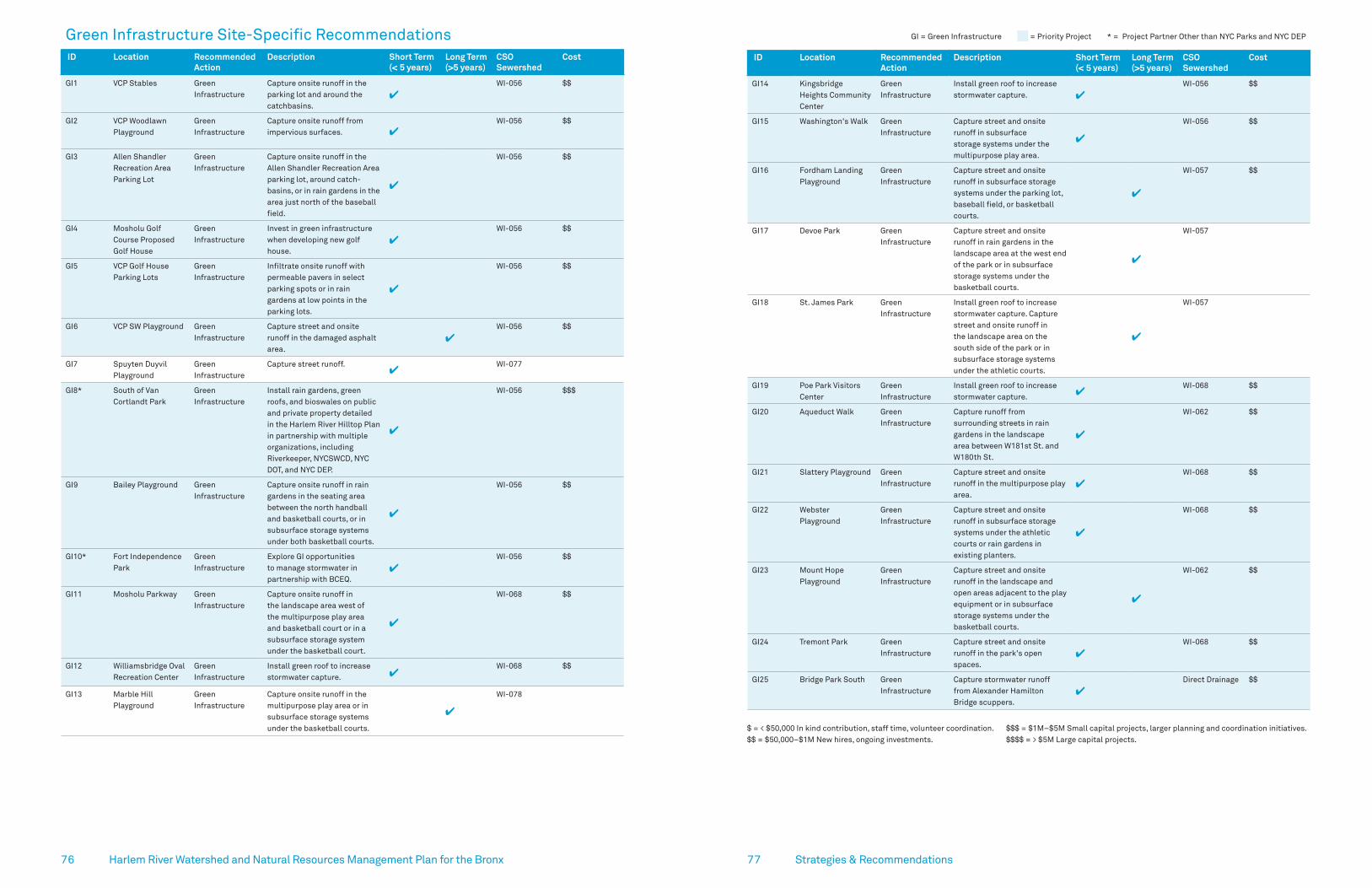
7776 Harlem River Watershed and Natural Resources Management Plan for the Bronx Strategies & Recommendations
GI = Green Infrastructure = Priority Project * = Project Partner Other than NYC Parks and NYC DEP
ID Location Recommended Action
Description Short Term(< 5 years)
Long Term(>5 years)
CSO Sewershed
Cost
GI14 Kingsbridge Heights Community Center
Green Infrastructure
Install green roof to increase stormwater capture. ✔
WI-056 $$
GI15 Washington's Walk Green Infrastructure
Capture street and onsite runoff in subsurface storage systems under the multipurpose play area.
✔
WI-056 $$
GI16 Fordham Landing Playground
Green Infrastructure
Capture street and onsite runoff in subsurface storage systems under the parking lot, baseball field, or basketball courts.
✔
WI-057 $$
GI17 Devoe Park Green Infrastructure
Capture street and onsite runoff in rain gardens in the landscape area at the west end of the park or in subsurface storage systems under the basketball courts.
✔
WI-057
GI18 St. James Park Green Infrastructure
Install green roof to increase stormwater capture. Capture street and onsite runoff in the landscape area on the south side of the park or in subsurface storage systems under the athletic courts.
✔
WI-057
GI19 Poe Park Visitors Center
Green Infrastructure
Install green roof to increase stormwater capture. ✔
WI-068 $$
GI20 Aqueduct Walk Green Infrastructure
Capture runoff from surrounding streets in rain gardens in the landscape area between W181st St. and W180th St.
✔
WI-062 $$
GI21 Slattery Playground Green Infrastructure
Capture street and onsite runoff in the multipurpose play area.
✔WI-068 $$
GI22 Webster Playground
Green Infrastructure
Capture street and onsite runoff in subsurface storage systems under the athletic courts or rain gardens in existing planters.
✔
WI-068 $$
GI23 Mount Hope Playground
Green Infrastructure
Capture street and onsite runoff in the landscape and open areas adjacent to the play equipment or in subsurface storage systems under the basketball courts.
✔
WI-062 $$
GI24 Tremont Park Green Infrastructure
Capture street and onsite runoff in the park's open spaces.
✔WI-068 $$
GI25 Bridge Park South Green Infrastructure
Capture stormwater runoff from Alexander Hamilton Bridge scuppers.
✔Direct Drainage $$
Green Infrastructure Site-Specific Recommendations ID Location Recommended
ActionDescription Short Term
(< 5 years)Long Term(>5 years)
CSO Sewershed
Cost
GI1 VCP Stables Green Infrastructure
Capture onsite runoff in the parking lot and around the catchbasins.
✔WI-056 $$
GI2 VCP Woodlawn Playground
Green Infrastructure
Capture onsite runoff from impervious surfaces. ✔
WI-056 $$
GI3 Allen Shandler Recreation Area Parking Lot
Green Infrastructure
Capture onsite runoff in the Allen Shandler Recreation Area parking lot, around catch-basins, or in rain gardens in the area just north of the baseball field.
✔
WI-056 $$
GI4 Mosholu Golf Course Proposed Golf House
Green Infrastructure
Invest in green infrastructure when developing new golf house.
✔WI-056 $$
GI5 VCP Golf House Parking Lots
Green Infrastructure
Infiltrate onsite runoff with permeable pavers in select parking spots or in rain gardens at low points in the parking lots.
✔
WI-056 $$
GI6 VCP SW Playground Green Infrastructure
Capture street and onsite runoff in the damaged asphalt area.
✔WI-056 $$
GI7 Spuyten Duyvil Playground
Green Infrastructure
Capture street runoff.✔
WI-077
GI8* South of Van Cortlandt Park
Green Infrastructure
Install rain gardens, green roofs, and bioswales on public and private property detailed in the Harlem River Hilltop Plan in partnership with multiple organizations, including Riverkeeper, NYCSWCD, NYC DOT, and NYC DEP.
✔
WI-056 $$$
GI9 Bailey Playground Green Infrastructure
Capture onsite runoff in rain gardens in the seating area between the north handball and basketball courts, or in subsurface storage systems under both basketball courts.
✔
WI-056 $$
GI10* Fort Independence Park
Green Infrastructure
Explore GI opportunities to manage stormwater in partnership with BCEQ.
✔WI-056 $$
GI11 Mosholu Parkway Green Infrastructure
Capture onsite runoff in the landscape area west of the multipurpose play area and basketball court or in a subsurface storage system under the basketball court.
✔
WI-068 $$
GI12 Williamsbridge Oval Recreation Center
Green Infrastructure
Install green roof to increase stormwater capture. ✔
WI-068 $$
GI13 Marble Hill Playground
Green Infrastructure
Capture onsite runoff in the multipurpose play area or in subsurface storage systems under the basketball courts.
✔
WI-078
$ = < $50,000 In kind contribution, staff time, volunteer coordination.$$ = $50,000–$1M New hires, ongoing investments.
$$$ = $1M–$5M Small capital projects, larger planning and coordination initiatives.$$$$ = > $5M Large capital projects.

7978 Harlem River Watershed and Natural Resources Management Plan for the Bronx
!
!
! !
!
!
!
!!
!
!
!
!!!!
!
!
!
!
!
!
!
!
!
!
!
!
!
!!
!
!
!!!
! !
!
!
!
!
!
!
!
!
!
!
!
H.HUDSON PKWY
BRO
AD
WAY M
OSH
OLU PKW
YM
AJO
R DEEG
AN EXP
VC1VC4
VC5
VC6
VC15
VC21
VC29
VC25
VC31VC30
VC33
VC35VC34
GI3
VC24
VC27
VC26
VC39VC38 VC37
VC36
VC40
GI8VC41
GI1
VC7
VC16
VC10VC14
VC12VC11
VC13
GI2
VC8VC9
VC17
VC23
VC28
VC32
VC22
VC20
VC19VC18
GI4
GI34
VC2
VC3
± 0Miles
0.5 1
Strategies & Recommendations
Van Cortlandt Park, the largest open space within the Harlem River watershed, offers restoration opportunities ranging from habitat restoration and stormwater management to educational programming and public access and connectivity to natural resources.
There are 41 recommendations proposed within Van Cortlandt Park, ranging from invasive species removal to continued water quality monitoring.
Van Cortlandt Park Opportunities
Site-Specific RecommendationsCompiled by Forestry, Horticulture, and Natural Resources October 03, 2019 Data Source: NYC Parks, NYC Department of Environmental Protection, 2014
Natural Resources Stormwater Management Access and Connectivity Engage and Educate
Golf Course NYC Park Waterbody — Major Road Priority Project
GI = Green Infrastructure = Priority Project * = Project Partner Other than NYC Parks and NYC DEP ID Location Recommended
ActionDescription Short Term
(< 5 years)Long Term(>5 years)
CSO Sewershed
Cost
GI26 West Bronx Recreation Center
Green Infrastructure
Install green roof to increase stormwater capture. ✔
WI-062 $$
GI27 Gouverneur Playground
Green Infrastructure
Capture street and onsite runoff in a subsurface storage system under the basketball court.
✔
WI-068 $$
GI28 Mullaly Park Green Infrastructure
Install green roofs to increase stormwater capture. Capture onsite runoff in the landscape areas or subsurface storage systems.
✔ ✔
WI-062 $$
GI29 Macombs Dam Park
Green Infrastructure
Capture onsite runoff in rain gardens in the landscape area at the southern end of the park or in subsurface storage systems under the baseball fields.
✔
WI-063
GI30* Arcilla Playground Green Infrastructure
Capture street and onsite runoff in rain gardens in the corner of the park adjacent to the half court and baseball field in partnership with NYC DOE.
✔
WI-068 $$
GI31 Patterson Playground
Green Infrastructure
Capture onsite runoff in the multipurpose play area. ✔
WI-075
GI32 Willis Playground Green Infrastructure
Capture onsite runoff in the asphalt area on the southern side of the park or in a subsurface storage systems under the asphalt area on the northern side of the park.
✔
WI-068 $$
GI33 People’s Park Green Infrastructure
Capture street and onsite runoff in rain gardens. Install green roof to increase stormwater capture.
✔
WI-068 $$
GI34 Van Cortlandt Park Pedestrian Bridge
Green Infrastructure
Explore feasibility of GI opportunities in conjunction with the construction of the Van Cortlandt Park pedestrian bridge over the Major Deegan Expressway.
✔
WI-056 $$
$ = < $50,000 In kind contribution, staff time, volunteer coordination.$$ = $50,000–$1M New hires, ongoing investments.
$$$ = $1M–$5M Small capital projects, larger planning and coordination initiatives.$$$$ = > $5M Large capital projects.

8180 Harlem River Watershed and Natural Resources Management Plan for the Bronx Strategies & Recommendations
= Priority Project
ID Location Recommended Action
Description Short Term(< 5 years)
Long Term(>5 years)
Leads & Partners
VC17 Van Cortlandt Park Golf Course
Natural Areas Access
Connect John Muir Trail with Putnam Trail and to allow access to Tibbetts Brook.
✔NYC ParksVCP Golf Course
VC19, 20, 27
Tibbetts Brook and Tributaries
Ecosystem Management/ Stewardship
Remove debris through volunteer events and contractors.
✔NYC ParksVan Cortlandt Park Alliance
VC21 Vault Hill Ecosystem Restoration
Complement restoration of Vault Hill cemetery with eradication of Japanese honeysuckle from eastern slope of hill.
✔
NYC ParksVan Cortlandt Park Alliance
VC22 Tibbetts Brook Signage Include informative and educational signage as part of Tibbetts Brook wetland restoration.
✔
NYC Parks
VC23 Mosholu Golf Course
Stormwater Control
Evaluate practices at golf course and stables and identify improvements needed to reduce runoff and protect water quality and natural areas.
✔
NYC Parks
VC24 Croton Woods Ecosystem Restoration
Restore forest behind the western Gulf gas station /Dunkin Donuts.
✔ ✔NYC ParksVan Cortlandt Park Alliance
VC25, 28, 32, 35, 37
Van Cortlandt Lake Discharge Pipes
Stormwater Control
Inspect conditions (short-term) and conduct routine maintenance (long-term) of stormwater basins discharging to Van Cortlandt Lake. Explore green infrastructure options for stormwater treatment.
✔ ✔
NYS DOTNYC ParksNYC DEP
VC29 Parade Ground Stormwater Control
Develop best management practices for Parade Ground. Rebuild outflow into Lake.
✔NYC ParksNYC DEP
VC30 Van Cortlandt Lake and Tibbetts Brook Corridor
Ecosystem Management
Manage invasive water chestnut on Van Cortlandt Lake and identify a long-term strategy for eradication.
✔
Van Cortlandt Park AllianceWestchester Parks Foundation
Water Quality Monitoring
Continue water quality monitoring program within Tibbetts Brook and Van Cortlandt Lake to identify nutrient loads, illicit discharges and spills. Expand water quality monitoring to Yonkers.
✔ ✔
Van Cortlandt Park AllianceWestchester Parks Foundation
Water Quality Monitoring
Make water quality data easily accessible to the public. ✔ ✔
Van Cortlandt Park AllianceWestchester Parks Foundation
VC31 Putnam Greenway Ecosystem Management
Maintain forest habitat in Putnam Greenway Corridor. ✔ ✔
NYC Parks
VC33 Tibbetts Brook and Van Cortlandt Lake
Stewardship Continue volunteer watershed crew weekly water quality monitoring.
✔ ✔Van Cortlandt Park Alliance
VC34 Van Cortlandt Lake Edge
Parkland Accessibility
Construct an ADA accessible boardwalk. ✔
NYC ParksVan Cortlandt Park Alliance
VC36 Van Cortlandt Lake Ecosystem Restoration
Assess lake shoreline for invasive species and opportunities to expand native plantings to stabilize the shoreline and improve the riparian buffer.
✔ ✔
NYC Parks
Van Cortlandt Park Site-Specific Recommendations VCP = Van Cortlandt Park
ID Location Recommended Action
Description Short Term(< 5 years)
Long Term(>5 years)
Leads & Partners
Park-wide Van Cortlandt Park Edges
Ecosystem Management
Eliminate vinelands at all edges of the park. ✔ ✔
NYC Parks Van Cortlandt Park Alliance
Upland Forest Ecosystem Management
Inspect and maintain past restoration sites. ✔ ✔
NYC Parks Van Cortlandt Park Alliance
Develop and implement Park-wide deer impact and Emerald Ash Borer management plans.
✔ NYC Parks
Expand Forever Wild area in Van Cortlandt Park. ✔
NYC Parks
Trails Trails Management
Develop plan to continue trail closures to reduce ecosystem fragmentation.
✔ NYC Parks Van Cortlandt Park Alliance
Update trail maps and develop maintenance plan. ✔
NYC Parks Van Cortlandt Park Alliance Natural Areas Conservancy
VC1 Van Cortlandt Park Northeast Forest
Ecosystem Management
Continue campaign to consistently monitor and remove mile-a-minute vine.
✔ ✔NYC ParksVan Cortlandt Park Alliance
VC2 Van Cortlandt Park Northeast Forest
Ecological Assessment
Examine feasibility and impacts of removing large tracts of Phragmites at the head of a Tibbetts Brook tributary.
✔
NYC Parks
VC3 Van Cortlandt Park Northeast Forest
Ecosystem Restoration
Complete restoration around large vernal pond. ✔ ✔
NYC Parks
VC4 Tibbetts Brook Corridor
Ecosystem Management
Restore large stretch of riparian forest from the northern park border south to the Mosholu/Sawmill Parkways exchange.
✔ ✔
NYC ParksVan Cortlandt Park Alliance
VC5, 8, 9, 10, 12, 13, 18, 26
Tibbetts Brook Discharge Pipes and Culverts
Stormwater Control
Identify sources of untreated stormwater and opportunities for stormwater treatment; Coordinate stormwater controls and maintenance across city agencies (short-term); Implement actions (long-term).
✔ ✔
NYS DOTNYC ParksNYC DEP
VC6 Van Cortlandt Park Northwest Woods
Ecosystem Restoration
Complete restoration of the northwest edge of the Northwest Woods.
✔ ✔NYC Parks
VC7 Van Cortlandt Park Trails
Stewardship Continue to train summer interns in trail maintenance and lake management.
✔Van Cortlandt Park Alliance
VC11, 14 Tibbetts Brook and Tributaries
Ecosystem Management/ Stewardship
Remove debris through volunteer events and contractors.
✔NYC ParksVan Cortlandt Park Alliance
VC15 Van Cortlandt Garage and Salt Shed
Stormwater Control
Evaluate current conditions at garage including: salt storage, run-off and drainage, fueling station and fuel storage, paving, and general site use. Work to adopt NYS DEC best practices and improvements through the MS4 permit.
✔
DSNYNYC DOTNYC Parks
VC16 Tibbetts Brook Corridor
Ecosystem Management
Manage invasives to control multiflora rose expansion. ✔
NYC ParksVan Cortlandt Park Alliance

8382 Harlem River Watershed and Natural Resources Management Plan for the Bronx Strategies & Recommendations
Van Cortlandt Park Priority ProjectsTibbetts Brook Wetland Restoration (VC38)NYC Parks worked with an engineering consultant team to generate 30% conceptual designs for restoring the Tibbetts Brook wetland south of Van Cortlandt Lake as part of a phased project to reconnect flow from Tibbetts Brook to the Harlem River. The proposed designs would enhance 4.0 acres of existing disturbed wetland, which is dominated by invasive common reed (Phragmites australis), and expand the habitat by 1.6 acres, for a total of 5.6 acres of restored wetland. The designs would also improve stormwater capture and public access to the wetland. Significant funding is needed in order to move forward with advanced design and construction.
COST $$$$LEAD NYC ParksPARTNERS BCEQ, VCPA
Tibbetts Brook Daylighting (VC40)Tibbetts Brook is currently piped into the combined sewer system south of Van Cortlandt Lake contributing to the occurrences and volume of combined sewer overflows into the Harlem River. In order to explore the feasibility, opportunities, and impacts of removing the base-flow from Tibbetts Brook from the sewer system and reconnecting it to the Harlem River, an engineering feasibility study should be undertaken.
COST $$$$LEAD NYC DEPPARTNERS NYC Parks, NYS DEC, BCEQ, VCPA
Van Cortlandt Lake Stormwater Vortechnics Chamber Maintenance (VC25, 28, 32, 35, 37)Four separate stormwater outfalls discharge stormwater runoff from adjacent highways into the south-eastern side of Van Cortlandt Lake in Van Cortlandt Park. In 2003, in association with a lake dredging project, NYC Parks installed five underground concrete stormwater Vortechnics chambers to capture the stormwater runoff upstream of these four outfalls and allow sediment to settle out before entering the lake. The stormwater chambers were cleaned of sediment in 2019 and should be cleaned every three to five years moving forward in order to maintain their function and protect the water quality of Van Cortlandt Lake.
COST $LEAD NYC Parks
Water Chestnut Control in Van Cortlandt Lake (VC30)Water chestnut is a non-native invasive aquatic plant that forms dense floating mats. Once established, these mats can severely limit light, reduce oxygen levels, and increase potential for fish kills in waterbodies. Water chestnut has become increasingly established in Van Cortlandt Lake in recent years via seeds transported downstream in Tibbetts Brook. Since 2016, the Van Cortlandt Park Alliance, formerly the Friends of Van Cortlandt Park, in conjunction with NYC Parks and other partners have led an effort to remove water chestnut from Van Cortlandt Lake. In 2018, Friends of Van Cortlandt Park initiated a pilot project to work with Westchester County and the Westchester Parks Foundation to expand removal efforts into Yonkers, where many of the water chestnut seeds originate in Tibbetts Brook Park. Continued cooperative removal efforts will enhance the health of Tibbetts Brook and Van Cortlandt Lake, and engage local communities in environmental stewardship.
COST $LEAD Van Cortlandt Park AlliancePARTNERS NYC Parks, Westchester County Parks, Westchester Parks Foundation
$ < $50,000 In kind contribution, staff time, volunteer coordination.
$$ $50,000–$1M New hires, ongoing investments.
$$$ $1M–$5M Small capital projects, larger planning, and coordination initiatives.
$$$$ > $5M Large capital projects.
= Priority Project
ID Location Recommended Action
Description Short Term(< 5 years)
Long Term(>5 years)
Leads & Partners
VC38 Tibbetts Brook Ecosystem Restoration
Restore degraded Phragmites wetland as first phase of project to reconnect Tibbetts Brook to the Harlem River.
✔
NYC Parks
VC39 Tibbetts Brook Programming Continue to build educational curriculum around Tibbetts Brook and Van Cortlandt Lake for students and adults to grow the connection between residents and the brook.
✔
NYC Parks Van Cortlandt Park Alliance
VC40 CSX Site Stormwater Management
Investigate opportunities and funding for daylighting as many sections of Tibbetts Brook as possible along the new Putnam Greenway downstream of Van Cortlandt Park.
✔
NYC ParksBCEQVan Cortlandt Park Alliance
VC41 Right-of-Way at Dickinson Ave and VCP S
Forest Restoration—Street Trees
Plant street trees to increase canopy cover and capture and infiltrate stormwater.
✔NYC Parks
GI1-4, 8, 34
VCP Golf House Parking Lots, Allen Shandler Recreation Area Parking Lot, VCP Stables, Mosholu Golf Course Proposed Golf House
Green Infrastructure
Implement green infrastructure recommendations (see page 76).
✔
NYC ParksNYC DEP
Tibbetts Brook, Van Cortlandt Park.

8584 Strategies & Recommendations
Hud
son
Rive
r
Harlem River __
Long Island Sound
161 ST
BRONX EXP
RFK B
R
CROSS
FORDHAM RD
MAJ
OR
DEE
GAN
EXP
CONC
OUR
SE
GRAND
± 0Miles
0.5 1
!(
!(
!
!(!
!(
!(
!(
!(!(
!(
!(
!(
!(
!(
!(
!(
!(
!
!(
!(
!(
!(
!(
!(
!(
!(
!(
!(
!(
!(
!(
!(
!(
!(
!(
!(
!
(
!
Har
lem
Riv
er
Har
lem
Riv
er Mil l Pond Park
Bridge ParkSouth
(Depot Place)
Bridge ParkSouth
(Depot Place)
BridgePark
BridgePark
WF4
WF5
WF6
WF7
WF8
WF9
WF10
WF11
WF12
WF13
WF14
WF15
WF16
WF17
GI25
WF18
WF19
WF20 WF21
WF22
WF1
WF3
WF2
Site-Specific RecommendationsCompiled by Forestry, Horticulture and Natural Resources October 03, 2019Data Source: NYC Parks
Natural Resources
Stormwater Management
Access and Connectivity
Engage and Educate
NYC Park
— Major Road
— Harlem River Watershed
Priority Project
The 9.3 mile stretch of Harlem River waterfront along the Bronx offers little community access to the river. Through a shoreline assessment, we verified that though the shoreline is mostly hardened, areas of erosion and degradation create opportunities for enhancement (Appendix C). In these areas, potential living shorelines should be considered during waterfront restoration or development efforts. A living shoreline is a protected, stabilized waterfront edge made of natural materials such as plants, sand, or rock. Living shorelines provide wildlife habitat, as well as natural resilience to communities near the waterfront.
There are plenty of opportunities to restore the Harlem River waterfront, improve connection to open space for the community, and enhance intertidal habitat where students and families can come to the river for educational programming. The following site-specific recommendations were developed from our shoreline assessment results and review of past planning efforts on waterfront access and greenway connectivity. The recommendations focus on how access, connectivity, and ecological habitat can be improved along the waterfront, and ways to engage the community with the river in their own neighborhood.
Waterfront Opportunities
NYC Parks staff discuss waterfront restoration opportunities at Bridge Park South, 2017.
Twenty-two site specific waterfront recommendations were developed for this plan.

8786 Harlem River Watershed and Natural Resources Management Plan for the Bronx Strategies & Recommendations
= Priority Project
ID Location Recommended Action
Description Short Term(< 5 years)
Long Term(>5 years)
Leads & Partners
WF11 Bridge Park South Waterfront Access
Design and construct Bridge Park South to allow for on-water access point if/when additional funding is secured.
✔
NYC Parks
Greenway Connectivity
Extend the Harlem River Greenway at Bridge Park South. Improve connectivity of Bridge Park South with the High Bridge by prioritizing completion of ongoing step improvement project.
✔
NYC Parks
Parkland Connectivity
De-map Exterior Street and convert to parkland. ✔
NYC DOT NYC Parks
WF12, 15-16
Mill Pond Park Shoreline Restoration
Explore feasibility of restoring intertidal and subtidal habitat through natural and nature-based solutions.
✔
NYC Parks
Plant areas of eroded shoreline with native shrubs to buffer wave impacts.
✔NYC Parks
WF13 Bronx Children's Museum, other community orgs.
Programming Leverage partnerships to expand existing programming, such as City Park Foundation’s Green Girls program.
✔
NYC ParksCommunity Organizations
WF14 Mill Pond Park Waterfront Access
Work with community groups to hold trash and invasive removal events to improve access and views of the River.
✔
NYC ParksNGO partners
WF14, 17
Pier 5, Mill Pond Park
Parkland Connectivity
Ensure a connection between Mill Pond Park and Pier 5 by extending the Harlem River Greenway through the Mill Pond Park expansion and esplanade at Pier 5.
✔
NYC ParksNYC EDC
WF17 Pier 5 Greenway Connectivity
Extend the Harlem River Greenway through the Mill Pond Park expansion and esplanade at Pier 5 to connect to the planned Lower Concourse Park at 144th Street.
✔
NYC EDCNYC DCPPrivate Developers
WF18 144th St Development Develop Lower Concourse Park. ✔ NYC Parks
WF19 Park Avenue Development Support waterfront redevelopment to increase public access and climate resiliency.
✔
South Bronx UniteNYC Parks
WF20 Mott Haven-Port Morris Waterfront
Greenway Connectivity
Extend South Bronx Greenway along the waterfront from Park Avenue to East 135th Street.
✔South Bronx UniteNYC ParksNYS DOT
WF21 Lincoln & Alexander Avenues
Development Explore feasibility of redeveloping into community space and designing to protect infrastructure from potential flooding.
✔
South Bronx UniteNYC Parks
WF22 Northwest Edge of Randall's Island Shoreline
Shoreline Restoration
Explore feasibility of restoring native marsh. ✔
Randall’s Island Park AllianceNYC Parks
GI25 Bridge Park South Green Infrastructure
Capture stormwater runoff from Alexander Hamilton Bridge scuppers.
✔NYC ParksNYC DEP
Waterfront Site-Specific Recommendations WF = Waterfront
ID Location Recommended Action
Description Short Term(< 5 years)
Long Term(>5 years)
Leads & Partners
WF1 CSX Property Along I-87
Property Acquisition
Acquire public open space. ✔
NYC Parks
Greenway Connectivity
Extend the Harlem River Greenway along CSX property north to Kingsbridge.
✔NYC Parks
WF2 Harlem River at W 193rd St.
Stream and Wetlands Restoration
Investigate opportunities and funding to daylight Tibbetts Brook along a new by-pass route to the Harlem River.
✔
NYC DEP NYS DECNYC Parks
WF3 Spuyten Duyvil Shoreline Restoration
Partner with MetroNorth to evaluate potential needs to protect & enhance existing salt marsh.
✔
NYC ParksMetroNorth
WF4 Bridge Park, Roberto Clemente
Stewardship Work with NYS Parks to hold engagement events across Roberto Clemente State Park & Bridge Park.
✔
NYC ParksNY-NJ Harbor and Estuary Program
Programming Share NYC DEP water quality data collected at Roberto Clemente State Park with NYS Parks to enhance already existing environmental education curriculum to provide more focused attention on the Harlem River.
✔
NYC DEPNYS ParksUSGSUrban Waters Federal Partnership
WF5 Bridge Park Shoreline Restoration
Work with volunteers on invasive plant management to restore habitat and views of the Harlem River.
✔
NYC ParksNGO partners
Evaluate stability of shoreline and overlook. Repair using materials and structures that can increase habitat for aquatic organisms.
✔ ✔
NYC Parks
WF6 Bridge Park Waterfront Access
Work with community groups to hold trash and invasive removal events to improve access and views of the River.
✔
NYC ParksNGO partners
WF7 Bridge Park South Programming Explore opportunities for educational programming related to restored shoreline habitat.
✔
NYC Parks
WF8 Bridge Park South Shoreline Restoration
Restore shoreline to support intertidal habitat. ✔ ✔
NYC Parks
WF9 Bridge Park South Signage Include signage in Bridge Park South on historic use of the Harlem River & information on fish consumption.
✔
NYC ParksNYC DEP
WF10 Bridge Park South Shoreline Restoration
Remove excess concrete and debris and increase habitat complexity and native plant cover.
✔
NYC Parks

89 Strategies & Recommendations
Waterfront Priority Projects Extending the Harlem River Greenway (WF11, 14, 17)Establishing a continuous greenway along the Harlem River waterfront has been a goal of Bronx residents for many years. In 2012, the Trust for Public Land and Harlem River Working Group published a community initiated vision for a Harlem River Greenway that runs the entire length of the river and connects to existing greenways and bicycle paths. Extending the existing greenway at Bridge Park through Bridge Park South (Depot Place) and through the Mill Pond Park expansion and esplanade will contribute toward an eventual continuous greenway.
COST $$$LEAD NYC ParksPARTNERS Private property owners, NYC EDC
Design and Build Bridge Park South (Depot Place) (WF6-11)NYC Parks has secured funding for design and construction of Bridge Park South (Depot Place), between the High Bridge and Alexander Hamilton Bridge on the Harlem River. Development of this currently vacant and unused property into a passive park will allow for restoration of the shoreline, management of highway runoff through green infrastructure, and improved waterfront access for local residents through extension of the Harlem River Greenway.
COST $$$$LEAD NYC ParksPARTNERS USDOT— Federal Highway Administration, NYS DOS,
Bronx Borough President
Stewardship and Educational Events (throughout waterfront parks)For decades, Bronx residents have been cut off from the Harlem River waterfront by transportation corridors. As parks and public open spaces are built and/or revitalized along the waterfront, and increasing attention is paid to improving pedestrian safety in key corridors, it is important to provide opportunities for Bronx residents to benefit from the beauty, recreational opportunities, and fish and wildlife viewing offered by the Harlem River. NYC Parks will prioritize identifying opportunities to hold public events at waterfront parks, and will explore the possibility of developing watershed curricula in conjunction with the Bronx Children’s Museum which plans to open in Mill Pond Park.
COST $–$$LEAD NYC Parks
PARTNERS Bronx Children’s Museum, Van Cortlandt Park Alliance,
Partnerships for Parks, Waterfront Alliance, Riverkeeper, NY-NJ HEP,
other community partners
88
Remnant pier structures along the shoreline at Bridge Park South, 2017.
Children testing the water quality at Mill Pond Park during City of Water Day, 2017.
$ < $50,000 In kind contribution, staff time, volunteer coordination.
$$ $50,000–$1M New hires, ongoing investments
$$$ $1M–$5M Small capital projects, larger planning and coordination initiatives
$$$$ > $5M Large capital projects
Harlem River Watershed and Natural Resources Management Plan for the Bronx

90 Harlem River Watershed and Natural Resources Management Plan for the Bronx
To ensure the long-term utility of this plan, NYC Parks will track progress towards completing recommendations and achieving the overall vision of a clean, healthy, and accessible watershed. As we advance projects, we will adjust their scope in response to changes in watershed condition, new research, and lessons learned during implementation.
NYC Parks manages a database to track natural resources restoration projects and has developed a Restoration Opportunities Inventory, documenting opportunities for habitat restoration throughout New York City. We will use these tools to assess plan progress and ensure that information on recommendations is readily accessible to funders, land managers, and stakeholders. We will also track the status of recommended actions using the form presented in Appendix D.
Specific performance criteria include, but are not limited to:
1. Acres of forest restoration or management 2. Acres of tidal or freshwater wetland restoration or
management 3. Linear miles of stream restoration or management 4. Gallons of stormwater managed through green
infrastructure 5. Number of green infrastructure and restoration
projects in planning, design, and construction 6. Number of street trees planted or maintained 7. Number of trails and linear feet of trails formalized,
managed, or closed 8. Linear miles of new greenway developed 9. Acres of new parkland acquired 10. Number of volunteers engaged 11. Number of outreach events held and number
of attendees 12. Number of grants applied for and dollar amount
of funding secured
Tracking and MonitoringIn addition, NYC Parks and partners have generated robust monitoring protocols for assessing success of its restoration projects, including the Natural and Nature-Based Features Monitoring Framework and a Forestry Rapid Site Assessment. We conduct a Street Tree Census every ten years to monitor street tree density, growth, and condition, with the next census planned for 2025 . Results of the Street Tree Census will be made publically available.
Finally, we will report on plan progress annually to the NY-NJ Harbor & Estuary program and the Urban Waters Federal Partnership.
91 Tracking & Monitoring
Shoreline monitoring at Bridge Park South, 2017.

93Harlem River Watershed and Natural Resources Management Plan for the Bronx
Our work with the Urban Waters Federal Partnership ensures close collaboration with Federal, State, and local partners to highlight priority projects in the Harlem River watershed and expand community engagement. We will continue to work with all lead and partner agencies in the plan to advance the recommendations, working towards the four goals of this watershed plan:
1. Protect, Restore, and Enhance Natural Resources2. Manage Stormwater3. Promote Access and Connectivity4. Engage and Educate the Public
Our past watershed planning efforts, including the Alley Creek Watershed Management and Habitat Restoration Plan and the Bronx River Intermunicipal Watershed Management Plan, have resulted in NYC Parks aquiring
funding for and implementing priority restoration projects. Similarly, we will pursue funding through grant opportunities and city funds for priority projects in the Harlem River watershed for which both interagency and community consensus has been built through the watershed planning process.
This plan provides a framework with actionable next steps to achieve the vision of a clean river and healthy watershed that is accessible for all to enjoy.
Looking AheadThe Harlem River Watershed in the Bronx is a diverse and dynamic system that contains critical resources for protection and restoration, along with exciting opportunities for water quality improvement, greenway expansion, and public engagement.
With input from a Watershed Advisory Committee of 16 organizations and three public meetings with more than 65 participants, our plan presents a consensus of recommendations that are primed for advocacy, funding, and implementation.
92
Discussing Harlem River shoreline restoration opportunities at the base of the High Bridge.
Harlem River Watershed and Natural Resources Management Plan for the Bronx
Kayaking on the Harlem River, 2018.

9594 Harlem River Watershed and Natural Resources Management Plan for the Bronx
Armstrong, L. (2016, April 14). Seal Spotted Splashing and Sunbathing Near Inwood Hill Park. DNAinfo, Washington heights & Inwood, Urban Animals.
Bronx Council for Environmental Quality (2007) Harlem River Waterfront: Linking a River’s Renaissance to its Upland Neighborhoods. Brownfield Opportunity Area Pre-Nomination Study.
Byrne, A. and Butler, J. (2016) Tibbetts Brook Water Monitoring Program Report of 2016 Water Quality Data. Friends of Van Cortlandt Park.
Crotty, E.M. Commissioner (2013) Commissioner Policy 29, Environmental Justice and Permitting. New York State Department of Environmental Conservation. Retrieved from https://www.dec.ny.gov/regulations/36951.html
FEMA (2015) Preliminary FEMA Map Products, Preliminary and Pending National Flood Insurance Rate Maps. Retrieved from https://hazards.fema.gov/femaportal/prelimdownload/searchResult.action
Fisher, S. (2016) Historical Water-Quality Data from the Harlem River, New York. USGS.
Gaffin, S.R. et al. (2010) Energy & Stormwater Analyses for the Con Edison Green & Control Roof Project. Columbia University.
Horenstein, S. (2007) Inwood Hill and Isham Parks: Geology, Geography, and History. Transactions of the Linnaean Society of New York, 10.
Howe, C. Mitchell, C. (2011) Water Sensitive Cities. London, UK: IWA Publishing.
McCormick, K. (1998) Rowing in New York City: A Lost Legacy? Retrieved from http://www.eastrivercrew.org/wp-content/uploads/2014/04/HistoryRowing-RowingInNYC-A_Lost_LegacyArticle2012.05.30.pdf
Mueller, S. and Estabrooks, F. (2006) New York status and trends report for freshwater and marine sediments: Albany, N.Y., New York State. Department of Environmental Conservation.
Natural Areas Conservancy (2016) Ecological Assessment Data.
Nowak, D.J. et al (2018a). The urban forest of New York City. Resource Bulletin, NRS-117. US Department of Agriculture, Forest Service, Northern Research Station.
NYCDEP (2004). Final Supplemental Environmental Impact Statement for the Croton Water Treatment Plant at the Harlem River Site.
NYCDEP (2012) Van Cortlandt Park Bluebelt: Basis of Design Report.
NYCDEP (2018) Citywide/Open Waters CSO Long Term Control Plan, Hudson River and Harlem River Public Kickoff Meeting. Retrieved from https://www1.nyc.gov/assets/dep/downloads/pdf/water/nyc-waterways/citywide-east-river-open-water/harlem-hudson-river-kickoff-meeting-presentation.pdf
NYC Parks (2017) 2015 Street Tree Census Report. Retrieved from http://media.nycgovparks.org/images/web/TreesCount/Index.html#additionalproducts
NYSDEC (2017)a Van Cortlandt Lake Electrofishing Survey. Retrieved from https://www.dec.ny.gov/outdoor/112904.html
NYSDEC (2017)b Waterbody Inventory/Priority Waterbodies List, Hudson/East River Watershed (0203010104). Retrieved from https://www.dec.ny.gov/docs/water_pdf/wiatllishrer.pdf
NYSDEC Lake Parameter Factsheet. Retrieved from https://www.dec.ny.gov/docs/water_pdf/cslaplkpara.pdf
Petkova E. P. et al. (2017) Towards More Comprehensive Projections of Urban Heat-Related Mortality: Estimates for New York City under Multiple Population, Adaptation, and Climate Scenarios. Environmental Health Perspectives, 125.
Pregitzer, Clara C. et al. (2018) Forest Management Framework for New York City. Natural Areas Conservancy, New York, NY.
Rosenzweig, C. and Solecki, W. (2015) New York City Panel on Climate Change 2015 Report. Annals of the New York Academy of Science, 1336.
South Bronx Unite (accessed in 2020). Retrieved from http://southbronxunite.org/environmental-justice/overview
Unpublished NYC Parks data.
US Census Bureau (2019) Quick Facts Bronx County (Bronx Borough), New York. Retrieved from https://www.census.gov/quickfacts/fact/table/bronxcountybronxboroughnewyork/PST045219
Wolch et al. (2014) Urban green space, public health, and environmental justice: The challenge of Making cities ‘Just green enough.’ Landscape and Urban Planning, 125.
References1. Horenstein, S. (2007).
2. Ibid.
3. McCormick, K. (1998).
4. US Census Bureau (2019).
5. Crotty, E.M. Commissioner (2013).
6. US Census Bureau (2019).
7. Crotty, E.M. Commissioner (2013).
8. South Bronx Unite (accessed 2020).
9. Wolch et al. (2014).
10. Bronx Council for Environmental Quality (2007).
11. NYC DEP (2012).
12. NYC Parks (2012).
13. Howe, C. and Mitchell, C. (2011).
14. NYCDEP (2018).
15. Mueller, S. and Estabrooks, F. (2006).
16. Ibid.
17. Fisher, S. (2016).
18. NYSDEC (2017)a.
19. Byrne, A. and Butler, J. (2016).
20. NYSDEC (2017)b.
21. NYSDEC Lake Parameter Factsheet
22. Rosenzweig,C. and Solecki, W. (2015).
23. Petkova E. P. et al. (2017).
24. Rosenzweig,C. and Solecki, W. (2015).
25. Ibid.
26. FEMA (2015).
27. NYC Parks (2017).
28. Nowak, D.J. et al (2018a).
29. Pregitzer, Clara C. et al (2018).
30. Natural Areas Conservancy (2016).
31. Unpublished NYC Parks data.
32. Armstrong, L. (2016).
33. NYCDEP (2004).
34. Ibid.
35. Gaffin, S.R. et al (2010).
Notes