Halfaya Field, Iraq Phase 1 Development: The Archaeology and Cultural Heritage of the Halfaya...
66
Halfaya Field, Iraq Phase 1 Development The Archaeology and Cultural Heritage of the Halfaya Contract Area and its Environs November 2012
Transcript of Halfaya Field, Iraq Phase 1 Development: The Archaeology and Cultural Heritage of the Halfaya...
Halfaya Field, Iraq
Phase 1 Development
The Archaeology and Cultural Heritage of the
Halfaya Contract Area and its Environs
November 2012
2
Contract Reference: HFY-CON/HSSE0183-0211
Contract Name: Provision of Environmental and Social Impact Assessment for
Projects:
i. Central Processing Facilities (CPF) 1;
ii. Gas Export Pipeline
iii. Source Water Plant;
iv. Intermediate Pumping Station;
v. Field Surface Facilities;
vi. Drilling Pads and Existing Drilling Works
Submission to: PetroChina, Halfaya, Iraq
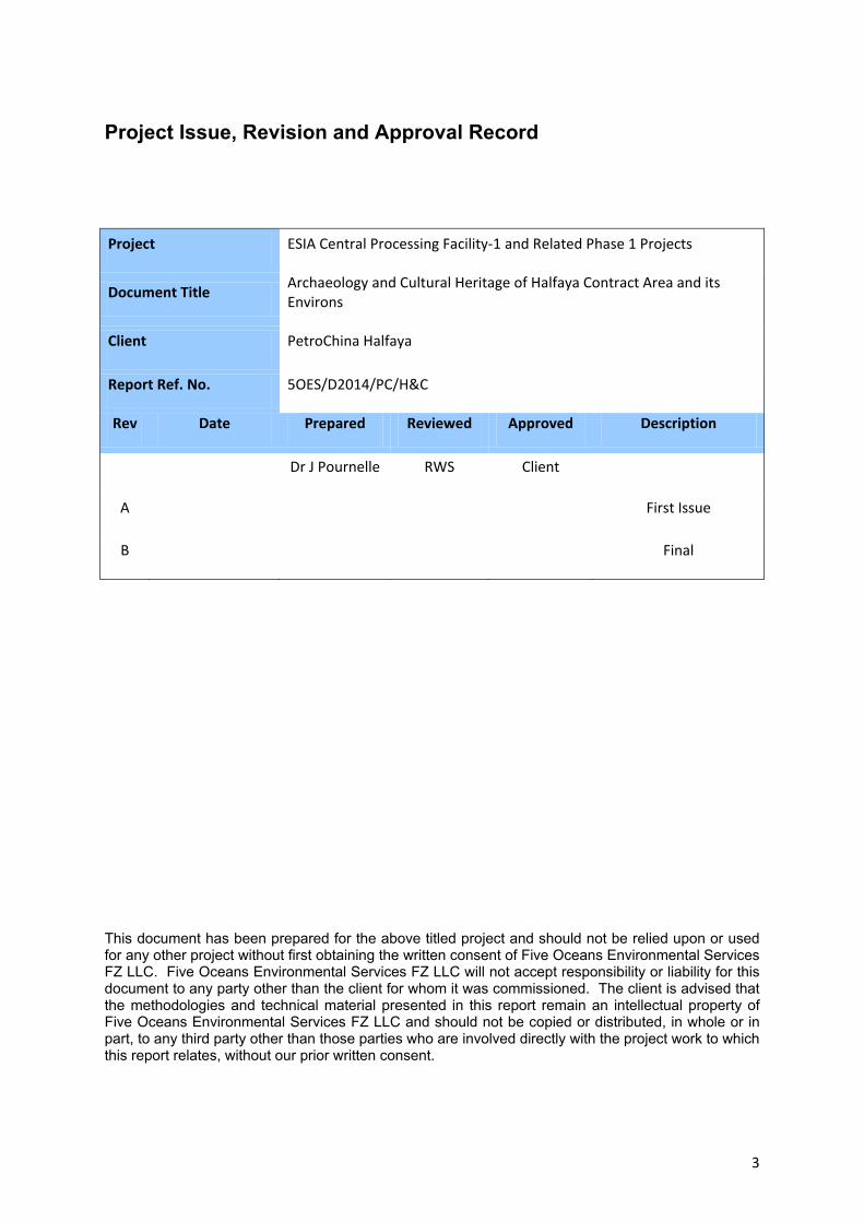
3
Project Issue, Revision and Approval Record
Project ESIA Central Processing Facility-1 and Related Phase 1 Projects
Document Title Archaeology and Cultural Heritage of Halfaya Contract Area and its Environs
Client PetroChina Halfaya
Report Ref. No. 5OES/D2014/PC/H&C
Rev Date Prepared Reviewed Approved Description
Dr J Pournelle RWS Client
A First Issue
B Final
This document has been prepared for the above titled project and should not be relied upon or used for any other project without first obtaining the written consent of Five Oceans Environmental Services FZ LLC. Five Oceans Environmental Services FZ LLC will not accept responsibility or liability for this document to any party other than the client for whom it was commissioned. The client is advised that the methodologies and technical material presented in this report remain an intellectual property of Five Oceans Environmental Services FZ LLC and should not be copied or distributed, in whole or in part, to any third party other than those parties who are involved directly with the project work to which this report relates, without our prior written consent.
1
Table of Contents
1 Archaeology ...................................................................................................................................... 1 1.1 Antiquities Law in Iraq ............................................................................................................... 1
1.1.1 Definitions .......................................................................................................................... 1 1.1.2 Authorities .......................................................................................................................... 1 1.1.3 Responsibilities ................................................................................................................... 1 1.1.4 Prohibitions ........................................................................................................................ 2 1.1.5 Actions on Discovery .......................................................................................................... 2 1.1.6 Penalties ............................................................................................................................. 2
1.2 Geography, Archaeology, and History of the Region ................................................................ 3 1.2.1 Physical Geography and Archaeology ................................................................................ 3 1.2.2 Archaeology and History .................................................................................................... 4
1.3 Known Antiquity and Heritage Remains in the Contract Area ................................................ 18 1.3.1 Sources ............................................................................................................................. 18 1.3.2 Methods ........................................................................................................................... 18 1.3.3 Findings ............................................................................................................................ 18
1.4 Potential for Further Archaeological Remains in the Contract Area ....................................... 21 1.4.1 Unpublished Interviews .................................................................................................... 22 1.4.2 Expected Physical Evidence .............................................................................................. 23 1.4.3 Evidence from Imagery Analysis ....................................................................................... 24 1.4.4 Evidence of Human Habitation ........................................................................................ 25
1.5 Known Heritage Properties in the Contract Area .................................................................... 27 2 Potential Impacts to Archaeological Remains .................................................................................. 0
2.1 Construction Footprint .............................................................................................................. 0 2.2 Operations Impacts ................................................................................................................... 0 2.3 Collateral Impacts ...................................................................................................................... 1 2.4 Recommendations for Protection of Archaeological Remains ................................................. 1
2.4.1 Actions to Confirm or Deny the Presence of Antiquities, Heritage Material, and Historical Sites ................................................................................................................ 1
2.4.2 Actions to Protect and Safeguard Antiquities, Heritage Material, and Historical Sites ..... 2 2.5 Key Gaps in Information and Uncertainties .............................................................................. 3 2.6 Sensitive Receptors ................................................................................................................... 3
Appendix A References A1 Maps and Atlases………………………………………………………………………………………………………………. 32 A2 Archaeological References………………………………………………………………………………………………… 32
2
A3 Geological References……………………………………………………………………………………………………… 33 A4 Historical References……………………………………………………………………………………………………….. 34 A5 Marsh Ecosystem Heritage References…………………………………………………………………………….. 34 A6 Intangible Cultural Heritage References…………………………………………………………………………… 35 Appendix B Maps………………………………………………………………………………………………………………….. 36 Appendix C Appendix: LAW No.55 of 2002 For The Antiquities & Heritage of Iraq…………………. 37
List of Tables, Figures, and Maps Table 1: 20th-Century Geographies, Ethnographies, and Travelogues treating the Wetlands of Southern Iraq. ....................................................................................................................................... 16 Table 2: Recorded Antiquity and Heritage sites in the Al Kahlah sub-district, Amara district, Maysan Governorate (Map 1) with approximate linear distance to nearest infrastructure. ............................ 19 Table 3: Descriptions and Condition of Archaeological Sites Near Existing Infrastructure .................. 20 Table 4: Recorded Archaeological Sites bordering the Al Kahla sub-district (Map 2) .......................... 22 Table 5: Other archaeological sites reported “in the marshes” ........................................................... 22 Table 6: Potential Archaeological Sites Identified on Imagery (Map 4) ............................................... 25 Figure 1: Traditional Agricultural Economy, 20th-Century Geographies and Ethnographies of the Tigris–Euphrates Delta. ......................................................................................................................... 17 Figure 2: Small Ishans. (L) With Palm Gardens (R) Without Palm Gardens .......................................... 23 Figure 3: Typical Late 19th-Century mud-brick architecture in southern Iraq. .................................... 24 Figure 4: Mud-brick walls with pisé stucco. (L) Livestock byre (R) Detail, showing palm-wood support beams .................................................................................................................................................... 24 Figure 5: Activities Likely to leave Physical Remains. (L) Pottery jar base upcast by canal-dredging (R) Household storage and furniture .......................................................................................................... 26 Figure 6: Clay Ovens. (L) Lining a canal bank (R) Close-up showing carbonized remains ..................... 26 Figure 7: Activities likely to leave organic remains. (L) Fish-drying house (R) Dung fuel-drying stacks .............................................................................................................................................................. 26 Figure 8: Al Awy Naama (L) and Ali Al Zakay ........................................................................................ 27 Map 1: Recorded Archaeological Sites, Al-Kahla Sub-District, Maysan (Iraq DoA Atlas 1976) .............. 4 Map 2: Recorded Archaeological Sites Bordering the Al-Kahlah Sub-District, Maysan (Iraq DoA Map . 4 Map 3: Recorded Archaeological Sites, Al-Kahla Sub-District, Maysan (Table 2) ................................... 6 Map 4 a and b : Potential Archaeological Sites Identified on Imagery (Table 6) .................................... 7
1
Abbreviations DEM Digital Elevation Model
DOA Directorate of Antiquities
GOI Government of Iraq
MTA Ministry of Tourism and Antiquities
SBAH State Board of Antiquities and Heritage
Glossary Archaeology The study of physical remains associated with human activities and living conditions,
regardless of their age.
Antiquity Movable and immovable property which has been built, made, carved, produced,
written or painted by man, the age of which is not less than 200 years, as well as
associated human, animal, plant, and geological remains.
Heritage Material: Movable and immovable property, less than 200 years of age, possessing a
historical, national, religious or artistic value.
Historical Site: A place where a notable historical event took place, regardless of age.
Ishan Literally, “island.” An occupation mound, surrounded by marsh and/or water, often
built up on top of an older mound (see Tell).
Libn Unfired (sun-baked) mud brick.
Klinker Vitrified brick fragments produced during brick firing.
Prill Metal fragment produced during mettalurgy.
Sherd Broken pottery fragment.
Slag Vitrified ore, ash, or glass fragments produced as a by-product of metallurgy, glass-
making, or burning reeds for fuel.
Tanoor Round, clay, upright oven, open at the top, usually fuelled with dried reed caneand
dung.
Tell Mound comprising architectural and other remains, built up over centuries of
repeated human occupation (Iran=Tepe; Turkey=Hoyuk).
Waqf An Islamic religious endowment, typically a building or plot of land used for religious
or charitable purposes. Conceptually similar to the common law trust.
1
1 Archaeology
The following paper examining the archaeology and cultural heritage has been prepared for the
Halfaya Contract Area, Phase 1 developments. This document has been prepared as a stand-alone
document that may be referred to for project planning, in particular for the research and preparation
of Environmental and Social Impact Assessment Studies.
1.1 Antiquities Law in Iraq Management of antiquities in Iraq, including standing architecture and archaeological sites, whether
visible or buried, is governed by Law 55 (Iraq 2002) (Appendix). Key provisions of that law include:
1.1.1 Definitions
§4.7. Antiquity: movable and immovable property which has been built, made, carved, produced,
written or painted by man, the age of which is not less than 200 years, as well as human, animal, and
plant remains.
§4.8. Heritage Material: The movable and immovable property, less than 200 years of age, possessing
a historical, national, religious or artistic value.
§4.9. Historical Site: A place where a notable historical event took place, regardless of age.
§4.10. Archaeological Excavation: The actions of digging or sensing and sounding with the aim of
uncovering movable or immovable property in or under the surface of soil or in the bottom of rivers,
lakes, marshes and regional water surfaces.
1.1.2 Authorities
The State Board of Antiquity and Heritage (SBAH) is designated as the responsible antiquites authority
(§4.3), as directed by the Ministry of Tourism & Antiquities (§4.1). SBAH is headquartered at the
National Iraq Museum in Baghdad (http://www.theiraqmuseum.com/). Regional Directors are
appointed to each Governorate, with offices located at the governorate museum. The Maysan office
is located in Amara. Regional officers employ local Inspectors who escort visitors, investigate reports,
and undertake survey and excavation.
1.1.3 Responsibilities
§9 3. The concerned authorities shall be committed to conserve Antiquity, Heritage and Historical
Sites when the mentioned authorities are about to make state, industrial, agricultural or residential
projects, as well as other projects such as: city and village planning, beautification, or expansion;
irrigation canals, and road paving. Written permission from the Antiquity Authority shall be acquired
before beginning or on changing the plans of these projects.
2
§13.1. Any occupier of land containing immovable Antiquity or Heritage sites shall be committed to
allow the Official Antiquity Authority to enter these sites or monuments at all appropriate times, with
the aim of examining, drawing maps, or undertaking soundings, excavations, restoration, or
conservation works with their tools, machines and devices.
1.1.4 Prohibitions
§3.2: The owner of land where an immovable Antiquity is located shall not have the rights to dispose,
dig, vandalize or change the features on or under its soil.
§15. The following actions are forbidden:
§15.2. Cultivation, erecting residential or other kinds of buildings, construction upon Antiquity or
Heritage sites and their prohibited zone, or altering their features.
§15.3. Using Antiquity sites as rubbish or debris collecting places or erecting buildings, cemeteries and
quarries therein.
§15.5. Erecting polluting industrial facilities likely to affect the general health of the site, less than
3km from any side of any Antiquity site or Heritage building.
1.1.5 Actions on Discovery
§12. Any person who discovers an immovable antiquity, shall, within 24 hours, be committed to
inform the nearest official authority, who in turn shall immediately notify the Antiquity Authority.
§19.1. Whoever discovers a movable or immovable antiquity or has been informed of it, shall be
committed to inform the nearest official authority or any public organization within 24 hours from
the date of discovery or acknowledgment.
1.1.6 Penalties
§41.1. Whoever deliberately exports or intends to export an antiquity from Iraq shall be punishable
with execution.
§43.1. Whoever dug, built, planted or inhabited in a declared antiquity site, or removed, rendered,
damaged, deformed, demolished an antiquity or heritage monument, attempted to dispose with its
construction materials or used it in a harmful manner which may result in tearing it down or altering
its original features shall be punishable with imprisonment for a period not exceeding 10 years, a
compensation two times the evaluated value of the damage, and removing the contravention at their
own expense.
3
1.2 Geography, Archaeology, and History of the Region The accumulated archaeological record for southern Iraq is vast, comprising over 2,500 recorded sites
and another 3,000 potential sites identified on satellite imagery (Hritz 2010), spanning a timeframe
from the late Pleistocene to the last century. The vast area known since Roman times as “the land
between the rivers” (Mesopotamia), is home to the world’s first and oldest known cities, and the
earliest known invention and recording of the wheel, monumental architecture, accounting,
timekeeping, manufacturing, standing military forces, writing, poetry, literature, engineering, law,
mathematics, and the early sciences. Even a minimal introduction to the rich archaeological heritage
of the region would require a book-length work.
Therefore, this introduction addresses only the specific background relevant to understanding the
archaeological heritage of the Al-Kahla sub-district of Maysan Governorate, insofar as that is known.
1.2.1 Physical Geography and Archaeology
Three processes in the physical geography of southern Iraq are especially important to understanding
the long history of human settlement in southern Iraq, as well as the likelihood of archaeological
remains being preserved or discovered within the Contract Area. These are: (1) Mid-Holocene marine
transgfression and regression; (2) establishment and movement of Tigris River channel beds; and (3)
formation of the vast marsh and lake complex (Awhar).
The modern-day Arab-Persian Gulf began forming around 12,000 years ago when glacial melting
raised sea levels, and sea water breached the narrows at Hormuz and began flooding the valley into
which the present-day Shatt al Arab river flows. The maximal boundaries of the Awhar basin are
hypothesized to coincide with the maximal extent of mid-Holocene marine incursion coincident with
eustasis highstands at around 3,000 BC, followed by withdrawal and deltaic progradation over the
next several thousand years. The timing, rate, and extent of that incursion are not well studied, but
probably covered the contract area (Pournelle 2012).
The main channel bed of the Tigris, as well as its terminal distributaries, migrated significantly
through time, and probably did not assume its present course until after 650 CEhritz 2010). As sea
levels fell and the Gulf withdrew, high annual Tigris discharge distributaries of the Tigris river built out
into an inner delta, contributing the bulk of water that formed the Awhar. Additional flows, as well as
the bulk of sediments, were transported by the Kurun-Karkeh river system from the Zagros piedmont.
Early Islamic introduction of rice farming in this area accelerated sediment deposition, beginning
about 650 CE and continuing into the modern era (Buringh 1960).
During the Palaeolithic, Epipaleolithic, and Early Neolithic, the broad Ur-Schatt River Valley, with lakes
and marshes in the flatter regions, would have provided localized resources attractive to early people
4
and formed a natural land route for people moving between Asia and Africa (Rose 2010). Within the
contract area, those early Holocene wetlands therefore hold the highest potential location for
preserved Paleolithic and Epipaleolithic archaeological sites. However, assessing those exact locations
would require subsurface imaging to detect the earlier channel beds.
In any case, within the Contract Area, sites older than about 4500 BC would be buried by sedimentary
materials at depths of up to 20m beneath the present ground surface (Aqrawi 2001). The following
two millennia probably comprise an archaeological void, in that the area was likely submerged
beneath the Gulf. From 2500 BC, there is no reason to suppose that the area was not inhabited.
However, on the one hand, migration of Tigris channels has no doubt resulted in destruction through
erosion of many sites predating the mid-first millennium CE. On the other, silt deposition and
formation of marshy organic sediments has certainly buried those that survived, at depths ranging
from 1-12m depending on local context ( Aqrawi 2001).
1.2.2 Archaeology and History
This section is intended to highlight activities and periods for which (as yet undiscovered)
archaeological evidence might be reasonably expected in or near Halfaya. Historical records from Iraq
as a whole date back over 5,000 years, to proto-literate (pre-cuneiform) baked clay texts recovered
from excavations at Uruk (Warka). However, no early sites that might have produced such
administrative, legal, or private texts have ever been excavated in either DĂLJƐĈŶ� Žƌ� �ĂƐƌĂ�
Governorates. Such discovery could be made at any time.
1.2.2.1 Pre-Islamic History
The intersection of archaeology and history in the general area that includes Halfaya, for which
additional archaeological correlation (discovery of sites) might be expected, lies between 1600–650
BCE. Thereafter, considerably more documentary evidence exists. What follows is a brief summary by
period.
1.2.2.1.1 Pre-Classical (Kassite–Babylonian)
The earliest site registered in the immediate area surrounding Halfaya is an unexcavated mound to
the north, near Amara, with some pottery dating to the Kassite period (1600 BC) (Iraq DoA Atlas
1976). While public administrative documents and both public and private letters from that period
are common, none explicitly mention any city further eastward than Lagash and Ur.
The earliest documentary evidence for human activity in the Halfaya area is accounts of military
campaigns conducted by Tiglath-pileser III, Sargon II, Sennacherib, and his successors against clans of
“The Sealands” allied with Merodach-baladan, beginning in 744 BCE. The contestation continued for
nearly a century (Ahmed 1968; van de Mierop 1999: 42; Cole and Gasche 2007: 6). The impenetrable
5
reeds, canebrakes, and a settlement surrounded by boats and mooring places called “Nagitu-the-
Turtle,” all associated with the Ulaya (Eulaios, Eulaeus) and Uqnu (Pasitigris) Rivers mentioned in
these accounts, served as refuges from and bases for raids against Sennecherib’s armies. Cole and
Gasch conclude that the region described included the later Hammar and Hawiza marsh districts
(2007: 6–29). Tell Abu Salabikh, located southeast of Halfaya in Lake Hammar (Basra Governorate),
was thought by Georgés Roux to be Merodach-baladan’s marshland capitol, Bit-Iakin (Roux 1960).
The site has never been excavated. During his informal visit (by boat) in the 1950’s, Roux noted other
pottery fragments that he believed to be two millennia older. This is as yet unconfirmed (Hritz,
Pournelle, and Smith 2012b).
1.2.2.1.2 Classical (Hellenistic–Parthian–Sassanian)
During the first half of 324 BCE, Alexander the Great’s fleet commander, Nearchus, explored the head
of the Gulf as it then existed, as well as the river mouths that emptied into it. His accounts were
preserved through secondary sources (mainly Pliny), which themselves were copied. Based on these
descriptions, Cole and Gasche 2007 conclude that modern T. Naisan, (Karkh Maisan) 5 km southeast
of Qurna, is ancient Alexandria-on-the-Tigris (later Spasinou Charax). At that time, branches of the
Karkeh joined the Dez and Karun rivers near Awhaz, then flowed southwest to enter the Gulf north of
the city, which was then a port. Numerous sites dating 3500–640 BCE are documented along this
valley. North of the united rivers was a marshy lake, known to Greek and Roman writers as chaldaicus
lacus (Chaldean Lake), extending into the geological depression that holds the Hawiza marsh. Draining
into its northern shore was the southern bed of the “Surappi” River, which Cole and Gasche identify
as the present-day Nahr Tib (Tib Canal). This stretch has since been re-captured by the modern
easternmost branch of the Tigris (the Hud), which lies along Halfaya’s northern boundary.
Refugees from Alexandrian battles along the southern Surappi likewise escaped into what became
the greater Hawiza marsh area. Spasinou Charax, re-named for Hyspaosines, first named Satrap in
166 BCE, then founder of the Characene kingship, remained an entrepôt under Characene reign until
the Sasanian conquest in 222 CE (Schuol 2000). Thus, there is every reason to suppose that sizeable,
clan-based “Chaldean” marsh settlements would have been located in that general area from at least
the first millennium BCE, although whether quite as far north and west as present-day Halfaya is
unknown.
Also unknown is whether we should expect the modern-day central channel of the Tigris, which runs
from Kut, through Amara, to Qurna, to be associated with early sites—or whether it has since that
time obscured earlier material. A find of silver coins dated to early Christian times (54–74 CE) at Tell
I’ran (Imm I’ran), to the south of Halfaya, may indicate that the site was occupied at that time, which
6
in turn may indicate that the river then passed by it. However, the hoard could also have been
brought from elsewhere and buried during a later period.
The branch certainly existed by Sassanian times (LeStrange 1930: 7). Given the massive expansion of
extensive, highly-regulated irrigation works (canals, weirs, flumes, diversion channels, dams, walls,
earthworks) that tapped Tigris waters during Sassanian rule (Adams 1981; Hill 1984), unless the
Halfaya district was under permanent marsh at that time, we should expect evidence of such
landscape engineering to be preserved. At the close of the Christian era, massive flooding in the years
628–629 AD resulted in the Tigris switching its main channel to a course that flowed well to the west
(southward from Wasit), and forming the massive, interconnected marsh system that eventually
became the Awhar.
1.2.2.2 Islamic History
1.2.2.2.1 Early (Rashidun, 632–661 CE; Ummayyad 661–750 CE)
Early Islamic historical documents are dominated by the initial campaigns launched from the Nejd,
and the founding of Basra, beginning with military camps at Old Zubayr. Chinese travellers also
provide accounts of travels to Basra during this period, but discussion of those sources is outside the
scope of this report.
1.2.2.2.2 Medieval (Abbassid 750-1258; Buwayhid 945–1012; Mongol Conquest)
According to Ibn Rustah, the Eastern Branch of the Tigris became operative again sometime after the
ninth century (LeStrange 1930: 28). Certainly palm and garden agriculture expanded in what are now
�ĂƐƌĂ�ĂŶĚ�DĂLJƐĈŶ�'ŽǀĞƌŶŽƌĂƚĞƐ�ĚƵƌŝŶŐ�ƚŚŝƐ�ƉĞƌŝŽĚ͕�ǁŚŝĐŚ�Ălso saw the introduction of water buffalo
and intensive rice cultivation, conducted through importation of African Slaves. The brutal working
conditions led to a series of slave revolts in the 9th century. Escapees fled to the marshes, whence
they based their campaigns of resistance (Popavic 1999). The area remained beyond any external
control or influence until 1003 BCE, when Abu’l-‘Abbas b. Wasil gained control of Basra, Ahwaz, and
the intervening marshes on behalf of the Buwayhid (first Shia) Caliphate. Thus, for much of the
Middle Islamic period, the area around Halfaya was essentially a Buwayhid “island” beyond Abbasid
control, subject to both financial and military governors. The former had the upper hand in Basra,
having been granted tax farming contracts for both Basra and Wasit (Donohue 2003: 211–212).
Canals, field systems, and apparently related pottery believed to date to the Abbasid era have been
identified in the former Hammar district, south of the present day Euphrates. Their canal heads
appear to arise as Tigris offtakes (Pournelle, unpubl.). From about 1200, the Tigris continued a gradual
shift to this bed, and became fully established some time in the sixteenth century (Hill 1984: 24). In
1581 it was reported as navigable by an English visitor to the region (LeStrange 1930: 28). Abbasid
7
rule ended with the Mongol conquest and sack of Baghdad in 1268, followed by systematic
destruction of irrigation systems and the agricultural base. By some accounts, Basra capitulated to the
Mongols to avoid a massacre. The area was claimed by both Mamluks (1250–1382) and the Mongol
Dominions (1300–1405); no doubt in actuality the marsh zone remained largely outside external
control, and distinguishing this period by any archaeological evidence other than absolute
(radiocarbon) dating is unlikely.
1.2.2.2.3 Late (Ottoman 1517-1812)
By 1546, Turkish troops had reached Basra, passing down the Tigris from the north. Despite
occasional forays, from about 1625–1668, when the Ottomans formally captured the city, Basra and
the delta marshlands remained in the hands of local chieftains independent of the Ottoman
administration at Baghdad. Thereafter, there were several Persian–Ottoman contestations of the
border territories, including the district surrounding Halfaya. Any of these events could be expected
to leave archaeological remains.
While Ottoman rule did not formally end in Iraq until the close of World War I in 1918, under Iraqi law
“archaeology” as such is concerned with only with physical remains more than 200 years old. Thus, as
of this writing, the year 1812 demarcates the line between “archaeology” and “history.”
1.2.2.3 Modern History
1.2.2.3.1 Late Ottoman & the Boundary Commission
The modern city of Amara was established in the 1860s as an Ottoman military outpost. In 1863, after
reflecting in glowing terms on the rich Gulf trade in pearls, dried fish, wool, cloth, dates, grain, and
horses,1 the British Political Resident at Bushire reported to the Chief Secretary to the Government of
Bombay that Fao, at the southern tip of the Shatt Al Arab’s emergence into the Gulf, “would ill-suit
our purposes; its climate and locality among delta marshes would render it fatal to Englishmen”
(Pelley 1863: 621, emphasis added). While waxing poetic about the “clean, active town, with a broad
and open main bazaar, and numerous solid stone dwelling houses stretching along the strand,
containing 20,000 inhabitants” that was Kuwait, he notes only in passing that the exported horses’
forage, no doubt collected from the deadly delta marshes, “comes down the Bubiyan Creek from
Bandar Zubair” (Pelley 1863: 619), while the exported dates, along with “a complimentary present of
dates from Basrah in token of suzerainty and for the supposed protection of the mouths of the Basrah
river” were actually received or shipped from the Shatt al-Arab (Pelley 1863: 620).
1 For rice, teak, boat masts, clove, coconut pulp, and coconut oil from Zanzibar, and for long cloths, rice, coffee, planks, and spices from Malabar and Bombay.
8
In his report, Basrah’s exports were reduced to marginalia in tiny type, even though the value of the
exported dates alone—dates watered by tidal flushing through “half discarded canals,” and packed by
the unnumbered parents of “dirty picturesque children”—at “40 lakhs of rupees” (Pelley 1863: 621)
was worth ten times that of all exports from Kuwait, valued at only “four lakhs of rupees” (Pelley
1863: 619). Basrah’s real value, from Pelley’s perspective, was not its commanding position in
recruiting agricultural labor to harvest dates and collect fodder, but its position enroute to Baghdad
along “any extension of the present steam communications through the Gulf” (Pelley 1863: 622).
Against Pelley’s marginal notation and denigrating description of deltaic terrain, a half-century later
Mandate estimated that 75% of the world’s date consumption was produced in Iraq, principally “in
the neighborhood of Basrah, where the belt of date palms on either side of the river Shatt al-Arab has
an average width of about a mile, and stretches from Fao to Qurna, a distance of 108 miles.” By that
time, their reports of agricultural production and export included wool, grain, pulses, oils, intestines
(casings), hides, skins, tobacco, cotton, flax, hemp, liquorice, dried fruit, almonds, nuts, gum, gall-
nuts, and silk—some of these in infinitesimal quantities, or merely expressed as hopeful possibilities.
Despite this optimistic vision, agricultural production of fodder, fuel, and packing material remained
nearly invisible.
To what extent Basra trans-shipped goods produced in DĂLJƐĈŶ between Amara and Qurna is not
recorded, but may have been considerable. For example, in a government press book of that period,
the photographic plates documenting date cultivation around Basrah clearly depict the reed mats and
baskets used during date collection, sorting, local sale, and packing for export (Government of Iraq
1919), and in summarizing date export volumes, a report-writer notes that over half the annual total
(about 60,000 tons) was packed “in baskets containing about 150 lbs” (Rush and Priestland 2001:
329–30). However, neither the total number, nor the origin, of the eight million baskets therefore
required to handle that tonnage was noted.
It is not as if British troops and administrators bypassed (or passed blindly through) deltaic terrain.
The first English East India Company factory was established in Basra in 1763, and thirty years before
Pelley’s report made its way to Bombay, the Chesney expedition had sought to commence mapping
potentially profitable (and shortened) lines of communication to India from Turkey along the
Euphrates and Tigris. In 1847, the Treaty of Erzeroum appointed a Commission of Delimitation to lay
down the frontier between them, from Baghdad to Muhammara (Khorramshar–Abadan). The
attempt, carried out over the next four years, was mostly unsuccessful, but it did afford English
archaeologist W.K. Loftus the opportunity to explore the ruins of Biblical Chaldea (such as Ur) along
the lower Euphrates, and steamer traffic was regularized by the 1850s (Loftus 1856, Chesney 1868,
McNie 1935: 6–8). But British land measurement away from the rivers began in earnest only with the
9
arrival of the Turco-Persian Boundary Commission in late 1913. As “the culminating act of seventy
odd years of diplomatic pouparlers, special commissions, and international conferences between the
four Powers concerned (Hubbard 1916: 1),” delegations representing the imperial governments of
Turkey, Persia, Russia, and Great Britain were charged with demarcating the 1,180-mile-long
international frontier, from Pelley’s old post at Bushire (on the Persian Gulf coast) to Mount Ararat (in
Armenia). Benchmarked to the previous century’s Survey of India,2 within a year—in an effort
completed despite the onset of World War One—Indian Army surveyors accompanying the British
delegation mapped the boundary between the Ottoman and Persian territories, and erected two
hundred and twenty-three concrete pillars to commemorate the feat (Hubbard 1916: 1).3
Hubbard finally landed at the junction of the Karun with the Shatt al-Arab on 11 December 1913.
After six weeks delay, spent outfitting the expedition and waiting for the Turkish and Persian
delegations to arrive overland from their respective capitols, a cortège some 400-strong set out for
the long trek to Ararat. For eleven months, the Commissioners, with their entourage of deputies,
transport officers, engineers, medical officers, secretaries, clerks, surveyors, masons, armed escorts
(mounted on cavalry chargers shipped from India), and one Russian naturalist, were accompanied by
a 230-mule pack-train bearing everything imaginable from tin baths to theodolites, including
muleteers (mounted on local Arab mares), guides, batmen, cooks, launderers, grooms, cleaners, and
personal pets (Hubbard 1916: 16–19, 26–32, 50–51; 94–95). En procession in full-dress regalia six
hours per day through the outer delta, along the Luristan piedmont, up the Diyala valley, and through
the mountains between Urmia and Van, “the caravan stretched for two or three miles across the
plain” (Hubbard 1916: 94). While the surveyors went about the concrete business of the enterprise,
the Commissioners were entertained by local dignitaries; the officers amused themselves by riding,
hunting, and fishing, and the escort fended off occasional small raids.
As their journey initially passed through the outer delta, across the Karun and Karkeh, and continued
through “a huge tract of extremely fertile country, which a little labour in irrigating would make as
productive as any in the world….watered by the scanty streams which come off the Eastern
watershed of the Luristan mountains and flow down to the marshes which fringe the bank of the
2 Edited primary materials are published in Phillimore 1950–68. For a short, highly readable historical treatment see Keay 2000. 3 This cartographic exercise became the foundational backbone for the British “T.C.” (Tigris Corps) and final “I” (International) quarter-inch (1: 253,440) Fao–Baghdad–Aleppo map series. Begun by the Survey of India detachment’s ground survey party at the outset of the British invasion at Basrah in 1914, rapidly expanded with the aid of aerial reconnaissance through out the war (with improvements and additions made by both British and German cartographic departments as terrain changed hands, it was finally completed in 1924 for a detailed discussion see British Naval Intelligence 1944: 646–8).
10
Tigris” (Hubbard 1916: 70, 76) The marshes themselves, and the towering reeds demarcating their
borders, did not go unnoticed. Lead by the transport officer, provisions, forage, and mail were
delivered weekly by parties from Amara, al-Gharbi, Kut, and Baghdad (Hubbard 1916: 96). Of the
journey’s outset, the British Commissioner’s secretary remarked that:
as far as Umm Chir the frontier could be marked on the map but not on the ground; for the reason that the first part of it runs through an arid desert too dry for travelers to pass through, the second part through an immense marsh (the Kor el-Azem) [Hazim] which is too wet. The desert and the greater portion of the marsh being uninhabited, there was, moreover, no need for pillars even if it had been possible to erect them; so the frontier was made to follow convenient lines of longitude and latitude and left to look after itself (Hubbard 1916: 58–59).
Hubbard separated from the grand procession to travel by boat for two days down the Karkeh and
through its impressive wetlands. But his observations betray an incongruous engagement not unlike
Pelley’s. On the one hand, though charged on behalf of the Crown with fixing the boundary, he was
unconcerned that setting benchmarks along its actual course through the marsh was impossible,
since “nobody” lived there. Yet, in his trip diary, he describes Bisaitin (Bostain), “one of the biggest of
the marsh villages,” which stretched along the lower Karkeh,
as a single row of huts for miles along each bank of the river, with side streets at intervals on canals leading off the main stream. The huts are long and narrow, the walls consist of bundles of reeds about six feet high, partly sunk into the ground and covered with a barrel roof of reed mats…Each village has one or two mud palaces where the big-wigs live…For an hour we slipped past an endless succession of reed-huts, and crowds of staring Arabs and naked children lining the bank…(Hubbard 1916: 72–73)
In form and extent, Bostain would have been comparable to Suwaich, west of the Tigris, or to
Chubayish on the Euphrates. During the 1950s, though much reduced following the war and several
destructive floods, the population of the latter alone was still estimated at nearly 11,000 (Salim 1962:
21). Deeper within the eastern marshes, within a few kilometers of that convenient line “left to look
after itself,” a score of nucleated towns like Turaba each covered 5–15 hectares of built-up area, with
innumerable hamlets of a hectare or two apiece in extent delimiting the deep-water reed beds—not
to mention various temporary camps and floating platforms within the lakes themselves. None of this
went unnoted by Hubbard:
The marsh scenery is wholly unlike anything I have seen elsewhere, and hardly less unique is its population of queer amphibious beings who live among their swamps, isolated from the outside world, and earning a meager livelihood by growing rice and fishing…(Hubbard 1916: 71–2).
Nor did the reeds themselves evade his view:

11
The boats we meet coming up-stream [are] loaded with cut reeds….The Kerkha abruptly came to an end amidst impenetrable reeds…but the marshmen turned out in force and pulled…us over a bar into a hidden canal about five feet wide and full of other belems…we…are now meandering along a vague channel among the reeds….only a few feet wide, with a sharp turn every few yards, and an impenetrable wall of rushes six feet high shutting us in, so that all one can see is the sky and a few yards of water ahead and behind…we…came out into a lagoon thick with waterfowl…waded ashore through the shallows and came on a mile into camp.” (Hubbard 1916: 74–75).
in the end, the prevailing view with which he had arrived won out over his own observations at the
time:
The main features of the country can be summed up in three words—river, desert, and marsh, the river being, of course, the essential feature. The “Waters of Babylon,” which once made Mesopotamia a rival with Egypt for the title of the “World’s granary,” still keep their fertilizing powers intact. But the old dams, canals, and barrages are gone, and the productive land is now narrowed down to strips of palm groves fringing the river banks. Where the palm groves end the desert abruptly begins. There is nowhere that ‘Strips of Herbage strown, That just divides the desert from the sown,’ where old Khayyám invites us to wander in blissful oblivion (Hubbard 1916: 35).
Within a paragraph, a rich, productive, densely inhabited countryside was diminished to a palm-
fringed river, abutting desert waste. This urban-centered world view persisted to the current century,
and is reflected in the paucity of “historical” designators or monuments.
1.2.2.3.2 World War One: The Mesopotamia Campaigns
During the ensuing First World War, the marshes themselves—posing, as they did, a potential barrier
to the movement of troops and war materiel—became the express object of military surveyor’s
scrutiny. Amarah was captured by British forces in 1915. Along the Tigris, from Kut to Basrah, army
photographers recorded miles-wide vistas of reed marshes and wetland pastures; of roads and lines
of kilns ringing marsh rims. Photos of the novel reed villages clustered among Basrah’s date palm
groves directly illustrated reed house walls, reed mat roofs, reed bundle doorposts, reed scattered as
fodder or flooring, reed cattle byres, and reed stacked to fuel kilns. Views along docks and quaysides,
and snaps of artisans at work in towns also showed ubiquitous reed construction in towns and cities,
including: reed mat bumpers on bridge piers; reed roof thatch, reed mats in roof fill, reed mat roof
covers and shades, reed-mat and woven reed walls, reed-bundle door and support posts, reed byres
and lean-tos alongside mud-brick buildings and in palm gardens, reed sleeping shelters on rooftops,
and reed mat screens, shades, and awnings on storefronts, upper balconies, and quaysides. Reed and
rush baskets and winnowing trays, reed mat sun shades and work surfaces, reed poles used as punts
and scaffolds, reed bundles and mats stacked and rolled for transport, and an entire barge
constructed of reed mats populated this working public sphere.
12
A unique set of records, keyed to and annotated upon the very maps that they helped to refine, show
that British Army logisticians well-understood the potential centrality to the Ottoman war effort of
the reed beds on both sides of the Tigris between Kut and Amara, and not just in terms of their
barrier to mobility. Sent aloft to record troop movements, supply bases, and potential for
provisioning, for nearly a year Royal Air Squadron observers recorded, often meticulously and nearly
daily, the locations of thousands of reed shelters, sheep, cattle, and stacks of “boosa” or hay made of
primarily of reeds, opportunistically mixed with rushes and other wetland grasses, as well as
agricultural activities and grain harvests.
And yet, this direct military experience was not fungible across institutional boundaries. Civil
administrators may have been willing to toy with the profit potential of mulberries and silk worms,
but there was no place in their landscape for a marsh-centered view. Kut was, to them, a locus of
military failure, bombed to rubble, dusty in summer and chocked with mud in winter, where besieged
troops had starved in sight of plenty. The reeds that had produced every strand of wool, bowl of
yoghurt, and spit of meat so desperately craved by their own troops lay utterly beyond their ken. At
the war’s end, one of the first endeavors of civil–military affairs officers was to invite the dignitaries
of Amara and Basrah to a proper, British livestock fair and show, where sepoys displayed the massive,
“improved” specimens of sheep, cattle, and horses bred in India alongside “model” practices of
farriery, dairy herd management, and cart drayage turnout. Grandstands were erected for
thoroughbred horse races and an air show. Separate classes and races were organized for desert Arab
horses and camels, and the entire event was commemorated with a glossy book of photographs
showcasing the region, which ran to several editions (GOI 1919).
1.2.2.3.3 World War II and the British Mandate Period
Within two decades, the first-hand knowledge gained at Kut and Amara seems even to have dropped
from the military sphere. Although chronicling the 1915–16 campaigns to capture those cities, and
elsewhere noting camel thorn, lentils, and even date stones (!) as sources of fodder, the nearly 700-
page thick 1944 Naval Intelligence Division Geographical Handbook to Iraq—a masterly compendium
of maps, photographs, statistics, history, ethnography, economic studies, and the like that still stands
as a basic reference for the delta and Gulf—includes only one index entry for reeds: “used by the
Arabs for their huts. It is easy to become lost in these marshes; the solitude is intense, there are few
landmarks, and the mashuf leaves no track…”. (NID 1944: 64, 187, 458, 461, 277–79).
The romance of the seeming remoteness of these reed beds south of Amara must have been acutely
felt by local British officials. Two of these, writing pseudonymically as “Fulainan,” relate time spent in
the company of one Haji Rikkan (Hedgecock and Hedgecock 1927). Rikkan became an agent
13
supervising cultivators sent by Salim al Khaiyun, a Muntafiq sheikh seeking to extend clan holdings
from their stronghold on the lower Euphrates northeastward into the western Tigris marshes, where
tremendous profits were to be had growing rice. British Administrative Journals record that “Salim’s
only object in thrusting a few undefended cultivators into [the Albu Mohammad lands of the Amara]
Division [from Nasiriya], could have been to tempt Sikar into making an attack of which he could take
advantage,” and, eventually, a skirmish did occur, “with a few casualties on both sides.” 4
Such was the administrative view from the perspective of Amara; the Hedgecocks romanticized this
story, portraying Rikkan as a simple canoe-peddler, caught up in forces beyond his control, in a tribal
war set off by the dislocations of World War I and waged in the personal terms of tit-for-tat revenge
killings and fierce contention for every small patch of muck extending above the waterline. This tale
was the first of several attempts by British observers to chronicle marshland life-ways, but it did so in
a manner that did not make apparent to the reader the specificity of what was described. As a
morality tale of clan and tribe, set in the reed-, buffalo-, and-rice-land of the marshes southeast of
Amara, it seemed to stand for all those who lived away from the substantial towns and cities of the
lower Tigris. Several decades would pass before more, and more scholarly, studies laid out practices
and products in other wetland ecotones (see Table 1, Figure 1).
The Hedgecocks had even noted Rikkan’s own keen sense of taxable marshland produce moving
along the Tigris—at one point, Rikkan was appointed as a sergeant in command of six men at Kassara,
near Qalat Salih,
just where a stream of clear blue water from the marsh flows into the Tigris…Opposite the mouth of the stream stood Haji Rikkan’s mud fort, or rather his toll bar; for no danak, birkash, mashuf, torrada, or challbiyah5 did he allow to issue from the marshes until its owner had paid a tribute. If it was bringing fish for sale, the Haji demanded a fifth of their value; reeds, feathers, mats, wild-fowl, all were estimated by his ruthless eye, and on all the toll was levied.”(116–117)
1.2.2.3.4 Post- Independence Ethnography
Not until the 1950s would a British-trained social anthropologist, originally from Amara, in a classic
study of one town on the lower Euphrates, put reeds and mat-weaving at the center of the local
economy, and relate the reed harvest cycle to livestock production, mat sales and canoe trading with
entrepreneurs from Nasiriya and Amara, and annual labor migrations to harvest grain along the Shatt
al-Gharraf, pack dates in Basra, and fish in Lake Hammar (Salim 1962).
Salim himself is very careful to note that he deals specifically only with the lower Euphrates delta;
4 British Administrative Report Amara 1919, cited in Westphal-Hellbusch and Westphal 1962: 106–7. 5 Types of local watercraft.
14
that not all inhabitants are “Ma’adan,” by which he specifically meant deep-water buffalo breeders;
nor are all inhabitants Arabs, or, if Arab, necessarily affiliated with desert-based tribal heads. He
particularly notes that, for town-dwellers, “Ma’adan” is merely a pejorative referent to any non-
urban person, that is, any “hick” from beyond the civil pale. By deconflating the images and
terminology attaching to essentializing terms like “Ma’adan” and “Marsh Arab”—too often used
interchangeably, and universally, to describe all wetland inhabitants—Salim’s study makes possible a
more integrated picture of the productive zones of the inner and outer deltas.
The former wetlands of the southern delta may be broadly divided into several distinct zones. In all of
these, the predominant activity was reed-cutting for construction, fodder, fuel, basketry and reed
matting produced for barter or sale. The harvest cycle began in January, when soft growing rushes
emerged near the settlements and were cut for cattle fodder. This continued through August,
following new growth ever-further from the permanent communities. In mid-August, though still
green and soft, some reeds had matured sufficiently to be cut for mats; their leafy portions also
served as sheep fodder, and reed-seeking began in earnest. Reed-cutting and mat-weaving continued
through November. By December, the reeds, now thick, yellow, and dry (called jinuba), were at their
prime for mat-making. Come January, fodder could once again be sought close to home, but jinuba
was available farther away, and people migrated to islands deeper in the marsh to continue its
harvest. By the time reeds are 18 months old, they are too tough for mats, but ideal for fuel.
Thereafter, left to themselves, reed stands become increasingly tatty and wind-battered; reed-beds
are at this point burned off to accommodate new growth. In general, men did the cutting and
weaving, while women and children measured, tied, and bundled reeds according to length and stem
thickness (Salim 1962: 105).
Only the water buffalo breeders dwelled permanently in the deep-water marshes and lakes to the
south and southeast of Amara (Thesiger 1964, Maxwell 1957, Hedgecock 1927). There, their
inaccessible, floating dwelling platforms, constructed of reeds and muck to give nightly haven to their
animals, were at times a place of refuge for those fleeing predatory sheikhs and various government
officials. To the southwest of Amara, rice cultivation and buffalo breeding was—for the town-dwelling
sheikhs who controlled it—extremely profitable, and following WWI, competing attempts to extend
rice cultivation along the prograding delta resulted in the clashes near Saigal (Westpahal-Hellbush
1962). A more traditional occupation on the western marsh rim is cattle-breeding. Thousands of
cattle grazed the seasonal reed-beds surrounding Lake Sanniya, moving north in late October into the
low-water riverbeds, and, in some cases, to market at Kut.
At the the Tigris-Euphrates junction near Qurna, levees were sufficiently developed to provide a belt
15
of salt grass pastures, used by nomads to graze cattle. The (slightly) heightened levees create da well-
drained root zone, enabling settled communities to maintain palm gardens, with vegetable crops
grown in the understory (Westphal-Hellbush 1962). A line from Nasiriya to Qurna demarcated the
northern border of the Hammar marsh belt, where the Euphrates bed was lower than that of the
Tigris, and hence received water drained through the Tigris marshes. Its southern boundary lay at the
transition between the inner (fresh) and outer (estuarine) deltas. There, residents produced salt from
deep wells, and fish from Lake Hammar (Salim 1962: 19). Finally, the tidal flushing that sent twice-
daily surges into side canals watered thousands—at one time, over a million—date palms along the
Shatt al-Arab as far as Basrah, where they were packed and shipped for world export (Wirth 1962).
Southeast of Basrah, to the Gulf at Fao, smaller communities grazed animals on salt pasture, erected
miles of fish-traps on the mud flats and smaller estuarine streams, and sailed down the Gulf for
fishing and shell-diving (Hassan and Criddle n.d.: 2:59–7:33). Chubayish, like other communities of the
Hammar belt at the transition from inner to outer delta, therefore straddled several agricultural
economies. Its 1,600 man-made islands were often too wet to maintain palm gardens, though some
were kept with variying success. To supplement their diet (if not their income), many residents
migrated in September to Basra for the date harvest, and in winter up the Gharraf and to the Amara
districts for the winter millet and rice harvests. But these activities must be (and are) viewed as
supplementary; in 1952, 862,000 reed mats were produced by the 11,000 residents of Chubayish
alone. “had it not been for the reed, all the people would have left” (Salim 1962: 94, 108–109).
In summary, almost from the moment of their landing at the mouth of the Shatt al-Arab, officers of
the British Imperium counted, measured, assessed, and “improved” any place or product that might
channel profit to their civilizing enterprise. Yet, while scarcely a person or thing moved through the
Mesopotamian realm, including Amara, that was not packed in, loaded on, shaded by, warehoused
under, fired with, or made of palms, reeds, or rushes; though not one donkey, horse, mule, sheep,
goat, camel, cow, or buffalo grazed from birth to rendering pit without seasonal sustenance from
wetland grasses; though hardly a floor was laid, wall was finished, roof was set, nor awning attached
without woven matting or thatch filler, following World War I nearly four decades passed before any
government attempted to measure or tax reed products, or to count reed fuel and fodder as an
agricultural resource. To this day, while official historical monuments exist to commemorate any this
productive effort, it is inscribedn in art; photography; postcards, and the murals that decorate now-
ubiquitous blast walls.
16
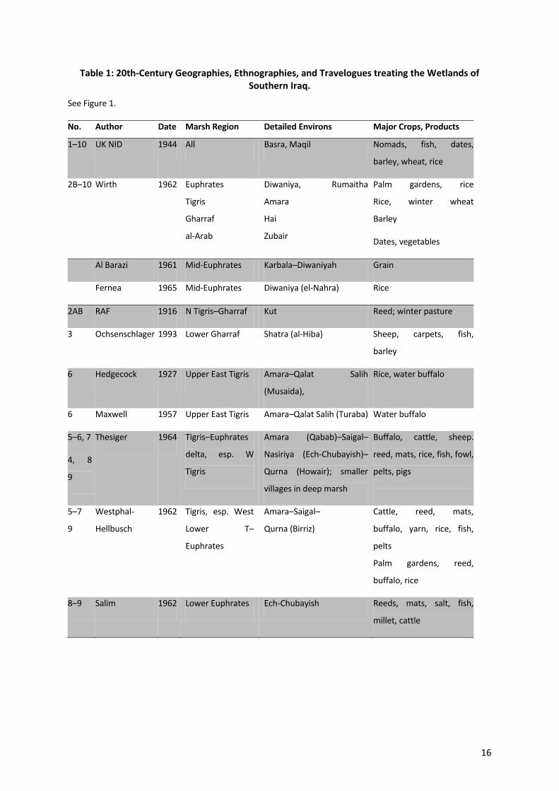
Table 1: 20th-Century Geographies, Ethnographies, and Travelogues treating the Wetlands of Southern Iraq.
See Figure 1.
No. Author Date Marsh Region Detailed Environs Major Crops, Products
1–10 UK NID 1944 All Basra, Maqil Nomads, fish, dates,
barley, wheat, rice
2B–10 Wirth 1962 Euphrates
Tigris
Gharraf
al-Arab
Diwaniya, Rumaitha
Amara
Hai
Zubair
Palm gardens, rice
Rice, winter wheat
Barley
Dates, vegetables
Al Barazi 1961 Mid-Euphrates Karbala–Diwaniyah Grain
Fernea 1965 Mid-Euphrates Diwaniya (el-Nahra) Rice
2AB RAF 1916 N Tigris–Gharraf Kut Reed; winter pasture
3 Ochsenschlager 1993 Lower Gharraf Shatra (al-Hiba) Sheep, carpets, fish,
barley
6 Hedgecock 1927 Upper East Tigris Amara–Qalat Salih
(Musaida),
Rice, water buffalo
6 Maxwell 1957 Upper East Tigris Amara–Qalat Salih (Turaba) Water buffalo
5–6, 7
4, 8
9
Thesiger 1964 Tigris–Euphrates
delta, esp. W
Tigris
Amara (Qabab)–Saigal–
Nasiriya (Ech-Chubayish)–
Qurna (Howair); smaller
villages in deep marsh
Buffalo, cattle, sheep.
reed, mats, rice, fish, fowl,
pelts, pigs
5–7
9
Westphal-
Hellbusch
1962 Tigris, esp. West
Lower T–
Euphrates
Amara–Saigal–
Qurna (Birriz)
Cattle, reed, mats,
buffalo, yarn, rice, fish,
pelts
Palm gardens, reed,
buffalo, rice
8–9 Salim 1962 Lower Euphrates Ech-Chubayish Reeds, mats, salt, fish,
millet, cattle
17
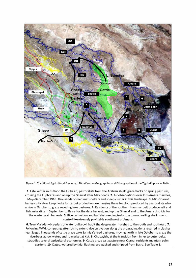
Figure 1: Traditional Agricultural Economy, 20th-Century Geographies and Ethnographies of the Tigris–Euphrates Delta.
1. Late winter rains flood the Ur basin; pastoralists from the Arabian shield graze flocks on spring pastures, crossing the Euphrates and on up the Gharraf after May floods. 2. Air observations over Kut–Amara marshes,
May–December 1916. Thousands of reed mat shelters and sheep cluster in this landscape. 3. Mid-Gharraf barley cultivators keep flocks for carpet production, exchanging these for cloth produced by pastoralists who arrive in October to graze receding lake pastures. 4. Residents of the southern Hammar belt produce salt and fish, migrating in September to Basra for the date harvest, and up the Gharraf and to the Amara districts for
the winter grain harvests. 5. Rice cultivation and buffalo breeding is–for the town-dwelling sheikhs who control it–extremely profitable southwest of Amara.
6. True Ma’adan–breeders of water buffalo–inhabit the deep-water marshes to the south and southeast. 7. Following WWI, competing attempts to extend rice cultivation along the prograding delta resulted in clashes
near Saigal. Thousands of cattle graze Lake Sanniya’s reed pastures, moving north in late October to graze the riverbeds at low water, and to market at Kut. 8. Chubayish, at the transition from inner to outer delta,
straddles several agricultural economies. 9. Cattle graze salt pasture near Qurna; residents maintain palm gardens. 10. Dates, watered by tidal flushing, are packed and shipped from Basra. See Table 1.
2A
2B
3
9
10
6 5
8
7
Kut
Nippur
Shurrupak
Uruk
Amara
Qurna
Basra
Hai
Qalat Salih
Ur
4
Nasiriya
1 March–Oct
Shatra
L. Sanniya
Dates
Cattle Sheep Cattle Barley
1 1 1 1 1
1 1 1 1 1
Sheep
1 1 1 1 1
Oct–Nov
June–July
1 1 1 1 1
1 1 1 1 1
18
1.3 Known Antiquity and Heritage Remains in the Contract Area
1.3.1 Sources
Five bodies of work were consulted to compile a list of all known archaeological (antiquity and
heritage)remains within the contract area: (1) Published archaeological databases, indexes, and
atlases; (2) published historical maps; (3) expert (scholarly) literature; (4) published ethnographic and
geographic literature, (5) social, cultural, and environmental whitepapers, reports, and studies
compiled and published over the past decade; and (6) unpublished interviews with past and present
Antiquities officials. Of these, only the first category contributed concrete findings. Others either
contained no reference to antiquity and heritage sites in the contract area, or contained garbled
references incorrectly derived from the original sources.
1.3.2 Methods
The primary sources for site locations were the Atlas of the Archaeological Sites in Iraq (Iraq DoA
1976), The Archaeological Site Map of Iraq (Iraq DoA 1967), and Key Lists of Archaeological
Excavations in Iraq 1842–1965 (Al-Haik 1968). All of these works are published and available in the
public domain. All three contain hand-drawn maps of varying scales indicating locations of known,
named sites. The Archaeological Site Map and the Key Lists also indicate what little is known about
periods of occupation, based on surface observations made over 50 years ago. None of these sites
have been excavated.
The site maps were digitized and registered to (best available) 2010 CNES/SPOT 5m resolution base
image, draped over a 30m (best available) DEM (GoogleEarthTM), with rubber-sheet stretch to
localized best match. Mapped site locations were then extracted and plotted. The imagery was
inspected in 2D and 3D for evidence of localized elevation, soil- and vegetation-marks, standing
architecture, and other indicators of archaeological remains. Wherever possible, site markers were
adjusted to most-likely actual location, based on observed features. Where possible, likely outer site
boundaries were also delineated. Distance from existing oil infrastructure to the outermost
identifiable site boundary was measured.
1.3.3 Findings
The Iraq DoA Atlas 1976 records 26 known archaeological sites in the Al-Kahlah sub-district of Maysan
(Iraq DoA 1976) (Map 1). The Archaeological Site Map of Iraq also records two of these (Tell Azizah
and Tell al-Madhar), and reports them as having Islamic-era occupation (Iraq DoA 1967) (Map 2:
Recorded Archaeological Sites Bordering the Al-Kahlah Sub-District, Maysan (Iraq DoA Map 1967)).
Two heritage sites were identified by Messrs Mott MacDonald (2010) in or near the Contract Area,
19
both Holy Shrines (waqf property) namely Al Awy Naama, near Well Pad 002and Ali al Zakay near Al
Kahla (refer to Section 1.5). Locally Shrine Al Awy Naama may also be referred to as Umm Saa.
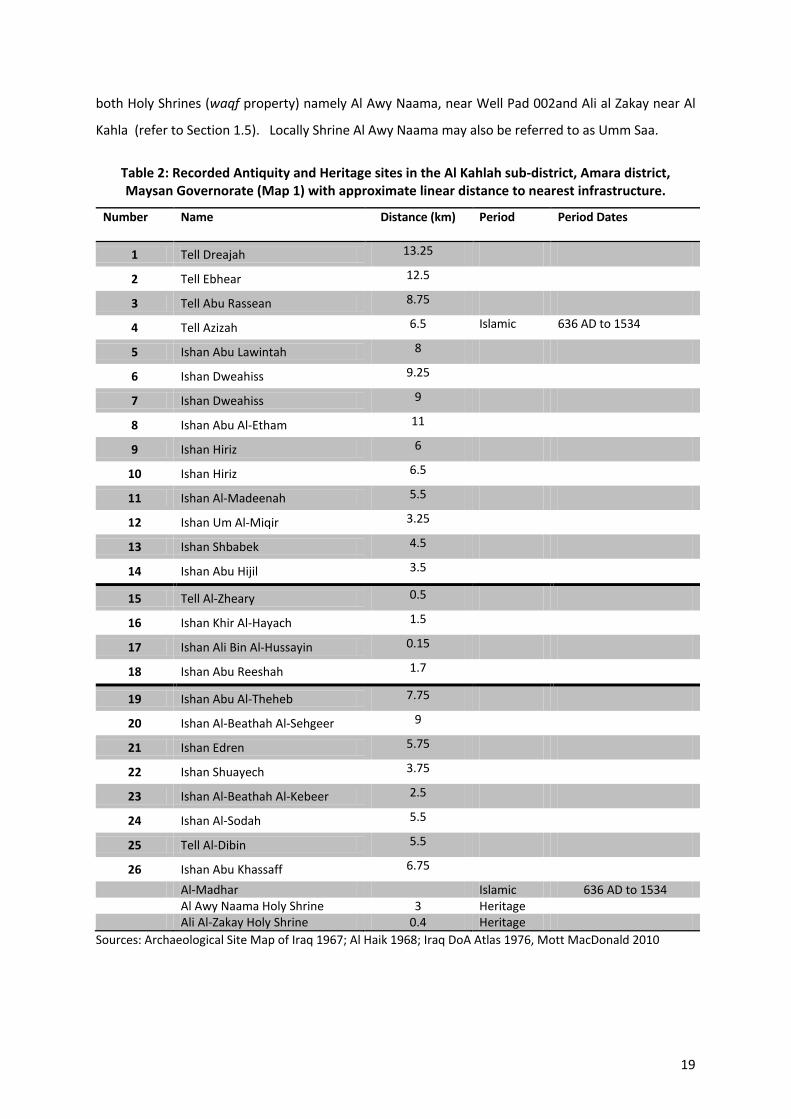
Table 2: Recorded Antiquity and Heritage sites in the Al Kahlah sub-district, Amara district, Maysan Governorate (Map 1) with approximate linear distance to nearest infrastructure.
Number Name Distance (km) Period Period Dates
1 Tell Dreajah 13.25
2 Tell Ebhear 12.5
3 Tell Abu Rassean 8.75
4 Tell Azizah 6.5 Islamic 636 AD to 1534
5 Ishan Abu Lawintah 8
6 Ishan Dweahiss 9.25
7 Ishan Dweahiss 9
8 Ishan Abu Al-Etham 11
9 Ishan Hiriz 6
10 Ishan Hiriz 6.5
11 Ishan Al-Madeenah 5.5
12 Ishan Um Al-Miqir 3.25
13 Ishan Shbabek 4.5
14 Ishan Abu Hijil 3.5
15 Tell Al-Zheary 0.5
16 Ishan Khir Al-Hayach 1.5
17 Ishan Ali Bin Al-Hussayin 0.15
18 Ishan Abu Reeshah 1.7
19 Ishan Abu Al-Theheb 7.75
20 Ishan Al-Beathah Al-Sehgeer 9
21 Ishan Edren 5.75
22 Ishan Shuayech 3.75
23 Ishan Al-Beathah Al-Kebeer 2.5
24 Ishan Al-Sodah 5.5
25 Tell Al-Dibin 5.5
26 Ishan Abu Khassaff 6.75
Al-Madhar Islamic 636 AD to 1534 Al Awy Naama Holy Shrine 3 Heritage Ali Al-Zakay Holy Shrine 0.4 Heritage
Sources: Archaeological Site Map of Iraq 1967; Al Haik 1968; Iraq DoA Atlas 1976, Mott MacDonald 2010
20
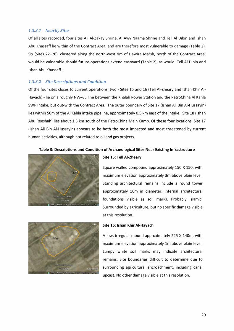
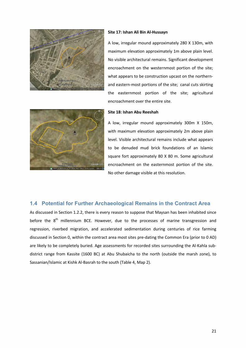
1.3.3.1 Nearby Sites
Of all sites recorded, four sites Ali Al-Zakay Shrine, Al Awy Naama Shrine and Tell Al Dibin and Ishan
Abu Khassaff lie within of the Contract Area, and are therefore most vulnerable to damage (Table 2).
Six (Sites 22–26), clustered along the north-west rim of Hawiza Marsh, north of the Contract Area,
would be vulnerable should future operations extend eastward (Table 2), as would Tell Al Dibin and
Ishan Abu Khassaff.
1.3.3.2 Site Descriptions and Condition
Of the four sites closes to current operations, two - Sites 15 and 16 (Tell Al-Zheary and Ishan Khir Al-
Hayach) - lie on a roughly NW–SE line between the Khalah Power Station and the PetroChina Al Kahla
SWP Intake, but out-with the Contract Area. The outer boundary of Site 17 (Ishan Ali Bin Al-Hussayin)
lies within 50m of the Al Kahla intake pipeline, approximately 0.5 km east of the intake. Site 18 (Ishan
Abu Reeshah) lies about 1.5 km south of the PetroChina Main Camp. Of these four locations, Site 17
(Ishan Ali Bin Al-Hussayin) appears to be both the most impacted and most threatened by current
human activities, although not related to oil and gas projects.
Table 3: Descriptions and Condition of Archaeological Sites Near Existing Infrastructure
Site 15: Tell Al-Zheary
Square walled compound approximately 150 X 150, with
maximum elevation approximately 3m above plain level.
Standing architectural remains include a round tower
approximately 16m in diameter; internal architectural
foundations visible as soil marks. Probably Islamic.
Surrounded by agriculture, but no specific damage visible
at this resolution.
Site 16: Ishan Khir Al-Hayach
A low, irregular mound approximately 225 X 140m, with
maximum elevation approximately 1m above plain level.
Lumpy white soil marks may indicate architectural
remains. Site boundaries difficult to determine due to
surrounding agricultural encroachment, including canal
upcast. No other damage visible at this resolution.
21
Site 17: Ishan Ali Bin Al-Hussayn
A low, irregular mound approximately 280 X 130m, with
maximum elevation approximately 1m above plain level.
No visible architectural remains. Significant development
encroachment on the westernmost portion of the site;
what appears to be construction upcast on the northern-
and eastern-most portions of the site; canal cuts skirting
the easternmost portion of the site; agricultural
encroachment over the entire site.
Site 18: Ishan Abu Reeshah
A low, irregular mound approximately 300m X 150m,
with maximum elevation approximately 2m above plain
level. Visible architectural remains include what appears
to be denuded mud brick foundations of an Islamic
square fort approximately 80 X 80 m. Some agricultural
encroachment on the easternmost portion of the site.
No other damage visible at this resolution.
1.4 Potential for Further Archaeological Remains in the Contract Area As discussed in Section 1.2.2, there is every reason to suppose that Maysan has been inhabited since
before the 8th millennium BCE. However, due to the processes of marine transgression and
regression, riverbed migration, and accelerated sedimentation during centuries of rice farming
discussed in Section 0, within the contract area most sites pre-dating the Common Era (prior to 0 AD)
are likely to be completely buried. Age assessments for recorded sites surrounding the Al-Kahla sub-
district range from Kassite (1600 BC) at Abu Shubaicha to the north (outside the marsh zone), to
Sassanian/Islamic at Kishk Al-Basrah to the south (Table 4, Map 2).
22
Table 4: Recorded Archaeological Sites bordering the Al Kahla sub-district (Map 2)
Site Name Location Period Approximate Dates
Abu Shubaicha F8 Amara Kassite
Chaldean (Neo-Babylonian)
Islamic
1600–911 BC
652–539 BC
636 AD–1534
Abu Edham F8 Amara Sassanian 226 AD–636 AD
Kawli G8 Amara Sassanian
Islamic
226 AD–636 AD
636 AD–1534
Wabla G8 Amara Islamic 636 AD–1534
Kishk Al-Basri H6 Basra Sassanian
Islamic
226 AD–636 AD
636 AD–1534
Sources: Iraq DoA Map 1967; Al Haik 1968; Iraq DoA Atlas 1976
Three bodies of evidence were considered to assess the likelihood of additional archaeological
remains being present and discovered or impacted by ongoing or future operations in the contract
area. These were: unpublished interviews, satellite imagery, and the large body of archaeological and
ethnographic evidence regarding common remains of human activity in the region.
1.4.1 Unpublished Interviews
Additional, un-located sites reported by Rubec 2008 are listed at Table 5. Based on interviews with an
unnamed State Board of Antiquities and Heritage representative in Baghdad, that publication reports
the sites of “Qubab, Ishan, Azizah, Dibin, and Waquf” as being “in the marshes,” but does not specify
which marsh. Of these, “Ishan” is clearly an incomplete name. “Dibin” is Site 25 (Tell Al-Dibin).
“Azizah” is Site 4 (Tell Azizah). “Waquf”probably refers to “waqf” property—that is, Al Awy Naama Holy
Shrine, located approximately 3 km due east of the Central Processing Facility (Map 2.) Neither the
authors of the report, nor the representative with whom they spoke, seem to have been aware that
these sites were already well-known and recorded. The remaining two sites, plus one additional site
cited as listed on DoA Map 1967, but not seen thereon, probably lie in a different sub-district, outside
Al Kahla.
Table 5: Other archaeological sites reported “in the marshes”
Site Name Period Approximate Dates
I’ran Parthian 248 BC to 226 AD
Agar
Qubab
23
1.4.2 Expected Physical Evidence
Evidence for past human activity in southern Iraq may be found for mounded sites (tells and ishans),
relict hydrological systems (canals, regulators, flumes, and field boundaries), industrial areas (brick,
pottery, and glass kilns; smelters and foundries); intensive use areas (household compounds,
livestock pens, reed-processing yards, dung fuel-drying yards, fish-drying sheds, cooking and baking
yards, boat-building yards), and remnants of standing architecture.
Evidence for such zones includes any significant elevation above plain level (tells and ishans); linear
features such as raised, consolidated levees or depressed, organic-rich canal beds; concentrations of
industrial waste such as prills, slag, and klinker; concentrations of organic matter, bone, wood,
bitumen, and reed fragments, burnt seeds, plant phytoliths, charcoal, and ash; and physical remains
of fired brick, mud-brick, and pisé architecture.
Tells are mounded sites formed by repetitive rebuilding on previous foundations. Ishans (islands) are
permanently or repetitively occupied sites slightly elevated above and surrounded by lakes and
marshes (Figure 2). Ishans are often in fact submerged tells, although on dewatering they tend to
keep their old “island” name. In this region, both range in size from less than one ha for small
hamlets, to tens of hectares for small cities. The larger sites, being obvious in the landscape, have
long since been locally named and nationally recorded.
Figure 2: Small Ishans. (L) With Palm Gardens (R) Without Palm Gardens
Photo: (c) Jennifer R. Pournelle 2012
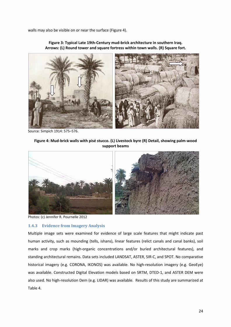
Tells and ishans usually incorporate substantial architectural remains. However, because denuded
mud brick is largely indistinguishable from the mud from which it was fashioned, those remains often
appear only as undifferentiated, low, lumpy mounds. From Islamic times, entry points to areas under
a sheikh’s control were often guarded from round and square forts (Figure 3). These, religious shrines,
and mosques comprise the most-likely standing finds. At larger sites, remains of substantial mud-brick
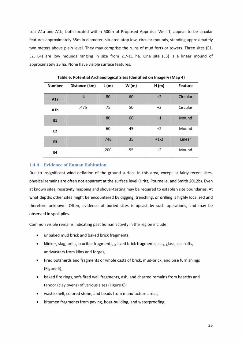
and pisé (dried mud slab reinforced with reed, poplar, and palm-wood framing) compound and house
24
walls may also be visible on or near the surface (Figure 4).
Figure 3: Typical Late 19th-Century mud-brick architecture in southern Iraq. Arrows: (L) Round tower and square fortress within town walls. (R) Square fort.
Source: Simpich 1914: 575–576.
Figure 4: Mud-brick walls with pisé stucco. (L) Livestock byre (R) Detail, showing palm-wood support beams
Photos: (c) Jennifer R. Pournelle 2012
1.4.3 Evidence from Imagery Analysis
Multiple image sets were examined for evidence of large scale features that might indicate past
human activity, such as mounding (tells, ishans), linear features (relict canals and canal banks), soil
marks and crop marks (high-organic concentrations and/or buried architectural features), and
standing architectural remains. Data sets included LANDSAT, ASTER, SIR-C, and SPOT. No comparative
historical imagery (e.g. CORONA, IKONOS) was available. No high-resolution imagery (e.g. GeoEye)
was available. Constructed Digital Elevation models based on SRTM, DTED-1, and ASTER DEM were
also used. No high-resolution Dem (e.g. LIDAR) was available. Results of this study are summarized at
Table 4.
25
Loci A1a and A1b, both located within 500m of Proposed Appraisal Well 1, appear to be circular
features approximately 35m in diameter, situated atop low, circular mounds, standing approximately
two meters above plain level. They may comprise the ruins of mud forts or towers. Three sites (E1,
E2, E4) are low mounds ranging in size from 2.7-11 ha. One site (E3) is a linear mound of
approximately 25 ha. None have visible surface features.
Table 6: Potential Archaeological Sites Identified on Imagery (Map 4)
Number Distance (km) L (m) W (m) H (m) Feature
A1a .4 80 60 +2 Circular
A1b .475 75 50 +2 Circular
E1 80 60 +1 Mound
E2 60 45 +2 Mound
E3 748 35 +1-2 Linear
E4 200 55 +2 Mound
1.4.4 Evidence of Human Habitation
Due to insignificant wind deflation of the ground surface in this area, except at fairly recent sites,
physical remains are often not apparent at the surface level (Hritz, Pournelle, and Smith 2012b). Even
at known sites, resistivity mapping and shovel-testing may be required to establish site boundaries. At
what depths other sites might be encountered by digging, trenching, or drilling is highly localized and
therefore unknown. Often, evidence of buried sites is upcast by such operations, and may be
observed in spoil piles.
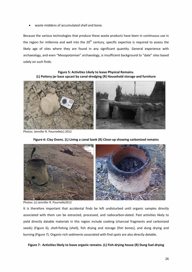
Common visible remains indicating past human activity in the region include:
x unbaked mud brick and baked brick fragments;
x klinker, slag, prills, crucible fragments, glazed brick fragments, slag glass, cast-offs,
andwasters from kilns and forges;
x fired potsherds and fragments or whole casts of brick, mud-brick, and pisé furnishings
(Figure 5);
x baked fire rings, soft-fired wall fragments, ash, and charred remains from hearths and
tanoor (clay ovens) of various sizes (Figure 6);
x waste shell, colored stone, and beads from manufacture areas;
x bitumen fragments from paving, boat-building, and waterproofing;
26
x waste middens of accumulated shell and bone.
Because the various technologies that produce these waste products have been in continuous use in
the region for millennia and well into the 20th century, specific expertise is required to assess the
likely age of sites where they are found in any significant quantity. General experience with
archaeology, and even “Mesopotamian” archaeology, is insufficient background to “date” sites based
solely on such finds.
Figure 5: Activities Likely to leave Physical Remains. (L) Pottery jar base upcast by canal-dredging (R) Household storage and furniture
Photos: Jennifer R. Pournelle(c) 2012
Figure 6: Clay Ovens. (L) Lining a canal bank (R) Close-up showing carbonized remains
Photos: (c) Jennifer R. Pournelle2012
It is therefore important that accidental finds be left undisturbed until organic samples directly
associated with them can be extracted, processed, and radiocarbon-dated. Past activities likely to
yield directly datable materials in this region include cooking (charcoal fragments and carbonized
seeds) (Figure 6), shell-fishing (shell), fish drying and storage (fish bones), and dung drying and
burning (Figure 7). Organic-rich sediments associated with find spots are also directly datable.
Figure 7: Activities likely to leave organic remains. (L) Fish-drying house (R) Dung fuel-drying
27
stacks
Photos: (c) Jennifer R. Pournelle 2012
It is expected that some or all of these remains would be identifiable at significant sites.
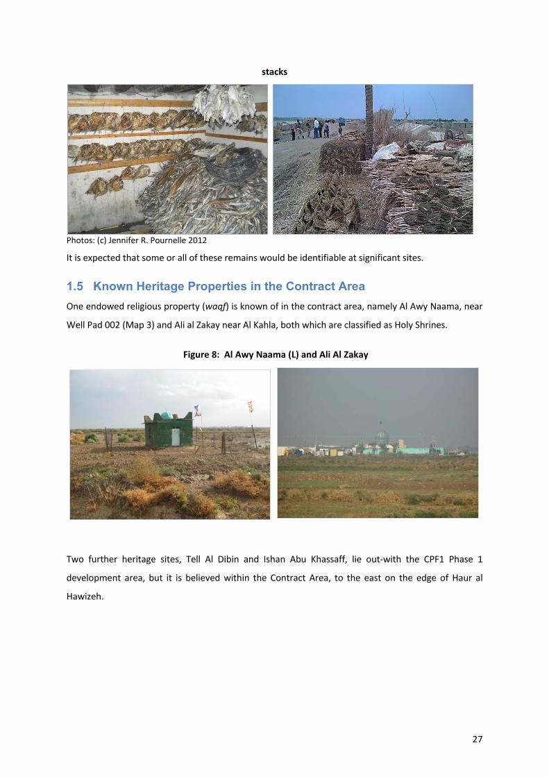
1.5 Known Heritage Properties in the Contract Area One endowed religious property (waqf) is known of in the contract area, namely Al Awy Naama, near
Well Pad 002 (Map 3) and Ali al Zakay near Al Kahla, both which are classified as Holy Shrines.
Figure 8: Al Awy Naama (L) and Ali Al Zakay
Two further heritage sites, Tell Al Dibin and Ishan Abu Khassaff, lie out-with the CPF1 Phase 1
development area, but it is believed within the Contract Area, to the east on the edge of Haur al
Hawizeh.
0
2 Potential Impacts to Archaeological Remains
The most obvious potential impact on Antiquity and Heritage sites is direct site damage by intentional
vandalism or theft, and by intentional or unintentional grading, digging, trenching, drilling, and other
operations that displace soil. However, other significant impacts may result during construction and
on-going operations, and as a collateral result of these activities.
2.1 Construction Footprint Introduction of new industrial equipment and construction to field locations inevitably involves not
only disturbance at the completed operation site, but surface disturbance related to human and
vehicular traffic. Obviously, such disturbance can cause direct damage to above-ground antiquities
and heritage objects through crushing and displacement. However, such disturbance has a number of
additional consequences.
Ground compaction from heavy vehicular traffic can directly damage subsurface architecture and
artefacts, as well as alter subsurface drainage with negative effect on preservation of organic
remains. Surface disturbance removes geochemical and microfossil evidence preserved in soils, even
where no discrete artefacts are visible. Related to this, surface disturbance can also obscure the
below- ground record preserved in soil and moisture marks.
2.2 Operations Impacts The physical integrity of standing architecture may be damaged by ground vibration induced by
vehicular traffic, generators, pumps, and drilling equipment. Such damage can range from minor
cracks in mortars and plaster, to complete failure of the structural integrity of standing walls.
Both standing and buried architecture can be negatively impacted by ground subsidence resulting
from extractive pumping.
Architectural and artefact surfaces, especially ornamental surfaces, are extremely vulnerable to
degradation under acidic conditions induced by release of SOX compounds during flaring and burning,
and from engine exhausts. Mosaics, frescos, ornamental carvings (sculpture, bas relief), painted
decoration, polychrome tile and pottery, and metal cladding and leafwork can be completely
destroyed within a very few years of exposure.
Site flooding from wastewater spills promotes surface salinization. The resulting salt crusts both
directly damage artefacts and render them difficult to identify and date. Waterlogged subsurface
organic remains may be permanently damaged (decomposed) if drainage causes de-watering of the
1
field, or if the field is repetitively wetted and dried
Petrochemical contamination of soils through oil spillage, ponding, etc. renders organic samples
undateable due to “old carbon” contamination. Introduction or spillage of bentonite (dry or slurry)
within site boundaries alters soil chemistry, rendering calculations of past climate conditions based
on isotopic analyses of calcium carbonate proxies impossible.
2.3 Collateral Impacts The increased human presence associated with infrastructure expansion can have a number of
associated negative consequences for site preservation.
Displacement of people and livestock from farming and grazing areas can leads to greater agricultural
and pastoral encroachment onto the larger site area surrounding the ore obvious mounds. Increased
foot and vehicular traffic on or near sites(whether from agriculture or increased tourism) wears
“hollow ways” that become conduits for water flow during rainy weather, leading to down-cutting
and erosion of archaeological materials. Increased human presence often results in trash
accumulation in low-lying areas, which attracts further waste dumping.
2.4 Recommendations for Protection of Archaeological Remains
2.4.1 Actions to Confirm or Deny the Presence of Antiquities, Heritage Material, and
Historical Sites
Maintain consultation with Maysan Inspector of Antiquities to determine (a) whether the current
condition of recorded sites is known and up-to-date; and (b) whether additional, unrecroded sites are
known to exist in the survey area.
As a component of an Archaeological Protection Programme for the Halfaya Contract Area, with
permission from antiquities authorities, ground-truth Sites 17 and 18 as they are in the general
proximity of the Contract Area, including a 0.5 km-radius walk-oversurvey, gridded shovel test, and
geophysical assay to record archaeological features and define site boundaries.
As a component of an Archaeological Protection Programme for the Halfaya Contract Area ground-
truth Sites A1a & b, E1–E4 (Map 4). With permission from antiquities authorities, conduct a 0.5 km-
radius walk-over survey, gridded shovel test, and geophysical assay to confirm/deny presence of
archaeological features and define site boundaries.
As a component of an Archaeological Protection Programme for the Halfaya Contract Area ground-
truth Tell Al Dibin and Ishan Abu Khassaff on the eastern edge of the Contract Area. This should be
carried out particularly if further earth-works and drainage is proposed in this area of the Marshes.
2
Conduct walk-over surveys to examine upcast from recent digging, ditching, excavating, and
bulldozing activities for archaeological remains. Where significant cultural material is identified, with
permission from antiquities authorities, conduct a 0.5 km-radius walk-over survey, gridded shovel
test, and geophysical assay to confirm/deny presence of archaeological features and define site
boundaries.
Re-examine the area using high (1m) resolution imagery draped over a high resolution (LIDAR) DEM.
Before undertaking large-scale bulldozing, perform randomized shovel-testing to a depth of 1m.
Before undertaking digging over large areas (as for opening building foundations), open randomized
small-backhoe trenches to depth. Before undertaking drilling, examine a pilot core to a depth of 15m.
Examine Holocene segments of drilled cores to establish local stratigraphic sequence and obtain
datable samples (AMS & OSL). Preserve the Holocene fraction of future drilled material for laboratory
analysis and assay.
2.4.2 Actions to Protect and Safeguard Antiquities, Heritage Material, and Historical
Sites
If not already employed by SBAH, contract local residents to act as site curators, guards, and act as
liaison to SBAH antiquities inspectors. In accordance with §5.3, demarcate substantial sites with
signage or perimeter fencing to prevent inadvertent encroachment.
Sites may remain well preserved if held consistently wet or consistently dry, but brick, mud brick, and
organic matter degrade rapidly with repeated wetting and drying. Care must be taken to divert return
water away from known sites.
By law, no polluting materials may be introduced or disposed of within 3 km of any registered site.
Under this provision, specific assessment should be undertaken to determine whether there is
downwind impact on Site 24 from burn pit HF-4. Likewise, should possible sites A1a, A1b, and E-4 be
confirmed as antiquities, determine whether there is downwind impact from burn pits Well Pad 002,
HF-6, and HF-7, and prevent spillage, dumping, or encroachment from drilling operations at Proposed
Appraisal Well 1.
Consult with the waqf holder and local SBAH authority to determine current responsibility for maintenance of Al
Awy Naama Holy Shrine, and support ongoing maintenance as needed. Protect Al Awy Naama Holy Shrine
from disturbance.
Implement a worker education and supervision program to ensure that (1) all employees and
contractors liable to encounter archaeological remains in the course of their duties understand
responsibilities, required actions, protections, and penalties under Iraqi law and (2) employees and
3
contractors are prevented from physically or mechanically damaging or despoiling archaeological
sites and artefacts by digging, drilling, dumping, draining, flooding, polluting, or other actions.
2.5 Key Gaps in Information and Uncertainties Document all consultations with Maysan Antiquities Inspector. Consultation with Maysan Antiquities
Inspector is required by law, SBAH Maysan is the cognizant authority on local Antiquity and Heritage
properties and their condition and maintenance, it is therefore imperative that PetroChina maintains
a record of discussions, consultations, meetings and telephone conversations held with the
Antiquities Inspector.
Whilst it is understood that consultation with the Antiquities Inspector has been ongoing, there are
no known records of a systematic walk-over survey having been conducted in the CPF1 project area
prior to construction commencing by any qualified agent or authority expert in the archaeology of the
district. Whilst largely pointless following a bull-dozing and construction event for CPF1, prior to any
future works in the Contract Area a documented assessment by a qualified agent or authority expert
in the archaeology of the district should be carried out.
2.6 Sensitive Receptors The following receptors may be affected by the Project proposals:
x Below-ground archaeological remains may be affected by any new ground disturbance
caused by the project;
x Waterlogged organic remains may be permanently damaged if drainage causes de-watering
of the field, or if the field is repetitively wetted and dried ;
x The setting of any above-ground archaeological remains may be affected by the introduction
of new industrial equipment at the field;
x Standing architecture may be affected by vibration, subsidence, or air pollution; and
x The heritage, identity, and livelihood of rural residents, including farmers, herders, and
marsh dwellers, may be altered by the introduction of oil field infrastructure and activities.
0
Appendix A References
A1 Maps and Atlases
Canada-Iraq Marshlands Initiative (CIMI) (2010). Atlas of the Iraqi Marshes. Victoria BC: CIMI Humanitarian Information Center for Iraq (HIC) (2003). Sheet NH 38-4: Populated Places (1:250,000).
USAID-Office of Foreign Disaster Assistance and The University of Georgia. HIC (2003) Tribes in Iraq. Map Reference 284. URL: http://reliefweb.int/map/iraq/tribes-iraq
Iraq Directorate-General of Antiquities (Iraq DoA) (1967).The Archaeological Map of Iraq. URL: http://www.wdl.org/en/item/212/
Iraq Directorate-General of Antiquities (1976). Atlas of the Archaeological Sites in Iraq. Baghdad: Al-Jumhuriya Press.
Great Britain. Naval Intelligence Division (1944). Geographical Handbook of Iraq and the Persian Gulf. Geographical Handbook Series Vol. 524. Oxford.
A2 Archaeological References
Al-Haik, Albert R.(1968). Key Lists of Archaeological Excavations in Iraq 1842-1965. Coconut Grove: Field Research Projects.
Crawford, Harriet (2005). Mesopotamia and the Gulf: The History of a Relationship. Iraq 67(2) (Autumn, 2005): 41–46. Stable URL: http://www.jstor.org/stable/4200598.
Eger, A. Asa. The Swamps of Home: Marsh Formation and Settlement in the Early Medieval Near East (2011). Journal of Near Eastern Studies 70(1) (April 2011): 55–79. Stable URL: http://www.jstor.org/stable/10.1086/659093 .
Gasche, H. (ed.) (2004). The Persian Gulf Shorelines and the Karkheh, Karun, and Jarrahi Rivers: A Geo-Archaeological Approach. A Joint Belgo-Iranian Project. First Progress Report Part 1. Akkadica 125(2): 141-215.
Gasche, H. (ed.) (2005). The Persian Gulf Shorelines and the Karkheh, Karun, and Jarrahi Rivers: A Geo-Archaeological Approach. A Joint Belgo-Iranian Project. First Progress Report Part 2. In Akkadica 126(1): 1-44.
Gasche, H. (ed.) (2007). The Persian Gulf Shorelines and the Karkheh, Karun, and Jarrahi Rivers: A Geo-Archaeological Approach. A Joint Belgo-Iranian Project. First Progress Report Part 3. In Akkadica 128(1-2: 1-72.
Hamdani, Abdulamir (2008). Protecting and Recording our Archaeological Heritage in Southern Iraq. Near Eastern Archaeology 71 (4): 221–230.
Heimpel, Wolfgang (2011) Twenty Eight Trees Growing in Sumer. In Garšana Studies. Cornell University Studies in Assyriology and Sumerology 6. David I. Owen, ed. Bethesda: CDL Hritz, Carrie and T.J. Wilkinson. 2006. Using Shuttle Radar Topography to map ancient water channels in Mesopotamia. Antiquity 80:308 (June 2006):415–424.
Hritz, Carrie A. 2010. Tracing Settlement Pattern and Channel Systems in Southern Mesopotamia Using Remote Sensing. Journal of Field Archaeology 35(2): 184-203.
Hritz, Carrie A., Jennifer R. Pournelle, and Jennifer Smith (2012a). Mid-Holocene Dates for Organic-Rich Sediment, Palustrine Shell, and Charcoal, Southern Iraq. Radiocarbon 54(1): 65–79.
1
Tucson: University of Arizona. Hritz, Carrie A., Jennifer R. Pournelle, and Jennifer Smith (2012b). Revisiting the Sealands: Report of
Preliminary Ground Reconnaissance in ihe Hammar District, Dhi Qar and Basra Governorates, Iraq. Iraq LXXIV: 1–13.
Iraq (2002). Law No. 55 of 2002 for the Antiquities & Heritage of Iraq. Baghdad: UNESCO. URL: http://www.iraq-ild.org/LoadLawBook.aspx?SP=REF&SC=150220061057690&Year=2002&PageNum=1.
Mott MacDonald (2010). Halfaya Oilfield ESIA Environmental Baseline Study. Beijing: PetroChina.
Pournelle, Jennifer R. (2003). Marshland of Cities: Deltaic Landscapes and the Evolution of Early Mesopotamian Civilization. Ph.D. dissertation, Department of Anthropology, University of California, San Diego. URL: http://www.environ.sc.edu/sites/default/files/files/pournelle/dissertation_pournelle.pdf
Pournelle, Jennifer R. (2007). KLM to Corona: A Bird’s-Eye View of Cultural Ecology and Early Mesopotamian Civilization. In Settlement and Society: Essays Dedicated to Robert McCormick Adams, ed. By E. Stone, 29–62. Los Angeles: UCLA Cotsen Institute of Archaeology and Chicago: Oriental Institute.
Pournelle, Jennifer R. (2012), "Physical Geography." In: The Sumerian World, ed. by H. Crawford. Routledge Companion to Museum Ethics. Oxford: Routledge, pp. 13–32.
Pournelle, Jennifer R. and Guillermo Algaze (In press: 2013). Travels in Edin: Deltaic Resilience and Early Urbanism in Greater Mesopotamia. In: Preludes to Urbanism: Studies in the Late Chalcolithic of Mesopotamia in Honour of Joan Oates, ed. by H. Crawford, A. McMahon, and J. N. Postgate. Cambridge: McDonald Institute for Archaeological Research.
Rose, Jeffrey I. (2010). New Light on Human Prehistory in the Arabo-Persian Gulf Oasis Current Anthropology 51(6) (December 2010): 1–34. DOI: 10.1086/657301
Roux, Georgés (1960). Recently discovered ancient sites in the Hammar Lake district (southern Iraq). Sumer 16: 20–31
A3 Geological References
Al-Baidhany, A., S. Darmoian, and B. Albadran. 2002. Evolution of Holocene Sedimentary Environments of the Southern Part of Iraq. Basrah Journal of Science B 20(1):73–86.
Aqrawi, Adnan A. M. 1997. The nature and preservation of organic matter in Holocene lacustrine/deltaic sediments of lower Mesopotamia, SE Iraq. Journal of Petroleum Geology 20(1):69–90.
Aqrawi, Adnan A. M. 2001. Stratigraphic signatures of climatic change during the Holocene evolution of the Tigris-Euphrates delta, lower Mesopotamia. Global and Planetary Change 28(1–4):267–283.
Aqrawi, Adnan A. M., and G. Evans, 1994. Sedimentation in the lakes and marshes (Awhar) of the Tigris-Euphrates delta, southern Mesopotamia. Sedimentology 41: 755–776.
Aqrawi, Adnan A.M., Jaroslav Domas, and Saad Z. Jassim. 2006. Quaternary Deposits. In: Geology of Iraq ed. Saad Z. Jassim and Jeremy C. Goff:185–196. Prague: Dolin.
Chen, Z.,M., Kavvas, N., Ohara, M. Anderson, and J. Yoon, 2010. Impact of water resources utilization on the hydrology of Mesopotamian marshlands. Journal of Hydrologic Engineering. DOI:10.1061/(ASCE)HE.1943–5584.0000208.
Jassim, Saad Z and Jeremy C Goff (ed.) (2006). Geology of Iraq. Prague: Dolin. Richardson, Curtis J., Peter Reiss, Najah A. Hussain, Azzam J. Alwash, and Douglas J. Pool. (2005). The
2
Restoration Potential of the Mesopotamian Marshes of Iraq. Science 25 February 2005: 1307-1311.
Sanlaville, Paul. 2003. The deltaic complex of the lower Mesopotamian plain and its evolution through millennia, in The Iraqi Marshlands, ed. by Emma Nicholson and Peter Clark:133–150. London: Politico’s Publishing.
A4 Historical References
Ahmed, Sami Said. (1968). Southern Mesopotamia in the Time of Ashurbanipal. The Hague and Paris: Mouton.
Donohue, John J. (2003). Buwayhid Dynasty in Iraq 334H./945 to 403H./1012Leiden and Boston: Brill.
Hill, Donald. (1984). A History of Engineering in Classical and Medieval Times.London and Sydney: Croom Helm.
Popovic, Alexandre. (1999). The Revolt of African Slaves in Iraq in the 3rd/9th Century. Princeton: Marcus Wiener.
Schuol, Monika. (2000). Die Charakene. Ein mesopotamisches Königreich in hellenistisch-parthischer Zeit. Stuttgart: Franz Steiner.
Van de Mieroop, Marc. (1999). Cuneiform Texts and the Writing of History. London and New York: Routledge.
A5 Marsh Ecosystem Heritage References
Garstecki, T. and Amr Z. (2011). Biodiversity and Ecosystem Management in the Iraqi Marshlands – Screening Study on Potential World Heritage Nomination. Amman, Jordan: IUCN. URL: http://data.iucn.org/dbtw-wpd/edocs/2011-010.pdf
IMOS [Iraqi Marshlands Observation System] (2006). Iraqi Marshlands Observation System – UNEP Technical Report 2006. URL: http://postconflict.unep.ch/publications/UNEP_IMOS.pdf .
Iraq Ministries of Environment, Water Resource,s and Municipalities & Public Works (2005). New Eden Master Plan for Integrated Water Resources Management in the Marshlands Area: Interim Report (2 vols). Iraq Foundation. URL: http%3A%2F%2Fwww.iraqfoundation.org%2Fedenagain%2Fpublications%2Fpdfs%2FNew%2520Eden%2520Master%2520Plan%2520-%2520INTERIM%2520REPORT%25202005%2520-%2520REDUCED.pdf&ei=45R3UMmwJtDKtAbg9IHYDA&usg=AFQjCNGq2-ZcLiig2ZR7yC-fWuLhKotYPg
Partow, Hassan (2001). The Mesopotamian Marshlands: Demise of an Ecosystem. Nairobi: UNEP/DEWA. URL: http://www.grid.unep.ch/activities/sustainable/tigris/mesopotamia.pdf.
Rubec, C.D.A. (ed.) (2008) Management Plan for the Hawizah Marsh Ramsar Site of iraq (2 vols.). Sulaimani, Iraq: Nature Iraq and the Twin Rivers Environmental Research Institute. URL: v1: http://www.natureiraq.org/site/sites/default/files/Hawizeh%20Plan%202nd%20Draft%20Volume%201%20Dec%201%202008.pdf v2: http://www.natureiraq.org/site/sites/default/files/Hawizeh%20Plan%202nd%20Draft%20Volume%202%20Dec%201%202008.pdf
Stevens, Michelle L. (2007). Iraq and Iran in Ecological Perspective: The Mesopotamian Marshes and Hawizeh-Azim Peace Park. In: Peace Parks: Conservation and Conflict Resolution ed. Saleem H. Ali: 313–331. Boston: MIT Press.
3
United Nations Environmental Program (UNEP) (2010). Mesopotamia Marshlands National Park Project: Protection of diverse nature reserves of Iraq for biological diversity. Nagoya CBD COP10, October 21th 2010. URL: http://www.unep.or.jp/Ietc/WS/news-oct10/21-4_A-Alwash_NatureIraq.pdf
United Nations Integrated Water Task Force for Iraq (2011). Managing Change in the Marshlands: Iraq’s Critical Challenge. New York: United Nations. URL: http://iq.one.un.org/documents/Marshlands%20Paper%20-%20published%20final.pdf
A6 Intangible Cultural Heritage References
Al-Barazi, Nuri K. 1960. The Geography of Agriculture in Irrigated Areas of the Middle Euphrates Valley. Ph.D. dissertation, University of Durham, UK.
Buringh, Pieter. (1960). Soils and Soil Conditions in Iraq (with Soil Map). Baghdad: Iraq Ministry of Agriculture.
Fernea, Elizabeth W. (1969). Guest of the Sheikh: An Ethnography of an Iraqi Village. New York: Anchor Books.
Hedgecock, S. E., and Hedgecock, (pseud. Fulanain) (1927). Haji Rikkan, Marsh Arab. London: Chatto & Windus.
Hubbard, G. E. 1916. From the Gulf to Ararat: An Expedition through Mesopotamia and Kurdistan. Edinburgh and London: William Blackwood and Sons.
Maxwell, Gavin (1957). A Reed Shaken by the Wind. London: Longmans. [People of the Reeds. New York: Harper and Brothers.]
Nicholson, Emma and Peter Clark (2003). The Iraqi Marshlands. London: Politico’s Publishing. Ochsenschlager, Edward L. (2004). Iraq’s Marsh Arabs in the Garden of Eden. Philadelphia: U. of
Pennsylvania Museum of Archaeology and Anthropology. Salim, S. M. (1962). Marsh dwellers of the Euphrates delta. London School of Economics Monographs
on Social Anthropology. London: Athlone. Simpich, Frederick and Margaret (1914). Where Adam and Eve Lived. National Geographic 26(6):
546–609. Thesiger, Wilfred (1964). The Marsh Arabs. New York: E. P. Dutton. Young, Gavin and Nick Wheeler (1977). Return to the Marshes: Life with the Marsh Arabs of Iraq.
London: William Collins. Westphal-Hellbusch, Sigrid, And Heinz Westphal (1962). Die Ma’dan. Kulture und Geschichte der
Marschenbewohner in Sud-Iraq. Berlin: Duncker und Humbolt. Wirth, Eugen (1955). Landschaft und Mensch im Binnendelta des unteren Tigris. Mitteilung
Geographische Gesellschaft 52. Hamburg: Geographical Society. Wirth, Eugen (1962). Agrargeographie des Irak. Hamburger geographische Studien 13. Hamburg:
Institut für Geographie und Wirtschaftsgeographie der Universität Hamburg; Cram de Gruyter & Co.
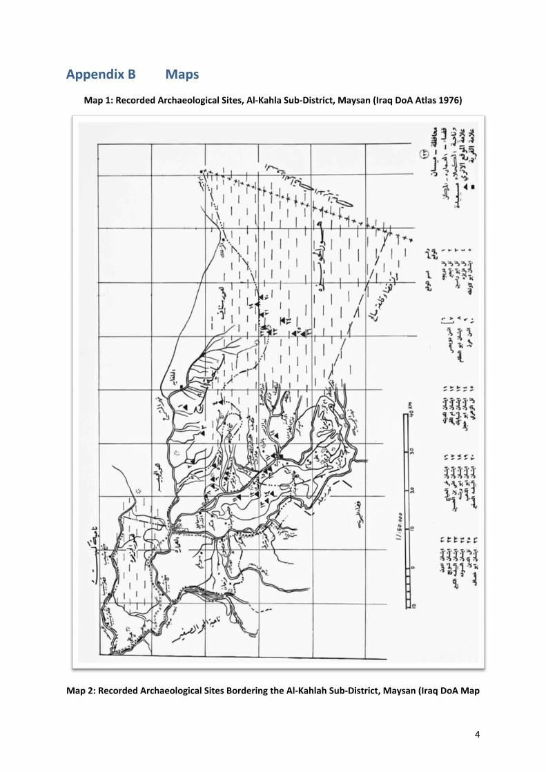
4
Appendix B Maps
Map 1: Recorded Archaeological Sites, Al-Kahla Sub-District, Maysan (Iraq DoA Atlas 1976)
Map 2: Recorded Archaeological Sites Bordering the Al-Kahlah Sub-District, Maysan (Iraq DoA Map
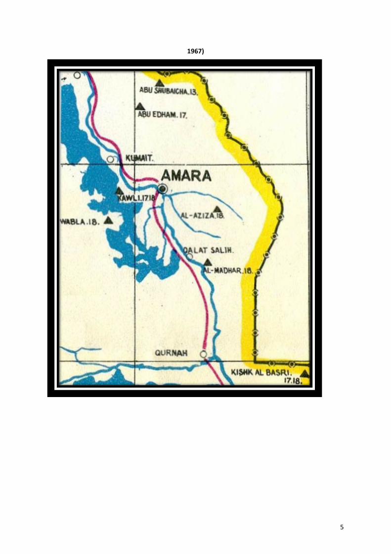
5
1967)
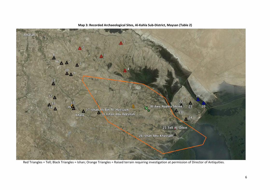
6
Map 3: Recorded Archaeological Sites, Al-Kahla Sub-District, Maysan (Table 2)
Red Triangles = Tell; Black Triangles = Ishan; Orange Triangles = Raised terrain requiring investigation at permission of Director of Antiquities.
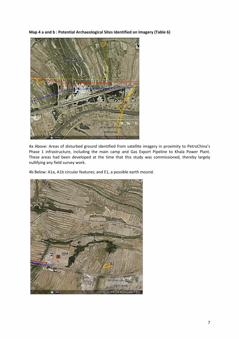
7
Map 4 a and b : Potential Archaeological Sites Identified on Imagery (Table 6)
4a Above: Areas of disturbed ground identified from satellite imagery in proximity to PetroChina’s Phase 1 infrastructure, including the main camp and Gas Export Pipeline to Khala Power Plant. These areas had been developed at the time that this study was commissioned, thereby largely nullifying any field survey work.
4b Below: A1a, A1b circular features; and E1, a possible earth mound.

8
Appendix C LAW No.55 of 2002 For The Antiquities & Heritage of Iraq
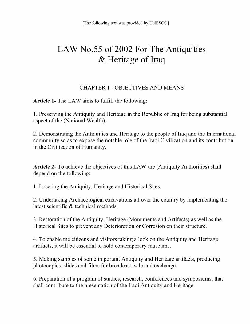
[The following text was provided by UNESCO]
LAW No.55 of 2002 For The Antiquities
& Heritage of Iraq
CHAPTER 1 - OBJECTIVES AND MEANS
Article 1- The LAW aims to fulfill the following:
1. Preserving the Antiquity and Heritage in the Republic of Iraq for being substantial
aspect of the (National Wealth).
2. Demonstrating the Antiquities and Heritage to the people of Iraq and the International
community so as to expose the notable role of the Iraqi Civilization and its contribution
in the Civilization of Humanity.
Article 2- To achieve the objectives of this LAW the (Antiquity Authorities) shall
depend on the following:
1. Locating the Antiquity, Heritage and Historical Sites.
2. Undertaking Archaeological excavations all over the country by implementing the
latest scientific & technical methods.
3. Restoration of the Antiquity, Heritage (Monuments and Artifacts) as well as the
Historical Sites to prevent any Deterioration or Corrosion on their structure.
4. To enable the citizens and visitors taking a look on the Antiquity and Heritage
artifacts, it will be essential to hold contemporary museums.
5. Making samples of some important Antiquity and Heritage artifacts, producing
photocopies, slides and films for broadcast, sale and exchange.
6. Preparation of a program of studies, research, conferences and symposiums, that
shall contribute to the presentation of the Iraqi Antiquity and Heritage.
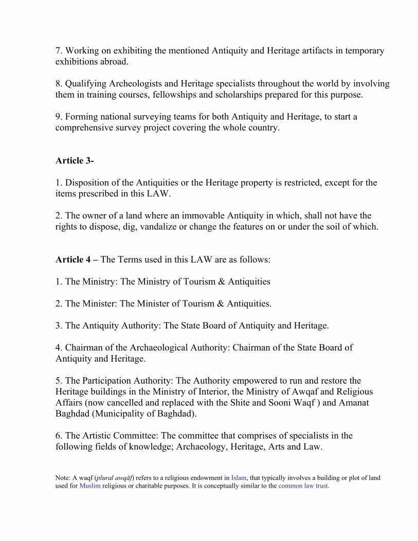
7. Working on exhibiting the mentioned Antiquity and Heritage artifacts in temporary
exhibitions abroad.
8. Qualifying Archeologists and Heritage specialists throughout the world by involving
them in training courses, fellowships and scholarships prepared for this purpose.
9. Forming national surveying teams for both Antiquity and Heritage, to start a
comprehensive survey project covering the whole country.
Article 3-
1. Disposition of the Antiquities or the Heritage property is restricted, except for the
items prescribed in this LAW.
2. The owner of a land where an immovable Antiquity in which, shall not have the
rights to dispose, dig, vandalize or change the features on or under the soil of which.
Article 4 – The Terms used in this LAW are as follows:
1. The Ministry: The Ministry of Tourism & Antiquities
2. The Minister: The Minister of Tourism & Antiquities.
3. The Antiquity Authority: The State Board of Antiquity and Heritage.
4. Chairman of the Archaeological Authority: Chairman of the State Board of
Antiquity and Heritage.
5. The Participation Authority: The Authority empowered to run and restore the
Heritage buildings in the Ministry of Interior, the Ministry of Awqaf and Religious
Affairs (now cancelled and replaced with the Shite and Sooni Waqf ) and Amanat
Baghdad (Municipality of Baghdad).
6. The Artistic Committee: The committee that comprises of specialists in the
following fields of knowledge; Archaeology, Heritage, Arts and Law.
Note: A waqf (plural awqāf) refers to a religious endowment in Islam, that typically involves a building or plot of land
used for Muslim religious or charitable purposes. It is conceptually similar to the common law trust.

7. Antiquity: The movable and immovable property which has been built, made,
carved, produced, written or painted by man, those age of which is not less than 200
years, as well as the man and animal skeletons besides the plants remains.
8. The Heritage Material: The movable and immovable property, less than 200 years
of age, possessing a historical, national, religious and artistic value.
9. The Historical Site: A place where a notable historical event took place, therein,
regardless its age.
10. Archaeological Excavation: The actions of digging or sensing and sounding those
devoted to uncover the movable or immovable property in or under the surface of soil or
in the bottom of Rivers, Lakes, Marshes and the Regional water surfaces.
CHAPTER 2
Article 5
1. The Antiquity Authority shall be entitled to hold its own registrations, to register
the Archaeological Monuments (Buildings and Sites), besides inserting the data,
documents and the attachment rights related to the neighboring real estate and
publishing it in the official Gazette to secure permanent protection and restoration.
2. If a monument has already been registered, while the attachment rights of the
neighboring real estate were not determined, this shall be done in accordance with the
LAW.
3. The attachment rights should include determination of a prohibited zone (no man's
land) around the archaeological areas besides securing roads and pathways to reach
them.
4. The Stylistic Character of the modern buildings adjacent to the Archaeological sites
should also be determined, the new or renewed buildings, their heights, frontispiece and
colors so they will be harmonious to the neighboring antiquity buildings, in coordination
with the Antiquity Authority and the Participation Authority.
Article 6 –
1. The Antiquity Authority shall be entitled to take over (taking a private property for
public use) which possess antiquities in accordance with the Possession Law No. 12
of 1981, regardless of the value of the extent Antiquities in the real state in the case of
evaluating the reparation for possession.
2. The Antiquity Authority shall be entitled to evacuate (individuals and property) from
the Antiquity and Heritage areas and their forbidden zone, when this might represent a
threatening upon the presence of the Antiquity or Heritage area.
Article 7 – All the Antiquity and Historical Sites including those owned by
individuals or public property should be registered in the name of the ministry of
finance, allocated for the purposes and possession of the State Board of Antiquity and
Heritage.
Article 8 – In coordination with the State Directorates, the Antiquity Authority is
obliged to prepare a comprehensive survey for the whole Archaic and Heritage sites in
Iraq, documenting them on the maps, the survey documents shall be provided with
standard scales, inserting them within the basic designation of which as well as referring
to their usages whether they were merely lands or Antiquity buildings. The Real Estate
Registration Office, Municipality of Baghdad or any other Municipalities concerned,
shall be notified.
Article 9 –
1. In case of confiscating, allocating or clearing a real estate within the limits of the
basic designation of a city or out of it, the state directorates and the (Socialist Sector)
shall be committed to avoid constituting or using the Antiquity (Sites, Buildings); it
will also be necessary to determine their prohibited zone in coordinating with the
Antiquity Authority.
2. After possessing the written permission from the Antiquity Authority, the concerned
authorities shall be committed to rent or sell (Farming Lands) those possess antiquities
in or under their soil, after being reformed.
3. The concerned authorities shall be committed to conserve the Antiquity, Heritage
and Historical Sites when the mentioned authorities are about to making state
industrial, agricultural or residential projects and other projects like: city and the
village planning, beautification, expansion, irrigation canals and the road paving.
The written permission from the Antiquity Authority shall be acquired before or at
changing the plans of these projects.
4. In case of an inconsistency of a specific and important project within the (Growth
Plan) with an antiquity Site, the Antiquity Authority shall be committed to undertake
Excavations, therein, which shall be financed by the (Executive Authority), putting a
dead line that must be adequate from the scientific and project time schedule point of
view. The total cost of the excavations shall be listed in the project's budget before the
initiation of digging.
5. The building license, shall not be granted in the antiquity locations or adjacent to
which with about one kilometer, except for the cases when a permission is to be
granted by the Antiquity Authority within a time not exceeding 30 days from the
date of handing in a license application .
6. The Antiquity Authority is entitled to coordinate with Amanat Baghdad or any
other concerned municipality for granting a license that concerns an erected
monument inside the limits of Baghdad or the Governorates (Provinces).
Article 10 – Mosques, Masjids, Holy Shrines, Monasteries, Convents, Tombs,
Takaya, Churches, Inns and other ancient buildings , owned or constituted in Waqf, in
the occupation of persons de facto or de jure whether they own or run such buildings,
to be used for the purpose for which they have been built, taking into consideration
development and expansion works in accordance with the contemporary demands.
Article 11 –
1. The Antiquity Authority shall be, periodically, responsible for monitoring the
utilities mentioned in Article 10, allowing the owner or occupier to carryout any
necessary preservation works, subject to the supervision of the Antiquity Authority.
2. Should the owner or appropriator of the monuments mentioned above in Article 10
of this LAW, proved to be incapable of doing the necessary restoration, it shall be
charged to the Antiquity Authority, provided that the expenses shall be charged to the
owner, supervisor or from the income resources fulfilled from the monument in
accordance with the law No.56 of 1977 concerning the state's debts.
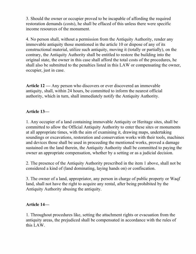
3. Should the owner or occupier proved to be incapable of affording the required
restoration demands (costs), he shall be effaced of this unless there were specific
income resources of the monument.
4. No person shall, without a permission from the Antiquity Authority, render any
immovable antiquity those mentioned in the article 10 or dispose of any of its
constructional material, utilize such antiquity, moving it (totally or partially), on the
contrary, the Antiquity Authority shall be entitled to restore the building into the
original state, the owner in this case shall afford the total costs of the procedures, he
shall also be submitted to the penalties listed in this LAW or compensating the owner,
occupier, just in case.
Article 12 — Any person who discovers or ever discovered an immovable
antiquity, shall, within 24 hours, be committed to inform the nearest official
authority, which in turn, shall immediately notify the Antiquity Authority.
Article 13—
1. Any occupier of a land containing immovable Antiquity or Heritage sites, shall be
committed to allow the Official Antiquity Authority to enter these sites or monuments
at all appropriate times, with the aim of examining it, drawing maps, undertaking
soundings or excavations, restoration and conservation works with their tools, machines
and devices those shall be used in proceeding the mentioned works, proved a damage
sustained on the land therein, the Antiquity Authority shall be committed to paying the
owner an appropriate compensation, whether by a setting or as a judicial decision.
2. The presence of the Antiquity Authority prescribed in the item 1 above, shall not be
considered a kind of (land dominating, laying hands on) or confiscation.
3. The owner of a land, appropriator, any person in charge of public property or Waqf
land, shall not have the right to acquire any rental, after being prohibited by the
Antiquity Authority abusing the antiquity.
Article 14—
1. Throughout procedures like, setting the attachment rights or evacuation from the
antiquity areas, the prejudiced shall be compensated in accordance with the rules of
this LAW.
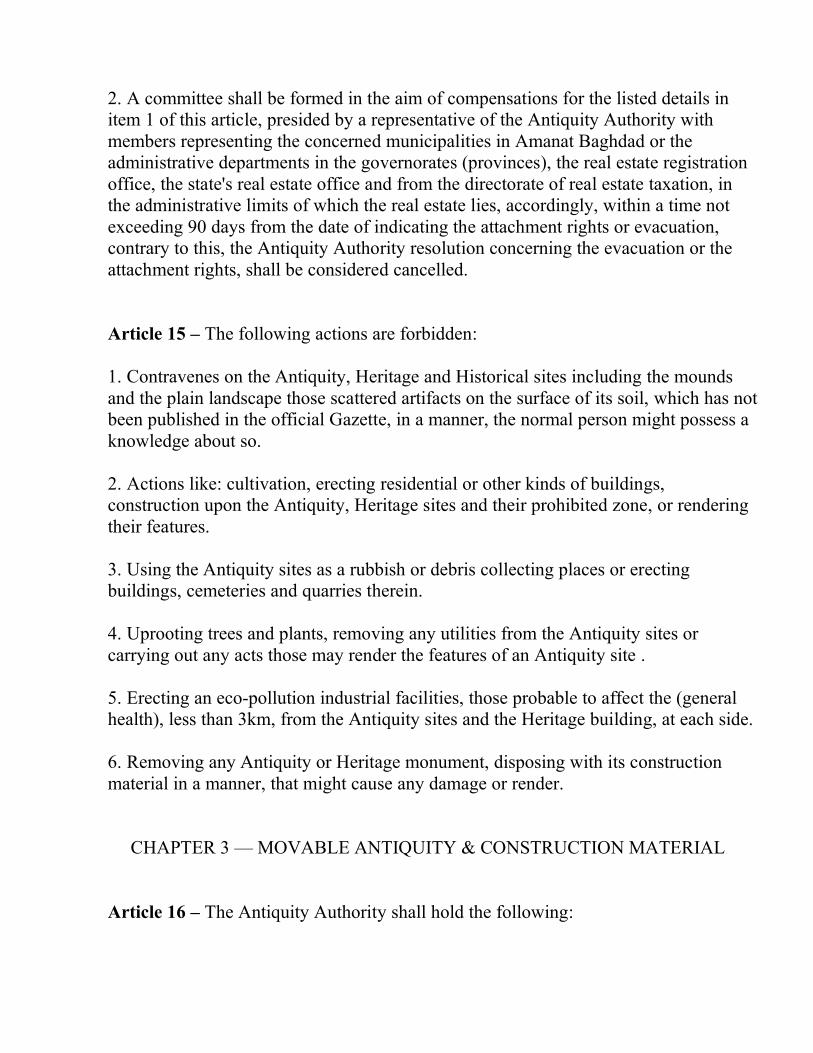
2. A committee shall be formed in the aim of compensations for the listed details in
item 1 of this article, presided by a representative of the Antiquity Authority with
members representing the concerned municipalities in Amanat Baghdad or the
administrative departments in the governorates (provinces), the real estate registration
office, the state's real estate office and from the directorate of real estate taxation, in
the administrative limits of which the real estate lies, accordingly, within a time not
exceeding 90 days from the date of indicating the attachment rights or evacuation,
contrary to this, the Antiquity Authority resolution concerning the evacuation or the
attachment rights, shall be considered cancelled.
Article 15 – The following actions are forbidden:
1. Contravenes on the Antiquity, Heritage and Historical sites including the mounds
and the plain landscape those scattered artifacts on the surface of its soil, which has not
been published in the official Gazette, in a manner, the normal person might possess a
knowledge about so.
2. Actions like: cultivation, erecting residential or other kinds of buildings,
construction upon the Antiquity, Heritage sites and their prohibited zone, or rendering
their features.
3. Using the Antiquity sites as a rubbish or debris collecting places or erecting
buildings, cemeteries and quarries therein.
4. Uprooting trees and plants, removing any utilities from the Antiquity sites or
carrying out any acts those may render the features of an Antiquity site .
5. Erecting an eco-pollution industrial facilities, those probable to affect the (general
health), less than 3km, from the Antiquity sites and the Heritage building, at each side.
6. Removing any Antiquity or Heritage monument, disposing with its construction
material in a manner, that might cause any damage or render.
CHAPTER 3 — MOVABLE ANTIQUITY & CONSTRUCTION MATERIAL
Article 16 – The Antiquity Authority shall hold the following:
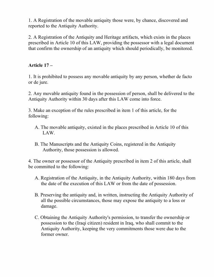
1. A Registration of the movable antiquity those were, by chance, discovered and
reported to the Antiquity Authority.
2. A Registration of the Antiquity and Heritage artifacts, which exists in the places
prescribed in Article 10 of this LAW, providing the possessor with a legal document
that confirm the ownership of an antiquity which should periodically, be monitored.
Article 17 –
1. It is prohibited to possess any movable antiquity by any person, whether de facto
or de jure.
2. Any movable antiquity found in the possession of person, shall be delivered to the
Antiquity Authority within 30 days after this LAW come into force.
3. Make an exception of the rules prescribed in item 1 of this article, for the
following:
A. The movable antiquity, existed in the places prescribed in Article 10 of this
LAW.
B. The Manuscripts and the Antiquity Coins, registered in the Antiquity
Authority, those possession is allowed.
4. The owner or possessor of the Antiquity prescribed in item 2 of this article, shall
be committed to the following:
A. Registration of the Antiquity, in the Antiquity Authority, within 180 days from
the date of the execution of this LAW or from the date of possession.
B. Preserving the antiquity and, in written, instructing the Antiquity Authority of
all the possible circumstances, those may expose the antiquity to a loss or
damage.
C. Obtaining the Antiquity Authority's permission, to transfer the ownership or
possession to the (Iraqi citizen) resident in Iraq, who shall commit to the
Antiquity Authority, keeping the very commitments those were due to the
former owner.
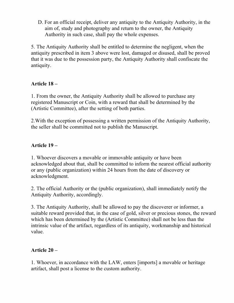
D. For an official receipt, deliver any antiquity to the Antiquity Authority, in the
aim of, study and photography and return to the owner, the Antiquity
Authority in such case, shall pay the whole expenses.
5. The Antiquity Authority shall be entitled to determine the negligent, when the
antiquity prescribed in item 3 above were lost, damaged or disused, shall be proved
that it was due to the possession party, the Antiquity Authority shall confiscate the
antiquity.
Article 18 –
1. From the owner, the Antiquity Authority shall be allowed to purchase any
registered Manuscript or Coin, with a reward that shall be determined by the
(Artistic Committee), after the setting of both parties.
2.With the exception of possessing a written permission of the Antiquity Authority,
the seller shall be committed not to publish the Manuscript.
Article 19 –
1. Whoever discovers a movable or immovable antiquity or have been
acknowledged about that, shall be committed to inform the nearest official authority
or any (public organization) within 24 hours from the date of discovery or
acknowledgment.
2. The official Authority or the (public organization), shall immediately notify the
Antiquity Authority, accordingly.
3. The Antiquity Authority, shall be allowed to pay the discoverer or informer, a
suitable reward provided that, in the case of gold, silver or precious stones, the reward
which has been determined by the (Artistic Committee) shall not be less than the
intrinsic value of the artifact, regardless of its antiquity, workmanship and historical
value.
Article 20 –
1. Whoever, in accordance with the LAW, enters [imports] a movable or heritage
artifact, shall post a license to the custom authority.
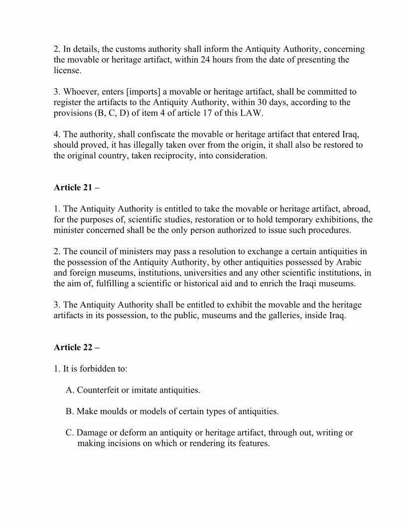
2. In details, the customs authority shall inform the Antiquity Authority, concerning
the movable or heritage artifact, within 24 hours from the date of presenting the
license.
3. Whoever, enters [imports] a movable or heritage artifact, shall be committed to
register the artifacts to the Antiquity Authority, within 30 days, according to the
provisions (B, C, D) of item 4 of article 17 of this LAW.
4. The authority, shall confiscate the movable or heritage artifact that entered Iraq,
should proved, it has illegally taken over from the origin, it shall also be restored to
the original country, taken reciprocity, into consideration.
Article 21 –
1. The Antiquity Authority is entitled to take the movable or heritage artifact, abroad,
for the purposes of, scientific studies, restoration or to hold temporary exhibitions, the
minister concerned shall be the only person authorized to issue such procedures.
2. The council of ministers may pass a resolution to exchange a certain antiquities in
the possession of the Antiquity Authority, by other antiquities possessed by Arabic
and foreign museums, institutions, universities and any other scientific institutions, in
the aim of, fulfilling a scientific or historical aid and to enrich the Iraqi museums.
3. The Antiquity Authority shall be entitled to exhibit the movable and the heritage
artifacts in its possession, to the public, museums and the galleries, inside Iraq.
Article 22 –
1. It is forbidden to:
A. Counterfeit or imitate antiquities.
B. Make moulds or models of certain types of antiquities.
C. Damage or deform an antiquity or heritage artifact, through out, writing or
making incisions on which or rendering its features.
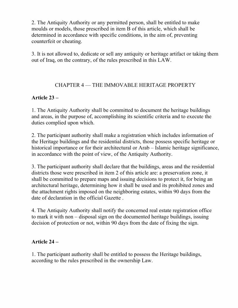
2. The Antiquity Authority or any permitted person, shall be entitled to make
moulds or models, those prescribed in item B of this article, which shall be
determined in accordance with specific conditions, in the aim of, preventing
counterfeit or cheating.
3. It is not allowed to, dedicate or sell any antiquity or heritage artifact or taking them
out of Iraq, on the contrary, of the rules prescribed in this LAW.
CHAPTER 4 — THE IMMOVABLE HERITAGE PROPERTY
Article 23 –
1. The Antiquity Authority shall be committed to document the heritage buildings
and areas, in the purpose of, accomplishing its scientific criteria and to execute the
duties complied upon which.
2. The participant authority shall make a registration which includes information of
the Heritage buildings and the residential districts, those possess specific heritage or
historical importance or for their architectural or Arab – Islamic heritage significance,
in accordance with the point of view, of the Antiquity Authority.
3. The participant authority shall declare that the buildings, areas and the residential
districts those were prescribed in item 2 of this article are: a preservation zone, it
shall be committed to prepare maps and issuing decisions to protect it, for being an
architectural heritage, determining how it shall be used and its prohibited zones and
the attachment rights imposed on the neighboring estates, within 90 days from the
date of declaration in the official Gazette .
4. The Antiquity Authority shall notify the concerned real estate registration office
to mark it with non – disposal sign on the documented heritage buildings, issuing
decision of protection or not, within 90 days from the date of fixing the sign.
Article 24 –
1. The participant authority shall be entitled to possess the Heritage buildings,
according to the rules prescribed in the ownership Law.
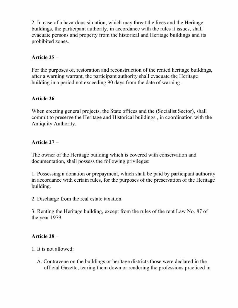
2. In case of a hazardous situation, which may threat the lives and the Heritage
buildings, the participant authority, in accordance with the rules it issues, shall
evacuate persons and property from the historical and Heritage buildings and its
prohibited zones.
Article 25 –
For the purposes of, restoration and reconstruction of the rented heritage buildings,
after a warning warrant, the participant authority shall evacuate the Heritage
building in a period not exceeding 90 days from the date of warning.
Article 26 –
When erecting general projects, the State offices and the (Socialist Sector), shall
commit to preserve the Heritage and Historical buildings , in coordination with the
Antiquity Authority.
Article 27 –
The owner of the Heritage building which is covered with conservation and
documentation, shall possess the following privileges:
1. Possessing a donation or prepayment, which shall be paid by participant authority
in accordance with certain rules, for the purposes of the preservation of the Heritage
building.
2. Discharge from the real estate taxation.
3. Renting the Heritage building, except from the rules of the rent Law No. 87 of
the year 1979.
Article 28 –
1. It is not allowed:
A. Contravene on the buildings or heritage districts those were declared in the
official Gazette, tearing them down or rendering the professions practiced in
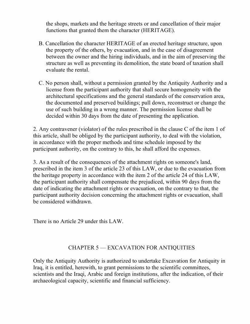
the shops, markets and the heritage streets or and cancellation of their major
functions that granted them the character (HERITAGE).
B. Cancellation the character HERITAGE of an erected heritage structure, upon
the property of the others, by evacuation, and in the case of disagreement
between the owner and the hiring individuals, and in the aim of preserving the
structure as well as preventing its demolition, the state board of taxation shall
evaluate the rental.
C. No person shall, without a permission granted by the Antiquity Authority and a
license from the participant authority that shall secure homogeneity with the
architectural specifications and the general standards of the conservation area,
the documented and preserved buildings; pull down, reconstruct or change the
use of such building in a wrong manner. The permission license shall be
decided within 30 days from the date of presenting the application.
2. Any contravener (violator) of the rules prescribed in the clause C of the item 1 of
this article, shall be obliged by the participant authority, to deal with the violation,
in accordance with the proper methods and time schedule imposed by the
participant authority, on the contrary to this, he shall afford the expenses.
3. As a result of the consequences of the attachment rights on someone's land,
prescribed in the item 3 of the article 23 of this LAW, or due to the evacuation from
the heritage property in accordance with the item 2 of the article 24 of this LAW,
the participant authority shall compensate the prejudiced, within 90 days from the
date of indicating the attachment rights or evacuation, on the contrary to that, the
participant authority decision concerning the attachment rights or evacuation, shall
be considered withdrawn.
There is no Article 29 under this LAW.
CHAPTER 5 — EXCAVATION FOR ANTIQUITIES
Only the Antiquity Authority is authorized to undertake Excavation for Antiquity in
Iraq, it is entitled, herewith, to grant permissions to the scientific committees,
scientists and the Iraqi, Arabic and foreign institutions, after the indication, of their
archaeological capacity, scientific and financial sufficiency.
Article 30 –
1. It is allowed to carry out excavation in the lands owned by the state or persons,
whether, de facto or de jure, in which lies antiquity remains.
2. The parties and persons prescribed in article 29 of this LAW, are committed to
restore the excavated areas into their original pre excavation situation, paying
compensation for the reparation of damages sustained on the land after the conclusion
of the excavation, the compensation shall be evaluated by the Antiquity Authority.
3. The Antiquity Authority shall determine the time schedule of the excavation, in
the land not of a public property, only the minister shall be entitled to extend the
schedule.
Article 31 –
1. Excavation shall be carried out scientifically under the supervision of a committee,
which shall be formed by the minister or any authorized party, accordingly.
2. The director or the chief of the expedition, shall be a well known archaeologist
with previous experience in archaeological excavation.
3. An architect specializing in ancient architecture.
4. An assistant competent in drawing and photography.
5. When needed, an epigraphist of ancient languages and scripts.
Article 32 – The holder of the permit of excavation, those do not belong to the
Antiquity Authority, shall comply with the following conditions:
1. The application permits shall be made to the Antiquity Authority, setting forth:
A. Particulars of the applicant, his previous experience and financial capacity.
B. Affiliation and authorization of a well known scientific institution that deals
with excavation and archaeological research.
C. Number of the workers, therewith, their scientific qualification in excavation.
2. Additionally:
A. Preparing a map to explain the boundaries of the area, showing details of the
site intended to excavate, therein
B. A report containing the general program (scheme) of the work to be followed
for the next 5 years.
3. The minister's approval for the excavations, according to the study and
recommendation made by the Antiquity Authority.
4. The applicant shall be jointed with the Antiquity Authority, by a contract, in the
aim of determination the rights and commitments of both parties.
Article 33 – The Antiquity Authority shall be entitled to inspect the excavations
undertaking and the uncovered artifacts, in any time it sees proper.
Article 34 –
1. The Antiquity Authority shall suspend the excavation, if the holder of the permit
contravenes the conditions laid down in the permit, warning the excavating party of
the necessity to eliminate the contravention, within a proper time determined by the
Antiquity Authority.
2. If the holder of the excavation permit did not remove the contravention or it was
significant and or the holder's situation required that, the minister shall be entitled to
cancel his approval.
Article 35 –
1. All antiquities discovered within the course of the excavation and the information
obtained from which, including photographs, maps and plans are state property,
shall not be allowed, except of a written permission by the Antiquity Authority, to
dispose with or publication inside or outside Iraq.
2. For his efforts, the Antiquity Authority, shall grant the following for the permit's
holder:
A. Moulds, photographs, maps and the plans of the discovered antiquities.
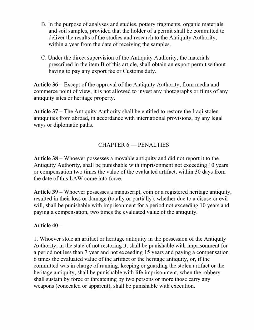
B. In the purpose of analyses and studies, pottery fragments, organic materials
and soil samples, provided that the holder of a permit shall be committed to
deliver the results of the studies and research to the Antiquity Authority,
within a year from the date of receiving the samples.
C. Under the direct supervision of the Antiquity Authority, the materials
prescribed in the item B of this article, shall obtain an export permit without
having to pay any export fee or Customs duty.
Article 36 – Except of the approval of the Antiquity Authority, from media and
commerce point of view, it is not allowed to invest any photographs or films of any
antiquity sites or heritage property.
Article 37 – The Antiquity Authority shall be entitled to restore the Iraqi stolen
antiquities from abroad, in accordance with international provisions, by any legal
ways or diplomatic paths.
CHAPTER 6 — PENALTIES
Article 38 – Whoever possesses a movable antiquity and did not report it to the
Antiquity Authority, shall be punishable with imprisonment not exceeding 10 years
or compensation two times the value of the evaluated artifact, within 30 days from
the date of this LAW come into force.
Article 39 – Whoever possesses a manuscript, coin or a registered heritage antiquity,
resulted in their loss or damage (totally or partially), whether due to a disuse or evil
will, shall be punishable with imprisonment for a period not exceeding 10 years and
paying a compensation, two times the evaluated value of the antiquity.
Article 40 –
1. Whoever stole an artifact or heritage antiquity in the possession of the Antiquity
Authority, in the state of not restoring it, shall be punishable with imprisonment for
a period not less than 7 year and not exceeding 15 years and paying a compensation
6 times the evaluated value of the artifact or the heritage antiquity, or, if the
committed was in charge of running, keeping or guarding the stolen artifact or the
heritage antiquity, shall be punishable with life imprisonment, when the robbery
shall sustain by force or threatening by two persons or more those carry any
weapons (concealed or apparent), shall be punishable with execution.
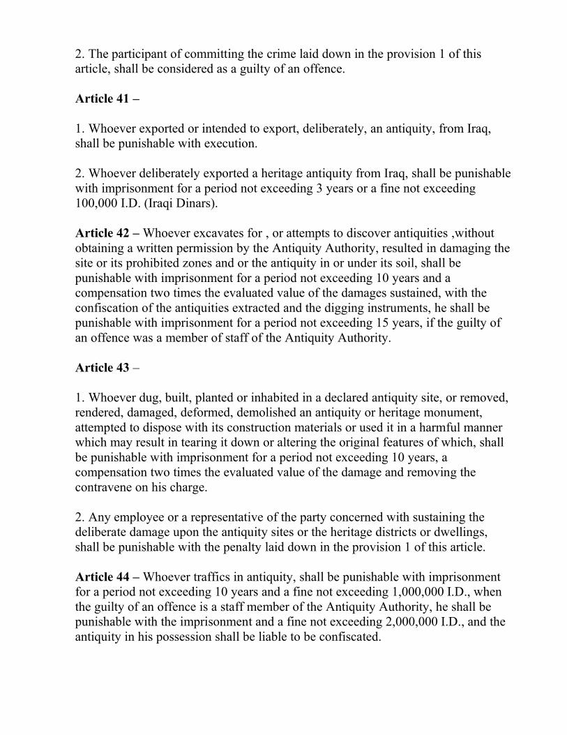
2. The participant of committing the crime laid down in the provision 1 of this
article, shall be considered as a guilty of an offence.
Article 41 –
1. Whoever exported or intended to export, deliberately, an antiquity, from Iraq,
shall be punishable with execution.
2. Whoever deliberately exported a heritage antiquity from Iraq, shall be punishable
with imprisonment for a period not exceeding 3 years or a fine not exceeding
100,000 I.D. (Iraqi Dinars).
Article 42 – Whoever excavates for , or attempts to discover antiquities ,without
obtaining a written permission by the Antiquity Authority, resulted in damaging the
site or its prohibited zones and or the antiquity in or under its soil, shall be
punishable with imprisonment for a period not exceeding 10 years and a
compensation two times the evaluated value of the damages sustained, with the
confiscation of the antiquities extracted and the digging instruments, he shall be
punishable with imprisonment for a period not exceeding 15 years, if the guilty of
an offence was a member of staff of the Antiquity Authority.
Article 43 –
1. Whoever dug, built, planted or inhabited in a declared antiquity site, or removed,
rendered, damaged, deformed, demolished an antiquity or heritage monument,
attempted to dispose with its construction materials or used it in a harmful manner
which may result in tearing it down or altering the original features of which, shall
be punishable with imprisonment for a period not exceeding 10 years, a
compensation two times the evaluated value of the damage and removing the
contravene on his charge.
2. Any employee or a representative of the party concerned with sustaining the
deliberate damage upon the antiquity sites or the heritage districts or dwellings,
shall be punishable with the penalty laid down in the provision 1 of this article.
Article 44 – Whoever traffics in antiquity, shall be punishable with imprisonment
for a period not exceeding 10 years and a fine not exceeding 1,000,000 I.D., when
the guilty of an offence is a staff member of the Antiquity Authority, he shall be
punishable with the imprisonment and a fine not exceeding 2,000,000 I.D., and the
antiquity in his possession shall be liable to be confiscated.
Article 45 – Whoever, without a permission of the Antiquity Authority, traffics in a
counterfeited or imitated antiquity, shall be punishable with imprisonment for a
period not exceeding 3 years and a fine not exceeding 100,000 I.D., he shall only be
punishable with imprisonment when the guilty of an offence is a staff member of
the Antiquity Authority, the instruments and materials used in committing this
crime shall be liable to be confiscated.
Article 46 – Whoever contravenes on the heritage buildings, shops and districts,
declared in the official Gazette, by demolishing or changing the purposes for which
they have been built, shall be punishable with imprisonment for a period not
exceeding 7 years, and at his charge he shall be committed to restore the building
into the original pre contravention situation.
Article 47 –
1. Any owner or appropriator of the buildings prescribed in the article 10 of this
LAW, who, without a written permission of the Antiquity Authority, totally or
partially, demolishes, moves, reconstructs, renews or alters the buildings listed,
shall be punishable with imprisonment, and at his charge he shall be committed to
restore the building into the original situation.
2. Whoever contravenes the provisions of the articles 12 , 15, 19-A , 20-A/C , 22-
A/C , 36, listed in this LAW, shall be punishable with imprisonment for a period
not exceeding 2 years and a fine not exceeding 100,000 I.D. (Iraqi Dinar).
Article 48 –
1. A. The Antiquity Authority shall be entitled to award whoever shall report of any
illegal possession of antiquity or heritage material and helps laying hands on which.
B. The chairman of the Antiquity Authority , shall be the only party to make a
decision in the legal suits resulted by the offences prescribed in the articles
12, 15, 19/A, 20/A.C, 22/A.C and 36 of this LAW.
C. In order to practice the authorities prescribed in clause B of item 1 of this
article, the chairman of the Antiquity Authority shall enjoy the powers
granted to a delict judge.
D. The decisions or the judgments issued by the chairman of the Antiquity
Authority, in his capacity of a delict judge, shall be liable to appeal within 15
days from the date of the acknowledgment with the judgment or decision and
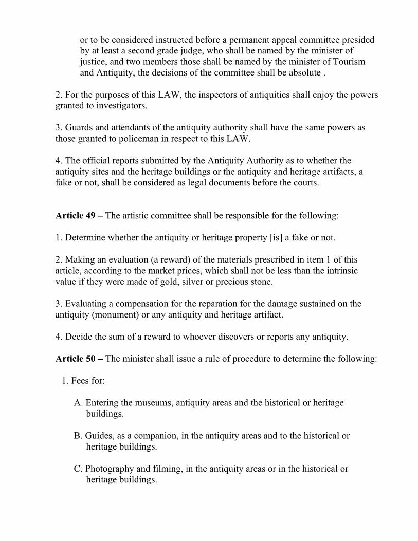
or to be considered instructed before a permanent appeal committee presided
by at least a second grade judge, who shall be named by the minister of
justice, and two members those shall be named by the minister of Tourism
and Antiquity, the decisions of the committee shall be absolute .
2. For the purposes of this LAW, the inspectors of antiquities shall enjoy the powers
granted to investigators.
3. Guards and attendants of the antiquity authority shall have the same powers as
those granted to policeman in respect to this LAW.
4. The official reports submitted by the Antiquity Authority as to whether the
antiquity sites and the heritage buildings or the antiquity and heritage artifacts, a
fake or not, shall be considered as legal documents before the courts.
Article 49 – The artistic committee shall be responsible for the following:
1. Determine whether the antiquity or heritage property [is] a fake or not.
2. Making an evaluation (a reward) of the materials prescribed in item 1 of this
article, according to the market prices, which shall not be less than the intrinsic
value if they were made of gold, silver or precious stone.
3. Evaluating a compensation for the reparation for the damage sustained on the
antiquity (monument) or any antiquity and heritage artifact.
4. Decide the sum of a reward to whoever discovers or reports any antiquity.
Article 50 – The minister shall issue a rule of procedure to determine the following:
1. Fees for:
A. Entering the museums, antiquity areas and the historical or heritage
buildings.
B. Guides, as a companion, in the antiquity areas and to the historical or
heritage buildings.
C. Photography and filming, in the antiquity areas or in the historical or
heritage buildings.
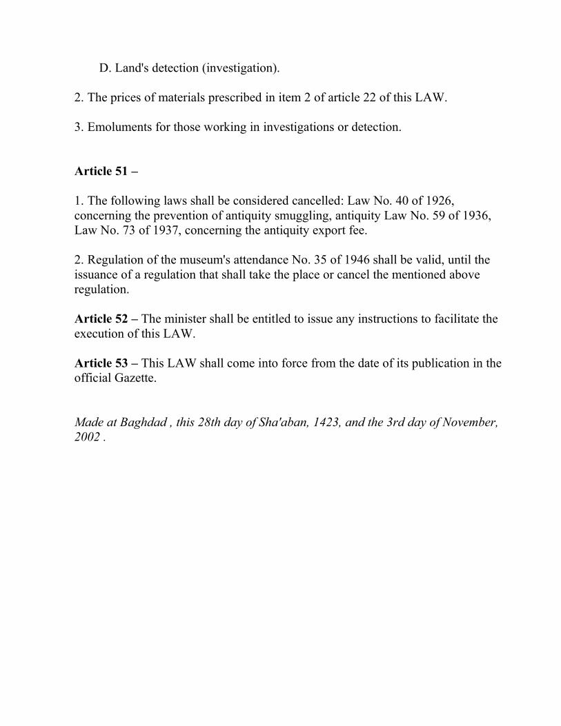
D. Land's detection (investigation).
2. The prices of materials prescribed in item 2 of article 22 of this LAW.
3. Emoluments for those working in investigations or detection.
Article 51 –
1. The following laws shall be considered cancelled: Law No. 40 of 1926,
concerning the prevention of antiquity smuggling, antiquity Law No. 59 of 1936,
Law No. 73 of 1937, concerning the antiquity export fee.
2. Regulation of the museum's attendance No. 35 of 1946 shall be valid, until the
issuance of a regulation that shall take the place or cancel the mentioned above
regulation.
Article 52 – The minister shall be entitled to issue any instructions to facilitate the
execution of this LAW.
Article 53 – This LAW shall come into force from the date of its publication in the
official Gazette.
Made at Baghdad , this 28th day of Sha'aban, 1423, and the 3rd day of November,
2002 .