HABITAT MANAGEMENT PLAN FOR PIEDMONT NATIONAL ...
191
HABITAT MANAGEMENT PLAN FOR PIEDMONT NATIONAL WILDLIFE REFUGE Jones and Jasper Counties, Georgia Southeast Region U.S. Fish & Wildlife Service
-
Upload
khangminh22 -
Category
Documents
-
view
0 -
download
0
Transcript of HABITAT MANAGEMENT PLAN FOR PIEDMONT NATIONAL ...

HABITAT MANAGEMENT PLAN FOR
PIEDMONT NATIONAL WILDLIFE REFUGE
Jones and Jasper Counties, Georgia
Southeast Region
U.S. Fish & Wildlife Service


TABLE OF CONTENTS
Chapters
1.0 Introduction 1
2.0 Environmental Setting and Background 5
3.0 Resources of Concern 17
4.0 Habitat Management Goals and Objectives 27
5.0 Habitat Management Strategies 43
6.0 Literature Cited 65
Appendices
1.0 Species Lists 79
2.0 Process to Determine Resources of Concern 95
3.0 Forest Inventory 111
4.0 Silviculture and Hazardous Fuels 123
5.0 Silvicultural Prescriptions 143
6.0 Timber Sales Administration 145
7.0 Environmental Action Statement 183


1
1.0 INTRODUCTION
The purpose of the Habitat Management Plan (HMP) is to provide specific direction and long-
term management guidance for the refuge. An HMP is a step-down management plan of the
Refuge Comprehensive Conservation Plan (CCP). A CCP is a strategic plan that guides the
direction of the refuge. The CCP for Piedmont National Wildlife Refuge (NWR) was finalized
in 2010 (USFWS 2010). HMPs comply with all applicable laws, regulations, and policies
governing the management of National Wildlife Refuge System. The lifespan of an HMP is 15
years and parallels that of the refuge CCP. HMPs are reviewed every 5 years utilizing peer
review recommendations, as appropriate, in the HMP revision process or when initiating refuge
CCPs.
1.1 Legal Mandates
The purposes shown here are based upon land acquisition documents and authorities. The unit
purposes may also include purposes included as deed restrictions, management agreements with
primary land managers and congressional established wilderness designations which were not
part of the acquisition documents and authorities.
“... as a refuge and breeding ground for birds and other wildlife: ...” Executive Order 8037, dated
Jan. 18, 1939
“... for use as an inviolate sanctuary, or for any other management purpose, for migratory birds.”
16 U.S.C. 715d (Migratory Bird Conservation Act).
“... conservation, management, and restoration of the fish, wildlife, and plant resources and their
habitats for the benefit of present and future generations of Americans...” 16 U.S.C. 668dd(a)(2)
(National Wildlife Refuge System Administration Act).
From http://www.fws.gov/refuges/databases/
1.2 Relation to Other Plans
A Comprehensive Wildlife Conservation Strategy for Georgia (Georgia Department of Natural
Resources 2005)
Supported by the State Wildlife Grants (SWG) Program, Georgia's CWCS (also known as
the State Wildlife Action Plan) identifies the challenges facing Georgia's diverse wildlife
species and devises strategies to conserve those "species with the greatest conservation
need," and their habitats. Georgia ranks sixth in the nation in overall species diversity based
on numbers of vascular plants, vertebrate animals, and selected invertebrates. The state
currently has 223 species that are protected by state or federal laws and hundreds of
additional animal and plant species in need of conservation. The CWCS is a guide to
conserving the species of fish and wildlife that have immediate conservation needs or are key
indicators of the diversity and health of the state’s wildlife. The CWCS emphasizes a
cooperative, proactive approach to conservation, inviting local governments, businesses, and

2
conservation-minded organizations and individuals to join in the task of maintaining the fish
and wildlife resources
The Red-Cockaded Woodpecker (RCW) Recovery Plan (USFWS 2003)
The ultimate recovery goal is red-cockaded woodpecker (Picoides borealis) viability. Once
this goal is met, the size, number, and distribution of populations will be sufficient to
counteract threats of demographic, environmental, genetic, and catastrophic stochastic
events, thereby maintaining long-term viability for the species as defined by current
understanding of these processes.
Partners in Flight North American Landbird Conservation Plan (Rich et. al. 2004)
The Partners in Flight North American Landbird Conservation Plan (hereafter Plan) provides
a continental synthesis of priorities and objectives that will guide landbird conservation
actions at national and international scales. The scope for this Plan is the 448 species of
native landbirds that regularly breed in the U.S. and Canada. Fully 100 of these species
warrant inclusion on the PIF Watch List, due to a combination of threats to their habitats,
declining populations, small population sizes, or limited distributions. Of these, 28 species
require immediate action to protect small remaining populations, and 44 more are in need of
management to reverse long-term declines. This Plan also highlights the need for
stewardship of the species and landscapes characteristic of each portion of the continent,
identifying 158 species (including 66 on the Watch List) that are particularly representative
of large avifaunal biomes, and whose needs should be considered in conservation planning.
Taken together, the pool of Watch List and Stewardship Species represent the landbirds of
greatest continental importance for conservation action. Although the recommended actions
may vary from region to region, no area in North America is without a conservation need for
landbirds.
NBCI – National Bobwhite Conservation Initiative (National Bobwhite Technical Committee
2011)
The NBCI charged with meeting the conservation and management needs of the northern
bobwhite quail and facilitate integration with other bird management plans. The goal is to
restore bobwhites to the density they enjoyed during the baseline year 1980. Forest habitat
objectives are to enhance habitats in pinelands and mixed pine-hardwood forests through
silvicultural treatments such as thinning and prescribed burning.
North American Waterfowl Management Plan (North American Waterfowl Management Plan,
Plan Committee 2004)
The North American Waterfowl Management Plan (NAWMP) was developed and signed in
1986 in response to declining waterfowl populations. This plan lays out a strategy between
the United States, Canadian and Mexican (after 1994) governments to restore wetlands.
Recovery of these shared resources is implemented through habitat protection, restoration,

3
and enhancement through regionally-based self-directed partnerships known as joint
ventures. The original plan was updated in 1994, 1998 and 2004.

4

5
2.0 ENVIRONMENTAL SETTING AND BACKGROUND
2.1 Location
Piedmont National Wildlife Refuge is 34,949 acres, in Jones (28,552 acres) and Jasper (6,397
acres) Counties, Georgia. Atlanta is approximately 60 miles to the northwest; Macon is
approximately 20 miles to the south.

6
2.2 Management Units
The refuge is divided into 34 compartments of varying sizes. Compartment 1 is the smallest, at
486 acres; compartment 18 is the largest, at 1,975 acres.

7
2.3 Physical Elements
The refuge's topography is typical of the region, with open low hills interspersed with small
streams. Twenty to 50 percent of the area is gently sloping; the majority of the slope is on
uplands. Elevations range from 360 to 640 feet above sea level.
Major streams flow in a southwesterly direction. The northern portion of the refuge is drained
by Little Falling Creek, Allison Creek, Caney Creek, Stalkinghead Creek, and Rocky Branch.
These creeks drain into Falling Creek, which empties into the Ocmulgee River three miles from
the refuge boundary. The refuge's southern portion is drained by Hurricane Creek and Butler’s
Creek, which also empty into the Ocmulgee River. There are intermittent streams scattered
throughout the refuge.
Soils directly influence the kind and amount of vegetation and the amount of water available; in
this way they indirectly influence the kind of wildlife that can live in an area. The soils found on
the refuge can be classified into three soil orders – ultisols, alfisols and inceptisols (Payne 1976).
Within these orders are nine soil series. The series Davidson, Vance, Cecil and Gwinnett are
found in the order ultisols. These soils are acidic and are characterized by an argillic or clay
deposition horizon. Soils in the Davidson, Vance and Cecil series occupy 78 percent of the
refuge. This series, along with soils in the series Vance and Cecil are found on interstream
ridgetops and slopes (2 to 25 percent) adjacent to drainages. Most of these soils are classed as
eroded; in some areas erosion has removed all or nearly the entire original surface layer. Soils in
the Gwinnett series occur on steep slopes (15 to 35 percent) adjacent to drainages.
Two soil series in the order alfisols occur on the refuge – Enon and Wilkes. These soils are
similar to the ultisols in that they have an agrillic horizon as the identifying horizon; however,
alfisols have a higher pH than ultisols. Enon and Wilkes soils occur on the uplands and on
slopes adjacent to drainages. They occupy 12 percent of the refuge.
Inceptisols are young soils with no distinct horizons. Within this order are found the soil series
Chewacla, Starr, and Congaree. These soils are found along the stream bottoms. They occupy
10 percent of the refuge.
Various degrees of erosion are found on all these soils. On 20 percent of the area the topsoil is
completely gone. An additional 70 percent retains only a thin layer of topsoil. Gullies are
numerous throughout the forest.
2.4 Weather
The refuge is located near the geographical center of Georgia so it has a blend of maritime and
continental climates. The area experiences all four seasons. Summers typically consist of long
spells of warm and humid weather. Average afternoon high temperatures are in the upper 80s to
around 90. Readings of 90 or higher can be expected on 30 to 60 days. Overnight lows usually
range from the middle 60s to lower 70s. Temperatures during winter months are more variable.
Stretches of mild weather alternate with cold spells. Winter high temperatures average in the

8
50s, while lows average in the 30s. Lows of 32 degrees or below can be expected on 50 to 70
days. Spring and autumn seasons are characterized by daily and annual variability. The average
dates of first freeze in the autumn range from late October to mid-November. The average dates
of last freeze in the spring range from mid-March to early April.
A measurable amount of rain falls on about 120 days each year, producing amounts averaging
between 40 and 50 inches. The average annual total snowfall is one to two inches, usually
occuring on just one or two days. The driest month is October and the wettest month is January.
Thunderstorms are common in the spring and summer months. On a typical year, thunder will
be heard on 50 to 60 days.
Table 2.1 Climatological normals for the years 1971-2000 from the National Weather Service station
at the Macon, GA Airport (KMCN).
Month
N O R M A L
High
(°F)
Low
(°F)
Mean
(°F)
Rainfall
(inches)
Snowfall
(inches)
Jan 56.6 34.5 45.5 5.00 T
Feb 61.0 37.1 49.0 4.72 T
Mar 68.5 43.8 56.2 4.90 T
Apr 75.9 49.5 62.7 3.14 0.0
May 83.4 58.6 71.0 2.98 0.0
Jun 89.5 66.6 78.0 3.54 0.0
Jul 91.8 70.5 81.1 4.32 0.0
Aug 90.5 69.5 80.0 3.79 0.0
Sep 85.4 63.7 74.5 3.26 0.0
Oct 76.8 51.1 63.9 2.37 0.0
Nov 67.8 42.5 55.1 3.22 0.0
Dec 59.2 36.3 47.8 3.93 T
Yearly Normals
High (°F) Low (°F) Mean (°F) Total Rainfall Total Snowfall
75.5 52.0 63.7 45.17 T
2.5 Historic Condition
The typical impression of North America on the eve of European contact is that of a ‘pristine’
wilderness, unchanged by humans. This viewpoint implies the Native American was,
ecologically speaking, invisible. The reality is quite different – the environment encountered by
the earliest European explorers to North America was created by Native Americans.
When the 1539-1543 expedition of Hernando de Soto arrived in present-day middle Georgia, the
landscape was home to more than a dozen largely distinct chiefdoms (Worth 1993). The
members of this expedition were the first Europeans to see the chiefdoms of the Native
Americans of the interior southeast in a largely pristine (i.e. unimpacted by Europeans) state
(Worth 1994). At the same time, the landscape they witnessed was not pristine (i.e. unimpacted

9
by humans). The de Soto chroniclers described middle Georgia as an area teeming with people
(Clayton et. al. 1993).
The large Native American population had a significant impact on the environment. Earthworks,
fields and settlements were everywhere (Denevan 1992). Fire was the primary tool at the Native
American’s disposal (Cowell 1998). Anthropogenic fire changed the “natural” fire regime,
increasing the frequency of fire and varying the seasonality, which in turn modified the intensity,
fire size and depth of burn (Buckner 1989, Pyne 2000, Williams 2000). The effect of this
human-caused fire regime was to increase the extent of oak and pine, decrease the amount of
hardwood midstory, increase the grass component and maintain open areas (Barden 1997, Hamel
and Buckner 1998). Savannas, plains and fields were encountered all along de Soto’s route,
from Florida to Louisiana (Rostlund 1957). The Native American, through their land use
practices, was a keystone species, affecting the survival and abundance of many species.
Within only a few decades of contact, the chiefdoms began to collapse. James Edward
Oglethorpe, writing 200 years after the de Soto expedition, described the effect of de Soto’s
expedition on the Native Americans: “By the healthiness of this Climate, and some Accounts of
Spanish Expeditions hither in early Times, which were vigorously repulsed by great Armies of
the Natives, one would expect to find the Country by this Time fully peopled with Indians. It is
indeed probable that they were much more numerous in those Days than at present, or else they
could not have defended themselves against the Spaniards as they did. But if their numbers were
formerly considerable they have since greatly decreased; and that might easily happen in a
Century, even tho’ the Country be naturally fertile and healthy, for the Indians … have this
Resemblance in common: They are … exceedingly apt to make War upon each other … Add to
which … (they) must perish in Heaps if the Fruits of the Woods, or their Hunting should once
fail them … Another great Cause of their Destruction was the Small-pox, the Europeans
brought this Distemper among them …” (Blaine 1994). While there is much debate as to the
exact figures, Native American population levels of the Southeast may have dropped by more
than 90% within the first two centuries after contact (Worth 1993).
Due to this massive depopulation, the members of the de Soto expedition were also the last
Europeans to witness the chiefdoms in a largely pristine state (Worth 1994). Greatly reducing
the Native American population removed their keystone status, resulting in a significant shift in
the composition of the ecological community. Since a large Native American population
increased fire frequency, depopulation must have decreased fire frequency, beginning a reversal
of the trend towards open canopy, fire-tolerant oaks and pines with prairies and savannas. By the
time most historical records were being written in the18th century, the Native American-created
environment of 1492 had largely vanished. Former fields and fire-maintained uplands were
supporting communities that developed for decades or even centuries under completely different
disturbance regimes than those of pre-European contact.
While 18th century historical records do not portray conditions prior to substantial human related
changes to the landscape, they do represent conditions post European contact but pre European
settlement. Accounts by James Edward Oglethorpe, a principle architect in establishing the
colony of Georgia, describe the colony. An report written in 1739 describes the area between the
mountains and the coast as, “covered mostly with woods; the banks of the rivers are in some

10
places low, and form a kind of natural meadows, where the floods prevent trees from growing.
In other places, in hollows, between the hillocks, the brooks and streams being stopt by falls of
trees, or other obstructions, the water is penn’d back: these places are often covered with canes
and thickets, and are called in the corrupted American dialect, swamps. The sides of the hills are
generally covered with oaks and hiccary, or wild walnuts, cedar, sassafras, and the famous laurel
tulip, which is esteemed one of the most beautiful trees in the world: the flat tops of the hillocks
are all covered with groves of pine trees, with plenty of grass growing under them; and free from
underwood, that you may gallop a horse for forty or fifty miles on end. In the low grounds, and
islands of the river, there are cypress, bay-trees, poplar, plane, frankincense, or gumtrees, and
other aquaticks” (Blaine 1994).
William Bartram was America’s first native born naturalist and the first author in the modern
genre of writers who portrayed nature through personal experience as well as scientific
observation. In 1773 he described the major physiographic subdivisions of the area, with notes
on the vegetation of each. He depicted the Piedmont west of Augusta as an “extensive nearly
level plain of pine forests, mixed with various other forest trees … its vegetable productions
nearly the same (as the red hills), excepting that the broken ridges by which we ascend to the
plain are of a better soil; the vegetative mould is mixed with particles of clay and small gravel,
and the soil of a dusky brown color, lying on a stratum of reddish brown tough clay. The trees
and shrubs are, Pinus taeda, great black Oak, Quercus tinctoria, Q. rubra, Laurus, Sasafras,
Magnolia grandiflora, Cornus Florida, Cercis, Halesia, Juglans acuminate, Juglans-exaltata,
Andromeda arborea; and, by the sides of the rivulets (which wind about and between these hills
and swamps, in the vales) Styrax latifolia, Ptelea trifoliate, Stewartia, Calycanthus, Chionanthus,
Magnolia tripetala, Azalea, and others” (Harper 1998).
Benjamin Hawkins, a United States agent to the Creek Nation, traveled through north Georgia
and to the Piedmont region of western Georgia and Eastern Alabama in late 1796 and early 1797.
He described the Alabama Piedmont around the Tallapoosa river north of its confluence with the
Coosa river (northeast of Montgomery, northwest of Columbus) as “The soil … gravelly, stoney
and broken, the bottoms rich, the hills poor, the water abundant and salubrious, and every moist
bottom covered with reed. The growth a mixture pine, oak, and some hickory, the trees small,
some of them tall.” Old fields (i.e. abandoned farm fields) were common, and Native American
mounds abounded. A few months later he described the lower Piedmont of west-central
Georgia, in the area of present day Coweta County, using similar language: “the timber pine,
oak, hickory, the soil stiff,” the drainages “stored with cane” (Hawkins 1916).
Georgia was settled between 1733 and 1832. Territorial expansion between 1733 and 1784 was
without any logical scheme for land apportionment. The land law of 1784 required that plats be
surveyed into rectangles and squares. Expansion of the frontier in 1805 was accompanied by a
land lottery system. Eight times between 1805 and 1833 Georgia held lotteries to distribute land.
Each new territory was subdivided into Districts, according to its own set of characteristics; that
is, the size of the smallest unit within a District, a lot, depended on abstract qualities about the
territory recognized only by those who knew it best. Surveyors recorded one witness tree at each
lot corner, and two intervening line trees. Tree size was not measured. Trees were identified by
common name, and certain taxa recognized only to genus, i.e. pine, hickory.

11
The original Baldwin County consisted of 20 districts. Districts one to five were part of the 1805
drawing; districts 6-20 were part of the 1807 drawing. Cowell (1995) investigated the districts
which are in the current Baldwin, Putnam and Morgan Counties, in the Oconee river basin. The
overall frequency of occurrence for the recorded trees was as follows:
Table 2.2
Genus
Species
Frequency of
Occurrence
Oak 50.1
Post 17.5
Red (several species) 10.5
Black (several species) 10.9
White 7.3
Spanish 2.7
Black Jack 1.1
Water 0.1
other oak 17.5
Pine 26.8
Hickory 10.1
Other 13.0
Subdividing the tree frequencies by topographic variables (slope, aspect and position) indicates a
gradient between pine and oak based on moisture:
Table 2.3 Moist Sites ↔ Dry Sites
Bottomlands,
N facing lower
slopes, coves
N facing lower
slopes, mid-
slope, coves
Lower convex
slopes, E and
W facing mid-
slopes
S-facing mid-
slopes, E and
W facing
upper slopes
Flat uplands,
upper convex
slopes
Species Frequency of Occurrence
Pine 9.5 22.0 24.9 29.9 33.1
Post Oak 7.4 15.1 17.0 20.4 19.5
Black Oak 6.1 10.3 11.2 11.0 12.2
Red Oak 5.6 8.9 11.0 11.3 11.4
Chestnut 0.7 0.8 1.2 1.2 2.4
Blackjack Oak 0.1 0.6 1.0 1.0 1.8
Southern Red Oak 1.8 3.4 2.9 2.5 2.8
Yellow Poplar 2.9 3.6 1.9 1.1 0.5
Hickory 13.2 11.6 10.4 9.6 8.7
White Oak 16.1 12.1 8.9 6.1 2.7
Dogwood 4.4 3.9 3.5 1.9 1.7
Black Gum 3.1 1.4 1.3 0.6 1.2
Sweetgum 2.8 1.0 0.5 0.4 0.3
Ash 4.5 0.6 0.8 0.5 0.1
All Others 21.8 4.7 3.5 2.5 1.6
Pine and post oak dominated uplands, upper slopes and south facing mid-slopes. They were
more prevalent than other species on north, east and west facing mid-slopes, and east and west
facing lower slopes. Pine was always more common than post oak. Red oak frequencies showed

12
a clearly increasing trend from lowland to upland. Black oak frequency was steady on all classes
except lower slopes and riparian areas where it decreased. Hickory showed a slightly decreasing
trend from lowland to upland. Other species, especially white oak and hickory, were most
common in riparian areas and in coves.
2.6 Current Condition
The forest types are described using the following designations for forest type, canopy closure
and size class:
P – Pine (≥50% of the stocking is pine)
Size Class:
1 – Average DBH < 5.5"
2 – Average DBH ≥5.5 ≤ 9.0"
3 – Average DBH ≥ 10.0"
Canopy Closure:
A – >70% canopy closure
B – ≤70 – 40% canopy closure
C – ≤40% canopy closure
UH – Upland Hardwoods (≥50% of the stocking is upland hardwoods)
BH – Bottomland Hardwoods (≥50% of the stocking is bottomland hardwoods)
Current conditions are as follows:
Total – 34,949 acres
Forest – 34,506 (99% of refuge total)
Pine – 25,519 (74% of forested total)
P3 – 19,507
A – 4
B – 18,647
C – 856
P2 – 3,887
P1 – 2,125
Hardwoods – 8,987 (26% of forested total)
UH – 5,504
BH – 3,483
Non-forest – 441 (1% of refuge total)
Openings – 323
Ponds – 118
Table 2.4 shows current forest conditions by compartment.

13
Table 2.4.
Compartment
P1 P2 P3A P3B P3C total
pine UH BH
total
hwd Openings Ponds
total
acres
-------------------- acres* --------------------
1 3 142 144 289 173 24 197 486
2 107 97 713 917 47 245 292 21 46 1,276
3 167 180 688 1,035 43 98 141 3 1,179
4 24 203 849 1,076 89 27 116 1 1,193
5 639 639 326 194 520 3 1,162
6 121 43 4 522 133 823 138 221 359 32 6 1,220
7 13 37 225 152 427 99 129 228 15 2 672
8 57 32 573 662 141 111 252 4 918
9 33 32 454 253 772 177 256 433 1 5 1,211
10 34 147 646 827 195 175 370 9 1,206
11 153 275 264 692 233 123 356 6 11 1,065
12 33 185 348 566 315 95 410 4 980
13 173 374 547 140 95 235 10 792
14 107 170 488 765 94 195 289 25 27 1,106
15 75 76 820 971 222 127 349 15 1,335
16 41 114 554 709 103 121 224 6 939
17 107 102 689 898 116 102 218 5 1,121
18 110 404 1,081 1,595 193 177 370 10 1,975
19 91 10 625 726 188 39 227 11 3 967
20 132 25 394 551 68 19 87 638
21 263 55 877 1,195 90 93 243 61 8 1,507
22 116 98 550 764 228 15 243 13 4 1,024
23 13 68 631 712 154 49 203 915
24 54 45 684 783 11 86 97 1 881
25 26 181 486 55 748 150 99 249 13 3 1,013
26 47 198 496 741 125 35 160 10 911
27 46 229 493 768 210 63 273 1,041
28 18 336 354 271 45 316 10 680
29 112 204 845 1,161 244 55 299 20 1,480
30 15 64 363 442 59 49 108 1 551
31 13 139 371 523 171 43 214 1 738
32 43 133 674 850 140 108 248 9 1,107
33 74 162 545 781 240 58 298 4 3 1,086
34 47 3 407 457 68 51 119 576
* there may be rounding errors in this acreage summation
2.7 Changes from Historic Condition to Current Condition
Settlement and land conversion dramatically changed the landscape. Within 50 years of
European settlement, the southern Piedmont was converted from forests and savannahs to farms.
At first the farms were smaller subsistence farms, but within 20 years of settlement, cotton as a
cash crop took over. Contour plowing and crop rotation were not practiced, and serious erosion
set in. Nearly all the topsoil was lost from the uplands, and fertility was lost (Brender 1974). As
a result of deposition from the uplands, the bottomlands were also degraded. This degradation
occurred throughout the southern Piedmont physiographic region.

14
Erosion on the Georgia Piedmont, on what is now Piedmont National Wildlife Refuge
The degraded nature of the landscape significantly influences the management potential of the
forest. Erosion has removed all or nearly the entire original surface layer in many areas of the
refuge. Numerous shallow and some deep gullies are present. The hazard of further erosion is
severe unless the surface is protected. Approximately 67% of the refuges soils are loblolly pine
site index 70 (base age 50); white oak equivalent site index is 60, the red oaks 50. Another 21%
are loblolly site index 80; white and red oak equivalent site index is between 65 and 70 (Nelson
and Beaufait 1956). Red and white oak sites east of the Mississippi river are considered poor if
the site index is less than 65, medium if the site index is between 65 and 80 (Francis 1980).
Generally speaking refuge soils are better suited to pines than hardwoods.
The narrative about Historic Conditions, Current Conditions, and Changes from Historic
Condition to Current Condition indicates several important points useful in guiding future
management:
The notion that some ‘natural’ forest condition existed prior to 1492, in the sense of the
broad landscape being composed of climax forest associations that formed independent of
human influence, is an illusion.
From supporting the hunters/gatherers family units to organized communities, on through
depopulation and European colonization, human influence shaped the pre-Columbian,
historical, and current forest conditions. No specific time in the past can be said to represent
the true ‘original’ condition of the southern forest; human activity has shaped the forest for
millennia.
Attempting to devise desired future conditions and management practices that recapture
landscape conditions at some pre-Columbian point in time is both unrealistic and
undesirable.
A more rational approach is to determine desired future conditions based on ecological and
societal values rather than some ideal past condition that is currently unattainable.
Fire is the most important component of historic conditions to apply to current conditions to
achieve desired future conditions.
2.8 Potential Impacts of Global Climate Change
Global climate has always fluctuated; however, it appears that human activity is increasing the
rate of change (Malmsheimer et. al. 2008). Managing forests for endangered species, biological
diversity, and other goals requires a solid understanding of the relationships between soils,
topography, and climate (Skinner 2007). Forest managers commonly use historical conditions –

15
usually those occurring prior to European settlement – to plan for sustainability and integrity
(Millar et. al. 2007). Continued attempts to plan and manage using historic climate conditions as
guidance, given future climate change, is an ill-advised endeavor. A better approach is to
manage for resistance – the ability to maintain equilibrium in the face of disturbance, i.e. resist
change – and resilience – the ability to recover from change. Forest management practices likely
to increase resistance and resilience include (Noss 2001):
Representative ecosystem types across environmental gradients – ecological
classification (identifying species-site units with well-defined similarity) is one approach
to identify representative ecosystems.
Protect climatic refugia at multiple scales – refugia are areas that resist ecological change
occurring elsewhere, providing suitable habitat for remnant populations. The refuge may
be able to protect species at small scales; for example, those that utilize rock outcrops,
mesic north facing slopes, etc.
Protect old growth forests – large patches of old trees can moderate the effects of rapid
change. There are no old growth forests on the refuge, but the forest can be managed for
long rotations.
Avoid fragmentation and provide connectivity – large blocks of forest and corridors
between forest patches should facilitate species migration.
Provide buffer zones – this difficult to implement strategy involves coordinating
management between the refuge and surrounding lands.
Practice low intensity forestry and prevent conversion to plantations – plantations are not
part of the management practices on the refuge.
Maintain natural fire regimes – climate change discussions often suggest fire suppression
to reduce emissions. The threat to biodiversity caused by suppression far outweighs any
short term advantages to emissions reduction. Indeed, many of the most endangered
ecosystems have declined because of fire suppression.
Maintain diverse gene pools
Identify and Protect Functional Groups and Keystone Species – keystone species are
those that play a critical role in ecosystem functioning. Efforts should be made to
identify these species and maintain their natural patterns of abundance and distribution.
Ecologically sound forestry during a time of rapid change is not dramatically different than that
during a time of stable conditions. More emphasis, however, should be placed on protecting
climatic refugia and providing connectivity (Noss 2001).
Implementing these strategies in the face of uncertainty (the only certainty is variability in this
scenario) requires flexibility, periodic assessment, and a willingness to change actions as
conditions change (Millar et. al. 2007). The lessons learned approach to organizational learning
in the wildland fire community is an ideal way to learn from past actions in order to modify
future actions based on new knowledge.

16

17
3.0 RESOURCES OF CONCERN
3.1 Identification of Resources of Concern
Resources of concern for Piedmont NWR were selected after taking into account the
conservation needs identified in refuge purpose(s), System mission, or international, national,
regional, State, or ecosystem conservation plans or acts of congress. The entire process used to
determine refuge resources of concern is detailed in appendix 2.
Wildlife resources of concern and their habitats:
1. Loblolly/Shortleaf Pine
a. Red-cockaded woodpecker
b. Bachman’s sparrow
c. Brown-headed nuthatch
d. Northern bobwhite quail
e. Prairie warbler
f. Red-headed woodpecker
2. Oak/Hickory
a. Wood thrush
b. Kentucky warbler
3. Oak/Pine
a. Wood thrush
b. Kentucky warbler
Habitat resources of concern and associated wildlife
4. Oak/Gum/Cypress
5. Unique/Rare Habitats
a. Beaver ponds, freshwater marsh
i. Four-toed salamander
b. Canebrakes
i. Swainson’s warbler
c. Rock outcrops
d. Springs and Spring Runs
i. Four-toed salamander
e. Streams
i. Altamaha shiner
ii. Goldstripe darter
3.2 Resources of Concern and Habitat Requirements
The entire refuge is in the southern Appalachian Piedmont section of the southern mixed forest
province (McNab and Avers 1994). It consists of irregular plains, plains with high hills, open
low hills, and tablelands of moderate relief. Soils are generally deep, with a clayey or loamy
subsoil. In many areas soils are severely eroded as a result of past agricultural practices.

18
Kuchler (1964) mapped the potential natural vegetation of this area as oak-hickory-pine forest –
a state high priority habitat that is a combination of the loblolly/shortleaf pine, oak/hickory, and
oak/pine ecosystems – with small amounts of southern mixed forest. There are scattered
remnants of old growth oak/pine in the region. The disturbance regime in these patches is
dominated by gap dynamics (White and Lloyd 1998). The structure and dynamics of these
remnants are not historical; they are a product of European settlement. The historical oak/pine
ecosystem was driven by fire dynamics (Cowell 1998). While many components of this
historical ecosystem exist, functionally it is gone. Some of its characteristics, however, can be
recovered (White and Lloyd 1995).
Mature loblolly/shortleaf, upland hardwoods (i.e. post oak-blackjack oak, white oak-black oak-
northern red oak, white oak and yellow poplar-white oak-northern red oak) and bottomland
hardwoods (i.e. swamp chestnut oak-cherrybark oak, sweetgum-willow oak and overcup oak-
water hickory) were identified by the state as especially important for the support of priority bird
species.
Forest ecosystem descriptions are from Garrison et al. (1977) and forest cover type descriptions
are from Eyre (1980). Habitat requirements are from DeGraaf et al. (1991), Hamel (1992) and
Martin et al. (1951).
3.2.1 Loblolly/Shortleaf Pine
Forests in which 50 percent or more of the stand is loblolly pine, shortleaf pine, or other southern
yellow pines, singly or in combination. Common associates include oak, hickory, sweetgum,
blackgum, red maple, and winged elm. The main grasses are bluestems, panicums, and longleaf
uniola. Dogwood, viburnum, haw, blueberry, American beautyberry, yaupon, and numerous
woody vines are common. Typical stand structures at different ages for unmanaged stands
shown in table 3.1.
The fauna varies with the age and stocking of the stand, the percentage of deciduous trees, and
the proximity to openings, bottom-land forest types, etc. The white-tailed deer is widespread, as
is the cottontail. When deciduous trees are present, the fox squirrel is common on uplands. Gray
squirrels are found along intersecting drainages. Raccoon and fox are found throughout the
ecosystem.
The eastern wild turkey, northern bobwhite, and mourning dove are widespread. In mature
forests, the density of breeding birds is about 240 pairs per 100 acres. Of the 20 odd species
present, the most common include the pine warbler, cardinal, summer tanager, Carolina wren,
ruby throated hummingbird, blue jay, hooded warbler, eastern towhee, and tufted titmouse. The
red-cockaded woodpecker is an endangered species.
Forest cover types in this ecosystem include shortleaf pine (SAF 75), loblolly pine (SAF 81) and
loblolly-shortleaf pine (SAF 80).

19
SAF 75 – Shortleaf pine provides the majority of the stocking. The type is seldom pure.
Common associates include loblolly and longleaf pines, as well as post, white, black, scarlet,
southern red and blackjack oaks; blackgum, sweetgum, winged elm, sourwood, and mockernut
and pignut hickories. This type is rare on the Piedmont due to littleleaf disease, a serious
shortleaf pine root disease in the Georgia Piedmont (Ward and Mistretta 2002).
Table 3.1
Age
(years)
Loblolly Pine Shortleaf Pine
Trees
per Acre
Basal
Area per
Acre (ft2)
Quadratic
Mean
Diameter
(inches)
BA
Periodic
Annual
Increment
(5 years)
Trees
per
Acre
Basal
Area per
Acre (ft2)
Quadratic
Mean
Diameter
(inches)
BA
Periodic
Annual
Increment
(5 years)
15 580 74 4.8 200 15 3.7
20 632 107 5.6 6.6 530 79 5.2 12.8
25 572 128 6.4 4.2 920 121 4.9 8.4
30 518 140 7.0 2.4 955 149 5.3 5.6
35 468 147 7.6 1.4 805 161 6.1 2.4
40 424 151 8.1 0.8 680 163 6.6 0.4
45 384 154 8.6 0.6 575 164 7.2 0.2
50 347 157 9.1 0.6 505 164 7.7 0.0
55 314 159 9.6 0.4 450 165 8.2 0.2
60 284 161 10.2 0.4 410 165 8.6 0.0
65 257 162 10.7 0.2 375 165 9.0 0.0
70 233 163 11.3 0.2 345 165 9.4 0.0
75 210 164 12.0 0.2 320 165 9.7 0.0
80 190 165 12.6 0.2 300 165 10.0 0.0
85 172 165 13.2 0.0 280 166 10.4 0.2
90 156 166 14.0 0.2 265 166 10.7 0.0
95 141 166 14.7 0.0 250 166 11.0 0.0
100 128 167 15.5 0.2 230 166 11.5 0.0
(adapted from USDA Forest Service 1929)
SAF 81 – Loblolly pine occurs in either pure stands or mixtures in which the species makes up
the majority of the stocking. On well drained sites shortleaf and longleaf pines, southern red,
white, post and blackjack oaks, hickories, sassafras and persimmon are common associates. On
moderately to poorly drained sites red maple, blackgum, willow, water and cherrybark oaks, and
yellow poplar are common. Sweetgum is a common associate on all sites.
SAF 80 – Loblolly and shortleaf comprise a majority of the stocking. Loblolly is usually
dominate expect on drier sites and at higher elevations. Common associates include those for
SAF 75 and SAF 81.
3.2.1.1 Red-cockaded Woodpecker
General Habitat: endemic to southern pine ecosystems; prefers longleaf, but also uses
loblolly, shortleaf and slash pines. Prefers mature (>60 years) forests, but will use
younger forests with groups of mature trees present.
Key Habitat Requirement: mature, fire-maintained open pinewoods with heart rot for
nesting.

20
Food: ants, wood-boring beetle larvae, grasshoppers, crickets, termites, roach egg cases.
Will eat pine seed in the winter months.
3.2.1.2 Bachman’s Sparrow
General Habitat: overgrown fields with scattered saplings, open woods with thick grass.
Key Habitat Requirement: dense grassy with scattered shrubs or small trees.
Food: beetles, grasshoppers, spiders, caterpillars in summer; seeds (panic grass,
Paspalum) in winter.
3.2.1.3 Brown-headed Nuthatch
General Habitat: mature, open pine or pine-hardwood woodlands, particularly burn over
areas. Not common in dense stands.
Key Habitat Requirement: dead trees or stumps for nests.
Food: ants, caterpillars, scale insects and other invertebrates that occur on tree trunks and
twigs. Pine mast makes up a significant portion of the diet, especially in winter.
3.2.1.4 Northern Bobwhite Quail
General Habitat: open pasture with abundant weedy growth, abandoned agricultural
fields with hedgerows, open woods (usually pines).
Key Habitat Requirement: thickets with herbs, shrubs and saplings.
Food: beetles make up nearly ½ of the animal food. Grasshopper, crickets, caterpillars
and others are also important. Lespedeza, beggarweed, oak, partridge pea, cow pea and
ragweed are key seeds.
3.2.1.5 Prairie Warbler
General Habitat: abandoned brushy fields, cut-over or burned-over woods, open woods of
many types, especially pine woods.
Key Habitat Requirement: saplings and shrubs, tends to favor pines.
Food: insects and other invertebrates gleaned from leaves, branches and the ground.
3.2.1.6 Red-headed Woodpecker
General Habitat: open woods with low stem density.
Key Habitat Requirement: dead and dying trees for nesting.
Food: feeds extensively on beetles, ants, grasshoppers and caterpillars. Acorns are an
important fall and winter food.
3.2.2 Oak/Hickory
The ecosystem varies from open to closed woods with a strong to weak understory of shrubs,
vines, and herbaceous plants. By definition, oak and hickory must make up 50 percent of the

21
stand, singly or in combination. Sweetgum and red cedar are close associates. Maple, elm,
yellow-poplar, and black walnut often are close associates. The major shrubs are blueberry,
viburnum, dogwood, rhododendron, and sumac. The major vines are woodbine, grape, poison
ivy, greenbrier, and blackberry. Important herbaceous plants are sedge, panicum, bluestem,
lespedeza, tick clover, goldenrod, pussytoes, and aster; many more are abundant locally. Typical
stand structures at different ages for unmanaged stands are:
Table 3.2
Age
(years)
Upland Oaks
Trees
per Acre
Basal
Area per
Acre (ft2)
Quadratic
Mean
Diameter
(inches)
BA
Periodic
Annual
Increment
(5 years)
15 153 15 4.3
20 330 38 4.6 4.5
25 453 63 5.0 5.1
30 453 78 5.6 2.9
35 416 86 6.2 1.7
40 370 92 6.8 1.2
45 344 97 7.2 1.0
50 322 102 7.6 1.0
55 300 106 8.1 0.9
60 279 111 8.5 0.9
65 258 115 9.0 0.8
70 240 119 9.5 0.8
75 227 123 10.0 0.8
80 218 127 10.3 0.8
85 210 131 10.7 0.8
90 203 136 11.1 0.8
95 196 139 11.4 0.8
100 190 143 11.8 0.8
105 181 146 12.2 0.7
110 175 149 12.5 0.6
115 169 152 12.9 0.6
120 164 155 13.2 0.5
125 159 157 13.5 0.5
130 154 160 13.8 0.5
135 150 162 14.1 0.5
140 146 164 14.4 0.5
145 142 166 14.7 0.4
150 138 169 14.9 0.4
(adapted from Schnur 1937)
The fauna of the oak-hickory ecosystem is similar to that of other eastern hardwood and
hardwood-conifer areas and varies somewhat from north to south. Important animals include the
white-tailed deer, black bear, bobcat, gray fox, raccoon, gray squirrel, fox squirrel, eastern
chipmunk, white-footed mouse, pine vole, short-tailed shrew, and cotton mouse. Bird
populations are large. The turkey, bobwhite and mourning dove are game birds in various parts
of the ecosystem. Breeding bird populations average about 225 pairs per 100 acres and include
some 24 or 25 species. The most abundant breeding birds include the cardinal, tufted titmouse,

22
wood thrush, summer tanager, red-eyed vireo, blue-gray gnatcatcher, hooded warbler, and
Carolina wren. The box turtle, common garter snake, and timber rattlesnake are characteristic
reptiles.
Forest cover types in ecosystem include post oak-blackjack oak (SAF 40), white oak-black oak-
northern red oak (SAF 52), white oak (SAF 53) and yellow poplar-white oak-northern red oak
(SAF 59).
SAF 40 – Post and blackjack oaks comprise the majority of the stocking. Associate species
include pignut and mockernut hickories and black and scarlet oaks.
SAF 52 – White, black and northern red oak together provide a majority of the stocking. Other
oaks include scarlet, southern red, chinkapin, post and blackjack. Bitternut, mockernut, pignut
and/or shagbark hickories are almost always present as a minor component.
SAF 53 – White oak is pure. Associates that may comprise up to 20 percent of the stocking
include northern red, black and post oaks, mockernut, pignut and bitternut hickories, blackgum,
yellow poplar, white ash and maple.
SAF 59 – Yellow poplar, white and northern red oaks comprise a majority of the stocking. This
type usually occurs on mesic sites and includes a large number of mesic site species.
3.2.2.1 Wood Thrush
General Habitat: hardwood or mixed pine/hardwood forests with a well developed
understory, particularly where moist.
Key Habitat Requirement: tall overstory trees, understory of deciduous shrubs and
saplings.
Food: beetles, ants, caterpillars, spiders and grasshoppers, mostly from the ground, but
will forage in shrubs and low trees.
3.2.2.2 Kentucky Warbler
General Habitat: favors moist or shady hardwood forests.
Key Habitat Requirement: a rich understory of hardwoods is essential.
Food: spiders and insects from the ground, occasionally foraging on low shrubs.
3.2.3 Oak/Pine
Fifty percent or more of the stand is hardwoods, usually upland oaks, but in which southern
pines, mainly shortleaf pine, make up 25–49 percent of the stand. Common associates include
sweetgum, hickory, and yellow-poplar. Typical stand structures at different ages for unmanaged
stands are:

23
Table 3.3
Age
(years)
Oak-Pine
Trees
per Acre
Basal
Area per
Acre (ft2)
Quadratic
Mean
Diameter
(inches)
BA
Periodic
Annual
Increment
(5 years)
15 124 38 7.5
20 154 52 7.9 2.8
25 180 63 8.0 2.1
30 202 71 8.1 1.7
35 219 79 8.1 1.5
40 232 85 8.2 1.3
45 241 91 8.3 1.1
50 246 96 8.4 1.0
55 247 100 8.6 0.9
60 243 105 8.9 0.8
65 236 108 9.2 0.8
70 224 112 9.6 0.7
75 207 115 10.1 0.7
80 187 118 10.8 0.6
85 162 121 11.7 0.6
90 134 124 13.0 0.5
95 101 127 15.2 0.5
100 63 129 19.3 0.5
(adapted from McClure and Knight 1984)
The fauna is similar to that of the adjacent oak-hickory ecosystem. Animals include the white-
tailed deer, fox squirrel, and cottontail, and birds include the mourning dove, bobwhite, and
turkey. Many small mammals are present, and the avian fauna is quite varied.
Forest cover types in this ecosystem include shortleaf pine-oak (SAF 76) and loblolly pine-
hardwood (SAF 82).
SAF 76 – Shortleaf pine and one or more oak species dominate the stocking. The oak species
that occur depends more on the soil and topography than on geography. On drier sites the oaks
tend to be post, southern red, scarlet and blackjack oaks. On more fertile sites they are white,
southern red and black oaks. Blackgum, winged elm, maples and hickories are also associates.
SAF 82 – Loblolly is not dominate but comprises 25 percent of the stocking. Component
hardwoods reflect the range of moisture regimes on which the type is found.
3.2.3.1 Wood Thrush
General Habitat: hardwood or mixed pine/hardwood forests with a well developed
understory, particularly where moist.
Key Habitat Requirement: tall overstory trees, understory of deciduous shrubs and
saplings.
Food: beetles, ants, caterpillars, spiders and grasshoppers, mostly from the ground, but
will forage in shrubs and low trees.

24
3.2.3.2 Kentucky Warbler
General Habitat: favors moist or shady hardwood forests.
Key Habitat Requirement: a rich understory of hardwoods is essential.
Food: spiders and insects from the ground, occasionally foraging on low shrubs.
3.2.4 Oak/Gum/Cypress
This ecosystem varies considerably, but the dominants are of tree life form. It is made up of
bottomland forests in which 50 percent or more of the stand is tupelo, blackgum, sweetgum, oak,
and bald cypress, singly or in combination. Common associates include willow, maple,
sycamore, cottonwood, and beech. Most species are broadleaved deciduous trees. Typical stand
structures at different ages for unmanaged stands are:
Table 3.4
Age
(years)
Oak-Gum-Cypress
Trees
per Acre
Basal
Area per
Acre (ft2)
Quadratic
Mean
Diameter
(inches)
BA
Periodic
Annual
Increment
(5 years)
15 128 33 6.8
20 165 59 8.1 5.2
25 193 79 8.7 4.1
30 217 96 9.0 3.3
35 236 110 9.2 2.8
40 254 122 9.4 2.4
45 269 133 9.5 2.1
50 282 142 9.6 1.9
55 294 151 9.7 1.7
60 306 159 9.8 1.6
65 316 166 9.8 1.5
70 325 173 9.9 1.3
75 334 179 9.9 1.3
80 342 185 9.9 1.2
85 350 190 10.0 1.1
90 358 196 10.0 1.0
95 364 200 10.0 1.0
100 371 205 10.1 0.9
(adapted from McClure and Knight 1984)
This ecosystem is the most fertile and productive of southern habitats for wildlife. In times past,
large animals, such as the deer, elk, black bear, mountain lion, bobcat, and wolf, inhabited the
forest. Presently, the white-tailed deer is common in most areas. Other mammals include the
gray fox, gray squirrel, fox squirrel, raccoon, opossum, striped skunk, eastern cottontail, swamp
rabbit, and many small rodents and shrews. Birds include wild turkeys and, in the flooded areas,
cormorants, herons, egrets, and kingfishers.

25
The term ‘bottomland forests’ refers to forests found on floodplain sites. Different forest cover
types have different nutrition and moisture requirements. Small elevation changes (1-3 feet)
have a big effect on species composition.
(image from Rousseau 2004)
Bar – formed when the concave section of a stream bank erodes and the sediment is
deposited downstream on an opposite convex area of the stream.
Front – natural levees that form when streams overflow their banks and quickly deposit
sediment.
Flat – a broad, smooth area between two ridges or between a ridge and a front.
Variations classified as “high flats” and “low flats” are based on drainage patterns.
Slough – shallow depressions formed from old stream channels that have nearly filled
with sediment.
Ridge – old fronts. While these areas could vary in elevation from 2 to 15 feet above
flats, an elevation of 2 or 3 feet is more common.
Swamp – also old stream channels, but the channel is deeper.
Forest cover types in this ecosystem include swamp chestnut oak-cherrybark oak (SAF 91),
sweetgum-willow oak (SAF 92) and overcup oak-water hickory (SAF 96).
SAF 91 – Swamp chestnut and cherrybark usually constitute a majority of the stocking, but when
many species are in mixture they may only form a plurality. Associates include ashes, hickories,
white oak and black gum. Minor associates include water oak, American elm, winged elm,
water hickory, yellow-poplar, beech and loblolly pine. If the pine stocking is from 25 to 49%
this is a cover type under the oak/pine ecosystem, not oak/gum/cypress. This type is usually
occurs on ridges, although it may occur on fronts.
SAF 92 – Sweetgum and willow oak comprise a plurality of the stocking, although in the
Piedmont, water oak is a strongly represented associate and frequently surpasses willow oak.
Sweetgum, green ash, sugarberry and American elm are major associates. Minor associates are
overcup oak, water hickory, red maple, honeylocust and persimmon. This type occurs on first
bottom ridges and high flats.
SAF 96 – Overcup oak and water hickory make up a majority of the stocking. Water and willow
oaks, green ash, red maple and sugarberry are common associates. The type occurs on low flats
and sloughs.

26
Bottomland hardwoods are a threatened forest ecosystem, with a 70-84% decline (Noss et al.
1995).
3.2.4 Unique and Rare Habitats
Unique and rare habitats are, by definition, not common on the refuge. The point in considering
these habitats is not that the refuge can contribute large acres of habitat or high numbers of
associated wildlife species. Instead, by protecting the few acres that occur, the refuge can
provide refugia for isolated species with specific habitat requirements. This is especially
important in times of climatic change. Unique and rare habitats include beaver ponds and
freshwater marshes, canebrakes (a critically endangered ecosystem with a >98% decline – Noss
et al. 1995), rock outcrops, springs and spring runs, and streams. Streams include species such
as the Altamaha shiner and goldstripe darter, while marshes and springs include the four-toed
salamander.

27
4.0 HABITAT MANAGEMENT GOALS AND OBJECTIVES
4.1. CCP Goal 1: Manage, enhance, and restore healthy and viable populations of
migratory birds, native wildlife, and fish, including all federal and state threatened and
endangered species found on the refuge.
4.1.1. During the 15 year time frame of the HMP manage 18,432* acres (of the 20,798 desired
loblolly/shortleaf pine acres) of good quality habitat for the endangered RCW and associated
species of concern – see figure 1. Good quality habitat is defined as: 1) 18 or more pines/acre ≥
14” DBH; minimum 20ft2 basal area/acre, 2) 0-40ft2 basal area/acre pines 10-14” DBH, 3)
basal area of pines < 10” DBH below 10ft2 and 20 stems/acre, 3) maintain a basal area of all
pines 10” DBH of at least 40ft2/acre, 4) no hardwood midstory exists, or is sparse, and 5)
Canopy hardwoods < 30% of the trees per acre.
Acres by compartment are as follows:
Compartment Acres Compartment Acres Compartment Acres Compartment Acres
1 0 10 707 19 553 28 283
2 757 11 638 20 180 29 732
3 823 12 644 21 774 30 431
4 682 13 463 22 684 31 385
5 648 14 611 23 413 32 368
6 867 15 674 24 412 33 502
7 407 16 560 25 412 34 244
8 531 17 504 26 398
9 649 18 964 27 532
*This is the amount of desired pine acres currently in prescribed fire management. This number
should not decrease. It may increase, however, if the remaining 2,366 pine acres can be brought
into fire management.
Supports CCP objectives 1.2 and 2.2.
Resources of Concern: red-cockaded woodpecker, Bachman’s sparrow, brown-headed nuthatch,
northern bobwhite quail, prairie warbler, red-headed woodpecker.
Rationale: The ecological potential for 20,798 acres of the refuge is the loblolly/shortleaf
ecosystem – see appendix 2. The reason 2,366 acres are not in burn units is operational; i.e.
property lines, terrain, creeks, and other such considerations make it extremely difficult to bring
the entire desired pine acreage into burn rotation.
The CCP sets an acreage objective of 22,500 acres (CCP objective 2.2, page 64). This, however,
is based on current conditions, not desired future conditions. This HMP modifies the acreage
objective to be in line with the ecological potential of the refuge.
These density variables are measures of good quality red-cockaded woodpecker foraging habitat
that come from the 2003 RCW Recovery Plan.

28

29
Adaptive Management Monitoring Elements:
1o Habitat Response Variables Probable Methods
Acres loblolly/shortleaf pine
Pine and hardwood basal area by size class
Pine and hardwood trees per acre by size
class
Refuge-wide continuous forest inventory
Compartment forest inventory
1o Wildlife Response Variables Probable Methods
RCW population growth and reproductive
fitness
Northern bobwhite quail population trend
Bachman’s sparrow population trend
Annual RCW population status and reproductive fitness
monitoring
Annual quail whistling call count
Annual Bachman’s sparrow call count and playback survey
4.1.2. During the 15 year time frame of the HMP increase the number of active red-cockaded
woodpecker clusters by an average annual rate of 3 to 5%, working toward a goal of 62 to 70
active clusters.
Supports CCP objective 1.2.
Resources of Concern: red-cockaded woodpecker.
Rationale: The RCW Recovery Plan indicates a desire for populations to increase at a rate of 5%
per year (US Fish and Wildlife Service 2003), an exponential growth model that assumes
unconstrained growth. This may be realistic, at least for a short period of time, when there are
sufficient resources and no competition. No population, however, can grow unrestricted
indefinitely; instead, growth usually slows down as the population increases and resources
become limited. Modeling this type of growth using a logistic equation slows the growth rate as
the population approaches carrying capacity (Johnson 1996). The current (2012) number of
active clusters is 53; the 30 year average annual growth rate is 2.68%. Assuming the refuge’s
recovery goal (96 clusters) is carrying capacity, and using an annual average growth rate of 2.68
to 5% per year, the refuge should have from 62 to 70 active clusters in 2027.
While consistently increasing at a rate of 5% is desirable, Piedmont’s population achieved a five
year average annual growth rate of 5% or greater only 5 out of the past 30 years. These five
years are associated with management actions – recruitment sites, prescribed fire and timber
harvesting. Although these actions do help increase the population growth rate, it must be kept
in mind that the refuge is dominated by loblolly/shortleaf, which has higher hardwood stocking
than longleaf/slash pine sites, even when managed for the RCW. This higher stocking leads to
increased nest parasitism and cavity competition (Lennartz and Heckel 1987). RCWs in
Piedmont loblolly/shortleaf invest more energy – 22% more eggs and 9% more chicks per pair –
than those in Coastal Plain longleaf/slash to realize similar reproductive output. While reducing
hardwood stocking is a way to increase reproductive output, it is unwise to attempt to create a
longleaf/slash pine structure on loblolly/shortleaf pine sites. Loblolly pine occurs on a wide
assortment of sites, mixed with many different species, in numerous different forest cover types
(Baker and Balmer 1983, Burns and Honkala 1990, Schultz 1997, Wahlenberg 1960). This is the
ecological potential where loblolly/shortleaf occurs – forests of highly variable structure,
including hardwood stocking. Historically the red-cockaded woodpecker occurred on these sites

30
outside the range of longleaf pine (Jackson 1994). It is likely these sites always had a lower
carrying capacity as compared to longleaf/slash on the Coastal Plain.
Adaptive Management Monitoring Elements:
1o Habitat Response Variables Probable Methods
Acres loblolly/shortleaf pine
Pine and hardwood basal area by size class
Pine and hardwood trees per acre by size
class
Refuge-wide continuous forest inventory
Compartment forest inventory
1o Wildlife Response Variables Probable Methods
RCW population growth and reproductive
fitness
Northern bobwhite quail population trend
Bachman’s sparrow population trend
Annual RCW population status and reproductive fitness
monitoring
Annual quail whistling call count
Annual Bachman’s sparrow call count and playback survey
4.2. CCP Goal 2: Manage, enhance, and restore suitable habitat for the conservation of
migratory birds, native wildlife, fish, and plants, including all federal and state threatened
and endangered species endemic to the refuge.
4.2.1. During the 15 year time frame of the HMP regenerate an average of 1 to 2 percent of the
desired loblolly/shortleaf pine acreage in burn units annually.
Supports CCP objectives 2.2 and 2.3.
Resources of Concern: red-cockaded woodpecker, Bachman’s sparrow, brown-headed nuthatch,
northern bobwhite quail, prairie warbler, red-headed woodpecker.
Rationale: The red-cockaded woodpecker requires large, old pines for nest habitat. These are
provided in areas managed using even-aged management by lengthening the rotation – 100 years
in the case of loblolly pine (US Fish and Wildlife Service 2003). There is a drawback to this:
lengthening rotations without guidance for regulating the age distribution results in dramatic
oscillations in nesting habitat availability (Seagle et al. 1987). Area regulation is an approach to
controlling the amount of forest harvested based on stocked area. Stocking is an indication of
growing space occupancy relative to a pre-established standard (Helms 1998). In this case the
standard is good quality foraging habitat. The goal of regulation is to provide a sustainable,
constant amount of the desired forest resource (Roach 1974). Again, that resource is good
quality foraging habitat.
Pine stands on the refuge are described using the following designations (section 2.6):
P1 = DBH < 5.5 inches = 0 – 25 years old = regeneration
P2 = DBH ≥ 5.5 inches ≤ 9.0 inches = 25 – 50 years old = pole size mid-successional
P3 = DBH 10.0 inches = 50 – 100 years old = late successional to mature
The underlying assumption to these designations is that a seedling takes 25 years to grow to a
pole-sized tree, and a new pole-sized tree takes 25 years to grow to a mature tree. Loblolly pine
is managed on a minimum of a 100 year rotation (US Fish and Wildlife Service 2003), so the
31
mature tree is available for RCW use for 50 years*. The process starts over at that time. A
forest is ‘balanced’ when the area in each age and/or size class is represented in equal proportion
and consistently grown to provide a continual and approximately equal amount of outputs
indefinitely. To provide a sustained flow of RCW habitat requires that each age and/or size
class, from year one to rotation age, be equally represented in the areas managed for RCWs. To
sustainably maintain 18,432 acres of pine forest requires the following distribution:
25% or 4,608 acres in regeneration
25% or 4,608 acres in pole sized trees
50% or 9,216 acres in mature trees
Eight percent of the current pine acreage is regeneration, fifteen percent pole sized trees, and
77% in mature trees (see section 2.6). The current distribution is unsustainable. There are too
many acres in the mature size/age class, and insufficient acreage in the regeneration and pole
classes. Furthermore, the majority of the stands in the mature class are 75+ years old. In 2006
the ages of forty dominant and codominant loblolly pines in foraging habitat adjacent to 10
active RCW clusters were determined. The average age was 82 years; the youngest was 60, the
oldest 108. In 2012 the age of 160 active, natural RCW cavity trees were determined. The
average age was 90 years; the youngest was 55, the oldest 126. As a consequence of the missing
regeneration and pole class acreages, sooner or later there will be a shortage of RCW habitat.
* NOTE the 9,216 acres of mature pine are not the only acres available to the RCW. There are
two reasons for this:
a) Retention shelterwood is the proposed regeneration method. Ten year old loblolly pine on
site index 70 – the most common on the refuge – should be about 12 feet tall (adapted from
USDA Forest Service 1929). Assuming regeneration harvests occur at age 100, the retained
seed trees would be over 90 feet tall when the regeneration is 12 feet tall. This is not tall
enough to make the stand unusable to the RCW, so the first 10 of the 25 years for a given P1
stand are still available to the RCW. The total desired P1 acreage is 4,608. Forty percent
({10/25}*100) of 4,608 is 1,843.
b) The majority of the TPA and BA in managed stands on medium sites 40 years old are in trees
over 10 inches DBH (adapted from Burton 1980). These larger pole timber stands may not
be suitable for nesting habitat, and they may not meet the Recovery Plan definition of good
quality foraging habitat, but they do provide suitable foraging habitat (Hooper and Harlow
1986, Wigley et al. 1999). Thus the last 10 of the 25 years for a given P2 stand are available
to the RCW. The total desired P2 acreage is 4,608. Forty percent ({10/25}*100) of 4,608 is
1,843.
9,216 + 1,843 + 1,843 = 12,902 acres available to the RCW. 12,902/96 = 134 acres per cluster at
recovery.

32

33
Adaptive Management Monitoring Elements:
1o Habitat Response Variables Probable Methods
Acres loblolly/shortleaf pine regenerated Refuge-wide continuous forest inventory
Compartment forest inventory
1o Wildlife Response Variables Probable Methods
RCW population growth and reproductive
fitness
Northern bobwhite quail population trend
Bachman’s sparrow population trend
Annual RCW population status and reproductive fitness
monitoring
Annual quail whistling call count
Annual Bachman’s sparrow call count and playback survey
4.2.2. During the 15 year time frame of the HMP burn 29,274* acres on a 3-5 year burn
rotation, with three years preferred – see figure 2.
*This is the acres currently in prescribed fire management. This number should not decrease. It
may increase, however, if the remaining acres can be brought into fire management.
Supports CCP objectives 2.2, 2.5, 2.6 and 2.7.
Resources of Concern: red-cockaded woodpecker, Bachman’s sparrow, brown-headed nuthatch,
northern bobwhite quail, prairie warbler, red-headed woodpecker.
Rationale: Prescribed fire is a long established practice in loblolly/shortleaf stands managed for
wildlife (Chen et al. 1975, Cushwa 1966, 1969, 1970, Czuhai and Cushwa 1968, Landers 1987,
Lay 1956, 1957, Wood 1981). While growing season fire controls woody vegetation better than
dormant season fire (Brender and Cooper 1968), fire seasonality is less important overall than
fire frequency (Knapp et al. 2009). The historic fire frequency for the lower Piedmont region
was 4 to 6 years (Frost 1998, Guyette 2010). The historic forest maintained by this fire
frequency is different from the current forest – see chapter 2, sections 2.5, 2.6 and 2.7. Burning
on this frequency maintains a two-canopy forest, with an understory of hardwood sprouts and an
overstory of pine or mixed pine/hardwood (Wade et al. 1989, Waldrop et al. 1987). Shortening
the fire return interval, and targeting the shorter end of the acceptable range, should better
produce habitat conditions conducive to the wildlife resources of concern.
Adaptive Management Monitoring Elements:
1o Habitat Response Variables Probable Methods
Annual acres burned in identified units Fire report
Refuge-wide fire effects monitoring
1o Wildlife Response Variables Probable Methods
RCW population growth and reproductive
fitness
Northern bobwhite quail population trend
Bachman’s sparrow population trend
Annual RCW population status and reproductive fitness
monitoring
Annual quail whistling call count
Annual Bachman’s sparrow call count and playback survey
4.2.3. During the 15 year time frame of the HMP burn 4,981 acres on a 2-3 year burn rotation,
with two years preferred – see figure 2.
Supports CCP objective 2.3 and 2.8.

34
Resources of Concern: red-cockaded woodpecker, Bachman’s sparrow, bobwhite quail.
Rationale: The northern bobwhite quail has experienced widespread declines (National Bobwhite
Technical Committee 2011). Prescribed fire was identified in the 2011 National Bobwhite
Conservation Initiative as one of the most useful habitat management tools. Recommendations
for burning for quail habitat target a fine mosaic of burned and unburned areas, maintained on a
two year burn rotation (Landers and Mueller 1986, Thackston and Whitney 2001). The 4,981
acre ‘focus area’ is divided up into 22 small burn units. The smallest unit is 128 acres; the
largest, 443 acres. The average size is 226 acres. Roads and creeks are used as firelines
wherever possible.
Adaptive Management Monitoring Elements:
1o Habitat Response Variables Probable Methods
Annual acres burned in identified units Fire report
Refuge-wide fire effects monitoring
1o Wildlife Response Variables Probable Methods
RCW population growth and reproductive
fitness
Northern bobwhite quail population trend
Bachman’s sparrow population trend
Annual RCW population status and reproductive fitness
monitoring
Annual quail whistling call count
Annual Bachman’s sparrow call count and playback survey
4.2.4. During the 15 year time frame of the HMP manage 2,366 acres* loblolly/shortleaf using
uneven-aged management – see figure 3.
*This is the amount of desired pine acres not currently in prescribed fire management. This
number should not increase. It may decrease, however, if it can be brought into fire
management. Any acreage brought into fire management will be managed for RCW as outlined
in objectives 4.2.1 to 4.2.3.
Supports CCP objective 2.3.
Resources of Concern: brown-headed nuthatch, red-headed woodpecker.
Rationale: Forest structural diversity at a small scale – a stand – is greatest under uneven-aged
management, which produces a high degree of within stand diversity by means of trees of
different age, size and height on each acre. The diversity between stands, however, is low.
Structural diversity at a medium scale – a management compartment – is greatest under even-
aged management, which produces a high degree of between stand diversity, again by means of
trees of different age, size and height. The diversity within a stand, however, is low. Structural
diversity at the scale of an ownership – a larger refuge – is greatest when managed under both
management methods (Hunter 1990). Most of the loblolly/shortleaf acres are to be managed
using modified even-aged management and prescribed fire in support of the red-cockaded
woodpecker. The 2,366 of desired pine acres not in burn units could also be managed with
modified even-aged management, using mechanical and chemical treatments as surrogates for
fire. Managing them with uneven-aged management, however, increases structural diversity at
the scale of the refuge, which should in turn increase species diversity.

35

36
Adaptive Management Monitoring Elements:
1o Habitat Response Variables Probable Methods
Acres uneven-aged loblolly/shortleaf pine Refuge-wide continuous forest inventory
Compartment forest inventory
4.2.5. During the 15 year time frame of the HMP evaluate 3,955 acres of oak/hickory forests to
determine the need for intermediate or regeneration treatments. Design intermediate treatments
to produce: 1) ≥ 25% total canopy cover, 2) ≥ 50% of the total canopy is in hard mast producing
species ≥ 12” DBH, 3) ≥ 3 hard mast producing tree species per acre, 4) QMD ≥ 10”, and 5) ≥ 5
snags per acre that are at least 8.5” DBH and 10” tall.
Desired acres by compartment are as follows:
Compartment Acres Compartment Acres Compartment Acres Compartment Acres
1 93 10 96 19 95 28 120
2 85 11 110 20 130 29 200
3 58 12 91 21 203 30 18
4 165 13 81 22 109 31 93
5 69 14 124 23 150 32 107
6 17 15 187 24 206 33 98
7 25 16 82 25 169 34 110
8 99 17 125 26 222
9 69 18 194 27 155
Supports CCP objective 2.3.
Resources of Concern: wood thrush, Kentucky warbler.
Rationale: The stands in the oak/hickory ecosystem are comparatively young (oaks and hickories
are relatively long-lived species – Burns and Honkala 1990) and depleted. The 1948 and 1968
Refuge Timber Management Plans both prescribed selectively cutting the hardwood stands, a
technique that usually leads to high grading (Clatterbuck 2006). NOTE – selective cutting is a
partial cutting practice that tends to use a diameter limit to determine which trees to harvest and
which to leave (Garver and Miller 1933). This is different than the selection system, which
maintains and regenerates a multi-aged stand by harvesting trees in all size classes, either singly
or small groups (Helms 1998).
The stand structure variables listed in this objective are from the gray squirrel habitat suitability
index model (Allen 1987). Managing oak forests to produce high HSI scores should promote
oak forests with large, dominant trees and exposed, sunlight crowns – a condition that scores
high. Wakeley (1988) suggested converting HSI model curves from continuous to discrete forms
by reducing the index for each variable to three categories: zero (SI = 0), low (0 < SI < 0.5), and
high (SI ≥ 0.5). Variables one through four in objective 4.2.5 are values that score 0.5 or higher.
Bats are an emerging species of interest due to white nose syndrome. Variable five in objective
4.2.5 is from the Indiana bat HSI model (Farmer et al. 2002), simplified according to Wakeley’s
recommendations (1988).

37
Adaptive Management Monitoring Elements:
1o Habitat Response Variables Probable Methods
Acres oak/hickory Refuge-wide continuous forest inventory
Compartment forest inventory
1o Wildlife Response Variables Probable Methods
Eastern wild turkey population trend Turkey brood Survey
Turkey hunter success
4.2.6. During the 15 year time frame of the HMP manage 7,916 acres of oak/pine forests to
benefit wildlife and habitat diversity. Design intermediate treatments to produce: 1) ≥ 25% total
canopy cover, 2) ≥ 50% of the total canopy is in hard mast producing species ≥ 12” DBH, 3) ≥ 3
hard mast producing tree species per acre, 4) QMD ≥ 10”, 5) ≥ 5 snags per acre that are at least
8.5” DBH and 10” tall, and 6) maintain at least 25% of the overstory in pine.
Desired acres by compartment are as follows:
Compartment Acres Compartment Acres Compartment Acres Compartment Acres
1 260 10 404 19 330 28 259
2 360 11 378 20 273 29 634
3 345 12 300 21 427 30 141
4 529 13 308 22 283 31 283
5 346 14 290 23 366 32 338
6 136 15 514 24 346 33 358
7 208 16 284 25 307 34 272
8 349 17 490 26 384
9 434 18 590 27 347
Supports CCP objective 2.3.
Resources of Concern: wood thrush, Kentucky warbler.
Rationale: Many of these acres are currently in loblolly/shortleaf pine. The refuge’s ecological
classification (see appendix 2), however, indicates these sites are better suited to oak/pine than
loblolly/shortleaf pine. Decreasing the pine stocking while concurrently increasing the oak
stocking should bring this acreage more in line with its ecological potential.
The stand structure variables listed in this objective are from the gray squirrel habitat suitability
index model (Allen 1987). Managing oak forests to produce high HSI scores should promote
oak forests with large, dominant trees and exposed, sunlight crowns – a condition that scores
high. Wakeley (1988) suggested converting HSI model curves from continuous to discrete forms
by reducing the index for each variable to three categories: zero (SI = 0), low (0 < SI < 0.5), and
high (SI ≥ 0.5). Variables 1 through 4 in objective 4.2.6 are values that score 0.5 or higher.
Bats are an emerging species of interest due to white nose syndrome. Variable 5 in objective
4.2.5 is from the Indiana bat HSI model (Farmer et al. 2002), simplified according to Wakeley’s
recommendations (1988).

38
Variable 6 is necessary to meet the definition of oak/pine (50 percent or more of the stand is
hardwoods, usually upland oaks, but in which southern pines make up 25–49 percent of the stand
– Garrison et al. 1977).
Adaptive Management Monitoring Elements:
1o Habitat Response Variables Probable Methods
Acres oak/pine Refuge-wide continuous forest inventory
Compartment forest inventory
1o Wildlife Response Variables Probable Methods
Eastern wild turkey population trend Turkey brood Survey
Turkey hunter success
4.2.7. During the 15 year time frame of the HMP evaluate 2,158 acres of oak/gum/cypress
forests to determine the need for intermediate or regeneration treatments. Design intermediate
treatments to produce: 1) 60-70% overstory canopy cover, 2) 25-40% midstory cover, 3) 60-70
ft2/acre basal area, 4) ≥ 5 snags per acre that are at least 8.5” DBH and 10” tall, and 5) 60-
70% tree stocking.
Desired acres by compartment are as follows:
Compartment Acres Compartment Acres Compartment Acres Compartment Acres
1 0 10 128 19 86 28 36
2 129 11 36 20 35 29 51
3 35 12 31 21 140 30 7
4 21 13 40 22 27 31 0
5 90 14 140 23 58 32 0
6 191 15 112 24 32 33 0
7 95 16 107 25 77 34 39
8 53 17 86 26 25
9 115 18 121 27 13
Supports CCP objective 2.3 and 2.4.
Resources of Concern: Oak/gum/cypress ecosystem.
Rationale: The stands in the oak/gum/cypress ecosystem are comparatively young (oaks and
hickories are relatively long-lived species – Burns and Honkala 1990) and depleted (the 1948
and 1968 Refuge Timber Management Plans both prescribed selectively cutting the hardwood
stands, a technique that usually leads to high grading – see Clatterbuck 2006).
The identified structure variables are from table 2, page 23 of Restoration, Management and
Monitoring of Forest Resources in the Mississippi Alluvial Valley: Recommendations for
Enhancing Wildlife Habitat (Wilson et al. 2007). Achieving values within the identified ranges
should promote biological diversity by providing within-stand vertical and horizontal structural
diversity.

39
Bats are an emerging species of interest due to white nose syndrome. Variable 5 in objective
4.2.7 is from the Indiana bat HSI model (Farmer et al. 2002), simplified according to Wakeley’s
recommendations (1988).
Adaptive Management Monitoring Elements:
1o Habitat Response Variables Probable Methods
Acres oak/gum/cypress Refuge-wide continuous forest inventory
Compartment forest inventory
1o Wildlife Response Variables Probable Methods
Eastern wild turkey population trend Turkey brood Survey
Turkey hunter success
4.2.8. During the 15 year time frame of the HMP identify, map and protect rock outcrops from
negative impacts due to management activities.
Supports CCP objectives 2.10.
Resources of Concern: rock outcrops.
Rationale: Rock outcrop flora is significantly different then the surrounding Piedmont in which
they occur. They contain many more annuals, which better survive the hot, dry, shallow soil
conditions found on outcrops (Phillips 1982).
Adaptive Management Monitoring Elements:
1o Habitat Response Variables Probable Methods
Rock Outcrop Presence/Absence Refuge-wide continuous forest inventory
Compartment forest inventory
4.2.9. During the 15 year time frame of the HMP identify and where possible protect existing
canebrakes from excessive disturbance caused by management activities.
Supports CCP objectives 2.11.
Resources of Concern: canebrakes.
Rationale: This objective is problematic, for two reasons: 1) what constitutes a canebrake is
undefined, and 2) the recommended fire return interval for canebrakes may be different than the
one for upland pines.
What differentiates a canebrake as an independent vegetation unit from small areas of cane in the
understory of a different vegetation unit is not clear (Brantley and Platt 2001). While much of
the current cane on the refuge probably falls into the latter category, historically many of the
bottoms may have been in the former category (see section 2.5). Without specific criteria to
differentiate a canebrake from a patch of cane under a tree overstory the refuge can only
subjectively determine whether or not an area qualifies.

40
The desired fire return interval for most of the refuge is 3-5 years (objective 4.2.2), while it is 2-3
years in the focus area (objective 4.2.3). The recommended fire return interval in canebrakes
varies from 5 to 10 years, with an average of 7 (Hughes 1966), to 3 to 8 years (Gagnon et al.
2013). It is important to note that Gagnon et al. (2013) go on to state that this interval may be
too frequent for forest grown cane, the probable condition of much of the cane currently on the
refuge. This suggests that upland fire management, which will intrude into the bottomlands, may
negatively affect cane without other management activities to open the tree canopy overtopping
existing cane.
Adaptive Management Monitoring Elements:
1o Habitat Response Variables Probable Methods
Canebrake Presence/Absence Refuge-wide continuous forest inventory
Compartment forest inventory
4.2.10. During the 15 year time frame of the HMP protect riparian and stream habitats by
implementing Georgia’s Best Management Practices for Forestry in accordance with Service
policy and refuge goals and objectives.
Supports CCP objectives 2.2 through 2.12.
Resources of Concern: beaver ponds and freshwater marshes, springs and spring runs, streams.
Rationale: Best Management Practices are practices intended to attain a silvicultural goal while
protecting the integrity of waters of the U.S. BMPs are designed to “minimize non-point source
pollution (soil erosion and stream sedimentation) and thermal pollution” (Georgia Forestry
Commission 2009).
Adaptive Management Monitoring Elements:
1o Habitat Response Variables Probable Methods
Correct BMP Implementation BMP Compliance audit
Refuge-wide continuous forest inventory
Compartment forest inventory
4.2.11. During the 15 year time frame of the HMP locate invasive exotics and prescribe
treatments to control spread.
Supports CCP objectives 2.3 and 2.12.
Resources of Concern: All
Rationale: The 1997 National Wildlife Refuge System Improvement Act mandates the refuge
system to “ensure that the biological integrity, diversity, and environmental health of the System
are maintained” (16 USC 668dd.5(4)(B)). Invasive exotics are antithetical to that mandate
(National Invasive Species Council 2001).

41
Adaptive Management Monitoring Elements:
1o Habitat Response Variables Probable Methods
Invasive Exotic Presence/Absence Refuge-wide continuous forest inventory
Compartment forest inventory
4.2.12. During the 15 year time frame of the HMP identify the desired future condition of all
fields; prescribe treatments to promote those conditions.
Supports CCP objective 2.13.
Resources of Concern: Bachman’s sparrow, Northern bobwhite quail, Prairie warbler
Rationale: Georgia is 66% forested. Twenty-seven percent of that forestland is 10 years old or
less (11% pine plantations, 16% natural stands). Three percent of the state’s forestland is 81+
years old (Thompson 1998). Young natural stands occupy approximately 3.8 million acres
across the state, while mature forests occupy approximately 0.8 million acres across the state.
Both young forests (i.e. scrub-shrub) and mature forests (i.e. mature forests of southern pine and
upland hardwood) are considered high priority habitats (Georgia Department of Natural
Resources 2005). Mature forests, however, are currently less prevalent. Every acre of these
types of forests the refuge provides increases the diversity of the middle Georgia landscape.
Adaptive Management Monitoring Elements:
1o Habitat Response Variables Probable Methods
Field Condition Refuge-wide continuous forest inventory
Compartment forest inventory
1o Wildlife Response Variables Probable Methods
Northern bobwhite quail population trend
Bachman’s sparrow population trend
Annual quail whistling call count
Annual Bachman’s sparrow call count and playback survey

42

43
5.0 HABITAT MANAGEMENT STRATEGIES
The bulk of the habitat management at a refuge that is 99% forested is forest management. As
such forest management strategies dominate this HMP. Timber harvesting is a potential part of
forest management. Revenue is a byproduct of timber harvesting for habitat management. It is
important to note that, while timber harvesting generates revenue, the purpose for timber
harvesting on a wildlife refuge is habitat management, not revenue. Harvesting timber to
manage habitat is simply using the fact that timber has a dollar value, and that can be used as a
tool to accomplish habitat objectives.
This chapter contains the following sections to discuss strategies designed to provide the
necessary habitat for the resources of concern:
1. Potential Management Strategies
2. Management Strategy Constraints and Impacts to Resources of Concern
3. Management Strategy Selection
4. Management Strategy Prescriptions
5.1 Potential Management Strategies
5.1.1 No Active Management: no habitat management activities take place other than resource
protection, i.e. southern pine beetle suppression, wildfire suppression, etc.
5.1.2 Fire with Uneven-aged Management: a series of treatments (i.e. timber harvesting and
prescribed fire) designed to create and maintain a stand with three or more age classes. Protect
rare and unique habitats from negative impacts due to management activities.
5.1.3 Fire with Modified Even-aged Management: a series of treatments (i.e. timber harvesting
and prescribed fire) designed to create and maintain a stand with one age class, ± 20% of rotation
age. Protect rare and unique habitats from negative impacts due to management activities.
5.2 Management Strategy Constraints and Impacts to Resources of Concern
5.2.1 No Active Management. The primary advantage to this strategy is easy implementation.
There are several disadvantages:
1) General
a. Best management practices for forestry are a constraint, even when the only
management activity is reaction to a natural event such as wildfire or a southern
pine beetle outbreak. Firelines from wildfire suppression, skid trails, haul roads
and log decks from pine beetle suppression need rehabilitation in accordance with
BMP specifications (Georgia Forestry Commission 2009).
2) Loblolly/Shortleaf
a. Successional trends in the absence of disturbance (i.e. management) tend to be
from pine to hardwoods (Brender 1973, Wahlenberg 1960).

44
b. Suppressing the southern pine beetle without hardwood competition control
afterwards results in unsuccessful pine regeneration (Goelz et al. 2012).
c. The RCW is dependent on pine dominated forests (US Fish and Wildlife Service
2003).
d. There is a strong correlation between RCW cluster abandonment and increasing
hardwood vegetation resulting from no fire in pine systems (Loeb et al. 1992).
e. The heavy hardwood understory and midstory resulting from no fire management
is detrimental to Bachman’s sparrow, brown-headed nuthatch, northern bobwhite
quail, prairie warbler and red-headed woodpecker (DeGraaf et al. 1991, Hamel
1992), all identified as resources of concern in the loblolly/shortleaf ecosystem.
3) Oak/Hickory and Oak/Pine
a. Oak regeneration requires canopy disturbance (i.e. management) to become a
canopy dominant or co-dominant (Loftis and McGee 1993, White and Lloyd
1998).
b. Fire is an integral disturbance component in most oak forest cover types (Johnson
1993, Brown and Smith 2000).
4) Oak/Gum/Cypress
a. While it’s desirable to leave 5-30% of the bottomlands unmanaged, 70-95% of the
bottomland forests should be actively managed to achieve desired stand
conditions (Wilson et al. 2007).
5.2.2. Fire with Uneven-aged Management. There are both advantages and disadvantages to this
strategy:
1) General
a. BMP implementation.
b. Using timber harvesting as a habitat management tool means timber markets,
something the refuge has no control over, can impact the ability to implement
habitat management treatments.
c. Smoke management.
2) Loblolly/Shortleaf
a. Uneven-aged management and its applicable silvicultural systems are capable of
producing suitable RCW foraging habitat (Walker 1995).
b. Uneven-aged silvicultural systems require recurring inputs of regeneration,
meaning there are many different seedling age cohorts in the understory. Young
loblolly pine, the dominant pine at Piedmont, is highly susceptible to fire damage
(Shultz 1997, Wahlenberg 1960).
c. Burning regimes have not been successful in allowing adequate movement of pine
seedlings into the pine sapling size class. Burning that controls woody
competition kills too many pine seedlings to perpetuate an uneven-aged
loblolly/shortleaf stand (Cain 1993, Cain and Shelton 2002), bringing into
question its ability to sustainably manage RCW habitat.
d. Periodic herbicide application, not fire, has long been recommended to ensure
adequate pine regeneration (Reynolds et al. 1984).
3) Oak/Hickory and Oak/Pine

45
a. While single tree selection has been successfully utilized in some drier site oak
forests (for example, the Pioneer Forest in the Missouri Ozarks – Guldin et al.
2008), it isn’t generally compatible with oak management (Johnson 1993, Loftis
and McGee 1993, Trimble and Smith 1976).
b. Group selection may be compatible with oak management (Loftis and McGee
1993).
4) Oak/Gum/Cypress
a. Neither single tree selection nor group selection are recommended silvicultural
systems to ensure adequate oak regeneration; instead, patch cutting is advocated
(Meadows and Stanturf 1997).
5.2.3 Fire with Modified Even-aged Management. As with uneven-aged management, there are
both advantages and disadvantages to this strategy:
1) General
a. BMP implementation.
b. Using timber harvesting as a habitat management tool means timber markets,
something the refuge has no control over, can impact the ability to implement
habitat management treatments.
c. Smoke management.
2) Loblolly/Shortleaf
a. Even-aged management and its applicable silvicultural systems are capable of
producing suitable RCW foraging habitat (Seagle et al. 1987, Walker 1995, Wood
et al. 1985).
b. Even-aged silvicultural systems are compatible with prescribed fire since there is
only one input of regeneration per rotation (Brender 1973, Wahlenberg 1960).
Once that regeneration reaches a fire resistant stage broadcast fire treatments can
be applied.
c. Modifying even-aged management with deferment harvesting is a better approach
to RCW management than traditional even-aged management since the retained
seed trees provide both foraging and nesting habitat in regeneration areas,
something missing in traditional even-aged management (Conner et al. 1991,
Gresham 1996, Hedrick et al. 1998, McConnell 1999).
3) Oak/Hickory and Oak/Pine
a. Even-aged silvicultural systems promote adequate advanced oak regeneration,
something necessary for regeneration harvesting to succeed (Roach and Gingrich
1968, Sander and Clark 1971).
b. Modifying even-aged management with deferment harvesting increases structural
heterogeneity (Sims 1992, Stringer 2006a). Improper amount and pattern of
retention can negatively impact regeneration, however (Miller et al. 2004).
4) Oak/Gum/Cypress
a. Patch cutting, an even-aged approach, is the recommended method to ensure
adequate oak regeneration (Meadows and Stanturf 1997).

46
5.3 Management Strategy Selection
The No Active Management strategy is incompatible with RCW, the highest priority resource of
concern due to its endangered status. RCW populations decline steadily and dramatically in
forests that do not use state-of-the-art management practices as compared to those in managed
forests (Saenz et. al. 2001). For example, a dense woody midstory, comprised of both pines and
hardwoods, develops rapidly in pine stands in the Piedmont that aren’t managed frequently using
prescribed fire, timber harvesting and/or herbicides (Jones 1993, Lennartz and Heckel 1987,
Wade et al. 1989). Active and abandoned clusters have similar overstory characteristics, but the
woody midstory is significantly denser in abandoned clusters (Loeb et. al. 1992).
Both the Fire with Uneven-aged Management and Fire with Modified Even-aged Management
are potentially viable management strategies. Even-aged management creates and maintains a
stand of one age class in which the range of ages is within 20% of rotation; uneven-aged
management creates and maintains a stand with three or more age classes, either intimately
mixed or in small groups (Helms 1998). While the even-aged versus uneven-aged and RCW
management debate has raged for decades (Engstrom et al. 1996, Hedrick et al. 1998, Rudolph
and Conner 1996), the reality is both management methods and their applicable silvicultural
systems are, at least theoretically, capable of producing suitable foraging habitat in the
loblolly/shortleaf ecosystem (Walker 1995). The point of this discussion is not to debate the
merits of each management method; instead, it is to determine which is more capable of
sustainably producing RCWs in loblolly/shortleaf pine in the middle Georgia Piedmont.
Prescribed fire is integral to RCW management (US Fish and Wildlife Service 2003); thus the
selected management method must be compatible with burning in loblolly/shortleaf stands.
Young loblolly pine is highly susceptible to fire damage (Shultz 1997, Wahlenberg 1960).
Uneven-aged silvicultural systems require periodic pulses of regeneration, meaning there are
always numerous pine seedlings in the understory. Burning regimes have not been successful in
allowing adequate movement of pine seedlings into the pine sapling size class. In other words,
burning that controls hardwood competition kills too many pine seedlings to perpetuate an
uneven-aged loblolly/shortleaf stand (Cain 1993, Cain and Shelton 2002). Periodic herbicide
application, not fire, has long been the recommended tool to ensure adequate pine regeneration
(Reynolds et al. 1984). The current state of knowledge regarding the loblolly/shortleaf
ecosystem and RCW management does not support uneven-aged management.
Even-aged silvicultural systems in loblolly pine stands are compatible with prescribed fire since
there is only one pulse of regeneration per rotation (Brender 1973, Wahlenberg 1960). Once that
regeneration reaches a fire resistant stage broadcast fire treatments can be applied. The refuge
integrated even-aged management using area regulation, seed tree and shelterwood silvicultural
systems (no clearcutting), and prescribed fire over 50 years ago (Givens 1962). The
administrative unit was the compartment, averaging 1,000 acres apiece. The goal was a balanced
distribution of 10 to 100 acre even-aged stands, representing all ages from regeneration to
rotation age. While individual stands have an even-aged structure, the compartment has an
uneven-aged structure (US Fish and Wildlife Service 1970). The refuge successfully used this
wildlife management strategy for decades (Carter and Dow 1969, Czuhai 1981, Speake et al.
1975). It was even highlighted in a 1984 National Geographic Society book titled Wild Lands

47
for Wildlife: America’s National Refuges, and is still a suggested management strategy (Masters
et al. 2007).
There is, however, a potential problem with this strategy: in traditional even-aged forest
management using natural regeneration such as the seed tree and shelterwood systems, the seed
trees are removed shortly after establishment of the reproduction, creating a uniform or “regular”
stand (Smith 1986). Recent research in ecological forestry and red-cockaded woodpecker
management indicates several problems with this:
1) Even-aged management is intended to be an analog for stand replacing disturbances
(Smith 1986). However, even intense disturbances rarely create uniform stands by
removing most or all of the organic matter. Instead much of this material remains as
structures such as living trees, snags and downed woody debris (Franklin et al. 2007).
These legacies from the old stand perform important functional roles in the new stand.
2) Removing the seed trees after regeneration is established eliminates the foraging habitat
potential of a loblolly/shortleaf stand for as long as 30 years and the nesting habitat
potential for as long as 80 years (Hedrick et al. 1998).
One potential alternative is using two aged management. This technique creates a stand with two
distinct age classes separated by more than 20% of rotation (Helms 1998). Longer lived species
are required for this method (Stringer 2006a). A stand near mid-rotation age is harvested,
leaving an appropriate number of seed trees for regeneration. The regeneration along with the
un-harvested seed trees are allowed to grow simultaneously, creating two age classes (Sims
1992). This is contrary to loblolly/shortleaf pine and RCW management for two reasons: 1)
loblolly pine is a relatively short lived tree; the seed trees will only live for a portion of the
rotation, meaning much of the rotation will only have one age class, not two, and 2) mitigating
the first reason by conducting regeneration harvesting at mid-rotation is antithetical to the RCWs
need for large, old trees. Modifying even-aged management by retaining the seed trees will not
create a two age stand, but the retention trees are biological legacies (Franklin et al. 2007),
maintaining some nesting and foraging value post regeneration harvest (Conner et al. 1991,
Gresham 1996, Lennartz 1988, McConnell 1999). As such, the Fire with Modified Even-aged
Management strategy is the preferred alternative.
5.4 Management Strategy Prescriptions
5.4.1 General Principles
Three principles form the core of an ecologically based forestry program (Franklin et al. 2007):
Biological legacies
Stand development processes
Appropriate recovery periods
48
5.4.1.1 Biological Legacies
A biological legacy is “an organism, a reproductive portion of an organism, or a biologically
derived structure or pattern inherited from a previous ecosystem – note biological legacies often
include large trees, snags, and down logs left after harvesting to provide refugia and to
structurally enrich the new stand” (Helms 1998). These legacies help perpetuate species on site
after a disturbance such as a regeneration harvest.
5.4.1.2 Stand Development Processes
Four stages of stand development occur after a regeneration harvest: stand initiation, stem
exclusion, understory re-initiation, and old growth (Oliver and Larsen 1996). At crown closure
the stem exclusion stage begins. As competition increases, density dependent mortality takes
place. Thinning is an attempt to replicate this type of mortality while directing the future
development of the stand towards a desired structure. Traditional thinning homogenizes stand
structure by attempting to create a uniform distribution of trees of a few species (Smith 1986).
Non-traditional thinning uses a variable density approach, attempting to create a patchwork of
gaps and anti-gaps within the larger forested matrix (Franklin et al. 2007).
5.4.1.3 Appropriate Recovery Periods
This is the time between regeneration establishment and the final harvest; in other words, the
rotation length (Helms 1998). An economically optimum rotation age is one that maximizes net
present value. An extended rotation is increased beyond economic rotation to provide values
such as larger trees and wildlife habitat (Curtis 1997). The recommended economic rotation for
loblolly pine is 30 years for pulpwood and up to 60 years for sawtimber (Wahlenberg 1960).
Determining an appropriate extended rotation length can be difficult. Criteria such as average
life expectancy (somewhere between pathological longevity and maximum longevity) or the age
at which the periodic annual growth is close to zero are possibilities (Hunter 1990).
5.4.2 Administration
Forest management planning for timber production using traditional forestry practices provides
detailed descriptions of proposed management activities. Management planning for non-timber
goals using non-traditional practices needs to be similarly comprehensive (Franklin et al. 2007).
These activities include rotation age, compartment cycle entry, regulation, growing stock,
silvicultural system, intermediate treatments, prescribed fire, unplanned events, and non-forest
management.
5.4.2.1 Rotation Age
The periodic annual growth of natural, unmanaged stands of loblolly pine approaches zero at age
65 (see section 3.2.1). The oldest recorded loblolly was 245 years old (Burns and Honkala
1990), for an average life expectancy of 155 years. The RCW recovery plan calls for a minimum
loblolly rotation age of 100 years (US Fish and Wildlife Service 2003). This is 66% longer than
the recommended 60 years for sawtimber production (Wahlenberg 1960).

49
5.4.2.2 Compartment Entry Cycle
Compartments are the standard unit for forest inventory, silvicultural prescriptions, and timber
sales administration. Compartments are a tool for scheduling work. The schedule follows a
logical progression: inventory in year one, write silvicultural prescriptions and get approvals in
year two, mark timber in year three, administer timber sales in year four. Put another way, each
year involves all four activities, but they occur on different compartments in any given year.
The refuge is 34,949 acres, divided into 34 compartments. Ideally the entry cycle is based on
growth, i.e. the time between entry cycles is that which allows a stand to grow from the lower
end of the desirable structure to the upper end. While stand growth is based on basal area, age,
and site index – three highly variable parameters across the refuge – the average loblolly pine
stand growth is 2.29 ft2 BA/acre/year (Brender 1960). This equates to 23 to 34 ft2 BA/acre in 10
to 15 years.
Dividing the number of compartments (or acres) by the entry cycle gives the work load for each
year:
Table 5.1 Entry Cycle, years Ave. No. Compartments No. Acres
10 3.4 3,496
11 3.1 3,178
12 2.8 2,913
13 2.6 2,689
14 2.4 2,497
15 2.3 2,330
The ideal entry cycle is every 10 years, but that may not be possible to achieve on any consistent
basis. There are always duties that pull staff away from scheduled forestry work – off refuge fire
assignments or hurricane details, southern pine beetle epidemics on the refuge, and so on.
Achieving a 10 to 15 year entry cycle depends on both available staff and other duties.
The planned entry cycle is to start with compartment 1 and work sequentially. Intermediate
compartment entries that are off cycle or early may be needed when unplanned events occur (i.e.
RCW clusters become established in areas needing silvicultural treatments to improve foraging
habitat). Intermediate entries may vary in scale from a portion of the compartment to the entire
compartment. The intensity level of forest inventory will be determined by the type of
intermediate treatment needed (i.e. mid-story control, overstory stocking, etc.).
5.4.2.3 Forest Regulation
Forest regulation is “the technical aspects of controlling stocking, harvests, growth, and yields to
meet management objectives” (Helms 1998). The 18,432 acres of loblolly/shortleaf pine in burn
units managed using modified even-aged management are regulated using area regulation – “an
indirect method of controlling the amount of forest produce to be harvested, annually or
periodically, on the basis of stocked area” (Helms 1998). Calculating and achieving a
sustainable age class distribution is based on the acres in each compartment, not on total refuge
50
acres. Calculations to determine the acreage to be regenerated at each compartment entry cycle
use the following formula:
A/R * C = H
Where:
A = total loblolly/shortleaf pine in acres (desired future conditions, not current
conditions)
R = rotation length in years
C = frequency of entering each compartment for silvicultural treatment, in years
H = acres regenerated at each entry
Thus a compartment with a desired future condition of 500 acres pine, a 100 year rotation, and a
10 year entry cycle needs 50 acres regenerated at each entry cycle. Changing the entry cycle to
15 years means 75 acres need to be regenerated at each entry cycle. Maintaining a 10 year entry
cycle but increasing the rotation to 125 years means 40 acres need to be regenerated at each
entry. At the end of one rotation using area regulation each age class will be represented by
approximately equal acreage. Assuming the P1 size class (see section 2.6 for size class
definitions) lasts 25 years, P2 25 years, and P3 50 years, each size class should cover 25, 25 and
50%, respectively, of the pine acreage. While this acreage varies by compartment, at the refuge
level it is 4,609 acres P1, 4,609 acres P2, and 9,218 acres P3.
Although RCW habitat regeneration will ultimately be determined by area regulation, initial
regeneration of stands may occur before the minimum rotation age of the stand is achieved.
However, no regeneration should occur within that portion of the oldest classes present, unless
those age classes are the ones over-represented (US Fish and Wildlife Service 2003). The
age/size class over-represented on the refuge is the mature class (see sections 2.6 and 4.2.1),
which also happens to be the preferred RCW habitat. Regenerating the predominant age class
within a compartment will help distribute the age classes more evenly over several cutting cycles
(Seagle et al. 1987, Walker 1995). While this appears to be a conflict, in reality it is the only
way to sustainably manage the RCW on the refuge.
The 2,194 acres of loblolly/shortleaf outside of burn units are regulated using basal area
regulation – “a method of controlling and determining the amount of timber to be cut annually or
periodically from a forest according to its basal area relative to that of the growing stock and its
increment” (Helms 1998). Calculating and achieving a sustainable age class distribution is based
on diameter distribution:
BDq
Where:
B = target residual basal area
D = maximum diameter to be retained
q = a negative exponential constant between diameter classes
Recommended ranges for these variables are B: 45 to 60 ft2/acre, D: 12 to 30+, and q: 1.1 to 1.4
for 1 inch dbh classes or 1.2 to 2.0 for 2 inch dbh classes (Baker et al. 1996).

51
5.4.2.4 Growing Stock
Stocking is an indication of growing-space occupancy relative to a pre-established standard;
Stand density is a quantitative measure of stocking (Helms 1998).
Loblolly/Shortleaf Pine – The 2003 RCW Recovery Plan defines the tree component of good
quality foraging habitat as:
18 or more pines/acre ≥ 14” DBH; minimum 20ft2 basal area/acre.
0-40ft2 basal area/acre pines 10-14” DBH.
Basal area of pines < 10” DBH below 10ft2 and 20 stems/acre.
Maintain a basal area of all pines 10” DBH of at least 40ft2/acre.
No hardwood midstory (undefined in the Recovery Plan, but presumed to be sub-canopy
hardwoods) exists, or is sparse.
Canopy hardwoods < 30% of the trees per acre in loblolly/shortleaf pine.
These variables define the minimum stocking for good quality RCW foraging habitat. Basal area
(BA) and trees per acre (TPA) are the stand density measures used to evaluate stocking. These
are commonly used and thus well understood density measures. When prescribing treatments,
some measure of density is necessary to determine whether or not a treatment is warranted.
Despite their common usage, neither BA nor TPA are good measures.
Trees per acre is not a useful measure of stand density since it does not account for differences in
stem diameter. Basal area is easy to measure, but it has several deficiencies. First, BA varies in
equally dense stands (Zeide 2005). Stated another way, stands of equal BA can have differing
amounts of competition for resources (light, water, nutrients) since their stem density may vary.
Secondly, BA is not independent of site and age. Stands on better quality sites should be thinned
when they reach a higher BA than those on poorer sites; older stands should retain a higher post-
thinning BA than younger stands (Harrington 2001b). Ultimately BA is not a consistent measure
of density when used as a fixed value.
A more useful measure of density in even-aged stands is called Stand Density Index (Reineke
1933). SDI describes the relationship between quadratic mean diameter and trees per acre.
Stands at the highest possible density have a SDI equivalent to the maximum number of ten inch
diameter trees that an acre can support. This species-specific relationship is independent of stand
age. As the QMD increases with age, mortality from self-thinning allows further QMD
increases. It is also independent of site quality. Stands growing on better sites do not have a
higher maximum SDI. Instead they go through self-thinning earlier (Long 1985, Zeide 2005).
SDI allows management objectives to be converted into specified amounts of growing stock.
Since it is independent of site and age, these amounts can be used across the region. When
expressed as a percentage, SDI values can be compared between species to provide a relative
index of competition (Harrington 2001b). Thus relative densities for stands of different site, age
and species can be compared across the region with SDI, making it a better measure of density
than BA.

52
An important issue is what measure of density to use as a trigger point to initiate a treatment?
The RCW Recovery Plan recommends that total stand basal area in off-site loblolly pine forests
be kept below 80ft2 BA/acre (US Fish and Wildlife Service 2003, p. 190). The loblolly at
Piedmont, however, is site appropriate as it is in the middle of loblolly’s natural range, with soils
conducive to its growth (Brender 1973, Burns and Honkala 1990, Schulz 1997, Wahlenberg
1960). As noted above, neither trees per acre nor basal area are good stand density measures;
stand density index is better. Twenty-five percent of the maximum stand density index
represents the beginning of crown closure; 35% corresponds to the lower limit of full site
occupancy (stand growth continues to increase with increasing relative density above this point,
but at a decreasing rate); 50-60% represents the onset of density-dependent mortality (Harrington
2001b, Long 1985). Using 35% (loblolly SDI 158) as a trigger point to initiate a treatment and
25% (loblolly SDI 113) as the objective of the treatment gives the following guidance:
Table 5.4
QMD
25% MaxSDI 35% MaxSDI
Basal Area
6 50 70
8 56 79
10 61 86
12 66 92
14 70 98
16 74 103
18 77 108
20 81 113
The objective of treatments, then, is to maintain the basal area within these ranges, while
providing the specific density metrics for good quality foraging habitat.
Oak/Hickory and Oak/Pine – The rationale for using SDI instead of BA to determine growing
stock in loblolly/shortleaf pine applies to oak/pine and oak/hickory as well. The primary
difference is the %MaxSDI to determine the trigger point to decide when to thin as well as the
target residual BA. The maximum SDI for upland oaks is 230 (Schnur 1937). Thirty-five
percent MaxSDI represents the lower limit of full site occupancy; 60% represents the onset of
density-dependent mortality (Long 1985). This gives the following guidance for thinning in
oak/hickory:
Table 5.5
QMD
35% MaxSDI 60% MaxSDI
Basal Area
6 36 62
8 40 69
10 44 75
12 47 81
14 50 86
16 53 91
18 55 95
20 58 99
22 60 103
24 62 106

53
26 64 110
An alternative stocking chart is the Gingrich diagram (Gingrich 1967):
(figures from Larsen 2002)
Gingrich stocking is a function of basal area and trees per acre. Desired stocking is between the
A-line and B-line. The A-line is considered 100% stocked, or the average maximum density for
undisturbed stands. The B-line is the point of crown closure. As an example, 200 TPA and 80
BA is adequatley stocked (i.e. between the A and B-lines) with about 73% of full stocking, and
has an average diameter of 8 – 9 inches.
Note that while these two approaches to quantify stocking theoretically measure the same thing,
they result in different evaluations of the same stand. For example, a stand with a QMD of 10
and 60 BA is adaqueatly stocked by SDI but understocked by the Gingrich diagram.
Oak/Gum/Cypress – There is no published maximum SDI for bottomland hardwoods. A
stocking guide was developed by Goelz (1995). It follows the format developed by Gingrich
(1967), using stocking information presented by Putnam et al. (1960).
Additional guidance from the Mississippi alluvial valley includes the following primary forest
variables for enhancing wildlife habitat in bottomland hardwood forests (Wilson et al. 2007):
Variables Desired Stand Structure
Conditions That May Warrant
Management
Overstory Canopy Cover 60-70% >80%
Midstory Cover 25-40% <20% or >50%
Basal Area 60-70 ft2/ac, with ≥ 25% in older age classes >90 ft2/ac or ≥ 60% in older age classes
Tree Stocking* 60-70% <50% or >90%
Stocking in terms of the Goelz (1995) stocking guide.

54
5.4.2.5 Silvicultural Systems
A silvicultural system is a planned series of treatments designed to produce a new stand. An
even-aged silvicultural system is designed to create one age class; they can be modified (through
retention harvesting) to create two age classes. Uneven-aged silvicultural systems are designed
to create three or more age classes. The seed tree and shelterwood silvicultural systems produce
even-aged stands, while the single tree and group selection systems produce uneven-aged stands
(Helms 1998).
Loblolly/Shortleaf and Oak/Pine – Modified even-aged management is the preferred
management strategy in the loblolly/shortleaf pine and oak/pine ecosystems. The primary
difference between these two ecosystems’ response to regeneration treatments is the different
sites they occur on (Brender and Davis 1959). The same silvicultural system should result in the
different ecosystems due to the different site conditions.
The seed tree system removes all trees except for widely spaced trees left for seed production.
The regeneration develops in a fully exposed environment (Helms 1998). Leave 10ft2 BA/acre
(6-12 TPA, ~14-16” dbh) of cone bearing trees (Georgia Chapter, Society of American Foresters
1979). Seed bed preparation, using prescribed fire, should be timed with good seed crops. Since
the harvest stimulates cone production, and it takes about 26 months for loblolly seed to mature,
the timing of the harvest can be used to predict the seed crop (Wahlenberg 1960). The first two
cone crops following a winter or spring harvest will show no increase in seed production. The
second autumn after the harvest, however, should show increased seed production. Meanwhile,
the third or fourth year following a summer harvest should show the effect of the release. This
information can be used to plan for a prescribed fire ahead of seed fall to prepare a seedbed.
The shelterwood system removes most trees except those needed to provide enough shade for the
regeneration to develop in a moderated environment (Helms 1998). This is probably the best
approach for loblolly in the Georgia Piedmont (Brender and McNab 1972). Leave 25ft2 BA/acre
(20-30 TPA, ~14-16” dbh) of cone bearing trees (Georgia Chapter, Society of American
Foresters 1979). Again, prepare seed beds using prescribed fire as described under the seed tree
system.
Traditionally the seed trees in either even-aged silvicultural system are removed after the
regeneration is well established (Brender 1973, Georgia Chapter, Society of American Foresters
1979). The preferred management strategy, however, is modified even-aged management, where
the seed trees are reserved for goals other than regeneration. Those goals include biological
legacies (Franklin et al. 2007), structural diversity (the seed trees will cause the regeneration to
have irregular height and diameter growth, hence the adjective irregular shelterwood – Smith
1986) and RCW habitat (US Fish and Wildlife Service 2003). As such the seed trees may be
retained indefinitely. There is a risk to this approach: loblolly pine regeneration can stagnate and
even die under an overstory (Baker and Balmer 1983, Burns and Honkala 1990). Indefinitely
retaining the seed trees in a regeneration area, for goals other than regeneration, may cause
excessive regeneration mortality if there is not a phased reduction in the amount of reserved seed
trees (Brender and Loftis 1969, Walker 1995).
55
Where prescribed fire is not an option in the loblolly/shortleaf ecosystem, manage using the
single tree selection system. Maintain the merchantable basal area from 45 to 75 ft2 BA/acre.
Sixty to 80% of the BA should be in trees 10” dbh or larger (Baker et al. 1996). Plan the residual
basal area (somewhere from 45 to 60 ft2 BA/acre) based on the projected cutting cycle and not
allowing the BA to exceed 75 ft2/acre. For example, given an average growth rate of 2.29 ft2
BA/acre/year (Brender 1960) and a 10 year cutting cycle, the residual basal area should be
52ft2/acre, i.e. 75–{2.29*10}. Periodic herbicide use will probably be required to control
hardwood competition (Farrar 1996, Reynolds et al. 1984). Evolving small diameter timber
markets may allow mechanical treatments to reduce, or even eliminate the need for herbicide.
Oak/Hickory and Oak/Gum/Cypress – Many of the stands in these ecosystems are degraded.
The key to deciding whether to rehabilitate or to regenerate these stands is an evaluation of
adequate growing stock (Clatterbuck 2006). Criteria for this evaluation include:
1. Site Quality – use site index to determine if the site is low, medium or high quality.
2. Tree Manageability – determined by species, stem form, crown class (dominant, co-
dominant, intermediate or suppressed) and crown condition (the fullness or size relative
to the expected size and diameter of a tree of that size). As a rule of thumb there should
be at least 30ft2 BA/acre of these trees; 50ft2 BA/acre is better. Sound professional
judgment is required for this determination.
3. Undesirable species – oaks, hickories and, depending on the site, poplars are more
desirable; maples, elm, black cherry, white ash and sweetgum are less desirable.
4. Advanced Regeneration – to determine regeneration potential.
5. Age – young, vigorous trees respond better to release than mature trees.
If there is adequate growing stock, the stand is suitable for rehabilitation – see Intermediate
Treatments, section 5.4.2.6. If not, regenerating the stand is prescribed.
Once a stand has been identified for regeneration, it should be assessed for advanced oak
regeneration. If there are less than 100 pre-existing seedlings per acre 3-4 feet tall and a
regeneration harvest is implemented, oak will probably not be a significant component of the
new stand (Clatterbuck 2006, Stringer 2006b). Understory control (mechanical, chemical,
prescribed fire) and a series of partial cuts may help establish advanced regeneration. Partial
cuts, however, may not be possible in a degraded stand with little economic value. Once
advance regeneration is established remove midstory, starting with the smallest size possible and
work up to intermediate trees. Do not remove dominant or codominant trees at this time.
Monitor the advanced regeneration, and when it is >4 feet tall, harvest using the shelterwood
system in oak/hickory, leaving 10 to 15 ft2 BA/acre of high quality oaks to create a two-aged
stand (Stringer 2006a). In oak/gum/cypress harvest using patch cutting with irregularly shaped
openings of 2 to 5 acres (Meadows and Stanturf 1997). Underplanting may be necessary if
adequate natural regeneration cannot be established.
An alternative in oak/hickory is to use the shelterwood system in conjunction with prescribed fire
(Brose et al. 1999). Advanced oak regeneration must still be present prior to the harvest. The
difference is 3 to 5 years after the harvest a prescribed burn is implemented to topkill the
regeneration. While this burn topkills the oak as well as its competition (poplar, maple,

56
sweetgum), the growth strategy of oak gives it a competitive advantage after the burn. While an
early growing season burn is best, any season burn is better than no burn.
5.4.2.6 Intermediate Treatments
An intermediate treatment is any action, implemented after regeneration and before the final
harvest, designed to improve stand conditions (Helms 1998). The primary operation of concern
here is thinning. Thinning is simply the process of removing trees from an area to reduce
competition and thus increase survivability and growth of the most desirable trees (Harrington
2001a). The primary thinning techniques used are precommercial thinning and two commercial
thinning techniques: thinning from below and free thinning. Another thinning technique useful
in hardwoods is crop tree release.
Precommercial Thinning – The removal of unmerchantable trees to reduce stocking and
concentrate growth on desirable trees. Mechanical strip thinning is an effective approach to the
treatment (Grano 1969, Mann and Lohrey 1974). The cut swaths should be 8 to 12 feet wide,
alternating with 1 to 3 feet wide uncut strips. While this treatment can be delayed until the
regenerating pines are 7 to 8 years old, it should be applied when the trees are 3 to 4 years old.
Prescribed fire is a less precise but more ecologically based method to thin young stands of
loblolly pine. Determine when the ground line diameters (GLD) range from <1 to 3 inches. The
range of diameters is important, as a low intensity backing fire will effectively eliminate the
pines less than 1.5 inches GLD (Wade 1993). This pattern of thinning is desirable, as it removes
the smaller, weaker trees. Extreme caution is mandatory because small increases in fire intensity
in young stands may cause a large increase in mortality (Waldrop and Lloyd 1988).
Commercial Thinning – Any type of thinning that harvests merchantable material and generates
revenue. In thinning from below trees are removed from the lower crown classes, mostly the
suppressed crown class, to favor those in the upper crown classes. In free thinning trees are
removed to favor desired trees without regard to crown position (Helms 1998). Either technique
simulates density-dependent mortality experienced from severe competition during stand
development.
The first commercial thinning in a pine stand should be made when the average diameter reaches
about 6 inches DBH. This is usually around 20 or 25 years in a natural stand. Within a few
years after thinning branches and roots of remaining trees will grow to fill in the gaps, and the
same crowded condition that existed before thinning redevelops. Another thinning should be
made before trees get too crowded and the growth rate slows. See table 5.5 for guidance on
when and how much to thin.
Crop Tree Release – a “treatment intended to provide increased growing space to selected trees
through the removal of crown competition from adjacent trees” (Miller et al. 2007). It differs
from the other thinning techniques in that it focuses site resources on a relatively few selected
trees instead of all residual trees. Crop trees should be a desirable species, be in the dominant or
co-dominant crown class, have a >30% live crown ratio, and have a low risk for biotic and
abiotic damage (i.e. disease, insects, forks or cankers on the main stem that may break, etc.).

57
Crop tree release can be used in either precommercial or commercial hardwood stands, in both
uplands and bottomland. It is an ideal technique to improve degraded stands with adequate
growing stock. To implement a crop tree release treatment, apply a crown touching release –
remove competing trees whose crowns touch the crop tree – to all four sides of up to a maximum
of 60 to 70 crop trees per acre. See table 5.4, the 60%MaxSDI column, for guidance on when to
apply a crop tree release.
Trees to be cut will be designated by, 1) specification in words, 2) physical marking, or 3) some
combination of the two. Cutting instructions specified in words are used when it is either
unnecessary or not feasible to physically mark the trees to be removed. Good results can be
achieved by specifying definite rules for cutting or by physically marking a small area to
demonstrate the type of cutting desired. The logger, or equipment operator, then selects the trees
to harvest based on these guidelines. More control can be obtained by physically marking the
trees that are to be removed or those to be left. Ordinarily the trees to be cut are marked because
they are less numerous than those to be left. If the majority of the trees are to be cut, it is better
to mark those that are to be left.
5.4.2.7 Prescribed Fire
Prescribed fire is “fire applied in a knowledgeable manner to forest fuels on a specified land area
under selected weather conditions to accomplish predetermined, well-defined management
objectives” (Wade and Lunsford 1989, Waldrop and Goodrick 2012). A basic premise of fire
ecology is that fire is neither innately positive nor negative; it simply causes change. Whether
these changes are desirable or not depends on land management objectives. Resource managers
can manipulate fire-caused changes in plant and animal communities. To do this, knowledge of
the ecological role of fire, both past and present, is essential.
Plants and animals respond differently to fire variables including fire frequency, seasonality,
intensity, size and depth of burn. While fire is variable, general patterns occur over long periods.
These patterns describe fire regimes. There are four fire regime classifications: 1) Understory, 2)
Stand-Replacement, 3) Mixed-Severity, and 4) Nonfire (Brown et al. 2000). Piedmont falls in the
first classification. Fires in the understory fire regime are generally non-lethal to the dominant
vegetation (i.e. the overstory) and do not substantially change the structure of the dominant
vegetation. Approximately 80% of the aboveground dominant vegetation survives fires.
Understory fire regimes can change the overstory in several ways (Smith 2000). First,
understory fires may kill or top-kill a few of the most fire-susceptible trees. Secondly, they may
selectively kill or top-kill a cohort of tree regeneration according to fire resistance. Furthermore,
understory fires reduce woody understory biomass, sometimes in a patchy pattern. At the same
time, it increases understory grasses and forbs. The structural changes caused by a single
understory fire are not dramatic, but repeated fires create and maintain a forest characterized by
large, old trees, park-like conditions, and few understory trees.
The refuge Fire Management Plan develops the fire program on the refuge. It includes chapters
such as policy, land management planning, and partnerships; fire management unit
characteristics; wildland fire operational guidance; and monitoring and evaluation.
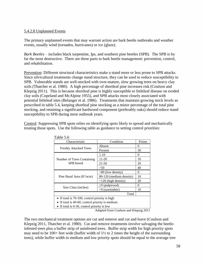
58
5.4.2.8 Unplanned Events
The primary unplanned events that may warrant action are bark beetle outbreaks and weather
events, usually wind (tornados, hurricanes) or ice (glaze).
Bark Beetles – includes black turpentine, Ips, and southern pine beetles (SPB). The SPB is by
far the most destructive. There are three parts to bark beetle management: prevention, control,
and rehabilitation.
Prevention: Different structural characteristics make a stand more or less prone to SPB attacks.
Since silvicultural treatments change stand structure, they can be used to reduce susceptibility to
SPB. Vulnerable stands are well-stocked with over-mature, slow growing trees on heavy clay
soils (Thatcher et al. 1980). A high percentage of shortleaf pine increases risk (Coulson and
Klepzig 2011). This is because shortleaf pine is highly susceptible to littleleaf disease on eroded
clay soils (Copeland and McAlpine 1955), and SPB attacks most closely associated with
potential littleleaf sites (Belanger et al. 1986). Treatments that maintain growing stock levels as
prescribed in table 5.4, keeping shortleaf pine stocking as a minor percentage of the total pine
stocking, and retaining a significant hardwood component (preferably oaks) should reduce stand
susceptibility to SPB during most outbreak years.
Control: Suppressing SPB spots relies on identifying spots likely to spread and mechanically
treating those spots. Use the following table as guidance to setting control priorities:
Table 5.6 Characteristic Condition Points
Freshly Attacked Trees Absent 0
Present 30
Number of Trees Containing
SPB brood
1-10 0
11-20 10
21-50 20
>50 40
Pine Basal Area (ft2/acre)
<80 (low density) 0
80-120 (medium density) 10
>120 (high density) 20
Size Class (inches) ≤9 (pulpwood) 0
>9 (sawtimber) 10
Total
If total is 70-100, control priority is high
If total is 40-60, control priority is medium
If total is 0-30, control priority is low
Adapted from Coulson and Klepzig 2011
The two mechanical treatment options are cut and remove and cut and leave (Coulson and
Klepzig 2011, Thatcher et al. 1980). Cut and remove treatments involve salvaging the beetle-
infested trees plus a buffer strip of uninfested trees. Buffer strip width for high priority spots
may need to be 100+ feet wide (buffer width of 1½ to 2 times the height of the surrounding
trees), while buffer width in medium and low priority spots should be equal to the average tree

59
height in the stand. Buffer trees and freshly attacked trees should be removed first, followed by
trees with SPB brood. Vacated trees may or may not be removed, depending on rehabilitation
objectives. This is the most recommended control tactic (Coulson and Klepzig 2011).
In cut and leave treatments the buffer trees, freshly attacked trees, and trees with SPB brood are
felled toward the center of the infestation. The vacated trees are left standing. While this tactic
reduces spot growth, it has questionable effectiveness in reducing brood survival (Coulson and
Klepzig 2011). It also greatly increases fuel load which, depending on location, could create a
wildfire hazard or smoke management problem. As such it should only be used when cut and
remove cannot be employed due to small spot size, difficult access, unmerchantable trees, etc.
Rehabilitation: Conditions created by SPB spots may or may not be in line with the refuge goal
of sustainably producing RCW habitat to achieve the recovery objective. SPB spots create gaps
by killing overstory pine trees, an essential component of RCW habitat. The question is whether
or not to regenerate (either naturally or artificially) these gaps to provide future RCW habitat.
Planned regeneration treatments occur at the scale of the stand; most SPB spots, meanwhile, only
represent a portion of the stand. Characteristics such as number and type of residual trees in a
spot, spot size and shape, number of spots, cumulative area in spots and distribution of spots
influence regeneration decisions. Considerations when deciding whether or not to regenerate
include (Goelz et al. 2012):
Hardwood competition is usually common in spots and must be controlled for successful
pine regeneration.
Natural regeneration works with smaller spots where seed from mature trees surrounding
the spot can adequately disperse throughout the spot. Larger spots may require artificial
regeneration unless there are seedlings in place.
Artificial regeneration is easier when spots are larger (≥ 5 acres) or a number of smaller
spots can be combined.
Regeneration treatments will be hampered unless buffer trees, freshly attacked trees, trees
with SPB brood, and vacated trees are removed. While some vacated trees may be
retained to promote natural SPB predator populations or provide snags for wildlife
habitat, the majority should be removed if regeneration treatments are planned.
Wind – wind events like tornadoes and hurricanes break the main bole of a tree, cause limb and
top breakage, and uproot trees. Generally speaking, if the stocking goes below a certain
threshold the stand will not be able to recover, and regeneration treatments are prescribed. If the
stocking remains above this threshold alternative treatments may help speed recovery from the
incident. Assess and treat wind damaged stands as follows (Dickens et al. 2008):
Severe Damage (>50% of the good quality trees with significant damage) – Regenerate.
Salvage harvest as soon as possible. Retain undamaged oaks ≥ 12” dbh and mature,
cone-bearing pines if considering natural regeneration. Pile limbs, tops and debris away
from retention trees and burn within one year. A September burn, prior to a good pine
seed year, should encourage pine regeneration. Remove pines if planning artificial
regeneration.

60
Moderate Damage (20-50% of the good quality trees with significant damage) – Carry
stand to planned rotation age. Salvage harvest broken and leaning trees. Pile limbs, tops
and debris away from retention trees and burn within one year.
Low Damage (<20% of the good quality trees with significant damage) – Carry stand to
planned rotation. Salvage harvest not necessary unless used to remove debris that could
become a smoke management concern.
Pre-Merchantable Stands – usually trees less than 30 feet tall and less than 45% lean
recover. If there are 300+ trees per acre in good condition, wait until the first prescribed
thinning to treat.
Ice – glaze storms occur every 3 to 6 years in Georgia (Brender 1973). The damage they cause is
similar to wind damage, so assess them using the same criteria. Hail damage, while less
frequent, may also fall into this category.
5.4.2.9. Non-Forest Management
Rock Outcrops – the only management activity on identified outcrops is protection. Note that
protection does not mean excluding management activities from the area surrounding an outcrop.
For example, firelines will not be installed around outcrops to keep fire out while the
surrounding area is burned during a prescribed fire. Protection means keeping equipment
(bulldozer, skidder, etc.) used for management activities in the surrounding area off the outcrop.
Canebrakes – since there is no guidance as to what differentiates small areas of cane in the
understory from canebrakes (Brantley and Platt 2001), refuge staff must use their sound
professional judgment whether or not a particular cane patch warrants treatments. Potential
treatment types include:
Selectively applied herbicides to control invasive exotic plants such as Chinese privet and
reduce hardwood competition such as sweetgum and maple (Klaus and Klaus 2011).
Reduce forest canopy to increase shoot growth (Cirtain et al. 2009). This can be through
either herbicide or mechanical (i.e. timber thinning) means.
Apply prescribed fire to promote vigor (Gagnon et al. 2013). The difficulty here is the
surrounding uplands get burned more frequently than recommended for forest grown
cane, the probable condition of much of the cane currently on the refuge. Firelines will
not be installed around cane patches to exclude fire. Instead, fire seasonality and firing
patterns will be used to mitigate excessive fire in cane.
Invasive exotic species – an effective invasive species program includes preventing the
introduction of invasive exotic species, early detection and eradication of introductions,
controlling the spread of establish populations, and managing healthy communities of native
species to compete with exotic species. Specific actions include (USDA Forest Service 2001):
Avoid or remove sources of weed seed to prevent new weed infestations and the spread
of existing weeds.
o Preventing spread may require cleaning stations for vehicles and equipment.
o Treat weeds on log decks and skid trails before harvesting activities commence.

61
Avoid creating soil conditions that promote weed germination and establishment.
o Appropriate burn unit preparation may reduce disturbances to soil.
o Retain native vegetation in and around timber harvesting activities and keep soil
disturbance to a minimum consistent with project objectives.
Re-establish vegetation on bare ground caused by project disturbance as soon as possible.
Plant native species as necessary to compete with exotic species.
Open Lands/Early Successional Habitat – this means the existing fields, pond dams, road sides,
and power line right-of-ways. All require exotic plant control since they all have varying
amounts of Bermuda grass, tall fescue, Johnson grass, and other invasive exotics. All openings
within burn units will be burned in conjunction with the surrounding unit. Cane is adjacent to
some of the openings that fall within the oak-gum-cypress desired future condition. This cane
should be allowed to expand into these openings, eventually taking over. Once the exotics are
adequately controlled in the other openings, prescribed fire should be the preferred management
activity. This allows the plant communities to develop naturally under an appropriate fire
regime. However, mechanical and/or chemical treatments, both inside and outside of burn units,
may be utilized to maintain their openness.
5.4.3 Unit by Unit Prescriptions
A prescription is a set of treatments designed to change current conditions to one that meets
goals and objectives (Helms 1998). The particular treatments prescribed depend on site-specific
conditions at the time of prescription. As such it is not possible to write prescriptions for units
that may not be treated for 10 to 15 years from now. Instead, tables 5.7 and 5.8 identify the
desired future conditions for each management unit, or compartment.
The prescription process includes:
Compartment assessment or forest inventory – see appendix 3.
A comparison between the current conditions from the inventory and the desired future
conditions identified in these tables and addressed in detail in chapter 4, Habitat
Management Goals and Objectives.
Prescribing the appropriate practices, identified in this chapter – see section 5.4,
Management Strategy Prescriptions, to change from current conditions to desired future
conditions.
The written prescription follows the guidance in appendix 5.

62
Table 5.7 Loblolly/Shortleaf Pine (P)
Current
Condition
Desired Condition
total Uneven-aged Even-aged P1 P2 P3
Compartment -------------------- acres --------------------
1 289 221 221 0 0 0 0
2 917 776 19 757 189 189 379
3 1036 856 33 823 206 206 412
4 1076 713 31 682 171 171 341
5 639 772 124 648 162 162 324
6 823 915 48 867 217 217 434
7 427 408 1 407 102 102 204
8 662 533 2 531 133 133 266
9 771 732 83 649 162 162 325
10 827 712 5 707 177 177 354
11 692 655 17 638 160 160 319
12 566 657 13 644 161 161 322
13 548 467 4 463 116 116 232
14 766 622 11 611 153 153 306
15 970 693 19 674 169 169 337
16 710 560 0 560 140 140 280
17 899 584 80 504 126 126 252
18 1348 1268 304 964 241 241 482
19 727 564 11 553 138 138 277
20 551 291 111 180 45 45 90
21 1194 810 36 774 194 194 387
22 764 695 11 684 171 171 342
23 712 464 51 413 103 103 207
24 784 412 0 412 103 103 206
25 748 558 146 412 103 103 206
26 741 407 9 398 100 100 199
27 769 643 111 532 133 133 266
28 353 351 68 283 71 71 142
29 1161 806 74 732 183 183 366
30 441 431 0 431 108 108 216
31 523 456 71 385 96 96 193
32 849 774 406 368 92 92 184
33 780 747 245 502 126 126 251
34 456 245 1 244 61 61 122
Totals 25519 20798 2366 18432 4608 4608 9216

63
Table 5.8 Oak/Pine & Oak/Hickory* Oak/Gum/Cypress (BH)
Current Condition Desired Condition Current
Condition
Desired
Condition
Upland Hardwood* Oak/Pine (M) Oak/Hickory (UH) Water total
Compartment -------------------- acres --------------------
1 173 173 93 24 0 486
2 47 240 85 245 129 46 1275
3 43 230 58 98 35 1179
4 89 353 165 87 21 1252
5 325 231 69 194 90 1162
6 138 91 17 221 191 6 1219
7 99 139 25 129 95 2 669
8 141 233 99 111 53 918
9 177 290 69 256 115 5 1210
10 195 269 96 175 128 1205
11 233 252 110 123 36 11 1065
12 314 200 91 95 31 980
13 140 205 81 95 40 793
14 94 194 124 195 140 27 1106
15 222 343 187 127 112 1335
16 103 190 82 121 107 939
17 116 327 125 102 86 1122
18 439 393 194 177 121 1976
19 188 220 95 39 86 3 968
20 68 182 130 19 35 638
21 90 284 203 93 140 8 1446
22 228 189 109 16 27 4 1023
23 154 244 150 49 58 915
24 11 231 206 86 32 882
25 150 205 169 99 77 3 1012
26 125 256 222 35 25 910
27 210 232 155 63 13 1043
28 270 173 120 45 36 680
29 244 423 200 55 51 1481
30 59 94 18 49 7 550
31 171 188 93 43 0 738
32 140 226 107 108 0 1107
33 240 239 98 58 0 3 1086
34 68 181 110 51 39 575
Totals 5504 7916 3955 3483 2158 118 34943

64

65
6.0 LITERATURE CITED
Albrecht, M.H. and K.E. Mattson. 1977. Fuel weights by types for Piedmont and Mountain
regions of North Carolina. North Carolina Forest Service Forestry Note No. 30.
Allen, A.W. 1987. Habitat suitability index models: gray squirrel. US Department of the Interior,
Fish and Wildlife Service, Biological Report 82(10.135).
Bailey, R.G. 1995. Descriptions of the ecoregions of the United States. USDA Forest Service
Miscellaneous Publication Number 1391.
Baker, J.B., M.D. Cain, J.M. Guldin, P.A. Murphy, & M.G. Shelton. 1996. Uneven-aged
silviculture for the loblolly and shortleaf pine forest cover types. USDA Forest Service General
Technical Report SO-118.
Baker, J.B. & W.E. Balmer. 1983. Loblolly pine. Pp. 148-152 in R.M. Burns, compiler.
Silvicultural systems for the major forest types of the United States. US Department of
Agriculture Handbook 445.
Barden, L.S. 1997. Historic prairies in the Piedmont of North and South Carolina, USA. Natural
Areas Journal 17(2)149-152.
Barnes, B.V., Pregitzer, K.S., Spies, T.A., Spooner, V.H. 1982. Ecological forest site
classification. Journal of Forestry 80(8):493-498.
Berlanger, R.P., R.L. Heddon, and F.H. Tainter. 1986. Managing Piedmont forests to reduce
losses from the littleleaf disease-southern pine beetle complex. US Department of Agriculture
Handbook 649.
Blaine, R.M., ed. 1994. The publications of James Edward Oglethorpe. The University of
Georgia Press, Athens, GA.
Brantley, C.G. and S.G. Platt. 2001. Canebrake conservation in the Southeastern United States.
Wildlife Society Bulletin 29(4):1175-1181.
Brender, E.V. 1960. Growth predictions for natural stands of loblolly pine in the lower
Piedmont. Georgia Forest Research Council, Report No. 6.
Brender, E.V. 1973. Silviculture of loblolly pine in the Georgia Piedmont. Georgia Forest
Research Council, Report No. 33.
Brender, E.V. 1974. Impact of past land use on the lower Piedmont Forest. Journal of Forestry
72(1):34-36.
Brender, E.V. and L.S. Davis. 1959. Influence of topography on the future composition of lower
Piedmont forests. Journal of Forestry 57(1):33-34.

66
Brender, E.V. & R.W. Cooper. 1968. Prescribed burning in Georgia’s Piedmont loblolly pine
stands. Journal of Forestry 66(1):31-36.
Brender, E.V. & N.S. Loftis, Jr. 1969. Growth of advance loblolly reproduction after removal of
overwood. Journal of Forestry 67(11):830-831.
Brender, E.V. & W.H. McNab. 1972. Loblolly pine seed production in the lower Piedmont under
various harvesting methods. Journal of Forestry 70(6):345-349.
Brose, P.H., D.H. Van Lear, and P.D. Keyser. 1999. A shelterwood-burn technique for
regenerating productive upland oak site in the Piedmont region. Southern Journal of Applied
Forestry 23(3):158-163.
Brown, J.K. & J.K Smith, eds. 2000. Wildland fire in ecosystems: effects of fire on flora. USDA
Forest Service General Technical Report RMRS-42-vol.2.
Bryan, R.R. 2007. Focus species forestry: a guide to integrating timber and biodiversity
management in Maine. Maine Audubon.
Buckner, E. 1989. Evolution of forest types in the Southeast. Pp. 27-33 In: Waldrop, T.A., ed.
Proceedings of Pine-Hardwood Mixtures: A Symposium of Management and Ecology of the
Type. USDA Forest Service General Technical Report SE-58.
Burns, R.M. and B.H. Honkala. 1990. Silvics of North America. Volumes I and II. USDA Forest
Service Agriculture Handbook No. 654.
Burton, J.D. 1980. Growth and yield in managed natural stands of loblolly and shortleaf pine in
the West Gulf Coastal Plain. USDA Forest Service Research Paper SO-159.
Byford, B. 2009. A landowner’s guide to careful logging. The Ontario Woodlot Association.
Byram, G.M. 1959. Combustion of forest fuels. In Forest Fire: Control and Use. K.P. Davis, ed.
McGraw-hill Book Co., New York.
Cain, M.D. 1993. A 10-year evelauation of prescribed winter burns in uneven-aged stands of
Pinus taeda L. and P. echinata Mill.: woody understorey vegetation response. International
Journal of Wildland Fire 3(1):13-20.
Cain, M.D. & M.G. Shelton. 2002. Does prescribed fire have a place in regenerating uneven-
aged loblolly-shortleaf pine stands? Southern Journal of Applied Forestry 26(3):117-123.
Carter, V.E. and E.A. Dow. 1969. Effects of timber harvest and regeneration on deer food and
cover. Pp. 62-65 In White-Tailed Deer in the Southern Forest Habitat. Proceedings of a
Symposium. USDA Forest Service Southern Forest Experiment Station.

67
Chen, M., E.J. Hodgkins, and W.J. Watson. 1975. Prescribed burning for improving pine
production and wildlife habitat in the hilly Coastal Plain of Alabama. Auburn University
Agricultural Experiment Station, Bulletin 473.
Cirtain, M.C., S.B. Franklin, and S.R. Pezeshki. 2009. Effect of light intensity on Arundinaria
gigantean growth and physiology. Castanea 74(3):236-246.
Clatterbuck, W.K. 2006. Treatments for improving degraded hardwood stands. Southern
Regional Forestry Publication SREF-FM-009.
Clayton, L.A., V.J. Knight Jr., & E.C. Moore, eds. 1993. The de Soto chronicles: the expedition
of Hernando de Soto to North America in 1539-1543. The University of Alabama Press.
Cleland, D.T., P.E Avers, W.H. McNab, M.E. Jensen, R.G. Bailey, T. King, W.E. Russell, W.E.
1997. National Hierarchical Framework of Ecological Units. Pp. 181-200 In Boyce, M. S. and A.
Haney, ed. Ecosystem Management Applications for Sustainable Forest and Wildlife Resources.
Yale University Press.
Conner, R.N., A. Snow, & K.A. O’Halloran. 1991. Red-cockaded woodpecker use of seed-
tree/shelterwood cuts in eastern Texas. Wildlife Society Bulletin 19(1):67-73.
Copeland, O.L., Jr. and R.G. McAlpine. 1955. The interrelations of littleleaf, site index, soil, and
ground cover in Piedmont shortleaf pine stands. Ecology 36(4):635-641.
Coulson, R.N. and K.D. Klepzig. 2011. Southern pine beetle II. USDA Forest Service General
Technical Report SRS-140.
Cowell, C.M. 1995. Presettlement Piedmont forests: patterns of composition and disturbance in
central Georgia. Annals of the Association of American Geographers 85(1):65-83.
Cowell, C.M. 1998. Historical change in vegetation and disturbance on the Georgia Piedmont.
American Midland Naturalist 140(1):78-89.
Curtis, R.O. The role of extended rotations. Pp. 165-170 In Kohm, K.A. and J.F. Franklin, eds.
Creating a Forestry for the 21st Century: the Science of Ecosystem Management. Island Press,
Washington, D.C.
Cushwa, C.T., E.V. Brender & R.W. Cooper. 1966. The response of herbaceous vegetation to
prescribed burning. USDA Forest Service Research Note SE-53.
Cushwa, C.T., E. Czuhai, R.W. Cooper, & W.H. Julian. 1969. Burning clearcut openings in
loblolly pine to improve wildlife habitat. Georgia Forest Research Paper # 61.
Cushwa, C.T. 1970. Response of legumes to prescribed burns in loblolly pine stands of the South
Carolina Piedmont. USDA Forest Service Research Note SE-140.

68
Cutko, A. 2009. Biodiversity inventory of natural lands: a how-to manual for foresters and
biologists. NatureServe Technical Report.
Czuhai, E. 1981. Considerations in prescribed fire on National Wildlife Refuges. Pp37-40 In
Wood, G.W., ed. Prescribed Fire and Wildlife in Southern Forests. Proceedings of a Symposium.
The Belle W. Baruch Institute of Clemson University.
Czuhai, E. and C.T. Cushwa. 1968. A resume of prescribed burning on the Piedmont National
Wildlife Refuge. USDA Forest Service Research Note SE-86.
DeGraaf, R.M., V.E. Scott, R.H. Hamre, L. Ernst, and S.H. Anderson. 1991. Forest and
rangeland birds of the United States: natural history and habitat use. USDA Forest Service
Agriculture Handbook 688.
Denevan, W.M. 1992. The pristine myth: the landscape of the Americas in 1492. Annals of the
Association of American Geographers 82(3):369-385.
Dickens, E.D., J. Johnson, P.M. Crosby, and B. Allen. 2008. Assessing storm damaged forest
stands. University of Georgia, Warnell School of Forest and Natural Resources. Forest Health
Publication Series #FH 2008-01.
Dixon, G.E., comp. 2002. Essential FVS: a user’s guide to the Forest Vegetation Simulator,
USDA Forest Service, Forest Management Service Center, Internal Report. (Revised: October
16, 2012).
Elzinga, C.L., D.W. Salzer, and J.W. Willoughby. 1998. Measuring and monitoring plant
populations. USDI Bureau of Land Management Technical Reference 1730-1.
Engstrom, R.T., L.A. Brennan, W.L. Neel, R.M. Farrar, S.T. Lindeman, W.K. Moser, & S.M.
Hermann. 1996. Silvicultural practices and red-cockaded woodpecker management: a reply to
Rudolph and Conner. The Wildlife Society Bulletin 24(2):334-338.
Eyre, F.H. 1980. Forest cover types of the United States and Canada. Society of American
Foresters.
Farmer, A.H., B.S. Cade, and D.F. Stauffer. 2002. Evaluation of a habitat suitability index
model. Pp. 172-179 In Kurta, A. and J. Kennedy, eds. The Indiana bat: biology and management
of a species. Bat Conservation International.
Farrar, R.M., Jr. 1996. Fundamentals of uneven-aged management in southern pine. Tall
Timbers Research Station Miscellaneous Publication No. 9.
Franklin, J.F., R.J. Mitchell, & B.J. Palik. 2007. Natural disturbance and stand development
principles for ecological forestry. USDA Forest Service General Technical Report NRS-19.

69
Francis, J.K. 1980. Soil-site factors affecting southern upland oak management and growth. Pp.
126-133 In Shropshire, F. and D. Sims, co-chairs. Mid-south upland hardwood symposium for
the practicing forester and landowner. USDA Forest Service Technical Publication SA-TP 12.
Frost, C.C. 1998. Presettlement fire frequency regimes of the United States: a first
approximation. Pp 70-81 In Pruden, T.L. and L.A. Brennan, eds. Fire in ecosystem management:
shifting the paradigm from suppression to prescription. Proceedings of the 20th Tall Timbers Fire
Ecology Conference, Tall Timbers Research Station.
Gagnon, P.R., H.A. Passmore, and W.J. Platt. 2013. Multi-year salutary effects of windstorm and fire
on river cane. Fire Ecology 9(1): 55-65.
Garrison, G.A., A.J. Bjugstad, D.A. Duncan, M.E. Lewis, and D.R. Smith. 1977. Vegetation and
environmental features of forest and range ecosystems. USDA Forest Service Agriculture
Handbook No. 475.
Garver, R.D. and R.H. Miller. 1933. Selective logging in the shortleaf and loblolly pine forests of
the Gulf States region. USDA Technical Bulletin No. 375.
Georgia Chapter, Society of American Foresters. 1979. Silvicultural guidelines for forest owners
in Georgia. Georgia Forest Research Paper No. 6.
Georgia Department of Natural Resources. 2005. A comprehensive wildlife conservation
strategy for Georgia. Georgia Department of Natural Resources, Wildlife Resources Division.
Georgia Forestry Commission. 2009. Georgia’s best management practices for forestry. Georgia
Forestry Commission.
Gingrich, S.F. 1967. Measuring and evaluating stocking and stand density in upland hardwood
forests in the Central States. Forest Science 13:38-53.
Givens, L.S. 1962. Use of fire on southeastern wildlife refuges. Pp. 121-126 In Komarek, E.V.,
ed. Proceedings of the 1st Tall Timbers Fire Ecology Conference, Tall Timbers Research Station.
Goelz, J.C.G. 1995. A stocking guide for southern bottomland hardwoods. Southern Journal of
Applied Forestry 19(3):103-104.
Goelz, J.C.G., B.L. Strom, J.P. Barnett, and M.A. Sword Sayer. 2012. Guidelines for
regenerating southern pine beetle spots. USDA Forest Service General Technical Report SRS-
153.
Grano, C.X. 1969. Precommercial thinning of loblolly pine. Journal of Forestry 67(11):825-827.
Gresham, C.A. 1996. Loblolly pine (Pinus taeda) irregular shelterwood stand development and
red-cockaded woodpecker management – a case study. Southern Journal of Applied Forestry
20(2):90-93.

70
Guyette, R.P., M.C. Stambaugh, and D.C. Dey. 2010. Developing and using fire scar histories in
the southern and eastern United States. Final Report to the Joint Fire Science Program.
Gysel, L.W. and L.J. Lyon. 1980. Habitat analysis and evaluation. Pp. 305-327 In Schemnitz,
S.D., ed. Wildlife management techniques manual. 4th edition, revised. The Wildlife Society,
Washington, DC.
Hamel, P.B. 1992. The land manager’s guide to the birds of the south. The Nature Conservancy,
Southeastern Region, Chapel Hill, NC.
Hamel, P.B. and E.R. Buckner. 1998. How far could a squirrel travel in the treetops? A
prehistory of the southern forest. Pp. 309-315 In Transactions of the 63rd North American
Wildlife and Natural Resources Conference. Wildlife Management Institute.
Harper, F. 1998. The travels of William Bartram: naturalist’s edition. The University of Georgia
Press.
Harrington, T.B. 2001a. Silvicultural basis for thinning southern pines: concepts and expected
responses. Georgia Forestry Commission, Report # FSP001.
Harrington, T.B. 2001b. Silvicultural approaches for thinning southern pines: method, intensity,
and timing. Georgia Forestry Commission Report #FSP002.
Hawkins, B.1916. Letters of Benjamin Hawkins, 1796-1806. Georgia Historical Society.
Hendrick, L.D., R.G. Hooper, D.L. Krusac, & J.M. Dabney. 1998. Silvicultural systems and red-
cockaded woodpecker management: another perspective. The Wildlife Society Bulletin
26(1):138-147.
Helms, J.A. 1998. The dictionary of forestry. The Society of American Foresters, Bethesda, MD.
Hooper, R.G. and R.F. Harlow. 1986. Forest stands selected by foraging red-cockaded
woodpeckers. USDA Forest Service Research Paper SE-259.
Hunter M.L. 1990. Wildlife, forests, and forestry: principles of managing forests for biological
diversity. Prentice Hall, Englewood Cliffs, NJ.
Hughes, R.H. 1966. Fire ecology of canebrakes. Pp. 149-158 In Komarek, E.V., Sr., chairman.
Proceedings of the Fifth Annual Tall Timbers Fire Ecology Conference.
Husch, B., C.I. Miller, and T.W. Beers. Forest Mensuration. John Wiley & Sons, New York.
Jackson, J.A. 1994. Red-cockaded Woodpecker (Picoides borealis). The Birds of North America.

71
Jones, E.P., Jr. 1993. Silvicultural treatments to maintain red-cockaded woodpecker habitat. Pp.
627-632 In Brissette, J.C., ed. Proceedings of the Seventh Biennial Southern Silvicultural
Research Conference. USDA Forest Service General Technical Report SO-93.
Johnson, D.H. 1996. Population analysis. Pp. 419-444 In Bookhout, T.A., ed. Research and
management techniques for wildlife and habitats. 5th edition, revised. The Wildlife Society,
Bethesda, Maryland.
Johnson P.S. 1993. Perspectives on the ecology and silviculture of oak-dominated forests in the
central and eastern states. USDA Forest Service General Technical Report NC-153.
Klaus, N.A., and J.M. Klaus. 2011. Evaluating tolerance of herbicide and transplantation by cane
(a native bamboo) for canebrake restoration. Restoration Ecology 19(3): 344-350.
Knapp, E.E., B.L. Estes, and C.N. Skinner. 2009. Ecological effects of prescribed fire season: a
literature review and synthesis for managers. USDA Forest Service General Technical Report
PSW-224.
Kuchler, A.W. 1964. Potential natural vegetation of the conterminous United States. American
Geographical Society Special Publication No. 36.
Landers, J.L. 1987. Prescribed burning for managing wildlife in southeastern pine forests. Pp 19-
27 In Dickson, J.G. and O.E. Maughan, eds. Managing southern forests for wildlife and fish: a
proceedings. USDA Forest Service General Technical Report SO-65.
Landers, J.L. and B.S. Mueller. 1986. Bobwhite quail management: a habitat approach. Tall
Timbers Research Station Miscellaneous Publication No. 6.
Larsen, D.R. 2002. Spreadsheet stocking diagrams for the central hardwoods. Northern Journal
of Applied Forestry 19(2):93-94.
Lay, D.W. 1956. Effects of prescribed burning on forage and mast production in southern pine
forests. Journal of Forestry 54(9):582-584.
Lay, D.W. 1957. Browse quality and the effects of prescribed burning in southern pine forests.
Journal of Forestry 55(5):342-347.
Lennartz, M.R. The red-cockaded woodpecker: old-growth species in a second growth
landscape. Natural Areas Journal 8(3):160-165.
Lennartz, M.R. & D.G. Heckel. 1987. Population dynamics of a red-cockaded woodpecker
population in Georgia Piedmont loblolly pine habitat. Pp. 48-55 In Odum, R., K.A. Riddleberger,
and J.C. Ozier, eds. Proceedings of the third southeastern nongame and endangered wildlife
symposium. Georgia Department of Natural Resources, Game and Fish Division.

72
Loeb, S.C., W.P. Pepper & A.T. Doyle. 1992. Habitat characteristics of active and abandoned
red-cockaded woodpecker colonies. Southern Journal of Applied Forestry 16(3):120-125.
Loftis, D.L. and C.E. McGee. 1993. Oak regeneration: serious problems, practical
recommendations. USDA Forest Service General Technical Report SE-84.
Long, J.N. 1985. A practical approach to density management. The Forestry Chronicle 61(1):23-
27.
Lutes, D.C., R.E. Keane, J.F. Caratti, C.H. Key, N.C. Benson, S. Sutherland, and L.J. Gangi.
2006. FIREMON: fire effects monitoring and inventory system. USDA Forest Service General
Technical Report RMRS-GTR-164-CD.
Lutes, D.C., N.C. Benson, M. Keifer, J.F. Caratti, and S.A. Streetman. 2009. FFI: a software tool
for ecological monitoring. International Journal of Wildland Fire 18:310-314.
Malmsheimer, R.W., P. Heffernan, S. Brink, D. Crandall, F. Deneke, C. Galik, E. Gee, J.A.
Helms, N. McClure, M. Mortimer, S. Ruddell, M. Smith, and J. Stewart. 2008. Forest
management solutions for mitigating climate change in the United States. Journal of Forestry
106(3):115-171.
Mann, W.F. & R.E. Lohrey, Jr. 1974. Precommercial thinning of southern pines. Journal of
Forestry 72(9):557-560.
Martin, A.C., H.S. Zim, and A.L. Nelson. 1951. A guide to wildlife food habits: the use of trees,
shrubs, weeds, and herbs by birds and mammals of the United States. Dover Publications, Inc.
New York, NY.
Masters, R.E., K. Robertson, B. Palmer, J. Cox, K. McGorty, L. Green, and C. Ambrose. 2007.
Red Hills forest stewardship guide. Tall Timbers Research Station Miscellaneous Publication
No. 12.
McClure, J.P. and H.A. Knight. 1984. Empirical yields of timber and forest biomass in the
southeast. USDA Forest Service Research Paper SE-245.
McMconnell, W.V. 1999. Red-cockaded woodpecker cavity excavation in seedtree-shelterwood
stands in the Wakulla (Apalachicola National Forest, Florida) sub-population. Wildlife Society
Bulletin 27(2):509-513.
McNab, W.H. and P.E. Avers. 1994. Ecological subregions of the United States. USDA Forest
Service General Technical Report WO-WSA-5.
Meadows, J.S. and J.A. Stanturf. 1997. Silvicultural systems for southern bottomland hardwood
forests. Forest Ecology and Management 90:127-140.

73
Mitchell, W.A., and G.H. Hughes. 1995. Fixed area plot sampling for forest inventory: section
6.2.4, U.S. Army Corps of Engineers Wildlife Resources Management Manual. Technical Report
EL-95-27.
Mitchell, W.A., G.H. Hughes, and L.E. Marcy. 1995. Prism sampling: U.S. Army Corps of
Engineers Wildlife Resources Management Manual. Technical Report EL-95-24.
Millar, C.I., N.L. Stephenson, and S.L. Stephens. 2007. Climate change and forests of the future:
managing in the face of uncertainty. Ecological Applications 17(8):2145-2151.
Miller, G.W., J.N. Kochenderfer, and D. Fekedulegn. 2004. Composition and development of
reproduction in two-age Appalachian hardwood stands: 20-year results. Pp. 171-181 In
Sheppard, W.D. and L.G. Eskew, comps. Silviculture in special places: proceeding of the
national silviculture workshop. USDA Forest Service Proceeding RMRS-P-34.
Miller, G.W., J.W. Stringer, and D.C. Mercker. 2007. Technical guide to crop tree release in
hardwood forests. Southern Regional Forestry Publication SREF-FM-011.
National Bobwhite Technical Committee. 2011. Palmer, W.E., T.M. Terhune, and D.F.
McKenzie (eds). The national bobwhite conservation initiative: a range-wide plan for re-
covering bobwhites. National Bobwhite Technical Committee Technical Publication, ver. 2.0.
National Wildfire Coordinating Group. 2008. Glossary of wildland fire terminology. PMS 205.
Nelson, T.C. and W.R. Beaufait. 1956. Studies in site evaluation for southern hardwoods.
Society of American Foresters Proceeding 57:67-70.
National Invasive Species Council. 2001. Meeting the invasive species challenge: national
invasive species management plan.
North American Waterfowl Management Plan, Plan Committee. 2004. North American
Waterfowl Management Plan 2004. Strategic Guidance: Strengthening the Biological
Foundation. Canadian Wildlife Service, U.S. Fish and Wildlife Service, Secretaria de Medio
Ambiente y Recursos Naturales.
Noss, R.F., E.T. LaRoe III, and J.M. Scott. 1995. Endangered ecosystems of the United States: a
preliminary assessment of loss and degradation. USDI National Biological Service Biological
Report 28.
Noss, R.F. 2001. Beyond Kyoto: forest management in a time of rapid climate change.
Conservation Biology 15(3):578-590.
Oliver, C.D. & B.C. Larson. 1996. Forest Stand Dynamics. Update Edition. John Wiley & Sons,
Inc., New York.

74
Payne, H.H. 1976. Soil survey of Baldwin, Jones, and Putnum Counties, Georgia. USDA Soil
Conservation Service.
Phillips, D.L. 1982. Life-forms of granite outcrop plants. American Midland Naturalist
107(1):206-208.
Putnam, J.A., G.M. Furnival, and J.S. McKnight. 1960. Management and inventory of southern
hardwoods. USDA Forest Service Agriculture Handbook No. 181.
Pyne, S.J. 2000. Where have all the fires gone? Fire Management Today 60(3):4-6.
Reineke, L.H. 1933. Perfecting a stand-density index for even-aged forests. Journal of
Agricultural Research 46:627-638.
Remsen, J,V., Jr. 1977. On taking field notes. American Birds 31(5):946-953.
Reynolds, R.R., J.B. Baker, & T.T. Ku. 1984. Four decades of selection management on the
Crossett farm forestry forties. Arkansas Agricultural Experiment Station, Bulletin 872.
Rich, T. D., C. J. Beardmore, H. Berlanga, P. J. Blancher, M. S. W. Bradstreet, G. S. Butcher, D.
W. Demarest, E. H. Dunn, W. C. Hunter, E. E. Iñigo-Elias, J. A. Kennedy, A. M. Martell, A. O.
Panjabi, D. N. Pashley, K. V. Rosenberg, C. M. Rustay, J. S. Wendt & T. C. Will. 2004. Partners
in Flight North American Landbird Conservation Plan. Cornell Lab of Ornithology. Ithaca, NY.
Roach, B.A. 1974. Scheduling timber cutting for sustained yield of wood products and wildlife.
USDA Forest Service General Technical Report NE-14.
Roach, B.A., and S.F. Gingrich. 1968. Even-aged silviculture for upland central hardwoods.
USDA Forest Service Agriculture Handbook 355.
Rostlund, E. 1957. The myth of a natural prairie belt in Alabama: an interpretation of historical
records. Association of American Geographers 47:392-411.
Rousseau, R.J. 2004. Bottomland hardwood management: species/site relationships. Mississippi
State University Extension Service publication POD rev-02-08.
Rudolph, D.C. and R.N. Conner. 1996. Red-cockaded woodpecker and silvicultural practice: is
uneven-aged silviculture preferable to even-aged? The Wildlife Society Bulletin 24(2):330-333.
Saenz, D., R.N. Conner, D.C. Rudolph, & R.T. Engstrom. 2001. Is a “hands-off” approach
appropriate for red-cockaded woodpecker conservation in twenty-first-century landscapes?
Wildlife Society Bulletin 29(3):956-966.
Sander, I.L., F.B. Clark. 1971. Reproduction of upland hardwood forests in the central states.
USDA Forest Service Agriculture Handbook 405.
75
Seagle, S.W., R.A. Lancia, D.A. Adams, M.R. Lennartz, & H.A. Devine. 1987. Integrating
timber and red-cockaded woodpecker habitat management. Pp. 41-52 In Transactions of the 52nd
North American Wildlife and Natural Resources Conference.
Schnur, L.G. 1937. Yield, stand, and volume tables for even-aged upland oak forests. USDA
Technical Bulletin No. 560.
Schultz, R.P. 1997. Loblolly pine: the ecology and culture of loblolly pine (Pinus taeda L.). US
Department of Agriculture Handbook 713.
Sims, D.H. 1992. The two-aged stand: a management alternative. USDA Forest Service
Management Bulletin R8-MB 61.
Skinner, C.N. 2007. Silviculture and forest management under a rapidly changing climate. Pp.
21-32 In Powers, R.F., technical editor. Restoring fire-adapted ecosystems: proceedings of the
2005 national silviculture workshop. USDA Forest Service General Technical Report PSW-
GTR-203.
Smith, D.M. 1986. The practice of silviculture. 8th edition. John Wiley & Sons, Inc., New York.
Smith, J.K., ed. 2000. Wildland fire in ecosystems: effects of fire on fauna. USDA Forest Service
General Technical Report RMRS-42-vol.1.
Southern Forest Fire Laboratory. 1976. Southern forestry smoke management guidebook. USDA
Forest Service General Technical Report SE-10.
Speake, D.W., E.P Hill, and V.E. Carter. 1975. Aspects of land management with regard to
production of wood and wildlife in the southeastern United States. Pp. 333-349 In Bernier, B.
and C.H. Winget, eds. Forest Soils and Forest Land Management. Proceedings of the Fourth
North American Forest Soils Conference.
Stringer, J. 2006a. Two-age system and deferment harvests. Southern Regional Forestry
Publication SREF-FM-008.
Stringer, J. 2006b. Oak shelterwood: a technique to improve oak regeneration. Southern
Regional Forestry Publication SREF-FM-005.
Thackston, R. and M. Whitney. 2001. The bobwhite quail in Georgia: history, biology and
management. Georgia Department of Natural Resources Publication.
Thatcher, R.C., J.L. Searcy, J.E. Coster, and G.D. Hertel, eds. 1980. The southern pine beetle.
USDA Forest Service Technical Bulletin 1631.
Thompson, M.T. 1998. Forest statistics for Georgia, 1997. USDA Forest Service Resource
Bulletin SRS-36.

76
Trimble, G.R., Jr. and H.C. Smith. 1976. Stand structure and stocking control in Appalachian
mixed hardwoods. USDA Forest Service Research Paper NE-340.
USDA Forest Service. 1929. Volume, yield, and stand tables for second growth southern pines.
USDA Forest Service Miscellaneous Publication No. 50. Revised 1976.
USDA Forest Service. 2001. Guide to noxious weed prevention practices. Version 1.0.
US Fish and Wildlife Service. 1970. Piedmont National Wildlife Refuge: even-aged forest
management. Bureau of Sport Fisheries and Wildlife Pamphlet RL-417-R.
US Fish and Wildlife Service. 2003. Recovery plan for the red-cockaded woodpecker (Picoides
borealis): second revision. USDI Fish and Wildlife Service, Atlanta, GA. 296pp.
US Fish and Wildlife Service. 2010. Piedmont National Wildlife Refuge comprehensive
conservation plan. USDI Fish and Wildlife Service, Atlanta, GA. 233pp.
Wade, D.D. 1993. Thinning young loblolly pine stands with fire. International Journal of
Wildland Fire 3(3):169-178.
Wade, D.D. & J.D. Lunsford. 1989. A guide for prescribed fire in southern forests. USDA Forest
Service Technical Publication R8-TP 11.
Wade, D.D., D.R. Weise, & R. Shell. 1989. Some effect of periodic winter fire on plant
communities on the Georgia Piedmont. Pp. 603-611 in Miller, H.M., complier. Proceedings of
the Fifth Biennial Southern Silvicultural Research Conference. USDA Forest Service General
Technical Report SO-74.
Wahlenberg, W.G. 1960. Loblolly pine: its use, ecology, regeneration, protection, growth and
management. The School of Forestry, Duke University, Durham, NC.
Wakeley, J.S. 1988. A method to create simplified versions of existing habitat suitability index
(HSI) models. Environmental Modelling 12(1):79-83.
Waldrop, T.A., D.H. Van Lear, F.T. Llotd, and W.R. Harms. 1987. Long-term studies of
prescribed burning in loblolly pine forests of the southeastern Coastal Plain. USDA Forest
Service General Technical Report SE-45.
Waldrop, T.A. and F.T. Lloyd. 1988. Precommercial thinning a sapling-sized loblolly pine stand
with fire. Southern Journal of Applied Forestry 12(3):203-207.
Waldrop, T.A. and S.L. Goodrick. 2012. Introduction to prescribed fire in southern ecosystems.
USDA Forest Service Science Update SRS-54.
Walker, J.S. 1995. Potential red-cockaded woodpecker habitat produced on a sustained basis
under different silvicultural systems. Pp. 112-130 in D.L. Kulhavy, R.G. Hooper, & R Costa,

77
eds. Red-cockaded woodpecker recovery, ecology and management. Center for Applied Studies
in Forestry, College of Forestry, Stephen F. Austin State University, Nacogdoches, TX.
Ward, J.D. and P.A. Mistretta. 2002. Impacts of pests on forest health. Pp. 403-428 In Southern
forest resource assessment. USDA Forest Service General Technical Report SRS-53.
Wigley, T.B., S.W. Sweeney, and J.R. Sweeney. 1999. Habitat attributes and reproduction of
red-cockaded woodpeckers in intensively managed forests. Wildlife Society Bulletin 27(3):801-
809.
Williams, G.W. 2000. Introduction to aboriginal use of fire. Fire Management Today 60(3):4-6.
Wilson, R., K. Ribbeck, S. King, and D Twedt. 2007. Restoration, management and monitoring
of forest resources in the Mississippi alluvial valley: recommendations for enhancing wildlife
habitat. LMVLV Forest Resource Conservation Working Group.
White, D.L. and F.T. Lloyd. 1995. Defining old growth: implications for management. Pp. 51-62
In Boyd, E.M., comp. Proceedings of the Eighth Biennial Southern Silvicultural Research
Conference. USDA Forest Service General Technical Report SRS-1.
White, D.L. and F.T. Lloyd. 1998. An old-growth definition for dry and dry-mesic oak-pine
forests. USDA Forest Service General Technical Report SRS-23.
Wood, G.W., ed. 1981. Prescribed fire and wildlife in southern forests. Proceedings of a
Symposium. The Belle W. Baruch Institute of Clemson University.
Worth, J.E. 1993. Before Creek and Cherokee: Georgia Indians during the early colonial era.
Fernbank Quarterly 18(3): 18-27.
Worth, J.E. 1994. Late Spanish military expeditions in the interior southeast, 1597-1628. Pp.
104-122 In Hudson, C. & C.C. Tesser, eds. The forgotten centuries: Indians and Europeans in the
American south, 1521-1704. The University of Georgia Press.
Wood, G.W., L.J. Niles, R.M. Hendrick, J.R. Davis, and T.L. Grimes. 1985. Compatibility of
even-aged timber management and red-cockaded woodpecker conservation. Wildlife Society
Bulletin 13(1):5-17.
Zeide. B. 2005. How to measure stand density. Trees 19(1):1-14.

78

79
APPENDIX 1 – SPECIES LISTS
BIRDS
Grebes
Pied-billed grebe Podilymbus podiceps
Cormorants and Darters
Double crested Cormorant Phalacrocorax auritus
Anhinga Anhinga anhinga
American Bittern Botaurus lentiginosus
Least Bittern Tigrisoma mexicanum
Great Blue Heron Ardea herodias
Great Egret Ardea alba
Snowy Egret Egretta thula
Little Blue Heron Egretta caerulea
Tricolored Heron Egretta tricolor
Cattle Egret Bubulcus ibis
Green Heron Butorides virescens
Black crowned Night Heron Nycticorax nycticorax
Yellow crowned Night Heron Nyctanassa violacea
White Ibis Eudocimus albus
Geese and Ducks
Snow Goose Chen caerulescens
Canada Goose Branta canadensis
Wood Duck Aix sponsa
Green winged Teal Anas crecca
American Black Duck Anas rubripes
Mallard Anas platyrhynchos
Northern Pintail Anas acuta
Blue winged Teal Anas discors
Northern Shoveler Anas clypeata
Gadwall Anas strepera
American Wigeon Anas americana
Canvasback Aythya valisineria
Redhead Aythya americana
Ring necked Duck Aythya collaris
Lesser Scaup Aythya affinis
Bufflehead Bucephala albeola
Common Merganser Mergus merganser
Hooded Merganser Lophodytes cucullatus

80
Red breasted Merganser Mergus serrator
Ruddy Duck Oxyura jamaicensis
Vultures, Hawks and Eagles
Black Vulture Coragyps atratus
Turkey Vulture Cathartes aura
Vultures, Hawks and Eagles
Osprey Pandion Haliaetus
Bald Eagle Haliaeetus Leucocephalus
Northern Harrier Circus Cyaneus
Sharp shinned Hawk Accipiter Striatus
Cooper's Hawk Accipiter Cooperii
Red shouldered Hawk Buteo Lineatus
Broad winged Hawk Buteo Platypterus
Red-tailed Hawk Buteo Jamaicensis
Golden Eagle Aquila Chrysaetos
American Kestrel Falco Sparverius
Turkeys and New World Quail
Wild Turkey Meleagris Gallopavo
Northern Bobwhite Colinus Virginianus
Rails, Gallinules, Coots and Cranes
King Rail Rallus Elegans
Purple Gallinule Porphyrio Martinica
Common Moorhen Gallinula Chloropus
American Coot Fulica Americana
Sandhill Crane Grus Canadensis
Plovers, Sandpipers and Phalaropes
Killdeer Charadrius Vociferous
Spotted Sandpiper Actitis Macularius
Solitary Sandpiper Tringa Solitaria
Upland Sandpiper Bartramia Longicauda
Least Sandpiper Calidris Minutilla
Common Snipe Gallinago Gallinago
American Woodcock Scolopax Minor
Greater Yellowlegs Tringa Melanoleuca
Lesser Yellowlegs Tringa Flavipes

81
Gulls
Ring billed Gull Larus Delawarensis
Pigeons and Doves
Rock Dove Columba Livia
Mourning Dove Zenaida Macroura
Cuckoos
Yellow billed Cuckoo Coccyzus Americanus
Owls
Eastern Screech Owl Megascops Asio
Great Horned Owl Bubo Virginianus
Barred Owl Strix Varia
Nightjars
Common Nighthawk Chordeiles Minor
Chuck will's Widow Caprimulgus Carolinensis
Whip poor will Caprimulgus Vociferous
Swifts
Chimney Swift Chaetura Pelagica
Hummingbirds
Ruby throated Hummingbird Archilochus Colubris
Kingfishers
Belted Kingfisher Ceryle Alcyon
Woodpeckers
Red headed Woodpecker Melanerpes Erythrocephalus
Red bellied Woodpecker Melanerpes Carolinus
Yellow bellied Sapsucker Sphyrapicus Varius
Downy Woodpecker Picoides Pubescens
Hairy Woodpecker Picoides Villosus
Northern Flicker Colaptes Auratus
Pileated Woodpecker Dryocopus Pileatus

82
Red-cockaded Woodpecker Picoides Borealis
Tyrant Flycatchers
Eastern Wood Pewee Contopus Virens
Acadian Flycatcher Empidonax Virescens
Eastern Phoebe Sayornis Phoebe
Great Crested Flycatcher Myiarchus Crinitus
Eastern Kingbird Tyrannus Tyrannus
Shrikes
Loggerhead Shrike Lanius Ludovicianus
Swallows
Purple Martin Progne Subis
Tree Swallow Tachycineta Bicolor
Northern Rough-winged Swallow Stelgidopteryx Serripennis
Barn Swallow Hirundo Rustica
Vireos
White eyed Vireo Vireo Griseus
Yellow throated Vireo Vireo Flavifrons
Blue headed Vireo Vireo Solitarius
Red-eyed Vireo Vireo Olivaceus
Jays and Crows
Blue Jay Cyanocitta Cristata
American Crow Corvus Brachyrhynchos
Fish Crow Corvus Ossifragus
Chickadees and Titmice
Carolina Chickadee Poecile Carolinensis
Tufted Titmouse Baeolophus Bicolor
Nuthatches and Creepers
Red breasted Nuthatch Sitta Canadensis
White breasted Nuthatch Sitta Carolinensis
Brown headed Nuthatch Sitta Pusilla
Brown Creeper Certhia Americana

83
Wrens
Carolina Wren Thryothorus Ludovicianus
Bewick's Wren Thryomanes Bewickii
House Wren Troglodytes Aedon
Winter Wren Troglodytes Troglodytes
Sedge Wren Cistothorus Platensis
Marsh Wren Cistothorus Palustris
Gnatcatchers, Kinglets and Thrushes
Golden crowned Kinglet Regulus Satrapa
Ruby crowned Kinglet Regulus Calendula
Blue-gray Gnatcatcher Polioptila Caerulea
Eastern Bluebird Sialia Sialis
Veery Catharus Fuscescens
Gray cheeked Thrush Catharus Minimus
Swainson's Thrush Catharus Ustulatus
Hermit Thrush Catharus Guttatus
Wood Thrush Hylocichla Mustelina
American Robin Turdus Migratorius
Mockingbirds and Thrashers
Gray Catbird Dumetella Carolinensis
Northern Mockingbird Mimus Polyglottos
Brown Thrasher Toxostoma Rufum
Pipits
American Pipit Anthus Rubescens
Waxwings
Cedar Waxwing Bombycilla Cedrorum
Starlings
European Starling Sturnus Vulgaris
Wood Warblers
Golden winged Warbler Vermivora Chrysoptera
Tennessee Warbler Vermivora Peregrine
Northern Parula Parula Americana
Yellow Warbler Dendroica Petechia

84
Wood Warblers
Chestnut sided Warbler Dendroica Pensylvanica
Magnolia Warbler Dendroica Magnolia
Cape May Warbler Dendroica Tigrina
Black throated Blue Warbler Dendroica Caerulescens
Yellow rumped Warbler Dendroica Coronata
Black throated Green Warbler Dendroica Virens
Blackburnian Warbler Dendroica Fusca
Yellow throated Warbler Dendroica Dominica
Pine Warbler Dendroica Pinus
Prairie Warbler Dendroica Discolor
Palm Warbler Dendroica Palmarum
Bay breasted Warbler Dendroica Castanea
Blackpoll Warbler Dendroica Striata
Cerulean Warbler Dendroica Cerulean
Black and white Warbler Mniotilta Varia
American Redstart Setophaga Ruticilla
Prothonotary Warbler Protonotaria Citrea
Worm eating Warbler Helmitheros Vermivorum
Ovenbird Seiurus Aurocapilla
Northern Waterthrush Seiurus Noveboracensis
Louisiana Waterthrush Seiurus Motacilla
Kentucky Warbler Oporornis Formosus
Common Yellowthroat Geothlypis Trichas
Hooded Warbler Wilsonia Citrine
Swainson’s Warbler Swainsonii Virens
Yellow breasted Chat Limnothlypis Icteria
Tanagers
Summer Tanager Piranga Rubra
Scarlet Tanager Piranga Olivacea
Grosbeaks, Sparrows and Buntings
Northern Cardinal Cardinalis Cardinalis
Rose breasted Grosbeak Pheucticus Ludovicianus
Blue Grosbeak Passerina Caerulea
Indigo Bunting Passerina Cyanea
Eastern Towhee Pipilo Erythrophthalmus
Bachman's Sparrow Aimophila Aestivalis
Chipping Sparrow Spizella Passerine
Field Sparrow Spizella Pusilla
Vesper Sparrow Pooecetes Gramineus

85
Savannah Sparrow Passerculus Sandwichensis
Fox Sparrow Passerella Iliaca
Song Sparoow Melospiza Melodia
Grosbeaks, Sparrows and Buntings
Swamp Sparrow Melospiza Georgiana
White throated Sparrow Zonotrichia Albicollis
White crowned Sparrow Zonotrichia Leucophrys
Dark eyed Junco Junco Hyemalis
Blackbirds and Orioles
Bobolink Dolichonyx Oryzivorus
Red winged Blackbird Agelaius Phoeniceus
Eastern Meadowlark Sturnella Magna
Rusty Blackbird Euphagus Carolinus
Common Grackle Quiscalus Quiscula
Brown headed Cowbird Molothrus Ater
Orchard Oriole Icterus Spurious
Finches
Purple Finch Carpodacus Purpureus
House Finch Carpodacus Mexicanus
Pine Siskin Carduelis Pinus
American Goldfinch Carduelis Tristis
Evening Grosbeak Coccothraustes Vespertinus
Old World Sparrows
House Sparrow Passer Domesticus
Other - Accidental or casual occurrences
Wood stork Mycteria Americana
Merlin Falco Columbarius
Red-necked Phalarope Phalaropus Lobatus
Scissor Tailed Flycatcher Tyrannus Forficatus
Tundra Swan Cygnus Columbianus
Yellow Rail Coturnicops Noveboracensis
Laughing Gull Larus Atricilla
Northern Oriole Icterus Galbula

86
REPTILES AND AMPHIBIANS
Turtles
Snapping turtle Chelydra Serpentine
Stinkpot Sternotherus Odoratus
Loggerhead musk turtle Sternotherus Minor
Eastern mud turtle Kinosternon Subrubrum
Eastern Box turtle Terrapene Carolina
Yellow-bellied turtle Chrysemys Scripta
River cooter *Chrysemys Concinna
Eastern painted turtle Chrysemys Picta
Eastern spiny softshell Trionyx Spiniferus
Lizards
Green anole Anolis Carolinensis
Fence lizard Sceloporus undulates
Six-lined racerunner Cnemidophorus Sexlineatus
Ground skink Leiolopisma Laterale
Five-lined skink Emeces Fasciatus
Broad headed skink Eumeces Laticeps
Southeastern five-lined skink Eumeces Inexpectatus
Eastern glass lizard Ophisaurus Ventralis
Slender glass lizard Ophisaurus Attenuatus
Snakes
Brown water snake *Nerodia (=Natrix) Taxispilota
Red-bellied water snake Nerodia (=Natrix) Errythrogaster
Midland water snake Nerodia (=Natrix) Sipedon
Queen snake Regina (=Natrix) Septemvittata
Northern brown snake Storeria Dekayi
Eastern garter snake Thamnophis Sirtalis
Easter ribbon snake Thamnophis Saurtitus
Smooth earth snake Virginia Valeriae
Rough earth snake Virginia Striatula
Eastern hognose snake Heterodon Playtyrhinos
Southern ringneck snake Diadophis Punctatus
Eastern worm snake Carphophis Amoenus
Black racer Coluber Constrictor
Eastern coachwhip Masticophis Flagellum
Rough green snake Opheodrys Aestivus
Corn snake Elaphe Guttata
Black rat snake Elaphe Obsolete
Northern pine snake Pituophis Melanoleucas

87
Eastern kingsnake Lampropeltis Getulus
Scarlet king snake Lampropeltis Triangulum
Mole snake *Lampropeltis Calligaster
Redbelly snake Storeria Occipitomaculate
Scarlet snake Cemophora Coccinea
Southeastern crowned snake Tantilla Coronata
Eastern coral snake *Micrurus Fulvius
Northern copperhead Agkistrodon Contortrix
Eastern cottonmouth *Agkistrodon Piscivorus
Canebrake rattlesnake *Crotalus Horridus
Salamanders
Mole salamanders Ambystomatidae
Marbled salamander Ambystoma Opacum
Spotted salamander *Ambystoma Maculatum
Eastern tiger salamander *Ambystoma Tigrinum
Red-spotted newt Notophthalmus Viridescens
Spotted dusky salamander Desmognathus Fuscus
Southern dusky salamander Desmognathus fuscus Auriculatus
Red-backed salamander *Plethodon Cinereus
Slimy salamander Plethodon Glutinosus
Four-toed salamander Hemidactylium Scutatum
Eastern mud salamander *Pseudotriton Montanus
Southern red salamander *Pseudotriton Rubber
Southern two-lined salamander Eurycea Bislineata
Long-tailed salamander Eurycea Longicauda
Toads and Frogs
Eastern spadefoot *Scaphiopus Holbrooki
American toad Bufo Americanus
Fowler's toad Bufo woodhousei Fowleri
Southern cricket frog Acris Gryllus
Northern cricket frog Acris Crepitans
Spring peeper Hyla Crucifer
Green treefrog Hyla Cinerea
Barking treefrog Hyla Gratiosa
Gray treefrog Hyla versicolor Chrysoscelis
Upland chorus frog Pseudacris Triseriata
Southern chorus frog *Pseudacris Nigrita
Eastern narrow-mouthed toads Gastrophryne Carolinensis
Bullfrog Rana Catesbeiana
Greenfrog Rana Clamitans
Southern leopard frog Rana Utricularia

88
MAMMALS
Marsupials
Opposum Didelphia marsupialis
Moles and Shrews
Southeastern shrew Sorex longirostris
Short-tailed shrew Blarina brevicauda
Least shrew Cryptotis parva
Eastern mole Scalopus aquaticus
Bats
Little brown myotis Myotis lucifugus
Keen's myotis Myotis keenii
Silver-haired bat Lasionycteris noctivagans
Eastern pipistrelle Pipistrellus subflavus
Big brown bat Eptesicus fuscus
Red bat Lasiurus borealis
Seminole bat Lasiurus seminolus
Hoary bat Lasiurus cinereus
Eastern yellow bat Lasiurus intermedius
Evening bat Nycticeius humeralis
Easter eared bat Plecotus refinesquei
Mexican free-tailed bat Tadarida brasiliensis
Rabbits
E. cottontail rabbit Sylvilagus floridanus
Swamp rabbit Sylvilagus aquaticus
Rodents
Eastern chipmunk Tamias striatus
Gray squirrel Sciurus carolinensis
Fox squirrel Sciurus niger
S. flying squirrel Glaucomys volans
Beaver Castor canadensis
Rice rat Oryzomys palustris
Harvest mouse Reithrodontomys humulis
White-footed mouse/wood mouse Peromyscus leucopus
Cotton mouse Peromyscus gossypinus
Golden mouse Peromyscus nuttalli
Hispid cotton rat Sigmodon hispidus

89
Eastern woodrat *Neotoma floridana
Pine vole Microtus (=Pitymys) pinetorum
Muskrat Ondatra zibethica
Rodents
Norway rat Rattus norvegicus
House mouse Mus musculus
Meadow jumping mouse Zapus hudsonius
Carnivores
Red fox Vulpes fulva
Gray fox Urocyon cinereoargenteus
Coyote Canis latrans
Raccoon Procyon lotor
Long-tailed weasel Mustela frenata
Mink Mustela vison
Spotted skunk *Spilogale putorius
Striped skunk Mephitis mephitis
River otter Lutra canadensis
Bobcat Lynx rufus
Deer
White tailed deer Odocoileus virginianus
LEPIDOPTERA
Swallowtails (Family Papilionidae)
True Swallowtails (Subfamily- Papilioninae)
Pipevine Swallowtail Battus Philenor
Zebra Swallowtail Eurytides Marcellus
Black Swallowtail Papilio Polyxenes
Giant Swallowtail Papilio Cresphontes
Eastern Tiger Swallowtail Papilio Glaucus
Spicebush Swallowtail Papilio Troilus
Palamedes Swallowtail Papilio Palamedes
Whites and Shulphurs (Family Pierdae)
Whites (Subfamily-Pierinae)
Cabbage White Pieris Rapae
Southern Dogface Colias Cesonia
Orange Sulphur Colias Eurytheme

90
Cloudless Sulphur Phoebis Sennae
Little Yellow Eurema Lisa
Sleepy Orange Eurema Nicippe
Gossamer-Wings (Family- Lycaenidae)
Harvesters (Subfamily-Miletinae)
Harvester Feniseca Tarquinius
Banded Hairstreak Satyruim Calanus
Striped Hairstreak Satyruim Liparops
Olive' Juniper Hairstreak Callophrys Gryneus
Great Purple Hairstreak Atlides Halesus
Gray Haristreak Strymon Melinus
Red-banded Hairstreak Calycopis Cecrops
Blues (Subfamily-Polyommatina)
Eastern Tailed-Blue Everes Comyntas
Summer' Spring Azure Celastrina ladon neglecta
Brushfoots (Family Nymphalidae)
Snouts (Subfamily- Libytheinae)
American Snout Libytheana Carinenta
Heliconians and Fritillaries (Subfamily- Heliconiinae)
Gulf Fritillary Agraulis Vanillae
Variegated Fritillary Euptoieta Claudia
True Brushfoots (Subfamily- Nymphalinae)
Sivery Checkerspot Chlosyne Nycteris
Pearly Crescent Phycoides Tharos
Question Mark Polygonia Interrogationis
Eastern Comma Polygonia Comma
Mourning Cloak Nymphalis Antiopa
American Lady Vanessa Virginiensis
Painted Lady Vanessa Cardui
Red Admiral Vanessa Atalanta
Common Buckeye Juonia Coenia
Admirals and Relatives (Subfamily- Limenitidinae)
Red-spotted Purple Limenitis arthemis astyanax
Viceroy Limenitis Archippus
Hackberry Butterflies (Subfamily-Apaturinae)
Hackberry Emperor Asterocampa Celtis
Tawny Emperor Asterocamp Clyton

91
Satyrs and Wood-Nymphs (Subfamily-Satyrinea)
Southern Pearly-eye Enodia Prtlandia
Creole Pearly-eye Enodia Creola
Applalchian Brown Satyrodes Appalachia
Gemmed Satyr Cyllopsis Gemma
Carolina Satyr Hermeuptychia Sosybius
Little Wood-Satyr Megisto Cymela
Common Wood Nymph Cercyonia Pegala
Milkweek Butterflies (Subfamily Danainae)
Monarch Danaus Plexippus
Skippers (Family Hesperiidae)
Spread-Winged Skippers (Subfamily-Pyrginae)
Silver-spotted Skipper Epargyreus Clarus
Long-tailed Skipper Urbanus Proteus
Hoary Edge Achalarus Lyciades
Southern Cloudywing Thorybes Bathyllus
Northern Cloudywing Throybes Pylades
Confused Couldywing Thorybes Confuses
Hayhurst's Scallopwing Stafphylus hayhurstii Hayhurstii
Juvenal's Duskywing Erynnis Juvenalis
Horace's Duskywing Erynnis Hoatius
Mottled Duskywing Erynnis Martialis
Pacuvuius Duskywing Erynnis Pacuvius
Zarucco Duskywing Erynnis Zarucco
Wild Indigo Duskywing Erynnis Baptisiae
Common/White Checkered Skipper Pyrgus sp.
Common Sootywing Pholisora Catullus
Grass Skippers (Subfamily Hesperiinae)
Swarthy Skipper Nastra Lherminier
Clouded Skipper Lerema Accius
Least Skipper Ancyloxypha Numitor
Southern Skipperling Copaeodes Minimus
Fiery Skipper Hylephila Phyleus
Crossline Skipper Polites Origenes
Tawny-edged Skipper Polites Themistocles
Whirlabout Polites Vibex
Southern Broken-Dash Wallengrenia Otho
Nrothern Broken-Dash Wallengrenia Egeremet
Little Glassywing Pompeius Verna
Sachem Atalopedes Compestris
Delaware Skipper Anatrytone Logan

92
Dyssus Skipper Problema Byssus
Hobomok Skipper Poanes Hobomok
Zabulon Skipper Poanes Zabulon
Yehl Skipper Poanes Yehl
Dion Skipper Euphyes Dion
Dun Skipper Euphyes Vestries
Lace-winged Roadside Skipper Amblyscirtes Aesculapius
Dusky Roadside Skipper Amblyscirtes Atteranata
Ocola Skipper Panoquina Ocola
Eufala Skiopper Lerodea Eufala
Twin-spot Skipper Oligoria Maculate
Dusted Skipper Atrytonopsis Hianna
COMMON PLANTS
Green ash Fraxinus pennsylvanica
Sweetgum Liquidambar styraciflua
Yellow-poplar Liriodendron tulipifera
Black willow Salix nigra
Black walnut Juglans nigra
Swamp chestnut oak Quercus michauxii
Water oak Quercus nigra
Willow oak Quercus phellos
Shumard oak Quercus shumardii
Southern red oak Quercus falcata
White oak Quercus alba
Post oak Quercus stellata
Black oak Quercus velutina
Shagbark hickory Carya Ovata
Pignut hickory Carya glabra
Mockernut hickory Carya tomentosa
Red maple Acer rubrum
Red mulberry Morus rubra
Boxelder Acer negundo
American hornbeam Carpinus caroliniana
Eastern hophornbeam Ostrya virginiana
American elm Ulmus americana
Georgia hackberry Celtis tenuifolia
Persimmon Diospyros virginiana
Winged elm Ulmus alata
American beech Fagus grandifolia
Dogwood Cornus florida
Black cherry Prunus serotina
Loblolly pine Pinus taeda
Shortleaf pine Pinus echinata
Sassafras Sassafras albidum

93
Redbud Cercis canadensis
Rusty blackhaw Viburnum rufidulum
Possumhaw Virburnum nudum
Hawthorn Crataequs spp.
Sumac Rhus spp.
Buttonbush Cephalanthus occidentalis
Southern bayberry Myrica cerifera
Japanese honeysuckle Lonicera japonica
Blueberry Vaccinium spp.
American beautyberry Callicarpa americana
Greenbrier Smilax supp.
Trumpet-creeper Campsis radicans
Blackberry Rubus spp.
Muscadine Vitis routundifolia
Partridge pea Cassia fasciculata
Ragweed Ambrosia artemisiifolia
Beggarweed Desmodium spp.
Aster Aster spp.
Fern Spp.
Switch cane Arundinaria tecta
Wild sunflower Helianthus spp.
Bluestem grass Andropogon spp.
Uniola Uniola spp.
Panicum Panicum spp.
Plumegrass Erianthus spp. spp.
Poison-Ivy Rhus radicans
Strawberry Fragaria Virginiana
*Species that should occur on the Refuge but have not been collected to date.
See also:
Edwards, M.B. 1971. Mosses of the Piedmont National Wildlife Refuge, Georgia. The
Bryologist 74(2):213-215.

94

95
APPENDIX 2 – PROCESS TO DETERMINE RESOURCES OF CONCERN
A2.1 Background
Resources of concern, as defined by the Service, are “plant and/or animal species, species
groups, or communities specifically identified in refuge purpose(s), System mission, or
international, national, regional, State, or ecosystem conservation plans or acts” (620 FW 1.4.G).
Many sources were consulted to determine a list of potential resources of concern: the refuge’s
purpose(s), the 1997 National Wildlife Refuge System Improvement Act, and the Endangered
Species Act of 1973, as well as other documents and plans including a Comprehensive Wildlife
Conservation Strategy for Georgia, Partners in Flight North American Landbird Conservation
Plan, USFWS Birds of Conservation Concern 2008, and Audubon’s 2007 Watchlist.
A2.2 Ecological Classification
The purpose of the Endangered Species Act of 1973, as amended, is “to provide a means
whereby the ecosystems upon which endangered species and threatened species depend may be
conserved” (16 USC 1531.2(b)). The 1997 National Wildlife Refuge System Improvement Act
builds on this ecosystem approach, mandating the refuge system to “ensure that the biological
integrity, diversity, and environmental health of the System are maintained” (16 USC
668dd.5(4)(B)). These terms are defined as follows (601 FW 3.6):
Integrity – biotic composition, structure, and functioning at genetic, organism, and
community levels comparable with historic conditions, including the natural biological
processes that shape genomes, organisms, and communities.
Diversity – the variety of life and its processes, including the variety of living organisms,
the genetic differences among them, and communities and ecosystems in which they
occur.
Health – composition, structure, and functioning of soil, water, air, and other abiotic
features comparable with historic conditions, including the natural abiotic processes that
shape the environment.
The definitions of integrity and health refer to historic conditions as the “composition, structure,
and functioning of ecosystems resulting from natural processes that we believe, based on sound
professional judgment, were present prior to substantial human related changes to the
landscape.”
These two acts indicate the need to utilize a top-down method to identifying resources of
concern; i.e. start at a coarse scale and work to finer scales. One approach to this is ecological
classification, which expresses the relationships between vegetation, physiography and soils
(Barnes et al. 1982). Stratifying ecological units at different scales delineates relatively
homogeneous units that respond similarly to ecological processes (i.e. energy flow, nutrient
cycling, the water cycle, disturbance) and thus to management practices.

96
A2.2.1 National Hierarchical Framework of Ecological Units
The USDA Forest Service’s National Hierarchical Framework of Ecological Units draws on the
strengths of numerous classification systems to create a national system for application
throughout the United States (Cleland et al. 1997). The following table summarizes the criteria
for the different ecological units:
Scale Ecological Units General Use Map Scale Range
Ecoregion
Domain
Strategic planning and assessment
1:30,000,000 or smaller
Division 1:30,000,000 to 1:7,500,000
Province 1:15,000,000 to 1:5,000,000
Subregion Section Strategic, statewide, multiagency
analysis and assessment
1:7,500,000 to 1:3,500,000
Subsection 1:3,500,000 to 1:250,000
Landscape Landtype association Area-wide planning 1:250,000 to 1:60,000
Land unit Landtype Project and management area planning
and analysis
1:60,000 to 1:24,000
Landtype phase 1:24,000 or larger
The classification system used starts with these ecological units. Domain, Division and Province
descriptions are from Bailey (1995), Section description from McNab and Avers (1994), and
Sub-section description from attribute data with the GIS shapefiles.
Domain – 200 Humid Temperate. The climate of the Humid Temperate Domain, located in the
middle latitudes (30 to 60 degrees N), is governed by both tropical and polar air masses. The
middle latitudes are subject to cyclones; much of the precipitation in this belt comes from rising
moist air along fronts within these cyclones. Pronounced seasons are the rule, with strong annual
cycles of temperature and precipitation. The seasonal fluctuation of energy and temperature is
greater than the diurnal. Climates of the middle latitudes have a distinctive winter season, which
tropical climates do not.
The Humid Temperate Domain contains forests of broadleaf deciduous and needleleaf evergreen
trees. The variable importance of winter frost determines six divisions: warm continental, hot
continental, subtropical, marine, prairie, and Mediterranean.
Division – 230 Subtropical. The humid subtropical climate, marked by high humidity
(especially in summer) and the absence of really cold winters, prevails in Southern Atlantic and
Gulf Coast States.
In the Koppen-Trewartha system, this area lies within the Cf climate, described as temperate and
rainy with hot summers. The Cf climate has no dry season; even the driest summer month
receives at least 1.2 inches of rain. The average temperature of the warmest summer month is
above 72F. Rainfall is ample all year, but is markedly greater during summer. Thunderstorms,
whether of thermal, squall-line, or cold-front origin, are especially frequent in summer. Tropical
cyclones and hurricanes strike the coastal area occasionally, always bringing very heavy rains.
Winter precipitation, some in the form of snow, is of the frontal type. Temperatures are
moderately wide in range and comparable to those in tropical deserts, but without the extreme
heat of a desert summer.

97
Soils in the moister, warmer parts of the humid subtropical regions are strongly leached Ultisols
related to those of the humid tropical and equatorial climates. Rich in oxides of both iron and
aluminum, these soils are poor in many of the plant nutrients essential for successful agricultural
production.
Forest provides the typical vegetation throughout most of this division. Much of the sandy
coastal region of the Southeastern United States is covered by second-growth forests of longleaf,
loblolly, and slash pines. Inland areas have deciduous forest.
Province – 231 Southern Mixed Forest. This province comprises the Piedmont and the irregular
Gulf Coastal Plains, where 50 to 80 percent of the area slopes gently toward the sea. Local relief
is 100 to 600 ft on the Gulf Coastal Plains, and 300 to 1,000 ft on the Piedmont. The flat coastal
plains have gentle slopes and local relief of less than 100 ft. Most of the numerous streams in the
region are sluggish; marshes, lakes, and swamps are numerous.
The climate is roughly uniform throughout the region. Mild winters and hot, humid summers are
the rule; the average annual temperature is 60 to 70ºF. The growing season is long (200 to 300
days), but frost occurs nearly every winter. Precipitation, which averages from 40 to 60 inches
annually, is rather evenly distributed throughout the year, but peaks slightly in midsummer or
early spring, when it falls mostly during thunderstorms. Precipitation exceeds evaporation, but
summer droughts occur. Snow falls rarely and melts almost immediately.
Climax vegetation is provided by medium-tall to tall forests of broadleaf deciduous and
needleleaf evergreen trees. At least 50 percent of the stands are made up of loblolly pine,
shortleaf pine, and other southern yellow pine species, singly or in combination. Common
associates include oak, hickory, sweetgum, blackgum, red maple, and winged elm. The main
grasses are bluestem, panicums, and longleaf uniola. Dogwood, viburnum, haw, blueberry,
American beautyberry, youpon, and numerous woody vines are common. The West Gulf Coast
is bordered along its shores by salt marshes characterized by the marsh grass Spartina.
Ultisols dominate throughout the region, with locally conspicuous Vertisols formed from marls
or soft limestones. The Vertisols are clayey soils that form wide, deep cracks when dry.
Inceptisols on floodplains of the major streams are among the better soils for crops.
Fauna vary with the age and stocking of timber stands, percent of deciduous trees, proximity to
openings, and presence of bottom-land forest types. Whitetail deer and cottontail rabbits are
widespread. When deciduous trees are present on uplands, the fox squirrel is common. Gray
squirrels live along intersecting drainages. Raccoon and fox inhabit the whole region and are
hunted in many areas. Among mammals frequently encountered in the western part of this
province is the nine-banded armadillo.
The eastern wild turkey, bobwhite, and mourning dove are widespread. Of the 20-odd bird
species present in mature forest, the most common are the pine warbler, cardinal, summer
tanager, Carolina wren, ruby-throated hummingbird, blue jay, hooded warbler, eastern towhee,
and tufted titmouse. The red-cockaded woodpecker is an endangered species.

98
Forest snakes include cottonmouth moccasin, copperhead, rough green snake, rat snake,
coachwhip, and speckled kingsnake. Fence and glass lizards are also found, as is the slimy
salamander.
Section – 231A Southern Appalachian Piedmont. This Section is in the Appalachian Piedmont
geomorphic province. It consists of an intensely metamorphosed, moderately dissected plain
consisting of thick saprolite, continental sediments, and accreted terranes. Differential erosion
has produced some isolated mountains (monadnocks) which rise above the general land surface.
Landforms on about 70 percent of the Section are irregular plains. Landforms on the remaining
area are about equally divided; plains with high hills; open low hills; and tablelands of moderate
relief. Elevation ranges from 330 to 1,300 ft. Local relief ranges from 100 to 300 ft.
Rock units formed during the Precambrian (60 percent), Paleozoic (30 percent), and Mesozoic
(10 percent) Eras. Precambrian strata consist of metamorphic complexes with compositions of
schist and phylite, and mafic paragneiss. Paleozoic strata consist of about equal amounts of
Cambrian eugeosynclinal and volcanic rocks. Mesozoic strata consists of Triassic marine
deposits (sandstone, siltstone, and shale).
Udults are the predominant soils. Paleudults and Hapludults are on gently sloping uplands.
Steeper slopes are dominated by Hapludults, Rhodudults, Dystrochrepts, and Hapludalfs.
Dystrochrepts, Udifluvents, and Fluvaquests are on alluvium. Soils have a thermic temperature
regime, and kaolinitic, mixed, or oxidic mineralogy. Soils are generally deep, with a clayey or
loamy subsoil. In many areas soils are severely eroded as a result of past intensive agricultural
practices, especially for cotton production.
Kuchler (1964) mapped the potential natural vegetation as oak-hickory-pine forest, with small
amounts of southern mixed forest in the bottomlands. Predominant vegetation form is evergreen
forest with rounded crowns, and about equal areas of cold-deciduous broad-leaved forest with
evergreen needle-leaved trees. The oak-hickory ecosystem consists of white, post, and southern
red oaks, and hickories of pignut and mockernut. The loblolly-shortleaf pine ecosystem is
common on disturbed areas and usually has an understory component of dogwood and
sourwood.
Among the fauna in this Section are white-tailed deer, black bear, bobcat, gray fox, raccoon,
cottontail rabbit, gray squirrel, fox squirrel, eastern chipmunk, white-footed mouse, pine vole,
short-tailed shrew and cotton mouse. The turkey, bobwhite, and mourning dove are game birds
in various parts of this Section. Songbirds include the red-eyed vireo, cardinal, tufted titmouse,
wood thrush, summer tanager, blue-gray gnatcatcher, hooded warbler, and Carolina wren. The
herpetofauna include the box turtle, common garter snake, and timber rattlesnake.
Average annual precipitation ranges from 45 to 55 in. Temperature averages 58 to 64º F. The
growing season lasts about 205 to 235 days.
There is moderate density of small to medium size perennial streams and associated rivers,
mostly with low to moderate rates of flow and moderate velocity. A dendritic drainage pattern

99
has developed on moderately dissected surface, with some influence from the underlying
bedrock. Many rivers drain this Section, including the Chattahoochee, Ocmulgee, Savannah,
Saluda, and Yadkin.
Fire has probably been the principal historical disturbance, previously burning over small to
moderate-size areas between natural barriers with low frequency and low intensity. Climatic
influences include occasional summer droughts and winter ice storms, and infrequent tornadoes.
Insect-related disturbances are often caused by southern pine beetles.
Sub-section – 231Aa Midland Plateau Central Uplands. 20 to 50 percent of the area is gently
sloping, local relief is 100 to 300 feet, and 50 to 75 percent of gentle slope is on upland. Ultisols
comprise the majority of the soils.
A2.2.2 Ecological Units
Finer classification was required since the 231Aa Midland Plateau Central Uplands sub-section
is too large a scale for refuge-wide planning. Research conducted on the Hitchiti Experimental
Forest indicates the rate of hardwood invasion in pine stands is strongly influenced by

100
topography (Brender and Davis 1959), suggesting its utility in determining the appropriateness
of a site for pine, pine/hardwood, or hardwood forest. Understory was mapped by the following
topographic classifications:
Aspect: NE slopes – N, NE, and E aspects; SW slopes – S, SW, W, NW and SE aspects.
Slope: Gentle – 0 to 7% slope; Moderate – 7 to 14% slope; Steep – greater than 14% slope.
Position: Upper slope – upper 2/3s of the range in elevation, intermittent creeks usually fall
entirely within this class; Lower slope – lower 1/3 of the range in elevation adjacent to
perennial creeks; Bottoms – creek bottoms and coves.
The distributions of understory types by topographic feature are as follows:
Aspect
SW NE
Percent
Pine 62 36
Pine-hardwood 23 29
Hardwood 15 35
Slope
Gentle Moderate Steep
Percent
Pine 72 51 30
Pine-hardwood 19 32 24
Hardwood 9 17 46
Position
Upper Lower Bottom
Percent
Pine 53 18 0
Pine-hardwood 25 32 13
Hardwood 22 50 87
Combining these topographic features leads to the following conclusions:
1. Pine: all gentle upper slopes and moderate upper slopes on a SW aspect.
2. Pine-hardwood: Steep upper slopes with a SW aspect, moderate upper slopes with a NW
aspect, and all moderate lower slopes.
3. Hardwood: Steep upper slopes with a NW aspect, all steep lower slopes, and bottoms.
Note that lower slope is not part of these conclusions. Looking at the tables above it appears that
gentle lower slopes on a NE aspect favor pine/hardwood, while those on a SW aspect favor pine.
Hardwoods were further subdivided using soils and topography to delineate upland hardwoods
from bottomland hardwoods.

101
The potential natural vegetation, four forest ecosystems and twelve cover types that make up the
desired forest conditions of Piedmont National Wildlife Refuge are described as follows (Eyre
1980, Garrison et al. 1977, Kuchler 1964):
Oak-Hickory-Pine (32,669 acres) – medium tall to tall forest of broadleaf deciduous and
needleleaf evergreen trees. Canopy dominants include hickory, shortleaf and loblolly pine, white
and post oak.
Loblolly/Shortleaf Pine (20,798 acres) – forests in which 50 percent or more of the stand is
loblolly pine, shortleaf pine, or other southern yellow pines, singly or in combination.
Forest types in this ecosystem include shortleaf pine (SAF 75), loblolly pine (SAF 81) and
loblolly-shortleaf pine (SAF 80).
SAF 75 – Shortleaf pine provides the majority of the stocking.
SAF 81 – Loblolly pine occurs in either pure stands or mixtures in which the species
makes up the majority of the stocking.
SAF 80 – Loblolly and shortleaf comprise a majority of the stocking. Loblolly is usually
dominate expect on drier sites and at higher elevations.
Oak/Pine (7,916 acres) – 50 percent or more of the stand is hardwoods, usually upland oaks,
but in which southern pines, mainly shortleaf pine, make up 25–49 percent of the stand.
Forest types in this ecosystem include shortleaf pine-oak (SAF 76) and loblolly pine-
hardwood (SAF 82).
SAF 76 – Shortleaf pine and one or more oak species dominate the stocking. The oak
species that occur depends more on the soil and topography than on geography.
SAF 82 – Loblolly is not dominate but comprises 25 percent of the stocking. Component
hardwoods reflect the range of moisture regimes on which the type is found.
Oak/Hickory (3,955 acres) – The ecosystem varies from open to closed woods with a strong
to weak understory of shrubs, vines, and herbaceous plants. By definition, oak and hickory
must make up 50 percent of the stand, singly or in combination.
Forest cover types in this ecosystem include post oak-blackjack oak (SAF 40), white oak-
black oak-northern red oak (SAF 52), white oak (SAF 53) and yellow poplar-white oak-
northern red oak (SAF 59). These reflect a moisture regime from dry upland sites to mesic
upland sites.
SAF 40 – Post and blackjack oaks comprise the majority of the stocking.

102
SAF 52 – White, black and northern red oak together provide a majority of the stocking.
Other oaks include scarlet, southern red, chinkapin, post and blackjack.
SAF 53 – White oak is pure.
SAF 59 – Yellow poplar, white and northern red oaks comprise a majority of the
stocking. This type usually includes a large number of mesic site species.
Southern Mixed Forest (2,158) – tall forest of broadleaf deciduous and evergreen and needleleaf
evergreen trees. Canopy dominants include beech, sweetgum, southern magnolia, loblolly pine,
and white oak.
Oak/Gum/Cypress – dominants are of tree life form. It is made up of bottomland forests in
which 50 percent or more of the stand is tupelo, blackgum, sweetgum, oak, and bald cypress,
singly or in combination.
Forest cover types in this ecosystem include swamp chestnut oak-cherrybark oak (SAF 91),
sweetgum-willow oak (SAF 92) and overcup oak-water hickory (SAF 96). These reflect a
moisture regime from mesic bottomland sites to wet bottomland sites.
SAF 91 – Swamp chestnut and cherrybark usually constitute a majority of the stocking,
but when many species are in mixture they may only form a plurality.
SAF 92 – Sweetgum and willow oak comprise a plurality of the stocking, although in the
Piedmont water oak is a strongly represented associate and frequently surpasses willow
oak.
SAF 96 – Overcup oak and water hickory make up a majority of the stocking.
The following table shows the relationship between the refuge’s potential natural vegetation,
forest ecosystems, cover types, as well as the old refuge classification scheme:
Potential Natural
Vegetation
(Kuchler 1964)
Forest Ecosystem
(Garrison et al. 1977)
Forest Cover Type
(Eyre 1980)
Refuge
classification
scheme
Oak-Hickory-Pine
32,669 acres
Loblolly/Shortleaf Pine
20,798
shortleaf pine Pine
20,798 loblolly-shortleaf pine
loblolly pine
Oak/Pine
7,916
shortleaf pine-oak
Upland
Hardwood
11,871
loblolly pine-hardwood
Oak/Hickory
3,955
post oak-blackjack oak
white oak-black oak-northern red oak
white oak
yellow poplar-white oak-northern red oak
Southern Mixed
Forest
2,158
Oak/Gum/Cypress
2,158
swamp chestnut oak-cherrybark oak Bottomland
Hardwood
2,158
sweetgum-willow oak
overcup oak-water hickory

103

104
A2.3 Potential Wildlife Resources of Concern
The next step was to create a table of wildlife species that 1) either occur on the refuge (birds) or
occur in Jones or Jasper Counties (other wildlife), and 2) are documented as a species of
conservation concern:
Scientific Name Common Name
Glo
bal
Ran
k
Sta
te R
an
k
Fe
dera
l S
tatu
s
Sta
te
Sta
tus
Sta
te
Wil
dli
fe
Pla
n
BC
C 2
008
MB
TA
PIF
Au
du
bo
n
NA
WM
P
AMPHIBIAN
Hemidactylium scutatum Four-toed Salamander* G5 S3
BIRD
Bitterns, Herons and Ibises
Ixobrychus exilis Least bittern G4 S3 X X
Geese and Ducks
Anas rubripes American Black Duck G5 S3S4 X X
Aythya affinis Lesser Scaup G5 S5 X X
Vultures, Hawks and Eagles
Haliaeetus leucocephalus Bald eagle G5 S2 T X X
Turkeys and New World Quail
Colinus virginianus Northern bobwhite G5 S4 X
Rails, Gallinules, Coots and Cranes
Rallus elegans King Rail G4G5 S3 X X X
Nightjars
Caprimulgus vociferus Whip-poor-will G5 S4 X X
Woodpeckers
Picoides borealis Red-cockaded Woodpecker G3 S2 E E X X X
Melanerpes erythrocephalus Red-headed Woodpecker G5 S4 X
Shrikes
Lanius ludovicianus Loggerhead Shrike G4T3Q S? X X
Nuthatches and Creepers
Sitta pusilla Brown-headed nuthatch G5 S5 X X
Wrens
Thryomanes bewickii Bewick's Wren G5 SH X
Cistothorus platensis Sedge Wren G5 S3 X X
Gnatcatchers, Kinglets and Thrushes
Hylocichla mustelina Wood Thrush G5 S5 X X X X
Wood Warblers
Dendroica cerulea Cerulean Warbler G4 S1 X X X X
Oporornis formosus Kentucky warbler G5 S5 X X X X
Dendroica discolor Prairie Warbler G5 S5 X X X X
Protonotaria citrea Prothonotary Warbler G5 S5 X X
Limnothlypis swainsonii Swainson's warbler G4 S3 X X X X
Helmitheros vermivorus Worm-eating Warbler G5 S5 X X
Grosbeaks, Sparrows and Buntings
Aimophila aestivalis Bachman's sparrow G3 S3 R X X X X
Blackbirds and Orioles
Euphagus carolinus Rusty Blackbird G4 S5 X X X X
Casual Occurrence
Mycteria americana Wood Stork G4 S2 E E
FISH
Cyprinella xaenura Altamaha shiner G2G3 S2S3 E X
Etheostoma parvipinne Goldstripe darter G4G5 S2S3 R X
* The four-toed salamander is not on any list of conservation concern; however, the Georgia Department of Natural
Resources recommended its inclusion.

105
State Wildlife Plan – Georgia’s Comprehensive Wildlife Conservation Strategy, chapter 11, table 5
BCC 2008 – Birds of Conservation Concern 2008, table 27
MBTA – Migratory Bird Treaty Act
PIF – Partner’s in Flight American Landbird Conservation Plan, table 8, Watch List species
Audubon – 2007 Watchlist, red and yellow categories
NAWMP – North American Waterfowl Management Plan, Implementation Framework, table B-2, waterfowl
conservation region 29, high continental priority species
The following species – least bittern, bald eagle, king rail, loggerhead shrike, Bewick’s wren,
sedge wren, cerulean warbler, prothonothary warbler, and wood stork – where removed from the
list due to their rare or only occasional use of the refuge. The table was rearranged as a
species/habitat matrix. A species/habitat matrix is simply a way to depict relationships between
wildlife species and vegetation associations (DeGraaf et al. 1991):
Species
Lo
blo
lly
/
Sh
ort
leaf
Oak
/Pin
e
Oak
/ H
ick
ory
Oak
/Gu
m/
Cy
pre
ss
Elm
/Ash
/
Co
tto
nw
oo
d
Fie
ld
Wet
Mea
do
w
Mar
sh,
Po
nd
Lak
e, S
trea
m,
Riv
er
Red-cockaded woodpecker
X
Brown-headed nuthatch
X X
Red-headed Woodpecker
X X
Bachman's sparrow
X X X X
Northern bobwhite
X X X X
Wood Thrush X X X X
Worm-eating Warbler
X X X X
Prairie Warbler X X X X X
Whip-poor-will X X X X X
Kentucky warbler
X X X X
Rusty Blackbird
X X
Swainson's warbler
X
Four-toed Salamander
X X
American Black Duck
X X X X
Lesser Scaup X X
Altamaha shiner
X
Goldstripe darter
X
The highlighted area covers 99% of the refuge.
The vegetation types used in this matrix are described as follows (DeGraaf et al. 1991):

106
Loblolly-Shortleaf Pine – loblolly and shortleaf pines together comprise a majority of the
stocking.
Oak-Pine – upland oaks and pines, usually loblolly or shortleaf pine, each comprise 25%
of the stocking.
Oak-Hickory – oak and hickory compose most of the stocking, while pines constitute less
than 25% of the stocking.
Oak-gum-cypress – tupelo, blackgum, sweetgum, oak, and bald-cypress, singly or in
combination, comprise most of the stocking; pines contribute less than 25% of the
stocking.
Elm-Ash-Cottonwood – elm, ash, cottonwood or red maple comprise most of the
stocking.
Field – primarily grass, hayfields and abandoned agricultural land.
Wet Meadow – meadows dominated by grasses or sedges with soils that are saturated or
seasonally flooded.
Marsh, Pond – palustrine and lacustrine wetlands, permanently flooded, containing
emergents such as cattails, bulrushes, rushes, and floating-leaved plants.
Lake, Stream, River – stratified lacustrine wetlands, permanently flowing watercourses of
any width.
A2.4 Potential Habitat Resources of Concern
The third step was to identify habitat(s) of concern. Georgia's Department of Natural Resources,
in their Comprehensive Wildlife Conservation Strategy, listed sixteen high priority habitats for
the Piedmont physiographic province (Georgia Department of Natural Resources 2005). Eleven
of these may occur on the refuge:
1. Beaver Ponds; Freshwater Marsh – Beaver ponds are temporary impoundments created
by beaver on small to medium sized streams. Freshwater marshes develop in shallow
beaver ponds and along the edges of larger lakes and ponds. Dominants include a variety
of sedges, rushes, grasses, and forbs, with scattered buttonbush, red maple, swamp
dogwood, and tag alder. Few Georgia examples exist that are not invaded by the exotic
weed, Murdannia. These wetlands provide habitat for a wide variety of wildlife species.
2. Bottomland Hardwood Forests – Forested wetlands of alluvial river floodplains,
characterized by a diverse association of deciduous hardwood trees. Canopy dominants
vary, but may include water oak, willow oak, overcup oak, cherrybark oak, swamp
chestnut oak, green ash, sweetgum, bitternut hickory, and pignut hickory. Shrub layer
may be dense or relatively sparse, containing a variety of mesophytic or hydrrophytic
woody plants and often a significant woody vine component. Many of these habitats
have been impacted by invasive exotic species such as Chinese privet and Nepalese
browntop. Bottomland hardwoods are a threatened forest ecosystem, with a 70-84%
decline (Noss et al. 1995).
3. Canebrakes – Thickets of native river cane found along rivers and creeks under sparse to
full tree cover. Canebrakes represent important wildlife habitat for a variety of
neotropical birds and insects. These habitats require fire or other form of periodic

107
disturbance for maintenance. Most canebrakes in this region are relatively small and fire-
suppressed, often occurring along the edges of fields and other clearings.
4. Granite Outcrops – Diverse mosaics of exposed granitic rock, herb and shrub dominated
patches, and wetland microhabitats. Most have shallow solution pits that collect soil and
support various stages of plant succession. These environments support rare or endemic
species of plants and animals. The most important of these habitats contain a variety of
solution pits, seepage zones, and bare rock exposures. Some outcrops are monadnocks
(rise above the ground) while others are flat rock exposures. The Georgia Piedmont is
the center of granite outcrop species diversity.
5. Mesic Hardwood Forests – Non-wetland forests of floodplains, ravines, and north-facing
slopes in the Piedmont. These may include species such as American beech, white oak,
northern red oak, bitternut hickory, pignut hickory, shagbark hickory, bigleaf magnolia,
yellow poplar, blackgum, dogwood, black cherry, and loblolly pine. Typical shrubs
include spicebush, sweetshrub, pawpaw, Oconee azalea, rusty viburnum, and pinxter-
flower.
6. Oak Woodlands and Savannas – Rare upland hardwood habitats found in scattered
locations in the Piedmont. These xeric or subxeric oak-dominated woodlands are
influenced by edaphic conditions (i.e. thin soils, mafic rocks) and periodic fire.
Dominants may include southern red oak, scarlet oak, post oak, and blackjack oak,
sometimes with shortleaf pine. Sparkleberry and hawbushes are common shrub
components. A particularly rare type, the post oak-blackjack oak savanna, was
apparently much more common in pre-settlement times; only small, fire-suppressed
remnants of these habitats exist today.
7. Oak-Hickory-Pine Forest – Considered the climax forest of the Piedmont, this forest type
formerly covered 50% to 75% of the region; most examples on fertile soils were
eliminated by conversion to agricultural uses. Remaining examples are often found in
rocky areas that were difficult to convert to agricultural fields. Typically include a
variety of hardwood species such as white oak, black oak, southern red oak, pignut
hickory, shagbark hickory, mockernut hickory, red maple, blackgum, shortleaf pine, and
loblolly pine, with dogwood, rusty viburnum, hog plum, dwarf pawpaw, and various
hawbushes in the understory. American chestnut was formerly a major component of the
canopy in the upper Piedmont. Examples over circumneutral soils influenced by mafic or
ultramafic bedrock are often floristically richer, and may contain species such as
Oglethorpe oak, basswood, red mulberry, redbud, and fringetree.
8. Springs and Spring Runs – Springs are highly localized groundwater expressions. The
waters of springs and associated habitats can be highly variable, depending on hydrology
(hydroperiod and volume) and edaphic factors. Springs of the Piedmont have varying
mineral content, chemical properties, and temperatures. Includes spring pools and first
order streams immediately below springs where rare fish and invertebrates may occur.
9. Streams – In the upper Piedmont, streams are low to moderate gradient and typically
contain well defined riffles and pools. Substrate consists of gravel, pebble, sand, and silt;
some bedrock may also be present. Lower Piedmont streams are lower gradient, have
fewer riffles and pools, and their substrates have a higher proportion of silt, clay, and
detritus than upper Piedmont streams. Turbidity is highly variable, but most of these
streams become highly turbid after rain.

108
10. Upland Depression Swamp – A non-alluvial open swamp with water oak, southern
shagbark hickory, Oglethorpe oak, and loblolly and shortleaf pine. Coastal plain
elements in the understory include swamp palmetto and parsley haw. Usually found on
Iredell or Enon soils in the lower Piedmont. These sticky, plastic soils pond water in the
spring, resulting in swampy conditions for a portion of the year.
11. Xeric Pine Woodlands – Pine-dominated habitats of dry, rocky ridgetops and granitic
outcrops. Dominants are loblolly, shortleaf, and Virginia pine. These woodland habitats
are maintained by a combination of edaphic factors and periodic fire.
Two of these, Bottomland Hardwood Forests and Oak-Hickory-Pine Forests, were identified as
especially important for the support of priority bird species:
1. Bottomland Hardwood Forests – Closed canopy riparian forests that lack a diverse
understory (and which may be impacted by altered hydrology, sedimentation, and
chemical run-off due to intensive pine management) can negatively influence species
such as Swainson's warbler, Louisiana waterthrush, and the Prothonotary warbler. A
threatened forest ecosystem, with a 70-84% decline (Noss et al. 1995).
2. Mature Forests of Southern Pine and Upland Hardwood (i.e. Oak-Hickory-Pine Forests)
– Priority species dependent on Southern Pine forests include the Red-cockaded
Woodpecker, the Brown-headed Nuthatch, and Bachman's Sparrow. Upland Hardwood
forests are needed to support the Wood Thrush and the Kentucky Warbler.
A2.5 Final Resources of Concern
The three steps outlined above lead to the following resources of concern for the refuge:
Wildlife resources of concern and their habitats:
6. Loblolly/Shortleaf Pine
a. Red-cockaded woodpecker
b. Bachman’s sparrow
c. Brown-headed nuthatch
d. Northern bobwhite quail
e. Prairie warbler
f. Red-headed woodpecker
7. Oak/Hickory
a. Wood thrush
b. Kentucky warbler
8. Oak/Pine
a. Wood thrush
b. Kentucky warbler
Habitat resources of concern and associated wildlife
9. Oak/Gum/Cypress
10. Unique/Rare Habitats

109
a. Beaver ponds, freshwater marsh
i. Four-toed salamander
b. Canebrakes
i. Swainson’s warbler
c. Rock outcrops
d. Springs and Spring Runs
i. Four-toed salamander
e. Streams
i. Altamaha shiner
ii. Goldstripe darter
A2.6 Final Thoughts
This process to determine the resources of concern should be thought of as always in
development. For example, the classification used to determine the desired future conditions
was based on research conducted on the Hitichi Experimental Forest in the 1950s. An iterative
process of data collection and analysis may validate and refine the current DCFs, or it may
repudiate them. The continuous forest inventory program (see appendix 3) is part of this
process, but it may require geology and agronomy specialists since geomorphology, topography
and soil characteristics are important criteria is describing the ecological potential of a site
(existing vegetation shouldn’t be a primary ecological site criterion because it is highly variable
and easily modified by management actions). Also, the wildlife resources of concern may
change depending on their status. Periodically reviewing the resources of concern is a necessary
part of this process.

110

111
APPENDIX 3 – FOREST INVENTORY
Inventory is a single point-in-time measurement to determine the presence, relative abundance,
and/or distribution of a resource of interest. Monitoring is the measurement and analysis of
repeated observations to assess change and progress towards a management objective. Cause
and effect normally cannot be statistically inferred since control and replication are usually not
part of either inventory or monitoring (Elzinga et al. 1998). The refuge forest inventory program
consists of two parts: 1) compartment inventory, used as part of the silvicultural prescription
process, and 2) continuous forest inventory, part of the overall refuge monitoring program.
Changing resources (i.e. funding, personnel) indicate the need to be flexible regarding the
intensity of inventory effort. There are three possible levels of effort (Cutko 2009):
Level 1 – Remotely sensed measurement.
Level 2 – Rapid or extensive evaluation (often qualitative).
Level 3 – Intensive measurement and evaluation (quantitative).
Remotely sensed data – whether traditional data such as aerial photographs, soil maps or
topographical maps, or modern data such as LandSat or LiDAR – can be used to delineate
stands, calculate area and determine connectivity. This data can address the following goals and
objectives:
4.1. CCP Goal 1: Manage, enhance, and restore healthy and viable populations of
migratory birds, native wildlife, and fish, including all federal and state threatened
and endangered species found on the refuge. o 4.1.1. During the 15 year time frame of the HMP manage 18,432 acres (of the
20,798 desired loblolly/shortleaf pine acres) of good quality habitat for the
endangered RCW and associated species of concern …
4.2. CCP Goal 2: Manage, enhance, and restore suitable habitat for the conservation
of migratory birds, native wildlife, fish, and plants, including all federal and state
threatened and endangered species endemic to the refuge. o 4.2.1. During the 15 year time frame of the HMP regenerate an average of 1 to 2
percent of the desired loblolly/shortleaf pine acreage in burn units annually.
o 4.2.4. During the 15 year time frame of the HMP manage 2,366 acres
loblolly/shortleaf using uneven-aged management.
o 4.2.6. During the 15 year time frame of the HMP manage 7,916 acres of oak/pine
forests to benefit wildlife and habitat diversity …
o 4.2.8. During the 15 year time frame of the HMP identify, map and protect rock
outcrops from negative impacts due to management activities.
o 4.2.9. During the 15 year time frame of the HMP identify and where possible
protect existing canebrakes from excessive disturbance caused by management
activities.
Objectives 4.1.1, 4.2.4 and 4.2.6 can only be partially addressed with remote sensing since this
data is insufficient to do a full RCW foraging habitat analysis, apply the BDq method of forest
regulation, or design intermediate treatments.

112
Rapid or extensive evaluation involves a combination of remotely sensed data and field
measurements. The field measurements may be descriptive (i.e. assigning stands to the forest
types defined in section 2.6 based on professional judgment) or plot based. Measurements using
plots may produce numbers, but the data may not be suitable for statistical analysis. These data
can address, in addition to those under remote sensing, the following goals and objectives:
4.2. CCP Goal 2: Manage, enhance, and restore suitable habitat for the conservation
of migratory birds, native wildlife, fish, and plants, including all federal and state
threatened and endangered species endemic to the refuge. o 4.2.5. During the 15 year time frame of the HMP evaluate 3,955 acres of
oak/hickory forests to determine the need for intermediate or regeneration
treatments. Design intermediate treatments to produce: 1) ≥ 25% total canopy
cover, 2) ≥ 50% of the total canopy is in hard mast producing species ≥ 12”
DBH, 3) ≥ 3 hard mast producing tree species per acre, 4) QMD ≥ 10”, and 5) ≥
5 snags per acre that are at least 8.5” DBH and 10” tall.
o 4.2.6. During the 15 year time frame of the HMP manage 7,916 acres of oak/pine
forests to benefit wildlife and habitat diversity. Design intermediate treatments to
produce: 1) ≥ 25% total canopy cover, 2) ≥ 50% of the total canopy is in hard
mast producing species ≥ 12” DBH, 3) ≥ 3 hard mast producing tree species per
acre, 4) QMD ≥ 10”, 5) ≥ 5 snags per acre that are at least 8.5” DBH and 10”
tall, and 6) maintain at least 25% of the overstory in pine.
o 4.2.7. During the 15 year time frame of the HMP evaluate 2,158 acres of
oak/gum/cypress forests to determine the need for intermediate or regeneration
treatments. Design intermediate treatments to produce: 1) 60-70% overstory
canopy cover, 2) 25-40% midstory cover, 3) 60-70 ft2/acre basal area, 4) ≥ 5
snags per acre that are at least 8.5” DBH and 10” tall, and 5) 60-70% tree
stocking.
Intensive measurement and evaluation requires more rigorous field sampling and may involve
considerable work. Detailed vegetation sampling and analysis, due to practical considerations,
are not appropriate for habitat evaluation on large areas (Gysel and Lyon 1980). Level 2
inventory is the desired level of sampling effort on the refuge.
A3.1 Compartment Inventory
The primary purpose of a compartment inventory is to systematically gather information for a
silvicultural prescription. The prescription uses the inventory as part of a rational decision
making process to evaluate current forest conditions and determine if a treatment is necessary to
move towards the desired future conditions.
Use the following steps as guidance to planning and conducting a compartment inventory:
1. Determine the number of compartments to inventory in a given year following the
guidance in chapter 5, section 5.4.2.2.

113
2. Delineate stands using aerial photographs, topographical maps, soil survey maps, or other
remotely sensed data. Don’t identify stands less than five acres.
3. Visit all delineated stands and, using sound professional judgment, assign each stand one
of the following condition classes:
P – Pine (≥50% of the stocking is pine)
Size Class:
1 – Average DBH < 5.5"
2 – Average DBH ≥5.5 ≤ 9.0"
3 – Average DBH ≥ 10.0"
Canopy Closure:
A – >70% canopy closure
B – ≤70 – 40% canopy closure
C – ≤40% canopy closure
M – Mixed Pine/Hardwood (≥50% of the stocking is hardwoods, 25-49% is pines)
UH – Upland Hardwoods (≥75% of the stocking is upland hardwoods, pine stocking
is <25%)
BH – Bottomland Hardwoods (≥75% of the stocking is bottomland hardwoods, pine
stocking is <25%)
Determine, again using sound professional judgment, stands needing treatment to achieve
the desired future conditions. NOTE – this determination should be considered
preliminary. Further analysis may change it.
4. For stands requiring treatment design a 1% inventory, using either fixed area plots or
prism sampling (also called horizontal point or variable radius). This equates to a 10 by
10 chain grid with 0.10 acre plots or 10 basal area factor prism points, or one plot/point
per 10 acres. Use a minimum of three plots per stand, even if the stand is less than 30
acres.
5. Conduct inventory using the following references as guidance: fixed area plots – Mitchell
and Hughes (1995), prism sampling Mitchell et al. (1995).
6. Take field notes while conducting the inventory. Use the format described by Remsen
(1977). Document natural (granite outcrops, large diameter or otherwise unique trees,
new RCW clusters, etc.) and cultural (wells, bottle dumps, chimneys, etc.) resources
found while inventorying. Document impressions of stand conditions with respect to
desired future conditions. Despite its descriptive nature this may be the most useful part
of the inventory.
7. Analyze and summarize stand data to address the metrics in objectives 4.1.1, 4.2.5, 4.2.6,
and 4.2.7. Use the following references as guidance: fixed area plots – Mitchell and
Hughes (1995); prism sampling – Mitchell et al. (1995). Alternatively, use a growth
model such as the Forest Vegetation Simulator to compute the desired variables. See
Dixon (2002).
8. Summarize compartment data as in tables A3.1, A3.2, A3.3, and A3.4. Use Bryan (2007)
as guidance. Address objectives 4.2.1 and 4.2.4, as appropriate.

114
Table A3.1
Compartment: Date:
Forest Ecosystem (acres)
Non-forest
Forest Type:
H, M, P, NF
Loblolly-Shortleaf Oak-Pine Oak-Hickory Oak-Gum-Cypress
Stand Number: Regeneration Pulpwood Sawtimber Regeneration Pulpwood Sawtimber Regeneration Pulpwood Sawtimber Regeneration Pulpwood Sawtimber Acres Type
Total
Adapted from Bryan 2007

Table A3.2
Forest Development Stage Summary - Acres
Forest Type Regeneration Pulpwood Sawtimber Total
Hardwood H
Mixed M Pine P
Total
Table A3.3
Forest Development Stage Summary - Percent
Forest Type Regeneration Pulpwood Sawtimber Total
Hardwood
Mixed
Pine
Total
Table A3.4
Ecosystem Summary - Acres
Regeneration Pulpwood Sawtimber Total
% of Compartment - acres -
Loblolly-Shortleaf
Oak-Pine
Oak-Hickory
Oak-Gum-Cypress
Non-Forest
Total Acres
% of Forest
Adapted from Bryan 2007
A3.2 Continuous Forest Inventory
CFI is forest monitoring designed to determine significant changes in forest characteristics
such as composition, stocking and growth over time. CFI comprises a series of small,
permanent, systematically located plots (Helms 1998). Due to the low sampling intensity
usually employed with CFI this inventory type is not appropriate for developing silvicultural
prescriptions. The objectives of this program are:
Analyze the different forest strata in terms of the objectives from chapter 4

116
116
Validate and refine the desired future condition derived in appendix 2. Note – this may
require modifications to the CFI program to incorporate abiotic data collection for
ecological site description.
There are 237 plots located on a grid throughout the refuge – see figure 1 and table A3.5 Plot
locations are unstratified since natural events like weather, insects and disease, and
management activities like prescribed fire and harvesting continually alter strata. Plots are
0.10 acres for a 0.07 percent sampling intensity, well within the recommended 0.03 to 0.1
percent intensity (Husch et al. 1982). Ten percent of the plots are sampled every year, during
the summer months. Sampling protocol follows the FIREMON: Fire Effects Monitoring and
Inventory System, plot description and tree data sampling methods (Lutes et al. 2006), with
the following modifications:
Starting Point – starting points mark the beginning of the traverse to the plot. They are
usually trees (but not always) that are easy to find and likely to remain unchanged prior to
the next inventory. Mark the SP with two parallel diagonal bark scribe marks. NOTE –
ensure the scribe marks are only in the outer bark layer, not the cambium. Document
species and diameter, and GPS location.
Course to Plot – this is the distance and azimuth (not corrected for declination) to plot
center. Plot centers are already documented and the crew should be able to navigate to
PC with a GPS unit. The course to plot allows the crew to find the plot in case of GPS
failure.
Plot Center – monument PC with a metal stake. Attach a metal tag with the plot number
stamped on it to the stake. Select two PC witness trees that are:
o Relatively close to the stake and at right angles.
o Stand out from others in the area.
o At least 3” dbh, larger if possible.
o Not expected to die or be harvested in the next 10 years.
Mark the witness trees with scribe marks in the same manner as the starting point. For
each witness tree record:
o The horizontal distance from the stake to the center of the witness tree.
o The azimuth from the stake to the witness tree.
o Tree species and diameter.
o Anything distinctive about the tree, i.e. forks at 4 feet, clump of 3, etc.
Use trees tallied on the plot as witness trees if possible.
Decide if a plot is forested or non-forested based on the plot center location. If plot
center falls on a gravel or paved road, or in a field or pond, the plot is non-forested, even
if some portion of the plot has trees. If the plot center is in a forested area, the plot is
forested.
Plot Diagram – show witness tree locations and anything unique that may be helpful in
relocating the plot at the next inventory.
Sketch Map – shows the general direction of how to get to the plot. The sketch map
should show enough information for someone to find the starting point without any other
information. They can be done using GIS.
The nested seedling subplot is 0.01 acres, 11.77 feet radius.

117
117
The breakpoint diameter at or above which overstory trees are measured on the 0.10 acre
plot and below which saplings are tallied to species/diameter classes on the 0.10 acre plot
and seedlings are tallied to species/height classes on the 0.01 acre plot is six (6) inches.
Trees at or above the breakpoint diameter are not marked with metal tags. Instead, trees
are monumented using the horizontal distance from plot center to the center of the tree,
the azimuth from PC to the center of the tree, and a bark scribe. With the scribe, make a
horizontal mark about two inches long, one inch below where dbh is taken, on the side of

118
118
the tree facing the plot center. Do not measure dbh until the scribe is made. Scribe
marks should not penetrate the cambium.
Use the FFI (FEAT/FIREMON Integrated – Lutes et al. 2009) disturbance history
protocol to record planned treatments (prescribed fire, timber harvest) and unplanned
events (southern pine beetle, wind, etc.).
Data are entered into FFI, an ecological monitoring software tool (Lutes et al. 2009). While
FFI can do some reports and analysis, it is limited. Also, it cannot do growth simulations.
Plots measured at different times in the past need to be grown to the current time, so a forest
growth model such as the Forest Vegetation Simulator (Dixon 2002) should be employed for
complete analysis. FFI can export data into FVS.
Stratify plots by the following strata:
P – Pine (≥50% of the stocking is pine)
Size Class:
1 – Average DBH < 5.5"
2 – Average DBH ≥5.5 ≤ 9.0"
3 – Average DBH ≥ 10.0"
Canopy Closure:
A – >70% canopy closure
B – ≤70 – 40% canopy closure
C – ≤40% canopy closure
M – Mixed Pine/Hardwood (≥50% of the stocking is hardwoods, 25-49% is pines)
UH – Upland Hardwoods (≥75% of the stocking is upland hardwoods, pine stocking is
<25%)
BH – Bottomland Hardwoods (≥75% of the stocking is bottomland hardwoods, pine
stocking is <25%)
Further summarize the data by the following:
For P2 and P3 (all canopy closure classes), calculate the measures of RCW good quality
foraging habitat (US Fish and Wildlife Service 2003) as structural attributes.
For M and UH calculate the variables used in the gray squirrel habitat suitability index
(Allen 1987) and the snag component of the Indiana bat HSI model (Farmer et al. 2002)
as structural variables.
For BH, calculate the primary management factors for desired stand conditions for
bottomland forests (Wilson et al. 2007) and the snag component of the Indiana bat HSI
model (Farmer et al. 2002) as structural variables.
A “cookbook” detailing specific protocols should be developed and kept on file at the refuge.
This cookbook is reviewed annually as part of the HMP annual review. Changes or additions
to the protocol (for example, changing the snag plot diameter in the tree sampling protocol,
adding quadrats to sample non-tree woody density, etc.) warrant re-writing the cookbook.

119
119
Table A3.5 – Plot Centers
Plot # X Y Plot # X Y
0 249625.5 3653327.7 39 248857.1 3661780.1
1 249625.5 3654096.1 40 245015.1 3662548.5
2 250393.9 3654096.1 41 245783.5 3662548.5
3 249625.5 3654864.5 42 246551.9 3662548.5
4 250365.6 3654909.3 43 247320.3 3662548.5
5 251162.3 3654864.5 44 248088.7 3662548.5
6 248088.7 3655632.9 45 249625.5 3662548.5
7 248857.1 3655632.9 46 250393.9 3662548.5
8 249625.5 3655632.9 47 248857.1 3662548.5
9 250393.9 3655632.9 48 246551.9 3663316.9
10 251162.3 3655632.9 49 244246.7 3663316.9
11 248088.7 3656401.3 50 245015.1 3663316.9
12 248857.1 3656401.3 51 245783.5 3663316.9
13 249625.5 3656401.3 52 247320.3 3663316.9
14 250393.9 3656401.3 53 248088.7 3663316.9
15 251162.3 3656401.3 54 248857.1 3663316.9
16 248857.1 3657169.7 55 249625.5 3663316.9
17 249625.5 3657169.7 56 250393.9 3663316.9
18 250393.9 3657169.7 57 251162.3 3663316.9
19 251162.3 3657169.7 58 245015.1 3664085.3
20 251930.7 3657169.7 59 246551.9 3664085.3
21 249625.5 3657938.1 60 247320.3 3664085.3
22 250393.9 3657938.1 61 248088.7 3664085.3
23 251162.3 3657938.1 62 249625.5 3664085.3
24 251930.7 3657938.1 63 250393.9 3664085.3
25 249625.5 3658706.5 64 253467.5 3664085.3
26 250393.9 3658706.5 65 245783.5 3664085.3
27 251930.7 3658706.5 66 248857.1 3664085.3
28 252699.1 3658706.5 67 251162.3 3664085.3
29 249625.5 3659474.9 68 244246.7 3664853.7
30 251930.7 3659474.9 69 245015.1 3664853.7
31 252699.1 3659474.9 70 245783.5 3664853.7
32 251930.7 3660243.3 71 246551.9 3664853.7
33 252699.1 3660243.3 72 247320.3 3664853.7
34 246551.9 3661011.7 73 248088.7 3664853.7
35 248088.7 3661011.7 74 248857.1 3664853.7
36 252699.1 3661011.7 75 249625.5 3664853.7
37 247320.3 3661780.1 76 250393.9 3664853.7
38 248088.7 3661780.1 77 251162.3 3664853.7

120
120
78 251930.7 3664853.7 118 251162.3 3667158.9
79 252699.1 3664853.7 119 253467.5 3667158.9
80 253467.5 3664853.7 120 254235.9 3667158.9
81 254235.9 3664853.7 121 255004.3 3667158.9
82 244246.7 3665622.1 122 242709.9 3667927.3
83 245015.1 3665622.1 123 243478.3 3667927.3
84 245783.5 3665622.1 124 244246.7 3667927.3
85 247320.3 3665622.1 125 245015.1 3667927.3
86 248088.7 3665622.1 126 245783.5 3667927.3
87 248857.1 3665622.1 127 246551.9 3667927.3
88 249625.5 3665622.1 128 247320.3 3667927.3
89 251162.3 3665622.1 129 248088.7 3667927.3
90 251930.7 3665622.1 130 248857.1 3667927.3
91 252699.1 3665622.1 131 249625.5 3667927.3
92 253467.5 3665622.1 132 250393.9 3667927.3
93 254235.9 3665622.1 133 251930.7 3667927.3
94 255004.3 3665622.1 134 252699.1 3667927.3
95 243478.3 3666390.5 135 253467.5 3667927.3
96 244246.7 3666390.5 136 254235.9 3667927.3
97 245015.1 3666390.5 137 241941.5 3668695.7
98 245783.5 3666390.5 138 242709.9 3668695.7
99 246551.9 3666390.5 139 243478.3 3668695.7
100 247320.3 3666390.5 140 244246.7 3668695.7
101 248088.7 3666390.5 141 245015.1 3668695.7
102 248857.1 3666390.5 142 245783.5 3668695.7
103 250393.9 3666390.5 143 246551.9 3668695.7
104 251162.3 3666390.5 144 247320.3 3668695.7
105 251930.7 3666390.5 145 248088.7 3668695.7
106 252699.1 3666390.5 146 248857.1 3668695.7
107 253467.5 3666390.5 147 249625.5 3668695.7
108 254235.9 3666390.5 148 250393.9 3668695.7
109 246551.9 3667158.9 149 251162.3 3668695.7
110 243478.3 3667158.9 150 251930.7 3668695.7
111 244246.7 3667158.9 151 252699.1 3668695.7
112 245015.1 3667158.9 152 253467.5 3668695.7
113 245783.5 3667158.9 153 254235.9 3668695.7
114 247320.3 3667158.9 154 241173.1 3669464.1
115 248088.7 3667158.9 155 241941.5 3669464.1
116 249625.5 3667158.9 156 242709.9 3669464.1
117 250393.9 3667158.9 157 243478.3 3669464.1

121
121
158 244246.7 3669464.1 198 245015.1 3671000.9
159 245015.1 3669464.1 199 245783.5 3671000.9
160 245783.5 3669464.1 200 246551.9 3671000.9
161 246551.9 3669464.1 201 247320.3 3671000.9
162 247320.3 3669464.1 202 248088.7 3671000.9
163 248088.7 3669464.1 203 248857.1 3671000.9
164 248857.1 3669464.1 204 249625.5 3671000.9
165 249625.5 3669464.1 205 250393.9 3671000.9
166 250393.9 3669464.1 206 251162.3 3671000.9
167 251162.3 3669464.1 207 251930.7 3671000.9
168 251930.7 3669464.1 208 252699.1 3671000.9
169 252699.1 3669464.1 209 248857.1 3671769.3
170 253467.5 3669464.1 210 251162.3 3671769.3
171 254235.9 3669464.1 211 238867.9 3671769.3
172 238867.9 3670232.5 212 240404.7 3671769.3
173 241173.1 3670232.5 213 241173.1 3671769.3
174 241941.5 3670232.5 214 241941.5 3671769.3
175 242709.9 3670232.5 215 242709.9 3671769.3
176 243478.3 3670232.5 216 243478.3 3671769.3
177 244246.7 3670232.5 217 244246.7 3671769.3
178 245015.1 3670232.5 218 245015.1 3671769.3
179 245783.5 3670232.5 219 245783.5 3671769.3
180 246551.9 3670232.5 220 246551.9 3671769.3
181 247320.3 3670232.5 221 247320.3 3671769.3
182 248088.7 3670232.5 222 248088.7 3671769.3
183 248857.1 3670232.5 223 249625.5 3671769.3
184 249625.5 3670232.5 224 250393.9 3671769.3
185 250393.9 3670232.5 225 251930.7 3671769.3
186 251162.3 3670232.5 226 252699.1 3671769.3
187 251930.7 3670232.5 227 243478.3 3672537.7
188 252699.1 3670232.5 228 244246.7 3672537.7
189 238099.5 3671000.9 229 245015.1 3672537.7
190 238867.9 3671000.9 230 245783.5 3672537.7
191 239636.3 3671000.9 231 246551.9 3672537.7
192 240404.7 3671000.9 232 248088.7 3672537.7
193 241173.1 3671000.9 233 248857.1 3672537.7
194 241941.5 3671000.9 234 251930.7 3672537.7
195 242709.9 3671000.9 235 252699.1 3672537.7
196 243478.3 3671000.9 236 253467.5 3672537.7
197 244246.7 3671000.9

122
122

APPENDIX 4 – SILVICULTURE AND HAZARDOUS FUELS

124
124

125
125
US Fish & Wildlife Service
Southeastern Region TAKING CREDIT Guidance on identifying forest management activities that meet National Fire Plan objectives
May 20, 2003 JEREMY KELLER WILDLAND-URBAN INTERFACE COORDINATOR Revised March 08, 2010 CARL SCHMIDT FORESTER RICK STRUHAR FIRE MANAGEMENT SPECIALIST US FISH & WILDLIFE SERVICE SOUTHEASTERN REGION

126
126

127
127
SUMMARY This “how-to” paper offers guidance to field stations to use in determining whether or not standard forest management practices meet the objectives for hazard fuel management laid out in the National Fire Plan. When such practices meet National Fire Plan objectives, they may be eligible for fire funding and should be tracked using the National Fire Plan Operations Reporting System (NFPORS) and the Fire Management Information System (FMIS).
TARGET AUDIENCE The primary audience of this paper includes those field unit staff involved in writing and approving forest management plans and silvicultural prescriptions as well as District and Refuge Fire Management Staff
INTRODUCTION With the implementation of the National Fire Plan in 2001, there has been an increased emphasis on funding Federal land management agencies’ efforts to manage hazard fuel on their lands. Along with this increased funding comes increased responsibility for Federal agencies to demonstrate accountability to Congress for how these efforts are progressing. Progress reporting is accomplished through NFPORS and FMIS. Because future funding decisions are in part based upon the data that agencies enter into NFPORS, accurate accomplishment reporting is critical. Many silvicultural practices commonly used in forest management activities on National Wildlife Refuges (NWRs) in the Southeastern Region meet Hazard Fuel (HF) and Wildland-Urban Interface (WUI) objectives of the National Fire Plan.
DEFINITIONS The following terms will be used throughout this paper. Definitions are provided to establish a common understanding.
Forest Management * The practical application of biological, physical, quantitative, managerial, economic, social and policy principles to the regeneration, management, utilization and conservation of forests to meet specific goals and objectives Fuel ** Any combustible material, especially petroleum-based products and wildland fuels. Fuel Characteristics ** Factors that make up fuels such as compactness, loading, horizontal continuity, vertical arrangement, chemical content, size and shape, and moisture content. Fuel Management **

128
128
The act or practice of controlling flammability and reducing resistance to control of wildland fuels through mechanical, chemical, biological or manual means, or by fire in support of land management objectives. Hazard Fuel ** A fuel complex defined by kind, arrangement, volume, condition and location that presents a threat of ignition and resistance to control. Mitigation ** Those activities implemented prior to, during or after an incident which are designed to reduce or eliminate risks to persons or property that lessen the actual or potential effects or consequence of an incident. Prescription * A planned series of treatments designed to change current stand structure to one that meets management goals. Silviculture * The art and science of controlling the establishment, growth, composition, health and quality of forests and woodlands to meet diverse needs and values on a sustainable basis. Some examples of silvicultural activities include precommercial thinning, commercial thinning, regeneration cutting, invasive exotic plant control and prescribed fire. Stand * A contiguous group of trees sufficiently uniform in age class distribution, composition and structure, and growing on a site of sufficiently uniform quality, to be a distinguishable unit.
* Definitions from the Society of American Forester’s 1998 Dictionary of Forestry ** Definitions from the National Wildfire Coordinating Group’s 2008 Glossary of Wildland Fire Terminology
HOW TO PROCEED A silvicultural prescription can be written for a single stand or a management compartment which may have numerous stands. In either case, the effects of the proposed silvicultural treatment on hazardous fuels must be considered for each stand individually. The question that you are trying to answer is:
Will the planned activities result in stand conditions that, in the event of an unwanted ignition, would reduce the possibility of a wildfire that is large, intense
or difficult to control? If the answer is “yes,” then you should be thinking of it as an HF project, as well as a forest management activity. A related question is whether or not the treatment would have any impacts on a WUI community. This question must be answered separately, and guidance is provided in a companion document to this one issued by the Regional Office entitled What is WUI?: Guidance on Determining Whether or Not your Project Involves the Wildland-Urban Interface June 27, 2003.
This procedure should be applied to
every stand in a project
area.

129
129
All silvicultural projects with WUI benefits by definition also have
HF benefits, but not all HF projects have a WUI benefit. The following step-by-step procedure will help you to determine whether or not a particular project meets National Fire Plan HF and WUI objectives.
STEP 1: WHAT IS THE POTENTIAL WILDFIRE HAZARD OF EACH STAND IN THE PROJECT AREA? The potential wildfire hazard of any given site depends on three components: weather, topography and fuel. These affect the probability of a fire start, the speed and direction of spread, its intensity, and the ability to control and extinguish a fire. The primary impact that forest management activities have on a site’s hazard potential is through their influence on fuels. Which fuels are hazardous fuels? While every piece of vegetation has some potential value as a fuel under the right conditions, we must observe some reasonable limitations in what we are calling “hazardous”. The following question must be answered:
Could the fuels in this stand, if unmanaged, result in conditions that would support large, intense or difficult to control
wildfires under typical “bad” fire year conditions? Some stands will not normally have much potential wildfire hazard, regardless of management activities. Examples include cypress domes or bottomland hardwood stands. Activities in cases such as these would not normally be included. Some cover types are well known to produce hazardous fuels if not treated. Examples include pine-dominated stands, ti-ti swamps and stands with extensive palmetto or gallberry understories. Between these two obvious extremes you must use your local knowledge to make a decision.
STEP 2: DO THE PLANNED ACTIVITIES MITIGATE WILDFIRE HAZARDS? This is an obvious question to ask, and it must be answered at the local level. The following questions may help you decide:
Does the project modify fuel characteristics in a manner
that limits potential wildfire ignition, size, spread, intensity or difficulty of control?
Does the project create or maintain stand conditions that are less prone to high-intensity fires?
A tree planting would probably not qualify, but a pre-commercial thinning or a commercial timber thinning might. Keep in mind that while logging tends to increase woody fuels because of logging debris scattered throughout the treatment area, harvesting operations usually disrupt the horizontal continuity and reduce vertical arrangement of the fuels. The immediate result tends to be stand conditions that are less prone to high intensity fires. The increased fuel load, along with subsequent vegetative growth and leaf fall, may actually increase the fire hazard in the long term without follow-up treatments. Ultimately, each project must be judged on a case-by-case basis by the responsible FMO or his/her designee, in collaboration with the unit resource management specialist(s).
Most upland site cover types
have the potential to accumulate hazardous
fuels.

130
130
STEP 3: MAKE YOUR DECISION
After analyzing the project on a stand-by-stand basis using the above criteria concerning the potential of your project to meet HF objectives, you need to make the following decision:
After consideration of the above criteria, is it reasonable to conclude that this activity helps mitigate the effects of a potential wildfire on (or moving through) the site that is large, intense or
difficult to control? If the answer is “yes,” then you should consider the project to be in keeping with the HF objectives of the National Fire Plan.
FINAL STEP: PROVIDE DOCUMENTATION It is important to provide adequate documentation of cases where silvicultural activities meet HF and WUI objectives. In addition to entering these projects into NFPORS and FMIS, the following items should be completed or incorporated into the Silvicultural Prescription. HF and WUI Worksheets A HF worksheet should be completed – see attached copy. While each stand needs to be considered individually, stands in similar condition that are proposed for the same type of treatment may be lumped as one activity. Different stand types, different stand conditions and different silvicultural treatments are different activities, and should be recorded as such on the worksheet. A single stand designated for multiple types of treatments should get its own worksheet. The process for determining whether or not the project provides mitigation benefits to a Wildland-Urban Interface (WUI) community (detailed in What is WUI?: Guidance on Determining Whether or Not your Project Involves the Wildland-Urban Interface, June 27,2003) should also be conducted for each stand, and the worksheet for that process completed. These worksheets should be maintained as documentation of the decision-making process. General Statement: The following statement should appear in the introductory section of the prescription:
“Some common silvicultural techniques employed in the management of forest resources incidentally or by design meet the Hazardous Fuels (HF) and/or Wildland-Urban Interface (WUI) mitigation objectives of the 2001 National Fire Plan. The activities planned for each stand in this project have been analyzed to determine whether or not they may contribute to the fulfillment of these objectives.”
Specific Statements:
Projects need to be entered in
both NFPORS
and FMIS.

131
131
Where planned silvicultural activities have been determined to be meeting HF objectives, the following statement should be included in the prescription:
“Silvicultural activities planned for this compartment/stand have been determined to contribute to the accomplishment of National Fire Plan Hazardous Fuels (HF) objectives. The following activities will help to mitigate the effects of a wildfire that is large, intense or difficult to control: ... “ (list planned activities)
The effects of the proposed silvicultural treatment on hazardous fuels must be considered for each stand; however, as noted above, a silvicultural prescription can be written for a single stand or a management compartment which may have numerous stands. While the analysis must consider each stand independently, the documentation may combine similar stands receiving similar treatments. Where the activities planned for a stand have also been found to be meeting National Fire Plan objectives concerning the mitigation of wildland fire danger to communities in the Wildland-Urban Interface (WUI), include the following statement:
“These activities have also been determined to contribute to the mitigation of wildland fire hazards for the following Wildland-Urban Interface (WUI) community (or communities): ...” (list communities benefiting from mitigation effects)
Summary Matrix: A matrix summarizing the HF and WUI determinations should be included as an appendix to the plan or prescription. A suggested format is attached to this document.
HOW CAN I GET FIRE FUNDING FOR THESE PROJECTS? Projects that demonstrate significant HF or WUI benefit may receive fire funding. This will be on a cost-share basis with other, non-fire funding sources. When requesting fire funding for silvicultural projects, use normal NFPORS procedures and timeframes. You should submit these projects along with all other HF projects going into NFPORS for future years. Appropriate items for fire funding include any project costs incurred. Examples include reasonable shares of the costs of expendable supplies (e.g. marking paint, etc.) and personnel costs for both planning and implementation, excluding base salaries, which are ineligible. Projects that have a demonstrated HF benefit, but not necessarily a WUI benefit, may be eligible for funding from the HF Operations sub-activity (-9263). Projects that a field unit would like to have funded from Wildland-Urban Interface (WUI) funds (-9264) must be submitted as a WUI project and will enter competition for these funds along with other WUI projects in the region. Projects that demonstrate both a HF and WUI benefit may be eligible for funding from both subactivties.

132
132
US Fish & Wildlife Service
Southeastern Region
WORKSHEET FOR HAZARDOUS FUELS POTENTIAL OF FOREST MANAGEMENT PROJECTS
Refuge
Forester or Project Leader
Fire Management Officer or Designee
What silvicultural activities are planned? Will the activity help
mitigate hazardous fuels?
Activity 1:
□ YES □ NO
Activity 2:
□ YES □ NO
Activity 3:
□ YES □ NO
Activity 4:
□ YES □ NO
Activity 5:
□ YES □ NO
Activity 6:
□ YES □ NO
attach copies of this worksheet for continuation as necessary

133
133
US Fish & Wildlife Service
Southeastern Region
SUMMARY MATRIX: Hazardous Fuels Reduction (HF) and Wildland-Urban Interface (WUI) Mitigation Potential of Forest Management Projects
Append this matrix to the Silvicultural Prescription
Refuge
Compartment Name(s) or Identifier(s)
Forester or Project Leader
Fire Management Officer or Designee
Stands and planned activities: National Fire Plan
objectives met (check all that apply):
Activity#
Acres Planned Direct Costs
Management Activity HF WUI None Subactivity Amount
attach copies of this form for continuation as necessary

134
134
HAZARDOUS FUELS WORKSHEET EXAMPLE
WORKSHEET FOR HAZARDOUS FUELS POTENTIAL OF FOREST MANAGEMENT PROJECTS
Refuge Your NWR
Forester or Project Leader Jane Forester
Fire Management Officer or Designee Joe Firefighter
What silvicultural activities are planned? Will the activity help
mitigate hazardous fuels?
Activity 1:
YES NO
Commercially thinning one mature pine stand
from above will break up crown fuel continuity
by harvesting overstory trees and reduce
vertical fuel height by the movement of heavy
logging equipment throughout the stand on 34
acres.
Activity 2:
YES NO
Commercially thinning two mature pine stands
from below will disrupt the horizontal fuel
continuity by skidding cut trees to the log
decks and reduce vertical fuel height by the
movement of heavy logging equipment throughout
the stands on 125 acres. This is near a
community at risk.
Activity 3:
YES NO
Controlling the invasive exotic plant Lespedeza
bicolor with herbicide in two mature pine
stands will reduce flashy fuels by killing
flammable vegetation on 125 acres. This is
near a community at risk.
Activity 4:
YES NO
Commercially thinning one upland hardwood stand
from below will disrupt the horizontal fuel
continuity by skidding cut trees to the log
decks and reduce vertical fuel height by the
movement of heavy logging equipment throughout
the stands on 55 acres.
Activity 5:
YES NO
Commercially thinning two bottomland hardwood
stands using crop tree release on 85 acres.
Since the fire danger is minimal due to the
fuel type, even without treatment, there is no
hazardous fuel benefit.
Activity 6:
YES NO
Tree planting old field to restore BH. Since
the fire danger is minimal due to the fuel
type, even without treatment, there is no
hazardous fuel benefit.
Attach copies of this worksheet for continuation as necessary.

135
135
SUMMARY MATRIX EXAMPLE
SUMMARY MATRIX: Hazardous Fuels Reduction (HF) and Wildland-Urban Interface (WUI) Mitigation Potential of Forest Management Projects
Append this matrix to the Forest Management Plan or Prescription
Refuge Your NWR
Compartment Name(s) or Identifier(s) Compartment X
Forester or Project Leader Jane Forester
Fire Management Officer or Designee Joe Firefighter
Stands and planned activities: National Fire Plan
objectives met (check all that apply):
Activity#
Acres Planned Direct Costs
Management Activity HF WUI None Subactivity Amount
1
34
9263
$500
Thinning one
mature pine stand
from above
X
2
125
9264
$2500
Thinning two
mature pine
stands from below
X
X
3
125
9264
$4500
Control invasive
exotics with
herbicide
X
X
4
55
9263
$600
Thinning one UH
stand from below
X
5
85
Thinning two BH
stands using crop
tree release
X
6
75
Tree planting old
field to restore
BH
X
Attach copies of this form for continuation as necessary.

136
136
US Fish & Wildlife Service
Southeastern Region WHAT IS WUI? Guidance on determining whether or not your project involves the Wildland-Urban Interface June 27, 2003 JEREMY KELLER WILDLAND-URBAN INTERFACE COORDINATOR US FISH & WILDLIFE SERVICE SOUTHEASTERN REGION FIRE STAFF

137
137
SUMMARY The term “Wildland-Urban Interface” or its’ acronym, “WUI,” has gained increased importance with the coming of the National Fire Plan. Confusion has abounded over this term, since it is nowhere defined yet everywhere emphasized. This “how-to” paper represents guidance from the Regional Fire Office as to deciding whether or not a particular project involves the Wildland-Urban Interface. This guidance is strongly influenced by the article “The Wildland/Urban Interface: What’s Really at Risk?” by Paul Summerfelt, Flagstaff (AZ) Fire Department, appearing in Fire Management Today 63:1.
TARGET AUDIENCE This “how-to” paper is intended primarily for District and Refuge Fire Management Officers and District Wildland-Urban Interface Specialists. Refuge managers and staff with responsibility for land management activities should also have an understanding of the concepts covered in order to improve coordination with fire management staff.
INTRODUCTION With the implementation of the National Fire Plan in 2001, there has been an increased emphasis on funding Federal land management agencies efforts to reduce hazardous fuels accumulations on their properties. Along with this increased funding has come increased responsibility for Federal agencies to show accountability to the Congress for how these efforts are progressing. Progress reporting is accomplished through the National Fire Plan Operations Reporting System (NFPORS) internet application. Because future funding decisions are in part based upon the data that agencies are entering into NFPORS, accurate reporting of accomplishments is critical. Knowing whether or not to check the WUI block for a project is important, but often difficult to determine. These guidelines offer some criteria that you can use in the field to help decide whether a particular project should be called “WUI.”
DEFINITIONS The following terms will be used throughout this paper. Definitions are provided here to establish a common understanding.
Mitigate To cause to become less harsh or hostile; to make less severe or painful Hazard A source of danger Vulnerability Open to attack or damage Risk Possibility of loss or injury
Source: State and Local Mitigation Planning – Understanding
Your Risks (FEMA Pub. 386-2, 2001)
138
138
HOW TO PROCEED The ultimate question that you will be trying to answer is:
Will this project mitigate the risks to a vulnerable WUI area caused by the hazard of fuels accumulation in the project area?
If the answer is “yes,” then you should be calling it a WUI project. The following step-by-step procedure will help you to determine whether or not a particular project accomplishes a WUI mitigation objective.
CRITERIA 1: DECIDE – IS THERE A WUI COMMUNITY IN PROXIMITY TO THE PROJECT If you are reducing fuel loads by prescribed burning or plowing firebreaks, and you can see buildings from where you are working, it is probably safe to say that it is a WUI project. For other projects, the answer is not always obvious. What Qualifies as Wildland-Urban Interface (WUI)? In keeping with National Fire Plan concepts, it is the policy of the Southeastern Region to not dictate a strict definition for the Wildland-Urban Interface. Instead, local FMOs are responsible for deciding what areas are a part of the WUI based on their knowledge of local conditions. The following broad guidelines are intended to assist local FMOs in making their determinations. What Qualifies as a Community?
This is a tough question. An incorporated town is an easy call, but many of the areas where our lands are located are dotted with unincorporated settlements. What about that single-wide mobile home tucked in the woods by itself? What about that hunting camp? What about uninhabited industrial structures that are still a part of the local economy? For ambiguous cases like these, remember that the question is not really whether or not someone lives there, it is whether or not a fire would have an impact on a community. The third set of criteria contains some questions on impact to communities that may be helpful in deciding. What Qualifies as “In Proximity”?
There is no set distance figure for deciding which WUI areas may be protected by the mitigating effects of your project. Whether or not a WUI area is in proximity to your project area depends upon the specific potential impacts, as determined in the next step.
CRITERIA 2: DECIDE – DOES THE PROJECT REDUCE HAZARDS? This is an obvious question to ask, and it must be answered at the local level. The following questions may help you decide:
Does the project reduce the potential for an unwanted ignition (an emergency)?
If an unwanted ignition occurs, does the project limit the potential of the ignition to grow into a large fire (a disaster)?

139
139
Would the project create a barrier to, or slow the spread of, a large fire coming from somewhere else?
Does it make the community better able to withstand the impacts of a large fire that is not prevented or suppressed?
A tree planting would probably not qualify, but a pre-commercial thinning or timber stand improvement (TSI) project that removes ladder fuels might. Each project must be judged on a case-by-case basis by the responsible FMO or his/her designee.
CRITERIA 3: DECIDE – IS THERE A POTENTIAL HAZARD TO A WUI COMMUNITY? Is there a hazard to a WUI area as the project area exists today, or as it will probably exist in the future?
Consider the potential impacts in terms of values-at-risk that could occur
if you did not carry out your project. The specter of homes going up in flames is the most obvious danger of fires in the interface. While this may be the most dramatic impact, it is certainly not the only one. A large WUI incident will result in a cascade of events, all having an impact on the community. A community may be vulnerable to many “downstream” impacts after the fire has been suppressed – and many of these secondary impacts are not given consideration in pre-incident planning. Not every type of impact listed here will apply to each WUI area, but you should take all of the appropriate factors into consideration when making your determination. The list of criteria with each type of impact is not intended to be exhaustive, as many other potential impacts exist. The lists are meant to be an example of the types of questions you should be asking. Life Safety Impacts Could a large fire in, or moving through, the project area potentially:
Threaten residential or other occupied structures within the WUI area?
Result in increased danger to firefighters and other response personnel?
Result in public panic?
Result in local 911 or other emergency reporting systems being overwhelmed with calls?
Require the evacuation of a community?
Put smoke on a road and cause a wreck?
Result in potential hazardous materials (HAZ MAT) releases?

140
140
Economic Impacts Could a large fire in, or moving through, the project area potentially:
Destroy critical community infrastructure such as powerlines, bridges or communications sites?
Disrupt livestock operations by destroying grazing areas, fences or by directly killing animals?
Require the evacuation of large numbers of livestock?
Reduce tourism or outdoor recreation use and the revenues associated with such activities?
Cause major economic losses through closed roads, airports or evacuations?
Have negative impacts on businesses that are unable to recover?
Cost jobs through impacts to forest or other resources (e.g. loggers, guides, etc.)?
Critically overextend the response capabilities of local governments?
Critically overextend the permitting and zoning functions of local communities during the rebuilding phase?
Reduce income and tax revenues by destroying significant amounts of private timber, crops or improved hunting areas?
Is the local economy so weak that loss of homes or jobs could lead to a decrease in population following the incident?
Community Health Impacts Could a large fire in, or moving through, the project area potentially:
Impact the health of residents with respiratory ailments because of heavy or persistent smoke?
Result in emotional distress or trauma among those evacuated or who lose their homes or jobs? Remember, what are small incidents to responders are big events to the victims.
Require the evacuation of special needs populations (e.g. disabled residents, nursing homes, special care facilities, etc.)?
Impact the ability of local emergency services to respond to emergency medical calls while occupied fighting the fire?

141
141
Resource Impacts Could a large fire in, or moving through, the project area potentially:
Result in the loss of economically or socially important timber or wildlife habitat resources, either on the refuge or on other lands nearby?
Result in significant damage to a community’s watershed?
Lead to erosion resulting in degradation of sport or commercial fishing resources?
Result in significant negative impacts to aesthetic values (e.g. viewsheds)? Social Impacts Could a large fire in, or moving through, the project area potentially:
Damage relations between the impacted community and the Refuge?
Will the social infrastructure for handling evacuees and victims of disaster be overwhelmed (e.g. shelters, mass feeding, temporary housing)?
Cause large changes to the social structure of communities where jobs or population are lost?
Cause an erosion of local residents’ trust in Federal wildland fire and land management policies?
Result in bad press, damaging the public image of the Fish and Wildlife Service, local government or the emergency response community?
Result in a change in the character of a community through the loss of traditional activities or occupations?
FINAL STEP: IS YOUR PROJECT MITIGATING A RISK TO A WUI COMMUNITY?
Now that you have weighed all of the criteria concerning the potential for your project to mitigate risks to a vulnerable WUI community, you need to make the decision:
After consideration of each of the above criteria, is it reasonable to conclude that this activity helps to mitigate the risks posed by
wildland fire to a community or communities? If the answer is “yes,” then you should be calling it a WUI project. The final page of this document is a worksheet to assist you in documenting your decision process as to whether or not to call a particular activity a WUI project.

142
142
US Fish & Wildlife Service
Southeastern Region
WORKSHEET FOR WUI MITIGATION POTENTIAL OF PROPOSED PROJECTS
Refuge
Project Name or Identifier
Forester or Project Leader
Fire Management Officer
Potentially Impacted WUI Community (ies): These do not have to come from the Federal Register list
What potential community impacts would result if a large fire occurred on or moved through the project area (check
all that apply):
Will the project help to mitigate these impacts?
Any “Yes” answer indicates that you have a potential WUI project
□ Life Safety Impacts
□ YES □ NO
List any potential impacts identified:
□ Economic Impacts
□ YES □ NO
List any potential impacts identified:
□ Community Health Impacts
□ YES □ NO
List any potential impacts identified:
□ Resource Impacts
□ YES □ NO
List any potential impacts identified:
□ Social Impacts
□ YES □ NO List any potential impacts identified:
□ Other Impacts
□ YES □ NO
List any potential impacts identified:

APPENDIX 5 – SILVICULTURAL PRESCRIPTIONS
A silvicultural prescription is “a planned series of treatments designed to change current stand
structure to one that meets management goals” (Helms 1998). It is an implementation document,
not a strategic one. Planning and treatment implementation are at the compartment level. The
refuge has been writing silvicultural prescriptions as part of the habitat management planning
process since timber harvesting began in 1945. To maintain continuity with previous
prescriptions, use the following outline when writing prescriptions:
1. General Description – compartment location, general lay of the land, soils, past
treatments (both timber harvesting and prescribed fire). Summarize inventory data as in
tables A3.1, A3.2, A3.3, and A3.4.
2. Wildlife and Habitat Interrelationships – reference RCW cluster site data, foraging
habitat analysis (use section 5.4.2.4. Growing Stock, as guidance), any appropriate
habitat suitability index modeling (see objectives 4.1.1, 4.2.5, 4.2.6 and 4.2.7), and other
applicable wildlife information.
3. Habitat Management Recommendations (i.e. proposed silvicultural treatments) – make
recommendations by the following categories:
a. P – Pine (≥50% of the stocking is pine)
i. Size Class:
1. 1 – Average DBH < 5.5"
2. 2 – Average DBH ≥5.5 – 9.0"
3. 3 – Average DBH > 9.0"
ii. Canopy Closure:
1. A – >70% canopy closure
2. B – ≤70 – 40% canopy closure
3. C – ≤40% canopy closure
b. M – Pine/Hardwood (≥50% of the stocking is hardwood, 25-49% is pine)
c. UH – Upland Hardwoods (>75% of the stocking is upland hardwoods)
d. BH – Bottomland Hardwoods (≥50% of the stocking is bottomland hardwoods)
Proposed treatments should include both intermediate and regeneration treatments by the
appropriate silvicultural system – see sections 5.4.2.3. Forest Regulation, 5.4.2.5.
Silvicultural Systems, and 5.4.2.6. Intermediate Treatments.
4. Other Items – this section covers details that don’t easily fit into the habitat management
recommendations:
a. Prescribed fire considerations.
b. BMP implementation.
c. Silviculture and hazardous fuels.
d. Invasive exotics.
e. Etc.

144

145
APPENDIX 6 – TIMBER SALES ADMINISTRATION
The following documents are either business practices documents or examples of appropriate
timber sales administration records. It is important to note that timber sale administration
documents may need modification for the particulars of individual sales. While using timber
sales as a habitat management tool is an attempt to take advantage of the economic value of
timber to accomplish refuge goals and objectives, it must be kept in mind that neither the refuge,
nor the region, nor the Service has control over timber markets. They can only operate within
the boundaries of the market, and these boundaries evolve. Sales administration must evolve
with the markets to remain a viable habitat management tool.
Included documents:
Forest Management Payment Processing and Exchanges on National Wildlife Refuges
Delegation of Authority
Special Conditions Applicable to Timber Harvesting Permits – Marked Timber Sale
Special Conditions Applicable to Timber Harvesting Permits – Operator Select Sale
Formal Timber Bid Invitation – Lump Sum
Formal Timber Bid Invitation – Per Ton
Formal Bid – Lump Sum
Formal Bid – Per Ton
Per Ton Revenue and Expense Report
Timber Harvesting Checklist Unit Log
Best Management Practices Evaluation
Post Harvest Evaluation

146

147
Memorandum
To: Area Supervisors, Southeast Region
From: Regional Chief, National Wildlife Refuge System
Date: October 2, 2012
Subject: Forest Management Business Guidance Document
Please disseminate the attached guidance concerning Forest Management Payment Processing
and Exchanges on the National Wildlife Refuge System in the Southeast Region. This guidance
is in response to uncertainty expressed by staff concerning how to the Region processes timber
sales and determines appropriate expenses associated with timber sales. We recognize that
Refuges within the Region have adopted different methodologies to process payments generated
from forest management practices and have identified different expenses (goods and services)
associated with timber sales. Additional clarity was needed in determining what expenses
associated with a timber sale are appropriate.
This document establishes appropriate standards for permit payment processing, determining
appropriate expenses, and documentation procedures. It is not intended to be a step by step
guide to conducting a timber sale nor is it intended to address silvicultural practices or other
broad forestry issues. The document references appropriate laws, regulations and policy where
more detail can be found.
I appreciate the efforts of Jeff Denman, Carl Schmidt, John Simpson, Greg Corace and Steve
Seibert preparing this document along with the Regional Forestry Program, Refuges and the
Solicitors Office for providing critical review.
We recognize that the forest industry is dynamic and other methods of selling timber may be
valid. As we move forward with forest habitat management, it is imperative that Refuges remain
compliant with relevant laws, regulations and policy governing our forest management activities.
When uncertain, it is expected that Refuges operate within the bounds of this guidance to help
ensure compliance with governing regulations. If you have questions or need assistance related
to this guidance, please advise the regional forestry program (Henry Sansing or Haven Barnhill)

148

149
Southeast Region Guidance
Forest Management Payment Processing and Exchanges on National Wildlife Refuges
Prepared by:
Jeff Denman Supervisory Forester White River NWR
Carl Schmidt Supervisory Forester Piedmont NWR
John Simpson Administrative Forester Bayou Cocodrie NWR
Greg Corace Forester (Ecologist) Seney NWR
Steve Seibert Supervisory Wildlife Refuge Specialist Southeast Regional Office
Executive Summary
The purpose of this document is to provide regional guidance concerning business practices
related to processing payments and to identify the appropriate types of goods and services
associated with forest management on refuges. This document is not intended to address
silvicultural practices or other broad forestry issues.
Issue: Over the years, refuges within the Southeast Region have adopted different
methodologies to process payments generated from forest management practices and have
included a wide range of expenses, goods and services that are related to the sale. Additional
clarity is needed to process payments correctly and consistently and to determine what expenses
associated with a timber sale are appropriate.
Scope: The guidance applies to FWS lands (fee-title) and may not necessarily apply to overlays
(leased lands).
Objective: To provide guidance and clarification, and establish appropriate standards for:
1) Processing payments;
2) Defining appropriate expenses;
3) Documentation procedures.
Background: Many Refuges in the Southeast Region have forests requiring active management
to restore, conserve or enhance ecosystem functions and habitat conditions for trust resources.
After conducting a forest habitat evaluation to determine what type of habitat management, if
any, is needed to meet refuge objectives, a timber harvest may be prescribed by the refuge
because it often provides the most suitable and cost-efficient means to mimic natural
disturbances and/or promote ecological succession for restoration and conservation purposes.
Once a timber harvest is prescribed, the forest products to be harvested are marked or designated,
and then sold into the local timber market. The value is most commonly determined by
competitive bids or appraisal. A Special Use Permit (Permit) (5 RM 17.B and 603 FW 1-2) is
then issued to the selected timber buyer (usually the highest bidder although operator skills and
abilities and past performance may also be considered along with the bid amount). Terms of the
Permit state the conditions of the sale, including access or site modifications to support the
150
management action. Compliance inspections are conducted by Refuge staff to assure adherence
to the terms. Once a bid is accepted, local logging companies harvest the designated trees, thus
providing the desired ecological disturbance while also benefitting local economies through the
employment of forest and logging companies and the sale of merchantable forest products.
This type of economic use may be authorized when it contributes to the achievement of the
Refuge purpose(s) (50 CFR 29.1). The value of the Permit is to be commensurate with fees for
similar products made by private land owners in the vicinity and can be a monetary exchange or
a share in kind of the resources (50 CFR 29.5).
Field stations can authorize Special-Use permits and collect fees for timber sales provided they
have a current approved Timber Sales Authorization (details are available from the Regional
Forester). An approved Timber Sales Authorization is the delegation of authority to the refuge
manager that allows for timber sales up to $500,000. Timber Sales Approval Authorizations
require renewal every 5 years. A Special-use permit governing sales exceeding $500,000
requires approval from the Regional Chief of Refuges.
Net receipts are revenue from sales remaining after deduction of appropriate expenses incurred
in producing the income (50 CFR 34.3(e)), and are deposited in the Revenue Sharing Fund (50
CFR 34.3(d)) through Denver Finance Center using collection transmittal #5 (refuge revenue
sharing). Performance bonds to ensure compliance with Permit terms use collection transmittal
#4 (suspense). Also, products of public land may be exchanged to acquire lands (16 USC dd (b)
(3) (B)).
Expenses incurred in producing the income include staff time and operating expenses for
planning timber sales, designating trees to be sold, and inspecting operations for compliance with
terms of the Permit. Salaries, benefits, travel expenses, fuel, etc. are considered expenses of the
sale. Other expenses include tools, specialized equipment, and supplies used primarily for sales,
such as paint sprayers and paint, safety boots, etc. Obtaining and maintaining access to the sale
has also been recognized as an expense of the sale. The intent is to limit expenses to those
incurred in producing the income. A number of Refuges receive an Expense for Sales (6860
funding) allocation that has been used for these items. Some refuges have no allocation or
insufficient amounts for those sale expenses. The remedy has been for those expenses to be
deducted from the sale income prior to deposit into the Revenue Sharing Fund. Additionally, a
refuge may receive an in-kind share of the resource or product which could be a portion of the
timber harvested or lumber sawn from the timber. Exchanges of Timber for Land have been
coordinated through the Division of Realty to acquire parcels within approved acquisition
boundaries. Some exchanges have added acres to one Refuge with timber from another Refuge.
FWS regulation (50 CFR 25.12) and policy (603 FW 2(N)) indicate the exchange of timber for
goods or services is possible but the legislative foundation for this is unclear. Therefore, the
region limits the exchange of timber for goods and services to expenses clearly related to the
approved silvicultural prescription and timber sale. Examples may include the planting of
specific trees, control of designated plants, and/or expertise and labor to assist with the timber
harvest and sale within the specified prescription area.

151
Processing Payments: Methods of payment for timber vary depending on how the sale is
structured. Below is a list of payment methods being utilized, all of which meet the terms and
spirit of the regulations. The economic viability of each sale in each locality will influence
which method is thought to best meet the refuge purposes. As markets fluctuate, flexibility is
needed to adapt additional methods to meet the terms and spirit of the regulations. A
performance bond or guarantee is often a standard component of timber sale administration.
This bond is to assure payments are made for the timber, and all tasks are completed in
accordance with the terms of the Permit.
1) Lump Sum as Performance Bond with Refunding for Designated Expenses – The total
value of the Permit to harvest trees is received from the Permittee and deposited into the
Suspense Account of the Denver Finance Center as a Performance Bond to complete all the
terms in the Permit. Permit terms include specific goods and services required to implement the
prescribed treatment. When goods or services in the Permit are provided, the documented actual
expense of those goods and services are refunded to the Permittee from the performance bond.
When all required goods and services have been provided and expenses refunded, the balance of
the performance bond becomes net receipts and is transferred from the Suspense Account to the
Revenue Sharing Account. When both parties sign the Permit, the timber becomes the property
of the permittee, who would then bear the burden of unforeseen loss; e.g. insects, fire, wind
damage, etc. One example of appropriate language in the bid and Permit is:
“The Permittee will provide, conduct, or pay a contractor for goods or services needed to
meet the stated goals and objectives, as determined by the Refuge Manager. These may
include … … … …. As designated goods or services are provided, the actual,
documented costs of same will be refunded to the permittee.”
2) Per Unit Sale (also called pay as cut, pay by scale, scale sale, or per ton sale) with
Deductions from Partial Payments – The value of the timber is based upon volume or weight
and product class (sawlogs, pulpwood, etc.) as removed. In some cases (particularly in low value
timber stands), it may be appropriate to accept a blended price for multiple products (e.g. pine
chip-n-saw and pine pulpwood) to reduce merchandizing concerns. Weekly or bi-weekly
payments are made by Permittee to the refuge based upon the scale and product of the timber
removed, then deposited into the Revenue Sharing Account of the Denver Finance Center.
When goods or services in the Permit are provided, the documented actual expense of those
goods and services is deducted by the Permittee from the following payment(s) until satisfied.
When all required goods and services have been provided and expenses deducted, all subsequent
payments are net receipts and deposited at the Denver Finance Center into the Refuge Revenue
Sharing Account. Timber remains the property of the refuge which retains the burden of
unforeseen loss; e.g. flood, tornado damage, etc. until cut by the Permittee. One example of
appropriate language in the bid and Permit is:
“The Permittee will provide, conduct, or pay a contractor for goods or services needed to
meet the stated goals and objectives, as determined by the Refuge Manager. These may
include … … … … As designated goods and services are provided, the actual,
documented costs of same will be deducted from following payment(s) for the timber
until balanced.”

152
3) Deducted from Lump Sum Bids – Bid and permit terms include a set amount for specific
goods and services required to implement the prescribed treatment. The net value of the Permit
to harvest trees (total value less set amount for goods and services) is received from the
Permittee and deposited into the Revenue Sharing Account of Denver Finance Center. For
example, it is determined that $15,000 of road work would be required to complete a timber sale.
If the gross value of the permit is $100,000, the net value would then be $85,000. One example
of appropriate language in the bid and Permit is:
“To prepare and maintain Refuge roads for logging operations, the Permittee will either
conduct or pay a contractor to … … … … in locations specified by the Refuge Manager.
This is expected to cost … … … … for … … … …. This value is to be deducted from
the gross value, resulting in the net value of this Permit with Permittee being required to
furnish or pay the expected cost out of pocket.”
A variation of this method includes stating a quantity of resources (e.g. gravel) in the bid and
Permit that will be needed to complete the timber operation, such as:
“Prior to logging, the successful bidder must purchase and put on account with a vendor
1,000 tons of GD-8 crushed limestone rock for maintenance of a graveled portion of the
logging access route; please bid accordingly.”
4) Potential Costs Bids – A variation of Example 3 is to not specify the amount of the required
goods and services, but simply have the bidder take into account the potential costs of the
requirements explicitly in the request for bids and have the permittee adjust their bid
accordingly. Examples of appropriate phrases in the conditions of the permit would be:
“The Permittee will either conduct or pay a contractor at the Permittee’s expense to … …
… … in locations specified by the Refuge Manager.”
“Roads within the Sale Area: The location of loading decks and logging roads will be
mutually agreed to by the Permittee (or his representative) and the Refuge Forester prior
to their placement. All primary haul roads used by the Permittee will be left in good
condition or blocked after operations are completed by placing logging slash and/or dirt
mounds across all entrance points as directed by the Refuge Forester. Those roads to be
left open will be maintained and repaired so that the road will not hold standing water any
more than the adjacent area. This will require the use of equipment such as a bulldozer
and/or grader. Refuge roads will be maintained in pre-entry condition or better by the
Permittee. Deteriorating roadbeds will be supplemented with B-stone, or SB-2, as
directed by the Refuge Manager; “borrowing” dirt will not be allowed”
“Existing refuge roads used as haul roads will be maintained and repaired by the
Permittee from wear caused by logging traffic; this requires a grader. Although the
refuge roads are well graveled and dry, the Permittee will be responsible for
supplementing with SB2 gravel if the road deteriorates due to logging traffic from this
sale.”

153
Some of the advantages and disadvantages of each Permit Payment Process are identified in the
following table:
Permit Payment Processing:
Method Advantages Disadvantages
Lump Sum as
Performance
Bond with
Refunding for
Designated
Expenses
Actual expenses of sale are
covered by sale.
Eliminates risk of refuge having
to bear large expenses for sales.
Eliminates risk of Permittee
having to bear unknown costs
for goods and services.
Transfers risk for damage from
insects, fire, wind, etc. to
Permittee
Requires documentation of cost
of goods and services for
refunding.
Requires requesting Denver
Finance Center to transfer funds.
Per Unit Sale
with Deductions
from Partial
Payments
Actual expenses of sale are
covered by sale.
Eliminates risk of refuge having
to bear large expenses for sales.
Eliminates risk of permittee
having to bear unknown costs
for goods and services.
Reduces transfer of funds at
Denver Finance Center.
Requires documentation of goods
and services for deductions.
The potential for timber theft and
fraud by not reporting all loads of
timber is greater than lump sum
sales.
Refuge retains risk for damage
from insects, fire, wind, etc.
Deducted from
Lump Sum Bids Fixed amount provides security
for bidders, limits their costs.
Minimizes transfer of funds
with Denver Finance Center.
Eliminates risk of potential
buyers having to bear unknown
costs for goods and services.
Transfers risk for damage from
insects, fire, wind, etc. to
Permittee
Necessitates detailed and long-
range planning of goods and
services that will be required
prior to conducting the sale.
Inability to accurately predict
costs based on future weather
conditions, material prices, and
energy costs may result in high
or low expense predictions.
If too low, refuge has to make
road repairs from their budget.
If too high, excess materials
wasted or misapplied.
Potential Costs
Bids Requires less planning by
Refuge staff.
Minimizes transfer of funds and
associated documentation with
Denver Finance Center.
Eliminates risk of refuge having
to bear large expenses for sales.
Potential for high unknown costs
to be shouldered by Permittee,
results in low bids to offest for
high risks, and may also result in
fewer bidders (i.e. less
competition due to risks and
complexities).

154
Defining Appropriate Expenses: There are expenses for various tasks that are essential to
many forest management operations. To determine whether a particular task and expense is
appropriate, a “but for” check can be performed. But for the sale of timber this expense
would not have been incurred and but for the expense, the sale would not be consistent with
the refuge’s habitat or forest management plan. When both conditions are met, the expense
is appropriate. If either condition is not met, the expense should not be deducted or refunded
from the sale. Though not possible to list all potentially appropriate expenses, the examples
below include expenses, goods and services that generally meet the “but for” check and
could be appropriate to include as a condition of the sale:
1) Providing access to sale areas – Road Management: Road management is typically the
largest expense related to a timber sale. It is essential in most cases to create and maintain or
improve haul roads to support truck traffic associated with commercial timber harvest. This
is a costly effort which is directly linked to conducting the harvest. These roads may be
extraneous to the needs of the refuge after completion of the sale, in which case they must be
rehabilitated to return to original condition. In cases in which the refuge chooses to keep the
roads for future use, gating or replanting roads may be an acceptable option and would
similarly be a requirement of the sale. State Best Management Practices (BMPs) are to be
implemented in all these activities.
Examples of Appropriate Expenses:
a. Road Materials (gravel, aggregate base, culverts, stone, mats, bridges, etc. for crossing
drainages/ditches)
b. Road Construction (bulldozing, road grading, installation of erosion control structures,
etc.)
c. Road Maintenance (smoothing, seeding road sides, gates or other closure structures such
as dirt mounds to prevent access, leveling to restore to previous conditions, etc.)
2) Supplies used for the sale: Supplies are commonly required to conduct a timber sale.
These supplies are direct costs of conducting the sale and it is appropriate to deduct expenses
from the income.
Examples of Appropriate Expenses:
a. Tree marking paint
b. Flagging
c. Paint guns
d. Fuel associated with planning, implementing and monitoring the sale
e. Safety Equipment (ex. snake leggings)
3) Integrated forest management actions: Actions on the project sale area that include the
management of plants, treat impacts of the management action, and serve to meet the habitat
objective for which the management action was taken. Care should be used to assure the
actions meet the above mentioned “but for” check.
Examples of Appropriate Expenses:

155
a. Control of designated plants by cutting, girdling, and/or spraying invasive or other
undesirable plants.
b. Plant seedlings of native species for site restoration after cutting, control of designated
plants.
c. Control of insect outbreak and rehabilitation on areas to be designated as the outbreak
expands, such as for Southern Pine Beetle control.
There are as many types of acceptable forest management actions as there are wildlife
objectives across the Southeast Region. It is impossible to enumerate all acceptable actions;
such a list would by omission improperly designate an acceptable practice as disallowed.
Instead, the refuge planning process that leads to a silvicultural prescription should address
the management actions needed for a specific project.
4) Providing supplemental expertise: Many refuges lack sufficient expertise and/or personnel
to get started or fully implement approved plans. By obtaining assistance from forestry
contractors, local experts and/or Service experts from other refuges, these refuge forests
could be managed in accordance with Comprehensive Conservation Plans and Habitat
Management Plans with the benefit of additional net receipts deposited into the Revenue
Sharing Account.
Examples of Appropriate Expenses:
a. Preparing implementation plans for the Refuge Manager using approved management
plans for guidance, that detail tree marking, logging operations, monitoring, etc.
b. Marking trees in accordance with approved prescriptions and plans, using independent
tree markers to designate the trees to be cut.
c. Preparing and distributing bid invitations to potential buyers,
d. Conducting bid openings and providing recommendations,
e. Inspecting logging for compliance with BMPs and/or Permit terms, etc.
f. Assessing and/or monitoring of vegetation or wildlife affected by the timber sale.
In all these tasks, as with all contractors, due care should be taken for independence of the
contractor, quality assurance during the task, and completion of the task prior to payment for the
expense. Tasks and material provided by the permittee as a condition of the Permit are not a
federal acquisition, thus Federal Acquisition Regulations do not apply. There are numerous
acceptable procedures and a few examples include:
1. Permittee will provide specialists to assist with tree marking. A list of approved,
independent markers will be provided by the Refuge. These markers will supplement the
marking crew and work alongside Refuge tree markers, who will provide guidance,
oversight, and accounting of the independent markers.
2. Permittee will provide an independent inspector while logging proceeds. A list of
approved inspectors will be provided by the Refuge. The inspector is to note various
items and issues concerning the logging and report only to the Refuge. The Refuge will
assess reports from the inspector, conduct follow-up examinations when deemed prudent,
and administer the terms of the Permit, including any appropriate penalty judgment.

156
Documentation Procedures: The first part of documentation is the planning process.
Comprehensive Conservation Plans, Habitat Management Plans, Forest Prescriptions, and
Annual Work Plans should address more than harvesting trees. All aspects of habitat
management should be covered through the planning process, including exotic plant control,
hazardous fuel reduction, wildlife habitat issues other than those related to merchantable trees,
access needs, etc. – all applicable topics should be addressed in the prescription that lays out the
implementation plans for a project area. The approval process for the silvicultural prescription
accepts or rejects proposed actions that may be conducted as part of the sale of merchantable
timber.
The second part of documentation comes during project implementation. Files must include
detailed documentation of all the tasks related to the sale, track all refunds or value exchanges,
and assurance that expenses are commensurate with those of similar tasks for local private
landowners.
Just as refuges have flexibility in determining the appropriate method of timber sale, they also
have some flexibility in determining the desired methods to track harvest revenue and expense.
Some areas use a load logging report, others a load ticket tracking system while others add
electronic monitoring (trail cameras) for monitoring and documentation purposes. Two
examples of local-use forms are shown below. The first form (Refund Request) is intended for
use with the Permit Payment Processing method 1) Lump Sum with Contractor Refunding for
Qualifying Expenses. The second form (Per Unit Revenue and Expense Report) is for use with
method 2) Per Unit Sale with Deductions from Partial Payments. The third sample form is a
Logging Load Report and could be useful for Per Unit Sales. This report can assist in accounting
for each load that leaves a logging deck before scale tickets are turned in a few weeks later, thus
reducing the risk of timber theft and fraud from non-reported loads. Regardless of the methods
chosen, it is incumbent upon the refuge to account for revenue and expenses and maintain
appropriate documentation for each timber harvest.
Summary
Forest management continues to be a critical tool for meeting wildlife habitat objectives on FWS
lands. This guidance is provided to help insure refuges remain within the intent of laws, policy
and regulations associated with the sale of timber from FWS lands. For further information,
please contact the regional forest management program.

157
Date: Submitted By:
Amount of Reimbursement:
Permittee:
Special Use Permit #:
Worksite:
Description of Expense:
Attach or sketch map
Signature of Requestor:
Amount Approved:
Approved By: Date:
Concurrence Signature: Date:
Request Submitted: Date:
Additional Comments:
Refund Request
WHR NWR 2009, CW

158
Per Unit Revenue and Expense Report
PERMITEE:___________________________ PERMIT:____________________________
DATE:_______________________________ PRODUCT:_________________________
COMPARTMENT:______________________ PDT. PRICE:________________________
PDM WHR 2009, CS
DATE CONTROL # VOLUME TOTAL VOL.
VALUE TOTAL VALUE
TOTALS
TIMBERSALE SERVICES
DATE SERVICES VALUE TOTAL VALUE
TOTALS

159
Logging Load Report Tract: Permit #: Exp. Date Permittee: Logger:
Date Load # (start
over each day) Time Load Left Landing
Truck name or #
Destination Species
Pine Hdwd
Product √ S/T Poles CNS P/W
Scale Ticket #
Scale mbf or tons
Initials
am pm
am pm
am pm
am pm
am pm
am pm
am pm
am pm
am pm
am pm
am pm
am pm
am pm
am pm
am pm
am pm
am pm
Note: Must fill out Report within 10 minutes of a loaded truck pulling away from the landing. Keep Report on loading site at all times
so that it can be reviewed during routine logging inspections. Turn report in with scale tickets weekly. WHR NWR 2010, JBD

160

161
SPECIAL CONDITIONS APPLICABLE TO TIMBER HARVESTING PERMITS –
Marked Timber Sale
All refuge regulations are in effect unless otherwise authorized in writing
1. Taking, collecting or disturbing any artifact, property, plant, wildlife or part thereof; other
than that specifically permitted by refuge regulation.
2. Littering in any manner on the refuge is a violation of Federal Regulations. The entire work
area shall be kept free of all forms of litter at all times.
3. The possession and/or use of firearms and alcohol on the refuge are prohibited.
4. Vehicles and other equipment will be operated in accordance with refuge regulations unless
otherwise authorized in the Special Use Permit.
5. All logging will be within the boundaries specified and coordinated with refuge staff. The
Refuge Manager or his agent must be contacted before any equipment is moved on the refuge
and before cutting starts. Log decks, haul roads and skid trails must be approved prior to use.
6. The buyer is responsible for any road work, gravel, etc. required to get equipment into the job
site, haul harvested timber out, and rehabilitation. All roads must be rehabilitated in accordance
with Georgia’s Best Management Practices.
7. Logging operations will not be allowed in a stand containing a Red-cockaded Woodpecker
cluster site during breed season, usually April to July.
8. Trees to be cut are marked with a spot of blue paint on the stump at ground level and a spot at
DBH. Only marked trees shall be cut, and all marked trees are to be cut. All merchantable
portions of timber harvested must be removed from the refuge in a timely manner.
9. Care shall be exercised to protect all other trees and vegetation from damage. Any and all
timber damaged unnecessarily as determined by the Refuge Manager or his agent shall be paid
for at three (3) times the stumpage paid for the harvested merchantable timber.
10. Trees shall be cut so as to leave a stump not more than 12 inches high for sawtimber and 6
inches high for pulpwood, on the side adjacent to the highest ground. Ground level paint spot
must be visible after the tree has been cut.
11. All logging operations shall be conducted during daylight hours.
12. Trees and tops cut shall not be left hanging or supported by any other living or dead tree or
brush and shall be pulled down immediately after falling.
13. Tops and logging debris shall be kept pulled back 50 feet from highways, county roads and
refuge roads. All openings and fields must be kept clear of tops and debris. The permittee and

162
his employees will do all in their power to prevent and suppress forest fires; shall pay the United
States for any unnecessary damage to roads, fields, openings, and ditches resulting from
operations conducted hereunder.
14. All of Georgia’s Best Management Practices for Forestry will be followed as mandatory
practices. Failure to follow BMPs is grounds to terminate the Special Use Permit. Pay special
attention to the following:
Logging slash will be spread out in the woods while a log deck is in operation.
Each log deck will be permanently closed when it is no longer used.
The logger will minimize soil exposure by spreading logging slash on skid trails and using it
to drive over. Skid trails will be spread out on several paths and not concentrated.
Skid trails will be retired when it is no longer used with properly installed water bars and
turnouts, or covering with logging slash.
Refuge staff will clearly designate Streamside Management Zones (SMZ) before the logging
operation starts. SMZs are marked with a painted vertical blue line.
The logger will avoid the following practices in SMZs: cutting stream bank trees,
unnecessary main skid trails, significant soil compaction and rutting, felling trees into the
streambed, or leaving logging debris in the stream.
Under no circumstances will temporary stream crossings made of logs and brush piles in the
stream and covered with dirt be permitted.
15. Logging will not be permitted when the ground is wet and subject to rutting or severe soil
compaction. The permittee and his employees will do all in their power to prevent rutting and
erosion.
16. The Refuge Manager shall have authority to temporarily close down all or any part of the
operation during a period of high fire danger, inclement weather, refuge hunts, safety reasons or
any other reason deemed necessary.
17. Extensions to the Special Use Permit time period equal to the closed period will be granted
to the permittee. Extensions will not be granted due to inactivity during favorable harvesting
conditions.
18. All logging equipment will be removed from refuge property within 72 hours after
completion of operations.
19. Harvest operations will be monitored by refuge staff to ensure compliance with the Special
Use Permit conditions and Georgia’s Best Management Practices for Forestry.
Violation of Any of These Conditions May Result in Forfeiture of Some or the Entire
Performance Bond

163
SPECIAL CONDITIONS APPLICABLE TO TIMBER HARVESTING PERMITS – Operator
Select Sale
All refuge regulations are in effect unless otherwise authorized in writing
1. Taking, collecting or disturbing any artifact, property, plant, wildlife or part thereof; other than
that specifically permitted by refuge regulation.
2. Littering in any manner on the refuge is a violation of Federal Regulations. The entire work area
shall be kept free of all forms of litter at all times.
3. The possession and/or use of firearms and alcohol on the refuge are prohibited.
4. Vehicles and other equipment will be operated in accordance with refuge regulations unless
otherwise authorized in the Special Use Permit.
5. All logging will be within the boundaries specified and coordinated with refuge staff. The Refuge
Manager or his agent must be contacted before any equipment is moved on the refuge and before
cutting starts. Log decks, haul roads and skid trails must be approved prior to use.
6. The buyer is responsible for any road work, gravel, etc. required to get equipment into the job site,
haul harvested timber out, and rehabilitation. All roads must be rehabilitated in accordance with
Georgia’s Best Management Practices.
7. Logging operations will not be allowed in a stand containing a Red-cockaded Woodpecker cluster
site during breed season, usually April to July.
8. This unit will be harvested using operator select. Leave trees shall be those of the tallest height,
biggest crown or largest diameter unless they have poor form (i.e. twists, crook, sweep, forks, etc.).
A tree of poor form shall be left if no other tree is acceptable. Leave trees shall be free from obvious
risks (i.e. insect or disease infestation, small or sparse crowns, fusiform rust, basal or other injury,
etc.) unless no other tree is acceptable. The order of preference for leave trees is pine, then oak, then
other hardwoods. The target residual basal area is 60 to 70 square feet per acre.
9. Care shall be exercised to protect all other trees and vegetation from damage. Any and all timber
damaged unnecessarily as determined by the Refuge Manager or his agent shall be paid for at three
(3) times the stumpage paid for the harvested merchantable timber.
10. Trees shall be cut so as to leave a stump not more than 12 inches high for sawtimber and 6
inches high for pulpwood, on the side adjacent to the highest ground. Ground level paint spot must
be visible after the tree has been cut.
11. All logging operations shall be conducted during daylight hours.
12. Trees and tops cut shall not be left hanging or supported by any other living or dead tree or brush
and shall be pulled down immediately after falling.
13. Tops and logging debris shall be kept pulled back 50 feet from highways, county roads and
refuge roads. All openings and fields must be kept clear of tops and debris. The permittee and his

164
employees will do all in their power to prevent and suppress forest fires; shall pay the United States
for any unnecessary damage to roads, fields, openings, and ditches resulting from operations
conducted hereunder.
14. All of Georgia’s Best Management Practices for Forestry will be followed as mandatory
practices. Failure to follow BMPs is grounds to terminate the Special Use Permit. Pay special
attention to the following:
Logging slash will be spread out in the woods while a log deck is in operation.
Each log deck will be permanently closed when it is no longer used.
The logger will minimize soil exposure by spreading logging slash on skid trails and using it to
drive over. Skid trails will be spread out on several paths and not concentrated.
Skid trails will be retired when it is no longer used with properly installed water bars and
turnouts, or covering with logging slash.
Refuge staff will clearly designate Streamside Management Zones (SMZ) before the logging
operation starts. SMZs are marked with a painted vertical blue line.
The logger will avoid the following practices in SMZs: cutting stream bank trees, unnecessary
main skid trails, significant soil compaction and rutting, felling trees into the streambed, or
leaving logging debris in the stream.
Under no circumstances will temporary stream crossings made of logs and brush piles in the
stream and covered with dirt be permitted.
15. Logging will not be permitted when the ground is wet and subject to rutting or severe soil
compaction. The permittee and his employees will do all in their power to prevent rutting and
erosion.
16. The Refuge Manager shall have authority to temporarily close down all or any part of the
operation during a period of high fire danger, inclement weather, refuge hunts, safety reasons or any
other reason deemed necessary.
17. Extensions to the Special Use Permit time period equal to the closed period will be granted to the
permittee. Extensions will not be granted due to inactivity during favorable harvesting conditions.
18. All logging equipment will be removed from refuge property within 72 hours after completion of
operations.
19. Harvest operations will be monitored by refuge staff to ensure compliance with the Special Use
Permit conditions and Georgia’s Best Management Practices for Forestry.
Violation of Any of These Conditions May Result in Forfeiture of Some or the Entire
Performance Bond

165
UNITED STATES DEPARTMENT OF THE INTERIOR
FISH AND WILDLIFE SERVICE
PIEDMONT NATIONAL WILDLIFE REFUGE
718 Juliette Road
Round Oak, Georgia 31038
FORMAL TIMBER BID INVITATION – Lump Sum
Date: _____________
Sealed bids for a timber sale of approximately ____ acres in Compartment ___ will be received in the
office of Piedmont National Wildlife Refuge, Round Oak, GA 31038, until 1:00 pm on _____________
and opened at that time. When returning this bid invitation mark the lower left-hand envelope corner
“timber bid”. The timber and sale area will be shown to prospective bidders who call for an appointment.
For further information or to set up an appointment, contact the refuge at 478 986-5441.
Volumes are estimates only and are not guaranteed. Bidders are urged to inspect the timber area and
make their own estimate of volume and logging conditions (see attached map).
Pine Sawtimber Tons Hardwood Sawtimber Tons
Chip-n-Saw Tons
Pine Pulpwood Tons Hardwood Pulpwood Tons
Trees to be cut are marked with spots of blue paint at DBH and the base. Bids and timber harvest
operations must be in accordance with the Special Conditions Applicable to Timber Harvesting Permits
(attached).
The stumpage offered in this invitation will be sold on a lump sum basis. The sale area is divided into
two (2) units of approximately equal area and volume. A Special Use Permit will be prepared and
submitted to the successful bidder for his acceptance and signature.
The permittee (successful bidder) will be issued a Special Use Permit after, 1) meeting with the refuge
manager or his designee to go over the Special Conditions Applicable to Timber Harvesting Permits, 2)
payment of a performance bond deposit of $_________, and 3) an advance deposit of _________. The
performance bond must be in the form of a bank draft or certified check payable to the U.S. Fish and
Wildlife Service. The Special Use Permit period will begin no later than ______________. The Special
Use Permit period will be twelve (12) months. Further payments will be made on a weekly basis after a
timber value equal to the advance deposit has been harvested. These payments may be either monetary or
goods and services, equal to the timber value, needed to meet stated goals and objectives, as determined
by the Refuge Manager. These may include gravel, culverts, gates, fuel, seed, herbicide, and equipment
costs. As designated goods and services are provided, the actual, documented costs of same will be
deducted from following payment(s) for the timber until balanced.
The performance bond will be retained by the Government as a guarantee to cover any damages or claims
the Government may have against the permittee as a result of his operations under the terms and
conditions of the permit-agreement. The balance, if any, will be returned to the permittee upon
satisfactory completion of the operation.

166

167
UNITED STATES DEPARTMENT OF THE INTERIOR
FISH AND WILDLIFE SERVICE
PIEDMONT NATIONAL WILDLIFE REFUGE
718 Juliette Road
Round Oak, Georgia 31038
FORMAL TIMBER BID INVITATION – Per Ton
Date: _____________
Sealed bids for a timber sale of approximately ____ acres in Compartment ___ will be received in the
office of Piedmont National Wildlife Refuge, Round Oak, GA 31038, until 1:00 pm on _____________
and opened at that time. When returning this bid invitation mark the lower left-hand envelope corner
“timber bid”. The timber and sale area will be shown to prospective bidders who call for an appointment.
For further information or to set up an appointment, contact the refuge at 478 986-5441.
Volumes are estimates only and are not guaranteed. Bidders are urged to inspect the timber area and
make their own estimate of volume and logging conditions (see attached map).
Pine Sawtimber Tons Hardwood Sawtimber Tons
Chip-n-Saw Tons
Pine Pulpwood Tons Hardwood Pulpwood Tons
Trees to be cut are marked with spots of blue paint at DBH and the base. Bids and timber harvest
operations must be in accordance with the Special Conditions Applicable to Timber Harvesting Permits
(attached).
The stumpage offered in this invitation will be sold on a per ton basis. A Special Use Permit will be
prepared and submitted to the successful bidder for his acceptance and signature.
The permittee (successful bidder) will be issued a Special Use Permit after, 1) meeting with the refuge
manager or his designee to go over the Special Conditions Applicable to Timber Harvesting Permits, 2)
payment of a performance bond deposit of $_________, and 3) payment of the total bid price. The
performance bond must be in the form of a bank draft or certified check payable to the U.S. Fish and
Wildlife Service. The Special Use Permit period will begin no later than ______________. The Special
Use Permit period will be twelve (12) months. Further payments will be made on a weekly basis after a
timber value equal to the advance deposit has been harvested. These payments may be either monetary or
goods and services, equal to the timber value, needed to meet stated goals and objectives, as determined
by the Refuge Manager. These may include gravel, culverts, gates, fuel, seed, herbicide, and equipment
costs. As designated goods and services are provided, the actual, documented costs of same will be
deducted from following payment(s) for the timber until balanced.
The performance bond will be retained by the Government as a guarantee to cover any damages or claims
the Government may have against the permittee as a result of his operations under the terms and
conditions of the permit-agreement. The balance, if any, will be returned to the permittee upon
satisfactory completion of the operation.

168

169
FORMAL BID – Lump Sum
The right to reject any and all bids is reserved by the Government.
If awarded the advertised timber sale you, the undersigned, agree to make the required payments
before receipt of the Special Use Permit.
PRODUCT (tons) VOLUME
Pine Sawtimber (tons) _________
Pine Chip & Saw (tons) _________
Pine Pulpwood (tons) _________
Hardwood Pulpwood (tons) _________
Total Bid $_____________
Date: ____________________
Name of Firm: ________________________________________________________________
Contact Person: _______________________________________________________________
Address: _____________________________________________________________________
Telephone No. ______________________ Zip Code: _______________________________
Signature of Bidder: ____________________________________________________________

170

171
FORMAL BID – Per Ton
The right to reject any and all bids is reserved by the Government.
If awarded the advertised timber sale you, the undersigned, agree to make the required payments
before receipt of the Special Use Permit.
PRODUCT VOLUME PER TON BID
Pine Sawtimber (tons) _________ $_____________
Pine Chip & Saw (tons) _________ $_____________
Pine Pulpwood (tons) _________ $_____________
Hardwood Sawtimber (tons) _________ $_____________
Hardwood Pulpwood (tons) _________ $_____________
Total Bid $_____________
Date: ____________________
Name of Firm: ________________________________________________________________
Contact Person: _______________________________________________________________
Address: _____________________________________________________________________
Telephone No. ______________________ Zip Code: _______________________________
Signature of Bidder: ____________________________________________________________

172

173
PER TON REVENUE AND EXPENSE REPORT
Permitee SUP Permit No.
Date Product
Compartment Product Price
Date Control # Volume Total Vol. Value Total Value

174

175
UNIT LOG
1. COMPARTMENT
2. SUP NUMBER
4. TIMBER BUYER
5. DATE STARTED
6. DATE COMPLETED
POINTS TO CHECK
Unmarked trees cut
Skid trails (rutting)
Barked trees
Stream crossings cleaned out
Tops pulled back from county roads
Litter picked up
Loading docks pushed off
Cultural & historical resources
Compliance with other regulations
ACTIVITY LOG (CONTINUE ON ADDITIONAL PAPER)
DATE
MAJOR EVENTS

176

177
Best Management Practices Evaluation
Best Management Practices are “the most appropriate or applicable practices to attain a
silvicultural goal while protecting the physical, chemical, and biological integrity of the state’s
waters” (Georgia Forestry Commission 2009). BMPs include:
1. Streamside management zones – buffer strips adjacent to perennial or intermittent creeks,
lakes, ponds, reservoirs, etc., that are managed with special considerations to protect
water quality.
2. Access road location, construction, maintenance and retirement.
3. Stream crossings for roads.
4. Timber harvesting activities such as log decks and skid trails.
5. Chemical applications.
6. Prescribed fire
Part of timber sales administration is to ensure logger compliance with BMPs. Use the following
checklist (or something comparable) to document compliance or non-compliance.

178

179
BMP Assurance Examination
Date:
Compartment:
Timber Buyer/Logger:
Examiner:
Roads 1. Number, length and width minimized?
2. Points of egress onto county roads maintained?
3. Roads well drained with adequately spaced and installed
water diversions?
4. Outfalls of turnouts stabilized?
5. Permanent or temporary roads are adequately reshaped,
stabilized or retired at completion?
Comments:
Stream Crossings
1. All crossings comply with the 15 federal mandates? If no,
list specific #’s note complied with.
2. Approaches at ≤3% grade?
3. Culverts properly located?
4. Culverts properly installed?
5. Skidder fords avoided?
6. Dirt and debris crossings avoided?
7. Road ditches avoid intersecting streams?
Comments:
Streamside Management Zones 1. Appropriate widths established along all streams within
harvest area?
2. Recommended BA maintained within SMZs?
3. Streambank trees left unharvested?
4. Logging debris kept out of channels or properly removed?
5. Log decks located outside of SMZs?
6. New access roads located outside of SMZs?
7. Pre-existing or new roads within SMZs adequately
stabilized?
8. Soil disturbance within SMZs by harvesting equipment
minimized?
9. Equipment serviced outside SMZs?
Comments:
Timber Harvesting 1. Number of decks minimized?
2. Log decks adequately retired and stabilized where needed?
3. Skid trails adequately retired and stabilized where needed?
4. On wetland sites, excessive rutting avoided?
Comments:
Equipment Servicing 1. Fuel/oil changes properly conducted?
2. Garbage at deck cleaned up?
Comments:

180

181
POST HARVEST EVALUATION
A minimum of 85% of the good quality residual trees should be damage-free post harvest. If a
preliminary walk through of the harvest area indicates there is no or only minor damage, then a
formal damage assessment is not needed.
If a formal assessment is needed, use a strip cruise technique. Ensure sampling covers all areas
harvested. Walk a straight line counting all trees (≥6” dbh) for 15 feet on either side of the line.
Sample where the strip transect crosses skid trails, but do not sample along skid trails, in log
decks, on roads, or outside the harvest area. Note the number trees that are damaged, using table
1 as guidance. Calculate the percent damage.
Table 1 – Residual Tree Damage Criteria Type of Injury Wound or Injury is Considered Major When:
Bark Scraped Off
Any tree 6-12” dbh with a wound greater than the square of its dbh is considered
major. If the wound is in contact with the ground, the allowance is reduced 60%.
For example, a wound on an 11” tree measuring greater than 121 in2 is major. If the
same wound is in contact with the ground the allowance is 60% of 121 in2 or 73 in2.
Any tree 12” dbh or larger with a wound greater than 155 in2 is considered major.
For example, a wound on 15” tree is considered major. If the same wound is in
contact with the ground the allowance is 60% of 155 in2 or 93 in2.
Broken Branches More than 33% of the crown is destroyed.
Root Damage More than 25% of the root area exposed or severed.
Tree Broken Off Any tree.
Bent Over Any tree noticeably tipped.
After harvesting a minimum of 85% of the residual trees measuring 6” dbh or greater
must be free of major damage.
Adapted from Byford 2009

182
183
APPENDIX 7 – ENVIRONMENTAL ACTION STATEMENT
Within the spirit and intent of the Council on Environmental Quality's regulations for
implementing the National Environmental Policy Act (NEPA), and other statutes, orders, and
policies that protect fish and wildlife resources, I have established the following administrative
record and determined that the following proposed action is categorically excluded from NEPA
documentation requirements consistent with 40 CFR 1508.4, 43 CFR 46.205, 43 CFR 46.210, 43
CFR 46.215, and 516 DM 8.
PREFERRED ALTERNATIVE
The preferred alternative is the approval and implementation of the Habitat Management Plan
(HMP) for Piedmont National Wildlife Refuge (NWR). This plan is a step-down management
plan providing the refuge manager with specific guidance for implementing goals, objectives,
and strategies identified in the Piedmont NWR Comprehensive Conservation Plan (CCP 2010).
The Environmental Assessment of the CCP (Draft CCP and EA (2010) considered four
alternatives and selected B for the preferred alternative (Final CCP (2010)). In the CCP, the
proposed action was to “increase all management programs. Management of federal and state
listed species, migratory birds, and other wildlife would be increased through monitoring efforts.
The refuge would expand forest management. Exotic plant control efforts would be increased
and prevention methods for additional non-native species would be implemented. Potential
impacts of climate change would be accessed through partnerships. Environmental education
and interpretation, wildlife viewing and photography opportunities, and hunting and fishing
opportunities would be enhanced. New partnerships would be sought and intergovernmental
coordination would be expanded.” (Piedmont NWR CCP (2010)).
The CCP has defined goals, objectives and strategies to achieve the stated action. The actions
further detailed in the HMP have been identified, addressed, and authorized by the Piedmont
NWR CCP and accompanying Environmental Assessment (2010). These include:
Red-cockaded Woodpecker Management Strategy: Apply appropriate management
practices to achieve the desired RCW population objective stated in CCP objective 1.2
(CCP pages 59-60).
Forest Management: Treat upland and bottomland forests to achieve desired future
conditions stated in CCP objectives 2.2, 2.3 and 2.4 (CCP pages 64-66).
Fire Management: Implement prescribed burning in a way that mimics historic and
natural fire regime to achieve desired future conditions stated in CCP objectives 2.5, 2.6,
2.7 and 2.8 (CCP pages 66-67).
Unique and Rare Habitat Management: Identify, protect and strategically enhance rare
and unique habitats as identified in CCP objectives 2.10 and 2.11 (CCP page 68).
Chemical Management Strategy: Use approved chemicals according to label
specifications and Pesticide Use Proposals to control invasive plant species as stated in
CCP objective 2.12 (CCP page 69).

184
Early Successional Habitat Management: Identify the desired future condition of all
fields and prescribe treatments to promote those conditions as stated in CCP objective
2.13 (CCP page 69).
CATEGORICAL EXCLUSIONS
Categorical Exclusion Department Manual 516 DM 6, Appendix 1 Section 1.4 B (10), which
states “the issuance of new or revised site, unit, or activity-specific management plans for public
use, land use, or other management activities when only minor changes are planned. Examples
could include an amended public use plan or fire management plan.”, is applicable to
implementation to the proposed action.
Consistent with Categorical Exclusion (516 DM 6, Appendix 1 Section 1.4 B (10)) the HMP is a
step-down management plan which provides guidance for implementation of the general goals,
objectives, and strategies established in the CCP, serving to further refine those components of
the CPP specific to habitat management. This HMP does not trigger an Exception to the
Categorical Exclusions listed in 516 DM 2 Appendix 2.
Minor changes or refinements to the CCP in this activity-specific management plan include:
Habitat management objectives are further refined by providing numerical parameter
values that more clearly define the originating objective statement.
Habitat management objectives are restated so as to combine appropriate objectives or
split complicated objectives to provide improved clarity in the context of the HMP.
Specific habitat management guidance, strategies, and implementation schedules to meet
the CCP goals and objectives are included (e.g. location, timing, frequency, and intensity
of application).
All details are consistent with the CCP and serve to provide the further detail necessary to
guide the refuge in application of the intended strategies for the purpose of meeting the
habitat objectives.
PERMITS/APPROVALS
Endangered Species Act, Intra-Service Section 7 Consultation was conducted and signed 2010
during the CCP process. The determination was a concurrence that the CCP may affect, but is
not likely to adversely affect the red-cockaded woodpecker.
PUBLIC INVOLVEMENT/INTERAGENCY COORDINATION
The proposed HMP is a step-down of the approved CCP for Piedmont NWR. The development
and approval of the CCP included appropriate NEPA documentation and public involvement.
An Environmental Assessment was developed (Draft CCP and EA (2010)) which proposed and
addressed management alternatives and environmental consequences. As part of the
intergovernmental scoping, invitations were sent to federal, tribal, state, and local agencies, and a
meeting was held at the refuge headquarters on May 13, 2008. Representatives from the Georgia
Department of Natural Resources, Georgia Forestry Commission, and USDA Forest Service

185