![C.S. Lewis. Adaptacje życia i twórczości [C.S. Lewis: adaptations of life and work]](https://static.fdokumen.com/doc/165x107/631b31c4665120b3330b4035/cs-lewis-adaptacje-zycia-i-tworczosci-cs-lewis-adaptations-of-life-and.jpg)
C.S. Lewis. Adaptacje życia i twórczości [C.S. Lewis: adaptations of life and work]
Upload
khangminh22Category
view
0download
0
LEWIS RIVER WILDLIFE HABITAT MANAGEMENT PLAN STANDARDS & GUIDELINES DOCUMENT
FINAL
Prepared for: PacifiCorp Energy
Portland, OR
and
Public Utility District No. 1 of Cowlitz County, Washington Longview, WA
Prepared by: EDAW, Inc. Seattle, WA
July 2006

Lewis River Hydroelectric Project FERC Project Nos. 935, 2071, 2111, and 2213
Lewis River WHMP – Standards & Guidelines Document Page i
CONTENTS 1.0 INTRODUCTION...................................................................................................................1
1.1 OVERVIEW OF THE LEWIS RIVER PROJECTS AND RELICENSING PROCESS ...............1 1.2 PURPOSE AND INTENT OF THE WHMPS AND STANDARDS AND GUIDELInes ............2 1.3 LANDS COVERED BY THE WHMPS .............................................................................3 1.4 SUMMARY OF EXISTING WILDLIFE MANAGEMENT EFFORTS....................................4 1.5 SUMMARY OF TERRESTRIAL RESOURCE RELICENSING STUDIES...............................5
2.0 TCC ROLES AND RESPONSIBILITIES AND WHMP COORDINATION....................7
2.1 TCC ROLES AND RESPONSIBILITIES ...........................................................................7 2.2 TCC COMMENT, RECOMMENDATION, AND DECISION PROCESS ...............................8 2.3 MEETINGS, REPORTS, AND PLANS ...............................................................................9
2.3.1 Annual Meetings............................................................................................9 2.3.2 Annual Reports ..............................................................................................9 2.3.3 Annual Plans ................................................................................................10
2.4 COMPLIANCE WITH FEDERAL AND STATE REGULATIONS AND COORDINATION WITH OTHER PLANS....................................................................................................10
3.0 WILDLIFE HABITAT GOALS AND OBJECTIVES......................................................11
3.1 OLD-GROWTH CONIFER FOREST HABITAT ...............................................................13 3.1.1 Background Information..............................................................................13 3.1.2 Old-Growth Habitat in the Region...............................................................15 3.1.3 Old Growth Habitat on WHMP Lands ........................................................15 3.1.4 Old-Growth Habitat Goals and Objectives ..................................................18
3.2 WETLAND HABITAT....................................................................................................19
3.2.1 Background Information..............................................................................19 3.2.2 Wetlands in the Region ...............................................................................21 3.2.3 Wetlands on WHMP Lands .........................................................................21 3.2.4 Wetland Habitat Goals and Objectives ........................................................23
3.3 RIPARIAN HABITAT ....................................................................................................24
3.3.1 Background Information..............................................................................24 3.3.2 Riparian Habitat in the Region ...................................................................26 3.3.3 Riparian Habitat on the WHMP Lands........................................................26 3.3.4 Riparian Habitat Goals and Objectives........................................................27
3.4 SHRUBLAND HABITAT ................................................................................................28
3.4.1 Shrubland Habitat in the Region..................................................................28 3.4.2 Shrubland Habitat on the WHMP Lands .....................................................29 3.4.3 Shrubland Habitat Goals and Objectives .....................................................30

Lewis River Hydroelectric Project FERC Project Nos. 935, 2071, 2111, and 2213
Lewis River WHMP – Standards & Guidelines Document Page ii
CONTENTS (CONTINUED)
3.5 FARMLAND/IDLE FIELD/MEADOW ............................................................................30 3.5.1 Background Information..............................................................................30 3.5.2 Agricultural Habitat in the Region...............................................................31 3.5.3 Agricultural Habitats on WHMP Lands ......................................................32 3.5.4 Farmland/Idle Field/Meadow Habitat Goals and Objectives.......................32
3.6 ORCHARDS ..................................................................................................................33
3.6.1 Background Information..............................................................................33 3.6.2 Orchard Habitat in the Region .....................................................................33 3.6.3 Orchard Habitat on WHMP Lands ..............................................................33 3.6.4 Orchard Habitat Goals and Objectives ........................................................34
3.7 TRANSMISSION LINE RIGHTS-OF-WAY (ROWS) ......................................................34
3.7.1 Background Information..............................................................................34 3.7.2 ROW Habitats in the Region .......................................................................35 3.7.3 ROW Habitats on WHMP Lands.................................................................35 3.7.4 ROW Habitat Goals and Objectives ............................................................35
3.8 UNIQUE AREAS/HABITATS .........................................................................................36 3.8.1 Background Information..............................................................................36 3.8.2 Unique Habitats in the Region.....................................................................36 3.8.3 Unique Habitats on WHMP Lands ..............................................................37 3.8.4 Unique Area/Habitat Goals and Objectives.................................................38
3.9 FORESTLANDS .............................................................................................................39
3.9.1 Background Information..............................................................................39 3.9.2 Forestlands in the Region.............................................................................40 3.9.3 Forestland on WHMP Lands .......................................................................42 3.9.4 Forestland Habitat Goals and Objectives.....................................................45
4.0 PLAN-WIDE GOALS ..........................................................................................................47
4.1 INVASIVE PLANT SPECIES...........................................................................................47 4.1.1 Background Information..............................................................................47 4.1.2 Invasive Plant Species in the Region ...........................................................47 4.1.3 Invasive Plant Species on WHMP Lands ....................................................48 4.1.4 Invasive Plant Species Goals and Objectives ..............................................48
4.2 RAPTOR SITE MANAGEMENT .....................................................................................50
4.2.1 Background Information..............................................................................50 4.2.2 Raptors in the Region...................................................................................54 4.2.3 Raptor Sites on WHMP Lands.....................................................................55 4.2.4 Raptor Site Management Goal and Objectives............................................56

Lewis River Hydroelectric Project FERC Project Nos. 935, 2071, 2111, and 2213
Lewis River WHMP – Standards & Guidelines Document Page iii
CONTENTS (CONTINUED)
4.3 PUBLIC ACCESS MANAGEMENT ................................................................................57 4.3.1 Background Information..............................................................................57 4.3.2 Public Access in the Region ........................................................................58 4.3.3 Public Access on WHMP Lands..................................................................58 4.3.4 Public Access Management Goal and Objectives .......................................59
4.4 MONITORING..............................................................................................................59
5.0 LITERATURE CITED ..................................................................................................................... 61

Lewis River Hydroelectric Project FERC Project Nos. 935, 2071, 2111, and 2213
Lewis River WHMP – Standards & Guidelines Document Page iv
TABLES Table 3-1. Old-growth conifer forest definitions .........................................................................14 Table 3-2. Habitat components for the pileated woodpecker.......................................................16 Table 3-3. Ecology-recommended wetland buffers .....................................................................20 Table 3-4. Buffer widths for wetlands on the GPNF ..................................................................21 Table 3-5. RHAs for typed and non-typed streams......................................................................25 Table 3-6. USDA-FS riparian buffer standards ...........................................................................25 Table 3-7. Acreage of unique habitats on WHMP lands..............................................................38
Table 3-8. Acreage of upland forest types on the WMHP lands..................................................43 Table 4-1. General locations of weed infestations in the vicinity of the Merwin Project............49 Table 4-2. General locations of weed infestations in the vicinity of the Yale Project.................49 Table 4-3. General locations of weed infestations in the vicinity of the Swift No. 1 and Swift
No. 2 Projects.........................................................................................................49 Table 4-4. Injury distance thresholds for the northern spotted owl on the GPNF .......................52 Table 4-5. Definitions of spotted owl site status..........................................................................53
EXHIBITS
Exhibit A – Settlement Agreement Schedule 10.8 Exhibit B – Wildlife Habitat Management Lands (from SA) Exhibit C – Committee Ground Rules Exhibit D – Considerations for Tree Harvest Activities Exhibit E – Weed Lists Exhibit F – Forest Practice Rules Related to Spotted Owls

Lewis River Hydroelectric Project FERC Project Nos. 935, 2071, 2111, and 2213
Lewis River WHMP – Standards & Guidelines Document Page v
ACRONYMS AND ABBREVIATIONS ACC Aquatic Coordination Committee ADR Alternative Dispute Resolution ALP Alternative Licensing Procedure APHIS Agricultural Plant Health and Inspection Service APLIC Avian Powerline Interaction Committee ATV All-terrain vehicle BMP Best Management Practice BPA Bonneville Power Administration Cowlitz PUD Public Utility District No. 1 of Cowlitz County dbh diameter at breast height DNR Washington Department of Natural Resources Ecology Washington State Department of Ecology ESA Endangered Species Act FERC Federal Energy Regulatory Commission FPC Federal Power Commission GIS Geographic Information System GMA Growth Management Act GPNF Gifford Pinchot National Forest HCP Habitat Conservation Plan HEP Habitat Evaluation Procedure HSI Habitat Suitability Index HPMP Historic Properties Management Plan LOP limited operating period LWD Large woody debris MBTA Migratory Bird Treaty Act MOA Memorandum of Agreement msl mean sea level MWHMA Merwin Wildlife Habitat Management Area MWHMP Merwin Wildlife Habitat Management Program NRF Nesting, Roosting, Foraging NRC National Research Council NWCB Noxious Weed Control Board NWFP Northwest Forest Plan O&M Operations and Maintenance OHV Off-highway vehicle PHS Priority Habitats and Species PM&E Protection, mitigation, and enhancement PUD Public Utility District RHA Riparian Habitat Area RMEF Rocky Mountain Elk Foundation ROW Right-of-way RRMP Recreation Resource Management Plan SA Settlement Agreement SI Suitability Index

Lewis River Hydroelectric Project FERC Project Nos. 935, 2071, 2111, and 2213
Lewis River WHMP – Standards & Guidelines Document Page vi
ACRONYMS AND ABBREVIATIONS (CONTINUED)
SOP Standard Operating Procedure SOSEA Spotted Owl Special Emphasis Area STL State Trust Lands SUV Sport utility vehicle Task Group Old Growth Definition Task Group TCC Terrestrial Coordination Committee TY Target Year USDA U.S. Department of Agriculture USDA-FS U.S. Department of Agriculture, Forest Service USDI-BLM U.S. Department of the Interior, Bureau of Land Management USDI-FWS U.S. Department of the Interior, Fish and Wildlife Service WAC Washington Administrative Code WDFW Washington Department of Fish and Wildlife WHMP Wildlife Habitat Management Plan

Lewis River Hydroelectric Project FERC Project Nos. 935, 2071, 2111, and 2213
Lewis River WHMP – Standards & Guidelines Document Page 1
LEWIS RIVER WILDLIFE HABITAT MANAGEMENT PLAN
STANDARDS & GUIDELINES DOCUMENT FINAL
1.0 INTRODUCTION
PacifiCorp Energy and the Public Utility District No. 1 of Cowlitz County (Cowlitz PUD) have prepared this Standards and Guidelines Document to provide the framework for development of Wildlife Habitat Management Plans (WHMPs) for the Lewis River Hydroelectric Projects, located in Clark, Cowlitz, and Skamania counties in Washington State. This introductory chapter includes the following sections:
Section 1.1 - An overview of the Projects and the relicensing process.
Section 1.2 – The purpose and intent of the WHMPs and this Standards and Guidelines Document.
Section 1.3 – A description of the lands included in the WHMPs.
Section 1.4 – A summary of existing wildlife management efforts on Project lands.
Section 1.5 – A review of the terrestrial resource studies/inventories conducted during
relicensing that will assist in the development of the WHMPs. Chapter 2 of this document describes the roles and responsibilities of the coordination committee that will oversee the development and implementation of the WHMPs. Chapters 3 and 4 present the goals and objectives that will define the programs to be included in the WHMPs. 1.1 OVERVIEW OF THE LEWIS RIVER PROJECTS AND RELICENSING PROCESS The Lewis River Hydroelectric Projects consist of the Merwin Project (Project No. 935), Yale Project (Project No. 2071), Swift No. 2 Project (Project No. 2213), and Swift No. 1 Project (Project No. 2111) (each individually referred to as a “Project” and collectively as the “Projects”) and associated powerhouses, transmission facilities, recreational facilities, hatcheries, reservoirs, canals, and lands within the Projects’ boundaries, as well as wildlife lands managed within and outside the Project boundaries. PacifiCorp Energy (PacifiCorp), a subsidiary of MidAmerican Energy Holdings Company, owns the Merwin, Yale, and Swift No. 1 Projects. Cowlitz PUD owns the Swift No. 2 Project. Construction of the Projects began with the Merwin Dam in 1929 and was completed with the Swift No. 1 and Swift No. 2 projects in 1958. The Federal Power Commission (FPC) issued the first license for the Merwin Project on November 29, 1929, which expired on November 29, 1979. That license was renewed on October 6, 1983 and was originally due to expire on April 30, 2009 but was accelerated by an Order from the Federal Energy Regulatory Commission (FERC, the successor to the FPC) and now expires on April 30, 2006. The original licenses for the Swift No. 1 and Swift No. 2 projects were effective on May 1, 1956 and expire on April 30,

Lewis River Hydroelectric Project FERC Project Nos. 935, 2071, 2111, and 2213
Lewis River WHMP – Standards & Guidelines Document Page 2
2006. The original license for the Yale Project was issued on April 24, 1951 and expired on April 30, 2001; an application to relicense this Project was submitted to the FERC in 1999. The FERC agreed to defer processing of the Yale Project license application until the applications for the Merwin and Swift No. 1 and Swift No. 2 projects were filed. License applications for the Merwin, Swift No. 1, and Swift No. 2 projects were submitted to the FERC in late April 2004 for simultaneous and coordinated processing along with the Yale Project license application. To resolve issues related to relicensing the Lewis River Projects, PacifiCorp and Cowlitz PUD (referred to in this document as “the Licensees”) used a collaborative process under the FERC’s Alternative Licensing Procedure (ALP). The collaborative process was initiated with public and agency meetings in April 1999. The outcome of this process was the Lewis River Settlement Agreement (SA) signed by PacifiCorp, Cowlitz PUD, and 24 other Parties, including 5 federal agencies, 2 state agencies, 8 county/local agencies, 2 tribes, 2 citizens-at-large, and 5 non-governmental organizations, on November 30, 2004. Under SA Section 14.1, these Parties assigned designated representatives to the Terrestrial Coordination Committee (TCC) to provide a forum for coordination between the Licensees and the other Parties on implementation of terrestrial resource protection, enhancement, and mitigation measures. This Standards and Guidelines Document was prepared in coordination with the TCC, which currently includes representatives of the Licensees, the Washington Department of Fish and Wildlife (WDFW), U.S. Fish and Wildlife Service (USDI-FWS), U.S. Department of Agriculture-Forest Service (USDA-FS), the Cowlitz Tribe, the Yakama Nation, Lewis River Citizens at-Large, and Rocky Mountain Elk Foundation (RMEF).
1.2 PURPOSE AND INTENT OF THE WHMPS AND STANDARDS AND GUIDELINES Under Section 10.8 of the SA, PacifiCorp and Cowlitz PUD agreed to develop Wildlife Habitat Management Plans (WHMPs) for their respective lands in Consultation with the TCC. The purpose of the WHMPs is to benefit a broad range of wildlife, fish, and native plant species, including, but not limited to, large and small game, amphibians, bats, forest raptors, neo-tropical migratory birds, and culturally significant native plants. Although the SA allows PacifiCorp and Cowlitz PUD to collaborate to produce a single WHMP, the Licensees have agreed to develop separate plans. As the first step toward preparation of WHMPs, SA Section 10.8.1 directs PacifiCorp and Cowlitz PUD to Consult with the TCC and to develop specific standards and guidelines based upon on the broad objectives identified in SA Schedule 10.8 (Exhibit A of this document provides a copy of SA Schedule 10.8). PacifiCorp, Cowlitz PUD, and the TCC met to discuss the standards and guidelines for the WMHPs for the first time on January 24, 2005. At that meeting, the TCC decided that the standards and guidelines should be a refinement of the broad objectives included in the SA and consist of the following:
Goals for the WHMPs that address what the plans are intended to achieve and form the basis for the programs needed to effectively guide wildlife habitat management; and
Objectives for each goal that define habitat management actions, schedule, and/or desired outcomes within a specific time period.

Lewis River Hydroelectric Project FERC Project Nos. 935, 2071, 2111, and 2213
Lewis River WHMP – Standards & Guidelines Document Page 3
The goals and objectives developed for this Standards and Guidelines Document will be incorporated into the WHMPs for both Licensees, as applicable. The WHMPs will include the strategies that will be used to meet each of the objectives, as well as a detailed schedule. Implementation of the WHMPs will be accomplished through Annual Plans, which will be developed by the Licensees and approved by the TCC. As provided by SA Section 14.2.6, the Annual Plan will be submitted to the TCC, and an associated meeting will be held prior to implementing any projects for that year (see Section 2.3). 1.3 LANDS COVERED BY THE WHMPS The Lewis River Projects are located on the western slope of the Cascade Mountains, an area with a temperate marine climate. Elevations range from about 240 ft (73 m) mean sea level (msl) at Merwin Dam to approximately 2,500 ft (762 m) msl on lands surrounding the reservoirs. The landscape surrounding the Projects consists primarily of upland conifer forests dominated by Douglas-fir (Pseudotsuga menziesii), and upland deciduous and mixed conifer-deciduous forests. Wetlands and riparian forests are comparatively limited in the Project vicinity. Of the 215 wildlife species associated with low elevation conifer forests in western Washington (Johnson and O’Neil 2001), 147 have been documented in the vicinity of the Projects (PacifiCorp and Cowlitz PUD 2004). PacifiCorp currently owns 10,348 acres (4,188 ha) in the Lewis River Basin. The maps in SA Exhibit A (modified and provided as Exhibit B of this Standards and Guidelines Document) show the lands owned by PacifiCorp as of June 2005, and indicate the areas that are included or excluded in the WMHPs. Project facilities, hatcheries, and parts of some recreational developments are excluded from the WHMP and represent about 263 acres (106 ha) of PacifiCorp’s ownership. Of the 10,085 acres (4,081 ha) currently included in PacifiCorp’s WHMP, there are:
9,629 acres (3,900 ha) for which wildlife habitat management is the primary priority. 159 acres (64 ha) (34 sites) for which wildlife habitat is a secondary priority. Secondary
management areas include parts of some recreation developments, lands leased to other entities, and maintenance areas (see Exhibit B of this document). In general, secondary WHMP lands will be managed for wildlife provided that there is no conflict with the primary purpose of these areas.
23 acres (9.3 ha) in the Cresap Bay Recreation Area that will be managed for wildlife
except during the peak recreation season (Memorial Day-end of September) when PacifiCorp will manage for both wildlife and recreation. This area will be closed to public vehicle access during the off-season with the intent of minimizing disturbance to wildlife. PacifiCorp may need periodic access to Cresap Bay during the off-season for scheduled maintenance; these activities will be timed to minimize disturbance to wildlife and will be discussed with the TCC on an annual basis, except for emergencies.
308 acres (100 ha), including 273 acres (110 ha) in the Cougar/Panamaker Conservation
Covenant and 35 acres (14 ha) in the Swift Creek Arm Conservation Covenant, which are to be maintained in perpetuity for bull trout (Salvelinus confluentus). The area of the

Lewis River Hydroelectric Project FERC Project Nos. 935, 2071, 2111, and 2213
Lewis River WHMP – Standards & Guidelines Document Page 4
Cougar/Panamaker Conservation Covenant includes the following: (1) the land within 500 ft (152 m), as measured horizontally, on either side of the high water mark along Cougar Creek, but not extending past the toe slope of the road to the south of Cougar Creek; and (2) the land within 200 ft (60 m) of Panamaker Creek, as measured horizontally on either side of the high water mark, or the property boundary if it is <200 ft (60 m) from the creek.
Note: There is a 3-acre difference between the sum of the above acreages and the 10,085 ac included in the WHMP because of “slivers” within the geographic information system (GIS) mapping associated with reservoir shoreline accuracy. These acreages will change as boundaries are surveyed and remapped and as additional Interests in Land are acquired in the future under the Yale, Swift Nos. 1 and 2, and Lewis River land acquisition and habitat protection funds. The term “Interests in Land” is defined in SA Section 10.1 as “acquisition of interests in land to protect wildlife habitat, which may include, without limitation, fee interests and conservation easements.” Acquired Interests in Land will be included in PacifiCorp’s WHMP. Cowlitz PUD owns 663 acres (268 ha) of land associated with the Swift No. 2 Project. Of this, 525 acres (212 ha) will be covered by the PUD’s WHMP, including 87 acres (35 ha) of land in the Devil’s Backbone Conservation Covenant. Approximately 138 acres (56 ha), primarily Project facilities, are excluded (see SA Exhibit B; provided in Exhibit B of this document); there are no lands where wildlife habitat is a secondary priority in Cowlitz PUD’s WHMP. 1.4 SUMMARY OF EXISTING WILDLIFE MANAGEMENT EFFORTS The original Merwin and Yale project licenses did not include any provisions for wildlife management when they were issued in 1929 and 1951, respectively. The original Swift No. 2 and Swift No. 1 licenses both included articles addressing wildlife. The Licensees complied with the terms of those articles through a series of Memoranda of Agreement (MOA) with the Washington Department of Game and Washington Department of Fisheries (now combined as the WDFW) in the early 1960s. However, none of the license articles or associated MOAs required implementation of any specific on-the-ground wildlife management or habitat improvement activities at the Swift No. 1 or Swift No. 2 projects. As a condition of relicensing the Merwin Project in 1983, PacifiCorp agreed to protect and enhance wildlife habitat on 5,600 acres (2,266 ha) of land around Lake Merwin and in the Saddle Dam Farm near Yale Lake. This area is known as the Merwin Wildlife Habitat Management Area (MWHMA) and is managed under the Merwin Wildlife Habitat Standard Operating Procedures (SOP). The management plan for the MWHMA was developed by the WDFW (then known as the Washington Department of Game) in 1982 and has been implemented by PacifiCorp since 1984. After an initial 5-year development period, PacifiCorp prepared the SOP to guide annual management activities in the MWHMA. The initial SOP was prepared in 1990 and updated in 1998 in cooperation with the WDFW (PacifiCorp 1990 and 1998). Although the Merwin management plan was developed to enhance conditions for wildlife in general, an emphasis of the plan was to develop and maintain a 50:50 cover:forage ratio to

Lewis River Hydroelectric Project FERC Project Nos. 935, 2071, 2111, and 2213
Lewis River WHMP – Standards & Guidelines Document Page 5
benefit elk (Cervus elaphus). This cover:forage ratio and other wildlife habitat enhancements are accomplished primarily through the use of innovative forest management practices. The plan also includes provisions for improving and maintaining existing old-growth forest stands, farm fields, orchards, meadows, and a number of created wetlands. The MWHMA will continue to be managed under the SOP (PacifiCorp 1998) no later than 6 months after the FERC’s issuance of the License Orders for the Lewis River Projects. The WHMPs will incorporate lessons learned during the development and implementation of the Merwin management plan and SOP, as well as relevant literature and other information sources. 1.5 SUMMARY OF TERRESTRIAL RESOURCE RELICENSING STUDIES PacifiCorp and Cowlitz PUD conducted a number of terrestrial resource studies to acquire the information needed to complete the license applications for the Lewis River Projects and the accompanying Preliminary Draft Environmental Impact Assessment (PacifiCorp and Cowlitz PUD 2004). Several of these studies were specifically designed to provide data to guide future habitat management activities on Project lands. Terrestrial resource surveys and inventories were conducted in 1996-1998 for the Yale Project; studies for the other 3 Projects were implemented in 2000-2002. These studies included the following:
Vegetation Cover Type Mapping (TER 1) Habitat Evaluation Procedure (HEP) (TER 2) Analysis Species Assessment (TER 3) Botanical Surveys (TER 4) Wetland Information Synthesis (TER 5) Reservoir Fluctuation Study (TER 6) Reservoir and Tributary Stream Study (TER 7) Forest Harvest Practices Assessment (TER 8) Riparian Habitat Information Synthesis (TER 9)
The TER numbers in parentheses are the study numbers assigned during relicensing and are included to facilitate locating the final reports in the License Applications for the projects. Study objectives, methods, and results are provided in PacifiCorp and Cowlitz PUD (2004). Studies particularly relevant to the WHMP include the vegetation cover type mapping, habitat evaluation procedure (HEP), and the weed inventory, which was part of the botanical surveys. The HEP was conducted specifically to provide a baseline assessment of habitat quality on lands near the Project for a select set of evaluation species, and to monitor progress toward achieving the habitat management objectives for the WHMPs, as projected by the HEP (TER 2). The seven evaluation species addressed by the HEP included:
Pond-breeding amphibians (primarily the northern red-legged frog [Rana aurora aurora])
Pileated woodpecker (Dryocopus pileatus) Black-capped chickadee (Poecile atricapillus) Yellow warbler (Dendroica petechia) Savannah sparrow (Passerculus sanwichensis)

Lewis River Hydroelectric Project FERC Project Nos. 935, 2071, 2111, and 2213
Lewis River WHMP – Standards & Guidelines Document Page 6
Mink (Musteal vison) Elk (Cervus elaphus)
SA Section 10.8.4.2 directs PacifiCorp and Cowlitz PUD to repeat the HEP for all WHMP lands in year 17 of the licenses. The HEP in year 17 will use the same sampling density and methods as the original HEP, with the objective of measuring any changes in habitat value compared with the baseline and original HEP projections. If the original HEP projections have not been met, the Licensees will modify their respective WHMPs as needed, subject to the review and approval of the TCC.

Lewis River Hydroelectric Project FERC Project Nos. 935, 2071, 2111, and 2213
Lewis River WHMP – Standards & Guidelines Document Page 7
2.0 TCC ROLES AND RESPONSIBILITIES AND WHMP COORDINATION This section summarizes the roles and responsibilities of the TCC and the process this group will follow when making comments and recommendations. It also describes how implementation of the WHMPs will be coordinated with other plans developed under the SA, federal and state regulation, and requirements of the FERC License Orders for the Projects. 2.1 TCC ROLES AND RESPONSIBILITIES The roles of the TCC over the life of the licenses are described in SA Section 14; applicable portions of this section are provided below, modified slightly to fit the style and tone of this document and remove references to the Aquatic Coordination Committee (ACC). As stated in SA Section 14.1, the primary purpose of the TCC is to provide a forum for coordination between the Licensees and the other Parties on implementation of the protection, mitigation, and enhancement (PM&E) measures for terrestrial resources included in SA Section 10. In addition, the TCC is responsible for the following:
Overseeing the development by the Licensees of objective-oriented WHMPs prior to the
issuance of the licenses; Monitoring implementation of the WHMPs;
Overseeing the HEP study in the 17th year after issuance of the licenses, and modifying
the WHMPs, if necessary, based on the HEP’s results; Overseeing and making decisions regarding the: (1) Yale Fund; (2) the Swift Fund; and
(3) the Lewis River Fund; and
Overseeing the annual budgets for the WHMPs. As described in SA Section 14.2.3, the functions of the TCC include:
Coordinating and consulting on development of plans by the Licensees as provided in the SA;
Reviewing information and overseeing, guiding, and making comments and
recommendations on implementation and monitoring of the terrestrial PM&E measures, including plans;
Consulting with the Licensees on their respective reports prepared under the SA Section 14.2.6 regarding implementation of the terrestrial PM&E measures;
Making decisions, granting approvals, and undertaking any additional duties and
responsibilities expressly given to the TCC with respect to the terrestrial PM&E measures;

Lewis River Hydroelectric Project FERC Project Nos. 935, 2071, 2111, and 2213
Lewis River WHMP – Standards & Guidelines Document Page 8
Establishing, among other things: (1) procedures and protocols for conducting committee
meetings and deliberations to ensure efficient participation and decision-making; (2) rules for quorum and decision-making in the absence of any member; (3) alternative meeting formats as desired, including phone or teleconference; and (4) the methods and procedures for updating committee members on the interim progress of development and implementation of the terrestrial PM&E measures;
Establishing subcommittees, as deemed necessary and appropriate, to carry out specified
committee functions and responsibilities, and establishing the size of, membership of, and procedures for any such subcommittees; and
Discussing the protocols and the content of public information releases, provided that each Party retains the right to release information to the public at any time without such discussion.
The ACC has similar purposes and functions for the implementation of PM&E measures for aquatic resources. In addition, the TCC and ACC will coordinate on PM&E measures related to riparian habitat. 2.2 TCC COMMENT, RECOMMENDATION, AND DECISION PROCESS SA Section 14.2.4 directs the TCC to make comments, recommendations, and decisions related to implementation of PM&E measures in a timely manner, as provided below:
Each Party represented on the TCC will have the authority to participate in all committee
discussions relating to, and to provide input and advice on, decisions regarding implementation of the terrestrial PM&E measure. Ground Rules related to decision making by both the TCC and ACC have been developed by the two groups and are provided in Exhibit C of this document.
The TCC will strive to operate by Consensus (see Exhibit C of this document for
definition). Whether or not the TCC has final authority over decisions on terrestrial PM&E measures, the Licensees and other Parties may proceed with actions necessary to implement the licenses or the SA, even though Consensus is not achieved; provided that in such cases the responsible Licensee or Licensees notify the FERC of the comments of the TCC members and the areas of disagreement. If the TCC does not reach Consensus, then any member of the TCC may initiate the Alternative Dispute Resolution (ADR) Procedures as provided in SA Section 15.
Where one or more Parties have approval authority under the SA, Licensees will notify
the FERC of any approvals that were not obtained, include the relevant comments of the Parties with approval authority, describe the impact of the lack of approval on the schedule for implementation of PM&E measures, and describe proposed steps to be taken to gain the approval, including dispute resolution.

Lewis River Hydroelectric Project FERC Project Nos. 935, 2071, 2111, and 2213
Lewis River WHMP – Standards & Guidelines Document Page 9
In no event will the TCC increase or decrease the monetary, resource, or other commitments made by PacifiCorp and Cowlitz PUD under the SA; override any other limitations set forth in the SA; or otherwise require PacifiCorp to modify its three Projects’ facilities without PacifiCorp’s prior written consent or require Cowlitz PUD to modify its Project’s facilities without Cowlitz PUD’s prior written consent, which consent may be withheld in the applicable Licensee’s discretion.
At any juncture where discussion or other contact with the TCC is required by the SA, the TCC Coordinator(s) will schedule an opportunity to discuss the relevant issue with the TCC. This event will consist of a conference call, in-person meeting, or other appropriate forum to enable full consideration of the issue.
To aid with the decision process, the utilities will provide the TCC with summarized and raw field data from any studies, inventories, and monitoring efforts, including the HEP in year 17 of the licenses. 2.3 MEETINGS, REPORTS, AND PLANS 2.3.1 Annual Meetings SA Section 14.2.5 requires that the TCC meet at least annually and provide for additional meetings, if needed. TCC members will have a minimum of 30 days’ notice prior to any meeting, unless otherwise agreed to by the members. Meetings will be open to the public who may observe and provide comment at the appropriate time. Non-member participants (i.e., interested parties) cannot participate in the determination of consensus. The TCC may schedule meetings that are not open to non-TCC participants, confidential or otherwise. Agendas will be prepared prior to each TCC meeting using the guidance provided in the Ground Rules (see Exhibit C of this document); similarly, meeting notes will be prepared for review and distribution within 7 days following each TCC meeting. TCC representatives will raise any substantive comments during the review of the notes at the next meeting for discussion and resolution, as necessary (see Exhibit C of this document). The Ground Rules provide additional guidance related to meeting attendance, participation, and preparation (see Exhibit C of this document). 22..33..22 Annual Reports SA Section 14.2.6 directs PacifiCorp and Cowlitz PUD to prepare and file with the FERC detailed Annual Reports on the TCC activities, implementation of the terrestrial PM&E measures occurring during the prior year, and plans for the coming year. The Annual Report will include a detailed budget summary to enable the TCC to evaluate the cost effectiveness of the past year’s activities. The Annual Reports are to be prepared in Consultation with the TCC members and submitted to both the TCC and ACC for review each year. Committee members will have a minimum of 30 days to review and provide comment on a draft report before a final report is prepared and filed with the FERC. The Licensees are to submit the final report to the FERC no later than 30 days after the close of the TCC comment periods. To the extent that comments are

Lewis River Hydroelectric Project FERC Project Nos. 935, 2071, 2111, and 2213
Lewis River WHMP – Standards & Guidelines Document Page 10
not incorporated into the final report, an explanation will be provided in writing, and such explanation included in the report. 2.3.3 Annual Plans Implementation of the WHMPs will be accomplished by Annual Plans, which will be developed by the Licensees in conjunction with and incorporated into the Annual Report and approved by the rest of the TCC. The Annual Plan will include a detailed budget estimate for activities planned for the upcoming year. As provided by SA Section 14.2.6, the Annual Plan will be submitted, and associated meeting held, prior to implementing any projects for that year. During this time, the Licensees should update the Annual Plans to reflect any changes to federal and state listed species, species of concern, and sensitive species, including plants. 2.4 COMPLIANCE WITH FEDERAL AND STATE REGULATIONS AND COORDINATION WITH
OTHER PLANS
The Licensees and TCC will be responsible for ensuring that the WHMPs and any projects implemented under the WHMPs are consistent with, or complementary to SA Articles, other plans developed under the SA, and all federal and state regulations. As stated in SA Section 1.3:
Nothing in this SA shall be construed to limit any government agency with jurisdiction directly related to the Projects from complying with its obligations under applicable laws and regulations or from considering and responding to public comments received in any required environmental review or regulatory process related to the Projects, in accordance with this SA. This SA shall not be interpreted to predetermine the outcome of any environmental review or appeal process.
Should an event or circumstance occur that affects terrestrial resources and that is not covered by the WHMPs, the Licensees will work with the TCC to develop an acceptable solution consistent with the WHMPs and SA. That solution will not increase the financial obligation of the Licensees, as defined by the SA, unless agreed to by the Licensee on whose land it occurs.
In addition, wildlife management activities under the WHMPs will be coordinated with other plans developed under the SA, including the Cougar/Panamaker Creek, Swift Creek Arm, and Devil’s Backbone Conservation Covenant areas for bull trout, aquatic habitat enhancement plans, Historic Properties Management Plan (HPMP) (Thompson and Becker 2004), and Recreation Resource Management Plan (RRMP) (PacifiCorp 2003).

Lewis River Hydroelectric Project FERC Project Nos. 935, 2071, 2111, and 2213
Lewis River WHMP – Standards & Guidelines Document Page 11
3.0 WILDLIFE HABITAT GOALS AND OBJECTIVES This section presents the wildlife habitat goals and objectives for the WHMPs. The goals are linked to the broad objectives included in SA Schedule 10.8 of the SA (see Exhibit A of this document) and were refined by the TCC in a series of meetings between March 2005 and January 2006. The goals address the intent of habitat management and define main programs that will be included in the WHMPs; nine of the goals and associated programs address specific habitat types, which are:
Old-growth Coniferous Forest (SA Schedule 10.8 Sec. 2.1) Wetlands (SA Schedule 10.8 Sec. 2.6) Riparian Areas (SA Schedule 10.8 Sec. 2.12) Shrublands (SA Schedule 10.8 Sec. 2.3) Farmland/Old Field/Meadow (SA Schedule 10.8 Sec. 2.4) Orchards (SA Schedule 10.8 Sec. 2.7) Transmission Line Right-of-Way (ROW) (SA Schedule 10.8 Sec. 2.7) Unique Areas (SA Schedule 10.8 Sec. 2.10) Forestlands (SA Schedule 10.8 Sec. 2.9)
The SA also included objectives for snags and coarse woody debris (SA Schedule 10.8 Sec. 2.2). Rather than having snags and woody debris be a stand-alone program, the TCC decided that it is more appropriate to incorporate those objectives into the habitat programs. An additional four goals define programs that apply to all lands included in the WHMPs:
Invasive Plant Species (SA Schedule 10.8 Sec. 2.11) Raptors (SA Schedule 10.8 Sec. 2.8) Public Access (SA Schedule 10.8 Sec. 2.13) Monitoring (SA Schedule 10.8 Sec. 3.1)
Terrestrial management objectives within the Cougar/Panamaker, Swift Creek Arm, and Devil’s Backbone Conservation Covenant areas include noxious plant management, road maintenance and closures, and/or as-yet undefined actions to protect bull trout habitat (SA Schedule 10.8 Sec. 2.14). All of the plan-wide programs and associated goals and objectives are presented in Chapter 4 of this document. In general, objectives for any management plan should be measurable and include the following elements:
What is to be done, Where it is to be done, Who will do it, and When.
The objectives developed by the TCC for each WHMP goal specify the management actions and/or desired outcomes (what) by habitat type or location (where) and the timeframe (when).

Lewis River Hydroelectric Project FERC Project Nos. 935, 2071, 2111, and 2213
Lewis River WHMP – Standards & Guidelines Document Page 12
The intent of the objectives is to guide the development of the WHMPs to address the habitat requirements of all the evaluation species included in the HEP and other species identified for management in each habitat type. The minimum measurement standard for each objective for HEP evaluation species will be based on the habitat parameters as defined by the species Habitat Suitability Index (HSI) models. However, the TCC may decide to implement management actions that differ from the HSI guidance on a case-by-case basis. It is assumed that the management actions will be accomplished by PacifiCorp and Cowlitz PUD or their agents (who). Development of the objectives was generally guided by the following:
Lessons learned in implementing the Merwin SOP; Utility policies; State/federal regulations and policies; Updated study results; Species habitat requirements; and Recent research in wildlife management.
Subsequent formulation of specific strategies will describe procedures to accomplish the objectives (how) and detailed schedules for implementation. These strategies will be the basis of the WHMPs. For each habitat type included in the WHMPs, objectives generally fall into one of three categories:
Protecting and maintaining existing habitat quality and quantity; Increasing the amount of a certain habitat; or Improving habitat quality
To the extent possible, the results of the HEP conducted during relicensing were used to formulate the objectives related to improving habitat quality. This process involved four steps: (1) reviewing habitat quality, as determined by the HSIs for each of the seven evaluation species included in the HEP; (2) identifying low quality habitats (low HSI values) by species; (3) reviewing the parameters (e.g., number of snags, grass height) that were measured in the field and used to calculate the HSI values; and (4) determining the parameter(s) responsible for reducing habitat quality. Since the HEP will be used in year 17 to evaluate the success of the WHMPs, it is important that most of the objectives be focused on improving habitat quality for the evaluation species that were included in the original HEP study. However, the SA (Section 10.8.4.2) does provide some flexibility in year 17 to include species model updates and new management priorities, as appropriate. As described in SA Section 10.8, the purpose of the WHMPs is to benefit a broad range of fish, wildlife, and native plant species, including, but not limited to, large and small game, amphibians, bats, forest raptors, neo-tropical migratory birds, and culturally significant native plants. Thus, in addition to the seven HEP evaluation species, there are a number of other species that will be considered and would benefit from specific management actions. Some of these species were addressed in relicensing studies as part of the Analysis Species Assessment (TER 3). Thus, the TCC decided to include a number of objectives to target habitat

Lewis River Hydroelectric Project FERC Project Nos. 935, 2071, 2111, and 2213
Lewis River WHMP – Standards & Guidelines Document Page 13
improvements for several of the 11 analysis species studied during relicensing. The TCC also developed a goal and associated objectives that focused on unique habitats (i.e., caves, cliffs, oak sites), which were not included in the HEP, to address the needs of several analysis species. The habitat-specific WHMP programs and associated goals and objectives are described in the following sections. Each section provides background/rational for the goal and any pertinent definitions. A number of habitat-specific goals and objectives do not apply to Cowlitz PUD’s WHMP because these habitats do not occur on Cowlitz PUD lands and are not expected to develop over the life of the license. The plan-wide programs area described in Chapter 4. 3.1 OLD-GROWTH CONIFER FOREST HABITAT 3.1.1 Background Information Several definitions of old-growth have been used in the Pacific Northwest over the last 20 years. These definitions usually fall into one of two categories—those based on timber production criteria (stand age, stocking class, and economic value) and those based on ecological criteria (vegetation structure and composition) (Marcot et al. 1991). The more commonly used ecological definitions are listed in Table 3-1. The definition currently used by the USDA-FS and the Wilderness Society was developed in 1986 by the Old-Growth Definition Task Group (Task Group). The Task Group developed “interim definitions” of old-growth specific to three major plant series found in western Washington and Oregon, including Douglas-fir stands in the western hemlock-Pacific silver fir (Tsuga heterophylla /Abies amabilis) series, and is representative of forests in the vicinity of the Lewis River Projects. As would be expected, the ecological definitions of old-growth forest vary substantially, particularly in the criteria used for number and size of large trees per acre and effective patch size. According to the Task Group (1986), stands less than about 80 acres (32 ha) are fully influenced by edge conditions and should not be expected to provide interior forest conditions. The USDA-FS, Region 6, considers 10 acres (4 ha) as the minimum stand size for conserving old-growth-associated wildlife species and habitats, but this may not address the needs of all old-growth species. The pileated woodpecker, for example, has an estimated average breeding home range of 1,480 acres (600 ha) in Washington (WDFW 2005). Franklin and Spies (1991) tested the ability of the interim definition to correctly identify known old-growth stands (>200 years old) and found that its performance was mediocre, particularly when all criteria were used. For example, of 24 old-growth stands sampled in southwestern Washington, only 70 percent met all six minimum criteria. Percentages in other areas included in the tests were even lower (Franklin and Spies 1991). Using a slightly different iteration of the interim definition correctly classified 92 percent of the 24 sampled stands in southwestern Washington but also included 24 percent of the mature stands that were sampled. Franklin and Spies (1991) concluded that efforts to further refine the interim definition were probably not warranted due to lack of data sets for substantial portions of the Pacific Northwest, and the large amount variability in old-growth stands. Marcot et al. (1991) concluded that, as expected, none of the old-growth forest definitions adequately address the full variety of habitat values and resource management issues.

Lewis River Hydroelectric Project FERC Project Nos. 935, 2071, 2111, and 2213
Lewis River WHMP – Standards & Guidelines Document Page 14
Table 3-1. Old-growth conifer forest definitions. Old-Growth Definitions
Stand Characteristics
Old-Growth Definition Task Group1
Pacific Northwest
Regional Guide1
Society of American Foresters1
WDFW2 MWHMP3 Lewis River Cover Type Mapping4
Large Trees – No. of Species
>= 2 species with a wide range of ages & tree sizes
>= 2 species of several age classes
>= 2 species; wide range of age & size
No specific standard
No specific standard No specific standard
Large Trees – Density & Size
Douglas-fir >= 8/ac that are > 32 in. diameter or > 200 years old
Overmature trees >= 5/ac with at least some Douglas-fir >= 32 in. dbh
>= 10 trees/ac with dbh > 40 in. or > 200 years old
Dominant tress >=8/ac & 30 in. dbh
>=20 live trees/ac that are >= 42 in. dbh
Average conifer stand dbh >=26 in.
Large Trees – Co-dominant Species
Tolerant species (w. hemlock, w. red cedar, Pacific silver fir, grand fir, or big-leaf maple) >= 12/ac that are > 16 in. dbh
No specific standard
No specific standard
Co-dominant trees >=16 in. dbh
No specific standard No specific standard
Canopy Deep, multi-layered canopy
Multi-layered Multi-layered Deep, multi-layered canopy, usually with >=3 layers & less than complete canopy closure
Multi-layered; >= 2 layers, depending on stand age
Multi-layered with small openings
Snags Conifer snags >= 4/ac that are >20 in. dbh & > 15 ft tall
>=2/ac >=10/ac that are >20 ft tall & some >25 dbh
Several/ac that are >=20 in. dbh
2-10/ac; stands with 10/ac should include 5 between 12-20 in. dbh & 5 that are >= 20 in. dbh
Conifer snags >= 4/ac that are >= 20 in. dbh & 20 ft tall
Logs Logs >= 15 tons/ ac including 4 pieces/ac that are >= 24 in. in diameter & > 50 ft long
Logs >=29 tons/ac
>20 tons/ac & some >25 in. in diameter & 50 ft long
Many logs/ac >= 24 in. in diameter
No specific standard No specific standard
Patch Size 79 ac 10 ac None specified None specified None specified 1 ac 1 Source: Marcot et al. 1991. 2 Source: Geppert et al. 1998. 3 Source: PacifiCorp 1990. 4 Source: PacifiCorp and Cowlitz PUD 2004.

Lewis River Hydroelectric Project FERC Project Nos. 935, 2071, 2111, and 2213
Lewis River WHMP – Standards & Guidelines Document Page 15
One factor to note is that all of the ecological definitions of old-growth were developed in the late 1980s-1990s. Since that time, additional research has suggested that perhaps the minimum criterion for the dead wood (snags and log) characteristics of old-growth is low. Recent field studies indicate that the numbers and sizes of snags selected by wildlife are far greater than those depicted from earlier studies and models (Rose et al. 2001). The USDA-FS has recently developed an interactive, web-based program called DecAID that summarizes the best available data on snag and down wood used by various species (Mellen et al. 2002). For example, best available data for lowland conifer forests in western Washington indicate that 80 percent of snags used for nesting by pileated woodpeckers are <= 43 in. (109 cm) diameter at breast height (dbh) and 20 percent are >43 in. (109 cm) dbh (Mellen et al. 2002). In addition, the WDFW has also developed guidelines for snags and large woody debris (LWD) in managed forests and in habitat for the pileated woodpecker (WDFW 1995 and 2005; Table 3-2). 3.1.2 Old-Growth Habitat in the Region In the Pacific Northwest, the term “old-growth” typically connotes conifer stands greater than 200 years of age and composed primarily of large Douglas-fir (Franklin and Spies 1991). Old-growth conifer forests in western Oregon and Washington are known to be used by 227 wildlife species. In Washington, 68 of these species, including 10 amphibian, 37 bird, and 21 mammal species, are considered to be closely associated with old-growth forests (Olsen et al. 2001). Over the past 200 years, however, the amount of old-growth in the Pacific Northwest has been reduced by more than 80 percent (Lehmkuhl and Ruggiero 1991), and populations of several species closely associated with old-growth habitat, most notably the northern spotted owl (Strix occidentalis) and marbled murrelet (Brachyramphus marmoratus), have declined significantly. The WDFW considers old-growth a Priority Habitat in Washington (WDFW PHS Website). According to the WDFW (Geppert et al. 1998), there are about 100,350 acres (40,610 ha) of old-growth conifer forest in the Lewis-Kalama watershed; this amount represents about 12 percent of the watershed. Most old-growth stands, particularly at elevations < 1,000 ft (305 m) and in private ownership, have been developed, converted to agriculture, or logged. For this reason, the Merwin Wildlife Habitat Management Program (MWHMP) included goals and objectives for managing old-growth habitat near the Merwin Project. Likewise, SA Schedule 10.8 (provided as Exhibit A of this document) and the TCC identified the protection and development of old-growth as one of the broad objectives for the WHMPs. 3.1.3 Old-Growth Habitat on WHMP Lands Overall, there is relatively little existing old-growth conifer forest on lands included in the WHMPs. Cover type mapping during relicensing defined old-growth as conifer stands with an average tree diameter of >=26 in. (66 cm), a multi-layer canopy, and >= 4 snags/acre >= 20 in. dbh and 20 ft tall (9.9/ha, 50 cm dbh, 6 m tall) (Table 3-1) (PacifiCorp and Cowlitz PUD 2004). Approximately 1,202 acres (486 ha) of old growth were mapped in the vicinity of the Lewis River Projects, but over half of this amount was on USDA-FS and state lands on the south side of Swift Reservoir. Of the lands included in the WMHP, there are an estimated 56 acres (23 ha)

Lewis River Hydroelectric Project FERC Project Nos. 935, 2071, 2111, and 2213
Lewis River WHMP – Standards & Guidelines Document Page 16
Table 3-2. Habitat components for the pileated woodpecker. Habitat Para-meter
HSI Model for Pileated
Woodpecker1
PHS Mgmt. Guidelines for
Nesting & Roosting Pileated
Woodpeckers2
PHS Mgmt. Guidelines for
Foraging Pileated Woodpeckers2
PHS Snag Guide-lines3
DecAID Model (Pileated
Woodpecker)4 Large Trees
>= 30 trees/ac that are >= 20 in. dbh
Retain trees >=61-122 in. dbh >= 90 ft tall (roosting)
>=3 large, decaying live trees
-- -- --
Canopy Closure
>= 75% tree canopy closure
Maintain forests with >= 70% tree canopy closure
-- -- --
Snags >= 1 snag/5 ac >= 20 in. dbh
average dbh of snags > 20 in. dbh is >= 30 in. dbh
>= 1 snag/217 ac that are >= 30 in. dbh & 75 ft tall
>= 12 snags/ac that are >=10 in. dbh & 75 ft tall
Manage for >= 2 snags/10 ac >= 30 in. dbh (nesting)
Retain >= 7 snags/ac >=61-122 in. dbh) & >= 90 ft tall for nesting & roosting
Retain snags with nesting cavities
Retain the following: >= 7 snag/ac 10-20 in. dbh
>= 3 snags/ac 20-30 in. dbh
>= 2 snags/ac > 30 in. dbh
a mix of hard & soft snags
snags with foraging excavations
>= 4 snags/ac >= 29 in. dbh & 15 ft tall (minimum)
>= 37 snags/ac >= 22 in. & 6 ft tall dbh (average)
Mean nest snag size= 31 in. dbh
Mean roost snag size= 55 in. dbh
Mean foraging snag size = >26 in. dbh
Mean nesting/roosting snag density & size = 7 snag/ac > 20 in. dbh
Stumps >=10 stumps/ac that are > 7 in. in diameter & > 1 ft tall
Retain the following: stumps with nesting cavities
natural stumps
Retain the following: stumps with foraging excavations
natural stumps
-- --
LWD >= 10 in diameter that are >= 49 ft long
Retain logs: with nesting cavities
in various degrees of decay
Retain logs: with foraging excavations
in various degrees of decay
>= 4 logs/ac
>= 24 in. diameter & 50 ft long
Mean foraging LWD diameter = 16 in.
Mean foraging LWD % cover = 3.85%
Home Range
320 ac of contiguous forest with some value as pileated woodpecker habitat
1,480 ac/breeding pair (average)
-- -- --
1 Schroeder 1982, as modified for the Lewis River Project HEP study (PacifiCorp and Cowlitz PUD 2004). 2 WDFW 2005. 3 WDFW 1995. 4 Mellen et al. 2002. DecAID is based on a statistical synthesis of empirical data from field studies, which calculates tolerance levels. The 50% tolerance level for normally distributed data=the mean. In low elevation Douglas-fir stands in the western Washington Cascades with large trees, 50% of nesting snags used by pileated woodpeckers were > 31 in. dbh and 50% were < 31 in. dbh (50% tolerance level). The 30% tolerance level for nesting snag size is 24 in. dbh, which means that 30% of the snags used by nesting pileated woodpeckers were < 24 in. dbh and 70% were > 24 in. dbh.

Lewis River Hydroelectric Project FERC Project Nos. 935, 2071, 2111, and 2213
Lewis River WHMP – Standards & Guidelines Document Page 17
of old-growth on PacifiCorp ownership at Merwin, slightly over 35 acres (14 ha) at Yale, and 77 acres (31 ha) at Swift No. 1. Mature conifer forest stands cover 498, 144, and 71 acres (201, 58, and 29 ha) at Merwin, Yale, and Swift No. 1, respectively. There are 9.6 acres (3.9 ha) of old-growth and 0.17 acre (<1 ha) of mature forest on Cowlitz PUD’s Devil’s Backbone property, mostly within the Devil’s Backbone Conservation Covenant boundary. One of the objectives of the 1990 Merwin SOP was to manage about 11 percent or 560 acres (226 ha) of forest within the MWHMA as old-growth habitat (PacifiCorp 1990). In total, 926 acres (375 ha) or 17 percent of the MWHMA is currently being managed as old-growth habitat (PacifiCorp 1998). To account for the small amount of existing old-growth forest within the MWHMA, the Merwin SOP (PacifiCorp 1990 and 1998) identified three old-growth management categories:
Category 1 – Forested lands that exhibit few, if any, old-growth stand characteristics. These stands were managed aggressively, where practical and desirable, to promote optimum cover conditions (multi-storied canopy).
Category 2 – Forested lands that are primarily young to mature conifer stands, but lack
many (but not all) characteristics of functional old-growth habitat. These stands were managed aggressively, where practical and desirable, to promote structural characteristics for perching, nesting, and roosting raptors.
Category 3 – Forested lands that largely exhibit old-growth characteristics. Limited
management occurred on these stands due to accessibility, or where a stand was naturally developing old-growth characteristics.
These old-growth categories were included in the broad objectives presented in SA Schedule 10.8 (see Exhibit A of this document). However, the TCC decided that rigid application of these categories might not be useful in guiding the management and development of old-growth on the WHMP lands. Instead, they agreed to focus on the pileated woodpecker, which was the HEP evaluation species for old-growth, and connectivity of old-growth habitat. Nonetheless, the objectives developed for old-growth in the WHMPs generally reflect the intent of the three old-growth categories from the Merwin SOP, as stated in the SA. Overall, the stand characteristics required to provide high quality habitat for the pileated woodpecker are different from the criteria used in any of the ecological definitions of old-growth (see Tables 3-1 and 3-2). Snags, particularly large snags, are required for nesting pileated woodpeckers. In general, old-growth stands sampled for the HEP indicated that habitat quality of old-growth in the WHMP is moderate at Merwin (average HSI=0.65) and high at Yale and Swift (average HSI=0.97 and 0.89, respectively) (PacifiCorp and Cowlitz PUD 2004). At Merwin, the limiting factor to old-growth habitat quality for the pileated woodpecker appears to be low numbers of large snags and a low average dbh of the large snags that are present. This is likely due to the relatively young stand age of the old-growth management areas at Merwin.

Lewis River Hydroelectric Project FERC Project Nos. 935, 2071, 2111, and 2213
Lewis River WHMP – Standards & Guidelines Document Page 18
3.1.4 Old-Growth Habitat Goals and Objectives Goal: Promote the development, maintenance, and connectivity of old-growth coniferous forest and/or associated habitat components (e.g., snags, down wood, “wolf trees,” multistoried stands) for wildlife species that use old-growth habitat. As defined for the Lewis River cover type mapping (PacifiCorp and Cowlitz PUD 2004), old-growth includes conifer stands >= 1 ac (0.4 ha) with the following characteristics:
Average conifer dbh >= 26 in. (66 cm) Multi-layer with small openings At least 4 snags/ac >= 20 in. dbh and 20 ft tall (2.5 snags/ha >=51 cm and 6.1 m tall)
HEP Evaluation Species: Pileated woodpecker. Analysis Species: Northern flying squirrel (Glaucomys sabrinus), marten (Martes americana), Larch Mountain salamander (Plethodon larselli), northern spotted owl, and bald eagle (Haliaeetus lecucocephalus).
Objective a: Within 5 years of WHMP implementation, evaluate existing old-growth stands (based on maps in PacifiCorp and Cowlitz PUD 2004) to determine the number of snags and trees (>=20 in. [51 cm] dbh), and develop a schedule to create snags where needed and appropriate to improve habitat for pileated woodpeckers. The number and size of snags created will be consistent with the intent of WDFW Priority Habitats and Species (PHS) guidelines for nesting and roosting (2 snags/10 acre >=30 in. dbh; 12-18 in. diameter at the top of the created snag [2 snags/4 ha, 76 cm dbh, 30-45 cm diameter at top]).
Objective b: Protect and maintain existing old-growth conifer stands (based on maps in PacifiCorp and Cowlitz PUD 2004) to provide high quality habitat for pileated woodpeckers, other cavity nesters, and other species over the life of the licenses.
Objective c: Protect and manage forested buffers (see Sections 3.2 and 3.3 for a discussion of buffer widths) adjacent to streams, wetlands, and reservoir shorelines to promote the development of large trees where appropriate, and to provide connectivity between existing old-growth conifer stands over the life of the licenses.
Objective d: Within 5 years of WHMP implementation, identify and evaluate specific
mature conifer stands or other areas that could improve habitat connectivity between old-growth stands or increase number or size of old-growth patches, and develop a schedule to manage/protect these areas as appropriate. Complete identification/evaluation process within 5 years of the acquisition of Interests in Land.
Objective e: Within areas to be thinned to develop old-growth characteristics (see
Objectives c and d), leave LWD in sizes that reflect the trees in the stand or import wood from other locations where possible and appropriate.

Lewis River Hydroelectric Project FERC Project Nos. 935, 2071, 2111, and 2213
Lewis River WHMP – Standards & Guidelines Document Page 19
3.2 WETLAND HABITAT 3.2.1 Background Information Wetlands occur because conditions of soil and hydrology combine to result in the formation of unique plant communities (King County 2004). Overall, hydrology is recognized as being the single most important determinant of wetland establishment, processes, and type (Mitch and Gosselink 1986). There are a variety of wetland types, depending on the frequency and extent of inundation and dominant plants species and structure (Cowardin et al. 1979). Wetlands range from shallow ponds to forested areas that may have standing surface water only rarely (King County 2004). Wetlands include seeps and small, temporal pools (Semlitsch and Brody 1998, Snodgrass et al. 2000). Wetlands are recognized as performing a number of critical environmental functions, including flood storage and retention, groundwater discharge/recharge, water quality maintenance and protection, and fish and wildlife habitat (NRC 2001). Wetlands in Washington are protected by federal and state laws, with the intent of prohibiting the net loss of both wetland area and function. The principal federal laws regulating activities in wetlands are Sections 401 and 404 of the Clean Water Act. Federal permits for dredging or filling a wetland and associated mitigation are administered by the U.S. Army Corps of Engineers. On a state level, the primary wetlands laws are the Growth Management Act (GMA), Shoreline Management Act, and Water Pollution Control Act. These laws give the Washington State Department of Ecology (Ecology) the authority to regulate activities in wetlands. In addition, Clark and Skamania counties have provisions in their comprehensive plan and shoreline master programs that regulate activities in wetlands. Despite the laws and regulations, wetlands have declined in area throughout the United States. In addition, the functions of many of the remaining wetlands are often severely compromised by nearby development, timber harvest, and agricultural practices, as well as by invasive plant and animal species. In the western United States, for example, the non-native bull frog (Rana castesbeiana) has become well established in many low-elevation wetlands. This predatory species has reduced the number of native amphibian species in many areas. Non-native fish introduced into larger wetlands have had similar impacts on native amphibian populations. Invasive non-native plants, such as Himalayan blackberry (Rubus armeniacus = R. discolor) and reed canarygrass (Phalaris arundinacea), can greatly out-compete native shrubs, grasses, and sedges, reducing wetland habitat value for breeding passerines and other wildlife. Buffers are the most commonly used method to protect wetland habitat functions from the detrimental effects of adjacent land uses (King County 2004). Buffers protect wetland functions by removing sediment, nutrients, and toxins; influencing microclimate; screening disturbance; and maintaining habitat and connectivity (Sheldon et al. 2005). Based on the literature, there are three primary factors that are critical in determining adequate buffer width:
The type of wetland and function it provides; Type of adjacent land use; and Characteristics of the buffer (King County 2004).

Lewis River Hydroelectric Project FERC Project Nos. 935, 2071, 2111, and 2213
Lewis River WHMP – Standards & Guidelines Document Page 20
However, recent studies suggest that buffers alone may be insufficient to fully protect the varied functions that wetlands provide. Buffer effectiveness also varies depending on width, vegetation, and landscape context (Castelle et al. 1992). However, it appears that buffers less than 300 ft (91 m) are unable to maintain their characteristics because they are vulnerable to climatic influences from adjacent areas. In addition, narrow fixed-width buffers may not effectively protect wetland integrity in the long term if they are not diversely vegetated areas and do not encompass the biophysical and ecological processes and biota through which surface and subsurface hydrology connect with adjacent uplands (King County 2004, NRC 2002). Buffer widths recommended by various local, state, and federal jurisdictions vary between 25 and 300 ft (7 and 91 m), depending on wetland type and agency. Buffer widths suggested by Ecology in 1998 ranged from 50 to 300 ft (15 to 91 m) (Table 3-3). In King County, current regulatory protection ranges from 25 ft to 100 ft (7 to 30 m), with control of invasive species and other permitted uses allowed within these zones (King County 2004). Table 3-3. Ecology-recommended wetland buffers. Wetland Category1 Buffer Width2
Category 1 (highest quality) – Wetlands that: Represent a unique or rare wetland type; or Are more sensitive to disturbance than most wetlands; or Are relatively undisturbed and contain ecological attributes that are impossible to replace within a human lifetime, if at all; or
Provide a high level of functions.
Includes estuarine wetlands > 1 ac; wetlands in the Washington Natural Heritage Program; bogs; mature and old-growth forest wetlands; wetlands in coastal lagoons; and wetlands that perform many functions very well (as defined by wetlands function scoring [Hruby 2004])
200-300 ft
Category 2: Wetlands that are difficult, though not impossible, to replace and provide high levels of some functions.
Includes estuarine wetlands < 1 ac, interdunal wetlands >1 ac, wetlands that perform functions well (as defined by wetlands function scoring [Hruby 2004])
100-200 ft
Category 3: Wetlands with a moderate level of functions, and interdunal wetlands 0.1-1 ac in size. Generally smaller, less diverse, and/or more isolated that Category 2 wetlands.
50-100 ft
Category 4 (lowest quality): Wetlands that have the lowest level of function and are often heavily disturbed.
25-50 ft
1 Wetland category definitions from Hruby (2004) 2 Recommended wetland buffer widths from McMillan (1998) Forest Practice Regulations recommend buffering wetlands based on wetland type (Washington Administrative Code [WAC] 222). Wetland buffers vary between 25 and 50 ft (7 and 15 m) minimum and up to 200 ft (60 m) for wetlands greater than 5 acres (2 ha). Wetlands from 0.5 to 5 acres (0.2 to 2 ha) have recommended buffers up to 100 ft (30 m). USDA-FS recommended wetland buffers are based on standards and guidelines for riparian areas under the Northwest

Lewis River Hydroelectric Project FERC Project Nos. 935, 2071, 2111, and 2213
Lewis River WHMP – Standards & Guidelines Document Page 21
Forest Plan (NWFP), but vary by Forest. Buffer widths for wetlands ≥ 1 acre (0.4 ha) in the Gifford-Pinchot National Forest (GPNF) are 150 ft (45 m) or the height of one site tree, whichever is greater. Buffer widths for wetlands < 1 acre (0.4 ha) are not well defined but are estimated to be about 100 ft (30 m) (USDA-FS 1995; Table 3-4). The NWFP (USDA-FS and USDI-BLM 1994) defines a site-potential tree height as the average maximum height of the tallest dominant trees (200 years or older) for a given site class. Site potential tree heights (200 years) for Douglas-fir in western Washington are as follows (McArdle 1949):
Site Class 1: 238 ft (72 m) Site Class 2: 200 ft (60 m) Site Class 3: 165 ft (50 m) Site Class 4: 130 ft (40 m)
Table 3-4. Buffer widths for wetlands on the GPNF.
Wetland Type Recommended Widths Wetlands >= 1 acre in size 150 ft as measured from the edge of the hydric vegetation (or
height of one site potential tree1, whichever is greater) Wetlands < 1 acre in size2 100 ft as measured from the edge of the hydric vegetation Source: Adapted from the USDA-FS (1995). 1 The NWFP defines a site-potential tree height as the average maximum height of the tallest dominant trees (200 years or older) for a given site class. 2 Buffers for wetlands < 1 acre are not well defined for the GPNF; 100 ft is an estimate. 3.2.2 Wetlands in the Region Like most areas of the country, the amount of freshwater wetland in the Pacific Northwest is thought to have declined by at least 80 percent over the last century or so (King County 2004). In Oregon and Washington, 359 species are known to use riparian areas and wetlands for all or parts of their life cycles (Brown 1985). The WDFW considers wetlands a Priority Habitat in Washington (WDFW PHS Website). The amount of wetland habitat in the Lewis River Basin is unknown but is probably low, with most wetlands generally restricted to low-lying areas where the valley is wider. For this reason, the MWHMP included goals and objectives for managing and creating wetlands in the MWHMA, particularly in Saddle Dam Farm. Likewise, SA Schedule 10.8 (provided as Exhibit A of this document) and the TCC identified wetland management as one of the broad objectives for the WHMPs. 3.2.3 Wetlands on WHMP Lands Wetlands in the Project area were defined and mapped during relicensing using the Cowardin et al. (1979) classification system, and include palustrine emergent, scrub-shrub, and forested types (PacifiCorp and Cowlitz PUD 2004). A total of 125 acres (51 ha) of wetland were documented in the Project area:
Merwin: 23 acres (9 ha) Yale: 36 acres (15 ha)

Lewis River Hydroelectric Project FERC Project Nos. 935, 2071, 2111, and 2213
Lewis River WHMP – Standards & Guidelines Document Page 22
Swift No. 1: 28 acres (11 ha) Swift No. 2: 0 acres Lewis River Bypass Reach: 38 acres (15 ha) Transmission line ROWs: < 1 acre (note that several wetlands are mapped as “points”
because of their small size) Most of the wetlands in the Project area are relatively small, but many provide a unique mix of different habitats. Only a few Project wetlands are hydrologically connected to the reservoirs, and most of these have other sources of water. The largest wetland complex (28 acres [11 ha]) is associated with Beaver Bay on the west side of Yale Lake. PacifiCorp has created 10 wetlands—five along Frazier Creek as it runs through Saddle Dam Farm (Cedar Grove, Chestnut, Bankers, Road, and Crossroad ponds), four along the Speelyai transmission line ROW, and Pumphouse Pond, which is on the north side of the Lewis River downstream of Yale Dam. The wetlands associated with the Borrow Area ponds developed as water-filled sites excavated for borrow materials during the construction of Yale Dam (PacifiCorp and Cowlitz PUD 2004). All of these created and borrow area wetlands, as well as the Yale ponds, are part of the MWHMA and are currently managed to provide a mix of aquatic and riparian vegetation for waterfowl and amphibians (PacifiCorp 1998). Of the 147 wildlife species documented in the Project area, 98 (67 percent) were recorded using wetlands, including a number of the HEP evaluation and analysis species. The three HEP evaluation species assessed in wetlands included the yellow warbler, mink, and native amphibians. Habitat quality for each of these HEP evaluation species varies by wetland type.
Scrub-shrub wetlands provide relatively high quality habitat for the yellow warbler (HSI=0.63-0.95), and moderate habitat quality (HSI=0.30-0.40) for mink. Low tree cover defines scrubs-shrub wetlands but also reduces their habitat values for mink.
Forested wetlands provide moderate quality habitat for both the yellow warbler
(HSI=0.39-0.67) and mink (HSI=0.38-0.52), with low shrub cover the primary factor responsible for lower values for both species.
Emergent wetlands generally provide low quality habitat for yellow warbler, as would be
expected by the lack of shrubs in this type, and moderate quality habitat for the mink, again due to low shrub cover.
Most of the wetlands in the Project area include open water and provide moderate quality (HSI=0.28-0.52) habitat for native amphibians; breeding populations of northern red-legged frogs were documented in numerous wetlands (PacifiCorp and Cowlitz PUD 2004). The persistence of substantial areas of open water for most or all of the year (high water permanence) is responsible for reducing amphibian habitat quality in many wetlands. High water permanence tends to favor the non-native bull frog, which requires water year round, instead of native species, which are adapted to wetlands that dry out in later summer. And indeed, bull frogs are found in several Project area wetlands, particularly those associated with Frazier Creek and Saddle Dam Farm (PacifiCorp and Cowlitz PUD 2004). Managing bull frog source areas is an important consideration in controlling populations of this species.

Lewis River Hydroelectric Project FERC Project Nos. 935, 2071, 2111, and 2213
Lewis River WHMP – Standards & Guidelines Document Page 23
In general, use of Project area wetlands by nesting waterfowl is restricted to a few species, most commonly mallards (Anas platyrhynchos) and Canada geese (Branta canadensis), although breeding by wood ducks (Aix sponsa) and hooded mergansers (Lophodytes cucullatus) also occurs. Beaver (Castor canadensis) are active in many wetlands throughout the Project area and are responsible for maintaining or changing water levels in some areas (PacifiCorp and Cowlitz PUD 2004). 3.2.4 Wetland Habitat Goals and Objectives Goal: Protect, maintain, and/or enhance wetlands to provide a diversity of habitat types for native amphibians, waterfowl, and other wildlife species. HEP Evaluation Species: Native amphibians (primarily the northern red-legged frog), mink, and yellow warbler. Analysis Species: Beaver, great blue heron (Ardea herodias) (rookeries), and wood duck.
Objective a: Manage water levels in the existing man-made wetlands with water control structures to improve habitat and reproductive success for native amphibians (northern red-legged frogs) and discourage bull frog use. Management will be over the life of the licenses.
Objective b: Identify forested wetlands with < 20 percent shrub cover and manage to
increase overall shrub cover by at least an additional 5 percent (as determined by the line intercept method) without tree harvest by Target Year (TY) 17 to benefit the yellow warbler and mink.
Objective c: Within 5 years of WHMP implementation, identify opportunities to
enhance select wetlands to benefit nesting waterfowl (diving and dabbling ducks) and bats. Implement enhancement projects over the next 5 years.
Objective d: Within 5 years of WHMP implementation, investigate methods to
discourage/reduce bullfrog use of wetlands. Implement appropriate identified measures over the next 5 years.
Objective e: Identify and establish buffers to maintain and protect wetland habitat and
functions using the following guidelines as a minimum when planning forest management activities: (1) 150 ft (45 m) as measured from the edge of the hydric vegetation, or height of one site potential tree, whichever is greater, for wetlands >= 1 acre (0.4 ha); and (2) 100 ft (30 m) as measured from the edge of the hydric vegetation, or height of one site potential tree, whichever is greater, for wetlands < 1 acre (0.4 ha). Buffer widths are measured horizontally from the edge of the hydric vegetation. Reduced buffer widths and other management activities would only be allowed for the purpose of meeting specific wildlife habitat objectives.

Lewis River Hydroelectric Project FERC Project Nos. 935, 2071, 2111, and 2213
Lewis River WHMP – Standards & Guidelines Document Page 24
Objective f: Protect heron rookeries from disturbance and structure removal. Prepare colony-site management plans for any rookeries as identified in the future, as described in the PHS Management Recommendations for great blue herons (Quinn and Milner 2004).
3.3 RIPARIAN HABITAT 3.3.1 Background Information In the most general terms, riparian ecosystems are defined as ecotones between aquatic and upland ecosystems (Mitch and Gosselink 1986). In the western United States, however, the term riparian zone is used most often to refer to lands adjacent to rivers and streams that are at least periodically subjected to flooding (Mitch and Gosselink 1986). In their management recommendations for riparian habitats associated with perennial or intermittent streams, WDFW uses the following definition:
Riparian habitat is defined as the area adjacent to aquatic systems with flowing water that contains elements of both aquatic and terrestrial ecosystems which mutually influence each other (Knutson and Naef 1997)
The terms riparian habitat, riparian area, riparian ecosystem, and riparian corridor are typically used interchangeably in the literature and are used to refer to the functionally distinct area adjacent to streams (Knutson and Naef 1997) and lakes. Riparian habitat starts at the ordinary high water line of a stream or river and includes that portion of the adjacent terrestrial landscape that influences the aquatic habitat by providing shade, nutrients, woody material, insects, or habitat for riparian-associated species (Knutson and Naef 1997). Riparian habitat also encompasses floodplains and channel migration zones because these areas influence and are influenced by high water events. Riparian areas can include wetlands as well as upland plant communities that directly influence streams. Other relevant riparian concepts include:
Riparian vegetation, which refers specifically to plant communities that are adapted to wet conditions, as distinct from uplands, and that occur immediately adjacent to aquatic systems (Knutson and Naef 1997).
Riparian buffer and riparian zone, which refer to administrative or management areas associated with riparian habitat (Knutson and Naef 1997).
Riparian habitats provide a number of important ecosystem functions, including streambank stabilization, stream temperature control, flood control, and wildlife habitat. Riparian habitats also contribute to the aquatic food web and provide structural diversity by contributing LWD (Knutson and Naef 1997).
There are no federal laws governing riparian areas on private lands. Many states and local jurisdictions, however, regulate development, agriculture, and timber harvest along stream and lake shorelines. The Washington Department of Natural Resources (DNR) regulates timber management along streams by the use of buffers that either exclude or limit harvest activities; Clark and Skamania counties also have regulations regarding timber harvest in riparian areas.

Lewis River Hydroelectric Project FERC Project Nos. 935, 2071, 2111, and 2213
Lewis River WHMP – Standards & Guidelines Document Page 25
Although the DNR is in the process of changing their stream classification system, the current regulations are as follows (WAC 222):
Type S Water (formerly Type 1) – Shorelines of the state. Buffers vary (90-200 ft [27-60 m]) based on Site Class and have multiple zones – no harvest within 50 ft (15 m). Forest practice rules allow some timber harvest to occur along shorelines if done specifically for the benefit of wildlife.
Type F Water (formerly Types 2 and 3) – Fish presence, domestic water use, fish hatchery
use, waters within 100 ft (30 m) of campgrounds or trails, riverine ponds used by fish. Same buffers as “S.”
Type Np (formerly Type 4) – Perennial non-fish. 50-ft (15-m) no harvest buffer (each side)
on reaches closest to a confluence with a Type S or F stream, otherwise 30 ft (9 m); no harvest within a 56-ft (17-m) radius of a headwater spring or upper-most point of Np water.
Type Ns (formerly Type 5) – Seasonal/non-fish. 30-ft (9-m) equipment exclusion buffer.
WDFW recommendations (Knutson and Naef 1997) for protecting streams and adjacent riparian habitat are provided in Table 3-5 and are referred to as Riparian Habitat Areas (RHAs). USDA-FS recommended riparian buffers are based on standards and guidelines for riparian areas under the NWFP. Riparian buffer widths range from the height of one site tree (about 100 ft [30 m]) for intermittent streams to 300 ft (45 m) for perennial fish-bearing streams (Table 3-6). Table 3-5. RHAs for typed and non-typed streams.
Stream Type Recommended RHA widths (ft)1
Type 1 and 2 streams; or Shorelines of the State, Shorelines of Statewide Significance 250
Type 3 streams; or other perennial or fish-bearing streams 1.5-6.1 m (5-20 ft) wide 200 Type 3 streams; or other perennial or fish bearing streams <1.5 m (5 ft) wide 150 Type 4 and 5 streams; or intermittent streams and washes with low mass wasting potential2 150
Type 4 and 5 streams; or intermittent streams and washes with high mass wasting potential2 225
Source: Knutson and Naef 1997. 1 Widths apply to both sides of the stream beginning at the ordinary high water mark measured on the horizontal plane. 2 Mass wasting is a general term for a variety of processes by which large masses of rock or earth material are moved downslope by gravity, either slowly or quickly. Table 3-6. USDA-FS riparian buffer standards.
Stream Type Recommended USFS Widths1,2 Perennial fish-bearing streams 300 ft, or height of 2 site potential trees, whichever is greater Perennial non-fish-bearing streams 150 ft, or height of 1 site potential tree, whichever is greater Intermittent streams 100 ft, or height of 1 site potential tree, whichever is greater Source: USDA-FS and USDI-BLM 1994. 1 Distance is defined as the slope distance from the high water mark. 2 The NWFP defines a site-potential tree height as the average maximum height of the tallest dominant trees (200 years or older) for a given site class.

Lewis River Hydroelectric Project FERC Project Nos. 935, 2071, 2111, and 2213
Lewis River WHMP – Standards & Guidelines Document Page 26
3.3.2 Riparian Habitat in the Region Riparian zones probably provide some of the most diverse, dynamic, and complex terrestrial habitat in the Pacific Northwest. Although these areas only represent 1-2 percent of the landscape in Oregon and Washington, 319 of the 593 species that occur in these two states have been recorded using riparian habitat (Kauffman et al. 2001). Riparian habitats are important for wildlife and fish because of their diverse mix of physical, structural, and biotic characteristics. However, unlike some areas of the country where riparian areas are disproportionately used by birds, there is little difference in avian diversity and abundance between riparian areas and uplands west of the Cascades in Oregon and Washington. This is perhaps because moist maritime conditions reduce micro-climate and vegetation differences between uplands and riparian areas (Pearson and Manuwal 2001). Nonetheless, riparian vegetation serves important aquatic and terrestrial ecosystem functions, influencing water chemistry and temperature, sediment retention, and nutrient transformation (Kauffman et al. 2001). Riparian habitats are used for essential life activities by approximately 85 percent of Washington’s terrestrial vertebrate species, and the density of wildlife in riparian areas is comparatively high (Knuston and Naef 1997). For this reason, riparian habitats are designated by the WDFW as a Priority Habitat in Washington (WDFW PHS Website). Riparian vegetation and associated habitat occurs along many streams in the Lewis River Basin. Some of this habitat has been logged in the past; agricultural, recreational, and residential development has occurred in some riparian areas along the lower Lewis River. Overall, the amount of riparian vegetation along the Lewis River below Merwin Dam has increased since 1939, as areas formerly in agriculture have converted back to forest (PacifiCorp and Cowlitz PUD 2004). The Merwin SOP did not include goals and objectives specific to riparian areas in the MWHMA. However, recognizing the value of this habitat for fish and wildlife, SA Schedule 10.8 (provided as Exhibit A of this document) and the TCC identified management of riparian habitats as one of the broad objectives for the WHMPs. 3.3.3 Riparian Habitat on the WHMP Lands
Riparian cover types in the Project area were mapped during relicensing and were defined based on the dominant vegetation community and proximity to the Lewis River or tributary streams (PacifiCorp and Cowlitz PUD 2004). The Project area includes deciduous forest, mixed deciduous-conifer forest, shrub, and grassland riparian types. Approximately 399 acres (161 ha) of riparian cover types were mapped in the Project area, with riparian deciduous stands (183 acres or 74 ha) representing slightly less than half of this amount. The amount of riparian habitat associated with each of PacifiCorp’s Projects ranges from 100 acres (40 ha) at Swift No. 1 to 170 acres (69 ha) at Merwin, with 125 acres (51 ha) at Yale. There are about 34 acres (13 ha) of riparian habitat associated with the Swift No. 2 Project. The reservoir shorelines, for the most part, were not mapped as riparian communities as much of this area had more typically upland characteristics and vegetation. Although riparian habitats are not specifically covered in the Merwin SOP, management activities in these areas that involve timber harvest are guided by Washington State Forest Practices, which include protection of riparian vegetation, dependent upon stream size.

Lewis River Hydroelectric Project FERC Project Nos. 935, 2071, 2111, and 2213
Lewis River WHMP – Standards & Guidelines Document Page 27
Of the 147 wildlife species documented in the Project area, 71 (49 percent) were recorded using riparian habitats, including a number of the HEP evaluation and analysis species (PacifiCorp and Cowlitz PUD 2004). The three HEP evaluation species assessed in riparian forest stands included the black-capped chickadee, yellow warbler, and pileated woodpecker.
Black-capped Chickadee – Both riparian mixed and deciduous stands generally provide high quality habitat (HSI=0.68-1.0) for the black-capped chickadee, with the exception of Swift No. 1, where habitat quality in both types is low due to low tree cover and snag density.
Yellow Warbler – Similarly, both riparian mixed and deciduous stands provide moderate quality habitat (HSI=0.38-0.69) habitat quality for the yellow warbler. Overall, lack of hydrophytic shrub cover is responsible for lowering the quality of these habitats for yellow warblers. As expected, areas of riparian shrub have high quality (HSI=0.63-0.97) habitat for this species.
Pileated Woodpecker – As would be anticipated, riparian deciduous stands generally provide low quality (HSI=0.29-0.37) habitat for pileated woodpeckers due to the lack of large trees and snags. Riparian mixed forests provide habitat of moderate to high quality (HSI=0.046-0.94). Again, habitat quality is limited by the lack of large snags and/or trees.
The concept of riparian buffers is often applied to the protection of streams from the effects of nearby upland activities. As such, riparian buffers may include just enough area to buffer, deflect, or attenuate impact on stream-dwelling species (Knutson and Naef 1997). For the WHMPs, however, riparian buffers are more broadly defined to protect stream-dwelling wildlife and to accommodate the needs of other wildlife species that use riparian areas for cover, feeding, breeding, moving, and resting (Knutson and Naef 1997). This definition is comparable to the WDFW’s Riparian Habitat Area. 3.3.4 Riparian Habitat Goals and Objectives Goal: Protect, maintain, and/or enhance riparian areas to include a diversity of native plant species and vegetation structures to benefit wildlife species that use riparian habitats. HEP Evaluation Species: Pileated woodpecker, black-capped chickadee, mink, and yellow warbler. Analysis Species: Cascade torrent salamander (Rhyacotriton cascadae), papillose tail-dropper (Prophysaon dubium).
Objective a: Identify and establish buffers to protect, maintain, and enhance riparian habitat structure and functions, using the following guidelines as a minimum when planning forest management activities: (1) 300 ft (90 m) or the height of 2 site potential trees, whichever is greater, for perennial fish-bearing streams that potentially support bull trout (Salvelinus confluentus) or anadromous fish; (2) 300 ft (90 m) for perennial fish-bearing streams that support residential fish species only; (3) 150 ft (45 m) for perennial non-fish bearing streams; and (4) 100 ft (30 m) for intermittent streams. Buffer widths

Lewis River Hydroelectric Project FERC Project Nos. 935, 2071, 2111, and 2213
Lewis River WHMP – Standards & Guidelines Document Page 28
are measured horizontally from the ordinary high water mark or the outer margin of the channel migration zone and are applied to both sides of the stream. Buffers will be larger for streams showing evidence of mass wasting or erosion (as per Table 3-5). Reduced buffer widths and other management activities would only be allowed for the purpose of meeting specific wildlife habitat objectives.
Objective b: Maintain a 200-ft (60-m) buffer around the reservoir to protect shoreline
riparian habitat as a minimum when planning forest management activities. Reduced buffer widths would only be allowed for the purpose of meeting specific wildlife habitat objectives.
Objective c: Within 5 years of WHMP implementation, evaluate the number of live
conifers and snags >= 20 in. (50 cm) dbh in riparian mixed stands.
If <= 20 live conifer trees/acre >= 20 in. dbh (49/ha, 50 cm dbh)→ protect large conifers.
If >20 live trees/acre >= 20 in. dbh (49/ha, 50 cm dbh)→ determine if creation of
additional large snags is needed to increase snag numbers (at least 1 per 6 acre >=20 in. dbh [1 per 2.4 ha, 50 cm dbh]) and snag average dbh (>= 25 in. [63 cm] dbh) for pileated woodpecker. Develop a schedule to create additional snags, if needed.
Objective d: Protect existing large snags in riparian habitats.
Objective e: As part of implementation of the WHMP, identify riparian sites damaged
by anthropogenic processes and prepare restoration plans within 5 years of identification, if feasible. Restoration plans should incorporate measures to meet applicable objectives for invasive species and public access management (see Sections 4.1.4 and 4.3.4).
3.4 SHRUBLAND HABITAT 3.4.1 Shrubland Habitat in the Region Unlike western Oregon, where expansive native shrub communities occur along the coast and in the southern interior valleys, low elevations in western Washington have very few areas naturally dominated by upland shrubs. Shrub stands are typically associated with natural transitions or edges between habitats or as part of early seral communities (Brown 1985). They often occur in relatively small patches or in linear bands. Because native shrublands are not a major habitat type in western Washington, there is relatively little information on wildlife use of these areas. A number of studies, however, have documented wildlife use of edges and clearings resulting from logging or fire. Brown (1985) lists 130 species that breed in shrub-forest edges and 152 species that forage in these areas, and most wildlife managers recognize the importance of shrublands in providing habitat diversity.

Lewis River Hydroelectric Project FERC Project Nos. 935, 2071, 2111, and 2213
Lewis River WHMP – Standards & Guidelines Document Page 29
In the Lewis River drainage, shrubs are most common in the understories of older, more open forest stands; climax communities dominated by shrubs are rare. WDFW (1998) estimates that shrub/sapling communities represent about 137,202 acres (55,523 ha), or 16 percent of the Lewis-Kalama drainage, but most of this area is probably young regenerating conifer stands on sites that have been clearcut. Most true shrublands in the basin are likely the result of some past disturbance that limited tree regeneration in favor of relatively dense communities of predominately hazel (Corylus cornuta) and vine maple (Acer circunatum). Residual trees in these communities are most often large “wolf trees” typical of Douglas-fir growing in open conditions. The Merwin SOP includes a number of measures directed at managing shrub communities for wildlife. In addition, SA Schedule 10.8 (provided as Exhibit A of this document) and the TCC identified management of shrubland habitats as one of the broad objectives for the WHMPs. 3.4.2 Shrubland Habitat on the WHMP Lands Because shrublands are primarily associated with edges or seral habitats, there are no definitions of this community type that are applicable to western Washington. Shrublands mapped during relicensing were defined as areas with <10 percent forest canopy cover and >50 percent coverage by shrub species. Clearcuts were defined differently; thus, mapped shrublands included areas that either naturally supported shrub communities or were managed primarily to support shrubs (PacifiCorp and Cowlitz PUD 2004). There are about 91 acres (37 ha) of shrubland in the Project area, including 32 acres (13 ha) at Merwin, 58 acres (23 ha) at Yale, and 2 acres (<1 ha) at Swift No. 1. There are no shrub communities associated with the Swift No. 2 Project. Many of the mapped shrublands are associated with old fields, abandoned pastures, landslides, or dry, rocky sites. Some of these areas are dominated by invasive, non-native shrubs, such as Himalayan blackberry and Scotch broom (Cytisus scoparius), that do not provide high quality wildlife habitat. One of the largest stand of native shrubs in the Project area is associated with the Yale Project and is located near Speelyai Creek; this site is dominated by mature vine maple, hazel, and cascara (Rhamnus purshiana) (PacifiCorp and Cowlitz PUD 2004). Because of the importance of shrublands for big game and birds, PacifiCorp manages 217 acres (87.8 ha) in 33 sites within the MWHMA, ranging in size from 0.4 to 37 acres (0.16 to 14.9 ha). Managed shrublands include 3-5 trees per acre (7.4 to 12.4/ha), with the goal of providing perching sites for birds, particularly raptors (PacifiCorp 1998). As a result, many of these managed shrubland sites have tree canopy cover that exceeds 10 percent and were not mapped as shrub communities during relicensing studies. Of the 147 wildlife species documented in the Project area, only 38 (26 percent) were found within mapped shrubland communities (PacifiCorp and Cowlitz PUD 2004). HEP evaluation species in shrublands included the elk and yellow warbler. The HEP team realized that the yellow warbler is more likely to be found in riparian and wetland shrub communities, but this species was selected to represent other warblers that are likely to use areas dominated by upland shrubs. Observations during relicensing studies documented six warbler species in upland shrub stands: common yellowthroat (Geothylpis trichas), and yellow, Nashville (Vermivora ruficapilla), MacGillivray’s (Oporornis tolmiei), Wilson’s (Wilsonia pusilla), and black-throated gray (Dendroica nigrescens) warblers. Overall, Project area shrublands have moderate to high

Lewis River Hydroelectric Project FERC Project Nos. 935, 2071, 2111, and 2213
Lewis River WHMP – Standards & Guidelines Document Page 30
value for these warblers, as defined by deciduous shrub canopy cover (Suitability Index [SI] =0.48-0.79) and height (SI=0.53-1.0) (PacifiCorp and Cowlitz PUD 2004). For the HEP, elk habitat value was assessed in 14 units composed of a number of cover types, including shrublands. Overall, elk habitat value was low to moderate (HSI=0.34-0.60) in the Project area, with forage as the primary limiting factor. Grasses and forbs in many shrub stands are relatively limited, but shrublands may provide browse and some hiding and cover. 3.4.3 Shrubland Habitat Goals and Objectives Goal: Perpetuate and enhance designated shrub stands and patches to provide habitat for wildlife that use these areas. HEP Evaluation Species: Elk and yellow warbler. Analysis Species: None identified. Other Species: Black-tailed deer (Odocoileus hemionus), migratory birds, and raptors.
Objective a: Within 5 years of WHMP implementation, evaluate all cover typed shrub stands to determine tree composition and size classes, as well as shrub size and structural characteristics. Where appropriate, manage to prevent conversion to forest and maintain/improve mixture of shrub ages and sizes; re-evaluate stands every 15 years.
Objective b: Within 5 years of WHMP implementation, evaluate the designated
shrublands identified in the Merwin SOP (PacifiCorp 1998) and determine if and how these areas should continue to be managed as shrublands in the future. Within 8 years, revise management actions where necessary.
Objective c: Maintain existing snags and large perch trees, while minimizing excessive
shading, in shrublands over the license periods to benefit raptors. When possible, maintain existing large red-cedar (Thuja plicata) trees.
3.5 FARMLAND/IDLE FIELD/MEADOW 3.5.1 Background Information Agricultural lands are broadly defined to include cultivated croplands, pastures, idle fields, shelterbelts, hedge/fence rows, field borders, buildings/structures, water developments, and associated roads (Edge 2001). Most habitat features associated with agricultural lands are anthropomorphic in origin, and none are particularly unique. There are, however, two characteristics in particular that separate agricultural habitats from other types. First, agricultural habitats are subject to regular disturbance and second, they are almost always in private ownership. Both of these factors have important implications in the use, value, and management of agricultural areas as wildlife habitat (Edge 2001). For many reasons, agricultural areas have the potential to become ecological traps. Ecological traps are areas that appear suitable for nesting or breeding based on vegetation or physical characteristics, but that are in fact population sinks rather than sources for the species that use

Lewis River Hydroelectric Project FERC Project Nos. 935, 2071, 2111, and 2213
Lewis River WHMP – Standards & Guidelines Document Page 31
them (Edge 2001). For example, brood parasitism and predation can be problematic for birds that nest in hedge/fence rows, field borders, and shelterbelts. These narrow and linear areas are composed entirely of edge habitat often used by omnivorous predators as travel corridors, attracted by the combination of cropland food sources and cover. In addition, brown-headed cowbirds (Molothrus ater) are common in agricultural areas, particularly in and near pastures, and can exploit a variety of host species, including those nesting in hedgerows (Edge 2001). Crop cultivation and harvest timing and practices can also affect breeding success of species that nest on the ground (Edge 2001). Despite some ecological limitations, there are substantial opportunities for enhancing wildlife habitat and species diversity on agricultural lands and reducing potential ecological traps. In particular, old fields and field edges, if managed correctly, can provide forage for deer and elk as well as grassland birds. Wide shelterbelts and hedgerows that include seed- and fruit-producing plants, as well as a mixture of canopy layers, can provide nesting and foraging habitat for a variety of gamebirds and passerine species. Crop mix, planting configuration, tillage practices, harvest timing, and the timing and use of herbicides and pesticides can also be manipulated to improve wildlife habitat value (Edge 2001). 3.5.2 Agricultural Habitat in the Region Depending on their location, structure, and management, agricultural lands provide food and breeding sites for a variety of wildlife. More than 340 wildlife species have been recorded using agricultural lands in the Pacific Northwest—more than any other habitat. This high species richness is due, in part, to the wide distribution of agricultural lands throughout both states. It is also a function of the variety of conditions, lands uses, and crops included in this habitat. Most wildlife species found in agricultural lands are seasonal migrants or use these areas in conjunction with other habitats (Edge 2001). Agricultural lands also typically support a large number of common non-native species, both plant and wildlife, due to the high levels of disturbance associated with these habitats. As mapped by the Northwest Habitat Institute (2001), about 49,000 acres (19,830 ha), or 7 percent of the Lewis River watershed, consists of agricultural lands. Agriculture in the Lewis River Basin is concentrated below Yale Dam where the valley is wide and flat, and especially below the town of Woodland. According to the WDFW, grass/forb/sparsely vegetated habitat represents 211,345 acres (85,528 ha), or 25 percent of the Lewis-Kalama drainage, but this estimate includes lands used for residential, industrial, and recreational developments, as well as agriculture. However, the amount of agricultural land currently in the Lewis River valley is actually considerably less today than previously. Based on aerial photographs taken in 1939, 45 percent of the land within 240 ft (73 m) of the river between Merwin Dam and the lower end of Eagle Island was farmed, with another 5 percent in pasture. By 2001, only 22 percent of the land in this area was farmed, and 9 percent was in pasture (PacifiCorp and Cowlitz PUD 2004). Some of the agricultural land in the Lewis River valley is part of the MWMHA, and these areas are actively managed under the SOP to provide benefits to wildlife, especially elk. SA Schedule 10.8 (provided as Exhibit A of this document) and the TCC also recognized the importance of farmland, old fields, and meadows for wildlife and identified management of agricultural habitats as one of the broad objectives for the WHMPs.

Lewis River Hydroelectric Project FERC Project Nos. 935, 2071, 2111, and 2213
Lewis River WHMP – Standards & Guidelines Document Page 32
3.5.3 Agricultural Habitats on WHMP Lands Agricultural lands on WHMP lands are defined to include farmland, idle fields, and meadows, as well as associated hedgerows and border areas (PacifiCorp and Cowlitz PUD 2004). Orchards are treated separately because they are managed differently (see Section 3.6). There are 39 acres (16 ha) of farmland/idle field in the Project area, all associated with Saddle Dam Farm, which is near Yale Dam but part of the Merwin WHMA. Meadows cover 57 acres (23 ha) in the Project area, including 35 acres (14 ha) at Merwin, 10 acres (4 ha) at Yale, and 12 acres (5 ha) at Swift No. 1. There are no meadows, idle fields, or farmlands associated with the Swift No. 2 Project. Farmlands, idle fields, and meadows in the MWHMA are managed specifically as a source of forage for elk, with hedgerows breaking up line-of-sight and providing browse. Of the 147 wildlife species documented in the Project vicinity, only 34 (23 percent) were found within farmland, idle fields, and/or meadows (PacifiCorp and Cowlitz PUD 2004). Twenty-nine of these species were birds, which were often observed using associated edge habitats (PacifiCorp and Cowlitz PUD 2004). HEP evaluation species for agricultural lands included the elk and Savannah sparrow. The Savannah sparrow is a ground nester, and farmlands and meadows in the Project area provide moderate quality (HSI=0.35-0.52) habitat for this species. The limiting factor for meadows and farmlands in the MWHMA appeared to be grass that was too tall during the early breeding season to provide high quality habitat for the Savannah sparrow. The timing of mowing may also affect this species later in the breeding season. For the HEP, elk habitat value was assessed in 14 units composed of a number of cover types, including farmlands/idle fields/meadows. Overall, elk habitat value was low to moderate (HSI=0.34-0.60) in the Project vicinity, with forage as the limiting factor. This limitation emphasizes the importance of forage production on the farmlands, idle fields, and meadows in maintaining elk habitat quality. 3.5.4 Farmland/Idle Field/Meadow Habitat Goals and Objectives Goal: Perpetuate and enhance farmlands, old fields, and meadows to benefit elk and other species that use open habitats. HEP Evaluation Species: Elk and Savannah sparrow. Analysis Species: None identified. Other Species: Black-tailed deer
Objective a: Intensively manage select meadows, farm fields at Saddle Dam Farm, and other designated lands to provide quality forage for wintering elk (November 1-April 30) over the life of the licenses.
Objective b: Manage and develop hedgerows or shrub patches in and between farm
fields and meadows to break up line-of-sight distances and provide screening/hiding cover for elk and multi-layered habitat structure for birds for the license periods. Evaluate alternative techniques.

Lewis River Hydroelectric Project FERC Project Nos. 935, 2071, 2111, and 2213
Lewis River WHMP – Standards & Guidelines Document Page 33
Objective c: Manage select meadows and old fields over the license periods to prevent shrub/tree encroachment, and maintain a diverse composition and structure of desirable grasses and forbs for birds (e.g., Savannah sparrows) and mammals.
Objective d: Maintain fruit or soft mast bearing species in shrub patches or hedgerows
over the life of the licenses. 3.6 ORCHARDS 3.6.1 Background Information Orchards are a type of agriculture habitat—one that supports fruit and nut trees instead of grains or row crops. Depending on how they are managed, orchards can provide nesting habitat for birds, as well as food for birds and mammals. Old orchards that are no longer actively managed for fruit production, as well as backyard orchards, are typically more conducive to wildlife use. 3.6.2 Orchard Habitat in the Region Orchards in western Washington are not a common agricultural land use, with production of many fruit types limited by cool summer temperatures, moisture, and disease. In 2002, the acreage of orchards in Clark, Cowlitz, and Skamania counties combined represented slightly more than 13,000 acres (5,260 ha), or only 3 percent of the state total (Washington Department of Agriculture – Statistics Service 2005). There are few orchards in the Lewis River Basin, and most are confined to the lower portion of the valley, which is wide and flat and receives less precipitation than the upper portions. Most of the orchards are small and not commercial operations. A number of old orchards in the valley are part of the MWHMA, and the Merwin SOP includes measures directed at enhancing these areas to provide fall/winter fruit for wintering songbirds and big game, and fruit buds for ruffed grouse (Bonasa umbellus) and big game. Recognizing that the few old orchards in the Lewis River drainage have wildlife habitat benefits, SA Schedule 10.8 (provided as Exhibit A of this document) and the TCC identified management of orchards as one of the broad objectives for the WHMPs. 3.6.3 Orchard Habitat on WHMP Lands There are 5 non-contiguous acres (2 ha) of orchard on the WMHP lands, all associated with the Merwin Project. This acreage does not include an additional 20 orchards < 0.5 acres identified as points on habitat maps. Orchards on WHMP lands occur at eight old homestead locations that encompass 227 fruit trees, and 13 transmission line ROW sites that include a total of 90 trees. Apple and crab apples are the primary species, and trees range in age from saplings to >70 years old (PacifiCorp 1998). None of the relicensing surveys for wildlife were conducted in the old orchards associated with the Project, and there were no specific HEP evaluation species selected to represent this habitat type. The HEP did, however, assess elk habitat value in 14 units composed of a number of cover types, including orchards. Overall, elk habitat value was low to moderate (HSI=0.34-0.60) in the Project area, with forage as the limiting factor (PacifiCorp and Cowlitz PUD 2004).

Lewis River Hydroelectric Project FERC Project Nos. 935, 2071, 2111, and 2213
Lewis River WHMP – Standards & Guidelines Document Page 34
3.6.4 Orchard Habitat Goals and Objectives Goal: Maintain existing orchard habitat, and expand, where appropriate, to provide healthy fruit trees to benefit wildlife and to provide forage for elk. HEP Evaluation Species: Elk. Analysis Species: None identified. Other Species: Black bears (Ursus americanus), black-tailed deer, migratory and upland birds.
Objective a: Replace dead fruit trees, as needed, and maintain existing orchards over the license periods.
Objective b: Within 5 years of WHMP implementation, evaluate existing orchards and
determine the feasibility and desirability of expanding the number of trees. Where feasible, plant new trees in year 6 of the WHMP.
Objective c: Maintain elk forage in orchards. Mow, where feasible, in the understory
outside the nesting season. 3.7 TRANSMISSION LINE RIGHTS-OF-WAY (ROWS) 3.7.1 Background Information Electrical transmission lines are a ubiquitous feature on most modern landscapes; the Bonneville Power Administration (BPA) alone owns 15,000 miles (24,000 km) of transmission lines in its Pacific Northwest territory, which includes Washington, Oregon, Idaho, Montana, and parts of several other western states. Public and private utilities own thousands of additional miles, which traverse a variety of vegetation types and habitats. Vegetation within the associated ROWs for these must be managed to provide for the reliable and safe transmission of electricity (PacifiCorp 2002). ROW vegetation management typically involves periodically removing trees that might contact the lines and promoting the growth of low-growing, early successional species to reduce maintenance requirements. Vegetation ROW management is usually minimal through areas that naturally support low-growing vegetation, such as croplands, shrublands, and emergent or scrub-shrub wetlands. Similarly, ROWs are not cleared at all in areas where lines span canyons or steep ravines and thus are high above the tree canopy. In many ways, transmission line ROWs offer the same benefits and problems for wildlife as agricultural lands. The narrow and linear ROWs consist entirely of edge habitat and are often used by predators as travel corridors. Mowing can also periodically reduce the habitat value of ROW for some species. Nonetheless, ROWs can benefit species that require more open areas for feeding and forested habitats for cover. In particular, studies of ROWs throughout North America have documented relatively high use by songbirds, some gamebird species, and big game (Yahner and Hutnik 2004). Proper management can improve the forage value of ROW habitat and provide screening cover to reduce predation risk.

Lewis River Hydroelectric Project FERC Project Nos. 935, 2071, 2111, and 2213
Lewis River WHMP – Standards & Guidelines Document Page 35
3.7.2 ROW Habitats in the Region PacifiCorp and BPA own and manage most of the transmission line ROWs in the Lewis River Basin. PacifiCorp’s transmission lines in the area include the Merwin-Yale (Lake Line - 115 kV), Swift No. 2 BPA TAP (Speeylai Line - 230 kV), and Swift 1-Swift 2 (Cougar Line - 230 kV) lines. Assuming that most of the associated ROWs are approximately 110 ft (33 m) wide, PacifiCorp’s ROWs encompass about 207 acres (84 ha) in the valley. Vegetation in the ROWs consists primarily of grasses and forbs, but also includes wetlands, riparian areas, orchards, and agricultural fields. Cowlitz PUD owns a 0.9-mile (1.4 km) section of transmission line that extends from the Swift No. 2 substation to the Cowlitz-Skamania county line. Cowlitz PUD’s distribution lines are not subject to the SA. About 9 miles (14.4 km) of the Swift 2 BPA TAP line is included in the MWHMA; the ROW associated with this area encompasses about 99 acres (40 ha) on the north side of Lake Merwin. ROW management objectives in the Merwin SOP are focused on enhancing shrub areas for deer browse and food and cover for birds, providing open grassy areas for elk forage, and limiting access to reduce disturbance to big game (PacifiCorp 1998). Recognizing that the transmission lines in the Lewis River drainage encompass a substantial amount of acreage that can be enhanced to benefit certain wildlife species, SA Schedule 10.8 (provided as Exhibit A of this document) and the TCC identified ROW management as one of the broad objectives for the WHMPs. 3.7.3 ROW Habitats on WHMP Lands The WHMP lands include about 207 acres (84 ha) of ROW on PacifiCorp land along the Speelyai, Cougar, and Swift No. 2 to BPA TAP transmission lines, and a portion of the Lake line above the Merwin powerhouse. These ROWs are associated with the Merwin and Yale projects and encompass shrubland, orchard, grassland, wetland, and riparian habitats. There are about 3.6 acres (1.5 ha) of ROW in the Swift No. 2 project boundary. None of the surveys conducted during relicensing documented wildlife use of the transmission lines associated with the Project. ROWs were included in the HEP, however, with the elk and Savannah sparrow selected as evaluation species. The ROWs in the Project area provide moderate quality (HSI=0.42) habitat for the Savannah sparrow; the limiting factor appeared to be grass that was too tall during the early breeding season to provide high quality habitat for this species. For the HEP, elk habitat value was assessed in 14 units composed of a number of cover types, including transmission line ROW. Overall, elk habitat value was low to moderate (HSI=0.34-0.60) in the Project area, with forage as the limiting factor (PacifiCorp and Cowlitz PUD 2004). This limitation emphasizes the importance of forage production in the ROWs for maintaining elk habitat quality. 3.7.4 ROW Habitat Goals and Objectives Goal: While allowing for the safe and reliable transmission of electricity, promote the establishment and maintenance of desirable vegetation on utility-owned lands in transmission

Lewis River Hydroelectric Project FERC Project Nos. 935, 2071, 2111, and 2213
Lewis River WHMP – Standards & Guidelines Document Page 36
line ROWs to provide habitat for wintering deer and elk and a diverse mix of shrub and other early-successional habitats. HEP Evaluation Species: Elk and Savannah sparrow. Analysis Species: None identified.
Objective a: Manage and develop patches of desirable shrubs in the transmission line ROWs and along ROW edges to break up line-of-sight distances and provide screening/hiding cover for elk and multi-layered habitat structure for birds for the license periods. Evaluate alternative techniques to provide security cover and reduce line-of-sight, where needed.
Objective b: Continue to manage existing deer and elk foraging areas, where
appropriate, on ROW in the MWHMA. Identify and manage other suitable areas within PacifiCorp’s transmission line ROWs to provide “enhanced forage” for elk and deer. Enhanced forage is defined as a mix of grasses and forbs that are considered forage species by elk and deer that may be mowed, fertilized, and/or seeded. Suitable areas should be identified within 5 years of WHMP implementation, with management activities to follow.
Objective c: Identify and provide screening cover for deer and elk, where needed, along
public roads that cross transmission line ROWs.
Objective d: Schedule mowing in transmission line ROWs between August 15 and September 15 to minimize impacts to ground-nesting birds and complete prior to fall rains.
3.8 UNIQUE AREAS/HABITATS 3.8.1 Background Information Unique habitats are localized in extent, usually representing very small areas. By definition, unique habitats are dependent on location and do not fit neatly into standard habitat classification systems. Habitats considered unique in one location may be relatively common elsewhere. Aspen (Populus tremuloides) stands, for example, occur in relatively few locations in Washington, but are common throughout the Rocky Mountain states. Unique habitats are typically associated with localized geological or landscape features or soil types, and often support very different assemblages of plants and wildlife compared to adjacent habitats. 3.8.2 Unique Habitats in the Region In Washington, one of the criteria used to define a priority habitat is “limited availability,” which implies uniqueness in the state. Priority habitats with limited availability include caves, cliffs, talus, Oregon white oak (Quercus garryana) stands, old-growth/mature forest, prairies and steppe, estuaries, marine/estuarine shorelines, and aspen stands (WDFW 2005). Several of these

Lewis River Hydroelectric Project FERC Project Nos. 935, 2071, 2111, and 2213
Lewis River WHMP – Standards & Guidelines Document Page 37
habitats, most notably old-growth/mature forests and estuaries, are limited primarily because of human activities; others, like aspen stands and cliffs, are naturally rare in the state. The Lewis River watershed is underlain primarily by volcanic rocks that have been modified by glaciation, volcanic activities, and stream processes (PacifiCorp and Cowlitz PUD 2004). Volcanic activity associated with nearby Mount St. Helens and Mount Adams has resulted in a number of basalt cliffs, talus slopes, lava tubes, and caves that are evident throughout the upper portion of the Lewis River drainage. In the lower valley, rocky outcrops covered with thin soils support a few stands of Oregon white oak, which are typically much more common to the north in the Puget Trough, south in the Willamette Valley, and east along the Columbia River (Franklin and Dyrness 1988). The MWHMA includes 12 sites that support Oregon white oak trees. Oak management objectives in the Merwin SOP are intended to protect these areas by controlling shade trees and competing vegetation (PacifiCorp 1998). The SOP does not include management objectives for cliffs, caves, or talus slopes since these habitats are barely represented in the MWHMA. A number of state sensitive wildlife species are closely associated with the unique habitats in the Lewis River drainage. The Larch Mountain and Van Dyke’s (Plethodon vandykei) salamanders are typically restricted to moist rock talus slopes, which are usually found at the base of north-facing cliffs, or along seeps. Bats, particularly, the Pacific western big-eared bat (Coryhorhinus
townsendii townsendii), are known to use several caves in the area. Recognizing that cliffs, caves, talus slopes, and oak stands are unusual in the Lewis River drainage and provide habitat for a number of sensitive wildlife species, the TCC and SA Schedule 10.8 (provided as Exhibit A of this document) identified management of these unique habitats as one of the broad objectives for the WHMPs. 3.8.3 Unique Habitats on WHMP Lands Unique habitats found in the Lewis River Project area include oak stands, cliffs, caves, and talus slopes (Table 3-7). By far the most common of the unique habitat found on WHMP lands consists of a large area of talus, old lava flow, and riprap located at the upper end of the Yale Project and encompassing parts of the Swift No. 1 and Swift No. 2 Projects. This area is characterized by large, moss-covered rocks and is the only place in the valley that supports lodgepole pine (Pinus contorta), which is intermixed with Douglas-fir and a diverse shrub layer of manzanita (Arctostaphylos columbiana), kinikinik (Arctostaphylos uva-ursi), oceanspray (Holodiscus discolor), and ceanothus (Ceanothus sanguineus) (PacifiCorp and Cowlitz PUD 2004). Although not mapped as such, the face of Yale Dam consists primarily of rock talus on the downstream side of an earthfill dam. Oak stands are limited to the Merwin Project lands, while exposed rock areas are found at both Merwin and Swift (PacifiCorp and Cowlitz PUD 2004). A number of surveys and data reviews during relicensing were focused on characterizing unique habitat types and identifying wildlife and plant species associated with these areas. A relatively large population of Larch Mountain salamanders was found on the face of Yale Dam, but not in other rock talus areas (PacifiCorp and Cowlitz PUD 2004). The WDFW has records of a nursery colony of Pacific western big-eared bats in a cave near the Swift transmission line; The Nature

Lewis River Hydroelectric Project FERC Project Nos. 935, 2071, 2111, and 2213
Lewis River WHMP – Standards & Guidelines Document Page 38
Conservancy owns the cave. There were no HEP evaluation species chosen to represent unique habitats. There were no federal or state-listed plant species found in the Project area during relicensing surveys. The area does, however, support a number of plant species considered important to the Cowlitz Tribe and/or Yakama Nation (PacifiCorp and Cowlitz PUD 2004). Many of these species are common and widespread, and no specific locations with these species have been identified to date. However, it is possible that specific sites of culturally sensitive species may be identified by the Tribes in the future. For this reason, the TCC decided to include areas of cultural sensitive plants in the goals and objectives for unique habitats. Table 3-7. Acreage of unique habitats on WHMP lands1.
Unique Habitat Type Merwin Yale Swift No. 1 Swift No. 2 Total Exposed Rock 1.7 2.9 4.6 Rock Talus 0.4 0.4 Lodgepole Pine 62.6 10.4 20.5 93.5 Oak Woodland2 9.6 9.6 1 Caves were mapped as points and cliffs as linear features, so there are no associated areas for these habitats. 2 Oaks occur as individual trees or in small patches; acreage is non-contiguous. 3.8.4 Unique Area/Habitat Goals and Objectives Goal: Protect unique habitats, including, but not limited to, oak stands, cliffs, talus/lava flow, and caves, as well as areas of culturally sensitive plant species identified as important to the Tribes. HEP Evaluation Species: None identified. Analysis Species: Pacific western big-eared bat, Larch Mountain salamander, and Van Dyke’s salamander. Other Species: Other species associated with unique areas (i.e., migratory birds).
Objective a: Protect and maintain existing oak stands and prevent encroachment of conifers and invasive plant species over the life of the licenses.
Objective b: Coordinate with cooperating agencies and other parties to protect caves in or near the WHMP lands over the life of the licenses.
Objective c: Maintain a record of sensitive sites and unique habitats, as they are
identified, through implementation of the WHMPs.
Objective d: Identify and implement appropriate measures to protect and maintain important areas of ethnobotanically significant plants, as identified by the Tribes, over the life of the licenses.

Lewis River Hydroelectric Project FERC Project Nos. 935, 2071, 2111, and 2213
Lewis River WHMP – Standards & Guidelines Document Page 39
3.9 FORESTLANDS 3.9.1 Background Information Forestland is a general term for upland areas dominated by trees; it encompasses all forest types, structures, and age classes. In the Pacific Northwest, forestlands west of the Cascade crest are dominated by Douglas-fir. The composition, structure, and habitat quality of forestlands for wildlife vary greatly as a consequence of forest succession, disturbance, plant community, and environmental factors (Spies and Franklin 1991). Forestlands are often distinguished by whether or not they are unmanaged or managed. Unmanaged forestlands are not harvested periodically, and changes are the result of natural succession and environmental processes; managed forestlands are periodically affected by some type of harvest. For the WHMPs, forestlands are defined as areas that are periodically subject to timber harvest for purposes of perpetuating enhanced forage for deer and elk, as well as other species that benefit from a variety of successional stages. There are approximately 9,064,128 acres (3,668,137 ha) of low elevation forestlands in western Washington (Shaughnessy and O’Neil 2001). Forestlands, which include old-growth stands, are the most prevalent habitat type in the state. About 5 percent of westside lowland conifer-hardwood forestlands are permanently protected (Shaughnessy and O’Neil 2001 and Cassidy et al. 1997). Approximately 233 species have been documented using westside lowland conifer-hardwood in Oregon and Washington (Olsen et al. 2001). Over the last 20 years, numerous studies in the southern Washington Cascades have investigated the relationships between forest stand age, composition, moisture level, and elevation on wildlife species richness and abundance. In general, total species richness increases with vegetation height for all taxa except reptiles (Olsen et al. 2001). Greater numbers of birds, mammals, and reptiles are associated with open rather than closed canopies; the reverse holds for amphibians. About one-third of the vertebrate species using western Washington forests are considered to be closely associated with older forest conditions (Olsen et al. 2001). Other pertinent conclusions from these studies are summarized below.
Birds: As a general rule, breeding bird abundance in unmanaged stands in the southern Washington Cascades increases with stand age and moisture and decreases with elevation (Manuwal 1991). Of 17 avian species analyzed in unmanaged forests, all but three were most abundant in older growth compared to younger stands, but only one was considered dependent on old-growth for survival (Manuwal 1991). Species richness, however, appears to be highest in early and late successional stages and lowest in mid-successional stands of managed forests, which tend to be structurally simple (Olsen et al. 2001). Wintering bird abundance and species richness are highly correlated with older stand ages in unmanaged forests (Huff et al. 1991). Hardwood trees and shrubs may have an important influence on bird community composition in forested landscapes because they provide different resources for nesting and feeding than do conifers. Bird abundance and species diversity have been shown to be highly correlated with the abundance and distribution of hardwoods (Olsen et al. 2001).

Lewis River Hydroelectric Project FERC Project Nos. 935, 2071, 2111, and 2213
Lewis River WHMP – Standards & Guidelines Document Page 40
Snags are an important forestland habitat component for cavity-nesting birds. A study in unmanaged forestlands of southwestern Washington showed that the relative abundance of cavity nesters was not well-predicted by snag density, but these species disproportionally selected large, hard snags for nesting (Lundquist and Mariani 1991). Cavity nesters, in particular, can decline precipitously in intensively managed forest stands (Manuwal 1991). DNR regulations are intended to ensure that forestlands in Washington continue to provide snags for cavity nesters; the WDFW provides specific standards for maintaining snags for pileated woodpecker (see Table 3-2).
Small Mammals: Small mammal abundance and species richness are highly correlated
with older stand ages in unmanaged forests (West 1991). Most small mammal species, however, are broadly distributed and not significantly correlated with forest-age (West 1991). Some species, but not all, appear correlated with high amounts of understory vegetation and coarse woody debris (Carey and Johnson 1995). Myotis bat species tend to be found more often in old-growth stands than younger stands, possibly because these areas exhibit a greater variety and abundance of day roosts (Thomas and West 1991).
Deer and Elk: Early-seral vegetation in young-successional forests represents a valuable
nutritional resource for deer and elk (Cook et al. 2005). Landscapes dominated by forests of advanced successional stages probably can support big game at some level, but maintaining the large, productive herds common in the recent past, and the associated hunting recreation enjoyed by the public, may depend on maintaining a reasonable amount of early-successional vegetation well distributed across deer and elk ranges of the region (Cook et al. 2005).
Terrestrial Amphibians: There does not appear to be a significant correlation between
terrestrial amphibian species richness and stand age in unmanaged forests in the southern Washington Cascades. Elevation and increasing stand moisture, however, had a negative influence on amphibian species richness (Aubry and Hall 1991).
3.9.2 Forestlands in the Region As mapped by the Northwest Habitat Institute (2001), about 610,000 acres (246,859 ha) or 81 percent of the 749,100-acre Lewis River watershed consists of upland forest. Lowland conifer-hardwood forests cover about 348,000 acres (140,831 ha), or 46 percent of the basin. Other forest types in the watershed include westside oak and dry Douglas-fir, montane mixed conifer, interior mixed conifer, and lodgepole pine forest and woodlands. Management of forestlands in the Lewis River Basin is dependent on ownership, as summarized below.
Federal – More than 404,000 acres (163,493 ha) of the Lewis River watershed (54 percent) is in federal ownership, including lands managed by the USDA-FS in the GPNF (354,000 acres [143,259 ha]), Mount St. Helens National Volcanic Monument (32,712 acres [13,238 ha]), and wilderness areas (17,146 acres [6,939 ha]) and lands managed by the Bureau of Land Management (924 acres [374 ha]) (PacifiCorp and Cowlitz PUD 2004). Federal lands managed for timber production are primarily in the GPNF. USDA-FS lands managed for timber typically have longer rotations and include measures to

Lewis River Hydroelectric Project FERC Project Nos. 935, 2071, 2111, and 2213
Lewis River WHMP – Standards & Guidelines Document Page 41
protect wildlife habitat and other resource values. Federal land policy expressed through the Northwest Forest Plan (USDA-FS and USDI-BLM 1994) has reduced timber harvest on GPNF lands in the Lewis River drainage due to large areas designated as late successional old-growth reserves. On the GPNF, many forested areas are moving toward the late-successional stages, and nutritive value probably is declining for elk and deer.
State - About 87,700 acres (35,491 ha) in the Lewis River watershed (13 percent) are
owned by the DNR (PacifiCorp and Cowlitz PUD 2004). DNR manages its forestlands under trust agreements to optimize return through timber management but also includes measures to protect wildlife habitat and other resource values. DNR forestlands are managed under the Forest Practices Habitat Conservation Plan (DNR 2004) and the State Trust Lands Habitat Conservation Plan (DNR 1997), which provide guidelines for green tree retention and down wood, as well as other habitat elements, and requirements for riparian and wetland buffers, roads, and harvest area size.
Private Timber Companies - Private timber companies, primarily Weyerhaeuser and
Olympic Resources, own about 98,000 acres (39,659 ha), or 14 percent of the Lewis River watershed (PacifiCorp and Cowlitz PUD 2004). Lands owned by private timber companies in the Lewis River drainage are intensively managed and typically harvested on a 40-year rotation (PacifiCorp and Cowlitz PUD 2004). To stay in business today, private industrial timber producers must practice intensive forestry, which accelerates the growth of conifers and discourages competing shrubs and forbs preferred by elk and deer. DNR Forest Practices regulate timber harvest on private lands.
Non-Industrial Private Lands - About 124,000 acres (50,181 ha) of forestlands, mostly
in the lower Lewis River valley, are owned by private individuals (PacifiCorp and Cowlitz PUD 2004). These lands represent about 14 percent of the Lewis River watershed and include forestlands managed for timber protection under DNR Forest Practices regulations (WAC 222), as well as lands used for other purposes (e.g., residential).
Utility Lands - PacifiCorp and Cowlitz PUD own 11,034 acres (4,465 ha), or less than 1
percent of the watershed (PacifiCorp and Cowlitz PUD 2004). Currently, about 5,000 acres (2,023 ha) of PacifiCorp forestlands within the MWHMA are managed to enhance conditions for wildlife in general, and to provide for a 50:50 forage:cover ratio for elk (PacifiCorp 1998). Measures in the SOP designed to improve forest stand conditions at various seral stages include:
Restricting timber harvest sites to <30 acres (12 ha);
Retaining and/or developing snags, down wood, and green recruitment trees in a
distribution that provides for diversity and species requiring large dead trees for nesting, foraging or roosting;
Pruning and thinning of young stands to increase shrub and herb layers in the
understory;

Lewis River Hydroelectric Project FERC Project Nos. 935, 2071, 2111, and 2213
Lewis River WHMP – Standards & Guidelines Document Page 42
Seeding with a grass-legume seed mix to provide forage for grazing elk. It also
reduces the potential for erosion and to control the establishment of weeds and other undesirable species;
Maintaining permanent big game concealment zone buffers along roads; and
Not harvesting old-growth conifer stands, cottonwoods (Populus trichocarpa),
and cedar (PacifiCorp and Cowlitz PUD 2004).
For the MWHMA, PacifiCorp developed long-term forest management plans to meet and maintain the 50:50 cover/forage ratio established by the WDFW. Management Units were delineated by ownership and natural boundaries, ranging in size from 125 to 844 acres (50 to 340 ha). Each Management Unit contained areas reserved for non-forest management (shrublands, old-growth, wetlands, oaks, orchards, ROW, or agriculture), and the remainder was scheduled for forest harvests (commercial thinning or even-aged management). Forest harvests were designed to meet specific size and distribution criteria that would provide a mosaic of cover and forage over the license planning period. Scheduling forest management on a Management Unit basis was intended to meet overall distribution and diversity of age class objectives for wildlife across the entire 5,600 acres (2,260 ha) of the MWHMA. The schedule of forest management was developed on a GIS so that the long-term distribution of forage and cover could be looked at for any future year of planning.
Recognizing that forestlands represent the majority of land in the Lewis River watershed, including the Licensees’ ownership, and the importance of these habitats for wildlife, the TCC and SA Schedule 10.8 (provided as Exhibit A of this document) identified forestland management as one of the broad objectives for the WHMPs. 3.9.3 Forestland on WHMP Lands Exclusive of old-growth, approximately 87 percent of lands within the WHMP currently support upland forests. Of the 9,282 forested acres on WHMP lands, 52 percent are conifer, 20 percent are upland deciduous, and 28 percent are mixed conifer-deciduous (Table 3-8). Forestlands, as defined for the WHMPs, exclude old-growth conifer stands; forest stands within the Cougar/Panamaker Creek, Swift Creek Arm, and Devil’s Backbone Conservation Covenant areas for bull trout; and designated forested buffers for wetlands, streams, and reservoir shorelines. Some mature conifer stands may be categorized as forestland if not identified for protection under Old-growth Objective d (see Section 3.1.4) or Raptor Management Objective h (see Section 4.2.4). Thus, not all 9,282 acres of upland forest on WHMP lands will be managed as forestlands.
The number of wildlife species documented in forestlands during relicensing surveys ranged from 36 in mature stands to 57 in seedling/sapling types; a total of 147 species were recorded over the entire Project area (PacifiCorp and Cowlitz PUD 2004).

Lewis River Hydroelectric Project FERC Project Nos. 935, 2071, 2111, and 2213
Lewis River WHMP – Standards & Guidelines Document Page 43
Table 3-8. Acres of upland forest types on WMHP lands1. Project Area
Forested Cover Types and Definitions2 Merwin Yale
Swift No. 1
Swift No. 2
Grand Total
Conifer - >10% forest cover; canopy consists of >70% conifer
Seedling/Sapling-new - Clearcut; trees < 10 yrs old 486.5 105.2 2.3 0.0 594.0 Seedling/Sapling - Aver. tree dbh < 8 in.; trees > 10 yrs old; dense sapling cover 307.4 86.6 1.6 35.5 395.6
Pole Conifer - Aver. tree dbh 8-15 in. dbh; even-aged stand with relatively uniform structure 42.2 220.4 127.4 144.6 390.0
Pole Conifer-thinned - See above, thinned since the mid-1980s 420.9 29.7 53.2 0.0 503.8
Mid-Successional Conifer - Aver. tree dbh 16-20 in; even-aged stand with relatively uniform structure 910.0 628.3 226.3 24.4 1789.0
Mid-Successional Conifer-thinned - See above, thinned since the mid-1980s 289.2 0.0 0.0 0.0 289.2
Mature Conifer - Aver. tree dbh 21-26 in.; relatively uniform structure 497.9 144.4 71.4 0.9 713.7
Conifer Total 2954.1 1214.6 482.2 205.4 4,856.3Upland Deciduous - >10% forest cover; canopy consists of >70% deciduous cover, not in a riparian zone; oak not dominant
Young Upland Deciduous – Aver. tree dbh < 10 in. 21.8 48.6 0.0 0.0 70.4 Upland Deciduous – Aver. tree dbh > 10 in. 459.8 777 383.7 131.3 1739.4
Upland Deciduous Total 481.6 825.6 383.7 131.3 1822.2Upland Mixed - >10% forest cover; canopy consists of <70% and >30 % conifer or deciduous cover; not in a riparian zone
Young Upland Mixed – Aver. tree dbh > 10 in. 137.1 114.9 0.0 0.0 252.0 Upland Mixed – Aver tree dbh > 10 in. 1519.8 511.9 255.4 60.6 2320.1 Upland Mixed-thinned – See above; thinned since the mid-1980s 3.6 0.0 3.6
Upland Mixed Total 1660.5 626.8 255.4 60.6 2,603.3Forestland Total 5096.2 2667 1121.3 397.3 9,281.8
1 Acreages are from PacifiCorp’s GIS. 2 Definitions are those used to map cover types for the Project area in 1999 (PacifiCorp and Cowlitz PUD 2004).
HEP evaluation species selected for assessment in forestlands were the pileated woodpecker, black-capped chickadee, and elk; the Savannah sparrow was evaluated in seedling/sapling stands. The quality of habitat provided for these species by forestland type in the WHMP is summarized below.
Seedling/Sapling stands associated with all 4 Project areas provided moderate quality (HSI=0.33-0.42) habitat for the Savannah sparrow (PacifiCorp and Cowlitz PUD 2004). The limiting factor in these stands at Merwin and Yale was grass that was too short to provide optimal nesting habitat for this species. At Swift No. 1 and Swift No. 2, low grass cover was limiting.

Lewis River Hydroelectric Project FERC Project Nos. 935, 2071, 2111, and 2213
Lewis River WHMP – Standards & Guidelines Document Page 44
Pole Conifer stands at all four Projects provided moderate to high quality (HSI=0.4-1.0) habitat for the black-capped chickadee (PacifiCorp and Cowlitz PUD 2004). Habitat was optimal for pole stands near the Swift No. 2 canal; snag density was limiting at Merwin and Swift No. 1, while tree cover was less than optimal for stands at Yale. The few thinned pole stands that were sampled provided low quality habitat for the black-capped chickadee, with snag density limiting. As might be expected, pole conifer stands provided low quality (HSI=0.16-0.33) habitat for the pileated woodpecker, with the number of large trees and large snags as the limiting factors.
Mid-Successional Conifer stands provided habitat of moderate-high quality (HSI=0.6-
0.86) for the black-capped chickadee and moderate quality (HSI=0.47-0.69) for the pileated woodpecker (PacifiCorp and Cowlitz PUD 2004). Tree cover was most limiting for the black-capped chickadee at all Projects except for Swift No. 2, where snag density was also low. The average size of snags > 20 in. [50 cm] dbh limited pileated woodpecker habitat quality in mid-successional stands at all Projects; the number of snags > 20 in. [50 cm] dbh was also problematic at Yale and Swift No. 2.
Mature Conifer stands provide high quality habitat for both the black-capped chickadee
(HSI= 0.70-0.91) and pileated woodpecker (HSI=0.80-1.0) (PacifiCorp and Cowlitz PUD 2004). High tree canopy cover was the most limiting factor for the chickadee. The average size of snags > 20 in. (50 cm) dbh limited pileated woodpecker habitat quality in mature stands at all Projects; the number of snags > 20 in. (50 cm) dbh was also problematic at Yale.
Upland Deciduous stands were variable in the quality of habitat provide for the black-
capped chickadee (HSI=0.27-0.8) (PacifiCorp and Cowlitz PUD 2004). Low snag density was limiting at Merwin, Yale, and Swift No. 2, while tree cover was low at Yale. Upland forests provided low quality habitat (HSI=0.13-0.55) for the pileated woodpecker, with number of large snags and trees the most limiting.
Upland Mixed Conifer-Deciduous stands provided moderate to high quality habitat
(HSI=0.6-0.89) for the black-capped chickadee and variable habitat quality (HSI=0.19-0.71) for the pileated woodpecker (PacifiCorp and Cowlitz PUD 2004). Low tree cover and/or snag density affected black-capped chickadee habitat quality in most locations. For the pileated woodpecker, average size of trees > 20 in. (50 cm) dbh was limiting in upland mixed stands at all Projects; the number of large trees and snags was also very low at Swift No. 1.
For the HEP Study, elk habitat value was assessed in 14 units composed of a number of cover types, including forestlands. Overall, elk habitat value was low to moderate (HSI=0.34-0.60) in the Project area, with forage as the limiting factor (PacifiCorp and Cowlitz PUD 2004). This limitation emphasizes the importance of forage production in forestlands for maintaining elk habitat quality.

Lewis River Hydroelectric Project FERC Project Nos. 935, 2071, 2111, and 2213
Lewis River WHMP – Standards & Guidelines Document Page 45
3.9.4 Forestland Habitat Goals and Objectives Goal: Promote forestland species composition and structures that benefit wildlife and provide an appropriate mosaic of big game hiding cover and forage. HEP Evaluation Species: Black-capped chickadee, Savannah sparrow, pileated woodpecker, and elk. Analysis Species: Northern flying squirrel and northern spotted owl. Other Species: Black-tailed deer.
Objective a: At the Management Unit level, provide a range of alternatives for developing and maintaining a mix of forage and hiding cover for elk, considering activities on adjacent lands, over the life of the licenses. Revise Management Unit Plans for WHMP lands associated with the Merwin Project and create new plans for WMHP lands at the Yale and Swift No. 1 Projects.
Objective b: Over the life of the licenses, maintain or create at least 8 snags (>= 20 in.
[50 cm] dbh), green retention trees (>= 15 in. [38 cm] dbh), or wildlife reserve trees (>=15 in. [38 cm] dbh) per acre (19.8 per ha) if available within the harvest area. Retain larger trees and snags representative of the harvest area. A different number of snags, retention, or reserve trees would be allowed only to meet specific wildlife objectives. To the extent possible, retain or create 4 logs/acre (9.9/ha) (>= 24 in. [60 cm] diameter and 50 ft [15 m] long).
Objective c: At the management unit level, promote forest habitat diversity for wildlife by increasing or maintaining minor native tree species (e.g., cottonwood, big-leaf maple [Acer macrophyllum], western red-cedar) composition where appropriate site conditions exist over the life of the licenses.
See Exhibit D for additional forest management considerations developed by the TCC.

Lewis River Hydroelectric Project FERC Project Nos. 935, 2071, 2111, and 2213
Lewis River WHMP – Standards & Guidelines Document Page 46

Lewis River Hydroelectric Project FERC Project Nos. 935, 2071, 2111, and 2213
Lewis River WHMP – Standards & Guidelines Document Page 47
4.0 PLAN-WIDE GOALS
The plan-wide goals and objectives are not tied to the management of any particular habitat type or target species. The programs resulting from the plan-wide goals and objectives are intended to preserve the ecological integrity of the WHMP lands and/or benefit a particular group of species. These programs address the following:
Invasive Plant Species (SA Schedule 10.8 Sec. 2.11), Raptors (SA Schedule 10.8 Sec. 2.8), Public Access (SA Schedule 10.8 Sec. 2.13), and Monitoring (SA Schedule 10.8 Sec. 3.1).
The plan-wide WHMP programs and associated goals and objectives are described in the following sections. Each section provides background/rational for the goal and any pertinent definitions. 4.1 INVASIVE PLANT SPECIES 4.1.1 Background Information As defined by the Washington State Noxious Weed Control Board (NWCB), noxious weeds are “non-native plants introduced to Washington through human actions” that are highly destructive, competitive, or difficult to control because of their aggressive growth and lack of natural enemies (NWCB 2005). Exotic invasive plants can reduce crop yields, decrease wildlife habitat value, clog waterways, and/or harm wildlife and domestic animals (NWCB 2005). As of 2005, there were 127 plant species or cultivars designated by the NWCB as noxious weeds in Washington (NWCB 2005), including at least three species that are federally designated as noxious weeds by the U.S. Department of Agriculture (USDA), Agricultural Plant Health and Inspection Service (APHIS). Each year, the NWCB adopts a State Noxious Weed List that categorizes weeds into three major classes—A, B, and C—according to the seriousness of the threat they pose to the state or a region of the state. By law, land owners are required to eradicate Class A weeds, which have a limited distribution in the state. Class B weeds are designated by law for control in areas where they are not widespread (Class B-designate); preventing new infestations in these areas is a priority. In areas where a Class B species is already abundant, control is decided at a local (usually county) level (NWCB 2005). Class C weeds are considered widespread, with suppression and control left to county discretion, depending on feasibility and threat to local resources. 4.1.2 Invasive Plant Species in the Region Of the 127 NWCB-designated noxious weeds, the numbers known to occur in Clark, Cowlitz, and Skamania counties are unknown. Some, but not all, counties in Washington have active weed boards that have lists of weeds known from the county available on-line. Clark, Cowlitz, and Skamania counties do not have weed species lists posted online, but these should be

Lewis River Hydroelectric Project FERC Project Nos. 935, 2071, 2111, and 2213
Lewis River WHMP – Standards & Guidelines Document Page 48
available by directly contacting the county weed boards. There are 30 Class A weeds in Washington, all of which require control if found, and 51 Class B species designated for control in Region 8, which includes the three counties in the Project area (see Exhibit E of this document). Recognizing the importance of weed control in maintaining high quality wildlife habitat, the SA and TCC identified invasive species management as an overall objective for the WMHP. 4.1.3 Invasive Plant Species on WHMP Lands Surveys for invasive plant species in the Project vicinity were conducted in 2000 and 2001 as part of relicensing (PacifiCorp and Cowlitz PUD 2004). These surveys mapped and documented infestations of 7 state-listed noxious weeds in the vicinity of the Projects, including 5 at Merwin, 5 at Yale, and 3 at Swift No. 1 and Swift No. 2 (Tables 4-1, 4-2, and 4-3). No Class A species were recorded and only 1 Class B-designate weed—policeman’s helmet (Impatiens glandulifera)—was found. This species was documented in a few isolated locations just downstream of the Merwin Project. Canada thistle (Cirsium arvense) (Class C) and Scotch broom (Class B) were associated with all the Projects. Most of the other invasive species were fairly common, occurring widely in disturbed areas as scattered individual plants or small infestations (PacifiCorp and Cowlitz PUD 2004). While not classified as a weed by the NWCB, the non-native and invasive Himalayan blackberry was also documented in many locations on WHMP lands. PacifiCorp has an active program of weed control and routinely treats infestations of Scotch broom and Himalayan blackberry in the MWHMA, as well as Japanese knotweed (Polygonum cuspidatum), which so far has a very restricted distribution in the Project area. It was found downstream of Merwin Dam during the 2000-2001 surveys and has since been documented on the Yale Project at the mouth of Cougar Creek. 4.1.4 Invasive Plant Species Goals and Objectives Goal: Work to prevent the establishment and spread of weeds currently listed by the Washington State NWCB and Clark, Cowlitz, and Skamania county weed boards, and other undesirable or invasive plant species identified by the TCC (see Exhibit E of this document for list of invasive species).
Objective a: Identify infestations of weeds and other undesirable or invasive plant species as part of implementation of Annual Plans. Priority infestations for treatment will be mapped and included in the Annual Report.
Objective b: Identify and implement Best Management Practices (BMPs) over the life of the licenses to discourage and control the establishment of weeds and other undesirable or invasive plant species in areas disturbed by Project operations and maintenance (O&M), wildlife habitat management, and recreation-related activities.
Objective c: Control known infestations of Class A and B designate weeds and other
undesirable or invasive plants, as part of implementing Annual Plans for habitat management activities.

Lewis River Hydroelectric Project FERC Project Nos. 935, 2071, 2111, and 2213
Lewis River WHMP – Standards & Guidelines Document Page 49
Table 4-1. General locations of weed infestations in the vicinity of the Merwin Project.
Species (classification)
Highway 503
Corridor Merwin
Dam
Downstream of
Merwin Dam
Speelyai Bay
Area1 Cresap
Bay Area2
Trans-mission
Line ROW South Shore
Canada thistle (C) Cirsium arvense
-- -- -- X -- X --
Japanese knotweed (B) Polygonum cuspidatum
-- -- X -- -- -- --
Policeman’s helmet (B-d) Impatiens glandulifera
-- -- X -- -- -- --
Scotch broom (B) Cytisus scoparius
X X X X X X X
St. John’s wort (C) Hypericum perforatum
-- -- X -- -- X --
1 Includes the area east and west of Speelyai Bay. 2 Includes the area from Cresap Bay to the west. Source: PacifiCorp and Cowlitz PUD 2004
Table 4-2. General locations of weed infestations in the vicinity of the Yale Project1.
Species (classification) Highway 503
Corridor
Saddle & Yale Dam
Areas
Down-stream of Yale Dam
Beaver Bay
West Shore
Trans-mission Line
ROW East
Shore Canada thistle (C) Cirsium arvense X X -- -- X X X
Bull thistle (C) Cirsium vulgare -- X -- -- -- -- X
Scotch broom (B) Cytisus scoparius X X X X X X X
St. John’s wort (C) Hypericum perforatum -- -- -- -- X X X
Tansy ragwort (B) Senecio jacobaea -- -- -- -- -- -- X 1 Japanese knotweed has recently been documented at the mouth of Cougar Creek. Source: PacifiCorp and Cowlitz PUD 2004
Table 4-3. General locations of weed infestations in the vicinity of the Swift No. 1 and Swift No. 2 Projects.
Species (classification)
Lewis River Road
Corridor Swift Dam
Swift Bypass Reach
North Side
South Side
Transmission Line ROW
Swift Canal
Canada thistle (C) Cirsium arvense -- -- -- X X -- X
Scotch broom (B) Cytisus scoparius X X X X -- X X
Tansy ragwort (B) Senecio jacobaea -- -- -- X X -- --
Source: PacifiCorp and Cowlitz PUD 2004

Lewis River Hydroelectric Project FERC Project Nos. 935, 2071, 2111, and 2213
Lewis River WHMP – Standards & Guidelines Document Page 50
Objective d: Monitor the effectiveness of control measures and BMPs over the life
of the licenses. Objective e: Coordinate with public and private land managers to control priority
infestations of invasive non-native plant species on their lands within the Project boundary and on adjacent lands.
Objective f: Coordinate with the county weed boards to meet state and local noxious
weed objectives and requirements on WHMP lands. 4.2 RAPTOR SITE MANAGEMENT 4.2.1 Background Information Raptors, or birds of prey, include eagles, hawks, falcons, kites, and owls. As top predators, raptors are frequently considered emblematic of ecosystem function. A number of raptor species are federally or state listed as threatened or endangered, while others are considered at risk because of habitat loss, toxic chemicals, or reduced prey. The Migratory Bird Treaty Act (MBTA) protects all raptors and their active nests; the Bald Eagle Protection Act provides additional federal protection to bald eagles and golden eagles (Aquila chrysaetos). The bald eagle and northern spotted owl are the only federally listed raptors in Washington that are protected under the Endangered Species Act (ESA). Both of these species are federally and state listed as threatened. Management guidelines for these species are summarized below. Bald Eagle The Pacific Bald Eagle Recovery Plan (USDI-FWS 1986) provides guidelines for minimizing disturbance to bald eagles. In general, logging, construction, habitat improvements, and other activities are discouraged within 1,320 ft (400 m) of nest and roost sites or 2,640 ft (800 m) of these sites when eagles have line-of-sight vision. The critical nesting period is defined as January 1-August 31, although this can vary by location; the key winter period for protection of feeding and roost sites is approximately November 15-March 31 (USDI-FWS 1986). Recovery goals for the bald eagle have been met or exceeded in many areas throughout the country. Consequently, the bald eagle has been proposed for delisting and may not be protected under the ESA over the life of the licenses. Protection of this species would, however, be expected to continue under the Bald Eagle Protection Act, MBTA, and state regulations. Spotted Owl The Spotted Owl Recovery Plan is still in draft form and much has changed since this document was prepared in 1992 (Lujan et al. 1992). On the GPNF, the USDA-FS uses the following definition of suitable habitat nesting, roosting, and foraging (NRF) habitat from the Judge Dwyer decision on March 29, 1993 (personal communication, M. Wainwright, Wildlife Biologist, GPNF, Amboy, WA, March 22, 2006):

Lewis River Hydroelectric Project FERC Project Nos. 935, 2071, 2111, and 2213
Lewis River WHMP – Standards & Guidelines Document Page 51
Stands that are at least 16 in.(41 cm) average dbh with at least 4 trees/acre 10/ha that are
>=30 in. (76 cm) dbh or larger Numerous large snags (typically >2/acre [5/ha]) Numerous down logs (typically >15 tons/acre [33.6 metric tons/ha]) Multi-layered canopy Greater than 40 percent canopy closure (most typically >60 percent)
An earlier GPNF definition (July 23, 1992) required a minimum of 70 percent crown closure and a patch size of at least 60 acres to be considered suitable NRF habitat (personal communication, M. Wainwright, Wildlife Biologist, GPNF, Amboy, WA, March 22, 2006). Dispersal habitat (which is not considered “Suitable”) is defined by:
Average minimum stand dbh is 11 in. (28 cm) Crown closure >40 percent
In cooperation with the USDI-FWS, the USDA-FS recently established “limited operating periods” (LOPs) to minimize impacts to spotted owls during implementation of various projects on the GPNF (Harke 2003). These LOPs include the following:
Removal of suitable northern spotted owl nesting, roosting, and foraging habitat from March 1-August 31 (primary nesting and fledging season on the GPNF). This LOP applies to the following situations:
o Planned activities are located within unsurveyed suitable spotted owl habitat. o Planned activities would remove nesting or foraging habitat located within an
active northern spotted owl home range that is below the incidental take thresholds of 500 acres (202 ha) and 2,663 acres (1,078 ha) within 0.7-mile (1.1 km) and 1.82-mile radius (2.9 km), respectively, of an active northern spotted owl home range.
o Planned activities are located within the 70-acre (28 ha) core of the best nesting, roosting, and foraging habitat surrounding an active northern spotted owl nest.
o Planned activities that result in the removal of foraging habitat only (i.e., the habitat lacks the structural features necessary for nesting habitat) may be subject to an early season LOP (March 1-June 30) to avoid disturbing spotted owls that are using the stand early in the nesting season.
Disturbance from noise and smoke from March 1-June 30 (early season when spotted
owls are most vulnerable to nesting failure). This LOP applies in the following situations:
o Planned activities are located with the specified disturbance distance (Table 4-4)
of unsurveyed nesting habitat. o Planned activities are located within the specified disturbance distance (Table 4-4)
of an active spotted owl 100-acre (40 ha) core area.

Lewis River Hydroelectric Project FERC Project Nos. 935, 2071, 2111, and 2213
Lewis River WHMP – Standards & Guidelines Document Page 52
Table 4-4. Injury distance thresholds for the northern spotted owl on the GPNF. Type of Activity Combined Injury Threshold Distances
Blasts > 2 lbs 1 mile Blasts ≤ 2 lbs 120 yards
Impact pile drivers 60 yards Helicopters or single-engine airplanes 120 yards
Heavy equipment 35 yards Chainsaws 65 yards
Source: Harke 2003
o For projects that generate smoke, planned activities are located within 0.25 mi. (0.4 km) of unsurveyed habitat.
The DNR provides protection for spotted owls on non-federal timber lands under Forest Practice Rules adopted in 1996, which established 10 landscape areas, known as Spotted Owl Special Emphasis Areas (SOSEAs), throughout the range of this species in Washington. Proposed harvest activities in SOSEAs receive environmental review with the intent of providing a high degree of protection for spotted owls (Pierce et al. 2005). Consequently, the level of protection provided by Forest Practice Rules (WAC 222) varies depending on whether habitat is within a Spotted Owl Management Circle located inside or outside a SOSEA, and whether or not lands are covered by the State Trust Lands Habitat Conservation Plan (STL HCP) (DNR 1997). In general, the Forest Practice Rules for private timberlands and DNR lands not covered by the HCP are focused on protecting habitat within and around management circles known to be occupied by one or two territorial spotted owls (site status 1-3; Table 4-5).
For SOSEAs, critical spotted owl habitat is defined as the area “within a median home range circle that is that is centered within the SOSEA or on adjacent federal lands” (WAC 222-16-080; see Exhibit F). For SOSEAs in the Cascades, a total of 2,605 acres (1,054 ha) of suitable habitat within 1.8 miles (2.9 km) of a status 1-3 Management Circle, including all suitable habitat within 0.7 mile (1.1 km) of the center, is assumed to necessary to maintain the viability of the owls associated with the circle (WAC 222-10-041; see Exhibit F). There is, however, an exemption for small parcels of private timberlands within SOSEAs: Forest practices proposed on lands owned or controlled by a landowner whose forest land ownership within the SOSEA is less than or equal to 500 acres and where the forest practice is not within 0.7 mile (1.1 km) of a northern spotted owl site center shall not be considered to be on lands designated as critical habitat (state) for northern spotted owls (WAC 222-16-080; see Exhibit F).
Outside SOSEAs, critical spotted owl habitat is defined as “the 70 acres (28 ha) of the
highest quality habitat surrounding a northern spotted owl site center located outside a SOSEA. The highest quality suitable habitat shall be determined by the DNR in cooperation with the WDFW. Consideration shall be given to habitat quality, proximity to the activity center and contiguity” (WAC-222-16-080; see Exhibit F). Outside SOSEAs, at least 70 acres (28 ha) of the highest quality habitat around the site center are

Lewis River Hydroelectric Project FERC Project Nos. 935, 2071, 2111, and 2213
Lewis River WHMP – Standards & Guidelines Document Page 53
Table 4-5. Definitions of spotted owl site status. Status Definition
1 Pair location. This determination is based on the detection of a pair of owls, a single adult with young, or young owls identifiable as spotted owls.
2 Two birds, pair status unknown. This determination is made when two birds of the opposite sex are detected, but it is unknown whether the birds are paired.
3 Resident single. This determination reflects sites with three or more detections (without detections of the opposite sex) in the same general area, an indication of territorial behavior.
4 Status unknown. This determination reflects sites with less than three detections, such that territorial status cannot be assigned.
5 Unoccupied. Source: Pierce et al. 2005 (as adapted from the USDI-FWS 1991, 1992)
to be maintained during the nesting season (March 1-August 31) (Pierce et al. 2005, DNR 1997) (WAC 222-10-041 [see Exhibit F]).
The Forest and Fish Report to the DNR and Governor’s Salmon Recovery Board further recommends that construction, operation of heavy equipment, and blasting be prohibited within 0.25 mile (0.4 km) of a spotted owl site center during the nesting season unless it is demonstrated that owls are not actively nesting or a protection plan is in place (USDI-FWS et al. 1999). For DNR forestlands in the five west-side planning units covered by the STL HCP, the goal for the spotted owl is to maintain at least 50 percent of NRF habitat and 50 percent of the dispersal habitat on a landscape scale. Management can occur provided that lands designated as providing target levels of NRF habitat are maintained or can be attained over time (DNR 1997). Nesting habitat is to be provided in at least two 300-acre (121-ha) patches per 5,000 acres (2,023 ha) of designated NRF habitat. High-quality spotted owl nesting habitat provides for all the characteristics needed by northern spotted owls for NFR and dispersal and has the following average conditions (WAC 222-16-085; see Exhibit F):
A canopy closure of 60 percent or more and a layered, multi-species canopy where 50 percent or more of the canopy closure is provided by large overstory trees (typically, there should be at least 75 trees/acre >= 20 in. dbh, or at least 35 trees/acre >= 30 in. dbh [185 trees/ha >51 cm dbh or 86 trees/ha >=76 cm dbh]);
>= 3 snags or trees/acre >= 20 in. dbh and 16 ft tall (7 snags or trees/ha >=51 cm dbh and
5 m tall) and with various deformities such as large cavities, broken tops, dwarf mistletoe infections, and other indications of decadence; and
>= 2 fallen trees/acre >= 20 in. dbh (5 fallen trees/ha >= 51 cm dbh) and other woody
debris on the ground. Sub-mature habitat provides all the characteristics need for spotted owls for roosting, foraging, and dispersing and is defined as (WAC 222-16-085; see Exhibit F):

Lewis River Hydroelectric Project FERC Project Nos. 935, 2071, 2111, and 2213
Lewis River WHMP – Standards & Guidelines Document Page 54
Forest communities that are conifer-dominated or conifer-hardwood (>= 30 percent confer);
Canopy closures that is >= 70 percent;
Tree density between 115 and 280 trees/acre >= 4 in. dbh (284-691/ha >= 10 cm) with
dominant and co-dominant trees >=85 ft (26 m) tall, or dominants/codominants >= 85 ft high (26 m) with >= 2 layers and 25-50 percent intermediate trees; and
>= 3 snags or cavity trees/acre >=20 in. dbh and 16 ft high (7.4/ha, 50 cm dbh and 5 m
high). Young forest marginal habitat provides some of the characteristics needed by spotted owls for roosting, foraging, and dispersal and is defined as having the following attributes (WAC 222-16-085; see Exhibit F):
Forest communities that are conifer-dominated or conifer-hardwood (>= 30 percent conifer);
Canopy closure that is >= 70 percent;
Tree density between 115 and 280 trees/acre >= 4 in. dbh (284-691/ha >= 10 cm) with
dominant and co-dominant trees >=85 ft (26 m) tall, or dominants/codominants >= 85 ft (26 m) high with >= 2 layers and 25-50 percent intermediate trees; and
>= 2 snags or cavity trees/acres >=20 in. dbh and 16 ft high (7.4/ha, 50 cm dbh) or >= 10
percent of the ground covered with wood >=4 in. (10 cm) diameter with 25-60 percent shrub cover.
4.2.2 Raptors in the Region About 19 raptor species are year-round residents and/or breed in western Washington; these include the white-tailed kite (Elanus leucurus), bald eagle, northern harrier (Cirus cyaneus), osprey (Pandion haliaetus), and red-tailed hawk (Buteo jamaicensis), as well as 3 accipiter, 3 falcon, and 8 owl species. Numbers of bald eagles wintering and nesting in the Pacific Northwest have increased greatly over the past 20 years, due in part to the ban on the use of DDT. Osprey populations have also grown; spotted owls, however, are thought to be declining in Washington (Courtney et al. 2004) by about 7.5 percent annually (Anthony et al. 2005). Although each raptor species has its own unique habitat requirements, many use large trees and snags for roosting, perching, foraging, and nesting. The Merwin SOP includes strategies for raptor management in the MWHMA. These include surveying for raptors in areas with planned forest management activities; restricting timber harvest within 1,500 ft (457 m) from occupied raptor nests; seasonal restrictions for activities near osprey nests (April 15-August 1); aerial surveys for bald eagles and osprey; and protecting

Lewis River Hydroelectric Project FERC Project Nos. 935, 2071, 2111, and 2213
Lewis River WHMP – Standards & Guidelines Document Page 55
known bald eagle roost sites. Recognizing the role of raptors as top predators, the SA and the TCC identified management of raptor sites as an overall objective for the WHMPs. 4.2.3 Raptor Sites on WHMP Lands The following nine raptor species were documented in the Project vicinity during relicensing surveys:
Bald eagle (Haliaeetus leucocephalus) Northern spotted owl (Strix occidentalis) Osprey (Pandion haliaetus) Barred owl (S. varia) Red-tailed hawk (Buteo jamaicensis) Northern pygmy owl (Glaucidium gnoma) Sharp-shinned hawk (Accipiter striatus) Great horned owl (Bubo virginianus) Cooper’s hawk (A. cooperii)
Since 1981, PacifiCorp has conducted surveys for nesting bald eagles and osprey in the Project vicinity and along the Lewis River downstream to Woodland. As in other areas of the state, the populations of these species in the Project vicinity have increased. Based on the results of the 2005 surveys, there are 10 bald eagle nesting territories in or near WHMP lands—4 at Merwin, 2 at Yale, 2 at Swift No. 1, and 2 downstream of Merwin Dam. There were 3 new bald eagle nest sites discovered in 2005. Most nest sites are in large conifer trees and are located within about 1 mile (1.6 km) of the reservoirs. Productivity (number of young per occupied territory) in 2005 was 0.60 and has ranged from 0.60 to 1.5 over the last 9 years. The number of bald eagles recorded during the winter is highly variable, ranging from 5 to 80 over the 9 winter survey years, and clearly related to forage availability, particularly fish. The WDFW has records of 17 bald eagle communal roost sites – 7, 6, and 4, along Yale, Swift No. 1, and Merwin reservoirs, respectively. The number of active osprey nesting territories is highly variable from year to year, ranging from 2 (1981) to 49 (1994); nests are generally within 0.5 mile (0.8 km) of the reservoirs. Ospreys nesting on WHMP lands use a variety of structures, including power poles, and have occupied a number of snags created by PacifiCorp on the MWHMA. The locations of nest sites for other raptor species on WHMP lands are largely unknown, though PacifiCorp conducts surveys for and maps raptor nest sites prior to conducting any forest management activities. Other nesting raptor species that have been observed include red-tailed hawk and great horned owls. To date (2005), northern spotted owls have not been documented nesting on WHMP lands. However, DNR lands on Siouxon Ridge, which is east of Yale Lake, provide a large contiguous block of nesting, roosting, and dispersal habitat that support medium-sized clusters of spotted owl sites. The Siouxon SOSEA is considered important because it provides low elevation habitat for spotted owls and is a potential link between Oregon and Washington populations across the Columbia River (DNR 1997). As of 2004, there were 82 status 1-3 spotted owl sites in the southern Cascades, which includes the Lewis River drainage as well as lands in the Columbia River Gorge (Pierce et al. 2005). There are over 600 acres (244 ha) of WHMP land (PacifiCorp ownership) within the Siouxon SOSEA. Maps of spotted owl sites are available from the WDFW’s PHS database.

Lewis River Hydroelectric Project FERC Project Nos. 935, 2071, 2111, and 2213
Lewis River WHMP – Standards & Guidelines Document Page 56
4.2.4 Raptor Site Management Goal and Objectives Goal: Provide and protect habitat for, and minimize or avoid disturbance to, raptors, including bald eagles, buteos, ospreys, accipiters, and owls.
Objective a: Use protocol surveys in areas scheduled for road construction, heavy maintenance, or forestland management activities to identify specific raptors and their active and inactive nest sites and roost sites (including bald eagle winter roosts in suitable habitat), if possible, and implement appropriate measures to protect these sites.
Objective b: Develop a management plan for nesting bald eagles, considering site-
specific requirements, within 3 years of WHMP implementation, and revise upon discovery of a new active nest site.
Objective c: Opportunistically identify areas that could be enhanced to provide
future nesting, perching, or roosting habitat for raptors. Develop a schedule to implement enhancement measures, if needed.
Objective d: Conduct 2 annual aerial surveys of PacifiCorp WHMP lands to
determine bald eagle nest site occupancy and productivity and osprey nest site occupancy.
Objective e: Continue to manage PacifiCorp electrical, distribution, and
transmission facilities according to PacifiCorp guidelines, which are based on industry standards for avian protection on power lines (Avian Power Line Interaction Committee [APLIC] 1994, 1996; APLIC and USDI-FWS 2005). Update PacifiCorp guidelines over the license period, if needed, to reflect changes in industry standards.
Objective f: If identified, manage avian interaction problems with Cowlitz PUD
electrical and transmission facilities, as described in SA Exhibit B (see Exhibit B in this document), consistent with the APLIC guidelines (1994 and 1996; APLIC and USDI-FWS 2005).
Objective g: In accordance with USDI-FWS Limits of Operating Periods (Harke
2003; see Table 4-4.), limit WHMP activities that may generate noise-related disturbance near spotted owl nest sites.
Objective h: Unless separated by a reservoir from the nest site center, manage
WHMP lands > 2 miles (3.2 km) from the Siouxon SOSEA and within Spotted Owl Management Circles (Status 1-3) to maintain at least 50 percent submature habitat or better, as defined by WAC 222-16-085 (1) (a), within the Licensees’ ownership in each management circle. In addition, all conifer trees > 21 in. dbh within Spotted Owl Management Circles will be retained unless otherwise determined by the TCC.

Lewis River Hydroelectric Project FERC Project Nos. 935, 2071, 2111, and 2213
Lewis River WHMP – Standards & Guidelines Document Page 57
Objective i: Unless separated by a reservoir from the SOSEA over the life of the licenses, manage at least 50 percent of WHMP lands within a 2-mile (3.2 km) buffer outside of the Siouxon SOSEA to provide/develop high quality nesting spotted owl habitat, as defined by WAC 222-16-085 (1) (a).
Objective j: Manage WHMP lands within the SOSEA under Forest Practices,
especially WAC 222-16-080 and 222-10-041.
Objective k: Manage standing live and dead trees along designated trails through WHMP lands to maintain safety based on USDA-FS Long-Range Planning for Developed Sites in the Pacific Northwest: The Context of Hazard Tree Management (Harvey and Hessburg 1992) and Field Guide for Danger Tree Identification and Response (Toupin and Barger 2005). Leave all trees and snags cut for safety reasons as down wood in the forest adjacent to the trail. Leave any large down wood cleared from the trail in the adjacent forest stand.
See Exhibit F for copies of WAC 222-16-080, WAC 222-16-085, and WAC 222-10-041. A confidential map of Spotted Owl Management Circles on and near WHMP lands is available from the utilities for use by the TCC for planning purposes. 4.3 PUBLIC ACCESS MANAGEMENT 4.3.1 Background Information Public access is usually categorized as motorized or non-motorized. Motorized access includes cars, trucks, motorcycles, and off-highway vehicles (OHVs), a term which encompasses any vehicle that can be driven off-road, such as all-terrain vehicles (ATVs), sport utility vehicles (SUVs), and motorbikes. Non-motorized access covers walking, running, bicycling, and horseback riding. Motorized access usually requires roads, though ATVs are typically used on trails. Vehicle collisions have long been recognized as a source of direct mortality to wildlife, with hundreds of thousands of mammals killed annually in the United States. The literature suggests that birds actually suffer the greatest road-related mortality, followed by mammals and then herptiles, although amphibians and reptiles may be under-represented because of their small size (Foreman et al. 2003). While road-related wildlife mortality results from collisions with vehicles, roads themselves also affect wildlife (Forman et al. 2003). Road construction results in habitat loss and fragmentation. Roads also decrease habitat quality and act as barriers for most wildlife, although they can benefit and aid in the dispersal and movement of some species, including a number of predators (Foreman et al. 2003). The type of road and the amount of vehicle traffic it receives also affect wildlife habitat quality and use. Studies from the 1970s suggest that elk use areas within 400 ft (122 m) of primary roads and 200 ft (60 m) of secondary roads significantly less than would be expected (Witmer 1981). In western Washington and Oregon, road densities of > 5 miles (8 km) of open primary road per mi2 were found to decrease habitat effectiveness for deer and elk by about 90 percent; 1

Lewis River Hydroelectric Project FERC Project Nos. 935, 2071, 2111, and 2213
Lewis River WHMP – Standards & Guidelines Document Page 58
mile (1.6 km) of open road per mi.2 reduced usability by about 30 percent. More than 5 miles (8 km) of open secondary road per mi2 decreased habitat usability by about 35 percent, while 1 mile (1.6 km) of open road per mi.2 had less than a 5 percent effect (Witmer et al. 1985). Results of recent research in northeastern Oregon found that the consistency of elk selecting areas away from roads is positively correlated with increasing traffic; in general, elk were found to select areas farther away from roads with day rates of > 1 vehicle/12 hrs. Mule deer seem less sensitive to traffic, actually selecting areas closer to roads that had day rates of > 4 vehicles/12 hr (Wisdom et al. 2005). Routine use of forest roads for management activities appears to be less disruptive than intermittent use associated with hunting and other recreational activities. Roads closed to vehicular traffic minimize disturbance to big game, and in fact are sometimes used for foraging, bedding, and travel (Witmer et al. 1985 and Rowland et al. 2005). 4.3.2 Public Access in the Region Public vehicle access through the Lewis River valley is primarily along State Highway 503, which parallels Merwin and Yale reservoirs and then changes to Forest Service Road 90 along the Swift No. 2 canal and Swift Reservoir. Highway 503 and Forest Service Road 90 are both two lane, asphalt roads. These two roads provide the main access to the Project area, as well as to the Mount St. Helen’s National Volcanic Monument, the GPNF, the town of Cougar, and a number of recreation sites and private housing developments. A network of paved secondary roads connects Project facilities, recreation areas, and residential sites to Highway 503/Road 90. In addition, there are numerous dirt and gravel roads that access federal, state, and private timber lands. These are used for timber management, as well as by the public for hunting and other recreational purposes. Recognizing the effects of roads on habitat quality, particularly for big game, the SA and the TCC identified public access management as an overall objective for the WHMPs. 4.3.3 Public Access on WHMP Lands PacifiCorp lands are open to the public and provide a variety of recreational opportunities including hunting, fishing, picnicking, swimming, boating, camping, and wildlife viewing. The reservoirs and associated developed and dispersed campsites are accessible by vehicle or boat. Cowlitz PUD allows non-motorized public access to lands within the Swift No. 2 Project boundary for wildlife viewing, angling, hunting, and other recreational purposes, subject to capacity restrictions, restrictions for security of its Project, restrictions to protect environmental and cultural resources, and restrictions for public safety. Boating, swimming, any other in-water activity, and overnight camping are not permitted within the Swift No. 2 Project boundary. There are a number of primitive, dirt roads within the MWHMA that are used by PacifiCorp for access associated with the management of these lands. Most of these roads are gated and are closed to motorized public access either year-round or seasonally. PacifiCorp has also permanently closed some roads, seeding the old roadbeds with a mixture of forage species for big game. The dirt road that crosses Cowlitz PUD’s land on Devil’s Backbone north of Forest

Lewis River Hydroelectric Project FERC Project Nos. 935, 2071, 2111, and 2213
Lewis River WHMP – Standards & Guidelines Document Page 59
Service Road 90 is not readily passable by vehicles. Access to Cowlitz PUD’s Devil’s Backbone property south of Forest Road 90 is controlled by a gate installed by the neighboring land owner. 4.3.4 Public Access Management Goal and Objectives Goal: Minimize disturbance to wildlife and protect their habitats while managing access for non-motorized recreation, which includes legal hunting and fishing, and activities associated with implementation of the WHMP.
Objective a: Within 5 years of WHMP implementation or acquisition of Interests in Land, identify roads for closure and type of closure (abandonment, temporary closure, seasonal closure) to motorized use by the public, and schedule appropriate treatments.
Objective b: Monitor the effectiveness and condition of road closure barriers at least
annually and make any necessary repairs or modifications in a timely manner.
Objective c: As part of the WHMP, develop criteria to protect habitat and determine the continued use or closure of dispersed recreation sites; monitor that use, identify resource concerns, and determine appropriate actions. Site pioneering and site creep should be monitored on a schedule consistent with the RRMP over the life of the licenses.
Objective d: Identify pioneered “roads,” trails, and paths created by unauthorized
activities. Develop and implement closure plans (e.g., signs at gates, boulders), and coordinate with law enforcement to discourage these activities on WHMP lands. Prioritize these activities in sensitive habitat types.
Objective e: Prior to constructing new roads or making major improvements
(widening, paving) to existing roads, identify and implement measures to minimize impacts to wildlife habitat.
Objective f: Provide information to recreation planners regarding wildlife and
habitat when siting new or expanding existing developed recreation facilities. Consider buffers for wetland and riparian habitat and ways to minimize potential disturbances to wildlife, especially TES species.
Objective g: Where needed and feasible, develop and/or maintain buffers along
roads open to public vehicles to conceal big game and other wildlife using adjacent habitats.
4.4 MONITORING Monitoring is a critical part of an effective habitat management plan and is necessary to be able to assess the success of the plan over time. Monitoring may show that management objectives are being achieved faster and better than expected or, conversely, suggest that current management strategies are not working as well as anticipated. Furthermore, management

Lewis River Hydroelectric Project FERC Project Nos. 935, 2071, 2111, and 2213
Lewis River WHMP – Standards & Guidelines Document Page 60
strategies may need to change over time as habitat conditions change, either in response to management or as the result of stochastic events, such as fire. In addition, new research findings may result in improved management strategies. Recognizing the importance of assessing the success of the WHMPs and making changes, if needed, the SA and the TCC included monitoring as overall objective for the WHMPs. As stated in SA Section 10.8.4.2, the success of the WHMPs will be evaluated using the same methods on which the plan was based—the HEP. The SA states:
At year 17 after Issuance of all New Licenses, PacifiCorp shall repeat the HEP for all WHMP lands that it manages, and Cowlitz PUD shall repeat the HEP for all WHMP lands that it manages, using essentially the same sample density that was used to develop the existing HEP, with a focus on measuring any changes in habitat value of these lands compared with the baseline HEP data, and determining whether the original HEP projections regarding habitat values (based on the objectives in the WHMPs) have been met. If the original HEP projections have not been met, each Licensee shall modify its respective WHMP to achieve its WHMP objectives, subject to the review and approval of the TCC, but shall not be obligated to increase in any way its funding obligations under Section 10.8.2. The Licensees shall base any modifications on the results of the HEP, although the Licensees may include species model updates and new management priorities as appropriate. The TCC must approve modifications before they are filed with the Commission and implemented by PacifiCorp and Cowlitz PUD.
Goal: Promote the continued effectiveness of the WHMPs in maintaining and enhancing wildlife habitat over the life of the licenses.
Objective a: Repeat the HEP in year 17 of the licenses using species model updates and new survey protocols, as appropriate.
Objective b: Review, revise, and update the WHMPs, if needed, following year 17
to meet the original HEP projections, taking model updates and new management priorities into account, as appropriate.
Objective c: Conduct implementation monitoring for the measures included in each
of the major habitat programs covered by the WHMPs. Include monitoring results in the Annual Report.
Objective d: Consistent with the SA, modify specific goals and objectives included
in this Standards and Guidelines Document if monitoring and best available science indicate that change is warranted.

Lewis River Hydroelectric Project FERC Project Nos. 935, 2071, 2111, and 2213
Lewis River WHMP – Standards & Guidelines Document Page 61
5.0 LITERATURE CITED
Anthony, R.G., E. Forsman, A. Franklin, D. Anderson, K. Burnham, G. White, C. Scharwz, J. Nichols, J. Hines, G. Olson, S. Ackers, S. Andrews, B. Biswell, P. Carlson, L. Diller, K. Dugger, K. Fehring, T. Fleming, R. Gerhardt, S. Gremel, R. Gutierrez, P. Happpe, D. Herter, J. Higley, R. Horn, L. Irwin, P. Loschl, J. Reid, and S. Sovern. 2005. Status and trends in demography of northern spotted owls, 1985-2004. Wildlife Monographs No. 163.
APLIC (Avian Power Line Interaction Committee). 1994. Mitigating Bird Collisions with Power Lines: The State of the Art in 1994. Edison Electric Institute, Washington, DC. 78 pp.
APLIC. 1996. Suggested Practices for Raptor Protection on Power Lines: The State of the Art in 1996. Edison Electric Institute/Raptor Research Foundation, Washington, DC. 125 pp.
APLIC and USDI-FWS (U.S. Fish and Wildlife Service). 2005. Avian Protection Plan (APP) Guidelines, April. Available at URL = http://migratorybirds.fws.gov/issues/APP/AVIAN%20PROTECTION%20PLAN%20FINAL%204%2019%2005.pdf.
Aubry, K. and P. Hall. 1991. Terrestrial Amphibian Communities in the Southern Washington Cascade Range. Pages 327-340 in: Wildlife and Vegetation of Unmanaged Douglas-fir Forests. Ruggiero, L.F.; Aubry, K.B.; Carey, A.B.; Huff, M.M. (tech. cords). General Technical Report PNW-GTR-285. U.S. Department of Agriculture, Forest Service, Pacific Northwest Forest and Range Experiment Station, Portland, OR. 532 pp.
Brown, E.R. 1985. Management of Wildlife and Fish Habitats in Forests of Western Oregon and Washington. Parts 1 and 2. USDA Forest Service, Pacific Northwest Region. Portland, Oregon.
Carey, A.B. and M.L. Johnson. 1995. Small Mammals in Managed, Naturally Young, and Old-Growth Forests. Ecological Applications 5:336-352.
Cassidy, K.M., M.R. Smith, C.E. Grue, K.M. Dvornich, J.E. Cassady, K.R. McAllister, and R.E. Johnson. 1997. Gap Analysis of Washington State: An Evaluation of the Protection of Biodiversity. University of Washington, Seattle.
Castelle, A., C. Conolly, M. Emers, E.D. Metz, S. Meyer, M. Witter, S. Mauerman, M. Bentley, D. Sheldon, and D. Dole. 1992. Washington State Wetland Mitigation Replacement Ratios: Defining Equivalency. WSDOE, Olympia, WA. Publ. No. 92-08.
Cook, J.G., B.K. Johnson, R.C. Cook, R.A. Riggs, T. DelCurto, L.D. Bryant, and L.L. Irwin. 2005. Nutrition and Parturition Date Effects on Elk: Potential Implications for Research and Management. Pages 113-126 in: The Starkey Project: A synthesis of long-term studies of elk and mule deer. M.J. Wisdom (ed.). Alliance Communications Group, Lawrence, KS. 252 pp.

Lewis River Hydroelectric Project FERC Project Nos. 935, 2071, 2111, and 2213
Lewis River WHMP – Standards & Guidelines Document Page 62
Courtney, S. P., J. A. Blakesley, R. E. Bigley, M. L. Cody, J. P. Dumbacher, R. C. Fleischer, A. B. Franklin, J. F. Franklin, R. J. Gutiérrez, J. M. Marzluff, and L. Sztukowski. 2004. Scientific Evaluation of the Status of the Northern Spotted Owl. Sustainable Ecosystems Institute, Portland, Oregon.
Cowardin, L.M., V. Carter, F.C. Golet, and E.T. LaRoe. 1979. Classification of Wetlands and Deepwater Habitats of the United States. U.S. Fish and Wildlife Service, Office of Biological Services, Washington, D.C.
Cowlitz PUD (Public Utility District No. 1 of Cowlitz County). 2004. Swift No. 2 Hydroelectric Project – Final Application for New License, Major Project-Existing Dam Swift No. 2 (P-2213). Filed with the Federal Energy Regulatory Commission (FERC), April 23, 2004.
DNR (Washington State Department of Natural Resources). 1997. Final State Trust Lands Habitat Conservation Plan (HCP). Washington Department of Natural Resources. Olympia, WA. 400p/
DNR. 2004. Forest Practices Habitat Conservation Plan (HCP). Draft. Available at URL = http://www.dnr.wa.gov/htdocs/agency/federalassurances/dhcp/index.html
Edge, W.D. 2001. Wildlife of Agriculture, Pastures, and Mixed Environs. Pages 342-360 in: Wildlife-Habitat Relationships in Oregon and Washington. D.H. Johnson and T.A O’Neil (eds). Oregon State University Press, Corvallis, OR. 736 pp.
Foreman, R.T., D. Sperling, J. Bissonette, A. Clevenger, C. Cutshall, V. Dale, L. Fahrig, R. France, C. Goldman, K. Heanue, J. Jones, F. Swanson, T. Turrentine, and T. Winter. 2003. Road Ecology. Island Press, Washington D.C. 481 pp.
Franklin, Jerry F. and C.T. Dyrness. 1988. Natural Vegetation of Oregon and Washington. Corvallis, OR: Oregon State University Press.
Franklin, J.F., and T.A. Spies. 1991. Composition, Function, and Structure of Old-growth Douglas-fir Forests. Pages 71-80 in: Wildlife and Vegetation of Unmanaged Douglas-fir Forests. Ruggiero, L.F.; Aubry, K.B.; Carey, A.B.; Huff, M.M. (tech. cords). General Technical Report PNW-GTR-285. U.S. Department of Agriculture, Forest Service, Pacific Northwest Forest and Range Experiment Station, Portland, OR. 532 pp.
Geppert, R., A. Carlson, and D. Price. 1998. Volume 1, The Lewis-Kalama River Watershed Plan, Integrated Landscape Management Plan for Fish and Wildlife, WRIA#27. A Pilot Project. WDFW, Olympia, WA. 59 pp.
Harke, V. 2003. Summary of Limited Operating Periods and Disturbance Injury Distance Thresholds for Minimizing Impact of Incidental Take to Northern Spotted Owls on the Gifford Pinchot National Forest. Western Washington Field Office, Lacey, WA.

Lewis River Hydroelectric Project FERC Project Nos. 935, 2071, 2111, and 2213
Lewis River WHMP – Standards & Guidelines Document Page 63
Harvey, Robert D Jr., Paul F. Hessburg Sr. 1992. Long-range planning for developed sites in the Pacific Northwest: the context of hazard tree management. USDA Forest Service. FPM-TP039-92..
Hruby, T. 2004. Wetland Rating Form for Western Washington (Revised). Washington State Department of Ecology, Olympia, WA. Available at URL = http://www.wsdot.wa.gov/environment/biology/wet_delineation.htm.
Huff, M.H., D.A. Manuwal, and J.A. Putera. 1991. Winter Bird Communities in the Southern Washington Cascade Range. Pages 207-218 in: Wildlife and Vegetation of Unmanaged Douglas-fir Forests. Ruggiero, L.F.; Aubry, K.B.; Carey, A.B.; Huff, M.M. (tech. cords). Technical Report PNW-GTR-285. U.S. Department of Agriculture, Forest Service, Pacific Northwest Forest and Range Experiment Station, Portland, OR. 532 pp.
Johnson, D.H., and T.A. O’Neil. 2001. Wildlife-Habitat Relationships in Oregon and Washington. Oregon State University Press, Corvallis. 736pp.
Kauffman, J.B., M. Mahrt, L.A. Mahrt and W.D. Edge. 2001. Wildlife of riparian habitats. Pages 361-388 in: Wildlife-Habitat Relationships in Oregon and Washington. Johnson, D.H., and T.A. O'Neil (eds) Oregon State University Press, Corvallis, Oregon. 736 pp.
King County. 2004. Best Available Science. Volume I: A Review of the Literature. Critical Area, Stormwater, and Clearing and Grading Proposed Ordinances. Volume II: Assessment of Proposed Ordinances. Critical Area, Stormwater, and Clearing and Grading Proposed Ordinances. Department of Natural Resources and Parks, Department of Development and Environmental Services, and Department of Transportation. Seattle, WA.
Knutson, K. L., and V. L. Naef. 1997. Management Recommendations for Washington’s Priority Habitats: Riparian. Washington Department of Fish and Wildlife, Olympia. 181 pp.
Lehmkuhl, J. F., and L. F. Ruggiero. 1991. Forest Fragmentation in the Pacific Northwest and its Potential Effects on Wildlife. Pages 35-46 in: Wildlife and Vegetation of Unmanaged Douglas-fir Forests. Ruggiero, L.F.; Aubry, K.B.; Carey, A.B.; Huff, M.M. (tech. cords). General Technical Report PNW-GTR-285. U.S. Department of Agriculture, Forest Service, Pacific Northwest Forest and Range Experiment Station, Portland, OR. 532 pp.
Lujan, M. Jr., D. R. Knowles, J. Turner, and M. Plenet. 1992. Recovery Plan for the Northern Spotted Owl - Draft. USDI Fish and Wildlife Service, Portland, Oregon.
Lundquist, R. W., and J. M. Mariani. 1991. Nesting Habitat and Abundance of Snag-dependent Birds in the Southern Washington Cascade Range. Pages 221-240 in: Wildlife and vegetation of unmanaged Douglas-fir forests. Ruggiero, L.F.; Aubry, K.B.; Carey, A.B.; Huff, M.M. (tech. cords). General Technical Report PNW-GTR-285. U.S. Department of Agriculture, Forest Service, Pacific Northwest Forest and Range Experiment Station, Portland, OR. 532 pp.

Lewis River Hydroelectric Project FERC Project Nos. 935, 2071, 2111, and 2213
Lewis River WHMP – Standards & Guidelines Document Page 64
Manuwal, D.A. 1991. Spring Bird Communities in the Southern Washington Cascade Range. Pages 161-174 in: Wildlife and Vegetation of Unmanaged Douglas-fir Forests. Ruggiero, L.F.; Aubry, K.B.; Carey, A.B.; Huff, M.M. (tech. cords). General Technical Report PNW-GTR-285. U.S. Department of Agriculture, Forest Service, Pacific Northwest Forest and Range Experiment Station, Portland, OR. 532 pp.
Marcot, B.G., R.S. Holthausen, J. Teply, and W.D. Carrier. 1991. Old-growth Inventories: Status, Definitions, and Visions for the Future. Pages. 47-60 in: Wildlife and Vegetation of Unmanaged Douglas-fir Forests. Ruggiero, L.F.; Aubry, K.B.; Carey, A.B.; Huff, M.M. (tech. cords). General Technical Report PNW-GTR-285. U.S. Department of Agriculture, Forest Service, Pacific Northwest Forest and Range Experiment Station, Portland, OR. 532 pp.
McArdle, R.E., W.H. Meyer, and D. Bruce. 1949. The Yield of Douglas Fir in the Pacific Northwest. USDA Technical Bulletin No. 201. Washington, D.C. Originally produced October 1930, Revised October 1949.
McMillan, A. 1998. How Ecology Regulates Wetlands. An Introduction to: Regulatory Authority, Wetland Definitions and Delineation, Wetland Characterization and Function Assessment Wetland, Mitigation, Buffers, and More. Washington State Department of Ecology. Shoreline and Environmental Assistance Program, Olympia, WA. 49 pp.
Mellen, K., B.G. Marcot, J.L. Ohmann, K.L. Waddell, E.A. Wilhite, B.B., Hostetler, S.A. Livingston, and C. Ogden. 2002. DecAID: A Decaying Wood Advisory Model for Oregon and Washington. Pages 527–533 in: Proc. of the symp. on the ecology and management of dead wood in western forests.
Mitch and Gosselink. 1986. Wetlands. Ban Norstran Reinhold Co., New York, NY.
Northwest Habitat Institute. 2001. Interactive Biodiversity Information System. Available at URL = http://www.nwhi.org/ibis/subbasin/subs1.asp.
NRC (National Research Council). 2001. Compensating for Wetland Losses Under the Clean Water Act. Washington , DC: National Academy Press.
NRC. 2002. Riparian Areas: Functions and Strategies for Management. National Academy Press, Washington, D.C.
NWCB (Washington State Noxious Weed Control Board). 2005. List of Noxious Weeds in Washington State and Region 8. Updated 4/7/05. Available at URL = http://www.nwcb.wa.gov/weed_list/weed_list.classa.html and http://www.nwcb.wa.gov/weed_list/Regions/region_8_designations.htm. Accessed January 2006.
Olsen, D., J. Hagar, A. Carey, J. Cissel, and F. Swanson. 2001. Wildlife of Westside and High Montane Forests. Pages 187-212 in: Wildlife-Habitat Relationships in Oregon and Washington. D.H. Johnson and T.A O’Neil (eds). Oregon State University Press, Corvallis, OR. 736 pp.

Lewis River Hydroelectric Project FERC Project Nos. 935, 2071, 2111, and 2213
Lewis River WHMP – Standards & Guidelines Document Page 65
PacifiCorp. 1990. Merwin Wildlife Habitat Management Plan, Standard Operating Procedures. Pacific Power and Light. Portland, Oregon.
PacifiCorp. 1998. Merwin Wildlife Habitat Management Plan, Standard Operating Procedures. Pacific Power and Light. Portland, Oregon. July 1998.
PacifiCorp. 1999. License Application for the Yale Hydroelectric Project, FERC Project No. 2071. Portland, OR.
PacifiCorp. 2002. Transmission and Distribution Vegetation Management Program. Specification Manual. PacifiCorp, Portland, OR. 32 pp.
PacifiCorp. 2003. Recreation Resource Management Plan (RRMP) for the Lewis River Hydroelectric Projects. Draft. Prepared by EDAW, Inc., Seattle, WA for PacifiCorp, Portland, OR. August 2003.
PacifiCorp. 2004a. Final Application for New License for Major Project, Swift No. 1 Hydroelectric Project, FERC Project No. 2111. Portland, OR.
PacifiCorp. 2004b. Final Application for New License for Major Project, Merwin Hydroelectric Project, FERC Project No. 935. Portland, OR.
PacifiCorp, Public Utility District No. 1 of Cowlitz County, National Marine Fisheries Service, National Park Service, Bureau of Land Management, U.S. Fish and Wildlife Service, USDA Forest Service, Confederated Tribes and Bands of the Yakama Nation, Washington Department of Fish and Wildlife, Washington Interagency Committee for Outdoor Recreation, Cowlitz County, Cowlitz-Skamania Fire District No. 7, North Country Emergency Medical Service, City of Woodland, Woodland Chamber of Commerce, Lewis River Community Council, Lewis River Citizens At-Large, American Rivers, Fish First, Rocky Mountain Elk Foundation, Trout Unlimited, and the Native Fish Society. 2004. Settlement Agreement Concerning the Relicensing of the Lewis River Hydroelectric Projects, FERC Project Nos. 935, 2071, 2111, and 2213, Cowlitz, Clark, and Skamania Counties, Washington. November 30, 2004.
PacifiCorp and Cowlitz PUD. 2004. Lewis River Hydroelectric Projects Technical Reports. Technical studies conducted under PacifiCorp and Cowlitz PUD’s Lewis River Hydroelectric Projects Alternative Licensing Procedure (ALP). FERC Project Nos. 935, 2071, 2111, and 2213. Available at URL = http://www.cowlitzpud.org/Swift%20ReLi%20Docs/
Pearson, S.F., and Manuwal, D.A. 2001. Breeding Bird Response to Riparian Buffer Width in Managed Pacific Northwest Douglas-fir Forests. Ecological Applications. 11(3): 840-853.
Pierce, D.J., J. B. Buchanan, B. L. Cosentino, and S. Snyder. 2005. An Assessment of Spotted Owl Habitat on Non-federal Lands in Washington between 1996 and 2004. Final Report. Washington Department of Fish and Wildlife, Olympia, Washington, USA. 187 pp.

Lewis River Hydroelectric Project FERC Project Nos. 935, 2071, 2111, and 2213
Lewis River WHMP – Standards & Guidelines Document Page 66
Available at URL = http://wdfw.wa.gov/wlm/research/papers/spotted_owl/spot_owl_hab_assessment.pdf.
Rose, C.L., B.G. Marcot, T.K. Mellen, J.L. Ohmann, K.L. Waddell, D.L. Lindley, and B. Schreiber. 2001. Decaying Wood in Pacific Northwest Forests: Concepts and Tools for Habitat Management. . In: Wildlife-Habitat Relationships in Oregon and Washington. D.H. Johnson and T.A O’Neil (eds). Oregon State University Press, Corvallis, OR.
Rowlands, M., M. Wisdom, B. Johnson, and M. Penninger. 2005. Effects of Roads on Elk: Implications for Management in Forested Ecosystems. Pages 42-52 in: The Starkey Project: A Synthesis of Long-term Studies of Elk and Mule Deer. M.J. Wisdom (ed.). Alliance Communications Group, Lawrence, KS. 252 pp.
Schroeder, R. L. 1982. Habitat Suitability Index models: Pileated woodpecker. U.S. Dept. Int. Fish Wildl. Serv. FWS/OBS-82/ 10.39. 15 pp.
Semlitsch, R.D. and J.R. Brodie. 1998. Are Small, Isolated, Wetlands Expendable? Conservation Biology 12:1129-1133.
Shaughnessy, M.M., and T.A. O’Neil. 2001. Conservation of Biodiversity: Considerations and Methods for Identifying and Prioritizing Areas and Habitats. Pages 154-167 in: Johnson, D.H.; O’Neil, T.A. (eds.) Wildlife-habitat Relationships in Oregon and Washington. Corvallis, OR: Oregon State University Press. 736 pp.
Sheldon, D., T. Granger, T. Hruby, P. Johnson, K. Harper, A. McMillan, S. Stanley, and E. Stockdale. 2005. Freshwater Wetlands in Washington State - Vol. 1: A Synthesis of the Science. Washington Department of Ecology, Publication Number 05-06-006. March 2005.
Skamania County. 1977. Comprehensive Plan A. County Planning Commission. Stevenson, Washington. July 11, 1977 as amended.
Skamania County. 1986. Shoreline Management Master Program. Stevenson, Washington.
Snodgrass, J.W., M.J. Komorowski, A.L. Bryan, Jr., and R.B. Cunningham. 2000. Relationships Among Isolated Wetland Size, Hydroperiod, and Amphibian Species Richness: Implications for Wetland Regulations. Conservation Biology 14:2, 414- 419.
Spies, T.A. and Franklin, J.F. 1991. The structure of Natural Young, Mature, and Old-growth Douglas-fir Forests in Oregon and Washington. Pages 90-109 in: Wildlife and Vegetation of Unmanaged Douglas-fir Forests. Ruggiero, L.F.; Aubry, K.B.; Carey, A.B.; Huff, M.M. (tech. cords). General Technical Report PNW-GTR-285. U.S. Department of Agriculture, Forest Service, Pacific Northwest Forest and Range Experiment Station, Portland, OR. 532 pp.
Task Group (Old-Growth Definition Task Group). 1986. Interim Definitions for Old-growth Douglas-fir and Mixed-conifer Forests in the Pacific Northwest and California. Portland, OR: U.S. Department of Agriculture, Forest Service, Pacific Northwest Research Station.

Lewis River Hydroelectric Project FERC Project Nos. 935, 2071, 2111, and 2213
Lewis River WHMP – Standards & Guidelines Document Page 67
Thomas, D.W. and S.D. West. 1991. Forest Age Associations of Bats in the Southern Washington Cascade and Oregon Coast Ranges. Pages 295-303 in Wildlife and Vegetation of Unmanaged Douglas-fir Forests. Ruggiero, L.F.; Aubry, K.B.; Carey, A.B.; Huff, M.M. (tech. cords). General Technical Report PNW-GTR-285. U.S. Department of Agriculture, Forest Service, Pacific Northwest Forest and Range Experiment Station, Portland, OR. 532 pp.
Thompson, Gail, and Tom Becker. 2004. Historic Properties Management Plan (HPMP), Swift No. 1 Hydroelectric Project (FERC No. 2111), Yale Hydroelectric Project (FERC No. 2071), and Merwin Hydroelectric Project (FERC No. 935), Clark, Cowlitz, and Skamania Counties, Washington. Prepared for PacifiCorp by Historical Research Associates, Inc. On file, Department of Archaeology and Historic Preservation, Olympia, Washington.
Toupin, Richard, Michael Barger. 2005. Field guide for danger tree identification and response. USDA Forest Service and USDI Bureau of Land Management. R6-NR-FP-PR-03-05.
Quinn T. and R. Milner. 2003. Great Blue Heron. Pages 3-1 – 3-6 in:. Management Recommendations for Washington’s Priority Species. E. Larsen, J. Azerrad, and N. Nordstrom (editors). Washington Department of Fish and Wildlife. Olympia, WA.
Quinn, T. and R. Milner. 2004. Great blue heron. Pages. 3-1 – 3-6 in: E.M. Larsen, J.M. Azerrad, and N. Nordstrom, editors. Management recommendations for Washington’s priority bird species. Volume IV: Birds. Washington Department of Fish and Wildlife, Olympia, WA.
USDA-FS (U.S. Department of Agriculture, Forest Service). 1995. Gifford Pinchot National Forest Land and Resource Management Plan, Amendment 11. USDA-FS. Portland, Oregon.
USDA-FS and USDI-BLM (U.S. Bureau of Land Management). 1994. Final Supplemental Environmental Impact Statement on Management of Habitat for Late-Successional and Old-growth Forest Related Species within the Range of the Northern Spotted Owl (Northwest Forest Plan). Portland, Oregon. 2 vol.
USDI-FWS (U.S. Fish and Wildlife Service). 1986. Recovery Plan for the Bald Eagle. USDI-FWS, Portland, Oregon.
USDI-FWS. 1991. Protocol for Surveying Proposed Management Activities that May Impact Northern Spotted Owls. USDI_FWS. Portland, Oregon.
USDI-FWS. 1992. Protocol for Surveying Proposed Management Activities that May Impact Northern Spotted Owls (Revised). USDI-FWS. Portland, Oregon.
USDI-FWS, NMFS (National Marine Fisheries Service), EPA (U.S. Environmental Protection Agency), Office of the Governor of the State of Washington, DNR, WDFW (Washington Department of Fish and Wildlife), Colville Confederated Tribes, the Washington State Association of Counties, WFPA (Washington Forest Protection Association), and WFFA

Lewis River Hydroelectric Project FERC Project Nos. 935, 2071, 2111, and 2213
Lewis River WHMP – Standards & Guidelines Document Page 68
(Washington Farm Forestry Association). 1999. Forest and Fish Report. Presented to the Forest Practices Board and the Governor’s Salmon Recovery Office. April 29, 1999.
Washington Department of Agriculture Statistic Service. 2005. Available at URL = (http://agr.wa.gov/AboutWSDA/Divisions/AgencyOps.htm#WaAgStats web site ref.
WDFW (Washington Department of Fish and Wildlife). 1995. Priority Habitat Management Recommendations: Snags. Washington Department of Fish and Wildlife, Olympia, WA. 137 pp.
WDFW. 1998. Integrated Landscape Management for fish and Wildlife. An Integrated Plan for Managing Fish and Wildlife. Pilot Project in the Lewis-Kalama River Watershed, WRIA #27. Volume I. Olympia, Washington. July 1998.
WDFW. 2004. Management Recommendations for Washington's Priority Species, Volume IV: Birds. May 2004. Available at URL = http://wdfw.wa.gov/hab/phs/vol4/birdrecs.htm.
WDFW. 2005. Single page management recommendations for Washington’s Priority Species. For use to guide site specific management of priority species. Pileated woodpecker. January 2005. EDFE, Olympia, WA. Available at URL = http://wdfw.wa.gov/hab/phs/vol4/abbreviated_pileated_woodpecker.pdf
WDFW Website. Priority Habitats and Species (PHS) Database. Available on line at URL = (http://wdfw.wa.gov/hab/phshabs.htm).. Accessed June 2006.
West, S.D. 1991. Small Mammal Communities in the Southern Washington Cascade Range. Pages 269-284 in Wildlife and Vegetation of Unmanaged Douglas-fir Forests. Ruggiero, L.F.; Aubry, K.B.; Carey, A.B.; and Huff, M.M. (tech. cords). General Technical Report PNW-GTR-285. U.S. Department of Agriculture, Forest Service, Pacific Northwest Forest and Range Experiment Station, Portland, OR. 532 pp.
Wisdom, M., N. Cimon, B. Johnson, E. Garton, and J. Thomas. 2005. Spatial Partitioning by Mule Deer and Elk in Relation to Traffic. Pages 53-66 in: The Starkey Project: A Synthesis of Long-term Studies of Elk and Mule deer. M.J. Wisdom (ed.). Alliance Communications Group, Lawrence, KS. 252 pp.
Witmer, G.W. 1981. Roosevelt Elk Habitat use in the Oregon Coast Range. PhD. Dissertation. Oregon State University, Corvallis. 104pp.
Witmer, G.W., M. Wisdom, E.P. Harshman, R.J. Anderson, C. Carey, M.P. Kuttel, I.D. Luman, J.A. Rochelle, R.W. Sharpf, and D. Smithey. 1985. Deer and Elk. Pages. 231-258 in: E.R. Brown, Tech. Ed. Management of Wildlife and Fish habitats in Forests of Western Oregon and Washington. USDA Forest Service and USDI Bureau of Land Management.
Yahner R. and R. Hutnik. 2004. Integrated Vegetation Management on an Electrical Transmission Line in Pennsylvania, USA. J. of Arboriculture 30(5): 295-300.

Exhibits
Exhibit A – SA Schedule 10.8
Exhibit B – Wildlife Habitat Management Lands (from SA)
Exhibit C – Committee Ground Rules
Exhibit D – Considerations for Tree Harvest Activities
Exhibit E – Weed Lists
Exhibit F – Forest Practice Rules Related to Spotted Owls

Exhibit A
SA Schedule 10.8

Lewis River Hydroelectric Projects FERC Project Nos. 935, 2071, 2111, and 2213
Lewis River WHMP – Standards and Guidelines Document Page A-1 P:\2005\05100006_01\WP\Goals & Objectives\Exhibits\Exhibit_A_SA.doc
SA SCHEDULE 10.8: WILDLIFE OBJECTIVES
1 INTRODUCTION
The purpose of the Lewis River Wildlife Habitat Management Plan (WHMP, or the Plan) is to offset habitat impacts and associated wildlife losses resulting from continued operation of the Lewis River Projects by protecting (including from further development), mitigating and enhancing existing wildlife habitat on the Licensees’ owned and/or controlled lands that are associated with the Projects.
This document presents broad objectives that will be used by the Terrestrial Coordinating Committee and the Licensees in developing more specific objectives, standards and guidelines, standard operating procedures and specific management actions for the Plan. While the broad objectives provide direction and guidance for developing the Plan, the standards and guidelines and specific management actions will govern the Plan’s implementation. They will offer the clarity and specificity about intent and desired outcomes that will ensure that the Plan is being implemented in a way that achieves the broad objectives. It is the intent of the parties to develop the plan by the time the current licenses expire.
These wildlife objectives reflect current thinking, information and management practices. Over time, current thinking may change. In that event, the objectives may need to change, too. Any changes to the objectives must be consistent with the Settlement Agreement and agreed upon by the members of the TCC before they are finalized.
These objectives take into consideration culturally significant species. The Plan must also be developed with the preservation and protection of culturally significant species in mind.
Any proceeds that may occur from the implementation of the Plan may be used to offset costs incurred from implementing the Plan.
2 OVERALL OBJECTIVES 2.1 Old-Growth Habitat Management
• Provide habitat for wildlife species associated with old-growth habitats as well as habitat components preferred by these species (e.g. snags, down wood, “wolf” trees, and multistoried stands).
• Identify designated old-growth areas as being managed towards one of three categories:
2.1.1 Category I Old Growth designation includes forested lands that may exhibit few, if any, old-growth characteristics (e.g., large snags, down wood, multistoried canopies). Management may include intensive forestry actions intended to accelerate succession and create optimal cover for big game while also providing benefits for old-growth associated species. Optimal big game cover provides both forage and cover for deer and elk. Optimal cover is further defined as a coniferous forest stand with overstory trees that exceed twenty-one inches in diameter, have a canopy cover of at least

Lewis River Hydroelectric Projects FERC Project Nos. 935, 2071, 2111, and 2213
Lewis River WHMP – Standards and Guidelines Document Page A-2 P:\2005\05100006_01\WP\Goals & Objectives\Exhibits\Exhibit_A_SA.doc
seventy percent with scattered small openings, and at least four canopy layers including an herbaceous ground cover. 2.1.2 Category II This Old Growth designation includes forested lands that are primarily young to mature conifer cover types, but lack many characteristics of functional old-growth habitat (e.g., large snags, down wood, uneven-aged multistoried canopies). Management may include low-intensity forestry actions (i.e., no clearcuts) intended to enhance old-growth structure (e.g., create limby “wolf” trees, topping mature trees to produce snags, thinning sub-dominant trees). The objective is to provide both large diameter trees and snags for denning and nesting habitat and trees with large branches for roosting, perching, and foraging habitat in an association that will benefit old growth and mature forest dependent species. 2.1.3 Category III Old Growth designation includes forest lands that largely exhibit old-growth characteristics and functions (e.g., large snags, down wood, multistoried canopies). Management is conducted only when monitoring indicates need targeted toward increasing habitat diversity and promoting old-growth associated species.
2.2 Snags and Coarse Woody Debris Management
• Provide nesting, perching, and foraging habitat for a variety of wildlife species associated with these habitat components across all appropriate areas covered by the Plan.
• In general, do not compromise management for snags or coarse woody by forest management.
• Conduct actions for snags and coarse woody debris in all management areas, with timber harvest planned to accomplish snag and coarse woody debris objectives.
• Emphasize retention of hollow trees, snags and logs, retention of western red cedar snags and coarse woody debris and manage snags in clumps and groups where appropriate, and when safety is not an issue.
• Provide random isolated snags where possible to reduce territorial conflicts for some species.
2.3 Shrub-land Habitat Management
• Provide winter browse for deer and elk, habitat for upland game and non-game birds, and habitat diversity.
• Manage vegetation to perpetuate and enhance shrub-lands. In managing shrub-lands, consider the variation between shrub-land sites and apply management options that take advantage of desirable attributes for the specific site to optimize benefits for desired groups of wildlife species.
• Retain a limited number of large cedar trees or other conifers to provide perch trees and future snags where they will not preclude specific shrub-land management objectives.

Lewis River Hydroelectric Projects FERC Project Nos. 935, 2071, 2111, and 2213
Lewis River WHMP – Standards and Guidelines Document Page A-3 P:\2005\05100006_01\WP\Goals & Objectives\Exhibits\Exhibit_A_SA.doc
• Designate and manage shrub-lands to meet the objectives of one of the three following categories:
2.3.1 Big Game
Maintain or improve the current structure (i.e., thick hiding cover in some areas and travel lanes), especially in the central portion of the shrubland. Produce available browse (i.e., within reach of animals) and encourage palatable species by pruning and/or reducing competition from less desirable species.
2.3.2 Birds/Wildlife Diversity Encourage desired fruit or soft mast bearing species native to the site and maintain structural diversity. 2.3.3 Unique Areas Maintain unique character and promote regeneration of unique species. Minimum management is preferred.
2.4 Farmland and Meadow Management
• Provide and maintain quality forage and browse conditions for elk and deer from 1 November through 30 April (including reducing disturbance) while also creating or maintaining screening, cover, and structure between fields or along edges of meadows to encourage use by other wildlife species.
2.4.1 Farmland Consistent with the Merwin Wildlife Habitat Management Plan, manage to provide high quality forage benefits for wildlife, as well as reduce disturbance during the elk use period, and maintain screening, cover and structure between fields.
2.4.2 Meadow Consistent with the Merwin Wildlife Habitat Management Plan, manage to improve and maintain permanent forage and browse areas for elk and deer while maintaining irregular shaped meadow areas and existing shrub islands and hedgerows for diversity and screening. "Natural" meadows acquired in the future will be evaluated as to whether active management is appropriate, as little or no management may provide the greatest benefits for the majority of wildlife species.
2.5 Right-of Way (ROW) Management
• As currently practiced at Merwin, maintain desirable shrub species for browse, enhance grass-forbs for forage, and reduce disturbance to wildlife using the ROW. The ROW should continue to provide a travel corridor with abundant forage for big game and other wildlife species and the diversity of habitats should be maintained.
2.6 Wetland Management

Lewis River Hydroelectric Projects FERC Project Nos. 935, 2071, 2111, and 2213
Lewis River WHMP – Standards and Guidelines Document Page A-4 P:\2005\05100006_01\WP\Goals & Objectives\Exhibits\Exhibit_A_SA.doc
• Within existing wetlands, provide wetland areas with diverse aquatic and
riparian vegetation to promote diversity for waterfowl, shorebirds, amphibians and other wildlife species.
2.7 Orchard Management
• Provide a food source (fruit and buds) for big game and upland game birds, provide food and nesting cover for non-game birds, and increase habitat diversity.
2.8 Raptor Management
• Provide habitat for and minimize disturbance to raptors, including northern bald eagles, ospreys, accipiters, and owls.
• A secondary objective related to raptor management is to conduct inventories and monitoring surveys for identified species and at appropriate intervals.
2.9 Forest Management
• Improve big game (i.e., deer and elk) wintering areas by developing high quality forage opportunities using timber management, while maintaining an appropriate ratio of cover to forage in the forest management zone to provide habitat diversity.
2.10 Oak Tree/Habitat Management
• Maintain or enhance the composition of oak in areas it occupies. If ecologically feasible, active management should be accomplished to maintain and enhance stands of oak, including selecting against conifer encroachment.
2.11 Noxious and Invasive Weed Species Prevention and Control
• Prevent or minimize the establishment and spread of noxious and invasive weed species on Licensee-owned and/or controlled lands and to control known noxious and invasive weed species on said lands to meet State and local objectives and requirements. Inventory and monitoring are key aspects for a successful integrated weed management program on these lands.
2.12 Riparian Zone Management
• Maintain or restore native plant species assemblages and vegetation structures that benefit riparian-associated wildlife species. Management will primarily entail protecting riparian habitats (i.e., buffer zones) from impacts due to forestry or recreational activities.
• Emphasize preserving multiple canopies in riparian zones, where present (including a dense over-story component where appropriate), maximizing ground cover and managing to restore the ecological processes associated with riparian zones.

Lewis River Hydroelectric Projects FERC Project Nos. 935, 2071, 2111, and 2213
Lewis River WHMP – Standards and Guidelines Document Page A-5 P:\2005\05100006_01\WP\Goals & Objectives\Exhibits\Exhibit_A_SA.doc
2.13 Access Management
• Allow reasonable public access (not necessarily vehicular) for recreation, including hunting, subject to restrictions related to capacity, safety, security, and to protect environmental and cultural resources, as long as that level of access does not hinder meeting other objectives of the WHMP or the protection and enhancement of wildlife habitat. Access management may include gating roads, controlling disturbance of sensitive areas (e.g., nest sites, cultural resources), temporal restrictions (e.g., Saddle Dam farm), and requirements related to implementation of state and federal law.
2.14 Bull Trout Conservation The management objective for Devil’s Backbone and Cougar Creek Conservation Covenant areas is to benefit bull trout conservation. The intent is to have no management within these zones with the exceptions of noxious plant treatment and actions needed to protect the objectives of protecting bull trout habitat, consistent with the recorded conservation covenant. 2.15 Swift Reservoir and Yale Valley Management Zone Due to the undefined nature of these potential zones, management objectives and procedures will be developed when management rights are obtained and/or land acquisition is complete. Management of these lands will be consistent with the already described objectives for habitat types that are ultimately included in the management zone.
3 MONITORING AND HABITAT EVALUATION PROCEDURES (HEP)
3.1 The Monitoring Component
The Lewis River Wildlife Habitat Management Plan shall include a monitoring component that sufficiently documents plan implementation, assesses effectiveness of the management activities, and documents progress toward meeting the WHMP’s objectives. The HEP study is part of the assessment of progress toward meeting the Plan’s objectives. More specifically, the assessment shall include: baseline evaluation and update to include all wildlife lands; mid-course HEP evaluation at year 17; and use of HEP results to fine-tune the management plan.

Exhibit B
Wildlife Habitat Management Lands (from SA)

Lewis River Hydroelectric Projects Settlement Agreement
EXHIBIT B: COWLITZ PUD’S WILDLIFE HABITAT MANAGEMENT PLAN LANDS

C:\Documents and Settings\p74694\Local Settings\Temporary Internet Files\OLK1C4\Exhibit C 10-25-04 (2).doc
EXHIBIT B: COWLITZ PUD’S WILDLIFE HABITAT MANAGEMENT PLAN LANDS
Cowlitz PUD shall manage all of the property listed in Table B-1, as illustrated on aerial photographs included herein as Figures B-1 and B-5, and as shown on the tax lot maps included herein as Figures B-2 through B-4 and B-6 through B-7, under its Wildlife Habitat Management Plan (WHMP) except those portions of the properties covered by the project works and related structures listed in Table B-2 and illustrated as polygon on Figure B-1. Table B-1. Cowlitz PUD-owned property related to Swift No. 2
Township-Range-Section
County Acres Parcel Number Description
T7, R5E, Section 21 Skamania 189.31 070521000100 070521000101
T7, R5E, Section 27 Skamania 6.64 070527000200 Subtotal 195.95
Devil’s Backbone Wildlife Lands
T7, R5E, Section 21 Skamania 81.60 070521000101 T7, R5E, Section 21 Skamania 6.19 070521000100
Subtotal 87.79
Devil’s Backbone Conservation
Covenant T7, R5E, Section 28 Skamania 1.36 Taxed under Parcel
070529000300 T7, R5E, Section 29 Skamania 45.64 070529000300 T7, R5E, Section 30 Skamania 182.75 070530000400 T7, R4E, Section 25 Cowlitz 69.30 ES2503001 T7, R4E, Section 25 Cowlitz 80.41 ES2504001
Subtotal 379.46
Swift No. 2 Project Lands
Within the
Swift N
o. 2 Project B
oundary
Total Acres Owned 663.20
Total Acres Occupied by Project Works Table B-2
-138.00
Total Acres Managed under the WHMP
525.20
Table B-2. Swift No. 2 Project Works
Powerhouse, tailrace and associated works Substation and associated works Canal including, intake structure and associated works, embankments, maintenance roads, drainage systems Check-structure and wasteway Bank fishing facility and parking lot
138 Acres
As of the Effective Date, Cowlitz PUD is currently re-surveying the Swift No. 2 Project Boundary. To the extent that any portion of the parcels listed in Table B-1 fall outside the re-surveyed Project Boundary and are not occupied by project works listed in Table B-2, Cowlitz PUD shall manage those lands under its Wildlife Habitat Management Plan. Geo-references relating to Cowlitz PUD’s existing Project Boundary are available upon request. When the new Project Boundary survey is complete, geo-reference data related to that survey will be available upon request.

Lewis River Hydroelectric Projects Settlement Agreement
SWIFT NO. 2 PROJECT WORKS

SkamaniaCounty
SkamaniaCounty
CowlitzCountyCowlitzCounty
Tax Lot # 070530000400Tax Lot # 070530000400
Tax Lot # 070529000300Tax Lot # 070529000300
Tax Lot # ES2504001Tax Lot # ES2504001
Tax Lot # ES2503001Tax Lot # ES2503001
COWLITZ PUDSwift NO. 2 Project Works
COWLITZ PUDSwift NO. 2 Project Works
11/03/200411/03/20040 0.1 0.2 0.3 0.4 0.50.05
Miles
Legend
County Boundary
Ditch
Project Boundary (379.46 Acres)
Project Works Area (138 Acres)
Parcel Boundary


Lewis River Hydroelectric Projects Settlement Agreement
DEVIL’S BACKBONE

070521000100070521000100
070521000101070521000101
0 600 1,200 1,800300Feet
Devil's Backbone
11/09/2004
Conservation Easement Line
Property Line


Exhibit C
Committee Ground Rules


Exhibit D
Considerations for Tree Harvest Activities

Page D-1
Considerations for Tree Harvest Activities
1) Clump and Group Snags (and/or green retention trees) where appropriate (SA Schedule 10.8.2.2, PacifiCorp et al. 2004).
2) Emphasize retention of hollow trees and western red cedar snags (SA Schedule 10.8.2.2,
PacifiCorp et al. 2004).
3) Do not replace natural snag creation and retention with artificial snag creation (WDFW 1995 and Lewis and Azerrad 2004). Where forest management is conducted, the intent is to maintain the largest snags (> 20” dbh) up to the objective of 8 snags per acre. Where there are in excess of 8 snags per acre, smaller snags or those that are of advanced decay and less than 15’ tall would not be prioritized for retention. Consideration, however, should be given to the decay class of snags to provide an appropriate mix of both hard and soft snags where achievable and desirable. While the objective is “at least” 8 snags per acre, it may not be possible to retain all snags and still achieve other wildlife habitat objectives.
4) “In snag-deficient areas, where recommended snag densities do not occur, retain the
greatest number of largest diameter snags possible and concentrate on large live-tree retention…”(WDFW 1995).
5) Prioritize retention of snags with >40% bark cover (WDFW 1995).
6) “If specific snags cannot be retained for safety reasons, pursue topping them to an acceptable height rather than removing them” (WDFW 1995). Try buffering with green retention trees if possible. Topping dead trees (snags) is not recommended due to safety concerns. PacifiCorp biologist and hazard tree contractor should evaluate location, tree size (> 20” dbh), height, and decay in determining retention options for wildlife and safety issues. While considering safety concerns, retain a high-cut stump to improve woodpecker foraging and to increase future LWD.
7) To the extent possible, retain decaying live, defective, and cull trees including those showing signs of decay such as top rot, broken tops, fungal conks, dead branch stubs, or other defects as possible (Lewis and Azerrad 2004 and Lewis et al. 2004). Buffer with green retention trees if necessary.
8) Avoid dragging logs or operating heavy machinery across talus and protect talus with a buffer (Nordstrom and Milner 1997a and Nordstrom and Milner 1997b).
9) Retain trees, snags, and stumps with existing pileated nest cavities and foraging excavations (Lewis and Azerrad 2004). Buffer with green retention trees if necessary.

Page D-2
10) Restrict timber Harvest Areas to less than 30 ac (PacifiCorp 1998, WHMP introduction to Forestlands, EDAW 2006).
11) Seed with a grass-legume seed mix to provide forage for grazing elk. Seeding also reduces the potential for erosion and controls the establishment of weeds and other undesirable species (PacifiCorp 1998, WHMP introduction to Forestlands, EDAW 2006).
12) No harvesting of old-growth stands, cottonwoods, and cedar (PacifiCorp et al. 2004). The intent is to retain large ( > 20” dbh cedar trees) but recognize that cedar have been planted since 1986 and these trees may need to be thinned or managed to meet other objectives. Therefore, harvesting cedar greater than approximately 75 years of age (age of previously harvested areas through next license period) would not be conducted.
13) No aerial spraying of herbicides.
14) Leave a mix of hard and soft snags. Buffer with green retention trees if necessary.
15) Retain as many naturally formed stumps as possible.
16) Use leave trees to buffer desirable snags and large trees, when possible.
17) Retain and/or develop snags, down wood, and green recruitment trees in a distribution that provides for diversity and species requiring large dead trees for nesting, foraging, and/or roosting (PacifiCorp 1998, WHMP introduction to Forestlands, EDAW 2006).
18) Prune and thin young stands to increase shrub and herb layers in the understory
(PacifiCorp 1998, WHMP introduction to Forestlands, EDAW 2006).
19) Maintain permanent, big game concealment zone buffers (hiding cover) along roads open to the public (PacifiCorp 1998, WHMP introduction to Forestlands, EDAW 2006). See objective ‘g’ in Public Access Management Goal and Objectives.
20) Where desirable, protect vegetation and hiding cover along areas of least topographic
resistance for deer and elk movement such as saddles and gaps, bands around ridges, seeps, and springs (Thomas 1979).
21) Disperse harvest areas by retaining hiding cover adjacent to all newly created harvest
areas. Practices will not include clear-cut harvesting adjacent to another clear-cut harvest until hiding cover is reached or approximately 10 years.
22) Use best management practices (BMP’s) such as channeling water off the roadway onto
the forest floor, and disconnect the road network from water channels and streams, when possible (Dodge 2006).

Page D-3
Literature Cited Dodge, J. 2006. “Road rules benefit forests, foresters alike.” The Olympian: February 20,
2006. [Online]. Available at ULR = http://www.theolympian.com/apps/pbcs.dll/article?AID=/20060220/NEWS05/60220012&SearchID=73238467506176.
EDAW. 2006. Lewis River Wildlife Habitat Management Plan Standards & Guidelines Document, Version from 02/10/06 for 03/20/06. Prepared for PacifiCorp, Portland, OR and
Public Utility District No. 1 of Cowlitz County, Longview, WA. Draft. 65pp. Lewis, J. C., and J. M. Azerrad. 2004. Pileated woodpecker (Dryocopus pileatus). In E. M.
Larsen, J. M. Azerrad, and N. Nordstrom, editors. Management Recommendations for Washington's Priority Species, Volume IV: Birds [Online]. Available at URL = http://wdfw.wa.gov/hab/phs/vol4/piwo.pdf.
Lewis, J. C., M. Whalen, and R. L. Milner. 2004. Vaux’s swift (Chaeturi vauxi). In E. M.
Larsen, J. M. Azerrad, and N. Nordstrom, editors. Management Recommendations for Washington's Priority Species, Volume IV: Birds [Online]. Available at URL = http://wdfw.wa.gov/hab/phs/vol4/vasw.pdf.
Nordstrom, N., and R. Milner 1997a. Dunn’s and Van Dyke’s Salamanders. Pages 1-1 to 1-16
in E. M. Larsen, ed. Management recommendations for Washington’s Priority Species, Volume III: Amphibians and Reptiles. Wash. Dept. Fish and Wildl., Olympia.
Nordstrom, N., and R. Milner 1997b. Larch Mountain Salamander. Pages 3-1 to 3-8 in E. M.
Larsen, ed. Management recommendations for Washington’s Priority Species, Volume III: Amphibians and Reptiles. Wash. Dept. Fish and Wildl., Olympia.
PacifiCorp, Public Utility District No. 1 of Cowlitz County, National Marine Fisheries Service,
National Park Service, Bureau of Land Management, U.S. Fish and Wildlife Service, USDA Forest Service, Confederated Tribes and Bands of the Yakama Nation, Washington Department of Fish and Wildlife, Washington Interagency Committee for Outdoor Recreation, Cowlitz County, Cowlitz-Skamania Fire District No. 7, North Country Emergency Medical Service, City of Woodland, Woodland Chamber of Commerce, Lewis River Community Council, Lewis River Citizens At-Large, American Rivers, Fish First, Rocky Mountain Elk Foundation, Trout Unlimited, and the Native Fish Society. 2004. Settlement Agreement Concerning the Relicensing of the Lewis River Hydroelectric Projects, FERC Project Nos. 935, 2071, 2111, and 2213, Cowlitz, Clark, and Skamania Counties, Washington. November 30, 2004.
PacifiCorp. 1998. Merwin wildlife habitat management plan, standard operating procedures.
Pacific Power and Light. Portland, Oregon. July 1998.
Page D-4
Thomas, J.W. ed. 1979. Wildlife habitats in managed forests: the Blue Mountains of Oregon and Washington. USDA Forest Serv. Agr. Hndbk. N. 533.
WDFW (Washington Department of Fish and Wildlife). 2004. Management Recommendations
for Washington's Priority Species, Volume IV: Birds. May 2004. Available at URL = http://wdfw.wa.gov/hab/phs/vol4/birdrecs.htm.
WDFW (Washington Department of Fish and Wildlife). 1995. Priority Habitat Management
Recommendations: Snags. Washington Department of Fish and Wildlife, Olympia, WA. 137pp.

Exhibit E
Weed Lists

Lewis River Hydroelectric Projects FERC Project Nos. 935, 2071, 2111, and 2213
Lewis River WHMP – Standards and Guidelines Document Page E-1 P:\2005\05100006_01\WP\Goals & Objectives\Exhibits\Source\Exhibit_E_Weeds.doc
Table E-1: Washington State Noxious Weed List – Class A Weeds1.
Scientific Name Common Name Abutilon theophrasti Velvetleaf Alliaria petiolata Garlic mustard Carduus pycnocephalus Italian thistle Carduus tenuiflorus Slenderflower thistle Centaurea calcitrapa Purple starthistle Centaurea macrocephala Bighead knapweed Centaurea nigrescens Vochin knapweed Crupina vulgaris Common crupina Euphorbia oblongata Eggleaf spurge Galega officinalis Goatsrue Helianthus ciliaris Texas blueweed Heracleum mantegazzianum Giant hogweed Hieracium floribundum Yellow devil hawkweed Hydrilla verticillata Hydrilla Isatis tinctoria Dyers woad Mirabilis nyctaginea Wild four o' clock Pueraria montana var. lobata Kudzu Salvia aethiopis Mediterranean sage Salvia pratensis Meadow clary Salvia sclarea Clary sage Silybum marianum Milk thistle Solanum elaeagnifolium Silverleaf nightshade Solanum rostratum Buffalobur Soliva sessilis Lawnweed Sorghum halepense Johnsongrass Spartina densiflora Denseflower cordgrass Spartina patens Salt meadow cordgrass Spartium junceum Spanish broom Thymelaea passerina Spurge flax Zygophyllum fabago Syrian bean-caper
1. Class A weeds are non-native species with a limited distribution in the state. Source: WA State NWCB Website.

Lewis River Hydroelectric Projects FERC Project Nos. 935, 2071, 2111, and 2213
Lewis River WHMP – Standards and Guidelines Document Page E-2 P:\2005\05100006_01\WP\Goals & Objectives\Exhibits\Source\Exhibit_E_Weeds.doc
Table E-2: Washington State Noxious Weed List – Class B Weeds & Class B-Designates in Region 81 Scientific Name Common Name Designated for Control2 Acroptilon repens knapweed, Russian In All Of Region 8 Alhagi maurorum camelthorn In All Of Region 8 Alopecurus myosuroides blackgrass In All Of Region 8 Amorpha fruticosa indigobush Region 8 Except within 200 feet of the Columbia River Anchusa arvensis bugloss, annual In All Of Region 8 Anchusa officinalis bugloss, common In All Of Region 8 Anthriscus sylvestris chervil, wild Region 8 Except Clark County Berteroa incana alyssum, hoary In All Of Region 8 Bryonia alba bryony, white In All Of Region 8 Cabomba caroliniana fanwort Region 8, Except T8N, R3W of Cowlitz County Carduus acanthoides thistle, plumeless In All Of Region 8 Carduus nutans thistle, musk In All Of Region 8 Cenchrus longispinus sandbur, longspine In All Of Region 8 Centaurea biebersteinii knapweed, spotted Region 8 Except Portions of Lewis County Centaurea diffusa knapweed, diffuse In All Of Region 8 Centaurea jacea knapweed, brown Region 8 Except Clark County Centaurea jacea x nigra knapweed, meadow Region 8 Except Clark County Centaurea nigra knapweed, black Region 8 Except Clark County Centaurea solstitialis starthistle, yellow In All of Region 8 Chondrilla juncea skeletonweed, rush In All Of Region 8 Cynoglossum officinale houndstongue NA Cyperus esculentus nutsedge, yellow In All Of Region 8 Cytisus scoparius broom, Scotch NA Daucus carota carrot, wild NA Echium vulgare blueweed In All Of Region 8 Egeria densa elodea, Brazilian Lewis County of Region 8 Euphorbia esula spurge, leafy In All Of Region 8 Euphorbia myrsinites spurge, myrtle NA Geranium robertianum herb-Robert NA Hieracium atratum hawkweed, polar In All Of Region 8 Hieracium aurantiacum hawkweed, orange Lewis County of Region 8 Hieracium caespitosum hawkweed, yellow In All Of Region 8 Hieracium glomeratum hawkweed, queen-devil In All Of Region 8 Hieracium laevigatum hawkweed, smooth In All Of Region 8 Hieracium pilosella hawkweed, mouseear In All Of Region 8 Hypochaeris radicata catsear, common NA Impatiens glandulifera helmet, policeman’s In All Of Region 8 Kochia scoparia kochia In All of Region 8 Lepidium latifolium pepperweed, perennial In All Of Region 8 Lepyrodiclis holosteoides lepyrodiclis In All Of Region 8 Leucanthemum vulgare daisy, oxeye NA Linaria dalmatica ssp. dalmatica
toadflax, Dalmatian In All Of Region 8
Ludwigia hexapetala primrose, water Region 8 Except portions of Cowlitz County Lysimachia vulgaris loosestrife, garden In All Of Region 8 Lythrum salicaria loosestrife, purple In All Of Region 8 Lythrum virgatum loosestrife, wand In All Of Region 8 Myriophyllum aquaticum parrotfeather Pacific, Lewis, and Skamania counties

Lewis River Hydroelectric Projects FERC Project Nos. 935, 2071, 2111, and 2213
Lewis River WHMP – Standards and Guidelines Document Page E-3 P:\2005\05100006_01\WP\Goals & Objectives\Exhibits\Source\Exhibit_E_Weeds.doc
Table E-2: Washington State Noxious Weed List – Class B Weeds & Class B-Designates in Region 81 Scientific Name Common Name Designated for Control2 Myriophyllum spicatum watermilfoil, Eurasian Region 8 Except within 200 feet of the Columbia River Nymphoides peltata floating heart, yellow In All Of Region 8 Onopordum acanthium thistle, Scotch In All Of Region 8 Picris hieracioides oxtongue, hawkweed Region 8 Except Skamania County Polygonum bohemicum knotweed, Bohemian NA Polygonum cuspidatum knotweed, Japanese NA Polygonum polystachyum knotweed, Himalayan Lewis County of Region 8 Polygonum sachalinense knotweed, giant NA Potentilla recta cinquefoil, sulfur Region 8 Except Lewis County Rorippa austriaca fieldcress, Austrian In All Of Region 8 Sagittaria graminea arrowhead, grass-leaved In All of Region 8 Senecio jacobaea ragwort, tansy NA Sonchus arvensis ssp. arvensis
sowthistle, perennial In All of Region 8
Spartina alterniflora cordgrass, smooth Region 8 Except Bays and Estuaries of Pacific County Spartina anglica cordgrass, common In All Of Region 8 Sphaerophysa salsula swainsonpea In All Of Region 8 Tamarix ramosissima saltcedar In All of Region 8, unless intentionally established prior to
2004 Torilis arvensis hedgeparsley In All Of Region 8 Tribulus terrestris puncturevine NA Ulex europaeus gorse Region 8, Except Pacific County
1. Region 8 includes Pacific, Lewis, Wahkiakum, Cowlitz, Skamania, and Clark Counties. 2. NA – Indicates that species is not a B-designate species in Region 8. Source: WA State NWCB Website (http://www.nwcb.wa.gov/weed%20list/weed_list.htm).
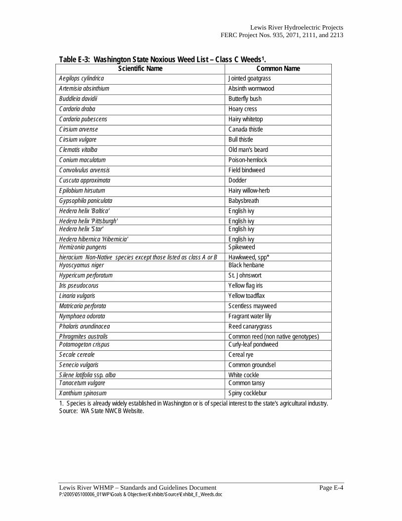
Lewis River Hydroelectric Projects FERC Project Nos. 935, 2071, 2111, and 2213
Lewis River WHMP – Standards and Guidelines Document Page E-4 P:\2005\05100006_01\WP\Goals & Objectives\Exhibits\Source\Exhibit_E_Weeds.doc
Table E-3: Washington State Noxious Weed List – Class C Weeds1.
Scientific Name Common Name Aegilops cylindrica Jointed goatgrass Artemisia absinthium Absinth wormwood Buddleia davidii Butterfly bush Cardaria draba Hoary cress Cardaria pubescens Hairy whitetop Cirsium arvense Canada thistle Cirsium vulgare Bull thistle Clematis vitalba Old man's beard Conium maculatum Poison-hemlock Convolvulus arvensis Field bindweed Cuscuta approximata Dodder Epilobium hirsutum Hairy willow-herb Gypsophila paniculata Babysbreath Hedera helix 'Baltica' English ivy Hedera helix 'Pittsburgh' English ivy Hedera helix 'Star' English ivy Hedera hibernica 'Hibernicia' English ivy Hemizonia pungens Spikeweed hieracium Non-Native species except those listed as class A or B Hawkweed, spp* Hyoscyamus niger Black henbane Hypericum perforatum St. Johnswort Iris pseudocorus Yellow flag iris Linaria vulgaris Yellow toadflax Matricaria perforata Scentless mayweed Nymphaea odorata Fragrant water lily Phalaris arundinacea Reed canarygrass Phragmites australis Common reed (non native genotypes) Potamogeton crispus Curly-leaf pondweed Secale cereale Cereal rye Senecio vulgaris Common groundsel Silene latifolia ssp. alba White cockle Tanacetum vulgare Common tansy Xanthium spinosum Spiny cocklebur 1. Species is already widely established in Washington or is of special interest to the state's agricultural industry. Source: WA State NWCB Website.

Exhibit F
Forest Practice Rules Related to Spotted Owls
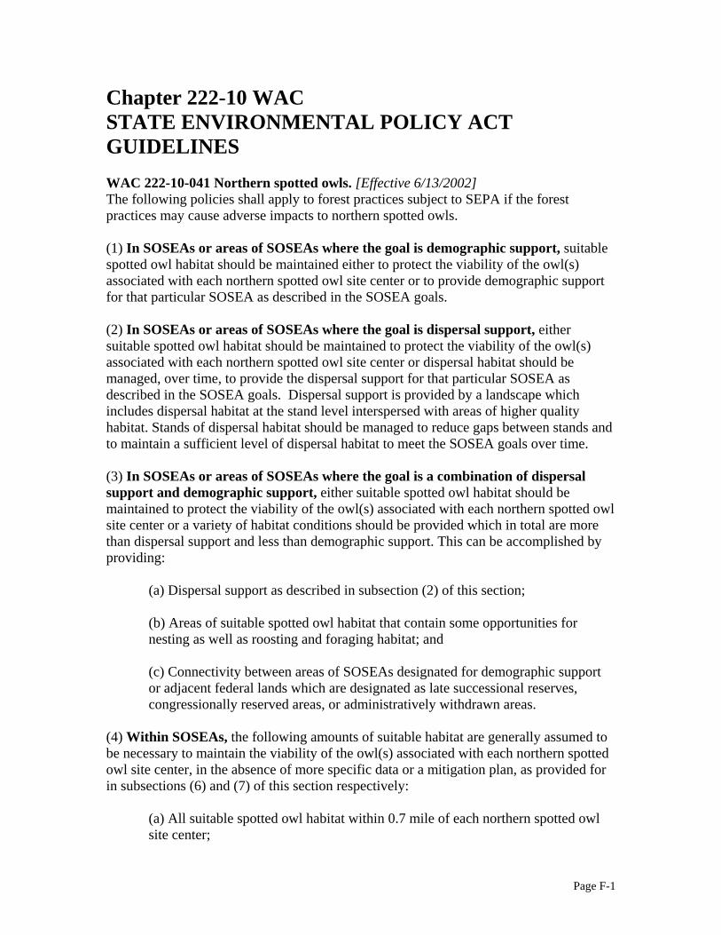
Page F-1
Chapter 222-10 WAC STATE ENVIRONMENTAL POLICY ACT GUIDELINES WAC 222-10-041 Northern spotted owls. [Effective 6/13/2002] The following policies shall apply to forest practices subject to SEPA if the forest practices may cause adverse impacts to northern spotted owls. (1) In SOSEAs or areas of SOSEAs where the goal is demographic support, suitable spotted owl habitat should be maintained either to protect the viability of the owl(s) associated with each northern spotted owl site center or to provide demographic support for that particular SOSEA as described in the SOSEA goals. (2) In SOSEAs or areas of SOSEAs where the goal is dispersal support, either suitable spotted owl habitat should be maintained to protect the viability of the owl(s) associated with each northern spotted owl site center or dispersal habitat should be managed, over time, to provide the dispersal support for that particular SOSEA as described in the SOSEA goals. Dispersal support is provided by a landscape which includes dispersal habitat at the stand level interspersed with areas of higher quality habitat. Stands of dispersal habitat should be managed to reduce gaps between stands and to maintain a sufficient level of dispersal habitat to meet the SOSEA goals over time. (3) In SOSEAs or areas of SOSEAs where the goal is a combination of dispersal support and demographic support, either suitable spotted owl habitat should be maintained to protect the viability of the owl(s) associated with each northern spotted owl site center or a variety of habitat conditions should be provided which in total are more than dispersal support and less than demographic support. This can be accomplished by providing:
(a) Dispersal support as described in subsection (2) of this section; (b) Areas of suitable spotted owl habitat that contain some opportunities for nesting as well as roosting and foraging habitat; and (c) Connectivity between areas of SOSEAs designated for demographic support or adjacent federal lands which are designated as late successional reserves, congressionally reserved areas, or administratively withdrawn areas.
(4) Within SOSEAs, the following amounts of suitable habitat are generally assumed to be necessary to maintain the viability of the owl(s) associated with each northern spotted owl site center, in the absence of more specific data or a mitigation plan, as provided for in subsections (6) and (7) of this section respectively:
(a) All suitable spotted owl habitat within 0.7 mile of each northern spotted owl site center;

Page F-2
(b) Including the suitable spotted owl habitat identified in (a) of this subsection:
(i) For the Hoh-Clearwater/Coastal Link SOSEA - A total of 5,863
acres of suitable spotted owl habitat within the median home range circle (2.7 mile radius).
(ii) For all other SOSEAs - A total of 2,605 acres of suitable spotted owl habitat within the median home range circle (1.8 mile radius). The department shall first identify the highest quality suitable spotted owl habitat for this purpose. Consideration shall be given to habitat quality, proximity to the activity center and contiguity in selecting the most suitable habitat. Suitable spotted owl habitat identified outside 0.7 mile of a northern spotted owl site center may support more than one median home range circle.
(5) Outside SOSEAs, during the nesting season (between March 1 and August 31), seventy acres of the highest quality suitable spotted owl habitat surrounding a northern spotted owl site center should be maintained. The seventy acres for one site center shall not be utilized for meeting suitable habitat needs of any other site center. (6) The assumptions set forth in subsection (4) of this section are based on regional data. Applicants or others may submit information that is more current, accurate, or specific to a northern spotted owl site center, proposal, or SOSEA circumstances or goals. The department shall use such information in making its determinations under this section where the department finds, in consultation with the department of fish and wildlife, that the information is more likely to be valid for the particular circumstances than the assumptions established under subsection (4) of this section. If the department does not use the information, it shall explain its reasons in writing to the applicant. (7) The department shall consider measures to mitigate identified adverse impacts of an applicant’s proposal. Mitigation measures must contribute to the achievement of SOSEA goals or to supporting the viability of impacted northern spotted owl site centers.

Page F-3
Chapter 222-16 WAC DEFINITIONS WAC 222-16-080 Critical habitats (state) of threatened and endangered species. [Effective 7/1/05] (1) Critical habitats (state) of threatened or endangered species and specific forest practices designated as Class IV-Special are as follows:
(h) Northern spotted owl (Strix occidentalis caurina)
(i) Within a SOSEA boundary (see maps in WAC 222-16-086),
except as indicated in (h)(ii) of this subsection, harvesting, road construction, or aerial application of pesticides on suitable spotted owl habitat within a median home range circle that is centered within the SOSEA or on adjacent federal lands.
(ii) Within the Entiat SOSEA, harvesting, road construction, or aerial
application of pesticides within the areas indicated for demographic support (see WAC 222-16-086(2)) on suitable spotted owl habitat located within a median home range circle that is centered within the demographic support area.
(iii) Outside of a SOSEA, harvesting, road construction, or aerial
application of pesticides, between March 1 and August 31 on the seventy acres of highest quality suitable spotted owl habitat surrounding a northern spotted owl site center located outside a SOSEA. The highest quality suitable habitat shall be determined by the department in cooperation with the department of fish and wildlife. Consideration shall be given to habitat quality, proximity to the activity center and contiguity.
(iv) Small parcel northern spotted owl exemption. Forest practices
proposed on the lands owned or controlled by a landowner whose forest land ownership within the SOSEA is less than or equal to 500 acres and where the forest practice is not within 0.7 mile of a northern spotted owl site center shall not be considered to be on lands designated as critical habitat (state) for northern spotted owls.

Page F-4
WAC 222-16-085 Northern spotted owl habitats. [Effective 6/18/06]
(1) Suitable spotted owl habitat means forest stands which meet the description of old forest habitat, sub-mature habitat or young forest marginal habitat found in (a) and (b) of this subsection. Old forest habitat is the highest quality, followed in descending order by submature habitat and young forest marginal habitat.
(a) Old forest habitat means habitat that provides for all the characteristics
needed by northern spotted owls for nesting, roosting, foraging, and dispersal, described as stands with:
(i) A canopy closure of 60% or more and a layered, multispecies
canopy where 50% or more of the canopy closure is provided by large overstory trees (typically, there should be at least 75 trees greater than 20 inches dbh per acre, or at least 35 trees 30 inches dbh or larger per acre); and
(ii) Three or more snags or trees 20 inches dbh or larger and 16 feet or more in height per acre with various deformities such as large cavities, broken tops, dwarf mistletoe infections, and other indications of decadence; and
(iii) More than two fallen trees 20 inches dbh or greater per acre and other woody debris on the ground.
(b) Sub-mature habitat and young forest marginal habitat. Sub-mature habitat
provides all of the characteristics needed by northern spotted owls for roosting, foraging, and dispersal. Young forest marginal habitat provides some of the characteristics needed by northern spotted owls for roosting, foraging, and dispersal. Sub-mature habitat and young forest marginal habitat stands can be characterized based on the forest community, canopy closure, tree density and height, vertical diversity, snags and cavity trees, dead and down wood, and shrubs or mistletoe infection. They are described in the following tables:

Page F-5
The values indicated for canopy closure and tree density may be replaced with a quadratic mean diameter of greater than 13 inches and a basal area of greater than 100.

Page F-6
The values indicated for canopy closure and tree density may be replaced with the following:
(A) For sub-mature a quadratic mean diameter of greater than 13 inches and a relative density of greater than 44; (B) For young forest marginal a quadratic mean diameter of greater than 13 inches and a relative density of greater than 28.

Page F-7
(2) Spotted owl dispersal habitat means habitat stands that provide the characteristics needed by northern spotted owls for dispersal. Such habitat provides protection from the weather and predation, roosting opportunities, and clear space below the forest canopy for flying. Timber stands that provide for spotted owl dispersal have the following characteristics:
(a) For western Washington, timber stands 5 acres in size or larger with: (i) 70% or more canopy cover; and (ii) 70% or more of the stand in conifer species greater than 6 inches
dbh; and
(iii) A minimum of 130 trees per acre with a dbh of at least 10 inches or a basal area of 100 square feet of 10 inch dbh or larger trees; and
(iv) A total tree density of 300 trees per acre or less; and
(v) A minimum of 20 feet between the top of the understory
vegetation and the bottom of the live canopy, with the lower boles relatively clear of dead limbs.
(b) For eastern Washington, timber stands 5 acres in size or larger with:
(i) 50% or more canopy closure; and (ii) A minimum of 50 conifer trees per acre, with a dbh of 6 inches or more in even-aged stands or 4 inches or more in uneven-aged stands, and an average tree height of 65 feet or more; and
(iii) Total tree density of 200 trees per acre or less; and
(iv) A minimum of 20 feet between the top of the understory vegetation and the bottom of the live canopy, with the lower boles relatively clear of dead limbs; or
(v) Conifer stands with a quadratic mean diameter of 9 inches or more and a relative density of 33 or more or a canopy closure of 55% or more.
(c) Suitable spotted owl habitat provides all of the required characteristics needed by spotted owls for dispersal. (d) Landowners may submit information to support an alternate definition of dispersal habitat for review and approval by the department in consultation with the department of fish and wildlife.
Copyright © 2022 FDOKUMEN