ETHIOPIAN WILDLIFE CONSERVATION AUTHORITY ...
59
1 ETHIOPIAN WILDLIFE CONSERVATION AUTHORITY ENHANCED MANAGEMENT AND EFFECTIVENESS OF ETHIOPIA’S PROTECTED AREA ESTATE A REPORT ON ASSESSMENT OF THREAT STATUS IN FIVE SELECTED WILDLIFE PROTECTED AREAS OF ETHIOPIA By Mekbeb Eshetu Tessema (PhD) Biodiversity & Environmental Consultant February 2019
-
Upload
khangminh22 -
Category
Documents
-
view
0 -
download
0
Transcript of ETHIOPIAN WILDLIFE CONSERVATION AUTHORITY ...

1
ETHIOPIAN WILDLIFE CONSERVATION AUTHORITY
ENHANCED MANAGEMENT AND EFFECTIVENESS OF ETHIOPIA’S
PROTECTED AREA ESTATE
A REPORT ON ASSESSMENT OF THREAT STATUS IN FIVE SELECTED
WILDLIFE PROTECTED AREAS OF ETHIOPIA
By
Mekbeb Eshetu Tessema (PhD)
Biodiversity & Environmental Consultant
February 2019

2
Table of Contents
ACKNOWLEDGMENTS ......................................................................................................... 3
ACRONYMS ......................................................................................................................... 4
EXECUTIVE SUMMARY ......................................................................................................... 6
1. INTRODUCTION ............................................................................................................. 11
1.1. General ................................................................................................................... 11
1.2. Background of the project ....................................................................................... 15
1.3. Rationale for the Study ........................................................................................... 15
1.4. Objectives of the Study ........................................................................................... 17
2. SCOPE AND METHODS OF THE STUDY ............................................................................ 17
2.1. Scope ...................................................................................................................... 17
2.2. Description of Study Areas ...................................................................................... 18
2.3. Data Collection ....................................................................................................... 20
2.4. Data Analysis .......................................................................................................... 22
2.4.1. Descriptive Analysis.......................................................................................... 22
2.4.2. Construction of the Theory of Change Model ................................................... 23
3. RESULTS ........................................................................................................................ 24
3.1. Threat status ........................................................................................................... 24
3.2. Underlying causes of the direct threat factors ......................................................... 28
3.3. Impacts of threat factors to biodiversity in the protected areas .............................. 31
3.4. Results of the Theory of Change Model ................................................................... 31
4. DISCUSSION ................................................................................................................... 44
4.1. Severity of Threat Factors and Vulnerability of Protected Areas .............................. 44
4.2. Impacts of the key threat factors to biodiversity in the protected areas .................. 48
5. CONCLUSION AND RECOMMENDATIONS ....................................................................... 54
6. REFERENCES .................................................................................................................. 57

3
ACKNOWLEDGMENTS
The author of this study would like to extend his heartfelt gratitude to wardens, experts
and scouts of the five target protected areas (Omo, Mago, Chebera Churchura and
Kafta Sheraro National Parks and Babille Elephant Sanctuary). The author’s gratitude
also goes to community leaders and other knowledgeable people who live around the
five target protected areas and shared their views on the matter.
The author’s special thanks also goes to the senior staff of EWCA at the headquarters;
namely, Ato Kumara Waqjirra, Ato Arega Mekonnen and Ato Addisu Assefa for
sharing ideas, commenting on the script and facilitating the field trips and logistics.

4
ACRONYMS
AEWA – African-Eurasian Migratory Waterbird Agreement
AWF – African Wildlife Foundations
BFF – Born Free Foundation
BES – Babille Elephant Sanctuary
CBD – Convention on Biological Diversity
CCNP – Chebera Churchura National Park
CMS – Convention on Migratory Species
CITES – Convention on International Trade in Endangered Species of Wild Flora and Fauna
EMEPA – Enhancement of Management Effectiveness of Ethiopia’s Protected Areas
EWCA – Ethiopian Wildlife Conservation Authority
FZS – Frankfurt Zoological Society
GEF – Global Environmental Facility
GIZ – Deutsche Gesellschaft Fuer Internationale Zusammenabeit
HWC – Human Wildlife Conflict
HEC – Human Elephant Conflict
IBC – Institute of Biodiversity Conservation
IUCN – International Union for Conservation of Nature
KSNP – Kafta Sheraro National Park
MNP – Mago National Park
MoCT – Ministry of Culture and Tourism
ONP – Omo National Park
PARTI – Protected Area Relative Threatened Index
PASI – Protected Area Susceptibility Index
PPAM – Prioritization of Protected Area Management

5
PMU – Project Management Unit
RAMSAR – Convention on Wetlands of International Importance especially as Waterfowl
Habitats
RTFSI – Relative Threat Factor Severity Index
SDPASE – Sustainable Development of Protected Area System of Ethiopia
SNNPRS – Southern Nations Nationality People Regional State
TRARA – Threat Reduction Assessment and Rapid Assessment
UNDP – United Nation Development Program
UNESCO – United Nations Education, Science and Cultural Organization
WHC – World Heritage Convention

6
EXECUTIVE SUMMARY
Ethiopia has a land mass of approximately 1,127,127 km² (IBC, 2005), with extremely varied
topography. As a result, Ethiopia is blessed with significant wildlife potential, high endemism and
extraordinary landscapes which can be the basis for flourishing tourist industry (SDPASE -
EWCA, 2015).
In Ethiopia, the milestone towards preserving the diminishing wildlife species and their habitats
goes back to 1960's. This was the period when the foundation for the birth of modern concepts of
nature and natural resource conservation laid in the country. His Imperial Majesty Emperor Haile
Selassie requested UNESCO to support the initiative in rendering technical assistance to assess
potential wildlife areas across the country. Then, UNESCO sent team of experts that had conducted
intensive field study, encompassing Awash, Jima, Maji, north end of Lake Rudolf, Omo River
Delta, Lake Stefanie, Rift Valley Lakes, the Blue Nile Gorges, Lake Tana and Mount Simien
Massif.
Following the recommendations of the assessment, the first national park, Awash, was created in
1966. Since then, a chain of protected areas has been designated in various parts of the country
encompassing ecologically diverse ecosystems specifically for wildlife conservation.
At present, there are about 73 wildlife protected areas falling under six management categories.
These include 27 national parks, 2 wildlife sanctuaries, 6 wildlife reserves, 25 controlled hunting
areas, 5 biosphere reserves and 8 community conservation areas. In total, they account for about
8.3% (9, 3182 km 2) of the total land mass of the country.
Despite such considerable efforts have been made, Ethiopia is not successful in wildlife
conservation. Arrays of factors have contributed to the existence of myriad of conservation
challenges. Ethiopia adopted the protectionist conservation approach that had been practiced up
until mid-90s. Ethiopia had no clear benefit sharing mechanism for the local community prior to
the endorsed wildlife policy in 2007. Such delay in transforming the conservation strategies of the
country in regards to the contemporary global strategy had resulted in practicing an outdated
conservation approach for about four decades. This circumstance has led the local community to
gradually develop negative perception towards the conservation and management of wildlife and
protected area, making their sense of ownership considerably fragile.
As a result, currently, almost all protected areas of Ethiopia are not immune from human-induced
threats. The rapid growth of human and livestock populations is primarily responsible for creating
a high demand for land and biological resources. The local community surrounding the protected
areas derives their livelihood directly from them. This has exerted an incredible amount of pressure
and threat to wildlife and their habitats. In high potential areas of Awash, Rift Valley Lakes, Omo
River Delta, Mount Bale Massif, Lake Stefanie, Maji, Dabus valley and Gambella region, where
agriculture, pastoralism and land investment are the predominant land use, most wildlife species
have nearly been exterminated including substantial alteration, fragmentation and loss of habitats.
The critical challenges of wildlife conservation in Ethiopia come mainly from human
encroachments on prime wildlife depository sites. These are compounded by poverty, weak law
enforcement, lack of awareness, lack of integration and cooperation, inadequate political

7
willingness, lack of alternative livelihoods and integrated-land use system. This has created a
myriad of problems such as illegal settlement, agricultural expansion, overgrazing, illegal hunting,
deforestation, human-wildlife conflicts and incompatible land investment. As a result, some of
these threats have reached at irreversible stage due to a continuous trend of encroachments that
has been causing irremediable habitat destruction and blocking of wildlife migratory routes and
dispersal areas. Attempts have been made to address and mitigate these threats but with back and
forth success. The current approach of applying the same strategies across the existing protected
areas network to mitigate threats to wildlife and associated habitats or ecosystems will not have
any meaningful impacts even in the years to come.
The Ethiopian Wildlife Conservation Authority (EWCA) which was established in 2008 has an
objectives to manage national parks and wildlife sanctuaries that are of “national and global
significance”. Positioned under the Federal Ministry of Culture and Tourism (MoCT) until recently
(but now under the newly formed “Environment, Forest and Climate Change Commission),
EWCA also develops and manage tourism in the protected areas and regulates the hunting industry.
In 2017, the United Nations Development Program (UNDP) has granted the Government of
Ethiopia ~$7.2 million with the funding from the Global Environment Facility (GEF 6) to
strengthen management and law enforcement in the protected areas of Ethiopia. This funding is
allocated for the implementation of a six-year project titled “Enhanced Management and
Effectiveness of Ethiopia’s Protected Area Estate Project (EMEPA project”. EWCA has been
charged to implement two of the three components (Component 3 is implemented by Ethiopian
Biodiversity Institute) of the project. The project management unit is housed within EWCA HQs
in Addis. As such, EWCA and EMEPA PMU have contracted the study "Assessment of Threat
Status in Five Selected Wildlife Protected Areas of Ethiopia” to a National Individual Consultant
who produced this report.
The need for launching of the “Enhanced Management and Effectiveness of Ethiopia’s Protected
Area Estate Project” is one of the responses to mitigate the ever increasing threats and their impacts
to biodiversity in the protected areas. The main objective of the project is to build the capacity of
protected area managers and authorities and promote management effectiveness of the protected
areas through (i) development of management plans, (ii) development of tools necessary for
standard operational procedures, (iii) establishment of coordinated and collaborative law
enforcement activities and (iv) implementation of illegal wildlife trafficking and trade controlling
systems. As such, data/information on the nature, extent/severity and impacts of human-induced
threats to each protected areas covered under the project is needed to serve as, among others: i)
input for the preparation and implementation of both management plans and standard operational
procedures; ii) a baseline to evaluate success of project implementation; iii) basic information for
prioritizing protected areas most threatened and threat factors to be dealt with; and iv) a baseline
to evaluate overall management effectiveness of the protected areas in the near and long-term
future.
The objective of this particular assignment is to collect, analyze and synthesize data/information
on the nature, extent/severity and impacts (where possible) of human-induced threats to each
targeted protected area, which would be used as (i) input for the preparation of both management
plans and standard operational procedures, (ii) a baseline to evaluate success of the project and
(iii) input for making informed management decisions on which protected areas and which threat
factors need to be addressed urgently.

8
In accordance with the Terms of Reference agreed for the study, this threat assessment study was
carried-out in five protected areas: Omo, Mago, Chebera Churchura and Kafta Sheraro National
Parks and Babille Elephant Sanctuary. These sites were specifically selected because they are
currently covered by the EMEPA project; the sites contain the majority of the remaining elephant
populations in the country which are the main target of the project. The study used both qualitative
and quantitative data collection approaches to assess type, extent and impacts of threats in each
protected area.
In order to achieve the objectives of the assignment both primary and secondary data were
collected. Primary data were collected from interviews of key staff of EWCA at the headquarters,
and field-level staff from the respective protected areas which included Wardens, Ecologists,
Community and Tourism Experts and Senior Game Rangers. Field visits were made to the target
protected areas. A checklist of structured questionnaire on major threats to protected areas was
prepared and used during interviews. In addition to identifying threat types and determining their
severity levels, other related data needed for The Theory of Change Model construction were also
collected. This included the target biodiversity component affected by each threat, human
behaviors/or actions that caused the threats (indirect threat factors), contributing factors (bearers
and challenges) and actions needed to mitigate/control the threats. Secondary data collection was
made through desk reviews of all relevant documents which include current management plans (if
there is any), published and unpublished research articles, monthly and annual reports and other
relevant government documents.
Thirteen main direct threat factors were identified to facing the five protected areas studied, with
relative threat factor severity (RTFSI) ranging from 0.01 to 0.40. Wildlife poaching for bushmeat
and for other products (ivory, skin, etc.) had the highest RTFSI (0.40), followed by cultivation
expansion for subsistence farming (0.35) and overgrazing by livestock (0.32). These threat factors
are also widespread, occurring almost in all the protected areas. Other threat factors with higher
RTFSI than or equal RTFSI to average RTFSI, and occurring in three or four protected areas,
included investment pressure/large scale irrigation (0.27), small scale expansion of permanent
agriculture (0.24), human-induced fire burning (0.21) and deforestation for charcoal making,
construction, etc (0.20).
Three of the five protected areas were susceptible to the majority (over half of the total) of threat
factors identified. These protected areas that are most susceptible to the majority of the threat
factors were: Babille Elephant Sanctuary which is susceptible to 10 threat factor types, with
Protected Area Susceptibility Index (PASI) of 0.77; Kafta Sheraro National Park susceptible to 9
threat factor types, with PASI of 0.69; and Omo National Park susceptible to 8 threat factor types,
with PASI of 0.62.
Most of the widespread threat factors discussed above, such as poaching, overgrazing and
subsistence cultivation, were also found to be more severe within each protected area, being ranked
as one of the top three threats. However, some threats are specific to some PAs such as canal
construction, investment developments and conversion of grassland/bushland were the first ranked
threat factors in the Omo National Park, while human settlement expansion was ranked first in the
Babille Elephant Sanctuary. Similarly, gold mining in the Kafta Sheraro National park was ranked
fourth is specific to the park.

9
In addition to identifying and assessing the severity of the threat factors, information on the impacts
of the factors were also gathered during the study both from the interviewees and secondary
sources. The results demonstrated that most of the threat factors identified are posing probably
hardly reversible adverse impacts on ecosystems, communities and species in the protected areas.
Although some of the threat factors and the underlying causes and human behaviours did vary
across the five protected areas, most of these were similar across the study areas. Thus, the goal of
EWCA in the five protected areas is: Improving population status of key wildlife species and the
quality of their habitat in the protected areas. Given these similarities among the protected areas
in the components of the theory of change model, the assumptions underlying the theory of change
stated in the models are described in generality, rather than separately for each protected area, that
works for each respective protected area.
In this assessment study, although thirteen threat factors were identified across the five protected
areas studied, with several of them occurring almost in all the protected areas, it should be noted
that most of the threat factors are not always mutually exclusive as they are operating against
biodiversity of the protected areas in a complex and interactive ways. For example, conversion of
grassland/bushland to cultivation fields and canal construction in the Omo National Park are
related to investment pressure/large scale irrigation for sugar cane cultivation. Similarly,
deforestation is usually performed, in addition to logging for construction and charcoal production,
for expansion of small scale permanent and seasonal (subsistence) agriculture. Nonetheless, the
findings of this study have highlighted that most of the threat factors are occurring in most of the
protected areas, with wildlife poaching for bushmeat and for wildlife products (e.g., ivory, skin,
etc), expansion of crop cultivation land (subsistence farming) and overgrazing by livestock being
the top most severe and most widespread threat factors. The implication of the findings of the
present study is therefore although most protected areas are susceptible to all of the threats, dealing
with poaching and human encroachment and associated activities (e.g., deforestation for
cultivation and livestock grazing) in the studied area would secure most protected areas.
Moreover, areas outside protected areas are currently highly degraded due to unregulated overuse,
being confounded by recurrent drought. As such, the exponentially growing rate of human
population in the country, where the majority is under high poverty level, and ecosystem
degradation outside protected areas have resulted to increasing demand of previously unoccupied
virgin land for cultivation land and livestock pasture. Ultimately, these constraints have caused
increased dependency of local communities on the natural resources of the protected areas, as
relatively intact and productive areas are only available in such areas that have been set aside for
wildlife conservation.
Another key challenge to contain the wide spreading threats to protected areas in Ethiopia is partly
attributed to the low capacities of protected areas management to address conservation issues in a
holistic approach. Most of the protected areas, including those treated under this study, lack until
recently clearly defined boundaries and are suffering from shortage of resources (skilled
manpower, funding/budget, infrastructure and equipment) needed for effective conservation.
Furthermore, protected area managements systems seldom take into account the need of local
communities and the role that they play in pushing conservation forward. This lack of participation
of local communities in conservation and management of and benefit sharing from protected areas
and, most importantly, coupled to lack of awareness on the conservation values of wildlife and the
associated ecosystems to the society, have led to the local communities to develop the feeling that

10
they are marginalized from conservation initiatives and that wildlife resources are belongings of
the government/state.
But most critically important challenges are, lack of political commitment by government bodies
almost at all levels and lack of appropriate integrated land use plan policies and/or poor
implementation thereof are among the key political factors for the intensive and extensive
biodiversity degradation in Ethiopia’s protected areas. One best example of the effect of lack of
integrated land use plan policy is the recent allocation of land from Omo National Park for large
scale irrigation schemes for cultivation of sugar cane that fed the Omo Kuraz Sugar Factory.
Similar incidences have been reported from Kafta Sheraro National Park where local investors are
given irrigation-based cultivation land within the park boundary.
In conclusion, this study has found that wildlife poaching for bushmeat and for other products
(ivory, skin, etc.), cultivation expansion for subsistence farming and overgrazing by livestock
RTFSI are identified to be the top severe and widespread threat factors, occurring almost in all the
protected areas. Other threat factors with moderate relative severity and lower
distribution/localized occurrence/, but are detrimental at site levels, included investment and large
scale irrigation pressure, small scale expansion of permanent agriculture and human-induced fire
burning. Babille Elephant Sanctuary, Kafta Sheraro National Park and Omo National Park were
the most susceptible and threatened protected areas to most of the threat factor types.
The underlying causes of the direct threat factors, herein, are treated as indirect threats or
conservation challenges and bearers that are the reasons for the occurrence and expansion of the
direct threats to wildlife, include: poor law enforcement (due to resource constraints and lack or
poor implementation of enabling policies), availability of fire arms, ethnic conflicts, increased
global demand and price of ivory, cultural practices during marriage and to demonstrate social
status are reported to be the major causes (indirect threats) for increased wildlife poaching in the
protected areas. On the other hand, poverty, human population increase, recurrent drought and
declining of pasture outside protected areas have caused local communities to largely rely on
natural resources within the protected areas for pasture and water and to practice small scale
seasonal and permanent cultivation. These practices have been further fostered due to lack of
awareness, lack of benefits to local community and inadequate political commitment by
government at all level. Furthermore, lack of clearly developed and implemented integrated
development plan (land use plan) both at federal and regional levels, coupled with poor
environmental impact assessments during planning and implementation of investment projects,
have led to conservation incompatible land allocation for development initiatives.
11
1. INTRODUCTION
1.1. General
Ethiopia has a land mass of approximately 1,127,127 km² (IBC, 2005), with extremely varied
topography. These range from the depressions in the Afar (110 m below sea level) to the
spectacular Mountain tops of Ras Dashen (4543 m above sea level) in the north. As a result,
Ethiopia is blessed with significant wildlife potential, high endemism and extraordinary landscapes
which can be the basis for flourishing tourist industry (SDPASE - EWCA, 2015).
In Ethiopia, the milestone towards preserving the diminishing wildlife species and their habitats
goes back to 1960's. This was the period when the foundation for the birth of modern concepts of
nature and natural resource conservation laid in the country. His Imperial Majesty Emperor Haile
Selassie requested UNESCO to support the initiative in rendering technical assistance to assess
potential wildlife areas across the country. Then, UNESCO sent team of experts that had conducted
intensive field study, encompassing Awash, Jima, Maji, north end of Lake Rudolf, Omo River
Delta, Lake Stefanie, Rift Valley Lakes, the Blue Nile Gorges, Lake Tana and Mount Simien
Massif.
Following the recommendations of the assessment, the first national park, Awash, was created in
1966. Since then, a chain of protected areas has been designated in various parts of the country
encompassing ecologically diverse ecosystems specifically for wildlife conservation. Formerly,
their governance system was exclusively run by the central government. However, such approach
has been gradually transformed to inclusive and decentralized system, involving regional states,
local communities, hunting operators and particularly NGOs on co-management basis.

12
At present, there are about 73 wildlife protected areas falling under six management categories.
These include 27 national parks, 2 wildlife sanctuaries, 6 wildlife reserves, 25 controlled hunting
areas, 5 biosphere reserves and 8 community conservation areas (Annex). In total, they account
for about 8.3% (9, 3182 km 2) of the total land mass of the country.
All the major ecosystems of the country have been represented in this protected areas system.
These diverse ecosystems and variable climate conditions have contributed to high diversity of
species (Yalden, 1992). Therefore, thus far 320 species of mammals (57 are endemic), 926 species
of birds (Lepage, 2006) (18 endemic), 242 species of reptiles (15 endemic), 73 species of
amphibians (30 endemic), 180 species of fish (41 endemic), about 6500 species of vascular plants
(700 endemic) and 6862 species of insect have been recorded (Berehanu Beyene, 2016).
Ethiopia has taken various actions to conserve wildlife species and their environment. These
include the formulation of institutional and policy frameworks and legal instruments. Presently,
Ethiopian Wildlife Conservation Authority is the custodian of the country’s wildlife resources.
The first national conservation strategy was issued in 1997, and laid basis for the development of
wildlife policy and conservation strategy in 2007. Subsequently other legal systems such as
wildlife proclamation, regulation, directives and guidelines have come in to force to ensure
sustainability in wildlife conservation and management.
Furthermore, Ethiopia took actions in signing and ratifying conservation–related global
international frameworks and organizational membership. The first signed (but not ratified)
regional agreement was the African convention on nature and natural resources in 1968 under the
facilitation of the African Union. Since then, other ratified international conventions include: the
World Heritage Convention (WHC), 1977; Convention on International Trade in Endangered
Species of Wild Flora and Fauna (CITES), 1989; the Convention on Biological Diversity (CBD),

13
1994; the Convention on Migratory Species (CMS), 2009; African-Eurasian Migratory Waterbird
Agreement (AEWA), 2009; and the Convention on Wetlands of International Importance
especially as Waterfowl Habitats, Ramsar, not yet ratified. Similarly, Ethiopia is the member of
the International Union for Conservation of Nature (IUCN) since 1967. Ethiopian Wildlife
Conservation Authority (EWCA) is the focal institution for the implementation of CITES, CMS
and AEWA agreements, and IUCN membership.
Despite such considerable efforts have been made, Ethiopia is not successful in wildlife
conservation. Arrays of factors have contributed to the existence of myriad of conservation
challenges. Ethiopia adopted the protectionist conservation approach that had been practiced up
until mid-90s. This approach has also alienated the local communities from participating in
wildlife conservation and protected area management in Kenya (Okello, 2007).
Ethiopia had not formulated clear benefit sharing mechanism for the local community prior to the
endorsed wildlife policy in 2007. Such delay in transforming the conservation strategies of the
country in regards to the contemporary global strategy had resulted in practicing an outdated
conservation approach for about four decades. This circumstance has led the local community to
gradually develop negative perception towards the conservation and management of wildlife and
protected area, making their sense of ownership considerably fragile.
At present, almost all protected areas of Ethiopia are not immune from human-induced threats.
The rapid growth of human and livestock populations is primarily responsible for creating a high
demand for land and biological resources. The local community surrounding the protected areas
derives their livelihood directly from them. This has exerted an incredible amount of pressure and
threat to wildlife and their habitats. In high potential areas of Awash, Rift Valley Lakes, Omo
River Delta, Mount Bale Massif, Lake Stefanie, Maji, Dabus valley and Gambella region, where

14
agriculture, pastoralism and land investment are the predominant land use, most wildlife species
have nearly been exterminated including substantial alteration, fragmentation and loss of habitats.
The critical challenges of wildlife conservation in Ethiopia come mainly from human
encroachments on prime wildlife depository sites. These are compounded by poverty, weak law
enforcement, lack of awareness, lack of integration and cooperation, inadequate political willing,
lack of alternative livelihoods and integrated-land use system. This has created a myriad of
problems such as illegal settlement, agricultural expansion, overgrazing, illegal hunting,
deforestation, human-wildlife conflicts and incompatible land investment. As a result, some of
these threats have reached at irreversible stage due to a continuous trend of encroachments that
has been causing irremediable habitat destruction and blocking of wildlife migratory routes and
dispersal areas (Vreugdenhil et al., 2012).
Ethiopia has mainly begun facing wildlife conservation crisis as of mid-1980s. However, the
predecessor of EWCA has taken little proactive measures to gazette, build institutional capacity,
mobilize resources, re-examine wildlife conservation approach and objectives and formulate
policy. Therefore, the Ethiopian Wildlife Conservation Authority has been faced with complex
challenge of overcoming these underlying threats. Indeed, various research works (Menhistu Wale,
2017), mainly for academic purposes, have outlined some of the critical threats to protected areas
that need to be seriously addressed. Attempts have been made to address and mitigate these threats
but with back and forth success. The current approach of applying the same strategies across the
existing protected areas network to mitigate threats to wildlife and associated habitats or
ecosystems will not have any meaningful impacts even in the years to come.

15
1.2. Background of the project
The Ethiopian Wildlife Conservation Authority (EWCA) was established in 2008 with the
objectives to manage national parks and wildlife sanctuaries that are of “national and global
significance”. Positioned under the Federal Ministry of Culture and Tourism (MoCT) until recently
(but now under the newly formed “Environment, Forest and Climate Change Commission),
EWCA also develops and manage tourism in the protected areas and regulates the hunting industry.
In 2017, the United Nations Development Program (UNDP) has granted the Government of
Ethiopia ~$7.2 million with the funding from the Global Environment Facility (GEF 6) to
strengthen management and law enforcement in the protected areas of Ethiopia. This funding is
allocated for the implementation of a six-year project titled “Enhanced Management and
Effectiveness of Ethiopia’s Protected Area Estate Project (EMEPA project”. EWCA has been
charged to implement two of the three components (Component 3 is implemented by Ethiopian
Biodiversity Institute) of the project. The project management unit is housed within EWCA HQs
in Addis. As such, EWCA and EMEPA PMU have contracted the study "Assessment of Threat
Status in Five Selected Wildlife Protected Areas of Ethiopia” to the author [Dr. Mekbeb Eshetu
Tessema, a National Individual Consultant]. Here, presented the report on findings of the
assignment.
1.3. Rationale for the Study
Ethiopia harbours several endemic and rare wildlife species and spectacular landscapes with varied
ecological zones. Though, the wildlife resources and their associated ecosystems have a great
potential in enhancing the country’s development efforts through eco-tourism and through the vital
ecosystem services they provide to Ethiopian nations, it has not been able to tap economic gain
from the sector (Ethiopian Wildlife Policy and Strategy, 2005). This is due to, in the past, the lack
of integrated development strategies and activities which undermined the ecological importance

16
of the country’s unique wildlife habitats throughout the country. As a result, multi-faceted
anthropogenic factors have been affecting Ethiopia’s wildlife conservation efforts, which have
continued to exist even today. Currently, the main threats to the country’s wildlife include habitat
destruction/loss and habitat fragmentation due to the rapid population growth and subsequent
illegal agricultural encroachment, illegal settlement, poaching, etc. This human encroachment,
coupled to the lack of land use policy, into untouched habitats in Ethiopia have led to loses annually
40,000 ha of forests, 800,000 ha of woodland and 18 tons of fertile soil per ha of land, resulting to
more rapid degradation of natural ecosystems and wildlife resources. In order to minimize the
threats, the Ethiopian Wildlife Conservation Authority (EWCA) partners with international
conservation organizations such as GIZ-Ethiopia, UNDP-GEF, Born Free Foundation (BFF),
Frankfurt Zoological Society (FZS) and African Wildlife Foundation (AWF) to address
conservation and development issues. This is because the government’s inadequate technical and
financial capacity has been a limiting factor to develop a feasible and realistic protected area
system that involve local communities in the conservation efforts, and create sustainable
development that benefits both communities and the wildlife resources.
The need for launching of the “Enhanced Management and Effectiveness of Ethiopia’s Protected
Area Estate Project” is one of the responses to mitigate the ever increasing threats and their impacts
to biodiversity in the protected areas. The main objective of the project is to build the capacity of
protected area managers and authorities and promote management effectiveness of the protected
areas through (i) development of management plans, (ii) development of tools necessary for
standard operational procedures, (iii) establishment of coordinated and collaborative law
enforcement activities and (iv) implementation of illegal wildlife trafficking and trade controlling
systems. As such, data/information on the nature, extent/severity and impacts of human-induced

17
threats to each protected areas covered under the project is needed to serve as, among others: i)
input for the preparation and implementation of both management plans and standard operational
procedures; ii) a baseline to evaluate success of project implementation; iii) basic information for
prioritizing protected areas most threatened and threat factors to be dealt with; and iv) a baseline
to evaluate overall management effectiveness of the protected areas in the near and long-term
future.
1.4. Objectives of the Study
The objective of this assignment is to collect, analyze and synthesize data/information on the
nature, extent/severity and impacts (where possible) of human-induced threats to each targeted
protected area, which would be used as (i) input for the preparation of both management plans and
standard operational procedures, (ii) a baseline to evaluate success of the project and (iii) input for
making informed management decisions on which protected areas and which threat factors need
to be addressed urgently.
2. SCOPE AND METHODS OF THE STUDY
2.1. Scope
In accordance with the Terms of Reference agreed for the study (Annex I), this threat assessment
study was carried-out in five protected areas: Omo, Mago, Chebera Churchura and Kafta Sheraro
National Parks and Babille Elephant Sanctuary. These sites were specifically selected because they
are currently covered by the EMEPA project; the sites contain the majority of the remaining
elephant populations in the country which are the main target of the project. The study used both
qualitative and quantitative data collection approaches to assess type, extent and impacts of threats
in each protected area.
18
A threat, in this particular study, was defined as: “any factor, resulting either directly or indirectly
from human activities (legal or illegal), that actually or has the potential to destroy, degrade, or
impair key biodiversity components [found at various organizational level, including an
ecosystem, a habitat/community, or a species] in the next 10 years” (Kinahan and Laurenson,
2013).
2.2. Description of Study Areas
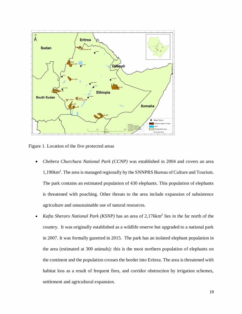
The five target protected areas are shown on Figure 1, and are briefly described as follow:
Omo National Park (ONP) was established in 1968 as a “proposed” National Park. The total
area of the park is 2,936km2 and currently is managed by EWCA, a federal institution. It lies
in a complex area with eight ethnic groups living in the area. Major threats include poaching
of wildlife and grazing by livestock and, more recently, large areas of the park have been
appropriated for commercial agriculture (specifically sugar plantations) and the infrastructure
associated with this has created a barrier to movement of wildlife and exposed it to illegal
killings.
Mago National Park (MNP) was established in 1970 but the area was “re-demarcated” in
2003 to an area of 1,942km2 (taking into account various anthropogenic pressures). Currently,
it is managed by the SNNPR Bureau of Culture and Tourism. The park is threatened with
overgrazing and illegal killing of wildlife – and the elephant population has declined by 52%
since the 1980s. The commercial agriculture in Omo NP and adjacent areas has resulted in a
loss of connectivity among the areas.
19
Figure 1. Location of the five protected areas
Chebera Churchura National Park (CCNP) was established in 2004 and covers an area
1,190km2. The area is managed regionally by the SNNPRS Bureau of Culture and Tourism.
The park contains an estimated population of 430 elephants. This population of elephants
is threatened with poaching. Other threats to the area include expansion of subsistence
agriculture and unsustainable use of natural resources.
Kafta Sheraro National Park (KSNP) has an area of 2,176km2 lies in the far north of the
country. It was originally established as a wildlife reserve but upgraded to a national park
in 2007. It was formally gazetted in 2015. The park has an isolated elephant population in
the area (estimated at 300 animals): this is the most northern population of elephants on
the continent and the population crosses the border into Eritrea. The area is threatened with
habitat loss as a result of frequent fires, and corridor obstruction by irrigation schemes,
settlement and agricultural expansion.

20
Babille Elephant Sanctuary (BES) was established 1970 with an area of 6,900km2 is in the
semi-arid areas of the east of the country and contains an estimated population of 250
elephants. It is also from this area that the majority of animals (including lions, cheetahs
and a number of antelope species) are caught for the trade. The animals are smuggled
through the Ethiopian borders and the alleged destination is the Middle East. In addition to
poaching and killings of elephants and other species, illegal settlement, livestock grazing
and agricultural expansion have also been increasing with subsequent degradation of the
habitat and escalation of human-wildlife conflict. High levels of human-elephant conflict
have been resulting in perceived injustices, high economic loss and loss of life among
people living in the vicinity of the sanctuary.
2.3. Data Collection
The type, quality and quantity of data collected in any study are partly determined based on the
purpose/objective of the study and planned method of analysis to be used. There are several
approaches of assessing threats to wildlife and protected areas, including Threat Reduction
Assessment (TRA), Threat Reduction Rapid Assessment (TRARA), and Prioritization of Protected
Area Management (PPAM) (Rao et al. 2007); Assessment of status of a species relative to other
species in terms of a species’ extinction risk (Hilton Taylor, 2000; Baillie et al., 2004); Important
Bird Areas Program (Stattersfield and Capper, 2000); Key Biodiversity Area approach (Eken et
al., 2004); range-wide priority setting approaches that use threat assessment to set conservation
priorities for individual species such as tigers and jaguars (Dinerstein et al., 1997; Sanderson et
al., 2002a); and the Theory of Change Approach to threat analysis (Vogel and Stephenson, 2012;
Conservation International, 2013). In the present study, “Theory of Change Approach to threat
analysis” method was used to collect data. This method is the most recent approach becoming

21
popular among the conservation organizations in threat analysis whereby a situation analysis (See
Figures 2-6) and monitoring models (Figures 7-11) are developed for individual protected area.
The monitoring model uses key biodiversity indicators identified to monitor whether the threat
level is reduced after the introduction of appropriate intervention. The consultant used this
approach to identify types, determine level and assess impacts of threats to the target protected
areas. The main advantage of using the Theory of Change Approach is because it is more
convenient to customize the analysis for each protected area based on the types and level of threats
that the protected areas are facing (Vogel and Stephenson, 2012; Conservation International,
2013). And also, it gives a tool for monitoring of changes on threats level using key indicators
identified. Therefore, in order to achieve the objectives of the assignment and use the Theory of
Change Approach, both primary and secondary data were collected.
Primary data were collected from interviews of the key staff of EWCA at the headquarters, and
field-level staff from the respective protected areas which included Wardens, Ecologists,
Community and Tourism Experts and Senior Game Rangers. Field visits were made to the target
protected areas. A checklist of structured questionnaire on major threats to protected areas was
prepared and used during interviews. Respondents from each protected area were asked to score
each of the threat they mention independently and only for the threat type occurring in the protected
area where they are currently working. Scoring was done for each of the threat they mention
independently on numerical scale ranging from 1 as the lowest threat level to 5 as the highest. To
help them determine the extent (and thus to assign a score) of each threat, the interviewees were
informed to use the following four criteria: severity (i.e. level of damage), permanence (potential
for permanent damage/loss), scope (geographic extent of occurrence), and status
(increasing/decreasing) (Kinahan and Laurenson, 2013). In addition to identifying threat types and

22
determining their severity levels, other related data needed for The Theory of Change Model
construction were also collected. This included the target biodiversity component affected by each
threat, human behaviors/or actions that caused the threats (indirect threat factors), contributing
factors (bearers and challenges) and actions needed to mitigate/control the threats.
Secondary data collection was made through desk reviews of all relevant documents which include
current management plans (if there is any), published and unpublished research articles, monthly
and annual reports and other relevant government documents.
2.4. Data Analysis
2.4.1. Descriptive Analysis
Prior to undertaking the Theory of Change Analysis, data were analyzed using the methods of
Okunlola and Tsujimoto (2009), by calculating indexes of threat factor indicators. Accordingly,
the following indexes were calculated as indicators of how serious a threat factor was both within
and across protected areas, and vulnerability of protected areas to these threats:
o Protected Area Susceptibility Index (PASI) to the threat factors = (Number of threat
factors mentioned for each protected area/ Total number of threat factors identified across
protected areas, 13)
o Mean score of each threat factor = (sum of all the scores for that particular threat factor) /
(the total number of respondents, 25)
o Relative Threat Factor Severity Index, across protected areas, RTFSI(across) = (The mean
score for a particular threat factor) / (the maximum possible score, 5)
o Relative Threat Factor Severity Index, within a protected area, RTFSI(within) = (The mean
score for a particular threat factor arranged in ascending order)

23
o Protected Area Relative Threatened Index, PARTI = total score of the thirteen threat factors
from the interviewed officers of a given protected area) / total responses (65)
A ranking system based on (i) RTFSI (across) showed which of the threat factors was more serious
across the protected areas considered, (ii) both PASI and PARTI showed which protected areas
were most vulnerable to the identified threat factors, and (iii) Relative Threat Factor Severity Index
(rank) within a protected area, RTFSI (within), showed which of the threat factors was more serious
within a protected area or which protected area was most vulnerable to which threat factor.
2.4.2. Construction of the Theory of Change Model
Construction of the Theory of Change Model is a two-step process. The first step is compiling
background information on the situation of the protected areas (i.e., carrying-out situation
analysis). Thus, a situation analysis was conducted for each protected area based on the threat
factors identified and their effect on the target biodiversity component and the underlying causes
of the threats. This situation analysis is a conceptual model which relates the Conservation Target
(i.e., ecosystem, habitat/community, or a species) being affected by each of the identified threat
factors, human behaviors/or actions and contributing factors (Figures 2-6). The second step is,
using the results of situation analysis as input, constructing the theory of change model, which by
itself was undertaking following the following five main steps: i) defining long-term goal(s) of
management interventions; ii) mapping the pathway to change [i.e., building intermediate
(outcomes) and immediate (output) results framework to achieve the goal]; iii) selecting a set of
activities/interventions needed to achieve the outputs and outcomes (i.e., actions needed change
contributing factors and human behaviors so as to reduce threats); iv) identifying biodiversity

24
indicators and their monitoring methods to track progress; and v) articulating key assumptions (see
Figures 7-11).
3. RESULTS
3.1. Threat status
Thirteen main direct threat factors were identified to facing the five protected areas studied, with
relative threat factor severity (RTFSI) ranging from 0.01 to 0.40. Five (~39%) of the threat factors
are operating at relatively higher relative severity level (RTFSI) of 0.20 (Table 1). Wildlife
poaching for bushmeat and for other products (ivory, skin, etc.) had the highest RTFSI (0.40),
followed by cultivation expansion for subsistence farming (0.35) and overgrazing by livestock
(0.32). These threat factors are also widespread, occurring almost in all the protected areas. Other
threat factors with higher RTFSI than or equal RTFSI to average RTFSI, and occurring in three or
four protected areas, included investment pressure/large scale irrigation (0.27), small scale
expansion of permanent agriculture (0.24), human-induced fire burning (0.21) and deforestation
for charcoal making, construction, etc (0.20). The rest of the threat factors are localized (occurring
only in one or two protected areas) and had relatively lower than the average RTFSI (see Table 1).

25
Table 1. Sum of threat factor score (n = 25), mean threat factors score (n = 25) and Relative Threat Factor Severity
Index, RTFSI (across) of the 13 threat factor types identified across the five protected areas.
Threats
Sum of Threat Factor
Score
Mean (±SE) Threat
Factor Score RTFSI
Poaching 51 2.00 ± 0.32 0.40
Overgrazing 40 1.58 ± 0.41 0.32
Settlement 22 0.90 ± 0.46 0.18
Cultivation/ subsistence farming 44 1.76 ± 0.37 0.35
Human induced wildfire 26 1.04 ± 044 0.21
Canal Construction 15 0.60 ± 0.60 0.12
Conversion of grassland & bushland 15 0.60 ± 0.60 0.12
Human-Wildlife Conflict 17 0.66 ± 0.59 0.13
Deforestation 25 1.00 ± 0.45 0.20
Mining 11 0.44 ± 0.39 0.09
Ethnic Conflict 1 0.04 ± 0.04 0.01
Investment pressure/large scale Irrigation 33 1.34 ± 0.69 0.27
Expansion of permanent agriculture (small scale) 30 1.20 ± 0.49 0.24
Three of the five protected areas were susceptible to the majority (over half of the total) of threat
factors identified. These protected areas that are most susceptible to the majority of the threat
factors were: Babille Elephant Sanctuary which is susceptible to 10 threat factor types, with
Protected Area Susceptibility Index (PASI) of 0.77; Kafta Sheraro National Park susceptible to 9
threat factor types, with PASI of 0.69; and Omo National Park susceptible to 8 threat factor types,
with PASI of 0.62; (Table 2).
The protected area relative threatened index (PARTI) values provided on Table 2 showed that
those protected areas that appeared to be most susceptible to the majority of the threat factors (see
above) also had PARTI values of greater than the average index of the five protected areas (average
PARTI = 0.20). Accordingly, Kafta Sheraro National Park had the highest PARTI (0.26), followed
by Omo National Park (0.23) and Babille Elephant Sanctuary (0.22) (Table 2).

26
More detail analysis of relative threat factor severity (RTFSI) within each protected area was
conducted by ranking based on their mean threat severity score. Interestingly, this analysis had
enabled to disclose the fact that those threat factors that are localized, and thus which would have
been considered as little conservation concern had only the results obtained from across the
protected areas were interpreted/reported, are in fact detrimental to biodiversity conservation at
local scale (i.e., within the protected area where they occurred). For example, canal construction,
investment developments and conversion of grassland/bushland (in both cases, mean score = 3.0)
were the first ranked threat factors in the Omo National Park, while human settlement expansion
(mean score = 2.5) was ranked first in the Babille Elephant Sanctuary. Similarly, gold mining in
the Kafta Sheraro National Park was ranked fourth (Table 3). Otherwise, most of the widespread
threat factors discussed above, such as poaching, overgrazing and subsistence cultivation, were
also found to be more severe within each protected area, being ranked as one of the top three
threats; (for detail, see Table 3).

27
Table 2. Sum of threat factor score within each protected area, protected area susceptibility index (PASI) and relative protected area
threatened index (RPATI).
Na
me o
f P
A
Po
ach
ing
Ov
erg
razi
ng
Sett
lem
en
t
Cu
ltiv
ati
on
/
sub
sist
en
ce
farm
ing
Hu
ma
n
ind
uced
wil
dfi
re
Ca
na
l
Co
nst
ru
cti
on
Co
nv
ersi
on
of
gra
ssla
nd
&
bu
shla
nd
Hu
ma
n
Wil
dli
fe
Co
nfl
ict
Defo
rest
ati
on
Min
ing
Eth
nic
Co
nfl
ict
Inv
est
men
t
perm
an
en
t
ag
ric
ult
ure
(sm
all
scale
)
No
. T
hre
at
Fa
cto
rs
Pro
tect
ed
Area
Su
scep
tib
ilit
y
Ind
ex
S
um
of
Th
rea
t
Fa
cto
r S
cores
PA
RT
I
Mago NP 15 10 5 5 9 0 0 0 0 0 0 0 0 6 0.46 44 0.14
Omo NP 10 9 0 4 7 15 15 0 0 0 0 15 0 8 0.62 75 0.23
Chebera
Churchura
NP
10 0 0 10 0 0 0 15 10 0 0 0 10 4 0.31 55 0.17
Kafta
Sheraro NP
5 12 5 13 10 0 0 0 5 10 0 15 10 9 0.69 85 0.26
Babille
Elephant
Sanctuary
11 9 12 12 0 0 0 2 10 1 1 3 10 10 0.77 71 0.22

28
Table 3. Relative threat factor severity index within each protected area [RTFSI (within)]
Threat Mago NP Omo NP Chebera
Churchura NP
Kafta
Sheraro NP
Babille
Elephant
Sanctuary
Poaching 3.0 (1) 2.0 (2) 2.0 (2) 1.0 (5) 2.1 (3)
Overgrazing 2.0 (2) 1.8 (3) 2.3 (3) 1.8 (5)
Settlement 1.0 (4) 1.0 (5) 2.5 (1)
Cultivation/subsistence farming 1.0 (4) 0.8 (5) 2.0 (2) 2.7 (2) 2.3 (2)
Human induced wildfire 1.8 (3) 1.4 (4) 2.0 (4)
Canal construction 3.0 (1)
Conversion of grassland & bushland 3.0 (1)
Human wildlife conflict 3.0 (1) 0.3 (7)
Deforestation 2.0 (2) 1.0 (5) 2.0 (4)
Mining/mineral extraction 2.0 (4) 0.2 (8)
Ethnic conflict 0.2 (8)
Investment pressure/large scale
Irrigation
3.0 (1) 3.0 (1) 0.7 (6)
Expansion of permanent agriculture (small scale)
2.0 (2) 2.0 (4) 2.0 (4)
3.2. Underlying causes of the direct threat factors
Underlying causes of the direct threat factors, herein, are treated as indirect threats or conservation
challenges and bearers that are the reasons for the occurrence and expansion of the direct threats
to wildlife. Although poor law enforcement (due to resource constraints and lack or poor
implementation of enabling policies) is the primary reason for the expansion of the threat factors
across the protected areas, there are a number of underlying causes (indirect threats and other
causatives) of the direct threat factors in the protected areas (Table 4). Although these indirect
threats are not mutually independent of each other and some of them are site-specific (i.e., the case
of a particularly protected area), the majority are found to be prevailing across the whole protected
areas. For example, among the most frequently mentioned indirect threats (including challenges
and bearers) such as availability of fire arms, ethnic conflicts, increased global demand and price
of ivory, cultural practices during marriage and to demonstrate social status are reported to be the

29
major causes (indirect threats) for increased wildlife poaching in the protected areas. On the other
hand, poverty, human population increase, recurrent drought and declining of pasture outside
protected areas have caused local communities to largely rely on natural resources within the
protected areas for pasture and water and to practice small scale seasonal and permanent
cultivation. These practices have been further fostered due to lack of awareness, lack of benefits
to local community and inadequate political commitment by government at all level. Furthermore,
lack of clearly developed and implemented integrated development plan (land use plan) both at
federal and regional levels, coupled with poor environmental impact assessments during planning
and implementation of investment projects, have led to conservation incompatible land allocation
for development initiatives. The consequences of this lack of clear policy and/or its poor
implementation on protected areas have been manifested in the Omo National Park where Kuraz
Sugar factor was established and in the Kafta Sheraro National Park where irrigation-based
cultivation land was leased-out for private investments along Tacazze River (Table 4).
Table 4. Underlying causes (indirect threats) of the main direct threats identified in the five
protected areas.
Omo NP
Indirect Threats Cause of Direct Threat Target species by
poachers (and other
threat factors)
Sand mining
Blockage of wildlife
passage by the water canal
Ethnic conflicts
(Surma & Bume)
Illegal influx of fire
arms from South
Sudan
Trespassing of
Tofossa tribe from
South Sudan
Inadequate Political commitment by govt. at
all level
Increased demand for pasture, water & cultivation by locals
Demand for bushmeat & Ivory
Ethnic conflicts (Bume & Surma, Dizi &
Surma)
Unintegrated development & allocation of
land for large scale irrigation schemes
Weak conservation practice (lack of capacity)
Lack of integration with other sectors
Shortage of pasture & water outside the park
Elephant
Eland
Buffalo
Giraffe
30
Recurrent drought
Lack of awareness
No defined boundary and gazettement of the
park
Mago NP
Fire arm influx
Ethnic conflicts
Drought
Ivory smuggling
Dogs
Omo Sugarcane
plantation
Cultural practice (for marriage & social
status), bushmeat & increasing demand
for ivory
Demand for pasture & water
Demand for agricultural land
Lack of awareness
Weak law enforcement
Lack of benefits to local community
No defined boundary of the park
Weak conservation practice (lack of
skilled manpower, commitment &
professionalism)
Inadequate political commitment by
govt. at all level
Decline of pasture outside the pasrk
boundary
Elephant
Buffalo
Greater Kudu
Lesser Kudu
Hartebeest
Defassa
waterbuck
Warthog
Dikdik
Chebera Churchura NP
Human population increase
No clear boundary of the park
No buffer zone
Inadequate political commitment
Weak conservation practice (low capacity)
Poverty
Dependency on the natural resources.
Elephant
Buffalo
Kafta-Sheraro NP
Expansion of settlements around the park
Poverty and population increase in
surrounding community by influx of
newcomers via govt. settlement schemes
Bad investment policy and incompatible land
allocation for development activities
Weak law enforcement
No clear land use plan
Elephant,
Red-fronted gazelle,
Roan antelope,
Greater kudu,
Demoiselle crane
Babille ES

31
Inconsiderate
allocation of land for
new settlers within the
boundary of the
sanctuary
Need for land by the
new comers
Need for Berhsa soil
used for house
construction
Competition over the
resources use in the
sanctuary by Hawya &
Oromo ethnic groups
Demand for ivory
Need for charcoal production & land clearing
for cultivation
Population increase surrounding the
sanctuary
Poverty
Drought/Desertification
Low capacity (inadequate funding/budget,
inadequate trained manpower)
Weak law enforcement
Lack of Political will
No benefit sharing to local communities
Lack of professional ethics and passion
Elephant
3.3. Impacts of threat factors to biodiversity in the protected areas
In addition to identifying and assessing the severity of the threat factors, information on the impacts
of the factors were also gathered during the study both from the interviewees and secondary
sources. The results demonstrated that most of the threat factors identified are posing probably
hardly reversible adverse impacts on ecosystems, communities and species in the protected areas.
These impacts are described in detail under subsection 4.3 of the “Discussion” section.
3.4. Results of the Theory of Change Model
Summary results of situation analysis for each protected area studied are shown on Figures 2-6,
which is simply a graphical illustration of the results presented above while showing the links
(cause-effect relationships) existing between the threat factors, underlying causes, and their effect
of target ecosystem component (see Figures 2-6). The Theory of Change Model (see Figures 7-
11), on the other hand, is simply the reverse of the situation analysis model in a way that depict
the expected results achieved if the underlying causes of the threat factors are acted upon. As such,
clearly stating, this theory of change model demonstrates the links among: Biodiversity target
32
result (impacts or goal of threat reduction interventions), Threat reduction result (outcome of
intervention), behavioural change results (outputs of interventions), and work plan (management
interventions/actions needed to reduce threat factors) (Figure 7-11). The potential functionality of
these models’ components was demonstrated by certain assumptions, which are briefly described
below.
Although some of the threat factors and the underlying causes and human behaviours did vary
across the five protected areas, most of these were similar across the areas. Similarly, as was also
highlighted both in the situation analysis and theory of change models, the target ecosystem
components (those most affected by the threat factors) are some key wildlife species, elephant
being common to all PAs, and critical habitats of these species. Thus, the goal of EWCA in the
five protected areas is: Improving population status of key wildlife species and the quality of
their habitat in the protected areas. Given these similarities among the protected areas in the
components of the theory of change model, the assumptions underlying the theory of change stated
in the models are described in generality, rather than separately for each protected area, that works
for each respective protected area.
The five key assumptions underlying the theory of change (as clearly shown on the figures 7-11)
are as follows:
i. Awareness raising and community dialogue campaigns [Interventions] would help
reduce/avoid wildlife hunting for cultural practices and the demand of bushmeat and ivory
[outputs]. This in turn will result to reduced poaching [outcome] and ultimately to “Increased
populations of key wildlife species such as Elephant, Buffalo, etc” [goal].

33
ii. Forging and maintaining strong collaboration with relevant neighboring and middle-east
countries will result to “Reduced demand for ivory”, thereby to “Reduced poaching” and
“Improved wildlife population”.
iii. Strengthening law enforcement through stakeholder collaboration and adequate resource
allocation (finance, equipment and human resources) will lead to “Reduced illegal activities
such as unregulated grazing, fire, deforestation for cultivation, etc”, which in turn results to
“Improved wildlife habitat quality”.
iv. Developing and implementation of integrated community development initiatives for protected
area-associated people will “Reduce people’s dependence on protected areas’ resources”. As
a result, pressures from cultivation, grazing, etc will be mitigated and wildlife populations and
their habitat conditions improved/maintained.
v. Promoting awareness of local communities and admins on the importance of the park and
wildlife laws and lobbying relevant govt. bodies at all levels will ensure to gain their political
commitment to support wildlife conservation and incorporate conservation in community
priority development agendas. Gaining their commitment will (i) facilitate defining of
protected areas’ boundary and gazettement; and ii) help to mitigate/ reverse the effects of
development projects (e.g., sugar factory, irrigation canals and investments in and around some
protected areas) on ecosystems. Provided that these actions would be taken, then their
outcomes and impacts will be “Rehabilitation of Open woodland, bushland and grassland
habitats, especially in Omo and Kafta NPs” and “Maintenance of elephant movement
corridors” in these parks.

34
Figure 2: Mago NP Situation Analysis Conceptual Model.
Scope
Biodiversity target
Threat
Behaviour
Contributing factor
Scope: Babil
Mago NP
Elephant
Buffalo
Open
woodland,
bushland and
grassland
Poaching
Livestock
grazing
Human
induced wild
fire
People have
strong desire to
hunt buffalo &
elephant
Illegally enter
into the park
with their
livestock
Use fire to
harvest wild
honey and burn
grass for
visibility during
hunting season
Lack of
awareness
Decline of
pasture outside
the park &
demand for
pasture & water
No defined
boundary for
the park
Demand for
ivory &
bushmeat
Community feel
they have a
right to use
resources
Weak law
enforcement
Cultural
practice
(marriage,
social status &
heroism)
Weak law
enforcement

35
Figure 3: Omo NP situation analysis conceptual model.
Scope
Biodiversity target
Threat
Behaviour
Contributing factor
Scope: Babil
Omo NP
Elephant,
Eland &
Giraffe
Open
grassland,
open
woodland
Blockage of
wildlife
passage
Poaching
Habitat change
Construction of
water canal by
sugarcane
plantation
People have
strong desire to
hunt wildlife
(elephant,
eland, giraffe,
etc.)
Conversion of
prime grassland
into sugarcane
plantation, over
grazing and fire
Weak law
enforcement,
porous border & fire
arm influx
Cultural practice
(marriage, social
status, etc.) &
demand for
bushmeat & ivory
Shortage of pasture &
water outside the park,
drought, creating visibility
during hunting season &
Law awareness
No defined park
boundary and
gazettement
Illegally enter
into the park
with modern
fire arm
Weak conservation
practice due to lack
of capacity by the
park
Lack of political
commitment by govt.
at all level
(conservation has not
been a priority)
Lack of political
commitment,
unbalanced
development plan

36
Figure 4: Chebera Churchura NP situation analysis conceptual model.
Scope
Biodiversity target
Threat
Behaviour
Contributing factor
Scope: Babil
Chebera
Churchura
NP
Elephant
Buffalo
Wooded
grassland,
montane
woodland &
riparian
forest
Human
wildlife
conflict
Poaching
Deforestation
Expansion of
agriculture &
settlement
Need for
bushmeat &
Ivory
Cutting trees for
having more
land for
agriculture
Weak capacity
to run proper
conservation
Weak law
enforcement by
park staff
Dependency on
natural
resources
No clear
boundary and
gazettement of
the park
To protect
cropland
Lack of buffer
zone
Human
population
increase
Poverty/lack of
livelihood
diversification

37
Figure 5: Kafta Sheraro NP situation analysis conceptual model.
Scope
Biodiversity target
Threat
Behaviour
Contributing factor
Scope: Babil
Kafta
Sheraro
NP
Elephant
Wood land,
dry
evergreen
montane
woodland
Illegal
settlements
Poaching
Deforestation/
land use
change
Expansion of
human
settlements
Demand for
ivory &
bushmeat
Investment
pressure /large
scale irrigation
scheme/, small
holding
irrigation, over
grazing
Poverty
Weak law
enforcement
Bad investment
policy/no land
use plan
Bad policy
towards land
allocation
Induce wild fire
by miners
Influx of
human
population
Lack of political
commitment by
govt. at all level
Lack of political
commitment

38
Figure 6: Babille ES situation analysis conceptual model.
Scope
Biodiversity target
Threat
Behaviour
Contributing factor
Scope: Babil
Babille
Elephant
Sanctuary
Elephant
Dry wood
land
Poaching
Human
elephant
conflict
Deforestation
Demand for
Ivory
Expansion of
farm land by
local investors
& community
Charcoal
production,
subsistence
farming, and
livestock over
grazing
Weak law
enforcement
No clear
boundary
demarcation
Poverty and
drought
Low capacity of
the Sanctuary
staff
Illegal
settlement
Lack of political
commitment to
enforce law
Weak law
enforcement
Low conservation
practices due to
weak capacity

39
Figure 7: Mago NP: The theory of change model showing intervention needed, changes expected and monitoring its success.
Scope
Goal (Impact of intervention on the target biodiversity)
Outcome (Impact of human behavioural change on threats)
Output (Impact of intervention on human behavior)
Interventions (Activities)
Target biodiversity monitoring method
Scope: Babil
Mago NP
Increased populations
of Elephant and Buffalo
Reduced
degradation of
Open woodland,
bushland and
grassland
Reduced
Poaching
Regulated
livestock
grazing
Reduced
incidence of
human
induced wild
fire
People’s desire
to hunt buffalo
& elephant
reduced
Regulated enter
of people and
their livestock
into the park
Careful use of
fire to harvest
wild honey and
avoided grass
burn grass
Promote awareness of local
communities and admins on the
importance of the park and
wildlife laws
Undertake pasture development
outside the park & demand for
pasture & water
Define and gazzet
boundary for the park
Forge strong collaboration
with concerned countries to
reduce demand for ivory
Regulated use
of resources
Strengthen law enforcement
through stakeholder
collaboration, resource allocation
and training
Awareness raising and community dialogue to
avoid wildlife hunting for cultural practice
Quarterly
population
survey using
standard
methods
Yearly quadrat survey of
species diversity and cover
of woody and herbaceous
vegetation

40
Figure 8: Omo NP: The theory of change model showing intervention needed, changes expected and monitoring its success.
Scope Target biodiversity monitoring method
Goal (Impact of intervention on the target biodiversity)
Outcome (Impact of human behavioural change on threats)
Output (Impact of intervention on human behavior)
Interventions (Activities)
Scope: Babil
Omo NP
Increased populations of
Elephant, Eland & Giraffe
Open grassland, open
woodland partly
restored
Secured wildlife
passage/
corridor
Reduced
Poaching
Impact of
habitat change
minimized
Measures
implemented to
mitigate
impacts of
water canal
People’s desire
to hunt wildlife
(elephant,
eland, giraffe,
etc.) weakened
Wildlife
movement
corridors and
buffer zone
secured
Strengthen law
enforcement,
porous border & fire
arm influx
Awareness raising
to reduce the
demand for
bushmeat & ivory
Promote awareness; seek
alternative options to
address the issue of
shortage of pasture &
water outside the
parkuring hunting season &
Law awareness
Finalize defining of
park boundary and
gazettement
Reduced Illegal
entry into the
park with
modern fire
arm
Improve park
management by
allocating adequate
resources
Lobby govt. at all level to gain
their political commitment and
incorporate conservation in
priority development agendas
Promote political
commitment for
balanced development
plan
Quarterly population
survey using standard
methods
Yearly quadrat survey of
species diversity and cover
of woody and herbaceous
vegetation

41
Figure 9: Chebera Churchura NP: The theory of change model showing intervention needed, changes expected and monitoring
its success.
Scope
Goal (Impact of intervention on the target biodiversity)
Outcome (Impact of human behavioural change on threats)
Output (Impact of intervention on human behavior)
Interventions (Activities)
Target biodiversity monitoring method
Scope: Babil
Chebera
Churchura
NP
Elephant &
Buffalo popn.
Maintained
Wooded
grassland,
montane
woodland &
riparian
forest
maintained
Reduced
Human
wildlife
conflict
Reduced
Poaching
Reduced
Deforestation
Decline
expansion of
agriculture &
settlement
Decline need
for bushmeat &
Ivory
Control of
Cutting trees for
having more
land for
agriculture
Build capacity
to run proper
conservation
Strengthen law
enforcement by
park staff
Reduce
dependency on
natural
resources
Delinate clear
boundary and
gazettement of
the park
Reduced
conflict to
protect
cropland
Establish buffer
zone
Control human
population increase
Reduce
poverty/
Increase
livelihood
diversification
Quarterly population
survey using standard
methods
Yearly quadrat survey of
species diversity and cover
of woody and herbaceous
vegetation

42
Figure 10: Kafta Sheraro NP: The theory of change model showing intervention needed, changes expected and monitoring its
success.
Scope Target biodiversity monitoring method
Goal (Impact of intervention on the target biodiversity)
Outcome (Impact of human behavioural change on threats)
Output (Impact of intervention on human behavior)
Interventions (Activities)
Scope: Babil
Kafta
Sheraro
NP
Health
population of
Elephant
Improved
condition of
Woodland, dry
evergreen
montane
woodland
habitats
Reduced
Poaching
Reduced
deforestation/
land use
change
Expansion of
human
settlements
controlled
Reduced
demand for
ivory &
bushmeat
Reduced
pressure from
Investment
/large scale
irrigation
scheme/, small
holding
irrigation, over
grazing
Develop and
implement
Poverty
reduction
strategies
Strengthen law
enforcement
Lobby gov’t to
change/implement
existing landuse policy
Wild fire and
mining halted
Control illegal
influx of human
Secure of
political
commitment
Improve political commitment by
govt. at all level
Quarterly population
survey using standard
methods
Yearly quadrat survey of
species diversity and cover
of woody and herbaceous
vegetation

43
Figure 11: Babille ES: The theory of change model showing intervention needed, changes expected and monitoring its success.
Scope Target biodiversity monitoring method
Goal (Impact of intervention on the target biodiversity)
Outcome (Impact of human behavioural change on threats)
Output (Impact of intervention on human behavior)
Interventions (Activities)
Scope: Babil
Babille
Elephant
Sanctuary
Increased
population of
Elephant
Dry
woodland
rehabilitated
Reduced
Poaching
Human-
elephant
conflict
mitigated
Reduced
deforestation/
Habitat
changes
Discouraged
motivation of
poachers
Reduced
expansion of
farm land by
local investors
& community
Reduced
charcoal
production,
subsistence
farming, and
livestock over
grazing
Improve law
enforcement
Define clear
boundary
Create alternative
income generation
mechanisms
Improve capacity
for effective
conservation
Illegal
settlement
controlled
Improve political
commitment to
enforce law
Reduce Demand
for Ivory
Quarterly
population survey
using standard
methods
Yearly quadrat survey of
species diversity and cover
of woody and herbaceous
vegetation

44
4. DISCUSSION
4.1. Severity of Threat Factors and Vulnerability of Protected Areas
In this assessment study, although thirteen threat factor types were identified across the five
protected areas treated, with several of them occurring almost in all the protected areas, it should
be noted that most of the threat factors are not always mutually exclusive as they are operating
against biodiversity of the protected areas in a complex and interactive ways. For example,
conversion of grassland/bushland to cultivation fields and canal construction in the Omo National
Park are related to investment pressure/large scale irrigation for sugar cane cultivation. Similarly,
deforestation is usually performed, in addition to logging for construction and charcoal production,
for expansion of small scale permanent and seasonal (subsistence) agriculture. Nonetheless, the
findings of this study have highlighted that most of the threat factors are occurring in most of the
protected areas, with wildlife poaching for bushmeat and for wildlife products (e.g., ivory, skin,
etc), expansion of crop cultivation land (subsistence farming) and overgrazing by livestock being
the top most severe and most widespread threat factors. These results are in agreement with several
similar reports in Ethiopia (e.g., Asefa et al., 2015; Wale et al., 2017; EWCA, 2018) and elsewhere
in Africa (e.g., Kiringe and Okello, 2007). The implication of the findings of the present study is
therefore although most protected areas are susceptible to all of the threats, dealing with poaching
and human encroachment and associated activities (e.g., deforestation for cultivation and livestock
grazing) in the studied protected areas would secure most protected areas.
Other threat factors with higher or equal to RTFSI than average, and occurring in three or four
protected areas, include investment pressure/large scale irrigation (0.27), small scale expansion of
permanent agriculture (0.24) human-induced fire burning (0.21) and deforestation (0.20). The rest

45
of the threat factors are localized (occurring only in one or two protected areas) and had relatively
lower than the average RTFSI (see Table 2).
The findings that a majority of the protected areas considered for the study are threatened by a
majority of threat types imply that wildlife conservation in the country, in general, and in these
protected, in particular, is currently at huge crisis. The fact that conservation crisis in Ethiopia has
become in an overwhelming challenges has already been highlighted in reports of several studies
and national development plans, including the Growth and Transformation plan. The primary
cause of threats to biodiversity in Ethiopia is the ever-increasing land demand for cultivation,
settlement and livestock grazing—which is due to the unbridled increasing human population in
the country, including around protected areas—, thereby putting more pressure on biodiversity and
protected areas (Williams et al., 2004). In addition to this, however, there are a number of
bottlenecks to achievement of effective protected area conservation and management in the
country. The key barriers and challenges to effective law enforcement pertaining to biodiversity
conservation and protected area management in Ethiopia are related to socio-cultural, economic,
environmental, management system of protected areas, and political factors; these factors are
affecting conservation practices independently or interactively. For example, from socio-cultural/-
economic and environmental points of view, most socio-economic activities (e.g., way of
cultivation and animal husbandry) of the nation are still in the traditional mode. Subsequently,
areas outside protected areas are currently highly degraded due to unregulated overuse, being
confounded by recurrent drought. As such, the exponentially growing rate of human population in
the country, where the majority is under high poverty level, and ecosystem degradation outside
protected areas have resulted to increasing demand of previously unoccupied virgin land for
cultivation land and livestock pasture. Ultimately, these constraints have caused increased

46
dependency of local communities on the natural resources of the protected areas (Acha and
Temesgen, 2015; Megaze, 2017), as relatively intact and productive areas are only available in
such areas that have been set aside for wildlife conservation. Similarly, conservation incompatible
cultural practices, such as killing wildlife to demonstrate bravery and serving bushmeat during
marriage ceremonies, and coupled to the increasing demand and price of ivory on the global
markets, has motivated locals to do poaching.
Another key challenge to contain the wide spreading threats to protected areas in Ethiopia is partly
attributed to the low capacities of protected areas management to address conservation issues in a
holistic approach. Most of the protected areas, including those treated under this study, lack until
recently clearly defined boundaries and are suffering from shortage of resources (skilled
manpower, funding/budget, infrastructure and equipment) needed for effective conservation.
Furthermore, protected area managements systems seldom take into account the need of local
communities and the role that they play in pushing conservation forward. This lack of participation
of local communities in conservation and management of and benefit sharing from protected areas
and, most importantly, coupled to lack of awareness on the conservation values of wildlife and the
associated ecosystems to the society, have led to the local communities to develop the feeling that
they are marginalized from conservation initiatives and that wildlife resources are belongings of
the government/state. The consequences of such negative attitude have been increased abuse of
natural resources in the protected areas, which have been more demonstrated during civil unrests
where protected area properties and wildlife have been severely destroyed by locals (Jacobs and
Schloeder, 2001).
Finally, but most critically important challenge, lack of political commitment by government
bodies almost at all levels and lack of appropriate integrated land use plan policies and/or poor

47
implementation thereof are among the key political factors for the intensive and extensive
biodiversity degradation in Ethiopia’s protected areas. One best example of the effect of lack of
integrated land use plan policy is the recent allocation of land from Omo National Park for large
scale irrigation schemes for cultivation of sugar cane that fed the Omo Kuraz Sugar Factory
(Gebre, 2018). Similar incidences have been reported from Kafta Sheraro National Park where
local investors are given irrigation-based cultivation land within the park boundary (KSNP, 2016;
Asefa et al., In Prep.).
In addition to characterizing key threat factors across the protected areas, based on the PASI and
PARTI values, this study has also enabled to identify [the three] protected areas most susceptible
and most threatened to overall threat factors and to each individual threat factor. Accordingly,
threat factors such as canal construction, investment developments and conversion of
grassland/bushland in the Omo National Park are key issues that should be addressed in a matter
of urgency, while human settlement expansion and elephant poaching in the Babille Elephant
Sanctuary. Similarly, gold mining and irrigation farming along the course of Tacazze River in the
Kafta Sheraro National Park are top priority issues to be dealt with in the short term. Livestock
grazing is a common practice across the protected areas, except in Chebera Churchura National
Park, and thus requires implementation of regulatory systems across all protected areas, if
prevention may not be possible at all, so as ensure sustainability of ecosystems. Further, although
incidences of human-wildlife conflicts are also identified to be among threats to other protected
areas in Ethiopia, including Babille Elephant Sanctuary and Kafta Sheraro National Park (Kiringe
and Okello, 2007; Wale et al., 2017; EWCA, 2018), it is a major threat factor in the Chebera
Churchura National Park (Acha and Temesgen, 2015; Megaze, 2017). This growing human-
wildlife conflict in Chebera is a function of human population increase and encroachment to the

48
park and arises from conflicts between human and wildlife needs, particularly are due to livestock
depredation, crop-raiding by ungulates and human damage by Elephants and buffalos (Acha and
Temesgen, 2015; Megaze, 2017). Any action such as controlling problem animals would reduce
negative attitudes to protected areas (Kiringe and Okello, 2007; Asefa and Didita, 2018).
Overall, the few facts discussed above illustrate the importance of the approach used to assess and
rank the threat factors, as well protected areas, in that the findings can be used to identify specific
problems ailing each conservation area in a prioritized manner and deal with them on individual
basis based on their severity indices or relative threat factor severity index (RTFSI). It is critical
for EWCA to have structured and focused priorities for its protected areas. This study therefore
suggests that most of management actions should be based on actual measurement of threat indices
or a reliable index such as RTFSI in addressing specific threat factors. Despite the similar trend
reported herein between protected area relative threatened index (PARTI) and susceptibility index
(PASI), this study recommends that further prioritization of Protected Areas most affected should
be done based on a threatened status using indices such as PARTI, rather than on susceptibility
(PASI) which is simply a catalogue of threats recorded without considering its magnitude or
severity (Kiringe and Okello, 2007).
4.2. Impacts of the key threat factors to biodiversity in the protected areas
The results of the present study demonstrated that most of the threat factors identified are posing
probably hardly reversible adverse impacts on ecosystems, communities and species in the
protected areas. These findings are similar to some previous studies (e.g., Gebre, 2018; Hika et al.,
2018; EWCA, 2018; Asefa et al., In Prep.) conducted on quantification of severity and impacts of
certain threats in some of the protected areas. These are briefly summarized below for each or
groups of related key threat factor.

49
Wildlife Poaching
Wildlife poaching/illegal killing is a common practice throughout protected areas of the country,
which usually is committed to meet their demand for bushmeat (e.g., ungulates) and for wildlife
products for sale (e.g., ivory, leopard skins, etc) and to demonstrate bravery (e.g., elephant,
Buffalo, lion and leopard) (Hika et al., 2018; EWCA, 2018). For instance, of the total 547
incidences of wildlife mortalities reported from Omo National Park, 371 (68%) of the cases were
due to subsistence and commercial poaching (Gebre, 2018). Similar reports have also been
indicated increasing killing of wildlife, particularly elephants Elephant poaching for ivory, in
particular, have been remained the most severe immediate threat facing all populations of the
species (EWCA, 2015). Some of the reviewed previous reports indicate that: i) in the Mago
National Park, at least, 8 elephants were killed only in 2013/14 (Hika et al., 2018); ii) 73 Elephants
were killed in the Babille Elephants Sanctuary from 2011-2014 (EWCA 2015), and 3 Elephants in
2018 (BES, 2018); iii) ~20 elephants were killed between 2012 and 2014 in Mago (EWCA, 2015);
and iv) 4 elephants were killed in the Kafta Sheraro National Park in 2006 (Shoshani et al., 2004),
and another four elephant tusks were confiscated in 2015 from poachers living around the park, in
addition to five Leopard, five Greater kudu and two Red-fronted Gazelle skins (KSNP, 2016). In
general, Elephant poaching in Ethiopia has been remained the most threat to their long-term
survival; it has led to decline in its populations by 90% since the 1980s and extirpation from at
least 6 of the 16 areas in which elephants were found in the early 1990s (EWCA, 2015). The
interviewees have informed that indiscriminate poaching, interactively with other threat factors
though, have ultimately resulted to the extinction of several mammal species in the protected areas,
such as Giraffe, Rhino, Oryx, Tiang, Zebra, Gerenuk and Grant’s Gazelle in the Mago NP, and
Zebra, Oryx and Rhino in the Omo NP.

50
Settlement and Crop Cultivation
Settlement and cultivation (both small-scale subsistence and large-scale permanent) inside
Ethiopia’s protected areas are a recent history, just following the downfall of the then Derg regime
in 1991. Since then, these have been increasing alarmingly due to intrinsic population growth and
immigration from other areas. For example, in the KSNP has been due to the high intrinsic
population growth rate resulted from resettlement programmes and illegal immigration to the area.
Currently, there are 14 (12 outside and 2 inside) villages found in/around the park, with their
~64,000 estimated people (KSNP, 2016). This rapid increase of human population in the area has
led to increased demand of arable land. At present, ~415 km2 (18% of the total area of the park)
of natural habitat has been converted to sesame and sorghum cultivation fields.
Investment and Irrigation Canals
Although a localized threat factor, only occurring in the Kafta-Sheraro and Omo National Parks,
Investment/irrigation canals are among the top ranked threat factors at these areas. In Kafta, nearly
15km2 of natural vegetation of the park has been cleared and converted by local private inventors
to irrigation-based Banana plantation along Tekeze River (Wendim et al., 2016). The case of Omo
National Park, establishment of the Omo Kuraz Sugar Factory Project in the lower Omo Valley,
may perhaps represent one of the most devastations have been occurred in the country due to
government investment expansion. This recently launched Sugar Factory Project is found to be
established in the core wildlife habitats in the Omo National Park, which has now influenced the
park via construction of roads, bridges, irrigation canals, sugar factories, accommodations for
migrant workers, and land clearing for sugarcane plantation (Gebre, 2018). This happened as the
process was less inclusive of relevant stakeholders, like EWCA, during feasibility studies of the
project so that the environmental impacts that the development might have (as is now clearly

51
evident) have not been assessed and mitigation measures are not in place. As a result, over
25,000ha virgin land (grassland and bushland) of the park is converted to sugar cane fields.
The impact of the investment is also associated with irrigation canal; it is estimated that a minimum
total of 250km canals (main, primary, etc.) is needed for the operation, which has an average
dimension of L250 km x W100m x H4m. Thus, canal construction has resulted to a permanent
loss of 100sq km pristine habitat (Gebre, 2018). The problem with canal does not end soon after
excavation, the excavated soil materials are damped at several sites of a considerable size just
along the canals, and in the process, covering the most suitable habitat and creating artificial hills.
Overall, the canals and such artificial hills obviously have not only jeopardized the security and
vital activities of wild animals, but potentially have (would) also caused habitat fragmentation and
population separation that affect genetic diversity of less mobile smaller animals. In addition to
causing habitat loss and fragmentation, the canals have a long-lasting effect on wild animals by
acting as a barrier separating populations—a phenomenon that reduce genetic diversity and fitness
of animals of less mobile smaller-sized species—and a venue for drowning. Gebre (2018) has
reported that canals are responsible for 21% of the total wildlife mortality cases in the Omo Valley.
Finally, the construction of factories or sugar cane plantations in South Omo Zone has also resulted
to blockade of the wildlife movements within the park through a massive excavation of canals and
blocked elephant movement corridors between Mago and Omo NPs (Figure 12). Such corridor
blockade are thought to finally lead species with a small population sizes to loss of gene flow
which in turn results to lack of fitness, thereby accelerating their vulnerability to extinction.
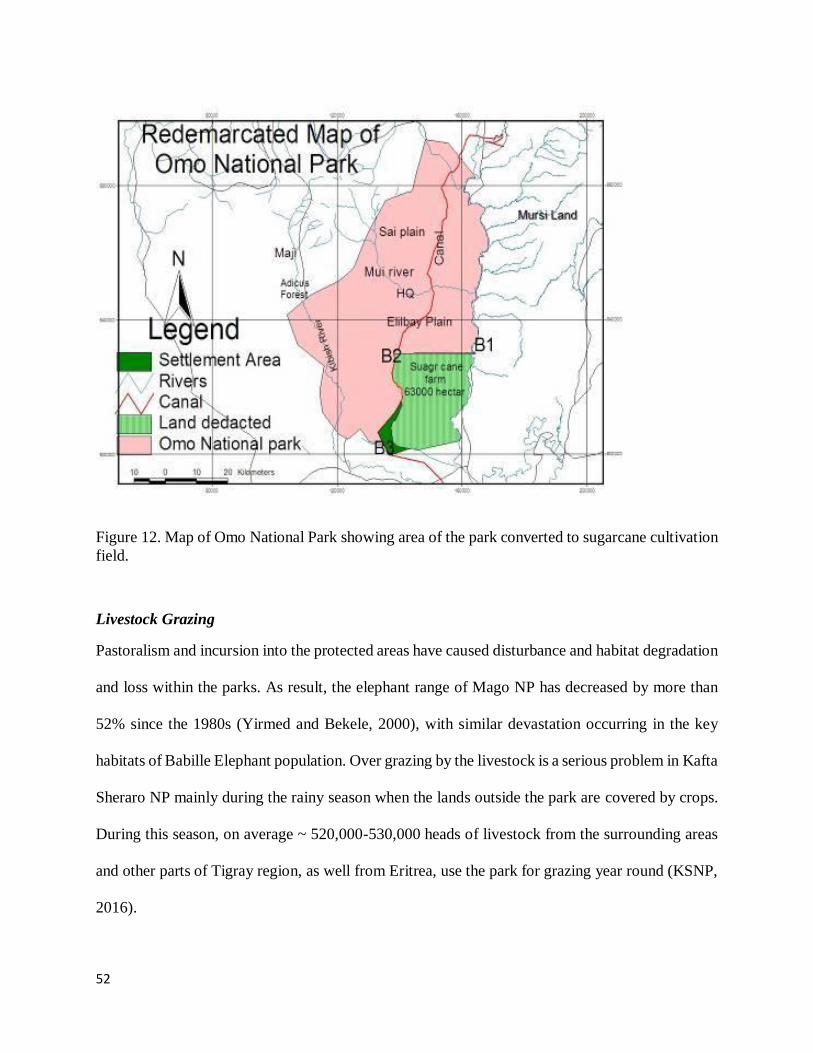
52
Figure 12. Map of Omo National Park showing area of the park converted to sugarcane cultivation
field.
Livestock Grazing
Pastoralism and incursion into the protected areas have caused disturbance and habitat degradation
and loss within the parks. As result, the elephant range of Mago NP has decreased by more than
52% since the 1980s (Yirmed and Bekele, 2000), with similar devastation occurring in the key
habitats of Babille Elephant population. Over grazing by the livestock is a serious problem in Kafta
Sheraro NP mainly during the rainy season when the lands outside the park are covered by crops.
During this season, on average ~ 520,000-530,000 heads of livestock from the surrounding areas
and other parts of Tigray region, as well from Eritrea, use the park for grazing year round (KSNP,
2016).

53
Other Localized Threat Factors
Other threats factors that occur only one or two protected areas, but are of critical issues that should
be dealt with, include gold mining in the Kafta Sheraro NP, human-wildlife conflicts in the
Chebera Churchura and Kafta Sheraro NPs, and ethnic conflict in Babille Elephant Sanctuary.
Mining Kafta Sheraro NP: Gold and marble are among the most economically important precious
mineral deposits found in/around KSNP (KSNP, 2016). Although traditional gold mining inside
the park was started recently, just before six 6 years, a survey conducted in 2012 revealed that
more than 10,000 youth (both males and females) were found to be engaged in illegal gold mining
in the park (Asefa et al., In Prep). Wendim et al. (2014), who surveyed along 179 km long transect,
have reported the presence of ~10,000 (i.e. 56 pits per km) gold mining pits that have 20-35m
depth at ~300 quarrying sites. Apart from modifying the ecosystem through ecological
successions, such activities pose a significant threat to wildlife, because such pits can act as a trap
even for larger animals like Elephants (Wendim et al., 2014). Urgent management actions are
needed to reverse the situation and rehabilitate sites affected by quarrying activities.
Human-Wildlife Conflicts (HWC): HWC occurs due to damage incurred to the local community
by wildlife through depredation of livestock, damage to human body/life and crop raiding. Critical
issue is the case of human-elephant conflicts occurring in the Kafta and Chebera NPs and Babille.
In Kafta Sheraro this is occurring on the irrigated land in the park, with elephants being chased
and some equipment destruction by elephants, while in Chebera is due to Elephants’ attraction
crops outside the boundary (bananas, sugar cane, cassava, etc). Even though this human elephant
conflict (HEC) in Kafta and Chebera national parks occurs at a low rate, it is a critical challenge
in Babille. Conflict and crop raiding mainly results from the illegal settlement within the BES as
50-90% of incidents are within the park along both sides of the Gobele Valley and the Upper part

54
of the Erer Valley. Reports indicate that, as a result of HEC, 19 human deaths and/or injuries had
occurred between 1997 and 2014 (EWCA, 2015) and 3 human deaths/injuries occurred only in
2018 (BES, 2018). Conflict and crop raiding mainly results from the illegal settlement within the
BES as 50-90% of incidents are within the park along both sides of the Gobele Valley and the
Upper part of the Erer Valley. Although this may not be seen as a direct threat to elephants but
note that it is a significant problem to BES staffs and have led to decreased support for elephant
conservation and a scale up of poaching as a result.
Ethnic Conflict: Although it occurs in Mago and Omo NPs, it is also the case in Babille Elephant
Sanctuary where insecurity and conflict across the Somali/Oromia RS boundaries are making it
very difficult to conduct law enforcement operations and community support is low.
5. CONCLUSION AND RECOMMENDATIONS
This study has found that wildlife poaching for bushmeat and for other products (ivory, skin, etc.),
cultivation expansion for subsistence farming and overgrazing by livestock RTFSI are identified
to be the top severe and widespread threat factors. , occurring almost in all the protected areas.
Other threat factors with moderate relative severity and lower distribution/localized occurrence/,
but are detrimental at site levels, included investment and large scale irrigation pressure, small
scale expansion of permanent agriculture and human-induced fire burning (see Table 1). Babille
Elephant Sanctuary, Kafta Sheraro National Park and Omo National Park were the most
susceptible and threatened protected areas to most of the threat factor types (see Table 2).
The underlying causes of the direct threat factors, herein, are treated as indirect threats or
conservation challenges and bearers that are the reasons for the occurrence and expansion of the
direct threats to wildlife, include: poor law enforcement (due to resource constraints and lack or

55
poor implementation of enabling policies), availability of fire arms, ethnic conflicts, increased
global demand and price of ivory, cultural practices during marriage and to demonstrate social
status are reported to be the major causes (indirect threats) for increased wildlife poaching in the
protected areas. On the other hand, poverty, human population increase, recurrent drought and
declining of pasture outside protected areas have caused local communities to largely rely on
natural resources within the protected areas for pasture and water and to practice small scale
seasonal and permanent cultivation. These practices have been further fostered due to lack of
awareness, lack of benefits to local community and inadequate political commitment by
government at all level. Furthermore, lack of clearly developed and implemented integrated
development plan (land use plan) both at federal and regional levels, coupled with poor
environmental impact assessments during planning and implementation of investment projects,
have led to conservation incompatible land allocation for development initiatives. The
consequences of this lack of clear policy and/or its poor implementation on protected areas have
been manifested in the Omo National Park where Kuraz Sugar factor was established and in the
Kafta Sheraro National Park where irrigation-based cultivation land was leased-out for private
investments along Tacazze River (Table 4).
The results also demonstrated that the threat factors have been posing probably hardly reversible
adverse impacts on some ecosystem components, including key wildlife species such as elephant
and their habitat. The Theory of Change Model (see Figures 6-10) is constructed to demonstrate
for EWCA and respective protected area managers to implement the suggested interventions in the
model. These models link Biodiversity target result (impacts or goal of threat reduction
interventions), Threat reduction result (outcome of intervention), Behavioural change results
(outputs of interventions), and Work plan (management interventions/actions needed to reduce

56
threat factors) (Figure 7-11). The potential functionality of these models’ components was
demonstrated by certain assumptions, which are briefly described below.
In short, in order to improve population status of the key wildlife species and the quality of their
habitat, both of which are presumed to be affected by the threat factors, the top severe threat factors
(poaching, cultivation, settlement, investment, fire, etc) should be mitigated in each respective
protected area. This in turn requires addressing the underlying causes of these threats. Therefore,
the suggested key management interventions shown in the theory of change models should be
implemented in a matter of urgency and the effects (results = outputs, outcomes and goals) of these
interventions on the proposed goals should be monitored based on the periodic
evaluation/monitoring of the status of the target biological components (e.g., elephant population
and habitat quality).

57
6. REFERENCES
Acha, A. and Temesgen, M. (2015), Approaches to Human-Wildlife Conflict Management in
and around Chebera-Churchura National Park, Southern Ethiopia, Asian Journal of
Conservation Biology, 4(2): 136-142.
Asefa, A. and Didita, M. (2018). Report On Experience Sharing Visit To Kenya Wildlife Service
And Protected Areas. Ethiopian Wildlife Conservation Authority/Enhanced Management and
Effectiveness of Ethiopia’s Protected Area Estate Project. 62 pp, EWCA, AA, Ethiopia.
Asefa, A., et al. (In Prep.). Kafta-Sheraro National Park in the NW Ethiopia: Exceptional
Resource Values, Principal Ecosystem Components and Human-Induced Threats.
Asefa, A., Shimelis, A. and Kinahan, A. (2015). Assessment of threat status in the northern
Afromontane forests of the Bale Mountains, Ethiopia. Ethiopian Journal of Environmental
studies and Management 8(3): 318 – 329. doi: http://dx.doi.org/10.4314/ejesm.v8i3.9.
Baillie, E.M., Hilton, T. C. and Stuart, S. N. (2004). IUCN Red List of Threatened Species. A
Global Species Assessment. IUCN, Gland, Switzerland.
Berehanu Beyene, (2016). Checklist for insect species in Ethiopian. unpublished document
Ethiopian biodiversity institute.
BES (Babile Elephant Sanctuary). (2018). A report on Elephant Mortality, BES, Babile,
Ethiopia.
Conservation International. (2013). Constructing theories of change models for Ecosystem-based
Adaptation projects: a guidance document. Conservation International. Arlington, VA.
Demeke, Y. (2000). The status of the African elephant (Loxodonta africana) in Ethiopia. Walia
15: 23-32.
Dinerstein, E., Wikramanayake, E., Robinson, J., Karanth, U., Rabinowitz, A., Olson, D.,
Mathew, T., Hedao, P., and Connor, M. (1997). A framework for identifying high priority
areas and actions for the conservation of tigers in the wild. WWF-US and WCS.
Eken, G., L. Bennun, T. M. Brooks, W. Darwall, L. D. C. Fishpool, M. Foster, D. Knox, P.
Langhammer, P. Matiku, E. Radford, P. Salaman, W. Sechrest, M. L. Wes, S. Spector, and
A. Tordoff. (2004). Key Biodiversity Areas as Site Conservation Targets. BioScience 54:
1110-1118.
EWCA. (2015). Ethiopian Elephant Action Plan (2015-2025). EWCA (Ethiopian Wildlife
Conservation Authority). Addis Ababa, 79pp.
EWCA. (2018). Kafta-Sheraro National Park General Management Plan (2018-2028). EWCA,
Addis Ababa.

58
FDRE (Federal Democratic Republic of Ethiopia) (2008a). Ethiopian Wildlife Development,
Conservation and Utilization Policy (Proclamation No. 575/2008). House of Peoples
Representatives, Addis Ababa, Ethiopia.
Gebre, A. (2018). Report on Assessment of the Impacts of Human-induced Threats on Wildlife
in Omo National Park, Southern Ethiopia: With Special Reference to Sugarcane Irrigation
Canal. EWCA, Addis Ababa.
Government of the Federal Democratic Republic of Ethiopia: Institute of Biodiversity
Conservation (IBC) (2005). National Biodiversity and Action Plan. Pp.
Hilton-Taylor, C. (2000). The 2000 IUCN Red List of Threatened Species. World Conservation
Union, Cambridge, UK.
Hika, G., Wanjiro, D., Shifeta, F. and Nega, W. (2018). A Report on a Field Trip to Mago
National Park (MNP) to Gather and Compile Basic Information Needed for the Preparation
of a General Management Plan of the Park. EWCA, Addis Ababa.
Jacobs, M.J. and Schloeder, C.A. (2001). Impacts of conflict on biodiversity and protected areas
in Ethiopia Washington, D.C.: Biodiversity Support Program; 45p.
Kinahan, A.A. & Laurenson, K. (2013). Guidelines for developing an ecological and threat
monitoring programme. Frankfurt Zoological Society, Serengeti, Tanzania, pp. 66.
Kiringe, J.W. and Okello, M.M. (2007). Threats and their relative severity to wildlife protected
areas of Kenya. Applied ecology and environmental research, 5 (2): 49-62.
KSNP (Kafta-Sheraro National Park). (2016). Biodiversity of and threats to KSNP. KSNP,
Humera, Ethiopia, pp. 26.
Lepage, D. (2006). Avibase - Bird Checklists of the World- Ethiopia. http://www.bsc- eoc.org.
Megaze, A., Mundanthra, B. and Belay, G. (2017), The attitudes and practices of local people
towards wildlife in Chebera Churchura national park, Ethiopia, Int. J. Biodivers. Conserv.
9(2): 45-55.
Wale, M., Kassie, A., Mulualem, G., Tesfahunegny, W., Assefa, A. (2017). Wildlife Threats and
Their Relative Severity of Eastern Ethiopia Protected Areas. Ecology and Evolutionary
Biology. Vol. 2, No. 4, 2017, pp. 59-67.
Okello, M.M. (2007). Threats and their relative severity to wildlife protected areas of Kenya.
Applied Ecology and Environmental Research 5(2): 49-62
Rao, M., Johnson, A., and Bynum, N. (2007). Assessing Threats in Conservation Planning and
Management: Syntheis. Network of Conservation Educators and Practitioners, Center for
Biodiversity and Conservation, American Museum of Natural History. Lessons in
Conservation, Vol. 1, pp. 44-71.
59
Sanderson, E.W., K.H. Redford, C. Chetkiewicz, R.A. Medellin, A. Rabinowitz, J.G. Robinson,
and A.B. Taber. (2002a). Planning to save a species: the jaguar as a model. Conservation
Biology 16(1):58-72.
Shoshani, J. Hagos, Y., Yacob, Y., Ghebrehiwet, M., and Kebrom, E. (2004). The elephants
(Loxodonta africana) of Zoba Gash Barka, Eritrea: Part 2. Numbers and distribution, ecology
and behaviour, and fauna and flora in their ecosystem. Pachyderm, 36:52-68.
Stattersfield, A.J. and Capper, D.R. (2000). Threatened birds of the world. BirdLife International.
Lynx Edicions, Spain.
Sustainable Development of the Protected Areas System of Ethiopia (SDPASE) project and
Ethiopian Wildlife Conservation Authority (EWCA). (2015). The Economic Value and
Potential of Protected Areas in Ethiopia, Unpublished consultant report 82 pp, prepared by
Hugo van Zyl.
Vreugdenhil, A. D., Tilahun, T., Shimelis, A. and Tefera, Z. (2012). Gap Analysis of the Protected
Areas System of Ethiopia, with technical contributions from Nagelkerke, L., Gedeon, K.
Spawls, S., Yalden, D., Lakew Berhanu, and Siege, L., World Institute for Conservation
and Environment, USA.
Yalden, D. W. and M. J. Largen (1992). The endemic mammals of Ethiopia. Mammal Rev., 22:
115-150.
Vogel, I. and Stephenson, Z. (2012). Appendix 3: Examples of Theories of Change. DFID EVD.
Wale, M., Kassie, A., Mulualem, G., Tesfahunegny, W., Assefa, A. (2017). Wildlife Threats and
Their Relative Severity of Eastern Ethiopia Protected Areas Ecology and Evolutionary
Biology. 2017; 2(4): 59-67.
Wendim, E., Gizaw, G. & Arefine, Z. (2014). Wildlife conservation assessment study on Kafta
Sheraro National Park. EWCA, Addis Ababa, pp. 52.
Williams, S. Vivero pol, J.L., Spawl, S., Shimelis, A. and Kelbessa, E. (2004). Ethiopian
Highlands. Hotspots revisited, Washington, D.C., CEMEX Publisher, Mexico City pp. 262-
273.