
GUIDELINES OF DAILY GEOTECHNICAL INSPECTION PIT AS A ONE OF DAILY MONITORING SITE PROGRAM
10
(INTERNAL USED) GUIDELINES OF DAILY GEOTECHNICAL INSPECTION PIT AS A ONE OF DAILY MONITORING SITE PROGRAM MUH ARIF IDHAM ENGINEER GEOLOGIST SITE PT.PIK FOCUS OF REPORT : Checklist daily inspection and descriptions Term Risk With Control Action Implemented
-
Upload
independent -
Category
Documents
-
view
3 -
download
0
Transcript of GUIDELINES OF DAILY GEOTECHNICAL INSPECTION PIT AS A ONE OF DAILY MONITORING SITE PROGRAM

(INTERNAL USED)
GUIDELINES OF DAILY
GEOTECHNICAL INSPECTION PIT
AS A ONE OF DAILY MONITORING
SITE PROGRAM
MUH ARIF IDHAM
ENGINEER GEOLOGIST SITE PT.PIK
FOCUS OF REPORT :
Checklist daily inspection and descriptions
Term Risk With Control
Action Implemented

Geotechnical Inspection Program
Introduction
This report arranged as a reference in daily
geotech monitoring program. As a first data
inspection pit daily monitoring by visual
expecting provides any instability at pit
operational. eventhought it can not be used
as mine point to rate instability on open pit
mining but daily inspection monitoring at
field could be a cross and check data and
assist site monitoring slope stability program
such as prism deformation data, crack
extensometer and advanced instrument as
slope stability radar monitoring.
This geotech daily monitoring report
inspection by visual and done regularly
every day on pit active area that becoming
pre-elemenary report before mine
operational continioud.
Monitoring program by visual expected to
help site employees on level supervisor and
foreman to understand risk and potention of
slope instability on site and to understanding
all employees level (higher position till
managemen) which is expected facilitate the
determination of slope stability risk.
Objective
Daily inspection monitoring program as a
regular daily report by visual as one of slope
stability monitoring program expecting can
ensure of safety operational needs as follow:
a. As a reference for slope stability risk
assessment on field supervisor and
foreman level.
b. Pre-eleminary report by geotech
person on a slope stability risk
assessment report.
c. As a comparative data with data
deformation existing such as prism
deformation and radar deformation.
d. Assessment by visual is objective
which daily inspection report should
be done by experienced employees
with standart operational procedure
on mine pit operational.
e. Result of daily monitoring risk
assessment report would be guide to
the next step for prevention and
coordination line.
f. Carried on daily regularly.
GUIDELINES OF DAILY GEOTECHNICAL INSPECTION PIT AS A
ONE OF DAILY MONITORING SITE PROGRAM
Geotechnical Inspection Program
Stage of investigation
1. Item Description
Checklist description consist of 18 item on
daily inspection report by visual. Certainly
every mine site issue are different and
depends on risk assessment that could be
change as needed. 18 checklist item can be
combined with other issue such as
environmental, economics etc and resulting
collective mine site risk assessment.
4 primary framework on checklist inspection
consist of : suitability with mineplan design,
geological structure, water influence,
standart operational procedure and residual
risk potention.
a. Suitability with mineplan design
Design issued certainly has passed
geotechnical assessment and
research of slope stability and
accepted by government related
which is used primary data from
geotechnical drilling. Operational at
field must be according with the
design issued (final design and
temporary desing) for slope stability
from top crest of pit to the buttom of
pit. Review suitability with mineplan
design could control production from
over/under cut potention. On the
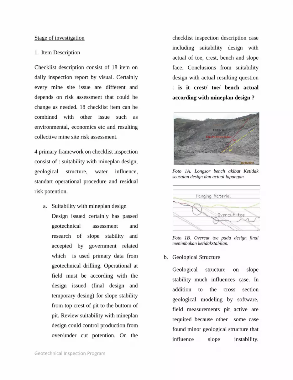
checklist inspection description case
including suitability design with
actual of toe, crest, bench and slope
face. Conclusions from suitability
design with actual resulting question
: is it crest/ toe/ bench actual
according with mineplan design ?
Foto 1A. Longsor bench akibat Ketidak
seusaian design dan actual lapangan
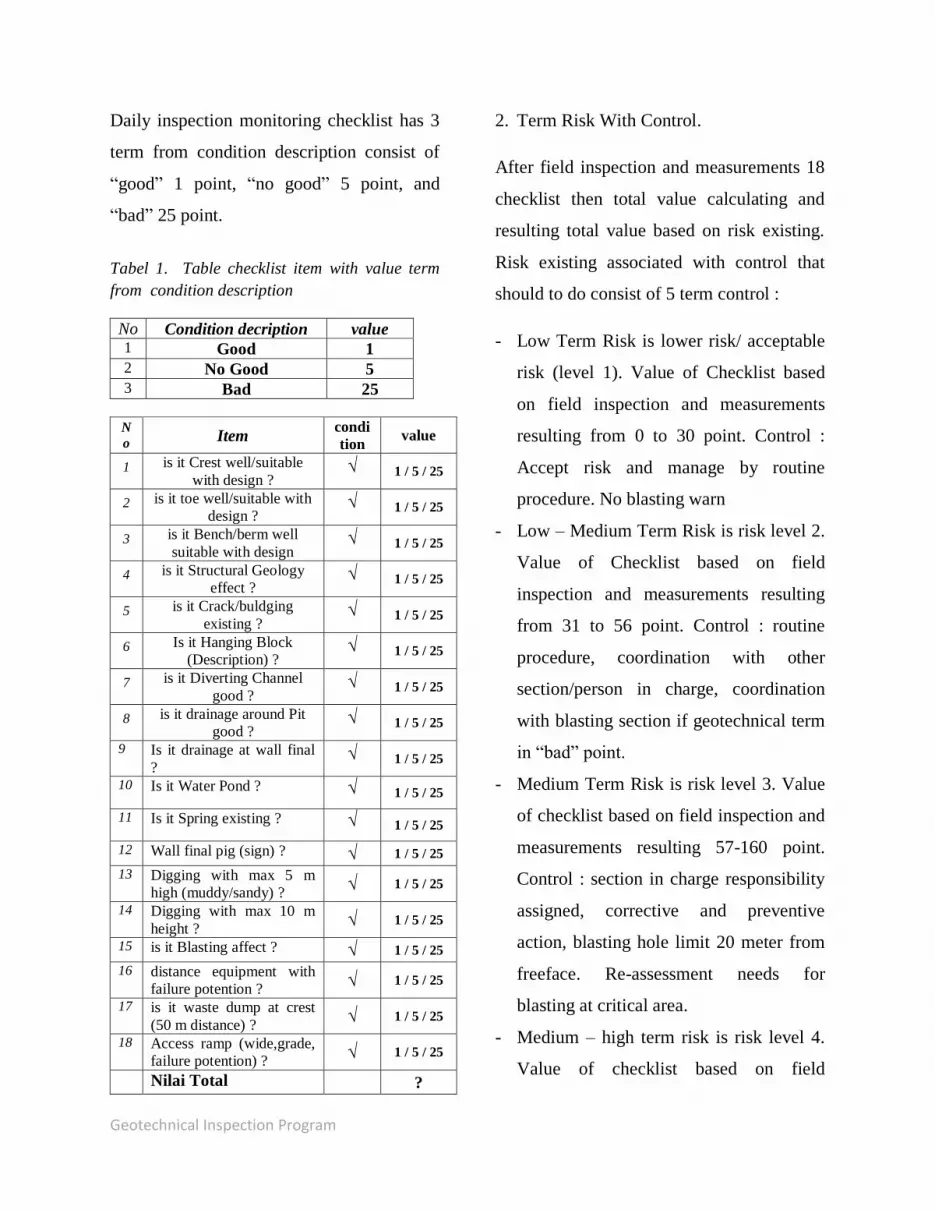
Foto 1B. Overcut toe pada design final
menimbukan ketidakstabilan.
b. Geological Structure
Geological structure on slope
stability much influences case. In
addition to the cross section
geological modeling by software,
field measurements pit active are
required because other some case
found minor geological structure that
influence slope instability.

Geotechnical Inspection Program
Comparing and rechecking actual
condition with geological model as
neccecary needs especially on dip of
slope, crack existing, fault, fold and
normal/reverse fault that coulnd be
“weak layer” on sediments layer and
decreasing of slope stability.
Geological structure case resulting
checklist questions Is It geological
structure influence slope stability ?
and describe all geological
structure found.
Foto 2A. geological structure field
measurements that have potention for slope
instability.
Foto 2b. failure potention map by measuring
minor field geological structure .
Foto 2b. Map potention and minor
geological structure field measurement
c. Water Influences
Water surface and underground at
mine pit significantly influencing on
slope stability. Water at mine pit
active could increase slope instability
including as a media on “weak layer”
sediment could triggering slope
failure and saturating sediment that
increasing load of sediments
material, water flowing at toe can be
eroded toe of slope that steppening
of slope face. On water influence the
questions is Is water spring,
dewatering surface water and
water ponding at crest of pit that
affect slope stability ?
Foto 3A.water ponding at pit crest(unsafe
condition).
A

Geotechnical Inspection Program
Foto 3B. perimeter drainage for surface
water around pit avoid water coming to the
pit edge.
d. Standart Operational Procedure.
Standart operational procedure
related with slope stability compiled
by research by person in charge.
Technically standart operational
procedure contained of paper
registered on company procedure
document. Procedure in associated
with slope stability consist of
digging at slope with 5 meter
maximum high at muddy material,
survey pig as a reference for crest,
toe, slope establishment, blasting
pattern on geological strucuture
affected area, waste dump crest
distance and other procedure related.
Foto 4A. unprosedural digging on muddy
material (morethan 10 m high).
Foto 4B. Operational prosedur muddy
material with not more than 5 meter high.
e. Residueal Risk.
Residual risk are slope instability
which is accapteble and not directly
affect on mine operational pit.
Residual risk in term is employees
and equipment safe from instability
risk like creeping muddy material,
rockfall potention, access ramp, and
risk associated with community. The
questions on checklist description are
Is it equipment distance with failure
potention are good, is it access ramp
good, is it other failure potention
associated with community good.
Foto 5. Rockfall potention as an example of
residual risk (no activity below risk
potention).
Geotechnical Inspection Program
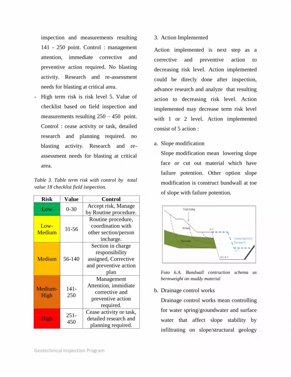
Daily inspection monitoring checklist has 3
term from condition description consist of
“good” 1 point, “no good” 5 point, and
“bad” 25 point.
Tabel 1. Table checklist item with value term
from condition description
No Condition decription value 1 Good 1 2 No Good 5 3 Bad 25
N
o Item condi
tion value
1 is it Crest well/suitable
with design ? √ 1 / 5 / 25
2 is it toe well/suitable with
design ? √ 1 / 5 / 25
3 is it Bench/berm well
suitable with design √ 1 / 5 / 25
4 is it Structural Geology
effect ? √ 1 / 5 / 25
5 is it Crack/buldging
existing ? √ 1 / 5 / 25
6 Is it Hanging Block
(Description) ? √ 1 / 5 / 25
7 is it Diverting Channel
good ? √ 1 / 5 / 25
8 is it drainage around Pit
good ? √ 1 / 5 / 25
9 Is it drainage at wall final
? √ 1 / 5 / 25
10 Is it Water Pond ? √ 1 / 5 / 25
11 Is it Spring existing ? √ 1 / 5 / 25
12 Wall final pig (sign) ? √ 1 / 5 / 25 13 Digging with max 5 m
high (muddy/sandy) ? √ 1 / 5 / 25
14 Digging with max 10 m
height ? √ 1 / 5 / 25
15 is it Blasting affect ? √ 1 / 5 / 25 16 distance equipment with
failure potention ? √ 1 / 5 / 25
17 is it waste dump at crest
(50 m distance) ? √ 1 / 5 / 25
18 Access ramp (wide,grade,
failure potention) ? √ 1 / 5 / 25
Nilai Total ?
2. Term Risk With Control.
After field inspection and measurements 18
checklist then total value calculating and
resulting total value based on risk existing.
Risk existing associated with control that
should to do consist of 5 term control :
- Low Term Risk is lower risk/ acceptable
risk (level 1). Value of Checklist based
on field inspection and measurements
resulting from 0 to 30 point. Control :
Accept risk and manage by routine
procedure. No blasting warn
- Low – Medium Term Risk is risk level 2.
Value of Checklist based on field
inspection and measurements resulting
from 31 to 56 point. Control : routine
procedure, coordination with other
section/person in charge, coordination
with blasting section if geotechnical term
in “bad” point.
- Medium Term Risk is risk level 3. Value
of checklist based on field inspection and
measurements resulting 57-160 point.
Control : section in charge responsibility
assigned, corrective and preventive
action, blasting hole limit 20 meter from
freeface. Re-assessment needs for
blasting at critical area.
- Medium – high term risk is risk level 4.
Value of checklist based on field
Geotechnical Inspection Program
inspection and measurements resulting
141 - 250 point. Control : management
attention, immediate corrective and
preventive action required. No blasting
activity. Research and re-assessment
needs for blasting at critical area.
- High term risk is risk level 5. Value of
checklist based on field inspection and
measurements resulting 250 – 450 point.
Control : cease activity or task, detailed
research and planning required. no
blasting activity. Research and re-
assessment needs for blasting at critical
area.
Table 3. Table term risk with control by total
value 18 checklist field isnpection.
Risk Value Control
Low 0-30 Accept risk, Manage
by Routine procedure.
Low-
Medium 31-56
Routine procedure,
coordination with
other section/person
incharge.
Medium 56-140
Section in charge
responsibility
assigned, Corrective
and preventive action
plan
Medium-
High
141-
250
Management
Attention, immidiate
corrective and
preventive action
required.
High 251-
450
Cease activity or task,
detailed research and
planning required.
3. Action Implemented
Action implemented is next step as a
corrective and preventive action to
decreasing risk level. Action implemented
could be direcly done after inspection,
advance research and analyze that resulting
action to decreasing risk level. Action
implemented may decrease term risk level
with 1 or 2 level. Action implemented
consist of 5 action :
a. Slope modification
Slope modification mean lowering slope
face or cut out material which have
failure potention. Other option slope
modification is construct bundwall at toe
of slope with failure potention.
Foto 6.A. Bundwall contruction schema as
bermweight on muddy material
b. Drainage control works
Drainage control works mean controlling
for water spring/groundwater and surface
water that affect slope stability by
infiltrating on slope/structural geology

Geotechnical Inspection Program
layers. Dranaige control can be use
drainhole method with water level
monitoring (pziometer) for draining
undergroundwater. Drainage control for
surwace water usually with perimeter
drainage around pit edge.
Foto 6.B. water infiltrated schema from surface
water to lowwall pit.
c. HSE implementation
HSE implementation with identification
instability existing as warn information
sign for employees and as a preventive
action before andvance research and
analysis. HSE implementation example
safety barricade, geotech warning sign
and other warning sign.
Foto 6.B. safety barricade installation as a
warning sign for instability area.
d. Geotechnical Investigation and Analysis
Geotechnical investigation and analysis is
advance detailed research and analysis
with software and other instrument as a
corrective action. Software analyze
including slide, phase2, detailed research
on fieLd by spt test, cone penetrometer
test, geological structure measurement
etc. Report detailed research and
investigation used as a recommendation
for mineplan and operational section.
Foto 7.A. factor of safety analysis used software
slide v 5.0. sample geotechnical anilysis after
detaild research actual condition and resulting
geotechnical recommendation.
Geotechnical Inspection Program
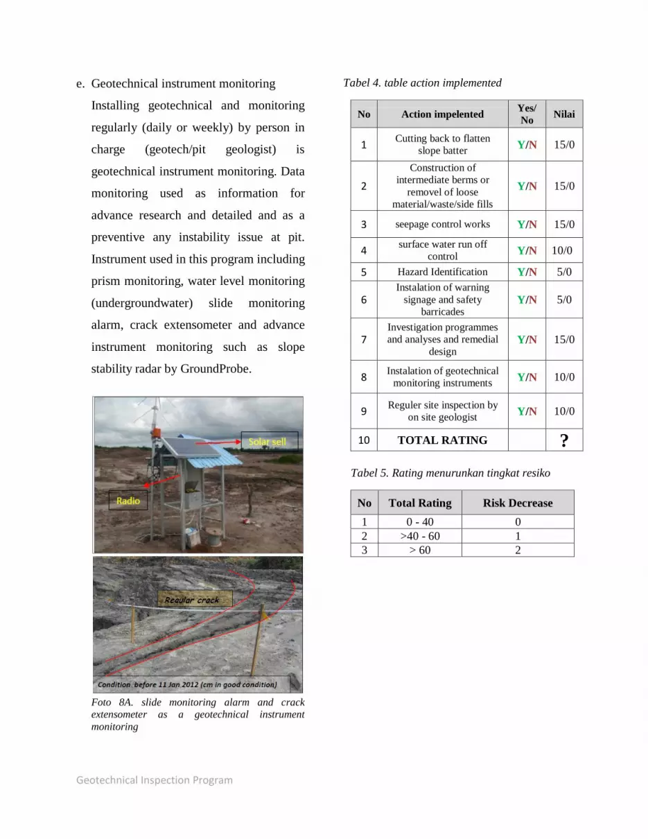
e. Geotechnical instrument monitoring
Installing geotechnical and monitoring
regularly (daily or weekly) by person in
charge (geotech/pit geologist) is
geotechnical instrument monitoring. Data
monitoring used as information for
advance research and detailed and as a
preventive any instability issue at pit.
Instrument used in this program including
prism monitoring, water level monitoring
(undergroundwater) slide monitoring
alarm, crack extensometer and advance
instrument monitoring such as slope
stability radar by GroundProbe.
Foto 8A. slide monitoring alarm and crack
extensometer as a geotechnical instrument
monitoring
Tabel 4. table action implemented
No Action impelented Yes/
No Nilai
1 Cutting back to flatten
slope batter Y/N 15/0
2
Construction of
intermediate berms or
removel of loose
material/waste/side fills
Y/N 15/0
3 seepage control works Y/N 15/0
4 surface water run off
control Y/N 10/0
5 Hazard Identification Y/N 5/0
6 Instalation of warning
signage and safety
barricades Y/N 5/0
7 Investigation programmes
and analyses and remedial
design Y/N 15/0
8 Instalation of geotechnical
monitoring instruments Y/N 10/0
9 Reguler site inspection by
on site geologist Y/N 10/0
10 TOTAL RATING ?
Tabel 5. Rating menurunkan tingkat resiko
No Total Rating Risk Decrease
1 0 - 40 0
2 >40 - 60 1
3 > 60 2

Geotechnical Inspection Program
Description 18 item on
checklist
Risk Assesment 1. Low
2. Low - Medium
3. Medium
4. Medium – high
5. High
1. Accept risk, Manage by Routine procedure.
2. Routine procedure, coordination with other
section/person incharge.
3. Section in charge responsibility assigned,
Corrective and preventive action plan.
4. Management Attention, immidiate
corrective and preventive action required.
5. Cease activity or task, detailed research and
planning required.
Control term Risk
- Cutting back to flatten slope batter.
- Construction of intermediate berms or
removel of loose material/waste/side fills
- seepage control works
- surface water run off control
- Hazard Identification
- Instalation of warning signage and safety
barricades
- Investigation programmes and analyses
and remedial design
- Instalation of geotechnical monitoring
instruments
- Reguler site inspection by on site geologist
Action Implemented
Evaluation, Conclusions and
Recommendation report
Flowchart on guidelines daily Geotechnical Inspection Pit Monitoring
Total 18 checklist number (0 – 450 )