Guide to the geology of the Rock Island-Milan area, Rock Island County
80
O Msxsfk JHkm^ D. r —< Richard C. Anderson Augustana College David H. Ma I one Robert S. Nelson Illinois State University Wayne T. Frankie Russell J. Jacobson >^ f?f\ Illinois State Geological Survd^i -Sag-? ' -•*#£ *< VI .'» 'tit*** Ml, A" . Field Trip Guidebook 1999B May 22, 1999 Department of Natural Resources ILLINOIS STATE GEOLOGICAL SURVEY '* -» .-*• .*
Transcript of Guide to the geology of the Rock Island-Milan area, Rock Island County
O
MsxsfkJHkm^D.
r —<Richard C. AndersonAugustana College
David H. Ma IoneRobert S. Nelson
Illinois State University
Wayne T. Frankie
Russell J. Jacobson >^ f?f\
Illinois State Geological Survd^i
-Sag-? '-•*#£
*<
VI
.'»
'tit***
Ml,
A"
.
Field Trip Guidebook 1999BMay 22, 1999
Department of Natural ResourcesILLINOIS STATE GEOLOGICAL SURVEY
'* -»
.-*• .*

Digitized by the Internet Archive
in 2012 with funding from
University of Illinois Urbana-Champaign
http://archive.org/details/guidetogeologyof1999ande
Guide to the Geology of the
Rock Island-Milan Area,
Rock Island County
Richard C. AndersonAugustana College
David H. MaloneRobert S. Nelson
Illinois State University
Wayne T. Frankie
Russell J. JacobsonIllinois State Geological Survey
Field Trip Guidebook 1999BMay 22, 1999
Department of Natural ResourcesILLINOIS STATE GEOLOGICAL SURVEYNatural Resources Building
615 East Peabody Drive
Champaign, IL 61820-6964Home page: http//www.isgs.uiuc.edu
Cover photo Collinson Brothers, Milan Quarry (photo by W. T. Frankie)
Geological Science Field Trips The Geoscience Education and Outreach unit of the Illinois State
Geological Survey (ISGS) conducts four free tours each year to acquaint the public with the rocks,
mineral resources, and landscapes of various regions of the state and the geological processes that
have formed them. Each trip is an all-day excursion through one or more Illinois counties. Frequent
stops are made to explore interesting phenomena, explain the processes that shape our environ-
ment, discuss principles of earth science, and collect rocks and fossils. People of all ages and inter-
ests are welcome. The trips are especially helpful to teachers preparing earth science units. Grade
school students are welcome, but each must be accompanied by a parent or guardian. High school
science classes should be supervised by at least one adult for each ten students.
A list of guidebooks of earlier field trips, useful for planning class tours and private outings, can be
obtained by contacting the Geoscience Education and Outreach Unit, Illinois State Geological Sur-
vey, Natural Resources Building, 615 East Peabody Drive, Champaign, IL 61820-6964. Telephone:
(217) 244-2427 or 333-4747.
Two U.S. Geological Survey 7.5-Minute Topographic Quadrangle maps (Coal Valley and Milan)
cover this field trip area.
Editorial Board
Jonathan Goodwin, Chair
Michael Barnhardt Anne ErdmannBrandon Curry David Larson
Heinz Damberger Donald Mikulic
William Roy
ILLINOIS
ttPAIWLNlQiNATURALRESOURC E9
printed with soybean ink on recycled paper
Printed by authority of the State of Illinois/1999/500
CONTENTS
ROCK ISLAND-MILAN AREA 1
Geologic Setting 1
Stratigraphy 2
Silurian 4
Devonian 7
Pennsylvanian 8
Quaternary 9
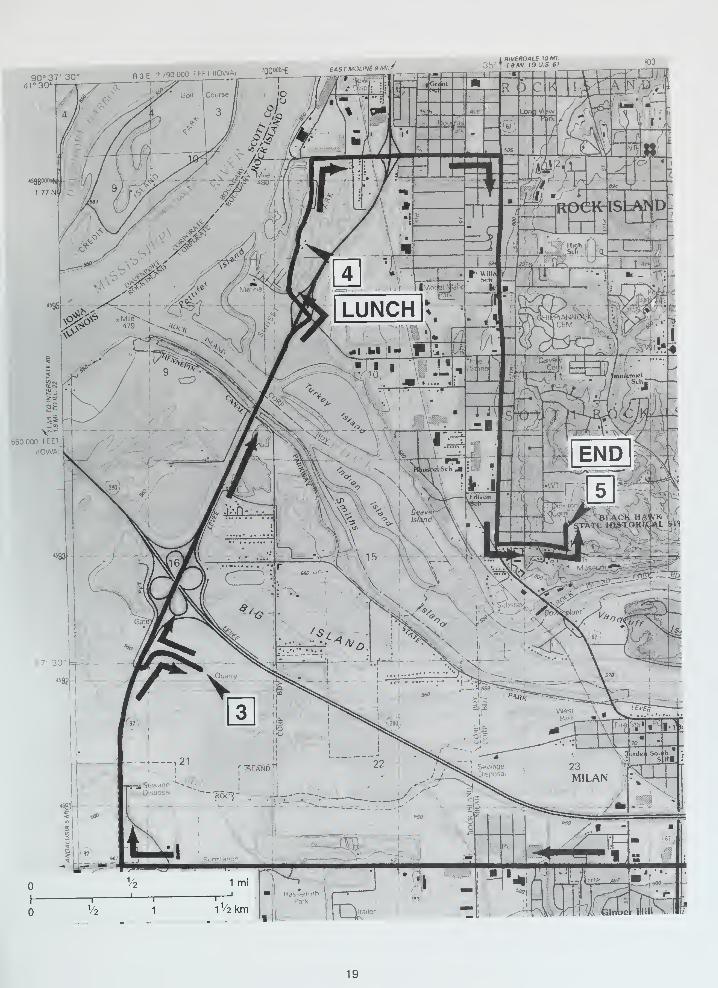
GUIDE TO THE ROUTE 11
STOP DESCRIPTIONS 20
1 Borrow Pit of C. E. Peterson and Sons 20
2 Collinson Brothers, Milan Quarry 22
3 Moline Consumers, General Sand and Gravel Pit 22
4 Lunch: Sunset Park 23
5 Black Hawk State Historic Site 26
REFERENCES 37
GLOSSARY 39
SUPPLEMENTARY READING
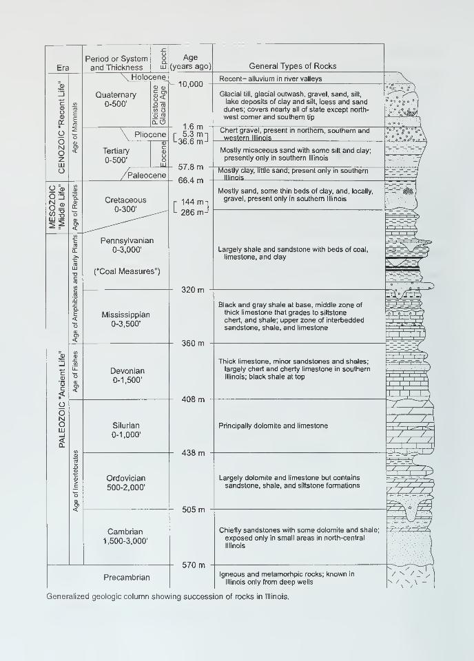
Era
Period or Systemand Thickness
Holocene
Quaternary0-500'
0) 0)
o _o eg
oj _tg
Pliocene
Tertiary
0-500'
Paleocene
Pennsylvanian0-3,000'
("Coal Measures")
Mississippian
0-3,500'
Devonian0-1,500'
Silurian
0-1,000'
Ordovician
500-2,000'
Cambrian1,500-3,000'
Precambrian
Generalized geologic column showing succession of rocks in Illinois.
Age(years ago)
10,000
1.6 m• 5.3 mi-36.6 m J
57.8 m
66.4 m
144 m-
286 m-
320 m
360 m
408 m
438 m
General Types of Rocks
505 m
570 m
Recent- alluvium in river valleys
Glacial till, glacial outwash, gravel, sand, silt,
lake deposits of clay and silt, loess and sanddunes; covers nearly all of state except north-
west comer and southern tip
Chert gravel, present in northern, southern andwestern Illinois
Mostly micaceous sand with some silt and clay;
presently only in southern Illinois
Mostly clay, little sand; present only in southernIllinois '
Mostly sand, some thin beds of clay, and, locally,
gravel, present only in southern Illinois
Largely shale and sandstone with beds of coal,
limestone, and clay
Black and gray shale at base, middle zone of
thick limestone that grades to siltstone
chert, and shale; upper zone of interbedded
sandstone, shale, and limestone
Thick limestone, minor sandstones and shales;
largely chert and cherry limestone in southern
Illinois; black shale at top
Principally dolomite and limestone
Largely dolomite and limestone but contains
sandstone, shale, and siltstone formations
Chiefly sandstones with some dolomite and shale;
exposed only in small areas in north-central
Illinois
Igneous and metamorhpic rocks; known in
Illinois only from deep wells
sss.
I I
i ' i —r-
/ , //
. / /
/ / 7
ROCK ISLAND-MILAN AREA
The Rock Island, Illinois, area has been the destination for numerous geology field trips and geo-
logic field conferences (for example, Edmunds and Anderson 1967, Anderson and others 1982).
This field trip guidebook was developed largely from work published in these field guides. We wish
to thank the following for permission to enter their property and help in developing this trip: Moline
Consumers Inc., C. E. Peterson and Sons, Collinson Brothers, and the staff at Black Hawk State
Historic Site.
This guidebook is divided into four sections. The first section introduces the geology of Illinois and
in particular the Rock Island-Milan area. The second section is a road log for the trip, and the third
section provides detailed stop descriptions. The final section includes a glossary and supplemen-
tary discussions of topics that are important to the field trip area.
GEOLOGIC SETTING
The oldest rocks present in the subsurface (termed basement rocks by geologists) of the field trip
area include approximately 1.5-billion-year-old crystalline rocks of the Midcontinent Granite-Rhyolite
Terrane (consisting mostly of granitic and rhyolitic igneous, and possibly metamorphic, crystalline
rock). Very little is known about these basement rocks because they are not exposed anywhere in
Illinois, and few (approximately 35) drill holes have penetrated deep enough to recover samples.
From about 1.0 to 0.6 billion years ago, these rocks were exposed and deeply weathered into a
landscape similar to that of the present Missouri Ozarks.
The Illinois Basin is the major structural feature of Illinois. This broad elliptical cratonic basin began
to develop as a failed arm of Precambrian rifting of North America (figs. 1 & 2). This rifting initially
produced the Rough Creek Graben and the Reelfoot Rift in southernmost Illinois. These steep-
walled tectonic valleys are filled with sand and gravel that was shed from the adjacent uplands. By
the late Precambrian, the rifting had stopped, but the Illinois Basin remained an area of structural
weakness prone to infilling of sediment throughout the Paleozoic Era.
During the Paleozoic Era, strata accumulated in seas that covered Illinois and adjacent states. The
shallow seas connected with the open ocean to the south during much of the Paleozoic, and the
area of southern Illinois was an embayment. The southern part of Illinois and adjacent parts of Indi-
ana and Kentucky sank more rapidly than areas to the north, which allowed a greater thickness of
sediment to accumulate there than elsewhere in Illinois. Where stresses built up in places, the rela-
tively thin crust of the earth was periodically flexed and warped to produce both upward bends (anti-
clines) and downward buckles (synclines). These movements, along with worldwide changes in sea
level, produced repeated withdrawals (regressions) and invasions (transgressions) of ocean water
across the slowly subsiding region. During the regressions, former sea floors were periodically ex-
posed to erosion, removing some sediments from the rock record. During the Mesozoic Era, the
rise of the Pascola Arch in southeastern Missouri and western Tennessee cut off the embayment
and separated it from the open sea to the south. Development of the Pascola Arch, combined with
the earlier sinking of deeper parts of the area to the north, gave the basin its present asymmetrical,
"spoon-shaped" configuration (fig. 3).
Please note: although all present localities have only recently appeared within the geologic time frame, we usethe present names of places and geologic features because they provide clear reference points for describing
the ancient landscape.
Rock Island County lies along the extreme
northwestern margin of the Illinois Basin as de-
fined by the occurrence of Pennsylvanian strata;
immediately to the west is the Mississippi River
Arch (fig. 2). The regional dip of Paleozoic strata
is less than 1° toward the south and southeast.
The Precambrian granite and rhyolite lie at a
depth of about 4,000 feet beneath the surface in
this region. These rocks are unconformably
overlain by about 1 ,900 feet of sandstone and
minor amounts of dolomite and shale (Cambrian
Mt. Simon through Franconia Formations) fol-
lowed by 1 ,800 feet of carbonate rocks, sand-
stone, and shale (Cambrian Potosi through
Devonian Cedar Valley formations) (see fig. 4).
The Devonian rocks are unconformably overlain
by varying thicknesses of Pennsylvanian shale,
sandstone, and coal; and these units are subse-
quently overlain by Quaternary glacial till, loess,
and alluvium. This field trip will examine rocks
and sediments that range in age from Silurian
through Pleistocene (fig. 5). Rocks older than
the Silurian are not exposed at the surface in the
field trip area.
Figure 1 Location of some of the major structures in
the Illinois region. (1) La Salle Anticlinorium, (2) Illinois
Basin, (3) Ozark Dome, (4) Pascola Arch, (5) Nashville
Dome, (6) Cincinnati Arch, (7) Rough Creek Graben-
Reelfoot Rift, and (8) Wisconsin Arch.
STRATIGRAPHYNear the beginning of the Paleozoic Era, about
570 million years ago, the rifting in and near
southern Illinois stopped, and the hilly Precam-
brian landscape began to slowly subside, allow-
ing a shallow sea to invade from the south and
southwest. During the several hundred million years of the Paleozoic Era, the area that is now
southern Illinois continued to accumulate layers of sediment deposited on the bottom of the shallow
seas that repeatedly covered it. The region continued to subside until at least 15,000 feet of strata
were deposited. At times the seas withdrew and the deposits were weathered and eroded. As a re-
sult, in Illinois there are gaps in the sedimentary record, which are called unconformities. The major
gaps form boundaries that separate the Paleozoic rocks into four super sequences: Sauk, Tippeca-
noe, Kaskaskia, and Absaroka. The major unconformities in the field trip area are shown on figure 4.
Many of the sedimentary units, called formations, have conformable contacts; that is, no significant
interruption in deposition occurred as one formation was succeeded by another (figs. 4 & 6). In
some instances, even though the composition and appearance of the rocks change significantly at
the contact between two formations, the fossils in the rocks and the relationships between the rocks
at the contact indicate that deposition was virtually continuous. In contrast however, in some places
the top of the lower formation was at least partially eroded before deposition of the next formation
began. In these instances, fossils and other evidence in the two formations indicate that there is a
significant age difference between the lower unit and the overlying unit. This type of contact is called
an unconformity (fig. 6). If the beds above and below an unconformity are parallel, the unconformity
is called a disconformity. However, if the lower beds were tilted and eroded prior to deposition of
Anticline
Syncline
Monocline
Fault, ticks on F.C. Fault Complex
downthrown side F.F. Faulted Flexure
rt. Crypto-explosive or F.S. Fault SystemM
impact structure F.Z. Fault Zone
Figure 2 Structural features of Illinois (modified from Buschbach and Kolata 1991)
Chicago
Rockford
100 mi
00 km
Figure 3 Stylized north-south cross section shows the structure of the Illinois Basin. To show detail, the thickness of the
sedimentary rocks has been greatly exaggerated and younger, unconsolidated surface deposits have been eliminated.
The oldest rocks are Precambrian (Pre--€) granites. They form a depression filled with layers of sedimentary rocks of vari-
ous ages: Cambrian (-G), Ordovician (O), Silurian (S), Devonian (D), Mississippian (M), Pennsylvanian (P), Cretaceous (K),
and Tertiary (T). Scale is approximate.
overlying beds, the contact between the lower tilted beds and the overlying flat-lying rocks is called
an angular unconformity.
Unconformities occur throughout the Paleozoic rock record and are shown in the generalized stra-
tigraphic column (located in the front of this guidebook) as wavy lines. In figure 4, the unconformities
are labeled with a "U." Each unconformity represents an extended interval of time for which there is
no rock record in this area.
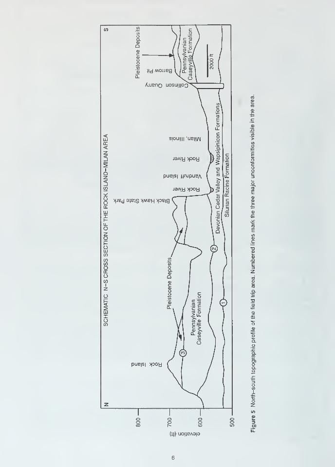
Silurian The oldest bedrock unit exposed at the surface in Rock Island County is the Silurian
Racine Dolomite (fig. 4). We will examine the Racine Dolomite during the morning at the Collinson
Brothers quarry in Milan, Illinois. Quarry operations have recently uncovered about 30 feet of the
Racine. The unit ranges in color from light yellow brown to light brownish or greenish gray and is as
thick as 300 feet.
The Racine Dolomite consists of numerous low oval reefs (bioherms) that vary in size from a few
tens of feet to as much as % mile in diameter (Hinman 1968). Larger reefs are present in northeast-
ern Illinois and northern Indiana. An idealized Silurian reef is shown in figure 7. The reef core con-
sists of a mass of porous and fractured dolomite. The numerous fossils that are typically present in
the bioherm cores include corals, stromatoporoids, crinoids, brachiopods, and molluscs. Corals and
stromatoporoids were the most abundant organisms. The coral Favosites is particularly abundant.
Figure 4 Generalized stratigraphic column for Rock Island County, Illinois (modified from Anderson, 1980). Major uncon-
formities are indicated by "U."
If) i2'55
oQ.CD
Qcdc .
cca
c03>
c \o \
"co /E /ll/ JA) >, (Df
o </) -^t ° /o c
c £\ 8to
0) }!d MOUBg V /CD
CLCD \W 1
c I
Q.
AjjBnQ U0SU|||0C
CO I
O \
]
)'V\ (
ca
\ \ CD
\ s\
k_CO
\ ol CD
\ .C\ TO
IE co CDLL .a
<Ul SjOUjHI
'
UB||LAJ
Coo
CO
>DC 'c CO
< Q.CD
ZjaAiy >poy
V co
1} CO
A 5' "O
cgto
E
1o
oQZ puB|S| iimpuBA
1
CO £oc3
3 CDC o
w J9A|y >poy )>?oCO
co"
Eoo >|JBd ajBJS >|MBH >P«
^ CO
\ "D\ CD
Xc(0
2igC~CDCD
X1 °l ^
£LU 1 c J CD
X 1 '~° w £H cl J£UL 1 o '
I > coOz \
Q ECOo CDc
h-O
(5) TJLU CD
C/)w 0)
W 'co Eo o 3DC a.
CDZ
O Q CO
1
zCDcCDO
CD
co
o O I c1 o
£2
<5
X. I!DCD
LU CO o CD
X > u. £o CO JD i^_
(J)
j^(
ItCL CD
COCO
o
o_g>
oCLO!cQ.CO
D)OnpuB|S| >poyOX3O?-Ccoz z
~r ~r 1
in
o o o c3 £o o o cD 3CO r^ CD Lo co
(W) u<D!lBA9|ail
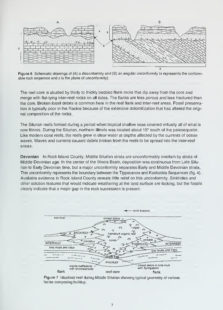
Figure 6 Schematic drawings of (A) a disconformity and (B) an angular unconformity (x represents the conform-
able rock sequence and z is the plane of unconformity).
The reef core is abutted by thinly to thickly bedded flank rocks that dip away from the core and
merge with flat-lying inter-reef rocks on all sides. The flanks are less porous and less fractured than
the core. Broken fossil debris is common here in the reef flank and inter-reef areas. Fossil preserva-
tion is typically poor in the Racine because of the extensive dolomitization that has altered the origi-
nal composition of the rocks.
The Silurian reefs formed during a period when tropical shallow seas covered virtually all of what is
now Illinois. During the Silurian, northern Illinois was located about 15° south of the paleoequator.
Like modern coral reefs, the reefs grew in clear water at depths affected by the currents of ocean
waves. Waves and currents caused debris broken from the reefs to be spread into the inter-reef
areas.
Devonian In Rock Island County, Middle Silurian strata are unconformably overlain by strata of
Middle Devonian age. In the center of the Illinois Basin, deposition was continuous from Late Silu-
rian to Early Devonian time, but a major unconformity separates Early and Middle Devonian strata.
This unconformity represents the boundary between the Tippecanoe and Kaskaskia Sequences (fig. 4).
Available evidence in Rock Island County reveals little relief on this unconformity. Sinkholes and
other solution features that would indicate weathering at the land surface are lacking, but the fossils
clearly indicate that a major gap in the rock succession is present.
wind direction
flank
micrite batflestone
with stromatactoids
crinoid debris in lime mudwith Syringapora
flankreef core
Figure 7 Idealized reef during Middle Silurian showing typical geometry of various
facies composing buildup.
In the Quad Cities area, the Devonian consists of the Wapsipinicon and Cedar Valley formations
(fig. 4). During Devonian time, the Quad Cities area lay on the eastern margin of the Central Iowa
Basin, which at that time was separated from the Illinois Basin by the roughly east-west-trending
Sangamon Arch in central Illinois (Collinson 1967) (see fig. 2).
Following the withdrawal of the seas at the end of Early Devonian time, the sea rapidly transgressed
from the west and north and reached the Quad Cities area by Middle Devonian time, as recorded by
deposition of the Wapsipinicon Limestone (fig. 4). The Wapsipinicon, which is as thick as 60 feet,
gives abundant evidence for deposition in hypersaline conditions (conditions of highly increased
salinity due to evaporation of seawater, which forms concentrated brines). Gypsum, a commonevaporite rock (that is, a salt mineral formed by evaporation of seawater) that forms in hypersaline
conditions, is widespread within the Wapsipinicon in southeastern Iowa. In the Rock Island area,
where the Wapsipinicon is at the surface or is unconformably overlain by Pennsylvanian rocks, the
formation is highly brecciated (broken into angular fragments), perhaps as the result of the dissolu-
tion of thick layers of gypsum and the collapse of the limestone layers into the empty spaces that
formed. The Wapsipinicon also has very fine-grained layers with well-developed stromatolites, rip-up
clasts, and scattered occurrences of mud cracks and dolomite; fossils are extremely rare. These
characteristics are typical of limestones deposited under arid, shallow seas in tropical or subtropical
latitudes, an environment similar to that of the modern Persian Gulf region. During the Devonian,
what is now northern Illinois was located about 12° south of the paleoequator.
The Wapsipinicon Limestone is overlain by the Cedar Valley Limestone (fig. 4). In some places,
there is evidence for a minor unconformity between the two units, but in other areas deposition was
continuous. The Cedar Valley represents a transgressive onlapping succession of deposits that cov-
ered the Wapsipinicon when the seas reinvaded the area after a period of withdrawl. In the Rock
Island area, the Cedar Valley consists of thickly to massively bedded, richly fossiliferous limestone
that is as thick as 140 feet. Brachiopods are the dominant fossils, but crinoids, corals, bryzoans,
cephalopods, trilobites, and rare shark teeth also occur. In places, the sediments were intensively
burrowed by marine animals before they were lithified. The Cedar Valley limestone was deposited in
a shallow marine environment with normal marine salinities. Erosion has removed much of the upper
Cedar Valley Limestone in the Rock Island area.
Pennsylvanian In the Rock Island-Milan area, some Late Devonian strata and an unknown thick-
ness of Mississippian strata were removed by erosion prior to Pennsylvanian time, so that in most
places, Pennsylvanian strata rest directly upon the Cedar Valley Limestone. This unconformity
marks the boundary between the Kaskaskia and Absaroka Sequences (see fig. 4). The unconfor-
mity surface reflects a well-developed karst landscape formed in an area of low to moderate relief
(generally less than 200 feet).
Because of the occurrence of coal and the cyclic successions of strata, the Pennsylvanian rocks of
the Illinois Basin have been extensively studied (see Depositional History of Pennsylvanian Rocks in
Illinois at the back of this guidebook). Pennsylvanian strata consisting of shale, siltstone, sandstone,
limestone, coal, and underclay were deposited as sediments in shallow seas, rivers, deltas, and
swamps between about 320 and 288 million years ago. Rock Island County marks the northwest-
ernmost extent of Pennsylvanian rocks in the Illinois Basin. Prior to the beginning of Pennyslvanian
deposition, the Illinois Basin area was elevated at its north end and depressepd slightly at the south;
the upturned edges of the strata were then beveled by erosion, forming an angular unconformity.
Two Pennsylvanian formations occur in the Rock Island area, the Caseyville and the Tradewater
(see fig. 4), but only the Caseyville will be seen during this field trip. Prior to the deposition of the
Caseyville Formation, the entire Illinois Basin area was above sea level, and a series of southwest-
flowing streams incised valleys 200 to 300 feet below the adjacent upland plains. In areas where the
surface rocks were limestone or dolomite, caves and sinkholes formed that were subsequently filled
with Pennsylvanian sediments. The principal source area for Pennsylvanian sediments throughout
much of the Illinois Basin was to the northeast in the Appalachian Mountains, but in the Quad Cities
area, the sediments may have been derived from the north or northwest.
When the Lower Pennsylvanian seas advanced from the west, deposition of the Caseyville and
Tradewater Formations was initially confined to the river valleys, which became brackish estuaries,
bays, or lagoons as they were drowned by the rising sea. As a result, the oldest Pennsylvanian units
in the area are discontinuous. The river valleys were eventually filled, and a level depositional sur-
face was established. The Pennsylvanian strata in the field trip area are as thick as 200 feet.
The Caseyville Formation was initially believed to occur only in southern Illinois. O'Brien (1963) rec-
ognized the Caseyville Formation in the Quad Cities area on the basis of studies of fossil pollen in
the coals. The Caseyville, which forms the bluffs overlooking the Rock River at Black Hawk State
Historic Site, is the basal Pennsylvanian unit throughout much of central and southern Rock Island
County. The Caseyville is dominated by thick sandstone units, composed of "clean" quartz sands
that have little clay and only modest amounts of mica. These rocks are interpreted to have been
deposited in fluvial or deltaic environments.
Although coals are common throughout the Pennsylvanian system in the Quad Cities area, only the
Rock Island (No. 1) Coal of the Lower Tradewater Formation has been economically important. The
Tradewater Formation overlies the Caseyville in part of the field trip area, but in the remainder of the
region, it is the basal formation of the Pennsylvanian System. In the field trip area, the Tradewater is
characterized by thin lenticular sandstones and limestones within thicker shale successions. Trade-
water sandstones differ significantly from those in the underlying Caseyville. Tradewater sandstones
generally are less clean and contain abundant rock fragments, especially mica and feldspar. The
compositional and textural changes reflect a change in source materials.
Quaternary System No rocks of Permian, Mesozoic, or Tertiary age occur in the Quad Cities
area. The present course of the Mississippi River below the Quad Cities and its deeply incised val-
ley date to the Pleistocene. Prior to the establishment of the present course of the Mississippi River
at the Quad Cities in late Pleistocene time, the course of the river in western Illinois, below Muscatine,
Iowa, was occupied by a river whose headwaters lay in the drainage basins of the present Cedar and
Iowa Rivers in east-central Iowa. Thus, although the present course of the Mississippi River in west-
ern Illinois bears a close relationship to the western margin of lllinoian glacial deposits and appears
to have been determined by the lllinoian glaciers, a valley almost certainly existed in that location
prior to lllinoian glaciation and probably in preglacial time as well. The Pleistocene glaciations and
their effects on preglacial drainage patterns are summarized in Pleistocene Glaciations in Illinois at
the back of this guidebook.
Between Cordova, Illinois, and Muscatine, Iowa, the Mississippi River flows across a preglacial
drainage divide. This course is a result of diversions of the southeastward-flowing Ancestral Missis-
sippi River by lllinoian and later Wisconsinan ice moving south and west across Illinois from the
Lake Michigan basin. These diversions caused proglacial lakes to form when the river was blocked
by the glacial ice. The level of these lakes rose until the water flowed over the lowest point within the

lake's basin. The most significant breach of these former divides in the Quad Cities area is located
at Wyoming Hill, Iowa. The development of this outlet established the present course of the Missis-
sippi River in the Quad Cities area. Lacustrine sediments associated with these proglacial lakes will
be examined at Stop 1
.
The Quaternary stratigraphy in this area is primarily lllinoian till (the Kellerville Till member of the
Glassford Formation) with a well-developed Sangamon Soil in its upper portions, overlain by the
Peoria Loess of Wisconsinan age. Lacustrine sediments occur between the till and the loess. In
places, pre-lllinoian tills have been recognized. Modern alluvium occurs within the main channel and
floodplains of the Mississippi and Rock Rivers.
10
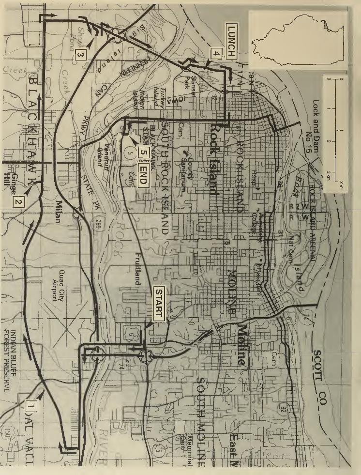
GUIDE TO THE ROUTE
We'll start the trip in the parking lot of the South Park Mall, Moline. Assemble in the northwest corner
of the parking lot next to Montgomery Wards and the outer mall road. The mall is located in the SE
quarter of the NW quarter of the NW quarter of Sec. 16, T17N, R1W, 4th PM, Milan 7.5-Minute
Quadrangle. Mileage will start at the northeast entrance/exit of South Park Mall.
You must travel in the caravan. Please drive with headlights on while in the caravan. Drive safely
but stay as close as you can to the car in front of you. Please obey all traffic signs. If the road cross-
ing is protected by an Illinois State Geological Survey (ISGS) vehicle with flashing lights and flags,
please obey the signals of the ISGS staff directing traffic. When we stop, park as close as possible
to the car in front of you and turn off your lights.
Private property Some stops on the field trip are on private property. The owners have graciously
given us permission to visit on the day of the field trip only. Please conduct yourselves as guests
and obey all instructions from the trip leaders. So that we may be welcome to return on future field
trips, follow these simple rules of courtesy:
• Do not litter the area.
• Do not climb on fences.
• Leave all gates as you found them.
• Treat public property as if you were the owner—which you are!
• Stay off of all mining equipment.
• Parents must closely supervise their children at all times.
When using this booklet for another field trip with your students, a youth group, or family, remember
that you must get permission from property owners or their agents before entering private property.
No trespassing please.
Two USGS 7.5-Minute Quadrangle maps (Coal Valley and Milan) provide coverage for this field trip
area.
Miles Miles
to next from
point start
0.0 0.0 South Park Mall is built on 5 to 10 feet of fill. Before the mall was constructed,
the elevation at the top of the banks along Rock River was at 560 feet and the
natural floodplain north of Rock River extended % mile to the 570-foot contour
line. This low area, where the mall now stands, was a swamp. Presently, the
570-foot contour line is at the south end of the mall, and the floodplain has been
reduced to less than Va mile wide. Before the mall was constructed, the creek at
the west side of the mall drained into the swamp not the river. Now the creek is
channelized all the way to the river.
TURN RIGHT (south) onto 27th Street. Set your mileage to 0.0 at the northeast
exit/entrance of South Park Mall.
Note the drainage way between the road and the mall parking lot. Prior to mall
construction, this drainage way was located on the other side of the road.
11
0.2 0.2
0.2 0.4
0.1 0.5
0.1 0.6
0.2 0.8
Stoplight (intersection of East Mall Entrance). CONTINUE SOUTH.
Stoplight (intersection of 52nd Avenue and 27th Street). CONTINUE SOUTH.
North abutment of bridge over Rock River.
South abutment of bridge.
Bridge over Interstate 280/74. The low hill ahead is a remnant of a terrace that
marked a former floodplain of the river. The terrace is underlain by a resistant
bedrock island.
0.1 0.9 Stoplight (intersection of Airport Road and 27th Street). CONTINUE AHEAD.Directly ahead to the south are the bluffs that form the valley of the Rock River.
0.1 1 .0 Road begins a large, gentle 90° curve to the left.
0.3 1 .3 Stoplight. T-intersection from the left (Route 6 and access to I-74/280). CON-TINUE AHEAD (east). We are now following Route 6 East, which is also WestFirst Avenue
0.5 1 .8 Stoplight. T-intersection from the right (Route 1 50). CONTINUE EAST on Route
6. Right lane ends. MERGE LEFT.
0.2 2.0 Bridge over Coal Creek. The creek has been channelized and its mouth relo-
cated % mile downstream.
0.3 2.3 Enter Coal Valley, population 3,500, established in 1856. Coal Valley and Coal
Creek are named after the 3- to 6-foot-thick exposures of the Rock Island Coal.
This coal was mined in the area for several years near Coal Valley and Carbon
Cliff. The Rock Island Coal is generally overlain by the very dark gray to black
Seville Limestone. The Seville Limestone is generally thickest over the thickest
coal.
0.75 3.05 T-intersection from the right (First Street). TURN RIGHT (south) onto First
Street.
0.25 3.3 Crossroad intersection (East 4th Avenue and West 4th Avenue, and 1st Street).
TURN RIGHT (west) onto West 4th Avenue. PROCEED WITH CAUTION: The
road surface is rough.
One of the first things to notice (to the left) as you follow this road is the large
number of trees whose trunks are bent near their bases. These bent tree trunks
are strong indications that the soil in the bluffs is unstable and that slumping
has occurred. Bent tree trunks are a feature commonly found when the earth is
sliding downhill. To your right is the large Rock River floodplain.
0.9 4.2 Begin crushed-rock road surface; the road is now 78th Avenue.
12
0.2 4.4 Pull over to the far right side of the road. Watch out for traffic and use caution
when exiting vehicles.
STOP 1 Borrow Pit of C. E. Peterson and Sons
0.0 4.4 Leave Stop 1 and CONTINUE AHEAD.
0.1 4.5 Crossing Coal Creek. The Rock Island Coal and the Seville Limestone are exposed
about 2 miles upstream.
0.1 4.6 Stop (2-way). Intersection of Route 150. CONTINUE WEST on 78th Avenue
(Note: this is also Rock Island County Road JJ). CAUTION: Fast-moving traffic
from the right and left.
0.4 5.0 Dissected loess and till on the left with evidence of creep and slump.
0.7 5.7 Crossing small unnamed creek. Outcrop of Seville Limestone over Rock Island
Coal occurs about 2,000 feet upstream to the south. At present, the route is on
a valley wall terrace.
0.3 6.0 T-intersection from the right. Access road to Indian Bluff Forest Preserve and
public golf course. CONTINUE AHEAD. The valley wall consists of the uncon-
solidated materials also present at Stop 1 . There is nothing strong to hold up
the hillside, and slumping occurs for the next mile.
1 .0 7.0 Crossing Case Creek. Case Creek has been channelized from the road to the
river. The west abutment of the bridge is the tie point for an artificial levee to
protect Milan between Case Creek and Mill Creek. During the early spring of
1965, heavy rains caused flash flooding, and Case Creek shifted about 100 feet
as saturated shale, mudstone, and coal, along with till and loess, slumped into
the creek downstream from a low knob of Cedar Valley Limestone. Upstream,
the creek cut laterally into an alluvial terrace to triple the width of its floodplain.
0.6 7.6 Stop (4-way). Intersection of Milan Beltway. CONTINUE AHEAD (west). The
road becomes 10th Avenue.
0.6 8.2 Stoplight. T-intersection from the left (Knoxville Road). CONTINUE WEST on
10th Avenue.
0.15 8.35 Crossing Mill Creek. The United States Geological Survey stream gauging sta-
tion is on the left. Historic streamflow data beginning with 1936 and real-time
streamflow data are available from the United States Geological Survey online
at
http://waterdata.usgs.gov/nwis-w/IL/7statnum-05448000
Notice the levees on both sides of the creek to your right.
13
0.25 8.6 T-intersection from the left. Entrance to Collinson Brothers, Milan Quarry. TURNLEFT. Follow the lead vehicle into the quarry, and assemble for safety instruc-
tions and the geology presentation.
STOP 2 Collinson Brothers, Milan Quarry
0.0 8.6 Leave Stop 2. Follow the quarry road back to 10th Avenue and TURN LEFT.
0.1
5
8.75 Stoplight. Entrance to Eagle Distribution Center to the right. CONTINUE WESTon 10th Avenue.
0.25 9.0 Stoplight (intersection of Route 67). CONTINUE WEST on 10th Avenue.
0.25 9.25 Stoplight (intersection of 4th Street West). CONTINUE WEST (1 0th Avenue is
now on Andalusa Road).
0.35 9.6 Crossing unnamed creek.
0.1 9.7 CAUTION: Cross single set of railroad tracks. Single lights, no guard gates.
0.25 9.95 Crossing Kyte Creek.
0.05 1 0.0 Stoplight. T-intersection from the left (Ridgewood Road). CONTINUE WEST on
Andalusa Road (also named 78th Avenue). Entering Rock Island, population
40,600.
0.6 10.6 To your right is an abandoned sand and gravel pit, now the Camelot CampGround.
1 .25 11 .85 Stoplight. Crossroad intersection (Route 92 East and Andalusia Road). TURNRIGHT. Follow signs indicating Rock Island-Davenport at the intersection.
After you make your turn, you're heading north on Route 92 (Centennial Express-
way).
0.3 12.15 Wastewater treatment facility on the right (north).
0.1 12.25 Crossing Mill Creek. This is not the same creek that had the gauging station at
Stop 2 but a creek that drains Kickapoo Slough. This creek may have been a
distributary on the fan-delta of the Rock River. Note the wooded wetlands on
both sides of the road.
0.45 12.7 T-intersection from the right. TURN RIGHT. Entrance to Moline Consumers,
General Sand and Gravel Pit. Follow the lead vehicle into the sand and gravel
operations, and assemble for safety instructions and the geology presentation.
14
STOP 3 Moline Consumers, General Sand and Gravel Pit
0.0 1 2.7 Leave Stop 3. Retrace the route back to Route 92 and TURN RIGHT. CAUTION:
Fast-moving traffic from your left. Note: This is a divided highway.
0.1 12.8 Entrance ramp to I-280 East. CONTINUE NORTH on Route 92 (Centennial
Expressway).
0.3 1 3.1 Center of bridge over I-280.
0.1 13.2 Entrance ramp to I-280 West. CONTINUE NORTH on Route 92 (Centennial
Expressway).
0.8 14.0 Crossing Hennepin Canal. This section of the Hennepin Canal is about 3 miles
long. It was constructed to bypass the low head pool formed by construction of
the Sears Hydroelectric Power Plant. The pool was formed by construction of
two dams: the dam adjacent to the power plant, and Steel Dam at the east end
of Vandruff Island. This segment of the canal, between locks 30 and 32, was
completed in 1907 and was only 7 feet deep. It was abandoned in 1935.
0.1 14.1 Crossing Rock River. Turkey Island is to the right. Prepare to exit onto 31st
Avenue in Rock Island.
MERGE RIGHT onto exit ramp to 31st Avenue.
Stop (1-way). TURN LEFT (west) onto 31st Avenue and pass under Route 92.
Entrance to Sunset Park. Note: As soon as you enter the park, bear to the right
onto Sunset Lane. The marina is to your left.
0.3 1 4.9 Picnic shelter at Sunset Park. Pull over to the right side of the road.
STOP 4 Lunch and discussion of Mississippi River history
0.0 1 4.9 Leave Stop 4 and CONTINUE AHEAD.
0.4 15.3 T-intersection (Sunset Lane and 18th Avenue). TURN RIGHT (east) and exit
Sunset Park onto 18th Avenue.
During the major 1965 flood on the Mississippi River, earthen dikes were con-
structed to protect the industrial area to the north of 18th Avenue. One set of
dikes was built along the river's edge and joined to 18th Avenue. A second dike
was constructed along the south side of 18th Avenue. About 3 days before the
expected crest, the dike along the river failed at the Rock Island Boat Club, and
the industrial area north of 18th Avenue flooded to the railroad embankment.
15
0.2 14.3
0.1 14.4
0.2 14.6
After the flood, the city began constructing a permanent levee. This levee was
strengthened and raised during the floods of 1975 and 1993.
0.3 15.6 CAUTION: Crossing single railroad track. Lights, no guard gate. This was the
fallback position during the 1965 flood. Filled sandbags were loaded on railroad
flat cars and brought here for construction of a sandbag dike.
0.1 15.7 Crossing under Route 92 (Centennial Expressway).
0.1 1 5.8 Ascending Savanna Terrace. This is a major terrace along the Mississippi
River.
0.3 16.1 Stop (4-way). Intersection with 9th Street (Martin Luther Drive). CONTINUEEAST.
0.15 16.25 Stoplight. TURN RIGHT (south) onto 11th Street (U.S. 67).
0.55 16.8 Stoplight (25th Avenue). CONTINUE SOUTH.
0.4 1 7.2 Stoplight (31 st Avenue). CONTINUE SOUTH.
0.5 17.7 Silhouette statue of Black Hawk to the right.
0.1
5
1 7.85 Stoplight (42nd Avenue). Prepare to merge to the left lane just after the stop-
light. Sign: Black Hawk State Historic Site and Museum.
0.25 18.1 Stoplight (intersection of U.S. Route 67 and Illinois Route 5). TURN LEFT onto
Route 5 (Black Hawk Road) to Black Hawk State Historic Site. Note: This is
also 46th Avenue.
0.25 18.35 The road now ascends an old creek cut; loess is exposed on both sides of the
road.
0.05 18.4 TURN LEFT onto 15th Street. We will spend the rest of the afternoon in the
Black Hawk State Historic Site. We will use two parking lots on the day of the
field trip.
0.1 18.5 Entrance to the lower parking lot is to your right, just before 45th Avenue. Pull
into the parking lot and park as you normally would. The second parking lot is
located at the end of 15th Street. Follow the detailed trail map provided in the
guidebook while traveling in the park. After cars are parked, everyone should
walk and meet at the lower parking lot near the A-frame shelter house.
STOP 5 Black Hawk State Historic Site
End of road log.
16
.
1
L?_—•'•
¥i
t
'"
'
1
17
:'.,•.'.;"" • -^v
18
90° 37' 3041°30 '
R 3 E ? /30 000 n El HOWA, 'OO 0110^ easTMOUNC 9 mi.:
I WVEftDAlB 10 Ml.
If
T77N/ ;
'595
roc
«93l
I 8 Ml. TO US 61
5E/W
V|D
FI
He»? *x
I ? ^
"91-
66»
f^v».v I
_ .=^nr ,,pi c '
Wkoi ha*/k'S ,|
tl jrd«i tjSoi
MILAN
itf"P?
m.
y«
^
11/2 km
i :ns _^«_
19
STOP DESCRIPTIONS
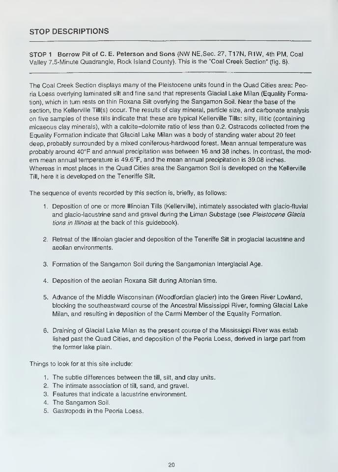
STOP 1 Borrow Pit of C. E. Peterson and Sons (NW NE.Sec. 27, T17N, R1W, 4th PM, Coal
Valley 7.5-Minute Quadrangle, Rock Island County). This is the "Coal Creek Section" (fig. 8).
The Coal Creek Section displays many of the Pleistocene units found in the Quad Cities area: Peo-
ria Loess overlying laminated silt and fine sand that represents Glacial Lake Milan (Equality Forma-
tion), which in turn rests on thin Roxana Silt overlying the Sangamon Soil. Near the base of the
section, the Kellerville Till(s) occur. The results of clay mineral, particle size, and carbonate analysis
on five samples of these tills indicate that these are typical Kellerville Tills: silty, illitic (containing
micaeous clay minerals), with a calcite-dolomite ratio of less than 0.2. Ostracods collected from the
Equality Formation indicate that Glacial Lake Milan was a body of standing water about 20 feet
deep, probably surrounded by a mixed coniferous-hardwood forest. Mean annual temperature was
probably around 40°F and annual precipitation was between 16 and 38 inches. In contrast, the mod-
ern mean annual temperature is 49.6°F, and the mean annual precipitation is 39.08 inches.
Whereas in most places in the Quad Cities area the Sangamon Soil is developed on the Kellerville
Till, here it is developed on the Teneriffe Silt.
The sequence of events recorded by this section is, briefly, as follows:
1. Deposition of one or more lllinoian Tills (Kellerville), intimately associated with glacio-fluvial
and glacio-lacustrine sand and gravel during the Liman Substage (see Pleistocene Glacia
tions in Illinois at the back of this guidebook).
2. Retreat of the lllinoian glacier and deposition of the Teneriffe Silt in proglacial lacustrine and
aeolian environments.
3. Formation of the Sangamon Soil during the Sangamonian Interglacial Age.
4. Deposition of the aeolian Roxana Silt during Altonian time.
5. Advance of the Middle Wisconsinan (Woodfordian glacier) into the Green River Lowland,
blocking the southeastward course of the Ancestral Mississippi River, forming Glacial Lake
Milan, and resulting in deposition of the Carmi Member of the Equality Formation.
6. Draining of Glacial Lake Milan as the present course of the Mississippi River was estab
lished past the Quad Cities, and deposition of the Peoria Loess, derived in large part from
the former lake plain.
Things to look for at this site include:
1. The subtle differences between the till, silt, and clay units.
2. The intimate association of till, sand, and gravel.
3. Features that indicate a lacustrine environment.
4. The Sangamon Soil.
5. Gastropods in the Peoria Loess.
20
LU\-CO>CO
><-z.
a:LU
<o
COLU
a:LUCO
LUzLUooh-co
LU
LUCD<I-co
COzooCO
<O
<LTO
o0)
0-
X)
LUCO
LU
14
*?
1»
I?J?
6
't
-''
y r • v •
^ O O . P^,
.< . * .„ 4
14. Silt, yellowish-brown, calcareous, contact between No. 13 and No. 14
covered, truncated at top. Thickness = 20 feet.
13. Silt and very fine sand, calcareous, faint regular laminations, light
yellow brown, laminations are more obvious and the sediment is
coarser near the top. Thickness = >6 feet.
12. Silt, interbedded light gray and light yellow brown. Crude color
banding, calcareous, ostracods. Thickness = 1 foot.
1 1 . Silt, dark gray-brown. Thickness = 2 feet.
10. Clay, silty, scattered pebbles, leached, well developed blocky structure.
Light gray at base grading upward into dark gray. Iron oxide pellets,
thickness = 4 feet.
9. Silt, light gray, massive to laminated. Some drop stones near the base.
Thickness = 4 feet
8. Sand, medium to coarse, pebbly, leached at the top. Thickness = 1 foot.
7. Gravel, sandy, silty. Thickness = 1 foot.
6. Till, brownish-yellow, calcareous, scattered lenses of gravel. Thickness
= 4 feet.
5. Till, gray, same as unit No. 3. Thickness = 1 foot.
4. Gravel, sandy, lenticular. Thickness = 0-2 feet.
3. Till, dark gray, calcareous. Thickness = 4 feet.
2. Gravel, sandy, silty, (washed till). Thickness = 0.5-1 foot.
1. Sand, fine to medium, poorly bedded to massive, some grains of coal,
yellow to yellow brown, base concealed. Thickness = 7 feet.
Figure 8 Stratigraphic column for Stop 1, Coal Creek Section (modified from Anderson and others 1982).
21
STOP 2 Collinson Brothers, Milan Quarry (east half of the NW and SW quarter of Sec. 25,
T17N, R2W, 4th PM, Milan 7.5-Minute Quadrangle, Rock Island County) (fig. 9).
Because it exposes the most complete section of Devonian rocks in northwestern Illinois and be-
cause it has been studied repeatedly over many years, the Collinson Quarry has become an impor-
tant Devonian reference section (fig. 10). The upper Racine Formation (Silurian), the Wapsipinicon
Limestone, and the lower two members of the Cedar Valley Limestone (Middle Devonian) are all
well exposed, as are Pennsylvanian caves (paleo-karst or ancient karst) fillings.
Things to look for at this site include:
1
.
Large-scale brecciation in the Kenwood and Spring Grove Members of the Wapsipinicon
affecting a vertical section of 10 feet or more and having clasts as much as 3 feet in maxi
mum dimension.
2. Small-scale brecciation in the Davenport Member of the Wapsipinicon confined to individual
beds generally less than 1 foot thick with clasts less than 2 inches indiameter.
3. Stylolites (solution zones).
4. Minor faults and flexures, probably resulting from dissolution of limestone.
5. Caves or sinkholes filled with Pennsylvanian shales and sands.
6. Stromatolites (algal fossils).
7. Contrast between the Wapsipinicon and the overlying Cedar Valley Limestones.
8. Invertebrate fossils in the Rapid Member of the Cedar Valley Formation (see Devonian
Fossils of Northwestern Illinois at the back of this guidebook).
9. Trace fossils.
10. The Silurian-Devonian unconformity.
11. The lithologic characterisitics of the Racine Dolomite (Silurian).
Stop 3 Moline Consumers, General Sand and Gravel Pit (NE, Sec. 21 , T17N, R2W, 4th PM,Milan 7.5-Minute Quadrangle, Rock Island County) (fig. 11)
This dredge operation is located near the center of a reworked fan-shaped deltaic sand and gravel
deposit. Outbursts of meltwater transported sand and gravel down the newly positioned Mississippi
River. Once the torrents cleared the Rock Island Rapids, the sand and gravel was deposited against
the east valley wall and into the mouth of the Rock River as the Savanna Terrace (elevation 580
feet). Later, during outbursts down the Rock River, a portion of the terrace was washed away and
22
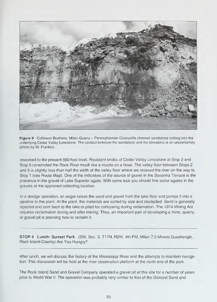
Figure 9 Collinson Brothers, Milan Quarry - Pennsylvanian Caseyville channel sandstone cutting into the
underlying Cedar Valley Limestone. The contact between the sandstone and the limestone is an unconformity
(photo by W. Frankie).
reworked to the present 560-foot level. Resistant knobs of Cedar Valley Limestone at Stop 2 and
Stop 5 constricted the Rock River much like a nozzle on a hose. The valley floor between Stops 2
and 5 is slightly less than half the width of the valley floor where we crossed the river on the way to
Stop 1 (see Route Map). One of the indicators of the source of gravel in the Savanna Terrace is the
presence in the gravel of Lake Superior agate. With some luck you should fine some agates in the
gravels at the approved collecting location.
In a dredge operation, an auger raises the sand and gravel from the lake floor and pumps it into a
pipeline to the plant. At the plant, the materials are sorted by size and stockpiled. Sand is generally
rejected and sent back to the lake or piled for contouring during reclamation. The 1974 Mining Act
requires reclamation during and after mining. Thus, an important part of developing a mine, quarry,
or gravel pit is planning how to reclaim it.
STOP 4 Lunch: Sunset Park (SW, Sec. 3, T17N, R2W, 4th PM, Milan 7.5-Minute Quadrangle,
Rock Island County) Are You Hungry?
After lunch, we will discuss the history of the Mississippi River and the attempts to maintain naviga-
tion. This discussion will be held at the river observation platform at the north end of the park.
The Rock Island Sand and Gravel Company operated a gravel pit at this site for a number of years
prior to World War II. The operation was probably very similar to that of the General Sand and
23
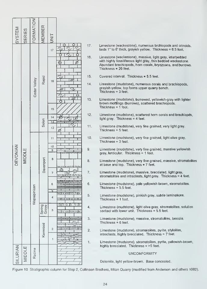
17. Limestone (wackestone), numerous brchiopods and crinoids,
beds 1" to 6' thick, grayish yellow. Thickness = 6.5 feet.
16. Limestone (wackestone), massive, light gray, interbedded
with highly fossiliferous light gray, thin bedded wackestone.
Abundant brachiopods, horn corals, bryozoans, and burrows.
Thickness = 26 feet.
15. Covered interval. Thickness = 5.5 feet.
14. Limestone (mudstone), numerous corals and brachiopods,
grayish-yellow, top forms upper quarry bench.
Thickness = 3 feet.
13. Limestone (mudstone), burrowed, yellowish-gray with lighter
brown mottlings (burrows), scattered brachiopods.
Thickness = 1 foot.
12. Limestone (mudstone), scattered horn corals and brachiopds,
light gray. Thickness = 4 feet.
1 1 . Limestone (mudstone), very fine grained, very light gray.
Thickness = 5 feet.
10. Limestone (mudstone), very fine grained, light olive gray.
Thickness = 3 feet.
9. Limestone (mudstone), very fine grained, massive yellowish
gray, lenticular. Thickness = 1 foot.
8. Limestone (mudstone), very fine grained, massive, stromatolites
at base and top. Thickness = 7 feet.
7. Limestone (mudstone), massive, brecciated, light gray,
stromatolites and intraclasts, light gray. Thickness = 4 feet.
6. Limestone (mudstone), pale yellowish brown, stromatolites.
Thickness =5.5 feet.
5. Limestone (mudstone), pinkish gray, subtle laminations.
Thickness = 1 foot.
4. Limestone (mudstone), light olive gray, stromatolites, solution
contact with lower unit. Thickness = 5.5 feet.
3. Limestone (mudstone), massive, stromatolites, breccia.
Thickness = 6 feet.
2. Limestone (mudstone), stromatolites, pyrite, stylolites,
intraclasts, highly brecciated. Thickness = 7 feet.
1. Limestone (mudstone), stromatolites, pyrite, yellowish-brown,
highly brecciated. Thickness = >5 feet.
UNCONFORMITY
Dolomite, light yellow-brown. Base concealed.
Figure 10 Stratigraphic column for Stop 2, Collinson Brothers, Milan Quarry (modified from Anderson and others 1982).
24
Figure 11 Dredging machine at Moline Consumers, General Sand and Gravel Pit (photo by D. Malone).
Gravel Company at Stop 3. The pit itself is now Potter Lake, separated from the Mississippi River by
a narrow peninsula. Originally this area was a low and swampy river floodplain, probably not unlike
the wooded shores of the backwater lake that lies along the east side of the park. The park lies out-
side the levee that protects the city of Rock Island from Mississippi River floodwaters. The levee is
located along the northern boundary of the park and connects with a seawall that protects the Rock
Isiand Boat Club, located just to the north. Much of the park was inundated during the Great Flood
of 1 993.
In 1948 the city of Rock Island purchased 30 acres of land for use as a landfill at the north end of
what is now the park. Later this operation was moved to a former gravel pit off 31st Avenue, about1/2 mile east of the south end of the park. At that time, development began on that part of the park
between Potter Lake and the Mississippi River. Further land purchases in 1953 brought the park to
its present size of 244 acres and led to improvements on the east side of Potter Lake and Sunset
Marina. The park is the downstream terminus of a bike path that will eventually extend upstream to
Savanna, Illinois.
History of the Mississippi River The stretch of river before you is the youngest reach of the
upper Mississippi River. It was created when the old channel of the Mississippi River, which flowed
southward into central Illinois, was blocked by glacial ice. A large lake developed and subsequently
overflowed, forming the Andelusa Gorge. The stream's down-cutting action left a bedrock island
(Rock Island) in the river and a series of rapids along the island. These rapids were a major hin-
drance to commercial river traffic. During the 1800s, goods were offloaded, hauled around the rap-
ids, and loaded onto a different boat to continue the trip. Robert E. Lee's first assignment after
graduating from West Point in 1836 was to survey these rapids. In the early 1900s, a series of
25
gravel bars (wing dams) was constructed partway into the river to force the current to the center and
increase the river's depth to 6 feet. During the 1930s, a series of navigation dams and locks was
constructed along the Mississippi River to ensure a minimum navigation channel of 9 feet. This field
trip stop is at the upstream end of navigation pool 16. Lock and Dam 15 is located just upstream, at
the west end of Rock Island. The navigation pools and their dams are numbered downstream from
Minneapolis, Minnesota. The Corps of Engineers sometimes must dredge the channel to remove
accumulated sand and mud in order to maintain the 9-foot navigation channel mandated by an
act of Congress. Credit Island, directly across the channel, is one of numerous islands composed
of mud and sand that occur in the Mississippi River from its headwaters to its mouth. Rock Island is
the largest bedrock island in the Mississippi River.
The Mississippi River at this point is about 0.4 mile wide. The navigation channel is marked by
buoys, each of which is located at the end of a wing dam designed to direct the water into the navi-
gation channel. The stronger flow that results helps keep the channel free of sediment and thus
maintains the minimum depth of 9 feet required for navigation. Credit Island Park lies across the
river in Davenport, Iowa. From the gazebo it is possible to see the mouth of the Rock River about
1 mile downstream, and the I-280 bridge a little beyond.
Stop 5 Black Hawk State Historic Site (NE, Sec. 14, T17N, R2W, 4th PM, Milan 7.5-Minute
Quadrangle, Rock Island County). Park in one of the parking areas and assemble at the A-frame
shelter house near the lower parking lot. Note: When visiting the park, use the pedestrian overpass
over Black Hawk Road.
History of Black Hawk State Historic Site
The following description is taken from the Illinois Historic Preservation Agency brochure:
Black Hawk State Historic Site—a wooded, steeply rolling 208-acre tract—borders
the Rock River in Rock Island County. Prehistoric Indians and nineteenth-century
settlers made their homes here, but the area is most closely identified with the
Sauk nation and the warrior-leader whose name it bears—Black Hawk. The site,
which is also noted for its many natural features, is managed by the Illinois Historic
Preservation Agency.
Sauk and MesquakieThe Black Hawk site was first occupied by Indians as long as 12,000 years ago,
and it was continuously inhabited through the Hopewell period, ca. 100 B.C. to
A.D. 250. Villagers lived within the bounds of the present historic site, and they built
burial mounds along the bluffs above the river. Unfortunately, the mounds have
been destroyed.
For nearly a century beginning about 1730, the Sauk and Mesquakie Indians madetheir home here. Saukenuk, the capital of the Sauk nation and one of the largest
Indian centers in North America, stood adjacent to the site. The Sauk and the
Mesquakie farmed the land along the river and relied upon the fur trade for their
livelihood. At the height of their power, they controlled parts of Illinois, Wisconsin,
and Missouri and all of Iowa.
Saukenuk was the site of the westernmost battle of the Revolutionary War. Ameri-
cans destroyed the village in 1780 because some of the Sauk had given military
support to the British. In 1804, several chiefs of the tribe ceded the village land to
26
the United States government. The Sauk warrior Black Hawk (he was not a chief)
headed the pro-British faction that refused to recognize the cession as legal. Dur-
ing the War of 1812, the pro-British Indians remained at Saukenuk, defeating the
Americans in two Mississippi River battles—Campbell's Island and Credit Island.
In the late 1820s, white settlers began to move into the area. By 1831, the Saukand Mesquakie had been forced across the Mississippi, relinquishing their claim
with the promise that they would not return. The warrior Black Hawk, in 1832, led
1,500 followers back into Illinois in an attempt to regain their cornfields. Following
several sharp skirmishes, Black Hawk and his followers—men, women, and chil-
dren—were chased into the wilderness of southern Wisconsin and decisively
defeated at the Battle of Bad Axe on August 2, 1832.
Early Recreation Center
From 1882 to 1927, the Watch Tower amusement park occupied the area that
would become Black Hawk State Historic Site. Local businessman Bailey Daven-
port, president and superintendent of the Rock Island and Milan Steam Railway,
developed the Watch Tower as a destination for his rail line. Horse-drawn cars
were phased out in favor of electric cars in the 1890s, and daily attendance soared
as high as 15,000 as people took the streetcar to Watch Tower for concerts, op-
eras, vaudeville, open-air theater, fireworks, bowling, target shooting, outdoor mov-
ies (projected on a canvas screen that often flapped in the breeze), balloon
ascensions, and amusement rides. The Watch Tower boasted a figure-eight roller
coaster (the four loops made it the first of its kind west of Chicago) and the memo-rable Shoot the Chutes toboggan slide, which was invented in Rock Island. Begin-
ning in 1898, the "Chutes"—flat boats with side runners that slid on a greased
track—carried riders down the bluff at speeds of up to 80 miles per hour. After
shooting down the slope, the boat bounced across the waters of the Rock River.
Then the "conductor" poled the boat back to the slide, and an electric cable hauled
it back to the top.
Natural Features
The deciduous hardwood forest and the Rock River provide habitat for a variety of
wildlife. Nearly 175 species of birds can be observed during the year, though spring
is a favorite time for observing the migrating species. The dominant trees of the up-
land forest—oaks—are bountiful at Black Hawk, along with a variety of other hard-
woods. Numerous wildflowers, shrubs, and vines grow under their canopy. Morethan 30 wildflower species, including wild orchids (showy orchids), bloom in April
and May.
The following is taken from the brochure Black Hawk, prepared by the Citizens to Preserve Black
Hawk Park Foundation:
"I am a Sauk. . . I am a warrior!" So proclaimed Black Hawk in the spring of 1831
,
only a few days before he and his followers were forced to leave their home along
Rock River forever. Though not a chief by birth, Black Hawk was the recognized
leader of a political faction within the Sauk nation that believed in the old ways, the
way of life that existed before Europeans came to America. He fought hard to pre-
serve his ancestral home, but, in the end, failed to stem the tide of cultural changebrought about by the invading European-Americans.
Ma-ka-tai-me-she-kia-kiak, or Black Sparrow Hawk, was born about 1767 at Sau-kenuk. This principal Sauk city was located along the Rock River, a few miles from
its mouth. Black Hawk was born into the Thunder clan. His father's name was Py-e-sa.
27
Black Hawk was a member of the warrior class. By the time the Sauk and their
allies the Mesquakie (or Fox) had moved to the Rock River region around 1750,
warfare had come to play an increasingly important role in tribal affairs. For an
ambitious man, the path to success was along the path to war. Black Hawk was15 years old when he wounded his first enemy in battle. This deed earned Black
Hawk the right to paint his face and wear feathers. Time and time again he proved
his bravery and skill in battle. As he grew older, he came to be a trusted leader of
large war parties.
During the War of 1812, Black Hawk fought on the side of the British. He was a
trusted lieutenant of the great Shawnee warrior-leader Tecumseh and fought with
his forces at the battle of Detroit in 1813. In this area, Black Hawk and his Sauk fol-
lowers, known as the British Band, were responsible for the victories at Campbell's
Island and Credit Island. Although Black Hawk signed a treaty of peace with the
United States government at the end of the war, he refused to relinquish his friend-
ship with the British. Accordingly, every year he and his British Band followed the
Great Sauk Trail from Saukenuk to Fort Maiden in Amberstburg, Ontario, to receive
gifts from the British military officials there.
Though polygamy was practiced among the Sauk, Black Hawk had only one wife,
As-she-we-qua, or Singing Bird. They had five children—two girls and three boys.
The eldest son and youngest daughter both died in the same year, probably before
1820. Black Hawk mourned their deaths for two years in the traditional Sauk fash-
ion. He built a small house away from the city proper, blackened his face with
ashes, and fasted by drinking only water at mid-day and eating a little boiled corn
at night.
The Black Hawk WarBlack Hawk is best known for the war that bears his name. The Black Hawk War of
1 832 was the last Indian war fought east of the Mississippi River. The Indians'
defeat spelled the end of 200 years of armed resistance to European-American
encroachment on Indian lands.
In 1804, five Sauk and Mesquakie chiefs were tricked into signing a treaty with the
United States government, selling tribal lands in Illinois, Missouri, and Wiscon-
sin—nearly 51 million acres—in exchange for various goods and a $1 ,000 annuity
to be paid to the tribes annually. The treaty was clearly illegal by Sauk and
Mesquakie custom. The American officials knew this. The United States Senate,
however, ratified the treaty in December 1804. The treaty stipulated that the Indi-
ans could remain on the ceded lands as long as they were not wanted for white
settlement. And so the matter rested for 24 years.
In 1828, white settlers began to move into Saukenuk and its vicinity. They demandedthat the Indians now be removed. In order to avoid bloodshed, the majority of the
Sauk and Mesquakie moved to the west side of the Mississippi. Black Hawk, how-
ever, refused to go. He and his followers remained at Saukenuk, living side by side
with white settlers. Many problems ensued. Finally, by June 1831 , the Governor of
Illinois demanded that the army remove Black Hawk and his British Band. Troops
were dispatched. Black Hawk, realizing he was badly outnumbered, slipped across
the river during the night of June 25. A few days later he agreed never to return to
Illinois.
Black Hawk and his followers were unhappy in the Iowa lands. Black Hawkdreamed of leading an Indian uprising to forcibly retake their lost Illinois home. In
April 1832, Black Hawk and about 1500 followers (500 warriors and 1000 women,
28
children, and old people) crossed the Mississippi to its eastern bank. They followed
the course of the Rock River for 50 miles, their objective being a Winnebago town,
now called Prophetstown. This move threw the frontier into a panic. The ensuing
war, named the Black Hawk War, lasted just 15 weeks. It ended August 2, 1832, at
the Battle of Bad Axe, Wisconsin. By the end of the war, approximately two-thirds
of Black Hawk's followers were dead—some in battle, most of starvation, depriva-
tion, and exhaustion.
Though Black Hawk escaped before the Battle of Bad Axe, he was captured six
weeks later and turned over to American authorities. He and his five closest advi-
sors, including his eldest son, were imprisoned at Jefferson Barracks, Missouri,
until April 1833. The group was then taken to Washington, D.C. where Black Hawkmet with President Andrew Jackson. He was then sent to Fortress Monroe, Virginia.
Black Hawk and his party were released on May 30, 1833. Prior to their return to
Rock Island, they were taken on a tour of large cities on the East Coast, where
they were a media sensation. People turned out in droves to see the famous Black
Hawk and his warriors. It was during this time that Black Hawk was erroneously
tagged a "chief." This was due to a lack of understanding of Sauk politics. TheAmerican public reasoned that anyone powerful enough to wage war against the
United States must be a chief. The misnomer continues to this day. Though a great
warrior and military tactician, Black Hawk was never a chief.
Black Hawk returned to Rock Island in August 1833. Keokuck, Black Hawk's arch
political rival, met the party at Fort Armstrong, where Black Hawk was released into
Keokuck's custody. It was here made plain that the United States recognized
Keokuck as chief of the Sauk. Black Hawk was directed to follow Keokuck's coun-
sel and advice. Black Hawk's humiliation was complete.
Black Hawk was a tired, broken old man. The war had been a disaster and morethan 1,000 of his people had died. Through his attempt to save his people's tradi-
tions and homeland, he had brought only dishonor upon himself. In the treaty that
ended the war, the Sauk and Mesquakie were forced to cede still more land to the
United States as war reparation.
Shortly after his return, Black Hawk dictated his autobiography to Antoine LeClaire,
a government interpreter living at Fort Armstrong. The Life of Black Hawk was pub-
lished in 1833. It sold well. Though disgraced among his own people, Black Hawkhad achieved fame and admiration among the European-Americans, his former
enemies. Such was the tragedy and irony of his finai years.
For the next five years, Black Hawk lived along the Iowa River with his wife andchildren. They moved to a new home along the Des Moines River in 1838. It washere that he died on October 3, 1838, of a respiratory illness. He was 71 years old.
Black Hawk was buried sitting up inside a small mausoleum of logs. His grave wassoon robbed, but eventually his remains were deposited in a museum of Burlington,
Iowa. The museum and its contents were destroyed by fire in 1855.
Black Hawk fought hard to preserve the ancestral home of his people, as well as
their time-honored customs and traditions. Unfortunately, he was born at a time
when the ancient ways of his people were fast crumbling before the cultural pres-
sure of the New Americans. The fate of Black Hawk and his nation was a tragic
outcome of the clash of two divergent cultures.
29

"Sinissippi (Rock River) was a beautiful country. I loved it, my cornfields and the
home of my people. I fought for them."
Geology of Black Hawk State Historic Site
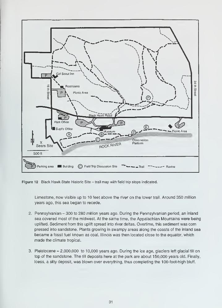
See figure 12 for a detailed map of park trails and the location of A to E and the Sears site.
Rock River Valley Looking south from the back of the lodge, near the stature of Black Hawk, is a
magnificent view of the Rock River Valley. We often think that a river valley is only the trench in
which there is actually water, but the valley of an old river is much wider. A valley is formed by the
eroding action of the river that flows in it. The size of the valley is a rough measure of its age. The
older it is, the wider and deeper it is. The Rock River valley at this point is about 2 miles across. You
are standing on one of the bluffs that forms the valley wall. The low ground below is the floodplain.
Often the floodplain contains terraces and levees. The river itself flows in the channel. A topographic
cross section of the valley is given in figure 5.
From the bluff, looking down at Rock River, you can see a limestone quarry on Vandruff Island. This
quarry is mining the Devonian-age limestone, which was deposited approximately 375 millions years
ago. The quarry below is about as deep as the bluffs are high.
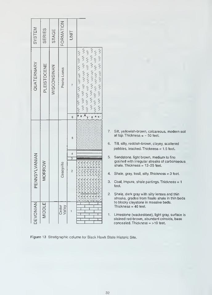
Geology in the Park Black Hawk State Historic Site consists of two distinct geologic areas. The
first area is the east-west-trending ridge located between Black Hawk Road and Rock River. This
ridge is composed of the Caseyville Formation sandstone (fig. 13). The sandstone provides internal
strength to this ridge and is visible along the bluff trail. This sedimentary rock is composed of sand
particles that were deposited by moving water. These particles were then cemented together by iron
oxide that was deposited by water seeping through the sand. Sandstones often show distinct layer-
ing because the amount and type of materials deposited varied from time to time. This sandstone
was formed between 300 and 280 million years ago, during the Pennsylvanian Period of geologic
time, when the Appalachian Mountains were being uplifted. Sediments from the mountains were
washed away and spread into river deltas along an inland sea. Over millions of years, these sedi-
ments were compressed into shale, siltstone, and sandstone.
The upper and lower Caseyville sandstones in the bluffs represent two different environments of
deposition. The upper horizon consists of 3 to 5 feet of fine- to medium-size sand grains deposited
as a near-horizontal sheet deposit. This sheet deposit is present from location A to east of location
E. The lower horizon consists of cross-bedded, fine- to coarse-size sand grains deposited in a chan-
nel. The channel sandstone is present at location C and the Sears site. Although the sandstone pro-
vides strength to the ridge, slump features are present all along the bluff above Rock River.
This sandstone ridge was the site of the winter encampment of the Sauk and Fox Indians during the
late 1700s and early 1800s. The museum has an excellent depiction of Indian life. We recommend a
tour of the museum as part of this field trip. The ridge was also the site of an amusement park from
1882 until the 1920s. The footings for the "shoot the Chutes" are still evident near location E. Years
later, a similar ride gained fame at the Six Flags amusement park as the Log Flume.
From the river to the top of the bluff, the exposed rocks were deposited during three different geo-
logical periods (fig. 13).
1. Devonian - 400 to 350 million years ago. During the Devonian period, when Illinois was
located south of the equator, a warm, shallow sea covered this area. It left the Cedar Valley
Limestone, now visible up to 10
30
Park Office
1 Supf's Office
I ^ A. ^Museum (7\"^
\ /v ©_•" ""<D >-J^fll \ r"
-"")».^•©"^" -,* Observation
T „* '^.V —•"*"""*", niMFR Platform
' Sears Site Vw^ ROCKBWt^
500 ft
© *Picnic Area
Parking area Building (c) Field Trip Discussion Site ~™ *«- »•• Trail — ~— Ravine
Figure 12 Black Hawk State Historic Site - trail map with field trip stops indicated.
Limestone, now visible up to 10 feet above the river on the lower trail. Around 350 million
years ago, this sea began to recede.
Pennsylvanian - 300 to 280 million years ago. During the Pennsylvanian period, an inland
sea covered most of the midwest. At the same time, the Appalachian Mountains were being
uplifted. Sediment from this uplift spread into river deltas. Overtime, this sediment was compressed into sandstone. Plants growing in swampy areas along the coasts of the inland sea
became a fossil fuel known as coal. Illinois was then located close to the equator, which
made the climate tropical.
Pleistocene - 2,000,000 to 10,000 years ago. During the ice age, glaciers left glacial till on
top of the sandstone. The till deposits here at the park are about 150,000 years old. Finally,
loess, a silty deposit, was blown over everything, thus completing the 100-foot-high bluff.
31
LLi
HCO>-CO
<zorhih-<Z)
O
<>_i>co
LUQ.
o>LUQ
COLU
a:LLI
CO
LUZLLI
CJ
OI-co
LLI
Ooror
O
LLI
_JQQ
LLI
O<CO
z<zcozOOco
Ol-<or
O
oQJ
0-
WCO
O
-§==
zZ)
M
*5
*^ft^*^*M*M*MI
T^T
7. Silt, yellowish-brown, calcareous, modern soil
at top. Thickness = - 50 feet.
6. Till, silty, reddish-brown, clayey, scattered
pebbles, leached. Thickness = 1.5 feet.
5. Sandstone, light brown, medium to fine
grained with irregular streaks of carbonaeousshale. Thickness = 12-25 feet.
4. Shale, gray, fissil, silty. Thickness = 3 feet.
3. Coal, impure, shale partings. Thickness = 1
foot.
2. Shale, dark gray with silty lenses and thin
streaks, grades from fissile shale in thin bedsto blocky claystone in massive beds.
Thickness = 46 feet.
1. Limestone (wackestone), light gray, surface is
stained red-brown, abundant crinoids, baseconcealed. Thickness = >10 feet.
Figure 13 Stratigraphic column for Black Hawk State Historic Site.
32
Some of the geological features that can be observed in the park include;
Location A - slump terrace A large block of sandstone measuring approximately 20 to 25 feet
wide and more than 100 feet long has slumped (moved downhill) 5 to 6 feet. The sandstone sits on
top of a shale unit. When the shales become wet, they form a lubricated slide plane, which allows
blocks of sandstone to slump downhill because of gravity.
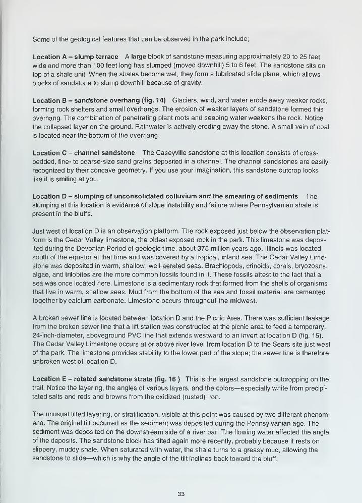
Location B - sandstone overhang (fig. 14) Glaciers, wind, and water erode away weaker rocks,
forming rock shelters and small overhangs. The erosion of weaker layers of sandstone formed this
overhang. The combination of penetrating plant roots and seeping water weakens the rock. Notice
the collapsed layer on the ground. Rainwater is actively eroding away the stone. A small vein of coal
is located near the bottom of the overhang.
Location C - channel sandstone The Caseyville sandstone at this location consists of cross-
bedded, fine- to coarse-size sand grains deposited in a channel. The channel sandstones are easily
recognized by their concave geometry. If you use your imagination, this sandstone outcrop looks
like it is smiling at you.
Location D - slumping of unconsolidated colluvium and the smearing of sediments The
slumping at this location is evidence of slope instability and failure where Pennsylvanian shale is
present in the bluffs.
Just west of location D is an observation platform. The rock exposed just below the observation plat-
form is the Cedar Valley limestone, the oldest exposed rock in the park. This limestone was depos-
ited during the Devonian Period of geologic time, about 375 million years ago. Illinois was located
south of the equator at that time and was covered by a tropical, inland sea. The Cedar Valley Lime-
stone was deposited in warm, shallow, well-aerated seas. Brachiopods, crinoids, corals, bryozoans,
algae, and trilobites are the more common fossils found in it. These fossils attest to the fact that a
sea was once located here. Limestone is a sedimentary rock that formed from the shells of organisms
that live in warm, shallow seas. Mud from the bottom of the sea and fossil material are cemented
together by calcium carbonate. Limestone occurs throughout the midwest.
A broken sewer line is located between location D and the Picnic Area. There was sufficient leakage
from the broken sewer line that a lift station was constructed at the picnic area to feed a temporary,
24-inch-diameter, aboveground PVC line that extends westward to an invert at location D (fig. 15).
The Cedar Valley Limestone occurs at or above river level from location D to the Sears site just west
of the park. The limestone provides stability to the lower part of the slope; the sewer line is therefore
unbroken west of location D.
Location E - rotated sandstone strata (fig. 16 ) This is the largest sandstone outcropping on the
trail. Notice the layering, the angles of various layers, and the colors—especially white from precipi-
tated salts and reds and browns from the oxidized (rusted) iron.
The unusual tilted layering, or stratification, visible at this point was caused by two different phenom-
ena. The original tilt occurred as the sediment was deposited during the Pennsylvanian age. The
sediment was deposited on the downstream side of a river bar. The flowing water affected the angle
of the deposits. The sandstone block has tilted again more recently, probably because it rests on
slippery, muddy shale. When saturated with water, the shale turns to a greasy mud, allowing the
sandstone to slide—which is why the angle of the tilt inclines back toward the bluff.
33
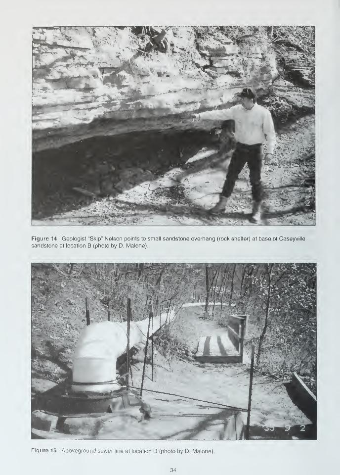
Figure 14 Geologist "Skip" Nelson points to small sandstone overhang (rock shelter) at base of Caseyville
sandstone at location B (photo by D. Malone).
Figure 15 Aboveground sewer line at location D (photo by D. Malone).
34
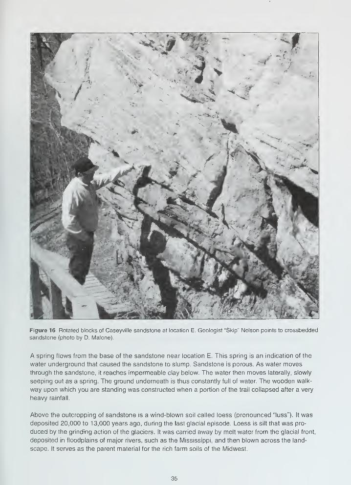
Figure 16 Rotated blocks of Caseyville sandstone at location E. Geologist "Skip" Nelson points to crossbedded
sandstone (photo by D. Malone).
A spring flows from the base of the sandstone near location E. This spring is an indication of the
water underground that caused the sandstone to slump. Sandstone is porous. As water moves
through the sandstone, it reaches impermeable clay below. The water then moves laterally, slowly
seeping out as a spring. The ground underneath is thus constantly full of water. The wooden walk-
way upon which you are standing was constructed when a portion of the trail collapsed after a very
heavy rainfall.
Above the outcropping of sandstone is a wind-blown soil called loess (pronounced "luss"). It was
deposited 20,000 to 13,000 years ago, during the last glacial episode. Loess is silt that was pro-
duced by the grinding action of the glaciers. It was carried away by melt water from the glacial front,
deposited in floodplains of major rivers, such as the Mississippi, and then blown across the land-
scape. It serves as the parent material for the rich farm soils of the Midwest.
35
This is the last stop on this section of the trail. The Rock River picnic area is located to the east.
Sears Site The Sears site is located just west of the park with access off 50th Avenue. On the day
of the field trip, we will access the Sears site by following the base of the bluffs along the southwest
corner of the park boundary. The Cedar Valley Limestone is present 20 feet above river level. Large
crinoid columnals are common in the limestone. The Cedar Valley Limestone is overlain by a few
feet of mudstone. The thin sandstone that occurs above the mudstone is of interest because it con-
tains imprints of Pennsylvanian-age tree roots and branches.
Location F The second distinct geologic area is located north of Black Hawk Road. This area is
part of the stream-dissected uplands that compose Rock Island. Before establishment of the Missis-
sippi River in its present position, Coal Creek, located along the east edge of the park boundary,
drained southward into Rock River. Coal Creek and its tributaries cut down through relatively weak
materials, creating a small drainage basin with about 100 feet of local relief. This large amount of
local relief contrasts with the relief of the much younger and smaller drainage basins that flow into
the Mississippi River in the area.
Down-cutting by one of the tributaries of Coal Creek has exposed a 2-inch-thick coal bed about 30
feet southwest of location F. This is the same coal that is just a thin layer near location D. A thicker,
older, and deeper coal was mined underground in 1876 at location F. The coal was loaded on a
narrow-gauge railroad and hauled north into Rock Island. This mine was only marginally economical
and was closed when better quality coal available from mines in Carbon Cliff and Coal Valley.
Coals in Rock Island County are variable in both thickness and quality. The thickness is dependent
on the topography of the underlying pre-Pennsylvanian surface. The thickest and highest quality
coals accumulated in the lowest areas and were absent where the Cedar Valley Limestone stood
topographically high. Two coals were mined in this area. The Rock Island Coal was mined at several
locations in Coal Valley and Carbon Cliff. The older and deeper coal was mined only here and in the
area between the Niabi Zoo and Coal Valley.
The Pennsylvanian-age strata here present an interesting problem. Why were relatively old Pennsyl-
vanian sediments deposited and preserved in this area but nowhere else within 50 miles of here,
and why are Caseyville coals present at Black Hawk at elevations higher than the Rock Island Coal
near Coal Valley?
36
REFERENCES
Anderson, R.C., 1967, Sand and Gravel Resources Along the Rock River in Illinois: Illinois State
Geological Survey Circular 414, p. 17 p.
Anderson, R.C., 1980, Geology for Planning in Rock Island County, Illinois: Illinois State Geological
Survey Circular 510, 35 p.
Anderson, R.C, R.D. Taylor, and W.R. Hammer, 1982, Geology of the Mississippi River Arch in the
Quad-Cities Region: Guidebook for the 46th Annual Tri-State Geological Society Field Confer-
ence, Octobert 1-3, 1982, Augustana College, 54 p.
Bergstrom, R.E., 1956, Groundwater Geology in Western Illinois, North Part: Illinois State Geological
Survey Circular 222, 24 p.
Bergstrom, R.E., ed., 1968, The Quaternary of Illinois: University of Illinois College of Agriculture,
Special Publication 14, 179 p.
Buschbach, T.C., and D.R. Kolata, 1991, Regional setting of the Illinois Basin, /nM.W. Leighton,
D.R. Kolata, D.F. Oltz, and J.J. Eidel, eds., Interior Cratonic Basins: American Association of
Petroleum Geologists, Memoir 51, p. 29-55.
Carmen, J.E., 1909, The Mississippi Valley Between Savanna and Davenport: Illinois State Geological
Survey Bulletin 13, 96 p.
Collinson, C, 1967, Devonian of the North-Central Region, United States, in Symposium of the
Devonian System: Alberta Society of Petroleum Geologty, v. 1., p. 933-39.
Edmund, R.W., and R.C. Anderson, 1967, Guidebook for the 31st Annual Tri-State Geological Society
Field Conference—The Mississippi River Arch: Augustana College.
Herzog, B.L., B.J. Stiff, C.A Chenoweth, K.L Warner, J.B. Sieverling, and C. Avery, 1994, Buried
Bedrock Surface of Illinois: Illinois State Geological Survey, Illinois Map 5; scale, 1:500,000;
size, 33.25" x 60.75".
Hinman, E.E., 1968, A Biohermal Facies in the Silurian of Eastern Iowa: Iowa Geological Society,
Report of Investigations 6, 52 p.
Horberg, C.L, 1950, Bedrock Topography of Illinois: Illinois State Geological Survey Bulletin 73, 111 p.
Horberg, L, 1956, Pleistocene Deposits Along the Mississippi Valley in Central-Western Illinois:
Illinois State Geological Survey, Report of Investigations 192, 39 p.
Leighton, M.M., G.E. Ekblaw, and C.L. Horberg, 1948, Physiographic Divisions of Illinois: Illinois
State Geological Survey, Report of Investigations 129, 19 p.
Lineback, J.A., et al., 1979, Quaternary Deposits of Illinois: Illinois State Geological Survey Map;scale, 1 :500,000; size, 40" x 60"; color.
Nelson, J.W., 1995, Structural Features in Illinois: Illinois State Geological Survey, Bulletin 100, 144 p.
O'Brien, N.R., Differentiation of some Pennsylvanian underclays by their clay mineral compositions:
Illinois Academy of Science, Transactions, v. 56, p. 68-74.
Piskin, K., and R.E. Bergstrom, 1975, Glacial Drift in Illinois: Illinois State Geological Survey, Circular
490, 35 p.
Reinertsen, D.L., D.J. Berggren, R.C. Anderson, and M. Killey, 1974, Milan Area: Illinois State
Geological Survey, Geological Science Field Trip Guide Leaflet 1974C, 30 p., plus attachments.
Savage, T.E., and J.A. Voden, 1921, The Geology and Mineral Resources of the Edgington andMilan Quadrangles: Illinois State Geological Survey Bulletin 38, Extract C.
37
Searight, T.K., and W.H. Smith, 1969, Strippable Coal Reserves of Illinois, Part 5B—Mercer, Rock
Island, Warren, and Parts of Henderson and Henry Counties: Illinois State Geological Survey
Circular 439, 22 p.
Templeton, J.S., and H.B. Willman, 1952, Guidebook for the Sixteenth Annual Field Conference of
the Tri-State Geological Society: Central Northern Illinois (Dixon, Illinois area): Illinois State
Geological Survey, Guidebook Series 2, 47 p.
Willman, H.B., et al, 1967, Geologic Map of Illinois: Illinois State Geological Survey Map; scale,
1:500,000; size, 40" x 56"; color.
Willman, H.B., J.A. Simon, B.M. Lynch, and V.A. Langenheim, 1968, Bibliography and Index of
Illinois Geology through 1965: Illinois State Geological Survey, Bulletin 92, 373 p.
Willman, H.B., and J.C. Frye, 1970, Pleistocene Stratigraphy of Illinois: Illinois State Geological
Survey Bulletin 94, 204 p.
Willman, H.B., E. Atherton, T.C. Buschbach, C. Collinson, J.C. Frye, M.E. Hopkins, J.A. Lineback,
J.A. Simon, 1975, Handbook of Illinois Stratigraphy: Illinois State Geological Survey, Bulletin 95,
261 p.
38
GLOSSARY
The following definitions are adapted in total or in part from several sources; the principal source
is R.L. Bates and J.A Jackson, eds. .Glossary of Geology, 3rd ed.: American Geological Institute,
Alexandria, VA, 1987, 788 p.
Ablation - Separation and removal of rock material and formation of deposits, especially by wind
action or the washing away of loose and soluble materials.
Age - An interval of geologic time; a division of an epoch.
Aggrading stream - One that is actively depositing sediment in its channel or floodplain because it
is being supplied with more load than it can transport.
Alluviated valley - One that has been at least partially filled with sand, silt, and mud by flowing water.
Alluvium - A general term for clay, silt, sand, gravel, or similar unconsolidated sorted or semisorted
sediment deposited during comparatively recent time by a stream or other body of running water.
Anticline - A convex-upward rock fold in which strata have been bent into an arch; the strata on
either side of the core of the arch are inclined in opposite directions away from the axis or crest;
the core contains older rocks than does the perimeter of the structure.
Aquifer - A geologic formation that is water-bearing and which transmits water from one point to another.
Argillaceous - Said of rock or sediment that contains, or is composed of, clay-sized particles or clay
minerals.
Arenite - A relatively clean quartz sandstone that is well sorted and contains less than 10% argil-
laceous material.
Base level - Lower limit of erosion of the land's surface by running water. Controlled locally and
temporarily by the water level of stream mouths emptying into lakes, or more generally and
semipermanently by the level of the ocean (mean sea level).
Basement complex - The suite of mostly crystalline igneous and/or metamorphic rocks that generally
underlies the sedimentary rock sequence.
Basin - A topographic or structural low area that generally receives thicker deposits of sediments
than adjacent areas; the low areas tend to sink more readily, partly because of the weight of the
thicker sediments; the term also denotes an area of relatively deep water adjacent to shallow-
water shelf areas.
Bed - A naturally occurring layer of earth material of relatively greater horizontal than vertical extent
that is characterized by physical properties different from those of overlying and underlying materi-
als. It also is the ground upon which any body of water rests or has rested, or the land covered
by the waters of a stream, lake, or ocean; the bottom of a stream channel.
Bedrock - The solid rock (sedimentary, igneous, or metamorphic) that underlies the unconsolidated
(non-indurated) surface materials (for example, soil, sand, gravel, glacial till, etc.).
Bedrock valley - A drainageway eroded into the solid bedrock beneath the surface materials. It maybe completely filled with unconsolidated (non-indurated) materials and hidden from view.
Braided stream - A low-gradient, low-volume stream flowing through an intricate network of inter-
lacing shallow channels that repeatedly merge and divide, and are separated from each other
by branch islands or channel bars. Such a stream may be incapable of carrying all of its load.
Most streams that receive more sediment load than they can carry become braided.
Calcarenite - Describes a limestone composed of more or less worn fragments of shells or pieces
of older limestone. The particles are generally sand-sized.
39
Calcareous - Said of a rock containing some calcium carbonate (CaC03), but composed mostly of
something else; (synonym: limey).
Calcining - The heating of calcite or limestone to its temperature of dissociation so that it loses its
carbon dioxide; also applied to the heating of gypsum to drive off its water of crystallization to
make plaster of pahs.
Calcite - A common rock-forming mineral consisting of CaC03; it may be white, colorless, or pale
shades of gray, yellow, and blue; it has perfect rhombohedral cleavage, appears vitreous, and
has a hardness of 3 on the Mohs scale; it effervesces (fizzes) readily in cold dilute hydrochloric
acid. It is the principal constituent of limestone.
Chert - Silicon dioxide (SiCte); a compact, massive rock composed of minute particles of quartz
and/or chalcedony; it is similar to flint, but lighter in color.
Clastic - Said of rocks composed of particles of other rocks or minerals, including broken organic
hard parts as well as rock substances of any sort, transported and deposited by wind, water, ice
or gravity.
Closure - The difference in altitude between the crest of a dome or anticline and the lowest structural
or elevation contour that completely surrounds it.
Columnar section - A graphic representation, in the form of one or more vertical column(s), of the
vertical succession and stratigraphic relations of rock units in a region.
Conformable - Said of strata deposited one upon another without interruption in accumulation of
sediment; beds parallel.
Delta - A low, nearly flat, alluvial land form deposited at or near the mouth of a river where it enters
a body of standing water; commonly a triangular or fan-shaped plain extending beyond the gen-
eral trend of a coastline.
Detritus - Loose rock and mineral material produced by mechanical disintegration and removed from
its place of origin by wind, water, gravity, or ice; also, fine particles of organic matter, such as
plant debris.
Disconformity - An unconformity marked by a distinct erosion-produced irregular, uneven surface
of appreciable relief between parallel strata below and above the break; sometimes represents a
considerable time interval of nondeposition.
Dolomite - A mineral, calcium-magnesium carbonate (Ca,Mg[C03]2); also the name applied to sedi-
mentary rocks composed largely of the mineral. It is white, colorless, or tinged yellow, brown,
pink, or gray; has perfect rhombohedral cleavage; appears pearly to vitreous; effervesces feebly
in cold dilute hydrochloric acid.
Drift - All rock material transported by a glacier and deposited either directly by the ice or reworked
and deposited by meltwater streams and/or the wind.
Driftless Area - A 10,000-square-mile area in northeastern Iowa, southwestern Wisconsin, and
northwestern Illinois where the absence of glacial drift suggests that the area may not have
been glaciated.
End moraine - A ridge or series of ridges formed by accumulations of drift built up along the outer
margin of an actively flowing glacier at any given time; a moraine that has been deposited at the
lower or outer end of a glacier.
Epoch - An interval of geologic time; a division of a period. (Example: Pleistocene Epoch).
Era - The unit of geologic time that is next in magnitude beneath an eon; it consists of two or moreperiods. (Example: Paleozoic Era).
40
Escarpment - A long, more or less continuous cliff or steep slope facing in one general direction; it
generally marks the outcrop of a resistant layer of rocks, or the exposed plane of a fault that has
moved recently.
Fault - A fracture surface or zone of fractures in Earth materials along which there has been vertical
and/or horizontal displacement or movement of the strata on opposite sides relative to one another.
Flaggy - Said of rock that tends to split into layers of suitable thickness for use as flagstone.
Flood plain - The surface or strip of relatively smooth land adjacent to a stream channel produced
by the stream's erosion and deposition actions; the area covered with water when the stream
overflows its banks at times of high water; it is built of alluvium carried by the stream during floods
and deposited in the sluggish water beyond the influence of the swiftest current.
Fluvial - Of or pertaining to a river or rivers.
Formation - The basic rock unit, one distinctive enough to be readily recognizable in the field and
widespread and thick enough to be plotted on a map. It describes the strata, such as limestone,
sandstone, shale, or combinations of these and other rock types. Formations have formal names,
such as Joliet Formation or St. Louis Limestone (Formation), generally derived from the geographic
localities where the unit was first recognized and described.
Fossil - Any remains or traces of a once-living plant or animal preserved in rocks (arbitrarily
excludes Recent remains); any evidence of ancient life. Also used to refer to any object that
existed in the geologic past and for which evidence remains (for example, a fossil waterfall)
Friable - Said of a rock or mineral that crumbles naturally or is easily broken, pulverized, or reduced
to powder, such as a soft and poorly cemmented sandstone.
Geology - The study of the planet Earth that is concerned with its origin, composition, and form, its
evolution and history, and the processes that acted (and act) upon it to control its historic and
present forms.
Geophysics - Study of the Earth with quantitative physical methods. Application of the principles of
physics to the study of the earth, especially its interior.
Glaciation - A collective term for the geologic processes of glacial activity, including erosion and
deposition, and the resulting effects of such action on the Earth's surface.
Glacier - A large, slow-moving mass of ice formed on land by the compaction and recrystallization
of snow.
Gradient - A part of a surface feature of the Earth that slopes upward or downward; the angle of
slope, as of a stream channel or of a land surface, generally expressed by a ratio of height
versus distance, a percentage or an angular measure from the horizontal.
Igneous - Said of a rock or mineral that solidified from molten or partly molten material (that is, from
magma).
Indurated - Said of compact rock or soil hardened by the action of pressure, cementation and,
especially, heat.
Joint - A fracture or crack in rocks along which there has been no movement of the opposing sides
(see also Fault).
Karst - Collective term for the land forms and subterranean features found in areas with relatively
thin soils underlain by limestone or other soluble rocks; characterized by many sinkholes sepa-
rated by steep ridges or irregular hills. Tunnels and caves formed by dissolution of the bedrock
by groundwater honeycomb the subsurface. Named for the region around Karst in the Dinaric
Alps of Croatia where such features were first recognized and described.
Lacustrine - Produced by or belonging to a lake.
41
Laurasia - A protocontinent of the Northern Hemisphere, corresponding to Gondwana in the South-
ern Hemisphere, from which the present continents of the Northern Hemisphere have been
derived by separation and continental displacement. The supercontinent from which both were
derived is Pangea. Laurasia included most of North America, Greenland, and most of Eurasia,
excluding India. The main zone of separation was in the North Atlantic, with a branch in Hudson
Bay; geologic features on opposite sides of these zones are very similar.
Lava - Molten, fluid rock that is extruded onto the surface of the Earth through a volcano or fissure.
Also the solid rock formed when the lava has cooled.
Limestone - A sedimentary rock consisting primarily of calcium carbonate (the mineral, calcite).
Limestone is generally formed by accumulation, mostly in place or with only short transport, of
the shells of marine animals, but it may also form by direct chemical precipitation from solution
in hot springs or caves and, in some instances, in the ocean.
Lithify - To change to stone, or to petrify; especially to consolidate from a loose sediment to a solid
rock.
Lithology - The description of rocks on the basis of their color, structure, mineral composition, andgrain size; the physical character of a rock.
Local relief - The vertical difference in elevation between the highest and lowest points of a land
surface within a specified horizontal distance or in a limited area.
Loess - A homogeneous, unstratified accumulation of silt-sized material deposited by the wind.
Magma - Naturally occurring molten rock material generated within Earth and capable of intrusion
into surrounding rocks or extrusion onto the Earth's surface. When extruded on the surface it is
called lava. The material from which igneous rocks form through cooling, crystallization, and
related processes.
Meander - One of a series of somewhat regular, sharp, sinuous curves, bends, loops, or turns pro-
duced by a stream, particularly in its lower course where it swings from side to side across its
valley bottom.
Meander scars - Crescent-shaped swales and gentle ridges along a river's flood plain that mark the
positions of abandoned parts of a meandering river's channel. They are generally filled in with
sediments and vegetation and are most easily seen in aerial photographs.
Metamorphic rock - Any rock derived from pre-existing rocks by mineralogical, chemical, and
structural changes, essentially in the solid state, in response to marked changes in temperature,
pressure, shearing stress, and chemical environment at depth in Earth's crust (for example,
gneisses, schists, marbles, quartzites, etc.)
Mineral - A naturally formed chemical element or compound having a definite chemical composition, an
ordered internal arrangement of its atoms, and characteristic crystal form and physical properties.
Monolith - (a) A piece of unfractured bedrock, generally more than a few meters across, (b) A large
upstanding mass of rock.
Moraine - A mound, ridge, or other distinct accumulation of glacial drift, predominantly till, deposited
in a variety of topographic land forms that are independent of control by the surface on which the
drift lies (see also End Moraine).
Morphology - The scientific study of form, and of the structures and development that influence
form; term used in most sciences.
Natural gamma log - One of several kinds of measurements of rock characteristics taken by lower-
ing instruments into cased or uncased, air- or water-filled boreholes. Elevated natural gammaradiation levels in a rock generally indicate the presence of clay minerals.
42
Nickpoint - A place with an abrupt inflection in a stream profile, generally formed by the presence of
a rock layer resistant to erosion; also, a sharp angle cut by currents at base of a cliff.
Nonconformity - An unconformity resulting from deposition of sedimentary strata on massive
crystalline rock.
Outwash - Stratified glacially derived sediment (clay, silt, sand, gravel) deposited by meltwater
streams in channels, deltas, outwash plains, on flood plains, and in glacial lakes.
Outwash plain - The surface of a broad body of outwash formed in front of a glacier.
Oxbow lake - A crescent-shaped lake in an abandoned bend of a river channel. A precursor of a
meander scar.
Pangea - The supercontinent that existed from 300 to 200 million years ago. It combined most of
the continental crust of the Earth, from which the present continents were derived by fragmenta-
tion and movement away from each other by means of plate tectonics. During an intermediate
stage of the fragmentation, between the existence of Pangea and that of the present widely
separated continents, Pangea was split into two large fragments, Laurasia on the north and
Gondwana in the southern hemisphere.
Ped - Any naturally formed unit of soil structure (for example, granule, block, crumb, or aggregate).
Peneplain - A land surface of regional scope worn down by erosion to a nearly flat or broadly
undulating plain.
Period - An interval of geologic time; a division of an era (for example, Cambrian, Jurassic, Tertiary).
Physiography - The study and classification of the surface features of Earth on the basis of similari-
ties in geologic strucure and the history of geologic changes.
Physiographic province (or division) - (a) A region, all parts of which are similar in geologic struc-
ture and climate and which has consequently had a unified geologic history, (b) Aa region whosepattern of relief features or landforms differs significantly from that of adjacent regions.
Point bar - A low arcuate ridge of sand and gravel developed on the inside of a stream meander by
accumulation of sediment as the stream channel migrates toward the outer bank.
Radioactivity logs - Any of several types of geophysical measurements taken in bore holes using
either the natural radioactivity in the rocks, or the effects of radiation on the rocks to determine
the lithology or other characteristics of the rocks in the walls of the borehole. (Examples: natural
gamma radiation log; neutron density log).
Relief - (a) A term used loosely for the actual physical shape, configuration, or general uneveness
of a part of Earth's surface, considered with reference to variations of height and slope or to
irregularities of the land surface; the elevations or differences in elevation, considered collec-
tively, of a land surface (frequently confused with topography), (b) The vertical difference in ele-
vation between the hilltops or mountain summits and the lowlands or valleys of a given region;
"high relief" has great variation; "low relief" has little variation.
Rift - A long narrow trough, generally on a continent, bounded by normal faults, a graben with
regional extent. Formed in places where the forces of plate tectonics are beginning to split a
continent. (Example: East African Rift Valley).
Sediment - Solid fragmental matter, either inorganic or organic, that originates from weathering of
rocks and is transported and deposited by air, water, or ice, or that is accumulated by other
natural agents, such as chemical precipitation from solution or secretion from organisms. Whendeposited, it generally forms layers of loose, unconsolidated material (for example, sand, gravel,
silt, mud, till, loess, alluvium).
Sedimentary rock - A rock resulting from the consolidation of loose sediment that has accumulated
in layers (for example, sandstone, siltstone, mudstone, limestone).
43
Shoaling - Said of an ocean or lake bottom that becomes progressively shallower as a shoreline is
approached. The shoaling of the ocean bottom causes waves to rise in height and break as
they approach the shore.
Sinkhole - Any closed depression in the land surface formed as a result of the collapse of the under-
lying soil or bedrock into a cavity. Sinkholes are common in areas where bedrock is near the
surface and susceptible to dissolution by infiltrating surface water. Sinkhole is synonymous with
"doline," a term used extensively in Europe. The essential component of a hydrologically active
sinkhole is a drain that allows any water that flows into the sinkhole to flow out the bottom into
an underground conduit.
Slip-off slope - Long, low, gentle slope on the inside of a stream meander. The slope on which the
sand that forms point bars is deposited.
Stage, substage - Geologic time-rock units; the strata formed during an age or subage, respec-
tively. Generally applied to glacial episodes (for example, to the Woodfordian Substage of the
Wisconsinan Stage.
Stratigraphy - The study, definition, and description of major and minor natural divisions of rocks,
particularly the study of their form, arrangement, geographic distribution, chronologic succes-
sion, naming or classification, correlation, and mutual relationships of rock strata.
Stratigraphic unit - A stratum or body of strata recognized as a unit in the classification of the rocks
of Earth's crust with respect to any specific rock character, property, or attribute or for any purpose
such as description, mapping, and correlation.
Stratum - A tabular or sheet-like mass, or a single, distinct layer of material of any thickness, sepa-
rable from other layers above and below by a discrete change in character of the material or by
a sharp physical break, or by both. The term is generally applied to sedimentary rocks, but could
be applied to any tabular body of rock. (See also Bed)
Subage - A small interval of geologic time; a division of an age.
Syncline - A convex-downward fold in which the strata have been bent to form a trough; the strat on
either side of the core of the trough are inclined in opposite directions toward the axis of the fold;
the core area of the fold contains the youngest rocks. (See also Anticline).
System - A fundamental geologic time-rock unit of worldwide significance; the strata of a system are
those deposited during a period of geologic time (for example, rocks formed during the Pennsyl-
vanian Period are included in the Pennsylvanian System).
Tectonic - Pertaining to the global forces that cause folding and faulting of the Earth's crust. Also
used to classify or describe features or structures formed by the action of those forces.
Tectonics - The branch of geology dealing with the broad architecture of the upper (outer) part of
Earth; that is, the major structural or deformational features, their origins, historical evolution, and
relations to each other. It is similar to structural geology, but generally deals with larger features
such as whole mountain ranges, or continents.
Temperature-resistance log - A borehole log, run only in water-filled boreholes, that measures the
water temperature and the quality of groundwater in the well.
Terrace - An abandoned floodplain formed when a stream flowed at a level above the level of its
present channel and floodplain.
Till - Unlithified, nonsorted, unstratified drift deposited by and underneath a glacier and consisting
of a heterogenous mixture of different sizes and kinds of rock fragments.
Till plain - The undulating surface of low relief in an area underlain by ground moraine.
Topography - The natural or physical surface features of a region, considered collectively as to
form; the features revealed by the contour lines of a map.
44
Unconformable - Said of strata that do not succeed the underlying rocks in immediate order of ageor in parallel position. A general term applied to any strata deposited directly upon older rocks
after an interruption in sedimentation, with or without any deformation and/or erosion of the older
rocks.
Unconformity - A surface of erosion or nondeposition that separates younger strata from older strata;
most unconformities indicate intervals of time when former areas of the sea bottom were tempo-
rarily raised above sea level.
Valley trains - The accumulations of outwash deposited by rivers in their valleys downstream from
a glacier.
Water table - The point in a well or opening in the Earth where groundwater begins. It generally
marks the top of the zone where the pores in the surrounding rocks are fully saturated with water.
Weathering - The group of processes, both chemical and physical, whereby rocks on exposure to
the weather change in character, decay, and finally crumble into soil.
45

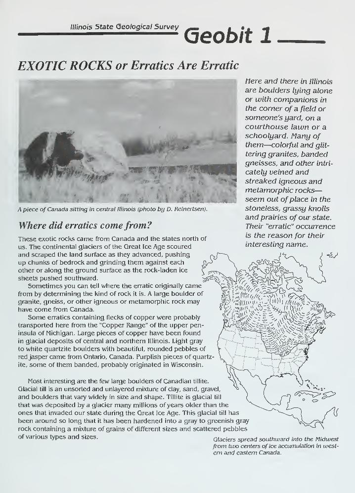
Illinois State Geological Survey
(oeobit 1
EXOTIC ROCKS or Erratics Are Erratic
Here and there in Illinois
are boulders lying alone
or with companions in
the corner of a field or
someone's yard, on acourthouse lawn or aschoolyard. Many ofthem—colorful and glit-
tering granites, bandedgneisses, and other intri-
cately veined andstreaked igneous andmetamorphic rocks—seem out ofplace in the
stoneless, grassy knolls
and prairies of our state.
Their "erratic" occurrence
is the reason for their
interesting name.
Apiece of Canada sitting in central Illinois (photo by D. Reinertsen).
Where did erratics comefrom?These exotic rocks came from Canada and the states north of
us. The continental glaciers of the Great Ice Age scoured
and scraped the land surface as they advanced, pushing
up chunks of bedrock and grinding them against each
other or along the ground surface as the rock-laden ice
sheets pushed southward.
Sometimes you can tell where the erratic originally camefrom by determining the kind of rock it is. A large boulder of
granite, gneiss, or other igneous or metamorphic rock mayhave come from Canada.
Some erratics containing flecks of copper were probably
transported here from the "Copper Range" of the upper pen-
insula of Michigan. Large pieces of copper have been found
in glacial deposits of central and northern Illinois. Light gray
to white quartzite boulders with beautiful, rounded pebbles of
red jasper came from Ontario, Canada. Purplish pieces of quartz
ite, some of them banded, probably originated in Wisconsin.
Most interesting are the few large boulders of Canadian tillite.
Glacial till is an unsorted and unlayered mixture of clay, sand, gravel,
and boulders that vary widely in size and shape. Tillite is glacial till
that was deposited by a glacier many millions of years older than the
ones that invaded our state during the Great Ice Age. This glacial till has
been around so long that it has been hardened into a gray to greenish gray
rock containing a mixture of grains of different sizes and scattered pebbles
of various types and sizes. Glaciers spread southward into the Midwestfrom two centers of ice accumulation in west-
ern and eastern Canada.
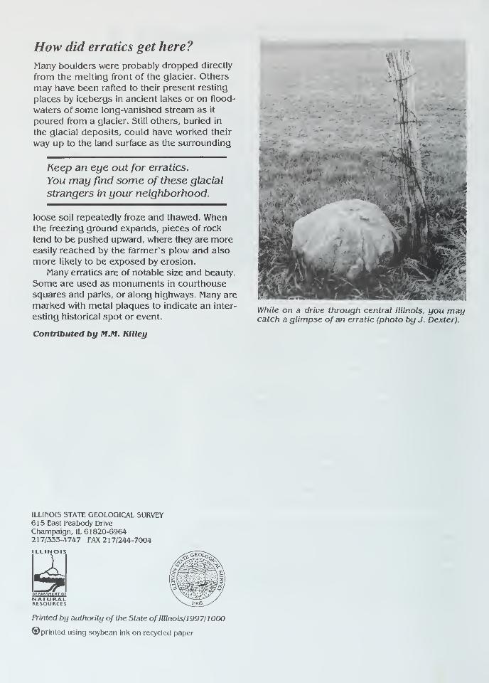
How did erratics get here?
Many boulders were probably dropped directly
from the melting front of the glacier. Others
may have been rafted to their present resting
places by icebergs in ancient lakes or on flood-
waters of some long-vanished stream as it
poured from a glacier. Still others, buried in
the glacial deposits, could have worked their
way up to the land surface as the surrounding
Keep an eye out for erratics.
You may find some of these glacial
strangers in your neighborhood.
loose soil repeatedly froze and thawed. Whenthe freezing ground expands, pieces of rock
tend to be pushed upward, where they are moreeasily reached by the farmer's plow and also
more likely to be exposed by erosion.
Many erratics are of notable size and beauty.
Some are used as monuments in courthouse
squares and parks, or along highways. Many are
marked with metal plaques to indicate an inter-
esting historical spot or event.
Contributed by M.M. Killey
<N
H
While on a drive through central Illinois, you maycatch a glimpse of an erratic (photo by J. Dexter).
ILLINOIS STATE GEOLOGICAL SURVEY615 East Peabody Drive
Champaign, IL 61820-69642 1 7/333-4747 FAX 2 1 7/244-7004
ILLINOIS
PtPA*Tf1£NT OF
NATURALRtSOURCtS
Printed by authority of the State of Illinois/1997/1000
©printed using soybean ink on recycled paper
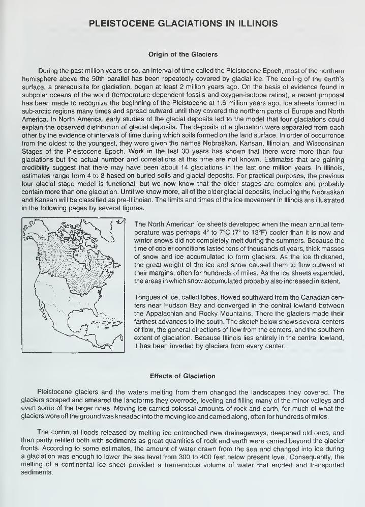
PLEISTOCENE GLACIATIONS IN ILLINOIS
Origin of the Glaciers
During the past million years or so, an interval of time called the Pleistocene Epoch, most of the northern
hemisphere above the 50th parallel has been repeatedly covered by glacial ice. The cooling of the earth's
surface, a prerequisite for glaciation, began at least 2 million years ago. On the basis of evidence found in
subpolar oceans of the world (temperature-dependent fossils and oxygen-isotope ratios), a recent proposal
has been made to recognize the beginning of the Pleistocene at 1 .6 million years ago. Ice sheets formed in
sub-arctic regions many times and spread outward until they covered the northern parts of Europe and North
America. In North America, early studies of the glacial deposits led to the model that four glaciations could
explain the observed distribution of glacial deposits. The deposits of a glaciation were separated from each
other by the evidence of intervals of time during which soils formed on the land surface. In order of occurrence
from the oldest to the youngest, they were given the names Nebraskan, Kansan, lllinoian, and Wisconsinan
Stages of the Pleistocene Epoch. Work in the last 30 years has shown that there were more than four
glaciations but the actual number and correlations at this time are not known. Estimates that are gaining
credibility suggest that there may have been about 14 glaciations in the last one million years. In Illinois,
estimates range from 4 to 8 based on buried soils and glacial deposits. For practical purposes, the previous
four glacial stage model is functional, but we now know that the older stages are complex and probably
contain more than one glaciation. Until we know more, all of the older glacial deposits, including the Nebraskan
and Kansan will be classified as pre-lllinoian. The limits and times of the ice movement in Illinois are illustrated
in the following pages by several figures.
The North American ice sheets developed when the mean annual tem-
perature was perhaps 4° to 7°C (7° to 13°F) cooler than it is now and
winter snows did not completely melt during the summers. Because the
time of cooler conditions lasted tens of thousands of years, thick massesof snow and ice accumulated to form glaciers. As the ice thickened,
the great weight of the ice and snow caused them to flow outward at
their margins, often for hundreds of miles. As the ice sheets expanded,
the areas in which snow accumulated probably also increased in extent.
Tongues of ice, called lobes, flowed southward from the Canadian cen-
ters near Hudson Bay and converged in the central lowland between
the Appalachian and Rocky Mountains. There the glaciers made their
farthest advances to the south. The sketch below shows several centers
of flow, the general directions of flow from the centers, and the southern
extent of glaciation. Because Illinois lies entirely in the central lowland,
it has been invaded by glaciers from every center.
*j
2rV Zlff;
Effects of Glaciation
Pleistocene glaciers and the waters melting from them changed the landscapes they covered. Theglaciers scraped and smeared the landforms they overrode, leveling and filling many of the minor valleys andeven some of the larger ones. Moving ice carried colossal amounts of rock and earth, for much of what the
glaciers wore off the ground was kneaded into the moving ice and carried along, often for hundreds of miles.
The continual floods released by melting ice entrenched new drainageways, deepened old ones, andthen partly refilled both with sediments as great quantities of rock and earth were carried beyond the glacier
fronts. According to some estimates, the amount of water drawn from the sea and changed into ice during
a glaciation was enough to lower the sea level from 300 to 400 feet below present level. Consequently, the
melting of a continental ice sheet provided a tremendous volume of water that eroded and transported
sediments.
In most of Illinois, then, glacial and meltwater deposits buried the old rock-ribbed, low, hill-and-valley
terrain and created the flatter landforms of our prairies. The mantle of soil material and the buried deposits
of gravel, sand, and clay left by the glaciers over about 90 percent of the state have been of incalculable
value to Illinois residents.
Glacial Deposits
The deposits of earth and rock materials moved by a glacier and deposited in the area once covered
by the glacier are collectively called drift. Drift that is ice-laid is called till. Water-laid drift is called outwash.
Till is deposited when a glacier melts and the rock material it carries is dropped. Because this sediment
is not moved much by water, a till is unsorted, containing particles of different sizes and compositions. It is
also stratified (unlayered). A till may contain materials ranging in size from microscopic clay particles to large
boulders. Most tills in Illinois are pebbly clays with only a few boulders. For descriptive purposes, a mixture
of clay, silt, sand and boulders is called diamicton. This is a term used to describe a deposit that could be
interpreted as till or a mass wasting product.
Tills may be deposited as end moraines, the arc-shaped ridges that pile up along the glacier edges
where the flowing ice is melting as fast as it moves forward. Till also may be deposited as ground moraines,
or till plains, which are gently undulating sheets deposited when the ice front melts back, or retreats. Deposits
of till identify areas once covered by glaciers. Northeastern Illinois has many alternating ridges and plains,
which are the succession of end moraines and till plains deposited by the Wisconsinan glacier.
Sorted and stratified sediment deposited by water melting from the glacier is called outwash. Outwashis bedded, or layered, because the flow of water that deposited it varied in gradient, volume, velocity, anddirection. As a meltwater stream washes the rock materials along, it sorts them by size—the fine sands, silts,
and clays are carried farther downstream than the coarser gravels and cobbles. Typical Pleistocene outwashin Illinois is in multilayered beds of clays, silts, sands, and gravels that look much like modern stream deposits
in some places. In general, outwash tends to be coarser and less weathered, and alluvium is most often finer
than medium sand and contains variable amounts of weathered material.
Outwash deposits are found not only in the area covered by the ice field but sometimes far beyond it.
Meltwater streams ran off the top of the glacier, in crevices in the ice, and under the ice. In some places, the
cobble-gravel-sand filling of the bed of a stream that flowed in the ice is preserved as a sinuous ridge called
an esker. Some eskers in Illinois are made up of sandy to silty deposits and contain mass wasted diamicton
material. Cone-shaped mounds of coarse outwash, called kames, were formed where meltwater plunged
through crevasses in the ice or into ponds on the glacier.
The finest outwash sediments, the clays and silts, formed bedded deposits in the ponds and lakes that
filled glacier-dammed stream valleys, the sags of the till plains, and some low, moraine-diked till plains.
Meltwater streams that entered a lake rapidly lost speed and also quickly dropped the sands and gravels
they carried, forming deltas at the edge of the lake. Very fine sand and silts were commonly redistributed onthe lake bottom by wind-generated currents, and the clays, which stayed in suspension longest, slowly settled
out and accumulated with them.
Along the ice front, meltwater ran off in innumerable shifting and short-lived streams that laid down a
broad, flat blanket of outwash that formed an outwash plain. Outwash was also carried away from the glacier
in valleys cut by floods of meltwater. The Mississiippi, Illinois, and Ohio Rivers occupy valleys that were major
channels for meltwaters and were greatly widened and deepened during times of the greatest meltwater
floods. When the floods waned, these valleys were partly filled with outwash far beyond the ice margins.
Such outwash deposits, largely sand and gravel, are known as valley trains. Valley train deposits may beboth extensive and thick. For instance, the long valley train of the Mississippi Valley is locally as much as200 feet thick.
Loess, Eolian Sand and Soils
One of the most widespread sediments resulting from glaciation was carried not by ice or water but bywind. Loess is the name given to windblown deposits dominated by silt. Most of the silt was derived from
wind erosion of the valley trains. Wind action also sorted out eolian sand which commonly formed sanddunes on the valley trains or on the adjacent uplands. In places, sand dunes have migrated up to 10 miles
away from the principle source of sand. Flat areas between dunes are generally underlain by eolian sheetsand that is commonly reworked by water action. On uplands along the major valley trains, loess and eolian
sand are commonly interbedded. With increasing distance from the valleys, the eolian sand pinches out, often
within one mile.
Eolian deposition occurred when certain climatic conditions were met, probably in a seasonal pattern.
Deposition could have occurred in the fall, winter or spring season when low precipitation rates and low
temperatures caused meltwater floods to abate, exposing the surfaces of the valley trains and permitting
them to dry out. During Pleistocene time, as now, west winds prevailed, and the loess deposits are thickest
on the east sides of the source valleys. The loess thins rapidly away from the valleys but extends over almost
all the state.
Each Pleistocene glaciation was followed by an interglacial stage that began when the climate warmedenough to melt the glaciers and their snowfields. During these warmer intervals, when the climate was similar
to that of today, drift and loess surfaces were exposed to weather and the activities of living things. Con-sequently, over most of the glaciated terrain, soils developed on the Pleistocene deposits and altered their
composition, color, and texture. Such soils were generally destroyed by later glacial advances, but somewere buried. Those that survive serve as "key beds," or stratigraphic markers, and are evidence of the passageof a long interval of time.
Glaciation in a Small Illinois Region
The following diagrams show how a continental ice sheet might have looked at various stages as it
moved across a small region in Illinois. They illustrate how it could change the old terrain and create alandscape like the one we live on. To visualize how these glaciers looked, geologists study the landforms
and materials left in the glaciated regions and also the present-day mountain glaciers and polar ice caps.
The block of land in the diagrams is several miles wide and about 10 miles long. The vertical scale is
exaggerated—layers of material are drawn thicker and landforms higher than they ought to be so that they
can be easily seen.
1. The Region Before Glaciation — Like most of Illinois, the region illustrated is underlain by almost flat-lying beds of
sedimentary rocks—layers of sandstone (-•••.
), limestone ( ,
'). and shale (=E^)- Millions of years of erosion
have planed down the bedrock (BR), creating a terrain of low uplands and shallow valleys. A residual soil weathered
from local rock debris covers the area but is too thin to be shown in the drawing. The streams illustrated here flow
westward and the one on the right flows into the other at a point beyond the diagram.
<r=F
^^P, ;!,; .
'
.
'
.!' -
.,!
2. The Glacier Advances Southward — As the Glacier (G) spreads out from its ice snowfield accumulation center, it
scours (SC) the soil and rock surface and quarries (Q)—pushes and plucks up—chunks of bedrock. The materials are
mixed into the ice and make up the glacier's "load." Where roughnesses in the terrain slow or stop flow (F), the ice
"current" slides up over the blocked ice on innumerable shear planes (S). Shearing mixes the load very thoroughly. As
the glacier spreads, long cracks called "crevasses" (C) open parallel to the direction of ice flow. The glacier melts as it
flows forward, and its meltwater erodes the terrain in front of the ice, deepening (D) some old valleys before ice covers
them. Meltwater washes away some of the load freed by melting and deposits it on the outwash plain (OP). The advancing
glacier overrides its outwash and in places scours much of it up again. The glacier may be 5000 or so feet thick, and
tapers to the margin, which was probably in the range of several hundred feet above the old terrain. The ice front advances
perhaps as much as a third of a mile per year.
1 , . 1 ±=r±=cy^ \'
i '
-r1^^?^ ^S r"-r
3. The Glacier Deposits an End Moraine — After the glacier advances across the area, the climate warms and the
ice begins to melt as fast as it advances. The ice front (IF) is now stationary, or fluctuating in a narrow area, and the
glacier is depositing an end moraine.
As the top of the glacier melts, some of the sediment that is mixed in the ice accumulates on top of the glacier.
Some is carried by meltwater onto the sloping ice front (IF) and out onto the plain beyond. Some of the debris slips down
the ice front in a mudflow (FL). Meltwater runs through the ice in a crevasse (C). A supraglacial stream (SS) drains the
top of the ice, forming an outwash fan (OF). Moving ice has overridden an immobile part of the front on a shear plane
(S). All but the top of a block of ice (B) is buried by outwash (O).
Sediment from the melted ice of the previous advance (figure 2) remains as a till layer (T), part of which forms the
till plain (TP). A shallow, marshy lake (L) fills a low place in the plain. Although largely filled with drift, the valley (V)
remains a low spot in the terrain. As soon as the ice cover melts, meltwater drains down the valley, cutting it deeper.
Later, outwash partly refills the valley: the outwash deposit is called a valley train (VT). Wind blows dust (DT) off the dry
floodplain. The dust will form a loess deposit when it settles. Sand dunes (D) form on the south and east sides of streams.
4. The Region after Glaciation — As the climate warms further, the whole ice sheet melts, and glaciation ends. Theend moraine (EM) is a low, broad ridge between the outwash plain (OP) and till plains (TP). Run-off from rains cuts
stream valleys into its slopes. A stream goes through the end moraine along the channel cut by the meltwater that ran
out of the crevasse in the glacier.
Slopewash and vegetation are filling the shallow lake. The collapse of outwash into the cavity left by the ice block's
melting has made a kettle (K). The outwash that filled a tunnel draining under the glacier is preserved in an esker (E).
The hill of outwash left where meltwater dumped sand and gravel into a crevasse or other depression in the glacier or
at its edge is a kame (KM). A few feet of loess covers the entire area but cannot be shown at this scale.
TIME TABLE OF PLEISTOCENE GLACIATION
STAGE SUBSTAGE NATURE OF DEPOSITS SPECIAL FEATURES
>
cr
<
LU
O
HOLOCENE(interglacial)
Years
Before Present
WISCONSINAN(glacial)
SANGAMONIAN(interglacial)
ILLINOIAN(glacial)
YARMOUTHIAN(interglacial)
KANSAN*(glacial)
AFTONIAN*(interglacial)
NEBRASKAN*(glacial)
10,000 -
Valderan
- 1 1 ,000 -
Twocreekan
- 12,500 -
Woodfordian
- 25,000
Farmdalian
- 28,000 -
Altonian
75,000
125,000
Jubileean
Monican
Liman
300,000?
500,000?
700,000?
900,000?
1 ,600,000 or more
Soil, youthful profile
of weathering, lake
and river deposits,
dunes, peat
Outwash, lake deposits
Peat and alluvium
Drift, loess, dunes,
lake deposits
Soil, silt, and peat
Drift, loess
Soil, mature profile
of weathering
Drift, loess, outwash
Drift, loess, outwash
Drift, loess, outwash
Soil, mature profile
of weathering
Drift, loess
Soil, mature profile
of weathering
Drift (little known)
Outwash along
Mississippi Valley
Ice withdrawal, erosion
Glaciation; building of
many moraines as far
south as Shelbyville;
extensive valley trains,
outwash plains, and lakes
Ice withdrawal, weathering,
and erosion
Glaciation in Great Lakesarea, valley trains
along major rivers
Important stratigraphic marker
Glaciers from northeast
at maximum reached
Mississippi River andnearly to southern tip
of Illinois
Important stratigraphic marker
Glaciers from northeast
and northwest covered
much of state
(hypothetical)
Glaciers from northwest
invaded western Illinois
'Old oversimplified concepts, now known to represent a series of glacial cycles.
linois State Geological Survey, 1973)
SEQUENCE OF GLACIATIONS AND INTERGLACIALDRAINAGE IN ILLINOIS
PRE-PLEISTOCENE PRE-ILLINOIAN YARMOUTHIANmajor drainage inferred glacial limits major drainage
LIMANglacial advance
MONICANglacial advance
JUBILEEANglacial advance
SANGAMONIANmajor drainage
ALTONIAN WOODFORDIAN WOODFORDIANglacial advance glacial advance Valparaiso ice and
Kankakee Flood
VALDERANdrainage
(Modified from Willlman and Frye, "Pleistocene Stratigraphy of Illinois," ISGS Bull. 94, fig. 5, 1970.)
QUATERNARY DEPOSITSOF ILLINOIS
Hudson and Wisconsin Episodes
Mason Group and Cahokia Fm
I Cahokia and Henry Fms; sorted
sediment including waterlain
river sediment and windblownand beach sand
Equality Fm; fine grainedsediment deposited in lakes
Thickness of Peoria andRoxana Silts; silt deposited
as loess (5 ft contour interval)
Wedron Group (Tiskilwa, Lemont, andVvadsworth Fms) and Trafalgar Fm;diamicton deposited as till andice-marginal sediment
i End moraine
Ground moraine
inois Episode
Winnebago Fm; diamicton deposited as till
and ice-marginal sediment
Glasford Fm; diamicton deposited as till andice-marginal sediment
Teneriffe Silt and Pearl Fm, including HagerstownMbr; sorted sediments including river and lake
deposits and wind blown sand
Pre-lllinois Episodes
//// Wolf Creek Fm; predominantly diamictondeposited as till and ice-marginal sediment
Paloezoic, Mesozoic, and Cenozoic
Mostly Paleozoic shale, limestone, dolomite,
or sandstone; exposed or covered by loessand/or residuum
50 kmj i
[LLINOIS STATE GEOLOGICAL SURVEY GEOGRAM 5
Urbana, Illinois 61801 October 1975
ANCIENT DUST STORMS IN ILLINOIS
Myrna M. Killey
Fierce dust storms whirled across Illinois long before human beings werehere to record them. Where did all the dust come from? Geologists have carefullyput together clues from the earth itself to get the story. As the glaciers of the
Great Ice Age scraped and scoured their way southward across the landscape fromCanada, they moved colossal amounts of rock and earth. Much of the rock groundfrom the surface was kneaded into the ice and carried along, often for hundredsof miles. The glaciers acted as giant grist mills, grinding much of the rock and
earth to "flour"—very fine dust-sized particles.
During the warm seasons, water from the melting ice poured from the gla-
cier front, laden with this rock flour, called silt. In the cold months the melt-water stopped flowing and the silt was left along the channels the water had fol-
lowed, where it dried out and became dust. Strong winds picked up the dust, swept
it from the f loodplains , and carried it to adjacent uplands. There the forests
along the river valleys trapped the dust, which became part of the moist forest
soil. With each storm more material accumulated until the high bluffs adjacent to
major rivers were formed. The dust deposits are thicker along the eastern sides
of the valleys than they are on the western sides, a fact from which geologists
deduce that the prevailing winds of that time blew from west to east, the same
direction as those of today. From such clues geologists conclude that the geo-
logic processes of the past were much like those of today.
The deposits of windblown silt are called loess (rhymes with "bus").
Loess is found not only in the areas once covered by the glaciers but has beenblown into the nonglaciated areas. The glaciers, therefore, influenced the pres-
ent land surface well beyond the line of their farthest advance.
Loess has several interesting characteristics. Its texture is so fine
and uniform that it can easily be identified in roadcuts— and because it blanketssuch a vast area many roads are cut through it. Even more noticeable is its ten-
dency to stand in vertical walls. These steep walls develop as the loess drains
and becomes tough, compact, and massive, much like a rock. Sometimes cracks de-
velop in the loess, just as they do in massive limestones and sandstones. Loess
makes good highway banks if it is cut vertically. A vertical cut permits maximumdrainage because little surface is exposed to rain, and rainwater tends to drain
straight down through it to the rock underneath. If the bank is cut at an angle
more water soaks in, which causes the loess to slump down. Along Illinois roads
the difference between a loess roadcut and one in ordinary glacial till is obvi-
ous. The loess has a very uniform texture, while the till is composed of a ran-
dom mixture of rock debris, from clay and silt through cobbles and boulders.
Many loess deposits are worth a close look. Through a 10-power handlens separate grains can be seen, among them many clear, glassy, quartz grains.
Some loess deposits contain numerous rounded, lumpy stones called concretions.
Their formation began when water percolating through the loess dissolved tiny
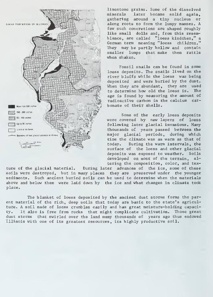
I.OKSS THICKNESS IN I I.I.INOIS 1 ^B1§*£S
More than 300 inches
150 - 300 inches
limestone grains. Some of the dissolvedminerals later became solid again,gathering around a tiny nucleus oralong roots to form the lumpy masses. Afew such concretions are shaped roughlylike small dolls and, from this resem-blance, are called "loess kindchen," a
German term meaning "loess children."They may be partly hollow and containsmaller lumps that make them rattlewhen shaken.
Fossil snails can be found in some
loess deposits. The snails lived on the
river bluffs while the loess was beingdeposited and were buried by the dust.
When they are abundant, they are used
to determine how old the loess is. The
age is found by measuring the amount of
radioactive carbon in the calcium car-
bonate of their shells.
50 - 150 inches
[""""'I Up to 50 inches
I I Little or no loess
»—'"'—» Boundary of last glacial advance
Some of the early loess depositswere covered by new layers of loessfollowing later glacial invasions. Manythousands of years passed between the
major glacial periods, during whichtime the climate was as warm as that of
today. During the warm intervals, the
surface of the loess and other glacialdeposits was exposed to weather. Soilsdeveloped on most of the terrain, al-
tering the composition, color, and tex-
ture of the glacial material. During later advances of the ice, some of thesesoils were destroyed, but in many places they are preserved under the youngersediments. Such ancient buried soils can be used to determine when the materialsabove and below them were laid down by the ice and what changes in climate tookplace.
The blanket of loess deposited by the ancient dust storms forms the par-ent material of the rich, deep soils that today are basic to the state's agricul-ture. A soil made of loess crumbles easily and has great moisture-holding capaci-ty. It also is free from rocks that might complicate cultivation. Those greatdust storms that swirled over the land many thousands of years ago thus endowedIllinois with one of its greatest resources, its highly productive soil.
DEPOSITIONAL HISTORY OF THE PENNSYLVANIAN ROCKS IN ILLINOIS
At the close of the Mississippian Period, about 310 million years ago, the sea withdrew from the Midcontinent
region. A long interval of erosion that took place early in Pennsylvanian time removed hundreds of feet of the
pre-Pennsylvanian strata, completely stripping them away and cutting into older rocks over large areas of the
Midwest. Ancient river systems cut deep channels into the bedrock surface. Later, but still during early
Pennsylvanian (Morrowan) time, the sea level started to rise; the corresponding rise in the base level of
deposition interrupted the erosion and led to filling the valleys in the erosion surface with fluvial, brackish,
and marine sands and muds.
Depositional conditions in the Illinois Basin during the Pennsylvanian Period were somewhat similar to
those of the preceding Chesterian (late Mississippian) time. A river system flowed southwestward across a
swampy lowland, carrying mud and sand from highlands to the northeast. This river system formed thin but
widespread deltas that coalesced into a vast coastal plain or lowland that prograded (built out) into the shallow
sea that covered much of present-day Illinois (see paleogeographic map, next page). As the lowland stood
only a few feet above sea level, slight changes in relative sea level caused great shifts in the position of the
shoreline.
During most of Pennsylvanian time, the Illinois Basin gradually subsided; a maximum of about 3000 feet
of Pennsylvanian sediments are preserved in the basin. The locations of the delta systems and the shoreline
of the resulting coastal plain shifted, probably because of worldwide sea level changes, coupled with variation
in the amounts of sediments provided by the river system and local changes in basin subsidence rates. These
frequent shifts in the coastline position caused the depositional conditions at any one locality in the basin to
alternate frequently between marine and nonmarine, producing a variety of lithologies in the Pennsylvanian
rocks (see lithology distribution chart).
Conditions at various places on the shallow sea floor favored the deposition of sand, lime mud, or mud.
Sand was deposited near the mouths of distributary channels, where it was reworked by waves and spread
out as thin sheets near the shore. Mud was deposited in quiet-water areas — in delta bays between dis-
tributaries, in lagoons behind barrier bars, and in deeper water beyond the nearshore zone of sand deposition.
Limestone was formed from the accumulation of limy parts of plants and animals laid down in areas where
only minor amounts of sand and mud were being deposited. The areas of sand, mud, and limy mud deposition
continually changed as the position of the shoreline changed and as the delta distributaries extended seaward
or shifted their positions laterally along the shore.
Nonmarine sand, mud, and lime mud were deposited on the coastal plain bordering the sea. The nonmarine
sand was deposited in delta distributary channels, in river channels, and on the broad floodplains of the rivers.
Some sand bodies 100 or more feet thick were deposited in channels that cut through the underlying rock
units. Mud was deposited mainly on floodplains. Some mud and freshwater lime mud were deposited locally
in fresh-water lakes and swamps.
Beneath the quiet water of extensive swamps that prevailed for long intervals on the emergent coastal
lowland, peat was formed by accumulation of plant material. Lush forest vegetation covered the region; it
thrived in the warm, moist Pennsylvanian-age climate. Although the origin of the underclays beneath the coal
is not precisely known, most evidence indicates that they were deposited in the swamps as slackwater mudbefore the accumulation of much plant debris. The clay underwent modification to become the soil upon which
the lush vegetation grew in the swamps. Underclay frequently contains plant roots and rootlets that appear
to be in their original places. The vast swamps were the culmination of nonmarine deposition. Resubmergenceof the borderlands by the sea interrupted nonmarine deposition, and marine sediments were laid down over
the peat.
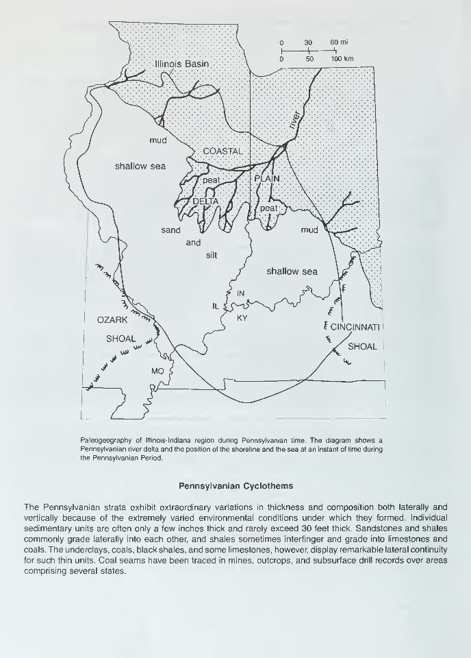
30 60 mi
-\ h
J Illinois Basin \50 100 km
^ *** /
oJ:::::i/::::::::::::-:
> COASTAL
shallow sea y^TVs^-. r^.
plain: : \: : •:•:•::•:::•:•:::
/jr delta: A A/peat^Yv^-^A J"*
sand
and
VOZARK '^
SHOAL j {
silt
IL
mud
shallow sea
IN
KYI CINCINNATI
MO
r^
Paleogeography of Illinois-Indiana region during Pennsylvanian time. The diagram shows a
Pennsylvanian river delta and the position of the shoreline and the sea at an instant of time during
the Pennsylvanian Period.
Pennsylvanian Cyclothems
The Pennsylvanian strata exhibit extraordinary variations in thickness and composition both laterally and
vertically because of the extremely varied environmental conditions under which they formed. Individual
sedimentary units are often only a few inches thick and rarely exceed 30 feet thick. Sandstones and shales
commonly grade laterally into each other, and shales sometimes interfinger and grade into limestones and
coals. The underclays, coals, black shales, and some limestones, however, display remarkable lateral continuity
for such thin units. Coal seams have been traced in mines, outcrops, and subsurface drill records over areas
comprising several states.
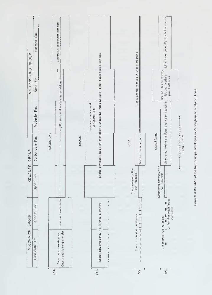
Q.
Oor<£>
UJUJ-z.
<
UJ
a.
Oa.
o
CLZ>
o<r
oor
omen
<UJ
CD
eu.
o
Eu. <
oo
ooa.
uD
.D
Id
ID1
TT
i 2
< occ in
c2'cCO>>s</>
cca>Q.
oox:
T3
CDCVO
o -2
^ n
or
oo
Eu_
5 £
| ||
o
5-°
if)
CMlf>
CMif)
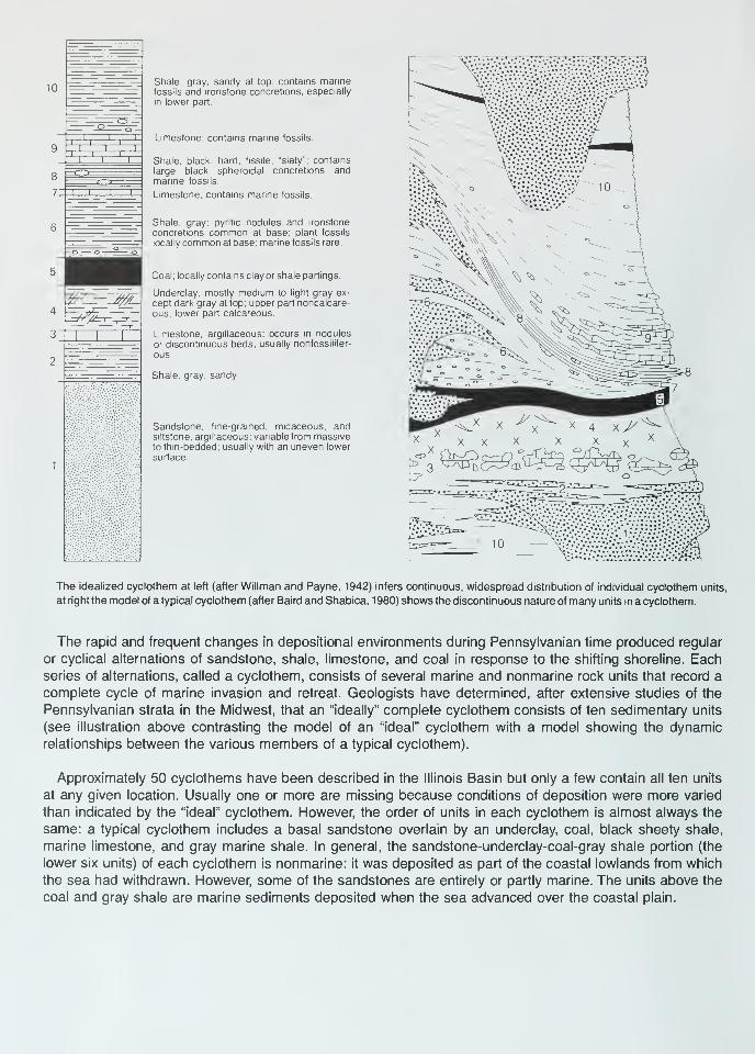
10Shale, gray, sandy at top; contains marinefossils and ironstone concretions, especially
in lower part.
Limestone; contains marine fossils
Shale, black, hard, fissile, "slaty"; contains
large black spheroidal concretions andmarine fossils.
Limestone; contains marine fossils.
Shale, gray; pyntic nodules and ironstone
concretions common at base; plant fossils
locally common at base; marine fossils rare.
Coal ; locally contains clay or shale partings.
Underclay, mostly medium to light gray ex-
cept dark gray at top; upper part noncalcare-
ous, lower part calcareous
Limestone, argillaceous; occurs in nodules
or discontinuous beds; usually nonfossilifer-
ous.
Shale, gray, sandy
Sandstone, fine-grained, micaceous, andsiltstone, argillaceous; variable from massiveto thin-bedded, usually with an uneven lower
surface
The idealized cyclothem at left (after Willman and Payne, 1942) infers continuous, widespread distribution of individual cyclothem units,
at right the model of a typical cyclothem (after Baird and Shabica, 1980) shows the discontinuous nature of many units in a cyclothem.
The rapid and frequent changes in depositional environments during Pennsylvanian time produced regular
or cyclical alternations of sandstone, shale, limestone, and coal in response to the shifting shoreline. Eachseries of alternations, called a cyclothem, consists of several marine and nonmarine rock units that record a
complete cycle of marine invasion and retreat. Geologists have determined, after extensive studies of the
Pennsylvanian strata in the Midwest, that an "ideally" complete cyclothem consists of ten sedimentary units
(see illustration above contrasting the model of an "ideal" cyclothem with a model showing the dynamic
relationships between the various members of a typical cyclothem).
Approximately 50 cyclothems have been described in the Illinois Basin but only a few contain all ten units
at any given location. Usually one or more are missing because conditions of deposition were more varied
than indicated by the "ideal" cyclothem. However, the order of units in each cyclothem is almost always the
same: a typical cyclothem includes a basal sandstone overlain by an underclay, coal, black sheety shale,
marine limestone, and gray marine shale. In general, the sandstone-underclay-coal-gray shale portion (the
lower six units) of each cyclothem is nonmarine: it was deposited as part of the coastal lowlands from which
the sea had withdrawn. However, some of the sandstones are entirely or partly marine. The units above the
coal and gray shale are marine sediments deposited when the sea advanced over the coastal plain.
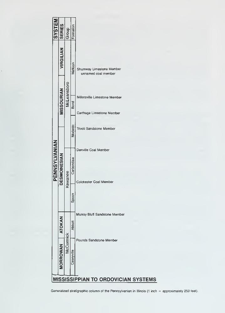
3Eui (O c
coLU
ccUi
Q.3
oTO
> 2 E
CO CO CDoLL
z<-1
occ C
o>
oo
o(0
5Shumway Limestone Member
unnamed coal member
z< CO
cLX
(0CD Millersville Limestone Member3 _l
O(0
O2 c
o(0 CD
5
otoQ)
o2
Carthage Limestone Member
Trivoli Sandstone Member
z<z Danville Coal Member< z5 < ¥>- 0)
(0
COz
LUz
zLU
os
CD
C
03
O
Q.COLUQ
(0
Colchester Coal Member
cooQ-CO
Murray Bluff Sandstone Memberz< c
oo
£ <<
o
1 Pounds Sandstone Member
z<
oOo
5 s ^o Icc 01
ccCOTO
o O5
MISSISSIPPIAN TO ORDOVICIAN SYSTEMS
Generalized stratigraphic column of the Pennsylvanian in Illinois (1 inch = approximately 250 feet).
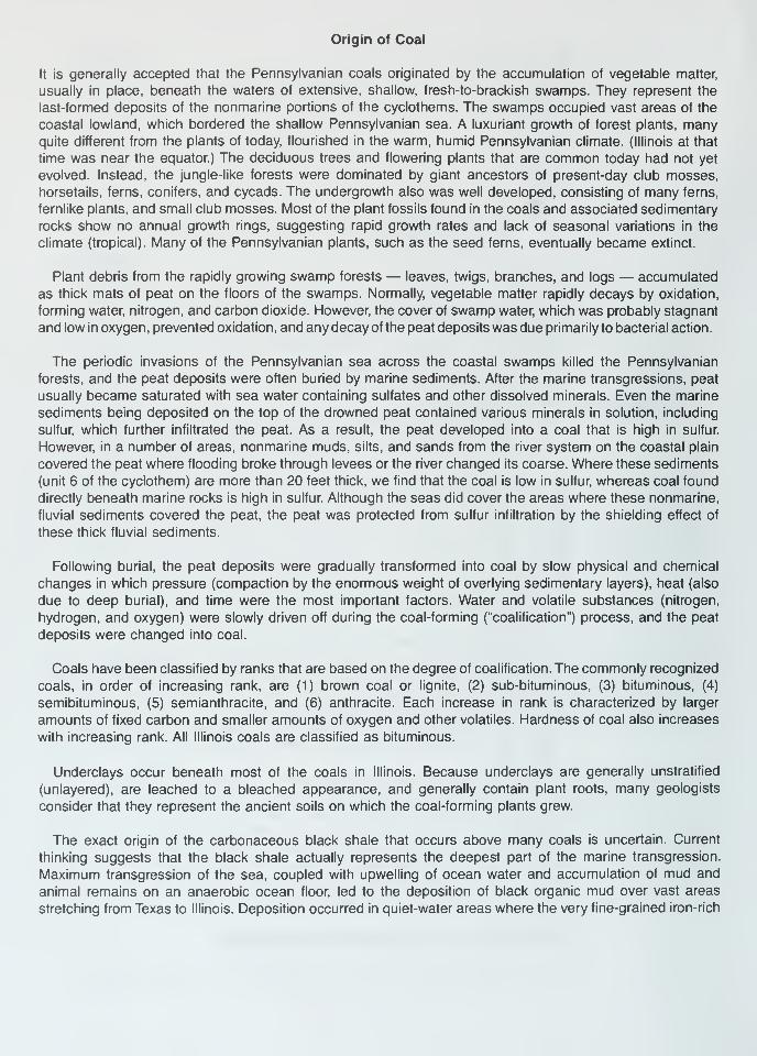
Origin of Coal
It is generally accepted that the Pennsylvanian coals originated by the accumulation of vegetable matter,
usually in place, beneath the waters of extensive, shallow, fresh-to-brackish swamps. They represent the
last-formed deposits of the nonmarine portions of the cyclothems. The swamps occupied vast areas of the
coastal lowland, which bordered the shallow Pennsylvanian sea. A luxuriant growth of forest plants, manyquite different from the plants of today, flourished in the warm, humid Pennsylvanian climate. (Illinois at that
time was near the equator.) The deciduous trees and flowering plants that are common today had not yet
evolved. Instead, the jungle-like forests were dominated by giant ancestors of present-day club mosses,
horsetails, ferns, conifers, and cycads. The undergrowth also was well developed, consisting of many ferns,
fernlike plants, and small club mosses. Most of the plant fossils found in the coals and associated sedimentary
rocks show no annual growth rings, suggesting rapid growth rates and lack of seasonal variations in the
climate (tropical). Many of the Pennsylvanian plants, such as the seed ferns, eventually became extinct.
Plant debris from the rapidly growing swamp forests — leaves, twigs, branches, and logs — accumulated
as thick mats of peat on the floors of the swamps. Normally, vegetable matter rapidly decays by oxidation,
forming water, nitrogen, and carbon dioxide. However, the cover of swamp water, which was probably stagnant
and low in oxygen, prevented oxidation, and any decay of the peat deposits was due primarily to bacterial action.
The periodic invasions of the Pennsylvanian sea across the coastal swamps killed the Pennsylvanian
forests, and the peat deposits were often buried by marine sediments. After the marine transgressions, peat
usually became saturated with sea water containing sulfates and other dissolved minerals. Even the marine
sediments being deposited on the top of the drowned peat contained various minerals in solution, including
sulfur, which further infiltrated the peat. As a result, the peat developed into a coal that is high in sulfur.
However, in a number of areas, nonmarine muds, silts, and sands from the river system on the coastal plain
covered the peat where flooding broke through levees or the river changed its coarse. Where these sediments
(unit 6 of the cyclothem) are more than 20 feet thick, we find that the coal is low in sulfur, whereas coal found
directly beneath marine rocks is high in sulfur. Although the seas did cover the areas where these nonmarine,
fluvial sediments covered the peat, the peat was protected from sulfur infiltration by the shielding effect of
these thick fluvial sediments.
Following burial, the peat deposits were gradually transformed into coal by slow physical and chemical
changes in which pressure (compaction by the enormous weight of overlying sedimentary layers), heat (also
due to deep burial), and time were the most important factors. Water and volatile substances (nitrogen,
hydrogen, and oxygen) were slowly driven off during the coal-forming ("coalification") process, and the peat
deposits were changed into coal.
Coals have been classified by ranks that are based on the degree of coalification. The commonly recognized
coals, in order of increasing rank, are (1) brown coal or lignite, (2) sub-bituminous, (3) bituminous, (4)
semibituminous, (5) semianthracite, and (6) anthracite. Each increase in rank is characterized by larger
amounts of fixed carbon and smaller amounts of oxygen and other volatiles. Hardness of coal also increases
with increasing rank. All Illinois coals are classified as bituminous.
Underclays occur beneath most of the coals in Illinois. Because underclays are generally unstratified
(unlayered), are leached to a bleached appearance, and generally contain plant roots, many geologists
consider that they represent the ancient soils on which the coal-forming plants grew.
The exact origin of the carbonaceous black shale that occurs above many coals is uncertain. Current
thinking suggests that the black shale actually represents the deepest part of the marine transgression.
Maximum transgression of the sea, coupled with upwelling of ocean water and accumulation of mud and
animal remains on an anaerobic ocean floor, led to the deposition of black organic mud over vast areas
stretching from Texas to Illinois. Deposition occurred in quiet-water areas where the very fine-grained iron-rich

mud and finely divided plant debris were washed in from the land. Most of the fossils found in black shale
represent planktonic (floating) and nektonic (swimming) forms — not benthonic (bottom-dwelling) forms. The
depauperate (dwarf) fossil forms sometimes found in black shale formerly were thought to have been forms
that were stunted by toxic conditions in the sulfide-rich, oxygen-deficient water of the lagoons. However, study
has shown that the "depauperate" fauna consists mostly of normal-size individuals of species that never grew
any larger.
References
Baird, G. C, and C. W. Shabica, 1980, The Mazon Creek depositional event; examination of Francis Creek
and analogous fades in the Midcontinent region: in Middle and late Pennsylvanian strata on margin of
Illinois Basin, Vermilion County, Illinois, Vermilion and Parke counties, Indiana (R. L. Langenheim, editor).
Annual Field Conference— Society of Economic Paleontologists and Mineralogists. Great Lakes Section,
No. 10, p. 79-92.
Heckel, P. H., 1977, Origin of phosphatic black shale fades in Pennsylvanian cyclothems of mid-continent
North America: American Association of Petroleum Geologist Bulletin, v. 61, p. 1045-1068.
Kosanke, R. M., J. A. Simon, H. R. Wanless, and H. B. Willman, 1960, Classification of the Pennsylvanian
strata of Illinois: Illinois State Geological Survey Report of Investigation 214, 84 p.
Simon, J. A., and M. E. Hopkins, 1973, Geology of Coal: Illinois State Geological Survey Reprint 1973-H, 28 p.
Willman, H. B., and J. N. Payne, 1942, Geology and mineral resources of the Marseilles, Ottawa, and Streator
Quadrangles: Illinois State Geological Survey Bulletin 66, 388 p.
Willman, H. B., et al., 1967, Geologic Map of Illinois: Illinois State Geological Survey map; scale, 1:500,000
(about 8 miles per inch).
Willman, H. B., E. Atherton, T C. Buschbach, C. W. Collinson, J. C. Frye, M. E. Hopkins, J. A. Lineback, and
J. A. Simon, 1975, Handbook of Illinois Stratigraphy: Illinois State Geological Survey Bulletin 95, 261 p.
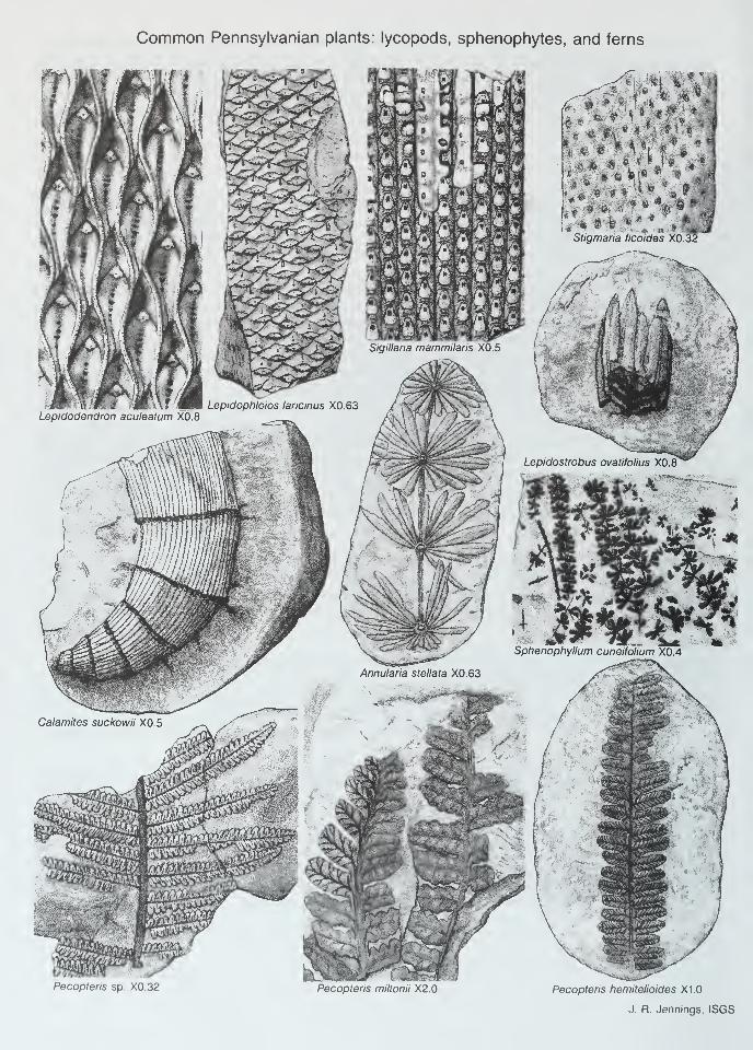
Common Pennsylvanian plants: lycopods, sphenophytes, and ferns
$§mm
Pecopteris sp. X0.32 Pecoptehs miltonii X2.0 Pecopteris hemitelioides X1.0
J. R. Jennings, ISGS
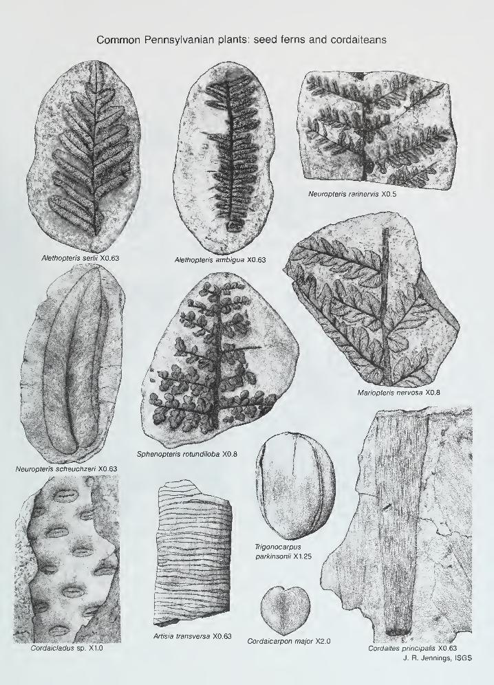
Common Pennsylvanian plants: seed ferns and cordaiteans
Cordaicladus sp. X1.0Cordaicarpon major X2.0
Cordaites principalis X0.63
J. R. Jennings, ISGS
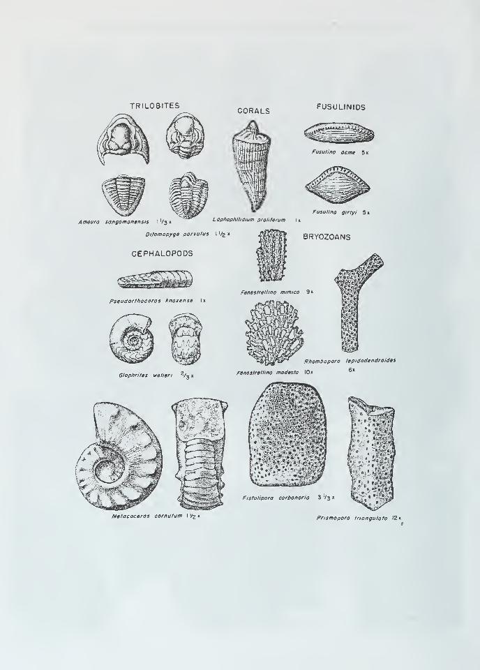
TRILOBITESCORALS FUSULINIDS
Fusuiino acme 5 x
Fusulina girtyi 5 x
Ameura sangamonensis I V3 xL ophophllidium proliferum I x
Dilomopyge porvulus I Vfc x
CEPHALOPODS
BRYOZOANS
aEE3E3
Pseudorthoceros knoxense Ix
Glaphrites welleri z/3 x
Fistulipora carbonario 3 V3 x
Metacoceras cornutum I '/g x Prismopora triangulate 12 x
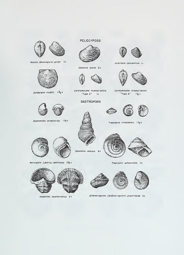
Nucula (Nuculopsis) girtyi lx
Dunbortllo kmghti I '/g x
Edmonia ovato 2 x
Cardiomorpho missouritnsis
"Type A" I
«
Astarttlta conctntrico I x
Cordiomorpho missouriensis
"Typ« B" 1 1/2 x
GASTROPODS
Evphemites carbonarius I'/fc
x
Oonoldino robusto 8 x
Trapospira illinoisensis I ^ x
Naticopsis (Jtdnaj vtnrncosa I '/2 x Trepospira sphoerulato I x
Kmahtites montfortionus 2 xGlabrocingulum (Globrocingulum) grayvtllense 3x
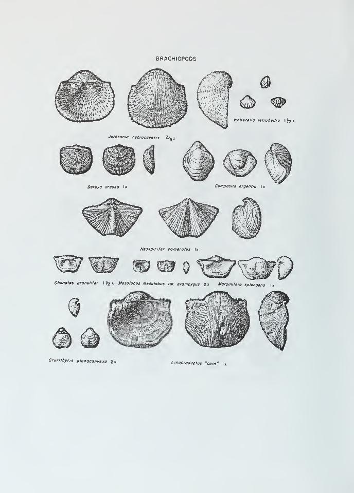
8RACHI0P0DS
Jurasanio nabroscensis 2/, „
Darbyo cross a Ix Composite organf/o I x
Naospinfar comarotus Ix
wChonatas gronutifar I
l/2 x Masolobus mesolobus vor. avompygus 2 x Morgmifaro splendans I x
Crurithyris planoconvaxa 2x Linoproduclus "coro" Ix

Cladopora
Spinocyrtia Pro tolep tos trophia
Devonian Fossils of Northwestern Illinois.