GR133.pdf - Aberdeenshire Council
87
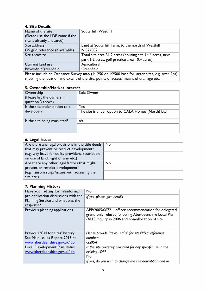
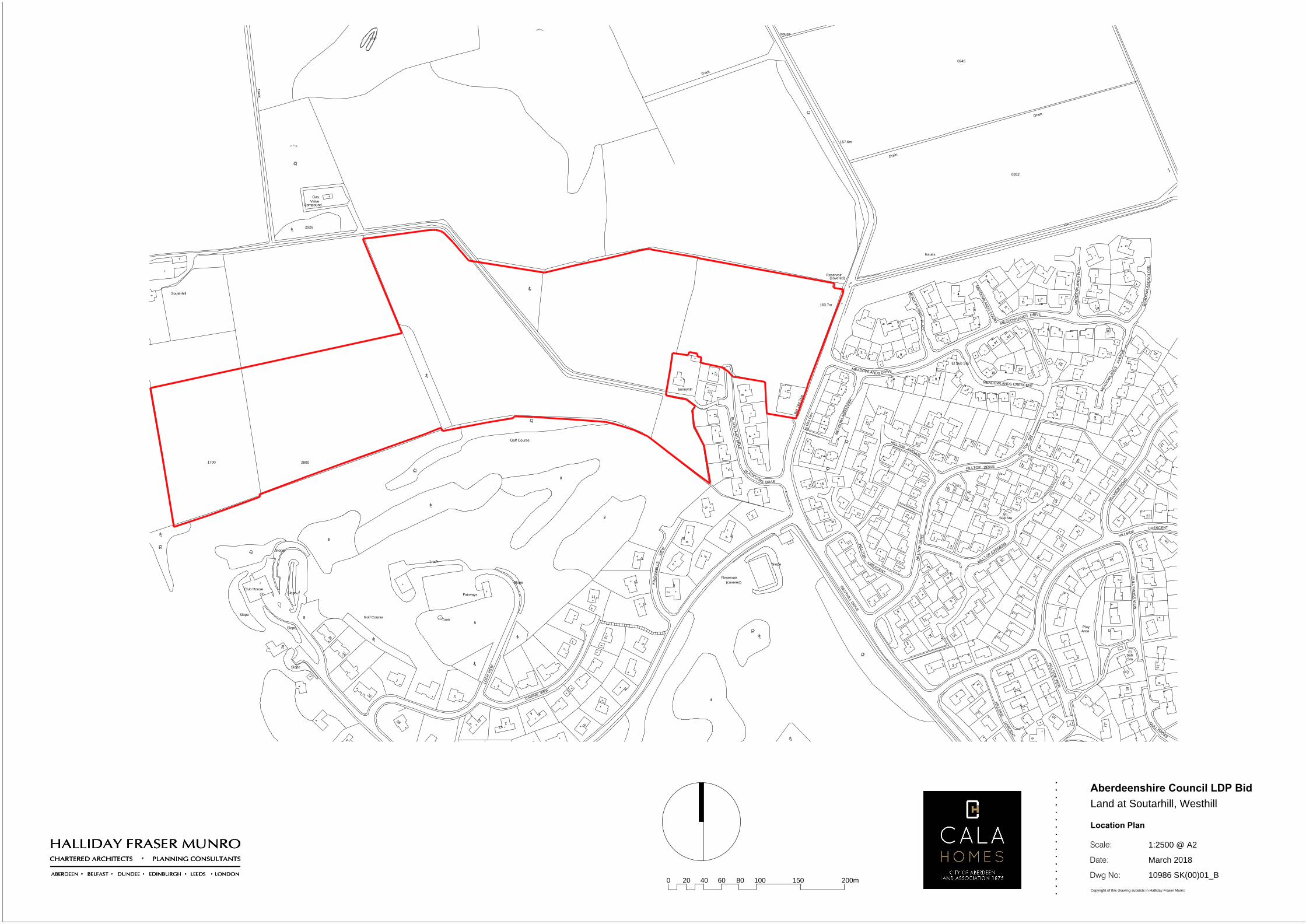
2 4. Site Details Name of the site (Please use the LDP name if the site is already allocated) Soutarhill, Westhill Site address Land at Soutarhill Farm, to the north of Westhill OS grid reference (if available) NJ827082 Site area/size Total site area 31.2 acres (housing site 14.6 acres, new park 6.2 acres, golf practice area 10.4 acres) Current land use Agricultural Brownfield/greenfield Greenfield Please include an Ordnance Survey map (1:1250 or 1:2500 base for larger sites, e.g. over 2ha) showing the location and extent of the site, points of access, means of drainage etc. 5. Ownership/Market Interest Ownership (Please list the owners in question 3 above) Sole Owner Is the site under option to a developer? Yes The site is under option to CALA Homes (North) Ltd Is the site being marketed? n/a 6. Legal Issues Are there any legal provisions in the title deeds that may prevent or restrict development? (e.g. way leave for utility providers, restriction on use of land, right of way etc.) No Are there any other legal factors that might prevent or restrict development? (e.g. ransom strips/issues with accessing the site etc.) No 7. Planning History Have you had any formal/informal pre-application discussions with the Planning Service and what was the response? No If yes, please give details Previous planning applications APP/2005/0672 – officer recommendation for delegated grant, only refused following Aberdeenshire Local Plan (ALP) Inquiry in 2006 and non-allocation of site. Previous ‘Call for sites’ history. See Main Issues Report 2013 at www.aberdeenshire.gov.uk/ldp Please provide Previous ‘Call for sites’/‘Bid’ reference number: Ga054 Local Development Plan status www.aberdeenshire.gov.uk/ldp Is the site currently allocated for any specific use in the existing LDP? No If yes, do you wish to change the site description and or
-
Upload
khangminh22 -
Category
Documents
-
view
2 -
download
0
Transcript of GR133.pdf - Aberdeenshire Council
2
4. Site Details
Name of the site
(Please use the LDP name if the
site is already allocated)
Soutarhill, Westhill
Site address Land at Soutarhill Farm, to the north of Westhill
OS grid reference (if available) NJ827082
Site area/size Total site area 31.2 acres (housing site 14.6 acres, new
park 6.2 acres, golf practice area 10.4 acres)
Current land use Agricultural
Brownfield/greenfield Greenfield
Please include an Ordnance Survey map (1:1250 or 1:2500 base for larger sites, e.g. over 2ha)
showing the location and extent of the site, points of access, means of drainage etc.
5. Ownership/Market Interest
Ownership
(Please list the owners in
question 3 above)
Sole Owner
Is the site under option to a
developer?
Yes
The site is under option to CALA Homes (North) Ltd
Is the site being marketed? n/a
6. Legal Issues
Are there any legal provisions in the title deeds
that may prevent or restrict development?
(e.g. way leave for utility providers, restriction
on use of land, right of way etc.)
No
Are there any other legal factors that might
prevent or restrict development?
(e.g. ransom strips/issues with accessing the
site etc.)
No
7. Planning History
Have you had any formal/informal
pre-application discussions with the
Planning Service and what was the
response?
No
If yes, please give details
Previous planning applications APP/2005/0672 – officer recommendation for delegated
grant, only refused following Aberdeenshire Local Plan
(ALP) Inquiry in 2006 and non-allocation of site.
Previous ‘Call for sites’ history.
See Main Issues Report 2013 at
www.aberdeenshire.gov.uk/ldp
Please provide Previous ‘Call for sites’/‘Bid’ reference
number:
Ga054
Local Development Plan status
www.aberdeenshire.gov.uk/ldp
Is the site currently allocated for any specific use in the
existing LDP?
No
If yes, do you wish to change the site description and or
fnapier
Text Box
GR133
3
allocation?
N/A
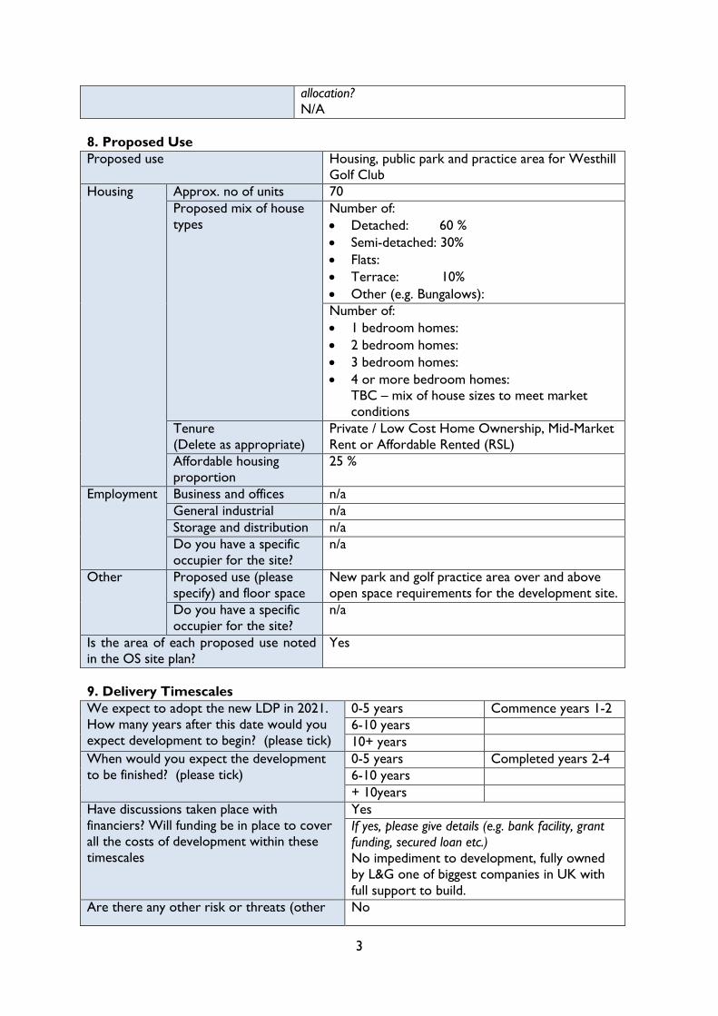
8. Proposed Use
Proposed use Housing, public park and practice area for Westhill
Golf Club
Housing Approx. no of units 70
Proposed mix of house
types
Number of:
Detached: 60 %
Semi-detached: 30%
Flats:
Terrace: 10%
Other (e.g. Bungalows):
Number of:
1 bedroom homes:
2 bedroom homes:
3 bedroom homes:
4 or more bedroom homes:
TBC – mix of house sizes to meet market
conditions
Tenure
(Delete as appropriate)
Private / Low Cost Home Ownership, Mid-Market
Rent or Affordable Rented (RSL)
Affordable housing
proportion
25 %
Employment Business and offices n/a
General industrial n/a
Storage and distribution n/a
Do you have a specific
occupier for the site?
n/a
Other Proposed use (please
specify) and floor space
New park and golf practice area over and above
open space requirements for the development site.
Do you have a specific
occupier for the site?
n/a
Is the area of each proposed use noted
in the OS site plan?
Yes
9. Delivery Timescales
We expect to adopt the new LDP in 2021.
How many years after this date would you
expect development to begin? (please tick)
0-5 years Commence years 1-2
6-10 years
10+ years
When would you expect the development
to be finished? (please tick)
0-5 years Completed years 2-4
6-10 years
+ 10years
Have discussions taken place with
financiers? Will funding be in place to cover
all the costs of development within these
timescales
Yes
If yes, please give details (e.g. bank facility, grant
funding, secured loan etc.)
No impediment to development, fully owned
by L&G one of biggest companies in UK with
full support to build.
Are there any other risk or threats (other No
4
than finance) to you delivering your
proposed development
If yes, please give details and indicate how you
might overcome them:
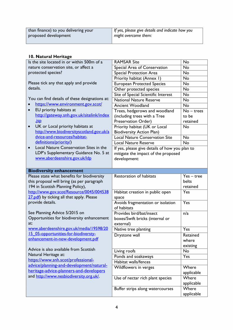
10. Natural Heritage
Is the site located in or within 500m of a
nature conservation site, or affect a
protected species?
Please tick any that apply and provide
details.
You can find details of these designations at:
https://www.environment.gov.scot/
EU priority habitats at
http://gateway.snh.gov.uk/sitelink/index
.jsp
UK or Local priority habitats at
http://www.biodiversityscotland.gov.uk/a
dvice-and-resources/habitat-
definitions/priority/)
Local Nature Conservation Sites in the
LDP’s Supplementary Guidance No. 5 at
www.aberdeenshire.gov.uk/ldp
RAMSAR Site No
Special Area of Conservation No
Special Protection Area No
Priority habitat (Annex 1) No
European Protected Species No
Other protected species No
Site of Special Scientific Interest No
National Nature Reserve No
Ancient Woodland No
Trees, hedgerows and woodland
(including trees with a Tree
Preservation Order)
No – trees
to be
retained
Priority habitat (UK or Local
Biodiversity Action Plan)
No
Local Nature Conservation Site No
Local Nature Reserve No
If yes, please give details of how you plan to
mitigate the impact of the proposed
development:
Biodiversity enhancement
Please state what benefits for biodiversity
this proposal will bring (as per paragraph
194 in Scottish Planning Policy),
http://www.gov.scot/Resource/0045/004538
27.pdf) by ticking all that apply. Please
provide details.
See Planning Advice 5/2015 on
Opportunities for biodiversity enhancement
at:
www.aberdeenshire.gov.uk/media/19598/20
15_05-opportunities-for-biodiversty-
enhancement-in-new-development.pdf
Advice is also available from Scottish
Natural Heritage at:
https://www.snh.scot/professional-
advice/planning-and-development/natural-
heritage-advice-planners-and-developers and http://www.nesbiodiversity.org.uk/.
Restoration of habitats Yes – tree
belts
retained
Habitat creation in public open
space
Yes
Avoids fragmentation or isolation
of habitats
Yes
Provides bird/bat/insect
boxes/Swift bricks (internal or
external)
n/a
Native tree planting Yes
Drystone wall Retained
where
existing
Living roofs No
Ponds and soakaways Yes
Habitat walls/fences
Wildflowers in verges Where
applicable
Use of nectar rich plant species Where
applicable
Buffer strips along watercourses Where
applicable
5
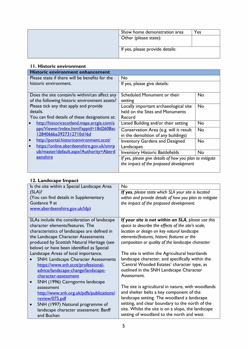
Show home demonstration area Yes
Other (please state):
If yes, please provide details:
11. Historic environment
Historic environment enhancement
Please state if there will be benefits for the
historic environment.
No
If yes, please give details:
Does the site contain/is within/can affect any
of the following historic environment assets?
Please tick any that apply and provide
details.
You can find details of these designations at:
http://historicscotland.maps.arcgis.com/a
pps/Viewer/index.html?appid=18d2608ac
1284066ba3927312710d16d
http://portal.historicenvironment.scot/
https://online.aberdeenshire.gov.uk/smrp
ub/master/default.aspx?Authority=Aberd
eenshire
Scheduled Monument or their
setting
No
Locally important archaeological site
held on the Sites and Monuments
Record
No
Listed Building and/or their setting No
Conservation Area (e.g. will it result
in the demolition of any buildings)
No
Inventory Gardens and Designed
Landscapes
No
Inventory Historic Battlefields No
If yes, please give details of how you plan to mitigate
the impact of the proposed development
12. Landscape Impact
Is the site within a Special Landscape Area
(SLA)?
(You can find details in Supplementary
Guidance 9 at
www.aberdeenshire.gov.uk/ldp)
No
If yes, please state which SLA your site is located
within and provide details of how you plan to mitigate
the impact of the proposed development:
SLAs include the consideration of landscape
character elements/features. The characteristics of landscapes are defined in
the Landscape Character Assessments
produced by Scottish Natural Heritage (see
below) or have been identified as Special
Landscape Areas of local importance.
SNH: Landscape Character Assessments
https://www.snh.scot/professional-
advice/landscape-change/landscape-
character-assessment
SNH (1996) Cairngorms landscape
assessment
http://www.snh.org.uk/pdfs/publications/
review/075.pdf
SNH (1997) National programme of
landscape character assessment: Banff
and Buchan
If your site is not within an SLA, please use this
space to describe the effects of the site’s scale,
location or design on key natural landscape
elements/features, historic features or the
composition or quality of the landscape character:
The site is within the Agricultural heartlands
landscape character, and specifically within the
‘Central Wooded Estates’ character type, as
outlined in the SNH Landscape Character
Assessment.
The site is agricultural in nature, with woodlands
and shelter belts a key component of the
landscape setting. The woodland a landscape
setting, and clear boundary to the north of the
site. Whilst the site is on a slope, the landscape
setting of woodland to the north and west
6
http://www.snh.org.uk/pdfs/publications/
review/037.pdf
SNH (1998) South and Central
Aberdeenshire landscape character
assessment
http://www.snh.org.uk/pdfs/publications/
review/102.pdf
encloses the site. It is also seen in a context of
residential development.
Views to the site are limited, the site sits within a
woodland framework, and with residential
development to the east and south. Its
development would not result in a significant
landscape impact.
13. Flood Risk
Is any part of the site identified as being at
risk of river or surface water flooding within
SEPA flood maps, and/or has any part of the
site previously flooded?
(You can view the SEPA flood maps at
http://map.sepa.org.uk/floodmap/map.htm)
No
If yes, please specify and explain how you intend to
mitigate this risk:
n/a
Could development on the site result in
additional flood risk elsewhere?
No
If yes, please specify and explain how you intend to
mitigate or avoid this risk:
n/a
Could development of the site help alleviate
any existing flooding problems in the area?
No
If yes, please provide details:
n/a
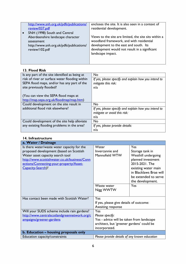
14. Infrastructure
a. Water / Drainage
Is there water/waste water capacity for the
proposed development (based on Scottish
Water asset capacity search tool
http://www.scottishwater.co.uk/business/Conn
ections/Connecting-your-property/Asset-
Capacity-Search)?
Water
Invercannie and
Mannofield WTW
Yes
Storage tank in
Westhill undergoing
planned investment
2015-2021. The
existing water main
in Blacklaws Brae will
be extended to serve
the development.
Waste water
Nigg WWTW
Yes
Has contact been made with Scottish Water? Yes
If yes, please give details of outcome:
Awaiting response
Will your SUDS scheme include rain gardens?
http://www.centralscotlandgreennetwork.org/c
ampaigns/greener-gardens
Yes
Please specify:
Yes - advice will be taken from landscape
architect, but ‘greener gardens’ could be
incorporated.
b. Education – housing proposals only
Education capacity/constraints Please provide details of any known education
7
https://www.aberdeenshire.gov.uk/schools/pare
nts-carers/school-info/school-roll-forecasts/
constraints. Is additional capacity needed to serve
the development?
Westhill Academy has capacity to serve the
development (forecast to be at 79% in 2022
with capacity for 210 pupils (2016 School Roll
Forecast)
The site is zoned to Westhill Primary School,
which is forecast to be at 86% capacity in 2022
according to the 2016 School Roll Forecast
with capacity for up to 46 pupils.
There is therefore educational capacity for the
development.
Has contact been made with the Local
Authority’s Education Department?
No
If yes, please give details of outcome:
c. Transport
If direct access is required onto a Trunk Road
(A90 and A96), or the proposal will impact on
traffic on a Trunk Road, has contact been
made with Transport Scotland?
No
If yes, please give details of outcome:
n/a
Has contact been made with the Local
Authority’s Transportation Service?
They can be contacted at
v.uk
Yes
If yes, please give details of outcome:
Attached Transport statement indicates that
its scope was agreed with Aberdeenshire
Council and includes correspondence in
Appendix A .
Public transport Please provide details of how the site is or could
be served by public transport:
There is a bus stop within 150m of the site.
This is served by the Stagecoach 220 Kirkton
of Skene to Aberdeen service (which runs
approximately every 30 minutes).
The 777 Oldmeldrum to Dyce services the
bus stop, this is a peak service.
A bus stop with access to the X17 Westhill to
Aberdeen Service is approximately 800m from
the site on Hay’s Way.
Active travel
(i.e. internal connectivity and links externally)
Please provide details of how the site can or could
be accessed by walking and cycling:
There is a core path to the south of the site,
8
which connects to Hill of Keir, and onwards
to Kirkton of Skene. The proposed
development prioritises pedestrian linkages,
and connectivity. The site will connect to
Westhill Drive which has pavement provision.
CALA will prepare marketing material on
opportunities for walking / active travel which
is to be provided to purchasers of properties,
recognising the importance of active lifestyles.
d. Gas/Electricity/Heat/Broadband
Has contact been made with the relevant
utilities providers?
Gas: Yes
If yes, please give details of outcome(s)
To be confirmed with the utility providers.
Electricity: Yes
If yes, please give details of outcome(s):
To be confirmed with the utility providers.
Heat: No
If yes, please give details of outcome(s):
Broadband: Yes
If yes, please give details of outcome(s):
Fibre Broadband is available from Kingswells
exchange. Other ADSL broadband available
locally.
Have any feasibility studies been undertaken to
understand and inform capacity issues?
Yes
Please specify:
During previous planning application, no
capacity issues expected.
Is there capacity within the existing network(s)
and a viable connection to the network(s)?
See above
Please specify:
Will renewable energy be installed and used on
the site?
For example, heat pump (air, ground or
water), biomass, hydro, solar (photovoltaic
(electricity) or thermal), or a wind turbine
(freestanding/integrated into the building)
Yes
If yes, please specify the type of renewable energy
technology(s), if it is to provide electricity and/or
heating (i.e. space heating and/or hot water), and
the scale of provision (To supplement off-site
connection all the way to 100% energy provision
(off-grid)):
Current appropriate technology at the time of
construction.
e. Public open space
Will the site provide the opportunity to
enhance the green network? (These are
Yes
9
the linked areas of open space in settlements,
which can be enhanced through amalgamating
existing green networks or providing onsite
green infrastructure)
You can find the boundary of existing green
networks in the settlement profiles in the LDP
Please specify:
There is no green space network near the
site, but a significant area of public open space,
and a golf practice area is proposed. Along
with the golf course to the south west of the
site, this creates a significant green network
around the north of Westhill.
Will the site meet the open space standards, as
set out in Appendix 2 in the Aberdeenshire
Parks and Open Spaces Strategy?
https://www.aberdeenshire.gov.uk/media/6077/
approvedpandospacesstrategy.pdf
Yes
Please specify:
The indicative layout prepared shows that the
site will include 68% open space. The
proposed space aligns with the hierarchy of
open space as follows:
Community Play Areas: - within 600m
Neighbourhood Greenspace: proposed
Community Woodlands: - woodland on site
Blue-green Corridors: proposed
Neighbourhood Streets: proposed (home zone)
Will the site deliver any of the shortfalls
identified in the Open Space Audit for
specific settlements?
https://www.aberdeenshire.gov.uk/communities
-and-events/parks-and-open-spaces/open-
space-strategy-audit/
Yes
Please specify:
The development would contribute to onsite
play equipment.
f. Resource use
Will the site re-use existing structure(s) or
recycle or recover existing on-site
materials/resources?
No
If yes, please specify:
There is one existing property on the site
which would need to be demolished given its
ruinous condition.
Will the site have a direct impact on the water
environment and result in the need for
watercourse crossings, large scale abstraction
and/or culverting of a watercourse?
No
If yes, please provide details:
No watercourses.
15. Other potential constraints
Please identify whether the site is affected by any of the following potential constraints:
Aberdeen Green Belt
https://www.aberdeenshire.gov.uk/media/20555/appendix-3-
boundaries-of-the-greenbelt.pdf
No
Carbon-rich soils and peatland
http://www.snh.gov.uk/planning-and-development/advice-for-
planners-and-developers/soils-and-development/cpp/
No
Mineral podzols
Coastal Zone
https://www.aberdeenshire.gov.uk/media/20176/4-the-coastal-
zone.pdf
No
Contaminated land No
Ground instability No
10
Hazardous site/HSE exclusion zone
(You can find the boundary of these zones in Planning Advice 1/2017
Pipeline and Hazardous Development Consultation Zones at
https://www.aberdeenshire.gov.uk/planning/plans-and-
policies/planning-advice/ and advice at
http://www.hse.gov.uk/landuseplanning/developers.htm)
Part -
Gas pipeline
consultation zone affects
the north western
corner of the site.
Outer Zone – so some
development can be
accommodated. HSE did
not advise against
previous application so
not considered to be of
any impediment to
development.
Minerals – safeguarded or area of search
https://www.aberdeenshire.gov.uk/ldpmedia/6_Area_of_search_and
_safeguard_for_minerals.pdf
No
Overhead lines or underground cables No
Physical access into the site due to topography or geography No
Prime agricultural land (grades 1, 2 and 3.1) on all or part of the site.
http://map.environment.gov.scot/Soil_maps/?layer=6
No
‘Protected’ open space in the LDP (i.e. P sites)
www.aberdeenshire.gov.uk/ldp and choose from Appendix 8a to 8f
No
Rights of way/core paths/recreation uses Yes-
There is a core path on
the farm track through
the site. This will be
retained, and provision
of a park enhances
Topography (e.g. steep slopes) No
Other Yes/No (please specify)
If you have identified any of the potential constraints above, please use this space to identify
how you will mitigate this in order to achieve a viable development:
Core Path
The core path runs along the farm track to the south of the site. The core path would be
retained through the site, but would be slightly re-routed by the proposed development.
Enhanced linkages, including access to a new proposed community park are also proposed.
HSE Exclusion Zone
A small part of the site is within the outer zone of the pipeline consultation zone. Within this
zone some development is permitted under PADHI guidelines. There is no conflict with the
development proposed and the pipeline.
During the 2005 planning application HSE did not advise against the development of this site and
as circumstances haven’t altered this should be the case for the proposed development.

11
16. Proximity to facilities
How close is the site to
a range of facilities?
Local shops 400m-1km
Community facilities (e.g. school,
public hall)
400m-1km
Sports facilities (e.g. playing fields 400m-1km
Employment areas >1km
Residential areas 400m
Bus stop or bus route 400m
Train station >1km
Other, e.g. dentist, pub (please
specify)
>1km
17. Community engagement
Has the local community been given the
opportunity to influence/partake in the design
and specification of the development proposal?
Yes
If yes, please specify the way it was carried out
and how it influenced your proposals:
Bidder has discussed this with the golf club
and has also taken on board community
comments from previous plans with bigger
buffer around existing Blacklaws Braes
properties.
They intend to speak with the community
council in next few months.
If not yet, please detail how you will do so in the
future:
Engagement with Community Council and
local community following publication of Main
Issues Report.
18. Residual value and deliverability
Please confirm that you have considered the
‘residual value’ of your site and you are
confident that the site is viable when
infrastructure and all other costs, such as
constraints and mitigation are taken into
account.
I have considered the likely ‘residual value’ of
the site, as described above, and fully expect
the site to be viable:
Please tick:
If you have any further information to help demonstrate the deliverability of your proposal,
please provide details.
CALA Homes (North) Ltd are a leading housebuilder, and have a track record of delivering high
quality developments. CALA have fully considered the deliverability of this proposal, considering
potential developer obligations, abnormal costs and development costs when negotiating land
value. There is no issue with site viability and construction can take place as soon as the
requisite consents are in place.
12
19. Other information
Please provide any other information that you would like us to consider in support of your
proposed development (please include details of any up-to-date supporting studies that have
been undertaken and attach copies e.g. Transport Appraisal, Flood Risk Assessment, Drainage
Impact Assessment, Peat/Soil Survey, Habitat/Biodiversity Assessment etc.)
Masterplan / Design Statement
A supporting masterplan has been prepared in support of this site, showing the commitment of
CALA to the proposal. A fully designed layout plan has been developed, based on a full analysis
of the site, including topographical survey, and engineering input has informed the roads layout.
This is not far from full planning application information.
A summary of supporting technical information has been included within the masterplan
document, however, full copies of the following information has also been submitted:
- Topographical survey
- Constraints plan
- Transport Review
Other Relevant information
Housing Need
The draft Aberdeen city and Shire Strategic Development Plan Main Issues Report 2018
identifies a housing allowance for 5500 new homes up to year 2030 and 16,200 houses from
2031-2040. There is also a target to deliver 2190 homes per annum over the next 25 years.
Additional sites therefore need to be allocated to meet this need.
There is one site in Westhill (site OP1 for 10 homes) from the 2017 Local Development Plan
which has not been built out, but has planning permission and is part of the effective housing
supply. There is therefore a clear need for additional housing to serve the settlement.
(2014) Update to Westhill Capacity Study 2008
The Westhill Capacity Study (WCS) recognises that in order to maintain Westhill’s place as a
global centre for excellence for subsea engineering, a high growth option is required. It is noted
that there are transport pressures in the area, but the need to maintain Westhill’s position
outweighs these concerns.
The WCS identifies the site as ‘most suitable’, and as a potential development area for Westhill.
The site was assessed in the WCS as part of ‘site 8’, scoring 74% in an assessment against a
Goal Achievement matrix (GAM).
Landscape
As summarised in Section 12 above, the site has minimal landscape impact. The site is enclosed
by woodland to the north and west, and sits in a location surrounded by existing residential
development on two sides. There is a maturing tree belt to the north of the site which provides
a logical settlement boundary, and rounds off the settlement of Westhill. This housing proposal
would not impact significantly on any sight lines or appear any more visible than housing already
built. Westhill Heights is higher than this already.
Delivery
Westhill is a desirable location that people want to locate in. House building completions
13
demonstrate this, with completions averaging 66 units over the past six years. Almost all sites
allocated in the 2017 ALDP in Westhill have been built out, which is a situation unique to
Westhill, and demonstrates there is a need for additional housing land in the settlement.
Westhill is the subsea capital of Europe, and in order to keep pace with economic development,
housing land is required to ensure that Westhill remains vibrant, and a place that both
businesses and people want to locate. This is as outlined in the Westhill Capacity Study Update
in 2014.
This site is readily available and CALA have already undertaken a substantial amount of
background work on the site, meaning that the site could be delivered within 1-2 years of
allocation. A planning application for the site has been prepared and is ready for submission at
the earliest opportunity. There are no constraints to the delivery of the site. The size of the site
and scale of development proposed mean that the site can come forward utilising existing
infrastructure capacity.
Please tick to confirm your agreement to the following statement:
By completing this form I agree that Aberdeenshire Council can use the information provided in
this form for the purposes of identifying possible land for allocation in the next Local
Development Plan. I also agree that the information provided, other than contact details and
information that is deemed commercially sensitive (questions 1 to 3), can be made available to
the public.
L
O
C
H
V
I
E
W
C
A
I
R
N
I
E
V
I
E
W
K
IN
G
S
W
E
L
L
S
V
I
E
W
W
E
S
T
H
I
L
L
D
R
I
V
E
H
I
L
L
T
O
P
C
R
E
S
C
E
N
T
H
IL
L
T
O
P
D
R
IV
E
Reservoir
(covered)
Tra
ck
Club House
Tank
Golf Course
2
1
6
1
5
8
2
2
1
1
4
1
2
2
6
1
4
1
1
3
5
1
3
1
1
1
7
9
1
5
1
6
1
0
3
9
28001700
8
2
7
4
4
6
6
1
3
1
9
2
8
4
4
1
2
Slope
Slope
Slope
Slope
Slope
Slope
Slope
3
6
3
4
3
0
1
11
7
1
5
1
5
B
L
A
C
K
L
A
W
S
BR
AE
Fairways
Golf Course
Sunnyhill
B
M
1
6
4
.
2
4
m
H
I
L
L
T
O
P
A
V
E
N
U
E
1
3
1
5
1
4
6
1
0
3
2
163.7m
Souterhill
Gas
Valve
Compound
157.6m
Track
Issues
D
r
a
in
2926
Cliff
T
r
a
c
k
Issues
M
E
A
D
O
W
L
A
N
D
S
D
R
IV
E
1
9
1
1
2
(covered)
Reservoir
8
4
7
5
6
3
M
E
A
D
O
W
L
A
N
D
S
PLA
CE
11
B
L
A
C
K
L
A
W
S
B
R
A
E
4
8
9
4
G
a
s
G
o
v
3
M
E
A
D
O
W
L
A
N
D
S
P
A
R
K
1
7
1
5
El
El
Sub
Sta
Play
Area
H
I
L
L
T
O
P
G
A
R
D
E
N
S
H
I
L
L
V
I
E
W
R
O
A
D
CRESCENT
H
IL
L
S
ID
E
GU
LLY
MO
SS
V
IE
W
H
I
L
L
S
I
D
E
V
I
E
W
H
I
L
L
S
I
D
E
G
A
R
D
E
N
S
G
U
L
L
Y
M
O
S
S
2
3
7
1
2
1
1
9
1
7
3
1
6
4
0
2
8
3
2
3
8
4
0
2
1
7
3
1
3
9
1
7
2
0
2
4
8
2
23
8
1
5
1
1
6
19
2
1
2
1
4
4
1
1
1
1
0
2
1
9
2
2
1
4
8
HIL
LT
OP
DR
IVE
Sub Sta
Slope
4
2
5
3
1
4
4
4
2
1
1
1
2
0932
0245
H
I
L
L
T
O
P
D
r
a
in
D
R
El Sub Sta
1
0
12
15
1
6
1
4
8
7
2
17
4
6
ME
AD
OW
LA
ND
S C
RE
SC
EN
T
M
E
A
D
O
W
L
A
N
D
S
C
O
U
R
T
1
1
l5
1
7
28
1
9
ME
AD
OW
LA
ND
S W
AY
M
E
A
D
O
W
L
A
N
D
S
DR
IVE
1
1
1
6
M
E
A
D
O
W
L
A
N
D
S
A
V
E
N
U
E
1
3
2
5
M
E
A
D
O
W
L
A
N
D
S
CLO
SE
0 20 40 60 80 100 150 200m
Copyright of this drawing subsists in Halliday Fraser Munro
Scale:
Date:
Dwg No:
Aberdeenshire Council LDP Bid
Land at Soutarhill, Westhill
Location Plan
1:2500 @ A2
March 2018
10986 SK(00)01_B
fnapier
Text Box
GR133
MASTERPLAN FOR LAND AT SOUTARHILL , WESTHILL
LOCAL DEVELOPMENT PLAN BID
MARCH 2018
CALA HOMES (NORTH) L IMITED
PREPARED BY HALLIDAY FRASER MUNRO
fnapier
Text Box
GR133
Soutarhill Masterplan / LDP Bid for CALA Homes (North) Limited 2
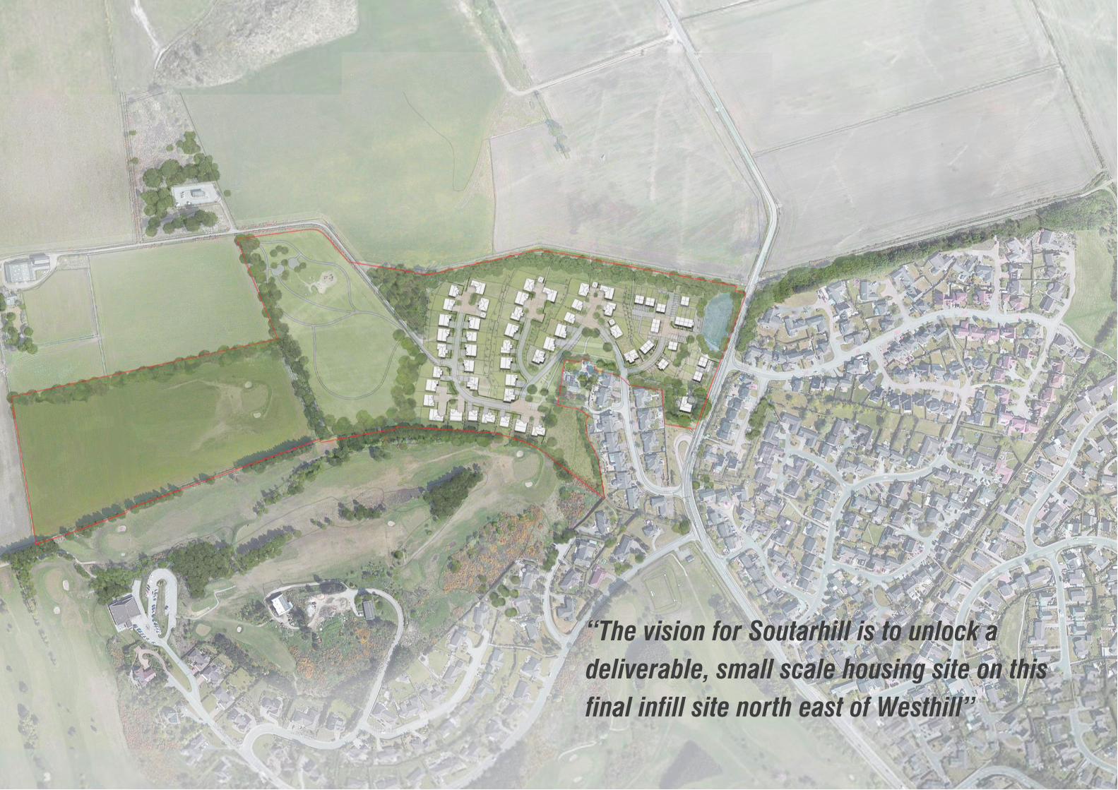
“The vision for Soutarhill is to unlock a
deliverable, small scale housing site on this
final infill site north east of Westhill”
Soutarhill Masterplan / LDP Bid for CALA Homes (North) Limited 3
The purpose of this document is to support the Local Development
Plan bid submission for Land at Soutarhill, which has been prepared
on behalf of CALA Homes (North) Limited by Halliday Fraser Munro
Architects and Planning Consultants.
The site at Soutarhill offers an excellent opportunity to provide a high
quality residential development, which is immediately deliverable. The
site is ideally located to meet the local housing needs of Westhill, and
offers substantial community benefits.
The site is being promoted by CALA, who are a premium house
builder with its heritage firmly placed in Aberdeen, having been
established in the city in 1875 as the City of Aberdeen Land
Association. 140 years on CALA are focused on delivering high quality
developments in the best locations. The principle focus being
sourcing the best land opportunities and optimising value through
high quality design and sought after living environments.
Over the past five years, under the ownership of Patron Capital
Partners and Legal & General Group (L&G), CALA has reached new
heights. CALA have doubled the size of the business in terms of new
home volumes over this period and become one of the fastest
growing housebuilders in the UK today, which is testament to the
strength and ambition of the team, the quality of our homes and our
first class approach to customer service.
In March 2018, it was announced that L&G has increased its
shareholding in the CALA business to 100%, acquiring the 52.1%
which it did not previously own. This marks an exciting new chapter
for CALA, ensuring both consistency and stability of our operations
through the continued backing of L&G; one of the most highly-
respected, blue-chip investors in the UK, who share our long-term
vision for the business. Working together, we will build on the strong
momentum we have achieved in recent years while strengthening our
position as the UK’s most upmarket major homebuilder.
VISION
This strong backing builds upon and allows the delivery of
fantastic new communities and quality family homes ensuring
proposals are viable, deliverable and will be acted upon.
CALA have a strong track record of developing sites similar to
Soutarhill throughout Aberdeen City, Aberdeenshire, Scotland
and the UK and have conducted in depth investigations on this
proposal.
This document outlines how the design process has developed
following a thorough analysis of the site and its unique
opportunities and constraints. It is split in two halves — ‘Analysis’
and ‘Proposals’ — and is intended to take the reader through the
design process, in chronological order.
The ‘Analysis’ section concentrates on existing site features,
opportunities and constraints which helped inform the proposals,
including a visual appraisal, drainage, utilities, transportation and
topographical studies.
The second part of the document, titled ‘Proposals’ outlines the
design concept, site layout, character areas and project delivery.
Client: CALA Homes (North) Limited
Architect: Halliday Fraser Munro
Civil / Structural Engineer: Fairhurst
Contents
PART 1 — ANALYSIS 4
Site Description 5
Growth of Westhill 6
Settlement Analysis 7
Planning Context 8
Topography 10
Visual Appraisal 11
Site Opportunities 22
Site Constraints 23
PART 2 — PROPOSALS 25
Concept 26
Masterplan 28
Character Area—Blacklaws Heights 30
Character Area—Soutarhill Walks 32
Character Area—Westhill Golf Practice 34
Phasing 36
Summary 37

Soutarhill Masterplan / LDP Bid for CALA Homes (North) Limited 4
PART 1 | ANALYSIS
Soutarhill Masterplan / LDP Bid for CALA Homes (North) Limited 5
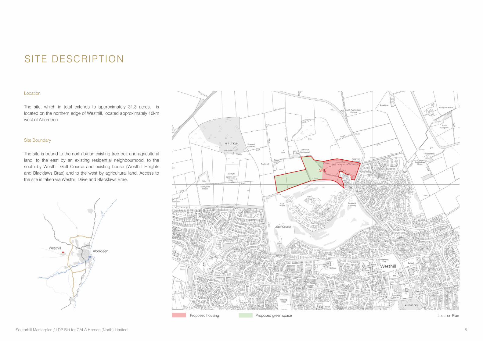
Location
The site, which in total extends to approximately 31.3 acres, is
located on the northern edge of Westhill, located approximately 10km
west of Aberdeen.
Site Boundary
The site is bound to the north by an existing tree belt and agricultural
land, to the east by an existing residential neighbourhood, to the
south by Westhill Golf Course and existing house (Westhill Heights
and Blacklaws Brae) and to the west by agricultural land. Access to
the site is taken via Westhill Drive and Blacklaws Brae.
SITE DESCRIPTION
Aberdeen
Westhill
SITE
Location PlanProposed housing Proposed green space
Soutarhill Masterplan / LDP Bid for CALA Homes (North) Limited 6
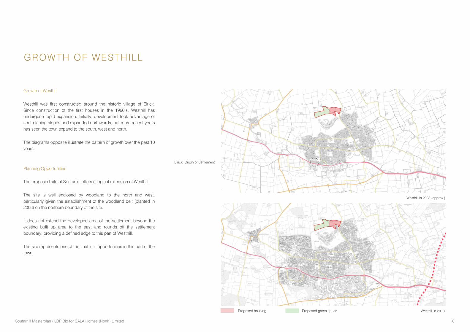
Growth of Westhill
Westhill was first constructed around the historic village of Elrick.
Since construction of the first houses in the 1960’s, Westhill has
undergone rapid expansion. Initially, development took advantage of
south facing slopes and expanded northwards, but more recent years
has seen the town expand to the south, west and north.
The diagrams opposite illustrate the pattern of growth over the past 10
years.
Planning Opportunities
The proposed site at Soutarhill offers a logical extension of Westhill.
The site is well enclosed by woodland to the north and west,
particularly given the establishment of the woodland belt (planted in
2006) on the northern boundary of the site.
It does not extend the developed area of the settlement beyond the
existing built up area to the east and rounds off the settlement
boundary, providing a defined edge to this part of Westhill.
The site represents one of the final infill opportunities in this part of the
town.
GROWTH OF WESTHILL
Westhill in 2008 (approx.)
Westhill in 2018
Elrick, Origin of Settlement
Proposed housing Proposed green space
Soutarhill Masterplan / LDP Bid for CALA Homes (North) Limited 7
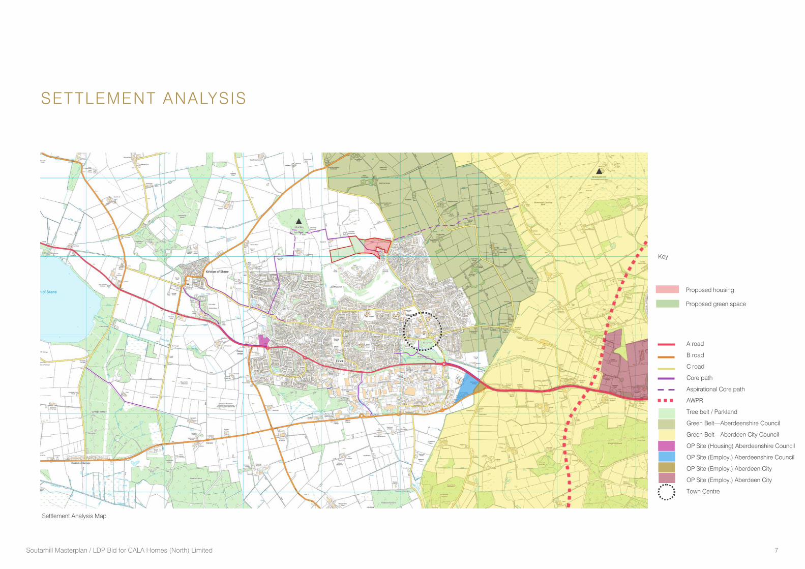
SETTLEMENT ANALYSIS
Settlement Analysis Map
A road
B road
C road
Core path
Aspirational Core path
AWPR
Tree belt / Parkland
Green Belt—Aberdeenshire Council
Green Belt—Aberdeen City Council
OP Site (Housing) Aberdeenshire Council
OP Site (Employ.) Aberdeenshire Council
OP Site (Employ.) Aberdeen City
OP Site (Employ.) Aberdeen City
Town Centre
Key
Proposed housing
Proposed green space
Soutarhill Masterplan / LDP Bid for CALA Homes (North) Limited 8
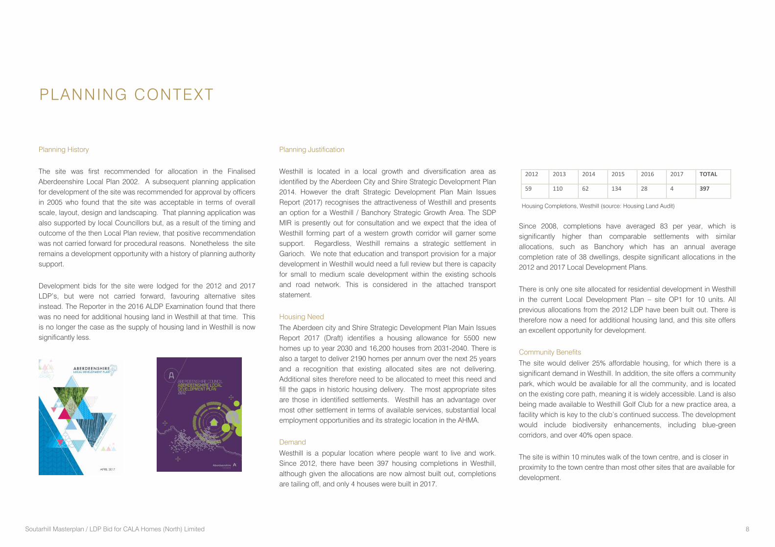
Planning History
The site was first recommended for allocation in the Finalised
Aberdeenshire Local Plan 2002. A subsequent planning application
for development of the site was recommended for approval by officers
in 2005 who found that the site was acceptable in terms of overall
scale, layout, design and landscaping. That planning application was
also supported by local Councillors but, as a result of the timing and
outcome of the then Local Plan review, that positive recommendation
was not carried forward for procedural reasons. Nonetheless the site
remains a development opportunity with a history of planning authority
support.
Development bids for the site were lodged for the 2012 and 2017
LDP’s, but were not carried forward, favouring alternative sites
instead. The Reporter in the 2016 ALDP Examination found that there
was no need for additional housing land in Westhill at that time. This
is no longer the case as the supply of housing land in Westhill is now
significantly less.
Planning Justification
Westhill is located in a local growth and diversification area as
identified by the Aberdeen City and Shire Strategic Development Plan
2014. However the draft Strategic Development Plan Main Issues
Report (2017) recognises the attractiveness of Westhill and presents
an option for a Westhill / Banchory Strategic Growth Area. The SDP
MIR is presently out for consultation and we expect that the idea of
Westhill forming part of a western growth corridor will garner some
support. Regardless, Westhill remains a strategic settlement in
Garioch. We note that education and transport provision for a major
development in Westhill would need a full review but there is capacity
for small to medium scale development within the existing schools
and road network. This is considered in the attached transport
statement.
Housing Need
The Aberdeen city and Shire Strategic Development Plan Main Issues
Report 2017 (Draft) identifies a housing allowance for 5500 new
homes up to year 2030 and 16,200 houses from 2031-2040. There is
also a target to deliver 2190 homes per annum over the next 25 years
and a recognition that existing allocated sites are not delivering.
Additional sites therefore need to be allocated to meet this need and
fill the gaps in historic housing delivery. The most appropriate sites
are those in identified settlements. Westhill has an advantage over
most other settlement in terms of available services, substantial local
employment opportunities and its strategic location in the AHMA.
Demand
Westhill is a popular location where people want to live and work.
Since 2012, there have been 397 housing completions in Westhill,
although given the allocations are now almost built out, completions
are tailing off, and only 4 houses were built in 2017.
PLANNING CONTEXT
Since 2008, completions have averaged 83 per year, which is
significantly higher than comparable settlements with similar
allocations, such as Banchory which has an annual average
completion rate of 38 dwellings, despite significant allocations in the
2012 and 2017 Local Development Plans.
There is only one site allocated for residential development in Westhill
in the current Local Development Plan – site OP1 for 10 units. All
previous allocations from the 2012 LDP have been built out. There is
therefore now a need for additional housing land, and this site offers
an excellent opportunity for development.
Community Benefits
The site would deliver 25% affordable housing, for which there is a
significant demand in Westhill. In addition, the site offers a community
park, which would be available for all the community, and is located
on the existing core path, meaning it is widely accessible. Land is also
being made available to Westhill Golf Club for a new practice area, a
facility which is key to the club’s continued success. The development
would include biodiversity enhancements, including blue-green
corridors, and over 40% open space.
The site is within 10 minutes walk of the town centre, and is closer in
proximity to the town centre than most other sites that are available for
development.
Housing Completions, Westhill (source: Housing Land Audit)
2012 2013 2014 2015 2016 2017 TOTAL
59 110 62 134 28 4 397
Soutarhill Masterplan / LDP Bid for CALA Homes (North) Limited 9
PLANNING CONTEXT
Infrastructure Capacity
There are no infrastructure constraints to the delivery of this site. The
scale of development proposed means that there are no infrastructure
capacity issues and the site can progress quickly. The infrastructure
capacity is summarised below:
Education
The 2016 School Roll Forecast shows capacity within Westhill
Academy (210 pupil capacity at 2022) and Westhill Primary School (46
pupils at 2022) , to which the site is zoned. The development of this
site is therefore unlikely to create any serious concerns for these
schools.
Transportation and Roads
The site is well located for public transport, with a bus stop only
150metres from the site (at Blacklaws Brae) served by the 220
Stagecoach service. The road network has been reviewed by Fairhurst
and can accommodate this scale of development. See Transport
Statement lodged with this bid.
Water and Waste Water
Invercannie and Mannofield WTW has capacity for the development.
Nigg WWTW has capacity for the development.
Electricity / Gas
It is anticipated that there is an available capacity in the existing gas
and electricity network. No issues are foreseen.
The delivery of this site is discussed in more detail later in this report,
but in summary the site is readily available, with no constraints to
development. A planning application for the site has been prepared
demonstrating the deliverability of the site. An application could
essentially be lodged immediately as soon as the LDP review process
allows.
Westhill Capacity Study
The Westhill Capacity Study (WCS, prepared for Aberdeenshire
Council by AMEC) document was updated in 2014, due to the time
since the original capacity study was undertaken and the increasing
pressure from businesses and developers. That document considers
the future of Westhill over the next 20-25 years, and identifies capacity
for development.
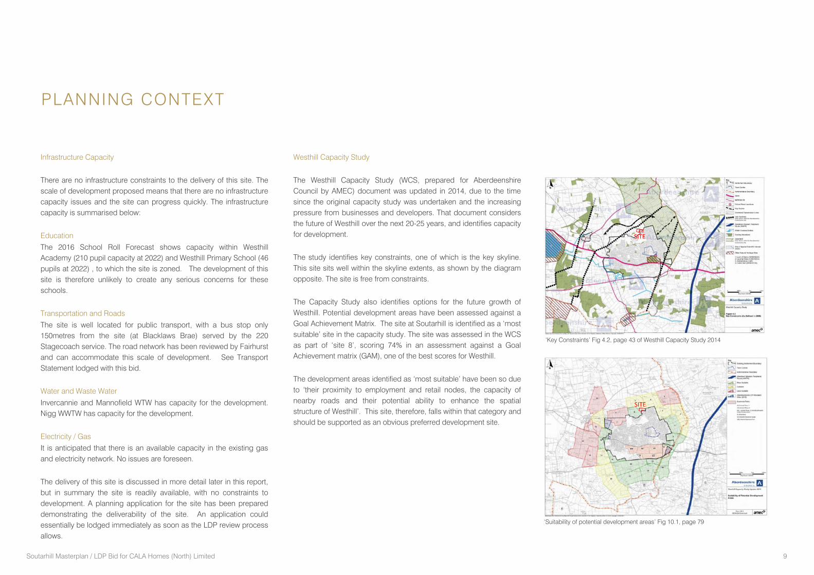
The study identifies key constraints, one of which is the key skyline.
This site sits well within the skyline extents, as shown by the diagram
opposite. The site is free from constraints.
The Capacity Study also identifies options for the future growth of
Westhill. Potential development areas have been assessed against a
Goal Achievement Matrix. The site at Soutarhill is identified as a ‘most
suitable’ site in the capacity study. The site was assessed in the WCS
as part of ‘site 8’, scoring 74% in an assessment against a Goal
Achievement matrix (GAM), one of the best scores for Westhill.
The development areas identified as ‘most suitable’ have been so due
to ‘their proximity to employment and retail nodes, the capacity of
nearby roads and their potential ability to enhance the spatial
structure of Westhill’. This site, therefore, falls within that category and
should be supported as an obvious preferred development site.
SITE
‘Suitability of potential development areas’ Fig 10.1, page 79
SITE
‘Key Constraints’ Fig 4.2, page 43 of Westhill Capacity Study 2014
Soutarhill Masterplan / LDP Bid for CALA Homes (North) Limited 10
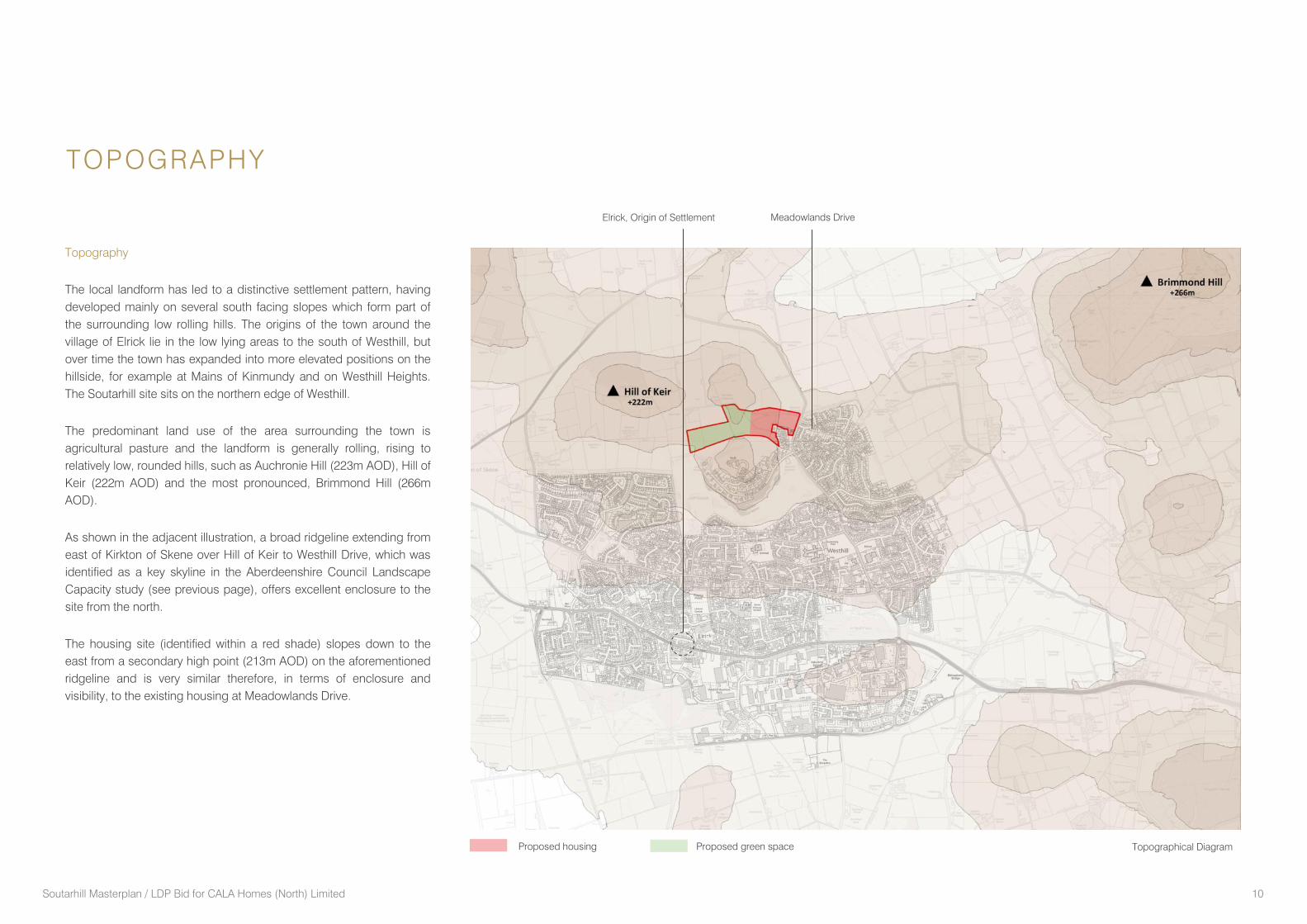
Topography
The local landform has led to a distinctive settlement pattern, having
developed mainly on several south facing slopes which form part of
the surrounding low rolling hills. The origins of the town around the
village of Elrick lie in the low lying areas to the south of Westhill, but
over time the town has expanded into more elevated positions on the
hillside, for example at Mains of Kinmundy and on Westhill Heights.
The Soutarhill site sits on the northern edge of Westhill.
The predominant land use of the area surrounding the town is
agricultural pasture and the landform is generally rolling, rising to
relatively low, rounded hills, such as Auchronie Hill (223m AOD), Hill of
Keir (222m AOD) and the most pronounced, Brimmond Hill (266m
AOD).
As shown in the adjacent illustration, a broad ridgeline extending from
east of Kirkton of Skene over Hill of Keir to Westhill Drive, which was
identified as a key skyline in the Aberdeenshire Council Landscape
Capacity study (see previous page), offers excellent enclosure to the
site from the north.
The housing site (identified within a red shade) slopes down to the
east from a secondary high point (213m AOD) on the aforementioned
ridgeline and is very similar therefore, in terms of enclosure and
visibility, to the existing housing at Meadowlands Drive.
TOPOGRAPHY
Topographical Diagram
Meadowlands Drive Elrick, Origin of Settlement
Proposed housing Proposed green space
Soutarhill Masterplan / LDP Bid for CALA Homes (North) Limited 11
Views
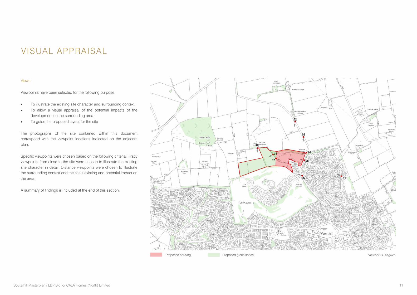
Viewpoints have been selected for the following purpose:
To illustrate the existing site character and surrounding context.
To allow a visual appraisal of the potential impacts of the
development on the surrounding area
To guide the proposed layout for the site
The photographs of the site contained within this document
correspond with the viewpoint locations indicated on the adjacent
plan.
Specific viewpoints were chosen based on the following criteria. Firstly
viewpoints from close to the site were chosen to illustrate the existing
site character in detail. Distance viewpoints were chosen to illustrate
the surrounding context and the site’s existing and potential impact on
the area.
A summary of findings is included at the end of this section.
VISUAL APPRAISAL
Viewpoints Diagram Proposed housing Proposed green space
Soutarhill Masterplan / LDP Bid for CALA Homes (North) Limited 12
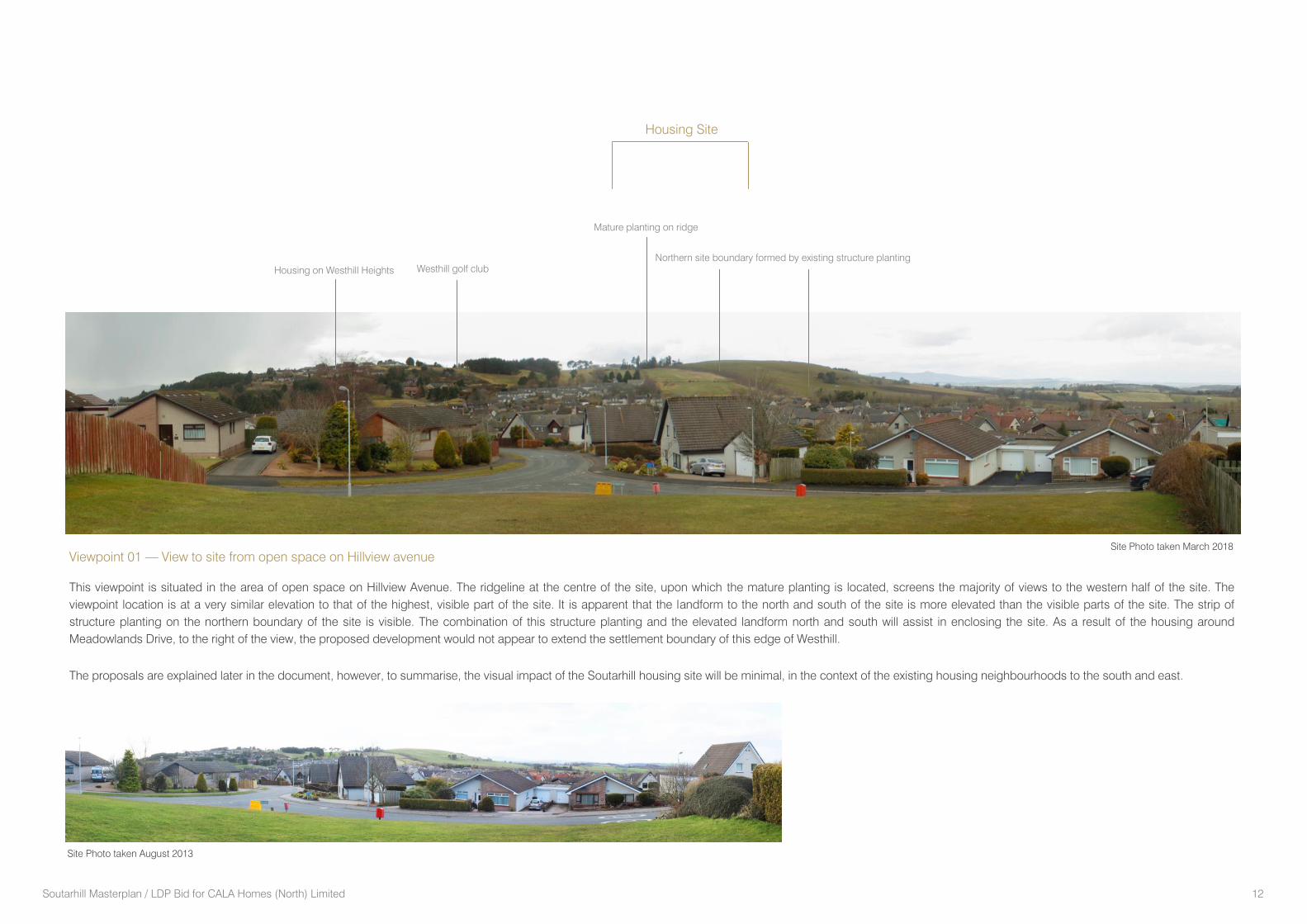
Viewpoint 01 — View to site from open space on Hillview avenue
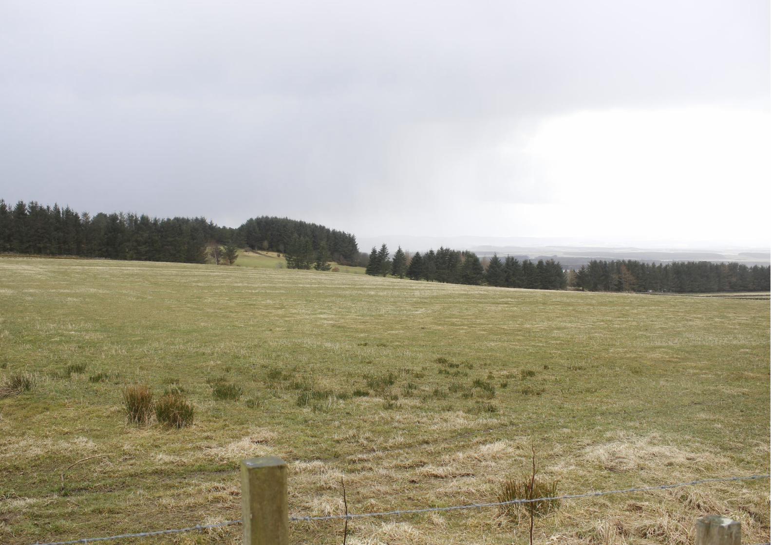
This viewpoint is situated in the area of open space on Hillview Avenue. The ridgeline at the centre of the site, upon which the mature planting is located, screens the majority of views to the western half of the site. The
viewpoint location is at a very similar elevation to that of the highest, visible part of the site. It is apparent that the landform to the north and south of the site is more elevated than the visible parts of the site. The strip of
structure planting on the northern boundary of the site is visible. The combination of this structure planting and the elevated landform north and south will assist in enclosing the site. As a result of the housing around
Meadowlands Drive, to the right of the view, the proposed development would not appear to extend the settlement boundary of this edge of Westhill.
The proposals are explained later in the document, however, to summarise, the visual impact of the Soutarhill housing site will be minimal, in the context of the existing housing neighbourhoods to the south and east.
Mature planting on ridge
Northern site boundary formed by existing structure planting
Westhill golf club Housing on Westhill Heights
Housing Site
Site Photo taken March 2018
Site Photo taken August 2013
Soutarhill Masterplan / LDP Bid for CALA Homes (North) Limited 13
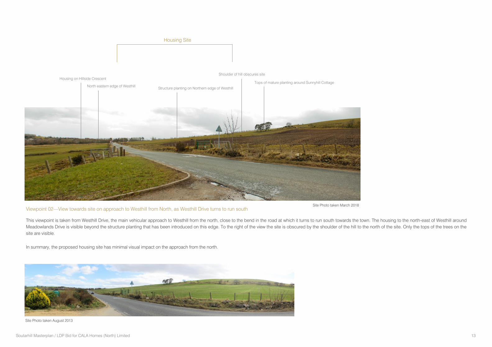
Viewpoint 02—View towards site on approach to Westhill from North, as Westhill Drive turns to run south
This viewpoint is taken from Westhill Drive, the main vehicular approach to Westhill from the north, close to the bend in the road at which it turns to run south towards the town. The housing to the north-east of Westhill around
Meadowlands Drive is visible beyond the structure planting that has been introduced on this edge. To the right of the view the site is obscured by the shoulder of the hill to the north of the site. Only the tops of the trees on the
site are visible.
In summary, the proposed housing site has minimal visual impact on the approach from the north.
North eastern edge of Westhill
Shoulder of hill obscures site
Housing on Hillside Crescent
Structure planting on Northern edge of Westhill
Tops of mature planting around Sunnyhill Cottage
Housing Site
Site Photo taken March 2018
Site Photo taken August 2013
Soutarhill Masterplan / LDP Bid for CALA Homes (North) Limited 14
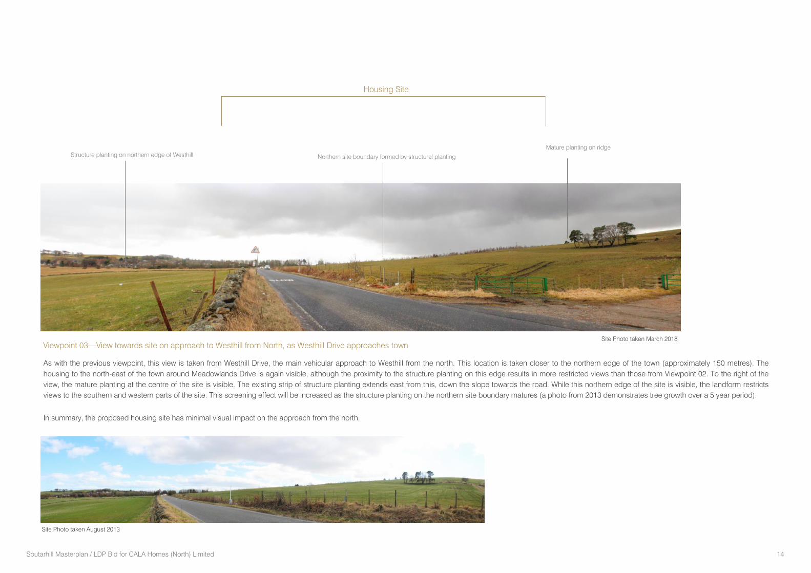
As with the previous viewpoint, this view is taken from Westhill Drive, the main vehicular approach to Westhill from the north. This location is taken closer to the northern edge of the town (approximately 150 metres). The
housing to the north-east of the town around Meadowlands Drive is again visible, although the proximity to the structure planting on this edge results in more restricted views than those from Viewpoint 02. To the right of the
view, the mature planting at the centre of the site is visible. The existing strip of structure planting extends east from this, down the slope towards the road. While this northern edge of the site is visible, the landform restricts
views to the southern and western parts of the site. This screening effect will be increased as the structure planting on the northern site boundary matures (a photo from 2013 demonstrates tree growth over a 5 year period).
In summary, the proposed housing site has minimal visual impact on the approach from the north.
Viewpoint 03—View towards site on approach to Westhill from North, as Westhill Drive approaches town
Structure planting on northern edge of Westhill Northern site boundary formed by structural planting
Mature planting on ridge
Housing Site
Site Photo taken March 2018
Site Photo taken August 2013
Soutarhill Masterplan / LDP Bid for CALA Homes (North) Limited 15
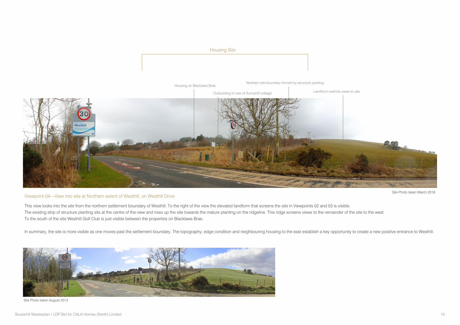
Viewpoint 04—View into site at Northern extent of Westhill, on Westhill Drive
This view looks into the site from the northern settlement boundary of Westhill. To the right of the view the elevated landform that screens the site in Viewpoints 02 and 03 is visible.
The existing strip of structure planting sits at the centre of the view and rises up the site towards the mature planting on the ridgeline. This ridge screens views to the remainder of the site to the west.
To the south of the site Westhill Golf Club is just visible between the properties on Blacklaws Brae.
In summary, the site is more visible as one moves past the settlement boundary. The topography, edge condition and neighbouring housing to the east establish a key opportunity to create a new positive entrance to Westhill.
Northern site boundary formed by structure planting
Landform restricts views to site Outbuilding to rear of Sunnyhill cottage
Housing on Blacklaws Brae
Housing Site
Site Photo taken March 2018
Site Photo taken August 2013
Soutarhill Masterplan / LDP Bid for CALA Homes (North) Limited 16
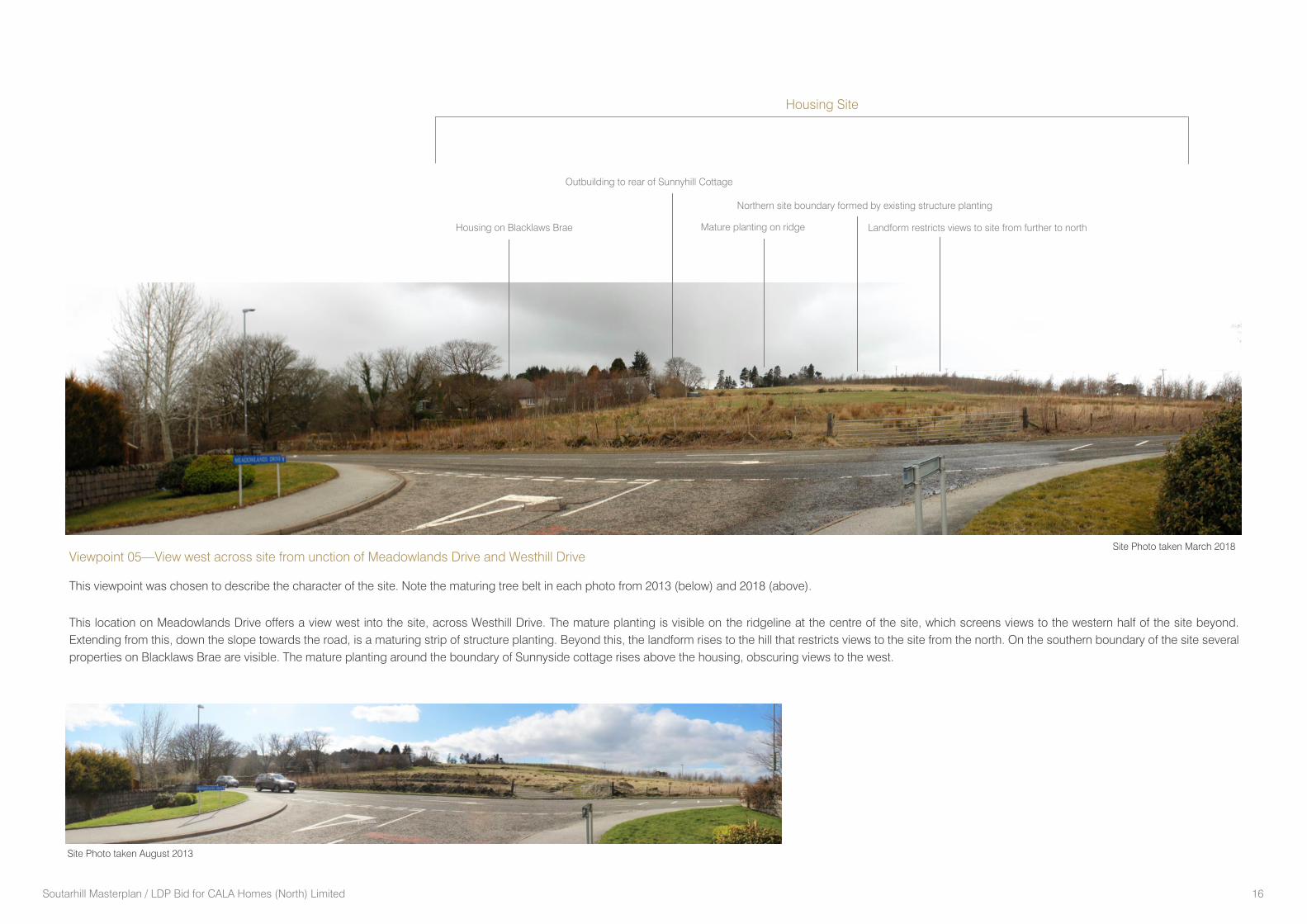
Viewpoint 05—View west across site from unction of Meadowlands Drive and Westhill Drive
This viewpoint was chosen to describe the character of the site. Note the maturing tree belt in each photo from 2013 (below) and 2018 (above).
This location on Meadowlands Drive offers a view west into the site, across Westhill Drive. The mature planting is visible on the ridgeline at the centre of the site, which screens views to the western half of the site beyond.
Extending from this, down the slope towards the road, is a maturing strip of structure planting. Beyond this, the landform rises to the hill that restricts views to the site from the north. On the southern boundary of the site several
properties on Blacklaws Brae are visible. The mature planting around the boundary of Sunnyside cottage rises above the housing, obscuring views to the west.
Site Photo taken August 2013
Housing on Blacklaws Brae Mature planting on ridge Landform restricts views to site from further to north
Northern site boundary formed by existing structure planting
Outbuilding to rear of Sunnyhill Cottage
Housing Site
Site Photo taken March 2018
Soutarhill Masterplan / LDP Bid for CALA Homes (North) Limited 17
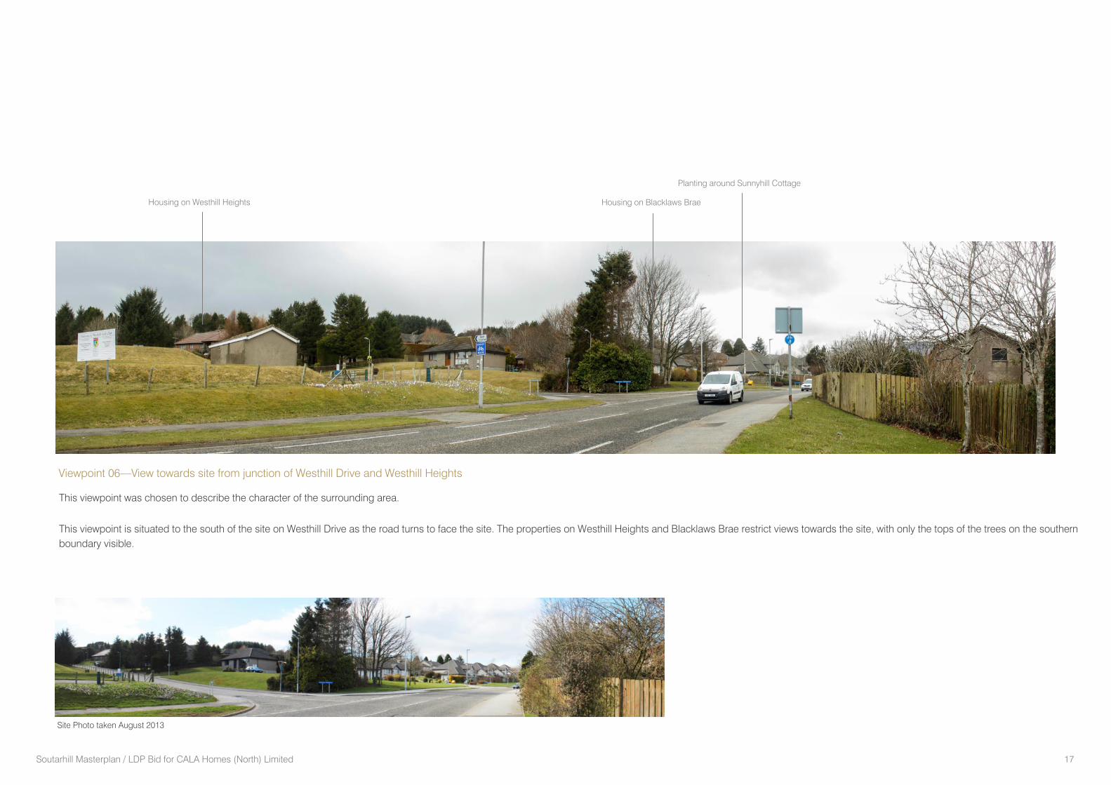
Viewpoint 06—View towards site from junction of Westhill Drive and Westhill Heights
This viewpoint was chosen to describe the character of the surrounding area.
This viewpoint is situated to the south of the site on Westhill Drive as the road turns to face the site. The properties on Westhill Heights and Blacklaws Brae restrict views towards the site, with only the tops of the trees on the southern
boundary visible.
Site Photo taken August 2013
Housing on Blacklaws Brae Housing on Westhill Heights
Planting around Sunnyhill Cottage
Soutarhill Masterplan / LDP Bid for CALA Homes (North) Limited 18
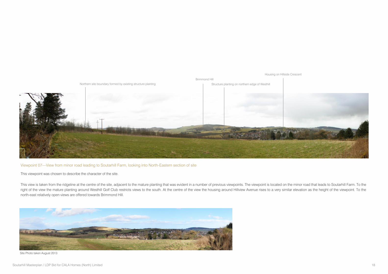
Viewpoint 07—View from minor road leading to Soutarhill Farm, looking into North-Eastern section of site
This viewpoint was chosen to describe the character of the site.
This view is taken from the ridgeline at the centre of the site, adjacent to the mature planting that was evident in a number of previous viewpoints. The viewpoint is located on the minor road that leads to Soutarhill Farm. To the
right of the view the mature planting around Westhill Golf Club restricts views to the south. At the centre of the view the housing around Hillview Avenue rises to a very similar elevation as the height of the viewpoint. To the
north-east relatively open views are offered towards Brimmond Hill.
Site Photo taken August 2013
Brimmond Hill
Structure planting on northern edge of Westhill
Housing on Hillside Crescent
Northern site boundary formed by existing structure planting
Soutarhill Masterplan / LDP Bid for CALA Homes (North) Limited 19
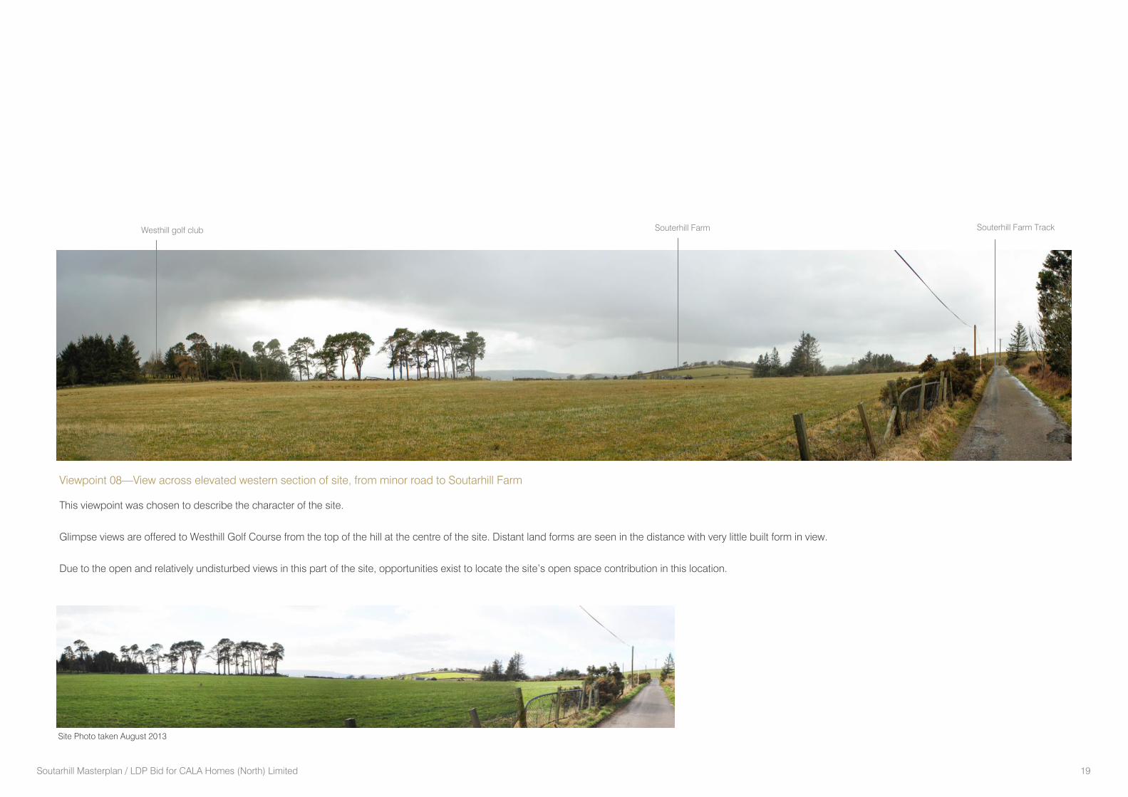
Viewpoint 08—View across elevated western section of site, from minor road to Soutarhill Farm
This viewpoint was chosen to describe the character of the site.
Glimpse views are offered to Westhill Golf Course from the top of the hill at the centre of the site. Distant land forms are seen in the distance with very little built form in view.
Due to the open and relatively undisturbed views in this part of the site, opportunities exist to locate the site’s open space contribution in this location.
Site Photo taken August 2013
Westhill golf club Souterhill Farm Souterhill Farm Track
Soutarhill Masterplan / LDP Bid for CALA Homes (North) Limited 20
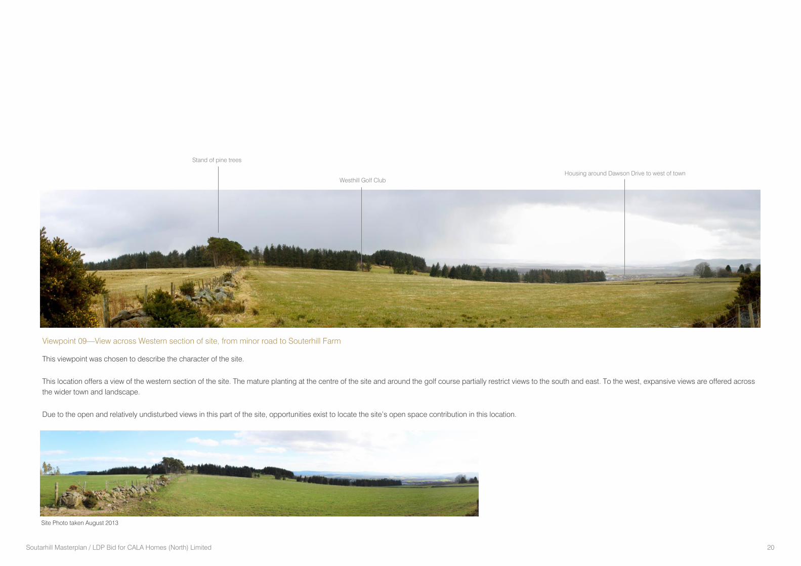
Viewpoint 09—View across Western section of site, from minor road to Souterhill Farm
This viewpoint was chosen to describe the character of the site.
This location offers a view of the western section of the site. The mature planting at the centre of the site and around the golf course partially restrict views to the south and east. To the west, expansive views are offered across
the wider town and landscape.
Due to the open and relatively undisturbed views in this part of the site, opportunities exist to locate the site’s open space contribution in this location.
Site Photo taken August 2013
Westhill Golf Club
Stand of pine trees
Housing around Dawson Drive to west of town

Soutarhill Masterplan / LDP Bid for CALA Homes (North) Limited 21
The visual amenity of a site is an important consideration for any new
development.
In general, distant views to the Soutarhill site are not possible from the
south and west by either the intervening development of the town of
Westhill or by the landform surrounding the site.
To the north the site views are limited by the ridgeline (identified in
Aberdeenshire Council Landscape Capacity study) as it falls towards
Westhill Drive. As a result, the site is not seen from positions to the
north along Westhill Drive, until relatively close to the site beyond the
shoulder of the hill. This landform helps to restrict views of the
proposed housing site.
From the north, the north-eastern edge of the town is visible from a
greater distance. This is a result of the existing development around
Meadowlands having already extended over a secondary ridge to the
south-east, which otherwise contains Westhill. Therefore the proposed
development site does not extend the visibility of housing into areas
where housing is not currently visible. In other words, it does not
extend the extent of visibility of the town into new areas and therefore
has little additional impact.
The screening offered by this landform to the north is further
reinforced by the 20 metre wide maturing belt of structure planting on
the northern site boundary, which was planted in 2006. This shelter
belt will continue to mature over the coming years offering a similar
degree of screening to the housing site as already exists on the north
eastern boundary of Westhill.
VISUAL APPRAISAL SUMMARY
In summary, due to the surrounding natural landforms, boundary tree
planting, mature tree groups and surrounding residential
neighbourhoods, the visual impact of the proposed site on the
surrounding area is minimised and in keeping with existing residential
neighbourhoods in this part of Westhill.
Soutarhill Masterplan / LDP Bid for CALA Homes (North) Limited 22
Key Opportunities
1. Structure Planting
Existing tree planting provides visual screening on approach from the
north and creates a strong landscape edge to this part of Westhill.
2. Westhill Golf Club House and Golf Course
The golf club represents an important amenity within close proximity
of the site. An opportunity exists to enhance existing sports and social
facilities.
3. Bus Stop
A bus stop on Westhill Drive provides regular public transportations
link to Kirkton of Skene, Aberdeen, Oldmeldrum and Dyce.
4. Hill of Keir Viewpoint and Core Path
An existing core path exists between Westhill Drive, the Hill of Keir
Viewpoint and western residential neighbourhoods (Keirhill Road).
providing views over the landscape. Opportunities exist to design in
this core path link into a proposed residential street pattern.
5. Existing Road Connections
Westhill Drive provides a direct link to the town centre and provides
access to the site via Blacklaws Brae.
6. Views Over Landscape
The site opens up to the west, offering panoramic views over the
landscape. Views to Brimmond Hill are possible from the eastern half
of the site, where the land slopes down towards Westhill Drive.
7. Housing Site
A natural split in the site exists at the top of the ridge in line with the
group of mature trees. An opportunity exists to contain housing within
the eastern slopes and green space to the west.
SITE OPPORTUNITIES
2
1
3
4
6
Westh
ill Driv
e
5
Hill of Keir
Viewpoint
Westhill Golf Course
To Westhill Town Centre
Opportunities Diagram
6
4
7
Soutarhill Masterplan / LDP Bid for CALA Homes (North) Limited 23
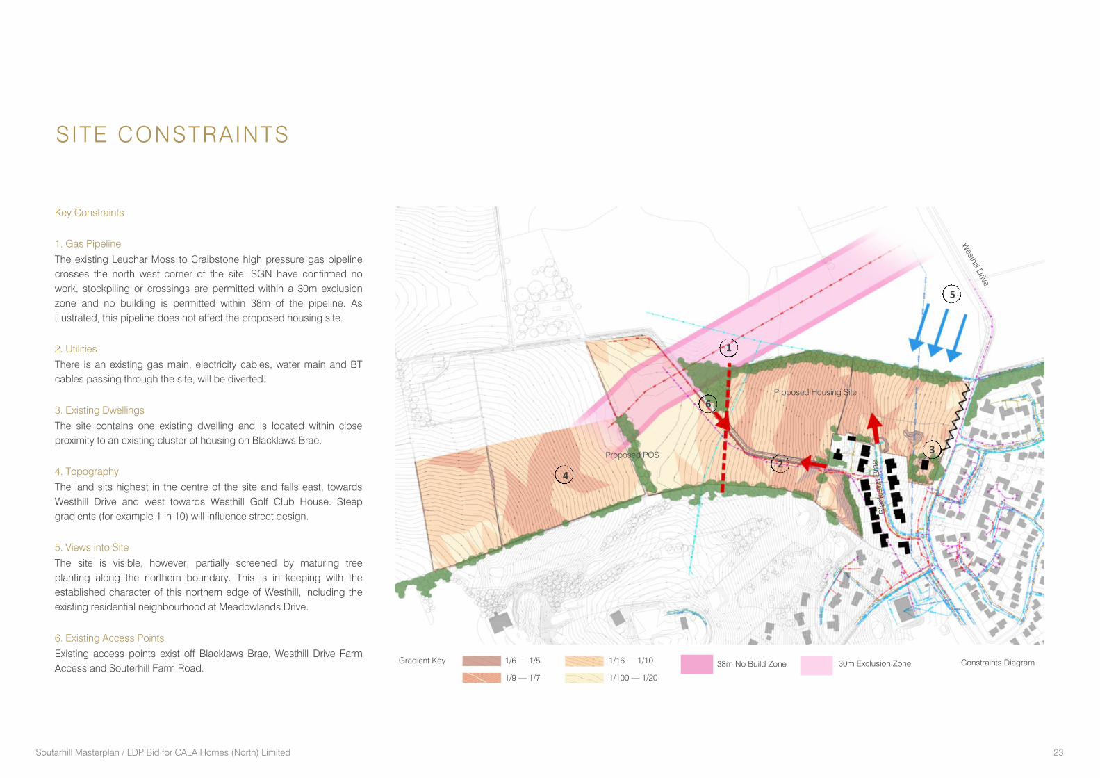
SITE CONSTRAINTS
Key Constraints
1. Gas Pipeline
The existing Leuchar Moss to Craibstone high pressure gas pipeline
crosses the north west corner of the site. SGN have confirmed no
work, stockpiling or crossings are permitted within a 30m exclusion
zone and no building is permitted within 38m of the pipeline. As
illustrated, this pipeline does not affect the proposed housing site.
2. Utilities
There is an existing gas main, electricity cables, water main and BT
cables passing through the site, will be diverted.
3. Existing Dwellings
The site contains one existing dwelling and is located within close
proximity to an existing cluster of housing on Blacklaws Brae.
4. Topography
The land sits highest in the centre of the site and falls east, towards
Westhill Drive and west towards Westhill Golf Club House. Steep
gradients (for example 1 in 10) will influence street design.
5. Views into Site
The site is visible, however, partially screened by maturing tree
planting along the northern boundary. This is in keeping with the
established character of this northern edge of Westhill, including the
existing residential neighbourhood at Meadowlands Drive.
6. Existing Access Points
Existing access points exist off Blacklaws Brae, Westhill Drive Farm
Access and Souterhill Farm Road.
4
3
2
1
6
5
Westh
ill Driv
e
Bla
ckla
ws B
rae
Constraints Diagram 1/6 — 1/5
1/9 — 1/7
Gradient Key 1/16 — 1/10
1/100 — 1/20
38m No Build Zone 30m Exclusion Zone
Proposed Housing Site
Proposed POS
Soutarhill Masterplan / LDP Bid for CALA Homes (North) Limited 24

Soutarhill Masterplan / LDP Bid for CALA Homes (North) Limited 25
PART 2 | PROPOSALS
Soutarhill Masterplan / LDP Bid for CALA Homes (North) Limited 26
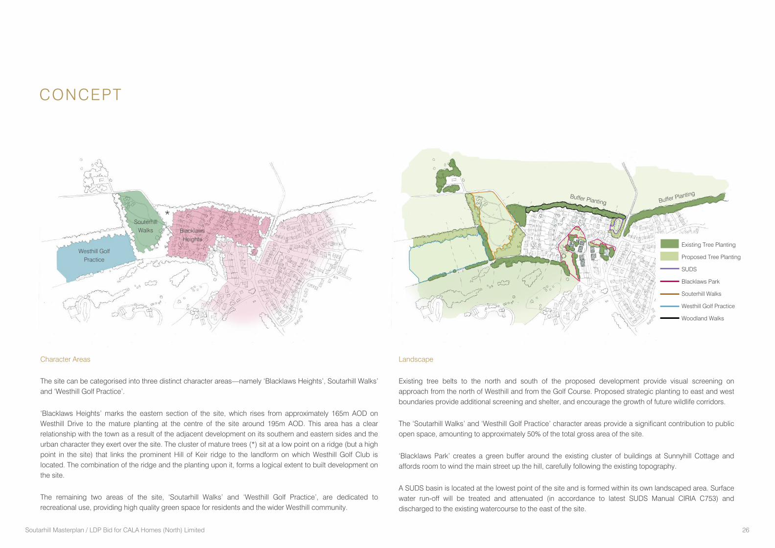
CONCEPT
*
Character Areas
The site can be categorised into three distinct character areas—namely ‘Blacklaws Heights’, Soutarhill Walks’
and ‘Westhill Golf Practice’.
‘Blacklaws Heights’ marks the eastern section of the site, which rises from approximately 165m AOD on
Westhill Drive to the mature planting at the centre of the site around 195m AOD. This area has a clear
relationship with the town as a result of the adjacent development on its southern and eastern sides and the
urban character they exert over the site. The cluster of mature trees (*) sit at a low point on a ridge (but a high
point in the site) that links the prominent Hill of Keir ridge to the landform on which Westhill Golf Club is
located. The combination of the ridge and the planting upon it, forms a logical extent to built development on
the site.
The remaining two areas of the site, ‘Soutarhill Walks’ and ‘Westhill Golf Practice’, are dedicated to
recreational use, providing high quality green space for residents and the wider Westhill community.
Landscape
Existing tree belts to the north and south of the proposed development provide visual screening on
approach from the north of Westhill and from the Golf Course. Proposed strategic planting to east and west
boundaries provide additional screening and shelter, and encourage the growth of future wildlife corridors.
The ‘Soutarhill Walks’ and ‘Westhill Golf Practice’ character areas provide a significant contribution to public
open space, amounting to approximately 50% of the total gross area of the site.
‘Blacklaws Park’ creates a green buffer around the existing cluster of buildings at Sunnyhill Cottage and
affords room to wind the main street up the hill, carefully following the existing topography.
A SUDS basin is located at the lowest point of the site and is formed within its own landscaped area. Surface
water run-off will be treated and attenuated (in accordance to latest SUDS Manual CIRIA C753) and
discharged to the existing watercourse to the east of the site.
Westhill Golf
Practice
Buffer Planting Buffer Planting
Existing Tree Planting
Proposed Tree Planting
SUDS
Blacklaws Park
Souterhill Walks
Westhill Golf Practice
Woodland Walks
Souterhill
Walks Blacklaws
Heights
Soutarhill Masterplan / LDP Bid for CALA Homes (North) Limited 27
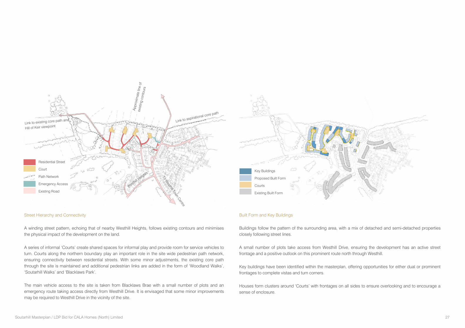
Key Buildings
Proposed Built Form
Courts
Existing Built Form
Built Form and Key Buildings
Buildings follow the pattern of the surrounding area, with a mix of detached and semi-detached properties
closely following street lines.
A small number of plots take access from Westhill Drive, ensuring the development has an active street
frontage and a positive outlook on this prominent route north through Westhill.
Key buildings have been identified within the masterplan, offering opportunities for either dual or prominent
frontages to complete vistas and turn corners.
Houses form clusters around ‘Courts’ with frontages on all sides to ensure overlooking and to encourage a
sense of enclosure.
Street Hierarchy and Connectivity
A winding street pattern, echoing that of nearby Westhill Heights, follows existing contours and minimises
the physical impact of the development on the land.
A series of informal ‘Courts’ create shared spaces for informal play and provide room for service vehicles to
turn. Courts along the northern boundary play an important role in the site wide pedestrian path network,
ensuring connectivity between residential streets. With some minor adjustments, the existing core path
through the site is maintained and additional pedestrian links are added in the form of ‘Woodland Walks’,
‘Soutarhill Walks’ and ‘Blacklaws Park’.
The main vehicle access to the site is taken from Blacklaws Brae with a small number of plots and an
emergency route taking access directly from Westhill Drive. It is envisaged that some minor improvements
may be required to Westhill Drive in the vicinity of the site.
Ap
pro
xim
ate
lin
e o
f exis
ting
co
nto
urs
Link to aspirational core path
Link to existing core path and
Hill of Keir viewpoint
To W
esth
ill Tow
n C
entre
Residential Street
Court
Path Network
Emergency Access
Existing Road
Westh
ill H
eig
hts
Soutarhill Masterplan / LDP Bid for CALA Homes (North) Limited 28
Accommodation Schedule
Gross Site Area 31.3 acres
Public Open Space 22.5 acres (72%)
(includes Woodland Walks, Soutarhill Walks and Blacklaws Park and Westhill Golf
Practice)
Total unit no. 70
53 Private Units (mix of 2-5 bed houses)
17 Affordable Units (2 bed houses, based on 25% provision)
Parking based on Aberdeenshire Parking Standards 2001.
A significant and valuable area of community woodland and
parkland to the west of the site offers benefits to the wider
community. This area could include a network of paths, a picnic
area, seating, woodland, children’s play area and wildflower
areas. It has been designed to maximise potential views to the
wider landscape to the west and path links could form part of
the core path network. A smaller park is located within
Blacklaws Heights.
Vehicular access to the site is provided via Blacklaws Brae, with
a secondary / emergency access also opening onto Westhill
Drive;
The SUDS pond is determined by landform and offers functional
treatment, ecological and aesthetic value;
New foul sewers will installed within the development
discharging to the existing sewers in Westhill Drive.
Key Design Principles
The site can accommodate approximately 70 residential units,
consisting of a mix of housing tenures and types, including
terraced, semi-detached and detached;
The retention and bolstering of the existing structural planting on
the northern edge of the site, assists in the screening of the
development and forms a considered urban / rural transition to
the northern edge of the town, which echoes that of the
Meadowlands development to the east. This belt of planting, in
addition to new north / south planting belts, assist with
screening, wind shelter and the growth of existing habitat
corridors;
The street pattern carefully follows the existing topography and
ties into existing access locations on Blacklaws Brae and
Soutarhill Farm Lane. Pedestrian links have been carefully
designed to maximise connectivity throughout the site, with
networks extending along the wooded north boundary, parkland
to the south and community space to the west;
The layout is designed to ensure houses proposed adjacent to
those on Blacklaws Brae or Sunnyhill Cottage are positioned
back or side-on to respect the amenity of these existing
properties to prevent them feeling overlooked with a buffer
between 20—40m. Due to the topographical characteristics of
the site, the majority of houses benefit from a good solar aspect
and views to Brimmond Hill;
MASTERPLAN
Soutarhill Masterplan / LDP Bid for CALA Homes (North) Limited 29
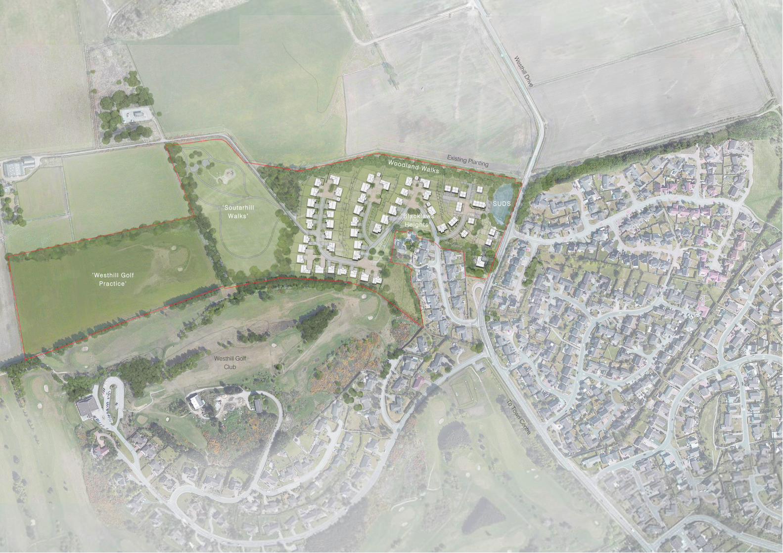
Masterplan
Westh
ill Driv
e
Existing Planting
‘Westh i l l Gol f
Pract ice ’
‘Soutarh i l l
Walks ’ ‘B lacklaws
Heights ’
Westhill Golf
Club
To T
ow
n C
entre
SUDS
Woodland Walks
Soutarhill Masterplan / LDP Bid for CALA Homes (North) Limited 30
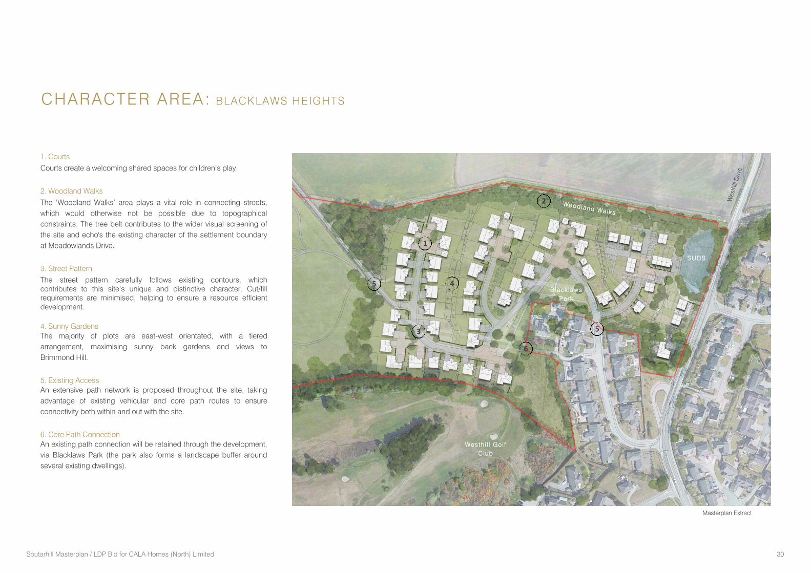
1. Courts
Courts create a welcoming shared spaces for children’s play.
2. Woodland Walks
The ‘Woodland Walks’ area plays a vital role in connecting streets,
which would otherwise not be possible due to topographical
constraints. The tree belt contributes to the wider visual screening of
the site and echo's the existing character of the settlement boundary
at Meadowlands Drive.
3. Street Pattern
The street pattern carefully follows existing contours, which
contributes to this site’s unique and distinctive character. Cut/fill
requirements are minimised, helping to ensure a resource efficient
development.
4. Sunny Gardens
The majority of plots are east-west orientated, with a tiered
arrangement, maximising sunny back gardens and views to
Brimmond Hill.
5. Existing Access
An extensive path network is proposed throughout the site, taking
advantage of existing vehicular and core path routes to ensure
connectivity both within and out with the site.
6. Core Path Connection
An existing path connection will be retained through the development,
via Blacklaws Park (the park also forms a landscape buffer around
several existing dwellings).
CHARACTER AREA: BLACKLAWS HEIGHTS
1
2
3
4
6
5
5 Black laws
Park
Woodland Walks
SUDS
Westh
ill D
riv
e
Wes th i l l Gol f
C lub
Masterplan Extract
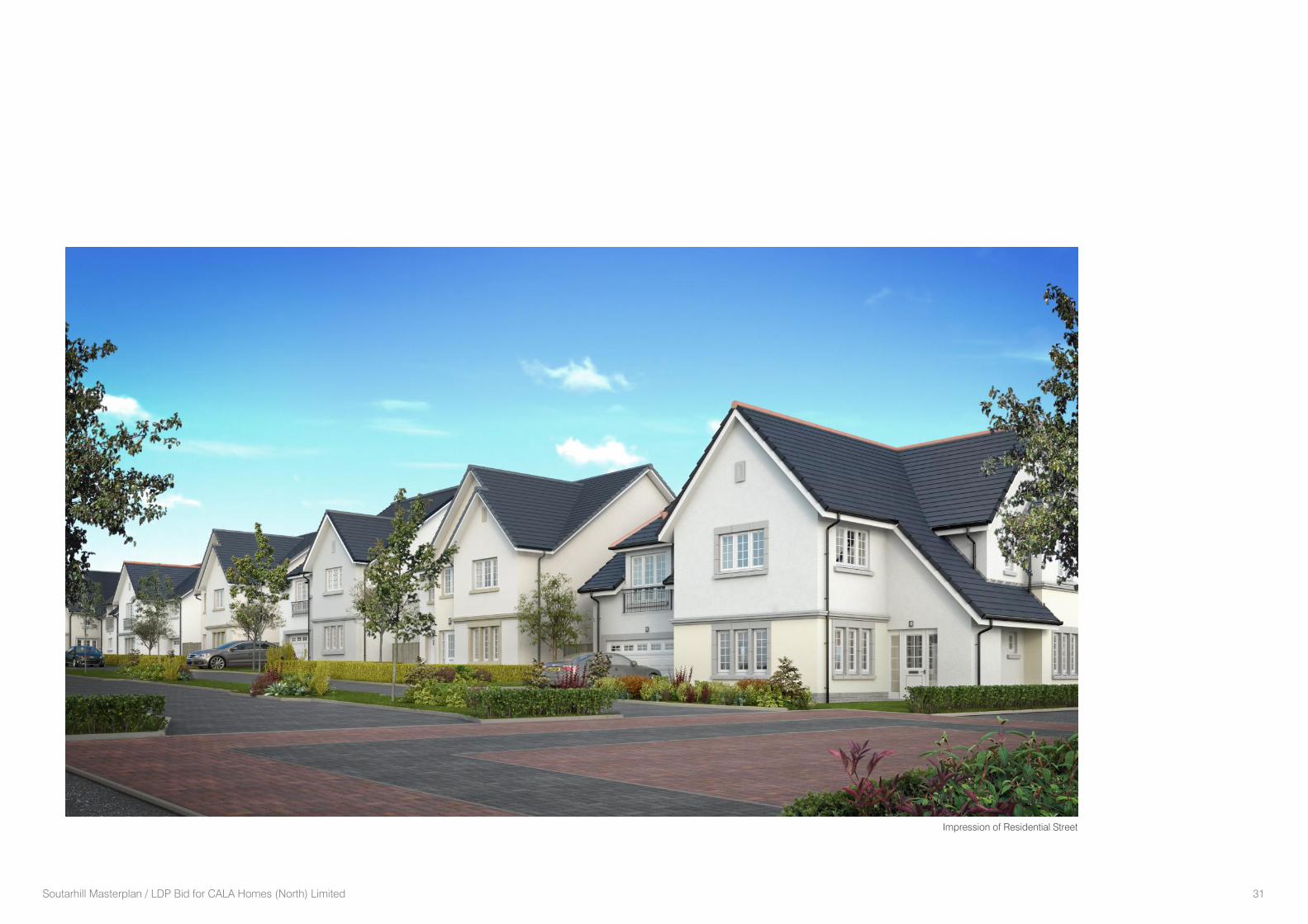
Soutarhill Masterplan / LDP Bid for CALA Homes (North) Limited 31
Impression of Residential Street
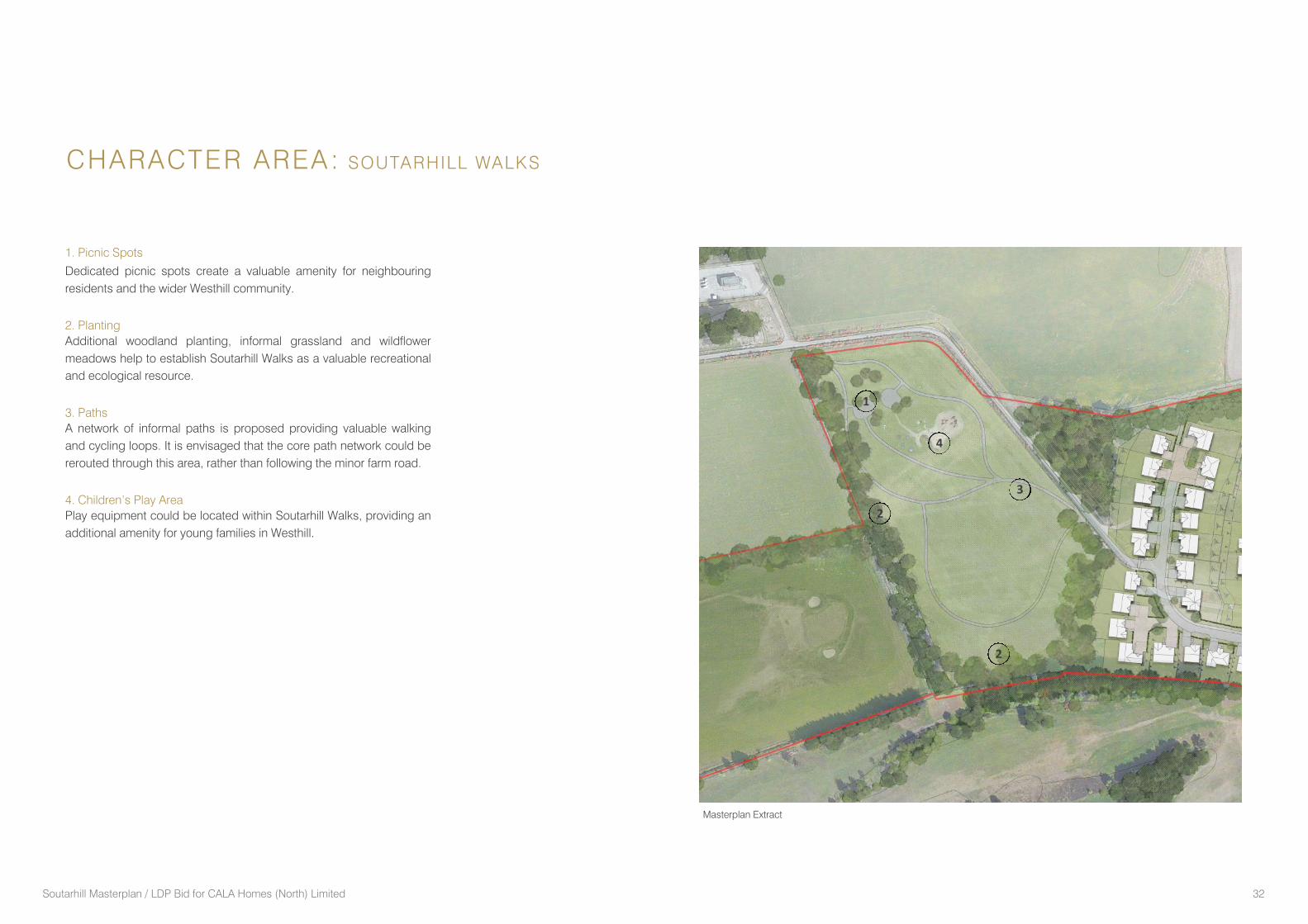
Soutarhill Masterplan / LDP Bid for CALA Homes (North) Limited 32
1. Picnic Spots
Dedicated picnic spots create a valuable amenity for neighbouring
residents and the wider Westhill community.
2. Planting
Additional woodland planting, informal grassland and wildflower
meadows help to establish Soutarhill Walks as a valuable recreational
and ecological resource.
3. Paths
A network of informal paths is proposed providing valuable walking
and cycling loops. It is envisaged that the core path network could be
rerouted through this area, rather than following the minor farm road.
4. Children’s Play Area
Play equipment could be located within Soutarhill Walks, providing an
additional amenity for young families in Westhill.
CHARACTER AREA: SOUTARHILL WALKS
2
1
2
3
4
Masterplan Extract
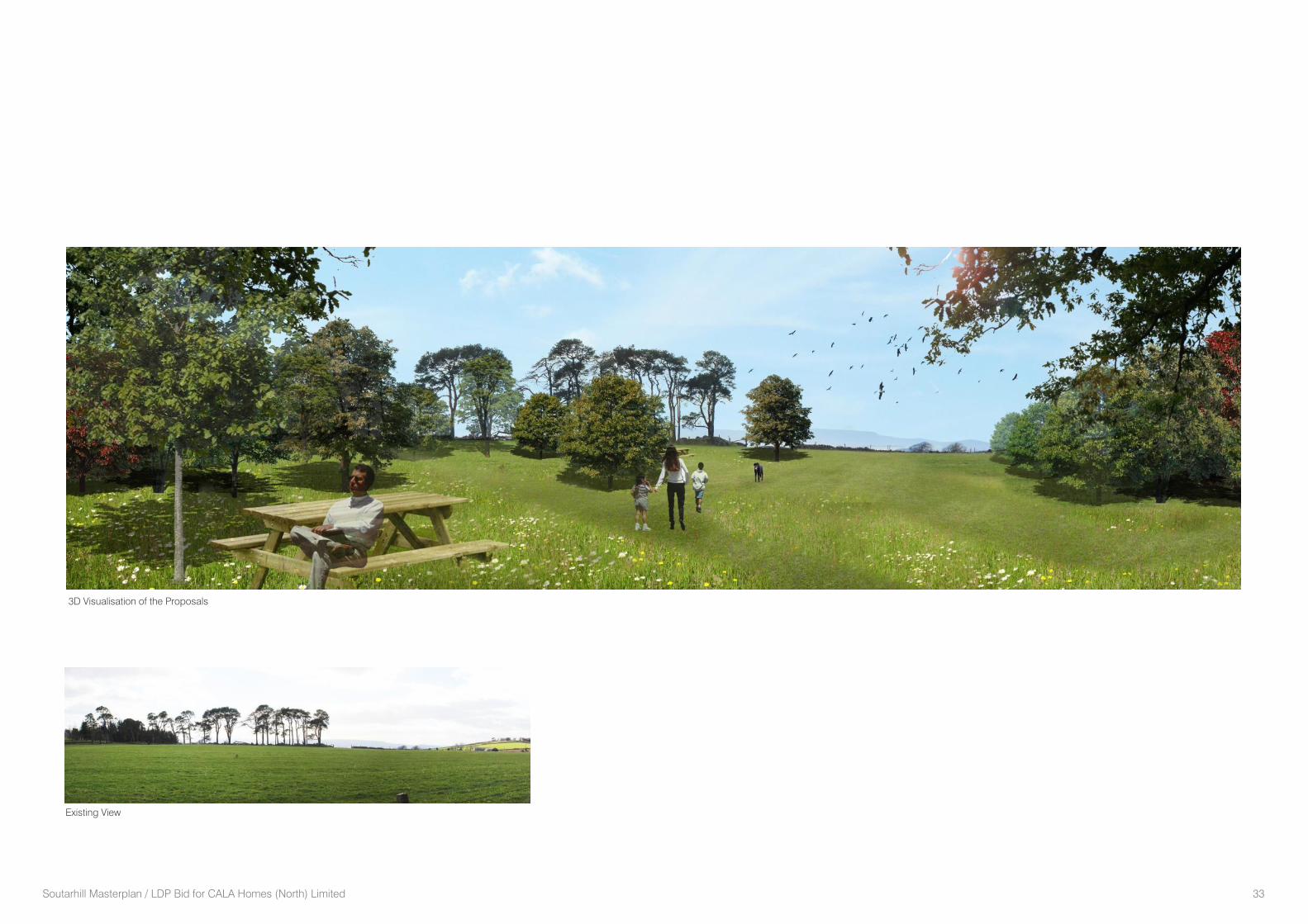
Soutarhill Masterplan / LDP Bid for CALA Homes (North) Limited 33
Existing View
3D Visualisation of the Proposals
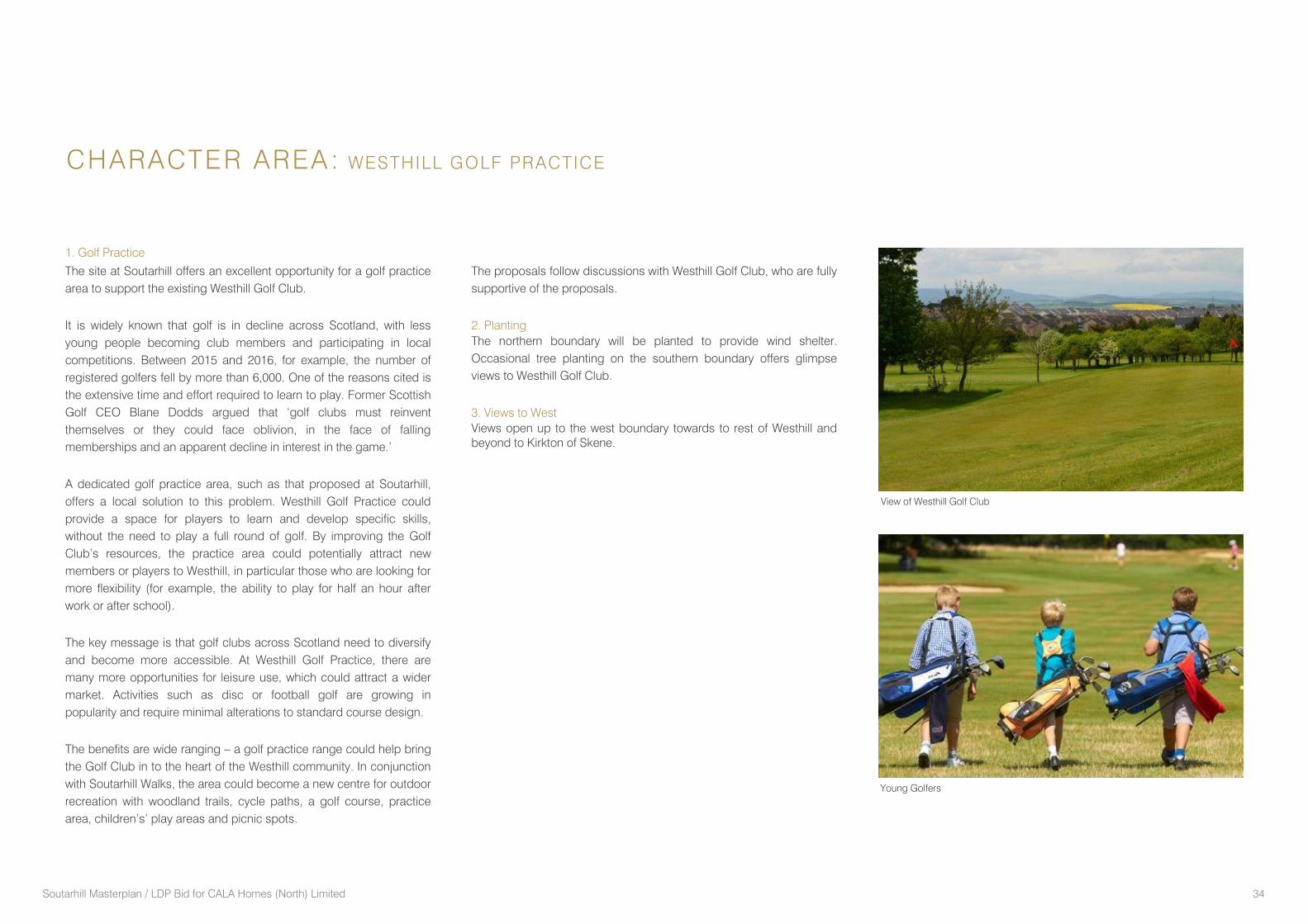
Soutarhill Masterplan / LDP Bid for CALA Homes (North) Limited 34
1. Golf Practice
The site at Soutarhill offers an excellent opportunity for a golf practice
area to support the existing Westhill Golf Club.
It is widely known that golf is in decline across Scotland, with less
young people becoming club members and participating in local
competitions. Between 2015 and 2016, for example, the number of
registered golfers fell by more than 6,000. One of the reasons cited is
the extensive time and effort required to learn to play. Former Scottish
Golf CEO Blane Dodds argued that ‘golf clubs must reinvent
themselves or they could face oblivion, in the face of falling
memberships and an apparent decline in interest in the game.’
A dedicated golf practice area, such as that proposed at Soutarhill,
offers a local solution to this problem. Westhill Golf Practice could
provide a space for players to learn and develop specific skills,
without the need to play a full round of golf. By improving the Golf
Club’s resources, the practice area could potentially attract new
members or players to Westhill, in particular those who are looking for
more flexibility (for example, the ability to play for half an hour after
work or after school).
The key message is that golf clubs across Scotland need to diversify
and become more accessible. At Westhill Golf Practice, there are
many more opportunities for leisure use, which could attract a wider
market. Activities such as disc or football golf are growing in
popularity and require minimal alterations to standard course design.
The benefits are wide ranging – a golf practice range could help bring
the Golf Club in to the heart of the Westhill community. In conjunction
with Soutarhill Walks, the area could become a new centre for outdoor
recreation with woodland trails, cycle paths, a golf course, practice
area, children’s’ play areas and picnic spots.
CHARACTER AREA: WESTHILL GOLF PRACTICE
The proposals follow discussions with Westhill Golf Club, who are fully
supportive of the proposals.
2. Planting
The northern boundary will be planted to provide wind shelter.
Occasional tree planting on the southern boundary offers glimpse
views to Westhill Golf Club.
3. Views to West
Views open up to the west boundary towards to rest of Westhill and
beyond to Kirkton of Skene.
View of Westhill Golf Club
Young Golfers
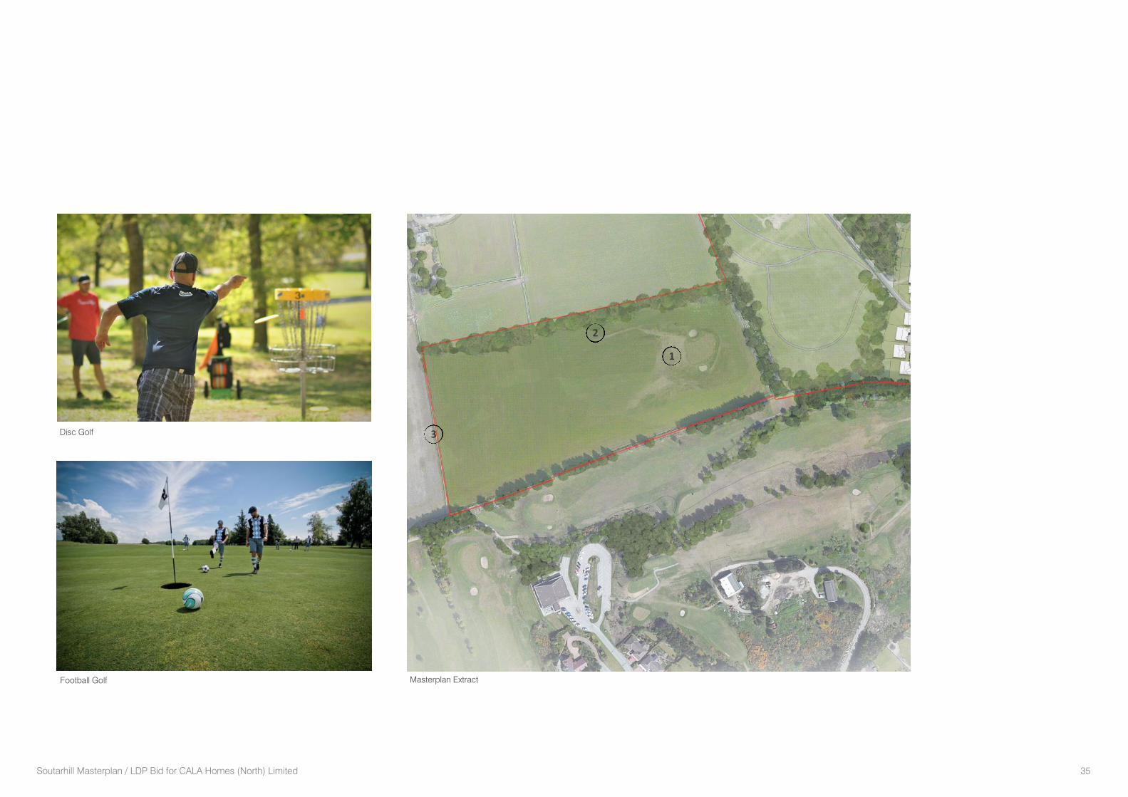
Soutarhill Masterplan / LDP Bid for CALA Homes (North) Limited 35
1
2
3
Masterplan ExtractFootball Golf
Disc Golf
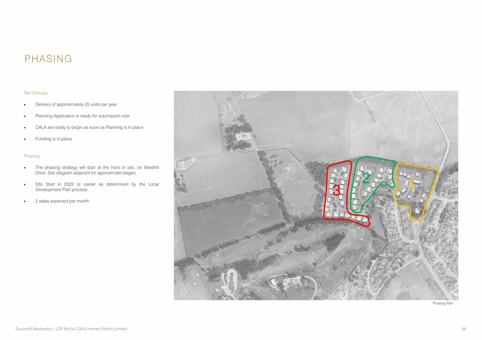
Soutarhill Masterplan / LDP Bid for CALA Homes (North) Limited 36
PHASING
Site Delivery
Delivery of approximately 25 units per year
Planning Application is ready for submission now
CALA are ready to begin as soon as Planning is in place
Funding is in place
Phasing
The phasing strategy will start at the front of site, on Westhill
Drive. See diagram adjacent for approximate stages.
Site Start in 2022 or earlier as determined by the Local
Development Plan process.
2 sales expected per month
Phasing Plan
1 2
3
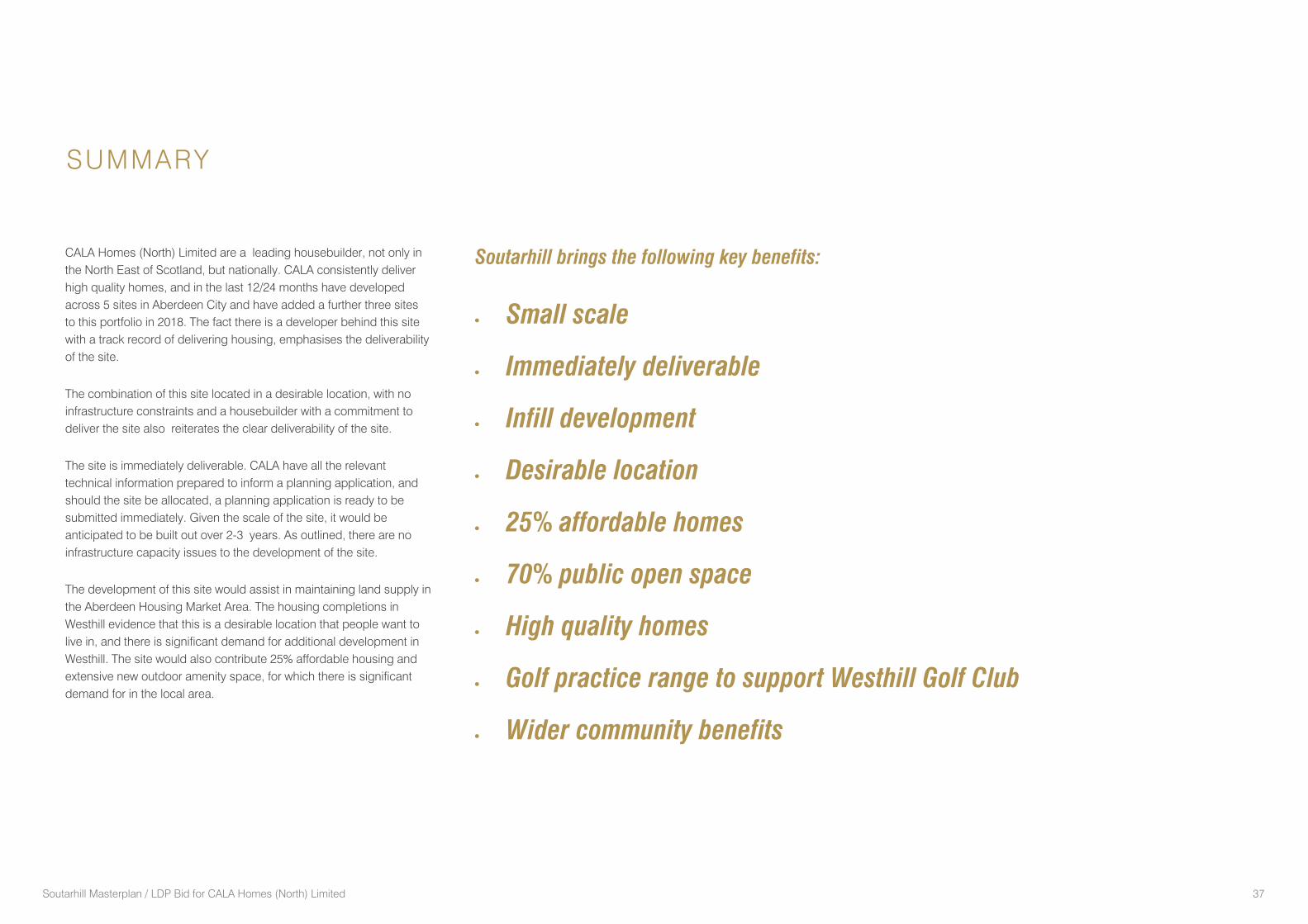
Soutarhill Masterplan / LDP Bid for CALA Homes (North) Limited 37
SUMMARY
CALA Homes (North) Limited are a leading housebuilder, not only in
the North East of Scotland, but nationally. CALA consistently deliver
high quality homes, and in the last 12/24 months have developed
across 5 sites in Aberdeen City and have added a further three sites
to this portfolio in 2018. The fact there is a developer behind this site
with a track record of delivering housing, emphasises the deliverability
of the site.
The combination of this site located in a desirable location, with no
infrastructure constraints and a housebuilder with a commitment to
deliver the site also reiterates the clear deliverability of the site.
The site is immediately deliverable. CALA have all the relevant
technical information prepared to inform a planning application, and
should the site be allocated, a planning application is ready to be
submitted immediately. Given the scale of the site, it would be
anticipated to be built out over 2-3 years. As outlined, there are no
infrastructure capacity issues to the development of the site.
The development of this site would assist in maintaining land supply in
the Aberdeen Housing Market Area. The housing completions in
Westhill evidence that this is a desirable location that people want to
live in, and there is significant demand for additional development in
Westhill. The site would also contribute 25% affordable housing and
extensive new outdoor amenity space, for which there is significant
demand for in the local area.
Soutarhill brings the following key benefits:
Small scale
Immediately deliverable
Infill development
Desirable location
25% affordable homes
70% public open space
High quality homes
Golf practice range to support Westhill Golf Club
Wider community benefits
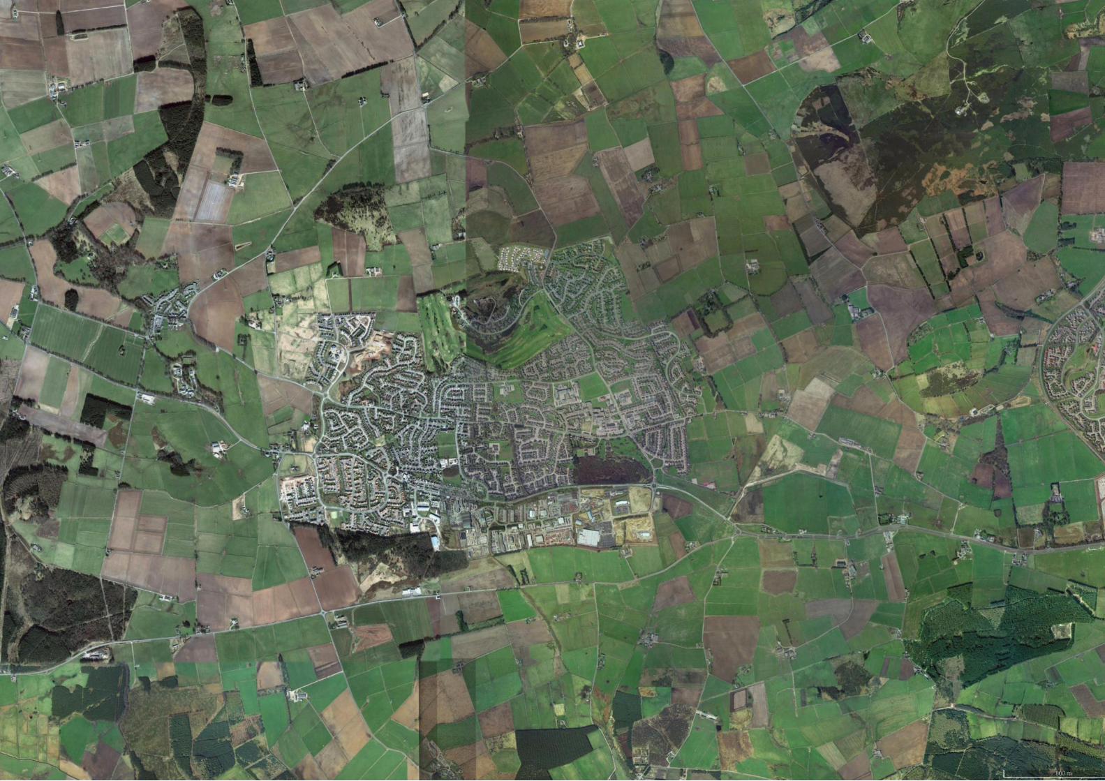
Souterhill Farm Residential Development, Westhill, Aberdeenshire
Transport Statement
March 2018
fnapier
Text Box
GR133
124001 TS01: Souterhill Farm Residential Development, Westhill, Aberdeenshire
CONTROL SHEET CLIENT: CALA Homes PROJECT TITLE: Souterhill Farm Development, Westhill, Aberdeenshire REPORT TITLE: Transport Statement PROJECT REFERENCE: 124001 / TS01
Issu
e &
Ap
pro
val S
ch
ed
ule
ISSUE 1 Name Signature Date
Prepared by M Ayim
27/03/18
Checked by M Peters
27/03/18
Approved by R McDonald
27/03/18
Re
vis
ion
Rec
ord
Rev. Signature
2
By
Checked
Approved
3
By
Checked
Approved
This document has been prepared in accordance with procedure OP/P02 of the
Fairhurst Quality and Environmental Management System
124001 TS01: Souterhill Farm Residential Development, Westhill, Aberdeenshire
Contents
1 Introduction ________________________________________________________________________ 1
1.1 General 1
1.2 Existing Site 1
1.3 Scoping Discussions 2
1.4 Planning Policy Context and Guidance 2
1.5 Transport Statement Structure 2
2 Planning Policy Context ______________________________________________________________ 3
2.1 National Planning Policy 3
2.2 Regional Policy 6
2.3 Local Policy 6
3 Site Accessibility ___________________________________________________________________ 8
3.1 Local Area Summary 8
3.2 Walking and Cycling Accessibility 8
3.3 Public Transport Accessibility 9
3.4 Local Road Network 10
3.5 Safe Routes to School 11
4 Development Proposal & Access Arrangements_________________________________________ 12
4.1 Overview 12
4.2 Vehicle Access 12
4.3 Pedestrian Access 13
4.4 Parking 13
4.5 Servicing 13
5 Trip Generation & Traffic Impact ______________________________________________________ 14
5.1 Overview 14
5.2 Trip Generation 14
6 Residential Travel Plan Framework ___________________________________________________ 15
6.1 Introduction 15
6.2 Residential Travel Pack Aims and Objectives 15
6.3 Framework for the preparation of the Residential Travel Pack 15
7 Summary and Conclusion ___________________________________________________________ 17
7.1 Summary 17
7.2 Conclusion 18
124001 TS01: Souterhill Farm Residential Development, Westhill, Aberdeenshire
Appendices
APPENDIX A Scoping Correspondence
APPENDIX B Accessibility Maps
APPENDIX C Site Layout Plan - Halliday Fraser Munro Drawing No. 10986 SK (00)03_C
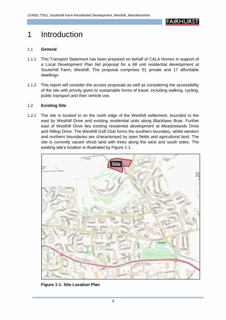
124001 TS01: Souterhill Farm Residential Development, Westhill, Aberdeenshire
1
1 Introduction
1.1 General
1.1.1 This Transport Statement has been prepared on behalf of CALA Homes in support of
a Local Development Plan bid proposal for a 68 unit residential development at
Souterhill Farm, Westhill. The proposal comprises 51 private and 17 affordable
dwellings.
1.1.2 This report will consider the access proposals as well as considering the accessibility
of the site with priority given to sustainable forms of travel, including walking, cycling,
public transport and then vehicle use.
1.2 Existing Site
1.2.1 The site is located to on the north edge of the Westhill settlement, bounded to the
east by Westhill Drive and existing residential units along Blacklaws Brae. Further
east of Westhill Drive lies existing residential development at Meadowlands Drive
and Hilltop Drive. The Westhill Golf Club forms the southern boundary, whilst western
and northern boundaries are characterised by open fields and agricultural land. The
site is currently vacant shrub land with trees along the west and south sides. The
existing site’s location is illustrated by Figure 1-1.
Figure 1-1: Site Location Plan
Site
124001 TS01: Souterhill Farm Residential Development, Westhill, Aberdeenshire
2
1.3 Scoping Discussions
1.3.1 Fairhurst has agreed scoping of the TS with Aberdeenshire Council in advance of
preparing this report in order to agree the content, methodology and certain
parameters to be adopted. All relevant scoping correspondence is contained within
Appendix A.
1.4 Planning Policy Context and Guidance
1.4.1 The TS has been undertaken giving recognition to appropriate national, regional and
local planning policies including the Scottish Government documents ‘Scottish
Planning Policy (SPP)’, ‘Planning Advice Note 75 (PAN 75)’, and ‘Transport
Assessment Guidance’.
1.5 Transport Statement Structure
1.5.1 This report has been prepared in accordance with the ‘Transport Assessment
Guidance’ document issued by Transport Scotland, and will be structured as follows:
Transport Planning Policy
Site Accessibility
Development Proposals & Access Arrangements
Trip Generation & Traffic Impact
Residential Travel Plan Framework
Summary & Conclusions
124001 TS01: Souterhill Farm Residential Development, Westhill, Aberdeenshire
3
2 Planning Policy Context
2.1 National Planning Policy
2.1.1 The National Policy Context is principally defined by ‘Scottish Planning Policy’ (SPP),
and Scottish Planning Advice Note 75 (PAN 75) ‘Planning for Transport’. The
Scottish Government documents ‘Transport Assessment Guidance’ and ‘Designing
Streets’ are also of relevance.
2.1.2 The Scottish Government’s ‘Scottish Planning Policy’ (SPP) issued in June 2014
identifies the Scottish Government’s overarching aim to increase sustainable
economic growth within Scotland.
2.1.3 SPP revolves around the principal policies – sustainability and placemaking. In
considering how planning should support the vision, the document outlines the key
outcomes that developments need to contribute to:
‘A successful, sustainable place – supporting sustainable economic growthand regeneration, and creation of well-designed, sustainable places.’
‘A low carbon place – reducing our carbon emissions and adapting to climatechange.’
‘A natural, resilient place – helping to protect and enhance our natural andcultural assets, and facilitating their use.’
‘A more connected place – supporting better transport and digitalconnectivity.’
2.1.4 The ‘Promoting Sustainable Transport and Active Travel’ section of SPP stresses the
importance of efficient transport connections within Scotland and to international
markets, and the crucial role that planning plays to improving such infrastructure. The
section goes on to identify within paragraph 270 that the planning system should
support developments that:
‘optimise the use of existing infrastructure;
reduce the need to travel;
provide safe and convenient opportunities for walking and cycling for bothactive travel and recreation, and facilitate travel by public transport; and
enable the integration of transport modes’.
2.1.5 Paragraph 273 notes that ‘the spatial strategies set out in plans should support
development in locations that allow walkable access to local amenities and are also
accessible by cycling and public transport. Plans should identify active travel
networks and promote opportunities for travel by more sustainable modes in the
following order of priority: walking, cycling, public transport, cars.’
124001 TS01: Souterhill Farm Residential Development, Westhill, Aberdeenshire
4
2.1.6 SPP notes in paragraph 287 that ‘Planning permission should not be granted for
significant travel-generating uses at locations which would increase reliance on the
car and where:
direct links to local facilities via walking and cycling networks are not available or cannot be made available; and
access to local facilities via public transport networks would involve walking more than 400m.’
2.1.7 SPP identifies that the accessibility criteria relates to ‘significant travel-generating
uses’. The proposal is not considered to be a significant travel generating use. SPP
notes at paragraph 286 that a Transport Assessment should be carried out for
proposals that will generate a ‘significant’ level of trips. For smaller developments
that will not generate a significant level of trips, a simplified Transport Statement is
required to support a planning application, which is the case in this instance. This is
in line with guidance contained within Transport Scotland’s document ‘Transport
Assessment Guidance’.
2.1.8 SPP also indicates at paragraph 279 that the public transport accessibility criteria for
developments that will generate a significant level of trips should be considered
differently from smaller developments that will not generate a significant travel
demand. Nonetheless, the accessibility criteria are recognised as good practice
guidance for smaller developments.
2.1.9 PAN 75 identifies the need for the integration of land use planning with transport,
taking into account policies on economic growth, education, health and the objective
of a more inclusive society.
2.1.10 PAN 75 identifies in Annex B the undernoted thresholds:
‘For accessibility of public transport the recommended guidelines are less than 400m to bus services;
A maximum threshold of 1600m for walking is broadly in line with observed travel behaviour.’
2.1.11 Whilst the accessibility criteria noted within PAN 75 represents good practice, the
proposal will not generate a significant level of trips and should be considered
differently from larger proposals that do generate significant trip levels.
2.1.12 When discussing Travel Plans, SPP paragraph 279 notes that ‘Development Plans
should indicate when a Travel Plan will be required to accompany a proposal for a
development which will generate significant travel’. This indicates that developments
that do not generate significant levels of trips may not require a Travel Plan.
2.1.13 PAN 75 indicates that ‘Travel Plans are documents that set out a package of positive
and complementary measures, for the overall delivery of more sustainable travel
patterns for a specific development.’ It further states that ‘their ability and success in
influencing travel patterns is dependent upon the commitment of the developer and
occupier of a development.’ For residential land uses, PAN 75 notes at paragraph 43
124001 TS01: Souterhill Farm Residential Development, Westhill, Aberdeenshire
5
that ‘travel plans may set out measures which will be used as an incentive to house
purchasers to use non-car travel modes, but setting targets is generally not
practicable for this land use. Sustainability in housing should come through design in
relation to walking, cycling and public transport networks.’
2.1.14 Transport Assessment Guidance (TAG) has been published by Transport Scotland to
guide the preparation of Transport Assessments (TA) for development proposals in
Scotland. Paragraph 1.8 notes that the TA process “is directed towards successful
delivery of development-related transport measures aimed at achieving sustainable
transport outcomes.” It further notes that the “process incorporates scoping, transport
assessment and implementation including travel plans and monitoring.” Paragraph
2.2 provides some guidance on the principles of the assessment and states “the TA
deals with person-trips, not car trips.”
2.1.15 Paragraph 3.2 of TAG states that “In the case of local developments or changes of
use where transport impacts are likely to be insignificant, a detailed assessment will
not be necessary. At the next level, a simple Transport Statement can help inform
decision makers.” Paragraph 4.1 continues by stating that “A Transport Statement
(TS) should identify the main transport issues relating to a proposed development.
This will normally include details of the existing conditions and for the proposed
development. The TS will identify the existing transport infrastructure, travel
characteristics associated with the site and the proposed measures to improve the
infrastructure and services to encourage sustainable travel to the site. Detailed
accessibility analysis and assessment of the traffic impacts will not be required.”
2.1.16 ‘Designing Streets’ sets out Scottish Government policy to be followed in designing
and approving the layout of settlements. The Scottish Government’s policy
emphasises that street design should meet the six qualities of successful places, as
set out in Designing Places. The six qualities and key considerations are summarised
as follows:
Distinctive – street design should respond to local context to deliver places that are distinctive
Safe and pleasant – streets should be designed to be safe and attractive places
Easy to move around – streets should be easy to move around for all users and connect well to existing networks
Welcoming – streets layout and detail should encourage positive interaction for all members of the community
Adaptable – street networks should be designed to accommodate future adaptation
Resource efficient – street design should consider orientation, the integration of sustainable drainage and use attractive, durable materials that can be easily maintained.
124001 TS01: Souterhill Farm Residential Development, Westhill, Aberdeenshire
6
2.2 Regional Policy
2.2.1 Regional Policy for the proposed development is largely defined by:
Approved Aberdeen City & Shire Strategic Development Plan (March 2014)
NESTRANS Regional Transport Strategy Refresh 2035 (Jan 2014)
2.2.2 The Approved Aberdeen City & Shire Strategic Development Plan (SDP) identifies
‘four strategic growth areas’ (SGA) which will be the focus of development in the area
up to 2035. The SDP notes, “The strategic growth areas are centred on Aberdeen
and the main public transport routes.” The SDP also aims to “make the most efficient
use of the transport network, reducing the need for people to travel and making sure
that walking, cycling and public transport are attractive choices.”
2.2.3 The Strategic Development Plan identifies the undernoted objectives:-
‘To be a city region which takes the lead in reducing the amount of carbon dioxide released into the air, adapts to the effects of climate change and limits the amount of non-renewable resources it uses;
To make sure that new development meets the needs of the whole community, both now and in the future, and makes the area a more attractive place for residents and business to move to;
To make sure that all new developments contribute towards reducing the need to travel and encourage people to walk, cycle or use public transport by making these attractive choices’.
2.2.4 The SDP endorses the role of ‘Sustainable mixed communities’ in making sure that
‘new development meets the needs of the whole community, both now and in the
future, and makes the area a more attractive place for residents and businesses to
move to’.
2.2.5 The NESTRANS Regional Transport Strategy Refresh 2035 (RTS) identifies within its
four Strategic Objectives the requirements to:
‘to enhance and exploit the North East’s competitive economic advantages, and to reduce the impacts of peripherality;
enhance choice, accessibility and safety of transport for all in the north east, particularly for disadvantaged and vulnerable members of society and those living in areas where transport options are limited; and
support transport integration and a strong, vibrant and dynamic city centre and town centres across the north east.’
2.3 Local Policy
2.3.1 Local Policy is defined in:
Aberdeenshire Local Development Plan (ALDP) 2017;
124001 TS01: Souterhill Farm Residential Development, Westhill, Aberdeenshire
7
Local Transport Strategy (LTS) 2012.
2.3.2 The Aberdeenshire Local Development Plan (ALDP) 2017 sets out the ground rules
for the development of land under the land use planning acts. The proposed plan
sets out the Council’s statement of policies that will guide the assessment of planning
applications while also confirming the principle of development on sites across
Aberdeenshire. The ALDP sets out the Council’s land use planning and development
policies from the date of approval until 2026.
2.3.3 The Aberdeenshire Local Transport Strategy 2012 (LTS) sets out the transportation
vision and objectives of the Council and provides a three-year implementation plan
for meeting local changes and needs.
2.3.4 To deliver its aim, the LTS embraces a simple guiding principle which is to
‘encourage businesses and individuals to consider ways to travel less, travel more
actively and, where vehicular travel is necessary, how journeys could be made more
effectively.’
2.3.5 The five broad objectives sets out in the LTS are ‘promote sustainable economy
growth, promote social inclusion and accessibility, protect the environment, improve
safety and improve integration.’
124001 TS01: Souterhill Farm Residential Development, Westhill, Aberdeenshire
8
3 Site Accessibility
3.1 Local Area Summary
3.1.1 The site is located at the northern boundary of Westhill, adjacent to existing
residential neighbourhoods at Blacklaws Brae, Westhill Heights, Meadowlands Drive
and Hilltop Drive. The proposed development will form an extension to an existing
residential zone.
3.1.2 Westhill is a sub-regional centre accommodating mixed-use development comprising
residential, retail and employment uses. The areas to the south of the A944 are
predominantly employment uses with some retail elements.
3.2 Walking and Cycling Accessibility
3.2.1 Walking is the most sustainable mode of transport and it promotes good health and
has significant environmental benefits when compared to similar journeys made by
car. It is recognised that thirty minutes of brisk walking per day can make a significant
difference to a person’s health, which should be encouraged.
3.2.2 A walking catchment of 1600 metres is recognised in PAN 75 as being broadly in line
with observed travel behaviour. PAN 75 also notes that the quality of walking and
cycling networks within 800 metres of a development can influence accessibility on
foot. Figure 3-1 in Appendix B presents walking isochrones 800 and 1600 metres,
representing walking times of approximately 10 and 20 minutes respectively,
measured along formal footway connections to and from the proposed development.
Figure 3-1 illustrates that the 1600m walking catchment encompasses all key local
amenities in the town, including Aldi supermarket, Westhill Shopping Centre, Westhill
Primary and Academy, Westhill Library, Community Centre and Swimming Pool.
3.2.3 The majority of pedestrian movement from the site is expected to be southbound as a
result of the site’s location with regards to the rest of Westhill.
3.2.4 Blacklaws Brae will provide access into the development from the external network. It
accommodates 1.8m wide footways on both side of the carriageway. In the easterly
direction, the footways connect with the footway on the west side of Westhill Drive.
Blacklaws Brae is subject to a 20mph speed limited, which is complemented by
speed tables along its length. Presently, it provides direct frontage access to existing
driveways along its length. Footways on Blacklaws Brae are well lit and facilitate links
to the wider pedestrian network within Westhill.
3.2.5 Westhill Drive to the south forms a direct route to Westhill town centre, where local
facilities can be accessed and are all within an acceptable walking distance of the
proposed site. Westhill Drive is subject to a 30mph speed limit and the footways are
well lit. It facilitates links to key routes within Westhill, including Hay’s Way, Hillside
Road, Westhill Road, Old Skene Road and the A944.
124001 TS01: Souterhill Farm Residential Development, Westhill, Aberdeenshire
9
3.2.6 Figure 3-1 within Appendix B illustrates the local facilities located within Westhill,
which includes the Westhill Shopping Centre where there are convenience shops,
restaurants, pharmacy, coffee shop and post office.
3.2.7 Westhill and Arnhall Business Parks, located to the south of Westhill, form part of the
core employment zone within the area. Given their function as a major employment
centre, the Business Parks have a good network of pedestrian footways facilitating
access to business/commercial areas within the business park.
3.2.8 There are a number of designated pedestrian crossing points on the A944 Straik
Road which provide safe crossing for north-south pedestrian movements between
the residential areas to the north and commercial/business areas to the south.
3.2.9 The proposed development site is between 30 to 40 minutes walking distance from
the employment areas within the business park.
3.2.10 Like walking, cycling has an important part to play in reducing congestion, improving
accessibility and reducing pollution. A further benefit of cycling is linked to increased
general health and fitness which has personal benefits as well as economic benefits
for the nation in terms of health service costs. The bicycle is generally more
affordable than the car and hence there are social equity benefits to the promotion of
cycling. Cycling can also allow people without cars to reach destinations that they
may otherwise be unable to reach on foot.
3.2.11 The nearest cycle facility is on road cycle lanes on Westhill Drive, approximately 70
metres south of the Blacklaws Brae junction. Westhill has an extensive network of
cycle facilities forming the Westhill ‘No Excuse Zone’. The zone covers a 12 minute
cycling catchment within Westhill and the facilities comprises designated on-road
cycle routes, off road paths and quiet or traffic-calmed routes. The existing facilities
also afford links to the ‘Westhill to Aberdeen’ dual use path which runs along the
A944. The extent of the ‘No Excuse Zone’ and designated crossing points are
illustrated in Figure 3-2 in Appendix B. The site lies within close proximity to
Westhill’s 12 minutes ‘No Excuse Zone’.
3.2.12 Cycling provides a realistic opportunity as an alternative mode of travel between the
predominantly residential neighbourhood to the north and the employment and retail
land uses to the south.
3.2.13 A journey time of 30 to 40 minutes (8km) is generally considered to be appropriate for
cycling. Prime Four Business Park, another major employment centre, is within 20
minutes cycling distance from the development. Further east along the A944 Lang
Stracht, Whitemyres Industrial Estate is also within within 40 minutes cycling distance
from the development. Cycling accessibility to the east of Westhill, incorporates the
use of the dual use path along the A944.
3.3 Public Transport Accessibility
3.3.1 The closest bus stop is the Blacklaws Brae bus terminal located on Westhill Drive
approximately 160 metres from the site’s boundary on Blacklaws Brae. It should be
noted that the majority of the development would be within 400 meters walking
distance from the Westhill Drive bus stop.
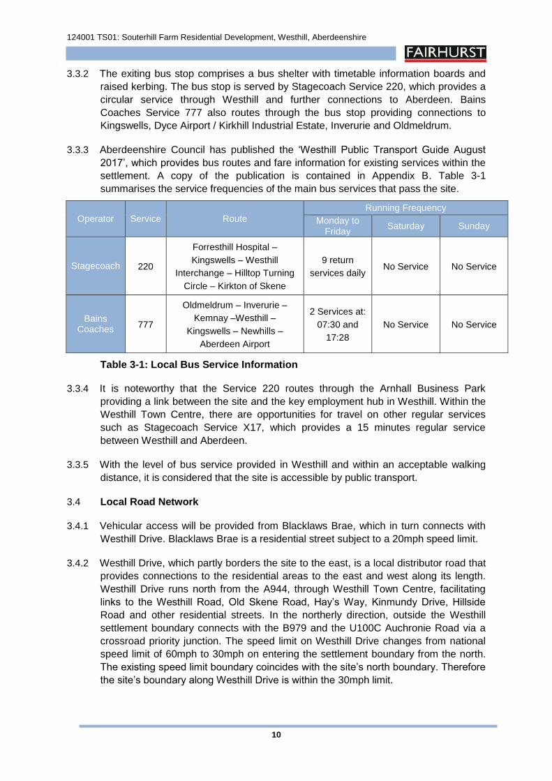
124001 TS01: Souterhill Farm Residential Development, Westhill, Aberdeenshire
10
3.3.2 The exiting bus stop comprises a bus shelter with timetable information boards and
raised kerbing. The bus stop is served by Stagecoach Service 220, which provides a
circular service through Westhill and further connections to Aberdeen. Bains
Coaches Service 777 also routes through the bus stop providing connections to
Kingswells, Dyce Airport / Kirkhill Industrial Estate, Inverurie and Oldmeldrum.
3.3.3 Aberdeenshire Council has published the ‘Westhill Public Transport Guide August
2017’, which provides bus routes and fare information for existing services within the
settlement. A copy of the publication is contained in Appendix B. Table 3-1
summarises the service frequencies of the main bus services that pass the site.
Operator Service Route
Running Frequency
Monday to Friday
Saturday Sunday
Stagecoach 220
Forresthill Hospital –
Kingswells – Westhill
Interchange – Hilltop Turning
Circle – Kirkton of Skene
9 return
services daily No Service No Service
Bains Coaches
777
Oldmeldrum – Inverurie –
Kemnay –Westhill –
Kingswells – Newhills –
Aberdeen Airport
2 Services at:
07:30 and
17:28
No Service No Service
Table 3-1: Local Bus Service Information
3.3.4 It is noteworthy that the Service 220 routes through the Arnhall Business Park
providing a link between the site and the key employment hub in Westhill. Within the
Westhill Town Centre, there are opportunities for travel on other regular services
such as Stagecoach Service X17, which provides a 15 minutes regular service
between Westhill and Aberdeen.
3.3.5 With the level of bus service provided in Westhill and within an acceptable walking
distance, it is considered that the site is accessible by public transport.
3.4 Local Road Network
3.4.1 Vehicular access will be provided from Blacklaws Brae, which in turn connects with
Westhill Drive. Blacklaws Brae is a residential street subject to a 20mph speed limit.
3.4.2 Westhill Drive, which partly borders the site to the east, is a local distributor road that
provides connections to the residential areas to the east and west along its length.
Westhill Drive runs north from the A944, through Westhill Town Centre, facilitating
links to the Westhill Road, Old Skene Road, Hay’s Way, Kinmundy Drive, Hillside
Road and other residential streets. In the northerly direction, outside the Westhill
settlement boundary connects with the B979 and the U100C Auchronie Road via a
crossroad priority junction. The speed limit on Westhill Drive changes from national
speed limit of 60mph to 30mph on entering the settlement boundary from the north.
The existing speed limit boundary coincides with the site’s north boundary. Therefore
the site’s boundary along Westhill Drive is within the 30mph limit.
124001 TS01: Souterhill Farm Residential Development, Westhill, Aberdeenshire
11
3.4.3 The B979 in the north-westerly direction provides a link to the A96(T) Aberdeen to
Inverness Trunk Road. The A96(T) in turn facilitates links to Aberdeen, Aberdeen
Airport (and surrounding employment areas), Blackburn, Kintore and Inverurie.
3.4.4 The A944 in the easterly direction provides a link in to Aberdeen and a link to the
B9119 Westhill to Tarland Road. In the westerly direction, the A944 facilitates links to
Dunecht and Alford.
3.5 Safe Routes to School
3.5.1 The proposed residential development will fall within the catchment of Westhill
Primary School and Westhill Academy. Figure 3-3 included within Appendix B
illustrates the safe routes to Westhill Primary School and Westhill Academy.
3.5.2 Westhill Primary School is located to the south, approximately 1100m (13 minutes)
walking distance from the site’s boundary on Blacklaws Brae. The school’s access is
located on Westhill Drive.
3.5.3 A good walking route exists between the site and the school, with the desired route
comprising footways along Blacklaws Brea and Westhill Drive. From the site, existing
footways along Blacklaws Brea provide a continuous link to the footway on the west
side of Westhill Drive. Traveling southbound along the Westhill Drive footway will
route to the pedestrian crossing adjacent to the school’s pedestrian access to the
south. The route requires crossing of Westhill Heights, Hay’s Way and the accesses
into Ashdale Hall and Trinity Church. There are dropped kerb crossings provided at
the above locations.
3.5.4 Westhill Academy is located on the south side of Hay’s Way, approximately 1000m
(12 minutes) walking distance from the site. Pedestrian access is via a similar route
to the primary school. However at the Hay’s Way junction, pupils would turn left
utilising the footway on the south side which in turn provides a link to the pedestrian
access into the school. Alternatively, from Westhill Drive pupils can utilise the
footpath on the south side of the golf course boundary through the residential street
on the north side of Hay’s Way. Access is via Fare Park Crescent, Fare Park Drive
and Meikle Gardens, all of which are subject to a 20mph speed limit. There is a
dropped kerb crossing on Hay’s Road which provides access into the school.
3.5.5 The existing routes to both Westhill Primary School and Westhill Academy are well lit.
124001 TS01: Souterhill Farm Residential Development, Westhill, Aberdeenshire
12
4 Development Proposal & Access Arrangements
4.1 Overview
4.1.1 The development proposal is for 68 dwellings comprising 51 private and 17
affordable with an overall accommodation schedule as follows:
2-bed Affordable Dwellings = 17
2-bed Dwellings = 9
4-bed Dwellings = 2
5-bed Dwellings = 40
4.1.2 The proposed development has been designed in line with Designing Streets,
including shared use surfaces. The existing 20mph speed limit on Blacklaws Brae
would be extended to encompass the development’s internal road network.
4.1.3 The site layout plan is shown by Halliday Fraser Munro (HFM) Drawing No.
10986sk(003)03_C contained within Appendix C and includes a full Accommodation
Schedule of the proposal.
4.2 Vehicle Access
4.2.1 Presently, Blacklaws Brea terminates on the site’s boundary adjacent to Number 17.
The development’s access proposal incorporates extending Blacklaws Brae north
into the development. The main access road comprises a 5.5m wide residential
street to be designed to the similar standard as the existing section of Blacklaws
Brae.
4.2.2 The new internal road would route through the development providing links to two
new side roads and direct access to driveways of dwellings along its length.
Internally, it would provide access to a number of courtyards serving some dwelling
within the new development. On the site’s western boundary, it would provide access
to the Souterhill Farm via an existing farm track.
4.2.3 The proposal also incorporates 5 private dwellings with direct access from Westhill
Drive, which includes a group of 4 and a single dwelling with separate accesses.
4.2.4 The remaining development and adjacent existing development on Blacklaws Brae
would have one point of access from the external road network. Therefore, AC has
confirmed that an emergency access would be required. As part of the development,
a 3m wide emergency access, with demountable bollards, will be provided from
Westhill Drive on the south side of the proposed SUDS basin.
124001 TS01: Souterhill Farm Residential Development, Westhill, Aberdeenshire
13
4.3 Pedestrian Access
4.3.1 There will be two points of access for pedestrians from the external network along
Westhill Drive. Firstly, access from the existing footways on Blacklaws Brae, which
provides links to Westhill Drive. A second pedestrian access is proposed from
Westhill Drive via a footpath to the north of the bus terminal.
4.3.2 Internally, there will be a network of footways / paths permeating through the
development, which in turn will facilitate links to the external network.
4.3.3 Pedestrian access to the north of the site is also provided, facilitating pedestrian links
through the existing tree belt along the northern boundary.
4.4 Parking
4.4.1 The parking proposed will be provided in accordance with Aberdeenshire Council
Parking Standards with parking for the private dwellings generally in the form of in-
curtilage parking provided via driveways and garages. A summary of the parking
proposals is provided below, with a full parking schedule included on the site layout
plan contained in Appendix C.
26 x 2-bed (including affordable) @ 2 spaces per unit = 52 spaces.
2 x 4-bed @ 3 spaces per dwelling = 6 spaces
40 x 5-bed @ 3 spaces per dwelling = 120 spaces
Visitor Parking @ 1 space per 4 dwellings = 17 spaces
TOTAL Parking = 195 spaces
4.4.2 As discussed with AC, car parking for the affordable housing element would be
provided at a rate of 2 spaces per dwelling.
4.4.3 The parking comprises off-street using both marked out bays and driveways.
4.4.4 Given the nature of the development, cycle parking will generally be accommodated
within the dwellings.
4.5 Servicing
4.5.1 The internal road network would be designed to accommodate service vehicles
including refuse collection vehicles.
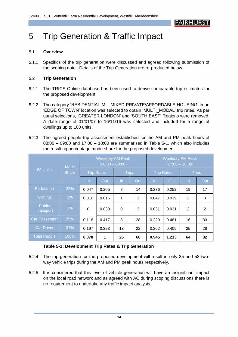
124001 TS01: Souterhill Farm Residential Development, Westhill, Aberdeenshire
14
5 Trip Generation & Traffic Impact
5.1 Overview
5.1.1 Specifics of the trip generation were discussed and agreed following submission of
the scoping note. Details of the Trip Generation are re-produced below.
5.2 Trip Generation
5.2.1 The TRICS Online database has been used to derive comparable trip estimates for
the proposed development.
5.2.2 The category ‘RESIDENTIAL M – MIXED PRIVATE/AFFORDABLE HOUSING’ in an
‘EDGE OF TOWN’ location was selected to obtain ‘MULTI_MODAL’ trip rates. As per
usual selections, ‘GREATER LONDON’ and ‘SOUTH EAST’ Regions were removed.
A date range of 01/01/07 to 16/11/16 was selected and included for a range of
dwellings up to 100 units.
5.2.3 The agreed people trip assessment established for the AM and PM peak hours of
08:00 – 09:00 and 17:00 – 18:00 are summarised in Table 5-1, which also includes
the resulting percentage mode share for the proposed development.
68 Units Mode
Share
Weekday AM Peak
(08:00 – 09:00)
Weekday PM Peak
(17:00 – 18:00)
Trip Rates Trips Trip Rates Trips
In Out In Out In Out In Out
Pedestrian 22% 0.047 0.205 3 14 0.276 0.252 19 17
Cycling 3% 0.016 0.016 1 1 0.047 0.039 3 3
Public Transport
3% 0 0.039 0 3 0.031 0.031 2 2
Car Passenger 35% 0.118 0.417 8 28 0.229 0.481 16 33
Car Driver 37% 0.197 0.323 13 22 0.362 0.409 25 28
Total People 100% 0.378 1 26 68 0.945 1.213 64 82
Table 5-1: Development Trip Rates & Trip Generation
5.2.4 The trip generation for the proposed development will result in only 35 and 53 two-
way vehicle trips during the AM and PM peak hours respectively.
5.2.5 It is considered that this level of vehicle generation will have an insignificant impact
on the local road network and as agreed with AC during scoping discussions there is
no requirement to undertake any traffic impact analysis.
124001 TS01: Souterhill Farm Residential Development, Westhill, Aberdeenshire
15
6 Residential Travel Plan Framework
6.1 Introduction
6.1.1 Paragraph 279 of SPP comments that ‘Development plans should indicate when a
travel plan will be required to accompany a proposal for a development which will
generate significant travel’.
6.1.2 Travel Plans for Residential Developments require to be tailored to the needs,
location and scale of the development. In line with best practice, it is envisaged that
the practical implementation of the Travel Plan would require the preparation of a
Residential Travel Pack.
6.2 Residential Travel Pack Aims and Objectives
6.2.1 The site would be developed in a manner to afford easy access to local facilities
within the existing settlement area. The site is suitably located to take advantage of
existing sustainable transport links to the town centre, primary and secondary
schools, which are all within 15 minutes walking distance from the site. The aim of
the emerging Residential Travel Pack would be to promote and encourage use of
more sustainable travel options rather than single occupier car journeys to and from
the proposed development.
6.2.2 The Residential Travel Pack would need to be reviewed, monitored and updated
regularly. Objectives of the emerging Residential Travel Pack would be to address
the following;
Increase awareness among residents of travel choices and implications;
Facilitate and promote more active forms of travel;
Increase the share of residents travelling to work by walking, cycling or public transport;
Promote the personal health benefits of active travel; and
Reduce single car occupancy trips by promoting car sharing.
6.3 Framework for the preparation of the Residential Travel Pack
6.3.1 The Residential Travel Pack would be completed and presented to AC for approval
prior to occupation of the first unit. It is the intention of the developer to liaise with the
Council during preparation of the Residential Travel Pack. The undernoted general
headings would form the framework for developing the Residential Travel Pack.
Clear statement of objectives of the Pack in relation to key features of the development to promote and encourage sustainable travel;
Walking and cycling maps showing existing provisions;
124001 TS01: Souterhill Farm Residential Development, Westhill, Aberdeenshire
16
Walking, cycling and public transport travel times;
Public transport information – service times at nearest stops;
Local taxi contact information;
Car sharing / Car Club scheme information including details of Getabout – afree online car sharing scheme; and
Relevant website / contacts including local groups such as – www.cycle-streets.net, www.firstgroup.com/ukbus/aberdeen,www.stagecoachbus.com/aberdeen, www.getbout.liftshare.com andwww.travelinescotland.com
6.3.2 The Travel Pack will contain information on the health benefits of active travel,
directing residents to websites such as www.sustrans.org.uk and
www.healthyliving.gov.uk. Tips for active travel include:
Think “healthy living” before you travel – every time you use your legs it doesyou good;
If your trip is less than a mile or so, try walking – or walk some of the way if itis too far;
Start your active lifestyle gently, by walking part of the way, or taking a bushome;
If you are thinking about cycling, try out your route at the weekend first; and
Try walking or cycling to work every day and see how much fitter you feel.
6.3.3 The Travel Pack should also contain information on the environmental damage of
CO2 emissions resulting from car use. Hints for reducing environmental damage
created by car use could include:
Try to avoid using a car for short journeys – use public transport, cycle orwalk;
Plan ahead – choose uncongested routes, combine trips or car share;
Cold starts – drive away as soon as possible after starting;
Drive smoothly and efficiently – harsh acceleration and heavy braking have avery significant effect on fuel consumption, driving more smoothly saves fuel;
Slow down – driving at high speeds significantly increases fuel consumption;
Use higher gears as soon as traffic conditions allow;
Switch off – sitting stationary is zero miles per gallon, switch off the enginewhenever it is safe to do so
Lose weight – don’t carry unnecessary weight, remove roof racks when not inuse.
124001 TS01: Souterhill Farm Residential Development, Westhill, Aberdeenshire
17
7 Summary and Conclusion
7.1 Summary
7.1.1 This Transport Statement has been prepared on behalf of CALA Homes in support of
a Local Development Plan bid proposal for a 68 unit residential development at
Souterhill Farm, Westhill. The proposal comprises 51 private and 17 affordable
dwellings.
7.1.2 The site is located on the northern edge of Westhill, bounded to the east by Westhill
Drive. The proposal would form a natural extension to the existing residential
neighbourhood.
Site Accessibility
7.1.3 The existing site has good accessibility by sustainable transport modes including;
walking, cycling and bus. There are good pedestrian links to the adjacent bus stop
and local facilities in the town centre as well as Westhill Primary School and Westhill
Academy.
7.1.4 Westhill has a network of dedicated cycle routes and facilities which provides
excellent cycling accessibility within the settlement and beyond. The majority of the
settlement, including key employment centres to the south of the A944, are within 12
minutes cycling distance from the site. There are further cycling opportunities to the
east and into Aberdeen using the dual use path along the A944 Westhill to Aberdeen
Road.
7.1.5 The closest bus stop is located about 160 metres from the site’s boundary on
Blacklaws Brae. The majority of the development would be within 400 metres walking
distance from the bus stop. Services from the bus stop route through the town centre
offering opportunities for onward travel using other services. With the level of bus
service provided within an acceptable walking distance of the site, the site can be
considered to be accessible by public transport in accordance with planning policy.
7.1.6 Westhill Academy is located within a 1000 metres (12 minutes) walk from the
proposed site and Westhill Primary School is located within 1100 metres (13
minutes) walk. It can therefore be concluded that the majority of children who will be
generated from the proposed development will either walk or cycle to school, which
again highlights the proposed development sites sustainable and accessible
credentials.
Proposed Development & Access Arrangements
7.1.7 The proposal comprises both private and affordable housing to ensure all housing
needs are met.
7.1.8 The proposed development has been designed in line with Designing Streets. The
proposals will include shared surfaces and traffic calming features that would
encourage low vehicular speeds within the development.
124001 TS01: Souterhill Farm Residential Development, Westhill, Aberdeenshire
18
7.1.9 Parking would be provides in accordance with Aberdeenshire Councils parking
standards.
Trip Generation & Traffic Impact
7.1.10 Specifics of the trip generation were discussed and agreed following submission of
the scoping note to Aberdeenshire Council.
7.1.11 The trip generation for the proposed development will result in 35 and 53 two-way
vehicle trips during the AM and PM peak hours respectively. This level of vehicle
generation will have an insignificant impact on the local road network and as agreed
with AC during scoping discussions there is no requirement to undertake any traffic
impact analysis.
Residential Travel Plan Framework
7.1.12 A Residential Travel Plan Framework has been included which will form the basis of
the development of a Residential Travel Pack to be made available for future
occupants.
7.2 Conclusion
7.2.1 The site is highly accessible by walking, cycling and public transport modes in
accordance with planning policy and will have an insignificant traffic impact on the
surrounding road network.
7.2.2 The site layout makes appropriate allowance for parking and can accommodate
servicing requirements.
7.2.3 The TS concludes that the proposed development is suitably located and can
integrate well with the existing transport networks in Westhill. There will be no
detrimental traffic or transport impacts.
124001 TS01: Souterhill Farm Residential Development, Westhill, Aberdeenshire
Appendix A
Scoping Correspondence
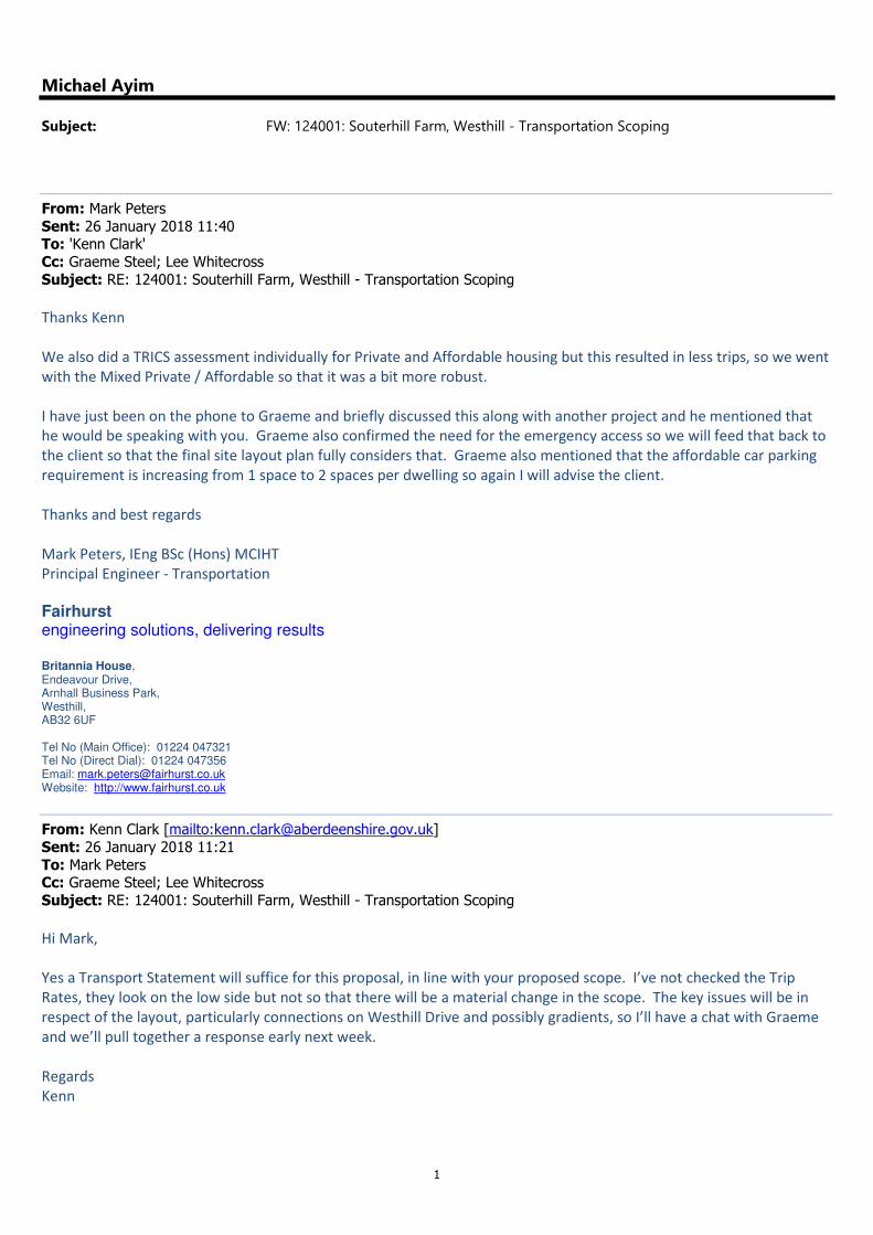
1
Michael Ayim
Subject: FW: 124001: Souterhill Farm, Westhill - Transportation Scoping
From: Mark Peters
Sent: 26 January 2018 11:40 To: 'Kenn Clark'
Cc: Graeme Steel; Lee Whitecross
Subject: RE: 124001: Souterhill Farm, Westhill - Transportation Scoping
Thanks Kenn
We also did a TRICS assessment individually for Private and Affordable housing but this resulted in less trips, so we went
with the Mixed Private / Affordable so that it was a bit more robust.
I have just been on the phone to Graeme and briefly discussed this along with another project and he mentioned that
he would be speaking with you. Graeme also confirmed the need for the emergency access so we will feed that back to
the client so that the final site layout plan fully considers that. Graeme also mentioned that the affordable car parking
requirement is increasing from 1 space to 2 spaces per dwelling so again I will advise the client.
Thanks and best regards
Mark Peters, IEng BSc (Hons) MCIHT
Principal Engineer - Transportation
Fairhurst engineering solutions, delivering results
Britannia House, Endeavour Drive, Arnhall Business Park, Westhill, AB32 6UF Tel No (Main Office): 01224 047321 Tel No (Direct Dial): 01224 047356 Email: [email protected] Website: http://www.fairhurst.co.uk
From: Kenn Clark [mailto:[email protected]]
Sent: 26 January 2018 11:21
To: Mark Peters Cc: Graeme Steel; Lee Whitecross
Subject: RE: 124001: Souterhill Farm, Westhill - Transportation Scoping
Hi Mark,
Yes a Transport Statement will suffice for this proposal, in line with your proposed scope. I’ve not checked the Trip
Rates, they look on the low side but not so that there will be a material change in the scope. The key issues will be in
respect of the layout, particularly connections on Westhill Drive and possibly gradients, so I’ll have a chat with Graeme
and we’ll pull together a response early next week.
Regards
Kenn
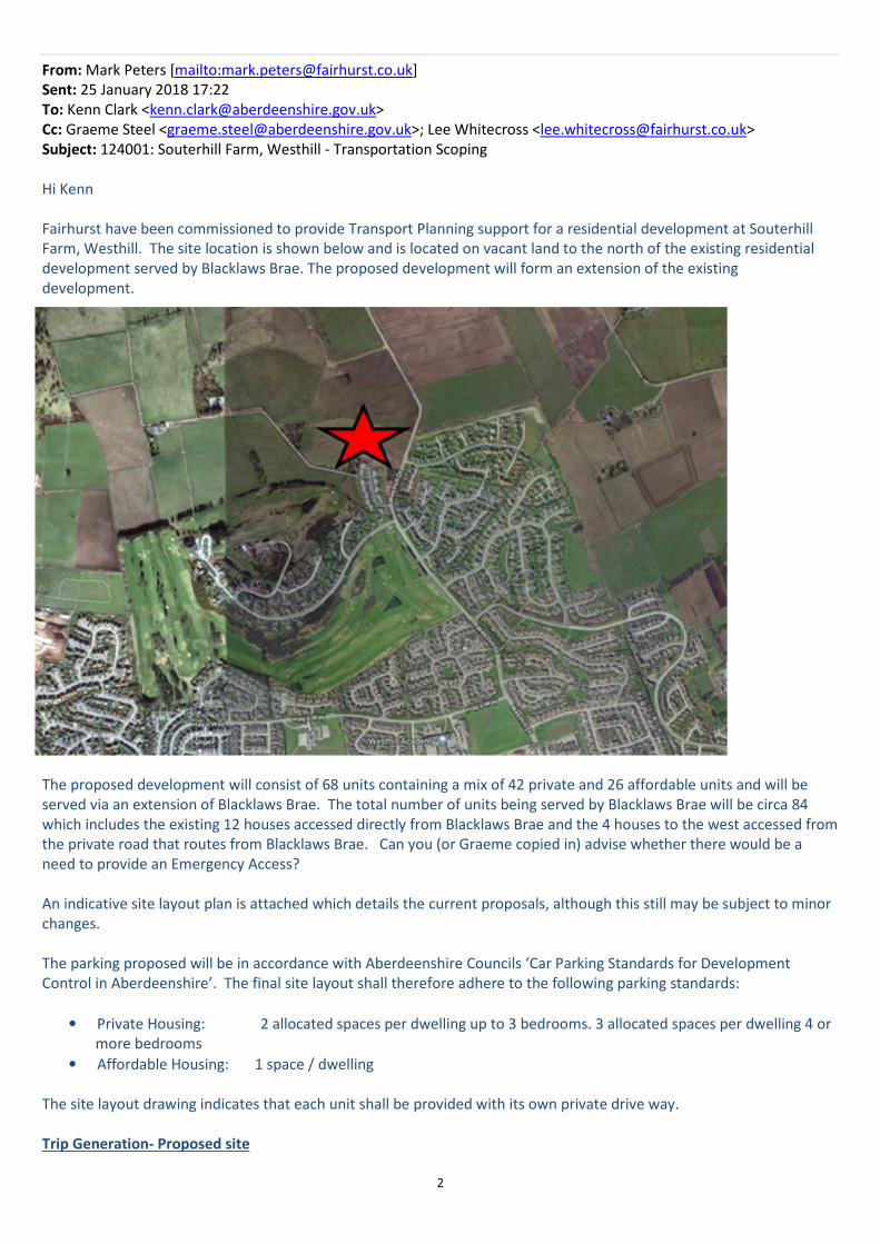
2
From: Mark Peters [mailto:[email protected]]
Sent: 25 January 2018 17:22
To: Kenn Clark <[email protected]>
Cc: Graeme Steel <[email protected]>; Lee Whitecross <[email protected]>
Subject: 124001: Souterhill Farm, Westhill - Transportation Scoping
Hi Kenn
Fairhurst have been commissioned to provide Transport Planning support for a residential development at Souterhill
Farm, Westhill. The site location is shown below and is located on vacant land to the north of the existing residential
development served by Blacklaws Brae. The proposed development will form an extension of the existing
development.
The proposed development will consist of 68 units containing a mix of 42 private and 26 affordable units and will be
served via an extension of Blacklaws Brae. The total number of units being served by Blacklaws Brae will be circa 84
which includes the existing 12 houses accessed directly from Blacklaws Brae and the 4 houses to the west accessed from
the private road that routes from Blacklaws Brae. Can you (or Graeme copied in) advise whether there would be a
need to provide an Emergency Access?
An indicative site layout plan is attached which details the current proposals, although this still may be subject to minor
changes.
The parking proposed will be in accordance with Aberdeenshire Councils ‘Car Parking Standards for Development
Control in Aberdeenshire’. The final site layout shall therefore adhere to the following parking standards:
• Private Housing: 2 allocated spaces per dwelling up to 3 bedrooms. 3 allocated spaces per dwelling 4 or
more bedrooms
• Affordable Housing: 1 space / dwelling
The site layout drawing indicates that each unit shall be provided with its own private drive way.
Trip Generation- Proposed site
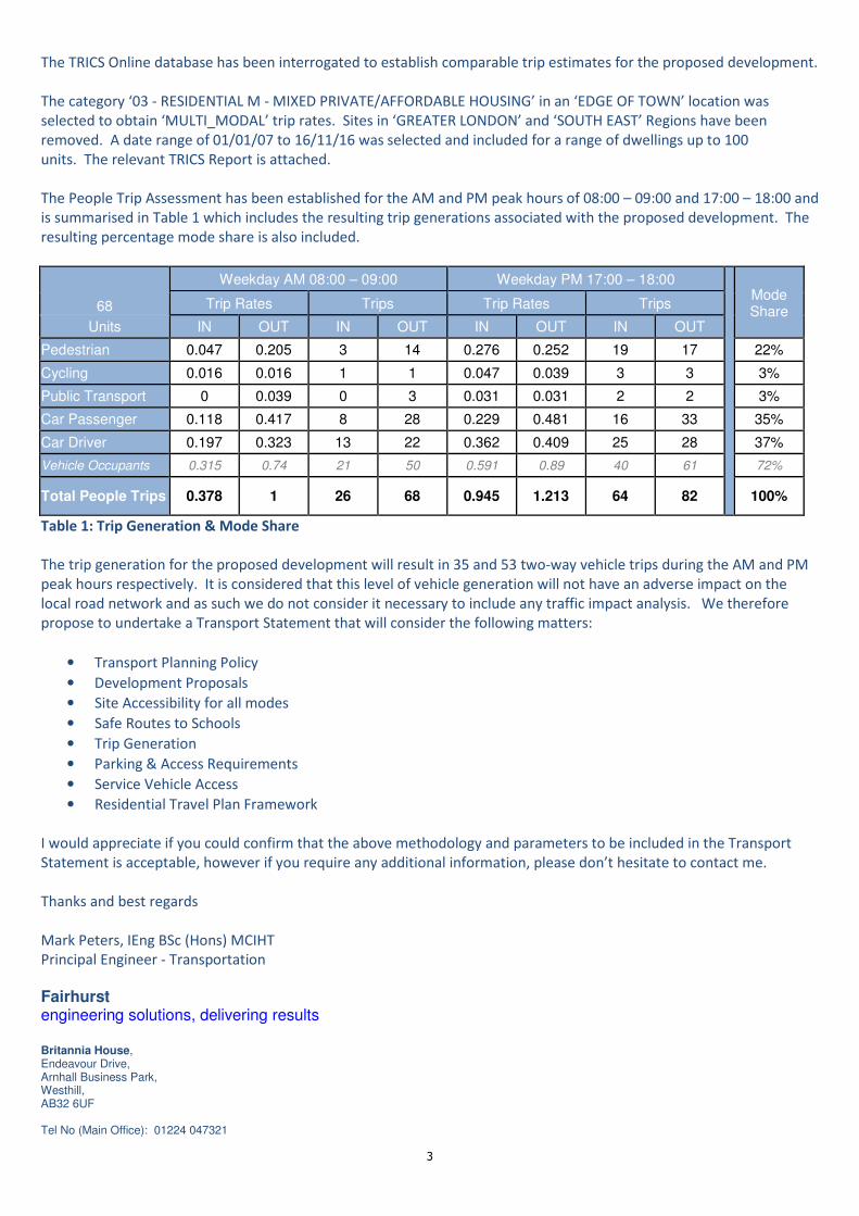
3
The TRICS Online database has been interrogated to establish comparable trip estimates for the proposed development.
The category ‘03 - RESIDENTIAL M - MIXED PRIVATE/AFFORDABLE HOUSING’ in an ‘EDGE OF TOWN’ location was
selected to obtain ‘MULTI_MODAL’ trip rates. Sites in ‘GREATER LONDON’ and ‘SOUTH EAST’ Regions have been
removed. A date range of 01/01/07 to 16/11/16 was selected and included for a range of dwellings up to 100
units. The relevant TRICS Report is attached.
The People Trip Assessment has been established for the AM and PM peak hours of 08:00 – 09:00 and 17:00 – 18:00 and
is summarised in Table 1 which includes the resulting trip generations associated with the proposed development. The
resulting percentage mode share is also included.
68
Weekday AM 08:00 – 09:00 Weekday PM 17:00 – 18:00 Mode Share
Trip Rates Trips Trip Rates Trips
Units IN OUT IN OUT IN OUT IN OUT
Pedestrian 0.047 0.205 3 14 0.276 0.252 19 17 22%
Cycling 0.016 0.016 1 1 0.047 0.039 3 3 3%
Public Transport 0 0.039 0 3 0.031 0.031 2 2 3%
Car Passenger 0.118 0.417 8 28 0.229 0.481 16 33 35%
Car Driver 0.197 0.323 13 22 0.362 0.409 25 28 37%
Vehicle Occupants 0.315 0.74 21 50 0.591 0.89 40 61 72%
Total People Trips 0.378 1 26 68 0.945 1.213 64 82 100%
Table 1: Trip Generation & Mode Share
The trip generation for the proposed development will result in 35 and 53 two-way vehicle trips during the AM and PM
peak hours respectively. It is considered that this level of vehicle generation will not have an adverse impact on the
local road network and as such we do not consider it necessary to include any traffic impact analysis. We therefore
propose to undertake a Transport Statement that will consider the following matters:
• Transport Planning Policy
• Development Proposals
• Site Accessibility for all modes
• Safe Routes to Schools
• Trip Generation
• Parking & Access Requirements
• Service Vehicle Access
• Residential Travel Plan Framework
I would appreciate if you could confirm that the above methodology and parameters to be included in the Transport
Statement is acceptable, however if you require any additional information, please don’t hesitate to contact me.
Thanks and best regards
Mark Peters, IEng BSc (Hons) MCIHT
Principal Engineer - Transportation
Fairhurst engineering solutions, delivering results
Britannia House, Endeavour Drive, Arnhall Business Park, Westhill, AB32 6UF Tel No (Main Office): 01224 047321
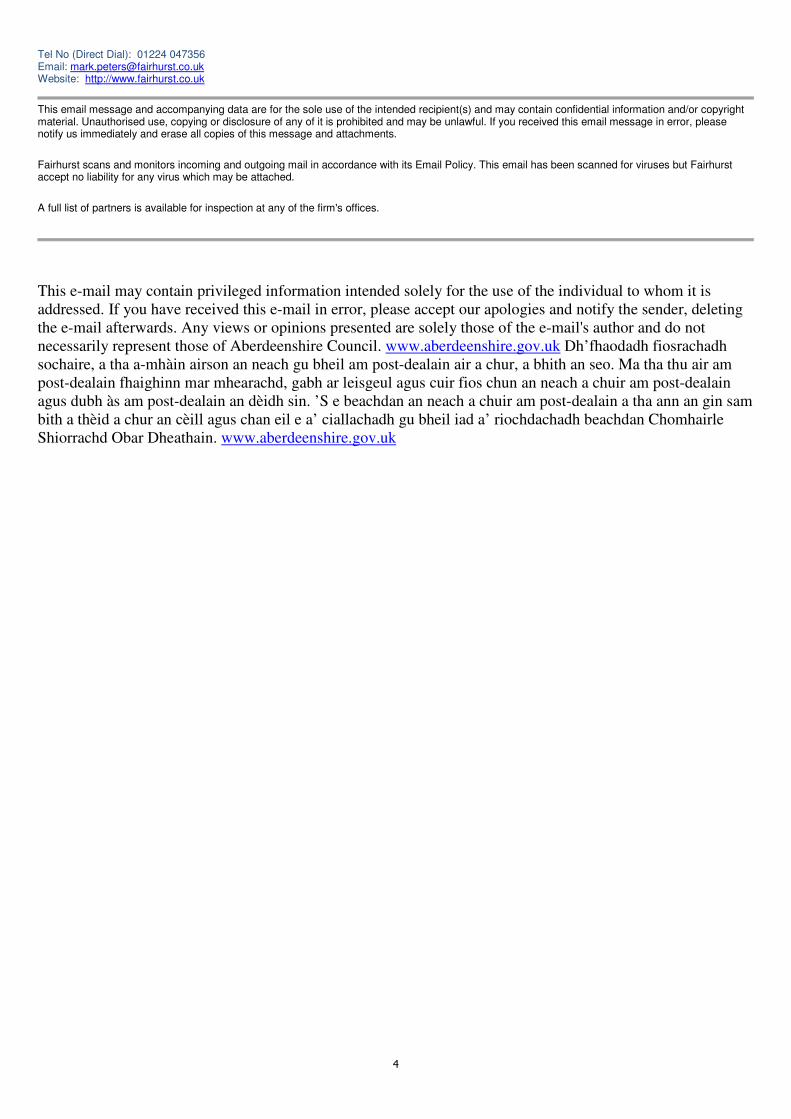
4
Tel No (Direct Dial): 01224 047356 Email: [email protected] Website: http://www.fairhurst.co.uk
This email message and accompanying data are for the sole use of the intended recipient(s) and may contain confidential information and/or copyright material. Unauthorised use, copying or disclosure of any of it is prohibited and may be unlawful. If you received this email message in error, please notify us immediately and erase all copies of this message and attachments.
Fairhurst scans and monitors incoming and outgoing mail in accordance with its Email Policy. This email has been scanned for viruses but Fairhurst accept no liability for any virus which may be attached.
A full list of partners is available for inspection at any of the firm's offices.
This e-mail may contain privileged information intended solely for the use of the individual to whom it is
addressed. If you have received this e-mail in error, please accept our apologies and notify the sender, deleting
the e-mail afterwards. Any views or opinions presented are solely those of the e-mail's author and do not
necessarily represent those of Aberdeenshire Council. www.aberdeenshire.gov.uk Dh’fhaodadh fiosrachadh
sochaire, a tha a-mhàin airson an neach gu bheil am post-dealain air a chur, a bhith an seo. Ma tha thu air am
post-dealain fhaighinn mar mhearachd, gabh ar leisgeul agus cuir fios chun an neach a chuir am post-dealain
agus dubh às am post-dealain an dèidh sin. ’S e beachdan an neach a chuir am post-dealain a tha ann an gin sam
bith a thèid a chur an cèill agus chan eil e a’ ciallachadh gu bheil iad a’ riochdachadh beachdan Chomhairle
Shiorrachd Obar Dheathain. www.aberdeenshire.gov.uk

124001 TS01: Souterhill Farm Residential Development, Westhill, Aberdeenshire
Appendix BAccessibility Maps
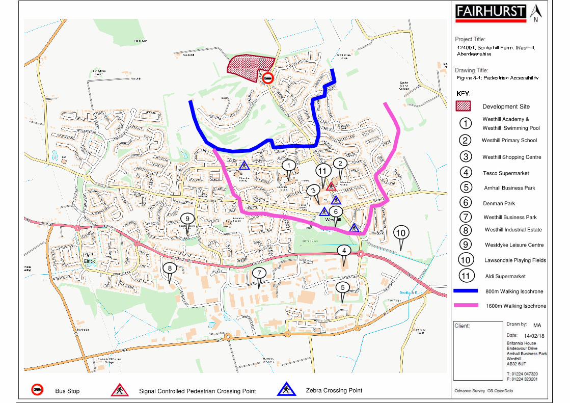
MA
124001, Souterhill Farm, Westhill, Aberdeenshire
14/02/18
1
4
5
69
87
10
Bus Stop Signal Controlled Pedestrian Crossing Point Zebra Crossing Point
11
Figure 3-1: Pedestrian Accessibility KEY:KEY:KEY:KEY:Westhill Academy &
Westhill Swimming Pool
Westhill Primary School
Westhill Shopping Centre
Tesco Supermarket
Arnhall Business Park
Denman Park
800m Walking Isochrone
1600m Walking Isochrone
Westhill Industrial Estate
Westhill Business Park
Lawsondale Playing Fields
1
2
3
4
5
6
7
8
Westdyke Leisure Centre9
10
Development Site
Aldi Supermarket11
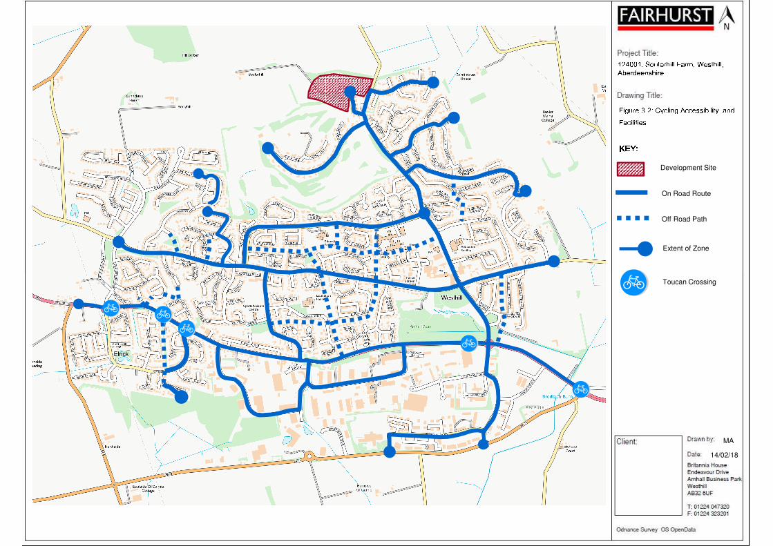
Figure 3-2: Cycling Accessibility and Facilities
MA
124001, Souterhill Farm, Westhill, Aberdeenshire
14/02/18
KEY:KEY:KEY:KEY:Development Site
On Road Route
Off Road Path
Extent of Zone
Toucan Crossing
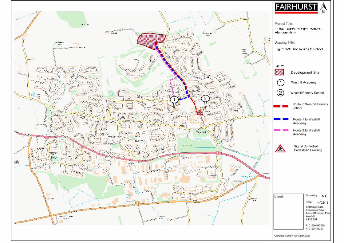
Figure 3-3: Safe Routes to School124001, Souterhill Farm, Westhill, AberdeenshireKEY:KEY:KEY:KEY:
Westhill Academy
Westhill Primary School
Route to Westhill Primary
School
Route 1 to Westhill
Academy
1
2
Development Site
Route 2 to Westhill
Academy
MA
14/02/18
1
Signal Controlled
Pedestrian Crossing
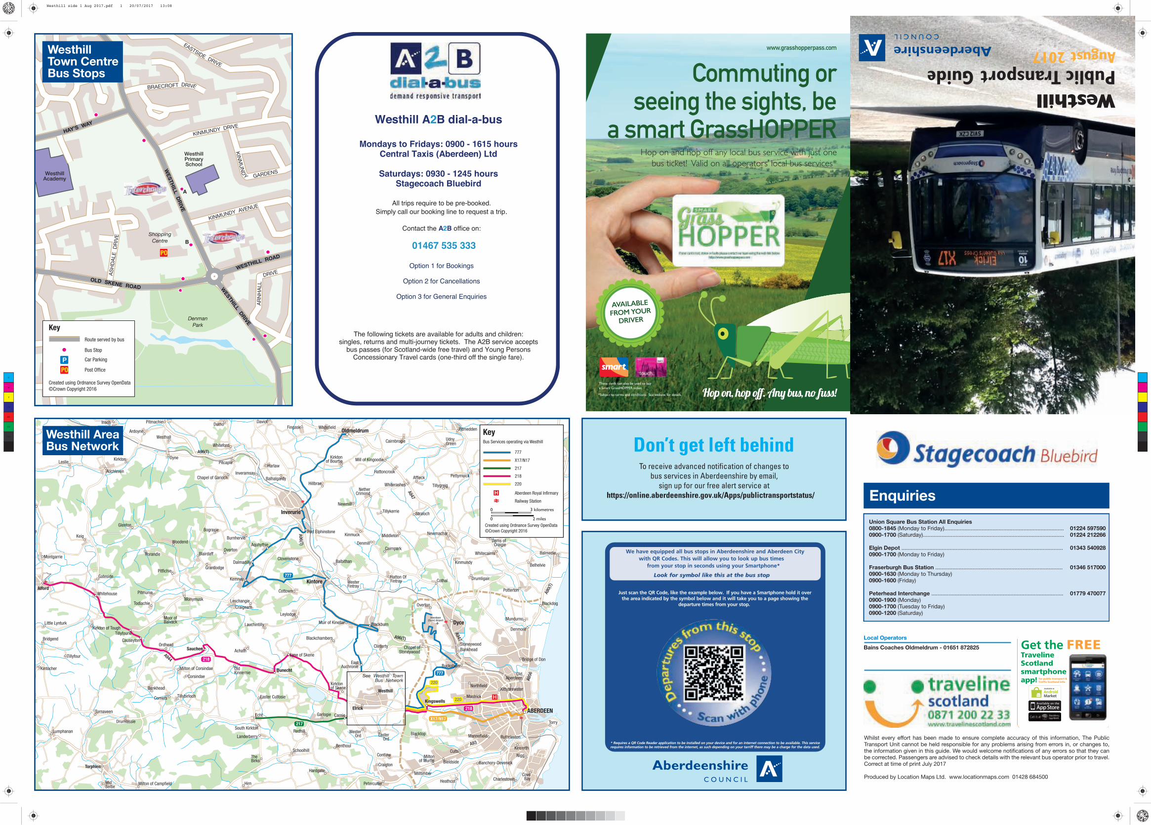
KINMUNDY AVENUE
WesthillAcademy
WesthillPrimarySchool
WESTH
ILL D
RIV
E
WESTHILL ROAD
WE
ST
HIL
L
DR
IVE
OLD SKENE ROAD
KINMUNDY DRIVE
EASTSIDE DRIVE
HAY’S WAY
AR
NH
ALL
DRIVEA
SH
DA
LE
D
RIV
E
BRAECROFT DRIVE
KIN
MU
ND
Y
GARDENS
A
B
Denman
Park
Shopping
Centre
Key
Route served by bus
Bus Stop
Car Parking
Post Office
Created using Ordnance Survey OpenData
©Crown Copyright 2016
P
PO
PO
WesthillTown CentreBus Stops
A90
(T)
A96(T)
A96(T
)
A96(T)
A944
A956
A947
A947
A93
Insch Durno
Duncanstone
Leslie
Auchleven
Kirkton
Ardoyne
Oyne
Westhall
Whiteford
Pitcaple
Fingask
Daviot
wn
InveramsayChapel of Garioch Balhalgardy
Hillbrae
Kirktonof Bourtie
ullynessle
Montgarrie
Keig
Glenton
Rorandle Blairdaff
Grantlodge
Bograxie
Burnhervie
Aquhythie
Port Elphinstone
ClovenstoneBalbithan
Kinmuck Middleton
Cairnpark
NetherCrimond
Whiterashes
Tillykerrie
Hattoncrook
Cairnbrogie
Mill of Kingoodie
Alford
Whitehouse Pitmunie
Moor ofBalvack
Monymusk
Pitfichie
Craigearn
Kemnay
Leylodge
Cottown
WesterFintray
Hatton OfFintray
Overton
Cothal
Newmachar
Kinmundy
Straloch
Affleck
Tillygreig
UdnyGreen
Pitmedden
Little LynturkKirkton of Tough
Tillyfourie
OrdheadSauchen Achath
OldKinnernie
Lauchintilly
Lyne of Skene
EastAuchronie
Blackburn
Clinterty Chapel ofStoneywood
Bankhead
Bucksburn
Stoneywood
Drumligair
Craigie
Whitecairns
UdnyPettymuick Cultercullen
Kintocher
Tornaveen
Bankhead
Milton of Corsindae
Comers
Corsindae
Dunecht
Kirktonof Skene
Elrick
Westhill
KingswellsMastrick
NorthfieldKittybrewster
OldAberdeen
Bridge of Don
Denmore
Mundurno
Potterton
Blackdog
Belhelvie
Causeyend
Balmedie
Middlemuir
Minnes
Delfrigs
Tipperty
Lumphanan
Drumlassie
Echt
South Kirkton
Landerberry
Redhill
Schoolhill
Garlogie Carnie
Benthoul
EasterOrd
Contlaw
Blacktop
Bieldside
Miltonof Murtle
Cults
Mannofield Ruthrieston
Banchory-Devenick
Kincorth
Torry
Nigg
Foveran
MidBeltie
Torphins
Milton of Campfield Hirn
Hardgate
Craigton
Peterculter
Milltimber CoveBayCharlestown
Pitmachie
Harlaw
Newmill
Whitefield
Woodend
Overton
Dalmadilly
Denmill
Gateside
TodlachieLeschangie
Bridgend
Tillyfour
CauseytonBlackchambers
Muir of Kinellar
Dams ofCraigie
Tillybirloch Easter Culfosie
Cairnhill
TheBirks
WesterOrd
Heathcot
Inverurie
Oldmeldrum
Kintore
Dyce
ABERDEEN
Aberdeen(Dyce) Airport
777
777
X17/N17
218
218
217
220
220
KeyBus Services operating via Westhill
777
X17/N17
217
218
220
Railway Station
Aberdeen Royal Infirmary
Created using Ordnance Survey OpenData
©Crown Copyright 2016
See Westhill TownBus Network
H
H
3 kilometres0
0 2 miles
Westhill AreaBus Network Don’t get left behind
To receive advanced notification of changes to
bus services in Aberdeenshire by email,
sign up for our free alert service at
https://online.aberdeenshire.gov.uk/Apps/publictransportstatus/
We have equipped all bus stops in Aberdeenshire and Aberdeen City
with QR Codes. This will allow you to look up bus times
from your stop in seconds using your Smartphone*
Look for symbol like this at the bus stop
* Requires a QR Code Reader application to be installed on your device and for an internet connection to be available. This servicerequires information to be retrieved from the internet, as such depending on your tarriff there may be a charge for the data used.
Just scan the QR Code, like the example below. If you have a Smartphone hold it over the area indicated by the symbol below and it will take you to a page showing the
departure times from your stop.
Hop on, hop off. Any bus, no �ss!
Hop on and hop off any local bus service with just one bus ticket! Valid on all operators’ local bus services*
www.grasshopperpass.com
AVAILABLE
FROM YOUR
DRIVER
Commuting or seeing the sights, be
a smart GrassHOPPER
*Subject to terms and conditions. See website for details.
These cards can also be used to buy
a Smart GrassHOPPER ticket.
All trips require to be pre-booked.
Simply call our booking line to request a trip.
Contact the A2B office on:
01467 535 333
Option 1 for Bookings
Option 2 for Cancellations
Option 3 for General Enquiries
Westhill A2B dial-a-bus
Mondays to Fridays: 0900 - 1615 hours Central Taxis (Aberdeen) Ltd
Saturdays: 0930 - 1245 hours
Stagecoach Bluebird
The following tickets are available for adults and children: singles, returns and multi-journey tickets. The A2B service accepts
bus passes (for Scotland-wide free travel) and Young Persons Concessionary Travel cards (one-third off the single fare).
Enquiries
Union Square Bus Station All Enquiries
0800-1845 (Monday to Friday)............................................................................. 01224 597590
0900-1700 (Saturday)........................................................................................... 01224 212266
Elgin Depot ........................................................................................................ 01343 540928
0900-1700 (Monday to Friday)
Fraserburgh Bus Station .................................................................................. 01346 517000
0900-1630 (Monday to Thursday) 0900-1600 (Friday)
Peterhead Interchange ..................................................................................... 01779 470077
0900-1900 (Monday)0900-1700 (Tuesday to Friday)0900-1200 (Saturday)
Local Operators
Bains Coaches Oldmeldrum - 01651 872825
Whilst every effort has been made to ensure complete accuracy of this information, The PublicTransport Unit cannot be held responsible for any problems arising from errors in, or changes to, the information given in this guide. We would welcome notifications of any errors so that they canbe corrected. Passengers are advised to check details with the relevant bus operator prior to travel.Correct at time of print July 2017
Produced by Location Maps Ltd. www.locationmaps.com 01428 684500
Get the FREETravelineScotland smartphoneapp! for public transport &
Traffic Scotland info
Westhill
Public Transport GuideAugust 2017
C
M
Y
CM
MY
CY
CMY
K
Westhill side 1 Aug 2017.pdf 1 20/07/2017 13:08
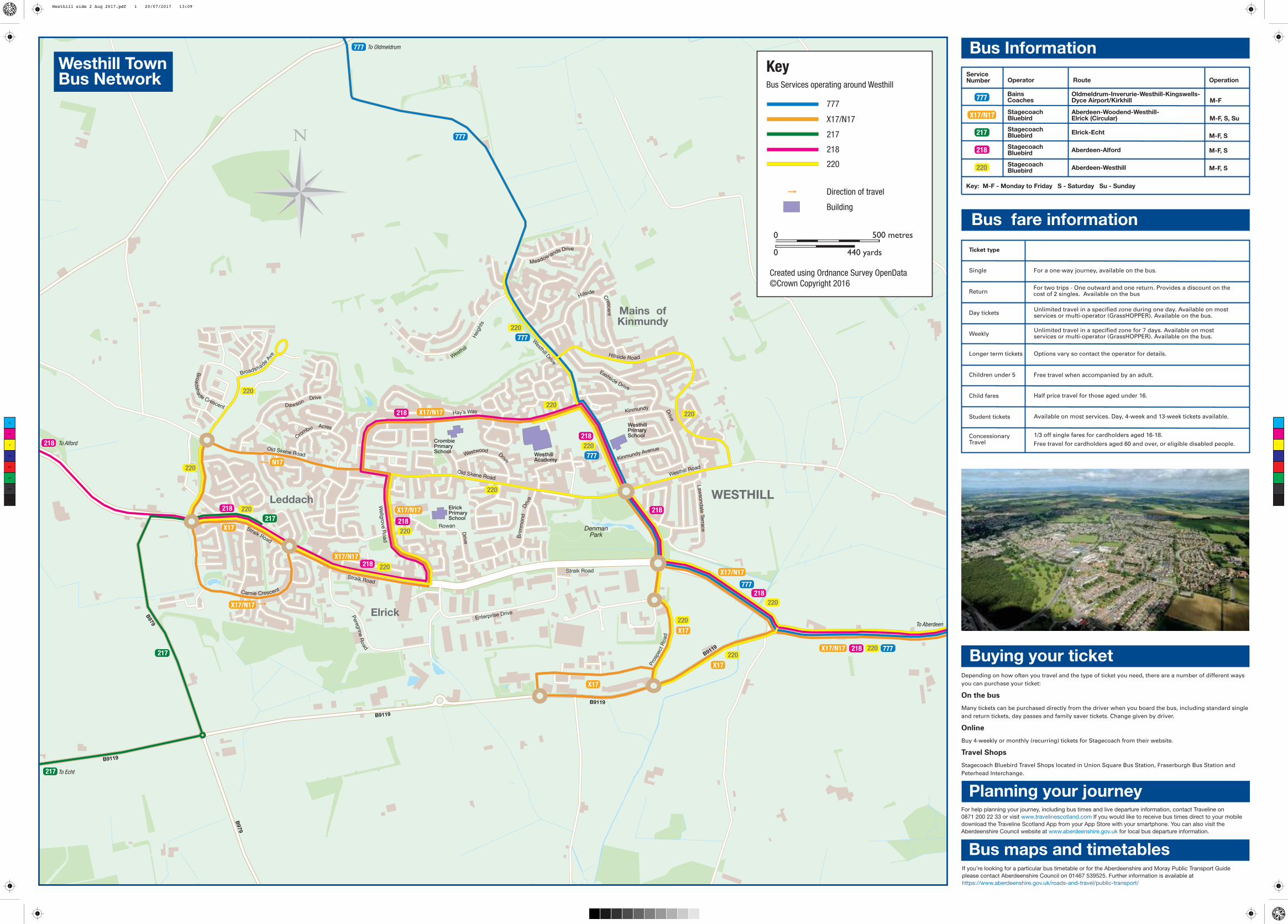
B9119
B9119
B979
B9119
B9119
B979
WESTHILL
Elrick
Leddach
Mains ofKinmundy
Meadowlands Drive
Hillside
Cres
cen
t
DawsonDrive
Hillside Road
Hay’s Way Kinmundy Drive
Old Skene Road
Kinmundy Avenue
Westhill Road
Brim
mo
nd
Drive
Eastside Drive
Cro
mbieAcres
WestwoodDrive
Wellg
rove R
oad
Law
so
nd
ale
Terra
ce
Carnie Crescent
Straik Road
Pere
grin
e R
oad
Old Skene Road
Driv
e
Rowan
Straik Road
Straik Road
Enterprise Drive
Westhill
Heig
hts
Westhill D
rive
WesthillAcademy
CrombiePrimarySchool
ElrickPrimarySchool
WesthillPrimarySchool
Bro
ad
sh
a
de Crescent
Broadshade Ave
Pro
spect
Ro
ad
Denman
Park
KeyBus Services operating around Westhill
777
X17/N17
217
218
220
Direction of travel
Building
Created using Ordnance Survey OpenData
©Crown Copyright 2016
500 metres0
0 440 yards
777
777
777
777
X17/N17
X17/N17
X17/N17
X17/N17
X17/N17
217
X17/N17
X17
X17
777
X17
217 220
220
220
220
218
218
220
217
218
218
218
218
218
218
218
220
220
220
777
220
220
220
220
220
X17
220
N17
To Oldmeldrum
To Alford
To Echt
To Aberdeen
Westhill Town Bus Network
For help planning your journey, including bus times and live departure information, contact Traveline on
0871 200 22 33 or visit www.travelinescotland.com If you would like to receive bus times direct to your mobile
download the Traveline Scotland App from your App Store with your smartphone. You can also visit the
Aberdeenshire Council website at www.aberdeenshire.gov.uk for local bus departure information.
Buying your ticket
Planning your journey
Bus maps and timetables
Bus Information
Depending on how often you travel and the type of ticket you need, there are a number of different ways
you can purchase your ticket:
On the bus
Many tickets can be purchased directly from the driver when you board the bus, including standard single
and return tickets, day passes and family saver tickets. Change given by driver.
Online
Buy 4-weekly or monthly (recurring) tickets for Stagecoach from their website.
Travel Shops
Stagecoach Bluebird Travel Shops located in Union Square Bus Station, Fraserburgh Bus Station and
Peterhead Interchange.
If you’re looking for a particular bus timetable or for the Aberdeenshire and Moray Public Transport Guide
please contact Aberdeenshire Council on 01467 539525. Further information is available at
https://www.aberdeenshire.gov.uk/roads-and-travel/public-transport/
ServiceNumber Operator
StagecoachBluebird
BainsCoaches
StagecoachBluebird
StagecoachBluebird
StagecoachBluebird
Key: M-F - Monday to Friday S - Saturday Su - Sunday
Oldmeldrum-Inverurie-Westhill-Kingswells-Dyce Airport/Kirkhill
Aberdeen-Woodend-Westhill-Elrick (Circular)
Elrick-Echt
Aberdeen-Alford
Aberdeen-Westhill
M-F, S
M-F, S
M-F, S
M-F, S, Su
M-F
Route Operation
Bus fare information
Ticket type
Single For a one-way journey, available on the bus.
For two trips - One outward and one return. Provides a discount on thecost of 2 singles. Available on the bus
Unlimited travel in a specified zone during one day. Available on mostservices or multi-operator (GrassHOPPER). Available on the bus.
Options vary so contact the operator for details.
Unlimited travel in a specified zone for 7 days. Available on mostservices or multi-operator (GrassHOPPER). Available on the bus.
Free travel when accompanied by an adult.
Half price travel for those aged under 16.
Available on most services. Day, 4-week and 13-week tickets available.
1/3 off single fares for cardholders aged 16-18.
Free travel for cardholders aged 60 and over, or eligible disabled people.
Return
Day tickets
Weekly
Longer term tickets
Children under 5
Child fares
Student tickets
ConcessionaryTravel
777
217
218
220
X17/N17
C
M
Y
CM
MY
CY
CMY
K
Westhill side 2 Aug 2017.pdf 1 20/07/2017 13:09

124001 TS01: Souterhill Farm Residential Development, Westhill, Aberdeenshire
Appendix CSite Layout Plan - HFM Drawing No. 10986SK(00) 03_C
3
2
0
m
(
3
5
0
y
d
s
)
o
r
t
h
e
r
e
b
y
1
6
0
m
(o
r th
e
re
b
y)
ACCESS TO PRACTICE AREA FROM CLUBHOUSE
EXISTING TRACK TO FARM LINKED TO
HOUSING DEVELOPMENT
EXISTING TREE BELT
PROPOSED COMMUNITY PARKLAND
+ WOODLAND WALKS
EXISTING MATURE
WOODLAND
SUDS
EXISTING TREE BELT TO GOLF CLUB
W
E
S
T
H
I
L
L
C
L
U
B
H
O
U
S
E
GOLF COURSE
EXISTING SOUTERHILL FARM
POTENTIAL GOLF PRACTICE AREA
A
A
A
A
A
A
A
A
A
A
A
A
A
A
A
A
A
1
2
3
4
5
6
7
8
9
10
11
12
13
14
15
16
17
18
19
20
21
22
23
24
25
26
27
28
29
30
31
32
33
34
35
36
37
38
39
40
41
42
43
44
45
46
47
48
49
50
51
52
53
54
55
56
57
58
59
60
61
62
63
64
65
66
67
68
48
48
49
49
50
50
51
51
53
53
54
54
46
45
45
55
55
46
47
47
44
44
42
42
60
60
61
61
64
64
65
65
66
66
67
67
56
56
57
57
52
52
58
58
59
59
63
63
62
62
43
43
V
V
V
V
V
V
V
V
V
V
V
V
V
V
V
V
V
Copyright of this drawing subsists in Halliday Fraser Munro
Scale:
Date:
Dwg No:
Masterplan at Souterhill, Westhill
CALA Homes (North) Limited
Sketch Layout
1:1250 @ A1
January 2018
10986 SK(00)03_C
Accommodation Schedule
House Type Beds No. Parking
Belford (affordable) 2 17 34Belford (private) 2 9 18Cleland 4 2 6Crichton 5 5 15Garvie 5 3 9Kennedy 5 6 18Lowther 5 4 12Lewis 5 7 21Melville 5 5 15Macrae 5 4 12Moncrief 5 6 18
Total No. 68 178
Gross Site Area (red line) 31.3 acres
Housing Site Area 14.6 acres
POS - Within Housing Site 5.9 acres
POS - Golf Range Site Area 10.4 acres
POS - Woodland Walks 6.2 acres
Total POS 22.5 acres (72%)
Net Site Area 8.8 acres
Affordable provision based on Aberdeenshire Local Development Plan 2017 @ 25% of total unit no.
A = Affordable types.
Open space provision based on Aberdeenshire Local Development Plan 2017 @ 40% for Major
Development.
Private parking based on Aberdeenshire Parking Standards 2001 @ 2 per 1-3 bed house, 3 per 4+
bed house, 1.5 per 1-2 bed flat.
Private parking provided in the form of 2 no. spaces on minimum 5.5m x 6m driveway and 1 no.
space within internal garage dimension of minimum 6mx3m.
Affordable parking based on expected future parking standards of 2 per HA house and 1 per 1-2 bed
HA flat.
Visitor parking based on 1 per 4 dwellings = 17 spaces.
Notes
Layout based on OS information and topographical survey by others.
Refer to engineer information for roads, SUDS, proposed levels and proposed and existing services
(including details of existing gas main).
0 10 20 40 60 100m
Revision A 05-02-18 Red line amended, design development.
Revision B 28-02-18 Design development.
Revision C 27-03-18 Layer type changes. Parking schedule added.

www.fairhurst.co.uk
Aberdeen Bristol
Dundee Edinburgh
Elgin Glasgow
Inverness
Leeds London
Manchester Newcastle upon Tyne
Sheffield Watford
Wellesbourne
CIVIL ENGINEERING • STRUCTURAL ENGINEERING • TRANSPORTATION • ROADS & BRIDGES
PORTS & HARBOURS • GEOTECHNICAL & ENVIRONMENTAL ENGINEERING • PLANNING &
DEVELOPMENT • WATER SERVICES • CDM COORDINATOR SERVICES
fnapier
Text Box
GR133