Cartographies of Friendship, Desire, and Home; Notes on surviving neoliberal security regimes.


© 2014 Duke University Press
All rights reserved
Printed in the United States of América on acid-free paper <
Typeset in Scala and Meta type by BW&A Books, Inc.
Library of Congress Cataloging-in-Publication Data
Formations of United States colonialism / Alyosha Goldstein, editor.
pages cm
Includes bibliographical references and Índex.
isbn 978-0-8223-5796-4 (hardcover : alk. paper)
isbn 978-0-8223-5810-7 (pbk.: alk. paper)
isbn 978-0-8223-7596-8 (e-book)
1. United States—Territories and possessions—History.
2. Colonization—History.
3. Colonies—History. 1. Goldstein, Alyosha.
JV527.F672014
325'.373-dc23
2014026095
Cover art: Merritt Johnson, Blowing Out the Border (Sonoran Desert) (detail),
courtesy of the artist.
Title page art: Map ofthe Routepursued in 1849 by the US Troops ... ,inan ex-
pedition against the Navajo Indians. Drawn by Edward Kern. Photo Courtesy
ofthe Newberry Library, Chicago.

LANNYTHOMPSON
Governmentality and Cartographies
of Colonial Spaces
The "Progressive Military Map of Puerto Rico," 1908-1914
In 1908, the recently formed "Porto Rico Regiment of Infantry" assigned
three officers to produce a topographical, tactical map of Puerto Rico, which
scarcely ten years prior had become a possession of the United States. One
of these officers, Lieutenant William Henry Armstrong, created a number
of detailed field books in which he documented his topographical work
and, in addition, provided descriptions, including sketches, postcards, and
photographs oftowns and villages, the countryside, and the transportation
networks that linked them. The Army War College printed the topographi
cal map of Puerto Rico in twelve quadrants in 1914, but it has only recently
been rediscovered.1 By means of a cióse examination of these cartographic
materials, this chapter will examine the intersecting processes ofimposing
sovereignty, establishing disciplinary institutions, and exercising govern-
mental rationality in the colony of Puerto Rico. First, I will show how the
military map traced the división of coercive power between military and
pólice forces. Second, I will consider the spatial dispersal of disciplinary
institutions—the military service, the pólice forcé, and the public schools—
in Puerto Rico. Finally, I will examine the cartography of appropriation,
reconfiguration, and modification of economic spaces and transportation
networks that linked them. With military cartography as our point of de-
parture, the intent of this chapter is to shed light on the deployment of
techniques of power as a means of creating colonial spaces. This chapter
will show how cartography divided and distributed sovereign functions over

the territory, how it visualized the dispersal ofdisciplinary institutions, and
how it represented the population and its political economy. In short, this
chapter seeks to discover the ways in which the U.S. imperial state created,
normalized, and documented variegated colonial spaces.
IMPERIAL FORMATIONS, GOVERNMENTALITIES,
AND CARTOGRAPHIES OF COLONIAL SPACES
Much of Michel Foucault's work focused on different techniques of power
and their effects on subjects. His concept of "governmentality" defined the
objects, forms of power, mechanisms, and historical expansión of the ra-
tionality associated with the rise ofmodern states. First, the objects of gov-
ernmental rationality are populations, which are understood in the terms
of political economy and the demography ofcivil society. Biopolitics, which
seeks to manage and foster "life" and well-being, is an essential technique.
Second, governmental rationality differs from, but is articulated with, the
rationalities of sovereignty and discipline. "Sovereignty" refers to the ex-
ercise of authority over political subjects by means of laws, decrees, and
coercive apparatuses. "Discipline" refers to the techniques ofregulating and
normalizing bodies, their forces and capacities, in the context ofinstitutions
such as schools, prisons, military barracks, factories, monasteries, and so
forth. One might summarize the different rationalities—governmental, sov-
ereign, and disciplinary—in terms oftheir objects ofobservation, jüdgment,
and normalization: populations, political subjects, and bodies, respectively.
Third, governmental rationality deploys techniques and apparatuses, such
as the census, that produce knowledge about the population in order to
effectively promote that conduct conducive to prosperity and well-being. In
this way, it provides for state security just as much as the coercive appara
tuses such as armies, pólice forces, and surveillance agencies. Finally, the
history ofthe modern state may be theorized as the "governmentalization of
the state," a process through which the governmental rationality gradually
reinscribes, recodes, and predominates over the rationalities of sovereignty
and discipline.2 In this sense, "governmentality," in the broad sense of the
term, refers to the configuration of three intersecting elements of power:
governmental rationality, discipline, and sovereignty.
Foucault's theorization was oriented, above all, toward liberal European
states. What, then, of colonial states? The question at hand is whether gov
ernmentality takes on a particular configuration in the colonies.3 Mitchell
Deán has argued that the liberal state regularly divides the population into
290 LANNYTHOMPSON

trióse who qualify as political subjects and those who do not possess the
attributes necessary for the full rights ofcitizenship. Indeed, liberal democ-
racies often discrimínate against internal populations by means ofethnic or
racial criteria, as this volume amply demonstrates. Likewise, they commonly
establish nonliberal, or authoritarian, governments in their colonies.4 Deán
concluded that "authoritarian governmentality" differs from liberalism in
that it delimits subject populations (whether internal or colonial), denies
their capacities and rights as citizens, and expects unquestioned obedience.
Authoritarian governmentality deploys more intensive and general "sov-
ereign instruments of repression" in order to neutralize or eliminate any
opposition to the dominant state formation. In this context, racism becomes
a way of consolidating "national" populations, ensuring their welfare, and
protecting them from the perceived contamination of internal or external
"others."5
One possible reading ofthis theorization is that colonial governmentality
is simply an instance of authoritarian governmentality. While not incor-
rect, this interpretation seems too simplistic. Stephen Legg argued that
sovereignty, discipline, and governmental rationality intersect in unique and
múltiple configurations in the colonies and urged us to carefully consider
the specificities ofcolonial governmentalities, which may vary considerably
over time and place. In his contribution to the debate over the "colonial
difference," Legg concluded that the colonial state deployed more violence
(techniques of sovereignty), invested less in disciplinary institutions, and
used governmental rationalities to exelude, racialize, and pathologize sub
ject populations. Furthermore, the state favored economic enterprises that
were less modern and more extractive and exploitative. In addition, in his
thorough study of urban development in Delhi, India, he found that the
organization and representation of space was a central mechanism of ex
clusión and control.6 James Duncan reached similar conclusions regarding
nineteenth-century Ceylon, where the colonial state focused on practices of
surveillance, coerción, and corporal punishment to ensure the extraction of
agricultural wealth. He concluded that the colonial state, for the most part,
"rejected governmentality in favour of authoritarian biopower."7
Similarly, Achule Mbembe noted that Foucault's concept of biopolitics
did not adequately explain the "practical conditions in which the sovereign
claims the right to kill, to allow to live, or to expose to death." He coined
the term "necropolitics" to refer to the sovereign right to decide who may
live and who should die. He argued that governmental rationality in the
colonies was directed less toward biopolitics (the promotion of the life of
GOVERNMENTALITY AND CARTOGRAPHIES 291

populations) and discipline (the institutional control of bodies), and more
toward necropolitics (the separation ofthe population into those who should
live and the massacre of those who should die). According to Mbembe, two
additional principies of sovereignty, the state of exception and the state of
siege, formed the basis of necropolitics. The state of exception defined the
colony as outside the norms of the modern state while the state of siege
treated some segments ofthe populations as the enemy.8 First, the "right" of
the state was absolute and, consequently, "rights" were absent for subjects,
who were not treated as viable citizens. Second, the sovereignty ofthe colony
rested on violence: the founding violence that imposed control over a terri-
tory and its inhabitants; the authorizing violence that was self-legitimizing;
and the repeated violence that reproduced its dominión.9 In sum, the notion
ofnecropolitics helped clarify some ofthe particular manifestations ofwhat
other authors have called the authoritarian governmental rationality in the
colonies.
Paúl Kramer's history of the "race war" in the Philippines suggests that
necropolitics was also deployed within some áreas ofthe U.S. overseas em-
pire. The use of guerilla warfare tactics by Filipino revolutionaries led to
their characterization as savages, and the U.S. Army quickly adopted strate-
gies aimed at entire populations in insurgent áreas. Specifically, the practice
of "reconcentration," previously condemned as a Spanish atrocity, relocated
rural inhabitants and confined them to garrisoned towns. This was com-
bined with "scorched earth" tactics ofburning evacuated villages, destroying
crops and livestock, and torturing or killing anyone outside of the pacified
áreas and towns. Starvation and epidemics quickly ensued in many munic-
ipalities in several provinces. These tactics expressed dearly the principies
of necropolitics: the assertion of a state of exception let the colonial regime
declare war, kill, and starve entire segments ofthe native population. After
most áreas were pacified, the deployment of techniques of power changed;
the race war in the Philippines was soon supplanted by the collaborative
racial state, which, as we shall see, continued to use coercive techniques.10
A serious limitation of many interpretations of governmentality is
that they are circumscribed by the boundaries of uniform states, whether
modern sovereign states or colonies. The "liberal governmentality" of the
national state is conceptually distinct from the "authoritarian governmen
tality" in the colonies. Recent historical research on the U.S. "imperial state"
has expanded the notion of the state beyond the narrow confines of the
national bureaucratic apparatus to include complex and transnational pro-
cesses that articúlate both national and colonial state formations, national
292 LANNYTHOMPSON

and colonial élites, and a myriad ofempire builders, both public and private,
that circulated widely among empires and their colonies.11 The introduction
to this volume suggests further that the United States, like all imperial
powers, has never been a uniform political entity but rather a "variable and
uneven constellation" of states, territories, districts, and all kinds of sover-
eign relations over distinct populations.
The research discussed above suggests that the modern imperial state
was created through the synergetic interaction ofthree processes. First, colo
nial states were hybrid forms created from shifting national institutions and
principies, including internal colonialism and settlement as well as overseas
expansión and colonial state making. Second, the establishment of colonial
states provided for the expansión and dispersal ofvarious techniques of state
power in the colonies and stimulated bold governmental experimentation,
especially in áreas of policing, drug prohibition, education, public health,
environmental organization, warfare, and military organization. Finally,
many of these governmental innovations in the colonies were repatriated
back to the national sphere and dispersed to other colonies. The work of
Alfred McCoy regarding the "surveillance state" in the Philippines is a con-
vincing illustration ofthe valué ofthis perspective. He showed how the U.S.
colonial regime in the Philippines, built on the centralized and authoritar-
ian Spanish pólice system, expanded its use of information technology and
surveillance in order to both crush the revolutionary movement and control
local politicians. The surveillance techniques were later repatriated to the
United States and used by the fbi and also applied in counterinsurgency
practices in other neocolonies.12
A recent book by Julián Go further broadens the scope of analysis and
proposes a theoretical definition that facilitates systematic comparisons of
systems of colonial governance. He conceptualizes "imperial formations"
as hierarchical relations in which a state establishes subordinate territo
ries, subject peoples, and dominated societies by means of"múltiple tactics,
policies, practices, and modalities of power."13 In his comparative study of
U.S. and British empires he focuses on the exercise of political power (for
mal or informal), the legal status of colonial subjects, the characteristics of
dominant groups (religious, racial, or class), and various tactics of control
(outright aggression, covert operations, protectorates, economic aid, and so
forth). Go's work is explicitly directed at refuting the claims of U.S. excep-
tionalism, and he adopts a long-term, cyclical model of comparison that
shows how social, economic, and political conditions in the colonies were
determinate in the establishment of different modalities of governance.
GOVERNMENTALITY AND CARTOGRAPHIES 293

This allows him to show that, contrary to the theory of U.S. exceptionalism,
the British and U.S. empires responded in similar ways to the variegated
conditions in their respective colonies. Nevertheless, his broad comparative
perspective must necessarily leave out finely grained analysis ofprocesses of
creation ofsubjects, populations, and spaces. Except for the political systems
ofgovernance, he does not examine other techniques ofpower, namely, the
particular apparatuses of security, discipline, and governmental rationality
that constituted the mechanics of imperial power and knowledge.
These two concepts, "imperial state" and "imperial formation," suggest
the possibility of a wider and more integrated application of the notion of
governmentality than Foucault originally conceptualized within the con
fines of European nation-states. First, the concept of the imperial state
emphasizes the circulation and dispersión of techniques of power. As yet,
however, these techniques have not been carefully conceptualized. Second,
the concept of imperial formation stresses the importance of comparative
analysis. As yet, however, we lack careful studies that compare and contrast
the diverse mechanisms that produce power and knowledge in difFerent co
lonial contexts. Furthermore, absent in both ofthese concepts is the careful
consideration ofthe creation of colonial spaces as an element in the deploy-
ment ofdiíferent techniques ofpower dispersed throughout territories and
institutions.
If Foucault was entirely negligent when it carne to the analysis of em
pires and their colonies, he was much less so regarding the relationships
between space and power. His work on disciplinary institutions is filled with
observations regarding the design and use of architectural spaces, such as
the Panopticon, even though he does not address geography as such, except
for his idea of the "spaces of dispersión" of disciplinary techniques. His
later conversation with a group of French geographers associated with the
journal Hérodote is one ofthe founding texts ofcritical geography, although
his conclusions were at best tentative. Much of Foucault's discussion of
governmentality also refers to geographic dimensions, but without much
explicit theorization." The techniques ofgovernmental rationality imply the
delimitation and administration of space. Foucault writes:
The things with which in this sense government is to be concerned
are in fact men, but men in their relations, their links, their imbrica-
tion with those other things which are wealth, resources, means of
subsistence, the territory with its specific qualities, climate, irriga-
tion, fertility, etc.; men in their relation to that other kind of things,
294 LANNYTHOMPSON

customs, habits, ways of acting and thinking, etc.; lastly, men in their
relation to that other kind of things, accidents and misfortunes such
as famines, epidemics, death, etc.15
The first part of this defmition stresses geography, namely, the relation-
ship ofthe population ("men"), the spatial distribution ofmaterial resources
("things"), and the characteristics ofthe territory. Like governmental ratio-
nality (relative to the management of populations), sovereignty (relative to
the control of political subjects) is also delimited geographically, at least in
part. Cartography has served as a central technique of both. In contrast,
disciplinary institutions organize and manage internal spaces, as we shall
see later in the instance of the graded public school. Even so, the spatial
distribution ofsuch institutions throughout a territory can also be mapped.
Cartography demarcates and defines territories and their administrative
units; it delineates populations and describes their distribution in space;
it provides inventories of demographic, economic, and natural resources.
Maps also provide the basic grid for other techniques of knowledge pro-
duction such as the national census and industrial surveys. In addition to
the demarcation of national territories, cartography has been central in the
división ofthe globe into colonies and the establishment ofimperial control.
Yet, the paradox of imperial mapping is that its cartographical methods
are virtually indistinguishable from those deployed in the governing of na
tional territories. Matthew Edney has argued that the difference between
national and imperial mapping resides in the deployment of similar tech
niques for diverse ends; namely, nation building versus empire building. In
the first instance, maps became a symbol ofthe nation just as the geograph-
ical and demographic information created a certain administrative unity. In
the second instance, maps were but another method to claim territory and
produce information allowing imperial administrators to subjugate colonial
subjects. In the first instance, there existed a certain unity of knowledge
between the national subjects and maps of themselves while in the second
instance there was a disjunction between the colonial subjects and the ad
ministrators who mapped them. The "imperial map," then, is not a "distinct
cartographical category." However, this does not mean that imperial maps
were neutral with respect to colonial power; to the contrary, cartographers
were agents ofthe imperial state, and they produced knowledge that delim
ited, defined, and controlled colonial spaces.16 Indeed, we might generalize:
there can be no colony without a map, even though a map does not always
designate a colony.
GOVERNMENTALITY AND CARTOGRAPHIES
Therefore, by fusing these notions of imperial state, imperial forma-
tion, and governmentality we propose that the dispersal of techniques of
governmental rationality, discipline, and sovereignty extend geographically
throughout the whole of the empire and even among different imperial
formations. Furthermore, national and colonial state formations constitute
uneven and unequal fields ofdispersión ofpower and should express differ
ent configurations of governmentality. This idea of a wide, but variegated,
dispersal oftechniques thus suggests the necessity ofcomparative analysis.
The continental United States and its imperial archipelago did not institute
a single, uniform pattern of government for colonial rule.17 Consequently,
different sites should also exhibit different configurations ofgovernmental
ity. Indeed, many of the above generalizations regarding colonial govern
mentality do not neatly coincide with the history ofearly twentieth-century
Puerto Rico. What particular configuration of governmentality did the
United States deploy? The following is a working hypothesis based on a
reading of the secondary literature.
First, the use of governmental techniques, such as public health and
hygiene, urban ordering, military cartography, and the census, were well
known in the Spanish colonial regime even though their extensive deploy-
ment often lacked sufficient material support. The new regime in Puerto
Rico simply broadened and deepened already established practices during
the nineteenth century. Biopolitics, rather than necropolitics, were promi-
nent.18 Second, the new regime also adapted many ofthe Spanish techniques
of coerción that included the modern prison, rural and municipal pólice,
centralized command structure, and virtually unchecked executive power.
In Puerto Rico, however, the deployment of sovereign techniques seems to
have been less intense than in the Philippines, largely because of the lack
of armed revolutionary resistance." Third, the new regime financed the
development of the most modern forms of road and railway construction
and promoted the expansión ofadvanced sugar production and refining: the
highly mechanized sugar mili (central).20 Finally, as we shall see below, a
key attribute of governmentality in Puerto Rico was the establishment and
wide distribution of disciplinary institutions, principally the graded public
school. In addition, nursing schools, a normal school, and an ofHcers' school
were also created in the first few years ofcolonial rule. Even the integration
of Puerto Ricans into the state apparatus also took on disciplinary aspects
of political tutelage.21
The dynamic ofresistance and collaboration took place within the partic
ular context of Puerto Rico, one ofthe oldest European colonial settlements.
296 LANNYTHOMPSON

Unlike many colonial and settlement contexts, the "governance of prior"
did not mean intractable conflicts and violence.22 In 1898, Puerto Rico was
already a modern, settler colony, albeit Spanish, and its inhabitants aspired
to democratic rule and economic development; indeed, there was a general
acceptance ofadvanced strategies ofmodernization ofthe United States. The
Puerto Rican élite shared considerable valúes with the offirials ofthe new re-
gime, and one could argüe that there was a meeting ofthe minds regarding
the political and economic modernization ofthe country. The élite, however,
expected that "autonomy" would be politics as usual on the island and their
exercise ofpatronage, at least at the municipal level, would be held intact or
even expanded. Recently granted an autonomous government by Spain, they
hoped for a U.S.-style territorial government with even more political power.
Instead, they were disappointed when the new colonial administrators estab-
lished firm central control over the government and regularly admonished
or removed municipal leaders for corruption, inefficiency, and party poli
tics. Conflicts and resistance to the new regime aróse frequently over the
meanings, practices, and extent of autonomy and democratic participation.
In addition, the domination of the economic interests of the United States,
and the expansión of capital-intensive forms ofwage exploitation, met with
resistance by the displaced commercial and agricultural owners and class
struggle among the working classes.23
The following sections will detail the configuration of sovereign, disci-
plinary, and governmental rationalities as exhibited by the Progressive Mili-
tary Map ofthe United States, Eastern División: Porto Rico. Cartography will
be understood as part ofthe process of appropriation (by a colonial state),
reconfiguration (under a new sovereign), and modification ofcolonial spaces
(the Americanization oftransportation, political economy, and education).24
Let us turn first to the Regiment of Infantry, which produced the map, and
its relationship with other security apparatuses.
PORTO RICO REGIMENT OF INFANTRY AND THE INSULAR PÓLICE:
THE INTERSECTION OF SOVEREIGN POWER AND DISCIPLINE
As soon as the U.S. troops disembarked in July 1898, army omcers, with the
cooperation ofthe local élite, organized the Porto Rican Scouts, to assist with
reconnaissance and military maneuvers against the Spanish troops, and
the Porto Rican Guards, to help maintain law and order in the áreas under
U.S. control. When the war with Spain concluded the following August,
the United States faced an even greater challenge than the Spanish Army:
GOVERNMENTALITY AND CARTOGRAPHIES 297

unrest and violence in the countryside. Seeking provisions, money, and
vengeance against the propertied classes, groups ofarmed men throughout
the interior attacked the stores and haciendas of Spanish and Puerto Rican
property owners and merchants. The U.S. Army established rural patrols,
provided guards for rural property, and tracked down the perpetrators of
violence. Again, the cooperation ofthe Puerto Ricans was essential for sur-
veillance, reconnaissance, and troop movement.25
By 1899, most of the unrest in the countryside had been put down, and
the United States began to organize and recruit its first overseas colonial reg
iment, with the plan of separating pólice and military functions. The result
was the creation, in 1899, of the Porto Rico Battalion. Composed of Amer-
ican officers and Puerto Rican enlisted men, it was conceptualized both as
defensive forcé against foreign threats and a backup reserve for the Insular
Pólice, created that same year to patrol the rural áreas. The following year, an
additional mounted battalion was created. In 1901, Congress combined the
two battalions and created the Provisional Porto Rican Regiment of Infan-
try, with headquarters in the capitol, San Juan, and barracks in the central
mountain town of Cayey. The provisional regiment was initially comprised
of Puerto Rican enlisted men and U.S. officers. In 1902, qualifying exams
were offered to Americans who aspired to a commission in the regiment.
Two years later Puerto Ricans were also permitted to receive commissions
as officers, and several passed the exams and were commissioned as sec-
ond lieutenants. Puerto Rican officers were subordínate to higher-ranking
American officers. In 1908, the provisional regiment became a regular unit
ofthe U.S. Army: the Porto Rico Regiment of Infantry.2"
From the very beginning, the regiment had strictly defensive military
objectives; it did not have pólice functions, except to serve as backup for
the Insular Pólice. The organization ofa colonial regiment in distinct units
from the Insular Pólice meant that American soldiers were not required
to intervene directly in the maintenance of law and order among the local
population. The army itself was not envisioned as the principal means of
internal control, and only San Juan and Cayey were garrisoned. Given the
absence ofarmed rebellion against the colonial state, regular and volunteer
troops of the U.S. Army were retired from Puerto Rico, and many went on
to serve in the Philippines. The Insular Pólice was organized precisely in
order to reduce the necessity of military occupation. At first, the previously
existing municipal guards remained active in the urban áreas; later they
would be disbanded, and the Insular Pólice would cover both rural and ur
ban áreas. The Insular Pólice had a parallel structure with a military chain
298 LANNYTHOMPSON

of command: American pólice officials occupied the highest ranks while
Puerto Ricans made up the subordínate officers and the rank and file. In this
way, the pólice forcé could exercise control and vigilance of the population,
while at the same time policemen, detectives, and subordínate officers were
subject to the hierarchical discipline oftheir superior U.S. officers.27 Under
the centralized command of high-ranking U.S. pólice officials, the Insular
Pólice, composed of local policemen, was responsible for keeping order in
the towns and the countryside.
This model was a variant of the Spanish system of municipal and rural
guards, which was adapted with great success by the United States in Cuba,
the Philippines, and Puerto Rico. 28 The hallmarks of the Spanish system
were centralized, intrusive law enforcement and the modern prison. These
two attributes were carried over to the new regime in Puerto Rico with
minor adjustments. In contrast, in the Philippines the new regime quickly
created a much larger and more complex security apparatus in order to
wage war against the Filipino revolutionary army, to implement overt and
covert counterinsurgency techniques against guerrilla forces, and to deploy
secret pólice forces to demoralize and discredit nationalist leaders. The ci-
vilian government, established in 1901, created a complex security system
for policing the provincial municipalities (lightly armed pólice), the capital
city (Manila Metropolitan Pólice), and the countryside (the Philippine Con-
stabulary). In addition, an infantry unit composed of Filipino soldiers and
U.S. officers (the Philippine Scouts) were integrated with the U.S. Army. In
addition, three ofthese security organizations, Manila Metropolitan Pólice,
Philippine Constabulary, and U.S. Army, had covert surveillance units: the
Secret Service Bureau, the Information División, and the Military Informa-
tion División, respectively.25 Since there was no armed, nationalist challenge
to the colonial state in Puerto Rico, the security apparatus was far simpler
and much reduced, although admittedly very little historical research in
this área has been done.
Indeed, perhaps as important as its coercive function, the regiment in
Puerto Rico was a disciplinary regime dedicated to the training of hearts,
minds, and bodies. Writing in 1905, Governor Winthrop justified the Porto
Rico Provisional Regiment ofInfantry, not on military grounds, rather for its
positive effect on the soldiers and officers, many who later entered civilian
life. He wrote:
It is true that the maintenance of this regiment is unnecessary in
so far as it affects the peace of the island, but the same may be said
GOVERNMENTALITY AND CARTOGRAPHIES 299
of the regiments stationed in posts throughout the United States.
The continuance of the regiment is of great moment to the people of
Porto Rico, affording, as it does, a school for the mental and physical
development ofmany of the natives of the island. It is a noticeable
fact that after service with the regiment, owing to the regular life,
nutritious food, and daily exercise, the men improve considerably in
size and physique. Of the 800 men who have been discharged from
this regiment, many have been enabled through their knowledge of
the English language, secured in the regiment, to pass civil-service
examinations for entrance to the Federal service. In others, the habits
acquired of discipline and steady attention to duty have caused them
to be sought after by the plantation owners and merchants to fill
responsible places. The existence of the regiment, composed of native
Porto Ricans, is a source of great satisfaction and pride to these peo
ple, and does much to inspire an impressive respect for the American
flag,"
The governor's description suggests that more than merely a coercive func-
tion, the regiment was a "school of mental and physical development," a
disciplinary regime that trained subjects for both military service and ci-
vilian life. In effect, the report portrayed the regiment as an instrument of
Americanization: the men learned English and were trained for civil service
positions and jobs in the expanding plantations and commercial concerns.
They both learned and inspired in others a respect for and loyalty to the
colonial state. Their military capacity was of secondary importance.
Similar to the regiment, the Insular Pólice was also a coercive apparatus
that functioned simultaneously as disciplinary regime. The Insular Pólice
was organized along military lines, with a centralized chain of command,
under the direction of an American ofñcer. The governor considered the
pólice an "impartial, model, and well-disciplined forcé." Discipline was
achieved through various techniques, including constant evaluation and
one-year, renewable appointments. Other disciplinary techniques were the
drill, the concentration, and the pólice academy. The governor wrote:
The concentrating of the pólice forcé for drill and instructions is of
the greatest importance. A great deal has been accomplished toward
bringing the forcé to a high degree of efficiency by concentrating the
men four or five days, teaching them their duties and maintaining
their discipline. These concentrations should take place at least twice
a year, and each time in a different section of the island, so that those
300 LANNYTHOMPSON

guardsmen who take part in the first concentration would not have
to called upon to take part in the second, thereby making them less
expensive.31
The Insular Pólice, then, was a disciplinary institution similar to the army.
Both attempted to train subjects, whether policemen or enlisted men, and
submit them to the hierarchy of a centralized system under the control of
U.S. officers in the colonial government. Officers and guardsmen worked
long hours and were assigned a wide variety oftasks, including supervising
elections and strikebreaking. In general, the Insular Pólice functioned to
control the "dangerous classes" and to manage the "popular illegalities"
related to their survival in and resistance to the new economic regime. In
addition, the Insular Pólice sought to circumscribe mob violence in the
political sphere and to contain collective actions by workers that threatened
agriculture and industry.32 To date, scholars have produced little evidence of
widespread use of surveillance as a method of military pacification and po
litical control in Puerto Rico during this period. The concerted methods of
surveillance that have been documented in the Philippines are not evident.
THE PROGRESSIVE MILITARY MAP, THE FIELD BOOKS,
AND THE MILITARY GAZE
When the U.S. military forces first arrived in the Puerto Rico, they updated
existing Spanish maps, including transportation, agriculture lands, and
communications, and quickly mapped the changes underway in the first
decade of the twentieth century. The extensive cartography of Puerto Rico
was also a primary concern during the first civilian administrations.33 In
May of 1908, the U.S. Army ordered Lieutenant William Armstrong and two
officers ofthe Porto Rico Regiment ofInfantry to produce a "progressive mil
itary map" ofthe island.34 This topographic map was a part ofthe progressive
military map ofthe United States, a large-scale project ofthe U.S. Army that
attempted to produce "progressively" a collection oftactical maps ofstrategic
áreas of the states and territories.35 In this context, "progressively" meant
gradually or piecemeal. Cartographic field books, including detailed road
itineraries and town descriptions, were an essential part of the standard
methods of the army for making military maps. However, Armstrong's
field books, which will be the primary sources for the following analysis,
were unique in style, materials, and presentation. He collected postcards,
took photographs, and sketched towns, and then he meticulously annotated,
GOVERNMENTALITY AND CARTOGRAPHIES 301

arranged, cross-referenced, and bound all ofthese materials. Among other
innovations, he included annotated panoramic photographs of the coun-
tryside and created urban panoramic sequences with photographs. The ten
existing field books cover about thirty towns, their agricultural environs,
and the transportation infrastructure that linked them.
In this section we are interested in the military "gaze," a way of seeing
objects and of speaking about them; a field ofvisibility and a mode ofenun-
ciation. The gaze was a part of a social apparatus, a dispositif, which created
knowledge, established relationships of power, and defined subjects.36 The
principal objects ofthe cartographer's gaze were the territory, its resources,
and population; the enunciations described the military valué ofthe towns,
the strategic topography, and the lines of troop movement. In Puerto Rico,
the map was a function ofthe división between the reduced responsibilities
of the army and the increased centralization of the Insular Pólice. First, it
provided the means of mobilization of troops or of additional pólice in the
case that the local pólice forces required additional forces to control unrest
or in the case that foreign invaders threatened the island. For this reason, it
paid attention to the elements essential to troop movement: roads and trails,
bridges and culverts, railroads and trolleys, and sea ports. Second, the field
books provided information on provisioning and quartering: campsites,
food and water, fuel, pasturage, medicines, hospitals, and sanitary condi-
tions. Within the field books, detailed town maps outlined urban spatial
organization, prominent buildings, and the spatial distribution ofcommerce
and class. Third, the map provided tactical information regarding topogra
phy and troop deployment.
Thus, the map used techniques of governmental rationality—the de-
scription of populations and territories—but was an exercise of sovereign
power in that it consolidated military control and prepared for possible
threats, both internal and external. Indeed, the military cartographers'
presence in the field embodied and exemplified the dominión of the army
over the entire island: Armstrong and his two assistants moved freely for
several years with without impediment or threat at any time. The comple-
tion of the map further enabled the army's quick deployment if, when,
and wherever necessary. This cartography was concerned, not so much
with the delimitation of a sovereign territory, but rather with the careful
description of an already demarcated space: the colony of Puerto Rico. The
map reiterated and deepened colonial spaces, but it was a primarily a work
of governmental rationality: the description of a population, its territory,
and resources.37
302 LANNYTHOMPSON

Thus, the principal function ofthe map and the field books was military,
but the technique was governmental. For example, the field books defined
subject populations but did not interpólate individual subjects. In his no-
tations, Armstrong expressed concern over the military character of the
population and its loyalty to the colonial state. He continuously posed the
following questions: Is the town pro-American? Are they willing to fight for
the United States? How many local men can effectively bear arms? Is the pó
lice forcé reliable? Again, the technique was one ofgovernmental rationality
(the description of a population), but the issue was one of sovereignty, that
is, the loyalty of political subjects to the sovereign power. Armstrong's work
was one of reconnaissance rather than of surveillance; he sought to survey
the topography and resources of a territory, not to keep a cióse watch over
individuáis, whether crimináis or subversives. The element of surveillance,
that is, the collection ofinformation regarding individual political subjects,
was entirely absent.
In general, Armstrong was not optimistic about the capacity of the local
pólice forces or the towns' population to defend of the island from foreign
invasión. He found them to be neither disciplined militarily ñor loyal to
the United States. In these discussions about loyalty and military character,
Armstrong identified the perceived opponents of the regime: the Spanish,
the Catholic clergy, and the local native politicians. The following descrip
tion ofa small town, Añasco, on the west coast (see figure ii.i) captures the
tone and the content ofthe field books regarding military character and the
adversarles of the colonial regime.
As most of the business men are Spaniards and the greater part of the
rest of the male population the peón class, it is doubtful if more than
200 would be of any use with arms. Of these, 25-30 might make good
shots under most favorable conditions. As defenders of the American
flag I have but very little confidence in them. The picture [see figure
ii.i] shows exactly what the people are. Mostly bare footed illiterate ne
gros or half breeds. Of course there are many people of a better class.
There are six or seven Americans in the town all engaged in mission-
ary or in school work. There are few if any of other nationalities than
Spanish or American. The people are indifferent toward Americans
but it is safe to believe that their love for Americans is limited. The
greater part of feeling toward Americans is encouraged by the town
priest who has pronounced all Americans as 'demonios' and the public
school as the 'casa de demonios' (devils and houses of devils). Nearly
GOVERNMENTALITY AND CARTOGRAPHIES 303

n.i. "The Public Market at Añasco." Courtesy of the Biblioteca Digital Puertorriqueña de la Univer
sidad de Puerto Rico.
all the trouble throughout the island is caused by the half educated
native priests and the cheap politicians. Romanism leaves its black
trail in all parts of the island.38
Armstrong's language deployed elements of class, race, and national
origin, not as systematic, discrete categories, rather as the components of
complex descriptions shaped by the military gaze. Except for the distinction
between the agricultural "peón" and the urban laborer, he was oblivious to
distinctions among the working classes; he dismissed them all as poor, il-
literate, and barefoot and often referred to them pejoratively as negro, black,
nigger, mulatto, or half-breed. He found very few men capable of bearing
arms, and even fewer were able to shoot well. He found that working classes
were neither ready ñor willing to fight for any cause. Likewise, among the
educated and propertied classes he also found poor military character and
very little loyalty. He often distinguished between Spanish and Puerto Ri-
can. This national distinction often delineated class differences: he stressed
that the wealthy merchants were "Spanish" as distinguished from the Puerto
Ricans who composed the working classes. This class and nationality di
visión was described for practically every town. Armstrong identified the
Spanish and native priests as opponents ofthe American regime and one of
its central institutions, the public school. Yet, there is no evidence that Arm
strong considered the Spanish Catholics to be a military threat, instead the
304 LANNYTHOMPSON

issue was one ofloyalty to the new regime and its institutions. Nevertheless,
some larger towns had wealthy, educated Puerto Ricans, who constituted
the local élite, and their loyalty to the political regime was shaped by the
transition to capital-intensive, export-driven sugar production.
Loyalty was not entirely a question of religión or nationality. A cióse
reading ofhis evaluations ofthe various towns suggests that it was, in part,
related to recent economic turns offortune: the depressed coffee áreas were
sometimes "anti-American" but at the same time desperate for government
assistance and schools. In his travels through the coffee regions, he found
much opposition to the change of colonial regime and the subsequent col-
lapse of the coffee market. He stopped at several coffee plantations in the
interior and found the owners to be "very anti-American" even though they
were usually "very friendly." He found little open hostility to his presence;
instead, he usually found the population in the coffee regions friendly and
courteous.
In contrast, the inhabitants of the booming sugar áreas were somewhat
positive with respect to the American political economy, but at best indif-
ferent toward the colonial government. The expansive sugar production had
made many wealthy men, but paradoxically many ofthem now desired more
political autonomy or independence. He noted that local politicians were
both courteous to him and fond of stirring speeches against the colonial
regime. He considered them to be misguided but not a military threat. At no
time did he suggest that there was any armed resistance; indeed, he found
very few men even capable ofhandling firearms.39 In general, the population
was described as passive, both unable and unwilling to fight for any cause,
except for the Spanish inhabitants who were seen as impediments to the
colonial regime. In contrast, the Spanish population was seen as an intracta-
ble obstacle to the American regime, both opposed to the public school and
in conflict with the Protestant denominations. Instead of a military threat,
however, opposition was directed at the new disciplinary institutions that
increasingly occupied central spaces both in the towns and the countryside,
as we shall see later.
Armstrong was not only a military agent; he was also a witness to the
transformation of the landscapes and cityscapes of Puerto Rico under the
new colonial government. His field books documented the material expan
sión and improvement of transportation, urban services, and agricultural
production. First, the field books captured the processes of improving oíd
trails and roads and creating new macadam roads. Armstrong commented
that his map would soon be obsolete since the government was building
GOVERNMENTALITY AND CARTOGRAPHIES 305
ii.2. Detail of Progressive Military Map of the Unite
"good macadam roads in all sections of the island and before many years
trails now found on the map will be roads."40 Second, the field books docu-
mented the improvement of urban services, in particular water works and
electrification, in various towns throughout the island, but especially in
the sugar regions. In addition, he recorded the establishment of hospitals,
clinics, anemia stations, and, of course, public schools. Third, the decline
of coffee and the advent of sugar were evidenced in the reconfiguration of
the landscape: the panoramic views and the topographical map illustrate the
geographic distribution of cultivation, the location of coffee haciendas, oíd
sugar milis, and modern centrales. The map is both littered with ruins of
oíd milis and filled with the expansive new milis. Armstrong's cartographic
work left impressive documentation of the first phase of expansión of the
sugar industry in Puerto Rico, and his panoramic landscapes appear as if it
were natural spaces for capital investment in sugar.41
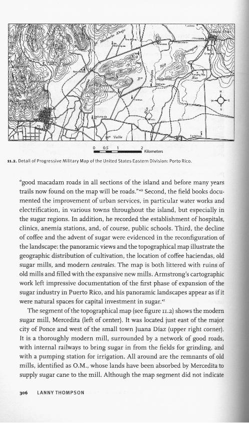
The segment ofthe topographical map (see figure 11.2) shows the modern
sugar mili, Mercedita (left of center). It was located just east of the major
city of Ponce and west of the small town Juana Díaz (upper right córner).
It is a thoroughly modern mili, surrounded by a network of good roads,
with internal railways to bring sugar in from the fields for grinding, and
with a pumping station for irrigation. All around are the remnants of oíd
milis, identified as O.M., whose lands have been absorbed by Mercedita to
supply sugar cañe to the mili. Although the map segment did not indícate
306 LANNYTHOMPSON

■at
11.3. "Guánica Sugar Milis." Courtesy of the Biblioteca Digital Puertorriqueña de la Universidad de Puerto Rico.
cultivation, it is clear that all of the fíat lands shown were dedicated to the
cultivation of sugar cañe. Armstrong also documented this process of ex
pansión ofthe modern milis by means ofphotography. One photograph (see
figure 11.3) is a panoramic view of the Guánica sugar mili, at the time the
largest sugar mili in the world. It transported sugar cañe by railroad from
all around Puerto Rico and shipped in sugar cañe from the neighboring
Dominican Republic to be processed by the most capital intensive, advanced
technology of the period.
In sum, Armstrong participated in and documented the creation of co
lonial spaces by means of cartographic techniques. First, the military map
applied a military gaze in order to produce strategic knowledge about the
topography, the infrastructure, and the population. The field books pro-
vided detailed information essential to troop movement, provisioning, and
the military character of the men. Second, the material process of "Amer-
icanization" may be seen in the landscapes and cityscapes: new roads and
sugar milis. In many respects, they captured the changes of fortune of the
élites due to the decline of coffee and the rise of sugar. The field books also
commented on the impediments to the U.S. regime, namely the local politi-
cians, the Spanish upper dass, and the Catholic priests and nuns. Although
Armstrong witnessed the material transformation ofthe landscape, he was
not convinced that roads and sugar milis would transform the hearts and
minds of population. That task, perhaps, would be left to other colonial
spaces, those circumscribed by that archetypical disciplinary institution,
the public school.
GOVERNMENTALITY AND CARTOGRAPHIES 307

SPACES OF ORDER: GRADED SCHOOLS,
TEXTBOOKS,AND DESKS
Before Armstrong entered military service, he had worked for two years
(1900-1902) as a district supervisor in the public school system in San Juan.
In this capacity, he was charged with supervising teachers and students and
establishing the first "graded schools" in Puerto Rico. The graded schools
had clear curricular sequences based on the organization of progressive
levéis or grades. The graded school was central to a new disciplinary re-
gime that sought to manage both students and teachers. The effective use
of pedagogical and supervisory techniques associated with the new school
system required the centralization ofauthority in the Department of Educa
tion. Several kinds of struggles aróse over the new disciplinary structure of
the department: between teachers and students; between supervisors and
teachers; and between the centralized department and municipal control.
In addition, conflicts aróse over the specific content of the teaching, spe-
cifically instruction in English. Armstrong had been an active participant
in these conflicts, and his topographical work demonstrated cióse attention
to the widespread distribution of public schools throughout the towns, vil-
lages, and countryside. In the larger towns he took photographs ofthe new
concrete graded schools, and in the countryside he mapped the locations
of rural and agricultural schools. His work evidenced the wide dispersal of
these disciplinary institutions; however, in order to identify the particular
mechanisms of control of students and teachers, we must consult the re-
ports ofthe first two commissioners ofthe Department ofEducation, Martin
Brumbaugh (1900-1901) and Samuel Lindsay (1902-4). These two men had
been Armstrong's immediate superiors when he was district supervisor.
When Brumbaugh took office he found that there were no virtually no
public school buildings. This meant the department had to rent facilities for
that purpose. His report enumerated the dimculties ofvacating the rented
buildings, their deplorable sanitary conditions, the time and cost for their
renovation, and the resistance of the current residents or owners. The De
partment of Education responded quickly to this situation by implementing
a program of constructing new schools. During its first years of operation,
the department built scores of one-room rural schools, vocational schools
(agricultural or industrial), modern graded schools (including primary and
secondary), and a normal school for the training of local teachers.42 These
new schools were widely dispersed through the towns and the countryside
and Armstrong's military map included many details of their geographic
308 LANNYTHOMPSON

«sfLÁsufrir'
ILJ K\ W r
. Map of Añasco. Courtesy of the Biblioteca Digital Puertorriqueña de la Universidad de Puerto
reach in the towns and countryside. In the field books he included descrip-
tions and photographs of the new urban structures and located them on
his sketch maps of the towns. One sketch map (see figure 11.4) details the
town ofAñasco, which we have discussed earlier. The map shows the spatial
location of the central disciplinary institution, the graded school. It is wor-
thy of note that in this town the two new graded schools, one of four rooms
(two hundred students) and the other ofsix rooms (three hundred students),
were built directly behind the Catholic church. It is no coincidence that the
schools, symbols ofthe new regime, were centrally located, and at least one
of the schools was partially visible from the central square (see figure 11.1).
The Catholic clergy, as we have seen in Armstrong's field book (quoted
above), was opposed to secular education and referred to these new schools
as "casas de demonios" or houses of devils. The grouping of boys and girls
in the same dassroom was also a novel idea that was initially questioned
by the clergy and parents. Two other wooden school buildings were built
just outside oftown, near the railway station, but were not indicated on the
sketch map. Armstrong also included in his map the anemia station, the
pólice headquarters, and the town hall, which included the jail, telephone,
and telegraph station.
Closely related to the inadequate school buildings, the lack of discipline
in the early classrooms was a problem in the first years of the new regime.
In 1902, Lindsay complained that when he took office "there was no uniform
GOVERNMENTALITY AND CARTOGRAPHIES 309

course of study; no attempt at rules, regulations, or order; no thought ofthe
rights of the child; no endeavor to apply pedagogical principies ñor to fur-
nish teachers with adequate equipment for their work."43 Lindsay's strategy
focused on textbooks and desks. The introduction of textbooks, whether
in English or Spanish, outlined a course of study by year and grade. The
department purchased thousands of school desks, which were to replace the
existing benches and tables "at which the children were formerly huddled
together without any possibility ofmaintaining good order and without any
regard for health and comfort." Lindsay explained: "New individual desks
créate a change in discipline of the school and in the spirit of pride and
degree of efficiency with which both teacher and pupil carry on the work."
The textbooks and individual desks were articulated with the architecture
ofthe new school buildings; the construction ofmodera multiroom, graded
school houses provided for the spatial separation of grades corresponding
to the curriculum outlined in the textbooks.44 Thus, the construction ofthe
graded school, the installation of individual desks, and the use oftextbooks
assured the repartition ofbodies, the temporal control of activities, and the
división of sequential tasks in which students were watched, evaluated, and
sanctioned as individualized subjects.45
In addition to the discipline of students, conflicts aróse over the super
visión ofthe teachers. Brumbaugh described the conflicts between the dis-
trict supervisors, who were most often American, and the local teachers:
"The difficulty attending their work is due to the friction of races and lan-
guages. The teachers who speak no English, and who are not wholly willing
to accept the new order of things, look upon these supervisors as official
meddlers. This has led to a few unpleasant and unfortunate experiences.
But in general the teachers welcome this supervisión, and now appreciate
its valué to them and to the schools."46 It is not clear exactly what Brum
baugh meant when he referred to the conflict of "races," but the context of
the comment suggests that the races in question were American super
visors and Puerto Rican teachers. Likewise, Lindsay identified the "English
supervisors" as the main agents of disciplinary management of teachers.
"Those who willfully neglect their work, cióse their schools before the reg
ular hour for closing, neglect to open them at the proper time, sham sick-
ness, and in general do as little work as possible when the supervisor is not
in sight are dealt with severely when they are found out. We have had the
risk of closing some schools altogether, by suspending within the last three
months about twenty-five teachers for serious cause." Since teachers were
also to be model citizens, they could be suspended for lack of moráis in
310 LANNY THOMPSON

prívate Ufe: "We must not place the care and training of innocent children
in the hands of any teacher whose Ufe is not clean, wholesome, and earnest,
no matter what other qualifications he may have."47
The early commissioners of education recounted several conflicts and
difficulties that aróse from the establishment of a new disciplinary regime,
or in Brumbaugh's words, the "new order of things." Both commissioners
emphasized the clashes between supervisors and teachers. These conflicts
centered on the issues of the use of the English language, teacher prepara-
tion, and the authority ofthe Department of Education to hire, evalúate, and
dismiss teachers. In addition to direct supervisión, another instrument in
the disciplining of Puerto Rican teachers was the establishment, in 1903, of
the normal school, which trained persons to teach in graded schools as well
as the rural, agricultural, and industrial schools. The idea was to convert
subjects into students ofthe disciplinary regime, and only then would they
become proper teachers. The fmancing and construction ofgraded schools,
as well as the supervisión and training of teachers, required a centralized
administration. The official reports indicated that the department was struc-
tured in a way to remove the power from the local school boards and the
municipalities. The local school boards were often politically subservient
to the mayor while at the same time without a budget. The Department of
Education was centrally structured and fmanced in order to establish a clear
chain of command from the commissioner through the supervisors to the
teachers. The local boards were weakened, but not eliminated.
The discursive themes in the official reports centered on conflicts aris-
ing from student discipline and teacher supervisión. The first two ofHcial
reports ofthe Department of Education provided evidence ofthe establish
ment of a new disciplinary discursive social formation in the public school
system in Puerto Rico. Several changes in the school system were at the
center ofthe department's disciplinary regime. The techniques ofdiscipline,
broadly speaking, related to the distribution of bodies within institutional
spaces, the control of activities, the división of tasks, and establishment of
a chain of command: the graded school, the supervisión of teachers, and
the centralization of the Department of Education. Although Puerto Rico
was without armed resistance to the colonial state, Lindsay used a bellicose
metaphor; he wrote that the colonization of Puerto Rico was to be "carried
forward by the armies ofpeace, whose outposts and garrisons are the public
schools of the advancing nation."48 Apparently, Armstrong took this met
aphor to heart: in his military map he was careful to include all of these
disciplinary "outposts and garrisons." These schools were the signs of the
GOVERNMENTALITY AND CARTOGRAPHIES 311

new order and had an important spatial presence as well as a demographic
impact.
Despite these initial conflicts, many parents and students, teachers and
trainees soon took advantage ofthe opportunities provided by primary, sec-
ondary, and postsecondary education. Basic literacy increased in the pop-
ulation, and enrollment increased rapidly. In addition, the Department of
Education provided employment, advancement, and even social mobility
for men and, importantly, women in Puerto Rico. In 1911, teachers formed
a unión to promote their class interests and influence pedagogical policy.
Teachers were able to negotiate their differences arising from the imposition
of English as the language of instruction and the colonial assimilationist
content ("Americanization"). For the most part, resistance to the new ped-
agogy was expressed within the confines of the educational system. For ex-
ample, instead of emphasizing the "colonial form of nationalism," teachers
adopted strategies to develop a modern, national, Puerto Rican identity.49
Whether English should be a language of instruction or taught as a second
language was more controversial and generated both open political conflicts
and frequent policy changes.
I have argued that colonial spaces are created through the deployment of
techniques of sovereignty, discipline, and governmental rationality. In the
U.S. imperial formation, these techniques were widely, yet unevenly, dis-
persed throughout the colonies. In Puerto Rico, sovereign techniques of
repression and surveillance were not as prevalent as the wide spatial dis-
persal of disciplinary institutions that sought to train the hearts, minds,
and bodies of the newly colonized subjects. Likewise, governmental tech
niques of collecting information about populations and political economy
were equally important. Using the Progressive Military Map of the United
States, Eastern División: Porto Rico as a point of departure, I have shown
how cartography was an instrument of appropriation, reconfiguration,
and modification, not only of landscapes, but also of colonial subjects and
populations. First, it mapped the space of sovereignty and made possible
the functionality of its scant security forces. It helped make possible the
división between policing the local population, undertaken by the Insular
Pólice, and the defense of the island from foreign attack or internal distur-
bance, responsibilities of the Regiment of Infantry. Both institutions were
simultaneously disciplinary institutions, in that they sought to shape the
bodies and minds of their members, and security apparatuses that used,
312 LANNYTHOMPSON

or threatened, coerción to maintain internal order and external defense.
Sovereign techniques were minimal because of the relative political and
military stability of Puerto Rico, especially when compared with the Philip-
pines. Second, it mapped spaces of discipline and their distribution. In par
ticular, the small, internal spaces of disciplinary institutions of the public
school house were shown to have a wide geographical dispersal throughout
the cities, towns, and countryside. Third, the map documented the recent
transformation of scale and extensión of sugar production and the intricate
transportation networks that facilitated the export-based economy. The map
traced the increasingly dense networks of transportation and their connec-
tions to the changing landscape of agricultural production. These were the
colonial spaces created, normalized, and documented by the progressive
military map of Puerto Rico: spaces of sovereignty and their functionality;
spaces of discipline and their dispersal; spaces ofeconomic production and
their connection. The colonial difference of Puerto Rico may be character-
ized by a particular configuration of governmental rationality: the limited,
but effective, uses ofcoercive techniques; the wide dispersal of disciplinary
institutions; and the expansive, modern capitalist transformations of the
political economy along with the management of populations through
biopolitics.
NOTES
1. The topographical map is located in the Map Collection ofthe Library ofCongress;
Progressive Military Map ofthe Uníted States Eastern División: Porto Rico, William H.
Armstrong, ist Lieut., P.R.R.I. Authority for Topography and Teófilo Marxuach,
ist Lieut., P.R.R.I. Authority for Topography; F. B. Essex, draftsman; surveyed
1908; drawn 1914; scale 1:62,500. Used with permission. María Dolores Luque,
María Mercedes Carrión, Aurora Lauzardo, and I are currently preparing a bilin-
gual facsímile edition ofthe field books to be published by Ediciones Puerto. Some
field books may be consulted online: Colección Manuscritos, William Armstrong,
Biblioteca Digital Puertorriqueña, Universidad de Puerto Rico, Río Piedras. I will
use the abbreviation f b , followed by the original enumeration and page number,
to reference quotes from the field books.
2. Foucault's principal text is "Governmentality." I have followed Deán, Governmen-
tality. See also Lemke, Biopolitics.
3. This question was originally posed by David Scott in his study of Ceylon. How-
ever, he did not distinguish precisely the colonial difference in the deployment
of governmental rationality. Rather, he sought to refocus the analysis away from
attitudes ofthe colonizer and the forms of exclusión of colonial subjects and
toward the analysis ofthe objects and techniques that define the political ratio-
GOVERNMENTALITY AND CARTOGRAPHIES 313

nality ofthe colonial state. I take a similar theoretical position although I hope to
distinguish better the techniques ofgovernmentality in the context ofthe colonial
state of Puerto Rico. See D. Scott, "Colonial Governmentality."
4. Deán, Governmentality, 133-35.
5. Deán, Governmentality, chap. 7.
6. Legg, Spaces ofColonialism. He summarized the pattern of colonial governmen
tality in India as a mixture, on the one hand, of excesses in the realms of vio-
lence, ceremony, segregation, incarceration, exploitation, the ethos of Western
civilization, social experimentation, and hyper-regulation and, on the other hand,
of neglect in the realms of civil rights, direct rule, broad social integration, free
markets, social welfare ethos, and the recognition of individuality.
7. Duncan, In the Shadows ofthe Tropics, 190.
8. Mbembe, "Necropolitics."
9. Mbembe, On Ae Postcolony, 25-35. He referred to these two fundamental princi
pies of sovereignty in the colonies as commandement.
10. Kramer, The Blood of Government, chap. 2.
11. McCoy, Scarano, and Johnson, "On the Tropic of Cáncer: Transitions and Trans-
formations in the U.S. Imperial States," 13-14, 24-25, 33. See also Tomes, "Cru-
cibles, Capillaries, and Pentimenti." Mbembe noted the múltiple origins and
circulation ofnecropolitics in a wide range ofhistorical and geographical contexts
spread across Europe and its colonies; see Mbembe, "Necropolitics."
12. McCoy, Polícíng America's Empire.
13. Go, Patterns of Empire, 12.
14. Foucault's principie text on disciplinary institutions is Discipline and Punish. Fou-
cault's interview is translated, commented, and analyzed in Crampton and Elden,
Space, Knowledge and Power. See also Crampton and Krygier, "An Introduction to
Critical Cartography."
15. Foucault, "Governmentality," 93.
16. Edney, "The Irony of Imperial Mapping." On the use of maps ofthe Philippines
in U.S. mass media and in the army, see Brody, "Mapping Empire." Compare
Appadurai, who argües that the modern census has a different effect in Britain
than in India, even though the same basic techniques were used; see Appadurai,
"Number in the Colonial Imagination."
17. Thompson, Imperial Archipelago.
18. On public health and hygiene, see Duprey, Bioislas. On urban ordering, see Cortés
Zavala, "Los Bandos de Policía y Buen Gobierno en Puerto Rico." On social hy
giene and eugenics, see Carmen Baerga, "Transgresiones corporales." On the
census, see Scarano, "Censuses in the Transition to Modern Colonialism." On
cartography, see Sepúlveda Rivera, Puerto Rico urbano.
19. On the transition from Spanish to U.S. prisons in Puerto Rico, see Santiago-
Valles, "American Penal Reforms and Colonial Spanish Custodial-Regulatory
Practices in Fin de Siécle Puerto Rico."
20. García Muñiz, Sugar and Power in the Caribbean.
21. For a comparative study ofthe disciplinary aspects of political tutelage, see Go,
American Empire and the Politícs ofMeaning.
22. Povinelli conceptualized the "governance ofthe prior" in the context of encoun-
ters ofsettler colonies with local indigenous populations (the prior); see Povinelli,
"The Governance ofthe Prior."
314 LANNY THOMPSON
23. Cabán, Constructing a Colonial People; García, "I Am the Other"; Go, American
Empire and the Politics ofMeaning.
24. Edney, "The Irony of Imperial Mapping," 19.
25. Negrón Portillo, Cuadrillas anexionistas y revueltas campesinas; Picó, 1898.
26. Marín Román, ¡Llegó la gringada!, 208-16.
27. Marín Román, ¡Llegó la gringada!, 208-16.
28. Cabán, Constructing a Colonial People; Santiago-Valles, "Subject Peoples" and Co
lonial Discourses; McCoy, Policing America's Empire.
29. McCoy, Policing America's Empire.
30. Winthrop, Fifth Annual Report ofthe Governor ofPorto Rico, 33—34.
31. Winthrop, Fifth Annual Report ofthe Governor of Porto Rico, 145.
32. Santiago-Valles, "Subject Peoples" and Colonial Discourses, 77-110.
33. The most comprehensive history of cartography in Puerto Rico is Sepúlveda Ri
vera, Puerto Rico urbano.
34. First Lieutenant William H. Armstrong, First Lieutenant Teófilo Marxuach, and
Second Lieutenant Louis Emmanuelli were ordered to complete a progressive
military map of Puerto Rico. Of the twelve quadrants that made up the final
map, Armstrong signed as topographer on ten and Marxuach on two. Apparently,
Emmanuelli worked as an assistant to Marxuach. Efficiency report of ist Lt. Wm.
H. Armstrong, P.R.R.I., for the period from July 1,1908, to June 30,1909. Record
Group 94, National Archives and Records Administration, Washington, DC.
35. A detailed background and description ofthe process of producing a map, as well
as field notes, is provided by Roy Robert Lyon, "Field Work on the Progressive
Military Map ofthe United States," thesis for advanced degree in civil engineer-
ing, Michigan Agricultural College, 1914. A general description is also found in
Ehrenberg, "Up in the Air in More Ways Than One," 220-22.
36. The notion ofthe "gaze" is found in Foucault's early work on the clinic. I have
extended the scope ofthe concept by following Deleuze, "What Is a Dispositif?,"
159-61.
37. McCoy refers to this as "mute and blind information" because it did not contain
information on specific individuáis that might be used as a means of political
control. His emphasis on surveillance techniques leads him to overlook the in-
teraction of sovereign and governmental rationalities in the colonial state. See
McCoy, Policing America's Empire, 21.
38. fb 8, 42-44.
39. For description ofthe coffee áreas, see fb 10. The sugar áreas are described, above
all, in fb 8 and 11.
40. fb 1, n.p.
41. García Muñiz, Sugar and Power.
42. Brumbaugh, Report ofthe Commissioner of Educationfor Porto Rico, 757.
43. Lindsay, "Report ofthe Commissioner of Education," 230. For a discussion of
Lindsay's policies, see Negrón de Montilla, La americanización, 77-108.
44. Lindsay, "Report ofthe Commissioner of Education," 236.
45. I follow closely Foucault, Discipline and Punish.
46. Brumbaugh, Report ofthe Commissioner of Educationfor Porto Rico, 749.
47. Lindsay, "Report ofthe Commissioner of Education," 248.
48. Lindsay, "Report ofthe Commissioner of Education," 257.
49. del Moral, Negotiating Empire; Bobonis and Toro, "Modern Colonization and Its
Consequences.
GOVERNMENTALITY AND CARTOGRAPHIES 315
Copyright © 2022 FDOKUMEN