The Buried Body Cases Content Analyses Project: Patterns in Buried Body Investigations
Upload
bodendenkmalpflege-lvrCategory
view
0download
0
This article appeared in a journal published by Elsevier. The attachedcopy is furnished to the author for internal non-commercial researchand education use, including for instruction at the authors institution
and sharing with colleagues.
Other uses, including reproduction and distribution, or selling orlicensing copies, or posting to personal, institutional or third party
websites are prohibited.
In most cases authors are permitted to post their version of thearticle (e.g. in Word or Tex form) to their personal website orinstitutional repository. Authors requiring further information
regarding Elsevier’s archiving and manuscript policies areencouraged to visit:
http://www.elsevier.com/copyright
Author's personal copy
Buried dark soil horizons and archaeological features in the Neolithic settlementregion of the Lower Rhine area, NW Germany: Formation, geochemistry andchronostratigraphy
R. Gerlach a,*, P. Fischer b, E. Eckmeier c, A. Hilgers b
a LVR-Amt für Bodendenkmalpflege im Rheinland, Endenicher Allee 133, 53113 Bonn, Germanyb Institute for Geography, University of Cologne, Albertus-Magnus-Platz, 50923 Cologne, Germanyc INRES-Soil Science, University of Bonn, Nussallee 13, 53115 Bonn, Germany
a r t i c l e i n f o
Article history:Available online 18 October 2011
a b s t r a c t
The properties and age of buried humic and clay-rich dark soil remains (Bht-horizons and pits) atarchaeological excavations in the Lower Rhine Basin (NW Germany) were investigated. These Bht-features were formerly described as a component of Luvic Phaeozems and as relics of chernozemic soils.
Field observations challenge this interpretation. The Bht-horizons in the Lower Rhine Basin occur ina patchy distribution independent of relief position and climatic condition, and they are mostly con-nected with artefact-free but human-made pits (off-site features) consisting of the same Bht-material.The presence of charred organic matter (pyrogenic carbon) and its radiocarbon ages suggested thatthese Bht-horizons are not relics of naturally formed soils but rather archaeological features. Pyrogeniccarbon, produced during agricultural burning practices (e.g. slash and burn) in the Younger to EndNeolithic (4400e2200 BC), led to the characteristic dark colouring of the soil material.
Previously, it was generally presumed that the parent material of those dark soils is Pleistocene loess.New IRSL and OSL ages (around 6.4e4.3 ka) indicate that the Bht-horizons in the Lower Rhine Basinformed in colluvial sediments which also date to the Younger to End Neolithic. Thus, the history ofhuman induced soil erosion in the Lower Rhine area started more than 1000 years earlier than assumedbefore. It was most likely connected to Neolithic burning practices (slash and burn) which subsequentlytriggered soil erosion, and then influenced the formation of dark Anthrosols by eluviation and illuviationof the partly charred dark humic material. These Anthrosols are an example of strong human impact onsoil forming processes since the onset of agriculture.
� 2011 Elsevier Ltd and INQUA. All rights reserved.
1. Introduction
The loess-covered landscapes of the Lower Rhine Basinwith theirarable soils have been occupied intensively since the Early Neolithic(since 5300 BC). Thus, the surface has been exposed to human impactfor the most of the Holocene. Common soil formation models,however, postulated the predominance of naturally and climaticallycontrolled soil formation processes within the early settled CentralEuropean loess landscapes. The concept of Chernozem formationimplies that these soils formed under a dry continental climate andsteppe vegetation (FAO/ISRIC/ISSS, 1998). Increasing precipitation,decalcification and clay translocation led to the formation of LuvicPhaeozems with a characteristic dark argic Bht-horizon. In humid
regions, Luvisols were the final products of the soil development(Roeschmann, 1968; Rohdenburg and Meyer, 1968; Schalich, 1981;Catt, 1989; Driessen et al., 2001). For the Lower Rhine region, it waspresumed that Chernozems existed as naturally formed soils at theonset of the Neolithic (5300 BC). Soil forming processes transformedthem into Luvic Phaeozems to the end of Neolithic (2200 BC)(Schalich,1981; Lüning, 2000; cf. Fig.1 of; Lorz and Saile, 2011). In theLower Rhine region, fossil Bht-horizons exist only as relics next tobrown Bt-horizons of recent Luvisols.
In Central Europe, the entire spectrum of the proposed soildevelopment sequence can be observed, from Haplic Chernozemsin the Central German dry region to Luvic Phaeozems of the MainzBasin, the Soester and Warburger Boerde, the Leine valley, theWetterau and the Lower Rhine Basin (Mückenhausen, 1985; Catt,1989; Altermann et al., 2005).
Evidence for a possible chernozemic history of recent Luvisol-dominated loess landscapes has been detected over decades in
* Corresponding author.E-mail address: [email protected] (R. Gerlach).
Contents lists available at SciVerse ScienceDirect
Quaternary International
journal homepage: www.elsevier .com/locate/quaint
1040-6182/$ e see front matter � 2011 Elsevier Ltd and INQUA. All rights reserved.doi:10.1016/j.quaint.2011.10.007
Quaternary International 265 (2012) 191e204
Author's personal copy
many excavations of Neolithic sites, e.g. in Lower Saxony (Schefferand Meyer, 1958, 1965; Bork, 1983), in the Rhineland (Schalich,1981), in the Wetterau (Thiemeyer, 1989) and in the KraichgauHills (Kadereit et al., 2010). Pit fillings and soil horizons that werecomposed of dark and clay-rich material were interpreted as relicsof Chernozems. Since the work of Firbas (1949), however, noarchaeobotanical study could confirm the presence of steppevegetation in the Early Holocene, which would be the prerequisitefor Chernozem formation in Central Europe. When Neolithicfarming began, deciduous forests covered nearly the whole region(Huntley, 1988; Frenzel, 1992; Lang, 1994b; Lorz and Saile, 2011).Palynological investigations could not find evidence for steppe orforest-steppe vegetation prior to Neolithic occupation, even for theCentral German loess area where Haplic Chernozems still occur(Müller, 1953: Litt, 1994; Ehwald et al., 1999). Therefore, thepedogenetic model that has been proposed by Scheffer and Meyer(1965) and Rohdenburg and Meyer (1968), representing the back-ground of several modified regional models (e.g., for the LowerRhine Basin by Kopp, 1965 and Schalich, 1981), introduced theconcept of Chernozem formation under forest by insufficientdecalcification of the loess-borne parent material.
A review of the state of the art on pedogenesis of Central EuropeChernozems demonstrated that there is to date no generallyaccepted consensus concerning age, formation, further develop-ment and preservation of Chernozems in Central Europe (Eckmeieret al., 2007a). Due to the questionable correlation of climate andvegetation, the influence of anthropogenic impact has never beenexcluded (Scheffer and Meyer, 1965; Rohdenburg and Meyer, 1968;Ehwald et al., 1999). In the vicinity of Neolithic settlements, thedark soil colour caused by charcoal dust was assumed to indicateanthropogenic formation of chernozemic soils (Baumann et al.,1964; Scheffer and Meyer, 1965). Apart from the inconsistencies
of the pedogenetic models, field observations at archaeologicalexcavations in the Lower Rhine region since 1999 led to thefollowing questions: Are the observed Bht-horizons witnesses offormer chernozemic soils? Did black soils already exist at thebeginning of the Neolithic? If not, was the formation of dark soilhorizons caused by natural or by human processes? Which wasfirst: chicken or egg, dark soils or Neolithic farmers?
This study investigated the context, the properties and the age ofdark Bht-features observed since 1999 at 24 large-scale excavationsfrom the Archaeological Heritage Management Office of the Rhine-land, North-Rhine-Westphalia (LVR-Amt für Bodendenkmalpflege imRheinland) using fieldwork methods, analytical data and physicaldating methods. The paper reviews and summarizes the results offield observations and laboratory analyses, and presents new lumi-nescence data. In the following, colluvial sediments are understood asproduct of anthropogenic-caused soil erosion (cf. Leopold and Völkel,2007).
2. Regional settings
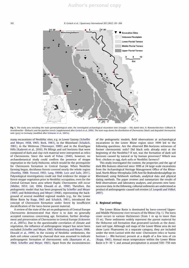
The Lower Rhine Basin is dominated by loess-covered Upper-and Middle Pleistocene river terraces of the Rhine (Fig. 1). The loesscover occurs in various thicknesses (from 1 m up to more than15 m). These sediments widely represent the parent material forthe Holocene soil formation that generated Luvisols as the domi-nant soil type. Although soil maps of the Lower Rhine area do notshow Luvic Phaeozems in a separate category, they are includedunder the term Luvisol with the note: Chernozem relics or humichorizon (¼ Bht-horizon) present at a depth of a few tens of cm(Kopp, 1965). Annual mean temperature within the Lower RhineBasin is 9e10 �C and annual precipitation is around 550e750 mm
Fig. 1. The study area including the main geomorphological units, the investigated archaeological excavation sites (triangle ¼ OSL dated sites, A: RommerskircheneGillbach, B:ArnoldsweilereEllebach) and the pipeline trench (supplemented after Gerlach et al., 2006). The inset map shows the distribution of Chernozems (black) and degraded chernozemicsoils (grey) in Germany (modified after Eckmeier et al., 2007a).
R. Gerlach et al. / Quaternary International 265 (2012) 191e204192
Author's personal copy
(data: Landesamt für Natur, Umwelt und Verbraucherschutz desLandes Nordrhein-Westfalen, 2010).
As part of the Central European loess belt, the Lower Rhine Basin(Rhineland) was settled since the Early Neolithic (Linear Potteryculture). The oldest Neolithic sites in the Rhineland date to 5300 BC.The whole Neolithic took more than 3000 years and can be sub-divided into five periods: Early Neolithic 5300e5000 BC, MiddleNeolithic 5000e4400 BC, Younger Neolithic 4400e3500 BC, LateNeolithic 3500e2800 BC and End Neolithic 2800e2200 BC (Richter,1997; Zimmermann et al., 2005).
The vegetation history of the research area is well known frompalynological studies (summarized by Kalis and Meurers-Balke,1997; Zimmermann et al., 2005). According to these studies, theloess landscapes of the Rhineland were covered with dense lime-and elm forests before the first farmers arrived (5300 BC). Onlysmall forest clearances, which are hardly visible in pollen diagrams,interrupted those woodlands, and farming was restricted to theloess-covered areas during the next millennia. With the beginningof the Young Neolithic (4400 BC), fields and settlements alsoexpanded into the highland zone of the Eifel with less suitable soils.Since the Late Neolithic (3500 BC), the changes in the forest cover ofthe loess landscape became more drastic and semi-natural limewoods were converted into mixed oak woodland. A simultaneousincrease in the pollen percentages of non-arboreal pollen waseither the result of an expansion of woodland clearances or of anamalgamation of the fields. Finally, the transformation of woodlandproceeded until the vegetation of the loess landscape hadcompletely changed into a bright open and mixed park-woodlandin the End Neolithic (2800e2200 BC), dominated by oak (Quercus).
3. Methods
3.1. Field methods
Dark soil horizons (Bht-features, see 4.1.) and their context wereinvestigated at 24 archaeological excavations (15 large-scale exca-vations between 0.5 and 5 ha and nine excavation sites along a 33 kmlong gas-pipeline trench in the Cologne Lowlands, Fig. 1). Addition-ally, two soil profiles with Bht-horizons were investigated at exca-vations in RommerskircheneGillbach and ArnoldsweilereEllebach,where OSL samples of the entire sequences were taken.
All archaeological features have been documented after the“Prospektionse und Grabungsrichtlinien für drittfinanzierte arch-äologische Maßnahmen des LVR-Amt für Bodendenkmalpflege”and archived in the Archaeological Heritage Management Office ofthe Rhineland, North-Rhine-Westphalia (LVR-Amt für Bod-endenkmalpflege im Rheinland). All profiles and soil samples weredescribed using the German Soil Classification (Boden, 1994, 2005).
3.2. Geochemical soil analyses
The particle-size was measured by wet sieving and gravitationalsedimentation (pipette method) according to a standard method(Schlichting et al., 1995). The pH was determined in 0.1 M KClsolution (ratio 1:2.5). The soil colourwasmeasured on dry fine-earthsamples using a photospectrometer (Minolta Chroma-Meter CR-300) by observing the diffused reflected light under standardisedobservation conditions. Soil colour was expressed as Munsell valuesand as lightness L* (Commission Internationale de l’Eclairage, CIE,1976 Standard Observer) on a scale from L*0 (absolute black) toL*100 (absolute white). Total carbon (C) and nitrogen (N) wasdetermined for all soil samples in duplicates by dry combustionwithan elemental analyzer (Elementar Vario EL). The values for organiccarbon (Corg) corresponded to the total carbon content because thesoil samples did not contain any bicarbonate material.
Total phosphorus (Pt) was determined in soils heated at 550 �Cin a muffle furnace photometrically after extraction with sulphuricacid (H2SO4). Concentrations of inorganic phosphorus (Pi) wereobtained from an unignited sub-sample. Organic phosphorus (Po)was calculated by subtraction of values for inorganic phosphorusfrom values for total phosphorus (Kuo, 1996).
Lipids were extracted from soil samples (100e120 g) viaa Soxhlet-extractor for 24 h using dichloromethane/methanol (2/1;v/v). The total lipid extract was separated into a neutral fraction andan acid fraction by elution on a KOH coated SiO2 column(Wiesenberg et al., 2009b). The neutral lipids were subsequentlyseparated using the medium-pressure liquid chromatographyseparation scheme (MPLC) to gain the aliphatic hydrocarbons.Identification of compounds was performed on an Agilent 6890Ngas chromatograph coupled to an Agilent 5973 mass spectrometer.
3.3. Analyses of charred organic matter (pyrogenic carbon, pyrC)
Macrocharcoal pieces (>1 mm) were manually selected fromthe bulk soil samples for identification of wood species andradiocarbon dating. Microcharcoal was analysed after less stabletotal soil organic matter was removed by high-energy UV photo-oxidation as described by Skjemstad et al. (1993, 1999). The soilsamples (particle-size fraction <53 mm) were treated with high-energy UV light for 2 h to destroy the more labile soil organicmatter. After the treatment, the charcoal carbon left in the soilsample was estimated after identification of carbon compounds by13C nuclear magnetic resonance (NMR) using the aryl fraction aftercorrection for lignin or lignin-like structures.
Ten manually picked macrocharcoal particles which were takenfrom the lower parts of the Bht-horizons and pits, as well as fourmacrocharcoals from Early Neolithic settlement features wereradiocarbon dated by accelerator mass spectrometry (AMS;Universities of Kiel and Utrecht). The 14C data were calibrated usingOxCal v4.1.7. Most charcoal samples were derived from tree species,which means that an old wood effect cannot be excluded. Also, thetime delay between death of a tree and charring implies that the 14Cages of wood charcoal would overestimate the date of burning andthus would give the maximum ages of fire events (Gavin, 2001).However, Gavin et al. (2003) reported that one 14C date per site wasstill sufficient to identify the time since the last fire.
3.4. Luminescence dating
Luminescence dating of colluvial deposits in this study wascarried out using either the optically stimulated luminescence(OSL) response of quartz (40e63 mm grain size fraction, Arnold-sweilereEllebach site) or the infra-red stimulated luminescence(IRSL) emission of polymineral fine grains (4e11 mm, Rommer-skircheneGillbach site). The inconsistency in sample treatment andmeasurement procedures applied at both sites relates to thedevelopment of OSL dating of colluvial sediments. The first majorand many following studies on colluvial deposits in Germany werebased on the polymineral fine grain fraction using multiple aliquottechniques (e.g. Lang, 1994a; Lang and Wagner, 1997; Lang andHönscheidt, 1999). Through the further development of OSLdating, single aliquot techniques have been increasingly applied(e.g. Kadereit et al., 2002, 2006, 2010; Fuchs and Lang, 2009). TheRommerskircheneGillbach dating results were obtained first usingthe polymineral fine grain fraction initially proved to yield reliableresults (see overview in Fuchs and Lang, 2009). More recently,measurements of quartz extracted from colluvial deposits werecarried out (e.g. Fuchs et al., 2010), changing not only the mineralfraction but also focussing on other, coarser grain size fractions.Thus, instead of dating the fine-grained fraction, where sample
R. Gerlach et al. / Quaternary International 265 (2012) 191e204 193
Author's personal copy
holders with 8 mm diameter are fully covered by the grains, thisstudy used the 40e63 mm fraction for samples from the Arnold-sweilereEllebach site. This approach allows substantial reductionof the number of grains per aliquot which is essential to investigatethe degree of signal resetting or the impact of bioturbation. Thesub-samples used for dating consisted of a few hundred grains ofwhich only a few tens of grains usually contribute to the OSL signal(Duller, 2008) compared to the fine grain aliquots carrying tens ofthousands of grains. Thus, the probability to measure only grainswhich do not contain a residual dose is enhanced by usinga reduced number of grains per aliquot. In order to check whetherthe ages might be erroneous due to insufficient bleaching bysunlight during transport or post-depositional intrusion of older oryounger grains, 33 to 45 aliquots were measured per sample. Theequivalent dose (De) distributions were analysed using the finitemixture model (FFM in Table 4, Galbraith and Green, 1990). Samplepreparation for equivalent dose determination followed standardprocedures as describe for example in Preusser et al. (2008).
All measurements were carried out on automated Risø TL/OSLreaders (types TL-DA-12, 15, or 20; Bøtter-Jensen et al., 2003) usingsingle aliquot regenerative dose (SAR) protocols for quartz (Murrayand Wintle, 2000, 2003; Wintle and Murray, 2006) and K-richfeldspar dominated emissions as proposed by Wallinga et al.(2000). Dose rates were calculated from radionuclide concentra-tions (uranium, thorium, and potassium) in the bulk sedimentsamples, as determined by gamma-ray spectrometry.
4. Results of field observation and geochemistry
4.1. Field observations of Bht-features and their context
The term “Bht-features” is used as a generic term for two con-nected phenomena:
1. Bht-horizons. These humic and clay-rich sub-soil horizons differin colour and texture from the brown and clay-rich Bt-horizonsof the surrounding Luvisols. Such relics of Bht-horizons wereconsidered to be a former stage of the soil degradation modelfrom Chernozems to Luvisols preserved under colluvial cover(Schalich, 1981), which are situated directly next to argic hori-zons (Bt-horizons) of Luvisols. The pedogenetically related light-greyish eluviation (Al) horizon is sometimes visible above thedark Bht-horizon, depending on the level of preservation. TheBht-horizons aswell as the Al-horizons are not identicalwith theformer surface (Schalich, 1981; Gerlach et al., 2006).
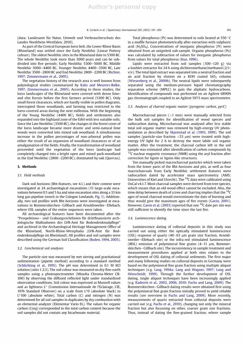
2. Bht-pits. These pits are part of the Bht-horizon (Fig. 2). The soilmaterial of horizons and the pit fillings have the same char-acteristics as they are influenced by the same pedogeneticprocesses (eluviation and illuviation). Both are mostly wellpreserved under colluvial coverage. In the following, the termBht-pits refers to the filling of those pits.
Geoarchaeological documentation provided three main obser-vations concerning the visible properties, the distribution and thecharacteristics of Bht-features:
(i) The Bht-horizons never appeared without pits which had thesame characteristics (dark colour, clayenriched texture, humuscontent) as the Bht-horizons. Leaching and decalcification ledto the translocation of clay and humus from the former topsoilinto the argic Bht-horizon, which inherited the black colour.The position of the Bht-horizons follows the structure of thepits because illuviation of clay and organic matter was stoppedby the dense soil matrix at the bottom of the pit (Gerlach et al.,2006). Only in a few cases did the clay infiltrate throughmacropores into the parts directly below the pit. The Bht-pitstherefore consisted of a filling that was superimposed by illu-viation and transformed into a Bht-horizon. Most internalstructures (infilling layers) were subsequently superimposedby this pedogenetic process. If not eroded, the light-greyeluviation horizon (Al) was preserved in the upper part ofthe former hollow. Horizons and pits appear as a unit, and itwas impossible to detect clear boundaries between them(Fig. 2). For the upper part of the Neolithic features, eluviationprocesses seemed to be a reasonable explanation. Due to thebleaching of the Al-horizon after the humic material wasremoved, the upper boundaries partly vanished beyondrecognition (Schalich, 1981). However, even in the lower darkBht-horizon it was impossible to distinguish between horizonand pits (Figs. 2 and 5). This observation was contradictory tothe assumption that the Bht-horizon developed in Pleistoceneloess, thus existed before pit construction. For many years, thisseemed to be an unsolved problem. Most archaeologicaldocumentations tried to solve this problem by drawingadotted line to construct a hypothetical boundaryof the pits upto the top of the Bht-horizon, or up to the Al-horizon, whichwas seen as pre-Neolithic soil relic. Luminescence dating (seebelow) gives a reliable explanation for this discrepancy.
(ii) In contrast to Bht-horizons and -pits, comparable features werenever found in the brown and humus free argic horizons ofadjacent Luvisols. The dark Bht-features appear as dark islandsin the surrounding of brown Luvisols. Commonly, the lowerparts of the Bht-pits were still clearly visible, although the upperparts and the Bht-horizon have been eroded (see Fig. 4). Theclose connection between Bht-horizons and pits could only beobserved in longer trenches andprofiles such as thegas-pipelineor in larger archaeological excavation areas. It is almost impos-sible to detect them in drill cores or in short trenches.
(iii) No archaeological artefacts typical for pit fillings in prehistoricsettlements (on-site features), such as pottery, were found inany of the more than 500 documented Bht-pits. Only a fewcharcoal particles and some reworked gravels have beenobserved. These pits occurred in the vicinity of a settlement
Fig. 2. Typical cross section as produced by pipeline trench cutting through the loess-covered landscape near Cologne (see Fig. 1). The slope dips from right to left with the thicknessof the colluvial cover (M) increasing accordingly. The eluviated Al-horizon was eroded. The dark Bht-horizon and pits seem to be an unit. Underneath and aside (outside the crosssection) the dark Bht-horizon change into a brown Bt-horizon, followed by unweathered loess (Cv).
R. Gerlach et al. / Quaternary International 265 (2012) 191e204194
Author's personal copy
but outside the actual residence area, and they are thereforearchaeological off-site features, due to the absence of charac-teristic settlement materials in the pits.
(iv) Luvic Phaeozem horizons (Bht) and pits were not limited toloess as a substrate but also occurred on loamy and sandyalluvial sediments of the lower terrace of the river Rhine andon the Holocene floodplain (Fig. 1). They appeared in differentgeomorphological positions, in depressions, on slopes, and on
top of hills. About 80% of the observed Bht-features werecovered by 20e180 cm thick colluvial sediments. The otherswere preserved uncovered and therefore partly eroded(Gerlach et al., 2006).
The patchy distribution of the preserved Bht-features enablesreconstruction of their original distribution. They may have existedas islands surrounded by Luvisols in which human influence is the
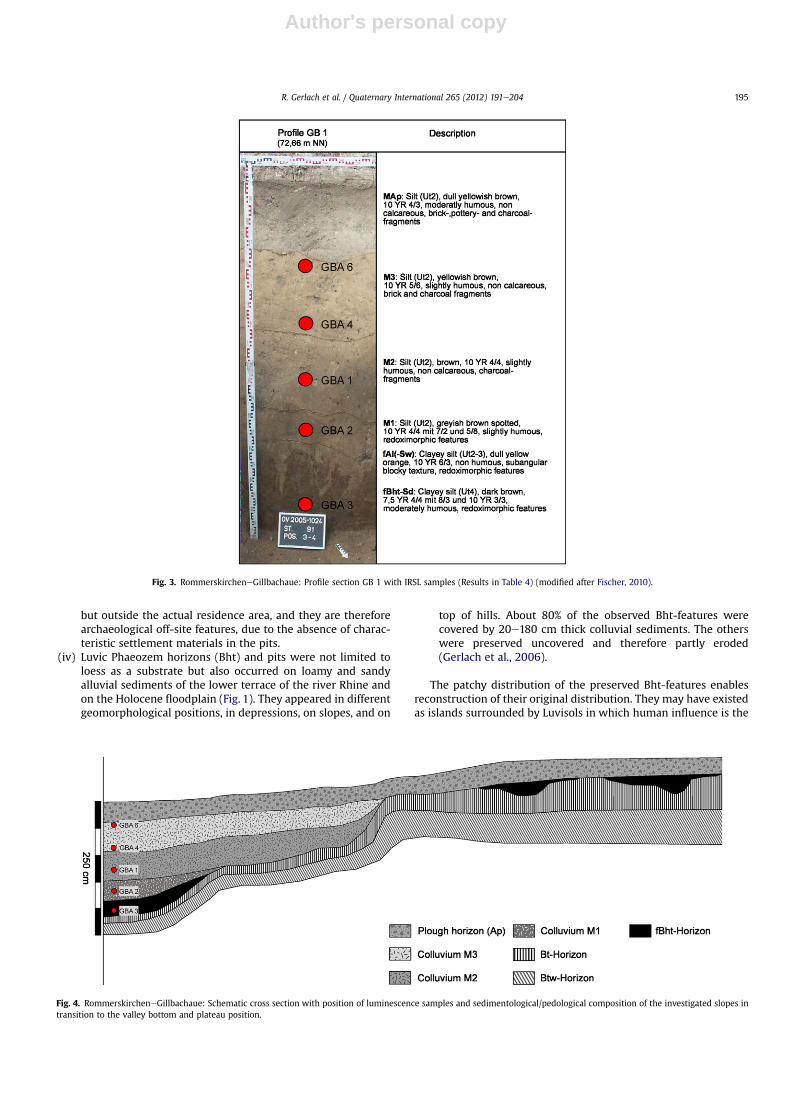
Fig. 4. RommerskircheneGillbachaue: Schematic cross section with position of luminescence samples and sedimentological/pedological composition of the investigated slopes intransition to the valley bottom and plateau position.
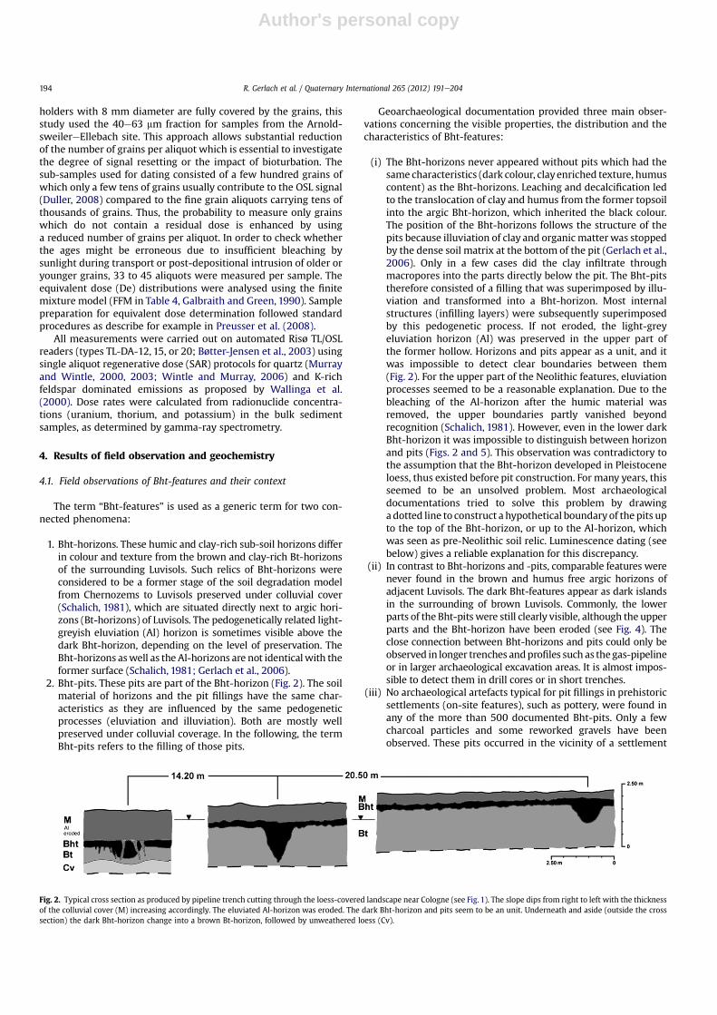
Fig. 3. RommerskircheneGillbachaue: Profile section GB 1 with IRSL samples (Results in Table 4) (modified after Fischer, 2010).
R. Gerlach et al. / Quaternary International 265 (2012) 191e204 195
Author's personal copy
most likely explanation for the existence of the Bht-features(Gerlach et al., 2006).
4.2. Geochemistry
Soil geochemical characteristics were compared for bulk soilmaterial from (i) Bht-horizons and (ii) Bht-pits (off-site features)with (iii) pit fillings from clearly defined and archaeologically datedEarly Neolithic settlements and (iv) settlement floors (both are on-site features), and with (v) adjacent brown Bt- or Bv-horizons of theLuvisols. In total, 109 soil samples were analysed. The main resultswere compiled in Table 1.
4.2.1. Bulk soil propertiesThe texture is similar for all soils, which were dominated by silt
and rich in clay. Bht-pits had higher clay concentrations than Bht-horizons, and the lowest proportion of silt was found in the Bt-horizons. All soils were slightly acidic. Soil colour (L*) was darkestin the settlement soils and lightest in the Bt-horizons, which isreflected also by different Munsell values. Bht-features had anaverage Munsell value of 10 YR 6/3, Bt-horizons 9 YR 6/4, and
settlement features 10 YR 5/3. The organic carbon (Corg) concen-trations were lower in the Bht-horizons and pit fillings than in thesamples taken within Neolithic settlements, but higher than in Bt-horizons. Nitrogen (N) concentrations were lowest in Bt-horizons,and C/N ratios of Bht-pits and horizons were low (arithmeticmean: 8).
As expected, the settlement pits were characterised by thehighest total phosphorous (Pt) concentrations (mean: 649mgkg�1),which could be attributed to organic settlementwaste. The Bht-pits,although containing more P (mean: 416 mg Pt kg�1) than thesurrounding Bt-horizons, had lower P concentrations than thesettlement soils, which emphasized their off-site character(Eckmeier et al., 2008).
4.2.2. Pyrogenic carbonMicrocharcoal was found in all examined samples (two Bht-
horizons, nine Bht-pits, five settlement pits and one settlementhorizon), with proportions between 16 and 87% of bulk organiccarbon (average mean values see Table 1). The highest concentra-tionsweremeasured in the settlement pits (mean: 43%) followed bythe Bht-pits (mean: 39%). Elevated black carbon concentrations are
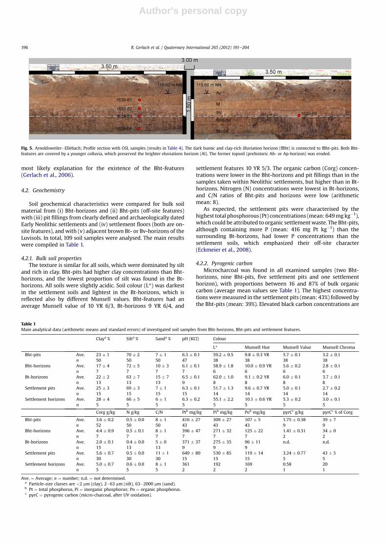
Fig. 5. ArnoldsweilereEllebach; Profile section with OSL samples (results in Table 4). The dark humic and clay-rich illuviation horizon (fBht) is connected to fBht-pits. Both Bht-features are covered by a younger colluvia, which preserved the brighter eluviations horizon (Al). The former topsoil (prehistoric Ah- or Ap-horizon) was eroded.
Table 1Main analytical data (arithmetic means and standard errors) of investigated soil samples from Bht-horizons, Bht-pits and settlement features.
Claya % Silta % Sanda % pH (KCl) Colour
L* Munsell Hue Munsell Value Munsell Chroma
Bht-pits Ave. 23 � 1 70 � 2 7 � 1 6.3 � 0.1 59.2 � 0.5 9.8 � 0.3 YR 5.7 � 0.1 3.2 � 0.1n 50 50 50 47 38 38 38 38
Bht-horizons Ave. 17 � 4 72 � 5 10 � 3 6.1 � 0.1 58.9 � 1.8 10.0 � 0.9 YR 5.6 � 0.2 2.8 � 0.1n 7 7 7 7 6 6 6 6
Bt-horizons Ave. 22 � 2 63 � 7 15 � 7 6.5 � 0.1 62.0 � 1.0 9.1 � 0.2 YR 6.0 � 0.1 3.7 � 0.1n 13 13 13 9 8 8 8 8
Settlement pits Ave. 25 � 3 69 � 3 7 � 1 6.3 � 0.1 51.7 � 1.3 9.6 � 0.7 YR 5.0 � 0.1 2.7 � 0.2n 15 15 15 15 14 14 14 14
Settlement horizons Ave. 28 � 4 66 � 5 6 � 1 6.3 � 0.2 55.1 � 2.2 10.1 � 0.6 YR 5.3 � 0.2 3.0 � 0.1n 5 5 5 5 5 5 5 5
Corg g/kg N g/kg C/N Ptb mg/kg Pib mg/kg Pob mg/kg pyrCc g/kg pyrCc % of Corg
Bht-pits Ave. 3.6 � 0.2 0.5 � 0.0 8 � 1 416 � 27 309 � 27 107 � 5 1.75 � 0.38 39 � 7n 52 50 50 43 43 43 9 9
Bht-horizons Ave. 4.4 � 0.9 0.5 � 0.1 8 � 1 396 � 47 271 � 32 125 � 22 1.41 � 0.31 34 � 0n 7 7 7 7 7 7 2 2
Bt-horizons Ave. 2.0 � 0.1 0.4 � 0.0 5 � 0 371 � 37 275 � 35 96 � 11 n.d. n.d.n 15 13 13 9 9 9
Settlement pits Ave. 5.6 � 0.7 0.5 � 0.0 11 � 1 649 � 80 530 � 85 119 � 14 3.24 � 0.77 43 � 5n 30 30 30 15 15 15 5 5
Settlement horizons Ave. 5.0 � 0.7 0.6 � 0.0 8 � 1 361 192 169 0.58 20n 5 5 5 2 2 2 1 1
Ave. ¼ Average; n ¼ number; n.d. ¼ not determined.a Particle-size classes are <2 mm (clay), 2e63 mm (silt), 63e2000 mm (sand).b Pt ¼ total phosphorus, Pi ¼ inorganic phosphorus; Po ¼ organic phosphorus.c pyrC ¼ pyrogenic carbon (micro-charcoal, after UV oxidation).
R. Gerlach et al. / Quaternary International 265 (2012) 191e204196
Author's personal copy
typical forblack soils (Rodionovet al., 2010),whereasanearlier studyshowed that brown Luvisol Bt-horizons did not contain any pyro-genic carbon (Schmidt et al., 1999).
Fewmacrocharcoal particles were found in the Bht-features. Themasses of charcoal per soil sample were too small to calculate theconcentration of charcoal in the soil. A total of 139 charcoal pieces(>1 mm) from Bht-pit fillings and horizons and from Neolithicsettlement pits were suitable for the identification of wood species(Table 2), as Pomoideae (pomaceous fruit trees), Quercus (oak),Fraxinus (ash),Ulmus (elm),Corylus (hazel),Prunus (stone-fruit trees)and unidentifiable deciduous wood species. The settlement pitsdelivered a wood composition typical for Early Neolithic settle-ments, dominated by Pomoideae as a product of burning branchesfrom hedges that surrounded the settlement sites (Castelletti andStäuble, 1997). The Bht-features yielded a different charcoalcomposition which was dominated by forest species includingQuercus and Ulmus (Table 2). The differences in fuel suggested thatthe charcoal found in Bht-features was produced in fires that werenot connected to settlement activities (Eckmeier et al., 2008).
4.2.3. Soil lipidsThe lower proportion of total lipids in dark Bht-horizons and pit
fillings compared to the Luvisol Bt-horizons indicated that theamount of lipid compounds has been reduced by fire. This is inagreement with the observations made by Wiesenberg et al.(2009a), where charring of biomass resulted in a decrease in lipidcontents. The distribution patterns of lipid compounds from Bht-material showed that short-chain and even carbon-numbered n-alkanes prevailed, maximising at n-C16 or n-C18. This specificdistribution pattern could be attributed to thermal degradation orincomplete combustion of preferentially non-woody biomassoccurring at temperatures between 400 and 500 �C (Eckmeier andWiesenberg, 2009).
4.3. Case studies: RommerkircheneGillbach andArnoldsweilereEllebach
In addition to pedological investigations of Bht-features in theRhineland (Gerlach et al., 2006; Eckmeier et al., 2008), the OSLdating of two Neolithic sites with Bht-features delivered newresults (cp. section 5.2) (Fig. 1).
The archaeological excavations at the RommerskircheneGillbachsite were investigated in detail using geomorphological and pedo-logical principles (Fischer, 2010). Profile GB 1 (Fig. 3) is situatedapprox. 125m northwest of Gillbach Creek and includes the westernfoot slope in transition to the valley bottom.
At the profile base, a humic, dark brown fBht-horizon overlainby a fAl-horizon with redoximorphic features and consisting ofclayey silt was exposed. Clay content (21.6%) and organic carboncontent (0.39%) within the fBht-horizon are comparable with most
of the analysed Bht-horizons at other sites. Taking the observationsfrom the adjacent upper slopes and plateau situations into account,the humic Bht-horizon occurred in small depressions and pit fill-ings and formed distinct layers in the valley bottom, foot slopepositions and at the plateau (Fig. 4).
Three colluvial units (M1, M2 and M3) cover the fossil Bht- andAl-horizon in the main Profile GB 1. They were characterized bydecreasing organic carbon and clay contents, a typical brown colourand weakly developed soil structure.
In the context of the field observations, the dark humic materialwas first interpreted as being a relic of stagnic Chernozemsdeveloped in Pleistocene sediments and occurring in valleybottoms as described from different study sites in the CologneLowlands (e.g. Boenigk and Frechen, 1994; Schulz, 2007).
Geomorphological and pedological investigations at the site ofArnoldsweilereEllebach were conducted in context of an excava-tion of a Linear Pottery settlement exhibiting a multiplicity ofhousing structures, adjacent pits and a burial ground. To clarify thesedimentary structure and soil compositionwithin the range of theexcavation site, a 350 m long cross section, on average 1.5 m deep,was prepared, and significant segments were sampled for sedi-mentological analyses and luminescence dating (Fig. 5). The surfacehas an angle of inclination below 0.5%.
At the profile base, a stagnic horizon (fBt-Sd) formed in peri-glacially reworked loess sediments was characterized by an angularblocky texture, clayenrichment and strong redoximorphic overprint.
The overlying fBht-Sd horizon showed a dark brown to blackcolour, a subangular to angular blocky texture and in parts charcoalimpurities. Pedogenetic processes lead to bleaching along secondarypores. Thematerial within these pores is comparable to the hangingsediments forming the fAl-horizon. Underneath the plough horizon,the sequence is completed by a colluvium (M) characterized bya brown to light brown colour and aweakly developed texture. Linemarking as displayed in Fig. 5 is based on field evidence and relatedto soil horizons and the well defined colluvial layer (M).
5. Chronology
5.1. Radiocarbon ages
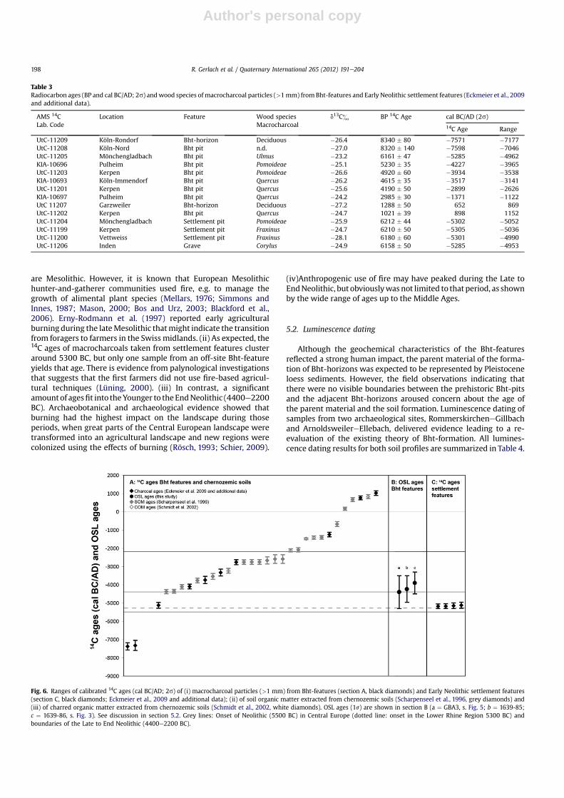
14C ages of charred organic matter from Bht-features (Table 3)were compared with published 14C ages of soil organic matter fromchernozemic soils (see also Gerlach et al., 2006). For clarity andbetter visualization, all results for Bht-features, including OSL agesfor their parent material, are displayed in Fig. 6 ordered by age.Scharpenseel et al. (1996) measured radiocarbon concentrations insoil organic matter separated from deeper Axh-horizons of cher-nozemic soils in Germany. Schmidt et al. (2002) published 14C agesof black carbon separated from subsurface Axh-horizons of Germanchernozemic soils.
The data for chernozemic A-horizons were added becausechernozemic soils were seen as possible predecessors of LuvicPhaeozems. The ages of soil organic matter and black carbon inchernozemic soils and the ages of macrocharcoals in Bht-horizonsof Phaeozems should therefore be in the same range. However,single macrocharcoal particles date individual events, whereasmicro-charcoal as well as soil organic matter samples yield meanages of different events and of materials of different susceptibilityagainst degradation in soils (Eckmeier et al., 2009).
In Central European deciduous forests, fires were rare during theHolocene andmainly had anthropogenic causes (Tinner et al., 1999,2005). Therefore, despite the disparities in the obtained ages, thereis continuity in the deliberate use of fire from the Mesolithic to theMiddle Ages, but with distinct gaps and concentrations. (i) Theearliest 14C ages of macrocharcoals from the Bht-features (off-site)
Table 2Wood species of identified macrocharcoal particles in Bht-horizons and pits and inNeolithic settlement pits (modified after Eckmeier et al., 2008).
Wood species Bht-pits (n ¼ 7)and horizons(n ¼ 3)
Settlementpits (n ¼ 5)
Deciduous 12 10Deciduous (diffuse porous) 3 10Corylus 0 6Fraxinus 0 2Prunus 1 0Pomoideae 7 31Ulmus 7 3Quercus 39 6n.d. 2 0
R. Gerlach et al. / Quaternary International 265 (2012) 191e204 197
Author's personal copy
are Mesolithic. However, it is known that European Mesolithichunter-and-gatherer communities used fire, e.g. to manage thegrowth of alimental plant species (Mellars, 1976; Simmons andInnes, 1987; Mason, 2000; Bos and Urz, 2003; Blackford et al.,2006). Erny-Rodmann et al. (1997) reported early agriculturalburning during the lateMesolithic thatmight indicate the transitionfrom foragers to farmers in the Swiss midlands. (ii) As expected, the14C ages of macrocharcoals taken from settlement features clusteraround 5300 BC, but only one sample from an off-site Bht-featureyields that age. There is evidence from palynological investigationsthat suggests that the first farmers did not use fire-based agricul-tural techniques (Lüning, 2000). (iii) In contrast, a significantamountof agesfit into theYounger to theEndNeolithic (4400e2200BC). Archaeobotanical and archaeological evidence showed thatburning had the highest impact on the landscape during thoseperiods, when great parts of the Central European landscape weretransformed into an agricultural landscape and new regions werecolonized using the effects of burning (Rösch, 1993; Schier, 2009).
(iv)Anthropogenic use of fire may have peaked during the Late toEndNeolithic, but obviouslywas not limited to that period, as shownby the wide range of ages up to the Middle Ages.
5.2. Luminescence dating
Although the geochemical characteristics of the Bht-featuresreflected a strong human impact, the parent material of the forma-tion of Bht-horizons was expected to be represented by Pleistoceneloess sediments. However, the field observations indicating thatthere were no visible boundaries between the prehistoric Bht-pitsand the adjacent Bht-horizons aroused concern about the age ofthe parent material and the soil formation. Luminescence dating ofsamples from two archaeological sites, RommerskircheneGillbachand ArnoldsweilereEllebach, delivered evidence leading to a re-evaluation of the existing theory of Bht-formation. All lumines-cence dating results for both soil profiles are summarized in Table 4.
Fig. 6. Ranges of calibrated 14C ages (cal BC/AD; 2s) of (i) macrocharcoal particles (>1 mm) from Bht-features (section A, black diamonds) and Early Neolithic settlement features(section C, black diamonds; Eckmeier et al., 2009 and additional data); (ii) of soil organic matter extracted from chernozemic soils (Scharpenseel et al., 1996, grey diamonds) and(iii) of charred organic matter extracted from chernozemic soils (Schmidt et al., 2002, white diamonds). OSL ages (1s) are shown in section B (a ¼ GBA3, s. Fig. 5; b ¼ 1639-85;c ¼ 1639-86, s. Fig. 3). See discussion in section 5.2. Grey lines: Onset of Neolithic (5500 BC) in Central Europe (dotted line: onset in the Lower Rhine Region 5300 BC) andboundaries of the Late to End Neolithic (4400e2200 BC).
Table 3Radiocarbon ages (BP and cal BC/AD; 2s) andwood species of macrocharcoal particles (>1mm) fromBht-features and Early Neolithic settlement features (Eckmeier et al., 2009and additional data).
AMS 14CLab. Code
Location Feature Wood speciesMacrocharcoal
d13C& BP 14C Age cal BC/AD (2s)
14C Age Range
UtC-11209 Köln-Rondorf Bht-horizon Deciduous �26.4 8340 � 80 �7571 �7177UtC-11208 Köln-Nord Bht pit n.d. �27.0 8320 � 140 �7598 �7046UtC-11205 Mönchengladbach Bht pit Ulmus �23.2 6161 � 47 �5285 �4962KIA-10696 Pulheim Bht pit Pomoideae �25.1 5230 � 35 �4227 �3965UtC-11203 Kerpen Bht pit Pomoideae �26.6 4920 � 60 �3934 �3538KIA-10693 Köln-Immendorf Bht pit Quercus �26.2 4615 � 35 �3517 �3141UtC-11201 Kerpen Bht pit Quercus �25.6 4190 � 50 �2899 �2626KIA-10697 Pulheim Bht pit Quercus �24.2 2985 � 30 �1371 �1122UtC 11207 Garzweiler Bht-horizon Deciduous �27.2 1288 � 50 652 869UtC-11202 Kerpen Bht pit Quercus �24.7 1021 � 39 898 1152UtC-11204 Mönchengladbach Settlement pit Pomoideae �25.9 6212 � 44 �5302 �5052UtC-11199 Kerpen Settlement pit Fraxinus �24.7 6210 � 50 �5305 �5036UtC-11200 Vettweiss Settlement pit Fraxinus �28.1 6180 � 60 �5301 �4990UtC-11206 Inden Grave Corylus �24.9 6158 � 50 �5285 �4953
R. Gerlach et al. / Quaternary International 265 (2012) 191e204198
Author's personal copy
At RommerskircheneGillbach, the IRSL-dating (Table 4) onpolymineral fine grains of the Bht-horizon (Fig. 3) yielded a Middleto Younger Neolithic age of 6.4 � 0.9 ka, in contrast to the expectedPleistocene age. Despite the limitations of fine grain dating ofsediments such as colluvial layers, which are prone to incompletebleaching at the time of deposition and coverage, a potentialshortfall in ages observed for polymineral fine grain dates due tofading, an anomalous signal loss over burial time, has to be inves-tigated. For the RommerskircheneGillbach site one sample waschecked for the occurrence of fading. Sample GBA-2 was analysedfollowing the protocol of Auclair et al. (2003) and the age of3.0 � 0.4 ka was corrected to 3.4 � 0.5 ka according to the proce-dure established by Huntley and Lamothe (2001) (Table 4). Asimilar dimension of age underestimation could be expected for theother samples of the RommerskircheneGillbach section. Thus, ifa similar fading rate as observed for sample GBA-2 affected sampleGBA-3, the deposition of the sediments inwhich the fBht-horizon isdeveloped would still date into the Neolithic (w5.2 BC).
However, good correlation of the IRSL-dates obtained for theyounger colluvial units M2 and M3 with well dated archaeologicalfeatures indicated only a minor impact of anomalous fading(Fischer, 2010) and supported the reliability of the IRSL approach.
The studies at the RommerskircheneGillbach site indicateda Neolithic sediment remobilization followed by soil formation(clay and humus eluviation and illuviation) within the accumulatedmaterial. However, the IRSL-dates from polymineral fine grains canonly be interpreted as a first approximation. Based on the investi-gations at the RommerskircheneGillbach site, studies in compa-rable sequences with Bht-horizons at the site ofArnoldsweilereEllebach (Fig. 5) were conducted to resolve thequestion, if more evidence for a colluvial origin of the humicsediments could be found. An improved approach allowed a muchmore detailed investigation of the signal, i.e. dose distribution inthe sediments (Section 3.4). The application of the finite mixture
model to analyse the equivalent dose (De) distribution allows todistinguish between different De populations and to calculatea mean De for each population. The data spread that is allowedwithin each population, however, has to be determined. Here, a Dedata spread of 12% was considered still acceptable for sufficientlybleached and undisturbed sediments, based on the results of a doserecovery test (DRT) and the lowest data spread observed fora natural sample. The relative standard deviation calculated from12 aliquots used for the DRT was 5% (test sample: 1639-86) and thelowest scatter in a natural De distribution was obtained for sample1639-86 with 16% (see De plot in Fig. 7). Because of the almostGaussian shaped and fairly tight De distribution (skewness of 0.2,see Fig. 7) this sample is considered as uncomplicated with respectto incomplete bleaching or substantial post-sedimentary mixing.For both scenarios, one would expect to measure more aliquotscarrying either substantially higher or lower doses resulting ina larger data spread around the mean or in a distribution curvedisplaying several peaks (Bateman et al., 2007). Sample 1639-86was taken from an Al-horizon developed in clearly colluvialdeposits above a pit (Fig. 5). The fairly tight De distribution ofsample 1639-86 argues for a sufficient resetting of the OSL-signalsduring colluvial transport that took place approx. 5.9 ka (92% of allmeasured sub-samples fit into this age component). Most likely, thedistance and time of the sediment transport into the weakdepressionwas sufficient to reset the OSL-signals. As an Al-horizon,these sediments once had been closer to an older surface andtherefore could be affected by post-depositional translocation ofmaterial through mixing or exhumation. Such mixing by bio-turbation should increase the degree of palaeodose scatter(Batemann et al., 2007), but this is small in case of sample 1639-86.Even attributing the minor age component (8%, Table 4) to a prob-able intrusion of younger material through bioturbation, it isconcluded that post-depositional mixing has only a minor impact,even in lower parts of the topsoil (Al-horizon) at site
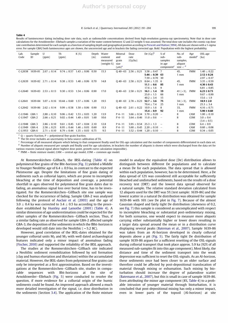
Table 4Results of luminescence dating including dose rate data, such as radionuclide concentrations derived from high-resolution gamma-ray spectrometry. Note that in dose ratecalculations for the ArnoldsweilereEllebach samples a variation of the water content between 12 and 22 weight-% was assumed. The total dose rate includes the cosmic-ray doserate contribution determined for each sample as a function of sampling depth and geographical position according to Prescott andHutton (1994). All data are shownwith a 1-sigmaerror. For sample GBA2 both luminescence ages are shown, the uncorrected age and in brackets the fading corrected age. Bold: Popultation with the highest probability.
Lab.Code
SampleID
U(ppm)
Th(ppm)
K (%) Depth(m)
Watercontentmeasured(weight-%)
Mineralandgrainsize(mm)a
Doserate(Gy/ka)
De (Gy)b % ofsub-samplesin agecomponentc
No. ofsub-samples,aliquotsize < d
Agemodele
OSL-age(ka)
C-L2638 1639-81 2.67 � 0.14 9.74 � 0.57 1.43 � 0.06 0.50 15.3 Q 40e63 2.56 � 0.21 3.58 � 0.47 7 45,1 mm
FMM 1.40 � 0.225.44 � 0.39 63 2.12 ± 0.247.59 � 0.70 30 2.97 � 0.37
C-L2639 1639-82 2.71 � 0.14 9.38 � 0.53 1.48 � 0.06 0.70 14.8 Q 40e63 2.58 � 0.21 8.64 � 1.35 6 45,1 mm
FMM 3.35 � 0.5911.1 � 0.6 85 4.30 ± 0.4317.6 � 1.6 9 6.81 � 0.85
C-L2640 1639-83 2.53 � 0.13 9.30 � 0.53 1.54 � 0.06 0.90 17.0 Q 40e63 2.58 � 0.21 16.1 � 1.4 19 41 (þ3),1 mm
FMM 6.23 ± 0.7325.0 � 1.5 66 9.67 � 0.9940.2 � 3.4 15 15.6 � 1.9
C-L2641 1639-84 3.07 � 0.16 10.44 � 0.60 1.57 � 0.06 1.20 19.5 Q 40e63 2.78 � 0.23 52.7 � 3.6 75 34 (þ3),1 mm
FMM 18.9 ± 2.070.4 � 7.4 25 25.3 � 3.4
C-L2642 1639-86 2.62 � 0.14 9.99 � 0.58 1.50 � 0.06 0.90 15.3 Q 40e63 2.61 � 0.22 10.9 � 1.6 8 33,1 mm
FMM 4.16 � 0.7115.4 � 0.9 92 5.90 ± 0.60
C-L1946 GBA 1 2,88 � 0,10 9.06 � 0.42 1.53 � 0.03 1.20 13.9 P 4e11 3.66 � 0.34 3.70 � 0.20 e 8 CAM 1.00 � 0.10C-L1947 GBA 2 2.66 � 0.21 9.02 � 0.44 1.49 � 0.01 1.60 10.6 P 4e11 3.64 � 0.46 11.0 � 0.6 e 8 COM 3.0 � 0.4
(3.4 � 0.5)C-L1948 GBA 3 2.86 � 0.10 9.61 � 0.45 1.67 � 0.04 2.10 12.8 P 4e11 3.95 � 0.54 25.3 � 1.3 e 8 COM 6.4 � 0.9C-L1949 GBA 4 2.58 � 0.23 8.95 � 0.44 1.46 � 0.03 0.60 8.9 P 4e11 3.60 � 0.45 2.20 � 0.10 e 8 CAM 0.60 � 0.08C-L1953 GBA 6 2.71 � 0.10 8.79 � 0.44 1.35 � 0.03 0.75 9.5 P 4e11 3.52 � 0.44 1.20 � 0.10 e 8 COM 0.34 � 0.05
a Q ¼ quartz fraction, P ¼ polymineral fine-grain fraction.b The De error includes an uncertainty in beta source calibration of 5%.c Percentage of all measured aliquots which belong to that component finally used for OSL-age calculation and the number of components differentiated in each data set.d Number of aliquots measured per sample and finally used for age calculation, in brackets the number of aliquots is shown which were discharged from the data set for
various reasons (natural signal above highest dose point, growth curve calculation impossible).e FMM ¼ finite mixture model, CAM ¼ central age model, COM ¼ common age model.
R. Gerlach et al. / Quaternary International 265 (2012) 191e204 199
Author's personal copy
ArnoldsweilereEllebach. Most probably, the impact of bioturbationis further reduced with distance to the surface in the sub-soil (B-horizon).
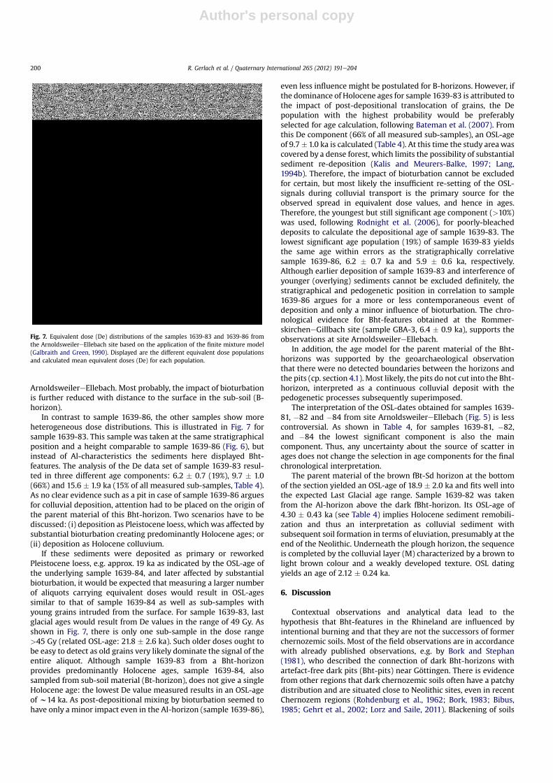
In contrast to sample 1639-86, the other samples show moreheterogeneous dose distributions. This is illustrated in Fig. 7 forsample 1639-83. This sample was taken at the same stratigraphicalposition and a height comparable to sample 1639-86 (Fig. 6), butinstead of Al-characteristics the sediments here displayed Bht-features. The analysis of the De data set of sample 1639-83 resul-ted in three different age components: 6.2 � 0.7 (19%), 9.7 � 1.0(66%) and 15.6 � 1.9 ka (15% of all measured sub-samples, Table 4).As no clear evidence such as a pit in case of sample 1639-86 arguesfor colluvial deposition, attention had to be placed on the origin ofthe parent material of this Bht-horizon. Two scenarios have to bediscussed: (i) deposition as Pleistocene loess, which was affected bysubstantial bioturbation creating predominantly Holocene ages; or(ii) deposition as Holocene colluvium.
If these sediments were deposited as primary or reworkedPleistocene loess, e.g. approx. 19 ka as indicated by the OSL-age ofthe underlying sample 1639-84, and later affected by substantialbioturbation, it would be expected that measuring a larger numberof aliquots carrying equivalent doses would result in OSL-agessimilar to that of sample 1639-84 as well as sub-samples withyoung grains intruded from the surface. For sample 1639-83, lastglacial ages would result from De values in the range of 49 Gy. Asshown in Fig. 7, there is only one sub-sample in the dose range>45 Gy (related OSL-age: 21.8 � 2.6 ka). Such older doses ought tobe easy to detect as old grains very likely dominate the signal of theentire aliquot. Although sample 1639-83 from a Bht-horizonprovides predominantly Holocene ages, sample 1639-84, alsosampled from sub-soil material (Bt-horizon), does not give a singleHolocene age: the lowest De value measured results in an OSL-ageof w14 ka. As post-depositional mixing by bioturbation seemed tohave only a minor impact even in the Al-horizon (sample 1639-86),
even less influence might be postulated for B-horizons. However, ifthe dominance of Holocene ages for sample 1639-83 is attributed tothe impact of post-depositional translocation of grains, the Depopulation with the highest probability would be preferablyselected for age calculation, following Bateman et al. (2007). Fromthis De component (66% of all measured sub-samples), an OSL-ageof 9.7� 1.0 ka is calculated (Table 4). At this time the study areawascovered by a dense forest, which limits the possibility of substantialsediment re-deposition (Kalis and Meurers-Balke, 1997; Lang,1994b). Therefore, the impact of bioturbation cannot be excludedfor certain, but most likely the insufficient re-setting of the OSL-signals during colluvial transport is the primary source for theobserved spread in equivalent dose values, and hence in ages.Therefore, the youngest but still significant age component (>10%)was used, following Rodnight et al. (2006), for poorly-bleacheddeposits to calculate the depositional age of sample 1639-83. Thelowest significant age population (19%) of sample 1639-83 yieldsthe same age within errors as the stratigraphically correlativesample 1639-86, 6.2 � 0.7 ka and 5.9 � 0.6 ka, respectively.Although earlier deposition of sample 1639-83 and interference ofyounger (overlying) sediments cannot be excluded definitely, thestratigraphical and pedogenetic position in correlation to sample1639-86 argues for a more or less contemporaneous event ofdeposition and only a minor influence of bioturbation. The chro-nological evidence for Bht-features obtained at the Rommer-skircheneGillbach site (sample GBA-3, 6.4 � 0.9 ka), supports theobservations at site ArnoldsweilereEllebach.
In addition, the age model for the parent material of the Bht-horizons was supported by the geoarchaeological observationthat there were no detected boundaries between the horizons andthe pits (cp. section 4.1). Most likely, the pits do not cut into the Bht-horizon, interpreted as a continuous colluvial deposit with thepedogenetic processes subsequently superimposed.
The interpretation of the OSL-dates obtained for samples 1639-81, �82 and �84 from site ArnoldsweilereEllebach (Fig. 5) is lesscontroversial. As shown in Table 4, for samples 1639-81, �82,and �84 the lowest significant component is also the maincomponent. Thus, any uncertainty about the source of scatter inages does not change the selection in age components for the finalchronological interpretation.
The parent material of the brown fBt-Sd horizon at the bottomof the section yielded an OSL-age of 18.9 � 2.0 ka and fits well intothe expected Last Glacial age range. Sample 1639-82 was takenfrom the Al-horizon above the dark fBht-horizon. Its OSL-age of4.30 � 0.43 ka (see Table 4) implies Holocene sediment remobili-zation and thus an interpretation as colluvial sediment withsubsequent soil formation in terms of eluviation, presumably at theend of the Neolithic. Underneath the plough horizon, the sequenceis completed by the colluvial layer (M) characterized by a brown tolight brown colour and a weakly developed texture. OSL datingyields an age of 2.12 � 0.24 ka.
6. Discussion
Contextual observations and analytical data lead to thehypothesis that Bht-features in the Rhineland are influenced byintentional burning and that they are not the successors of formerchernozemic soils. Most of the field observations are in accordancewith already published observations, e.g. by Bork and Stephan(1981), who described the connection of dark Bht-horizons withartefact-free dark pits (Bht-pits) near Göttingen. There is evidencefrom other regions that dark chernozemic soils often have a patchydistribution and are situated close to Neolithic sites, even in recentChernozem regions (Rohdenburg et al., 1962; Bork, 1983; Bibus,1985; Gehrt et al., 2002; Lorz and Saile, 2011). Blackening of soils
Fig. 7. Equivalent dose (De) distributions of the samples 1639-83 and 1639-86 fromthe ArnoldsweilereEllebach site based on the application of the finite mixture model(Galbraith and Green, 1990). Displayed are the different equivalent dose populationsand calculated mean equivalent doses (De) for each population.
R. Gerlach et al. / Quaternary International 265 (2012) 191e204200
Author's personal copy
close to prehistoric settlements could be easily explained with thepresence of charcoal dust (Baumann et al., 1964; Scheffer andMeyer, 1965). However, previously this anthropogenic influencewas considered as restricted to the production of micro-charcoalfound in the Bht-features. The charcoal is responsible for theirdark soil colour. Investigations at the slash-and-burn-experimentat Forchtenberg (SW Germany) showed that one fire would besufficient for a weak but measurable blackening of the topsoil(Eckmeier et al., 2007b; Ehrmann et al., 2009).
The new luminescence ages of Bht-horizons and contextual fieldobservations revealed that even the parent material could bea result of human activities. Not only charring and blackening, butalso the contemporaneous soil erosion was caused by the sameagricultural and fire-related activity (slash and burn).
Radiocarbon and OSL ages (Fig. 6) point to the Younger and EndNeolithic (4400e2200 BC), while they are missing for the EarlyNeolithic. A millennium after the Neolithisation of the CentralEuropean loess areas, these later phases of the Neolithic mostnotably were characterised by a sudden expansion of agriculturebeyond the established settlement areas and the first colonizationof areas with less fertile soils.
Schier (2009) suggested that the application of fire-basedtechniques such as slash and burn (not to be misunderstood asfire clearance) was the prerequisite for the adoption of agriculturein regions with soils of lower nutritional value, such as northernEurope and the alpine foreland. This hypothesis was based onarchaeobotanical studies (charcoal and/or pollen analyses)revealing the existence of extensive and long-term fire-basedagriculture (slash and burn) both in south-western Germany (LakeConstance, Rösch, 1993) and northern Germany to Denmark(Iversen, 1941; Kalis and Meurers-Balke, 1998).
Prehistoric burning experiments in deciduous forests (For-chtenberg, SWGermany) showed that slash and burn is an efficientbut extensive method to prepare agricultural land which results inhigh crop yields. Additionally, the opening of the landscapegenerates better conditions for livestock farming (Ehrmann et al.,2009).
An expansion of farming and a change in cultural technique isalso recognizable in the palynological record of the Rhineland loessarea. During the Younger Neolithic (4400e3500 BC) the fields andsettlements expanded into the low mountain ranges for the firsttime. Since the Late Neolithic (3500 BC), the existence of larger fieldareas and deforestation in the loess area was deduced from theoccurrence of increasing quantities of herb and grass pollen(Zimmermann et al., 2005). At the same time, forests started to bemanaged and changed into an artificial open mixed oak park-woodland in the End Neolithic. Such mixed oak woods are mostlyconnected with animal husbandry, because they are well suitablefor wood pasture as well as for pig fattening with acorns(Zimmermann et al., 2005). Concentrations of charcoal particles incontemporaneous pollen samples indicated the use of fire asa plausible cause for the development of this human-madewoodland type (Zimmermann et al., 2005). The charred materialin the Bht-horizons that was detected by geochemical analyses isa further evidence for extensive use of fire during the later phases ofthe Neolithic.
The reduction of natural forest vegetation and the increase ofarable land since the Young Neolithic should have causedmajor soilerosion. However, evidence of colluvial sediments that formed asa result of the Neolithic colonization phases is generally scarce andnegligible (Kalis et al., 2003; Dotterweich, 2008). Most authorsconceded that the Neolithic erosional processes only delivered localcolluvia, which filled the microrelief in the agricultural area itself(Schalich, 1981; Bork, 1983; Lang and Hönscheidt, 1999; Kalis et al.,2003). As long as deforestation had been limited to smaller
clearings in the forest, no soil material could have been eroded fromthe densely overgrown slopes and transported into the valleys. Inthe Rhineland the forests of the valley slopes were heavily clearedfrom the early Iron Age (ca. 800 BC) onward and the woodland atthe valley bottoms was replaced by extensive grassland (Becker,2005; Meurers-Balke and Kalis, 2006). This enabled the trans-location of larger masses of colluvial sediments into the valleys. Inmost cases, the older colluvial sediments in the local traps did nothave any connection to the valleys. In contrast to the hypothesis ofLang and Hönscheidt (1999), most of these old local colluviaremained stable and were subsequently affected over millennia bysoil formation processes.
Bork et al. (1998) already suggested that the earliest Neolithiccolluvia were exposed to soil formation and therefore would not berecognizable as such. They could be misinterpreted as relics ofchernozemic soils. The spatial distribution, the characteristics andthe OSL ages of the investigated Bht-features are in accordancewiththis model.
OSL ages of the ArnoldsweilereEllebach site suggested thebeginning of the eluviation and illuviation processes at the end ofthe Neolithic (sample 1639-82: around 4.30 ka, Table 4). Depositionof the younger colluvial layer (sample 1639-81, Fig. 5) around 2.12ka (Table 4) postdates pedogenetic superimposition. However,eluviation and illuviation processes are still active in the uppercolluvial layers and affected the buried subsoil-horizons untiltoday.
These observations are not restricted to the Lower Rhine Basin.In comparison to the results presented here, Kadereit et al. (2010)investigated a similar stratigraphy of Holocene sediments andsoils in one U-shaped trench (Bretten-Bauerbach) in the loess-covered area of south-western Germany (Kraichgau) using IRSL-techniques. They found buried horizons of so called Humic Luvi-sols, which were described as a degradation stage of former Cher-nozems. The macroscopic and analytical characteristics of theinvestigated humic Bt- or Bw-horizon (e.g., 0.34e0.67% Corg and26.4e34.4% clay) are comparable with those from Bht-horizonsfrom the Rhineland sites (Table 1). The dark clayey humic Bw- orBt-horizon appeared in form of patches embedded in a brownLuvisol (Kadereit et al., 2010, Fig. 16), similar to the situation inFig. 5.
The lowermost sample within the colluvial coverage yielded anIRSL age of 3.97 � 0.23 ka, representing the transition from Early toMiddle Bronze Age (Kadereit et al., 2010, p. 17, p. 17). It waspresumed that soil erosion did not start before the end of the EarlyBronze Age. However, IRSL-dating of the underlying Bht-material(¼ humic Bw, sensu Kadereit et al., 2010) yielded Early Neolithicages ranging between 7.97 � 0.58 and 7.19 � 0.49 ka, which aresignificantly younger than the expected Pleistocene age. Analysis ofthin sections did not indicate a colluvial origin of the Bht-material.Therefore, Kadereit et al. (2010) argued against a human inducedEarly Neolithic sediment remobilization. Pedogenetic processes,mainly bioturbation bringing up sediments to the surface, weresupposed to explain the resetting of the luminescence signal tosuch a degree that Holocene instead of the expected Pleistoceneages were obtained (Kadereit et al., 2010). Concerning the black-ening of the Luvic Phaeozems, Kadereit et al. (2010) did not excludean anthropogenic promotion by Neolithic charring.
However, it has to be questioned if bioturbation is reallyresponsible for the young IRSL ages because: (i) the dated humicBw horizons have always been sub-soil horizons and not been asdeeply affected by bioturbation as the missing topsoil, and (ii) it isnot possible to distinguish between different age populations toclarify the influence of bioturbation by using the IRSL techniques.
As shown for the example of ArnoldsweilereEllebach, the use ofthe 40e63 mm grain size fraction of quartz allows a substantial
R. Gerlach et al. / Quaternary International 265 (2012) 191e204 201
Author's personal copy
reduction of the number of grains per aliquot. This is essential toinvestigate the degree of signal resetting and the impact of bio-turbation. The obtained OSL ages indicate a deposition of the parentmaterial of the Bht-features during the Young Neolithic rather thanan impact of bioturbation.
Given that these results could be transferred to SW Germany,soil erosion would have started in this region with the earliestNeolithic occupation (5500 BC) onwards, significantly earlier thanin the Rhineland. Enduring surface stability from the Neolithic tothe Early Bronze Age following the colluvial deposition would haveled to pedogenetic processes (mainly eluviation and illuviation)that masked the colluvial origin of the sediments in the thinsections. However, further investigations are necessary to verify theexistence of such Early Neolithic colluvia.
For the Rhineland, it is hypothesised that the use of agriculturalburning (slash and burn) and the deposition of Neolithic colluvialsediments were correlative processes, both starting in the Late toEnd Neolithic. It is not known if the pyrogenic carbon wasa component of the eroded sediment or if it was incorporated afterits deposition. Pedogenetic superimposition (eluviation and illuvi-ation) of these colluvia started after deposition at the end of theNeolithic and was interrupted by colluvial covering during the lateIron Age.
To evaluate this hypothesis, a systematic survey of Bht-featuresat archaeological excavations, including OSL dating and micro-morphology, would be necessary. Additionally, it should beconsidered that not only the dark Bht-horizons but also typicalbrown Bt-horizons could be early colluvial sediments which weretransformed into Luvisols without being influenced by charring.Leopold et al. (2011) report that naturally brown Luvisols and darkanthropogenic soils influenced by fire activities exist more or lesssynchronously in the surrounding of a Middle Neolithic settlement(4700 BC). Both could be the source material for local Neolithiccolluvia, with different colours, later mistaken as Luvisols derivedfrom loess or relics of Chernozems.
7. Summary and perspective
The compilation of results concerning the formation of Bht-features lead to the conclusion that dark fossil Bht-horizons andpits in the Lower Rhine Region are archaeological off-sitefeatures; deeply influenced by charred organic matter derivedfrom fires ignited by humans. Radiocarbon ages indicated burningevents between Mesolithic and the Medieval Ages, with anaccumulation of ages during Late to End Neolithic (4400e2200BC), when slash-and-burn practices are also visible in archae-obotanical records.
Luminescence ages in this study yielded ages around 6.4e4.3 ka(Late to End Neolithic) indicating that even the parent material ofthe soils enriched in pyrogenic carbon is of colluvial origin. Thus,the history of human-induced soil erosion started during the YoungNeolithic and was most likely connected to the opening of thelandscape by using agricultural burning techniques. The latterinfluenced the formation of dark Anthrosols that were subse-quently affected by soil formation processes, mainly eluviation andilluviation of humus and clay complexes. The resulting Bht-horizons could be misunderstood as properties of a Luvisol witha chernozemic background. For that, Bht-horizons in the LowerRhine region are a part of dark Anthrosols but they are not relics offormer Chernozems.
Soil formation by fire-based agriculture could explain at leastpartially how dark soil horizons could have formed under a climatewhich was too moist to agree with the current understanding ofChernozems as zonal steppe soils, and why they occur in a patchydistribution.
The term “Chernozem” summarizes different types of black soilsand connects them to steppe climate and natural pedogeneticprocesses although they could have had different formationhistories. The common feature of most Central European degraded“chernozemic soils” such as Phaeozems or Luvic Phaeozems aredark humic Bw- or Bt-horizons, but this is insufficient to definethem as former Chernozems.
Beyond the discussion about the formation of dark soil horizons,it may become necessary to revise conventional wisdom ofa uniform, natural soil development for many Central Europeansoils which were strongly influenced during the Holocene byenduring agricultural activities. Most likely, human impact can beconsidered as the main soil forming factor in early settled regions,not only for “black soils”.
Acknowledgements
Support, comments and discussions came from Jutta Meurers-Balke, Ursula Tegtmeier (University of Cologne, ArchaeobotanyLaboratory), Arie J. Kalis (University of Frankfurt/Main, Institute forPrehistoric Archaeology), Andreas Zimmermann (University ofCologne, Prehistoric Institute), Ehrhard Schulz, Otto Ehrmann,Manfred Rösch, Wolfram Schier (the “Forchtenberg ExperimentTeam”). Reiner Lubberich helped to improve and modify thefigures. We also acknowledge all the numerous archaeologicalexcavators who provided information and samples. Their perma-nent assistance was the base of our investigation. The study waspartly funded by “Ministerium für Wirtschaft, Energie, Bauen,Wohnen und Verkehr des Landes Nordrhein-Westfalen” and theUniversity of Zurich. We thank three anonymous reviewers and theeditors for constructive comments.
References
Altermann, M., Rinklebe, J., Merbach, I., Körschens, M., Langer, U., Hofmann, B.,2005. Chernozem e Soil of the year 2005. Journal of Plant Nutrition and SoilScience 168, 725e740.
Auclair, M., Lamothe, M., Huot, S., 2003. Measurement of anomalous fading forfeldspar IRSL using SAR. Radiation Measurements 37, 487e492.
Bateman, M.D., Boulter, C.H., Carr, A.S., Frederick, C.D., Peter, D., Wilder, M., 2007.Detecting post-depositional sediment disturbance in sandy deposits usingoptical luminescence. Quaternary Geochronology 2, 57e64.
Baumann, W., Czerny, P., Fiedler, H.J., 1964. Archäologische und bodenkundlicheUntersuchungen an einem bandkeramischen Siedlungsprofil bei Dresden-Prohlis. Arbeits- und Forschungsberichte zur sächsischen Bodendenkmalpflege13, 7e50.
Becker, W.D., 2005. Das Elsbachtal. Landschaftsgeschichte vom Endneolithikum bisins Hochmittelalter, vol. 59. Rheinische Ausgrabungen.
Bibus, E., 1985. Zur jungen Relief- und Bodenentwicklung in der Umgebung vonTübingen. In: Seuffert, O., Mensching, H. (Eds.), Aktuelle und vorzeitliche Relief-und Bodenentwicklung, Berlin, Stuttgart, pp. 109e124.
Blackford, J.J., Innes, J.B., Hatton, J.J., Caseldine, C.J., 2006. Mid-holocene environ-mental change at Black Ridge Brook, Dartmoor, SW England: a new appraisalbased on fungal spore analysis. Review of Palaeobotany and Palynology 141,189e201.
Boden, A.G., 1994. Bodenkundliche Kartieranleitung (Hannover).Boden, A.G., 2005. Bodenkundliche Kartieranleitung (Hannover).Boenigk, W., Frechen, M., 1994. Lumineszenz-Datierungen an kolluvialen Sed-
imenten des Elsbachtales e Erste Ergebnisse. Archäologie im Rheinland,177e179.
Bøtter-Jensen, L., McKeever, S.W.S., Wintle, A.G., 2003. Optically Stimulated Lumi-nescence Dosimetry. Elsevier.
Bork, H.-R., Stephan, H.G., 1981. Archäologische Funde und bodenkundliche Befundein einer linienbandkeramischen Siedlung bei Dorste, Kreis Osterode am Harz.Göttinger Jahrbuch 29, 23e30.
Bork, H.-R., Bork, H., Dalchow, K., Faust, B., Piorr, H.-P., Schatz, T., 1998. Land-schaftsentwicklung in Mitteleuropa. Klett-Perthes, Gotha/Stuttgart.
Bork, H.-R., 1983. Die holozäne Relief- und Bodenentwicklung in Lößgebieten. In:Bork, H.-R., Ricken, W. (Eds.), Bodenerosion, holozäne und pleistozäne Bode-nentwicklung, pp. 1e93.
Bos, J.A.A., Urz, R., 2003. Late Glacial and early Holocene environment in the middleLahn river valley (Hessen, central-west Germany) and the local impact of earlyMesolithic people - pollen and macrofossil evidence. Vegetation History andArchaeobotany 12, 19e36.
R. Gerlach et al. / Quaternary International 265 (2012) 191e204202
Author's personal copy
Castelletti, L., Stäuble, H., 1997. Holzkohlenuntersuchungen zu ur- und frühge-schichtlichen Siedlungen der Aldenhovener Platte und ihrer Umgebung (Nie-derrheinische Bucht) e eine diachrone Betrachtung. In: Lüning, J. (Ed.), Studienzur neolithischen Besiedlung der Aldenhovener Platte und ihrer Umgebung,vol. 43. Rheinische Ausgrabungen, pp. 687e714.
Catt, J.A., 1989. Relict properties in soils of the central and north-west Europeantemperate region. Catena Supplement 16, 41e58.
Dotterweich, M., 2008. The history of soil erosion and fluvial deposits in smallcatchments of central Europe: deciphering the long-term interactionbetween humans and the environment e A review. Geomorphology 101,192e208.
Driessen, P., Deckers, J., Spaargaren, O., Nachtergaele, F.O., 2001. Lecture Notes onthe Major Soils of the World. FAO, Wageningen.
Duller, G.A.T., 2008. Single-grain optical dating of Quaternary sediments: whyaliquot size matters in luminescence dating. Boreas 37, 589e612.
Eckmeier, E., Wiesenberg, G.L.B., 2009. Short-chain n-alkanes (C16e20) in ancientsoil are useful molecular markers for prehistoric biomass burning. Journal ofArchaeological Science 36, 1590e1596.
Eckmeier, E., Gerlach, R., Gehrt, E., Schmidt, M.W.I., 2007a. Pedogenesis of Cher-nozems in central Europe - A review. Geoderma 139, 288e299.
Eckmeier, E., Gerlach, R., Skjemstad, J.O., Ehrmann, O., Schmidt, M.W.I., 2007b.Minor changes in soil organic carbon and charcoal concentrations detected ina temperate deciduous forest a year after an experimental slash-and-burn.Biogeosciences 4, 377e383.
Eckmeier, E., Gerlach, R., Tegtmeier, U., Schmidt, M.W.I., 2008. Charred organicmatter and phosphorus in black soils in the Lower Rhine Basin (NorthwestGermany) indicate prehistoric burning. In: Fiorentino, G., Magri, D. (Eds.),Charcoals From The Past: Cultural and Palaeoenvironmental Implications.British Archaeological Reports International Series 1807, pp. 93e103.
Eckmeier, E., van der Borg, K., Tegtmeier, U., Schmidt, M.W.I., Gerlach, R., 2009.Dating charred soil organic matter: comparison of radiocarbon ages frommacrocharcoals and chemically separated charcoal carbon. Radiocarbon 51,437e443.
Ehrmann, O., Rösch, M., Schier, W., 2009. Experimentelle Rekonstruktion einesjungneolithischen Wald-Fedbaus mit Feuereinsatz - ein multidisziplinäresForschungsprojekt zur Wirtschaftsarchäologie und Landschaftsökologie. Prä-historische Zeitschrift 84, 44e72.
Ehwald, E., Jäger, K.D., Lange, E., 1999. Das Problem Wald - Offenland im zirkum-herzynen Trockengebiet vor der neolithischen Besiedlung sowie die Entstehungder zirkumherzynen Schwarzerden. In: Rolle, R., Andraschko, F.M. (Eds.), FrüheNutzung Pflanzlicher Ressourcen. Internationales Symposium Duderstedt. Lit,Hamburg, pp. 12e34.
Erny-Rodmann, C., Gross-Klee, E., Haas, J.N., Jacomet, S., Zoller, H., 1997. Früher“human impact” und Ackerbau im Übergangsbereich Spätmesolithikum-Früh-neolithikum im schweizerischen MittellandFrüher “human impact” undAckerbau im Übergangsbereich Spätmesolithikum-Frühneolithikum imschweizerischen Mittelland. Jahrbuch der Schweizerischen Gesellschaft für Ur-und Frühgeschichte 80, 27e56.
Firbas, F., 1949. Waldgeschichte Mitteleuropas. Gustav Fischer, Jena.Fischer, P., 2010. Zur mittel- und jungquartären Relief- und Bodenentwicklung der
nordwestlichen Kölner Bucht - Detailuntersuchungen der lössbedeckten Mit-telterrassenlandschaft. Doctoral dissertation, Universität zu Köln.
Frenzel. (Hrsg.), B., 1992. Evaluation of land surfaces cleared from forests byprehistoric men in early neolithic times and the time of migrating Germanictribes. Paläoklimaforschung ESF project “European paleoclimate and man”.Special issue 3. Gustav Fischer Verlag.
Fuchs, M., Lang, A., 2009. Luminescence dating of hillslope deposits e A review.Geomorphology 109, 17e26.
Fuchs, M., Fischer, M., Reverman, R., 2010. Colluvial and alluvial sediment archivestemporally resolved by OSL dating: implications for reconstructing soil erosion.Quaternary Geochronology 5, 269e273.
Galbraith, R.F., Green, P.F., 1990. Estimating the component ages in a finite mixture.Nuclear Tracks and Radiation Measurements 17, 197e206.
Gavin, D.G., Brubaker, L.B., Lertzman, K.P., 2003. Holocene fire history of a coastaltemperate rain forest based on soil charcoal radiocarbon dates. Ecology 84,186e201.
Gavin, D.G., 2001. Estimation of inbuilt age in radiocarbon ages of soil charcoal forfire history studies. Radiocarbon 43, 27e44.
Gehrt, E., Geschwinde, M., Schmidt, M.W.I., 2002. Neolithikum, Feuer und Tscher-nosem - oder: was haben die Linienbandkeramiker mit der Schwarzerde zutun? Archäologisches Korrespondenzblatt 32, 21e30.
Gerlach, R., Baumewerd-Schmidt, H., van den Borg, K., Eckmeier, E.,Schmidt, M.W.I., 2006. Prehistoric alteration of soil in the Lower Rhine Basin,Northwest Germany-archaeological, 14C and geochemical evidence. Geoderma136, 38e50.
Huntley, D.J., Lamothe, M., 2001. Ubiquity of anomalous fading in K-feldspars andthe measurement and correction for it in optical dating. Canadian Journal ofEarth Sciences 38, 1093e1106.
Huntley, B., 1988. Glacial and holocene vegetation history e Europe. In: Huntley, B.,Webb, T. (Eds.), Vegetation History. Handbook of Vegetation Science, vol. 7.Kluwer, Dordrecht/Boston/London, pp. 341e383.
Iversen, J., 1941. Landnam i Danmarks stenalder. En pollenanalytisk undersøgelseover det første Landbrugs Indvirkning paa vegetationsudviklingen.(Land occupation in Denmark’s stone age. A pollen-analytical study of theinfluence of farmer culture on the vegetational development). Københaven.
Kadereit, A., Lang, A., Hönscheidt, S., Müth, J., Wagner, G.A., 2002. IR-OSL-datedcolluvial archives as evidence for the Holocene landscape history. Case studiesfrom SW-Germany. Zeitschrift Für Geomorphologie 128 (N.F. Suppl.), 191e207.
Kadereit, A., Sponholz, B., Rosch, M., Schier, W., Kramer, B., Wagner, G.A., 2006.Chronology of Holocene environmental changes at the tell site of Uivar,Romania, and its significance for late Neolithic tell evolution in the temperateBalkans. Zeitschrift Für Geomorphologie 142 (N.F.Suppl), 19e45.
Kadereit, A., Kühn, P., Wagner, G.A., 2010. Holocene relief and soil changes in loess-covered areas of south-western Germany: the pedosedimentary archives ofBretten-Bauerbach (Kraichgau). Quaternary International 222, 96e119.
Kalis, A.J., Meurers-Balke, J., 1997. Landnutzung im Neolithikum. In: Richter, J.,(Hrsg.) (Eds.), Neolithikum. Geschichtlicher Atlas der Rheinlande, pp. 25e47.Beiheft II/2.1 e II/2.2. Köln.
Kalis, A.J., Meurers-Balke, J., 1998. Die “Landnam”-Modelle von Iversen und Troels-Smith zur Neolithisierung des westlichen Ostseegebietes - ein Versuch ihrerAktualisierung. Prähistorische Zeitschrift 73, 1e24.
Kalis, A.J., Merkt, J., Wunderlich, J., 2003. Environmental changes during theHolocene climatic optimum in central Europe e human impact and naturalcauses. Quaternary Science Reviews 22, 33e79.
Kopp, E., 1965. Über Vorkommen “degradierter Steppenböden” in den Lößgebietendes Niederrheins und Westfalens und ihre Bedeutung für die Paläobodenkundeund Bodengenese. Eiszeitalter und Gegenwart 16, 97e112.
Kuo, S., 1996. Phosphorus. In: Sparks, D.L. (Ed.), Methods of Soil Analysis. Part 3Chemical Methods (SSSA Book Series 5). Soil Science Society of America,Madison, pp. 869e919.
Lang, A., Hönscheidt, S., 1999. Age and source of colluvial sediments at Vaihingen-Enz, Germany. Catena 38, 89e107.
Lang, A., Wagner, G.A., 1997. Infrared stimulated Luminescence dating of Holocenecolluvial sediments using the 410 nm emission. Quaternary Geochronology(Quaternary Science Reviews) 16, 393e396.
Lang, A., 1994a. Infra-red stimulated luminescence dating of Holocene reworkedsilty sediments. Quaternary Geochronology (Quaternary Science Reviews) 13,525e528.
Lang, G., 1994b. Quartäre Vegetationsgeschichte Europas. Methoden und Ergeb-nisse. Gustav Fischer Verlag.
Leopold, M., Völkel, J., 2007. Colluvium: definition, differentiation and their possiblesuitability to reconstruct Holocene climate data. Quaternary International 162-163, 133e140.
Leopold, M., Hürkamp, K., Völkel, J., Schmotz, K., 2011. Black soils, sediments andbrown Calcic luvisols: a pedological description of a newly discovered neolithicring ditch system at Stephansposching, Eastern Bavaria, Germany. QuaternaryInternational 243, 293e304.
Litt, T., 1994. Paläoökologie, Paläobotanik und Stratigraphie des Jungquartärs imnordmitteleuropäischen Tiefland (Unter besonderer Berücksichtigung des Elbe-Saale-Gebietes). Dissertationes Botanicae 227.
Lorz, C., Saile, T., 2011. Anthropogenic pedogenesis of Chernozems in Germany? ACritical review. Quaternary International 243, 273e279.
Lüning, J., 2000. Steinzeitliche Bauern in Deutschland: die Landwirtschaft imNeolithikum. Habelt, Bonn.
Mason, S., 2000. Fire and Mesolithic subsistance - managing oaks for acorns innorthwest Europe? Palaeogeography, Palaeoclimatology, Palaeoecology 164,139e150.
Mellars, P.,1976. Fire ecology, animal populations andman: a study of some ecologicalrelationships in prehistory. Proceedings of the Prehistorical Society 42, 15e45.
Meurers-Balke, J., Kalis, A.J., 2006. Landwirtschaft und Landnutzung in der Bronze -und Eisenzeit. In: Kunow, J., Wegener, H.H. (Eds.), Urgeschichte im Rheinland,pp. 267e276.
Mückenhausen, E., 1985. Die Bodenkunde und ihre geologischen, Geo-morphologischen, Mineralogischen und Petrologischen Grundlagen. DLG Ver-lag, Frankfurt/Main.
Müller, H., 1953. Zur spät- und nacheiszeitlichen Vegetationsgeschichte des Mit-teldeutschen Trockengebietes. Nova Acta Leopoldina N. F. 16/110.
Murray, A.S., Wintle, A.G., 2000. Luminescence dating of quartz using animproved single-aliquot regenerative-dose protocol. Radiation Measurements32, 57e73.
Murray, A.S., Wintle, A.G., 2003. The single aliquot regenerative dose protocol:potential for improvements in reliability. Radiation Measurements 37, 377e381.
Preusser, F., Degering, D., Fuchs, M., Hilgers, A., Kadereit, A., Klasen, N.,Krbetschek, M., Richter, D., Spencer, J., 2008. Luminescence dating: basics,methods and applications. Quaternary Science Journal 57 (1-2), 95e149.
Prescott, J.R., Hutton, J.T., 1994. Cosmic ray contribution to dose rates for lumines-cence and ESR dating: large depths and long-term time variations. RadiationMeasurements 23 (2-3), 497e500. doi:10.1016/1350-4487(94)90086-8.
Richter, J., 1997. Neolithikum. Geschichtlicher Atlas der Rheinlande Beiheft II/2.1 eII/2.2 Köln.
Rodionov, A., Amelung, W., Peinemann, N., Haumaier, L., Zhang, X., Kleber, M.,Glaser, B., Urusevskaja, I., Zech, W., 2010. Black carbon in grassland ecosystemsof the world. Global Biogeochemical Cycles 24, GB3013. doi:10.1029/2009GB003669.
Rodnight, H., Duller, G.A.T., Wintle, A.G., Tooth, S., 2006. Assessing the reproduc-ibility and accuracy of optical dating of fluvial deposits. Quaternary Geochro-nology 1, 109e120.
Roeschmann, G., 1968. Pseudogley-Tschernoseme und deren Übergangsbildungenzu Parabraunerden im Lößgebiet der Hildesheimer Börde. Geologisches Jahr-buch 85, 841e860.
R. Gerlach et al. / Quaternary International 265 (2012) 191e204 203
Author's personal copy
Rohdenburg, H., Meyer, B., 1968. Zur Datierung und Bodengeschichte mitteleur-opäischer Oberflächenböden (Schwarzerde, Parabraunerde, Kalkstein-braunlehm): Spätglazial oder Holozän? Göttinger Bodenkundliche Berichte 6,127e212.
Rohdenburg, H., Willerding, U., Jankuhn, H., 1962. Quartärgeomorphologische,bodenkundliche, paläobotanische und archäologische Untersuchen an der Löß-Schwarzerde-Insel mit einer wahrscheinlich spätneolithischen Siedlung imBereich der Göttinger Leineaue. Göttinger Jahrbuch 10, 36e56.
Rösch, M., 1993. Prehistoric land use as recorded in a lake-shore core at LakeConstance. Vegetation History and Archeobotany 2, 213e232.
Schalich, J., 1981. Boden- und Landschaftsgeschichte in der westlichen Nieder-rheinischen Bucht. Fortschritte in der Geologie des Rheinlandes und Westfalens29, 505e518.
Scharpenseel, H.W., Pietig, F., Schiffmann, H., Becker-Heidmann, P., 1996. Radio-carbon dating of soils: database contribution by Bonn and Hamburg. Radio-carbon 38, 277e293.
Scheffer, F., Meyer, B., 1958. Bodenkundliche Untersuchungen an neolithischenSiedlungsprofilen des Göttinger Leinetalgrabens. Göttinger Jahrbuch, 3e19.
Scheffer, F., Meyer, B., 1965. Ergebnisse pedologischer Untersuchungen an derGrabungsfläche: Pedogenetische und stratigraphische Phasengliederung undweitere Beiträge zur Herkunft dunkler Grubenfüllungen in Lößgebieten. NeueAusgrabungen und Forschungen in Niedersachsen 2, 72e88.
Schier, W., 2009. Extensiver Brandfeldbau und die Ausbreitung der neolithischenWirtschaftsweise in Mitteleuropa und Südskandinavien am Ende des 5. Jahr-tausends v. Chr. Praehistorische Zeitschrift 81, 15e43.
Schlichting, E., Blume, H.-P., Stahr, K., 1995. Bodenkundliches Praktikum. Blackwell,Berlin/Oxford.
Schmidt, M.W.I., Skjemstad, J.O., Gehrt, E., Kögel-Knabner, I., 1999. Charred organiccarbon in German chernozemic soils. European Journal of Soil Science 50,351e365.
Schmidt, M.W.I., Skjemstad, J.O., Jäger, c., 2002. Carbon isotope geochemistry andnano-morphology of soil black carbon: Black Chernozemic soils in CentralEurope originate from ancient biomass burning. Global Biogeochemical Cycles16 (4), 1123. doi:10.1029/2002GB001939.
Schulz, W., 2007. Die Kolluvien der westlichen Kölner Bucht. Gliederung, Entste-hungszeit und geomorphologische Bedeutung. Doctoral dissertation, Uni-versität zu Köln.
Simmons, I.G., Innes, J.B., 1987. Mid-Holocene adaptions and Later Mesolithic forestdisturbance in northern England. Journal of Archaeological Science 14, 385e403.
Skjemstad, J.O., Janik, L.J., Head, M.J., McClure, S.G., 1993. High-Energy UltravioletPhotooxidation - a Novel technique for studying Physically Protected organic-matter in clay-Sized and silt-Sized Aggregates. Journal of Soil Science 44,485e499.
Skjemstad, J.O., Taylor, J.A., Smernik, R.J., 1999. Estimation of charcoal (char) in soils.Communications in Soil Science and Plant Analysis 30, 2283e2298.
Thiemeyer, H., 1989. Landschaftsgeschichte und bodenkundliche Befunde einesbandkeramischen Siedlungsplatzes bei Bruchenbrücken/Wetterau. FrankfurterGeowissenschaftliche Arbeiten D 10, 31e42.
Tinner, W., Hubschmid, P., Wehrli, M., Ammann, B., Conedera, M., 1999. Long-termforest fire ecology and dynamics in southern Switzerland. Journal of Ecology 87,273e289.
Tinner, W., Conedera, M., Ammann, B., Lotter, A.F., 2005. Fire ecology northand south of the Alps since the last ice age. The Holocene 15 (8), 1214e1226.
Wallinga, J., Murray, A.S., Wintle, A.G., 2000. The single-aliquot regenerative-dose(SAR) protocol applied to coarse-grain feldspar. Radiation Measurements 32,529e533.
Wiesenberg, G.L.B., Lehndorff, E., Schwark, L., 2009a. Thermal degradation of ryeand maize straw: lipid pattern changes as a function of temperature. OrganicGeochemistry 40, 167e174.
Wiesenberg, G.L.B., Schneckenberger, K., Kuzyakov, Y., Schwark, L., 2009b. Plantlipid composition is not affected by short-term isotopic (13C) pulse-labellingexperiments. Journal of Plant Nutrition and Soil Science 172, 445e453.
Wintle, A.G., Murray, A.S., 2006. A review of quartz optically stimulated lumines-cence characteristics and their relevance in single-aliquot regeneration datingprotocols. Radiation Measurements 41, 369e391.
Zimmermann, A., Meurers-Balke, J., Kalis, A.J., 2005. Das Neolithikum im Rheinland.Bonner Jahrbücher 205, 1e63.
R. Gerlach et al. / Quaternary International 265 (2012) 191e204204
Copyright © 2022 FDOKUMEN