Geomorphologic assessment of relative tectonic activity in the Maharlou Lake Basin, Zagros Mountains...
11
Geomorphologic assessment of relative tectonic activity in the Maharlou Lake Basin, Zagros Mountains of Iran ALI FAGHIH 1 * , BABAK SAMANI 2 , TIMOTHY KUSKY 3 , SAMAN KHABAZI 1 and REIHANEH ROSHANAK 1 1 Department of Earth Sciences, College of Sciences, Shiraz University, Shiraz, Iran 2 Faculty of Earth Sciences, Shahid Chamran University, Ahvaz, Iran 3 State Key Lab for Geological Processes and Mineral Resources, Three Gorges Research Center for Geohazards, China University of Geosciences, Wuhan, China Spatial differences of Quaternary deformation and intensity of tectonic activity are assessed through a detailed quantitative geomorphic study of the fault-generated mountain fronts and alluvial/fluvial systems around the Maharlou Lake Basin in the Zagros Fold–Thrust Belt of Iran. The Maharlou Lake Basin is defined as an approximately northwest–southeast trending, linear, topographic depression located in the central Zagros Mountains of Iran. The lake is located in a tectonically active area delineated by the Ghareh and Maharlou faults. Combined geomor- phic and morphometric data reveal differences between the Ghareh and Maharlou mountain front faults indicating different levels of tectonic activity along each mountain front. Geomorphic indices show a relatively high degree of tectonic activity along the Ghareh Mountain Front in the southwest, in contrast with less tectonic activity along the Ahmadi Mountain Front northeast of the lake which is consistent with field evidence and seismotectonic data for the study area. A ramp valley tectonic setting is proposed to explain the tectonosedimentary evolution of the lake. Copyright © 2011 John Wiley & Sons, Ltd. Received 8 February 2011; accepted 4 August 2011 KEY WORDS neotectonics; tectonic geomorphology; geomorphic indices; faults; Maharlou Lake; Zagros Mountains 1. INTRODUCTION The study of landforms that appear to be controlled by the interaction between tectonic and geomorphic processes is the focus of tectonic geomorphology (Mayer, 1986). Land- scapes in tectonically active areas result from a complex inte- gration of the effects of crustal block motion, erosion and/or deposition by surface processes (Burbank and Anderson, 2001). Therefore, geomorphic investigation in regions of active tectonics is a powerful tool for studies of tectonic geomorphology. The quantitative measurement of landscape is based on the calculation of geomorphic indices using topographic maps or digital elevation models, aerial photo- graphs or satellite imagery, and fieldwork (Keller and Pinter, 2002). Geomorphic indices are a tool for analyzing land- forms and evaluating the degree of tectonic activity in a given area (Keller, 1986). The most characteristic landforms developed in semi-arid, tectonically-active zones are fault- generated mountain fronts. These are large-scale tectonic landforms with long survival periods (>100 ka), in which the erosional and depositional history are linked to the related range-front fault (Mayer, 1986). Therefore, the geomorpho- logic analysis of mountain fronts, alluvial fans and related drainage networks would provide valuable information about the recorded tectonic history (Silva et al., 2003; Singh and Tandon, 2008; Figueroa and Knott, 2010). The aim of this study is to assess the relative intensity of tectonic activity of fault-generated mountain fronts around the Maharlou Lake Basin (Figure 1) through geomorphic analysis, and to explain the origin and evolution of this lake basin as a tectonic and morphologic feature in the Zagros Mountains of Iran. The lake is located 18km southeast of Shiraz City in southwest Iran. Natural hazard assessment and disaster management depend on an understanding of active tectonics including studies of the patterns of deformation, landscape development, and the determination of rates of tectonic processes. In particular, earthquakes impact human societies with huge attendant economic consequences (Singh and Tandon, 2008). The fault-generated mountain fronts and fluvial system are the most characteristic landforms in this region. Therefore, geomorphological and morphometric anal- yses of these features may offer valuable information on the *Correspondence to: A. Faghih, Department of Earth Sciences, College of Sciences, Shiraz University, Shiraz, Iran. E-mail: [email protected]; [email protected] Copyright © 2011 John Wiley & Sons, Ltd. GEOLOGICAL JOURNAL Geol. J. 47: 30–40 (2012) Published online 28 September 2011 in Wiley Online Library (wileyonlinelibrary.com). DOI: 10.1002/gj.1329
Transcript of Geomorphologic assessment of relative tectonic activity in the Maharlou Lake Basin, Zagros Mountains...

Geomorphologic assessment of relative tectonic activity in the Maharlou LakeBasin, Zagros Mountains of Iran
ALI FAGHIH1*, BABAK SAMANI2, TIMOTHY KUSKY3, SAMAN KHABAZI1 andREIHANEH ROSHANAK1
1Department of Earth Sciences, College of Sciences, Shiraz University, Shiraz, Iran2Faculty of Earth Sciences, Shahid Chamran University, Ahvaz, Iran
3State Key Lab for Geological Processes and Mineral Resources, Three Gorges Research Center for Geohazards, ChinaUniversity of Geosciences, Wuhan, China
Spatial differences of Quaternary deformation and intensity of tectonic activity are assessed through a detailed quantitative geomorphic studyof the fault-generated mountain fronts and alluvial/fluvial systems around the Maharlou Lake Basin in the Zagros Fold–Thrust Belt of Iran.The Maharlou Lake Basin is defined as an approximately northwest–southeast trending, linear, topographic depression located in the centralZagros Mountains of Iran. The lake is located in a tectonically active area delineated by the Ghareh and Maharlou faults. Combined geomor-phic and morphometric data reveal differences between the Ghareh and Maharlou mountain front faults indicating different levels of tectonicactivity along each mountain front. Geomorphic indices show a relatively high degree of tectonic activity along the Ghareh Mountain Front inthe southwest, in contrast with less tectonic activity along the Ahmadi Mountain Front northeast of the lake which is consistent with fieldevidence and seismotectonic data for the study area. A ramp valley tectonic setting is proposed to explain the tectonosedimentary evolutionof the lake. Copyright © 2011 John Wiley & Sons, Ltd.
Received 8 February 2011; accepted 4 August 2011
KEY WORDS neotectonics; tectonic geomorphology; geomorphic indices; faults; Maharlou Lake; Zagros Mountains
1. INTRODUCTION
The study of landforms that appear to be controlled by theinteraction between tectonic and geomorphic processes isthe focus of tectonic geomorphology (Mayer, 1986). Land-scapes in tectonically active areas result from a complex inte-gration of the effects of crustal block motion, erosion and/ordeposition by surface processes (Burbank and Anderson,2001). Therefore, geomorphic investigation in regions ofactive tectonics is a powerful tool for studies of tectonicgeomorphology. The quantitative measurement of landscapeis based on the calculation of geomorphic indices usingtopographic maps or digital elevation models, aerial photo-graphs or satellite imagery, and fieldwork (Keller and Pinter,2002). Geomorphic indices are a tool for analyzing land-forms and evaluating the degree of tectonic activity in a givenarea (Keller, 1986). The most characteristic landformsdeveloped in semi-arid, tectonically-active zones are fault-generated mountain fronts. These are large-scale tectoniclandforms with long survival periods (>100 ka), in which
the erosional and depositional history are linked to the relatedrange-front fault (Mayer, 1986). Therefore, the geomorpho-logic analysis of mountain fronts, alluvial fans and relateddrainage networks would provide valuable information aboutthe recorded tectonic history (Silva et al., 2003; Singh andTandon, 2008; Figueroa and Knott, 2010).The aim of this study is to assess the relative intensity of
tectonic activity of fault-generated mountain fronts aroundthe Maharlou Lake Basin (Figure 1) through geomorphicanalysis, and to explain the origin and evolution of this lakebasin as a tectonic and morphologic feature in the ZagrosMountains of Iran. The lake is located 18 km southeast ofShiraz City in southwest Iran. Natural hazard assessment anddisaster management depend on an understanding of activetectonics including studies of the patterns of deformation,landscape development, and the determination of rates oftectonic processes. In particular, earthquakes impact humansocieties with huge attendant economic consequences (Singhand Tandon, 2008). The fault-generated mountain fronts andfluvial system are the most characteristic landforms in thisregion. Therefore, geomorphological and morphometric anal-yses of these features may offer valuable information on the
*Correspondence to: A. Faghih, Department of Earth Sciences, College ofSciences, Shiraz University, Shiraz, Iran. E-mail: [email protected];[email protected]
Copyright © 2011 John Wiley & Sons, Ltd.
GEOLOGICAL JOURNALGeol. J. 47: 30–40 (2012)Published online 28 September 2011 in Wiley Online Library(wileyonlinelibrary.com). DOI: 10.1002/gj.1329

Figure 1. Geological map of the study area. The upper map shows tectonic subdivisions of the Zagros Orogeny (Zagros Fold–Thrust Belt, Sanandaj–SirjanMetamorphic Belt and Urumieh–Dokhtar Magmatic Arc) and the location of the study area.
TECTONIC ACTIVITY IN THE MAHARLOU LAKE BASIN, ZAGROS MOUNTAINS 31
Copyright © 2011 John Wiley & Sons, Ltd. Geol. J. 47: 30–40 (2012)
recorded tectonic history in the geomorphic features aroundthe lake which may inform hazard assessments in the region.
2. GEOMORPHOLOGICAL AND GEOLOGICALSETTING
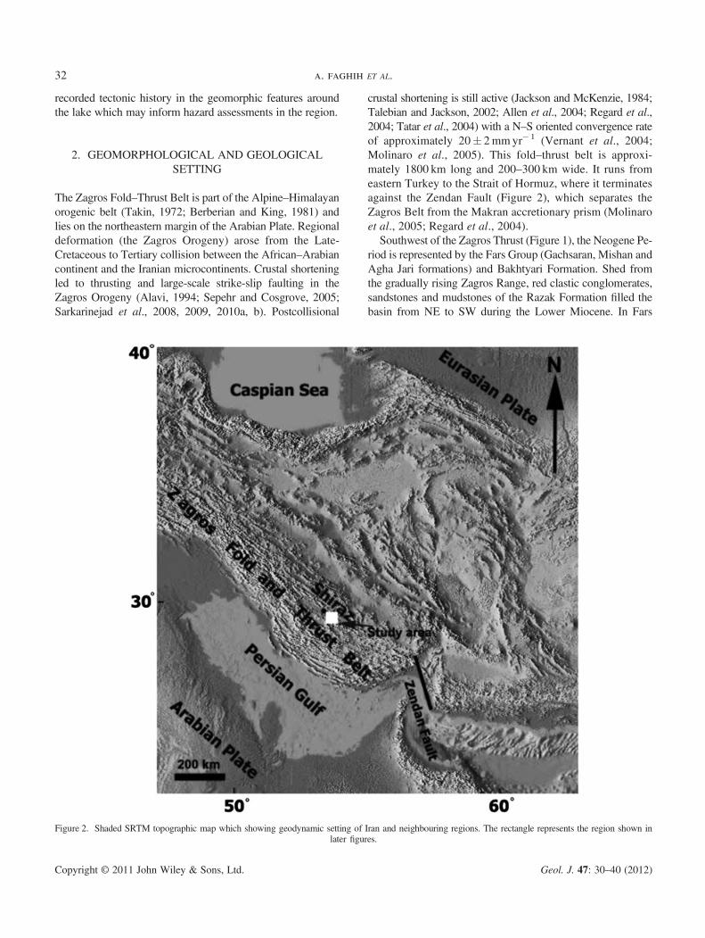
The Zagros Fold–Thrust Belt is part of the Alpine–Himalayanorogenic belt (Takin, 1972; Berberian and King, 1981) andlies on the northeastern margin of the Arabian Plate. Regionaldeformation (the Zagros Orogeny) arose from the Late-Cretaceous to Tertiary collision between the African–Arabiancontinent and the Iranian microcontinents. Crustal shorteningled to thrusting and large-scale strike-slip faulting in theZagros Orogeny (Alavi, 1994; Sepehr and Cosgrove, 2005;Sarkarinejad et al., 2008, 2009, 2010a, b). Postcollisional
crustal shortening is still active (Jackson and McKenzie, 1984;Talebian and Jackson, 2002; Allen et al., 2004; Regard et al.,2004; Tatar et al., 2004) with a N–S oriented convergence rateof approximately 20� 2mmyr� 1 (Vernant et al., 2004;Molinaro et al., 2005). This fold–thrust belt is approxi-mately 1800 km long and 200–300 km wide. It runs fromeastern Turkey to the Strait of Hormuz, where it terminatesagainst the Zendan Fault (Figure 2), which separates theZagros Belt from the Makran accretionary prism (Molinaroet al., 2005; Regard et al., 2004).Southwest of the Zagros Thrust (Figure 1), the Neogene Pe-
riod is represented by the Fars Group (Gachsaran, Mishan andAgha Jari formations) and Bakhtyari Formation. Shed fromthe gradually rising Zagros Range, red clastic conglomerates,sandstones and mudstones of the Razak Formation filled thebasin from NE to SW during the Lower Miocene. In Fars
Figure 2. Shaded SRTM topographic map which showing geodynamic setting of Iran and neighbouring regions. The rectangle represents the region shown inlater figures.
a. faghih ET AL.32
Copyright © 2011 John Wiley & Sons, Ltd. Geol. J. 47: 30–40 (2012)

Province they interfinger with limestones and marls of theupper Asmari–Jahrum Formation and with evaporites andinterbedded limestones of the Gachsaran Formation. From lateOligocene to early Miocene time, the Asmari Sea recededfrom the Zagros Basin. On the Fars platform, evaporates weredeposited, comprising gypsum, anhydrite and halite beds ofthe Gachsaran Formation. Fars Group deposition ended withthe Agha Jari Formation, a mudstone and sandstone sequenceof continental nature. After the strong uplifting of the ZagrosRange in the late Alpine phase, the Bakhtyari Conglomerates(Upper Pliocene in age) were deposited from rivers in fold beltvalleys, with an irregular distribution pattern and preservedthickness (James and Wynd, 1965; Falcon, 1974; Motiei,1994; Alavi, 1994, Bahrami, 1997).Maharlou Lake is located in the central part of the Zagros
Fold–Thrust Belt (Figures 1 and 2; Alavi, 1994). It is anephemeral saline lake that developed in an intra-continentalbasin (Sonnenfeld, 1991). In wet seasons, the lake expandsto an area of 280 km2 (26 km long and 12 km wide). Thelake is located in an elevated depression (1455m abovesea level) with a northwest–southeast trend.The average annual precipitation and minimum and max-
imum temperatures are 341mm, 9.8 �C and 25.6 �C respec-tively, with the maximum precipitation occurring in Januaryand December. The average annual evaporation rate is ap-proximately 2391mm. Average water depths in the northernpart of the lake range between 1.5 to 2m. Vegetation coverin the study area includes various species of Artemisia,Astragalus and liquorice. The lake receives water from di-rect precipitation and inflow from surface run-off, a few sea-sonal rivers and several karstic springs which collectivelycompensate for the high evaporation rates in the region(Dumas et al., 2003). There are no permanent rivers enteringthe lake, and the local drainage network is ephemeral, includ-ing the Nahre-Azam (the Khoshk), and Chenare-Rahdar (theBabahaji) rivers (Fayazi et al., 2007). The Khoshk River, hasthe largest discharge and plays the most significant role in thehydrochemical composition of the Maharlou Lake. The maxi-mum discharge of the Khoshk River in wet and dry seasons isapproximately 164 and 2.4m3s� 1, respectively. The KhoshkRiver is approximately 62 km long, 40 km of which passesthrough Shiraz City (Forghani et al., 2009).The lake’s hydrogeological properties, former lake level
stands and the survival of relict Pleistocene fish species(Djamali et al., 2009) indicate that the lake has been in exis-tence since early Pleistocene times. The Lake Basin devel-oped with a NW–SE- trend, and the floor of the Basin isinfilled with Plio-Quaternary alluvial fan and alluviumdeposits. Recent lacustrine deposits comprise predominantlywell-laminated carbonates, evaporites and siliciclastic sedi-ments. Lake centre deposits are evaporitic and in the lakemargins are carbonates and siliciclastic sediments. (Laket al., 2008). A study of the recent evolution of the lake
hydrochemistry has shown that the lake water has changedfrom a Mg–SO4–Cl type in 1970 to a Na–Mg–Cl–(SO4) typeat the present time (Fayazi et al., 2007; Djamali et al., 2009).
The margins of the lake are defined by a series of mountainranges. The Ahmadi Mountains northeast of the lake and theGhareh Mountains to the southwest were uplifted as doublyplunging anticlines. The mountain ranges are composedof Cenozoic sedimentary rocks. The main rock type whichconstitutes the mountain fronts in the study area is Oligo-Miocene limestone of the Asmari Formation (Figure 1).
3. METHODS
Geomorphic indices represent a quantitative approach togeomorphic analysis. In this study we analyze the main mor-phological features of the mountain fronts, alluvial fans, andfluvial networks surrounding Maharlou Lake. The geomor-phological and morphometric analyses were carried out inthe field using 1:25 000 scale topographic maps and digitalelevation models. Most of the geomorphic and morphomet-ric parameters used in this study were developed by Hack(1973), Bull and McFadden (1977), Rantsman (1979), Wellset al. (1988), Silva et al. (2003) and El-Hamdouni et al.(2008). Six main parameters used in these analyses quantifythe relationships between tectonics, lithology, sedimentationand erosion, and include mountain front sinuosity, facet,valley width/height ratio, drainage basin shape ratio, basinelongation ratio and alluvial fan topographic profiles.
3.1. Mountain front sinuosity index (Smf)
Mountain front sinuosity index is defined as Smf ¼ Lms=Ls;where Lmf is the length of the mountain front along the footof the mountain where a change in slope from the mountainto the piedmont occurs; and LS is the straight line length ofthe mountain front (Bull and McFadden, 1977). This indexreflects the balance between erosional processes and activetectonism along the mountain front. Active vertical tectonics(generally coincident with active faults or folds) tend to pro-duce straight mountain fronts, however these become moresinuous as streams cut both laterally and into the front (Bulland McFadden, 1977; Keller, 1986; Keller and Pinter,2002). Mountain fronts associated with active tectonics andactive uplift are relatively straight with low values of Smf;but if the rate of uplift is reduced or ceases, then erosionalprocesses along the mountain front produce a more sinuousfront and thus lower value of Smf. Values of Smf are readilycalculated from topographic maps or aerial photography,although they are scale dependant (Bull and McFadden,1977). Small-scale maps (1:250 000) produce approximatevalues of Smf, while larger scale topographic maps due totheir high resolution produce more accurate assessments of
TECTONIC ACTIVITY IN THE MAHARLOU LAKE BASIN, ZAGROS MOUNTAINS 33
Copyright © 2011 John Wiley & Sons, Ltd. Geol. J. 47: 30–40 (2012)
Smf. Mountain front sinuosity is also sensitive to the localclimate, where the values need to be adjusted in areas ofhigher rainfall and erosion rates (e.g. Kusky et al., 2010).
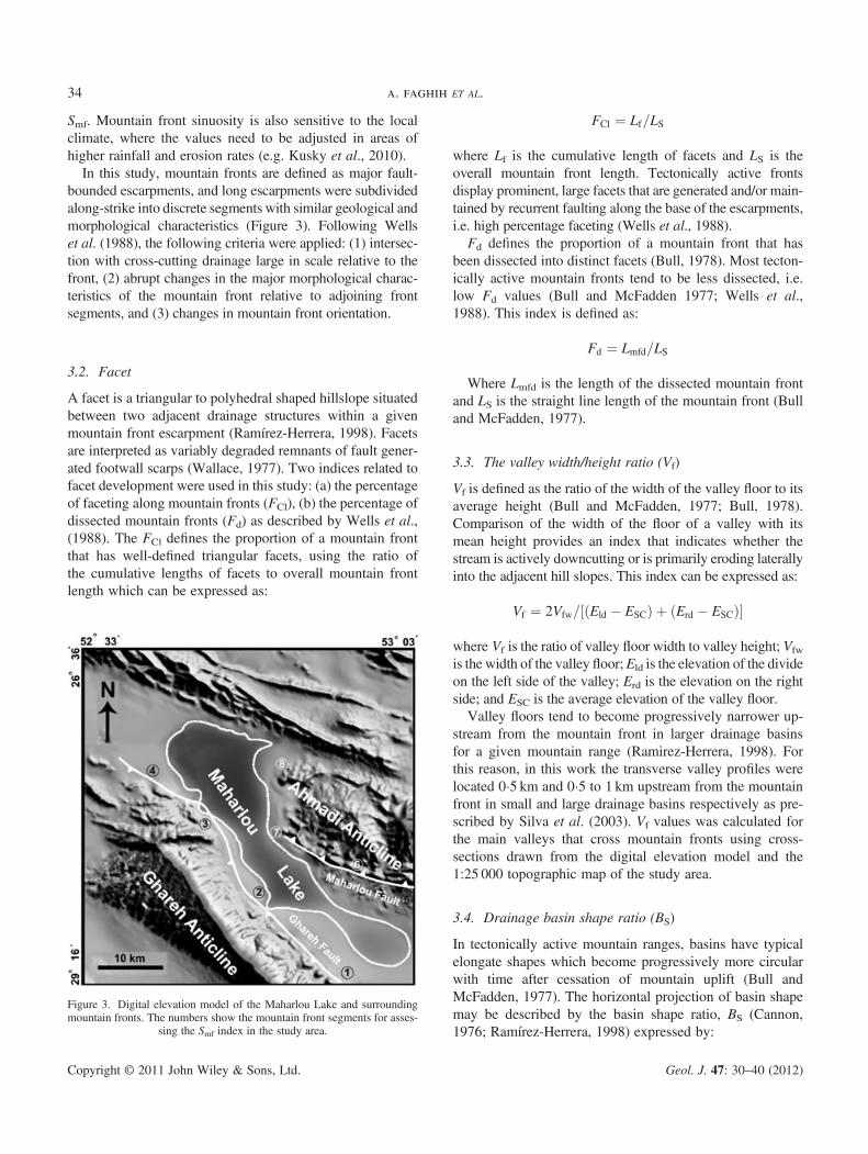
In this study, mountain fronts are defined as major fault-bounded escarpments, and long escarpments were subdividedalong-strike into discrete segments with similar geological andmorphological characteristics (Figure 3). Following Wellset al. (1988), the following criteria were applied: (1) intersec-tion with cross-cutting drainage large in scale relative to thefront, (2) abrupt changes in the major morphological charac-teristics of the mountain front relative to adjoining frontsegments, and (3) changes in mountain front orientation.
3.2. Facet
A facet is a triangular to polyhedral shaped hillslope situatedbetween two adjacent drainage structures within a givenmountain front escarpment (Ramírez-Herrera, 1998). Facetsare interpreted as variably degraded remnants of fault gener-ated footwall scarps (Wallace, 1977). Two indices related tofacet development were used in this study: (a) the percentageof faceting along mountain fronts (FCl), (b) the percentage ofdissected mountain fronts (Fd) as described by Wells et al.,(1988). The FCl defines the proportion of a mountain frontthat has well-defined triangular facets, using the ratio ofthe cumulative lengths of facets to overall mountain frontlength which can be expressed as:
FCl ¼ Lf=LS
where Lf is the cumulative length of facets and LS is theoverall mountain front length. Tectonically active frontsdisplay prominent, large facets that are generated and/or main-tained by recurrent faulting along the base of the escarpments,i.e. high percentage faceting (Wells et al., 1988).Fd defines the proportion of a mountain front that has
been dissected into distinct facets (Bull, 1978). Most tecton-ically active mountain fronts tend to be less dissected, i.e.low Fd values (Bull and McFadden 1977; Wells et al.,1988). This index is defined as:
Fd ¼ Lmfd=LS
Where Lmfd is the length of the dissected mountain frontand LS is the straight line length of the mountain front (Bulland McFadden, 1977).
3.3. The valley width/height ratio (Vf)
Vf is defined as the ratio of the width of the valley floor to itsaverage height (Bull and McFadden, 1977; Bull, 1978).Comparison of the width of the floor of a valley with itsmean height provides an index that indicates whether thestream is actively downcutting or is primarily eroding laterallyinto the adjacent hill slopes. This index can be expressed as:
Vf ¼ 2Vfw= Eld � ESCð Þ þ Erd � ESCð Þ½ �
where Vf is the ratio of valley floor width to valley height; Vfw
is the width of the valley floor;Eld is the elevation of the divideon the left side of the valley; Erd is the elevation on the rightside; and ESC is the average elevation of the valley floor.Valley floors tend to become progressively narrower up-
stream from the mountain front in larger drainage basinsfor a given mountain range (Ramirez-Herrera, 1998). Forthis reason, in this work the transverse valley profiles werelocated 0�5 km and 0�5 to 1 km upstream from the mountainfront in small and large drainage basins respectively as pre-scribed by Silva et al. (2003). Vf values was calculated forthe main valleys that cross mountain fronts using cross-sections drawn from the digital elevation model and the1:25 000 topographic map of the study area.
3.4. Drainage basin shape ratio (BS)
In tectonically active mountain ranges, basins have typicalelongate shapes which become progressively more circularwith time after cessation of mountain uplift (Bull andMcFadden, 1977). The horizontal projection of basin shapemay be described by the basin shape ratio, BS (Cannon,1976; Ramírez-Herrera, 1998) expressed by:
Figure 3. Digital elevation model of the Maharlou Lake and surroundingmountain fronts. The numbers show the mountain front segments for asses-
sing the Smf index in the study area.
a. faghih ET AL.34
Copyright © 2011 John Wiley & Sons, Ltd. Geol. J. 47: 30–40 (2012)

BS ¼ Bl=Bw
where Bl is the length of the basin, measured from its mouthto the most distant drainage divide, and Bw is the width ofthe basin measured across the short axis.
3.5. Basin elongation ratio (Re)
The basin elongation ratio (Bull and McFadden, 1977), isone of the proxy indicators of recent tectonic activity. Thisparameter (Re) is calculated as a ratio of the drainage basinarea (A) to the maximum basin length (L), i.e. the distancebetween the two most distant points in the drainage basinwhich is expressed by:
Re ¼ 2ffiffiffiffiffiffiA :
p ffiffiffip
p� �=L
where A is the drainage basin area and L is the maximumlength of the basin.
3.6. Alluvial fan topographic profiles
Tectonic uplift creates elevated terrain and provides in-creased potential energy to the agents of erosion such as flu-vial systems. Alluvial fan morphology sheds light on faultactivity and reflects the rate of the source mountain uplift(Gürbüz and Gürer, 2008). The plan view morphologiesand the longitudinal profiles of eight alluvial fans aroundthe Maharlou Lake were used to define control mechanismson fan development.
4. RESULTS
4.1. Mountain front sinuosity
In this work, eight mountain fronts were evaluated. Obtainedvalues of Smf range from 1.03 to 1.37 (Figure 4). The lowestvalues of Smf are associated with the southwest border ofMaharlou Lake with the Ghareh Fault (Tables 1 and 2).The Smf values calculated for the Ghareh Mountain Frontvary from 1.03 to 1.08, which point to a relatively high
activity of recent uplift along this front. Alternatively, Smf
values vary from 1.16–1.37 along the Maharlou Fault whichrevealed less active tectonism (Figure 4).
4.2. Facet
The obtained FCl (35.3%) and Fd (42.6%) values revealed ahigh percentage faceting and a low percentage of dissectedmountain front along the Ghareh Mountain Front than theAhmadi Mountain Front (FCl = 21.6%; Fd = 65.2%) whichsuggests a relatively higher degree of tectonic activity alongthe Ghareh Fault than the Maharlou Fault (Figure 4). Tec-tonically active fronts display a high percentage of triangularfaceting and tend to be less dissected (Bull and McFadden,1977; Wells et al., 1988).
4.3. Valley floor width-to-height ratio
Valleys dissecting the Ghareh Mountain Front display Vf
values (calculated for valley segments located 1 km up-stream of the mountain front) ranging between 0.2–0.45whereas those of Maharlou Mountain Front vary between0.32–0.76 (Figure 4 and Tables 1 and 2). Most Vf values inthis study are relatively low, revealing that most valleys ofthe study area are V-shaped. U-shaped valleys generallyhave high values of Vf, whereas V-shaped valleys have rela-tively low values. Because uplift is associated with incision,the index is thought to be a surrogate for active tectonicswhere low values of Vf are associated with higher rates ofuplift and incision (El-Hamdouni et al., 2008).
4.4. Drainage basin shape ratio
The resulting values of BS calculations range from 1.3 to 4.8(Figures 4 and 5). The highest values are along the SW bor-der of the Maharlou Lake Basin. The index reflectsdifferences between elongated and more circular basins.High values of BS are associated with elongated basins, gen-erally associated with relatively higher tectonic activity(Keller and Pinter, 2002). Low values of BS indicate a morecircular-shaped basin, generally associated with low tectonic
Figure 4. Geomorphic and morphometric parameters and relative tectonic activity in each mountain front in the study area. Arrow tip shows the increasingintensity of tectonic activity. AMF and GMF letters indicate Ahmadi Mountain Front and Ghareh Mountain Front, respectively. Six used parameters are moun-tain front sinuosity index (Smf), facet (FCl), dissected facets (Fd), the valley width/height ratio (Vf), drainage basin shape ratio (BS) and basin elongation ratio (Re).
This figure is available in colour online at wileyonlinelibrary.com/journal/gj
TECTONIC ACTIVITY IN THE MAHARLOU LAKE BASIN, ZAGROS MOUNTAINS 35
Copyright © 2011 John Wiley & Sons, Ltd. Geol. J. 47: 30–40 (2012)

activity. Rapidly uplifted mountain fronts generally produceelongated, steep basins; and when tectonic activity is dimin-ished or ceases, widening of the basins occur from themountain front up (Ramírez-Herrera, 1998; El-Hamdouniet al., 2008). Elongated drainage basins characteristically oc-cur in the southwestern part of the Maharlou Lake Basin,suggesting a relatively higher degree of tectonic uplift in thispart of the study area.
4.5. Basin elongation ratio
The Re values have been calculated for nine small drainagebasins located on the NE and SW borders of the lake in theGhareh and Ahmadi Mountain Fronts. These results rangefrom 0.435 to 0.689, pointing to a slightly active uplift of theMaharlou Fault than the more active Ghareh Fault (Figures 4and 5). Drainage basins in arid and semiarid climates tend toshow Re values ranging from <0.50, through 0.50–0.75 to>0.75 for tectonically active, slightly active and inactive set-tings, respectively (Cuong and Zuchiewicz, 2001).
4.6. Alluvial fan topographic profiles
The fans generally present a profile with a similar mean slope.They have concave upwards profile with slopes that graduallydecrease from the apex down. Most of these profiles are seg-mented into two parts with constant, but different, slopes.These slope breaks were determined in the field and some ofthem were identified by their observable fault scarps. There-fore, the slope breaks with dashed lines in the longitudinalfan profiles may be caused by tectonic activity (Figure 6).
5. DISCUSSION
5.1. Geomorphology
The geomorphic andmorphometric analyses carried out on themountain fronts, alluvial fans and fluvial system aroundMaharlou Lake have significant value in providing informa-tion on the relative rate of tectonic uplift. Geomorphological
Table 2. Morphometric data of the Ghareh Fault
Ghareh Fault
Station Lmf (m) LS (m) Smf Eld (m) Erd (m) ESC (m) Vfw (m) Vf
1 8368.4 8124.6 1.03 1686.2 1709.3 1616.9 16.2 0.22 9903.3 9431.7 1.05 1636.8 1684.9 1591.1 18.1 0.353 6421.5 6058.1 1.06 1625.3 1654.2 1549.5 35.2 0.394 11742.1 10872.3 1.08 1711.1 1741.6 1642.9 37.5 0.45
Figure 5. Shaded SRTM topographic map which shows alluvial fans andfluvial systems used in the morphometric analysis.
Table 1. Morphometric data of the Maharlou Fault
Maharlou Fault
Station Lmf (m) LS (m) Smf Eld (m) Erd (m) ESC (m) Vfw (m) Vf
1 6307.6 5437.5 1.16 1685.5 1682.8 1618.8 21 0.322 13718.2 11337.3 1.21 1650.2 1680.7 1581.9 32.6 0.393 12892.9 9767.3 1.32 1710.5 1696.8 1660.5 26.7 0.624 11775.2 8595.1 1.37 1585.2 1591.9 1545.9 32.4 0.76
a. faghih ET AL.36
Copyright © 2011 John Wiley & Sons, Ltd. Geol. J. 47: 30–40 (2012)

features such as fault scarps and triangular facets along moun-tain fronts reflect recent tectonic activity. Indices of activetectonics may detect anomalies in the fluvial system or alluvialfans along the mountain fronts. These anomalies may be pro-duced by local changes from tectonic activity resulting fromuplift or subsidence (El-Hamdouni et al., 2008).Alluvial fans are ubiquitous features of mountainous
range-fronts worldwide. Tectonic activity is now commonlyrecognized as the primary controlling factor in dictating allu-vial fan properties such as location, setting and morphology,primarily through tectonic influences on drainage basinrelief and fan accommodation space (Allen and Hovius,1998; Allen and Densmore, 2000; Densmore et al., 2007).Alluvial fan morphology is an indicator of active tectonicsbecause the fan form reflects varying rates of tectonicprocesses such as uplift of the catchment on mountainsalong a fault or tilting of the fan surface. Several factors, inparticular tectonics, climate, and geomorphic history affectthe geomorphology of alluvial fans. Within the context of
the geomorphic setting, fan morphology reflects fan pro-cesses and evolution. In this study, slope breaks indicatedby dashed lines are interpreted to be caused by fault activityalong the mountain front associated with the Ghareh andMaharlou faults (Figure 6). Slope morphology of scarps pro-duced by faulting is a useful geomorphic indicator ofactive tectonics (Keller and Pinter, 2002). The geometry offaults and the structure of the basin surrounding the lakeindicate a ramp valley tectonic setting, with the lake devel-oping in the topographic depression created by synclinalbuckling (Figure 7). The ramp valley (Willis, 1928)developed in the structural accommodation zone created be-tween the two thrust faults with opposing vergences. Otherexamples of similar ramp valley basins have been describedby Bally (1982), Mann et al. (1991), Cobbold et al. (1993),and Lavenu et al. (1996). Mann et al. (1991) accounted forMiocene–Pliocene basin structures in Hispaniola by apply-ing a similar tectonic evolution that developed along therestraining bend between the North American and Caribbean
Figure 6. Longitudinal profiles of some studied alluvial fans along the mountain fronts (Ahamdi Mountain Front in this figure) bounding Maharlou Lake. Slopebreaks indicated by dashed lines interpreted as the location of the Maharlou Fault.
Figure 7. Simplified cross-section showing the two fault-generatedmountain fronts bounding theMaharlou Lake Basin that developed in a ramp valley tectonic setting.(See Figure 1 for location of section line).
TECTONIC ACTIVITY IN THE MAHARLOU LAKE BASIN, ZAGROS MOUNTAINS 37
Copyright © 2011 John Wiley & Sons, Ltd. Geol. J. 47: 30–40 (2012)

Plates. Lavenu et al. (1996) proposed that a compressionalsetting prevailed in the Ambato-Latacunga area, which cor-roborates a full-ramp setting (Cobbold et al., 1993). Theseauthors assume that both the east-verging Victoria Fault inthe west and the west-verging Pisayambo Fault in the eastoverthrust the basin margins.
Seismotectonic studies carried out by Andalibi and Oveisi(1999) within the study area confirm the presence of theMaharlou and Ghareh faults. A full-ramp basin model(Cobbold et al., 1993), in which the opposite vergingMaharlouand Ghareh faults drive differential uplift of the Lake Basinborders, most appropriately describes the tectonosedimentarysetting of the lake.
5.2. Geomorphic indices
Several authors have tried to categorize tectonic activity ofregions into different tectonic classes as measured by geo-morphic indices. El-Hamdouni et al. (2008) introduced threeactive tectonics classes corresponding to Smf values; class I(Smf< 1.1), class II (1.1≤ Smf<1.5), and class III (Smf≥1.5). Smf values lower than 1.4 indicate tectonically activefronts (Rockwell et al., 1985; Keller, 1986) while higherSmf values (>3) are normally associated with inactive frontsin which the initial range–front fault may be more than 1 kmaway from the present erosional front (Bull and McFadden,1977). Mountain fronts associated with active uplift arerelatively straight with low values of (Smf). For slightlyactive and inactive regions, the Smf values tend to be be-tween 1.4–3.0 and 1.8 to >5, respectively. When the rateof uplift is reduced or ceases, erosional processes will beginto form a sinuous front that becomes more irregular withtime (Keller, 1986). According to Silva et al. (2003), linearmountain fronts with Smf< 1.5 are the main geomorphicand structural character of regions with active tectonics(class I). Irregular mountain fronts with Smf values rangingfrom 1.8 to 2.30 characterize class II regions. Results in thisstudy indicate that the Ghareh and Maharlou Fault scarps be-long to the class I of relative tectonic activity of Silva et al.(2003) with associated uplift rates of>0.08m/ka which is alsoconsistent with regions classified by high tectonic activity byRockwell et al. (1985) and Keller (1986). In addition, theGhareh Fault and Maharlou Fault belong to the tectonic clas-ses I and II of El-Hamdouni et al. (2008) regarding the Smf
values respectively. Tectonically high active mountain frontsdisplay prominent and large facets, whereas tectonically lessactive fronts display fewer and dissected facets (Bull, 1978).High values of percentage of faceting and dissected escarp-ments that are associated with the Ghareh Mountain Frontcharacterize the high tectonic activity. In the same way, thesevalues are inverted in the Maharlou Mountain Fronts due toless tectonic activity.
The same conclusion is derived from analysis of valleyfloor width and valley height ratios (Vf) in the study area.This index differentiates between broad-floored valleys,with relatively high values of Vf, and V-shaped canyons withrelatively low values. Low values of Vf reflect deep valleysof actively incising streams, commonly associated withthe uplift (Keller and Pinter, 2002).The Vf values associatedwith Maharlou Mountain Front are relatively higher thanthose associated with the Ghareh Mountain Front. The ele-vation of the hills associated with the Ghareh MountainFront is greater than that associated with the Maharlou Moun-tain Front; this reflects the larger displacement on the GharehMountain Front. Thus, the width of the valleys on the hills as-sociated with the Ghareh Mountain Front is less and also theelevations of the valley walls are high resulting in a low Vf
value. El-Hamdouni et al. (2008) classifiedVf values into threeclasses: I (Vf≤ 0.5); II (0.5≤Vf< 1.0) and III (Vf≥ 1).According to Silva et al. (2003), V-shaped valleys (Vf< 0.6)characterized by active incision and U-shaped valleys (Vf:0.3 – 0.80) characterized by valley floor aggradation.Corresponding to the obtained Vf values in the study area(Figure 4) the Ghareh Fault is categorized in class I of El-Hamdouni et al. (2008) and classes I and II of Silva et al.(2003). The Maharlou Fault belongs to classes I and II of El-Hamdouni et al. (2008) and class II of Silva et al. (2003) withrelation to Vf values. In addition, the data resulting from basinshape and elongation ratio analyses carried out on the smallbasins around the lake also reveal that the Ghareh Fault onthe SW border of the lake is more active than the MaharlouFault on the NE border of the basin.In summary, the quantitative geomorphic and morphomet-
ric analyses on the mountain fronts surrounding the lake revealthat the Ghareh Mountain Front is more active than theAhmadi Mountain Front. Seismotectonic studies (Andalibiand Oveisi, 1999) indicate that the deepest part of the lake islocated along its southwest border (i.e. adjacent to the GharehMountain Front). Andalibi and Oveisi (1999) argued that thetectonically-generated accommodation space developed bythe Ghareh Fault had more influence on the lake formationthan that generated by the Maharlou Fault.
6. CONCLUSIONS
Tectonic geomorphology of orogenic belts has become oneof the principal tools in the identification of active faults,seismic-hazard assessment and the study of landscape evolu-tion. Geomorphic analysis of two mountain fronts surround-ing Maharlou Lake within the Zagros Fold–Thrust Beltreveal marked differences between the fronts. Fault geome-try in the study area is characterized by mountain front faultson both sides of Maharlou Lake. The results of the geomor-phic analysis show that the southwestern mountain frontboundary (Ghareh Fault) is more active than the northeastern
a. faghih ET AL.38
Copyright © 2011 John Wiley & Sons, Ltd. Geol. J. 47: 30–40 (2012)

front (Maharlou Fault) which is consistent with field evi-dence and seismotectonic data for the study area. This studyindicates that Maharlou Lake developed in a ramp valleytectonic setting that developed in the structuralaccommodation zone between the two opposing basinbounding faults.
ACKNOWLEDGEMENTS
The authors would like to thank R. Hillier and I. Somervillefor their helpful suggestions in editing the manuscript. Weare also thankful to S. Leleu and an anonymous reviewerfor their constructive and valuable comments that helped toimprove the manuscript. The Research Council of the ShirazUniversity has supported the study which is gratefullyacknowledged.
REFERENCES
Alavi, M. 1994. Tectonic of the Zagros orogenic belt of Iran: new data andinterpretations. Tectonophysics 229, 211–238.
Allen, M., Jackson, J., Walker, R. 2004. Late Cenozoic reorganizationof the Arabia–Eurasia collision and the comparison of short-term andlong-term deformation rates. Tectonics 23, TC2008, 1–16. DOI: 10.1029/2003TC001530.
Allen, P.A., Hovius, N. 1998. Sediment supply from landslide-dominatedcatchments; implications for basin-margin fans. Basin Research 10,19–35.
Allen, P.A., Densmore, A.L. 2000. Sediment flux from an uplifting faultblock. Basin Research 12, 367–380.
Andalibi, M.J., Oveisi, B. 1999. Modern seismotectonics with an explana-tory note on the seismotectonic, structure-contour and geophysicalsynthetic maps of Shiraz area. Perspolis publication: Shiraz, Iran, pp 318.
Bahrami, M. 1997. Sedimentology and morphotectonical evolution ofAghajari and Bakhtyari Formations in northwestern of Shiraz. Journalof sciences, Islamic Azad University 8, 1995–2010.
Bally, A.W. 1982. Musings over sedimentary basin evolution. Philosophi-cal Transaction of the Royal Society of London A305, 325–338.
Berberian, M., King, G.C. 1981. Towards a palaeogeography and tecton-ics evolution of Iran. Canadian Journal of Earth Sciences 18, 210–265.
Bull, W.B. 1978. Geomorphic tectonic classes of the south front of the SanGabriel Mountains, California. U.S. Geological Survey Contact Report14, 08-001-G-394.
Bull, W.B., McFadden, L.D. 1977. Tectonic geomorphology north andsouth of the Garlock Fault, California. In: Geomorphology in Arid Regions,Proceedings of Eighth Annual Geomorphology Symposium, Doehring,D.O. (Ed.). State University of New York, Binghamton, 115–138.
Burbank, D., Anderson, R. 2001. Tectonic Geomorphology. BlackwellScience: Oxford.
Cannon, P.J. 1976. Generation of explicit parameters for a quantitativegeomorphic study of the Mill Creek drainage basin, Oklahoma. GeologyNotes 36, 3–16.
Cobbold, P.R., Davy, P., Gapais, D., Rossello, E.A., Sadybakasov, E.,Thomas, J.C., Tondji, J.J., Urreiztieta, M.D. 1993. Sedimentary basinsand crustal thickening. Sedimentary Geology 86, 77–89.
Cuong, N.Q., Zuchiewicz, W.A. 2001. Morphotectonic properties of theLo River Fault near Tam Dao in North Vietnam. Natural Hazards andEarth System Sciences 1, 15–22.
Densmore, A.L., Allen, P.A., Simpson, G. 2007. Development andresponse of a coupled catchment fan system under changing tectonicand climatic forcing. Journal of Geophysical Research, Earth Surface112, 1–16.
Djamali, D., Beaulieu, J., Miller, N.F., Ponel, V.A., Ponel, P., Lak, R.,Sadeddin, N., Akhani, H., Fazeli, H. 2009. Vegetation history of theSE section of the Zagros Mountains during the last five millennia; apollen record from the Maharlou Lake, Fars Province, Iran. VegetationHistory and Archaeobotany 18, 123–136.
Dumas, D., Mietton, M., Humbert, J. 2003. Le fonctionnement hydrocli-matique de la cuvette lacustre de Maharlou (Iran). Sécheresse 14,219–226.
El-Hamdouni, R., Irigaray, C., Fernandez, T., Chacón, J., Keller, E.A.2008. Assessment of relative active tectonics, southwest border of SierraNevada (southern Spain). Geomorphology 96, 150–173.
Falcon, N. 1974. Southern Iran: Zagros Mountains, in Mesozoic–CenozoicOrogenic Belts: Geological Society Special Publication 4, 199–211.
Fayazi, F., Lak, R., Nakhaei, M. 2007. Hydrogeochemistry and brineevolution of Maharlou Saline Lake, southwest of Iran. Carbonates andEvaporites 22, 34–42.
Figueroa, A.M., Knott, J.R. 2010. Tectonic geomorphology of the south-ern Sierra Nevada Mountains (California): evidence for uplift and basinformation. Geomorphology 123, 34–45.
Forghani, G., Moore, F., Lee, S., Qishlaqi, A. 2009. Geochemistry andspeciation of metals in sediments of the Maharlu Saline Lake, Shiraz,SW Iran. Environmental Earth Scieces 59, 173–184.
Gürbüz, A., Gürer, Ö.F. 2008. Tectonic Geomorphology of the NorthAnatolian Fault Zone in the Lake Sapanca Basin (Eastern MarmaraRegion, Turkey). Geosciences Journal 12, 215–225.
Hack, J.T. 1973. Stream-profiles analysis and stream-gradient index.Journal of Research of the U.S. Geological Survey 1, 421–429.
Jackson, J.A., McKenzie, D.P. 1984. Active tectonics of Alpine–Himalayanbelt between western Turkey and Pakistan. Geophysical Journal of theRoyal Astronomical Society 77, 185–264.
James, G.A., Wynd, J.G. 1965. Stratigraphic nomenclature of Iranian oilconsortium agreement Area. American Association of PetroleumGeologists Bulletin 49, 2182–2245.
Keller, E.A. 1986. Investigation of active tectonics: use of surficial earthprocesses. In: Active Tectonics, Studies in Geophysics, Wallace (ed.).National Academy Press: Washington DC, 136–147.
Keller, E.A., Pinter, N. 2002. Active tectonics: Earthquakes, Uplift andLandscapes. Prentice Hall: New Jersey, 338 pp.
Kusky, T.M., Toraman, E., Raharimahefa, T., Rasoazanamparany, C.2010. Active tectonics of the Alaotra–Ankay Graben System, Madagascar:possible extension of Somalian–African diffusive plate boundary?GondwanaResearch 18, 274–294.
Lak, R., Kalani, M., Fayazi, F. 2008. Sedimentology of the MaharlouLake, SW Iran segnificance of evaporates. 33rd international GeologicalCongress, SES-01 General contributions to Sedimentology, Oslo.
Lavenu, A., Baudino, R., Ego, F. 1996. Stratigraphie des depots tertiaireset quaternaires de la dépression interandine d’Équateur (entre 0� et 2�15"S).Bulletin de l’Institut francais des études andines 25, 1–15.
Mann, P., Draper, G., Lewis, J.F. 1991. An overview of the geologic andtectonic development of Hispaniola. In: Geologic and Tectonic Develop-ment of the North America-Caribbean Plate Boundary in Hispaniola,P. Mann, G. Draper and J.F. Lewis (eds). Geological Society AmericanSpecial Paper 262, 1–28.
Mayer, L. 1986. Tectonic geomorphology of escarpments and mountainfronts. In: Active Tectonics, Studies in Geophysics, Wallace (ed.),National Academy Press: Washington DC, 125–135.
Molinaro, M., Leturmy, P., Guezou, J.C., Frizon de Lamotte, D.,Eshraghi, S.A. 2005. The structure and kinematics of the southeasternZagros fold–thrust belt, Iran: from thin-skinned to thick-skinned tectonics.Tectonics 24, TC3007. DOI: 10.1029/2004TC001633.
Motiei, H. 1994. Geology of Iran; Zagros Stratigraphy. Geological Societyof Iran Publications, Tehran, Iran, p. 630.
Ramirez-Herrera, M.T. 1998. Geomorphic assessment of active tectonicsin the Acambay Graben, Mexican Volcanic belt. Earth Surface Processesand Landforms 23, 317–332.
Rantsman, E.Y. 1979. Places of Earthquakes and Morphostructure ofMountain Territories, Nauka, Moscow, 170 pp.
Regard, V., Bollier, O., Thomas, J.C., Abbasi, M.R., Mercier, J.,Shabanian, E., Feghhi, K., Soleymani, S. 2004. Accommodation ofArabia–Eurasia convergence in the Zagros–Makran transfer zone, SE
TECTONIC ACTIVITY IN THE MAHARLOU LAKE BASIN, ZAGROS MOUNTAINS 39
Copyright © 2011 John Wiley & Sons, Ltd. Geol. J. 47: 30–40 (2012)

Iran: a transition between collision and subduction through a youngdeformation system. Tectonics 23, DOI: 10.1029/ 2003TC001599 TC4007.
Rockwell, T.K., Keller, E.A., Johnson, D.L. 1985. Tectonic geomorphol-ogy of alluvial fans and mountain fronts near Ventura, California. In:Tectonic Geomorphology. Morisawa, M. (ed.), Proceedings of the 15thAnnual Geomorphology Symposium. Allen and Unwin Publishers:Boston, MA, 183–207.
Sarkarinejad, K., Faghih, A., Grasemann, B. 2008. Transpressionaldeformations within the Sanandaj–Sirjan Metamorphic Belt (ZagrosMountains, Iran). Journal of Structural Geology 30, 818–826.
Sarkarinejad, K., Godin, L., Faghih, A. 2009. Kinematic vorticity flowanalysis and 40Ar/39Ar geochronology related to inclined extrusion ofthe HP–LT metamorphic rocks along the Zagros accretionary prism, Iran.Journal of Structural Geology 31, 691–706.
Sarkarinejad, K., Heyhat, M., Faghih, A., Kusky, T.M. 2010a. Hetero-geneous ductile deformation and quartz c-axis fabric development withinthe HP-LT Sanandaj–Sirjan Metamorphic Belt, Iran. Tectonophysics 485,283–289.
Sarkarinejad, K., Samani, B., Faghih, A., Grasemann, B., Moradipoor,M. 2010b. Implications of strain and vorticity of flow analyses to inter-pret the kinematics of an oblique convergence event (Zagros Mountains,Iran). Journal of Asian Earth Sciences 38, 34–43.
Sepehr, M., Cosgrove, J.W. 2005. Role of the Kazerun fault zone in theformation and deformation of the Zagros Fold–Thrust Belt, Iran. Tectonics24, TC5005. DOI: 10.1029/2004TC001725.
Silva, P.G., Goy, J.L., Zazo, C., Bardajm, T. 2003. Fault generatedmountain fronts in Southeast Spain: geomorphologic assessment oftectonic and earthquake activity. Gemorphology 250, 203–226.
Singh, V. Tandon, S.K. 2008. The Pinjaur dun (intermontane longitudinalvalley) and associated active mountain fronts, NW Himalaya: tectonicgeomorphology and morphotectonic evolution. Geomorphology 102,376–394.
Sonnenfeld, P. 1991. Evaporite Basin Analysis. In: Sedimentary and Diage-nentic Mineral Deposits: A Basin Analysis Approach to Exploration, Force,E.R., (ed.), Society of Economic Geologists: El Paso, Texas, 159–169.
Talebian, M., Jackson, J. 2002. Offset on the Main Recent Fault of NWIran and implications for late Cenozoic tectonics of the Arabia–Eurasiacollision zone. Geophysical Journal International 150, 422–439.
Takin, M. 1972. Iranian geology and continental drift in the Middle East.Nature 235, 147–150.
Tatar, M., Hatzfeld, D., Ghafory-Ashtiyani, M. 2004. Tectonics ofthe Central Zagros (Iran) deduced from microearthquake seismicity.Geophysical Journal International 156, 255–266.
Vernant, P., Nilforoushan, F., Haztfeld, D., Abassi, M., Vigny, C.,Masson, F., Nankali, H., Martinod, J., Ashtiany, A., Bayer, R.,Tavakoli, F., Chéry, J. 2004. Contemporary crustal deformation and platekinematics in Middle East constrained by GPS measurement in Iran andnorthern Oman. Geophysical Journal International 157, 381–398.
Wallace, R.E. 1977. Profiles and ages of young fault scarps, north-centralNevada. Geological Society of America Bulletin 88, 1267–1281.
Wells, S.G., Bullard, T.F., Menges, C.M., Drake, P.G., Karas, P.A.,Kelson, K.I., Ritter, J.B., Wesling, J.R. 1988. Regional variations intectonic geomorphology along a segmented convergent plate boundary,Pacific coast of Costa Rica. Geomorphology 1, 239–265.
Willis, B. 1928. Dead Sea problem: rift valley or ramp valley? GeologicalSociety of America Bulletin 39, 490–542.
a. faghih ET AL.40
Copyright © 2011 John Wiley & Sons, Ltd. Geol. J. 47: 30–40 (2012)