Detrital zircon provenance record of the Zagros ... - Solid Earth
Upload
khangminh22Category
view
2download
0
SED7, 2735–2773, 2015
Spatial evolution ofZagros collision zone
in Kurdistan
S. Sadeghi andA. Yassaghi
Title Page
Abstract Introduction
Conclusions References
Tables Figures
J I
J I
Back Close
Full Screen / Esc
Printer-friendly Version
Interactive Discussion
Discussion
Paper
|D
iscussionP
aper|
Discussion
Paper
|D
iscussionP
aper|
Solid Earth Discuss., 7, 2735–2773, 2015www.solid-earth-discuss.net/7/2735/2015/doi:10.5194/sed-7-2735-2015© Author(s) 2015. CC Attribution 3.0 License.
This discussion paper is/has been under review for the journal Solid Earth (SE).Please refer to the corresponding final paper in SE if available.
Spatial evolution of Zagros collision zonein Kurdistan – NW Iran, constraints forArabia–Eurasia oblique convergenceS. Sadeghi and A. Yassaghi
Department of Geology, Tarbiat Modares University, Tehran, Iran
Received: 1 August 2015 – Accepted: 20 August 2015 – Published: 22 September 2015
Correspondence to: A. Yassaghi ([email protected])
Published by Copernicus Publications on behalf of the European Geosciences Union.
2735

SED7, 2735–2773, 2015
Spatial evolution ofZagros collision zone
in Kurdistan
S. Sadeghi andA. Yassaghi
Title Page
Abstract Introduction
Conclusions References
Tables Figures
J I
J I
Back Close
Full Screen / Esc
Printer-friendly Version
Interactive Discussion
Discussion
Paper
|D
iscussionP
aper|
Discussion
Paper
|D
iscussionP
aper|
Abstract
Stratigraphy, detailed structural mapping and crustal scale cross section of the NWZagros collision zone evolved during convergence of the Arabian and Eurasian plateswere conducted to constrain the spatial evolution of the belt oblique convergence sinceLate Cretaceous. Zagros orogeny in NW Iran consists of the Sanandaj–Sirjan, Gaveh5
Rud and ophiolite zones as internal, and Bisotoun, Radiolarite and High Zagros zonesas external parts. The Main Zagros Thrust is known as major structures of the Za-gros suture zone. Two stages of deformation are recognized in the external parts ofZagros. In the early stage, presence of dextrally deformed domains beside the re-versely deformed domains in the Radiolarite zone as well as dextral-reverse faults in10
both Bisotoun and Radiolarite zones demonstrates partitioning of the dextral trans-pression. In the late stage, southeastward propagation of the Zagros orogeny towardsits foreland resulted in synchronous development of orogen-parallel strike-slip andpure thrust faults. It is proposed that the first stage related to the late Cretaceousoblique obduction, and the second stage is resulted from Cenozoic collision. Ceno-15
zoic orogen-parallel strike-slip component of Zagros oblique faulting is not confinedto the Zagros suture zone (Main Recent) but also occurred in the more external part(Marekhil–Ravansar fault system). Thus, it is proposed that oblique convergence ofArabia–Eurasia plates occurred in Zagros collision zone since the Late Cretaceous.
1 Introduction20
As an active orogeny, Zagros is evolving through the convergence of the Arabia andEurasia plates (Fig. 1). Zagros collision zone in NW Iran consists of the Sanandaj–Sirjan, Gaveh Rud and Ophiolite zones as internal, and Bisotoun, Radiolarite and HighZagros zones as external parts (Fig. 1b). Zagros orogeny started from obduction ofthe Neotethys Oceanic crust upon the Arabian Plate in Late Cretaceous (Gidon et al.,25
1974; Kazmin et al., 1986; Karim et al., 2011) then followed by Cenozoic Continent–
2736

SED7, 2735–2773, 2015
Spatial evolution ofZagros collision zone
in Kurdistan
S. Sadeghi andA. Yassaghi
Title Page
Abstract Introduction
Conclusions References
Tables Figures
J I
J I
Back Close
Full Screen / Esc
Printer-friendly Version
Interactive Discussion
Discussion
Paper
|D
iscussionP
aper|
Discussion
Paper
|D
iscussionP
aper|
Continent collision of Arabia with the Central Iran (Braud, 1987; Berberian, 1995; Mc-Quarrie et al., 2003). Late Cretaceous obduction caused deformation at the northeast-ern margin of the Arabian Plate or Neotethys passive margin, (i.e., the Bisotoun andRadiolarite zones) (Gidon et al., 1974; Kazmin et al., 1986; Agard et al., 2005) whileCenozoic collision caused southwest-ward propagation of Zagros orogeny toward its5
external (Folded Belt zone) (Falcon, 2010; Berberian, 1995; Hessami et al., 2010).GPS measurements show that the recent Arabian Plate movement in relation to
Central Iran is oblique in Iran and Iraq (Vernant et al., 2004). Transpressional zonesand strike-slip faults in Zagros are likely manifestations of the oblique convergence,but their spatial and temporal evolution and their distribution across the Zagros remain10
controversial. It is generally believed that the major belt parallel (Main Recent Fault(MRF)) and transverse faults (Kazerun, Karebas, Sabzpoushan and Sarvestan faults)accommodate almost all strike-slip component of the Zagros orogeny during Cenozoiccontinent-continent collision (Berberian, 1995; Talebian and Jackson, 2002; Allen et al.,2004; Authemayou et al., 2006; Hatzfeld et al., 2010). Similarly, ductile transpression15
were also proposed for the evolution of the Zagros internal parts (Sanandaj–SirjanZone) (Mohajjel et al., 2000, 2003; Sarkarinejad, 2007; Sarkarinejad and Azizi, 2008).However, few and sparse structural data is present to constrain evolution of Zagroscollision zone by oblique convergence since Late Cretaceous.
In this paper, stratigraphy, detailed structural mapping and crustal scale cross section20
of Zagros collision zone were conducted to constrain the spatial evolution of Zagrosoblique convergence. To achieve it, the Bisotoun, Radiolarite and High Zagros zones(Fig. 1) as the Zagros external parts in Kurdistan area (NW of Iran) are investigated.Spatial constrain on the oblique convergence of the Zagros collision zone in Cenozoicduring its southwest-ward propagation followed by development of transverse strike-25
slip faults are also discussed.
2737

SED7, 2735–2773, 2015
Spatial evolution ofZagros collision zone
in Kurdistan
S. Sadeghi andA. Yassaghi
Title Page
Abstract Introduction
Conclusions References
Tables Figures
J I
J I
Back Close
Full Screen / Esc
Printer-friendly Version
Interactive Discussion
Discussion
Paper
|D
iscussionP
aper|
Discussion
Paper
|D
iscussionP
aper|
2 Tectonic setting
Zagros orogen is generally comprises the Sanandaj–Sirjan zone as internal and the Za-gros Fold–Thrust Belt as external parts, separated by the Main Zagros Thrust (Falcon,1974; Berberian, 1995; Mohajjel et al., 2000; Agard et al., 2005). In Kurdistan area(NW Iran), Zagros orogeny composed of seven zones, as Sanandaj–Sirjan, Gaveh5
Rud, Ophiolites as internal, and Bisotoun, Radiolarite, High Zagros and Folded beltzones as external parts (Fig. 1b). These seven zones are inherited from the Permian–Triassic extensional events related to the Neotethys opening and Late Cretaceous toCenozoic compressional events. Though the Main Zagros Thrust separates partly theOphiolites, Gaveh Rud and Sanandaj–Sirjan zones from the Bisotoun, Radiolarite and10
High Zagros zones, but could not be considered as suture zone (Nemati and Yassaghi,2010). Therefore, in this study we use the term “Collision Zone” for the Sanandaj–Sirjanzone, Gaveh Rud volcanic arc, Ophiolite, Bisotoun platform, Radiolarite and High Za-gros zones (Fig. 1b).
Ophiolites, Gaveh Rud and Sanandaj–Sirjan zones as internal parts of the Zagros15
orogeny are accumulated to the Arabian Plate during the closure of the NeotethysOcean. Ophiolite zone is the remnant of the Neotethys oceanic crust obducted on theArabian Platform in Late Cretaceous to early Paleocene (Kazmin, 1986; Agard et al.,2011; Karim et al., 2011). Gaveh Rud zone comprises of volcano-sedimentary unitscollided with the margin of the Arabian Plate in Oligocene-early Miocene (23–16 Ma)20
(Ali et al., 2013). The more Iraq’s part of this zone is named as Walash and Naopurdangroups (Ali et al., 2013) while the more Iranian’s part is known as Gaveh Rud (Homkeet al., 2010; Vergés et al., 2011). Sanandaj–Sirjan zone as the metamorphic core of theZagros orogeny has a long lived deformation and magmatism of Mesozoic subduction(Mohajjel et al., 2000; Azizi and Jahangiri, 2008) and Cenozoic collision (Berberian,25
1995; McQuarrie et al., 2003).High Zagros and Folded Belt zones (include the Lorestan Salient and Kirkuk Embay-
ment in Fig. 1b) were evolved on the Zagros passive continental margin. They comprise
2738

SED7, 2735–2773, 2015
Spatial evolution ofZagros collision zone
in Kurdistan
S. Sadeghi andA. Yassaghi
Title Page
Abstract Introduction
Conclusions References
Tables Figures
J I
J I
Back Close
Full Screen / Esc
Printer-friendly Version
Interactive Discussion
Discussion
Paper
|D
iscussionP
aper|
Discussion
Paper
|D
iscussionP
aper|
thick shelf deposit from Permian–Triassic to Cenozoic with some facies changes anddiscontinuities (James and Wynd, 1965; Koop and Stoneley, 1978; Harison and Frost,1987; Beydoun, 1991). The major differences of the Lorestan Salient and Dezful Em-bayment arise from difference in the basal décollement rheology during deformation aswell as variations on fold style due to the effect of the middle décollements (Sherkati5
et al., 2006; Farzipour-Saein et al., 2009, 2014)Bisotoun and Radiolarite zones are also resulted from thinning of the Arabian Plate
during the Neotethys opening in Permian–Triassic time (Searle and Graham, 1982;Kazmin et al., 1986; Fontaine et al., 1989). Bisotoun zone (or Bisotoun platform) com-posed of thick carbonate deposits at the northeastern rim of the Arabian Plate. Radi-10
olarite zone with 50 to 70 km widens, developed as marginal basin (Radiolarite basin)between the Bisotoun Platform and the rest of Arabian platform (i.e., High Zagros andFolded Belt zones) (Ricou, 1976; Wrobel-Daveau et al., 2010; Vergés et al., 2011)(Figs. 1b and 2).
3 Stratigraphy of the Zagros collision zone15
stratigraphic columns of sedimentary basins on Zagros collision zone in the Kurdistanarea (Bisotoun platform, Radiolarite basin, High Zagros zone and Lorestan salient) aredrawn (Fig. 3) using present stratigraphic columns (e.g., Farzipour-Saein et al., 2009;Motiei, 1993) and Radiolarite Basin in Iran (Gharib et al., 2010) and Iraq (Jassim andBuday, 2006) as well as field measurements during this study (A to F line of cross20
section in Fig. 2).Detailed study on stratigraphic columns of the Lorestan salient, Radiolarite and Biso-
toun platforms as to the timing of the main extensional and compressional events canbe addressed as follow:
– From Triassic to Jurassic period, Radiolarite basin existed at the northeast rim of25
the Arabian platform separated by Bisotoun platform from the Neotethys Ocean.Carbonate rocks and shales were deposited on both Bisotoun (Braud, 1987)
2739

SED7, 2735–2773, 2015
Spatial evolution ofZagros collision zone
in Kurdistan
S. Sadeghi andA. Yassaghi
Title Page
Abstract Introduction
Conclusions References
Tables Figures
J I
J I
Back Close
Full Screen / Esc
Printer-friendly Version
Interactive Discussion
Discussion
Paper
|D
iscussionP
aper|
Discussion
Paper
|D
iscussionP
aper|
and Arabian (James and Wynd, 1965; Koop and Stoneley, 1978; Sherkati et al.,2006) platforms. The Radiolarite basin is filled by up to 300 m of rhythmically thin-bedded cherts alternating with millimeter in thickness of shales (Gharib et al.,2010) (Fig. 3).
– During Early Cretaceous, the thickness of the Garau Formation pelagic sediments5
increased from 200 m in the Folded Belt zone to about 1200 m in High Zagroszone. This variation is more likely related to normal mechanism of the High ZagrosFault (HZF) and other normal faults in High Zagros zone. At the same time, in theRadiolarite basin, thick sediments (up to 1200 m) consist of radiolarian cherts withslivers of limestone and brecciated limestones or turbidites were deposited (unit10
Ra-Li in Fig. 3). These variations inferred to the simultaneous subsidence of bothHigh Zagros and Radiolarite basin on the hanging wall of the HZF.
– In Cenomanian–Turonian, the subsidence in the Radiolarite basin and High Za-gros reduced which resulted in sedimentation of the carbonate Ilam–Sarvak for-mations over High Zagros and Folded Belt zones. At the same time, the Radiolar-15
ite basin filled with thick conglomerates (unit C in Fig. 3) (500 to 1400 m of pebbleand small boulders of limestone and brecciated limestone) (Jassim and Buday,2006).
The sedimentary basins across the northeastern margin of the Arabian Plate wereactive until Late Cretaceous (Fig. 4). The obduction of the Neotethys oceanic crust in20
the Late Cretaceous–Paleocene is recorded in the stratigraphic column of the ZagrosFolded Belt zone as deposition of the Amiran Formation (i.e. Amiran flysh) (Fig. 3).Beside unconformities in the Radiolarite zone, this event is also caused unconformitiesin Campanian and Maastrichtian sedimentary cover of High Zagros zone (Karim et al.,2011). The growth syncline in the limestone rocks of the Campanian–Maastrichtian25
Gurpi Formation in the High Zagros zone (Fig. 5) is proposed as the result of thistectonic event.
2740

SED7, 2735–2773, 2015
Spatial evolution ofZagros collision zone
in Kurdistan
S. Sadeghi andA. Yassaghi
Title Page
Abstract Introduction
Conclusions References
Tables Figures
J I
J I
Back Close
Full Screen / Esc
Printer-friendly Version
Interactive Discussion
Discussion
Paper
|D
iscussionP
aper|
Discussion
Paper
|D
iscussionP
aper|
4 Structure of the Zagros collision zone
The study area in the Kurdistan part of Zagros (NW of Iran) provides very good outcropsacross the various zones of the Zagros collisional zone; herein two key regions asKermanshah–Soleymanieh (KS) and Salas area are selected (Fig. 2). In this sectiondetailed structural mapping of the selected areas along which a regional x section5
using field and available stratigraphic and subsurface data are presented:
– The KS area is a long sector parallel to the main trend of Zagros (Figs. 2 and6). The area covers the three main subzones of the Zagros Collision zone asthe Bisotoun, Radiolarite and High Zagros zones. The Main Zagros thrust, HZF,Kermanshah Fault and MRF, as major well-known faults, and the Marekhil (M.F),10
Paveh (Pv.F), and Ravansar (R.F) faults, as new faults, mapped during this study(Fig. 6).
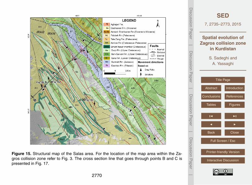
– The Salas area is located in the western part of the Lorestan Salient (Posht-e-Kuharc) near to the Kirkuk Embayment of the Zagros Folded Belt zone (Figs. 2 and15).15
4.1 Structure of the Kermanshah–Soleymanieh (KS) area
Structural mapping carried out in this area reveal temporal development of the earlystructures as mesoscopic scale folds and faults cross-cut by the late strike-slip faults.
4.1.1 Early structures
Beside the major thrust faults (i.e., the Kermanshah and High Zagros faults), minor20
faults and mesoscopic scale folds with different orientation on their axial plane and axisare common structures in the Bisotoun, Radiolarite and High Zagros zones.
2741

SED7, 2735–2773, 2015
Spatial evolution ofZagros collision zone
in Kurdistan
S. Sadeghi andA. Yassaghi
Title Page
Abstract Introduction
Conclusions References
Tables Figures
J I
J I
Back Close
Full Screen / Esc
Printer-friendly Version
Interactive Discussion
Discussion
Paper
|D
iscussionP
aper|
Discussion
Paper
|D
iscussionP
aper|
Faults
The High Zagros and Kermanshah faults are major reverse faults in the study area. TheHZF, that is the southwestern boundary of the High Zagros zone, acted as a basin con-troller in subsidence of the Garau Formation during Early Cretaceous (refer to Sect. 3).In the KS area, the fault zone is well exposed with about 300 m in width in which several5
drag folds and fault planes are mapped (Fig. 7). Most of the folds in the HZF zone areinclined folds plunging toward southeast and show the oblique kinematics of the faultwith notable strike-slip component (Fig. 7).
The Kermanshah Fault as the other major fault of the KS area emplaces the Radio-larite basin material over the Arabian platform (Figs. 1 and 2).10
There are also early faults in the Radiolarite and Bisotoun zones (Fig. 8a). Usingdrag folds as kinematic indicators, the early faults in the Bisotoun zone and NE marginof the Radiolarite zone are dextral-reverse (Figs. 8a and 10) while in the central and SWparts of the Radiolarite zone, faults have both dextral-reverse and reverse mechanisms(Figs. 7 and 8a and their stereographic projections).15
Folds
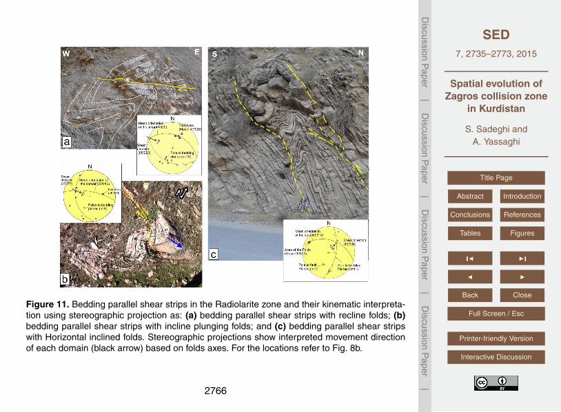
In the Radiolarite zone, mesoscopic scale folds are mapped within the alternation ofmedium to thick bedded radiolarite, pelagic limestone and shale (Figs. 8b and 9). Twotypes of deformed domains were identified in this zone. The reclined and inclined plung-ing folds developed by strike-slip kinematics and referred here as dextrally deformed20
domains (Figs. 8b and 9). In the remaining parts of the Radiolarite zone, where hori-zontal inclined folds are dominant, they are kinematically inferred as reverse domains(Figs. 8b and 9). Narrow bedding parallel shear strips are also present in the Radiolar-ite zone, which contain plunging inclined folds (Fig. 11b) and reclined folds (Fig. 11a)in the dextrally deformed domains and horizontal inclined folds (Fig. 11c) in reversely25
deformed domains.
2742

SED7, 2735–2773, 2015
Spatial evolution ofZagros collision zone
in Kurdistan
S. Sadeghi andA. Yassaghi
Title Page
Abstract Introduction
Conclusions References
Tables Figures
J I
J I
Back Close
Full Screen / Esc
Printer-friendly Version
Interactive Discussion
Discussion
Paper
|D
iscussionP
aper|
Discussion
Paper
|D
iscussionP
aper|
4.1.2 Late structures
The NW-trending Marekhil–Ravansar faults that are sub-parallel to the main trend ofZagros are two main strike-slip faults in the KS area (Fig. 6).
The Marekhil Fault offsets dextrally the early structures such as the Marekhil Anticlineand Kermanshah Fault for about 32 km (Fig. 12). Towards southeast, the Marekhil Fault5
joins to the HZF and caused reactivation of the fault in dextral manner. Similarly, theRavansar Fault also offsets the early thrusts as well as the HZF early structures. Towardsoutheast, the Ravansar Fault strike-slip splays cut the HZF related folds and thrusts(Fig. 13) in which faults with old reverse-slip kinematics are reactivated by later dextral-slip movements (Fig. 13b).10
Minor strike-slip faults in the restraining zone between the Marekhil and Ravansarfaults also cut the early structures. There are outcrops where fault striations of bothminor later strike-slip faults and older reverse faults are mapped (Fig. 14).
4.2 Structure of the Salas area
The Salas area that is located in the southwest of the HZF within the Folded Belt zone15
is studied in detail to investigate the effect of Zagros oblique orogeny away from thecollision zone (Figs. 2 and 15). Structures within this area comprise thrusts and relatedfolds typical of the Folded Belt zone structures. Geometric and kinematic analysis ofthese structures (Fig. 15) showed that like the other part of the Zagros Folded Beltzone, thrust faults have no strike-slip component (e.g., Fars domain; Hessami et al.,20
2001; McQuarrie, 2003). These structures cut by a series of transverse strike-slip faults(Figs. 1b and 15) consists of two major NNW-trending dextral-slip (Figs. 16a) and ENE-trending sinistral-slip faults (Figs. 16b) or normal faults with a component of sinistral-slip(Fig. 16c). There are also some locations where thrusts and folds cut by later strike-slipfaults (Fig. 17b and f).25
2743

SED7, 2735–2773, 2015
Spatial evolution ofZagros collision zone
in Kurdistan
S. Sadeghi andA. Yassaghi
Title Page
Abstract Introduction
Conclusions References
Tables Figures
J I
J I
Back Close
Full Screen / Esc
Printer-friendly Version
Interactive Discussion
Discussion
Paper
|D
iscussionP
aper|
Discussion
Paper
|D
iscussionP
aper|
4.3 Regional geological cross section
A regional cross section across the Zagros collision zone in NW Iran (Fig. 17) is drawnusing direct field measurements and present stratigraphy data as well as assumptionsin stratigraphy, time and depth of deformation as follows:
– The Phanerozoic sedimentary succession of Zagros comprises 7–12 km (Alavi,5
2004) or up to 12 km (Colman-Sadd, 1978; Falcon, 1974a; James and Wynd,1965; Stocklin, 1968) of sediments including Paleozoic, Mesozoic and Cenozoicstrata. We considered the thickness of about 12 km (Fig. 3) for this succession inconstruction of the cross section (Fig. 17).
– Deformation in the Bisotoun (platform) and Radiolarite (basin) zones occurred10
as thin skinned tectonic during the Late Cretaceous (Kazmin et al., 1986). Thickskinned tectonic, thus, did not have any major effect on the overall deformation ofthese zones.
– After collision of the Arabian Plate with Central Iran, a thick viscous layer at thebase of the sedimentary cover (Hormoz salt) (McQuarrie, 2004) or its equivalents15
(Sherkati and Letouzey, 2004) as a basal décollement zone decouple basementfrom the cover during the deformation. The Mountain Front Fault is considered asthe SE boundary of the Hormoz salt or its equivalent shale basins (McQuarrie,2004) (Fig. 17).
– Timing on involvement of the basement in the deformation is not clear but as-20
sumed to occur in the last stage of deformation (Cenozoic) (e.g., Molinaro et al.,2005; Casciello et al., 2009; Mouthereau et al., 2007).
– Restoration of the cross section has been carried out using the line-length bal-ancing technique for all formations except Hormoz salt and Radiolarite zone sed-iments where area-balancing technique used (Fig. 17b). The total shortening of25
62 km is measured for the Zagros external zone (distance between L3 and L’32744

SED7, 2735–2773, 2015
Spatial evolution ofZagros collision zone
in Kurdistan
S. Sadeghi andA. Yassaghi
Title Page
Abstract Introduction
Conclusions References
Tables Figures
J I
J I
Back Close
Full Screen / Esc
Printer-friendly Version
Interactive Discussion
Discussion
Paper
|D
iscussionP
aper|
Discussion
Paper
|D
iscussionP
aper|
in Fig. 17). This shortening amount can be divided into 13 km for the sedimen-tary cover of both High Zagros and Folded Belt zones and remaining 49 km forthe Bisotoun and Radiolarite zones (distance between L2 and L’2 in Fig. 17). The13 km of shortening in sedimentary cover is equal to the initial length of crosssection (distance between P and L2 in Fig. 17). The same amount of shortening5
(16.5 %) is also obtained for the Folded Belt zone (distance between L1 and L’1 inFig. 17).
5 Discussion
The proposed pre-convergence paleogeography of Zagros in Turonian (Late Creta-ceous) time shows that the northeastern margin of the Arabian platform was fully10
extended and the Radiolarite basin and Bisotoun platform were developed (Fig. 4).Development of the Radiolarite basin constrain by synchronized thickening of the Ga-rau Formation in the High Zagros zone and sedimentation of thick sediments containslimestone and chert in the Radiolarite zone within the hanging wall of the High Zagrosinitially normal fault (Fig. 17b). The initial normal mechanism of the HZF (e.g., Jackson,15
1980; Berberian, 1995) caused northward thickening of the sedimentary cover until theLate Cretaceous (e.g., Farzipour-Saein et al., 2009). This proposed paleogeography issimilar to the ones presented by Kazmin et al. (1986), Fontaine et al. (1989) and Mo-hajjel et al. (2003). In Turonian–Campanian, the basin is inverted due to the obductionof Neotethys oceanic crust (Fig. 18a).20
The obduction of Neotethys oceanic crust over the Bisotoun zone occurred inMaastrichtian–Paleocene along the so-called Main Zagros Thrust (Takin, 1972; Berbe-rian, 1995) (Fig. 18b). After the obduction, subduction of the oceanic crust resulted indevelopment of the Gaveh Rud volcanic arc and Sanandaj–Sirjan metamorphic zone.This subduction was continuing until Early to Late-Miocene (McQuarrie et al., 2003;25
Allen et al., 2004; Mouthereau et al., 2007) when the collision zone was evolved bysequential emplacement of the Gaveh Rud volcanic arc and Sanandaj–Sirjan meta-
2745

SED7, 2735–2773, 2015
Spatial evolution ofZagros collision zone
in Kurdistan
S. Sadeghi andA. Yassaghi
Title Page
Abstract Introduction
Conclusions References
Tables Figures
J I
J I
Back Close
Full Screen / Esc
Printer-friendly Version
Interactive Discussion
Discussion
Paper
|D
iscussionP
aper|
Discussion
Paper
|D
iscussionP
aper|
morphic zone over the ophiolite zone (Fig. 18c). These major compressional events inthe northeastern margin of the Arabian platform can be classified into the Late Creta-ceous oblique obduction related transpressional deformation and Cenozoic partitioningof oblique convergence described in more detail in the following sections.
5.1 Late Cretaceous oblique obduction related transpressional deformation5
The early structures mapped in the Bisotoun and Radiolarite zones (Figs. 9–11) areconsidered as the result of the Neotethys oceanic crust obduction. This obductionthat is considered to occur in Late Cretaceous (Kazmin et al., 1986; Agard et al.,2005; Wrobel-Daveau et al., 2010; Vergés et al., 2011; Karim et al., 2011) (Fig. 18a)is proposed to follow till Maastrichtian–Paleocene (Fig. 18b). About 49 km (79 %) of10
shortening measured by restoration of the cross section is proposed to occur by theLate Cretaceous Oblique obduction (Fig. 17). In the Radiolarite zone, presence ofdextrally deformed domains beside the reversely deformed domains (Fig. 9) impliesthe effect of Late Cretaceous transpression deformation related to oblique obduction(Fig. 18a and b). This demonstrates partitioning of the transpressional deformation to15
dextrally deformed and reversely deformed domains. In addition, the presence of sev-eral dextral-reverse faults in the Bisotoun zone and NE of Radiolarite zones (Figs. 8and 10) is in accordance with this oblique obduction. Similar type of deformation par-titioning was addressed for Silurian Caledonide orogeny in the sedimentary sequenceconsisting predominantly of turbiditic greywacke rocks by Jones et al. (2004).20
5.2 Cenozoic partitioning of oblique convergence
The main stage of deformation in the Zagros orogeny was occurred by Cenozoic event(e.g., Falcon, 1976; Berberian and King, 1981). It is proposed that 13 km (16.5 %) ofshortening measured by restoration of the regional cross section (Fig. 17) is occurredduring the Cenozoic time. Despite contrasts on timing of the Cenozoic deformation, it is25
widely accepted that strike-slip component of oblique convergence is accommodated
2746

SED7, 2735–2773, 2015
Spatial evolution ofZagros collision zone
in Kurdistan
S. Sadeghi andA. Yassaghi
Title Page
Abstract Introduction
Conclusions References
Tables Figures
J I
J I
Back Close
Full Screen / Esc
Printer-friendly Version
Interactive Discussion
Discussion
Paper
|D
iscussionP
aper|
Discussion
Paper
|D
iscussionP
aper|
by the belt-parallel strike-slip faults (Talebian and Jackson, 2000; McQuarrie et al.,2003; Fakhari et al., 2009; Axen et al., 2010). The Marekhil–Ravansar fault system(Figs. 2 and 6) in the study area is evidence of such strike-slip faulting. These faultsystem laterally cut the early structures of dextrally deformed and reversely deformeddomains as well as dextral-reverse faults (Figs. 8 and 9). These late strike-slip faults5
in the Radiolarite and High Zagros zones imply that they are not confined to the MainReverse Fault but distributed in outer parts of Zagros orogeny such as Radiolariteand High Zagros zones (Fig. 18c and d). The presences of the late strike-slip faultingare also documented by Gavillot et al. (2010) farther to the southeast part of HighZagros zone. Along the Marekhil Fault, as one of the main strike-slip faults in the study10
area, around 32 km of strike-slip displacement is measured (Fig. 12). This shows thatapart from the MRF, the Marekhil–Ravansar fault system is also accommodated a largeamount of strike-slip deformation related to the Cenozoic oblique collision. The amountof 50 km of strike-slip displacement is proposed by Talebian and Jackson (2002) forthe MRF activity. In the study area, however, this amount of displacement is proposed15
as 10–15 km by Copley and Jackson (2006) and 16 km by Alipoor et al. (2012). Wepropose that 32 km out of 50 km of the MRF strike-slip displacement is more likely tobe accommodated by the Marekhil–Ravansar fault system. Thus, we proposed that thetotal orogen-parallel strike-slip faulting in the study area is accommodated by both theMarekhil–Ravansar fault system as well as the MRF.20
In the Salas area (within the Folded Belt zone), faults are generally pure thrust(Figs. 2, 15 and 16). These thrust faults, however, are laterally cut by strike-slip faults.Like the major transverse strike-slip faults in other parts of the Zagros Folded Belt zone(e.g., the Kazeroun Fault), these strike-slip faults likely have basement nature (e.g.,Berberian, 1995; Hessami et al., 2001; Bahroudi and Koyi, 2003; Yassaghi, 2006) but25
reactivated during the oblique convergence of the Zagros orogeny in Cenozoic.
2747

SED7, 2735–2773, 2015
Spatial evolution ofZagros collision zone
in Kurdistan
S. Sadeghi andA. Yassaghi
Title Page
Abstract Introduction
Conclusions References
Tables Figures
J I
J I
Back Close
Full Screen / Esc
Printer-friendly Version
Interactive Discussion
Discussion
Paper
|D
iscussionP
aper|
Discussion
Paper
|D
iscussionP
aper|
5.3 Constrain for Arabia–Eurasia oblique convergence
There are two interpretations for inception time of the Zagros oblique convergence. Thefirst interpretation proposes Pliocene (3–5 Ma) for initiation of the Zagros oblique con-vergence (e.g. Talebian and Jackson, 2002), while the second interpretation proposesthe oblique collision at early to middle Miocene (19–15 Ma; Gavillot et al., 2010) or ear-5
lier (Allen et al., 2004; Axen et al., 2010). The presented structural evidences in thispaper constrain that the oblique convergence of the Arabia and Eurasia plates alongthe Zagros occurred since the late stage of orogeny in late Cretaceous–Paleocene.Similarly, these evidences might not support a possible scenario for drastic changein Arabia–Eurasia convergence from orthogonal to oblique manner (e.g. Navavabpour10
et al., 2012; Mouthereau, 2011). Thus we propose that the Arabia–Eurrasia obliqueconvergence alongside Zagros occurred during all stages of Zagros orogeny since theLate Cretaceous.
6 Conclusions
The main outcomes of this study are summarized in the following points.15
Extension of the Arabian platform in Early Cretaceous to form passive continentalmargins constrain by synchronized thickening of sedimentary rocks on the hangingwall of the High Zagros initial normal fault.
Presence of reversely and dextrally deformed domains within the Radiolarite zoneare taken as a clue to conclude that oblique convergence related to the late Cretaceous20
obduction event occurred in the early stage of the Zagros collision zone.The Zagros oblique convergence is continued in Cenozoic by synchronously south-
westward propagation of the Zagros orogeny via propagation of pure thrusts and re-lated folds (the Zagros Folded Belt zone) as well as overprinting of orogen-parallelstrike-slip faulting on the late Cretaceous obduction related structures.25
2748

SED7, 2735–2773, 2015
Spatial evolution ofZagros collision zone
in Kurdistan
S. Sadeghi andA. Yassaghi
Title Page
Abstract Introduction
Conclusions References
Tables Figures
J I
J I
Back Close
Full Screen / Esc
Printer-friendly Version
Interactive Discussion
Discussion
Paper
|D
iscussionP
aper|
Discussion
Paper
|D
iscussionP
aper|
Restoration of the regional cross section across the Zagros collision zone showedthat large amount of shortening (79 %) occurred during the obduction. Propagation ofthe orogeny toward its more external part (i.e., the Zagros Folded Belt zone) caused16.5 % of shortening.
Cenozoic strike-slip faulting is not confined to the Zagros suture zone (i.e., the Main5
recent Fault), but distributed towards the more external parts of the orogeny (Marekhil–Ravansar fault system). Therefore, it is more likely that inception of these strike-slipfaulting started from early to middle Miocene.
Presence of dextral transpressional deformation in Kurdestan area is used to pro-pose that oblique convergence of the Arabia–Eurasia plates affected during entire his-10
tory of the Zagros orogeny (since the Late Cretaceous).
Acknowledgements. People of the Kurdistan province of Iran are acknowledged for their sup-port during field works in the high Zagros Mountains near Iran and Iraq border with high risk ofmine fields remained from 8 years of war.
References15
Agard, P., Omrani, J., Jolivet, L., and Mouthereau, F.: Convergence history across Zagros (Iran):constraints from collisional and earlier deformation, Int. J. Earth Sci., 94, 401–419, 2005.
Agard, P., Omrani, J., Jolivet, L., Whitechurch, H., Vrielynck, B., Spakman, W., Monié, P.,Meyer, B., and Wortel, R.: Zagros orogeny: a subduction-dominated process, in: Geody-namic Evolution of the Zagros, edited by: Lacombe, O., Grasemann, B., and Simpson, G.,20
Geological Magazine, Cambridge, UK, 692–725, 2011.Alavi, M.: Regional Stratigraphy of the Zagros fold-thrust belt of Iran and its proforeland evolu-
tion, Am. J. Sci., 304, 1–20, doi:10.2475/ajs.304.1.1, 2004.Alavi, M.: Structures of the Zagros fold-thrust belt in Iran, Am. J. Sci., 307, 1064–1095, 2007.Ali, S., Mohajjel, M., Aswad, K., Ismail, S., Buckman, S., and Jones, B.: Tectono-stratigraphy25
and general structure of the northwestern Zagros collision zone across the Iraq–Iran border,Journal of Environment and Earth Science, 4, 92–110, 2013.
2749

SED7, 2735–2773, 2015
Spatial evolution ofZagros collision zone
in Kurdistan
S. Sadeghi andA. Yassaghi
Title Page
Abstract Introduction
Conclusions References
Tables Figures
J I
J I
Back Close
Full Screen / Esc
Printer-friendly Version
Interactive Discussion
Discussion
Paper
|D
iscussionP
aper|
Discussion
Paper
|D
iscussionP
aper|
Alipoor, R., Zaré, M., and Ghassemi, M. R.: Inception of activity and slip rate on the main recentfault of Zagros Mountains, Iran, Geomorphology, 175–176, 86–97, 2012.
Allen, M.: Roles of strike-slip faults during continental deformation: examples from the activeArabia–Eurasia collision, in: The Evolving Continents: Understanding Processes of Conti-nental Growth, Geological Society, London, UK, 329–344, 2010.5
Allen, M., Jackson, J., and Walker, R.: Late Cenozoic reorganization of the Arabia–Eurasiacollision and the comparison of short-term and long-term deformation rates, Tectonics, 23,TC2008, doi:10.1029/2003TC001530, 2004.
Authemayou, C. Chardon, D. Bellier, O. Malekzadeh, Z. Shabanian, E. and Abbassi, M. R.: LateCenozoic partitioning of oblique plate convergence in the Zagros fold-and-thrust belt (Iran),10
Tectonics, 25, TC3002, doi:10.1029/2005TCOO1860, 2006.Axen, G., Fakhari, M., Guest, B., Gavillot, Y., Stockli, D. F., and Horton, B.: Distributed Oblique-
dextral Transpression in the High Zagros Mountains, Iran, in: Tectonic Crossroads: EvolvingOrogens of Eurasia-Africa-Arabia, Ankara, Turkey, Abstracts, 73 pp., 2010.
Azizi, H. and Jahangiri, A.: Cretaceous subduction-related volcanism in the northern Sanandaj–15
Sirjan Zone, Iran, J. Geodyn., 45, 178–190, 2008.Bahroudi, A.: The Effect of Mechanical Characteristics of Basal Décollement and Basement
Structures on Deformation of the Zagros Basin, PhD Thesis, Uppsala University, Uppsala,Sweden, 43 pp., 2003.
Bahroudi, A. and Koyi, H. A.: Effect of spatial distribution of Hormuz salt on deformation style in20
the Zagros fold and thrust belt: an analogue modelling approach, J. Geol. Soc. London, 160,1–15, 2003.
Berberian, M.: Contribution to the Seismotectonics of Iran, Part II, Geological Survey of Iran,Tehran, Iran, 518 pp., 1976.
Berberian, M.: Master “blind” thrust faults hidden under the Zagros folds; active basement tec-25
tonic and surface morphotectonics, Tectonophysics, 241, 193–224, 1995.Berberian, M. and King, G. C. P.: Towards a paleogeography and tectonic evolution of Iran,
Can. J. Earth Sci., 18, 210–265, 1981.Beydoun, Z. R.: Arabian Plate Hydrocarbon, Geology and Potential – A plate Tectonic Ap-
proach, American Association of Petroleum Geology, Studies In Geology, 33, 77 pp., 1991.30
Blanc, E. J.-P., Allen, M. B., Inger, S., and Hassani, H.: Structural styles in the Zagros Sim-ple Folded Zone, Iran, J. Geol. Soc. London, 160, 401–412, doi:10.1144/0016-764902-110,2003.
2750

SED7, 2735–2773, 2015
Spatial evolution ofZagros collision zone
in Kurdistan
S. Sadeghi andA. Yassaghi
Title Page
Abstract Introduction
Conclusions References
Tables Figures
J I
J I
Back Close
Full Screen / Esc
Printer-friendly Version
Interactive Discussion
Discussion
Paper
|D
iscussionP
aper|
Discussion
Paper
|D
iscussionP
aper|
Braud, J.: La suture du Zagros au niveau de Kermanshah (Kurdistan Iranien): reconstitutionpaléogéographique, évolution géodynamique, magmatique et structurale, PhD Thesis, Paris-Sud, Orsay, p. 488, 1987.
Casciello, E., Vergés, J., Saura, E., Casini, G., Fernandez, N., Blanc, E., Homke, S., andHunt, D. W.: Fold patterns and multilayer rheology of the Lurestan Province, Zagros Simply5
Folded Belt (Iran), J. Geol. Soc. London, 166, 947–959, doi:10.1144/0016-76492008-138,2009.
Colman-Sadd, S.: Fold development in Zagros simply folded belt, Southwest Iran, AAPG Bull.,62, 984–1003, 1978.
Copley, A. and Jackson, J.: Active tectonics of the Turkish-Iranian Plateau, Tectonics, 25,10
TC6006, doi:10.1029/2005TC001906, 2006.Cotton, J. T. and Koyi, H. A.: Modelling of thrust fronts above ductile frictional de’collements:
application to structures in the Salt Range and PotwPlateau, Pakistan, Geol. Soc. Am. Bull.,112, 351–363, 2000.
Fakhari, M. D., Axen, G. J., Horton, B. K., Hassanzadeh, J., and Amini, A.: Revised age of15
proximal deposits in the Zagros foreland basin and implications for Cenozoic evolution of theHigh Zagros, Tectonophysics, 451, 170–185, 2008.
Falcon, N. L.: Southern Iran: Zagros Mountains, in: Mesozoic-Cenozoic Orogenic Belts, editedby: Spencer, A., Geological Society, London, Special Publications, London, UK, 4, 199–211,1974.20
Farzipour-Saein, A., Yassaghi, A., Sherkati, S., and Koyi, H.: Mechanical stratigraphy and fold-ing style of the Lurestan region in the Zagros Fold-Thrust Belt, Iran, J. Geol. Soc. London,166, 1101–1115, doi:10.1144/0016-76492008-162, 2009.
Fontaine, J. M., Monod, O., Braud, J., and Perincek, D.: The Hezan Units: a fragment of southNeo-Theethyan passive continental margin in SE Turkey, J. Petrol. Geol., 12, 29–50, 1989.25
Gavillot, Y., Axen, G. J., Stockli, D. F, Horton, B. K., and Fakhari, M. D.: Timing of thrust activityin the High Zagros fold-thrust belt, Iran, from (U/Th)/He thermochronometry, Tectonics, 29,TC4025, doi:10.1029/2009TC002484, 2010, 2010.
Gharib, F. and De Wever, P.: Mesozoic radiolarians from the Kermanshah formation (Iran), C.R. Palevol, 9, 209–219, 2010.30
Gidon, M., Berthier, F., Billiautt, J.-P., Halbronn, B., and Maurizot, P.: Sur quelques caractèresde la tectonique Néocrétacée dans la région de Borudjerd (Zagros Oriental, Iran), ComptesRendus de l’Académie des Sciences, 278, 577–580, 1974.
2751

SED7, 2735–2773, 2015
Spatial evolution ofZagros collision zone
in Kurdistan
S. Sadeghi andA. Yassaghi
Title Page
Abstract Introduction
Conclusions References
Tables Figures
J I
J I
Back Close
Full Screen / Esc
Printer-friendly Version
Interactive Discussion
Discussion
Paper
|D
iscussionP
aper|
Discussion
Paper
|D
iscussionP
aper|
Harrison, P. M., Frost. S. H., Seiglie, G. A., and Scheneidermann, N.: Regional unconformitiesand depositional cycles, cretaceous of the Arabian Peninsula, AAPG Memoir., 36, 67–80,1984.
Hatzfeld, D. and Molnar, P.: Comparisons of the kinematics and deep structures of the Zagrosand Himalaya and of the Iranian and Tibetan plateaus and geodynamic implications, Rev.5
Geophys., 48, RG2005, doi:10.1029/2009RG000304, 2010.Hessami, K. Koyi, H. A., Talbot, C. J., Tabasi, H., and Habanian, E. S.: Progressive unconformi-
ties within an evolving foreland fold-and-thrust belt, Zagros Mountains, J. Geol. Soc. London,158, 969–981, 2001.
Homke, S., Vergés, J., Serra-Kiel, J., Bernaola, G., Sharp, I., Garcés, M., Montero-Verdú, I.,10
Karpuz, R., and Goodarzi, M. H.: Late Cretaceous–Paleocene formation of the proto-Zagrosforeland basin, Lorestan Province, SW Iran, Geol. Soc. Am. Bull., 121, 963–978, 2009.
Homke, S., Vergés, J., Van Der Beek, P., Fernàndez, M., Saura, E., Barbero, L., Badics, B.,and Labrin, E.: Insights in the exhumation history of the NW Zagrosfrom bedrock and detritalapatite fission-track analysis: evidence for a long-lived orogeny, Basin Res., 22, 659–680,15
2010.Jackson, J. A.: Reactivation of basement faults and crustal shortening in orogenic belts, Nature,
283, 343–346, 1980.James, G. A. and Wynd, J. G.: Stratigraphic nomenclature of Iranian oil consortium agreement
area, AAPG Bull., 49, 2162–2245, 1965.20
Jassim, S. Z. and Buday, T.: Tectonostratigraphy of the Zagros suture, in: Geology of Iraq, editedby: Jassim, S. Z. and Goff, C., Dolin, Prague and Moravian Museum, Brno, Czech Republic,341 pp., 2006.
Jones, R. R., Holdsworth, R. E., Clegg, P., McCaffrey, K., and Tavarnelli, E.: Inclined transpres-sion, J. Struct. Geol., 26, 1531–1584, 2004.25
Karim, K. H., Koyi, H., Baziany, M. M., and Hessami, K.: Significance of angular unconformitiesbetween Cretaceous and Tertiary strata in the northwestern segment of the Zagros fold–thrust belt, Kurdistan Region, NE Iraq, Geol. Mag., 148, 925–939, 2011.
Kazmin, V. G., Ricou, L. F., and Sbortshikov, I. M.: Structure and evolution of the passive marginof the eastern Tethys, Tectonophysics, 123, 153–179, 1986.30
Koop, W. J. and Stoneley, R.: Subsidence history of the Middle East Zagros Basin, permian torecent, Philos. T. Roy. Soc. A, 305, 149–168, 1982.
2752

SED7, 2735–2773, 2015
Spatial evolution ofZagros collision zone
in Kurdistan
S. Sadeghi andA. Yassaghi
Title Page
Abstract Introduction
Conclusions References
Tables Figures
J I
J I
Back Close
Full Screen / Esc
Printer-friendly Version
Interactive Discussion
Discussion
Paper
|D
iscussionP
aper|
Discussion
Paper
|D
iscussionP
aper|
McClusky, S., Balassanian, S., Barka , A., Demir, C., Ergintav, S., Georgiev, I., Gurkan, O.,Hamburger, M., Hurst, K., Kahle, H., Kastens, K., Kekelidze, G., King, R., Kotzev, V., Lenk,O., Mahmoud, S., Mishin, A., Nadariya, M., Ouzoums, A., Paradissis, Y. P., Prilepin, M.,Reilinger, R., Sanli, I., Seeger, H., Tealeb, A., Toksoz, M. N., and Veis, G.: Global PositioningSystem constraints on plate kinematics and dynamics in the eastern Mediterranean and5
Caucasus, J. Geophys. Res., 105, 5695–5719, 2000.McQuarrie, N.: Crustal scale geometry of the Zagros fold-thrust belt, Iran, J. Struct. Geol., 26,
519–535, 2004.McQuarrie, N., Stock, J. M., Verdel, C., and Wernicke, B. P.: Cenozoic evolution of
neotethys and implications for the causes of plate motions, Geophys. Res. Lett., 30, 2036,10
doi:10.1029/2003GL017992, 2003.Mohajjel, M. and Fergusson, C. L.: Dextral transpression in Late Cretaceous continental colli-
sion, Sanandaj-Sirjan Zone, western Iran, J. Struct. Geol., 22, 1125–1139, 2000.Mohajjel, M. and Fergusson, C. L.:: Jurassic to Cenozoic tectonics of the Zagros Orogen in
northwestern Iran, Int. Geol. Rev., 56, 263–287, doi:10.1080/00206814.2013.853919, 2013.15
Mohajjel, M., Fergusson, C. L., and Sahandi, M. R.: Cretaceous-Tertiary convergence andcontinental collision, Sanandaj-Sirjan Zone, western Iran, J. Asian Earth Sci., 21, 397–412,2003.
Molinaro, M., Leturmy, P., Guezou, J.-C., and Frizon de Lamotte, D.: The structure and kine-matics of the south-eastern Zagros fold-thrust belt; Iran: from thin-skinned to thick-skinned20
tectonics, Tectonics, 24, TC3007, doi:10.1029/2004TC001633, 2005.Motiei, H.: Stratigraphy of Zagros, Treaties on the Geology of Iran, Geol. Survey of Iran Publi-
cation, Tehran, Iran, 536 pp., 1993 (in Persian).Mouthereau, F., Tensi, J., Bellahsen, N., Lacombe, O., De Boisgrollier, T., and Kargar, S.:
Tertiary sequence of deformation in a thin-skinned/thick-skinned collision belt: the Zagros25
Folded Belt (Fars, Iran), Tectonics, 26, TC5006, doi:10.1029/2007TC002098, 2007.Mouthereau, F., Lacombe, O., and Vergés, J.: Building the Zagros collisional orogen: timing,
strain distribution and the dynamics of Arabia/Eurasia plate convergence, Tectonophysics,532–535, 27–60, 2012.
Navabpour, P. and Barrier, E.: Stress states in the Zagros fold-and-thrust belt30
from passive margin to collisional tectonic setting, Tectonophysics, 581, 76–83,doi:10.1016/j.tecto.2012.01.011, 2012.
2753

SED7, 2735–2773, 2015
Spatial evolution ofZagros collision zone
in Kurdistan
S. Sadeghi andA. Yassaghi
Title Page
Abstract Introduction
Conclusions References
Tables Figures
J I
J I
Back Close
Full Screen / Esc
Printer-friendly Version
Interactive Discussion
Discussion
Paper
|D
iscussionP
aper|
Discussion
Paper
|D
iscussionP
aper|
Nemati, M. and Yassaghi, A.: Structural characteristics of the transitional zone from internal toexternal parts of the Zagros orogen, Iran, J. Asian Earth Sci., 39, 161–172, 2010.
Ricou, L. E., Braud, J., and Brunn, J. H.: Le Zagros, Société Géologique de France, MémoireHors Série, 8, 33–52, 1977.
Sarkarinejad, K.: Quantitative finite strain and kinematic flow analyses along the Zagros trans-5
pression zone, Iran, Tectonophysics, 442, 49–65, 2007.Sarkarinejad, K. and Azizi, A.: Slip partitioning and inclined dextral transpression along the
Zagros Thrust System, Iran, J. Struct. Geol., 30, 116–136, 2008.Searle, M. P. and Graham, G. M.: “Oman Exotics” – oceanic carbonate build-ups associated
with the early stages of continental rifting, Geology, 10, 43–49, 1982.10
Sherkati, S., Letouzey, J., and Frizon de Lamotte, D.: Central Zagros fold-thrust belt (Iran): newinsights from seismic data, field observation, and sandbox modeling, Tectonics, 25, TC4007,doi:10.1029/2004TC001766, 2006.
Stocklin, J.: Structural history and tectonics of Iran; a review, AAPG Bull., 52, 1229–1258, 1968.Talbot, C. J. and Alavi, M.: The past of a future syntaxisacross the Zagros, in: Salt Tectonics,15
edited by: Alsop, G. I., Blundell, D. J., and Davison, I., Geological Society of London, London,UK, Special Publication no. 100, 89–109, 1996.
Talebian, M. and Jackson, J.: Offset on the main recent fault of NW Iran and implicationson thelate Cenozoic tectonics of the Arabia–Eurasia collision zone, Geophys. J. Int., 150, 422–439,2002.20
Tatar, M., D., Hatzfeld, J., Martinod, A., Walpersdorf, M., Ghafori-Ashtiany, and Chéry, J.: Thepresent-day deformation of the central Zagros from GPS measurements, Geophys. Res.Lett., 29, 1927, doi:10.1029/2002GL015427, 2002.
Vergés, J., Saura, E., Casciello, E., Fernàndez, M., Villaseñor, A., Jiménez-Munt, I., and Gar-cíaCastellanos, D.: Crustal-scale cross-section across the NW Zagros Belt: implications for25
the Arabian Margin reconstruction, in: Geodynamic Evolution of the Zagros, edited by: La-combe, O., Grasemann, B., and Simpson, G., Geological Magazine, Cambridge, UK, 148,739–761, 2011.
Vernant, P., Nilforoushan, F., Hatzfeld, D., Abassi, M., Vigny, C., Masson, F., Nankali, H., Mar-tinod, J., Ashtiani, A., Bayer, R., Tavakoli, F., and Chery, J.: Contemporary crustal deformation30
and plate kinematics in Middle East contrained by GPS measurements in Iran and northernOman, Geophys. J. Int., 157, 381–398, 2004.
2754

SED7, 2735–2773, 2015
Spatial evolution ofZagros collision zone
in Kurdistan
S. Sadeghi andA. Yassaghi
Title Page
Abstract Introduction
Conclusions References
Tables Figures
J I
J I
Back Close
Full Screen / Esc
Printer-friendly Version
Interactive Discussion
Discussion
Paper
|D
iscussionP
aper|
Discussion
Paper
|D
iscussionP
aper|
Wrobel-Daveau, J.-C.,Ringenbach, J.-C.,Tavakoli, S.,Ruiz, G. M. H.,Masse, P., and Frizon DeLamotte, D.: Evidence for mantle exhumation along the Arabian margin in the Zagros (Ker-manshah area, Iran), Arabian Journal of Geosciences, 3, 499–513, 2010.
2755

SED7, 2735–2773, 2015
Spatial evolution ofZagros collision zone
in Kurdistan
S. Sadeghi andA. Yassaghi
Title Page
Abstract Introduction
Conclusions References
Tables Figures
J I
J I
Back Close
Full Screen / Esc
Printer-friendly Version
Interactive Discussion
Discussion
Paper
|D
iscussionP
aper|
Discussion
Paper
|D
iscussionP
aper|
Figure 1. (a) Geodynamic map shows recent oblique convergence between the Arabian Plateand Central Iran but orthogonal convergence in Bitlis suture in South Turkey (Modified fromVernant et al., 2004). Arrows are velocity vectors of the Arabian Plate (based on a fixed point inEurasia) from McClusky et al. (2000) and Vernant et al. (2004); (b) Zagros Orogen in NW Iranand NE Iraq (Kurdistan area). Abbreviations: E.A.F – East Anatolian Fault; H.Z.F – High ZagrosFault; K.F – Kermanshah Fault; KH.F – Khaneqin Fault; M.F – Marekhil Fault; M.F.F – MountainFront Fault; M.Z.T – Main Zagros Thrust; N.A.F – North Anatolian Fault; Z.F.F – Zagros FrontFault. Line A–F is the location of the regional cross section presented in Fig. 17.
2756

SED7, 2735–2773, 2015
Spatial evolution ofZagros collision zone
in Kurdistan
S. Sadeghi andA. Yassaghi
Title Page
Abstract Introduction
Conclusions References
Tables Figures
J I
J I
Back Close
Full Screen / Esc
Printer-friendly Version
Interactive Discussion
Discussion
Paper
|D
iscussionP
aper|
Discussion
Paper
|D
iscussionP
aper|
Figure 2. Geological map of the Zagros collision zone in Kurdistan area (NW Iran). Rectanglesshow the location of Kermanshah–Soleymanieh area (Fig. 6) and Salas area (Fig. 15). Thedotted line (A to F) is the trace of the regional Cross section shown in Fig. 17. For the locationof the area within the Zagros collision zone as well as the faults names refer to captions ofFig. 1b.
2757

SED7, 2735–2773, 2015
Spatial evolution ofZagros collision zone
in Kurdistan
S. Sadeghi andA. Yassaghi
Title Page
Abstract Introduction
Conclusions References
Tables Figures
J I
J I
Back Close
Full Screen / Esc
Printer-friendly Version
Interactive Discussion
Discussion
Paper
|D
iscussionP
aper|
Discussion
Paper
|D
iscussionP
aper|
Figure 3. Stratigraphic column of the Zagros collision zones in NW Iran (Kurdistan area). Fordescription of rock units of the Bisotoun platform and Radiolarite basin refer to Fig. 8. Abbrevi-ations: H.Z.F – High Zagros Fault; K.F – Kermanshah Fault; M.Z.T – Main Zagros Thrust.
2758

SED7, 2735–2773, 2015
Spatial evolution ofZagros collision zone
in Kurdistan
S. Sadeghi andA. Yassaghi
Title Page
Abstract Introduction
Conclusions References
Tables Figures
J I
J I
Back Close
Full Screen / Esc
Printer-friendly Version
Interactive Discussion
Discussion
Paper
|D
iscussionP
aper|
Discussion
Paper
|D
iscussionP
aper|
Figure 4. Sedimentary basins across the northeastern margin of the Arabian Plate in the Tur-onian (Late Cretaceous), just before the obduction of the Oceanic crust.
2759

SED7, 2735–2773, 2015
Spatial evolution ofZagros collision zone
in Kurdistan
S. Sadeghi andA. Yassaghi
Title Page
Abstract Introduction
Conclusions References
Tables Figures
J I
J I
Back Close
Full Screen / Esc
Printer-friendly Version
Interactive Discussion
Discussion
Paper
|D
iscussionP
aper|
Discussion
Paper
|D
iscussionP
aper|
Figure 5. Growth syncline in the limestones of the Gurpi Formation (Campanian–Maastrichtianin age) in High Zagros zone (see Fig. 2 for the location).
2760

SED7, 2735–2773, 2015
Spatial evolution ofZagros collision zone
in Kurdistan
S. Sadeghi andA. Yassaghi
Title Page
Abstract Introduction
Conclusions References
Tables Figures
J I
J I
Back Close
Full Screen / Esc
Printer-friendly Version
Interactive Discussion
Discussion
Paper
|D
iscussionP
aper|
Discussion
Paper
|D
iscussionP
aper|
Figure 6. Structural map of the Kermanshah–Soleymanieh (KS) area. Stereographic projec-tions show kinematics of the late strike-slip faults. Used Abbreviations are: (M.Z.T) Main ZagrosThrust; (H.Z.F) High Zagros Fault; (K.F) Kermanshah Fault; (M.R.F) Main Recent Fault; (M.F)Marekhil Fault; (R.F) Ravansar Fault.
2761

SED7, 2735–2773, 2015
Spatial evolution ofZagros collision zone
in Kurdistan
S. Sadeghi andA. Yassaghi
Title Page
Abstract Introduction
Conclusions References
Tables Figures
J I
J I
Back Close
Full Screen / Esc
Printer-friendly Version
Interactive Discussion
Discussion
Paper
|D
iscussionP
aper|
Discussion
Paper
|D
iscussionP
aper|
Figure 7. (a, b) The High Zagros Fault Zone; (c) close view of the drag folds with line drawing;(d) stereographic projection show interpreted movement direction of fault zone (black arrow)based on folds axes and minor faults in the fault zone. For the location refer to Fig. 6.
2762

SED7, 2735–2773, 2015
Spatial evolution ofZagros collision zone
in Kurdistan
S. Sadeghi andA. Yassaghi
Title Page
Abstract Introduction
Conclusions References
Tables Figures
J I
J I
Back Close
Full Screen / Esc
Printer-friendly Version
Interactive Discussion
Discussion
Paper
|D
iscussionP
aper|
Discussion
Paper
|D
iscussionP
aper|
Figure 8. (a) Structural map of a part of the Kermanshah–Soleymanieh (KS) area that crossingthe Bisotoun, Radiolarite, and High Zagros zones. Arrows show movement direction of bothearly (reverse and dextral-reverse faults and late strike-slip faults). See Fig. 17 for the crosssection between D and E; (b) structural map of the Radiolarite zone near Nodeshe city. Note todevelopment of two kinematically different domains defined by pink color as reversely deformedand violet color as dextrally deformed domains; (c) structural cross section along the line G–Hin Fig. 8b, the black lines are the late strike-slip faults.
2763

SED7, 2735–2773, 2015
Spatial evolution ofZagros collision zone
in Kurdistan
S. Sadeghi andA. Yassaghi
Title Page
Abstract Introduction
Conclusions References
Tables Figures
J I
J I
Back Close
Full Screen / Esc
Printer-friendly Version
Interactive Discussion
Discussion
Paper
|D
iscussionP
aper|
Discussion
Paper
|D
iscussionP
aper|
Figure 9. Field photo and line drawing of the Radiolarite zone near Nodeshe city (Fig. 8b).Note to dextrally deformed domain (pinkish color area) located within the reversely deformeddomains.
2764

SED7, 2735–2773, 2015
Spatial evolution ofZagros collision zone
in Kurdistan
S. Sadeghi andA. Yassaghi
Title Page
Abstract Introduction
Conclusions References
Tables Figures
J I
J I
Back Close
Full Screen / Esc
Printer-friendly Version
Interactive Discussion
Discussion
Paper
|D
iscussionP
aper|
Discussion
Paper
|D
iscussionP
aper|
Figure 10. (a) Photograph and line drawing of fault zone in alternation of limestone and Radio-larite within the Radiolarite zone (see Fig. 8 for its location); (b) fault plane and its two differentstriations; (c) stereographic projection show interpreted movement direction of fault zone (blackarrow) based on attitude of folds axes. Refer to Fig. 8a for the location of the area.
2765
SED7, 2735–2773, 2015
Spatial evolution ofZagros collision zone
in Kurdistan
S. Sadeghi andA. Yassaghi
Title Page
Abstract Introduction
Conclusions References
Tables Figures
J I
J I
Back Close
Full Screen / Esc
Printer-friendly Version
Interactive Discussion
Discussion
Paper
|D
iscussionP
aper|
Discussion
Paper
|D
iscussionP
aper|
Figure 11. Bedding parallel shear strips in the Radiolarite zone and their kinematic interpreta-tion using stereographic projection as: (a) bedding parallel shear strips with recline folds; (b)bedding parallel shear strips with incline plunging folds; and (c) bedding parallel shear stripswith Horizontal inclined folds. Stereographic projections show interpreted movement directionof each domain (black arrow) based on folds axes. For the locations refer to Fig. 8b.
2766

SED7, 2735–2773, 2015
Spatial evolution ofZagros collision zone
in Kurdistan
S. Sadeghi andA. Yassaghi
Title Page
Abstract Introduction
Conclusions References
Tables Figures
J I
J I
Back Close
Full Screen / Esc
Printer-friendly Version
Interactive Discussion
Discussion
Paper
|D
iscussionP
aper|
Discussion
Paper
|D
iscussionP
aper|
Figure 12. Restoration of about 32 km dextrally offset on the early structures by the MarekhilFault (M.F). The numbers in circles are location of the older structures such as the KermanshahFault (K.F), Marekhil Anticline (M.A) and a thrust fault on both walls of the Marekhil Fault.
2767

SED7, 2735–2773, 2015
Spatial evolution ofZagros collision zone
in Kurdistan
S. Sadeghi andA. Yassaghi
Title Page
Abstract Introduction
Conclusions References
Tables Figures
J I
J I
Back Close
Full Screen / Esc
Printer-friendly Version
Interactive Discussion
Discussion
Paper
|D
iscussionP
aper|
Discussion
Paper
|D
iscussionP
aper|
Figure 13. (a) Overall view of the outcrop and line drawing of horizontally inclined folds in thepelagic limestone of Ilam Formation in the High Zagros Fault footwall cut by younger strike-slipfaults; (b) stereographic projection show interpreted movement direction of fault zone (blackarrow) based on attitudes of folds axes; (c) fault with 1st generation (St.1) reverse and 2ndgeneration (St.2) dextral-reverse slickenlines; (d, e) dextral faults with reverse component; (f)strike-slip fault. For the location refer to Fig. 6.
2768

SED7, 2735–2773, 2015
Spatial evolution ofZagros collision zone
in Kurdistan
S. Sadeghi andA. Yassaghi
Title Page
Abstract Introduction
Conclusions References
Tables Figures
J I
J I
Back Close
Full Screen / Esc
Printer-friendly Version
Interactive Discussion
Discussion
Paper
|D
iscussionP
aper|
Discussion
Paper
|D
iscussionP
aper|
Figure 14. Fault plane in intercalation of limestone within the Radiolarite zone. Note to differentattitude of slickenlines show 1st generation (St.1) as reverse and 2nd generation (St.2) asdextral-slip kinematics. For the location refer to Fig. 6.
2769
SED7, 2735–2773, 2015
Spatial evolution ofZagros collision zone
in Kurdistan
S. Sadeghi andA. Yassaghi
Title Page
Abstract Introduction
Conclusions References
Tables Figures
J I
J I
Back Close
Full Screen / Esc
Printer-friendly Version
Interactive Discussion
Discussion
Paper
|D
iscussionP
aper|
Discussion
Paper
|D
iscussionP
aper|
Figure 15. Structural map of the Salas area. For the location of the map area within the Za-gros collision zone refer to Fig. 3. The cross section line that goes through points B and C ispresented in Fig. 17.
2770

SED7, 2735–2773, 2015
Spatial evolution ofZagros collision zone
in Kurdistan
S. Sadeghi andA. Yassaghi
Title Page
Abstract Introduction
Conclusions References
Tables Figures
J I
J I
Back Close
Full Screen / Esc
Printer-friendly Version
Interactive Discussion
Discussion
Paper
|D
iscussionP
aper|
Discussion
Paper
|D
iscussionP
aper|
Figure 16. Photographs of fault zones in the Salas area (a) dextral-slip fault (b) sinistral andnearby dragged layers; (c) normal faults with sinistral components. For the locations refer toFig. 15.
2771

SED7, 2735–2773, 2015
Spatial evolution ofZagros collision zone
in Kurdistan
S. Sadeghi andA. Yassaghi
Title Page
Abstract Introduction
Conclusions References
Tables Figures
J I
J I
Back Close
Full Screen / Esc
Printer-friendly Version
Interactive Discussion
Discussion
Paper
|D
iscussionP
aper|
Discussion
Paper
|D
iscussionP
aper|
Figure 17. (a) Regional cross section across the Zagros orogeny in NW Iran (see line A–Ein Fig. 2 for the section location and descriptions of its lithological and lithostratigraphic units);(b) restoration of the cross section. Abbreviations: H.Z.F: high Zagros Fault; K.F: KermanshahFault; M.R.F: Main Recent Fault; M.F: Marekhil Fault; R.F: Ravansar Fault; KH.F: KhaneqinFault.
2772

SED7, 2735–2773, 2015
Spatial evolution ofZagros collision zone
in Kurdistan
S. Sadeghi andA. Yassaghi
Title Page
Abstract Introduction
Conclusions References
Tables Figures
J I
J I
Back Close
Full Screen / Esc
Printer-friendly Version
Interactive Discussion
Discussion
Paper
|D
iscussionP
aper|
Discussion
Paper
|D
iscussionP
aper|
Figure 18. Possible scenario for the Zagros oblique convergence history since the Late Cre-taceous. (a) The initial stage of the convergence by obduction of the Neotethys oceanic crust;(b) completion of the obduction (inset shows the partitioning of oblique convergence into twodomains, dextrally deformed and reversely deformed domains); (c) evolvement of collision zoneby emplacement of Gaveh Rud and Sanandaj–Sirjan zones over the Bisotoun and Radiolaritezones and initiation of strike-slip faults; (d) synchronous evolvement of strike-slip faults andpropagation of folded belt zone. For more detail refer to the text.
2773
Copyright © 2022 FDOKUMEN