geomatics engineering - University of Calgary
86
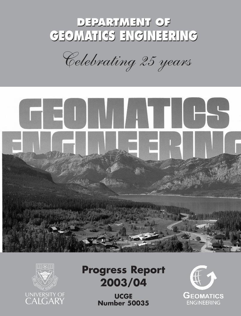
DEPARTMENT OF GEOMATICS ENGINEERING Progress Report 2003/04 UCGE Number 50035 DEPARTMENT OF GEOMATICS ENGINEERING - Progress Report 2003/04 DEPARTMENT OF GEOMATICS ENGINEERING Celebrating 25 years UCGE Number 50035
-
Upload
khangminh22 -
Category
Documents
-
view
0 -
download
0
Transcript of geomatics engineering - University of Calgary
DEPARTMENT OF GEOMATICS ENGINEERING
Progress Report2003/04
UCGENumber 50035
DEP
ARTM
ENT O
F GEO
MATIC
S EN
GIN
EERIN
G - P
rogress R
eport 2
003/0
4
DEPARTMENT OF GEOMATICS ENGINEERING
Celebrating 25 years
UCG
E Num
ber 5
0035
Celebrating 25 years 1979 - 2004

DEPARTMENT OFGEOMATICS ENGINEERING
Faculty of Engineering
May 2004
UNIVERSITY OF CALGARY2500 University Drive N.W.
Calgary, AlbertaT2N 1N4
Telephone: (403) 220-5834Fax: (403) 284-1980
website: http://www.geomatics.ucalgary.ca
PROGRESS REPORT2003/20042003/20042003/20042003/20042003/2004
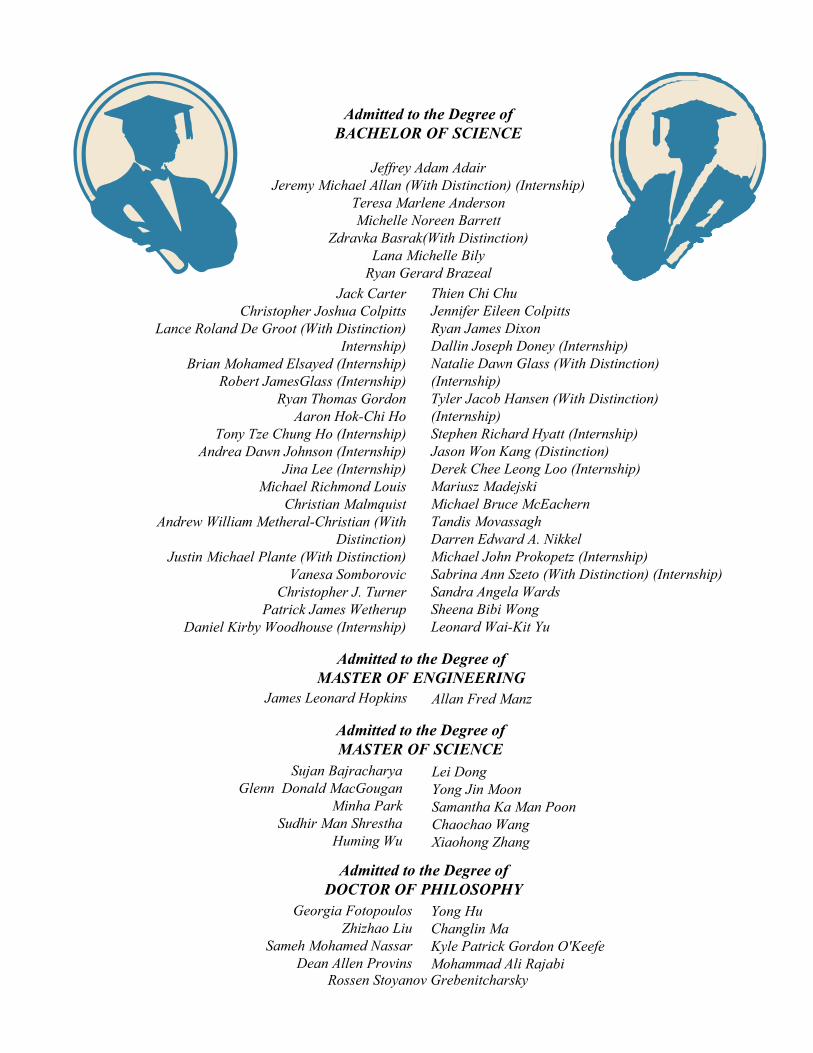
Admitted to the Degree ofBACHELOR OF SCIENCE
Jeffrey Adam AdairJeremy Michael Allan (With Distinction) (Internship)
Teresa Marlene AndersonMichelle Noreen Barrett
Zdravka Basrak(With Distinction)Lana Michelle Bily
Ryan Gerard BrazealJack Carter
Christopher Joshua ColpittsLance Roland De Groot (With Distinction)
Internship)Brian Mohamed Elsayed (Internship)
Robert JamesGlass (Internship)Ryan Thomas Gordon
Aaron Hok-Chi HoTony Tze Chung Ho (Internship)
Andrea Dawn Johnson (Internship)Jina Lee (Internship)
Michael Richmond Louis Christian Malmquist
Andrew William Metheral-Christian (WithDistinction)
Justin Michael Plante (With Distinction)Vanesa Somborovic
Christopher J. TurnerPatrick James Wetherup
Daniel Kirby Woodhouse (Internship)
Thien Chi ChuJennifer Eileen ColpittsRyan James DixonDallin Joseph Doney (Internship)Natalie Dawn Glass (With Distinction)(Internship)Tyler Jacob Hansen (With Distinction)(Internship)Stephen Richard Hyatt (Internship)Jason Won Kang (Distinction)Derek Chee Leong Loo (Internship)Mariusz MadejskiMichael Bruce McEachernTandis MovassaghDarren Edward A. NikkelMichael John Prokopetz (Internship)Sabrina Ann Szeto (With Distinction) (Internship)Sandra Angela WardsSheena Bibi WongLeonard Wai-Kit Yu
Admitted to the Degree ofMASTER OF ENGINEERING
Admitted to the Degree ofMASTER OF SCIENCE
Sujan BajracharyaGlenn Donald MacGougan
Minha ParkSudhir Man Shrestha
Huming Wu
Admitted to the Degree ofDOCTOR OF PHILOSOPHY
Lei DongYong Jin MoonSamantha Ka Man PoonChaochao WangXiaohong Zhang
James Leonard Hopkins Allan Fred Manz
Georgia FotopoulosZhizhao Liu
Sameh Mohamed NassarDean Allen Provins
Yong HuChanglin MaKyle Patrick Gordon O'KeefeMohammad Ali Rajabi
Rossen Stoyanov Grebenitcharsky

CELEBRATING 25 YEARS .................................................................... iHIGHLIGHTS 2003/2004 ........................................................................ 1NEW DEPARTMENT HEAD .................................................................. 3MESSAGE FROM THE DEAN ............................................................... 5AWARDS & RECOGNITION .................................................................. 6PERSONNEL ......................................................................................... 10
Faculty ................................................................................................. 10Staff Changes ..................................................................................... 14Professer Emeritus .............................................................................. 16Adjunct Professors .............................................................................. 16Support Staff ....................................................................................... 16Research Assistants/Associates ......................................................... 17Post Docs ............................................................................................ 17Visting Scientists ................................................................................. 18Guest Lecturers ................................................................................... 18
ADVISORY COMMITTEE AND STUDENT AWARDS ........................... 20Advisory Committee ............................................................................ 20Geomatics Engineering Liaison Committee ......................................... 23Student Awards Night .......................................................................... 24
UNDERGRADUATE STUDIES .............................................................. 29Enrollment ........................................................................................... 29Common Core Curriculum .................................................................. 32Undergraduate Curriculum in Geomatics Engineering ........................ 33Geomatics Engineering Student Society (GESS) ................................ 34ENGO 500 Projects and Guest Presentations .................................... 35Engineering Internship Program .......................................................... 37Geomatics Engineering Career Day .................................................... 38Survey Camp ...................................................................................... 39
GRADUATE STUDIES ........................................................................... 42Enrollment ............................................................................................ 42Convocants .......................................................................................... 45Grad Seminars ..................................................................................... 46Streams ............................................................................................... 47
RESEARCH ........................................................................................... 48Research Statistics .............................................................................. 48Major Research Areas ......................................................................... 50
PUBLICATIONS ..................................................................................... 57Refereed Journals ............................................................................... 57Proceedings ......................................................................................... 59Scholarly Presentations & Seminars .................................................... 65Technical Reports and Notes ............................................................... 70Technology Transfer ............................................................................ 71Other .................................................................................................... 72Theses ................................................................................................. 73
ACADEMIC AND PROFESSIONAL SERVICES .................................... 75
UofC/CGC Geoconnections Campaign .................................................. 79
E-MAIL ADDRESSES ............................................................................ 80
TIME CAPSULESDepartment Heads ...................................................................................... 4Faculty ......................................................................................................... 9Staff .............................................................................................................14-15Distinguished Lecturers ............................................................................... 19Advisory Committee .................................................................................... 21-22Awards Night ............................................................................................... 28Undergrad Curriculum ................................................................................. 31Survey Camp ............................................................................................... 40-41Research ..................................................................................................... 56Theses ......................................................................................................... 74
TABLE OF CONTENTS
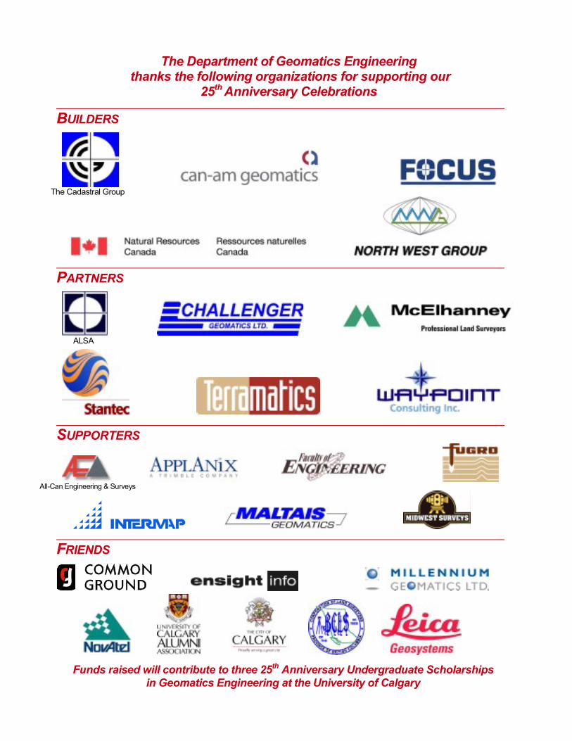
The Department of Geomatics Engineering thanks the following organizations for supporting our
25th Anniversary Celebrations
BUILDERS
The Cadastral Group
PARTNERS
ALSA
SUPPORTERS
All-Can Engineering & Surveys
FRIENDS
Funds raised will contribute to three 25th Anniversary Undergraduate Scholarships in Geomatics Engineering at the University of Calgary

This year marks the 25th Anniversary of the Department ofGeomatics Engineering at the University of Calgary. Theestablishment of geomatics engineering education at theUniversity of Calgary was the result of the foresight andpersistence of the surveying profession in western Canadain the 1960s and 70s. In 1976, the Alberta Land Surveyors’Association established the concept of creating a centre forsurveying education in western Canada. A Brief preparedby the western land surveying and mapping profession in1977 called for the creation of such a centre and was sentto all academic and other institutions concerned. TheUniversity of Calgary proposal to establish undergraduate,graduate and research programs in surveying engineering,
commissioned by Dr. Mike Ward, Head of Civil Engineering and written by Dr. E.J. Krakiwsky, receivedunanimous support. The Engineering Profession, represented by APEGGA, also supported the creation of sucha centre, and it was their strong support that tipped the balance in favor of the eventual creation of the programin 1979.
The program began in 1979 as the Division of Surveying Engineering of the Department of Civil Engineering butbecame a full department in 1986, the same year the graduate program was formally approved by the Universityadministration and financially supported by the Alberta Government. The full-time faculty members who joinedthe unit during the first year were Ted Anderson, Rod Blais, Edward Krakiwsky (Chair), Klaus-Peter Schwarz andBill Teskey. Numerous other experts helped with the teaching as sessional instructors including John Adams,PEng, Alex Hittel, ALS, andTom Swanby, ALS. These faculty members, in particular Dr. Krakiwsky who was Chairand Head for the first 10 years, were instrumental not only in setting up a successful program but in creating aculture of excellence, openness and collaboration that has prevailed throughout the history of the Department.
Undergraduate enrolment produced between 15 and 20 BSc graduates per year during the first 10 years. Interestin surveying engineering education by high school graduates dropped worldwide in the early 90s and theDepartment decided to change its name to Geomatics Engineering to better reflect its broad curriculum as wellas national trends. The name change, in addition to the implementation of strategies to increase enrolment,resulted in a profound and permanent change in enrolment.
The initial faculty members identified research and graduate studies as a priority and initially focussed their effortson gravity, positioning, statistical analysis, photogrammetry and high precision engineering surveys. Throughoutthe years, other research areas were initiated and grew, namely remote sensing, cadastral studies, geospatialinformation systems, digital imaging and integrated systems.
Ten years into the program, the annual funding was in the order of $500k. During the past five years, thanks tonew federal and provincial R&D support programs directed at academic institutions and the high level of successof faculty members in competing in these programs, the annual research revenue has grown rapidly to a currentannual level of about $4M.
In parallel with the above growth, the graduate program has steadily grown. The number of graduate studentsenrolled in the program is currently over 80, with an expected increase to 100 within five years, as new facultymembers develop their individual research programs. Some twenty students with either a Master or PhD nowcomplete their studies every year.
As a celebration of our 25th Anniversary, the Department has raised over $120,000 to establish threeundergraduate bursaries for Geomatics Engineering students. Faculty, alumni, industry and governmentagencies have generously donated to create these awards as a legacy of our commitment and their support toexcellence in geomatics education.
Celebrating 25 Years1979 to 2004
Page i
UofC, Geomatics Engineering Progress Report 2003/2004
Page 1
his Report covers the period May 2003 to April 2004 and in-cludes a special emphasis on the 25th Anniversary of the De-
HIGHLIGHTS 2003/2004
Tpartment of Geomatics Engineering, through some glimpses intoour past by showing where we started and what we have accom-plished.
In Spring 2004, 43 students received their BSc degree and two inFall 2003, nine students received their PhD, 10 students receivedtheir MSc degree and two students received their MEng. Under-graduate enrolment remained steady with 58, 46 and 52 in each ofthe second, third and fourth years, in addition to 21 students en-tered in the Internship Program. Demand for our BSc, MSc andPhD graduands remained exceptionally strong.
The 2003-2004 fiscal period was another successful year from aresearch excellence point of view. Faculty members have contin-ued to secure major research funding. The average research fund-ing per faculty member was $214,954 for the reporting period.
Numerous awards were received by students and faculty memberswhich are detailed on the following pages. Several faculty memberscontinued to serve in leadership positions on various boards and inlearned societies.
The Department launched a quarterly Newsletter in Fall 2003, tokeep our supporters, alumni, friends and other colleagues up to dateon our activities and direction.
The Department also launched a Support Opportunities initiative inDecember. This consisted of the “University of Calgary - CalgaryGeomatics Cluster - GeoConnection” Poster Project, support of theDepartment Newsletter and opportunities to support the GeomaticsEngineering 25th Anniversary Celebrations. These initiatives havebeen extremely successful.
The Poster Project saw the Department, together with the CalgaryGeomatics Cluster, Natural Resources Canada’s GeoConnectionprogram and our industrial sponsors play a leading role towardsbetter recognition of the science and practice of Geomatics. To-gether with our sponsors, we launched the Geomatics posters de-picting the role of geomatics in several sectors. The posters aretargeted at high school and university students to encourage themto consider geomatics as a possible career. A set of posters wasmailed to every high school and post-secondary institution in Canada(about six thousand in total). The goal of this awareness campaignis to excite the next generation about Geomatics as a valid careerchoice.

Page 2
Progress Report 2003/2004 UofC, Geomatics Engineering
Gérard Lachapelle completed his term as head June 30, 2003-and now has time for a little relaxation
Naser El-Sheimy, duringENGG Week 2004
A CCLS accreditation team visited the Department in April. Our Faculty,Staff, Technical Support and Administrative Staff made a thorough presen-tation – as to the uniqueness of this institution and its continued commit-ment towards the practice and teaching of Engineering.
In terms of Departmental leadership, Dr. Gérard Lachapelle completed hisHeadship on June 30, 2003 - after an eight year run. My term as InterimHead ends June 30, 2004 and Dr. Elizabeth Cannon’s tenure as the Headof the Department begins July 1. I would like to take this opportunity towish Elizabeth all the best with her new role.
Dr. Naser El-SheimyAssociate Professor andInterim Head
UofC, Geomatics Engineering Progress Report 2003/2004
Page 3
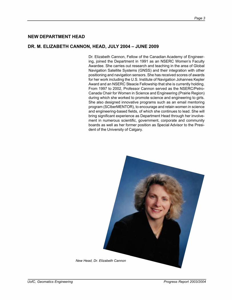
NEW DEPARTMENT HEAD
Dr. Elizabeth Cannon, Fellow of the Canadian Academy of Engineer-ing, joined the Department in 1991 as an NSERC Women’s FacultyAwardee. She carries out research and teaching in the area of GlobalNavigation Satellite Systems (GNSS) and their integration with otherpositioning and navigation sensors. She has received scores of awardsfor her work including the U.S. Institute of Navigation Johannes KeplerAward and an NSERC Steacie Fellowship that she is currently holding.From 1997 to 2002, Professor Cannon served as the NSERC/Petro-Canada Chair for Women in Science and Engineering (Prairie Region)during which she worked to promote science and engineering to girls.She also designed innovative programs such as an email mentoringprogram (SCIberMENTOR), to encourage and retain women in scienceand engineering-based fields, of which she continues to lead. She willbring significant experience as Department Head through her involve-ment in numerous scientific, government, corporate and communityboards as well as her former position as Special Advisor to the Presi-dent of the University of Calgary.
DR. M. ELIZABETH CANNON, HEAD, JULY 2004 – JUNE 2009
New Head, Dr. Elizabeth Cannon

Page 4
Progress Report 2003/2004 UofC, Geomatics Engineering
Time Capsule: First Progress Report pub-lished in September 1982, reporting period wasthe academic year 1981/1982. Dr. Ed Krakiwskywas Chairman of the Division of Surveying Engi-neering.
Geomatics Engineering Department Heads, past, presentand future. Standing, LtoR: Drs. Cannon, El-Sheimy andLachapelle. Seated: LtoR: Drs. Schwarz and Krakiwsky(2004)
Dr. Krakiwsky with future heads ... LtoR:Gérard Lachapelle, Ed Krakiwsky, Klaus-PeterSchwarz (1981)
Ed Krakiwsky (1979)
An era ends. Dr. Ed Krakiwsky passes the torch toGérard Lachapelle and Klaus-Peter Schwarz (June1989)
UofC, Geomatics Engineering Progress Report 2003/2004
Page 5
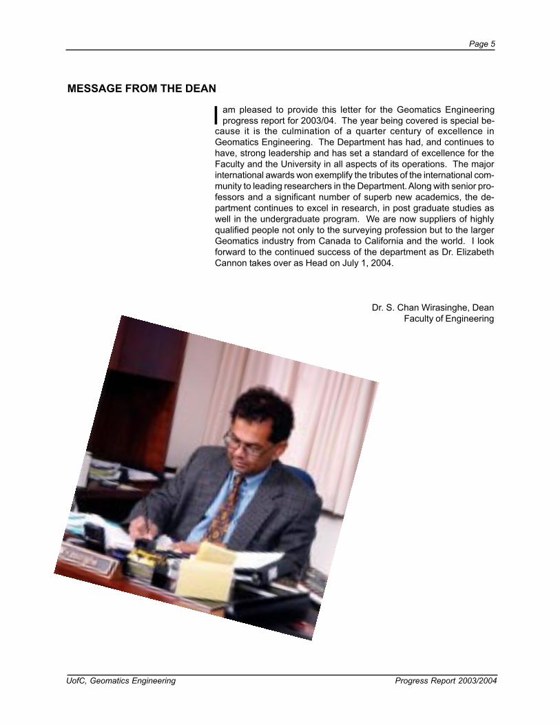
MESSAGE FROM THE DEAN
Dr. S. Chan Wirasinghe, DeanFaculty of Engineering
I am pleased to provide this letter for the Geomatics Engineeringprogress report for 2003/04. The year being covered is special be-
cause it is the culmination of a quarter century of excellence inGeomatics Engineering. The Department has had, and continues tohave, strong leadership and has set a standard of excellence for theFaculty and the University in all aspects of its operations. The majorinternational awards won exemplify the tributes of the international com-munity to leading researchers in the Department. Along with senior pro-fessors and a significant number of superb new academics, the de-partment continues to excel in research, in post graduate studies aswell in the undergraduate program. We are now suppliers of highlyqualified people not only to the surveying profession but to the largerGeomatics industry from Canada to California and the world. I lookforward to the continued success of the department as Dr. ElizabethCannon takes over as Head on July 1, 2004.

Page 6
Progress Report 2003/2004 UofC, Geomatics Engineering
AWARDS AND RECOGNITION
Dr. Gérard Lachapelle was conferred an Honorary Professorship fromthe Università Degli Studi Di Napoli Parthenope, Naples, Italy for his pio-neering contributions and numerous outstanding achievements in the areaof satellite-based positioning, navigation and location during the past 25years.
Zhizhao Liu was been awarded the J.B. Hyne Research Innovation Award.This award recognizes graduate students in any discipline who excel inresearch.
Georgia Fotopoulos, PhD student, was awarded an Alberta IngenuityFellowship. The Alberta Ingenuity Fellowship program is aimed at recruit-ing new researchers to Alberta as post-doctoral fellows and to help furtherdevelop and strengthen Alberta’s science and engineering research ca-pacity.
Andrew Hunter, PhD student, was awarded the Margaret P. Hess Gradu-ate Scholarship. The Margaret P. Hess Graduate Scholarship is awardedto students whose area of study focuses on the Rocky Mountains and theEastern Slopes, or the Arctic/Sub-Arctic regions, and whose research ad-dresses the question of balance between protection of natural habitatsand economic use of lands.
Dr. Ayman Habib, Dr. Young-ran Lee, and Michel Morgan, Ph.D. stu-dent, are the recipients of the Second Honourable Mention for the TalbertAbrams Award for the year 2004 for their paper entitled, Automatic Match-ing and Three-dimensional Reconstruction of Free-Form Linear Featuresfrom Stereo Images.
Michel Morgan, PhD student, was been awarded the 2004 ASPRSE.Altenhofen Memorial Scholarship. The Scholarship is intended to encour-age and commend college students who display exceptional interest andability in the theoretical aspects ofPhotogrammetry.
Cameron Ellum, Ph.D. student, was been awarded the 2004 LeicaGeosystems internship.
Dr. Elizabeth Cannon was awarded the Frank Spragins Technical Awardat the APEGGA Summit Awards held in Edmonton.
Rita Cheng, supervised by Dr. Ayman Habib and Lance de Groot, super-vised by Dr. Susan Skone, won Ingenuity MSc Studentship Awards.
Eun Shin, PhD student, and Dr. Naser El-Sheimy won a best paper awardat the IEEE PLANS (Position Locations and Navigation Symposium) 2004conference for their paper An Unscented Kalman Filter for In-Motion Align-ment of Low Cost IMUs.

UofC, Geomatics Engineering Progress Report 2003/2004
Page 7
Four students won best paper awards at the Institute of Navigation GPS2003 Conference held in Portland, OR:Kai-Wei Chiang, The Utilization of Single Point Positioning and Multi-LayerFeed-Forward Nets for INS/GPS IntegrationZhizhao Liu, Development and Analysis of a New Ionospheric ModelChanglin Ma, Integration of GPS and Cellular Networks to Improve Wire-less Location PerformanceGiovanni Pugliano, Testing of a Multi-Reference Station Network for RTKDGPS Positioning in Italy
Georgia Fotopoulos won the Canadian Geophysical Union Best StudentPaper Award for the Geodesy Section. The award was given for her pres-entation entitled ‘On the estimation of variance components using GPS,geoid and levelling data’, and was co-authored by Dr. M.G. Sideris.
Dr. Cathy Valeo received the 2003/2004 Departmental Teaching Excel-lence Award.
Dr. Gérard Lachapelle received the 2003/2004 Departmental ResearchExcellence Award as well as the Faculty of Engineering Research Excel-lence Award.
Dr. Gérard Lachapelle was elected a Fellow of the Canadian Academy ofEngineering during the annual meeting of the Academy held in Montréal onMay 30, in recognition of his extensive contribution to the development anddissemination of satellite-based navigation technologies in Canada andinternationally.
Dr. Naser El-Sheimy was been elected as a member of the Geoide NCEBoard of Directors.
Dr. Nico Sneeuw was awarded a Humboldt Research Fellowship from theGerman Alexander von Humboldt Foundation. This prestigious award ena-bles him to conduct research at the University of Stuttgart, Germany, nextyear. Dr. Sneeuw will investigate spatio-temporal sampling characteristicsof current and future gravity field satellite missions.
Dr. Gérard Lachapelle was elected a Fellow of the U.S.-based Institute ofNavigation in recognition of his sustained contributions in the field of globalnavigation satellite systems and related educational accomplishments.

Page 8
Progress Report 2003/2004 UofC, Geomatics Engineering
Faculty members at the Annual Strategy Meeting held May 6, 2004. Back RowLtoR: Nico Sneeuw, Michael Barry, Chris Kotsakis; Middle Row LtoR: MichaelSideris, Caterina Valeo, Susan Skone, Gérard Lachapelle, Isabelle Couloigner,Mele Rakai; Seated LtoR: Bill Teskey, Ayman Habib, Yang Gao, Naser El-Sheimy, Elizabeth Cannon, Matthew Tait; Missing from the photo: Michael Collinsand Darka Mioc
Professor Naser El-Sheimy Appointed Canada Research Chair inMobile Multi-Sensor Geomatics Systems: Dr. Naser El-Sheimy wasseleced by the Federal Government’s Canada Research Chairs Pro-gram to receive a Canada Research Chair (CRC) in Mobile Multi-Sen-sor Geomatics Systems. This appointment will enable Professor El-Sheimy to focus his research on the above topic. The initial term for theCRC is seven years. Dr. El-Sheimy’s objectives of this multidisciplinaryresearch program are to advance the theory and applications of M2Gsystems through the deployment of cost-effective sensing technolo-gies made possible through the development of data management, real-time geo-computing, and specializewd, intelligent porocessing sensorsintegration algorithms. The research is guided by two key factors: cost-effectiveness while maintaining performance, and overall accuracy.
UofC, Geomatics Engineering Progress Report 2003/2004
Page 9
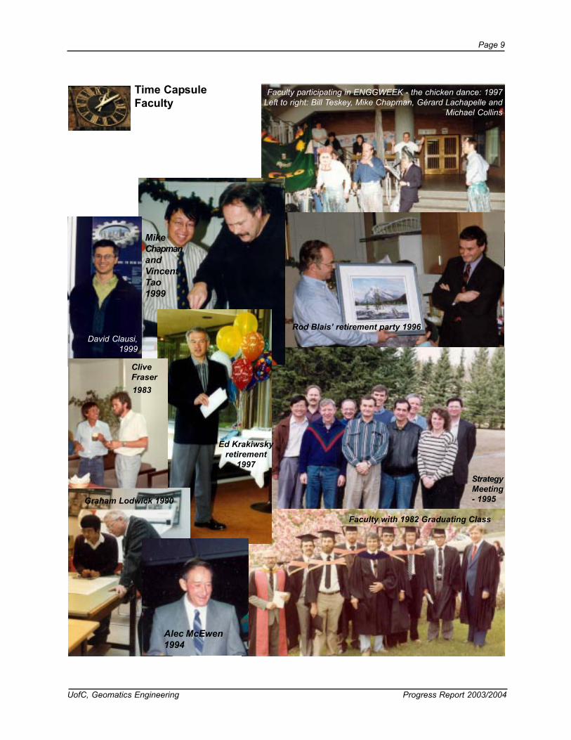
Time CapsuleFaculty
Rod Blais’ retirement party 1996
StrategyMeeting- 1995Graham Lodwick 1990
MikeChapmanandVincentTao1999
Ed Krakiwskyretirement
1997
Faculty participating in ENGGWEEK - the chicken dance: 1997Left to right: Bill Teskey, Mike Chapman, Gérard Lachapelle and
Michael Collins
Faculty with 1982 Graduating Class
Alec McEwen1994
David Clausi,1999
CliveFraser1983

Page 10
Progress Report 2003/2004 UofC, Geomatics Engineering
PERSONNEL
Faculty
Dr. M.E. CannonProfessor and Steacie FellowB.Sc. (Mathematics), B.Sc., M.Sc., Ph.D. (KillamScholar, University of Calgary), P.Eng., C.L.S.,NSERC Women's Faculty Award, Satellite-basedradionavigation systems, precise static and real-time kinematic positioning.
Dr. N. El-SheimyAssociate Professor and Interim HeadB.Sc., M.Sc., Ph.D. (University of Calgary),Multi-sensor systems, real-time mapping andtheir applications in (GIS).
Dr. S.H. SkoneAssociate Professor and Associate Head(Graduate Studies)B.Sc., M.Sc., Ph.D. (University of Calgary),Wide-area differential GPS, , atmosphericeffects and modelling on satellite navigation.
Dr. M.B. BarryAssociate Professor and Associate Head(Undergrad)B.Sc., MBA, PhD (Natal)Cadastral Systems, land tenure and geo-graphic information systems
1992
1996
1996

UofC, Geomatics Engineering Progress Report 2003/2004
Page 11
Dr. G. LachapelleProfessor
CRC/iCORE Chair in Wireless LocationB.Sc., M.Sc., L.Ph., Dr. Techn. (Technical
University of Graz), P.Eng., C.L.S., Satellite-based positioning and navigation, wireless
location
Dr. M.J. CollinsAssociate Professor and
Associate Dean (Student Affairs)B.Sc., M.Sc., Ph.D. (York), Microwave remotesensing, geometric and radiometric analysis of
digital images, polar science.
Dr. I. CouloignerAssistant Professor
Fr. Ing., PhD (trés honorable, Université Nice-SophiaAntipolis/École des Mines de Paris)
Digital image processing, data fusion and wavelettransformation, and high resolution remote sensing
imagery.
Dr. Y. GaoAssociate Professor
B.Sc., M.Sc., Ph.D. (University of Calgary),P.Eng. Robust estimation, satellite positioning
and navigation, mobile information manage-ment.
Dr. A.F. HabibAssociate Professor
B.Sc., M.Sc., Ph.D. (Ohio State University)Digital photogrammetry, image processing,image understanding, mobile mapping sys-
tems, sensor, data, and information integra-tion.
1988
1982
Page 12
Progress Report 2003/2004 UofC, Geomatics Engineering
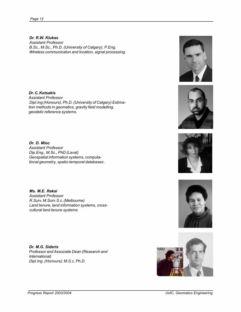
Dr. M.G. SiderisProfessor and Associate Dean (Research andInternational)Dipl.Ing. (Honours); M.S.c, Ph.D.
Ms. M.E. RakaiAssistant ProfessorR.Surv. M.Surv.S.c. (Melbourne)Land tenure, land information systems, cross-cultural land tenure systems.
Dr. R.W. KlukasAssistant ProfessorB.Sc., M.Sc., Ph.D. (University of Calgary), P.Eng.Wireless communicaton and location, signal processing.
Dr. C. KotsakisAssistant Professor Dipl.Ing (Honours), Ph.D. (University of Calgary) Estima-tion methods in geomatics, gravity field modelling,geodetic reference systems.
Dr. D. MiocAssistant ProfessorDip.Eng., M.Sc., PhD (Laval)Geospatial information systems, computa-tional geometry, spatio-temporal databases .
1982

UofC, Geomatics Engineering Progress Report 2003/2004
Page 13
Dr. W.F. TeskeyProfessor
B.Sc. (Distinction; APEGGA Gold Medal),M.Sc., Dr.-Ing. (Stuttgart University), P.Eng.,
A.L.S., C.L.S. Precise engineering anddeformation surveys, integrated anlysis of
deformations.
Dr. C. ValeoAssociate Professor
B.Sc., B.A.Sc., M.Eng., PhD (McMaster), P.Eng.,Water resources and environmental engineering, remote
sensing and GIS.
Dr. N.J. SneeuwAssistant Professor
ir, Dr.-Ing. (Technical University Munich)Geodesy, gravity field modelling, satellite
geodesy, gravity field satellite missions
Dr. M.P. TaitAssistant Professor
BEng (Hons), Ph.D. (Leeds) Industrial mea-surement systems and methodologies, closer
integration of metrology, 3D modelling.
1980

Page 14
Progress Report 2003/2004 UofC, Geomatics Engineering
STAFF CHANGES
Dr. Richard Klukas moved on to take a position at the University ofKelowna. We wish him well.
New faculty will be arriving July 1, 2004. Dr. Kyle O’Keefe takes overas Assistant Professor in the area of Wireless Location. A new Associ-ate Professor, Dr. Bo Huang arrives to head the GIS area of the De-partment.
Cannon Chapman
Schwarz
HamiltonLeask
Collins
Inch
Gehring
Time CapsuleFaculty and Staff
2003
1997
1991
1996
Wanamaker
Robinson1992
LtoR: M. Anderson, M. Inch, H. Alto,A. Gerhing, J. Lai
`1996
Barbaro
Markland
2003
Sideris1990
Richardson
WeiBlais
Schwarz
1996
Teskey

UofC, Geomatics Engineering Progress Report 2003/2004
Page 15
Sideris
1982
Swanby
Teskey
1980
Anderson2002
Anderson1993
Collins1995
Wanamaker
Szarmes
Markland
Lai
2003
Chapman
1989
Goldfarb
LaiInch
1996
Page 16
Progress Report 2003/2004 UofC, Geomatics Engineering
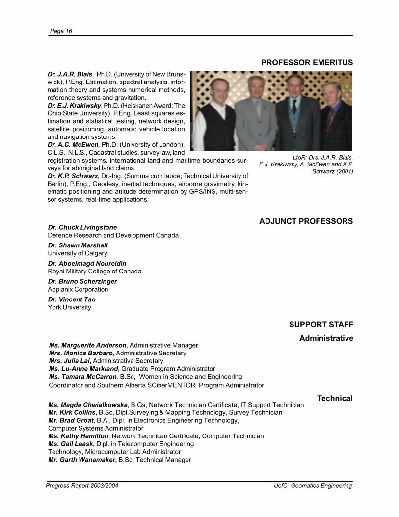
Dr. J.A.R. Blais, Ph.D. (University of New Bruns-wick), P.Eng. Estimation, spectral analysis, infor-mation theory and systems numerical methods,reference systems and gravitation.Dr. E.J. Krakiwsky, Ph.D. (Heiskanen Award; TheOhio State University), P.Eng. Least squares es-timation and statistical testing, network design,satellite positioning, automatic vehicle locationand navigation systems.Dr. A.C. McEwen, Ph.D. (University of London),C.L.S., N.L.S., Cadastral studies, survey law, landregistration systems, international land and maritime boundaries sur-veys for aboriginal land claims.Dr. K.P. Schwarz, Dr.-Ing. (Summa cum laude; Technical University ofBerlin), P.Eng., Geodesy, inertial techniques, airborne gravimetry, kin-ematic positioning and attitude determination by GPS/INS, multi-sen-sor systems, real-time applications.
PROFESSOR EMERITUS
Ms. Marguerite Anderson, Administrative ManagerMrs. Monica Barbaro, Administrative SecretaryMrs. Julia Lai, Administrative SecretaryMs. Lu-Anne Markland, Graduate Program AdministratorMs. Tamara McCarron, B.Sc, Women in Science and EngineeringCoordinator and Southern Alberta SCiberMENTOR Program Administrator
SUPPORT STAFF
Administrative
ADJUNCT PROFESSORSDr. Chuck LivingstoneDefence Research and Development CanadaDr. Shawn MarshallUniversity of CalgaryDr. Aboelmagd NoureldinRoyal Military College of CanadaDr. Bruno ScherzingerApplanix CorporationDr. Vincent TaoYork University
Technical
LtoR: Drs. J.A.R. Blais,E.J. Krakiwsky, A. McEwen and K.P.
Schwarz (2001)
Ms. Magda Chwialkowska, B.Gs, Network Technician Certificate, IT Support TechnicianMr. Kirk Collins, B.Sc, Dipl.Surveying & Mapping Technology, Survey TechnicianMr. Brad Groat, B.A., Dipl. in Electronics Engineering Technology,Computer Systems AdministratorMs. Kathy Hamilton, Network Technican Certificate, Computer TechnicianMs. Gail Leask, Dipl. in Telecomputer EngineeringTechnology, Microcomputer Lab AdministratorMr. Garth Wanamaker, B.Sc, Technical Manager

UofC, Geomatics Engineering Progress Report 2003/2004
Page 17
RESEARCH ASSOCIATES/ASSISTANTS
POST DOCS
gnoDieLnoitagivaNdnanoitacoL,gninoitisoP
ireinrauGatreblAnoitagivaNdnanoitacoL,gninoitisoP
eHrefinneJseidutSdnaLdnaSIG
oHeirraCseidutSdnaLdnaSIG
gnoHiL.sMseidutSdnaLdnaSIG
engivaLnitraMnoitagivaNdnanoitacoL,gninoitisoP
uiLeignuJnoitagivaNdnanoitacoL,gninoitisoP
aMnilgnahCnoitagivaNdnanoitacoL,gninoitisoP
naguoGcaMnnelGnoitagivaNdnanoitacoL,gninoitisoP
notroMnoraAnoitagivaNdnanoitacoL,gninoitisoP
ulutuMpillihPseidutSdnaLdnaSIG
ollevotePkraMnoitagivaNdnanoitacoL,gninoitisoP
eppelhcSnhoJnoitagivaNdnanoitacoL,gninoitisoP
ifooSdammahuMscimanydoeGdnadleiFytivarG
atamustoYuroTsmetsySgnigamIlatigiD
soluopotoFaigroeGscimanydoeGdnadleiFytivarG
rassaNhemaSnoitagivaNdnanoitacoL,gninoitisoP
uiNijoaiXnoitagivaNdnanoitacoL,gninoitisoP
kraPkUgnoJnoitagivaNdnanoitacoL,gninoitisoP
dajennahsoRilAseidutSdnaLdnaSIG
gnahZgnefuYnoitagivaNdnanoitacoL,gninoitisoP

Page 18
Progress Report 2003/2004 UofC, Geomatics Engineering
VISITING SCIENTISTS
GUEST LECTURERS
aupaCtreboR.rMylatIfotnemnrevoG
sivaDnoJ.rMyvaNSU
reluEnegruJ-snaH.rDdnalreztiwS,acieL
setroFziuL.rDscitsitatSdnayhpargoeGfoetutitsnInailizarB
aktaleG.B.rMyvaNSU
namtuGhteS.rDASU,AAON
mhaHkhaH-gnahC.rDaeroK,egelloClacinhceTahnI
miKgnuoyMiuE.rD)FESOK(noitadnuoFgnireenignEdnaecneicSnaeroK
gninnaMdivaDrosseforPeltsacweNfoytisrevinU
kraPsemaJ.rDyrotavresbOymonortsAaeroK
regnizrehcSonurB.rDotnoroT,xinalppA
resieWsaerdnA.rDzarGtaytisrevinUlacinhceT
Special Lecturer SeriesrafhsenaDmarhaB.rD
awattOfoytisrevinUetamitsEotSIGnignilledoMssecorPfoelpmaxEnA
oiratnOnretsaEniytivitisneSlacigoloegordyH
uFleinaD.rDrevieceRecnatsiseR-raf-raeN,noitagitiM-IAM
srevieceRSSNGrofserutcetihcrA
efeeK'OelyK.rMyraglaCfoytisrevinU
noitagivaNlabolGdesoporPfoecnamrofrePehtgnissessAnoitalumiShguorhTsmetsySetilletaS

UofC, Geomatics Engineering Progress Report 2003/2004
Page 19
Distinguished Lecturer SeriesnidleruoNdgamleobA.rDadanaCfoegelloCyratiliMlayoRgnireenignEscitamoeGotsnoitacilppAhtiwgnissecorPlangiSlatigiD
yaRatnayaJ.rDaidnIerolagnaB,tuoyaLrulmoDseigolonhceTrevieceRSPGdecnavdA
Time Capsule: The Distinguished Lecturers series was introduced in the mid 80s andhas attracted over 20 external lecturers. International experts from academia and industrycome to give graduate courses during the spring and summer periods to increase diversity.
International Lecturer SeriessekoorBrehpotsirhC.rDsdeeLfoytisrevinUtnemeganaMecitcarPtseBrofgnilledoMtnemhctaCdetargetnI
mehtoHyrraL.rMNOI,tnediserPeciVevitucexEmargorPnoitazinredoMSPGehT
gnauHoB.rDeropagniSfoytisrevinUlanoitaN,gnilledoMataDlaitapS:SIGfotnemecnavdAnasdrawoT
sisylanAdnanoitazilausiV
Dr. Ivan Mueller from TheOhio State University gave a Distin-guished Lecturers course on Earth Rota-tion and Reference Coordinate Framesin Summer 1994.
Dr. Jayanta Ray with graduate studentsenrolled in his graduate course onAdvanced GPS Receiver Technologies
LtoR: Weigen Qui, Gary Sellhorst,Chuanya Tang, Gengsheng Zhang, Liming
Wu, Yousef Hammada, Seated IvanMueller

Page 20
Progress Report 2003/2004 UofC, Geomatics Engineering
ADVISORY COMMITTEE AND STUDENT AWARDS
Advisory Committee
t is the responsibility ofthe GeomaticsI
Advisory Committee toensure that the under-graduate, graduate andresearch programsmeet the needs of thecountry and are kept upto date with society andthe rapidly changingtechnologies.
The 27th annual advi-sory committee meet-ing was held onOctober 17, 2003. Theagenda included dis-cussion on the CalgaryGeomatics ClusterInitiative, Career Day2004, anticipated hu-man resources needsby the geomaticsindustry, career oppor-tunity diversification,student summer jobs,and internship opportu-nities. The committeealso met with third andfourth year studentrepresentatives.
Back LtoR: Michael Sideris, Irwin Itzkovitch, Mike Barry, Paul Mrstik, Pat Fenton,Bruno Scherzinger, Front LtoR: Naser El-Sheimy, Bryan Bates, O’Brian Blackall, Sara
Masterson, Vicky Brilz, Tim Koepke, Amin Kassam
3002eettimmoCyrosivdA
emaN noitailiffA
,llakcalBnairB'OriahC
CB,nhoJ.tStroF,.cnIgniyevruSdnaLyennahlEcM
ttenraBnehpetS BA,yraglaC,.dtLscitamoeGregnellahC
setaBnayrB BA,yraglaC,.proCscitamoeGmA-naC
zlirBykciV BA,yraglaC,maertsanyD
notneFtaP BA,yraglaC,letAvoN
hctivokztIniwrI NO,awattO,naCRN,rotceSsecneicShtraE
massaKnimA ,tnemeganaMecruoseRelbaniatsuSfoyrtsiniMCBCB,airotciV
ekpeoKmiT KY,esrohetihW,sriaffAnrehtroNdnanaidnI
nosretsaMaraS AC,ogeiDnaS,snoituloSoeGselahT
kitsrMluaP NO,awattO,.cnIsmetsySgnippaMciasoM
regnizrehcSonurB NO,lliHdnomhciR,noitaroproCxinalppA
enokS.H.S,ymiehS-lE.N,yrraB.B.MerewCfoUehtfosevitatneserpeR
UofC, Geomatics Engineering Progress Report 2003/2004
Page 21
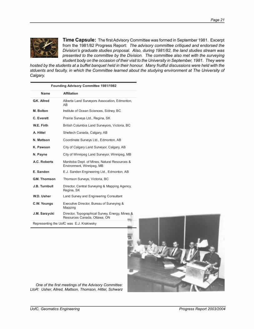
Time Capsule: The first Advisory Committee was formed in September 1981. Excerptfrom the 1981/82 Progress Report: The advisory committee critiqued and endorsed theDivision’s graduate studies proposal. Also, during 1981/82, the land studies stream waspresented to the committee by the Division. The committee also met with the surveyingstudent body on the occasion of their visit to the University in September, 1981. They were
hosted by the students at a buffet banquet held in their honour. Many fruitful discussions were held with thestduents and faculty, in which the Committee learned about the studying environment at The University ofCalgary.
One of the first meetings of the Advisory Committee:LtoR: Usher, Allred, Mattson, Thomson, Hittel, Schwarz
2891/1891eettimmoCyrosivdAgnidnuoF
emaN noitailiffA
derllA.K.G ,notnomdE,noitacossAsroyevruSdnaLatreblABA
notloB.M CB,yendiS,secneicSnaecOfoetutitsnI
tterevE.C KS,anigeR,.dtLsyevruSeiriarP
htriF.E.W CB,airotciV,sroyevruSdnaLaibmuloChsitirB
lettiH.A BA,yraglaC,adanaChcetlehS
nosttaM.N BA,notnomdE,.dtLsyevruSetanidrooC
noswaP.K BA,yraglaC,royevruSdnaLyraglaCfoytiC
enyaP.N BM,gepinniW,royevruSdnaLgepinniWfoytiC
streboR.C.A &secruoseRlarutaN,seniMfo.tpeDabotinaMBM,gepinniW,tnemnorivnE
nednaS.E BA,notnomdE,.dtLgnireenignEnednaS.J.E
nosmohT.M.G CB,airotciV,syevruSnosmohT
llubnruT.B.J ,ycnegAgnippaM&gniyevruSlartneC,rotceriDKS,anigeR
rehsU.D.W tnatlusnoCgnireenignEdnayevruSdnaL
sgnuoY.W.C &gniyevruSfouaeruB,rotceriDevitucexEgnippaM
ikcyzraS.M.J &seniM,ygrenE,yevruSlacihpargopoT,rotceriDNO,awattO,adanaCsecruoseR
ykswikarK.J.EsawCfoUehtgnitneserpeR

Page 22
Progress Report 2003/2004 UofC, Geomatics Engineering
Advisory Committee 1984
Advisory Committee 1986
Advisory Committee 1990
Advisory Committee 1993
Advisory Committee 1991
Advisory Committee 1997
Advisory Committee 2001

UofC, Geomatics Engineering Progress Report 2003/2004
Page 23
The Geomatics EngineeringLiaison Committee met onOctober 16, 2003 and Feb-ruary 4, 2004. The commit-tee was established to de-velop an effective and per-manent relationship be-tween the Land Surveyors’Associations and the Uni-versity of Calgary. The com-mittee consists of two del-egates each from the LandSurveying Associations inthe four western provincesand the Association ofCanada Lands Surveyors, amember at large, as well asthe Associate Heads andCadastral faculty of the De-partment of Geomatics En-gineering at the University ofCalgary.
Geomatics Engineering Liaison Committee
Discussions centredaround further improve-ments to the land surveyingmodules that were givenduring Field Camp held inAugust, summer jobs andinternship, provincial asso-ciation reports, CalgaryGeomatics Cluster, numberof CLS Candidates andspecial provisions for UofCstudents, CLS Programmeaccreditation and MarketingStrategy and the FutureLand Surveyor.
Back LtoR: Richard Redfern, Rob King, Mele Rakai, Mike Barry, Paul Standing,Ian Lloyd, Bill Teskey, Jeff Skelton, Front LtoR: Naser El-Sheimy, Paul Dixon,
Bryan Bates, O’Brian Blackall, Vince Ziegler
3002eettimmoCnosiaiLgnireenignEscitamoeG
emaN noitailiffA
setaBnayrB egraLtarebmeM
llakcalBnairB'O sroyevruSdnaLaibmuloChsitirBfonoitaroproC
noxiDluaP sroyevruSsdnaLadanaCfonoitaicossA
gniKtreboR noitaicossAsroyevruSdnaLatreblA
dyolLnaI sroyevruSsdnaLadanaCfonoitaicossA
nrefdeRhciR sroyevruSdnaLaibmuloChsitirBfonoitaroproC
notlekSyerffeJ noitaicossAsroyevruSdnaLnawehctaksaS
gnidnatSluaP sroyevruSdnaLabotinaMfOnoitacossA
relgeiZecniV noitaicossAsroyevruSdnaLatreblA
,ymiehS-lE.N,)riahC(yrraB.B.MerewCfoUehtfosevitatneserpeRyekseT.F.W,iakaR.E.M

Page 24
Progress Report 2003/2004 UofC, Geomatics Engineering
Student Awards Night
on Thursday, Octo-ber 16, 2003.Awards night is anopportunity to pub-licly recognize themany accomplish-ments of our gradu-ate and under-graduate students.It also provides anoccasion for an in-formal meeting be-tween members ofthe profession, stu-dents, faculty andother university rep-resentatives.
The number ofawards available forour students contin-ues to rise thanks tothe commitment ofthe Geomaticscommunity to ourprogram and to ourstudents.
tudent AwardsNight was heldS )gnireenignEscitamoeGotcificepS(sdrawAetaudargrednU
tneipiceR sdrawA
miehsrelloWleahciM gnireenignEscitamoeGnipihsralohcSyawolloH.H.J
thcerbseiGnimajneB drawAsroyevruSdnaLaibmuloChsitirBpihsralohcS.dtLsmetsysoeGACIEL
etnalPnitsuJ drawAlairomeMybweN)kciD(.R.LdrawAlairomeMhcnifdloGyoR.H
laezarBnayR drawAsroyevruSdnaLnawehctaksaS
retraCkcaJ drawAregerD.InayrB
naitsirhClarehteMwerdnA pihsralohcSyennahlEcMehT
oHnoraA drawAlairomeMsmailliW.PnehpetS
eeKcMdlanoD yrasruBscitamoeGcetnIsucoF
rhaKnirE pihsralohcSylimaFellepahcaL-nonnaCehT
egraLyelhsA pihsralohcSdargrednU79SIKyrasruBykswikarK.J.EehT
uihCdnomseD yrasruBretpahCatreblAnoitagivaNfoetutitsnIyrasruBlairomeMyrwoLyaR
nehctiKhtenneK yrasruBlairomeMllivocSdivaD
nesnaHrelyT yrasruBnoitaicossA'sroyevruSdnaLatreblA
karsaBakvardZ yrasruB.dtLsnoituloScitamoeGnaidanaC
resarFleahciM pihsralohcSdrofsoH)sineD(.D.A
nallAymereJ pihsralohcSadanaCscitamoeGGIC
noxiDekuLkarsaBakvardZ
naitsirhC-larehteMwerdnA
sdrawAhcraeseRtnedutSetaudargrednUCRESN

UofC, Geomatics Engineering Progress Report 2003/2004
Page 25
Graduate and undergraduate award winners
O’Brian Blackall presents JustinPlante with the H. Roy Goldfinch
Memorial Award
Second year students at Awards Night

Page 26
Progress Report 2003/2004 UofC, Geomatics Engineering
sdrawAetaudarG
dimaH-ledbAdilaW pihsralohcStnemnrevoGnaitpygE
sevlAluaP pihsralohcSCRESNNOI
drofwarCttocS pihsralohcSCRESNpihsralohcStnedutSetaudarGatreblA
tnemelppuSEROCi
mullEnoremaC lairomeMmalliKnotlaWkaazItnarGhcraeseRmalliKnotlaWkaazI
ihthtappalaGaknalihT pihsralohcSetaudargtsoPlairtsudnICRESN
elyoHairotciV pihsraolohcStnedutSetaudarGatreblA
retnuHwerdnA EDIOEGybweNreklaW
pihsralohcSsseH.PteragraMpihsralohcSetaudargtsoPlairtsudnICRESN
gnauHwerdnA pihsralohcStnedutSetaudarGatreblA
pInalA pihsralohcSetaudargtsoPlairtsudnICRESN
neiluJreivilO drawAFIAnoitceSatreblANOI
uiLoahzihZ pihsralohcSetaudarG49SIKdrawAnoitavonnIhcraeseRenyH.B.J
NOI
vestnezeMgelO noitceSlanoitaNNOI
nagroMlehciM pishralohcSetaudarGyrasrevinnArevliS
rassaNhemaS drawAetaudarGztiroMtumleH
noslohciNaylataN pihsralohcSCRESNdrawAecnellecxEhcraeseRsnaeD
drawAecneicShtraECRESNdrawAlacigolroeteMCRESN
tnemelppuSEROCi
efeeK'OelyK pihsralohcSCRESNtnemelppuSEROCi
malliKnotlaWkaazIyraronoHtnarGhcraeseRmalliKnotlaWkaazI
noniP-zenoniuQacebeR aigolonceTYaicneiCedlanoicaNojesnoC
trehciRddoT pihsralohcSetaudargtsoPlairtsudnICRESNdrawAytiunegnIatreblA
pihsralohcStnedutSetaudarGatreblAtnarGhcraeseRdrawAytiunegnIatreblA
UofC, Geomatics Engineering Progress Report 2003/2004
Page 27
Our graduate students achievedover $387,000 in awards for 2003/2004. This figure is excludinggraduate teaching assistantshipsand graduate research scholar-ships.
)deunitnoc(sdrawAetaudarG
amrahSitnayaJ pihsralohcSCRESNetteyaPeiluJpihsralohcStnedutSetaudarGatreblA
tnemelppuSEROCi
siverTardnaL pihsralohcStnedutSetaudarGatreblA
tlegieWsaihttaM epuarGrenreW
dedrawAlatoT 892,783$
dnastnedutsetaudargybderohtua-ocsrepaprofnowoslaerewsdrawarepaptseBsliatedrof7-6segapfonoitcesnoitingoceRdnasdrawAeesesaelP.ytlucaf
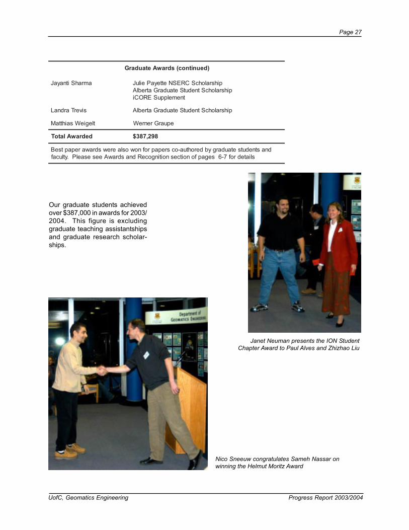
Janet Neuman presents the ION StudentChapter Award to Paul Alves and Zhizhao Liu
Nico Sneeuw congratulates Sameh Nassar onwinning the Helmut Moritz Award

Page 28
Progress Report 2003/2004 UofC, Geomatics Engineering
1981: PhilMacKenzie (left),Ken Allred (right)
1983: Lance LaPlante(left), Rick Kurash(Right)
1986: Clyde Harris,Awards Night
Time CapsulePrevious Awards Nights
1987: Mr. L.Newby (left),Gerry Smyth(Right)
Chris Tucker,Awards NightEmcee, 1995
1990: LtoR:AngelaRauhut, DonBayly, HughMartell,Zoltan Biacs
1988: GordThomson
(left), JoCoehlo(Right)
1991 Award Winners, LtoR: Daniel Joerissen, Blake Bullock, DarrenCosandier, Kam Gahunia, John Lovse, Dale Rosnes, Rob Hare, DaveParkin, Jill Hinkelman, Ray Obidowski
1993: LtoR: KevinWigglesworth, Dean
Mikkelsen, Kirk Burnell

UofC, Geomatics Engineering Progress Report 2003/2004
Page 29
UNDERGRADUATE STUDIESEnrollment
A representation ofenrollment statistics by postsecondary institution isshown in the adjacent figure.Alberta post-secondary insti-tutions listed under Other ABInstitutes include Augustanaand Medicine Hat Colleges.Other BC Institutes includeKwantlen and Trinity West-ern. McGill and University ofWinnipeg are listed in Other.
Student Enrollment by Geographic Region
uring the 2003/04 academic year 156undergraduate students (177 includ-D
Student Enrollment by Previous Post-Secondary Institution
ing internship) pursued studies inGeomatics Engineering at the UofC.
The Department has seen a steady in-crease in undergraduate enrollment overthe past seven years (see graph on page30). The program’s maximum enrolmentper year increased from 35 to 50 duringthe past five years.
The figure to the left shows a breakdownof student enrollment by geographic region.
0
20
40
60
80
100
120
140
Alb
erta BC
Inte
rnat
iona
l
Sas
katc
hew
an
Man
itoba
Que
bec
0
20
40
60
80
100
120
Uof
C
Mou
nt R
oyal
Col
lege
Inte
rnat
iona
l
Red
Dee
rC
olle
ge
UB
C/B
CIT
/Oth
er
SA
IT/N
AIT
/Oth
er
SIA
ST/
Uof
S
Oth
er

Page 30
Progress Report 2003/2004 UofC, Geomatics Engineering
Undergraduate enrolment 1994/95 to 2003/2004
34 3140 48 56
42 44 51 54 58
30 3829
35
56
52 4648
56 46
6
15 23
16 21
27
42 4432
3034
4452
48 52
19
0
20
40
60
80
100
120
140
160
180
94/95 95/96 96/97 97/98 98/99 99/00 00/01 01/02 02/03 03/04
No.
of S
tude
nts
4th
Internship
3rd
2nd
0
5
10
15
20
25
30
35
40
45
50
80/8
1
82/8
3
84/8
5
86/8
7
88/8
9
90/9
1
92/9
3
94/9
5
96/9
7
98/9
9
00/0
1
02/0
3
No. o
f Con
voca
nts
Undergraduate convocants 1980/81 to 2003/2004
UofC, Geomatics Engineering Progress Report 2003/2004
Page 31
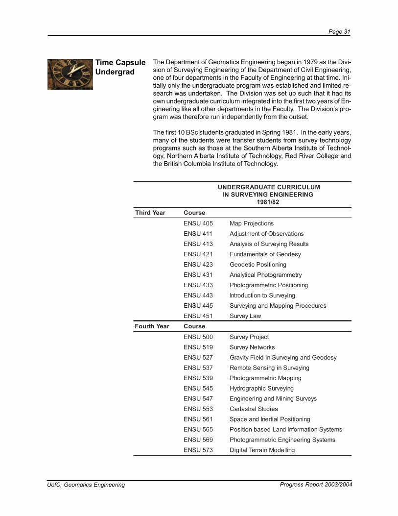
Time CapsuleUndergrad
The Department of Geomatics Engineering began in 1979 as the Divi-sion of Surveying Engineering of the Department of Civil Engineering,one of four departments in the Faculty of Engineering at that time. Ini-tially only the undergraduate program was established and limited re-search was undertaken. The Division was set up such that it had itsown undergraduate curriculum integrated into the first two years of En-gineering like all other departments in the Faculty. The Division’s pro-gram was therefore run independently from the outset.
The first 10 BSc students graduated in Spring 1981. In the early years,many of the students were transfer students from survey technologyprograms such as those at the Southern Alberta Institute of Technol-ogy, Northern Alberta Institute of Technology, Red River College andthe British Columbia Institute of Technology.
MULUCIRRUCETAUDARGREDNUGNIREENIGNEGNIYEVRUSNI
28/1891raeYdrihT esruoC
504USNE snoitcejorPpaM
114USNE snoitavresbOfotnemtsujdA
314USNE stluseRgniyevruSfosisylanA
124USNE ysedoeGfoslatnemadnuF
324USNE gninoitisoPcitedoeG
134USNE yrtemmargotohPlacitylanA
334USNE gninoitisoPcirtemmargotohP
344USNE gniyevruSotnoitcudortnI
544USNE serudecorPgnippaMdnagniyevruS
154USNE waLyevruS
raeYhtruoF esruoC005USNE tcejorPyevruS
915USNE skrowteNyevruS
725USNE ysedoeGdnagniyevruSnidleiFytivarG
735USNE gniyevruSnignisneSetomeR
935USNE gnippaMcirtemmargotohP
545USNE gniyevruScihpargordyH
745USNE syevruSgniniMdnagnireenignE
355USNE seidutSlartsadaC
165USNE gninoitisoPlaitrenIdnaecapS
565USNE smetsySnoitamrofnIdnaLdesab-noitisoP
965USNE smetsySgnireenignEcirtemmargotohP
375USNE gnilledoMniarreTlatigiD

Page 32
Progress Report 2003/2004 UofC, Geomatics Engineering
Common Core Curriculum
he common curriculumfor engineering studentsT
is shown in the adjacent ta-ble.
Students choose their depart-ment at the end of the firstyear and begin studies spe-cific to that Department intheir 4th term.
STNEDUTSGNIREENIGNELLAROFMARGORPNOMMOC
1raeY esruoCemaN
esruoCmreTnIdereffO
712TAMA stsitneicS&sreenignErofsuluclaC F912TAMA sreenignErofsuluclaCelbairavitluM W902MEHC sreenignErofyrtsimehClareneG W/F102GGNE sdiloS&sesaG,sdiuqiLforuoivaheB W/F502GGNE IscinahceMgnireenignE F332GGNE IsreenignErofgnitupmoC F152GGNE IsnoitacinummoCdnangiseD F352GGNE IIsnoitacinummoCdnangiseD W122HTAM &stsitneicSrofarbeglAraeniL
sreenignEW/F
952SYHP msitengaM&yticirtcelE F1-TSOC seidutSyratnemelpmoC W
flahevifnideretsigereblliwstneduts,margorpdengissanognidnepeD.mretrehtoehtnisesruocflahxisdnamretenonisesruoc
)llaF(2raeY
703TAMA sreenignErofsnoitauqElaitnereffiD F
913GGNE sreenignErofscitsitatS&ytilibaborP F
523GGNE smetsyS&stiucriCcirtcelE F533GGNE IIsreenignErofgnitupmoC F943GGNE IIscinahceMgnireenignE F963SYHP rofnoitaidaRdnascitpO,scitsuocA
sreenignEF
snoitaiverbbATAMA .statSdna.htaMfo.tpeDMEHC yrtsimehCfo.tpeDSYHP scisyhPfo.tpeDGGNE gnireenignEfoytlucaFOGNE gnireenignEscitamoeGfo.tpeD

UofC, Geomatics Engineering Progress Report 2003/2004
Page 33
Undergraduate Curriculum in Geomatics Engineering
he first year and a half(three terms) of commonT
core subjects are followed bytwo and a half years (fiveterms) which concentrate ongeomatics related subjects.The curriculum for the re-maining five terms is shownin the adjacent table.
NIMULUCIRRUCETAUDARGREDNUGNIREENIGNESCITAMOEG
retniW/2raeY esruoC maertS
903TAMA sreenignErofsuluclaCrotceV
723LENE smetsySdnaslangiS
343OGNE gniyevruSfoslatnemadnuF gniyevruS
153OGNE smetsySnoitamrofnIlaitapSotnoitcudortnI)SIL(
SIG
163OGNE snoitavresbOfostnemtsujdA ygolodohteM
300GGNE ytefaSdnahtlaeH,tnemnorivnE/esruoCkcolB
1-TSOC ydutSyratnemelpmoC
llaF/3raeY esruoC maertS
174ICNE tnemeganaMtcejorPotnoitcudortnI lacitcarP
704GGNE gnireenignEnisdohteMlaciremuN ygolodohteM
124OGNE ysedoeGfoslatnemadnuF ysedoeG
134OGNE yrtemmargotohP dnayrtemmargotohPgnisneSetomeR
534OGNE gnisneSetomeRfoselpicnirPlacisyhP dnayrtemmargotohPgnisneSetomeR
2-TSOC ydutSyratnemelpmoC
retniW/3raeY esruoC maertS
914OGNE skrowteNscitamoeG gniyevruS
324OGNE gninoitisoPcitedoeG ysedoeG
724OGNE ysedoeGlacisyhP ysedoeG
554OGNE smetsySdnaL&syevruSlartsadaC gniyevruS
3-TSOC ydutSyratnemelpmoC
llaF/4raeY esruoC maertS
315GGNE nisreenignE.forPfoytilibisnopseR&eloRyteicoS
lacitcarP
005OGNE tcejorPgnireenignEscitamoeG lacitcarP
105OGNE syevruSdleiF lacitcarP
1-ET evitcelElacinhceT lacinhceTmorfesoohCsevitcelE
2-ET evitcelElacinhceT lacinhceTmorfesoohCsevitcelE
4-TSOC ydutSyratnemelpmoC
retniW/4raeY esruoC maertS
005OGNE tcejorPgnireenignEscitamoeG lacitcarP
915OGNE skrowteNscitamoeG gniyevruS
3-ET evitcelElacinhceT lacinhceTmorfesoohCsevitcelE
4-ET evitcelElacinhceT lacinhceTmorfesoohCsevitcelE
5-ET evitcelElacinhceT lacinhceTmorfesoohCsevitcelE
5-TSOC ydutSyratnemelpmoC
Page 34
Progress Report 2003/2004 UofC, Geomatics Engineering
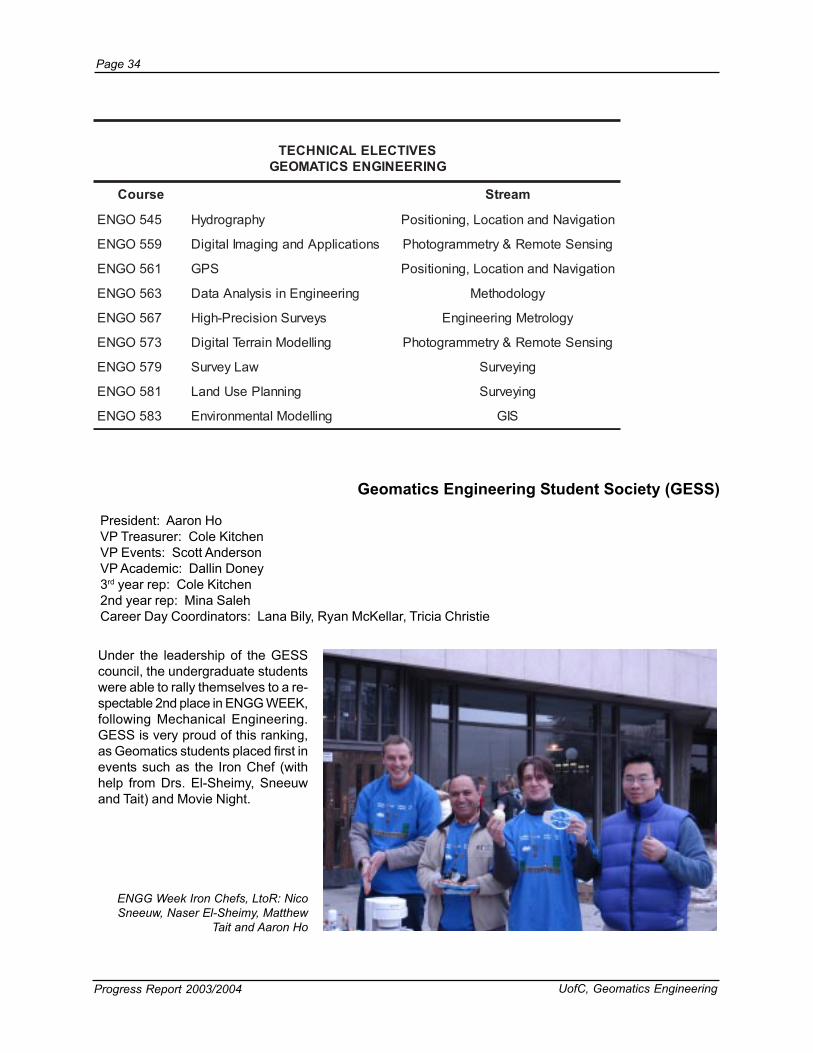
Geomatics Engineering Student Society (GESS)
President: Aaron HoVP Treasurer: Cole KitchenVP Events: Scott AndersonVP Academic: Dallin Doney3rd year rep: Cole Kitchen2nd year rep: Mina SalehCareer Day Coordinators: Lana Bily, Ryan McKellar, Tricia Christie
Under the leadership of the GESScouncil, the undergraduate studentswere able to rally themselves to a re-spectable 2nd place in ENGG WEEK,following Mechanical Engineering.GESS is very proud of this ranking,as Geomatics students placed first inevents such as the Iron Chef (withhelp from Drs. El-Sheimy, Sneeuwand Tait) and Movie Night.
ENGG Week Iron Chefs, LtoR: NicoSneeuw, Naser El-Sheimy, Matthew
Tait and Aaron Ho
SEVITCELELACINHCETGNIREENIGNESCITAMOEG
esruoC maertS
545OGNE yhpargordyH noitagivaNdnanoitacoL,gninoitisoP
955OGNE snoitacilppAdnagnigamIlatigiD gnisneSetomeR&yrtemmargotohP
165OGNE SPG noitagivaNdnanoitacoL,gninoitisoP
365OGNE gnireenignEnisisylanAataD ygolodohteM
765OGNE syevruSnoisicerP-hgiH ygolorteMgnireenignE
375OGNE gnilledoMniarreTlatigiD gnisneSetomeR&yrtemmargotohP
975OGNE waLyevruS gniyevruS
185OGNE gninnalPesUdnaL gniyevruS
385OGNE gnilledoMlatnemnorivnE SIG

UofC, Geomatics Engineering Progress Report 2003/2004
Page 35
he objective of the ENGO 500 group project course is the develop-ment of skills in cooperative research, report preparation and semi-
ENGO 500 Special Presentations
ENGO 500
Tnar presentation. Students plan and execute a project that must con-
form with professional requirements.The project must have design, meas-urement, analysis and presentationcomponents. Submission and de-fence of progress reports and a finalreport are required. The Departmentawards a prize to the group with thebest project. This year the winnerswere: Lana Bily, Jack Carter, RyanMcKellar and Andrew Metheral-Chris-tian for their project First Nations LandManagement.
This year there were poster presen-tations at the first Faculty of Engineer-ing Design Open House. This eventserved as a showcase of 4th yearproject work from the entire Facultyof Engineering to the wider campusand industry communities.
noturBxelA.rDproCseigolonhceTpamretnIyrtsudnIscitamoeGehtnitnemeganaMtcejorPhtiwnuFgnivaH
efyFneK.rD.cnIsnoitavonnImaertsanyD
erutneVmaertsanyDehT
neslekkiMnaeD.rMshparGoeGyrtsudnIscitamoeGehtnitnemeganaMtcejorP
arupnawuRakanaJ.rDCfoU,gnireenignEliviCfo.tpeDtnemeganaMksiR
tiaTwehttaM.rDCfoU,gnireenignEscitamoeGfo.tpeDtnemeganaMtcejorP
lladniTguoD.rMecnediseRnireenignE,gnireenignEfoytlucaFretsasiDdiovAoTwoH-slatnemadnuFtnemeganaMtcejorP
Geomatics Engineering Poster presentations at theFaculty of Engineering Design Open House
Page 36
Progress Report 2003/2004 UofC, Geomatics Engineering
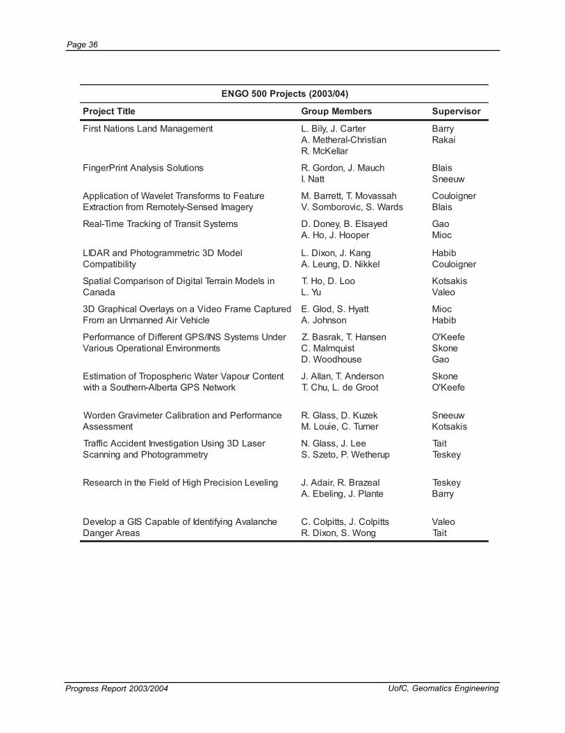
)40/3002(stcejorP005OGNE
eltiTtcejorP srebmeMpuorG rosivrepuS
tnemeganaMdnaLsnoitaNtsriF retraC.J,yliB.LnaitsirhC-larehteM.A
ralleKcM.R
yrraBiakaR
snoituloSsisylanAtnirPregniF hcuaM.J,nodroG.RttaN.I
sialBwueenS
erutaeFotsmrofsnarTtelevaWfonoitacilppAyregamIdesneS-yletomeRmorfnoitcartxE
hassavoM.T,tterraB.MsdraW.S,civorobmoS.V
rengioluoCsialB
smetsyStisnarTfognikcarTemiT-laeR deyaslE.B,yenoD.DrepooH.J,oH.A
oaGcoiM
ledoMD3cirtemmargotohPdnaRADILytilibitapmoC
gnaK.J,noxiD.LlekkiN.D,gnueL.A
bibaHrengioluoC
nisledoMniarreTlatigiDfonosirapmoClaitapSadanaC
ooL.D,oH.TuY.L
sikastoKoelaV
derutpaCemarFoediVanosyalrevOlacihparGD3elciheVriAdennamnUnamorF
ttayH.S,dolG.EnosnhoJ.A
coiMbibaH
rednUsmetsySSNI/SPGtnereffiDfoecnamrofrePstnemnorivnElanoitarepOsuoiraV
nesnaH.T,karsaB.ZtsiuqmlaM.CesuohdooW.D
efeeK'OenokS
oaG
tnetnoCruopaVretaWcirehpsoporTfonoitamitsEkrowteNSPGatreblA-nrehtuoSahtiw
nosrednA.T,nallA.JtoorGed.L,uhC.T
enokSefeeK'O
ecnamrofrePdnanoitarbilaCretemivarGnedroWtnemssessA
kezuK.D,ssalG.RrenruT.C,eiuoL.M
wueenSsikastoK
resaLD3gnisUnoitagitsevnItnediccAciffarTyrtemmargotohPdnagninnacS
eeL.J,ssalG.NpurehteW.P,otezS.S
tiaTyekseT
gnileveLnoisicerPhgiHfodleiFehtnihcraeseR laezarB.R,riadA.JetnalP.J,gnilebE.A
yekseTyrraB
ehcnalavAgniyfitnedIfoelbapaCSIGapoleveDsaerAregnaD
sttiploC.J,sttiploC.CgnoW.S,noxiD.R
oelaVtiaT

UofC, Geomatics Engineering Progress Report 2003/2004
Page 37
Number of Internship StudentsPlaced 1993/94 to 2003/04
Engineering Internship Program
his program offers anoptional cooperativeT
0
5
10
15
20
25
93/94
94/95
95/96
96/97
97/98
98/99
99/00
00/01
01/02
02/03
03/04
No.
of S
tude
nts
4002/3002stnedutSpihsnretnIscitamoeG
emaN ynapmoCtnemecalP rotneMytlucaF
nothsArehpotsirhC enilepiPadanaCsnarT wueenS.J.N
tnebdaorBleahciM .dtLscitamoeGLSESorguF oaG.Y
retserroFyasdniL .dtLsmetsySLDC tiaT.P.M
resarFleahciM .cnIksedotuA bibaH.F.A
thcerbseiGnimajneB yevruSworraDiksrebaW yrraB.B.M
rebuHniloC .cnIgnitlusnoCtniopyaW ymiehS-lE.N
sotaLaerdnA .cnIksedotuA oelaV.C
dyolLnoraA .dtLsyevruSdnaLyennahlEcM yrraB.B.M
kuitsaNwerdnA .cnIksedotuA oelaV.C
tocserParaS gnitlusnoCcetnatS tiaT.P.M
nessumsaRnohtanhoJ .proCseigolonhceTpamretnI bibaH.F.A
nospmohTleahciM .dtLsroyevruSsetaicossAsiatlaM yrraB.B.M
tteppiTahsataN nrobnaS enokS.H.S
gnoTnhoJ skroWcilbuP iakaR.E.M
miehsrelloWleahciM .proCseigolonhceTpamretnI rengioluoC.I
gnoWnosaJ noitaroproCxinalppA ellepahcaL.G
paYtsenrE noitaroproCxinalppA nonnaC.E.M
ruosnaMennaiviV draoBseitilitU&ygrenEatreblA ymiehS-lE.N
nayyagnaRaydiV lanoitanretnItasadaR rengioluoC.I
gnaYanaiD detimiLhcraeseRsertI coiM.D
inadzaYzibmaK erutcurtsarfnIatreblA sikastoK.C
educational work experi-ence for all students whohave completed in thethird year of engineering.Participants spend 12 to16 months in paid em-ployment.
The number of internshipplacements from 1993/94to 2003/2004 is shown inthe graph below.

Page 38
Progress Report 2003/2004 UofC, Geomatics Engineering
Geomatics Engineering Career Day
n February 5, 2004, theGeomatics Engineering Student’sO
Career Day in MacEwan Student Centre
Society and the Department ofGeomatics Engineering hosted theireighth annual Career Day. Career Dayprovides a forum for both companiesand students to interact and discusstopics and career opportunities in theGeomatics industry. Several guestspeakers made presentations on vari-ous topics throughout the day. In addi-tion to these presentations, studentsand company representatives partici-pated in the Industry Showcase, whichwas introduced to provide all partici-pants with an opportunity to discuss ca-reers in Geomatics.
The Geomatics Engineering Student’sSociety would like to thank all partici-pants and sponsors for making CareerDay a success.
CSI Wireless at Career Day
4002stnapicitraPyaDreeraC
puorGscitamoeGatreblA smetsySgninoitisoPinimeG
noitaicossAsroyevruSdnaLatreblA .cnIcitylanAoeG
noitaicossA'sroyevruSdnaLatreblA hpargretnI
yevruS&gnireenignENAC-LLA pamretnI
.dtLsyevruStseW-llA .cnIscitamoeGsiatlaM
noitaroproCxinalppA .dtLsyevruSdnaLyennahlEcM
adanaCtnempoleveDksedotuA .cnIletAvoN
noitaicossA'sroyevruSdnaLCB .cnIscitamoeGnoisicerP
.dtLseilppuSyevruSreltuB .cnIygolonhceTFRIS
.cnIpuorGlartsadaC noisiviDlaitrenIrennoDnortsyS
.proCscitamoeGmA-naC scitamoeGSULET
tnempiuqEyevruSlesnaC .dtnoitaroproCsucoFehT
.cnIaesbuSyrutneC pohsohtrOehT
scitamoeGtloC detimiLadanaCelbmirT
noitaroproCscitamoeGeparC .dtLscitamoeGllihrednU
sseleriWISC adanaCrehsU
.dtLscitamoeGLSESorguF worraD-iksrebaW

UofC, Geomatics Engineering Progress Report 2003/2004
Page 39
Butler Survey Supplies Ltd.Cansel Survey EquipmentPoint Inc.Southern Alberta Institute of Technology
Geomatics Engineering Survey Camp at Kananaskis
n important part of the undergraduate de-gree program in Geomatics Engineering isA
the field camp (ENGO 501). This two week campis held at the Kananaskis Centre for Environmen-tal Research prior to the start of the Fall Session.It gives incoming fourth year students the oppor-tunity to apply the knowledge and experiencegained in the different areas of geomatics to anintegrated practical project.
The Department of Geomatics Engineering wouldlike to thank the following companies for their par-ticipation in the annual Survey Camp EquipmentDay and for the generous loan of equipment overthe duration of Survey Camp:
Field Camp students and instructors
Field Camp exercise- Precise Engineering SurveyLance de Groot and Sheena Wong

Page 40
Progress Report 2003/2004 UofC, Geomatics Engineering
1989
Survey Camp Over the Years
1988
1987
Time Capsule

UofC, Geomatics Engineering Progress Report 2003/2004
Page 41
1989
19951993
1990
1999
2002

Page 42
Progress Report 2003/2004 UofC, Geomatics Engineering
Enrollment
GRADUATE STUDIES
he number of graduate students continued to increase with a totalof 109 (101full time and 8 part time). During the academic yearT
Graduateenrollment
climbed to 108
students
2003/2004, students were either enrolled in the graduate program orfinishing their theses. Forty-one were working towards their PhD de-gree, 62 towards their MSc degree and 7 towards their MEng degree.Students originated from 14 different countries. There were 21 stu-dents that graduated during the reporting period, nine with a PhD de-gree, 10 with an MSc and two with an MEng. Details are given in thefollowing tables.
4002/3002stnedutSDhP
emaN rosivrepuS emaN rosivrepuS
dilaW,dimaH-ledbA ellepahcaL/ymiehS-lE oahzihZ,uiL oaG
demahoM,malaS-ledbA oaG nilgnahC,aM sakulK/ellepahcaL
noWgnoY,nhA ellepahcaL AgelO,vestnezeM ellepahcaL
imaR,quozuR-lA bibaH lehciM,nagroM bibaH
luaP,sevlA nonnaC/ellepahcaL hemaS,rassaN ymiehS-lE/zrawhcS
adnimahC,ekayansaB revIcaM/ellepahcaL aylataN,noslohciN nonnaC/enokS
ehzgnoK,nehC oaG elyK,efeeK'O enokS/ellepahcaL
uyihZ,nehC oaG acebeR,noniP-zenoniuQ oelaV
ieW-iaK,gnaihC ymiehS-lE enaiDnnyL,bualfaaR oelaV
duomhaM,ywaziG-lE ymiehS-lE dammahoM,ibajaR ellepahcaL/sialB
demahoM,ybibaH-lE sirediS anelE,avolegnaR sirediS
noremaC,mullE ymiehS-lE )esoJ(gnibaoiX,nehS oaG
aigroeG,soluopotoF ymiehS-lE/sirediS nawHnuE,nihS ymiehS-lE
nehcnaiJ,oaG nonnaC gnuisH-uaJ,gnaW oaG
gafawM,amnahG bibaH .B.LsaihttaM,tlegieW sirediS/wueenS
nessoR,yksrahctineberG sirediS secnarFrefinneJ,lattihW yrraB
gnoY,uH snilloC/oaT nehC,uX wueenS
werdnA,retnuH coiM/ymiehS-lE gniPoaiQ,gnahZ bibaH/rengioluoC
reivilO,neiluJ nonnaC/ellepahcaL gneFuY,gnahZ oaG
eajgnahC,miK bibaH oB,gnehZ ellepahcaL
04:LATOT

UofC, Geomatics Engineering Progress Report 2003/2004
Page 43
4002/3002stnedutSgnEMdnacSMemaN rosivrepuS emaN rosivrepuS
stnedutScSM
atiR,gnehC yksnoR/bibaH yhtamralaV,maradnusihskaneeM rengioluoC
ayneW,uihC rengioluoC nijgnoY,nooM enokS
ttocSdrofwarC nonnaC ahniM,kraP oaG
gnoHihTpeiD,oaD ellepahcaL yojiB,luaP yekseT
teemaS,ednaphseD nonnaC ameeS,eklahP nonnaC
ijalaB,ujaraveD wueenS hsotnaS,eklahP rengioluoC
ajiriG,jaramrahD bibaH/coiM ahtmamaS,nooP oelaV
ieL,gnoD ellepahcaL poonA,illevilluP bibaH
enirehtaK,rekrellE ellepahcaL ddoT,trehciR ymiehS-lE
odranoeL,sanicnE ellepahcaL wehttaM,deiR yrraB
moT,droF zrawhcS deyS,namlaS nonnaC
LaknalihT,ihthtappalaG ymiehS-lE aisatsanA,avehcylaS nonnaC
gnaiJouG,oaG ellepahcaL itnayaJ,amrahS snilloC
hbaruaS,ahdoG nonnaC awsajO,amrahS coiM
gniyiaH,uoH ymiehS-lE )ynoT(iL,gnehS tiaT
airotciV,elyoH enokS naMrihduS,ahtserhS enokS
oaT,uH ellepahcaL teemaS,hgniS sakulK/nonnaC
werdnA,gnauH nonnaC mayhS,savinirS ellepahcaL
nalA,pI ymiehS-lE ardnaL,siverT ymiehS-lE
ihZ,gnaiJ ellepahcaL dnomyaR,iosT sirediS/wueenS
rahD,ekayananuraK ellepahcaL/nonnaC oahCoahC,gnaW nonnaC/ellepahcaL
koonnuyN,miK ellepahcaL nhoJ,nostaW ellepahcaL
cirE,ppoK snilloC madA,ikswohceicjoW oaG
hceicjoW,ikcabuK nonnaC ecurB,thgirW ymiehS-lE
neuS,eeL oaG nebuR,fusuoY enokS
gniP,naiL ellepahcaL oaTiaH,gnahZ nonnaC
niMniM,niL ellepahcaL )yrraL(uisauH,gnahZ snilloC/sialB
nnelG,naguoGcaM ellepahcaL oatneW,gnahZ nonnaC
naMiL,oaM iakaR gnohoaiX,gnahZ nonnaC
divaD,retsillAcM oelaV
stnedutSgnEMdranoeLeimaJ,snikpoH yekseT )regoR(gnuhC-iasT,niL oelaV
16:LATOT

Page 44
Progress Report 2003/2004 UofC, Geomatics Engineering
MSc defence: Standing LtoR: Dr. Susan Skone,Dr. Swavik Spiewak, Seated LtoR: Dr. Gérard
Lachapelle (supervisor), Chaochao Wang (MScstudent), Dr. Yang Gao
seitisrevinUrehtomorfdetaudarGstnedutSytlucaFgnireenignEscitamoeGmorfnoisivrepuS-oChtiw
emaN eergeD noitutitsnI eltiTsisehTetaudarG rosivrepuS
gnilritSssoR cSM atreblAfoytisrevinU a/n ellepahcaL.G
4002/3002stnedutSetaudarGlanretxEdnaemiT-traP
emaN gnEM cSM DhP rosivrepuS
hpesoJ,olegnA 1 ellepahcaL/nonnaC
najuS,ayrahcarjaB 1 sirediS
nayR,xoF 1 tiaT/yekseT
ecnaLylleK,nosehcteK 1 coiM
nallA,znaM 1 nonnaC
nallAnaeD,snivorP 1 sialB
gnimuH,uW 1 nonnaC
valsodaR,veijdadiaG 1 tiaT
LATOT 3 4 1
noisivrepuSlanretxE
nilloCissuJfoytisrevinUerepmaT
ygolonhceT
1 ellepahcaL
sdrawdEregoRnotelraCfoytisrevinU
1 ellepahcaL
imeinsuuKidieHfoytisrevinUerepmaT
ygolonhceT
1 ellepahcaL
gnilritSssoRatreblAfoytisrevinU
1 ellepahcaL)rosivrepuS-oC(

UofC, Geomatics Engineering Progress Report 2003/2004
Page 45
4002/3002stnacovnoCseidutSetaudarG
emaN eergeD etaDmaxE eltiTsisehTetaudarG /rosivrepuSrosivrepuS-oC
kraPahniM cSM 40/62lirpA SMEMfogniledoMcitsahcotSdnasisylanArorrEnoitagivaNelciheVdnaLrofsrosneSlaitrenIdesaB
snoitacilppA
oaG.Y
nooMniJgnoY cSM 40/32lirpA rofsledoMerehpsonoIlanoisnemiD-2fonoitaulavEadanaCniskrowteNSPGlanoigeRdnalanoitaN
enokS.H.S
yksrahctineberGnessoR DhP 40/32lirpA yradnuoByrtemivarG-yrtemitlAotsnoituloSlaciremuNsnoigeRlatsaoCnismelborPeulaV
sirediS.G.M
efeeK'OelyK DhP 40/22lirpA ehtfoecnamrofrePehtfonoitaulavEdnanoitalumiSrofnoitalletsnoCkrowteNsraMdesoporP
fotnemhsilbatsEdna,tnemevorpmItibrO,gninoitisoPsraMrofemarFecnerefeRlaitapSa
/ellepahcaL.GenokS.H.S
uiLoahzihZ DhP 40/02lirpA snoitacilppAdnagniledoMcihpargomoTerehpsonoI)SPG(metsySgninoitisoPlabolGgnisU
stnemrusaeM
oaG.Y
nooPahtnamaS cSM 40/61naJ -wonSrofataDSIDOMgnisUgnilledoMlacigolordyHfotseroFlaeroBnrehtroNehtniaerAderevoc
abotinaM
oelaV.C
snivorPnaeD DhP 40/32naJ morferutcurtSs'htraEgninimreteD:sisehtnyShtraEsdleiFlaitnetopoeG
sialB.R.A.J
gnoDieL cSM 30/32ceD noitacifireVdnarotalumiSlangiSSPGFI ellepahcaL.G
soluopotoFaigroeG DhP 30/20ceD ,dioeGfonoitanibmoClamitpOehtnosisylanAnA.ataDthgieHladiospillEdna,cirtemohtrO
/sirediS.G.MymiehS-lE.N
rassaNhemaS DhP 30/02tcO rorrE)SNI(metsySnoitagivaNlaitrenIehtgnivorpmIsnoitacilppASPGD/SNIdnaSNIrofledoM
/zrawhcS.P.KymiehS-lE.N
uHgnoY DhP 30/3tcO daoR,sledoMniarreTlatigiDfonoitcartxEdetamotuAataDradiLenrobriAmorfsgnidliuBdnaskrowteN
/oaT.VsnilloC.M
ayrahcarjaBnajuS cSM 30/50tpeS noitanimreteDdioeGnostceffEniarreT sirediS.G.M
uWgnimuH cSM 30/31guA laitrenIhtiwnoituloseRytiugibmASPGylF-ehT-nOgnidiA
nonnaC.E.M
ibajaRdammahoM DhP 30/51guA gnisUsledoMniarreTlatigiDfotnemecnahnElaitapSyregamIetilletaSelgniShtiwgnidahSmorfepahS
/sialB.R.A.JellepahcaL.G
ahtserhSrihduS cSM 30/71yluJ cirehpsoporTfonoitamitsEehtotnisnoitagitsevnISPGgnisUytivitcarfeRteWdnayaleD
stnemerusaeM
enokS.H.S
aMnilgnahC DhP 30/03enuJ sseleriWdesaB-dnuorGevorpmIotseuqinhceTenohpeleTralulleCagnisUecnamrofrePnoitacoL
krowteN
/ellepahcaL.GsakulK.W.R
snikpoHsemaJ gnEM 30/71enuJ desaBesruoC yekseT.F.W
gnaWoahcoahC cSM 30/01enuJ edutittAdesab-SPGtsoc-woLafotnempoleveDmetsySnoitanimreteD
/ellepahcaL.GnonnaC.E.M
gnahZgnohoaiX cSM 30/31enuJ rofUMIycaruccAmuideMahtiwSPGfonoitargetnIgninoitisoPleveL-erteM
nonnaC.E.M
znaMnallA gnEM 30/02enuJ desaBesruoC nonnaC.E.M
naguoGcaMnnelG cSM 30/62enuJ nisisylanAecnamrofrePSPGytivitisneShgiHstnemnorivnElangiSdedargeD
ellepahcaL.G

Page 46
Progress Report 2003/2004 UofC, Geomatics Engineering
4002/3002-sranimeSetaudarG
emaN cipoT
malaS-ledbAdemahoM ecnamrofrePdnaycaruccA:gninoitisoPtnioPesicerP
quozuR-lAimaR seitreporPcirtemoidaRdnacirtemoeGgniyraVhtiwyregamIecruoS-itluMfonoitartsigeRcitamotuA
dnAcirtemoeGgniyraVhtiWyregamIecruoS-itluMfOnoitceteDegnahCdnAnoitartsigeRcitamotuAseitreporPcirtemoidaR
sevlAluaP ytiugibmAkrowteNdnagninoitisoPnoitatSecnerefeRelpitluMdesaB-noitacolloCfonoitargetnInoituloseR
ekayansaBadnimahC tnedicnIciffarTdnasmetsySgninoitisoPelciheV:gnirotinoMciffarTrofgnikcarTelciheVtisnarTsmhtiroglAnoitceteD
ciffarTroFmetsySeborPAsAgnihctaMpaMdnASPGevitisneShgiHhtiWselciheVtisnarTgnikcarT.gnirotinoM
ednaphseDteemaS noitisiuqcalangisSPGnostceffeecnerefretnI
soluopotoFaigroeG lortnoClacitreVgnizinredoMroFsnoitaredisnoClacitcarPnOnoissucsiDA
yksrahctineberGnessoR fosnoitulosrofstelevawdnasrotarepolaitnereffid-oduesp,scinomrahlacirehpsfonoitanibmoCsmelborpeulavyradnuobyrtemivarg-yrtemitla
elyoHairotciV ruopaVretaWcirehpsoporTD-4devorpmIrofkrowteNSPGdesaB-dnuorGaotsnoitatnemguAyhpargomoT
uoHgniyiaH ecnairaVnallAgnisUgnilledoMsrorrEsrosneSlaitrenI
uHgnoY radiLenrobriAgnisUsgnidliuBdnaskrowteNdaoR,sledoMniarreTlatigiDfonoitcartxEdetamotuAataD
neiluJreivilO gninoitisoPnoisicerProFgnilpuoCOELILAG/SPGthgiTweNA
eeLneuS tnemeganaMtessAeliboMfOtnemyolpeDdnAtnempoleveDdipaRehTroFmroftalPerawtfoSAsmetsyS
ieLgnoD rotalumiSlangiSspGfIdesaB-erawtfoSAfOnoitacifireVdnAnoitatnemelpmI
uiLoahzihZ noitazilaeRdnatpecnoC:ataDSPGgnisUgniledoMyhpargomoTerehpsonoI
ataDSPGgnisUgniledoMyhpargomoTerehpsonoIfosisylanAecnamrofreP
vestnezeMgelO noitagivaNraluciheVnoynaCnabrUrofsnoitacilppASPGSH
nooMnijgnoY skrowteNspGlanoigeRroFsmhtiroglAnoitalopretnIfOnoitaulavE
nagroMlehciM yarrAraeniLfogniledoMnoitcejorPlellaraPgnisusenecSfognilpmaseRdnayrtemoeGralopipEsrennacS
efeeK'OelyK -flesasanoissiMsrednalteNnaeporuEehtdnakrowteNsraMLPJehtfoecnamrofrePehtgnitalumiSsraMrofmetsySetilletaSnoitagivaNlabolGdeniatnoc
kraPahniM srosneSlaitrenIdesab-SMEMfogniledoMcitsahcotSdnasisylanArorrE
nooPahtnamaS noitelpeDwonSrofataDSIDOMfonoitaulavE
nihSnawHnuE sUMItsoCwoLfotnemngilAnoitoM-nIrofretliFnamlaKdetnecsnUnA
gnahZyrraL lartcepSfonoitanibmoCahguorhtyregamIlartcepsitluMmorfserutaeFSIGfonoitcartxEcitamotuAsdnatStseroFotnoitacilppAstIdna,noitamrofnIlaitapSdna
gnahZoatneW noituloseRytiugibmAycneuqerF-elpirT/lauDOELILAG/SPG

UofC, Geomatics Engineering Progress Report 2003/2004
Page 47
Graduate students Andrew Hunter, DharshakaKarunawanayake and Mohamed Abdel Salaam,
volunteer at Campus Fair, June 2003
smaertS
1maertS 2maertS 3maertS 4maertS 5maertS
dnadleiFytivarGscimanydoeG
,gninoitisoP&noitacoLnoitagivaN
gnigamIlatigiDsmetsyS
gnireenignEygolorteM
dnaLdna,SIGseidutS
ecnerefeRcitedoeGsmetsyS
namlaK,sledoMetatSdnagniretliF
gnihtoomS
etomeRnisranimeSsnoitacilppAgnisneS
serauqStsaeLdnanoitamitsE
sisylanA
dnaLniseidutSesaCsmetsySnoitamrofnI
)316OGNE( )126OGNE( )136OGNE( )926OGNE( )156OGNE(
lacisyhPdecnavdAysedoeG
dnagniyevruSlaitrenInoitargetnISPG/SNI
lacihpargopoT-noNyrtemmargotohP
dnalairtsudnItnemngilAnoisicerP
syevruS
noitcartxEnoitamrofnIyregamIlatigiDmorf
)516OGNE( )326OGNE( )536OGNE( )346OGNE( )556OGNE(
dnayrtemitlAetilletaSsnoitacilppA
yroehT:SPGratsvaNsnoitacilppAdna
fosisylanAdetargetnIlaitapSecruoS-itluM
ataD
dnAgnilledoMnoitazimitpO
sisylanA
laitapSdecnavdAsmetsySnoitamrofnI
366OGNE( )526OGNE( )736OGNE( )746OGNE( )166OGNE(
scisyhpoeGlabolGscimanydoeGdna
stceffEcirehpsomtAnoitagivaNetilletaSno
metsyS
egamIoeretSlatigiDgnissecorP
yevruSdecnavdAwaL
)186OGNE( )336OGNE( )936OGNE( )566OGNE(
niscipoTdecnavdASPG
niarreTlatigiD&gnilledoMsnoitacilppA
esUdnaLdecnavdAgninnalP
)75.996OGNE( )356OGNE( )15.996OGNE(

Page 48
Progress Report 2003/2004 UofC, Geomatics Engineering
Research Statistics
RESEARCH
esearch is an integral part of Department activi-ties. It allows individual faculty members to stay atR
the leading edge of their area of specialization and toapply their knowledge to current problems in industry andgovernment. It also provides funding for research asso-ciates and graduate students. It thus supports the edu-cation of highly trained future engineers and the teach-ing activities of the Department.
Direct research funding for this report year was at$3,654,234 which is about $215,000 per member (basedon 17 faculty members). This continues to be an excel-lent level of support.
Direct Research Funding by Source - 1999/00 to 2003/04

UofC, Geomatics Engineering Progress Report 2003/2004
Page 49
Besides direct research funding,there is indirect research supportavailable in terms of studentscholarships and in-kind dona-tions. When added to the directproject funding, the total researchfor the reporting period is$4,359,532. The figure belowshows research funding by sourcefor 2003/2004.
Equipment and in-kind donationsinclude software from Intergraph,Trimble receivers, Sun computersfrom TransCanada and a RolleiD7Metric 5 digital camera from theFaculty of Engineering Endow-ment Fund.
Direct Research Funding by Source - 2003/04
NSERC29%
Federal23%
Provincial25%
Industry3%
Grants-Fed4%
Foreign16%
doirePehtrofstcartnoCdnastnarGhcraeseR4002,13hcraM-3002,1lirpA
ecruoS )$(tnuomA
CRESN 858,230,1
tnemnrevoGlaredeF 872,758
stnarG-laredeF 817,951
tnemnrevoGlaicnivorP 213,429
yrtsudnI 901,601
seicnegAngieroF 959,375
troppuShcraeseRtceriD 432,456,3
spihsralohcShcraeseR 892,783
snoitanoDtnempiuqE 000,813
troppuShcraeseRtceridnI 892,507
troppuShcraeseRlatoT 235,953,4

Page 50
Progress Report 2003/2004 UofC, Geomatics Engineering
MAJOR RESEARCH AREAS
he five major research areas in the Department and the names offaculty members who worked on major projects in each area areT
listed in the following table.
Research projects being conducted inthe above major research areas arelisted in tables on pages 51 - 55.
The number of graduate studentsworking in each area is shown in theadjacent figure. Some factors in thedistribution of students are the numberof faculty members per research areaand the number of new faculty mem-bers in the department that are cur-rently in the early stages of recruitingstudents and building their researchgroups. The distribution confirms thateach of the research areas in the De-partment is viable in terms of facultyand graduate student involvement andhas the depth in human resources totake on major projects.
Graduate Student Distribution by Area
1511
64
14
415 3 5 4 2 10
5
10
15
20
25
30
35
40
45
50
55
60
65
GIS
and
Lan
d Te
nure
Gra
vity
Fie
ld a
ndG
eody
nam
ics
Posi
tioni
ng, L
ocat
ion
and
Nav
igat
ion
Dig
ital I
mag
ing
Syst
ems
Engi
neer
ing
Met
rolo
gy
Biom
edic
alEn
gine
erin
g
No. of StudentsFaculty per area
smetsySgnigamIlatigiDbibaH.F.A,rengioluoC.I,snilloC.J.M,)sutiremE(sialB.R.A.J
ygolorteMgnireenignEyekseT.F.W,tiaT.P.MseidutSdnaLdnaSIG
oelaV.C,iakaR.E.M,coiM.D,ymiehS-lE.N,yrraB.B.MscimanydoeGdnadleiFytivarG
wueenS.J.N,sirediS.G.M,sikastoK.CnoitagivaNdnanoitacoL,gninoitisoP
,sakulK.W.R,oaG.Y,ymiehS-lE.N,nonnaC.E.MenokS.H.S,ellepahcaL.G

UofC, Geomatics Engineering Progress Report 2003/2004
Page 51
noitagivaNdnanoitacoL,gninoitisoPnistcejorPemaNtcejorP epyTtcartnoC srotagitsevnIytlucaF
troppuStnedutS laicnivorP nonnaC.E.MellepahcaL.G
feritluMehtgnisUgnissecorPataDenrobriAIIesahPnoissiMtsoPnidohteM
yrtsudnI nonnaC.E.MellepahcaL.G
&ecnamrofrePlangiSSSNGfosisylanAtnempoleveDmhtiroglA
laredeF nonnaC.E.M
erutlucirgAniseigolonhceTSPGfotnemssessA yrtsudnI ellepahcaL.GSPGgnisUnoitamitsEerehpsomtA CRESN
cigetartSnonnaC.E.MellepahcaL.G
oaG.YenokS.H.S
desaercnIrofSPGfonoitatnemguAecnamrofreP
CRESN nonnaC.E.M
&mhtiroglASSNGrof.arfnI:drawAreeraCIFCtnempoleveDnoitacilppA
/laredeFlaicnivorP
nonnaC.E.M
tnarGretratSCRC ytisrevinU ymiehS-lE.NSPGlaitnereffiDlabolGdesaBesahPreirraC
gninoitisoPCRESN oaG.Y
CRC/noitacoLsseleriWniCRC,riahC CRC/laredeFmargorP
ellepahcaL.G
scitamoeGrosneS-itluMeliboMniCRC,riahCsmetsyS
CRC/laredeFmargorP
ymiehS-lE.N
metsySgnivirDevitaroballoC laredeF nonnaC.E.MnoitamrofnInoitagivaNdetargetnI-noitcurtsnoC
metsySlaredeF nonnaC.E.M
tnemssessAecnamrofrePXRRGAD laredeF ellepahcaL.GnonnaC.E.M
erawfoSnoitargetnISPG/SNIfotnempoleveD&televaWfokrowteNlarueNlaicifitrAgnisU
sisylanAnoituloseR-itluM
ngieroF ymiehS-lE.N
dipaRrofmroftalPafotnempoleveDtnemeganaMtessAeliboMfotnempoleveD
smetsyS
laredeF oaG.Y
laitrenInwodpartSfotnempoleveDsnoitauqEnoitazinahceM
ngieroF ymiehS-lE.N
sisylanAelgnAksaMSPGD laredeF enokS.H.SKTR-tnioPfotnempoleveD-ECNEDIOEG
ygolonhceTCRESN oaG.Y
desab-SMEMnoitareneGtxeN-ECNEDIOEGlanosrePdnaselciheVrofmetsySnoitagivaN
noitagivaNnoitacoL
/laredeFCRESN
ymiehS-lE.NoaG.Y
egaptxennodeunitnoC
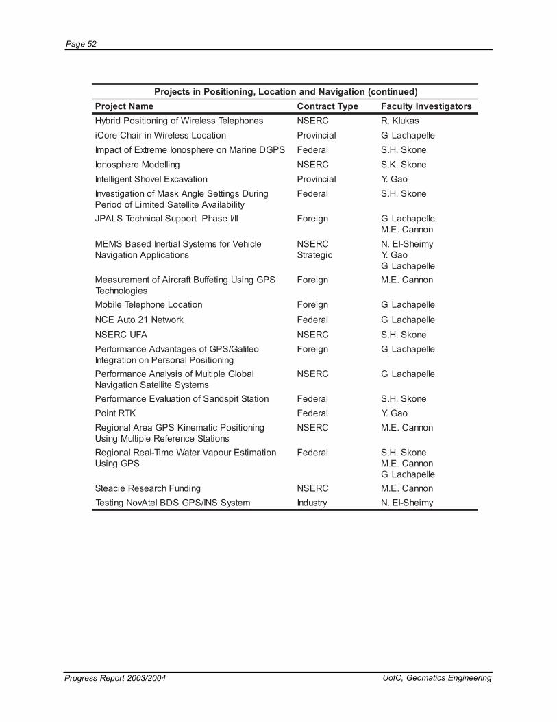
Page 52
Progress Report 2003/2004 UofC, Geomatics Engineering
)deunitnoc(noitagivaNdnanoitacoL,gninoitisoPnistcejorPemaNtcejorP epyTtcartnoC srotagitsevnIytlucaF
senohpeleTsseleriWfogninoitisoPdirbyH CRESN sakulK.RnoitacoLsseleriWniriahCeroCi laicnivorP ellepahcaL.G
SPGDeniraMnoerehpsonoIemertxEfotcapmI laredeF enokS.H.SgnilledoMerehpsonoI CRESN enokS.K.S
noitavacxElevohStnegilletnI laicnivorP oaG.YgniruDsgnitteSelgnAksaMfonoitagitsevnI
ytilibaliavAetilletaSdetimiLfodoirePlaredeF enokS.H.S
II/IesahPtroppuSlacinhceTSLAPJ ngieroF ellepahcaL.GnonnaC.E.M
elciheVrofsmetsySlaitrenIdesaBSMEMsnoitacilppAnoitagivaN
CRESNcigetartS
ymiehS-lE.NoaG.Y
ellepahcaL.GSPGgnisUgniteffuBtfarcriAfotnemerusaeM
seigolonhceTngieroF nonnaC.E.M
noitacoLenohpeleTeliboM ngieroF ellepahcaL.GkrowteN12otuAECN laredeF ellepahcaL.G
AFUCRESN CRESN enokS.H.SoelilaG/SPGfosegatnavdAecnamrofreP
gninoitisoPlanosrePnonoitargetnIngieroF ellepahcaL.G
labolGelpitluMfosisylanAecnamrofrePsmetsySetilletaSnoitagivaN
CRESN ellepahcaL.G
noitatStipsdnaSfonoitaulavEecnamrofreP laredeF enokS.H.SKTRtnioP laredeF oaG.Y
gninoitisoPcitameniKSPGaerAlanoigeRsnoitatSecnerefeRelpitluMgnisU
CRESN nonnaC.E.M
noitamitsEruopaVretaWemiT-laeRlanoigeRSPGgnisU
laredeF enokS.H.SnonnaC.E.MellepahcaL.G
gnidnuFhcraeseReicaetS CRESN nonnaC.E.MmetsySSNI/SPGSDBletAvoNgnitseT yrtsudnI ymiehS-lE.N

UofC, Geomatics Engineering Progress Report 2003/2004
Page 53
Severe Weather Detection using GPS: Hailcloud passing over Airdrie on July 20th, 2003.This cloud showered golf ball-sized hail over
some areas of the province.
eruneTdnaLdnaSIGnistcejorP
emaNtcejorP epyTtcartnoC ytlucaFsrotagitsevnI
smetsySscitamoeGrosnes-itluMeliboMniCRC laredeF/CRESN ymiehS-lE.N
rotceV/retsaRrofsmhtiroglAdnaerutcurtSataDnoitargetnISIG
laicnivorP coiM.D
noitargetnIehtrofsmhtiroglAdnaserutcurtSataDSIGrotcevdnaretsaRfo
CRESN coiM.D
dehsretaWdetseroFnignilledoMecnabrutsiD laredeF oelaV.C
tnemtsevnI.arfnIylppuSretaWgnicnahnEetamilCgnignahCarofsecitcarPgninnalP
laredeF oelaV.C
tnarGretratSgnireenignEfoytlucaF laicnivorP yrraB.M
tnarGretratSgnireenignEfoytlucaF laicnivorP coiM.D
ralloCgnikcarTraeBylzzirG laicnivorP ymiehS-lE.N
laitnediseRetamitsEotsledoMlacitamehtaMseulaVdnaL
laicnivorP yrraB.M
gnizinabrUfognilledoMdesaBlacisyhPsnoitidnoClanosaeS-itluMrednustnemhctaC
CRESN oelaV.C
metsySgnippaMenrobriAemit-laeR CRESN ymiehS-lE.N
saG/liOfoecnallievruSdesab-tenretnIemiTlaeRenilepiP
laicnivorP ymiehS-lE.N
rofsmetsySnoitamrofnIegdelwonKdesaB-beWtnemeganaMdnaLlanigirobA
laicnivorP iakaR.M

Page 54
Progress Report 2003/2004 UofC, Geomatics Engineering
smetsySgnigamIlatigiDnistcejorP
emaNtcejorP epyTtcartnoC srotagitsevnIytlucaF
egnahcdnanoitcartxeerutaefD3gnitamotuAedioeGECN-noitceted
laredeF rengioluoC.I
yregamIecruoS-itluMfonoitartsigeRcitamotuA laicnivorP bibaH.A
RADIL&cirtemmargotohPfonoitartsigeR-oCehtfonoitadilaV&noitaulavErofsecafruS
edioeGECN-noitarbilaCsmetsyS
laredeF bibaH.A
sisylanARASnIdnaRASloD laredeF snilloC.J.M
moorB-hsuPmorfgnilpmaseRegamIralopipEyregamI
ngieroF bibaH.A
deifissalceDfonoitacifitceRcirtemoeG)PSID(shpargotohPetilletaSecnegilletnI
CRESN bibaH.A
dnaelbaweneRrofsnoitacilppAlartcepsrepyHECNEDIOEG-secruoseRlareniM
laredeF snilloC.J.M
hgiHmorfnoitcartxEserutaeFedam-naMsaerAnabrUniyregamInoituloseR
CRESN rengioluoC.I
2tasradaR laredeF snilloC.J.M
aremaClatigiDroftnempoleveDerawtfoSnoitarbilaC
ngieroF bibaH.A
gnisneSetomeRfotnemeganaMytniatrecnUgnilledoMlatnemnorivnEdesaB
CRESN snilloC.J.M
ygolorteMgnireenignEnistcejorP
emaNtcejorP epyTtcartnoC srotagitsevnIytlucaF
ehtninoitamrofeDtsorfamrePgnirotinoMatleDeiznekcaM
yrtsudnI tiaT.P.M
syevruSlairtsudnInoisicerPhgiH CRESN yekseT.F.W
foytilibatSmreTgnoLehtfonoitagitsevnItsorfamreP
laicnivorP tiaTP.M
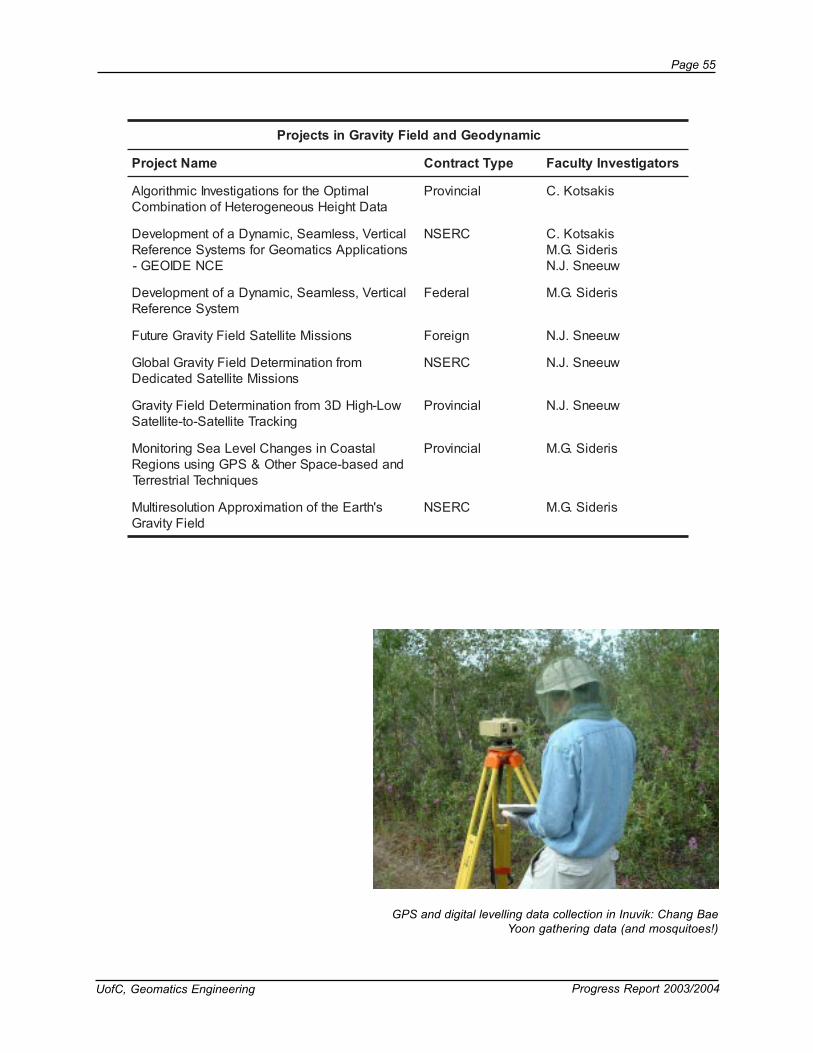
UofC, Geomatics Engineering Progress Report 2003/2004
Page 55
cimanydoeGdnadleiFytivarGnistcejorP
emaNtcejorP epyTtcartnoC srotagitsevnIytlucaF
lamitpOehtrofsnoitagitsevnIcimhtiroglAataDthgieHsuoenegoreteHfonoitanibmoC
laicnivorP sikastoK.C
lacitreV,sselmaeS,cimanyDafotnempoleveDsnoitacilppAscitamoeGrofsmetsySecnerefeR
ECNEDIOEG-
CRESN sikastoK.CsirediS.G.MwueenS.J.N
lacitreV,sselmaeS,cimanyDafotnempoleveDmetsySecnerefeR
laredeF sirediS.G.M
snoissiMetilletaSdleiFytivarGerutuF ngieroF wueenS.J.N
morfnoitanimreteDdleiFytivarGlabolGsnoissiMetilletaSdetacideD
CRESN wueenS.J.N
woL-hgiHD3morfnoitanimreteDdleiFytivarGgnikcarTetilletaS-ot-etilletaS
laicnivorP wueenS.J.N
latsaoCnisegnahCleveLaeSgnirotinoMdnadesab-ecapSrehtO&SPGgnisusnoigeR
seuqinhceTlairtserreT
laicnivorP sirediS.G.M
s'htraEehtfonoitamixorppAnoituloseritluMdleiFytivarG
CRESN sirediS.G.M
GPS and digital levelling data collection in Inuvik: Chang BaeYoon gathering data (and mosquitoes!)
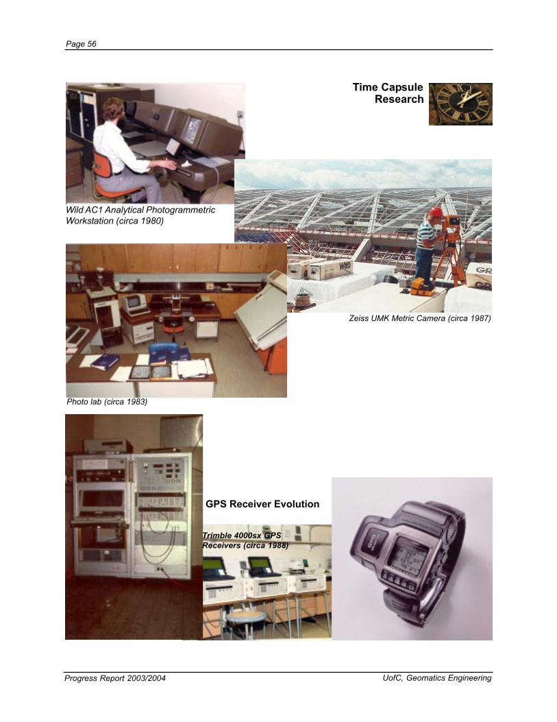
Page 56
Progress Report 2003/2004 UofC, Geomatics Engineering
ResearchTime Capsule
Zeiss UMK Metric Camera (circa 1987)
Wild AC1 Analytical PhotogrammetricWorkstation (circa 1980)
Photo lab (circa 1983)
GPS Receiver Evolution
Trimble 4000sx GPSReceivers (circa 1988)

UofC, Geomatics Engineering Progress Report 2003/2004
Page 57
Refereed Journals
PUBLICATIONS
Aguirre-Martinez, M. and N. Sneeuw (2003), Needs and Tools for FutureGravity Measuring Missions, Space Science Reviews 108(1-2), pp.409-416.
Barry M., I. Elema, and P. van der Molen (2003), Ocean Governance andthe Marine Cadastre: The Netherlands North Sea, Geomatica, 57(3),pp. 313-324.
Bayoud, F.A. and M.G. Sideris (2003), Two Different Methodologies forGeoid Determination from Ground and Airborne Gravity Data,Geophysical Journal International,155,3, pp. 914-922.
Chen, K., Y.Gao, and X. Shen (2003), An Analysis of Single PointPositioning with Real Time Internet-based Precise GPS Data, Journalof Nature Sciences, 8, 2, pp. 587-595.
Dogan, U., G. Lachapelle, L. Fortes, and S. Ergintav (2003), A Study of theTectonically Active Marmara Region, Turkey, Using GPS, CanadianJournal of Earth Sciences, 40, 9, pp. 1191-1202.
El-Sheimy, N., A.Osman, S.Nassar, and A. Noureldin (2003), Wavelet Multi-Resolution Analysis: A New Technique for GPS/INS Integration,Innovation Column, GPS World, October, pp. 70-82.
Fortes, L., M.E. Cannon, G. Lachapelle, and S. Skone (2003), Optimizinga Network-Based RTK Method for OTF Positioning, GPS Solutions, 7,2, pp. 61-73.
Gao, Y. and S. Lee (2003), Mobile Asset Data Acquisition and Decision-Making over the Internet, Geomatica, 57, 1, pp. 363-374.
Gerlach, Ch, L. Foeldvary, D. Svehla, Th. Gruber, M. Wermuth, N. Sneeuw,B. Frommknecht, H. Oberndorfer, Th. Peters, M. Rothacher, R. Rummel,and P. Steigenberger (2003), A CHAMP-only Gravity Field Model fromKinematic Orbits Using the Energy Integral, Geophysical ResearchLetters 30(20):2037 DOI 10.1029/2003GL018025.
Gerlach, C., N. Sneeuw, P. Visser, and D. Svehla (2003), CHAMP GravityField Recovery Using the Energy Balance Approach, Advances inGeosciences 1, pp. 73-80.
Habib, A and R. Al-Ruzouq (2004), Line-Based Modified Iterated HoughTransform for Automatic Registration of Multi-Source Imagery, Journalof Photogrammetric Record, 19, 105, pp. 5-21.
Habib, A., and M. Morgan (2003), Linear Features in Photogrammetry,Geodetic Science Bulletin, 9 (1), pp. 3-24.
Habib, A., H. Lin, and M. Morgan (2003), Autonomous Space ResectionUsing Point- and Line-Based Representation of Free-Form LinearFeatures, Journal of Photogrammetric Record, 18(102), pp. 244-248.
Habib, A., H. Lin, and M. Morgan (2003), Line-Based Modified IteratedHough Transform for Autonomous Single Photo Resection, Journal ofPhotogrammetric Engineering and Remote Sensing, 69(12),pp.1351-1357.
Huang, J., M.G.Sideris, P. Vanicek, and I.N. Tziavos (2003), NumericalInvestigation of Downward Continuation Techniques for GravityAnomalies, Bolletino di Geodesia e Scienze Affini Anno 2003, N. 1,pp. 33-48.
Johannessen, J.A., G. Balmino, C. Le Provost, R. Rummel, R. Sabadini,H. Suenkel, C.C. Tscherning, P. Visser, P. Woodworth, C.W. Hughes, P.

Page 58
Progress Report 2003/2004 UofC, Geomatics Engineering
LeGrand, N. Sneeuw, F. Perosanz, M. Aguirre-Martinez, H. Rebhan,and M.R. Drinkwater (2003), The European Gravity Field and Steady-State Ocean Circulation Explorer Satellite Mission: Its Impact onGeophysics, Surveys in Geophysics 24, pp. 339-386.
�ulien, O., M.E. Cannon, P. Alves, and G. Lachapelle (2004), TripleFrequency GPS/GALILEO For Ambiguity Resolution. European Journalof Navigation, 2, 2, pp. 51-57.
Kern M., K.P. Schwarz, and N. Sneeuw (2003), A Study on the Combinationof Satellite, Airborne and Terrestrial Gravity Data, Journal of Geodesy77, pp. 217-225 DOI 10.1007/s00190-003-0313-x.
Klukas, R., G. Lachapelle, C. Ma, and G. Jee (2003), GPS Signal FadingModel for Urban Centers, IEE Proceedings - Microwaves, Antennasand Propagation, 150, 4, pp. 245-252.
Klukas, R., O. Julien, L. Dong, and M.E. Cannon (2004), Effects of BuildingMaterials on UHF Ranging Signals, GPS Solutions, 8, 1, pp. 1-8.
Lachapelle, G., and M.E. Cannon (2004), Global Navigation SatelliteSystems – Capabilities and Opportunities, Canadian Aeronautics andSpace Journal, 50, 1, pp. 49-59.
Liu, J., M.E. Cannon, P. Alves, M.G. Petovello, G. Lachapelle, G.MacGougan, and L. DeGroot (2003), A Performance Comparison ofSingle and Dual Frequency GPS Ambiguity Resolution Strategies, GPSSolutions, 7, 2, pp. 87-100.
Liu, Q. and M.G. Sideris (2003), Wavelet Evaluation of the Stokes andVening Meinesz Integrals, Journal of Geodesy, 77, 5-6, pp. 345-356.
Liu, Z. Y. and Gao (2003), Performance Analysis of a 3D IonosphereTomographic Model, Journal of Nature Sciences, 8, 2, pp. 619-626.
Luo, N. and G. Lachapelle (2003), Relative Positioning of Multiple MovingPlatforms using GPS, IEEE Transactions on Aerospace andElectronic Systems, 39, 3, pp. 936-948.
Mezentsev, O., J. Collin and G. Lachapelle (2003), Vehicular Navigationin Urban Canyons Using a High Sensitivity GPS Receiver Augmentedwith a Medium-Grade IMU, Gyroscopy and Navigation, 4, 43, pp 73-84.
Nassar, S., A. Noureldin, and N. El-Sheimy (2004), Improving PositioningAccuracy during Kinematic DGPS Outage Periods Using SINS/DGPSIntegration and SINS Data De-noising, Survey Review Journal, (37)(292) pp. 426-438.
Noureldin, A., A. Osman, and N. El-Sheimy (2004), A Neuro-WaveletMethod for Multi-Sensor System Integration for Vehicular Navigation,Journal of Measurement Science and Technology, 15, pp. 404-412.
Pugliano, G., P. Alves, M.E. Cannon, and G. Lachapelle (2004), Valutazionedelle prestazioni di un approccio Multi-Reference Station avanzato perla navigazione differenziale, Atti dell’ Istituto Italiano di Navigazione,March 2004, no 174, pp. 49-66.
Reda Taha, M. M., A. Noureldin, N. El-Sheimy, and N. G. Shrive (2003),Artificial Neural Networks to Predict Creep With an Example Applicationto Structural Masonry, Canadian Journal of Civil Engineering, 30, 3,pp. 523-532.
Skone, S., M. El-Gizawy and S. Shrestha (2004), Analysis of DGPSperformance for marine users during solar maximum, Radio Science,Vol. 39, RS1S17, doi:10.1029/2002RS002844, 8 pp.

UofC, Geomatics Engineering Progress Report 2003/2004
Page 59
Proceedings
Skone, S.H. and S.M. Shrestha (2003), Strategies for 4-D RegionalModeling of Water Vapour using GPS, Journal of Natural Sciences, 8,2B, pp. 627-635.
Sneeuw N. (2003), Space-Wise, Time-Wise, Torus and RosboroughRepresentations in Gravity Field Modelling, Space Science Reviews108(1-2), pp. 37-46.
Valeo, C., K. Beaty, and R. Hesslein (2003), Influence of Forest Fires onClimate Change Studies on the Central Boreal Forest of Canada, Journalof Hydrology, 280, pp. 91-104.
Vella, M.N.J.P., and C. Kotsakis (2003), Similarity Transformations for GPSheighting, GIS Development, 7, 12, pp. 18-22.
Vinnins, M., G. Lachapelle, M.E. Cannon, S. Dosso, and G. Heard (2003),High Latitude Altitude, GPS World, 14,10, pp. 16-27.
Visser, P.N.A.M., N. Sneeuw, and C. Gerlach (2003), Energy IntegralMethod for Gravity Field Determination from Satellite Orbit Coordinates,Journal of Geodesy 77, pp. 207-216 DOI 10.1007/s00190-003-0315-8
Wang, C., G. Lachapelle, and M.E. Cannon (2004), Development of anintegrated Low-cost GPS/Rate Gyro System for Attitude Determination,The Journal of Navigation, Royal Society of Navigation, Vol. 57 No. 1,pp. 85-101.
Warren, A.J., M.J. Collins, and E.A. Johnson (2003), Mapping Biodiversityfrom Space in the Boreal Forest, Research Links, 11, 1, pp 16-18.
Zhang Q. and I. Couloigner (2004), A Wavelet Approach to Road Extractionfrom High Spatial Remotely-Sensed Imagery, Geomatics - SpecialIssue “Remote Sensing of Urban Areas”, 58, 1, 2004, pp.33-39.
Abdelazim, T., M. M. Reda Taha, A. Noureldin, and N. El-Sheimy (2003),Predicting Creep Using Radial Basis Function Neural Networks,Proceedings of the 9th Arab Structural Engineering Conference(9ASEC), Abu Dhabi, United Arab Emirates, December, pp. 1343-1350.
Abdel-Hamid, W., A. Osman, A. Noureldin, and N. El-Sheimy (2004), Improving the Performance of MEMS-based Inertial Sensors byRemoving Short-Term Errors Utilizing Wavelet Multi-Resolution Analysis,Proceedings of the ION National Technical Meeting, January 26-28, San Diego, CA, pp 260 – 266, CD ROM.
Adbel-Salam, M. and Y. Gao (2003), Ambiguity Resolution in Precise PointPositioning: Preliminary Results, Proceedings of ION GPS-03, Portland,Oregon, September 9-12, pp. 1222-1228
Alves, P., Y. Ahn, and G. Lachapelle (2003), The Effects of NetworkGeometry on Network RTK Using Simulated GPS Data, Proceedingsof ION GPS-03, Portland, OR, September 9-12, pp. 1417-1427.
Alves, P., Y. Ahn, J. Liu, G. Lachapelle, D. Wolfe, and A. Cleveland (2004),Improvements of USCG RTK Positioning Performance Using ExternalNOAA Tropospheric Corrections Integrated with a Multiple ReferenceStation Approach, Proceedings of ION National Technical Meeting,San Diego, January 24-28, pp. 689-698.
Anton, F. and D. Mioc (2003), A certified predicate for maintaining thetopology of the Voronoi diagram for conics, X Encuentros de GeometriaComputacional, Sevilla, Spain, June 18-21, pp. 180-186.

Page 60
Progress Report 2003/2004 UofC, Geomatics Engineering
Augustinus, C. and M. Barry (2004), Strategic Action Planning in PostConflict Societies, Federation Internationale des Geometres (FIG),Commission 7 Symposium on Land Administration in Post ConflictAreas, Geneva, April 29-30. Website.
Barry, M., I. Elema, and P. van der Molen (2003), Ocean Governance andThe Marine Cadastre: The Netherlands North Sea, FIG Meeting onMarine Cadastre Issues, New Brunswick, September 15-16, Website.
Barry M. (2003), Periurban Tenure Management in South Africa, FIG 2ndRegional Conference Urban-Rural Interrelationship for SustainableDevelopment, Marrakech, December 2-5, Website.
Basnayake, C., and G. Lachapelle (2003), Accuracy and ReliabilityImprovement of Standalone High Sensitivity GPS Using Map MatchingTechniques, Proceedings of ION Annual Meeting, Albuquerque, NM,June 23-25, pp. 209-216.
Basnayake, C., O. Mezentsev, G. Lachapelle, M.E. Cannon and M.Petovello (2004), A Vehicle Navigation System Using High SensitivityGPS Augmented with Odometry and Map-matching, Proceedings of theSAE 2004 World Congress, Detroit, March 8-11, CD ROM, 8 pp.
Cannon, M.E., C. Basnayake, S. Crawford, S. Syed and G. Lachapelle(2003), Precise GPS Sensor Subsystem for Platoon Control,Proceedings of ION GPS-03, Portland, OR, September 9-12, pp. 213-224.
Collin, J., H. Kuusniemi, O. Mezentsev, G. MacGougan and G. Lachapelle(2003), HSGPS under Heavy Signal Masking - Accuracy and AvailabilityAnalysis, Proceedings of NORNA 03 Conference - Navigation in the21st Century, Stockholm, December 2-4, 11 pages, Website[www.nornav.org].
Collin, J., O. Mezentsev and G. Lachapelle (2003), Indoor PositioningSystem Using Accelerometry and High Accuracy Heading Sensors,Proceedings of ION GPS-03, Portland, OR, September 9-12, pp. 1164-1170.
Deshpande, S., and M.E. Cannon (2004), Interference Effects on the GPSSignal Acquisition, Proceeding of the ION National Technical Meeting,San Diego, January 26-28.
Dong, L., C. Ma, and G. Lachapelle (2004), Implementation and Verificationof a Software-Based IF GPS Signal Simulator, Proceedings of IONNational Technical Meeting, San Diego, January 24-28, pp. 378-389.
Ellum, C. M. and N. El-Sheimy (2003), Direct Integration of GPSMeasurements into a Photogrammetric Network Adjustment, 6thConference on Optical 3D Measurement Techniques, Zurich,Switzerland, September 22-25, pp Vol-I 348-356.
Ellum, C. M. and N. El-Sheimy, (2003), The Calibration of Image-BasedMulti-Sensor Systems, 6th Conference on Optical 3D MeasurementTechniques, Zurich, Switzerland, September 22-25, pp. Vol-II 335–342.
Fortes, L.P., M.E. Cannon, G. Lachapelle, and S. Skone (2003), Uso deMulti-estações GPS de referência para posicionamentos RTK,Proceedings of Brazilian Cartographic Congress, September 29-Oct 3, CD ROM, 14 pp.
Fotopoulos, G., W.E. Featherstone, and M.G. Sideris (2003), Fitting aGravimetric Geoid Model to the Australian Height Datum via GPS Data,Proceedings of the 3rd Meeting of the International Gravity and

UofC, Geomatics Engineering Progress Report 2003/2004
Page 61
Geoid Commission, Thessaloniki, Greece, Aug. 26-30, 2002, pp. 173-178.
Gao, Y., M. Abdel-Salam, K. Chen, and A. Wojciechowski (2003), PointReal-Time Kinematic Positioning, Proceedings of IAG-IUGG Assembly,Sapporo, Japan, June 30-July 15.
Grebenitchrsky, R. and M.G. Sideris (2003), Data Smoothing AlongMountainous Coastline for use in the Altimetry-gravimetry BoundaryValue Problem Solutions, Proceedings of the 3rd Meeting of theInternational Gravity and Geoid Commission, Thessaloniki, Greece,Aug. 26-30, 2002, pp. 223-228.
Habib, A. and M. Morgan (2004), Small Format Digital Cameras forMapping Applications: Calibration and Stability Analysis, Serie emCiecias, Geodesicas, Curitiba, Brazil, May 9, 2003, Volume 3, pp. 3-25.
Habib, A., M. Ghanma, M. Tait, and R. Fox (2003), Using Ground BasedLaser Scanners to Establish the Orientation of Terrestrial Imagery,Proceedings of the 6th Conference on Optical 3-D MeasurementsTechniques, Zurich, Switzerland, September 22-25, pp. 306-314.
Hou, H. and N. El-Sheimy (2003), Inertial Sensors Errors Modeling UsingAllan Variance, Proceedings of ION GPS-03, Portland, OR, September9-12, pp 2860-2867.
Hoyle, V., S. Skone, and S. Shrestha (2003), The use of the GlobalPositioning System to Derive Atmospheric Water Vapor Distribution forEnvironmental Applications, ISEIS Environmental InformaticsArchives, Volume 1, Chapter 7, pp. 512-523.
Hu, Y., C.V. Tao, and M.J. Collins (2003), Automatic Extraction of Buildingsand Generation of 3D City Models from Airborne LIDAR Data, ASPRSAnnual Conference, May 3-9, Anchorage Alaska, 12 pp.
Julien, O., P. Alves, M.E. Cannon and G. Lachapelle (2004), ImprovedTriple-Frequency GPS/GALILEO Carrier Phase Ambiguity ResolutionUsing an Enhanced Ionospheric Model, Proceeding of the ION NationalTechnical Meeting, Long Beach, January 26-28, pp. 441-452.
Kuusniemi, H., and G. Lachapelle (2004) GNSS Signal Reliability Testingin Urban and Indoor Environments, Proceedings of the ION NationalTechnical Meeting, San Diego, January 24-28, pp. 210-224.
Lachapelle, G., A. Morton, M. Petovello, and M.E. Cannon (2003),Improving the USCG DGPS Service: Analysis of Potential SystemUpgrades and Their Effects on Accuracy, Reliability and Integrity,Proceedings of U.S. Coast Guard eDGPS Symposium, Norfolk, VA,June 17-19, CD ROM, 28 pp.
Lachapelle, G., H. Kuusniemi, D. Dao, G. MacGougan, and M.E. Cannon(2003), HSGPS Signal Analysis and Performance Under Various IndoorConditions, Proceedings of ION GPS-03, Portland, OR, September 9-12, pp. 1171-1184.
Lachapelle, G., H. Kuusniemi, D. Dao, G. MacGougan, and M.E. Cannon(2003), HSGPS Signal Analysis and Performance Under Various IndoorConditions, Proceedings of ION GPS-03, Portland, OR, September 9-12, pp. 1171-1184.
Lachapelle, G., O. Julien, G. MacGougan, M.E. Cannon, and S. Ryan(2003), Ship GPS Multipath Detection Experiments, Proceedings ofthe ION Annual Meeting, Albuquerque, June 23-25, pp. 217-229.

Page 62
Progress Report 2003/2004 UofC, Geomatics Engineering
Lachapelle, G., O. Mezentsev, J. Collin and G. MacGougan (2003),Pedestrian and Vehicular Navigation Under Signal Masking UsingIntegrated HSGPS and Self Contained Sensor Technologies,Proceedings of 11th World Congress, International Association ofInstitutes of Navigation, Berlin, October 21-24, CD ROM, 29 pp.
Liu, Z.Z. and Y. Gao (2003), Testing a 3D Ionosphere Model During 2001Solar Maximum Period, Proceedings of IEEE AP-S InternationalSymposium and USNC/CNC/URSI National Radio Science Meeting,Columbus, OH, June 22-27, CD ROM.
Lupart, J.L. and M.E. Cannon (2003), SCIberMENTOR: A PromisingProgram for the Internationalization of Education, Science andTechnology, Proceedings of the 2nd Convergent Conference onInternationalisation of Education, Science and Technology ofMexico and the Americas, Veracruz, Mexico, September 4-5, 6 pp.
Lupart, J.L. and M.E. Cannon (2003), What Canadian Adolescents areThinking About Science, Technology and Adult Life Roles, Proceedingsof the 2nd Convergent Conference on Internationalisation ofEducation, Science and Technology of Mexico and the Americas,Veracruz, Mexico, September 4-5.
Ma, C. (2003), Integration of GPS and Cellular Networks to ImproveWireless Location Performance, Proceedings of ION GPS-03, Portland,OR, September 9-12, pp. 1585-1596.
Ma, C., R. Klukas, and G. Lachapelle (2003), An Enhanced Two-Step LeastSquared Approach for TDOA/AOA Wireless Location, Proceedings ofInternational Conference on Communications, Anchorage,USA, May11-15, Vol.2, pp. 987-991.
McCarron, T.L, M.E. Cannon, S.C. Wirasinghe, P.M. Boorman (2003),From Email Mentoring to Networking: Preparing for the Future througha Spectrum of Women in Engineering and Science Programs,Proceedings of the WEPAN 2003 Conference, Chicago, June 8-11,CD ROM.
Merchant, D., A. Schenk, A. Habib, and T. Yoon (2003), USGS/OSUProgress with Digital Camera in Situ Calibration Methods, InternationalWorkshop on Radiometric and Geometric Calibration, Gulfport,Mississippi, December 5, CD ROM.
Mezentsev, O., J. Collin, and G. Lachapelle (2003), Vehicular Navigationin Urban Canyons Using a High Sensitivity GPS Receiver Augmentedwith a Medium-Grade IMU, Proceedings of the 10th Saint PetersburgInternational Conference on Integrated Navigation Systems, May26-28, pp. 64-70.
Moon, Y. and S. Skone (2004), Evaluation of Ionospheric InterpolationAlgorithms for Regional and National GPS Networks in Canada,Proceedings of the ION National Technical Meeting, San Diego,California, January 26-28, pp. 761-770.
Nassar, S., K.P. Schwarz, and N. El-Sheimy (2004), INS and INS/GPSAccuracy Improvement Using Autoregressive (AR) Modeling of INSSensor Errors, Proceedings of the ION National Technical Meeting,January 26-28, San Diego, CA, pp 936-944.
Nicholson, N., V. Hoyle, S. Skone, M.E. Cannon, and G. Lachapelle (2003),4-D Troposphere Modeling Using a Regional GPS Network in Southern
UofC, Geomatics Engineering Progress Report 2003/2004
Page 63
Alberta, Proceedings of ION GPS-03, Portland, OR, September 9-12,pp. 1718-1727.
O’Keefe, K., G. Lachapelle, and S. Skone (2004), Simulated PositioningPerformance of the JPL Mars Network Operating in Conjunction withthe European Netlanders Mission, Proceedings of the ION NationalTechnical Meeting, San Diego, CA, January 26-28, pp. 614-623.
Osman, A., A. Noureldin, M. M. Reda Taha, N. El-Sheimy, and N.G. Shrive(2003), Application of Wavelet Multi Resolution Analysis For IntelligentStructural Health Monitoring Using Inertial Based Sensors, Proceedingsof the 9th Arab Structural Engineering Conference, Abu Dhabi, UnitedArab Emirates, December, pp. 1369-1376.
Petovello, M., M.E. Cannon, G. Lachapelle (2004), Integration of GPSand INS Using Float Ambiguities with Application to Precise Positioningfor JPALS, Proceeding of the ION National Technical Meeting, SanDiego, CA, January 26-28, pp. 1126-1136.
Petovello, M., O. Mezentsev, G. Lachapelle, and M.E. Cannon (2003),High Sensitivity GPS Velocity Updates For Personal Indoor NavigationUsing Inertial Navigation Systems, Proceedings of ION GPS-03,Portland, OR, September 9-12, pp. 2886-2896.
Pugliano, G. (2003), Testing of a Multi-Reference Station Network for RTKDGPS Positioning in Italy, Proceedings of ION GPS-03, Portland, OR,September 9-12, pp. 1406-1416.
Pugliano, G., M.E. Cannon, and G. Lachapelle (2003), Tecnica GPS RTKMulti-Reference Station: Sperimentazione sulla rete test Campania GPSNetwork, Proceedings of Conferenza Nazionale ASITA, October 28-31, Verona, CD ROM. 6 pp.
Pugliano, G., P. Alves, M.E. Cannon, and G. Lachapelle (2003),Performance Analysis of a Post-Mission Multi-Reference RTK DGPSPositioning Approach, Proceedings of 11th World Congress,International Association of Institutes of Navigation, Berlin, October21-24, CD ROM. 20 pp.
Quiñonez-Piñón, M.R., C. Valeo, and A. Mendoza-Durán (2003), TheInterpretation of Scale and Scaling in Remote Sensing and Ecology:their Influence on Mapping Biodiversity in Boreal Forest, in Scales andDynamics in Observing the Environment, Proceedings of the AnnualConference of the Photogrammetry and Remote Sensing Society,September 10 - 12, University of Nottingham, UK, 13 pp, CD ROM.
Radovanovic, R. S. and W. F. Teskey, (2003), A Novel Method of HighPrecision Height Determination, Proceedings of the 11th InternationalFIG Symposium on Deformation Measurements, Santorini, May 25-28, 8 pp.
Reda Taha, M. M., A. Noureldin, and N. El-Sheimy (2003), Application ofWavelet Multi Resolution Analysis For Intelligent Structural HealthMonitoring Using Inertial Based Sensors, Proceedings of XXIII GeneralAssembly of the International Union of Geodesy and Geophysics(IUGG2003), Sapporo, Japan, July.
Reda Taha, M. M., A. Noureldin, and N. El-Sheimy (2003), Improving INS/GPS Positioning Accuracy During GPS Outages Using Fuzzy Logic,Proceedings of the ION GPS-03, Portland, OR, September 9-12, pp499 - 508.
Salycheva, A.O. and M.E. Cannon (2004), Kinematic Azimuth Alignment

Page 64
Progress Report 2003/2004 UofC, Geomatics Engineering
of INS using GPS Velocity Information, Proceeding of the ION NationalTechnical Meeting, San Diego, January 26-28.
Shin, Eun-Hwan and N. El-Sheimy (2004), An Unscented Kalman Filterfor In-Motion Alignment of Low-Cost IMUs, Proceedings of the IEEEPLANS, Monterey, CA, April, CD ROM.
Sideris, M.G. (2003), President’s report of IAG Section III: Determinationof the Gravity Field, for the Period 1999-2003, In Travaux of the IAGVol. 32, 1999-2003, pp. 143-145.
Skone, S., A. Coster, V. Hoyle, and C. Laurin (2003), WAAS Availabilityand Performance at High Latitudes, Proceedings of the ION GPS-03,Portland, OR, September 9-12, pp. 1279-1287.
Skone, S., M.E. Cannon, D. Karunanayake and N. Nicholson (2003), Widearea DGPS Performance Analysis, Proceedings of the CanadianAeronautics and Space Institute Annual General Meeting, Montreal,Canada, April 28-30, 15 pp.
Sneeuw N., C. Gerlach, D. Svehla, and C. Gruber (2003), A first attemptat time-variable gravity recovery from CHAMP using the energy balanceapproach, Proceedings of the 3rd Meeting of the InternationalGravity and Geoid Commission, Thessaloniki, Greece, August 26-30, 2002, pp. 237-242.
Syed, S. and M.E. Cannon (2004), Fuzzy Logic Based-Map MatchingAlgorithm for Vehicle Navigation System in Urban Canyons, Proceedingof the ION National Technical Meeting, San Diego, January 26-28.
Tait, M and B. Moorman (2003), A Feasibility Study into DeformationMonitoring in the Niglintgak Region of the Mackenzie Delta, Proceedingsof the 11th FIG International Symposium on DeformationMeasurements, Santorini, Greece, May 25-28, pp. 319-326.
Vergos, G.S. and M.G. Sideris (2003), Altimetry-derived Marine GravityField Estimation Using Single- and Multi-satellite Data, Proceedingsof the 3rd Meeting of the International Gravity and GeoidCommission, Thessaloniki, Greece, Aug. 26-30, 2002, pp. 308-313.
Vergos, G.S. and M.G. Sideris (2003), Estimation of High-precision MarineGeoid Models Offshore Newfoundland, Eastern Canada, Proceedingsof the 3rd Meeting of the International Gravity and GeoidCommission, Thessaloniki, Greece, August 26-30, 2002, pp. 126-131.
Vergos, G.S., R.S. Grebenitcharsky, and M.G. Sideris (2003), Sea SurfaceTopography and Geostrophic Flow Estimation from Multi-satelliteAltimetry and Shipborne Gravity Data Using Low-pass Filtering andWavelet Decomposition, Proceedings of the 3rd Meeting of theInternational Gravity and Geoid Commission, Thessaloniki, Greece,Aug. 26-30, 2002, pp. 314-320.
Wang, C. and G. Lachapelle (2004), Development of a Low-Cost Solutionfor GPS/Gyro Attitude Determination, Proceedings of ION NationalTechnical Meeting, San Diego, January 24-28, pp. 267-276.
Wang, J. and Y. Gao (2003), Performance Improvement of a Low-CostGyro-Free INS for Land Vehicle Navigation by Using ConstrainedNavigation Algorithm and Neural Network, Proceedings of ION GPS-03, Portland, Oregon, September 9-12, pp. 762-768.
Wright, B. and N. El-Sheimy (2003), Real-Time Direct Georeferencing ofThermal Images For Identification and Location of Forest Fire Hotspots,

UofC, Geomatics Engineering Progress Report 2003/2004
Page 65
6th Conference on Optical 3D Measurement Techniques, Zurich,Switzerland, September 22-25, pp Vol- I 357 - 364.
Zhang, Q and I. Couloigner (2003), Automatic Road Change Detectionand GIS Updating from Remotely-sensed Image, Proceedings of AsiaGIS 2003 Conference, Wuhan, Hubei province, P. R. China, October16-18, CD-Rom.
Zhang, W., M.E. Cannon, O. Julien, and P. Alves (2003), Investigation ofCombined GPS/GALILEO Cascading Ambiguity Resolution Schemes,Proceedings of ION GPS-03, Portland, OR, September 9-12, pp. 2599-2610.
ScholarlyPresentationsand Seminars
Alves, P., and G. Lachapelle (2004), Multiple Reference Station DGPSRTK For Sub-Decimeter Level 3D Positioning. USM GPS WorkshopCarrier Phase GPS Navigation for Hydrographic Surveys, andSeamless Vertical Datums, Long Beach, MS, March 16-18.
Barry, M. (2003), The Role and Nature of Cadastral Systems DuringTransformation: The South African Experience, Alberta GeomaticsGroup, November 4.
Basnayake, C., S. Crawford, S. Syed, M.E. Cannon and G. Lachapelle(2003), Research in the Construction of an Integrated NavigationInfrastructure, Auto21 Scientific Conference, Niagara-on-the-Lake, June16-18.
Bouman, J., R. Koop, R. Haagmans, J. Mueller, N Sneeuw, C Tscherning,P Visser (2003), Calibration and validation of GOCE gravity gradients,IUGG, Sapporo, Japan, June 30 - July 11.
Cannon, M.E. (2003), Building Geomatics Capacity and Impact,Presentation to the GeoAlberta Conference, Calgary, May 9.
Cannon, M.E. (2003), Positioning and Navigation with the GlobalPositioning System: Pushing the Limits, University of Sherbrooke,Sherbrooke, October 2.
Cannon, M.E. and G. Lachapelle (2003), Remote Vehicle TechnologyResearch and Development, Alberta RVT Conference, AlbertaAerospace Association, Calgary, October 21-23.
Foeldvary L., Ch. Gerlach, D. Svehla, B. Frommknecht, Th. Gruber, Th.Peters, M. Rothacher, R. Rummel, N. Sneeuw, P. Steigenberger (2003),Determination of the Gravity Field from CHAMP MeasurementsConsidering the Energy Integral, IUGG, Sapporo, Japan June 30-July11.
Forsberg, R., M.G. Sideris, and C.K. Schum (2003), The Gravity Fieldand IGGOS. Invited paper, presented at the IUGG General Assembly,Sapporo, Japan, June 30-July 11.
Fotopoulos G., C. Kotsakis, M.G. Sideris, N. El-Sheimy (2003),Development of a Semi-automated Approach for Regional CorrectorSurface Modelling in GPS-levelling, Canadian Geophysical Union 29thAnnual Meeting, Banff, AB, May 10-14.
Fotopoulos G., C.Kotsakis, M.G. Sideris (2003), Estimation of VarianceComponents Through a Combined Adjustment of GPS, Geoid andLevelling Data, XXIII Assembly of the International Union of Geodesyand Geophysics, Sapporo, Japan, June 30-July 11.
Fotopoulos, G. and M.G. Sideris (2003), On the Estimation of Variance

Page 66
Progress Report 2003/2004 UofC, Geomatics Engineering
Components Using GPS, Geoid and Levelling Data, Paper presentedat the Canadian Geophysical Union 29th Annual Meeting, Banff, AB,May 10-14.
Fotopoulos, G. and M.G. Sideris (2003), On the Rigorous Combination ofGPS, Geoid and Levelling Data, Paper presented at the 5th AnnualScientific Meeting of the GEOIDE NCE, Victoria, BC, May 20-24
Gao, Y., M. Abdel-Salam, and K. Chen (2003), Single Point Real-TimeKinematic Positioning, Geoide Annual Conference,Victoria, BC, May 21-23.
Gao, Y., M. Park, and J. Wang (2003), Merror Analysis of MEMS-basedInertial Sensors and Optimal Data Fusion Using Federated Kalman Filter,Geoide Annual Conference, Victoria, BC, May 21-23.
Grebenitcharsky, R.S., E. Rangelova, and M.G. Sideris (2003), GPS-leveling with Additional Information, Paper presented at the 5th AnnualScientific Meeting of the GEOIDE NCE, Victoria, BC, May 20-24.
Grebenitcharsky, R.S. and M.G. Sideris (2003), A Numerical Study ofSolving the Altimetry-gravimetry Boundary Value Problems in CoastalRegions, Paper presented at the IUGG General Assembly, Sapporo,Japan, June 30-July 11.
Grebenitcharsky, R.S., E.V. Rangelova, and M.G. Sideris (2003), Effect ofLocal Covariance Functions on the Transformation Between Gravimetricand GPS/Leveling Derived Geoids, Poster presented at the AnnualScientific Meeting for the Canadian Geophysical Union, Banff, AB, May10-14.
Habib, A.F (2003), Automatic Calibration and Stability Analysis of LowCost Digital Cameras, The Third Brazilian Colloquium on GeodeticScience, Federal University of Parana, Brazil, May 9.
Habib, A.F (2003), Advanced Photogrammetry Course Proposal, Institutefor Geospatial Course Development and Delivery, University ofMississippi, June 10.
Habib, A.F (2003), Automatic Registration of Spatial Datasets, Hosted byKW/IEEE Joint Chapter on Computer Science/Signal Processing/NeuralNetworks and the Department of Systems Design Engineering, Universityof Waterloo, July 21.
Habib, A.F (2003), Automatic Registration of Spatial Datasets, Hosted bythe Ontario Association of Remote Sensing, University of Ryerson, July23.
Habib, A.F (2003), Automatic Registration of Spatial Datasets, Hosted bythe Mapping Services Branch, Natural Resources of Canada, Ottawa,July 24.
Habib, A.F (2003), Research Activities: Digital Photogrammetry Group,presented to a delegation from the Korean TelecommunicationsResearch Institute (ETRI), University of Calgary, December 10.
Habib, A.F (2004), Photogrammetry: Basics and Principles, Presentationto the City of Calgary at the I-Centre, CCIT, January 23.
Habib, A.F. (2004), 3-D Geometric Information from 2-D Imagery,Presentation to first year engineering students, March 18.
Habib, A.F. (2004), Geomatics and Bio-medical Engineering, Presentationto first year engineering students, February 4.
Hoyle, V., S. Skone, and S. Shrestha (2003), Using the Global PositioningSystem as a tool for hydrological studies, Canadian Geophysical Union

UofC, Geomatics Engineering Progress Report 2003/2004
Page 67
Annual Scientific Meeting, Banff, AB, May 10-14.Kotsakis C. (2003), Datum Transformation Issues on the Combined
Analysis of GPS, Levelling and Geoid Data: The problem of non-parallelism between the reference equipotential surfaces, 7th CanadianGeoid Workshop, Calgary, Canada, May 15-16.
Kotsakis C. (2003), Weighted Averaging of Multiple Data Sets with no A-priori Statistical Information: Some Examples for Noise Reduction withSimulated Gravity Anomaly Profiles of Varying Accuracy, CanadianGeophysical Union 29th Annual Meeting, Banff, Canada, May 10-14.
Kotsakis C., I.N. Tziavos (2003), Parametric Versus Non-parametricMethods for Optimal Weighted Averaging of Noisy Data Sets, XXIIIAssembly of the International Union of Geodesy and Geophysics,Sapporo, Japan, June 30-July 11.
Kotsakis C., M.N.J.P. Vella (2003), Improved Fitting Between Gravimetricand GPS/levelling Geoids Using an Extended Similarity TransformationModel: A Case Study in Johor, Malaysia, XXIII Assembly of theInternational Union of Geodesy and Geophysics, Sapporo, Japan, June30 - July 11.
Lachapelle, G. (2003) Global Navigation Satellite Systems Opportunitiesand Challenges. Invited Presentation, Universita di Napoli “Parthenope”,Naples, October 17.
Lachapelle, G. (2003), GPS Signal Availability Indoor and in Urban CanyonsUsing a High Sensitivity Receiver, Presented to Southern California andSan Diego Sections of the U.S. Institute of Navigation, May 12-13.
Lachapelle, G. (2004), Satellite-Based Positioning and Wireless Location.Presented at Education Seminar on Geomatics in Alberta – Presentand Future, APEGGA AGM, Edmonton, April 23.
Lachapelle, G., M.E. Cannon, R. Klukas, G. MacGougan, R. Watson, andS. Singh (2003), GPS Performance Under Weak Signal Environmentsand Indoor, Presented at ION Alberta Section, Calgary, May 22.
Lachapelle, G. and M..E. Cannon (2003), CCIT Research in Positioning,Location and Navigation, Presented to CCIT Board of Directors,December 2.
Liu, Q. and M.G. Sideris (2003), Wavelet evaluation of some singulargeodetic integrals, Poster presented at the IUGG General Assembly,Sapporo, Japan, June 30 - July 11.
Lupart, J.L., and M.E. Cannon (2003), SCIberMENTOR: Using email toConnect Gifted girls with Female Scientists, Presented at the 15thBiennial World Conference of the World Council for Gifted and TalentedChildren, Adelaide, Australia, August.
MacGougan, G., G. Lachapelle and M.E. Cannon (2003), Hardware GPSSimulations for High Sensitivity GPS Receivers. Presented at SpirentFederal Systems Simulator Conference, Anaheim, CA, May 15-16.
Mioc, D. (2003), ICA/ISPRS workshop in Map Visualizations and virtualenvironments, Stellenbosch, South Africa, August 8-9.
Mioc, D. (2003), ICA/ISPRS workshop in Spatial database versioning andupdates, Durban, South Africa, August 8-9.
Mioc, D. (2003), X Encuentros de Geometria Computacional, Sevilla, Spain,June 18-21.
Park, M. and Y. Gao (2003), Error Analysis and Stochastic Modeling ofMEMS-based Inertial Sensors, Presented at ION GPS-03, Portland,

Page 68
Progress Report 2003/2004 UofC, Geomatics Engineering
Oregon, September 9-12.Poon, S.K.M. and C. Valeo (2003), Hydrological Modelling in Northern
Manitoba Using MODIS Data For Snow Covered Area, CanadianGeophysical Union Annual Meeting, Banff, AB, May 10-14.
Poon, S.K.M. and C. Valeo (2003), Hydrological Modelling in NorthernManitoba Using MODIS Data For Snow Covered Area, CanadianGeophysical Union 29th Annual Meeting, Banff, AB, May 10-14.
Quiñonez-Piñón, M.R., C. Valeo, and Mendoza-Durán A. (2003), TheInterpretation of Scale and Scaling in Remote Sensing and Ecology:Their Influence on Mapping Biodiversity in Boreal Forest, in Scales andDynamics in Observing the Environment, Proceedings of the AnnualConference of the Photogrammetry and Remote Sensing Society,University of Nottingham, UK, September 10-12.
Schleppe, J., C. Ma, G. Lachapelle, and M.E. Cannon (2004) GNSSResearch Using Spirent Simulators, Spirent 2004 Users’ Conference,Anaheim, CA, April 6-7.
Sideris, M.G. (2003), President’s report of IAG Section III: Determinationof the Gravity Field, for the Period 1999-2003, Presented at the IUGGGeneral Assembly, Sapporo, Japan, June 30-July 11.
Sideris, M.G. (2003), Towards a Unified Vertical Datum for Canada, Paperpresented at the 5th Annual Scientific Meeting of the GEOIDE NCE,Victoria, BC, May 20-24.
Skone, S. (2003), Canadian Marine DGPS Service, Society of NavalArchitects and Marine Engineers - Albert Chapter Meeting, Calgary,October 20.
Skone, S. (2003), Impact of Ionospheric Effects on Operational Systems,MIT Haystack Observatory Workshop on GNSS Measurement of theAtmosphere, Westford, Massachusetts, November 10-11.
Skone, S. (2003), Remote Sensing of the Ionosphere Using GPS, IstitutoNazionale di Geofisica e Vulcanologia, Rome, Italy, October 17.
Skone, S. and M. El-Gizawy (2003), Canadian GPS Network forIonosphere Monitoring - Preliminary Results, XXIII General Assemblyof the International Union of Geodesy and Geophysics, Sapporo, Japan,June 30-July 11.
Skone, S., A. Coster, and Y. Moon (2003), Estimation of Ionospheric TECUsing Ground-based Networks - Limitations and Accuracies,Atmospheric Remote Sensing Using Satellite Navigation Systems:Special Symposium of the URSI Joint Working Group FG, Matera, Italy,October 13-15.
Skone, S., N. Nicholson, and V. Hoyle (2003), Profiling troposphericrefractivity in a real-time regional GPS network, Atmospheric RemoteSensing using Satellite Navigation Systems: Special Symposium of theURSI Joint Working Group FG, Matera, Italy, October 13-15.
Skone, S., V. Hoyle, and S. Shrestha (2003), High-resolution 4-D watervapour estimation using the Global Positioning System, CanadianMeteorological and Oceanographic Society’s (CMOS) 37th AnnualCongress, Ottawa, ON, June 2-5.
Skone, S., V. Hoyle, and S.M. Shrestha (2003), Troposphere ModelingUsing a Regional GPS Network, XXIII General Assembly of theInternational Union of Geodesy and Geophysics, Sapporo, Japan, June30-July 11.

UofC, Geomatics Engineering Progress Report 2003/2004
Page 69
Sneeuw, N., Ch. Gerlach, L. Foeldvary, Th. Gruber, Th. Peters, R. Rummel,D. Svehla (2003), One Year of Time-variable CHAMP-only Gravity FieldModels using kinematic orbits”, IUGG, Sapporo, Japan, June 30-July 11.
Sneeuw, N. & the members of IAG-SSG3.185 (2003), Merging Data fromDedicated Satellite Missions with Other Gravimetric Data, IUGG, Sap-poro, Japan, June 30-July 11.
Sneeuw, N. (2003), Space Gravimetry as a Remote Sensing Tool, half-dayworkshop, Canadian Space Agency, St.-Hubert, September 19.
St. Laurent, M. E. and C. Valeo (2003), Modelling Runoff in the High BorealForest of Northern Manitoba using SLURP”, Canadian Geophysical Un-ion 29th Annual Meeting, Banff, AB, May 10-14.
St. Laurent, M. E. and C. Valeo (2003), Modelling Runoff in the High BorealForest of Northern Manitoba using SLURP, Canadian Geophysical Un-ion 29th Annual Meeting, Banff, AB, May 10-14.
Tait, M. (2003), A Feasibility Study into Monitoring Deformation in theNiglintgak Region of the Mackenzie Delta, 11th FIG International sym-posium on deformation measurements, Santorini, May 25-28.
Tait, M. (2003), Measuring As-built Process Plants for Accuracy and In-creased Productivity, CIG Annual Conference, Calgary, AB, October 16.
Tait, M. (2003), Permafrost Deformation Monitoring, CIG Annual Confer-ence, Calgary, AB, October 16.
Tait, M. (2003), Using Ground Based Lasers to Establish the Orientation ofTerrestrial Imagery, 6th Annual Symposium on Optical 3D MeasurementTechniques, ETH Zurich, September 22-25.
Tocho, C., G.S. Vergos, and M.G. Sideris (2003), Optimal Marine GeoidDetermination in the Atlantic Coastal Region of Argentina, Poster pre-sented at the IUGG General Assembly, Sapporo, Japan, June 30 - July11.
Tocho, C., M.G. Sideris, and G. Font (2003), Gravimetric Geoid Computa-tion in the Andes, Poster presented at the IUGG General Assembly, Sap-poro, Japan, June 30 - July 11.
Valeo, C. (2003), 6TH KOVACS COLLOQIUM: 5th Phase of the Interna-tional Hydrologic Program (1996-2001), Presentation given at the IUGGAnnual Conference Lecture in Sapporo Japan, Hydrology 2020 WorkingGroup, June 30-July 11.
Valeo, C. (2003), What you don’t know about forest fires: The hiddeneffects”, Lecture in Super Research Saturday, Hosted by the AlbertaHeritage Foundation, Calgary, AB, October, 18.
Van der Marel, H. and S. Skone (2003), GPS as an Atmospheric RemoteSensing Tool, XXIII General Assembly of the International Union ofGeodesy and Geophysics, Sapporo, Japan, June 30-July 11.
Weigelt, M. and N. Sneeuw (2003), New CHAMP Gravity Results Usingthe Energy Intergral Approach, 5th annual Scientific Conference of theGEOIDE Network, Victoria, BC, May 21-23.
Weigelt, M. and N. Sneeuw (2003), The new IAU RecommendedTransformation Between the Celestial and Terrestrial Reference Frameand its Implementation in Matlab, Canadian Geophysical Union, Banff,AB, May 1 0-14.
Wojciechowski, A., Y. Gao, K. Chen, and M. Abdel-Salam (2003), PointRTK Positioning, presented at the 96th Annual Conference of theCanadian Institute of Geomatics, Geomatics for Industry - Micro to

Page 70
Progress Report 2003/2004 UofC, Geomatics Engineering
Macro, Calgary, AB, October 16-18.Xu, C., and N. Sneeuw (2003), Orbit design for future gravity field satellite
missions, Canadian Geophysical Union, Banff, AB, May 10-14.
Technical Reportsand Notes
Cannon, M.E., G. Lachapelle, P. Alves and A. Huang (2003), AirborneData Processing Using the MultiRef Method in Post-Mission - PhaseIII, Final Contract Report to Applanix Corp., November, 17 pp.
Cannon, M.E., G. Lachapelle, Y. Ahn, P. Alves, P. Lian, J. Liu, A. Morton,M. Petovello and J. Schleppe (2004) Improving the Existing USCGDGPS Service: Analysis of Potential System Upgrades and Their Effecton Accuracy, Reliability and Integrity. Report prepared for the UnitedStates Coast Guard, Portsmouth, VA., 70 pp.
Habib, A. and M. Ghanma (2003), Software Development for DigitalCamera Calibration, Submitted to the United States Geological Survey(USGS)/The Ohio State University, December, 40 pp.
Habib, A. and M. Morgan (2003), Epipolar Image Resampling from Push-Broom Imagery Phase II - Further Investigation & Implementation,Submitted to the Korean Electronics and Telecommunications ResearchInstitute (ETRI), August, 96 pp.
Habib, A., P. Mrstik, A. Pullivelli, M. Ghanma, R. Al-Ruzouq, E. Kim, andR. Cheng (2004), Quantitative Measures for the Evaluation of CameraStability, Submitted to the GEOIDE Research Network, April, 57 pp.
Ma. C., R. Watson, R. Klukas and G. Lachapelle (2003), Tactical OutdoorPositioning System (TOPS), Report Prepared for Defense ResearchDevelopment Canada, Department of National Defense, Ottawa, August.170 pp.
O’Keefe, K., G. Lachapelle, and M.E. Cannon (2003) Large AdaptiveReflector Real Time Kinematic (LARTK) GPS Positioning Software. FinalReport Prepared for the Dominion Astrophysical Observatory, Penticton,BC, March, 25 pp.
O’Keefe, K., G. Lachapelle, and M.E. Cannon (2003) Real-Time KinematicPositioning System for the Large Reflector Array. Final Report Preparedfor the Dominion Astrophysical Observatory, Penticton, BC, March 17pp.
Olynik, M., M.E. Cannon, M. Petovello, and G. Lachapelle (2003)Measurement of Aircraft Buffeting Using GPS Technologies for Non-Acoustic ASW Systems. Report Prepared for Electro-Optics SensorsBranch, Naval Air Warface Center Aircraft Division, NAWC, PatuxentRiver, MD., 122 pp.
Schleppe, J., N. Kim, S. Deshpande, G. Lachapelle and M.E. Cannon(2004) GPS Signal Degradation Simulation Test Procedures and Results– Rockwell Collins DAGR and Raytheon DAGR Receivers. Reportprepared for DRDC-Ottawa, Department of National Defense, 155 pp.
Skone, S. (2003), Impact of Extreme Ionospheric Activity on Marine DGPSservice, Report for the Canadian Coast Guard, November, 13 pp.
Skone, S. and R. Yousuf (2003), Performance Evaluation of SandspitStation, Report for Canadian Coast Guard, August, 50 pp.
Skone, S., V. Hoyle and R. Yousuf (2003), Impact of Mask Angle on DGPSAvailability and Continuity, Peport for Canadian Coast Guard, August,61 pp.
UofC, Geomatics Engineering Progress Report 2003/2004
Page 71
Technology Transfer(New and Ongoing)
Alves, P., M.E. Cannon and G. Lachapelle, , MultiRefPM™ - Receiver-based software for multiple reference stations Real-Time Kinematic GPSapplication. Licensed by University Technologies International, a wholly-owned subsidiary of the University of Calgary.
Cannon, M.E., G. Lachapelle, and J. Liu, FLYKIN+™ and FLYKINRT+™ -software package for cm-level GPS on-the-fly ambiguity resolutionpositioning. Licensed by University Technologies International, a wholly-owned subsidiary of the University of Calgary.
Cannon, M.E., G. Lachapelle, HEADRT+™ - software package for GPSheading and pitch determination. Licensed by UTI Inc.
Ellum, C. and N. El-Sheimy, BUNDLE Software - software package thatperforms self-calibrating photogrammetric Bundle™ adjustments andterrestrial network adjustments. Licensed by University TechnologiesInternational, a wholly-owned subsidiary of the University of Calgary.
Lachapelle, G. and M.E. Cannon, MultiRef™ - software for multiplereference stations Real-Time Kinematic GPS application. Licensed byUniversity Technologies International, a wholly-owned subsidiary of theUniversity of Calgary.
Lachapelle, G., M.E. Cannon, P. Alves, and O. Julien, SimGNSS2™ -software for the simulation of GNSS measurements. Licensed byUniversity Technologies International, a wholly-owned subsidiary of theUniversity of Calgary.
Lachapelle, G., C. Ma, and M.E. Cannon, GNSS Software Receiver-Software GNSS Receiver. Licensed by University TechnologiesInternational, a wholly-owned subsidiary of the University of Calgary.
Lachapelle, G., M.E. Cannon, and K. O’Keefe, SimGNSS1™- software forthe simulation of GPS and low cost inertial navigation systems. Licensedby University Technologies International, a wholly-owned subsidiary ofthe University of Calgary.
Petovello, M., M.E. Cannon, and G. Lachapelle, SAINT™ - software forthe integration of GPS and a variety of inertial measurement units.Licensed by University Technologies International, a wholly-ownedsubsidiary of the University of Calgary.
Petovello, M., P. Alves, J. Liu, G. MacGougan and K. O’Keefe, G.Lachapelle, M.E. Cannon, Navigation Development Library™ - suite ofC++ classes designed to facilitate the reading, handling, processing and
Tao C.V., D. Ziou, Y. Zhang, I. Couloigner, T. Ranchin, and A. Krupnik(2003), Automating Photogrammetric Processing and Data Fusion ofVery High Resolution Satellite Imagery with LIDAR, iFSAR and Papsfor Fast, Low-cost and Precise 3D Urban Mapping (PHASE II), SecondAnnual NCE GEOIDE AutoMAP Project Report, October.
Watson, R., R. Klukas and G. Lachapelle (2003), Investigation of High-Accuracy AOA in IS-95 Systems Using a Monopulse Technique, ReportPrepared for Defense Research Development Canada, Department ofNational Defense, Ottawa, December. 71 pages
Yeung, P., C. Valeo, F. Bouchart, and X. Zhong (2003), Elbow River BasinSSARR Model Calibration, Technical Report on a joint project betweenAlberta Environment and the University of Calgary, Alberta Environment,Edmonton, AB, November, 56 pp.
Page 72
Progress Report 2003/2004 UofC, Geomatics Engineering
Other (Interviews,Newsletters)
Cannon, M.E.Interview, National Post, September 5 (reported September 8),Regarding appointment of Linda Cook as Shell CEOInterview, CBC Radio, October 23, Wild Rose Country, Science and
KidsInterview, AHFMR newsletter, October/NovVideo, Exemplary teachers, U of C Learning Commons, January 28Video and Interview, HS Enrichment program, March.
Couloigner, I.Translation into French, the Hydrologie 2020 workgroup solicitation letter
by C. Valeo, February 2003,and the First announcement and call forpapers brochure of the 1st Canadian Young Geotechnical Engineersand Geoscientists Conference by J.L.H. Grozic - September 2003
Translate into French the English version of the abstract for 2conferences: 1) Grozic, J.L.H. 2003. A new geotechnical gas hydratesresearch laboratory. In Proceedings of the 56th Canadian GeotechnicalConference, 29 September - 1 October, Winnipeg, Manitoba, Vol.1,pp. 374-381 2)Grozic, J.L.H. 2003. Gas hydrates and submarine slopeinstability. In Proceedings of 3rd Canadian Conference onGeotechnique and Natural Hazards, 9-10 June 2003, Edmonton, AB,pp. 143-150.
Interview with Shaw TV and A-Channel in the context of the “Women inEngineering” day – May 2003
El-Sheimy, N. User Manual of the KINGSPAD (KINematic Geodetic Systemfor Positions and Attitude Determination) Software
Gao, Y. User Manual of P3 (Precise Point Positioning) SoftwareHabib, A., Mwafag, M., 2003. User Manual for Camera Calibration SoftwareSkone, S.H.
Interview broadcast on CFCN TV, Global TV, A-Channel TV, Shaw TV,CBC TV Local/National: Using GPS to Forecast Weather - July 22,2003
Interview with CBC Radio Calgary/Homestretch: Using GPS to ForecastWeather - July 22, 2003
Interview with CBC Radio Edmonton, QR77: Using GPS to ForecastWeather - July 23, 2003
Interview with CJBK Radio London, Ontario/Talk of the Town: Using GPSto Forecast Weather - August 12, 2003
Interview with Calgary Herald, Edmonton Journal, Calgary Sun, AirdrieEcho: Using GPS to Forecast Weather - July 22, 2003
analysis of various data for positioning and navigation applicationsSchwarz, KP and N. El-Sheimy, KINGSPAD (KINematic Geodetic System
for Positions and Attitude Determination) Software

UofC, Geomatics Engineering Progress Report 2003/2004
Page 73
Theses Bajracharya, S. (2003), Terrain Effects in Geoid Determination, MScThesis, Report No. 20181, Department of Geomatics Engineering,University of Calgary.
Dong, L. (2003), IF GPS Signal Simulator Development and Verification,MSc Thesis, Report No. 20184, Department of Geomatics Engineering,University of Calgary.
Fotopoulos, G. (2003), An Analysis of the Optimal Combination of Geoid,Orthometric and Ellipsoidal Height Data, PhD Thesis, Report No. 20185,Department of Geomatics Engineering, University of Calgary.
Grebenitcharsky, R. (2004), Numerical Solutions to Altimetry-GravimetryBoundary Value Problems in Coastal Regions, PhD Thesis, ReportNo. 20195, Department of Geomatics Engineering, University ofCalgary.
Hu, Y. (2003), Automated Extraction of Digital Terrain Models, Roads andBuildings Using Airborne Lidar Data, PhD Thesis, Report No. 20187,Department of Geomatics Engineering, University of Calgary.
Ma, C. (2003), Techniques to Improve Ground-based Wireless LocationPerformance Using a Cellular Telephone Network, PhD Thesis, ReportNo. 20177, Department of Geomatics Engineering, University ofCalgary.
MacGougan, G. (2003), High Sensitivity GPS Performance Analysis inDegraded Signal Environments, MSc Thesis, Report No. 20176,Department of Geomatics Engineering, University of Calgary.
Moon, Y. (2004), Evaluation of 2-Dimensional Ionosphere Models forNational and Regional GPS Networks in Canada, MSc Thesis, ReportNo. 20192, Department of Geomatics Engineering, University ofCalgary.
Nassar, S. (2003), Improving the Inertial Navigation System (INS) ErrorModel for INS and INS/DGPS Applications, PhD Thesis, Report No.20183, Department of Geomatics Engineering, University of Calgary.
�’Keefe, K. (2004), Simulation and Evaluation of the Performance of theProposed Mars Network Constellation for Positioning, OrbitImprovement, and Establishment of a Spatial Reference Frame forMars, PhD Thesis, Report No. 20191, Department of GeomaticsEngineering, University of Calgary.
Park, M. (2004), Error Analysis and Stochastic Modelling of MEMS basedInertial Sensors for Land Vehicle Navigation Applications, MSc Thesis,Report No. 20194, Department of Geomatics Engineering, Universityof Calgary.
Poon, S.K.M. (2004), Hydrological Modelling Using Modis Data for SnowCovered Area in the Northern Boreal Forest of Manitoba, MSc Thesis,Report No. 20188, Department of Geomatics Engineering, Universityof Calgary.
Provins, D.A. (2004), Earth Synthesis: Determining Earth’s Structure fromGeopotential Fields, PhD Thesis, Report No. 20189, Department ofGeomatics Engineering, University of Calgary.
Rajabi, M. (2003), Spatial Enhancement of Digital Terrain Models UsingShape from Shading with Single Satellite Imagery, PhD Thesis, ReportNo. 20182, Department of Geomatics Engineering, University ofCalgary.

Page 74
Progress Report 2003/2004 UofC, Geomatics Engineering
Shrestha, S.M. (2003), Investigations into the Estimation of TroposhericDelay and Wet Refractivity Using GPS Measurements, MSC Thesis,Report No. 20180, Department of Geomatics Engineering, Universityof Calgary.
Stirling, R.G. (2003), Development of a Pedestrian Navigation System UsingShoe-Mounted Sensors, MSc. Thesis, Department of MechanicalEngineering, University of Alberta.
Wang, C. (2003), Development of a Low-Cost GPS-Based AttitudeDetermination System, MSc Thesis, Report No. 21075, Department ofGeomatics Engineering, University of Calgary.
Wu, H. (2003), On-The-Sly GPS Ambiguity Resolution with Inertial Aiding,MSc Thesis, Report No. 20186, Department of Geomatics Engineering,University of Calgary.
Zhang, X. (2003), Integration of GPS with a Medium Accuracy IMU forMetre-level Positioning, MSc Thesis, Report No. 20178, Departmentof Geomatics Engineering, University of Calgary.
Geomatics EngineeringTheses are available
in their entirety athttp://www.geomatics.ucalgary.ca/
links/GradTheses.htm
Time Capsule First theses pub-lished by the Department was in1982: Wong, R.V.C (1982), AKalman Filter-Smoother for an Iner-tial Survey System of Local LevelType, MSc Thesis, Report No.20001, Division of Surveying Engi-neering, University of Calgary.

UofC, Geomatics Engineering Progress Report 2003/2004
Page 75
ACADEMIC AND PROFESSIONAL SERVICES
M.E. Cannon
N. El-Sheimy
• Vice President, Council of the Institute of Professional LandSurveyors and Geomaticians of the Western Cape. South Africa
• South African Qualifications Authority (SAQA) 2002. Member andsmall group leader on generating unit standards for education ingeographic information science in South Africa
• FIG Working Groups; Member WG 4.3 on Marine Cadastre;Advisor WG 7.1 Creating Land Administration in formal andinformal environment; Advisor WG7.2 Instruments for landdistribution
• Reviewer for International Journal of Geographic InformationScience
• Reviewer for Geomatica• Reviewer for Survey Review
• Member, Minister’s National Advisory Board on Earth Sciences,NRCan
• Chair, Geomatics Canada Technical Advisory Committee• Vice Chair, US Institute of Navigation Satellite Division• Member, NSERC Committee on Research Partnerships• Chair, CFI Multidisciplinary Assessment Committee• Member, Alberta Science and Research Authority (ASRA) Board
of Management• Director, Calgary Science Centre• Trustee, Alberta Ingenuity Fund• Director, Top 40 Under 40 Board
• Associate Dean (Student Affairs)• Reviewer for several technical journals• APEGGA, Board of Examiners• Associate Editor, International Journal of Remote Sensing
• Member, European Association of Remote-Sensing Laboratories• Member, EuroSDR Working Group• Member, Faculty of Engineering Internship Committee• Member, Faculty of Engineering Gender and Diversity Committee• Member, Department Advisory Selection Committee
(Photogrammetry position)• Reviewer, Photogrammetric Engineering and Remote Sensing
(PE&RS) Journal, IJRS, CJRS, Bulletin SEPT, Geomatica, IEEETransactions on Image Processing
• Member, NCE Geoide Network
• Interim Head (July 2003 – June 2004), Department of GeomaticsEng, UofC
• Canada Research Chair in Mobile Multi-sensor GeomaticsSystems
• Vice Chair, International Association of Geodesy (IAG) SpecialWorking Group SC4-WG1 on Mobile Multi-Sensor Systems
I. Couloigner
M.B. Barry
M.J. Collins

Page 76
Progress Report 2003/2004 UofC, Geomatics Engineering
Y. Gao• Board of Directors, International Association of ChineseProfessionals in Global Positioning Systems
• Board of Directors, Alberta Geomatics Group• Chair, IAG Sub-Commission 4.5 “Next generation RTK”• Member, Faculty of Engineering Internship Standing Committee
and Internship Advisory Council• Coordinator, Geomatics Engineering Graduate Seminars• Special Examiner, Board of Examiners for Canada Land
Surveyors• Editorial Board, Journal of Geographic Information Science• Editorial Board, Journal of Global Positioning Systems
• Co-Chair, ISPRS Working Group III/1 (Sensor Pose Estimation)• Member, American Society for Photogrammetry and Remote
Sensing• Chairman of the GEOIDE Student Network (GSN) award
committee.• Member of the Editorial Board of the Brazilian Journal of
Cartography (RBC) in the field of Photogrammetry and RemoteSensing.
• Member, Honor Society and Sigma Xi scientific society• Member, Research and Post-Graduate Studies Committee,
Faculty of Engineering• Reviewer, Journal of Photogrammetric Engineering and Remote
Sensing• Reviewer, Geomatica Journal• Reviewer, John Wiley & Sons, Inc and ASPRS publishing• Session chair/moderator for several ISPRS conferences and
symposia
• Associate Member, International Association of Geodesy (IAG)• Member, IAG Special Study Groups: Regional and Marine Geoid
Modelling, Wavelets in Geodesy and Geodynamics, and Theory ofFundamental Height Systems
• Member, Undergraduate Studies Committee, Faculty ofEngineering
• Member of the Canadian Geophysical Union, Ekuropean Geo-physical Society, American Geophysical Union and the AlbertaGeomatics Group
• Member, Technical Chamber of Greece, Hellenic Association ofProfessional Surveying Engineers
A.F. Habib
C. Kotsakis
• Chair, International Federation of Surveyors (FIG) working groupC5.3 on Integrated Positioning, Navigation and Mapping Systems
• Member, GEOIDE NCE Board of Directors• Technical Program Chair, Co-Chair and Member, Organizing
Committee for a number of national and international conferences• Special Examiner, Board of Examiners for Canada Land
Surveyors• Member, Editorial Board of the UK, Survey Review Journal

UofC, Geomatics Engineering Progress Report 2003/2004
Page 77
• Head, Department of Geomatics Engineering, till June 2003• Chair, Institute of Navigation Alberta Chapter• Western Vice-President, Institute of Navigation, till June 2003• Management Team, Calgary Centre for Innovative Technology• Editorial Board, GPS World• Editorial Board, GPS Solutions• Member, CCIT Advisory Board• Member, CSA Satellite Communications Advisory Group• Editor for Navigation, IEEE Transactions on Aerospace and
Electronic Systems
• Member ICA/ISPRS working group in Spatial database versioningand updates
• Member, Faculty of Engineering High School Liaison Committee• Reviewer, Geomatica
• Member, Academic Appeals Committee• Member, Aboriginal Committee, Faculty of Engineering• Associate Member, Association of Canada Lands Surveyor• Associate Member, Alberta Land Surveyors Association• Member, Internship Committee• Member, Geomatics Engineering Liaison Committee• Member, Professional Development Committee, Alberta Land
Surveyors Association (ALSA)• Member, Western Canadian Board of Examiners Committee• Member, International Federation of Surveyors (FIG) Commission
7 Working Group 7.1: Creating Land Administration in formal andinformal environment
• Associate Member, New Zealand Institute of Surveyors
• Associate Dean (Research), Faculty of Engineering• Chair, Research and Post Graduate Studies Committee of the
Faculty of Engineering• Member, UofC Strategic Resarch Plan Working Group• Member of several committees and forums of the University of
Calgary, Faculty of Engineering and the Faculty of GraduateStudies
• Member, Board of Directors of ASTech and of the BureauGravimetrique International
• Member, Executive Committee, International Association ofGeodesy (IAG)
• President, IAG Section III: Determination of the Gravity Field• Member of several IAG special study groups, commissions, and
working groups• Member, Research Management Committee, Geomatics for
Informed Decisions (GEOIDE) Network Centres of Excellence(NCE)
• Reviewer for the Journal of Geodesy and for Geomatics
M.E. Rakai
M.G. Sideris
G. Lachapelle
D. Mioc
Page 78
Progress Report 2003/2004 UofC, Geomatics Engineering
S.H. Skone
C. Valeo
M.P. Tait
� Associate Head, Graduate Studies� Research and Post-Graduate Studies Committee� FGS Policy Committee• Lead co-investigator: CHAMP satellite mission• Chair, Canadian Navigation Society• Co-Chair, IAG Sub-Commission 4.3: GNSS Measurement of the
Atmosphere• Canadian Hydrographic Association National Executive• CIG Hydrography Committee• Associate Editor, Canadian Aeronautics and Space Institute
Journal
• Editor, Journal of Geodesy• Fellow, International Association of Geodesy (IAG)• Chair, IAG Intercommission Working Group: Satellite Gravity
Theory• Delegate of IAG commission 2 (Gravity Field ) to the IAG
InterCommission Committee on Theory• Member, 3 other IAG working groups• Member-at-large, Geodesy Section Executive Committee,
Canadian Geophysical Union• Member, University Research Grants Committee• Member, High School Liaison Committee
• Board Member, Calgary Geomatics Cluster• Vice-Chairman, Calgary CIG Branch• Member, Remote Sensing and Photogrammetry Society, UK• Member, Gender and Diversity Committee• Chair of IAG WG4.2.2 ‘Dynamic Monitoring of Buildings’.
• Member, Academic Awards Committee, University of Calgary• Co-Chair, Faculty of Engineering Academic Appeals Committee• Canadian representative to Commission 6 (Engineering Surveys)
of the International Federation of Surveys (FIG)• Member, Western Canadian Board of Examiners for Land
Surveyors• Academic Examiner for Geomatics Engineering, APEGGA• Member, Publications Committee, Journal of Surveying
Engineering
• Associate Editor of the Journal of Environmental Informatics• Member, Gender and Diversity Committee• Member of the Board of Directors of the Kananaskis Field Station• Member of Canadian Water Resources Association• Member of the Canadian Geophysical Union• Member of the American Geophysical Union• Member of the Canadian Society of Civil Engineering• Member of the International Association of Hydrological Sciences
W.F. Teskey
N.J. Sneeuw

UofC, Geomatics Engineering Progress Report 2003/2004
Page 79
The Calgary Geomatics Cluster, the Natural Resources CanadaGeoConnection program and the Geomatics Department of the Uni-versity of Calgary launched a nationwide awareness campaign to pro-mote Geomatics to students nationwide. A set of colourful and in-formative posters have been developed to raise awareness of the ex-citing field of geomatics with the country’s future technology workforceby appealing specifically to students.
The posters are targeted to high school and university students to en-courage them to consider geomatics as a possible career. A set ofposters have been shipped to every high school and university inCanada (about six thousand schools and universities). These postersare expected to increase public awareness of the role of geomatics intoday’s society.
The posters are available in both English and French. One posteroverviews the range of disciplines in geomatics and the other five pro-mote the different sectors where geomatics is used: Business, Envi-ronment/Agriculture, Government/Municipalities, Health, and NaturalResources. A website is also associated with the campaign(www.discovergeoamtics.com or www.decouvrezlageomatique.com )where interested users can obtain more information on the topics cov-ered by the posters. Included on the website is a PDF pamphlet de-signed for career counselors to download and help answer some ofthe expected questions from students.
List of the Poster Sponsors:
GoldFugro SESL Geomatics Ltd.
SilverCquay Technologies CorpCSI WirelessPCI GeomaticsRyerson UniversityYork UniversityUniversity of New Brunswick
BronzeAssociation of Ontario Land SurveyorsColt Geomatic Solutions Ltd.Geoide NCEIntermap Technologies Corp.University of LavalWaberski Darrow
UOFC/CGC/GEOINNOVATION CAMPAIGN

Page 80
Progress Report 2003/2004 UofC, Geomatics Engineering
Dr. Mike [email protected]
Dr. Rod [email protected]
Dr. Elizabeth [email protected]
Dr. Michael [email protected]
Dr. Isabelle [email protected]
Dr. Naser [email protected]
Dr. Yang [email protected]
Dr. Ayman [email protected]
Dr. Chris [email protected]
Dr. Gerard [email protected]
Dr. Darka [email protected]
Ms. Mele [email protected]
Dr. Michael [email protected]
Dr. Susan [email protected]
Dr. Nico [email protected]
Dr. Matthew [email protected]
Dr. Bill [email protected]
Dr. Caterina [email protected]
E-MAIL ADDRESSES
Look for more informa-
tion about our faculty,
department, graduate
and undergraduate
programs on the WorldWide Webhttp://
www.geomatics.ucalgary.ca