GEOLOGY OF MASSACHUSETTS AND RHODE ISLAND
299
DEPARTMENT OF THE INTERIOR FRANKLIN K. LANE, Secretary UNITED STATES GEOLOGICAL SURVEY GEORGE OTIS SMITH, Director Bulletin 597 GEOLOGY OF MASSACHUSETTS AND RHODE ISLAND BY B. K. EMERSON WASHINGTON GOVERNMENT PRINTING OFFICE 1917
-
Upload
khangminh22 -
Category
Documents
-
view
0 -
download
0
Transcript of GEOLOGY OF MASSACHUSETTS AND RHODE ISLAND
DEPARTMENT OF THE INTERIORFRANKLIN K. LANE, Secretary
UNITED STATES GEOLOGICAL SURVEYGEORGE OTIS SMITH, Director
Bulletin 597
GEOLOGY OF MASSACHUSETTS AND RHODE ISLAND
BY
B. K. EMERSON
WASHINGTONGOVERNMENT PRINTING OFFICE
1917


CONTENTS.
Page.Introduction.............................................................. 13
Sources of material.................................................... 13Physiography......................................................... 14Geologic formations..................................................... 17
PART I. Sedimentary rocks................................................. 18Pre-Cambrian rocks. .............................. 1.................... 18
General features................................................... 18Archean system.................................................... 19
Hinsdale gneiss............................................... 19General character......................................... 19Pegmatite................................................ 19Hornblende rocks.......................................... 19Fibrolitic facies........................................... 20
Coles Bro<jk limestone.......................................... 20Character and occurrence.................................. 20Metamorphism of the limestone and paragenesis of its min
erals. .................................................. 21Washington gneiss......,- ...................................... 23
*- Condition of the region in pre-Cambrian time................... 23Algonkian (?) rocks............................................... 24
General features............................................... 24Worcester County, Mass....................................... 24
Westboro quartzite........................................ 24Marlboro formation......................................... 25
Rhode Island................................................. 26Historical sketch .......................................... 26Westboro ("Grafton") quartzite............................. 27Marlboro formation......................................... 27
Character and occurrence. .^ ........................... 27Smithfield limestone member........................... 27
Northeastern Massachusetts..................................... 28General character......................................... 28Westboro quartzite........................................ 30Marlboro formation......................................... 31
Cambrian system................................................... 32Western Massachusetts............................................ 32
Formations in the area......................................... 32Dalton formation.............................................. 32Cheshire quartzite............................................. 34Stockbridge limestone......................................... 34Iron ores of the Richmond district............................. 35
Eastern Massachusetts............................................. 35Occurrence.................................................... 35Hoppin slate................................................. 36Weymouth formation.......................l .................. 37Braintree slate................................................ 38Upper Cambrian............................................... 39
3

4 CONTENTS.
PART!. Sedimentary rocks Continued. Page.Ordovician system..................................................... 39
Taconic Range and Housatonic Valley.............................. 39Stockbridge limestone (upper part)............................ 39Berkshire schist............................................... 39Bellowspipe limestone......................................... 40Greylock schist................................................ 40
Berkshire Hills and Connecticut Valley............................ 40Hoosac schist................................................. 40Rowe schist................................................... 41Chester amphibolite.......................................... 41Peridotite and serpentine associated with Chester amphibolite .. 42Savoy schist................................................. 42Hawley schist................................................. 43
Silurian (?) system.................................................... 44General character and relations..................................... 44Goshen schist..................................................... 45Con way schist.................................................... 46Leyden argillite.................................................. 47
Devonian system..................................................... 48Bernardston formation............................................. 48
Carboniferous system............... '. .................... ........... 49General features................................................... 49Narragansett Basin (including the Norfolk Basin)................... 52
General features .............................................. 52Pondville conglomerate....................................... 54Wamsutta formation........................................... 54Rhode Island formation ...................................... 54Dighton and Purgatory conglomerates.......................... 55
Woonsocket area.................................................. 56Bellingham conglomerate...................................... 56
Boston Basin..................................................... 56Roxbiiry conglomerate........................................ 56
Subdivisions............................................. 56Brookline conglomerate member........................... 57Dorchester slate member................................... 57Squantum tillite member................................. 57
Cambridge slate............................................... 57Correlation and age of the formations............................ 58
Merrimack trough................................................. 58Merrimack quartzite........................................... 58Brimfield schist................................................ 59
Worcester trough and Central Upland.............................. 59General features .............................................. 59Older Carboniferous formations................................. 61
Oakdale quartzite......................................... 61Paxton quartz schist...................................... 62
Younger Carboniferous formations.............................. 62Worcester phyllite........................................ 62
General character..................................... 62Fossils................................................ 63Chiastolite schist..................................... 64Harvard conglomerate lentil............................ 66
Boylston schist............................................ 67

CONTENTS. 5
PART I. Sedimentary rocks Continued.Carboniferous system Continued. °
Worcester trough and Central Upland Continued.Younger Carboniferous formations Continued. Page.
Oxford schist.............................................. 68Brimfield schist............................................ 68
General character.................................... 68East of Worcester phyllite.............................. 69West of Worcester phyllite............................ 69
' Sturbridge graphite mine............................. 71Brown gedrite-cordierite schist beds in Brimfield schist... 71Limestone and limestone derivatives in Brimfield schist.. 72
Western border of the Carboniferous area........................... 72General character of the rocks.................................. 72Erving hornblende schist........................................ 73Quabin quartzite............................................... 74Amherst schist................................................. 75Age of the Worcester, Oakdale, and equivalent strata........... 76
Gneisses and schists of undetermined age................................ 78General relations.................................................... 78Northern areas.................................................... 80Central area. .................................*.................... 80
"Bolton " gneiss.............................................. 80Limestone and limestone derivatives in the'' Bolton " gneiss...... 83
Limestone................................................ 83Steatite derived from boltonite-scapolite rock............... 85Scapolite rock............................................ 85Vermiculite............................................... 85
Southeastern areas ................................................ 85Age of the gneisses and schists..................................... 86
Triassic system........................................................ 89General character of the rocks...................................... 89Formation and character of the basin............................... 90Newark group..................................................... 91
General character of the sedimentary rocks of the basin and theirfaulting.................................................... 91
Sugarloaf arkose.............................................. 93Mount Toby conglomerate..................................... 93Longmeadow sandstone........................................ 94Granby tuff.................................................. 95Chicopee shale............................................... 96Proof of contemporaneous deposition of the formations........... 96Evidence of the presence of ice and violent currents from the
character of contacts and constituents......................... 97Outcrops of crystalline rocks in midst of Mount Toby conglomerate. 100
Conway schist at Whitmores Ferry, in Sunderland.......... 100Gneiss of hill west of Montague.............................. 101
Faults in the Triassic basin......................................... 102Mineral veins...................................................... 104The Triassic fauna and flora of the Connecticut Valley, by R. S. Lull. 105
Environment................................................. 105The flora..................................................... 106

6 CONTENTS.
PART I. Sedimentary rocks Continued. Triassic system Continued.
The Triassic fauna and flora of the Connecticut Valley Continued. Page.The fauna.......................................................... 107
Invertebrates.............................................. 107^Aquatic vertebrates....................................... 109Terrestrial vertebrates..................................... 110Footprints............................................... 113
Geologic history.................................................... 127Cretaceous system..................................................... 132
Lower Cretaceous................................................. 132Upper Cretaceous................................................. 132
Tertiary system....................................................... 133Eocene series................................... ̂ ................. 133Miocene series..................................................... 133Pliocene series.................................................... 133
Quaternary system..................................................... 134Pleistocene epoch................................................. 134
Work of the glaciers............................................ 134Recession of the ice........................................... 137Recessional moraines.......................................... 137Glacial lakes..-................................................ 139The Connecticut Valley lakes................................... 141Fossils..............................................1......... 143
Recent epoch..................................................... 146Formation of terraces........................................... 146Repulsion of tributaries........................................ 147
v Oxbows....................................................... 147Dunes........................................................ 147Fossils........................................................ 147
Plants.................................................... 148Mollusks................................................. 148Beetles.................................................... 149Vertebrates............................................... 149
PART II. Igneous rocks. .................*................................. 150Archean igneous rocka.................................................. 150
Berkshire County................................................... 150General character............................................. 150Stamford granite gneiss.......................................... 151Titanite-diopside diorite aplite.................................. 152Lee quartz diorite............................................. 153Becket granite gneiss........................................... 154Dunite.................................^...................... 155
Eastern Archean area............................................. 155Northbridge granite gneiss...................................... 155Diorite........................................................ 156
Ordovician rocks..................................................... 156Peridotite and serpentine lenses associated with the Chester amphibo-
lite ............................................................ 156Emery deposits associated with the Chester amphibolite ............ 159
Character and occurrence...................................... 159Summary of paragenesis....................................... 160Origin........................................................ 160
CONTENTS. 7
PART II. Igneous rocks Continued. Page.Silurian or Devonian rocks.............................................. 161
Newbury volcanic complex.......................................'. 161Devonian (?) igneous rocks............................................ 164
General character................................................. 164Milford granite and associated rocks................................. 165
Milford granite................................................. 165Distribution and relations.................................. 165Character.........................................^....... 165
Aplite and northfieldite....................................... 167Ironstone quartz diorite....................................... 168Wolfpen tonalite.............................................. 170
Granite on Conanicut Island and Newport Neck..................... 171Dedham granodiorite and associated rocks........................... 172
General relations............................................... 172Dedham granodiorite.......................................... 175Newburyport quartz diorite.................................... 177Salem gabbro-diorite........................................... 178
Rocks doubtfully referred to the Devonian (?) igneous complex...... 181Gabbro at Nahant ............................................ 181Sharon syenite................................................. 182Cumberlandite................................................ 184Odinite....................................................... 185Diabase (greenstone)........................................... 185
Carboniferous igneous rocks of eastern Massacfiusetts and Rhode Island... 186General character................................................. 186Quincy granite and associated rocks................................ 187
General character.......'......................................' 187Quincy granite............................................... 188
Distribution.............................................. 188Lithologic character....................................... 189Pegmatite................................................ 190Cognate xenoliths........................................... 190Chemical character........................................ 191
Blue Hill granite porphyry..................................... 191Occurrence....... ........................................ 191Ordinary type............................................. 192Rhombenporphyry........................................ 192Chemical character........................................ 193
Aporhyolite................................................... 194Quincy granite and associated rocks in Rhode Island............ 194Squam granite................................................. 195Dikes cutting the Quincy granite in Essex County, Mass......... 196
Aplite.................................................... 196Vogesite................................................... 196Quartz syenite porphyry..°................................ 196Diorite porphyry.......................................... 196Paisanite.................................................. 196Chemical character........................................ 196
Beverly syenite and associated rocks........................... 197General character......................................... 197Quartz syenite............................................ 197Akerite (augite-quartz syenite)............................. 197Nordmarkite (biotite-hornblende-quartz syenite)............ 197

8 CONTENTS.
PAET II. Igneous rocks Continued.Carboniferous igneous rocks of eastern Massachusetts and Rhode Island Contd.
Quincy granite and associated rocks Continued.Beverly syenite and associated rocks Continued. . page.
Orbicular syenite......................................... 197Nephelite syenite.......................................... 197Essexite................................................... 198Solvsbergite and tinguaite................................. 198
" Chemical character........................................ 198Early Carboniferous dikes and volcanic rocks........................ 200
General character............................................. 200Mattapan volcanic complex..................................... 200Volcanic rocks in Narragansett Basin........................... 201Lithologic types............................................... 201
Siliceous andesite.......................................... 201Granite porphyry and rhyolite porphyry..................... 201Felsite dikes, stocks, and necks (aporhyolite)............... 201Siliceous effusive rocks..................................... 202Keratophyre............................................... 202Apoandesite dikes........................................ 203Apoandesite flows......................................... 203"Andesite flow.............................................. 203Apo-soda trachyte......................................... 203Chemical character........................................ 204
Later Carboniferous dikes.......................................... 204Nephelite-bearing dike rocks of Worcester County, Mass......... 204
Distribution.............................................. 204Augite monchiquite. ....................................... 204jEgirite tinguaite ......................................... 205
Camptonite dikes.............................................. 205Diabase dikes................................................. 206
Quantitative classification of igneous rocks of eastern Massachusetts... 207Bedrock beneath Cape Cod......................................... 208
Late Carboniferous mediosilicic and subsilicic igneous rocks of central andwestern Massachusetts............................................... 208
Belchertown tonalite and associated rocks............................ 208General character..............I.............................. 208Influence of limestone on the differentiation of the-mafic types.. 209Crush zones of the tonalite along the great valley faults.......... 210Belchertown tonalite and its variants........................... 211
Tonalite................................................... 211Tonalite aplite............................................. 211Cortlandtite or olivine-hornblende pyroxenite................ 212Pyroxenite................................................ 212Hornblendite.............................................. 212Pyroxene hornblendite..................................... 212Diallage-albite gabbro.............................. v ...... 212Chemical character........................................ 212
Olivine gabbro and wehrlite.................................... 213Diallage hornblendite and gabbro............................... 214Steatite with kokscharoffite..................................... 214Prescott diorite................................................ 215Saxonite...................................................... 215
Minette............................................................ 217

CONTENTS. 9
PART II. Igneous rocks Continued. Page.Late Carboniferous or post-Carboniferous granites......................... 218
General relations.................................................... 218Eastern muscovitic granites and associated diorites.................. 219
General character............................................. 219" Bolton " gneiss............................................... 219Straw Hollow diorite.......................................... 219Andover granite............................................... 220Dracut diorite and associated gabbro............................ 221Ayer granite.................................................. 223
Distribution.............................................. 223Relations................................................... 224Character................................................. 224Clinton areas.............................................. 225Worcester area............................................ 227Southwestern areas......................................... 228
Sterling granite gneiss.......................................... 229Westerly granite............................................... 230
The central batholith..........1.................................... 231General character............................................. 231Fitchburg granite............................................. 232'Hubbardston granite.......................................... 233Dikes......................................................... 236Hypothesis concerning conditions of solidification................ 236
Hardwick granite and associated rocks............................... 238Hardwick and Fitzwilliam granites.............................. 238Mafic border rocks of the Hardwick granite..................... 239
Biotite-hypersthene diorite................................. 239Garnet-hypersthene diorite or norite......................... 239
Pegmatite.................................................... 239Western porphyritic band.......................................... 240
Coys Hill granite.............................................. 240Light-gray biotite granites with marked differentiation bands......... 241
Monson granodiorite........................................... 241New Salem aplite.............................................. 244Dana diorite.................................................. 244Quartz monzbnite. ............................................ 247
Shelburne Falls batholith......................................... 248General character............................................. 248Pelham granite and its siliceous border......................... 248Diorite schists or amphibolites on the border of the Pelham granite. 249Silicic differentiates of the Pelham granite ..................... 250
Northfieldite............................................. 250Pegmatite schist........................................... 252Pegmatite.................................................. 253
Coarse granites surrounded by large mineral-bearing pegmatite dikesand quartz veins............................................... 253
Williamsburg granodiorite..................................... 253Pegmatite dikes with secondary veins or segregations containing
rare minerals................................................ 254General character......................................... 254 .Great tourmaline-spodumene dike......................... 255Dikes in Goshen........................................... 257

10 CONTENTS.
PART II. Igneous rocks Continued.Late Carboniferous or post-Carboniferous granites Continued.
Coarse granites surrounded by large mineral-bearing pegmatite dikes and quartz veins Continued.
Pegmatite dikes with secondary veins or segregations containing rare minerals Continued. Page.
Dikes in Blandford and Huntington....................... 258Dikes east of Connecticut River........................... 258
Quartz veins.................................................. 258Middlefield granite. ............. ̂ ................................ 258
Distribution and balanced arrangement of the large bands of Paleozoic granite in Massachusetts............................................. 259
Triassic eruptive rocks................................................. 261Diabase........................................................... 261
General features............................................... 261Interbedded sheets............................................ 264
Petrography................................................ 264Talcott diabase .............................................. 264Holyoke diabase.......................................... 265
General character..................................... 265Deerfield sheet......................................... 266
General character................................. 266Red diopside diabase with secondary albite.......... 267Paragenesis of secondary minerals.................. 268
Mud inclusions in diabase pitchstone, palagonite, and holyokeite........................................... 268
Hampden diabase.......................................... 272Diabase dike rocks............................................ 272
General character......................................... 272Normal diopside diabase................................... 273.Micrographic quartz diabase................................ 273Olivine diabase. ............. ̂ ............................. 274Normal nonporphyritic diabase............................. 275
Dikes in and near Worcester County.................... 275Dikes in Essex County................................. 275Dikes of the Boston district............................ 276Dikes in the Narragansett Basin........................ 276
Coarse gabbroid diabase..................................... 276Coarse uralitic diabase..................................... 277Coarse hornblende diabase................................. 277
Index..................................................................... . 279

ILLUSTRATIONS.
Page. PLATE I. Specimen of Bellingham conglomerate from Cranston, R. I 56
II. A, Specimen of Bellingham conglomerate from Woonsocket, R. I., north of railroad cut at Preniisy Hill; B, Specimens of Oakdale quartzite from Worcester, Mass__ 57
III. Triassic dinosaurs of the Connecticut Valley: A, Stegomus longipes Emerson and Loomis; B, Podokesaurus Jiolyokensis Talbot; C, Anomcepus, a plant-eating dinosaur__ _ 112
IV. Anchisaurus colurus Marsh, a Triassic dinosaur of the Con necticut Valley: A, Side of model showing skeleton; B, Side of model showing form of animal________________ 113
V. A, Aplite border at the contact of the Ayer granite and the " Bolton " gneiss in the Ballard quarry, Worcester, Mass.; B, Specimen of porphyritic Ayer granite from Clinton, Mass.; at east entrance of Boston & Maine Railroad tunnel ___ 226
VI. Specimens of coarse porphyritic Ayer granite containingcracked feldspar crystals____________________ 227
VII. View of Mount Lizzie, Greenwich, Mass______________ 242VIII. A, Specimen of Dana diorite cut by aplite dikes, from a point
2£ miles northeast of Belchertown, Mass.; B, Photomicro graph of specimen of Harvard conglomerate from Bare Hill, Harvard, Mass-______ _________________ 244
IX. A, Dana diorite at Shelburne Falls, Mass., showing banded contact diorite or "ribbon gneiss;" B, Specimen of Dana diorite ("ribbon gneiss") from a point 1 mile southeast of Gibbs Crossing, Ware, Mass__________________ 245
X. Preliminary geologic map of Massachusetts and RhodeIsland _ ___ _______________In pocket.
FIOURE 1. Ribbon gneiss from roadside at south base of Mount Poraeroy,Greenwich, Mass__________________________ 246
2. Map of Massachusetts and Rhode Island showing the distribu tion of diabase and subsilicic dike rocks____________ 262
11


\
GEOLOGY OF MASSACHUSETTS AND RHODE ISLAND.
By B. K. EMERSON.
INTRODUCTION.
SOURCES OF MATERIAL.
In preparing the present treatise and the accompanying geologic map of Massachusetts and Rhode Island (PI. X, in pocket) I have endeavored to use all the material available. The matter has been greatly condensed, for the detailed geology of a considerable part of the area will be described in a number of forthcoming folios of the Geologic Atlas of the United States. The Holyoke folio, published in 1898, covered the major part of the Triassic rocks in Massachu setts, but as those rocks have since been more thoroughly studied they are here treated in greater detail to bring their discussion up to date.
The description and map of the part of Massachusetts east of Pittsfield and west of Framingham are mainly the results of my own studies, which began in 1871 and still continue. Prof. Joseph H. Perry has been associated with me for many years in these studies and is a recognized authority on the geology of Worcester, and Mr. C. S. Merrick and Prof. Fred A. Peck have worked as assistants in Worcester and Franklin counties, respectively.
The discussion and map of the Hoosac Mountain district, in western Massachusetts, are the result of studies by Raphael Pum- pelly, J. E. Wolff, and T. N. Dale.1 I have also had access to all the maps made by Mr. Dale for the northern half of western Berkshire County and to those made by Prof. William H. Hobbs and by Prof. Joseph Barrell for the southern half, and have become familiar with that region on tramps through every part of it in conference with all.those geologists.
The map of the Narragansett Basin is drawn from maps'pre pared by Prof. J. B. Woodworth and Dr. A. F. Foerste.2 For western Rhode Island the data are meager, but a recent paper by G. F. Loughlin 3 gives a new map of the south half of that State.
1 Geology of the Green Mountains in Massachusetts: U. S. Geol. Survey Mon. 23, 1894.2 Geology of the Narragansett Basin: U. S. Geol. Survey Mon. 33, 1899. 8 Intrusive granites and associated metomorphic sediments in southwestern Rhode
Island : Am. Jour. Sci., 4th ser., vol. 29, p. 447, 1910.13

14 GEOLOGY OF MASSACHUSETTS AND RHODE ISLAND.
For the region east of the Narragansett Basin the boundaries drawn by Hitchcock in 1841 have been used.
The map of the part of Massachusetts east of Pepperell, Ayer, Harvard, Hudson, Southboro, Hopkinton, Milford, and Bellingham and north of Franklin, Walpole, Norwood, Braintree, Hingham, and Cohasset is based almost wholly on the work of Laurence LaForge, of the United States Geological Survey. Mr. LaForge has been engaged for several years in the study of the geology of that part of the State and has drawn the map of that region for me, except the portion for the area of Quincy granite and associated rocks in eastern Essex County, which was compiled by me from Sears's map of Essex County x and from unpublished maps by C. H. Clapp and by J. W. Eggleston. Mr. LaForge has made no study of the part of Essex County lying between Rowley, Georgetown, Andover, Reading, and Peabody, and has compiled that part of the map from the results of the work of Sears and of C. H. Clapp. Much of the description of the rocks of northeastern Massachusetts, especially in the Boston district and in the Merrimack Valley, has been written by Mr. LaForge, and other parts of the text have been abstracted from material furnished by him.
Since 1907 the work has been under the supervision of Arthur Keith, chief of the section of eastern areal geology of the United States Geological Survey, with whom I have held many confer ences in the field and in the office. Mr. Keith has made extensive field studies of the geology of the Housatonic Valley and of critical areas in eastern Massachusetts, and has been of material assistance, both in the field investigations and in the preparation of this text and the accompanying map.
Acknowledgment should also be made to Miss M. G. Wilmarth, clerk of the Survey committee on geologic names, who, by careful scrutiny of the manuscript and patient attention to details, has ren dered invaluable assistance in matters pertaining to the names and correlation of the formations. Miss Wilmarth prepared the table of formations that accompanies this text and aided greatly in the preparation of the legend for the geologic map.
PHYSIOGRAPHY.
The State of Massachusetts presents a perfect illustrative section across the Appalachian Mountain system in an area where it culmi nates in variety and complexity, about midway in its great sweep frem Newfoundland to Alabama. This area lies just south of the region where the great folds of this mountain system were com pressed against the Adirondacks, by forces thrusting from the east,
1 Sears, J. H., The physical geography, geology, mineralogy, and paleontology of Essex County, Mass., Salem, 1905.

r INTRODUCTION. 15
in a zone where the ancient unfolded rocks of New York form the foreland. As the rocks now at the surface can have attained their present condition only under the weight of a great mass of superin cumbent material, and as the surface everywhere shows steeply dip ping and truncated layers, it is evident that erosion by rain and wind and frost and streams has worn down these great folds as they rose into prominent mountain chains, leaving a low plateau showing mountainous structure but without mountains. The agents of ero sion cut the mass down toward sea level, the goal to which all erosion tends, and almost reached it, for the region was worn down to a peneplain. W. M. Davis, in developing this idea and giving this name to a plain thus formed, applied to the elevations which survive above the general plain when the work has been interrupted before completion, the term " monadnocks," from the name of the well- known mountain in New Hampshire, just over the Massachusetts border. The chief monadnocks standing on the upland of central Massachusetts are Mount Wachusett, the Watatics, Mount Grace, Brush Mountain, and Asnebumskit Hill.
At the completion of this epoch of erosion the surface of the State was a nearly continuous plain, sloping southward and eastward, of which the present broad, flat uplands are remnants. This plain was then raised as a whole, without folding, but by broad warping and tilting, so that in the northwestern part of the State it stood about 2,000 feet above the sea. As a result of this uplift the streams, which ran southward and eastward across the plain, cut deep trenches in the upland. In the soft sandstones of the Connecticut Valley and the soluble limestones of the Housa,tonic Valley these trenches were widened into broad, flat-bottomed valleys, the beginnings of new, transient peneplains, whose elevation was determined not by sea level but by obstructions farther downstream.
Thus erosion has marked out the broad topographic divisions of the State, which are also the broad geologic divisions. These divi sions are enumerated below:
First. The Cambrian and Ordovician limestone valley of the *^ Housatonic, in which steep schist ridges rise from Greylock to Canaan Mountain, and which is a sort of prong of the Great Appa lachian Valley. The great scenic beauty of this valley depends on the sharp contrast in relief between the soft soluble limestone of the lowlands and the resistant schist of the bold ridges.
Second. The broad Archean-Silurian upland of eastern Berkshire*-^ County the Green Mountain protaxis running through Hoosac Mountain and the "hill towns" Peru, Washington, and Becket. This higher wefetern axial part of the upland is underlain by Archean rocks, on which rest belts of schists and limestones that are infolded in granites and that have curved northwesterly trends. The erosion

16 GEOLOGY OF MASSACHUSETTS AND RHODE ISLAND.
of the limestones in pre-Cambrian time formed deep curved valleys, into which the Cambrian and Ordovician seas penetrated and de posited their own limestones, the subsequent erosion of which has disclosed the older marbles. The rocks of the uplands have in part been thrust over the limestone of the Housatonic Valley along fault planes and form a lobed or scalloped escarpment facing it. These and other faults have exercised considerable control over the direc tion and depth of erosion. The eastern half of the upland slopes gradually eastward and is made up of northward-trending schist ranges, which include many beds of limestone and are much cut by granite. The divide lies along the higher, western crest of the up land, and the greater part of it is drained southeastward to the Con necticut, only the curved limestone valleys being drained westward to the Housatonic.
|/X'Third. The Devonian-Triassic valley of the Connecticut, in which, there are sharp trap ranges topographically much like Monument Mountain in the Housatonic Valley. Great faults along the scarps on both sides of the valley have lowered and thus preserved the sand stones in which the valley has been cut to form a younger incipient peneplain.
Fourth. The central upland, or Worcester County plateau, made up of alternate broad bands of Carboniferous granite and narrower bands of folded schists, repeating in part the structure and lithology of the western upland. The northern part of the westernmost range of granite is rather resistant and forms monadnocks like Mount Grace, but its southern part has been deeply eroded in the Wilbraham Valley. The granite belt next east is made up of less resistant rock and forms the Monson Valley and the broad, relatively low strip that stretches from Orange to Palmer. The third granite belt is more re sistant again and forms such monadnocks as Wachusett and Asne- bumskit. Just east of it the weak Worcester phyllite is worn down in the low Nashua Valley.
Fifth. The bordering slope that descends gradually eastward and southeastward from the irregular but fairly definite escarpment bounding the central upland. The descent is by no means uniform, and the general surface, if restored by filling the valleys to the height of the hilltops, would be not at all smooth and. would not have a regular and gentle slope from the central upland to the coast. Southeastern Worcester County and northwestern Rhode Island are in large part a rugged upland of pre-Cambrian rocks, which, though much lower than the central upland, stands distinctly above the country northeast and southeast of it. Northeastern Massachusetts, north of the forty-second parallel, is crossed by several belts of hilly country which have a general northeast-southwest trend but which converge, in a way, on the rugged upland just mentioned and which separate broad tracts of lowland that are, to some extent, the valleys

General table of formations in Massachusetts and Rhode Island.Li!
Age.
Recent. £
| Pleisto- 3 cene.
Tertiary.
Unconformitv
Cretaceous.
Trlassio (Newark group).
Late Carboniferous or post-Carbonif erous Igneous rocks.
Carboniferous sedimentary route.
Early Carboniferous igneous rocks.
Devonian.
Devonian (?) igne ous rocks.
Silurian or Dovoni- an igneous rocks.
Silurian (?) sedi mentary rocks.
Ordovician igneous rocks.
Ordovician sedi mentary rocks.
Cambrian.
Algonkian(T).
Archoan igneous rocks.
Archoan sedimen tary rocks.
Taconio Range and Housatonic valley.
Terrace deposits.
Deposits of glacial lakes.
Till and outwash de posits.
Bowlder trains.
Greylock schist. Bellowspipe limestone.Berkshire schist.Stockbridge limestone
(upper part).
Stockbridge limestone (lower part). (Lower Cambrian in lower part.)
Cheshire qu a r t z i t e (Lower Cambrian).
Dalton formation (Lower Cambrian).
Stamford granite gneiss.
>
Berkshire Hills and Connecticut Valley.
Terrace deposits.
Deposits of glacial lakes.
Till and outwash deposits.
Bowlder trains.
Pliocene (?) at Northampton.
i Chicopee shale, g ^ Granby tuff. a g Hampden diabase, g § Longrneadow sandstone. *j 9 ' Holyoke diabase.^^,^ a g Talcott diabaser 7Z-7 °* ft Mount Toby,jjo:nflomerate. ,9 Sugarloaf a&ose.
Pegmatite with/ albitic granite and great quartz mns.
Middlofield granite. Williatnsburg granodiorite.
Belchertown tonalite.
\
Amherst schist (east side of Connecti cut Valley to edge of Worcester County).
Quabin quartzite. Erving hornblende schist.
Bernardston formation.
Le3'den argillite. Conway schist. Goshen schist.
Peridotite and serpentine.
Hawley schist. Savoy schist. Chester amphibolite.
fRowe schist. \Hoosac schist. Stockbridge limestone (upper part).
Stockbridge limestone (lower part).
Cheshire quartzite.
Dalton formation.
«
Dunite. Bocket granite gneiss. Lee quartz diorite. Titanite-diopside diorite aplite. Stamford granite gneiss.
Washington gneiss. Coles Brook limestone. Hinsdale gneiss.
I Central Massachusetts.
Terrace deposits.
Deposits of glacial lakes.
Till and outwash deposits.
<
Diabase.
Pegmatite.
Coys Hill granite. >> Hubbardstop granite. ® Fitchburg granite. <a . Fitzwilliain granite. S & Hardwick granite. '£ d Pelham gre<iite. gS Northfieldite. p,§ Monson grahodiorite. g1 "5 New SalemJaplite. Dana diorltt. . "3 Prescott diorite. Belchertown tonalite and
associated rocks.
i U
Brimfleld schist.
Paxton qua -tz schist.
^Eastern Worcester County
and Merrimack Valley.
Terrace deposits.
Deposits of glacial lakes.
Till and outwash deposits.
Olivine diabase.
Ayer granite. Andover granite.
Dracutdiorite and associated gabbro.
Straw Hollow diorite.
Worcester phyllite (Penn- sylvanian):
Dark phyllite. Chiastolite schist. Harvard conglomerate
lentil. Boy Iston schist. Brfmfleld schist. Oxford schist.
Oakdalo quartzite. Merrimack quartzito.
Nephelite-bearing rocks.
Milford granite. Ironstone quartz diorite. Aplite and northfleldite. Wolfpen tonalite.
Marlboro formation.
Westboro quartzite.
Northbridge granite gneiss (Archean ?).
Northeastern Massachusetts, including Boston district.
Terrace deposits.
Deposits of glacial lakes.
Till and outwash deposits.
Bowlder trains.
Olivine diabase. Diabase.
Andover granite.
Greenstone (diabase) dikes.
Cambridge slate. Roxbury conglomerate:
1: Squantum till! to member.
Unconformity(?)
2. Dorchester slate member.
11. Brooklino conglomer ate member.
Mattapan volcanic complex (lower part called Lynn volcanics).
Nephelite-bearing rocks. Squam granite. Quincy granite. Blue Hill granite porphyry. Beverly syenite. Quartz syenite. Nephelite syenite. Essexite.
Diabase. Dedham granodiorite. Nowburyport quartz diorite. Salem gabbro- diorite. Gabbro at Nahant.
Newbury volcanic complex.
Braiutree slate (Middle Cam brian).
Weymouth formation (Lower Cambrian).
Marlboro formation includ ing other rocks of Algon- kian (?) age.
Westboro quartzite.
Southeastern Massachusetts and Rhode Island.
Terrace deposits.
Deposits of glacial lakes.
Till and outwash deposits.
Bowlder trains.
Pliocene. Miocene. Eocene.
Upper Cretaceous. Lower Cretaceous.
OH vine diabase. Diabase.
Westerly granite. Sterling granite gneiss.
Dlghton conglomerate at north; Purgatory conglom erate at south.
Rhode Island formation (Pennsylvanian).
f /
y'
Wamsutta formation. - Pondville and Bellingham
conglomerates (probably the same).
Vein quartz of Diamond Hill . Mattapan volcanic complex.
Quincy granite. Blue-quartz porphyry.
Diabase. Granite at Conanicut Island,
Newport Neck, and New Bedford.
Cumberlandite. Sharon syenite. Odinite.
Hoppin slate (Lower Cam brian).
Marlboro formation, with Smitlifleld limestone mem ber.
Westboro ("Grafton") quartzite, with Albion schist member.
Northbrid^r granite gneiss (Archean ?).
50244° Bull. 597 17. (To face page 17.)

INTRODUCTION. 17
of the main streams of that part of the State. The only one of these hilly belts which can really be called a range extends from Shrews bury northeastward through Harvard and Westford into Chelms- ford, and separates the basin of Nashua Eiver from that of Assabet and Concord rivers. It follows a belt of metamorphosed sedimentary rock which appears to be much more resistant than the rocks on either side of it, though they are largely granitic.
There is in a broad way a relation between the topography and the rock structure of this part of the State, as the hilly belts are to a large extent underlain by granites and other igneous rocks and the lowlands are more or less underlain by sedimentary rocks, but there a're so many exceptions that the relation is far from being a rule.
Narrow marginal lowlands border the coast in northeastern I^ssex County a.ri.d about the shore of Boston Bay. The one about Boston Bay extends irland to form the Boston Basin, which has been cut in Carboniferous strata. A similar lowland, which also has been eroded in Carboniferous strata and has been partly submerged to form Nar- ragansett Bay, extends northeastward from Narragansett Bay nearly to Massachusetts Bay. It forms a narrow strip of the mainland west of Narragansett Bay and is bordered on the west by the granitic upland of western Rhode Island, Avhich overlooks it along a line of low bluffs. A similar low granitic upland forms the peninsula be tween Narragansett and Buzzards bays.
The rocks of the fifth division, which is about equal in area to the first four combined, also present a greater diversity in kind and structure than, those of any other division. Periods of sedimenta tion in parts of the area were interrupted by periods of deformation
^nd followed by periods of intrusion. As a result the division is a great complex of stratified rocks, different parts of which are as signed to the pre-Cambrian (?), Cambrian, Devonian (?), and Car boniferous periods, respectively, and of igneous rocks of several ages pre-Cambrian (?), Devonian, and early and late Carbonifer ous. The whole complex has been several times folded and faulted and has been deeply eroded, so that in parts of the area rocks of presumed Archean age are exposed.
Sixth, the Coastal Plain, which includes the Cape Cod peninsula and the islands south of the mainland. This division is almost wholly covered by Quaternary glacial drift, but Cretaceous and Tertiary strata are exposed at a few places, and probably underlie practically the whole area.
GEOLOGIC FORMATIONS.
The general sequence and approximate correlation of the'forma tions occurring in the two States are shown in the. accompanying table.
50244° Bull. 597 17 2

: PARTI. SEDIMENTARY ROCKS.
PRE-CAMBRIAN ROCKS.o
GENERAL FEATURES.
Two widely separated areas of pre-Cambrian rocks enter the §tate of Massachusetts from the south one from western Connecticut, forming the axis of the Green Mountains and extending northward into Vermont, the other from western Rhode Islaric^ forming the high ground in southeastern Worcester County and extending north eastward into Essex County. The rocks of the western area are highly metamorphosed and include such types as coarse chondroditic limestones and blue-quartz gneiss. They are separated from the overlying Cambrian strata by a marked unconformity and are there fore regarded as belonging among the older pre-Cambrian rocks and are assigned to the Archean. The eastern area contains a lower granitoid formation (the Northbridge granite gneiss), which re sembles the Stamford granite gneiss of the western area and which is overlain imconformably by a series of strata that are more meta morphosed than the adjacent Cambrian strata and are tentatively as signed to the Algonkian.
All the areas of pre-Cambrian rocks in western Massachusetts, ex cept the Hoosac Mountain area, have been mapped and discussed detail by me in previous reports,1 and the minerals have been ft described in the mineral lexicons accompanying those reports.
Further study has shown that the supposed transition of the Ci brian conglomerate into the light-gray Becket gneiss does not ex and that the gneiss is in the main an eruptive rock of pre-Cambi age, cutting the pre-Cambrian sedimentary rocks, that the " Tyriri^- ham gneiss" is merely a coarser, darker, and more stretched facie, of the Becket granite gneiss, and that the black Lee " gneiss " is L reality a quartz diorite a differentiate of the Becket granite gneiss and appears in especial force in contact with the limestone. All these rocks and the Stamford granite gneiss of Hoosac Mountain are described under the heading "Igneous rocks" (pp. 150-155).
1 Geology of old Hampshire County, Mass.: U. S. Geol. Survey Mon. 29, 1898. The geology of eastern Berkshire County, Mass.: U. S. Geol. Survey Bull. 159, 1899. See also U. S. Geol. Survey Bull. 126, 1895.
18

PRE-CAMBRIAN ROCKS. 19
1 ABCHEAN SYSTEM.
HINSDALE GNEISS.
General character. The western area of pre-Cambrian sedimen tary rocks is very complex. More than 60 isolated sedimentary tracts are included in the extensive area of Becket granite gneiss. The oldest formation in those tracts is the Hinsdale gneiss, which is a coarse granitoid biotite gneiss, much of it epidotic, everywhere including beds of limestone, quartzite, and a coarse, highly mica ceous, graphitic schist, the least altered form of the original coaly argillaceous beds. Toward the south this schist is very generally porph^ritic, fibrolitic, and graphitic. The formation is named for its occurrence at Hinsdale, in Berkshire County.
Pegmatite. The original character of the Hinsdale gneiss is still further disguised by the presence of coarse feldspathic rocks allan- ite pegmatites and titanite pegmatites which very generally, at least in part, appear to replace limestone. In these rocks the feld spars occur in large, curve-faced phenocrysts, some of them opal escent, like the feldspar found in the altered limestone beds, or crushed to a granular mass. Coarse biotite occurs in distmcftlfilms or in columnar aggregates, as if pseudomorphic after some prismatic mineral possibly pyroxene or it may be almost wholly absent. Allanite is abundant in some of these coarse rocks; in others large crystals of titanite 'are common. In places the rocks are actinolitic. All these silicates are rich in calcium and suggest the capture by the heated solutions of a portion of the calcium from the limestone which was being dissolved to make place for the new rock. The rare elements suggest the deep-seated source of the hot solutions.
Eocks of this type border the Archean limestone at many places, as at Coles Brook and at the iron bridge in South Windsor, where they have plainly replaced portions of the limestone;* therefore their origin is presumably the same where no limestone is now found near them. The limestone is regularly bordered on both sides by the black Lee quartz diorite and for a certain distance a part of the limestone bed is replaced by pegmatite. At South Windsor allanite, bordered by xanthorthite, is surrounded by the usual puckering, and this same curious puckering surrounds brown-red crystals of rutile, which have been superficially changed to fine-grained black titanite, as at the outcrops half a mile west of Peru Center.
Hornblende rocks. The hornblende gneisses or hornblende schists that form part of the Hinsdale gneiss are very dark rocks with some what gneissoid aspect, which lie in bands interstratified with the other schists. Under the microscope they are observed to lack the distinct
1 See U. S. Geol. Survey Mon. 29, fig. 2, p. 23, where the coarse pegmatite Is called Kins- dale gneiss and clearly replaces the limestone (the faults should be omitted) ; also U. S. Geol. Survey Bull. 159, fig. 1, p. 29.

20 GEOLOGY OF MASSACHUSETTS AND EHODE ISLAND.
granitic structure of the Lee quartz diorite, an igneous rock bordering the Becket granite gneiss (see p. 153), and they have a metamorphic texture which can be best explained by supposing their derivation from impure ferruginous limestone. Under the microscope the field swarms with minute grains and crystals of pale hornblende, aggre gated in places into larger ragged-edged grains. The colorless back ground is made up of a fine-grained, more or less plumose aggregate of grains of plagioclase, many of them imperfectly twinned or strained, resembling the water-deposited albite in the cavities of diabase.1 Locally it surrounds the garnet in plumose concentric layers. Epidote, titaniferous magnetite, and leucoxene are rare or lacking, and these are abundant and characteristic in the Lee quartz diorite.
Fibrolitic fades. In the latitude of Otis village the Hinsdale gneiss begins to be fibrolitic, and it becomes more and more fibrolitic toward the south. The broad Sandisfield area is a low dome in which scarcely anything is exposed except the Hinsdale gneiss; but a rusty fibrolite gneiss, which here and there contains blue quartz and allanite and small beds of chondrodite limestone, extends from this area into Connecticut. Finally, in the small areas south west of this region which are exposed by the solution of the Coles Brook limestone and the sinking and removal of the Becket granite gneiss, the rock is still more strongly ferruginous than that farther north and contains much magnetite, pyrite, and pyrrhotite.
From Campbell Falls in New Marlboro southward extend long bands of a dark schistose biotitic gneiss, which is full of rounded nodules of niicrocline largely changed to muscovite and full of fibrolite. Similar rock occurs in the southern part of the Sandis field area.
This change in the character and arrangement of the pre-Cam brian rocks has had a marked influence on the topography of the range throughout its course across the State of Massachusetts. In the solid block of the Stamford granite gneiss the pre-Cambrian composes the crest of the Hoosac Mountain range, and farther south the solution of the limestones has formed all the passes across the mountains and many rock-bordered ponds.
COLES BROOK LIMESTONE.
Character and occurrence. The Coles Brook limestone appears with a maximum thickness of 600 feet on either flank of the broad anticline of the Hinsdale gneiss, but below the upper surface of the gneiss, and in beds several hundred feet thick at Coles Brook, in Becket, in the bottoms of the East Lee, Tyringham, and Otis valleys, and in many isolated areas farther south. Except in Hins-
1 U. S. Geol. Survey Mon. 29, p. 424, fig. 24, C, 1898.

PEE-CAMBEIAN BOCKS. ' 21
dale these beds are surrounded by the Becket granite gneiss bor dered by a broad contact band of the dark Lee quartz diorite.
The Coles Brook is a coarse, highly crystalline, magnesian lime stone, locally white and pure, generally graphitic and greatly changed to a mass of silicates chondrodite, wollastonite, wernerite, hypersthene, pyroxene, amphibole, titanite, adularia, pericline, and others. Apatite and spinel are lacking, but spinel appears in the same limestone just over the State boundary in Norfolk, Conn. These aggregates are in places changed into serpentine or massive talc. The talc, derived from tremolite, has been much quarried at Windsor Falls.
In the southern part of the State the limestone is largely changed to pyrrhotite, and much mining for nickel, gold, and iron has been done on the beds, though without important results. The coarse, granular white marble from Hinsdale station contains 76.85 per cent CaC03 ; 13.20 per cent MgCOs , and 9.92 per cent insoluble, and that from the iron bridge in Windsor contains Y5.80 per cent CaCO3 , ac cording to analyses made by E. S. Wooster, in the laboratory of Amherst College.
A very thick bed of the limestone surrounds the largest area of the Hinsdale gneiss in Hinsdale. It forms a closed anticline, so that the limestone seems to be newer than the gneiss, but rocks of the Hinsdale type extend on either side beyond the limestone as far as the surrounding granite, so that it can only be said that the bed lies in the upper portion of the Hinsdale gneiss.
Farther east, several beds of a similar limestone from 100 to 300 feet thick and from 1 to 4 miles long run parallel to one another from Middlefield across Becket, crossing the railroad between the Middlefield station and Coles Brook. They lie wholly in the Becket granite gneiss and the beds stand vertically and can be followed from the bed of the brook up over hills 600 feet high. They are in many places flanked on either side by the black Lee quartz diorite and this by the light Becket granite gneiss, which is locally pseudo- conglomeratic. The whole at first seemed to be a conformable sedi mentary series and was so interpreted. It is difficult to see how so much of the limestone can have extended downward or sunk into the granite from the former capping of pre-Cambrian rocks unac companied by the associated graphitic gneisses or blue quartzites. It may be that the Hinsdale gneiss as it extended east became more purely calcareous.
Metamorphism of the limestone and paragenesis of its minerals. The following tabular statement, derived from study of the Coles Brook limestone, at Hop Brook (Tyringham) and Otis, may make clear the probable steps by which the rich mineral beds on Hop Brook and elsewhere have been formed. That this mineralization

22 GEOLOGY OF MASSACHUSETTS AND RHODE ISLAND.
has occurred along a line of faulting has had much to do with the complexity of the result. A detailed description of all the minerals mentioned is given in the mineral lexicon of Berkshire County.1First stage: A fragmental limestone. Result of vital forces and transporta
tion. The bed was at first presumably an accumulation of animal re mains_________________________________First calcite.
Second stage: A crystalline limestone. Result of circulating carbonated waters with heat and pressure. In its least-changed state the bed is now highly crystalline; it has recrystallized many times in every part_Second calcite.
Third stage:(a) At East Lee. Chondrodite-phlogopite limestone, with much clinochlore,
coccolite, and graphite. Result of circulation of heated waters carrying silica and fluorine. Characterized by very basic mag- nesian fluosilicates.
(6) At Otis. Pyroxene-wernerite-titanite limestone. Result of more intense dynamic and thermal activity along fault planes and the circulation through the limestone of heated waters containing fluorine, chlorine, and titanium compounds. Characterized by graphite, green and white pyroxene, stout black hornblende, great blocks of wernerite and chalcedony, opalescent orthoclase (loxoclase), albite in great masses and inclosing salite and calcite, and pink, white, and gray calcite in coarse crystals________________Third calcite.
(c) At New Marlboro and Norfolk. A limestone containing the minerals of substage b, with wernerite replaced by spinel and nickeliferous pyrrhotite. Characterized by abundant aluminous silicates, which may perhaps be derived from clayey limestones; the chlorine may have come from the ancient sea in which the sediments gathered, and the graphite from the organic remains. The abundant titanic acid was probably brought into the limestone from without, and the same may be true of the aluminum silicates.
Fourth stage: The mortised rock. Extensive pseudomorphic replacement of albite by quartz (which retains the twin striation and pearly luster of the albite), without affecting the inclosed salite; then resorption of salite, leaving large square mortise holes one-half to three-quarters of an inch square and several inches long; the dissolved salite went to the formation of actinolite, which incrusts the remains of the salite.* Result of continued action of silica solutions under changing conditions of heat and pressure.
Fifth stage: Quartz inclosing actinolite. Also extensive development of large biotite crystals in veins in which the crystals are greatly crumpled by crystal growth or by later movements on the fault. Results of silica solu tions at lower temperature.
Sixth stage: Zeolitization. Formation of scolecite by the decomposition ofwernerite. The formation of actinolite continues.
Seventh stage: Zeolitization continued. Development on the earlier scolecite of heulandite, stilbite, scolecite, laumontite,. and calcite. Extensive forma tion of jasper inclosing fragments of earlier silicates. Result of warm waters and long time_______________________Fourth calcite.
Eighth stage: Decomposition and hydration. Jefferisite from biotite; kaolin from feldspar; solution of calcite and etching of crystal faces. Formation of chalcedony inclosing jasper. Effect of atmospheric waters and moderate temperature.
1 U. S. Geol. Survey Bull. 126, 1895.2 U. S. Geol. Survey Bull. 159, pp. 52-53, pis. 2, 3, 1899.

PRE-CAMBRIAN ROCKS. 23
WASHINGTON GNEISS.
The remaining formation of the Archean sedimentary series the Washington gneiss, named for its occurrence at Washington, Berk shire County is distinguished from the Hinsdale gneiss by the absence of limestone and the abundance of blue quartz. It was originally in large part an arenaceous formation. Quartzites are abundant, though they are largely disguised by the development of coarse blotches of biotite and a moderate amount of feldspar. The formation is everywhere characterized by the large quantity of secondary lavender-blue quartz in films and layers, as much as an inch thick, among which the original granular quartz almost dis appears.
The cause of the blue color of the quartz may be explained as due to strain. The quartz is free from inclosures that might have caused the color, and this color is lacking along certain bands in the thin section, and in polarized light these bands are seen to have been brecciated, thus relieving the strain and discharging the color.
CONDITION OF THE REGION IN PRE-CAMBRIAN TIME.
The highly quartzose layers in the central portion of the area mapped as Washington gneiss suggest the accumulation of sand on some shallow sea bottom, and the intercalated limestone beds in these layers indicate the advent of deeper water and marine life. The water seems to have deepened more continuously toward the east, for the limestones thicken in that direction and extend farther east than the quartzites. The increase of aluminous silicates, graph ite, and sulphides toward the south indicates an extensive accumu lation of muddy sediments loaded with carbonaceous matter in that direction. This anticipated to some extent the conditions under which the Carboniferous rocks of central Massachusetts were laid down. Indeed, the pre-Cambrian graphitic and fibrolitic gneisses \A7hich extend into Connecticut from New Marlboro and Sandisfield bear a striking resemblance to the Carboniferous fibrolitic and graphitic schists which extend into Connecticut from Worcester County. The contrasts are, however, equally striking. We can only partly decipher the succession of the deposits of these ancient seas and can have no knowledge of their original limits. The basal Cambrian conglomerates show a gradual advance of the waters over an exposed and irregular and therefore deeply eroded surface of the pre-Cambrian rocks.
The sedimentary pre-Cambrian beds have suffered profound meta- morphism and have been smothered in the great mass of the ancient highly mineralized granites. Great pressure has then mashed them both together and developed the blue quartz everywhere in them, and

24 GEOLOGY OF MASSACHUSETTS AND RHODE ISLAND.
(hen the granitic magmas have soaked the bedded rocks, especially the limestones, with new minerals.
By these processes the first four of the above-mentioned stages in the change of the limestone to coarse chondroditic marble have been brought about. In the later stages the continued effect of the fold ing and mashing of the combined sedimentary and plutonic rocks is manifest, and a new form of change appears as a consequence of long and deep erosion, resulting in the production of hydrated min erals and oxides and the development of an old and irregular land surface, over which the waters spread and gathered the pebbles of blue quartz, aplite, and granite for the Cambrian conglomerates.
ALGONKIAN (?) ROCKS.
GENERAL FEATURES.
The central and oldest pre-Cambrian formation of eastern Massa chusetts the Northbridge granite gneiss is tentatively assigned to the Archean and is described among the igneous rocks on pages 155-156. It is believed to be of the same general age as the Archean of western Massachusetts.
The eastern pre-Cambrian stratified series rests, apparently un- eonformably, upon the Northbridge granite gneiss, and has been variously designated as of Cambrian, Huronian, and Algonkian age. The argument for its assignment to the Cambrian is stated for the Rhode Island region on pages 26-27.1 It is here tentatively assigned to the Algonkian, as suggested by Woodworth and by LaForge, largely because it abounds in volcanic rocks, whereas the Cambrian along the Atlantic seaboard is generally free from volcanic rocks.
The supposed Algonkian rocks flank the Northbridge granite gneiss in Rhode Island and in Worcester County, Mass., and ex tend northeastward in several interrupted belts into New Hampshire. In northeastern Massachusetts many small isolated areas of the sup posed Algonkian strata appear in the prevailing igneous rocks.
WORCESTER COUNTY, MASS.
In Worcester County the Algonkian (?) rocks can be divided into two formations the Westboro quartzite and the Marlboro formation. These formations were first briefly described and named by me in 1898 and assigned provisionally to the Cambrian.2
WESTBORO ftUARTZITE.
The Westboro quartzite, the lower of the two Algonkian (?) for mations, is a shoreward bed of sugary quartzite, in places actinolitic
1 See Emerson, B. K., and Perry, J. H., The green schists and associated granites and porphyries of Rhode Island : U. S. Geol. Survey Bull. 311, pp. 10-26, 1907.
a D. S. Geol. Survey Mon. 29, p. 18, 1898.

PBE-CAMBBIAN BOCKS. 25
or biotitic. Across Uxbridge it is stretched into ligniform masses. It occupies nearly the whole town of Hopedale as a pure massive quartzite, and another area of this type extends from Grafton north eastward into Westboro, where much of it contains many minute needles of tremolite. Farther northeast, across Southboro, the lower beds seem to be cut and replaced by the Milford granite. The upper beds are thin, laminated, fine-grained, flinty quartzite. The rock is in many places brecciated and recemented by hematite films.
The result of an analysis of the flinty, flesh-colored, finely lami nated lydite from the prominent ledge by the roadside east of the house of T. C. Converse in Southboro is given below. It represents an abnormal and very feldspathic sediment, unlike the nearly pure quartz rock that makes up the main part of the formation. The lydite extends across the middle of Southboro and forms a transition to the next higher formation, the Marlboro.
Chemical composition of lydite from Southboro, Mass.
[W. S. Hunt and W. C. Wheeler, analysts.]
Na2O_______________ 1.91KaO________________ 1.87H2O (by difference)______ 2.82
SiOa_______________ 68.75AUOs_______________ 11.71FeO_______________ 4.19MgO _______________ 3.58CaO_______________ 5.17 100.00
The Westboro quartzite is the same as the " Grafton " quartzite,1 and as the name Westboro has priority over Grafton it is now adopted and the name Grafton is abandoned for this formation.
MARLBORO FORMATION.
The Marlboro formation is mainly a dull-black biotite schist, every where well foliated. In much of the rock the biotite is matted in dense layers that simulate hornblende, so that specimens from beds that seem to be hornblendic may show in thin section no hornblende at all. Many layers, however, contain a little hornblende and in places grade into subordinate beds of hornblende schist.
The typical locality is the long wall-like outcrop north of the main street in Marlboro, where several horizontal layers of con glomerate, 3 to 9 inches thick, are interbedded with the black schist. The small, slightly elongated aplite pebbles in the conglomerate have a micrographic texture and contain much plagioclase. Many lighter beds, as well as quartz-epidote layers a foot thick, derived from lime stone, lie parallel to the conglomerate beds. The presence of so much biotite with cordierite and wollastonite indicates metamorphism under great pressure and high temperature, higher than that at which
1 Emerson, B. K., and Perry, J. H., op. clt., pp. 7, 10, 12-13.

26 GEOLOGY OF MASSACHUSETTS AND RHODE ISLAND.
the muscovite schist adjoining on the north was formed, but without mashing or shearing, as is shown by the only slightly distorted peb bles and the low dip of the beds. Many beds of dark, well-foliated hornblende schist are intercalated with the biotite schist. Specimens from these beds show under the microscope much actinolite and mag netite in a groundmass of clastic quartz.
RHODE ISLAND.
HISTORICAL SKETCH.
The strata in the Blackstone Valley and elsewhere in Rhode Island that are here tentatively assigned to the Algonkian were called Primary by C. T. Jackson in 1840, were called Taconic and compared with the Stockbridge limestone by E. Emmons in 1846, and were classed as Montalban by Crosby in 1880. In 1888 Shaler called them Huronian. In 1899 Woodworth 1 referred the strata in the Black- stone Valley to the Algonkian, as Shaler had done in 1888, because they are so much more metamorphosed than the red fossiliferous Cambrian shale of North Attleboro (Hoppin slate), 4 miles to the east. He named the whole the Blackstone series and divided it into the Cumberland quartzites, the Ashton schists, and the Smithfield limestones. In the same publication Foerste 2 suggested the possi bility of the Cambrian age of the beds, but noted their differences from the fossiliferous Cambrian at North Attleboro. ^
In 1897 I made a study of the crystalline rocks of the Blackstone Valley district, in association with J. H. Perry, and our results were published in 1907.8 We divided the metamorphic strata into the Grafton quartzite, including the Albion schist member, and the Marlboro formation, consisting chiefly of schists and including the Smithfield limestone member. The name Grafton quartzite re placed " Cumberland quartzite," as the name Cumberland was pre occupied. We correlated the beds of the Blackstone Valley with the Cambrian of the North Attleboro locality, and explained their more crystalline character by the fact that they lie in a western zone of greater mashing, in which the equivalents of the Carboniferous shales near Attleboro are changed to coarse muscovite and ottrelite schists, an alteration quite as great as that by which Cambrian strata like those at North Attleboro were supposed to have been altered to hornblendic and chloritic schists, quartzite, and marble.4 We also pointed out the fact that the Cambrian strata at North Attleboro and
1 Shaler, N. S., Woodworth, J. B., and Foerste, A. P., Geology of the Narragansett Basin : U. S. Geol. Survey Mon. 33, p. 104, 1899.
a ldem, p. 384.8 U. S. Geol. Survey Bull. 311.4 F. H. Lahee (Am. Jour. Sci., 4th ser., vol. 33, p. 357, 1912) has verified this westward
Increase of metamorphism.

PBE-CAMBEIAN ROCKS. 27
the supposed Cambrian at Newport, R. I., are of such chemical com position as would easily permit their alteration to rocks like those of the Blackstone Valley. The quartzite also resembles the Cheshire quartzite in minute detail, and, as already noted by Emmons, the Smithfield limestone is, in its content of tremolite and white pyroxene and its replacement by iron ores, the counterpart of the Stockbridge limestone. Therefore, .although the assignment of these strata to the Algonkian is tentatively accepted, there is some justification for regarding them as of Cambrian age.
Warren and Powers 1 have described and mapped in detail the rocks of the Blackstone Valley in Rhode Island and the region just north thereof and regard the metamorphic strata as pre-Cambrian. The lower beds are described as the Cumberland quartzite, the equivalent of the Westboro quartzite, and the upper green schists, including the Smithfield limestone, as the Ashton schists, the equiva lent of the Maiiboro formation.
WESTBORO ("GRAFTON") ttTTARTZITE.
The Westboro quartzite, the lower of the two formations, is chiefly a light, fine-grained, massive quartzite of great purity. It is the Cum berland quartzite of Woodworth and of Warren and Powers, and the Grafton quartzite of Emerson and Perry. The formation as here recognized includes the Albion schist member, a light-colored musco- vite schist which grades into a little-altered gray phyllite.
MARLBORO FORMATION.
Character and occurrence. The Marlboro formation consists chiefly of schists but includes the Smithfield limestone member. It comprises biotite schist, hornblende schist, epidote-chlorite schist, actinolite quartzite, and steatite, with intercalated quartzite, con glomerate, and limestone beds, all for the most part of sedimentary origin.
Smitkfteld limestone member. The limestone beds of the Harris and Dexter quarries in Lincoln, R. I. (formerly a part of Smithfield), have long been known as the Smithfield limestone. They contain many interesting' minerals, are of great economic importance, and still sustain a considerable industry. From them the village of Lime Rock derives its name.
Other limestone beds, some of which are large and many of which were formerly quarried, occur in the formation, and those that now remain form only a part of the limestone that was contained in the original rock, as many bodies of tremolite rock, soapstone, serpentine, amphibolite, white pyroxene, and ores of iron and copper replace
1 Warren, C. H., and Powers, Sidney, Geology of the Diamond Hill-Cumberland district in Rhode Island-Massachusetts: Geol. Soc. America Bull., vol. 25, pp. 455-476, 1914.

28 GEOLOGY OF MASSACHUSETTS AND RHODE ISLAND.
former beds of limestone. The limestone is generally pure white, but some beds are banded in dark gray or tinged yellow with iron or pink with manganese, as if the rock contained rhodochrosite. The limestones range from massive saccharoidal marbles of fine to medium grain to rocks laminated by shearing, which developed chlorite, asbestos, mountain leather, or talc on the shearing planes. These beds are plainly contemporaneous members of a sedimentary series, intercalated originally with clayey and marly layers. At some places they reach a thickness of 150 feet or more, and their present occurrence in isolated long elliptical masses is due to faulting and to the metamorphism of much of the original limestone to other kinds of rock. The limestones are in part dolomitic and in part pure lime stone. In many places, especially at Copper Mine Hill, north of Sneech Pond, in Cumberland, they have been replaced by ores of iron and copper.
Dana 1 originally reported from Cumberland manganese, epidote, actinolite, garnet, titaniferous iron, magnetite, hematite, and chal- copyrite. Later E. S. Dana 2 copied this list and added bornite, malachite, azurite, calcite, apatite, feldspar, zoisite, mica, quartz crystals, and ilvaite (yenite); from Beacon Pole Hill, crocidolite; from Sneech Pond, chalcopyrite, ilvaite, wad, molybdenite, mag netite, epidote, and chlorite. The "crocidolite" cited is riebeckite. The quartz penetrated by hornblende needles the Thetis hair stone of Dr. Jackson, from Calumet Hill, in Cumberland has been exten sively cut as a gem.
NORTHEASTERN MASSACHUSETTS.
GENERAL CHARACTER.
Except for the long curved belts that extend for a number of miles northeastward and eastward from Marlboro and Southboro, the stratified rocks of northeastern Massachusetts that are tentatively assigned to the Algonkian 8 occur for the most part in comparatively small isolated lenses and ovals surrounded by and included in the Paleozoic igneous rocks. The areas occupied by these stratified rocks are of all sizes, ranging from those too small to be mapped on any ordinary scale up to those a mile or more wide and many miles long.
The Algonkian (?) rocks consist chiefly of a number of sorts of schist, but include also many beds of quartzite, a number of small bodies of limestone, and a few small lenses of conglomerate. Many of the schists are of sedimentary origin and represent former argil laceous or calcareous beds; others are volcanic and represent flows
1 Dana, J. D., System of mineralogy, p. 770, 1883.2 Dana, E. S., idem, 6th ed., p. 1060, 1892.3 The description of the presumed Algonkian rocks of northeastern Massachusetts has
been furnished by Mr. LaForge.

PRE-CAMBEIAN ROCKS. 29
and contemporaneous intrusive sheets of both rhyolitic and basaltic lavas. Some of the schists are probably metamorphosed tuffs. All the rocks are greatly altered and most of them are completely re- crystallized and highly schistose. The schistosity is nearly every where parallel to the original bedding, which in most places is still easily distinguishable. The beds are, as a rule, steeply tilted and, although there are many exceptions, there is a strikingly prevalent tendency throughout northeastern Massachusetts, even in the smaller and more isolated areas of these rocks, toward a northeast-southwest strike and a high northwesterly dip. Whether or not the beds have been overturned can be made out at only a few places but that they have been overturned at many places seems not unlikely.
The strata are cut, both parallel to and across the bedding, by dikes of igneous rocks like those which surround and intrude them. The invading rocks also include, especially in some places, many frag ments of the stratified rocks, of all shapes and ranging in dimen sions from a fraction of an inch to many yards. In very few places can any of the alteration of the stratified rocks be ascribed to con tact metamorphism, and manifestly most of the alteration that they now display was produced before the intrusion of the igneous rocks, as the schistosity is cut across in many places by the contacts and the fragments of the stratified rocks included in the igneous rocks were clearly schistose before their inclusion. The metamorphism of the stratified rocks is therefore believed to be almost wholly dynamic and to have been produced by folding under great pressure before the intrusion of the igneous rocks. That the present attitude and distribution of the Algonkian (?) rocks is due, however, to folding since the intrusion is shown by the facts that the igneous rocks them selves have been deformed and that both they and the Algonkian (?) rocks now generally conform in attitude to the younger (Carbonifer ous) strata that were deposited since the greater part of the intru sions occurred and were subsequently deformed. In some places the younger intrusive sheets cutting the Algonkian (?) strata are as strongly schistose as the strata themselves, but whether their folia tion is primary and due to flow-banding or secondary and due to the folding is not known.
The present masses of Algonkian (?) rocks are all that remains of a series of strata that must have been thick and have covered a wide area. That some of the granite gneisses whose age has not yet been determined may represent a part of the floor on which the strata were deposited is not impossible, especially as pebbles of similar gneiss are found in the conglomerate lenses in the Algon kian (?) strata. The series was greatly deformed and much meta morphosed and later was several times invaded by igneous rocks.

30 GEOLOGY OF MASSACHUSETTS AND RHODE ISLAND.
Then the whole complex was again strongly deformed and finally was greatly denuded by erosion. The resulting scattered and fragmentary character of the little that is left of the ancient rocks makes their interpretation and correlation rather difficult. They are regarded as probably pre-Cambrian because they are so much more metamorphosed than the Cambrian rocks of the region and appear to have been affected by a deformation to which those rocks were not subjected, and because they are so largely volcanic, vol canic rocks being extremely rare in the Cambrian of th^ Atlantic seaboard but fairly common in the pre-Cambrian. On the other hand, it is quite possible that Cambrian strata which have not been recognized as such because no fossils have been found in them have been mapped as pre-Cambrian, but such rocks are probably scarce.
Because most of the presumed Algonkian rocks occur in small, rather widely separated areas, their correlation is difficult and un certain, and detailed knowledge of them has not reached the point where formations can be delimited and the rocks assigned to them except in a very general way. For the present it has seemed best to divide them between two formations, as has been done in central Massachusetts and in Khode Island, and to use the same names Westboro quartzite and Marlboro formation that have been used in those districts. This arrangement is tentative and is made purely for convenience, and it may soon be superseded by another, as facts already accumulated indicate strongly that there are several for mations instead of two and that not all the bodies of quartzite are of the same age.
WESTBORO QTIARTZITE.
For the present all areas in which quartzite is sufficiently pre ponderant to give character and a name to the mass as a whole and which are large enough to be mapped are mapped as Westboro quartzite. The quartzite that occurs in several areas between Fay- ville, Ashland, and Framingham Center, close to the type locality, is pretty surely the basal formation of the Algonkian (?) series, is free from interbedded volcanic rocks, has the typical charac ter of the Westboro quartzite, and is undoubtedly a part of that formation. The quartzite in Melrose, Saugus, and Lynnfield, and at least part of that in Waltham, Arlington, and Burlington, also presumably belong to the same formation. Other areas of quartzite, however, as, for example, those in Sudbury, Woburn, Ips wich, Georgetown, and West Newbury, as well as part of that in Southboro, Waltham, Arlington, and Burlington, differ somewhat from the true Westboro in lithologic character and still more in being extensively interbedded with volcanic rocks, chiefly of rhyolitic

PBE-CAMBRIAN EOCKS. 31
types. In fact, in several of the areas just enumerated volcanic rocks make up the bulk of the mass, which has accordingly been mapped with the Marlboro formation. As the structural relations are being worked out in greater detail, indications are becoming more numerous and definite that the quartzite interbedded with volcanic rocks is not part of the Westboro but constitutes a later formation. It appar ently forms the upper part of the Marlboro formation as that forma tion has been mapped in northeastern Massachusetts, and perhaps overlies the true Marlboro. This conclusion gains support from the relations discovered by F. J. Katz in Portsmouth and Eye, N. H., where the counterpart of the Marlboro formation overlies a gray- wacke without volcanic rocks and is in turn overlain by associated quartzite and rhyolite.
MARLBORO FORMATION.
All the areas of presumed Algonkian rocks in northeastern Massa chusetts in which the rock is not dominantly quartzite have been in cluded in the Marlboro formation on the accompanying map. The formation as thus mapped includes a variety of rocks, although green, gray, and black chloritic, hornblendic, epidotic, and biotitic schists predominate. Interbedded with these are many thin layers of quartzite and quartz-muscovite schist, and, in places, of rhyolite, and the formation also includes a number of small bodies of limestone and a few lenses of conglomerate. Much of the schist is of sedimen tary origin, but part of it is clearly of volcanic origin and consists chiefly of andesitic and basaltic types, and both porphyritic and amygdaloidal rocks are included among the less schistose varieties. In some places the formation has been extensively invaded by in trusive sheets of younger igneous rocks.
The terrane mapped as the Marlboro formation in northeastern Massachusetts thus corresponds fairly well in general character to the Miarlboro formation of central Massachusetts and of Khode Is land, but it is notably more complex, includes much more rock of igneous origin, and may represent a longer period of time. As stated in the preceding paragraph, quartzite and rhyolite are abundantly interbedded in some sections and appear to constitute the upper part of the formation as mapped and in reality may constitute a younger formation than the Marlboro proper. Definite information is yet lacking as to whether the limestone bodies occur at the same fixed horizon in the formation and can thus be separated as a distinct member, and the same is true of the conglomerates and of some of the schists. It is therefore possible that the formation, at least in northeastern Massachusetts, may eventually be broken up into several formations.

32 GEOLOGY OF MASSACHUSETTS AND RHODE ISLAND.
CAMBRIAN SYSTEM.
WESTERN MASSACHUSETTS.
FORMATIONS IN THE AREA.
The Cambrian strata of western Massachusetts comprise three formations at the base is the schistose Dalton formation, including in places a gneissoid conglomerate, which rests in marked uncon formity on the deeply eroded pre-Cambrian rocks; in the middle a thick, granular quartzite, the Cheshire quartzite; and at the top a thick mass of crystalline limestone the lower part of the Stock- bridge limestone. The first two formations extend much farther eastward than the Stockbridge limestone over the pre-Cambrian rocks of the Green Mountain district.
DALTON FORMATION.
At some places in western Massachusetts the lowermost Cambrian strata consist of gneissoid conglomerate having a maximum total thickness of 600 or 700 feet. The pebbles are chiefly quartz black, blue, and commonly white but a few are feldspar or gneiss. They are 5 to 100 millimeters long, are uniformly well rounded, and are arranged by longest diameters in one direction. At some places they are flattened parallel to a common plane into rather broad sheets, and at one place round-edged plates of quartz measuring 150 by 100 by 10 millimeters were observed. The pebbles are generally inclosed in a large amount of matrix, which is altered to mica schist or mica ceous quartzite by the development of muscovite, and in some speci mens many tourmaline crystals are scattered through the matrix or incrust the surface of the pebbles, commonly in radiating groups.
This conglomerate is continuous and can be traced for miles across Hinsdale and into Washington. It is best exposed at the site of the former Dalton clubhouse, on the high hill south of Dalton station, in the open pasture farther south, and on the southeast to the new lookout tower. This section was formerly thought to prove the transi tion of Dalton to Becket. The conglomerate here is so beautifully distinct, the matrix is so completely changed to muscovite schist, and the unconformity with the underlying pre-Cambrian rocks is so well exposed that the locality is the best in Massachusetts for a study of the relations of these rocks.
The growth of rosettes of tourmaline on the pebbles and the shear ing of the conglomerate, at right angles to the bedding, into layers of gneiss 6 inches thick, on either side of which the pebbles are but slightly flattened, is especially notable. From the clubhouse flat the contact runs westward down the slope to the brook, where the Cambrian and the pre-Cambrian rocks can be seen in contact; east of the pasture the gneissoid development is more complete, although the pebbles are in places distinct. The conglomerate was originally
CAMBEIAISr SYSTEM. 33
feldspathic and has generally changed to a thin-fissile, light-colored gneiss or schist in which the muscovite is generally a greasy hydrated sericite. Minute black or brown needles of tourmaline are invariably present in the rock clear across the State and are characteristic of this lower division in places where all traces of pebbles have disap peared. This is the more remarkable, as tourmaline-bearing granites of post-Cambrian age are rare in Berkshire County, though I have found in Sandisfield one or two small veins which may be post- Cambrian, full of large crushed needles of tourmaline. Extensive batholiths of granite may be concealed beneath the Cambrian area. A little farther east such batholiths, rich in tourmaline, are exposed, and still farther east they become predominant even in areas west of Connecticut Elver.
A mile north of Hinsdale station, in the east wall of the long rock cut on the railroad, the same Cambrian sericite gneiss, although en tangled in a warped and overturned syncline and most highly meta morphosed and contorted, contrasts strikingly with the equally crushed Becket biotite granite gneiss in the west wall, of pre-Cam- brian age, which contains beds of amphibolite. The contact is at a break in the wall leading to a fine spring.
One of the best places to study the series from the blue-quartz gneiss up to the Cheshire quartzite, and especially the relations of the Dalton formation to the pre-Cambrian gneiss and the transition of the conglomerate gneiss into the sugary tourmaline quartzite, is in the northwest corner of Washington, where a blind road, not shown on the topographic map, runs north from a schoolhouse to the house of H. C. Congdon. The blue quartz here is extremely abundant 'and of rich color. Allanite is present, and parts of the ledges near the barn and spring are crushed into a granulite, which can be distinguished as pre-Cambrian only by its association with other pre-Cambrian rocks and by its position below the Cambrian. On the west the blue-quartz gneiss is covered unconformably by a fine muscovitic conglomerate gneiss, which is more gneissoid farther up from the base, and where a wood road crosses the brook it be comes a slightly muscovitic tourmaline-bearing quartzite. Next west, and thus higher up in the series, appears a fine, white, massive quartzite, the Cheshire, which forms the first range of hills and be comes schistose in the limestone valley. Other excellent contacts are exposed just east of Washington Center and south of O. Hudson's place, west of Ashley Lake.
There is also the classic locality of the blue-quartz conglomerate at the central shaft of the Hoosac Tunnel described by Wolff. 1
Prof. Barrell has had the following composite analysis made of 36 samples of gneiss from the Dalton formation.
1 Fumpelly, Raphael, Wolff, ,T. E., and Dale, T. N., Geology of the Green Mountains In Massachusetts: U. S. Geol. Survey Mon. 23, pp. 48, 72, 1894.
50244° Bull. 597 17 3

34 GEOLOGY OF MASSACHUSETTS AND RHODE ISLAND.
Composite analysis of gneiss from the Dalton formation.
, [B. C. Wells, analyst.]
SiO2 _ _ _ .Al20s _Fe2O3 _ _ _ .FeO ___ _CaO _ _ _ .Na20_K20 _ _ _ .H20 _ _H20+_ _ - __.
71. 82. _ _ 13.12. ._ _ .41
2. 69. _____ .54_ _ _ _ .87. - _ _ 7.17- __ _ _ .21
- _ 2.35
Ti02Zr02P206 _S _ _ _ __MnO _BaO _
______ 0.86- - .07
.14. _ _ _ Tr.
.02
.02
100. 29
CHESHIRE QUARTZITE.
The Cheshire quartzite is a granular quartz rock of very massive habit, rather fine and even grain, and colorless or slightly iron-tinted. It is extensively used for making glass. In places it is very feld- spathic, and by the decomposition of the feldspar becomes regularly porous, so that it was formerly used as a buhrstone. The feldspar washed out of it forms small beds of very pure kaolin. The quartz ite rises above the valley in picturesque cliffs, as in. Monument Mountain. Great trains of bowlders of this rock have been.carried down the Deerfield, Westfield, and Farmington valleys into the Con necticut Valley, and many of these bowlders are marked by con- choidal cracks about 2 inches long, which are apparently due to the action of the glacial ice, as they do not exist in the parent ledges. The formation was named from Cheshire, Mass., at and near which it is found in typical form.
STOCKBRIDGE LIMESTONE.
The Stockbridge limestone is the great valley formation. It ranges from a gray mottled limestone to a white, highly crystalline marble, which is at some places very coarse grained. Chemically it ranges from pure calcite to dolomite, but the dolomitic phase is dominant. It is generally crowded with many secondary minerals, especially colorless varieties of the hornblende and pyroxene series tremolite and canaanite. Toward the west it grades into beds that contain fossils of Lower Cambrian and Trenton (Middle Ordovi- cian) age; toward the east it grades downward in places into the Cheshire quartzite, as in Cheshire and.Monterey. It is quarried for local use, and the great quarries on it in Lee have yielded much marble for public buildings in Washington, D. C., and other large cities. In the detailed description of the Ferncliff in Lee I have mentioned subordinate beds of quartzite in the Stockbridge. 1 The formation was named from the Stockbridge Valley.
1 U. S. Geol. Survey Bull. 159,' p. 88, 1899.

CAMBRIAN SYSTEM. 35
IRON ORES OF THE RICHMOND DISTRICT.
In the western part of the Stockbridge Valley, in Richmond, West Stockbridge, and Lenox, there are many deposits of limorgte like those at Salisbury, Conn. These deposits have been mined for 175 years, and the charcoal iron obtained from them is still valued for making car wheels, though only the Cone mine in Richmond has been worked recently. The deposits lie near the junction of the Ordovician Berkshire schist and the Stockbridge limestone and skirt the high ground of Mount Washington. They are formed by the replacement of portions of the Berkshire schist or the Stockbridge limestone by solutions derived probably from the overlying schists, which have changed the schist into limonite and the limestone into limonite and an impure siderite.1
EASTERN MASSACHUSETTS.
OCCURRENCE.
Fossiliferous strata of Cambrian age are found at four places in eastern Massachusetts. Lower Cambrian fossils are found at all four places and Middle Cambrian fossils at one of the four. No Upper Cambrian rocks have been found in place, but a few Upper Cambrian fossils have been collected from glacial bowlders of un known origin and many pebbles of fossiliferous Upper Cambrian quartzite have been found in the Carboniferous Dighton conglomer ate of the Narragansett Basin.
Of the four localities indicated, two are on the borders of the Bos ton Basin (of Carboniferous rocks), one on the north side and the other on the south side of Boston Bay, and the other two are in the northwest corner of the Narragansett Basin (also of Carboniferous rocks). All these Cambrian beds are completely surrounded by younger rocks, and no traces remain of the floor on which they were deposited. They owe their preservation to the fact that some are huge inclusions in an igneous mass and others are the loAver parts of down-folded or down-faulted masses that have not been wholly re moved by erosion. All contain marine fossils, and their distribution, together with the widespread occurrence of fossiliferous Cambrian boAvlders and pebbles, seems to indicate that a considerable part of southeastern New England was covered by the sea during most if not all of Cambrian time, and that Cambrian strata were once widely spread over the region.
The Cambrian fossils of eastern Massachusetts have been treated with great fullness by Grabau in Crosby's paper on the " Blue Hills complex," 2 where he gives the following table:
1 Hobbs, W. H., The iron ores of the Salisbury district of Connecticut, New York, and Massachusetts: Econ. Geology, vol. 2, p. 153, 1907.
2 Grabau, A. W., Paleontology of the Cambrian terranes of the Boston Basin : Boston Soc. Nat. Hist. Occasional Papers IV, vol. 1, pt. 3, pp. 601-694, pis. 31-39, 1900.

36 GEOLOGY OF MASSACHUSETTS AND RHODE ISLAND.
Distribution of Cambrian fossils of eastern Massachusetts.
Class. ;
Brachiopoda. . .. ............................
Lower Cambrian.
32
111412
Middle Cambrian.
1
124
Upper Cambrian."
13
o From pebbles and bowlders only.
Only those rocks have been mapped as Cambrian that have yielded fossils or that are so closely associated in position with and are so closely similar lithologically to the fossiliferous rocks that their Cambrian age is highly probable. As has been stated in the descrip tion of the presumed Algonkian rocks, it is quite possible that some of the quartzite, lydite, and limestone that have been mapped with the Algonkian (?) rocks may be of Cambrian age, especially some in Essex County, where small areas of rocks that are lithologically very similar to the fossiliferous Cambrian rocks have hitherto been rather generally regarded as Cambrian, and were so mapped by Sears. 1 Obscure fossils reported by Sears from several places in Essex County were identified as Cambrian, but the identifications have not been confirmed and their age is still doubtful. Some of the rocks from which Sears reported fragments of Lower Cambrian pteropods are now known to be much younger, and if he was not mistaken in his identifications the fragments must have been redeposited after erosion from Cambrian strata.
HOPPIN SLATE.
The Lower Cambrian strata, in the Narragansett Basin, which are mapped under the name Hoppin slate, are exposed at two locali ties. One of these, from which the formation is named, is at Hoppin Hill, North Attleboro. Here the beds outcrop at several places about the base of the hill, especially in the valley of a brook just east of the hill. The other locality is in Wrentham, half a mile south of West Wrentham village, just north of the Rhode Island boundary. The Cambrian fossils at Hoppin Hill were first described by Shaler and Foerste 2 and later in detail by Foerste.3
The rocks consist chiefly of red shale or slate, with layers and nodules of white limestone, overlying greenish shale or slate, be neath which is a basal white quartzite. They are not greatly altered.
1 Sears, J. H., The physical geography, geology, mineralogy, and paleontology of Essex County, Mass., 1905.
2 Shaler, N. S., and Foerste, A. F., Preliminary description of North Attleboro fossils: Harvard Coll. Mus. Comp. Zool. Bull., vol. 16, No. 2, p. 27, 1888.
3 Foerste, A. F., Geology of the Narragansett Basin: U. S. Geol. Survey Mon. 33, p. 386, 1899.

CAMBRIAN SYSTEM. 37
The fossils are found mainly in the limestone and red slate and are fairly abundant in some ledges along the brook above mentioned. They consist principally of pteropods and trilobites, with one or two brachiopods, and form a characteristic Olenellus or Lower Cam brian fauna.
In both localities the beds dip steeply toward the neighboring granite. The relation of the two rocks was long in doubt, but that the granite is younger now seems certain.1 In several places about Hoppin Hill the Cambrian beds are overlapped unconformably by strata of the Wamsutta formation of Carboniferous age. The base of the Cambrian strata is not exposed in the district and their thickness is unknown, but is probably not less than 600 feet.
WEYMOTJTH FORMATION.
Fossiliferous strata of Lower Cambrian age are exposed at two places on the margin of the Boston Basin Weymouth and Nahant. At Weymouth, from which town the formation is named, the beds outcrop north of Mill Cove, where fossils were discovered by Foerste in 1889, and east of the cove where fossils were discovered by Burr in 1899.2 The fauna is somewhat different at the two places, but at both it is characteristically Lower Cambrian. The localities are described in detail by Crosby,3 and the fossils are discussed by Grabau in the same publication. At Nahant the formation is ex posed in three or four small masses, of which the largest and best known is at East Point. Fossils were noticed there by Agassiz as long ago as 1851, but the species were not identified, and their age was not determined until they were studied by Foerste in 1889.4
At Weymouth the formation consists of reddish, brownish, and greenish cherty slate, with greenish epidotic and calcareous lenses and nodules and thin beds of white limestone. At Nahant the beds are cherty greenish slate and gray lydite and a few layers of white limestone. Only a few feet of the formation is exposed at Nahant, the strata apparently being large inclusions in the great mass of gabbro that makes up the peninsula, though possibly that mass is a deformed sill or laccolith, of which the Cambrian strata exposed are the remnants of the floor and roof. At Weymouth the strata appear to be folded with the overlying Braintree slate, but the drift cover is so general that the relations are concealed and the thickness of the beds can not be determined.
1 Warren, C. 17., and Powers, Sidney, Geology of the Diamond Hill-Cumberland district in Rhode Island-Massachusetts: Geol. Soc. America Bull., vol. 25, p. 460, 1914.
" Burr, H. T., A new Lower Cambrian fauna from eastern Massachusetts: Am. Geolo gist, vol. 25, p. 41, 1900.
3 Crosby, W. O., Geology of the Boston Basin; the Blue Hills complex: Boston Soc. Nat. Hist. Occasional Papers IV, vol. 1, pt. 3, pp. 413-422, 1900.
* Foerste, A. F., The pnleontoloffical horizon of the limestone at Nahant, Mass.: Boston Soc. Nat. Hist. Proc., vol. 24, p. 201, 1SS9.

38 GEOLOGY OF MASSACHUSETTS AND RHODE ISLAND.
BRAINTREE SLATE.
Beds containing Middle Cambrian fossils are exposed in the valleys of Buggies and Hayward creeks, in Quincy, in the valley of Monatiquot Brook, in Braintree, from which town the formation is named, and about the shores of Fore River, in Braintree and Wey- mouth. Strata of similar, lithologic character, in which no fossils have been found, crop out at several places along the north base of the Blue Hills in Quincy and Milton and are mapped with the formation.
The old quarry on the south bank of Hayward Creek is one of the classic localities in American paleontology,- Middle Cambrian fos sils having been discovered there by Rogers in 1856. 1 Since then many fossils have been obtained from that quarry and from other places in the neighborhood and the fossils have been thoroughly studied. The character and relations of the rocks have been de scribed in detail by Crosby and the fossils have been described by Grabau in the work on the " Blue Hills complex," already referred to.
The rocks are dark-gray to black carbonaceous slates and dark- gray lydite, with a few calcareous and epidotic layers and nodules. Near the contacts with the Quincy granite they have been some what altered, in most places to schist containing abundant almost microscopic garnet. Near their known contacts with the Dedham granodiorite all fault planes the strata have been greatly squeezed and sheared and altered to bright-red phyllite and mica slate, in which almost all trace of the original bedding has been obliterated. The fauna, though sparse, is a characteristic Paradoxides or Middle Cambrian fauna and fixes the age of the beds beyond doubt.
The Braintree slate appears to overlie conformably and to be folded with the Weymouth formation in Weymouth. All its other contacts are with younger rocks on the south it is faulted against and possibly in one or two places intruded by the Dedham grano diorite; on the north it is overlapped unconformably by the Rox- bury conglomerate; on the east it is probably faulted against the Roxbury; and on the west it is extensively intruded by and at places included in the Quincy granite. Its thickness is unknown but. is at least 1,000 feet.
Probably other areas of Middle Cambrian rocks in the Boston dis trict are covered by drift or submerged beneath Boston Bay, for fossiliferous bowlders have been found on some of the beaches about the south shore which could hardly by any possibility have come from the areas where the beds are exposed. Bowlders of rock
1 Rogers, W. B., Discovery of Paleozoic fossils in eastern Massachusetts: Am. Jour. Sci., 2d ser., vol. 22, p. 296, 1856.

ORDOVICIAN SYSTEM. 39
in all respects like the Braintree slate except that they do not con tain fossils have been found on Little Nahant, not far from one of the exposures of the Weymouth formation, and presumably they were brought by the ice from some locality beneath Lynn Harbor or the Sangus marshes. It is also interesting to note that a bowlder found at East Braintree contained five Middle Cambrian and two Lower Cambrian fossils. 1
UPPER CAMBRIAN.
No strata containing Upper Cambrian fossils have been found in place in eastern Massachusetts, but in the Carboniferous Dighton conglomerate in the Narragansett Basin many quartzite pebbles, some of great size, have been found that contain Upper Cambrian fossils. The pebbles increase in size and number toward the south east, which seems to indicate a source on that side of the basin, but if Upper Cambrian strata ever existed in southeastern Massachu setts they were long ago completely removed by erosion or they are buried beneath the glacial drift and Coastal Plain deposits that occupy the entire surface above sea level southeast of a line drawn from Manomet to Buzzards Bay. Pebbles of the same sort are found in the drift on Marthas Vineyard, but they were probably brought by the ice from some of the areas of Dighton conglomerate and thus have been transported twice before reaching the beds in which they are now found.
ORDOVICIAN SYSTEM.
TACQNIC RANGE AND HOUSATONIC VALLEY.
STOCKBRIDGE LIMESTONE (UPPER PART).
As stated under the heading " Cambrian system," the upper part of the Stockbridge limestone is of Ordovician age, Trenton fossils hav ing been found in it in certain areas to the north. The formation is described on page 34, in connection with the Cambrian rocks.
BERKSHIRE SCHIST.
The Berkshire schist is an extensive slaty formation, which in its western parts in New York is characterized by the presence of Upper Ordovician fossils and in its eastern parts becomes a complete mica schist, with garnet, staurolite, and tourmaline, and so much feld spar that it may be called in places a schistose gneiss. It makes up nearly all the mountain ridges that rise from the limestone valleys in the western part of the State. It was named for its development in Berkshire County.
1 Shimcr, U. W., A. Lower-Middle Cambrian transition fauna from Braintree, Mass.: Am. Jour. Sci., 4th ser., vol. 24, p. 170, 1907.
40 GEOLOGY OF MASSACHUSETTS AND RHODE ISLAND.
It has been fully described by Dale,1 Hobbs,2 and Emerson,3 and made the subject of illuminating articles on folding and pressure cleavage by Dale.
BELLOWSPIPE LIMESTONE.
The Bellowspipe limestone is a subordinate impure limestone, which grades into the Berkshire schist and occupies the Central Hollow of Mount Greylock.4 It includes the quartzite to which Dale 5 in 1894 applied the name " Bellowspipe quartzite." The for mation was named for its development at " The Bellowspipe," on Mount Greylock.
GREYLOCK SCHIST.
The Greylock schist is a muscovite (sericite), chlorite, and quartz schist with or without biotite, albite, magnetite, tabular crystals of interleaved ilmenite and chlorite, ottrelite, and tourmaline. Its thick ness is 1,500 to 2,000 feet. It formed part of Emmons's pre-Cambrian or Lower Taconic No. 3 (talcose slate) and of Walcott's Hudson (Lower Silurian [Ordovician]) .e Similar schists extend around the north of Hoosac Mountain in Vermont and seem to pass into the more metamorphosed Savoy schist. The formation was named for its con spicuous development on Mount Greylock.
BERKSHIRE HILLS AND CONNECTICUT VALLEY.
HOOSAC SCHIST.
The Hoosac schist is a dark graphitic mica schist, in many places highly garnetiferous, especially at the base; in a few places it carries staurolite and kyanite. It is commonly porphyritic with small second ary albite crystals, which in the northern part of the area so increase that the rock becomes a gneiss. Both muscovite and biotite are present, and the rock is commonly of greasy feel from the hydration of the muscovite. It is considered to be the lowest Ordovician schist formation on the west flank of the mountain axis. Farther west the Berkshire schist is the lowest, and the two formations are probably at least in part equivalent, but they were distinguished by Pumpelly,7 although the Hoosac, traced north round the Stamford granite gneiss, came into immediate proximity to the Berkshire, and no important lithologic distinction could be maintained between them. I have
1 Dale, T. N., U. S. Geol. Survey Mon. 23, pp. 119-203, 1894 ; U. S. Geol. Survey Four teenth Ann. Rept, pt. 2, pp. 551-556, 1894 ; U. S. Geol. Survey Bull. 272, 1905.
2 Hobbs, W. H., Jour. Geology, vol. 1, p. 717, 1893.3 Emerson. B. K., U. S. Geol. Survey Bull. 159, p. 81, 1899.* Dale, T. N., U. S. Geol. Survey Mon. 23, p. 180, 1894.B Dale, T. N., TJ. S. Geol. Survey Fourteenth Ann. Rept., pt. 2, pi. 71, 1894."Dale, T. N., U. S. Geol. Survey Mon. 23, p. 127, 1894.7 Idem, pp. 59, 98.

OBDOVICIAN SYSTEM. 41
described the Hoosac schist elsewhere.1 Its estimated thickness is 1,500 feet in the Westfield Valley and 4,000 feet on Hoosac Mountain.
The small secondary albite crystals were fully studied by Wolff, and three analyses of them prove that they are albite.
Chemical composition of albitic mica schist, Hoosac Mountain, Mass.3
Si02________________ 70. 95TiO2________________ . 63A1 208________. _______ 9. 99FeaOs__________- ____ 2. 61FeO________________ 6.10MgO__________._____ 1.08OaO________.________ . 38Na20_______..___..___ 1.69
K20________________ 5.15H:O at 105°______....___ .40H2O above 105°____._...____ 1. 82Xr02__________._____ . 04BaO__________-____ . 04
100. 22
This analysis shows dominance of magnesia over lime and of potassium oxide over sodium oxide, chemical relations strongly sug gestive if not demonstrative of sedimentary origin.8
ROWE SCHIST.4
The Rowe schist is a monotonous quartzose pale-green hydromica schist, nonfeldspathic, commonly chloritic, with trapezohedral gar nets and many quartz lenses. Its estimated thickness is 4,000 feet on Hoosac Mountain and 7,000 feet in the Westfield Valley. To the south, on the Boston & Albany Railroad, it becomes gneissoid and carries many intercalated beds of hornblende schist. It was named for its occurrence at the town of Rowe. The Hoosac and Rowe schists appear to be the eastern equivalent of the Berkshire schist.
CHESTER AMPHIBOLITE.6
The Chester amphibolite occupies about the position of the Bel- lowspipe limestone and may be its time equivalent. It crosses the State in a narrow interrupted band, with very steep bedding, and continues far into Vermont and Connecticut. It is 500 feet wide in its northern part, widens to 3,200 feet in Chester, and is 1,200 feet wide where it crosses the State line. In its northern part it is a dark-green to black foliated or ligniform epidotic quartz-horn blende schist apparently of sedimentary origin. At several places in this part of its course it is associated along its eastern (formerly the upper) border with lenticular masses of serpentine of igneous
1 Geology of old Hampshire County, Mass.: U. S. Geol. Survey Mon. 29, pp. 66-75, 1898: The geology of eastern Berkshire County, Mass.: U. S. Geol. Survey Bull. 159, p. 82, 1899.
2 Alien, B. T., U. S. Geol. Survey Bull. 228, p. 41, 1904. 8 Bastln, E. S., Jour. Geology, vol. 17, pp. 471-472, 1909.* U. S. Geol. Survey Mon. 29, p. 76, 1898; U. S. Geol. Survey Bull. 159, p. 84, 1899. B TJ. S. Geol. Survey Mon. 29, pp. 78-155, 1898, and U. S. Geol. Survey Geol. Atlas,
Holyoke folio (No. 50), 1898.
42 GEOLOGY OF MASSACHUSETTS AND RHODE ISLAND.
origin several hundred feet thick, and in Chester unique lenses of emery border the bed on the east for several miles. (See p. 159.)
South of the emery lenses and beginning at Osborn's quarry, in Blandford, an irregular thickness of dolomitic limestone appears in the bornblendic bed, which for miles south maintains a thickness of 10 to 80 feet and is more or less pierced with large enstatite prisms and grades into a coarse enstatite rock made up of thick, tabular crystals, some of which are 1 by 6 by 14 inches. The enstatite rock changes into a-black bastite (marmolite) serpentine, which is quarried as black marble, or, where the black prisms are scattered in the white marble, it forms the beautiful stellate verd antiques, which are quarried in Westfield. This change of the enstatite is coincident areally with the distribution of the granite and is a thermal, not a dynamic metamorphosis, for the great interlacing enstatite prisms are intact and the beds are massive.
In its northern extent, on the other hand, the thin fissile horn blende (actinolite or tremolite) schists are products of mashing of more ferruginous, perhaps tufaceous beds without the influence of granite, and albite and quartz have been introduced by circulating waters as in the adjacent albitic schists.
PERIDOTITE AND SERPENTINE ASSOCIATED WITH CHESTER AMPHIBOLITE.
As these rocks are in the main eruptive, their description is given on pages 156-158, although the limestone beds which form part of the series seem to be sedimentary.
SAVOY SCHIST.
The Savoy schist is a thick formation of light-gray, rather coarse muscovite or sericite schist, generally hydrated and greenish from the presence of a little chlorite commonly derived from garnets, which are very abundant and large. It is hardly distinguishable from the underlying Eowe schist. Its estimated thickness in Middlefield is 3,300 feet.
Large beds of a sugary quartzite are intercalated in the schist and in many places are penetrated by long, flat hornblende crystals, which increase till beds of sedimentary hornblende schist like that of the Chester amphibolite are formed. Small beds of pyroxene limestone are scattered through the formation. South to Westfield River the formation is nearly all composed of the greasy sericite schist. In the cuts west of Chester 40 beds of hornblende schist 1 foot to 20 feet thick are intercalated. Farther south the Savoy is a coarse two-mica feldspathic schist, carrying kyanite. It is the talcose slate and hydromica slate of Hitchcock. It was named for its development in the eastern part of Savoy Township.

OEDOVICIAN SYSTEM. 43
HAWLET SCHIST. ,
The Hawley schist is a local ferromagnesian formation that is well exposed in Hawley Township. It is a soft dark-green chlorite schist, commonly full of ankerite rhombohedra, and contains many quartzose pale-green beds of sericite schist penetrated with many long hornblende blades in a fasciculate arrangement. Its estimated
. thickness is 2,300 feet in Worthington.Thick beds of black hornblende schist run south with the bedding
and are cut off by the great fault which forms the western border of the Hawley schist. An analysis of this hornblende schist is quoted on page 74. Several thin sections showed only the characteristics of sedimentary rocks clastic quartz grains in a mat of hornblende and epidote needles, and magnetite without a trace of titanium and its composition sustains this theory of its origin.
The heated waters circulating in the great fault that forms the western border of the Hawley schist have dissolved the ankerite in great quantity and deposited the iron as magnetite along the main fissure and carried the manganese and much vein quartz and ilmenite far out from the fissure into the crushed rock; still farther away from the main fissure hematite has replaced the micaceous mineral of the schist. Thus at the old Hawley mine the specular iron or " micaceous iron " found in many mineralogic cabinets was formed. The ore belt can be traced along the crushed zone for several miles, and many openings have been made on the lean magnetite beds ex tending southward across Forge Hill in West Hawley.
Many traces of manganese ores rhodonite and rhodochrosite occur in these openings, and farther south along the same fault in Cummington, at what are called the "manganese mines," the rho donite of Cummington can be found in place. At the old Hawley mine mentioned above can also be found a beautiful "coticule" or quartz-garnet rock, a .pale flesh-colored granular rock made up almost wholly of small manganese garnets, many specimens of which are beautifully corrugated.1 Similar veins carrying magnetite and the quartz-rhodonite mixture appear still farther east in Hawley.
Farther north and east, especially north of Deerfield River, len ticular beds and impregnations of pyrite appear, in many places carrying chalcopyrite and gahnite and, in some small veins, bornite. These deposits seem to have been concentrated by heated waters from the mineralized country rock under conditions somewhat different from those under which the magnetite veins were formed.
The only important and successful mine in the Hawley schist is the well-known Davis pyrite mine in Rowe. The mine is said to approach exhaustion, and though much exploration has been made no other equally valuable deposit has been found.2 The mine was
* U. S. Geol. Survey Mon. 29, p. 174, 1898. 2 Idem, p. 170.
44 GEOLOGY OF MASSACHUSETTS AND EHODE ISLAND.
closed in 1907. It was in an enormous mass of almost pure gran ular pyrite, with some chalcopyrite, gahnite, blende, and garnet. Its length was 450 feet, and it was worked 1,200 feet deep on the dip; its thickness was 24 feet for most of its length.1
The Hawley schist is brought up by a short anticline in Goshen, which is faulted along the center and overthrust eastward. It carries a heavy bed of a characteristic sedimentary hornblende schist a coarse brown cummingtonite-garnet rock.
The Ordovician period seems to have closed with the deposition of the Hawley formation under conditions somewhat resembling those which prevailed in the Triassic. The great sheets of mafic eruptive rock were intercalated with beds of tuff and ferruginous sandstone; the tuffs have changed to the fine-grained ankerite-chlo- rite schists, the sandstones to the f asciculite-sericite schists.
The beds and impregnations of sulphides may find their parallel in the pyrite and chalcopyrite veins in the Triassic, as at Turners Falls, Mass., or the bornite veins and impregnations, as at Granb}^ Conn.
Later faultings and mashings have formed, the passageways for the heated waters, which gathered the iron and manganese oxides and silicates there concentrated.
SILURIAN (?) SYSTEM.
GENERAL CHARACTER AND RELATIONS.
The rocks here tentatively assigned to the Silurian are divided into three formations: A lower dark flaggy schist spangled with small biotites and full of garnets the Goshen schist; a middle formation the Conway schist consisting of a similar schist but more corrugated and containing many beds of black limestone and hornblende schist derived therefrom, with beds of flaggy quartzite; and an upper for mation, barren of accessory minerals, which in some places forms a good roofing slate the Leyden argillite.
These formations are cut off by the Ordovician rocks before reach ing the Connecticut line but extend nearly across the State with an average width of 10 miles and were mapped by Hitchcock as con tinuing into northern Vermont.
The Ordovician rocks, from the Hoosac schist to the Hawley schist, inclusive, make a continuous succession of related formations very distinct from the Cambrian below and the Silurian (?) above, and they occur in sufficient thickness and variety to match the whole Ordovician farther west.
The Ordovician is free from carbon and largely from iron. The Silurian (?) rocks are very graphitic. They rest with marked un-
1 Rntledse, J. J., Davis pyrites mine, Mass.: Eng. and Min. .Tour., vol. 82, pp. 673, 724, 772, 1906.

SILURIAN (?) SYSTEM. 45
conformity on the older western beds and cut off the Hawley schist to the south by overlap. The eruptive activity of the Hawley epoch, and the distinct transgressive unconformity of the Goshen schist upon the Hawley, prove that a considerable break separates the beds at this point.
Farther east the Hawley schist emerges from beneath the younger Goshen schist, and there is distinct unconformity betAveen them. The .Devonian (Bernardston formation) rests unconformably on the Ley- den argillite, the upper formation of the Silurian (?) rocks. North ward across Vermont the Conway schist becomes very calcareous, and when Silurian fossils were found in Littleton, N. H., in impure limestone the evidence seemed sufficient to allow the whole to be classed as Silurian, and this was done by Dana and me. The discovery of graptolites in good preservation in Magog, Canada, just north of the Vermont line, and indeterminate graptolites in two towns in northern Vermont, caused Richardson a to class the " Cal- ciferous " as Ordovician. The graptolites at Magog occur in the continuation of the slates of Montpelier 2 (the Memphremagog slate). Later C. H. Hitchcock 3 revised the classification of the whole area and brought it into complete harmony with the Massachusetts succes sion. He makes the lowest series the " sericitic schist group," which is the equivalent of our Ordovician, next above the " phyllite slates and argillites," later called by him 4 the Memphremagog slate, and the same as the slates at Montpelier and the graptolite slates at Magog, and compared them with certain black slates in Heath and Charlemont which I have put in the Hawley schist. Next above comes the whole calciferous mica schist, which may thus be still correlated with the Silurian, except for the indeterminate grapto lites cited by Richardson, which may belong to infolded bands of the older rock. Ruedemann 5 reports that "the carbonaceous films are quite probably crushed graptolites." They may thus be either Ordovician or Silurian.
In Canada the full width of the schist is classed as Ordovician and Hitchcock 6 classes the Conway schist in Vermont as Ordovician in his latest map, so that for Massachusetts it may remain an unsolved problem.
GOSHEN SCHIST.
This formation includes the lower portion of the " Calciferous " mica schist of Hitchcock. It is almost wholly free from limestone and is a dark-gray graphitic muscovite schist, commonly arenaceous
1 Richardson, C. H., Vermont State Geologist Rept. 1901-2, p. 94, 1902. 3 Idem, p. 95.3 Hitchcock, C. H., Vermont State Geologist Rept. 1911-12, pp. 101, 117, 1912.4 Idem, p. 117. e"Uuedemann, Rudolf, Vermont State Geologist Rept. 1911-12, p. 182, 1912.8 Hitchcock, C. H , op. cit, p. 128, map.

46 GEOLOGY OF MASSACHUSETTS AND RHODE ISLAND.
and splitting into flags 2 to 3 inches thick, which have been much used in the large towns in the Connecticut Valley for sidewalks. It is abundantly crowded with small red garnets, especially where micaceous, and spangled with small shining black mica plates, many of them set across the bedding where the rock is more arenaceous. Staurolite is generally rare in the central portion of the area and is absent in the northern part.
The typical region is that surrounding the oval of Hawley schist in Goshen, where the Goshen dips away from the Hawley in all directions. A band identical in lithologic character and of the same thickness crosses the western part of Worthington and extends north ward into Vermont.
The schists run south across the southern half of the State in a .narrow band and are well exposed at Salmon Falls (Fairfield), where their thickness, much diminished from that seen farther north, can be clearly determined. In the rest of this area their dis tinction from the Conway schist is not so clear, for in the broad anticline the rock is about as much corrugated as the next formation above, and the only criterion by which it can be distinguished is the smaller quantity of graphite, limestone, and other accessories. The distinction is here comparatively unimportant and is carried out partly for the sake of uniformity with adjoining areas, and partly because in the great mass of these graphitic schists any distinction is important in unraveling the structure and expressing it on the map. At the base of the bed in its northern part is a bed of horn blende schist of sedimentary type, porphyritic with crystals of secondary albite. An analysis of the schist is quoted on page 74 (analysis 1).
CONWAY SCHIST.
A large region is covered by this formation, which is also very extensive northward beyond the limits of the State. The finely cor rugated muscovite schist, which is the principal rock, is in many places so contorted that no strike can be made out. The rock is dark from the abundance of graphitic matter. Small garnets and staurolites are generally abundant in it, but they become rare to the north; zoisite and blue kyanite are common.
The rock is generally spangled with many small elongate shining black mica scales, set transversely to the foliation. There are many beds of a sandy quartzite with small scales of red mica regularly dis seminated. These beds furnish excellent material for scythestones. Beds of a black limestone full of nodules of graphite and dark mica appear in the middle of the area and increase in number northward. In many places these beds are changed above and below for 2. or 3 inches into hornblende schist, and when blocks af$ separated from

SILURIAN (?) SYSTEM. 47
the ledge they weather in SAvampy places into forms like ploAV- shares, anvils, and the like from the solubility of the limestone.
These hornblende schist layers increase in thickness in some places until they replace the limestone entirety. Other wholly similar hornblende schist beds in the mica schist are assumed to have the same sedimentary origin. The passage of limestone into hornblende schist Avas first stated in 1898.1
Analyses of these and similar beds are brought together on page 74 (analyses 1, 4, 5, and 9) for comparison and common discussion.
In the Avestern portion the schist is very fine grained and of the ttype described above. In the eastern portion it is greatly cut by large masses of granite and becomes itself coarser grained, barren of all accessories mentioned above, and much impregnated with quartz and pegmatite veins. It is a rather coarse muscoAdte-biotite schist, rendered dark by graphitic dust. The fine and regular corrugation common farther Avest gives place to an irregular contortion, and by the intrusion of the granite the whole is greatly changed from the normal dark-spangled and corrugated schist farther west.
The thickest bed of limestone starts at Whately Glen and runs south across the toAvn of Whately. Parallel to this runs a thick bed of hornblende schist, A\7hich abuts against the great mass of granite that occupies so much of Whately and Northampton. Fragments of the three rocks the mica schist, the limestone, and the hornblende Schist can be found for many miles south included in the granite in the line of their strike and in parallel positions, which indicates that these rocks once extended together across the granite and have been removed by erosion. The granite is largely hornblendic in the area of the hornblende schist, biotitic in the area of the biotite limestone, and muscovitic in the part covered by the muscovite schists. This indicates that the granite melted the schists to some extent and incor porated much of them into its mass. The formation Avas named for its development along the riArer in ConAvay, Deerfield.
LEYDEN ARGILLITE.
The Leyden argillite is a slaty rock that is Avidely spread in Ver mont and enters Massachusetts in. Leyden. It occupies the Avhole of that toAvn, passes south beneath the Triassic sandstones in Green- field and Deerfield, and reappears in Whately, Avhere it is cut off on the south by the eruptive tonalite. It is the least altered rock of the Paleozoic column. It was originally a black mud rock, but is now a black slate, composed of a felt of microscopic scales of mica inclosing small grains of original quartz and much carbonaceous matter derived from the organic bodies it once contained. Where the rock is most changed small pustules indicate the beginning of
1 Emerson, B. K., Geology of old Hampshire County, Mass. : U. S. Geol. Survey Mon. 29, IV 191, 1898. Cited by G. A. J. Cole in 1913. at the International Geological Congress.

48 GEOLOGY OF MASSACHUSETTS AND EHODE ISLAND.
garnets or black mica crystals, and it is commonly netted with quartz veins. It is highly corrugated, and where by pressure a cleavage structure was produced it makes good roofing slate. Along its contact with the tonalite it has been greatly altered by that rock into a greenish gneiss and farther outward into a chiastolite schist. These chiastolites are further altered, though retaining the black cross in section, into a mass of muscovite scales in which minute stauroUtes in twin crystals are embedded, and these staurolites are superficially changed into a fibrous mineral. 1
The Goshen and Conway schists and the Leyden argillite form a continuous series, separated from the formations below and above by considerable unconformities. The deposits doubtless were laid down in a sea that was shallow but continuous, as is indicated by the abundant carbon, and whose boundaries and history were dif ferent from those of the seas which preceded and followed it. Qn the south and west the formations are successively narrower, the Ley- den, the latest of the three, lying within the Conway, and the Conway within the Goshen the oldest. Hence it may be inferred that the sea had shrunk northeastward, or that the land had expanded in that direction, during the corresponding epochs.
DEVONIAN SYSTEM.
BERNARDSTON FORMATION.
In the " Geology of Old Hampshire County " I have described the Bernardston formation and given a detailed map and sections of it. 2
Next above the Leyden argillite occurs a conglomerate in the base of the Bernardston formation composed in part of pebbles derived from the Leyden and deposited on it near their source. Such a bed is called a basal conglomerate. In order to produce the materials for such pebbles the Leyden strata must have been hardened and raised to form a shore line, against which broke the waves of the Devonian sea. Before this time, also, quartz veins had developed in the argillite. These changes imply the lapse of considerable time between the Leyden epoch and that during which the sedimentary deposits were continued by the return of the sea over this area. The pebble beds mark the third unconformity in the Paleozoic history of the province, the Cambrian transgression having been the first and that separating the Hawley and Goshen schists the second. The basal conglomerate and the deposits succeeding it were spread over Bernardston and Vernon and farther north to connect with the open sea and south down the Connecticut basin at least as far as Belcher- town and are known as the Bernardston formation. They are now
1 U. S. Geol. Survey Mon. 29, pi. 3, fig. 1, 1898. 2 Idem, pp. 252-299, 1898.

CARBONIFEROUS SYSTEM. 49
greatly altered; the quartzite pebbles have been mashed as if they Avere soft metal, and the whole conglomerate is locally changed to gneiss, which grades up into thick beds of quartzite, on the foliation faces of which there is much newly formed mica. Beds of limestone inclosed in these quartzites still contain Upper Devonian corals, crinoids, brachiopods, and other shells too obscure for specific deter mination, although the rock is so coarse grained that cleavage pieces of calcite more than an inch across can be split from some of it. Fer ruginous waters soaked into the limestone, changing the upper part into limonite, and this has been later changed to a bed of garnetifer- ous magnetite a foot thick.
Above these altered sandstones and limestones comes a thick series that was once composed of clayey beds Avith interposed limestone beds. The clayey beds have been changed into pimpled mica schists, and the limestone beds into thick hornblende schists, which show their derivation from limestone by the presence of limestone rem nants containing essonite and pyroxene. Other similar black beds are so coarse and massive that they seem to be sills of little altered diorite, as they contain much plagioclase and leucoxene. An an alysis of this rock is quoted on page 74.
CARBONIFEROUS SYSTEM.
GENERAL FEATURES.
Stratified rocks of certain or of probable Carboniferous age oc cupy a large part of Rhode Island and of Massachusetts east of Connecticut RiA^er. In the Central Upland more or less metamor phosed sedimentary rocks, which are regarded as the altered equiva lents of the definitely Carboniferous strata of the Worcester area, occupy, together Avith younger intrusive rocks of late Carboniferous or post-Carboniferous age, the whole district, and extend northAvard into NeAV Hampshire and southAvard into Connecticut. East of the Central Upland the slope descending to the coast is crossed by four principal and several minor troughs or basins occupied by Car boniferous strata, bounded in part by sedimentary or faulted con tacts against older rocks, both igneous and sedimentary, and in part by eruptire -contacts of younger igneous rocks. The Worcester trough, the westernmost of the four, is a belt from 2 to 10 miles broad and of general synclinal structure, which crosses Massachu setts from Webster to Pepperell. It extends southward far into Con necticut and northeastward probably across New Hampshire. Just east of it, and connected with it for a short distance in Bolton, lies the Merrimack trough, Avhich, as far northeast as Lowell, is hardly more than a mile wide. Beyond Lowell it broadens and extends across southeastern NCAV Hampshire into Maine. On the Piscataqua
50244° Bull. 597 17 "

50 GEOLOGY OF MASSACHUSETTS AND EHODE ISLAND.
it is more than 12 miles wide and is apparently a syncline, but in Massachusetts it appears to have a faulted monoclinal structure.
The Boston Basin is a roughly triangular area that occupies the coast of Boston Bay between Revere andoHull and extends westward to Sherborn. Its structure is highly complex. The Framingham Basin, a small area of volcanic rocks, which is separated by less than 4 miles from the west end of the'Boston Basin and which may once have been connected with it, is doubtfully regarded as Carboniferous.
The Narragansett Basin is a great area of Carboniferous sediments that occupies most of eastern Rhode Island, including the bed of Narragansett Bay and the islands in it, and extends northeastward nearly across Plymouth County, Mass. Its structure is highly com plex, but in the main it is a synclinorium. The Norfolk County Basin branches from its northwest corner and extends northeastward almost or possibly quite to the Boston Basin. The Woonsocket Basin, a small trough of highly altered but presumably Carbonif erous sediments, lies northwest of the Narragansett Basin and is at one place only a few miles distant from it. It is generally regarded as a detached outlier of that basin.
All the basins and troughs except that at Framingham, which is so small that its direction is indeterminate, trend northeast and south west. The four main areas and the Norfolk Basin are curved, the trend changing from nearly north and south at their southern ends to northeast, or, in the Boston Basin, even to east, at their northern ends. As this trend and curvature is common also to the pre-Car- boniferous rocks and the bodies of younger granites, it is probably almost wholly due to the post-Carboniferous deformation and only remotely, if at all, connected with the original form of the areas in which the sediments were deposited. Its conspicuousness is also probably due in large part to the extreme denudation which the region has suffered and which has separated large bodies of rock that formerly were probably continuous.
As these rocks at some places contain beds of graphitic coal and as fossil plants were found in the Narragansett Basin rather early in the nineteenth century, they have been studied for many years, and the literature pertaining to them is fairly voluminous. Only the more recent or the more detailed studies will be mentioned here.
The chief paper on the Narragansett Basin is the monograph by N. S. Shaler, J. B. Woodworth, and A. F. Foerste.1 More recently Lahee 2 has made a detailed study of the structure and the meta- morphism of the rocks in the southern half of the basin. The Boston Basin has been studied for many years by Crosby, who has pub-
iTJ. S. Gcol. Survey Mon. 33, 1899.2 Lahce, F. II., Relations oFthe degree of metamorphism to the geological structure and
to acid Igneous intrusion in the Narragansett Basin, R. I.: Am. Jour. Sci., 4th scr., vol. 33, pp. 447-469, 1912.

CARBONIFEROUS SYSTEM. 51
lished a number of papers dealing with parts of the area.1 The Roxbury conglomerate of the Boston Basin was made the subject of an elaborate study by Mansfield,2 and the Boston district has been mapped by LaForge for publication by the United States Geo logical Survey in the forthcoming Boston folio. The Carboniferous strata of the Worcester trough and of the Central Upland have been the subject of my own studies in mapping tHese areas for publication in folios of the Geologic Atlas of the United States, and the area about Worcester has already been mapped and described.3 The rocks of the part of the Merrimack trough crossing Essex County have been described by Sears. 4
In my opinion the sheet of Cambrian sediments, which Crosby thinks may have been 2 miles thick, was folded, intruded by granites and felsites, and worn down deeply before the beginning of the Carboniferous period. The surface was exposed, as dry land, to physical and chemical actions that caused deep disintegration of the granites without much chemical change, and the result is seen in the great quantity of granite debris in the arkose that forms a large part of the basal conglomerates. Barrell has urged that in a subarid climate extremes both of cold and of heat may produce such a result. The material of the basal conglomerates is very local in its origin arkose where the underlying rock is granite, quartzite conglomerate where it is quartzite, and felsitic where felsites abound. The coarseness, the unsorted and unworn fragments, and the rapid change in grade of the material indicate the violent but intermittent floods of an arid but mountainous region.
Mansfield concluded that the basal conglomerates are probably of a common terrestrial origin, that the more regularly and evenly bedded deposits are fluviatile and lacustrine, and that the more irreg ular deposits were laid down by torrents. He also suggested that the abundant feldspathic material in the sandstones and in the matrices of the conglomerates might have been derived from unsorted and unweathered material, such as might have been furnished to the streams of that time by glaciers, though he found no direct evidence of glacial deposition in the conglomerate itself. The subsequent dis covery by Sayles 5 of the glacial origin of part of the Roxbury con glomerate lends striking confirmation to this suggestion.
The coarse Dighton conglomerate, spread in great sheets over the thick coal-bearing shales of the Rhode Island formation in the Nar-
1 See especially Boston Soc. Nat. Hist. Occasional Papers III nnd IV. 3 Mansfield, G. R., The origin and structure of the Roxbury conglomerate : Harvard Coll.
Mus. Comp. Zool. Bull., vol. 49, pp. 91-271, 1906.8 Perry, J. H., and Emerson, B. K., The geology of Worcester, Mass., 1903.4 Sears, J. H., The physical geography, geology, mineralogy, and paleontology of Essex
County, Mass., 1905.5 Sayles, R. W., and LaForge, Laurence, The glacial origin of the Roxbury conglom
erate : Science, new ser., vol. 32, p. 723, 1910.
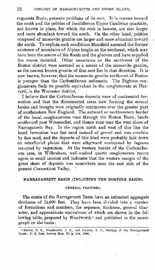
52 GEOLOGY OP MASSACHUSETTS AND RHODE ISLAND.
ragansett Basin, presents problems of its own. It is coarser toward the south and the pebbles of fossiliferous Upper Cambrian quartzite, not known in place, for which the rock is famous, are also larger and more abundant, toward the south. On the other hand, pebbles composed of muscovite granite are larger and more abundant toward the north. To explain such conditions Mansfield assumed the former existence of mountains of Alpine height on the southeast, which may have been the source of the floods and the glaciers and have supplied the coarse material. Other mountains on the northwest of the Boston district were assumed as a source of the muscovite granite, as the nearest known granite of that sort lies in that direction. It is now known, however, that the muscovite granite northwest of Boston is younger than the Carboniferous sediments. The Dighton con glomerate finds its possible equivalent in the conglomerate at Har vard, in the Worcester district.
I believe that the Carboniferous deposits were of continental for mation and that the disconnected areas now forming the several basins and troughs were originally continuous over the greater part of southeastern New England. The outward or northwestern border of the basal conglomerates runs through the Boston Basin, bends southward past Woonsocket, and thence runs near the west shore of Narragansett Bay. In the region north and west of this line the basal formation was fine sand instead of gravel and was overlain by fine mud, and the deposits of this kind were probably laid down on interfluvial plains that were afterward overspread by lagoons occupied by vegetation. At the western border of the Carbonifer ous area, in Wilbraham, well-washed quartz conglomerate recurs again in small amount and indicates that the western margin of the great sheet of deposits was somewhere near the east side of the present Connecticut Valley. '
NARRAGANSETT BASIN (INCLUDING THE NORFOLK BASIN).
GENERAL FEATURES.
The strata of the Narragansett Basin have an estimated aggregate thickness of 12,000 feet. They have been divided into a number of formations and members, the sequence, thickness, general char acter, and approximate equivalence of which are shown in the fol lowing table, prepared by Woodworth 1 and published in the mono graph on the basin:
1 Shaler, N. S., Woodworth, J. B., and Foerste, A. F., Geology of the Narragansett Basin: U. S. Geol. Survey Mon. 33, p. 134, 1899.
Tab
ular
vie
w o
f th
e st
rata
in t
he N
arra
gans
ett
Bas
in.
Gro
up.
Dig
h ton
(1,0
00-1
,500
feet
).
Rho
de I
slan
d co
al m
eas
ur
es (
10,0
00 fe
et).
Wam
sutt
a (1
,000
fee
t).
Pon
dvil
le (
100
feet
).
Unc
onfo
rmity
.
Nor
ther
n fi
eld.
Loc
al a
reas
.
Roc
ky
Woo
ds
con
gl
omer
ate.
Se
ekon
k co
nglo
mer
ate.
Wes
tvil
le s
hale
s an
d Se
ekon
k sa
ndst
ones
. T
enm
ile
Riv
er b
eds.
M
ansf
ield
bed
s.
Cra
nsto
n be
ds. S
ocka
- na
sset
sa
ndst
ones
, P
awtu
cket
sha
les.
Wam
sutt
a sl
ates
an
d sh
ales
. A
ttle
boro
san
dsto
ne.
Wam
sutt
a co
nglo
m
erat
es.
Mill
ers
Riv
er c
ongl
om
erat
es,
arko
se b
eds.
Sou
ther
n fi
eld.
Cha
ract
ers.
L
ocal
are
as.
Coa
rse
quar
tzit
e an
d gr
anit
ic p
ebbl
e co
nglo
mer
ates
, w
ith
fine
r co
nglo
m
erat
es a
nd s
ands
tone
.
Alt
erna
tion
s of
fi
ne
and
med
ium
qu
artz
, qu
artz
ite,
and
gra
niti
c pe
b
ble
cong
lom
erat
es,
wit
h pe
bbly
sa
ndst
ones
, san
dsto
nes
(gra
y w
acke
),
shal
es,
and
coal
be
ds,
beco
min
g m
etam
orph
ic
sout
hwar
d.
Col
ors:
B
lack
, bl
ue,
gree
n,
gray
, lo
cally
re
d. O
dont
opte
ris
flor
a an
d in
sect
be
ds.
-
Bed
s of
qua
rtz,
qua
rtzi
te,
fels
ites,
fel
- si
te b
recc
ias
and
fels
ite c
ongl
omer
at
es,
sand
ston
es,
arko
se,
and
shal
es.
Col
ors:
R
ed,
loca
lly
brow
n,
and
gree
n.
Cal
amite
s.
Qua
rtz
cong
lo m
erat
es.
Coa
rse,
whi
te,
gran
itic
was
te, o
r ar
kose
.
Pur
gato
ry c
ongl
omer
at
e.
Aqu
idne
ck
shal
es
of
Dr.
Foe
rste
. K
ings
tow
n se
ries
of
D
r. F
oers
te.
Bas
al b
eds.
Cha
ract
ers.
Cea
rse
quar
tzit
e pe
b
bles
, us
uall
y m
uch
elon
gate
d an
d in
de
nted
.
Mai
nly
shal
es,
wit
h co
al b
eds.
M
ainl
y sa
ndst
ones
and
co
nglo
mer
ates
, w
ith
coal
sh
ales
, us
uall
y m
etam
orph
ic.
Qua
rtzo
se c
ongl
omer
at
es a
nd a
rkos
e.
Rem
arks
.
Pro
babl
y, t
houg
h no
t ce
rtai
nly,
ide
n
tical
in
all
part
s of
the
fie
ld,
lyin
g in
sy
nclin
es a
bove
the
coa
l mea
sure
s.
Bot
h th
e A
quid
neck
and
Kin
gsto
wn
seri
es o
f D
r.
Foe
rste
, w
hen
trac
ed
nort
hwar
d, a
ppea
r to
for
m e
quiv
a
lent
sec
tions
be
neat
h th
e D
igh
ton
grou
p, o
ne o
n th
e ea
ster
n, t
he o
ther
on
the
wes
tern
sid
e of
Nar
raga
nset
t B
ay,
and
both
ext
end
dow
nwar
d to
th
e ba
sal
beds
in t
his
typi
cal
area
.
The
Wam
sutt
a be
ds a
re n
ot t
race
able
so
uth
of P
rovi
denc
e; p
roba
bly
repr
e
sent
ed b
y lo
wer
str
ata
of D
r. F
oer-
st
e's
Kin
gsto
wn
seri
es.
In t
he v
icin
it
y of
Paw
tuck
et t
he c
oal
mea
sure
s un
derl
ie th
e W
amsu
tta.
Ess
enti
ally
sim
ilar
pro
duct
s of
dec
ayed
gr
anit
ic l
and
surf
ace
in a
ll p
arts
of
the
basi
n.
C71
CO

54 GEOLOGY OF MASSACHUSETTS AND RHODE ISLAND.
The beds have been thrown into a series of great folds which, in general, are broader and more open in the middle of the basin and steeper and pinched at the sides. Lahee gives the following sum mary 1 of his conclusions regarding the deformation:
The Narragansett Basin is a.body of Carboniferous strata which (a) have been deformed according to the Appalachian type of folding; (b) have been regionally metamorphosed; and (c) have been intruded by igneous rocks.
The post-Carboniferous intrusives include a few minette dikes, on the one hand, and an extensive, perhaps related, series of granites, pegmatites, and quartz veins (Acid Intrusive Series) on the other hand.
Of the Acid Intrusive Series, the granite * * * is oldest, the pegmatites are younger, and the quartz veins represent the latest differentiation phase. * * *
These igneous rocks (Acid Intrusive Series and probably miuettes) were injected during, and immediately subsequent to, the folding of the Carboniferous sediments.
More or less static and dynamic metamorphism attended the intrusion of these igneous rocks, but this metamorphism is local and is of distinctly differ ent character from the regional metamorphism due to the folding.
We conclude, then, that the Carboniferous strata of the Narragansett basin, after deep burial, were folded by forces that acted with greater intensity in the south, that, contemporaneous with and consequent upon this deformation, these sediments were regionally metamorphosed; that this deformation and this meta morphism were accompanied, in their later stages, by the intrusion of certain igneous rocks a process which continued, with magmatic differentiation, for some time after folding ceased; and that, these facts being accepted, the regional metamorphism and the injection of the post-Carboniferous igneous rocks may be regarded as nearly parallel effects of the mountain-building forces.
PONDVILLE CONGLOMERATE.
The basal formation is generally a coarse conglomerate or arkose, made up of material derived from adjacent granite. It is not a continuous formation but is well represented along the north and southeast borders of the basin. It was named from Pondville sta tion, in the Norfolk Basin, where it is well displayed.
WAMSUTTA FORMATION.
Overlying the Pondville conglomerate, or resting on the older rocks where the Pondville is absent, is a group of characteristically red beds, composed of sandstones, felsite, agglomerates, arkose, and shale, which Woodworth called the Wamsutta group, from Wamsutta, an Indian name proposed, but not adopted, for North Attleboro, where it is typically developed. The sediments, which include both felsites and melaphyres, are interbedded with some tuffs and flows of vol canic rock.
RHODE ISLAND FORMATION.
The Ehode Island formation makes up the greater part of the rocks of the basin, both in thickness and extent. It is named from the fact that the graphite coal beds of the State of Rhode Island are a part of it. It is called the Pawtucket formation by Warren
1 Lahee, F. H,, op. cit* pp. 468-469,
CABBONIFEROUS SYSTEM. 55
and Powers.1 It consists of shaly and slaty coal-bearing beds in tercalated with sandstones and conglomerates. It abounds in coal plants of Pennsylvanian age and contains the remains of a few ostracodes and insects. The rocks along the western border of the basin are rather strongly metamorphosed.
Coal was mined from, the formation about the middle of the last century but apparently without profit. The coal beds are much crushed by the folding and include considerable infiltrated foreign material, so that the coal contains much ash. The coal is very anthracitic and apparently partly graphitic indeed, the more al tered rocks south of Providence are still mined for graphite.
A pale-greenish to grayish, little altered slate or phyllite from Potters Point on Conanicut Island was analyzed by Pirsson with the result given below. It is a mat of finest mica, chlorite, quartz, graphite, and hematite, containing microlites of secondary tour maline and rutile. The dominance of magnesia over lime and of potash over soda and the excess of alumina are striking and afford chemical evidence of sedimentary origin, though such confirmatory evidence is not needed.
Chemical composiPion of phyllite from Potters Point, Conanicut Island?
[L. V. Pirsson, analyst]
SiO2________________ 56. 3GTiO2_____________- __ . 97A1 2O8__________._____ 22. 78Fe208_______________ 1. 04FeO______________... 6. 26MnO__________.___ . 15MgO______..__....... ____-._ 2. 40
CaO_______________ None.Na2O_________ _ - ____ 1. 48K2O__________...__.._ 3. 91H20__.._______._____ 5. 01
100. 80
DIGHTON AND PURGATORY CONGLOMERATES.
Infolded in the Ehode Island formation are long lenses of a peculiar conglomerate, mentioned above as the Dighton conglom erate. It is named from Dighton, Mass., near which it is well ex posed. It contains Obolus-bearing quartzite pebbles of Upper Cam brian age and pebbles of muscovite granite, both rocks being of un known origin. The pebbles are commonly more than a foot long and are well rounded, suggesting beach action. Their size indicates more violent currents than those that existed during the earlier stages of Carboniferous deposition. Farther south what is regarded as the same formation is called the Purgatory conglomerate from a well-known cliff near Newport, where the conglomerate is much metamorphosed, the matrix is mica schist, and the large pebbles in dent each other. The whole is perfectly sheared by great joints.
1 Warren, C. H., and Powers, Sidney, Geology of the Diamond Hill-Cumberland dis trict In Hhode Island-Massachusetts': Geol. Soc. America Bull., vol. 25, p. 75, 1914.
«Am. Jour. Scl., 3d ser., vol. 40, p. 376, 1893.

56 GEOLOGY OF MASSACHUSETTS AND BHODE ISLAND.
WOONSOCKET AREA.
BELLINGHAM CONGLOMERATE.
The Bellingham conglomerate, regarded as the equivalent of the Pondville conglomerate, extends southward in a sinuous belt from a point near North Bellingham, Mass., past Woonsocket into Rhode Island. It is a coarse basal conglomerate composed of pebbles of granite, quartzite, and green schist in a matrix of sericite schist. The pebbles are commonly drawn out by crushing into long bands, and the whole mass is in places changed to coarse chloritoid (ma- sonite) schist, furnishing great crystals of masonite, several inches square, such as those obtained from Natick, R. I. The rock has pre sumably been isolated by erosion from the Narragansett Basin. In Plates I and II, A, the progressive alteration of the conglomerate is well shown in specimens from Cranston and from Premisy Hill, south of Woonsocket. In Plate I the aplite pebbles are much crushed, the granite little. In Plate II, A, the aplite pebbles are rolled out to disks 10 to 15 inches long.
' BOSTON BASIN.
The Carboniferous strata of the Boston Basin comprise the Rox- bury conglomerate below and the Cambridge slate above. Where the base of the Roxbury is exposed, it lies on the Dedham grano- diorite or on rocks of the Mattapan volcanic complex, and at its top it is overlain conformably by the Cambridge slate. Both for mations are much folded and faulted and in places considerably sheared, and an imperfect cleavage has been developed nearly every where in the basin.
ROXBURY CONGLOMERATE.
Subdivisions. The lower formation, named for the Roxbury dis trict of Boston, where it is conspicuously exposed, consists of a thick conglomerate and some sandstone and slate. In at least the southern part of the basin it may be divided into three members the Brookline conglomerate at the base, the Dorchester slate in the middle, and the Squantum tillite at the top. The later flows of the Mattapan volcanic complex, chiefly amygdaloidal melaphyre, are at several places interstratified with the Brookline and Dorchester members, but they are not known to occur in the Squantum member. It is impossible to distinguish everywhere between some of the earlier beds of the Brookline member and some of the volcanic, conglom erates of the Mattapan complex, but clearly the volcanic activity be gan before the deposition of the Brookline and it appears to have ceased, at least in so far as surface extrusion is concerned, before

U. S. GEOLOGICAL SURVEY BULLETIN 597 PLATE I
SPECIMEN OF BELLINGHAM CONGLOMERATE FROM CRANSTON, R. I.
Large uncrushed pebble in middle below is blue quartz of the Milford granite. White triangular pebble above is quartzite. -Matrix is muscovite schist OF sericite schist. Specimen was taken from rock not in place buttransported. Two-thirds natural size.

U. S. GEOLOGICAL SURVEY
. A. SPECIMEN OF BELLINGHAM CONGLOMERATE FROM WOONSOCKET, R. I., NORTH OF RAILROAD CUT AT PREMISY HILL.
Contains crushed pebbles of 'aplite and quartzite. One quartzite pebble just above middle has been so rolled out that it is 15 inches fong and one-half inch wide.
B. SPECIMENS OF OAKDALE QUARTZITE FROM WORCESTER, MASS.
The lower piece is from the northwest shore of Lake Quinsigamond. The upper piece is from the same band at a point farther north. One-half natural size.

CARBONIFEROUS SYSTEM. . 57
the advent of the glacial conditions that marked the close of Box- bury time.
Brookline conglomerate member. This member is named from Brookline, where the rocks are extensively exposed. It consists of massive conglomerate from 500 to perhaps 2,000 feet thick, which contains some layers or pockets of sandstone and a few thin lenses of slate. At some places along the southern margin of the basin its base is a slaty or sericitic quartzite but at most places it is a coarse ill-sorted conglomerate containing some pebbles or small bowlders more than a foot through.
Dorchester slate member. This member is named from the Dor chester district of Boston, where it is exposed at several places. It consists of red and purple slates, in part cross-bedded, interbedded with sandstone and fine-pebble conglomerate. The slate is typically rather coarse grained and consists largely of reworked volcanic sedi ments. In Dorchester and in the southern part of the basin generally the member is 100 to 600 feet thick, but if the slate exposed in and about Allston Heights is assigned to the Dorchester member, its maximum thickness may be as much as 1,000 feet.
Squantum tillite member. This member is named from the penin sula of Squantum in Quincy. It consists of conglomerate and tillite with some interbedded sandstone and slate. Its thickness appears to range from 50 to 600 feet or more, but as its base is exposed in only one place, so far as known, its thickness is uncertain, like that of the Dorchester member. For the same reason its relation to the Dorchester member is uncertain, and the two may be separated by an unconformity. At its top the Squantum member passes into the Cambridge slate through 100 feet or so of transition beds simi lar to the Dorchester member. A large part of the Squantum ap pears to be of glacial origin and some of it, especially near the top, is typical tillite or glacial conglomerate, containing striated and faceted pebbles, as at Squantum and Hyde Park. Sayles has de scribed in detail 1 all the outcrops of the tillite, which are found from Squantum on the east to Koslindale on the west and perhaps also in Hingham and Allston. He concludes that the ice probably came from the southeast, and that there were at least three beds of till with two intercalated interglacial beds. A great piedmont glacier like the Malaspina Glacier would have deposited material such as is found.
CAMBRIDGE SLATE.
The Cambridge slate, named from Cambridge, where it has been encountered in many excavations, consists of perhaps 3,500 feet of slate, shale, argillite, and some interbedded sandstone, and at or near
1 Sayles, R. W M The Squantum tllHte: Harvard Coll. Mua. Comp. Zool. Bull., vol. 58, No. 2 (geol. ser., vol. 10), p. 141, 1914.

58 GEOLOGY OF MASSACHUSETTS AND RHODE ISLAND.
the top about 40 feet of greenish and yellowish quartzite. Beds here and there are composed of reworked tuff. The formation is of rather uniform lithologic character, and appears to have been de posited in a body of fresh water, possibly a lake at the margin of the ice.
CORRELATION AND AGE OF THE FORMATIONS.
No fossils, except at one locality a few obscure tree trunks, pos sibly Cordaites, have been found in the Eoxbury conglomerate and none in the Cambridge slate. The age of the beds is assumed from what appear to be the most reasonable correlations with the forma tions of the Narragansett Basin, on the south. In both basins vol canic eruptions of similar lavas occurred during the early stages of deposition and presumably at about the same time. The Roxbury conglomerate is believed to be equivalent to the formations of the Narragansett Basin as a whole, and if so, it ranges in age from early Pennsylvanian possibly to Permian. The assumption of the glacial origin of part of the Squantum member accords with this view, for most of the Carboniferous tillites in different parts of the world are regarded as of basal Permian age. The Cambridge slate, then, is also possibly Permian but presumably younger than any beds in the Nar ragansett Basin.
MEBRIMACK THOUGH.
MERRIMACK QUARTZITE.
The rocks of that part of the Merrimack trough which lies between Lowell and the Massachusetts-New Hampshire boundary are fairly homogeneous, and for the present it seems best to map and describe them under but one formation name Merrimack quartzite.
The formation was named by Hitchcock 1 from Merrimack River, along which it causes the falls at both Lowell and Lawrence. It is typically shown in the gorge of the river below Pawtucket Falls at Lowell and the extensive exposures in the Lowell City quarry, at the falls at Lawrence, at the falls on Spickett River in Methuen, in cuts along the railroad near Ward Hill station, and in the old quar ries in Haverhill.
The formation consists chiefly of thin-bedded quartzite or quartz schist, as a rule somewhat actinolitic, generally gray or greenish- gray, but made chocolate-colored at many places by the red biotite which is disseminated in it in small amount, and at other places stained rusty brown by the oxidation of pyrite. At many places there are thin intercalated beds of slate or slaty quartz schist, and at others there are thin lenses and roundish nodules of greenish calcareous or epidotic rock, exactly as in the Oakdale quartzite.
1 Hitchcock, C. H., Geology of New Hampshire, vol. 2, p. 621, 1877.

CARBONIFEROUS SYSTEM. 59
The rock is in general more massively quartzitic toward the north west side of the belt and more slaty toward the southeast side, and seems to show a progressive increase in its slaty character north eastward along the strike. As the structure of the trough is ex tremely complicated, however the strike of the strata at many places being directly across the trend of the trough it is not known \vhether these differences in character are of stratigraphic signifi cance. In Groveland and West Newbury the formation is distinctly more micaceous and phyllitic than elsewhere, and in places it is a quartz-sericite phyllite. This diversity may be the result of dynamic metamorphism rather than of original differences in the character of the sediments, as these beds are in the angle where the trough bends sharply northward into New Hampshire. In South Groveland, how ever, there are outcrops of a graphitic phyllite much like the Worces ter, and it seems not unlikely that in this part of the trough a little of the younger Carboniferous formation is still preserved.
In its general character and apparent relations to surrounding rocks the Merrimack quartzite corresponds closely to the Oakdale quartzite of the Worcester trough, and the two formations are pre sumably equivalent. In the Geological Museum at Amherst College there is a block of gray quartzite, 6 inches wide and 24 inches long, which seems to be a flattened cast of a calamite. One side is fluted and rusty as if from the crumpling and removal of the epidermis, but on the flat surface traces of the ribbing still remain and bear a resemblance to that of Calamites ccurmwformis. The block was labeled simply "Lowell, Mass.," by Edward Hitchcock, and is sup posed to have come from the Merrimack quartzite. On the other hand, Sears has reported traces of Cambrian fossils from outcrops of the formation. No fossils have been found by other students of the region, however, after careful search of the localities mentioned bv
O / 7 v
Sears. Because of these uncertainties and its wide separation from other areas of the Oakdale quartzite, it seems best for the present to give the formation a name of its own.
BRIMFIELD SCHIST.
The part of the Merrimack trough that extends southwestward from Lowell is occupied by a rusty pyritic fibrolite-graphite-sericite schist that is closely similar to the Brimfield schist of the Worcester trough, with which it is continuous in Bolton. It is best discussed, therefore, in the description of that formation.
WORCESTER TROUGH AND CENTRAL UPLAND.
GENERAL FEATURES. t
In Worcester County the Carboniferous sedimentary rocks were originally a calcareous sandstone below and a great mass of car bonaceous and pyritous shale and subordinate beds of conglomerate

60 GEOLOGY OF MASSACHUSETTS AND EHODE ISLAND.
and limestone above. Along its western border, next to the Con necticut Valley, the series becomes threefold, containing at its base a sandstone or arkose, in the middle an impure limestone, and above a thick shale and .sandstone series, with some conglomerate.
The Carboniferous strata occur in their least altered form in the Worcester trough, where their lower part consists of the slightly micaceous Oakdale quartzite. and small green calcareous lenses and their upper part is the highly graphitic Worcester phyllite, lustrous from abundant fine scales of mica. At one locality in Worces ter the phyllite contains distinct fossil plants. East and west of the trough the formations appear as narrow anastomosing bands, the remnants of closed synclines. These bands are like the meshes of a network, the broad interstices of which are filled by the great masses of younger intrusive granite which now occupy three-fourths of the whole area. On the east and west also the beds seem to grade by progressive alteration caused largely by the intrusion of granite into schists and gneisses; toward the east the change is more abrupt, toward the west more gradual to a maximum, beyond which the alteration decreases.
Toward the west the Oakdale quartzite grades, in my opinion, into the Paxton quartz schist, a chocolate-colored, highly micaceous whetstone, which contains small green hornblendic lenses. Because of its intimate impregnation by granite the Paxton, at some places beyond the western border of the Worcester quadrangle, is further altered to a brown porphyritic gneiss (paragneiss). The Worcester phyllite similarly, in my opinion, becomes the Brimfield schist, a coarse, rusty, muscovite-biotite schist, full of pyrite, graphite, fibro- lite, and pink garnet. It also becomes in places a paragneiss, much of it full of beautiful porphyritic crystals of adularia. The Paxton and Brimfield schists are the predominant and most widely extended of the metamorphic sedimentary rocks.
On the western border of the Central Upland, overlooking the Connecticut Valley from Wilbraham to Millers Falls, the gneissoid Paxton quartz schist is less altered, and in the same district is divided into two formations the Erving hornblende schist below and the Quabin quartzite (firestone) above. In the same district the Brim- field becomes a normal garnetiferous mica schist called the Amherst schist. Farther north, along the Gulf road in Northfield and Erving, the Paxton strongly resembles the Oakdale quartzite, and the Brim- field schist grades into a rock of the type of the soft graphitic Worcester phyllite.
Eastward from the Worcester trough the change is more abrupt, and the Worcester phyllite grades into the Oxford schist, a gray muscovite schist, in many places full of muscovite spangles and garnet, or into the Brimfield schist.

CARBONIFEBOUS SYSTEM. 61
Besides exhibiting these regional gradations, caused partly b}^ the folding of the strata but mainly by the all-pervading influence of the great granite masses, the Worcester phyllite, an argillaceous for mation that is more subject to alteration than the underlying quartz- ite, assumes several contact phases at places around the border of the granite. At several places in Lancaster and Sterling the intru sion of small stocks of granite has caused the formation of chiasto- lite in broad belts of phyllite, forming what is here called chiastolite schist, and many of the larger granite masses are bordered by a garnet-andalusite hornfels or a very coarse muscovite schist, full of big prisms of pink andalusite, more or less altered to muscovite and fibrolite, which is here called the Boylston schist.
All these changes are a result of the intrusion of the granite, which first, by the action of heat and circulating water, caused a crystallization of muscovite, andalusite, biotite, garnet, fibrolite, and graphite (in about the order mentioned), and then, by continued heat and alkaline solutions, caused the formation of much more mus covite, with feldspar and cordierite, and the change of fibrolite, anda lusite, and kyanite into muscovite.
Besides these metamorphosed rocks, a subordinate division of the Carboniferous strata has been mapped, which was deposited under very different conditions from those under which the bulk of the strata were laid down. This is the Harvard conglomerate lentil of the Worcester phyllite.
OLDEK CARBONIFEROUS FORMATIONS
OAKDALE QUARTZITE.i
The Oakdale quartzite is named from Oakdale, a village in the town of Sterling, Mass., where it is conspicuously displayed. It is the least altered of the older Carboniferous formations and retains many of its sedimentary characters but grades into more crystalline varieties. It is a fine, even-grained, flaggy quartzite, in many places greatly jointed, reddish-brown from the development of secondary biotite in minute scales or greenish from the development of actinolite in small lenses or subordinate beds that were originally calcareous. It contains accessory menaccanite, ottrelite, pyrite, and muscovite. The bedding and the quartz grains are in many places original. Near the granite intrusions the quartz grains are enlarged or wholly recrystallized, the whole mass is coarser grained, and the rock grades into the next type.
In the specimen shown in Plate II, #, from the transition area into the Paxton quartz schist, the quartz bands are folded without jointing and the cement changed to mica schist. At Indian Ledge, on
1 Cnllcd Worcester nuartzite in U. S. Geol. Survey Mon. 29, p. 17, 1.898. Called Sterling quartzite in The geology of Worcester, Mass., 1903. These names are preoccupied.

62 GEOLOGY OF MASSACHUSETTS AND RHODE ISLAND.
the hijl east of the road, a little south of the Worcester " coal mine," the quartz bands, as figured elsewhere,1 are greatly twisted and sepa rated into small segments.
The age of the Oakdale quartzite is discussed on pages 76-78.PAXTON QUARTZ SCHIST.
Toward the west what I regard as the equivalent of the Oakdale quartzite is more flaggy, includes more abundant and visible biotite and, in the small green calcareous areas, distinct lenses of actinolite, some of them containing diopside, essonite, titanite, pyrite, and residual calcite. It includes small beds of mica schist and limestone, and some of it is slightly graphitic. This type of rock is called the Paxton quartz schist, from its development at Paxton, northwest of Worcester. Unlike the Brimfield schist it is distinctly quartzitic, less rusty, and lacks graphite, garnet, and the aluminous silicates. Though much intruded by granite, it maintains its type to the west edge of Worcester County, and at places farther west becomes com pletely gneissoid. It finds some use as a whetstone. This is the most widely extended type of the lower formation of the Carboniferous.
The alteration of the Oakdale into the Bolton east of Worcester, in the Ballard quarry (PI. V, A, p. 226), and into the Paxton west of Worcester, in the Tatnuck quarry, has been described in detail else where.2 In many exposures made in blasting for street and building improvements the transition of the Oakdale into the Paxton has been traced along the strike. The Paxton passes in pitching folds beneath the Brimfield, just as the Oakdale passes beneath the Worcester. For a great distance north and south of Worcester the boundary between the Paxton and the Oakdale is a zone rather than a line, and the transition is so gradual and over large areas the change is so slight that a new name was hardly needed. The boundary, which is drawn about parallel to the adjacent granite, cuts across the strike in many places.
A short distance east of the Worcester region the Paxton quartz schist, in my opinion, loses its identity in the " Bolton" gneiss, which I believe has derived much of its material from the Paxton, perhaps in some places the major part, and has thereby become, in effect, only a more quartzose porphyritic gneiss, in contrast with the Worcester phyllite, which, with its content of carbon, iron, and alumina, is much more persistent when included in the granite and forms a dark biotite gneiss.
YOUNGER CARBONIFEROUS FORMATIONS.
WORCESTER PHYLLITE.
General character. In its least changed or typical phase the Wor cester phyllite ranges from soft black slate or phyllite, partly car-
1 Perry, ,T. H., and Emerson, B. K., The geology of Worcester, Mass., p. 45, 1903.2 Idem, pp. 80-86, 131-134.

CARBONIFEROUS SYSTEM. G3
bonaccous and partly graphitic, to light greasy sericite schist. The prevailing rock is thinly fissile, lead gray, with corrugated satiny surface, generally splitting on the original lamination and not on a secondary cleavage. Some of it forms a good roofing slate and has been extensively quarried in Lancaster and Harvard. Its satiny surface is produced by the recrystallization of its clayey material into fine scales of mica, and as these scales grow coarser the rock grades into mica schist. The accessory minerals are biotite, ottrelite, garnet, pyrite, and minute chiastolite.
In the Worcester "coal mine" and in the more metamorphosed western part of the Narragansett Basin a greenish-white satiny fibrous mineral occurs, filling fissures with its transverse needles. It was originally a prochlorite, possibly made fibrous by pressure, and is now changed in part to silica by the action of the acids formed on the oxidation of the pyrite. 1
The relations of the typical Worcester phyllite to the different tj7pes of schist into which it grades laterally are explained on pages 64-72.
Fossils. Stems of Lepidodendron acuminatum have been found by Perry in great slabs at the Worcester " coal mine." 2
During the summer of 1911 Mr. David White examined the Wor cester "coal mine" and has published a preliminary notice 3 of the result of his study, which is reprinted in part below. Mr. White con firms the determination of the Worcester phyllite as Carboniferous, and adds to the number of fossils found there.
Though these beds were described more than three-quarters of a century ago and have been visited by scores of geologists, the widest views have pre vailed regarding their age. As often happens in graphitic argillites, mineral or cleavage forms accidentally resembling graphitized remains of plant fragments are plentiful. Some of these closely imitate imperfect fragments of Cordaites, Catamites, Lepidodendron, etc. In 1883 a specimen was found by Prof. Perry which appeared to be a true fossil, consisting of a frag ment of a Lepidodendron stem impression, in which the somewhat indistinct leaf cushions were still comparatively regular in their quincunxial arrange ment. This specimen was submitted by Perry to Leo Lesquereux, who re garded it as probably belonging to Lepidodendron acuminatum, a Carbon iferous species. On the evidence of the relatively minor degree of alteration, the occurrence of the graphitic bed, and this unfortunately rather obscure fossil,4 Perry and Emerson have courageously insisted on the Carboniferous age of the phyllite, notwithstanding the skepticism of most geologists and paleontologists, some of whom, denying the validity of the fossil, have con tinued to regard the beds as not younger than Algonkian. Spurred by criti cism, Prof. Perry continued the search, with the result that after 16 years the
1 Terry, J. H., and Emerson, B. K., The geology of Worcester, Mass., p. 17, .1903. " Terry, J. H., Am. Jour. Scl., 3d ser., vol. 29, p. 157, 1885. Terry, J. II., and Emerson,
B. K., op. cit, p. 18 and figs.3 White, David, Age of the Worcester phyllite : Washington Acad. Scl. Jour., vol. 2,
p. 1.14, 1912.4 Another specimen, never reported on by a paleontologist, Is said to have been sent to
Columbia University.

64 GEOLOGY OF MASSACHUSETTS AND EHODE ISLAND.
counterpart or reverse of the same stem fragment impression was discovered. This side, however, was scarcely more distinct than the other, arid accordingly added nothing to the evidence as to the age of the phyllite.
Since it was evident that in the midst of soft clay shales, after such squeezing and alteration as at Worcester, there could be little chance for the recognizable preservation of the delicate types of land plants most useful for age determina tion, the writer on the occasion of his brief visit to the old " mine " in Octo ber, 1911, set about the search for either clay ironstones or pyritic nodules ("niggerheads") which when occurring in the shales above coal beds are so often found to contain vestiges of more or less decayed but undeformed or ganic structures. The expectation that such sulphide nodules when surrounded by soft, plastic, and therefore compensating material, might, if present, have escaped serious deformation, was essentially borne out by the discovery of concretions containing recognizable fossils in the graphitic argillite. However, contrary to expectation, the concretions were found to contain brecciated shale fragments of various sizes and in varying attitudes. It appears that this shale was fractured or brecciated prior to the segregation of the sulphide. At present the interstices between the shale pieces, some of which were found to be as large as the palm of the hand, are largely occupied by asbestiform prochlorite (after fibrous pyrite?), though more or less iron sulphide is present.
The concretions above the graphite bed in the phyllite are few and rather hard to extract, and the included plant fragments in the particular shale layers represented therein appear to be scarce and generally small, but for tunately they are fairly distinct and practically undisturbed, the pieces of shale being less deformed so that the paleobotanical details are clear. In the relatively few fragments found during the writer's brief search, small por tions of Cordaites leaves, probably C. borassifolius, a^e relatively plentiful. Other fragments include a small leaflet of Sphenopteris comparable to S. dick- sonioides Stur; an isolated leaf cushion of Lepidodendron, possibly L. obova- tum; a Sporocystis, and a small Equisetacean cone.
Through the courtesy of Prof. Perry the opportunity has been given the writer to examine and photograph one side of the Lepidodendron found by him in gritty schist. As to the validity of this impression there is no room for doubt. Though the bolsters are partially defaced and alteration products largely mask the surface, there may be seen at several points imperfect outlines of what are, presumably, deformed leaf scars instead of mere pseudo-fossils. The trunk, which was perhaps a foot in diameter, may have belonged to Lepidodendron veltheimii, or possibly L. obovatum.
Description of the fossils is deferred in the expectation that new efforts will bring to light additional material in the protected brecciated shale frag ments. The specimens at present in hand, though few and very fragmentary, are such as to put beyond question the Carboniferous age of the phyllite at Worcester, thus confirming the opinion of Profs. Perry and Emerson. Judging by the details of the few pieces collected, the writer suspects that further dis coveries will show the beds to be of Pennsylvanian, possibly Pottsville, age.
The age of the Worcester phyllite is further discussed on pages 76-78.
Chiastolite schist. The small points of three granite masses are exposed by erosion near the centers of the large areas of chiastolite schist in Lancaster and Sterling. - These broad halos of chiastolite rock lie in the midst of an extensive area of the least altered Worces ter phyllite, and the one grades into the other.

CARBONIFEROUS SYSTEM. 65
The chiastolite is present, first, in small, black, dense, and hard spots; second, in prismoid masses of the same character with irregu lar and indefinite boundaries; third, as the well-known chiastolites with cylindrical shape and taper ends, some of them 6 inches long and 1 inch in diameter (the largest perfect prisms are 1 inch long); fourth, in the same shapes but changed into fine to quite coarse muscovite; fifth, prismatic shapes like staurolite, but now composed of coarse matted mica.
It is clear that the first waves of heat from the intruding granitic magma produced autogenous solutions of aluminous silicate from the clay, which crystallized in the black clay without moving it, but formed the irregular black spots while there was much more carbon in the rock than now. Later movement of the plastic shale distorted these forms and discharged the excess of carbon from the surround ing rock.
The complete chiastolite crystals have black squares in their cen ters, which commonly increase in size from one end to the other, and black plates radiate from the corners of these squares to the corners of the prism. The black square represents the first stage of feeble crystallization. Later the pure material was drawn strongly to the sides of the prism, forming pure white andalusite, and weakly to the corners, producing the dark plates in cruciform position. The tapering of the dark center shows that the favorable condition passes slowly from one end to the other of the crystal. In the clear triangles the microscope shows an oscillation of greater and lesser purity in planes parallel to the prism faces, showing an alternation of more or less favorable conditions. The material in some of the crosses grows more coarsely crystalline outward and contains less carbonaceous matter, showing that the process of change in the rock went on during the crystallization. The crystals are cigar-shaped, more or less tapering forms instead of square prisms, though show ing a quadratic structure in cross section, because the increasing condensation of the clayey matrix gradually damped down the crystallizing force to zero. Many of the crystals are distorted, showing that the chemical and physical changes went on together. Alkaline solutions from the granite afterward changed the crystals into matted muscovite scales, and in many places the steps of this process and its blending with continued movement can be seen. The change extends in opposite directions from some of the dark plates, the mica plates diverging from a central suture. In some of the rock the change to mica appears at the surface and proceeds in ward to the center. The same solutions changed the more ferru ginous crystals of staurolite to matted plates of muscovite and biotite and the clay slate into a mica schist full of minute crystals of green
50244° Bull. 597 17 5

66 GEOLOGY OF MASSACHUSETTS AND RHODE ISLAND.
tourmaline. Much of the chiastolite is dissolved, and deep cavities each shaped like a four-leaved clover, are left in the rock; as the mica increases in amount these cavities decrease. The rock nearest the granite becomes a distinct mica schist of the type of the Boylston pink andalusite schist and forms a transition zone both along and across the strike.
Harvard conglomerate lentil. A mass of crushed conglomeratic rock, 500 feet wide and 1 mile long, occurs northwest of Harvard village and lies on an isolated block of Worcester phyllite sur rounded on all sides by granite. A conglomerate mass of similar relations and dimensions forms the summit of Vaughn Hill, 3 miles to the southwest. Ice-scratched bowlders of similar rock appear at Bolton station and at George Hill in Lancaster, which must have come from another locality.
The rock is a breccia rather than a conglomerate, as the compo nent blocks are in general sharply angular. They differ greatly in size; one block measures 1£ by 3 by 5 inches, another 4 inches on one side. In other places a considerable surface would show blocks all about an inch long.
The blocks are as diverse in character as they are in size. They are mainly quartzite but of several kinds of quartzite. In other specimens the fragments are all slate but of several kinds of slate. The interstitial matter is a fine clay slate like the adjacent argillite. These are all characteristics of tillite, and the Squantum tillite x is the only known rock in the State with which this bed can be com pared; the two may be of about the same age. Some of the blocks have been distorted by pressure, others have not, and the undisturbed blocks bear a strong resemblance to tillite. The larger quartzite blocks look like the Algonkian Westboro quartzite, but under the microscope the resemblance is not close. The quartzite of the smaller blocks ranges greatly in size of grain but is generally made up al most wholly of well-rounded grains 0.1 to 1 millimeter in diameter with different amounts, in some specimens large amounts, of fine grained black material evenly distributed between them.
The Carboniferous Oakdale quartzite is of finer grain and every where biotitic. The Algonkian Westboro quartzite is of less rounded grain and is commonly actinolitic. Both contain no interstitial material. Quartz sand so fine in grain could have been rounded only by the wind, and these blocks must have been derived from an eolian sandstone. The specimen from which the slide shown in Plate VIII, B (p. 244), was taken shows a weathered surface where all the bleached angular blocks are of the two kinds of sand stone, and on the other side of this block is a large angular piece of black slate. The thin section of this rock is made up of fragments
1 Sayles, R. W., and LaForge, Laurence, The glacial origin of the Roxbury conglom erate : Science, new ser., vol. 32, p. 723, 1910.

CARBONIFEROUS SYSTEM. 67
of the eolian sandstone of different grain and of the more angular- grained Westboro quartzite inclosed in argillitie material beautifully affected by incipient strain cleavage.
Another interesting block was made up of many such black grains and others of coarse vein quartz, both about half an inch across and partly rounded, and many well-rounded pebbles of the eolian sand stone, some almost colorless, others more and more blackened by the large amount of intervening black fine-grained matter.
Plate VIII, B (p. 244), shows a thin section magnified five diameters. The partly rounded vein quartz pebbles (q) stand out very clearly, are about one-eighth inch across, and show that coarse quartz veins or pegmatite furnished part of the material.
The flat slate fragments are much larger and only slightly rounded. They are much darker in the picture than in reality; a to d are almost colorless; e has a faint greenish-yellow tint. They are com posed of a mat of minute equal-sized sericite scales. The well-rounded pebbles / and g are black from coaly matter and are about the size of the quartz pebbles (q). Where very thin they are trans lucent, aphanitic, and nonpolarizing, like black opal; g contains a well-rounded pebble of the eolian sandstone with much black inter stitial matter. Besides g there are many similar perfectly rounded pebbles (1 to 6), made up of well-rounded wind-blown grains of different sizes and cemented by the black dust in different amounts; 1 is a perfectly rounded pebble and indents a; 2 is finer in grain and is cut off against a; 3 indents 2. These pebbles are much more dis tinct under the microscope than in the photograph; thus 3 and 6 are very clear.
These perfectly rounded, egg-shaped eolian sandstone pebbles are surely not in the same category as the subspherical quartz (q} and black pebbles (#), because they are more perfectly and differently rounded and g contains one of these sandstone pebbles. We may, I think, assume that these pebbles came out of a conglomerate bed which was interstratified with the bed from which g was derived or formed a continuation of it.
The interstitial matter consists wholly of quartz grains, the larger ones of the vein quartz, the smaller ones apparently derived from the crushing of some of the sandstone pebbles. This black portion of the Harvard conglomerate was derived from an unknown rock which contained (1) pegmatitic vein quartz, (2) a gray fine-grained sericitic ;phyllite, (3) an unknown series containing a black pebble- bearing1 'flinty rock and a conglomerate of similar pebbles; these pebbles are made up of wind-blown sand of unknown origin.
BOYLSTON SCHIST.
The Boylston schist in Boylston is a ragged, coarsely micaceous rock which commonly lacks fissility because the muscovite scales are

68 GEOLOGY OF MASSACHUSETTS AND RHODE ISLAND.
crushed and crumpled together. In many places it is crowded full of square prisms of andalusite about an inch long, changing to sericite, and imperfect garnets, changing to chlorite. It is a coarse contact "hornfels" produced by the same agency that made the chiastolite schist, described above, acting more intensely. It sur rounds the granite in Boylston in a belt half a mile wide, and its transition into the Worcester phyllite is perfectly exposed on Cider Mill Hill. It may be very coarse, as east of Bare Hill Pond in Har vard, where irregular masses of pure flesh-colored andalusite as large as one's fist are inclosed in coarse muscovite, or farther north in Westford, where the perfect andalusite prisms rival those of Anda lusia.
These andalusite prisms are commonly very abundant and perfect, as on Maiden Hill south of Oakdale, and are generally small, but some of them are an inch square and 4 to 8 inches long. Farther north there are crystals of staurolite, which are full of the original carbonaceous matter and show the delicate faults of an incipient cleav age. This carbon is now concentrated in graphite in the rest of the rock, showing that the staurolite formed before the metamorphism of the groundmass was completed. The rock here shows much fibrolite intergrown with the andalusite, with the axes parallel and the fibrolite growing far beyond the surface of the andalusite. The fibrolite was formed later, at a higher temperature, and does not in clude carbonaceous matter. Thus the 3oylston is intermediate be tween the Worcester and the Brimfield. As a third stage fine sericite or coarse muscovite may replace both minerals, eating into them in bands whose sutures form exact pseudomorphs or growing far be yond their limits in plates that were crumpled by their own intense crystallization. Small spots of blue cordierite appear in places, and minute needles of tourmaline have been crystallized from the solu tions derived from the granite.
OXFORD SCHIST.
South of Worcester the Worcester phyllite grades along the strike into a lead-gray mica schist, full of large black crystals of garnet and staurolite and containing tourmaline derived from the granite. In places it is silvery white from the absence of both graphite and biotite. Subordinate beds of this schist containing fine staurolite twins ap pear in the Boylston schist along the shore of the reservoir a mile west of Boylston Center, The main mass occupies a broad area extending south from Worcester across Auburn into Oxford, from which town it is named.
BE1MFIELD SCHIST.
General character. The Brimfield schist is the most marked and most widely distributed of the metamorphic formations assigned to
CABBONTIFEHOUS SYSTEM. 69
the Carboniferous. The rock is a uniform coarse red-brown mus- covite schist containing much biotite, fibrolite (commonly derived from an antecedent andalusite), and graphite, and so much pyrite that it is wholly rusted in many of the deepest openings. It forms deep brown soils and abundant efflorescence of copperas, formerly used for dyeing, and names like Dyestone Rock, Alum Pond, and Copperas Hill are common. The formation was named for its occurrence at Brimfield, Mass.
East of Worcester phyllite. East of the Worcester phyllite a long, narrow strip of the Brimfield schist is infolded in the "Bolton" gneiss near its east edge and extensive irregular areas appear on the "Bolton" everywhere, especially in the southern part of the State. This strip is generally bordered and cut by diorite and contains along its western border several interesting derivatives of limestone beds. Large areas of this schist appear also farther east, next to the Algonkian (?) in Marlboro. Where the schist is more influenced by the granite, cordierite is formed with the fibrolite, and as similar patches continue far northeast over the Andover granite I interpret the occurrences of fibrolite and cordierite in muscovite-biotite granite cited by Sears, as at Market Ridge in North Andover, as remnants of the Brimfield.
Another belt of Brimfield schist, bordered in a few places by nar row strips of Boylston schist, not all of which are mapped, occupies the part of the Merrimack trough between Shrewsbury and Lowell and furnishes the fine andalusites of Westford. North of Wata- quadoc Hill, in Bolton, this belt for a mile or so adjoins the Wor cester phyllite and its altered phases in the Worcester trough. The rock of this belt is more resistant than that on either side and it forms a bold range of steep-sided hills as far northeast as Littleton depot and a range of broader, lower hills through Westford and nearly to Lowell.
West of Worcester phyllite. The Brimfield schist occupies a large part of the western half of Worcester County and extends west, north, and south far beyond the limits of the county. It is very generally so soaked with granitic material in small lenses, veins, and filaments that it has become a composite rock or a gneiss which still retains largely the aspect of the schist from which it was derived. Where least contaminated by granitic material it is a coarse deep- brown biotite-muscovite schist in which the red-brown shade of the biotite is characteristic. A fine amber fibrolite is very common. Crystals of clear, pink garnet are abundant, and their easy decom position gives the rock its rusty color in part, but there is commonly much pyrite, which causes the rock to slake and cover the surface with an efflorescence of salts of iron and aluminum and deep streaks of rust. Near the Coys Hill granite in the eastern part of Ware and Mon-

70 GEOLOGY OF MASSACHUSETTS AND BHODE ISLAND.
son the schist contains nodular masses of perfectly fresh and limpid moonstone, whose chatoyant luster is caused by exceedingly minute parallel rods of albite. The feldspars are commonly 20 to 30 milli meters across and generally each consists of a single apparently un- twinned crystal in which high powers of the microscope show micro- cline structure. The layers of the schist wrap around them so that they seem like pebbles. Many of them are surrounded by a border of sugary white granular feldspar, caused by the crushing of the border of the mass, and the granular material is drawn out into tails of the limpid feldspar in the red-brown schist. They are unstrained and have grown like potatoes in a hill where the schist was re lieved of pressure during folding, and some of the adjacent schist seems to retain traces of ripple marks.1 They inclose garnet and graphite, but not fibrolite. Near the Hubbardston. granite in Stur- bridge there is an extensive development of a coarsely banded, por- phyritic rock crowded with large crystalline plates of graphite, even in the feldspars, and the amber fibrolite of the schist is recrystallized in large sheets of a white fibrolite (bucholzite). This rock forms a passage in central Sturbridge to the Hubbardston granite. Before the intrusion of the granites the Brimfield occupied nearly the whole surface of western Worcester County, and it is still the most extensive formation. The rock is thrown into great north-south synclines, which are folded into the Paxton quartz schist, and its continuity is much interrupted by the broad areas of intruded granite. The rock represents that part of the clayey beds of the " Coal Measures " which was originally very coaly and therefore very pyritous, and which has been most thoroughly baked by the large masses of granite, soaked by the alkaline solutions from them, and intruded to a greater or lesser extent by them. So the graphite scales and pyrite have formed, some part of the iron has gone into garnet and biotite, and the clayey part of the sediment has crystallized into fibrolite, much of which has been changed over into a fibrous muscovite by the action of the later alkaline solutions from the granite, which have also increased the content of mica and added most of the abundant feldspar. Cordierite arid gedrite have thus formed on the contact of the granite. The Brimfield rusts very deeply and makes deep red soils, which excite false hopes of workable ores of iron. Because of the iron sulphate formed the rocks stain and crumble easily, and the copperas thus formed was once used in dyeing as stated above (p. 69). The acid waters sometimes even curdle milk and blacken tea.
West of the broad area described above a remarkable narrow band of the same schist, nearly 24 miles long and only about half a mile
iAm. Geologist, vol. 30, p. 75, pi. 1, fig. 2, 1902.

CARBONIFEROUS SYSTEM. 71
wide, runs in the granite with a constant character from Dana to Monson. It forms generally a line of high hills. A narrow band of the Dana diorite borders it on either side.
Sturbridge graphite mine. The widely disseminated graphite has suggested mining in mamr places but has been found in "promising amount only at the "lead mine" in Sturbridge, where since 1640 repeated attempts have been made to work the deposit, the last in 1903 or 1904, and a deep shaft and extensive open workings remain.
The deposit is in a series of flat pockets, 3 or 4 inches in thickness, placed with the bedding, but not very extensive in this plane. The bed is near the base of the Brimfield schist and in the zone of strong influence of the granite. Prof. G. H. Haynes, of the Worcester Polytechnic Institute, has written an interesting history of the ancient mine, " The tale of Tantiusques, an early mining venture in Massachusetts," x which gives, with abundant citations of the Win- throp papers, the long-continued attempts of John Winthrop, jr., from 1644 on to work this mine, and its subsequent extensive work ing by many owners.
Brown gedrite-cordierite schist beds in Brimfield schist. A. pretty clear distinction can be maintained between the brown hornblende schists found in the Brimfield schist or in the adjacent granite and derived from portions of the schist recrystallized in the granite and the greenish-black schistose diorites or amphibolites formed by dif ferentiation on the border of the granite and an integral part of that rock.
The brown schists here considered in many places contain cordierite and also all the constituents of the rusty Brimfield schist. Cordierite is quite abundant in the first cut west of Ware station and occurs in coarse granite at the contact with the Brimfield at the old locality of cordierite on the Warren road near the town line and on Shumway Hill in Sturbridge. The complex twinning is figured in Monograph 29 (PL III, fig. 2). A hematitic cordierite occurs in large well- cleaved and twinned anhedra, with much calcic plagioclase, titanite, and rutile, in the Brimfield schist in Enfield by the roadside a mile southwest of Davis Pond.
A cordierite-gedrite schist occurs in a considerable layer in the Brimfield opposite the school southwest of West Ware. The large well-twinned, pleochroic cordierite anhedra are associated with stout blades of hairlike brown gedrite like that on Tully Mountain in Warwick,2 which forms a thick bed and changes into a great bed of steatite. Analyses of the gedrite are quoted on page 74.
1 Am. Ant. Soc. Proc., Worcester, Mass., 1902. The Winthrop papers are preserved in the library of this society.
2 U. S. Geol. Survey Bull. 126, p. 86, 1895.

72 GEOLOGY OP MASSACHUSETTS AND KHODE ISLAND.
The cordierite is altered in broad branching bands into an aggre gate of sericite and actinolite. Labradorite, pyrrhotite, apatite, chlorite, rutile, and fibrolite also occur.
Limestone and limestone derivatives in Brimfield schist. Several beds of graphitic crystalline limestone, nowhere more than 3 or 4 inches thick, appear in this formation. They are very coccolitic and grade into gabbro-like anorthite-pyroxene-essonite rock, more or less hornblendic. This rock appears about a mile south of East and North Brookfield and 2£ miles south of Brookfield.
The same rock appears near the brook crossings, 1 mile and 2 miles south of Southbridge, and thin, coarsely hornblendic bands, which appear in the center and west edge of Southbridge village, may also be altered calcareous layers in the Brimfield. The same coccolitic beds appear half a mile east and west of East Brimfield village and at the bend in the road a mile northeast of the graphite mine.
WESTERN BOBBER OF THE CARBONIFEROUS AREA.
GENERAL, CHARACTER OF THE ROCKS.
Westward across the anastomosing network of the Carboniferous schists a change occurs in a zone passing southeastward from War wick village obliquely across the strike. The Brimfield schist loses its graphite, fibrolite, limonite, red-brown biotite, and pink garnet and becomes a coarse wavy-surfaced muscovite schist, generally barren but in some places containing dark garnets, staurolite, spangles of shining black biotite set across the bedding, and more rarely kyanite. This rock is called the Amherst schist. In some places it resem bles the Brimfield type or even that of the Worcester phyllite. The Paxton quartz schist persists with its usual features for a long dis tance beyond the border of the Brimfield, but at length it changes to a sugary white friable quartzite, once in demand for furnace hearthstones, which becomes more or less sericitic or chloritic and at Amherst is full of large, irregular masses of garnet. This rock is called the Quabin quartzite. A thick mass of a rather fine grained hornblende schist, the Erving hornblende schist, makes a third for mation of the series. It is in the middle of the quartzite in North- field, but it sinks lower farther south, and in the middle of the State it forms the basal member. It appears to represent^ a calcareous band in the original schist, which occupied a horizon that became lower toward the south. The whole series indicates, when com pared with the more eastern beds described above, that the coal- forming conditions of the central and eastern parts of the State were disappearing and that deeper waters existed in the Connecticut re gion, deep enough for the formation of limestone and in some places near enough to the shore for the formation of conglomerate.

CARBONIFEROUS SYSTEM. 73
The series gradually develops as many resemblances to the older Savoy (Ordovician) and Conway (Silurian?) schists west of the Connecticut as to the Carboniferous Brimfield and Paxton east of the broad Greenwich Valley. Many years ago 1 I correlated these beds east of the Connecticut with the western Silurian, and as they all run together in Warwick, a few miles north, and unite -there with the Brimfield, this was also thought to be Silurian.
As the transition in Warwick of the mica schists of this series into the Brimfield seems on reexamination to be well established, and as the quartzite of this series is in places indistinguishable from the Oakdale, whereas the mica schist becomes in places a black carbona ceous slate like that at Worcester, the series is now interpreted as a peculiar shoreward variant of the Carboniferous. It differs so much in lithologic facies from the rocks of Worcester County that its divisions can properly be designated by different names. The western beds in the crushed zone of the border of the Connecticut Valley are most metamorphosed. The eastern band south of New Salem assumes almost the facies of the Brimfield schist.
ERVING HORNBLENDE SCHIST.
The Erving hornblende schist is a fissile fine-grained schist com posed largely of shining black hornblende needles, either parallel or lying confusedly in a common plane in a ground of clastic quartz grains, many of which show enlargement. In many places it passes into a gray tremolite-actinolite schist that contains many needles, composed of actinolite in the middle and tremolite at the ends, or into a garnet-bearing chlorite schist, the chlorite being pennine. Epidote is abundant, much of it in lenses or layers of the pure min eral. The feldspar is largely untwinned and commonly incloses several quartz grains. In places it closely resembles the banded contact diorite. The diorite, however, has hornblende with brown absorption on c instead of blue, leucoxene in place of epidote, and more black ore. An analysis of this rock is quoted on page 74.
Above the Chaffee place in Stafford, a mile west of State Lino Pond, is a thick bed of hornblende coticule. Its alternate layers are flesh-colored and black; the flesh-colored are formed of fine quartzite, crowded with minute perfect dodecahedral garnets; the black are composed wholly of the same perfect garnets and hornblende blades. The formation is named for its occurrence at Erving, Mass.
1 U. S. Geol. Survey Mon. 29, pp. 211-252, 1898.

74 GEOLOGY OF MASSACHUSETTS AND RHODE ISLAND.
Chemical composition of hornblende schists and other mafic rocks from Massa chusetts and Vermont.
[L. G. Eakins (1-7 and 9) and E. A. Schneider (8), analysts.]
SiOs..--. ....................TiOg..... ....................AUOg........ ................Cr803 ........................Fe203 .. ......................FeO.......... ...............MnO.. ......................BaO.......... ...............CaO..... ....................MgO........... ..............K20.............. ...........NasO..... ...................H2O........ .................PS05... ....... ...............
1
51.381.07
18.01
3.308.53.19
6.275.08
.185.34
.56
.18
100.09
2
<1Q Rfi1.58
15.50
2.998.01
.07TVapft
8.897.79.72
3.261.51.11
100.29
3
49.161.03
16.43
3.927 1Q
.23
.029.218.19
.413 7ft
.45
.16
100.10
4
48.53.51
16.35
2 ns10.52
.17TVaoA
9.839.71
.321.36.79.07
100. 19
5
51 791 SQ
16.51
1 799 Cft
Trana8 &Q6.58
id2.74
.51
.23
100. 19
6
47.561.24
16.13
1.809 SQ
.08
6.679.211.58
2 V)s 51
.21
99.90
7
55.645ft
16.27
1 997 9ft
.28
9 OO
5.58.1991
3 11.23
100.36
8
47.86.63
14.09
si13.41
.14
.5719.89
.06<M
2.46.05
100. 42
9
50.65.50
13.03
.2712.67
.15
1.7316.96
.041 37
2.96
100.33
1. Heath, Mass.. W. M. Sanford's place. Porphyritic hornblende schist in Goshen schist. (See p. 46.)2. Whitmores Ferry, Sunderland, Mass. Thin, shaly, aphanitic hornblende schist in Conway schist,
projecting through Triassic sandstone. (See p. 47.)3. Guilford, Vt. Shining-black, flaggy hornblende schist; long bed in Conway schist. (See p. 47.)4. Worthington, Mass. In Hawley schist; nearly all material is composed of simple matted black
hornblende needles. (See p. 43.)5. Bernardston, Mass. R. Park's place. Black, heavy, massive hornblende rock. Devonian. (See
p. 49.)6. South Leverett, Mass. Ligniform deep-green hornblende schist (=Erving hornblende schist). (See
p. 73.)7. Goshen, Mass. Hornblende schist base of the "anvil" formed by solution and replacement of the
block of impure limestone and thus certainly derived from limestone of Conway age. (See p. 46.)8. Richmond, Vt. Gedrite, fresh material. From Dana diorite, eruptive. (Seep. 244.)9. Richmond, Vt. Gedrite, average rock. (See p. 244.)
These analyses are brought together for comparison. One (No. 7) is certainly sedimentary; all the others except No. 5 are probably sedimentary, and that one is possibly so. From their composition they could be either sedimentary or igneous.1 I use the term horn- .blende schist wherever the hornblendic rock is believed to be sedi mentary and diorite (or diorite schist where the rock is foliated) for hornblendic rocks believed to be igneous.
QUABIN QUARTZITE.
The arenaceous formation of the western Carboniferous area re tains in places the Oakdale type where the facies of the mica schist has changed and after the hornblende schist has developed in it. This change has occurred from Palmer village to the south foot of Quabin Mountain. The Oakdale grades into a thick-banded white sugary quartzite, which becomes schistose by the development of pale-green chlorite or greasy muscovite. In places it contains lime stone and many large shapeless masses of mica and large garnets and grades, by the development of hornblende and tremolite, into hornblende schist. The fasciculite or radiated horhblende-quartzite in Quabin Mountain and Palmer is a variant of the Quabin quartzite that resembles the western Hawley schist.
1 Rosenbusch, H., Elemente der Gesteinslehre, 2d ed., pp. 330, 509, 1901.

CABBONIFEROUS SYSTEM. 75
Across Prescott and Enfield the rock is largely a white, friable sandstone made foliated by wavy films of a white to pale-green sericite, which may increase so as to require the name sericite schist for the rock, but the quartzite type persists and the rock is in some places biotitic or garnetiferous. It makes a great portion of Quabin and Felton mountains as a pure, white, sugary quartz rock, in many places flaggy, and was formerly used as hearthstones for iron furnaces.
The long ridge south of Peaked Mountain in Monson, especially where it crosses the Somers turnpike near a school 1£ miles west of State Line Pond, is composed of a fine quartz conglomerate that con tains slightly flattened quartz pebbles 1 to 2 inches long and a few large garnets in a muscovitic matrix. This conglomerate continues to the south line of the area mapped where, along the east foot of the ridge, the Quabin is developed into the purest white granular quartz ite. A mile west of the conglomerate locality the western band is a quartzite containing both muscovite and biotite mica, a little actino- lite, and many stout blades of a white kyanite. This rock was for merly celebrated as a firestone, and in Stafford, Conn., at Chaffee's place, 4 miles south of Peaked Mountain, are great quarries and a mill where it was sawed 50 years ago.
A sample of what seemed to be a pure fine-grained micaceous aplite from a point just west of the hornblende schist on the top of Fallon Hill in Enfield proved, on analysis, to be a strongly musco vitic quartzite. The microscope showed an even-grained fine quartz sand, with many somewhat large albite grains and muscovite plates. Enough of the latter two minerals are present to give exactly the composition of a soda granite belonging to kallerudose.
Chemical composition of alMtic quartzite, Fallon Hill.1
[George Steiger, analyst.]
SiO2____________________ 77. 00 TiO2________________ . 07 A12OS____________ _____ 13. 60 Fe2Os______________ . 41 CaO__________________ . 70 Na2O____________._ 5. 78
K2O__________________ 1. 50H2O at 105° C_____._____ . 23H2O above 105° C___._____ . 48
99.77
AMHERST SCHIST.
The Amherst schist is at its base a coarse lead-gray mica schist, generally without accessory minerals. This lead-gray schist is suc ceeded above by a finer-grained corrugated mica schist, which is dark gray from graphite and abounds in dark-red garnet and red-brown biotite, set transversely to the bedding. This is much like the
1 U. S. Geol. Survey Bull. 228, p. 40, 1904. The rock Is there wrongly called aplite, prob ably from my incorrect interpretation before study of thin sections.

76 GEOLOGY OF MASSACHUSETTS AND RHODE ISLAND.
spangled Conway schist west of the river, and the rock retains this structure in places clear across the State.
The most altered form of the rock appears abundantly in the hills east of Mount Toby as a very coarse, barren muscovite schist. It is greatly entangled in the abundant pegmatite, and south across Am- herst it is only a matter of convenience where the line shall be drawn between the rusty Amherst schist filled with great lenses of pegma tite, and the pegmatite contaminated and commonly made very garnetiferous by the dissolved schist. In Mount Warner it reverts to the Brimfield type and becomes a highly fibrolitic rusty garnetifer ous brown biotite schist. It maintains the same coarse barren musco- vitic type in the whole length of Wilbraham Mountain. It shows everywhere traces of derivation from a calcareous mica schist. East of Mount Toby and on Mount Boreas small bands of gray pyroxene rock occur, and in Amherst village and on Mount Warner there are thin beds of black quartz-garnet-hornblende rock which contain graphite. A half mile east of Wilbraham there are thin beds of limestone. Above Coolyville the Amherst schist is a normal mica schist finely spangled with transversely placed biotites and full of garnet and staurolite and so resembling the Conway schist.
The least altered facies of the rock and of the adjoining quartz - ite is perfectly exposed along the road from Wendell to New Salem. The schist is a black carbonaceous phyllite, and the quartzite is a thin-layered sandstone in which one might almost hope to find fossils. In places the schist contains spherical precious garnets half an inch in diameter. These rocks duplicate exactly the Worcester phyllite and the Oakdale quartzite.
The Amherst schist reappears and reaches its fullest development in Quabin Mountain in Enfield and sends out westward into the Bel- chertown tonalite great lobes which are highly and coarsely fibrolitic.1 The following varieties occur on this contact: (1) A coarse fibro litic chlorite schist, or (2) fibrolite-biotite schist, containing much muscovite, large garnets, fibrolite blades commonly 3 to 5 millimeters wide, graphite, specular iron, and rutile. There is also (3) a garnet- staurolite rock, and (4) a beautiful mottled epidosite occurs on the immediate contact.
The Amherst schist of the eastern band runs south from New Salem as a coarse barren muscovite schist, which in a short distance becomes brown, fibrolitic, and rusty, resembling the Brimfield type.
AGE OF THE WORCESTER, OAKDALE, AND EQUIVALENT STRATA.
In the Narragansett Basin the coal-bearing Rhode Island forma tion overlies a series of coarse-grained strata, largely conglomeratic
1 U. S. Geol. Survey Mon. 29, p. 243, 1898.

CARBONIFEROUS SYSTEM. 77
but including considerable sandstone and having at the base a con glomerate which rests unconformably on much older rocks. The lower formations contain fossil tree trunks, some of which belong to the genus Calamites, and the whole series is assigned with little doubt to the Carboniferous. The similar series in the Worcester district comprises the Oakdale quartzite below and the Worcester phyllite above. The Worcester phyllite is Carboniferous, for it contains Lepidodendron and several species of ferns at the Worcester " coal mine." Its substantial equivalence to the Khode Island formation is indicated not only by its fossils but by the beds of graphitic anthra cite it includes. The lower parts of the series in the two areas also exhibit many points of resemblance, but in the Narragansett Basin the lower part is made up chiefly of conglomerate with subordinate sandstone and in the Worcester district almost wholly of sandstone with only a little conglomerate. It has been generally maintained that the conglomerates were derived from higher land lying to the east, and, on the assumption that most of southeastern New England was once covered by Carboniferous strata and that the rocks of the several basins were, therefore, originally continuous, this would ex plain the finer grain of the Oakdale quartzite lying to the west. The Oakdale grades into the overlying Worcester phyllite by an easy transition, without visible unconformity or interruption. Slaty layers are intercalated in the upper beds of the Oakdale, and prevail in the Worcester. The transition is so complete that there is no more reason in the Worcester district than in the Narragansett Basin for regard ing the underlying sandy strata as of different age from the over lying carbonaceous shales.
The conclusion that the Oakdale quartzite is of Carboniferous age is greatly strengthened by the fact that it and the Worcester phyllite are closely folded together and in pitching folds the Oakdale regu larly passes under the Worcester. Another reason for believing that the two formations belong to the same geologic period is that they are cut by the same set of igneous rocks. Finally, the Oakdale quartzite is quite unlike the pre-Cambrian (?) quartzites of.adjacent areas in Massachusetts and Rhode Island. That the Oakdale quartz ite and Worcester phyllite together form a series of Carboniferous agt., on the whole closely similar in general character, sequence of beds, and thickness, to the Carboniferous strata of neighboring dis tricts, may therefore be regarded as established.
The reason for extending the Carboniferous area to include the highly altered rocks that are correlated with the Oakdale and Wor cester is that, even though those rocks are much more metamorphosed, every effort to find boundaries separating them from the less altered rocks of undisputed Carboniferous age in the Worcester area has

78 GEOLOGY OF MASSACHUSETTS AND KHODE ISLAND.
failed. I began the study of the rocks around Worcester with a prejudice in favor of such boundaries and for a long time urged my assistants to find them, but at last I gave up the quest.
Across Worcester County the sedimentary rocks assigned to the Carboniferous rest on great batholithic masses of younger granite, much as the Huronian rocks of Canada rest on the Laurentian granite, without the visible intervention of older sedimentary rocks. In my opinion not only does the great increase of granite northeast ward and westward from the Worcester area furnish a sufficient ex planation for the increased metamorphism of the sedimentary rocks, but also the metamorphism is just the sort that such granites should produce. The carbonaceous slate at the " coal mine " in Worcester is crowded with nodules of pyrite, and as the Worcester phyllite was altered to the Brimfield schist the kaolin of the shale promoted the abundant development of chiastolite, which changed to fibrolite, the carbonaceous matter became graphite, and the iron became in part pyrite and in part garnet. The Oakdale quartzite, with its small calcareous lenticles, which in places is almost a sandstone, became a brown, slightly biotitic quartzite the Paxton with green actino- litic lenticles, and both the Worcester and the Oakdale, through impregnation with granitic material, became coarse grained and gneissoid. Both, however, are here and there little altered, and though at Sturbridge the Brimfield schist has been mined for graph ite, just as the more altered beds of the Rhode Island formation south of Providence are now mined for graphite, still farther west both the Oakdale and the Worcester are less metamorphosed and retain more of their original characters. In Northfield the quartzite can not be distinguished from that in Oakdale, and in Wilbraham and other places it is conglomeratic and the phyllite is as soft and crocky as at Worcester.
The progressive increase in the metamorphism of the sedimentary rocks from areas of little to those of extensive granitic intrusion and the continuous and complete transition, without definite boundaries between the different phases of the rocks, from the little altered rocks to the highly altered schists, are my reasons for correlating the schists with the Oakdale and Worcester and regarding them all as of Carboniferous age.
GNEISSES AND SCHISTS OF UNDETERMINED AGE.
GENERAL RELATIONS.
A considerable part of northeastern Massachusetts is occupied by metamorphic rocks some of igneous and others of sedimentary origin but the two sorts apparently closely associated whose age has not been definitely determined and is a matter about which

GNEISSES AND SCHISTS OF UNDETERMINED AGE. 79
opinions differ widely. The principal types are biotitic gneisses and schists of sedimentary origin and biotitic gneisses of probable igne ous origin, but a number of other types are included, especially some peculiar injection gneisses and several bodies of highly altered lime stone.
The metamorphic rocks here mapped together extend northeast ward into New Hampshire and southwestward into Connecticut, and have been mapped and described by several authors and under vari ous names. In northeastern Massachusetts they occupy six rather large continuous areas or belts, with a general northeast-southwest trend. The principal area extends from Tewksbury southwestward to Oxford, is interrupted for a short distance, and then passes south ward into Connecticut, where it is called the Putnam gneiss. On the northwest another large area extends from Ayer northeastward into New Hampshire and probably across that State into southwest Maine. A smaller belt, parallel to the last, extends from Merrimack River near North Chelmsford northeastward past Haverhill into Newton, N. H. East of the main area a fourth belt, long, sinuous, and branching, extends from Sherborn through Waltham and Wo- burn to North Reading. A fifth and much smaller one lies in Woburn and Winchester, and a sixth lies between North Andover and Boxford.
The rocks of the several areas differ somewhat in character, espe cially in the ratio of rocks believed to be sedimentary to those re garded as igneous but approximately contemporaneous with the sediments. In the northern areas sedimentary rocks appear to predominate over igneous rocks. In the central and largest area the two sorts of rocks are nearly equal in amount, but sedimentary rocks appear to predominate in the northwestern part of the area and igneous rocks in the southeastern part. In the southeastern belts igneous rocks predominate. That the rocks of all these areas are of the same or even approximately the same general age is by no means certain, but they all fall in the category of rocks whose age is not yet determined or agreed upon, and they are therefore grouped to gether in mapping.
In all the areas the rocks' have been closely folded, crushed and sheared, and greatly altered. The sedimentary rocks in particular have nearly everywhere been completely recrystallized. Neverthe less, the original bedding of the sedimentary rocks is preserved in many places, and in other places it is reasonably clear that the folia tion of the igneous rocks is due largely to original flow-banding. In the northern areas and the central area the metamorphic rocks have also been extensively invaded and probably to a great extent in jected by granite and pegmatite of late Carboniferous or post- Carboniferous age. So great was the extent of the invasion that

80 GEOLOGY OF MASSACHUSETTS AND RHODE ISLAND.
scarcely an outcrop can be found where the rocks are not cut by veins or dikes of pegmatite, and granite dikes abound in all expo sures of any considerable size. The intrusion was commonly along foliation planes, and there is comparatively little brecciation along the contacts of even the larger intrusive masses. Inclusions of the metamorphic rocks in the younger granites are likewise very rare.
NORTHERN AREAS,
The rocks of the two areas that extend into New Hampshire and of that in Boxford are almost wholly sedimentary, except for the younger intrusive diorite, granite, and pegmatite. The main type is a rusty quartz-biotite schist or gneiss, with which are interbedded in many places layers of hornblende schist and of actinolite quartzite. No limestones or limestone derivatives are known in these areas. The original formation must have been sandstone and graywacke, and perhaps a little shale. The sedimentary beds now alternate with countless intrusive sheets, from a few inches to many feet thick, of gneissoid granite and with a few such sheets of gneissoid diorite. They are also cut by larger lenses or ovals of granite, most of which are not shown on the map, and all the rocks, both igneous and sedi mentary, are cut by veins and dikes of aplite and pegmatite.
In New Hampshire the central part of the area extending north east from Ayer is occupied by a ferruginous biotitic gneiss that may be of igneous origin but which must be considerably older than the intrusive granite and pegmatite.
CENTRAL AREA.
" BOLTON " GNEISS.
The metamorphic rocks of the great central area extending from Tewksbury to Oxford include a number of diverse types. Several strips and lenses of schists of sedimentary origin are apparently infolded in the general complex. The rocks of these strips include rusty biotite-quartz schist like that of the northern areas, quartz- muscovite schist, and pyritic quartz-sericite schist. Some of them resemble rather closely the Paxton and Brimfield schists of central Massachusetts and others are much like some of the rocks mapped as part of the Marlboro formation. A part of the area, especially along the southeastern side, is occupied by granitic and dioritic gneisses that are probably igneous but that are much more altered and appear to be considerably older than the younger intrusive granites and diorites.
The greater part of the area, however, is occupied by a complex mica gneiss, chiefly biotitic but in places containing muscovite, with which is associated some hornblende gneiss. It has. been closely

GNEISSES AND SCHISTS OF UNDETERMINED AGE. 81
folded and greatly squeezed, and much of it is closely and intricately plicated. It is certainly in part sedimentary and almost certainly in part igneous, but the two sorts of rock are so complexly inter- bedded and folded that in many places they can be distinguished with difficulty, if at all, and in most places to map them separately is out of the question. This complex has been called the Bolton gneiss,1 but the name has been found to be preoccupied for a forma tion in Connecticut, and its use in this connection is discontinued. The adoption of a new name has been postponed until the rocks have been studied more closely and an agreement has been reached, if possible, regarding their age and correlation.
The " Bolton " gneiss is typically exposed in the towns of Bolton and Berlin. It consists as a rule of well-banded mica gneiss, with layers made up of coarse muscovite, biotite, and quartz alternating with more quartzose and feldspathic layers. The commonest type is a medium-grained to fine-grained quartzose biotite gneiss of gray or brown color, in some places containing graphite, fibrolite, and garnet. The rock splits into layers 3 to 4 inches thick and makes good flagging. Layers and lenses of quartz and of several peg matites are common and in places make up much of the rock. They include greisen as well as the more common feldspathic pegmatite, and some are much squeezed and schistose. Other intrusive rocks are numerous dikes and sheets of granite (chiefly Ayer and Andover) and of aplitic and dioritic rocks. The latter are generally more or less foliated.
Additions to the gneiss in the form of balls and small nodules of feldspar are common in some belts, especially in one extending from eastern Shrewsbury through Northboro nearly to Hudson and in another extending northeastward from Auburn past Worcester and into Boylston. This feature is also common in the Putnam gneiss of Connecticut. The feldspar is chiefly alkalic plagioclase but in cludes a little orthoclase. It forms balls and grains up to half an inch in diameter, and in many places is so abundant as to give the rock the appearance of a conglomerate. The feldspar is commonly arranged in layers along foliation planes, and in places it increases in amount until, where joined by muscovite, it forms secondary pegmatite layers. These porphyritic gneisses were formed by the impregnation of the rock by granitic material and its crystallization therein. The rounding of some of the grains is due to later crush ing and that of others is original. In the folding of the schist small areas seem to have been relieved of pressure by the warping of adja cent layers, and the feldspar grains formed there are rounded but un- crushed. Sometimes the pressure shifted and the grains were partly
1 Perry, J. H., and Emerson, B. K., Geology of Worcester, Mass., p. 79, 1903,
50244° Bull. 597 17 6

82 GEOLOGY OF MASSACHUSETTS AND RHODE ISLAND.
crushed. Under the microscope the prevailing feldspar in the body of the rock, on the other hand, is seen to be a sodic plagioclase that is greatly strained by the mashing of the rock that produced the flaggy structure. The large balls, of feldspar contain coarse plates of biotite, showing an original tendency to make a biotite gneiss like the " Bolton," followed by much resorption and development of muscovite, a heavier mineral containing water and fluorine, as if deep-seated waters had influenced the later formation of the rock. The rock has the following composition:
Chemical composition of porphyritic gneiss at railroad cut east of J. Shaug-nessey's, Marljboro.
[Analyst, George Steiger.]
Si02___________________________.______ 75. 35TiO2___________________________.______ .21A1 2O3__________________________-______ 13. 03Fe203_________________________.______ .62FeO_________________________.______ .94CaO_____________..___________.______ 1.33BaO_________________________.______ .07MgO________________________________ . 21K20______________' ^__________-______ 5.14Na2O_________________________'_.______ 2. 44H2O (below 100° C.)______________________ .15H2O (above 100° C.)_______________________ .73SO3_________________________________ . 03P2O5___________________________.______ . 08CO2_________________________________ . 03
100.36
It is dopotassic and so is chemically allied with the " Bolton " gneiss rather than with the dospdic porphyries of the Boston Basin.
When this rock was first studied, at the south end of the belt, the half-crushed and rounded porphyritic feldspars were regarded as pebbles, and the rock was then thought to be almost wholly of sedimentary origin. It so blends igneous and sedimentary charac ters that it has been described as a highly metamorphosed Carbonifer ous sedimentary rock.1
The rocks of the central area are everywhere cut by veins, dikes, lenses, and intrusive sheets of granite and pegmatite, and in a few places by lenses of diorite. Only the larger lenses of granite and diorite are shown on the map, but the total amount of such rock must be a considerable part of the bulk of the rock of the area as a whole. There seems to be, furthermore, a progressive decrease south westward in the size and number of the intrusive masses, which are largest and most abundant in the northeastern part of the area, near the main area of Andover granite.
1 Perry, J. H., and Emerson, B. K., op. clt, pp. 79, 141.

GNEISSES AND SCHISTS OF UNDETERMINED AGE. 83
In my opinion, the several phases of the " Bolton " gneiss are a complex or hybrid rock, formed by the extensive injection and im pregnation of sedimentary rocks of Carboniferous age by the Andover granite and by the extensive incorporation of the material of the sedimentary rocks into the first intruded portions of the granite magma. I have found what I regard as all possible gradations be tween the somewhat crushed and sheared but otherwise unaltered sedimentary rocks and the unmodified granite. The strata appear to have been invaded from beneath by the granite during intense deformation, and the blended rock appears to have been formed dur ing the early part of the intrusion, which was synchronous with the closing stages of the deformation. After the deformation had ceased final irruptions of granite formed the dikes and lenses that cut the whole complex. I therefore regard the entire assemblage of the " Bolton " gneiss and associated rocks as of Carboniferous age. Messrs. Keith and LaForge, on the other hand, hold the view that the gneiss was not formed by the blending of intrusive granite with a cover of folded Carboniferous sediments, and that the granitic and dioritic gneisses that form an integral part of the " Bolton " are in no way related to the Andover and Ayer granites but are much older. They regard the sedimentary part of the gneiss as very ancient and be lieve that long before the Carboniferous period, probably in pre- Cambrian time, it was folded for the first time, metamorphosed', intruded by granite and diorite, and brought substantially to its present character. In their opinion the dikes, lenses, and sheets of younger granite and pegmatite are altogether younger than the gneiss and have played only a very minor part in the alteration that it has undergone. The question of the age of the " Bolton " gneiss, as well as of the other gneisses and schists here discussed, is treated more fully on pages 86-89.
LIMESTONE AND LIMESTONE DERIVATIVES IN THE " BOLTON " GNEISS.
Limestone. Interbedded with the mica gneiss in Northboro, Bol ton, Stow, Boxboro, Littleton, Carlisle, Chelmsford, and Webster are thin bodies of limestone, now highly metamorphosed to coarse marble and other sorts of -rock and containing many minerals. The rock occurs in great beds, from 1 to 100 feet thick, of coarse crystal line, commonly fetid magnesian limestone, which are remnants of larger beds removed by erosion and solution or changed into scapo- lite rock, hornblende schist, or steatite. On account of the interest ing character of the minerals found, as well as the rarity of limestone in eastern Massachusetts, much attention has been given to these localities. The citations of boltonite or of scapolite in literature would be a history of the study of these beds since the rise of mineralogy in America. They contain scapolite, boltonite, petalite,
84 GEOLOGY OF MASSACHUSETTS AND RHODE ISLAND.
fluorite, allanite, graphite, salite, tremolite, actinolite, titanite, par- gasite, andesine, essonite, magnetite, biotite, black and green py roxene, phlogopite, pyrite, blue apatite, antigorite, spinel, talc, and cerium ocher. Near the limestone the " Bolton " gneiss commonly contains fibrolite and graphite, and much of the limestone itself contains graphite. At Old Common in Millbury a bed of scapolite limestone occurs in the Brimfield schist. These limestones differ characteristically from the pre-Cambrian, Cambrian, and Devonian limestones of Rhode Island and of western Massachusetts.
The limestone at Bolton contains, according to Edward Hitchcock, 61.81 per cent of calcium carbonate, 27 per cent of magnesium car bonate, and 11.19 per cent of silica and insoluble matter. An analysis of the pure white marble from Webster: Mass., is quoted below:
Chemical composition of white marble from Webster, Mass.
[H. N. Stokes, analyst,'U. S. Geological Survey.]
Si02_________________ 1. 01 C02_______ '-_______.___ 45.84P2O5 ________________ . 06 AUO3____________.___ . 17 FeO__________________ . 37 MnO_____________.____ . 08CaO_____________.1___ 30. 82
MgO_________________ 21. 35 K20_____________.____ . 10 Na,O_____________.____ . 01
(at 110° C.)_________ .09
99.90
Where gneiss is in contact with limestone in the quarries at Bolton a layer of black porphyritic diorite 3 or 4 feet thick is commonly next to the limestone. Where this diorite or the fine biotite granite in the gneiss touches the limestone the layer next to it is in some places composed of vein quartz, but ordinarily it is a thick sheet of scapolite rock, in one place 16 feet thick. Next comes a light-green pyroxene- hornblende layer and next a layer of boltonite limestone, grading into the pure phlogopite limestone. The scapolite rock was formed by the reaction between the granite and the limestone, and a high con tent of silica, alumina, and lime is the result. Later, and perhaps as a result of the regional metamorphism, due to the folding of the rocks, the hornblende-pyroxene layer has formed against the lime stone much more commonly than the scap'olite layer. In this layer silica, soda, ferric oxide, and a little ferrous oxide have been con tributed from without, and lime and magnesia have been supplied in equal amount by the limestone, and a bed of bisilicates, poor in iron, has been formed. In the innermost boltonite layer the depleted solu tion brought only silica in diminished amount, and that has united exclusively with magnesia to form a unisilicate, replacing only part of the limestone. It is interesting to note that in the hornblende- pyroxene layer newly formed andesine grains nearly 1.8 inches across can be seen in contact with the calcite.

GNEISSES AND SCHISTS Otf UtfDETE&MlHEB AGE. 85
Steatite derived from boltonite-scapolite rock. At H. H. Mason's place in West Shrewsbury a great boss of rock of peculiar character is superficially changed to dark fibrous steatite derived from a matted tremolite rock that makes up much of the mass. The central part is a dull-black serpentinous rock with many shining less-altered spots. These are exactly like olivine in optical characters and mode of decomposition and were at first thought to be that mineral, but as they are associated with scapolite they seem rather to be boltonite, and the especially perfect network of fibrous antigorite serpentine and the wisps of the same mineral outside the spots are also found exactly repeated in the altered boltonite at Bolton. The large and abundant grains have the same size and distribution as in the bol tonite. The interstitial material is matted tremolite derived from the limestone.
Scapolite rock. At Dr. Hay ward's place, on Winthrop Street, in Worcester, are large bowlders of rusty scapolite-hornblende rock, containing salite, biotite, magnetite, and leucoxene. A similar bed makes up part of the large limestone mass south of Old Common in Millbury. It contains scapolite, graphite, and a rich-brown horn blende.
Vermiculite. The great deposit of vermiculite at Bramanville in Millbury is altered biotite and is a thick selvage of a lens of tremolite steatite, doubtless of the same origin as the rock at Mason's in Shrews bury. It rests in the gneiss as if derived from an overlying schist.
SOUTHEASTERN AREAS.
The rocks of the southeastern areas are of the same general types as those of the central and northern areas, except that metamorphic rocks of igneous origin gneissoid diorites, granites, and aplites are considerably more abundant than the schists and gneisses of sedi mentary origin. The sedimentary rocks are of substantially the same character as a large part of those in the central and northern areas but do not include so many varieties. The southeastern areas differ strikingly, however, from the other areas in one respect the rocks are nowhere cut by veins, dikes, or lenses of diorite, granite, and pegmatite that can with any degree of probability be regarded as of Carboniferous or later age, except at a few places in Bedford, Burlington, and Wilmington, where the main mass of the Andover granite is in contact with the metamorphic rocks. The rocks of the southeastern areas seem to be closely involved, structurally, with those that have been mapped with the Westboro quartzite and the Marlboro formation in the Boston and Framingham quadrangles, and at several places there is considerable doubt as to which forma tion should include certain schists in mapping. No rocks regarded as

86 GEOLOGY OF MASSACHUSETTS AND RHODE ISLAND.
certainly volcanic have, however, been mapped with the gneisses and schists of undetermined age. In Natick and the immediately adjacent territory are numerous exposures of a fine-grained, white, somewhat laminated or schistose, highly siliceous rock of puzzling character. It has been regarded by some geologists as a quartzite and by others as an intrusive rhyolite or aplite. As its age is not yet definitely ascertained, it is for the present mapped with the other gneisses and schists of uncertain age.
AGE OF THE GNEISSES AND SCHISTS.
In the discussion of the age of the Oakdale quartzite (p. 78) I have stated my reasons for correlating the Paxton and Brimfield schists with the Oakdale quartzite and Worcester phyllite, respectively, and there fore for regarding the Paxton and Brimfield as Carboniferous. In my opinion those portions of the unnamed gneisses and schists which are of sedimentary origin are, except those in the southeastern areas, parts of the Brimfield and Paxton schists, and the portions which are of igneous origin are younger intrusive rocks, offshoots of or differentiates from the main batholiths of Andover and Ayer granite.
The sedimentary rocks of the northern areas I regard as mainly Paxton schist, grading in places, through progressive increase in the amount of injection by granite, into granitic gneisses or paragneisses of hybrid nature. The igneous rocks of the northern areas are almost wholly Ayer granite or Dracut diorite, intruded in sheets and lenses parallel to the general stratification.
The apparently infolded strips and lenses of comparatively little altered sedimentary rock in the great central area I regard as chiefly Brimfield schist, though a few are assigned to the Paxton schist. The intervening " Bolton " gneiss I regard as a hybrid rock, resulting in part from the extensive injection and impregnation of the Brimfield and Paxton schists by the Andover granite and in part by the ex tensive absorption into the granite of portions of the schists. The pseudoconglomeratic porphyries or porphyroids, such as those in Northboro and Shrewsbury, are regarded as impregnation gneisses formed from the Oakdale quartzite or Paxton schist through injec tion by the Andover granite magma.
In my opinion the Oakdale quartzite and Worcester phyllite formerly extended eastward over the area and were probably con tinuous with the strata of the Boston and Narragansett basins. I believe the " Bolton " gneiss and associated rocks as a whole to rep resent those formations, folded and partly metamorphosed to the Paxton and Brimfield schists, and to form the cover, now greatly eroded, beneath and into the lower part of which the Andover

GNEISSES AND SCHISTS OP UNDETERMINED AGE. 87
granite was intruded. The intrusion began before the folding of the cover had ceased, and folding and intrusion were probably going on at the same time, thus permitting extensive change of the Andover type to the Bolton type, and continued after the movements and the formation of the hybrid gneisses had ceased, forming the dikes and sheets of granite and pegmatite that are younger than the gneisses and cut them.
There is progressive decrease, southwestward from the main mass of Andover granite, in the number and size of the masses of that granite intruded in the gneiss complex and progressive increase southwestward in the number and size of the infolded strips of Brimfield and Paxton schists. In many places it is impossible to draw definite boundaries between granite and gneiss on the one hand or gneiss and schist on the other. The mineral and chemical com position of the several varieties of supposed hybrid rocks seem to me to be those that theory demands if the rocks have been formed as here postulated, and, finally^ in spite of more or less local diversity in minor matters, there is, in my opinion, essential unity in the amount of deformation and of alteration of the gneiss complex as a whole and in its structural relations to the surrounding rocks.
In my opinion, therefore, the whole complex of unnamed gneisses and schists (except, possibly, a few small included masses of lime stone), as well as the associated igneous rocks, is of Carboniferous age.
Messrs. Keith and LaForge, on the other hand, have come to a radically different conclusion regarding the age of the gneisses and schists and the origin of a part of them. They agree with me in be lieving the Andover and Ayer granites to be of late Carboniferous or post-Carboniferous age, in regarding a considerable part of the gneisses as injection or impregnation gneisses of hybrid character, in assigning the bulk of the sedimentary rock of the northern areas to the Paxton schist, and in the view that the " Bolton " gneiss repre sents a folded cover beneath and into the lower part of which the Andover granite was intruded, and that the intrusion was in part contemporaneous with the latest folding of the rocks.
They doubt, however, that the Worcester phyllite and Oakdale quartzite ever extended eastward to any great distance over the area occupied by the gneisses or were continuous with the strata of the Boston and Narragansett basins; that the chemical and mineral composition of the " Bolton " gneiss is sufficient evidence to warrant the conclusion that it was derived from a rock like the Brimfield schist; and that the Paxton schist, or at least a great part of the rock so mapped, was ever derived from the Oakdale quartzite by any kind of metamorphism. In their opinion much the greater part
88 GEOLOGY OF MASSACHUSETTS AND RHODE ISLAND.
of the alteration which the gneisses and schists have undergone is due to regional and dynamic metamorphism instead of to the intrusion of the great granitic batholiths, and they believe it to have been produced long before and to be distinctly different in character from the alteration, mainly contact metamorphism1, produced in the undoubtedly Carboniferous sediments by the intrusion of the younger granites.
They believe that the sedimentary part of the unnamed gneisses and schists is very much older than Carboniferous and is probably pre- Cambrian; that the much deformed and sheared associated igne ous rocks, to which the formation of the greater part of the hybrid rocks in the " Bolton " gneiss is probably due, are very much older than the Andover and Ayer granites and are also probably pre- Cambrian; and that the whole complex was first folded, resulting in great deformation and regional metamorphism of the rocks, prob ably in pre-Cambrian time, at any rate long before the deposition of the Carboniferous strata or the intrusion of the younger gran ites. In their view the Carboniferous sedimentary rocks may have been deposited over a part of this complex, exposed by long- continued erosion, and the whole mass again folded after the Car boniferous deposition and intruded by the Andover and Ayer gran ites. They therefore believe it possible that some of the appar ently infolded strips and lenses of schist may be of Carboniferous age but that such strips bear only an accidental relation to the complex as a whole, much as do the intrusive sheets and lenses of Andover granite, which were clearly intruded into the complex after it had reached practically its present structural and metamorphic character.
The principal facts noted by them in the field on which they base their conclusions as to the age of the rocks are as follows: The strong resemblance, amounting practically to lithologic identity, of some of the unnamed schists to rocks in other parts of the State which are generally admitted to be probably pre-Cambrian; the greater deformation, greater alteration (even in areas far from large exposed bodies of younger granite), and the general appearance of greater age of the sedimentary schists as compared with strata that are undoubtedly Carboniferous; the similar differences in defor mation, alteration, and apparent age, as well as the striking lithologic differences, between the unnamed gneisses of igneous origin and even the most sheared and altered parts of the Andover and Ayer (Car boniferous) granites and associated rocks; and the fact that a great part of the deformation and alteration of the unnamed gneisses and schists appears to antedate the deposition of the Carboniferous strata and the intrusion of the younger granites.

SYSTEM. 89
They have not been able to trace transitions along the strike from undoubtedly Carboniferous strata to rocks like the Paxton schist or the " Bolton " gneiss, and in their opinion apparent transi tions of one sort of rock into another across the strike of closely folded and metamorphosed beds form a very untrustworthy basis for correlation. They hold that the difficulty of drawing boundaries is quite to be expected in a region of complex structure in which the rocks are so largely covered by glacial deposits, and in their opinion careful detailed mapping of the structure will show that the Car boniferous strata do not merge into the schists, but overlap them unconformably.
TRIASSIC SYSTEM.
GENERAL CHARACTER OF THE ROCKS.
The Triassic rocks of New England emerge from the sea at New HaA^en, Conn., and extend north in a band that becomes 20 miles wide, bounded by the fault scarps of the crystalline rocks which extend north past Middletown and Wesleyan University on the east and past the Farmington School on the west. Next, Wilbraham Academy exactly marks the boundary on the east, and the State Normal School at Westfield is near the western boundary.
The great trap ridges give the Triassic Basin a picturesque beauty. Of these East Kock and West Rock look down on Yale University, and farther north is Hartford Theological Seminary and Trinity Col lege, which is founded on the trap that shows there an exceptionally instructive section. The same trap ridge culminates farther north in Mount Toby, which overlooks Mount Holyoke College, Williston Seminary, Smith College, and the Smith Agricultural School. Here the eastern edge of the sandstone is shifted by erosion far west of the fault scarp, which was its former boundary, but an isolated patch of the sandstone is preserved as a foundation for Amherst Col lege, and even on the narrow neck of sandstone that extends north are Hadley, Hatfield, Deerfield, and Bernardston academies.
In Northfield the Northfield Academy marks the boundary on the east and Mount Hermon School on the west, and the sandstone ends beneath the steps of Dwight L. Moody's church.
For almost a century the Triassic sandstone, or "Connecticut River sandstone " as it has been called, has been a classic ground for geology and healthful geologic controversy, made so by President Edward Hitchcock, who early invited a committee of doubting geol ogists from the American Association for the Advancement of Science to decide whether his " bird tracks " were tracks. There are still conservative doubters. Later came the question of the extent of

90 GEOLOGY OP MASSACHUSETTS AND RHODE ISLAND.
the beds and the claim that the Triassic of New England and New Jersey were once connected. The suggestion that the region was essentially continental makes it more probable that the beds were deposited in separate landlocked basins. There has been a difference of opinion connected with the expressions " sandstone below the trap " and " sandstone above the trap," used by Hitchcock and Percival and continued in the very excellent map of the Triassic of Connecticut by W. M. Davis.1 The writer has long maintained that the eastern and western border beds were contemporaneous, since the Holyoke diabase begins in the lower sandstones, bends east, and runs through these " upper sandstones " to their border, and Mount Toby on the east edge of the basin, which is an " upper sandstone " area, rests in all its extent on the crystalline rocks, as do the coarse beds on the west side.
This contemporaneity of the beds across the valley, and their exceeding coarseness, variability, and lack of weathering, led me long ago to postulate glacial conditions without distinct glaciers for their formation, and, with much hesitation, exceptionally high tides for their rapid distribution.
The later suggestions of Walther and others of the importance and extent of continental deposits, applied and extended by Barrell 2 and Mansfield 3 to other regions in America, have seemed to me to give much promise of unraveling the geology of this region, and strong intermittent floods may replace the strong tides of my former hypothesis.
FORMATION AND CHARACTER OF THE BASIN.
The steep walls of the valley, the series of faults which bound it on each side, and the great thickness of the sandstones, or the great depth of the basin in which these sandstones are gathered, are best explained on the hypothesis that the basin is a " graben," a trench, or rift valley, formed by the sinking of a great block of the crystal line substratum between faults. These faults have a certain sym metry with the curved outcrops of the diabase sheets in Holyoke and Greenfield, projecting on the east into their concavities and on the west preserving a marked parallelism with the lobes of the trap.
An inspection of the detailed geologic onap of the Appalachian chain makes it very plain that the southward trend of the main structure lines across New England must have made a great sig- moid curve to the west, south of Connecticut, in sympathy with the
1 Davis, W. M., The Triassic formation of Connecticut: U. S. Geol. Survey Eighteenth Ann. Rept., pt. 2, pi. 19, 1898.
2 Barrell, Joseph, Comparative importance of terrestrial and marine deposits: Jour. Geology, vol. 14, p. 317, 1906.
3 Mansfield, G. R., The origin and structure of the Roxbury conglomerate: Harvard Coll. Mus. Comp. Zool. Bull., vol. 49, p. 91, 1906.

TRIASSIC SYSTEM. 91
same curves in the more western chains across New York and Penn sylvania, and that a great block must have sunk where Long Island nowfgfcands; hence the deeply indented drowned coast of southern New England.
It becomes a problem whether the sinking of this block accompa nied the formation of the Triassic depression and let the salt sea into it or whether the Triassic basin was a landlocked upland valley, extending far south of New Haven, which was first opened to the sea and drained southward long after the filling of the basin. The region around New Haven is not more marine in type than the region around Greenfield, and all the fault blocks may be land or landlocked forms. So this sinking may well have been later than the Triassic, and the converging boundary lines may have continued south and met to form the south end of the basin a few miles south of New Haven, and the similar converging boundaries on the north may have met to form the north end of the basin a little north of the State line.
NEWARK GROUP.
GENERAL CHARACTER Or THE SEDIMENTARY ROCKS OF THE BASIN AND
THEIR FAULTING.
All the Triassic sedimentary rocks in Massachusetts are generally regarded as belonging to the Newark group, which is recognized as extending from North Carolina to Nova Scotia. The rocks are not chronologically successive in the order given below, or in any order, but are in part synchronous facies, dependent for their vari ety on the different characters of the shore rocks from which they were derived, on the strength and direction of the currents by which they were carried, and on the different distances from shore and tlie different depths of water in which they were deposited. The last element is highly important. Because of the great depth of the western portion of the basin and the abundance of granite along the western shore, the waters may have begun to deposit the Sugar- loaf arkose here a little earlier than the other rocks, but very soon the argillites and schists of the eastern border must have contributed their share, and the development of the arkose and that of the Mount Toby conglomerate were then strictly synchronous. As the waters rose and attained greater width the central portion of the basin was occupied by a deposit of offshore sands, the Longmeadow sandstone, and when the maximum width was reached the middle portion of the sandstones decreased in size of grain to the fine grained sand and mud beds which have become the central Chicopee shale.
After a considerable accumulation of coarse sediments forming the base of the Sugarloaf arkose across the bottom of the valley a bed

92 GEOLOGY OF MASSACHUSETTS AND RHODE ISLAND.
of lava was poured out on them, which barely enters the State of Massachusetts from the south and is called the Talcott diabase.
After the Talcott diabase had been deeply covered, the /^ nula- tion of sediment was again. interrupted by an eruption of lava through a fissure in the earth's crust, which opened along the bot tom of the basin. The lava flowed east and west on the bottom .of the bay, as tar oozes and spreads from a crack, and solidified in a sheet which may have been 2 or 3 miles wide and about 400 feet thick in its thickest central part. This is the main sheet and is called the Holyoke diabase. The sheet was soon covered with sand and mud layers, which in many places mixed with the still liquid lava, but its thickness was such that it had shallowed the waters, and thus formed extensive mud flats. This area was suitable for the formation and preservation of unique records of the life of the time. The curiously shaped and commonly huge reptiles of that age wandered over the exposed mud, and their footprints, covered by the deposits of the next flood, constitute the so-called " bird tracks," which have been found in such great numbers and perfection.
The sands had reached a considerable thickness over the second trap bed when a third outflow of the trap occurred, represented by the "posterior bed" of the Percival or Hampden diabase. Imme diately after the outflow of this sheet an explosive eruption took place locally, and blocks and pulverized dust of diabase were spread by the waters over a broad area, forming the Granby tuff. Then fol lowed the uppermost layer of rusty sands, in which most of the tracks have been preserved. The whole was capped down the mid dle of the basin by the thin Chicopee shale, in which only leaves and small tracks are found. The area was next the scene of dislocations or faults, by which the mass of sedimentary and volcanic rocks was divided into great blocks, generally extending north and south. The blocks slipped one past another along nearly vertical planes. In these dislocations the strata were generally tilted eastward.
On the map the faults which bound these blocks are clearly indi cated where they cross the trap ridges. They are approximately parallel and run about N. 20° W., crossing the trap ridges at very small angles. They are doubtless equally abundant in the rest of the area, but the sandstones include no peculiar bed which can be identified for long distances and are so largely covered that the faults can not be traced. Because of the unequal tilting of these blocks the outcrop of the mSin trap sheet has a peculiar lobed appearance, and the eastern sheet is broken into parts widely separated from each other. In these movements, associated perhaps with general uplift, the area became land and the rocks were exposed to erosion.

TEIASSIC SYSTEM. 93
SUGARLOAF ARKOSE.
This rock, which is a coarse buff to pale-red sandstone, and which in manj places becomes so coarse that it can be called a conglomer ate, is made up largely of the debris of the granite and coarse pegma tite veins of the high ground on the west or of the Amherst-Leverett region on the east. The flesh-colored cleavage pieces of the feldspar and the shining scales of white mica give character to the rock. At the surface it is generally softened by the solution of the cement and in many places spotted green from the reduction of the iron rust by decomposing organic matter. This process is in places carried so far that the surface is composed of white kaolin from the leaching out of the reduced iron salts and the decomposition of the feldspar. The formation was named for its occurrence at Sugarloaf Mountain.
In the central part of the State the rock extends from Connecticut Kiver westAvard, including the isolated area in Amherst village, and farther south it occupies the whole width of the plain west of the Holyoke Range. It is synchronous with the Mount Toby conglom erate, which is the eastern shore deposit, now raised as a " horst" be tween two great faults above its former level. Its western limit is along the foot of the western bluffs, and it seems to meet them by a nearly continuous series of faults across the State, but the junction is deeply covered by the terrace sands, so that the coarsest western shore deposits are mostly concealed. Just south of Whately village, near the western border, it becomes a coarse granitic conglomerate, which represents a part of the western shore bed. It is also a de cided conglomerate at Mount Tom station, which is in the center of the basin and just beneath the Holyoke diabase, and it may have been brought up here by faulting, as it is cut through by an artesian well in Northampton that is 3,700 feet deep.
The low ground of the Westfield-Southwick plain is underlain by this formation, which is there a coarse feldspathic sandstone, whose material has been largely derived from the granites of the hills to the west. Along the western border it becomes a granitic conglomerate. Its red or buff color comes from the iron rust, which forms a large part of the cement by which the ancient gravels were solidified.
MOUNT TOBY CONGLOMERATE.
The Mount Toby conglomerate is composed of coarse materials ranging from pebbles 2 inches in length to masses 2 to 4 feet in size. The rock is very largely, and in many localities wholly, made up of comminuted argillites, quartz schist, and vein quartz, with larger cobbles of the same material. In many places, as along the eastern slope of Mount Toby and in Gill, blocks from 1 to 2 feet long are set as closely as they can lie in a coarse gravel from which

94 GEOLOGY OF MASSACHUSETTS AND RHODE ISLAND.
all sand has been washed. A partial arrangement of the pebbles with their flat surfaces parallel to a common plane and the rude strati fication in the coarser and the finer beds form the only structure. A half mile south of the old Mount Toby railroad station and 200 feet up a small brook the rock rests on a very irregular surface of granite. Just where the present brook flows a pre-Triassic V-shaped valley 240 feet deep is exposed in the steep bluff and filled by the coarse -conglomerate, and 40 rods south a vertical eastward-trending Avail 100 feet high has the coarse Triassic debris massed against it. The conglomerate between these depressions contains very large blocks of granite, one of which is 3£ by 4£ by 6£ feet. These ava lanche beds came from high mountains on the east that covered the Pelham granite, which is now the surface rock to the east but is not represented in the conglomerate.
Westward from this point the whole mass of the main ridge of Mount Toby is composed of this coarse rock, but along any of the "sugar roads" into the mountain from the western side can be observed several bands of the Longmeadow sandstone, which pene trate the horizontal beds of the coarser rock and thin out under the main ridge. These sandstone beds indicate successive oscil lations of level or of flood violence, during which the finer-grained sandstone extended east across the conglomerate several times and then gave place to the coarser material again.
LONGMEADOW SANDSTONE.
The Longmeadow sandstone, named for its occurrence at Long- meadow, Mass., represents an offshore facies of the sediment spread over the bottom of the Triassic valley. South of Titans Pier, where the Holyoke diabase projects into .the river, the coarse Sugarloaf arkose grades into the buff or brown sandstones, which have been quarried on both sides of the river in Larrabee's quarries. This locality is at the north end of a broad band which extends south down the center of the broadened depression. It is a quartzose brownstone, commonly somewhat feldspathic, and is cemented mainly by iron oxide. It suffers the same superficial change as the preceding rock. It abounds in branching tubes of sandstone about the size of a pencil or smaller, which are of about the same material as the rock itself, but separate easily from the rest of the rock. They have been thought to be the remains of seaweeds and have been called fucoids, but they are ferruginous concretions. Many layers of the rock are covered with the tracks of animals of every size, ripple marks, mud cracks, raindrop impressions, and a multitude of markings which have not been explained but which prove that the waters were shallow and that the deposits were often laid bare by the drying of the shallow

TRIASSIC SYSTEM. 95
waters. The valuable building stone of the region comes from ex ceptional beds in this series.
Chemical composition of the Longmeadow sandstone from quarries near EastLonffmeadow, Mass.
[Analysts, C. F. Chandler (1) and chemists of the Worcester Polytechnic Institute (2 and 3).]
Lime.....................................................................
1
81.389.443.64.76.11.28
4.49
100.00
2
88.895.951.79.27
.861.83
99.59
3
70 Ifi8.752.432.57
4.082.79
100.00
1. Sandstone of the Kibbe quarry.2. Sandstone of the Worcester quarry.
3. Sandstone of the Maynard quarry.
The amount of alumina shows that there is probably considerable feldspar in the rock and that some part of the loss is alkali.
GRANBY TUFF.
The Granby tuff consists of thick-bedded black tuff and tuffa- ceous sandstone ranging from fine-grained volcanic sandstone to coarse diabase breccias and agglomerates; from rocks made up wholly of volcanic debris to such as contain abundant fragments of granitic gneissoid rocks. The finer-grained varieties contain the materials of granite, especially white mica, on the lamination faces, and grains of quartz in the mass of the rock. The roadside a mile or two north and south of Smith Ferry and the railroad cuts adjacent furnish fine outcrops of this bed and enable one to study it near the center of eruption and distribution.
The great angular blocks of diabase a mile north of Smith Ferry, by the cemetery, can be seen to have fallen into the mud, now turned to sandstone, and to have bent down its layers. The blocks decrease gradually in size southward, and above Larrabee's Ferry, on the north line of Holyoke, a few scattered fragments of trap an inch or two long in the feldspathic sandstone are all that remain. On the east, on the road south of The Notch, at a small brook, the cross section of the bed is very instructive. Here the fragments are from half an inch to an inch in size. The transition from the tuff to the feldspathic sandstone above and below is very abrupt. The tuff itself is deep brown from rust. At the east end 4-inch blocks of trap ap pear in the tuff. The explosion occurred while the " posterior " trap sheet was still liquid, for amygdaloidal blocks a foot across are sunk in the surface of the flow at the northeast outlook in Mountain Park.
In tracing the outcrop one finds portions of it lacking, apparently faulted out of sight, and, on the other hand, portions of it are found

96 GEOLOGY OF MASSACHUSETTS AND RHODE ISLAND.
north far beyond its normal limits, which have been let down from above between opening fault blocks during the time of faulting and are now exposed by the great erosion which the sandstone has suf fered. The striking exposures of this kind occur in the bluff over looking the middle Belchertown Pond and at a point a mile and a quarter north of the cemetery in Granby, and a mile east of The Notch, which is far up the mountain side and far north of the pres ent outcrop of the bed. Here a mass projects from the ground and is shaped like the rude model of a great telescope on its stone pedestal. This shows that the tuff extended far north and east of its present outcrop.
CHICOPEE SHALE.
The Chicopee shale forms a central band, which begins at Holyoke and is best exposed along the railroad cut near the Holyoke dam, where it is a thin dark-gray coaly calcareous shale jpr shaly sand stone, which shows many impressions on the laminae of raindrops, ripple marks, mud cracks, and angular markings formed from salt and gypsum crystals that have been dissolved^out.1 The beds appear at the mouth of Chicopee River and in the bed of Connecticut River at Mittineague, where the rock consists of red shales, with many nodules and thin beds of concretionary limestone and casts of skele ton salt crystals in calcite. It also appears in the beds of brooks in Agawam and Thompsonville, near the Connecticut, but the rock in place is so covered that it is not possible to draw a boundary for it with accuracy.
PROOF OF CONTEMPORANEOUS DEPOSITION OF THE FORMATIONS.
As is shown on the map the whole width of the Triassic across the north of Gill is composed of conglomerate, equally divided be tween the arkose on the west and the slate conglomerate on the east. The boundary is a narrow transitional band, rather than a line, but is very distinct. From Bernardston across to the boundary the rock is pure granite debris; near this line slate pebbles begin to appear, rounded and far traveled, and in a short distance the finer material also becomes wholly comminuted slate and quartz and continues thus east to the river. The granitic material on the west has been brought from the area 20 miles south, the slaty material from Vernon and Northfield, which lie to the northeast. They meet, as seen in ver tical walls, with an interdigitating boundary, and as the basin widens southward sandstone intervenes and passes gradually into the coarser beds on either side. This is repeated on a more extensive scale in the southern wider part of the basin.
*U. S. Geol. Survey Bull. 126, p. 145, 1895.

TRIASSIC SYSTEM. 97
The behavior of the great overflow trap sheets is instructive as indicating the character of the bottom over an extended area at a given time. The Deerfield sheet is an overflow, as is proved by the beautiful ropy surface at Turners Falls. That it flowed over the muddy bottom of the basin is indicated by the kneading together of trap and shale in Greenfield. (See p. 268.) It rests on the Mount Toby conglomerate from Gill Center nearly to Fall Kiver, then on Longmeadow sandstone to Deerfield, then on Sugarloaf arkose to the Connecticut, and on the Mount Toby conglomerate to the south end of Mount Toby. It is covered by the same rocks as those which lie beneath it, and had little effect on the later rocks, except that the boundary of the Longmeadow sandstone and the Mount Toby con glomerate is shifted to the north by an amount equivalent to the thickness of the trap.
The same is true of the Holyoke sheet. At its north end the same buff arkose that underlies it also rests on it and has not been affected in the slightest degree by the abundant iron in the trap, as it was immediately covered by the strong currents. It continues to rest on the arkose to Holyoke and from there to the south line of the State rests on the Longmeadow sandstone and the Chicopee shale. All these rock types thus formed portions of the bottom, of the basin at the same time.
The shallowing of the basin effected by the outflow of the great mass of trap made itself manifest in the transfer of the boundary of the arkose and sandstone far to the north. That is, it shallowed the waters so that along the central axis of the valley the finer- grained sandstones characteristic of the shallower central area ex tended much farther north. This conclusion strengthens the impres sion, derived from the abundant signs of repeated emergence of the sandstones from the water and the absence of such signs from the arkose, that the sandstone was deposited in shallower water and often laid bare. That the arkose and the calcareous shales were being deposited at the same time is further shown by the fact that from Titans Pier, where the Holyoke diabase sheet crosses the Con necticut, nearly to Westfield River, a distance of about 10 miles, the diabase, which here everywhere rests directly on the coarse arkose, is filled with fragments of the fine-grained shales and dove-colored limestones, which were in place at the bottom of the basin in the area far to the east or southeast, whence it came.
EVIDENCE OF THE PRESENCE OF ICE AND VIOLENT CURRENTS FROM THE
CHARACTER OF CONTACTS AND CONSTITUENTS.
The contact of the shore beds with the schists is first seen in Ber- nardston, in the brook just south of the Devonian limestone. Here there rests on the basset edges of the Devonian quartzite a thin
50244° Bull. 597 17 7

98 GEOLOGY OF MASSACHUSETTS AND RHODE ISLAND.
remnant of the conglomerate made up of a coarse red sandstone, full of large angular fragments of the rocks on which it rests.
On Fox Brook south of the road over West Mountain, in Bernard- ston, the very coarse arkose can be seen almost in contact with the schists, showing that almost from the beginning the strong north ward currents carried their granitic material from the south even into this far northern portion of the basin. In Leyden Glen, in the northwest corner of Greenfield, a brook gorge affords an opportunity to study the extreme contortion of the argillite, as well as the con tact of the Triassic beds with it. Just below the dam of a burnt mill a basal stratum of the Triassic is plastered against the argillite, the plane of contact dipping 45°. The stratum is here made up of subangular masses, nearly an inch across, of the vein quartz derived from the argillite, and is quite uncemented. It is 1 to 1^ inches thick, and passes gradually up into a bed, 2 or 3 inches thick, contain ing many smaller pebbles of the white vein quartz in a deep-red paste. This grades into a deep chocolate-colored layer a coarse, pebbly arkose full of muscovite and feldspar, but with much vein quartz, and argillite also, and this continues upward across the brook, becoming lighter in color.
In the gorge of the next tributary, 50 feet lower down on the same side, traces of the basal conglomerate bed rest nearly horizon tally on the vertical slates for 245 feet up the brook. It is a striking rock, containing large white quartz pebbles in the bright-red sand. Above this place, just at the entrance of the brook, is a bluff, and in it the basal bed grades through 3^- feet of fine red sandstone into a bed 10 feet thick of coarse buff arkose with two thin conglomerate layers, and above this is a bed 10 to 12 feet thick of a conglomerate with pebbles an inch across; strike N. TO 0 E., dip 15° S. These are mostly well-rounded masses of the vein quartz from the argillite, also of gneiss, mica schist, argillite, and similar rocks. These bowlders are commonly full of iron rust. Circumstances favoring the deposition of iron oxide were present from the beginning, and after a brief period (during which the waters advancing on this sharp slope "deposited only the angular quartz masses so generally abundant in the argillite, yet wanting just here) the strong currents brought up from the south the granitic material of the Williamsburg area, 18 miles away, so that there for a long time and for a considerable distance out into the valley by far the larger and the finer portion of the deposit was this far-traveled granite debris, whereas the coarser and more angular portion was vein quartz from the argillite. The black mud from the argillite seems to have been swept away entirely and to have found no place of permanent deposit north of Holyoke,

TKIASSIC SYSTEM. 99
Farther south the rock is everywhere a coarse pudding stone, whose large pebbles of vein quartz and schist are derived from the adjacent bluffs of mica schist and become smaller and rarer away from the bluff eastward, until in Deerfield River they are mostly, lacking. The matrix in which these large pebbles are embedded is a coarse arkose with much kaolinized feldspar and muscovite, which could not have been furnished by the dark schists that make the shore for miles north and south but which have drifted up, as before indicated, from the south.
From this point south the arkose abuts against the western wall clear across the State, and few of its pebbles are larger than an 8-inch cube. Thus, at Whately, in the roadside near the school south of the village, the arkose contains 8-inch pebbles of a coarse granite exactly like that of Williamsburg, in a mass of coarse granitic debris, but the adjacent argillite and tonalite are wanting in the rock.
The northernmost outcrop of the Triassic occurs half a mile north of Northfield, where the Winchester road starts. It is a coarse con glomerate, which appears in continuous outcrops west of the village street and may be best studied in the fine roches moutonnees in front of the church erected by Mr. D. L. Moody and along the brook near by, a little west of the gristmill. Here the pudding stone contains pebbles of granite, quartzite, and amphibolite. One block of a flat barren mica schist was 2 feet long. The whole series comes from the escarpment of crystalline rocks directly east; and the great fault at the foot of this escarpment is about 100 rods east, which probably represents the distance of the shore line. A mile farther south, at the south end of the village, the conglomerate contains pebbles of the peculiar coarse hornblende rock that crops out in the lower por tion of the escarpment due east, and there only, which indicates that these conglomerates have spread thinly from the foot of the scarp, less than a mile east.
The section at the mouth of Millers River is interesting and pecul iar. The farthest bluff visible on the south side of the Connecticut to one standing at the mouth of the tributary is composed of the coarse conglomerate of the Triassic. To reach it one passes along the shore over a coarse muscovite granite and at a small brook comes upon an outcrop of the Leyden argillite and of quartz schist, wholly crushed and slickensided. Just above high water, on a horizontal, slightly faulted contact plane, is a coaly dirt bed, full of frag ments of the subjacent argillite, which passes westwardly beneath the conglomerate bluff. This is the coarsest shore breccia, wholly derived from the adjacent argillite and showing no granitic mate rial. Many blocks are 3 feet long; one measured 43 inches long. The

100 GEOLOGY .OF MASSACHUSETTS AND RHODE ISLAND.
whole region shows intense crushing and faulting, though there is x no indication of great throw.
The conglomerate is exposed along the river about 25 rods, where it dips 40° N. and strikes N. 80° E. Beneath the sandstone is a thin-bedded gray, shaly rock, which for many rods is crushed into a mass of slickensided pencils.
The conglomerates rise in Mount Toby to their greatest height and their most extensive development. The steep walls of the deep gorge which borders this mountain on the east show sheer cliffs and enormous bowlders of the coarsest conglomerate, and high above the bottom of the valley, in the beds of Eoaring Brook and of the next brook to the north, the contact of this conglomerate on an ancient quartzite can be seen.
This mountain is a slate conglomerate from base to summit and from its eastern slopes westward nearly to the Connecticut. High up on its western slope there are two bands of sandstone, which penetrate the mountain with slight eastward dip and indicate two horizons at which a deepening of the water sent the finer sediment far east over the shoreward conglomerates. The high level (310 feet above the sea) at which the crystalline rocks of .the South Leverett plain pass beneath the conglomerate on the east slope of the mountain and the rising of the whetstone and amphibolite through it at Whitmores Ferry, on the west slope, show that the rock is less than 1,000 feet thick, as the mountain is only 1,260 feet high.
In Wilbraham, just east of the academy, there are outcrops of a dull-brown rotted conglomerate, and next to the east a highly in durated muscovitic quartzite, full of quartz veins and of dark color, rises sharply to form the eastern escarpment of the valley. All, or nearly all, the pebbles of the conglomerate, which are 1 inch to 8 inches 1-ng, are from this schist.
The contact of the two rocks may be seen in the bed of the brook, which crosses the road just south of the village (south of J. Hoi- man's place), by following the brook east to the foot of the scarp. Here, resting on the black crushed and silicified schist, there is a compact pudding stone with abundant pebbles, about 4 inches long, of the schist in a ground of deep-red sandstone.
OUTCROPS OF CRYSTALJLJNE ROCKS IN MIDST OF MOUNT TOBY CON
GLOMERATE.
CONWAY SCHIST AT WHITMORES FERRY, IN STJNDERLAND.
The discovery of large outcrops of the underlying rocks in the heart of the Mount Toby conglomerate has proved very useful, as well in throwing light on the distribution of the older rocks beneath

. TBIASSIC SYSTEM. 101
N the Triassic as in accounting for the source of the materials of a large portion of the conglomerates and the extreme coarseness of those conglomerates at long distances from the old shore bluffs, which seemed to be the only source for them. Several of the rocks which thus outcrop are unique, and their presence in abundance in the conglomerate had long been a puzzle. Again, at certain points in the mountain far from the shore the pebbles of the conglomerate are rather large and maintain their size in a small area around the central point. This phenomenon has enabled me to locate several outcrops of crystalline rocks in the midst of the conglomerate.
The first area discovered forms the ledges over which the water runs at the mill at Whitmores Ferry, east of the road, though west of the road it runs over black, fish-bearing shaly sandstone. The crystalline rock is here a black, fine-grained, and thin-bedded horn blende schist hardly distinguishable from the black sandstone. On the plateau above, just south of the mill pond, the western well- smoothed ledge is, at its north end, composed of a dark-green, very fine grained hornblende schist, striking north and standing vertical, full of wavy quartz veins and lenses placed with the bedding. The whole is little jointed, but a few feet along the surface the traces of jointing increase in distinctness and farther south become slightly opened planes, then traces of motion of the fragments are seen, and infiltrated sand appears, now indurated in the joints. The breccia- tion increases to the point where the fragments are thrown into confusion, but one can see how they may be moved back into their places. At a distance of 3 rods from the beginning the whole is a breccia of large plates of the parent rock; at 10 rods one begins to see foreign pebbles quartz and gneiss and for a mile south the hornblende schist pebbles can be found in abundance. East of the amphibolite, which is, perhaps, 10 rods wide, is a band of light-gray, fine-grained, thin and flat laminated quartz schist (whetstone), and still farther east is a second adjoining bed of the fine-grained horn blende schist. The first bed forms the face of the bluff, and the water pours over it; it can be examined along the path up to the dam. Southward all these rocks show a full repetition of all that has been described for the first band, and the quartz schist is more abundant in the conglomerate and more characteristic of it than any other rock.
GNEISS OF HILL WEST OF MONTAGUE.
On the northern slope of this hill, near the house of H. H. Taylor (now burned), with its center at the branching of the road at the northernmost loop of the 320-foot contour on the map is a large outcrop of a spotted, thin and wavy bedded gneiss. It is a large outcrop, as the ice has planed the conglomerate off from the whole north face of the hill, and its similar position to that of

102 GEOLOGY: OF MASSACHUSETTS AND EHODE ISLAND, a
Mount Warner, in the Amherst Basin, is interesting. This was a great hill in Triassic time, and furnished material in large amount as the waters rose over it. Toward the north the Triassic rock grows abruptly finer, but the long exposures in the bed of the stream at the foot, of the hill, 100 rods north, are composed of a coarse, pebbly sandstone, derived almost wholly from this peculiar rock.
All around the south border of the gneiss the exposures of the contact are excellent, and the undisturbed ledge passes gradually through the stages described above at Whitmores Ferry until, at a distance of a few rods, a coarse agglomerate is found, in which I measured one egg-shaped block 47 inches long. In the entire hill, for miles to the south, the large glacial bowlders of this rock are so abundant that I searched especially for an outcrop of the older rock and found it here. The conglomerates are thrown off in all directions from this mass, and in the brook dip 30° E. away from the hill. The gneiss bowlders weather more rapidly than the fine paste and form great holes in the conglomerate.
At the northernmost point in the south wood road, on Mount Toby, is probably another similar outcrop, as blocks 40 to 45 inches occur, and 3 rods east of the east end of this road is another out crop of a fine granite which protrudes through the conglomerate.
FAULTS IN THE TRIASSIC BASIN.
The Triassic rocks form a great " gra-ben" or sunken block bounded on either side by nearly vertical faults or broad crush zones which run at the foot of the bluffs that bound the basin on both sides. The fault on the west is offset in harmony with the fore- springing angles of the trap outcrops.
The mass of Mount Toby is broken up into fault blocks, and a major fault is beautifully exposed at the waterfall east of Whit- mores Ferry in Sunderland.
From the south Mount Tom is seen to be a table mountain, where a nearly horizontal sheet of trap, 300 feet thick, rests on a great pedestal of sandstone, which rises about 900 feet above the sea, with steep scarps on the west, south, and east. At the foot of the eastern scarp a fault runs very obliquely to the course of the bed, about N. 35° E., and west of this fault the mass is raised about 650 feet, so that when viewed from the road south of the moun tain the trap seems to come to a sudden end in Mount Tom, but eastward its whole width can be traversed and can be followed thence south continuously across the State. The sandstone can be traced north in a sharp triangular projection set in between the two sections of the trap by the displacement of the fault. This eastward-facing bluff of Mount Tom sinks northward, but where

TB1ASSIC SYSTEM. 103
the fault crosses the river and makes the westward-facing bluff of Mount Holyoke the throw is about the same but in the opposite direction.
The slickensided fault wall and a 6-foot zone of crushed rock have been well exposed by the cut on the electric road just south of the lower station of the cable road on Mount Tom, and about 5 rods south along the fault, where a small brook comes down over the trap, above a small quarry, there is an excellent exposure of the fault which shows a marked brecciation of the adjacent beds.
The ridge reaches its culmination in Mount Tom because of the great upthrow on this fault running at the eastern foot of the mountain and not because of any thickening of the trap sheet there; the thickness is about 250 feet at Mount Nonotuck and ibout 300 feet at Mount Tom. It then sinks to a comparatively low level but continues south, as an unbroken ridge, which rises in Proven Mountain, in Agawam, to 625 feet and runs with thick ness not greatly diminished to the south line of the State. On Percival's map of Connecticut it is prolonged without interruption to the south line of Simsbury.
Parallel to the fault at Mount Tom run three other faults, far ther south, which cross the trap ridge very obliquely, and, what is of more interest and importance, all four run parallel to the western rocky border of the basin. One forms a gap in the range in Holyoke through which passes the railroad which connects this town with Westfield, and this I have called the Holyoke fault. The second forms the notch for the passage of Westfield River, after which I have named it. The third determines a notch in the range at the point where it enters Connecticut, and I have referred to it as the State line fault. Details of this fault where it crosses the " posterior " dike and the river at the Holyoke dam are given in Monograph 29. 1
These parallel faults divide the country into narrow orographic blocks, which are tilted to the east, producing the uniform easterly dip. Furthermore, each block seems to be raised vertically as com pared with its neighbor on the east, a structure which seems most marked in Mount Tom. This structure produces a pattern in the boundary of the trap ridge on the map which is repeated at each fault. The western boundary of trap on sandstone below swings round in sickle shape to meet the fault, and the eastern boundary of sandstone on trap is transferred to the northeast along the fault line. Thus the ridges are slightly in echelon, each ending in a high rounded bluff on the south, and their continuation is moved north and. east and begins in a sharp point.
1 U. S. Geol. Survey Mon. 20, pp. 370, 47G. 1898.

104 GEOLOGY OP MASSACHUSETTS A^D RHODE ISLAND.
As the fault lines run so nearly parallel to the trap they form its boundary for long distances. This is recognizable on the east by the fact that where the sandstone rests normally on the trap the upper surface of the trap is very scoriaceous and full of inclusions; where the fault boundary is present on this side sandstone occurs in immediate proximity to compact trap for long distances. On the west, in many places, if not in all, vertical bluffs and " Devils Gar dens " of trap debris coincide with the fault boundaries of the trap along the uplifted edge of the blocks. The effect of these faults is more manifest on the narrow " posterior " bed.
MINERAL VEINS. -
The only mineral veins in the western part of Massachusetts are of the " baryta-lead formation," though in some of the fissures there seems to have been an antecedent " fluorspar-calcite formation," which is now scarcely represented except by the many pseudomorphs of quartz after fluorite and calcite. Circulating waters bearing silica dissolved out or replaced the 'fluorite and calcite, introducing the second stage of vein filling, and the veins soon became quartz-barite- galena deposits, with chalcopyrite and sphalerite in places replacing the galena. It is quite possible that the fluorspar-calcite formation dates from the time of the post-Carboniferous folding, and entirely probable that the baryta-lead veins coincided with the faulting of the Triassic rocks, as they occur both in the Triassic sandstones and traps and in the older adjacent rocks.
All the minerals which occur in the veins mentioned above are described in detail in my " Mineralogical lexicon of Franklin, Hamp shire, and Hampden counties" 1 and in the supplement to that list in chapter 22 of Monograph 29, where all the veins are described. They occur at many places in the Triassic beds and in the border country.
The principal mining has been done at Loudville, where the vein produced lead with about 12^ ounces of silver to the ton from galena. Sphalerite, chalcopyrite, pyrite, and bornite occurred more rarely; barite and quartz in abundant crystals formed the gangue. As decomposition products, malachite appeared with wulfenite, and cerusite, stolzite, anglesite, limonite, pyrolusite, and the finest pyro- morphite occurred. Pseudomorphs after calcite and fluorite indi cate the more abundant presence of these gangue minerals in former times.
At the granite quarry east of Florence, in Northampton, the great crush faults were occupied first by calcite, which is now present only in a few crystals coated with transparent cubes of fluorite but
1 U. S. Geol. Survey Bull. 126, 1895.

TRIASSIC SYSTEM. 105
is further represented by negative crystals in barite and quartz. Barite followed the calcite and shot through all the cavities in broad plates of extreme thinness. This was followed by an abundant dep osition of quartz, both as drusy surfaces and as pseudomorphs after calcite, and by barite. There is also an abundance of a chocolate- colored tabular quartz, slashed full of fissures from which the blades of barite have disappeared; this quartz is a most perfect pseudo- morph after the peculiar tabular form of calcite called argentine, which occurs also on the other border of the great granite area.
The quartz is followed by prehnite in broad surfaces of large crystals simple or slightly resetted. The prehnite was followed by laumontite in fine large crystals possessing the wholly peculiar form characteristic of this mineral but now represented only by hollow in crustation pseudomorphs in albite, which appear as minute, limpid, very characteristic twins. The whole forms thus a very peculiar but very clearly observed paragenesis.
THE TBIASSIC FAUNA AND FLORA OF THE CONNECTICUT VALLEY.1
By RICHARD SWANN LULL, Ph. D.2
ENVIRONMENT.
In an exhaustive report on the Triassic life of the Connecticut Valley, recently published by the Connecticut Geological and Natural History Survey,8 I have presented the following main conclusions.
The region was formerly supposed to be an estuary or basin to which the tidal ebb and flow had daily access, laying bare at inter vals vast mud flats over which the animate population, vertebrate and invertebrate, small and great, wound its devious way, leaving trails and impressions which, after partly hardening, would be cov ered by the sediment-laden waters and thus preserved'.
A maturer judgment, based on the evidence afforded by the char acter of the sediments, the nature of certain physical phenomena which the deposits show, and above all the total absence of marine forms, or even such as would point to brackish-water origin, from the record of the organic life, leads us to picture surroundings quite at variance with the older idea.
1 An abstract of the state of our knowledge concerning the paleontology of the Triassic up to the time when Prof. Lull published his Fossil footprints cf the Jura-Trias of North America (Boston Soc. Nat. Hist. Mem., vol. 5, p. 461, 1904) is given in U. S. Geol. Survey Mon. 29, p. 394, 1898. In the paper here contributed Prof. Lull gives his matured results concerning the paleontology of the Triassic period and the light which these results throw on the character of the region during that period. He has given a more popular account in The life of the Connecticut Trias (Am. Jour. Sci., 4th ser., vol. .33, pp. 397-422, 1912).
2 Paper published by permission of Prof. William North Rice, director of the Connecti cut Geological and Natural History Survey.
3 Lull, R. S., Triassic life of the Connecticut Valley: Connecticut Geol. and Nat. Hist. Survey Bull. 24, 1915.

106 GEOLOGY OF MASSACHUSETTS AKD RHODE ISLAND.
Our new conception is that of a broad but shallow depression lead ing from a point near the Vermont border on the north to New Haven Bay on the south, bordered by higher uplands formed of more an cient rock, the weathering of which gave rise to the material which composed the Triassic sediments themselves. This ancient valley had already a well-established drainage, for evidence is at hand of the existence of at least one considerable stream with its system of tributaries. At times the drainage was temporarily deranged, prob ably by extensive lava flows or by the warping of the surface due to subterranean volcanic forces, giving rise to more or less extensive bodies of standing water, which teemed with the curious armored " ganoid " fishes characteristic of Triassic time. Evidence of this is found at certain localities in Massachusetts and Connecticut in the form of black bituminous shale deposits containing an abundance of piscine fossils and of plants. At times great volcanic activity oc curred, which resulted in pouring over the surface widespread sheets of lava, some of them of great thickness. These phenomena gave rise to the so-called trap sheets, the anterior, main, and posterioV, which were preceded, separated, and followed by periods of tran quillity of unequal lengths, during which the life-recording sediments were laid down.
The organic evidence points to a climate of semiarid character, probably with increasing dryness as Triassic time rolled on, though doubtless there were cycles of varying humidity, which, as Hunting- ton has shown, have occurred in the Near East during historic times. Sudden changes in the character of deposition point at intervals to those torrential rains so characteristic of semidesert regions to-day.
The landscape was clothed with vegetation, which bore the mark of antiquity in its monotonous somber greens and which was dis tinguished by the sparseness and lack of variety, except locally, which characterizes our great Southwest. The plants were of three main sorts ferns, cycads, and conifers all of which must have been a source of food to some, at least, of the denizens of the Triassic lands.
THE FLORA.
Davis and Loper 1 have recorded several plant species from the so-called anterior and posterior black shale bands of Connecticut. These include the following forms: Of the Coniferse. a gingko or maidenhair tree, Baiera munsteriana, Pachyphyllum simile, and P. brevifolium; of the cycads, represented to-day by the sago palm, Cycadinocarpus ckapini, Otozamites brevif&lius, 0. latior, and Cteno- phyttum braunianum; and of the Equisetse or scouring rushes, Equi- setum rogersi and " calamite-like stems, with head." There is also
1 Davis, W. M., and Loper, S. W., Geol. Soc. America Bull., vol. 2, pp. 425-430, 1891.

TETASSIC SYSTEM, 107
found a fern, ClatJiropteris platyphylla^ in the coarse sandstones of Mount Tom, and another, Tceniopteris^ from the gray footprint-bear ing shales as well. Another conifer, w,hich may be Pcdissya, and twigs of Gheirolepis muensteri have been found in the footprint- bearing Field's Orchard quarry at Gill, Mass., which are much younger than either of the black shale belts.1
THE FAUNA.
The record of animate life is of a twofold character; on the one hand, there are the relatively rare actual fossils, an'd on. the other the trails, impressions, and footprints, which occur in these rocks in a profusion and perfection of detail elsewhere unknown. This evidence points to a diverse horde of creatures, both invertebrate and vertebrate. Of the invertebrates there are known with fair assur ance worms, mollusks, and arthropods, including insects, and prob ably crustaceans and myriapods. Of the vertebrates there were doubtless present three classes fishes, amphibians, and reptiles. The presence of birds has been neither proved nor disproved, for though the great majority of the so-called "bird tracks" are un questionably referable to dinosaurs, there are some of which one can not be so sure. Presumptive Mammalia are known from deposits of nearly equivalent age in South Carolina, hence their appearance in the Connecticut Valley is not impossible, but I know of no form of footprints which suggests a probable mammalian origin.
INVERTEBRATES.
Of the fauna but two or three invertebrates are known from actual fossils. A neuropterous insect, probably the larva or nymph of an aquatic type, occurs in great abundance in two or three localities in the neighborhood of Turners Falls. This species is known to science as Mormolucoides articulatus Hitchcock and is interesting as the most ancient recorded insect larva. Another insect has been reported from a railroad cut not far from Middletown, Conn., but its identity is as yet unknown.
On January 28, 1912, Miss Mignon Talbot lent to the Yale Uni versity museum specimens of the crustacean Estheria found near West Horyoke, the first record of the genus in the Connecticut
1 1 have also described the ferns Macrotainiopteris magnifolia and Astrocarpus vlrgin- iensis and the calamite ScMzoneura planicostata (U. S. Geol. Survey Mon. 29, p. 396, 1.S9S), from the beds in Massachusetts.
Newberry gave the name Loperia simplex to the small imperfect cylindrical stems common in the sandstones, and two such stems have been found in bowlders in Amherst (see Am. Jour. Sci., 4th ser., vol. 41, p. 321, 1916) as small cylinders of amygdaloid in greenish compact trap. They are smooth and tapering with cordate cross section. One is 2 feet long, 2J inches across at one end, and an inch at the other. They seem to have been formed by the trunk being enveloped in the lava and burned and the hole filled by a later amygdaloid. Such occurrences- are found at Kilauea. B. K. E.

108 GEOLOGY OF MASSACHUSETTS AND RHODE ISLAND.
Valley, though it is known abundantly from the Triassic of Penii- 'sylvania.
Of the Mollusca, several occurrences have been published. But one find, however, that recorded by Emerson from a locality near Wil- braham, Mass., is authentic. It consists of a slab bearing at least 14 impressions of shells representing at least two species of Unio, of which one was described by Emerson as Anoplophora wilbrahamen- sis. 1 This shell should be known as Unio wilbraJiamensis and the other species I have named U. emersoni, in honor of its discoverer.2
Of known invertebrate trails the number is considerable. They are, however, with few exceptions so obscure as to be difficult of exact diagnosis. The revised list of species, descriptions of which are pub lished in the author's recent memoir, is given below. All the species were identified by Edward Hitchcock.
Phylum ARTHROPODA.
Class INSECTA.
Genus Acanthichnus with 9 species, A. cursorius, A. altemans, A. alatus, A. saltatorius, A. anguineus, A. trilinearis, A. punctatus, A. rectilinearis, and A. divaricatus.
Genus Bifurculapes with 5 species, B. laqueatus, B. tuber culatus, B. curvatus, B. scolopendroideus, and B. elacMstotatus.
Genus Lithographus with 3 species, L. hieroglyphicus, L. cruscu- laris, and L. punctatus (Copeza punctata of Hitchcock).
Genus Copeza with 1 species, G. triremis.Genus Hexapodichnus with 2 species, H. magnus and H. horrens.Genus Conopsoides with 2 species, 0. larvalis and C. curius.Genus Harpepus with 1 species, H. capttlaris.Genus Sagittarius with 1 species, 8. alternans.
INCERTJE SEDIS.
Other trails, undoubtedly those of arthropods, but of what class or classes within the phylum there is considerable doubt, are as follows:
Genus Lunula with 1 species, L. obscura.Genus Pterichnus, probably myriapod, with 1 species, P. tardigra-
dus, referred by Hitchcock to AcantMchnus tardigradus and later to Pterichnus centipes.
Genus Hamipes with 1 species, H. didactylus.Genus Sphaerapus with 2 species, S. larvcdis and /Sf . magnus.Genus Grammepus with 2 species, G. erismatus and G. unordinatus.Genus Stratipes with 1 species, S. latus.Genus Saltator with 2 species, S. bipedatus and S. caudatus.
1 Am. Jour. Scl., 4th ser., vol. 10, p. 58, 1900.2 Idem, vol. 33, p. 407, 1912. U. emcrsoni has also been described by E. L. Troxell
(idem, vol. 38, pp. 460-462, 1914).

TRIASSIC SYSTEM. 109
Phylum VERMES.
Of Vermes, using the term in the broad sense of the older zoologies, we have the following forms:
Genus Herpystezoum with 4 species, II, marshii, II. minutum, II. intermedium, and II. magnum, referred by Hitchcock to the genus Unisulcus.
Genus Halysichnus v/ith 2 species, II. laqueatus and H. tardigradus.Genus Cunicularius with 1 species, G. retrahens.Genus Cochlea with 1 species, G. archimedea,Genus Cochlichnus with 1 species, C. anguineus.
Phylum MOLLUSCA?
Under the phylum Mollusca ? are placed some dubious trails, which differ from those assigned to the worms in being multiple, double, or triple. The genera thus assigned are as follows:
Genus Bisulcus with 1 species, B. undulatus.Genus Trisulcus with 1 species, T. laqueatus.
Genera of doubtful origin.
Genus Harpagopus with 1 species, H. dubius. Genus Grammichnus with 1 species, G-. alpha. Genus Climacodichnus with 1 species, Ol corrugatus. Genus ^Enigmichnus with 1 species, A. multiformis.
AttUATIC VERTEBRATES.
Of the fishes Dr. C. R. Eastman, in a characteristically excellent paper, 1 gives the following summary:
List of fossil fishes occurring in the "Newark" or Upper Triassic rocks ofeastern North America.
[Names of species found in the Connecticut Valley are marked with an asterisk.]
CROSSOTTERYGII.
Family CcelacanthidsB:*Diplurus longicaudatus Newberry.
ACTINOPTERYGII.
Family Catopteridse:*Catopterus gracilis J. H. Redfielcl.*Catopterus redfieldi Egerton. Dictyopyge macrura (W. C. Redfield).
Family Semionotidae:*A.centrophorus chicopensis Newberry. ^Semionotus agassizi (W. C. Redfield).Semionotus brauni (Newberry).Semionotus elegans (Newberry).
'*Semionotus fultus (Agassiz).Semionotus gigas (Newberry).Semionotus lineatus (Newberry).
* Semionotus micropterus (Newberry).
1 Eastman, C. R., Triassic fishes of Connecticut: Connecticut Geol. and Nat. Hist. Survey Bull. 18, pp. 28, 29, 1911.

110 GEOLOGY OF MASSACHUSETTS AND EHODE ISLAND.
Family Semionotidse Continued.*Semionotus ovatus (W. C. Redfield). Semionotus robiistus (Newberry).
*Semionotus tenuiceps (Agassiz). Family Eugnathidae:
*Ptycholepis inarshi Newberry.
This fauna is made up exclusively of ganoids except for one crossopterygian, and from comparisons with fish faunas of the Old World it is considered to be of more or less manifold nature and corresponds in a general way to the interval between the uppermost Muschelkalk and the basal division of the Keuper in the Mediter ranean region.
TERRESTRIAL VERTEBRATES.
Reference has already been made to the great disparity in num bers of actual bone remains as compared with the footprints, and though the number of footprints contained in our museums is so great as to be unrecorded, and many more have been destroyed, the skeletal remains are by no means as rare as is generally supposed, for, as a matter of fact, no fewer than three genera and five species of dinosaurs, one species of a Belodon, and two species of aetosaurs have been described from the Connecticut Valley alone, and the actual number of specimens naturally exceeds this record of different forms. Geographically, osseous remains are reported from Greenfield, Bel- chertown, South Hadley, Springfield, and Longmeadow, in Massa chusetts; and from East Windsor, Ellington, Manchester, New Haven, and Simsbury, in Connecticut. The footprints occur scat- teringly the entire length of the valley from above Turners Falls to New Haven, but the greatest abundance, both of separate localities and profusion of species and specimens, is in the northern portion of the area, specifically around Turners 'Falls and near South Hadley. Hitchcock, in the " Ichnology of Massachusetts," enumerates no fewer than 38 quarries containing fossil footprints, and a very few locali ties have been discovered since that time.
The creatures known from the bones are as follows:
Class REPTILIA.
Order Parasuchia Huxley:Suborder Aetosauria Nicholson and Lydekker (=Pseudosuchia
Zittel) : Family Aetosauridse:
Stegomus arcuatus Marsh. New Haven, Conn.Stegomus longipes Emerson and Loomis. Longmeadow,
Mass. Suborder Phytosauria Baur:
Family Phytosauridse McGregor:Rutiodon (Belodon) validus (Marsh). Simsbury, Conn.

TRIASSIC SYSTEM. Ill
Order Dinosauria Owen:^
Suborder Theropoda Marsh:Superfamily Megalosauria Baur:
Family Anchisauridse Marsh:Anchisaurus (Megadactylus) polyzelus (E. Hitchcock,
jr.). Springfield, Mass. Anchisaurus colurus Marsh. Manchester, East Windsor,
Conn.Anchisaurus solus Marsh. Manchester, Conn. Ammosaurus major Marsh. Manchester, Conn.
Superfamily Compsognatha Huxley: Family Podokesauridse Lull:
Podokesaurus holyokensis Talbot. South Hadley, Mass.
These forms may be briefly described as follows:The Parasuchia were Keptilia of more or less lizard-like form and
had an outer armor consisting of bony plates which were in part segmentally arranged. They were distinguished from the later crocodilians mainly by the internal nares (nostrils). These were normal in position and not shifted far to the rear by the growth of a secondary bony palate, as in the modern crocodile, which, by bring ing the nasal chamber into direct communication with the glottis, prevents drowning, when the animal devours its prey under water. The Parasuchia were both aquatic fish-eating forms and, in the Aetosauria, truly terrestrial reptiles, though still doubtless of car nivorous habits.
Stegomus arcuatus Marsh is represented by the impressions of the dorsal armor only, which show it to have consisted of narrow trans verse plates extending from the mid line well across the back, flanked by smaller plates along the sides. Each of these overlapped its successor behind. The animal was estimated by Marsh to be "of moderate size, probably 8 or 10 feet long." It is preserved in the Yale University Museum.
Stegomus longipes Emerson and Loomis is much more completely known, as nearly the entire armor from neck to rump is preserved, and also the skull, sacrum, and remains of the limb bones. The limb bones give indication of long, slender legs, and the animal was apparently small. Its limbs indicate most strongly a correlation with certain abundant footprints of the genus Batrachopus in which the long step and narrow trackway suggest a mammal-like gait, though the feet themselves were still typically reptilian. A restora tion of Stegomus longipes is shown in Plate III, A. The original specimen is preserved in the Museum of Amherst College.
The specimen of Rutiodon validus, described by Marsh as Belodon, is much more meager, consisting of a single incomplete scapula. It pertains, however, to a very well known genus, abundant remains of which have been found elsewhere than in the Connecticut
112 GEOLOGY OF MASSACHUSETTS AND RHODE ISLAND.
Valley, so that the entire character of the animal is approximately known. This creature was of decidedly more crocodile-like aspect, being comparable to the modern gavials, with long, attenuated snout and slender, conical teeth, which inhabit the large rivers of India. Rutiodon also doubtless resembled the gavial in its fish-eating habits, and the finding pf such remains at Simsbury, Conn., implies the presence during early Newark time of a large river or fresh-water lake containing sufficient fish for the maintenance of animals which may have attained the length of a dozen feet. The original specimen of Rutiodon validus is preserved in the Yale Museum.
The dinosaurs of the Connecticut Valley which are known from their osseous remains are all carnivores, but within that group (Theropoda) two sorts are represented the heavier, more power fully aggressive anchisaurs and the slender swift-running podoke- saurs, representatives of the two main phyla of the suborder.
The anchisaurs, represented by two genera and four species, were animals of fairly robust proportions, especially Ammosaurus major, bipedal, though their fore limbs were proportionately larger than those of the carnivores of later geologic time and were still well fitted for grasping their prey. There is no evidence, however, though their footprints are known by the hundreds, that they ever placed the hands on the ground, even while resting. The teeth in the skull of Anchisaurus colurus are not of the piercing and cutting type seen in the larger, more aggressive carnivores from other regions, but are somewhat spatulate, amply sufficient, however, for the feebler rep tilian and amphibian creatures which doubtless formed their prey. Their light, hollow bones and their complete bipedalism imply swift movement over a wide range of territory.
Of the known anchisaurs, Anchisaurus solus Marsh is the smallest; its estimated length was about 3^ feet. A. colurus Marsh was T feet in length, and A. polyzelus Edward Hitchcock, jr., was of nearly equivalent size, A. colorus being slightly the larger, and Ammosaurus major Marsh was perhaps 8f feet in length. A restoration of Anchi saurus colurus, both skeleton and flesh, is shown in Plate IV, A and B. With the exception of the type of Anchisaurus polyzelus, which is preserved at Amherst College, the Yale Museum contains all the known material pertaining to this group.
Podokesaums holyokensis Talbot 1 represents the latest discovery of dinosaurian remains in the Connecticut Valley region. It was found by Dr. Mignon Talbot, professor of geology in Mount Holyoke College, near South Hadley, in 1910. This animal, which is known from the entire skeleton of the trunk and much of the tail and limbs but unfortunately lacks the head and anterior portion of the neck, I have restored as a long-limbed type with an excessively long and
i Am. Jour. Scl., 4th ser., vol. 31, p. 469, 1911.

U. S. GEOLOGICAL SURVEY BULLETIN 597 PLATE [II
A. STEGOMUS LONGIPES EMERSON AND LOOMIS.
Length 1 foot 7 inches.
B. PODOKESAURUS HOLYOKENS1S TALBOT.
Length 3 feet 9 inches.
C. ANOMCEPUS, A PLANT-EATING DINOSAUR.
Restored from footprints (7 inches in length) in comparison with Hypsilophodon in the British Museum.
TRIASSIC DINOSAURS OF THE CONNECTICUT VALLEY.Models made by R. S. Lull.

U. S. GEOLOGICAL SURVEY BULLETIN 597 PLATE IV
A. SIDE OF MODEL SHOWING SKELETON.
S. SIDE OF MODEL SHOWING FORM OF ANIMAL.
ANCHfSAURUS COLURUS MARSH, A TR1ASSIC DINOSAUR OF THE CONNECTICUT VALLEY.
Model made by R. S. Lull. Length 7 feet.

TRIASSIC SYSTEM. 113
slender tail. (See PI. Ill, B.) The head is restored from that of Oompsognathus, of the Middle Jurassic of Bavaria, but the rest is based almost without exception on the type skeleton. The estimated length of Podokesaurus is 3f feet.
Podokesaurus was essentially a slender cursorial animal, carnivor ous in habit, but the very slenderness which gave it such celerity of movement necessarily confined it to feeble prey, of which the foot prints manifest so great an abundance. That it was related to the group represented later by Ornitholestes from the Morrison forma tion and Ornithomimns from the close of the Cretaceous seems cer tain ; in fact, I see no feature to debar it from a more or less direct ancestry to its American successors in time.
FOOTPRINTS.
In the nomenclature of the footprints it is deemed advisable to keep the genera and species entirely separate from those of the skele tal remains, even though tAvo names may thereby be applied to one organism, the one to the animal, the other to its tracks. The reasons for this are that even the best of correlations may possibly be in exact, owing to unavoidable differences in the limitations of genera and species in ichnology and osseous paleontology.
The classification is mainly that of Lull, 1904, with some modifica tions due to the increase of our knowledge since that time. The better-known groups are considered first, the obscurer forms last.
Class REPTILIA.
Order PARASUCHIA Huxley.
Suborder AETOSAURIA Nicholson and Lydckker.
Genus BATRACHOPUS Edward Hitchcock.
Quadrupedal; hand with 5 or 4 broad, clawless digits, generally directed forward. Foot 4-toed, with slender acuminate claws, all pointing forward. Hand and foot impression close together nearly in a right line. Stride very long.
It is probable that the footprints of Stegomus, were they known, would prove identical with some of the species here included.
Batrachopus includes five species, which differ from each other mainly in size. They are Batrachopus deweyi (Edward Hitch cock) , B. dispar Lull, B. gracilis (Edward Hitchcock), B. gracilior (Edward Hitchcock), B. bettus (Edward Hitchcock). Of these the impression of the hand of B. deweyi, the largest, is about 25 milli meters long, whereas that of the much larger foot measures 43 milli meters and the step 100 to 113 millimeters. B. dispar shows a greater disproportion between hand and foot, and B. gracilior is the smallest, the hand being 8, the foot 15, and the step 46 millimeters.
50244° Bull. 597 17 8

114 GEOLOGY OF MASSACHUSETTS AND EHODE ISLAND.
Genus CHEIROTHERX)IDES Edward Hitchcock.
Quadrupedal; feet unequal in size; foot functionally 4-toed; hand with 5 digits. Three inner digits of the foot generally terminate in rounded claws, the fourth does not. Limbs rather short, ratio of foot to step being as 3 to 4.
There is but one species, C heir other aides pilulatus Edward Hitch cock, which has a foot 22.5 millimeters in length. From Turners Falls, Mass.
Order DINOSAURIA Owen.
Suborder THEROPODA Marsh.
These are footprints of carnivorous dinosaurs. Strictly bipedal, digitigrade forms with a generally tetradactyl mesaxonic foot; hallux occasionally forms an impression but generally is rotated to the rear. Claws acuminate. Limbs moderately to very long, trackway nar row, and a few of the tracks show a tail trace. In the genera I have included under this suborder the hand is never impressed and here are included, if such there are/ihe tracks made by birds.
Genus ANCHISAURIPUS Lull.
Tetradactylous, the hallux impression when present is in the rear of digit II. Well-marked phalangeal pads, anterior claws acumi nate. No tail trace. In this genus the limbs are of moderate length, though variable with the individual's gait.
There are several species, of which the best known is Anchisauri- pus sittimani, formerly Brontozoum sillimanium^ which has a foot that averages 153 millimeters in length and a stride of 300 to 560 millimeters. This is the ichnite which I have correlated with the dinosaur Anchisaurus colurus Marsh. Localities, nearly all those of the upper horizon.
AncMsauripus hifchcovki Lull is somewhat smaller, its foot being 119 millimeters in length. Locality, Lily Pond, Turners Falls, Mass.
A. tuberosus (Edward Hitchcock) has a foot 168 millimeters in length; A. exsertus (Edward Hitchcock), 226 millimeters; A, minus- culus (Edward Hitchcock), the largest species, correlated with Am- mosaurus major Marsh, 307 millimeters in length. A. parcHlelus (Edward Hitchcock), a foot of peculiar character, is but 165 milli meters long.
Genus OTOUPHEPUS Cushman.
In the original description this track is represented as tridactylous, with thick digits that show indistinct phalangeal impressions and are terminated by fairly sharp claws. The distinctive feature, how ever, on which Dr. Cushman lays great stress, is that of a scalloped weblike expansion all around the margin of the track. The original

TEIASSIC SYSTEM. 115
specimen has been unavailable for study, but as a wave of mud dis placed by the creature's weight has been mistaken for a weblike expansion in several other specimens, notably those of Otozoum (see p. 119), I am skeptical concerning the validity of the web as a generic character here, especially in view of the fact that what is apparently a second species is represented in the Yale University Museum (Cat. No. 2059), in which no trace of the expansion can be seen.
Otouphepus m&gnificus Cushman, from Gill, Mass., has a length of 165 millimeters for the foot, that of the step being unknown.
Otouphepus minor Lull, also from Gill, has a foot about half the length of that of the first species, namely 85 millimeters.
Genus GIGANDIPUS Edward Hitchcock.
Large bipedal forms; foot tetradactyl, hallux semirotated, its axis lying at right angles with that of the foot. Foot flatly digitigrade. Claws acuminate. With or without tail trace.
Gigandipus c&udakus Edward Hitchcock, from Turners Falls, Mass., a huge form with a foot length of 445 millimeters and a stride of more than a meter. If the relative proportions to those of the Morrison Allosaurus, the length of which is recorded as 34 feet, held good throughout, G. caudatus must have attained a length of approximately 27 feet, which would make it one of the most majestic dinosaurs of Newark time.
Genus HYPHEPUS Edward Hitchcock.
Bipedal, tetradactylous, hallux impressing its entire length and curved sharply backward. Phalangeal pads obscurely defined, an terior digits apparently clawless.
Hyphepus fieldi Edward Hitchcock, from Turners Falls, has a foot length of 128 millimeters and a step of 153 millimeters.
Genus BUBRONTES Edward Hitchcock.
Large bipedal forms with a functionally tridactyl foot, as with one doubtful exception the hallux is never impressed. Claws acumi nate to blunted, digits broad with distinct phalangeal pads. Caudal trace absent.
In my earlier work this genus was classed with the Orthopoda (plant-feeding dinosaurs) largely because of the generally blunted claws; in the recent report, however, the presence of a hand impres sion with rounded digits is considered the only true criterion of a herbivore from the ichnologic point of view.
Eubrontes giganteus Edward Hitchcock is perhaps the best known of all the Connecticut Valley tracks, for its huge size and numerous occurrences appeal strongly to the imagination, the animal vying

116 GEOLOGY OF MASSACHUSETTS AND KHODE ISLAND.
with that whose feet made the impressions discussed above as Gigan- dipus. Length of foot, 370 millimeters; its breadth, 225 millimeters; length of step, 1,090 to 1,170 millimeters. In distribution it ranges from the Turners Falls locality to Portland and Middlefield, Conn., and is also recorded from New Jersey.
Eubrontes approximatus (C. H. Hitchcock), from Turners Falls, has a foot from 381 to 408 millimeters in length; the stride is 910 to 1,080 millimeters. This species is distinguished from the preced ing one mainly in its slenderer proportions. It is, however, often ex tremely difficult to decide to which of the two species a specimen should be referred.
Eubrontes divaricatus (Edward Hitchcock), from the Turners Falls region and South Hadley, Mass., Wethersfield, Conn., and Whitehall, N. J., has a foot 340 to 360 millimeters in length; the step is 1,040 to 1,190 millimeters.
Eubrontes platypus Lull, from Turners Falls, has a foot 267 mil limeters in length; the step is 1,135 millimeters, very long in propor tion to the foot.
Eubrontes tuberatus (Edward Hitchcock), from the Turners Falls region, has a foot 249 millimeters in length; the step is unknown.
Genus GRALLATOR Edward Hitchcock.
Typically small bipedal forms; footprints tridactyl; limbs very long; no hand nor tail impressions. Distinguished from Anchisauri- pus, which it most closely resembles, by length of limb, general small- ness of track, and absence of the hallux impression.
Grallator cursorius Edward Hitchcock, which is found in the entire length of the-valley from the Turners Falls region to Middle- field, Conn., and also in Milford and Whitehall, N. J., is one of the most conspicuous of the smaller ichnites, corresponding most closely to the compsognathoid dinosaur Podokesaurus holyokensis Talbot in form and proportions, horizon, and locality. Length of the foot, 79 millimeters; of the step, 610 millimeters.
Grallator tenuis Edward Hitchcock, from Turners Falls and South Hadley, Mass., and Wethersfield and Portland, Conn., is a form sep arable with difficulty from G. cursorius. Its length of foot is 73 millimeters; its step is 195 millimeters.
Grallator gracilis C. H. Hitchcock, from the Turners Falls region, Mass., Portland, Conn., and Milford, N. J., has a foot 45 millimeters in length; the step is 315 millimeters.
Grallator cuneatus Edward Hitchcock is found in the whole length of the Connecticut Valley and in Milford, N. J., so that it is a, very widespread species. Its length of foot is 125 millimeters; its step is 460 to 550 millimeters.

TRIASSIC SYSTEM. 117
fGrallator formosus Edward Hitchcock, from Turners Falls, Mass., Wethersfield, Conn., and Whitehall, N. J., has a foot 172 millimeters in length; its step is 655 millimeters.
Genus STENOttYX Lull.
Bipedal, tridactyl, digitigrade, track very small, with thick toes, long slender claws, and distinct phalangeal pads. Stride fairly >hort; no tail trace.
Stenonyx lateralis (Edward Hitchcock), from the Turners Falls region, has a foot 30 millimeters in length; its step is 70 millimeters. If a dinosaur of the proportions of Compsognathus longipes from the "Lithographic slate," its length would be about 15 inches.
Genus SELENICHNUS Edward Hitchcock.
Bipedal, tridactylous. Inner toe rarely distinct. Tracks nearly in line, without pads or claws. A generally continuous caudal trace but slightly sinuous.
Selenichnus falcatus Edward Hitchcock, from Turners Falls, Mass., has a foot 72 millimeters in length; its step is 90 millimeters.
Selenichnus breviusculus Edward Hitchcock, from the Turners Falls region, has a foot 46 millimeters in length; its step is 58 milli meters.
Suborder ORTHOPODA Cope.
These are footprints of plant-feeding dinosaurs. Bipedal, rang ing from a plantigrade, functionally tetradactyl foot (Otozoum) to a digitigrade, calcigrade while seated, functionally tridactyl one (Anomcepus). The hand is pentadactyl with blunt claws, and, though occasionally touching the ground in the resting position, is apparently never used for locomotion. It is much smaller than the foot. A caudal trace is present in a few specimens of some genera.
Genus ANOMO2PUS Edward Hitchcock.
Foot digitigrade, tetradactyl, the subfunctional hallux sometimes impressing. All the digits widely divergent, those of the hand rang ing through 180°. Limbs only moderately long, and when resting considerable weight is borne on the hand, a point of difference from the succeeding genus. The tail and "ischial callosity" sometimes impress. A restoration is given in Plate III, C (p. 112).
Anomcepus scambus Edward Hitchcock, from the Turners Falls region and South Hadley, Mass., has a standing foot 95 millimeters in length; with the heel the length is 168 to 210 millimeters; the step is 230 millimeters.
Anommpus intermedium Edward Hitchcock may be called the most typical species. It ranges in distribution from the Turners Falls

118 GEOLOGY OF MASSACHUSETTS AND RHODE ISLAND.
region to South Hadley, Mass., Wethersfield, Conn., and Whitehall, N. J. The length of the foot is 105 millimeters, including the heel, 173 millimeters; that of the step ranges from 140 to 235 millimeters.
Anomcepus curvatus Edward Hitchcock, from the Turners Falls region and South Hadley, Mass., has a foot 98 millimeters in length. The length of the foot and heel is unknown. The step is 230 to 250 millimeters. It is a very close ally of A. intermedius, if not merely a variety of that species.
Anomcepus crassus (C. H. Hitchcock), from Whitehall, N. J., is unrecorded from the Connecticut Valley. The length of the foot is 190 millimeters; of the step, 387 millimeters.
Anomcepus minimus Edward Hitchcock, from Turners Falls, Gill, and South Hadley, Mass., has a foot 54 millimeters in length. The length of the heel is unknown. It is distinguishable from all other species of Anomoepus by its small size and delicate proportions.
Anomcepus gracittimus (Edward Hitchcock), from the Turners Falls regi on, South Hadley, and Chicopee Falls (?), Mass.; Wethers- field and Middlefield, Conn.; and near Goldsboro, York County, Pa., has a foot 64 millimeters in length; the step is 180 to 200 milli meters.
Anomcepus cuneatus C. H. Hitchcock, from the Turners Falls region and South Hadley, Mass., and Wethersfield, Conn., has a step 330 to 460 millimeters in length.
Anomcepus isodactylu$ C. H. Hitchcock, from Turners Falls, Mon tague, and South Hadley, Mass., has a foot 115 millimeters in length (including the heel 230 millimeters); the step is 205 millimeters.
^ Genus SAUROPUS Edward Hitchcock.
Distinguished from Anomoepus by the greater size, especially of the hind foot, the less acuminate claws, and the less divarication of the digits. .The ischial callosity may impress. The foot also resem bles that of Anchisauripus but is distinguished therefrom by the nonrotated hallux and by the occasional impression of the long heel while resting.
Sauropus barrattii Edward Hitchcock is the track commonly known as Anomcepus major and is recorded from the Turners Falls region only. The length of the foot is 220 millimeters (including the heel, 427 millimeters); the step is 765 millimeters. .
Genus APATICHNUS Edward Hitchcock.
Bipedal, digitigrade, functionally tridactyl, claws on foot acumi nate. Caudal trace. Apatichnus differs from Anomcepus in the much shorter hallux and the relatively greater offset of the outer toe.
Apatichnus circumagens Edward Hitchcock, from the Turners Falls region and South Hadley, Mass., has a foot 75 millimeters in

TEIASSIC SYSTEM. 119
length. The foot and heel of a smaller specimen are 127 millimeters in length; the foot alone is half that length. The average length of the step is 240 millimeters.
Apatichnus minor (Edward Hitchcock),, from Turners Falls and South Hadley, Mass., has a foot 225 millimeters in length; the step is 630 millimeters.
Genus OTOZOUM Edward Hitchcock.
Bipedal, hand rarely impressing. Foot plantigrade, functionally tetradactyl; hallux nonrotated. Digits broad, with well-marked phalangeal pads; claws more or less rounded. Hand apparently pentadactyl, relatively small. Occasional tail trace. This unique animal has no counterpart, so far as our knowledge now goes, among osseous remains. It may remain for some time a baffling mystery. The so-called " web " of Hitchcock and of Lull proves to be noth ing but a wave of mud displaced by the animal's weight. The same phenomenon has been observed in associated tracks of Anchisauripus aillimani from Portland, Conn., and in Cheirotherium sp. of the Old World. In character of track Cheirotherium comes nearer to that of Otozonm than any known form.
Otozowm moodii Edward. Hitchcock, from South Hadley, Mass., and Portland, Conn., has a foot 490 millimeters in length; the step is about 800 millimeters.
Otozoum minus Lull, from the Turners Falls region, has a foot 228 millimeters in length. The length of the stride is unknown.
Cheirotherium (?} parvum C. H. Hitchcock, from Milford, N. J. (not found in the Connecticut Valley), has a foot 190 millimeters in length; its step is unrecorded.
INCERTjfE SEDIS.
Forms habitually bipedal. What these forms were it is difficult to conjecture, but as bipedality has evolved a number of times in dinosaurs, birds, several modern lizards, marsupials, rodents, man, and other animals, it follows that there may have been other reptilian orders in which cursorial need impelled the animal to assume the erect or semierect pose. What these orders were we can not, in the light of our present knowledge, ascertain.
Genus PLATYPTERNA Edward Hitchcock.
Bipedal, tridactyl, plantigrade or digitigrade, generally with a broad, rounded heel. Digits narrow, without pad impressions, and but rarely showing distinct claws.
Platypterna deanii (Edward Hitchcock), from Turners Falls, Mass., and Wethersfield, Conn., has a foot 100 to 115 millimeters long.

120 GEOLOGY OF MASSACHUSETTS AND RHODE ISLAND.
'Platypterna concamerata (Edward Hitchcock), from Turners Falls, Mass., has a foot 127 millimeters in length; the step is 200 to 300 millimeters.
Platypterna digitigrada Edward Hitchcock, from the Turners Falls region, Mass., has a foot 50 millimeters in length; the step is 100 to 115 millimeters.
Platypterna tennis (Edward Hitchcock), from Wethersfield, Conn., has a foot 69 millimeters in length; the step is 178 millimeters.
Platypterna delicatula (Edward Hitchcock), from Wethersfield, Conn., has a foot 38 millimeters in length; the step is 76 millimeters.
Platypterna recta (Edward Hitchcock), from Gill, Mass., has a foot 95 millimeters in length; the step is 140 millimeters.
Genus ARGOIDES Edward Hitchcock.
Bipedal, leptodactylous (narrow toed), tridactylous. Toes curved, the lateral ones more or less outward and upward behind, so as to be keel-shaped. Digitigrade, rarely showing a heel.
Argoides minimus (Edward Hitchcock), from the Turners Falls region, Mass., and Wethersfield Cove, Conn., has a foot 30 millimeters in length; the step is 152 millimeters.
Argoides macrodactylus (Edward Hitchcock), from Turners Falls and Cabotville, Mass., and Wethersfield, Conn., has a foot 140 milli meters in length; the ,step is 380 millimeters.
Argoides redfieldii (Edward Hitchcock), from Chicopee Falls, Mass., except for the extreme narrowness of its digits, agrees essen tially with Eubrontes divaricatus and may prove synonymous with that species.
Genus PLECTROPTERNA Edward Hitchcock.
Bipedal, tetradactyl, plantigrade, heel narrow, tapering backward, not always wholly impressing.. No phalangeal pads nor distinct claws. Long limbed.
Pleetropterna minitans (Edward Hitchcock), from the Turners Falls region and Chicopee Falls, near Cabotville, Mass., and Wethers field, Conn., has a foot 230 millimeters in length; the step is 405 millimeters.
Pleetropterna angusta Edward Hitchcock, from the Turners Falls region, has a foot 110 millimeters in length; the step is 305 milli meters.
Pleetropterna elegans C. H. Hitchcock, from Wethersfield, Conn., has a foot 127 to 132 millimeters in length; the step is 457 to 533 millimeters.
Pleetropterna lineans Edward Hitchcock, from the Turners Falls region, Mass., and Wethersfield, Conn., has a foot 65 millimeters in length; the step is 255 millimeters.

TEIASSIC SYSTEM. 121
Genus POLEMARCHUS Edward Hitchcock.
Bipedal, tetradactyl, plantigrade, with broad heel and a large, half-rotated hallux. Toes slender in the track, though it is impressed on shale and has doubtless caved in to some extent. No phalangeal pads nor claws are in evidence. Except for the presence of the hallux this form most nearly approximates Platypterna.
Polemarchus poleiDMrchius (Edward Hitchcock), from Chicopee Falls and Cabotville, Mass., has a foot 376 millimeters in length; the step is 1,224 millimeters.
Genus PLESIORNIS Edward Hitchcock.
Bipedal, digitigrade, tridactyl, with digits terminated by blunt or pellet-like claws. Small forms of doubtful affinity.
Plesioniis pilulatus Edward Hitchcock, from the Turners Falls region, Mass., has a foot 53 millimeters in length; the step is 183 millimeters.
Genus SILLIMANIUS Edward Hitchcock.
Bipedal, tetradactyl, hallux rotated so as to be in line with the fourth digit. Digitigrade to semiplantigrade.
tSillimanius tetradactylus (Edward Hitchcock), from Turners Falls and Cabotville, Mass., and Wethersfield, Conn., has a foot 97 milli meters in length; the step is 178 millimeters.
Sillimanius gracilior Edward Hitchcock, from the Turners Falls region, Mass., and Wethersfield, Conn., has a foot 43 millimeters in length; the step is 153 millimeters.
Genus STEROPOIDES Edward Hitchcock.
Bipedal, tetradactyl, subdigitigrade to semiplantigrade. Heel slopes upward so that the impression commonly ends in ridges and furrows. The hallux is rotated backward so as to be in line with digit IV.
Steropoides diversus (Edward Hitchcock), from the Turners Falls region, Mass., and Wethersfield, Conn., has a foot 135 millimeters in length; the step is 250 to 500 millimeters.
Steropoides ingens (Edward Hitchcock), from the Horse Race in Gill, Mass., and Whitehall, N. J., has a foot 460 millimeters in length; the step is 1,020 to 2,020 millimeters. A very large animal.
/Steropoides infelifo Hay, from the Turners Falls region, Mass., and Wethersfield, Conn., has a foot 45 millimeters in length; the step is 135 millimeters.
/Steropoides divaricatus (Edward Hitchcock), from the Turners Falls region and South Hadley, Mass., has a foot 152 to 178 milli meters in length. The maximum length of the heel is 50 millimeters. The length of the step is unknown.

122 GEOLOGY OF MASSACHUSETTS AND RHODE ISLAND.
Steropoides uncus (Edward Hitchcock) ^ from the Turners Falls region, Mass., has a foot 82 millimeters in length; the step is 215 to 227 millimeters. " S. uncus differs markedly from the other mem bers of the genus in the short step and wide trackway, and also in the position of the hallux, which is only semirotated."
Genus LAGUNCULAPES Edward Hitchcock.
Bipedal, digitigrade, tetradactyl, with clawless digits widely radi ating and more or less flask or club shaped, dilating toward their tip.
Lagunculapes latus Edward Hitchcock, from the Turners Falls region, Mass., has a foot 22 millimeters in length and 32 millimeters in width; the step is 76 millimeters.
The following forms are quadrupedal in some specimens:
Genus XIPHOPEZA Edward Hitchcock.
Quadrupedal, possibly not habitually so; plantigrade; the tetra dactyl foot much larger than the hand, which in known specimens im presses but three digits.
Xiphopeza triplex Edward Hitchcock, from the Turners Falls region, Mass., has a foot 66 millimeters in. length; the step is 102 millimeters.
Genus TARSODACTYLUS Edward Hitchcock.
Quadrupedal, digitigrade; hand pentadactyl; foot tetradactyl, with broad digits and somewhat acuminate claws. Tail trace present.
Tarsodaictylus caudatus Edward Hitchcock, from the Turners Falls region, Mass., has a foot 80 millimeters in length; the step is about 200 millimeters.
Tarsodactylus expansus C. H. Hitchcock, from a locality near Greenfield, Mass., has a foot 43 millimeters in length; the step is 127 to 178 millimeters.
Genus HARPEDACTYLUS Edward Hitchcock.
Quadrupedal, tetradactyl, plantigrade; heel long, digits somewhat curved inward, sickle-like.
Harpedactylus tenuissimus (Edward Hitchcock), from the Turners Falls region, Mass., and Wethersfield, Conn., has a foot 90 milli meters in length; the step is 90 millimeters.
Harpedactylus gracilior Edward Hitchcock, from the Turners Falls region, Mass., has a foot 41 millimeters in length; the step is 90 millimeters.
Harpedactylus crassus Edward Hitchcock is a doubtful species from an unrecorded locality.
TKIASSIC SYSTEM. 123
The following forms are habitually quadrupedal:
Genus CORVIPES Edward Hitchcock.
Quadrupedal. Foot tridactyl, birdlike, digitigrade. Hand penta dactyl; digits curved; no phalangeal or claw impressions. Tips of digits more or less acuminate.
Corvipes lacertoideus Edward Hitchcock, from the Turners Falls region, Mass., and Wethersfield, Conn., has a hand 33 millimeters and a foot 66 millimeters in length; the step is 43 to 68 millimeters.
Genus ANCYROPUS Edward Hitchcock.
Quadrupedal, plantigrade. Foot tetradactyl or pentadactyl; hal- lux semirotated; the other digits turned outward very strongly. Hand tetradactyl; digits as in the foot but much slenderer in pro portion to its length. No pad nor claw impressions are preserved. Hitchcock suggests chelonian affinities for this animal.
Ancyropus heteroclitus (Edward Hitchcock), from localities near Turners Falls and Moodys Corner (?), Mass., has a hand and a foot 51 millimeters in length; the step is 63 millimeters.
Genus CHELONOIDES Edward Hitchcock.
Quadrupedal; foot tridactyl, digitigrade, smaller than the planti grade pentadactyl hand. No pads nor claws. Limbs long and body wide.
Chelonoides incedens Edward Hitchcock, from Lily Pond, Turners Falls, Mass., has a hand 43 millimeters and a foot 26 millimeters in length; the stride is 180 millimeters.
Genus AMBLYPUS Edward Hitchcock.
Hand unknown. Foot plantigrade, tridactylous, with the digits curving inward.
Amblypus dextratus Edward Hitchcock, from Turners Falls, Mass., has a foot 25 millimeters in length; the step is 100 to 115 millimeters.
Genus HELCURA Edward Hitchcock.
Quadrupedal; tail and toes commonly drag on the ground. Broad body trace. These traces give absolutely no data concerning the form and structure of the feet. Hitchcock compares the mark ings to those left by living land tortoises and hence classes them provisionally with the Chelonia.
Helcura anguinea Edward Hitchcock, from Turners Falls, Mass., has a stride of 125 to 150 millimeters, and a trackway 75 millimeters in width.
Helcura littoralis Edward Hitchcock, from Turners Falls, Mass., has a stride of 150 millimeters and a trackway 125 millimeters in width.

124 GEOLOGY OF MASSACHUSETTS AND RHODE ISLAND.
Eelcura surgens Edward Hitchcock, from Turners Falls, Mass., has a trackway 125 to 150 millimeters in width. No tail trace nor footprints.
Genus EUPALAMOPUS Hay.
Quadrupedal (?); foot palmated, tetradactyl; all toes directed forward. Heel stout, bent outward. Hand not well known, about one-third the length of the foot.
Eupalamopus dananus (Edward Hitchcock), from the east face of Mount Tom, Mass., has a hand 90 millimeters and a foot 217 millimeters in length; the step is 535 millimeters. The largest quadrupedal track, if such it is, in the Connecticut Valley fauna.
Genus PALAMOPUS Edward Hitchcock,
Quadrupedal; the foot from two to three times the length of the hand. Feet plantigrade, tetradactyl; hand pentadactyl; no claws nor phalangeal pad impressions. Caudal trace present in some speci mens.
Palamopus palmatus (Edward Hitchcock), from, the Turners Falls region, Mass., has a hand 23 millimeters and a foot 69 milli meters in length; step is 84 to 178 millimeters.
Palamopus gracilipes (Edward Hitchcock), from the Turners Falls region, Mass., has a hand 5 millimeters and a foot .15 milli meters in length; the stride is 38 to 48 millimeters.
Palamopus rogersi (Edward Hitchcock), from the Turners Falls region, Mass., and Wethersfield, Conn., has a hand 15.millimeters and a foot 28 millimeters in length; the step is 46 millimeters. Tail trace when present sinuous.
Genus EXOCAMPE Edward Hitchcock.
Quadrupedal; foot tetradactylous, digitigrade; the heel occa sionally impresses; the three outermost digits are curved outward from the line of direction. Hand pentadactyl, about half the length of the foot; does not always impress.
Exocampe arcta Edward Hitchcock, from the Turners Falls re gion, Mass., has a foot 48 millimeters in length; the step is 217 millimeters.
Exocampe ornata Edward Hitchcock, from the Turners Falls region, Mass., and Wethersfield, Conn., has a hand 13 millimeters and a foot 10 millimeters in length; the step is 55 millimeters.
Exocampe minima Edward Hitchcock, from the Turners Falls region, Mass., has a hand whose digits range from 4 to 5 millimeters in length and a foot whose digits range from 3 to 8 millimeters in length; the step ranges from 28 to 50 millimeters.

TKIASSIO SYSTEM. 125
Genus ORTIIODACTYLUS Edward Hitchcock.
Quadrupedal, digitigrade. Foot with four long straight digits, diverging but little; clawless and without phalangeal pads. Hands pentadactyl, digits ranging through 180° or more of divarication.
OrtJiodactylus ftoriferus1 Edward Hitchcock, from Lily Pond, Turners Falls, Mass., has a hand whose digits average about 13 mil limeters and a foot whose digits range from 15 to 30 millimeters; the step is about 180 millimeters.
Orthodactylus introvergens Edward Hitchcock, from the Turners Falls region, Mass., has a foot whose digits range from 20 to 32 millimeters in length and a hand whose digits are about half as long. The step is 54 millimeters.
Orthodactylus linearis Edward Hitchcock has a foot whose digits are from 7 to 13 millimeters in length; the step is 43 milli meters.
Genus ANTIPUS Edward Hitchcock.
Quadrupedal, digitigrade. Foot tetradactyl and hand pentadac tyl, without claw or phalangeal impressions. Hand and foot prints point in opposite directions.
Antipus flexiloquus Edward Hitchcock, from Turners Falls, Mass., has a hand 23 millimeters and a foot 29 millimeters in length; the step is 38 to 84 millimeters.
Genus SUSTENODACTYLUS Lull.
Quadrupedal, digitigrade; pentadactyl hand and foot. Digits extremely slender and tapering, without claws or pads. Foot about twice the size of the hand.
Sustenodactylus curvatus (Edward Hitchcock), from Turners Falls, Mass., has a foot 26 millimeters in length; the step is 90 millimeters.
Genus ISOCAMPE Edward Hitchcock.
Quadrupedal; hand and foot of unequal size, the hand tetradac- tylous, possibly pentadactylous, the foot tetradactylous. Digits of the foot nearly parallel and curved toward the median line; those of the hand nearly straight, divergent. No pads nor claws. Digiti grade and has a tail trace. A short-limbed, broad-bodied form.
Isocampe strata Edward Hitchcock, from Turners Falls, Mass., and Middletown, Conn., has a hand whose digits range from 28 to 43 millimeters and a foot whose digits range from 42 to 58 milli meters; the step is 161 millimeters.
Genus SHEPARDIA Edward Hitchcock.
Quadrupedal, digitigrade, feet nearly equal in size. Hand penta dactyl, foot tetradactyl, clawed, with a vestigial fifth digit.

126 GEOLOGY OF MASSACHUSETTS AND RHODE ISLAND.
Shepardia, palmipes Edward Hitchcock, from Turners Falls, Mass., has a hand whose digits range from 10 to 26 millimeters and a foot whose digits range from 13 to 30 millimeters. The step is unrecorded.
Genus COMPTICHNUS Edward Hitchcock.
Quadrupedal, tetradactyl, digitigrade. Digits of the foot broad, showing neither claws nor phalangeal impressions; those of the hand making peculiar oval marks.
Comptichnus obesus Edward Hitchcock, from Lily Pond, Turners Falls, Mass., has a hand 8 millimeters and foot 15 millimeters in length; the step is 65 millimeters.
Genus ARACHNICHNUS Edward Hitchcock.
Quadrupedal, plantigrade. Foot tetradactylous, with vestigial fifth digit; the impression of the hand tetradactyl also. Limbs mod erately long, body wide.
Aracknichnus dehiscens Edward Hitchcock, from the Turners Falls region, Mass., has a hand 9 millimeters and a foot 28 milli meters in length; the step is 76 to 114 millimeters.
Genus TRIvENOPUS Edward Hitchcock.
Quadrupedal; tetradactyl hand and foot. Toes long and slender, three directed forward with small divarication; fourth toe comes out near the extremity of a long heel.
Tricenopus baileyi (Edward Hitchcock), from Wethersfield, Conn., has a hand TO to 100 millimeters and a foot 100 to 125 millimeters in length; the step is about 180 millimeters.
Genus TOXICHNUS Edward Hitchcock.
Quadrupedal (?). Both feet leptodactylous, tetradactylous, digi tigrade, toes all gracefully curved inward, except the innermost, which is nearly straight.
Toxichnus incequalis Edward Hitchcock, from localities near Turners Falls, Mass., has a hand 41 millimeters and a foot 43 milli meters in length; the step is 120 millimeters.
Genus AMMOPUS Marsh.
Quadrupedal, digitigrade, feet unequal in size; hand pentadactyl, foot tetradactyl with rounded heel. Digits all curved but without separate claw or phalangeal pad impressions. Stride short and track way broad.
Ammopus marshi Lull, from the ferry above Turners Falls, Mass., has a hand 20 to 21 millimeters in length and 18 milli meters in breadth. The foot has the following characters: Digit I,
' TRIASSIC SYSTEM. 127
claw just touching; length of digit II, 12 millimeters; length of digit III, 26.5 millimeters; length of digit IV, 16 millimeters; length of foot, 47 millimeters. Length of step, 75 millimeters. Width of trackway, about 90 millimeters. Type specimen, Cat. No. 2040 and its counterpart, Yale collection.
A few other genera of very doubtful validity I shall omit from this enumeration.
GEOLOGIC HISTORY.
After the deposition of the Carboniferous beds came the Appa lachian revolution the crushing together of the eastern rocks of the continent to form the bordering mountains, of which Massachusetts just furnishes a complete section. This folding was accompanied and fallowed by very extensive intrusion of silicic igneous rocks and the recrystallization of the sedimentary rocks.
An overlapping period of faulting followed the time of folding, and blocks sank between parallel fissures to form "rift valleys," one of which became the Connecticut Valley "graben" or trench. One of these fissures was at the foot of the scarp of the Worcester County plateau, just east of the Central Vermont Railway, from Pelham to North Amherst, and then south at the foot of the Belchertown and Wilbraham Hills. The western fault group lies at the eastern foot of the Berkshire Hills near the present western border of the Triassic beds. The " graben " was a deep valley extending 20 miles wide from the vicinity of Brattleboro south past New Haven. Its eastern Avail Avas especially precipitous; the Avestern more an exaggeration of the present marked slopes.
The outlines of the Connecticut Basin Avere determined in the Devonian period, for the Bernardston formation (see p. 48) is bor dered by shore conglomerates, which coincide Avith the borders of the basin and the later limits of the Triassic rocks.
We believe that the deposits were limited by those \valls and did not extend far east or west because, especially along the Avest side, any extension would cover up many beds which have each contributed great volumes of debris to every level of the Triassic from bottom to top.
Fragments of the Pelham granite, Avhich forms the present border of the basin, are lacking in the adjacent conglomerate and arkose. A difficulty has long been recognized in that the slates and quartzites Avhich make the Mount Toby conglomerate Avere found in place only beneath the mountain itself and at its eastern foot along the Central Vermont Eailway, where the former extension of the conglomerate undoubtedly covered it, whereas across Leverett, Amherst, and Granby the coarse debris of pegmatite makes up the arkose along the eastern half of the basin, and the only pegmatite from which

128 GEOLOGY OF MASSACHUSETTS AND RHODE ISLAND.
this debris seems to have come was wholly covered by the arkose itself, and for all this distance the bordering bluffs on the east and the high ground far east are made up of the gray Pelham granite, which is wholly wanting in the Mount Toby conglomerate, as well as in the arkose.
Now the discovery is made that the Pelham granite is slightly younger than the coarse pegmatitic Williamsburg granodiorite, which occupies the bottom of the valley in Amherst and Leverett and rises to make the high hills east of Montague station, since the Pel- ham granite meets the Williamsburg granodiorite with a horn blende diorite borderland the flat-domed gneissoid structure of the Pelham batholith has independently made it probable that the pegma tite formerly extended farther east, out over the Pelham granite as a cover, exactly as the quartzite did east of Mount Toby.
Thus, when the bottom of,the basin sank on the great eastern border fault, the bluffs were of quartzite and schist against the present site of Mount Toby, but farther south, across Leverett, Am herst, and Belchertown, the coarse muscovite granite made the bluffs and contributed the materials of the arkose in those latitudes. In both places it was only the post-Triassic peneplanation that exposed
the gray Pelham granite beneath, and so it is lacking in the adjacent Triassic beds.
The large quantity of unweathered material gathered in the Tri assic beds, made up of angular blocks of quartzite and schists of every size, and of granitic debris, comminuted with a minimum of chemical change (weathering), suggests a period of secular disin tegration, under a climate so cold that frost was the principal agent of fracturing, and the localities at Whitmores Ferry and Montague (see pp. 100-101) seem to be fossil illustrations of the process, where the angular blocks have been cracked, wedged apart, and moved for ward by ice, the size being wholly dependent on the joint system of the rocks, so that the quartzite forms small blocks and the granite very large ones.
This period of secular disintegration gave the great supply of material. The great elevation and rapid erosion can be deduced from the coarse, unworn, and unsorted character of the material. Across the whole State the eastern border beds can be well called avalanche beds. I have seen the great coulees of coarse granite blocks stone rivers creeping down the steep valleys in northern Siberia, and found in them a good illustration of these beds. Mount Toby is the delta or alluvial fan of such a stream system.
All distinct proof of glaciers is completely lacking. The condi tions described above demand, thus, a glacial climate without glaciers; that is, a cold but somewhat arid climate^ and the complete absence of weathering favors if it does not demand such a climate.

TEIASSIC SYSTEM. 129
The State of Massachusetts was then part of an extended land area of great elevation, of rapid erosion, and cold and perhaps arid climate.
The main faults which bound the great complex block that con tains Mount Tom and Mount Toby on the east and west are crush zones at the foot of the bluffs that border the valley on either side. (See p. 102.)
Another major fault follows the Connecticut from Northfield to its bend at the mouth of Millers River, and extends south past Whit- mores Ferry, between Mount Toby and Sugarloaf, and past the west foot of Mount Warner to be cut off by an east-west fault (Mount Holyoke fault) at the north foot of the Holyoke range. These two faults divide the main block into two parts of diverse character. On the east is the long triangular block having the south part of Am- herst and Hadley for its base, Mount Toby for its center, and its apex in Mine Hill at the mouth of Millers River. In this block the crystalline substratum has a very irregular surface and lies about 300 feet above the sea, and the whole thickness of the Triassic is 1,000 feet. This is the Mount Toby triangle.
On the west of the Mount Warner fault and south of the Mount Holyoke fault the crystalline base is many hundred feet below sea level, below all erosion or artesian well borings. The well at Turners Falls was 875 feet deep; at Northampton, 3,700 feet; at South Hadley, 450 feet; at Holyoke, 685 feet; at Westfield, 1,110 feet. The samples from these wells are in the Amherst College collection.1 This block forms the Mount Tom tract.
In the Mount Tom area" regular block faulting is prominent. Parallel faults run about N. 10° E. and about a mile apart, with up throw on the west of each block. This system terminates on the north against the south base of the Mount Toby block, and the thrust of the mass against this block has caused the east-west trend of the Holyoke Range, its abnormal southerly dip, and the great multitude of irregular faults.
The dips in the basin are for the most part easterly, but this is commonly overstated, as the block faulting has been assumed to cover the whole of the Triassic area. Across Hatfield the dip is largely westerly. At Mount Toby the beds are nearly level, as also in Hampden County. East of Turners Falls and in the Holyoke Range the dip is southerly.
This brings out the important peculiarity of the Mount Toby Range. Its basal contacts are local, characterized by ice shattering and ice creep (see p. 128), and its lowest beds may have been formed \vhile the mass was still part of the elevated and folded region and,
1 U. S. Gool. Survey' Mem. 29, p. 380, 1898.
50244° Bull. 597 17 9

130 GEOLOGY OF MASSACHUSETTS AND RHODE ISLAND.
when the land sank, have been covered with the eastern avalanche deposits.
I have described a curious change of the feldspar of the granite immediately below this oldest deposit into agalmatolite in the Am- herst region, a result of water concentrating and stagnating on the contact surface.
It is quite possible that the Mount Toby area at first sank deeper and has been reelevated at a later time, which may explain the east ward strikes north and south of it.
A distinguishing characteristic of these beds in the Mount Toby area is the lack of all signs of assorting. Angular pebbles or blocks of quartz, feldspar, mica, and soft shale are carried along together, and no beach or river-bed sorting and attrition has oc curred. Intermittent floods from exceptional rains and snow melting would seem to explain the unsorted and confused stratification.
These terrestrial and torrential conditions seem capable of explain ing the Mount Toby block, but with the larger Mount Tom area the case is different.
I have already shown 1 that the sediment was carried north along the west side and south along the east side of the basin and inferred with much reserve excessive tidal currents and conditions like those in the present Bay of Fundy. A more detailed study has shown that a general southward current along the east side was not well estab lished but that the eastern shore deposits can all be derived from bordering cliffs east of the localities where they are now found.
With the western side the case is different. Along the middle por tion of the western borderlands of the Triassic basin is a very great development of granites, abundantly muscovitic, and the schists down to the southern line of the State abound in these granites, which plainly extend eastward far beneath the border of the Triassic. Now, all along this line the Triassic series is made up at the shore line of a granitic conglomerate which, as it extends far out into the valley and up in the series, grades through coarse to fine arkose.
In the northern half of the State the western border country is composed of black schists and argillites, but the arkose sweeps up along this shore for more than 20 miles, scarcely darkened by any ad mixture of the black schists, though where it is coarse it contains many large, well-rounded pebbles of the vein quartz from the schists. Here it is plain that the immediate shore wash has rounded and sorted the quartz pebbles and that they have then been carried out ward by the undertow and forward diagonally by the sweep of the current, but the mass of the less-worn granitic material came from the granite much farther south.
1 U. S. Geol. Survey Mon. 29, p. 372, 1898.

TBIASSIC SYSTEM. 131
The coarse arkose seems to have spread clear across the basin west and south of the Mount Toby triangle with great but unknown depth. The Northampton well gave a section 3,700 feet deep in the middle of the basin without reaching bottom. It was made up entirely of coarse arkose an unsorted granitic debris. The other well sections give similar evidence. Near the top of the deposit, beneath the trap at Mount Tom, tufts of fern leaves have been found embedded as they grew. A few imperfect tracks are found at the same level.
Great and intermittent floods may have swept these unsorted beds out over the bottom of the basin, and the sinking may not have kept pace with the filling.
Later and not long before the coming of the lava a more pro nounced sinking of the bottom of the basin, aided perhaps by a more humid climate, formed a permanent water body across the basin. The depth must have been considerable and the sinking must have more than kept pace with the filling.
All the conditions under which the earlier trap sheet was poured out indicate a depth of more than 300 feet for the northern region and more than 400 feet for the Mount Tom region, for they were clearly submarine flows. (See p. 269.)
Several hundred feet of sand, generally finer than that below, was spread over the main trap sheet, and then came in the southern region the outflow of the upper trap sheet, about 100 feet thick, fol lowed immediately by the great eruption of coarse tufl'aceous mate rial. The waters seem to have been greatly shallowed at this time. Part of the. upper lava bed may have been subaerial, for blocks pf the scoriaceous lava from the ejection fell upon and sank into it. Part of the ejected material is so coarse, unstratified, and pure that it may have been subaerial. Most of it, however, was sorted by the water and mixed with the granitic material which the waters were bringing in from the shores, and it grades upward into the fine sandstone.
The conditions favorable to the formation of "bird tracks" and the attendant phenomena followed immediately after the outflow of the first trap, both in the Turners Falls and the southern regions. The second outflow,of lava and eruption of ashes formed only an interruption in the southern region, and the tracks are especially abundant just'above the tuff. The abundant iron rust introduced by the lava may have caused the drying surface to " set" quickly, thus aiding in the preservation of the tracks. Indeed, the decomposed red sandstone is often used for surfacing walks because it compacts so readily.
The evidence as to the exact conditions under which all these beds were deposited is indeed very conflicting. The fine-grained fish-

132 GEOLOGY OF MASSACHUSETTS AND RHODE ISLAND.
bearing shales, grading east and west into the "bird-track" Long- meadow sandstone, and that into the coarser, presumably shoreward beds, demand a broad body of water down the middle of the basin. The abundance of fish demands a permanent body of water whether or not it be isolated from the sea, and all the fossils can be interpreted as fresh-water forms. The salt crystals and excess of salt in the water indicate a drying salt-water lake.
The " bird-track " sandstones above the trap give evidence of great shallowing and contracting of the waters, of constant exposure, and intermittent floods, as shown by the tracks, cracks, ripple and rill marks, curdled surfaces, the trails of uprooted trees, and dirt beds deeply scored and left with a coarse rippled surface.
After a period of floods and avalanches in an arid subglacial climate, we may conclude that a considerable lake appeared in a more humid climate, which was much shallowed by the great lava floods and intermittently became more or less desiccated, as the salt crystals in the shales seem to indicate, but was renewed by recurrent floods, thus furnishing the broad mud flats frequented by the great reptiles, and providing for the rapid covering of these flats for the preservation of their tracks.
CRETACEOUS SYSTEM.
Rocks of this age occur at Gay Head and at the Third .Cliff in Scituate. Woodworth describes the succession at Gay Head in substance as follows:
Lower Cretaceous. Nonmarine lignitic leaf-bearing clays, held to be Lower Cretaceous by L. F. Ward because of the.flora.
Upper Cretaceous. Locally hardened bands of sands containing molds of invertebrate fossils and locally developed beds, similar to those at Indian Hill on Marthas Vineyard, which have a texture that ranges from fine to coarse and which contain scattered larger grains of quartz and abundant muscovite scales. An unconformity is inferred between the Lower and the Upper Cretaceous.1
At Third Cliff the underlying clay and the yellow and white sands are probably Upper Cretaceous. The clay and sands contain a little glauconite and sponge spicules. An unconformity separates these beds from the overlying Tertiary.2
The character of the peneplain in southern New England is thought to demand the former extension of the Cretaceous north ward from Long Island Sound, at least as far as the big eastward bend of the Connecticut at Middletown, Conn., and perhaps farther.
1 Woodworth, J. B., Unconformities in Marthas Vineyard and Block Island : Geol. Soc. America Bull., vol. 8, p. 197, 3897.
2 Bowman, Isaiah, Northward extension of Atlantic preglacial deposits: Am. Jour. Sci., 4th ser., vol. 22, p. 313, 1906.
GEOLOGY OP MASSACHUSETTS AND RHODE ISLAND. 133
TERTIARY SYSTEM.
EOCENE SERIES.
Lower Eocene fossils have been found by Hollick* in ferruginous concretions in the glacial drift of Chappaquiddick Island, Marthas Vineyard. He has described the plants, and T. C. Brown 2 has de scribed a new and peculiar molluscan fauna of 12 species allied to the English Eocene and differing from the Eocene faunas farther south.
MIOCENE SERIES.
At Gay Head the Miocene reaches a thickness of 10 feet. It con sists of two members, an osseous conglomerate and foraminiferal or greensand beds, with an unconformity between. The conglomerate is from 12 to 16 inches in thickness and consists of rounded bowlders or of nut-sized quartz pebbles, white and well rounded. Bones of the whale and walrus are present, and Woodworth has found the astragalus of a horse in this bed.3
The foraminiferal bed ranges from a feather edge to 10 feet in thickness and is green below and brown above. The basal part in-
x eludes rolled fragments of the osseous conglomerate and bears glau- \conite casts of Macoma, lyelli in the attitude of growth and the crab
\rcheoplax siffnifera in the lower part of the stratum.4 j In Marshfield, about 2 miles southwest from the home of Daniel
\Vebster, highly glauconitic sands rest on granite and appear in wells and brook cuttings.5 Their Miocene age was determined by Dall.
In Fourth Cliff in Scituate, above the Cretaceous the following section is exposed: °
Section exposed in Fourth Cliff in Scituate.Feet.
Coarse black sand of smoky quartz and biotite________ 1-2Coarse dark-red sand_____^_________________ 10 Dark-green sands and clay_____________________ 12
PLIOCENE SERIES.
At the top of the Gay'Head section there are yellowish-green and brownish glauconitic clays containing Pliocene fossils, determined by Dall. Unconformity is inferred at the base of these beds. 7
Remnants of the Cretaceous and Tertiary sands are found at dif ferent places in the till between Scituate and Gay Head, which make
* Hollick, Arthur, New York Bot. Garden Bull., vol. 2, pp. 399-400, 1902.2 Brown, T. C., Science, new ser., vol. 21, p. 990, 1915 ; Am. Jour. Sci., 4th ser., vol. 20,
pp. 299-239, 1905.3 Woodworth, J. B., Geol. Soc. America Bull., vol. 11, p. 429, 1900.4 Woodworth, J. B., idem.B Hitchcock, Edward, Final report on the geology of Massachusetts, pp. 91, 427, 1841.0 Bowman, Isaiah, Am. Jour. Sci., 4th ser., vol. 22, pp. 315, 316, 1906.7 Woodworth, J. B., op. cit, p. 429.

134, GEOLOGY OP MASSACHUSETTS AND RHODE ISLAND.
it probable that these formations once extended widely across eastern Massachusetts.
From a study of dredged fragments of compact calcareous sand stone with fossil shells and lignites, about half of them extinct forms, Yerrill inferred the existence of an " extensive submerged Tertiary formation extending along the outer banks from off New foundland nearly to Cape Cod." 1
Shaler also deduced the presence of Cretaceous and Tertiary de posits on the sea floor northward as far as Cape Ann from the general likeness of the shoals from Stellwagen Bank to Cape Cod and the relations of the submerged valleys.2
Sands which bear close resemblance to the Tertiary sands at Gay Head appear beneath the till at the long railroad cut on the north line of Northampton. They are well-sorted pink beach sands with layers of well-rounded quartz pebbles. The whole bed is more or less cemented by calcite and much jointed. In all these particulars it is unlike any known glacial bed in the region. The remnant ex posed was 14 feet thick and 250 feet long.3
QUATERNARY SYSTEM.
If we assign to the Cretaceous period most of the peneplanation which produced the upland surface, and to the Tertiary the up- warping and consequent trenching and beginning of a second pene planation in the forming of the broad lowland valleys, we may pic ture the country at the approach of the Pleistocene or glacial epoch as essentially completed but with its surface rocks deeply rotted and its shoreward parts covered by equally soft Tertiary beds, as in the southern coast States.
We find protected remnants of that layer of decomposed rock here and there, as at Leeds and at Blandford, where it has been worked for kaolin, and in the deep fault fissures that was cut by the Hoosac Tunnel.
PLEISTOCENE EPOCH.
WORK OF THE GLACIERS.
During the glacial epoch the warm climate of the Tertiary was replaced by a climate similar to that of Greenland, and a mantle of ice, rising above the tops of the highest mountains, moved southward across the State, deeply scouring the rocks and carrying much rock
1 Verrill, A. E., Tertiary rocks on the Grand Bank and on Georges Bank : Am. Jour. Sci., 3d ser., vol. 16, p. 323, 1878.
2 Shaler, N. S., The geology of the Cape Cod district: U. S. Geol. Survey Eighteenth Ann. Rept, pt. 2, pp. 5, 16, 578, 580, 1896.
3 Emerson, B. K., Geology of old Hampshire County, Mass.: U. S. Geol. Survey Mon. 29, p. 680, 1898.
QUATERNARY SYSTEM. 135
material, coarse and fine, to make part of the backbone of Long Island. As the climate became more severe the thick water-soaked layer of rotted rock which had come to form the surface became frozen, and as the snow accumulation increased and became the glacial ice, perhaps a mile thick over New England, the whole ultimately moved forward and the softened rock layer became the first and principal source of the till. The peculiar stiff clay or hardpan called till, full of unsorted bowlders of different sizes, many of them angular, scratched, and far traveled, which was in many places compressed almost like rock by the great weight of the ice, was left on the melt ing of the ice as an irregular veneering over most of the surface. If samples of the rotted granite and the adjacent till are passed through a nest of sieves, the screenings are as a rule scarcely dis tinguishable.
The ice scratched and wore the deep grooves on the hardest rocks like the Holyoke diabase, the rounded forms of the mountain tops show that there was considerable erosion of the solid rocks, and there is clear indication that in favorable localities soft rocks were worn down several hundred feet. This occurred in the soft Triassic sand stone in the broad valley bottom from Deerfield southward through Northampton to Westfield, where the great trap walls deflected the ice and reinforced its wearing pOAver, and where, as the trap descends south of Mount Tom, the sandstone rises in the valley bottom to the west.
As the ice coming from the northwest met these high vertical westward-facing bluffs obliquely, its basal portion was deflected southward and wore deeply at their base before it could surmount them.
The ice scratches trend S. 35° E. across the western part of the State, and are deflected southward down the main river valleys. They trend southward in the middle of the State.
The ice cut deep and remarkable flutings in the hard Holyoke diabase, and Edward Hitchcock noted that all the deep notches in the range are independent of the curve of the range and trend in the same direction as the ice scratches. Examination shows that the larger notches get their direction from the faults. The direc tion of the ice movement is equally well shown by the drumlins those great hogbacks or whalebacks which were formed by the ac cumulation of till beneath the ice, like bars beneath the water of a stream. They are almost absent over all the Berkshire uplands, but appear in great numbers in the Connecticut Valley, especially as marked obstructions across the northern half of the valley, in Bern- ardston and Northfield, north of the rise of the land in Gill. In a similar way the drumlins are also abundant in the Amherst region north of the transverse Plolyoke Range.

136 GEOLOGY OF MASSACHUSETTS AND RHODE ISLAND.
They are again markedly rare or lacking across the western part of the Worcester County Plateau. They occur in a zone about 8 miles wide that extends from north to south across the State, parting on Wachusett, and they especially abound in and west of Worcester. A third distinct zone passes through Groton and Marlboro. Drum- lins are especially abundant along the coast, as in the northeastern part of the State and in and around Boston and Boston Harbor. An interesting example of the influence of these drift hills on the configuration of the present shore line has been brought out in a study made by Johnson and Reed on the suggestion of Prof. W. M. Davis, of the way in which Nantasket Beach may have been formed by the cutting back and tying together of several drumlins.1
The drumlins of Franklin, Hampshire, and Hampden counties have been mapped in Monograph 29, those of the Worcester region in " The geology of Worcester," and those of the whole State by Mr. George H. Barton, whose unpublished maps have been used in the summary given above. <
The direction of the movement of the ice is also shown by the bowlder trains that can be followed from many ledges of rock. As _ early as 1844 Hitchcock,2 and in 1855 Lyell,3 described the Kichmond bowlder trains across Berkshire County. They were last described by Benton,4 with full citation of literature, and by Taylor,5 who also describes, an older train of weathered bowlders which extends 20 miles south from the same source to Great Barrington.
The distribution of the many bowlders of Cambrian quartzite across the eastern Berkshire Hills and the Connecticut Valley is inter esting, though not the result of the movement of the ice in a single direction as are the true bowlder trains. They have been carried by the ice southeast over the crest of the Hoosac Range and down the three great valleys, the Deerfield, Westfield, and Farmington, and , then taken southward by the southward-moving ice of the Connecti cut Basin. They are well known as " hard heads " over all the region. ^
An interesting train of bo\vlders of a drusy yellow jasper extends southeast and south from Conway across Amherst and Granby.
The whole western side of Mount Toby is a series of great steps, " whose vertical walls are 10 to 100 feet high, alternating with slightly 1- sloping flats, the whole formed by the impact and plucking action of the ice against the mountain, aided by regular jointing of the. coarse conglomerates and the presence of finer and softer layers alternating with other coarser and harder layers. Blocks of the
1 Johnson, D. W., and Reed, W. G., jr., The form of Nantasket Beach : Jour. Geology, vol. 18, p. 162, 1910. v
- Hitchcock, Edward, Am. Jour. Sci., 1st ser., vol. 47, p. 32, 1844.3 Lyell, Charles, Roy. Inst. Troc., vol. 2, p. 86, 3855.4 Benton, E. R., Harvard Coll. Mus, Comp. Zoob Bull., vol. 5, p. 17, 1878. V 6 Taylor, F. B., Geol. Soc. America Bull., vol. 21, p. 747, 1910.
QUATERNARY SYSTEM. 137
peculiar slate conglomerate of the mountain form a well-marked train for miles south.1 The steep west face of Deerfield Mountain, Mount Holyoke, and Mount Tom is due to a similar ice plucking.
Shaler 2 has described the fine train of the black heavy cumber- landite bowlders from Iron Mine Hill across Rhode Island and Marthas Vineyard, and Fuller 8 has published notes on a Carbonifer ous bowlder train in eastern Massachusetts, which extends from Great Pond in Braintree to Great Pond in South Weymouth.
I have made the distinction between the thick valley till, generally very clayey, thick, and very compact, commonly molded into drum- lins or drumlinoid forms, and the upland till, coarser and of looser texture. The first was subglacial in origin, the other transported on and in the ice, and where subglacial was a concentration product, washed free from much of its finer material by water running be neath the ice or freed from much of its fine material by surface wash before the coming of the ice.
RECESSION OF THE ICE.
The great ice invasion of New England is correlated with the Wisconsin stage of the west. It obliterated all traces of earlier stages of glaciation in Massachusetts, but traces of these earlier ^ages have been found on Nantucket and Long Island.4 The ice is thought to have extended southward across New England (especially during the time of its recession) in great lobes, one occupying the Hudson Valley in its broadest extent with a small subordinate lobe clown the Housatonic Valley and a marked reentrant in the eastern Berkshire Highlands. The next lobe extended down the Connecticut Valley, and at one period a broad reentrant bent northward across the plateau of Worcester County and a lobe extended southward across the low ground to the east and down the valley of the Merri-' mack, continuing south at the great northeastward bend of that stream.
Farther east, a lobe in Massachusetts Bay seems to have moved south into Cape Cod Bay, having the Plymouth interlobate moraine as a median between it and the last-mentioned lobe.
RECESSIONAL MORAINES.
Woodworth 4 has given a summary of our knowledge concerning the well-marked terminal moraines, which continue eastward from Long Island, the one making the north shore of Marthas Vineyard and Nantucket, the other forming the south shore of Rhode Island
1 Emerson, B. K., The cirques and rock-cut terraces of Mount Toby : Geol. Soc. America Bull., vol. 22, p. 681, 1911.
a Shaler, N. S., Harvard Coll. Mus. Comp. Zool. Bull., vol. 16, p. 185, 1893.s Fuller, M. L., Boston Soc. Nat. Hist. Proc., vol. 28, p. 251, 1898.4 Woodworth, J. B., Some glacial wash plains of southern New eEngland: Essex Inst.
Bull., vol. 29, p. 71, 1897.

138 GEOLOGY OF MASSACHUSETTS AND RHODE ISLAND.
from Watch Hill to Point Judith and continuing in the Elizabeth Islands and north along the east shore of Buzzards Bay in the great Falmouth moraine. The terminal moraine of the lobe that filled Cape Cod Bay (the northern arm of Cape Cod was not then formed) now skirts the south shore of the bay and at its southwest corner joins the Falmouth moraine, and the two extend north, a little back from the present shore, as the Plymouth interlobate moraine.
Great outwash plains fringe these moraines on the south, forming the sand plains of Nantucket and Marthas Vineyard and of the east part of Cape Cod. From the Falmouth and Elizabeth Islands moraine another outwash plain stretches northwestward across two tiers of towns to the next morainic ice-front deposit, which extends from a point near Fall River northeast to the Plymouth interlobate moraine. The next halting place starts in the well-marked Queens River moraine on the high land of Rhode Island southwest of Provi dence and continues interruptedly past Providence and northeast to join the Plymouth interlobate moraine near Colemans Heights in Scituate.
Northeastern Massachusetts is crossed by several recessional mo rainic belts, which mark temporary slight readvances of the ice and the deposition of more outwash material. These belts are charac terized by kame moraines, outwash plains, and ice-block holes (many of them occupied by ponds), and they are generally separated by belts in which the glacial deposits consist almost wholly of ground moraine and bowlders, or of silts deposited in the beds of glacial lakes. Several extensive and complicated systems of eskers cross the area from north to south. The glacial deposits of this part of the State have not been systematically mapped, and the several reces sional moraines have not yet been correlated with those in central Massachusetts.
These halting places of the ice are in many localities poorly or not at all marked, and farther west, across the more rugged parts of Massachusetts, it has been usually said that recessional frontal mo raines are wanting.
Many years ago I determined in the three Connecticut River counties several halting place? of the ice by the location of ice dams of glacial lakes and the ice deposits at the head of outwash plains. Later the subject has been taken up by the United States Geological Survey at my request, employing the more detailed methods de veloped in the study of the frontal moraines in the less rugged central western country. By making in the valleys a comparative study of all the phenomena connected with the successive positions of the ice front, a large number of places have been discovered where the margin of the ice remained stationary for some time. As the inter vening uplands %re almost everywhere devoid of frontal deposits.

QUATERNARY SYSTEM. 139
lines looping upstream have been draAvn connecting these halting places, allowing the ice front a marginal southward slope of 100 to 300 feet to the mile and in accordance with the general theory developed above as to the shape of the great valley lobes and the reentrants on the high ground between. From such hpothetic cor relation there results a system of lines representing successive posi tions of the receding ice front which are believed to be approximately isochronal. Mr. W. C. Alden has studied the Worcester County plateau in this way, and his mapping shows a series of 12 such ice- front lines extending across the plateau. These are sinuous lines run ning in a general easterly direction except that the northern lines wind southeastward in the latitude of Wachusett and on the west turn sharply southwest as they pass a line connecting Warren and Petersham. This is where they reach the western slope of the plateau and are influenced by the deep Greenwich and Connecticut valleys, down, which long lobes extended southward.
In the same way the Berkshire plateau and Housatonic Valley have been studied by Taylor.1
West of a line running through Charlemont and Cummington Taylor draws 16 extremely sinuous ice-front lines, running northeast and southwest and lobing down somewhat in the Housatonic Valley. These lines are in large part recognizable only by an expert, espe cially in the uplands.
GLACIAL LAKES.
Many broad sand areas, some of them underlain by laminated clays, mark the sites of lakes, many of them of large size, which were fed by the glacial waters and wholly or partly dammed back by the ice. In his description of the glacial wash plains of southern New Eng land Woodworth 2 does not distinguish glacial lakes, and yet many of his broad flat-fronted terraces seem to have been deposited in water bodies of some permanence, especially those accompanying the line of ponds extending northeast from the eastern corner of Rhode Island. The first and oldest of the well-determined water bodies was Lake Bouve, which, according to Grabau,3 covered an area south of Boston Harbor and extended across Braintree and Weymouth into Hingham. It was 12 miles long and about 140 feet above sea level. 3 According to Clapp 4 this was followed by Charles and NVponset lakes at 240 feet, tributary, respectively, to Taunton and Blackstone rivers, and which at 200 feet were confluent and dis charged into Taunton River. Clapp states that later, as Charles-
1 Taylor, F. B., Jour. Geology, vol. 11, p. 323, 1903.2 Woodworth, J. 13., op. cit.3 Bouve", T. T., History of I-Iingham, p. 74, 1893; Grabau, A. W., Boston Soc. Nat, Hist.
Occasional Papers IV, pt. 3, p. 564, 1900.* Clapp, F. G., Tech. Quart., vol. 14, p. 171, 1901.

140 GEOLOGY OF MASSACHUSETTS AND RHODE ISLAND.
Neponset Lake, at 160 feet, it discharged into Lake Bouve and that it extended eastward across Wellesley and Needham into Newton and West Roxbury and northward into Billerica. Crosby 1 states that north of Lake Bouve was Lake Shawmut, which extended northward across Boston Harbor and westward to Milton. He holds that an ice lobe continued to advance southward in the basin of Boston and Massachusetts bays while the ice margin farther west was being melted back for some distance. Thus the drainage eastward was impounded and the bottom of Lake Shawmut was covered with thick laminated blue clays. Northwest of Lake Shawmut, according to Goldthwait,2 was Lake Sudbury, which, at different stages, stood at altitudes of 195 to 160 feet above sea level. It extended from South Framington to Weston and from Concord to Wellesley.
West of Lake Sudbury and a little earlier was the glacial lake Assabet,3 , outlined by the broad glacial sand plains of Westboro, Southboro, and Northboro, with lobes running north to Marlboro and Bolton, which drained east past Cordaville and Fayville and has been partly restored by the great reservoir No. 5 of the Metropolitan Waterworks.
Then came the great Lake Nashua of Crosby,4 which extended broadly over the drainage area of Nashua River from Boylston, past Clinton and Ayer Junction to East Pepperell, with a great arm running northwest to Fitchburg.
This lake drained to the south first by a course west of Oakdale and then successively by lower openings farther east. The pre- glacial watercourse had extended south through Worcester but had become much clogged by the till, and so the ancient valleys were only partly used. A main outlet was due south, by way of the valley in the middle of which Lake Quinsigamond noAV lies. The readjusted drainage in the region south of Worcester has been de scribed by Perry.5
For 30 miles west of a line running through Worcester, across the highest part of the plateau, where the glacial recession lines as drawn by Alden run east and west, I class all the valley deposits as morainic deposits or outwash plains, because the ice retreated up the valleys and sent its deposits down the valleys to the lake basin just described. As the land begins to sink westward we come into a region of west ward drainage.
West of this axial region I mapped many years ago the bedded drift of the western edge of the plateau and the broad Connecticut
1 Crosby, W. 0., Tech. Quart., vol. 16, p. 82, 1903.2 Goldthwait, J. W., Harvard Coll. Mus. Comp. Zool. Bull., vol. 42, p. 263, 1905. 2 Alden, W. C., U. S. Geol. Survey unpublished report.* Crosby, W. O., Tech. Quart, vol. 16, p. 240, 1913; idem, vol. 17, p. 37, 1904. B Perry, J. EL, The physical geography of Worcester, Mass., Worcester Nat. Hist. Soc.,
1898.

QUATERNARY SYSTEM. 141
Valley depression, defining many glacial lakes and drainage lines connecting these lakes.1
Only two large drainage systems head far back on the plateau that of Millers River in the north and the Chicopee system, which takes in the southern two-thirds of the plateau.
As the ice front receded northwestward it first set free the head waters of the many tributaries of these systems, forming small lakes with eastward and southeastward drainage, and then developed suc cessively lower and larger and more western lakes until the marginal recession of the great Connecticut Valley lobe set free the trunk streams and admitted the waters into the open valley.
The Chicopee system was exceedingly complicated. 2 The ground was first abandoned at the southeast by the melting glacier in Brim- field and Monson, and small high-level lakes were formed, draining southeast into the Willimantic. Then successively more northern branches were set free and lakes were formed about the centers of Brimfield, Warren, West Brookfield, and Dana.
Following this movement the great Orange-Greenwich Valley was set free and a broad belt of sand plains was developed. This area is 5 miles wide in Orange and is 4 miles wide for 14 miles south, where it passes Greenwich. It is continued 18 miles farther south to Enfield, where it narrows greatly and joins the main drainage of Quabaug and Swift rivers 6 miles farther south at Thorndyke. From this place the stream which occupied this valley was drained by Chicopee River into the newly born Springfield Lake.
The history of Millers River was very different. As it had only short tributaries on the south and it and its branches ran in deep, narrow valleys, its evacuation was accompanied by the formation of only one great lake around its headwaters in Winchendon, north of Denison Lake.
Partly contemporaneous with these changes in drainage, the Con necticut Valley lobe during the slow recession of its margin formed a dam for a time across the mouth of each small stream coming down the steep scarp of the plateau and formed glacial lakes in the stream courses and the hanging valleys of Hampden, Wilbraham, Belcher- town, Pelham, Shutesbury, and Leverett. The sand of the Pelham lakes was especially deep and finely sorted and, being derived from the Pelham granite, the quartz sand grains are clean and sharp. This sand has sold for $5 a load in Florence for brass casting.
THE CONNECTICUT VALLEY LAKES.
As the basin of the Connecticut became free of ice a body of water was formed so broad and deep that laminated clays were deposited in
* U. S. Geol. Survey MOD. 29, pp. 5'62-696, 1898.8 Idem, pp. 565 et seq. *

142 GEOLOGY OF MASSACHUSETTS AND EHODE ISLAND.
it 180 feet deep, so long lived that it has cut deep notches and devel oped broad deltas at its shore line, and so slow in current that the thin-layered clays were formed even through the narrows between its broader water bodies. These narrows divide the lake into the small Montague Lake; the long Hadley Lake, north and west of the Holyoke Kange, extending from Greenfield south past Northampton into Connecticut; and south of the same range the Springfield Lake, 20 miles broad, reaching far south to the middle of Connecticut. The ice front still retreated northwest across the Berkshire Hills, with great lobes extending down the valleys and out into these lakes, where they calved icebergs, thrust the clays up in extreme confusion, and maintained an Arctic climate during all the life of the lake.
The lakes are bordered by a bench, which is well marked where it cuts into sand beds or drumlins and broadens in great delta flats at the mouth of tributary valleys. Its gravels grade through sands into the laminated clays of the lake bottom. Each stratum is double. Its lower half is composed of very fine sand, which grades up into a much finer blue clay, and the change is abrupt from the top of this layer of blue clay to the bottom of the next sandy layer. In places a film of coarser sand, an incipient ripple marking, a mica scale, or fossil leaves appear at the top of the layer of clay.
The sandy layer represents the flood waters of the opening spring and grades into the fat clay that settled from the stagnant water beneath the ice of the following winter. Each layer thus represents a year's growth. As the clays are about 180 feet deep and each layer about one-third of an inch thick, the lake may have remained about 6,000 years.
The bench stands about 400 feet above the present sea level at the north line of the State and 200 feet above it at the south line. As there was almost no southward current in these lakes the beach must have been nearly horizontal, and the basin in the northern part of the State must subsequently have been elevated nearly 200 feet more than on the south line.
Fairchild has recently examined the Hudson and Connecticut valleys and maintains that the waters in both valleys were at sea level almost to their heads during the lake period; the Hudson was an open estuary, the Connecticut more narrowed seaward, and so formed a series of lakes as described above.
Points on a given latitude in the Connecticut Valley he finds to have been raised about 20 feet more than in the same latitude in the Hudson Valley.1
As the ice melted in the valleys on the west side of the Connecticut the lower reaches of the rivers were set free first, and few and small
1 Fairchild, H. L., Pleistocene marine submergence of the Connecticut and Hudson val leys : Geol. Soc. America Bull., vol. 25, pp. 219-242, 1914,

QUATERNARY SYSTEM. 143
glacial lakes were formed until the divide was passed and the Avest- ward drainage into the Housatonic was reached.
West of the Hoosac Range axis of the Berkshires glacial lakes of two types appear; first, where the valley ice clogged the entrances of deep transverse valleys, as in Dalton and Hinsdale and at the entrance of the East Lee and Tyringham valleys, and second, in the deep valley region in the west, where Dale* has described the glacial Lake Bascom, which filled all the valley above Williamstown and North Adams and extended far north and 20 miles south in the Hoosic River valley.
A broad lake known as Lake Housatonic occupied the region south of this area, about Pittsfield, and extended into Dalton. Taylor 2 has traced the boundary of this lake, which was a great H-shaped body of water that extended southward from Lenoxdale past Lee and up the Tyringham Valley, the middle strait running westAvarcl to Glendale, whence it widened northward to Stockbridge Bowl and southward to Great Barrington.
FOSSILS.
A short list of shells from glacial beds a few rods west of the Pavilion Hotel in Gloucester has been reported by Shaler. 3 Many of the drumlins of Boston Harbor and the region to the south contain an abundance of fragmentary shells, which were comminuted by the motion of the ice by which they were taken up from the bottom of the sea. Crosby and Ballard have given the history of previous observa tions and a list of the shells found in the drumlins of the Boston Basin with the exact occurrence of each species.4
The fossiliferous beds at Sankaty Head, first reported by Desor and Cabot in 1849, have been described with full illustration and citation of literature by Wilson. 5 Fossiliferous sands 8 feet thick are overlain by white sand 10 feet thick and the whole is covered by Wisconsin silt 50 feet thick.
The lowest beds indicate a sheltered shallow inlet containing a southern fauna. Their deposition was followed by subsidence, which was probably connected with the oncoming of the great ice sheet, and deeper-water northern and even Arctic species replaced the southern fauna.
In the following table the fossils from Gloucester are taken from Shaler's list: those from Boston Basin from the list given by Crosby and Ballard; and those from Sankaty Head from Wilson's list.
1 Dale, T. N., The geological history of Mount Greylock : Berkshire Hist, and Sci. Soc. Papers, p. 235, Pittsfleld, 1900.
2 Taylor, F. B., Jour. Geology, vol. 11, p. 323, 1903.s Shaler, N. S., Boston Soc. Nat. Hist. Proc., vol. 11, p. 27, 1868.4 Crosby, W. 0., and Ballard, H. 0, Am. Jour. Sci., 3d ser., vol. 48, p. 486, 1894.6 Wilson, J. H., Jour Geology, vol. 13, p. 712, 1905.

144 GEOLOGY OF MASSACHUSETTS AND RHODE ISLAND.
Pleistocene fossils from the coastal beds.
Glouces ter.
Boston Basin.
Porifera:Cliona sulphurea Desor............................................
Ccelenterata:Astrangia danse Agassiz............................................
Echinodermata:Strongylocentrotus drobachiensis Miiller...........................
Annelida:Serpula dianthus Verrill...........................................
Bryozoa:Hippothoa variabilis Leidy........................................Membranipora tenuis Desor.......................................Mombranipora catenularia Smett..................................Eschara verrucosa Esper..........................................Celleporaria incrassata Smith......................................
Pelecypoda:Area pexata Say...................................................Area ponderosa Say...............................................Area transversa Say...............................................Argina pexata Say.................................................Gouldia mactracea Linsley........................................Gemma gemma Totten............................................Venus mercenaria Linne"...........................................Venus mercenaria var. antiqua Verrill.............................Ostrea virginiana Lister...........................................Anomia aculeata Gmelin..........................................Anomia simplex D' Orbigny........................................Anomia glabra Verrill.............................................Myaarenaria Linne'...............................................Mya truncata Linne"...............................................Mactra solidissima Chemnitz.......................................Serripes laperousii Deshayes.......................................Pecten magellanicus Conrad.......................................Pectenislandicus Miiller...........................................Ensis directus Conrad.............................................Corbulacontracta Say.............................................Leda sp.......J...................................................Mytilus edulis Linne"..............................................Mytilus exustus Linne.............................................Modiola plicatula Lamarck........................................Modiola modiolus Linne...........................................Modiola hamatus Verrill...........................................Modiola discrepans Say............................................Crenella glandula Totten..........................................Mulinialateralis Say...............................................Macomafusca Say.................................................Macoma fusca var. fragilis Say.....................................Macoma incongrua von Martens...................................CummingiatellinoidesConrad............................... .....Yoldia sapotilla Gould.............................................Petricolapholadiformis L?nne".....................................Pholas truncata Say...............................................Zirtea crispata Linn6..............................................Siliqua squama Blainville.........................................Ensatellaamericana Gould...........:............................Panopeaarctica(Lamarck) Gould (= Saxicava norvegica Linn<5).....Saxicava arctica Linn6............................................Saxicava distorta Say.............................................Pandora gouldiana Call...........................................Pandora crassidens Conrad........................................Astarte quadrans Gould...........................................Astarte undata Gould.............................................Astarte castanea Say..............................................Astarte crebricostata Forbes.......................................Ceronia deaurata Turton..........................................Ceronia arctata Adams............................................Venericardia (Cyclocardia) boreal is Conrad........................Venericardia novangliae Morse.....................................Cardium islandicum Linne"?.......................................Cyprina islandica Linn6 ..........................................Tapes fluctuosa Gould?............................................Callista convexa Say...............................................Thracia truncata Mighels and Adams..............................
Gastropoda:Odostomia impressa Say...........................................Odostomia triftda Gould...........................................Turbonillainterrupta Totten......................................Ilyanassa obsqleta Say.............................................Ilyanassa trivittata Say...........................................Urosalpinx cinerea (Say)..........................................Bittium negrum Totten..........................................Cingula (Rissoa) aculeus Gould....................................Cingulalatior Mighels and Adams................................Scala greenlandica Perry..........................................

QUATEENAEY SYSTEM.
Pleistocene fossils from the coastal beds Continued.
145
Gastropoda Continued.
Tritonofusus stimpsoni Morch .......................................
Buccinura undatum Linne" . .........................................
Sipho islandicus? Linn6. .............................................Sipho stimpsoni Morch. . .............................................
Crustacea:
Glouces ter.
Boston Basin.
X
X X X
X X X X
X X X X X
X X X
X X X X
X X
X
Sankaty Head.
X X X X X X X X X X
X
X
X
X X
X X X
X X X X X X
X X X X
X X X X X
Serripes laperousii and Macoma incongrua belong to the Arctic fauna of the Pacific coast and Pandora crassidens to the Miocene of Maryland-
I have found many fossils in the Pleistocene clays in the bank of Connecticut River a mile below Hadley, west of the Boston & Maine Railroad station in Amherst, and near the Amherst fair ground. The originals are in the geologic cabinet of Amherst Col lege. They are described elsewhere.1
The following species of plants have been found: Viola palusfrris, Vaccinium oxycoccus, V. uliginosum, Rhododendron lapponicum, Arctostaphylus alpina, A. uva-ursi, Oxyria digyna, Salix cutleri, Lycopodium selago.
The burrows of dipterous larvse and the fusiform larva case of an insect nearly an inch long have been obtained.
1 Emerson B. K., V. S. Ccol. Purvey Mon. 29, p. 718, 1898.
5024.4° Bull. 507 17 10

146 GEOLOGY OF MASSACHUSETTS AND RHODE ISLAND.
The pharyngial bone of a dacelike fish resembling Leuciscus or Rhodus has been found.
RECENT EPOCH. Vf
FORMATION OF TERRACES.
On the elevation of the land and the consequent recession of the lacustrine or estuarine waters, the streams began to cut into the . Pleistocene deposits, producing steep scarps and broad alluvial ter races and meadows. These terraces are especially characteristic of the three principal streams the Housatonic, the Connecticut, and i the Merrimack which occupy broad, partly drift-filled valleys, but occur also along many of the smaller streams, like the Nashua, the Charles, and the Blackstone, which cut through the broad glacial lake beds in the eastern eastward-sloping half of the State.
These terraces were of the greatest importance in the first settle ment and the later development of the Connecticut Valley. Not only were the waterways the first lines of exploration, travel, and trans portation, but the broad unf orested meadoAvs along them were sought out by the first settlers, as in Springfield, Hadley, and Deerfield.
In cutting down into the lake beds the streams here and there reached ledges at which they formed waterfalls, and when the indus try of the State changed from agriculture to manufacturing these waterfalls, because of the water power they furnished, became the sites of large towns, such as Lowell, Lawrence, Holyoke, and Turners v Falls. Springfield and Pittsfield, though without water power, were favored because they stood opposite the only pass by which a rail road could cross the Berkshire Hills.
The terraces are covered with buff sand that is delicately cross bedded and ripple marked. These deposits are formed in the beds of the streams and rise as long bars to low-water level, and Gen. Ellis * discovered that at high water a large part or the whole of l this system of bars is scoured out and that, on the recession of the i flood, they are redeposited in their old places and with their old dimensions. Where these bars rise above low water they become fixed by vegetation and grow to flood level by flood deposits, which form a layer of loam, in many places 8 feet thick, over the surface of the completed meadows. This loam shows no bedding, as each year's deposit is the thin layer of mud left by the spring flood and is blended with preceding layers by wind and frost. It forms one of the most fertile soils in Massachusetts.
Some of the meadows are made up of a confluent series of islands, formed one beside another as time goes on, and their surface is gently undulating and grooved here and there by abandoned flood channels.
i Bills, T. G., Survey of Connecticut River, 45th Cong., 2<J sess.. Ex, Poc, 101, 1878.

QUATERNAKY SYSTEM. 147
REPULSION OF TRIBUTARIES.
In some of the broad, terraced valleys there is a striking differ ence between the courses of the streams across old lake bottoms and their courses across the terrace flats to join the main streams. They follow the natural slope across the old lake bottoms, but where they strike the terrace flats they turn and run, most of them for long dis-% tances, almost parallel to the main streams and then again turn sud denly at right angles and join the main streams. Their deflection is due to the formation of islands in the main streams across the mouths of the tributaries, which are thus lengthened downstream and occupy the grooves between the islands and the former banks. As other islands are formed in similar positions farther downstream the tributaries are forced to flow still farther down the valleys, in chan nels parallel to that of the main river, before they can join it.
The water seems to have fallen rapidly from the glacial lake level to the present stream level, as is well shown in the Hadley Lake, described above (p. 142), which was originally very broad and deep and was only in small part filled with sediment. It is bordered by fine deltas, the frontal scarps of which are quite intact and are not marked by benches that would register halts, however brief, in the recession of the water.
OXBOWS.
The Connecticut, swinging broadly in fine and homogeneous sedi ments across the Hadley Lake, has been so nicely balanced that it has obeyed Ferrel's law that moving bodies in the Northern Hem isphere tend to be deflected to the right by the rotation of the earth. It has thrown out to the right and cut off seven great oxbows and has formed two great bends in the same direction. In the same way Fort River, flowing over the same plain, has formed five times as many oxbows on the right side as on the left.
DUNES.
Where the prevailing west wind strikes the scarp that forms the eastern border of the meadows, the sand has been carried eastward in a marked line of dunes, which stretches from the Northampton road, in Hadley, northward to Sunderland, and a similar line extends northward across the west part of Hatfield.
FOSSILS.
Except the vertebrate fossils, the specimens here listed are in the geologic cabinet of Amherst College. I obtained the plants and beetles from an old oxbow of Fort River which is being worn away by the Connecticut a mile south of Hadley. It flowed at a level 13

148 GEOLOGY OF MASSACHUSETTS AND RHODE ISLAND.
feet higher than that of the present Connecticut, and this represents certainly more than half the distance through which the Connecticut has lowered its bed in the bottom of Hadley Lake since it shrunk to its present size. This would assign to the fossils found here an age intermediate between those of the Pleistocene clays described above and the present time, or somewhat nearer to that of the present flora than to that of the older. The habit of the fossils themselves agrees with this and indicates a climate like that of northern Vermont or Canada. It is interesting that a fragment of charcoal from some light, open-grained wood was found in the midst of the matted leaves of the leaf bed and was certainly of the same age.1
PLANTS.
Ranunculus aqnatilis Linne1 .Acer saccharinum Wangenheim.Prunus virginiana Linne. Seeds and leaves.Platanus occidentalis Linng.
Matted masses several inches thick and many feet broad consist almost entirely of leaves of Platanus occidentalis, many of the largest size. Large branches, many of them very much flattened and still covered with the characteristic bark, occur abundantly.
The nutlets or " button balls " are commonly preserved in a curious way. Delicate hollow globes of sand, like globes of lace or Chinese hollow ivory balls, have been formed by the penetration of the fine sand to the surface of the central ball and spreading in the regular interstices which surround each point of attachment of a seed, where the grains have been slightly agglutinated and left as a globe of lace on the rotting of the seed ball.
Juglans cinerea Linne". Dwarf nuts, less deeply sculptured than the formnow common here.
Gary a amara Nuttall. Quercus alba Linng.Quercus coccinea Wangenheim, var. ambigua. Fagus ferruginea Alton. Betula alba Linng.
Besides these, many other indeterminate plants were studied willow leaves, grapevines, grasses, Liliacese, Lycopodium, lichens, seeds, and even a flower.
MOLLUSKS,
In a marlpit on the till at the farm of Fred. Conant at East Shel- burne the following shells were found: Limnea elodes Say, Planorbis trivolvis Say, Planorbis parvus Say, and Pisidium variabile Prime.
1 Emerson, B. K., Geology of old Hampshire County, Mass.: U. S. Geol. Survey Mon. 29, p. 738, 1898.

QUATERNARY SYSTEM. 149
BEETLES.
These forms were determined and figured by Samuel H. Scudder.1They are the first insects found in such deposits in New England.
.' They consist wholly of Coleoptera, and represent 5 species and 4families. At least three of the insects, perhaps all, belong to speciesnot now known to exist, but all belong to existing genera.
Carabidse:Cymindis extorpescens Scudder.
Dytiscidse:Dysticus sp.
I Elateridse:Corymbites tethiops (Herbst) ?
Chrysomelidre:Donacia elongatula Scudder. Saxinis regularis Scudder.
VERTEBRATES.
N"ine teeth, with numerous parts of the skull and parts of the tusks, of Mastodon giganteus were found in 1884 on the farm of William U. Maynard, in Northboro, near the Shrewsbury line, and were determined by J. A. Alien, of the Museum of Comparative Zoology at Cambridge, as belonging to an animal about two-thirds grown. A perfect unworn tooth is figured.2 The specimens are pre served in a separate case in the Museum of the Worcester Society of
- Natural History./ A single tooth of Mastodon giganteus was dug from a muck bed
on the farm of Elias Bardwell, in Colerain.3
iU. S. Geol. Survey Mon. 29, pp. 740-746, pi. 23, 1898.2 Rice, P. P., An account of the discovery of a mastadon's remains in Northboro, 8 pp.,
Worcester, Mass.3 Hitchcock, Edward, Am. Jour. 3d ser., vol. 3, p. 146, 1872.

PAETII. IGNEOUS ROCKS.
AKCHEANIGNEOUS BOCKS.
BERKSHIRE COUNTY.
GENERAL CHARACTER.
In 1899 x I gave a description of these rocks on the hypothesis that they were all sedimentary because of the apparent transition of the Becket granite gneiss into the Cambrian conglomerate. My present opinion is that the Becket, " Tyringham," and Lee gneisses of the former paper are different facies of one eruptive mass of pre-Cam- brian age, and that the Hinsdale gneiss, the Coles Brook limestone, and the Washington gneiss are parts of a very homogeneous series of pre-Cambrian sedimentary rocks, much cut and -soaked by granite. The pre-Cambrian area begins in the northern part of the State at the Hoosac Tunnel, increases southward to a width of 12 to 15 miles, and occupies nearly the full width of the Becket and Sandisfield quadrangles. It is crossed by the Boston & Albany Railroad from Dalton station to Bancroft station in Middlefield. On the west it is unconformably covered by the less metamorphosed Dalton formation (Cambrian) and on the east by the Hoosac (Ordovician) schist. The map shows a continuous area of eruptive or orthogneisses (Becket granite gneiss and Lee quartz diorite), in which are set irregular areas of the sedimentary rocks (quartzites, limestone, and paragneisses), which in the Becket quadrangle occupy most of the surface and in the Sandisfield quadrangle less than half.
The granite magma appears to have invaded the closely folded sedimentary rocks, in places with considerable local absorption of material and with the more general development of a mafic border of differentiation, which in places is thick but is not everywhere present. In part the banding is an original structure of the granite. Through deep-seated orogenic compression the granite has become gneissoid and the carbonaceous sandstones have been metamorphosed into graphitic quartzites, the slates into graphitic ferruginous para- gneisses, and the limestones into coarse marble containing more or less phlogopite, actinolite, pyroxene, chondrodite, scapolite, pla- gioclase, and graphite. An extensive transfer of silica has effected the silicification of the limestone and soaked the quartzites and para- gneisses full of banded secondary quartz of deep lavender color from strain. In some places beds of serpentine or talc derived from pyroxene or chondrodite represent the limestone.
1 U. S. Geol. Survey Bull. 159, 1899. 150

AECHEAN IGNEOUS ROCKS. 151
Cavities have been produced by the slow successive removal of minute portions of the limestones by heated solutions, and by the introduction of granitic minerals in an equal degree remarkable limestone substitutes-have been produced. All these changes are pre. Cambrian, for their results are represented in pebbles in the Cam brian conglomerates. It is remarkable that the Cambrian quartzites silong the western border of the Archean area clear across the State are filled with original minute brown tourmalines and small tour maline-bearing pegmatite lenses, whereas in the schists of similar age along the eastern border tourmaline is wanting, and the schist in stead abounds with large garnets or small albites. The source of the boron in these tourmalines is not known, for there are no erup- tives of Cambrian or later ages in the region, and the later rocks are free from tourmaline. Considerable masses of granite may be pres ent not far below the quartzites and may be the source of the solu tions which brought the boracic acid compound into the quartzite.
STAMFORD GKA3SUTE GNEISS.
The northernmost outcrops of the pre-Cambrian igneous rocks within the limits of the State are the type areas of Stamford granite gneiss of Oak Hill, north of North Adams, and that stretching along the crest of the Hoosac Eange south of the tunnel. These outcrops have been described in detail by Pumpelly and Wolff x as consisting at both localities of a " coarse-banded granitoid gneiss, composed of long lenticular crystals of pinkish feldspar, flattened lenses of blue quartz, and thin, irregular, greenish layers of mica (biotite or mus- covite, or both) mixed with small epidote crystals." It forms the core of Hoosac Mountain proper as a mass of monotonous uniformity, occupying the surface of the mountain for several miles. It dis appears below the overlying rock but is exposed in the Hoosac Tunnel for nearly 5,000 feet.
The formation is named for its exposures at Stamford, Vt.
Chemical composition of Stamford granite gneiss (toscanosc) from HoosacMountain.2
[E. T. Alien, analyst.]
SiO«_- _ _ _ . _TiO2__ __ __ _ZrOa _ __ _A1 2O» __ _. _Fe203FeO __ ____ .MnO __ _ _ _
M <yf)
BilO _ - _
______ 67. 12'______ .37
.03__ __ 14. 97
_ _ _ 2.61_ _ _. _ 2.19
no_ __ . 54
_ - _ .19
CaO_ _ _ . _Na2 O_ _ ___K2O__ __ __ __P,O5 _ _ __ _ _H,O (105° C.) __H_O (ignition) _______
1 RQ
._ __ 3. 92- __ 5. 15
.141Q
. ___ 1. 13
100. 26
1 Fumpelly, Raphael, Wolff, J. E., and Dale, T. N., The geology of the Green Mountains In Massachusetts : TJ. S. Geol. Survey Mon. 23, p. 45, 1894.
a U. S. Geol. Survey Bull. 22.8, p. 41, 1904.
152 GEOLOGY OF MASSACHUSETTS AND EHODE ISLAND.
TITANITE-DIOPS1DE DIORITE APLITE.
On page 19 the coarse allanite pegmatites and titanite pegmatites are described and their apparent replacement of a part of the lime stone beds adjacent to which they lie is maintained. Their excep tional content of calcium silicates points to a fixation in them of part of the base of the dissolved limestone, the rare elements being the contribution of the deep-seated waters.
This pegmatite and the adjacent limestone are inclosed together in a broad band of the Lee quartz diorite, the border differentiate of the Becket granite gneiss, and the whole mass lies far out in the middle of a great area of the Becket granite gneiss.
In a similar manner other long, narrow beds of limestone that lie in the granite gneiss and are bordered on either side by the black con tact rocks are continuous with long, narrow bands (of the same width and bordered by the same black contact beds) of the prob lematic rock here described, which covers so large an area that it is shown on the map. It may be studied in the hills north and south of Benton Pond, a mile east of Washington station. A beautiful eclogite-like variety occurs east of C. Conwell's place in South Peru, Mass.
The rock is light colored, even, fine grained, and is either massive or thick layered. In its thin platy form it resembles a granulite from Saxony, and it has been mistaken for a garnetiferous quartzite. The small flat grains of brown titanite are evenly scattered through it like garnets, and the bright green diopside and actinolite are in many places so abundant that the rock has the aspect of a fine grained eclogite. Under the microscope the quartz-microcline micro- graphic groundmass is characteristic, and the large increment of sodic plagioclase combined with the other calcium silicates suggests the introduction of calcite, as does the constant presence of grains of calcite itself. Its analysis is quoted on page 153 for comparison with the Becket granite gneiss.
A great number of vertical limestone beds rest in the broad granite mass, each bounded on either side by a thick sheet of the contact diorite.
While the mafic differentiate of the granite, with its high content of sodium, calcium, and iron and its low content of potassium, was gathering against the foreign bed of limestone a replacement of just this composition (see analysis, p. 153) might be formed, a little of the calcium remaining behind as calcite or joining with the iron and fixing some of the titanium oxide as titanite and some of the silica as diopside.
All the.minerals here enumerated have been formed abundantly elsewhere in the region at the contact of limestone and granite. The

ABCHEAN IGNEOUS EOCKS. 153
only peculiarities'noted here are the great extent and the even grain of the deposit. I have described the formation against limestone in the granite of Worcester (p. 227) of just such an even-grained bed of the same composition.
We may, of course, assume that a peculiar magma of unknown origin has exactly replaced long, narrow masses of the limestone beds and appears nowhere else in the region.
Chemical composition of the Becket granite gneiss and of the titanite-diopsidediorite aplite.
SiOa.. ....................................................................Alj08 ... ..................................................................TftoOoFeO. .....................................................................MgO... ...................................................................CaO... ...................................................................NasO.. ...................................................................KjO... ...................................................................HjO....... ..............................................................HjO+........ ............................................................TiOi.. ....................................................................ZrOj.. ....................................................................COj.. .....................................................................v&t................. .....................................................SOj...... .................................................................s.. .......................................................................Cr20a. ....................................................................NiO. .....................................................................MnO.. ...................................................................BaO. .....................................................................SrO................ ......................................................LijO. .....................................................................
1
70.6215.311.06.43.29
1.304.554.01
.16
.72
.29
.88
.07
99.09
2
69.46517.502.30
.3052.57
o2.934.070.08
.74
.04
Trace.
100.00
3
60.4416.26
.073.521.757.867.13
.44
.29
.381.33.06
.58None.
Trace..06
.10
100.27
o By difference. 6 At 110°
1. Becket granite gneiss from the Alderman quarry In Becket. George Steiger, analyst. It is a rather fine grained biotite-muscovite granite (toscanose-lassenose). Because of its proximity to the Coles Brook limestone it contains microscopic grains of calcite. The granite from the Chester quarry contains twice as much calcium oxide.
2. Becket granite gneiss from the Hudson & Chester quarry in Becket. Analyst, Prof. L. M. Dennis (N. Y. Acad. Sci. Trans., vol. 11, p. 130, 1892). Medium-grained biotite- muscovite gneiss.
3. Titanite-diopside diorite aplite (beerhachose) from east of C. Conwell's place, South Peru, W. T. Schaller, analyst. It is a white rock, with scattering grains of brown titanlte and green diopside.
LEE QUARTZ DIORITE.
On the contact of the Becket granite gneiss with the sedimentary rocks a black fine-grained heavy hornblende, hornblende-biotite, or biotite-quartz diorite in many places intervenes. The feldspar is an albite-oligoclase in clearly twinned grains. Clusters of epidote grains accompany the biotite. Titanite-magnetite surrounded by a broad leucoxene halo is invariably present and is commonly very abundant and characteristic.
This quartz diorite, to which the name Lee quartz diorite has been given, from its exposure in East Lee, is believed to be a contact zone of the Becket granite gneiss and to have originated by differen tiation in place. It is not constant, as locally the fine-grained Becket,

154 GEOLOGY OF MASSACHUSETTS AND RHODE ISLAND.
the concretionary gneiss, or the stretched gneiss are found adjacent to the sedimentary rocks.
Where the white gneiss is adjacent to the graphitic rocks dikes of black hornblende gneiss appear in some places in the graphitic rocks. Here the differentiation has probably been effected and part of the mafic magma injected into the country rock and there solidified. Motion then removed the mafic magma before it had congealed against the adjacent wall.
Although this mafic border is common against the quartzite and gneiss, it is many times thicker and more constant against the lime stone, and it is probable that the granitic magma has here absorbed into its mass much of the limestone.
Masses of this black hornblende gneiss or amphibolite,1 many of them of considerable size, appear in places in the white gneiss. I have never seen a trace of diabasic texture in them, and I am inclined to interpret them as portions of this mafic differentiation border which have been stoped from their place of formation, at the upper surface of the liquid mass, and sunk in the still mobile magma. Their rounded and irregular shapes and their blending at the border Avith the gneiss would agree with this origin. Such masses have been recently called cognate xenoliths.
This may explain the curious relations of the two rocks in the largb quarries on Ball Mountain in Norfolk and in Becket, where large inclosures, or xenoliths, of the black gneiss on one side blend schlier- enwise with the white gneiss, and along the other and lower side is a narrow space which is filled with a coarse pegmatite. The newly solidified hornblende rock on sinking into the granite blended with the granite on one side and on the other magmatic gases escaping and rising were intercepted by the rock and caused the development of muscovite and the coarse grain, thus producing the pegmatite. The mass in the Becket quarry is figured in a pre vious paper.2
In other places, as around Becket station, the border gneiss is a white-banded microgranite, which uniformly contains a little graphite. In this locality there has been a considerable solution of the adjacent graphitic gneiss.
BECKET GRANITE GNEISS.
The slightly gneissoid rock of the Becket, Mass., and Norfolk, Conn., quarries may be taken as the type of this formation. It is a medium to fine grained light-colored biotite (or biotite-muscovite) microcline-oligoclase gneiss, with microscopic epidote uniformly
1 1 have used the term amphibolite for igneous banded hornblende rocks and hornblende schist for sedimentary rocks.
3 U. S. Geol. Survey Bull. 159, p. 75, 1899.

AECHEAN IGNEOUS ROCKS. 155
blended with the scanty biotite, and the microcline grains commonly grouped as if made of the crushed fragments of larger porphyritic crystals. There are small areas of a light-colored small porphyritic granite from which the prevalent rock could have been produced by crushing. A micrographic texture is common. Over large areas the dark constituent is in whole or part magnetite in small octahedra.
As the gneiss of the Dalton formation is commonly highly mica ceous and magnetitic its separation from the Becket granite gneiss is in places difficult. Generally the Becket contains biotite, epidote, and microcline; the Dalton muscovite and tourmaline.
At its contact with the graphitic rocks the rock is commonly graphitic, and against the limestone it contains in many places sec ondary calcite grains and tremolite or actiriolite.
A Avidely distributed facies of the Becket granite gneiss was for merly called the " Tyringham " gneiss. It is a coarse biotite gneiss, which in its least altered form has a pseudoconglomeratic texture and is easily believed to be sedimentary. Some of the apparent pebbles are rounded Carlsbad twins of microcline. In places the texture is imperfectly spherulitic. By pressure the pebble-like forms are lo cally stretched into long flattened pencils of quartz and feldspar Avhich are surrounded by films of biotite scales, and by further crush ing it becomes indistinguishable from the normal Becket.
The analysis of the Becket granite gneiss is given on page 153 for comparison with the aplite.
DUNITE.
A boss of pure olivine rock, clunite, 1,000 by 2,000 feet in extent, is exposed on the mountain in the eastern part of Cheshire in the midst of the Becket granite gneiss. The rock is hard, compact, medium grained, and light to very dark green. It consists of granular olivine with a little picotite- and niccolite, somewhat changed to serpentine, ores, and carbonates.1
EASTERN ARCHEAN AREA.
NORTHBRIDGE GRANITE GNEISS.
The Northbridge granite gneiss occupies a broad area with a core of coarse, slightly gneissoid, porphyritic microcline-biotite granite and a broad border of completely mashed, stretched, and penciled, highly muscovitic gneiss. It is considered Archean because the Al- gonkian (?) quartzite overlaps it normally and the Milford granite cuts both rocks. The gneiss is a monotonous rock of coarser grain than the Milford granite and the aplitic and horneblende varieties of
1 Martin, G. C., Dunite in western Massachusetts : Am. Jour. Sci., 4th ser., vol. 6, p. 244, 1898.

156 GEOLOGY OP MASSACHUSETTS AND RHODE ISLAND.
that rock are absent. It is named for its occurrence at Northbridge.1 It extends southward into Rhode Island as far as Pascoag. The Mil- ford granite is separated from it by the hornblendic border rock characteristic of that granite, which forms a fine quarry rock at Graniteville, east of Pascoag. The boundary is drawn westward from that place so as to exclude granites containing hornblendic and aplitic phases, which are assigned to the Milf ord.
The granite around Slocumville in southern Rhode Island is of the Northbridge type, and there may be an area of the older rock in that region, but the granite in contact with the Carboniferous is mapped as post-Carboniferous in accord with the results of the studies of Loughlin.2
DIORITE.
Diorite of pre-Cambrian age appears as pebbles in the green schists and as beds and dikes adjacent thereto, in Rhode Island, in the hill north of the Smithfield limestone quarry and farther south, and on Copper Mine Hill. In Cumberland it ranges from very coarse hornblendic to gabbro-like rocks in which no trace of pyroxene can be found, either in the pebbles or in the beds.3
ORDOVICIAN ROCKS.
PERIDOTITE AND SEBPENTINE LENSES ASSOCIATED WITH THE CHESTER AMPHIBOLITE.
The great serpentine lenses adjoining the Chester amphibolite show sparingly the olivine structure in thin section and may have been peridotites or norites.
They may have been intruded after the first folding along a line of faulting at the east edge of the hornblende schist, for that rock wraps around the serpentine stock in Blandford or is extensively crumpled up against it in Chester, though elsewhere it is flatly lam inated. The contact laminae of the eruptive rock conform to all the wrinklings of the thin fissile schist as if this structure had been produced in the schist before the intrusion of the peridotite.
In the center of the great lens of serpentine, where the road and railroad adjoin on the north line of Chester, is an interesting lo- cality. Large crystals of olivine are here changed into a yellow serpentine, which was called hampshirite by Emmons.4
The previous history of hampshirite is given in the mineral lexi - con of Franklin, Hampshire, and Hampden counties.4 Palache has shown that these large, perfectly terminated crystals have been
1 Emerson, B. K., and Perry, J. H., The green schists and associated granites and porphyries of Rhode Island: U. S. Geol. Survey Bull. 311, p. 9, 1907.
2 Loughlin, G. F., Am. Jour. Sci., 4th ser., vol. 29, p. 447, 1910. «U. S. Geol. Survey Bull. 311, p. 44, 1907. *U. S. Geol. Survey Bull. 126, p. 91, 1895.

OBDOVICIAN BOCKS. ' 157
foraed in secondary veins in the peridotite.1 His article and an interesting one by Roe 2 constitute a rediscovery of the long-lost locality of these remarkable pseudomorphs.
The constant content of nickel, cobalt, and chromium shown in the analyses below wherever these substances have been sought is very interesting and may be taken as a possible indication of the eruptive origin of the whole series, including the enstatite rock, which would, however, involve the derivation of large beds of white crystal line limestones, both dolomitic and purely calcareous, from the same basal eruptive rocks.
Analyses Nos. 1, 5, 6, 8, and 10 were made by George Steiger, in the laboratory of the United States Geological Survey; No. 2 by Melville, quoted from Dana's Manual (p. 672); No. 3, by Miss H. P. Cook, professor of chemistry in Smith College; Nos. 4, 7, and 11 by W. F. Hillebrand, of the United States Geological Survey; No. 9, by Prof. C. U. Shepard; No. 12, by Arthur A. Noyes, in Amherst College lab oratory ; No. 13, by W. T. Schaller, of the United States Geological Survey; Nos. 14,15, and 16, by E. E. Nicholson.8
1 Palache, Charles, Am. Jour. Sci., 4th ser., vol. 24, p. 491, 1907.2 Roe, A. D., A mineral resembling meerschaum from the serpentine range of Hampdcn
County, Mass., with descriptions of interesting included crystals: Minnesota Acad. Nat. Sci. Bull., vol. 4, No. 2, pp. 268, 276, 1906.
3 Minnesota Acad. Nat Sci. Bull., vol. 4, p. 269, 1908.

Che
mic
al c
ompo
siti
on o
f ser
pent
ines
and
ass
ocia
ted
rock
s of w
este
rn M
assa
chus
etts
.
SiO
2...
....
.T
i02...
....
Alj
Qs.
.....
FeO
. ..
....
FeS
2.......
Cr2
03.
....
.N
iO..
....
.C
aO
....
...
Mn
O..
....
.C
aO
....
...
BaO
. ......
Mg
O..
....
.K
20. ....
..N
asO
......
Lig
O.......
H20
....
..H
20+
..._
.S
O3.
....
...
P20
6.......
CO
a.. .
.....
1 40.4
2
1.86
2.75
A 97
.43
.28
.53
.66
35.9
5I
1R1
-16
.21
10.5
1
99.4
7
2 44.2
2
.53
6.61
37.5
4
.36
11.2
6
100.
52
3 40.2
7
V 5.7
4
Af\
fl
fl
.69
13.6
1
100.
31
4 38-6
2
/ .3
51
3.44
"*
QO
.39
.21
.10
.40
40.6
1f
.08
.36
10.9
1
100.
08
5 39.1
4
1.18
4.46
3.14 .33
.47
41.4
5
.34
9.48 .02
100.
01
6 33.8
7
.77
2.81 .3
8
.33
.04
38.5
7
.33
7.00 .20
Tra
ce.
10.8
2
99.4
2
7 40.7
7
1.16
3.56
1.47 .28
.17
.09
39.3
7f
.10
t
m
-14
.49
12.4
8
Tra
ce.
100.
08
8 37.8
2
.61
7.92
1.15 .19
.45
.05
37.9
4
.75
12.5
0
99.3
8
9 44.1
6
37.4
4
11.0
0
99.6
5
10 36.9
4
.50
6.04
1 Q
4.
.33
.40
38.3
5
.71
12.0
7.2
0T
race
.1.
85
99.3
3
11 54.0
4
.52
1.51
3.90 .14
.23
.11
34.4
0.0
8
.70
3.07
1.32
100.
02
12 0.20 .41
32.7
7
19.6
8
46.9
1
99.9
7
13 39.4
3
7.83 .12
49.2
6
1.20
1 49 .77
100.
10
14 45.7
8
.65
1.21
32.1
7f
.081
\ .2
7
| 11
.44
'
99. 7
41
15 42.0
9
1.78
oo
no
.021
.31
10.1
0
99.1
71
16 42.8
3
.61
15. 0
43
1.08
31.7
6.0
53.2
86
7. 1
6
98. 8
22
OO
1. R
ich
dark
-gre
en
serp
enti
ne.
Row
e,
quar
ry
nea
r R
. K
ing'
s pl
ace.
2. P
icro
lite
. F
lori
da, M
ass.
3. S
traw
-yel
low
fi
brou
s se
rpen
tine
, a
glaz
e,
enve
lopi
ng
oliv
ine
pseu
dom
orph
s.
Mid
dlef
ield
. (F
rom
th
e sp
ecim
en
figu
red
in
U.
S.
Geo
l. S
urve
y B
ull.
12
6,
pi.
1.)
4. N
orm
al d
ark-
gree
n, s
ligh
tly
oily
ser
pent
ine.
F
rom
the
cent
er o
f th
e la
rge
bed
at
the
loca
lity
whe
re t
he
road
cro
sses
the
Che
ster
-Mid
dlef
ield
lin
e.5.
Bla
ck-g
reen
ser
pent
ine,
w
eath
erin
g to
pa
le n
icke
l-gr
een,
w
ith
much
ch
rom
ite.
N
ort
h B
land
ford
, fr
om "
The
Cra
ter.
"6.
Gra
y sp
lint
ery
serp
enti
ne e
nvel
oped
in
tal
c.
Che
ster
, fr
om t
he
east
wal
l of
th
eol
d m
ine.
7i
Ser
pent
ine
from
the
low
er b
ed a
t O
sbor
n's
quar
ry,
Bla
ndfo
rd,
whi
ch s
till
ret
ain
sth
e cl
eava
ge o
f sal
ite
and
in
plac
es c
onsi
dera
ble
rem
nan
ts o
f th
at m
iner
al.
8. E
nst
atit
e ch
ange
d to
ser
pent
ine.
G
ranv
ille
, H
. C
oole
y's
plac
e.9.
Bla
ck s
erpe
ntin
e w
ith b
lack
bas
tite
. R
usse
ll.
10.
Bla
ck s
erpe
ntin
e co
ntai
ning
mar
mo
lite
(bas
tite
).
Rus
sell
. A
twat
er's
quar
ry.
11.
Sli
ghtl
y al
tere
d,
nea
rly
co
lorl
ess
enst
atit
e,
from
D
owne
y's
plac
e in
G
ranv
ille
; ad
ded
for
com
pari
son.
12.
Mar
ble.
Q
uarr
y of
Wes
tfie
ld M
arbl
e &
San
dsto
ne C
o.13
. O
livi
ne.
Che
ster
. P
ure
st m
ater
ial
sele
cted
by
Pro
f. P
alac
he f
rom
the
rail
road
cut,
w
here
the
oliv
ine
pseu
dom
orph
ham
psh
irit
e oc
curs
.14
. Y
ello
w p
icro
lite
inc
losi
ng o
livi
ne p
seud
omor
ph a
nd c
alle
d ham
pden
ite
by A
. D
. R
oe.
15.
Fib
rous
pic
roli
te.
Oute
r port
ion o
f th
e ps
eudo
mor
ph i
n 1
4.16
. P
icro
lite
. F
rom
cen
ter
of t
he
pseu
dom
orph
in 1
4.

ORDOVICIAN ROCKS. 159
EMERY DEPOSITS ASSOCIATED WITH THE CHESTER AMPHIBO-LITE.
Character and occurrence. Because of the small scale of the map the emery deposits must be represented by a continuous line along the east border of the hornblende schist. They form a series of small, disconnected, and irregular lenses which average about 4 feet in thickness, the maximum being 16 feet and the minimum a feather edge. The largest lenses measure 200 by 300 feet in height and length. These deposits lie at the eastern or former upper surface of the hornblende schist between it and the serpentine to the east. They are essentially magnetite beds, in some places mixed with scattered grains, some rather large, of deep-bronzy corundum, mingled with the very basic corundophilite (Si0 2 , 24; A1 203 , 25.9; FeO, 14.8; MgO, 22.7; H20,11.9).
Though the magnetite, emery, and corundophilite form the first generation of minerals of the deposits, the corundophilite continued to be formed or re-formed in the abundant fissures produced by the continued movements of the mass, cementing the breccias and form ing thick cross veins with a fine-grained chloritic groundmass, in places closely resembling an aphanitic hornblende rock, and in this form abundantly associated with tourmaline (invariably in regular six-sided prisms) and with-epidote and pyrite. During this stage the corundophilite formed a fringe a foot thick along the borders of the lenses, which is in some localities replaced by a layer a foot thick of granular oligoclase. In a third and more quiet stage the corundpphi- lite formed incrusting layers on the free surface of fissures, made up commonly of congeries of broad, vertical plates terminated above in well-defined faces and associated with oligoclase, rutile, brookite, menaccanite, calcite, diaspore, margarite, and epidote. This stage is closely parallel to the customary secondary fissure deposits of the associated rocks, especially the hornblende schists, which consist as a rule of prochlorite, menaccanite, rutile, calcite, and epidote, and is peculiar only in the substitution of corundophilite for the ordinary chlorite and in the presence of the satellites of emery, diaspore, and margarite.
The fourth and final stage in the development of the vein minerals seems to be quite distinct from and later than the preceding and to indicate the presence of steam or heated and gradually cooling waters in a new set of fissures which cut across the older diaspore-margarite veins and are filled with a new series of minerals. The succession specular iron, aragonite, calcite clearly indicates at first steam or hot water for the formation of the first and second and a transition to cooler water for the formation of the last. The sudden appearance of calcium carbonate in considerable abundance is also interesting. Cal cium is wholly wanting in the first and second stages defined above. A trace of calcite and. epidote in small amount, together with mar-

160 GEOLOGY OF MASSACHUSETTS AND RHODE ISLAND.
garite, represents altogether but a small quantity of this element in the third stage, whereas here the carbonate makes up the greater portion of the new series, and may have been introduced from with out, possibly set free by decomposition of the hornblende in its change into serpentine.
Summary of paragenesis. The following is a summary of the paragenesis of the emery deposits: Stage 1. Limestone.Stage la. Limonite, gibbsite, allophane.Stage 2. Magnetite, emery, corundophilite.StageS. Corundophilite (in veins in magnetite), tourmaline, pyrite, epidote, co
rundum (white and blue in veins), and oligoclase.Stage3a. Corundophilite (in incrusting layers on stage 2), margarite, diaspore,
rutile, epidote, chalcopyrite, calcite, menaccanite.Stage 3b. Menaccanite, margarite, diaspore, brookite, calcite.Stage 4. Specular iron, aragonite, pyrite, chalcopyrite.Stage 4a. Calcite, malachite.Stage 5. Corundophilite altered to amesite, and margarite and diaspore bleached.
The enstatite rock changed to serpentine and this to talc.
Origin. It formerly seemed to me most probable that the emery- magnetite lenses were originally superficial deposits of limonite, which were formed by the replacement of limestone and into which, as in the limonites of Berkshire County, alumina was carried by infil trating solutions and deposited as allophane and gibbsite, and stages 1 and la listed above are ^ deduced from this theory. The sub sequent metamorphism of the deposit was thought to have consisted in the changing of the limonite and gibbsite into emery and the lime stone into hornblende schist. Later studies strongly suggest that the emery deposit is a portion of the western border of the large peridotite-serpentine lens in Chester. The emery outcrops coincide with the western border of this lens. At the old mine there are 16 feet of talc derived from serpentine just east of the emery.
There is a transition bed a foot thick composed of fine granular, white plagioclase (anorthite) exactly as in the similar selvage in Pelham. (See p. 216.) Along the mountain to the north the serpen tine widens, and large tourmaline crystals become abundant at its periphery. Where the bed crosses the river the contact with the Ches ter is beautifully exposed and in many ways resembles the border at Pelham.1 Against the hornblende schist on the west there is first a narrow band of coarse biotite followed by- a band of chlorite rock full of tourmaline, and this by the chloritic emery. Next east across the stream which conceals the boundary is the serpentine, which is broadest near the hampshirite locality. Farther east in the woods on the eastern edge of the mass are the abandoned chromite diggings, and to this abundance of chromite may be due the absence of the basic emery selvage along the eastern edge of the serpentine lens, for Pratt
1 U. S. Geol. Survey Mon. 29, figs. 3, 4, pp. 48, 49, 1898.

SILURIAN OR DEVONIAN ROCKS. 161
says that emery is generally lacking along the border where chromite i? abundant.1 This puts the emery at Chester in the same category as the occurrences at Pelham and Peekskill, N. Y., though the differ ences are considerable but easily understood. The bed at Pelham is a simple unchanged reaction rim between the olivine bed and a very acid granite. The emery at Chester and at Peekskill is very similar because the olivine was in contact with similar rocks in both places. The bed at Chester has passed through a much more complex and long-continued series of metamorphic changes than the others, and as a result furnishes a more varied and beautiful series of secondary minerals. For the same reason the adjacent olivine rock itself de veloped large and beautiful olivine crystals in secondary veins.
SILURIAN OR DEVONIAN ROCKS.
NEWBTJRY VOLCANIC COMPLEX.'
The rocks forming the Newbury volcanic complex occupy what has been variously called the Newbury Basin and the Parker River basin, in the towns of Kowley and Newbury in Essex County. The basin is a rudely horn-shaped area extending from western Rowley north-northeastward to the neighborhood of Dumrner A.cademy and thence east-northeastward across Parker River to the Plum Island River marshes. From the southwesternmost known exposure in Rowley to the northeasternmost in the marshes the basin has a length of more than 7 miles, and it presumably extends for some distance farther beneath Plum Island and the water of the Gulf of Maine. It is nearly 2 miles wide at the eastern limit of exposures and tapers southwestward, but for more than half its exposed length the width is more than 1£ miles. Except at the southwest end and in places along the southeast side outcrops are abundant in all parts of the basin and large areas of entirely bare rock surface are exposed in many places. Even the tidal marshes of Parker River and Mill Creek are dotted with rocky islands, the largest several acres in extent and 60 feet in height.
The rocks, with one exception, are wholly volcanic and comprise flows, breccias, and tuffs. The flows comprise rocks of several types, ranging from rhyolite to andesite or basalt. Some of the rhyolites are coarsely porphyritic, some are spherulitic, and some are finely banded. The banded type, an aphanitic or in places semivitreous rock of pink, gray, or green color, predominates and makes up what are probably the thickest flows in the complex. It is also the most resistant rock and stands nearly everywhere in bold ridges. At many places the flows of banded rhyolite have been thoroughly brec-
1 Pratt, J. H., The occurrence and distribution of corundum in the United States: U. S. Gool. Survey Bull. 180, p. 21, 1901.
2 The description of the Newbury volcanic complex has been prepared by Laurence LaForge, who made a detailed examination of the area in 1914 and 1015.
50244° Bull. 597 17 11

162 GEOLOGY OF MASSACHUSETTS AND RHODE ISLAND.
elated before final consolidation and form flow breccias that exhibit great structural complexity but contain few or no fragments of ex traneous material.
Associated with the flows of rhyolite, especially with the porphy- ritic rhyolites, are beds of volcanic conglomerate and coarse rhyolitic tuff. The conglomerates, both pebbles and matrix, consist wholly of rhyolitic material, and in places they grade into the tuffs through beds of medium-grained detritus that might be called rhyolitic arkose. Except that many of the pebbles of the conglomerate are well rounded, these beds show little evidence of water action in their formation.
Several sorts of melaphyre dacite, andesite, diorite porphyry, and probably basalt are represented among the flows. All the rocks are porphyritic, some strikingly so, and a number are in places amyg- daloidal. All are dark colored gray, olive-brown, and purple and generally noticeably epidotic, and in grain they range from aphanitic to moderately coarse. Many show flow banding, but others are massive. Among the massive rocks are those of some flows that are probably as thick and nearly as resistant to weathering as those of the great flows of rhyolite.
Associated with the melaphyre flows are volcanic breccias, or mud- flows, and thick beds of tuff. The breccias, or mud flows, are in places 200 feet or more thick and consist of a poorly sorted mass of frag ments, the largest a foot in diameter, and of all shapes angular, subangular, and rounded of different types of melaphyre, em bedded in a matrix of volcanic mud made up of andesitic or basaltic tuff and fine detritus. They show a rude sort of stratification, but do not, as a rule, appear to have been deposited in water. The tuffs are generally dark-gray, dark-red, or purple, and range from fine volcanic ash to moderately coarse material full of feldspar crystals. They are well sorted and stratified and were deposited under water or by strong currents of air. In places they contain thin, pebbly beds, in which the pebbles reach an inch in diameter and consist .almost wholly of various sorts of melaphyre. Small flows of highly scoriaceous melaphyre are also interbedded 'with the tuffs in some places.
Careful study of the border of the basin has failed to discover con tacts with the surrounding rocks, which are the Dedham granodiorite and the Newburyport quartz diorite. No pebbles of the surrounding rocks are found in the volcanic conglomerates, and no dikes of the volcanic rocks penetrate the surrounding rocks. On the other hand, no dikes of granodiorite or quartz diorite cut the rocks of the basin. The form of the boundary of the basin, however, at least along its southeast side, indicates, though not conclusively, that the surround ing rocks are younger and have been intruded against the..volcanic

SILURIAN OB DEVONIAN BOCKS. 163
rocks. The northwest side of the basin may be along a fault, but this is not clear. The base of the volcanic complex is therefore not certainly exposed, and whether the earliest flows were rhyolite or melaphyre is not known. During the period of the eruptions the two types alternated to some extent, but in this connection it is interest ing to note that no pebbles of melaphyre have been found in the rhyolitic conglomerates and only a few possibly rhyolitic pebbles have been found in the pebbly beds in the melaphyre tuffs.
At the four corners on the Newburyport turnpike just south of Glen Mills, in Rowley, the top of an arnygdaloidal melaphyre flow is exposed in a small ledge. The surface of the flow is irregular and scoriaceous and shows some evidence of pillow structure, and a detached block of lava lies on the surface of the flow. Overlying the lava flow is a volcanic conglomerate or mud flow, probably at least 50 feet thick. Just at the base, of the mud flow, immediately overlying the lava and surrounding the detached block, is a few inches of calcareous shale in which abundant fossils were discovered by Mr. Keith in August, 1915. A collection has since been made by K>. D. Mesler, of the United States Geological Survey, and the fossils have been examined in a preliminary way by E. 0. Ulrich. They are all of marine-types and comprise one or more species of brachiopods, a species of gastropod, fragments of crinoids, and probably a pelecy- pod. They are rather fragmentary, and, although the flow appears to have been submarine, they were probably brought by tidal cur rents from some near-by area where conditions were more favorable for marine life. The fauna must have lived not far away, however, for the shells are little worn, and furthermore the mud flow over lying the fossiliferous bed appears to grade upward into clay shale, 200 fe^or more thick, in Avhich a few crinoid fragments have been found.
After diligent search no other locality has been found where fossiliferous bed is exposed or even where a lava flow bears evidence of having been submarine. A fairly detailed study of tlie basin with a view to determining its structure, although the evidence is to some extent contradictory, has led to the conclusion that the basin as a whole is a unit and that all the rocks in it are of practically the same geologic age. The fossiliferous shale appears to be so related to the other rocks as to be an essential part of the complex, and the fossils therefore fix the age of the complex as a Avhole.
The fossils have not been studied in detail and only one species has so far been identified, but according to Mr. Ulrich the fauna appears to be similar in a general way to that of the Chapman sandstone of northeastern Maine, which he regards as of Oriskany age. The fauna at Kowley may, however, according to Mr. Ulrich, be somewhat older and more nearly contemporaneous with the Pembroke and Eastport

164 GEOLOGY OF MASSACHUSETTS AND RHODE ISLAND.
formations of the Eastport region, which have been classed as Cayugan. The age of the Newbury complex, therefore, is not defi nitely determined, but it appears to be either late J^jluiian, Q£. early Devonian. Inasmuch as the rock types are substantially the same as those of the Mattapan volcanic complex of the Boston district, which is supposed to be Carboniferous, the Newbury Basin has hitherto been grouped with the Carboniferous basins of southeastern New England. The definite discovery that it is older therefore marks an important epoch in the history of geologic research in the State. Probably the basin marks the southwesternmost limit now remaining of the Silurian and Devonian strata, characterized by faunas of European relationships and interbedded with volcanic flows, which are exposed at several places in Maine and the Maritime Provinces of Canada.
DEVONIAN (?) IGNEOUS BOCKS.
GENERAL CHARACTER.
About half of that part of Massachusetts which lies southeast of the Merrimack belt of Carboniferous strata (excluding the Cape Cod Peninsula, where nothing is known of the bedrock) and a large part of central northern Rhode Island are occupied by a great complex of igneous rocks of several sorts, the greater part of which are prob ably of Devonian age. They are intruded into and include many masses of the Algonkian (?) rocks, are overlain in broad areas by the Carboniferous sedimentary and volcanic rocks, and are at some places cut by the younger granites.
The presumed Devonian rocks are here described under two gen eral heads the Milford granite and associated rocks and the Ded- ham granodiorite and associated rocks. The rocks of the 't\^ groups are closely similar in lithologic character and in most other respects and are believed to be of the same age. They are separated here chiefly for convenience in mapping and description. The Dedham granodiorite and associated rocks occupy several times as much territory as the other group.
The Dedham granodiorite appears to be in eruptive contact with the rocks of the Newbury volcanic complex and hence, if so, is at least as young as Devonian. On the other hand, this granodiorite and some associated rocks had been laid bare by long denudation and had been deeply weathered before the earliest Carboniferous sedi mentary and volcanic rocks were laid down upon it, and it is there fore at least as old as Devonian. Similar granites in the Maritime Provinces of Canada cut early Devonian strata and were deformed before the deposition of Mississippian strata. Several different kinds of evidence therefore show that the granite is probably of Middle Devonian age.

DEVONIAN (?) IGNEOUS .-ROCKS. 165
MILFORD GRANITE AND ASSOCIATED. ROCKS.
MILFORD GRANITE.
Distribution and relations. The Milford granite occupies a large area extending from Westboro and Southboro, Mass., to Cranston, R. I., and a small area west of the principal one, chiefly in Grafton, Mass. It is well known and much used as a building stone under the name "Milford pink granite" and is extensively quarried in Fayville, Cordaville, Hopkinton, and Milford, Mass., and in Granite- ville, R. I. The rock has been fully described in its economic as pects by Dale.1
The Milford granite is intruded into the Northbridge granite gneiss and into the supposed Algonkian rocks and is overlain by the Carboniferous Bellingham conglomerate of the Woonsocket area. So far as the formation itself is concerned, there seem to be no re lations by which to determine its age more closely, but it is appar ently of the same age as the Dedham granodiorite and it is there fore regarded as probably Devonian.
There is generally around the granite a dark hornblendic border, supposed to be a contact phase of the granite magma, which is de scribed below as the Ironstone quartz diorite. Within this border is an irregular area, in places a mile wide, of light-colored, fine grained, somewhat aplitic rock, from which it is assumed that the iron and magnesia have migrated to the hornblendic border.
Character. Across its broad central area of many square miles the Milford granite is a rather coarse-grained alkalic granite, con taining a small quantity of biotite as its dark constituent. The blue or lavender color of the quartz distinguishes the granite from the Quincy granite and from, all the late Carboniferous granites ex cept that' near Worcester. The rounded grains of albite and of poikilitic quartz are possibly rounded by resorption.
The commonest type of the granite is a pink, coarse-grained rock containing fairly abundant biotite in distinct black spots made up of minute scales." The quartz is in rounded blue grains and the feldspar in partly distinct crystals inclosed in a granulated quartz-feldspar groundmass. This structure is original, for it pene trates some of the larger grains. The feldspar is generally micro- cline with a coarse peglike growth of albite and quartz. The accessory minerals are ilmenite bordered by leucoxene, garnet, apatite, pyrite, magnetite, and zircon. Some of the rock along the border of the mass, as in Statesville, is crushed into a muscovitic schist.
1 Dale, T. N., The chief commercial granites of Massachusetts, New Hampshire, and Rhode Island: U. S. Geol. Survey Bull. 354, p. 73, 1908.

166 GEOLOGY OF MASSACHUSETTS AND RHODE ISLAND.
The granite exposed about Fayville is rather coarse, even grained, and pinkish and contains blue quartz. The biotite is in scattered, inconspicuous scales. The abundant feldspars are orthoclase and microcline with complex microperthitic structure, with the lobed albite projecting beyond the surfaces of the crystals and coating them, and with the centers crowded with perfect microlites of epidote and muscovite. The quartz is in large grains 'with wavy extinction.
In the granite (or granodiorite) around Upton the bunches of black biotite are larger and somewhat blended, and the rock is darker and distinctly more mafic. The quartz and feldspar are well mixed in a common groundmass, in many places micrographic, and much of the feldspar is an alkalic plagioclase crowded full of large, model-like microlites of epidote. The rock is thus in a way inter mediate between the typical Milford granite and the Ironstone quartz diorite.
The granite of the area in Ehode Island that extends from Woon- socket to Graniteville is similar to that in the quarries at Milford. Microcline is abundant and seems to be the only feldspar. It is cut by broad bands which seem originally to have been albite but are now altered to a mixture of muscovite, epidote, and the like. The rock at the Taylorsville quarry, west of Providence, is commonly sheared into a muscovite gneiss but retains many porphyritic struc tures. The large grains of blue quartz show undulose extinction, contain many small epidote crystals and small water cavities with many bubbles, and meet the feldspar with traces of graphic texture. The feldspars are commonly idiomorphic, like phenocrysts, and are nearly all albite full of epidote crystals. The quartz, though newly broken into fragments, was plainly in large grains, as in the Quincy granite at Rockport. It contains calcite in twinned grains ̂ and pale- red isotropic garnet grains with a kelephytic rim of pale amber pyroxene and grains of a colorless mineral with a deep-purple bor der and octahedral cleavage lines. This is doubtless fluorite, which is found in large grains in the granite and also in veins in that rock.
The composition of the granite is shown by the following results of analyses. It is nearly the same as that of the Quincy granite at Rockport given for comparison in column 7 of the table. Chemi cally the rock is an alkalic granite.

DEVONIAN (?) IGNEOUS ROCKS.
Chemical composition of Milford and Qnincy granites.
167
SiOa....... .....................Ti02 . ...........................AljOj..... ..................... . FesOa............... ............ FeO... .........................MnO. ..........................CaO.. ..........................MgO.. ..........................KaO......... ...................Na20. ..........................HaO. ...........................
1
77.08
12. 54.95
.75
.014.993.64
99.96
2
76.07
12.672.00
.03
.85
.104.713.37
99.80
3
79 9n
1 16.02
4
71.60
16.08
5
7Q AC
6
7G.51
,
7
77.61.25
/ 11.94\ .55
.87Trace.
.31
4.983.80.23
100.54
1. Pink Milford granite (liparose), Ross Granite Co., L. P. Kinnicut, analyst.2. Milford granite (toscanose), C. F. Chandler, analyst. 3 and 4. Milford granite.5. Milford granite, Southville quarry, Fayville.6. Aplite, Soutliville quarry. (3 to 6, analyses furnished by laboratory of J. H. Perry.)7. Quincy granite (liparose), Rockport, Mass., H. S. Washington, analyst. Jour. Geology, vol. 6, p. 793,
1898. (For comparison.)
APLITE AND NORTHFIELDITE.
The granite is, as a rule, bordered by a broad zone of dark horn- blendic rock, the Ironstone quartz diorite. Just within this dark "zone is another zone, about a mile wide, in which the prevailing rock is a fine-grained, light-colored aplite, much of it so poor in feldspar, that it simulates a slightly biotitic quartzite. This aplitic rock is at places, as in the hill 2 miles south of Uxbridge and also a mile northeast of Wheelockville, almost pure quartz. A sample from the outcrop 1-| miles north of Millville contained 87.51 per cent silica. It has been named northfieldite. 1
Both in the field and under the microscope this aplite can hardly be distinguished from the near-by Algonldan (?) quartzite, but its position in a concentric zone between the central normal granite and the hornblendic border zone makes its nature clear and there are certain characteristic differences between it and the quartzite. Thus ledges of the aplite are more rounded, massive, and unjointed. and those of the quartzite are more ragged, irregularly jointed, and banded. There is a greater range in the size of the quartz grains in the aplite than in the quartzite. Besides in many places the aplite grades into a distinctly more feldspathic facies, and even in the most quartzose facies the lens shows minute, opaque, white, widely scattered grains, probably of feldspar. The quartzite, on the other hand, grades into actinolitic or highly micaceous schist. Its disseminated biotite, muscovite, and epidote ally the aplite with the granite rather than with the quartzite, and in some sections every grain is full of rutile needles that seem to be original and not derived as sand from some weathered granite.
1 Emerson, B. K., Northfieldite, pegmatite, and pegmatite schist: Am. .Tour. Sci., 4th ser., vol. 40, pp. 212-217, 1915.

168 GEOLOGY OF MASSACHUSETTS AND BF< ~,DE ISLAND.
A mile northeast of Westboro a large outcrop of the aplite on the north side of the road contains a quartzite inclusion about 10 rods long. A hill north of the road where it turns west, 2 miles south of Uxbridge, is made up of the aplite. The rock is also well ex- posed in the hill a mile northeast of Wheelockville, and at points a mile east, north, and west of Millville, where aplite shot through with hornblende needles forms the zone of transition to the diorite.
In several places where lenses of diorite appear in the granite far from its border they are surrounded by a zone of aplite and are interpreted as portions of the peripheral zone separated from the rest by erosion.
IRONSTONE QUARTZ DIORITE.
The Ironstone quartz diorite is1 the rock that forms the dark hornblendic border zone of the Milford granite. ° It is named from the village of Ironstone, in the town of Blackstone, where a great ridge of black, heavy rock, well exposed in a long railroad cut, has given a name to the village. This hornblendic border zone can be traced, almost continuously, about the sinuosities of the western margin of the great Milford granite mass, a distance of more than
70 miles. It also surrounds the smaller granite stock in Grafton. It ranges in width from a narrow belt to a zone 60 rods wide, but its continuity is broken in only a few places.
The diorite is a dull-black massive rock of fine to medium grain. The coarser portions are more or less gray, mottled with small aggregates of feldspar and quartz, which in places are so abundant as to give the rock the aspect of a dark granite, and this is the pre vailing type. Much of the rock is biotitic and the biotite is so plen- tiful in places that the rock there deserves the name tonalite. The feldspar is generally labradorite. The hornblende crystals are com monly full of minute grains and rods of iron ore in their centers, and have clear borders, but the rest of the ore is in large interstitial grains. The hornblende crystals may also contain large rounded grains of unstrained quartz or plagioclase.
As with the albite of the ordinary Milford granite the plagioclase is centrally filled with crystals of epidote, as sharply defined as models, which are much larger and more abundant than in the granite, and are commonly so abundant as wholly to disguise the feldspar. In the quartz veins at the border the epidote, there pos sibly secondary, appears further concentrated in great crystals sev- eral inches long, many of them bent or broken. The rock thus everywhere preserves a record of the migration of the iron from the center toward the border and its early crystallization in the epidote molecule, and a later sudden crystallization of the residual magma into plagioclase and hornblende wholly free from iron-bearing microlites.

DEVONIAN (?) IGNEOUS ROCKS. 169
Large masses of the rock in the Ironstone cut, though retaining the granular texture of the gray rock, contain green instead of gray epidote as the light constituent, and in them the feldspar is entirely replaced by the granular epidote which is so abundant in the feldspars of the gray variety.
Many large dikelike masses of the diorite appear isolated in the Mil ford granite. Some of them are bordered by a broad zone of aplite and are assumed to be portions of the old cover spared by erosion. Where they appear in the coarse granite without a border of aplite, as in the great masses on Pond Hill in M.endon, they are assumed to have sunk into the granite magma from the newly formed cover before the central mass finally solidified. Along the road from Milford to Hopkinton the Milford granite contains many inclusions of the black diorite, generally small, but a few of them 15 to 20 feet square.
Gabbroid variants of the diorite appear in places. The contact rock has generally the aspect of a, dark granite, but where the diorite zone crosses the State line south of Ironstone it is a dull-gray rock, lighter in color and weight than the average and having the aspect of an enstatite rock. With the microscope it is seen to be made up chiefly of large square equal-sized anhedra of coarsely banded plagi- oclase, much of it very calcic and very fresh, extinction 45° on (100). In strong contrast, the scattered rounded blebs of the bisilicate are so entirely changed to a uralitic mass that their original character can not be determined, but all the cores that seem least changed are hornblende. They are almost colorless, and there is no free ore. This may possibly be -a separate dike penetrating the contact rock.
Another great outcrop of diorite occurs in longitude 71° 40', along the highway that runs south in Bur rill ville. It is a coarse black massive pyritous diorite, so fresh that in one part of the section the uralitic and leucoxenic changes are wholly wanting. The sec tion has the gabbroid plagioclase of the last variant described, and the dark hornblende and abundant ore of the normal con tact rock.
In Bellinghani; near the point where the railroad from Milford to Franklin crosses the east boundary of the Blackstone quadrangle, are boAvlders of an interesting type of the Ironstone quartz diorite. The rock is a black porphyritic diorite, with the feldspar crystals in thick white plates from an inch to an inch and a half long and from one-eighth to one-fourth of an inch thick. These crystals are quite regular, but taper somewhat to the end. In some specimens several radiate from a common center. Biotite almost equals horn blende in amount, so that the rock approaches the tonalite phase.
The large feldspars have a saussuritic aspect, but prove under the microscope to be made up of an aggregate of plagioclase grains.

170 GEOLOGY OF MASSACHUSETTS AND RHODE ISLAND.
As usual, their central parts are so crowded with epidote microlites' that their character is wholly indistinct, but in the border of the crystals the microlites are scattered.
Dikes of dark dioritic rock cut the Westboro quartzite, which may be offshoots of the outer layer of the batholith, although they differ slightly from it, being of considerably finer grain. A half mile northwest of Hopedale such a dike 25 feet thick, dark gray to black, of fine grain and finer at the border, shows remarkable exfoliation.
A zone 3 feet thick and 3 feet from the edge is full of quartzose fragments, the largest 7 inches long, which are surrounded by a halo of coarser-grained diorite.
Chemically, the Ironstone quartz diorite is mediosilicic and is fairly high in iron and lime. Its composition is shown by the fol lowing result of an analysis of rock from the Ironstone cut:
Chemical composition of Ironstone quartz .diorite (hessose).
[Eugene C. Sullivan, analyst.]
SiO2 ___________ 47. IS A12O8 _________________ 16. 90 Fe2O3 ___________ 5.21
.________________ 7.22
.__________.____ 3.71
._______________ 9.69
.________________ 2.76
._______________ .68 _______________ .92
H2O+ ________________ 1. 66 Ti02 _________________ 2.94 ZrO2 _______________ Trace.
CO2 _______ ____. _____ 0. 63 PaOB _________________ .38Ol __________________ Trace. F ______ Possible trace. S ____________________ .22NiO ________________ Trace. MnO ________________ .14 BaO _________________ .01 SrO _________________ Trace. ZnO _________.____._ .03
100. 28
AVOLFPEN TONALITE.
A belt of tonalite or quartz diorite extends from the Sudbury Reservoir southwestward across the northern part of Southboro and Westboro and is seemingly a southwestern extension of the mass of Dedham granodiorite that extends from Lincoln to Southboro. The rock is well exposed in Wolfpen Hill, in Southboro, from which it is named. In the eastern part of the area the rock is similar to the Newburyport quartz diorite but is generally mottled flesh-colored and green from the alteration of its dark-colored minerals to chlo- rite. At many places it' is so greatly mashed that portions are changed to a greenish hornstone. In Wolfpen Hill a greatly crushed black diorite containing no free quartz is associated with the tonalite. The prevailing rock in the western part of the area is a greatly de composed chloritic granular rock.

DEVONIAN (?) IGNEOUS BOCKS. 171
The Wolfpen is doubtless intruded into the Marlboro formation, and along its northern side it contains inclusions of rock derived from the Marlboro. Along its southern side it contains some inclu sions of Westboro quartzite, with which it is in contact in Southboro.
GRANITE ON CONANICUT ISLAND AND NEWPORT NECK.
The coarse granite or granite porphyry of the south end of Conani cut Island and on Newport Neck,1 characterized by 2-inch feldspar phenocrysts and containing orthocla'se, oligoclase, magnetite, quartz, titanite, and chloritic aggregates from a ferromagnesian mineral with microscopic epidote', was determined to be older than the Carbonif erous strata byJPirsson,2 who found pebbles of it in the strata. It is associated with a distinct greenish or purplish hornfels (called the Dumpling Rock by Foerste) containing chlorite, zoisite, horn blende, and feldspar, which is possibly one of the Algonkian (?) rocks. The granite is much cut by pegmatite and quartz veins, and in places a pink aplite intervenes between it and the older rock and cuts the granite. Foerste 3 regarded the aplite as younger than and intruded into the granite.
Lahee 4 considers this granite to be pre-Carboniferous. He regards the pegmatite and quartz veins as offshoots of the Sterling granite gneiss, and they cut the rock on Conanicut Island, which makes that rock older than the Sterling granite. A minette dike cuts the granite on Conanicut and also cuts the Carboniferous strata, but Lahee finds no close relation between the minette and the Sterling granite.
Chemical conrpo^rfion of f/ranite (toscunose) from a point near middla of areaon Conanicut Island.1
0.752.313.553.791.72
SiOa ___________ . ______ 71. 23 MgO __________ . ______TiOa _________ . ______ .21 CaO _______________________AliOa __________ - ______ 13. 64 Na20 __________ . ______Fe203 __________ .... ____ 1. 70 K20 __________ __. ______FeO _______ !_..__. _____ 1. 00 EUO __________ . ______MnO __________ - _____ . 05
The same coarse porphyritic granite with aplite dikes appears on Newport Neck, and the "greenish igneous rock" of Dale 6 which borders it and separates it from the shale would seem to be the same as the hornfels of Pirsson. The same rock appears between the Bonnet and Narragansett Pier.
e, T. N., Am. Jour. Sci., 3d ser., vol. 27, p. 217, ]SS4.2 Pirssou, L. V., Geology of Conanicut Island : Am. Jour. Sci., 3d ser., vol. 46, p. 363,
1893.3 Foerste, A. F., U. S. Geol. Survey Mon. 33, pp. 235, 315, .1.899.4 Lahee, F. H., Am. Jour. Sci., 4th ser., vol. 33, pp. 249, 254, 447, 1912. 6 Pirsson, L. V., Am. Jour. Sci.; 3d ser., vol. 46, p. 373, 1893. « TJ. S. Geol. Survey Mon. 38, pp. 314-316, 1899.
172 GEOLOGY OF MASSACHUSETTS AND RHODE ISLAND.
DEDHAM GRANODIORITE AND ASSOCIATED BOCKS.
GENERAL RELATIONS.
Much the greater part of the igneous rocks of probably Devonian age in eastern Massachusetts is comprised in a great group of in trusive rocks, including many varieties but all apparently closely related, of which the dominant and most widely distributed type is a granodiorite from which the group as a whole has been named. The rocks of this group extend from Hampton, N. H., to the shore of Buzzards Bay. They are intruded into the old complex of pre- Cambrian rocks and contain many isolated masses of those rocks and are in turn invaded by and probably entirely surround stocks of early Carboniferous granite. They are overlain in broad basin_s by Carboniferous sedimentary and volcanic rocks, and evidently they very generally form the floor beneath those rocks, for the younger rocks rest on them at many places about the margins of the basins and contain pebbles derived from them, and fragments of them are abundant in certain inclusion-bearing dikes that cut the rocks of the basins and that have evidently brought up material torn from the underlying rocks. Therefore, although their surface continuity is apparently interrupted by shallow basins of younger rocks, they probably form a continuous mass a sort of complex batholith throughout their known geographic range. Eecent field work has shown that the granite of southwestern Maine is probably late Car boniferous or still younger and that it may cut off the Devonian (?) batholith on that side, and thus separate it from the Devonian granite of eastern Maine.
In this group of intrusive rocks many types, are represented, from quartz veins, pegmatite, and aplite through binary granite and bio- titic and hornblendic granites, syenites, tonalites, and diorites to camptonite, gabbro, and diabase. Small masses of subsilicic rocks occur at some places, but their relations are not clear, and whether they should be grouped with the other rocks has not been satisfac torily determined. Most of the rocks have been grouped for con venience in mapping and description under three names Salem gabbro-diorite, Newburyport quartz diorite, and Dedham granodio rite but several sorts of rock are included under each name and all three groups grade into one another, so that such a threefold divi sion is largely arbitrary and is made chiefly for convenience. Rocks of several other types that perhaps are not essential members of the complex have been mapped separately. The Dedham granodiorite is the most characteristic and widely distributed of the formations and exceeds in bulk all the others combined.
All these rocks are intimately associated, and the several types grade into one another and all have the same relations to the general

DEVONIAN (?) IGNEOUS ROCKS. 173
geologic structure and to the surrounding formations; therefore they are regarded as having been intruded at different times during a single prolonge.d and complex eruptive period and as of the same general geologic age. Among themselves, however, they display a considerable range in age and a regular order of irruption, shown by their intrusive relations, which follows closely their order of gradation from mafic to felsic rocks. Thus the diabases and campto- nites are the oldest and cut no rocks of the other types, but are cut by many of them, and so on through the list to the granites, which cut rocks of all the other types except the aplite, pegmatite, and quartz, dikes and veins of which cut everything. They also display a definite geographic arrangement, at least in mass distribution. The Salem gabbro-diorite and most of the other mafic types occur chiefly north of the Boston district, where they constitute by far the greater part of the whole, and the Dedham granodiorite occurs chiefly in southeastern Massachusetts, where it is almost the only kind of rock throughout large areas. There is no corresponding gradation, however, in the individual types of rock. The binary granite of northern Essex County is as silicic as that found miles to the south, and is practically identical in character with it, and the diorites and diabases of northern Ess'ix County are no more mafic than those of the Boston district and not essentially different from them.
On account of their diversity in character, their intricate field relations, and the light they throw on the problems of magmatic differentiation, these rocks are of great interest and have been in vestigated in more or less detail by many geologists. The chief con tributions to this investigation have been those of Washington.1 Sears,2 and Clapp 3 on the rocks of Essex County, those of Crosby 4 and White 5 on the rocks of northern Norfolk County, and of War ren and Powers 6 on the district about the northeast corner of, Khode Island. Woodworth 7 and Loughlin 8 have briefly described the rocks about the Narragansett Basin.
It seems to be the general opinion of those who have studied these rocks that they constitute a single eruptive group and are parts of a complex batholith and that they owe their diversity to magmatic
1 Washington, TI. g., The petrographlcal province of Essex County, Mass.: .Tour. Geology, vols. 6 and 7, 1898-99.
2 Sears, J. H., The physical geography, geology, mineralogy, and paleontology of Essex County, Mass., 1905.
8 Clapp, C. H., The igneous rocks of Essex County, Mass., 1910.4 Crosby, W. O., The Blue Hills complex: Boston Soc. Nat. Hist. Occasional Papers IV,
pt. 3, 1900.5 White, T. G., A contribution to the petrography of the Boston Basin : Boston Soc. Nat.
Hist. Proc., vol. 28, p. 117, 1897.6 Warren, C. H., and Powers, Sidney, Geology of the Diamond Hill-Cumberland district
in Rhode Island-Massachusetts: Geol. Soc. America Bull., vol. 25, p. 435, 1914.7 Woodworth, J. B., U. S. Geol. Survey AJon. 33, p. 114, 1899.8 Loughlin, G. F., Am. Jour. Sci., 4th ser., vol. 32, p. 19, 1911; also vol. 38, p. 49, 1914.

174 GEOLOGY OF MASSACHUSETTS AND RHODE ISLAND.
differentiation, but there is considerable difference of opinion regard ing the cause, manner, time, and place of the differentiation.
Some geologists, Crosby especially, have regarded the differentia tion as controlled largely by external conditions and as perhaps due in part to assimilation of material from surrounding rocks. Crosby suggests that the batholith has a zonal structure and consists of a core of granite surrounded by concentric zones of successively more mafic rock and a peripheral shell of diorite and gabbro, and that this structure is due entirely or chiefly to differentiation in place, caused largely by chilling and other effects at the contacts. Both Sears and Washington have expressed the same general idea, but more recent work has shown that the granite which they regarded as the core of the batholith in Essex County is younger and that its ap parently central position has nothing to do with the differentiation of the older rocks.
Clapp, on the other hand, suggests that the variety of rocks in the batholith is due to gravitative differentiation in place, on the theory that the heavier constituents of the magma tended to sink before final solidification, and that the cooling rock thus became arranged in layers, increasing downward in density and in their content of mafic minerals. On this explanation the granite was the upperrnost part of the solidified mass and was underlain by successive layers of grano- diorite, quartz diorite, and gabbro-diorite, and the bottom of the batholith was presumably a layer of olivine gabbro or peridotite, as yet nowhere exposed. He explains the present complex structure of the mass, especially the fact that gabbro-diorite, which must have formed well toward the bottom, is now in places in contact with granite or with the older surrounding rocks, as due to subsequent folding and faulting.
Mr. LaForge has come to a still different conclusion. He regards both the explanations cited above as inadequate, because each was based on observations made in only part of the area0 occupied by these rocks and did not take into account the relations of. the same rocks at other places or the mass distribution of the rocks in the area as a whole. Furthermore, except along part of the west side, the exposed area of these rocks is bounded by younger rocks or by the sea, and under such circumstances the position of the center or of the periph ery of the original complex can be determined only hypothetically.
From a general familiarity with the rocks of the complex from New Hampshire to Khode Island he has reached the conclusion that the relations they display can not be explained by any theory based on the assumption that the so-called batholith was irrupted practi cally as a single mass and that the differentiation took place chiefly or wholly after such irruption and during cooling. That differentia tion in place has occurred in some parts of the mass is evident, though

DEVONIAN (?) IGNEOUS ROCKS. 175
the study of the rocks has not been sufficiently detailed to determine its cause or mode, but wherever it occurred it was on a comparatively small scale, and it can generally be cited to explain only the grada tions from one type of rock to another within the limits of a single intrusive mass.
Mr. LaForge believes, with the others, that these rocks constitute a single eruptive group and are of the same general age, but he also believes that they do not form virtually a single large eruptive mass that can properly be called a batholith, except perhaps in the broad est sense of that term. In his opinion all the types of rock in the mass were differentiated from one parent magma, but the field rela tions indicate that the principal differentiation took place at a much greater depth than solidification, in some great magmatic reservoir, possibly in the manner suggested by Bowen. 1 From time to time differentiated portions of the parent magma, of successively less mafic composition, invaded the overlying rocks, parts of which, in the later stages of the eruptive period, were offshoots of the same
. parent magma that had already solidified. These intrusive masses were of all sizes, and some of them may have been for a time sec ondary magmatic reservoirs in which differentiation still went on and from which other and smaller masses were irrupted. In many of the intrusive masses, some of them fairly large, solidification oc curred before the differentiation was completed and such masses show a gradation from one type of rock to another within the mass. In other places such gradation seems to be due to incomplete assimi lation of portions of the country rock. Again, in some places more or less movement occurred after partial differentiation, resulting in the formation of orthogneisses and of highly complex schlieric mix tures of two or more sorts of rock.
In Mr. LaForge's opinion there is no general systematic relation, either on a large or a small scale, between the composition of the rocks , of the several types found in the complex and their structural posi tion, except in so far as their composition may have been affected by assimilation of the invaded rocks. Most of the intrusive masses reached the places where they solidified with virtually their present composition, and they seem to have been intruded at any place where the conditions permitted.
DEDHAM GRANODIORITE.
The Dedham granodiorite (or the several types of rock mapped under that name) occupies a larger part of eastern Massachusetts than any other formation and is more widely distributed than any other rock in the State except the Triassic diabase. Its occurrences range from the shore of Massachusetts Bay 50 miles westward into
1 Bowen, N. L., The later stages of the evolution of igneous rocks : Jour. Geology, vol. 23, supplement, 1916.

176 GEOLOGY OF MASSACHUSETTS AND RHODE ISLAND.
Marlboro and from the shore of Buzzards Bay 100 miles northward to and into New Hampshire. It is almost the only hard rock outside the Carboniferous basins in Bristol and Plymouth counties, and it occupies more than half of Norfolk County, including nearly the whole area between the Boston and Norfolk basins and between the Norfolk and Narragansett basins. Several large masses of it are in truded into the Algonkian (?) rocks west of the Boston Basin, and a number of small stocks and lenses occur in a belt extending from the north side of the Boston Basin across the middle of Essex County to Hampton, N. H.
The rock is named from its typical exposures about Dedham. It is the biotitic normal granite of Crosby and the granitite of Wood- worth. It is quarried in a small way at many places for local use but has never become a widely used commercial granite.
Except for the quartz veins and small dikes of aplite and pegma tite that cut it, it is the youngest of the Devonian (?) igneous rocks, and is intruded into the other rocks of the group, as well as into the pre- Devonian rocks. It is cut at several places by dikes and stocks of felsite and is overlain by the Carboniferous sedimentary and vol canic rocks, to both of which it has furnished much detrital material. It is also cut by three sets of trap dikes, and one of these sets appe'ars to be of late Devonian age-
The formation as mapped includes several lithologic varieties. The most abundant and typical variety is a rather coarse biotitic granodiorite, composed essentially of microcline, plagioclase (gener ally andesine), quartz, and chlorite, and commonly more or less epidote and kaolin. The chlorite and epidote are alteration prod ucts of biotite and hornblende, and in most places the rock now con tains little, if any, recognizable unaltered biotite or hornblende. In color the rock ranges from light gray or greenish white to dark greenish gray, where most of the feldspar is plagioclase, and is gen erally distinctly red where it contains much microcline. The quartz is vitreous and, as a rule, greenish white or pale sea-green. It is so much more resistant to weathering than the other minerals of the rock that the grains of quartz stand out on weathered surfaces of the rock and give it an appearance like the sole of a hobnailed boot. In some localities the rock is porphyritic and contains phenocrysts of microcline. the largest 2 inches long. In a few localities it has a somewhat foliated or banded structure, probably secondary, but such structure is rare.
The granite of Indian Head Hill, east of Marlboro, mapped as Dedham, is a porphyritic biotite granite with small phenocrysts of feldspar penetrated by quartz in beautiful graphic texture and by plugs of very coarse quartz. The microcline and albite are, as a rule, almost wholly untwinned and are centrally dotted by many grains of epidote and mica, and the biotite is full of sagenitic rutile. The

DEVONIAN (?) IGNEOUS ROCKS. 177
rock also contains very large crystals of titanite. Trains of cavities pass through several grains, and curious crystal aggregates of biotite and muscovite bristle out from the plates of biotite, showing con siderable secondary change.
Near the former electric railroad terminus west of Maple Street, in Maiiboro, a coarse granite of irregular grain that grades into a dark biotite granite contains red-brown garnets and oil-green prisms, one- half inch across, of cordierite, mostly changed to felted muscovite.
Another common phase is a binary granite, composed of quartz and partly kaolinized. feldspar, generally microcline, and in places a very little biotite, hornblende, or chlorite. In some areas this rock is pink or red, in others gray or white. It generally occurs in Small stocks or dikes, but in Stoneham and in Rowley it forms masses a mile or two across. It grades on the one hand into an aphanophyric granite porphyry containing abundant phenocrysts of quartz, and on the other into a hornblende granite containing pink feldspar.
A third common variety that occurs abundantly in dikes and in small intrusive sheets and lenses is an aplite, generally light gray or dirty cream color. It ranges in grain from an aphanitic rock to a moderately coarse pegmatite. Very rarely the pegmatite contains miarolitic cavities, but no rare minerals are reported as associated with it.
The summit of Arlington Heights, northwest of Boston, is formed of a mass of hornblende syenite, Avhich differs from the typical Dedham granodiorite in containing abundant hornblende and almost no quartz and in possessing a notably different fabric. Neverthe less, by increase of quartz and decrease of hornblende, it appears to merge into a pink granite like the binary granite described above but containing considerable amounts of dark minerals. It is there fore mapped as one of the phases of the Dedham. The syenite phase- also occurs in a few dikes that cut the more mafic rocks.
In many of the areas shown as Dedham granodiorite on the accom panying map the rock not only grades, on the one hand, into binary granite and aplite but, on the other hand, into quartz diorite and tonalite of the Newburyport type and in places even into diorite. All these varieties of rock are intricately mixed and, as a rule, without sharp contacts, so that it is impossible to map them separately; hence they are grouped under one formation name.
NEWBURYPORT QUARTZ DIORITE.
The rocks mapped as Newburyport quartz diorite occupy a con siderable area lying in northeastern Essex County and extending into New Hampshire and a smaller area in the northern part of the Boston district. The quartz diorites and tonalites are by no means confined to those areas, however, as rocks of these types are abundant
50244° Bull. 597 17 12

178 GEOLOGY OF MASSACHUSETTS AND EHODE ISLAND.
almost everywhere in the areas mapped as Salem gabbro-diorite, and in areas west, southwest, and southeast of the Boston Basin, where they constitute much of the rock mapped as Dedham granodiorite. In all such areas, however, the quartz diorite and tonalite are so in tricately mixed with other rocks, and grade so imperceptibly into them, that separate mapping is not feasible, and as the other types of rock are dominant the areas are mapped accordingly. In the areas mapped as Newburyport, however, the quartz diorite and tonalite predominate, and at some places are the only rocks except the dikes of granite and aplite.
Clapp 1 describes the rock of the Newburyport area as a medium- grained, somewhat gneissic rock, consisting essentially of andesine- labradorite, orthoclase, quartz, and horneblende, and accessory bio- tite, augite, ilmenite, magnetite, apatite, rutile, and titanite. By in crease in quartz and orthoclase it grades into granodiorite of the Dedham type and by increase in plagioclase, hornblende, and augite and loss of quartz it passes into gabbro-diorite of the Salem type.
The quartz diorite of Essex County in general was described by Sears 2 as a light-gray, medium-grained, granular rock containing orthoclase, labradorite, augite, hornblende, and quartz, with chlorite, uralite, and epidote as decomposition products. He states that it ranges from the type into quartz-hornblende diorite, quartz-augite- biotite diorite. hornblende diorite, and amphibolite, the last two sorts of rock being phases of the Salem gabbro-diorite. The rock of the long, narrow strip in the northern part of the Boston district and that mapped with the Dedham granodiorite are practically the same as that of Essex County.
The quartz diorite not only merges into the Salem gabbro-diorite at many places, but numerous dikes of it, especially of its more quartzose phases, cut the gabbro-diorite. It also merges into the Dedham granodiorite in many areas, but the less quartzose phases of it are cut by many dikes of granite and aplite. All these relations are well displayed within a distance of 2 miles along the Newburyport turnpike between Newburyport and Parker Eiver, and in the fields on both sides of the road.
SALEM GABBRO-DIORITE.
The principal area of the rocks mapped as Salem gabbro-diorite is in central and southern Essex County. It extends northeastward to the coast in Newburyport and Ipswich, southeastward to the coast from Salem to Swampscott, and southwestward into Arlington, Lexington, and Lincoln. Other small areas in Essex County are in closed in the younger Quincy and Andover granites. In Norfolk
1 Clapp, C. II., Ignpous rocks of Essex County, Mass., p. 5, 1910.- Sears, J. II., The physical geography, geology, mineralogy, and paleontology of Essex
County, Mass., p. 125, 1905.

DEVONIAN (?) IGNEOUS BOCKS. 179
and Plymouth counties a number of masses of diorite, some of them of considerable size, are inclosed in the Dedham granodiorite. Be sides the areas mapped as Salem, small masses of diorite are found at many places among the rocks mapped as Dedham and Newbury- port, but, as explained above, these grade into the surrounding rocks in intricate fashion and can not well be mapped separately.
The Salem includes several types of rock. The most character istic and most widely distributed is a rock containing quartz, labra dorite, hornblende, augite, and biotite, to which it is difficult to give a name; it might be called a quartz-augite diorite, a quartz-hornblende gabbro, or an augite-hornblende tonalite, or better still, a quartz gab- bro-diorite. It is composed essentially of the minerals named, gen erally with accessory apatite, magnetite, and ilmenite or titanite, and commonly with more or less secondary chlorite and epidote. It is a medium-grained dark-gray granular rock, ranging to light gray with increase of quartz and feldspar and to greenish and brownish tones where considerably weathered. In a very few places it is porphyritic and contain* ""rge phenocrysts of microcline, and grades into the porphyritic granite described above. At some places it is gneissoid or foliated.
It grades on the one hand into quartz diorite and granodiorite and on the other into hornblende diorite and amphibolite. The gabbro- diorite about Salem differs from place to place in coarseness, color, and composition, but everywhere contains alkalic feldspar, ranging from oligoclase to calcic labradorite, and either augite, diopside, or diallage, and in many places quartz, green or brown hornblende, and biotite.
The diorite of Cohasset, as described by Crosby1 and by White,2 is a dark ophitic to fine-grained rock composed of hornblende and plagioclase. Some of it contains a little quartz and it is commonly chloritic and epidotic by alteration. It is cut most intricately by three granites an abundant dark hornblende granite, a light-gray or pinkish coarse quartzose biotite granite containing little or no hornblende, and a fine-grained granite grading through microgranite to felsite. Crosby regards the larger patches of diorite as true erosion remnants of a once continuous sheet that covered the granite, and he regards most of the smaller patches as inclusions in the granite. Some of the smaller patches, of rounded outline, he regards as segre gations in the granite, as he states that they are surrounded by light- colored zones from which the iron-bearing compounds have migrated to the dark rock.
Another common type of the diorite is a dense, fine-grained, almost aphanitic, dark gray to black rock composed essentially of labradorite
1 Crosby, W. 0., The Blue Hills complex : Boston Soc. Nat. Hist. Occasional Papers IV, pt. 3, p. 341, 1900.
3 White, T. G., A contribution to the petrography of the Boston Basin : Boston Soc. Nat, Hist Proc., vol. 28, p. 124, 1897,

180 GEOLOGY OF MASSACHUSETTS AND RHODE ISLAND.
and hornblende, with accessory pyrite, magnetite, ilmenite, or titanite, and not uncommonly augite. At many places the hornblende is so abundant that the rock is .schistose and becomes an amphibolite, at others the hornblende is in conspicuous shining crystals and the rock may be classed as camptonite. In places this black rock is spotted with what appear to be phenocrysts and round bunches of pink feldspar, the largest half an inch in diameter. These are generally oligoclase or andesine or both, and are probably secondary, and due to impregnation of the rock by heated solutions from near-by dikes of granite.
This dark rock grades into the more typical diorite in some areas through a phase that has the composition of a hornblendic diabase and has even the typical diabasic texture, with automorphic feld spars, but which occurs in large, irregular masses, some of them with out definite boundaries, instead of in dikes. Another striking phase of the diorite, which is associated with and grades into the Dedham granodiorite and the Newburyport quartz diorite in the areas assigned to those formations, is a medium-grained to fine-grained, almost felsitic-looking rock of an olive-brown or tan-brown color. It con tains all the ordinary minerals of the quartz diorite except quartz,
'but it is as a rule much more altered, the dark minerals having almost wholly gone over into chlorite and epidote. The rock seems to be intermediate in composition between diorite and anorthosite or highly feldspathic gabbro.
A hornblendic gabbro or hyperitic diorite occurs in the southwest part of Salem Neck. It is a dark, ophitic rock, almost subsilicic, and contains labradorite, pyroxene, olivine, and magnetite, with acces sory biotite and a brown hornblende near barkevikite, in zonal growth about the other ferromagnesian minerals.
The chemical composition of some varieties of the diorite is given below.
Chemical composition of Salem yabbro-diorite.[H. S. Washington, analyst.] "
Si02 ... ...................................................................Ti02 . .....................................................................A1203 ...................:.................................................Fe203 .. . ..................................................................FeO... ...................................................................MnO. .....................................................................MgO.... ....... ............................................................CaO.... .......................................... ............... .......Na20... ..................................................................KZO. .............. .......................................................H2 O (at 110° C.) ..........................................................H20 (ignition). ...........................................................
1
51.822.45
17.061.978.60
4.878.593.441.77.r.20
100. 88
2
54.99.29
25.58.43
2.70Trace.
.729.874.951.11.38
101. 02
1}
45.3294
18.993.78O 78
4.689 193.782.12
flQ01
98.98
1. Diorite (andose), Peaches Neck, Salem, Mass.2. Porphyritic diorite (inclosure in granite), Bass Hock, Salem.3. Hornblende gabbro (salemose), Salem Neck, Salem,

DEVONIAN (?) IGNEOUS BOOKS. 181
A striking feature of all the phases of the Salem gabbro-diorite is the extent to which they have been invaded by the more felsic rocks of the complex. Scarcely an outcrop of the diorite can be found that is not cut by dikes of tonalite, granite, or aplite, or even of all three. Several large areas of the diorite are so thoroughly cut up by dikes of the younger types that they constitute a plutonic breccia. One such area in Swampscott shows a complete gradation from diorite, with granite dikes here and there, through a rock in \vhich the diorite and granite are about equal in bulk, to granite with blocks of diorite here and there. At many other places the rock can not properly be mapped as either diorite or granite, for it is a complex breccia made up of diorite and granite and at many places includes also tonalite and aplite.
Again, the granite, granodiorite, and more quartzose phases of the quartz diorite contain many isolated masses of dioritic rocks, some angular and others rounded, some with perfectly sharp contact sur faces against which the inclosing rock appears to have been slightly chilled, and others with smeared contacts or merging gradually into the surrounding rocks. Some of these are undoubtedly inclusions of older rocks of the complex, others are, as Crosby suggested, segrega tions, but the two kinds can not everywhere be distinguished by the sharpness of their contacts with the inclosing rocks, for some un doubted segregations have sharp contacts and some undoubted inclu sions have been partly assimilated into the inclosing rock and have smeared contacts.
Still other elongate and more or less irregular masses of diorite in the granite are best explained as schlieren. Many of these have sharp contacts on one side and merge gradually into the granite on the other side.
ROCKS DOUBTFULLY REFERRED TO THE DEVONIAN (?) IGNEOUSCOMPLEX.
A number of small masses of igneous rock, chiefly of rather mafic types, are scattered here and there from Essex County to northeastern Rhode Island. Some geologists regard a part or all of these rocks as probably of Devonian age and as essential parts of the great igneous complex just described. Others regard part as older and part as younger. The structural relations of some of them to rocks of the complex are not displayed and those of others are obscure.
GABBRO AT NAHANT.
The peninsula of Nahant consists of several large masses of rock connected by beaches and alluvial deposits and tied to the mainland by a long beach. Aside from the small masses of Cambrian strata in three places the rock is coarse, dark, and granular, and is composed

182 GEOLOGY OF MASSACHUSETTS AND RHODE ISLAND.
of saussuritic labradorite (Ab1An3 ), black augite, and titaniferous magnetite. It was described by Lane* as a coarsely granular diabase of granitic texture, by Sears 2 as granitic hypersthene diabase or norite, by Washington,3 who found no hypersthene in it, as gabbro, and by Clapp 4 as gabbro, but he states that it includes a syenitic phase with microperthitic feldspar and basaltic hornblende.
The same sort of rock forms Egg Eock, an island in Nahant Bay, but it is not known to occur on the mainland, and no other rocks ex cept Lower Cambrian strata and diabase dikes are found on Nahant. The age of the gabbro therefore can not be determined on structural grounds more closely than to say it is younger than Lower Cambrian and older than late Carboniferous, for it seems to have been involved in the deformation at the close of the Carboniferous. Considering it lithologically, most geologists have regarded it as a phase of the Salem gabbro-diorite, but Clapp, largely on the ground that it in cludes, as just mentioned, a syenitic phase with a microperthitic feldspar, includes it in the early Carboniferous volcanic rpicks, which are called by him Lynn volcanics but are here mapped as part of the Mattapan volcanic complex.
The gabbro is cut by scores of trap dikes, of several different inter secting sets each with a characteristic trend and dip. These dikes consist of several types of rock, though mainly of diabases and dia base porphyries, and they undoubtedly represent several periods of intrusion. Clapp regards some of them as apophyses of a mafic differentiate from the magma that also furnished the volcanic rocks.
The composition of the gabbro is shown by the following result of an analysis by H. S. Washington:
Chemical composition of yahltro (hessose) from Nahant.
[II. S. Washington, analyst.]
SiO2_______-_________ 43. 73 Ti02__________________ 4. 23Al20s_________________ 20.17 Fe2O3____ -_________-__ 4. 32 FeO________________ 6.93MnO _______________ None. MgO________________ 3. 91 CaO________________ 10. 99
Na2O ________1 _________ 2. 42K2O______ H2O (below 110° H2O (above 110° P20B_______
C.). C.).
1. 45.08
1.02.15
99.40
SHARON SYENITE.
A bold range of hills extending from Canton Junction southwest- ward to North Foxboro and bordering the Norfolk Basin on the
1 Lane, A. C., The geology of Nahant: Boston Soc. Nat. Hist. Proc., vol. 24, p. 91, 1889.2 Sears, J. H., Essex Inst. Bull., vol. 26, p. 125, 1896.3 Washington, H. S., The petrographical province of Essex County, Mass.: Jour. Geology,
vol. 7, p. 63, 1899.* Clapp, C. H., The igneous rocks of Essex County, Mass., p. 9, 1910.

DEVONIAN ( ?) IGNEOUS EOOKS. 183
southeast is formed chiefly of dark mafic rocks that range in compo sition from augite-hornblende syenite through diorite to gabbro. Their principal development is in Sharon, from which town the formation is named. The rocks appear to be, as a whole, much more resistant than the other rocks of that district and form high hills, among them Moose Hill in Sharon, the highest summit in south eastern Massachusetts. A series of disconnected bosses of rocks of the same type extends farther southwestward to Wrentham and possibly recurs in Iron Mine Hill, in Cumberland, R. I.
These rocks have not been studied as a whole, though they have been examined in some detail in one or two localities. Wood worth,1 who seems to have been the first to call attention to them, quotes details concerning them from reports of advanced students working under his direction. The gabbro of the mass in Cumberland, R. I., has been studied by Warren and Powers, who allude briefly to the work of students in the region northeast of Cumberland.2 Little seems to be known of the syenite and diorite beyond the fact of their existence. The gabbro is a medium-grained to coarse-grained green ish to brownish rock consisting originally of plagioclase, augite, ilmenite, magnetite, and apatite, but now containing considerable hornblende, biotite, chlorite, epidote, zoisite, and leucoxene. The feldspars have been very generally saussuritized.
The chemical composition of the gabbro phase of the rock as it occurs at Cumberland is shown in the following result of an analysis given by Warren. 3
Chemical composition of oabbro (hessose) from Cumberland, R. I.
SiO2 ________________ 45.27Ti02 ________________ 2.77A] 203 _______________ 18.30-Fe203 __-.___________ 3.30FeO _______________ 10.13MgO _______________ 4.08CaO _______________ 7.32Na»O _______________ 3.64
K,,O _____________.._ 1.07MnO ___________.__ . 86 Co, Ni ___. ..._______.. Trace. P206______. _________ 1. 27S______._.__________ .08 H2O ___.. ___.--..__- 2.08
100.17
There is a wide difference of opinion regarding the age of these rocks. Woodworth expresses no opinion except that they are pre- Carboniferous. Emerson and Perry 4 call them post-Cambrian and pre-Carboniferous. Warren and Powers class them as pre-Cam- brian. On the other hand, the statement of Finlay and Richmond, quoted by Woodworth,5 that granite is invaded by ctiorite south of
* Woodworth, J. B., U. S. Geol. Survey Mon. 33, p. 118, 1899.2 Warren, C. IT., and Pow.ers, Sidney, Geology of the Diamond Hill-Cumberland district
in Rhode Island-Massachusetts: Geol. Soc. America Bull., vol. 25, pp. 449-450, 19.14. a Warren, C. H., Am. .Tour. Sci., 4th ser., vol. 26, p. 469, 1908. 4 U. S. Geol. Survey Bull. 311, p. 48, 1907. B Op. cit, p. 118.

184 GEOLOGY OF MASSACHUSETTS AND BHODE ISLAND.
Canton Junction, seems to imply a post-Dedham age for the diorite, though this is probably the only place in eastern Massachusetts at * which diorite is reported to cut granite. In view of this difference of opinion it seems impossible to assign a definite age to these rocks until their relations have been worked out in detail.
CUMBEKLANDITE.
Iron Mine Hill, a prominent elevation in Cumberland, K. I., is formed by a boss of interesting and exceptional igneous rock. It is a dikelike mass about 1,200 feet long.and 600 feet wide. The rock looks like a magnetite containing scattered white feldspar crystals and has been quarried as an iron ore. It consists of olivine, hyalo- siderite, magnetite, ilmenite, labradorite, and a little spinel and t garnet. It was described in detail by Wadsworth 1 as a "terrestrial pallasite," a rock possessing the texture of an iron-olivine meteorite, and as " composed of a spongiform mass of titaniferous magnetite containing abundant olivine and more or less feldspar; a dark resin- : ous crystalline splintery and compact mass, holding porphyritically inclosed feldspar." He expresses the belief that the matrix, which at the surface is magnetite, will be found to pass with increase of depth into unoxidized metallic iron.
The rock is unique and easily recognized in bowlders, and Shaler ~ has traced a bowlder train from the hill southeastward to Marthas Vineyard.
The history, geology, petrography, and mineralogy of Iron Mine Hill have been described in detail by Johnson and Warren.3
This rock, which has been called cumberlandite, contains, in un usual amount, inclusions of an ilmenite-bearing gabbro that is ex posed just west of the hill. It also apparently cuts pre-Cambrian (?) I rocks and was crushed by the Carboniferous folding, and it may be a part of the range of gabbro and syenite hills described above.
The rock alters to a subfibrous plumose chlorite, which changes further into a matted, foliated clinochlore, easily mistaken for ser pentine. Then comes the change to actinolite, and at last the actino- lite and remaining olivine change to serpentine.4 As a result of this A alteration small veins an inch or less thick, which cut the altered rock, consist of actinolite, clinochlore, or, strangely, of secondaiy olivine and hortonolite, as discovered by Palache.5 ''
1 Wadsworth, M. JE., Harvard Coll. Mus. Comp. Zool. Bull., vol. 7, p. 183, 1881; also Harvard Coll. Mus. Comp. Zool. Mem., vol. 11, p. 75, 1884. \
2 Shaler, N. S., Harvard Coll. Mus. Comp. Zool. Bull., vol. 16, p. 185, 1893. ^3 Johnson, B. L., and Warren, C. H., Am. .Tour. Sci., 4th ser., vol. 25, p. 1, 1908.4 Idem, pp. 26-32. " Idem, p. 30.

DEVONIAN (?) IGNEOUS BOCKS. 185
Chemical composition of cnmberlundilc (rhodose).
SiOj.. ..........................................................AI 803 ..........................................................Ti0 2 ............ '...... .........................................FejOj... .......................................................FeO.. ..........................................................MnO. ..........................................................MgO...........................................................CaO.. ..........................................................H2 0.. ..........................................................P206 .... .......................................................S. .............................................................Xn..... ........................................................
1
23.0013.1015. 3027.6012.402.004.00
2.60
100. 00
2
22.8710.649.99
| 44. 882.055.67.65
3.05
100. 00
3
20.855.559.93
45.62
16.45.73
Trace.
99. 13
4
1 26. 33
3.66
6.80.65
4.06
100. 00
1. Jackson, C. T., Report on the geological and agricultural survey of the State of Rhode Island, p. 53, 1840.
2. Thnrston. R. H.. in Wadsworth, M. E., Harvard Coll. Mus. Comp. Zool. Bull., vol. 7, p. 185,1881.3. Drovvn, T. M., idem, vol. 11, p. 16, 1S84.4. Chilton, Dr., in Halley, A. L., Am. Inst. Min. Eng. Trans., vol. 6, p. 226,1878.
ODINITE.
The rock of a 30-inch dike which cuts the Smithfield limestone in (lie quarry at Lime Kock, K. I., is made up of a network of minute needles of hornblende and a little biotite, menaccanite, and alkalic plagioclase. It seems to have been little altered, and is therefore classed as odinite.1 The dike has the same trend as the near-by dikes of fresh olivine diabase, but it is cut by the dikes of aplite that are associated with the Milford granite and is therefore much older than the diabase dikes. It is probably of about the same age as the gabbro in Cumberland.
DIABASE (GREENSTONE).
Crosby 2 describes some westward-trending trap dikes in Cambrian slate near Pine Tree Brook, in Quincy, which are cut off by the Quincy granite. A similar dike is cut by granite near the target in the shooting range in the Blue Hills Reservation. The rock of these dikes is a fine-grained, dark-green, highly altered chloritic and epidotic diabase, not distinguishable from that of the Carboniferous diabase dikes. Thej^ can not Avell belong among those dikes, however, unless the Quincy granite is younger than the Cambridge slate, for the Carboniferous diabase dikes cut that slate, which is the youngest formation in the Boston Basin.
The Dedham granodiorite is cut at a few places by highly schistose dikes that are older than the felsites of the Mattapan volcanic com plex. 3 All these pre-Carboniferous trap dikes perhaps represent the final irruptions of the Devonian (?) igneous complex.
1 Emerson, B. K., and Perry, ,7. H., The green schists and associated granites and por phyries of Rhode Island : U. S. Geol. Survey Bull. 311, p. 49, 1907.
- Crosby, W. O., The Blue Hills complex: Boston Soc. Nat. Hist. Occasional Papers IV, pt. 3, p. 388, 1900.
3 Wilson, A. W. G., The Medford dike area: Boston Soc. Nat. llist. Proc., vol. 30, p. 357, 1901.

186
CARBONIFEROUS IGNEOUS ROCKS OF EASTERNMASSACHUSETTS AND RHODE ISLAND.
GENERAL CHARACTER.
After the irruption of the Devonian (?) igneous rocks there was a long period of quiescence and erosion, during which' the region was so greatly denuded that large areas of those rocks were exposed at the surface and deeply weathered. Early in Carboniferous time, as nearly as has been determined, another period of eruptive activity began and lasted, in one form or another, until after the close of the deposition of the Carboniferous strata. Most of the rocks of this eruptive group are more alkalic than the other igneous rocks of the State, being especially rich in sodium, which is contained in the sodic minerals albite, riebeckite, segirite, nephelite, glaucophane, and arfvedsonite.
The rocks of this eruptive group include volcanic as well as plutonic rocks. The volcanic rocks occur in surface flows, intrusive sheets, dikes, and small stocks, and are accompanied by tuffs, agglom erates, and flow breccias. They are in part older than the Carbonif erous strata and in part interbedded with them. The plutonic rocks occur both in large batholithic masses and in small stocks and dikes.
Although thus occurring in a greater variety of structural forms, the Carboniferous igneous rocks do not display so wide a range in (, lithologic character or so great structural complexity as those of Devonian (?) age. The plutonic.rocks, in particular, consist largely of granite, with which are associated syenitic rocks of several varie ties. The volcanic rocks, however, comprise types ranging from rhyolite to basalt, and the close of the eruptive period was marked by the intrusion of dikes of diabase, camptonite, and similar rocks.
The rocks of this group occupy a number of disconnected areas extending from Cape Ann southwestward to East Greenwich, R. I. They are most extensively developed in eastern Essex County, in the Boston district, and in northeastern Ehode Island, but they also occur in several smaller masses scattered throughout their range. In the Boston district they occupy large areas north, west, and south of the Boston Basin, and they presumably form the floor upon which a considerable part of the sedimentary rocks O'f the basin was depos ited. Except a few nephelite-bearing and similar dikes, which may or may not belong in this eruptive group, no rocks of the group are. exposed west and northwest of a line drawn through East Greenwich and Woonsocket, R. I., and Framingham, Waltham, Reading, Tops- field, and Ipswich, Mass.
The age of these rocks is fixed with a fair degree of certainty as Carboniferous and, on the whole, early Carboniferous. The plu tonic rocks and intrusive felsites are intruded into the rocks of the

CARBONIFEROUS IGNEOUS ROCKS OF EASTERN MASSACHUSETTS. 187
Devonian (?) igneous complex, and the volcanic rocks rest upon and include many fragments of the rocks of that complex. On the other hand, the plutonic rocks and the older part of the volcanic rocks are at some places overlain by the Carboniferous sedimentary rocks, with which the later volcanic rocks are interbedded. As the basal Carboniferous sediments are as old as basal Pennsylvanian or older, the plutonic rocks and part of the volcanic rocks are probably of Mississippian age and the rest of Pennsylvanian age. The Carbon iferous trap dikes, however, cut the youngest Carboniferous strata but were deformed with them, and are therefore classed as late Pennsylvanian or somewhat younger.
QTTINCY GRANITE AND ASSOCIATED ROCKS.
GENERAL CHARACTER.
The plutonic igneous rocks of Carboniferous age in eastern Massa chusetts, which include much the greater part of the Carboniferous igneous rocks, consist chiefly of alkalic granite,.with which are asso ciated porphyries and syenitic rocks of similar composition, all ap parently phases of or differentiated from one parent magma. Other rocks associated with the syenite are regarded as hybrids formed by the absorption into the syenitic magma of portions of the rock in-
vaded by it.Because of their alkalic composition, the rather unusual minerals
they contain, the rare types of rock they include at a few places, and the interesting comagmatic relations of the whole series, these rocks have received much attention from geologists and petrologists, and the literature relating to them is fairly voluminous. The rocks in Essex County have in recent years been studied and described by Washington,1 Sears,2 and Clapp,3 those in the Boston district by White,4 Crosby,5 Loughlin,6 and Warren,7 and those in the Rhode Island areas by Emerson and Perry 8 and by Warren and Powers.8 The economic aspects of the granite have been fully treated by Dale.10
1 Washington, H. S., The petrographical province of Essex County, Mass.: Tour. Geology, vol. 6, p. 787, 1898, and vol. 7, p. 463, 1899.
2 Sears, J. H., The physical geography, geology, mineralogy, and paleontology of Essex County, Mass., 1905.
3 Clapp, C. H., Igneous rocks of Essex County, Mass., 1910.* White, T. G., A contribution to the petrography of the Boston Basin : Boston Soc. Nat.
Hist. Proc., vol. 28, p. 117, 1897.5 Crosby, W. 0., The Blue Hills complex: Boston Soc. Nnt. Hist. Occasional Papers IV,
pt. 3, p. 289, 1900.0 Loughlin, G. F., Structural relations between the Quincy granite and adjacent sedi
mentary formations: Am. Jour. Sci., 4th ser., vol. 32, p. 117, 1911.7 Warren, C. H., Petrology of the alkali granites and porphyries of Quincy and the Blue
Hills, Mass.: Am. Acad. Arts and Sci. Proc., vol. 49, p. 203, 1913.8 Emerson, B. K., and Perry, ,T. H., The green schists and associated granites and por
phyries of Rhode Island: U. S. Geol. Survey Bull. 311, 1907.8 Warren, C. H., and Powers, Sidney, Geology of the Diamond Hill-Cumberland district
in Rhode Island-Massachusetts: Geol. Soc. America Bull., vol. 25, p. 435, 1914.10 Dale, T. N., The chief commercial granites of Massachusetts, New Hampshire, and
Rhode Island: U. S. Geol. Survey Bull. 354, 1908.

188 GEOLOGY OF MASSACHUSETTS AND RHODE ISLAND.
A few of the smaller areas have not yet been investigated and de scribed in detail.
In Essex County and in the region north of Boston the Quincy granite and associated rocks are intruded into the Devonian (?) igneous complex, which there consists chiefly of Salem gabbro-dio- rite, some fragments of which have been in places taken up by the intrusive rock. The only distinctly -younger rocks in these areas are the Triassic diabase dikes. In the Quincy and Blue Hills area the Quincy granite and associated rocks are intruded into and include masses of the Cambrian Braintree slate, and the granite is possibly also intruded into the Dedham granodiorite. The Quincy granite of this area is in fault contact with the presumably younger Rox- bury conglomerate of the Boston Basin, in which, however, no cer tainly identified pebbles of the granite ha.ve been found. On the south the Blue Hill granite porphyry, which is associated with the Quincy granite, is overlain by and has furnished material to the Carboniferous Pondville conglomerate of the Norfolk Basin.
In the Rhode Island areas the Quincy granite and associated rocks are intruded into the ancient metamorphic rocks and the Milford granite, and at some places are overlain by and at other places are in fault contact with the basal strata of the Carboniferous Narragan- sett Basin.'
The relation of the Quincy granite to the Carboniferous volcanic rocks is still in doubt. It seems to be the plutonic equivalent of at least a part of them, and it is probably younger than some of them though perhaps older than a great part of them.
QUINCY GRANITE.
Distribution. The type area of the Quincy granite in Quincy and Milton is 10 miles in length from east to west and 2-J- miles in greatest width. By far the largest area of the rock, however, is the one that occupies eastern Essex County, including Cape Ann Island and the mainland as far west as Ipswich, Wenham, and Beverly, an area of more than 100 square miles. Another mass 5 miles long by 3^ miles wide occupies a large part of Peabody and Lynnfield, and smaller stocks occur in Marblehead, Swampscott, Lyim, Sharon, and Fall River, Mass., and in Cumberland, Warwick, and East Green wich, R. I.
In the Essex County areas the granite both is cut by and grades into the associated syenitic rocks, but no very evident spatial rela tions are displayed. In the Rhode Island areas, too, the granite is associ ated with a considerable variety of porphyritic rocks, the whole complex showing no discoverable symmetrical arrangement. In the Quincy-Blue Hills area, however, the granite and associated rocks

CARBONIFEROUS IGNEOUS EOCKS OF EASTERN MASSACHUSETTS. 189
display an arrangement in concentric shells or zones, of which the outermost was the first and the central mass the last to solidify. The central mass of normal, moderately coarse-grained granite is sur rounded by a shell of granite porphyry, which in places grades into a more mafic porphyritic phase and in others is replaced by a fine granite contact zone. The stock as a whole must have cooled very near the surface of the earth, and some geologists are inclined to believe that a part of the magma reached the surface and was poured out upon it or was cooled as a surface cover of the main stock, in either case forming the aporhyolite which is apparently peripheral to the granite porphyry.
Lithologic character. The normal Quincy_gra~mte is a moderately coarse-grained rock composed of dominant quartz, feldspar, and horn blende and accessory aegirite, zircon, titanite, and ores. At some places, especially near the granite porphyry yzone, the feldspars have partly automorphic outlines and the rock-x is obscurely porphyritic. The fresh rock, which takes a high poj-isn, is prevailingly gray, but has scattered darker streaks and cloudy masses, due to abundant dark microlites in the feldspar crystals. At other places the rock is pink ish or reddish from surface oxidation, greenish from alteration along shear zones and near trap dikes, or purplish from abundant micro- .lites of hematite.
The gray, commonly anhedral crystals of feldspar are seen in thin section to be almost wholly microperthite of extremely fine texture, composed of microcline and albite. The quartz, in clear and glassy, dark and smoky, or bluish and opalescent grains, is purely anhedral and is commonly intergrown with aegirite. The hornblende forms black, lustrous, cleavable crystals, generally broad but somewhat prismatic, and arranged in groups of two or more and commonly associated with aegirite. The dominant, and in places the only, hornblende is riebeckite (deep blue in thin section), but in many places the rock also contains greenish kataphorite. The ssgirite is not only intergrown with the quartz and riebeckite, but occurs also in separate dark-green grains, generally anhedral, and in many places it exceeds the hornblende in amount. It differs much in its composition and properties and grades toward augite on the one hand and toward hedenbergite on the other. The common acces sories are zircon, titanite, magnetite, and hematite. In addition fluorite is fairly common and senigmatite and astrophyllite are found associated with the aegirite in some localities.
The normal Quincy granite of the Essex County areas is much like that of the type area, but the feldspar crystals are in many places more or less automorphic, the hornblende and pyroxene are chiefly kataphorite and hedenbergite, respectively, and biotite is found in places. Among the accessory minerals reported from the Essex

190 GEOLOGY OF MASSACHUSETTS AND RHODE ISLAND.
County localities are lepidomelane (annite), cryophyllite, danalite, allanite, fluorite, and apatite, besides the common zircon and ores.
The fine granite of the zone which borders the normal granite in some places, especially near the contacts with the Cambrian slates, is a prevailingly light-gray, fine-grained, slightly porphyritic rock con taining all the minerals of the normal granite except astrophyllite. It displays sparsely distributed phenocrysts of feldspar, a few of quartz in some places, and abundant small, black hornblende needles. In some places where the feldspar crystals are more abundant the rock is more distinctly porphyritic and may grade into that of the granite porphyry £one surrounding the central granite.
Seen in thin section; the rock is made up of dominant microcline- albite microperthite, quartz, and riebeckite, accessory zircon, magnet ite, ilmenite, titanite, fluorite, and calcite, and in the altered surface layers secondary biotite,\chlorite, and limonite. In some localities the rock also contains s&girite, senigmatite, and a green alkalic pyroxene, as well as more abundant fluorite.
A fine granite of the same general nature is associated with the Quincy granite of the Cape Ann and Beverly area, where, however, it appears to occur as dikes and segregations in"the* normal granite instead of as a contact zone. Similar rocks occur abundantly in the Rhode Island areas, where their texture is microgranitic in places and micrographic in others.
Pegmatite. One small dike and three pipelike masses of pegma tite have been found in the granite of the Quincy and Blue Hills area. The pipes, which have been exposed in the quarries on North Com mon Hill in Quincy, reach a diameter of 10 feet in places and extend downward to an unknown depth. They have a concentric structure, and in the center there are irregular pockets of beautiful fibrous, loosely felted masses of blue crocidolite (riebeckite) and segirite, con taining fragments of the wall rock, quartz crystals, purple fluorite, zircon, ilmenite, galenite, sphalerite, and the rare minerals beckelite and parisite. 1 The whole is of pneumatolytic origin.
Cognate xenoliths. Certain patches of different texture and gen erally of darker color than the surrounding rock are abundant in the normal granite and its porphyritic phase in places immediately be- neath the granite porphyry and in the granite porphyry near the deeper contacts. They are undoubtedly derived from the magma by some process of differentiation and are thought to be chiefly fragments, more or less modified, of the peripheral zones sunken into the consolidating magma beneath. They are therefore called, in accordance with Harker's 2 suggestion, cognate xenoliths. They are
1 Warren, C. H., and Palache, Charles, The pegmatites of the riebeckite-segirite granite of Quincy, Mass., U. S. A.; their structure, minerals, and origin : Am. Acad. Arts and Sci. Proc., vol. 47, p. 125, 1911.
2 Hark'er, Alfred, Natural history of igneous rocks, p. 347, 1904.

CARBONIFEROUS IGNEOUS EOCKS OF EASTERN MASSACHUSETTS. 191
especially abundant in the granite, where they are of well-nigh uni versal occurrence. They contain essentially the same minerals as the rocks of which they are thought to be fragments.
Chemical character. The chemical character of the several varie ties of Quincy granite is shown by the following tabulated results of analyses of samples of the granite from the Quincy,.Cape Ann, and Rhode Island areas:
Chemical composition of Quincy granite.
SiOs..... .................... TiOa ... .....................
M&i..... ...................TosOs.. .....................FeO.........................MnO ........................McrO
CaO .........................NasO........................K20.........................Li2O ........................H2O (below 110° C.).........H2O (above 110° C.) .........PZ0»........................
1
75.08 .20.20
11.572.25
.93
.03
.444.214.62
.04
.19Trace
99.76
2
75.58 .22.20
11.171.711.26
.05
.04
.494.034. 68
.10
.34TVar»*»
99.87
3
73.93 .18.20
12.092.911.55
.04
.314.664.63
.41TrQiCB
100.91
4
74.86 .20.20
11.612.291.25
.02
.04
.414.304.64
.05
.31
100.18
5
72.97 .30.20
12.132.771.09
.20
.74
4.79
.10
.35
.20
100.45
6
77.61 .25
11.94.55.87
Trace.
.313.804.98
.23
100.54
7
71.41 .38.10
12.741.752.33.10
0 .06.85
' 4.595.00.00ifi
.1099
100. 19
8
76.81
10.57.00
3 74
.13
.05V)
3.42
.00
.00
.25
100.59
9
74.52
10.073.742.81
.20
.01
.863 CO
3.46.00.07.86
100. 48
1. Medium gray granite (liparose); Hitchcock quarry, North Common Hill, Quincy, Mass. C.H.Warren, analyst.
2. very dark granite (liparose); Reinhalter quarry, West Quincy, Mass., from about 300 feet below surface. C. H. Warren, analyst.
3. Medium dark granite (liparose); Hardwick quarry, North Common Hill, Quincy, Mass. H.S.Wash ington, analyst.
4. Average of 1, 2, and 3 (liparose).5. Slightly porphyritic phase near contact with granite porphyry; Quarry north side of Rattlesnake
Hill, Blue Hills Reservation. C. H. Warren, analyst.6. Hornblende granite (liparose); Rockport Granite Co.-'s quarry, Rockport, Mass. H. S. Washington,
analyst.7. Fine granite (liparose); South of Ruggles Creek. Quincy, Mass. C. H. Warren, analyst.8. Microgranite (liparose); From the quarry at the northwest corner of the village, East Greenwich,
R. I. J. H. Perry, analyst.9. Graphic inicrogranite (alsbacbose); East Greenwich, R. I., from the spring locality south of Spencer
Hill. (Seep. 60, U. S.Geol. Survey Bull. 311.) J. H. Perry,analyst.Analyses 1-5 in Warren, C. H., Petrology of the alkali granites and porphyries of Quincy and the Blue
Hills: Am. Acad. Arts and Sci. Proc., vol. 49, p. 227. 1913.Analysis 6 in Washington, H. S., The petrographical province of Essex County, Mass.: Jour. Geology,
vol. 6, p. 793, 1S98.Analysis 7 in Warren, C. H., op. cit., p. 227.Analyses 8 and 9 in Emerson, B. K., and Perry, J. H., The green schistsand associated granites and
porphyries of Rhode Island: U. S. Geol. Survey Bull. 311, p. 66, 1907.
BLUE HILL GRANITE PORPHYRY.
Occurrence. All the higher hills of the Blue Hills range, as far east as Pine Hill, in Quincy, and their southern slopes, down to the margin of the Carboniferous Norfolk Basin, are formed by a granite porphyry that is regarded as the peripheral zone or shell of the Quincy granite stock. The porphyry overlies the main mass of the granite, into which it grades in places, although in other places it is separated from the porphyritic phase of the granite by a fairly abrupt change in character. The porphyry is believed to have originally covered the whole stock and to have been eroded from the northern part of the area after faulting and tilting by

192 GEOLOGY OF MASSACHUSETTS AND KHODE ISLAND.
which that part was raised more than the southern part. Its thick ness ranges from only a few feet on Pine Hill to perhaps 200 feet on Rattlesnake Hill. It displays several intergrading phases in different parts of the field, and under different relations to the sur rounding rocks. The two principal phases are the ordinary type and the rhombenporphyry.
Ordinary type. The most abundant and widely distributed type of the porphyry is holocrystalline and granophyric and ranges in texture from a rock resembling rather fine grained, slightly por- phyritic granite (for which it is easily mistaken) to a dense, almost aphanophyric rock with phenocrysts of quartz and alkalic feldspar. In places feldspar is subordinate and the phenocrysts are almost all quartz, in abundant small grains, and in other places the rock con tains only a few small phenocrysts and is almost aphanitic. Here and there the porphyry is brecciated or displays a distinct flow structure. °
Seen in thin section the normal light greenish-gray porphyry consists of phenocrysts of feldspar and quartz and small colored areas of hornblende and pyroxene in a groundmass of microper- thite, quartz, hornblende, and aegirite, and accessory senigmatite, magnetite, hematite, zircon, fluorite, and, in places, calcite and astrophyllite. The feldspar phenocrysts are chiefly cryptoperthite, but many are partly replaced by albite. Most of them contain abundant minute needles of a^girite. The hornblende is in part riebeckite and in part probably kataphorite, and a part of the segirite seems to grade toward augite. In the normal granite porphyry the feldspar phenocrysts constitute about 40 per cent, the quartz phenocrysts about 12 per cent, and the groundmass about 48 per cent of the bulk of the rock. The several phases in which the porphyry occurs, especially near contacts, contain substantially the same minerals (which are also those of the Quincy granite), and the differences between them are in texture and in the amount and de velopment of the minerals.
RJiombenporpliyry. A characteristic marginal differentiate of the Blue Hill porphyry is developed in places against the deeper infolded masses of Cambrian slate and the deeper parts of the aporhyolite. It is the " basic porphyry " of Crosby. It is limited in its occurrence to the Pine Hill area in Quincy and the Pine Tree Brook area in the Blue Hills Reservation and to some of the cognate xenoliths included in the other rocks.
The rock ranges in phase from those with a few white or grayish feldspar phenocrysts in a black or dark-greenish fine-grained groundmass to profusely porphyritic phases in which the ground- mass is almost indistinguishable, and the rock appears to be a syenite. The phenocrysts characteristically have gently curved

CARBONIFEROUS IGNEOUS ROCKS OF EASTERN MASSACHUSETTS. 193
sides and acute terminations and resulting rhombic outlines, and a tendency to be paired or grouped.
Under the microscope the rock is seen to be made up of dominant feldspar (either soda-orthoclase, cryptoperthite, or microperthite) and augite, accessory quartz, apatite, and magnetite or ilmenite, and a number of secondary minerals. The feldspar phenocrysts are zonal and are more perthitic at their borders, where they contain some included augite. Besides the crystals included in the feld spar, purplish augite forms a few small phenocrysts in the ground- mass, and there are a very few small, rounded quartz phenocrysts. The groundmass consists essentially of microperthite, augite, and the ores. Among the secondary minerals are hornblende, epidote, and titanite.
The rock differs rather strongly in some of its chemical and tex- tural characters from the typical rhombenporphyries of the Laurvik region in Norway, but it also resembles them in some important particulars. It is, therefore, in view of the characteristic shape of the feldspar phenocrysts, classed as a rhombenporphyry.
Chemical character. The chemical composition of the chief varie ties of the Blue Hill granite porphyry, as well as of the aporhyolite, next described, and of the porphyries associated with the Quincy granite in the Rhode Island areas, is shown in the following tabu lated results of analyses of material from several localities:
Chemical composition of porphyries associated with the Quincy granite.
Si02 ... .......................................TiOg...... ...................................Zr02 ...... ...................................Al,03.. .......................................
i Fe«O*
} MnO'... ......................................MgO... ......................................CaO....... ...................................BaO... .......................................
, SrO.... ...................................... > NajO.... .....................................
Li OH£> (below ii6° C.). .........................H«O (above 110° C.)..... .....................
; COS..... .....................................P305 - ........................................
1 s.............................................
1
74.21
12.772.512.04
Trace.1.04.98
2.175.44
101.16
2
72.88.35.10
12.301.672.10
.10
.09
.87
4.434.90
.15
.31
.30
100.55
3
58.77.94
15.782.336.03
.10
.243.55
4.475.29
.291.22
1.45
100.46
4
60.02.90
14.862.806.57
.20
.383.33
5.644.26
.20
.78
.63
100.57
5
76.37.18
12.151.651.08.07.10.17
3.644.68
10
.08
100.28
6
77.35
10.891.982.82
.13
.09
.70
3.38.00.05.26
101.89
7
73.01
11.232.533.66
.19
.02
.75
.06
.015.563.66
.00
.00
.55
.05
101.28
1. Blue Hill granite porphyry; average of several analyses. Crosby, W. O., The Blue Hills complex: Boston Soc. Nat. Hist. Occasional Papers IV, pt. 3, p. 357, 1900.
2. Granite porphyry (liparose); from quarry on east side of Rattlesnake Hill, Blue Hills Reservation.3. Rhombenporpnyry; Pine Hill, Quincy.4. Rhombenporphyry, xenolith in granite; northern part of Pine Hill,- Quincy. - - -. ,5. Aporhyolite (alaskose); Wampatuck Hill. Blue Huls Reservation.6. Blue-quartz porphyry (alaskose); East Greenwich, R. I.,. , . . from a point half a mile southeast of the
summit of Spencer Hill.7. Riebeckite porphyry (pantellerose); Cumberland, R. I., from top of hill a mfle northeast of Sneech
Pond.Analyses 2-5 by C. H. Warren, 6 and 7 by J. H. Perry.
50244° Bull. 597 17- -13
194 GEOLOGY OP MASSACHUSETTS AND RHODE ISLAND.
APORHYOLITE.
The Blue Hill granite porphyry is overlain in three places by masses of aporhyolite, the largest of which extends southwestward from Pine Hill in Quincy and is shown generalized as to outline on the map accompanying this bulletin (PL X). It is assigned to the Mattapan volcanic complex because it was first regarded as prob ably effusive and younger than the Blue Hill granite porphyry, but Warren 1 has since shown rather convincingly that it is more probably ) older than the porphyry, but comagmatic with it and probably a { remnant of the outermost shell and first-cooled part of the invading magma.
The rock is prevailingly dark reddish-brown or purple and is com monly somewhat porphyritic, though in places dense and almost ^ perfectly aphanitic. Flow structure is common and in places is finely developed. In many places, especially where flow structure is most in evidence, the rock is taxitic. Spherulitic textures, too, are fairly common.
Thin sections show that the feldspar phenocrysts consist almost wholly of microperthite and that quartz phenocrysts are rare. Under high powers the groundmass is seen to be now entirely crystalline and to be made up largely of a mixture of alkalic feldspar and quartz. Dark silicates > are almost wholly lacking, but the groundmass is sprinkled with tiny grains of hematite and magnetite and other alteration products are fairly abundant. The rock appears to be a devitrified and altered rhyolite. Its chemical composition is shown in column 5 of the preceding table of analyses.
QTJINCY GRANITE AND ASSOCIATED ROCKS IN RHODE ISLAND.
In Cumberland, H. I., the Quincy granite is represented by a V riebeckite granite porphyry 2 containing porphyritic feldspar and M quartz in a microgranitic groundmass of quartz, feldspar, and biotite. The rock also contains riebeckite and segirite. The short, stout, >- square feldspar phenocrysts are composed of orthoclase microperthite I with an outer border of albite and are opaque from abundant needles \ of riebeckite, oriented in several planes. They are surrounded by ^ a narrow border of quartz and feldspar of finer grain than the rest , of the groundmass. The quartz phenocrysts have the freedom from inclosures and the polarization in separate fields characteristic of the quartz of porphyries and are penetrated by deep lobes of the
1 Warren, C. H., Petrology of the alkali granites and porphyries of Quincy and the Blue Hills, Mass., U. S. A.: Am. Acad. Arts and Sci. Proc., vol. 49, p. 304, 1913.
3 Emerson, B. K., and Perry, J. H., The green schists and associated granites and porphyries of Rhode Island : U. S. Geol. Survey Bull. 311, p. 51, 1907.

CARBONIFEROUS IGNEOUS ROCKS OF EASTERN MASSACHUSETTS. 195
groundmass. The rock has a " pepper-and-salt" appearance, due to abundant stout blades of hornblende.
A granite porphyry with abundant quartz phenocrysts, formed by the strong development of the microgranitic groundmass, occurs also in stocks and great dikes, as well as an aplitic rock, formed by the development of the groundmass alone, without phenocrysts. A coarse hornblende granite forms large masses at the south end of the last-mentioned stock, along its border.
The East Greenwich area of Quincy granite, south of Providence, forms a great stock, which, except for a narrow band of black biotite granite along its northern border, is chemically undifferentiated. Its prominent characteristics are the paucity of dark constituents, its composition, which is that of an alkalic granite, the prevalence of microgranitic and micrographic textures, and its general porphyritic habit.
The rocks are arranged concentrically. A biotite granite, which passes into granite porphyry, forms the main mass and is overlapped on all sides except the west by a thick sheet of fine pearl-gray aplite, which has in part a microgranitic and in part a micrographic texture and is very ferruginous on its north border. In the center of the granite is an area a mile square of beautiful granite porphyry with microcline and blue quartz and adjoining this on the west is another area a mile square where the micrographic aplite is shattered and is cemented by the blue-quartz granite porphyry. This breccia is over lain by a large outlier of Carboniferous conglomerate, which for several miles about contains abundant large fresh angular blocks of the aplite associated with the granite.1
The chemical nature of some of the phases of Quincy granite in Khode Island is shown in columns 6 and 7 of the tabulated re- suits of analyses given under the description of the Blue Hill granite porphyry.
SQUAM GRANITE.
Small masses of granite intrusive into the Quincy granite along Squam River and in Danvers have been called Squam granite by Shaler and by Clapp. The rock is apparently related to the main granite mass but is finer grained and is richer in mafic minerals. Its feldspar is mainly orthoclase or microcline. It is correlated by Clapp 2 with the Andover granite, but if this correlation is correct it must be considerably younger than the Quincy granite in spite of their apparent association.
1 Emerson, B. K., and Perry, J. H., The green schists and associated granites and por phyries of Rhode Island : U. S. Geol. Survey Bull. 311, p. 64, 190T. I may here call attention to an error near the Uottom of p. 64 of Bull. 311, where " south of a school- house " should read " north."
* Clapp, C. H., The igneous rocks of Essex County, Mass., p. 10, 1910.

196 GEOLOGY OF MASSACHUSETTS AND RHODE ISLAND.
DIKES CUTTING THE QUINCY GRANITE IN ESSEX COUNTY, MASS.
Aplite. Small dikes of aplite, consisting of light-colored, fine grained mixtures of quartz and microperthitic feldspar are common in the Quincy granite in Essex County. Some of them have a micro- graphic and others a microgranitic texture. Washington describes a curious compound dike at Bass Rocks on Cape Ann x which has an aphanitic aplite center and microgranitic borders.
Vogesite. Washington notes several vogesite dikes, as on Davis Neck, Cape Ann,2 which are composed of hornblende, augite, biotite, and much alkalic feldspar but little calcic plagioclase.
Quartz syenite porphyry. Shaler's dikes 52, 53, and TO on Eastern Point and 245, north of Squam Light, and others, are described by Washington 3 as composed of quartz syenite porphyry. They con tain phenocrysts of alkalic feldspar, hornblende, biotite, and rarely quartz in a dark-gray or brown groundmass. A similar slightly porphyritic rock cuts the gabbro in the quarry for road metal on Nahant. An alkalic syenite porphyry that cuts rhyolite on the southeast coast of Marblehead Neck contains microscopic diopside as its dark constituent. °
Diorite porphyry. Shaler 4 describes one remarkable dike of dio- rite porphyry, No. 236, in Lanesville, on Cape Ann, in which the iri descent plagioclase crystals are several inches across.
Paisanite. A single dike of highly siliceous rock, Shaler's No. 3, at the southeast corner of Magnolia Point, is described by Washing ton as a paisanite.5
Chemical character. The chemical composition of the rock of some of these siliceous dikes is shown by the following tabulations of the results of analyses by H. S. Washington:
Chemical composition of dikes cutting Quincy granite in Essex County.
SiO2.... ........................................................TiO2 .. .........................................................A12O3 ..........................................................FejOs.. ........................................................FeO.... ........................................................MnO... ........................................................MgO. ..........................................................CaO... . ........................................................NasO ........................................................KnO... .........................................................HjO (below no0 C.). ..........................................H2O (above 110° C.).... .......................................
1
77 49.25
11.89OA
1 1*>
.09
.454.584.26
.16
100.63
2
76.4497
12.951Q
.89
.154.764.95
.09
100.79
3
68.88
14.96.64
TVapp07
1.743.834.97.06.24
100.33
4
76.49
11.891.16i <;fi
.144.035.00.12.38
100.77
1 and 2. Aplite (liparose) from dike at Bass Rocks, Cape Ann; 1 from border of dike, 2 from center of dike.3. Quartz syeoite porphyry (tpscanose) from dike near Squam Light, Cape Ann.4. Paisanite (liparose) from dike on Magnolia Point, Essex County, Mass.
1 Washington, H. S., The petrographical province of Essex County, Mass.: Jour. Geology, vol. 7, p. 106, 1899.
2 Idem, p. 287. ° 8 Idem, p. 109.* Shaler, N. S., Geology of Cape Ann: U. S. Geol. Survey Ninth Ann. Kept., p. 581, 1889. 5 Washington, H. S., op. cit., p. 113.

CARBONIFEROUS IGNEOUS ROCKS OF EASTERN MASSACHUSETTS.
BEVERLY SYENITE AND ASSOCIATED ROCKS.1
General character. The Quincy granite of the Cape Ann and Peabody areas differs from that of the other areas in the presence of a series of syenitic rocks, rich in sodium and in part containing nephelite and olivine, which cut the granite and are thought to be afterarrivals of the same magma. Similar rocks are abundant as inclusions or schlieren in the granite, and the whole complex, there fore, can not be widely separated in age. The varieties that occur in areas of sufficient size and definiteness to be mapped are the Bev- erly syenite, the quartz syenite, and the nephelite syenite. The Bev- erly syenite occupies an area comparable with that of the Quincy granite, but the nephelite syenite is confined to Salem Neck and the Beverly shore. These syenitic rocks were divided by Washington 2 into the varieties described below, not all of which are differentiated on the map accompanying this paper (PL X, in pocket).
Quartz syenite. The abundant dark inclosures in the Quincy granite of Cape Ann are formed of a granitoid rock, composed of the same constituents as the granite but in finer grains and with the darker minerals more abundant. (See analysis 2, p. 199.)
Akerite (augite-quartz syenite}. The dominant type of the sye nitic rocks is a coarse greenish rock of granitoid texture, with abun dant black spots of pyroxene. It is much like the rock of the neigh boring inclosures in the granite and it occupies an area about equal to that occupied by the granite, which it partly surrounds.
Nordmarkite (biotite-hornblende-quartz syenite). A subordinate variety, occurring along the shore of Squam River and named diorite on Shaler's map of Cape Ann,3 is a light-gray, fine-grained granitoid rock of composition similar to the varieties just described. It also occurs in dikes in the Salem gabbro-diorite in Marblehead and Swampscott.
Orbicular syenite. Small masses of porphyritic syenite with black hornblende crystals 5 centimeters long, surrounded by narrow zones of white granular feldspar, from which the iron has been drawn to help form the hornblende, occur on Salem Neck, at Bass Eock, and on the Manchester shore.
Nephelite syenite. A narrow belt of nephelite syenite is exposed at several places for a distance of 8 miles along the shore from Salem Neck to Gales Point in Manchester. The rocks of this belt are classed by Washington as ditroite,of granitic texture, and foyaite,
1 These- rocks were called Salem syenite by Elias Cornelius in 1821. See Am. Jour. Sci., 1st ser., vol. 3, p. 232, 1821.
2 Washington, H. S., The petrographical province of Essex County, Mass.: Jour. Geology, vol. 6, pp. 794-808, 1898. Sears, J. H., The physical geography, geology, mineralogy, and paleontology of Essex County, Mass., pp. 177-202, 1905.
3 Shaler, N. S., Geology of Cape Ann: U. S. Geol. Survey Ninth Ann. Kept., pi. 77, 1889.

198 GEOLOGY OF MASSACHUSETTS AND BHODE ISLAND.
of trachytic texture, the foyaite predominating. In addition to the minerals common to the other varieties of syenite these rocks contain nephelite, sodalite, cancrinite, aegirite, and much zircon. They in clude subordinate types free from nephelite, one of trachytic habit called hedrumitic pulaskite, and another with very large hornblende crystals called pulaskite.
Essexite. A generally black and porphyritic mafic rock of grani toid texture forms a great mass on Salem Neck. Some varieties of it are light blue and schistose (salemite of Sears). It is cut by nephe lite syenite and, according to Washington, grades into the neighbor ing diorite. It is thought by Clapp to be a hybrid rock formed by the blending of the nephelite syenite with the diorite. It contains augite, aBgirite, biotite, hornblende, and plagioclase, with subordinate orthoclase, nephelite, and olivine.
Solvsbergite and tinguaite. Apparently allied to the nephelite syenite is a series of small dikes, especially described by Washington, characterized by alkalic feldspar and glaucophane, riebeckite, or aegirite.
The rock of Shaler's dikes 55 and 182 is classed by Washington as solvsbergite. It is compact, blue-gray, and slightly porphyritic and contains glaucophane or aBgirite, or both, and little or no quartz. Similar dikes are found on islands in Salem Harbor.
Only three dikes of tinguaite have been found in Essex County. The rocks are dark green and dense and contain a few crystals of alkalic feldspar in a groundmass of aegirite, analcite, and nephelite. A dike of biotite tinguaite occurs at Gales Point and one of analcite tinguaite at Pickards Point in Manchester, and another 200 yards from Squam Light, on Cape Ann.
Chemical character. The chemical composition of the several types of the Beverly syenite and associated rocks is shown by the following tabulated results of analyses:

Che
mic
al c
ompo
sitio
n of
Bev
erly
sye
nite
and
ass
ocia
ted
rock
s.
SiO
j.. ..............................................
T1
0....... .
........................................
ZrO
,.. ............................................
AJj
08.............................. .................
Fea0
8...
...
....
....
....
.............................
FeO
..................
..............................
MnO
..... .
........................................
MgO
................................................
CaO
. ...............................................
BaO
....
............................................
NaaO
..............................................
KaO
.. ..............................................
H20
(be
low
110
° C
.). .
....
....
....
....
....
....
....
. H
3O (
abov
e 11
0" C
.)..
....
....
....
....
.. ..........
.P?
06.
.. ...
....
....
....
.............................
Cl.
... .
..................
....
....
....
....
....
....
....
1
66.6
0.7
6
15.0
51.
074.
42T
Vnft
o
.36
2.21
Non
e.4
AO
5.43
100.
33
2
67.3
5.6
0
15.0
61.
234.
76 .05
.03
.55
4Af
>
6.08 .16
.17
100.
45
3
68.3
6
16.5
8.9
03.
24T
m/»
o
.45
1 C
5
3Q
7
5.27 .18
.17
100.
97
4
63.7
1
is. so
2.08
2.52
TV
opo
.09
1 18
6O
Q
6.21 .09
.17
100.
74
5
63.0
9.4
5.0
618
. 44
2.90
1.36
TV
opft .16
1 00
Non
e.
7 OS
5.23 .21 R9
100.
77
6
58.7
7.3
1.1
122
.53
1.54
1.04 10 .74
Non
e.
9.62
4
RQ
.07 Qft
100.
71
7
59.3
1.3
2
22.5
01.
931.
40 .17
.46
""7.
"98~
4.08 .15
1 1
9
99.4
2
8
46.9
82.
92
17.9
42.
567.
56
8.22
7.85
Non
e.
6.35
2ft
9
""."
65*
Q4
99.6
0
9
47.9
4.2
0
17.4
46.
846.
51
2.07
7.47
""5.
" 63'
27
0
2.04
1 fU
99.9
7
10 64.2
8.5
0
15.9
72.
913.
16 .03
.85
Non
e.
7.38
5.07
""."
26"
OS
100.
35
11 62.9
9.1
6
14.2
52.
.78
5.16 .18
i 3n
27
9
""i' 8
6'
6.35 18 .15
100.
92
12 61.0
5.3
4
18.8
12.
023.
06 .42
1.30
Non
e.
6.56
6.02 7
8
100.
36
13 60.6
0.7
1
18.2
82.
852.
67 .52 QQ
""e.'
ee"
5.73 fio
99.8
5
14 60.0
5.1
1
19.9
74.
321.
04 .79
.23
.91
"Teg
'3.
24 .15
1.26 O
Q
100.
04
15 56.7
5.3
0
20.6
93.
52 .59
Tra
ce.
.11
.37
Non
e.
11.4
52.
90 .04
3.18 .2
8
100.
18
w § d 9> h-0 O
feS M
O> d w w O' o M CO' I
1. A
keri
te(t
osca
nose
); P
rosp
ect S
tree
t, G
louc
este
r.2.
Qua
rtz
syen
ite (l
ipar
ose)
; in
clos
ure
in g
rani
te,
Pige
on H
ill q
uarr
y, R
ockp
ort.
3. N
ordm
arki
te(t
osca
nose
); W
olf H
ill,
Glo
uces
ter.
4. H
edru
mit
ic p
ulas
kite
; (p
hleg
rose
); S
alem
Nec
k.
6. P
ulas
kite
(nor
dmar
kose
); S
alem
Nec
k.6.
Nep
helit
e sy
enit
e ff
oyai
te, m
iask
ose)
; Sa
lem
Nec
k.7.
Nep
heli
tesy
enit
e(fo
yait
e,no
rdm
arko
se);
Gre
at H
aste
Isl
and.
8. E
ssex
ite(e
ssex
ose)
; Sa
lem
Nec
k.9.
Ess
exite
(ess
exos
e);
Sale
m N
eck.
10.
Sttlv
sber
gite
(um
ptek
ose)
; di
ke 1
84, A
ndre
ws
Poi
nt,
Cap
e A
nn.
11.
Um
ptek
ite(
ilm
enos
e);
Bev
erly
.12
. SO
lvsb
ftrg
itefp
hleg
rose
); d
ike
on C
oney
Isl
and,
Sal
em H
arbo
r.13
. SO
lvsb
ergi
te(n
ordm
arko
se);
Sal
em H
arbo
r.14
. B
ioti
teti
ngua
ite(
nord
mar
kose
); G
ales
Poi
nt. M
anch
este
r.15
. A
nalc
ite ti
ngua
ite
(mia
skos
e);
Pick
ards
Poi
nt, M
anch
este
r.A
naly
ses
1-8,
10,1
2, a
nd 1
5 by
H. S
. Was
hing
ton,
ana
lyse
s 9
and
13 b
y M
. D
ittr
ich,
ana
lysi
s 11
by
F.
E.
Wri
ght,
and
anal
ysis
14
by A
. S.
Eak
le.
W-

200 GEOLOGY OP MASSACHUSETTS AND RHODE ISLAND.
EARLY CARBONIFEROUS DIKES AND VOLCANIC ROCKS.
GENERAL CHARACTER.
In eastern Massachusetts the intrusion of the batholiths of Quincy granite was accompanied and followed by the invasion of the sur rounding rocks by dikes and stocks of granite porphyry, rhyolite porphyry, felsite (aporhyolite), and siliceous andesite and by the eruption on the surface of trachytic, andesitic, and basaltic flows. The eruptions seem to have been violently explosive, as extensive beds of tuff and of volcanic breccia are interbedded with the flows, and much of the red sandy slate in the Carboniferous basins is com posed of redeposited tuff. In Essex County the earliest volcanic rocks rest in places on a coarse agglomerate of Dedham granodiorite and are called the Lynn volcanics by Clapp. They form the older and more felsitic part of the complex of volcanic rocks to which LaForge has given the name Mattapan volcanic complex. He has furnished the following brief description of the rocks of this complex in the Boston district:
MATTAPAN VOLCANIC COMPLEX.
For the Carboniferous volcanic rocks of the Boston district and the associated stocks and dikes of granite porphyry, felsite, and other rocks the name Mattapan volcanic complex is proposed, taken from Mattapan, in the Dorchester district of Boston, where the rocks are well displayed. TJie complex comprises an extensive series of flows, volcanic breccias, and accompanying pyroclastic sedimen tary beds, associated with and to some extent cut by intrusive felsites and granophyric rocks. The intrusive bodies cut also the Dedham granodiorite, the Salem gabbro-diorite, and the Algonkian(?) rocks, and the volcanic breccias include many fragments of those older rocks.
The igneous rocks of the Mattapan complex may be roughly classified as felsites and melaphyres. The felsites are prevailingly light-colored and are largely quartzophyric rocks, chiefly dacite, but they include andesite, trachyte, and some granite porphyry. The melaphyres are commonly dark, to a considerable extent amygda- loidal, and comprise chiefly andesite, trachyte, and diorite porphyry but include some basalt. The order of eruption has not been lully determined, but in general the oldest lavas are felsite and the young est are melaphyre, although during a large part of the eruptive period the two alternated more or less, so that felsite cuts melaphyre and melaphyre fragments are found in volcanic breccias with a fel sitic matrix, as well as the reverse.
The eruptions began before the first deposition of the Roxbury conglomerate, the base of which lies in some places on a considerable

CARBONIFEROUS IGNEOUS ROCKS OP EASTERN MASSACHUSETTS. 201
thickness of volcanic rocks, and continued in some parts of the area through nearly the whole time of deposition of that formation. Hence there is some doubt whether some of the older sedimentary beds are part of the Eoxbury conglomerate or are interstratified volcanic conglomerates.
VOLCANIC ROCKS IN NARRAGANSETT BASIN.
The felsitic surface flows (aporhyolite), so abundant in the Bos ton district, are generally absent in the Cumberland and East Green wich areas, situated, respectively, north and south of Providence. The southernmost extensive occurrence of Carboniferous volcanic rocks is at Diamond Hill, in the northern p^rt of the Providence quadrangle, where the aporhyolite is in part replaced by an enor mous deposit of vein quartz. From Diamond Hill the aporhyolite swings around to the east in a series of small outcrops associated with basaltic dikes.. It appears to have been erupted early in the Carboniferous period, as it is interstratified with the Wamsutta formation.
LITHOLOGIC TYPES.
Siliceous andesite. The rock of a dike in the Neponset Valley, which has been studied by Miss Bascom, is representative of a large series. It contains 60 to 62.8 per cent SiO2 , 19.84 per cent A12O3 , and 8.3 per cent FeO. It cuts the fine.granite and is cut by the oldest siliceous intrusive rocks.1
Granite porphyry and rhyolite porphyry. Crosby 2 describes in detail a great 100-foot dike pf rhyolite porphyry running through Bearberry Hill in the Blue Hills Park Reservation, which twice passes into granite porphyry and back into rhyolite porphyry. Abundant half-inch feldspar crystals appear in a greenish-gray groundmass. The rock is the type of an extensive series, which cuts all the zones of the Quincy granite -batholith and agrees with the granite in composition.
Felsite dikes, stocks, and necks (aporhyolite}. Gray felsite dikes and stocks are abundant in the Hyde Park region, cutting- the granites, rhyolite porphyries, and other felsites, and two enormous dikes of this kind, one on the north and the other on the south of the Blue Hills, pass into effusive sheets.
The felsite rocks at West Eoxbury and Hyde Park are of the greatest interest. According to Crosby those localities were the cen ters of volcanic activity the throats of old volcanoes from which flowed the effusive felsite described below and they are clogged
1 Crosby, W. O., Am. Geologist, vol. 36, pp. 36, 70, 1905.2 Crosby, W. O. f idem.

202 GEOLOGY Of MASSACHUSETTS AND RHODE ISLAND.
"by the results of explosive outbursts fine volcanic ash in large quantity and coarse agglomerates of volcanic blocks and granite fragments, cemented by later fluidal aporhyolite and cut by still later dikes of that rock. With these true pyroclastic rocks are blended autoclastic forms breccias produced in the viscid lava by its own flow.1
I have described a similar rock at East Greenwich, R. L, else where.2
Siliceous effusive rocks. The types grouped as siliceous effusive rocks comprise aporhyolite, fluidal rhyolite, rhyolite porphyry, effu sive felsite, quartz keratophyre, dacite, and andesite. They are found on Marblehead Neck, in Lynn, Saugus, and Maiden, in the Middlesex Fells, in tljp Blue Hills, as part of the Wamsutta forma tion in Attleboro, and in East Greenwich, R. I. Red felsites are extensively developed in Hyde Park and in Hingham. With the flows are associated in many localities beds of tun and agglomerate and extensive flow breccias.
The flow rocks have a dense aphanitic groundmass, generally spotted with small white angular feldspars. They are of many colors, ranging from black through red to white. In many places they show a marked flow structure, and because of their sharply marked banding they were thought for years to be of sedimentary origin, but their igneous character was finally established by Diller 3 and by Wadsworth 4 in the early eighties after a long and interesting controversy. In this connection Mr. E. S. Bastin has called my attention to the absence from the analyses quoted below of those chemical relations characteristic of sedimentary rocks.
These rocks contain quartz, orthoclase, albite, oligoclase, and a little pyroxene and magnetite and are high in silica. In the rock of Lowell Island, according to Sears, glaucophane is commonly present. The groundmass of the rocks is made up of quartz and feldspar and seems in some specimens to have been originally glassy and later devitrified but in others to have been originally holocrys- talline. Some remnants of glass remain and spherulites and litho- physae are abundant. In Medford the felsite has a microgranitic texture and grades into granite porphyry on one side and into rhyolite on the other and is associated with a rhyolite breccia.5
Keratophyre. The rock called keratophyre by Sears, bostonite by Rosenbusch, and trachyte by Wadsworth is exposed at low tide
1 Crosby, W. O., op. cit., pp. 36, 73.2 U. S. Geol. Survey Bull. 311, pp. 60-62, 1907.
3 Diller, J. S., The felsites and their associated rocks north of Boston : Boston Soc. Nat. Hist. Proc., vol. 21, p. 168, 1883.
4 Wadsworth, M. E., On the trachyte of Marblehead, Mass.: Boston Soc. Nat. Hist. Proc., vol. 21, p. 288, 1883.
B Wilson, A. W. G., The Medford dike area : Boston Soc. Nat. Hist. Proc., vol. 30, p. 357, 1901.

CARBONIFEROUS IGNEOUS ROCKS-OF EASTERN MASSACHUSETTS. 203
at two places on the northwest shore of Marblehead Neck. It rests on a rhyolite agglomerate and probably forms a flow onflows. It is a whitish harsh-feeling fine-grained rock containing a few por- phyritic crystals of orthoclase and resembles the trachyte from Drachenfels.1
Apoandesite dikes. These are dense, fine-grained purple rocks containing a few feldspar phenocrysts but now almost wholly made up of secondary minerals. They occur in the Neponset Valley in and near Hyde Park.
Apoandesite flows. The melaphyre at Brighton was for a long time thought to be a sedimentary rock by Hitchcock, Hunt. Crosby, and Shaler. E. R. Benton 2 gave a history of opinion and the first determination of the rock as melaphyre. W. M. Davis 3 described banded amygdules in the melaphyre at Brighton. J. E. Wolff * de scribed the rock at Houghs Neck in Quincy as compact and amygda- loidal, red when freshest and grading to gray and green in the most altered parts. It contains plagioclase, sanidine, olivine, augite, and magnetite, and the whole is largely changed to calcite, quartz, epi- dote, and chlorite. He determined that it was derived from diabase and olivine diabase or melaphyre, and cut by later dikes of more altered diabase.
Prof. Bascom 5 has described the rock and its associated tuffs in detail, and on the basis of the analysis (No. 9 in the following table) determines it to be a highly " acid andesite " or in its present altered state an apoandesite. It might better be called a highly sodic andes ite. If the large amount of soda is present in the feldspar the rock may contain albite 59.75 per cent, orthoclase 7.11 per cent, other constituents 33.14 per cent.
Andesite flow. A single widely extended effusi\re sheet of this type appears on Black Rock Island off Nantasket and beyond. It is a compact purplish felsitic rock containing many plagioclase pheno crysts in a microlitic base. There are several associated dikes of the same rock. It is described by Merrill 6 as a porphyrite. The silica content ranges from 56.25 to 58.25 per cent.
Apo-soda trachyte. This is described by Prof. Bascom 7 as a coarse, very porphyritic rock in which albite is dominant and diopside was
1 Wadsworth, M. A., On the trachyte of Marblehead Neck: Boston Soc. Nat. Hist. Proc., vol. 21, p. 208, 1886. Sears, J. H., On keratophyre of Marblehead Neck : Harvard Coll. Mus. Comp. Zool. Bull., vol. 14, p. 167, 1900. Washington, H. S., Jour. Geology, vol. 7, p. 292, 1899.
2 Benton, B. R., The amygdaloidal melaphyre of Brighton, Mass.: Boston Soc. Nat. Hist. Proc., vol. 20, p. 416, 1881.
8 Davis, W. M., Idem, p. 426.4 Wolff, J. E., The great dike at Houghs Neck, Quincy: Harvard Coll. Mus. Comp.
Zool. Bull., vol. 7, p. 231, 1882.8 Bascom, Florence, Voleanice of Neponset Valley: Geol. Soc. America Bull., vol. 11,
p. 115, 1900.8 Merrill, G. P., Boston Soc. Nat. Hist. Occasional Papers IV, vol. 1, pt. 1, p. 35, 1893.7 Bascom, Florence, Am. Geologist, vol. 36, p. 80, 1905.

204 GEOLOGY OP MASSACHUSETTS AND RHODE ISLAND.
formerly present. It appears in a single flow in Milton (Central Avenue) and in a probable vent in Hyde Park, north of River Street^ and was exposed, as a flow, in the Hyde Park tunnel. Its composi tion is given in the following table.
Chemical character, The following tabulation of analyses of specimens of several of the types mentioned above will serve to illus trate the chemical character of the rocks:
Chemical composition of Carboniferous volcanic rocks from easternMassachusetts.
SiO 2......... ........A1203 . ..............Fe2O3 . ..............FeO..... ............MgO... .............CaO.... ...... .......NajO.... ............K2O. ................H2O+...... .........H20-.... ...........C02 .................TiO2 . ........ .......PiOs................MnO................s..... ................
1
73.7213.221.481.72.66.65
4.522.40.36.10
.34
.15
99.32
2
71.7315.00
1.541.65.86.69
4.692.90
.94
.14
100. 14
3
72.8512.92
f £i. yo
.38
.907.083.01
.65
.15
100.92
4
70.6415.34
/ 1.83\ 1.10
.521.245.233.55.38.14
on
100.87
5
71.4014.761.68.72.55.10
4.795.161.46
100.62
6
70.2315.001.99(«)
.38
.334.984.991.28.91
.03
.06
.24
100. 42
7
65.6620.05
Trace.
.18
.676.566.98.37.04
.13
100. 64
8
45.3016.078.262.175.585.632.444.062.93.30
4.781.70.43.20
99.85
9
53.7518.378.28
5.633.227.051.20
V 3.34
100.84
10
65.4116.093.84
QC
1.512.936.54.57
f 1.06i 11
.51
Trace.
99.54
a Not determined.
1 and 2. Aporhyolite (kallerudose) from the Neponset Valley. W. H. Hall, analyst (Acad. Nat. Sci. Philadelphia Jour., 2d ser., vol. 15, p. 148,1912). (No. 1 was taken from the center and No. 2 from the border of the dike.)
3. Sodicaporhyolite(kallerudose) from the Neponset Valley. W. H. Walker, analyst (Geol. Soc. Amer ica Bull., vol. 11, p. 121,1900). (From a carefully selected composite sample of the rock of a flow.)
4. Rhyolite (lassenose) from Marblehead Neck. H. S. Washington, analyst (Jour. Geology, vol. 7, p. 291, 1899).
5. Keratophyre (bostonite,liparose) fromBodens Point, Marblehead Neck. H. S. Washington, analyst (op. cit., p. 293).
6. Keratophyre(bostonite,liparose) from Bodens Point, Marblehead Neck. T. M. Chatard, analyst (U. S. Geol. Survey Bull. 78, p. 121, 1891).
7. Feldspar from the keratophiyre of Marblehead Neck. T. M. Chatard, analyst (idem).8. Composite material from apoandesite dike (shoshonose) in Neponset Valley. W. T.Hall, analyst,
Acad. Nat. Sci. Philadelphia Jour., 2d ser., vol. 15, p. 155, 1912).9. Apoandesite (neponsetfise) from Neponset Valley. W. H. Walker, analyst (op. cit., p. 124).10. Ape-soda trachyte (mariposose) from Hyde Park tunnel. W. M. Hall, analyst (op. cit., p. 135).
LATER CARBONIFEROUS DIKES.
NEPHELITE-BEARING DIKE ROCKS OF WORCESTER COUNTY, MASS.
Distribution. A distant halo of nephelite-bearing dikes surrounds the center of nephelite-bearing rocks at Salem and extends far northward toward the similar centers in New Hampshire. (See fig. 2, p. 262.) A dike of amphibole monchiquite, with fine, large barkevikite phenocrysts, and one of augite monchiquite are found in Stow, Mass., and an interesting series of tinguaite dikes is exposed in Southboro, Mass., and Woonsocket, R. I.
Augite moncMquite. Near the southern quarry, west of Marble Hill in Stow, is a dike, 3 feet thick, of dull-brownish rock showing spots of altered olivine and of red biotite. The oldest constituents are apatite in abundant needles and magnetite evenly distributed and commonly surrounded by red biotite. The whole interspace between?

CARBONIFEROUS IGNEOUS ROCKS OF EASTERN MASSACHUSETTS. 205
the earlier porphyritic pyroxenes is taken up by long needles of a paler diopside, projecting into cavities and having blue-green ends of asgirite. They lie in a colorless, faintly polarizing groundmass which is apparently nephelite.
/figirite tingucdte* Bowlders of compact, aphanitic, dark grayish- brown rock with a greasy luster are abundant along the eastern slope of Clear Hill, a mile northeast of Southboro, and continue to a point 2 miles south of Fayville. Material from a large bowlder lying north of the barn of J. C. Converse in Southboro was analyzed for me under the name phonolite, and was determined by Washington 1 to be a typical segirite tinguaite, one specimen showing very sharp nephelite crystals. The colored constituent is segirite in distant tufts of green needles. Except for this mineral the whole field is made up of colorless branching needles, of so high refractive index that they stand out like glass threads. They are probably colorless segirite, for some larger crystals of aegirite are half colorless. The needles have a remarkable resemblance to the spicules of a sponge.
The chemical composition of the rock is shown by the following result of an analysis by H. N. Stokes: 2
. Chemical composition of cegirite tinguaite from Southboro, Mass.
SiO= _TiO2A12O3Fe2O3FeOMnO _ - - -MgOCaO _ _
_ _ 54. 22.38
20. 20_ _ . _ 2.35_ _ . 1.02
1Q
. _ _ .29.70
Na2O . .K2O _ _ _ . .H2O (below 110° C.)H2O (above 110° G.) ° _.
. _ 9.44
. _ 4.85.42
5. 57
99.74
(Traces of CO2, Cl, F, BaO, and Li2O; no S, SOS, or SrO.)
The Tenth Census collection, in the United States National Mu seum, contains a thin section (No. 25920) from Fairmount Farms, Woonsocket, R. I., which is a biotite-labradorite-nephelite rock of very fine grain.
CAMPTONITE DIKES.
Amphibole camptonites are found in Brookline, N. H., and Town- send, Mass., and in Pepperell, Mass., an augite camptonite occurs which contains large phenocrysts of both augite and plagioclase. A great bowlder on the farm of J. W. Stow, in Stow, is composed of black, compact, fresh-looking rock with black, very lustrous, doubly terminated hornblendes (barkevikite) one-fourth to 1 inch long. Large grains of magnetite, three-quarters of an inch long, and many grains of pyrite are included in the hornblende crystals, especially in
1 Washington, H. S., The petrographical province of Essex County, Mass.: Jour. Geology, vol. 7, p. 121, 1899.
*U. S. Geol. Survey Bull. 148/p. 77, 1897.

206 GEOLOGY OF MASSACHUSETTS AND RHODE ISLAND.
the larger ones. Many white spots of fresh, glassy, or dull-lustered oligoclase are half an inch long. The groundmass in part polarizes in soft colors like nephelite.
The rock of a dike close to the northwestern boundary of Fram- ingham is a dull-black aphanitic trap, showing black, pitchlike spots from altered olivine. The long blades and needles of violet titanifer- ous augite are later and, with the feldspar crystals, have a fluidal arrangement around the very abundant automorphic olivine crystals, which are altered to brown-yellow serpentine, and are commonly corroded and surrounded by a border of iddingsite.
Washington describes some not quite typical camptonite that cuts the foyaite of Salem Neck and the augite syenite of Coney Island in Salem Harbor. It is a dense, black, nonporphyritic rock made up of much brown hornblende (barkevikite), a little pyroxene, labradorite, a little orthoclase, and some magnetite and apatite. Its chemical composition is given below. Similar rocks that occur in connection with the great Medf ord dike are described by Hobbs.1
Chemical composition of camptonite from Salem Neck, Mass.2
[H. S. Washington, analyst.]
SiO2__________________ 46. 59TiO2____________._____ 1. 41A12O3____________-____ 17. 55Fe2O3________________ 1. 68FeO___________._____ 10. 46MgO__________________ 7. 76CaO____________._____ 10. 64
Na2O________:________ 3. 31K2O__________________ . 72H2O (below 110° C.)_______ .72H2O (above 110° C.)_______ .07
100. 29
DIABASE DIKES.
Crosby,3 who divides the dikes of the Boston Basin into two series, of Carboniferous and Triassic age, respectively, says of the older:
The normal trend of the numerous dikes of this series is approximately east- west, and they rarely vary more than 30° from the normal. Although commonly approximately vertical, they are more likely than the Triassic dikes to exhibit a distinct hade, especially in the sedimentary terranes, the manifest tendency being to conform with the strike joints of the inclosing formation. In other words, these are longitudinal dikes, traversing a series of unsymmetric folds and sympathizing in attitude with the tension planes of the flexures, having been developed during a period of folding and strike or thrust faulting. In the dikes of this series transverse columnar jointing is rarely distinctly developed. Lithologically they are rather fine grained greenstones, the original or normal constituents having suffered extensive chloritization and epidotization, in con sequence of which the diabase is somewhat immune to kaolinization and to be^ reckoned among the more resistant rocks of the region.
1 Hobbs, W. H., On the petrographical characters of a dike of diabase in the Boston Basin : Harvard Coll. Mus. Comp. Zool. Bull., vol. 16, p. 10, 1888.
2 Jour. Geology, vol. 7, p. 285, 1899.8 Crosby, W: O., Am. Geologist, vol. 36, p. 82, 1905. t

CARBONIFEROUS IGNEOUS ROCKS OF EASTERN MASSACHUSETTS. 207
Diabase dikes of Carboniferous age, although abundant in the Boston district, are in many places too much decomposed for accu rate determination. White 1 describes several dikes from the Blue Hills and Merrill 2 a number from Nantasket. They seem to be, for the most part, normal diabase without olivine.
Crosby 3 describes 119 diabase dikes in Nantasket, of which he dis tinguishes three series: (1) A pre-Carboniferous group cut by the Quincy granite (see p. 185) ; (2) a Carboniferous group, discussed here; and (3) a Triassic group, discussed below (pp. 272 et seq.).
Chemical composition of diabase (camptonose) from Rockport, Mass*
[H. S. Washington, analyst.]
SiO2__A12O3Fe2O8-FeOMgO _ _CaO _ _Na2O_ _ _ .
47. 12. .-- 14. 43
3. 3311. * »
6.059. 63
. .__ _ 2.58
K2OH2O (above 110°H2O (below 110°TiO2__ .
C \
C \
- _ 1. 11.34
3 07
99.85
QUANTITATIVE CLASSIFICATION OF IGNEOUS BOCKS OF EASTERN
MASSACHUSETTS.
The following tabular arrangement of some of the rocks of eastern Massachusetts, in accordance with the quantitative classificatior brings out their chemical peculiarities very clearly:
Classification of some of the Carboniferous igneous rocks of eastern Massa chusetts according to the quantitative system.
Rock type.
Quartz syenite porphyry.
Rhyolite.................Hedrumitlc pulaskite ....
JEgirite tinguaite ........'Umptekite...............Glaucophane solvsbergite.
Hornblende gabbro ......
Class.
|l. Persalane.
1. Persalane.
2. Dosalane . 2 Dosalane2. Dosalane .2. Dosalane .
Order.
4. Quardofelie .5. Perfelic.....
6. Lendofelic..
5. Perfelic. ..5. Perfelic. .. 5. Perfelic. ..6. Lendofel c.6. Lendofel c. 5. Perfelic....
Rang.
2 Domalkalic1. Peralkalic...
1. Peralkalic...
1. Peralkalic...1. Peralkalic... 4. Docalcic. ...2. Domalkalic.3. Alkalicalcic. 3. Alkalicalcic.
Subrang.
3. Sodipotassic (phlegrose).
:
4. Dosodic (nordmarkose).
4. Dosodic (miaskose).
3. Sodipotassic (Qmenose).4. Dosodic (umptekose). 4. Persodic (hessose).4. Dosodic (essexose).4. Dosodic (salemose). 4. Dosodic (camptonose).
1 White, T. G., A contribution to the petrography of the Boston Basin: Boston Soc. Nat. Hist. Proc., vol. 28, p. 142, 1897.
2 Merrill, G. P., Boston Soc. Nat. Hist. Occasional Papers IV, vol. 1, pt. 1, p. 31, 1893. 8 Crosby, W. O., Nantasbet and Cohasset: Boston Soc. Nat. Hist. Occasional Papers IV,
vol. 1, pt. 1, pp. 12&-131, 1893.* Jour. Geology, vol. 7, p. 289, 1899.

208 GEOLOGY OF MASSACHUSETTS AND RHODE ISLAND.
, BEDROCK BENEATH CAPE COD.O
Nothing is known of the bedrock beneath Cape Cod, but an in teresting suggestion as to its character or that of the rock beneath the sea on the north is contained in an article by Julien 1 on the pebbles at Harwich, on the cape. The glacial pebbles consist al most wholly of crystalline rocks in considerable variety, in which, however, three types predominate. The commonest rock is a coarse binary granite, in some specimens porphyroidal, which grades into hornblende monzonite. Its sheared form seems to be represented by pebbles of granite gneiss or aplite schist, without mica, and a very few of fine biotite gneiss.
The granite appears to have been cut by two sorts of dikes, both of which are represented by abundant pebbles. One sort consists of pinkish rhyolite porphyry, white felsite, or finely striped rhyo- lite, whose sheared form appears to be a white phyllitic gneiss, with a minute augen texture. The other is rather fine grained gabbro made up of white feldspar and a greenish-black hornblende- like mineral. When sheared it passes into hard greenstone, com monly decidedly schistose, and perhaps into banded schist. There are also several sorts of finely crystalline schist, probably metamor- phic, a few small grains of serpentine, and some flakes of blue- black argillite. All these rocks are notably poor in mica of any kind, and no mica is found even in the sands and clays, at least in flakes visible to the naked eye.
On the other hand, pebbles of the rocks characteristic of east ern Massachusetts have not been found on Cape Cod, in spite of careful search, but Mr. Keith has called my attention to the fact that rocks of the types described above are found near Portland, Maine, except the white rhyolite.
LATE CARBONIFEROUS MEDIOSILICIC AND SUBSILICIC IGNEOUS ROCKS OF CENTRAL, AND WESTERN MASSA CHUSETTS.
BELCHERTOWN TONALITE AND ASSOCIATED BOCKS.
GENERAL CHARACTER.
A stock of tonalite (the Belchertown tonalite) 8 miles square, associated with more mafic rocks (the whole like the so-called " Cort- landt series" on the Hudson), occupies a position along the eastern border, fault of .the Connecticut Valley and is balanced by the similar tonalite in Hatfield along the western border fault. A narrow belt of tonalite extends from the northwest corner of the stock for 12
1 Julien, A. A., Science, new ser., vol. 26, p. 831, 1907,

LATE CARBONIFEROUS IGNEOUS ROCKS. 209
miles northward along the eastern fault" to North Leverett and another extends 30 miles southward along the same fault into Con necticut. The great stock of the Prescott diorite, which is asso ciated with the tonalite, lies along the Swift River fault, next east, which starts at the northeast corner of the Belchertown stock and is accompanied by much hornblende granite that may be associated with the tonalite series.
Broad belts of subsilicic rocks pyroxenite, hornblendite, and cortlandtite appear in the mass. They blend with the tonalite and have the aspect of segregations, rather than of dikes. Except norite, all the types of the " Cortlandt series " appear here. Norite is the principal type in the Hudson River area but tonalite is here. Within a radius of 12 miles are several large stocks of olivine gab- bro, wehrlite, enstatite hornblendite, .picrite, and saxonite, and sub- silicic rocks are then absent for many miles. All these masses are assumed to be offshoots of the same parent magma and to form a disconnected selvage of subsilicic differentiates of the main tonalite mass.
The adjacent Amherst schist projects out over the main tonalite mass and becomes coarsely fibrolitic, and an area of mica schist and highly crystalline limestone rests on the tonalite near its center. It is therefore assumed that the tonalite, as well as the whole group of subsilicic dikes, was erupted in late Carboniferous or post-Carbon iferous time. All the members of the group cut the Brimfield schist, and no known facts militate against assigning the tonalite and asso ciated rocks to the Carboniferous. The assumption of such an age for the saxonite, however, involves a somewhat hazardous hypothesis, for the saxonite masses are surrounded by Pelham granite, which has a contact dioritic phase against the tonalite and hence is younger than that rock. The hypothesis mentioned is briefly that the saxonite is older than the granite and that the present masses are huge inclusions that were involved in the granite magma during its irruption.
INFLUENCE OF LIMESTONE ON THE DIFFERENTIATION OF THE MAFIC
TYPES.
The most plausible explanation of the mafic variants is that, as at Predazzo and Cortlandt, they are hybrids produced by the ab sorption of limestone, a large bed of which rests on the adjacent tonalite. At the south end of the large pyroxenite area in the south end of Belchertown village are several small beds of limestone, prob ably Devonian. One specimen which was analyzed contained only
50244° Bull. 597 17 14
210 GEOLOGY OF MASSACHUSETTS AND RHODE ISLAND.
calcium carbonate and much green granular pyroxene. The lime stone grades into a green pyroxene-plagioclase rock. The hornblende pyroxenite and that Avith luster-mottled plates of biotite from the large adjacent area show in every thin section grains of original calcite, even in the pyroxene. On the east slope of the hill a mile northwest of Belchertown the same green pyroxenite is so full of calcite that it weathers to a spongy friable mass. The freshest cort- landtite effervesces with acid.
The hornblendite 2 miles east of Belchertown contains 6-inch nod ules made up of green diopside, dark hornblende, chabazite, and scolecite, all intercrystallized in a loosely porous mass of shining- faced crystals, with fresh diopside grains bristling on the fresh zeolites. Doubtless a block of limestone has been altered in the magma, its water promoting the formation of zeolites and producing perhaps the porous structure, for the wholly fresh surfaces and lack of rust or tarnish show that this structure is not the result of the recent leaching of a calcite remnant in which zeolites had formed.
These variants are not found in the eastern and western belts of subsilicic rock but are found in the middle belt, just where the Bernardston formation crosses it.
CRUSH ZONES OF THE TONALITE ALONG THE GREAT VALLEY FAULTS.
The Connecticut Valley is a sunken area or graben, bounded on the east and west sides by normal faults, and similar faults bound the valley next to it on the east, that of Swift River.
These faults have not only been the loci of considerable and long- continued movements, but the fault fissures have in places been the channels through which a mediosilicic magma has been extruded. On the one hand, great stocks of tonalite and diorite have come up in Belchertown, Hatfield, and Prescott, and, on the other hand, the tonalite has filled the fissures for many miles, and intrusion and mashing have alternated with each other for a distance of more than 30 miles from a point east of Mount Toby southward into Connecti cut. The east side of the valley is bounded by a crush zone, in places 100 rods wide, where the tonalite has been mashed into small angular fragments and changed into chlorite gneiss or green chloritic horn- stone, locally called Shay's flint (from its use in Shay's rebellion), and extensive veins of epidotic quartz and calcite have been de veloped and subordinate mineralization and the formation of zeolites have occurred. The rocks from all these localities show in thin sec tions much secondary calcite and chlorite with shreds of biotite and hornblende, saussuritic feldspars whose twin banding is obliterated or much twisted, and rare remnants of an original pyroxene.

LATE CARBONIFEROUS IGNEOUS EOCKS. 211
In the Swift River valley the crush zone is well developed on the west slope of the high hills south of Cooleyville and continues south in the high bluffs for several miles. It is shown exceptionally well in the city quarry at the north boundary of Northampton. The zone of extreme crushing passes through Baggs Hill, where it is 100 rods wide, and along the western border of the Belchertown area, where it contains very thick quartz veins. The tonalite is completely gneissoid for a mile farther east.
BELCHERTOWN TONALITE AND ITS VARIANTS.
Tonalite. The Belchertown tonalite, named for its occurrence at Belchertown, is a quartz-hornblende-biotite diorite in which the hornblende is commonly secondary after diallage. It is light gray, completely granular, and of medium, regular grain. Some of the quartz is amethystine and blends with the bright green of the horn blende to form a beautiful rock. Much of othe rock is full of small aplite dikes or is silicified along a network of old fissures so that it is strongly ribbed on weathered surfaces.
Microscopically the quartz is full of rigid needles and appears also in micrographic growths. The principal feldspar is a doubly twinned, rather alkalic plagioclase and the orthoclase is a fine grained microperthite. The diallage is in large grains or crystals full of red-brown rods or plates which are inherited by the secondary hornblende. The rock is commonly much saussuritized and full of quartz-epidote veins. Crystals of titanite and large ones of apatite appear. Many xenoliths of pyroxenite and hornblendite like the main mafic mass appear in the tonalite. The tonalite has altered the adjacent mica schist along the contact to coarse fibrolite schist with fibrolite blades 2 to 3 inches long and half an inch wide. There is much granular epidote rock along the border.
A mile northeast of Scantic, in Hampden, a 20-foot dike of tonalite trends N. 20° E. along the 500-foot contour and near the great east ern border fault, along which all the tonalite appears farther north. A quarter of the surface consists of squarish grains of shining black pjTOxene embedded in a white fine-grained groundmass, very loose textured and so fresh that quartz and feldspar can not be distin guished.
Tonalite aplite. A broad band of tonalite aplite a beautiful fine-grained, pearl-gray, wholly massive rock is exposed along the south border of the main mass. In thin sections it shows small phenocrysts of diallage and zonal plagioclase in a granophyric groundmass. Generally the diallage has been recrystallized into an aggregate of grains of augite and magnetite or into blades of hornblende.

212 GEOLOGY OF MASSACHUSETTS AND RHODE ISLAND.
Cortlandtite or olivine-hornblende pyroxenite. In the middle of the tonalite at D. Griffin's place at the end of a blind road south of Rock Rimmon, among the Facing Hills, the tonalite grades into cortlandtite through decrease in and lack of feldspar. The rock is coarse grained and contains great plates of hornblende, luster mot tled by pyroxene and by resorbed grains of olivine containing spinel. A green pyroxene, commonly black borderedj is the chief constituent. Flat sheets, an inch square, of minute biotite scales divide the rock into 6-sided to 12-sided polyhedral forms 1 to 2 inches in diameter, into which it falls apart on weathering.
Pyroxenite. A porphyritic hornblende pyroxenite occurs at T. S. Haskell's place, west of Belchertown Center. The pyroxene is fibrous diallage with central inclosures, and the large, stout, dark-green horn blende crystals with black borders are porphyritic in the leek-green granular pyroxene.
Hornblendite. Just west of the cortlandtite is an area of horn- blendite a blackish-green rock very like the mafic segregations from a locality 2£ miles southeast of Forge Pond at the north edge of the area but containing a little titanite and small perfect crystals of allanite, surrounded by rust-brown borders and radiating fissures. Great dikes of coarse-grained, highly p^agioclasic, tourmaline-bor dered pegmatite ^"*nrop near each of these localities, and the rocks may have some genetic relation to each other.
Pyroxene horriblendite. Near the center and more abundantly near the borders of the cortlandtite mass are areas of pyroxene horn- blendite a rock composed of an aggregate of stout, rather light- green hornblende blades with much pyroxene, cut, except near the border, by the large biotite plates.
Diallage-albite gabbro. Large bowlders of diallage-albite gab- bro a rock forming a transition from the tonalite to the pyroxen- ites are found in the northern part of Belchertown. The broad crystals of albite just isolate the large leek-green diallage crystals, which are bordered by black hornblende oriented to the diallage. The albite contains uncommonly large crystals of apatite, many of them half an inch long, titanite crystals half an inch square, perfect zircons, and a little granophyric quartz.
Chemical character. The chemical character of the Belchertown tonalite and some of the associated rocks is shown by the following tabulated results of analyses, which include also one of the rock next described, the olivine gabbro of New Braintree.

LATE CARBONIFEROUS IGNEOUS ROCKS. 213
Chemical composition of Belchertown tonalite and associated rocks.
SiOt... ......... ...........................TiO... ....................................AUOa.. ...................................FesO3 .....................................CrsO3.. ....................................FeO..... ....... ...........................MnO..,.- -...,MgO............ ..........................CaO............ ...........................y^o.. ....................................KS0........ ...............................HSO........ ...............................P205 .. ....................................CO2 . . .....................................BaO.. ....................................
1
56.69.62
15.486.22
(°)
6.537.593.413.43
(»)
99.97
2
56.181.60
\ 22. 79
(»)
6.536.493.403.27
(«)
100.26
3
55.51.91
/ 16. 51\ 1.68
4.57.11
6.736.733.192.461.53.17
.02
100.12
4
51.561.97
14.824.30
7.21
7.367.094.21.17
1.47.09
100.25
5
50.64.82
7.931.41.05
14.82.16
18.583.41.96.21.87.27
100.13
6
48.63.47
5.322.91.36
3.90.12
21.7913.04
.34
.232.81.21
Trace.
100.13
a Not determined.
1. Belchertown tonalite (andose); just north of-Three Rivers, Belchertown; fresh, medium grained, slightly amethystine; the lens shows dark bronzy diallage, bright-green hornblende, and amethystine quartz. William Orr, jr., analyst; Amherst College laboratory.
2. Same; F. H. Fitts, analyst; Amherst College laboratory.3. Belchertown tonalite (andose): crossroads east of South Leverett; beautiful deep-green epidote-veined
rock. L. G. Eakins. analyst, U. S. Geol. Survey.4. Coarse saussuritic quartz diorite (ornose), much crushed; east of Leverett Center. L. G. Eakins,
analyst, U. S. Geol. Survey.5. Wehrlite (cookose); 2f mfles southwest of New Braintree. L. G. Eakins, analyst, U. S. Geol. Survey.6. Cortlandtite (belcherose); D Griffin's place in Belchertown; freshest material, containing hornblende,
olivine, biotite, and black ore. L. G. Eakins, analyst, U. S. Geol. Survey.
OLIVINE GABBRO AND WEHRLITE.
A number of isolated dikes and great bosses of gabbroid rocks which duplicate the more mafic types of the " Cortlandt series " are scattered across southern Worcester County. The rocks are found in the midst of the schists or the granites and show no definite rela tions to any other rocks. They are characterized by abundant rich brown hornblende having a large extinction angle, commonly in very large plates and much of it poikilitic, which may or may not be accompanied by grains of pyroxene, plagioclase, and olivine. However, even where plagioclase alone is present with the horn blende it is highly calcic and the rock is so near to the common type that it can best be classed with the gabbros.
The gabbro occurs typically in a great volcanic core, 350 by 630 feet in area, which forms a conspicuous black mesa-like elevation in the white granite, 2^ miles south of New Braintree village. A great dike, 40 feet thick, outcrops 1£ miles south of the village, and many bowlders of the rock are to be seen between that point and the village.
The rock is a brown-black, medium-grained to coarse-grained, fresh, lustrous gabbro, in many places showing brilliant luster- mottled surfaces like the peridotites of the " Cortlandt series." It contains, calcic plagioclase, enstatite, augite, biotite, olivine, apatite, chromite, magnetite, and pyrrhotite. The plagioclase, which is everywhere subordinate, is in two generations. It occurs in rounded

214 GEOLOGY OF MASSACHUSETTS AND RHODE ISLAND.
resorbed grains luster-mottling the other constituents and in later- formed grains against which the latest-formed minerals are molded. The olivine occurs in large rounded grains luster-mottling the augite-hornblende plates or in large irregular forms with fine cleav age. Reaction rims are developed in great beauty and complexity. A broad contact zone of small, stout, colorless augite crystals has formed between plagioclase and olivine exactly as in the rocks of the " Cortlandt series." A remarkable double reaction zone was formed where augite and plagioclase are in contact, consisting of a zone of hornblende separated from the unchanged augite by a zone of equal thickness of finely fibrous diallage.
The chemical composition of this rock is shown in the tabulated results of analyses given on page 213.
DIALLAGE HORNBLENDITE AND GABBRO.
A fresh brownish-black rock of coarse to very coarse granitoid texture occurs at Fiskdale in Sturbridge, at the first branch in the road past Long Pond to Brookfield. It forms a large, rounded, homogeneous mass, the boundaries of which are concealed.
The rock is a diallage hornblendite showing on the surface squarish shining cleavages of hornblende. Under the microscope it is seen to be almost ideally fresh. The dominant mineral is red-brown hornblende containing but few inclusions black grains and rods. The other constituents generally luster-mottle the hornblende in rounded grains, but some of the faintly reddish diallage occurs in large plates. The centers are untwinned augite with a fine, almost micaceous cleavage. The feldspar is rare and highly calcic and in places biotite is abundant in large scales.
The rock of the great stock at the graphite mine in Sturbridge is of the Fiskdale type, a fresh brown-black massive rock in which the shining hornblende blades are regularly elongate, giving the rock an ophitic aspect. Some of it is so coarse that bronzy luster-mottled cleavages of typical diallage exactly like that of Veltlin and an inch square are abundant. The hornblende is in broad plates with strong pleochroism. Much of it is regularly twinned and is centrally crowded with black rods and grains. Both it and the diallage are luster-mottled by rounded grains of plagioclase, which, however, can not be much earlier, because in many places it swarms with rounded blebs of the hornblende. Some magnetite, pyrite, and calcite grains are scattered through the rock.
STEATITE WITH KOKSCHAROFFITE.
The large steatite (soapstone) bed at the east foot of Soapstone Hill, in North Dana, has beeli extensively quarried. It is a great

MgO_K2O__ _ .Na2O _ _H20P*0BC02_ __ _ .
_ _ _ 11.08.11
_. 2.28. 3.17
. 14_ - _ .20
100.04
LATE CARBONIFEROUS IGNEOUS ROCKS. 215
rounded mass, 50 by 150 feet in area, in the Monson granodiorite. The microscope reveals good evidence of the derivation of the rock from an olivine gabbro, the secondary magnetite grains being, ar ranged in a network of squarish pyroxene crystals or in irregular meshes suggesting olivine, and opaque white areas suggest altered feldspar. The rock is largely changed into a gray, fibrous mineral with the composition of kokscharoffite, which has altered to steatite. Its chemical composition is given below:
Chemical composition of steatite, Soapstone Hill, North Dana, Mass.
[L. G. Eakins, analyst.]
SiO2___________________. 45. 48 TiO2__________________. . 77 AUOs_________________- 19. 43 Cr2O3_______________. Trace. Fe2O3________________. . 13 FeO_________________. 6. 58 MnO_________________ Trace. BaO_________________ . 01 CaO________________. 10.66
PRESCOTT DIORITE.
Packard Mountain, in Prescott, is formed by a stock of diorite, 3 miles long and a mile wide, of unique type. Its central part con sists of massive, brownish-black, highly feldspathic rock, like a diabase but with brown interstitial hornblende in place of pyroxene. The hornblende is original, for in a large part of the mass it forms crystals more than half an inch square which envelop many labra- dorite rods. The hornblende crystals are invariably much dusted in the central third with black ore and grade into a colorless border. A few cores of pale-green pyroxene .appear in the hornblende, and menaccanite and rutile, with leucoxene border, are abundant.1
In its southwestern part the diorite is a coarse white gabbroid rock, now saussuritic, composed largely of much altered sodic plagio- clase, containing much wernerite, and distant tufts of actinolite, derived from the brown hornblende. This rock forms a narrow border around the entire mass, which lies along an important fault fissure extending northward from the Belchertown tonalite mass, and seems to be in close relation to that rock. The two rocks have such common peculiarities as the luster-mottling and the central dusting of the hornblende.
SAXONITE.
A great block of black saxonite is included in the Pelham granite in Pelham, a mile southwest of Mount Lincoln, and is locally known
1 17. S. Geol. Survey Mon. 29, p. 342, pi. 3, fig. 3, 1898.
216 GEOLOGY OF MASSACHUSETTS AND RHODE ISLAND.
as the asbestos mine. (See p. 160.) It has been much worked for asbestos and corundum and has been opened for about 200 feet along the strike of the gneiss and is exposed for a breadth of 40 or 50 feet.. Other similar masses occur in Shutesbury, Pelham, Leverett, New Salem, and Wilbraham. The Pelham body has been described in detail elsewhere. 1
The rock is composed of colorless granular olivine, blackened by abundant chromite and magnetite and containing porphyritic plates of bronzy enstatite. Between it and the gneiss a thick contact zone, a " reaction rim" on a grand scale, has been developed, whose marked peculiarities are due to the strong contrast between the highly siliceous gneiss and the highly mafic saxonite, which contains only 38 per cent of silica. Near the contact with the saxonite the granite gneiss is more massive, less biotitic and quartzose, and resembles a granular andesite (silica 57.26 per cent, lime 8.7 per cent), and next the contact it grades into a layer, in many places 2 to 3 feet thick, of snow-white, very fine grained anorthite (indianite, lime 19.4 per cent). This contact layer is commonly flesh-red from finely dis seminated rutile or gray from the fine dust of tourmaline and wrinkling around many small blades of allanite. Near its inner border is an interrupted layer of jet-black, coarsely massive tour maline, in many places 2 feet thick. The tourmaline occurs in im perfect crystals some of which are a foot long and the. tourmaline layer contains small crystals of apatite and zoisite, some of the apatite prisms being 2 inches in diameter. The anorthite layer is separated from the saxonite by a layer of coarsely matted, red-brown biotite, generally 4 to 6 inches but in places 4 feet thick, containing many nodules of dark-green fibrous actinolite and large nodules and crystals of corundum, commonly flecked with deep sapphire blue. As the thick contact zone seems Wholly out of proportion to the small size of the blocks of saxonite, it is assumed that they are members of the older group of the Belchertown tonalite and associated rocks and are inclusions in the granite, and that the contact zone was developed in the granite when the rock was irrupted.
The saxonite also has suffered a curious change in a layer from 3 to 12 feet thick. It was broken into a mass of blocks and, starting from fissures, has been altered into colorless fibrous anthophyllite, which now forms a network made up of fibers set at right angles to the broad surfaces and meeting in the middle in a suture which represents the original fissure. This anthophyllite is the asbestos which is mined, and its fibers are in places so fine that the mass has a ligniform appearance and blocks are obtained in which the fibers are more than 2 feet long. All this was due to early alteration.
1 U. S. Geol. Survey Mon. 29, pp. 47-55, 1898.

LATE CARBONIFEROUS IGNEOUS ROCKS. 217
Later, by the action of percolating surface water, the olivine has changed to villarsite and serpentine, the biotite to vermiculite, and the allanite to red gummite, while the apatite and anorthite have been bleached and the asbestos has been softened and hydrated.
In Wilbraham, 1£ miles south of Ellis Mills, are several old Indian soapstone quarries in which conditions are very similar to those at the Pelham asbestos mine. One common variety of rock there is full of remnants of olivine, another is a diallage rock pass ing into a hornblendite, a third is a light grass-green granular pyroxenite, and a fourth is a coarse massive biotite rock. The first- named and last-named varieties, in an altered state, furnished the soapstone for the Indian pots.
These blocks of saxonite are correlated in age with the similar rocks associated with the Belchertown tonalite, which are older than the Pelham granite, and their position surrounding the tonalite favors this view. In addition to this evidence, several of the Bel chertown types, such as the pyroxenite -and hornblendite, are found in similar relations. The blocks have very irregular shapes and small blocks lie adjacent to the large ones in the granite gneiss. The thorough fissuring which aided the formation of the anthophyllite may have been due to the heating of the blocks by the granite magma. All these structures seem to indicate that the masses are inclusions, and they present an appearance very unlike that of small dikes in the uncrushed granite. The main argument, however, must be drawn from the great extent of the contact alteration described above, which seems to have been out of all proportion to the heat effect that could have been produced by the small masses of saxonite, if they were intrusive, and which is wholly wanting where similar olivine-bearing rocks invade the adjacent schists.
MINETTE.
Two small dikes of altered mica trap that cut Carboniferous shale are described by Pirsson from Hulls Cove and Austin Hollow, on Conanicut Island, R. I.1 The rock consists of orthoclase and biotite with some plagioclase, apatite, zircon, pyrite, titanite, and altera tion products, as described by Lahee, who found seven such dikes, six of them cutting the fine greenish Carboniferous schist and one cut ting the pre-Carboniferous granite.2
1 Pirsson-, L. V., Am. Jour. Sci., 3d ser., vol. 46, p. 375, 1893. 3 Lahee, F. H., Am. Jour. Sci., 4th ser., vol. 23, p. 448, 1912.

218 GEOLOGY OF MASSACHUSETTS AND RHODE ISLAND.
Chemical composition of minette, Hulls Cove, Conanicut Island, R. I.
[L. V. Pirsson, analyst.]
SiO2___________________ 46.11 TiO2____-._____________ . 84ZrO2, etc___________ _ . 97 Al2Os_____________.--___ 14. 75 Fe2O8_________________ 2. 20 FeO__________________ 4. 51 MnO_____________ .____Trace. MgO__________________ 5. 73 CaO________ _________ 7. 82
Na2O_____________ ____ 1. 29K2O____ ________ ____ 3.84H2O______________ ._:__ 2. 90CO2______________.____ 7. 32S____________________ 1. 37
Deduct O=S-99.65
.33
99.32
LATE CARBONIFEROUS OR POST-CARBONIFEROUSGRANITES.
GENERAL RELATIONS.
About one-half of that paj-t of Massachusetts which lies between the pre-Cambrian rocks of the western upland and the area in vaded by the Devonian (?) igneous complex of eastern Massachusetts, excluding the area of Triassic rocks in the Connecticut Valley, is occupied by granite and associated igneous rocks. The rocks occur in elongate oval or lenticular areas, mostly large, and some of them occupying many square miles of territory. The larger areas extend northward into New Hampshire or southward into Connecticut. The granites and associated rocks are intruded into the surround ing formations and are, except a few trap dikes, the youngest in durated rocks of the State, again excluding the Triassic rocks. Although including a considerable number of varieties, they are all
~of the same general lithologic character, being almost wholly mus- covitic or biotitic rocks of rather alkalic composition and showing a tendency toward foliated and porphyritic textures. As they are of the same general character and display the same intrusive rela tions to the surrounding rocks, they are regarded as of the same general age and are grouped together. Some of the granites are certainly intruded into the Carboniferous strata of the Worcester and Merrimack troughs and are therefore late Carboniferous or post- Carboniferous, and the whole assemblage of these rocks is there fore regarded as of that age.
In a general way these rocks display a rough relation between their geographic position and their lithologic character, and for convenience in description they are therefore separated on such a double basis into eight groups.

LATE CARBONIFEROUS OR POST-CARBONIFEROUS GRANITES. 219
EASTERN MUSCOVITE GBANITES AND ASSOCIATED DIORITES.
GENERAL- CHARACTER.
The late Carboniferous granites of the region lying east of and including the Worcester trough are all of the same general type. They are characteristically biotite-muscovite granites, in many places porphyritic and not uncommonly somewhat gneissoid, and are ac companied by slightly younger pegmatitic intrusions. In several areas they are associated with somewhat older dioritic rocks, which, nevertheless, appear to be comagmatic with and of the same general age as the granites.
The rocks occur in a series of large areas, some of them several miles wide and many miles long, that extend from a point near Dover, N. H., southwestward across New Hampshire and Massachusetts into eastern Connecticut and thence across southwestern Rhode Island to the coast. The granites and pegmatites also occur in innumerable dikes and small intrusive sheets and lenses of all sizes cutting the intervening rocks. So extensive was this granitic invasion that in the areas occupied by the " Bolton" gneiss, by the strata of the Merrimack trough, and by the gneisses and schists lying between the Merrimack and Worcester troughs, scarcely an outcrop can be found without one or more intrusive bodies of granite or pegmatite. The rocks of the Worcester trough have not been so extensively invaded by small bodies of granite, but dikes and veins of pegmatite are fairly common in them.
Although of the same general type and age, the rocks of different parts of the region display certain characteristics on the basis of which they have been separated into formations. Those of the areas east of the Merrimack trough are mapped as Andover granite and Straw Hollow diorite, those of the areas in and west of that trough as Ayer granite and Dracut diorite, and those of southwestern Rhode Island as Sterling granite gneiss and Westerly granite.
" BOLTON " GNEISS.
The " Bolton " gneiss seems to me to be a superficial variant of the Andover granite caused by its contact reaction with a cover-of Brim- field and Paxton schists, now mostly eroded. If this view is correct it should be treated here, but because of the disagreement as to its origin it is described with other rocks of undetermined age on pages 80-83.
STRAW HOLLOW DIORITE.
A number of large dikes or intrusive lenses and sheets of dioritic rock occur in the part of the " Bolton " gneiss area that lies between Hudson and Millbury, in the Brimfield schist in Northboro, and in the Worcester phyllite in Worcester and Shrewsbury. They display a marked tendency to occur in, alongside of, or near lenses of Brim-

220 GEOLOGY OF MASSACHUSETTS AND RHODE ISLAND.
field schist, and the rock of which they are composed appears to be a border variant or differentiate of the Andover granite magma and in some way to owe its peculiar character to its occurrence in con nection with the schist bodies.
The rock of these intrusive masses ranges from gray gneissoid quartz diorite through brown and black traplike rocks to horn- blendite. The diorite and quartz diorite ordinarily contain both olive-green biotite and pale secondary hornblende. The rock of some masses also contains diopside, as in the areas near Hudson. That of the great dike at the type locality at Straw Hollow in Northboro is porphyritic and contains saussuritized plagioclase phenocrysts nearly an inch long. Under the microscope it is seen to be composed of large shapeless patches and wisps and fasciculate groups of pale-green actinolite, and this mineral, together with much zoisite, is also disseminated evenly through the large, distinctly twinned, and uncrushed feldspar crystals. Large elongate groups of coarse leucoxene with minute centers of ore are very common. The actinolite has the habit of that mineral in schists, and presum ably it is secondary and the rock has been altered from diabase or diorite.
The large mass of diorite and quartz diorite near Clamshell Pond, southeast of Clinton, is generally schistose or gneissic and ranges from amphibolite to quartz-mica diorite. It is irregularly intruded into the Carboniferous schists and in places contains abundant frag ments of other rocks. Although lying between the Merrimack and Worcester troughs it is mapped with the Straw Hollow diorite.
Some of the hornblendite in the masses near Hudson is made up of close-set, equant, brown hornblende crystals an inch on a side, many of them poikilitic and with splendent cleavage. The horn blende is in reality almost colorless and owes its apparent color to interposed plates of 'biotite and hematite. A coarse colorless, doubly cleaving diallage is common in trains of crystals or luster-mottling the hornblende. There is generally no ore except in stout rods in the hornblende or in plates in the diopside. The scanty quartz is micro- graphic and labradorite is generally present. Other dikes of horn blendite occur in Shrewsbury and Worcester and near Thompson, Conn. The rock is everywhere fresh and uncrushed.
ANDOVER GRANITE.
The main mass of the Andover granite occupies a roughly rhombic area, about 10 miles on a side, having its corners near North An dover, Middleton, Wilmington, and North Tewksbury. Several tonguelike. masses project from its southwestern side for a number of miles into the " Bolton " gneiss area and one, the southernmost, extends in a narrow belt past Concord and Maynard to Hudson and

LATE CARBONIFEROUS OE POST-CARBONIFEROUS GRANITES. 221
Marlboro. Many long thin lenses and sheets of all sizes, down to small dikes, are intruded into the rocks of the " Bolton " gneiss com plex and a few of the largest have been shown on the geologic map. Several small intrusive masses occur also in the Salem gabbro-diorite and the Newburyport quartz diorite in Essex County. The main mass of the granite lies in an area which has not been examined in detail, and its extent and relations are known only in a general way. It is, in fact, possible that more detailed study will show that the area now mapped as one is in reality several, separated by narrow belts of older rocks.
The granite is typically a biotite-muscovite granite of moderately coarse and generally somewhat uneven grain. It is generally, but not everywhere, more or less foliated, and in many places is strongly gneissic. Portions of it are porphyritic, and aplitic and pegmatitic phases abound, both as irregular schlieren in the general mass and as somewhat later dikes and veins with fairly sharp contacts. Its color ranges from nearly white to dark gray, and some of the more gneissic phases are strongly but irregularly banded with white and almost black layers.
The rock is composed essentially of feldspar, quartz, muscovite, and biotite. The feldspars are generally coarse microcline and albite, but a little orthoclase and microperthite are found in some specimens. Muscovite is nearly everywhere present, but consider able masses of the rock contain little or no biotite. Both micas are ordinarily rather uniformly distributed through the rock in moder ately small flakes, but in the pegmatitic phases both tend to be segregated and to occur in large plates, an inch or so across. Garnet is common in the rock and is abundant in the pegmatites, in some of which it reaches a considerable development. The granite also displays a greisen phase, consisting almost wholly of quartz and muscovite.
The Andover granite is intrusive into or against all the sur rounding rocks and is, so far as known, the youngest rock, with the exception of a few trap dikes, in the region in which it occurs. It has, however, been folded and faulted along with the neighboring older rocks.
DRACUT DIORITE AND ASSOCIATED GABBRO.
The name Dracut diorite, taken from the town of Dracut, north of Lowell, is applied to a dioritic rock, with associated tonalitic and noritic phases, which seems to be closely related to the Ayer granite.
The rock occurs in three large stocklike masses and in several small stocks or dikes. The principal mass, which is 2 miles broad and 9 or 10 miles long and of roughly rhomboidal outline, lies just

222 GEOLOGY OF MASSACHUSETTS AND RHODE ISLAND.
north of Lowell and extends from the neighborhood of North Chelmsford northeastward across western Dracut and possibly into Pelham, N. H. It is best exposed on and about Ledge Hill in the Pawtucketville quarter of Lowell, between Ledge Hill and Collins- ville, and on Bump and Winter hills in Dracut. It is also exposed on both sides of Merrimack River in western Lowell and in North Chelmsford. The second mass, about 3 miles broad and 5 miles long and of oval outline, extends northeast from Lowell to the Essex County line. It is best exposed in the hills back of Bellegrove, a village on the north side of the Merrimack midway between Lowell and Lawrence. The third area, which lies in the southwestern part of Nashua, N. H., and extends into Massachusetts, shows mostly a dark biotite granite gneiss like the " Bolton," which has a diorite border like the Straw Hollow rock (p. 219). The gneiss grades downward into the Ayer granite. The diorite is best exposed north east of Lovewell Pond in southwestern Nashua and near Hollis
.Depot. Small intrusive masses or dikes, not shown on the map, occur at several places in Lowell. Dracut, Dunstable, and Westford, and in Pelham, N. H.
The rock displays considerable diversity of character and possibly some rocks not properly belonging in the formation have been in cluded with it in mapping. The commonest and most widely dis tributed type is a moderately coarse grained biotitic granodiorite or quartz diorite, which generally contains subordinate augite or hyper- sthene and in many places some hornblende, and which shows a strong tendency toward a foliated or gneissic structure. This phase grades on the one hand into rather fine grained hornblende diorite, in most places rather definitely banded or schistose, and on the other hand into medium-grained norite or hypersthene gabbro, having a subporphyritic texture with crystals or crystalline aggregates of hypersthene, augite, or hornblende, and biotite, in a finer-grained groundmass. The noritic phase is characteristic of the area north east of Lowell. It is far from uniform in texture and composition and merges in places into a fine-grained hornblendic rock. It is not gneissic but is characterized by schlieren and apparent flow-banding.
No contacts of what is certainly Dracut diorite with older rocks have been observed, but north of Winter Hill in Dracut and in the adjacent part of Pelham, N. H., and in the northern part of Dun- stable and near Hollis Depot, N. H., the biotite-quartz schist and actinolite quartzite are cut by dikes or sills of coarse and fine gneissic hornblende diorite of the Dracut type. Near Pine Ridge station in Westford a large irregular dike of the same type of diorite cuts the Brimfield schist of the Shrewsbury-Lowell belt. Although no con tacts of the diorite with the adjacent Merrimack quartzite have been

LATE CARBONIFEROUS OR POST-CARBONIFEROUS GRANITES. 223
seen, the areal relations of the two formations are such that the dio- rite is probably younger than and intrusive into the quartzite. The noritic mass northeast of Lowell, for example, is nearly surrounded by the quartzite, which, north of Christian Hill, is deformed as though by the intrusion of the diorite mass east of it, and an apparent outcrop of diorite in the western part of Lowell is so situated that, unless it is an enormous bowlder, it must be an intrusion in the quartzite, which outcrops on both sides of it, though no contacts are exposed.
In the old quarries on Ledge Hill and in some otKer places the diorite is cut by dikes of pegmatite, of aplite or felsite, and of dia base of probably Triassic age. On Bump Hill, and near Hollis Depot and Nashua, N. H., it is cut by dikes of pegmatitic granite of the Ayer type. On the other hand, the diorite at Middlesex station and especially that in North Chelmsf ord is a tonalite or granodiorite, intermediate in composition between the diorite of Ledge Hill and the Ayer granite, and apparently the main diorite mass merges south- westward through this rock into, the granite of the Ayer-Tyngsboro area. This view is strengthened by the facts that in several places the granite of that area is distinctly dioritic and that the dioritic portions seem to be without definite boundaries and to merge into the normal granite on all sides.
The Dracut diorite is believed to be of the same general age as the Ayer granite, but slightly older, and to represent the first solid ified and more mafic portion of the magma, which crystallized into*a rock richer in biotite and other mafic minerals and poorer in quartz and orthoclase than the normal granite. The diorite, therefore, like the granite, is regarded as of late Carboniferous or post-Carbonif erous age, a conclusion supported by its apparently intrusive rela tion to the Merrimack quartzite and the Brimfield schist. It presum ably extends northeastward, in a series of disconnected areas, well across New Hampshire. The so-called syenite of Exeter and New market in New Hampshire is a similar rock of apparently the same age," as are also small diorite masses in Salem and Atkinson, N. H.
AYER GRANITE.
Distribution. The Ayer granite occurs in several detached areas in a belt extending from Hampstead, N. H., through Ayer and Worcester, Mass., into Connecticut. The type area extends nearly half the length of the belt, or from Hampstead to a point between Harvard and Bolton, and is 6 miles across at its widest part, between Westford and East Groton. Several smaller areas lie north of and in general parallel to it, and in New Hampshire it divides into long, tapering strips. Southwest of Bolton the granite occurs in a num ber of small areas in Clinton, Boylston, and Worcester, and still

224 GEOLOGY OF MASSACHUSETTS AND RHODE ISLAND.
farther southwest in three larger areas, one of which reaches the south boundary of the State. Besides the areas mapped the granite and its associated aplites and pegmatites also occur in a" number of dikes and veins in the Carboniferous strata of the Worcester and Merrimack troughs and in many veins, dikes, and intrusive sheets and lenses of all sizes in the areas of gneiss and schist lying between the two troughs.
The granite is a fairly resistant rock and, as a rule, is well exposed throughout its range. It is extensively quarried in Worcester, about Graniteville in Westford, and at Fletchers near North Chelmsford, and in a small way at many ledges in Tyngsboro, Ayer, and other places. It is much used for retaining walls, bridge abutments, and similar massive masonry and for curbstones and paving blocks.
Relations. The Ayer granite, like the Andover granite, is intru sive into or against all the surrounding rocks and is, with the excep tion of a few trap dikes, the youngest rock in the region where it occurs. Where intrusive into foliated rocks it has, like the Andover granite, penetrated those rocks along foliation planes in sheets rang ing in thickness from a fraction of an inch to many feet, and the metamorphic rocks have also been impregnated in many places by the granitic magma. On the other hand, where the granite has in vaded the Worcester phyllite, the Oakdale quartzite, or the Merri mack quartzite, or is in eruptive contact with one of those formations, the contacts are nearly everywhere sharp and with few apophyses, although in some places extensive plexuses of quartz veins have been developed in the sedimentary rocks close to the contacts and the sedimentary rocks themselves have been greatly altered, with the abundant development of metamorphic minerals. The granite, how ever, shows little or no endomorphic contact alteration.
All the rocks have been greatly deformed since the irruption of the granite, which has been greatly crushed and sheared in some places. Some of its present contacts with other rocks are probably along fault planes, and there the originally intrusive relation is not evident.
Character. The rock is typically a biotite-muscovite granite of moderately coarse grain. In many places it is coarsely porphyritic, containing feldspar phenocrysts 1 to 3 inches long, or is blotched with large patches of feldspar crystals. (See Pis. V, B, and VI.) The feldspar is orthoclase and coarse microcline, made opaque centrally by crowded microlites of muscovite and epidote and containing peg- like growths of albite, which also veneers much of the microcline and appears in separate grains. The albite is generally full of scales of muscovite, which commonly crowd the central area and leave free the border, where quartz, free from rutile needles, occurs in micro- graphic arrangement. Where the rock is porphyritic many of the feldspar phenocrysts are arranged parallel to the original surface

LATE CARBONIFEROUS OR POST-CARBONIFEROUS GRANITES. 225
of the intrusive mass, perhaps by slight flow, which also produced the cracking and faulting of the crystals, as suggested by Crosby, or perhaps this arrangement was caused by outward pressure in the uprising mass, as suggested by Van Hise.
In Harvard, Ayer, and Littleton much, perhaps half, of the gran ite is of the .coarse porphyritic type just described. It occurs in broad bands with a northeast-southwest trend, which alternate with broad bands of the normal, moderately fine grained, even-textured rock. Here and there are a few bands or perhaps schlieren of dark dioritic rock, poorer in quartz and richer in biotite than the normal granite, and in places containing a little hornblende. Northeast of Graniteville, and especially in the quarries there and at Fletchers the rock is typically the normal, even-grained granite, and the por phyritic phase is rare. Northeast of Merrimack River gneissic phases predominate, and some of the gneisses are almost aplitic, containing but little biotite and in places a little actinolite. In Groton and Tyngsboro the granite grades in places into dioritic areas that ap pear to be without definite boundaries and are probably local mag- matic variations. The granite also appears to grade eastward past North Chelmsford into the granodiorite phase of the Dracut diorite, although in Dracut and elsewhere dikes of aplite and pegmatite cut the diorite.
The rock of the type area just described is fairly characteristic of the occurrences of the Ayer granite as a whole, but that of some of the other areas which present interesting local peculiarities will be described in greater detail.
Clinton areas. Two small lenses of Ayer granite make the ridges between which the gorge of Nashua River at Clinton has been ex cavated along a narrow strip of Worcester phyllite. Th,e upper end of the gorge, where the bold ridges furnished admirable natural but tresses, was selected as a suitable site for the great dam that holds back the water of the Wachusett Reservoir.
The western and smaller granite mass is one-third mile wide and 3 miles long and forms the ridge on which the main part of Clinton is built. The new cut of the Boston £ Maine Railroad at the west end of the dam and the excavation for the spillway of the reservoir together give an exposed section completely across the granite. The rock is coarse-grained, porphyritic, and entirely massive at the west side of the area but progressively more jointed, faulted, slicken- sided, and crushed toward the east side. Just southeast of the west end of the railroad cut the granite is in contact with both the Oak- dale quartzite and the Worcester phyllite. The quartzite is not visibly altered at the contact, and the phyllite, a thinly fissile rock, with minute needles of chiastolite, shows only the minimum of alteration.
50244° Bull. 597 17 15

226 GEOLOGY OF MASSACHUSETTS AND RHODE ISLAND.
The eastern and larger granite mass has a maximum width of a mile and extends from the east end of the reservoir for 5 miles north eastward beyond Bolton station. It is a coarsely porphyritic biotite granite, with microcline phenocrysts, many of which are 3 inches long. (See Pis. V, B, and VI.) They are commonly shattered into small pieces which have been only slightly separated. In many places they lie parallel to the original surface of the mass, which arrangement, as Crosby has observed, seems to have been caused by slight flow parallel to that surface and might in some cases furnish a clue to the original form of the mass. At the east end of the rail road tunnel at Clinton is an interesting coarse-grained white pegma tite made up of quartz, albite, and coarse, twisted muscovite, and full of finely granular, deep ultramarine-blue apatite.
The granite is coarsely porphyritic even at the contacts and seems to have metamorphosed the adjacent phyllite only slightly. Near the contact as encountered in the tunnel at Clinton the ordinarily dark phyllite is white and finely crenulate but without much other visible change. The discharge of the dark color shows that at the time of irruption of the granite the carbonaceous material of the phyllite was either volatile or combustible, although it is now wholly graphitic, as shown by Perry. Sheets 4 or 5 feet thick of the same rock, a little more altered, are included in the granite at the east f j. contact of the western granite mass. It is a greasy-looking, talc' .e, sericitic schist, which under the microscope is seen to be made u of different materials, some layers being carbonaceous, some b ;ing biotitic, and some consisting of pure white sericite schist. In the adjacent granite the microcline is sericitized, the albite is saussuri- tized, and the thin intrusive tongues of granite are commonly sepa rated from the schist by trains of rhombohedral crystals of ankerite.
Plate VI shows two weathered blocks of granite from two widely distant points in the contact zone. The phenocrysts are crushed but not much moved and lie in a groundmass of nearly continuous quartz. The quartz borders the small central crystal at the bottom of the figure, extends to the left through the largest crystal half an inch above the bottom, and wraps around the large rounded crystal above. Under the lens the quartz has the aspect of continuous vein quartz.
The center of the batholith is a normal porphyritic biotite granite (Pi. V, B ), but near the border it becomes the micaless pegmatitic rock of Plate VI, and this material was injected into the soft phyl lite and separated into pebble-like portions by the kneading of the phyllite to form the normal contact rock. The upper slab has on its reverse many thin layers of dark schist and forms a transition phase of the border rock, which grades into the dark phyllite.

U. S. GEOLOGICAL SURVEY
A. APLITE BORDER AT THE CONTACT OF THE AVER GRANITE AND THE "BOLTON" GNEISS
IN THE BALLARD QUARRY, WORCESTER, MASS.
Narrow dark bands are remnants of schist soaked with granite. Broad intervening bands are aplite. (See p. 62.)
IS. SPECIMEN OF PORPHYRITIC AVER GRANITE FROM CLINTON, MASS., AT EAST ENTRANCE
OF BOSTON & MAINE RAILROAD TUNNEL.
One-fifth natural size. (See p. 226.)

U. 8. GEOLOGICAL SURVEY BULLETIN 597 PLATE VI
SPECIMENS OF COARSE PORPHYRIT1C AVER GRANITE CONTAINING CRACKED FELDSPAR CRYSTALS WHOSE FRAGMENTS ARE SLIGHTLY MOVED ON ONE ANOTHER.
The lower piece is from the south end of the mass east of Clinton, Mass., just above the shaft at Clamshell Pond. The upper piece is from the northwest border of the same mass. Natural size.

LATE CARBONIFEROUS OR POST-CARBONIFEROUS GRANITES. 227
Worcester area. The Ayer granite of the area at Worcester has been described in detail elsewhere. 1 The typical rock of the area, which is quarried on Millstone Hill in the city, is a light-colored, rather coarse grained muscovite-biotite granite, containing some blue quartz. It is fresh, almost uncrushed, and parts in thin slabs par allel to the surface of the hill. It is cut by vertical master joints, with some crushing, foliation, and mica-marking parallel to them, and by an irregular set of minor joints lightly coated with mica.
The rock is firm and even grained and is less pegmatitic than most of the Ayer granite. In texture it resembles the Milford granite somewhat, but it is a poor quarry rock, as it is rusty, jointed, and full of inclusions. It contains 76.47 per cent of silica (Harold Lane, Worcester High School laboratory). Perry has noted that the blue color of the quartz is deeper in buildings and on old surfaces and paler in fresh fractures at some depth in the ledge, as if due to weathering of some constituent, and he suggests that the cause may be the presence of some manganiferous mineral.
A small vein of tourmaline aplite cuts the Oakdale quartzite at the corner of Chandler Street and Hadman Lane, in the western part of Worcester. It is a fine-grained sugary-white rock, with no mica ex cept on shear planes. It contains abundant yellow-brown prisms of tourmaline, which reach 4 millimeters in length, and small rare spots of deep-blue apatite in a typical microgranitic or micrographic groundmass, with here and there partly twinned grains of labra- dorite, but no ores or microcline.
In one place at the east base of Millstone Hill near the " coal mine " bowlders of porphyritic granite are so abundant and in such a posi tion as to make it certain that they are nearly in place and must have formed part of the border of the granite of Millstone Hill. The rock contains many bipyramidal quartz crystals of distinctly blue color, square Carlsbad twins of feldspar, and minute scales of biotite, some of them agglomerated into rounded groups. These groups and the quartz and feldspar phenocrysts are 1 to 2 milli meters in diameter, in a finely granular groundmass with a sandy appearance under the lens.
Considerable bodies of limestone are included in the granite tit Worcester. Part of the reck was absorbed by the granite magma, and the calcite was recrystallized even in the centers of the feldspar crystals, forming schlieren of calcareous granite. The included lime stone layers and the adjacent calcareous granite are filled with purple fluorite, essonite, apatite, titanite, sphalerite, pyrite, and molybdenite. Fluorite of green, purple, and white color is every where sparingly disseminated in the granite on Millstone Hill as a
1 Perry, J. H., and Emerson, B. K., The geology of Worcester, Mass., p. 52, 1903.

228 GEOLOGY OF MASSACHUSETTS AND RHODE ISLAND.
primary constituent and is also gathered in thick secondary veins of purple color. The quartz includes many trains of fluid cavities con taining carbon dioxide with moving bubbles.
In the northern quarry a broad, thin sheet of limestone is bordered on both sides by layers a foot thick of calcite-albite-microcline rock, containing sphalerite, essonite, apatite, and purple fluorite. Masses of calcite grains are separated from the central layer and are inclosed in feldspar grains and bordered by a thick continuous selvage of granular titanite. An irregular selvage of "dark-blue, very quartzose albite-microcline granite separates this layer from the normal granite. This inclusion of limestone has served to precipitate from solution in the granite several metallic and rare elements in considerable quantity. Purple fluorite is disseminated in grains in the calciferous granite and green or white fluorite appears as thin sheets in secondary fissures in the adjacent rock, accompanied by crystals of quartz and pyrite and large aggregates of molybdenite scales. In a rather large area in the southern part of the quarry the granite is so full of a calcium-iron-manganese carbonate that the weathered rock has the appearance of a black cinder.
Southwestern areas. Two large, roughly oval areas of Ayer gran ite lie along the western border of the little-altered Carboniferous strata southwest of Worcester, and a long, narrow area begins at Auburn and extends 10 miles southward and into Connecticut. The rock of the southern oval area is much quarried and is a light-gray, medium-grained muscovite-biotite granite. Many of the muscovite plates are arranged parallel to a common plane, but are separated from each other and from the biotite, and if the muscovite were re moved the rock would be wholly massive. In places about the border of the area, however, the rock is rather schistose. This structure seems to be due to pressure during deformation, and the muscovite was probably formed then and oriented by the pressure.
The great ridge northwest of Webster has a central core of coarse porphyritic granite with square feldspar phenocrysts an inch across, and porphyritic quartz aggregates half an inch across. On the west a thick layer of fine-grained laminated granite rests against the core and dips away from it. This granite is in many places in its upper part very dark from abundant wavy bands of biotite. From Chace- ville south this granite is a good quarry stone, and a mile south of the village, where an exceptional contact with the Paxton quartz schist is exposed, there is much layer-by-layer injection of the schist with pegmatitic and aplitic films and a change of the Paxton to a sandy mica schist. Much of the rock of the long, narrow area of granite is coarse biotitic augen-gneiss or is coarsely and regularly porphyritic.

LATE CARBONIFEROUS OR POST-CARBOXIFEROUS GRAXITES. 229
STERLJXG GRANITE GNEISS.
I have not studied the igneous rocks in detail south of Pascoag, but my reconnaissance and the notes of Prof. H. E. Gregory, which I have been permitted to use. show that the blue-quartz Milford granite, of pre-Carboniferous age, extends several miles farther south toward the region covered by the later and fuller study of Loughlin,1 who has mapped an area of granite younger than the Milford, which extends south to the coast and invades the Carbon iferous conglomerate schists on the east and the Putnarn gneiss of Connecticut on the west. The Putnam gneiss is believed to be the southern continuation of the " Bolton gneiss " of Massachusetts; the latter is cut by the Andover granite with which the Sterling granite gneiss is herein correlated.
The younger granite extends 3 or 4 miles west intc Connecticut, where it is mapped by the State. Survey as the Sterling granite gneiss, named for its occurrence at Sterling in eastern Connecticut.
The conclusion of Loughlin and his students that this granite cuts the Carboniferous conglomerate schist near Narragansett Pier reverses the conclusion of Foerste, who, although he recognized the fact that the Carboniferous strata are invaded by pegmatite dikes, regarded the balance of probability as indicating a pre-Carbonifer ous age for the granite, with which he apparently did not asso ciate the pegmatite.2 - -' -- -
The conclusion that the Sterling is post-Carboniferous is strength ened by the fact that no pebbles of it have been found in the Carbon iferous conglomerates, either by Loughlin in the district about Narra gansett Pier or by Perry and me in the district about Natick, E.. I.
The northernmost point where a possibly eruptive contact of granite with conglomerate has been observed is a mile northwest of N"atick, E. I., and 30 rods south of the point where the county bound ary crosses the western margin of the Narragansett Bay quadrangle. Northwest from that point the boundarj^ of the Milford granite has been mapped across the country where the actual contact is covered by determining the southern limit of blue quartz in the granite outcrops. Along the west base of Steere and Absalona hills the coarse granite gneiss contains inclusions of Carboniferous conglom erate, and it is hornblendic near its contact with the Milford granite along the roads on both sides of Sucker Pond.
The Sterling granite gneiss, mostly of pink color and gneissic texture, comprises three varieties normal biotite granite, porphy- ritic biotite granite, and muscovite granite. The muscovite granite
1 Loughlin, G. F., Intrusive granites in southwestern Rhode Island: Am. Jour. Sci., 4ta ser., vol. 29, p. 456, 1910.
2 U. S. Geol. Survey Mon. 33, pp. 241-245 and 377, 1899.

230 GEOLOGY OF MASSACHUSETTS AKD RHODE ISLAND.
cuts the other two varieties, but all gradations in composition and texture occur. All the varieties are intrusive into the Putnam gneiss. Pegmatite and aplite in sheets and dikes cut the granite and are abundant in the metamorphic sedimentary rocks. The granite is characterized by well-developed microcline, some of it microper- thitic, white oligoclase or albite, and some quartz. 1
The gneisses of the south shore of Rhode Island are described by Kemp 2 as similar to the massive granites, but darker because of the greater abundance of biotite. The chief components are quartz, orthoclase, microcline, rather alkalic plagioclase, and greenish- brown biotite. The accessories are magnetite, apatite, zircon, and garnet. Mechanical deformation is widespread and commonh7 ex treme, and the rock is invariably foliated and in places is crushed and granulated into a thin schist. Some of it is a marked augen- gneiss, as on Kingston Hill. Around Westerly hornblende occurs in places in the gneiss and bands of dark hornblendic gneiss appear. The red granite gneiss of which the composition is given below con tains allanite and xenotime. An orbicular variety is exposed at Quonochontaug.3
WESTERLY
The Westerly granite, named for its occurrence at Westerly, in the southwest corner of Rhode Island, has been fully described and figured by Kemp.4 The gray and blue types of the granite are quar ried in the South Hill at Westerly and the red type in the North Hill. The gray type is also quarried at Niantic. The red type differs from the others in its coarser grain and in the red color of its feldspar, and according to later writers belongs to the Sterling granite gneiss. Rice and Gregory say : 5
The Sterling granite gneiss is injected into earlier sediments (Putnam gneiss) ; pegmatite cuts the Sterling, and the Westerly granite is intrusive iu pegmatite and granite gneiss alil^e and is thus the youngest formation.
Loughlin says : 6The Westerly is closely related to the Sterling in general character and
mineral composition and is considered the latest exposed phase of tho Sterling batholith.
The results of the analyses cited below from Kemp show the close ness of the relationship, and Dale,7 who has reported fully on the
1 Loughlin, G. F., op. cit., p. 448. '2 Kemp, J. F., Granites of the Atlantic coast: Gcol. Soc. America Bull., vol. 10, p. 361,
1899.3 Komp, J. F., Orbicular granite: New York Acad. Sci. Trans., vol. 1?., p. 140, 1R94. Kemp, J. F., Granites of the Atlantic coast : Geol. Soc. America Bull., vol. 10, p. 368,
1S09.* Rice, W. N., and Gregory, H. E., Manual of the geology of Connecticut : Connecticut
State Geol. and Nat. Hist. Survey Bull. 6, p. 155, 1006.c Loughliu, G. F., Am. Jour. Sci., 4th ser., vol. 29, p. 456, 1910.7 Dale, T. N., The chief commercial granites of Massachusetts, New Hampshire, and
Uhode Island: U. S. Geol. Survey Bull. 354, p. 188, 1908.
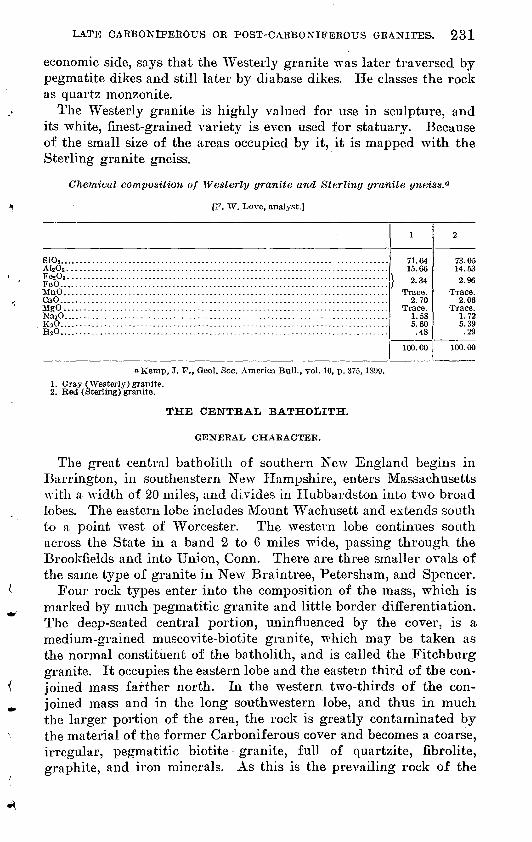
LATE CABBON1FEBOUS OR POST-CARBONIFEROUS GRANITES. 231
economic side, says that the Westerly granite was later traversed by pegmatite dikes and still later by diabase dikes. He classes the rock as quartz monzonite.
The Westerly granite is highly valued for use in sculpture, and its white, finest-grained variety is even used for statuary. Because of the small size of the areas occupied by it, it is mapped with the Sterling granite gneiss.
Chemical composition of Westerly granite and Sterling granite gneiss.0
[F. W. Love, analyst.]
SiOg.. ...............................................................................AltO3 ........... ....................................................................
FeO. ................................................................................MnO. ...............................................................................CaO. ................................................................................MgO.. ..............................................................................NasO.. ..............................................................................KgO. ................................................................................HjO.. ...............................................................................
1
71.6415.66
} 2.34
1.535.60.48
100.00
2
73.05
2.96
2.06
1.725.39.29
100.00
oKemp, J. F., Geol. Soc. America Bull., vol. 10, p. 375, 1899.
1. Gray (Westerly) granite.2. Red (Sterling) granite.
THE CENTRAL BATHOLITH.
GENERAL. CHARACTER.
The great central batholith of southern New England begins in Barrington, in southeastern New Hampshire, enters Massachusetts with a width of 20 miles, and divides in Hubbardston into two broad lobes. The eastern lobe includes Mount Wachusett and extends south to a point west of Worcester. The western lobe continues south across the State in a band 2 to 6 miles wide, passing through the Brookfields and into Union, Conn. There are three smaller ovals of the same type of granite in New Braintree, Petersham, and Spencer.
Four rock types enter into the composition of the mass, which is marked by much pegmatitic granite and little border differentiation. The deep-seated central portion, uninfluenced by the cover, is a medium-grained muscovite-biotite granite, which may be taken as the normal constituent of the batholith, and is called the Fitchburg granite. It occupies the eastern lobe and the eastern third of the con joined mass farther north. In the western two-thirds of the con joined mass and in the long southwestern lobe, and thus in much the larger portion of the area, the rock is greatly contaminated by the material of the former Carboniferous cover and becomes a coarse, irregular, pegmatitic biotite - granite, full of quartzite, fibrolite, graphite, and iron minerals. As this is the prevailing rock of the

232 GEOLOGY OF MASSACHUSETTS AND RHODE ISLAND.
great western lobe, and requires separate treatment, it may be called the Hubbardston granite. The third type is a black biotite border granite, which is called the Hardwick granite, as it appears inde pendently in the Hardwick batholith on the west. A little horn blende schist of the type of the contact diorites of the other bands is present and is associated with a peculiar gabbro.
FITCHBURG GRANITE.
Only in the eastern lobe and its continuation north about 6 miles wide across Fitchburg, Mass., and Mason, N. H., is the section of the batholith deep enough to expose the core of granite unadulterated by the material of the earlier cover. It appears also in a narrow band a mile wide and 11 miles long in the south-central part of the Hubbardston lobe in Brookfield and Sturbridge. This band is occupied by a series of great ponds from Furnace Pond to Cedar Pond.
In the interior of the northern area the rock is a medium-grained biotite granite in some places rudely banded by arrangement of the biotite.
The typical rock of the core in the large quarries on Rollstone Hill in Fitchburg, Mass., and in Mason, N. H., is a fresh light-colored medium-grained muscovite-biotite-microcline granite. It is massive and uncrushed. It contains large primary plates of muscovite, many of them intergrown with a later biotite.
The microscope shows much microcline with some grains, partly untwinned, a little orthoclase, and albite. It also shows the perfect coarse lattice structure and the intergrown albite, which is in per fect minute lenses. Besides this oriented albite large rounded un- twinned blebs of albite penetrate and border the microcline and are filled with beautiful vermiform quartz in micrographic growth. Long rutile needles fill quartz, microcline, and albite.
In Fitchburg the granite mass is along its eastern border a medium to fine grained rock. It is in places so fine grained and aplitic that it is easily confused with the most crystalline facies of the quartzite. Just at the border, especially in Fitchburg, a peculiar dark subpor- phyritic type is developed; small elongate feldspars are crowded to gether so closely as to make more than half the surface. The bor der, both inside the granite and outside, is cut by many large dikes and irregular masses of coarse pegmatite, which everywhere contains much coarse black tourmaline that is in many places carried out into the schist, forming a band of black tourmaline schist around much of the eastern border. The granite of Rollstone Hill is parted in thick sheets by fissures parallel to the present surface of the hill, which, according to Shaler, are due to the expansion and contrac tion caused by changes of temperature. It is possible that these are

LATE CARBONIFEROUS OR POST-CARBONIFEROUS GRANITES. 233
old structure joints, parallel to the surface of the batholith. The surface of Rollstone Hill is now drumlinoid.
A dark grancdiorite appears in places around the Fitchburg gran- its but is so irregular in its distribution and petrographic character that it was not mapped separately.
Along the east border of the Fitchburg granite in its north part this granodiorite forms a very narrow band of a dark, highly biotitic rock. It appears in a wide area from Monoosnuc Pond in Fitch burg to a point near Oakdale and is worked in a fine quarry on Sheldon Hill in Leominster. It widens to the south and in Holden is much rusted and jointed and some of it brecciated at the border. North ward along the western border it widens to a mile across Rutland and Princeton, where along the road from the village to the station it would furnish much good but dark quarry stone. It extends up the slopes of Wachusett and Little Wachusett mountains as a sheet 600 feet thick on the normal Fitchburg granite.
The granodiorite is a medium-grained, dark-gray rock, dark from the abundance of biotite, and also contains brown garnet grains'and a few tourmaline blades. It is slightly blotched =with lighter gray and imperfectly porphyritic material. The biotite is shining black and the fresh sugary quartz-feldspar mosaic is glassy. This charac teristic continues up to the contact with the Brimfield schist without change, and here the rock contains pyrite, graphite, garnet, films of fine-matted white silky secondary fibrolite, which is commonly changed into fibers of muscovite. The biotite is generally free from inclusions, but some plates are full of apatite and zircon with dark borders. There is very little ore and muscovite. The ground is granular sodic plagioclase and quartz. The whole mass is crowded full of distinct hexagonal prisms of apatite and more minute color less needles that may be fibrolite.
II CBBARDSTOX GRANITE.
Except the small areas described above, where the rock of the core is exposed, the prevalent rock in the main mass of the central batho lith and of the four subordinate ovals is a coarse white ragged, highly feldspathic granite of pegmatitic texture, though never dis tinctly porphyritic or fine grained, called the Hubbardston granite, from its occurrence at Hubbardston, Mass. The mica is in part muscovite but chiefly biotite. In maivy places great Carlsbad twins of microcline several inches across make up much of the rock, as at the cordierite locality in Brimfield.
Locally the rock becomes a white sugary granulite, full of red gar nets, graphite, and great sheets of silky white fibrolite, much of it changed to muscovite as in Southbridge. Microscopically it is com-

234 GEOLOGY Otf MASSACHUSETTS AND RHODE ISLAND.
posed of a simple coarse-meshed microcline, bordered by albite, with fine graphic structure and with strained and granulated quartz and wrinkled mica. There is in many places a rude banding or sheeting parallel to the surface of the old batholith, commonly a thin parallel jointing or rude cleavage which is not accompanied by any parallel arrangement of the constituents. There appears in other places a distinct gneissoid banding, which forms, where the fibrolite is abun dant, a thin white flaky gneiss, or, where much schist has been assimi lated into the mass, furnishes iron for the development of biotite. This phase is a dark fine-grained biotite granite or gneiss, much like the Hardwick granite, and that some of these dark gneisses have thus originated is indicated by the presence of graphite and in a few places of fibrolite in them, as in the area south of the Barre Poor Farm. Wherever the Hubbardston type of granite appears, the present surface is the nearly horizontal section of an immense flat- topped batholith, cut for the most part just through the contact shell of most intricate commingling of the schists and the granite. The boundary of the batholith is imperfectly drawn. Beyond the boundary the coyer retains its original position and continuity, although still greatly injected by granite, but within the boundary the remnants of the cover are twisted into irregular positions, and disappear in the much greater mass of the eruptive rock. In some places broad patches of the schists rest on the surface of the granite, their layers separating and extending into it like the teeth of a comb. In some places thin layers of the schist are themselves impregnated with granite, spread apart by it, and raveled out until they entirely disappear in the granite mass, as in a water-soaked book that has been frozen.the ice separates the leaves as well as occupies the pores in the paper sheets themselves.
The flat thin flags of the fissile Paxton quartz schist, consisting only of quartz grains with disseminated biotite scales, persist with little change. Thin contorted layers of the schist from an inch to a foot thick are wholly isolated in the granite, and in places several such bands, separated several feet from each other, retain a common dip and strike. When the last filaments of the schist disappear in the granite they make little change in its chemical constitution.
With the Brimfield schist the contact is very different. Over the areas formerly covered by this schist many contorted sheets and thin filaments appear. The abundance of iron, biotite, garnet, fibrolite, and graphite in these schists all enable their influence upon the gran ite to be traced long after their schistosity has wholly disappeared in the massive and highly feldspathic rock. The granite in its purest form is white and almost wholly free from iron; where its ledges rust superficially it is because much of the schist has been incor-

LATE CABBONIFEEOUS OR POST-CARBONIFEEOUS GEANITES. 235
porated into its mass, and the pyrite of the schist is still easily oxidizable in the granite.
The biotite and the garnet of this schist are commonly traceable in thin films, and that they are not recrystallized in the granite magma is manifest, because they are associated together and with fibrolite and graphite, after the manner of the schist, and can be traced into thicker bands which are clearly the schist included in the granite. At other places they are abundantly recrystallized, which is proved by the different type of the secondary products. The biotite be comes jet-black instead of brown and is commonly inclosed in the large feldspars in smaller separate and rounded scales.
The secondary fibrolite is of a very different tj7pe from that com mon in the schists, which is in distinct topaz-yellow transparent prisms with distant cross fractures. In the granite it is a snow- white, silky, finely fibrous and felted compact mass, a " fazerldesel" of the variety often called bucholzite, commonly occurring in broad sheets of entirely pure material an inch thick and in many places forming with feldspar, quartz, and a few garnets a complete fibrolite gneiss. In smaller quantity it is very abundant clear across the State in the broad band of granite, and for miles across Hubbardston or Brimfield fibrolite appears in every outcrop of the granite, though every other trace of the former presence of the schist has disappeared except the graphite. The graphite, which occurs in lustrous plates with delicate cleavage lines crossing their surf aces, is the most charac teristic and persistent constituent of the original schist and from the indestructibility of these plates during the process of the assimilation of the schists into the granites, and as graphite could not be a normal constituent of granite over large areas it furnishes the best proof of the process of the mingling of the schist and the granite here de scribed, though this proof is essentially cumulative. As the Brim- field schist contains graphite, amber fibrolite, brown biotite, garnet, and an excess of iron, so the presence of garnet, white silky fibrolite, and graphite and an increase of the iron are taken as an indication in the highly feldspathic coarse-grained granite that much of the schist has been assimilated into a coarse pegmatite to produce the mixture.
If the areas of the granite in which appear the peculiarities of the Brimfield schist above noted rustiness, content of graphite, fibro lite, and biotite and the areas containing fragments of the Paxton quartz schist are separately indicated on the map, it is seen that the boundaries between the Brimfield and the Paxton on the east of the granite area are continuous across the granite and join the corre sponding boundaries on the other side, so that all the granite areas could be mapped as schist areas also and assigned to the different schists which I have no doubt formerly mantled them.

236 GEOLOGY OF MASSACHUSETTS AND UHODE ISLAND.
A dark border is for the most part absent about the Hubbardston granite but appears in some quantity along the western edge, in the towns of Holland and Sturbridge.
DIKES.
A coarse biotite granite dike, 85 feet thick and a mile long, cuts the fibrolite schist a mile south of New Braintree and is itself cut by coarse wehrlite with very intricate boundary, which is marked by a biotite selvage perpendicular to the boundary. The granite is full of crystals of apatite one-half inch long and one-tenth to one-fourth, inch broad, which penetrate all the other constituents. The deep- brown plates of biotite are 2 inches square. The moonstone-like limpid feldspar masses are 3 inches square. The feldspar is an anorthoclase-microcline microperthite and shows the perthitic struc ture on the basal cleavage.
HYPOTHESIS CONCERNING CONDITIONS OF SOLIDIFICATION.
The conditions of solidification in the different parts of the central batholith seem to me to have been very different. °
A ver}^ broad area of fine-grained aplitic granite borders the Fitchburg granite along its eastern contact, and this rock is dark and highly biotitic in a narrow band just at the outer edge. The rock here cooled quickly and equably, allowing only an incipient magmatic differentiation, which brought a small share of the iron toward the surface, causing the darker color of the border.
The very narrow dark border becomes broader and darker toward the south around the east lobe, suggesting a longer time for differ entiation in that direction. It is continuous against nonferruginous and ferruginous rocks, making differentiation rather than absorp tion of the cover the probable explanation, and this conclusion is strengthened by the general absence of graphite in this dark granite. Where the dark border widens in the southeast lobe many masses of the rusty schist float on it, and in places it includes much graphite, so that the coworking of the two agencies is not excluded.
Later, during and after the solidification of the Fitchburg granite, deep-seated waters seem to have risen through the mass, producing by igneo-aqueous action great dikes and masses of pegmatite whose walls blend in many places with the common granite, showing al most simultaneous crystallization, or else the walls are sharp, or penetrate the schist, showing later solidification. The presence of the water is indicated by the development of muscovite, at the ex pense of the feldspar in the pegmatite; that it was deep-seated water is shown by the formation of beryl, tourmaline, spodumene, and minerals of the rare earths.

LATE CARBONIFEROUS OR POST-CARBONIFEROUS GRANITES. 237
As in the Williamsburg granodiorite (see p. 254) fissures have been occupied by boric acid solutions, or by superheated steam containing boric acid in some form, which have changed the surface of the biotite granite for a depth of about 2 millimeters into luxu- lianite, a muscovite granite coated with exquisite tourmaline dendrites.1
On Rollstone Hill pegmatite veins in granite in places contain curious crystals of black tourmaline with the central two-thirds oc cupied by opaque white feldspar, which is cut transversely and longi tudinally by thin bands of the tourmaline.
The coarse feldspars of this pegmatite are 3 inches square and many of them contain red garnets, coarse allanite changed to gum- mite, and rather large prisms of ber}7!, which are commonly cracked and faulted and cemented by quartz. On Rollstone Hill in Fitch- burg and in Royalston they furnish fine aquamarines for cutting.
The spockunene granite in- Sterling, Mass., is a coarse white por- phyritic muscovite pegmatite in which the spodumene is thickly disseminated in a porphyritic fashion with a certain parallelism of its separate stout prisms. It is found only in bowlders. Farther south, a mile and a half east of Chaffinville in Holden, the spodiunene occurs in place in a coarse pegmatite.
The development of biotite instead of hornblende in the border may be due to an exceptional influence of water, for water goes into the composition of biotite, and this same influence may have been even more effective, and that without the intervention of differentia tion, in the development of the coarse pegmatitic Hubbardston type, which replaces over the larger western part of the area the Hard- wick type, and which, if it occurred in veins or lenses we should call pegmatite, but which here makes the superficial portion of the batho- lith over an area of several square miles.
This Hubbardston type has everywhere absorbed so much of the cover that the water may have been superficial water derived from the sedimentary rock, and the general absence of tourmaline, beryl, fluorite, and minerals of the rare earths accords with this idea. Tour maline has been found in only a single place in this granite, and it is here included in fibrolite. Fluorite also has been found only once in all this broad area. The conditions were here unfavorable to the formation of the dark border, and it appears only in small quantity west of Holland village, and equally unfavorable for the appearance of true pegmatite.
The inclusion of so much of the moist sandy or argillaceous ma terial has given the whole mass a coarse, irregular, abruptly varying
1 Emerson, B. K., Geology of old Hampshire County, Mass.: U. S. Geol. Survey Mon. 29, pi. 7, 1S98.

238 GEOLOGY OF MASSACHUSETTS AND RHODE ISLAND.
texture, and the solution and recrystallization of this foreign ma terial has greatly changed its chemical and mineral composition. These abruptly changing conditions are evidenced also by the rude fluidal structures in the coarse granite, which is commonly parted in thick irregular masses. The quiet conditions needed for border differentiation and for accumulation of the deep-seated waters to produce pegmatites abounding in rare earths were thus absent.
HARDWICK: GRANITE AND ASSOCIATED BOCKS. 1
HARDWICK AND FITZWILLIAM GRANITES.
The very symmetric batholith composed chiefly of Hardwick granite begins with the1 usual blunt point in Marlboro, N. H., and extends southward with a uniform width of about 4 miles and a length of 50 miles, ending Avith a similar blunt point in Monson. Its banding dips outwardly with low angle Beneath the corrugated Brim- field schist, parallel wit1" the surface of the batholith. The rock is almost everywhere a black granite gneiss (the Hardwick granite, named for its occurrence at Hardwick, Mass.), but in several small .central areas what seems clearly to be a deep-seated core is exposed. Thus in Petersham sheets of a black fine and even grained rock pass with low inclinations east and west beneath the inclosing schists. .Next inwardly broad bands of a dark, small porphyritic rock pass outward beneath the fine-grained sheets, and in the central area this porphyritic rock is itself cut through in the deep valleys, exposing a very light-colored granite. Farther north a similar and larger oval of white granite appears in the black granite and the gneissic band ing of the black granite dips away from the central mass in a quasi- anticlinal posture as if it had formerly mantled over the. white rock, which thus forms the core of the batholith.
The southern point of this oval of light-gray muscovite-biotite granite (the Fitzwilliam granite) just enters the State from Fitz- william, N. H. It extends north across this town and Marlboro, N. H., and is extensively quarried for export. It is of even, fine grain, and of the same type as that quarried in Fitchburg (the Fitchburg granite). The Hardwick granite is commonly .porphyritic. It is low in quartz and rather feldspathic, containing generally orthoclase, a little plagioclase, much biotite, much magnetite, hypersthene, zircon, and allanite but no graphite or fibrolite. It is generally very coarse and curiously biotite-blotched that is, on cleavage faces, broad equi distant wavy-surfaced flakes of biotite, m,any of them more than half an inch square, or congeries of small flakes, cover the surface. The rock has almost invariably a dead black and not a brown-black color
l. Soc. America Bull., vol. 1, p. 559, 1890; U. S. Geol. Survey Mon. 29, pp. 231, 317, 1898.

LATE CARBONIFEROUS OB POST-CARBONIFEROUS GRANITES. 239
and does not rust like the adjacent schist. Except on contact with the Coys Hill granite, hornblende is generally absent and the dark color is due to abundance of biotite and magnetite. The abundance of iron in the border is attributed to differentiation, for if it was derived from absorption of the rusty schist graphite and fibrolite would be present.
The contact influence on the schist is small. In contacts south of Old Furnace and at W. Woodward's place in southwest Petersham the thick-banded black granite contains garnet and wisps of fibrolite just at the contact, and the fibrolite in the adjacent schist is unusually coarse and abundant and partly changed to muscovite.
MAFIC BORDER ROCKS OF THE IIARDWICK GRANITE.
The Hardwick granite is shown above to be a very broad mafic border to the Fitzwilliam granite in New Hampshire. The imme diate border of the Hardwick granite commonly contains hornblende. The border east of Parksville is a black heavy quartz diorite, which contains a few grains of a colorless coarse-cleaving pyroxene, which was an early growth in the rock and is inclosed with the half-resorbed plagioclase in brown hornblende. This forms a transition to several peculiar gabbroid types described below.
Biotite-hyperstJiene diorite. This rock is a black kersantite-like biotite-hypersthene diorite of fine grain, but the mica is commonly gathered in large patches. The feldspar ranges from albite to andesine. It occurs in the railroad cut at Gilbertville in the town of Harclwick.
Garnet-hypersthenediorite ornorite. A garnet-hypersthene diorite or norite occurs at a deep cut in the roadside north of Parksville village in Brimfield. It is a fresh, coarse gabbroid rock of dark greenish-brown color, m&de up mostly of shining feldspar surfaces and here and there a coarse deep-red garnet grain.
The greater portion of the mass is made up of andesine grains, commonly untwinned. It contains distant aggregates of garnet, biotite, and hypersthene. The hypersthene was later changed at the border to a hornblende with blue absorption. It forms a large body near the border of the Hardwick granite, but its contacts are covered.
PEGMATITE.
In the railroad cut at Gilbertville there is a dike 10 feet wide of coarse granite, composed chiefly of feldspar in great prisms a foot square with very coarse pegmatitic structure, showing rods of quartz an inch wide and an inch apart and sheets of biotite a foot square. The very fresh feldspar is pure orthoclase. The rock is intruded in the black Hardwick granite.

240 GEOLOGY OP MASSACHUSETTS AND EHODE ISLAND.
WESTERN POBPHYRITIC BAND.
COYS HILL, GRANITE.
The Coys Hill granite 1 is a remarkable narrow dikelike mass which starts near East Phillipston and runs south for 26 miles with an average width of a third of a mile. For a long distance it lies in the fibrolite schist and then opposite Ware it widens greatly, crosses an area of the Hardwick granite obliquely, and continues south in the fibrolite schist to a point east of Monson. It composes the mass of Coys Hill and forms a series of picturesque peaks rising above the average plateau level.
It is a regularly sheeted, very coarse porphyritic microcline granite gneiss, in which the flat Carlsbad twins are generally 2 to 4 inches square and three-fourths of an inch thick, and many of them are so closely set that there is little space for the coarse dark biotite- garnet groundmass, which winds in and out among them. These crystals have generally a granulated border from incipient crush ing, which increases in thickness at the expense of the central crystal and is drawn out in the planes of the banding so that they form eye- like spots, and finally complete crushing produces a medium-grained granite.
Under the microscope the feldspar is seen to be composed of microcline and anorthoclase intergrown, rarely showing very fine grained microperthitic albite. A fine micrographic texture occurs in the crushed borders.
Where the Coys Hill granite borders the Hardwick granite it is a clear-gray granite, but where it rests against the rusty garnet- fibrolite-graphite Brimfield schist it has incorporated and dissolved into its mass much of the schist, and thus the small red garnets or large secondary garnet and biotite become abundant, graphite scales appear here and there in the feldspar, and the amber fibrolite appears or is recrystallized in silky white masses. The granite rests in the schist like a great sill with a low westerly dip, and so its effect on the east side is small.
On the west or upper side the rusty Brimfield schist was invaded by the alkaline solutions rising from the Coys Hill granite in a zone nearly a mile wide and became locally a coarse fibrolitic augen gneiss crowded with rounded grains of limpid moonstone, many of them an inch in diameter, which simulate pebbles.
South of the station in Ware the Brimfield schist is impregnated with bands and lenses of coarse feldspar in large Carlsbad twins, partly limpid, partly crushed at the border, and partly drawn out into trains so that it much resembles the Coys Hill granite itself. The thin remnant bands of wavy schistose material are full of brown biotite, large pink garnets, and fibrolite, and cordierite appears as
1 U. S. Geol. Survey Mon, 29, p. 319, 1898.

LATE CARBONIFEROUS OR POST-CARBONIFEROUS GRANITES. 241
blue grains along the contact and within the granitoid bands. The presence of the last two unstable minerals is almost the only dis tinguishing character to make it different from the porphyritic gneiss of the Coys Hill granite, in its most garnetiferous phases. It is as if the coarse porphyritic, coarsely garnetiferous granite were only the last term of a series, where the abundant granite magma dissolving its way into the rusty graphitic schists has finally ab sorbed and assimilated a great body of the schist, thus eliminating the unstable and temporary constituents, cordierite, fibrolite, and the carbonaceous matter, and finding an equilibrium in the mixture of quartz, orthoclase. biotite, and garnet.
LIGHT-GRAY BIOTITE GRANITES WITH MARKED DIFFERENTIA TION BANDS.
MONSON GRANODIORITE.
A band of this rock begins in Northfield, crosses New Salem and Petersham, and extends south across the State at first 8 miles: in width, but in Monson it shrinks to 2 miles. Most of the way it is divided into three strips by two elevated ridges of schist. A broad oval of this type forms the mass of Tully Mountain, north of Athol.
A similar band appears on the west of Wilbraham and both con tinue far south in Connecticut. In appearance the rock is a clear gray granite or granite gneiss of rather fine grain, generally purely biotitic but some of it slightly hornblendic or muscovitic.
Although the rock may be wholly massive and granitoid over large areas, it is generally foliated by the concentration of the biotite in darker bands, many of them rather broad, and tapering or set so as to simulate cross-bedding, faulting, corrugations, or in different com plex patterns. The lighter bands are commonly a little coarser. This structure can not be due to mashing under great pressure and solid flowage, for the constituents are unstrained and the plagioclase generally untwinned. It may be ascribed to a combination of local differentiation and flow in the highly viscid material just before solidification. As in the butternut granite of Craftsbury, Vt., which is a similar type, rounded secretions 1 to 3 inches long of highly biotitic material, have formed in many places in the gneiss, as at the Monson quarry and elsewhere, so similar and so closely spaced that the resemblance to an altered conglomerate is very close.1
In many places these secretions are all symmetrically lenticular or grade into dark blotches of biotite and epidote. In the same way the granite in many places shows small pebble-like lenses of granular quartz and feldspar, and these become more flattened and at last grade into flat white oval areas larger than the hand, which are
1 This was figured as a conglomerate when it was believed that the Becket ^granite gneiss and the Monson granodiorite were altered conglomerates (U. S. Geol. Survey Mx>n. 29, p. 64, pi. 1, 1898).
50244° Bull. 597 17 16
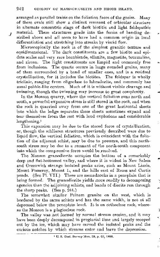
242 GEOLOGY OP MASSACHUSETTS AND EHODE ISLAND.
arranged as parallel trains on the foliation faces of the gneiss. Many of these ovals still show a distinct remnant of orbicular structure in alternate concentric rings of dark biotitic and light feldspathic
material. These structures grade into the forms of banding de scribed above and all seem to have had a common origin in local differentiation and stretching into streaks by viscid flow.
Microscopically the rock is of the simplest granitic texture and equidimensional. The dark constituents are a few biotite and epi- dote scales and very rare hornblende, allanite, magnetite, tourmaline, and zircon. The light constituents are limpid and commonly free from inclusions. The quartz occurs in lacge rounded grains, many of them surrounded by a band of smaller ones, and is a residual crystallization, for it includes the biotites. The feldspar is wholly triclinic, ranging from oligoclase to labradorite, and commonly has zonal pebble-like centers. Much of it is without visible cleavage and twinning, though the twinning may increase to great complexity.
In the Monson quarry, where the vertical foliation runs north and south, a powerful expansive stress is still stored in the rock, and when the rock is quarried away from one of the great horizontal sheets into which the ledge separates these sheets sometimes expand and tear themselves from the rest with loud explosions and considerable lengthening.1
This expansion may be due to the stored force of crystallization, or, though the schlieren structures previously described were due to liquid flow, the vertical foliation, which is coincident with the folia tion of the adjacent schist, may be due to pressure, and this north- south stress may be due to a remnant of the north-south component into which the compressive force would be.resolved.
The Monson granodiorite occupies the bottom of a remarkably deep and flat-bottomed valley, and where it is widest in New Salem and Greenwich strange isolated peaks arise, such as Mount Lizzie, Mount Pomeroy, Mount L, and the hills east of Reuss and Curtis ponds. (See PI. VII.) These are monadnocks in a peneplain that is being formed. The granodiorite yields more readily to decomposing agencies than the adjoining schists, and bands of diorite run through the sharp peaks. (See p. 244.)
The somewhat similar Pelham granite on the west, which is bordered by the same schists and has the same width, is not at all depressed below the peneplain level. It is an orthoclase rock, where as the Monson is a plagioclase rock.
The valley was not formed by normal stream erosion, and it may have been deeply decomposed in preglacial time and largely scooped out by the ice, which ma}7 have carved the isolated peaks and the curious notches by vrhich streams enter and leave the depression.
] U. S. Geol. Survey Mon. 29, p. 63, 1898.

U. S. GEOLOGICAL SURVEY BULLETIN 597 PLATE vii
VIEW OF MOUNT LIZZIE, GREENWICH, MASS.
Mount Porneroy and Mount L in the distance.

LATE CARBONIFEROUS OR POST-CARBONIFEROUS ' GRANITES. 243
Along the eastern border of the Monson band in Athol and Peter sham the rock becomes more potassic and a band a, mile wide is porphyritic, containing Carlsbad twins an inch long; here the rock rises in high ground. In the east part of the Monson quarry are local dikelike bands of a very coarse, very fresh biotite granite, which, however, blend with the normal gneiss. The rock contains great sheets of jet-black biotite, of muscovite containing flattened" den dritic films of magnetite like that from Pennsbury, Pa., and masses of translucent microcline as large as a fist.
In the Wilbraham area much of the rock is a good quarry stone, identical with the Monson type. It is a little more hornblendic and magnetitic along the western and northern sides and much crushed with development of muscovite. In the middle and eastern portion it is a much coarser biotite-epidote gneiss, without fissility but com monly foliated by the parallel arrangement of half-inch blotches of black biotite and epidote. In places abundant small thick lenses of granular quartz give the weathered rock the aspect of a conglom erate, but they pass into beaded quartz veins. Toward the south the biotite-epidote mixture increases and the rock is too coarse to quarry.
All sections show the feldspar to be wholly triclinic, with extinc tion 15° to 25°. Epidote grains are common and some of the epidote is intergrown with allanite.
The crushed fine granite at the west foot of Wilbraham Mountain at its south end. and the contact diorite with the structure of true ribbon gneiss or diorite aplite, 100 rods east of Scantic, shows that the west boundary of the Amherst schist is reached in that direc tion and that an area of Monson granodiorite probably extends west beneath the red sandstone.
Chemical composition of Monson granodiorite and associated rock*.
Alj03. ....................................................................
FeO ......................................................................MgO.... .,.........-.-............-.-.----........-..-..-.-.--.........-.PaO
K2O............ -...-..............-.........-....--.-.----..--.. -.-.-....H2O+............ ........................................................H8O ............-..........-....-.-..............-....-.-.........:.....TiOj.. ....................................................................r*c\PjO5 . . ..........-...-........-.-..-------.....-.-.-...-------..---.....-..
MnO .....................................................................BaO.... ........................ ....-.-...--.-.--.-...---......-..........SrO .................-.-.-......-.......--.-.-....-..--.---.........-.....
CuO.. ....................................................................
1
65.0218.371.212.061.496.203.%
64.09.42.33
.14
.09
100.02
2
73.4715.071.15
.124.485.59.38
100. 26
3
69.3518.832 00
\ 3.78
9D.90
1. Gneissoid Monson granodiorite (amadorose), Monson. Flynt's quarry, north wall, best dark quarry stone from block selected by Mr. Flynt. Analyst, W. F. Flillebrand.
2. 3. Analyses made by F. M. Ordway, of the Massachusetts Institute of Technology. No. 2 is described as light colored and was probably from one of the pegmatite dikes. No. 3 is described as dark and was plainly of the same type as No. 1.

244 GEOLOGY OF MASSACHUSETTS AND BHODE ISLAND.
NEW SALEM APLITE.
A broad microgranitic border zone connecting the Dana diorite with the central granodiorite (p. 241) can be followed around the mass of Monson granodiorite in Wilbraham. The same is true around the Monson band, although in that locality it general!}7 contains fine biotite scales and garnets or is blended with the band of diorite in many narrow alternations, forming a " ribbon gneiss," so that they
vare described together below. The broad lobe of the gneiss, which extends up f rom Enfield through Prescott and New Salem, is all very fine grained and aplitic, though it is uniformly bibtitic and is made up of quartz, orthoclase, and sodic plagioclase. It has in places a tourmaline-bearing border. Around the more siliceous Pelham band the hornblendic border is narrow or absent, and the aplitic band as a rule is absent.
The aplite in Dana east of the center of the mass has no mica, titanite, or garnet, and little magnetite, zircon, or apatite. It is a fresh sugary granular mixture of quartz and sodic plagioclase.
DANA DIORITE.
A broad band of a black hornblende-plagioclase rock, generally foliated and then commonly called hornblende schist, forms a selvage to the Monson granodiorite and follows all the sinuosity of its boundary. It also borders all the large areas of the schistose rocks resting in this gneiss. A second band of a white, very fine grained granite or aplite commonly occurs next inward, separating this mafic zone from the normal coarser gray granite gneiss of the central area. It is assumed that the dark minerals have been concentrated in this dark border zone and that the inner aplitic band represents the depleted zone from which these minerals have migrated. The granites having this dark border are those rich in calcium and sodium and lie on the border between granite and quartz diorite.
The rock is" made up of grains or stout blades of black hornblende, which is green with blue pleochroism on c, or more rarety brown by transmitted light, and of a triclinic feldspar in white grains. Biotite, magnetite, titanite, apatite, epidote, and pyroxene occur in quantities that differ from place to place. Zonal growth in the feldspar and resorption are common. In places a pebble-like half-resorbed grain of very calcic plagioclase is inclosed in later zonal material that be comes more sodic cmtward, and in different sections nearly the whole range of the triclinic feldspars can be found. Some orthoclase or quartz is common as the beds grade inward into the granite. There is no crushing or later alteration. A fine section is exposed in the railroad cut at Red Bridge, west of Three Rivers,

IULLETIN 597 PLATE VIII
A. SPECIMEN OF DANA DIORITE CUT BY APLITE DIKES, FROM A POINT 2y2 MILES NORTHEAST
OF BELCHERTOWN, MASS. TWO-THIRDS NATURAL SIZE.
J3. PHOTOMICROGRAPH OF SPECIMEN OF HARVARD CONGLOMERATE FROM BARE HILL,HARVARD, MASS.

U. 8. GEOLOGICAL SURVEY BULLETIN 597 PLATE IX
A. DANA DIORITE AT SHBLBURNE FALLS, MASS., SHOWING BANDED CONTACT DIORITE OR
"RIBBON GNEISS."
'''.-..- ' ". ' '' . ' ' - The length of the mass shown is 7 feet.
B. SPECIMEN OF DANA DIORITE ("RIBBON GNEISS"') FROM A ,-^n,i 1 MILE SOUTHEAST OF GIBBS CROSSING, WARE, MASS.
Alternate layers of black diorite and white aplite solidified successively parallel to the wall against which the granite rested. The rock has been contorted by flow and injected by pegmatite while still plastic. One-.fourth natural size. . . , .. ......

CARBONIFEROUS OR POST-CARBONIFEROUS GRANITES. 245
This dark border appears in several varieties which throw light on its mode of formation. It may be massive, (1) a true diorite; or(2) foliated parallel to its surface of contact, as if .the crystal grains were brought into the parallel position by slight flow or pressure; or(3) dikelike masses, which may be interpreted as offshoots of the sel vage, appear in the adjacent schists as if a portion of the mafic magma had been injected into the schists. At some places this ap pears to be a soaking of the adjacent schist with dark minerals rather than a distinct injection. Again (4) the dark layer seems in places to have been removed by flow, and the siliceous aplitic band comes in contact with the schist border, as in the hills south of Palmer. (5) The black diorite, 2-£ miles northeast of Belchertown village, is cut by a dike an inch thick, composed of gray hornblende granite that con tains about half as much hornblende as the diorite. (See PL VIII, A.} This dike is cut by later dikes of aplite that contain much less hornblende in several generations, each with less hornblende than its predecessor, and the last dike is almost white, like the type of the white aplite of the Monson granodiorite adjacent to the diorite. This relation indicates the formation within the granite of less and less mafic contact layers after the segregation and solidification of the thick black diorite. A part of each of these layers was injected suc cessively into the black diorite, and the rest removed by the motion of the still liquid mass, so that white aplite now rests against the black diorite and the gray intermediate varieties are absent as con tact border layers. (6) The "ribbon gneiss" (see PL IX, B) is made up of thin alternating la}7ers of the black diorite and a white aplite, commonly about an inch in thickness, making up a band several hundred feet thick, which extends along the border for miles. It is well developed across Ware and Dana, indeed clear across the State and in the distant Shelburne Falls batholith (PL IX, A). It seems to have been formed much after the manner of orbicular granite. The dark mafic layer attains a definite thickness against the contain ing schist, and consolidation extends beyond this mafic layer into the adjacent white felsic layer, forming a new surface against which the mafic material again concentrates and solidifies as before, and condi tions were so nicely balanced that this alternation continued for a long time. Elsewhere the bands are finely stretched (fig. 1, p. 246), the more brittle hornbleiidic bands having cracked and separated, or the bands are most complexly corrugated by some fluidal motion of the adjacent mass or later compression, as north of Pattapaug Pond in Dana and northwest of Dana village (PL IX, A). (7) Again, large sheets of the same diorite occur deep in the central granite, some of them a mile from the present border and in long ranges rudely parallel to this border. They may be portions of the former contact, zone dis-

246 GEOLOGY OP MASSACHUSETTS AND RHODE ISLAND.
lodged from their place of formation in the roof of the batholith and sunk in the mass. They are of the same type as the nearest adjacent portion of the border zone. They rest in the coarse granite without the adjacent aplite zone generally present in their normal position and so are not " pendants " from the former cover. They have pro duced no effect upon the adjacent granite and do not show any such border f acies as would be expected in dikes so large.
Moreover, pegmatite appears in some places irregularly and in considerable quantity beneath the bands of the hornblende rocks that have sunk into the middle of the granite and forms curious selvages to them, as if the large inclosures of the hornblende rock had intercepted some of the rising water.1
FIGURE 1. Ribbon gneiss from roadside at south base of Mount Fomeroy, Greenwich, Mass. The specimen, which comes from a mass of the ribbon gneiss that lies in the midst of the granite, shows stretching by tension during flow, which caused disruption of the dark diorite layers.
The border rock and an adjacent dike in the schists from the high ground northwest of the Duncan place, 1£ miles northeast of Palmer Center, were especially studied and the parts separated by the magnet and heavy solutions were anatyzed separately by W. F. Hillebrand. The border rock was a dark medium hornblende gneiss at the sharp contact, becoming a corrugated ribbon gneiss inward and appearing in many large lenses in the granite. The whole band is 12 rods wide. It contained brown hornblende, red biotite bordered by green, much granular plagioclase (extinction 3J° on &{010}), and much black titaniferous ore. The border dike was a similar dark massive granu lar rock of loose open texture and fine grain, white-spotted with the feldspar grains.
1 For illustrations see U. S. Geol. Survey Bull. 159, p. 75, 1899.

LATE CARBONIFEROUS OR POST-CARBONIFEROUS GRANITES. 247
Chemical composition of Dana, diorite, adjoining diorite dikes, and their con stituents.
[Analyst, W. F. Hillebrand.]
-
S102 .. ...............................TiOj.. ...............................A1»OS . ........... ............. .....v,o... ...............................Cr,03 . ...............................FejO8 ................................FeO... ..............................NiO....... .MnO................. . .CaO..... .............................BaO. ................................MgO. ....... .........................KjO.. ...............................NasO ................................H2 O (below 105° C.). ................H2 O (above 105° C.) ...............PS05 . ................................s. ............................COt.......... ........................
1
2.0314.23
.04
3.958.00
.27
6.149 =
3.C6.14
1.33.21.02
TrucG
100.14
2
51.251.84
16.53
Trace.1.817.67
Trace..28
9.32
5.87.78
3.35.19
1.26.31
100. 46
la
43.111.32
11.10.07
Trace.4.97
13.04Trace.
.4311.78
9.351.271.18.16
1.92.10
99.78
2a
44.091.73
10.68
Trace.2.72
12.98Trace.
.3211.58
10.75.88.19.21
1.91.10
99.12
Ib
62.91Trace.
23.37
Trace.
5.83
.207.78
\ 42/ ' 42
100. 51
2b
60.90Trace.
24.97
Trace.
7.85
.166.26.48
100.62
1C
61.03
24.22
6.04
.218.06
100.00
2c
57.78
26.49
8.37
.176.68
.51
100.00
1. Dikelike mass of Dana diorite in Brimflelcl schist, 15 rods from border. One and one-fourth miles northeast of Palmer Center.
2. Dana diorite, contact facies (auvergnose), same locality. Taken from the vicinity of the Monson granodiorite.
la. Hornblende from 1. Specific gravity at 31.5° C., 3.220. 2a. Hornblende from 2. Specific gravity at 29° C., 3.217. Ib. Andesine from 1. Specific gravity at 24° C., 2.667. 2b. Andesine from 2. Specific gravity at 22° C., 2.667. le. Recalculation of Ib to 100. 2c. Recalculation of 2b to 100.
The mineral constitution was approximately calculated from care ful measurement of the separated portions and from the partial analyses by Hillebrand.
Mineral constitution of Dana diorite.
\ IKttn
Apatite. . .............................. '. ............................................
2a
4.005.15
32.0547.095.495.72.50
100.00
2b
7.60
56.9227.634.512.62.72
100.00
QUARTZ MOXZOXITE.
An interesting club-shaped dike of exceedingly fine biotitic grani toid rock 20 rods thick at its thickest end cuts across the boundary of the Dana diorite and Brimfield schist east of the apex of Fallen Hill in Enfield. It contains microcline, oligoclase, quartz, biotite, and garnet. It is very micrographic.
An analysis by George Steiger of the rock from the northern nar rowed end of the dike gave the results expressed below. The rock is a lassenose-alsbachose.

248 GEOLOGY OF MASSACHUSETTS AND RHODE ISLAND.
Chemical composition of quartz monzonite from Enfield.
SiO2______________ ____ 73. 09 A1 2O3 _______-_________ 13. 42 Fe2O3__________________ 1. 04 FeO__________________ 1.13 MgO __________________ . 35 CaO__________________ 1. 89 Na:O __________________ 4. 52 K2O__________________ 1. 59
H2O _________________ 0. 47H2O-f _________________ 1. 41TiO2___________________ . 26P2O5____________"______ . 05MaO ___-_____________ . 10
99.32
SHELBUBNE FALLS BATHOLITH.
GENERAL CHARACTER.
A characteristic mass of the gray biotite gneiss of the Monson granodiorite type is exposed at the surface in a short eroded anti cline or quaquaversal in the Conway schist in Shelburne Falls. It is surrounded by a very broad band of the ribbon gneiss in many fine alternations of white aplite and black diorite of the type of the Dana diorite, now greatly contorted and faulted. The exposure is indeed the cross section of a giant spherulite. (See PL IX, B.)
PELHAM GRANITE AND ITS SILICEOUS BORDER.
The fine-grained gray Pelham granite, commonly gneissoid, begins in Northfield, attains in a short distance a width of 8 miles and con tinues southward across six townships, ending against the Belcher- town tonalite. The band of Monson granodiorite in Wilbraham south of this mass seems to be a continuation of the Pelham. The rock is so similar in appearance and in associations to the Pelham granite that it is surprising to find that the Pelham contains 10 per cent more silica and is a potash rock (orthoclase and microcline) instead of a soda-lime rock, like the Monson. Its foliation, unlike that of the other batholiths of the group, is not vertical but forms a .flat arch, which is centrally horizontal and dips east and west at low angles.
The rock splits with the foliation, generally in very broad slabs 6 or 8 inches thick, which have a strongly stretched appearance, as. the mica scales occur in long streaks and bands on these foliation faces or alternate with long oval blotches of whiter color made up of coarse feldspar and quartz. The structure seems to have been formed parallel to the old surface of the batholith by plastic flowage combined with orbicular growth during consolidation. It is locally spherulitic. It is not due to mashing, as is shown by the horizontal foliation and the unstrained condition of the constituents.
The rock is light gray and is made up mostly of a granular mixture of quartz and potash feldspar, both so glassy as to be hardly distin guishable, and shows micrographic texture. It is streaked with trains of shining black biotite scales, with epidote grains, and a few

LATE CARBONIFEROUS OR POST-CARBONIFEROUS GRANITES. 249
garnets. Most of the rock in the northern half of the mass is blotched by distant black spots of hornblende a quarter of an inch square, and contains abundant brown crystals of titanite over large areas.
Oriented sections cut from the very slightly foliated rock of Fraley's quarry in Erving showed no differences in character.
The aspect of the oriented slides from the highly foliated rock of Ward's quarry in Pelham was very different. The section in the plane of the principal rift the foliation plane showed the maximum number of microcline grains and broad fields of quartz and feldspar. Of the sections at right angles to the foliation plane the one paral lel to the dip, the " grain," showed all the constituents markedly elongate and fewer microcline grains with the twin banding only partly shown. The end section, cut normal to the dip, showed very little microcline twinning and a granular texture which had a much more clastic aspect than the sections cut in the other two planes.
This granite is crisp and friable and is thus easily worked. The portions which do not split into too thin slabs make a durable and valuable building stone."
The greater freshness and uncrushed condition of the gneiss as com pared to the much crushed and weathered state of the tonalite and the continuity of the mafic border around all the sinuosities of the granite contact makes it probable that the granite is the younger rock.
Chemical composition of Pelham granite.
SiOj... .............................................................................A1,0S ... ............................................................................Fe»0 3 .. .............................................................................FeO... .............................................................................MgO................................................................................CaO....... .........................................................................NasO..... ..........................................................................K,0... .............................................................................H20+.... ..........................................................................H2O- ..............................................................................TiOj... .............................................................................CO S . ...... ..........................................................................T> f~\
1
74.1513.351.26.53'.23
1.922.844.58
11.50.12
.06
99.67
2
72.45
1.93.63.44
1.813.553.86.59
1.51.27
.05
100.42
1. Pelham granite (tehamose-toscanose). Fraley's quarry, Erving, Mass. George Steiger, analyst.2. Pelham granite (toscanose). Ward's quarry, Pelham, Mass. George Steiger, analyst.
DIORITE SCHISTS OR AMPHIBOLJTES OX THE BORDER OF THE PELHAM
GRANITE.
The Monson granodiorite and the Pelham granite, although some what different chemically, are physically very similar and probably are portions of one large mass. It was therefore not thought need ful to differentiate on the map their mafic border. This mafic border is naturally less'prominent on the more siliceous rock and indeed decreases to the north and is at last replaced by thick bands of the highly siliceous rocks described below.

250 GEOLOGY OP MASSACHUSETTS AND RHODE ISLAND.
SILICIC DIFFERENTIATES OF THE PELHAM GRANITE.
NOBTHFIELDITE.1
The band of granite gneiss which runs through Wilbraham and is cut by the tonalite in Belchertown continues north through Pelham to Northfield. At its south end it is a very mafic rock like the Monson band next to the east, but as it crosses Pelham it is found by chemical and microscopic analyses to become gradually a very felsic rock. The Monson rock in the southern area contains 65.02 per cent of silica; the Pelham granite in Pelham contains 72.45 per cent of silica and in the northern area in Erving 74.15 per cent. The Monson extends in a broad, many-lobed mass across the State and has everywhere a broad diorite border zone against the adjacent schists. As a rule an equally broad band occurs inside this border, separating it from the normal granite. This band is whiter and com monly finer grained than the granite; indeed in many places it is de veloped as an aplite. I have followed the diorite band 136 miles around the Monson batholith in Massachusetts. The gneiss in Wil braham west of the Monson rock has the same diorite and aplite band, but where it reappears in Belchertown these bands become thinner, and in Pelham the diorite band disappears and the aplite is replaced by a band of contact quartz rock, which thickens and grows coarser to the north and becomes, in Crag Mountain, over 300 feet thick. Its coarser varieties resemble a vein quartz or greisen or pegmatite, without feldspar; its finer varieties resemble a quartzite like the Cambrian in the Berkshires. As a pegmatite or aplite dike may pass into a quartz vein, the mass of the batholith seems here to pass on a large scale upward into this quartzose variant.
Though the exterior resemblance is close, it is not wholly satis factory to apply the name greisen to this rock, for it does not seem to have been formed by later pneumatolytic changes whereby the feldspar of the granite has been removed but is rather an original persilicic contact differentiate and deposit of the magma.
As it is a member of the unaltered plutonic series and can not be called a vein quartz, a quartzite, or a greisen, it is named north- fieldite, from the mass in Northfield that forms Crag Mountain.
The other type of the northfieldite is the rock that forms the crest of Mount Orient in Pelham, where it is 120 feet thick. It contains more than 93 per cent of silica and has the aspect of a slightly actino- litic or biotitic quartzite or an extremely quartzose aplite.
When the gneiss was thought to be an altered Cambrian conglom erate the quartzose upper layer was thought to be the equivalent of the Cheshire. 2 The bedding of the gneiss is in a broad arch with low dip to east and west, and the northfieldite generally forms a super-
1 Emerson, B. K., Northfleldite, pegmatite, and pegmatite schist: Am. Jour. Sci., 4th ser., vol. 40, pp. 212-217, 1915.
3 U. S. Geol. Survey Mon, 29, p. 45, 1898.

LATE CARBONIFEROUS OR POST-CARBONIFEROUS GRANITES. 251
ficial layer on the gneiss. The transition of the one into the other is perfectly exposed. It is a fine-grained light-colored rock, in places quite biotitic, and garnet, zircon, rutile, and a little feldspar are found in it with the microscope.
The rock in this western area generally contains many minute needles of tremolite or actinolite, but these minerals may be assumed to be derived by absorption from a former cover, which included the thick Bernardston limestone, as they are absent in the eastern occurrences, and as calcite is also found in the neighboring granite in many places. (Seep. 48.) Indeed, 2 miles north of Mount Orient a small inclosure of coarse crystalline limestone was found in the northfieldite, and at the contact the northfieldite contains much more and coarser actinolite than a few inches away.
Chemical composition of northfieldite.
Al,03.. ..............................................Fe2O3 . ..............................................FeO. ................................................TiO2 . ...............................................CaO.................................................MgO... .............................................Na2O. . ..............................................K,0. ................................................P20S . ...............................................
1
93.383.09.72.12.34.43.50
1.32
99.90
2
93.202.86.79.12.68.27
(a)
97.92
3
83.04
1.34
.123.201.98
(a)
.04
96.64
4 '
80.636.22±. oy
.213.693.27
(a)
.02
95.63
5
93.48
a Not determined.1. Northfieldite, cardiffose, Mount Orient, Pelham. Average rock, trace of actinolite. E. T. Alien,
analyst.2. Northfieldite, 60 feet below summit on west slope of Mount Orient and so about 60 feet above trace
of biotite. E. T. Alien, analyst.3. Coarse actinolite-biotite northfieldite, hollow at east foot of Mount Orient, in the gneiss. E. T. Alien,
analyst.4. Highly actinolitic northfieldite, Mount Orient, south face, 2 to 3 feet above base. This specimen
contains minute flakes of graphite. It was carefully tested for molybdenum without success. E. T. Alien, analyst.
5. Northfieldite 2 inches from calcite, 1-J miles northeast by north of Mount Orient. J. C. Zinn, analyst.
In the region of transition from the mafic to the felsic border zones on the north line of Pelham and 2 miles north of the type locality on Mount Orient, both border types, the coarse and the fine, are present in their normal relations to the subjacent granite gneiss. The northfieldite occupies an area nearly a mile square in a white fine-grained sugary, commonly friable mass, containing a little biotite or actinolite. The bedding of the gneiss dips under it on either side with very low angles. Long bands of a black, rather coarse diorite, in some places banded, in others massive, rest on the north fieldite, which dips beneath them from either side. These bands are not very thick and may be remnants spared by the erosion of a con tinuous layer separating the northfieldite from the overlying sedi mentary schist into which the great batholith penetrated. The diorite may well have capped the Mount Orient area to the south
252 GEOLOGY OF MASSACHUSETTS AND BHODE ISLAND.
but disappeared in a short distance to the north, as the northfieldite is there found in contact with the overlying schist without any diorite band between. Indeed, in Crag Mountain a band of highly muscovitic rock (pegmatite schist) takes its place.
The rock has the aspect of a greisen, a coarse pegmatite without feldspar. It is a coarse vein quartz in flat bands, about an inch thick, with distinct films of shining white muscovite. This rock appears in mountain masses and for miles composes the major part of the ridge of Brush and Crag mountains. It is here about 300 feet thick. At the end of the blind road that leads to the north end of the mountain it is pseudoconglomeratic.
Sections cut from the rock at this place were composed of a mass of coarse limpid interlocking unstrained quartz grains which commonly contain rounded blebs of quartz differently oriented from the host, probably indicating rapid crystallization. It contains a few blades of muscovite and small triangular crystals of tourmaline, some zircon, negative quartz cavities, and large motionless bubbles.
A second great mass of the same border rock appears farther north, extending into Winchester. The same rock appears in great quantity in the hill a mile north of Tullyville, where it occupies a circular area a mile across. Another area more than 3 miles long and in places 50 rods wide runs up past Mallard Hill in the east part of Warwick. These areas seem to be domes of other similar batholiths, which if more deeply eroded would expose centers of normal Pelham granite.
PEGMATITE SCHIST.
The great Crag Mountain band forms a border to the Pelham granite for a long distance and is divisible into a thick bed of quartz- ose rock (northfieldite) adjacent to the granite and a thinner upper bed, perhaps 50 feet thick, of a coarse, highly muscovitic pegmatite schist. It is everywhere highly garnetiferous and some of the gar nets are an inch across, as at the locality where the road going east from Sky farm crosses the band.
Several of the great pegmatite stocks farther south show in part the same bordering pegmatite schist f acies, as at the south end of the great stock just north of New Salem village, described below. In deed I have mapped as pegmatite a broad band that runs from West Orange north through Hockanum Hill, though it then passes into a coarse pegmatite schist by loss of its feldspar and continues north ward in a narrow band for 7 miles. On Osgood Brook in Wendell is an oval stock of coarse pegmatite, which has a border of the same coarse highly muscovitic quartzite. Indeed the other great pegmatite bodies in the region are closely allied with the northfieldite masses and are commonly in part decidedly greisen-like.

LATE CARBONIFEROUS OR POST-CARBOXIFEROUS GRANITES. 253
PEGMATITE.
The large mass of pegmatite in New Salem deserves special con sideration, because it is distinctly later than the Monson granodiorite, for it has penetrated and dislocated the contact diorite band of the Monson in a marked way, has added much to the contact metamor- phism of the schists, and has developed a peculiar hornblende contact zone. It is a long, narrow mass, at most a mile wide and over 6 miles long, extending from New Salem Center past North Village and into Orange. It is a two-mica granite; the main and first-arrived mass is generally rather coarse but sinks to fine grain. It is generally wholly massive but in places is rudely foliated, rusty, and very micaceous where it seems to haA7e melted much of the mica schist into its mass. These original characters are mostly disguised by the great amount of coarse pegmatite in great dikes or in irregular segregated masses which penetrate the earlier portion. The great contact diorite band of the Monson, 30 rods wide, comes down from North Pond in Orange and can be traced a mile across the pegmatite mass to the place where it ends abruptly in the high hill half a mile west of North New Salem. It appears again a quarter of a mile farther south in the fine gorge of the brook, where it has been diverted from its normal direction and the bare walls of the gorge show the bound ary continuously. The mica schist shows a gradual increase in metamorphism as it approaches the pegmatite. The grain becomes much coarser, and there is a greater impregnation with coarse muscovite. Directly at the contact the mica schist is changed at dif ferent exposures for several miles along the boundary into a fascicu late schist, a mica schist full of great plumose wisps of hornblende or tremolite blades. Some of these groups are more than an inch long and half an inch wide, but generally they are smaller, and in some places the mica schist is simply filled with dark blades until it becomes a real black hornblende schist. This schist crosses the con tact diorite at right angles where the diorite leaves the pegmatite, and no two rocks could be more unlike. The diorite is everywhere exceedingly thick and is found only along the border of the Pelham granite, with which it blends below as if the two rocks formed one mass.
COARSE GRANITES SURROUNDED BY LARGE MINERAL-BEARING PEGMATITE DIKES AND QUARTZ VEINS.
WIIXIAMSBUKG GKAXODIORITE. 1
A series of large and irregular areas of granodiorite to which the name Williamsburg granodiorite is given, from its development at Williamsburg, extends south from Goshen into Connecticut, form ing the eastern rim of the Berkshire Hills. The rock seems to pass
1 For nomenclature see U, S, Geol, Surrey Mon. 29. p. 312, 1898,

254 GEOLOGY OF MASSACHUSETTS AND RHODE ISLAND.
beneath the Triassic ancl appears east of Mount Toby and south across Amherst. It is the peculiar characteristic of this granodiorite that it is surrounded by an exceptionally broad halo of pegmatitic dikes which abound in minerals of the raj-e elements, beyond which is a region of large quartz veins.
Its central areas are a fine to medium and regular grained biotite granite with a constant small admixture of muscovite. The simple coarse-meshed microcline is subordinate, the plagioclase is abundant.
The grain of the rock differs widely. Great sheets and streaks of coarser and commonly very coarse grain, in some places wholly mus- covitic, blend without distinct boundaries with the normal granite.
Around Leeds dikes of five or six- generations may cut the mass, some fine-grained, some coarse, some coarse at the center, and some coarse at the edges. In Leverett the granodiorite is greatly cut by fine aplite dikes and later by large coarse pegmatite dikes, many of them finer at the border, or by dikes of quartz-muscovite rock. These dikes increase in number toward the border until they swarm in several generations of every size and the original granite almost disappears. Great numbers of them appear also far beyond the granite stocks in the schists,' and farther out great veins of quartz, take their place.
The following analysis shows the chemical character of the Wil- liamsburg granodiorite. The specimen was taken from the best stone at Moore's quarry, Florence, Mass. The rock is a lassenose.
Chemical composition of Williamslturg granodiorite, fL. G. Eakins, analyst.]
SiO2_______.__-_______ 73.27TiO2__________________ . 10A1 2 O3_________________ 15. 51Fe2O3_________________ . 33FeO____.____________ 1.14MnO___ __.____________ Trace. CaO__________________ 2. 74
MgO-K»O
Na,O.
.151.C64.79.68
Trace.
100. 37
PEGMATITE DIKES WITH SECONDARY VEINS OR SEGREGATIONS CONTAININGRARE MINERALS. 1
GENERA! CHARACTER.
The rare elements appear only in pegmatite dikes in the schists surrounding the great granite areas and are not found in the biotite granite dikes or within the great central region of granite, as is shown by the list of localities given below. These facts indicate that the pegmatitic dikes were the later products in the complex series of
1 For description of all the mineral? here mentioned see U. S. Geol. Survey Bull. 126, 1895,

LATE CARBONIFEROUS OR POST-CARBONIFEROUS GRANITES. 255
granitic rocks in the region and that they may have originated through fumarole activity, using the term in a wide sense. Further more these rare elements are confined to parts of the pegmatite dikes that differ materially in structure and chemical and mineral compo sition from the mass of the dikes, and these parts are spoken of below as secondary veins. An exceptional occurrence in the central granite at the quarry in Florence may throw light on the process of forma tion. Here broad flat surfaces of the granite are covered by beautiful dendritic growths of jet-black tourmaline, and the surface of the biotite granite is changed to a depth of one-eighth of an inch to a slightly coarser muscovite granite, thus forming a layer of luxu- lianite. Here emanations of boric acid have passed through a fissure in the newly solidified and still heated rock, promoting the devel opment of tourmaline and muscovite and removing the biotite.
In the Clarke ledge described below ihe secondary vein is a very thin flat sheet about 2 feet thick, placed vertically and at right angles to the east wall of the great dike. It is of unknown vertical extent and runs into the middle cf the dike 20 or 30 feet. Its shape and marked banding suggest the idea that a crack may have formed in the still highly heated pegmatite by some sudden stress and have been filled from below by the different magma (or solution, liquid or gaseous) containing boric acid and rare earths, which, as both were so hot, blended with the pegmatite walls "and assumed against them a veinlike and almost comby structure.
The veinlike shape, however, is rare, but the symmetric banding is comnl&i, and the introduction or development in this way in the still liquid pegmatitic magma of irregular portions (schlieren) of the rare earth magma (for the two magmas are not miscible at certain temperatures) 1 may well have given rise to the secondary bodies
- and their symmetric veinlike banding.
GREAT TOTTRMALINE-SPODUMENE DIKE.
The Maccmber spoclumene ledge, the Clarke tourmaline ledge, the West Chesterfield Hollow ledge, and the well-known Walnut Hill spodumsne ledges (the last in Huntington, the others in Chesterfield) are all parts of one continuous or nearly continuous vertical dike of coarse pegmatite, which is faulted and its south half thrown east at West Chesterfield Hollow. Julien 2 says:
At Macomber's ledge in Chesterfield the coarse orthoclase granite [peg-^ matite] of the main vein contains films of margarodite and few imperfect green
beryls, while in the secondary vein the succession seems to have been, first,
1 Biickstrom, Ilelge, Causes of magmatic differentiation: Jour. Geology, vol. 1, p. 778, 1S93.
- Julien, A. A., Spodumene and its alterations : New York- Acad. Sci. Annals, vol. 1, p. 351, 1SSO.

256 GEOLOGY OF MASSACHUSETTS AND RHODE ISLAND.
quartz, muscovite, granular albite, tourmaline, and spodumene; then cleave- landite, quartz, manganese garnet, and zircon; and, finally, smoky quartz with green and blue tourmaline. The larger crystals of most of these minerals pene trate through all the layers and their growth seems to have been continuous.
At Clarke's ledge in Chesterfield the main granite vein [pegmatite] is of the same general constitution as that just described, rarely showing a few large beryls. In the secondary vein no spodumene occurs, but the succession is in the same order. First, on either wall a saccharoidal albitic granite, with little quartz and mica and a few scattered, imperfect, black tourmalines and garnets, then coarse cleavelandite, with blue, green, red, and rarely brown tourmaline, and small quantities of the rarer minerals, microlite, columbite, cassiterite, zircon, cookeite, and lepidolite; all these, especially the tourmaline-,- increase in quantity and development toward the center of the vein, which is filled up by an irregular sheet of smoky quartz.
There is in the collection at Amherst a crystal of tourmaline from the Clarke ledge, figured by President Hitchcock,1 which is broken across 15 times and the par,ts moved into a position in echelon and recemented by quartz.
At the Clarke ledge the schists have been worn away from the main dike which stands in a vertical wall 33 feet high. In many places a veneering of schist remains attached, and when it is removed the impression of the schist is sharp and clear on the surface of the pegmatite. The layer of schist against which the pegmatite rests shows no signs of its influence, thus differing from the schist in con tact with the albitic "granite at the Barrus farm described below.
At Chesterfield HolloAv the pegmatite of the main dike is of the usual character but contains no beryl and little mica. The successive deposition of minerals in the secondary vein is, first, orthocfise in huge crystals, large plates of muscovite, some of them 6 to 10 inches in diameter, and grayish-white quartz. Within, this layer comes an irregular mass of a coarse albitic granite that contains green musco vite, spodumene, greenish-white beryl in masses, some of them 10 to 25 pounds in weight, and a zircon, rich in uranium, in minute double pyramids, few of them three-sixteenths of an inch in diame ter. As a rule, this albitic granite passes gradually into a mixture of quartz and cleavelandite in bunches of snow-white plates inclosing less muscovite, manganese garnets in large and abundant but imperfectly crystalline grains, zircon, spodumene, and yellowish-white beryl in irregular masses. Finally the core of the dike consists of an irregular sheet of smoky quartz, penetrated by long prisms of spodumene, green beryl in small and good crystals, muscovite in hexagonal plates, many of them well crystallized, the largest 2 or 3 inches across, as well as in sheets, scattered scales, and wavy films, which in part seem to be altered to margarodite, columbite, and zircon in rare but perfect crystals. This succession of minerals in the secondary vein is not as regular as might be inferred from the description, in which it is
1 Hitchcock, Edward, Final report on the geology of Massachusetts, vol. 2, p. 702, 1841.

LATE CARBONIFEROUS OR POST-CARBONIFEROUS GRANITES. 257
intended to indicate only the general tendency toward a definite arrangement.
At Walnut Hill, in Huntington, the principal deposit in the sec ondary vein was found to be a very coarse albitic granite, rich in black tourmaline in huge masses, muscovite, and garnet; next in wardly followed cleavelandite, white quartz, and spodumene in the well-known fine crystals associated with black and blue tourma line, triphylite, cyrtolite, large garnets, apatite, muscovite, and green ish-white beryl; and the central sheet of smoky white quartz re ceived the* terminations of the spodumene crystals, together with a little beryl, muscovite, and cyrtolite. 1 The largest spodumene crystal was 28 by 3^ inches. The crystals bear abundant evidence of the violent pressure to which they have been subjected, apparently by the force of crystallization during their formation, as the vein is not crushed or sheared. Several large, perfectly terminated crystals a foot long have been several times obliquely sheared off and the parts slipped one-eighth to one-fourth of an inch and recemented, and the largest crystal is broken across or sharply folded into " monoclinal flexures " more than 40 times. Other large crystals are bent over as
.much as 45° in a great curve, one sharply full 90° and without a crack. 2
DIKES IN GOSHEN.
At the Barrus farm the mass of the dike seems to be represented in place by a coarse aggregation of white quartz, orthoclase, and muscovite, and a little greenish beryl, accompanied in places by a contiguous vein of reddish-white quartz. The scattered bowlders of. albitic granite appear to be fragments of a central band or secondary vein whose slow crystallization is suggested by the beautiful aggre- gate of snow-white cleavelandite and grayish-white quartz, which forms the matrix of the rarer minerals. Of these the most abundant are the spodumene, mostly in rectangular prismatic masses, the largest of which are 18 inches in length, and tourmaline, black, green, or blue-black (indicolite), generally massive, but in places in good crystals. Less common were beryl, green and white (goshen- ite), in grains, though some crystals with good terminations also occur, garnet, rose-colored muscovite, and still more rarely, colum- bite and cassiterite in minute crystals. Apparently there has been also in parts of the dike a final deposition of masses of smoky quartz that envelop smaller crj^stals of these minerals but particularly of green beryl and indicolite.3
1 Julien. A. A., Spodumene and its alterations : New York Acad. Sci. Annals, vol. 1, p. 351, 1S80.
2 For figures of these crystals see U. S. Geol. Survey Bull. 126, p. 159, 1895.3 Julien, A. A., op. cit., p. 350.
50244° Bull. 597 17 17

258 GEOLOGY OF MASSACHUSETTS AND RHODE ISLAND.
Here the secondary dike came in part in contact with the country rock, which is a whetstone schist just at the contact and has been for at least 4 inches fully impregnated Avith silica, albite, and tourmaline in fine black needles.
By the roadside, south of J. B. Taylor's place, much blasting was done in 1889 by Mr. Barrus for spodumene. It was proposed to export the mineral for the manufacture of lithium, but the experi ment did not prove successful.
DIKES IN BLANDFORD AND HUNTINGTON.
On the northeast line of Blandford a very coarse pegmatite, much quarried for mica, quartz, and feldspar (see p. 255), has furnished beryls of great size, the largest 1-^- feet long and 1 foot wide, asso ciated with large garnets. Just south of the first house on the West- field-Russell road after entering Russell the pegmatite abounds in black manganese garnets of large size and great perfection.
DIKES EAST OF CONNECTICUT RIVER.
The small pegmatite dike at the Monson quarry has furnished very fine beryls and many manganese garnets. The finest bluish- white cleavelandite occurs in New Salem. In Northfield, where the Gulf road crosses the south line of the town, large beryls occur in the pegmatite and garnet with complex paramorphic border of zoisite-hematite, epidote-fibrolite, and muscovite, and farther north, a mile west of the Moody homestead, is the interesting locality of columbite in a pegmatite dike in the mica schists. Still farther north, on the strike and therefore in the same schists, is a pegmatite dike that abounds in albite and spodumene and closely resembles the occurrence at the Manning farm. (See p. 255.) This dike lies j ust across the north line of Northfield, near the house of M. A. Brown, on the Winchester road.
QUARTZ VEINS.
The great quartz veins which are associated with the Williamsburg granodiorite occur outside the pegmatite dikes and are especially abundant in Hunting-ton and Worthington. The quartz has been crushed for commercial uses for many years.
MIDDLEFIELD GRANITE.
The Middlefield granite forms a great dike about 6 miles long that is widely separated from all other outcrops. West of this dike I have found no more post-Archean granite or pegmatite in mass except thin films of tourmaline-bearing pegmatite in Tyringham and Sandisfield. It is purely a biotite granite, small porphyritic in all its central portions. The feldspars are about three-fourths of an

DISTRIBUTION AND ARRANGEMENT OF PALEOZOIC GRANITE. 259
inch long, and few show Carlsbad twinning. They are composed of microclirie without bands of albite. A few rounded spots, apparently of albite, break the continuity of the cleavage surface. Some of these feldspar* crystals are bounded by a layer of secondary muscovite plates, and this is the only appearance of muscovite in the granite. The biotite is aggregated in groups of rather dull-black plates, accom panied by epidote, garnet, and a few white needles of apatite. The yellowish-white background is a somewhat friable mixture of much granular orthoclase and little bluish quartz, which is characterized by the presence of small, elongate cavities. At the border the porphyritic feldspars and the biotite aggregates disappear, and the friable groundmass with small distant spots of biotite and the small cavities remain unchanged.
The granite is named for its development at Middlefield, Hamp shire County.
DISTRIBUTION AND BALANCED ARRANGEMENT OF THE LARGE BANDS OF PALEOZOIC GRANITE IN MASSACHU SETTS.
The post-Cambrian granites of southern New England lie in bands that trend north and south. Most of these bands are composed of many separate masses that have rude elliptical outlines, whose longer diameters are coincident with the general trend of the series to which each belongs. Some of these ellipses are very elongate. Each of these ranges is distinguished from the others by many peculiarities, and they have a certain balanced arrangement and become less siliceous from the center outward.
In the broad central Hubbardston-Princeton area the granite is so full of small inclusions of the graphitic Brimfield schist or the Oakdale quartzite that, although the rock is everywhere quarried as a granite, it was yet possible to trace the boundaries of these forma tions as they formerly covered the granite. This granite has no distinct differentiation border and is very quartzose and muscovitic or pegmatitic.
Rather siliceous micrographic quartz diabase appears in dikes across this area. The blending of the cover and the granite reaches its maximum here, and the rock takes on a coarse and rude pegmatitic aspect. Water seems to have taken a greater part in the formation of the central granites (both by the formation of muscovite and by the transportation of alkaline solutions far out into the bordering schists) than in the outer bands, and this water seems to have been more largely superficial water, as the rare earths are generally absent, though spodumene occurs in a bowlder in Sterling and beryl in a few places, whereas fluorite, which is common in sections of the granites on the east and west, is wanting in this central band.

260 GEOLOGY OF MASSACHUSETTS AND RHODE ISLAND.
The blending of granite and schist is so perfect that for long dis tances no strict boundary can be drawn between the granite and the adjacent schists. The only minerals are those formed by the action of the granite upon the schist fibrolite, pyrite, garnet, and graphite and the granite minerals quartz, feldspar, and the micas recrystal- lized.
The bands on either side of this central area, the Ayer granite on the east, running through Clinton and Worcester,'and the Coys Hill granite, passing through Ware on the west, are largely coarse porphyritic muscovite-biotite granites, which in some places have a highly silicic and in others a mafic border. By the slow melting upward, and the circulation of the granite the country rock be came so heated that the granite has commonly become coarsely porphyritic right up to the boundary and there is no endomorphic zonal differentiation, chemical or physical, except that in many places a layer of exceedingly quartzose material appears at the border, as along the north edge of the eastern Clinton mass. Circulating alka line waters have also passed cut into the schists and produced wide spread exomorphic changes there, forming feldspars and changing aluminous silicates (which have been produced earlier in the shales by heat alone) into muscovite. Chiastolite, andalusite, and cordierite, in addition to those minerals mentioned above, have formed in the country rock and apatite, fluorite, and molybdenite in the granite.
The next series, the Milford granite on the east and the Monson granodiorite and Pelham granite on the west* are true biotite granites with broad mafic borders of black diorite, separated by bands of aplite from the central mass. Here the differentiation is extreme, and a highly silicic aplite (northfieldite) and even thick layers of coarse muscovitic quartz rock border the Pelham granite, and diorite, aplite, and an alternation of the two surround the Monson. No additional minerals occur in the granite except perhaps allanite and titanite. The presence of titanite depends apparently upon the introduction of calcite into the granite.
Exceptionally in the reaction rim of the granite, against the sub- silicic rocks in Pelham, corundum, tourmaline, allanite, rutile, anor- thite, andesine, and anthophyllite have formed.
Only the outermost groups the Quincy granite and the Dedham granodiorite on the east and the Belchertown tonalite and Williams- burg granodiorite on the west form petrographic provinces of great variety. These groups agree in their notably great content of subsilicic rocks but differ in age and chemical and mineralogic char acter. The first group may be related to great disturbances on the border of the continent and to the nephelite and olivine rocks along the coast; the other group is related to the almost equally important faults on either side of the Connecticut Valley, abounds in olivine

TRIASSIC EBUPTIVE ROCKS. 261
rocks, and is petrographically similar to the " Cortlandt series." This balanced arrangement does not depend on community of age, as the Dedham granodiorite is pre-Carboniferous, the Quincy granite is Carboniferous, and the western groups are post-Carboniferous.
In the western area the Belchertown tonalite is accompanied by a great variety. These groups agree in their notably great content of interest, which appear as irregular segregations in the main mass and are without zonal arrangement and without accompanying minerals, whereas in the albite-granite dikes in the Williamsburg granodiorite minerals of the rare elements lithium, tin, uranium, and tungsten are so abundant and beautiful that Goshen, Chesterfield, and Huntington have been known for years by all collectors of minerals.
Here again the differentiation is peculiar and extreme. The cen tral mass is a monotonous coarse granite and sends out many peg- matitic apophyses. It is surrounded by many pegmatite and aplite dikes, and in small albitic streaks in these coarse dikes the tourma- line-spodumene group of minerals is developed. Some of these dikes pass outward into quartz veins, and many other quartz veins of the largest size appear still farther from the central area. The igneous activity of the region reached its final phase in the eruption of the Triassic diabase, with its associated fringe of baryta-lead veins and native copper. This is a distinctly mafic diabase in asso ciation with the mafic tonalite group.
The eruption of igneous rocks in the eastern part of Massachu setts seems to have begun earlier and to have continued much longer than in the western part. The eastern area presents more chronologic stages and greater complexity in each stage.
TRIASSIC ERUPTIVE ROCKS.
DIABASE.
GENERAL FEATURES.
A large and "varied series of diabase dikes and sheets of late Triassic age of every size is developed in the Triassic basin of the Connecticut Valley, and diabase of several types occurs in small dikes, presumably of Triassic age, sparsely scattered through all the country on the east and is also abundantly, represented in the Boston district and along the shore north of there. No such dikes have been observed west of the Connecticut Valley or in the area occupied by the Northbridge granite gneiss. Their distribution is shown on the map (fig. 2, p. 262).
In the western part of the area the rock is a normal diopside dia base, in which augite and diopside occur together and which has a
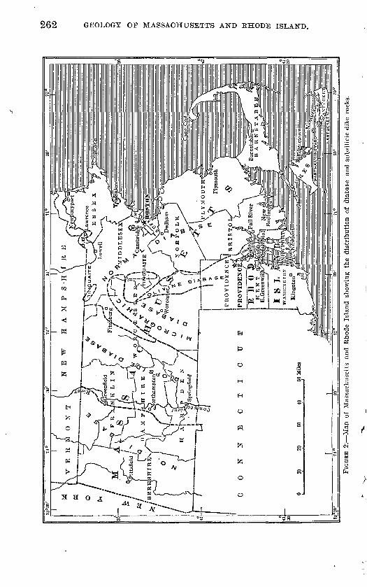
262 GEOLOGY OP MASSACHUSETTS AND RHODE ISLAND.
K -J!

TEIASSIC EBTJPTITE KOCKS, 263
distinct microporphyritic texture due to larger and earlier feldspathic and pyroxenic constituents in an ophitic groundmass, indicating crys tallization at two distinguishably different periods and under differ ent conditions, and possibly in two different positions in relation to the surface of the earth. This type appears in the Holyoke and Hampden sheets and in the dikes that cut the Triassic strata and the crystalline rocks for 20 miles eastward to the border of Worcester County. It is accompanied by a pitchstone that was formed by the frothing of water up into the trap sheets .from below, and by palag- onite, a jet-black glass that contains 17 per cent of water and 28.5 per cent of iron oxides, that was formed by the swirling of muddy water down into the trap sheet. Holyokeite, a diabase aplite, occurs in small dikes, the rock of which has an ophitic texture but no dark constituents. It seenis to be the product of a marked differentiation of the trap.
The same diopside diabase appears in dikes and is there almost invariably fresher than in the sheets. Border variants also occur, in which the ophitic groundmass is replaced by a very fine grained groundmass, more or less glassy and full of minute crystals of plagio- clase and of the two pyroxenes. They are as sharp as needles, which indicates that they floated to their present position and that cooling and solidification were so rapid that no additions were made to the isolated sharply defined crystals, whereas in the normal type of the rock the final crystallization added much to the larger crystals and gave them a ragged boundary like the smaller ones and a zonal structure.
Here and there in the diabase masses the augite crystals are large and a peculiar and early type of the groundmass hyalopilitic and fine grained is preserved, in which are evenly distributed magnetite grains surrounded by a growth of red biotite. This seems to have been a very general early stage in the solidification of the mass, but nearly everywhere the biotite was generally resorbed before final solidification. Traces of it are commonly preserved, however, in the centers of the earlier pyroxene grains.
Beyond a gap of 12 miles in which no dikes have been found a micrographic quartz diabase replaces the diopside diabase and this type continues across southern Worcester County in a series of great dikes known as the Spencer dikes. The rock retains the normal dia- basic texture of the groundmass and all the characters of the diopside- bearing type, though on the average the grain is somewhat coarser, but it has also a very perfect and abundant micrographic or vermi form intergrowth of quartz and feldspar. In many places the rock is spherulitic, and in some places this texture grades outward into the micrographic texture. The same distinction holds in the similar

264 GEOLOGY OF MASSACHUSETTS AND RHODE ISLAND.
rocks in New Jersey,1 where the diopside diabase type occurs in the Watchung basalt sheets and the micrographic quartz diabase occurs in the great Palisade diabase dike.
East of Worcester County, or rather east of a line drawn north and south through Southboro, olivine diabase and the normal dia base in which only one kind of feldspar and pyroxene are developed occur throughout a broad area that extends northward into New Hampshire. I have, however, examined a large series of thin sec tions made to illustrate all the types of the black traps that cut the granite around the whole shore of Cape Ann and have found none which could be classed with the diopside diabase, the micrographic quartz diabase, or the olivine diabase. Apparently the rock of these dikes is only the normal, gabbroid, much weathered type of diabase.
INTERBEDDED SHEETS.
PETROGRAPHY.
The average rock of the Triassic diabase sheets is dark gray and compact. The feldspar of the phenocrysts of the earlier generation, which appear as small points and lines in the rock, occurs in feathery groups, has an extinction of 31° or more, and is near anorthite. The rock texture is purely ophitic (diabasic), and the lath-shaped feld spars of the later generation are labradorite and have a maximum extinction of 26°. In some places this later feldspar forms zones about the earlier and more calcic feldspar. An early formed color less pyroxene near diopside occurs generally in long, stout, well- formed crystals. It decomposes more readily than the augite, which is in wholly shapeless pale-yellow grains, invariably secondary to the feldspar, has very poor and irregular cleavage, and seems dusted onto the feldspar network like yellow sand. In places it forms zones about the white pyroxene. Magnetite is everywhere abundant, olivine generally absent, and apatite rare.
TAXCOTT DIABASE.
Four great diabase sheets were poured out on the sea bottom dur ing the deposition of the Triassic sediments. These sheets have been named the Talcott diabase, the Holyoke diabase (which in cludes two of the sheets), and the Hampden diabase. The Talcott diabase, named for its occurrence at Talcott, Conn., is important in its extension across Connecticut, but it barely crosses the State and ends in Suffield, Conn. In Percival's account of the Geology of Con necticut it was called the anterior sheet, as it lies in front of the main or Holyoke diabase sheet, which dips east and faces west.
1 Lewis, J. V., New Jersey Geol. Survey Ann. Kept, for 1906, p. 99, 1907 ; also Science, new ser., vol. 26, p. 177. 1907.

TRIASSIC ERUPTIVE ROCKS, 265
HOLYOKE DIABASE.
GENERAL CHABACTER.
The transverse part of the great Holyoke diabase sheet (so named from its occurrence in the Holyoke Kange), from its east end to the apex of Mount Tom, runs east and west at a high altitude, beyond which it drops to a lower altitude and continues southward. At its east end it has a high southerly dip, which farther west changes to an easterly dip of about 30°. At its east end it is thinner, more weathered, and more amygdaloidal than it is farther west. The rock is generally fine grained, but on the new Mount Holyoke road and at Titans Pier it is coarser, the flat blades of augite being nearly an inch long. It commonly shows a rude columnar structure, as a rule on a large scale. Titans Piazza, south of Mount Holyoke, named by President Hitchcock after the Titans to prevent its being named after the Devil, is much visited because of the fine columnar wall. The great columns are 30 to 40 feet long and 3 to 4 feet wide. They are so underworn that one row, and in some places two rows, are retained in place solely by their lateral connection with adjacent columns, and their bases are hemispherical. Directly above these columns many large amethysts have been found. The columns thus form a curious cave or rock shelter, whose ceiling is composed of their great hemispherical ends.
The thick sheet rises above the sandstones because erosion has removed them from its flanks. Its own shape depends locally on the angle at which it is truncated by erosion. Where its eastern slope agrees closely with the upper surface of the sheet and the western slope coincides with the columnar structure, which is at right angles to the surface of the bed, it forms a bold hill with a precipitous western face, as in Mount Tom and Proven Mountain. Where erosion has worn off the trap sheet more nearly horizontally the ridge is less elevated, but the trap covers a broader surface. Its maximum thickness is about 400 feet. All the early fissures of the Holyoke diabase sheet are cemented by quartz, much of it ame thystine, which distinguishes it from the " posterior sheet," in which they are uncemented.

266 GEOLOGY OP MASSACHUSETTS AND RHODE ISLAND.
The chemical composition of the Holyoke diabase is shown by the following analyses:
Chemical composition of HolyoJce diabase from Mount Holyoke, Mass.
SiO2 . .....................................................................AluO3. ....................................................................FeO...... ................................................................
MnO .....................................................................CaO. .....................................................................MgO.....................................................................Na2O .....................................................................K80. .....................................................................H2O ......................................................................
Ignition. .................................................................
1
53.7013.00
21.00.19.70.15
8.502.76
100.00
2
52. 7014.119.781.87
.459.366.422.54
.89
1.61
99.73
3
52. 6514.179.802.03
9.396.352.57.87
1.58
99.85
1. Much decomposed amygdaloidal trap, east end of Mount Holyoke. Edward Hitchcock, analyst. Report on a reexamination of the economical geplogy of Massachusetts, p. 135,1833.
2. 3. Compact diabase (auvergnose), Mount Holyoke. G. W. Hawes. analyst. Am. Jour. Sci., 3d ser., vol. 9, p. 186,1875.
DEERFIELD SHEET.
General character. At the north, in Sunderland and Deerfield, a bed of trap similar to the main sheet of Holyoke diabase rests on the Mount Toby conglomerate, extends northwest across the river on the Sugarloaf arkose, and stretches far northward in Greenfield and Gill. Its mass, which dips gently eastward, forms the core of Deer- field Mountain, and it seems formerly to have capped South and North Sugarloaf. This is apparently the reason why those moun tains still retain a mesa form. The rock is thoroughly decomposed where interbedded with the conglomerate but is dark and compact where interbedded with the arkose. The mass is made up of a superficial sheet and two intermediate sheets full of steam holes, indicating three immediately successive flows. At the mouth of Fall River it displays the perfect ropy surface of an a-a lava.
The rock is typical diabase, ranging from aphanitic varieties to those in which the white flat feldspar crystals are 2 to 4 millimeters square, and from compact to very coarse amygdaloidal texture. North of Deerfield River the rock is more granular and remarkable grayish and reddish or reddish-white varieties occur. These vari eties are subporphyritic and abound with flattened steam cavities. Broad white plates of feldspar stand out in a dark-red ground of decomposed augite, the whole sprinkled with amygdules of prehnite and diabantite.
White-spotted diabase, an exceptional rock, occurs abundantly on the south side of Deerfield River, making a great layer in the sheet east of the large quarry. It is a clear, light-gray rock with roundish white blotches, which under the microscope are seen to be made up of aggregated stout crystals of plagioclase, and the rest of the mass is

TEIASSIC ERUPTIVE BOOKS. 267
composed of rodlike plagioclase and magnetite, with almost no augite. The rare amygdules in this rock are filled with a fine silky radiated mineral, apparently an altered prehnite, resting on diaban- tite, or are more rarely lined with glassy crystals of albite, together with datolite, pyrite, or globules of sphalerite. The rock is a transi tion to holyokeite.
Red diopside diabase with secondary albite. Much of the basal part of the Deerfield sheet just north of Deerfield River has been radically metamorphosed by hot water during its cooling. It is fine-grained, brick-red, and full of small cavities or scattered larger ones, lined or filled with exquisite crystals of albite large enough to be studied with a lens.1 The feldspar crystals of the first generation have been floated to their present places in delicate feathery groups. « They retain their sharp crystal outlines and traces of cleavage and multiple twinning on two bands but have been changed to a mass of subparallel scales and needles of kaolin and sericite. Augite is absent, but a few much-twinned automorphic diopside crystals occur. The minerals mentioned above are free from the abundant hematite which in small grains and dendritic growths fills the second genera tion of feldspar crystals and makes most of the sections opaque, and which entirely replaces the ordinary black ores and colored augite. The second generation of feldspar crystals is heavily loaded with the red rust, but they commonly have clear borders or the rust forms crosses in the diagonals of the square sections.
In some of the large cavities a broad-bladed barite has formed in many separate and parallel plates, all of which have been coated with albite and then removed by solution. There is no diabantite nor any trace of ordinary weathering in the section, and it is prob able that hot water, acting on the magma in which the earliest- formed feldspar crystals were floating, decomposed them, changed all the iron into hematite, tnus preventing the formation of dark augite and the black ores, and then deposited the residuum of the feldspathic material in the steam holes.
The difference between the rock and normal diabase is shown by the order of crystallization of its constituents as compared with that of the constituents of normal diabase.
DIOPSIDE DIABASE.
First plagioclase.Diopside.Hematite.Second plagioclase.Steam holes.Third plagioclase.
NOEMAX DIABASE.
Magnetite.First plagioclase.Second plagioclase.Augite.Steam holes.Diabantite.
U. S. Geol. Survey MOD. 29, fig. 24, C, p. 422, 1898.

268 GEOLOGY OF MASSACHUSETTS AND EHODE ISLAND.
Paragenesis of secondary minerals. The cuts made through the Holyoke diabase on both sides of Deerfield River opened up veins containing the ordinary trap minerals in great abundance and beauty.1 The paragenesis of the stilbite-chabazite veins was: Radi ated stilbite, chabazite, calcite, and pyrite, or prehnite, heulandite, prismatic stilbite, chabazite, and calcite..
A general table of the paragenesis of the minerals is given below. The oldest minerals are named first and the overlap indicates ap proximately the overlap of the minerals.
Paragenesis of secondary "minerals of the Deerfield sheet.
Diabantite. Albite.
Prehnito.Epidote. Babingtonite.Tourmaline.Calcite.Fluorite.Sulphides.
Datolite:r' Titanite. Calcite. Sulphides.
Natrolite. Stilbite. Heulandite. Analcite. Calcite. Fluorite. Sulphides.
Chabazite. Calcite. Fluorite.
v.Pyrite.
o Saponite.Chlorophseite.Kaolin.Malachite.Limonite.Wad.
MUD INCLUSIONS IN DIABASE P1TCHSTONE, PALAGONITE, AND HOLYOKEITE. 2
The Triassic lava flowed over a deep-sea bottom and everywhere took up great quantities of mud, marl, or sand and produced thereby new types of rock and glass, remarkable rock textures, and marked differentiations. These antagonistic bodies have been brought to gether in very different ways and have produced results so diverse
1 Emerson, B. K., The Deerficld dike and its minerals: Am. Jour. Sci., 3d ser., vol. 24, p. 195, 1SS2.
2 Emerson, B. K., Plumose diabase and palagonite from the Holyoke trap sheet: Geol. Soc. America Bull., vol. 16, p. 91, 1905.

TEIASSIC ERUPTIVE ROCKS. 269
that I have distinguished them by type localities, though each has occurred in many places and may extend for miles along the surface of the sheets.
In the mass of the rock at Titans Pier convection currents in the heated water carried the mud out over the surface of the molten lava and the mud or marl was blended in every way with the lava to a depth of 10 to 20 feet. The sheet is full of drops of the mud, now hardened to marly limestone, or. the two are mixed as if they had been liquid or plastic at the same time. There is little heat effect, but because of the rapid chilling augite is lacking in the adjacent trap and all the iron is concentrated against the surface of the mud in magnetite, showing distinct differentiation.
This mud formed over the surface and with the advance of the flow was carried forward and downward at the front and now ap pears inverted at the bottom of the sheet. Balloon-shaped steam holes point upward and long tubes formed by the escape of steam end at the bottom of the sheet. This condition is present everywhere at the upper and lower surfaces of the sheet for 5 miles each way from Titans Pier, where Connecticut River breaks through the Holyoke Range. A variant of the same type appears a few miles to the south of Larrabee's quarry, at the north boundary of Holyoke, where sandstone is blended with trap for 2 or 3 feet, and all the fissures of the overlying sandstone are coated with broad sheets of beautiful specular hematite. The trap beneath contains masses as large as one's fist of bluish-white radiate-foliated anhydrite and of pyrite.
In the lava sheet at Meriden, Conn., and Greenfield, Mass., the thin solid crust that separated the lava from the muddy bottom was rup tured and the still molten lava allowed to come in contact with the mud beneath. Violent explosions then forced the fragments of the shattered crust and much mud and wet sand 60 and 70 feet upward into the flow, and in one place clear through it, forming a temporary parasitic cone on the newly solidified surface of the flow. Much mafic glass was formed, which is a diabase pitchstone or tachylite, not known elsewhere. Beautiful spherulites, lithophysae, shards, and threads and beads of glass are blended with sand and mud, shattered trap fragments, and hematite plates, all cemented by the olive-green pitchstone. The whole mass was then shattered in some places and was recemented by a hot-water deposit of albite, calcite, diopside, and blue tegirine-augite. The best localities for the study of these phenomena are at the " Crater," in Meriden, and below the observa tion tower in Greenfield.
At the Holyoke Reservoir a layer of dove-colored limestone of the same type as that which is blended with the trap at the base and top of the sheet has been carried by some movement of the liquid mass

270 GEOLOGY OF MASSACHUSETTS AND KHODE ISLAND.
150 feet downward to the middle of the .trap sheet. In building the new reservoir in Holyoke the area showing all the phenomena de scribed here was perfectly cleared for study but is now covered by the water. From the much-shattered inclusion of limestone extend streaks (schlieren) of strange coarse gabbroid forms of diabase in which the pyroxene (sahlite) radiates in tufts of flat, thin, curving blades 3 or 4 inches long. A central twinning plane and the trans verse parting make them resemble feathers, but their resemblance is stronger to tufts of grass, especially when they weather to bright- green or straw-yellow and white talc.
The large feldspar crystals are also changed to a radiate-tufted mica, apparently paragonite. This change is not due to weathering but is a primary effect of moisture under great pressure. Next out wardly the pyroxene crystals are all nearly remelted and are sur rounded by grains of calcite and then comes a remarkable, fresh, glass-bearing, porphyritic diabase which contains crystals of luster- mottled feldspar (labradorite), almost 1 inch square, full of small augite crystals, glass, and spherulites and also large crystals of augite and skeletonized magnetite. Between these larger crystals the white aphanitic grouildmass is made up of quartz and minute needles of albite and contains many pieces of the black glass, some of them nearly 1 inch across.
This glass is a jet-black brittle palagonite, which has a hardness of 3 and a density of 1.91. It contains 17 per cent of water and 28.54 per cent of iron oxides. (See analyses 1 and 2, p. 271.) It is deep red-brown under the microscope, and many specimens are beautifully devitrified. It includes some perfect crystals or crystal groups and spherocrystals of calcite, or of calcite and ankerite, or spherulites with alternate layers of calcite and glass, and, in the same cavities, spherocrystals of richest cobalt-blue quartz, fibrous and excentrically radiate.
In many specimens the fresh glass molds perfectly the minute polished crystal ends of the calcite and the quartz and invariably incloses them entirely in a common cavity. There can be no doubt that they crystallized from the liquid magma in quick succession and that the calcite everywhere crystallized first. As the glass weathers easily these forms can not be the result of weathering nor can they be secondary growths.
The expansion of gas or steam formed many cavities in this lava, some of them half an inch across. A thin pellicle of glass solidified around the cavity and then collapsed, and the cavity was quickly filled with calcite and quartz which crystallized together in beautiful forms. All the grains of glass seem to have been formed by this expansion, for where they have collapsed entirely curved and wrinkled

TEIASSIC ERUPTIVE ROCKS. 271
sutures appear in the middle of the grains, marked by beautiful fibrous devitrified layers. More notable than the varied and beauti ful forms is the marked differentiation produced by these bubbles. Because of thermal changes, or the direct influence of the vapor, or from unknown causes, all the iron and magnesium have migrated to
'the surfaces of the bubbles and have cooled to a glass that contains 28.52 per cent of iron oxides and 17 per cent of water. The broad aureole left behind has the composition of albite, with 8 per cent of calcite and in some specimens a little quartz. The separation of the melanocratic and leucocratic constituents is completely effected. This colorless siliceous differentiate is formed in such quantity that it penetrates the adjacent normal diabase in dikes 2 to 3 inches thick, and in this form a little of it occurs throughout the length of the range. It has been named holyokeite. (See analyses 7 and 8, below.)
Chemical composition of palafjonite, diabase pitcltstonc, Jioluokeite, gabbroid. quarts diabase, and normal diabase.
SiO 2 . .:....-.. .......
FeOMgO... ...... ........CaO .................Na2O................
K2O .................H20 (below 100° C.)--H2O (above 100° C.)..TiO 2 . .........--.--..ZrO«. ................C0 2 ... ...............SO.,.........--..-..-.P20S . ................S. ...................F. ...................NiO .................MnO.. ...............
BaO .................SrO. .................Cu. ..................
1
40.35a 5. 1124.993.555.481.32.18
1.448.51S. 51.20
.22
99. SO
2
48.706.17
30.164.286.611.59.22
1.76
.24
.27
99. OS
3
53.529.708.069.452.525.642.24
1.501.67
1.9803
.36
.10
.26
100. 21
4
60. 0811.123.76
10.471.846.212.43
1.60
2. 64.04
.48
.13
.28
5
52. 6814.141.959.756.389.382.56
.88bl.60
.44
99 SO
6
46. Sfi13.965.234.677.699.421.85
2.021 9Q3.431.13
2.19
.15
Tr&CG
.03
99 92
7
53. S316.36
.89
.139. 817.89
1.58.15.36.86.02
7.47
.17
lost.
99 77
S
65. 3719.87
.499.58
1.92
1.04no
.13
.21
lost.
.17
a Possibly contains P2O5. & Ignition.1. Palagonite (atlantare) in gabbroid quartz diabase, new reservoir, Ilolyoke, Mass. Specific gravity,
1.91. George Steiger, analyst.2. Analysis 1 made anhydrous.3. Coarse sabbroid quartz diabase (aalose), containing much pala^onite and original quartz and calcite,
from an average sample of the very fresh coarse porphyritic rock from the great block that furnished the best palasonite. George Steiger, analyst.
4. Analysis 3 with an amount of Rlass removed equivalent to the amount of water according to analysis 1 and of calcite and siderite- equivalent to the COj. The entire freshness of the material and the visible amounts of glass and carbonates justify this procedure.
5. Compact diabase (auvergnose), Mount Holyoke. Mean of two analyses by G. W. Hawes. Am. Jour.Sci.,3dser., vol. 9, p. 186,1875.
6. Diabase pitchstone from base of trap sheet at the " ash bed " at Meriden, formed by the rising of muddy water up into molten trap from below. H. N. Stokes, analyst. Geol. Soc. America Bull., vol. 8, p. 77, 1897.
7. Holyokeite (tuolumnose), east foot of Mount Tom. W. F. Hillebrand, analyst. Jour. Geology, vol. 10, p. 508, 1902.
8. Analysis 7 with water and calcite equivalent to the CO 2 subtracted and the remainder calculated to 100 per cent. This is justifiable, for all the amygdules in the rock are of calcite. The rock becomes a nord- markose and has the composition of albite.

272 GEOLOGY OF MASSACHUSETTS AND EHODE ISLAND.
HAMPDEN DIABASE.
The Hampden diabase sheet 1 forms the line of bold foothills south of the Holyoke Range and east of the Mount Tom Range. It was called the posterior sheet by Percival. It is thinner than the Holyoke sheet, its thickness in West Springfield being 50 feet. It is identical with the main sheet in composition and general char acter, but as a rule it is less porphyritic, and the augite in it is more automorphic. In many places it has a fine spheroidal structure and weathers into a mass of balls a few inches thick, which have a remarkable onion-like exfoliation.
The bold hill (Little Mountain) in Mountain Park east of Mount Tom exposes a cross section of the vent through which the lava of this sheet rose, which sends out horizontal dikes into the sandstone on the west, south, and east, and overflows to form the trap sheet. North of this point small dikes appear everywhere in the sandstone immediately beneath this trap sheet. This suggests that the fissure through which the lava rose may lie beneath the crest of the ridge.
At Black Rock, south of the Mount Holyoke House, is an apparent core, the rock of which has been described as the " Black Rock dia base " and made the type of a series of such supposed plugs.2 More careful study has shown that the rounded, pluglike shape of the mass and its intrusive contact on the sandstone can not be traced all the way around it, but that it is connected with the Hampden diabase sheet as in Little Mountain, which makes it probable that in Black Rock is again exposed the cross section of the rock filling the fissure, and not an isolated plug.
DIABASE DIKE ROCKS.
GENERAL CHARACTER.
The interbedded sheets of diabase which form Mount Tom and Deerfield Mountain are, of course, of Triassic age. The same age may be assigned to the long line of diabase dikes which trend north ward in the Triassic sandstones and in the crystalline rocks, parallel to and a few miles east of the trap sheets. The rock of the dikes is macroscopically and microscopically indistinguishable from that of the flows when specimens of the same degree of coarseness are com pared, though the rock of the flows is in general much coarser grained and is uniformly much more decomposed. The rock of the dikes is glassy at their borders and contains olivine, which is absent from the main trap sheets but present in the later ones. The rock of the dikes and of the flows is so much alike that the flows may have originally been continuous with the dikes or other similar dikes.
1 U. S. Geol. Survey Mon. 29, p. 464, 1898. Unfortunately this rock is not shown on the geologic map in this bulletin (pi. 10) in the area south of Holyoke, but it is shown on the map in the Holyoke folio (U. S. Geol. Survey Geol. Atlas, folio 50) and in pi. 34 of Monograph 29.
2 Idem, p. 189.

TRIASSIC ERUPTIVE ROCKS. 273
NORMAL DIOPSIDE DIABASE.
The only dike of normal diopside diabase found west of the Tri assic area occurs in Loudville, one-eighth mile east of the village. It is 100 feet thick. The apparent trend of the dike is northeast, conforming in trend with the lead vein and the Florence-Loudville fault, which agrees with the theory that the fissures in which the lead veins were deposited are of late Triassic or post-Triassic age and coincident with the last eruption of trap. The rock of the dike is a fresh-looking, compact, fine-grained trap of dark-gray color.
The dikes east of the Triassic area are arranged in two belts. They are the eastern dikes of Percival and though not continuous can, in places, be followed for miles. The Ware dike may be taken as a type. A dike of diabase, 100 to 150 feet thick, which trends N. 20° E., can be traced across Palmer, Ware, and New Braintree. The rock of the dike, as typically exposed at D. Linehan's place in the southwest corner of New Braintree, is a compact fresh trap, dark gray with a shade of brown, in which the feldspar phenocrysts, 2 to 3 millimeters in diameter, are just visible. There are a few large grains of feldspar of saussuritic aspect 12 millimeters across. The rock has a perfect ophitic texture, with two generations of ragged-edged feldspar crystals, the larger ones near anorthite and the smaller ones near labradorite. The two varieties of pyroxene, amber augite and colorless diopside, are but slightly distinguished in color. The colorless variety is larger, more automorphic, and slightly decomposed, with basal cleavage and twinning. An outer zone of augite, which polarizes differently, commonly surrounds the diopside. Sections of rock identical with that of the Ware dike in all essential respects have been studied from bowlders at many localities.
MICROGRAPHIC QUARTZ DIABASE,
In the micrographic quartz diabase the feldspars and pyroxene occur in two generations. There is an earlier small-porphyritic feldspar near anorthite, and a later feldspar near labradorite, that forms the ophitic groundmass. An earlier, commonly porphyritic, colorless diopside is distinguished from a later interstitial amber augite. A beautiful interstitial micrographic intergrowth of quartz and orthoclase is characteristic and commonly very abundant.
Two great dikes, with several offshoots, can be traced south by west across Holden and Spencer and so on into Connecticut. A cross section of the larger one is exposed for nearly 150 feet in the cut a mile west of Jeffersonville station in Holden, and the rock includes many large masses of the graphitic Brimfield schist and of the granite. It may serve as the type of the porphyritic form of the diabase. The rock is fresh and black, because of which color
50244° Bull. 597 17 18

274 GEOLOGY OF MASSACHUSETTS AND EHODE ISLAND.
the abundant and highly calcic feldspar phenocrysts, which are only 2 to 3 millimeters long, are inconspicuous. The groundmass is ex ceedingly fine grained and is diabasic and holocrystalline, but it cooled so rapidly that no addition was made to the phenocrysts dur ing the process, and they are sharply bounded. The augite occurs in large polysynthetic groups, is of pale amber color, and shows a zonal growth and a rude prismatic cleavage. The white pyroxene characteristic of the Triassic diabase is especially abundant in groups of long, stout, model-like crystals just beginning to change to a fibrous serpentinous mineral.
Sections cut at the contact show very slight exomorphic effects. Microscopic veinlets of glass, which are cracked and strained, are set among the other constituents. The endomorphic change is greater. The phenocrysts are fewer and smaller, and plagioclase and the white pyroxene, in very long twinned prisms, rest in a spotted and variolitic glass that swarms with brightly polarizing microlites, apparently of pyroxene.
The same types of diabase the granophyric and the porphy- ritic occur in bowlders for 20 miles northeastward, across West P-oylston and Lancaster, to Boxboro, and from Stow through Har vard and Worcester to Sutton and Dudley.
OLIVINE DIABASE.
Several dikes of olivine diabase occur near the Essex Co.'s granite quarries in South Lawrence cutting Merrimack quartzite. Near the contact the quartzite has been made scoriaceous. Similar dikes occur throughout northeastern Massachusetts and are especially abundant in the Boston district and the region to the west and north.
In Uxbridge, a mile north of Wheelockville, a dike, only 3,75 inches thick, of dull-black aphanitic rock cuts hornblende schist. In a hyalopilitic groundmass are scattered a few long needles of lab- radorite and crystals of olivine, many of them perfect but others lobate from intrusion of the groundmass, and variously changed to a greenish to brownish iddingsite. The groundmass is a glass that is black from the abundance of dark globulitic grains and is full of linear rods of plagioclase with forked ends. It passes at the border into deep-brown tachylite. The rock contains little or no pyroxene.
A dike, a foot thick, of olivine diabase porphyry, occurs in North Smithfield, half a mile southwest of Blackstone, at a big bluff above the brook and cuts granite at a contact with conglomerate. It was described by Dr. Samuel Robinson. 1
Entirely similar small olivine diabase dikes occur in the marble quarry at Lime Rock, R. I., and at the southern boundary of Lin coln, R. I., three-quarters of a mile southwest of Olney.2
1 Am. Jour. Sci., 1st ser., vol. 9, p. 53, 1825.2 TJ. S. Geol. Survey Bull. 311, p. 70, 1907,

TKIASSIC ERUPTIVE ROCKS. 275
NORMAL NONPORPHYBITIC DIABASE.
Dikes in and near Worcester County. The nonporphyritic type includes dikes of very fine grained, dark bluish-gray trap, charac terized by the presence of both pyroxene and plagioclase in only a single form, and by the absence of porphyritic, even microporphyritic texture, although here and there a flake of earlier-formed mica in closes a little white pyroxene. In addition the thin section shows only a few grains of magnetite.
A dike 20 to 25 feet thick and 500 feet long outcrops a mile north east of the railroad station in Sterling. In the northeast corner of Southboro a great dike of rock of this type is 120 to 160 feet thick and 1,600 feet long. The rock closely resembles the Holyoke diabase, but the pale-brown augite is more automorphic and presents every stage of the change to uralite, and in places biotite has altered to chlorite.
Dikes in Essex County. Shaler x has mapped the diabase dikes ex posed on the shore of Cape Ann and found 324 in this small area but only 5 in natural exposures over the whole remaining surface of the island, showing how great a multitude must remain undis covered beneath the surface deposits. They range from a fraction of an inch to many feet in thickness and many of them are 1 to 3 miles long. Two-thirds of them have a trend near N. 30° W. and all have a high dip. I have also mapped them and studied many thin sections. They are described at some length by Washington.2
The rocks are dense black, very fine grained, compact, and of ophitic or basaltic texture or else the two textures blend. Many of them are greatly decomposed. Labradorite laths, violet augite anhedra, and magnetite in feathery forms, with some brown glass in the basaltic types, compose the rock. There is no olivine. They cut all the rocks of the region and seem generally to represent the simplest normal diabase type.
Chemical composition of freshest ophitic rock (diabase, camptonose) from the large quarry at Rockport, Mass.3
SiO2________________ 47.12 TiO2________________ 3. 27 A12O3____________ _____ 14. 43 Fe2O3____________ _ 3. 33 FeO__________________ 11. 71 MgO___________- 6. 05 CaO_____^____________ 9. 63
Na2O____________._____ 2. 58K2O____________ _____ 1.11H2 O (110° C.) ____________ s 28H2O (ignition)_____.____.. ..34
99.85
1 Shaler, N. S., The geology of Cape Ann: U. S. Geol. Survey Ninth Ann. Rept., p. 529, 1889.
2 Washington, H. S., The petrographical province of Essex County, Mass.: -Jour. Geology, vol. 7, p. 287, 1899.
3 Idem, p. 289.

276 .GEOLOGY OF MASSACHUSETTS AND RHODE ISLAND.
Washington mentions Shaler's dike 175 at the Pigeon Cove quarry and a similar dike at Pickards Point because of their large automorphic phenocrysts in a diabasic groundmass.
Dikes of the Boston district. Crosby describes the Triassic diabase dikes of the lower Neponset Valley as follows: *
The diabase dikes * * * of the Boston Basin generally, are referable to two distinct series distinct in age, trend, and lithologic character. We may properly emphasize the chronologic distinction as of greatest geologic signifi cance, by designating these two series provisionally the Carboniferous and the Triassic. Evidently the diabase dikes are not related in origin or composition to any of the other igneous rocks of the district, and in size, regularity, and continuity the two systems are essentially similar and normal. * * *
The * * * dikes of this series adhere very closely to a north-south trend and vertical attitude, a hade of even a few degrees being very unusual. Their relation to the general geological structure of the region is distinctly transverse, and evidently they date from a period of gravity faulting without folding, such as the Triassic is known to have been. Transverse columnar jointing is com monly well developed. The greenstone alteration is wanting, and the rock yields readily to kaolinization, the tendency to pass by spheroidal weathering to a rusty brown earth being a marked feature of this! diabase.
Crosby describes 20 of these dikes in the Nantasket region.2 Dikes in the Narragansett Basin. A series of altered and faulted
diabase dikes cuts the Carboniferous rocks in a great curve that runs south from North Attleboro. Others are found at the mouth of Narragansett Bay in the margin of the Carboniferous basin.3
A porphyritic diabase occurs in Warwick, K. I., 1 mile south of Spencer Hill. It is coarse and fresh and contains large veins of devitrified glass that'has a perlitic texture. It repeats the Holyoke type without diopside.
COARSE GABBB.OID DIABASE.
The great north-south Medford dike of coarse diabase, which is continued south across Mystic River as the Powder House dike, has long attracted attention because of its deep disintegration into red dish-brown sand, which has had long and extensive use as material for hard gravel walks and driveways. It was first described by J. F. and S. L. Dana,4 was fully investigated petrographically by Hobbs,5 and made the subject of a valuable investigation on rock disintegration by Merrill.6 It has been mapped and described with great fullness by Wilson.7 It contains plagioclase, orthoclase,
1 Crosby, W. O., Am. Geologist, vol. 36, p. 82, 1905.2 Crosby, W. O., Boston Sec. Nat. Hist. Occasional Papers IV, vol. 1, pt. 1, p. 123, 1893.3 Shaler, N. S., Woodworth, J. B., and Foerste, A. F., Geology of the Narragansett Basin:
U. S. Geol. Survey Mon. 33, p. 152, 1899.4 Am. Acad. Arts and Sci. Mem., vol. 4, p. 200, 1818.B Hobbs, W. H., Harvard Coll. Mus. Comp. Zool. Bull., vol. 16, No. 5, 1888.6 Merrill, G. P., Disintegration and decomposition of diabase: Geol. Soc. America Bull.,
vol. 7, p. 349, 1896.7 Wilson, A. W. G., The Medford dike area: Boston Soc. Nat. Hist. Proc., vol. 30, p. 353,
1902.

TRIASSIC ERUPTIVE ROCKS. 277
augite, biotite, apatite, magnetite, and ilmenite, and secondary horn blende, chlorite, quartz, calcite, leucoxene, and pyrite.
Chemical composition of diabase from the Medford dike.
SiOj..... .................................................................TiO... ....................................................................A1,0S.....................................................................Fe,0,... ...... ............................................................FeO......................................................................MnO... ..................................................................MgO... I.................................................................CaO. .............. ......................................................KsO......................................................................NasO .....................................................................P,05......................................................................
1
47.28
20.223-668.89.77
3.177.092-163.94.68
2.73
101. 59
2
48.75.99
17.97.41
13.62.91
3.398-822.401.63.68.60
100- 17
3
11 11
23.1912.70
.522.826.031.753.93
.703.73
99.81
1 and 3. Fresh and disintegrated gabbroid diabase (andose), Medford, Mass. G. P. Mer rill, analyst: Geol. Soc. America Bull., vol. 7, p. 353, 1896. Analysis 3 is of the much weathered and disintegrated rock.
2. Fresh diabase, Pine Hill, Medford, Mass. R. C. Sweeter, analyst. Harvard College Mus. Comp. Zool. Bull., vol. 16, p. 9, 1888.
COARSE TTKALITIC DIABASE.
This rock occurs in Woonsocket on the Blackstone road, 60 rods south of the railroad, as a boss 15 by 35 rods in extent, trending east. It is a coarse greenish-black rock that has visible ophitic texture. Broad blades of anorthite, skeletonized magnetite inter- grown with biotite, pale amber-colored augite somewhat altered to matted uralite, and chlorite which is thrust into the adjacent grains in rootlike forms make up the rock.
COAESE HORNBLENDE DIABASE.
In North Worcester are many great bowlders of fresh, coarse, dark-brown rock of gabbroid texture, consisting largely of stout amber-colored prisms of augite centrally full of black needles, with subordinate brown hornblende, biotite, and titanite, and cuboid grains of very calcic plagioclase.

INDEX.
A. Page.
^Egirite tinguaite, composition andoccurrence of_____ 205
Agalmatolite, change of feldspar to_ 130 Akerite in Quincy granite, composi-
tion of_________ 197, 199 Albion 'schist member, nature of__ 27 Albitic mica schist, analysis of___ 41 Alden, W. C., cited___________ 140 Algonkian rocks in northeastern
Massachusetts ____ 28-31 in Rhode Island_________ 26-28 in Worcester County, Mass 24 26
Algonkian (?) rocks, general fea-tures of______ 24
intrusion and metamorphism in_ 29Alien, E. T., analyses by_____ 151, 251
cited _________________ 41Amherst schist, correlation of . 73
equivalence of __ ___ 60nature of ______-____ 72,75-76
Anchisaurus colurus Marsh, modelsof, plates showing 113
Andalusite, occurrence of __ 68, 69 Andesite, siliceous, in the Neponset
Valley, composition of- 201 Andesite flow, nature of___ 203 Andover granite, correlation of cer
tain igneous rocks with _________ 86-87
nature and occurrence of 220 221 Anomcepus, models of, plate show
ing ________ 112 Anthophyllite, occurrence of_ 216-217 Aplite, dikes of, in Quincy granite 196
of eastern Massachusetts, na ture of_____ 167-168
Apoandesite dikes, nature of_ 203, 204 Apoandesite flows, nature of 203 Aporhyolite, nature and occur
rence of_____ 194 Apo-soda trachyte, nature of 203-204 Aquamarines, occurrence of-_ 237 Archean igneous rocks, distribution
and character of- 150 156 Archean sedimentary rocks, distribu
tion and character of- 19-31 Argillite, contortion of, at Green-
field, Mass_______ 98 Arkose, deposit of, close to schists 98
of the Triassic Basin, size ofpebbles in___ 99
Arlington Heights, Mass., graniteof ______ 177
Page.Asbestos, occurrence of_____ 215-216,
216-217Ashton schists. See Marlboro for
mation.Assabet Lake, location of_______ 140 Augite monchiquite, nature and oc
currence of ____ 204-205 Ayer granite, Clinton areas of__ 225-226
correlation of certain igneousrocks with________ 86
distribution of_ 223-224, 225, 227, 228 nature of ___________ 224-228 porphyritic, containing cracked
feldspar, plate show ing _______ 227
from Clinton, Mass., plateshowing _________ 226
relations of______________ 224 southwestern areas of____ 228 Worcester area of_______ 227-228
B.
BackstrSm, Helge, cited________ 255 Ballard, H. O., and Crosby, W. O.,
cited ___________ 143 Barrell, Joseph, acknowledgment to_ 13
cited _________________ 90 Barton, George H., acknowledgment
to _____________ 136 Baryta-lead formation, genesis of__ 104 Bascom, Florence, cited________ 203 Beach, lake, formation of______ 142 Beacon Pole Hill, R. I., minerals
from____________ 28 Becket granite gneiss, analyses of__ 153
nature of___________ 150,154-155. no transition of Cambrian con
glomerate into __ - 18 Beetles, Recent, fossils of_____ 149 Belchertown tonalite, analyses of _ 213
and associated rocks, nature andoccurrence of _:__ 208 217
crush zones of _________ 210-211description of____________ 211modification of, by limestone- 209-210
Belchertown tonalite aplite, natureand occurrence of ____ 211
Bellingham conglomerate, nature of_ 56 plates showing___________ 56, 57
Bellowspipe limestone, nature andoccurrence of ______ 40
Benton, E. R., cited_________ 136,203
279

280 INDEX.
Page.Berkshire County, Mass., Archean Ig
neous rocks in ___ 150 155 dunite in_______________ 155 upland of, formation of_____ 15-16
Berkshire Hills, formations in____ 40-44 Berkshire schist, distribution and
character of _______ 39-40 Beriiardston formation, nature of _ 48-49 Beverly syenite and associated rocks,
analyses of- 199nature and occurrence of 197 198
"Bird tracks," how formed _ _ 92when formed___________ 131-132
" Black Rock diabase," correlationof______________ 272
Blandford, Mass., minerals of dikesin_____________ 258
Blue Hill granite porphyry, analysesof_____________ 193
nature of__________!____ 192-193 occurrence of _____ _ 191-192
" Bolton " gneiss, correlation of 86-87 feldspar nodules in______ 81-82 nature of___________ 80-83 origin of ________ 83 relation of, to the Andover
granite__________ 219Bornite, occurrence of_ 43Boston Basin, Mass., formations of_ 56-58
fossils from ______ _ 144-145location of ___________ _ 50
Boston district, Mass., apoandesiteand andesite flows in_ 203
diabase dikes in______ 206-207nonporphyritic diabase dikes in_ 276studies of rocks in______ 187
Bowen, N. L., cited___ 175Bowlder trains, movement of ice
shown by_______- 136, 137 Bowman, Isaiah, cited_____ 132, 133 Boylston schist, nature of______- 67-68 Braintree, Mass., Braintree slate in_ 38 Braintree slate, nature and occur
rence of____ 38-39 Brimfield schist, contact of Hubbards-
ton granite with __ 234-235 correlation of unnamed gneisses
and schists with____ 86-87gradation of 60nature of____________ __ 68-69occurrence of______ - 59, 69 71
Bristol County, Mass., Dedham grano-diorite in________ 175-177
Quincy granite in__ _ 188 Triassic diabase dikes in____ 276
Brookline conglomerate member, na ture of_-__- 57
Brown, T. C., cited____________ 133 Brush Mountain, Northfleld, Mass.,
northfieldite in_____ 252 Burr, H. T., cited- _ 37. Button balls, globes of sand formed
on _____ 148
C. Page.
Calamites cannceformis, Hitchcock'ssupposed specimen of_ 59
Cambrian conglomerate, no transitionof, into Becket gneiss. 18
Cambrian quartzite bowlders, distri bution of________ 136
Cambrian sediments, distribution of_ 32-39 erosion of______________ 51
Cambrian, Upper, rocks, absence of_ 39 Cambridge slate, nature of______ 57-58 Camptonite dikes, composition and
occurrence of_____ 205-206 Cape Cod, bedrock north of____._ 208 Carboniferous area, western border
of formations in____ 72 78 Carboniferous period, early dikes and
volcanic rocks of, in. eastern Massachusetts and Rhode Island- 200-204
formations of____________ 49-78 igneous rocks of_____ __ 186-259
quantitative classificationof______________ 207
late granites of_________ 218-259 late igneous rocks of, in central
and western Massachu setts ________ 208-218
later dikes of____________ 204-207 Central area of rocks of undeter
mined age, description of ______________ 80-85
location of _______________ 79 Central batholith, dikes in______ 236
general features of_______ 231-232 petrography of_______ 232-236 solidification of__________ 236-238
Central Upland, formations of____ 59-72 Chalcopyrite, occurrence of______ 43, 44 Chandler, C. F., analyses by_____ 95, 167 Chappaquiddick Island, Mass., fossils
from____________ 133 Charles Lake, location of______ 139-140 Chatard, T. M., analyses by______ 204 Cheshire County, N. H., Hardwick
and Fitzwilliam gran ite in__________ 238-239
Cheshire quartzite in western Massa chusetts, nature of__ 34
Chester amphibolite, distribution andcharacter of _______ 41 42
Chesterfield Hollow, Chesterfield, Mass., minerals of dike in ____________ 256-257
Chiastolite schist, formation of__ 61, 65 nature of________________ 64-66
Chicopee drainage system, develop ment of________ 141
Chicopee shale, formation of_____ 92 nature of______________ 96
Chromite, occurrence of________ 160 Clapp, C. H., acknowledgment to__ 14
cited_______ 173,174,178, 187, 195

INDEX. 281
Clapp, C. H. Continued. Page, on the Dedham granodiorite and
associated rocks____ 174 Clapp, F. G., cited___________ 139 Clarke ledge, Chesterfield, Mass., min
erals in __________ 256 Coal of the Rhode Island formation,
nature of___ ____- 55 Coastal Plain, features of______ 17 Coles Brook limestone, character and
occurrence of-_-___ 20 21 metamorphism of________- 21 22 nature of____________ 150paragenesis of minerals in_ 21 22
Conanicut Island. Sec NewportCounty, R. I.
Conglomerates, Carboniferous, originof ______________ 51-52
Connecticut Basin, limits of 127Connecticut River, oxbows on 127Connecticut Valley, features of_-__ 1C
formations in____________ 40-44lakes in, development of__ 141 143Triassic fauna and flora of_ 105-127zones of crushing and extrusion
along ___________ 210 Conway schist, nature of_^ ____ 46-47
outcrop of, in Sunderland,Mass______-__ 100-101
Cook, Miss H. P., analysis by__ 157-158 Cordaville, Mass., granite quarried
at______________ 165 Cordierite-gedrite schist, nature and
occurrence of-_____ 71-72 Cornelius, Dlias, cited ___ 197
" Cortlandt series," occurrence of- 208, 209 Cortlandtite, analysis of- __- 213
nature and occurrence of ___ 212 Corundophilite, formation of___ 159-160 Corundum, occurrence of ___ 215-216 Coticule, occurrence of _ _- 43 Coys Hill granite, nature and occur
rence of________ 240-241 Crag Mountain, Northfield, Mass.,
northfieldite in_____ 250 Cretaceous system, rocks of __ 132 Crosby, W. O., cited__ ____ 37,
50-51, 140, 173, 185, 187, 201, 202, 207.
on diabase dikes in the Bostondistrict __________ 206
on the Dedham granodiorite andassociated rocks____ 174
on the Triassic diabase dikes of the lower Neponset Valley ___________ 276
and Ballard, H. O., cited____ 143 Cumberland, R. I., gabbro from,
analysis of_______ 183 minerals at __ _____ 28
Cumberland quartzite. See West-boro quartzite.
Cumberlandite, analysis of----__- .185nature and occurrence of__ 184 185
Cummington, Mass., manganese minesat__...___ ,,_. .._ 43
D. Page.
Dale, T. N., acknowledgment to___ 13 cited___________________ 40,
143, 165, 171, 187, 230 Pumpelly, Raphael, and Wolff,
J. E., cited_______ 33, 151 Dalton formation, analysis of gneiss
from____________ 33-34 in western Massachusetts, na
ture of __________ 32-34 Dana, E. S., cited____________ 28
minerals reported by, from Cum berland, R. I______ 28
Dana, J. D., cited-____________ 28 minerals reported by, from
Cumberland, R. I-___ 28 Dana, J^F. and S. L., cited_____ 276 Dana diorite at Shelburne Falls,
Mass., plate showing_ 245 at Ware, Mass., plate showing 245 cut by aplite dikes near Bel-
chertown, Mass., plate showing--___ 244
nature and occurrence of_ _ 244 247 Davis, W. M., cited__________ 90, 203
and Loper, S. Ward, cited___ 106 Davis pyrite mine, ore deposit of 43-44 Deerfield Mountain, steep face of_ 137 Deerfield sheet, paragenesis of sec
ondary minerals in _ 268 Deerfield sheet of Holyoke diabase,
nature and occurrence of____________ 266-268
Dedham granodiorite, distributionand character of 175 177
and associated rocks, generalrelations of___ _ 172-175
" Devil's Gardens," occurrence of 104 Devonian (?) igneous rocks, distribu
tion and character of_ 164 185 Devonian system, rocks of___ 48 49 Diabase, at Quincy, Mass., nature of_ 185
coarse gabbroid, dike of___ 276-277 coarse hornblende, bowlders of_ 277 coarse uralitic, dike of___ __ 277 from Rockport, Mass., analysis
of ______________ 207 Triassic, general features of_ 261-264
interbedded sheets of__ 264-272 nature and varieties of__ 261 277
Diabase dike rocks, Triassic, va rieties and occurrence of ____________ 272-277
Diabase dikes, nature and occur rence of________ 206-207
nonporphyritic, occurrence of_ 275-276 Diallage-albite gabbro, occurrence of_ 212 Diallage hornblendite, nature and
occurrence of__ _ 214 Dighton conglomerate, nature of__ 55
origin of ________________ 51-52 Dike rocks, nephelite-bearing, nature
and distribution of_ 204-205

282 INDEX.
Page.Dikes cutting Quincy granite, chemi
cal composition of__ 196 Diller, J. S., cited- _ 202 Diopside diabase in the Holyoke dia
base ______ _ _ 267Diopside diabase dikes, occurrence
of_____________ 273 Diorite porphyry, dike of, in Quincy
granite__________ 196 Dips, direction of, in the Connecticut
Valley___________ 129 Disintegration, frost as agent of__ 128 Dittrich, M., analyses by________ 199Dorchester slate member, nature of_ 57 Dracut diorite and associated gabbro,
nature and occurrence of ____________ 321-223
Drumlins, distribution of______ 135-136 Dunite, nature and occurrence of 155
B.
Eakins, L. G., analyses by_ 74, 213, 215, 254 Eakle, A. S., analysis by_______ 199 Eastern Archean area, igneous rocks
in _____________ 155-156 Eastman, C. B., cited________ 109-110 Effusive rocks, siliceous, of eastern
Massachusetts, nature of_____________' 202
Eggleston, J. W., acknowledgment to 14 Bills, T. G., cited____________ 146 Emery, occurrence and origin of- _ 42,
159-161Enstatite, analysis of_________ 158 Eocene series, fossils of_______ 133 Erosion, glacial, description of___ 135 Erving hornblende schist, analysis
of_____________ 74 correlation of____________ 73, equivalence of-__-______ 60 nature of _____________ 72,73
Essex County, Mass., Andover gran ite in __________ 220-221
camptonite from _ _ ___ 206 Dedham granodiorite in ____ 175 177 Dracut diorite in_______ 221-223 gabbro at Nahant in ______ 181-182 Newbury volcanic complex in_ 161-164 Newburyport quartz diorite
in _____________ 177-178 nonporphyritic diabase dikes
in_____________ 275-276 olivine diabase dikes in______ 274 Quincy granite in__________ 188 Salem gabbro-diorite in____ 178-181 siliceous effusive rocks in____ 202 studies of rocks in_________ 187
Essexite 'in Quincy granite, composi tion of_________ 198,199
F.
Fairchild, H. L., cited________Falmouth moraine, location of_
142138
Page. Faults, crushing and extrusion
along __________ 210-211 in the Connecticut Valley__ 127, 129 in the Triassic Basin, courses and
distances apart of_ 102-104 Fauna, Triassic, of the Connecticut
Valley _________ 107-127Fayville, Mass., granite at _____ 165
quarries at ____________ 165 Felsite rocks in Norfolk County,
Mass., nature of__ 201-202 Fishes, Triassic, of Connecticut
River Valley_____ 109-110 Fitchburg granite, nature and dis
tribution of______ 231-233 Fitts, F. H., analysis by_____ _ 213 Fitzwilliam granite, nature and oc
currence of_______ 238 Flora, Triassic, of Connecticut River
Valley ________ 106-107Foerste, A. F., acknowledgment to_ 13
cited_______________ 36, 37,171and Shaler, N. S., cited_____ 36Shaler, N. S., and Woodworth,
J. B., cited__ 26, 50, 52, 276 Formations, table of__________ 17 Fort River, oxbows on_________ 147 Fossils, Cambrian, in eastern Massa
chusetts_________ 35-36 Eocene, occurrence of______ 133 Middle Cambrian, occurrence
of ____________ 38, 39 Miocene, occurrence of _ 133 Pleistocene, occurrence of- 143-146 Pliocene, occurrence of____ 133-134 Recent, occurrence of____- 147 149 Silurian or Devonian, locality
of ____________ 163-164 Upper Cambrian, in pebbles 39
Framingham Basin, location of , 50 ifranklin County, Mass., Dana diorite
in ____________ 244-247 Deerfleld sheet of Holyoke dia-
N base in__________ 266 late Carboniferous igneous rocks
in_____________ 216 minerals of dikes in____ 258 Monson granodiorite in __ __ 241 mud inclusions in diabase in _ 269 New Salem aplite in ___ _ 244 northfieldite in_________ 250-252 pegmatite schist in____ _ 252 Pelham granite in____ 248 Williamsburg granodiorite in, 253-254
Fuller, M. L., cited____________ 137
G.
Gabbro, olivine-bearing, nature andoccurrence of _ 213 214
Gahnite, occurrence of_-_ 43, 44 Garnet, occurrence of___ - 38,
39, 40, 41, 42, 43, 44, 46, 68, 69, 72 Gay Head, Mass., Miocene beds at__ 133 Gedrite, analyses of_ 74

I2STDEX. 283
Page.Gedrite-cordierite schist, nature and
occurrence of-_____ 71 72Geologic history in Triassic time- 127-132Geologic map, preliminary, of Mas
sachusetts and Rhode Island-________ In pocket.
Glacier, lobed front of________ 137Glaciers, lack of proof of______ 128-129
work of_______________ 134-141Glen Mills, Rowley, Mass., fossils
near____'. ___________ 163Gloucester, Mass., fossil from___ 144-145Gneiss of hill west of Montague, na
ture and contact of- 101-102 porphyritic, from Marlboro,
Mass., analysis of___ 82Gneisses of undetermined age, na
ture and relations of_ 78-89Gneisses and schists, unnamed, age
of ______________ 86-89Goldthwait, J. W., cited_______ 140Goshen, Mass., minerals of dikes in_ 257-258Goshen schist, nature of _ _ 45-46Grabau, A. W., cited__________ 139
on Cambrian fossils of easternMassachusetts ___ 35-36
" Grafton " quartzite. See Westboro quartzite.
Granby tuff, -nature of . _"_ 95-96 origin of___ _____ ____ 92
Granite, intrusion of, effects pro duced by 61
Paleozoic, balanced arrangementof ____________ 259-261
Granite porphyry in Norfolk County,Mass., nature of _ 20.1.
Granites, eastern muscovite, and as sociated diorites, gen eral features of____ 219
late Carboniferous or post-Car boniferous, general re lations of - __ 218
Graniteville, R. I., granite at _ 166 quarries at 165
Gregory, H. E., and Rice, W. N., cited- 230Greylock schist, nature and occur
rence of 40
H.
Hadley Lake, deltas in_ 147 location of _______________ 142
Hall, W. H., analyses by _ _ 204 Hampden County, Mass., Coys Hill
granite in 240 Dana diorite in_________ 244-247 diopside diabase dike in 273 emery in_ 159 161 late Carboniferous igneous rocks
in _________ 211, 216, 20.7 minerals of dikes in________ 258Monson granodiorite in 241 New Salem aplite in 244 serpentine in 156-158 Williamsburg granodiorite Jn_ 253-254
Page. Hampden diabase, fissures uncement-
ed in ____________ 265 nature and occurrence of____ 92, 272
Hampshire County, Mass., Danadiorite in________ 244-247
diopside diabase dikes in____ 273 late Carboniferous igneous rocks
in _________ 208-213, 215 Middlefield granite in_____ 258-259 minerals of dikes in_____ 255 258 Monson granodiorite in _____ 241 mud inclusions in diabase in__ 269 New Salem aplite in________ 244 nortbfieldite * in__________ 250-252 Pelham- granite in_________ 248 quartz monzonite in________ 247 quartz veins in___________ 258 Williamsburg grauodiorite in_ 253-254
Hampshirite, origip and occurrenceof_____________ 156-157
" Hard heads," distribution of___ 136 Hardwick granite, mafic border rocks
of______________ 239nature and occurrence of__ 238 239pegmatite cutting _________ 239
Harker, Alfred, cited____.______ 190Harvard conglomerate, Harvard,
Mass., plate showing 244 nature of________________ 66-67
Har.wich, Mass., glacial pebbles at_ 208 Hawes, G. W., analysis by______ 271 Hawley mine, minerals in______ 43 Hawley schist, nature of_______ 43 44 Haynes, D. H., cited__________ 71 Hearthstones for iron furnaces, rock
used for______ __ 72, 75 Hematite, deposition of________ 43 Hillebrand, W. F., analyses by__ 157-158,
243, 247, 271Hilleboro County, N. H., Ayer gran
ite in____________ 223 Dracut diorite in________ 221-223 Fitchburg granite In____.___ 232
Hinsdale gneiss, fibrolitic facies otf_ 20 general character of_ 19 hornblende rocks in___ __ 19 20 nature of __ _ _ 150 pegmatite in._ _____ __ 19
Hitchcock, Edward, " bird-tracks"controversy of _ 89
cited__________ 133, 136, 149, 256 Hitchcock, C. H., cited_________ 45, 58 Hobbs, William H., acknowledgment
to________ '- ______ 13cited____________ 35, 40, 206, 27fi
Hollick, Arthur, cited__________ 133Holyoke diabase, eruption of_ 92, 97
mud inclusions in________ 268-271nature and occurrence of 265 271 stratigraphic place of 97
Holyoke fault, location of______- 103 Holyoke Range, cause of trend, dip,
and faults of______ 129

284 INDEX.
Page. Holyoke Reservoir, mud inclusions
in diabase at__ 269-270 Holyokeite, occurrence of 263 Hoosac Range, lakes west of 143 Hoosac schist, nature of_ 40-41 Hopkinton, Mass., granite quarried
at_____________ 165 Hoppin slate, nature and occur
rence of_______..__ 36-37 Hornblende schists, analyses of 74 Hornblendite, nature and occurrence
of______________ 212 Housatonic River valley, character
of________,______ 15 formations in___________ 39-40
Hubbardston granite, nature and dis tribution of______ 233-236
Hunt, W. S., and Wheeler, W. C., an alysis by __ _ _ 25
Huntington, Mass., minerals of dikesin__________ __ 258
I.
Igneous rocks, ratio of to sedimen tary rocks lr> areas of undetermined age 79
See also geologic periods.Indian Head Hill, east of Marlboro,
Mass., granite of___ 176Invertebrates, Triassic, of Connec
ticut River Valley 107-109Iron Mine Hill, Cumberland, R. I.,
rock of _________ 184-185Iron ores, occurrence of_ ______ 35Iron oxide, deposition of, in the Tri
assic basin _ _____ 98Ironstone quartz diorite, analysis
of______________ 170 nature and occurrence of 168-170
J.
Jasper, bowlders of, occurrence of_ 136 Johnson, B. L., and Warren, C. H.,
cited_____________ 184 Johnson, D. W., and Reed, W. G., jr.,
cited ___________ 136 Julien, A. A., cited___________ 208, 257
on the minerals in Macomberand Clarke ledges__ 255-256
K.
Keith, Arthur, acknowledgment to_ 14 cited__________________ 83 conclusions of, on the age of the
" Bolton " gneiss and certain unnamed gneis ses and schists_____ 8-7 89
Kemp, J. F., cited___________ 230, 231 Kent County, R. I., Quincy granite
in_____________ 188, 195 siliceous effusive rocks in____ 202 Sterling granite gneiss in___ 229-230 Triassic diabase dike in 276
Page.Keratophyre, nature of___ 202-203, 204 Kinnicutt, L. P., analysis by_____ 167 Kokscharofflte, occurrence of___ 214 215
L.
La Forge, Laurence, acknowledg ment to_________ 14
cited-________________ 83,161 conclusions of, on the age of the
" Bolton " gneiss and .certain unnamed gneis ses and schists--___ 87-89
on the Dedham granodiorite andassociated rocks__ 174-175
on the Mattapan, volcanic com plex __________ 200-201
and Sayles, R. W., cited_____ 51, 66 Lahee, F. H., cited______ 26, 50, 171, 217
on alteration of the rocks in theNarragansett Basin 54
Lake Bascom, location of_______ 143 Lake Housatonic, location of_____ 143 Lake Bouv , location of________ 139 Lake Nashua, location of_______ 140 Lake Shawmut, location of_____ 140 Lake Sudbury, location of____.__ 140 Lakes, glacial, locations of_____ 139-143 Lead, milling of, at Loudville, Mass_ 104 Lee gneiss, nature of __________ 150 Lee quartz diorite, nature of _- 153-154 Lepidodendron acuminatum, occur
rence of____ ____ 63 Leyden argillite, nature of______ 47-48 Limestone in Brimfleld schist, nature
and occurrence of __ 72 modification of tonalite by___ 209-210 scapolite, occurrence of, at Mill-
bury, Mass __ _ 84 Smithfield, minerals in______ 27, 28
Limestone and limestone derivatives in the " Bolton " gneiss, nature of_________ 83-84
Lincoln, R. I., limestone beds at___ 27-28 Little Mountain, Mass., exposure of
lava vent on______ 272 Longmeadow sandstone, analysis of_ 95
nature of______________ 94 95 Loper, S. Ward, and Davis, W. M.,
cited__:.________ 106 Loudville, Mass., diopside diabase
dike at__________ 273 Loughlin, G. F., acknowledgment to- 13
cited________ 156, 173, 187, £29, 230 Lull, Richard Swann, The Triassic
fauna and flora of the Connecticut Valley by__________ 105-127
Luxulianite, occurrence of 237 Lydite, analysis of_______ 25 Lyell, Charles, cited_____ 136
M.
Macomber ledge, Chesterfield, Mass.,minerals in_____ 255-256
Magnetite, secondary, deposition of- 43

INDEX. 285
Page. Maine, southwestern, age of granite
of_ __________ 172 Manganese, deposition of________ 43 Mansfield, G. R., cited_________ 51, 90 Marble, analyses of__________ 84, 158
occurrence of ____________ 42 Marlboro, Mass., granite of______ 177 Marlboro formation, in northeastern
Massachusetts--_____ 31in Rhode Island___________ 27-28nature of_______________ 25-26typical locality of _ 25
Martin, G. C., cited____________ 155Material, sources of___________ 13-14Mattapan volcanic complex, nature
of____________ 200-201Meadows, value of, to early settlers- 146Medford, Mass., diabase dike at__ 276-277Melville, W. H., analysis by__ 157-158Merrick, C. S., acknowledgment to_ 13Merrill, G. P., analyses by______ 277
cited____________r_ 203, 207, 276Merrimack quartzite, equivalence of_ 59
nature of________________ 58-59Merrimack trough, formations in _ 58 59
location of__ - ____ 49-50Mica schist, albitic, analysis of ____ 41Micrographic quartz diabase dikes,
occurrence of ____ 273-274 Middlefleld granite, nature and oc
currence of______ 258-259 Middlesex County, Mass., Andover
granite in _______ 220-221 augite monchiquite in_____ 204-205 Ayer granite in _______ 223-224 camptonite dikes in 205-206 coarse gabbroid diabase dike
in _____________ 276-277 Milford granite in________ 165-167 Salem gabbro-diorite in____ 178-181 siliceous effusive rocks in_ 202
Milford granite, analyses of 167 association of, with Northbridge
granite gneiss _ 155 border zone of 168 character of _______________ 165-166distribution and relations of 165 Westboro quartzite replaced by_ 25
Millers River, crushed and faultedbeds at mouth of__ 99-100
Millers River drainage system, devel opment of _____ 141
Mineral veins, occurrence of__ 104 105 Minette, nature and occurrence
of____________ 217-218 Miocene series, beds of_____ 133 Mollusks, Recent, fossils of 149 Monadnocks, origin of 15 Monson, Mass., minerals of dike in 258 Monson granodiorite, nature and oc
currence of____ 241-243 Montague, gneiss of hill west of 101-102 Moonstone, occurrence of _ 70 Moraines, recessional distribution
of____________ 137-139 Mount Holyoke, steep face of --- 137
Page. Mount Lizzie, Greenwich, Mass.,
plate showing______ 242 Mount Orient, Pelham, Mass., North-
fieldite in ________ 250 Mount Toby, Sunderland, Mass., a
delta of eroded mate rial .__________ 128
conglomerates of __________ 100 faulting on______________ 102 location of ______________ 89 outcrop of gneiss on_______ 102 stepped profile Of, causes of_ 136-137
Mount Toby block, peculiarities of _ 129-130 Mount Toby conglomerate, nature
of______________ 93-94time of ______________ 93
Mount Tom, Holyoke diabase in___ 265steep face of____________ 137structure of ____________ 102-103
Mount Warner,. material suppliedby______________ 102
Mud inclusions in Holyoke diabase,nature of________ 268-271
N.
Nahant, Mass., gabbro at, analysesof______________ 182
gabbro at, nature of______ 181-182Weymouth formation at____ 37
Narragansett Basin, formations in_ 52-55location of ___ __ _ __ 50Triassic diabase dikes in____ 276
Nephelite syenite in Quincy granite,composition of_ 197-198, 199
Neponset Lake, location of_____ 139 140 New Haven County, Conn., mud in
clusions in diabase in_ 269 New Jersey, connection of, with New
England in Triassic time_____________ 90
New Salem, Mass., minerals of dikein______________ 258
New Salem aplite, nature and occur rence of___ 244
Newark group, contemporaneousdeposition of_______ 96-97
formation of______ 91-92 faulting in________ ___ 92
Newbury volcanic complex, natureand locality of___ 161-164
Newburyport quartz diorite, distri bution and character
, of_____________ 177-178 viewport County, R. I., granite in 171
mica trap dikes in 217 Triassic diabase dikes in____ 276
Newport Neck, R. I., granite of 171 Nicholson, E. E., analyses by __ 157-158 Nordmarkite in Quincy granite, com
position of ______ 197,199 Norfolk Basin, formations in 52-55
location of _ 50 Norfolk County, Mass., apoandesite
dikes in__________ 203 aporhyolite in _ 194 apo-soda trachyte in_____ 203-204

286 INDEX.
Norfolk County, Mass. Continued. Page. Blue Hill granite porphyry in_ 191 192 Dedham granodiorite in___ 175-177 Milford granite in_______ 165-167 Odinite in______________ 185 Quincy granite in_ _ 188 Salem gabbro-diorite in___ 178-181 Sharon syenite in__ _ 182-184 siliceous effusive rocks in____ 202
North Attleboro, Mass., Hoppin slateat______________ 36-37
Northbridge granite gneiss, natureand occurrence of__ 155 156
Northern areas of rocks of unde termined age, descrip tion of__________ 80
location of _______ 79 Northfleld, Mass., conglomerate at,
source of pebbles in_ 99 minerals of dike in 258
Northfleldite, nature and occurrenceof______:___ 167,250-252
Noyes, Arthur A., analysis by 157 158
O.
Oakdale quartzite, contact of, withAyer granite 225
correlation of____ _ __ 77cut by tourmaline aplite____ 227equivalence of-_____ _ 59.60nature of________________ 61-62plate showing____________ 57progressive alteration of___- 60
Odinite, nature and occurrence of__ 185Olivine, analysis of__________ - 158Olivine diabase dikes, occurrence of- 274 Orbicular syenite in Quincy gran
ite, composition of____ 1.97Ordovician period, igneous rocks
of____________ 156-161sedimentary rocks of_____ 39-44
Ordway, F. M., analyses by______ 243Orr, William, jr., analysis by____ 213 Outwash plains, locations of _ 138 Oxbows, formation of, on Connecti
cut and Fort rivers__ 147 Oxford schist, nature of- _____ _ 68
P.
Paisanite, dike of, in Quincygranite_____ _ _ 196
Palache, Charles, cited________ 157and Warren, C. H., cited____ 190
Palagonite, analysis of_ 271occurrence of__________ 263, 270
Parker River basin. See Newburyvolcanic complex.
Pawtucket formation. See RhodeIsland formation.
Paxton quartz schist, contact of Hub- bards ton granite with- 234
correlation of unnamed gneissesand schists with____ 86-87
gradation of 60, 62 nature of _______ - 62 plate showing- 226
Page.Peck, Fred A., acknowledgment to__ 13 Pegmatite, occurrence of, in New
Salem, Mass______ 253 Pegmatite dikes containing rare min
erals, general features of ._____ 254-255
occurrence of___________ 255-258 Pegmatite schist, occurrence of, bor
dering Pelham granitc_ 252 Pelham granite, age of_______ 127-128
border rocks of_________ 249 250 locality of _______________ 94 nature and occurrence of___ 248-249
Peneplain, formation of________ 15 Percival diabase, eruption of_____ 92 Perry, Joseph H., acknowledgment
to ___ 13analyses' by____________ 191,193analyses supplied by_______ 167cited _______ ______ 63, 140and Emerson, B. K., cited___ 24,
25, 26, 51, 62, 63, 81, 82,155, 185, 187, 194, 195, 227
Phyllite from Conanicut Island,R. I., analysis of___ 55
Physiography of the region______ 14-17 Picrolite, analysis of__________ 158 Pirsson, L. V., analyses by_____ 55, 218
cited_________________ 171, 217 Plants, Recent, fossils of_______ 148 Plata/nvs occidentalis, fossils of__ 148 Pleistocene epoch, .events of____ 134-143 Pliocene series, beds of______ 133-134 Plymouth County, Mass., Dedham
granodiorite in___ 175 177 Salem gabbro-diorite in____ 178-181
Plymouth interlobate moraine, loca tion of___________ 138
PodoJcesaurus holyokensis Talbot, model of, plate show ing____________ 112
Pondville conglomerate, equivalentof _____________ 56 nature of_______ 54
" Posterior sheet." See Hampdendiabase.
Powers, Sidney, and Warren, C. H.,cited____________'. 27,
37, 54-55, 173,183, 187Pratt, J. H., cited____________ 161 Pre-Cambrian igneous rocks. See
Archean igneous rocks. Pre-Cambrian rocks, general fea
tures of__ 18 Prescott diorite, nature and occur
rence of______ 215 Proven Mountain, Holyoke diabase
in ______________ 265 Providence County, R. I., coarse ura-
litic diabase boss in 277 cumoerlandite in 184-185 diorite in_________ 156 ironstone quartz diorite in 168-170 Millford granite in 165-167 nephelite-bearing rock in 205 Northbridge granite gneiss in__ 155

INDEX. 287
Providence County, R. I. Continued. Page, olivine diabase dikes in ___ 274 Quincy granite in_______ 188, 194 Sterling granite gneiss in___ 229-230 volcanic rocks in_________ 201
Pumpelly, Raphael, acknowledgementto_____________ 13
cited__________________ 40 Wolff, J. E., and Dale, T. N.,
cited___________ 33, 151 Purgatory conglomerate, nature of 55 Pyrite, mining of, at Rowe, Mass 43-44 Pyroxene hornblendite, nature and
occurrence of_____ 212 Pyroxenite. nature and occurrence of _ 212
Q.
Quabin quartzite, correlation of 73 equivalence of 60 nature of_____________ 72, 74-75
Quartz, blue, cause of color in 23 blue, excellent localities of 33 quarries of_____ 258
Quartz diorite, analysis of 213 Quartz monzonite, nature and occur
rence of________ 247-248 Quartz syenite in Quincy granite,
composition of__ 197, 199 Quartz syenite porphyry in Quincy
granite, composition of_ 196 Quartzite, albitic, analysis of_ 75 Quaternary period, events of 134-147 Queens River moraine, location of 138 Quincy, Mass., Braintree slate in 38 Quincy granite, analyses of 167, 191
cognate xenoliths in 190 191 dikes cutting, chemical compo
sition of________ 196 in Essex County, Mass__ 196
distribution of________ 188-189nature of_____________ 189-190 pegmatite in 190 relations of_______ 188
R.
Recent epoch, geologic action in andfossils of_______ 146-149
Reed, W. G., jr., and Johnson, D. W.,cited____________ 136
Reptiles, Triassic, of the ConnecticutValley_________ 110-119
Rhode Island, studies of rocks in 187 Rhode Island formation, nature of 54 55 Rhodochrosite, occurrence of__' 43 Rhodonite, occurrence of _ 43 Rhombenporphyry, nature of 192-193 Rhyolite porphyry in Norfolk County,
Mass., nature of_ _ 201 Rice, F. P., cited _______ 149Rice, W. N., and Gregory, H. E.,
cited 230 Richardson, C. H., cited 45 Richmond district, Mass., iron ores
in ________ ___ 35Robinson, Samuel, cited 274
Page. Rockingham County, N. H., Ayer
granite in________ 223 Rockport, Mass., Quincy granite from,
analysis of_ ______ 167 Rocks of undetermined age, northern
areas of_________ 79-80 Roe, A. D., cited_____________ 157 Rogers, W. B., cited___________ 38
discovery of Middle Cambrian fossils in Quincy, Mass., by_________ 38
Rowe, Mass., pyrite mine in______ 43-44 Rowe schist, distribution and charac
ter of___________ 41 Rowley, Mass., granite of_______ 177 Roxbury conglomerate, nature of__ 56 57
subdivisions of__________ 57 Ruedemann, Rudolf, cited_______ 45 Russell, Mass., minerals of dike in_ 258
S.
Salem gabbro-diorite, analyses of__ 180nature and occurrence of-__ 178 181
Sand of Pelham lakes, quality of__ 141Sankaty Head, Mass., fossils from- 144-145Savoy schist, nature of ________ 42Sayles, R. W., cited___________ 57
and La Forge, Laurence, cited_ 51, 66Saxonite, age of ____________ 209
nature and occurrence of__ 215 217Scapolite rock, occurrence of ___ 85Schaller, W. T., analysis by____ 157-158Schist, albitic mica, analysis of _ 41Schists, arkose close to_________ 98
of undetermined age, nature andrelations of_______ 78-89
Schneider, E. A., analysis by_____ 74 Scudder, Samuel H., cited______ 149 Scythestones, rock suitable for__ 46 Sears, J. H., acknowledgment to__ 14
cited______ 36, 51, 173,178, 187, 203 Sedimentary rocks, ratio of, to igne
ous rocks in areas of undetermined age __ 79
Serpentine, occurrence of_______ 41-42 Serpentine adjoining the Chester
amphibolite, analyses of_____________ 158
origin of ______________ 156-157 Shaler, N. S., cited___________ 134,
137, 143, 184, 196, 197, 275 and Foerste, -A. F., cited___ 36 Woodworth, J. B., and Foerste,
A. F., cited__ 26, 50, 52, 276 Sharon syenite, nature and occur
rence of________ 182-184 Shay's flint, occurrence of _____ 210 Shelburne Falls batholith, nature
and occurrence of _ 248-253 Shepard, C. U., analysis by_____ 157, 158 Shimer, H. W., cited__________ 39 Silurian (?) system, formations of 44-48 Silurian or Devonian igneous rocks,
nature and occurrence of - 16J-J64

288 INDEX.
Page. Silver, mining of, at Loudville,
Mass____________ 104 Slate, roofing, rock used for_ 63 Slope, bordering, features of 16-17 Smithfleld limestone member, nature
of ______________ 27-28 Sneech Pond, R. I., minerals from 28 Soapstone, occurrence of 214-215, 217 Solvsbergite in Quincy granite, com
position of ____ 198, 199 Sources of material 13-14 Southeastern areas, gneisses and
schists of undetermined age in __ 1 85-86
Spencer dikes, diabase of 263-264 Springfield Lake, location of 142 Squam granite, nature and occur
rence of 195 Squantum tillite member, nature of- 57 Stamford granite gneiss, analysis of_ 151
nature and occurrence of 151 State line fault, location of___ 103 Staurolites, occurrence of_ 68 Steatite, nature and occurrence of 85,
214-215Steffomus longipes Emerson and
Loomis, model of, plate showing , 112
Steiger, George, analyses by 82, 157-158, 248, 249, 271
Sterling granite gneiss, analysis of_ 231 nature and occurrence of 229-230 relation of, to Westerly gran
ite_____________ 230-231 Sterling quartzite. See Oakdale
quartzite.Stockbridge limestone, nature of,
in western Massachu setts_________ 34, 39
Stokes, H. N., analyses by__ 84, 205, 271 Stoneham, Mass., granite of- 177 Strafford County, N. H., the central
batholith in _______ 231 Straw Hollow diorite, nature and
occurrence of__ 219-220 Sturbridge, Mass., grapbite mine,
history of- 71Sugarloaf arkose, beginnings of 91
distribution and character of 93Sullivan, Eugene C., analysis by 170Sunderland, Mass., Conway schist at
Whitmores Perry in_ 100-101 Sweeter, R. C., analyses by______ 277 Swift River valley, crush zone along- 211
T.
Taconic Range, formations in____ 39 40 Talbot, Dr. Mignon, loan of fossils
by_____________ 107-108 Talcott diabase, eruption of_____- 91-92
occurrence of____________ 264 Taylor, F. B., cited_______ 136, 139, 143 Terraces, Recent, formation of__ 146 147 Tertiary system, formations of__ 133-134 Thetis hairstone, occurrence of 28
Page.Till, origin of______________ 135, 137 Tinguaite in Quincy granite, compo
sition of________ 198,199 Titanite-diopside diorite aplite, *
analysis of_______ 153 nature and occurrence of__ 152 153
Titans Piazza, description of____ 265 Titans Pier, mud inclusions in dia
base near_________ 269 Tolland County, Conn., the central
batholith in _______ 231 Tonalite. See Belchertown tonalite. Tourmaline, occurrence of, in Cam
brian quartzites____ 151 recemented crystal of______ 256
Triassic basin, arkose deposit in,depth of_________ 131
depth of_______________ 131 description of___________ 105-106 eastern shore deposits of, origin
of ________ 130 formation and character of___ 90-91 ice in, evidence of________ 97 100 lava flows in____________ 131 location of______________ 89-90 salt in ___________ 132 shallowing of, results of____ 97 sinking and filling in_______ 131 strong currents in, evidence of_ 97-100 water in, volume of_____ 131,132 western shore deposits of, origin
of____________ 130-131 Triassic period, climate of______ 106
eruptive rocks of, nature andoccurrence of____ 261-277
fauna and flora of_______ 105-127sedimentary formations of___ 89-132
northernmost outcrop of-_ 99Triassic sandstone, " bird tracks"
in _______ 89 Tributaries, repulsion of_______ 147 " Tyriugbam " gneiss, nature of __ 150
U.
Ulrich, E. O., fossils examined by_ 163-164 Upton, Mass., granite at _ _ 166
V.
Vermiculite, occurrence of______ 85 Verrill, A. E., cited___________ 134 Vertebrates, Recent________ _ 149
Triassic, of the Connecticut Val ley ____________ 109-127
Vogesite, dikes of, in Quincy granite- 196
W.
Wachusett Mountain, granodioriteon ____________ 233
Wadsworth, M. E., cited___ 184, 202, 203 Walker, W. H., analyses by__ 204 Walnut Hill, Huntington, Mass., min
erals of 257 Wamsutta formation, nature of 54

INDEX. 289
Warren, C. H., analyses by 191, 193 cited ____________ 183, 187, 194 and Johnson, B. L., cited_____ 184 and Palache, Charles, cited 190 and Powers, Sidney, cited 27, 37,
54-55, 173, 183, 187Washington, H. S., analyses by 167,191,
199, 204, 207cited- 173,'187, 196, 197, 203, 205, 275
Washington, Mass., blue quartz at 33 Washington County, R. I., Sterling
granite gneiss in__ 229-230 Westerly granite in_____.__ 230-231
Washington gneiss, conditions underwhich it was laid down_ 23-24
general features of_ _ 23 nature of________-- - 150
Waterfalls, manufacturing townsestablished on 146
Wehrlite, analysis of________- 213 Wells, R. C., analysis by____ 34 Wells in the Connecticut Valley,
depths of_____.1___ 129 Westboro quartzite, distribution and
character of _ 24 25 in northeastern Massachusetts- 30 31 in Rhode Island__ _ 27
Westerly granite, nature and oc currence of______ 230-231
Westfleld River fault, location of 103 Weymouth, Mass., Braintree slate in_ 38 Weymouth formation, nature and oc
currence of 37 Wheeler, W. C., and Hunt, W. S.,
analysis by 25 Whetstone, rock used for _ 62 White, David, on the age of Worces
ter phyllite_______ 63-64 White, T. G., cited______ 173, 187, 207 Whitmores Ferry, Sunderland, Mass:,
fault east of_______ 102 outcrop of Conway schist at_ 100 101
Williamsburg granodiorite, natureand occurrence of 253-254
Wilmarth, Miss M. G., acknowledg ment to_ _ 14
Wilson, A. W. G., cited 185, 202, 276 Winchester, N. H., minerals of dike
in ___________ 258 ^Vindham County, Conn., Sterling
granite gneiss in_* 229 Wolff, J. E., acknowledgment to 13
cited__ _ 41, 203 Pumpelly, Raphael, and Dale,
T. N., cited_______ 33, 151 Wolfpen tonalite, nature and occur
rence of_______ 170-171 Woodwortn, J. B., acknowledgment
to_____________ 13
Woodworth, J. B. Continued. Page, cited ___ 132,133, 137, 139,173,183 Shaler, N. S., and Foerste, A. F.,
cited _____ 26, 50, 52, 276 Woonsocket, R. I., granite at 166 Woonsocket area, rocks of_____ 56 Woonsocket Basin, location of __ 50 Worcester County, Mass., aegirite tin-
guaite jn _________ 205 Ayer granite in_________ 223-224 central batholith in_____ 231 coarse hornblende diabase bowl
ders in__________ 277 Coys Hill granite in____ 240 Dana diorite in _____ 244-247 diopside diabase dike in_ _ 273 Hardwick and Fitzwilliam gran
ites in _________ 238-239 ironstone quartz diorite in__ 168-170 late Carboniferous igneous rocks
in_____________ 213 micrograph ic quartz diabase
dikes in ________ 273-274 Milford granite in_______ 165-167 Monson granodiorite in______ 241 muscovite granites and associ
ated diorites in__ 219-220 nephelite - bearing dike rocks
in ____________ 204-205 New Salem aplite in_______ 244 nonporphyritic diabase dikes
in______________ -275 Northbridge granite gneiss in__ 155 northfieldite in_________ 167-168 olivine diabase dike in_____ 274 wolfpen tonalite in ______ 170-171
Worcester County plateau, featuresof__ __________ 16
Worcester phyllite, contact of, withAyer granite_______ 225
correlation of ____________ 77 fossils in ____ ________ 63-64 gradation of, east and west__ 60 nature of :__'___________ 62-63
Worcester Polytechnic Institute, an alyses made at____ 95
Worcester quartzite. See Oakdalequartzite.
Worcester trough, formations of__ 59-72location of_____________ 49
Wrentham, Mass., Hoppin slate at_ 36-37Wrigbt, F. E., analysis by______ 199
X.
Xenoliths, cognate, origin of_
Z.
Zinn, J. B., analysis by______
154
251
50244° Bull. 597 17- -19 o