Wie verändert die Genderforschung die Frage nach dem historischen Jesus?
Upload
khangminh22Category
view
0download
0
� 7(&+1,6&+(� 81,9(56,7b7� %(5*$.$'(0,(� )5(,%(5*
*UDGXLHUWHQNROOHJÄ*HRZLVVHQVFKDIWOLFKH�XQG�*HRWHFKQLVFKH�8PZHOWIRUVFKXQJ³
,QWHUGLV]LSOLQlUHV�gNRORJLVFKHV�=HQWUXP/HKUVWXKO�I�U�+\GURJHRORJLH
([NXUVLRQVI�KUHU
*HRORJLVFK�JHRWHFKQLVFK�|NRORJLVFKH�([NXUVLRQQDFK
'U��-��0DWVFKXOODW 'U��&K��:RONHUVGRUIHU8QLYHUVLWlWVSURIHVVRU 'LSORPJHRORJH
,QWHUGLV]LSOLQlUHV�gNRORJLVFKHV�=HQWUXP .RRUGLQDWRU�*UDGXLHUWHQNROOHJ


Geologisch-geotechnisch-tikologische Exkursion nach Slowenien Seite 3
Geologisch-geotechnisch-okologische Exkursion nach Slowenien
vom 18. September - 3. Oktober 2000
Inhaltsverzeichnis
Titel Seite
Teilnehmer " .J
Programm 4 UntcrkUnfte 9 Literatur 10 Geologische Entstehungsgeschichte 11 Topographische Karte Sloweniens 13 Geologische Verhaltnisse Sloweniens 14 Karawankentunnel (Geologie) 16 Karawankentunnel (Ingenieurgeologie) 18 Wasserverunreinigung Slowenien 30 Geookologie Bleder See 31 Slovenian Ore Deposits 38 ldrija Quecksilberbergwerk (Geologie) 45 ldrija (Triassic Structure) Skocjanske jama (Obersicht) Gcookologie Slowenische Adria Ljubljanica River Basin Planinsko Polje Bioindikatoren Quecksilber ldrija
Teilnehmer
Claudia BLUME Anita Magdalena HORN Nicole HOTZEL Ulrich KNAUTHE Anja LANDGRAF Gunnar LEHMANN Claudia LEIN Antje LINDNER Antje LOHSE Univ.-Prof. Dr. Jorg MATSCHULLAT Alexander NEKRASSOV Susanne NIESCIIER Chicgoua NOUBACTEP
Univ.-Prof. Dr. J. Matschul\at
51 55 56 65 78 81
Titel
Hubelj QueUe Tracertest Sinji vrh Skocjanske jama (Geologie) Geologische Verhaltnisse Logatec Postojna (Geological map) Kranj (Geological map) Central Slovenia (Geol. Structure) Zirovski vrh Uranbergwerk Zirovski vrh (Wassermanagement) PalOkologie Sava-Becken Zirovski vrh (Geologie) Velenje (Mine Waters) Velenje (Pre-Pliocene basis) Velenje (Kohlenbergwerk) MeZica Blei-Zink-Bergwerk Thermalwasser Sloweniens Der Weg zum guten Bericht Notizen
Andreas NOWAK Rene OTPARLIK Sylvia REINHARDT Thorsten SCHEEL lens SEIM Ingrid SIEGERS Sylvana TAMME Doreen WENZEL Silva WERNER Mandy WOLfRAM Dr. Christian WOLKERSDORFER Katja ZIMMERMANN
Seite
84 86 92 94 97 99 101 103 109 ] 13 118 118 119 121 127 134 141 147
Dr. Ch. Wolkersdorfer

Seitc '-I Gcologisch-gcotechnisch-okologische Lxkursion nach Slo\\cnien
Programm
Montag, den 18. September 2000
06:00 Abfahrt Otto-Mcisser-Bau Freiberg 19:00 Ankunft in Werfcn
Ubernachtung: Pension I lubec Werfen
Dienstag, den 19. September 2000
0()::10 FrLihstlick 07:20 Abfahrt 08:00 Eisricsenwclt
Geologie und Okologie der Eisriesenwelt Werfen Lcitung: Eisriesenwelt
19:00 Ankunft in Bled (Veldes)
Obcrnachtung: Jugendhcrbergc Bled. Bled (Veldes)
Mittwoch, den 20. September 2000
O():45 FrLihstUck 07:45 Abfahrt 08:00 Bledcr See
Okologie des Bleder Sees Lcitung: Spela Rckar. C)lwlogische Station Bled
1 (): 00 Bergsturz
Folgen des Erdbebens 1998 Leitung: Andrej Gosar. Slowenisches Ministeriul11 fLir Umwelt und Raumplanung
Ljubljana
19:00 Ankunft in Soca
Obernachtung: Pension Lovee. Soca
Donnerstag, den 21. September 2000
07:00 FrlihstLick 08:00 Abfahrt 10:00 Kricgsmuscum Kobarid 1:1 :00 Bergv,;erk Idrija
Dr. eh. Wolkersdorfer Univ.-Prof. Dr. J. Matschullat

Geologisch-geotechnisch-okologische Exkursion nach Slowenien Seite 5
Geologisch-Iagerstattenkundliche Verhaltnisse der Quecksilberlagerstatte ldrija Leitung: Dipl.-Ing. Geol. Bojan Rezun, Dipl.-Ing. Tatjana Dizdarevic (Rudnik ZS
Tdrija)
20:00 Ankunft in Vojsko
Obernachtung: Vojsko, ALlC Turisticna Kmetija, Spodnja ldrija
Freitag, den 22. September 2000
07:00 Fruhstuck 08 :00 Abfahrt 09:00 Col
Hydrogeologische Verhaltnisse am Rande des Ternovaer Waldes - Hubelj-Quelle, Testfeld Sinij vrh Leitung: Dipl.-Ing. geol. Dr. Barbara Cencur Curk (IRGO Ljubljana)
19:00 Karst Stanjel und Uberraschung
Das Europaisch-Slowenische Karstprojekt Leitung: Dusana Svagel, Grad Stanjel
19:00 Ankunft in der Unterkunft
Obernachtung: Gostilna Fratnik, Stanjel (St. Daniel)
Samstag, den 23. September 2000
07:00 FriihstUck 08:00 Abfahrt 10:00 Skocjanske Jama (Hohle von St. Kazian)
Enten und ein World Heritage Objekt in Slowenien Leitung: Skocjanske lama
14:00 Divaca
Risnik - Karstphanomene Leitung: Prof. Matschullat, Dr. Wolkersdorfer (TU Bergakademie Freiberg)
19:00 Ankunft in Piran (Pirano)
Obernachtung: Bungalowanlage Maona, Piran (Pirano)
I Univ.-Prof. Dr. J. Matschullat Dr. Ch. Wolkersdorfer I

I Seite 6 Geologisch-geotechnisch-okologische Exkursion nach Slowenien
Sonntag, den 24. September 2000
08:00 Friihstiiek 09:30 Piran (Pirano) 11 :00 Secovejske Soline, Secovlje (Sieeiole) 14:00 Supotski slap, Kostabona
Salinenschwimmen und Slap-Suchen Leitung: Branko Cermelj, Okologisehe Station Piran, Dr. Ch. Wolkersdorfer
19:00 Ankunft in Piran (Pirano)
Dbernaehtung: Bungalowanlage Maona, Piran (Pirano)
Montag, den 25. September 2000
07:00 Fruhstiiek 08:00 Abfahrt 10:00 Autobahnbaustelle, Kozina
Verkehrswegebau und Umweltschutz im Karst Leitung: Dr. Tadej Slabe, Karstforsehungsinstitut Postojna
11 :30 Karstforsehungsinstitut Postojna (Adelsberg) 13 :00 Abfahrt naeh Laze 17:00 Miilldeponie Logatee
Kommunale Miillprobleme im Karst Leitung: Dr. Ch. Wolkersdorfer, Prof. J. Matsehullat, TU Bergakademie Freiberg
spat Ankunft in Laze
Ubernaehtung: Speleo Camping Laze, Laze
Dienstag, den 26. September 2000
07:00 Friihstuek 08 :00 Abfahrt 09:00 Karst von Notrjinska
Ljubljanica - "FluB der Sieben Namen" Leitung: Prof. Dr. f. Sustersic, Universitat Ljubljana
] 8:00 Ankunft in Laze
Obernaehtung: Speleo Camping Laze, Laze
I Dr. Ch. Wolkersdorfer Univ.-Prof. Dr. J. Matschullat I

Geologisch-geotechnisch-okologische Exkursion nach Slowenien Seite 7
Mittwoch, den 27. September 2000
06:30 FrUhstUck 07:30 Abfahrt 09:00 Zirovski vrh
Die U ranlagerstatte Zirovski vrh Leitung: Dip1.-Ing. Geo1. I. Gantar, Dip1.-Ing. L. Zmago (Rudnik Zirovski vrh)
18:00 Ankunft in Skoflijca
Ubcrnachtung: Pension "Grandovec", Skoflijca
Donnerstag, den 28. September 2000
06:30 FrUhstUck 07:30 Abfahrt 08:30 IRGO 10:00 Tunnelprojekt 5, Trojane
lngenieurgeologische Fragestellung beim Tunnelbau an der Autobahn Lubljana-Maribor Leitung: Prof. J. Likar, IRGO, Ljubljana
16:30 Lasko 21 :00 Ankunft erna na Koroskem
Obernachtung: Hotel Club Krnes, erna na Koroskem
Freitag, den 29. September 2000
05:00 FrUhstUck 05:30 Abfahrt 07:00 BergwerkVelenje
Grundwasserprobleme und Bergbau im Salek Tal Leitung: Dipl.-Ing. Bojan Lajlar, Dip1.-Ing. Marco Mavec, Premogovnik Velenje
16:00 Novi Dol
Palao-Umwelt und Palaoklima im Ostalpenraum Leitung: Dipl.-Geo1. Dr. A. Bruch, Universitat TUbingen
21 :00 Ankunft erna na Koroskem
Ubernachtung: Hotel Club Krnes, erna na Koroskem
Univ.-Prof Dr. J. Matschullat Dr. eh. Wolkersdorfer

Seitc 8 Geologisch-geotechnisch-okologische Exkursion nach Slowenien
Samstag, den 30. September 2000
07:30 Frlihstlick 08:30 Abfahrt 09:00 Bergwerk Meiica (MieG)
Blei-Zink-Bergbau in den Karawanken Leitung: Dipl.-Ing. Geol. Suzana Strucl (Rudnik Svinka in Cinka Mc.zica)
15 :00 Burg Celje 19:00 Ankunft: Rogaska Slatina
Obernachtung: Aparthotel Slatina, Rogaska Slatina
Sonntag, den 1. Oktober 2000
08:00 FruhstLick 09:00 Rogaska Slatina
Lebensquell Thermalquelle Leitung: Dr. Peter Junes, Zrdavilisce Rogaska
18:00 Ankunft: in .leruzalem 18:30 Uberraschung
Obernachtung: Gostisce Brenholc, Jeruzalem
Montag, den 2. Oktober 2000
06:00 Frlihstiick 07:00 Abfahrt 09:00 Mineralwasserfabrik Radenska, Radenci
Wasser aus hundert Quellen Leitung: Dipl.-Ing. Dusan Zizek, Radenska tri Srza
14:00 Abfahrt nach Linz 21:00 Ankunft in Linz
Obernachtung: Jugendherberge Linz
Dienstag, den 3. Oktober 2000
07:00 Frlihstlick 08:00 Abfahrt 19:00 Ankunft in Freiberg
Dr. ell. Wolkersdorfer Univ.-Prof. Dr. J. Matschullat

Geologisch-geotechnisch-okologische Exkursion nach Slowenien Seite 9
- C:::O-~--"'OM1 (' ~ ~
___ --,-~- J
. _~ --=""":::::I-=-==-=e:=-==,.,.-....,--""~"""--:==:::!!!e:=:",....------... ~--'
Wir wlinschen Ihnen viel SpaB in SIQ~enien und hoffen, daB Sie fUr sich und Ihre Zukunft etwas mit zuruck nach Freiberg nehmen konnen.
" UnlV:--Prof. Dr. J. Matschullat -~")
Dr. Ch. Wolkcrsdorfer
P.S.: Abgabe des Exkursionsberichts spatestens am 24. Dezember 2000 - und wenn Sie sich und uns einen Gefallen tun wollen: bitte nicht mehr als funf Schreibmaschineseiten Text!
ritelbiJd: TrigJav in den JuJischcn AJpcn. GeoJogische Obersichtskarte Slowenicns.
Unterkiinfte
18.9.2000-19.9.2000
Pension Huber - Plainberg Reitsam 54 A-5452 Pfarrwerfen
: 0043/6468/5663
19.9.2000-20.9.2000
Mladinsko Prenocisce Bledec Graj ska cesta 17 SI-4260 Bled
: 00386/641745250
20.9.2000-21. 9.2000
Penzion Lovec SI-5232 Soca
: 00386/65/89305
21.9.2000-22.9.2000
ALIC Turisticna Kmetija Srcdnja kanomlja 44 SI -5281 Spodnja Idrija
: 00386/651742100
Univ.-Prof. Dr. J. Matschullat
22.9.2000-23.9.2000
Gostilna in PrenoCisca Fratnik Kobdilj 5Ic SI-6222 Stanjel
: 00386/67179-116
23.9.2000-25.9.2000
Maona d.o.o. Piran Arze 5 SI-6330 Piran
: 00386/5/6731291
25.9.2000-27.9.2000
Speleo Camping Laze Laze 6b SI-1370 Laze - Logatec
: 00386/611744760
27.9.2000-28.9.2000
Penzion "Grandovec" Dolenjska cesta 336 SI-1291 Skoflijca
Dr. Ch. Wolkersdorfer

Seite 10
-: 00386/61/666449
28.9.2000-30.9.2000
I-Iotel Club Krnes Mountain Bike Park Center 153 SI-2393 ('rna na Koroskcm
: 00386/602/38-114
30.9.2000-1.10.2000
i\parthotcl Slatina Ccljska c. 6 SI-3250 Rogaska Slatina
Literatur (Auswahl)
Geologisch-geotechnisch-okologische Exkursion nach Slowenien
",:c: 00386/63/818270
1.10.2000-2.10.2000
Gostisce Brenholc .lcruzalem J eruzalem 8 SI-2259 Ivanjkovci >: 00386/621714504
2.10.2000-3.10.2000
Jugendg~istchaus L i IlZ
StanglhoCwcg 3 i\-4020 Linz
': 00431732/664434
I30CiI[ A. Karsthydrographie und physische Spelaologie. Berlin Hcidelberg New York: Springer: 1978: 292.
Bf<.i/fCjAF. A. OC;ORELIC B. RI.IAV[C L. MfOC P. Geologic setting of the Pre-Plioccne basis of the Vclenjc depression and its surroundings. C;c%gija. 1987; 30: 31 -6S.
BI;J)K()\'[( T. Cicologische Struktur im Tunnelbereich. In: M[KOS B. Predor I<aravanke Tunncl - gcologija in gcotehnika. Ljubljana: Cestni inzeniring p.o: Ljubljana; Titova 64; 1991: 21.
Bl';[R S. DRAK';!IR V. Geoloska Karta Siovenija. Ljubljana: Geodetski Zavod Siovenije; 1993. I Kart.
C:.\R.I. Gcological Setting of the Planinja Polje Ponor Area. /1cta CCirs%gicu. 1981: 10: 75-105.
!)R()V[~[K M. P
Cieologisch-geotechnisch-()Iwlogische Exkursion nach Siowenien Seite II
Geologische Entstehungsgeschichte Sioweniens
nach Prof. Stanko BUSER
ubersetzt von Irena TREBUSAK; sprachlich uberarbeitet von Ch. WOLKERSDORFER
Die geologische Geschichte Sicmeniens ist sehr bunt lind reicht vermlltlich bis ins Pr~ikambriul11 zurUck. Dann ware sie \\enigsten 600 Millionen Jahre alt. 1m Pohorje, Kozjak lind Strojna sowie sUdlich von Crna na Koroskem befinden sich die altesten Gesteine Sioweniens. Diese metamorphen Gesteine sind aus Sedimenten odeI' Maglllatiten entstanden. Es handelt sich um Gneise, Glimmerschiefcr, Amphibolite. Eklogite. Marmore und verschiedene Schiefer. Wegen des fchlenden Fossilinhalts IaGt sich ihr Alter nicht bestilll111en. [inige L:\perten stufcn sie in das Prakambrium und Kambrium ein, andere in das Ordovizium bis Devon. 1m letzten Fall wiiren sic .. nur·· SOO Millionen Jahre alt.
Die (iebicte. in denen Metamorphite vorkommen. werden den Ostalpen bzw. Alpiden zugerechnet. Siidlich davon liegen die Dinariden. Ihre Grenze bildet die Periadriatische Naht. die den ehemaligen Kontakt /\\ischen del' Af"rikanischen und luropaischen I<.ontinentalplatte wiedergibt.
Ciesicherte Alter liegen erst flir die devonischen Gesteine in den SUdkarawanken z\\ischen Logarska dolina (Logarskatal) und .lczersko fest. Das Unterdevon wird von plattig ausgebildeten Tiefseekalken gebildet. in denen Konodonten vorkommen. 1m Mitteldevon \\urden Flachwasserrinkalke aus I<. ora I len und Hydrozoen abgelagert. Das Oberdevon ist \\iederum durch Ticfseekalke vertreten.
Wahrend des LJnterkarbons war das (iebiet del' Slidkarawanken von Tiei'see bedeckt. J:s entstanden heute geschiefcrte Flyschtonsteine. Sandsteine und Kalksteine. Nach einer kurzdauernden Festlandsperiode entstanden im Oberkarbon flachmarine Quarzsandsteine. Konglomerate. geschiefcrte Tonsteine und Kalksteine mit Forallliniferen. Bivalvien lind Korallcn. In der Niihe von Litija enthalten diese Seciimente Blei- und 7inkerze sowie Baryt lind in den Karawanken Lisenerze.
[)ie unterperm ischen Sedimel1tgesteine entsprechen denen des Oberkarbons. nur in den SUdkanmanken Uberwiegen Kalksteine. Aus diesel' Leit stammen die Fossilien des weltbekannten Fundortes [)olzanova soteska (Dol;.anschlucht) bei Trsic. 1m Illittleren Perm zog sich das Mecr aus dem griiGten Teil SIO\\cniens zurlick. Auf dem I;estlandsbereich herrschte anderes Klima mit Sedimentation typischer roter Sandsteine. Schlu1lsteine. Tonsteine und bunter Breccie. l3ei Zirovski vrh enthalten diese Gesteine LJranerz. 1m oberen Perm transgredierte das Meer \\ieder Libel' das gesamte Territoriul11 Sioweniens. Die Flachmeerbereiche waren von A Igen bedeckt und an einigen Stellen lebten verschiedene Muscheln und Brachiopoden. Aus diesel' Zeit stamlllen auch scll\varze Kalksteine une! Dololllitsteine und sCidlich von ('irna na Koroskem Granit und Granoe!iorit.
Triasische Ciesteine sind flir Siowenien besonders wichtig. Von del' LJnteren bis Mittleren Trias wurden flachlllarine I\.alk~teine abgelagert. die spateI' zu Dolomitsteinen ulllgewandelt \\urden. Die obere J\IIittlere Trias (Ladinium) \\ar cine revolutioniire Am flir das slowenische Territorium. An Sti.irungen /.erbrach cias Gebiet in tektonische J3Wcke. die ZUIll Teil in tiefinarinen Eintluf.l, zum Teil in f"estliindischen gerieten. Uings del' groi.len S((irungs/onen drang Magma ein und vulkane 10rderten Aschen. die spiiter zu Tufkn wurden. J)aneben kalllen tiefillarine I'lattenkaike mit Ilornsteinen. Tonsteine unci Sandsteine zur Ablagerung. I Uiu1ige Fossilien in diesen Ciesteinen sind Bivalvien. Amllloniten. Konodonten und Radiolarien. Linhergehend mit del' vulkanischen Aktiviuit entstand die bedeutende Quecksilberlagerstiitte von Idrija.
J3is /ur Oberen Kreide \\ar Zentralslowenien von Tiefsee bedeck!. Daher \\ire! dieses (iebiet SIO\\enisches Ikcken odeI' auch Innere Dinariden genannt. Das (iebiet niirdlich davon war wiihrend del' oberen Trias flachmarin. und es \\urden anHinglich Plattenkalke mit Hornsteinen. spateI' Illehrere 100 Meter Illachtige [)achsteinkalke sedilllentiert. Lntsprechend des Ablagerungsmilieus und e!er Gesteinstypen, die in den .Iulischen. Kaillniker und Savinjischen Alpen vorkoillmen. werden sic den SUdalpen zugerechnet.
In del' unteren Oberen Trias \\urden sUdlich des Siowenischen Beckens Flaclmasserkalke sedimentiert. die spiitel' Illeist /u Dolomitsteinen ulllgewancleit wurden. verkarstung diesel' eisenhaltigen Kalksteine flihrte zu deren Rotliirbung. Ilellte \\crden sie bei Hotl"avIje und Lesno Brdo als l3austeine zu Schllluckz\\ecken ge\\ onnen. [)ie (iebiete von Notranjska und Dolc:nska sind durch vorkol11men roter Sandsteine. Tonsteine. Breccien und Bau:\it del' III ittleren Oberen rrias gekennzeichnet. Flachwasserkalksteine del' oberen Oberen Trias wurden dort spiiter zu Dolomitsteinel1 umgewandelt. Das gesamte Gebiet sUdlich des Siowenischen Beckens Illit Flachwassersedimentation zwischen Oberer Trias und Oberer Kreide wird als Auf3ere Dinariden be/.eichnet.
1m tlachlllarinen Bereich del' Nordkarawanken. nordlich del' Periadriatischen Nahl. entstanden in del' Mittleren und Oberen Trias Kalksteine mit Blei- und Zinkerzen, die in Mezica abgebaut wurden. Interessanterweise Idinnen in dieselll Gcbiet keine Spliren vllikanischer Aktivitat entsprechencl del' in den sCidlich liegenden Dinariden gefllnden \\ere!en.
Univ.-i'roL Dr . .I. Matschullat Dr. eh. Wolkerscimrer

Seite 12 Geologisch-geotechnisch-okologische Exkursion nach Slowenien
Aus dem unteren Teil des Unteren Juras (Lias) sind in den SUdalpen Flachwasserkalke bekannt. Spater wurde dieses Gebiet Uber den Meeresspiegel hinausgehoben, gelangte aber bald wieder unter tiefmarinen EintluG mit Ablagerung roter Knollenkalke.
Der Zentralteil Sloweniens war im Jura von Tiefsee bedeckt und es lagerten sich Plattenkalke mit Ilornsteinen, Tonsteinen und Mergel abo SUdlich dieses Grabens befand sich ein groGes Flachwasserplateau, auf dem nur Flachwasserkalke sedimentiert wurden. Besonders interessant sind dunkle Kalksteine mit langen weiGen Bivalvienschalen. 1m Bauwesen ist dieses Gestein als Podpe-Marmor bekannt, den der Architekt Jose Plecnik fUr seine besten Kunstwerke verwendete. Interessant sind auch Korallen- und Hydrozoenkalke aus dem Oberen Jura. Sie entstanden aus Riffen, die denen des australischen Great Barrier Riffs entsprechcn.
Die SUdalpen und Zentralslowenien standen in der Kreide unter tiefmarinem EintluG. Anfanglich entstanden grUne rlyschmergel und Sandsteine, spater rote Mergel und Mergelkalksteine. Diese wLlrden in den SUdalpen spater erodiert und nur noch in Rdeci rob LInd Tolmin sind sie als geologische Besonderheiten vorhanden. In Zentralslowenien wurdcn die krcidezeitlichen Plattenkalke nach dem Ort VoIce bei Tolmin auch als Volcckalkstein bezeichnet. Durch endogene Krafte wurden diese Kalksteine schon gefaltet. Am Ende der Kreide wurden die SUdalpen Uber den Meeresspiegel hinausgehoben. Die sUdlichen Teile Sloweniens waren in der Kreide yom Flachmeer bedeckt und dort lagerten sich machtige, geschichtete Plattenkalksteine abo Aus dieser Zeit stammen die schonsten slowenischen Karstgesteine fUr architektonische Zwecke, die hUher in Vrhovlje, Kopriva. Tomaj und KazJje gewonnen wurden. Heute arbeitet nur noch ein Steinbruch in Lipica.
Am Ende der Kreide war der groGte Teil des slowenischen und kroatischen Istriens Festland. die Kalksteine verwitterten, und aus der rot en Karsterde entstand spater Bauxit. Durch erneute Transgression entstanden die nach dem Ort Kozina benannten KozinakaJksteine. Spater bauten Foraminiferengehause die Nummuliten- und Alvedinkalksteine auf. Vor dem letzten MeeresrUckzug aus slowenischem Gebiet wurde das Meer nochmals tiefer und auf seinem Boden entstanden FlyschmergeJ und Sandsteine. die heute den fruchtbaren Boden vom Vipava- und Pivkatal. dem Brkinigebiet und dem KUstenland bilden.
Nach einer ziemlich langen Festlandsperiode in Zentralslowenien entstehen im Mittleren Tertiar (Oligozan) groi3ere Moorbecken, in denen Kohle- und Mergelschichten abgelagert wurden. Dazu gehoren die Koh leablagerungen zwischen Lasko, Trbovlje und ZagOlje in der Nahe von Zabukovica und Pecovnik. Spater wurden diese Gebiete sowie die SUdalpen von Osten ber transgrediert und unterlagen einer Flachwassersedimentation. Heute konnen die Gesteine dieser Zeit bei Bohinj, im oberen Savatal und den Kamniker Alpen gefunden werden. Wegen der Subduktion der Afrikaniscben unter die Eurasiscbe Platte begann in der Stajerska und Gorenska im Oligozan starke vulkanische Aktivitat. Die Asche der Vulkane bildete am Festland und dem Meer Tuffablagerungen. In dieser Zeit intrudierte auch der Tonalit von PohOlje. 1m westlichen Teil Pohorjes durchschlug die Dazitlava die Erdobertlacbe.
Am Ende des Oligozans und am Anfang des Miozans lagerten die FlUsse im Flachmeerbereicb riesige Sand-, Kies-. LInd Tonmengen ab, die sicb spater zu Sandsteinen, Konglomeraten und Tonsteinen verfestigten. In der Mitte des Miozans wurden die Gesteine Sioweniens gefaJtet und zum Teil als groGe Decken Uberscboben. Diese Faltungen und Oberschiebungen sind eine Folge der Unterschiebung der Afrikanischen Platte unter die Eurasische. Nach dieser revolutionaren Ara Ubertlutet das Meerwasser erneut die Gebiete von Stajerska und Dolenjska und aus dieser Zeit stammen die Kalk- und Mergelsteine mit Bivalvien. Gastropoden. Korallen und Seeigeln. Bald danach weicht das Panonische Meer in ostlicher Richtung zurUck. Die zurUckgebliebenen Salz- oder SUGwasserbecken wurden durch FluGsedimente mit Quarzsand. Kies und Ton aufgefUllt. 1m PrekmUlje konnen in diesen Schichten 01 und Gas gefunden werden, das vermutlich schon im Miozan entstand. Das entstandene restland wurde durch endogene Krafte in Schollen zerbrochen, gehoben und gesenkt.
1m Mittleren Pliozan entstanden in Zentralslowenien groGere tektonische Eintiefungen, die sich spater mit Wasser mllten. GroGe oberoligozane Walder um diese Seen waren die Grundlage fUr die Entstehung machtiger Lignitschichten in Velenje und weniger machtiger Lignitschichten bei Ilirska Bistrica und zwiscben Krmelj und Sentjanc.
1m Pliozan begann erneut eine tektonische Aktivitat. In dieser Zeit war Slowenien zum Gror3teil ein Plateau. Wegen der langanhaltenden Hebung von Kalk und Dolomitsteingebieten kam es zur Verkarstung und der Verlegung von FlUssen unter die Obertlache.
An langen StCirungen entstanden zu Anfang der Eiszeiten groGe Eintiefungen wie die von Ljubljana, Brezice-Krsko und Celje sowie das Ptuj Feld. In diese Eintiefungen lagerten die FIUsse Kiese und Sande aus den G lazialgebieten abo Die bunte Landschaft Sloweniens ist wabrend der vergangenen 10.000 Jahre geformt worden, nacbdem die Inlandsgletscher dem heutigen warmen Klima zurUckwicben.
Anmerkung der Obersetzer: Die EinfOhrung in die Geologie Sioweniens von Prof. Buser wurde fOr den geologischen Laien geschrieben. Um den Charakter des Textes zu erhaiten, wurde die Obersetzung zum Grof3teil nicht in die Fachsprache tJbertragen.
Dr. Ch. Wolkersdorfer Univ.-Prof. Dr. J. Matschullat

*HRORJLVFK�JHRWHFKQLVFK�|NRORJLVFKH�([NXUVLRQ�QDFK�6ORZHQLHQ 6HLWH���
8QLY��3URI��'U��-��0DWVFKXOODW 'U��&K��:RONHUVGRUIHU
�� �
�
��
��
��
��
��
��
��
��
��
��
��
��
�� �
�
��
�
�
78�%$

.~ c o
1 VJ
"5 8
YO ;:; """ >< w:.l o ...c o if;
~j
~ 1: o if;
;:: ...c o E 8 blJ ,
...c o if;
. 5iJ
.2 8 o
'T
3 :;
VJ
Exkursion Siowenien vom 08.07. -15.07.1995
Bericht zu den Themen: Geologie Sioweniens, Baugesteina in Ljubljana, Uranbergwerk Zirovski Vrh
Bernd Schreiber
Geologische Verhaltnisse Sioweniens
Siowenien, ein Land mit einer Gr611e von 20000 km2, wird durch verschiedene GebirgszOge geprl3.gt,
die auch jeweils unterschiedliche geologische Vergangenheiten haben. 1m Norden Sioweniens befinden sich die Karawanken als 6stliche Fortsetzung der Karnischen Alpen. Die Julischen Alpen im Nordwesten Sioweniens stellen mit dem Berg Triglav (2864 m) die gr611ten Erhebungen des Landes dar. Westlich von Sioweniens Hauptstadt Ljubljana erstrecken sich die In/leren Dinariden in OstWest-Richtung. SCidlich der Inneren Dinarden grenzen die Aul1eren Dinariden an.
Die meisten Gebirge Sioweniens haben ihren Ursprung in der Alpidischen (Miozl3.n) und der Dinarischen Gebirgsbildung (Pliozan bis Pleistozan) infolge der Subduktion der Afrikanischen unter die Eurasiatische Kontinentalplatte. Entsprechend der U,ingserstreckung der GebirgszOge und dem Streichen tektonischer Vorzugsrichtungen kann das dinarische Streichen (NW-SE) vom alpidischen Streichen (E-W) unterschieden werden. Ein wichtiges Stnukturelement ist die Periadratische Naht, die den Eurasiatischen Block von der Adriatischen Platte (Nordteil des Afrikanischen Blockes) und somit auch die Alpen im Norden von den Dinariden im SOden trennt. Die Periadriatische Naht ist von Ungarn bis nach Osterreich nachgewiesen und verlauft innerhalb Sioweniens etwa in H6he der Stadt Velenje in E-W-Richtung durch die Karawanken. Charakeristikum der Periadriatischen Zone sind vor allem entlang der Naht intrudierte Tonalite (Oligozan) bzw. Granodiorite und mitbef6rderte Schollen aus Metamorphiten tieferer Stockwerke. Diese Gesteine (Muskovit-Gneise, Zweiglimmer-Gneise, Amphibolite, Marmore, Eklogite), die in den Regionen Pohorje (grol1e Antiklinalstruktur zwischen Ravne na Koroskem und Maribor), Kozjak und Strojna vorkommen, sind mit kambrischen oder eventuell prakambrischem Alter die iiltesten Gesteine Sioweniens. SOdlich der Periadriatischen Zone treten keine Metamorphite mehr auf. Tonalite befinden sich aul1erdem im Kern des Pohorje.
Die geologischen Verhaltnisse Sioweniens sind weiterhin durch intensive Deckentektonik gepragt. 1m Zuge der kompressiven Beanspruchung der Gesteine im alpidischen Raum fand neben Faltung auch Deckenbewegung statt, n6rdlich der Periadriatischen Zone mit DeckenCiberschiebungen nach Norden, sOdlich der Periadriatischen Zone hingegen mit DeckenOberschiebungen in Richtung SOden. Die Deckentektonik Sioweniens weist zum Teil komplizierte Muster auf (bei z.B. Idrija Oberlagerung von drei Decken). Die Transportweiten der Decken betragen Z. T. 30-40 km (Krn-DeckenOberschiebung im Norden Sioweniens).
1m Gegensatz zu den (prl3.-) kambrischen Metamorphiten und altpalaozoischen GrOnschiefern und Phylliten z.B. im Kobansko (n6rdlich vom Pohorje) zeichnet sich das Jungpall3.ozoikum und Mesozoikum durch die Sedimentation von teilweise machtigen Karbonatfolgen aus. Die Sedimentation von 600 m machtigen Riffkalken im Devon wurde durch einsetzende orogene Bewegungen unterbrochen, anschlieBend wurden die Massenkalke von unterkarbonischen Flyschen diskordant Oberlagert. Aus dieser Zeit ist bereits der erste Pall3.okarst (AusfOliung von Hohlrl3.umen mit Flyschsedimenten) Ciberliefert. Weiterhin erwahnenswert sind jungpall3.ozoische Ablagerungen wie z.B. Mittelkarbonische Fusulinenkalke, oberkarbonische submarine Molassesedimente (Quarzsandsteine, Konglomerate, Tonsteine) und mittelpermische Rotsandsteine (Gr6dener Fazies, siehe unten). Ab dem Ladinium (Trias) fOhrte die Absenkung des E - W verlaufenden Siowenischen Troges im heutigen Bereich der Inneren Dinariden zur palaogeographischen Vorprl3.gung und zur Ausbildung verschiedener Fazies. Wl3.hrend im Gebiet der Inneren Dinariden eine Trogsedimentation einsetzte, kam es im Norden und SOden zur Bildung von karbonatischen Plattformen mit der Sedimentation machtiger Kalksteine (teilweise Umwandlung zu Dolomiten) einer Flachwasserfazies (Julische Karbonatplattform im N (u.a. Wettersteinkalk, Dachsteinkalk), Dinaridische Karbonatplattform im S -> Aul1ere Dinariden (u.a. Hauptdolomit)). Diese im Ladinium einsetzende Bruchbildung in E-W-Richtung und Entstehung einzelner Schollen fOhrte zur F6rderung von Diabasen, Tuften, Quarzkeratophyren und Quarzporphyren. Die Grenzzonen des Siowenischen Troges stellen auch rezent seismische Schwl3.chezonen dar.
1m Ladinium entstandene Frakturzonen dienten 6rtlich als Bahnen fOr hydrothermale Wl3.sser und weisen dadurch lokale Vererzungen auf (z. B. Quecksilberlagerstatte in Idrija).
Mehrere Kilometer machtige, z.T Rudisten fOhrende Kalksteine und Dolomite des Juras und der Kreide sind besonders im Bereich der Aul1eren Dinariden in SOdwest-Slowenien zu finden. Dort setzte vor bereits 16 Mio. Jahren im Zuge weitrl3.umiger Hebungen die Verkarstung ein. Durch die Entstehung von intramontanen Becken mit teilweise rezenter Absenkungstendenz, wie z.B. bei Ljubljana, kam es durch Reliefversteilungen auch im Quartl3.r zur Intensivierung des Karstes und der Verlegung des Entwasserungsnetzes in zunehmend tiefere Stockwerke. Intramontane Becken mit jungen Subsidenzbewegungen sind in Siowenien u.a. bei Velenje zu finden, in denen es insbesondere wahrend des Jungtertil3.rs zur Ablagerung von ml3.chtigen klastischen Sedimenten und teilweise auch Kohlen bzw. Lignit kam. Weiterhin erwahnenswerte tertiare Gesteine sind ml3.chtige miozane Konglomeratserien im Osten Sioweniens (Panoniden) als Indikatoren von verstl3.rkten Bodenunruhen der Alpidischen Gebirgsbildung. 1m Zuge der Alpidischen Tektonisierung kam es infolge niedrig hydrothermaler Fluidmigrationen zur Bildung von Pb- und Zn-Erzlagerstl3.tten bei Mezica in den Nordkarawanken.
Die dinarische Bruchbildung fand oberwiegend vom Oberpliozl3.n bis in das Pleistozl3.n statt. Zahlreiche dinarisch (NW - SE ) streichende Blattverschiebungen in Siowenien weisen auch rezente Lateralbewegungen auf. (z.B. Idrija-St6rung: z.T. 8-9 km dextraler Versatz, jahrliche Bewegung im mm-Bereich)
Baugesteine Sioweniens
Zahlreiche, in Siowenien vorkommende Gesteine werden als Bausteine fOr verschiedene Bauwerke genutzt. In Sioweniens Hauptstadt Ljubljana ist diese Vielfalt von Natursteinen slowenischer und ausll3.ndischer Herkunft zur Verwendung von Bausteinen bzw. Gebl3.udeverzierungen zu finden. Zur Verkleidung von Gebl3.udefassaden und fOr Treppen und Mauern finden oftmals mesozoische Kalksteine Verwendung wie z.B. die fOr die Aul1eren Dinariden typischen dunklen Liaskalksteine mit hellen, mehrere cm groBen Rudistenschalen (Podpec-Marmor) Malmkalke (am Rathaus; mit Hydrozoenkolonien und einer oolithischen Matrix) und kretazische Rudistenkalke. Teilweise eingeschaltete Dolomitger611e sind stl3.rker verwittert als der umgebende Kalkstein. AUGh in den Bausteinen, wie z.B. in triassischen Kalksteinen, sind oft Palaokarsterscheinungen zu beobachten (zementierte KIOOe). Joze Plecnik, ein berOhmter Architekt, der u.a. an dem Bau der Nationalbibliothek (1939-1941) beteiligt war, nutzte ebenfalls kretazische Kalksteine (mit Pachiodeata, Oberkreide) und die dunklen Liaskalke. FOr Pflastersteine und BOrgersteige werden oftmals Magmatite verwendet, so Z. B. Bozener Quarzporphyr (karbonische Vulkanite aus SOdtirol), Granodiorit und Granit. Einige Bauwerke sind mit mehreren Gesteinen versehen (Dichterdenkmal im Stadtzentrum: Gabbro, Granit, Kalktuft aus Mazedonien). Ein aus Ammonitico Rosso-~(a!kstei!1 (KJ10Uen!<.alke, lias-Maim: z.T. Ammoniten fOhrend) gefertigter Brunnen vor dem Bischofspalast fl3.lIt durch seine intensive Rotfl3.rbung auf.
Neben slowenischen Natursteinen sind in Ljubljana auch weltbekannte Bausteine wie CarraraMarmor aus Norditalien und nordischer Larvikit zu finden.
Uranbergwerk Zirovski Vrh
Das Uranbergwerk Zirovski Vrh (Vrh (slowenisch): Berg) befindet sich ca. 20 km sCidwestlich der Stadt Skofja Loka. Das in dem Bergwerk gewonnene Uran diente vorrangig der Versorgung des Kernkraftwerkes Krsko. Erstmals entdeckt wurde die Uranlagerstl3.tte im Jahr 1960. Ab 1961 wurden umfangreiche Explorationsprogramme durchgefOhrt, die bis 1968 unter der Leitung des Landes Jugoslawien standen und anschliel1end von der slowenischen Provinzregierung Cibernommen wurden. 1976 fiel die Entscheidung zum Ausbau eines Bergwerkes, in dem schlieBlich nach der ersten Erschliel1ung des Erzk6rpers (1981) im Jahre 1984 erstmals im gr6Beren Umfang Uranerz gef6rdert wurde. Da jedoch der Uranpreis auf dem Weltmarkt besonders in den 80er Jahren stark fie I und das Uranbergwerk Zirovski Vrh zu unproduktiv war, um sich dem Weltmarktpreis anzupassen
~ "3 ...c o v;
~ ~ .....;
cs .. o ~ > 2
;:J
~ ::; "0 en t3
""" '0 ~
e cs

c::: :::i
< ~ o v .., :--$: ~ cz (") :::;-E.. PI
v .., n :::;-
~ 2-'?' (") .., ~
0..
~ ..,
,:Beispiel: Uranpreis auf Weltmarkt 1990: 10-20 $/Pfund, Produktionskosten Zirovski Vrh 1990: 60 ,.:J;/Pfund), muf.!.te das Bergwerk Zirovski Vrh 1991 den Betrieb einstellen. Derzeitige Arbeiten dienen ~diglich der endgoltigen Schliell.ung und umweltrelevanter Problemstellungen wie z.B. Deponierung yon Bergematerial (taubes Gestein) und Erz-AufbereitungsrCickstanden, Das Bergwerk forderte in 5 Jahren insgesamt ca, 482 t Uranerz (U30S) mit einer maximalen jahrlichen Produktion von ca. 126 t i,Jranerz im Jahre 1985.
Die Uranlagerstatte, die sich in einer tektonischen Decke befindet, liegt in den GrOdener Sandstei~en, einer permischen Formation aus Oberwiegend fluviatilen Iiegenden grauen und hangenden roten Sandsteinen (gradiert) und Konglomeraten mit teilweise eingeschalteten Tonsteinen (mudstones), Der Grodener Sandstein, der im Bereich von Zirovski Vrh auf einer Lange von 7-10 km und einer Breite von maximal 2 km in NNW-SSE-Richtung ausbeill.t, ist von den Italienischen SOdalpen Ciber SOdosterreich und Siowenien bis nach Ungarn verbreitet Weitere Uranlagerstatlen im GrOdener Sandstein treten jedoch nur in in den Meesek-Bergen (Ungarn) auf. 1m Liegenden des GrOdener Sandsteins schlieJ>en sich permokarbonische Schwarzschiefer, im Hangenden oberpermische Bellerophon-Dolomite an. Der Erzk6rper befindet sich in den grauen Sandsteinen des Unteren Gr6dener Sandsteins (Mittel-Perm) und hat eine Lange von 200 m, eine Breite von 100 m und eine Tiefe von 180 m. Aufgrund einer intensiven alpidischen Faltung hat der Erzk6rper, der Schichtung entsprechend, eine sigmoidale Form. Die einzelnen Vererzungen sind Iinsenf6rmig ausgebildet mit Langen von einigen 100 m, Breiten von ca, 100 m und Machtigkeiten von ca. 4 m.
Die Herkunft des Urans ist noch nicht geklart, jedoch ist belegt, daB es sich um epigenetische, niedrig-hydrothermale Uranmineralausscheidungen handelt 1m GrOdener Sandstein auftretende Keratophyrfragmente geben einen Hinweis auf den m6glichen Ursprung des Urans. Eingeschaltetes organisches Material fOhrte vermutlich zur Reduzierung der uranbeladenen L6sungen, so daJ> Uranminerale auskristallisieren konnten. In der Lagerstatte kommen vor allem die Uranminerale Pechblende (U02, mit Pb-Spuren) und untergeordnet Coffinit (USi04) in Form von feink6rnigen Aggregaten im Zement vor. Die Urangehalte des Erzes betragen 0,01-1,0 Gew,-%, im Mittel ca. 0,1 %. 1m Erzk6rper treten zusatzlich Mineralisationen von zahlreichen Sulfiden und Gangartminerale (Quarz, Calcit, Dolomit etc.) auf.
Das Uranerz wurde in vier Soh len abgebaut Aufgrund der hohen Radonkonzentrationen in der Luft war eine gute Bewetterung Vorraussetzung fOr den Bergbaubetrieb, Jeder abbaubedingte Hohlraum wurde mit einem Bergematerial-Zement-Gemisch rOckverfCiJlt Das Grubengebaude umfaJ>te insgesamt 90 km Strecken, Die F6rderung von Bergematerial « 150 9 U30sITonne Gestein) betrug im Durchschnitt 125% des gef6rderten Erzes, Nach dem Abbau erfolgte die Trennung von Bergematerial und Erz durch radiometrische Messungen, Das Bergematerial wurde direkt zur Deponierung einige Kilometer sOdlich der Mine transportiert, wahrend das Erz zwecks Aufbereitung zur ErzhOtte, die sich auch auf dem Bergwerksgelande befindet, bef6rdert wurde, Ober aufwendige Aufbereitungsprozesse wurde der sogenannte yellow cake (Ammoniumdiuranat) hergesteJlt, der zur Weiterverarbeitung zum Kernkraftwerk Krsko transportiert wurde. Das Uran wurde letztendlich als nuklearer Brennstoff im Kernkraftwerk Krsko verwendet
Die derzeitige Hauptproblematik liegt bei der Deponierung der AufbereitungsrOckstande (Wassergehalt 14%) von der ErzhOtte, ein Material, das h6here Umweltauflagen verlangt als das gew6hnliche Bergematerial und daher gesondert deponiert werden mull.. FOr den Deponiestandort wurde eine Flache wenige Kilometer 6stlich des Bergwerkes ausgewahlt Die Deponie wurde auf einer morphologischen Erhebung angelegt, damit insbesondere im Sommer vorhandene hOhere Radonbelastungen der Luft durch Wind starker verdOnnt werden k6nnen, Sie umfam ein Volumen von 400000 m3 AufbereitungsrOckstanden und hat eine Erstreckung von 500 m in N-S-Richtung und 300 m in E-W-Richtung. Insgesamt besitzt die Deponie ein Fassungsverm6gen von ca. 600000 m3, Aufgrund der Schliell.ung des Bergwerkes bleiben ca. 200000 m3 Fassungsverm6gen ungenutzt
Der Wahl dieses Deponiestandortes gingen detaillierte Kartierungen und Bohrungen voraus. Hauptargument war hierbei die Beschaffenheit des Untergrundes als natorliche Abdichtung unter der Deponiebasis, der aus obertriassischen (Karnium) siliziklastischen Gesteinen (Sandstein, Siltstein, Konglomerat, Karbonate) besteht 1m Liegenden der Siltsteine stehen zudem Tuffite an, Kf-Werte von 10--5m/s (Konglomerat) bis 10-7m/s (Siltstein) schienen als Deponiebasis relativ geeigne!.
tine 1 m dicke Schicht Bergematerial und eine Kunststofflage steil en die "Basisabdichtung" der De(lonie dar. Eine endgOltige Oberflachenabdeckung wird mit der Aufschichtung von siltigem Ge~teinsmaterial aus dem Bau eines Entwasserungstunnels (siehe unten) erstellt E.in ROckhaltebecken ~m Full. des Deponiek6rpers fang! das Oberflachenwasser auf, das durch einen Uberlauf, abgesehen \}In der Sedimentation des Schlammes im Becken, ungeklart in den nachsten Vorfluter gelangt
.lI,ls der Standort zur Deponierung der AufbereitungsrOckstande bereits genutzt wurde, stellte sich j1eraus, daB sich die DeponiefJache auf einer groBen, Rutschmasse mit einem Volumen von ca, 2,5 ("IIio m3 befinde!. Die konkav gew61bt verlaufende Gleitfiache (vgl. Iistrische St6rung) fallt, entspre(hend der Hanglage, nach NNW ein. Zu erkennen ist die Gleitflache der Rutschung anhand der ~rerwerfung alterer St6rungsflachen und auch anhand der Abschneidung von Bohrl6chern. 1m Bereich :JE,es Ausbisses der Rutschungsflache wurde zudem die am Rand der Deponie verlaufende Drainagej\inne zerst6rt. Starkere RegenfaJle, wie z.B. im Jahre 1990, und eine mittlerweile gr61l.ere Auflast auf clem Rutschungsk6rper fOhrten zur Reaktivierung der Rutschung mit Gleitbewegungen bis zu 1 il1mlTag. In den oberen Zonen der Deponie bildeten sich offene Spalten, die aufgrund der Aufnahme ~'on Oberflachenwasser zusatzlich eine Gefahrdung fOr das Bodenreich und den nachsten Vorfluter ~t arstellten und daher mit Ton verfOJJt wurden,
lim die Gefahrdung der Deponie infolge eines Abrutschens zu minimieren, wird derzeit unter der i)eponie ein Entwasserungstunnel vorgetrieben, Zweck des Tunnelbaus ist, den Grundwasserspiegel :'.uf das Niveau des Tunnels abzusenken und dem Rutschungsk6rper somit Wasser zu entziehen, Der Tunnel, mit Gleitb6gen ausgebaut und zusatzlich mit Stahlgitter und Spritzbeton stabilisiert, verlauft unter der Rutschung Oberwiegend im Siltgestein und hat zur Entwasserung ein Gefalle von lflaximal 30 zum Mundloch, Unter dem 6stlichen Rand der Deponie verzweigt sich der Tunnel in zwei 'j3itenstrecken, die in einem Winkel von 900 zum Haupttunnel verlaufen, In die Seitenstrecken \..ange je 150 m) werden zur zusatzlichen Entwasserung des Gebirges mehrere Horizontalbohrungen
V ~rgetrieben,
Durch Rutschungsvorgange an der Schnittstelle Tunnel-Rutschflache ist die Spritzbetonwand des Tunnels 6rtlich zerschert, hinzu kommt ein hoher Quelldruck der anstehenden Siltgesteine,
~rste Erfolge des Entwasserungstunnels zeichneten sich im oberen Bereich (Konglomerate) und im '-\ I,teren Bereich der Deponie ab, in denen das Grundwasser bis auf das Tunnelniveau um bis zu 20m (.\I:Jgesenkt werden konnte, die im zentralen Bereich anstehenden Siltsteine konnten jedoch bisher t1uch nicht ausreichend entwassert werden, Dieser Tatbestand entspricht auch den Ergebnissen V ,~rher durchgefOhrter Pumpversuche, die starke Grundwasserschwankungen und -absenkungen in j.n oberen und unteren Bereichen ergaben, im zentralen Bereich die Grundwasserabsenkung jedoch ,.,~hr gering war. Die Gleitbewegungen konnten bisher auf 0,1 mmlTag minimiert werden. Regelmao,ge Extensiometermessungen im Tunnel und Oberflachenvermessungen (zweimal im Jahr) dienen (~r standigen Oberwachung der Rutschung.
a (D
2-o re. v; (") :::;-
rio (D
o 0' (") :::;-~. v; (") :::;-
0: '?' 2-
a:S. cz (") :::;(D
tTl >< '?' C .., (/0
0' :::i :::i p (") :::;-
~ o :::e (D :::i 0' :::i
[/l
~. 0' U1

'-.J
'-.J :::
VJ r
~
!'-:i
.:Lx
~ :..l J;
':,[j
"3 .:L-
, r
:..l CF,
:..l
~ ~ ~fJ r
:..l J.' .§!)
'-' CJ
'-C
3 '-.J
:r.
GEOLOGISCHE STRUKTUR 1M TUNNELBEREICH
BUDKOVIC T EINLEITUNG
Bei der Zusammenstellung der beim Ausbruch des Karawankentunnels durchgefOhrten geologischen Beobachtungen wurden die handschriftlichen Aufzeichnungen von A. Locniskar, V. Juvancic, L. Placer, J. Uhan, D. Skaberne, M. Marinko und T. Budkovic verwendet. Die Daten Ober die Oberflachengeologie wurden den Erlauterungen und der Geologischen Grundkarte fOr Klagenfurt (Buser, 1980), Viliach und Pontebba (Jurkovsek, 1987), dem "Geologisch-geotechnischen Bericht fOr das Ausschreibungsprojekt" des KarawankenStraBentunnels (Geoloski zavod Ljubljana, Verfasser Drobne, 1979) sowie der Wiederaufnahme der geologischen Karte 1 : 5000 in den Jahren 1988-90 (Budkovic, 1990) entnommen. Die Ortsbrust des Tunnels wurde laufend im MaBstab 1 : 1 00 kartiert. Wah rend des Tunnelvortriebs wurden so 1.100 brter kartiert. Bei jedem Abschlag wurde auch eine Probe genommen. Um eine Gefahr von WassereinbrOchen und Gasaustritten rechtzeitig festzustelien, wurden entlang der Tunnelachse je drei Schlagbohrl6cher unter verschiedenen Neigungswinkeln hergestellt. Ab Station 2300 m wurde jeweils eines dieser Bohrlocher in der Richtung 330°, quer zur vorherrschenden Richtung der geologischen Struktur, gebohrt. Das Bohrklein wurde beobachtet und das lithologische GefOge prognostiziert. Auf diese Weise wurde versucht, die Grenze zwischen den undurchlassigen Gesteinsschichten des OberkarbonsUnterperms und den durchlassigen Schichten der Trias rechtzeitig und m6glichst genau zu bestimmen. Die Daten der Kartierung wurden zuerst auf dem GrundriB und dem Langenschnitt im MaBstab 1 : 1 00 eingetragen. Zur Orientierung der Baumannschaften diente ein Profil im MaBstab 1 : 1000, auf dem die wichtigeren Daten eingetragen wurden. Zur besseren Ubersicht der geologischen Verhaltnisse im Tunnelbereich wurde ein geologischer Langenschnitt im MaBstab 1 :5000 auf Grund der geologischen Tunnel- und Oberflachendaten ausgearbeitet.
LlTHOSTRATIGRAPHISCHE VERHAL TNISSE
Oberkarbon und Unterperm
Die Schichten des Oberkarbons und des Unterperms bilden in der Entwicklung der klastischen Sedimentite (in Osterreich
Auernik - und Rattendorfer Schichten) die altesten Gesteinsschichten im Tunnelbereich. Bei der geologischen Beobachtung der brter und bei der geologischen Oberflachenkartierung wurden sie als lithostratigraphische Einheit betrachtet. Sie sind im Tunnelbereich zerrOttet und tektonisch verschoben. GemaB der Daten aus den Erlauterungen zur Geologischen Grundkarte fOr Klagenfurt, Villach und Pontebba betragt ihre Dicke Ober 1000 m. Die Schichten stehen zwischen Station 1721 und 2386 m geschlossen an und setzen sich aus Tonschiefer Siltstein, Sandstein, Quarzkonglomerat, Kalkbreccie und Kalkstein zusammen (Bild 1). Die feinkornigen klastischen Sedimentite und der Kalkstein haben wegen der Menge an organischen Stoffen eine schwarze bis dunkelgraue Farbe. In den Schichten kommt auch Methan vor. Der Tonschiefer besteht aus den tonigen Mineralen Illit. Chlorit und Montmorillonit. AuBerdem enthalt er noch Quarz. Siderit, Ankerit und Dolomit. Der Tonschiefer verursachte durch sein Anschwellen die grbBten Schwierigkeiten. 1m Siltstein Oberwiegen tonige Mineralien, Pyrit undgrbBere Quarzmengen als im Schieferton. Der Sandstein enthalt Quarz, Quarzglimmer. Lithiumquarz und karbonatischen Quarz. Das Quarzkonglomerat besteht aus gut gerundeten. 2-5 cm groBen Quarzkieseln und enthalt auch viel Lidit- und Kalkschotter. Die Kalkbreccie setzt sich aus Kalksteinbrocken und karbonatischen Sandkbrnern zusammen und hat eine dunkelgraue Farbe. Sie enthalt auch zahlreiche fossile Reste. Der Kalkstein ist dunkelgrau bis schwarz und haufig mit Kalzitadern durchzogen. Er ist stellenweise quarzig und dolomitisch. Manchmal enthalt er Kbrner autogenen Quarzes. Es sind zahlreiche fossile Reste anzutreffen. Aus den Bohrlbchern KT-3 und K-J wurden Kalksteinproben entnommen und mikropalaontologisch untersucht. Die im unteren Teil des Bohrlochs KT-3 gefundenen Fossile weisen auf das Oberkarbon (Gzelian) und die im im oberen Teil auf das Unterkarbon hin. Da die Gesteine des Oberkarbons lithologisch nicht von denen ,des Unterperms getrennt werden' kbnnen und die mikropalaontologischen Untersuchungen dieser Gesteinsproben noch nicht abgeschlossen sind, wurden sie zur ausgewogenen lithostratigraphischen Einheit der klastischen Sedimentite des Oberkarbons-Unterperms zusammengefaBt (in bsterreich Auernik- und Rattendorfer Schichten).
T rogkofel-Kalkstein
Dieser Kalkstein wird zur oberen Stufe des Unterperms gerechnet. Er ist etwa 100 m dick und rbtlich. rosa. weiB oder hellgrau. 1m Tunnelbereich enthalt er wenig Fossile, obwohl er anderswo reich an Fossilen ist. Der Kontakt zwischen den Schichten des Oberkarbons, des Unterperms und des Trogkofel-Kalksteins ist auf der Oberflache, Ober dem Tunnel, tektonisch. 1m Tunnel ist dieser Kalkstein nicht anzutreffen.
Mittelperm
Tarvisio-Breccie, Grodener Schichten
Diese Gesteine liegen in den Karawanken gewbhnlich auf dem Trogkofel-Kalkstein, kbnnen aber auch den klastischen Sedimentiten des Unterperms liegen. Auf der Oberflache, Ober dem Tunnel, ist auf dem Trogkofel-Kalkstein ein graues Quarzkonglomerat mit Linsen grauen Quarzsandsteins anzutreffen. Dieses steht im Tunnel zwischen den Stationen 1565 und 1703 m an. Die grauen klastischen Sedimentite sind auf Grund der Oberflachendaten 30 m dick und im Tunnel selbst etwas dicker. Uber ihnen liegt ein Komplex, in dem sich Tarvisio-Breccie, rotes Quarzkonglomerat, Quarzsandstein und roter Tonschiefer abwechseln. Roter Tonschiefer steht im Tunnel als tektonische Einlagerung im Bellerophon-Dolomit schon zwischen Station 933 und 1098 man. Diese Schichten sind geschlossen zwischen Station 1096 und 1606 m und zwischen 1606 und 1720 m wieder als tektonische Einlagerungen anzultreffen. Die Tarvisio-Breccie setzt sich hauptsachlich aus TrOmmern roten, rosa und grauen Trogkofel-Kalksteins mit Bindemittel aus rotem Tonstein zusammen (Bild 2). Zwischen den KalkstOcken konnen auch weiBe und rosa Quarzkiesel auftreten. Rotes Grodener Quarzkonglomerat und Sand stein setzten sich grbBtenteils aus Kieseln und Kornern weiBen und rosa Quarzes zusammen. iJer rote Tonschiefer enthalt weniger tonige Minerale als die schwarzen klastischen Sedimentite des Oberkarbons und des Unterperms, jedoch mehr Karbonate und Plagioklase.
Oberperm
Bellerophon-Dolomit
1m Tunnel steht er als tektonische Einlagerung zwischen Station 975 und 1098 man, wo er mit rolem Tonschiefer abwechselt. Er ist dickbankig und hal eine manchmal eher dunkel-
'" ::l
...c :..l ~
'" 2: "'" '" .. ;:;
::::::: ,
:> c :J
o v y: o
..:L
~ o F:
c:::: ::i
< ~ .., c
v " ~ g ere n
[ ~
v .., n :r
::E 2. ;>;" (1) .., ere p,. o .., d ..,
graue Farbe. Zwischen den dicken Dolomitschichten befinden sich auch dunne Gange schwarzen Tonsteins.
Untere Trias
Schichten der Unteren Trias (in Osterreich Werfener Schichten)
Die Schichten der Unteren Trieas werden vom Tunnel zwischen Station 315 und 933 m und zwischen Station 2654 und 2767 m durchquert. Sie .werden in untere (in Osterreich Seiser) und obere (in Osterreich Campiler) Schichten gegliedert. In den unteren finden sich roter Tonstein und Siltstein, gelblicher Dolomit und r6tlicher oolithischer Kalkstein (Bild 3). R6tlicher Tonstein und Siltstein sind manchmal grOn verfarbt. Stellenweise sind sie mit Pflanzenresten versehen und sChwarz gefarbt. 1m roten und im grOnen Tonstein befinden sich Linsen rosa und weiBen Gipses, der spater auch in den Spalten verteilt ist. Die oberen Schichten der Unteren Trias setzten sich uberwiegend aus dunkelgrauem, dOnnbankigem Kalkstein, dolomiti-. schem Kalkstein und Dolomit zusammen.
Mittlere Trias
Anisdolomit
Dieser Dolomit stehl im Tunnel zwischen Station 2767 und 2831 m an und liegt unter dem Erosionskontakt mit der Ukova- (Uggowitzer) Breccie. Er ist grau, manchmal auch braunlich gefarbt. Sein Alter wurde durch mikropalaontologische Untersuchungen noch nicht bestaligt.
Ukova- (Uggowitzer) Breccie
Dem Alter nach wird die Ukova- (Uggowitzer) Breccie dem Ladin zugerechnet. Es gibt zwei Typen von Breccie: Die erste setzt sich aus Triimmem bunten und schwarzen Kalksteins aus verschiedenen alteren Zeitraumen zusammen, das Bindemittel ist tonig und hat eine rotbraune Farbe. Ahnlich ist die Tarvisio-Breccie, da sie auch TrOmmer des Trogkofel-Kalksteins enthalt. Der zweite Typ enthalt vor allem TrOmmer grauen Kalksteins, das Bindemittel ist kalkig und grau. 1m Tunnel steht Beccie des zweiten Typs zwischen Station 2831 und 2851 m an. 1m FluBbett des Presusnik, uber dem Tunnel, ist die gleiche Breccie, jedoch in gr6Berer Dicke, anzultreffen .
Obere Trias
Cordevol- (Schlern-) Dolomit
In der Basis des Cordevol-Dolomits (in Osterreich Schlerndolomit genannt) befindet sich dunkelgrauer Dolomit mit Hornstein, der vom Tunnel zwischen Station 2851 und 2893 m durchquert wird. Auf ihm liegt hellgrauer bis weiBk6niger Dolomit. 1m Tunnel steht auch leicht r6tlicher dolomitischer Kalkstein an, in dem selten eher dunkel gefarbte Dolomitgange anzutreffen sind. 1m Cordevol-Dolomit steht auf Station 3028 m eine grune, 20 cm dicke Tuffschicht an. An der Grenze des Dolomits ist der Tuff oxidiert und braun. Der Dolomit wird der Oberen Trias bzw. dem Karn zugerechnet. Der Dolomit wird vom Tunnel zwischen Station 2893 und 3258 m durchquert.
Schwarzer Mergel des Karn und plattiger Mergelkalk, stellenweise mit Hornstein
Diese Schichten beginnen im Tunnel ab Station 3258 m und reichen noch auf die 6sterreichische Seite. Der untere Teil der Schichtfolge besteht Oberwiegend aus Mergel, im oberen Teil uberwiegt Kalkstein mit Hornstein.
Quartar
Morane und Hangschutt
Der Tunnel verlauft vom Portal bis Station 315 m in einer Morane, auf der Hangschutt liegt. Die Morane setzt sich vor aliem aus Trummern der Werfener Schichten aus der Unteren Trias und des Bellerophon-Dolomits zusammen. Stellenweise liegen zwischen feinerem Material auch gr6Bere GesteinstrOmmer zutage.
Tektonische Verhaltnisse im Tunnelbereich
Der Tunnelbereich wird im Rahmen der tektonischen Vorgange bezuglich der verschiedenen Gesteinseigenschaften in mehrere Abschnitte geteilt. Der erste Abschnitt wird aus Schichten der Unteren Trias gebildet. 1m Anfangsteil besteht eine groBe Antiklinale (First auf Station 320 m) und Synklinale (First auf Station 560 m). Die Verwerfungen verlaufen in diesem relativ unzerrutteten Bereich meist in ostwestlicher Richtung. Stark gefalteter, bunter Mergel mit Gips und Anhydrit, dOnnbankiger Dolomit und dolomitischer Kalkstein bilden den Abschnitt zwischen Station 560 und 933 m. Die Achsen der Falten verlaufen meist in alpiner Richtung (EW).
Selten verlaufen Verwerfungen in dinarischer Querrichtunc (NE-SW). Sie enden an den Verwerfungen mit dinarische~ und alpiner Richtung. Selten sind auch dinarische subverti-
o n o
kale Verwerfungen. c76 Der zweite Tunnelabschnitt liegt zwischen Station 933 und ;; . 1700 m und verlauft durch Tarvisio-Breccie, graues (wahr- g. scheinlich Gr6dener) Quarzkonglomerat, roten Tonschiefer (fq und grauen dickbankigen Dolomit des Oberperms. 1m massi- ~ ven, roten Tonschiefer sind auBer der Schieferung keine g anderen meBbaren strukturelien Elemente vorhanden. Zwi- 5" schen den Schichten der Unteren Trias und den Gr6dener ;;. Schichten verlauft eine subvertikale Verwerfung in ostwestli- g. cher Richtung. Zwischen Station 975 und 1098 m liegt an 0: ostwestlichen Verwerfungen im Bellerophon-Dolomit einge- S lagarter, roter Gr6dener Tonschiefer. Die Tarvisio-Breccie ~ zwischen Station 1148 und 1300 m verlauft genereli in ost-I ;;;. westlicher Richtung und ist gegen Norden steil geneigt oder I g. subvertikal. Die EinschlOsse von Sandstein und Tarvis- Brec- ~ cie treten zwischen Station 1350 und 1450 m in horizontaler ;x
bis subvertikaler Lage auf. Die Einschlusse grauen Konglo- S merats im roten Tonschiefer auf Station 1475 m sind gegen 0. Norden geneigt. Auf Station 1570 m gehen die roten Gr6de- § ner Schichten in grauen (wahrscheinlich Grodener) Sand-' ~ stein und graues Konglomerat Ober. BezOglich der normalen ~ Schichtfolge (alteres graues Konglomerat liegt auf jOngerem ~ roten Tonschiefer) und der Schichtneigung gegen Norden 0 kann von einer inversen Schichtung zwischen Station 1300 ~ und 1600 m gesprochen werden. ~. Das graue Konglomerat ist auf Station 1703 m von der sub- I 8 vertikalen dinarischen Verwerfung getrennt. Die meisten Ver- !
werfungen in den Gr6dener Schichten verlaufen in dinarischer Querrichtung und sind ziemlich steil bis subvertikal. Einige Verwerfungen verlaufen auch in ostwestlicher Richtung, sehr selten sind subvertikale dinarische Verwerfungen. Zwischen Station 1470 und 1620m steht eine gefaltete Verschiebung an, an der sich Einlagerungen von klastischen Sedimentiten des Oberkarbons und des Unterperms befin-den (Bild 4). Der dritte Tunnelabschnitt zwischen Station 1720 und 2386 m verlauft in klastischen Sedimentiten des Oberkarbons-Unterperms. Der gesamte Abschnitt ist tektonisch durchgeknetet. Die meisten strukturelien Elemente habe(l eine dinarische Querrichtung. Eine Ausnahme bildet die Zone zwischen Station 1700 und 1804 m, die in dinarischer Richtung verlauf. Der einzige langere, nicht durchknetete Abschnitt lieg! zwischen Station 1825 und 1900 m. Zwischen Station 2385 und 2402 m befindet sich eine Einlagerung roten Mergels mit Gips- und Anhydritlinsen der Unteren Trias. Eine Gipslinse, die den gleichen Schichten zugeh6rt, ist auch zwischen Station 2422 und 2452 m eingelagert (Bild 5).
Vl ~. (")
--.)

CJ
CJ ;;
C/)
.!::
~ :::
c: ::l
-'" x :.:..l
CJ .!::
CJ J.
81)
-'"
1 :.J JJ
:.J
~
CJ ~IJ , J 'J,
51)
~
x
s CJ
C/)
Zwischen Station 2595 und 2600 m befindet sich in den klastischen Sedimentiten des Oberkarbons-Unterperms eine Einlagerung der Ukova- (Uggowitzer) Breccie mit rotem, tonigem Bindemittel. Er liegt an einer in dinarischer Ouerrichtung verlaufenden Verweriung, die lokal (im Tunnel) gegen SOdosten und regional gegen Nordwesten geneigt ist. Diese wurde nach der Hrusenska planina Hrusica-Verweriung benannt, an der eine linke Gleitung vollzogen wurde. Der vierte Tunnelabschnitt beginnt auf Station 2610 m in triassischen Sedimentiten. Zwischen Station 2610 und 2767 m stehen Schichten aus der Unteren Trias an, die gegen Norden geneigt sind. Auch die Schichten des Anisdolomits zwischen Station 2767 und 2838 m sind gegen Nordwesten geneigt. 1m Cordevol- (Schlem-) Dolomit, der auf Station 3250 ansteht, sind die Schichten gegen Nordosten geneigt. Der gesamte Cordevol- (Schlem-) Dolomit ist klOftig. Zwischen Station 3030 und 3042 m durchquert der Tunnel eine breitere, subvertikale dinarische Verweriungszone. An dieser kam es zu einem Wassereinbruch, der eine Unterbrechung der Vortriebsarbeiten verursachte. Eine zweite, breitere dinarische Verweriungszone schneidet den Cordevol- (Schlem-) Dolomit zwischen Station 3180 und 3185m. Die Grenze zwischen Cordevol- (Schlern-) Dolomit, schwarzem karnischem Kalkstein und Mergel ist wieder eine in dinarischer Ouerrichtung verlaufende Verweriung, die steil gegen Nordwesten geneigt ist. An dieser wurde eine kleinere linke Gleitung vollzogen, wie aus den geologischen Verhaltnissen an der Oberilache ersichtlich ist. AuBer den dinarischen subvertikalen Verweriungen auf Station 3280 und 3355 m verlaufen die strukturellen Elemente auch in diesen Schichten in dinarischer Ouerrichtung -sowohl die Falten als auch die Verwerfungen bis zur osterreichischen Staatsgrenze. Die Falten entstanden, wie bei der Oberflachenkartierung festgestellt wurde, auf Grund der Verschiebungen an den Verwerfungen.
PETKOVSEKB
INGENIEURGEOLOGISCHE VERHALTNISSE 1M KARAWANKENTUNNEL - SOD
METHODOLOGIE DER INGENIEURARBEIT
Die Ortsbrust des Tunnels wurde im gesamten Zeitraum des Vortriebs von zwei Ingenieurgeologen verzeichnet, so daB die Geologie vor art jeden Tag sukzessive registriert wurde. Das Verzeichnis wurde nach einer Vorlage (Bild 1) angefertigt und
R,c~!u"'O L'IM1091~cht' Bnctve,bung
I KARAWAr-.:KENTUNNEL •
PRomN. ~ Tun,,~l',lo .... ~\e· 8Clurt' Iw;":'''~,,,,,,,,,,,.,,.a",,,,",,,,,.~
, c., ;',';';:::::,,, /;' ,
I a,,'"'''''''''''''' (A- ' 'I Mt'~~unge~ ,n Pro!l.
I Se~onoe't' Slc~e'I"I("I~mo~~no~mt'n I ----------------------L. BBQnderi'>t',len wohren<l Au~t>ou
I ;":,,::,, ., '" ", M;'~ t~_ " Du'ch~Ch""ljro~; de' B,C'c'e 1m',': ~ ~Iberproj" it'ln!e,Chnen)
I Uberlogerung Ko~err.t' --------__ J___________ Bemt',kung
I Ii!
~I_; __ ._uo" .. ""~ .'- .-----~-L--~.______o ~.
1 . I . , .
\
W£SruCHER S£llEN1Ell_, LJ____. G~IJ,.ORI~ _. i I OEOE~STLICHER SEilENTHL I
IvF(rlo"rnzi~hll .... e'.le"!O'-1';r .... 'I-E 1~ ~~<! Dicke ~~_~ __ ~':~5_~~en ~r~cI'Ir'~_"~b'uC"e ,~ ~un
B09':,==:J E:=:-=f'-:'-:-=-l~~_-====- ,~ Bild 1
wurde spater im BOro noch erganzt.
Die Vorlage fOr das geologische Verzeichnis des Gebirges . wurde so ausgearbeitet, daB das Gebirge auf Grund des
Verzeichnisses nach den geltenden geomechanischen Klassifikationssystemen bewertet werden konnte. Diese Kriterien waren:
- KIOftigkeit des Gebirges (Dichte der KIOfte, ROD, Zahl der Kluftsysteme, durchschnittliche GroBe des Geschiebes, Einfalien der Verwerfungen und KIOfte bezOglich Tunnelrichtung)
- Oualitat der Spalten (Rauhigkeit, Weliigkeit, VerwitterungsprozeB, Versatz)
- Lithologisches GefOge und Standfestigkeit des nicht zerstOrten Gebirges (einachsige Druck- und Zugfestigkeit bzw. Verhaltnis zwischen Standfestigkeit und intaktem Spannungszustand des Gebirges in der Tiefe des Tunnels; Scherfestigkeit)
- Druck und zuflieBendes Bergwasser Schwierigkeiten beim Vortrieb, die durch das Gebirge bedingt sind (Methan, Wasserempfindlichkeit usw.)
Tabelle 1
Profil Station Maximale Max. Konv. Kategorie IG Nr. (m) Konver- nach 6 des Zone
genz Monaten Aushubes ~
1 7,6 59 45 H 1 ::l 2 22 72 71 H 1 .!::
:.J
3 52,5 90 86 H 1 J.
~ 4 75 94 92 H 1 ~ 5 95,5 48 49 H 1 .-; 6 109,5 38 37 H 1 7 141 46 44 H 1 '"' ...... 8 167,5 17 16 H 1 9 199,5 43 41 H 1 c:
10 230 19 16 H 1 , :> 11 246 18 16 H 1 c
12 278,5 20 17,8 H 1 ~
4 75 94 92 H 3 52,5 90 86 H 2 22 72 71 H 1 7,6 59 45 H 5 95,5 48 49 H 7 141 46 44 H 9 199,5 43 41 H 6 109,5 38 37 H
12 278,5 20 17,8 H 10 230 19 16 H 11 246 18 16 H 8 167,5 17 16 H
Auf Grund der beschriebenen Parameter wurde das nach ,dem Kriterium des geologischen Alters global geordnete Gebirge in drei Gruppen gegliedert und dann in quasihomo-gene Zonen eingeteilt, in denen aile Parameter nach den drei Klassifikationssystemen bewertet wurden: nach Barton (0), Bieniawski (RMR) und dem Osterreichischen Klassifikations-system. Ab Station 740 m wurde im Tunnel mit den Vorausbohrungen begonnen, die bis zu drei nicht kerngebohrte Bohrlocher von der Ortsbrust aus zur Feststellung der hydrogeologischen und
1i:5 ingenieurgeologischen Verhaltnisse vor der Ortsbrust umfaBte. Die Vorausbohrungen wurden die ganze Zeit Ober
"0 von einem Geologen beobachtet, der jedesmal nach dem ~ beendetem Vorausbohren eine Prognose der geologischen CJ
--'<: Verhaltnisse fur den Tunnelausbruch im vorausgebohrten Abschnitt erstelite. ~ Da die Kontrolie der getroffenen StUtzmaBnahmen durch die r
geomechanischen Messungen im Tunnel erfolgte, wurde in ~
'"'

C ::l
< "0 ,3
t:J '""' :-.
~ ~ z o ;:0-
S g
s;:' n :r
~ S
"" o ;; Co .., o ...
den im Tunnel durchschnittlich aile 24 m aufeinanderfolgenden MeBquerschnitten systematisch die Konvergenz gemessen. Die MeBergebnisse der maximalen Konvergenzen bieten auBer der Kontrolle der StOtzmaBnahmen auch die Angabe des Schwierigkeitsgrads des Tunnelvortriebs durch die einzelne quasihomogene Zone.
MESSERGEBNISSE
Der erste Tunnelabschnitt verlief in QUARTAREN SEDIMENTGESTEINEN, in einer pleistozanen, lockeren. sehr heterogenen Morane mit Kalksteinblocken. Die Morane verfestigte sich im letzten Intervall, beim Kontakt mit dem Gebirge, zu Breccie. In diesem Tunnelabschnitt wurden 12 KonvergenzmeBquerschnitte eingebaut. FOr aile in das nicht verfestigte Erdreich eingebauten MeBquerschnitte war charakteristisch, daB die. Firstsetzungen groBer als die seitlichen VerdrOckungen waren. Die Setzungen erreichten den Hochstwert an der Stelle, wo die Oberlagerungshohe Qber dem Tunnel nur etwas (1,2 mal) groBer als der Ausbruchsquerschnitt des Tunnels is!. Tabelle 1 der maximalen Konvergenzen zeigt, wie diese langs des Abschnitts angeordnet waren: AuBer Zahl der MeBquerschnitte, Station und maximale Konvergenz (in mm) ist zur Bewertung der globalen Konvergenzstabilitat noch die GroBe der maximalen Konvergenz 6 Monate nach der Messung angegeben, als die Konvergenzen in der Mehrzahl schon stabilisiert waren. Weiters sind noch die Ausbruchklasse und die Kategorie der Tunnelsicherung (nach der osterreichischen Klassifikation, nach der der Tunnel gebaut wurde) und die Bezeichnung der quasihomogenen Zone angegeben. 1m zweiten Teil der Tabelle sind diesel ben Daten nach den Werten der groBten Konvergenz gereiht.
100, /1 ,. I
c wi '/ ~ I :7
h
" /
c o
:;;: <D 60! ' ,'/ .t: U o C
~ 401 ::pW"'"' jO ,
o
'" x o
:;;: 20
1
,./ ,. ,.
d-h
"'" d-
ij
j
o 1/ iii i o 20 40 60 80 100
moksimolno konvergenca Moximale Korwergenz
Bild 2
Aus dem Diagramm des Vergleichs der endgOltigen maximalen Konvergenzen mit jenen nach 6 Monaten ist ersichtiich, daB sich die Konvergenz in allen MeBquerschnitten, mit Ausnahme von 1 und 3, schon vor Ablauf der 6 Monate und in jenen nach 6,5 Monaten stabilisierte (Bild 2). Auf der jugoslawischen Seite standen zweimal MESOZOISCHE SCHICHTEN AN: - zwischen Station 315 und 933 m - von Station 2610 m bis zur Staatsgrenze (3437 m). Auf Grund der geomechanischen Parameter wurden im ersten Abschnitt der mesozoischen Schichten folgende Gesteinszonen festgestellt, innerhalb derer das Gebirge auf den Tunnelvortrieb gleich reagierte:
Durchschnittskoeffizient Zone nach 3
Klassifikationssystemen
1. ZerklOfteter Dolomit 0,85 2. Schichtserie stark zerklOfteter
Mischgesteine 0,80 3. Dolomit, weniger zerklOftet 0,67
4. Dolomit, kompakt 0,45 5. Kalkstein und Mergelkalk,
schwach zerklOftet 0,40 6. Mergelkalk, zerklOftet 0,60 7. Dolomit, breccios 0,95 8. Dolomit und Tonstein 0,75
9. Tonschiefer 0,80 10. Verwerfung mit Mylonit
und Wasser 1,0 11. Gefalteter Schieferstein und
stark zerrOtteter Dolomit 0,95 12. Gemischte Gesteinsserie
zerrOtteter Schichten 0,80
Anmerkung: Der Klassifikationskoeffizient wurde so ermittelt, indem die Klassifikationsergebnisse nach den drei Systemen bezOglich der Stellung der Zone im Klassifikationssystem bewertet wurden. Der Hochstwert des Koeffizienten bedeutet die schlechteste Gesteinskategorie . FOr den Tunnelvortrieb war die Kalk- und Mergelkalkzone (Zone 5 zwischen 420 und 450 m: II. bis III. Kategorie nach der Osterr. Klassifikation) am gOnstigsten und die Verwerfung voll Mylonit und Wasser (Zone 10 zwischen 728 und 765 m: VI.Kategorie nach der osterr. Klassifikation) am ungOnstigsten. In dieser Zone kam es auch zu einem plozlichen Wassereinbruch, der Sanierungsarbeiten notwendig machte . In Tabelle 2 sind die groBten Konvergenzen in den MeBquerschnitten dieser Gesteinszone angegeben.
Tabelle 2 0 S
Profil Station Maximale Max. Konv. Kategorie IG [j.3 . Nr. (m) Konver- nach 6 des Zone z
genz Monaten Aushubes 0
?' 31 774 129 121 5 11
(jQ (j)
32 805,5 111,5 109 5 11 0 8
30 775 69,2 58 5 10 0 ;::r'
33 827,5 65,5 63 5 12 ::l
27 734,5 50,7 44,36 5 10 en 0
22 607,5 44,8 35,2 5 7 ;::r' c:
28 739,5 41,6 38,06 5 10 "" .~
17 449 40,5 33,7 3 5 29 745 39,6 35,2 6 10 cG. 13 315,5 25,9 21 H 1 C/'
0
14 334,5 24,5 21,6 4 2 ;::r' 0
23 624,5 23,4 17,5 5 7 (T1
20 543 23,01 19,95 3 6 ><
"" 21 594 23 12 3 6 c '""' Ch
34 845 21,8 14,6 5 12 § 15 358,5 19,2 15 4 2 18 474,5 13 11 3 6
::l ~
25 676,5 11,8 5,9 8 0 5 ;:0-
26 709 10,6 4,39 3,5 9 ~ 16 406 10,1 4,3 3 4 0
::;: 35 891,5 8,1 6 3 2 (D
::l
19 520 4,5 1 4 6 (D'
24 648 2,7 2,6 5 7 ::l
2W PREDOR KARAVANKE
KARAWANKE NTUNNEL Legenda lad mer legende lelzte MtHllng
lGO Pro!d 31 Slot 774 m H' __ ]00789
Prahl 31 :1[01 77i.m H2 30078'.1
1~
~,t/~~P ______ 12 0' 89
160
I .,,--
99
69 .. "" ~.,. ~.- ------ ----- --- -- _.
39 .-----;-::- - -~ - ~ • .;' ,. .t~-···'
,(!..--.....!
.: 70 140 210 280 350 420
, 490 560 630 700 77~CiIn
_,I,'" ,i,', :"i ' ", ., '. , ., '" """ , , , , '" '" I ' " ,." , , , , ' ,. ' ,. '"", , ' I C/J IH7 , 91HI 1989 S.
Bild3 ~ 'C
c Q)
C Q
:s o
VJ ..c: Q c;j C
~ c: ;::l ~
>< ~ Q)
..c: () "/c
. blJ o
~ :9 ..c: () C/J
..§ () Q)
C <OJ toIJ
..c () :J;, 'g) g U
o N
~ ;:;
V;
Die Konvergenz entwickelte sich im Gebirge in der Richtung der Verdriickung der Kalottenseiten am starksten. Die Konvergenzen waren offensichtlich in den Zonen 10 bis 12, wo das Gebirge stark zerriittet ist, trotz der getroffenen maximalen StiitzmaBnahmen am groBten. Sie stabilisierten sich hauptsachlich schon nach 6 Monaten (Bild 3).
Eine Ausnahme bilden die MeBquerschnitte 22, 30 und 31, die sich nach einem Jahr stabilisierten (Bild 4, 5).
1£.01 /' I /
/
1201 .' :;~31 1 c ~
~ ml lj ~ 77
'" .c u o
801 / /' 7 7 /
/ /' . c
> c o
'"
',II! ..</c..--------i 601-------/-;7-::"/,.,.'" 30
/<. )(
o ::;: '°1 /:;Jl"", 22
/ 201 _
20 '0
Bild4
7~ PREDOR KARAVANKE KARAWANKENTUNNEL
60 Pro!1! 22 Stoe 507Sm Profrl 22 Stot 6075rn
5~
60 80 100 120
maksimalna konvergenca Maxlma!e Konvergenz
Legenao Zoe mer Lege n de Letz~e Me5suflg
H 1 05 ~";' 89
H2 _.-.. 05 G':' 89
StroD First
16::: 59
4G ~----------
3~1~"""'/ I
29 j 7"' ,.-,,,....-------
t -,'"/~~:-;./.~~ .' .
1'0
80 160 240 3~o- 480 ---560 640 720 800 88'aan
I I I I VI I I:~ I X I ~I I I I I • I ,< I vi• I" ,II J X j ~ I x, I ~. ! I ,I I ,II ~ • ,
1987 1938 ';a:}
BUd 5
In den PALAoZOISCHEN SCHICHTEN, die zwischen den Stationen 933 und 2610 m anstehen, wurden folgende quasihomogene Zonen festgestellt (dabei wurden die permokarbonischen Schichten von den permischen getrennt, da sich diese beiden Sedimentationen nach den geotechnischen Eigenschaften sehr unterscheiden):
A. Permische Sedimentgesteine (933-1720 m)
Durchschnittskoeffizient Zone
1. Tektonische Zone (62m) 2. Gefalteter Tonstein und
breccioser Dolomit (117 m) 3. Stark schieferiger Siltstein mit
Dolomit- und Breccieblocken (174m)
4. Gemischte Schichtserie von Breccie und Schieferstein mit Sandstein-Einschliissen und Konglomeratblocken: - schwach zerrOttet - stark zerriittet
5. Karbonatisches Gestein, etwas zerkliiftet
nach 3 Klassifikationssystemen
0,97
0,80
0,67
0,63 0,76
0,57
In den permischen Schichten waren Bellerophon-Dolomit, Tarvisio-Breccie und kalkiger Sandstein fUr den Tunnelvortrieb am gOnstigsten. In dieser Zone wurden nur 102 Tunnelmeter aufgefahren. Das Gebirge zahlt nach der osterr. Klassifikation zur III. Kategorie. Die schwierigsten Abschnitte stellen die tektonischen Zonen mit durchknetetem rotem Tonschiefer und zerrOtteten Gesteinsbrocken von Tarvisio-Breccie und Kalkstein dar. Die Gesamtiange dieser Abschnitte betragt 62 m. Das Gebirge zahlt nach der osterr. Klassifikation zur VI. Kategorie. Die MeBergebnisse der Konvergenz sind fOr diesen Abschnitt aus Tabelle 3 ersichtlich. Auch hier wurden die groBten Konvergenzen in der Richtung der VerdrOckung der Kalottenseiten gemessenen. Die Konvergenzen sind im Durchschnitt groBer, was der schlechteren Gebirgsqualitat zuzuschreiben ist. Die Kategorie der Tunnelsicherung ist im Durchschnitt die gleiche wie im Bereich der mesozoischen Sedimentgesteine.
Profil Nr.
52 58 53 54 51 57 55 59 56 48 50 49 37 47 45 46 39 40 44 38 36 41 42 43
Station (m)
1449 1555 1467,5 1481,5 1435,5 1550,5 1499,5 1579 1527 1325 1404,5 1367 976
1291 1225 1259,5 1042,5 1071,5 1193 1008,5 933
1106,5 1123 1158
Tabe/le 3
Maximale Max. Konv. Kategorie IG Konver- nach 6 des Zone
genz Monaten Aushubes
506,3 346,9 323 282,9 257,2 225,15 183,1 179,8 123 111,1 102,7 75,7 65,8 58,2 53.3 47,9 47,5 39,2 30,2 25.6 22,7 16 12 2
371,1 265,5 274,4 219,5 187,4 143 105,6 162,6 74,9
110 60 57,6 70 33,9
3,7 2,2
24,2 7,08 9,1
13,7 21,4 4,2 4,4
5 5 5 5 4 5 4 5 4 4 4 4 4 4 4 4 4 4 4 4 3 4 4 4
1 1 1 1 3 1 4,2 4,2 4,2 3 4,1 4,1 2 4,2 4,1 5 2 2 4,1 2 5 3 3 5
1m tektonisch starker zerrOtteten Gebirge sind die Konvergenzen trotz der wirkungsvollen StOtzmaBnahmen groBer als in den weniger zerrOtteten Abschnitten. Ihren Hochstwert von 506 mm erreichte die Konvergenz in dieser Zone im MeBquerschnitt 52, auf Station 1449 m, im Bereich einer groBeren Verwerfung.
Das Diagramm des Vergleichs der Konvergenzen nach 6 Monaten mit den Endwerten, das der globalen Bewertung der Standfestigkeit der MeBquerschnitte ab dem 6. Monat dient, zeigt, daB sich die Mehrzahl der Konvergenzen nach 6 Monaten noch nicht stabilisierte (Bild 4). In den MeBquerschnitten 48, 51-55, 57 und 58 ist das am besten erkennbar. In den MeBquerschnitten 40-46, die auch eine langere Unstabilitat aufweisen, konnten die Messungen eine langere Zeit nicht durchgefOhrt werden, die Daten Ober die Konvergenz nach 6 Monaten sind daher unvollstandig. 1m Bereich der MeBquerschnitte 51-55 wurde die endgOltige Tunnelstabilitat erst nach
c:J "3 ..c: ()
t:i c;j
2:
C5 ~ 0:
I
> c
::::J
~ 5
u v;,
t; ~
~ ..c: U
C5

c
-0
t:J
'--<
~ :r. <;
C
9 ~ A <;
'J. 0.
<;
Sanierungsarbeiten erzielt, die zusatzliche Ankerung und Nachprofilierung der Tunnelschale umfaBten. Der in einer stark zerrutteten gemischten Schichtserie von Breccie und Schieferstein eingebaute MeBquerschnitt 48 stabilisierte sich nach 15 Monaten.
B. Permokarbonische Sedimentgesteine (1720-2386 m)
Die Einteilung des Gebirges in Zonen nach den Parametern der geomechanischen Klassifikationen ergab folgende Ergebnisse:
Durchschnittskoeffizient Zone nach 3
Klassifikationssystemen
1. Gunstigstes Gebirge: Konglomerat, Sandstein und Kalkstein, wenig zerruttet (99 m) 0,73
2. Mischgestein: in gleichem AusmaB vertretener schuppiger Tonschiefer und Sandstein, auch anstehende Konglomeratbl6cke (148 m) 0,95
3. Lithologisch gunstiges Gebirge (wie 1.), aber stark zerruttet (72 m) 0,95
4. Mischgestein, stark zerruttet (166m) 1,00
5. Durchgekneteter Tonschiefer (292 m) 1,00
6. Tonschiefer (14m) 0,86
c: '" '0 c: o ::;: <D
"" u o c: > c: o
'" x o ::;:
058
200 300 1.00 SOD 600 moksimolno konvergenca
Max 1m ale Konvergenz
Bild 6
Das gunstigste Gebirge in diesen Schichten ist ein einem kurzen Abschnitt von 99 m Lange vertreten, wahrend di Zone mit den ungunstigsten Gebirgsverhaltnissen in diesem Teil 458 m betragt. In den Zonen 4 und 5 waren zur Sicherung der Tunnelstabilitat noch umfassende zusatzliche StlitzmaBnahmen erforderlich. Bei tektonisch stark zerruttetem Gebirge erleichtert das gunstigere lithologische GefUge auf Grund der ZerrUttung die Verhaltnisse bei der Wahl der StutzmaBnahmen nicht, was aus den Durchschnittskoeffizienten der obigen Tabelle ersichtlich ist. Die MeBergebnisse der Konvergenzen sind der GroBe nach geordnet (Tabelle 4). Die MeBergebnisse der Konvergenzen zeigen, daB die Einschlusse harteren, zerrutteten Gesteins in den Verwerfungen nicht zur Tunnelstabilitat beitragen. Die starken Verwerfungen weisen haufig derartige, im plastischen Gebirge eingeschlossene Gesteinsbrocken auf, diese besitzen jedoch ein zu geringes AusmaB, als daB sie die Tunnelstabilitat beeinflus-sen k6nnten. Wo das Gebirge im ganzen lithologisch gunstiger ist, sind die Konvergenzen trotz starker Zerruttung wesentlich kleiner (z. B. MeBquerschnitte 62rB4, Tabelle 4). Der relativ kleine Wert der Konvergenzen dieses Gebirges und dieses Tunnelabschnitts (325-504 mm) garantiert in den Fallen die Tunnelstabilitat noch nicht, da sich die Konvergenzen in den MeBquerschnitten 77, 78 und 101 noch 12 bis 17 Monaten entwik-kelten. Tabelle 4
Profil Nr.
66 68 67 69
103 105 70 65 96 95 91 71
104 90
Station (m)
1725 1737 1733,5 1748 2337 2380 1757 1718,5 2180 2162 2094 1766 2357,5 2080
Maximale Max. Konv. Kategorie IG Konver- nach 6 des Zone
genz Monaten Aushubes
1530,4 1477,6 1413,4 1254,3 1154,1 1141,4 1054,9 999,7 996 963,4 913,8 894,6 851,4 838,7
1346 1050 1095 1031 1040
971 825 820 920 910 820 737 725,5 755
6 6 6 6 6 6 6 6 6 6 6 6 6 6
4 4 4 5 2 5 5 3 2 6
5 5 5 5
97 2201 98 2224,5
102 2307 93 2123,5 89 2060 92 2107,5 73 1797 87 2031,5 99 2245,5 88 2044 72 1779,5 82 1945 94 2140,5
101 2289,5 100 2263 85 1996 74 1812 84 1969 83 1958,5 86 2011 75 1825 77 1861,5 81 1939 79 1904 60 1607 78 1880 61 1629 76 1845 80 1928 64 1691 62 1655 63 1670
812,5 811,6 789,9 769,8 744,7 725,8 696,8 656,1 617,3 598,9 575,1 532,2 514,6 504,4 497,4 477,4 438,3 428,2 425,7 423,9 365,3 350 341,1 329,3 285,2 253,7 247,9 247,3 242,3 175,7 170,5 150,6
703 763 725 670 673 635 602 565 561 515 453 485 470 450 423 422 370 374 409 375 317 176 281 232 255 220 236 186 280 130 135 115
6 6 6 6 6 6 6 6 6 6 6 6 6 6 6 6 6 6 6 6 6 5 6 5 5 5 5 6 5 5 5 6
2 5 5 4 5 5 5 4 5 5 5 5 5 3 5 3 4 4 5 4 1 1 5 4 2 1 2 1 1 3 3 3
Fur die Entwicklung der Konvergenzen im lithologischen Mischgestein ist der Zerruttungsgrad in den permokarbonischen Schichten fur die Zeit seiner Stabilisierung von entscheid ender, fUr seinen Endwert jedoch von geringerer Bedeutung. Auch im dunkelgrauen schuppigen Schieferstein beeinfluBt der Grad der tektonischen Zerruttung die Entwicklung des Endwertes der Konvergenzen nicht wesentlich, viel mehr jedoch die Geschwindigkeit der Stabilisierung. Aus der Kolonne der Konvergenzgeschwindigkeiten ist ersichtlich, daB die Konvergenzen nach zwei Jahren noch nicht zum Stillstand kamen: - am haufigsten im durchkneteten Tonschiefer - im lithologisch gunstigerem Gebirge, wo die Kreuzungen
der unterirdischen Anlagen liegen.
"'" G
(f:;
f <;
, rf':r G
0' <;
c f <; c-,
:::;
rf:r z <;
G
tT! >< A
c r. C-
'J:
:::: g G ~
'J: G
<;
IJ

,~ §
s [/J
.c u o:l r:: §
'C;
3 ..0<:
>< '-Ll o .c u C/O
'5ij o
.B :0 }; U C/O
.E u 2:: g oil }; u c/:
'5}) o
8 o
01 N
3 o
[/J
Das Diagramm der Konvergenzstabilitat (Bild 7) beweist, daB die Konvergenz nach 6 Monaten im Grunde in allen MeBquerschnitten nicht stabilisiert ist.
1400-------------------------------------------
, "'"I // "'T I ~ 1000
1 // T I ::E 7/ ~0681 ~
8001 //,..,.;!~ I
u ~~070 I
g /~ -"65 >
6001 //_ 071 I
§ /;,..J' I
'" x CJ ::E
ok iii ! I i a 200 400 600 800 1E.031.2E.0311E.0316E.03
makslma!na konvergenca Maxlmale Konvergenz
Bild 7
Aus Bild 7 ist ebenso klar ersichtlich, daB nach 6 Monaten jene MeBquerschnitte am wenigsten stabil waren, wo der Wert der Konvergenz mehr als 800 mm betrug. Die Tunnelstabilitat wurde im gesamten permokarbonischen Abschnitt erst durch zusatzliche StUtzmaBnahmen gewahrleistet. Der letzte Tunnelabschnitt verlauft zuerst entlang einer Verwerfung zwischen permokarbonischen und triassischen Schichten und im weiteren ohne Unterbrechung im Schlemdolomit aus der Oberen Trias und im Mergelkalk. Auch dieser
, letzte Abschnitt wurde daher in zwei getrennte Gruppen eingeteilt, innerhalb derer das Gebirge in quasihomogene Zonen gegliedert wurde.
A. IN DER GRUPPE DER VERWERFUNG (2386-2610m) wurden 3 quasihomogene Gebirgszonen festgestellt:
Zone
1. Mischgestein (152m) 2. Tonschiefer (41 m) 3. Dunkelgrauer Kalkstein (15 m)
Durchschnittskoeffizient nach 3
Klassifikationssystemen
0,96 0,87 0,69
~I / c ~ 600~--------------------------~~~L--------4
~ I ~ ~ 400iy7
i 1 0£ x 200 ~~ £ I // i
01///, , I I I I ! 200 300 1.00 500 600 700 800 900
maksimo!no konvergenca Moximale Konvergenz
Bild 8
Das fOr den Tunnelvortrieb gOnstigste Gebirge ist die Deckscholle des dunkelgrauen Kalksteins, am ungOnstigsten ist die durchgeknetete Zone des Tonschiefers mit zerklOfteten harteren Gesteinssbrocken (Kalkstein, Sandstein und Konglomerat). Der allein anstehende Tonschiefer ist tektonisch schwach zerrOttet, da er nicht von harteren EinschlOssen deformiert wird.
Die MeBergebnisse der Konvergenzen sind aus Tabelle 5 ersichtlich Die H6chstwerte der Konvergenz zeigen, daB deren Entwicklung von der Lithologie nicht wesentlich beeinfluBt wird. Das Verhalten des Mischgesteins ist so ungOnstig wie der durchgeknetete Tonschiefer. Wichtiger fOr die Entwicklung der Konvergenzen ist die Nahe eines stabilen Gebirges: Kleiner sind die Konvergenzen in den naher bei stabilen triassischen Sedimentgesteinen eingebauten MeBquerschnitten (z. B. 20 m vom MeBquerschnitt 115 we iter und in der Zone des dunkelgrauen Kalksteins zwischen 2512 und 2527 m, weswegen auch die MeBquerschnitte 111 und 112 kleine Konvergenzen aufweisen). Das Diagramm des Vergleichs der maximalen Konvergenzen mit den Werten nach 6 Monaten (Bild 8) zeigt, daB sich die MeBquerschnitte in der Mitte der Verwerfung als letzte stabilisierten. Es sind dies die MeBquerschnitte 106,107,108,109 und 110, somit all jene, deren maximale Konvergenz mehr als 700 mm betragt. Das Gebirge stabilisierte sich an den Stellen, wo die Konvergenz nach 6 Monaten mehr als 650 mm betragt, erst nach umfassenden zusatzlichen StUtz'maBnahmen. Zu einem ahnlichen AbschluB gelangte man auch bei der Interpretation der MeBergebnisse der Konvergenzen im permokarbonischen
Tabel/e 5
Profil Station Maximale Max. Konv. Kategorie IG Nr. (m) Konver- nach 6 des Zone
genz Monaten Aushubes
11O 2478,5 889,5 780 6 2 106 2408,5 864 715 5 1 108 2451 839,2 730 5 1 107 2427 780,6 689 5 1 109 2464 767,6 670 5 1 113 2544 723,1 650 5 1 114 2566 526,1 460 6 1 115 2582 425,3 260 5 1 111 2501,5 417,9 345 5 1 116 2601 276,2 175 5 2 112 2530,5 274,4 230 5 1
Schieferstein, nur daB hier die Grenze bei 800 mm lag.
B. In der letzten Gruppe DER TRIASSISCHEN SEDIMENTGESTEINE (2610-3437 m) wurden 7 quasihomogene Zonen festgestellt:
Zone
1. GOnstigstes Gebirge (50 m) 2. ZerklOftete karbonatische
Gesteine (74 m) 3. Mergelschiefer (163 m) 4. Stark zerklOfteter
Dolomit (178 m) 5. Dolomit + Siltstein (113,5 m) 6. Brecci6ser Dolomit (143 m) 7. WasserfOhrende
Verwerfung (45 m)
Durchschnittskoeffizient nach 3
Klassifikationssystemen
0,50
0,69 0,57
0,78 0,63 0,81
1,00
Das gOnstigste Gebirge bilden dunkelgrauer Kalkstein und grauer, nicht bankiger Dolomit. Der Kalkstein hat im letzten Tunnelabschnitt noch eine mergelige Beimischung. Die Schichtneigung ist im Kalkstein konstant. Die Ergebnisse der letzten Konvergenz-MeBwerte sind aus Tabelle 6 ersichtlich: Die Tabelle 6 mit den rangierten Ergebnissen zeigt, daB sich die Konvergenzen am starksten in den Zonen 3, 4 und 5 entwickelten, d. h. im Mergelschiefer, im stark zerklOfteten Dolomit und im Dolomit, der an der Ortsbrust zusammen
~ ~
.c u .:5 o:l
~ ,....,
Q
p;: > r:: ~
~ 5
-0 z tl
..0<:
~ 6 Q

c
,
;V
c: -:
3:: 2. "f c: :0-
S 2.
Ci
r::
:< ::::.. r, Q
~
G
mit Siltstein ansteht. Oer Tunnel wurde in diesen Zonen maximal in der IV. Kategorie aufgefahren. Die relativ graBen Konvergenzen in diesen Zonen, die jedoch wesentlich kleiner als die Konvergenzen in den palaozoischen Sedimentgesteinen sind, sind durch die groBere Deformierbarkeit des Siltsteins und des Mergels zu erklaren, die an der Ortsbrust neben dem Dolomit anstehen. AuBerdem liegt der Bereich dieser MeBquerschnitte in nachster Nahe des tektonischen Kontaktes mit den permokarbonischen Sedimentgesteinen. Da die oaten des am starksten zerrOtteten Gebirges nicht mit den Ergebnissen verglichen werden konnen, wo die MeBquerschnitte (im Bereich des Wassereinbruchs, auf Station 3010-3050 m) erst viel spater eingebaut wurden, und zwar nach erfolgter Injektion, sind die MeBwerte der Konvergenz niedrig. 120~---
/ /
1001 (/ )'\0120 c 2 D C
~ 80
.c I / g 60, // c // 1~0T1" >
~ 401 /N J /
/ x D
::;: 20 -·it~:--\tll-------------./-"1t", 133 l "<130
o k , , ' I o 20 40 60 80 100 120 140 160
makslmolno korwergenco Moxlmo\e Konvergenz Bild 9
Das Diagramm des Vergleichs des Endwertes der Konvergenzen mit jenen nach 6 Monaten (Bild 9) zeigt, daB die Konvergenzen nach 6 Monaten noch immer in den MeBquerschnitten anstiegen, wo deren Werte am grbBten sind, somit in der Nahe des tektonischen Kontaktes mit den permokarbonischen Sedimentgesteinen. Die Mehrzahl dieser MeBquerschnitte wurde in der Zone des stark zerklOfteten Dolomits eingebaut. Die Konvergenzen kamen im MeBquerschnitt 130, d. h. im Bereich der wasserfOhrenden Verwerfung und rund um diese, nach 250 Tagen und bei den Obrigen MeBquerschnitten vor Anfertigung der Innenschale zum Stillstand. Die Hochstwerte der Konvergenz sind in all diesen MeBquerschnitten gering, sie betragen nicht mehr als 145 mm.
OasOiagramm der maximalen Konvergenzen entlang des Tunnels (geologischer Uingenschnitt) ermoglicht den Vergleich des Hochstwertes der Konvergenzen mit dem geologischen GefUge und dem Grad der tektonischen ZerrOttung des Gebirges. Wie ersichtlich, entwickelten sich die Hochstwerte der Konvergenz im Bereich der tektonisch durchge-
Tabel/e 6
Profil Station Maximale Max. Konv. Kategorie IG Nr. (m) Konver- nach 6 des Zone
117 121 120 118 119 139 127 134 130 128 122 141 132 137 123 129 140 133 125 136 138 126 124 135 131
2611 2691 2672,5 2635 2649,5 3315 2889,5 3157 2991 2918 2719 3384 3043 3262,5 2750 2954,5 3339 3107,5 2816 3223,5 3283 2850 2784 3186 3023
genz Monaten Aushubes
145,3 65 5 139,2 72 4 129,2 100 4 121,1 93 5 104,6 63 4 74,7 66 4 56,5 40 4 46,8 45 5 42,6 10 4 42 30 5 37,2 25 4 35,9 23 4 35,8 18 6 30,6 23 5 28,1 20 4 25,4 13 5 25,2 22 4 24,5 7 6 21,2 16 4 20,7 10 4 20,4 18 4 18,2 18 4 16 12 4 13,4 13 5,5
5.1 5 6
2,5 2,3 2,3 2,4 2,4 2,5 2,6 2,4 2,4 2,4 2,5 2,3 2,7 2,6 2,1 2,6 2,3 2,2 2,2 2,2 2,5 2,6 2,6 2,6 2,7
kneteten Zonen in den permokarbonischen TrOmmergesteinen und im Bereich der starken Verwerfung, die den tektonischen Kontakt zwischen den permokarbonischen Schichten und den karbonatischen Gesteinen der Unteren Trias bildet. Sehr groB sind die Konvergenzen im gesamten Abschnitt der permokarbonischen TrOmmergesteine, auBer an den Stellen, wo sich im Gebirge geringfUgig zerrOttete Kalksteinbrocken groBeren AusmaBes ablagerten. Vie I kleiner (5-10mal kleiner) sind die Konvergenzen in den permischen und triassischen TrOmmergesteinen, deren Werte sich jenen aus den permokarbonischen TrOmmergesteinen nur an der Stelle des tektonischen Kontaktes mit diesen nahern.
1m Bereich der Oberwiegend in der Trias entstandenen karbo-: natischen Gesteine sind die Konvergenzen am kleinstein. In diesen Abschnitten ist das Wasser das Hauptproblem fOr den Tunnelvortrieb. Die beiden Bereiche der WassereinbrOche, die wah rend des Tunnelvortriebs groBe Schwierigkeiten verursachten, weisen nach den getroffenen Sanierungsarbeiten keine groBeren Konvergenzen auf; diese stabilisierten sich auch nach der Sanierung des Gebirges.
SCHLUSS
Die Konvergenzen sind in den permokarbonischen TrOmmergesteinen am groBten. Wesentlich kleinere weisen die permischen Sedimentgesteine auf, obwohl diese lithologisch nicht grundlegend anders sind. Sie sind anders in der mineral ischen Zusammensetzung der Schiefersteine und im Grad der tektonischen ZerrOttung. Die kleinsten Konvergenzen gibt es in den triassischen Schichten. 1m harteren und brOchigeren, tektonisch stark zerklOfteten Gebirge sind die Werte der Konvergenz 5-10mal geringer als im stark plastischen Gebirge. Wenn dieses Gebirge tektonisch nicht starker zerrOttet ist, stabilisierte sich die Konvergenz auf Werte, die 20-30mal geringer sind als jene im plastischen Gebirge. Die Hochstwerte der Konvergenz wurden in den Verwerfungen der permokarbonischen TrOmmergesteine und im Kontakt der Verschiebung zwischen den permokarbonischen TrOmmergesteinen und den Oberwiegend karbonatischen Gesteinen aus der Trias gemessen. In diesen Abschnitten kam die Konvergenz spatestens nach den zusatzlichen StOtzmaBnahmen auch zum Stillstand. 1m plastischen Gebirge beeinfluBt der Grad der tektonischen ZerrUttung des Gebirges den Endwert der Konvergenz weniger als die Zeit ihrer Stabilisierung.
Cl G
rr~
"f c: ,
(J:; (")
G ; :r c: ,
S rr:; z c: :0-(")
X r,
"f
::i
c: [/)
~ G ~
o
"./: G ~
G
1'-' 'J!

Seite 24
Ei
Mi
Ri
Ti
Gcologisch-gcotcchnisch-iikologischc Exkursion nach Slowcnien
GEOMECHANISCHE MESSUNGEN 1M TUNNEL Ein Bestandteil der Neuen Osterreichischen Tunnelbaumethode sind die geomechanischen Messungen, die der Kontrolle der getroffenen StUtzmaBnahmen dienen. 1m Karawankentunnel wurden zur Messung der Konvergenz 142 MeBquerschnitte eingebaut. Der durchschnittliche Abstand zwischen den MeBquerschnitten betragt 24 m. In den MeBquer-
Razdalje merjene v konvergencnih profilih AbsUjnde gem essen in den MeBquerschnitten
Ekstenzometri Ex stensometer
12 m
P, 9m 9m
6 6 m
5
MERILNA OPREMA VGRAJENA V MERSKI PROFIL TIPA 1/2
1M MESSPROFIL TYP 1/2 EINGEBAUTE MESSAUSRUSTUNG
Vrtine za preiskave z elastmetrom
Bild 2
Merilna sidra Messanker Pi
Bohrungen fur Untersuchungen mit Elastmeter
Merilniki radiulnih" Ilakov Radiale Oruckmessdose
Merilnik tangencialnih tlakov Tangentiale Oruckmessdose
Oi
KVi
Merilniki tangencialne deformacije obloge Messdosen der tangenti alen Belagde forma tion
Vrtine za geomehanske vzorce BOhrungen fur geomechanische Proben
Dr. eh. Wolkersdorfer Univ.-Prof. Dr. 1. Malschullat

Geologisch-gcoLechnisch-ijkologischc Exkursion nach Slowcnicn SeiLc 25
schnitten wurden die in der Skizze dargestellten Absti;inde gem essen (Bild 1): Die Abstande H" H2 und die Firstsetzungen wurden standig kontrolliert, wah rend die Abstande L" 0" L2 und O2 nur Hiltsabstande sind, die nur am Anfang der MeBquerschnitte gemessen wurden, als die Entwicklung der Konvergenz am gr6Bten war.
nen 1969 und 2611) waren zur Beobachtung der Verformungen und der Spannungen im gesamten System der StOtzmaBnahmen des Tunnels am besten ausgestattet. In diesen wurden die folgenden MeBgerate eingebaut (Bild2): Der MeBquerschnitt 84 wurde im permokarbonischen Tonschiefer, somit im stark plastischen Gebirge, und der MeBquerschnitt 117 im Dolomit eingebaut, der beim Tunnelvortrieb viel geringere Verformungen autwies. AuBer der Konvergenz wurde an 10 Messquerschnitten noch
die Verformungen des Gebirges und der primaren Betonschale gemessen. Die MeBquerschnitte 84 und 117 (Statio-
® 8 Bild 3
0 .9.9.( 6)
:,'0 ?.o" / ,
&.9/; .~~ ~ " ' , ' /// /
'0 ",,"f~
[i
, 2 '------'------' mm/m c. 'i.... ______ ~S(l mm
66. -13 ,'; "">:::>::;~):I
79. 3 '~"</ -10 ~~ ~:;:;/
89. >~ -21. ,~,.~<.
EKSTENSOMETRI 'Pomiki in specificne deformacije hribine
PREDOR KARAVANKE KARAWANKEN TuNNEL
EXTENSOMETER : Verschiebungen und Merskr profll st 84
s pezi fi sche Ges te in sde formationen Messprofll Nf
Staclonaia 5 to tlon
Datum
Bild 3: zeigt die Gebirgsverformungen rund um den Tunnel im Tonschiefer, im Querschnitt. Die Deformationen sind groB und ungleichmaBig und wurden mit bis zu 12 m langen Extensometern gemessen. Der Querschnitt gilt fOr den Zeitraum, a/s die Konvergenz im Grunde schon auf den Wert von 390 mm stabilisiert war.
1969m
18 8 1988
Univ.-Prol'. Dr. 1. MaLschullaL Dr. eh. Wolkcrscloricr
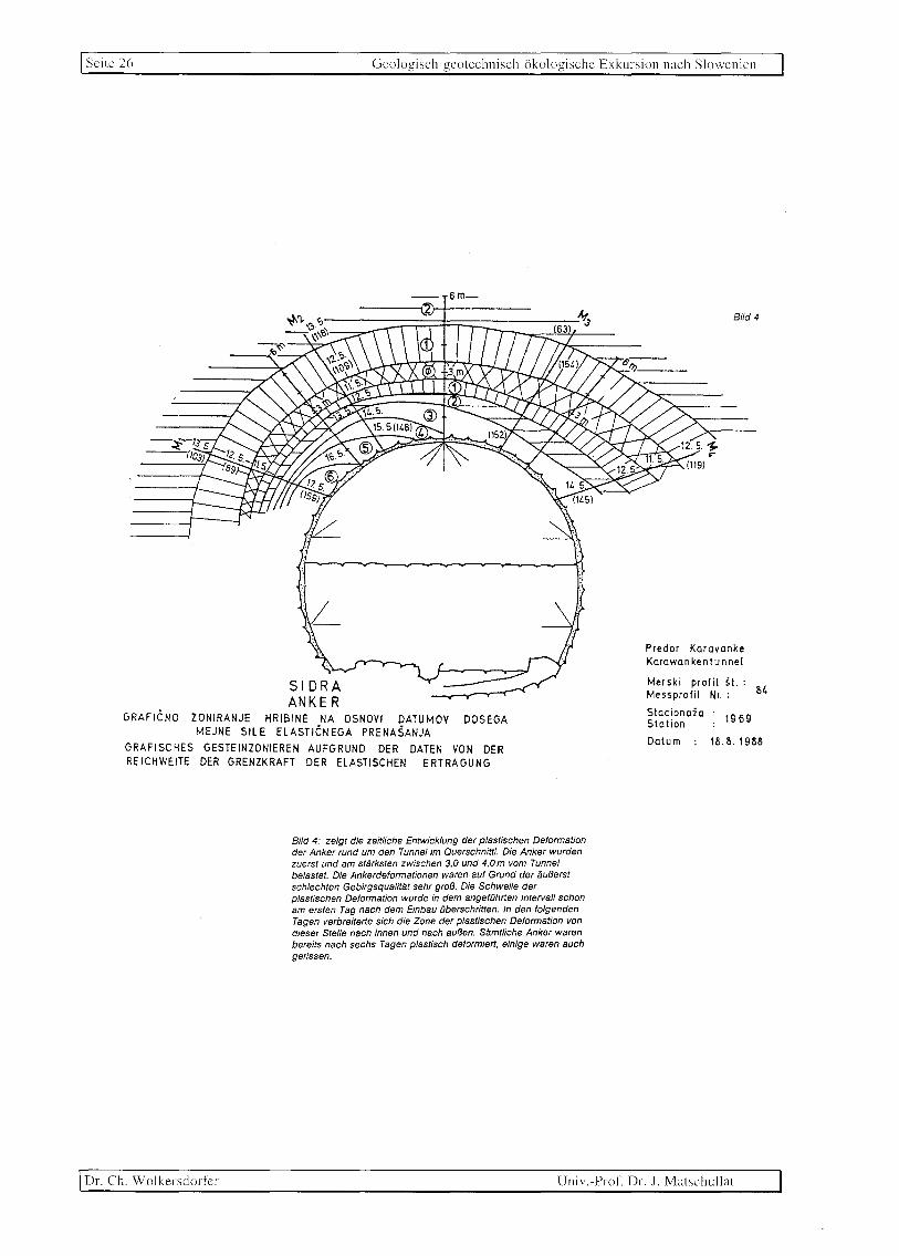
Seite 26 Geologiseh-geoteehniseh-okologische Exkursion nach Slowenien
-- sm-
GRAFICNO ZONIRANJE HRIBINE NA OSNOVI DATUMOV DOSEGA MEJNE SILE ELASTICNEGA PRENASANJA
GRAFISCHES GESTEINZONIEREN AUFGRUND DER DATEN VON DER REICHWEITE DER GRENZKRAFT DER ELASTISCHEN ERTRAGUNG
Bild 4: zeigt die zeitliche Entwicklung der plastischen Deformation der Anker rund um den Tunnel im Querschnittl. Die Anker wurden zuerst und am starksten zwischen 3,0 und 4,Om vom Tunnel belastet. Die Ankerdeformationen waren auf Grund der {;uBerst schlechten Gebirgsqualitat sehr groB. Die Schwelle der plastischen Deformation wurde in dem angefOhtten Intervall schon am ersten Tag nach dem Einbau (jberschritten. In den folgenden Tagen verbreitette sich die Zone der plastischen Deformation von dieser Stelle nach innen und nach auBen. Samtliche Anker waren bereits nach sechs Tagen plastisch deformiett, einige waren auch gerissen.
Bild4
Preder Karavanke Karawan ken tu nnel
Merski profil st. : Messprefil Nr. 84
Stacienaia :. 1969 Slation
Datum 18.8.1988
Dr. eh. Wolkersdorfcr Univ.-Prof. Dr. J. Matschullat

Gcologisch-geotechnisch-okologische Exkursion nach Siowenien Scitc 27
BUd 5
,-........ ~_ Glinasti skrilavec Tonschiefer
Zona pregnetenega skri lavca Zone des durchgekne teten Schiefers
51 ORA ANKE R
DIAGRAMI SPECIFICNIH DEFORMACIJ, PRECNO NA PREDOR DIAGRAMME DER SPEZIFISCHEN DEFORMATIONEN aVER
DURCH DEN TUNNEL
Bild 5: zeigt spezifische Ankerverformungen in dem Zeitraum, als die Konvergenz so gut wie zum Stillstand kam. Aus dem Diagramm ist ersichtlich, daB die Anker in den besseren Gesteinsschichten, auf der rechten Tunne/seite, starker belastet sind als jene auf der Iinken Selte, wo sie zu kurz sind (die MeBanker sind nur 6 m lang). Auf der Iinken Seite ist das Gebirge zu sehr gelockert, als daB die Anker zusammen mit dem Gebirge die Belastung im vol/en AusmaB iibernehmen k6nnten.
Univ.-Prof'. Dr . .I. Matschullat
o 10 '------' m m 1m
Dr. Ch. Wolkersdorfcr

Seitc 2~ Geologisch-gcotcchnisch-iikologische Exkursion nach Slowcnicn
o 1000 1....' __ ----' ,j'- / m
A91
SPECIFICNE DEFORMACIJE V BRIZGANEM BETONU -PREeNI PREREZ
SPEZIFISCHE DEFORMATIONEN 1M SPRITZBETON
QVERSCHNITT
Die Foige davon ist, daB die Spritzbetonscha/e auf dieser Tunnelseite viel starker be/astet ist (Bild 6). Die Be/astungen wurden mit VerformungsmeBgeraten gemessen, die in der Betonscha/e tangential eingebaut wurden.
A2 1
Predor Karavanke Karawankentunnel
Merski profi I st.. 84 Messprofil Nr.
Stacionaia Station Datum
1969
18.8.1988
Dr. Ch. Wolkersdorlcr Univ.-ProL Dr. J. Matschullat
Bi/d6

Geologisch geotechnisch (1ko]ogische Exkursion nach Siowenien Seile 29
10.5.88 15. 20. 25. 30. 4.6. 9. 14. 19. 24. 29 4.1 9. 14. 19. 24. 29 38 8 13 18888 Datum 12988
E: .,....-. 1/ [)-LIm] \
~+-~-+~--b-+-!~.~+-~~\+-~~-4.~_~.~~-.. +~-._~.-_+.-_4--+~--+-4--r-+--~ 1000+~-.,~-+~-._~-+.~--.~.-/~~~--~~\-+-4-/+. ~4--+--~+-~~--~~~~n.3~"-__ ~ __ -'+~-'~~-"_
"-\
:~..... --- - -~ /.-... , .... "'-" 'j-.. .. --.
r-.>" •. -'~""" \ r-.:.:: . ~ 1);(" - ~-=I~. - -- - - '>-~ A<.2 2<.- f--I-.- _ ',,,-"- ......'!< .'" ~r" ......... I '...,.......-,.-
-1000
1 '\ .: II i . '\ "'\ .' ............................. ~".L .. '\ AI. ,1
-2000 -I--+--+---+--+--1--1--\l--i..--... +-... -.... -hi--JJ.-i--i.1 -4-4,.'r' \\.-+. ---1-l---\--+---\--4--'>'+. -1=="=JP-l--r.-.~ ... = ... ±---'. \ 1'" As 1" '-' _ .. f- ..
Polozaj merilcev \~--./ .I i ~ ...... ,,~..........
_30001-:~~e:ss~d~O~S;~~~~~ta~n~d~1-~~\\1--kj~.~-+~_\~.~~I~= ... ~ ... = ... = .... +. ~~t=~~==~J~~,li21~.~-.......--t-~~ ~ 2 ~2) '-,_.
I( II . F_ '- -. 1-._ A "'- 3 2-. .
MERITEV RAZTEZKOV V BETONSKI OBLOGI Stacionaia Station Datum
1969 MESSAUSDEHNUNGEN 1M BETONBELAG
Das Diagramm der zeitlichen Entwicklung der Deformationen (Bild 7) des Spritzbetons zeigt den EinfluB der bei der Tunnelsicherung im permokarbonischen Tonschiefer verwendeten Deformationsschlitze auf die Entwicklung der spezifischen Verformungen im Spritzbeton und damit indirekt das Nachlassen der Spannung in der primaren Betonschale. Das Abklingen der Spannung ist eine Foige dafur, daB sich die Deformationsschlitze schlieBen.
Pj (MPal
9
8
7
6
5
3
2
P -.1... I - f+ 1
2 3
trc+(f-llcrv
(Re}f-1 (f-l1 ro
5
_ O'c f -1
Bild 8: zeigt die charakteristische Kurve des gesamten Systems der SWtzmaBnahmen im permokarbonischen Tonsch/efer und g/bt das Verhaltnis zwischen der Spannung in der Betonschale und dem Radius der gelockerten Zone rund um den Karawankentunnel
an.
Pri~sk na podpo~e Pj
Druck auf die Stutzanlage
Radij vplivne zone Re Radius der Einflusszo[)e
Radij predora ro Tunnelradius
Enoosna tlaena trdnost hribine O'c Einachsige Druckfestigkeit
des Gesteins
Vertikalna komponenta napetostnega stanja
cry Vertikale Komponente des Spannungszustandes
f Strizni parameter hribine Gesteinscherparameter
Bild 8
--
Univ. Prof. Dr. J. Matschullat Dr. Ch. Wolkcrsclorfer

~
C)
C)
3::
'l: ...c:
C)
'" ~
:;: ::; '/
>< ;:J
~ C) J:
51J o
~ ,
...c: C) J:
c ~
C)
~ C)
~Jj , ~
C) Of
':,1;
C C)
'-'
cr.
s C)
'l:
/11'.\'\. \1 II'!')'I \\,,1,'1 ()ualll\ III SI<lIc'l,i" Y,"II 1')')2 I')-l S l.illhll'll"llll\dl(1I11C'Ic()[()I()~iLallll'lillllc' "I
<C
)
~
<C
r--
S!()\ l'llla)
~ \j
C' ..:J
\ q \ '
f\
r (
~~ J ~
)~
/~~HOVO LJ
5 . ~~ U ~'1 ~ N'" ~ ID~~ \ VRH"IiK)\
(UD ",.fA "ORleA IS
~ ~\q AJQOVSCINA () l ~ IOGATEe
,~~ ~ Hu()POSTOJNYC1CEF1KNICA
'\ 1:1 SEiANA ) \ t;
i~o? --~~L:RSKA BISTRICA/('~ ~~ LJ ~
, [:--'~H 81~.
\"~? ~I WA. /" (S'\", I' , f/ ~~~ I ~-- ~ \..~ \ I ( /'-'~ ~ - v L/ \ -"c H R V ASK A
9() (J BOROVNICA GRDSUPLJE
9 ~ KOC[VJE
'0 U VELE'JE
2ALfC ()O
I Ldal - Pubi i srea by: MOP, H,lZ RS Tisk - Printed by: PLANPR I NT, 1993 I,delal - Adlmc" HELENA SENEKOVI C, dip:. Ing.; A~DREJ POINI t, dlpl. ing,
SLOV_8ISTRICA
~
u
(""~r'--~-~2 .4
I '7
i ~ <..,~~(
MURHA ~CBOT A -)7))
L iSl ()"" 'L~ U'
LE"RTY SLoveOR. .~ IFNO~ ~
..-~ /
)
rOME~18NEJSI ONESNAlEVALCI VODA V SLOVEi11JI IMPORTANT POLLU] A,NTS Or WATER ] N SLOVEN] A
H ~~~~lli~ = ~7g~~ II~JDuJ~~~J¢
'7 ~~RR~~~~E~S~~~ STATION 0 ~~~ARIS~~UI~~~~TRIJA
iSl ~;~~I~~AR~ARMA .0 ~~I[~AI~~~~STT;~JA
g ~~~t~T~~ [)J ~lV~~A~~~~~~~~STRIIA
{f ~~~~IS~~A~'JI~6::sJ;py '0 ~:J~~~~NDUSTRY ~ LIVILSKA INDUoIR:JA ~ lLKSllLNA INDUSTRIJA
FOOD INDUS'RY / fEXTILc INDL:lTRY
U ~~~I~~S\~N~~~Ur~~: JA II ~~~Jt~~~A I NN~0;;~I)A C:''''TRA~NA C:srILr~A. Nt.,PRAV;', brr)QIJlvost 5COO [;
() '\'\'ASll:. 'iiATt:R TREt.TM!:::!,T ,PLANT kOfXJcity SOOO I)
Vir· KATASTCR O,';ES.'~A7FVAl_CF'v \·ODA, Soucee: CADASrER OF WATtR POLlUrANTS.
KAT4STfR POV~SH~SKIH VOD,4, riMZ, ';;lSi CADAS1ER Of SURIACE WATER, HMZ, 1991
'" ::J ~
'-J f.
~ -,
:5
;..
~
t:;
-0 i/O
t:; .:.L
~
v
o

c ~. <
~ :-c<
t:J -:
3:: ~ OFo ::r-§: ~
Si n ::r-
:E s ;><;" 0l -: C/C 0.. o ~ o· -:
;llII'AN, M. (1')03): Water Quality in Slovenia Year 19'!2. - \94 S.: LjUbljana (HydroJllC1Coro\og:ical Institutc or
Slovenia)
4.4.1. INTRODUCTION
The evaluation of surface stratified waters in the Republic of Slovenia is being implemented by the Institute of Biology of the University of Ljubljana since 1974, when intensive research of Lake Bled started. In 1992, lake monitoring encompassed research of Lake Bled and Lake Bohinj as well as the lakes of the Triglav National Park. The present report is a summary of a full report on the results obtained within the framework of lake monitoring in 1992 (I).
4.4.1.1. Research Programme
This Lake Monitoring Programme has been set up on the basis of recommendations by Vollenweider (2) and OECD (3) for sampling most important physical, chemical and biological parameters.
The 1992 Lake Bled Monitoring Programme encompassed routine monthly analyses of physical, chemical, and biological parameters in the profile of east and west lake basin (see enclosed Map of Lake Bled), monthly analyses of physical and chemical parameters in influents and effluents as well as in the Sava Bohinjka River above and below the outflow of the hypolimnetic outflow from Lake Bled, saprobiological analyses of the influents and effluents as well as the Sava Bohinjka in two seasons of the year.
The Lake Bohinj Monitoring Programme encompassed routine monthly analyses of physical, chemical, and biological variables in the depth profiles at three points and performing physical and chemical analyses for the influents and effluents of the lake (See map of Lake Bohinj). Twice annually samples for saprobiological analyses of the main influents were taken.
In 1992, an investigation of the mountain lakes of the Triglav National Park both at the beginning as well as at the end of the vegetation season was implemented. For all water samples, basic physical and chemical parameters were analysed, influencing the development of phytoplankton, zooplankton and bacterioplankton in the littoral and populations in the benthos of the lakes and their influents. Biological investigations covered invertebrates, algae and macrophytes. Some research had been already implemented in previous years (4.5).
4.4.2. METHODS AND STANDARDS
4.4.2.1. Sampling
In Lake Bled, sampling in depth profiles was carried out vertically at intervals of two meters in both east and west lake basins. February sampling was omitted due to precarious ice.
Depth profile sampling in Lake Bohinj was performed at three sampling points. Ai all three sampling points, samples were taken at intervals of 3 meters to the depth of 15 m, and below that at intervals of 5 meters. Thus, regular monthly sampling produced 8 samples at Tl (25 m), and 12 samples at both T2 (45 m) and T3 (45 m). February sampling on Lake Bohinj was also omitted due to precarious ice.
In the lakes of the Triglav National Park, sampling was performed according to the depth of individual lakes. In shallow lakes, samples were taken on the surface and on the bottom, in deeper lakes also at mid-depths.
Lake influents and effluents were sampled once every month for physical and chemical analyses, and twice a month for saprobiological analyses.
4.4.2.2. Basic Physical and Chemical Analyses
The following physical parameters were measured at the sampling points: water transparency with Secchi disc, temperature with a thermistor (Iskra MI 7021), pH (Iskra MA 5705), electric conductivity with a conductimeter (Iskra MA 5968) as well as absolute and relative concentration of dissolved oxygen by means of an oxygen probe (WTW OXI96).
In laboratory, chemical parameters were determined according to the following standard methods (6,7,8):
by spectral/photometrical analysis (Iskra Spekol 221 MA 9524): silicon, nitrate, nitrite, ammonium, iron, total phosphorus, orthophosphate;
- titrimetrically: COD (permanganate method), dissolved oxygen and sulphate; - by flame photometry (Flapo-4,Carl-Zeiss, Jena): potassium, sodium, and
calcium.
4.4.2.3. Biological Analyses
The biological analysis comprised the following groups:
- zooplankton: with a 60 pm net; - phytoplankton: with a 30 pm net; - zoobenthos: with a 500 pm net; - benthical algae: by scraping them off the surface of stones; - macrophytes: by hand or scraper.
All samples were preserved in a 4% formaldehyde solution for subsequent laboratory investigation of species. Simultaneously, the relative frequency of single taxa in samples was determined.
The quantity of chlorophyll a (9) was determined at all sampling points of the depth profile in Lake Bled and Lake Bohinj. In the case of the lakes of the Triglav
o o o o
(1':;
J;' o 7'
[fq o S o o ::r-2. Cf. o ::r-,
~ ~ (5.
c/:., n ::r(D
tTl ~ c -: ~. o :l :l P o ::r-~
~ o :l (D :l
[/)
2. o 'J.)

G ::: o
i c./)
~ 0:: ::: ::: C J:
:l -'" X ~ Q)
..c o ,z'
'bJ) c'
~ , ~ .~ :l
..c '-.)
.9 () ~J)
..c '-.) VJ
'@) o
(;) o
01 r",
.9 o
c./)
National Park, which lie high in the mountains, these measurements were carried out at several points along the vertical profile if a particular lake was deeper than 5 m. Samples were taken eithpr with a plankton net or by filtering 2 litres of water through a glass filter (Watman GF/C). To evaluate the biomass per unity of the,ake surface, samples of zooplankton were taken, namely three parallel vertical samples at a time. Zooplankton samples were not taken if a lake was shallower than 1.5 m.
On the basis of the List of Bioindicator Organisms (IBU and HMZ for the year 1992) the identified taxa were classified into saprobic levels and the determined frequency of taxa was used to calculate the saprobic indices of individual lake influents as well as of the mountain lakes of the Triglav National Park (10, 11, 12, l3, 14). The method used was Pantle-Buck (15), modified by Zelinka-Marvan (16).
4.4.2.4. Valid Regulations for Evaluation of the Quality of Still Waters
In evaluating the quality of lake influents, valid regulations were considered, which, unfortunately, were outda,ed and insufficient (17). That is why in eV'lluating lakes beside these regulations, recommendations of Vollenweider (2) and OECD (3) had been observed. According to the regulations enumerated above, lake influents are classified into four quality classes, and lakes into five: ultraoligotrophic, oligotrophic, mesotrophic, eutrophic and hypereutrophic lakes. This classification of lakes is based on the quantity of total phosphorus, total inorganic nitrogen, the mean and maximum values of chlorophyll a, as well as the mean and minimum transparency depth (Secchi disc).
4.4.3. RESULTS OF RESEARCH IN 1992
4.4.3.1. Lake Bled
4.4.3.1.1. Phytoplankton
Changes in species and specimens abundance of algae at certain depths and in the lake as a whole were very dynamic. Monthly sampling was hardly enough to follow the main trends in the phytoplankton biocoenosis. Activities were particularly intensive during the spring homothermic period, when several species bloomed simultaneously.
In 1992, the total number of algae, their biomass, as well as the chlorophyll a content all showed a similar trend of increase and decrease. As in 1991, in 1992 the multiplication of algae was most pronounced in April, and accordingly the biggest growth of algae as to their numbers and biomass was observed in the west basin in the surface layers (total number 3.4 x 10⁷ ml, biomass 12.5 mg/l at a depth of2 m),
whereas the development in the west basin at that time was slightly slower (total number 1.8 x 10⁷ ml, biomass 8.7 mg/l at a depth of 2 m). During that period, Oscillatoria has reached its peak in the layer between the surface and the depth of 8 meters. In the east basin a maximum concentration of 715 filaments in a ml sample at a depth of two meters, and 590 filaments in a ml sample in the west basin in a surface sample (figure 4.4.1). To the total biomass also contributed diatoms such as Synedra acus and Cyclorella meneghiniana, a cryptophyte Cryplomonas ovata and a representative of the chrisophytes, Uroglena americana. The spring peak of algal blooming in 1992 was very similar to what had happened in 1991. The development of phytoplankton biomass also reflected in the distribution of increased concentrations of chlorophyll a.
0 2
100 4 0 6
~ 8 ~ g 10 -B 12
-.8' 14 16 18 20 22
24JFMAMJJASONDJFMAMJJASONDJFMAMJJASOND 1990 1991 1992
Figure 4.4.1: Vertical distribution of alga Oscillatoria rubescens (number of filaments ml-1) in Lake Bled for the period of 1990 - 1992.
The second peak of phytoplankton population was observed in September and October, while in November the biomass of the phytoplankton in Lake Bled was lowest. Thus the situation was quite different than in 1991, when the lowest biomass was noted already in September. In September and October, increased biomass was determined at the border between metalimnion and hypolimnion, namely in September in the east basin at the depth of 14 m (6.1 mg/l), and in the west basin at the depth of 12 m (3.8 mg/l).During that period the greatest number of algae was found at 22 m in the west basin (1.7 x lOs/ml), accounted for by cianobacteria
0::
"3 ..r::
'-.)
~
~
Q
2 '7 >
:5
2:3 :...
~ z ~
..:<:
~ .c u o

C :l
< ,
v 2
u ....,
:-$: g C/O (") :J"
S ~
:::J -,
n :J"
~ 'Tc" Q z 0..
~ 0-....,
Microcystis aeruginosa, which did not show in the biomass (5.8 mg/l). The top of biomass was formed by two chrisophytes Dinobryon divergens and Dinobryon sociaZe,
and to a lesser extent diatoms, namely the followi'flg two species, Cyclotella comta and Stephanodiscus sp.
In October the majority of algae sank down to a depth of 20 m in the east and west basin, although this did not show in the data for biomass, which meant that the algae had already died. That was indicated by increased concentrations of ammonium at those depths. In November, a biomass minimum was determined in both the east basin (0.18 mg/l) as well as the west basin (0.09 mg/l). In December the number of algae and the biomass again started to increase gradually.
The distribution of chlorophyll a concentrations in both east and west basin differed from that of 1991. In general, chlorophyll a values in 1992 both in their maximum and mean concentrations were higher for the east basin than the west basin, quite the reverse as in 1991. Maximum concentrations reflected above all the spring blooming of cianobacteria Oscillatoria, diatoms Synedra and Asterionella as well as the yellow-brown alga UrogIena. The September peak was reached in the blooming of the chrysophyte alga Dinobryon in metalimnion, which was more pronounced in the east basin.
4.4.3.1.2. Zooplankton
In 1992, the representatives of the following six species of organisms were detected in the zooplankton population: Cladocera Ceriodaphnia reticulata, Daphnia
hyaUna and Diaphanosoma brachyurum, Copepoda Cyclops vicinus, Eudiaptomus transyZ
vanicus as well as the dipterous larvae Chaoborus jluvicans. The vertical distribution of the species Daphnia hyalina was similar as in 1991, but with certain differences. In the east basin, the peak was reached at the depth of 6 m in July, while in the previous year the peak was reached also in July, but a depth of about 10 m. The next peak in September 1992 was at greater depth than in 1991. In October, November, and December, the highest number of Daphnia were distributed at a depth of 6 m, while in 1991 the main popUlation of Daphnia were at a greater depth.
Similar conditions prevailed in the west basin of the lake, with the peak distribution of Daphnia reached in July at a depth of 8 m, which means a whole month later than in 1991. In October, November, and December 1992, the main population was distributed at a greater depth than in the east basin and in the previous year.
The distribution of the other two Cladocera, Ceriodaphnia and Diaphanosoma was similar as in 1991, although appearing earlier in 1992 and thus enabling us to follow them for a longer time period. Thus Ceriodaphnia were detected in both lake basins from July to December (in 1991 only from August to November), and Diaphanosoma from July to November (in 1991 only in September and October).
The development of the populations of Copepoda EUdiaptomus and Cyclops followed a different pattern than in the year before. The Cyclops was less numerous, appearing through the entire year in the layer up to 10 m, except in September, when present only at the bottom of both lake basins. In the previous year, it was detected only in the time period from January to July as well as in December. Similar was the appearance of EUdiaptomus .
4.4.3.1.3. Physical and Chemical Parameters
In 1992, the lake started to freeze exceptionally early. On the New Year the ice covered the entire lake surface, except at those spots, where the lake receives its influents, the Radovna as well as other major influents. Because of a thaw from January 20 till the end of February the ice was not strong (up to 10 cm thick), and it melted in the first days of March. The homothermic period lasted till April, when temperature stratification began to appear in both lake basins. In June, July, and August, the thermocline lay between 6 and 8 m in both lake basins, in September and October between 8 and 10 m in both lake basins. The maximum temperature of the lake, 23.3°C, was recorded in August in the east lake basin.
Water transparency in both lake basins was smallest in April (1.7 m). The time of best water transparency was August, when a value of 10.5 m was measured in the east basin, and a value of 11.5 m in the west basin. During the summer months, water transparency lagged behind that of 1991.
The contents of dissolved oxygen in 1992 differed much from that of 1991 in both epilimnion and hypolimnion. In epilimnion in 1991, there was more dissolved oxygen in both lake basins than in 1992 (figure 4.4.2.). On the other hand, oxygen conditions in hypolimnion in 1992 were much better than in 1991. While in 1991 the period of oxygen concentrations below I mg/l in both lake basins lasted from March till the beginning of December, in 1992 that period was limited to the July-August period in the east basin, and the June-August period in the west basin. The layer of low oxygen concentration in 1992 reached down to a depth of 20 I'n inclusive in both lake basins. Better aeration at the bottom of the lake in 1992 was probably due to the influent the Radovna, which was ever since the beginning of stratification increased to 500 lis and for a certain period even to 700 lis. Increased inflow of the Radovna during the stratification period is an effective measure to ensure better supply of oxygen to lower layers.
Values of dissolved orthophosphate, assessed in individual time periods were lower for 1992 than for 1991. This was true for both epilimnion and metalimnion, but above all for hypolimnion. The values of total phosphorous were occasionally increased due to the blooming of individual species of algae, and were particularly high in April when they amounted to their maximum value of2.15 mgll at a depth of two meters in the west lake basin .
o ~
C(3 C/O r;
, f{Q
g o ~ :l v
~ 0: 'Tc" 2.. ::)
('8. z Q. o C11 >< 'Tc" C ~ ,3 :l
::l po (")
:J"
Vi o :;: (") :l (j)
:l
v; (")
(")
'JJ 'JJ

VJ ..c:
'-.) c; ~
~ C ,'f,
3 ~
>< ~ (0
..c: '-.) en
. tOil o o S ..c
'-.) on
2 ..c:
'-.)
.':J o ()
bJJ ..c u C/l
~ G:5 o
-qr<""i
.':J v
VJ
Table 4.4.1: Limit values according to OECD (1982) and values of individual parameters measured in Lake Bled.
trophic phosphorous nitrogen chlorophyll a water transparency level total inorg. mean v. max.v. mean v. min.v.
(pg/l) {pgfll (pgfl) (pg/l) (m) (m)
ultraoligotrophic $4 $200 $1 $2.5 ;,:12 ·;,:6 oligotrophic $10 200-400 $2.5 $8 ;,:6 ;,:3 mesotrophic 10·30 300-650 2.5·8 8·25 6·3 3-1.5 eutrophic 35-100 500-1500 8-25 25-75 3-1.5 1.5-0.7 hypereutrophic ;,:100 ;,:1500 ;,:25 ;,:75 $1.5 $0.7
Bled 1991
east basin 8.7 310 21.4 5.4 5.5 1.8 west basin 7.9 390 35.6 4.8 5.4 1.5
I
I
Bled 1992 J east basin 12.4 560 32.8 5.1 6.0 west basin 25.5 520 30.0 4.7 6.0
OVV~\~~V~'~>--~~V~lrrl''[(~V~----~~.----r---~~---2} ) J v J I
4 6 8-;
g 10
-B 12
~ 14 16 18 20
22
1.7J 1.7
Figure 4.4.2: Vertical distribution of dissolved oxygen (mg 1-1) in Lake Bled in the 1990 - 1992 period.
Values of nitrogen compounds were higher in 1992 than in 1991. In August, i.e.
at the time when anaerobic conditions predominated, ammonium values in bottom layers in both lake basins rose (up to 6.0 mg/l in the east basin and 4.8 mg/l in the west basin). Occasionally increased nitrite values were detected, up to 2.4 mg/l in the east basin and 5.1 mg/l in the west basin.
On the basis of the total contents of phosphorous, inorganic nitrogen, water transparency and chlorophyll a contents, table 4.4.1 illustrates the ranging of Lake Bled into the trophic levels according to OEeD recommendations (3). According to chlorophyll a values, Lake Bled is classified as mesotrophic to eutrophic.
Values of total phosphorous and nitrogen compounds in 1992 indicated that conditions in Lake Bled were somewhat worse than in 1991.
4.4.3.1.4. Influents and Rehabilitation Measures
The main influents of Lake Bled, contributing most water, are the MiSca, the Krivica, the Solznik, the Ribcev Graben as well as the Usivec. With regard to the measured values of chemical and physical parameters it may be concluded that the MiSca, the Krivica as well as the Solznik sporadically, and the USivec constantly, pollute this lake. An essential increase of in the content of the nutrients in 1992 was determined in the Ribcev Graben, the catchment area of which has suffered intensive liquid manuring.
The Radovna remained polluted and rich with oxygen for the major part of the year. Occasional increases in the values of nutrients point to irregular pollution, a fact further corroborated by saprobiological analyses. In 1992, the total amount of inflow of the Radovna into the lake amounted to 10,627,200 m3 , while the amount of water drawn out through the hypolimnetic outflow amounted to 8,590,752 m3 . The mass balance of nutrients brought into the lake by influents and drawn out of the lake through the hypolimnetic outflow, was negative. 1.7 times more total phosphorus
and 1.9 times more total inorganic nitrogen were drawn from the lake that brought into it by its influents. The difference between the input and output quantity of water was due to the fact that the water balance does not cover all influents and effluents (underground, precipitation and other sources).
Table 4.4.2 shows values of physical and chemical parameters as well as saprobic index, as measured in the influents of Lake Bled in 1992.
c;
::l ..c:
'-.)
3 c;
:;:s f-o
cs c
~ .::: ~
::J
2 o -0
C/J
~ ..:.::
~ o Q

C Table 4.4.2: Physical and chemical parameters and saprobic index (5.1.) in the 1° ::l
< influents of Lake Bled. G
,
3" 4.4.4. CONCLUSIONS re. z
~ Paramo N03 N02 NH3 P-o P-tot Si02 COD 02 condo S.1. r.
4.4.4.1. Lake Bled :T
~ unit mgll mgll mgll mgP04/1 mgll mg02/i mgll jJS/cm ,
rrc:r n
'- Particularly in the spring of 1992, cianobacteria were the most important phyto-
$: INFLUENTS 0
plankton group. Among them, Oscillatoria rubescens predominated, «algal bloom» in r.
2, :T
The Krivica the layer between the surface and the depth of 8 meters in both lake basins in April. ::l
vc
" max 10.0 0.01 1.0 0.16 0.53 3.5 4.1 13.4 476 z
:T There was no typical metalimnion «algal bloom» of Oscillatoria in the summer r.
E- mean 4.0 0.00 0.1 0.03 0.12 2.4 2.5 11.0 318 1.97 ..-, min 2.2 0.00 0.00 0.00 0.Q1 1.8 0.9 9.1 212 months. As for other algae, the predominating species were cryptophytes, pyrrho-
~.
g The MiSca r
phytes, green algae, yellow-brown algae or chrisophytes as well as diatoms, the lat- C)
max 11.6 0.04 1.2 0.1 0.38 4.5 9.4 12.1 470 C)
mean 6.9 0.03 0.3 0.04 0.1 3.2 3.4 10.9 363 2.05 ter reappearing after several years in the summer-autumn peak. °3. z
min 5.0 0.02 0.00 0.00 0.01 1.9 1.1 9.3 297 Average contents of chlorophyll a place Lake Bled into mesosaprobic level, while The Ribtev Graben
S
max 2.8 0.01 1.5 0.00 0.02 3.6 7.5 12.2 417 maximum contents place it into eutrophic leveL (0
tTJ mean 1.8 0.00 0.2 0.00 0.Q1 3.0 3.4 10.6 302 1.58 Species composition of Copepoda, Cladocera and dipterous larvae, which repre- x min 0.9 0.00 0.00 0.00 0.00 1.7 1.1 8.8 263 r
Th§ Solznik sent the majority of zooplankton population, saw no significant change compared to c ;;
max 13.7 0.03 0.97 0.02 0.06 6.9 8.4 10.6 752 1991. The species Daphnia hyaUna predominated in zooplankton during the entire co mean 2.7 0.01 0.25 0.00 0.01 4.4 4.3 6.0 446 1.72 year. Other Cladocera and Copepoda were present in a similar temporal and depth
::l
min 0.25 0.00 0.02 0.00 0.00 2.6 2.0 2.6 286 ::l
The USivec distribution as in 1991. During the winter, on the bottom of the lake the dipterous p
" max 14.7 0.01 0.97 0.09 0.08 6.1 7.4 9.9 530 larva Chaoborus fluvicans was present, which serves as an indicator of the mesos-:T
mean 10.8 0.00 0.12 0.02 0.03 4.7 3.1 8.8 515 ~ min 6.4 0.00 0.00 0.01 0.00 3.7 1.0 6.9 332 aprobic leveL ~ The Radovna The lake was covered with ice from the beginning of January till the end of G
max 3.8 0.Q1 1.05 0.01 0.29 1.4 4.1 16.3 257 ::l
mean 2.2 0.00 0.04 0.00 0.04 0.9 2.7 12.5 190 1.52 February. Homothermal conditions prevailed in both lake basins till April, when the G
min 1.2 0.00 0.00 0.00 0.00 0.0 1.6 10.8 temperature stratification set in. Winter mixing of the layers began in the end of ::l
136
OUTFLOWS November. Water transparency in 1992 was slightly higher than in 1991, placing the
The Jezernica lake both according to maximum as well as mean water transparency into the mesos-
max 2.9 0.02 1.86 0.02 0.03 1.6 5.8 13.3 399 aprobic levels. mean 1.0 0.01 0.31 0.00 0.01 0.8 3.8 10.8 296 1.81 min 0.25 0.00 0.00 0.00 0.00 0.1 2.5 9.0 219 Oxygen conditions during the summer period were more favourable than in 1991. Hl/Qolimnetic outflow Oxygen concentration of approx. 1 mg/1 was measured in both lake basins from June max 1.52 0.02 8.96 0.15 0.43 7.8 8.1 6.8 482 to August, rising up from the bottom to a depth of 20 m. mean 0.56 0.01 4.00 0.06 0.13 5.0 4.3 2.1 379 min 0.25 0.00 0.24 0.00 0.01 1.8 2.1 0.0 251
\J --: SAVA BOHINJKA r: The Sa va BQhinika above the inflow of the Jezernica and the hl/Qolimnetic outflow :T max 2.9 0.01 0.9 0.01 0.27 1.5 6.0 16.1 236
::E mean 2.2 0.01 0.2 0.00 0.05 0.6 3.0 12.3 206 1.66
2- min 1.3 0.00 0.0 0.00 0.00 0.0 0.9 10.2 159 r The Sav~ Bohinika below the inflow of the Jezernica and hl/Qolimnetic outflow n max 3.1 0.02 0.9 0.01 0.05 1.8 6.2 15.4 286 --: z mean 2.2 0.01 0.21 0.00 0.02 0.8 3.0 11.9 214 1.99 a.. ~ min 1.2 0.00 0.0 0.00 0.0 0.0 1.6 9.8 165
~ Ig. (')
'JJ U1

;3 c u
S Vi ..c: u ~ c
':; :.... ;::J
-'<: ><
:.r.l C)
..c: u J:
'51)
~ , ..c: u ~
c ..c: u ~ 8 ~) u z
Til o
V o
'-D rr: .::: ·0 C/)
The contents of total phosphorous remained for the major part of 1992 below the values of the previous year, while the contents of maximum concentrations were higher. The contents of inorganic forms of nitrogen, particularly of nitrite and ammonium exceeded those of 1991.
The mean contents of total phosphorous and the contents of inorganic nitrogen place this lake into the mesoeutrophic level.
In all influents, except in the Ribcev Graben, lower cation contents were measured in 1992 than in 1991. The contents of nutrients in the influents differ, but more nutrients entered the lake by way of individual influents than in 1991. The conditions deteriorated badly in the Ribcev Graben, where the content of total inorganic nitrogen compared to 1991 increased by a factor of 40, and of total phosphorous by a factor of 88; that being caused by intensive liquid manuring of adjacent surfaces. Saprobiological analyses of the influents showed a deterioration of the conditions of the Krivica and the Misca.
The inflow of the Radovna was in the spring period increased to 700 lis, the aim of that measure being to flood the huge mass of phytoplankton off the surface of the lake. For most of the year, the inflow of the Radovna was from 200 to 500 lis. The flow from hypolimnetic outflow oscillated from 200 to 370 lis and consequently twice the amount of total inorganic nitrogen and 1.5 times more total phosphorous were conducted through the hypolimnetic outflow from the lake than in 1991.
In the Sava Bohinjka the difference between the point above and the point below the inflow of the lezernica and the hypolimnetic outflow is greatest according to saprobiological analyses, which show deteriorated conditions at the point below the inflow of the lezernica, the hypolimnetic outflow, and the sewage. According to measured physical and chemical parameters the differences were less conspicuous in 1992.
4.4.4.2. Lake Bohinj
The representatives of the algae, which are normally found in more polluted lakes, were in 1992 in the phytoplankton biocoenosis detected mostly in early spring and late autumn, while in the summer the situation was somewhat more favourable. Also detected in the phytoplankton biocoenoses, cianobacteria, although in very small numbers. The diatoms population was numerous in spring and autumn. In summer, besides the green algae of the following species Gloeococcus schroeteri, Ankistrodesmus braunii as well as various species of the genus Sraurastrum, there also appeared chrysophytes, notably the species Dinobryon divergens. At any time of the year, phytoplankton populations consisted of few members only.
Species composition of Copepoda and Cladocera demonstrated that Lake Bohinj features psychrophilic species as well as species that cannot stand an eutrophised en-
vironment. Although Daphnia hyalina prospers there, other species, such as Diaphanosoma brachyurum or Eubosmina iongispina in particular, are more strong in numbers. Among Copepoda, Cyclops abyssorum praealpinus, typical of oligotrophic lakes, predominated. In summer, the lake was stratified from May till the end of September. The lake was weI1 aerated during the entire year all the way to the bottom. Occasional pollutions of the lake with nutrients were demonstrated by the values of COD, total phosphorous as well as by other parameters. On the basis of OECD recommendations (1982), Lake Bohinj is characterized as an oligotrophic lake.
Physical and chemical parameters in the influents show that the lake was receiving nutrients in increased quantities. Most polluted were the influents in the area around Skalca as well as the outflow from the fish-farm. Occasionally, increased inflows of total phosphorous in various influents and in different seasons of the year were detected.
...-oj
::l .c u .3
~
C5
d; ;.>
c ;:J
5 ':.... o
-::J J: :.... U ~
~ 6 2S
Geologisch-geotechnisch-bkologischc Exkursion nach Slowenicn
Univ.-ProL Dr. J. Malschullat
o CC W N we ""')w
Scitc 37
00:: ~ ~LL .~
(1)0 .~ U]w ~ ..J~ ~ CD..J e
Dr. eh. Wolkersclorrcr
\:: U
~ S
Ell ..c: u
'" \::
5 ':::: 5
..:.:: ><
U-l u
..c: u .J;
-bJ]
~ J: u .~ c
..c: u 2:l o (j)
11) U
"./)
'S) C C (j)
o
00 C".
3 u
[/)
Matija Drovenik, Mario Plenicar & Franc Drovenik .. ---_._------ -_ ..... __ .. __ .-
The origin of Slovenian ore deposits
Summary
An attempt has been made to interpret the multistage orIgm of the ore deposits of Slovenia in chronological order in relation to the geological history of the country .
Early Paleozoic era
The oldest ore bearing beds in Slovenia are the metamorphic rocks of Pohorje and Kozjak which belong to the Eastern Central Alps. They were derived from the sediments and products of the initial volcanism which filled during the Early Paleozoic era the large geosyncline in the region of the Alpides. During the subsidence of the geosyncline the deeper buried rocks were folded and metamorphosed. The progressive regional metamorphism terminated with the retrograde metamorphism. The problem of stratigraphy of our metamorphic rocks and the age of their metamorphism has not been solved completely yet. Metamorphism probably started already in the Baikalian orogeny, and continued during the Caledonian-Variscan orogeny. The metamorphic rocks overlain by quartz-sericite phyllite are probably Pre-Ordovician, and perhaps even of Precambrian age. The Magdalensberg beds which overlie the mentioned phyllite were deposited probably during the period of Middle Ordovician-Lower Devonian.
Already during the Early Silurian period the influence of the Periadriatic lineament became apparent. In the territory of Slovenia it is represented by several parallel faults which had different functions in different geological ages. During the Middle Triassic period the Periadriatic lineament might have been a subduction zone. At the boundary between Cretaceous and Tertiary periods it was represented by a system of right transcurrent faults, and during the Oligocene epoch and at the end of Miocene epoch it was the root region of overthrusts; north of the lineament the over thrusting was directed towards the north, and south of it southwards.
In metamorphic rocks are interesting the lead-zinc-copper deposit Okoska gora in the southern foothills of Pohorje, and the polymetallic ore deposit Remsnik in the southern slopes of Kozjak. At Okoska gora occurs mostly an orebearing breccia in which ore minerals represent crystalloblasts due to the influence of regional metamorphism (fig. 1). This is the oldest lead-zinc-copper ore deposit of Slovenia. Spectral analyses of ore minerals indicate a heterogeneous geochemical association, and mass-spectrometric analyses the juvenile origin of
sulfur. Possibly, the ore-bearing solutions were derived from the same magma chamber as the keratophyre which was later metamorphosed.
Of more economic importance was the polymetallic ore deposit Remsnik in which lenticular concordant ore bodies were mined. In total, several hundred tons of lead. zinc, and copper were mined. According to trace elements and the isotopic composition of sulfur the Remsnik ore is nearest to that of Okoska gora. It should be mentioned, however, that it is highest in silver and bismuth among all )Pad-zinc ores in Slovenia. The genesis of Remsnik is slill questionabll'. Somt' authors support its magmatic-metasomatic, and others the volcanogenic-sedimentary origin (figs. 2, 3).
The Magdalensberg beds are mineralized with lead and zinc in the Velunja valley. According to the mineral composition and geochemical paragenesis, the occurrences in the Velunja valley approach the veinlike lead-zinc deposits in Carboniferous-Permian beds of the Sava folds. On Hamunov vrh lhere were prospects and some mining of iron ore in Magdalensberg beds. Three diabase lenses contained magnetite bodies which were formed during the separation of liquid basic magma.
Lower Devonian beds outcrop in the Karavanke Alps in the surroundings of Jezersko. Upper Devonian beds are also exposed, but only locally.
Late Paleozoic era
At Stegovnik ore occurs at the contact of Upper Devonian reef limestone and Lower Carboniferous clastic beds. Devonian and Carboniferous rocks are silicified along the contact (fig. 4), and they contain ore minerals, mostly sphalerite, tetrahedrite, and galena (fig. 5). Spectral analyses of tetrahedrite show enrichment, especially of silver and nickel contents. Similar deposits were found along the contact of Devonian and Carboniferous beds also in the Carnian Alps; where they were explained by extrusive-sedimentary ore associated with the Carboniferous spilite-keratophyric volcanism. The total length of the zone of ore occurrences along the contact of Devonian and Carboniferous beds amounts to almost 140 km.
In the Upper Carboniferous beds of the Orenburgian stage occur small deposits of iron ore. They were mined in two belts, one between Jesenice and Tdic, and the other near Vitanje. In both belts ore bodies were mostly lenticular embedded in limestone or in clastic beds. In the first belt about 250,000 tons of !'ideritic ore were mined in Savske jame, BelScica, and Lepena. In the Vitanje belt iron ore was mined at Bric, Brdce, Felicijan, and in the surroundings of Glose, Cesnjice, and Kamna Gorica. To these deposits the hydrothermal-metasomatic origin was ascribed. However, considering that ore bodies occurred in both belts in the same stratigraphical-lithological horizon, and taking into account certain ore textures in Savske jame and Vitanje belt, sedimentary origin of iron ore in both belts seems more probable.
In the Sava folds the oldest rocks consist of a sequence of dark gray slate, light gray fine grained quartz sandstone, and quartz conglomerate. These beds were ranged first into the Carboniferous period. Later some ranged them into the- Carboniferous-Permian, and others into the Lower Permian, i. e. into the Trogkofel stage. Evidence for a faultless classification of the sequence is stil
'" '3 ..c: () z c;:j :;s ,....;
6 ~ ~ >
:5
~ 23
" C/;
t5 ..:<: o ~ ..c: U '-
Q

C ::l
, -C
~ '-<
~ ~ z
~ C ::: ~
o -,
n ;0-
~ ;>;
S :J ::::-
~
insufficient. Until the age of these beds has been well determined, we shall range them into Carboniferous-Permian.
In the wider surroundings of Ljubljana in Carboniferous-Permian beds copper, iron, and lead ores were mined and melted already in prehistoric times. In the New Ages Litija was the miniJag center with one of the most important ore potentials in the Eastern Alps. Locally lead and zinc ore contained cinnabar and barite in economical quantities. It occurred in concordant and discordant veins. Between Hrastnica near Medvode in the west, and Peeelj at Sevnica in the east, more than 40 deposits occur at a length of about 80 km, most of them in the Litija anticline.
They arc meso-epithermal ore deposits which are not exactly dated yet. We consider that their age determination should be performed primarily on the basis of their position in the geological setup of the Sava folds. These deposits at'e closely related to the Carboniferuus-Pet'mian beds. Ore veins of this kind were not found in the Middle Permian beds, although they overlie often the ore-bearing Carboniferous-Permian beds. They occur neither in Triassic nor in vOllnger beds. with the exception of Plese, where Triassic carbonate rocks are mineralized with barite - but only along the contact with ore-bearing Carboniferous-Permian beds. Ore at Plese could be explained by mobilization of barite from Carboniferous-Permiam beds into the Triassic ones.
Ore veins were filled before the deposition of Middle Permian beds, and Uwy are genetically associated with the Lower Permian magmatism, which furnished in Eeastern Alps quartz porphyry and keratophyre. True, outcrops of these rocks have not been found in Slovenia yet, but their pebbles and fragments are a frequent component of the Permian Val Gardena beds.
According to mineral composition four groups of ore deposits can be distinguished. To the first group can be ranged the mesothermal deposits Cesnjice, Zlatenek, and Ponovice; their characteristics is a simple paragenesis, and the principal ore mineral is sphalerite (fig. 6). The second group comprises most of the ore veins. They contain lead-zinc ore with prevailing galena. Typical representatives of this group are Zavrstnik, Maljek, and Zagorica. Ore minerals crystallized in the sequence sphalerite-cha1copyrite-tetrahedrite-galena. Veins often contain barite and also some quartz. Their country rock is in places silicified (figs. 7 and 8).
Economically most important was the third group of ore deposits characterized by ore veins with a heterogeneous paragenesis. Next to galena and sphalerite they contained also chalcopyrite and cinnabar, as well as locally barite in economical quantities. Such ore was mined especially at Litija, Knapovze, and Plese. The highest ore reserves existed at Litija, where about 50,000 tons of Pb, 1 ton of Ag, 42.5 ton of Ug, and about 30,000 Lons of barite were extracted. Vertically in veins the ore and the gangue minerals were zonally distributed. In the upper parts barite prevailed, accompanied by galena and cinnabar. Below, first an abundance of barite diminished, and then also of galena. At the same time sphalerite appeared. Its abundance increased with depth, and it became the main ore mineral accompanied by quartz. Veins then terminated downwards in barren quartz roots.
Into the fourth group only one ore deposit was placed, the Madja Reka mercury ore deposit. The main ore mineral is cinnabar. In lesser quantities
OCCur also other ore minerals characteristic for Pb-Zn ore deposits of the Sava folds. as discussed above.
Typical for the vein deposits of the Sava folds is a slight enrichment of sphalerite in cadmium, cobalt, copper, and gallium, as well as enrichment of galena in silver, copper, and antimony. The isotopic composition of sulfur in sulfides from various ore deposits is rather similar. The main characteristic arc close ranges of the 0 S34 value around 0.0 %0, which is an indication of the juvenile origin of sulfur.
In the Carboniferous-Permian beds of the Sava folds also antimony ore was mined. Ore veins and lenses occurred only in the Trojane anticline between Trojane and Znojile in an about nine kilometers long belt. In the Kralj and Zinka adits, at Perhavec and Znojile, about 4,000 tons of antimony wet'e extnlcted in total. Next to stibnite (figs. 9 to 12) the ore contains also other ore minerals. but in small quantities only. Considering the geochemical paragenesis and the isotopic composition of sulfur, these antimony vein deposits can be logically associated with other vein deposits in Carboniferous-Permian beds of the Sava folds.
South of the Periadriatic lineament the Permian beds occur in carbonate and clastic development, and north of it only in clastic one. Above the clastic Carbonifemus beds in the Karavanke Alps the Trogkofel Pseudoschwagcrina limestone was deposited. In the Trogkofel limestone occurs the lead-zinc deposit Korosica with the ore displaying pronounced colloidal structures and textures (fig. 13 a, b). In this respect it differs from other lead-zinc deposits in Slovenia.
From the metallogenic point of view the Pet'mian clastic Val Gardena beds are of an essentially higher importance, since they contain the uranium ore deposit 2irovski Vrh and the copper ore deposit Skofje. The Val Gardena beds attain their maximum thickness in the 2irovski Vrh area. In their lower part, which is 200 to 250 m thick, prevail gray and green coarse and medium grained sandstone along with conglomerate and conglomeratic sandstone. Sheets and beds of red rocks are rare. In the upper part, 350 to 400 m thick, predominate red medium and fine grained sandstone and siltstone. In this part of the lithological sequence occur also beds of gray and green varieties. Geological evidence indicates that the Val Gardena beds were deposited in an arid climate on land: their lower part represents deposits of river bed, and the upper part deposits of flood plain. Especially the red clastic beds occur also in the Skofja Loka and Polhov Gradec hills, and in the Karavanke Alps. Fragments and pebbles of the clastic beds are derived from igneous, sedimentary, and metamorphic rocks. The gray and green Val Gardena sandstone shows evidence of diagenetic, epigenetic, and retrograde-epigenetic alteration. Under the mict"Oscope growth of detritic quartz, plagioclase and orthoclase grains, authigenic albite grains, and also several generations of quartz and carbonate minet"<lls cill1 be seen among others. Alterations occurred at temperatures aUaining 2000 C.
The uranium ore deposit 2irovski vrh lies in gray-green clastic rocks which contain intercalations of red varieties. In this part of the lithological sequence four rhythms can be distinguished. The lower rhythm lies unconformably on Carboniferous-Permian beds. It consists largely of obscurely bedded basal conglomerate and of conglomeratic sandstone. Sandstone and conglomerate of the second rhythm are locally well bedded, and they contain traces of ura-
Cl c
rr:, J r: ;0-,
rf~
S2 G r: ;0-
z r: ;0-,
f (f~
z r.
co l ~;
X
~ "f
::l
;:; ;0-
CJ:
;;: r.. ()
CJ: c
c 'JJ
o

()
()
::s J;
..c ~
'"' ::; ..L
>< ~
~ () ~
EJ
~ ,
:::; C/O
-B 3 o :'Jj ,
..c () ~
:'fJ
()
G
;: ()
()
J;
nium ore and of sulfides. In the third, ore-bearing rhythm sandstone predominates above conglomerate; it is characterized by cross bedding. The fourth rhythm consists of medium and coarse grained sandstone which in places contains also pitchblende and various sulfides (fig. 14).
The ore-bearing horizon of the third rhythm is 30 to 60 m thick. It is devided by lenticular intercalations of red shaly sandstone into the lower and upper part. Until now above 100 lenticular ore bodies have been found which are very irregulary distributed.
The most important ore mineral is pitchblende. It occurs in grains in the cement of sandstone. On the average these grains are about 10 11m thick, and they occur individually, or appear associated into small, irregular lenses (figs. 15, 16, 18, 19, and 20). In very rich ore pitchblende forms most of the cement, and detric grains "float" in it (fig. 17). It is accompanied by sulfides which in several ore bodies achieve even 5 0/ 0 . Pyrite prevails which is characterized by "mineralized bacteria" (fig. 21). Also pseudomorphs of pitchblende and pyrite after plant remains have been found. In smaller quantities occur as primary minerals also galena, sphalerite, chalcopyrite, arsenopyrite (fig. 22), and ten nanEte.
Zirovski vrh is a sedimentary ore deposit. Pitchblende and sulfides precipitated in the reducing environment which was generated by decomposition of organic remains and metabolism of anaerobic bacteria. A part of uranium and a large part of sulfide grains were later remobilizied (figs. 23 to 26). The geochemical paragenesis comprises beside uranium also arsenic, copper, lead, zinc and vanadium. The mass-spectrometic analysis of the sulfur isotopic composition shows a strong enrichment in S~2 with a very wide variation of ,)S34 which attains almost 40 %0. This is regarded as evidence of biogenic origin of sulfur.
In the surroundings of Skofja Loka there are occurrences of uranium ore in Selca Valley at Sv. Tomaz and Sv. Valentin, as well as in Poljane Valley at Bodovlje ravine.
In the upper part of Val Gardena beds copper occurrences were deposited during diagenesis. There red siltstone, sandstone and shale predominate, however, mineralized are always only their gray and green varieties. Outcrops of copper occurrences are arranged in an almost 90 km long belt which extends from the Cerkno area into the eastern part of Sava folds. The mineralized clastic rocks are hydrothermally unaltered. Authigenic albite rims and authigenic albite grains are entirely fresh also in cases when they border directly on primary ore minerals. Ore beds contain anthracite lenses and very fine dispersed organic matter in clastic rocks. Ore minerals occur mainly in cement (figs. 27 and 28). The most important ore minerals are chalcopyrite and bornite (figs. 29, 32 and 33). In lesser quantities occur also pyrite, tennantite, chalcocite (fig. 30 a), sphalerite, and galena, while in traces enargite, linneile, and fl dom<'ykite are present. Characteristic are pseudomorphs of copper sulfides and pyrite after plant remains; the original cellular texture is often very well preserved (figs. 30 b, 34, 35 and 36).
At Skofje lenticular ore bodies occur in an about 15 m thick ore-bearing horizon which is in an inverse position due to post-ore tectonic. Most of the ore was found in dark gray, tough medium grained sandstone. According to mineral composition the bornite-chalcopyrite, bornite-chalcocite, and chalcopyrite-pyrite
ore can be distinguished: they were formed in slightly different physical-chrmical conditions. Along with copper the Skofje ore contains also some arsenic, lead and zinc, and is enriched in silver. Mass-spectrometric analysis gave evi(knce of high enrichment of sulfide sulfur with S~2; ,)S~4 value varies in the range of about 29 %0, Considering the sulfide sulfur from the surrounding OCCUl'('pnces Sebrelje. Masore, and Sovodenj, this arange is well above 40 %0. Enrichment in S~2 and the very broad range of (5S~4 favor the biogenic origin of sulful' in copper deposits of Val Gardena beds.
In the arid climate conditions of Middle Permian stage a small iron ore deposit. was formed in the clastic beds at Hrastno neal' Mokronog. In various pel'iods hematite ore was mined there.
In Upper Permian carbonate rocks no uranium, copper, or iron deposils occur but locally there are minor concentrations of lead-zinc ore. About three centuries ago at Skorno in Salek Valley Pb-Zn ore was prospected and mined in Upper Permian carbonate rock. In total about 500 tons of zinc and 100 tons of lead were extracted. Mining workings of some importance were in the ore deposit Puharje where the Upper Permian beds exceed 400 metres. The larger part of the lithological sequence belongs to gray and dark gray dolomite. Mineralized with lead and zinc is the upper part of dolomite beds, while the underlying and the overlying limestones are completely barren. Several irregular ore bodies of moderate dimensions showing epigenetic ore structures and textures have been found in the recently driven adit in the gray and dark gray dolomite. In spite of the simple paragenesis, the succession of crystallization of sphalerite and galena which prevail in ore, is very complex (figs. 37 to 42). In dark, very finely grained bituminous variety of dolomite also sedimentary textures and structures appear. They were preserved due to the fact, that the ore bed was insulated by sheets of slaty bituminous dolomite. According to our opinion, the ore minerals of Puharje were deposited during diagenesis of the more or less bituminous carbonate rock, but were later redistributed. By spectral analysis enrichment of sphalerite with cadmium, and of galena with arsenic has been determined. Sulfur of sphalerite and of galena is moderately enriched in S~4. It has been released most probably during bacterial reduction of repeatedly reduced sulfates.
Mesozoic era
During the Scythian stage the Alpidic orogenic cycle started with the formation of a shallow geosyncline, which differentiated during the Lower Anisian stage into an eugeosyncline and a miogeosyncline, with an interoceanic high inbetween. The same arrangement lasted also throughout the Ladinian stage. Starting with the Cordevolian substage, however, in the eugeosynclinal area developments in two regions can be distinguished. In the western part of Sava folds the deep marine sedimentation lasted without interruption through the end of Jurassic period. In the other areas of the Southern Alps the eugeosynclinal deposition became interrrupted in the Cordevolian substage and in the Norian and Rhaetian stages with an unique shallow marine carbonate deposition. During the Julian and Tuvalian substages narrow and shallow miogeosynclinal trougs with intermediate carbonate shallow marine deposition were formed. The miogeosyncline, i.e. the region of Dinarides, was periodically interrupt.ed by carbo-
~
~ ,-() C/O
~
~
cS
0: , >
:J
:... (j)
:... C v
C/O
()
..L
~ o '""
c:::
,
'D o
t:i ...,
s: ~
V; r. :0-
~ :::
o
9 :< ;>;""
~ :/: c..
o
nate shallow marine deposition in the Cordevolian substage, and in the Norian and Rhaetian stages. The total thickness of Scythian, Anisian, Ladinian, Carnian, Norian, and Rhaetian beds amounts to 1900 metres.
Although sedimentary beds deposited in various conditions, the Triassic system is characterized by carbonate rocks. Considering that these beds were deposited in shallow sea, and that their thickness is considerable, it is understandable that the depositional basin had to subside gradually.
Along the dislocations which cut the lithosphere the ascension of the basic basalt magma of the upper mantle started already during the Scythian stage. Due to ist differentiation, and due to the assimilation of the rocks of the lithosphere during its way towards the surface, various volcanic rocks were formed. Mentioned should be especially porphyrite, quartz porphyry, quartz porphyrite, quartz keratophyre, and diabase. Several varieties are albitized and chloritized, so that some rocks have characteristics of typical spilites. During volcanic eruptions pyroclastic rocks were deposited. They exist nowadays in larger outcrop areas than proper volcanic rocks.
The dynamic geological evolution resulted in the formation of various ore deposits. In Triassic carbonate rocks occur lead-zinc deposits without any apparent association with the igneous activity. In Scythian beds there is a number of deposits between Mokronog in the west and Bohor in the east, in Anisian beds occurs the Topla zinc-lead deposit, and in Ladinian, as well as partly in Carnian strata the Mezica lead-zinc deposit.
With deep faults, which cut into the lithosphere, the mercury deposit Idria is associated in which Upper Paleozoic, Scythian, Anisian, and Ladinian beds are mineralized. At the same time as Idria, the mercury deposit Podljubelj was probably formed as well; here, Anisian beds contain ore. Directly connected with the Middle Triassic igneous activity are the deposits of pyrite, as well as lead and zinc which occur in keratophyre and its pyroclastites in the Piresica area, and iron deposits in the Rudnica area, where Anisian beds are mineralized. During the emersion and weathering of older beds also deposits with varying quantities of aluminum monohydrates and iron hydroxides were formed locally.
Lead-zinc deposits in Triassic carbonate beds differ from vein-type lead and zinc deposits in Carboniferous-Permian beds by the shape of ore bodies, mineral composition, and geochemical properties. The ore deposits in Triassic limestones and dolomites are characterized especially by the following:
- Ore deposits are often roughly concordant with the bedding of the carbonate country rock. In Scythian and Anisian strata they are not associated with faults. However, in Ladinian beds numerous ore bodies are situated at discordant fault systems. These ore bodies were probably deposited in post-Triassic times.
- Ore usualy shows textures and structures indicating metasomatic processes. It should be mentioned that very often also sedimentary textures and structures can be seen.
- The mineral paragenesis of the ore is very simple. Besides galena and sphalerite, whose abundance in different deposits is variable, only pyrite and marcasite occur in noteworthy quantities. Other sulfides are present in traces. The ore contains only those gangue minerals which form the carbonate country rock.
- In the carbonate country rock there are no traces of hydrothermal alteration.
- Spectral analyses show that sphalerite and galena contain only a few trace elements, and even those mainly in small quantities. An exception is only cadmium in sphalerite.
Follows a review of Triassic ore deposits, according to the stratigraphical succession.
In the past in the Lower Scythian beds of the southeastern part of the Sava folds ores were mined which variably contained in some places more lead, and in others more zinc. Deposits are mainly situated in medium grained dolomite (fig. 45) which was deposited in the supratidal environment, and contains locally also gypsum intercalations. These deposits are distributed between Mokronog and Bohor, at a distance of almost 30 km. The most important mining works were at Bohor, while ores were mined also at Ledina, Mokronog, and Skovec.
Most data exist from Bohor, where mainly smaller ore bodies were mined. They were distributed in a distinct horizon, and they consisted of lenses, veinlets, and impregnations of medium and coarse grained galena, cerussite, smithsonitc, and also sphalerite (fig. 46). It should be emphasized that at Ledina also are with layered texture and indications of sedimentary structures was found. The massspectrometric analysis of sulfur of galena from Bohor showed a slight enrichment in S34 and a very homogeneous isotopic composition.
Considering the fact that the ore deposits in Scythian beds occur in a relatively large area in the same stratigraphical-lithological horizon, that the ore is of very simple mineral and geochemical paragenesis, and that there are no indications of hydrothermal alteration of the enclosing rock, it should be concluded that mineralization is most probably diagenetic. In epigenetic processes ore mincrals were recrystallized and partly also remobilized. In this manner epigenetic structures were formed, and they are highly predominant in the ore now. At the first glance the isotopic composition of sulfur does not support its biogenic origin. However, we permit the possibility of its more heterogeneous original composition which was homogenized during remobilization of ore minerals. According to the nature of ore occurrence, paragenesis and the isotopic composition of sulfur, the lead-zinc deposits in Scythian beds are most of all similar to the lead-zinc deposit Puharje.
In Anisian beds Topla zinc-lead deposit only occurs in the northern Karavanke Alps. In its environs appear three horizons of carbonate Anisian beds. The lower and the upper horizon consist of limestone, and the middle of dolomite. Economically important is the dolomitic horizon which contains relatively abundant organic detritus. In this horizon occur interstratified ore bodies of irregular shapes and moderate dimensions. In their lower parts prevails the zinc ore, and in the upper ones the lead, or the lead-zinc ore.
The ore of this deposit is characterized by very abundant sedimentary structures and textures, and especially by rhythmic alternation of ore and gangue minerals. In the ore occur several generations of sphalerite and galena. There prevail irregular sphalerite grainlets with diameters chiefly below 60 microns (fig. 51). Especially interesting is an early diagenetic variety of sphalerite forming globules up to several tens of microns in diameter (fig. 52). To a lesser degree ore contains also pyrite and marcasite. From the geochemical point of
,....., o
\{-:.
J r. ~
rf:C G
G r. :0-OJ
" r: :0-, r
rr::;
" r, :0-r.
~.
T" r:: 'f
~ :::;
:J;
~ G
g
:J; r.
r. +-

::: CJ
CJ ;;
:r; r
g
;£ ::l
..:L X .. ,
~ '-J z ':;1)
"" , r
:3 z ::: '-J
~ o :;1) ,
r
:3 z
. 5jJ
o G
01 -t u
u :r;
view it may be of interest that in Topla zinc prevails above lead; their ratio is about 5 : 1.
Topla is doubtlessly one of those lead-zinc ore deposits in the Eastern Alps in which primary sedimentary textures and structures are well preserved; therefore, the diagenetic origin of the ore in the Anisian dolomite is beyond doubt. This origin is favored also by mass-spectrometric analysis of sulfur; the sulfide SUlfUl' is enriched with S32, whereas values of () S34 vary in a very wide range which attains about 32 %0. Sulfur consequently went through the biogenic reduction of sulfates.
The most important conccntrations of lead and zinc occur in Ladinian and parlly also in Car'nian carbonate rocks of the northern Karavanke Alps, in the Mezica deposit. Mezica comprises the Central deposit with numerous workings, and deposits Graben and Mucevo. Ore occurrences are distributed also at Na-ravske Ledine, on Peca mountain, at Suhi dol, and Kotlje, .
By the volume of metals produced during three centuries, Mdica may be ' ranged among the most important lead-zinc ore deposits of the Alpine area. :
Ore bodies OCcur in the carbonate beds of the upper part of the Ladinian' sequence. There prevails the Wetterstein limestone in the lagoonal development, passing laterally into reef limestone; however, also the Wetterstein dolomite occurs there. Ladinian carbonate rocks are overlain by Carnian beds which are characterized by three horizons of the Rabelj slate. The first horizon of Rabelj slate is the direct hanging wall of the Ladinian beds in the Central deposits. In the Graben deposit the stratigraphical relations are more complex.
A peculiarity of Mezica consists in mining the ore in various types of ore bodies which also occupy various positions in the Wetterstein carbonate beds. They are concordant and discordant ore bodies, deposits of very irregular shapes and disposed in the rock without apparent geological control, and the ore deposits in reefs. The heterogeneity of ore bodies, as well as the structures and textures of the ore indicate that mineralization in Mezica was not formed by an unique, single process, but is a result of the action of distinct and temporally separated processes. However, all ore bodies occur over an area of almost 30 km2 in the same stratigraphic unit, which permits to attribute Mezica to the group of stratabound ore deposits. Such explanation is supported also by the fact that in the Eastern Alps numerous other deposits are associated with Ladinian beds, especially the two related ore deposits - Rabelj in Italy and Bleiberg in Austria. This is an indication that in the Middle Triassic period favorable conditions for the formation of lead-zinc ores existed in a larger area.
The original mineral composition of the Mezica ore is very simple. Besides galena and granular as well as botryoidal sphalerite (figs. 57, 58, 59, 60 and 62) the unweathered ore contains only pyrite and marcasite in minor and variable quantities. Wurtzite, arsenopyrite, and molybdenite represent only the mineralogic curiosity. Recent investigations have shown that in individual ore bodies several generations of both principal ore minerals appear. Beside calcite and dolomite ore contains in minor quantities also fluorite (figs. 61 and 63).
In spite of many years of research the most probable explanation of the genesis of the Mezica ore deposit is still questionable. The source of lead and zinc is not known, either. By assuming the Middle Triassic age both metals might
be supergeneous, as well as hypogeneous. By all means, it should always be considered that the deposit was formed probably during the times of the most violent igneous activity in Slovenia. However, it must be mentioned that those lead-zinc deposits which in Slovenia are provenly asssociated with the Middle Triassic magmatism have much more complicated mineral parageneses which are characterized by larger abundances of pyrite and the presence of copper sulfides. Besides, sphalerite and galena from those deposits contain mOl'c trace clements, and in higher quantities than the sulfides from Mezica. Sphalcrite rrom Mezica is namely very low in them. The all~tlyzed samples Wl'l'l' l'll
richcd only in cadmium, and some of them in gcrm'lIlium. Only till' botry()idal variety contains also higher arsenic. As for galena, it is especially interesting that samples from discordant ores are even lower in trace elements than those from concordant bodies. Results of spectral analyses of galena and sphalerite, then, do not favor a magmatic-hydrothermal origin of the Mezica deposit. Even by admitting the volcanogenic-sedimentary genesis we consider it more probable that both principal elements were derived from older beds, and were only remobilized by the Middle Triassic igneous and tectonic activity.
A further possibility exists that Mezica is not directly associated with the activity of magmatogenic hydrothermal solutions, but was formed, on the contrary, by supergeneous processes. This possibility is favored, among others, also by sedimentary structures and textures which are preserved in many concordant ore bodies in the Central deposits and especially in ore bodies of the Graben deposit. In this connection it should also be mentioned that the sulfide sulfur is enriched with the light isotope, and there is a wide variation of the () S~4 value. Both indicates a biogenic origin of sulfur. The mentioned problems show there are still no convincing answers to many questions on the origin of the Mezica ore deposit.
A typical example of an ore deposit which was formed along faults is the world known Idrija, where starting in 1492 until now at least 144,000 tons of quicksilver were mined. The ore-bearing solutions circulated along subvertical faults which formed the Idrija graben. In the top part they cut the Carboniferous-Permian, Permian and Lower Triassic, as well as partly the Middle Triassic beds.
The ore from Idrija is practically of monomineral composition. In numerous ore bodies cinnabar is namely the only ore mineral, and in rich are it is accompanied locally by droplets of native mercury. The native mercury is an economically important ore component only in Carboniferous-Permian beds. Pyrite and marcasite are rather rare. Both were formed chiefly already during the diagenesis of Late Paleozoic and Triassic beds. Exceptionally, metacinnabar, sphalerite, and orpiment could be found in the ore. In veinlets cinnabar is accompanied by dolomite, calcite, and quartz. During mobilization they precipitated from the country rock under the influence of hydrothermal solutions, and later of pore waters.
There are, consequently, two mineralization stages. During the first stage the epigenetic ore originated, and during the second the syngenetic ore. The ore-bearing hydrothermal solutions arrived into the deposit area before the culmination of the Middle Triassic igneous activity. During the first stage cinnabar crystallized in Late Paleozoic, Scythian, and Anisian beds from low-tempera-
oj
::l ~
'-J
~ ~ -,
cS
0;: >
~
ti 3
-:J Jl 'CJ ~
~ ..0:: U
cS

C ::l
< , u 3 :--to t:I
" :-<
~ ~ v; n ::T S ~
t:I
" n ::T
~ r;-' n ~ 0.. o ..., ~
t me solutions (figs. 68 to 74). Subsequently, the Iddja graben was formed in the Langobardian substage. The ore-bearing solutions of the second stage repeatedly' flowed through the mentioned strata, and then discharged on the bottom of the shallow sedimentary basin in which cinnabar deposited (figs. 75 to 78). In this manner, in the Langobardian Skonca beds and in hanging wall tuffs' as well as in tuffites lenticular and layered syngenetic ore bodies were formed. Locally, cinnabar occurs also in Cordevolian beds; however, all other Upper Triassic and younger beds in the area of the Idrija deposit are completely barren.
Contrary to l'xpedations, the mass-spedrometric analysis indicated a very h('ieJ'ogenc{)us isotopic composition of sulfur. It is not sufficiently clear yet [!'Om where sulfur was. derived. Igneous origin is certainly also possible. The observed fractionation of sulfur isotopes must be explained, in this case, by changing physico-chemical conditions during the formation of the ore.
More or less at the same time as Idrija was formed also the mercury deposit Podljubelj in the Karavanke Alps. Here, only Anisian beds were mineralized. Smaller, irregular ore bodies are situated in two parallel zones in the recrystallized and slightly silicified micritic limestone. They are formed by numerous irregular and interlaced cinnabar-calcite veinlets, by fine cinnabar impregnations (figs. 53 and 54), and to a lesser degree also by botryoidal cinnabar (figs. 54 and 55).
The ore from Idrija and Podljubelj is, consequently characterized by a very similar mineral composition. Practically, the only ore component occurring in either ore deposit, is the cinnabar. Its regular trace element is copper which is probably of the same origin as the mercury. Higher contents of lead in some samples of the »steel ore« in Idrija, and the presence of uranium in the Skonca beds are attributed to their syngenetic concentrations in the organic matter. All this indicates that the Idrija and the Podljubelj ores have been formed from similar, highly differentiated hydrothermal solutions. Considering the fact that in Idrija solutions followed deep faults, it may be supposed that mercury was derived from the upper mantle.
From highly differentiated low-temperature hydrothermal solutions also the antimony ore deposit Lepa Njiva originated. It is situated in Upper Permian limestone. The question of its origin - associated with the Triassic, or with Tertiary magmatic activity - is not solved yet. Solutions arrived along a strong tectonical zone, and they resulted also in an intense silicification o[ limestone. The mineral composition of the ore is very simple: next to stibnite (figs. 43 and 44) practically no other minerals are present. The isotopic composition of sulfur favors its juvenile origin.
A separate group is formed by ore deposits which are directly connected with the Triassic igneous activity. In the past large metallogenic importance was aUributed to this volcanic activity, which is the strongest in the geologic history of Slovenia. According to our views, this emphasis was exaggerated. It is true that there <Ire no important concentrations o[ ore minerals in the very abundant outcrops of Triassic volcanic and pyroclastic rocks. Besides, these rocks were nevel', with a few exceptions, hydrothermally altered to any appreciable degree. Also in older rocks, which directly surround the Triassic volcanics, occur no ore deposits of any degree of importance, and hydrothermal alterations in them are again only weakly developed.
It would not be justified to deny the Triassic igneous activity all its metallogenic importance. There is no doubt that the deposits in the Piresica keratophyric area are directly associated with it. Ail are situated in the hydrothermally altered biotite quartz keratophyre. These deposits never had any greater economic importance. However, in the past numerous smaller pyrite bodies were mined at Studenci, 2elezno, and Galicija. Pyrite (fig. 79) was accompanied by marcasite (figs. 80 and 81) and in lesser quantities probably also by arsenopyrite. The question whether these bodies are of volcanogenic-sedimentary, ore of hydrothermally-metasomatic origin, has so far not been solved.
In the eastern part of the keratophyre area lead-zinc ore was mined at Zavrh. Ore occured in the silicified and recrystallized Ladinian reef limestone which is enclosed by keratophyre tuff; the latter, too, was hydrothermally altered, and to a slight extent mineralized. Exsolutions of ZnS-CuFeS2 and of emulsion textures (figs. 78 to 89) characteristic for this process indicate relatively high temperatures of the genesis of this deposit. The concentrate of sphalerite is enriched in arsenic, cadmium, copper, gallium, indium, manganese, antimony, and tin. Next to silver and arsenic the galena concentrate contains also copper, :tntimony, and tin. Minor occurrences of lead-zinc ores occur also at Galicija, Lcbic, and Superger. In one of the drillings at Superger also lead-zinc ore with layered structures and texture (figs. 85 and 86) was found; they are characteristic [Ol'
a volcanogenic-sedimentary origin.
According to mineral composition, ore structures and textures, as well as geochemical association, the Zavrh ore differs from all the other lead-zinc ores of Slovenia. It is close to some Montenegrin lead-zinc ores which are also associated with the Middle TriaSSic igneous activity.
Other ore occurrences, which are probably also connected with the Middle. Triassic igneous activity, appear on Rudnica, in the eastern extension of the Sava folds. In anisian beds between Olimje and Podcetrtek iron ore was mined; it was prospected also to the west of Olimje. The primary mineralization was deposited by hydrothermal solutions, which were derived most probably from the same magmatic source as the augite porphyrite. During metasomatic processes dolomite was altered chiefly into ankerite and partly also into siderite. As a result of their oxidation iron hydroxides were formed, and they were mined in the past. In the volcanogenic-sedimentary processes in the Pseudozilian beds of Rudnica chert with hematite was formed, while in the southern slope of 2usem there were occurrences of iron .and manganese minerals in beds overlying the Pseudozilian strata.
The Rabelj beds, which were deposited during the Carnian stage, contain in the region Turjak-Podlipa ferruginous-bauxitic rocks, mainly rich in silica. Locally, oolitic textures occur; in places they contained enough iron to be mined in the past. At Podlipa near Vrhnika an about four kilometres long lens was found, being, however, relatively thin. A geographically discrete succession of rock units and oolitic lenses in clastic development indicate that aluminum and iron were redeposited.
The Jurassic beds are represented with Liassic, Doggerian, and Malmian beds. They were deposited in shallow and deep marine conditions. Characteristic for the shallow marine development are carbonate rocks of the shelf environment, and for the deep marine development platy limestone and slates. On the
o 8
(is. 'f
~ , (IO ()
o S n ::T ::l 'f
~ ~
(is '" n
~ tTJ x r;-' c ~ o c ::l ~ n ::T
Vl o ;::: ()
::l () ::l
Vl ~. S ~ '..-J

::: Q)
::: ()
3: o
Vi .c () cO ::: § .~
~
"'" >< I-Ll () .c () C/)
'51) c
.B :0
1: () ~,
:::: .c ()
~ o Q) bl)
1: () C/o
'51) o o Q)
o
..q
..q-
.8 ;;)
(/)
Dobrovlje plateau the Liassic beds are associated wit.h porphyry, porphyrite, keratophyre, and their tuffs. These rocks are evidence of eugeosynclinal Jurassic volcanism. In Liassic beds of the deep marine development the only manganese deposits in Slovenia are located. Concentrations of any interest occurred only on BegunjsCica. From the ore bearing bed which was enclosed in slates about 130,000 tons of ore with 30 % Mn were mined. Also at Vancovec, Pocenska Gora, and between Kobla and erna Prst occurred manganese ore enclosed in slaty beds. In all cases deposits are sedimentary. After the local emersion of Jurassic beds in Malmian strata deposits of low-quality bauxite were formed, among others also at Zelezni Klanci and Rjavi Gric.
In Cretaceous period continued a similar sedimentary environment as in the Jurassic. Deposited were Valanginian, Hauterivian, Barremian, Aptian, Cenomanian, Turonian, and Senonian beds. Deposits of the shallow marine facies are much more abundant than those of the pelagic. During the Upper Cretaceous in Central Slovenia the flysch miogeosynclinal trough started forming, and it kept gradually spreading towards the south and the north until Eocene epoch. During thi::; period the shallow marine carbonate deposilion continued south of this trough. In places orogenetic movements uplifted younger Mesozoic beds into the weathering zone. As a consequence, three horizons with lenses of moderate quality bauxite were formed. The first horizon is intercalated between the Lower Cretaceous and Upper Cretaceous beds, the second lies along the contact of Turonian and Senonian beds, and the third is underlain by the Turonian and Senonian strata, and is overlain by Paleocene beds.
During the deposition of Jurassic and Cretaceous beds the ore deposits, which existed in Permian and Triassic beds, were brought by subsidence into deeper parts of the lithosphere. When investigating the copper deposit Skofje, we observed that, due to higher temperature and pressure, ore and gangue minerals were partly mobilized and redistributed. Most probably similar phenomena occurred also in other ore deposits, since similar conditions existed in them.
Cenozoic era
Up to now the origin of numerous Slovenian ore deposits was attributed to their association with the Tertiary igneous activity. However, the more the Tertiary igneous rocks and the environment of their emplacement became known, the more convincing became the concept that Tertiary igneous phases were of reduced metallogenetic importance. In the temporal sequence of the emplacement of Tertiary igneous rocks, first the Oligocene andesite appeared accompanied locally by dacite. Andesite was derived from the quartz dioritic magma. It extruded to the surface mainly along the Smrekovec fault; and from there eastwards it occurs also along the Sostanj and Donat faults. Tuffs associating andesite occur in the Oligocene beds in a very wide area.
Along the system of faults which form the Periadriatic lineament plutonic rocks with prevailing hornblende-quartz diorite intruded in the Karavanke area during Oligocene. It was derived from the quartz-dioritic magma, and is characterized by parallel structure. Radiometric dating revealed an age of about 29 million years. Since both rocks were formed from the quartz-dioritic magma, and coincide in the age of their emplacement, it is believed that the
Smrekovec andesite represents the extrusive rock of the same magma which yielded the Karavanke diorite.
Close to the Periadriatic lineament also biotite-quartz dioritc and granodiorite, which solidified from a magma of palingcnic Ol'igin occur on Pohol'jt'. Rocks are probably more or less synchronous with the Karavanke diodte. Both diorites. that of the Karavanke Alps and that of PohOl'je, may be considered synorogenic intrusives.
To all appearance, the Oligocene magmatism was a barren one. This concept is supported by the absence of hydrothermal alteration of Oligocene plutonic and volcanic rocks. Until now no concentrations of ore minerals have been found in them. In the same line, no ore deposits are known along the contacts or Oligocene igneous rocks and older adjacent rocks.
The igneous activity on Pohorje, which started in Oligocene with the intrusion of biotite-quartz diorite and granodiorite, terminated during the Helvetian stage with the extrusion of dacitic magma. Dacite prevails in the western part of Pohorje. Along its contact in the area of Mala Kopa by contact metamOl'phism mainly Upper Cretaceous sedimentary rocks were altered, especially limestoJ1(> and marl. Skarns were formed with contact silicates which contain chidly magnetite, accompanied in lesser abundance by pyrrhotite, chalcopyrite, and pyrite, In the past centuries iron ore was mined here. Mala Kopa is the only deposit \vhich can be reliably connected with the Tertiary magmatism .
The very dynamic tectonic erosion of older beds and heterogenous sedimentary environments in individual depositional basins resulted during Tertiary period into the deposition of very heterogeneous sedimentary rocks. However, these rocks lack concentrations of ore minerals of any importance.
On the other hand, Quaternary fluvial deposits of Drava and Mura contain some gold that was locally washed in the past. With the increasing prices of this metal on the world market due attention should be given in the future to these placers.
During the Quaternary period also small deposits of pisolitic bog iron ore were formed. It was melted already in prehistoric times. Pisoliths composed ore provided the basis of iron industry, which starting with the 14th century principally of limonite were collected especially in the Triglav foothills. Bog iron de\'eloped in Zelezniki, Kropa, Kamna gorica, and Bohinj.
Of considerable importance for the ore deposits of Slovenia were the Tertiary tectonic phases. The paroxysm of the Alpidic orogeny coincided in these regions most probably with the Rhodanian orogenic phase at the end of the Miocene epoch. At that time the ore-bearing CarboniferOUS-Permian, Permian, and Triassic beds were brought to higher levels by folding, and were thrust up over ~'ounger beds. In this thrust faulting the Periadriatie lineament appears to have had an important part being the root zone of overthrusts with the vergence southwards, as well as northwards. Thus, the ore-bearing beds of the Idrija ore deposit were uplifted from a depth exceeding 4,000 m; they were folded and thrust forward from northeast to southwest. Nowadays, the Idrija deposit is situated in a schuppen structure within the Ziri-Trnovo nappe. A part of the deposit. approximately a quarter of it, was "lost" during thrusting somewhere between the Jelovica high plain and Idrija.
~ "3 .c ()
~ cO
~ ...;
2S c,...; o
~ ;;
8
'-< 2 C
"0 VJ t)
~ ~ .c U
2S

c < ,
3 "' s:?
3:: ~ C/)
n ::0-
S §:
:::' n
~ ",.
~ cJ: c..
() ...,
With the lower part of the Val Gardena beds in the Ziri-Trnovo nappe also the uranium deposit of Zirovski Vrh rised to the surface. Orogenic movements folded and deformed the ore-bearing beds, and affected also the ore bodics lying in the so called double "s" structure (fig. 14). In the same nappe lies also the copper deposit Skorje, as well as numerous are occurrences in its environs. The ore bearing Val Gardena beds were folded together with C,lrbonifcl'ous-Permian and Triassic strata. In one of the Skofje overthrust sheets the ore-bearing horizon is located, however, in the overturned position. During the orogeny in Zirovski Vrh and Skofje besides quartz also carbonate minerals were mobilized into quartz-, carbonate- and quartz-carbonate veins and vdnlets with characteristic striped texture (fig. 24).
The lead-zinc Ol'e deposits in Scythian beds, among others also Bohor, are located in the Dolsko overthrust which was moved from the north in the Outer Dinarides. Distance of overthrusting amounts to about 10 km.
North of the Periadriatic lineament in the northern Karavanke Alps the Triassic and Jurassic beds were moved towards the north. Here, the Jazbilw, the Central, and the Northern overthrust zones are distinguished. The Mezica (we deposit is located in the Central zone; the central undc'rground workings or this deposit are in the tectonic graben delimited by the Naversnik, Gociec, Sumah, and Peca faults. Also beds in the graben itself are cut by numerous faults; some of them were probably repeatedly active. Along faults and in fractured zones crystallized ore minerals, as well as calcite and dolomite. In this way were probably formed the discordant are bodies, among them also the bodies of the Union system (fig. 91).
Deformation of ore deposits continued also into the neotectonic time. The Idrija deposit was cut by subvertical faults striking NW-SE with a horizontal right movement of flanks. Along the Idrija fault a part of the deposit was moved for about 2.5 km towards the southeast; several years ago it was discovered by deep drilling at Ljubevc. The ore bodies were fractured, and in fissures superinduced cinnabar, calcite, and dolomite crystallized. In the copper deposit Skofje, and in the uranium deposit Zirovski Vrh gangue miner;lls were rcworked. In veins quartz, carbonate, quartz-carbonate, and even albite veinlels were formed, which contain in ore beds even sulfides (fig. 31). In the Mezica deposit old faults were rejuvenated. Due to movements, the ore was fractured. In rich lead ore the "lead mirrors" were formed, and during recrystallization of galena often also the "lead tail". In youngest faults crystallized well developed
calcite crystals. During Pliocene epoch and Quaternary period many ore deposits appeared
at land surface; the overlying beds having been wholly or partly removed by denudation. Due to the penetration of surface waters rich in oxygen the physico-chemical conditions changed. The primary ore minerals became unstable and they started to decompose. Unstable sulfides passed mainly into carbonates, oxides, hydroxides, and sulfates. Very probably the sul'face wal.crs bl'Ought from overlying Carnian beds also molybdenum into the Mezica ore deposit. In this manner wulfenite was precipitated, especially in the upper parts of some ore
bodies.
Gcologic und Vcrcrzung dcr QuccksilbcrlagcrsHittc ldrija Ivan Mlakar ulld Malija Dr()1)cnik
Zllsamll1cnfassung
Das geologische Pro·fil des Idrija-Gebieles charaklerisierl cine mehrere 1000 m miichtige Serie karbonatischer und klastischer Gesteine des jiingeren Paliiozoikum, det· Trias, del' Kreide und des Eoziin. Die miltelltiassisehen l'adialen Vel'schiebungen det· BlOcke begleilele eine magmalisehc Tiitigkeit; Diabase und Keratophyre, sowie ihre Tuffe werden als Produkt des initialen geosynklinalen Vulkanismus betrachtet.
Eine viel intensivere und bedeutsamere alttel'liiire 'rektnnik hat einen Deckenbau zur Folge gehabt, welcher aus viet· Decken besteht. Diesel' Deckenbau stellt das Endstadium del' Deformierung einet· grol3en liegendcn Faile dar. Die Dberschiebungsliinge betriigt 25 bis 30 km. Autochtone und allochthone Schichten wUl'den sehr wahrscheinlich im Plioziin mit einem System dinarisch geriehtetcr Verwerfungen mil hol'izonlalen rechten Blockbewegungen bis 2,5 km durchgeschnilten.
Die QuecksilberlagerstiitLe Idrija befindel sich in del' dritLen Decke. 1m Hangenden und im Liegenden ist sie mil den Dbet-schiebungsfliichen begrenzt; im Nordosten und im Siidwesten ist die Lagersliitte dagegen mit jiingeren dinal'isch gcrichtcten Vel'werfungen abgesehnitten. Den unteren 'reil del' Lagel'stiilte bilden jungpaliio-zoisehe so-wie unler- und teilweise noch mitteltriassische Schichten, welche gewohnlieh subvertikal (}der inven; Jiegen. 1m aberen Teil finden wir abel' anisische, cordevole und VOl' altern langobardische Gesteine. Beide Strukluren, die wir als unteren und obel'cn Bau del' LagcrstiitLc bl'zeichnet haben, scheideL cin milteltriassischcr Bruch, welcher nach del' Umdt'chullg del' Sehichten cine subhorizontale Lage eingenommen hat.
Systema.tische Gl'ubenaufnahme und in den lelzten Jahren durchgefUhrte mikroskopische Untersuchungen habe-n unzwc-ifelhaft das trias, sische Alter de-t· Lage-rstiitle be-wiesen. Es wUl'dc sagm- fcstgeste11t, das die Vererzung im Ladin stattgeIunden hat. Del' mineralogische Bestand des Erzes ist sehr einfach. Das Haupterzmineral isl del' Zinno bel', welchel' ill kleinCl'et· Ml'ngc von PYl'it und in cinigel1 EI-;,korpcrn Buch von gcdiegcncm Queeksilbet· begleitet isL Metacinnabm'iL, Markusit, Zinkbk"l1dc und Auripigment sind nul' sporadisch vertreten. Als Gangminet-alien salien DoIO'l11it, Calcit, Quarz und Chalcedon erwiihnt werden.
Die Erzkorpcr kommen in allen Horizonten vom Jungpaliinzoikum bis zu dem oberen TeiJ del' MlLLelLrias VOl'. In den iiltet'en Schichlcn, die VOl'
wiegend aus Perm-, Skylh- und Anisgesleinen beslehcn, handclt cs sieh um cpigenetische Vererzung. Fiir die Langobard-SchichLcll. insbl'Soncicl"t, fLir Skonca-Schichten und fiir die jiingsle wirtschaftlich vel'erztc stratigraphische Einheit, die aus 'ruffit, Tuff und Radiolarit bestehen, isL hingegen die syngenetische Vererzung kennzeichnend.
(';"
rl':.
cr n :;0-
ft";, n
() n ::0-::: C/C n ::0-,
s-(J-:'
cr n ::0-n CT. >< T" C
:/
:::
;=; ::0-C/)
~ () ::: n
'J: n
G +--'J,

c Q)
c ()
l VJ .c () 00 c c o .~
~
"'" >< 1LI Q)
.c u ~
.~
'0 "'" :0 , .c u u:'
.2 u B ~ bJJ ,
.c u CJ.'
. b)) o o ()
CJ
'C ~
~ ()
VJ
Geologie
In del' umfangreichen geologischen Litet"aLur libel' die Lagel'sliiLLpnverhiiltnisse des Bergbaues Idrija nehmen die Interprelationen von K 0 ssm a t (1899, 1911), K 1'0 pac (1912) und Be r c e (1958) eine sichLliche Stelle ein. Die Angaben, gesammelL in den leLzLen Jahren, of[nen aber neue Ansichten tiber den Aufbau und die Enlslehung der Idrija· Lagccxslalte (M I a k a r, 1967, 1969).
Das gcologische Pmfil des Idrija-GebieLes charakLerisiel'L ('inc mehl'l'l"~ lOUD m machlige Serie karbonalischer und klasLischel' Gesteine des jlingeren Paliiozoikum, der Trias, der Kreide und des Eoziin (Abb. I), JuraSchichlen kommen erst in wEiherer Umgebung von Idrij3 vor.
Der schwarze Tonschiefer ist zweifellos das i:illesle GesLdn im Gcbit't!' von Idlija. Nach der alien Auffassung some er zu Karbon gehoren, es rehlen aber paliiontologischc Beweise.
Auch das Alter des grauen und rolen Schiefers, del' SandsLeine und Konglomerate ist paliionlologisch nicht bewiesen. Diese Schichlen von einer Miichligkeit bis 40 m reihen wir in die Sosio-Slufe des permischen System ein, die im Idrija-Gebiet in der Gr6dener Fazies entwickelt isL Oberpermische Schichltn sind dagegen der iilteste paliiontologisch bewiesene stratigraphische Horizont. In diese Schichten reihen wir den grauen Dolomit und den schwarzen bituminosen Dolomit mit schiefrigen Einlagen ein. Die Gesamtmiichtigkeit betriigt hochstens 60 m.
1m unteren .Teil der unterskythischen Schichten wechselt sandiger Dolomit mit Dolomit ab, im oberen Teil find en wir aber kalkglimmerige Schiefer und Aleurolith mit Linsen von Oolilhkalk. Oberskythische Schichten sind im unteren Teil dolomitisch entwickelt, im oberen Teil abel' kalkmergelig. Die Miichtigkeit der Skyth-Schichten in der Lagerstiitte betriigt elwa 400 m,
Anisisches Alter hat der hellgraue Dolomit; seine Miichtigkeit errcicht ungefiihr 60 m.
Die Sedimenle der Ladiner Sture liegen auf dem anisischen Dolomit diskordant. Es fehlen niihmlich die Schichten der Fassaner Unterstufe. Langobardische Schichten beginnen mit basalem Sandstein, gewohnlich nw' einige Meter miichtig. Es folgt ein Konglomerat, vorwicgend aus Gcrilllcn anisisehen Dolomites, dawur schwarzel' bitUillinos('r Schiert'I' und Skonca-Sandstcin, Langobardische Schichten enden mit graugrlinem Tuffit, Tuff und Radiolarit mit Hornstein. Die Miichtigkeit der langobardischen Schichten in del' Lagel'stiitte betriigt clwa 200 m. Die Cordcvo\ Schichten stellen weiBer Dolomit und schwarzer Kalkstein mit Hornstein, in gesamter Miichtigkeit von ungefahr 180 m vor.
Die Schichten del' karnischen Sture sind im Idrija-Gebiet vorwiegend klastisch entwickelt, die Gesteine der norischcn und rhiitischen Sture aber karbonatisch. Die Schichten del' Obertl'ias besitzen eine Miichtigkeil von annahernd 1600 m,
Die Schichten dCI' JUt'a und Kreide sind kadxmatisch entwickclt in eiacl.' Gt'samlll1iiehUgkeil von etWll 2BOn Ill.
Mil den Eoziin-Schichten, die auf Senon-Kalken diskordant liegen, Endet im 1driia-Gebiet die geosynklinale Sedimentation. Diese SchichtE-n umfassen FlY5chmergel, SandsLeine und Kalkbnxcicn; sie sind nUL' einige
lr·::::·~:::'::2L.:~~;::S.2·~11 = II -- \I -~
K
II = Ii =
1 == II ~= II =
I 111=
T)
~,-~~:,~~ TI
E
~ ..; ,
190 ~o 3?O "~O~Om
_ Epigenetischer Erzkorper
IffiDI] Syngenetischer Erzkorper
* GedielJenes OUecksilber
K2
KI
T)
T2
TI
PZ2
~ ~
I:::J
fVC0-v]. LY-,-"_o,
Eczan
o~re Kreide
Unler. Krt'idI-
Jura
Korn, Nor
Anis, Ladln
Skylh
Junopaliiololkum
Vorlodinische klostische Gesteine
lodinicche und postlodinlsche klostische Gesteine-
lanQobordl~cht' Pyroklostilf'
EETI Vorlodinische Karbonatgesteine
1= 11=1
AUT
I -IV
lodinische und poslladinischeo Karbonatgesteine
Autochthon
Deckenelnheilen
Junglertitire Verwerfung
.....A.-.-.trr. Alttertiare Oeckengrenze
AUlertiore Uberschiebungsflache
Mltteftriodische Storung
Tektonische Erosionsdlskordanz
Abb. 1. Schematisches SaulenproCil durch das Idrija Gebiet
Hunderle Meter miichtig. Die Gesamlmiichtigkeit del' gecsynklinalen Scdimenten betriigt aber ungefiihr 5500 m.
1m Gebiete von Idrija ist cine intensive milteltriassische Tektonik festgestellt, die der labinischen tektonischen Phase entspricht. An den Briichen entlang, mit Richtung Nord-Slid und vor aUem Ost-Wc;;t, haben 'ieh die Blocke radial fUr mehl'el'e Hunderle MeIer vtTschnben. Langobardische Schichten liegtn daher di&kordant auf verschiedenen anisischen und skythischen stratigraphischm Gliedern, Voriangobardische Gesteine sind gegen die mitleltriassische DiskordanzfHiche hochslens urn 15" bis 20' geneigt. Faltungen die nul' im untel'en Teil del' Struklur zum Ausdruck kamen, konnten wir bisher nicht feststellen.
;;j
;:l .c u ~
~
2S c...; o
~ ;; ;:: o
:..,
~ ~,
-d VJ
tl ~. ~ o 2S

C ::: <
:0 0 .'
s;? ~
~ ." ~ () ::J" C
~
o :-'
n ::J"
::E 2.. A" o ..., ~
0.. ()
~ ...,
sw
, I Kl
100 200 300 400 SOOm I ! , 1
Abb. 2. Schematisches Querprofil durch die Quecksilberlagerstatte Idrija Legende in Abb. 1
Die radialen Versehiebungen der' Blocke begLeilele eine magmaURche Tatigkeil. Diabase und Keralophyre, sowie ihre Tuffe, beln1chlen wir als PJ"()dukte des geo&ynklinalen initial en Vulkanismus. Magmatisehe Gesleine finden wir ungefahr 13 km nordwesllich von 1drija im Bereich von Stopnik und Cerkno.
Nach bisher gesammelten Angaben haben die erwahnten mitteltriassischen tektonischen Linien die Quecksilbervererzung im Raum von Idr'ija konlrolliert.
Eine viel inten&ivere altter'liiire Tektonik hal nachher die Folgen der mitteltIiassisehen teklonischen Phase verwischt und uberpragt. In dieset" Zeit entsland der Deekenbau, in welch em aIle Sehiehten yom jungeren Palaozoikum bis zum alter'en Tertiar teilnehmen (Abb. 2).
Den altter'tiaren Deckenbau des 1drija-Gebietes haben wi!' in vier Decken unlerleilt (M I a k a r, 1964, 19(9). Die aUloehlhone Unlcrlagc bilden mesozoische und a1ttertiare Schichten in nonnaler Superposition. Die erste Deeke, die Kosevnik Decke genannl, di·~ wir auch als parautochI.hon bezeiehnen konnen, besteht aus Kreidegesteine in normaler Lage. Die Schichlen der Oberlrias und slellenweise noeh JUn1- und KreideschichLen in in verser slratigraphiseher Lage bilden die zweite, die Cekovnik Decke. Die dritte, die 1drija Decke, besteht aus palaozoischen und triassischen Schichten in normaler und inverser stratigraphischen Reihen-
NO !~lge. 1m Bau der vierten, Ziri-Trnovo Decke, nehmen aIle Schichten von jungerem Palaozoikum bis Eoziin in normaler stratigmphischer Lage teil'. . Der Deckenbau, enstanden unter dem EinfluB tangentialer Kr'afte ge- ,
r~chtet von No:rd und Nordosten, ist das Endstadium der De[ormierung' emer groBen hegenden Falte. Die autochthone Unlerlage, die KoSevnik Decke und ein Teil der 1drija Decke mit normaler Sehichlenfolge stellen den unler'en Fliigel der liegenden FaitI' dar, Die Cekovnik Decke und del' mverse Tei! del' Idrija Decke gehoren zum Mittelflugel der obere Tei! der FaitI' ist abel' in der Ziri-Trnovo Deeke erhalten. Aile Deekeneinheiten sind unlen mit einem basalen und oben mil einem Hangendsehriigzusehnitt begrenzt .
Eir:zelr:e Decken haben gewohnlich eine Miiehtigkeil von einigen 100 m nul' ,dIe vlerte ~st ~edeut:nd, miiehti~er. Die Uberschiebungslange betriigt 25 bls 30 km. Dre mltteltnasSlsehe labIle Zone ist eine embry'Onale Struktur c!..es alttertiiiren Deckenbaues, Das Alter des Deckenbaues konnen wir
nicht genauer feststellen, doch del' grol3ere Tell der Dcformationen enlstammt der posleozanen Periode.
1m Endstadium del' alpinen Orogenese war del' Deckenbau noeh mit einem System dinariseh gerichleler Verwerfungen mil horizonlalen reehLcn Rlnckbcw('gungcn bis 2,5 km durchsehnillcn (M I a k a I', 1964). DlT bedeulendsle ist die 1drija Verwerfung, die sleil gegen Nordosl abfiilll. Dic Verwerfungen sind sehr wahrscheinlich plioziinen Allers.
Die Schiehlen del' drilten Decke wieder'holen sich zwcimal (Abb.2). Die Deformation hat einen Schuppungseharakter. Die Idrija-Lagersliiltc liegt im zweiten Tei! der drilten Deeke. 1m Liegenden isl sie mit einer Ober'schiebungsflache des ersten Teiles del' dritten Decke begrenzl. 1m Hangenden begrenzl sie die Uberschiebungsflache der vierlen Decke. 1m Nordosten sehneidet die Idrija-Verwerfung die Lagerslatte ab, und im Sudwesten die Verwerfung Zala. Die Briiche verlaufen subparallel. Die 1drija-Lagerstatte ist also ein Ausschnitt des Deckenbaues und hal sich im tektonischen Graben zwischen zwei jungtertiaren Bruchen erhalten.
Den unteren Teil der Lagerstiitte bilden jungpaliiozoisehe sowie unterund teilweise noeh mitteltriassische Schichlen. Die Schiehlen liEgen gewohnlich subvertikal oder invers. Nur im Teil der Grube, weTchen wi!' »Talnina« nennen, und im siidostlichen Teil del' LagerstaUe, sind unler- . und mittellriassische Schiehlen in normaler stratigraphischer Lage erhalten. Von Nordosten gegen Sudwesten sind die Sehichlen immel" Junger.
1m oberen Teil del' Grube finden wir anisische, cordcvole und VOl' allem langobardische Gesleine, Beide StruktUl'en, die wir' als untel"cn unci oberen Bau der Lager'slalle bezeichnel haben, scheidel cin mit.le1lriassischer, seinerzeit subvertikaler Bruch, welcher nach Umdrehung der Schichten im alteren Tertiiir eine subhorizontale Lage eingenommen hat. Auch der Kontakt del' oberpalaolZoisehen und langobardischen Schichten im Hangenden del' Lagerstiille ist mitteltriassischen Alters. Del' Block zwischen den Bruchen ist in der Mitteltrias gesunken. Auf beiden Seiten del' Bruehe liegen die langobardischen Gesteine versehiedenen iilteren stratigraphischen Gliedern an,
Cl 3 o (8.
'/., ()
:r [jq ()
o S ()
::J"
2. c:r. ()
::J"
0: A" 2..
(J,3 c:r. ()
2f [I1 >< A" C ..., ~. g ;:l ." ()
::J"
~ o :::: (lJ ;:l
o· ;:l
VJ ~. S ~ --.J

§ (3 ()
:s o Vi ..c: () ~ t:::
§ .~
3 ~
>< ~ ()
..c: () Ch
tiD o
-"< :9 ..c: () . 'J]
t:::
~ o o o toO
.c () C/c
.;)] o o o ,..,
V
oc ~
3 o
[/)
Vererzung 1m Laufe del' bergmannischen Arbeiten und Tiefbohrungen wurde fest
gesteUt, daB die Quecksilbervererzung in den Schichten des unter'en Teiles del' stratigraphischen Saule vorkommt, daher nul' an die Horizonie zwischen Jungpalaozoikum und dem oberen Teil del' Mitteltrias beschranki is!. Die Obertrias-, Jura-, Kreide- und Terthir-Formaiionen sind durchaus erzleer. Diese Feststemung und die Tatsache, daB sieh auch in anderen Lagerslatten und Vorlrommen Sloweniens Quecksilber nil" in Jura-, Kreide- und Teriiar'schichten befindet, prajudiziert im gcwissen Sinne das triassische Alter del' VeTerzung. Dieses Alter haben tatsachlich auch viele, in Idrija taUge Forscher vermutet (G r 0 g I" r, 1876; S c h r auf, 1891; Kropac, 1912; Berce, 1958; Mlakar, 1967). Anderehaben sich fUr das terti are Alter del' Vererzung ausgesprochen (L i pol d, 1874; Nikitin, 1934; Schneiderhohn, 1941; di Colbertaldo
S I a vik, 1961).
Systematische Grubenaufnahmen und mikr05kopische Untersuchungen sowohl des Erzes als auch des Nebengesleincs, die in den letzten Jahl'en durchgefUhrt wurden, haben schlieBlich unzweifelhaft das triassische Alter' diesel' Lagerstatie bewiesen. Es wurde wei tel' festgestellt, daB die Quecksilberver"erzung in das Ladin, gennUel" noeh in die langobnr"dische Unier'~I.ufe einzun~ihen ist (M I a k u 1', Dr' <> v e n i k, 1971) .
Wie schon oben erwahnt, kommt die Vererzung in allen lithosl.raligraphischen Hm-i.7!Onlen Yom Jungpalaozoikum bis zum oberen Teil del' MitteUrias VOl'. Sowohl die IntEnsitat del'Vererzung als auch die Enlstchungsweise sind jedoch verschieden. W.ir miissen hier auf die von Me i I" l' bereits VOl' 100 Jahren (1868) geauBerte Ansicht aufmerksam machen, nach welcher del' nordwestliche Teil del' Lagerstatte (wo vorwiegend LadinSchiehten mit bekanntem Skoncaschiefer vorkommen) als eine lagerartige, und del' siidliche (mit alteren Schichten) hingegen als eine gangartige Vererzung zu bezeiehnen sei. Derselben Meinung waren auch andere altere Forscher. Wir wollen nul' die diesbezilgliche Meinung von K r 0 pac (1912) zitieren: »Die Anreieherungen in den nieht machtigen Skonca~ehiefel'll sind lagerartig, wahrend die Impragnationen in den Dolomiten. Breeden und Konglomeraten in Stockwerken oder in Klilften vorkommen.« Unlangst hat man diesen Angaben nieht geniigend Aufmerksamkeit geschenkt. Heutzutage wurde bestatigt, daB es sich in den alteren Schichten, die vorwiegend aus Perm-, Skyth- und Anis-Karbonatgesteinen bestehen, wirklich urn epigenetische Vererzung handelt. Gleichzeitig wurde jedoch nnchgewiesen, da!) 'in .den jiingeren, ladinischen Schichten auch die syn
genetische Vererzung vorkommt. In den Jungpalaozoikum-, Skyth- und Anis-Schichten finden wir also
einen Fall von typischer epigenetischer Vererzung. Klastische Sedimente haben in del' Regel einen kleineren Vererzungskoeff<izient als die karbonatischen. Au!)erdem befinden sich in den klastischen Sedimenten kleinere Erzkorper undauch armeres Erz, in den karbonatischen hingegen grof\t're Erzkorper und reicheres Erz. Die Erzkorper sind VOl' aHem an die Kontakte zwischen einzelnen lithostratigraphischen Horizonten und an die mitieltriassische Er05ionsdiskordanz gebunden. Sie befinden sich vorzugsweise dort, wo die miUeltriassischen Verwerfungen und Kliifte wenig permeable
Schichten durchgeschnitten haben. die zur Zeit del' Erzbildung Bameren darstel1ten. Eine plattenartige Gestalt vieler Erzkorper in den skythischen und anisischen Schichten wurde also durch lithologische Verschiedenheit verursacht. Wahrcnd del' Aufschiebung del' Lagerstaite auf die kretazische und terti are Grundlage sind viele Erzkorper in vertikale und subvertikale Lage geraten.
In diesen Schichten ist Zinnober das dominierendc und in vielen Erzkorpel'll sogar das einzige Erzmineral. Er" hat nicht. nut" viele Risse und Kliifte, sondel'll auch Poren ausgefilllt und das Nebengestein metasomatisch verdrangt. Bei del' Metasomatose und del' Vererzung mumen all'et'dings hydl'Othermale Losungen teilgenommen haben.
Die Skyth- und Anisschichtcn filhren manchmal J'ciche Anhaufungcn von Zinnober, die man del' Farbe wegen als Stahlerz benannt hat. Dicsc Art des Zinnobererzes zeichnet sich durch hohe Quecksilbergehalte aus, die
70 DID und dariib~r erreichen konnen. Sie ist durch eine sehr intensive Verdrangung des Nebengesteines mit Zinnober, oder noch haufiger, durch eine Ausfilllung von Kliiften mit diesem Mineral enstanden. Fiir das, in den Gangen vorkommende Stahlerz sind kolloidale Strukturen von nachtraglich sehr feinkcl'llig auskristaHisiertem Zinnober charakteristisch. Gewohnlich sind auch organische Verbindungen anwesend, von welchen jedoch nul' Idrijalin mit Sicherheit festgestellt wurde.
Das gediegene Quecksilber ist zwar das zweithaufigste QuecksiJbermineral. tritt abel' in relativ groBerer Menge nul' im karbonischen Schiefer lind in einigen reicheren Erzkorpern der triassischen Schichten auf. Seine Entstehung ist noeh nicht hinreichend erklart. Es soli in einigen Erzkorpern den pl-i.maI'en, und in anderen den sekundaren Bcstandteil darslellcn. Im letzten Faile wird das gediegene Quecksilber wohl ats Umselzungsprodukt von Zinnober angesehen. Sehr sporadisch kommt auch Metacinnabarit vor, del' sehr wahrscheinlich aus hydrothermalen Losungen krislallisiertc. Das Erz enthait gewohnlich 1-2 DID Pyrit; er ist in del' Regel als eine diagenetische Komponente zu bezeichnen. Ausnahmsweise hat sich Pyrit von den ErzlOsungen ausgeschieden. Markasit, Zinkblende und Aul"ipigment sind recht selten (di Colbertaldo-Slavik, 1961).
Zinnober wi I'd von wenigen Gangarten begleitet. Erwahnenswert sind nul' Quarz, Dolomit und Calcit. Zuallererst soil auf die Talsache hingE'wiesen werden. daB in den klastischen Sedimenten, wo der Quarz die haufigst.e Komponente ist, nul' er als Gangminerat vorkommt. In Kat", bonatgesteinen hingegen ist Zinnober vorzugsweise mit Dolomit (in Dolomiten) odeI' mit Calcit (in Kalksteinen) vergesellschaftet. Baryt st.em eine mineralogische Seltenheit dar. Kaolinit soil nach einigen Angaben sogar ein charakteristisches Mineral fill' Idrija sein; in den jungpalaozo<ischen, skythischen und anisischen Schichten kommt 1"1' jedoch als Gangart iibcr'haupt nicht VOl'. Dasselbe gilt fill' Fluorit. Daraus folgt. daB in einzelncn Schichlen Zinno bel' vorzugsweise von denjenigen Gangarien begleitet wird, die im Nebengestein die wichtigste Komponente darsl.ellcn. Dies" Feststellung erlaubt zwei Erklarungen: nach del' einen hatten die hydrothermalen Losungen wahrend del' Metasomatose und del' Vererzung die Nebengesteinskomponenten ausgelaugt und gleich wieder ausgeschieden. nach der anderen konnte es sich urn eine spatere Mobilisation (Iateralsekretionare Vorgange) von NebengesteinsbestandlteiJen, und natiirlich auch von Zinnober handeln. Mit Erzliisungen wurde sehr wahrscheinlich nul' wenig Kieselsaure zugefilhrt.
~
~
'3 ~ ~
'(;:j :;:s ,....;
Q ~ ~ ;;
:5
2 is -u VJ ;....
J2 '0 ~ r
o Q

c:: :J
< ~ 2
v ...,
s;: ~ ~
n :::r S ;:;.
;( n :::r
~ 7' n 7 c.. v
G ...,
Die Einwirkung der Erzl6sungen auf das Nebengestein ist im allgemeinen sehr gering. Sie auBert sich nul' in schwacher Sil'ifizierung der Karbonatgesteine, die stellenweise nachgewiesen wurde. Weiter soil belonl werden, daB im mikroskopischen Bilde keine Sprossung von Ca1citk6rnern in Kalksteinen erkennbar ist. Diese Gesteine sind also iiberhaupl nicht rekristallisiert. Daraus kann man auf eine Teilnahme der relativ tieftemperierten hydrothermalen L6sungen schlieBen. Leider verfiigen wir mit keinen genaueren Angaben iiber die Bildungstemperatur del' Erzmineralien in Idrija. Aus den neuesten Forschungsergebnissen del' amerikanischen (T u nell, 1970) und sowjetischen Forscher (F e do r c u k und
andere, 1963; Mer lie, 1963) belreffs der Bildungstemperatur von Zinnober und Melacinnabarit kann man jedoch den SchluB ziehen, Idrija habe sich sehr wahrscheinlich in einem Temperaturinterval von 100· bis 2000 C gebildet.
Hydrolhermale L6sungen folglen den mitteltriassischen Verwerfungen und Kli.iften, die aTh; Aufstiegswege dienten. Beriicksichligt man die urspriingliche Schichtfolge, dann lam sich nachweisen, daB diese zuerst die karbonischen Schiefer mit Sandsteinlinsen erreicht haben. In diesen Schichten ist diagenetischer Pyrit eine relativ haufige Komponente. Er. bildet entweder kleine idiomorphe Kristalle und sogenannte »vererzle Bakterien« oder Knollen, wo er oft Pseudomorphosen nach den PflanzenI'esten bildet. Wahrend der Quecksilbervererzung kam es bei giinstigen physikalisch-chemischen Verhaltnissen zur Kristallisierung des Zinnobers. Er tritt in feinen Impragnationen auf, die oft parallel mit der Schichtung liegen, S'Owie in Aderchen zusammen mit Quarz. Es kam auch zu einer Verdrangung des Pyrits durch Zinnober. Sulfidische Knollen wurden sogar gefunden, die mehr Zinnober als Pyrit fUhren. Ais nachslhaufiges Mineral isl das gediegene Quccksilber anzusehen; hie und da ist der Schiefer mit winzigen Quecksilberkugelchen slark impragniert.
1m mittelpermischen Gr6dener Sandstein befindet sich Zinnober VOl'
allem in tektonisch durchbewegten Teilen. wo er in Rissen und Poren kt'j'slallisiel'le. Im I'eicheren Et7.e hat er auch den Zemenl verdt'angt, wplcher mehr karbonatischen Anteil aufweist als die oben erwahnte Varietal. AuBerdem wird unter dem Mikroskop intensive Korrosion der Quarzk6rner beobachtet, was eine relativ gr6Bere Aktivilat der Erzl6sungen in tieferen Teilen del' Lagerstatte zuzumuten gestatteL Vererzter Aleurolith Iiihrt auch Zinnoberidioblaslen. Es handelt sich keineswegs um Pseudomorphosen naeh Calcit, der zwar sonst in diesem Gestein auch vorkommt. jedoch in viel kleineren K6.rnern und nie idiomol'ph.
Fiir den schwarzen bit.umin6sen oberpermischen Dolomit ist ein gl'OBer Vel'erzungskoeffizient kennzeichnend. Die Ursache fUr die intensive Vet'el'zung soIl zuel'sl in einer starkeren tektonischen Zcrtii.tterung des Gesteines gesucht werden. Sehr wahrscheinlich wirkle auBerdem die feinverteilte organische Subslanz als Katalysat()ll'. In den Rissen und Kliiften kristallisiel'ten als Friihausscheidungen Dolomit und Calcit. ihnen folgten stellenweise Quarz und zuletzt Zinnober, welcher altere Gangmineralien und das Nebengestein verdrangte. Fiir das reiche Erz ist die Breccientextur, IiiI' das arme hingegen die Netztextur und Impragnationstextur charakteristisch.
Der dariiberliegende unterskythische Dolomit war sehr wahrscheinliich so tektonisch beansprucht wie der oberpermische, trotzdem ist sein Vererzungskoeffizient kleiner. DaB kann man durch die Anwesenheit von klastischen Komponenten, vor allem von Quarz und Tonmineralien erklaren, welche die Metasomatose verhinderten. Die Schichten des sandigen' Dolomits bildeten sogar Barrieren. Bemerkenswert ist die Tatsache. daG sich die subvertikalen plattenf6rmigen Erzk6rper stets an del' NE Seite der sandigen Dolomitschichten befinden, also unter den Schichten, welche offensichtlich wahrend del' Vererzung als Aufstauhorizonte fUr die Erz-
16sungen wirkten. Die Nebengesteinsveranderungen auBern sich durch ~:chwache Silifizierung; der hydrothermale Quarz, in Form von winzigen Xeno- und Idioblasten. erscheint im Erz h6chstens mit 15"!o.
Mit schaner Grenze foglt eine heterogene Serie, die aus Schiefer und Aleurolith besteht, in welcher konkordant eingelagerte Linsen des Oolithkalksteines vorkommen. Die petrographische Zusammensetzung des Schiefers und Al'eurolithes erlaubte keine metasomatischen Verdrangungen. weswegen Zinnober nur als Ausfiillung von Rissen und Kliiften vorkommt. Intensive metasomatische Prozesse haben sich hingegen in den Linsen des Oolithkalksteines entwickelt, was zur Bildung des reich en Erzes fiihtie. An mehreren Stellen ist sogar das Stahlerz mit wenigstens 70 0/. Hg entstanden. Bei del' Metasomatose sind oft auch Zinnoberidioblaslen gebildet worden, die Einschliisse von Karbonaten und Quarz aufweisen. Das reiche Erz enthait in K1iiften und Rissen feine Tropfen von gediegenem Quecksilber; in einigen Erzk6rpern tritt auch Metacinnabarit auf.
In der Schichtfolge beobachten wir nacheinander oberskythischen Dolomit, oberskythischen mergeligen Kalkstein und anisischen Dolomit. In den Dolomiten herrschten wahrend der Vererzung gleich giinstige Beclingungen; beide haben namlich einen ziemlich hohen Vererzungskoeffizient. Dpr mergelige Kalkstein enthait jedoch nul' unbauwiirdige Impragnationen Von fIgS.
Zu del' Zeit del' mitleliriassischen tektonischen Bewegungen verhiclt sich der oberskythische Dolomit sm-ode, und bildete Feinkliifte und Kliifte. die mit Zinnober ausgefiillt wurden. Das Et7. hat gew6hnlich eine Breccientextur. Langst der Kliifte wurde Dolomit stark durch Zinnober verdrangt; im Quecksilbersulfid »schwimmen« korrociierie Dolomitk6rner. Dann folgt eine Zone, in welcher del' Zinnober Intergranularfilme bildd; <lbschlieBend sind nul' noch schr feine Zinnoberimpl'agnat.ionen an den Grenzen einzelner Do!omitk6rner zu finden, Einige Erzk6rper fiihren auch Melacinnabarit. Zusammen mit Zinnober bildet er kleine halbkugelige und nierenartige Aggregate, die oft einen schaligen Aufbau aufweisen. Im Kern befindet sich gew6hnlich Metacinnabarit, dann folgen abwechselnd einige Schalen aus Zinnober und Metacinnabarit. Die auBere Schal'e geh6rt in der Regel dem Melacinnabarit. Beide Sulfide sind am wahrscheinlichsten hypogen. Hie und da kann man auch gediegenes Quecksilber feststellen. Als mineralogische Seltenheiten sollen ferner noch hydrothel'maier Pyrit und Baryt erwiihnt werden.
1m anisischen Dolomit iiberwiegt armeres Erz mit Netz- und Impragnationstextur. Karbonatgangarten und Zinnober IiiHen feine Risse und Kliiftchen. sowie auch Poren aus. Mikroskopisch wurde festgestellt, daB die Karbonate im Kontakt mit Zinnober 6fters iiberhaupt keine Korosion aufweisen. woraus man eine Kristallisation von Zinnober aus kaiteren, wenig reaktiosfahigen Erzl6sungen vermuten kann.
Cl () ::)
::) (JQ ~.
n :::r
(Jq 0J ::)
(D n :::r ~. ~ n :::r ,0: A 2.. ::)
(!3 . vc n :::r ()
t:1 >< 7' C
"" 5' :J :J ::0 n :::r ~
~ :J CD :J
VJ :::. 0J
.J". ~

i3 i3 ;s c
Eli ..c: () ~ ::: ::: o Cf.
3 ~
>< r..rJ o
..c: () './l
·51)
~ :9 ..c: () 'J.'
.E ()
B 8 bJJ .c ()
.~ bJ) o g Q
o If',
2:J 0Q3 [/)
Die darauffolgenden Ladin-Schichten beginnen mit basalem langobarclischen Sandstein. In diesem Gesteine bildet Kaolinit haung den Haupt.gemengteil. Nebenbei treten sowohl andere klastische, wie auch pyroklastische Komponenten auf. Kleine Erzkorper haben eine unregelmaBige oder Jinsenartige Form. Zinnober befindet sich fast ausnahmslos in den
veranderten Plagioklasen und Tuffkornern. AHem Ansehein nach wurde vererzter Tuff oder vererzter Vulkanit m~haniseh desintegrieri. Zinnoberfiihrende Plagioklase und lithoide Korner sedimentierten zusammen mit I.auben detritisehen und pyroklastisehen Komponenten. Seltene Zinnoberimpragnationen, die im Zement vorkommen, sind sehr wahrseheinlieh wahrend der spateren Mobilisation enlst.anden. Dieser ProzeB hat aueh ZU'l" BiJldung der Kaolinitaderehen gefiihrt. Plagi'Oklase und Tuffkorner,
: die im basalen Sandstein vorkommen, sind als erster Beweis del' mittelt.riassisehen vulkanisehen Tatigkeit in diesem Raum anzusehen .
Hydrothermale Losungen haben zwar mit dem basal en Sandst.ein sehr wahrseheinlieh iibel-haupt nieht reagiert, muBten aber entlang der Vel-wer[ungen und Kliiften in das hangende Konglomerat eingedrungen sein. Dieses Gestein besteht hauptsaehlieh aus Gerollen von anisisehem und oberskythischem Dolomit, sowie aus karbonatischem Bindemittel. Das Kongl'omerat war von zahlreichen Kluften und Rissen durehgesetzt, welche manehmal die gesamt.e Machtigkeit erfaBt haben. Nachfolgende Erzlosungen konnten leichter zirkulieren und deswegen hat das Konglomerat. einen hoheren Vererzungskoeffi:dent. Eine ganz besondere Bedeutung wird den reich vererzten Gerollen aus oberskythischen Dolomit beigemessen, die in fast taubem Konglomerat gefunden wurd('n. Nach der Art und W"ise dl'I' V('I·c·l7.ung und nach ih .. el· Lag(' im Konglolll"'''''1. kiinnt.e man enll1('i1-men, daB bereits vererzt.e Dolomilgerolle sedimentierten. Wenn diese Vermut.ung stimmt, dann muBen wir eine Vererzungsphase vor del- Konglomeratbilidung anm·kennen.
Mit scharfer Grenze liegen uber dem Konglomerat Skoncaschiehten, die den groBten Vererzungskoeffizient aufweisen. Diese Sehichten bestehen nus schwarzem bituminiisen Tonschiefel', w('lchel' iifters znhh"eieh(' Radiolarien enthalt, so dan es sich manchmal um einen Dbel-gang zum Radiolarit handelt, und aus bituminosem Sandstein, del.' auch pyroklastische Komponenten ftihrt. AHem Anschein nach wurden die Skoncaschichten syngenetisch vererzt. Die Zufuhr der Erzlosungen erfolgte durch st.arke, am Meeresboden austretende ThermaTquellen. Nach epigenetiseher Deutung munten die Zufuhrspalten wenig&tens gelegentlich erhalten geblieben sein. Bei syngeneiisch-sedimentarer Deut.ung werden die Zufuhrkanale jedoch im weichen Schlamm des Meeresbodens zugedriickt. In Skoncaschichten konnte man sie tatsachlich nirgends naehweisen.
Die chemische Zusammenset.zung der Erzthm"ITlen war nicht immer die gleiche. Einige braeht.en in nennenswerten Mengen nur das Qu~ksilber, sehr wahrscheinlich in Form von Komplexion HgS;~. Vel'anderte physikaliseh-chemische Verhaltnisse fiihrten zur Bildung hochdisperser Losungen, d.ie zinnoberreiche koHoidale Ausfallungen ge[ordert haben, welche oft zusammen mit Sapropel sedimentierlen. Auf diese Weise sind
konkordante. Stahlerzlagen lind Linsen em;tanden. Reiche Slahlcrzarten beslehen vorwiegcnd nur aus feinkornigem n~krislallisiel-ten Zinnobcl', der unter dem Mikroskop kol1oidale Slrukluren aufweist. Armere Arlen fiihnm nebst SapropeJit sehr feinkornigen Zinnober, klastisehe Komponent.en, »vererzte Bakterien« und Reste von Lebewesen.
Andere Thermen haben auBer dem Komplexion HgS,'- auch betrachtliche Mengen von Kieselsaure mitgebracht. Hochdisperse Zinnober- und Opalniederschlage sedimentierten auf dem Meeresboden: Opal wandelte sich spater in Chalcedon urn. Auf diese Weise hat sich Hg-SiO,-reiches F:1"Zsroiment gebildC't, dns auch vererzt(' Radiol:U'i!'n, sowi(' klnst iscJl(' und pyroklastische Komponenten enlhielt. Es wir"d vel'mul!'l, dafl ('ill(' gleichzeitige tektonisch-vulkanische Aktivitat Erdbebenunnlhe verursachle tmd triibe Slromungen (turbidity current.s) auslosle. die halbkonsolidicrles Erz~ediment. meehanisch desintegriert haben. Die Erzkorner wurden auf kleinere und groBere Distanzen transportiert.. Nach ihrer Konzentration und Verteilung im bituminosen Tonschiefer oder bituminosen Radiolarit unterscheidet man mehrere Erzabarten.
Konkordante Erzlagen und Erzlinsen mit zahlreichen Erzk6rnern, di!' ,ich Mt.ers beruhren, wurden wegen del.' roten Farbe Ziegelerz benannt. Unter dem Mikroskop sind gewohnlich 50 Mikl"Onen bis 1 Millimeter gmBe Chalcedonkorner erkennbar, die ZinnobErimpragnaiionen in GroBen von der Grenze der Aufloslichkeit bis zu 30 Mikronen aufweisen. Es ist zu betonen. daB die Quarz- und Plagioklaskorner ubel'haupt keine Zinnoberimpr'agnationen fiihren.
Eine sehr haufige Erzart kommt als Lebererz vor. Es handell sich um bituminosen Tonschiefer oder bit.uminosen Radiolarit mil mehr oder weniger gleichmaJ3ig verleilten Erzkornern. Wahrend der t.ektonischen Bewegungen ent.standene gl'anzende Rutschflachen sind mit Bitumen und Zinnober iiberzogen, weshalb sic eine leberartige Fiil'bung habcn.
Wenn sich die Erzkorncrkonzcntration von Lage zu Lage iindert., dnnn zeigen einzelne Lagen verschiedene graurotliche Abtonungen. Taube Lagen sind dagegen grau oder schwarz. Verschiedene Farbung verursachte gebanderte Textur, weswegen diese Erzart Banderz genannt wird. Hie und da kann man in einzelnen Erzlagen Seigerungsschichtung (graded bedding) und Schriigschicht.ung (cross bedding) beobachten.
In den jiingsten langobardisehen Schichten, die aus Tuffit, Tuff und Radiolarit best.ehen, befindet sich das Zinnobererz in zwei konkordanten Horizonten. Der untere Horizont, dessen Machtigkeit bis 1,5 m betragt, liegt unmitlelbar auf den Skoncaschichten; er ist. aus reichem Banderz aufgebaut. Erzlagen zeigen sehr oft Seigerungsschicht.ung. manchmal auch Schwerecief()ll"ffiationen, die ihrer Form wegen als »flammende« Texturen bczeichnet. werden konnen. Ungefiihr 1 m hoher befindet sich der zweite Erzhorizont, der eine Machtigkeit von 0,5 m erreicht und aus armerem Banderz zusammengesetzt ist. In beiden Erzhorizonten befindet. sich Zinnober fast ausschlieBlich in Chalcedonkornern und in Radiolarien. In
c;:; "3 ..c: ()
!3
~ -.
6 c-
o;: > ::: ~
~ i3
-0 v;
i3 ~
~ ..c: U
o

C ::l
< ~ ...., o
t:I -,
:--
~ g 'J) G ::l" E. g
t:I -,
n ::l"
< o ~ s:: cFc c.. ~ (0' ....,
elrugen Lagen sind vererzte Radiolarien sogar haufiger als ChalcedonZinnoberkorner. Eine starkere Vergro13erung zeigt ofters, daB Zinnoberimpragnationen genau die Struktur del' Radiolarien folgen. Es sei nicht unerwahnt. dan auch in diesem Erz die Plagioklas- und Quarzkorner frei von Zinnoberimpragnationen sind, obwohl diese Korner manchmal vom vererzten Chalcedon umgeben sind.
Wahrend del' lateralsekretionaren Prozesse waren in den Tuffiten Zinnober und Kieselsaure, in den Skoncaschichten abel' auch organische Verbindungen in den Rissen und KJilften abgelagert.
Schliefllich sollte bemel'kt werden. dan ZinnobedmpragnationC'n und i'i.dcI"ChC'n nuch in COl'dC'vohchichi,C'n vorkommen. ,kdoch Sphl' unl."l'gco·rdn<'l. und nit' in abbauwiil'(ligt'n MC'nW'n. Am waill'seiwinlichsl.('n sind sit' wahl'end del' spatel'en Mobilisationsprozesse enstanden.
Zusammenfassend laflt sich tiber die Vererzung del' Lagerstatte Iddja folgendes sagen:
Das einzige bedeutende Quecksilbermineral ist Zinnobel'. Er hat sich in zwei Vererzungphasen gebildet. Die el'ste koinzidierle mit dem Beginn del' mitteltriassischen vulkanischen Tatigkeit. Die Vererzung erfante karbonische, permischc, skythische und anisischc Schichten. In diesel' Phase wurden auch langobardische Tuffe (Vulkanite?) vererzt, die nachher mechanisch desintegdert wurden, was zur Bildung von syngenetischen Erzkorpem in basalcm lnngobardischen Snndslein gefiihrt hal. In del' zweiten Phase ergossen sich Erzliisungen auch als Thermen in dns Meer. wobei synsedimentare Erzkorper in Skoncaschichten und Tuffiten C'ntstanden.
The Middle Triassic Structure of the Idrija Region
Ladislav Placer Geoloski zavod, Ljubljana, Parmova 33
Joze Car Institut za raziskovanje Krasa SAZU, Postojna
Detailed studies were carried out to reveal the geologic structure of the Idrija region, and the features exposed at the surface during the Middle Triassic time. First a vertical cross section is drawn to show the recent structure and interrelations between the Idrija and Ljubevc mercury deposits. the later being displaced from the former for some 2500 meters towards south-east. Another section is constructed to show the same ore deposits joined into a whole as existed at the time before the beginning of neotectonic movements. Finally a Middle Triassic cross section is given for the time of the sedimentation of Langobardian beds together with the syngenetic cinnabar. In conclusion the question is discussed, how the geologic movements from the Idria region suit the tectonic sequence of the wider South Alpine area.
Preliminary discussion and the method used
The geological structure of the Idrija region has been formed by movements that occurred during three tectonic phases. Taking into account the origin of cinnabar in Langobardian time, a Middle Triassic premineral phase and an old Tertiary post mineral phase followed by neotectonic movements are recognized.
The cross section of the Idrija ore deposit contains all basic elements of the whole Idrija-Ziri region showing a nappe structure. The most important feature of this region is the Idrija schuppe enclosed within the uppermost nappe. There the Idrija mercury deposit occurs. The Idrija schuppe is overlain by the Ticnica overthrust. Therefore the study of the Middle Triassic beds is essentially based on the study of the position of the Idrija schuppe.
The restoration of the original Middle Triassic conditions of the ore deposits is shown in figure 1. A cross section of the old Idrija mine, and that of the recently discovered Ljubevc ore deposit is given (fig. 1 a). The main neotectonic, old Tertiary, and Middle Triassic faults are drawn in. The horizontal distance between both ore deposits is 2500 meters (1. M I a k a r, 1964).
In figure 1 b there the Tertiary profile of the deposit before the neotectonic faulting is presented. Both deposits are joined in one cross section, that shows
o [ ~
c8. 'f G
:;0-\IQ
" ~ " g. ;:j
'" (')
f. [ [8
C/O G ::l"
" en >< i"" ::: ,.., ~. c ;:j
~ (')
::l"
Vl
~ " ;:j
o· ;:j
Vl G
F 'Jl

,§ B 3: c
Vl ..c :.) ~ ::: ::: c '~
3 ~ x
'-Ll tl)
..c: :.) C/:
'bJ) C
~ :9 ..c :.) vo
"2 ..c :.)
2:l o tl) bJJ
..c :.) "./0
, 51) o "0 tl)
o
N If>
2:l Qi
[/)
the Idrija schuppe as a whole. The geological features of the Idrija schuppe correspond to those in the Ticnica overthrust.
In figure 1 c there are the overturned syncline of the Idrija ore deposit, and the recumbent anticline of the Ljubevc deposit, both levelled out to a horizontal position of the beds. Thereby a fairly clear distribution of faults and ore bodies is revealed. According to this sheme, the mineralized Triassic beds are situated in a fault trough. The upper part of the trough belongs to the Idrija ore deposit, and the lower northern part to the Ljubevc ore deposit . But no one of the recent structural units could be derived from the southern part of the fault trough. It is believed that a corresponding sheet-block had been broken off and remained behind during thrusting.
The displacement between the Idrija schuppe and the Ticnica overthrust amounts to several hundreds of meters; for this reason in the section 1 c the unit of Ticnica cannot be seen.
At the same time paleoenvironmental conditions were studied to explain the origin of the Middle Triassic sedimentary sequence (plate 1). In this way the results were checked by two different methods.
Paleosiructure of the Jdrija Region at Middle Triassic time
Up to now the Idrija Middle Triassic fault trough is reconstructed in a lenght of 19 km from Vojsko to Zaplana, and in a widih of about 6 km. In the north and in the south the trough is closed by fault ridges; behind them extend the northern and the southern sedimentary basins respectively (plate 1).
The trough is bounded by the Urbanovec-Zovean fault on its northern long side, and by the Veharse fault on its southern long side. The longitudinal faults hade 700-800 northwards and southwards. In the Idrija ore deposit at the Urbanovec-Zovcan fault the vertical displacement amounts to at least 750 meters (plate 2).
A system of transverse faults cutting the trough in N-S direction is very distinctive. The most important are the Filipic fault and the »0« fault, that divide the ore deposit into the western, middle, and eastern zones. The vertical displacement at the »0« fault varies from 80 through 150 meiers. Of importance is also the horizontal component of the displacement, but up to now it has not yet been determined.
In the region of the Idrija ore deposit the trough is cut by longitudinal faults into structural units Zorc, Ursie, Cemernik, and Karoli. Upwards these units are confined by the Middle Triassic angular unconformity, with exception' of the unit Ursie, that thins oui in upward direction somewhat earlier. In horizontal direction the structural units either thin out, or are not known totally.
Origin of the Idrija fault trough
The Idrija Middle Triassic fault trough originated in the apical part of an anticline whose origin is described forthwith (plate 3).
In that part of the sea basin, where later originated the Idrija Middle Triassic trough with the mercury ore deposit, the folding started at about the
end of Lower Scythian stage. At first only a relatively slower subsidence of the northern and southern fault ridges and of the trough can be remarked in comparison with the northern and southern sedimentary basins. The result of this movement of the bottom is an essentially greater thickness of the Lower Scythian sediments in the northern and southern sedimentary basins. Up to Upper Scythian only the differences in thickness of the sediments can be recognized; but in the Campilean beds already facial differentiation set in.
During the sedimentation of the Upper Campilean beds a pronounced flexuring developed at a right angle to the anticline. The amount of downthrow was about 40 meters. Interesting is the intraformational breccia developed within the flexUle. From this flexure resulted the transverse fault »0«, one of the two most important transverse dislocations. The growth of the flexure as well as further formation of breccia continued in the lower part of Anisian stage as well. During this period, simultaneously with N-S faulls, E-W faults originated as well.
The further growth of the faulted anticline caused the forming of a somewhat larger mainland on the whole Idrija region already in the end of the Anisian stage or in the Fassan substage (plate 3, fig. 1). The erosional period was however short. The northern sedimentary basin started soon to subside . The transgression advanced gradually over tectonic blocks in this area. These blocks also haded slightly .
The Idrija fault trough, as well as the northern and the southern fault ridges were still on mainland (plate 3, fig. 2). From both fault ridges erosion removed in the course of time all rocks down to Permo-Carboniferous. The removed material filled the northern sedimentary basin.
A period of stronger tectonic movements followed simultaneously with volcanic activity that yielded material for different magmatic and pyroclastic rocks. For the first time parts of the fault t.rough and of the southern margin of the northern fault ridge were flooded. Unconformably on the Anisian and Permo-Carboniferous beds there variegated basal sediments accumulated. It is well to point out, that in these sediments the lower horizon of syngenetic cinnabar occurs (plate 3, fig. 3).
During this stage larger displacements took place along the longitudinal and the transverse faults. Also a stronger hading of some uplifted blocks can be connected with these processes. In the northern sedimentary basin the sedimentation of conglomerate continued into the beginning of this stage, while olistostrome and dolomite conglomerate have been amassed in the fault trough. At the end of this stage the trough got gradually shallow as evidenced by sandstone in both areas.
At the end of Langobardian, the sea spread over the northern and the soutthem fault ridges. The trough area was covered by a bog; some belts of dry land rose above the bog level. Along the faults there hydrotherms were tending to come to the surface. They accumulated in the bog sediments where the upper level of rich syngenetic ore originated.
The bog sedimentation was abruptly discontinued by a strong volcanic activity giving keratophyre and diabase associated with tuffs. At last ,the sea transgressed also over the remaining dry land parts, and therefore tuffites have been laid down unconformably over the Permo-Carbonife.rous beds of th(~
~ ;:::l
-B -3
~ ....;
o ~ 0;: > :5
~ is '0
"J]
~ ~
~ ..c u o

c: ::l
< "0 ;3
t:! ..., '-<
~ g C/J
" ;J"
E. §:
~ n ;J"
~ ;;;: $2 :;-)
g-..., 2 ...,
B
c
~ CordevOI.ske plesti ~ Cordevoltao beds
~ Lan90bQrd~ke plastl G:.::.J Langobordlon beds
~ Anizitne in SkitSk~ plosti ~ Anisian and Scythian beds
rz:::J Permske plasti G::::::J Permian beds
~ ~:~~~~~O~~~~~f~rg~~st~ed5 Neotektonskl pre lorn Neotectonical foult
Staroterciarno meja pokrovo Old Tertiary nappe border
Wf} lOOm
Starotercicrna ncrivn~ ploskev ~~ Old iertiary thrust plane
Storoterciorni drugotni prelom Old Tertiary secondary fault
Triodni normalni prelom Triassic normal fault
Diskordanco Uncon'ormity
5.H. ~~~~~~o u~~Sjce
/I
Kosevmski pokrov Kosevnlk nappe
Cekovniski pokrov Cekovnlk nappe
11/ Konomeljski pokrov Kanomljc nappe
IVi :~~:1~kOscl~~~~e
~ ~~~~coTi~~~r~hrust
o ~~~:;O::rc;~~
O Epigenetska .cinobaritna ruda Epigenetic Clnnobar ore
~ Singenet~ko ~Inoboritno rudo L....=..J Syngenetic Cinnabar ore
N
northern and southern fault ridges (plate 3, fig. 4). The highest part of the upper horizon of the syngenetic cinnabar occurs in the lowest pyroclastic layers.
Distribution of the epigenetic and syngenetic mercury ores
The Idrija Middle Triassic trough is considered to have been a structure favourable for the ore formation in the Mediterranean mercury metallogene province. Between the Vojsko High Plain and Rovte there are four mer~ury ore occurrences (plate 1). At Kocevse on the Vojsko High Plain only low geochemical concentrations are found. In the Idrija and Ljubevc mines there is the mercury ore of economic importance. At Zovcan in the west of Veharse high geochemical concentrations occur. In the surroundings of Kurja Vas, there the ore is indeed of high mercury content, but of no economic importance.
The distribution of the epigenetic and the syngenetic ore bodies in the Idrija Middle Triassic tectonic trough is shown in Plate 2. The cross section through the ore deposit is adjusted for the time of sedimentation of the lowest level of Langobardian pyrocJastites. There the highest stratigraphic horizon of syngenetic cinnabar is recognized. All cinnabar in the trough is controlled by normal longitudinal and transverse faults, along which the ore-forming fluids moved to the surface.
Unsolved questions
The stratigraphical features and structural relations of the Idrija region during the Triassic period are well known. The question arises now, how the, corresponding movement suit to the succession of geologic events in the wider south Alpine area. But the tectonic development of wider Slovenia and South Alpine areas are not closely defined as to make possible to recognize individual phases and even subphases during which proper systems were formed. Figure 2 shows a review of the Triassic tectonics relative to Slovenia as comprehended in the works of F. K 0 ssm at, B. Be r c e, 1. M I a k a r, J. Car, L. Plac e r , and U. Pre m r u as well as in the compiled reports of I. R a k 0 vee, A. Toll man, and A. Ram 0 v S. Diversities in the data show, that none unambigous interpretation of the tectonic movements is done as to their temporal and spatial interrelations. Unsolved is the question of the forces involving the rock deformation as well as their regional or local importance.
In the Idrija area today there are two problems important for better understanding of the Triassic structural events.
1. The Middle Triassic structure of the Idrija region could have been the result of a general dilatation of the Earth's crust. or of a local folding caused by suborogene processes during the period of general dilatation. The answer requires a detailed study of the origin of tectonic deformations in the Idria region in Middle Triassic time as well as a correlation with some other regions.
2. Of importance is the time of origin of the Middle Triassic faults. As to the transverse fault »0« it was developed from an flexure. The vertical displacement was estimated to be 40 meters in late Campilean. The longitudinal faults trending E-W existed in Middle Anisian, These conclusions are made, however, without sedimentological investigations of the rocks lying below the Middle Triassic angular unconformity.
o S o
us:. en
~ , [IQ
g (')
" ;J" ::l C/O
" :;0-~ o o
CG. cr.
" ;J"
" tTl x 7:' C
~. o ::l
~ " ;J"
~
~ (j)
::l (5 ::l
Vi $2, (') U1 J.l

\3 c 1.)
:5 c
Vi ...c: u cO :::::
§ .~
3 ~
>< LLl 1.)
...c: u J;
'5iJ ..s ] :9 ...c: u "./]
;:: ...c: u 1.)
o 1.) ell
J: u if]
'51 c
(3 <)
o
---T V)
2 '(j) (/J
5 JUZNO SEDIMENTAC/JSKO OBfVlOtJE SOUTHERN SEDIMENTARY BASfN
1%1 Langobardski ~, Langobardian
1:-:-=1 Langobardski '"'"' Langobardian t:::'J Langobardski I."..:..:J Langabardian rP.+l Langabardski t:t:l::tj Langabardian
piraklastiti pyroclastites skrilavec shale pescenjak sandstone apnenec limestone
IDRIJSKf SREDNJETRIADNI IDRIJA MIDDLE TRIASSIC
T.E. Z 0 r c
fOC""l Langobardski kongl. in breea ~ Langobardian congl.. breccia I" "'I Langobardska olistostroma ~ 6 Langobardian olistostrome
r<:"'l Langobardski dolomit ~ Langobardion dolomite ~ Langobard~ke kaolinitne usedline L.:cJ Lang.obardlOn kaolinite depOSit
TEKTONSKf JAREK FAULT TROUGH
IE
r,:;Ll Anizicni dolo mit L.C.:...J Anisian dolomite ~ Zgomjeskitski laporasti apnenec ~ Upper Scythian marly limestone [';EJ Zgornjeskitski pe~ceni skrllavec ".-- Upper Scythian sandy shale ~ Zgomjeskitski zrnati dolomit L-:J Upper Scythian grained dolomite
SEVERNf NORTHERN
--= __ -..2 100m
N P RAG
FAULT Rf DGE
~ Nepravilno razpokana kamenina ~ Irregularly fissured rock __ Erozijsko-tektonska diskordanca
Erosional-tectonic unconformity Srednjetriadna odprta razpoka Middle Triassic open fissure
= Srednjetriadni normalni pre 10m Middle Triassic normal fault
a Prelom Zagoda - Zagoda fault
b Prelom Veharse - Veharse fault
C Prelom Mocnik - Mocnik fault
d Prelom Pivk - Pivk fault
e Pre 10m Jozko - Joi ko fault
f Pre 10m Camernik - Camemik fault
9 Prelom Karoli - Karol; fault
h Prelom Grlibler - Grubler fault
Prelom Bacnar - Bacnar fault
j Prelom Urbanovec-Zovcan - fault
k Prelom Bajt - Bajt fault
Prelom Auersperg - Auersperg fault
~ Spod. skit ski skril. in oolitni apn. IE ~ Low. Scyth. shale. oolitic lim. ..
Tektonska enota Structural unit Lega rudnlh teles ,.---, Spodnjeskitski zrnati dolomit ®
c=!J Lower Scythian grained dolomite rr==J Zgornjepermski dolomit L-L.J Upper Permian dolomite ~ Grodenski pescenjak in skrilavec " ~ Groden sandstone and shale I""] Permokarbonski glinasti skrilavec
Permo- CarboOiferous clay shale r;::::::::] Sadra t:::::::..J Gypsum
Ppsition of the ore bodies Pot hidrotermalnih raztopin Direction of hydrothermal flows Samorodno Hg Native mercury Epigenetska cinabaritna ruda Epigenetic cinnabar are Singenetska cinabaritno ruda Syngenetic dnnabar ore
Tabla 2 PROFIL IDRIJSKEGA RUDISCA V CASU USEDANJA LANGOBARDSKEGA TUFA Plate 2 SECTION OF THE IDRIJA ORE DEPOSIT DURING THE LANGOBARDIAN TUFF
SEDIMENTATION
Cd ::; ~
::3 ~
~ ~
C5 ~ ~ >
:5
2 o
-V C/O
t3 .:.<
~ ...c: U
C5
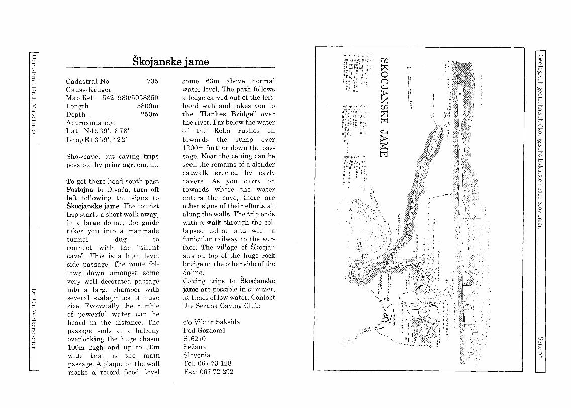
C :::l
< ~ ..., co
o :-' '-'
~ ~ [/0
G ::r S ~
o ...,
9
~ 77" o ~ Ceo ..., ~ ...,
v
Skojanske jame
Cadastral No 735 Ga USB-Kruger Map Ref 5421980/5058350 Length 5800m Depth 250m Approximately: Lat N 4539', 878' LongE 1359' .422'
Showcave, but caving trips possible by prior agreement.
To get there head south past Postojna to Divaca, turn off left following the signs to Skocjanske jame. The tourist trip starts a short walk away, in a large doline, the guide takes you into a manmade tunnel dug to connect with the "silent cave". This is a high level side passage. The route follows down amongst some very well decorated passage into a large chamber with several stalagmites of huge size. Eventually the rumble of powerful water can be heard in the distance. The passage ends at a balcony overlooking the huge chasm 100m high and up to 30m wide that is the main passage. A plaque on the wall marks a record flood level
some 63m above normal water level. The path follows a ledge carved out of the lefthand wall and takes you to the "Hankes Bridge" over the river. Far below the water of the Reka rushes on towards the sump over 1200m further down the passage. Near the ceiling can be seen the remains of a slender catwalk erected by early cavers. As you carryon towards where the water enters the cave, there are other signs of their efforts all along the walls. The trip ends with a walk through the collapsed doline and with a funicular railway to the surface. The village of Skocjan sits on top of the huge rock bridge on the other side of the doline. Caving trips to Skocjanske jame are possible in summer, at times oflow water. Contact the Sezana Caving Club:
clo Viktor Saksida Pod Gozdom1 SI6210 Sezana Slovenia Tel: 067 73 128 Fax: 067 72 292
co 'l ,(>.0, ..... _
~~~ti~tl ij'
w ~ o o ~
~ m ~ t?=J ~
~ t?=J
'\\\ " \..,,' C<
" " \\, , l~ .. ,~ /!.I. )!
/ •• 1, ~
/;;~~~o{~~, "" J
I: 11°
dg
tlg ,
o (t co co
[(S . v: r:: ::r ,
(!q o
~ r:: ::r 2. Cf. r::
f. ~ s co
no c;;" S o tT1 >< 77" C ;; o :::l
:::l
'" G ::r (/)
o :E o ::; ;:;; :::l
(/)
~. co U1 'J>
c o c o :s v
VJ ...c: u c;j c
23 ':JJ 5
..:<: x
:.r.l o
...c: u C/)
bl) o o
..:<: :9 ...c: u v: C
...c: u 2 ~ bl)
1: u C/)
'8) o c Q)
o
'-0 tn
2 '0 VJ
lliPAN.l'vl. (1993): Water Quality in Slovenia Year 1992 - llJ4 S .. Ljubljana (Hydromctcorologicallnstitulc oj
Slovenia).
CONTENTS page
45 . QUALITY OF THE SEA
INTRODUCTION 149 4.5.1.
4.5.2.
4.5.3.
4.5.4.
45.4.1.
4.5.4.2.
45.4.3.
REGIONAL AND SEASONAL DISTRIBUTION OF SAMPLING POINTS 149
SAMPLING METHODS AND ANALYSES
RESULTS OF RESEARCH IN 1992
Physical and Chemical Conditions in Water Body ...
Sanitary Conditions of the Coastal
Chemical and Sanitary Conditions in the Tributaries of the Sea
and Wastewaters ............................ ··· .. ··· .. · ... .
151
152
152
157
4.5.5. BIOPRODUCTION ..................... ..
158
159
159
162
162
163
4.5.5.1. Annual Dynamics of Phytoplankton and Chlorophyll a
4.5.5.2. Annual Dynamics of Microzooplankton
4.5.6. CONCLUSIONS
4.5.7. LITERATURE ...................... ..
APPENDIX
MAP: Coastal Sea - Sampling points for the Alps-Adriatic Monitoring Programme,
National Monitoring and Sanitary Quality of Sea-water
LIST OF TABLES AND FIGURES
TABLES:
4.5.1.
4.5.2.
45.3.
4.5.4.
Sampling points in the coastal waters of Slovenia and other pollution sources in
1992. Contents of crude oil and dissolved crude oil remnants (J.tg/l) in the seawater at
the sampling points in the Bay of Koper and Bay of Piran in 1992.
Results of chemical and bacteriological analyses of wastewaters and the
tributaries of the sea in 1992.
Results of analyses of heavy metals in the tributaries of the sea and treatment
plant outflows in 1992.
4.5.1. INTRODUCTION
The natural properties of the Gulf of Trieste (shallowness, freshwater tributaries, surface drain, meteorological influences, dynamics'~of water masses) all combine to
give the Gulf of Trieste its character of a vulnerable marine environment. Increased urbanization and industrialization put an ever growing pressure on the coastal sea in terms of municipal and industrial wastewaters. Rivers increasingly act as recipients of untreated municipal and industrial wastewaters, which are an important source of
suspended solids and dissolved compounds, influencing chemical and biological processes in· the coastal sea.
In spite of its coastline being short, Slovenia's development is closely connected with its utilisation. The problem of utilisation of the coast and the ecologically fragile
coastal sea is a burning issue due to conflicting activities (municipal, industrial, wastewaters from ships, fishing, tourism, pisciculture), therefore the protection of marine environment and the care to improve its quality ought to play an active role in the planning of economy and infrastructure .
Monitoring the quality of the coastal sea was done in monthly intervals and the existing data cover the last twenty years. This paper brings results of physicochemical, sanitary as well as bioproduction analyses of the Slovenian sea in 1992, as collected by the associates of the Institute of Biology at the University of LjUbljana, The Piran Marine Biological Station, within the framework of the sea quality monitoring programme. According to the coastal sea monitoring programme, two investigations of the pollution of tributaries and the sea in immediate vicinity of the outflows of municipal as well as of some industrial wastewaters were carried out in 1992.
4.5.2. REGIONAL AND SEASONAL DISTRIBUTION OF SAMPLING POINTS
Sampling points for monitoring physical, chemical, bioproduction and pollution conditions in the wider belt of the Slovenian coastal waters in the Gulf of Trieste are
presented in the enclosed map. Numbers from 1 to 37 denote sampling points for microbiological analyses. These sampling points are distributed along the coast in such a way as to include all major areas important to determine the sanitary quality
of the sea. Particularly important the sampling points in areas designated for pisciculture and bathing sites. Seawater samples were analysed twice monthly during the bathing season and bimonthly for the rest of the year.
For sampling points designated on the map by capital letters, the programme of physical, chemical, and bioproduction measurements was implemented. Locations of sampling points were determined on the basis of long-term observations and estimation of specific characteristics of individual areas of the investigated environment.
Based on this, these sampling points were considered as having specific differences
~
c;j
;::l ...c: u V1
~ 2: -:
6 c
~ ;; c
;::J
2 'o
"0 '/;
~ ..:<:
~ o Q
.:...
c;
'-
7' '"'" '-' 7 r. :::;t::
v
r; :::;-
< r r.
~
G
among themselves and yet posses a characteristic quality, The information gathered permits an assessment of the developments for the entire monitored area.
Table 4.5.1: Sampling points in the coastal waters of Slovenia and in other pollution sources in 1992.
S. point Latitude IN)
K 45°33'36" KK 45°35'70" Ri~ana
F 45°32'43" MA 45°30'10" 35 45°29'39" M' 45°31 '59" Istria G 45°35'97" CZ 45°37'26" M1' 45°32'59" F1 45°34'23" 14+ PM+ Pa, Pb, la, Kb
DE
RI, BA, ON, DR
Longitude IE)
13°43'12" 13°40'40"
13°33'13" 13°34'31 " 13°34'75" 13 °28'36"
13°31'69" 13 °38'07" 13°26'75" 13°32'05"
Location description
entrance of the Koper Bay influenced by the outflow of the
Cape Madona in Piran Central part of the Piran Bay Piran Bay, pisciculture area entry of waters from the direction of
influenced by the outflow of the Soca Centre of the Gulf of Trieste Italian/Croatian border influenced by the outflow of the Soca Port of Koper Portoro:! Marina municipal wastewater outflows from Piran, lzoia and Koper wastewater release from the "Delamaris" plant, Izola The Rizana, the Badasevica, the Drnica and the Dragonja
* no samples could be taken in 1992 (see explanation below) + analyses of mineral oils only
Up to and including September 1991, the monitoring program was implemented on 10 sampling points at sea, but following the uncertain situation along the as yet undefined sea border with the neighbouring Republic of Croatia, sampling was omitted at sampling points M and M I, which were assumed to lie within Croatian territorial waters. As a rule, samplings were performed on a monthly basis.
The content of dissolved oil and its remnants was measured at five sampling points (KK, K, 14, MA and PM) six times in 1992: once in winter, spring and autumn, and thrice in summer.
Twice yearly (in January and August) samples were taken at the outflow of rivers into the sea. Pollution originates in agriculture, industry and urbanized areas. Sampling points were situated at the outflow from treatment plants in Koper (Kb), Izola (Ia), Piran (Pa and Pb), Delamaris in Izola (DE), and outflows of the following rivers the RiZana, the BadaSevica, the Drnica, as well as the Dragonja.
4.5.3. SAMPLING METHODS AND ANALYSES
Samples for the analysis of physical, chemical, and bioproduc tion parameters in the water body were taken at five different depths for each sam PIing point: on the surface, at depths of 5, 10, and 15 m as well as approx. 0.5 m above the bottom, high enough to prevent the Niskin sampler to stir up the silt On the sea bottom. Water samples just above the sea bottom were taken by means of a Rutner sampler.
Water temperature at individual depths was measured by means of a standard oceanographic tilting thermometer (Richter-Wiese). Water tranSparency was measured by means of Secchi disc.
pH-value of samples was determined with an Iskra laboratory pH-meter, salinity (chloride) according to the Mohr-Knudsen titration method with silver nitrate.
Oxygen was determined according to Winkler method, BOD in five days (BODs) according to the Grasshoff procedure of the Winkler method (1). COD was determined according to the standard bichromate method.
Contents of nutrients were determined colorimetrically as follows: phosphate (Murphy and Riley, 1962 and modified by Koroleff, 1968), total phosphorus (Nydahl, 1978), ammonia (Grasshoff, 1967), nitrite (Bendscheider and Robinson, 1952), nitrate (Grasshoff, 1970), silicon (Mullin and Rilley, mOdified by Strickland, 1968), detergents (2) as MBAS.
The content of dissolved crude oil and its remnants was measured according to UNESCO directives (3), in samples taken at a depth of 1 meter.
Faecal coli forms were determined according to the membrane filtration method and 24-hour incubation on plate m-FC agar (4) (UNEP/WHO, 1983).
Chlorophyll a (Chla) quantity was measured at six sampling points (F, CZ, G, KK, K and 35). Chlorophyll a was determined fluorimetrically (HOlm-Hansen, 1965) by means of a Turner fluorimeter, while its content was expressed either in p.g Chlall or mg Chla/m3
The density of phytoplankton cells in water samples was determined at sampling points F and CZ, in monthly intervals. Cells were counted under inverted microscope (Utermohl, 1958).
Microzooplankton, sized from 20 to 200 p.m, was sampled according to two methods, the standard Utermohl method with Niskin sampler at depths of 0, 5, 10 and 20 m at sampling points CZ and F, as well as by means of a special microzooplankton net, with 50 p.m net mesh aperture radius.
Physical and chemical parameters of wastewaters (salinity, pH, dissolved oxygen, BODS and COD) as well as in river tributaries were measured according to standard methods (5). Nutritious salts (compounds of nitrogen, phosphorus and silicon) were determined colorimetrically (Grasshoff, 1967), total nitrogen and total phosphorus
also colorimetrically (Koroleff, 1977). Contents of detergents were analysed ac-
Cl G
f{-=<
z r. ,
rr':i n
n r.
z r. ,
r;-
(G. z r. n t:-: x r;-t:: z
g
J:
:E n
n
J: ,~
r. 'J, -...j

':.)
':.)
~
C/;
-"= ':.)
~
=0 .:L
>< I.l.l
':.)
':.) C/.
':1)
.2;i ,
r
'-' Z
'-' ~ ':.) ':;1) ,
'-' J:
.§J
':.)
c
:x; \f',
~ '-'
CJ;
cording to the methylene-blue method, total suspended solids gravimetrically (6) on
glass fibre filters (Whatman GF/C 1.2 /lm).
Heavy metals in rivers and outflows from wastewater-treatment-plants (Hg, Cd, Pb, Cr, Zn, Ni, Cu, Fe, Mn) were analysed according to UNEP/FAO (7, 8) in
structions and recommendations with wet acid degradation at increased temperatures and pressure (PTFE-autoclave). Samples were measured by AAS Varian (Spectr AA-IOBQ and Varian model 12S0A), using GTA, FL and VGA modules.
4.5.4. RESULTS OF RESEARCH IN 1992
Fourteen samplings were conducted within the monitoring framework in the
January - December period of 1992, as follows:
January 14 - IS February 12 - 13 March 4 - 5 April 6 - 7 May 7 - 8 May 27 - 28 June 15 - 16 July 13 - 14 August 19 - 20 September 15 - 16 October 20 - 21 November 17 November 24 - 25 December 21 - 22
4.5.4.1. Physical and Chemical Conditions in Water Body
The results of the analyses are summarized in figures 4.5.1 - 4.5.S. Figure 4.S.1 shows annual temperature variations in the water body of the Slovene coastal sea, taken as a whole. This includes total average of temperatures measured at all sam
pling points at individual depths. The lowest temperature on the water surface was reached in January, the highest in August. In February, water temperature was uniform along the entire depth profile. Isothermal conditions lasted till the beginning of March, when the entire water body started warming up and a gradual stratification set in. The highest annual sea temperature measuryd in 1992 amounted to 26.7 DC (FI). In October the period of autumn isothermal conditions set in, from then on the entire water body cooled down with constant speed, while the top layer was at all
times somewhat cooler than the deeper layers.
Figure 4.5.2 shows salinity oscillation in 1992 as an average of all measured val
ues at all sampling points for individual depths. There were three minimums to be noted here: April, June, and November, particularly marked on the surface. These changes in salinity of the surface layers were brought about by mixing with freshwater influents, notably the 50(;a River. April and November saw heavy precipita
tion, with the result that large quantities of fresh water entered the sea, flooding a
substantial part of the Gulf of Trieste in very short time. In November 1992, the So(;a reached its highest discharge for the last hundred years. The June salinity minimum was likewise connected to a slower, but as to its quantity an even more pronounced inflow of freshwater from the Soca, and also from the Rizana and the Dragonja. This effect was also noted in deeper layers, which the freshwater entered
gradually, mixing with seawater. Here the sampling point G deserves a special mention, since in November 1992 an all-time low salinity value in the open waters of the Gulf of Trieste was measured, the lowest since the Piran Marine Biological Station
conducts its oceanographic monitoring in this area.
Figure 4.5.3 shows density variation in water layers during the year as mean val
ues for the entire research area and individual depths. Seawater density is dependent on temperature and salinity. The April and June penetration of fresh water into the interior of the Bay of Pi ran and Bay of Koper (on the surface), will be noted.
Figure 4.5.4 shows the annual dynamics of the content of dissolved oxygen as a mean value of all measured values for all sampling points and individual depths. The lowest oxygen content (2.6 mill) was measured in September just above the sea bottom. The highest oxygen content was measured in March at a depth of 5 m, amounting to 8.1 mill. Oxygen contents are, as a rule, lowest in the bottom layer. In the period from January to December 1992, oxygen contents never fell bellow the limit contents for sea bottom fauna to remain alive. This means that there were no
occurrences of anoxia in 1992, such as was often the case in previous years.
The rivers which flow into the Gulf of Trieste (The Soca, the Dragonja, the
Rizana, the Drnica etc.) bring with them huge quantities of most varied matter, organic as well as inorganic. These include nutrients, mostly nitrogen and phosphorus
compounds. Figure 4.5.5 shows variations in content and depth distribution of total phospho
rus in the water body of the area under investigation in 1992. There were most pronounced maximums in March, May, and July, and to a lesser extent in December.
Differences in contents of total phosphorus as to the depth distribution were only
slight and showed an almost parallel course.
Results of analyses of contents of oil and dissolved oil remnants in the seawater in
1992 are compiled in table 4.5.2.
Oil contents at sampling points KK, K and MA was low as expected, since there are no pollution sources near these sampling points. Table 4.5.2 also brings data for sampling points 14 and PM, where measurements are being carried out within the
'-' C/.
2
C;
:::: ,
;.-
=0
':.)
v C/.
':.)
.:L
~ r
G
C;

c:: ::i
<
~I 0 :->1 tJ ..., :-<
~ ~ C/O () ::;-S g
tJ ....,
n ?"'
~ 0 ;;;:: (j)
;; CL 0 ...., (t ...,
30 --------------------------,I~ -, -III-- I (c) MOP HMZ
27 ______________ ~Om
Source - MBP
24
~21 ~
~ 18
~ 15
~ 12
~ 9
6 t--------------- ----------------------I : t , ,-~---------------,---- -----,-----,--1
F MAM J J A SON D
1992
Figure 4.5.1: Temperature in the Slovene coastal waters in 1992.
~36
J ~35
~ ~ 34 --l « (J) 33
32
31
30
(c) MOP HMZ
F M A M J J A S O-N 1992
j
...,J D
Figure 4.5.2: Mean salinity for all sampling points in 1992.
..... Sm -e--10m --*-15m
-----, Om --.0.-
5m -e-
10m = I ~~
30 -, ~~~~~~-~-~-(c)~~l: --Om
28
26
<g ~24
~ 22
~ 20
---- - -------------.-------------------
18 L-------------- , , N D
' S a ' j j A 16 F M A M 1992 J
...... 5m -e-
10m --x--15m --+--BOTTOM
Figure 4.5.3: Water layer density in the Slovene coastal waters in 1992.
8,,-------------------------------------------------------,---------Om (c) MOP HMZ
d ! Source- MBP
6 t-=---!; t '--- ---- .-----t3 4 r->- , ~ 3 +----------
:t ---- -:--::~::--::-:::::~::-:~:::::,------::~::::::::::: F M A M J J A S 0 N D
1992
...... 5m --+--10m --7<-
15m
--+-BOTTOM
Figure 4.5.4: Dissolved oxygen contents in Slovene coastal waters in 1992.
o S o
(!S. 'J)
n :;r-
[fCI n o (2' n ::;::i z' n :;r-0: ;>:"
£. o
15. v: n ::;(j)
tI1 >< ;>:" (::
~. g ::i P () ::;-
~ o ~ 3. (j)
::i
Vl 00 ~ ()
V1 '-C

u
'-' ::: J;
..c ~
~ ::l
..:L x:
-2 u C/;
6J
C
~ U Jo
r U U
U
~j (3 J.
g{J c u
G
GI '-'
'-' J;
35 r (el MOP HMl I ----
3 t- ____________ source-MB:J
fl Om -A-
1m -0--
_110m ---+---BOTTOM
~ ! I- 15+ o '
r -----t------- i
I- I
d. I t-~-----g---------~ ----------~.
0: L~~------m =-p---- ~ J F M AM J J A S ON
1992
Figure 4.5.5: Contents of total phosphorus in the Slovene coastal waters in 1992.
framework of other monitoring programmes. These two sampling points showed the highest values, by no means a surprise, considering their location. The PM sampling point showed an increase in the oil contents mostly during the summer months, when nautical traffic was most dense. Concentrations did not surpass the limit of 50 p.g/l as set for the 1st quality class of the coastal sea (Official Journal of the SFRY No.
611978).
Table 4.5.2: Contents of crude oil and dissolved crude oil remnants (JIg/II in the seawater at the sampling points in the Bay of Koper and the Bay of Piran in 1992.
Sampling point KK K 14 MA PM Date Ipglll
Mar. 17 0.2 0.2 6.3 0.1 , 2.5 Jun. 26 0,1 0.1 19.5 <0.1 19,1 Jul. 22 <0.1 0.1 39.2 <0,' 30.5 Aug. 18 0.1 0.1 11.6 0.1 33.5 Nov. 26 0.1 0.2 19.1 0.1 20.8 Jan. 12,1993 0.4 0,' 10.3 0.' 5.5
4.5.4.2. Sanitary Conditions of the Coastal Sea
In 1992, 331 analyses of seawater were performed in the coastal sea from Debeli Rtic to Kanegra at 22 sampling points at bathing sites, around the area dedicated to shell rearing in the Bay of Piran (sampling point No. 26), further in the estuary of
the Rizana (13 in 14), at the cross section towards the middle of the Bay of Koper (15, Kl) as well as at the reference sampling point in the middle of the Bay of Piran
(MA). Seawater samples were analysed twice weekly during the bathing season, bi
monthly during the rest of the year. The extent of faecal pollution was determined by means of indicator bacteria for fecal pollution (fecal coliforms), applying the mem
brane filtration culture method as recommended by WHO (UNEP/WHO, 1983).
Sanitary analysis of the samples taken at bathing sites from Debeli Rtic to Kanegra have in most cases satisfied the WHO criteria regarding suitability of the sea for recreational purposes, with the exception of seawater samples taken at bathing sites in Ankaran, Koper, and Izola, which contained less than 100 fecal coliforms in 100 ml only in 75 % of analysed samples, but did not exceed 2000 fecal coliforms in 100 ml, since these seawater samples contained less than 100 fecal col
iformsllOO ml.
4.5.4.3. Chemical and Sanitary Conditions in the Tributaries of the Sea
and Wastewaters
The results of chemical and bacteriological analyses of wastewaters and the tribu
taries of the sea in 1992 are compiled in tables 4.5.3 and 4.5.4.
Concentrations of individual parameters did not markedly depart from the results of previous years. Outflows from all treatment plants exceeded limit concentrations of biochemical oxygen demand (BOD5), fecal coliforms, and in some cases even concentrations of Fe (la, Kb), as allowed for releasing of wastewaters into the rivers
or coastal seawater (Official Journal of the Republic of Slovenia 18/85).
The contents of heavy metals such as Mn, Ni, Pb, Zn and Cr as well as of Cu and Fe in one sample in the rivers were highest in the Badasevica, where some concen-
trations were even higher than in the outflows from treatment plants. Slightly lower were the concentrations in the Drnica. The Dragonja was the least polluted river, with the exception for mercury content. Concentrations of individual metals do not substantially differ from the results in the previous years, however the concentrations measured for some metals exceed the permitted values as allowed for releasing of waters into the coastal sea (Fe, Pb, and Zn in the Drnica and in the Badasevica,
(Official Journal of the Republic of Slovenia No. 18/85).
OJ r
J J.
2
c5
c: , ;..
~
.'-'
v
~ '-'
-'"
~
0
c5

C ::l
< ~ ..., o ..., o ..., :-
$: g cz co ::0-
S ~
o ...,
n ::0-
~ o r;(1)
~ c.. o ..., ~
Table 4.5.3: Results of chemical and bacteriological analyses of wastewaters and the tributaries of the sea in 1992.
BODS Date mg/l
Pa Jan/22 240.3 Aug/26 115.7
Pb Jan/22 115.4 la Jan/22 340.6
Aug/26 203.1 Kb Jan/22 112.2
Aug/26 85.7 DE Jan/22 1724.3
Aug/26 1472.6 Riz. Jan/22 3.7
Aug/26 15.8 Bad. Jan/22 3.6
Aug/26 4.2 Drn. Jan/22 3.1
Aug/26 6.6 Dra. Jan/22 2.4
Aug/26 1.2
TSS - suspended solids TN - total nitrogen TP - total phosphorus det - detergents Fe - fecal coliforms
COD TSS mg/l mg/l
227 85 40
201 172 311
10 1285 1110
285 3.3 322 16.3 312 3.3 921 10.8
53 1.4 859 12.0
36 1.9 65 11.9
TN TP det FC mg/l mg/l I'g/l No.1100ml
51.5 4.3 7.20E+06 21.8 4.8 2872 1.40E +07 23.7 2.1 5. 70E+06 73.9 6.9 4252 1.26E+07 39.2 7.6 4677 3.50E+07 14.7 2.4 2105 1.20E+06 20.4 4.3 3725 2.84E+07
196.3 25.4 488 75.0 18.3 717
0.9 0.2 31 910 3.5 0.6 1124 38000 3.0 0.2 1 31000 0.7 0.1 40 3080 3.7 0.3 26 900 1.5 0.2 109 350 2.8 0.2 144 256 2.2 0.1 23 550 I
The estuary of the Rizana remained in 1992 one the most polluted areas of the Slovene coastal waters. The extent of pollution diminished somewhat after the treatment plant in Koper went into operation, but concentrations of fecal coliforms in the estuary area (sampling point 15) remained high. The worst bacteriological conditions were found immediately below the municipal wastewater run-off from the town of Koper into the estuary of the Rizana (sampling points 13 and 14). Fecal pollution diminishes rapidly with growing distance from the pollution source, its level and distribution, however, depend on the hydrological and meteorological conditions, since the movement of the water body in the bay depends mostly on tide and wind.
The mentioned rivers receive untreated municipal and industrial wastewaters and are therefore an important source of compounds which influence chemical and biological processes in the coastal sea. The results of the implemented analyses demonstrate that in 1992 all coastal rivers were charged with nutrients, detergents, fecal and industrial wastewaters, while the most heavily polluted rivers were the Rizana and the Badasevica.
Table 4.5.4: Results of analyses of heavy metals in the tributaries of the sea and treatment-plant outflows in 1992.
Date Cd Cr Cu Fe Hg Mn Ni Pb Zn I'gll pg/l pg/l I'g/l I'g/l I'g/l pg/l I'g/l I'g/l
Pa Jan/22 1.0 2 108 2780 <0.020 214 77 108 512 Aug/26 1.1 <0.5 106 598 <0.020 206 37 73 558
Pb Jan/22 7.2 3 195 930 <0.020 389 67 303 884 la Jan/22 1.2 15 36 688 <0.020 70 9 80 173
Aug/26 8.9 3 201 5040 <0.020 388 144 370 860 Kb Jan/22 2.0 5 142 545 <0.020 314 104 108 780
Aug/26 1.0 7 95 1066 <0.020 213 23 83 474 DE Jan/22 9.1 4 275 1080 0.060 503 40 463 896
Aug/26 8.3 3 40 1835 0.191 768 68 670 1554 Riz. Jan/22 1.8 5 109 695 0.027 318 28 132 814
Aug/26 1.1 12 91 465 0.060 185 54 258 789 Bad. Jan/22 0.9 6 120 865 0.060 360 54 329 875
Aug/26 2.3 13 144 2080 0.109 775 72 751 1706 Drn. Jan/22 0.2 1 36 410 <0.020 120 3 141 310
Aug/26 0.7 12 150 2235 0.158 705 54 803 1775 Dra. Jan/22 1.3 2 23 174 0.257 30 1 75 76
Aug/26 0.1 22 308 0.152 95 14 129 237
4.5.5. BIOPRODUCTION
The monitoring programme for biological, physical and chemical parameters in the eastern part of the Gulf of Trieste encompasses both primary and secondary production.
4.5.5.1. Annual Dynamics of Phytoplankton and Chlorophyll a
The monitoring program for biological, physical and chemical parameters in the eastern part of the Gulf of Triest~ covers also the temporal and regional distribution of phytoplankton biomass, expressed as the quantity of chlorophyll a, measured in all samples of the sea water.
The distribution of the phytoplankton biomass in 1992 followed the physical and chemical characteristics of the shallow Gulf of Trieste. Values of chlorophyll a at some sampling points were subject to great fluctuations, but they all reflected a similar dynamics of the biomass of algae.
In 1992 there were three maximums: in April, June, and November. The highest integrated values of the water column were reached in April (from 1.06 at sampling point M to 3.93 p.g Chla/l at sampling,point K). The exception here was the sam-
o o c
u.s . z o ;;'
rlq o C CD o ::0-:::: C/O o ;;' ~ S o
rIQ ~.
o ::0-("0
tTl >< r;C ..., C/J
o ::l ::l f:; ::0-[/)
o :;:: (1)
::l o· ::l
[/)
g . ("0
0'

OJ
OJ
::: J;
..c ~
:::; ...L x
:..:J
~ OJ ~
6J
...L
,
OJ Cf;
r
OJ Q)
2l bJj , OJ Cf;
~J --;:::
OJ
('I ~
OJ
OJ J;
piing point CZ, with the highest concentration, i.e. 3.44 jlg Chlall, reached in March. Following this spring peak, the values fell, but only to rise again in lune. Again, they were higher in the Bay of Koper at sampling points KK and K 0.20 and 1.36 jlg Chla/I). During the summer months, the biomass diminished again only to reach its third high in November, but that time, except for sampling point CZ, lower than on the two previous occasions. All three peaks coincided with salinity minima
and nitrate maxima in the surface layer of the sea. Those months saw an increased inflow of fresh water, particularly April and lune, but also November, when there was aboundant precipitation. Increased nitrate quantities caused a sharp rise of the phytoplankton biomass, notably in April on the surface, while values were consider
ably lower already at a depth of 5 meters. Sampling point G showed strong deviation, with 9.96 jlg Chla/I on the surface, indicating a strong influence of the Soca River. November saw a sub-surface maximum due to lower surface temperatures . The maximum in bottom samples was observed at the sampling point CZ in March (8.79 jlg Chla/I), while the situation was also similar in August and September, corresponding to high concentrations of nutrients.
The annual dynamics of cell density of individual taxonomic groups had all characteristics of phytoplankton biocoenoses of shallow or closed basins, receiving rivers and effluents from urbanized and developed catchment areas. Phytoplankton density at sampling points CZ and F showed a similar picture to that of its biomass. Markedly standing out the maximum at sampling point CZ in March (2.7 x 10⁶cellsll), and sampling point F in April 0.7 x 10⁶cells/l). March saw the biggest density at the bottom, that being also the highest cell density for the entire year (8.8 x 10⁶cells/l). In April, cell density was highest on the surface (4.3 x 10⁶cells/I). Significantly lower values of cell density were reached for both of the other two peaks in lune and September. The number of cells was lowest in October at both sampling points (1.7 x 10⁵cell sll at CZ and 1.6 x 10⁵cellsll at F).
Microflagellates were the predominant group, i.e. 2 to 10 jlm big flagellate algae of various taxonomic groups. As in previous years, microflagellates made for 80 to 90% of the entire number of cells, i.e. they were the predominant group for almost the entire year.
For all three peaks of cell density and chlorophyll a, there was strong predomi
nance exerted over all other groups by diatoms: in April by Skeleronema cosrarum and Nitzschia delicatissima camp., in 1 une by Chaetoceros spp .. Cyclotella sp., and Nitzschia delicarissima camp., in November by Ceraraulina pelagica. Rhizosolenia de/ica/u/a, Rhizosolenia jragilissima and Nirzschia seriara camp. Their share was biggest in April, amounting to 44 to 81 %. In lanuary and December, Cocolithinae predominated with
species Acanrhoica aculeara. Dinoflagellates were present all the year round, however, always in lesser numbers.
In 1992, no mucilage algae aggregates appeared in the Gulf of Trieste.
100 T-.- ~~ ~1:.1 I iilier g 80 1 ~ ~ :epOda :::l ~ I .. ~
~ ~~ ~ f;i 60 T· .. I .;:: S mtm~ ::
~ ~ >= 40 \!I Ci [::
~20~1111111111111 I: o
Figure 4.5.6:
F M A M J J 1992
A SON D
(0) MOP HMZ
Source - MBP
Relative abundance of microzooplankton at sampling point F.
100 I --.. """'" ..... < ... "". """"" .. "''''''' "''''"' """~ ""''''' "'''''''' .... ~ "' M I;. I
~oo IIIIIIIIIIII ~~I ; " .. II II 1!~:.1 ~ I.Il 40 ~ ....1 gj 20
o
Figure 4.5.7:
F M A M J J 1992
A SON D
(c) MOP HMZ
Source - MBP
Relative abundance of microzooplankton at sampling point CZ.
"OJ
c v J;
() ...L
~ o 6

c
~
;:;: 2-z r. :r c
r;
:::: r, G
:f c..
r.
4.5.5.2. Annual Dynamics of Microzooplankton
The seasonal dynamics of microzooplankton in 1992 roughly coincided with the dynamics of the previous years. The most important categories, such as aloricates, tintinides and nauplii of Copepoda all show a similar trend. Both groups of plankton ciliates had simultaneous abundance peaks, i.e. the winter-spring and the summerautumn peaks. The first peak of tintinides was represented by the psychrophilic species Srenosemella nivalis in January, in June it was the turn for Helicosromella subulata, and in September for several other species, among which Salpingella rotundata predominated.
Figures 4.5.6 and 4.5.7 show relative abundance of microzooplankton at sampling points F and CZ. Aloricates presented the most important microzooplankton category, while both peaks were due to genera Strombidium and Tontonia. Only in summer months the nauplii of Copepoda were more numerous, and in January tintinides.
Copepoda nauplii marked only one distinct peak in 1992, i.e. in August at sampling point F and in September at sampling point CZ. Their abundance amounted to 200 individuals/dm3 .
In like manner as in 1989, 1992 saw increased numbers of some species, which are typical of southern Adriatic. Thus the abundance of species Codonellopsis schabi amounted to 179 individuals/dm3 . The appearance of this species, as well as other species from southern Adriatic in autumn 1992, is linked to the inflow of water masses from the southern Adriatic into the Gulf of Trieste. Similar phenomena were also detected in 1986 by the experts from Trieste.
4.5.6. CONCLUSIONS
The main characteristics of the phenomena in the Slovene sea in 1992 were as follows:
water temperature was on the average by I °C lower than in previous years, with maximum temperatures setting in as late as August
the open sea was subject to strong influence of the surface inflow of the fresh water from the Soca River, particularly in April, and to a lesser extent in June,
and again very abundantly in November. The lowest measured salinity in open waters was measured in November (15.3 %0)
oxygen content in 1992 never fell below critical limit, and only once below 50% saturation, as was the case at the bottom in the open waters in mid September
variation in the quantity of nutrients was to a considerable extent conditioned by the influence of freshwater tributaries, notably by nitrogen and phosphorus salts
bioproduction and nutrients dynamics were in inverse proportion to each other and without any major peculiarities
- the chemical and sanitary quality of treated wastewaters were not satisfactory.
Critical areas included Ankaran, Koper, Izola and Portoroi - sanitary quality of samples taken at the bathing sites from Cape Debeli Rtic to
Kanegra satisfied the demands for recreational purposes in the majority of cases.
4.5.7. LITERATURE
1. Grasshoff, K. 1976. Methods of seawater analysis. Verlag Chemie, Weinheim. 2. Standard Methods for the examination of water and waste waters. 16th edition.
American Public Health Association, Water Pollution Control Federation, Inc.,
New York, 1985. 3. UNESCO. 1984. Manual for monitoring oil and dissolved/dispersed petroleum
hydrocarbons in marine waters and on beaches. pp. 1-10. 4. UNEP/WHO. 1983. Determination of faecal coliforms in seawater by mem
brane filtration culture method. Reference methods of marine pollution studies. Genova: United Nations Environment Programme. pp. 1-23.
5. Strickland,J.D.H. and Parsons, T.R.: Practical Handbook of Seawater Analysis. Bull. Fish. Res., Bd. Canada, p.1670, 1972
6. Banse, K.,C. Falls, L. A. Hobson 1963. A gravimetric method for determining suspended matter in sea water using Millipore filters. Deep-Sea Res. 10:639-642.
7. UNEP/FAO. 1976. Manual of Methods in Aquatic environment research. Part 3 - Sampling and analyses of biological material. FAO Fisheries Technical Paper
No. 158, Rome. 8. UNEP/FAO. 1986. Baseline studies and Monitoring Metals, particularly Mer
cury and Cadmium in Marine Organisms (MED POL 11) MAP Technical Reports Series No.2, UNEP, Athens.
G G
rrc; z r. ,
qq G
"" r.
z r. :r ,
~ rG. z r.
n ..,... x r, :: z
r. :r [/;
~ o ::l G
"J. G
r; ::? 'JJ

2 o
S Vi .r:: Cl
'" C c o YO g
-'<: X
;.L: o
.r:: Cl z
'8l o
~ ..c: Cl Vl a
.r:: Cl o o <1) bl) ,
.r:: Cl VJ
5b o
c:5 o
'Cj'D
.3 '0 '/)
-¥
G }f.
F ~
cz 1f.
KK }f.
KOPRSKI
~-~rl~(~'L,:':·f~. .DA:'~~;·:-
OBALNO MORJE COASTAL AREA
,,)::---:1-'''Z''''' .. D._
KONTROLNA MESTA ZA SPREMLJANJE
lit - PROGRAM A ALPE-JADRAN T ALPE ADRIA-PROJEKT
~ - NACIONALNEGA MONITORINGA \1'"" NATIONAL MONITORING PROGRAM
• - SANITARNE KAKOVOSTI VODA SANITARY QUALITY CONTROL
~
'" "3 .r:: Cl ;:J C7i :;;: -;
I~ ~ >
:5
2 o
"0 z ~
-'<: o ~
6 c5

C :::l
< "0 -: o " o -:
~
$: ~ ~ (")
~ ~
tJ -:
n :J"
;E 2. A (1l
~ CO -: Q--:
2. INVESTIGATIONS IN LJUBLJANICA RIVER BASIN
GoSPODARIC R, BAUER F
2.1 DESCRIPTION OF INVESTIGATED AREA
2.1.1 GEOMORPHOLOGIC AND HYDROGRAPHIC CHARACTERISTICS
P. HABle
THE RIVER BASIN SITUATION
Beside Karst of Trieste also Ljubljanica karst river basin belongs to classical karst regions not only in Yugoslavia, but even in Europe (M. HERAK and T. V. STRINGFIELD 1972). Centuries ago this reghm had been already explained by numerous natural scientists (N. FRISCHLIN 1583, A. KIRCHER 1665, J. V. VALVASOR 1689, J. A. NAGEL 1748, F. A. STEINBERG 1761, B. RACQUET 1778, T. GRUBER 1781 and others). The pecularities of this area are presented also by sinking streams Pivka, Unica and Ljub1janica, by karst poljes and by numerous karst cavities, which had been among the first described by A. SCHMIDL (1854), W. PUTICK (1887), A. E. MARTEL (1893). The touristic attraction has augmented mostly by discovery of interesting cave of Postojna.
To reputation and investigations the favourable traffic position has added and beside general interest of natural scientists for karst also practical economical view has appeared. By the development of settlements, industry and communications at one side increases the need for drinking water, which had been always scarce in karst scenery, on t.he other side the periodical floods on karst poljes have retarded agricultural development and exploitation of relatively good soil in the karst (R. VICENTINI 1875, W. PUTICK 1888). Almost hundred years lasting efforts for aboliti'On of floods on karst poljes did not attain the desired aims. All investigations and practical experiments have shown that without extensive and expensive intervention the karst nature cannot be satisfactory mastered. By opening and cleaning of swallowholes on karst po1jes the fl'Oods did not essentially diminished in rain periods, while by stuffing of swallow-holes and ponors also was not possible to retain the water in dry periods. In spite of by relief favourable karst depressions in the Ljubljanica river basin they are not yet changed into natural accumulation basins, suitable for energetic and other purposes (F. JENKO 1959, M. BREZNIK 1962, P. HABIC 1974).
Ljubljanica river collects the water from extreme NW part of Dinaric karst and belongs as -right Sava affluent to Danube part of Black Sea water basin. In the northern part superficial watershed with Sora affluents, which is collecting the waters from mostly non karstic promontory of Julian Alps, prevails. In the western part the watershed between Ljubljanica and Adriatic affluents as are Idrijca, Vipava, Notranjska Reka and Recina, is situated on high karst plateaus from Hrusica to Javornik and Sneznik. The real watershed is placed somewhere in the underground, and the waters from karst plateaus are flowing to several parts. The same happens at the watershed with Kolpa
and Krka rivers on southern and eastern basin's part (Fig. 1). Therefore Ljubljanica karst river basin cannot be precisely defined (Annex 1). In general the watershed line is supposed to be on the highest karst reefs. But it is known. that in karst the orographic watershed could be foundamentally different from 1he real one, that it can even change in different hydrologic situations.
All the incompatibilities between orographic and real watershed have not been yet even approximatively evaluated, although several works basing on geologic, geomorphologic and hydrologic data have been done by this purpo-
~". ..... •' ..... ""'). ~ ". -<It-
-. <' \ ~., " '\ 1-0
V' "" ~1> ~ 4"'~"'r4
1--
2----
-3-,----,.
4t2:j sC2]
6~ ~EKA
I~"""''''',
3.SUWT1976
~'f.~ 'f.
9 19 20km
fig.!. The situation of Ljubljanica river basin. 1 - superficial watershed, 2 - karst watershed, 3 - Adriatic-Black Sea watershed, 4 - non karst river basin's part, 5 -
karst river basin's part, 6 - restricted test area of combined water tracing test. Sl. 1. Polozaj porecja Ljubljanice. 1 - povrsinsko razvo~je, 2 - krasko razvodje, 3 -iadransko-crnomorsko razvodje, 4 - nekraski del porecja, 5 - kraski del porecja,
6 - ozje raziskovalno obmocje kombiniranega sledilnega poskusa.
o (D
2. c
('8. r.r. (")
:;;-riG o o (D (")
:J" 2. m (")
:J" ,6: A o o [8. ~ (")
:J" (1l
tTJ x ,.,.. c ,2. o ;:i
:::l ~ (")
:J"
~ o ~ (1l :::l o· :::l
C/J 2 .... (')
:l' lJ1

()
()
:s CJ)
..c ~ c
-'" x
~ () z
':!J
~ ,
..c () J.
c CJ
~ ()
bJJ , ~
CJ z
. SiJ
C:) ,~
'-'
~ ~ ()
()
c.r;
se. The unknown water basin extent causes the troubles by sulving the practical economical questions.
The rotal Ljubljanica water basin up to its outlet to Sava is evaluated to 1900 km!; to restricted kars~ part, including ihe immediate hinterland of karst ~prings near Vrhnika about 1100--1200 km2 belong to. Orographic ally the water basin is variegated, being the difference between the highest Sneznik Mt. (1796 m) and Ljubljanica outlet to Sava (266 m) even 1530 m; in restricted karst area up to Ljubljanica springs near Vrhnika (291 m) still remain 1505 m of altitude difference.
GEOMORPHOLOGIC CHARACTERISTICS
The Ljubljanica water basin relief characteristics are the easiest to be recognized after particular units, being conditioned by geologic structure on one side and by geomorphologic development at the contact of Alps and Dinarids Mt. on the other, between the Adriatic and Black Seea. In the southern SneZnik (1796) being the most dominant among them. Towards NW directed and several times interrupted reef of Javorniki follows, reaching with peaks up to 1260 m. The deepest gap in high karst plateaus is presented by Postojnska vrata in the altitudes between 600 and 700 m, having the important part of connection between the Adriatic and Pannonian basin. Towards NW wooded high plateaus continue, reaching the peaks of Hrusica and Trnovski gozd Mts. in the altitudes between 800 and 1200 m. On the SW part of this High karst to Ljubljanica water basin the well inhabited Postojna flysh basin belongs too, having the bottom mostly from 520 to 600 m. From all the parts it is surrounded by higher karst reefs, lower gaps being cut in only on the watershed towards Vipava river, in the altitude of 595 m, near Razdrto below Nanos Mt, and towards Notranjska Reka river near Pivka in the altitude of 590 Ip., and near Knezak 600 m above the sea level. Pivka river sinks near postojna in the altitude of 511 m There is not the lowest basin's part, having the sinking stream Lokva near Predjama village, which is flowing towards Vipava springs under the Nanos karst plateau, cut more deeply into the flysh base (F. HABE 1973).
In the central Ljubljanica water basin's part on the NE side of high karst plateaus a wide belt of lower karst surface in so called Notranjsko podolje predomines in the altitudes between 450 to 600 m. There karst poljes are distributed in levels, presenting the deepest relief depressions and the sole planes of flattened area in the whole karst Ljubljanica water basin and therefore also the most inhabited.
At the watershed with Kolpa water basin the highest lying is the karst polje near Prezid (770 m), followed by Babno polje (750 m), LaSko polje (580 m), Cerknisko polje (550 ro), Ralrov Skocjan und Unsko polje (520 m), Planinsko polje (450 m), Logasko polje (470 m) and finally by Ljubljansko Barje (Ljubljana Moor) (285-300 m). On the eastern part the watershed reefs reach the altitudes between 800--1100 m and are little dissected and lowered only on Bloke plateau (720 m) and in the Cerkniseica river basin.
A special relief unit is presented by NW part, by Logatec-Rovte plateau, where the altitudes between 500 to 800 m predomine. This region is separated
from Hrusica plateau by Hotensko podolje region, which is inclined from Godovie (600 m) near Idrijca waterhsed towards Hotedrsica and Kalce (500) as enough uniform dry valley. In the region of Logatec-Rovte plateau the normal fluviatile and karst relief are varying, presenting gradual transition between completely Notranjsko podolje karst region and dominantly normal relief of nearby Idrijca and Sora river basins.
The former Ljubljanica river basin had been greater from today's. By karstification a part of its waters had been captured by adriatic affluents . mostly by Idrijcaand Vipava and probably also Krka, as the southern Sava affluent had taken a part of former Ljubljanica river basin (F. KOSSMAT 1916, A. MELIK 1952, P. HABIC 1968). After the principal relief forms the geologists and geomorphologists have tried to reconstruct the former superficial river net, which is now preserved only on impermeable flysh, shale and partly on dolomite and on karst poljes, while previously superficially flowing waters from the limestones have been displaced by gradual karstification into underground.
By morphological view the most in detail is described just the Pliocene' Ljubljanica development, basing on these relief characteristics, which prove the former connected superficial streams (F. KOSSMAT 1916, A. MELIK 1952). Beside the Pliocene problematics also the Quaternary karst development, specially this of karst poljes (A. MELIK 1955) and karst caves (S. BRODAR 1~52, I. GAMS 1963, F. OSOLE 1961, R. GOSPODARIC & P. HABIC 1966, R. GOSPODARIC 1970, 1976) have been partly studied. The last mentioned studies are limited mostly to the region of Postojna basin and to Planinsko and Cerknisko poljes. Very important data about the morphological development in the Ljubljanica river basin have been given by geologic investigations of Ljubljana Moor and by palinologic analyses of the there lying sediments (A. SERCELJ 1966).
The recent perceptions about the development of young tectonic basin of I Ljubljana Moor are presenting good initial point for the further karst investigations in Ljubljanica river basin. The Moor's basin origin is tightly joined to connection of Alps and Dinarids Mts (1. RAKOVEC 1955). At this contact mostly in Pleistocene up to 200 m deep tectonic depression had originated, being filled up mostly by Upper Pleistocene and Holocene sediments (A. SERCELJ 1966). Beside relatively punctual temporal definition of subsidence also the unproportionate process of deepening and filling up the basin can be seen from the sediments, because of gravel layers, lacustrine clay and peat alterings. By elevation of central Dinaric reef and by Moor's subsidence in the Ljubljanica water basin important change has occured, accelerating the displacement of superficial waters to the underground. Between the Moor flattening and former bottom of the superficial Ljubljanica in Notranjsko podolje, the tectonic movements have caused about 150 m of altitude difference, which rendered possible the further karst dissection of former fluviokarst valley.
THE KARST DEVELOPMENT
The principal characteristics in karst surface and underground development have been tried to be presented by schematiC longitudinal section of central valley's part among Ljubljana Moor, Postojna basin and Cerknica polje
c;;
~
() z c;;
2 -,
C'.
c: , :.-~
-'
~ '-' J.
()
-'"
3: v

~ < , :9 o
v .., ~
~ ~ cz (")
=-S ;::
SJ n =-~ '" (")
;; g-.., if
(Fig. 2). The central part of Notranjsko podolje among Vrhnika, Postojna and Cerknica is not unitary dry valley, but composed by different relief units. Among higher karst plateaus as there are Hrusica, Javorniki and Pokojisce plateaus, it is difficult to follow the former bottom of Ljubljanica valley, being the surface by corrosional processes well dissected to singular ample summits ;md smaller remains in the form of shelves and levels. In fact karst t.rans-formation has changed the former relief shapes so much, that Uwy ("an 1)(' !!'
cognized only by charaeteristic altitudes of particulal- elevations. The characteristic higher and lowe!' ample peaks mostly belong to two
levels. The highest peaks belong to so-called Gradisce level, while lower ample summits to more expressive Bodiski vrh level. In longitudinal section the particular summits pro\'e to be the remains of former valley with average inclination about 5 %n. At different places of former valley the traces of fluvial sediments have been found (R. GOSPODARIC 1968). A special value is prt~sented by the clay sediment found on Bodiski vrh Mt. (558). After previous palinologic analyses it has been stated that it had originated from Lower Pleistocene or Upper Pliocene (A. SERCELJ 1968).
More than 5 m thick layer of carbonate clay can be sedimented only by v,aters flowing still on the surface in the Bodiski vrh level. But even if these clays present the remains of cave fills, they have a special importance on the isolated Bodiski vrh. After their age also the age of other, lower karst surface had been evaluated. Anyway the Dolina level is younger with superficial
! water flowing and forming the extensive erosional-solutional Logaski Ravnik. Tili now this one had been inserted in Middle or at least in Upper Pliocene (1. RAKOVEC 1955). Thus all the karst depressions and karst poljes of this region are from Lower Pleistocene or even younger.
Karst dissection was not proportionate in whole water basin, but dependant in great rate from local geologic and geomorphologic conditions. Therefore beside common development characteristics at each polje also some specific features can be recognized.
In restricted hinterland of Ljubljanica springs mostly geomorphogenetic differences between Logasko and Planinsko poljes were observed. After the situation and levels distribution it would be expected that Logasko polje would be situated lower from Planinsko, but it is just opposite, being already remained by J. RUS (1925) and A. MELIK (1928). Logasko polje has been formed mostly by superficial streams from dolomite and shale hinterland, while the waters of Unica from Planinsko polje did not had any direct influence. After characteristic low margin levels on the eastern part of Logasko polje we conclude, that this polje has deepened slower than Planinsko one and had gradually narrowed. The deepening had been held back mDstly because of extensive sediments of superficial streams, while the narrowing had been caused hy karst dissection of water net in the polje's hinterland, where Rovte plateau is situated.
On Rovte plateau the ponors of todays sinking streams continue the dry ..... alleys where formerly the waters have superficially flown to Logasko polje (Fig. 3). The actual superficial streams as are Petkovscica, Majerjeva grapa. Rovtarica and Ovcica, ,Pikeljscica, 2ejski potok, Hlevisarka and Hotenka are sinking enough far away from polje, to which only Logascica flows from only
~<~
I~;" Il>'
§'8. ~ o::>"li :>;"<0
P18.tf fIl,::! ~. :>;"~.
ro ::>"-0 OIl ... jl)"-"ro
Il> ... 'gg~ Co::r 0 Il> - en - ...
"'", CJ1 0.
I I~. 'd'"
°Ol'l'i ;;lo.o. &.~. ~ en. I-LI ~ :>;"ro Il>::l?;"
Il> ... ,., '" en n tr.I(
~g ~ .... 1l>1Q
g::l '" ro-o
'" :>;" 0 Sa. ... to ~ g( 2.~:·~. .!"::>"t"' ~ ~~. 10.,-
g. ~ b:J::>" ~. &,t;l' 2, ",. 3 " :>;" .... 1l>3
"'rol ~o. ~. <: ~'U:> ::l-o. Il> ~::l
~.Il>
~~ " .... o :>;"Il> 'd ~';3 2.3 Il> Il> - 'd Il> -l£:::: I roO 0-
3 Ol t!~. ~ e.::l o ~.~:~ :>;"~ Il>gl ,.,~.
roll> ::l ~g CD ro:>;", 5' ~3' g Il> ::l {J] ~-. <+Il>o 0,,0. '0 L...o. tl)
::l ro ro ?l'? a:
1l>~"'J ::l ::l ~. 0. :>;"'!'l t"'5t.:> C· ~ . o-::lt"' _ 0
P;''gJ; ~~~ :>;"",~ o Po
~ ~.
g~g ,.,::>"~ ~'-'n ro::l ... ~ 0 r<:>;"'" ~.!j (I)
~o'" g~~ '-'.::S "' Il> ~.
::lll>0 1l>();3
!;;,c· o ""<:oro o 0 ,., () '" ::-.. ~ ~ ~ro'"
'" f'l
.-I~~ ~:>;" I !:l roll> ... -,., '" Ul r-f" 0 -1 c-+ ::r"'-'"
l'drot"' g. til <....:I.
t! 'iii~.g 50 &(f)~~ ::l eT Ul ;0 n> 0 c'O ....... .... 0. () ,., .... '" ~3~?;" ro' ::l" .... ro'"
CJ1 '" co 0 No-
<: I ........ ro ~.
t-'QS~ ,.,,., ... ~30' fii~~ ~ ()< '" ro Pl ;;.
(). ,., .... ~~.t-' ~·ro
~ I ()
ron>~ <: <: () Cl)~~ r <:
eTC!) O>ro
I ~~ C!) <: roC!)
tJJ::l o 0 o.'U'" ~61~ -·2.~ <: ::l ::>" ... "'0 ~:>;"t-' 0..,(1)
~ 'd t-.:) _0
[~ I
~
N
W , , , , M
1/ II 1/ II
~ , ,I I
I" I I
\---_. n~
5~ 1Io~
\\ \ l.
1\ \ \
r C 0-
0'"..::::;": P P -" " ~ ~
6
\ ~::;:--... \(-\~ \ \1 \ '
-\ ~\
\ \ '- -; \ "go I ' I,. I:.
~ ~~5;
~
~ b ~
~ ~ ~
\ ~.
. \ - ~ ~ r-
\ ~ ~ r- S \
0 ~ ~. ~. B
-r----~~ "U
-\- ~
)~ - - -\ - ~. \v> -~
fe l ~ \ \" 2
'" Vl\ ~ ~ o ~~\-- - [
\~
~\ °1
-g ~
~ ",.",
- ~~ \ n 0
-.~-.--~ _gO <
I • -r.. . .J-"i
__ ~_::::>_ .::3 ~
,-x ~
if ~
~ g -r ._- -- ~.--- --s \ p ~ \ ~ 0
\ ~ ~
w e ~.
o (1) ::)
::)
([S. Ch (")
=r (~ o
~ o =::l v:' (")
=r ~ ~ ::)
(8. [h (")
=(1)
tn ><
'" c .., ~ . § ::l ~ (")
=-~
~ (1) ::l 0;' ::l
C/J 5:: 0" Q\ ---.l

.~ ~ :s o Vi ..c
C)
'" c § '0 :3
.:L. ><
Il.l '-.)
..c C) .'f]
'bI] o
(3 .:L. :0
1: C) V}
c ..c C)
~ ~ ~J]
..c C) V}
'~J
C ()
o
GC -c ~ '0:; VJ
a quarter of former hinterland. At these sinking streams ponors the recent blind valleys with more or less expressive rocky border and flattened filled up bottom have originated. Mostly impassable swallow-holes are situated in the bottom of the valleys, or well at the foot of rocky border and only at PetkovsCica, Ovcica, Pikeljscica and Zejski potok smaller ponor caves are known.
Essentially different had been the development of Planinsko polje, being formed and deepened by karst waters from Cerknica and Postojna regions . The waters have run off undergroundly directly to Ljubljanica springs near Vrhnika. In Planinsko polje development two principal phases can be distin-
~~ ;~. , 'f :--" 't I ! : \ I SLO"
HOTEDRSICA'W~ I I I I m,..'l "-
11-i-'-' I" ~ ~-- :: ,,\ I
I i Il +0,
II '1- "''''". 111It ,+0
1-
/-'- .. / ."
SlO
/'-~I-l i i // 1 j: I
[I i!
3 -- - - ~ 5 ITillIill C· o~j ~;>'m;.:· 4 • • .' 6 /, ~ . ".;
, _~ __ ~_o ././ /~ 7 r~lffiilli!~0 L~IliUu hlW
, .... .. ,
.(S ~<oPo / 't: tJ\Oltf\t'>lO ,,/
! ... C!' / q .",'''.,20 " . /
f. I f
0-1""'. I !!UOJ
Jkm
Fig. 3. Sinking streams and dry valleys on Logatec-Rovte plateau. 1 - superficial watershed, 2 - sinking stream with the ponor's sea level, 3 - dry valley, 4 -Quaternary sediments on marginal karst polje, 5 - Dolina or Ravnik relief level,
6 - Bodiski vrh level, 7 - Gradisce level.
Sl 3. Ponikalnice in suhe do line na Logasko-rovtarski planoti. 1 - povrsinsko razvodje, 2 - ponikainica z nadmorsko visino ponora, 3 - suha dolina, 4 - kvartarne napiavine na robnem kraskem polju, 5 - Dolinska ali Ravniska reliefna stopnja,
6 - Bodiska stopnja, 7 - Gradiska stopnja.
guished. The older polje's bottom had been in the altitude about 520 m, presenting together with actual ouvala near Unec-Rakek the uniform karst polje on the important Idrija wrench-fault and Predjama over-thrust. The abundant deepening of the polje's bottom to actual altitudes between 440 to 450 m follows, but in smaller extent, being Unec ouvala separated from the superficial confluence of Cerknica and Postojna waters. This confluence has taken its place in the area of Malni springs and Planinska jama (Planina Cave). Parallel to Planinsko polje bottom's deepening on the border underground inflow and outflow channels have been formed.
By detailed speleological investigations (W. PUTICK 1888, 1. MICHLER 1855,1. GAMS 1963, M. PUC 1965, F. SUSTERSIC & M. PUC 1972, R GOSPODARIC 1970, 1976) three more expressive levels of inflow and {Jutflow channels have been stated. The lowest level is now active, the medium is the most extensive and in general dry, the highest one is preserved only in shorter cave passages, being much transformed by breakdowns. Similar statements can be done for the border of Posiojna basin and Cerknica polje, smaller differences being conditioned by differences in geolDgic structure ~(flysch, dolomite) and by altering of superficial and karst hinterland.
The ponor regions of karst poljes are distinguished by well developed, but frequently interrupted net of runoff channels. Postojna, Cerknica and Planina cave systems are well known, while near springs much more uniform channels prevail. In the Planinska jama one channel of several levels exists and several erosional and accumulation phases can be distinguished, connected by general development of karst surface and underground in Upper Quaternary.
Karst poljes deepening as well inbetween underground channels deepening is t.ightly connected. It is dependant as much from erosional deepening in the area of superficial streams in headwater, as well in lower river basin's part and also from lowering of relatively less permeable barriers in the central river basin's part, where the karst poljes have developed. Beside the channels situation also their permeability is important. In general the channels have to be widened because of greater age, but such a deveIopment has been in retard because of different fills, being deposed by superficial waters in the underground. To lessened channels permeability also the breakdowns have influenced, impeding the underground streams and forcing them to search new ways.
The importance of breakdowns in unknown underground is shown also by several collapsed dolines. In Notranjsko Region there are more than 150 larger collapsed dolines, developed by roof collapse above the former water channels. The most frequent are the collapsed dolines just behind the ponor and on low plateaus surface directly above the Ljubljanica springs, but they 2re numerous also in the inbetween area (Fig. 4). After the shape, size and situation the collapsed dolines are very different (F. SUSTERSrC 1973), alt~ough the majority of them can be connected to distribution of medium ltvel of the underground channels. The collapsed dolines and steepheads of Mocilnik and Retovje directly above the Ljubljanica springs have the curious situation. They are lying much lower than other allied forms. If they have originated above the same channels as other collapsed dolines, which is probable, then we have to connect their actual situation with allied channels to
~
..:3 "3 ~ ~
'" ~ -:
o o ~ > c ~
~ 5,
-c) C/l
53 -"<
~ 6 o
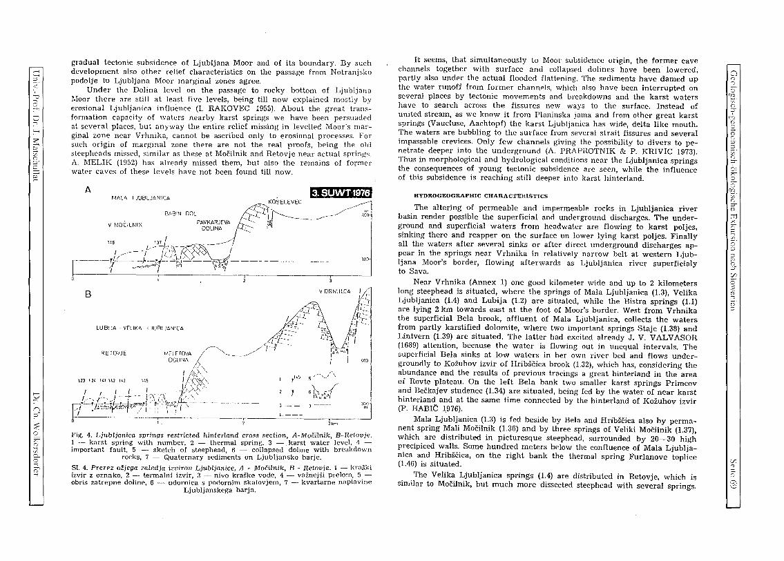
c e. < :,c
o .., ::---
s;:; ;:;. Cf. (';
:J"
§: ~
o .., n :J"
~ o ~ o .., ~ p.. o .., CD' -;
gradual tectonic subsidence of Ljubljana Moor and of its boundary. By such development also other relief characteristics on the passage from Notranjsko podolje tu Ljubljana Moor marginal zones agree.
Under the Dolina level on the passage to rocky bottom of Ljubljana r.loor there are still at least five levels, being till now explained mostly by erosional Ljubljanica influence (I. RAKOVEC 1955). About the great transformation capacity of waters nearby karst springs we have been persuaded a~ several places, but anyway the entire relief missing in levelled Moor's marginal zone near Vrhnika, cannot be ascribed only to erosional processes. For such origin of marginal zone there are not the real proofs, being the old steepheads missed, similar as these at Mocilnik and Retovje near actual sprini;s, A. MELIK (1952) has already missed them, but also the remains of former water caves of these levels have not been found till now.
A MALA L JUBLJANICA
8A8 .
~i'l",j IPr7!J
v MOCILNIK IN DOL (!l~?SELEVEC PAVKARJEVA l:.. ~
1(6 I DOllNA:---" 137 '
r-- TL~--//J!!t/r-'~-;A ~-----
;t ----f.-_o J >. '-<V / I ~~"",,,·<J>1 - ~:.-. -1 f~ -,(r:.'bgj-\t'I~".:,i ----
B
LUB!JA - VELIKA LJUBLJANICA
MElE IOVA /-'""'"' DCLINA J -----------/
;"A. I l:;:.'>, ",
'I"" , , J!l\ I I I , I ' , S).,
J"---~T'/~.,~/---I-· 'j"''''' I.'" i:<\ , o;,..;T-hc- " J 1· . ,
[/ .f;, cc.-r!t.9!~t. ~"'\"'""LL. '-_ r / I' ::' \"0/ I \ - - - - - -,
RE IOVJE
l:13 12l. H.l 11.2 1 t.J 14, r145 ,,'-"" I"~
5 '-"
6~ ,o,.,,0t>o~4 )-- 7---
4 ---
I. 3km
m <'.00·
JOO
(.oo
JOO m
Fig. 4. Ljubljanica springs restricted hinterland cross section, A-MocHnik, B-Retovje. 1 - karst spring with number, 2 - thermal spring, 3 - karst water level, 4 -important fault, 5 - sketch of steephead, 6 - collapsed doline with breakdown
rocks, 7 - Quaternary sediments on Ljubljansko barje. Sl. 4. Prerez ozjega zaledja izvirov Ljubljanice, A - Mocilnik, B - Retovje. 1 - kraski izvir z oznako, 2 - termalni izvir, 3 - nivo kraske vode, 4 - vaznejsi prelom, 5 -obris zatrepne doline, 6 - udornica s podornim skaiovjem, 7 - kvartarne naplavine
Ljubljanskega barja.
It seems, that simultaneously to Moor subsidence ongm, the former cave channels together with surface and collapsed dolines have been lowered, partly also under the actual flooded flattening. The sediments have darned up the water runoff from former channels, which also have been interrupted on several places by tectonic movements and breakdowns and the karst waters have to search across the fissures new ways to the surface. Instead of united stream, as we know it from Planinska jama and from other great karst springs (Vaucluse, Aachtopf) the karst Ljubljanica has wide, delta like mouth. The waters are bubbling to the surface from several strait fissures and several impassable crevices. Only few channels giving the possibility to divers to penetrate deeper into the underground (A. PRAPHOTNIK & P. KRIVIC 1973). Thus in morphological and hydrological conditions near the Ljubljanica springs the consequences of young tectonic subsidence are seen, while the influence of this subsidence is reaching still deeper into karst hinterland.
HYDROGEOGRAPHIC CHARACTERISTICS
The altering of permeable and impermeable rocks in Ljubljanica river basin render possible the superficial and underground discharges. The underground and superficial waters from headwater are flowing to karst poljes, sinking there and reapper on the surface on lower lying karst poljes. Finally all the waters after several sinks or after direct underground discharges appear in the springs near Vrhnika in relatively narrow belt at western Ljubljana Moor's border, flowing afterwards as Ljubljanica river superficialy to Sava.
Near Vrhnika (Annex 1) one good kilometer wide and up to 2 kilometers long steephead is situated, where the springs of Mala Ljubljanica (1.3), Velika Ljubljanica (1.4) and Lubija (1.2) are situated, while the Bistra springs (1.1) are lying 2 km towards east at the foot of Moor's border. West from Vrhnika the superficial Bela brook, affluent of Mala Ljubljanica, collects the waters from partly karstified dolomite, where two important springs Staje (1.38) and Lintvern (1.39) are situated. The latter had excited already J. V. VALVASOR (1689) attention, because the water is flowing out in unequal intervals. The superficial Bela sinks at low waters in her own river bed and flows undergroundly to Kozuhov izvir of Hribscica brook (1.32), which has, considering the abundance and the results of previous tracings a great hinterland in the area of Rovte plateau. On the left Bela bank two smaller karst springs Primcov and Beckajev studenec (1.34) are situated, being fed by the water of near karst hinterland and at the same time connected by the hinterland of Kozuhov izvir (P. HABIe 1976).
Mala Ljubljanica (1.3) is fed beside by Bela and HribScica also by permanent spring Mali Macilnik (1.36) and by three springs of Veliki Mocilnik (1.37). which are distributed in picturesque steephead, surrounded by 20-30 high precipiced walls. Some hundred meters below the confluence of Mala Ljubljanica and Hribscica, on the right' bank the thermal spring Furlanove toplice (1.46) is situated .
The Velika Ljubljanica springs (1.4) are distributed in Retovje, which is sin,ilar to Mocilnik, but much more dissected steephead with several springs.
Cl o o o (e. ef (';
:J" , fIq
8 (0 ('; ::,:0
:n (';
:;' 0: ;;>7"
~ (e. C/O o :J" (1)
ITJ >< ;;>7" c 2. ::i ::i p (';
:J"
~ o :E (1)
::i o· ::i
C/J ::So
o G\ \C
>= o 2 o :s o
[/J
..r::; o oj
>= >= o
'z· 3 ~
>< ~ 1)
..r::; o ~ OIJ o o ~
:9 ..c o './J
'2 ..c o }3 o o ~
..r::; o en OIJ C
(3 1)
o
o r---8 o
[/J
On its left side, under the abrupt wall the springs Malo Okence (1.44) very similar to Veliko Okence (1.45) are situated. The later is one of principal LJubljanica springs on the extreme south part of Retnvje. The both Okence springs are active only at high waters.
Just opposite to Malo Okence, a smaller periodical spring, being active at high water together with Veliko Okence, is lying. Nortwards Retovje is little widened and from the right side the waters are bubbling on several places [rom the underground. The most picturesque and strong is the permanent spring Pod skalo (1.43), a little smaller, but specially interesting because of bubbling manner is the spring Pod orehom (1.42). The near lying Maroltov izvir (1.41) is walled and partly covered by house. Immediately below, the river bpd of Velika Ljubljanica is widened on the passage from rocky to claypy ground. At right side the last spring of the series of Velika Ljubljanica springs is >:ituated.
Low rocky reef separates Retovje from less expressive steephead where the Lubija springs are situated; there are periodic Smukov (1.24) and Gradarjev (1.23) izvir, permanent Jurckov (1.21) and Ceglarjcv izvir (1.22). Among Lubija and I3istra springs (1.1) some smaller, insignificant springs nrc situated. Uistra (1.1) is fed by three principal springs, the first is Grajski izvir (1.13), enclosing the former Carthusian monastery from the north side; on t.he opposite side from several fissures the water is flowing from Zupanov izvir (1.12); ::till further eastwards a similar series of fissured channels is situated, feeding Galetov izvir (1.11). Still futher eastwards two smaller springs are lying, the first is Pasji (l.l5), the second Ribcev (1.14) studenec, which has periodical characteristics of intermittent spring .
The sinking streams, the nearest to the springs, are disposed west from Vrhnika in the region of Logatec and Rovte plateaus, covering about 100 km 2
of karst and non karst surface. The sinking stream Petkovscica (2.11) covers about 10 km2, Rovtarica (2.21) together with Ovcica (2.22) 8 km2 of mostly impermeable surface, but a part of the waters from the both river basins is disappearing into karstified dolomite underground. Similar can be stat.ed also for neighbour, more westwards lying sinking streams, which are sinking immediately after the contact with more permeable limestones. Hotenka (2.31) arId 2ejski potok (2.32) include each 4 km2 of dolomitic water basin, while Pikeljscica (2.51) only 2,5 km2• South from these sinking streams LogasCica (2.41) discharges from about 20 km2 of Triassic dolomite and sinks into Jacka ponors, before it reaches the Cretaceous limestones in the eastern border of Logasko polje.
The most important sinking stream in the hinterland of Vrhnika springs is Unica, flowing on Planinsko polje. Inflow are southern and westNn sid('s, outflow eastern and northern sides of Planinsko polje, extending on 16 km2. It is known, that the waters from Postojna basin are flowing to Planinsko po!je, as well as the waters from Cerknisko polje through Rakov Skocjan and the waters directly from the karst Javurniki Mt. (F. JENKO 1959, I. GAMS 1966, 1970). The principal Unica springs are situated in the southern polje's part in Cretaceous limestones; at high waters a real river is flowing out from 6 km long Planinska jama (3.9), where the confluence of waters from Cerknica, .Tavorniki Mt. and Pivka is located. The Malenscica brook (3.7) takes its springs
in near lying steephead. High waters are not very expressive, while at low waters the strongest springs are Malni. East from Malni, already 'on the contact of limestone and dolomite, is lying Skratovka (3.6) spring. Periodic effluents are situated also in NW polje's part, below the Grcarevec village, where the high waters from a part 'of Hrusica plateau, and perhaps also from Hotenka, are flowing.
The principal Unica swallow-holes are disposed at northern polje's border ncar Pod stene (3.1), where mostly medium and high waters are sinking. At low waters the whole Unica is disappearing in swallow-holes at eastern polje's border, where downwards river bed Mrconovi kljuci (3.44), Milavcovi kljuci (3.42), 2rnki and Ribce (3.43), swallow-holes at Dolenje Loke (3.41), near Laska zaga (3.21) and others are disposed. The water is sinking directly from Unica hed through the polje's bottum across more than 150 swallow-holes and impassable fissure. Only at Dolenje Loke and in Skofji lorn, up to 160 m long ponor caves are known.
At high waters to Planinsko polje much more water is flowing than the swallow-holes are capable to lead off, therefore polje is flooded several times in a y<'nr. At floods, I:Jst.ing 1 .. --2 months, the water increases up to 10 m and up to 40 millions of m3 of water inundate the polje.
In Postojna flysh basin the superficial Nanoscica stream (4.1) flows into Pivka River. At high and medium water level Pivka gets a part of karst waters from western marginal zones of Javorniki, while the low waters from this region are flowing directly to Malensciea springs (P. HABle 1968). In karst depression Rakov Skocjan the waters from Cerknisko polje and partly from Javorniki are flowing in 2,5 km long superficial Rak (5.1) stream; the waters are taking their springs in Kotlici (5.2) and in near lying periodical springs, greater part of Cerknica waters is flowing from the cave Zelske jame (5.4). A part of Rak waters sinks already before the Great Natural Bridge, the principal ponor being situated in extensive, more than 1,2 km long cave Tkalca jama (5.0) which is not yet completely explored. The inflows at high waters are greater than swallow-holes capacities, therefore the Rak valley is periodically flooded.
Mostly flattened bottom of Cerknisko polje covers about 36 km2, at floods it alters to spacious karst lake. Principal ponor caves and swallow-holes are disposed in Jamski zaliv at NW polje's border. The highest waters run off through the caves Mala and Velika Karlovica (6.01, 6.00), where more than 7 km of passable channels are known. Lower waters are sinking mostly in marginal swallow-holes, as are N arte (6.022), Kamnje (6.021) and Svinjske j8me (6.02) and in numerous ground swallow-holes, which are disposed in (:('ntral polje's bottom, in a good kilometer wide zone. It is widening from fieseto (6.18), Vodonos (6.16), Retje (6.21) southwards at the foot of Javorniki over Becki (6.15), Sitarica (6.13), Velika and Mala Ponikva (6.14) to swallowholes and estavellas Geben (6.035), Kotel (6.038), and l:esljenca (6.033) in Zadnji kraj and Lovisce (6.051) on the eastern side of Otok village. The most part of the year the ground swallow-holes are inundated, at dry period the last waters flowing to the polje are ~inking there. Inflows are on eastern and southern and partly on western polje's side. Beside superficial CerkniScica (6.45) with about 45 km" of hinterland, from Slivnica Mt. dolomitic slopes smal-
~
oj
:; ..c o ~
~ "'" Q ~ ~ :>
5
2 E;,
"0 './)
t.l ..:<: (3
is u ;5

c: ::l
< ,
u '~
t:I '""' :--<
~ ;:: :/0 ()
[ §:
SJ n :Y'
::E o ;>;"" (i)
~ c...
~
ler streams as are Martinjscica (6.23) and Grahovscica (6.25) are flowing. On the eastern polje's part a little more abundant are karst springs of 2erovniscica (6.27) and Lipsenjscica, Steberscica respectively (6.12), being fed by Bloscica (7.0) from Blosko polje and by waters from near karst hinterland, which partly flow through famous, 8 km long Krizna jama. The cave is known because of numerous lakes, divided by rimstone formation. The principal karst waters take their springs in SE polje's corner in Obrh (6.07) and Cemun (6.071) and in other springs, which are flowing off to Strzen (6.08) directly from Javorniki and Sneznik, the important part of the water is contributed by higher lying Losko polje. The inflows frequently exceed the outflows, therefore Cerknisko polje is changed in average for 8 months per year in karst lake, which sometimes do not dry up during the whole year. At the highest water table (552 m), up to 80 millions of m3 of water is accumulated.
Higher lying Losko polje is smaller (12 km2), having, compared to CerkniSko and Planinsko poljes, pretty more narrow ponor area in NW corner, where the known ponor cave Golobina (8.0) is situated. At low waters the Obrh brook (8.01) sinks in before reaching Golobina; at high water it inudates the cave and a part of polje, the water quantity reaching 10 millions of m 3• The principal springs are lying on SE and E polje's side, there are permanent spring Veliki Obrh (8.24) and periodical spring Mali Obrh (8.15). Veliki Obrh is fed by the waters from higher lying Babno polje and from ouvala near Prezid, where there is sinking stream Trebuhovica (9.0) lying the highest in sinking streams system and being the most distant from Ljubljanica springs.
The altering of superficial and underground discharges in the hinterland of Ljubljanica springs is causing a series of hydrological enigmas, which are not yet entirely found out.
In the period of floods on Cerknisko and Planinsko poljes and in Rakov ~kocjan it is impossible to measure neither inflow, neither outflow quantities. Because the floods are lasting for the longest period just on Cerknisko polje, their discharging quantities are the least known. The water tracing in Golobin a (F. BIDOVEC 1968) has shown, that a part of waters from Losko polje can flow under the Cerknisko polje directly to Ljubljanica springs. The first useful data for understanding the karst hydrologic conditions in Ljubljanica river basin have been done by successive water tracings of sinking streams (A. SERKO 1946, I. GAMS 1965) in the years from 1910 till 1965.
Basing on these tracings the principal water connections between the pOIlQrs and belonging streams have been stated. But as each water tracing has been achieved in different hydrologic conditions, the results of these tracings have been pretty different too. The opened questions have been reexamined by new investigations and tracings, which have been realized in the years 1972--1975.
THE TlNDERGROUND AND SUPERFICIAL WATER DISTRIBUTION
Before the beginning of investigations and combined water tracing experifT'.ent it was possible to compose an outline of underground and superficial waters in the Ljubljanica springs hiterland, as it is Shown on the Fig. 5. There are drawn a parts known (8) and supposed watershed lines (9), superficial
, .. ': .... . ..
~VRHNIKA""" I R 0 v Ie"" 1.02":' •. 1.01. '.
'- ~ ~ / > . . . ,. nico "'j 2.11 ~ C /:.."'- ~ 1I~/U.b.l~ 1251 ~ -'7".-, 1.2 ~ . . . 1',2J]:;J'2.21 '-'::::_.t.--:"/~/""', \ I '.. . "'" I '" V 1/, ,I I """, \ f '" I I f ~
I, 't '" I, f , I 31 '''''' \'LOGATEC:,-'" I"''', f ;\ , 2. "'" \ '- 't.:.. 2 ~I Y / /' ~
o Wkm I I
I " "". ~;,. I '/" I "'%"\', '.v B" I II , 1',11, ........ ___ ".7 1.If / . \\
\ ", ,~, ".r I J/ 1/ I I D ' ... -;/ I ,,,' \ '. \ , ... / "" 3.V '/ , \ I
)'","&", '. ~ ,/ r \ \ \ ~ / t '. ' .... , ." t14 \ A I \
c,. ~ I \ ••• 1111
• I \ \ -.f'..... I '\. 1)1/.\ I \ \ ~
("'10 • I II/ I \ I ~
z
\ PLANINA .... """" \ \ ~ 35 /1, \ \% . .. J', ? II , ~
_ .:.~ /111/1111 ,~ ------ t I l\ 11 '",:, RAK """ ,\
"1 , I \ ':A.H~ '11111111 ..)('i . '~POSTOJNA I 'f \5J:O~ ;;-{f~icERKNICA
',' " ( I \ I "'~~'':.: 6:~S., :-: " ~ ~ _ 1.0 I \, \'" 'e..;..' , "',_ .~ I \ 617\ '.,d ',,' .Tj
6.06 ,
:~~:J
":1 : \, "";:., ' 616':"',;,"6 26t-... '(' ..... , E' "'t.'. I, t _
.'. j "-.f '" ~'<' : ' 6.12,
'j, "" ....... '.'1 """ ."'\", 1 " f ..... f "'" ., ',1 " , , 6 OS .. " r I
"J 'I 'I.. ,. 4',,,, "j \ ',) \ \(-.....:.. :-"(-" , 1.., 1801 .. 1 '-1\ () ''-, \ , . , \
\ ',\ .----\ 0 ...... _
.'\ I
-: \ \ " .\ .. ---~ / :'1 \ , ------.............
4 ¢::::::.:::.~
5 ~----
'" '" 7 (--L.
8~
.{-
-..........."
/
'" '" 3 //,11/,1///////1 6-~~_ 9 - ......... V"
K • 8~~O::,,:,: .... f' .'.' : .. '\
--;! 1 ",'. ' '. :. <I -"" ~r.:... ... ~
/ --/ /' ~
-~.:----:.:~-"
<,
/ ,/ /
·"'lIi
\ ~ .1'~1111 , lit- 111,/ \
"IIIlIfI, "-, lilt .........
..... .... _', 1\, "------- III I
t",. /
-Sneznik
..-----
-----
·r., "':,
/ /
)
tcM.iIW,@W Fig. 5. Schematic review of superficial and underground water ~ in Ljubljanica karst 1iver basin. 1 - important gauging stations, 2 - karst polje with sediment, 3 _ central hydrogeologic relative barrier, 4 - intake area of per r-.=:::::----tanent karst springs, 5 - periodic high water discharges of karst water, 6 - und -=2rground water connections, 7 - superficial stream with springs and ponors, 8 - =- uperficial watershed,
9 - supposed karst watershed.
S!. 5. Shema povrsinskih in podzemeljskih voda v krailkem por ~ cju Ljubljanice. 1 _ vaznejse vodomerne postaje, 2 - krasko polje z naplavino, 3 osrednja hidrogeo-loska pregrada, relativna bariera, 4 - zbirno ubmocje stalnih kraskih izvirov, 5 _ obcasni visokovodni prelivi kraske vode, 6 - podzemeljske VD~ ne zveze, 7 _ povrsin ski tok z izviri in ponori, 8 -- povrsinsko razvodje, 9 - k r .asko predpostavljeno
razvodje.
o S \8.
'jO ()
:;r uo (;;
2-(;; ()
:Y' 2. Cf. ()
:Y' , ", . ;;:;:. 2.. o °5.
'jO ()
:Y' (i)
tTl x ;>;"" C
~. o ::l ::l P ()
:Y' C/)
o :::e (;; :::s o ::l
(/;
s::s. r"oo ---.)

§ c (j)
3: o
Vi .r:: o q c c o
0;;:
3 ..:<:
>< i-Ll (j)
.r:: o ~
°51 o o :3 , .r:: o ~
'c .r:: o 2 2 bJ)
1: o ~
'5)J
o (j)
o
N l'--
2 '<) C/)
flows - sinking streams (7), with corresponding underground connections (6); periodic high waters discharging from karst massifs (5), the areas of karst flows, feeding the permanent springs (4); central hydrogeologic barrier, dividing the water basin to upper and lower part (3); karst poljes (2); and the most important gauging statiDns (1), gathering the data for hydrological characteristic study of karst Ljubljanica.
In the region of Ljubljana Moor near Vrhnika (1.02) and near Komin (1.01) all the waters, flowing together from spacious, but only approximatively limited karst water basin, can be measured. Perhaps only a small part of water does not appear on the surface of Ljubljana Moor, feeding its groundwater. Otherwise the data about Ljubljanica (1.02), Lubija (1.2) and Bistra (1.1) discharges are important for the study of water balance of the entire water basin. Because of undefined extent of water basin it is difficult accurately define the total precipitations quantity and the real runoff coefficients, specially because there are considerable differences in distribution of precipitations and runoff; at short distances in karst Ljubljanica river basin, these values arc very altered.
In sinking streams of karst poljes only a part of hydrogeologically heterogeneous water basin can be measured. Particular areas present uniform hydrographic regions, as for example water basins of Nanoscica (4.1) and Cerkniscica (6.45) in restricted sense. The heterogeneous regions, Pivka water basin (4.21) for example, being fed only by high waters from Javorniki, while the low waters are flowing off to Planinsko polje, are prevailing. The similar hydrographic circumstances are characteristic also for waters basins of Losko and Cerknisko poljes, for Rakov Skocjan and Planinsko polje.
Somewhat peculiar hydrographic type is presented by Bloke (7.0) and their vicinity, from where the superficial waters undergroundly flow to Cerkni!iko and Losko poljes and can be included into observation net (6.12, 6.21) together with other karst waters. In general the water basin is known, therefore there somewhat detailed study of water balance and superficial and karst runoff is possible.
Almost through the center of Ljubljanica water basin only partly permeable dolomitic barrier passes, forcing karst waters from southern water basin's half to discharge again into underground flow towards Ljubljanica springs. The majority of karst waters is discharging from higher to lower basins, only a small part is discharging across karstified barrier in the region between Planinsko and Cerknisko poljes and Hotedrsica directly to Ljubljanica springs. These waters cannot be accurately measured, therefore the quantity D£ waters of upper Ljubljanica river basin, discharging across Planinsko polje, is not known (Unica, Hasberg 3.5) Regarding the data during the tracing the there average annual discharges are for 30-40 % smaller from annual discharges from total Ljubljanica karst water basin. The differences are greatEr in dry period (50 0/0), smaller at high waters (20 0/0). The intermediate affJuents from karst between Cerknisko and Planinsko poljes and Ljubljansko Barje (marked on figure A, B, C) are influencing this differences, as well as the waters, undergroundly discharging through mentioned relative barrier from higher karst water basin (D, E, F).
The Logatec-Rovte region with nine smaller sinking streams on the surface and with permanent underground runoff from unknown karst hinterland of Hrusica (D) is somewhat similar to Bloke in hydrologic view. But the runoff from this region cannot be measured, because in underground these waters are intermixed with waters from other parts of karst Ljubljanica river basin. By water level recorders on sinking streams (2.1 to 2.5) probably not a half of runoff from this region is included in average.
The statement of direct runoff from Cerknisko polje towards the Ljubljnnica springs presents special problcmniics, which can be solved by calculation of total inflow to Cerknisko polje and at the same time by measurement of runoff in the direction towards Rakov Skocjan and Planinsko polje and directly to Ljubljanica springs.
Also the question of waters runoff from Losko polje remains unsolved. When the Obrh springs on Cerknisko polje are completely dry, about 1 m3/s of water is still sinking before Golobina on Losko polje. This water can flow under Javorniki near Cerknisko polje into Unica springs on Planinsko polje or well under Cerknisku polje into Bistra, Lubija and Ljubljanica springs.
By cited is obvious, that a lot of hydrologic enigmas are existing in the hinterland of Ljubljanica springs in spite of 100 years tradition of hydrologic investigations. The previous knowledge is based on different reliable data, regarding the tracings and other hydrologic measurements. Therefore a special attention has been paid to these questions in the frame of previous investiga-tions.
2.1.2 GEOLOGY AND HYDROGEOLOGY S. BUSER, F. DROBNE, R. GOSPODARIC
Translated by Maja KRANJC
The prevailing part of Ljubljanica karst river basin is presented by geological map Ajdovscina and Postojna (Haidenschaft und Adelsberg) in scale 1 : 75.000, being composed together with commentary by F. KOSSMAT (1905). The mapping and geological surveys after 1945 have been done by geologists of Geoloski zavod from Ljubljana, essentially completing the older data (S. BliSER 1965, S. BUSER 1973, M. BREZNIK 1962, K. GRAD 1962, M. PLENICAR 1954, M. PLENICAR 1970). As well the tectonic structure is much better studied, due bo geologists from Idrija mine merits (J. MLAKAR 1969, L. PLACER & J. CAR 1975).
For requirements of hydrogeological investigations the area among Vrhnika, Logatec and Planina has to be resurveyed, because the existing data had not been detailed enough. The special attention has been dedicated to hydrogeologic characteristics of the rocks, which had not been previously studied in detail.
The description of lithostratigraphic, tectonit and hydrogeologic conditions is based on till now published studies and on the field work, which had been done for the purposes of investigation program for 31'd International Symposium of Undergroun'd Water Tracing.
~
'3 .r:: o ~
~ 2: -;
25 ~ c P; > c ~
2; '-< H o "0 ~
~ ~
~ .r:: U
25

c::::: ::l
< , ::? '~
o " ~ 2;: :; z (")
::l""
2 :;
o " n ::l""
~ " (")
~ 0.. o ~ ...,
LITHOSTRATIGRAPHIC DESCRIPTION
The treated region of Ljubljanica river basin belongs to Outer and Inner Dinarid Mountains. For Outer Dinarids the shallow-sea facies of Jurassic and Cretaceous beds is characteristic (limestone, dolomite), while for the Inner Dinarids the deep-sea facies of the same age (f1ysh rock and others). The both geotectonic units contact south-east from Idrija fault zone, where in there lying tectonic windows shallow-marine Lower Cretaceous strata are still found.
On the investigations and water tracing experiment area Permo-Carboniferous, Permian, Triassic, Jurassic, Cretaceous, Paleocene, Eocene and Quaternary beds are lying denuded. The greatest extent is covered by Triassic beds, smaller by Jurassic and Cretaceous, while the smallest extent is covered by Permo-Carboniferous, Permian and Eocene beds. Quaternary sediments are limited to karst poljes and Ljubljansko Barje (Ljubljana Moor).
PERMO-CARBONIFEROUS AND PERMIAN BEDS
are found in narrow, long, and several times interrupted belt between Idrija and Vrhnika. Below they are represented by black clayey shale and quartz sandstone, conglomerate respectively, and above by »Groden« clastites; bedded dolomite and limestone. The total stratigraphic thickness of these beds reaches up to 100 m, although on the treated region only a part of this thickness has been developed, because the beds are lying in tectonic nappes.
TRIASSIC BEDS
are lithologically variegated and stratigraphically well determined. The best they are studied east from Vrhnika up to Idrija, less in the eastern river basin side.
Everywhere about 600 m thick Scythian beds are lying, containing the most of dolomite and less of shale, sandstone, oolitic limestone and marl limestone. Anisian stage is developed in massive granular crushable dolomite 200 m thick. Ladinian stage is developed in thick-bedded dolomitic conglomerate of 400 m of thickness with tuffs and tuffites west from Rovte and in bedded limestone with cherts 100 m thick in the area of sinking streams Rovtarica and Petkovscica. Carnian stage contains Cordevol platy limestones with cherts thick up to 400 m and massive dolomite thick up to 300 m, found near the Podroteja springs on the western and near Borovnica, on the eastern part of the investigated region.
The upper part of Carnian stage (Jul and Tuval) is developed mostly in clastic rocks and in dolomite north from Hotedrsica and Godovic and near G. Logatec, everywhere in klippes, nappes respectively. The clastites stratigraphic thicknees is assessed as up to 300 m, the dolomite thickness near Borovnica up to 250 m.
Norian and Rhaetian stages are developed in thin bedded granular dolomite and thick granular massive dolomite. Dolomite near faults is crushed to milonite breccias, crushed zones being wide more than hundred meters and can be considered as partial barrier. This dolomite thickness reaches up to 1000-1300 m.
JURASSIC BEDS
are developed in thickness about 1.600 m in karst facies, that is to say as limestones and dolomites. There is 6-times more limestone than dolomite. These rocks are composing the karst region between Ljubljansko Barje and Cerknisko polje and northern, eastern and southern border of the same polje. Some of Jurassic dolomites and limestones are overlain by the Upper Triassic dDlomite near Planinsko polje, more of it are found on Hrusica plateau, where the underground watershed between Ljubljanica and Vipava rivers is situated.
Lower Liassic beds are presented by thiek granular bituminous dolomite thick up to 100 m, which is well karstified. Middle Liassic contains some of bituminous bedded dolomite and more of bedded limestone mostly in the area of Ljubljanica springs, at northern border of Planinsko polje ;nd near Cerknica.
Upper Liassic and Dogger can not be stratigraphically and lithologically distinguished. There is thin granular and oolitic limestone with inliers of marse granular bituminous limestone in beds up to 800 m thick. In these beds the majority of Ljubljanica karst springs is situated.
Lower Malmian strata are represented by massive oolitic and reef limestone up to 350 m thick. In Upper Malmian coarse granular d'Olomite prevails, limestone beds are less frequent, total thickness amounts to 200 m. These beds are found alongside Logaska plateau in narrow belt between Lower lVlalmian limestone in f'Ootwall and Lower Cretaceous limestone in hanging wall. This rocks belt is crushed in discrete blocks, which are displaced in horizontal and vertical direction. Thus in Upper Malmian dolomite the abundance and characteristics of tectonic movement are easier to be assessed, being in adjoining, mostly uniformly composed rocks, which are also crushed, almost impossible. Between Lower and Upper Malmian intercalations of red and brown bauxite lenses are distinctive.
CRETACEOUS BEDS
are lying between Planinsko and Logasko poljes, where they are concordantly -overlain by Jurassic beds, and in Idrija-Ziri region, where they present the compositional part of nappes (mostly of Cekovnik nappe).
In Lower Cretaceous, about 1200 m of thickness, limestone and dolomite. similar to Upper Malmian are lain at first, being followed by bedded, partly micritic limestone, which contains between Laze and Dolenji Logatec coarse inliers of dark grey bituminous bedded limestone and northeaste~n from Dolenji Logatec some beds of clayey marl. In these sediments the principal ponor zones and underground caves are situated in northern and northeastern border of Planinsko polje.
Upper Cretaceous beds (Cenomanian and Turonian) are represented by organogenic bedded and reef limestone and by platy limestone with cherts in the region between Planinsko and Logasko poljes.
Senonian beds are developed in form of bedded micritic limestone and massive rudist limestone up to 400 m thick and as marl in form of red and
Cl [
eG. C/O (") ::l""
(fq (D o (D (")
::l"" ::l en (")
::l""
0: " 2. o
CJ3. C/O (")
::l"" (D
m ><
" c ~. o c c ~ (")
::l""
~ o :;:;:: (D ::l
o ::l
C/J 2:. 0' --.J 'JJ

i=:= <:)
;3 ;s o Vi .£: u c;j i=:= i=:= C
0C/3
3 "'" x LLl o
.£: u C/]
'8) o
~ :C
1: u z' i=:=
.£: u o o o bD
1: u Ch
bD o g
O
-ql--
~ 'v [/)
greenish marl in thickness up to 100 m. The finding places of these rock are in vicinity of Kalise.
Up to 50 m thick series of red and green marl and limestone breccias near Kalise is partly of Paleocene age. Erosional remains of flysh rocks (sandstune and marl) near Kalise are of Eocene age.
QUATERNARY SEDIMENTS
On karst surface clays, sands, gravels and fossil soil are known, being in some cases assessed to be of Quaternary age. Paleobotanic investigati·on proved Old ,Pleistocene vegetation in grey clay of karst depressions above Vrhnika and Logatec (see page 15). On contrary on karst poljes only Upper PleistQcene sediments are known. On Cerknisko polje in thickness from 5 to 15 m clay, sand and gravel sediments with organic remains of Wiirm and Holocene age occur. Similar sediments of 5 m thick have been fuund on Unsko, Planinsko and Logasko poljes.
On Ljubljansko Barje the Wiirm sediments reach somewere up to 100 m of thickness, much more than all the other here lying sediments in foot wall and in hanging wall. The Moor's sediments are composed in detail by grey clay, silt and sand, calcareous clay, peat and black humus.
Quaternary sediments have been preserved also in underground caves together with autochthonous sediments as are sinters and rubbles.
TECTONIC SETTING
The karst Ljubljanica river basin lies on passage of alpine to dinaric structures (F. KOSSMAT 1912, 1. RAKOVEC, 1956). About the character and extent of this passage very different ideas exist (R. GOSPODARIC 1969). In the western river basin's part 1. MLAKAR (1969) has proved the nappe structure, whereas S. BUSER (1965) has assessed the blQck structure for the eastern part. Different view to tectonic structure are obvious from geologic map Postojna (1967) including greater part of Ljubljanica river basin; on its base the hydrogeologic map (Annex 2) has been based. The field explorations regarding the described investigations have been directed more to researching the rocks hydrogeological characteristics, therefore the tectonic interpretation remains unachieved.
STRUCTURAL UNITS (Fig. 6)
Southwestern part of Ljubljanica river basin has nappe structure (1. MLAKAR 1969). The first nappe (Kosevnik nappe) from Cretaceous beds is lying on autQChthonous base. It has the greatest extent among Godovic, HotedrSica and Idrija, continuing towards Logatec, where it is covered by subsequent nappes. This nappe seems to be very important for underground waters discharge towards Ljubljanica and Idrijca.
The second nappe (Cekovnik nappe) is composed by Upper Triassic dolomite and partly by Carnian clastites. On the surface it can be followed in greater extent between Hotedrsica and Godovic and south from line Hotedrslca-Zala. To the same nappe also Upper Triassic dolomite of Zaplana between Vrhnika and Petkovec belongs. The third nappe (Idrija nappe) is found
in wider area among Rovte, Logatec and Hotedrsica and in more narrow belt up to Idrija. In inverted position several rocks from Permo-Carboniferous up to Upper Triassic are found. On the eastern nappe's part, where there are sinking streams Rovtarica, Pikeljscica and Zejski potok, impervious Permo-
NAN 0 S
/'
3 ~E'RKNICA
.::C~=: P I V 5 k a' ===~:::~:-=~
~}'~c:==:~=C;? U, 9.:.~Ti '~:E:::.'\,":~~ r " : ." :--~' ,:'(-;:'::':, ~t)\;\,"0
JAVORNIKI
,.=~:::' ,= '-:_c=-"'J~--=--=-':--_ '-': (POSTOJNA 2E~~o~1 3cz==J =-~~ 5. • 6 .)¢ 7~ "~
~ 81 - 5
Fig. 6. Hydrogeologic units in the central part oj Ljubljanica karst river basin. 1 -limestone, 2 - impermeable rocks (schists, e. c.), 3 - dolomite, 4 - sediments on the karst poljes and moor, 5 - location of rupture survey, 6 - rupture diagrams, simplified, 7 - Idrija wrench fault ( t> ) and other faults, 8 - hydrogeologic units: (1) - Vrhnika-Cerknica block, (2) - Rakek-Cerknica imbricate structure, (3) -Javorniki-Sneznik block, (4) - Hrusica-block, (5) - Idrija-Ziri nappes area (all
after S. BUSER 1965).
S1. 6. Hidrogeoloske enoie v osrednjem delu kraskega porecja Ljubljanice. 1 _ apnenec, 2 - nepropustne kamnine (skrilavci in drugo), 3 - dolomit, 4 - naplavine na kraskih poljih in barju, 5 - lokacija merjenih ruptUf, 6 - diagrami ruptur, poenostavljeni, 7 - Idrijski zmik (!:::i ) in drugi prclomi, 8 - hidrogcoloske enote: (1) - Vrhnisko-cerkniSka gruda, (2) - Rakesko-cerkniska gruda, (3) - Javorniskosndniska gruda, (4) - Hrusica, (5) - Idrijsko-zirovsko ozemlie pokrovo v (vse po
S. BUSERJU 1965).
~
~ "3 .£: u C/]
'cd ~ ,....;
cs
~ >
:5
~ is
'D C/]
tl "'" ~ u c5

C ::l
<
::.0 o
o ~
;--<
$:; ~ C/O r. ;:r-S 8
SJ n ;:r-
::E 2. r;-' CD ;; C C >-;
~
Carboniferous. Permian and Lower Triassic rocks predomine; because of small nappe thickness they don't reach a great depth and don't influence to the underground discharge, which expires mostly in lower two nappes.
The central part of the region among Ljubljansko Barje, Logasko, Planinsko and Cerknisko polje belongs to autochthonous, which is bruken to separate block, as for example Moor's basin with knobs, Vrhnika-Cerknica block, imbricated structure of Rakek-Cerknica, Hrusica and Javorniki-SneZnik blocks (S. BUSER 1965).
The Moor's basin is surrounded by NW-SE and NE-SW striked faults. In the basin's area several fault trenches and horsts exist, being the most important the fault trench north from the Ljubljanica springs area. It seems, that by this fault trench origin also former underground channels have been submerged and afterwards resedimented by Pleistocene sediments.
Vrhnika-Cerknica block is situated in the region of Logaska plateau among Vrhnika on north, and Planinsko and Cerknisko poljes on south. On eastern side near Borovnica fault, the eastern part of this block has raised the most, thus impermeable Carnian beds are found on the surface. Jurassic and Cretaceous limestone and dolomite beds are inclined towards west, without being folded. Questionable is Borovnica anticline structure, where the strata are inclined towards east because of faults. In addition the block is cut by several, differently directed faults.
Imbricated thrust of Rakek-Cerknica is composed by narrow belt of Upper Triassic and Jurassic dolomite between Rakek and Cerknica. On the south-western part the imbricated structure is overthrusted near Predjama fault to Cretaceous beds of Javorniki-Sneznik block, the structure itself being transformed to wide tectonic zone because of near lying Idrija fault. Thus it is representing the underground barrier for a part of waters flowing from Cerknisko jezero.
To the investigated region northern and eastern Hrusica part reach, formerly belonging to Vrhnika-Cerknica block, being interrupted by faults, spedally by Idrija fault zone.
The northern part of Javorniki-Sneznik block is composed by Lower Cretaceous limestone, in southeastern part of Cerknisko polje also by Malmian limestone.
FAULTS
The investigated region is cut by several faults, which have been assessed by field work or well by photogeology. The most characteristic are the faults of NW-SE strike. The most important is Jdrija fault, which is composing the fault zones by several parallel faults, specially among Kalce, Unec, Rakek and Cerknica. Near Idrija 1. MLAKAR (1969) has assessed that the parts of nappes near Idrija fault are subhorizontally relatively displaced in the direction NoW - SE, which can be considered as the important tectonic wrench-fault greatly contributing to geological and specially to hydrogeological structure of Ljubljanica river basin.
The dinaric faults zone has been followed also in crushed Upper Triassic dolomite and Jurassic Cretaceuus limestones among Rovte, Logatec and fur-
ther towards southeast to Logaska plateau. In Vrhnika vicinity also several NW --SE striked faults have been found in tectonically very crushed Jurassic limestone. The faults in the direction east-west have been found between Rovte and Idrija. The next fault of NE - SW strike is situated in the valley between Vrhnika and Logatec.
Mostly by aerial survey assessed faults in the direction north-south are situated in the region of Logaska plateau between Cerknica and Vrhnika, near Dolenji Logatec and in vicinity of Hotedrsica.
Based on the field observations it can be concluded, that fault sets do not essentially influence to underground flows from Logaska plateau. The essential influence to these flows can be found in fissured limestone and dolomite. The ponors on northern border of Planinsko polje are bound to such, fissured limestone. The joints direction is mostly NE - SW. Similar conditions have been observed at karst Ljubljanica springs, where the water appears through water caves which had been developed more at joints than at faults.
TECTONIC PHASES
After recent informations (L. PLACER & J. CAR 1975) the geulogic structure of Idrija vicinity has been developed by Middle Triassic, early Tertiary and late Tertiary tectonic phases. Each particular phase is not temp-orally dE'fined, because sure temporal indicators are missed. No doubt, that these phases have developed also in geologic structure of the whole Ljubljanica river basin.
Middle Triassic phases are well seen in variegated lithology of the coresponding sediments. For early Tertiary phases (Pyrenean and others) the nappes origin between Logatec and Idrija and overthrusts between Planina and Cerknica are characteristic. At late Tertiary phases mostly horizontal movement of structural units have been asserted.
To cited phases also tectonic phases have to be added, which have influenced in Quaternary to formation of tectonic subsidence of Ljubljana Moor and of higher lying Karst. Some faults in Ljubljanica river basin are seismologically active still today.
THE MICROTECTONIC DATA
Several road and railway cutings in karst hinterland of Ljubljanica sprigs are offering in general good exposures about the crushed rocks. Unfortunate
Fig 7. Rupture diagramms (1-6) with location survey point, the projection on lower half of Schmidt net is used. 0 - bed plane pole, • - joint plane pole, X - wrenchand other fault pole, > - direction of ± vertikal slip on the fault planes, ss -strike of bed planes, rs - strike of first joints set (A), rSI _ strike of second, third joints set (B, C), ps - strike of wrench faults (dextral), PSI - strike of wrench
faults (sinistral).
Cl
S o \8. err. =r
\jO o c 8" r. ::;::l ~.
o
:r. ;;;: o o
C(3. ~
r. ::;(l)
ITl ><
" c ~. § ::l ~ r. ::;-
C/l
o ;::: (l) ::; 0)' ::l
C/l r. s --.}
1I1

~ '+
ps,
w
VRHNIKA 2
N ~--j--
.\ .. :. / \ .;-
\ '.. .' I '\ \ : . :) . ~_\-,<--_ Ii . \ ~~ __ \. ·/psss .. ,,\
t)~., . "-tE I \ '.
ps, / \ " I
\.... / \ / . ~'. /. \rs /
. / .. " \ / . /. ';.' \
~~~:"':~; j//
<
C
5
LOGATEC 4 N
_ --t----
/ /
E W(
A
~
\. ~.:~~B. \ . ~:.;.: +. '" ~ \ <~::'~""'--+- /
PLANINA
6
A
5
N --;- t -; --~~_
.+
\
'"'P' }
JE W E
I
.. . / ~'--F ~ lCl#!iWi'@il:J 5
Fig. 7 - 81. 7
only some cuts in LiaSSIC and Dogger limestone near Vrhnika and in Lower Crctaceous limcstone west from Logatec and alongside Planinsko polje have suited for microtectunic investigati·ons. The data, gathered there, are shown in diagrams (Fig. 7) and explained in text.
The method of treated investigations has been based mostly on study of structural joints and faults. By this genetic method successful differentiation of joints and faults of different ages is possible, while the statistic treatment remains in secundary plan (P. BANKWITZ 1966, R. GOSPODARIC 1973). By using this method for realized investigations we wanted to complete tectonic and hydrogeologic data from karst reg10n amung Vrhnika, Planina, Logatec and Cerknica .
In singular exposures the following joints and faults of different age have beed stated. In bedded Liassic limestone above Verd near Vrhnika, t.here are:
- Dlder joint trending NNE-SSW (principal group), - younger joints trending WNW-ESE, -- faults parallel to jDints; dextral WNW-ESE striked wrench faults are
pl1ominent, -- vertically displaced blocks at older steep wrench faults. In Dogger thick bedded oolitic limestone south from Vrhnika there are: - folded beds in direction E-W, - sinistral wrench faults, parallel to the bedding planes, - normal faults in NNE-SSW strike with throw to the east. In Lower Cretaceous limestDne east from Logatec there are: - older joints trending NNE--SSW, - younger joints trending WNW-ESE, - dextral wrench faults at joints trending NW-SE. In Lower Cretaceous limestone at highway near Laze and at railway sta
tion Planina there are: • - joints trending NE-SW,
- prominent sinistral wrench faults trending NE-SW and less prominent dextral wrench faults trending NW-SE.
The singular diagrams are showing the principal strikes of beds, joints and faults planes, as they have been shown by some exposures of mesoroic limestone in investigated area. Two common diagrams (Fig. 8) are showing that the dextral wrenchfaults in NW - SE are the most prominent among faults, while among joints these in NE - SW. The wrench-faults have been asserted and developed from equally directed joints. Near Vrhnika at Moor's border NNW -- SSE strike of fault is prevailing, showing the traces of the youngest vertical displacement. South from Vrhnika some joints are directed in this way, while the traces of vertical displacement at them are insignificant. Towards Planinsko polje two sets of joints (NW-SE, NE-SW) are develDped in Lower Cretaceous limestone; at the polje's border there are only the joints in NE - SW, which are also changed into sinistral wrench-faults. Dextral wrench-faults in NW - SE are rare.
Besides data about orientation and sort of ruptures it is impDrtant for hydrological purposes to quote that although the joints are frequent it was nowhere stated that they cut the rocks in long sections. Everywhere they
c:J :; ..c: '-.l
3
~ ,...;
2S ~
~ ;;
:3
2 ;.., o
u 'j;
t3 ..0.::
~ ..c: U
c5
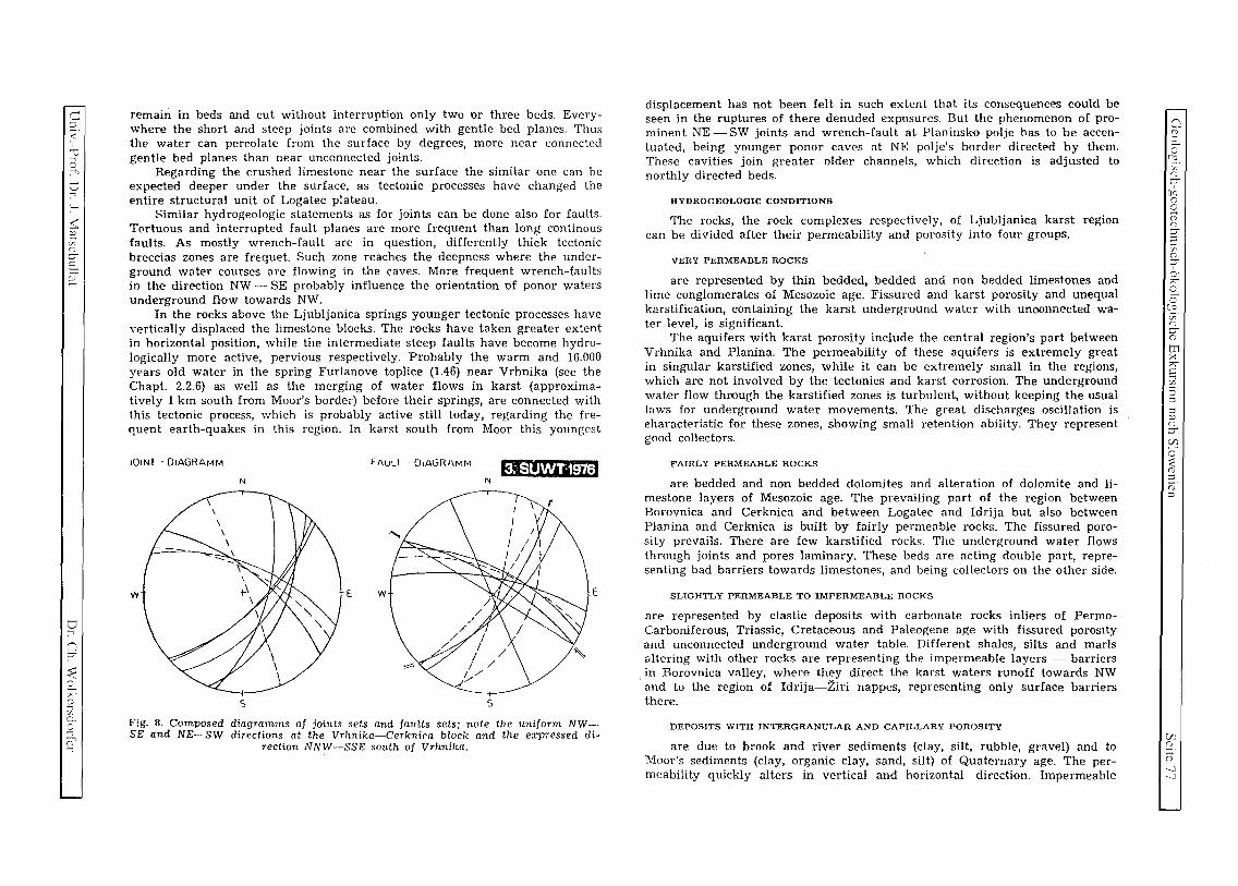
C :J
< ,
'"'
v >-;
:---
$: ~ C/O ("; ;:r-
§: ~
o n ;:r-
~ A ()
~ g-..., q
remain in beds and cut without interruption only two or three beds. Everywhere the short and steep joints are combined with gentle bed planes. Thus the water can percolate from the surface by degrees, more near connected gentle bed planes than near unconnected joints.
Regarding the crushed limestone near the surface the similar one can be expected deeper under the surface, as tectonic processes have changed the entire structural unit of Logatec plateau.
Similar hydrogeologic statements as for joints can be done also for faults. Tortuous and interrupted fault planes are more frequent than long continous faults. As mostly wrench-fault are in question, differently thick tectonic breccias zones are fn:quet. Such zone reaches the deepness where the underground water courses are flowing in the caves. More frequent wrench-faults in the direction NW - SE probably influence the orientation of ponor waters underground flow towards NW.
In the rocks above the Ljubljanica springs younger tectonic processes have Yertically displaced the limestone blocks. The rocks have taken greater extent in horizontal position, while the intermediate steep faults have become hydrologically more active, pervious respectively. Probably the warm and 16.000 YE'ars old water in the spring Furlanove toplice (1.46) near Vrhnika (see the Chapt. 2.2.6) as well as the merging of water flows in karst (approximatively 1 km south from Moor's border) before their springs, are connected with this tectonic process, which is probably active still today, regarding the frequent earth-quakes in this region. In karst south from Moor this youngest
JOIN! ·OIAGRAMM FAULI·OIAGRAMM W1i'fi'@zlEJ N N
w E w E
s s Fig. 8. Composed diagramms of joints sets and faults sets; note the uniform NWSE and NE-SW directions at the Vrhnika-Cerknica block and the expressed di
rection NNW-SSE south of Vrhnika.
displacement has not been felt in such extent that its consequences could be seen in the ruptures of there denuded expDsures. But the phenomenon of prominent NE - SW joints and wrench-fault at Planinsko polje has to be accenluated, being younger ponor caves at NE polje's border directed by them. These cavities join greater older channels, which direction is adjusted to northly directed beds.
HYDROGEOLOGIC CONDITIONS
The rocks, the rock complexes respectively, of Ljubljanica karst region can be divided after their permeability and porosity into four groups.
VERY PERMEABLE ROCKS
are represented by thin bedded, bedded and non bedded limestones and lime conglomerates of Mesozoic age. Fissured and karst porosity and unequal karstification, containing the karst underground waler with unoonnected water level, is significant.
The aquifers with karst porosity include the central region's part between Vrhnika and Planina. The permeability of these aquifers is extremely great in singular karstified zones, while it can be extremely small in the regions, which are not involved by the tectonics and karst corrosion. The underground water flow thl'ough the karstified zones is turbulent, without keeping the usual laws for underground water movements. The great discharges oscillation is eharacteristic for these zones, showing small retention ability. They represent good collectors.
FAIRLY PERMEABLE ROCKS
are bedded and non bedded dolomites and alteration of dolomite and limestone layers of Mesozoic age. The prevailing part of the region between Borovnica and Cerknica and between Logatec and Idrija but also between Planina and Cerknica is built by fairly permeable rocks. The fissured porosity prevails. There are few karstified rocks. The underground water flows through joints and pores laminary. These beds are acting double part, representing bad barriers towards limestones, and being collectors on the other side.
SLIGHTLY PERMEABLE TO IMPERMEABLE ROCKS
are represented by clastic deposits with carbonate rocks inliers of PermoCarboniferous, Triassic, Cretaceous and Paleogene age with fissured porosity and unconnected underground water table. Different shales, silts and marls altering with other rocks are representing the impermeable layers - barriers in Borovnica valley, where they direct the karst waters runoff towards NW and to the region of Idrija-2iri nappes, representing only surface barriers there.
DEPOSITS WITH INTERGRANULAR AND CAPILLARY POROSITY
are due to brook and river sediments (clay, silt, rubble, gravel) and to Moor's sediment.s (cIay, organic clay, sand, silt) of Quaternary age. The permeability quickly alters in vertical and horizontal direction. Impermeable
o S (8.
C/O (";
~ aq 0)
g o ("; ;:r-e. C/C (";
I ::;;c. ~ o °3.
CP. ("; ;:r-0)
tTl >< ?' ~
~. g ::l p ("; ;:r-
~ o :::: 0) ::l i'D' ::l
C/J s:!. S ---l ---l

c ~
c o
6 f./l ..c o oj c c C YO
5 ~
>< CI.1 ~
..c u v;
'bIj c
(3 ~ :(? ..c u z'
c ~ u u o o 0/)
..c u v;
'bI) c c 0)
o
ex:; r--s u
r.r;
Quarternary sediments on the Moor, up to 100 m thick, are presenting the barrier for karst water. Therefore it takes its numerous springs near Vrhnika, feeding the surface Ljubljanica river.
After lithologic structure and functitm several hydrogeological units can be distinguished according to tectonic structure of the region.
Regionally the Vrhnika-Cerknica block has enough simple structure. Its eastern part with impermeable Carnian beds and Upper Triassic dolomite presents hydrologic barrier. In central and western part, where the limestone predominates, the principal underground cuurses are distributed. Dolomite belt, situatC'd in the central part of this unit, docs not present any harricr for water flow.
The Rakek-Cerknica imbricated thrust with milonitic dolomite in central part presents partial or relative hydrogeologic barrier, to which well known karst bifurcation of Cerknisko pulje is connected.
Sneznik-Javorniki massif and Hrusica plateau only partly reach the treated region. These two units are composed mostly by limestones, only in the area of Planinska gora Mt. they are built by dolomites, which are presC'nting hydrogeologic barrier.
Northwestern part of the treated region is presented by the nappe structure of Idrija-Ziri region. The dolomite of Idrija nappe and imbricated thrust of Zaplana are hanging barriers, because they are lying on permeable limestones, which render possible the water discharge under the dolomite nappe. In nappes of Idrija-Ziri region the blocks of permeable and impermeable rocks are altering. The latter are presenting only apparent, hanging barriers, respectively, which can be avoided in horizontal or in vertical direction by the water courses.
The impermeable barrier is presented also by Upper Triassic dolomite south from Podlipska valley. The dolomitic barrier near Podlipska valley and the barrier situated from Cerknisko polje towards Borovnica valley, are limiting the region of the most permeable, well karstified rocks near Vrhnika and force the karst waters to rise to the surface.
Translated by Maja KRANJC
GEOLOGIC SETTING OF THE PLANINSKO POLJE PONOR AREA
Summary JOZE CAR
Planina polje and its wider surrounding is built by Upper Triassic dolomite, all Jurassic stratigraphic units und Lower and Upper Cretaceous lithological links.
The transition of Triassic to Jurassic is connected. Liassic developed mostly in dolomite. The inlier.; of organogenic and porous limestone with Iithiotides (Fig. 2) cOUla be observed. Dogger and Lower MaIm developed .in white, granulated dolomite. Concordantly to Jurassic rocks bituminous Lower Cretaceous limestone with inliers of dark, granulated dolomite follow. Discordantly we can observe avove Lower Cretaceous lithological links basal rudist breccias, followed by differenlly light and almost white rudist Upper Cretaceous limestones. Paleocene and Eocene flysch sediments (Fig. I, 2 and 3) can be found near Kame.
In wider sense the majority of mapped region of the Plan ina polje ponor area belongs to Hrufica nappe. The other part belongs to Snetnik thrust sheet (L. P I ace r, 1981). The entire explored region is situated within the Idrija wrench-fault zone (Fig. I).
Regarding the rock tectonic fracturing we can distinguish three zone species: Fractured zones are practically impermeable, characterized by tectonic clay, tectonic breccia and milonite "flour" and "grit". Partly and well permeable are collapsed zones, while fissured zones present an excellent permeable region thus in limestones as in dolomites. Several parallel fault zones on. a region with well developed fractured zones contribute to diminishing of total region permeability (Fig. I, 3 and 5),
Beside stated epirogenetic movements in the limit between Lower and Upper Cretaceous and in Upper Cretaceous on the treated region we know two types of tertiary tectonic deformations -older thrusting and younger sub vertical movement (Fig. I and 3).
On flysch near Kame we can observe the erosion remains of Upper Cretaceous limestone, belonging to Ko!evnik interjacent slice (L. P I ace r, 1981). Specially complicated structure was stated on Grahov~e and near Ivanje selo, where Ivanje selo and Unec over thrust units were observed. The first is built by Upper Triassic dolomite and Liassic lithological links while the second by Upper Triassic stromatholite dolomite (Fig. I).
The wide fault zone of Idrija wrench-fault is presented, beside dinarically directed Idrija wrench-fault, where the biggest relative displacement was observed, also by differently strong acompanying faults; it means Grtarevec, Hotenjka, Lanski vrh, Babin dol, Matkovec, Milavec and Grahov!e faults (Fig. I).
While mapping, the Podstene and Ravnik fissured zones were eliminated (Fig. 1,4 and 6). An important part of Planina polje developed in Upper Triassic dolomite, Babin dol, region
between Milav~evi klju~i and Laze, a part of polje between Planina and Hasberg are built by Lower Cretaceous limestones. In te area of Un~ki log, Klju~i and Loke different Jurassic lithological links can be observed.
The data of mapping showed that ponors and swallow-holes on the border of Planina polje are . genetically connected with fault zones and bed planes. In the case of Planina polje the both elements are interconnected, but fault zones strongly prevail. Because of strongly crushed rocks the majority of ponors is not accessible. Open ponors and bigger cave spaces can be expected mostly within less crushed rocks and between two fault zones. Cave system of Najdena jama clearly proves genetic connection between thin layered Lower Cretaceous limestones with non-resistant schist inliers and transition to granulated dolomite which even augments the permeability along bed planes. The other important cave system on the border of Planina polje - Logar~ek, is partly developed in tectonically less crushed block between two fiss,ured zones and partly within these zones. Thin layered limestone rocks greatly influenced the Logar~ek genesis.
In limestones different doline shapes occur dependent upon tectonic setting. In thin layered limestones the dolines were found not having any direct connection with macroscopically stated tectonic elements. On mapped region the dolines on dolomite terrains are almost exclusively, directly or indirectly connected with fault zones.
Bigger collapsed dolines could be expected in fissured zones or in less damaged rocks. The collapsed dolines density is proportional to cavernosity of the area and dependent on tectonic setting.
For the Planina polje ponor area two main predispositional elements for the development of the underground discharge directions are important: fissured systems and dip and strike of strata, Consideri~g hydrologic bases both elements show main direction of the underground water flow. On the surface we can indirectly follow the general flow directions considering doline series in fissured zones and distribution of collapsed dolines.
oj
::l ..c u 3 oj
:;;:: ~
o '-
~ > ~
:5
~ 5
"0 ~
tl ~
~ o o

c::::: :l
< ,
v :3
::J -:
:-~ ~ [/0
c: ;:J"
E. ~
o -:
9 < ~
"" o ;; ~ -:
~
/
<;Iii .. ).
FiB. J.
1.196. SN
G'Qhoy~
.( ',-
~
KOLOBAR
E
i ~ ,{
, J \' i \'
r!\ I' \ ' \- ( >
\
GRCAREVEC
, I r " , ' ! .,' I 'I ' ,,' 1 ' i f § I r
T ~ .) ; ,I f'--~
lazi pod gradom
, :1'/~"=~~<: ~-/ T'" /'
............ " / J ~ .............
'l')--..( ~",-,~ --~'/-- ~
PROFIL
E ~ 0.
EXPLANATIONS OF LEGEND ON FIGURES 1.,2. AND 3.
1. fli~ - flysch
PROFIL A - B
~ 0.
c-o
Stacnarjeva gmajna
2. rudistni apnenec - rudist limestone 3. temnosivi mikritni apnenec, svetiosivi in beli organogeni apnenec - dark grey micritic limestone, light grey and
white organogenic limestone ' 4. zrnali bituminozni dolomit - granulated bituminous dolomite 5, zmati beli dolomit in beli apnenec - granulated white dolomite and white limestone 6. rnikritni. oalilni in organogeni apnenec - micritic, oolithic and organogenic limestone 7. porozni dolomitizirani apnenec - porous dolomitized limestone 8. temnosivi mikritni, gomoljasti in oolitni apnenec - dark grey micritic, cobbled and oolithic limestone 9. bituminozni zrnati in pe!(Xni dolomit - bituminous granulated and sandy dolomite
10, sivi, zrnati in stromatolitni dolomit - grey, granulated and stromatholitic dolomite II, norma Ina stratigrafska ali litolo~ka meja - normal stratigraphic or lithological margin
E .9
1i ~ LANSKI VRH
~ E
E
i !
1~ E
! KALISE
600m
550
t~O .. ~~-1 L 1· I . I \·1-l..· 2~)=::;A~\J 1(50
I - _ _"i::::: J \ -"\\\\~
GRAHOVSE
~ i E
i
12, postopni Iitolo~ki prehod - graded lithological transition 13. erozijska diskordanca - erosional discordance 14, smeri in vpad; plasti - strike and dip of strata 15, mocan prelom - strong fault 16. ~irok prelom - faint fault 17. mocan prekrit prelom - strong covered fault 18, !irok prekrit preiom - faint covered fault
300m ~
I 19. domnevni potek m~nega preloma - supposed direction of strong fault 20. domnevni potek ~ibkega preloma - supposed direction of faint fault
~ ~ i
~ " :0 .8
LOO
350
21. moja pokrova - nappe boundary 22. meja vrnesne luske ali neopredeljene narivne enote - boundary of interjacent slice of undefined thrust unit 23. prekrita meja vrnesne luske ali neopredeljene narivne cnote - covered boundary of interjacent slice or unde-
fined thrust unit 24. smer in vpad prelomne ploskve - dip and strike of joint 25. relativno spu!ten blok - relatively lowered block 26. smer vertikalne komponenle premika - direction of vertical displacement component
m 600
400
350
Cl ()
C
CG. ':.r.
~ [JQ G o 0i c: ;:J" :l ~.
c: ;:J"
0: "" C
C [(S. ''.f. c: :::ro en X
"" C
~. o :l :l p () ;:J"
~
~ o :l o :l
Vl (j)
G --l \C

c ()
C ()
:s o
VJ ..c: () ~ C
c o C/O ':::l
-'" >< '-I.l ()
..c: () .'/;
'5"D o o ~ :()
..c () z C
~ 2:l ~ bI)
..c () v;
.@] o o (J)
U
Co X (J)
'1) VJ
TEKTONSKA KARTA - TECTONIC MAP
CD
" ®
TEKTONSKA RAJONIZAClJA-TECTONIC REGIONS
~ '::.:.:.::.:.:.:. Koity!\1ika v ... uoa (Il$~a
" .:: ...... : KoSt ... ",~ ;nltt ,unl sllrr
.~ k·C. .' Htui.SkipoktO'l « --/(1 Hrusi(oll'lappr
~ _::....K~
Unska n,rh,na rnota
Unt! Oytr~ Ihru" un,1
lyaf!jU"I$kan'~ ~U"'t ~Io o¥'r-~~
Htuiiih, poktClV
Htul.;t' ""ppr
-KF~I I: + .. I S"ti~lik.!l I'Iarivnll qruda .. Snl!lf\'k thrust shu I
'-'
27. milonitna moka in zdrob - milonitc: "nour" and "grif' 28. tektonska bre~a - tectonic breccia 29. poru~ena cona - crushed zone 30. razpoklinska cona - fissured zone 31. tektonsko premo obrnocje, kjer se rnenjavajo delno poru~ene ali rnilonitizirane razli~no stare karnenine -
tectonically fractured area, where partly crushed or rnilonitic, differently old rocks alternate 32. vrta~a v poru~eni coni - do1ine in crushed zone 33. udornica - collapsed doline 34. vhod v jarno ali brezno - entrance to the cave or pothole 35. geolo~ki profil - geologic profile 36. gr~arevski prelorn - Or~arevec fault 37. hotenjski prelom - Hotenjka fault 38. lanskovr!ki prelom - Lanski vrh fault 39. idrijski prelom - Idrija wrench fault 40. babindolski prelom - Babin dol fault
,LIllI 1~ 3~ ~~ S~ ] ".. ,/,
o [;i]ffil
G::0 ' I I
'frI c=m J, 0 0
9[~ I· ~ 'O~ 11
11
13 ~. ~.~ .. ~.=.
14/...'·"·/-..,,· .. •
15----
16----
17----
19-- .. -
20 - .. --
11~
12 --'--"'-'-
23 ----L- -"-
24~ 25-~~-
16
l'I1~ 30 1:::-:-:3 311~ 31 G 33 0 34
SJika I. Gkj lege.ID na strani lOS (31) Fig. L Stt ll:!cn4 on Pase IDS (31)
35 A-B
36 CD II (J)
38 CD 39 C0 40 0)
41 ® 42 G)
43 ® 44 @
45 ® t.6~
41. ma~kovski prelom - Ma~kovec fault 42. rnilav~ev prelorn - Milavec fault 43. grahov~ki prelom - Orahovec fault 44. podstensko razpoklinsko obmocje - Podstene fissured region 45. ravni~ko razpoklinsko obmo~je - Ravnik fissured region 46. ponralno obmo~je - ponor area
KARTA MAP
Joze Car 1981
2~ i __ L-_J-_J-__ ~1 ~
~
~
"3 ..c: ()
~
~ h
2S '-o
~ ;; ·c ::J
~ '-C
"0 z o ~
~ u 2S

C ::l
< ~ 2
tJ ..-,
:-<
~ ~ cr.' n ;:J"
§: ~
tJ ..-,
n ;:J"
~ r;(D
;:1 §-
fr
THE USE OF BIOLOGICAL INDICATORS FOR MONITORING
AIR POLLUTION WITH MERCURY IN THE BROADER REGION OF IDRIJA
Ales GNAMU8
University of Ljubljana, Department of Biology, Vecna pot 111, SI-1000 Ljubljana, Slovenia, and the lozef Stefan Institute, Department of Environmental Sciences, Laboratory for Radiochemistry, lamova 39, SI-
1000 Ljubljana, Slovenia
Studies are being conducted in the broader region of Idrija, the location of rich mercury cinnabar ore deposits and the second largest mercury (Hg) mine in the world. In more than 500 years of uninterrupted operation, 13% of all the mercury produced in the world (approx. 150,000 t) was extracted and processed in the Idrija mine up to 1995. The mine still contains approximately the same share of world reserves, which will probably never be utilized. Because of the naturally and anthropogenically highly increased concentrations of mercury, geological and geographical particularities (even native elemental mercury) and the incredibly rich flora and fauna, this region is a true natural laboratory for numerous studies related to the transport and biotransformations of Hg in organisms and the environment. Since 1990, systematic sampling in the broader region of Idrija and analyses of mercury concentrations in organisms and environmental samples from the contaminated region and at control locations have been conducted within the scope of a complex, long-term environmental study aimed at evaluating the effects of geologically and anthropogenically increased Hg concentrations on the region. Measurements of concentration levels of total mercury and organic mercury compounds (Me-Hg-X and Me-Hg) were conducted on the samples. As selenium is known to play an antagonistic role in reducing the toxicity of mercury compounds, the selenium content was also measured in approx. 20 samples. Samples of some tissues and organs of roe deer (Capreolus capreolus L.) and mixed samples of their plant food, comprised of more than 40 plant species, as well as samples of soil were collected in the broader region of the Idrija mine and smeltery. The experimental part of the study deals primarily with problems related to monitoring Hg concentrations for longer periods of time and locating the spots where elemental Hg and ionic forms are transformed into the most toxic organic Hg compounds. As is evident from initial findings, there is a high probability that a substantial part of the transformations of Hg from ionic forms to MeHg on the level of terrestrial ecosystems may occur in the organisms of some herbivorous animals (Gnamu5 et al. 1991, 1995, 1996). The objective of the study was to find the most suitable organisms in order to give an insight into the element's biogeochemical cycle, into biotransformation processes, the accumulation and transfer of mercury compounds into higher trophic levels of food chains, which, in the event of the danger of more serious contamination, would serve as an early warning of the threat to the Idrija population.
Samples of roe deer and their plant food as well as of soil were taken systematically (in the same regions), so that their Hg concentrations are directly comparable. On the basis of preliminary results and the distance from the main sources of contamination, the samples were classified into six regions (Figure 1: PS-l to PS-6), each with an area of approx. 1.5 km', which covered the broader region of the Idrija basin. In order to confirm the role of the emission of Hg va pours from the smeltery in the contamination of the Idrija region with Hg, plant and soil samples intended for Hg analysis were also collected in the sampling region in the direct vicinity of the smeltery smokestack of the Idrija Mine (Figure 1: PS-Sm). Control regions of comparable size and suitable control indicator organisms were selected (Figure 2). The indicator organisms were selected so as to represent the links of various terrestrial food chains, which gives an insight into the biogeochemical Hg cycles and enables biotransformation processes of the element and helps to determine the intensity of accumulation and transfer of mercury compounds into higher trophic levels of the food chain. Also included in the complex ecological study of plant and animal bioindicators and soil samples from the broader Idrija region were regions where highly increased concentrations of Hg were determined in environmental samples and some
"" ... 'f' .... g-S' ... "" Q~
;
~ i
l:;j('Jt::d> I I I I
:d('J"'l"'l 00 00 rp 9 ri ., o.."'CS ~!
!J~g, ~ a 5; ; rp '" 9 (J) a. = '"d
l:;jl:;je,lLg [ (",IN"","'-...-. I • I "CJ fl 0-
t::d S=:;J [::r1! e.5:; ~f2.~ = ~ g =!.. n c..::tVl ~~ rAtTlo OJ· 8';1,3 ;r~ ~.g~ O'! tl s-• a . 0
g~ ~ :::t " ~ 2.-
-" OQ' c
" :-'
';l == if'
(JQ
~ ., ~ Oq .,
" s= ., '" rp
== (JQ
a (D
S 0 e5. z n ;:J"
(fq g 8 n ;:J"
::: ~
n S' 0: r;-2.. 0 [5, z n ;:J" (D
IT: >< r;-c ..., ~.
5 ::l ~ n ;:J"
C/)
0' ;::: (j) ::l (2' ::l
C/) (t
co ex;

o 8 g
VJ ..c :.) ~ ~
. ,~ Of;
3 ..:.::
>< :.r.1 v
..c :.) C/O
ED o o
.-'< :9 ..c :.) .'f:;
~ ..c :.)
~ c v ~j)
..c :.) cJ]
'b1) o 8
CJ
01 ex;
B Q
VJ
organisms during the first extensive investigations conducted in the Idrija region in the early 70's by the Department of Nuclear Chemistry of the Jozef Stefan In~itute (Byrne and Kosta, 1970, Byrne et ai., 1971, Kosta et ai., 1972, Stegnar et ai., 1973 a,b, Kosta et ai., 1974 a, b, c, 1975).
The present ecological investigations will also include a comparison of the above mentioned geologically and anthropogenically burdened mining region of Idrija with the area surrounding the former Podljubelj mercury mine, where the extraction of cinnabar ore was abandoned approx. one hundred years ago.
For the purpose of quantitatively determining Hg concentrations and speciation of the element, sensitive specific analytical techniques were used, including cold vapour atomic absorption spectrometry / atomic fluorescence spectrophotometry (CV-AAS / AFS) (Horvat et aI., 1986, May et ai., 1987, Liang and Bloom,
1993, Liang et ai., 1994 a, b) and neutron activation analysis (NAA) (Byrne and Kosta, 1974). The accuracy of analytical results was varified using NRCC and IAEA standard reference materials. Special attention was devoted to the proper collection, preparation and storage of samples.
The results of studies conducted over several years are presented in Figure 1. The concentration levels of total mercury (T-Hg) and methylmercury compounds (Me-Hg) in samples from the Idrija region show some interesting mutual correlations and are highly dependent on the distance from the main sources of Hg emission. The total mercury and methylmercury concentrations in land and water ecosystems differ considerably. The same applies for the inorganic/organic Hg ratio and the boundaries of most polluted areas. Although water and terrestrial ecosystems together from a biocoenotic whole, they should be treated separately because of the above-mentioned findings and the different characteristics of the two types of ecosystems, The factors affecting both ecosystems and influencing the extent and intensity of contamination with Hg in one or the other medium are not directly comparable. As regards land ecosystems in the broader region of Idrija, it may be concluded that the extent and level of their contamination depends primarily on meteorological-atmospheric factors such as weather conditions, air pressure, humidity and temperature, on the direction, frequency and intensity of prevailing winds, as well as the exposure of individual areas to the said factors, i.e., the locations of individual sampling areas. Great differences were found in total Hg concentrations in land plant indicators and soil samples. In the broader mine smeltery area, the total Hg concentrations in plant samples were up to 200 times higher than those measured in sampling areas in the surroundings of Idrija and up to 500 times higher than those found at control locations. Even greater differences were found between total Hg concentrations in soil samples from the same locations. The Hg concentrations in the soil from the broader mine smeltery area were up to 500 times higher than those found in soil from the surroundings of Idrija and up to 1000 times higher than at the control locations, although there were no significant variations in sampling depth. Even higher concentrations were measured in the samples collected in the direct vicinity of the smeltery smokestack of the Idrija mine, where the total Hg concentrations in plant and soil samples were even up to 10,000 times higher than at the control locations.
Slightly smaller differences were found in animal indicators from the surroundings of contamination sources. The total Hg concentrations found were up to 100 times higher than in samples from the control locations. It should be noted, however, that none of the selected indicator animals had its habitat or territory in the direct vicinity of the mine-smeltery complex, where the highest concentrations in plant indicators and soil samples were found.
Due to the meteorological and geographical characteristics of the Idrija region, the contamination of its ecosystems with Hg is highly localized. Since large land predatory animals have much larger territories than their herbivorous prey, it has been observed that Hg concentrations in the tissues of predators mostly do not confirm the biomagnification effects characteristic of animals representing higher links in food chains. This fact strongly reduces their applicability as suitable bioindicators of intensive local contamination.
It is interesting to note that the concentrations of organic methylmercury compounds in all land samples diminish much more slowly with respect to their distance from the main sources of mercury emission than total Hg concentrations. In other words, the fraction of highly toxic Me-Hg-X compounds as a proportion of total Hg concentrations increases with distance. Similar characteristics were found in samples of water fauna collected downstream along the Idrija River (Kosta et ai., 1974 a). The determination of excessively contami
Y ! W 1_" I ( I r-=t-----t'-+-+-~ I) f !m UN GAR' ~. ~-4- A AUSTRIA, \I- .... ~, 1,'\
I--l-)!-f-+"'::"'H-t---t"" J' . .. v ~ 1-----'. '( 1:4 IV L1~ '.1.- M
Mf-+-!-~I- I.J MARlBOR ~ ~ ~~~~ , \ I~druber h •
-C ., -, 'f'-- "- I,~ '" IT lL \.J ... UUBUANA •
5 1./' PS-Ito PS-6 PS-Ij[Wrk i----' I;< I-.
Il ~_ I~~ !~-~k:: ''0< • r--. -, I ( UTM map of -t::'ti'- lOR! A I t>-!7 S L 0 V E N IA
""" • '" V L/""~ showing origins t.>c ~ J:\ I In <0.. of soil, vegetation
l L"- f,)' 1)1 rl . . ,,; and roe-deer
. ,~ l Pj'\;: r.--.. i-' samples_
t-,\-~" CROAltA ~IOkm ., y'
Figure 2. Map of Slovenia
nated areas in the water ecosystem of the River Idrijca, similar to those of land ecosystems, is a difficult task due to the hydrological characteristics of water currents. The influences of the contamination of the River Idrijca with Hg are even noticeable in the Gulf of Trieste in the Adriatic Sea. The level of Hg contamination can only be evaluated by comparing Hg concentrations in the river environment and the tributaries of the River Idrijca upstream from Idrija with those found downstream from the source of contamination. In past years the smelting plant operated only periodically and thus the emission of Hg into water is considerably smaller than in the past. Increased concentrations were observed mostly in bioindicators and sediments located far downstream, where hydrological factors caused the deposition of sediments, triggering biotransformation processes in aqueous biogeochemical cycles.
The results obtained show that, in contrast to the water ecosystem of the River Idrijica, where the center of contamination has moved some 10 km downstream, the contamination of land ecosystems surrounding Idrija is by far the most significant environmental problem in the Idrija basin itself. Terrestrila ecosystems are more sensitive than running waters to the enormous natural emission of volatile mercury from rocks in the broader surroundings of Idrija, which are a long-lasting process and continuously include additional quantities of Hg in the natural biogeochemical cycles of the element.
A comparison of the results of studies conducted in a recent five-year period with some data obtained in the 1970's show that Hg concentrations in living organisms still represent 3/4 of those found in the same or similar
samples collected in the same region 20-25 years ago, when the mine operated with full capacity and up to 10 kg of mercury was emitted through the smeltery smokestack daily. The Hg concentrations measured in recent years in samples from Idrija and its surroundings were still 100 times to several 1000 times higher (depending on the sampling location and type of sample) than the concentrations of this metal in the same type of samples from the control locations. Analyses of samples collected in the period from 1990-1995 indicate that Hg concentrations do not change significantly from year to year. Only small variations were observed in the average annual Hg concentrations in plant soil samples from individual regions, probably' due to varying weather conditions in the weeks before individual samplings. Therefore, the studies performed to date do not confirm the trend of reduction of Hg in plant and animal samples and samples from the I drija region in recent years.
~
~
"3 -B 3
~ .....,
Q ~
~ > ~
~
c3 h C '0 'fJ o
..:.<
~
o c5

c ~
< "0 :; -,
t::J ..., :--~ ~ C/O (") ;:J"
S ~
tJ ..., n ;:J"
~ ~ 7'" o ~ 0.. o >-\
0-...,
The reasons for the long-term persistence of increased Hg concentrations in the environment of the Idrija region are numerous, but the most crucial are probably !be following:
1. The continuous natural emission of Hg - due to its high volatility and the presence of mercury-rich bedrock in the Idrija region, mercury is continuously being emitted from rocks in the form of elemental Hg vapour, which results in continuous natural contamination with Hg.
2. The scattered depots of gangue - the heritage of 500 years of human exploitation and processing of mercury ore- are an additional source of environmental pollution caused by inefficient ore-processing pro
cedures used in the past.
3. The relief - because the basin is closed in on all sides and has numerous point sources of contamination (such as the mine facilities with ventilation shafts, the smeltery with its periodical Hg emissions, scattered depots of gangue with relatively high Hg content, certain areas with mercury - rich bedrock (Pront), and other continuous emissions resulting from the use of fossil fuel in households and for traffic purposes, elemental Hg vapour and other forms of Hg are often adsorbed on the surface of particulates in the air, which, under atmospheric influences, usually settle on surfaces close to sources of contamination before stronger winds
manage to spread them over a broader area.
4. Biogeochemical transformation processes and accumulations along food chains - during the course of biogeochemical cycles mercury is transformed from its inorganic forms into much more toxic organic Hg compounds, predominantly into methylmercury compounds, which are very stable and accumulate in organ
isms and concentrate along food chains.
In view of the persistent influences of increased concentrations of mercury and its compounds on the environ ment, analyses of the concentrations of this heavy metal in the tissues of certain properly selected indicator animals may serve as a warning of the serious threat to the majority of other organisms, including humans. Comparisons of Hg and Se content in the tissues of some terrestrial animal indicators from highly contaminated areas and samples of control subjects with the results of post-mortem analyses of inhabitants of Idrija (Kosta et al. 1975, Zelenko, 1986) have confirmed that long exposure to Hg leads to the eventual exclusion of these two elements from normal biotransformation processes in most tissues of animals and humans.
The approach used in monitoring and evaluating the effects of Hg compounds on living organisms enables the quantitative determination of total Hg (and Se) content, the determination of the main chemical forms of Hg and their distribution in various tissues as indicators of extremely complicated processes which depend on: - the chemical forms of the element itself and its oxidation state, _ the physical-chemical properties of compounds formed by a specific chemical form of Hg, and _ the transformation processes of individual forms of Hg taking place in organisms.
Each chemical form of Hg thus has a different metabolism and consequently a different toxic activity in the cells of organisms. Most often the ionic form of Hg, particulary Hg" represents the basis for the formation of various inorganic and Hg compounds, while the metabolism of compounds which it forms is to a great extent
conditioned by the groups or radicals bound to the basic structure.
By selecting suitable animal groups for monitoring the accumulation of Hg compounds in living organisms and simultaneously monitoring concentrations in plant species and comparing them with the values obtained in environmental samples, it is possible to make an approximate estimate of the general level of exposure of a specific environment and to monitor the resulting load over a longer period of time, which is known as biomonitoring. Studies of the consequences of prolonged activity of increased Hg concentrations on organisms - exposure to elemental Hgo vapours, the influences of oxidized, inorganic ionic forms, the salts of mono - and di - valent mercury cations, and the activity of biologically and nonbiologically transformed inorganic and organic Hg compounds - have triggered countless new questions and are opening some interesting issues which as yet have remained uninvestigated in many aspects.
The results of systematic analyses of samples from Idrija and its surroundings performed with the objective of determining the effect of Hg on organisms and the environment several years after the abandonment of exten-
sive mercury exploitation have shown that the concentrations of total mercury and in particular hazardous metylmercury compounds in biological samples are not as low as one would expect in view of the drastic reduction in mercury production in the Idrija mine in the past decade. Thus, the gradual shutdown of the mine and smeltery alone will not provide a short-term solution to the problem of mercury contamination of organisms and the environment in Idrija. The gap between reduced Hg emissions from the mining-processing complex and increased concentrations of Hg in the environment and living organisms could even last several decades, mostly as the consequence of bioaccumulation and biotransformation processes occurring in the biogeochemical cycles of surrounding ecosystems. More detailed knowledge of the actual state of the environment will therefore require numerous studies involving the continuous monitoring of related processes over longer periods, if we are to arrive at any significant conclusions.
The results and findings collected to date indicate that most of the selected biological indicators can be useful in monitoring the level of pollution with mercury both in Idrija and elsewhere in Europe _ e.g. in the surroundings of the world's largest mercury mine in Almaden, Spain. Because of its broad concept, systematic and well-planned periodical sampling involving major land and water food chains can provide comprehensive information on the actual state of the environment.
The use of bioindicator organisms is of great importance because Hg concentrations in the tissues of plant and animal species provide data on biologically accessible forms of Hg, while the ambient monitoring of Hg concentrations in environmental samples such as air, soil and sediments reflects external exposure. Only a combination of both types of monitoring will provide a relatively accurate picture of the actual extent and intensity of contamination in a specific region. The proposed complex approach to pollution with Hg in the Idrija region allows for the monitoring of Hg concentration levels and the influences of various compounds of the element throughout the entire environmental biotope, as well as in individual plant and animal species, including humans. Such monitoring gives insight into the interdependence of numerous factors in a natural environment, yet it also opens many new questions which call for additional study.
The collected data may prove helpful in rehabilitation of the polluted environment in the Idrija region in the period up to the final shutdown of the Idrija Mercury Mine in 2006. As the Idrija mine was, until recently, one of three such plants still operating in the world, it offers a unique opportunity to investigate the effects of 500 years of intensitive mining activities on the environment and to determine the qualitative and quantitative changes in the contamination of environmental ecosystems in the period of substantially reduced production in the late 80's and in the 90's, during the gradual shutdown of the mine in the period up to 2006, as well as after final shutdown of the mine and smeltery.
The environmental rehabilitation of the mine-smeltery area will first of all require the determination of current concentrations of the element and its compounds in environmental samples and organisms from the direct vicinity of the mining-processing complex and their comparison with naturally increased concentrations of Hg in the same types of samples from the broader Idrija region. Hg concentrations in the environment and biological species of the cinnabar region can never attain the low concentration levels characteristic of background areas.
As is the case in other research studies, the fact remains that the confirmation of findings and hypotheses drawn on the basis of this study will require extensive additional study. The long-term monitoring of air pollution by mercury through determining the concentration levels of the pollutant in environmental samples and the biological indicators representing links in food chains provides us with important information on the accumulation, transformation and interactions of the element and its compounds in organisms and their natural environment. Such an approach to the identification, study and solution of local pollution problems could, because of the complex nature of the results obtained, be used efficiently in the long _ term monitoring of problems related to most other hazardous pollutants present in our environment.
o S (B. e/. (") ;:J" ,
(fq (D
o (D (") ;:J" ~
z' (")
:;r-'~ o o
(G:. z' r. :y (D
[Tj >< 7'" C ,., S· ~
~
~ :y
Vl o :E ()
~ o ~
Vl ~. ()
ex; 'JJ

c: u c: u 3: c
VJ ..c: u
'" c: c: v
~ '::l ~ ><
u.: u
..c: u ~
'~)
~ ,
r o ,J;.
.E U Q)
g tiO ,
..c: u C/c
'bl) o
8 Q
7 x .':: (3
VJ
2.6.3. Geological structure and hydrogeological position of the Hubelj spring (J. JANEZ)
First hydrological data about the Hubelj spring were published by PUTICK (1928). Much later the studies about this spring were presented by HABIC (1970, 1985, 1987). PLACER & CAR (1974) explained the regional hydrogeological position of thc Hubelj spring.
2.6.3.1. Extent and method of mapping
Fig. 2.24 Lithologic-tectonic map of Hubelj background: 1 - slope rubble, collapse block, screes; 2 -coarse-grained to block-like limestone slope breccia, younger, Quaternary; 3 - slope breccia, older, Quaternary; 4 - marlstone, siltstone and sandstone; flysch, Eocene; 5 -light brown limestone, usually grained, rarely thick, oolitic limestone, non-bedded, bedded to thickbedded, Jurassic - Upper Lias and Dogger; 6 - pure grained dolomite, dolomitized oolitic limestone, bedded to thick-bedded or non-bedded - Jurassic - Upper Lias and Dogger; 7 - strong fault, visible and covered; 8 - weak fault, visible and covered; 9 - supposed fault; 10 -nappe border; II - lithological limit; 12 - dip and strike of inverse beds; 13 - dip and strike of normal beds; 14 - dip and strike of fault plane; 15 - fissure zone; 16 -broken zone; 17 - crushed zone; 18 - karst caves: A - Veliki Hubelj, B - Hubljeva Kuhinja, C - Otlilka Jama; 19 - spring; 20 - surface water; 21 - cross-section.
'ologial Investigations in South-Western Slovenia. - Acta Carsologica. 26 (I ):
Slightly more than 2 km' of the immediately background of the Hubelj spring was examined by a detailed geological mapping in 1994. Thc steep slope of the Trnovo plateau, including the edge of the plateau at the north-eastern side and the first outcrops of the Eocene flysch (impcrmeable cdge of the karst aquifer) in the South and south-west were mapped (Fig. 2.24 and 2.25). The average incline of the terrain with numerous overhangs is over 45°. The altitude difference between the lowest (190 m) and the highest point (855 m) is 655 m.
The method of mapping of all outcrops is used. Thc scale of the map is 1:5000. The terrain is uncovered and the weathering zone is thin, so the identification of the bedrock is not difficult. Conditions on the flysch beds are rather different. Diluvium and weathering sediment cover the solid rocks and the outcrops are
/ /
very rare. Besides, a thick layer. . , . t· I d' t tl Q Flg. 2.25 GeolOgical cross-sectwns near Hubelj. o s ope se Imen s - le uater-
nary slope breccia, collapse blocks, slope rubbles and recent still active screes - covers a large part of Mesozoic and Tertiary bedrock and complicates the geological interpretation.
The objects of geological mapping were mainly the lithology of rocks, the character of the contact between different rock types and the tectonic conditions. The method of mapping and interpretation of the crushed zones character, introduced by PLACER (1982), was used. Further CAR (1982) developed this method for geological mapping of karst. Crushed, broken and fissured zones can be distinguished on the base of the tectonic damage of the rock. CAR & GOSPODARIC (1988), JANEZ & CAR (1990) and CAR & JANEZ (1992) tested the method successfully for the explanation of geological, structural and hydrogeological position of karst springs on the edge of the Trnovo plateau and in Julian Alps. SEBELA & CAR (1991) use this method to explain the evolution of some typical karst objects. It can also be applied
~
'" "3 ..c u C/;
C;; ~ .....;
o ~ :> c:
::J
.... 2 v
"0 './)
t3 ~
~ ..c: U
c5
c::::: :i
< ~ ~ G ..., :--~ ~ C/O (")
:i" E§:
;? () :i"
. ~ ;>;"" (")
,~ co ..., (") ...,
for definition of hydrogeological background and protecting areas of karst springs (JANEl 1986).
Stratigraphic definition of the mapped lithologic units in respect to their age and position is based on the relcvant literature (BUSER 1968, 1973).
2.6.3.2. Geological structure near the Hubclj spring
The mapped area consists of Jurassic, Eocene and Quaternary rocks. The slope of the Trnovo plateau between Otliski Maj, NavrSe, Sinji Vrh and Hubelj spring is mainly built by light brown limestone. The limestone is usually grained, rarely thick. On several places it changes continuously into oolitic limestone. The limestone on Otliski Maj, Navrk and Rob is mostly nonbedded with rarely notable beds. Lower, in thc spring area of Hubelj, the limestone beds are 40 cm to 2 m thick, somc of them cven 10m.
The limestone is in several places dolomitized or recrystallized into a pure grained dolomite. Often, oolitic limestone changes into the oolitic dolomite. The transition from limestone to dolomite is progressive. Same as the limestone, the dolomite is bedded to thick-bedded or non-bedded.
Following the basic geological map, sheet Gorica (BUSER 1968; 1973), the carbonate rocks above the Hubelj spring are defined as Upper Jurassic (Oxfordian and Lower Kimmeridgian, J
31,,), but the beds are more likely of the
Upper Lias and Dogger age (J12 - brown and grey oolitic limestone, thick limestone, grained dolomite), due to their obvious lithological features.
The Eocene (Ypresian and Lower Lutetian (E1,)) flysch in thc Vipava valley consists of changeable beds of marls tone, siltstone and sandstone. The beds are 5 cm to 30 cm thick. Flysch on the mapped area has no inliers of limestonc breccia and calcarenites.
Slope breccia, collapse blocks, slope rubbles and recent still active screes present the Quaternary sediments. There are two types of breccia. The oldcr breccia builds the overhang ridge and the flattcned arca south-eastern from the Hubelj spring. It is partly bedded, agglutinated and has greater share of rounded clasts. The younger breccia is more chaotic, coarse-grained and block likc. The unconsolidated slope sediments, collapse blocks and slope rubbles arc also of different age. The youngest are recent active screes, that can be found at the foot of thc rocky overhangs of today still active tectonic zones .
The most expressive tectonic deformations are the result of the young fault tectonic activity. The main tectonic line is according to the interpretation found of BUSER (1968) the obvious continuation or one of the legs of the regional Avee-Dol fault. South-west under the Otliski Maj on thc altitude of 500 m the visible fault plane (45/90) confines the limestone massive. The screes and slope rubbles accumulate on the south-western side of this plane. First outcrops of t1ysch can be found at the distance of 120 m. On location Kljuc, southern from the Otlica cave, the fault zone is 50 to 70 m wide. At
this point it divides into two legs that encircle thc lens like peak of Navrse'~ (857 m). The south-western fault plane builds the wall of Rob and the northeastern leg represents 10 to 30 m wide broken zone. The valley southern from farm Zavrhovc was formed along this zone.
The course of the second fault line in the Dinaric direction is above the Hubelj spring at the altitude about 405 m. It is narrower, less marked and mostly covered with slope rubbles. It is displayed with a characteristic morphological step and with disposition of the connecting faults and crushed zones, those are interrupted at this line.
On the geological map (Fig. 2.24, and Fig. 2.25: geological cross sections) a supposed fault is drawn south-eastern from the springs of Hubelj. It is indicated by an outcrop of the tectonic breccia behind the abandoned army barracks near the Hubelj spring and by the geological and morphological conditions of the wider area.
Bctween these described tectonic lines there are the connecting crushed zones in the direction northwest-southeast. Their intensity varies from open wide fissured zones to crushed and broken zones. The broken zones are narrow and we present then on the geological map only with a line of a fault plane.
The beds of Jurassic limestone dip in general towards south-west. The dip angle changes between 30° and 60°. An evidently different dip direction can be established only at the western edge of the limestone, western and northwcstern above the Hubelj spring. In a narrow, up to 100 m wide belt at the contact between flysch and limestone, the dip direction turns towards south (strike 1700
- 190°) and the dip angle reaches 75°. At the Hubelj spring the dip angle is a little lower (22° - 40°) and the beds dip towards south.
The character of the contact between the Mesozoic carbonate rocks of the Trnovo plateau and the flysch beds of the Vipava valley north-westcrn from the mapped terrain is not problematic even though the contact is covered. This is undoubtedly a subvertical fault. But more unclear is the character of the contact bctween the carbonate rocks in the background of the Hubelj spring and the flysch beds south-western from the Avee-Dol fault on the section from Gosta Meja to the Hubelj spring, and also eastern from thc Hubelj spring. On Gosta Mej a location t1ysch undoubtedly lies under the thin layer of slope breccia at the altitude of 475 m, whereas near the Hubelj spring thus 235 m lower at the altitude of 240 m. The morphology of the terrain indicates, that towards east the upwarding of t1ysch is more gently. PLACER & CAR (1974) described the structure as a depression, a synclinal bow of the Trnovo nappe thrust plane with the axis in the northeast-southwest direction. The change of a dip dircction of the Jurassic beds from south-west to south and simultaneous rise of the dip angle at the contact with thc fysch is also a proof for such explanation. The thrust character of the contact at the section between Gosta Mcja and Hubelj spring is transformed with younger northwest-southeast and north-south oriented fault deformations.
o S r§ 'J:. (")
:;0-GO (")
o 5" ~ :i vo
~ '~
S 15.
C/O (")
:i" (D
rn >< ;>;"" c ~. o :i :i po (")
::0-
VJ "0 :::;: (") :i o· :i
VJ (")
F x 'Jl
c o
~ :s ~
[/)
...c '-' 03 C
5, .;;: ::;
"'" >< LLi o
...c '-' Jc
·51) o
~ :9 ...c '-' ,Z;.
.§ '-' co o co bfJ
..c '-' :/:'
'bi)
8 v
\C ex;
E "Qj [/)
2.6.3.3. Hydrogeological position of the Hubelj spring
It can be seen from the structural characteristics, that the Hubelj spring lies in the bottom of the expressive, narrow and deep structural depression in the thrust plane of the Trnovo nappe. Springs are situatcd in about 70 m wide belt at the altitudes from 240 to 265 m. Water gencrally comes from the bedplanes, widened by corrosion. The highest springs are in the eastern part and the altitudes of springs constantly decrease towards west. Above the permanent springs there are two caves. The "Veliki Hubelj" cave has the entrance at the altitude 280 m. Eastern from the spring there is the "Hubljeva Kuhinja" cave, which is not explored enough yet. The "Veliki Hubelj" cave is a horizontal cave - a temporary spring at high water - with permanent water inside also during draughts. The hydraulic gradient of the underground water behind the spring is very high (HABIC 1985). The reason for such position of the water level is according to HABIC (1970) the low permeability of the Jurassic limestone. PLACER & CAR (1974) gave an additional interpretation on the basis of the flysch basement shape near the Hubelj spring. For the correct explanation also the influence of the neotectonic movements must be considered. The arrangement of the karst rooms and the position of the underground water indicate the neotectonic lifting of the block. The karst corrosion is slower than lifting and it is not able to fuse the underground flow. The opposite process was examined at the Lijak spring, which lies in the structural lowered block with the karst channel in the depth of 90 m (CAR & GOSPODARIC 1988). Naturally, there are no karst features formed above the spring Lijak because of the neotectonic lowering. In this case the term "immersed karst" has also the neotectonic meaning. Finally, the determination of the depth to the impermeable flysch basement of the karst aquifer would be very important for the final explanation of the hydrogeological structure of the Hubelj spring.
SUMMARY
Cencur Curk B . Terenski eksperimentalni poligoni kot osnova pri studiju prenosa snovi "( I;le~?siceni kra.sko-razpoklinski ka~fltni I
Acta hydrotechnica 15120 (1997), III str., Ljubljana
INTRODUCTION
Over 40 % of the Slovenian territory is composed of carbonate rock, there(qre aquifr[s .\11 it are very important. The theory of solute transport in rock .with intergranular porosity has been studied sufficiently, while fractured and karstified rock, 'especially the unsaturated zone', is quite poorly researched
Field and laboratory experiments provide the basis. for the study of solute transport. This paper focuses on field work. Experimental /i,eld site~ can be used to discreticise and determine the parameters of karstified areas. Several such sites have been created in the world, but only to deposit radioactive waste into poorly permeable fractured igneous rock [Abelin et aI., 1991 a; 1991b; Cacas et aI., 1990a;. 1990b; 1990c; .G;limera et aI., 1997a; 1997b; Viitapen, 1994]. A few experiments have also been performed in permeable Slovenian karstic rock, but the objective of this research was only to establish the connection between pollutants from the surface and J)1e UJ1derground space [Kogovsek, 199,\; 1997]. The objective of this Master's thesis was to prepare methodological foundations for the selec\ion and building of experimental fiel<;! sites with respect to their purpose .
In studying natural processes it is very important to know the studied area well. For this reason, some basic terms, such as porosity, flow through porous media and solute transport in porous media are defmed first
THEORETICAL FOUNDATIONS OF FLOW AND SOLUTE TRANSPORT IN POROUS MEDIA
• Porosity Porosity is a property of sediments or rock, which contain a certain share of empty spaces (Eq. 2.1) that are named pores or voids and are filled with a water solution andlor air. With respect to the morphology of voids, porosity can be divided into intergranular, fractured and channel types (Fig. 2.2, a, c, d). Channel porosity is formed by the dissolving of fractures, therefore the two types are frequently coexistent in the form of channel-fractured porosity (Fig. 2.2 e). [0
rocks with fractured porosity, the matrix can also be porous, which is named double porosity
(Fig. 22.f).
Effective porosity, i.e the flow of water (and consequently solute transport), is relevant for the permeability of rock (Eq. 2.2). Effective pores are only the interconnected ones those which are sufficiently large to allow gravitational flow of water.
In studying processes which take place in rocks, representative elementary volume (REV) should be mentioned as well. It is selected such that the physical and chemical properties of the rock are identical throughout it (Fig. 28 - REV1). By increasing the scale, an increasingly greater share of heterogeneous rock is included and a greater REV can be determined (Fig. 2.8 _ REV2). The determination of REV is therefore related to the scale at which rock is studied Questions appear of whether REV as defmed here exists for karstified rock and whether it can be defined in a sensible manner, since the study ofkarstic rock would need to include the entire drainage structure of the karstic system.
c;:; "3 ...c '-' ~ iE .....,
6
~
,
> c
:=J
2 '-< C
V C/]
tl -'"
~ ...c U
cs

c ::;
, '"0 ::;
'~
3:: z
& c:
s-l
v r:
< 7'" ()
6..
()
• Fluid flow in porous media
Darcy's equation applies to laminar 1 D flow of incompressible fluid in a homogeneous medium (Eq 25, Fig 2.9). In 3D space,' this equation is a tensor equation 'and the permeability coefficient K is a tensor (Eq 2.9). At high flow rates (turbulent flow in karstic rock), the tensor of turbulent (Reynolds stress) needs to be taken into account as well, and in the unsaturated zone the dewee of rock saturation or the vanation of the hydraulic permeability coefficient with water content in the soil
In fractured rocks, water mainly flows via connected fractures and therefore depends on their geometry and properties (connections between fractures, density, aperture and surface roughness - Fig. 215) In the event of a high density of fractures and a large scale of studied area, a continuum (homogeneous space) can be assumed; otherwise, a discrete principle needs to be applied, in which flow through individual fractures and fracture network is described. In order to be able to do this, however, the spatial geometry of fractures needs to be known. In the unsaturated zone, large voids (fractures) are dry, while the surface of small pores remains covered with a water film (the matrix is partially saturated). Flow through fractures is therefore impeded due to the presence of air, except through smaller apertures which represent flow conduits (Fig. 2.18) ,
In general, two types of flows are present in karstic areas: channel flow with high flow rates, low residence times and a small degree of water mixing, and diffuse flow in the matrix, wluch acts as a storage, with slow water flow and long residence times (Fig 2.22).
• Solute transport in porous media
The main solute transport processes are advection, dispersion and diffusion Advection is solute transport due to the flow of wat.er, containing solutes. Dispersion is a process of mixing of fluids in a porous medium due to their different flow rates, as a result of friction, different pore sizes and different flow paths· (Fig. 2.26):' wHich results in the disturbance of an otherwise sharp pollutant front (Fig 2.24) Diffusioh iS'solute flow from an area with its higher concentration towards the area with a lower one (molecular level). The processes of diffusion and dispersion are difficult to distinguish and are therefore often studied together, as hydrodynamics dispersion.
The essential equation of solute transport is the advection-diffusion equation CEq. 2.42), which takes into account advection, hydrodynamic dispersion and biochemical processes dissolving/precipitation, sorption, ion exchange, oxidation/reduction and kinetic reactions. In the unsaturated zone, moisture content 0 must be taken into account as well
All of the above considerations also apply to fractured rock The causes of hydrodynamic dispersion include diffusion into the matrix and different flow rates due to fracture surface roughness and friction, different fracture lengths and fracture densities, and mixing at fracture intersections (Figs 2.28 and 2.30).
In karstic rock, sorption and filtration capacities are very low due to rapid transport, therefore residence times are short and decomposition is less effective. On the other hand, conditions favouring oxidation frequently occur, which can lower the concentration of certain pollutants Due to their alkalinity, karstic areas are less sensitive to acid rain (Fig. 231).
• Modelling of flow and solute transport The selection of the study scale is of great importance for the modelling of processes which take place in karstified rock (Fig. 234). Discrete models of inaividual fractures and parallel fractures (Fig 233) are more suitable for detailed studies at small scales. For medium size study areas, fracture network models are used and for regional studies continuum models and multicontinuum models (double porosity), in which the REV can :be defined.
STUDY OF FLOW AND SOLUTE TRANSPORT
The heterogeneity of karstified rocks introduces a problem of scale. The REV practically capnot be defined in karstic rocks, stnce one would need to study a very wide area or even the entire system with both karstic conduits and' fra~tures. With such a large REV, only general relatlOnships between processes which take place in rock can be given.
" ,. It
Due to the heterogeneity, parameters like hyaraulic permeability and hydrodynamic dispersion depend on the scale. At the laboratory level it is thus possible to comprise only pores and microfractures, macrofractures at the level of drillholes, and the network of karstic conduits at the regional level (Fig 3.1)
Hydrogeological parameters can be determined in a laboratory or in the field. Methods used are direct (structural and geomorphologic research, ;urface and cave mapping, coredrilling) or indirect (geophysics, geochemistry, tracer tests). Table 3.1 gives a review of methods used in the study of karstic aquifers
Every interruption, i.e. dlscontinuitv, In the rock is important for water flow and solute transport. Discontinuities include fr~ctures, fault~, stratifications, stylolites, schistosities and foliations Detailed studies of karstifled rock must therefore include the' determination of fracture parameters orientation (Fig 3 2), density (spacing) (Fig. 33), length, roughness (Fig 3 4), wall strength, aperture and filling (Fig 3.5 b, c), seepage, number of sets and block size (Fig 3.6)
Structurai elements can be determined in various ways by standard fracture mapping, by photogravimetry or according to Louis (1972) and Eraso (Veselic & Ceocur Curk, 1996) Eraso's method predicts the most frequent directions of water flow and is based on microtectonic analysis. In Louis' method, the description of fractures is made fIrst with regard to parameters (Tab 32) Hydraulically effective fractures are obtained using twb weights (presence of water and fracture aperture). '
EXPERIMENTAL FIELD SITES
In recent years, numerous detailed research studies have been carried out with the objective of studying the safety of depositing radioactive waste into ro~k and in order to be ~ble to determine "safe" rocks. Table 4.1 presents a few sites at which research mainly focused on tbe understanding of the hydro mechanics of rocks, solute transport and heat transfer in fractured igneous rocks. In addition to igneous rocks, sqlt mines are also of inie~est for the deposition of radioactive waste
Experimental field sites are a very important tool for detailed studies of flow and solute transport in karstifled rocks Possible locations for such sites include mine tunnels, artifIcial
CJ S2
r{':;
z r. ::;-, W~
S2 co r. ~
z ()
::;-, 7'"
rr':(
z ()
()
,-X 7'" C
~
~
C/J
~ () ::;
g
'J; ()
co ex --J

G c o
S Vi ..c: o :1 .:: .:: o JJ
3 .:oL,
>< ~ Q)
..c: o JJ
'5)) o o .:oL, :9 ..c: o ,J;.
;:: U
Q)
o Q) bJ)
..c o JJ
'bD o g
CJ
00 00
3 o
v;
tunnels, karstic 'caves and quarries For natural caves, their specific features need to be taken into account, since they were created along the most permeable conduits and are therefore predetermined, while in artificial tunnels the stress-strain state of rock in the vicinity of the tumel changes as' a result of digging.
The design of experimental field sites is presented in Table 4.2. When an experimental field s~te,. is selected, an accurate survey of the surface and underground structures is first perforl1l;ed, The basic characteristics of rock at the site must be determined first. This is followed by, petrographic and structural analyses of the rock in order to determine fracture parameters, A group of experiments are performed next: agrohydrological measurements and tracer test As an upgrading (or independently), geophysical and geochemical methods can be performed _ isotope methods (water balance measurements) .
EXAMPLES OF EXPERIMENTAL FIELD SITES
Three experimental field sites were selected within the framework of the study of solute transport in fractured and karstified rock. One site was located at the Pb-Zn Mine in Mezi~a, ' (Fig. 5.1), since it was desired to conduct its comparison with other experimental field sites fW the study of fractured igneous rocks elsewhere in the world. The main sources of pollution in Slovenia are located on the Earth's surface, therefore two additional experimental field sites were 'selected in order to study the' relationship between the surface and the undergroul).d layers. The following factors were used for site selection the type of rock, thickness of thy surface layer, presence of outcrop on the surface, artificial tunnels and acyess. On this basi.~,/ tunnels at Unska Kolisevka (Fig. 5.2) and Sinji Vrh (Fig. 5.3) were selected. .
Of the above-mentioned three experimental field sites at which the first three phases of site design were completed (Table 4.2), only one was used for further research,and,mea,surements. We were above all interested in processes taking place in the unsaturated zone immediately below the surface, since (as was mentioned above) the main SQurces of pollution in Slovenia are located on the surface and the solute transport through the unsaturated zone of karstified rock is quite unresearched., The Mezica mine was therefore eliminated \IS an option, ~)I~n though it would be very interesting to perform experiments at this site, in more permeabh" carbonate rocks, in order to enable their comparison with studies carried out in fractured igneous rocks. The remaining two sites were located at Unska Kolisevka and at Sinji Vrh. Al the Sinji Vrh site the surface is covered both by meadows and by sparse karstic forests, while at Unska Kolisevka the . entire surface is covered in forest. In addition, tunnels at Unska Kolisevka are very branched 'and frequently visited; it would therefore be difficult to close them to prevent visitors from destroying the water collection structures. For all of the stated reasons, the Sinji Vrh site was selected.
Due to the outcrop on the surface above the tunnel, a segment around the intersecti~I) of tunnels was selected as the experimental site (Fig. SA). The height difference bet\'!een the outcrop and tunnel ceiling ranged from 10 to 13 m. The surface above the tunnel intersection is covered by a meadow and a forest towards the south-west. .
Statistical structural analyses according to.8raso and according to Louis were performed first Eraso's method predicts the most frequent directions of water flow and is based on microtectonic analysis. In using Louis' method, the description of fractures is made first with
regard to fracture ,pru;ameters. Hydraulically effective fractures a;'~, obtained using two weights, the presence of wate, and fracture aperture.
The area was mapped in detail at a I: 20 scale. The majority of discontinuities in the tunnel were subvertical, with a dolomitised fault zone at the intersection (Fig. 5.5), while the angle of inclination of th~ layers wa,sless steep. The locations of drillholes (Figs. 5.4 and 5.8) for injecting the tr!ice~ in trac~r tyst,swere determined on the basis of produced profiles (Figs. 5.6 and 5,7). Drillholes werefll,ade on the surface through the hull).uS lay~rand for further 10-20 cm into the rock. A pl"stic tube was inserted in order to prevent t~eir collapse and chemical reactions between the injection tracer and the spi!. A special structurerwith ,a total length of 49 m (Fig. 5.9) was made in order to collect water seeping from tunnel ceilings
A preliminary experiment was carried out first in order to acquire joionnatioq on the main properties of flow through the rock. To simplifY detection, NaCI was used as a tracer. Water seeping from the tunnel ceiling was collected in the tunnel and the basic parameters were measured. Chemical analyses were performed at the laboratory of the Institute of Mining, Geology and the Environment. Soon after injecting, the tracer appeared in two places - in the fourth and fifth segments. The tracer test showed a single main flow conduit. Naturally, this result V{;as not sufficient in order to determine flows through the fractured system in general.
The objective of research was to establish flow characteristics in the entire rock mass, therefore additional drillholes were made and another preliminary experiment was con.ducted. Again, NaCl was used as a tracer. Now it was detected in a greater number of '~tructure segments (in addition to segments 4 and 5, tracer was also found in segments 6, 8, 9, 10, 11, 13, 15 and 25).
BGth preliminary experiments w!;'re carried out under different hydrological conditions: the first one in the saturated zone and the second one in the unsaturated zone. The results of both Weliminary experiments confirmed that in the unsaturated zone water first fills the voids fUld then flow may occur. Flow behaviour was thus determined and the appropriatel).~ss ,d driIlhole loc~tions was confirmed, so the main experiment of longer duration could be crmducieq, wit~ the ,use of several different tracers
CONCLUSIONS
Solute transport is determined. by flow conditions and flow by rock properties, abov,~ all porosity, more accurately its spatial distribution and the characteristics of voids. The flow of water through fractured and karstified rock therefore differs to a large extent from its flow through other types of rock. In studying solute transport, rock porosity and the properties of flow through the.rock must first be studied well; only then can solute transport, (i.e. pollution problems -- fro~ the' applicativy,yiewpoint) be solved. Flow and solute tran'sport through frac.lured rocks mainly take pl1\qi: via connected fractures of larger or smaller apertures. However, the influence of diffusion into the rock matrix and solute sorption onto matrix grains and microfractures must not be neglected. Flow and solute transport through karstic rock is performed via flow conduits, whic~ were formed by the dissolving of the fracture network. In nature, the two types of porqsity are usually coexistent -- in karstified rocks. I~ such rocks the variability of flow and solut~ transport thro:ugh kar~tic conduits, fractures and r~ck matrix must be taken into account For this reason a term triple (or in the case of karstified rocks without karstic conduits, double) porosity is used.
:§ :; -c o ~
~ ......;
Q ~
~ >
:5
~ '-< o
-0 C/]
t3 .:oL,
~ -C U
6

C :l
< , 'V ,.., C :-to
t:I ,.., ;--<
~ ~ v: n ;:J"
§: ~
v ,.., n ;:J"
~ '" (') ,.., v: g-,.., (t ,..,
Karstified rock has a complicated geometrical structure with complex hydraulic, mechanical, thermal and chemical processes which are closely interrelated. Attempts are made to illustrate natural processes by mathematical models (simplification), which can yield much data and study different situations related to a certain problem. Prior to mathematical modelling, good knowledge of the physical nature of processes to be simulated is required (conceptual models) and representative input data must be available; that can be obtained on experimental field sites. Two cOilc'epts 'for 'the study or modelling of karstified rocks exist. The continuum approach assume~ that at a dirtain scale the rock included in the study 'is homogeneous and can be presented as a continuum with the REV, while its parameters are average values of the REV Due to the heterogeneity of karstified rock, such rock is difficult to describe using the REV, since it would be very large For this reason, karstic conduits and main fractures are studied explicitly (discontinuum apprmlch). But this means that more accurate data is required and the fracture geometry and parameters need to be knoWn both for the surface and for underground areas (experimental field sites). In addition, such a model can be built only at a small scale.
The study scale isimportant for the seJection of the model. The contintium approach is suitable for studies performed at large scales, in which rock is deemed to be homogenous and represents a single continuum or several continuums. One should be aware that this is only an approximation, but in practice the data on rock structure is often lacking, and this approach is the only alternative in the modelling and parainet'er determination. Discontinuum models (individual fracture, parallel fracture and fractute network models) are used in detailed studies of flow and solute transport in karstified rock. Available data must be taken into account in the selection of the model, but the reverse way is more optimal: a model type is selected first and the plan of studies is designed later
Due to the heterogeneity of karstified rock, the parameters of flow and solute transport (porosity, permeability, dispersion rate, etc.) depend on the scale used. Hydrodynamic dispersiori increases logarithmically with an increase in migration distance, which creates several doubts as to the use of the standard concept of dispersion (Fick's law) in karstified rock, which takes into account constant dispersion rate, independently of the flow path.
Allover the world, a large number of studies in karstified rock were carried out at the regional scale, such that many karstic areas are well known as a whole. However; in such research it is possible to give only general relationships between processes taking place in rock, while it was our objective to study the processes of flow and solute transport at small scaIes. Detailed study of these processes was performed' at an experimental field site, where (vertical) flow behaviour and solute transport through the unsaturated zone of the rock - aquifer - can be determined, as well as the influence of the pedoldgical horizon on soluie transport. Geodetic survey is first performed at the site (Table 4.2) and then petrographical analysis of the rock is carried out This is followed by establishing of the detailed rock structure on the basis of which tracer experiments are planned. The geophysical and geochemical isotope methods can serve for a better understanding of processes or as independent methods. Each set of studies requires special instruments.
For a detailed study of processes and discontinuum modelling, small scale data is required, and it is obtained at experimental field sites. Fractures and conduits play the crucial role for flow and solute transport, therefore detailed 'structural an'alysis of rock at such sites is very important. In studying rock at experimental field sites, non-destructive methods must be used,
or structure would be disturbed and incorrect results would be obtained. Experimental field sites are intended for theoretical studies of processes and the testing of methods suitable for their study. Better knowledge of flow and solute transport would enable the determination of protected water source areas or quicker .interventions in the case of ecological disasters (e;g spillage and penetration of hydrocarbons in the underground layers). ,. "
':IJ'
The first three phases of designing experimental field sites and preliminary tracer' tests were performed at the Sinji Vrh site (Table 4.2). Tracer tests were supposed to be '2iu1ied out at least three times: firstly, a preliminary test to obtain the initial information on ~ater :(low followed by two tests in different 'climatic conditions (during droughts and during rainy periods). Structural analyses were performed according to Eraso and Louis. The first method is customarily used more for detailed structural studies of rock, and the second one for regional determination of the most frequent directions of water drainage. The Sinji Vrh site was intended for the testing of the agreement between the two methods and establishing the suitability of Eraso's method for small scale studies, The two methods showed satisfactory agreement. In addition, standard mapping offractures was performed and a map was produced at a 1: 20 scale. Two preliminary tracer tests with NaCI were also carded out at this site. The fIrst one showed only one main flow conduit, i. e. a fault in front of the intersection of tunnels (segments 4 and 5; Fig. 5.5). However, this result was not satisfactory for flow determination in the fracture system in general. One should be aware that such direct routes exist in karstic areas and are very important for the transport of pollutants, since any interventions are almost impossible in such cases. The performed experiment is the first approximation of flow conditions at the site.' In addition to this conduit, it was desired to determine flow characteristics in the entire fractured rock mass (longer residence times) at the site. For this reason, another preliminary experiment was carried out, which was more successful and showed a more disperse flow through the rock, and that is more characteristic of fractured rocks in general.
Many questions remain open for' further work: the use of sites for applicative studies; the influence of pedological horizon on solute transport; selection ofa geophysical method suitable for the study of underground structures and comparisons of different modelling concepts.
The final objective of the project was to establish which model best describes flow and solute transport and to compare the results obtained by discrete models and continuum models. However, many researchers believetliat hhas been proven in karstified rocks and above all in karstic rocks that the standard hydrogeoibgica:! interpretation by experts is often more reliable than model calculations. According to Quinlan (1990), a well prepared, accurately performed and correctly interpreted tracer test is worth 1000 expert opinions or 10 numerical simulations of processes which take place in karstic rocks. I believe that the reason for their opinion lies in a pronounced heterogeneity and complexity of the karsiifled system, which makes a correct and accurate discretisation of space as the basis for discrete models almost impossible. On the other hand, simple continuum models provide only a general picture of the system, which can only be obtained through experiments. All this holds true when studying momentary states of processes, while for the prediction of processes modelling cannot be avoided.
Perhaps, in the far future, a roboroach developed by Japanese scientists, which could function as a 'video camera in drillhole's, will contribute to the'discretisation of space. In this manner it would be possible to determine the position of spatial discontinuities and their properties (width, roughness and connections between fractures).
o S o (8.
'fC n 7'
fro g (D n ;:J" :l V n 7' ~ 2-
[(5. v: n
2f IT1 ><
'" E. ~.
:l :l ~ n ;:J"
C/J
~ (1) :l (1) :l
C/J ~. ~
n x \C

Scitc 90
golice na povrsju~-!. \;.._.-.
Geologisch-geotcchnisch-likologische Exkursion nach Slowenien
)(
v )1
Sill
\ . \
Stika 5.4 Terenski eksperimentalni poligon Sinji Vrh - situacija golic na povrsini in rovov pod povrsino. Figure 5.4 Experimental field site at Sinji Vrh - outcrops and tunnels.
Slika 5.5 Terenski eksperimentalni poligon Sinji Vrh - prikaz razpok v rovu in potek konstrukcije za lovljenjc vode, pronicajoce iz stropa. Figure 5.5 Experimental field site at Sinji Vrh - ground plan of the fractures in the tunnel and segments of water collecting construction.
Dr. Ch. Wolkersdorfer Univ.-Prof. Dr. 1. Matschullat

c ::;
< ~ .., o :-"'
tJ .., :--< 3;: ::: C/O n 0-S [
tJ .., n 0-
::E '~ A ~ v: c.. o --: (j' ..,
, " r------l
Sm
plll~t
.• ,/razjl(JkA
__ :-;;~rll-ciOIn
I
" -------j------~
Slika 5.6 Terenski eksperimentalni poligon Sinji Vrh - vertikalni prerez A-A' (polozaj glej sliki 5.4 in 5.5),
Figure 5,6 Experimental field site at Sinji Vrh - vertical cross section A-A' (see Fig. 5.4 and Fig. 5,5)
.
Slika 5, 7 Terenski eksperimentalni po ligon Sinji Vrh - vertikalni prerez B-B' (polozaj glej sliki 5.4 in 5.5),
Figure 5.7 Experimental field site at Sinji Vrh - vertical cross section B-B' (see Fig. 5.4 and Fig. 5.5)
---------5-7----NO-4--~~TI No, 5 1~
~ :': +---++------'--+ :: ~ I ~ ::::: ~ I'
" SIE S ~04 20..:.",,'0,4 40..:.1 CJ ' ,0 113 0 I
0,2 10 i 0,2 CI- 20 I
o 250 500 750 1000\'250 'I 500 1000 I ~ Cas (ure) -time (hours) ", .' cas (ure) -time (hours) J
Stika 5,12 in 5.]3 Potek specificne elektricne prevodnosti (normirane glede na najveejo vrednost) in vsebnosti cr ionov v ViotCih vode na odvzemriem mestu elena st. 4 in 5. Figure 5,12 and 5, 13 Specific eI: conductivities and cr ion contents in segment No.4
, and 5,
r----~ -------- -----;-00 II IO~
I 0,8 I"(t'\{ ~ 80 1'1 0,,8 80 I
I >< "l.71,l~ V >< ~I' ".06 66""" 60 ! "06 60 'a, E, ' No, 6 ..!. I E, ' No, 8 .§.
I ~ 0,4 4lP I ~ 0,4 40..!.
I " " u , 0,2 l--prevoclnost _ a- I 20 I 0,2 --prevodnost _ CI- 20
I o· _-.J I
o 2~ 500 7~ 1000 1250 i 0 250, 500 7SO 1000 12SO I~__ cas (ure) - time (hours) . ~ cas (ure) - time (hours)
Slika 5.14 in 5,15 Potek specificIJ.f: elektricqtl prevodnosti (normirane glede na najvecjo vrednost) in vsebnosti cr ionov v vzorcih vode na odvzemnem mestu elena §t. 6 in 8, Figure 5,14 and 5.15 specillc'yj, :q9nd~ctiv[ties and cr ion contents in segment No, 6
and 8.
SOl!
>< 0,8 ... ~-..,.,..'+-~.::..,..,~--+ 40 =-11
>< 0,8 -C,>=:J::~ ~'1U. I~ "' E 0,630 ~ ! E 0,6
I I ,I
~ ::: ~Odnost __ ~ ~:~lJil: ~,~:: -l-_+----l_-+~_h~-+-__I_; 0 ' 0
250 500 7SO 1000 1250 i I 2SO 500 7501~0 1250 Caslurn) - time (houls) .1 L Cas lUre) - tlm~ (hours)
1 . =;=g,eVocinoStl . ,~ __ ,_ J
'a. 10.§.
5 rl
Slika 5,16 in 5,17 Potek specipcne elektricne prevodnosti (normirane glede na najv€ejo vrednost) in ~sebnosti cr ionov v,vzorcih vode na odvzemnem mcstu clena ilt. lOin 15. Figure 5,16 anti 5,17 Specific el. cqnductivities and cr ion contents in segment No. 10
and IS.
I I I
J
Cl 8
[(S, ~
n 7
CfG n o 5" n 0-2. (/0
n 0-0: A '2-[5, ~
n 0-(1)
tTJ :x A c ~. o ::l ::l
~ C/J o :02 (1) ::l (j)' ::l
C/J S. ()
'0

~ o C o a: o
C/3 ..c: o cO ~
~ o .v; '-< :l ~ X ~ <I.l
..c: o V1
"bf) o
"3 ~ :0
1: o V1
~ ..c: (.)
B o o bJJ
1: (.) C/J
'5)J o
"3 o o
01 0\
2 '0 C/J
MIHEVC, A. & PETRIC·. M. (1997): Field Guide of Karst in Slovenia - 7th International
. ,acing. - Acta Carsologica SupplcmentuJl1. 26 (I): 1-98.52 Abb.: Ljubljana.
Skocjanske Jame Caves
Skocjanske Jame are the most important underground phenomenon of Kras, of Slovenia and also one of the finest caves in the world.
In the sense of geotectonical distribution the karst of Skocjanske Jame belongs to Outer Dinarids making part of Dinaric carbonate platform. The oldest rocks in the territory are Upper Cretaceous bedded limestones alternating with rudistid limestones. In these rocks the majority of underground features of Skocjanske Jame developed. The upper part of Skocjanske Jame geological column consists of different Paleocene foraminiferal limestones.
They are a system of ponor caves at the contact of impermeable (flysch) and carbonate rocks, made by the Reka sinking river. After reaching carbonate terrain the Reka river incises in a canyon, about 2 km long, and finally, under 100 m high, vertical limestone wall on top of which lies the village of Skocjan (which gave the name to the caves), disappears underground. A sort of dry valleys and a set of collapsed dolines around the actual swallow-hole indicate that during the evolution the sinking point of the river moved. After running under the village of Skocjan the Reka reappears in the bottom of two
~~ T~~
bUU m
t,~ ~(
Izdelal: IZRK ZRC SAZU Postojna Izmera: 1990 - 1996
Fig. 1.9: Plan of Skocjanske lame.
SKOCJANSKE JAME
llHA oWM
collapsed do lines, Mala Dolina and Velika Dolina. In the western slope of Velika Dolina (160 m high ,Wall) the Reka finally disappears underground. During long geomorphologic history the Reka downcut extremely vast underground passages, including an underground gorge, 100 m deep. After 2 km approx. the main passage ends (for a man) by a siphon (dived through in 1991). Beyond the siphon the passage of huge dimensions continues towards Kacna J ama, about 1,5 km far. In front of siphon lies the chamber Martelova dvorana. Its biggest dimensions being 308 x 123 x 146 m and calculated volume of 2,1 million m3 it ranges among the biggest underground chambers in the world.
The Reka river water level substantially varies in the cave, reaching the level over 100 m above the siphon .
Skocjanske Jame is a very important cave from cultural and technical point of view. There are the rests from Mesolithic Period on. Specially important are Tominceva Jama, as the largest cave burial site of all the Eastern Alps and nearby Jama na Prevali, Iron Age cult site with important remains of weapons. From the last century the remains of pathways in Alpine style are preserved, a sort of technical monument. A good example are the rests of fear-respected Macja brv (Cat's Walk) spanning across the river at the height of 90 m.·
Skocjanske Jame were mentioned in antiquity already. The first attempt of water tracing is documented from 1599. 1819 a part of the caves was displayed for tourist visit. In 1839 the underground water passage started to be explored, in 1890 the explorers reached the final siphon and the cavers dived it in 1991. 1986 the caves were inscribed in the List of World's heritage of UNESCO.
Skocjanske Jame and its vicinity are formed of Upper Cretaceous and Paleogene limestones. The collapse dolines Lisicna and Sapendol, to the northeast of the cave, developed in Upper Cretaceous Turonian (K22) limestone that stretches as other geological formations of this part of karst in Dinaric trend NW-SE. Light grey somewhere even white limestone is abundant in Rudist fauna. The villages Brezec and Betanja are located on Turonian limestone. The collapse dolines close to the swallow-hole of the Reka river, called Mala and Velika Dolina entirely developed in Senonian limestone (Kz3). In this limestone the Rudist shells are more rare, yet this limestone is locally abundant with distinctive microfauna and flora. Arcaeologically interesting cave Tominceva Jama (to the north of Velika Dolina), a part of Drcivnik collapse do line and the western part of Hankejev kanal (the passage in the cave) developed in Senonian limestone. The village Matavun is located on Senonian limestone also. A larger part of central passages of Skocjanske Jame lies in thinnly laminated dark grey to black very bituminous Maastrichtian limestone (Kz 4). Typical of it are beside other fossil remains Gyropleura sp. that are mostly transported to this secondary site. This is why the shells are very broken. Typical are also foraminiferas Rhapydionina liburnica. In this part of Upper Cretaceous there are frequent lenses and thin beds of coal which was exploited
~
cO
:l ..c: (.)
~ cO
~
p ~ o '-~ > ~
~
2 5
-0 ~ ii)
~ o ~ ..c: U
P

Gcologisch-geotechnisch-okologische Exkursion nach Slowcnicn
~ ~ ~ N CO) .. '" '" ... en -IillD~ ~§}l{JlJ Z w (!J .,: ...• ~:!!g ,: 0<0 ~-'~o = & ~
i "';: "';:
·en ~
Fig. 1.10: Geology of Skocjanske lame surroundings.
SSW Preval
l=
{ 'CI: < .. '"
@ \
E 0
1Il
0
Seile 93
near Skocjanske J arne at the beginning of this century. The collapse dolines Mali Dol, Globocak, where lies the entrance into the show cave, and Sokolak are bounded by Maastrichtian limestone. All the three collapse dolines are also located in Lower Paleogene (Paleocene) Danian limestone. Danian limestone (Pc l ) is dark grey to black in colour and extremely homogeneous and compact. In some horizons are found, beside interesting and still slightly problematic fossil called Microcodium elegans, a numerous Haraceas flora (for example Porochara stacheana, Lagynophora liburnica), various snails (Stomatopsis sp, Cosinia sp.) and also corals. The highest in the geological column of Skocjanske Jame appears Upper Paleocene light to dark grey Thanetian limestone. By an unaided eye and particular by microscope it is very nice looking as it contains a rich association of various microfossils, Milliolidae are prevailing.
500
400
300
A ~----------------------~~~----~~~~~~~~~~--~------------______ ~~ __ --1200 ~
Fig. 1.11: Geological cross section of Skocjanske lame surroundings.
Univ.-Prof. Dr. J. Matschullat Dr. Ch. Wolkcrsdorfer

~
C3 C Q)
:s o
Ell ..c () c;j :::
§ 0:;;
5 ~
>< ~ Q)
..c () C/)
'51) c
~ :0 , ..c: () C/)
.E () Q)
o Q) bl) ,
..c () C/)
'5[J o
8 o
7 ~
~ ()
[/)
SCHECKE. R. & SCIIREIBER. B. (1996): Grundwasscrschut/. in Karstgcbicten Mlilldcponicrung lind
Trinkwassergcwinnung alll Ikispiel von Logatcc/Slowcnicn. - 165 S .. 65 Abb .. 22 Tab., 2 AnI.. Anh: Clausthal
(UnvcrMf. Dipl.-Arb. TU Clausthal)
1.3.3 Geologische Verhaltnisse
1.3.3.1 Stratigraphie nnd Petrographie
1m Untersuchungsgebiet sind Sedimentgesteinsbildungen vom Karbon bis zum Quartar aufgeschlossen (SCHECKE 1996, SCHREIBER 1996), wobei machtige, gro/3tenteils verkarstete, mesozoische Karbonatabfolgen dominieren.
Ca. 3,5 km nordwestlich von Logatec bei der Ortschaft Zaplana sind k1astische Gesteine des Karbons und des terrestrisch ausgebildeten Perms zu finden, wobei Wechsellagerungen von Sand- und Siltsteinen mit Einschaltungen von Tonsteinlagen das charakteristische Erscheinungsbild pragen (s. Kap. 7.2). Die alteste Einheit der Trias bilden im Arbeitsgebiet die Dolomite sowie Sand- bzw. Siltsteine des Skyths, die einen relativ kleinen Ausstrichsbereich ca. 2 kIn nordlich von Logatec haben. Den massigen, stark fossilfuhrenden sowie verkarsteten Kalken des Ladins folgen im Hangenden massige, kornige Dolomite des Cordevols. Beide Einheiten sind vorwiegend im Norden von Logatec zu finden. Am nordlichen Ortsrand der Ortschaft treten vor allem die k1astischen Bildungen, Kalke und Tuffite des IuVTuvals (s. Kap. 7.3) in Erscheinung. Die gro/3te flachenma/3ige Ausdehnung im Untersuchungsgebiet besitzen die Dolomitgesteine des norischlratischen Hauptdolomits, der i.d.R. gering, aber nordlich von Logatec z.T. stark verkarstet ist. Als jurassische Bildung ist im Sliden von Logatec eine Wechsellagerung von Kalksteinen und Dolomiten des Maims zu nennen. AuI3erst stark verkarstete Karbonate der Kreide sind im Osten und Siiden von Logatec zu finden, wobei machtige Kalksteinabfolgen dominieren, in die innerhalb der Unteren Kreide vereinzelt Dolomitlagen eingeschaltet sind. Die tertiaren Bildungen sind durch Sandsteine und mergelige Kalksteine gekennzeichnet, wobei die k1einen tertiaren Einschuppungen ca. 3 km siidwestlich von Logatec flachenma/3ig nur eine untergeordnete Rolle spielen. Bei den quartaren Lockergesteinen im Umfeld von Logatec handelt
es sich vorwiegend urn relativ geringmachtige, fluviatile Ablagerungen im Bereich der LogaSko Polje und vereinzelter, k1einer Bachlaufe sowie urn geringmachtige, quartare Bodenbildungen.
1.3.3.2 Tektonik
Die tektonischen Verhaltnisse des Arbeitsgebietes sind durch einen Deckenbau (s. Abb. 3) und eine Bruchtektonik der Dinarischen Gebirgsbildung gekennzeichnet (SCHECKE 1996, SCHREIBER 1996). 1m Umfeld von Logatec streichen die Uberschiebungsflachen von insgesamt vier Decken (Kosevnik-, Hrusica-, Cekovnik- und Tmovo-Decke) aus, wobei die SWrungsbahnen mit 20-40° nach Norden bis Nordwesten einfallen und oftmals als Grundwasserstauer wirken. Die Tmovo-Decke besitzt nach PLACER (1981) mit ca. 56 kIn die gro/3te Uberschiebungsweite gegeniiber dem autochthonen Untergrund. Am weitesten nach Siiden sto/3t im Untersuchungsgebiet die Kosevnik-Decke vor. Neben den Karbonaten des Jura und der Oberen Kreide gehoren dieser Deckeneinheit eozane Bildungen an. Die Hrusica-, die aus den Kalken der Unteren Kreide im Untersuchungsgebiet aufgebaut ist, wird von der Kosevnik-Decke iIberlagert (s. Abb. 3). Auf diese Deckeneinheit ist die Cekovnik-Decke iiberschoben, der ausschliel3lich die Karbonate des Hauptdolomits angehOren. Das oberste Glied dieses Deckenstapels bildet im Raum Logatec die Tmovo-Decke, die gleichzeitig auch die gro/3te fiachenmal3ige Ausdehnung im Arbeitsgebiet besitzt. Innerhalb der Tmovo-Decke sind Gesteine vom Karbon bis zum NorlRat zu finden.
:s.... S~
~ --s;
it'1J8iCa'DeCke /(08ev".,_
'"'Decke
N
Abb.3: Deckenbau aufgrund einer Abscherung von Faltenscheiteln im Raum Logatee (sehematisch) aus SCHREIBER (1996).
Neben dem Deckenbau ist eine zumeist dinarisch (NW-SE) und querdinarisch (NE-SW) streichende Bruchtektonik fur die tektonischen Verhaltnisse im Raum Logatec charakteristisch (s. Kap. 5.3.4). Dazu zahlt die 2,5 kIn westlich des Arbeitsgebietes verlaufende Idrija-Verwerfung, eine rechtslaterale Horizontalverschiebung, die nach MLAKAR (1964) einen Versatz von ca. 2,5-9 kIn besitzt. Fur die Storung war die ca. 20 km nordwestlich von Logatec gelegene Bergbaustadt Idrija namensgebend, die durch ihre ladinischen Quecksilbervererzungen bekannt ist.
6 km ostlich von Logatec ist der siidwestliche Rand der Senke von Ljubljana zu tinden, die sich seit dem Alttertiar urn mehrere 100 m gegeniiber dem Umland eingesenkt hat und in der heute noch rezente Bewegungen zu beobachten sind.
~ ;::l
..c ()
~ c;j
:;s -;
Q c...; o
~ >
:5
2 is
"0 (/]
tl ~ ~ o Q
c: ~. :< "0 C3
t:J
" ~ ~ v.' n
'" §: ~
t:J ..., n '" ~ :2.. ~ ~ 0-o ..., (j' ...,
9 Zusammenfassung 2)
Karstgebiete sind Landschaften, in denen sich aufgrund der starken Wasserloslichkeit der anstehenden Gesteine (vorwiegend Karbonatgesteine) das Entwasserungsnetz in den Untergrund verlagert hat. Wahrend sich die Boden der Hochflachen von Karstgebieten durch Trockenheit auszeichnen, sind in Talern, in denen sich Vorfluter befinden, z.T. ergiebige Karstquellen zu find en.
Durch die Loslichkeit der Gesteine kommt es im Untergrund von Karstgebieten zu einer Erweiterung von Hohlraumen, aus der hohere Sicker- und FlieBgeschwindigkeiten der Karstwasser resultieren. Zudem ist der Oberflachenkontakt zwischen den Karstwassem und dem Gestein aufgrund der groBen Hohlraume im Vergeich zu Poren- und Kluftgrundwasserleitem sehr gering. Karstgrundwasserleiter weisen daher i.d.R. ein schlechtes Reinigungsvermogen gegeniiber Schadstoffen auf Aus diesen Grunden sind Grundwasser und aus diesen gewonnene Trinkwasser in Karstgebieten durch anthropogen verursachte Schadstoffeintrage, wie z.B. durch Miillablagerungen, besonders gefahrdet.
Logatec, eine Gemeinde mit etwa 9700 Einwohnem, liegt in den slowenischen Dinariden, ca. 30 km siidwestlich der slowenischen Hauptstadt Ljubljana. In der Umgebung von Logatec stehen z.T. intensiv verkarstete Kalksteine und Dolomite des Mesozoikums an. Die Abfalle der Haushalte und des in Logatec ansassigen Gewerbes gelangen zum groBten Teil zu einer Miilldeponie nordostlich des Ortskems, die eine Einlagerungsgenehrnigung bis in das Jahr 1997 hat. Die Miilldeponie wurde an einem Dolinenhang im Bereich relativ stark verkarsteter Dolomite der Unteren Trias (Skyth) angelegt. Zwischen dem anstehenden Gestein und dem Deponiekorper befindet sich eine sandig-siltige, tonhaltige Lockergesteinslage von wenigen Dezimetem bis zu wenigen Metem Machtigkeit. Die Miillablagerungen haben ein Volumen von ca. 80.000 m3 und bestehen u.a. zu ca. 45 % aus Hausmiill, ca. 20 % aus Sperrmiill, 15 % aus Bauschutt und ca. 10 % aus industriellen und gewerblichen Abfallen. Desweiteren werden Klarschlamme in die Doline und Abwasser eines papierherstellenden Betriebes in ein Absetzbecken eingeleitet.
Die Sickerwasser des Deponiekorpers und des Absetzbeckens sarnmeln sich zu einem groBen Teil in der Sohle der Doline und versickem anschlieBend in den Untergrund. Die Menge des Deponiesickerwassers belauft sich auf durchschnittlich ca. 251-314 lfh. Nach tektonischen Aspekten und Markierungs- (Tracer-)versuchen aus den Siebziger Jahren zu urteilen, gelangen die Sickerwasser zu den etwa 6 km nordostlich der Deponie gelegenen Karstquellen Kozuhov und Primkov nahe der Stadt Vrhnika, deren Wasser in den Vorfluter Ljubljanica flieBen. Bei einer von HABlc (1976) ermittelten mittleren Quellschiittung der Quellen Kozuhov und Primkov von 310 lis kommen die Deponiesickerwasser mit einem theoretischen Verdiinnungsgrad von etwa 1 :4000 in den Quellen zutage.
Die Beprobung der im Dolinenzentrum befindliehen Wasser sowie des vermeintlichen Deponieoberstromes (Sehwinden der Bache Rovtarica und Petkovscica) und des Deponieunterstromes (Quellen Kozuhov und Primkov) ergab, daB trotz der starken Belastung der Deponiewasser, insbesondere mit Schwermetallen, die Wasser des Deponieunterstromes gegeniiber den Wassem des Deponieoberstromes keine erhohten Konzentrationen der untersuchten Parameter aufwiesen. Grund hierfur ist vermutlieh zum einen die geringe, aber vorhandene Filterwirkung der Lockergesteinslage unter dem Deponiekorper durch enthaltene Tone und
organisehes Material, zum anderen die groBe Entfemung zwischen der Deponie und den Quellen und die Verdiinnung des Deponiesiciterwassers im Karstgrundwasserleiter. Zudem besitzt die einmalige Beprobung keinen reprasentativen Charakter.
Der Versueh, mit Hilfe der bisher geringen Datenzahl eine Gefahrdungsabschatzung der Miilldeponie Logatec auf Basis des Altlastenhandbuches Niedersaehsen fur das Schutzgut Grundwasser durehzufuhren, hat zum Ergebnis, daB ein Handlungsbedarf besteht und weitere Untersuchungen notwendig sind. Diesbeziiglieh sind vor allem die Lokalisierung des Karstgrundwasserhauptflusses, eine genauere Bestimmung der Miillzusarnmensetzung, die Durehlassigkeiten und Filterwirkung des Deponieuntergrundes und die Beprobung der Sikkerwasser und der betroffenen Quellen iiber lang ere Zeitraume zu nennen.
Der Handlungsbedarfwird dadurch eingeschriinkt, daB weder die Trinkwasserversorgung der Stadt Vrhnika, noch die Trinkwasserversorgung der Gemeinde Logatec durch die Deponie direkt geHihrdet ist. Bei dem Schutzgut handelt es sieh jedoch urn Grundwasserressourcen, deren Bedeutung nicht untersehatzt werden sollte.
In unrnittelbarer Umgebung von Logatec wurde trotz ortlieh anstehender sandig-toniger Gesteine kein geeigneter Altemativstandort fur eine Miilldeponierung vorgefunden.
Neben der MiiUdeponie Logatee tragen weitere Faktoren wie die wilde Deponierung von Abfallen, der Bahn- und Autoverkehr, die landwirtschaftliche Nutzung etc. zur Verschmutzung des Karstgrundwassers in der Umgebung von Logatec bei. Allein das wild abgelagerte Miillvolumen belauft sich auf 20.000 m3 in einem Gebiet der GroBe von 33 km2. Aus diesem Grund ist die Forderung naeh einem urnfassenden Grund- bzw. Trinkwassersehutz im Fall Logatee, jedoch auch in anderen derart betroffenen Karstgebieten gerechtfertigt. Da ein Karstgrundwasserleiter ganzlich andere Eigenschaften hat als ein Poren- und Kluftgrundwasserleiter, ist die pauschale Anwendung der Untergliederung in die Trinkwasserschutzzonen I, II und III sowie deren Nutzungseinschrankungen in Karstgebieten nur eingeschriinkt zweckmiiBig. In die Kriterien zur Festlegung von Schutzzonen fur Grund- bzw. Trinkwasser und von Nutzungseinschrankungen soll nach HOTZL (1996) die jeweilige Verletzbarkeit (Vulnerabilitat) des ortlichen Karstgrundwasserleiters eingehen. Auf diese Art und Weise kann auch eine sinnvolle Entscheidung iiber die Sanierungsbediirftigkeit von geregelten und wilden Deponien in Karstgebieten gewahrleistet werden.
Voraussetzung fur einen aktiven Grundwasserschutz ist zudem eine verstarkte UmweltbewuBtseinsbildung der Bevolkerung. Nur auf diese Weise kann langfiistig die Verminderung von Beeintrachtigungen des Grundwassers ermoglicht werden.
o g c (5. ~
n
'" , (Ie;
8 (ij n
'" :::. C/O
B-0: :A o 0' (e. Ch n '" (j)
tTJ >< :A C ..., ~.
::l ::l
~ '" C/l
0' ::e (j)
::l (j) ::l
C/l o s v 'J)

5 090
5 085
K 0 HR\I"'CA\ "=---~~5~ ,
Seite 96 Geologisch-geotechnisch-okologische Exkursion nach Slowenien
Dr. eh. Wolkersdorfer Univ.-Prof. Dr. J. Matschullat

Geologisch-geotechnisch-okologische Exkursion nach Slowenien Scite 97
Tektonische Ubersicht des Kartenblatts Postojna (Zvezni Geoloski ZavodBeograd)
/ /
"'<J~" : /// .'. :. t>:' / /
: .. ®. '. :' . . , .. ., ,. ..
o L' -I........I_'---'--'--'--L.1 , ~ 10 km
51. 3. Pregledna tektonska karta Iista Postojna. Generalized tectonic map of the Postojna sheet. 0630ppHO. TeKTOHH'leCKO, KOPTO nHCTo nOCTOHHO.
1. Poljansko-Vrhniski nizi . ..:;.. 2. Ljubljansko barje. - 3. Krimsko hribovje. - 4. Rakitniska gruda. - 5. Idrijsko-zirovsko ozemlje. - 6. Trnovski gozd. - 7. Zaplinska luska. - 8. Vrhnisko-cerkniska gruda. - 9. RakeSko-cerkniska luska. - 10. Goricko-vipavski flis. - 11. Hrusica. - 12. Nanos. - 13. Javornisko-sneiniske grude. - 14. Flis Postojnske in Pivske kadunje. - 15. Prestranski ravnik. - 16. TriaSko-komenska planota.
1. Poljana-Vrhnika highlands. - 2. Ljubljana depression. - 3. Krim hills. - 4. Rakitna block. - 5. IdrijaZiri area. - 6. Trnovski gozd. - 7. Zaplana overthrust. - 8. Vrhnika-Cerkno block. - 9. Rakek-Cerkno overthrust. - 10. Gorica-Vipava Flysch. - 11. Hruska. - 12. Nanos. - 13. Javornik-Sneznik blocks. - 14. Flysch of the Postojna and Pivka depressions. - 15. Prestranje area. - 16. Trst-Komen plateau.
1. non.HcKo-BpXHHKcKHe XOnl1bl. - 2. nlO6n.HcKo. BnO,l:\HHO. - 3. KpHl1cKlle XOnl1bl. - 4. cnoK POKHTHH.-5. 06noCTb I-I,I:\PHo-)KHpH. - 6. TPHOBCKHH r03,1:\. - 7. 30nnoHcKo. 'lewy •• - 8. cnoK BpxHHKo-l!epKHo.-9. 4ewylt POKeK-l!epKHo. - 10. ct>nHW BHnOBbl H rOpHL\bl. - 11. XpYWHL\O. - 12. HOHoc. - 13. cnoKbl Jl80PHHK-CHe>l<HHK. -14. ct>nHw nOCTOHHCKOH H nHBCKOH BnO,l:\ItH. - 15. 06noCTb npeCTpoHbe. - 16. nnocKoropbe TpCT-Kol1eH.
Univ.-Prof. Dr. J. Matschullat Dr. Ch. Wolkersdorfer

Seite 98 Geologisch-geotechn isch-okologische Exkursion nach Slowenien
Geologische Ubersicht des Kartenblatts Postojna (Zvezni Geoloski Zavod Beograd)
o L' ----'-_'---'---'--'----'_"----'---'--'010 km
h - Liada: dolomiti in apnenci. Liassic: dolomit.es and limestones. neHoc: AonOMHTbl H H3BeCTHRKIo1.
T:; - Zgornja triada: glavni dolomit, karbonacne in klasticne kamenine. Upper Triassic: "Haupcdolomi~··. carbonaceous and clastic sediments. BepxHHH TpHOC: "rnoBHbli:1 .a.onoMHT", Kop6oHQTOBble H KnaCTH
'1eCKMe nopoAbl.
T'-2 - Spodnja in srednja triada: dolomici, apnenci, g!inasci skrilavci, peScenjaki, brece, tufi, tufiti in poriiriti. lower and Middle Triassic dolomites, limestones, shales, sandstones, breccia, tuffs, tuffites and porphyrites. H"lKH"H" cpe.a.HHH TP"OC: ):10n0I1HTbl, "3sehHRK". l1eprenH. neC'lOHHKH. 6peK'lHH, ryq,b., Tyq,q,HTbl H nopq,"p"Tbl.
C + P - Sr. karbon in sr. perm: pescenjaki in glinasti skrilavci. Middle Carboniferous and Middle Permian. sandstones and shales. Cpe.a.HHH Kop6oH " Cpe.a.HRR nepMb: neC'lOHHK" H cnOHLlbl.
Dr. ell. Wolkersdorfer Univ.-Prof. Dr. 1. Matschullat

Gcologisch-gcotcchnisch-okologischc E:-.:kursion nach Slo\\'enien Seitc 99
Geologische Ubersicht des Kartenblatts Kranj (Zvezni Geoloski Zavod Beograd)
o LI -L----IL-.L.-...L-L--'-_'-.L--L-JI 10 km
• Boboy.k ,-f~--
o~~~ ~
Sl. 2. - Pregledna geoloska karta lista Kranj. Generalized geological map of the Kranj sheet. 0630pRaH reo
JIOI1T'IeCKaH KapTa JUICTa KPaRb.
Q - K vartar. Quaternary. "lleTBcpTll<rnarr CIICTe.'>la.
012 Sredni i oligocen: konglomerat, peScenjak, lap ornata glina, tut'. Middle Oligocene: conglomerates, sandstones, marly day, tuff. CpeAHl!.H omlrOLleH: KOHrJIOMCpaTbl, rreCtffiHlIIGI, .\lepremrCTaH rmnra, rycp. .
K Kreda: skladovit apnenec, lapornat apnenec, lapor, breca. Cretaceous: stratified limestone, marly limestone, marl. breccia. MeJI: CJIOHCTblH H3BeCTRHK, Mepre.TIICThIH H3BeCTRHK, 6pewm.ff.
J,K Jura, kreda: ern glinast skrilavac in lapor, apnenec z rozencem, mangan. Jurassic, Cretaceous: black clayey schists and marls, cherty limestones, manganese. lDpa, .'.1eJI: 'IepHble rmnrnCThIe CJIaIIL\bI H MepreJIH, H3BeCTIUll< c .ffUIROH, MapraHel..\.
J 1,2 - Liada, dogger?: ploseast apnenec z rozencem. Liassic, Dogger?: bedded cherty limestones. JIeliac, Aorrep?: CJIOHCTble H3BeCTRm<H C J)IlIMOli.
J 1 - Liada: neplastovit, deloma ooliten apnenec. Liassic: unstratified, partly oolitic limestones. JIemc: RCCJrOHCThre, qaCTll'IRO OOJIHTOBble H3BeCTHm<H.
Univ.-Prof. Dr. .I. Matschullat Dr. Ch. Wolkersdorfer

Scire 100 (jcologisch-geotcchnisch-okologischc Lxkllrsion nach SIO\\cnicn
Tektonische Ubersicht des Kartenblatts Kranj (Zvezni Geoloski Zavod Beograd)
-"'>"""-<=~-. -_._-_ ...
\ o LI -l_.L-'-.---L_L--L--1--l_L--" 10 km
Sl. 3. - Pregledna tektonska karta Kranj. Generalized tectonic map of the Kranj sheet. 0630PHaJI TeKTO HWIeCKaH KapTa JlliCT KPaHb.
A. Kosevniski pokrovo The nappe of kosevnik. IIoKPoB KOIlleBHllKa. B. Blegosko-vrhniski nizi. Blegos Vrhnika highlands. B03Bl>=eHHOCTb DJIerOIII-BepXID1Ka. C. Skofjelosko trnovski pokrovo The nappe of Skofja Loka and Tmovo. IIoKPoB IIIKcxP5I JIoKa H TpHoBo. D. Polhograjsko obmocje. The area of Polhovgradec. 06JIaCTb IIoJIXoBrpa,rJ;et<a. F. SelSka cona. The zone of Selce. 30Ra CeJIt<e. G. Jeloviski pokrovo The nappe of Jelovica. EJIOBHl<KHH: IIOKPOB. H. Ljub1janska kotlin,a in Ljubljansko barje. Ljubljana depression and Ljubljana Barje. JIro6mrn:CKaJI KOTJIOBIDIa H JIro6mrn:CKoe Eapr,e. 1. Idrijski prelom, Idrija fault. H,lqmH:cKIrii: pasJIOM. 2. Lomsko-zavraSki prelom. Lom- Zavratalec fault. Pa3-JIOM JIOM - 3aBpaTell. 3. Ledinski prelom. Ledine fault. JIemnrCKHH: pasJIOM. 4. Trebijski prelom. Trebije fault. Tpe6nH:CKHH: pa3JIOM. 5. Hotave1jski prelom. Hotavlje fault. Pa3JIOM XOTaBJIe. 6. BorovniSki prelom. Borovnica fault. DOPOBHHIIIKHH: Pa3JIOM. 7. Viski prelom. Vic fault. BHIIIKHH: pa3JIOM. 8. RatitovSki prelom. Ratitovec fault. Pa3JIOM PaTHTOBet<. 9. Drazgoski prelom. Drazgose fault. Pa3JIOM .upaJKrOIIIe. 10. Jeloviski prelom. Jelovica fault. PasJIOM EJIOBHt<a. 11. Blejski prelom. Bled fault. DJIe,!l;cKIrii: pa3JIOM. 12. Kranjski pre1om. Kranj fault. KpaHbCKHH pa3JIOM. 13. Cerkljanski prelom. Cerkno fault. Pa3JIOM UepKHO. 14. Savski prelom. Sava fault. CaBCKRH: Pa3JIOM. 15. Smledniski prelom, Smlednik fault. Pa3JIOM CMJIegHHk. 16. Ljub-
ljanski prelom. Ljubljana fault. JIroQ'1RHCKHH pa3JIOM.
Dr. ell. Wolkcrsdorfcr lJniv.-ProL Dr. J. Matschlillat

c --<' , '"C
3 :-'"l
o ....,
:-s a rn n g-[
o -:
9 ~ o ?' (!) -: [h
0.. o
~ -:
U. Fremru
Geologic structure of Central Slovenia Summary
The region of Slovenia consists of the following tectonic units: Austroalpin, Southern Alps, Outer Dinarides, Peri adriatic Lineament, Pannonian basin, and Plioquaternary fault basins.
The Austroalpin is part of the transitional oceanic plate (fig. 10). Its basement composed of simatic mafite rocks is overlain by Paleozoic metamorphic leptogeosynclinal rocks, passing into partly cratonized Upper Paleozoic rocks. Pelagic and neritic Mesozoic sediments represent already alpidic cratonization, and the start of forming an epigeosyncline. The postgeosynclinal cycle of the Alpine
orogeny is characterized by subsequent magmatism, over thrusting, and large scale right lateral separation followed by small scale left lateral separation along transcurrent faults.
The Southern Alps as well as the Outer Dinarides are related to the epigeosynclinal part of the continental Adriatic plate. Their basement composed of the crystalline rocks is overlain by epigeosynclinal sediments o( the Variscan and Alpine orogeny. The Southern Alps represent the epieugeosynclinal, the Outer Dinarides the C'pimiogeosynclinal part of the continental plate. The Southern Alps arc an cquivalent of the Inner Dinarides, but differ from them by their lithological and paleogeographic features. During the tardygeosynclinal cycle several parallel Flysch troughs were formed; during the postgeosynclinal cycle followed several phases of overthrusting and large scale right lateral separations along transcurrent faults.
Today, the Periadriatic Lineament is a completely consumed oceanic plate; its development is characterized by strong magmatic intrusions and tectonic deformations. During the tardygeosynclinal cycle of the Alpine orogeny, it was the central zone of transcurrent faults, at the end of the cycle, however, the root zone of overthrusts. In the north of the Lineament thrusting was directed northwards, in the south of the Lineament southwards.
The Pannonian basin originated in the tardygeosynclinal cycle of the Alpine orogeny. Its basement are' the tedonical units of Austroalpin, Southern Alps. Outer Dinarides and Periadriatic Lineament. It represents the marginal periadriatic basin with inner molasse. During the postgeosynclinal cycle it underwent strong tectonic processes: faulting, folding and overthrusting.
The Plioquaternary fault basins originated in the last phasis of tectonic deformation of the Alpine orogen due to gradual subsiding along faults.
The Central part of Slovenia belongs partly to the Southern Alps and partly to the Outer Dinarides. By means of the facies analysis the author divides it to structure-facies units (figs. 1 and 2). The Southern Alps are here divided into the Savinja, Upper Carniola, nnd Slovene zones; the Outer Dinarides into the Idrija
and Friuli zones. The individual zones are subdivided into subzones. The Ljubljana zone serves to indicate the boundat'y between the Southern Alps and the Outer Dinarides. During the Triassic and Jurassic ages there a stable carbonate platform was bordered by a more mobile epieugeosyncline in the north and an epimiogeosyndine in the south. The stability of the boundary zone was reflected still in Middle and Upper Cretaceous, when the Flysch troughs originated.
Through the palinspastic distribution of the zones and subzones the activity of the Podvolovljek left lateral transform fault is indicated (fig. 1), that is partly identical with the Ljubljana-Vienna fault. Today it is seen at the surface only at Podvolovljek, but otherwhere it is covered by younger overthrusts and displaced along right-lateral transcurrent faults related to the Periadriatic Lineament (fig. 2). In its origin and activity it is similar to the Zagreb fault. In the west of the Podvolovljek fault the Slovene zone is most distinctive, being substituted by t.he Upper Carniola zone east of the (ault. In the Slovene zone the epieugeosynclinal sedimentation took place from the Upper Anisian stage till end of the Langobardian substage, when it passed in Upper Triassic epimiogeosynclinal sedimentation, and for a short time over the Lower Jurassic epieugeosyncline into the Jurassic and Lower Cretaceous epimiogeosyncline,
finally to the Upper Cretaceous Flysch epimiogeosyncline. An alternation of epieugeosynclinal, epimiogeosynclinal and neritic carbonate sedimentation is characteristic of the Upper Carniola zone. In the epieugeosyncline intermediate carbonate platforms occurred. In Lower Cretaceous the first Flysch epimigeosynclines developed. Two parallel Flysch troughs extended in the west of the fault. and three in the east of the fault where they joined together into 0 whole Flysch epimigeosyncline in Upper Cretaceous (figs. 3, 4, 5, 6 and 7).
In Central Slovenia three epigeosynclinal belts are recognized. In the Alpine region the Slovenia epigeosynclinal belt spreads in the west of the Podvolovljek fault and the Carinthia epigeosynclinal belt in the east of the fault. The Outer Dinarides appear to be less influenced by the activity of the Podvolovljek fault; they have the nature of an indivisible epigeosynclinal belt.
The distribution of the structure-facies units indicates clearly a diverging of the epigeosynclinal area of the Southern Alps from the Outer Dinarides. This divergence can be seen most clearly in the Ladinian and Carnic stage, in Lower Jurassic and Cretaceous. The reason for the branching off appears to be left-lateral separation of the transform Podvolovljek fault, and the related spreading of the epigeosynclinal space in the east of the fault. Due to this extension new subzones generated in the Upper Carniola and Idrija zones. They reach up to the Podvolovljek fault, or thin out immediately in its vicinity from east westwards.
In the Ladinian stage and in Lower Jurassic the epigeosynclinal space of the Southern Alps shows the strongest phase of its extension, probably connected' with the extension of the Pen nine oceanic plate. The extension is remarkable on both sides of the Podvolovljek fault. In the Slovene zone as well as in the
Cl (!)
o o re v; () ::r-,
(fQ (!)
o rl(!) ()
::r::; v; n ::r-, 0: ?' o o
[)2. C/O ()
::r(!)
tTl x ?' C
~. o ::l ::l ." n ::r-Ul o :;;: (!) ::; (!) ::;
Ul (!)
::;: (!)
o

Seite 102 Gcologisch-gcotechnisch-okologische Exkursion nach Siowenien
o !
Atp,dskL geoslnkllnalni clklus Alpine geosynclinal cycle'
)uine Alpe Southern Alps
r:TIF.Tl.1 ! '. lillt2L...J SavlnJska cona SavlnJo zone
Slovenska cona Slovene zone
Selska podcona SelcQ subzone
10
W ~ ~ n
Llmbarska podcono 11mbor subzone
Gorenjska cona Upper Corniola zone
Zagors\(a podcono Zagofje subzone
Mejno can a med J Alpaml In Zun Olnarldl Border zone between the S. Alps and Outer Dinofldes
~pj LJubljOnska cona ____ LJublJona zone
Zunanjl DlnOridl Outer Olnoflces
P7 'I ' A -'.'. ,
Kanomeljska podcono ~ Kanomljo subzone
lldr'jSkO cona r Idrlja zone
Zasa'/sl<a podcor,a ZosovJe subzone
TreDonJska podcona Trebnje subzone
j
~~.o/~ Dolenjsko podcona .j;/" ~ Lower Corniola subzone
Fuflonsko cona Frlull zone
Notranjska podcona
Inner Carnl11a subzone
Prednar:vnl prelofT'1 - Faults older than overthrust
~ Idrljskl pre 10m ;]) SevodenJskl preto"" .I: Rc tltovsk! IdrJJO fault Sovodenj fault Ra t Itovec
Scvskl prelom Sovskl prelom II SavlnJskl
20 30 40 50 km
Fig. 2. Structure-facies map of Central Slovenia Alpldskl tardlogeoslnkllnO[nl clklus· Alpine tardy-geosynclinal cycle
~ ~
Tewornl sedlmenti J Alp Tertiary sediments of the Southern Alps
Terclorni sedimentl Zun. Olnarldov Tertiary sediments of the Outer Dlnorldes
Alpldskl postgeoslnklinalnl clklus Alptne post-geosynclinal cycle
D Ptlokvartarne udonne PUo-Quaternary subsidence baSins
Predalpldski clklus Pre-Alpine cycle
~ MlodopoleozoJskl sedlmentl j Alp (al In Zun C'r'londov (bl ~ Late-PaleozoIc sediments of the S Alps (0) arc of the Outer Dlnarrdes (bl
Os tall znokl Other signs
MeJo terclarnlh sedlmentov na povrsJu Boundary of Tertiary depOSits along a free SU'''ace
MeJo terClornlh sedlmentov pod kva tarnlml nacic'imaml Boundary of Tertiary depOSits benec..'h the c.uc~ernary depOSits
Norlv all luska no povrsJu Superficial thrust- and Imbricate-structure
NOrlv 0[1 luska .pod kvartarnlml noplaVlnof"T"l1 Thrust- and Imbncate-structure beneath the GL:c!ernary depOSits
Prednorlvnl pre-10m no povrsJu Fault older than overthrust along a free surf·:::.ce
Prelom v spodnjlh narlvlh all pokrlt s kvortorl"'Hl"l1 naplavlnaml Fau!t buried by younger overthrust or by thp :'waternary de-pOSits
Prelom, erodlran Fault, eroded
Fleksura Flexure
MeJa med conaml In podconamf I preglbJ Boundary zone I subzone
prelom [j\ Blejsk, prelom I -"'E' Blejskl pre-10m II 'F SkofjelOskl prelom 0:Y 1st Bled fault '-=-' 2nd Bled faulT '"--"'"' SkOf)C ~oka fault fault
prelom ,1', 1st Sava fault CE") 2nd Sava fault ~ Savlnjo fault
(J; PodvolovelJskl prelom '-..../ PodvolovlJek fault
K' Kamnlskl prelom ~ Kamnil( fault
Dr. ell. Wolkersdorfer Univ.-Prof. Dr. 1. Matschullat

c ::l :;::. , -0 (3
'" o -:
3::: po ..... [fO
o :T CO
§:"
o -:
n :T
:< o A (l)
;;5 0... o -:
~ -:
axial part of the Selca subzone, that belongs to the Upper Carniola zone, regional low-grade metamorphic rocks and hydrothermally altered rocks of the keratophyre-spilite as~ociation occur. The narrow belt of the rocks indicates the first stage of the rift valley of a marginal sea. In the south, as well as in the north of the rift valley ridges of pelagic limestone were layered. The creation of the marginal sea is somewhat indicated also by the Lower Jurassic volcanism.
The structure-facies analysis ana bled to determine the faults preceding the thrust faulting from the Laramide orogeny. The Southern Alpine region is characterized by the right-lateral transcurrent faults, in the Outer Dinarides, however, both the right- and left-lateral faults occurred. The author considers the Sava, Savinja and Kamnik faults to have preceded the thrust faulting. The Jdrija. Ratitovec, Bled, Sovodenj and Skofja Loka faults, however, appear to have moved to the left as well as to the right. All of them have renewed in the neotectonic period. Just due to the activity of the transcurrent faults the Southern Alps have been displaced into the Carpathian Mountains.
In the development of Central Slovenia two youngest phases of over thrusting can be distinguished in the tardygeosynclinal cycle. In the Outer Dinarides the youngest overthrusting occurred during the Illyrian-Pyrenean orogeny between the Middle Eocene and Middle Oligocene, and in the Southern Alps in the Rhodanian orogeny at the end of the Miocene epoch. The Cerknica, Blegos and Kamnik schuppen structures originated between Oligocene epoch and end of Tortonian stage. The overthrust tectonic units do not exactly coincide with the structure-facies units of the alpidic geosynclinal cycle. The structure-facies units of the Southern Alps are for some tens of kilometers thrust over the structural units of the Outer Dinarides; therefore the overthrust structure ·of the Southern Alps extends rather far into the structure-facies units of the Outer Dinarides. In the western part of Central Slovenia there are overthrusts related to both phases; therefore the structure is of Alpine-Dinaric nature.
The Southern Alps are the least stable part of Slovenia. After Triassic and Lower Jurassic extension they have been displaced towards SE and. E along the system of the righl-Ialeral transcurrent faults. Later they have been compressed due to folding. In neotectonic time inherited structures were superimposed. The neotectonic boundary between the Southern Alps and the Outer Dinarides does not follow the boundary of the overthrust structure, and even less the boundary of the structure-facies units. During the tardygeosynclinal and postgeosynelinal cycle the boundary was moved southwards, so, that the structure-facies units are overlapped by the overthrusts of the Southern Alps for some tens of kilometers.
Mineralogy of the Uranium Deposit of Zirovski Vrh, Slovenia/Yugoslavia A Reflected Light, SEM, Electron Microprobe and PIXE Investigation
M. K. PAVICEVIC and A. EI GORESY
Abstract
The uranium deposit of Zirovski Vrh is located in the southwestern part of Yugoslavia and is hosted by Permian-Gredenian sandstones. The deposit is interpreted as of epithermal origin and probably formed by transport of uranium in solution and deposition in the sandstone. Xylene structures of primitive plants of younger Paleozoic sediments were encountered. Recently, microprobe investigations on uranium minerals were performed by Simova et al. (1983, 1984). Based on the UO/SiOl and '(U + Ca)/Si ratios, these authors suggest the presence of five uranium minerals, four of them are thought to be new. Our studies indicate that the uranium mineralization is not restricted to the uraniferous veins in the sandstones. A cosiderable amount of uranium minerals was discovered in carbonaceous matter and fossil wood. Major components are coffinite and pitchblende. Other REE-rich minerals, presumably carbonates, were also encountered. In contrast to former reports by Simova et al. (1983), our results indicate that coffinite displays a complex chemistry with high concentrations in REE (average 11.4 wt.% total rare earth). Concentrations of REE, Hf, and Pb vary considerably. The totals are close to 100 % indicating the reported shortage in the totals to be due to incomplete analysis. Pitchblende in the carbonaceous material contains higher concentrations in REE than in the coexisting coffinite. Due to the high CaO-, and P lOs-contents, we interpret this result as suggesting the presence of REE-bearing phosphates and carbonates intimately intergrown with pitchblende. The uranium mineralization is very probably of sedimentary origin or due to low temperature hydrothermal activity. Mobilization of UOl' PbO, REE20) took place in a younger episode, thus redistributing these elements among various uranium minerals. The total PbO-content in pitchblende is too high to be attributed to in-situ decay. The measured Pb is probably a mixture of mobilized radiogenic lead, primordial lead, and pristine f.\diogenic lead. Hence, the total U/Pb ratios cannot be used to determine the age of the mineralization. Both Pb and U Were involved in the mobilization and contamination of coffinite and pitchblende and the amount of lO'Pb and the 206Pbf207Pb ratio in individual minerals are unknown so far. The genetic evolution of the deposit and the temporal determination of the metamorphic episodes can only be obtained by mass spectrometric Pb/U systematics.
1. Introduction and geologic setting
The uranium deposit of Zirovski Vrh is located west of Ljubljana and belongs to the Skofija Loka-Idrija metallogenic region (fig. I). The deposit attracted attention after the discovery of the radioactive anomaly and of secondary uranium minerals (Berce et al. 1960; Ivanovi': 1961; Ramov;; 1965; Markovic 1961). The uranium mineralization lies in the sedimentary red gradenian layers in a tick Permian succession (Radusinovic 1967). According to Ramov;; (1965) and Omaljev (1969), the sediments are Permian and Permocarboniferous in age. The sedimentation may have lasted for 20 million years (Omaljev 1969). The clastic sediments in which the uranium mineralization is emplaced are characterized by their red colour due to the presence of hematite. Clay minerals and lime are the major adhesive of the clastic grains.
o ()
o o
((3. vo o :r-
uQ (1)
S. (l)
g. ;j
[fO ()
:r-0: ~ o o
[JQ
w' o :r(l)
tTl x ;;;C -: vo o· ;j
;j ~ n :r-(fl
o ::E (1)
::l (ii' ;j
(fl (l)
;:;: ()
o VJ

r
OJ
C OJ
:s o Vl r
U ro c c o C/)
':::l
-'< >< u..: OJ r
U if;
bI) o
-0 -'< :9 -5 if]
c ..c u OJ +-' o (])
~D ..c u Vl
'01J o o OJ
o
":t o
2:l OJ
Vl
The geology of the area is typical of the metallogenic province of Northern Italy and West Yugoslavia Oankovic 1962, 1963;Jankovic et al. 1964, 1970, 1971). The inten· sive volcanic activity in the upper Carboniferous produced the quartz porphyry and is the main source of the clastic sediments (Mittempergher 1972). Zirovski Vrh lies in the youngest upper layers of the sedimentary succession (Omaljev 1969).
The major constituents of the sediments arc quartz, fragments of igncous rocks with rare mica and feldspars. Plant residues and coal are ubiquitous.
According to Radusinovic (1967), the primary zone of the deposit consists of a complex assemblage of uranium minerals and Pb, Fe, and Cu-sulfides. These assemblages include pitchblende, pyrite, galena, sphalerite, chalcopyrite, tetrahedrite, chalcocite, arsenopyrite, pyrrhotite, marcasite, bornite, and covellite. In addition, he reported the presence of autonite, torbernite, metatorbernite, and other secondary minerals.
OSTERREICH
.\_.~.-.,.-. f-' \.
SUOl. AlPEN
/
.... r· "..,.. ........ _ ............. v.-.i /v"'/
-)
~ •. ,~,-~\~'"
<;,\..\>-VRH
'0,,0 ) .
N
1
~Okm
1,.'<\<t1 MetaHogenische Provmz
SkofilB Loka -ldrl)a
Fig. I. A geographic map at the three countries corner Yugoslavia-Austria-Italy, depicting the location of the uranium deposit of Zirovski Vrh within the metallogenic province of Skofija-LokaIdrija.
Kurat et al. (1977) and Simova et al. (1983) conducted mineralogical and microprobe studies on the uranium minerals of Zirovski Vrh. In addition to pitchblende, they reported the presence of "water-bearing coffinite" USiO, nH,O and other unidentified U-silicates. The uranium minerals in Zirovski Vrh were also subject of a detailed TEM investigation (Hanzlik 1981). The presence of coffinite was confirmed and, in addition, ekanite, rutherfordite, and uranophane were also found. The latter three minerals suggest the formation of the deposit under oxidizing conditions from underground water.
2. Analytical methods
High quality polished sections were prepared to conduct a combination of studies including reflected light microscopy, scanning electron microscopy (SEM), electron probe microanalysis, and proton probe microanalysis (PIXE). One major intention for the
selection of these various methods is to study the fine textures of the mineral assemblages at high resolution in comparison to regular high magnification reflected liglH lllinosC"Opy and to secure the quality of the analysis hy covering the tr-:1ce clement household by PIXE. This is specifically important to check the amount of H,O or OH present in the uranium minerals. In many previously published microprobe analyses of uranium minerals, specifically coffinite, the amount of water or OH detected varies considerably. However, the real concentration is unknown since little attempt was made to quantitatively analyze numerous minor elements like the lanthanide group, Zr, Hf, Pb, V, Nb, etc. One major analytical problem is the accurate measurement of lanthanide element concentrations, especially at low concentration levels ( < 0,5 wt.% REE,OJ This problem arises from two sources: 1. There are some 19 L{J and L-y X-ray overlaps of elements of lower atomic number over the La's of elements of higher atomic number. The deconvolution requires accurate experimental determination of the overlapping factors. 2. Since the La, L{J and L-y of REE elements are numerous, it is difficult to measure the background with the required accuracy.
The SEM investigations were conducted using a Cambridge 180 S scanning electron microscope with an attached Si(Li) detector (147 eV resolution). The quantitative analyses of the mineral phases were carried out with a fully automated computercontrolled SEMQ electron microprobe using wavelength dispersive spectrometers. A special analytical procedure and a peak deconvolution programme were used to correct for X-ray overlaps of L{J and L-y lines of lanthanide elements on the La lines of lanthanides of higher atomic number; this procedure corrected for 19 overlaps in the lanthanide-group elements (El Goresy et al. 1984).
PIXE investigations were performed at the Heidelberg Proton Microprobe attached to the linear Tandem Van de Graaff accelerator of the Max-Planck-Institut fUr Kernphysik (Bosch et al. 1978). Analyses were carried out on the same grains analyzed previously by SEM and electron microprobe using an excitation energy of 3 MeV protons. The data were collected with a Si(Li) energy dispersive detector. The beam diameter was set at spot size of 1 mm" since it was planned to determine the bulk abundance of minor and trace elements in carbonaceous materials.
3. Petrography, assemblages, and mineral chemistry
The uranium mineralization is massively but not exclusively (as believed by Omaljev 1982) concentrated in the grey clastic sediments. Our investigation indicates two distinct types of assemblages in different host materials: (1) Uranium mineralization in the interstices between the clastic quartz sand grains. All previous reports were confined to this type only (Radusinovic 1967; Kurat et al. 1976; Omaljev 1982; Simova et al. 1983). (2) The investigations of carbonaceous material and graphite-like objects (called anthracite by Omaljev 1982) from Zirovski Vrh revealed a considerable amount of uranium- and REE-rich minerals discovered therein for the first time. Both host materials occur in the same samples and the carbonaceous material or graphite-like objects occur as inclusions in the sandstones. Figure 2 is a low magnification photograph of both lithologics in a part of the ,and,tone, which is hi~hly ('nriched ill 11I;1I1i II III minerals. In each sample studied, the carbonaceous material is of clastic nature in· dicating that it is not contemporaneous with the uranium mineralization of the first type (fig. 2).
.... :oj
:::l
-5 if;
'cd 2
,..; o +.: o '-
Q.. , > c :J
r2 is
-0 if;
tJ -'< o ~
u '-o
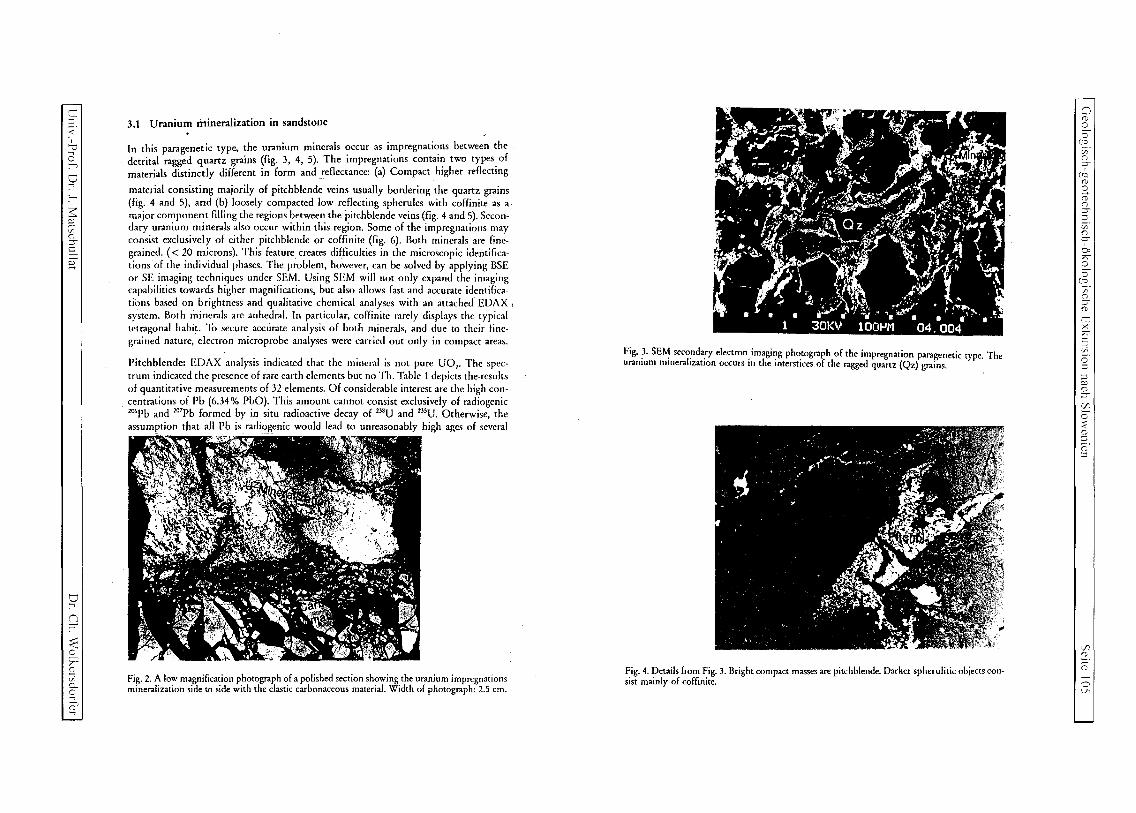
,~
::; ;:::' , v (3 :-'"l
V ....,
$: ~ en o :::r c
~
o ....,
9 :< o ?;"" (]) ...., [h
a.. o ~ ....,
3.1 Uranium mineralization in sandstone
In this paragenetic type, the uranium minerals occur as impregnations between the detrital ragged quartz grains (fig. 3, 4, 5). The impregnations contai~ two types. of materials distinctly different in form and reflectance: (a) Compact higher reflecting
material consisting majorily of pitchblende veins usually bordering the quartz grains (fig. 4 and 5), and (b) loosely compacted low reflecting spherules with coffinite as a major component filling the regions between the pitchblende veins (fig. 4 and 5). Secon· dary uranium minerals also occur within this region. Some of the impregnations may consist exclusively of either pitchblende or coffinite (fig. 6). Both minerals are fine· grained. ( < 20 microns). T.his feature. creates difficulties in the microscopic identifica· tions of the individual phases. The problem, however, can be solved by applying BSE or SE imaging techniques under SEM. Using SEM will not only expand the imaging capabilities towards higher magnifications, but also allows fast and accurate identifica· tions based on brightness and qualitative chemical analyses with an attached EDAX I
system. Both minerals are anhedral. In particular, coffinite rarely displays the typical tetragonal habit. '10 secure accurate analysis of both minerals, and due to their fine· grained nature, electron microprobe analyses were carried out only in compact areas.
Pitchblende: EDAX analysis indicated that the mineral is not pure UO" The spec· trum indicated the presence of rare earth elements but no Th. Table I depicts the results of quantitative measurements of 32 elements. Of considerable interest are the high con· centrations of Pb (6.34% PbO). This amount cannot consist exclusively of radiogenic '06Pb and ,o7Pb formed by in situ radioactive decay of 2J8U and 235U. Otherwise, the
assumption that all Pb is radiogenic would lead to unreasonably high ages of several
Fig. 2. A low magnification photograph of a polished section showing the uranium impregnations mineralization side to side with the clastic carbonaceous material. Width of photograph: 2.5 cm.
Fig. 3. SEM secondary electron imaging photograph of the impregnation paragenetic type. The uranium mineralization occurs in the interstices of the ragged quartz (Qz) grains.
Fig. 4. Details from Fig. 3. Bright compact masses are pitchblende. Darker spherulitic objects consist mainly of coffinite.
Cl (])
o o
[IQ
en o :::r
(Je (])
~ (])
g. ::; en o :::r , 0: ?;"" o o
[;5: en o :::r (])
tTl X ?;"" C ;;:; o ::;
::; ~ o :::r C/J o ::2 (]) ::; (]) ::;
C/J o ;:;: (1)
o Ul

c (J)
33 ;; o
Vl ..c o ro c § CfJ '-< :::;
.:L. ><
L:..: (J)
..c o CfJ
blJ o o
.:L. :9 ..c o c./l
c ...c o (J)
-0 (J)
qlJ ...c o CfJ
bJ) o o (J)
V
\CJ C
. ~ (J)
Vl
Fig. 5. Reflected light photomicrograph of massive pitchblende in an impregnation vein. Length of photograph 200 microns.
Fig. 6. SEM photograph of a part of vein impregnations consisting mainly of partly compacted coffinite .
billion years. We believe that such high local concentrations of lead are due to its· highly mobile nature. Hence, this lead consists not only of pristine radiogenic and ,o'Pb but also mobilized radiogenic lead. The results also indicate high concentrations in SiO" P,O" K,O, CaO, and V,O,. We interpret this as a result of electron beam overlap with minor phosphates and perhaps coffinite intimately intergrown with the pitchblende.
Table 1. Composition of Pitchblende Zirovski Vrh (wt.%).
% % Traces
00, 89.34 La,O, 0.06 Na SiO, 2.14 Ce,O, 0040 Co MgO n.d. Pr,O, n.d. Ni Al,O, 0.16 Nd,o, 0.23 Cu P,O, 0.86 Sm,O, 0.09 As S 0.27 Eu,O, 0.16 Se K,o 0.55 Gd,O, 0.01 Ag Cao 0.80 Tb,o, 0.Q7 Cs TiO 0.07 Dy,O, 0.34 Th V,O, 0.90 Ho,O, 0.18
Cr,O, n.d. Er,O, n.d. Totals - 104.1%
MnO 0.24 Tm,O, 0.14
FeO 0.22 Yb,O, n.d. Y,O, 0.31 Lu,O, 0.06
ZrO, 0.04 HfO, 0.11
BaO 0.02 PbO 6.34
Table 2. Composition of Coffinite Zirovski Vrh (wt.%).
% % Traces
0O, 64045 La,O, 0.30 Na SiO, 16041 Ce,O, 1.08 Co MgO 0.16 Pr,O, 0.30 Ni AI,O, 1.31 Nd,O, 1.54 Cu P,O, 1.13 Sm,O, 0.62 As S 0.17 Eu,O, 0.51 Se K,o 0.57 Gd,o, 0.66 Ag Cao 0.27 Tb,o, 0.78 Cs TiO 0.38 Dy,o, 0.70 Th V,O, 0.80 Ho,O, 1.05 Cr,O, 0.20 Er,O, 0.89. Totals = 102.5% MnO 0.23 Tm,O, 0.82 FeO 0.49 Yb,O, 1,00 Y,O, 0.84 Lu,O, 1,16 ZrO, 0.20 HfO, 1.85 BaO 0.35 PbO 1.27
+-' ro :::;
...c o CfJ
'ii'i 2: -;
o ~ 0: , > c ~
~ 23
"0 CfJ
ii3 ::::: o 5
6 o

C :l
< , v (3 :-+;
o -:
'-
;:;: ;::;. vo (") ';:S c §:
~ n ';:S
< o ?;""
~ cA DO ....;, o ...,
The high totals may also be a result of such overlap, since subtracttion of these elements leads to acceptable results.
Coffinite: The composition of coffinite is displayed in Table 2. A striking feature arc the high sums (> 102%) and high concentration in lanthanides (12.25 wt.% REE). The analyses also indicate high concentrations in Hf (1.85 wt.% HfO,). Likewise pitchblende, other oxides like AI20), P20 S' K20, and V20) were detected. However, we believe also that in this case it is due to contamination from phosphates and silicates intimately intergrown with coffinite. A very important result, however, is that even after subtraction of these elements from the totals, the sum is still close to 100% (97.87%). Taking,into account the analytical uncertainties, we bclive that this result has a severe consequence to the interpretations of electron microprobe analyses of coffinite. In all previous analyses of coffinite published in the literature, any considerable shortage of
the totals was explained as due to the presence of OH substituting for other cations in the coffinite structure. However, the major part of these analyses either did not include the REE or only some of these elements were analyzed. If in our case we would ignore the REE elements, Zr, and Hf, we would have a shortage of 14.1 %, which would have been attributed to OH in the coffinite structure. Our results indicate that the amount of OH (if present) is much smaller than anticipated. Ignoring the REE, Zr, and Hf, would certainly lead to erroneous results and misleading interpretations.
A striking feature is the high preference of Hf, Zr, and REE to coffinite in comparison to pitchblende which is probably structure-controlled.
3.2 Carbonaceous material
In reflected light, no visible inclusions of uraniferous minerals were observed in the carbonaceous material or graphite-like objects. However, carbonaceous materials are potential hosts for uranium, REE, Zr, V, etc. Consequently, they were subject to a detailed SEM study. An X-ray spectrum of an area of 2 mm2 collected at 30 keV excitation voltage indicated without doubt that the material is highly enriched in U and other elements (fig. 7). In addition to the high concentrations in U, considerable amounts of AI, Si, S, Ca, Cs, REE, As, Y, etc. were recorded. This illustrates the complexity of the assemblages enriched in these elements.
Under the SEM the carbonaceous material and graphite-like objects were found to
be loaded with minute inclusions ( < 10 microns, fig. 8). Surprisingly, these inclusions are dominantly oriented along one direction, specifically in the graphite-like objects (fig. 8). At higher magnification, it became evident that the inclusions are majorily of prismatic nature and hence it is expected that pitchblende is not the major component of these inclusions (figs. 9 and 10). Due to the high penetration depth of electrons in carbon, it was possible to image some of the inclusions below the polished surface of the graphite-like material to obtain information on the morphology of the inclusions in the third dimension (fig. 10).
Electron microprobe analyses of various inclusions indicate the quite complex nature of the assemblages in comparison to those found in the sandstone impregnations. In addition to pitchblende and coffinite, various phases with high concentrations in REE were found. Some of these phases were found to be selectively enriched in some lanthanide elements; e.g.: 15.1 wt.% Nd20), 1.96 wt.% Sm02, 2.86 wt.% Gd, and 14.4
r---------------------------------~'r
Qj c: c: «J .r. 0
L. G> a. rn C :> 0 U
j CARBONACEOUS MATERIAL
ZIROVSKI VRH
'?
~~~~~~ : ~;!~~~~ ~ i
Channels
SEM + EDS : 30 kV
N
.§ ::>
E-
r Fig. 7. EDAX spectrum of carbonaceous material depicting the K lines of AI, Si, S, Ca, Fe, Cu, and As, the L lines of REE, and M lines of Cs and U.
wt.% U0l' The totals were always below 100% (between 40-80%). We believe that the major part of these REE-rich minerals consists of REE-rich carbonates.
Pitchblende: Table 3 depicts the composition of pitchblende in the carbonaceous material. Chemical composition of pitchblende in carbonaceous material is distinct from its counterpart in the impregnations: a) it contains lower concentrations in UO, and PbO; b) it is considerably enriched in lanthanide elements. This raises the question of the genetic link between the U-rich minerals in the carbonaceous material and their counterparts in the impregnations.
Coffinite: Coffinite in the carbonaceous material is also enriched in lanthanide elements, Zr and Hf. Likewise in the impregnations, coffinite here shows higher Hf than Zr concentrations. However, the total REE is lower than in coffinite in the impregnations. In contrast, the PbO-content is higher than in coffinite in the impregnations. Compared to the behaviour in the impregnations, this clearly indicates a different partitioning behaviour of these elements in the carbonaceous materials (table 4).
In order to get information on the abundance of minor and trace c1cmcnts in the mineral assemblages of the carbonaceous material, PIXE (Proton-Induced X-ray Emission) analyses were carried out in several areas of a polished section. The collected spectrum is shown in fig. 11. In addition to the U-, M-, lrlines, X-ray lines of AI, Si, P, S, Ag, Ca, Ba, V. REE, Pb, Se, Y, and Zr were detected. In agreement with previous reports on Zirovski Vrh, no Th spectra were observed. This figure also demonstrates the superiority of PIXE over electron microprobe techniques for detection of heavy elements with low concentrations (see also fig. 7).
~ ~
~ ~
M M
o (1)
o o
(JQ
~ (") ';:S
(JQ (1)
o CD (") ::;:l v; (")
:;r 0: ?;"" o o
(Jo V; (") ::;(1)
tTl >< ?;"" c ;;:; o· :l :l ." (") ';:S
C/l o :::: (1) :J (1)
:l
C/l (1)
;:::;: (')
o --.l
Table 3. Composition of Pitchblende in Carbonaceous Material iirovski Vrh (wt.%). 4. Discussion ]
~ % % Traces ::l
.~ The uranium-rich mineralization in Zirovski Vrh is much more complex than an-..c:
c u
(j) UO, 68.39 La,O, 0.52 c/O
~ Na ticipated in all previously published reports on this deposit. Uranium-rich minerals are "t;j
..3 SiO, 4.52 Ce,O, 0.76 Co present both as impregnations and inclusions in pristine carbonaceous materials. This ~ (/J MgO 0.24 Pr,O, n.d. Ni raises the question of the genetic relationships between U and the rare earth elements. -;
-5 Al,o, 0.47 Nd,o, 0.71 Cu Compared to the ore in the impregnations, the carbonaceous materials and the graphite-oj P,O, 1.31 Sm,O, 0.76 As Cs c like objects are enriched in REE. Also in the carbonaceous materials pitchblende shows c S 0.38 Eu,O, 0.61 Se higher concentrations of lanthanides than in the impregnations. If the emplacement of
c,...:
.2 K,O 0.59 Gd,O, 0.51 Ag 0
U, REE, Zr, and Hf were contemporaneous, then why do REE, Zr, and Hf show higher \..0
if) Cao 0.70 Tb,o, 0.90 Cs g 0.-:... preference to pitchblende and coffinite in the carbonaceous materials? It is noteworthy
, ::l TiO 0.36 Dy,O, 0.80 Hi >
..:<: 00
x V,O, 0.78 Ho,O, 0.89 that our investigations indicate the presence of REE-rich carbonates in carbonaceous 00 .-
W materials. These minerals could have acted as traps for U introduced by solutions. Pitch-C'::! :J
0 Cr,O, 0.18 Er,O, 0.81 Totals = 96.5% a:) ..c: MnO 0.29 Tm,O, 1.13
blende and coffinite precipitated in the impregnations should then contain lower con- an u c/O cent rations of these elements.
'CD FeO 0.45 Yb,o, 0.78 ~ 0 Y,O, 0.51 Lu,O, 1.05 More difficult to explain is the relatively high concentrations of REE in coffinite
"0 ZrO, 0.31 HfO, 1.68 compared to pitchblende in the impregnations, on the one hand, and the higher REE 5 ..:<: :0 BaO 0.32 PbO 4.83 abundance of pitchblende compared to coffinite in the carbonaceous material, on the '"0
1: other. Crystal chemical effects cannot explain this contrasting behaviour. Nor could ~ u .~ The origin of the carbonaceous material could be discerned by examination at high this feature be explained as a result of formation at different temperatures since both ~
..c: resolution with the SEM. Plant residues with well preserved cellular structure are quite parageneses occur together. It is more plausible to attribute this feature to a high concen- M
u ....-I
(j) abundant. The material now consists of pitchblende or pitchblende and coffinite tration of these elements in the carbonaceous materials prior to the U-ore emplacement. '"0 '0 (j) (figs. 12 and 13). We suspect, however, that the high REE-content of pitchblende in the carbonaceous S el) material is perhaps the result of the presence of submicroscopic clastic aggregates of REE-1: C'l 0 Table 4. Composition of Coffinite in Carbonaceous Material iirovski Vrh (wt.%). rich inclusions in pitchblende. The same may also hold for SiO" P,O" K,O, and CaO ....-I if)
bl) % % Traces detected in both coffinite and pitchblende due to the presence of phosphates. ....-I
0 If all detectable minor elements in coffinite are measured with the electron ....-I
0 0 UO, 62.23 La,O, 0.36 Na microprobe, then the deviation of the totals from 100% is quite small. For this reason, O~
CJ SiO, 12.95 Ce,O, 0.91 Co we believe that the amount of H,O or OH in the coffinite structure is very small. ....-I
MgO 0.25 Pr,O, n.d. Ni Previous reports on high OH-concentrations in coffinite are definitely in error due to O\~
AI,o) 6.19 Nd,o) 1.19 Cu lackof complete analysis. oo~
P,O, 2.99 Sm,O) 0.64 As 5 S 0.79 Eu,O) 0.08 Se K,o 0.65 Gd,o, 0.34 Ag
bl.l 5. Conclusions .§ Cao l.15 Tb,o) 0.68 Cs
TiO 0.46 Dy,O, 0.69 Th Several conclusions can be drawn from the present investigations: ~ V,O, 0.71 Ho,O, 0.73 ..0
Cr,O, 0.11 Er,O, 0.23. Totals = 101.7% (1) The uranium mineralization in Zin;)Vski Vrh is probably of sedimentary origin, ~
MnO 0.16 Tm,O) 0.55 perhaps cogenetic with the sandstone. :...
(2) Mobilization of UO, and PbO took place in a younger episode thus redistributing Q) 0
FeO 0.38 Yb,O, 0.48 ...... 4-
~ :...
Y,O, 1.59 Lu,O, 0.77 these elements among various uranium minerals. 0 u
ZrO, 0.19 HfO, 0.94 (3) Carbonaceous materials enriched in REE-minerals acted as traps for U both during if] :...
the primary mineralization and the late mobilization episodes. (j)
BaO 0.34 PbO 1.97 ..:<:
(4) The total U/Pb ratios measured with the electron microprobe cannot be used to 0
DC determine the age of the mineralizations since a) both elements are involved in the 5 0
mobilization and b) the amount of ,o'Pb and the ' 06Pbl'°7Pb is unknown so far. .-~ u (j)
(/J 0

c ::;
< , u
~ o -:
:-3::: ;:;. vo o ::;c
[
o -:
n ::;-
::::: o ;A
~ vi c... o ~ -:
ZIROVSKI VRH URANIUM MINE WATER MANAGEMENT
Zmago Logar, Boris Likar, Ivan Gantar
SUMMARY
,,~" ~'1
Zirovski vrh uranium mine and its facilities are situated on the north-eastern slopes of the Zirovski Vrh ridge (960 m) and on the southern slopes of Crna gora (61Im) respectively. Mine elevation is from 430 m (bottom of the valley) to 580 m (P-I adit). All effluents from the mine and mill objects flow into the Brebovscica river (with average yearly flow of 0.74 m3/s):
run off mine water, mine waste pile Jazbec outflow, mill tailings Borst outflows, effluents from mine temporary mine waste piles P-1, P-9, P-36 of minor significance.
The first three are monitored in details as well as the recipient surface water flows (the Todrascica brook and the Brebovscica river). The impact of radioactive polluted outflows on named waters is proved, but far under the maximal permitted limit.
The future planes are to minimise the uranium concentrations in the run off mine water by target underground drilling to avoid clean water contamination and prevent contamination of the mine waste pile and tailings waters by percolation.
Area MioUSD Underground mine remediation 19.00 Mine waste pile remediation 6.50 Mill tailings remediation 2.24 Total investment costs 27.74
---_ .. _- ------- --
Above figures do not include operation costs of the Zirovski Vrh Mine, approximately 2.2 Mio USD per year nowadays. The last implementation schedule foresights the end of remediation works in year 2005. After that starts trial monitoring of 5 years to prove the quality of performed work.
1. INTRODUCTION
Zirovski Vrh Uranium Mine is situated 45 km west from Ljubljana the capitol of Slovenia. The ore body in Groeden sandstone was discovered in 1960, the ore production started in 1982, yellow cake production in 1984. The yellow cake production ceased in 1990. The production site remediation activities are going on since that time. Only 620,000 tons of ore with 0.7 kg ofU per ton was processed and 450 tons of yellow cake was produced.
Zirovski vrh uranium mine and its facilities are situated on the north-eastern slopes of the Zirovski Vrh ridge (960 m). The underground mine elevation is from 430 m (bottom of the valley) to 580 m (P-I adit). The mill was located in the valley of the river Brebovscica (415 m) and the mill tailings (530 -560 m) on the southern slopes of Crna gora mountain (61Im). Figure I shows location of all important mine objects.
The clime is sUbalpine with snow (I m) and low temperatures in winter (minimum - 28°C, average - 0.5 0c) and hot weather in summer (maximum 37°C, average 17 0c). The precipitation's are in the range between 1390 nnnlm2 in dry years and 2450 nnnlrr,z in wet years, respectively. Average total arnual precipitation is 1800 mm/m2 Ratio between rainfall and snowfall is 85 % of rain and 15 % of snow in a year. Evaporation rate is ca. 500 rnmIa.
The effluents from the mine and mill objects flow into the Brebovscica river (with average yearly flow of 2650 m3/h (740 lis). The impact of radioactive polluted outflows on nearby surface waters is proved, but far under the maximal permitted limit values. The whole area is part of the Sava river tributary system.
2. PRESENT WATER MANAGEMENT
There are three main objects of concern as sources of radioactive polluted effluents: the underground mine, the mine waste pile and the mill tailings. The effluents from these objects have been monitored in details since the start up of the ore production. Effluents from other minor sources like smaller mine spoil heaps, adits etc. have been monitored periodically. The arnual effective dose contributed to the members of critical group by water pathway is negligible (0.015 mSv: U, Ra-226, Pb-2l0, Th 230). [IJS-1998] The data are shown for typical year 1998 with yearly rainfall of 1834 mm.
Present monitoring of the mayor mine effluents and the Brebovscica river and Todraski brook is going on since the start of the production in 1982. The flows are measured and sampled manually on daily basis. Monthly composites are made up of the daily samples and are analysed on : uranium, radium-226, ammonia, calcium, magnesium, iron, sulphates and chlorides. Table I shows yearly average values for contaminants in the surface waters. The sediments in the surface water flows are sampled, uranium and radium-226 are determined. Of course, underground waters are monitored regularly in the whole area even in alluvial sediments of the Brebovscica river (Figure 2). Periodicaly are monitored surface waters above the mine objects. Organisation of this work is responsibility of the Radiological Safety Department.Part of the sampling and monitoring is entrusted to the contractors Institute of Josef Stefan and Institute of Occupational Safety, LjUbljana.
'"" -, (t
o o
ric vo o ::;-
(fQ (t
o rl' (t o ::;::; vo g. 0: ;A o o
(fO
en o ::;('0
tn x ;A C -: ~. o :::l
~ ('0 ::;-U'J o :;: ('0 ::; (t ::;
U'J (t
;=;-" (t
o v
c ([)
c ([)
~ o
C/l
..c: () oj
c c o VJ :.... ::l ~
>< w ([)
..c: u VJ
CJ) o o
..0.: :9 ..c: () VJ
..2 u ([)
o ([)
bIJ
1: u VJ
bIJ o o ([)
o
o
.~ o
C/l
2.1. Run off the Mine Water
The mine dewaters by gravity through the tunnel P-I0 at the lowest point of the mine at 430 m. Average yearly mine water flow is 70 - 85 m3/h (20 - 24 lis) depending on the rainfall. The water is not chemically contaminated.
The mine water was treated mechanically (coagulation, floculation, filtering) at the water treatment plant during the mine exploitation. Normally, water with less than 5 mgll solids was discharged into the Brebovscica river.
2.1.1. Water suppliers in the mine structures
Water suppliers in the mine structure are tectonically fractured sandstone's and conglomerates. Fractures as consequence of folding, appear in the south-western part of the ore deposit. We observe them in the apex of the folds in the shape of strongly clivaged rocks.
Another type of the water supplier is conglomerate from the third horizon, where carbonates prevail in the shape of limestone and dolomite pebbles, where a binder is composed of carbonates. This carbonate horizon is leached of in tectonic fractured faults, small cavems are created and washed out cracks .
2.1.2. Sources of Mine Water Pollution
Waters that inflows'into the open mine rooms, are contaminated with uranium depending to the type of water supplier. It can happened during the way through the rock. In much more cases, they get contaminated when percolate over opened ore bodies due to leaching of uranium and its daughter's products.
Waters that spring contaminated from the rock are bound to the fractured zones, that cut and crush the ore bodies, drain from folded rock strata in the north-eastern part of the ore body. Bigger number of contaminated mine water sources are exploration boreholes that drain through ore horizons.
Additional contamination of the mine water is percolation through stopes and tunnels, where they cut the ore zones. The same mechanism applies to the waters that spring uncontaminated.
2.1.3. Mine Water Flows and Contamination
Different quantities of the mine water inflows into horizons referring the level.
On the highest horizon the mine exploitation started in 1982. We would expect bigger inflows due to surface proximity. This is not the case, however water inflow strongly depends on weather conditions. With lower horizons constructions this horizon became dry. The biggest mine water inflows are at the mine level 430 m that is the lowest and at the level of the Brebovscica river. Upper horizons grow up drier.
We get only 1.4 lis water from all sources at the horizon 580 m. This water outflows through the drain boreholes and blind shafts to the lower horizon. Water contains only 26 IlgU/I in average. Horizon 555 is small intermediate horizon that is practically dry. We can observe
only small springs in faulted zones and trickled out pore water. This level contributes only 0.2 1/s with 769 f.lgU/l.
At the level 530, which is situated in the middle of the ore body, the waters from horizon 555 are collected and partially from horizon 530. These waters are joined by substantial quantities of seepage waters from this horizon. The contribution from this horizon is 2.9 1/s. They are not so contaminated, contain only 129 IlgU/l.
Waters inflow to the horizon 480 is from drainage boreholes and from blind shafts at horizon 580 and spring waters. Contribution from this horizon is only 1.3 lis and contains 129 IlgU/l.
Horizon 430 m is the lowest in the mine and presents drainage area for the whole mine. Here are numerous springs from fractured zones, from stopes and inflows from boreholes. The contribution is l6,91/s in average. The water quality differs considerably. Contaminated water comes from water suppliers that cut ore bodies e.g. exploration boreholes that cut more ore bodies are the worst. Additional problems represent flooded stopes where the contaminants concentrations exceed 6,000 IlgU/l. The dilution at this horizon is big enough so the average concentration is 209 IlgU/l. See the table 1 and the figures 3 - 5 for details.
2.2. Mine Waste Pile Jazbec Effluents
Mine waste pile is situated in narrow ravine, where two background water flows from two smaller ravines confluence in the brook called Jazbec. The Jazbec culvert was built under the spoil heap on the bottom of the small ravine, to drain surface water from background area before the start of construction. There is approximately 1.5 Mio ton of mine waste including 50,000 ton of neutralised red mud from mill process and 15.000 ton of debris from demolished mill buildings.
All waters coming into the mine waste heap due to rainfall and from background (surface, surrounding underground) outflow through Jazbec culvert. Flow has torrential nature and varies from 1 to 25 m
3/h. The background surface water dilutes the seepage from the pile.
Average concentration of uranium is 310 IlgU/I and varies up to 575 f.lgU/I. See table 1 for details.
The minor part of contfullinated water outflows as underground water that is not collected in the culvert. Maximal contamination of underground water in alluvial sediments is 15 Ilg U/l. Carstic nature of the pile ground complicates the situation with priority carstic water pathways. Figure 6 shows the contaminants average yearly concentration in the mine effluent since the start of monitoring.
2.3. Mill Tailings Borst Effluents
The mill tailings contains 620,000 ton of mill waste and 70,000 ton of mine waste. The surface is covered temporary by thin soil layer. Rainfall and some underground water together flow through the mill tailings and dissolve the contaminants. The effluent flows are mill tailings underground water (sampling point SDIJ), surface outflow via mill tailings pond Borst and in minor degree the underground drainage tunnel. The flow of the mill tailings underground water flow (SDU) decreased considerably after the construction of the drainage
'(;j
::l ..c: () VJ
'(;j
~ -,
o e;...: o t , > c
::J
:.... ~ :.... o -0
VJ :.... ([)
:::: o ;:;;
6 o

~ ~
::;
< ,
o .....,
o
~ ~ ~
o ::;-r
~
o -:
r; ::;-
< T ~ en 0-
r;, -:
tunnel. The concentration of the contaminants rose by five times due to lack of dilution by the underground water.
Simplified water flows and the contaminants concentrations from the tailings are shown in the
table 2.
2.4. Other Effluents
Other effluents, periodically monitored are:
Tunnel P-9 run off mine water P-36 mine waste backfill weathering seepage water P-l temporary mine waste heap weathering seepage water.
Their impact is negligible due to small flows and/or low contaminants concentrations.
3. PROPOSED SOLUTIONS
The limits for concentrations of the contaminants have been given by authorised limits or are stated in the existing regulative. These objectives are presented in the table 4, and have been taken into consideration for the design of the remediation actions. During the remediation works in the mine the water treatment plant will operate to minimise the emission of the solids into the Brebovscica river.
General request is the site monitoring period of 5 years after finishing of implementation which has been given by the Authorities.
3.1 Run off mine water
Objectives to minimise generation of the contaminants in the run off mine water will be achieved by engineered works:
Caption boreholes for dewatering of the critical mine stopes and tunnels, to avoid water contacts with ore bodies. Isolation of flooded stopes at the lowest level, where is impossible to use and implement
the boreholes. Implementation of drainage boreholes from level 430 m upwards opposite to the direction of decline of the strata and foulted zones. The test boreholes have proved this idea. Contaminated water flow from exploration boreholes decreased or ceased in total. See the figure 7.
The plan is to mllllmise concentration of uranium in mine water from 20 ~ 30 % with implementation of designed scope of work.
3.2. Mine Waste Pile effluents
Objectives to minimise generation of the contaminants water outflow respectively will be achieved by engineered works:
Repair of a part the PEHD pipelines under the mine waste pile to minimise water inflow into the waste body. Leaching of the contaminants will be prevented partially this way. With engineered multi layers cover weathering will be prevented and side waters inflow will be prevented as well. With surface diversion of the Jazbec brook the flood waters will not endanger the pile.
With implementation of these measures the concentration of the contaminants will remain lower as it is prescribed in authorised limits.
3.3. Mill Tailings Borst Effluents
The designer of the mill tailings long-term remediation declared that there will be no seepage effluents from the tailings after consolidation of the tailing materials. This is the reason why authorised limits have not been given by the authorities.
3.4. Other Effluents
Relocation of all temporary waste piles into the central mine waste pile Jazbec has been planned. The areas will be cleaned and adequately recultivated.
4. CONCLUSIONS
We believe, the impact by the water pathway on the environment will be minimal, if not negligible, after the implementation of the listed measures, and much lower than requested by authorities.
Funding of the planned activities is rather slow and the last plan foresees the conclusion of the field works in the year 2005.
::::; 8 o
(18
CF o :::s-,
(18
8 G o :::s::;
'.r. o :::s, 0: T C
(g vo o o 01 ;,.T
'fi
o
~
'J;
~ nl
G
'J; G
r;

:.;
:.;
g y; r
U
'" r
o ~
..c:: ~
:.;
u Of.
CJ) o o
..c:: ,
..c u C/:
r
U
~ o :.; ~D
"G C/:
CJ)
:.; C]
('I
~ :.; y;
5. TABLES AND FIGURES
Table I: Surface recipients average values for year 1998 [ Source: JRO-1999j
Water course Average Uranium Radium- Uranium flow 226 mOth ~g/l Bq/mO Kg/a
Brebovscica river 3368 15.5 4 332 Todraz brook 367 2.5 13 33
Radium
MBq/a 101,5
47
Table 2: Mine and waste pile effluents, averages for the year 1998 [Source: JRO-1999j
Effluent Average Uranium Radium- Ammo flow 226 ilia m'th ~g/l Bq/m' mg/l
Run off mine water 83 246 46 0.2 Mine waste pile 34 309 21 0.8 Jazbee
Table 3: Mill tailings effluents, averages for the year 1998 1 Source: JRO-1999j
Effluent Average Uranium Radium- Ammo flow 226 nia mth ~g/I Bq/m mg/l
SDU 0.9 590 223 56 Surface outflow 5.1 600 1461 13 from control pond Seepage outflow 0.2 544 423 4 from drainage pond Underground 5.1 3.4 12 0.2
CaLi" MgL
mg!! mg/I 22 2.9 81 29
CaL' Mg'"
mg/l mg!! 354 68 206 25
217 26
23 5.8
cr S04-
mg/I mg/I 3.9 20 7.2 246
cr S04-
mg!! mg/l 344 1163 87 569
87 152"8
59 37 drainage tunnel
.-~---~
r I
Table 4: Comparison of maximal permitted concentrations of contaminants for mine effluents and surface waters
Expected effluent flow MPC for potable Authorised limits Authorised limits after remediation water Quantity/annum
Average Uranium Radium- Uranium Radium- Uranium Radium-flow 226 226 226 mOth ~g/l Bq/mj ~g/l Bq/m Kg/a MBq/a
General 50 1000 - - -
Run off mine water 60 - 100 - - 250 60 170 50 Mine waste 34 - - 510 40 85 25
disposal Mill tailings SDU - - No flow No flow No flow No flow
Surface outflow - - No flow No flow No flow No flow from control pond Seepage outflow - - No flow No flow No flow No flow from drainage pond Mill tailings 5 - - < 50 < 1000 - -drainage tunnel Todrascica brook 367 - - < 50 60 - 50
Brebovscica river 3368 - - <50 40 - -
Note 1: These are average hourly flows for the water courses in the year 1998.
6. SOURCES
[IJS-1998] - The 1998 Report on the Environment Radioactivity Measurements of the Uranium Ore Mine Zirovski Vrh, Institute Josef Stefan, Ljubljana, March 1999 (in Siovenian)
[RZV -1995] - Report on the Effects on the Environment While Carrying-out the Programme on Closeout of the Mine and the Programme on Preventing the Consequences of Mining, Zirovski Vrh Mine, Todraz, September 1995 (in Siovenian)
[JRO-1999] - Interoffice Report on Implementation of Monitoring in 1998, Jozef Rojc, Todraz, February 1999 (in Siovenian)
T. Begus - 3 D view of the Mine site (1999)
[IRGO-1996] - Cadez Franc: Hydrogeological and Geomechanical Characteristic of the Mine Waste Pile Jazbec and its Impact onto Groundwater, Ljubljana, 1996 (in Siovenian)
[GZL-1997] - Begus Tomaz: A Fresh Assessment of he Alternatives for Close-out of Tailings Operation, Ljubljana, 1997 (in Slovenian)
..c u J)
c::: 2
c5 ::::
c::: ,
:.; ' ..... is
-0 YU
..c:: o ~
G
c5

c :::0
< , :? ci :-+> o -:
3: ~ en ()
::rc [
~ n ::r-
::::: o T (1)
v5 D. o ~ -:
BRLICH, A. A. (1')')8): Palynologische Untersuchungen im Oligozan Sloweniens - Paliio-Umwelt lind PaHioklill1a
ill1 Ostalpenraum. - Tlibingcr Mikropa1i:iontol. Mitt.. 18: 1-1')1,17 Ahh.: 7 Tab" 16 TaL, l Anb., Tlibingen.
2.1.2 Sava-Becken
Das Sava-Becken erstreckt sich niirdlich des Flusses Sava in ost-westlicher Richtung tiber mehr als 50
km von dem Ort Moravce im Westen bis hinter die Stadt Lasko im Osten (Abb. 1). Seine heutige
Nord-Stid-Erstreckung betragt aufgrund der starken tektonischen Einengung maximal 3 km. Dieser
Wert wird im Bereich der Ortschaft Zagorje erreicht.
Das Sava-Becken ist wegen seiner Kohlevorkommen schon seit mehr als 100 Jahren Gegenstand
geologischer Untersuchungen. Neben den Kartierarbeiten von BITTNER (1884) und Teller (1907)
entstanden schon fruh Arbeiten tiber die Makroflora (ETI1NGSHAUSEN 1872, 1877, 1885) und Fauna
(HOERNES 1876; TELLER 1886) der kohlefiihrenden Schichten. Bis heute sind der komplizierte
geologisch-tektonische Bau des Beckens (z.B. MUNDA 1953; KUSCER 1967; KUSCER & MITREVSKI
1979; GRAD et a!. 1996) sowie die unsichere stratigraphische Stellung seiner Sedimente (z.B. ODIN et
al. 1994; vgl. auch Kap. 5) Gegenstand zahlreicher Arbeiten.
2.1.1.1 Sedimentare Abfolge
Wie im Becken von Gomji Grad beginnt die Sedimentation auch im Sava-Becken mit terrestrischen
klastischen Ablagerungen. Diese werden nach JELEN et al. (1992) in Abgrenzung zu den eozanen
Socka-Schichten (ROLLE 1858) als Pseudo-Socka-Schichten bezeichnet. Ein Kohlefloz untergliedert
diesen Komplex in die unteren und oberen Pseudo-Socka-Schichten (Abb. 5 und 6), wobei erstere als
fossilfreie Konglomerate, Sande und hellgraue Tone fluviatilen Ursprungs beschrieben werden
Lasko-Schichten E. ~
Govce-Schichten
mariner Ton • mariner Ton
E obere Pseudo-
@ l~il~l~i:!;~~~d I Novi Dol Socka-Schichten
III iL7/96 Kohlefl6z <5~m_ OjL6/96
::::::::::::::::::::::: E
untere Pseudo- 0
Socka-Schichten LO N v
triassischer Untergrund
m tert. Karbonate k :I:':J Kong!.. Sands!. F::::::::l Mergel _ Kohle ~ triass. Karbonate
Abb. 5: Vereinfachtes Normalprofil der tertiiiren Abfolge im Sava-Becken und stratigaphische Lage der bearbeiteten Profile. Machtigkeitsangaben nach MUNDA (1953) und ODIN et aI. (1994).
(KUSCER 1967; CIMERMAN 1979; ODIN et a!. 1994). Zum Hangenden wird der Tonanteil dominanter
und geht unter Zunahme des organischen Anteils in die Kohleablagerung tiber. Die unteren Pseudo
Socka-Schichten konnen eine Machtigkeit bis zu 250 m erreichen (KUSCER 1967; UHAN 1991; ODIN et
al. 1994).
Die Kohle der Pseudo-Socka-Schichten ist als eine dunkle, harte Braunkohle mit relativ hohem
Inkohlungsgrad vom Rang einer Matt- bis Glanzkohle ausgebildet (KUSCER 1967; MARKIC mund!.
Mitt. 1996). Die auftretenden Lithotypen lassen sich nach STaPES (1919) iiberwiegend als Durain
Cl (1)
o o
(rQ
<A ()
::r-, (10
(1)
o ;:; ()
::r:::0 en ()
::r-0: T o o
(fQ
~ ()
::r()
M >< A (::
;;:: o :::0 :::0 ~ () ::r-C/l o :;;: (1)
:::0 ()
:::0
,:f) (1) ;:+. (1)
l,,)

::: (!)
~ ~
.£ Vl ..::: u ro ::: ::: 0 if]
'-::l -'" >< W-l (!)
..::: u if]
·CD .£ 0
-'" :0 , "5 .~ :::
..::: u (!) +-' 0 (!) bJ]
..c u if]
·bD 0
0 (!)
0
oo::t
.~ (!)
Vl
500m
E triassischer Untergrund 0 oligoziiner ~ oligoziine Pseudo-Socka-
mariner Ton Schichten mit Kohle
~ mittelmioziiner 0 quartiire TalfGllung D Grubenabraum Lithothamnienkalk ....
/" Sterung 0 Lage des Profils Novi Dol
Abb. 6: Geologischer Autbau des Sava-Beckens zwischen Hrastnik und Novi Dol. Das Profil Novi Dol befindet sich direkt auf der Profillinie A - A' (nicht iiberh6ht; verandert nach KUSCER & MITREVSKI 1979).
(Mattkohle) bis Clarain (Streifenkohle) mit zum Teil hohen Anteilen an Vitrain (Glanzkohle)
einordnen (MARKIC schrift!. Mitt. 1996). Der Brennwert der Kahle wird von KUSCER (1967) mit
durchschnittlich etwa 4500 kcal/kg angegeben. Die Abfolge innerhalb des Flazes geht vom Liegenden
mit starker tonigen Anteilen in einen von Karbonateinschaltungen dominierten Abschnitt iiber; nur
der obere Teil des Flazes ist von besserer Qualitat (KUSCER 1967; UHAN 1991; HAFNER 1996). Oiler
die gesamte Machtigkeit treten vereinzelt bis regelmiiBig vulkanoklastische Einschaltungen auf (z.B .
RUMPF 1884; BUSER 1979; ODIN et a!. 1994). An Fossilien sind aus dem Flaz des Sava-Beckens
bereits seit dem letzten J ahrhundert Reptilien- und Saugerreste - vor allem von Anthracotherien _
bekannt (HOERNES 1876; TELLER 1886; THENIUS 1959). Auch die Makroflora und ebenso die
SiiBwasserfauna der karbonatischen Zwischenmittel wurden fruh beschrieben (ETTINGSHAUSEN 1872,
1877, 1885; BIITNER 1884). Jilngere vor aHem palynologische Arbeiten b1ieben dagegen bis auf
wenige Ausnahmen unveriiffentlicht und beschranken sich meist auf die Angabe einzelner
stratigraphisch wichtiger Taxa (MARKIC et a!. 1993; ODIN et a1. 1994; GRAD et a1. 1996; JELEN
miind!. Mitt. 1996). Fur das Kohleflaz wird meist eine Machtigkeit von etwa 20 bis maximal 30 m
angegeben (z.B. KUSCER 1967; MIHAJLOVIC & JUNGWIRTH 1988; ODIN et a!. 1994), wobei es zu den
Beckenrandern hin ausdilnnt und z.B. astlich von Lasko (Abb. 1) nur noch wenige Dezimeter urnfaBt
(KUSCER 1967; GRAD et a!. 1996).
Die oberen Pseudo-Socka-Schichten werden im Becken gepragt von lakustrinen Kalksteinen und
Mergeln in unterschiedlichen Anteilen und Machtigkeiten. Der Ubergang von der Kohle zum
Hangenden ist stellenweise a1s bitumen- und diatomeenreicher Laminit ausgebildet, der in
wechselnden Miichtigkeiten auftritt und a1s "Brennschiefer" oder "sapropelic overburden" bezeichnet
wird (MARKIc miind!. Mitt. 1998). KUSCER (1967) erwiihnt ostlich von Zagorje ein Vorkommen
feinlagiger Silikatschiefer, das mog1icherweise diesem "Brennschiefer" entspricht. Aus den oberen
Pseudo-Socka-Schichten wurde neben der SilBwasserrnolluskenfauna vor allem die Makroflora
beschrieben (STUR 1871; BITTNER 1884; MlHAJLOVIC & JUNGWIRTH 1988). AuBerdem sind
Fischfossilien bekannt (GORJANOVIC-KRAMBERGER 1884, 1886, 1891, 1895 zitiert in KUSCER 1967),
welche als Hinweis auf zum Hangenden hin teilweise brackische Umweltbedingungen interpretiert
werden (z.B. KUSCER 1967; CIMERMAN 1979). Die Machtigkeit dieser Ablagerungen wird mit 15 bis
120 m angegeben(UHAN 1991; ODIN et a!. 1994).
Analog zur tertiaren Abfo1ge bei Gornji Grad geht die terrigene Sedimentation auch im Sava-Becken
zum Hangenden hin in marine Ablagerungen iiber. Flachmarine Ablagerungen, wie sie bei Gornji
Grad regelmiiBig anzutreffen sind, bilden hier jedoch eine seltene Ausnahme (KUSCER & MITREVSKI
1979). Es dominieren graue Mergeltone, die mit dem Vorkommen von Forarniniferen,
Dinoflagellatenzysten und Nannoplankton (z.B. JELEN et al. 1988/89; BRICL & PAVSIC 1991)
vollmarine Bedingungen be1egen. Die Tone sind tektonisch bedingt nur geringmachtig; ODIN et a!.
(1994) geben 120 bis 200 m Machtigkeit an. Diese mergelige Abfolge wurde bisher nur inforrnell
beschrieben und findet sich in der Literatur meist als "oligozane marine Tone" (z.B. KUSCER 1967;
c;j
::l ..::: u if)
~ 2 -;
(5 :.,...; o '-c.. , > ::: ~
:...
~ 'o
""0 if] :... (!)
:::: o ::; ,... o (5

c ;:i
<' V -: o :-+> o -:
'-
3: ;::;. rn n ;:i" c
§:"
o -:
9 :E o ;0;ro ~ 0.. o ~ --:
ODIN et al. 1994; GRAD et al. 1996). Zum Teil wird jedoch auch in Analogie zur ungarischen tertiaren
Schichtenfolge der Bergriff "Kiscell Clay" verwandt (z.B. CIMERMAN 1979; JELEN et al. 1992).
Die im unteren Teil der Abfolge reinen Tonmergel gehen zum Hangenden hin durch graduelle
Zunahme der Sandfraktion in die Govce-Schichten iiber, die bereits ins Mioziin gestellt werden (ODIN
et al. 1994). Diese sind von klastischer Sedimentation mit Sandsteinen und Konglomeraten gepragt
und erreichen Machtigkeiten von 180 bis 270 m (ODIN et al. 1994). Die Abfolge wird diskordant von
Kalken mit Corallinaceen-Biohermen iiberlagert, die nach PLACER (in ODIN et al. 1994) ins Baden
datieren. Mit diesen sogenannten Lasko-Schichten, fUr die MUNDA (1953) eine Machtigkeit von
mindestens 500 m angibt, endet die tertiare Abfolge des Sava-Beckens.
SA V A-BECKEN :_(ASAtvtHENf= ;\S,SLA\\J~ Die gute Erhaltung der relativ reichen Palynoflora der Profile des Sava-Beckens ermoglichte eine
quantitative Auswertung sowohl in palaoiikologischer als auch palaoklimatischer Hinsicht.
Mit Hilfe multivariater statistischer Methoden wurde die okologische und fazielle Entwicklung im
Ablagerungsraum rekonstruiert (Abb. 27). Dieser Hillt sich zunachst als von Taxodiaceen und Farnen dominiertes Braunkohlemoor beschreiben,
in dem sich aufgrund schwankender Grundwasserspiegel als Folge wechselnder Subsidenzraten
immer wieder kleinere Seen mit riedbestandenen Uferbereichen bildeten. Mit Beginn der
Sedimentation der oberen Pseudo-Socka-Schichten etablierte sich ein Iimnisches Milieu. Nach der
Ausbildung eines groBeren Sees mit mehreren Kilometern Durchmesser veranderte sich die
Vegetation. Die Taxodiaceen gingen zuruck und Auenwalder dominierten, die mit zunehmendem
Absinken des Grundwasserspiegels sukzessive von trockeneren Elementen des mesophilen
Mischwaldes verdrangt wurden. Spater wurde das Gebiet von der fortschreitenden Transgression
erreicht, und die marine Sedimentation setzte ein.
Die palaoklimatische Auswertung mit Hilfe des Koexistenz-Ansatzes erbrachte folgende Ergebnisse:
J ahresmitteltemperatur: 16 bis 19°C
Mittlere Temperatur des kaltesten Monats: 6 bis 9 °C
Mittlere Temperatur des wannsten Monats: 25 - 28°C
Jahresniederschlage: llOO - 1300 mm
Niederschlag des wannsten Monats: 70 - 90 mm
Niederschlag des feuchtesten Monats: 175 - 180 mm
Niederschlag des trockensten Monats: 20 - 50 rom
Relative Feuchte: 72 bis 74 %.
Die mit dem Koexistenz-Ansatz erzielten Ergebnisse weisen auf groBe klimatische Stabilitat wabrend
der Sedimentation der untersuchten Abfolge im Sava-Becken hin. Die Befunde sind in sich konsistent
und zeichnen das Bild eines warmtemperierten, sehr humiden Klimas yom Typ Cfa mit nur geringen
jahreszeitlichen Niederschlagsschwankungen. Uingere Frostperioden erscheinen ausgeschlossen. Ein
rezentes Analogon zu den klimatischen Verhaltnissen im Sava-Becken wabrend des
Ablagerungszeitraums der Pseudo-Socka-Schichten bildet das Klimadiagramm von Ningpo/Ostchina
(Abb. 31; W ALTER & LIETH 1960/67). Die Auswertung der statistischen Verteilungsparameter hinsichtlich ihrer Aussagekraft und
Verwertbarkeit beziiglich der Charakterisierung des Palaoklimas erbrachte am Beispiel der
J ahresmitteltemperatur eine sehr enge Korrelation mit der Anzahl der ausgewerteten Taxa, so daB
diese Parameter nicht als zusatzliche Hilfsmittel der Klimaanalyse angesehen werden kiinnen.
Lediglich die Schiefe verhalt sich als einziger der statistischen Parameter der Klimaaussage der
Koexistenz-Intervalle entsprechend. Ob hier ein signifikanter klimabezogener Zusarnmenhang besteht
oder methodische Einfliisse eine Rolle spielen, kann nur durch weitergehende Betrachtungen an
Floren verschiedener Klimaprovenienzen geklart werden.
Insgesamt dokumentieren die Ergebnisse der palynologischen Bearbeitung, daB im Oligoziin des Sava
Beckens die beobachteten Vegetations- und Klimaentwicklungen unabhangig voneinander verliefen.
Die Florenentwicklung war innerhalb des sehr einheitlichen warmtemperierten, humiden Klimas
wahrscheinlich ausschlieBlich von der regionalen tektonisch-geographischen Entwicklung gesteuert.
P ALAOKLIMA IM OSTALPENRAUM
Die Auswertung von 25 obereozanen bis miozanen Palynofloren mit dem Koexistenz-Ansatz zeichnet
ein relativ einheitliches Bild des klimatischen Geschehens im Ostalpenraum. Es wurden durchgehend
Cfa-Klimate nachgewiesen. Dariiber hinaus treten bestimmte Zeitabschnitte mit sich verandernden
palaoklimatischen Verhaltnissen deutlich hervor:
Eine deutliche Abkiihlung und der Riickgang des Sommerniederschlags im EoziiniOligozan
Grenzbereich ist nordlich der Alpen dokumentiert. Diese kann neben der globalen Tendenz zu
einem kiihleren Klima auf die erste Isolation der Paratethys zuriickgefiihrt werden, die eine
deutliche Abschwachung des ozeanischen Einflusses zur Folge hatte.
Ebenfalls in dieser Region zeigt sich ein Abschnitt im Bereich yom Unter- zum Mittel-Mioziin
(Ottnang bis Baden) mit einem Trend zu kiihleren Temperaturen in den Winter- und
Jahresmitteltemperaturen; die Soromertemperaturen andern sich nicht, so daB hier auf Anderungen
in der Saisonalitat geschlossen werden kann. Hier scheint mit dem Riickzug der Paratethys aus
dem Molassebecken bei gleichzeitiger Regression der Nordsee ebenfalls die Abnahme des
ozeanischen Einflusses das Klima zu bestimmen.
Eine weitere signiflkante Abkiihlung ist Yom Mittel- zum Ober-Mioziin im pannonischen Raum zu
verzeichnen. Ebenso weisen auch die Sommerniederschlage in abnehmende Richtung. Diese steht
in Zusarnmenhang mit einer verstarkten Hebung der iistlichen Ostalpen und der endgiiltigen
Abschniirung der Paratethys von den Ozeanen.
Diese Ergebnisse werden durch die aus der oligozanen Palynoflora des slowenischen Sava-Beckens
hochauflosend gewonnenen Klimadaten durchweg unterstiitzt.
Die beobachtete klimatische Entwicklung im ostalpinen Raum insbesondere der Temperatur ist stark
von der regionalen Tektonik und der davon abhangigen Palaogeographie beeinfluBt. Gleichzeitig
wirken jedoch auch globale Veranderungen auf das komplexe System des regionalen Klimas. Die
resultierende Land-Meer-V erteilung gibt dabei den entscheidenden Ausschlag iiber die Starke der
Saisonalitat und damit der Kontinentalitat des Klimas (Abb. 35).
AUSBLICK
Die in der vorliegenden Arbeit vorgenommenen Auswertungen von Palynofloren aus der Literatur
geben einen Uberblick iiber die klimatische Entwicklung im ostalpinen Raum im Oligo- und Miozan.
Weitergehende Untersuchungen zur quantitativen Palaoklima-Rekonstruktion in diesem Zeitraum
sollten sich hochauflosend vor allem auf die kritischen Zeitabschnitte des Grenzbereiches Unter
lMittel-Miozan und des Ober-Miozans konzentrieren, urn die beobachteten klimatischen
Veranderungen zeitlich noch genauer zu erfassen. Vor aHem eine Auswertung von Profilen der
siidlichen A1penregionen ist fUr eine Vervollstandigung des Gesamtbildes sowie zur Erfassung der
Entstehung des mediterranen Klimas dringend niitig.
Die mit dem Koexistenz-Ansatz gewonnenen quantitativen Klimaabschatzungen Iiefern dariiber
hinaus die Grundlage fUr computergestiitzte Modellrechnungen, welche eine Rekonstruktion der
tertiaren atmosphlirischen Zirkulation, die ja im Grunde das eigentliche "Klima" ausmacht,
ermiiglichen.
(""; '-<' ()
o o
Cf3. vo g.
1 (fQ (1;
o CD n ;:i" ;:i
rn n ;:i"
0: ;0;o o
U.3. In n ;:i" (j)
[T' >< ;0;-~
--: rn o· ::l
~ n ::;-
C/J o ;s:: () ;:i ;:c. ;:i
C/J o ~
'-1,

0: :;
:; ~ ~
c.r; r.
:..J ~
~ :::;
---" r
:; ~
:..J J
elJ C o
.:L
~
:..J Cf)
0:
:..J
S c 1)
~J)
u CfJ
cJ) o
OJ o
'.S
:;
:; c.r;
c)
b)
a)
tx 'Y' P 11111 R " Yc 9a Abb. 29: Schema der Vegetationsentwicklung in den Profilen des Sava-Beckens, a) OjL6/96 (Cluster 4): Taxodiaceen-Polypodiaceen-Moor mit Ried-Bewuchs an kleineren Wa'5erfJachen; b) OjL7/96 (Cluster 3): Auenwald-dominierte Ubergangsvegetation an einem flachen See; c) Novi Dol (Cluster 2): mesophiler Mischwald; durch steile Ufer unterdrtickte Auen-Vegetation. Reprasentativ sind die in der Palynoflora dominanten Taxa dargestellt: Tx: Taxodiaceen; P: monolete Sporen (Polypodiaceen); R: Ried-Vergesellschaftung; F: Tricolporopol/enites cingulum-Gruppe (Fagaceen?); C: Caryapol/enites simplex (Carya); Q: Quercopol/enites spp. (Quercus),
mariner Ton 02
Novi Dol
OjL7/96
OjL6/96
04
06
08
10
12
14
16
30
28
26
24
22
20
18
32
34
3il
38
40
42
44
46
48
50
....0.-1
t.-~ , ............. - .~.-~>'~ ,_U" ~I
I "fa _I
1== =Ff
.. ::j= -.--.--"=~
I-::t-=± ,~~",,~:r j.-~'*"-~I T=" ",,-,,'_.--.... J=:±:, ,'~::;::~?;:.::~ ':::'~::f"=:; '"
10 15 20 25
JT['C]
mariner TonProb;;-Nr, r. --;:==='"
! 1--1 I """""!": I
++at:. Novi Dol
04
06 08
10
12
14
16
J-I"-"-T§t=.
13:
O]L7/96 30
28
26
24
22
I--J.=! 20
18
, !~ ~""f,,,,····±·-
• .J2;a;"
.a:;,:on-,,_~'"
I ~ --"i-:'- . -, .~
.----.--.~
OjL6/96 32
34
36
38
40
42
44
46
48
50
+ ·5 10 15
TKM['C]
02
04
06
08
10
12
14
16
30
28
26
24
22
20
18
32
34
36
38
40
42
44
46
48
50
TT
500
Proben-Nr.
02
04
06
08
10
12
14
16
30
28
26
24
22
20
18
32
34
36
38
40
42
44
46
48
50
15
750 1.000 1.250 1.500
IN[mm]
= ':'::*= i "1:.~tt
I·-t=~ 1 ._.e:
~ == :tI'll!!!!1!:.*_
20 25 30 35
TWM['CJ
Abb. 30: Ubersicht tiber die mit dem Koexistenz-Ansatz ermittelten Klimawerte fur die einzelnen Proben der Profile des Sava-Beckens. Koexistenz-Intervalle, die auf einer Datenbasis von mehr als 10 Taxa beruhen, sind schwarz dargestellt.
:..J
~ 2: ... r.
+.:
:5: , > 0:
::::;
~ o
-0 y: V
.:L
~ ~
:..;
r.

c ::;
< , v (3 :-+>
EI ~ ~ en ()
::0-~
§:"
o -:
n ::0-
:E e.. A (1) -: en 0-o ~
Jahresmitteltemperatur
11
c 'm N 0 .2' 0
c 'm N 0
UJ
'-c·' ,," ~ ~
c 'm ~ .2' o
c 'm N o
W
1 .
I I ~~~~~-t-----~ - -----
I. 1
---r=-r--1:1 _____ L-l
'T
10 15 20 25
. T I I
----+---t----------f;--L---
I-I iii i. I
-----~-----~-----
i. I I I I-I
----1~----""i''''I''''
500 1.500
! I -J.-I -----~~---t-:::: -=t;;;;r ---f+--
I J ____ _
~~~-,-r~~-, , r, , , , 10 15 20 25
JT[QC]
Jahresniederschlag
TI
--~-------~-l~J-----I_I
I I I-I I------1-----'------
! I , I
I I
, I ~~~-~i~~-,-~t~~-,-:
500 1.500 IN[mm]
.\
If J ____ _ ----- --- !
I t---------r----
1 1 ___ _ --~--I ~I
I \ ~ ----t---------- - I , , , ,
iii, • i' i
10 15 20 25
----l----~I\-----1
----+---- -----! I J... L __ _ -----r----- ! I_I 1 ISSl I I-I
I I I I
-----~-----~----: Iii i 'i i , ii'
500 1.500
Abb. 34a: Koexistenz-Intervalle aller ausgewerteten Palynofloren. Linke Spalte - nordlicher Alpenraum: grau - Deutschland; schwarz - bsterreich. Mittlere Spalte - pannonisches Becken: grau - Ungarn; schwarz - Slowakei. Rechte Spalte _ siidlicher Alpenraum: grau - Italien; schwarz - Slowenien; schraffiert - eigene Ergebnisse.
,lij .~ ~
c 'm ~ .2' o
c 'm
~
c: ,ro ~ ~
c 'm ~ .2' o
c 'm ~
UJ
----1-1~-1--------bt!-+---II
I. j' ---~----~~--I----
I. I I I.
-5 0 5 10 15
i I I 1 I -----r:----i-----~I -----hIf'---r-----I- I .J.. ! I
----+~----~-----
I: I I II!!!! I
:~~-,-r..-~t~~-,-~ 20 25 30 35
Wintertemperatur
I I ;
---tl---1-J r 1 ---
-J-r-j-------lRi------L I --
I =1
---tJ i , , , , , , , , I :~~~~~~~ -5 0 5 10 15 -5 o 5 10 15
TKM[OC]
Sommertemperatur
T I '1 --*--~----- ---f-----r------i~+- --r-i-------ft---1--[-----
-----~----- ----- -----L--- -----. 20 25 30 35
1WM[2C]
20 25 30 35
Abb. 34b: Koexistenz-Intervalle aller ausgewerteten Palynofloren. Linke Spalte - nordlicher Alpenraum: grau - Deutschland; schwarz - bsterreich. Mittlere Spalte - pannonisches Becken: grau - Ungarn; schwarz - Slowakei. Rechte Spalte - siidlicher Alpenraum: grau - ltalien; schwarz - Slowenien; schraffiert - eigene Ergebnisse.
o (1)
o o
[fQ
en ()
::0-, erG (1)
o @" ()
§" vo g. 0: r, o
(J~ en ()
::0-(1)
rn >< r, ~ -: vo o· ::; ::; po () ::;-
[/l
2) ::< (1) ::; (i)' ::;
[/l (1) ;:+. (1)
-..J

:J
:J
6 J: r
g
c :: '/
/.
:J r C) CF.
:D C c ~
, -5 'f;
-5 :J
~ ~J)
u v;
3') c Q)
'-'
cc
Q)
:J J:
The Uranium Deposit of Zirovski Vrh Vesel in Jokanol'ic, Sianisa Radosevic, and Milan Ristic
SUMMARy
The 2irovski Vrh uranium deposit is situated about 30 km west of Ljubljana. The ore bearing rock is the grey Groden sandstone of the Middle Permian age. Its basement is represented by dark Permo-Cal'oonifenrus shale, whereas it is overla.in by Middle Permian red Groden sandstone and Upper Permian limestone and dolomite.
The thickness of the grey sandstone is about 300 meters. The sequence or the red series is between 300 and 500 mciers thick.
The grey sandstone has a variable grain size, fnlm the very fine up to coarse ones. It. is composed of sharp-edged quartz grains, K-feldspars and felsic plagioc1ases, and contains, as a rule, fmgments and phenocrysts 0'[
volcanic quartz and feldspars, the fragments of usually recrystallized quartz-porphyry and keratophyre, the quartzite fragments and, less fl'ef!uently, those or chert. The diabase fragments were also obsel'ved. The muscovite is frequent, and very frequent chlol'ite.
The cement of the uranium-bearing rocks is composed of qual'tz-c\aysericitic material, replaced partially by calcite. The calcite occurs in vtinlets or it is dispersed thrO'l.1ghout the rock. In additi'On to calcite, there are also small quantities of dolomite, ankerite and cerussite.
The uranium ore is confined to the zones in the grey series that contain the dispersed organic matter and anthracite aggregates.
As the most common uranium mineral pitchblende occurs, disseminated in the sandstone cement, 'Or rarely associated with galena, pyrite, chalcopyl'ite, and anthracite,
The minel'alized zones contain also sphalerite, tctmhedlit.e, chalcocite, bOlnitc, realgar, marcasite, arsenopyl'ite, covellite, ilmenite, chmme-spinel, and pyrrhotite. Among the secondary umnium minerals the presence of autunite, torbernite, metatorbernite, dumontite, the minerals of the phosphuranylite-renardite series, gum mites, arsenolite and beta-uranotile has been established, Limonite, malachite and azurite are also present.
The strata-bound uranium ore constitutes numerous unn,gular IPnsps of highly variable dimensions. The surfaces or the ore bodies al'e of the (Jl'der of several hundreds to thousand square meters, Their thickness vm'y from 0,5 to 1,5 meten" attaining in most favourable cases sevel'al
meters, The uranium contents varies most frequently in the interval of 0.05 to 0.23 "in of U:.o,. The ore itself is contl'Olled by the stratification. The rocks. however. mostly do, not show a well marked bedding. The most developEd structure of the Groden beds is the cleavage oriented at. right angle to the bedding planes.
Determination ofthe origin of mine waters from Velenje mine on the basis of their chemical composition
(Summary)
N. MALI and M. VESELlC'
In the hanging and bottom wall strata of Velenje Mine cxists a series of lithologically, hydrodynamically and hydrogeochell1ically difTering aquifers.
A clear hydrogeochemical anomaly is surrounding the lignite scam, due to the substan,tial rise in the free CO2 and HCO) content which gave way to the rise in mineralisation of the waters. It is believed that the CO2 source was lignite itselfduring maturation, yet,this hypot hesis was so far not proven.
The aquifers range from quaternary and pliocene sandy aquifers in the hanging wall strata to the pliocene sandy, miocene sandstone, oligomiocene tumc and triasic dolomitic aquifers in the bottom wall str<lt<l, Further, within a marginal part of the seam arc the pliocene sandy aquifers interbcded into the lignite seam and referred to as the pliocene interbcded sandy aquifers. Quaternary, pliocene and miocene aquifers have intergranular porosity and low to very low permeahility. Hydrogeologicaly strictly speaking, a pari of the pliocene and miocene aquifers should be classified among the semipervious strata. Yet, from the miner's point of view, they present, ifnot depressurised, a potentially dangerous source of water for a sudden inrush. Therefore they are considered as water bearing »aquifers((, Oligo-miocene and triasie aquifers are fractured aquifers. The first have very low permeability and represent no real \vater inrush hazard, while the later are partly karstified and have a definite inrush risk potential. Finally, some waters may exist even within the lignite scam itself due to it's local fracturation, however, they are mostly due to the past application of the flushed backfill. The aim of the study was to define the characteristical chemical composition of ground waters from the above aquifers and to provide liS with the hydrogeochcmieal paramcters that may be llsed for the determination of the ori)!in of the water coming from anyone of these aquifers. Thc main prohlem was the selectivity ofthc parameters, which have to be as simple and quick to get as possible, if they were to be a useful tool to the miner for his operational decisions. Whenevcr a water inflow occurs into the mine, let it be through a horehole or directly into the mineworking a quick and certain c\'aluation of the risk potential of this inflow has to be made and the appropriate decisions adopted.
During this study all the cxisting data were analyzed. The initial data base consisted of 272 samples of unfortunately vcry unequal analytical quality, A preselection was therefore to be made that considerahly reduced our data matrix. The analyzd hydrogeochemical parameters were basic analytical data Na+, K+, Ca~+, Mg~+, NII/, CI, HCO,., S04c-, Fc+, pH, e~lrbonate and total hardness, solid residue at 105" C and the KMn04 .value.
Other parameters, such as conductivity andtotal solids content were generally not analyzed and had therefore to be omitted from our analysis. We have checked the selectivity orthe basic analytical data as well as some of the sinthetical hydrogeochemical parameters, that are advised in the literature~·8. Checks were performed by standard statistical methods - corre, lations, 2test, Wilcoxon test. An ineonelusne attempt of multivariate analysis was also realized, but is not disellssed in the article.
c;;
::; -'= C) if;
~ 2:
"'" "9 ::: , >
~
3::i ~ C
"0 if;
tJ ~
o :s -'= u
c5

c ::;
< , " :;
:-'"l
o -:
:-3:: ~ (JJ
g. c CJ -
o -:
n ::0-
~ o ?'
" -: (JJ
CO
~
The conclusion of our study is that some correlations do exist between the basic analytical parameters (Table I) but very often, this parameters are not selective enough. Some of the sinthetical parameters proved to be sekctive when the origin of the ground water within the different triasie aquifers is considered (Tables 3 and 4) with symbols denoting V - aquifer; N - number of the analyzed samples; min, max. and x - minimum, maximulll and mean value of the analyzed parameters; M - median: »z({-test - test value, S - lower triasic (skit ian), a - middle triasic (anizian). To complete tile picture, the mean values (median values, where the data sample is small) are given in the Table 2.
Aieksander Brezigar, Bojan Ogoreiec, Lija Rijavec & Pern Mioe
Geologic setting of the Pre-Pliocene basis of the Velenje depression and its surroundings
Introduction
The Velenje depression is situated in the central part of northern Slovenia. The discussed area includes a part of the Karavanke Mountains and the northeastern outliers of the Savinja (Kamnik) Alps, both encompassing the Salek valley.
The Pliocene beds of the Salek valley harbor a thick seam of lignite which is being exploited in the Velenje colliery.
Previous investigations Aleksander Brezigar
About 150 years ago, the geologists began to investigate the Velenje area. It was Keferstein in 1829 (d. Roll e, 1860, 8) who provided its first geologic description. Themost known investigators until 1914 were Morlot (d. Rolle, 1857,405), Rolle (1857 and 1860) and Teller (1898). Between 1914 and 1945, geological exploration stagnated. After 1945, the investigators concentrated mostly on partial lithostratigraphic problems. In 1976 appeared the regional geologic map at 1 : 100,000 scale, sheet Slovenj Gradec, edited by M i 0 e and Z n ida rei c. Explanations to the map were issued two years later (Mioe, 1978).
Geologic description of the geotectonic units Aleksander Brezigar and Pero Mioc
Six tectonic units can be distinguished in the area (Figs. 1 and 2). They are as follows.
The Podgorje-Vitanje tectonic depression is built up by the Helvetian Ivnik (Eibiswald) beds which consist of conglomerates, micaceous sandstones and marls (Fig.3a).
The Velunja overthrust is a part of the great!'I' tectonic unit of the northern Karavanke Mountains. It consists of Silurian-Devonian strata represented mostly by dark green and violet phyllitic schists with intercalations of crinoid limestone. Violet and gray quartz sandstones of Permo-Triassic age can also be found in places (Fig. :3b).
The central Karavanke Mountains, a constituent part of the Peri adriatic lineanll'nt, ('x tend as an elongated belt from the neighboring Austria. Its northern part is composed of granite and the southern one of tonalite, with a narrow metamorphic layer in between. Granite is of Variscan age, whereas tonalite resulted from the Alpine Oligo-Miocene magma~ism (Fig.3c).
The southern Karavanke Mountains are built up by young Paleozoic overthrusts, consisting mainly of quartz sandstones and conglomerates with intercalations of dark grey shales and lenses of limestone wiht fusulinids. Taking part in tectonic nappes are also white of pink crystalline limestones belonging to the Lower Permian. Near Hudi mlin occur erosional remnants of the red Trbiz (Tarvisio) breccia. The gratest part of this tectonic unit consists of Triassic rocks, among them of Scythian clastic and carbonate beds, the Anisian stratified and massive dolomite, and the Middle to Upper Triassic crystalline dolomite and limestone with intercalations of marly schists. In the southern Karavanke Mountains there are preserved, in places,
. the Middle Eocene fresh-water marls and sandstones with floral remains and intercalations of coal. The Oligo-Miocene andesites are found in some tectonic zones near the Smrekovec fault. The Miocene and the Pliocene Villafranchian strata are typical for the Velenje depression proper (Fig. 4).
The Velenje depression proper is situated between the Sostanj fault and a near parallel tectonic line, the Velenje fault, this being an inverse tectonic contact of Triassic rocks with Oligo-Miocene beds. In the extension of the Velenje depression towards Dobrna near Vinska gora occurs the Oligocene (Rupelian) gray limestone with intercalations of conglomerates. Widespread in the area is the Oligo-Miocene (Egerian) sandy and marly clay, locally called »sivica« grey clay, as well as the OligoMiocene Smrekovec beds consisting of andesite, andesite tuff and tuffaceous clays and breccia. There are also the Lower Miocene (Burdigalian) sandy micaceous marls of Dobrna, and glauconitic sandstones with quartz grains of Govee. The Middle Miocene (Badenian) marine marl and sandy lithothamnian limestones follow upwards. The Pliocene and Villafranchian (Plio-Quaternary) beds with lignite are bound to the narrow center of the Velenje depression (Fig, 5).
The Gorenje-Sostanj block belongs to the outlier of the Savinja Alps. The oldest member is a gray and black Upper Permian limestone intercalated with gray and black shale. Lower, Middle and Middle to Upper Triassic rocks follow, which resemble the beds in the southern Karavanke Mountains. There are also the OligoMiocene Smrekovec beds and the marly clay called "sivica", both occurring also in the Velenje depression proper. The uppermost part of the sequence are Lower Miocene sandy micaceous marls with dacite, and beds of dacitic tuffs (Fig. 6).
c; (])
o o (~ ~ (")
::0-, (J~ (])
o .-+ (]) (") ::0-::; vo (") ::::;-
0: ?' o o
(JO V;. (") ::0-(])
rn x ?' C -, (JJ
o· ::; ::; CJ (") ::0-
[fJ
o :::: (])
::;
" ::;
[fJ (])
;:;: (])
'.[)
r ()
c Q)
3: o
VJ ..c () (Ij r
c o if) :... :J ~
.~
<:)
-B if)
'bb o o
..:<: :9 ..c () 1fJ
c ..c () Q)
o (])
71 ..c () 1fJ
'bb o o Q)
o
o ('I
Q)
.':: (])
VJ
Pre-Pliocene basis of the Velenje depression
Morphologic description Aleksander Brezigar
A number of boreholes penetrated the basis of the Velenje depression. The depression is about 11 km long and 4 km wide, its trough-like form elongated in the NW-SE direction. Morphologic characteristics are shown in Figure 7, and a crosssection, roughly across the middle of the depression, in Figure 8.
The slopes of the southern Karavanke Mountains descend toward the center of the depression under variable angles. Its basis is here about 1,100 to 1,200 m deep, the southern limb rising evenly until it meets the prolongation of the Sostanj fault. Further on, the rise is stepwise.
The Pre-Pliocene basis can be separated into a northern part, consisting mostly of Triassic rocks, and a southern one, consisting of Oligo-Miocene and Miocene beds. The two parts are separated by the Velenje fault.
Triassic rocks Bajan Ogarelec
The Triassic rocks of the Velenje depression have been thoroughly investigated in drill cores from the Gabrke-Lezen district. The rocks have been studied from the lithological, paleontological and sedimentological point of view in order to reveal their environmental characteristics, and to enable the stratigraphic and the tectonic correlations between boreholes (Fig. 9 and pis. 1 and 2).
The oldest rocks are of Scythian age. A gray dolomite prevails over limestone, both containing up to 10 per cent of detrital admixture of fine grained quartz and mica. There are intercalations of marly layers in the rocks. The pinkish and reddisch oolitic dolomite is the most characteristic lithological unit of the Scythian series, its colour occasioned by disseminated hematite.
The Anisian beds are represented by dolomites only, mostly of biomicritic texture. Fine laminated stromatolitic layers are discernible in places, indicating a littoral environment of deposition. The Anisian age of the succession is proved by the foraminifer Meandrospira dinarica (determined by L. Sri bar).
The Middle and the Upper Triassic rocks are difficult to subdivide. The paleontological data (foraminifers Invalutina sp. and Triasina sp.) point to the NorianRhaetian stage (the »Haupt-Dolomit«). Represented are thick beds of gray sparry dolomite with frequent stromatolitic layers, and biomicritic dolomites with shrinkage pores and solution cavities. Intervals of silty sandstone and slate might belong to the Carnian age, since they are lithologically comparable with the Carnian rocks of the Karavanke Mountains.
The Triassic carbonate sequence in the basis of the Velenje depression was tectonically affected by numerous faults and overthrusts. The inverse position of beds would indicate a rather strong tectonic activity during, or preceding, the formation of the Velenje depression.
Biostratigraphy of the Oligocene and Miocene beds Lija Rijavec
The basis of the Velenje depression proper is formed by the OligO-Miocene and Miocene beds, which are in turn overlain by Plio-Quaternary sediments. A new nomenclature, valid for the Paratethyan region, was applied in biostratigraphic analysis (Cicha et a!., 1975b, a; Ragl, 1975; Steininger, 1975a, b; Stevanovic, 1951).
The oldest Tertiary beds belong henceforth to the Egerian, that is to the Aquitanian and Chattian, the first evidenced by foraminifers, and the second devoid of them. The Eggenburgian beds (Lower Burdigalian) follow. They have been found near Crnova village east from Titovo Velenje, and in the borehole PT-14174. A stratigraphic gap follows, since the Ottnangian and the Carpathian beds (Lower and Upper Helvetian) are missing. The sedimentation resumed in the Badenian (Tortonian) which is evidenced by typical foraminiferal fauna found near Salek and in borehole PT-14174.
Tectonics Aleksander Brezigar
The Alpine and the Dinaric tectonic directions interfere in the discussed area. The boundary between the Alpides and the Dinarides is the Periadriatic lineament. The boundary between the Savinja Alps and the Karavanke Mountains pases in the middle of the Salek valley and corresponds to the Velenje fault. In this region faults of the 1", 2nd and 3rd order can be distinguished. Regarding the degree of tectonic affectedness of the Pliocene beds filling the Velenje depression, two Pre-Pliocene tectonic stages are evident (Fig. I).
The Smrekovec and the Sostanj faults are 1" order faults, the first a subvertical reverse fault dipping south, and the second a step fault dipping on the average 75° north-northeast· (Fig. 8). Along the northern flank of the central Karavanke Mountains there is the Cofatij fault, a high-angle reverse fault dipping southwest.
There are two Pre-Pliocene tectonic zones of the first order: the reverse Velenje fault and the area of the Paleozoic overthrusts.
The Topolsica and the Dobrna fauIts (Fig. 7) are ranked as faults of the 2nd order. There are numerous other nameless faults belonging to this category, running in the NW-SE and SW-NE directions, all of them of neotectonic origin.
Faults of the 3rd order encompass a great number of faults of short extension and low significance.
.,.., '" :J
..c ()
.::l (Ij
~ ...., :...
Cl c.-: P 6: , >
:J
~ 5
u if} :... (])
..:<: o ~ r
o Cs

c ::;
< , '"C -: 0 :->
~ :-:;: ~ '" 0 ::r c
PI
~ n ::r
< o 7' 9: cA 0-o ~ -:
1.
2.
3:
4.
5.
6.
7.
RUDNIK LIGNITA VELENJE DY'ij.,% HIDROGEOLOSKA SLUZBA
KOHLENBERGWERK IN SALEK TAL
VELENJE, 1993
EINIGE BEMERKENSWERTE DATEN DBER DIE GESCHICHTE DER KOHLENGEWINNUNG IN SALEK TAL
ERFORSCHUNGEN
DIE KOHLE
TEKTONIK UND SEDIMENTATIONSMODEL
ENTWASSERUNG
GEOMECHANISCHE VERHALTNISSE
ENTWICKLUNG DER ABBAUMETHODEN
1. EINIGE BEMERKENSWERTE DATEN UsER DIE GESCHICHTE DER
KOHLENGEWINNUNG 1M SALEK-TAL
Dnter Begebnisse, die als meistwichtige in der historischen Entwicklung des
Kontaktes zwischen der Kohle in dem Salek-Tal und den Menschen ausscheinen, steht
der erste schriftliche Bericht aus dem Jahr 1767, in dem Pater Steitz tiber die
Verbrauch der Kohle von Oberflache berichtete sicher an der ersten Stelle.
Da die Infrastruktur dieses Gebietes damals noch sehr unentwickelt war, i~t es nicht
zu bewundern, dass es erst nach 100 Jahren zur fachlichen Erkennung der hiesigen
Kohlen-verh3.ltnisse kam. Dr. Friedrich Rolle, Geologe, hat sie im Bericht "Die
Lignitablagerung des Beckens von Schon stein und ihre Fossilien" beschrieben und auf
einer geologischen Karte dargestellt. Er vermutete, dass in der Teufe besseres und
dickeres Flaz liegt.
Von 1873 bis 1875 hat Franz Mages als Investitor mit Untersuchungsbohrungen diese
Vermutung bestatigt; damit war das Hauptflaz zum ersten Mal durchgebohrt.
Mit der Kohlengewinnung fangte Daniel Lapp an. Er hat auch die Forschungen
erweitert und tiber die Kokerei erwagt.
Die ersten Methan-Schwierigkeiten tauchten schon im 1887 auf.
Die Kohle war der fiihrende Grund fijr die Eisenbahnbau im 1891.
1m 1892 war der erste erfolgslose Streik.
1m Jahr 1893 hat das Methan sehr hohes Steuer verlangt: 32 Bergmarmer starben.
Weitere erfolgslose Streiks fUr mehr Geld und Deputat brachen im 1907 und 1909
aus.
Neue Schwierigkeiten traten mit dem Wassereinbruch aus triassischen Dolomit im
1918 ein.
Das BedGrfnis die Abbauverluste und Kosten fUr Bergbauschaden zu reduzieren, ergab
schon im 1924, noch heute unrea1isierte Idee, HinterfGllung.
Grundrichtung zum heutigen Zustand wurde im 1927 mit den ersten Kraftwerk
gegeben.
Nach dem 1955 wurden Metallausbau und hydraulischen Schildausbau eingeleitet.
c ())
o o
u.s '" o ::r ,
(JQ ())
s. ())
& ::; (/)
~ 0: 7' o o
()C; u;. o ::r ())
tTJ >< 7' ~ ;A o· ::; ::;
'" o ::r C/J 0" :;: ()) ::; ()) ::;
C/J ())
;:;: o
tv

c (;)
c Q)
:s o
C/)
"8 oj c C o Vl .... :::l '/
>< W Q)
..c (;) Vl
·Wl o o -'" :0
~ (;)
o~ c
..c () Q) ..... o Q)
bJJ
~ () Vl 08J o "0 Q)
o
01 01
Q)
oe:: Q)
C/)
Die Ideen iiber die Vergasung, die noch heute ein sch6nes aber weites und teueres
Traum sind, waren zu jener Zeit (1961 - 1965) in der Rea1isierungsphase. Aber die
Politik hat diese grosse, laufende Investition gewaltig beendet und die teuere
importierte Ausrustung hat verfallen.
Die Weltkrise der Kohlenindustrie zwischen 1965 und 1967, ist mit diesen Problemen
zusamengefallen. 550 von 3700 Arbeiter waren entlassen und erst das neue
Thermokraftwerk Offnete weitere M6glichkeiten fUr den Kohlenverbrauch.
1m 1973 war es sehr ernst wegen eines Wassereindranges aus triassischen Dolomit.
Aber mutige Bergmiinner haben auch Gluck gehabt - es war endlich kIar, wie man
Entwasserung beherschen und auch die Kohle, die in Schutzpfeiler gegen Dolomit
liegt, gewinnen kann.
~;2. FORSCHUNG
Zusammen mit dem Bedarf an gr6sseren KOhlenmengen tauchte auf auch der Bedarf
an neuen Erkentnissen hinsichtlich des Fl6zes, des Wassers das das Abbauen bedroht,
der Eigenschaften des Hangendes und Liegendes und der Nachwirkung des Abbauens
in der Grube und auf der Oberflache.
Es folgten dann immer mehr komplekse Labor-Analysen des Bohrkerns,
geophysikalischen, geomechanischen, tektonischen, sedimentologischen Methoden und
Studien in Verbindung init physikal-mathematischen Analysen.
Die meisten bisher gesammelten Angaben stammten von den Ergebnissen des
Tiefbohrens von der Oberfliiche und aus der Grube. Diese Daten stellen eine
Ausgangsstelle flir weiteres Nachdenken vor und dienen gleichzeitig als Kontrolmittel
bei anderen angewendeten Methoden.
Bis heute waren insgesamt rund 550 Bohrl6cher von der Oberflache gebohrt (das
bedeutet 172000m) und zusatzlich sind noch rund 1500 BohrI6cher mit 70000m von
Untertage zuzuziihlen.
In den Grenzen des Exploitationsfeldes gibt es ungefahr 8km2 des Landes, unter dem
noch ungefahr 650mil. Tonnen der Kohle mit dem Heizwert iiber 4,2MJ/kg gibt. Von
diesen Mengen geh6rt nur eine Hiilfte zu den Bilanzvorraten, weil nur die Kohle mit
dem Heizwert iiber 7.5MJ/kg abgebaut sein kann und 100 mil. Tonnen in den
Schutzpfeilern bleiben miissen.
3. KOHLE
Trotz grosser Kohlenmengen, die bis zum 1950 abgebaut waren, bewerteten die
Bergmiinner hauptsachlich den Heizwert visuell. 1m 1952 hat Hamrla eine
petrografische Analyse gemacht und nannte hierige Kohle "Velenje-Lignit" der aus
Moorkohle und Dunkelmoorkohle mit Xylit zusammengesetzt ist und untergeordnet
ein bischen Fuzit enthiilt. Die Analyse von Nikolic & Dimitrijevic iindert nichts
besonderes: mit 60% Detrit und 40% Textit (manchmal mit einige % von Fuzit) ist
es immer noch Moorkohle - Lignit oder Braunkohle gennant.
Seit dem 1950 gibt es sehr viele Angaben fiber chemische Zusammensetzung der
Kohle. Die Bearbeiter haben schon friih festgestellt dass die analysierten Werte nicht
den tatsachlichen Werten entsprechen. Gewisse lineare Abhiingigkeiten zwischen
chemischen Parametern der Kohle waren festgestellt und die Ergebnise der
Laboranalysen wurden umgerechnet. Diese Rechnungsart war aber untauglich und
theoretisch unbegriindet.
Mit der Studie fiber die Klassifikation des FI6zes wurde aber ein neues mathematisch
unterstiitzes Mittel zur Umrechnung und Auswertung von Analysen eingeleitet.
4. TEKTONIK UND SEDIl'vlENTATIONSMODEL
Velenje EinbruchstaI befindet sich zwischen zwei regional
Bruchs¥stemen:
im Norden: Smrekovec Bruch (St6rung)
im Siiden : Sostanj Bruch (
bedeutsamen
und ist ein Teil der tektonischen Regionaleinheit, die Velenje-Dobma Einbruchstal
genannt ist (BiId 2, 3).
~
:::l ..c () Vl ..... oj
2
C5 o 0: , > c ..., -'
~ 8
-0 Vl
23 -'" o :s 6
=--o
,~
::l :;:::' ,
" (3 :-'"l
o .., :-~ ;;. C/O (")
::r :::
§I
o
n ::r
< o ?;"' (1) .., Vl DO .., ;:v ..,
Mit den verschiedenen Methoden (Geophysik, Kartieren, Fotogeologie) wurden noch
viele lokal-bedeutsame Bruche die verschiedenes Alter sind, festgestellt.
1m Velenje-Teil des Einbruchstales befindet sich unter anderen Sedimenten auch das
Kohlenfloz, das 8.3km lang und 1.5 bis 2.5km breitist und erreicht im Zentralgebiet
maximale gewinnbare Machtigkeit bis 170m.
Ein charakteristischer geologischer Querschnitt ist folgender (Bild 4, 5):
Die Grundlage des Einbruchstales ist im Norden triassisches Dolomit (Anissium -
Ladinium, stellenweise auch Skitium), fast ohne Fossilien und deshalb nur nach
Lithologie erkennbar. 1m SOden bilden die Grundlage oligocan und miocan Schichten,
meistens Andesit mit Tuff und stellenweise lithotamnische Kalksteine.
Uber der Grundlage befinden sich erst Basalschichten, grGne Silte, sandige Siltsteine
mit Sand, stell en weise sandige Tone und Ton im Norden auch roter und weisser Ton.
Dann folgt direkt Liegendes mit iihnlichen Schichten, aber die Anwesenheit des Tones
wird grosser.
Der Brandschiefer ist der Ubergang zur Kohle, die allmiihlich besser wird, und bis
zur Grenze mit dem Hangendes den Heizwert rund 12-14MJ/kg erreicht. Exploatiert
wird die Kohle bis unteren Heizwert 7,5MJ/kg.
Mergel mit den Makrofossilien (Schnecken) bildet die Dachschichte, die maximal drei
Meter dick ist. Oben folgt eine sehr dicke Schicht des Hangenden, gebildet aus Tegel
mit Fossillblattern und wasserfGhrenden Sandschichten. Weiter gibt es meistens
grGnen und grauen Ton mit Sand und SchoUer. Zu diesen Schichten gehort auch die
Kohle die schon in der Vergangenheit exploatiert wurde, und ein wichtiges Fossil,
Mastodont, der beim Dorf Skale gefunden war. Dann folgen noch gelborange sandige
Schichten und endlich Aluvium mit Sand und Schouer.
Dieser Querschnitt zeigt uns einen kompletten Sedimentations-zyk!us von der
terrigene tiber Sumpf und See Phase wieder tiber Sumpf bis terrigene Phase, mit der
Gesamtdicke tiber 10OOm, was bedeutet tiber lOOOm Sen kung im Zentrum des
Einbruchstalles .
AhnIiche Sedimentation ist in Literatur auch See oder Siiswasser-typ der
Sedimentation genannt.
Paleonthologische Analysen stellen Kohlenentstehen in der Zeit des junges Terziars,
an der Grenze zwischen mittel und ober Pliozlin, was bedeuten kann, dass unsere
Kohle ungefahr 2.5mil. Jahre alt ist.
5. ENTWASSERUNG
Die undurchHissige Isolierungsschichte zwischen Kohle und wasserftihrenden
Sandschichten ist stellenweise sehr diinn d.h. unter 20m, und stellenweise finden wir
Sandschichten gleich im Floz. Dieses Wasser das unter Druck ist (20 bis 30 bar)
bedroht unsere Abbaue, die in der Niihe sind, in Form Hangenddurchbruche des
Schlammes. In letzter Zeit haben wir mit wissenschaftlichen Untersuchungen
bedeutsame Ergebnisse auf diesem Gebiet erreicht. Erfolgreiche Zusammenarbeit von
Geologen, Hydrogeologen, Geomechaniker und Bergbauingeneure hat uns 1;>estimmte
Kriterien gegeben, die das Abbauen unter diinne isolierungsschichten ermoglichen.
Bessere VerhaItnisse versicheren wir mit der Entwasserung des Gebietes durch
zahlreiche (und sehr teuere) Brunnen (von Oberflache gebohrt), die das bedrohte
Gebiet umkreisen. In der Grube bohren wir auch zahlreiche Steckfilter urn ein
besseres Resultat zu erreichen.
Das zweite bedeutende hydrogeologische Problem war der triassische Dolomit, der
viel Wasser enthaIt. Entwasserung ist Heute fast total beherrscht weil wir Strecken
und lange Bohrlocher im Dolomit hergestellt haben.
Insgesarnt pumpen wir aus der Grube ungefar 5 mil. m' Wasser pro Jahr.
In der Zukunft werden grossere hydrogeologische Probleme wahrscheinlich noch
immer die wasserftihrende Sandschichten vorstellen, die nicht nur tiber und gleich im
Floz sind, aber befinden sich auch im Liegendes.
Cl (1)
o o
(JQ
C/O (")
::r , (JQ
(1)
;;;. (1) (")
::r ::l Vl
~ 0: ?;"' o o
(JQ
Vl (")
::r (1)
en >< ?;"' c ;;:; o· ::l ::l
'" (")
::r C/l
o :;;: g roO ::l
:/l n c; Iv v)
c ~
c (j)
:s o
VJ r
U '" r
.~ C/J '-::l ~
>< u ~ r
U Vl
e/J o o v
=9 ..c: u Vl
c ..c: u (j)
o (j)
~D ..c: u Vl
b/J o o (j)
r..J
.qN
.~ (j)
VJ
Teilweise geh6rt der Vergangenheit auch das Problem, der durch Bodensenlrung
entstand. Vor mehreren Jahren konnte niemand mit Sicherheit sagen, dass das Wasser
in den Mulden nicht gefahrlich fijr die Grube war. Aber die Geomechaniker leisteten
die Versicherung. Nach einigen Jahren der Untersuchungen wurde festgestellt, dass
die Isolierungstonschichten zwischen der Kohle und den Seeboden dick genug sind
und entsprechende geomechanische Eigenschaften haben.
6. GEOMECHANISCHE VERHALTNISSE
Die Syntheze der Resultate von der geomechanischen Eigenschaften aller Sedimenten
heisst "geomechanisches Modell" des Velenje Einbruchstals und ist im 1984
fertiggestellt.
Ein weiteres geomechanisches Modell, das sich naher mit den Fl6zeigenschaften
beschaftigt, ist in einer gesonderten Studie, mit dem Titel "Klasifikation des
Kohlenfl6zes mit Rucksicht auf das Heizwert und der physikal-mechanischen
Eigenschaften" dargestell t.
Der Vergleich zwischen diesen zwei Modellen und Sedimentations-model zeigt gute
Korrelationen zwischen geomechanischen Eigenschaften und
Sedimentationsbedingungen.
Abbauproblematik ist mit montangeologischen Verhii.ltnissen im Floz verbunden und
steHt sich in folgenden Formen dar:
Abbauen unter wasserfuhrenden. Sandschichten in Gebieten wo
Isolierungsschicht dunn ist;
Verhinderung der pl6tzlichen Gasausbruche;
Ausbaustabilitat;
Grossraumstabilitat;
Versicherung der Tagesanlagen und anderen Objekte;
Mit ersten emsten Untersuchungen im Bereich Hydrogeologie und Geomechanik
mussten Probleme bei Abbauen unter wasserfUhrenden Sandschichten in Gebiete wo
Isolierungsschicht dunn ist, aufgelost sein.
Das Ziel dieser Untersuchungen war, gewisse "Kriterien", die Abbauen in solchen
Bedingungen erlauben, festzulegen und damit das Abbauen unter Isolation die dunner
als 20m ist, erm6glichen.
In den letzten Jahren waren auch umfassende in-situ Untersuchungen in den Strecken
durchgefuhrt urn die n6tige Stabilitat zu erreichen und optimale Ausbau einzusetzen.
Solche Untersuchungen sind sozusagen schon ein Teil der Technologie geworden.
7. ENWICKLUNG DER ABBAUMETHODEN
Der wichtigste Beitrag in der Entwicklung der Abbaumethoden ist eine Tendenz nach
moglichst geringe Abbauverluste.
Die Anderungen wurden durch ekonomischen, technologischen und auch politischen
Grunden bedingt.
Die erste angewendete Abbaumethode war die Teilsohlen-schragbaumethode, die in
vier Varianten entwickelt wurde.
Die Methode, die bessere Sicherheit leistete, war aber nicht ekonomisch, war die
stossbauartige Schriigbaumethode.
Aus der ersten Methode entwickelte sich die Pfeilerbaumethode mit Sicherheitspfeiler
in verschiedenen Varian ten.
Seit 1960 wird "Velenje Strebabbaumethode" (VOM), als eine gute Synthese aller
positiven Eigenschaften bisher angewendeten Methoden, verwendet.
Schon seit einigen Jahren k6nnen wir in unseren Bergwerk uber totalmechanisiertes
Abbauen mit horizon taler und vertikaler Konzentration sprechen.
Vertikale Konzen tration ist Velenje-S trebabbaumethode mit Nachfallgewinnung
mit Bruchbau (StrebHinge 80 - 140m und H6he der Abbauetage 7,5 - 11m)
Horizontale Koncentration ist YOM, mit Streblangen 80 bis 100m und 3,2m
hohe Abbauscheibe.
'(;j
:::l r
U if;
'" 2: .....;
o c,...; o '-c... , ;;
0--, ~
~ is
-0 lfJ
i3 .:L-o ~
o :.... o

Geologisch-geotechnisch-okologische Exkursion nach Siowenien Scitc 125
Aleksander Brezigar, Bojan Ogorelec, Lija Rijavec & Pero Mioe
-
5km
S1. 2. Tektonske enote
Fig. 2. Tectonic units
POOGORSKO-GOR.ENJSKO- VITANJSKI SOSTANJSKI OSREONJE TEKTONSKI
_ BLOK +-OZJE OBMOCJE VELENJSKE UOORINE JU~NE KARAVANKE IKARAVANKE, JAREK GORENJE- VELENJE DEPRESSION PROPER -+----~---SOUTHERN KARAVANKE MTS-----+'CENTRAL "T"f'ODGORJE':-SOSTANJ KARAVANKE VITANJE
BLOCK MTS. Tg~rg~~c HUOOBREZNIKOV
800 (oS~~ZSKI) Poko Druzmirje CANCEV VRH NA~::jKI , I I I 600 I I I
'00 v v I 1
~~~~~~~~~~~~~
200.~~~~~~~~~ m!O
-200 Cofatljev prelom Cofalij fault
-1.00
-600
-800
D
• F==l.' Ed ~ ~
Pltocen in viliafrancklj: glina, gllnovec, pesek Pliocene and Villafranchian; clay, claystone, sand
Pliocen; premog Pliocene, coal
Miocen; konglomerat, pescenjak,lapor Miocene, conglomerate, sandstone, marl
Oligomiocen; ondezitni tuf, laporasta glina Oligo-Miocene; andesite tuff, marly clay
cona paleozojskih lusk zone of overthrusted Paleozoic rocks
~ IillI ~ ~
Trlada: dolomit Triassic; dolomite
lkm
Mlajsi paleozoik; kremenov konglomerat, skrilovec, apnenec Upper Paleozoic; quartz conglomerate, shale, limestone
Permij, oitgomlocen: gnajs, granit, tonal it Permian, Oligo - Miocene; gneiss, granite, tonalite
DiskordancQ Unconformity
S1. 8. Geoloski presek skozi Velenjsko udorino
Fig. 8. Geologic cross-section across Velenje depression
Univ.-Prof. Dr. 1. Matschullat Dr. eh. Wolkersdorfer

Scite 126 Gcologisch-geotechnisch-okologische Exkursion nach Slowenien
J V
C> co ~o
o 0 o
o o <J <:) C) c
o '" o
5 km
Sl. 1. Geoloska karta Saleske doline in okolice
'" a
Fig. 1. Geologic map of the Salek valley and its surroundings
Pliocen in villafranckij: prod, pesek, glina, premog Pliocene and Villafranchian: gravel, sand, clay, coal
Badenij (tortonij), litotamnijski apnenec Badenian (Tortonian); lithothamnian limestone
Helvetij; konglomerat, pescenjak, lapor Helvetian; congomerate, sandstone, marl
Eggenburgij (sp. burdigalij); pescenjak, lapor in dacitni tuf Eggenburgian (Lower Burdigalian); sandstone, marl and dacitic tuff
IVVlv
v Egerij; lapor, pesceni lapor, pescenjak, andezitni tuf, andezit ~ Egerian; marl, sandy marl. sandstone, andesitic tuff, andesite
tzjx x x x
x x
me a e
a 0
EZj+ + +
+ +
Oligomiocen', tonalit Oligo-Miocene; tonalite
Rupelij; sivi apnenec z vlo~ki konglomerata Rupelian, gray limestone With intercalations of conglomerate
Srednji eocen?, slJunati lapor Middle Eocene?; micaceous marl
Triada; predvsem dolomit in apnenec Triassic; mostly dolomite and limestone
Permotriada; vijolicasti in sivi kremenov pescenjak Permo- Triassic; violet and gray quartz sandstone
Permij; granit Permian; granite
Zgornji permij; sivi in crni apnenec, sivi dolomit Upper Permian; gray and black limestone, gray dolomite
Zg karbon in sp. permij; crni glinasti skrilavec, kremenov pescenjak in konglomerat temno sivi, svelto sivi in roznati apnenec Upper Carboniferous and Lower Permian; black shale, quartz sandstone and conglomerate, dark gray limestone, light gray and pink limestone
v
0 c:
'" 0 u
c: '" 0 0 c: Vi -'" 0
'" '" N
E c: u 0 - "'" c 0 a 2 u
'" 0 2 -" c: '" '" 0 .2 c: c:
u E '" '" c: u u ~ '" .~ .2 c: 0 0
0- u a.iL 0 .r:. 0 (;; -0 , c: ~ ~ '" '" 0
-" n:: n:: :> CD .N .r:. .3 > .~ Vi
:c $ Vi u
u '" '" :c > u 0 .3 '" .'"
u E -" '" .- -" E c: >. 'c '" -0 .r:. Vi c:
0- '" 0
~ :0 ~ >. c: '" .-
0 > c: C c: u 2 0
-0 .- 0 c:
0 .;;:;- ::J c: > .r:. 0 '" '"
.r:. E 0 > 0 Q. Ll
'" 3' 0 -0 C '" -'" u
0 '" .", Ol E .- '" '" 0 0 .£ .:e .:e 'O'Qj 0 0 '" ::J c: c: '" '" ct 0
Vl Vl <:> <:> <:> <:> LL
~I\ Dr. ell. Wolkersdorfer UniY.-Prof. Dr. J. Matscllullat

c :::;
< , --0 (3 ~
o ...,
~ ;:;. V> n ::rc:
[
~ n ::r-
::::: o 7'" (1)
v' g-et ...,
PliOCEN IN VILLAFRANCKIJ
PLIOCENE AND VILLAFRANCHIAN
BADENIJ ITORTONIJ ) BADENIAN
(lORlONIAN)
EGERIJ
r-' ._
f~ ':--:~': ,-:..., :-..:..... . ......:,.. . '.~.:-:....
',-.- ..
~;;'c.2 ·Sl{:.~· (,: o~.~·.f>..· :0'.
~~~ ~L...,31-
v'····· r-.•....
17/··
r=
Prod, pesek, glina, glinovec, premog Grovel, sand, cloy, claystone, cool
Lapor, apneneev pescenjak in konglomerat, litotamni)ski apnenec Marl, calcareous sandstone and conglomerate, lithothamnian limestone
IAKVITANIJ IN KATIJ) t77~'""- ___ _
Siva laporasla glina, andezitni tur, vulkanska breea, andezit
EGERIAN IAOUITANIAN AND
Gray marly cloy, andesite tuff, vulcanic breccia, andesite
CHATTlAN) -_-...:-_-~
F
EOCEN? RUPELlJ? EOCENE' RUPELIAN'
?
Sivi a'pnenec, pescenjak in konglomerat _ 2-
6~g_Oc:..O~~ Gray limestone, sandstone and conglomerate
Sl. 5. Geoloski stolpec Velenjske udorine
Fig. 5. Geological column of Velenje depression
Ivo Strucl
1 permeable (karstified) Wetterstein beds, 2 Upper Triassic and Jurassic carbonate rocks with impermeable beds of claystones and marls, 3 igneous rocks (granodiorite, gr;mite porphyry, tonalite), 4 impermeable rocks (Paleozoic schists, Permian and Triassic beds. Miocene clays), S direction of the groundwater flow, 6 the most impor;;:Jnt dislocations. 7 the North Karavanke overthrust, 8 pumping station on the mine
level + 300 m
Ivo strucI
Geological and geochemical characteristics of ore and host rock of lead-zinc ores of the Meiica ore deposit
The lead ;and zinc ores of the Meiica deposit are at the first look ven' similar. Und~r a somewhat closer look and scrutiny, however, they reveal, considerable cifferences between them in structural and textural character· Istics of ore and host rock, as well as in their geochemical and mineralogica:l composition. All these differing characteristics reflect obviously various con·· ditions of gene~is of individual ores and ore systems.
In the narrower area of the Meiica deposit the Pb-Zn ore occurs in generail in carbonate rocks of the Ladinian-Carnian stage of Triassic, in the so calledi Wetterstein beds, and certain ore occurrences appear also in Carnian bed;, between the first and the second marker layers of shale. In the wider sur· roundings are mineralized also the Middle Anisian dolomite and Carnian bed, above the third marker layer of shale. However, no direct conn,ection wa, discovered up to now between the two mineralized sequences of the Triassic beds, not even in the case of ore occul'l'ing in younger tectonic structures.
~ ..... ......... _;;:- ............... , .......
........ """'--~ ........ ..... ,
1'- ..... f_, ' .......
. i ....
\j s
l'
/
• "Z.J
Li 0-0 g 6 km
~-J~-L~J-~~~~~'
SI. 17. Hidrogeoloska skica sirse okolice meziskega rudisca Fig. 17. Hydrogeological sketch map of the broader surroundings of the Meiica mine
Cl (1)
o o
(Jq U;. n ::r-(J~ (1)
o rl n n ::r:::; V> n ::r-0: 7'" o o
(JO
~
g. (1)
tTl x 7'" c: -: V>
§ ::J
1'5 ::r-C/l
0" :;:: (1) ::J (1) :::;
C/l (1)
;:::: (1)
to --...)

c (\)
c (\)
;s: o
VJ .J:: (\) Cd r
r o Vl ':l
-'" >< w (\)
"5 Vl
bJ) C o -'" :9 .J:: U Vl
C .J:: U (j) +-' o (j)
qD .J:: u VJ
bJ)
.2 o (\)
CJ
co N
(\)
.':: (j)
VJ
Stratigraphy of the Wetterstein sequence and its equivalents
The Ladinian stage and a part of the Carnian stage are developed in three facies: in the back reef, reef and fore reef facies. The back reef (see fig. 1) and reef facies (fig. 2) have been called for a long time (T e 11 e r, 1896) the Wetterstein beds, or the Wetterstein limestone, and the fore reef facies the Pmtnach beds. The first two facies almost completely consist of carbonate rocks - limestones and dolomites, comprising all transitional varieties, and the Partnach facies consists of clayey carbonate sedimentary rocks.
Until recently the entire profile of Wetterstein beds was attributed to the Ladinian stage. The age was determined by gastropods Chemnitzia rosthorni and Chemnitzia gradata (T e 11 e r, 1896). Wetterstein beds are in general poor in fossil material. Microfossils are much more abundant. In almost every sample which is not dolomitized or recrystallized, various algae, foraminifers or test fragments of variIJus molluscs may be found. Very important was the find of the alga Poikiloporella duplicata (Pia) which i.s characteristic for the Cordevolian and Julian substages of the Carnian stage. With this find the boundary between the Ladinian and Carnian stage was moved downwards for more than 150 m. However, in practice, especially in mapping, this will not be possible to consider. Relatively often occurs also the alga Thaumatoporella parvovesiculifCTa (Raineri). An important part in the composition of the fossil material play also the foraminifers.
The reef facies is macroscopically hardly distinguishable from the Wetterstein limestone of the lagoon facies. The difference is only in fossil inventory and in microst ructural and textural characteristics of the limestone.
In the reef belt which extends with interruptions from the Peca mountain to Razborje the following corals have been determined up to now: Thecosmilia subdichotoma Munster, Thecosmilia badiotica Volz, Craspedophyllia alpina Loretz, Margarophyllia michaelis Volz, Margarosmilia septanectens (Loretz) and Omphalophyllia bittneri Volz. Besides corals also sponges, foraminifers and algae were found.
In the Graben mining district and east of it beside the listed fossils also Connophyllia alpina Loretz, Oppelismilia sp. and Microtubus communis Fliigel were found by us. On this basis a part of the reef belt is attributed to the Carnian stage.
South of the reef belt the Wetterstein limeston.es do not occur. In their place appear there black and dark grey shales which can be taken as an equivalent of the Partnach beds.
Lithological and sedimentological characteristics of the orebearing parts of the Wetterstein beds
The 1,000 to 2,000 m thick succession of the Wetterstein beds consists almost entirely of carbonate rocks. The lower part is predominantly dolomitic, and the upper part is calcareous. Locally also in the upper part occurs considerable dolomite, but having not much lateral extension. In the central 'Pit of the Mezica mine the degree of dolomitization is highly variable even on short
distances, either vertically or horizontally. It is interesting to note that dolomitization in the upper part is as a rule connected with the genesis of inter~tratified Pb-Zn ores, while the lower dolomite is barren. The Wetterstein beds are at the first look very uniform, but at a closer inspection they appear lithologically of very variable composition. Occurs a rapid interbedding of various microbreccias, macrobreccias, stromatolitic and oncolitic beds, loferites, dolomites of varying granularity and chemical composition, and aphanitic and phanerocrystalline limestones. Such is the situation in the cross section (fig. 3) of the upper HIO m of the Wetterstein beds on the 7th level of the Central zone, where 230 beds and sheets of the mentioned rocks were recorded.
By number predominate the stromatolitic beds. Their thickness varies from 1 cm to maximum 15 cm. They consist of calcite and dolomite in varying proportions. Ho··.vever, the predominant part of the succession of the Wetterstein beds was deposited in the subtidal area of sedimentation. Occur micritic, dismicritic and sparitic limestones with rare allochems and low energy index, and a low degree of dolomitization. Among the most extraordinary beds belong the so called black breccias (fig. 3-6) which occur in the Mezica ore deposit at levels about 12 m, 25 m, and 60 m below the Cardita shale. In spite of their small thickness from 5 to 15 cm they are of a considerable regional extension.
The reef limestone consists of very fine intra clastic and bioclastic material. However, in practically any sample of unaltered limestone remains of the reef fauna may be found. The reef belt in the Graben mine district consists of intrasparite and intrabiosparite, i. e. of sediments which were deposited in the very shallow sedimentation basin.
Sedimentological characteristics indicate that individual sediments of the Wetterstein beds were deposited in the following environments:
the micritic, dismictritic an.d sparitic limestone in the subtidal area, - the stromatolitic and oncoidal limestone in the intratidal area, - the dolomites, the black and other breccias, and limestones with a high
energy index in the intratidal and supratidal areas. To these belong also the reef limestones.
In the region of the Mezica deposit can be observed sequences similar to those described by Be c h s tad t (1974) in the Bleiberg deposit, and even <It approximatdy equal distances from the 1st Carnian shale. Some of these are shown on figure 5. If assuming that the green marly beds represent residual sediments, then occur in the upper part of the Wetterstein sequence 8 to 12 horizons which indicate shorter or longer interruptions of deposition, and also of karst erosion. Most of these horizons are characterized by breccias, arid some of them have also increased contents of Zn and Fe.
G(:ochemical characteristics of the ore-bearing rocks
There are probably few rocks that were geochemically so extensively and in uetail investigated as these parts of the Wetterstein beds. Only from the Meziea mine and the surrounr:lings more than 300,000 samples were analyzed, most of them, certainly, on Pb and Zn. In Table 1 the composition of both
(;:j
:l r
U Vl
(;:j
2 .....;
o ~ c::: , > r
:J
'-~ '-o v if)
'(j)
-'" o
;5;
o c5

< , v
:;
9
3::: ~ en g. r
s
c: -,
n ::;-
< o T Q vi c...
~
m'l.in components is shown. Even if the composition refers to one of the least altered, i. e. dolomitized sections, the pure limestone is relatively rare. As a rule limestone always contains some dolomite, either in the form of disseminated cryst.als and crystal aggregates, or in the form of diagenetic cement in pores and fissures. Often also the inverse situation occurs, the groundmass bping dolomitic, and pores and fissures filled with calcite. The dolomitic component is predominating especially in the Navrsnik mine district where also t.he levels of stratiform ores are the most abundant. The Wetterstein limestone contains generallv very low free SiO, (0.12 to 0.2 Ufo).
Table 2 shows the composition of the main components of the reef limestone. The calcareolls part is representative mostly of the barren rocks. and the <:lolomitic of the mineralized rocks. The proportion of the insoluble residue is very low, from 0.04 to l.32·0/ 0, on the average 0.20 %. Since the ZnS are sometimes contains from 2 to 4 0/,) SiO, in the form of euhedral and subeuhedr<ll quartz, it :is aSfoumed that silica was intror1uced later in the process of the orc genesis.
Although there are geochemical data for the entire area of the Mezica deposit, for the presentation of distribution of lead and zinc in the upper part of the Wetterstein succession the mine districts NavrSnik and Srednja cona were selected. The reason is in the existence in both districts of mainly older, Triassic mineralizations: in the N avrsnik district layered and 8-hours veinlike ores, and in the Srednja cona district only layered ores. From data in fig. II and tables 3 ,1l1d 4 it is obvious that average contents of both metals are much higher in Navrsnik t.han in -the Srednja cona, although the part of the Wetterstein succession is the same. Reasons for it are several, the most important being:
1. In the Navrsnik district the ore occurs at 3 or 1 distinct horizons, the lowest being at about 90 m from the 1st Carnian shale, while in the Srednja cona district (see fig. 9) a single horizon is mineralized, and this horizon occurs at about 140 m from the shale.
2. The country rock of the stratiform ores in Navrsnik is medium grained late diagenetic dolosparite, and in the Srednja cona a relatively little altered limestone.
3. The ore in the N avrsnik district is considerably more oxidized, and therefore also the secondary dispersion is most probably higher than in th" Srednja con a district.
In the reef limestone appears the ore only in the case if the rock is dolomitized (see table 5). This, however, does not mean that ore will be found in any dolomite.
In table 6 appears the I?lemental composition of trace elements in 33 samples from various levels 0 f the Wetterstein sequence. Sampling was done at a predetermined grid 1 by 1 km. Samples were analyzed at the Geologische I3undesanstalt in Hannover, West Germany.
Fluorine belongs in the eastern alpine Pb-Zn deposits to typical trace elements. It oecurs in fluorite which mostly crystallized during the cementation stage of diagenes'is. It appears most commonly in shaly sediments or close to them.
The composition of trace elements in carbonate rocks of the reef facies is shown in the table 7. An.alytical data indicate that the nonaltered reef limestone is very low in trace elements, while the dolomitized limestone is much higher in them, especially in lead and zinc.
Geological and mineralogical characteristics of Pb-Zn ores
In the sequence of the Wetterstein limestone occur several kinds of Pb-Zn mineralizations which may be subdivided according to structural and textural characteristics of ore and country rock, and especially according to their form and their spatial - stratigraphic, lithologic and tectonic - position into two systems. the concordant and the discordant one.
Concordant are all ores which occur more or less parallel to the bedding or to the paleogeographic relief, and the discordant ores Occur in fissures, along faults and fault zones, or appear without clear stratigraphic-lithologic spatial elements. Concordant ores were formed mainly before the mountainbuilding tectonic orogeny, and the discordant ores before mountain-buildin.li tectonics during it, and after it.
Concordant or interbedded O'res occur in various, but quite well definpd horizons of the Wetterstein limestone. These horizons are situated at th" following distances from the 1st Carnian shale: 10 to 15 m, 20 to 25 m, 50 to (j{) m, 90 m, 130 to 150 m, and 650 m. While the lowest horizon was until present obserncd onl.\' in the Union district, other horizons have larger extensions. However, all horizons are not. everywhere mineralized. Orebodies do not have the shape of a bed, or of a layer in the strict sense of the word, but rather shapes of nanow and very irregular lenses, tubes or channels, hollows and nests. Their boundaries or contours are seldom sharp, except t.owards the footwall where often funnel-like hollows occur filled with ore deposition. The country rock is mainly fine to medium grained xenotopic dolosparite in which pores and vugs are in part or entirely cemented by coarse grained, mainly idiotopic dolomite. Structural and other characteristics of dolomite indica le the late diagenetic character of dolomitization of the prevailing part of the orebearing sediment. However, a part of the sediments, e. g. several Clre rh\'thmites and stromatolites, show pecularities of the primary dolomite which was formed during the early diagenesis. Interstratified ore occurs also in more or less pure limestone. This holds especially fOT ores in the Srednja cona district which occur at 140 m from the 1st Carnian shale. In the predominating l'alcarEous roek occur also the interstratified ores in the Moring mine district. Mainl~' three kin.ds of ore appear: the metasomatic ore, the are rhythmites, and the ore breccias.
Metasomatic ores are the most abundant, they contribute above 90 % to the total ore mass. No wonder, then, that for decades investigators of MeZica were mislead by thi~ abundance to attribute the Mezica deposit to the group of magmatogene telethermal metasomatic deposits of Tertiary age. The metasomatic ore is 1<5 a rule quite rich, and it appears usually in very picturesque structures and textures (fig. II and table 2). The ore consists mainly of galen'l, p~Tite, marcasite, melnikovite-pyrite, dolomite and calcite in highly variable
c: ()
o r~ ~ (")
, rj: ()
o ;:; (")
3 ~
'Ie (") ::;, T o
(J:: V' (")
()
rr: >C T' c: vi
3
~
CIJ o -< CD
CD 3
fro
;:;
10 ..0
ilJ
u
6 J;
..0: u o:l r
~ ..:,::
" u (3
C/;
~JJ o
:9 u !J.'
r r
(3 U o ilJ ~JJ ,
..0: U J;
til o
~ :.:::
Co r'"1
u
ilJ :.r:
proportions. The metasomatic processes of ore minerals are mostly connected, except in a few instances (in the Srednja con a district and in Moring), with the process of the late diagenetic dolomitization.
The ore rhythmites (table 3) occur in interstratified ores very frequently, almost regularly, in places very abundantly, and in others in hardly notable appearances. TvJostly they are found in t.he basal parts of the orebodies, but they appear also in their centers .
The mineral composition of ore rhythmites practically does not differ of that of metasomatic ore. Depa'rtures are mostly manifested in structural and textural patterns of ore and barren minerals. The ore rhythmites most often consist only of sphalerite, but also rhythmites with galena and sphalerite are no rarity in the Meiica deposit. According to the composition of the gangue components sl~veral groups of the ore rhythmites are distinguished: dolomitic, calcitic and dolomitic-calcitic. Along with major components is highly variable also the SiO J contents, which occurs either in the form of authigenic or terrigenic quartz, or in the form of clay substance. Relatively frequent is also fluorite (Table 4, figs. 1 and 3).
The base of the ore rhythmites consists of dolomite or calcite of variable grain size in layers or laminae of millimetric thicknesses. The grain diameter varies between 0.004 and 0.2 mm. In individual microlayers or laminae graded bedding may be observed which can be often false, the result of varying conditions of diagenetic crystallization. Laminae (or part of them) of pure dolomite or culcite, without clayey admixt.ure or with very small amounts of it, consist as a rule of medium to coarse grained dolosparite or calcite, while the laminae containing higher amounts of clay matter are fine grained to very fine grained. Sulfides are usually not in proportion with the carbonate grains, neither by mass nor by size. A certarin dependence is indicated on.ly by the fact that the conditions for crystallization and growth of sulfide grains in layers of more pure, medium to coarse grained dolomite were more favorabl@ than in the fine grained clayey-carbonate sediment. By direct precipitation and sedimentation perhaps only the smallest grains havin.g the order of magnitude of framboids, from 3 to 20 {tm, were formed, but even in this case remains the qllestion of the chemical nature of the 'precipitates. In pyrite and in marcasite (Table 4) often occur very fine sphaleritic globules which represent probably the oldest, or the original form of at least a certain proportion of zinc in the sediment.
Grains of galena are as a rule larger than those of sphalerite, their diameter varying from 0.15 to 1 mm. Galena crystallized and grew during the diagenesis of the sediment. The metasomatic processes played an important part during the genesis of galenitic concentrations, either high or low grade ones. A typical mineral of the ore rhythmites is also fluorite, although it is not present in each rhythmite.
Pyrite appears in two forms, the crystal and the framboidal form. The major part of it occurs very fine grained, the diameter of grains varying between 0.003 and 0.03 mm, i. e. of rlimensions which are characteristic of its early diagenetic phase. Although some authors maintain that the pyritic framboids may be formed also under hyrlrothermal conditions, it is possible
to almost conclude, on the base of microscopic examination of several hundred samples from the Meiica deposit, that the form is typical of the early diagenetic mineralization.
In figure 12 is shown the paragenetic succession of minerals in the orc rhythmites.
The ore breccias of interstratified ores differ from each other in petlfologic and mineralogic characteristics, and also in their genesis. The sulfide minerals occur mostly concentrated in the cement, and only locally they are present also in fragments. Most intt:'resting and also economically the most important are the ore breccias in the Graben mine district, where they occur between the reef limestone and in the bituminous dolomite (fig. 13). Even if occurring in the same paleogeographic horizon, their petrologic and mineralogic composition is highly variable even on short distances. Highly variable is also the size of fragments which diameter ranges from millimeters to a few meters. Fragments have mostly sharp edges. Since sorting is very poor, the structure of the breccia is very chaotic. The majority of fragments consists of medium grained reef dolosparite, and occur also dark fragments of bituminous dolomicrite and dolosparite which are, however, considerably smaller than the fragments of reef dolosparite.
The dark fragments are often mineralized. They contain disseminated grains of pyrite (very often in framboidal form) and sphalerite. Grain size of dolomitic grains in the cement varies from 0.004 to 0.2 mm. Concentrations of sulfide minerals in the cement are very variable; most abundant is galena, follow by amount sphalerite, pyrite and marcasite.
Lithological characteristics of ore breccias offer indications that they are younger than the reef dolomite, and also the bituminous dolomite. On the basis of typical diagenetic indices (e.g. stylolitic sutures, cementation of pores and fissures, dolomitization, etc.) it can be deduced that the breccia is a product of epigenetic processes which may be best -imagined as a combination of dissolution and postsedimentary deformation processes. Next to ore bearin~ intrastratified deformational breccias and the monomictic dolomitic (dissolution) breccias \dthin the reef limestone, occurs in the Graben deposit a number of ()ther breccias. Especially frequent are breccias in which matrix consists of shale (fig. 14). and fragments of dolomite or limestone. The genesis of breccias cannot be generalized, nor can their genesis be ascribed to a single process. The ore breccias occur also in the interstratified ores of the Central deposit, but. they are, however, more rare, and not so pronounced and typical as in the reef limestone. An exception is presented by the orebody in the base of the Union mine district, between the 13 th level (+- 410 m) and the height -L 320 m. There two types of breccias occur, one of the typical dissolution type having the cement of coarse grained calcite, galena and sphalerite of cocade structUl es (ta hIe 6, figs. 3 and 4), and breccia of the second type, having the cement of fine layered fine grained ore sediment (table 6, fig. 1). It follows [rom the composition of fragments, composition of the country rock, and the chaotic structure in the ore sediment, that in the second instance the breccia i~ of the collapse type. Since in the orebody dissolution breccias prevail, also the genesis of collapse breccias can be attributed to dissolution processes in
o:l
::::;
u if;
Cj :;:;:
F:
2 , >
:=J
i:i
~ ~ ilJ
..:,::
~
u c5

::;
, v
:-'"0
::::
3:: ;:: '" n
~ n :::;-
~ 7,
Q Jl S2-+, n
Ihe hanging wall rock. In the sample on table 3, fig. 4 these deformations can be seen in miniature. At this point the questions may be asked on the time and place of the genesis of the sediment, before the deposition of covering sediments or ofter it, on the bottom of the depositional basin or in a karst cavity, consequently either externally or internally. Since only one instance of such orebody in. this level of the Wetterstein succession (at 650 m below the Cardita shale) is known, the explanation by the deposition in a karst cavity seems perhap~ the most accept.able.
Discordant ores
Discordant ores may be subdivided into the following groups: 1. The 8 hours veinlike ores or fillings of subvertical, the so called 8 hours,
or 120u (NW-SE) fissures, 2. Ores of the Union system, or veinlike, vein-impregnation and metaso
matic ores along the post.-Triassic faults and fault. zones, and 3. Irregular metasomatic orebodies without clear stratigraphic-lithologic
and tectonical spatial elements. The problema tics of the 8 hours ores is complex, and is. not yet reliably
solved. The author's personal opinion is that they were deposited about at the same time as the interstratified ores, that their genesis is consequently associated with the Triassic paleokarst processes. The 8 hours ores occur only in the upper part of the succession of the Wetterstein beds, and practically in the same horizons as the interstratified ores. As a rule they are connected with the horizons of the black breccia.
The are of the !l hours ores consists predominantly of galena, limonite and cerussite. Sphalerite is very subordinate, it appears only locally, disseminated in the limestone, and very seldom in fissures along with galena. Marcasite is in general entirely altered into limonite. The content of Pb in are is largely dependent on the thickness of the galenite vein which is highly variable, from 1 cm to 3 m, and mostly from 10 to 50 cm. The veins are not always continuous. The ore appears often also in the form of irregular nests.
The country rock consists mainly of limestone, dolomite is very rare. Characteristical for the country rock is the almost total absence of any alterations as they are typical for the major part of interstratified ores along which the country rock is mostly st.rongly doJomitized.
The system of the are bearing Union faults extends at a surface of about 2 km 2• The depth from the Carnian shale is about 600 m, according to the recent knowledge. The general direction of strike of the Union faults is northsouth. In the Central deposit most of these faults dip towards the west. The clip angle varies between 25 and 300• In their upper parts the faults tend to be steeper (50 to BOU). The ore occurs directly along the fault or the fissure, but often .it reaches also some distance into the country rock. The horizontal length of the orebodies varies between 5 and 100 m, and their thickness from 0.5 to 10 m. The o·rebodies have very irregular shapes, and they rise gently (15 to 25") along faults towards the northeast.
The ore grade varies much even on short distances, and so does the ratio of lead 10 zinc. No regularity of distribution of the two metals with depth appears to be present.
There is an abundance of faults an.d fissures of the Union system, but relatively few of them are mineralized. The most mineralized Union faults do not count much in the tectonical sense, since the shifts along them were minimal, if compared to other faults. The Union ores are indubitably younger than the interstratified ores. The basic condition, the space for deposition of orr> components, was created by tectonic processes, but the are was subjected later to a number of tectonic deformations, too. There is much evidence for it. the most obvious being the so called lead tectonic mirrors, and the galenrt with the lead tail structure. Most proof is furnished by microscopic examinations which gi ve indications rm several phases of fracturing, especially in the ore breccias. Besides the tectonic predisposition must have ruled in the Union system area also certain special geochemical conditions due to which are components were deposited from the aqueous solution. One of the possibilities is perhaps the change of the country rock which was permeated by groundwater. In the western part, in the Navrsnik and Three hour deposit, the country rock of the highly oxidized ores is dolomite, but in the area of th,o Union system it is a relatively pure limestone. That ores of the Union system were deposited from hydatogenous solutions of meteoric origin, and not of juvenile origin, follows also from the inclusions of galena, pyrite, shale, clay or limonite in calcite. Also the isotopic analyses of sulfur indicate that in mineralizations of the Union system occur secondary, remobilized enrichments of sulfide minerals (D r 0 v e n i k and others, 1970, 1980). Characteristic is the narrow range of (~S34 which is an indication of the homogenization of sulfur, and with it also of remobilization of the ore components.
The irregular metasomatic ores occur in the entire deposit. In. places a certain connection with one of the above described systems of ores may be ascertained, but in most instances this is no more possible. Very often occur more 01' les,; monominenl mineralizations, especially the zinc, resp. the sphalcritic ones. Among the most typical belong the zinc ores in Graben and Moring, and thl' lead ores in the Stari Fridrih mine districts and in the eastern part of th.:, Gralwn. In the Graben deposit Occur largely zinc ores in dolomitized rcef limestone. and the lead ores in the lagoon dolomite. According to origin there are consequentlv two entirely different country rocks, and besides, there is no indication of any connection between the two dolomites. Everywhere occurs between them a several tens of meters thick belt of highly deformed shale, c1il~'ey-dolomilic breccias and dolomite (fig. 14). In this belt appear also COD
siderilble amo;mts of gypsum and anhydrite. The differences between the two groups of are are shown in the summary comparison on table 8. The origin of the ore in both instances may be explained only by voluminous metasomatic processes. Mineralization took place in several phases. The succession of mineralization in the reef limestone is shown in fig. 15. A similar succession holds also for ore in the lagoon dolomite, the difference being only in the diagenetic alteration of the country rock. Mineralization (dolomite, sulfides and quartz) penetrated into the reef limestone from an other part, or horizon of the suc-
c; n
o (r:: v. n ::; , rr~
8 8 n :::;-::;
'" n :::;, 7'" o o rr~
Of' n :::;n
/. 7'"
~
::;
::;
~ :/)
s ~ (l) ::;
() ::;
:/) n
G
G)

::: <1)
::: <1)
:s o
VJ ...::: o Cd ::: ::: o if)
'::; .::<: ~
i.l.l ()
...::: o if)
oD o o
.::<: :0 , ...::: o
.;:; :::
...::: o <1) ~ o <1)
7) ...::: o if)
'M o o <1)
o
01 r"l
<1)
.t:: <1)
VJ
cession of beds (most probably from the younger one), while in the lagoon sediment the mineralization may have been present in one form or another already at the very beginning. In the second instance there is, moreover, the possibility of the presence of metals originally in the clayey sediment, of their migration during diagenesis into the dolomite, and of their accumulation
there in ore. The irreglllar metasomatic orebodies occur locally in larger extent also
in the Central mine of the Mezica deposit and in the Mucevo mine district. Similarly as in Graben they differ from each other in mineral composition (mainly in proportions of mineral components) and in the country rock. In the Moring and Mucevo mine districts the country rock is generally limestone (in places without a trace of dolomitization), in the Fridrih, Stari Fridrih and Havsarjev() mine district dolomite or dolomitized limestone. In the first two mentioned mine districts occur mainly zinc ores, and in the last three districts
mainly lead ores wit.h few zinc.
Geochemical characteristics of the Pb-Zn ores
The Triassic ores in the Northern Karavanke and Gailthaler Alps contain generally very few amounts of trace elements, which holds especially for galena. From one point of view this is economically favorable, since from ore without much trouble relatively pure lead with four nines (99.99 '0/0) can be produced, but from the other side the ore does not contain silver, or other commercial elements or metals, and has therefore a lower price.
It can be ~een from table 9 that galena contains all typical trace elements, but in low and variable amounts. Sphalerites (tables 10, 11) are much higher in trace elements, but still quite low in coml?arison with Paleozoic deposits in Slovenia and with other Yugoslav deposits, especially in contents of copper and iron. The latter occurs at levels from 0.1 to 2.5 % only. Sulfides of the interstratified .ores are as a rule higher in trace elements than sulfides of discordant ores, with the exception of molybdenum which appears in considerable abundances especially in the Union system. The clear difference in the composition of trace elements is an additional piece of evidence against the rMe of Union fissures as supply channels of other Triassic Pb-Zn ores, since in such a ease they should be as a rule richer in trace elements, especially
in copper and iron. In table 12 is shown the chemical composition of several typical ore rhythm-
ites from the mine district where they are the most frequent. As seen, they vary considerably, either in principal components or in ore and trace elements.
Oxidation of Pb-Zn ores
The degree of oxidation is highly variable in the Mezica deposit. In places, for example in Mala Peca, Helena, Igrce and Navrsnik mine districts, the individual orelJodies are 50 to 90% oxidized, in other places, in Graben, Moring, and Union districts not even 5 to 10 0/0. It is interesting that depth does not play the dominant part in it. Highly oxidized ores are not found only
in the upper parts of the deposit, or above the primary level of groundwater, but also in lowest parts, 300 m and more below that level. The variation of oxidation is shown by frequency distributions in figure 16. While studying the degree of oxidation of ore in individual systems one gets the impression that the ores had to be subjected to oxidation already in Triassic, at the time of their deposition, or shortly after it. This idea is suggested especially by data on the oxidation of the interstratified ores, and especially of the 120" veinlike ores. Many among them, particularly those which are situated at 50 to 60 m from the pt Carnian shale, are namely very profoundly oxidized regardless of their present depth.
In table 13 aTe presented data on the degree of oxidation in individual mine districts. It can be seen that the Graben deposit is the least oxidized, although it is situated dosest to the surface.
From the geological sketch (fig. 17) and cross section (fig. 18) it may be seen that the meteoric waters arrive into the Cent1ral deposit mainly from the Mount Peca area where the Wetterstein limestone is outcropping in a relatively extended surface. Due to large altitude differences between the sinkholes on Peca and the resurgences in the valley, and due to the high frequency of fissures and high degree of karstification of the limes.tone the circulation of groundwater through the deposit was always very intensive. At present, when. the mine workings arrived to the heigth + 300 m, the difference of altitudes amounts to 1,800 m, while it was before the beginning of mining activities from 1,540 to J ,600 m. It is understandable that these conditions varied much during the times from Pliocene until now. The tectonic structure, however, does not give any evidence that conditions also in more distant past were not much the same. The groundwater level did not change during the given period of time only due to climatic conditions, but also due to morphologic changes in the recharge and discharge areas. In the past undoubtedly intensive mixing of groundwaters occurred which led to establishment of geochem.ical barriers in the deposit. Isotopic analyses show that the time of mixing of the meteoric with the ground water is actually about 5 years. The chemical composition of waters from the Wetterstein limestone is shown in table 15. The first three analyses are of waters from the MeZica mine, and the three others of waters from the surroundings. Differences are obvious, especially in contents of Ph, Zn and SO,2-. The mine water contains on the average 0.01 mg/l Pb and 0.05 mg 1 Zn. By considering only these values, and the discharge of water from the mine, which is about 40 m 3/min, it is possible to estimate that the deposit loses yearly about 210 kg of lead and five times that much (1,050 kg) of zinc.
The Mezica mine has been known since long by wulfenite. Less known are other oxide minerals. Although the oxidation affected more or less the entire deposit, appear higher abundances of several minerals, for example wulfenite, hydrozincite, hemimorphite and descloizite, only in particular parts of the deposit, mostly in the ores of the Union system, i.e. in Igrce, Helena and Union. Of economic importance is only cerussite which occurs as a rult~
in. the ore together with galena with which it is commonly intensively overgrown (table 7). Smithsonite occurs usually in a highly dispersed state and
(;:j = ::; ...::: o Vl
'(;j
2 ....; '-o
c.,...: o 0: , >
~
~ b
u if)
i:3 ~ o ~ r
o ..; o

,'::;
< , 'U
:3 :-tJ
o -:
;-
3:: ~ en o :::rc po .-+
o -:
n :::r-
:< o T (i) -: en 0.. o
~
can be commonly determined only under microscope, or by chemical analysis. It occurs locally also in somewhat higher concentrations, particularly in higher levels of the deposit. Its mode of occurrence is variable, it appears either alone, or in association with hydrozincite, hemimorphite, cerussite and gypsum (table 9). A very important mineral of the oxidation zone in the Mezica deposit is wulfenite. In t.races it can be found in the entire deposit, but in higher abundances only in younger fissures of the Union system. From about BO wulfenite finding places, which are indeed since long mined out, only 8 were connected with the system of interstratified ores, and even of those more than half were recorded only as mineral showings.
It follows from data in table 16 and 17 that within the ore bearing Wetterstein limestone sequence there was available for crystallization of wulfenite enough molybdenum, most probably in the form of finely disseminated jOl'disite. It is more and more obvious that in fissures and along faults of the Union system occurred deposition of secondary Pb-Zn ores which are, among others, cha'racterized also by higher contents of molybdenum.
Conclusive remarks on the genesis of the Pb-Zn ores in the MeZica deposit
It follows from all above explanations that the Mezica deposit was formed in several phases, and that it was subjected to a number of secondary alterations. It makes no sense to look in each particular type of ore evidence for the primary genesis, because it will not be found as a rule. An even more serious mistake would be to generalize such ideas on the genesis. Therefore the present author discussed his views and reflections on the genesis progressively, while discussing particular groups of ores. In figure 19 the main phases of the deposit are schematically shown. It can be seen that the predominant part of the deposit was formed during the late diagenetic and epigenetic processes, and only a small part during the early diagenesis. The ore rhythmites cannot be considered by any means as the source material of all other ores. They are of relatively subordinate abundance in the Wetterstein limestone, in total they make lessthan ]0/0 of the entire ore mass of the interstratified orebodies. Also during their deposition they probably were not much more abundant. However, they may be useful in explaining several phenomena in the Triassic ores. It follows from the paragenetic evolution of sulfide minerals in the ore rhythmites that in them collective crystallization and metasomatic processes occurred, and with them also considerable ore concentrations, particularly in the pure carbonate beds. If this may be established at the millimeter scale, then the same phenomenon may be inferred to have occurred also in several decimeter or several meters thick beds in which the conditions for metasomatism cllld collective crystallization were obviously even more favorable. A considerable influence in this had certainly also dolomitization riuring .which the porosity may be increased up to 13 0/u.
The problematics of the soutce of the are components is still to a high degree unclear. The author discussed the question in the paper on the Anisian deposit of Topla (8 t r u c I, 1974), and because no new, more solid evidence was discovered since then, those suppositions should remain in vigour.
In the schematic presentation the ore rhythmites of the Graben deposit may have at the first look a somewhat unusual pOSItion, but they are internal ore sediments in the reef limestone, which means that they were deposited in vugs and other karst cavities of the already solidified reef limestone. Perhaps this holds also for a part of ore rhythmites in the Wetterstein limestone, but here many questions are not. clear yet.
It also follows from the paragenetic presentation that the Pb-Zn ores have been formed all the 'time, practically up to the present day. We do not know, to be sure, what happened to the deposit between Triassic and Miocene. It is, however, almost certain that the deposit was not conserved, especially if taking into consideration that due to the cover of 1,500 to 2,000 m of overlying younger beds the temperatures and pressures must have changed considerablY within the orebearing sedimentary beds. A considerable contribution to alterations within the deposit was undoubtedly supplied by the tectonic processes of the Alpidic orogeny. A more clear evidence on changes and deposition of younger ores is offered by post tectonic supergeneous processes. These processes did not only alter the appearance, composition and mineralogical and physico-chemical properties of the Triassic ores and country rocks, they also .::ontributed much to the genesis of new Pb-Zn ores.
w Mala Peca
1717 m
1000m
800
GOO
'00
200
Sumahov vrh 1066 m
......
'00 800 1200 1600 2000 m I J I ~
0' 0 2 -...,,3 -0-1. ·· .. ·5 ---6
. SJ. 18. Shematski geoloski profiI skozi mezisko rudisce FIg. 18. Schematic geological cross-section of the Mezica ore deposit
E
Upper Triassic rocks, 2 Wetterstein beds, 3 Pb-Zn ore bodies, 4 pumping station in the Union district, 5 ground water level before opening of the mine, G the present
ground water level, 7 faults
o (i)
o o
(fQ
C/O o ::r'
(jo (i)
o rt (i) o :::r::; [j) o :::r, 0: T o o
(fq [j)' o ~ ITl >< T C
~ o :J ::;
~ :::r-[/J
0" ~ (i)
:J (') ::;
[/J (i) ;:+. (i)
v) v)

c Q)
r
iii ~ o
Vl ..c u oj c c o en :.... ::l
-'" X
W Q)
..c u CIl
CJ)
.2 o
-'" :9 ..c u en C
fj Q) ..... o Q)
~ ..c u if]
CIl o o Q)
Q
7 rr,
G.J .':::
Q)
Vl
Thermal and mineral waters in north-eastern Slovenia Peter Kralj Polona Kra Ij
Received: 30 November 1998 Accepted: 22 March 1999
Peter Kralj Gejzir, d.D.a., T urnerjeva 17, 1000 ljubljana, Slovenia
Polona Kralj Geological Survey of Slovenia, Dimiceva 14, 1000 Ljubljana, Slovenia
Environmental Geology 39 (5) March 2000 . © Springer-Verlag
Introduction
North-eastern Slovenia is characterized by an abundant occurrence of thermal and mineral waters. During the last five decades, the area has been extensively explored to discover new resources of oil and gas, however wells commonly tapped thermal water instead Until the present, only low-enthalpy resources have been exploited. Thermal water, with a temperature of 50-70°C, is abstracted from an intergranular aquifer of the Upper Pliocene age, named Termal 1. It is widely used in balneology and, in the town of Murska Sobota, also for local district heating. Because of its importance, hydrodynamic properties and water chemistry have been monitored in some exploitation wells mOre or less regularly since the beginning of production. The results indicate that Termal I is subjected to overexploitation, reflected in a constant decrease of static pressures, and in Murska Sobota also in time-dependent regular changes of hydrodynamic pressures. Efficient re-injection of thermally used water seems to be the only solution to preserve this natural resource for future generations. Mineral waters are also important to the economy of north-eastern Slovenia. Radenska bottling company is renown in many European countries as a producer of highquality mineral and potable waters. However, Radenci is not the only location in NE Slovenia where mineral waters occur, but also many other smaller sources exist, and some of them might be interesting for bottling. High·enthalpy resourCes also exist in north-eastern Slovenia, but they have not yet been exploited. In a deep well, Ljut-1, located at Ljutomer, a brine having the temperatUfe of 173°C, has been captured in the pre-Tertiary carbonate basement. The studies have shown that this aquifer is a potential source for future production of electric power from geothermal steam (Kralj 1994).
The present contribution deals mainly with the geological occurrence of thermal and mineral aquifers in north-easterll Slovenia, the water types or hydrogeochemical facies encountered, and the changes in chemical properties of composite water, which are related to overexploitatioll of the Sob-l well in the town of Murska Sobota.
Geological setting
North-eastern Slovenia (Fig. 1) is a transitional region between Pannonian lowland in the east, and Southern Alps in the west. The most important tectonic structure is the Mura basin) which is infilled with clastic sediments of the Tertiary and Quarternary age. The Mura basin forms a part of a much larger Zala basin, which extends from south-western Hungary to northern Croatia, and belongs to a widespread system of Pannonian basins (Royden 1988) .
Although the formation of Mara basin began as early as the Carpathian stage of the Tertiary age, the main subsidence occurred during Late Pliocene and Quarternary . This subsidence was closely related to tectonic activity which produced deep-seated strike-slip faults. Two of
-100--- Basment isoHnes (m)
Normal fault
Reverse fault
--~ - Anticline \ ~
them are particularly important: the northeast -southwest trending Radgona fault in the north, and the east -west trending Ptu.i.;Ljutomer fault in the central part. Along the faults two depressions developed, separated by the horst of Murska Sobota (Fig. 1). They were named after the faults - the Radgona and Ljutomer depressions. The major part of the Radgona depression is situated in Austria, and only southern margins extend On the territory of north-eastern Slovenia. In the north, it is separated from the adjacent Graz basin by the horst of South Burgenland, where the pre-Tertiary metamorphic basement outcrops. In the Radgona depression, the basement consists of Mesozoic carbonates overlying metamorphic rocks at a depth of about 2 km (Oberhauser 1980). The carbonates are a thermal aquifer with mineral water of essentially sodium-dominated bicarbonate type. On the horst of Murska Sobota) the pre-Tertiary metamorphic basement rises to depths of about 500 m below the surface (Fig. 2). In the north-easterly direction, the horst spreads, but also deepens. Away from the horst of Murska Sobota, towards the Ljutomer depression, the
Fig.! Structural map of north-eastern Slovenia
"" c. -t-
d ::l
..c u CfJ
d 2: -;
6 +-= o c: , > c :J
~ o u if) :.... 1)
-'" o ~ ~
(]
6

c :;
<"
o
~
:;: ;:;. if> n
c:
Cl
'-'
r;
:< o T ()
~ Ceo t-
10 ~,,-,-.-r-''-'-.-'-''''~-'"
0.
01
274
1 J
0.01 I , ~ 10
0.1
0.01
b
La Ce Pr Nd SmEuGd1bDyHo ErTmYb
280
r_~ '" .1 La Ce Pr f\d 8m Ell 3d Tb Dy Ho [r Tm Yb
Fig. 3 Distribution of REE abundances normalized to chondrite values for mineral waters from the Radgona depression. a Sample from the T -4 well in Radenci, b sample from a shallow well in Stavesinci
Table 5
The deep Ljut-l well at Ljutomer, penetrated Mesozoic dolomites and dolomite breccias at a depth of 4004 m. The well tapped a stagnant, ovcrpressurized aquifer with the fluid having the temperature of 173°C, and mineralization amounting to 22,448 mg/l. Carbon dioxide was abundant. Despite carbonate composition of the aquifer and abundant C0 7, the \vater was a brine (Table 5), Sodium and chloride ions amounted to almost 90% of total concentration of dissolved ions. The water is possibly marine in origin, being leached into the pre-Tertiary basement from the overlying marine sediments of the Murska Sobola formation, and later, modified by complex hydrogeochemical processes. The presence of carbon dioxide cannot substantially enhance mineralization of brines as saturation of carbonates is reached, and they tend to precipitate from the solution (Mazor 1991).
Aquifers in the Murska Sobota formation The Murska Sobota formation includes stagnant aquifers, and confined aquifers with some phreatic parts. They bear thermal and mineral waters of rather diverse chemical composition. A stagnanHype aquifer was lapped in the deep well Mot-l at Motvarjevci, between 2828-2832 ill in depth (Table 5). The water was a brine with total dissolved ions amounting to 26,995 mg/l. The dominant ions were sodi urn and chloride, with very subordinate bicarbonate and sulfate. In deper levels of the same well Mot-l (3626.5-3630.5 m), another aquifer was encountered, Vlith
Composition of water from deep-seated aquifers in thf' Ljutomer depression
Well depth (m) Formatton. rock type
Na+
K+
Cd~ +
Mg~+
Cl-
HCO.~
SO;
Till
Units"
mg/I meqll °;(1
mg/l mcqll % mg/l mcq/l % mg/I meq/l % mg!! meq/l % mgll mcqll % mg/l me'l/l °;0 mgll
Ljut 1 4005-4023 Carbonate basement
8214 350.4
97.5 230
5.77 1.6
36 1.8 0.1
13 1.0b 0.1
11735 324.3
90.5 2082
33.48 9.3
128 2.60 0.2
22<148
Mot-l 2828-2832 Murska Sobota
10037 436.3
96.4 118
3.53 0.8
210 10.49
2.3 29
2.38 0.6
15619 440.46
97.1 flO7
9.96 2.2
146 3.04 0.7
2GlJ95
.1 Percentages refer to separate sums of cations and anion~
l:nvironmental Geology 39 (5) Marth 2000 Springer-Verlag
Mot-\ 3626-3630 Murska Sobota
5700 247.93
90.4 318
8.13 3.2
38 0.97 0.4 1.65 0.11
<0.1 8288
233.46 90.S
805 1:'1.2 5.1
505 10.52
4.1 15750
Mg~6
3727-3744 Mursb Sobota
4435 192.91 90.9
185 4.73 2.2
260 12.97
6.1 20
1.64 0.8
5404 152.1\
71.3 2174
40.56 19.
1001 20.R4
9.8 14210
Mt~4
1176-1263 Murska Sobota
4960 215.7
94.5 250
6 .. 19 2.9
95 4.74 2.
16.7 1.37 0.6
5574 157.0 679
4249 69.99 30.3
190 HIS 1.8
15520
Table 6 Composition of ,,·;ater from Termal [ (i'vlura formation).
Units'\ Ve-3
Admixtures of waters from the Lendava fromation increase concentrations of almost all ions and trace elements
Well depth (m) Formation Mum
1111 1467 Mura
Mt-6 720~ 974 Mura, Lcndava
Sob-2 600-854 Mura, Lcndava
Sob-1 557-856 Mura, Lendava
Samples
Na'
K+
Ca)·t
Mg2+
CI-
HCO.~
SO:-
TDI CO, pH T
mg/l meg/! % mg/l megll % mgil meqil
mgil meqll % mgJl meg/! % mgll meg!1 % mgil mcq!l % mg/I mgll
°c
280 12.18 95.2
8 0.2 1.6 5 0.25 1.9 8 0.66 1.3 3 0.09 0.6
856 14.03 99.1
2 0.04 0.3
1173 15 7.30
58.3
,\ Percentages refer to separate sums of cations and ,lnions
18
363 15.79 96.6
0.24 1.6 5 0.25 1.5 I 0.08 0.3
18 0.46 2.7
970 \5.96 97.2
<5
1468 178
7.96 54.5
thermal water of the same Na-Cl type, but \vith lower total concentration of dissolved ions amounting to 15,750 mg/I. \Vater of similar mineralization and type was also tapped in the well Mg-6 (Murski gozd) in depths between 3726.7-3743.5 ill (Table 5). In Moravci spa, the Mt-4 well tapped some aquifers of Sarmatian and Badcnian age, composed of fractured sandstones, which bear thermal water with the temperatUre of 71°C, and abundant CO 2 gas. Concentration of total dissolved solids amounts to 15,520 mg/l. The water is dominated by sodium and chloride ions, although bicarbonate amounts to about 30% of the total dissolved anions (Table 5).
Aquifers in the Lendava and Mura formations Aquifers in the Lendava and Mura formations are characterized by the dominance of sodium-bicarbonate hydrogeochemical facies. However, none of the wells in the Pomurje region abstracts only the water from Lendava formation, dnd for this reds on, the exact chemistry is unknown. It can only be estimated from the composition of mixtures ''lith the water from 'fermal I; in general, COI1-
ccnlrdtioll of total dissolved solid.'; and the temperature are higher, and CO 2 abundantly occurs as undissolved gas.
25
335 14.55 96.7
7 0.18 1.3
0.25 1.7 I 0.08 0.3
132 3.72
24.5 696
1l.41 75.4
<5
1187 227
7.9 58.8
46
733 32.85 94.4 44.0
1.14 3.3
10 0.5 1.1
0.33 0.9
122 3.44
10.1 1898
3Ll2 89.8
<5
2736 111
7.03 47.0
71
755 33.71 89.3 71.0
1.8 4.8
32 4.2 1.6 8 0.66 1.7
149 4.2
10.6 2125
34.83 87.8 32 0.67 1.6
3189 550
6.85 49.0
The aquifer - Termal I - is composed of several waterhearing sandy layers, interhedded with silts and clays, up to 60 m thick. Concentration of total dissolved solids averages to l276 mg/l for 46 of analyzed samples (Table 6). In the water from Le-g2 well, located at Lendava, the average sodium concentrations amount to 280 mgll, which means 96.7% of the total dissolved cations, and in the water from Ve-3 in Banovci spa, to 363 mg/l or 97.9% of lotal dissolved cations. Concentrations of bicarbonate average to 856 mg/l and 970 mg/l or 99.3% and 97.2% of to~ tal dissolved anions, respectively. The wells Sob-2 and Sob-I, located in the town of Murska Sobota, also abstract the water from Termal I, but also some water from the Lendava formation. Consequently, concentrations of total dissolved solids considerably increase, as well as the amount of CO 2 gas (Table 6). The wells are about 317111 apart and are hydraulically interconnected. Sob-1 penetrated about 151 m of the Lendava formation, and Sob-2 only 129 m due to tectonic displacements. The presence of the water from the Lendava formation in the abstracted composite water, increased total concentration of dissolved solids to 2736 mg/l in Sob-2 and to 3139 mgll in Sob-l. Sodium is still the dominant cation, averaging 7jj mg!l in Sob 2, and 755 mg/l in Soh-I, and bicarbonate the dominant anion, averaging
EnVironmental Geoloqy 39 (5) March )000 )pringer-Verlag
()
CO
(~ 'f n ::;,
[jO r;
S r; r; ::;-:;
~
n ::;, T o 8
C/o (F
n
('0
;.< T c: vi
:;
~
Vl
~ g (J) :;
J. r;
()
0) 'J,

c: ('J)
c: ('J)
;3: .s VJ ..c: u cO c: c: o if] :..... ::l ~
>< w ('J)
..c: u if]
'bJ) o o ~ :9 ..c: u if]
c: ..c: u ('J)
-0 ('J)
qJ) ..c: u if]
'bJ) o o ('J)
o
'D c')
C)
."!::: Q)
Vl
5W
1500.0m
MURSKA
ENE I
C RO 5S -5 EC TI ON - M ARIBOR- RADENCI- MOTVARJEVCI
Fig. 2
grove!,Qullternary
sand with clay, Mura formation
TermO! I sand, Nura formation
mart and 50ndstone,lendllva and Mursko Sobota formation
metamorphic rocks
_3D-isotherm mrC)
f!Jl ---,---- borehole with
1 depth In (m)
618,5 m
~alized cross-section through Mura basin in WSW-ENE 'ection
c-Tertiary metamorphic basement deepens rapidly, and :ains a depth of about 4 km in its central part, Here, me remains of Triassic dolomites overlie metamorpic cks, forming an aquifer containig a brine and abundant l, gas. r liary sediments in the Radgono. depression were de>sited in a marine environment during Carpathian, Badinan and Sarmatian stage (Plenicar 1968). Except for denian, they are developed as clastics - clays, marls, ts and sands. During Pannonian and Early Pontian, akish conditions prevailed, In Late Pontian and Quar'nary, the environment changed into continental - fluil and limnic. Pliocene and Quarternary deposits are latively thin, and probably, extensively eroded. CO, gas abundant in marginal areas of the Radgona depression, netratrating along deep faults from the pre· Tertiary sement. Nuskova, Radenci, Benedikt, and the Scavnica Hey are the sites of mineral water occurrences, either in allow aquifers or as natural springs. CO2 enters aquif-5, mixing with, and dissolving in the water enhancing agressiveness, and consequent water-rock interaction.
1 the horst of Murska Sobota and in the Ljutomer de-
Environmental Geology 39 (5) March 2000 . © Springer-Verlag
Horizontal scale
~km
pression, Tertiary sedimentation began in the Sarmatian stage in a marine depositional environment. A thin layer of basal breccia is overlain by the sequences of interstratified clays, marls, shales, sands and sandstones (Fig. 2). Sarmatian sediments are united into the Murska Sobota formation. They are moderately to well lithified by compaction and cementation processes. Aquifers are commonly of poor capacity, unless fractured. The overlying Pannonian and Lower Pontian sediments are fine-grained clays, silts and silty sands, deposited in a bra,kish environment. Their thickness attains up to 100 m, The sediments are united into Lendava formation. They are well compacted and partially hthified. The aquifers have poor capacity, but may be locally fractured, and characterized by the presence of CO 2 gas. Upper Pontian and Quarternary sediments are continental and united into the Mura formation. Owing to rapid subsidence of the Radgona and Ljutomer depressions, rapid sedimentation occurred, the transport direction being from northwest to southeast. In the northern margin of the Radgona depression, along the horst of South Bur· genland, systems of alluvial fans developed, and further on, they evolved into braided rivers, In the river channels, sands and pebbly sands accumulated, whereas in the adjacent flood basins, fine-grained sediments and organic matter deposited. During burial, the sediments stacked in horizontal and vertical directions forming a widespread
thermal aquifer - T ermal 1. T ermal I underwent some compaction, nevertheless, it still preserved much of the primary porosity. For this reason, CO2 does not occur as free gas, but only penetrates in the aquifer from the underlying formations, and dissolves in the water forming the set of inorganic carbon species. The Radgona and Ljutomer depressions can be regarded as small artesian basins. Under compaction, waters rise from the depression centers towards the marginal areas, undergoing modifications due to elevated temperature and pressure conditions. Elevated lithostatic pressure may exceed hydrostatic pressure, and pore waters will tend to squeeze out through the low permeability hori· zons eventually producing an ion filtration (Albu and others 1997). The presence of CO 2 may cause considerable changes in chemical composition due to the enhanced agressiveness of the water. Finally, tectonic displacements which are more abundant in marginal areas of both depressions, can be responsible for the passage of water from different aquifers, producing the effects of mixing.
Hydrogeochemical facies Hydrogeochemical facies, encountered in the thermal aquifers of the Mura basin, are shown in Table 1. The division is based on over 400 chemical analyses performed during hydrodynamical and hydrogeochemical monitoring of the aquifer - Termal 1. Some data (G. Baric, unpub. data), obtained during oil and gas exploration are also incorporated. At first glance, it can be seen that sodium is the prevalent cation, whereas anion composition is variable, comprising chloride, bicarbonate or sulfate ions. Mineral waters show the opposite compositional trend; they are essentially bicarbonate waters, dominated by calcium or calcium and sodium cations. Hydrogeochemical facies, encountered in mineral aquifers of the Mara basin are shown in Table 2. The division is based on 18 chemical analyses.
The Radgona depression
Thermal aqUifers in the basement Composition of water, abstracted from the pre-Tertiary carbonate basement in the Slovenian part of the Radgona depression, is generally dominated by sodium and bicarbonate. However, sulphate ions may become abundant locally, particularly if the carbonate rocks contain gypsum. Chloride is present in subordinate concentrations with respect to bicarbonate (Table 3). The aquifers were tapped by deep oil wells St-l, Dan·l and Som-l, located along margins of the Radgona depression in the NE-SW direction (Fig. 1). The well St-l, Strukovci, penetrated the pre-Tertiary carbonate basement at a depth of 1645 m. Water, abstracted from the depth interval between 1645-1660 m, contained 6551 mg/l of total dissolved ions, and belongs to the Na·HCO, hydrogeochemical facies (Table 3). Concentrations of chlo-
Table 1 Hydrogeochemical facies recognized in thermal aquifers of the Mura basin
Na·Cl Na-HC03
Na·CI·HCO, Na·HCO,·SO,·CI Na·SO.·HCOrCI
Table 2
Sodium - chloride Sodium - bicarbonate Sodium - chloride - bicarbonate Sodium - bicarbonate - sulphate - chloride Sodium - chloride - sulphate - bicarbonate
Hydrogeochemical facies recognized in mineral aquifers of the Mura basin
Na-Ca-HCO j Sodium - calcium - bicarbonate Ca-(Na)-HC03 Calcium - sodium - bicarbonate Ca-Mg-(Na)- HC03 Calcium - magnesium - bicarbonate
ride ions were less than 1 % of dissolved anions. The Dan-l well, located at Dankovci, penetrated the pre-Tertiary basement at a depth of 2000.5 m. Water abstracted from the depth interval between 2188.5-2000.5 m contained 9858 mg/l of total dissolved ions, and belongs to Na-HC0 3-SO,·CI hydrogeochemical facies (Table 3). Chloride amounts to 12.8% of the total anions. In the Som-l well, located at Somat, the pre-Tertiary basement occurs at a relatively shallow depth of 895 m. The basement con· sists of carbonate, metamorphic and clastic rocks. Water, abstracted from the 895-914·m depth· interval, contained 5495 mg/l of total dissolved ions, and belongs to Na·S04· HCO,.CI hydrogeochemical facies. Chloride amounted to 17.8% of the total dissolved anions.
Thermal and mineral aquifers in Badenian and Sarmatian sediments
Thermal water abstracted from Badenian and Sarmatian sediments is characterized by the dominance of sodium and bicarbonate, Mineralization is strongly dependent on the CO 2 gas available, which substantially increases water-rock interaction. In marginal parts of the Radgona depression CO 2 gas is abundantly encountered in thermal and mineral aquifers, but also in moffetes and underground traps. The T·4 well, located at Radenci spa, penetrated the preTertiary basement at a depth of 800 m. Thermal water is abstracted from the aquifers in Badenian and Sarmatian sediments between 400-450 m in depth; the water temperature is 43°C, and dissolved ions amount to 10,946 mg/l (Table 3). The composition of water is dominatad by sodium and bicarbonate. Chloride and sulphate are relatively low, amounting to 2,9% and 0.8% of the total dissolved anions, respectively. Shallow aquifers in Badenian and Sarmatian sediments commonly yield mineral water. The waters are dominated by calcium or calcium and sodium bicarbonate. In Benedikt (Fig. 1) three shallow boreholes - Helena, PavIa and Ana, reached a depth of 30 m, 60 m and 100 m, respec· tively. The chemical composition of abstracted water (Ta-
Environmental Geology 39 (5) March 2000 ' © Springer-Verlag
(;j
::l ..c: u Vl +-' cO
2 -, ,..: Q c...: o ci: , > c :J
~ is
-a if)
i:J ~
o ~
6 (5

c :J
< , '"'0
o ...., o -,
$: g '" (') ::;C
~
o
n
:;::: o ;r,:-
" ;;; DO
~ ~
Table 3 Composition of thermal water in the agUlfers of Radgona depression
Well depth (m) Formation, rock type
Na+
K'
Ca 2 +
Mg2+
CI-
IlCO;
SO~-
TnJ
Ur-its'
mgl] meqll % mgil meqll ()lo
mgll meg/\ % mgll meqil %1 mgl] meq/l IYo
mg!' meqll % mgll meqll % !TIg/l
St-l 1645~ 1660 Carbonate basement
1414 61.51 78.6
122 3.12 4.0
181 9.03
11.5
57 4.65 5.9
<0. <0.
4199 68.82 95.2
203 4.32 5.8
6551
St-1 1652-1655 Carbonate basement
750 32.6 90.6 11 0.28 0.8
42 2.1 5.8
12 0.99 2.8
149 4.2
11.6 1915
31.4 86.6 31
0.65 1.8
2669
.l Percentages refer to separate sums of cations and anions
hIe 4) shows an increase in total concentration of dissolved Lons with respect to the borehole depth ranging from 951 mg/l in Helena, to 2391 mg/l in Ana. The most obvious is the increase in calcium and. bicarbonate, but the other cations - magnesium, sodium, potassium and amonium - also become more abundant. Trace elements - silicon, barium, cesium, rubidium, lithium and strontium - increase in waters from deeper aquifers. Chloride ion is low, but tends to decrease with depth, and it is probably leached from the soil horizons. The borehole Helena in the shallows has significant recharge, and aquifers are subjected to pollution from the surface. The water from the borehole contains up to 0.03 mg!l of nitrite, and a part of sulphate, boron, arsenium, bismuth, cobalt, copper, chromium, tungsten and zinc was derived from recharge waters. Traces of some organic compounds as octy1-, and nonil-phenoles, phtalates and many others, undoubtedly originate in the surface (Von(:il1a, unpub. data). The borehole has been capped. \Vaters from mineral springs are rather diverse in total concentration of dissolved solids, which range from 2-5 gIl. The \Io,'ater composition is dominated by calcium and bicarbonate, although some types may also contain sodium in equal or higher amounts as calcium. The sodimil-rich mineral waters commonly contain substantially higher amounts of chloride than the others, indicating possible partial origin in highly mineralized thermal waters that underwent cooling and mixing processes during
Environmental Geology 39 (5) Marth 2000· Springer-Verlag
Dan-1 2188~2000
Carbonate basement
2550 110.92
90.5 125
3.2 2.6:i
145 7.24 5.9
14 1.14 0.9
567 16.0 12.8
4874 79.9 63.8
1410 29.3 23.4
9858
~or:-;.-I 895~914
Carbonate basement
1570 68.29 9i.2 39
1.0
1.1 66
3.29 4.4
28 2.3 3.1
479 U.S 17.8
1512 24.78 32.8
1795 37.37 49.'1
5495
T·1 400-540 Murska Sobota
2087 90.72 72. I
440 11.25
9.1 233
11.63 9.2
147 12.1
9.8 133
3.75 2.8
7633 125.13 93.6
233 4.85 3.6
10916
Iheir rise to the surface. Rare earth element (REE) distribution normalized to chondrite values for thermal water [rom the T-4 well shows a flat curve indicating rather limited fractionation of heavy (HREE) and light (LREE) rare earth elements, and very small posittve europium anomaly (Fig. 3,,). All analyzed mineral waters from Benedikt and the Scavnica valley show a pronounced positive europium anomaly; furthermore, the normalized europium values are practically the same as in thermal water from T-4, whereas LREE and HREE are considerably lower (Fig. 3b). When trivalent REE can undergo fractionation process due to precipitation, induced by the change in Eh, pH and the temperature. A great part of europium may persist in dissolved divalent state according to the reaction:
Eu 3+ +[-12 2+ =Eu 2 + -t-fe'+
This can happen if the reaction equilibrium is shifted to the right side in a solution containing higher concentralions of fe2+ (Michard and Alharede 1986) what is the case in all studied samples of mineral and thermal water.
The Horst of Murska Sobota and Ljutomer depression
Thermal aquifers in the basement Aquifers in the pre-Tertiary basement can be stagnant and diverse in wallrock composition, nevertheless, Ka-Cl hidrogeochcmical facies predominates.
Table 4 ComposItIon of mineral waters captured in shallow wells in Benedikt, Nuskova and Scavnica valley
Benedikt, Helena
Amount (mg/l) NII~ N,l +
K+ Ca 2 -'-
M1l2~
r p
CIN" N
Si0 2
0.52 II
1 172 80
0.99 0.610
<0.01 <0.01
14 0.03
<2 643
26 143
0.034
TOC 2.1 TD! 951 pH 6.82
Amount (ppb) As 4.8 B 200 I3a ':17 Be 0.2 Hi 0.05 Cd 0.08 Co 9.1 Cr 1.7 Cs 0.06 ell 4.2 Ga 0.21 Nl 26 Pb 0.08 Rb 2.6 Sc 12 Sc <0.1 Sn < 0.01 Sr 358 U 0.75 V 2.1 \V 1.1 Y Zn 62 Zr 0.\ Pd 0.3 La 0.75 Ce 1.25 Pr 0.19 Nd 1.06 Sm 0.18 Eu 0.04 Cd 0.16 Tb 0.02 Dy 0.11 Ho 0.3 Er 0.06 Yb 0.08
.l N as nitrite
Benedikt, P?"vla
1.74
36 8.8
420 94
8.4 0.'40 0.05 0.13 5.0
< 0.01 1.3
1800 14
1918 0.015
27 1.7
2391 6.00
3.6 60
230 0.1
<0.01 0.04
2
0.13 9.1 0.Q2
14 0.36
24.8 7.7 0.9 (1.01
1120 0.5 0.5
<0.01 0.87 7.6 1.9 0.1 0.29
0.52 <0.01
0.33 0.07 (1.08 ll.09
<0.01 0.1 0.02 0.07
<0.01
Benedikt, Ana
1.98 51 21
800 180
7.2 0.170
<0.05 0.04 3.5
< 0.01 1..1
3400 23
1830 <0.015 43
1..1 1536
6.37
0.2 80
520 0.4
<0.01 3.1
0.4 1.5 2.2 4.4
21 0.06
106 13.'t 0.5 0.02
2330 0.2 0.2
<O.Ol 0.24 2.8 1.6 0.7 0.07 0.14 0.02 0.08 0.06 C.17 0.01
<0.01 (1.02
<001 0 . .1 0.02
\\'anjsevci
.1.07 104
15 487 203
6.66 0.143 0.02
<0.1 7
< 0.01 <2
2590
2500 0.016
18 0.9
3420 6.22
0.1 100 (,40
0.5 0.02 0.21 0.8 6.7 0.88
<0.1 0.01
32 0.22
53.1 25.9
0.7 0.04
8180 <0.1 <0.1
0.01 0.7 3.5 0.1 7.5 0.02 0.01
<0.01 <0.01 <0.01
0.21 0.01
<0.01 <0.01 <0.01
0.01 <0.01
Oces~avci
0.90 685
65 ,117
69 1.22 0.178 0.21 0.78
170 <0.01 <2
2970 118
3800 0.058
15 0.8
4499 6.22
0.7 1400
63 0.3
<0.01 0.13 0.5 5.5
11.5 10
<0.01 20
0.12 316
23.2 9.4 0.07
1090 1.8 1.8 O.Oj 0.03 3.5 0.1 0.8
<0.1 0.01
<0.01 0.09 0.02 0,0.1
< 0.01 <0.01
0.01 <0.01
0.01 <0.01
Stavesinci
0.86 162
13 375
32 2.67 0.359 C.05 0.22
25 <0.01 <2
1690 19
3300 0.023
17 0.6
2321 6.02
0.5 200 210
0.2 <0.01
0.01 1.1 0.7 0.0] 1.4 0.04
25 0.01
61.2 9.3 1.8 0.01
2170 0.2 0.2 1.4
5.1 0.1 0.2 0.1 11.15 11.02 0.12
0.02 0.08 0.05 0.01 0.08 0.02 0.07 0.05
Nuskova
0.19 276
328 17
0.92 0.428 0.02 0.40
32 <0.01 <2
1790 68
3300 (1.011
11
0.9 2547
6.00
0.5 1100
62 0.1
<0.01 0.05 0.8 0.7 0.29 0.5 0.02
)2
0.01 27.7
9.6 3.4 0.02
1000 0.7 0.7
<0.01 0.28 4.6
0.' 0.1 11.11 0.19 0.02 0.1 0.02 0.03 0.02 0.01 0.02
<0.0] 11.04
0.02
~pindler
0.44 30
4.8 570
23 0.84 0.540
<0.01 0.22 8
<0.01 <2
1620 37
2600 0.180
30 0.8
2295 6.22
1.9 34
170 0.2
<0.01 1.3
<0.1 0.3 8.3 5..1 0.09 I.Sl 0.04
213 1.9 2.1
<0.01 876
0.1 0.1 0.23 0.02
2000 0.2
<0.1 < 0.01 <0.01 <0.01 <0.01 <0.01
(J.O)
<o.t)] <U.OI <U.OI <0.01 <0.01 <0.01
Environmental Geology 39 (5) March 2000 Springer-Verlag
c: (')
C
ri.§ vc n ::;-
(f~ r; C C; n ::;-:J
C/O n
C: ;r,:o
[J9, en n =-00
r:-: X ;r,:C
~ C :J
:J
~ =-[/)
o :;: g g
[/) n ;:: G) --J
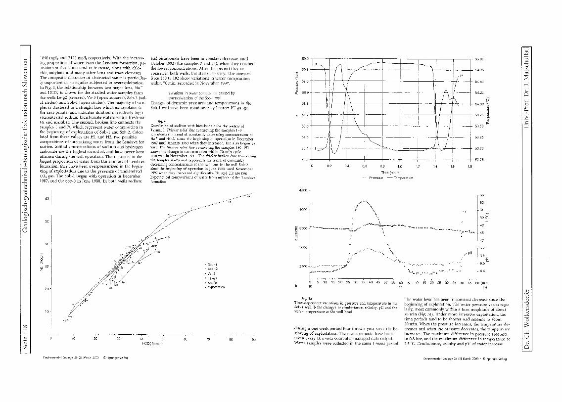
c Cl)
c Cl)
;s o
VJ ..c o ro c
§ Vl :.... ::l ~ ;.<
c..:J Cl) ~
-0 Vl
Cil .3 o
...:0.: :9 ..c o Vl
c ..c o Cl)
o Cl)
~Il ..c o Vl
'51) o o Cl)
c.J
00 c")
~ Cl)
VJ
1898 mg/l, and 2125 mg/l, respectively. With the increasing proportion of water from the Lendava formation, potassium and calcium tend to increase, along with chloride, sulphate and many other ions and trace elements. The composite character of abstracted water is particularly important in an aquifer subjected to overexploitation. In Fig. 4, the relationship between two major ions, Na +
and HC03 is shown for the studied water samples from the wells Le-g2 (crosses), Ve-3 (open squares), Sob-2 (solid circles) and Sob-l (open circles). The majority of samples is clustered in a straight line which extrapolates to the zero points, and indicates dilution of relatively high concentrated sodium-bicarbonate waters with a fresh-water end member. The second, broken line connects the samples 1 and 70 which represent water composition in the beginning of exploitation of Sob-l and Sob-2. Calculated from these values are HI and H2, two possible compositions of intermixing water from the Lendava formation. Intitial concentrations of sodium and hydrogencarbonate are the highest recorded, and have never been attained during the well operation. The reason is in the largest proportion of water from the aquifers of Lendava formation, they have been overpressurized in the beginning of exploitation due to the presence of undissolved CO2 gas. The Sob-l began with operation in December 1987, and the Sob-2 in June 1988. In both wells sodium
60
50
40
g E
~ 30 i J!!i:7'" /....: /.6
20 ~ //
10
"281
and bicarbonate have been in constant decrease until October 1992 (the samples 7 and 75), when they reached the lowest concentrations. After this period they increased in both wells) but started to vary. The samples from 180 to 192 show variations in water composition within 70 min) recorded in November 1997.
Variations in water composition caused by overexploitation of the Sob-1 well
Changes of dynamic pressures and temperatures in the Sob-l well have been monitored by Leutert PT gauge
Fig. 4 Correlation of sodium with bicarbonate for the waters of Termal1. Thicker solid line connecting the samples 1-9 represents the trend of constantly decreasing concentration of Na + and HCO; since the beginning of operation in December 1987 until January 1993 when they increased, but also began to vary. The thinner solid line connecting the samples 180-191 shows the change in concentration within 70-min cycle observed in November 1997. The thicker broken line connecting the samples 70-76 and represents the trend of constantly decreasing concentrations of the two ions in the well Sob-2 since the beginning of operation in June 1988 until November 1992 when they increased significantly. HI and H2 are two hypothetical compositions of water from aqifers of the Lendava formation
184
• Sob-1 o Sob-2
<> Ve-3 t Le-g2 ~ Apace ~ hypothetical
30 40 50 60 70 80 90 HeO; (meq/I)
Environmental Geology 39 (5) March 2000 . © Springer-Verlag
59.2
59.1
~ e.
~ 59.0
£ 58.9
58.S
58.7
58.6
I , P, .Ll /"
\ IP \ \ II
\ \ I
jl-~T ~ 11\
\ I
\ I !
\J
55.00
54.75
5450
54.25
p-54.00 -;;
~ 53.75 ~
E ~
53.50
58.5
58.4
58.3
~ r----------~
I I \ / ) / I \.--T= V I I
53.25
53.00
52.75
0,2 0.4 0.6 0.8 1.0 1.2 1.4 1.6 1.8
Time (hours)
~ Pressure -- Temperature
4500
4000 , c
53
52
51
50 E
13500 <>'<>ocmoQ:n:o::ooO""<>""<n:>o<>....,<>~o~OOOOOO occ.pd'b.:n(lDO~OOCCa1"""'OOoooo
%:.""!. 00«>0000 <>COC <» <»<oc 000°0000 o;;.»ooTWH
r-49
,
3000 ".
l . ....... '-II<
.. ' !".'
....... 'l-. 2500 Kw~~~~~:-; ~ ~#*
5 10 15 20 25 30 35 40 45 50 55 60 b 10 11
Fig. Sa Time-dependent variations in pressure and temperature in the Sob-l well, b the changes in conductance, salinity, pH and the water temperature at the well-head
during a one week period four times a year since the beginning of exploitation. The measurements have been taken evelY 10 s with computer-managed data output. Water samples were collected in the same I-week period.
.... pH
........ -................ -..
~~~il'~x~x~ ",;-''1<
48
47
r 6.7
~ 6.6 t. 6.5
6.4
10 15 20 25 30 35 40 45 50 (min) (h)
The water level has been in constant decrease since the beginning of exploitation, The water pressure varies regularly, most commonly within a time amplitude of about 70 min (Fig. Sa), Under more intensive exploitation) the time periods tend to be shorter and amount to about 30 min. When the pressure increases, the temperature decreases and when the pressure decreases, the temperature increases. The maximum difference in pressure amounts to 0.8 bar, and the maximum difference in temperature to 2.5°C, Conductance) salinity and pH of water increase
Environmental Geology 39 (5) March 2000 . © Springer-Verlag
~ I=§ ..c ()
IB
I
ro 2: -;
0 c,...: 0
ct > C ---, -'
'-~ o v if)
~ ~
o ~ ...c: U '-o

c ::l
< , "'C :; :-+> o -:
;-
~ ~ C/O (')
::rc
g
~ n ::r
:< o ?'7' (1) ...., vc 0.. Q ;i> ....,
50
HCO; 40 Na'
2: 30
~ -.S 20 co,
10
0~1~~~~~~~~~~~~~~
110 100 90 80 70 60
S 30 20
o 10
10 2u ~u 10 20 30 40 (min) 11 (hi
. K'
~ ~~ j
10 ___ ' .M9:' 1~ 1 '0'_ .P<'~C<-·-"><_. '>~H, SO~-
o o 10
10 20 30 40 50 60 10 20 30 40 (min)
220 200 180 160 140 120 100
]' 10 j - 0.8 0.6 0.4 0.2
O.~ ] ~ ___ _
a 10 20 30 10
Fig. 6
11 (hi
CI'
F' Br'
/J-
40 50 60 10 20 30 40 (min) 11 (hi
Variations in abundances of various ions, trace elements and undissolved gasses in water from the Sob" 1 well in a 70-min time interval in November 1997 a Na +, I-lC03 and undissolved CO2 , b K+, Ca 2
+ and SOJ-, c Cl-, Br-, J-, d Sr, Rb, Li, Ba, Cs, e ZD, MD, Cu, Ni, fREE
proportionally with the temperature (Fig. 5b). The lowest measured conductance value is 2300 I-LS/cm, and the highest 4400 ).LS/Clll. Salinity increases from 1.1 % to 2.2%, and pH from 6.34 to 6.69. The increase in temperature, conductance, salinity and pH in the abstracted com" po site water is related to a higher proportion of the water from the underlying Lendava formation. \Vhen the pressure in the aquifer - Termal I - decreases, the amount of water from the Lendava formation increases in the abstarcted composite water. When the pressure in the aquifer - Termal I - recovers and supplies more water
Environmental Geology 39 (5) March 2000 . © Springer-Verlag
1500 1400 1300 1200 1100 1000
900 800
·Sr
B 700 Rb
E; ~~~ Li
400 300
200 i-..=~<-"j 100
Ba
30{., ,Cs
~~- ,/ '- ... _------ ----------- ---- - .. -- .. -----~// 10 20 30 40 50 60 10 20 30 40 (min)
10 11 (hi 40
30
I 20
:g:
10
Ni
0~1~~~~. __ ~~~~ __ ~~~~ 10 2u 30
10
2.2
1.5
40 50 60 10 20 11
30 40 (min) (hi
.3: 1.0
0.9 0.8 0.7 0.6 0.5 0.4 0.3 0.2
o.~ ]C .• "" ... ,;..;2;>" ............ :~;~;c::" ~~'.;., Eu
10 20 30 40 50 10
60 10 20 11
30 40 (min) (hi
10 , •
195
f , C '~ ""'~~"'~",o ~ g 0.1 cr:
0.01 I I I I I I I
La Ce Pr Nd Sm Eu Gd Tb Oy Ho Er Tm Yb
10 , ,
192
m
J 'i'- '"
~ g 0.1 ~~,,~~
cr:
0.01 1 I I I I I I
b ~~~~ ~~~ ~~8 n
10
190
"' ~,~-~J\o 0.01 I I I I
La Ce Nd SmEu Gd Dy
Fig. 7 Rare earth element abundances normalized to chondrite values in the water from the Sob-l well, a water mixture with the highest mineralization, b, c wa ter mixtures with lower mineralization
with a lower mineralization, the proportion of water from the Lendava formation becomes lower, as well as the overall chemical composition of the abstracted composite water. The water from the Lendava formation is highly mineralized and even small amounts influence appreciably chemical composition of the abstracted composite water. An increase in concentration of almost all ions, dissolved gasses and trace elements - Na +, HC03' and CO 2
(Fig. 6a); K +, Ca"', SOl- (Fig. 6b); CI', Br', r (Fig. 6c);
Sr, Rb, Li, Ba, Cs (Fig. 6d); Zn, Mn, Cu, Ni (Fig. 6e); and REE (Fig. 6t) - occurs simultaneously with the decrease in pressure. Monitoring of the chemical composition within 70-min or 30-min cycles has shown, that the plots of changes in concelltraton versus time are continuous and regularly repeating wave-like curves. The maximum increase in concentration with respect to the lowest values is not the same for all of the ions and trace elements. For example: in a 70-min cycle, sodium concentrations increase from the lowest value of 490 mgll to the highest value of 990 mg/I, which means about twice. At the same time, potassium increases from 32 mg!l to 104 mg!l, which is over three times; calcium increases from 14 mg/I to 63 mg/I, which is over four times, and sulphate increases from 8 mg/l to 68 mg/I, which is over eight times. A similar high increase in concentration was observed for light rare carth elements, particularly cerium (over eight times) and lanthanum (over ten times). The abundances of rare earth elements, normalized to chondrite values clearly indicate dilution patterns (Fig. 7). The only exception is europium, which is retained in the solution, and in more diluted samples strong positive europium anomalies are observed.
Conclusions
Tertiary sediments and sedimentary rocks in the Mura basin include aquifers with thermal and mineral water. Thermal waters from the Radgona depression are domi, nated by sodium and bicarbonate, although some waters may be sulphate-rich. Mineral waters are abundant in the marginal area of the Radgona depression, and occur in shallow aquifers or springs. They are bicarbonate waters, dominated by calcium, or calcium and sodium. In deeper compartments of the Ptuj-Ljutomer depression, saline waters predominate regardless of the aquifer wallrock composition and abundance of CO2 gas. Aquifers in the Mura formation are characterized by intergranular porosity and thermal water dominated by sodium and bicarbonate, and also, by insignificant amounts of undissolved CO 2 gas. Overexploitation of the Sob-l well which abstracts composite water from Termal I and the aquifers of the Len, clava formatioll is reflected in time-dependent changes in pressure, temperature, conductance, pH, salinity and overall chemical composition. At the beginning of exploitation, concentration of total dissolved solids constantly decreased due to sufficiently high hydrodynamic pressures in Termal I, and consequently higher inflow of its waters to the well. From the beginning of exploitation, the amounts of abstracted water were to high for the aquifer - Termal I - to recover. In the first 5 years from the beginning of exploitation, the mineralization of absracted water has been constantly decreasing. After this period, an intensive change in the chemical composition occurred. The changes are related to the changing hydro, dynamical pressures in the aquifer - Termal I - which
Environmental Geology 39 (5) March 2000 . © Springer-Verlag
Cl (1)
o o
(jQ
C/O (') ::r-(f~
(1)
~ (1) (')
::r::l C/O (')
::r-0: ?'7' o o
(10 (J;' (') ::r(;)
tn >< ?'7' C
"" (/)
o :J ::l
'" (') ::r-~ o :::: (1)
::l (1)
::l
C/J (1) ;:::;: (1)
GO -.0
Scite 140
-, 4-. .. - -
~ .. ~ .. ,,,
. -.,.. <
'(-,':' .,,~.-. ~ ,-
; r-~_-.
occur regularly in a 70-min or 30-min cycle. The pressure decrease in the aquifer enables more intensive incursion of the highly mineralized water from the underlying Lenclava formation. The overall mineralization of abstracted composite water increases. When the pressure in the aquifer recovers, the influx of less mineralized water begins and the overall mineralization decreases. Plotted changes in chemical composition versus time form a continuous wave-like curve. We beileve the process will lead to well collapse in the near future. Exploitation of thermal water from the intergranular aquifer - Termal I - in the Mura basin should be planned carefully and the used water reinjected from the beginning of well operation.
Acknowledgements Analyses were performed in the Institute for Environment Protection Maribor, Radenska Laboratory Rad~ enci, and X-RAL Activation Services Inc., Ann Arbor, Michigan. The work was supported by The Ministry of Science and Technology of Republic Slovenia, the Radenska Company, Moravci Spa, the Community of Murska Sobota, and the Community of Benedikt.
I Dr. eh. Wolkersdorfer
Geologisch-geotechnisch-okologische Exkursion nach Siowenien
ALBU M, BANKS D, NASH H (1997) Mineral and thermal groundwater resources. Chapman & Hall, London
KRALJ P (1994) Slowenien: Geothermiepilotprojekt Ljutomer. Geotherm Energ 3:4-5
MAZOR E (1991) Chemical and isotopic groundwater hydrology. Marcel Dekker, New York
MICHARD A, Abarede F (1986) The REE content of some hydrothermal fluids. Chem Geol 55: 51-60
OBERHAUSER R (1980) Der geologische Aufbau Osterreichs. Springer, Wien
PLENICAR M (1968) Basic geological map, sheet Goricko I: 100 000. Federal Geological Survey, Belgrade
ROYDEN LH (1988) Late Cenozoic tectonics of the Pannonian basin system. In: Royden LH, Horvath F (eds) The Pannonian Basin. a study in basin evolution. Am Assoc Pet Geol Mem 45: 1-16
Univ.-Prof. Dr. J. Matschullat I
."
."

Geologisch-geotechnisch-okologische Exkursion nach Siowenien Scite 141
Christian Wolkersdorfer
Der Weg zum guten Bericht
Was ist ein Bericht
Berichte stellen wissenschaftlich-technische Sachverhalte systematisch dar.
Zu den wichtigsten Berichten, die in Ihrem Leben eine Rolle spielen, zahlen Versuchsberichte, Exkursionsberichte, Kartierberichte, Projektberichte oder AbschluBberichte. Aber auch Ihre Diplomoder Doktorarbeit zahlen zu d.en Berichten.
Wissenschaftliches Schreiben muB erlernt werden. Deshalb haben sich bereits viele Wissenschaftler angestrengt, urn brauchbare Anleitungen zu verfassen. Eine kleine Literaturauswahl finden Sie am Ende dieser Zusammenfassung.
Die vorliegende Anleitung wird Ihnen hauptsachlich dann helfen, wenn Sie einen Exkursionsbericht verfassen wollen.
Grundlage eines Berichts
Grundlage Ihres Berichts ist die Untersuchung und Aufzeichnung einer wissenschaftlichen Neuigkeit. Dazu haben Sie Ihre Idee, das Feld- oder Laborbuch und Ihr naturwissenschaftliches Handwerkszeug.
Als zweiter Punkt folgt das Feld- oder Laborbuch. Dort notieren Sie alle Beobachtungen die Sie im Gelande oder im Labor anstellen. Manchmal mag Ihnen eine Beobachtung unwichtig erscheinen, und erst spater erkennen Sie eine RegelmaBigkeit in dem entdeckten Sachverhalt. Schreiben Sie lieber zuviel, als zuwenig auf, denn einen anstrengend erreichten AufschluB nochmals aufzusuchen ist oftmals sehr muhselig. Hier sei daran erinnert, daB nicht nur das geschriebene Wort eine Aufzeichnung darstellt, sondern gerade in unserem Beruf die Zeichnung oder Skizze. Zeichnen Sie, wo immer sie etwas wichtiges entdecken. Oftmals konnen komplizierte Sachverhalte mit einer Zeichnung anschaulich und einfach dargestellt werden.
Ihr Betreuer wird Ihnen dankbar sein, wenn sie statt der komplizierten Auflistung einer Deponiebasisabdichtung eine kleine Skizze beilegen. Ganz nebenbei bemerkt freut sich auch Ihr Betreuer tiber jede Auflockerung Ihres Berichts!
Gliedern
Beginnen Sie Ihren Bericht erst, nachdem Sie eine Gliederung entworfen haben! Fur eine Exkursion konnten Sie beispielsweise folgende Strukturierung verwenden:
Titelblatt Einleitung (z. B. Exkursionsziel) Geologische Verhaltnisse Aufschlu/3beschreibungen Literatur
Selbstverstandlich steht es Ihnen frei, die Gliederung jederzeit abzuwandeln und anzupassen. Wichtig ist lediglich, daB sie Elinen roten Faden haben, an dem Sie sich entlangarbeiten konnen. Es empfiehlt sich, auch bei kurzen Berichten eine Gliederung anzufertigen! Verlieren Sie nicht den Zusammenhang aus den Augen, fur den Sie den Bericht schreiben. SchlieBIich sollen vor allem Sie von Ihrem Bericht profitieren!
I Univ.-Prof. Dr. J. Matschullat Dr. Ch. Wolkcrsdorfer I

I Seite 142 Geologisch-geotechnisch-okologische Exkursion nach Siowenien
Ein Beispiel dafiir, wie allgemeingiiltig obige Gliederung ist, zeigt die folgende beispielhafte Gliederung fiir einen palaontologischen Exkursionsbericht:
Titelblatt Einleitung (Them a und Ziel der Exkursion) Geologisch-stratigraphische Grundlagen Faunen: AufschlufJbeschreibungen
Literatur
Systematische Einordnung, Morphologie Taphonomie, PalOkologie
Die Gliederung eines Kartierberichts sollte folgendermaBen aussehen:
Titelseite
1 Zusammenfassung der Ergebnisse 2 Einfuhrung 3 Ergebnisse der geologischen Kartierung 3.1 Stratigraphie und Petrographie 3.2 Tektonik 3.3 Mineralvorkommen und deren Nutzung 4 Interpretation der Ergebnisse 5 Anhang
Beachten Sie, daB die Kapiteliiberschriften nicht zum eigentlichen Text gehtiren, Sie sollten nicht schreiben:
Ottinger Steinbruch
1m Steinbruch ist Suevit aufJerhalb des Kraters aufgeschlossen. Bunte Breccie ist auch zu finden.
Sondern besser:
Steinbruch Otting
Der Steinbruch Otting liegt am westlichen Stadtrand von Otting, 3.5 km aufJerhalb des Kraterzentrums. Er schliefJt Suevit und wenig bunte Breccie auf
Inhalt des Berichts
Am Anfang Ihres Berichts stehen Ihr Name, der Titel, das Berichtsdatum und die Exkursionsleitung. Beispielsweise ktinnten Sie schreiben:
Helga Stein Bericht zur Geologischen Exkursion nach Sudengland vom 27.08.94 bis 04.09.94 Friedrich-Alexander-Universitat Erlangen-Nurnberg Leitung: Prof H. Tonstein
Dipl.-Geol. S. Faltenachser
Bei kiirzeren Berichten ktinnen Sie diese Angaben an den Anfang der ersten Seite schreiben, bei langeren hingegen soU ten Sie ein separates Titelblatt verwenden. Bedenken Sie bei allen nachfolgenden Fakten, die Sie im Bericht beschreiben, folgendes:
• So kurz wie mtiglich
• So ausfiihrlich wie notwendig
Die Einleitung zu einer Exkursion in den Jungschen Steinbruch ktinnten Sie so formulieren:
Der Jungsche Steinbruch liegt im Westharz, an der BundesstrafJe B 242, zwischen Bad Grund und Clausthal-Zellerfeld, wenige hundert Meter nordostlich der Abzweigung nach Wildemann. Er befindet sich an einem nach SW geo{fneten etwa 120 m hohen Prallhang der Innerste und schliefJt eine Wechselfolge kulmischer Grauwacken und Tonsteine auf
Ziel der Exkursion war es, einen Einblick in die stratigraphische Abfolge des Viseum cd3 B und y zu erhalten. Daruber hinaus wurde der Rutschungsmechanismus der Steilwand oberhalb der 2. Sohle diskutiert.
Dr. eh. Wolkersdorfer Univ.-Prof. Dr. J. Matschullat

Geologisch-geotechnisch-tikologische Exkursion nach Slowenien Scite 143
Beachten Sie, daB die Lange eines Exkursionsberichts (2 ... 10 Seiten) unter der eines Kartierberichts liegt (10 ... 30 Seiten). Daher muB es Ihr Ziel sein, die Lange Ihrer Unterpunkte der Gesamtlange des Berichts anzupassen. Hiitten Sie im Jungschen Steinbruch einen Kartierkurs abgelegt, oder Ihre Diplomarbeit dort durchgefiihrt, dann miiBten Sie die jeweiligen Unterpunkte ausfiihrlicher darlegen. 1m vorstehenden Beispiel konnten Sie sehen, wie Einleitung und geologische Verhaltnisse zu einem Kapitel verschmolzen wurden.
Den wichtigsten Teil Ihres Berichts machen Ihre AufschluBbeschreibungen aus. Mit detaillierten AufschluBbeschreibungen fallt Ihnen die Ausdeutung Ihrer Forschertatigkeit leichter, als mit lieblos dahingeschriebenen Stichpunktsammlungen. Die prinzipieUe Gliederung einer AufschluBbeschreibung sieht so aus:
Wo befindet sich der AufschluB
Was ist dort zu sehen
Wie kann das Phanomen erklart werden
Selbstverstandlich erganzt eine Skizze Ihre Beschreibung! Auf keinen Fall soUten Sie Ihre Erklarungen und Beschreibungen miteinander vermischen. Sie sind Wissenschaftler, kein Prophet!
1m folgenden Beispiel ist die vorgenannte Gliederung eingehalten:
Ediacara-Mine
Die Ediacara-Mine befindet sich am ostlichen Ufer des Lake Torrens, etwa 200 km nordlich von Port Augusta (Sildaustralien). Sie ist der Locus typic us der Edicara-Fauna.
In der Umgebung der verlassenen Kupfermine steht ein feinkorniger Quarzit an, der ober/Zachlich ockerbraun verwittert. 1m frischen Bruch weist das Gestein eine weif3liche bis hellgelbe Farbe auf Typisch filr den Quarzit ist seine Verwitterung in zentimeterdicke Platten, die maximal 50*50 cm grof3 werden. Gelegentlich finden sich auf den Schichtoberseiten Fossilien, die Wurmern, Quallen und Farnen ahneln.
Fur den guten Erhaltungszustand der prakambrischen Fauna ist das Ablagerungsmilieu ursachlich zustandig. Nach der Sedimentation des Quarzsandes und dem Absinken der toten Tiere wurden diese innerhalb kurzester Zeit von Tonen bedeckt. Die Weichteile der Tiere wurden in den noch weichen Sand gedruckt und die Abdrucke konnten sich trotz Diagenese und Orogenese bis he ute erhalten.
Zu einer guten AufschluBbeschreibung gehort eine Lageskizze, ein Prom. oder eine AufschluBskizze. Haben Sie Mut! Eine schlecht gelungene Skizze ist besser als gar keine.
Aus Ihrer Zeichnung miissen Hohen- und LangenmaBstab sowie die Himmelsrichtung hervorgehen. Baume oder Straucher erleichtern zwar das Erfassen der GroBenordnung, ersetzen aber keinen MaBstab. Daneben diirfen Sie nicht die Legende verges sen.
SoU ten Sie in Ihrem Bericht bis hierher gekommen sein, dann priifen Sie jetzt Ihren sprachlichen Ausdruck.
Wissenschaftliche Sprache
Nicht immer gelingt Ihnen auf Anhieb, sich so auszudriicken, wie Sie es urspriinglich vorhatten. Schreiben ist eine Kunst, daher bedarf es der Ubung und Anleitung. Vor dem Beginn Ihres Berichts haben Sie sich iiberlegt, fiir welchen Personenkreis Sie Ihren Bericht schreiben. Vergessen Sie bitte nicht, daB gerade an Sie als Wissenschaftler besonders hohe Anforderungen gesteUt werden. Dies gilt genauso fiir Ihren Umgang mit der Sprache und die Verwendung von Fachausdriicken.
Sie miissen sich
• klar • unmiBverstandlich und • korrekt
ausdriicken, urn verstanden zu werden.
EBEL & BLIEFERT (1991) geben einige Kriterien fur guten sprachlichen Ausdruck:
• Denken Sie nach und - sehreiben Sie was Sie denken
I Univ.-Prof. Dr. J. Matschullat Dr. Ch. Wolkersdorfer I

Seite 144 Geologisch-geotechn isch-okologische Exkursion nach Siowen ien
• Verwenden Sie keine zu langen und zu komplizierten Sa.tze mit mehrfach ineinandergefiigten Satzteilen!
• Ein Wechsel von kiirzeren und la.ngeren Sa.tzen bringt Rhythmus und Spannung in die Sprache. • Benutzen Sie deutsche Fachworter ansteUe englischer, wo immer angangig. • Wagen Sie jedes Wort ab und priifen Sie, ob es gebraucht wird.
Daneben gibt es noch eine Anzahl weiterer Kriterien, die Sie beachten soUten und die Sie bei EBEL & BLIEFERT (1991, 1993) nachlesen konnen.
Haufige Fehler
In geologisch orientierten Texten tauchen die nachfolgenden Fehler regelmaBig auf. Priifen Sie Ihren Text daraufhin, ob Sie nicht ahnliche Formulierungen verwendet haben:
'1 Die Geologie im Nordharz ... .I) Die geologischen Verhaltnisse im Nordharz ...
'1 Durch aus von mir nicht erkannten Ursachen, .I) Durch Ursachen, die nicht von mir erkannt ...
Vermeiden Sie Satze mit "man". Es gibt Verlage, die in wissenschaftlichen Beitra.gen kein unpersonliches "man" zulassen.
'1 Daraus kann man die starke Erosion erkennen .
.I) Daraus ist die starke Erosion erkennbar.
Machen Sie sich den Unterschied zwischen "hier" und "dort" klar! "Hier" gibt Ihren Standort wieder, "dort" einen fiber den Sie schreiben:
'1 ... steht Hottinger Breccie an. Hier wurde von AMPFERER ., .
.I) ... steht Hottinger Breccie an. Dort wurde von AMPFERER ...
aber:
... wurden hier, an unserem Institut, umfangreiche ...
Beginnen Sie nicht jeden Satz mit einem Artikel:
'1 Die Lokalitat Klimpan befindet sich oberhalb des kleinen Sees, der von Marmor umgeben ist. Das dortige Gestein weist Einschlilsse von Granaten auf und ist stark metamorph uberpragt. Der Granat konnte als Almandin identifiziert werden.
Gleiches soUten Sie beim Wort "diesE,!" bzw. "dieses" beachten. Besonders wichtig ist der Bezug auf vorangegangenes, der durch "dieses"i hergestellt wird. Beginnen Sie keinen Absatz oder ein Kapitel mit "dieses", denn am Kapitel- oder Absatzanfang gibt es normalerweise nichts, worauf Sie mit "dieses" Riickbezug nehmen konnten.
Fossilnamen miissen korrekt wiedergegeben werden. Keiner verlangt von Ihnen, die Internationalen Regeln der zoologischen N omenklatur (IRZN) auswendig zu konnen, dennoch muB es heiBen
.I) Pseudophillipsia (Carniphillipsia) ogivalis javornikensis G. & R. HAHN, 1977
und nicht
'1 pseudophillipsia Javornikensis (HAHN).
Allgemeine Regel: Gattung (Untergattung) art unterart ERSTBESCHREIBER, Jahr.
Auch bei stratigraphischen Bezeichnungen gibt es Regeln, die Sie beachten miissen:
.I) ... werden als Obere speciosus-Schichten bezeichnet ... (Art name klein)
.I) ... im unteren Devon ...
~ ... die Posidonienschiefer neigen zur ... (Gattungsname groB)
I Dr. eh. Wolkersdorfer Univ.-Prof. Dr. J. Matschullat I

Gcologisch-geotechnisch-okologische Exkursion nach Siowenien Seite 145
AbschlieBend werfen Sie einen Blick auf Ihre Zeichensetzung.
• N ach einem Satzzeichen folgt ein Leerzeichen.
• Hinter der offnenden und vor der schlieBenden Klammer wird kein Leerzeichen gesetzt (da gibt es keine Ausnahme).
• Unterscheiden Sie zwischen Bindestrich (ohne Leerzeichen), Gedankenstrich (mit Leerzeichen) bis-Strich (mit Leerzeichen) und Strecken-Strich (ohne Leerzeichen). Daruber hinaus weisen die Striche im Computersatz unterschiedliche Langen auf.
Fur die NW-SE-streichende Lagerstatte wird heute - zumindest von einigen Wissenschaftlern - eine sekundar-hydrothermale Entstehung bei 120 -140°C angenommen.
(In vielen wissenschaftlichen Texten wird, der Empfehlung in DIN 1338 Beiblatt 2 folgend, anstatt des "bis"-Strichs das Erstreckungssymbol ... verwendet:
bei 120 ... 140°C).
• Einheitenzeichen werden mit Leerzeichen hinter die Zahl gestellt: 2,3 %, 123 m, 15°C, 2,1 giL. Beachten Sie die GroBschreibweise des Einheitszeichens L (Empfehlung des CIPM - Comite International des Poids Mesures).
• Verwenden Sie das = Zeichen nur bei mathematischer Gleichheit.
Orogenese = Gebirgsbildung durfen Sie auf keinen Fall verwenden! Aber: E = 1285 kN / m 2•
Danksagung Dank gilt allen Kolleginnen und Kollegen, die mit Tips, Kritik und Erganzungen zum Gelingen dieser Anleitung beigetragen haben.
Literatur
Ebel, H. F. & Bliefert, C. (1991): Schreiben und Publizieren in den Naturwissenschaften. -2. Aufl.: 448 S.; Weinheim (VCH).
Ebel, H. F. & Bliefert, C. (1993): Diplom- und Doktorarbeiten: Anleitungen fur den naturwissenschaftlichen Nachwuchs. - 218 S.; Weinheim (VCH).
Duden Taschenbucher (1988): Wie verfaBt man wissenschaftliche Arbeiten. - 2. Aufl.: 216 S.; Mannheim, Wien, Zurich (Dudenverlag).
Lang, H. D., Rabien, A., Struve, W. & Wiegel,E. (1976): Richtlinien fur die Verfasser geowissenschaftlicher Veroffentlichungen. - Stuttgart (Schweizerbart).
Anmerkung: Vorstehende Zitierweise entspricht den in den Richtlinien fur die Verfasser geowissenschaftlicher Veroffentlichungen (1976) nachlesbaren Empfehlungen. AnlaB fur die Herausgabe der Richtlinien war die uneinheitliche Zitierweise in den verschiedenen geologischen Publikationen.
Selbst heute halten sich die geowissenschaftlichen Fachverlage nicht alle an die sogenannten "Bonner Richtlinien", sondem verwendenjeweils Thre eigene Zitierweise. Entsprechendes gilt fiir Werke, die auBerhalb der geologischen Wissenschaften veriiffentlicht werden. Dieses Manko kann den Austausch von Artikel oder Literaturzitaten erheblich erschweren, daher wird von verschiedenen Verlagen seit geraumer Zeit ein vereinheitlichtes Zitiersystem angestrebt. Es handelt sich dabei um die Vancouver-Konvention (1968, 1978, 1987). Sie wird allen Anforderungen an korrektes wissenschaftliches Zitieren gerecht, kann in allen Fachgebieten und Sprachen eingesetzt werden und verwendet ausschlieBlich den Punkt um die bibliographischen Merkmale voneinander zu trennen. Thre Ubersichtlichkeit gestattet es, jedes Werk leicht und wiederauffmdbar zu zitieren. Eine Vereinheitlichung auf der Basis einer allgemein anerkannten Konvention kann dem Austausch von Wissen sicherlich we iter helfen!
Beispiel fur Zitierung nach Vancouver:
Ebel HF, Bliefert C. Diplom- und Doktorarbeiten: Anleitungen fUr den naturwissenschaftlichen Nachwuchs. Weinheim: VCH; 1993. 218 S.
Univ.-Prof. Dr. J. Matschullat Dr. eh. Wolkersdorfer
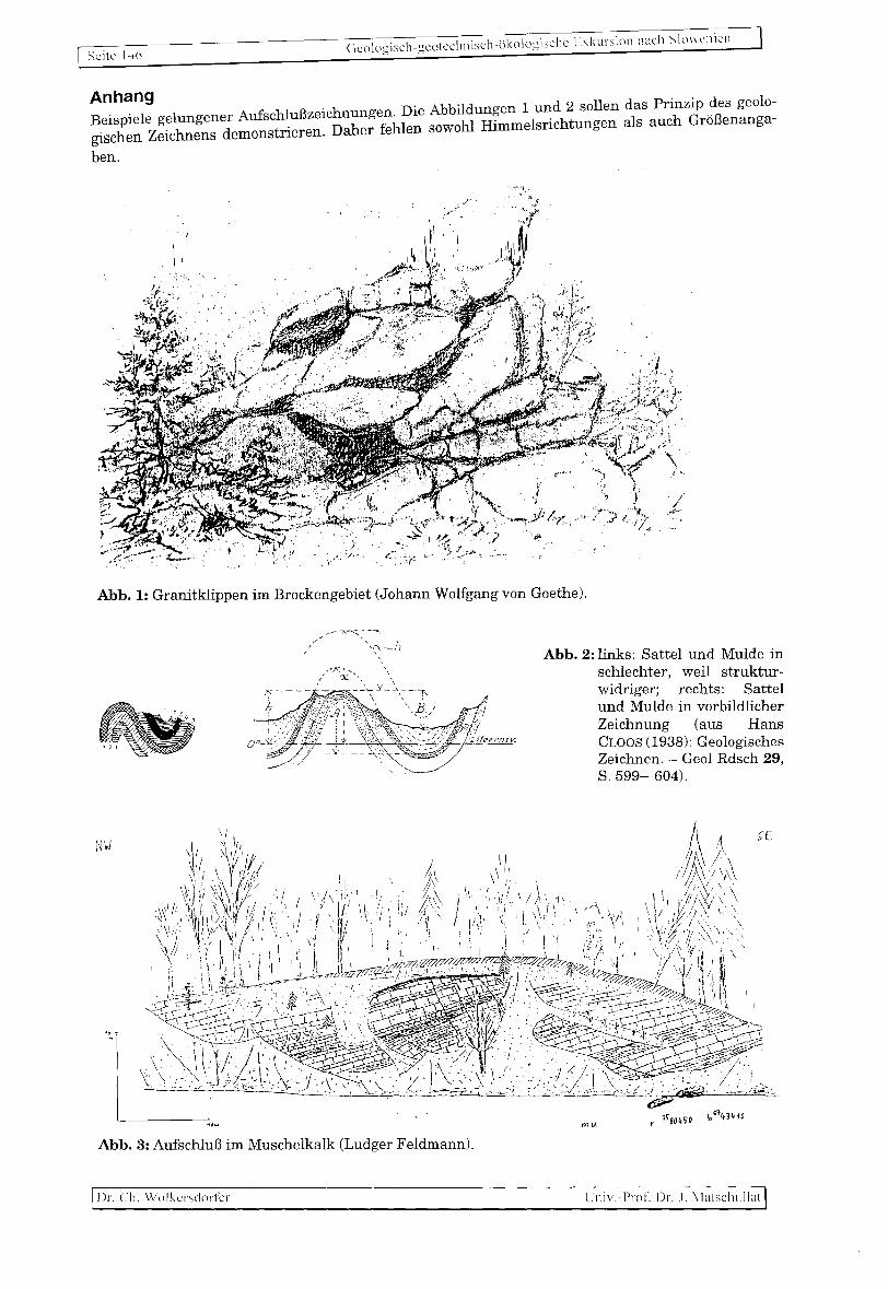
Scitc 1-16 Gcologisch-gcotcchnisch-likologisclle Lxkursion n<1ch Slo\\cnicn
Anhang Beispiele gelungener AufschluBzeichnungen. Die Abbildungen 1 und 2 sollen das Prinzip des geolo-gischen Zeichnens demonstrieren. Daher fehlen sowohl Himmelsrichtungen als auch GroBenanga-
ben.
Abb. 1: Granitklippen im Brockengebiet (Johann Wolfgang von Goethe).
NW
//"''-~~-~:,-'"'''''' I
I \':---11. ,
Abb. 3: AufschluB im Muschelkalk (Ludger Feldmann).
Dr. ell. WolkcrsdoriCr
Abb. 2: links: Sattel und Mulde in schlechter, weil strukturwidriger; rechts: Sattel und Mulde in vorbildlicher Zeichnung (aus Hans CLOOS (1938): Geologisches Zeichnen. - Geol Rdsch 29 S. 599-604). '
LJniv. Prof. Dr . .I. Matschullat
Copyright © 2022 FDOKUMEN