Geological evolution of Mount Etna volcano (Italy) from earliest products until the first central...
18
REVIEW ARTICLE Geological evolution of Mount Etna volcano (Italy) from earliest products until the first central volcanism (between 500 and 100 ka ago) inferred from geochronological and stratigraphic data Stefano Branca Mauro Coltelli Emanuela De Beni Jan Wijbrans Received: 12 September 2006 / Accepted: 24 November 2006 ȑ Springer-Verlag 2007 Abstract We present an updated geological evolution of Mount Etna volcano based on new 40 Ar/ 39 Ar age determinations and stratigraphic data integrating the previous K/Ar ages. Volcanism began at about 500 ka ago through submarine eruptions on the Gela–Catania Foredeep basin. About 300 ka ago fissure-type erup- tions occurred on the ancient alluvial plain of the Si- meto River forming a lava plateau. From about 220 ka ago the eruptive activity was localised mainly along the Ionian coast where fissure-type eruptions built a shield volcano. Between 129 and 126 ka ago volcanism shif- ted westward toward the central portion of the present volcano (Val Calanna–Moscarello area). Furthermore, scattered effusive eruptions on the southern periphery of Etna edifice occurred until about 121 ka ago. The stabilization of the plumbing system on the Valle del Bove area is marked by the building of two small polygenic edifices, Tarderia and Rocche volcanoes. Their eruptive activity was rather coeval ending 106 and 102 ka ago, respectively. During the investigated time-span volcanism in Etna region was controlled by a main E–W extensional tectonic related to the reacti- vation of Malta Escarpment fault system in eastern Sicily. Keywords Mount Etna Á 40 Ar/ 39 Ar dating Á Stratigraphy Á Unconformity Á Eruptive activity Introduction Eruptive activity of Mount Etna volcano began during the middle Pleistocene in eastern Sicily in a complex geodynamic frame (Fig. 1). The basaltic volcanism of Etna developed on the structural domain of the Gela– Catania Foredeep on the front of the Apenninic– Maghrebian Chain that overlaps the undeformed African continental plate margin, the Hyblean Fore- land (Lentini 1982; Ben Avraham and Grasso 1990). Although the earlier volcanism occurred during the final stage of the compressive deformation of the Apenninic–Maghrebian Chain (Bousquet and Lanza- fame 2004 and reference therein) the eastern part of Sicily was affected by the extensional tectonic regime of the Malta Escarpment. This lithospheric fault system separates the continental crust of the Hyblean Fore- land from the oceanic crust of the Ionian Basin (Scandone et al. 1981; Finetti 1982; Ben-Avraham and Grasso 1990; Hirn et al. 1997). The northern termina- tion of the Malta Escarpment dissects the lower east- ern flank of Etna volcano through a set of NNW–SSE normal faults called Timpe fault system (Lo Giudice et al. 1982; Bousquet and Lanzafame 2004), responsi- ble for the active seismicity of the area (Azzaro 1999 and 2004). Geological investigations performed by several au- thors (Rittmann 1973; Romano 1982; Chester et al. 1985; Kieffer and Tanguy 1993; Branca et al. 2004a) have furnished different reconstructions of the Etna volcano evolution (see Branca et al. 2004a for com- Electronic supplementary material The online version of this article (doi:10.1007/s00531-006-0152-0) contains supplementary material, which is available to authorized users. S. Branca (&) Á M. Coltelli Á E. De Beni Istituto Nazionale di Geofisica e Vulcanologia-Sezione di Catania, Piazza Roma 2, 95123 Catania, Italy e-mail: [email protected] J. Wijbrans Faculteit der Aardwetenschappen, Vrije Universiteit, Amsterdam, The Netherlands 123 Int J Earth Sci (Geol Rundsch) DOI 10.1007/s00531-006-0152-0
Transcript of Geological evolution of Mount Etna volcano (Italy) from earliest products until the first central...

REVIEW ARTICLE
Geological evolution of Mount Etna volcano (Italy) from earliestproducts until the first central volcanism (between 500 and 100 kaago) inferred from geochronological and stratigraphic data
Stefano Branca Æ Mauro Coltelli Æ Emanuela De Beni ÆJan Wijbrans
Received: 12 September 2006 / Accepted: 24 November 2006� Springer-Verlag 2007
Abstract We present an updated geological evolution
of Mount Etna volcano based on new 40Ar/39Ar age
determinations and stratigraphic data integrating the
previous K/Ar ages. Volcanism began at about 500 ka
ago through submarine eruptions on the Gela–Catania
Foredeep basin. About 300 ka ago fissure-type erup-
tions occurred on the ancient alluvial plain of the Si-
meto River forming a lava plateau. From about 220 ka
ago the eruptive activity was localised mainly along the
Ionian coast where fissure-type eruptions built a shield
volcano. Between 129 and 126 ka ago volcanism shif-
ted westward toward the central portion of the present
volcano (Val Calanna–Moscarello area). Furthermore,
scattered effusive eruptions on the southern periphery
of Etna edifice occurred until about 121 ka ago. The
stabilization of the plumbing system on the Valle del
Bove area is marked by the building of two small
polygenic edifices, Tarderia and Rocche volcanoes.
Their eruptive activity was rather coeval ending 106
and 102 ka ago, respectively. During the investigated
time-span volcanism in Etna region was controlled by a
main E–W extensional tectonic related to the reacti-
vation of Malta Escarpment fault system in eastern
Sicily.
Keywords Mount Etna � 40Ar/39Ar dating �Stratigraphy � Unconformity � Eruptive activity
Introduction
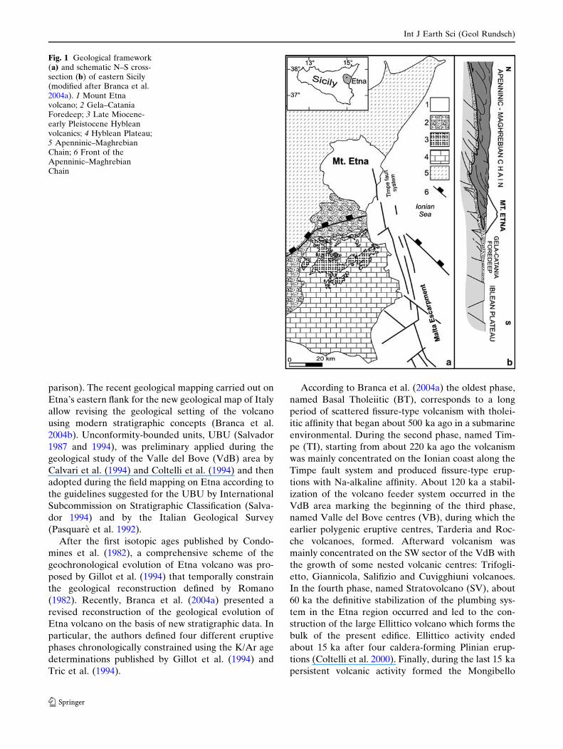
Eruptive activity of Mount Etna volcano began during
the middle Pleistocene in eastern Sicily in a complex
geodynamic frame (Fig. 1). The basaltic volcanism of
Etna developed on the structural domain of the Gela–
Catania Foredeep on the front of the Apenninic–
Maghrebian Chain that overlaps the undeformed
African continental plate margin, the Hyblean Fore-
land (Lentini 1982; Ben Avraham and Grasso 1990).
Although the earlier volcanism occurred during the
final stage of the compressive deformation of the
Apenninic–Maghrebian Chain (Bousquet and Lanza-
fame 2004 and reference therein) the eastern part of
Sicily was affected by the extensional tectonic regime
of the Malta Escarpment. This lithospheric fault system
separates the continental crust of the Hyblean Fore-
land from the oceanic crust of the Ionian Basin
(Scandone et al. 1981; Finetti 1982; Ben-Avraham and
Grasso 1990; Hirn et al. 1997). The northern termina-
tion of the Malta Escarpment dissects the lower east-
ern flank of Etna volcano through a set of NNW–SSE
normal faults called Timpe fault system (Lo Giudice
et al. 1982; Bousquet and Lanzafame 2004), responsi-
ble for the active seismicity of the area (Azzaro 1999
and 2004).
Geological investigations performed by several au-
thors (Rittmann 1973; Romano 1982; Chester et al.
1985; Kieffer and Tanguy 1993; Branca et al. 2004a)
have furnished different reconstructions of the Etna
volcano evolution (see Branca et al. 2004a for com-
Electronic supplementary material The online version of thisarticle (doi:10.1007/s00531-006-0152-0) contains supplementarymaterial, which is available to authorized users.
S. Branca (&) � M. Coltelli � E. De BeniIstituto Nazionale di Geofisica e Vulcanologia-Sezione diCatania, Piazza Roma 2, 95123 Catania, Italye-mail: [email protected]
J. WijbransFaculteit der Aardwetenschappen,Vrije Universiteit, Amsterdam, The Netherlands
123
Int J Earth Sci (Geol Rundsch)
DOI 10.1007/s00531-006-0152-0
parison). The recent geological mapping carried out on
Etna’s eastern flank for the new geological map of Italy
allow revising the geological setting of the volcano
using modern stratigraphic concepts (Branca et al.
2004b). Unconformity-bounded units, UBU (Salvador
1987 and 1994), was preliminary applied during the
geological study of the Valle del Bove (VdB) area by
Calvari et al. (1994) and Coltelli et al. (1994) and then
adopted during the field mapping on Etna according to
the guidelines suggested for the UBU by International
Subcommission on Stratigraphic Classification (Salva-
dor 1994) and by the Italian Geological Survey
(Pasquare et al. 1992).
After the first isotopic ages published by Condo-
mines et al. (1982), a comprehensive scheme of the
geochronological evolution of Etna volcano was pro-
posed by Gillot et al. (1994) that temporally constrain
the geological reconstruction defined by Romano
(1982). Recently, Branca et al. (2004a) presented a
revised reconstruction of the geological evolution of
Etna volcano on the basis of new stratigraphic data. In
particular, the authors defined four different eruptive
phases chronologically constrained using the K/Ar age
determinations published by Gillot et al. (1994) and
Tric et al. (1994).
According to Branca et al. (2004a) the oldest phase,
named Basal Tholeiitic (BT), corresponds to a long
period of scattered fissure-type volcanism with tholei-
itic affinity that began about 500 ka ago in a submarine
environmental. During the second phase, named Tim-
pe (TI), starting from about 220 ka ago the volcanism
was mainly concentrated on the Ionian coast along the
Timpe fault system and produced fissure-type erup-
tions with Na-alkaline affinity. About 120 ka a stabil-
ization of the volcano feeder system occurred in the
VdB area marking the beginning of the third phase,
named Valle del Bove centres (VB), during which the
earlier polygenic eruptive centres, Tarderia and Roc-
che volcanoes, formed. Afterward volcanism was
mainly concentrated on the SW sector of the VdB with
the growth of some nested volcanic centres: Trifogli-
etto, Giannicola, Salifizio and Cuvigghiuni volcanoes.
In the fourth phase, named Stratovolcano (SV), about
60 ka the definitive stabilization of the plumbing sys-
tem in the Etna region occurred and led to the con-
struction of the large Ellittico volcano which forms the
bulk of the present edifice. Ellittico activity ended
about 15 ka after four caldera-forming Plinian erup-
tions (Coltelli et al. 2000). Finally, during the last 15 ka
persistent volcanic activity formed the Mongibello
Fig. 1 Geological framework(a) and schematic N–S cross-section (b) of eastern Sicily(modified after Branca et al.2004a). 1 Mount Etnavolcano; 2 Gela–CataniaForedeep; 3 Late Miocene-early Pleistocene Hybleanvolcanics; 4 Hyblean Plateau;5 Apenninic–MaghrebianChain; 6 Front of theApenninic–MaghrebianChain
Int J Earth Sci (Geol Rundsch)
123

volcano, whose products cover at least 85% of the
present volcano surface.
Currently, De Beni et al. (2005) successfully applied
the 40Ar/39Ar technique on Etna volcanics in order to
improve the reconstruction of its geochronological
evolution defining the temporal hiatus and the signifi-
cance of one of the main unconformities of the volcanic
succession.
In this paper we present new results based on40Ar/39Ar age determinations and the stratigraphic
data derived from 1:10,000 scale geological surveys of
Etna, with the aim of defining the uncertain strati-
graphic position of some volcanics and clarifying the
meaning of the unconformities within the volcanic
succession. The geological survey was performed in
order to integrate the previous one of the eastern flank
(Servizio Geologico d’Italia 2006) for the realization of
the new 1:50,000 geological map of Mount Etna
(Branca et al. 2004c). The whole data set, integrated
with the already available isotopic age, allow us to
better constrain chronologically the geological evolu-
tion of Etna volcano. In particular, we propose an
updated reconstruction of the eruptive activity evolu-
tion in the Etnean region from the oldest products until
the early stage of the central-type volcanism, defining
the relationship between the volcano history and the
geodynamics of eastern Sicily.
Geochronology
40Ar/39Ar method and samples preparation
Seven samples were selected from stratigraphically
well-defined units to constrain in age the stratigraphy
of Etna volcano from the earliest products to about
100 ka ago. ACI sample has been collected from pillow
lava that forms the cliff of Acicastello Castle Rock
along the Ionian coast. TC sample belongs to a lava
flow overlapping the sedimentary basement at Torre
Casalotto locality, uphill from Acitrezza village. VS
sample has been collected from a massive lava flow
forming the top of the Mt. D’Oro morphological scarp,
south of Valverde. Three samples (CA, FC and CS)
where collected from the southern wall of the Val
Calanna at Mt. Fior di Cosimo. Finally, TD sample
belongs to a lava flow cropping out at Contrada Passo
Cannelli locality, north of Tarderia.
From the methodological point of view we analyzed
groundmass particles in the grain size fractions ranging
between 250 and 500 lm that may contain phenocryst
intergrowths. Each sample was prepared using liquid
density and magnetic separation and then handpicked
at microscope in order to obtain homogeneous
groundmass separates. Samples were then wrapped in
Al foil and loaded into a quartz tube together with
standards for irradiation (duration: 1 h) with fast neu-
trons in the Cd-lined RODEO facility of the EU/Pet-
ten HFR reactor (The Netherlands). After irradiation
ca 20 mg of each sample was spread out evenly in a
13 mm diameter sample holder pan (5 positions on a
60 mm copper tray). The sample tray was loaded in a
custom made sample house, and heated overnight at
150�C with a 500 W heating lamp. To extract argon
from prepared fractions, a defocused CW argon-ion
laser beam (beam diameter ca. 2 mm) was used. The
sample house was moved during laser-heating follow-
ing an x–y raster pattern that ensured even heating of
the sample during stepwise heating.
The main features of argon laserprobe extraction
line include a low volume vacuum extraction/purifica-
tion, short heating and clean up times (typically be-
tween 5 and 15 min), and no differences in ‘‘cold’’ and
‘‘hot’’ line blanks. The standard used to calculate the
irradiation constant J is DRA1 sanidine with an age of
25.26 ± 0.05 Ma. (Wijbrans et al. 1995). For each
groundmass sample we used an incremental heating
technique with eight steps for ACI, TC, TD and VS
samples, whereas CA, FC and CS samples were anal-
ysed in nine steps. The choice of the step number is
very important to obtain a homogenous plateau, the
laser intensity was increased between 0.3 W and 14 W
(total fusion). The purified gas fractions were analyzed
with a MAP 215-50 mass spectrometer (Wijbrans et al.
1995). Dedicated data reduction software (ArArCALC
of Koppers 2002) provides an easy-to-use graphical
interface for the calculation of age plateaus, total fu-
sion ages and isochrons following the regression of40Ar/39Ar mass spectrometry data.
Analytical results
The analytical results of analysed samples are sum-
marized in Table 1 and Fig. 2. All experiments yielded
excellent plateaus in agreement with the commonly
accepted standards (e.g. Dunai and Wijbrans 2000; De
Beni et al. 2005).
ACI sample
This rock was quite weathered, for this reason the
weighted plateau age is calculated using only the last
four steps of incremental heating, and the uncertain
margin is 8.75%. The K/Ca diagram shows a regular
pattern of continuously decreasing ratios from 0.158 at
the first step to 0.016 at the fusion. This behaviour
Int J Earth Sci (Geol Rundsch)
123

Ta
ble
1P
etr
og
rap
hy
an
din
cre
me
nta
lh
ea
tin
gre
sult
so
fth
esa
mp
les
Sa
mp
les
Lo
cati
on
La
titu
de
lon
git
ud
eE
lev
ati
on
(ma
.s.l
.)P
etr
og
rap
hy
Ag
e(k
a)
fro
mth
en
orm
al
iso
chro
ns
dia
gra
m
Ag
e(k
a)
fro
mth
ein
ve
rse
iso
chro
ns
dia
gra
m
39A
r (k
)
use
din
pla
tea
uca
lcu
lati
on
(%)
MS
WD
We
igh
ted
pla
tea
ua
ge
ka
±1r
P.I
.(%
)M
ost
ab
un
da
nt
ph
en
ocr
yst
s(f
rom
the
mo
stto
the
less
inm
m)
Gro
un
dm
ass
tex
ture
an
dm
ine
ralo
gy
AC
IN
Esi
de
of
the
Aci
cast
ell
o
Cast
el
Ro
ck
37�3
3¢2
1¢¢
15�0
9¢0
3¢¢
25
Ol
0.2
an
dP
x0.2
Cry
pto
cryst
all
ine
164.2
±317.0
166.0
±200.2
58.9
80.2
0496.1
±43.5
TC
To
rre
Casa
lott
olo
cali
ty37�3
4¢2
9¢¢
15�0
9¢1
0¢¢
195
30
Plg
3.5
-0.1
,P
x4-0
.1,
Ol
less
then
0.5
inth
esa
me
qu
an
tity
of
Px
an
do
paq
ue
oxid
e
Mic
ro-c
ryp
tocr
yst
all
ine:
Plg
an
dP
x
137.9
±30.0
140.7
±27.4
69.6
50.8
7145.8
±7.0
CA
Mt.
Fio
rd
iC
osi
mo
(Val
Cala
nn
a)
37�4
2¢4
3¢¢
15�0
4¢2
2¢¢
1,1
10
15
Plg
3-0
.1,
Px
1.5
-0.1
,O
l0.5
-0.1
an
do
paq
ue
oxid
e
Mic
ro-c
ryp
tocr
yst
all
ine:
Plg
,P
xan
do
paq
ue
oxid
es
111.5
±17.3
111.4
±16.4
75.0
30.8
8128.7
±3.8
VS
Mt.
D’O
rolo
cali
ty37�3
4¢1
3¢¢
15�0
7¢3
2¢¢
360
15
Px
4–0.1
,O
l0.5
,P
lg2.5
–0.1
an
do
paq
ue
oxid
es
Inte
rgra
nu
lar:
Plg
,P
xan
d
op
aq
ue
oxid
es
116.6
±12.4
116.9
±12.3
96.6
10.3
4121.2
±7.5
TD
Tard
eri
alo
cali
ty37�4
6¢4
3¢¢
15�1
0¢2
2¢¢
1,1
55
20
Plg
3–0.1
,A
mp
h3–0.1
,O
l
2.5
–0.1
,P
x2–0.1
Su
bo
ph
itic
:P
lg,
Ol
an
d
op
aq
ue
oxid
es
103.7
±7.9
104.4
±7.8
98.0
20.3
2105.8
±4.5
FC
Mt.
Fio
rd
iC
osi
mo
(Val
Cala
nn
a)
37�4
2¢4
3¢¢
15�0
4¢3
5¢¢
1,1
00
20
Plg
3.5
–0.1
,O
l3–0.1
,ra
re
an
do
paq
ue
oxid
es
Su
bo
ph
itic
:P
lg,
an
d
op
aq
ue
oxid
es
88.7
±21.4
89.2
±19.5
100.0
00.3
893.0
±3.0
CS
Mt.
Fio
rd
iC
osi
mo
(Val
Cala
nn
a)
37�4
5¢4
9¢¢
15�0
5¢3
7¢¢
1,3
35
25
Plg
3–0.1
,P
x3.5
–0.1
rare
Ol
an
do
paq
ue
oxid
es
Op
hit
ic:
Plg
,P
xan
d
op
aq
ue
oxid
es
46.5
±6.6
46.7
±6.4
98.7
80.6
041.3
±3.1
Th
eo
rig
ina
lA
rArC
alc
da
tata
ble
are
av
ail
ab
lea
sE
lect
ron
icsu
pp
lem
en
tary
ma
teri
al.
Se
ete
xt
for
the
larg
ed
iffe
ren
ceb
etw
ee
nn
orm
al
iso
chro
ns
an
dw
eig
hte
dp
late
au
ag
eo
fth
esa
mp
leA
CI
Plg
Pla
gio
cla
se;
Px
py
rox
en
e;
Am
ph
am
ph
ibo
le;
Ol
oli
vin
e
Int J Earth Sci (Geol Rundsch)
123
K/Ca
K/Ca
K/Ca
K/Ca
K/Ca
0,07
0
0,11
70,
135
0,26
9
0,18
4
00
0
00
0
6363 63
6363
9494
313163
0,0
0,0
0,0
0,0
0,0
0,0
0,0
0,0
0,0
0,0
100
100
100
100
100
100
100
100
100
0,15
8
AC
IT
C
496.
1±43
.4ka
145.
8±7.
0ka
0.16
3±0.
054
Cu
mu
lati
veA
rR
elea
sed
(%)
39
Cu
mu
lati
veA
rR
elea
sed
(%)
39
Cu
mu
lati
veA
rR
elea
sed
(%)
39
Cu
mu
lati
veA
rR
elea
sed
(%)
39
Cu
mu
lati
veA
rR
elea
sed
(%)
39
Cu
mu
lati
veA
rR
elea
sed
(%)
39
Age(Ka) Age(Ka)
125
125
125
125
125
125
188
188
188
156
156
188
188
219
219
188
250
250
250
250
313
313
313
313
375
375
375
375
438
438
438
438
500
500
500
500
0.02
5±0.
070
0.49
8±0.
055
0.50
1
0.82
2
0.97
31.
119
0.75
4
CA 12
8.7±
3.8
ka
121.
2±7.
5ka
VS
105.
8±4.
5ka
TD
0,0
0,0
100
100
0.21
0±0.
066
93.0
±3.
0ka
FC
0.45
8±0.
092
0,0K/Ca
0.02
3±0.
009
100
Tota
l Fus
ion
781.
9±
42.7
Nor
mal
Isoc
hron
164.
2±
317.
0In
vers
eIs
ochr
on16
6.0
±20
0.2
MS
WD
0.53
Tota
l Fus
ion
172.
3±
8.2
Nor
mal
Isoc
hron
137.
9±
30.0
Inve
rse
Isoc
hron
140.
7±
27.4
MS
WD
0.76
Tota
l Fus
ion
186.
9±
5.0
Nor
mal
Isoc
hron
111.
5±
17.3
Inve
rse
Isoc
hron
111.
4±
16.4
MS
WD
0.83
Tota
l Fus
ion
119.
8±
7.9
Nor
mal
Isoc
hron
116.
6±
12.4
Inve
rse
Isoc
hron
1 16.
9±
12.3
MS
WD
0.34
Tota
l Fus
ion
102.
9±
5.6
Nor
mal
Isoc
hron
103.
7±
7.9
Inve
rse
Isoc
hron
104.
4±
7.8
MS
WD
0.44
Tota
l Fus
ion
92.9
±3.
8N
orm
alIs
ochr
on88
.7±
21.4
Inve
rse
Isoc
hron
89.2
±19
.5M
SW
D0.
38
063
0,0 0,0
CS
125
188
250
313
375
438
500
100
100
1.05
8
41.3
±3.
1ka
Cu
mu
lati
veA
rR
elea
sed
(%)
39
0,14
6
K/Ca
0.24
4±0.
080
Tota
lFus
ion
45.4
±3.
5N
orm
alIs
ochr
on46
.5±
6.6
Inve
rse
Isoc
hron
46.7
±6.
4M
SW
D0.
54
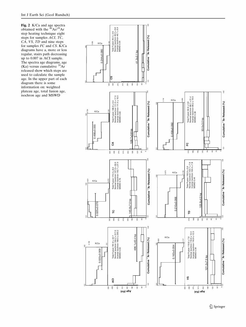
Fig. 2 K/Ca and age spectraobtained with the 40Ar/39Arstep heating technique eightsteps for samples ACI, TC,CA, VS, TD and nine stepsfor samples FC and CS. K/Cadiagrams have a, more or lessregular, stairs path decreasingup to 0.007 in ACI sample.The spectra age diagrams, age(Ka) versus cumulative 39Arreleased show which steps areused to calculate the sampleage. In the upper part of eachdiagram there is someinformation on: weightedplateau age, total fusion age,isochron age and MSWD
Int J Earth Sci (Geol Rundsch)
123
suggests that the K-rich components become depleted
and Ca-rich phases (andesine and labradorite) domi-
nate the final steps of the experiments because their
crystal sizes are generally larger and likely to melt later
then K-rich components. K-rich phases are microlite of
albite and anorthoclase which are spread in the
groundmass as the result of the late (post-eruption)
crystallization of the volcanic glass during the cooling
of lava flow below the solidus temperature (De Beni
et al. 2005). The isochron age is in disagreement with
the weighted plateau age probably due to the presence
of extraneous argon. The mean squared weighted
deviations (MSWD) factor is 0.53 that could be con-
sidered valid following the criterion stabilised by Du-
nai and Wijbrans (2000): a plateau is considered
acceptable when MSWD is less then 2.5. The age
496.1 ± 43.4 ka is in agreement with the results ob-
tained by Gillot et al. (1994) with the K–Ar method:
467.0 ± 41.0 ka, 583.0 ± 89.0 ka and 500 ± 87 ka.
TC sample
The K/Ca diagram is characterised by an irregular path
with a peak (0,501) at the fifth step which corresponds to
a peak within the plateau age spectrum (189.1 ±
30.3 ka), then the K/Ca ratio decreases to 0.070. It is
likely that during the fifth heating step the microlites
of albite and anorthoclase began to degas. Weighted
plateau and isochrons (normal and inverse) ages are
perfectly in agreement; their values are, respectively,
145.8 ± 7.0 ka, 137.9 ± 30.0 ka, 140.7 ± 27.4 ka, and
MSWD is 0.76.
CA sample
Even if this sample came from a weathered lava flow
the obtained results are very good because of the
leaching technique applied to the separated fraction
that was used to selectively dissolve the weathered
portions. K/Ca ratio decreases from 0.754 at the third
step to 0.184 at the last step. Normal (111.5 ± 17.3 ka)
and inverse isochron age (111.4 ± 16.4 ka) are con-
cordant with the result of the weighted plateau age
(128.7 ± 3.8 ka) and are characterized by little uncer-
tain margins; finally MSWD is 0.83.
VS sample
K/Ca and plateau age are regular if we excluded the
first two steps during which relatively little radiogenic
argon is released. In particular K/Ca ratio strongly
decreases from the fifth step 0.767 to value 0.117 at the
last step. The weighted plateau age 121.2 ± 7.5 ka has
an uncertain margin of 6.22% of the calculated age.
Results obtained with the normal (116.6 ± 12.4 ka) and
inverse isochrons (116.9 ± 12.3 ka) are comparable
with the plateau age; MSWD is 0.34.
TD sample
The K/Ca diagram shows a regular and continuously
decreasing ratio from 0.973 at the first step to 0.135 at
total fusion. To calculate the weighted plateau age the
first step has been excluded, the resulting age of
105.8 ± 4.5 ka has a good uncertain margin of 4.25%
and MSWD is 0.44. Normal isochron age (103.7 ±
7.9 ka) and inverse isochron age (104.4 ± 7.8 ka) are in
agreement with the weighted plateau age.
FC sample
The first step of the incremental heating has a big er-
ror, however, the results are excellent with an uncer-
tain margin of 3.19% of the calculated age. K/Ca ratio
has a regular path decreasing form 1.119 at the forth
step to 0.269 at total fusion. The plateau age is calcu-
lated over 95% of the total gas release. The weighted
plateau age (93.0 ± 3.0 ka) is comparable with normal
isochron (88.7 ± 21.4 ka) and inverse isochron age
(89.2 ± 19.5 ka); MSWD is 0.38. This result is in
accordance with the age of 96.0 ± 5.0 ka measured by
Gillot et al. (1994) on a sample located at the base of
the Mt. Fior di Cosimo with similar stratigraphical
position of our FC sample. For verifying the reliability
of this result we measured the age of a sample located
at the top of the Mt. Fior di Cosimo lava succession
(CS sample) which results the youngest volcanic of this
data set.
CS sample
K/Ca diagram shows a regular decreasing, from 1.062
to 0.146 at total fusion, excluding the first step. For the
weighted plateau age calculation we did not consider
the first two steps which release only a small amount of
argon and have a large error. The plateau age of
41.3 ± 3.1 ka with an uncertain margin of 7.31% is
comparable with, normal (46.5 ± 6.6 ka) and inverse
(46.7 ± 6.4 ka) isochron ages; MSWD is 0.54.
In our samples 38ArCl is generally very low; thus we
do not expect significant interference of 36ArCl on the
determination of radiogenic argon (40Ar*).
Int J Earth Sci (Geol Rundsch)
123
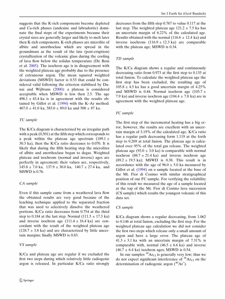
Geological data
In this section we briefly describe the stratigraphy of
the volcanic successions of the BT and TI phases and of
the earlier volcanics of the VB phase.
BT phase
The earliest volcanics found in the Etnean region are
related to the BT phase and they are preserved in a
restricted area between the villages of Acicastello and
Fig. 3 Geological sketch map of Mount Etna based on the new1:50,000 geological map of the volcano (Branca et al. 2004b) andlocation of the analysed samples. 1 Apenninic–MaghrebianChain, 2 Early-middle Pleistocene sediments; 3 BT phase
volcanics; 4 TI phase volcanics; 5 VB phase volcanics; 6 SVphase volcanics, a Ellittico volcano and b Mongibello volcano; 7Recent alluvial deposits
Int J Earth Sci (Geol Rundsch)
123

Acitrezza along the Ionian coast (Fig. 3). They consist
of shallow subvolcanic bodies, pillow lavas and hyalo-
clastic breccias with a tholeiitic affinity (Tanguy et al.
1997; Corsaro and Cristofolini 1997, 2000) that are
intercalated in the top of the early-middle Pleistocene
marly-clays of the Gela–Catania Foredeep (Di Stefano
and Branca 2002). Submarine eruption products are
preserved in the isolated coastal cliff of the Acicastello
Castle Rock and inland between the villages of Fica-
razzi and Acitrezza. At Acicastello Castle Rock they
consist of pillow lavas and hyaloclastic pillow-breccia
fed by a N–S oriented dyke (Fig. 4). Inland, these
volcanics crop out discontinuously within the early-
middle Pleistocene marly-clays. They consist of pillow
lava and pillow breccia made of sharp-edged pillow
fragments dispersed in a hyaloclastic matrix. These
deposits were fed by several small subvolcanic bodies
having bulb-shapes that are generally characterized by
columnar joints radiating from the inner part of the
body.
The oldest subaerial lava flows of BT phase are
exposed in the lower western flank of the volcano
along the left bank of the Simeto River; they have a
tholeiitic composition (Tanguy 1978; Corsaro and
Pompilio 2004). The lava flows crop out discontinu-
ously between Adrano town at 650 m asl and Paterno
town at 300 m asl forming a lava plateau between 5 and
25 m thick. The plateau rests on a sub-flat morphology
gently SSE dipping developed on top of Apenninic–
Maghrebian Chain terrains and locally, near Paterno,
on the Pleistocene infra-littoral sands. The tholeiitic
lava extends 8–9 km northward to Adrano town
according to subsurface data (Cristofolini et al. 1991).
The base of the lava plateau is locally characterized by
the presence of pillow lava facies resting on lenses of
alluvial deposits between Adrano and S. Maria di
Licodia towns as reported by Chester and Duncan
(1979). Pillow lava fragments in a hyaloclastic matrix
are also present at Valcorrente locality close to the
town of Paterno where the sub-aerial lava flow shows
marine incrustations of Polycaeta. The tholeiitic lava
plateau was generated by fissure-type eruptions whose
vents are covered by the younger volcanics with the
exception of one located in the south-eastern border of
the plateau at Valcorrente. Here, the eruptive fissure is
bordered by a pyroclastic deposit consisting of an
alternation of densely black scoriaceous lapilli and
bombs layers and stratified ashy layers. The juvenile
clasts are characterised by a yellowish alteration sur-
face and the bombs show a well-developed bread-crust
surface. The pyroclastic deposit also contains sedi-
mentary lithics of Pleistocene marly-clay clasts and
polygenetic alluvial pebbles. Attitude and geometrical
arrangements of the pyroclastic deposit indicate that
the eruptive fissure is oriented about N–S extending for
a length of about 650 m.
Finally, about 4 km south–east of the lava plateau
an isolated neck of tholeiitic lavas (Tanguy 1978) is
intruded in the marine Pleistocene sediments at Motta
S. Anastasia town. This subvolcanic body showing
well-developed columnar joints is about 400 m N–S
elongated, 200 m-wide and about 60 m-high. A pyro-
clastic deposit is locally preserved along the wall of the
neck. It is formed by scoriaceous lapilli and bombs,
with a bread-crust surface, and occasionally sedimen-
tary lithic fragments made up of heterolithologic allu-
vial pebbles. A small NNW trending dike is present in
the northern side of the subvolcanic body.
TI phase
The volcanic products related to the TI phase are well
exposed along the Ionian coast where a thick lava flow
succession crops out along the Acireale Timpa and
Fig. 4 Aerial view from southof the coastal cliff ofAcicastello Castle Rock thatis formed by the submarineproducts of the BT phase andlocation of ACI sample
Int J Earth Sci (Geol Rundsch)
123
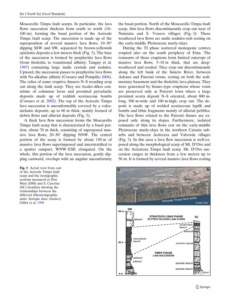
Moscarello Timpa fault scarps. In particular, the lava
flows succession thickens from south to north (10–
100 m), forming the basal portion of the Acireale
Timpa fault scarp. The succession is made up of the
superposition of several massive lava flows, 10–30�dipping SSW and SW, separated by brown-yellowish
epiclastic deposits a few meters thick (Fig. 5). The base
of the succession is formed by porphyritic lava flows
(from tholeiitic to transitional affinity; Tanguy et al.
1997) containing large mafic crystals and nodules.
Upward, the succession passes to porphyritic lava flows
with Na-alkaline affinity (Corsaro and Pompilio 2004).
The relics of some eruptive fissures N–S trending crop
out along the fault scarp. They are feeder-dikes con-
stitute of columnar lavas and proximal pyroclastic
deposits made up of reddish scoriaceous bombs
(Corsaro et al. 2002). The top of the Acireale Timpa
lava succession is unconformably covered by a volca-
niclastic deposits, up to 60 m thick, mainly formed of
debris flows and alluvial deposits (Fig. 5).
A thick lava flow succession forms the Moscarello
Timpa fault scarp that is characterised by a basal por-
tion, about 70 m thick, consisting of superposed mas-
sive lava flows, 20–30� dipping NNW. The central
portion of the scarp is formed by about 150 m of
massive lava flows superimposed and interstratified to
a spatter rampart, WNW–ESE elongated. On the
whole, this portion of the lava succession, gently dip-
ping eastward, overlaps with an angular unconformity
the basal portion. North of the Moscarello Timpa fault
scarp, thin lava flows discontinuously crop out near of
Nunziata and S. Venera villages (Fig. 3). These
weathered lava flows are mafic nodules-rich resting on
the early-middle Pleistocene marly-clays.
During the TI phase scattered monogenic centres
erupted also on the south periphery of Etna. The
remnants of these eruptions form limited outcrops of
massive lava flows, 5–10 m thick, that are deep-
weathered and eroded. They crop out discontinuously
along the left bank of the Simeto River, between
Adrano and Paterno towns, resting on both the sedi-
mentary basement and the tholeiitic lava plateau. They
were generated by fissure-type eruptions whose vents
are preserved only at Paterno town where a large
proximal scoria deposit N–S oriented, about 800 m-
long, 500 m-wide and 100 m-high, crop out. The de-
posit is made up of welded scoriaceous lapilli and
bombs and lithic fragments mainly of alluvial pebbles.
The lava flows related to the Paterno fissure are ex-
posed only along its slopes. Furthermore, isolated
remnants of thin lava flows rest on the early-middle
Pleistocene marly-clays in the northern Catania sub-
urbs and between Acitrezza and Valverde villages
(Fig. 3). In this area a lava flow succession is well-ex-
posed along the morphological scarp of Mt. D’Oro and
on the Acicatena Timpa fault scarp. Mt. D’Oro suc-
cession ranges in thickness from a few meters up to
50 m. It is formed by several massive lava flows resting
Fig. 5 Aerial view from eastof the Acireale Timpa faultscarp and the stratigraphicsections measured at DonMasi (DM) and S. Caterina(SC) localities showing therelationships between thedifferent lithostratigraphicunits. Isotopic data: (hashes)Gillot et al. 1994
Int J Earth Sci (Geol Rundsch)
123

on the early-middle Pleistocene marly-clays. At the
Gelso locality, on the sedimentary hill of Acitrezza, the
Mt. D’Oro succession is formed by three lava flows
separated by a thin paleosoil and a 6 m thick epiclastic
deposit (Fig. 6). The succession was generated by fis-
sure-type eruptions whose vents are preserved only on
the Acicatena Timpa fault scarp. Here, a proximal
deposit made up of densely lapilli and bread-crust
bombs alternating with ash layers containing lava lithic
and, occasionally, clay fragments crops out. The lava
flow related to this fissure extends eastward on the
Pleistocene sedimentary basement for more than 4 km
reaching the coast at Capo Mulini bay (Fig. 3).
Highly tectonized volcanics crop out in Val Calanna
forming the relief of Mt. Calanna, an isolated and
highly eroded volcanic body, and the base of Mt. Fior
di Cosimo a morphological scarp unconformably cov-
ered by the VB phase lava flows (Fig. 7). These vol-
canics have an uncertain stratigraphic position due to
the lack of any basal contact (Branca et al. 2004a).
They are highly-weathered cataclastic lava flows with a
grey-yellowish clay matrix that are cut by several
tectonized dykes. These products are also exposed in a
drainage gallery about 1.5 km southward of Mt. Fior di
Cosimo, indicating a southward extension for the
Calanna volcanics (Branca et al. 2004a).
On the whole, the top of the TI phase volcanics is
marked by a main erosional unconformity represented
by: (a) a buried morphological scarp in Val Calanna;
(b) debris and alluvial deposits along the Ionian coast
on the Acireale Timpa fault scarp; (c) isolated lava
relicts smoothed on the top and deeply eroded side-
ways due to the entrenchment of the drainage pattern
on the southern border of the volcano.
VB phase
The VB phase products crop out in the central portion
of the volcano. They are localised in the Val Calanna
area, at Tarderia locality and on the northern wall of
the Valle del Bove. In particular, in Val Calanna the
earliest lava flows of the VB phase on Mt. Calanna and
on Mt. Fior di Cosimo scarp are well-exposed (Fig. 7).
On the eastern slope of Mt. Calanna, a 10 m thick, SE
dipping, lava flow is fed by a dike that cut the cata-
clastic volcanics of the TI phase. Along the Mt. Fior di
Cosimo scarp, a 180 m-thick lava flow succession rests
with an angular unconformity on the TI phase cata-
clastic volcanics (Fig. 7). This succession is formed by
the superposition of massive lava flows, dipping 10–20�toward SE and SSE, which are unconformably covered
by the volcanics of the SV phase (Fig. 7).
South of the Val Calanna limited outcrops of a lava
flow succession, up to 30 m thick, are exposed along
fault scarps of Contrada Passo Cannelli, Tarderia, Mt.
Po and Mt. Cicirello. The succession is formed by the
superposition of massive southward dipping lava flows
that are unconformably covered by the SV phase vol-
Fig. 6 Image of the top of the Acitrezza sedimentary hill (a) and stratigraphic section measured at Gelso locality. The star indicatesthe location of the TC sample in the stratigraphic column
Int J Earth Sci (Geol Rundsch)
123

canics. The top of this lava succession is highly eroded
and is characterised by the presence of thin and con-
fined volcaniclastic deposits.
North of Val Calanna, a complex volcanic succes-
sion is exposed at the base of Valle del Bove northern
wall at Rocca Capra and Rocca Palombe localities
(Fig. 3), representing the relic of a small polygenic
eruptive center (Rocche volcano of Branca et al.
2004a). The succession is about 120 m thick, dipping
20–35� from NW to NE. From the base it consists of
thin superimposed lava flows passing upward to an
alternation of autoclastic lavas with pyroclastic and
epiclastic deposits. At Rocca Palombe a 30 m thick
reddish pyroclastic flow deposit crop out. The top of
this volcanic succession is highly eroded and is
unconformably covered by the SV phase volcanics
(Fig. 3).
Discussion
40Ar/39Ar age determinations and stratigraphic data
allow us to constrain the evolution of the eruptive
activity of Etna volcano chronologically from the first
submarine products of the BT phase to the formation
of the earliest eruptive center of the VB phase. Geo-
chronological and geological data allowed for the first
time to define the uncertain stratigraphic position of
some volcanics, to understand the meaning and the
role of the main unconformities that characterise the
complex Etnean volcanic succession and finally to
clarify the relationship with the tectonic evolution of
eastern Sicily.
The 40Ar/39Ar age of 496.1 ± 43.4 ka for the earliest
Etnean products (ACI sample) is in agreement with
the previous K/Ar age of Gillot et al. (1994), showing
that submarine eruptions occurred at about 500 ka ago
in the Gela–Catania Foredeep during the deposition of
the early-middle Pleistocene marly-clay. After these
submarine volcanics no products have been found in
the stratigraphic record up to about 300 ka ago as
indicate by the isotopic ages of the subaerial tholeiitic
lava flow cropping out at Valcorrente (Gillot et al.
1994). This subaerial volcanism is related to fissure-
type eruptions that formed a wide plateau, gently SSE
dipping, extending for more than 25 km from Bronte
to Paterno on the top of the Apenninic–Maghrebian
Chain terrains. The alluvial deposits exposed below the
lava plateau indicated that these lava flows emplaced
on the old alluvial plain of the paleo-Simeto River,
characterised by the presence of lacustrine environ-
ment as documented by the finding of pillow-lava fa-
cies at the base of the plateau. In addition, the
pyroclastic deposits of the two eruptive fissures
recognised at Valcorrente and Motta S. Anastasia are
characterised by phreatomagmatic features indicating
Fig. 7 Geological sketch map of Val Calanna area and thestratigraphic section measured at Mt. Fior di Cosimo. The starsindicate the location of the CA, FC and CS samples in thestratigraphic section. 1 Mongibello volcano products; 2 Ellittico
volcano products; 3 VB phase volcanics; 4 TI phase volcanics; 5bedding attitude; 6 location of the stratigraphic section; 7 VdBrim
Int J Earth Sci (Geol Rundsch)
123
the interaction between magma and the water located
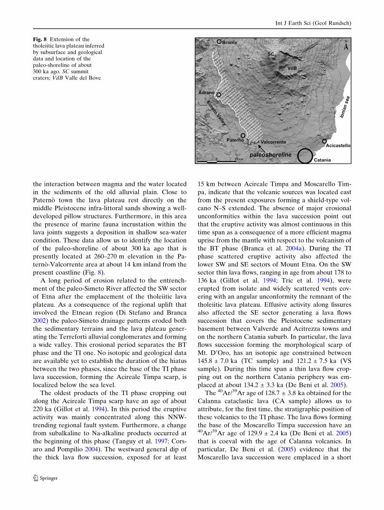
in the sediments of the old alluvial plain. Close to
Paterno town the lava plateau rest directly on the
middle Pleistocene infra-littoral sands showing a well-
developed pillow structures. Furthermore, in this area
the presence of marine fauna incrustation within the
lava joints suggests a deposition in shallow sea-water
condition. These data allow us to identify the location
of the paleo-shoreline of about 300 ka ago that is
presently located at 260–270 m elevation in the Pa-
terno-Valcorrente area at about 14 km inland from the
present coastline (Fig. 8).
A long period of erosion related to the entrench-
ment of the paleo-Simeto River affected the SW sector
of Etna after the emplacement of the tholeiitic lava
plateau. As a consequence of the regional uplift that
involved the Etnean region (Di Stefano and Branca
2002) the paleo-Simeto drainage patterns eroded both
the sedimentary terrains and the lava plateau gener-
ating the Terreforti alluvial conglomerates and forming
a wide valley. This erosional period separates the BT
phase and the TI one. No isotopic and geological data
are available yet to establish the duration of the hiatus
between the two phases, since the base of the TI phase
lava succession, forming the Acireale Timpa scarp, is
localized below the sea level.
The oldest products of the TI phase cropping out
along the Acireale Timpa scarp have an age of about
220 ka (Gillot et al. 1994). In this period the eruptive
activity was mainly concentrated along this NNW-
trending regional fault system. Furthermore, a change
from subalkaline to Na-alkaline products occurred at
the beginning of this phase (Tanguy et al. 1997; Cors-
aro and Pompilio 2004). The westward general dip of
the thick lava flow succession, exposed for at least
15 km between Acireale Timpa and Moscarello Tim-
pa, indicate that the volcanic sources was located east
from the present exposures forming a shield-type vol-
cano N–S extended. The absence of major erosional
unconformities within the lava succession point out
that the eruptive activity was almost continuous in this
time span as a consequence of a more efficient magma
uprise from the mantle with respect to the volcanism of
the BT phase (Branca et al. 2004a). During the TI
phase scattered eruptive activity also affected the
lower SW and SE sectors of Mount Etna. On the SW
sector thin lava flows, ranging in age from about 178 to
136 ka (Gillot et al. 1994; Tric et al. 1994), were
erupted from isolate and widely scattered vents cov-
ering with an angular unconformity the remnant of the
tholeiitic lava plateau. Effusive activity along fissures
also affected the SE sector generating a lava flows
succession that covers the Pleistocene sedimentary
basement between Valverde and Acitrezza towns and
on the northern Catania suburb. In particular, the lava
flows succession forming the morphological scarp of
Mt. D’Oro, has an isotopic age constrained between
145.8 ± 7.0 ka (TC sample) and 121.2 ± 7.5 ka (VS
sample). During this time span a thin lava flow crop-
ping out on the northern Catania periphery was em-
placed at about 134.2 ± 3.3 ka (De Beni et al. 2005).
The 40Ar/39Ar age of 128.7 ± 3.8 ka obtained for the
Calanna cataclastic lava (CA sample) allows us to
attribute, for the first time, the stratigraphic position of
these volcanics to the TI phase. The lava flows forming
the base of the Moscarello Timpa succession have an40Ar/39Ar age of 129.9 ± 2.4 ka (De Beni et al. 2005)
that is coeval with the age of Calanna volcanics. In
particular, De Beni et al. (2005) evidence that the
Moscarello lava succession were emplaced in a short
Fig. 8 Extension of thetholeiitic lava plateau inferredby subsurface and geologicaldata and location of thepaleo-shoreline of about300 ka ago. SC summitcraters; VdB Valle del Bove
Int J Earth Sci (Geol Rundsch)
123
time interval between 129.9 ± 2.4 and 126.4 ± 2.4 ka
ago ruling out that these volcanics could be related to
the younger Trifoglietto s.l. activity as previously in-
ferred by Romano (1982) and Busa and Cristofolini
(2001). Consequently, the Moscarello lava succession is
the product of an intense effusive activity from fissural
type eruptions developed along the northern termina-
tion of the Timpe fault system.
All these data suggest that the eruptive activity
during the TI phase was localised mainly along the
Ionian coast with the growth of a shield volcano from
before 220 ka to about 130 ka ago. The eruptive
activity moved toward the central portion of the pres-
ent volcano (Val Calanna–Moscarello area) marking
the westward shifting of the main feeder system be-
tween about 129 and 126 ka ago. Moreover, scattered
eruptions occurred until about 121 ka ago on the SW
and SE periphery of Etna. Consequently our geo-
chronological and geological data do not support the
presence of lava flows related to the earlier Na-alkaline
volcanism (Ancient Alkaline Centres of Romano 1982)
in the other sector of the volcano as reported in the
geological map of Romano et al. (1979) along the
valley floors of the Simeto and Alcantara rivers.
Therefore, the hypothesis of Romano (1982) about the
formation of a primitive shield volcano extending for
about 30 km from Alcantara to Simeto rivers is not
supported by our data. Furthermore, Kieffer and
Tanguy (1993) inferred the presence of an early cen-
tral-type volcano named ‘‘Etna Ancient’’ including
most of the TI volcanics. It was thought to extend
widely from the northern to the southern periphery of
Etna during the first stage of the Na-alkaline volca-
nism. The isotopic and stratigraphic data set here
presented does not support the existence of this ancient
large stratovolcano.
At the beginning of the VB phase an earlier central-
type eruptive center, Rocche volcano, grew on the
VdB area. Rocche volcano is a small polygenic center
whose eruptive axis was located less than 1 km south of
the Rocca Capra–Rocca Palombe reliefs on the NE
sector of the VdB. Rocche volcano activity was mainly
characterised by lava effusion even if the presence of
some thick pyroclastic flow deposits indicate the
occurrence of relevant explosive eruptions. The40Ar/39Ar age of the lava flow forming the top of this
volcanic succession indicates that its activity ended
about 101.9 ± 3.8 ka (De Beni et al. 2005). On the
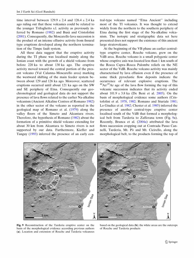
basis of morphological evidence some authors (Cris-
tofolini et al. 1978, 1982; Romano and Sturiale 1981;
Lo Giudice et al. 1982; Chester et al. 1985) inferred the
presence of another central-type eruptive center
localised south of the VdB that formed a morpholog-
ical belt from Tarderia to Zafferana town (Fig. 9a).
Recently, Branca et al. (2004a) attributed the lava
flows succession cropping out at Contrada Passo Can-
nelli, Tarderia, Mt. Po and Mt. Cicirello, along the
morphological belt, to the products forming the top of
Fig. 9 Reconstruction of the Tarderia eruptive center on thebasis of the morphological evidence according previous authors(a). Location and extension of Rocche and Tarderia volcanoes
based on the geological data (b); the white areas are the outcropsof Rocche and Tarderia products
Int J Earth Sci (Geol Rundsch)
123

this eruptive center, named Tarderia volcano. The40Ar/39Ar age of 105.8 ± 4.5 ka (TD sample) measured
for the Contrada Passo Cannelli lava flow reveal that
the two volcanic centres (Rocche and Tarderia) appear
almost coeval since their final products have similar
isotopic ages. Geological data of the Val Calanna area
allows us to define the extension of the Tarderia vol-
cano. From Zafferana the northward extension of the
morphological belt intersects the Val Calanna area that
should represent, in the hypothesis of the previous
authors (Cristofolini et al. 1982; Romano 1982), the NE
flank of the Tarderia volcano (Fig. 9a). On the con-
trary, the lava flows forming the thick succession of Mt.
Fior di Cosimo and Vallone S. Giacomo (Val Calanna
area) are characterised by a homogeneous SE–SSE
dipping (Fig. 7) forming conversely the SE flank of the
eruptive centres localized in the W portion of the VdB
(Branca et al. 2004a). In addition, the 93.0 ± 3.0 ka age
determination (FC sample) obtained for the base of
Mt. Fior di Cosimo lava flows succession, resting on the
TI phase volcanics (CA sample, 128.7 ± 3.8 ka), evi-
dences that during the time-span of the Tarderia vol-
cano building only erosional processes were reordered
in the Val Calanna area. In brief the Tarderia volcano
seems to be similar in age and size to the Rocche
volcano, and it is aligned with it along a N–S direction
(Fig. 9b). Volcanic activity resumed in Val Calanna
area about 93 ka ago with the emplacement of lava
flows belonging to the Valle del Bove centres phase
and continued during the Stratovolcano phase as
indicate by the 40Ar/39Ar age of 41.3 ± 3.1 ka obtained
for the lava flow (CS sample) at the top of the suc-
cession of Mt. Fior di Cosimo (Fig. 7).
From a geodynamics point of view the volcanism in
the Etnean region started in concomitance of a major
tectonic reorganization in the south-central Mediterra-
nean that occurred 800–500 ka ago (Goes et al. 2004). In
particular, eastern Sicily was affected by a huge exten-
sional deformation resulting from the divergence of the
Ionian basin from the continental crust of the Hyblean
Foreland that reactivated the structures of the Malta
Escarpment. According to several authors (Adam et al.
2000; Cifelli et al. 2004; Argnani and Bonazzi 2005) a
huge ESE–WNW extensional tectonic off- and on-shore
affected eastern Sicily from Middle Pleistocene. Geo-
logical data clearly evidence that this major reorgani-
zation in the tectonic setting of eastern Sicily influenced
the change from the Plio-Pleistocene volcanism of the
Hyblean foreland to the Etnean region volcanism. In
fact, the Plio-Pleistocene Hyblean volcanism is related
to a NE–SW extensional tectonic that produced the
settlement of the Hyblean foreland margin (Carveni
et al. 1991; Schmincke et al. 1997). This tectonic regime
of the northern margin of the Hyblean Plateau ended
during Late Pliocene–Early Pleistocene times (Torelli
et al. 1998). In the Etnean region, we observe that during
the BT phase the eruptive fissures trend is characterised
by the same N–S orientation of the following TI phase
indicating a general E–W extensional tectonic that
controls the magma intrusion in agreement with the
reactivation of the Malta Escarpment fault system. In
particular, the extensional tectonic of the Timpe fault
system superimposed the compressive regime of the fi-
nal stage of the chain shortening that affected the
Quaternary sediments of the Gela–Catania Foredeep
(Labaume et al. 1990; Lanzafame et al. 1997) favouring
the volcanism of the BT phase. During the BT phase the
eruptive activity changes from submarine to subaerial as
a consequence of the regional uplift affecting the Et-
nean region (Di Stefano and Branca 2002). The recog-
nition of a paleo-shoreline on the tholeiitic lava plateau
at 260–270 m elevation allows us to calculate an uplift
rate of about 1.0 mm/year for the past 300 ka using as
reference the eustatic curve of Chappel and Shackleton
(1986). This value is in agreement with the time-average
Holocene Etnean shoreline uplift rate of 0.8–1.4 mm/
year obtained by Firth et al. (1996) confirming the
occurrence of an active deformation in the Etnean re-
gion since the BT phase.
Starting from about 220 ka ago the volcanism ap-
pears mainly concentrated in a narrow belt along the
present Ionian coast where the Timpe master fault
segments developed. The huge WNW–ESE oriented
regional-scale extension of the Timpe faults allowed a
more efficient magma uprise from the mantle. In par-
ticular, during the TI phase the increase of the eruption
rate produced the growth of a shield volcano, roughly
N–S elongated, according to the orientation of the fault
system. During the late stage of the TI phase, between
about 129 and 126 ka, the volcanism concentrated on
the northern tip of the fault system. In this time span,
we observe the westward shifting of the main plumbing
system due to the NW migration of the extensional
regime of the Timpe fault system toward the central
portion of Etna edifice (Val Calanna–Moscarello area).
Finally, during the earlier stage of VB phase the pas-
sage from fissure to central eruptive style occurred, still
controlled by an E–W extensive tectonics as suggested
by the N–S alignment of Rocche and Tarderia volca-
noes.
Concluding remarks
On the basis of a new stratigraphic setting of Etna
volcano and 40Ar/39Ar age determinations we recon-
Int J Earth Sci (Geol Rundsch)
123
Fig. 10 Schematicreconstruction of: astratigraphy from earliestproducts of the BT phaseuntil the first centralvolcanism of the VB phase.Isotopic data: (open circles)this study; (hashes) De Beniet al. 2005; (asterisks) Gillotet al. 1994; and b arealdistribution of the volcanicproducts erupted in this timespan. SC summit craters; VdBValle del Bove
Int J Earth Sci (Geol Rundsch)
123

struct a detailed geochronological evolution of the
eruptive activity in the Etnean region from the early
dispersal fissure eruptions until the central-type activ-
ity (Fig. 10) and we infer its relationship with the
geodynamic framework of eastern Sicily. The main
evolutionary stages are here summarized in the fol-
lowing steps.
1. About 500 ka ago tholeiitic pillow lavas were
erupted on the sea floor of the Gela–Catania
Foredeep basin.
2. It seems that a long hiatus preceded the eruptive
activity in the Etnean region during which the re-
gional uplift produced the gradual emergence of
the sedimentary basement. Fissure-type eruptions
produced thin tholeiitic lava flows that were em-
placed on the paleo-alluvial plain of the Simeto
River at about 300 ka ago forming a plateau more
than 25 km wide. These lava flows reached the
ancient coastline that was located close to Paterno
town at about 14 km inland from the present
coastline.
3. Between 220 and 121 ka ago volcanism became
Na-alkaline and concentrated mainly along the
Ionian coast. In this area fissure-type eruptions
formed a shield volcano at least 15 km-long on a
N–S direction. During this time span scattered
effusive eruptions also took place in a wide area
that corresponds at present to the lower south–
west and south–east flanks of Etna. During the fi-
nal stage of the growth of the shield volcano, about
129 ka ago, the eruptive activity moved, for the
first time, to the area between Val Calanna and
Moscarello locality evidencing that the plumbing
system shifted westward from the Ionian coast. An
intense fissure-type activity formed a thick lava
succession that unconformably covered the shield
volcano.
4. During the VB phase the stabilization of the
plumbing system in the Valle del Bove area
marked the beginning of the central-type activity
with the initial construction of two small polygenic
centres, Tarderia and Rocche volcanoes. They re-
sult aligned along a N–S direction and ended their
eruptive activity about 106 and 102 ka ago,
respectively.
The whole geochronological and geological data-
set allow us to better understand the long-term rela-
tionships between tectonics and volcanism in the Et-
nean region. In particular, during the earliest BT phase
the magma rise was driven by a general E–W exten-
sional regime related to a major change in the geody-
namics setting of eastern Sicily that reactivated the
Malta Escarpment lithospheric fault system. The
gradual development of this transform boundary be-
tween the Ionian basin and the Hyblean Foreland
formed the Timpe fault system in the Etnean region.
Starting from about 220 ka the extensional tectonic of
the Timpe faults affecting the Ionian margin favoured
the transition from the scattered volcanism of the BT
phase to the shield volcano-forming activity during the
TI phase. In this geodynamic context the magmatic
supply rate from the mantle increased gradually
favouring the stabilization of the Etna plumbing sys-
tem in correspondence of the northern termination of
the Timpe fault system. Since 129 ka ago, a gradual
westward shifting of the volcanic activity from the tip
of Timpe faults toward the VdB area, recorded by
Calanna, Moscarello, Tarderia and Rocche volcanics,
marked the transition from fissure to central-type
eruptive activity.
Finally, further isotopic and geological investiga-
tions are in progress with the aim of defining the evo-
lution of eruptive activity in the last 100 ka during
which the large Etna statovolcano edifice was built.
Acknowledgments The authors are grateful to G. Groppelli forthe critical discussion about the geological and stratigraphicarguments. We wish to thank DK. Chester and JC. Tanguy forthe revision of the manuscript. Petrographic analyses were per-formed at the laboratories of the INGV-Sezione di Catania. Theresearch was supported by INGV-DPC V3_6/07 project andCNR-IDPA fund. The paper is dedicated to the newbornFederico.
References
Adam J, Reuther CD, Grasso M, Torelli L (2000) Active faultkinematics and crustal stresses along the Ionian margin ofsoutheastern Sicily. Tectonophysics 326:217–239
Argnani A, Bonazzi C (2005) Malta Escarpment fault zoneoffshore eastern Sicily: Pliocene-Quaternary tectonic evo-lution based on new multichannel seismic data. Tectonics 24(4) DOI: 10.1029/2004TC001656
Azzaro R (1999) Earthquake surface faulting at Mount Etnavolcano (Sicily) and implications for active tectonics. JGeodyn 28:193–213
Azzaro R (2004) Seismicity and active tectonics in the etnaregion: constraints for a seismotectonic model. In: Bonac-corso A, Calvari S, Coltelli M, Del Negro C, Falsaperla S(eds) Mt Etna Volcano Laboratory. AGU (Geophysicalmonograph series) 143:205–220
Ben Avraham Z, Grasso M (1990) Collisional zone segmentationin Sicily and surrounding areas in the central Mediterra-nean. Ann Tectonicae 4:131–139
Bousquet JC, Lanzafame G (2004) The tectonic and geodynam-ics of Mt. Etna: synthesis and interpretation of geologicaland geophysical data. In: Bonaccorso A, Calvari S, ColtelliM, Del Negro C, Falsaperla S (eds). Mt Etna VolcanoLaboratory. AGU (Geophysical monograph series) 143:29–49
Int J Earth Sci (Geol Rundsch)
123

Branca S, Coltelli M, Groppelli G (2004a) Geological evolutionof Etna volcano. In: Bonaccorso A, Calvari S, Coltelli M,Del Negro C, Falsaperla S (eds). Mt Etna Volcano Labo-ratory. AGU (Geophysical monograph series) 143:49–63
Branca S, Coltelli M, Del Carlo P, Groppelli G, Norini G,Pasquare G (2004b) Stratigraphical approaches and tools inthe geological mapping of Mt. Etna Volcano. In: PasquareG, Venturini C (eds) Mapping geology in Italy. APAT-Dipartimento Difesa del Suolo, Servizio Geologico d’Italia,S.EL.CA, Firenze, pp 145–156
Branca S, Coltelli M, Groppelli G, Lentini F (2004c) GeologicalMap of Mount Etna (Italy) 1:50,000 Scale. In: 32ndInternational geological congress (32IGC), Florence (Italy)abstract volume, pt. 1, 35–20, pp 188
Busa T, Cristofolini R (2001) Rilevamento geo-petrografico dellevulcaniti esposte lungo le ‘‘Timpe di Moscarello’’ (bassoversante orientale dell’Etna): evidenze di una migrazionedell’attivita dei centri eruttivi. Boll Soc Geol Ital 120:69–80
Calvari S, Groppelli G, Pasquare G (1994) Preliminary geolog-ical data on the south-western wall of the Vale del Bove, Mt.Etna (Sicily). Acta Vulcanol 5:15–30
Carveni P, Grasso M, Romano R, Tricomi S (1991) Vulcanismodel margine settentrionale ibleo. Mem Soc Geol Ital 47:417–429
Chappel J, Shackleton NJ (1986) Oxygen isotopes and sea level.Nature 324:137–140
Chester DK, Duncan AM (1979) Interrelationships betweenvolcanic and alluvial sequences in the evolution of theSimeto River Valley, Mount Etna, Sicily. Catena 6:293–315
Chester DK, Ducan AM, Guest J E, Kilburn CRJ (1985) MountEtna the anatomy of a volcano. Chapman and Hall, London,pp 1–404
Cifelli F, Rossetti F, Mattei M, Hirt AM, Funiciello R, TortoriciL (2004) An AMS, structural and paleomagnetic study ofquatenary deformation in eastern Sicily. J Struct Geol26:29–46
Coltelli M, Garduno VH, Neri M, Pasquare G, Pompilio M(1994) Geology of the northern wall of the Valle del Bove,Mt Etna (Sicily). Acta Vulcanol 5:55–68
Coltelli M, Del Carlo P, Vezzoli L (2000) Stratigraphicconstraints for explosive activity in the last 100 ka at Etnavolcano, Italy. Int J Earth Sci 89:665–677
Condomines M, Tanguy JC, Kieffer G, Allegre CJ (1982)Magma evolution of a volcano studied by 230Th-238Udisequilibrium and trace element systematics: the Etna case.Geochim Cosmochim Acta 46:1397–1416
Corsaro RA, Cristofolini R (1997) Geology, geochemistry andmineral chemistry of tholeiitic to transitional Etnean mag-mas. Acta Vulcanol 9(1–2):55–66
Corsaro RA, Cristofolini R (2000) Subaqueous volcanism in theEtnaean area: evidence for hydromagmatic activity andregional uplift inferred from the Castel Rock of Acicastello.J Volcanol Geotherm Res 95:209–225
Corsaro RA, Pompilio M (2004) Dynamics of magmas at MountEtna. In: Bonaccorso A, Calvari S, Coltelli M, Del Negro C,Falsaperla S (eds) Mt Etna Volcano Laboratory. AGU(Geophysical monograph series) 143:91–110
Corsaro RA, Neri M, Pompilio M (2002) Paleo-environmentaland volcano-tectonic evolution of the southeastern flank ofMt. Etna during the last 225 ka inferred from the volcanicsuccession of the ‘‘Timpe’’, Acireale, Sicily. J VolcanolGeotherm Res 113:289–306
Cristofolini R, Patane G, Rasa R (1978) Studio morfo-strutturaledel versante orientale etneo. Mem Soc Geol Ital 19:613–620
Cristofolini R, Patane G, Recupero S (1982) Morphologicevidence for ancient volcanic centers and indications of
magma reservoirs underneath Mt. Etna, Sicily. GeografiaFisica e Dinamica Quaternaria 5:3–9
Cristofolini R, Corsaro RA, Ferlito C (1991) Variazioni pet-rochimiche nella successione etnea: un riesame in base anuovi dati da campioni di superficie e da sondaggi. ActaVulcanol 1:25–37
De Beni E, Wijbrans JR, Branca S, Coltelli M, Groppelli G.(2005) New results of 40Ar/39Ar dating constrain the timingof transition from fissure-type to central volcanism at MountEtna (Italy). Terra Nova 17(3):292–298
Di Stefano A, Branca S (2002) Long-term uplift rate of theEtna volcano basament (southern Italy) based on bio-chronological data from Pleistocene sediments. TerraNova 14:61–68
Dunai TJ, Wijbrans JR (2000) Long-term cosmogenic 3Heproduction rates (152 ka-1.35 Ma) from 40Ar/39Ar datedbasalt flows at 29�N latitude. Earth Planet Sci Lett 176:147–156
Finetti I (1982) Structure, stratigraphy and evolution of theCentral Mediterranean. Boll Geof Teore Appl 24:247–426
Firth C, Stewart I, McGuire WJ, Vita-Finzi C (1996) Coastalelevation changes in eastern Sicily: implication for volcanoinstability at Mount Etna. In: McGuire WJ, Jones AP,Neuberg J (eds) Volcano instability on the Earth and otherplanets. Geol Soc London, Spec Pub 110:153–167
Gillot PY, Keiffer G, Romano R (1994) The evolution of MountEtna in the light of potassium-argon dating. Acta Vulcanol5:81–87
Goes S, Giardini D, Jenny S, Hollenstein C, Kahle HG, GeigerA (2004) A recent tectonic reorganization in the south-central Mediterranean. Earth Planet Sci Lett 226:335–345
Hirn A, Nicolich R, Gallart J, Laigle M, Cernobori L (1997)ETNASEIS Scientific Group, Roots of Etna volcano infaults of great earthquakes. Earth Planet Sci Lett 148:171–191
Kieffer G, Tanguy JC (1993) L’Etna: evolution structurale,magmatique et dynamique d’un volcan ‘‘polygenique’’.Mem Soc Geol France 163:253–271
Koppers AAP (2002) ArArCALC-software for 40Ar/39Ar agecalculations. Comput Geosci 28:605–619
Labaume P, Bousquet JC, Lanzafame G (1990) Early deforma-tions at a submarine compressive front: the Quaternarycatania foredeep south Mt. Etna, Sicily. Tectonophysics177:349–366
Lanzafame G, Neri M, Coltelli M, Lodato L, Rust D (1997)North-South compression in the Mt. Etna region (Sicily):spatial and temporal distribution. Acta Vulcanol 9:121–133
Lentini F (1982) The geology of the Mt. Etna basement. MemSoc Geol Ital 23:7–25
Lo Giudice E, Patane G, Rasa R, Romano R (1982) Thestructural framework of Mount Etna. Mem Soc Geol Ital23:125–158
Pasquare G, Abbate E, Castiglioni GB, Merenda M, Mutti E,Ortolani F, Parotto M, Pignone R, Polino R, Sassi FP (1992)Carta Geologica d’Italia 1:50,000 Guida al Rilevamento.Quaderni series III 1:1–203
Rittmann A (1973) Structure and evolution of Mount Etna.Philos Trans R Soc Lond 274:5–16
Romano R (1982) Succession of the volcanic activity in theetnean area. Mem Soc Geol Ital 23:27–48
Romano R, Lentini F, Sturiale C et al (1979) Carta Geologica delMonte Etna. Scala 1:50,000. In: Mem Soc Geol Ital 23 (1982)
Romano R, Sturiale C (1981) Geologia del versante Sud-orientale Etneo, F� 270 IV. Boll Soc Geol Ital 100:15–40
Salvador A (1987) Uncorformity-bounded stratigraphic units.Geol Soc Am Bull 98:232–237
Int J Earth Sci (Geol Rundsch)
123

Salvador A (1994) International stratigraphic guide, GSASalvador A (ed) Boulder, pp 1–214
Scandone P, Patacca E, Rodoicic R, Ryan WBF, Cita B,Rawason M, Cherazan H, Miller E, McKenzie J, Rossi S(1981) Mesozoic and Cenozoic rocks from Malta Escarp-ment (Central Mediterranean). AAPG Bull 65:1299–1319
Schmincke HK, Behncke B, Grasso M, Raffi S (1997) Evolutionof the northwestern Hyblean Mountains, Sicily: uplift,Pliocene/Pleistocene sea-level changes, paleoenviroment,and volcanism. Geol Rundsch 86:637–669
Servizio Geologico d’Italia (2006) Carta Geologica d’Italia F�625 Acireale, scala 1:50,000. CNR-APAT DipartimentoDifesa del Suolo (in press)
Torelli L, Grasso M, Mazzoldi G, Peis D (1998) Plio-Quaternarytectonic evolution and structure of the Catania foredeep, the
northern Hyblean Plateau and the Ionian shelf (SE Sicliy).Tectonophysics 298:209–221
Tanguy JC (1978) Tholeiitic basalt magmatism of Mount Etnaand its relations with the alkaline series. Contrib MineralPetrol 66:51–67
Tanguy JC, Condomines M, Kieffer G (1997) Evolution of theMount Etna magma: constraints on the present feedingsystem and eruptive mechanism. J Volcanol Geotherm Res75:221–250
Tric E, Valet JP, Gillot PY, Lemeur I (1994) Absolute paleo-intensities between 60 and 160 k year from Mount Etna(Sicily). Phys Earth Planet Int 85:113–129
Wijbrans JR, Pringle MS, Koppers AAP, Scheveers R (1995) Argongeochronology of small samples using the Vulcaan argon laserprobe. Proc. Kon Ned Akad V Wetensh 98:185–218
Int J Earth Sci (Geol Rundsch)
123