Geochemical Investigations of Fuller’s Earth Deposits around Thano Bula Khan Area, Sindh, Pakistan
6
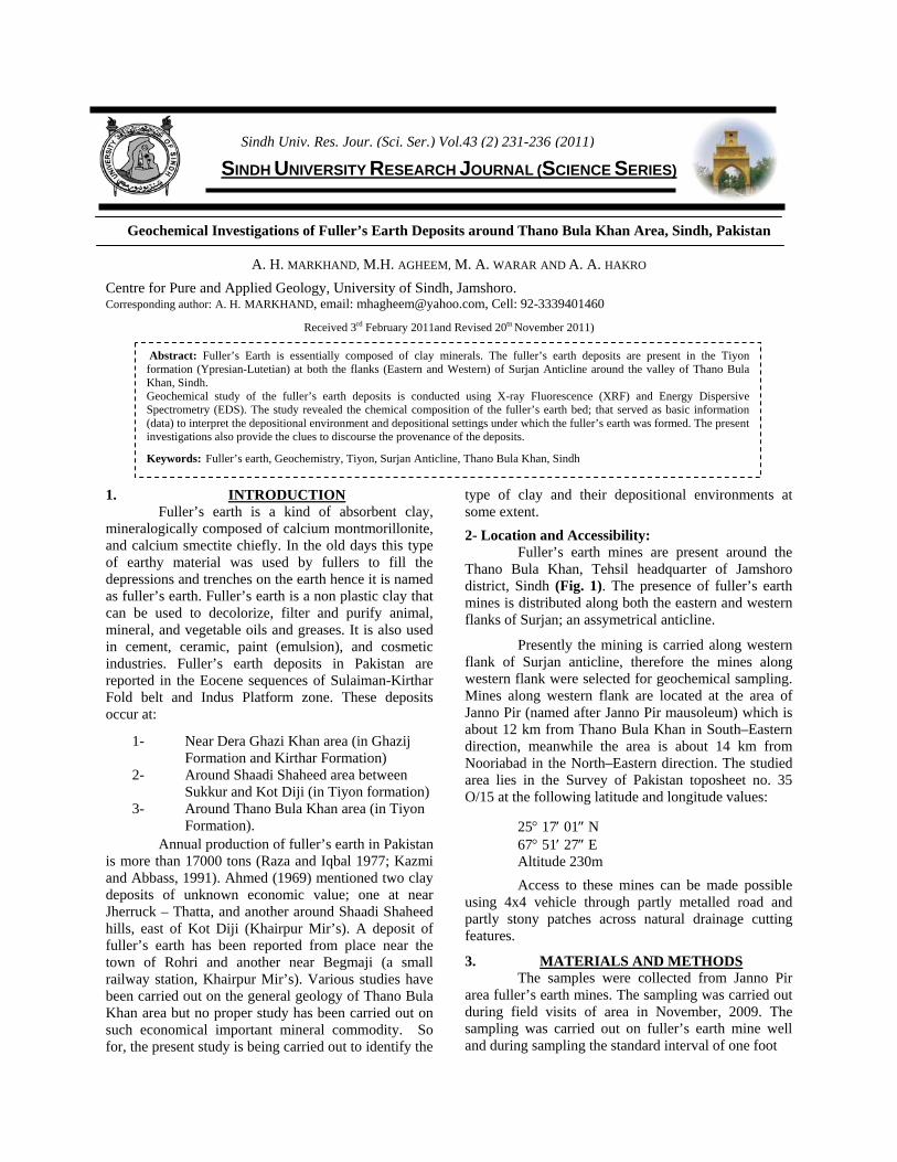
SINDH UNIVERSITY RESEARCH JOURNAL (SCIENCE SERIES) Geochemical Investigations of Fuller’s Earth Deposits around Thano Bula Khan Area, Sindh, Pakistan A. H. MARKHAND, M.H. AGHEEM, M. A. WARAR AND A. A. HAKRO Centre for Pure and Applied Geology, University of Sindh, Jamshoro. Corresponding author: A. H. MARKHAND, email: [email protected], Cell: 92-3339401460 Received 3 rd February 2011and Revised 20 tn November 2011) 1. INTRODUCTION Fuller’s earth is a kind of absorbent clay, mineralogically composed of calcium montmorillonite, and calcium smectite chiefly. In the old days this type of earthy material was used by fullers to fill the depressions and trenches on the earth hence it is named as fuller’s earth. Fuller’s earth is a non plastic clay that can be used to decolorize, filter and purify animal, mineral, and vegetable oils and greases. It is also used in cement, ceramic, paint (emulsion), and cosmetic industries. Fuller’s earth deposits in Pakistan are reported in the Eocene sequences of Sulaiman-Kirthar Fold belt and Indus Platform zone. These deposits occur at: 1- Near Dera Ghazi Khan area (in Ghazij Formation and Kirthar Formation) 2- Around Shaadi Shaheed area between Sukkur and Kot Diji (in Tiyon formation) 3- Around Thano Bula Khan area (in Tiyon Formation). Annual production of fuller’s earth in Pakistan is more than 17000 tons (Raza and Iqbal 1977; Kazmi and Abbass, 1991). Ahmed (1969) mentioned two clay deposits of unknown economic value; one at near Jherruck – Thatta, and another around Shaadi Shaheed hills, east of Kot Diji (Khairpur Mir’s). A deposit of fuller’s earth has been reported from place near the town of Rohri and another near Begmaji (a small railway station, Khairpur Mir’s). Various studies have been carried out on the general geology of Thano Bula Khan area but no proper study has been carried out on such economical important mineral commodity. So for, the present study is being carried out to identify the type of clay and their depositional environments at some extent. 2- Location and Accessibility: Fuller’s earth mines are present around the Thano Bula Khan, Tehsil headquarter of Jamshoro district, Sindh (Fig. 1). The presence of fuller’s earth mines is distributed along both the eastern and western flanks of Surjan; an assymetrical anticline. Presently the mining is carried along western flank of Surjan anticline, therefore the mines along western flank were selected for geochemical sampling. Mines along western flank are located at the area of Janno Pir (named after Janno Pir mausoleum) which is about 12 km from Thano Bula Khan in South–Eastern direction, meanwhile the area is about 14 km from Nooriabad in the North–Eastern direction. The studied area lies in the Survey of Pakistan toposheet no. 35 O/15 at the following latitude and longitude values: 25° 17′ 01″ N 67° 51′ 27″ E Altitude 230m Access to these mines can be made possible using 4x4 vehicle through partly metalled road and partly stony patches across natural drainage cutting features. 3. MATERIALS AND METHODS The samples were collected from Janno Pir area fuller’s earth mines. The sampling was carried out during field visits of area in November, 2009. The sampling was carried out on fuller’s earth mine well and during sampling the standard interval of one foot Abstract: Fuller’s Earth is essentially composed of clay minerals. The fuller’s earth deposits are present in the Tiyon formation (Ypresian-Lutetian) at both the flanks (Eastern and Western) of Surjan Anticline around the valley of Thano Bula Khan, Sindh. Geochemical study of the fuller’s earth deposits is conducted using X-ray Fluorescence (XRF) and Energy Dispersive Spectrometry (EDS). The study revealed the chemical composition of the fuller’s earth bed; that served as basic information (data) to interpret the depositional environment and depositional settings under which the fuller’s earth was formed. The present investigations also provide the clues to discourse the provenance of the deposits. Keywords: Fuller’s earth, Geochemistry, Tiyon, Surjan Anticline, Thano Bula Khan, Sindh Sindh Univ. Res. Jour. (Sci. Ser.) Vol.43 (2) 231-236 (2011)
-
Upload
usindhjamshoro -
Category
Documents
-
view
2 -
download
0
Transcript of Geochemical Investigations of Fuller’s Earth Deposits around Thano Bula Khan Area, Sindh, Pakistan
SINDH UNIVERSITY RESEARCH JOURNAL (SCIENCE SERIES)
Geochemical Investigations of Fuller’s Earth Deposits around Thano Bula Khan Area, Sindh, Pakistan
A. H. MARKHAND, M.H. AGHEEM, M. A. WARAR AND A. A. HAKRO
Centre for Pure and Applied Geology, University of Sindh, Jamshoro. Corresponding author: A. H. MARKHAND, email: [email protected], Cell: 92-3339401460
Received 3rd February 2011and Revised 20tn November 2011) 1. INTRODUCTION
Fuller’s earth is a kind of absorbent clay, mineralogically composed of calcium montmorillonite, and calcium smectite chiefly. In the old days this type of earthy material was used by fullers to fill the depressions and trenches on the earth hence it is named as fuller’s earth. Fuller’s earth is a non plastic clay that can be used to decolorize, filter and purify animal, mineral, and vegetable oils and greases. It is also used in cement, ceramic, paint (emulsion), and cosmetic industries. Fuller’s earth deposits in Pakistan are reported in the Eocene sequences of Sulaiman-Kirthar Fold belt and Indus Platform zone. These deposits occur at:
1- Near Dera Ghazi Khan area (in Ghazij Formation and Kirthar Formation)
2- Around Shaadi Shaheed area between Sukkur and Kot Diji (in Tiyon formation)
3- Around Thano Bula Khan area (in Tiyon Formation).
Annual production of fuller’s earth in Pakistan is more than 17000 tons (Raza and Iqbal 1977; Kazmi and Abbass, 1991). Ahmed (1969) mentioned two clay deposits of unknown economic value; one at near Jherruck – Thatta, and another around Shaadi Shaheed hills, east of Kot Diji (Khairpur Mir’s). A deposit of fuller’s earth has been reported from place near the town of Rohri and another near Begmaji (a small railway station, Khairpur Mir’s). Various studies have been carried out on the general geology of Thano Bula Khan area but no proper study has been carried out on such economical important mineral commodity. So for, the present study is being carried out to identify the
type of clay and their depositional environments at some extent.
2- Location and Accessibility: Fuller’s earth mines are present around the
Thano Bula Khan, Tehsil headquarter of Jamshoro district, Sindh (Fig. 1). The presence of fuller’s earth mines is distributed along both the eastern and western flanks of Surjan; an assymetrical anticline.
Presently the mining is carried along western flank of Surjan anticline, therefore the mines along western flank were selected for geochemical sampling. Mines along western flank are located at the area of Janno Pir (named after Janno Pir mausoleum) which is about 12 km from Thano Bula Khan in South–Eastern direction, meanwhile the area is about 14 km from Nooriabad in the North–Eastern direction. The studied area lies in the Survey of Pakistan toposheet no. 35 O/15 at the following latitude and longitude values:
25° 17′ 01″ N 67° 51′ 27″ E Altitude 230m
Access to these mines can be made possible using 4x4 vehicle through partly metalled road and partly stony patches across natural drainage cutting features.
3. MATERIALS AND METHODS The samples were collected from Janno Pir
area fuller’s earth mines. The sampling was carried out during field visits of area in November, 2009. The sampling was carried out on fuller’s earth mine well and during sampling the standard interval of one foot
Abstract: Fuller’s Earth is essentially composed of clay minerals. The fuller’s earth deposits are present in the Tiyon formation (Ypresian-Lutetian) at both the flanks (Eastern and Western) of Surjan Anticline around the valley of Thano Bula Khan, Sindh. Geochemical study of the fuller’s earth deposits is conducted using X-ray Fluorescence (XRF) and Energy Dispersive Spectrometry (EDS). The study revealed the chemical composition of the fuller’s earth bed; that served as basic information (data) to interpret the depositional environment and depositional settings under which the fuller’s earth was formed. The present investigations also provide the clues to discourse the provenance of the deposits.
Keywords: Fuller’s earth, Geochemistry, Tiyon, Surjan Anticline, Thano Bula Khan, Sindh
Sindh Univ. Res. Jour. (Sci. Ser.) Vol.43 (2) 231-236 (2011)

Fig. 1. Location map of Sindh, showing studied area.
was adopted between successive samples to have better and controlled representative samples. However, the sampling interval was reduced wherever necessary to encounter and sample the changes that occurred at the thickness of less than one foot. A total of 30 samples were collected and out of these only six samples were selected and processed for XRF and EDS analysis. A prefix of JP was associated with the sample number quoting Janno Pir (JP) area.
The major element analysis was conducted using S4-Pioneer (Bruker-AXS) WD-X-Ray fluorescence and EDS analysis was made by using
EDS (XFlash-4010) mount on the Scanning Electron Microscope available at the Advanced Research Laboratories of the Centre for Pure and Applied Geology, University of Sindh, Jamshoro, Pakistan. The elemental analyses were carried out on the oven dried samples but the LOI was not done.
4. General Geology of the area: The studied area represents the surface
geological exposures ranging in age from Eocene to Recent (Table 1). The major structural control of the area is in the form of asymmetrical Surjan Anticline. Meanwhile, towards the Thano Bula Khan this anticlinal structure is followed by the syncline and the town of Thano Bula Khan is a synclinal valley (Fig. 2).
NAME OF FORMATION AGE Alluvium Recent to Sub Recent
Nari Oligocene Tiyon Early-Middle Eocene Laki Early Eocene
Table 1. General stratigraphic succession of the
studied area.
The fuller’s earth bed is found in the Tiyon formation that is of early-middle Eocene (Ypresian-Lutetian) age (Usmani et. al., 2008). It has the conformable contact with underlying Laki Formation and unconformable contact with overlying Nari Formation.
The thickness of the fuller’s earth bed in the Tiyon formation at the studied area varies from 4 to 5 feet. Lithologically, Tiyon formation consists chiefly of shale, limestone, and clay.
Fig. 2. Geological map of studied area.
A. H. MARKHAND et al., 232

5. RESULTS: The selected samples such as the P-1, JP-2, JP-3, JP-4, JP-5, and JP-6 were analyzed on XRF and EDS.
The obtained results are as follows:
5.1 XRF RESULTS
Table-2. Major element geochemistry of fuller's earth from Thano Bula Khan.
Sample No. SiO2 (%)
TiO2 (%)
Al2O3 (%)
Fe2O3 (%)
MgO (%)
MnO (%)
CaO (%)
Na2O (%)
K2O (%)
P2O5 (%)
JP-1 43.58 1.81 16.86 22.36 7.12 0.22 2.39 2.29 3.25 0.14 JP-2 42.68 0.73 14.98 26.37 6.4 0.27 1.94 4.5 2.66 0.12
JP-3 42.70 0.60 16.70 25.66 6.30 0.25 2.00 1.90 3.15 0.18 JP-4 44.88 0.49 18.12 21.54 7.74 0.22 1.38 1.72 3.38 0.08 JP-5 40.87 1.08 14.78 30.07 5.79 0.29 2.02 1.45 3.50 0.13 JP-6 43.77 0.96 17.43 23.41 7.57 0.29 1.68 1.62 3.17 0.11
5.2 EDS RESULTS
Geochemical Investigations of Fuller’s Earth Deposits… 233

A. H. MARKHAND et al., 234

Geochemical Investigations of Fuller’s Earth Deposits… 235
6. DISCUSSION AND CONCLUSION The fuller’s earth of Janno Pir area near Thano
Bula Khan has been formed along flood plain of ancient river channels and it has been deposited in a quiet littoral environment. Here the fuller’s earth deposit is formed overlain and underlain by thin bedded shale which is locally fossiliferous. Fossils here indicate early-middle Eocene age, and fineness of sediments with abundance of pelecypods suggest quiet sub-littoral (90-120 ft.) environment of deposition.
On the basis of field and experimental
analysis we came to conclude that the fuller’s earth samples collected from Janno Pir area (Sample No. JP-1, JP-2, JP-3, JP-4, JP-5, and JP-6) were highly moisturized and contain SiO2 from 42.68 to 44.88 wt. %, Fe2O3 (21.54 to 30.67 wt. %), Al2O3 (14.78 to 18.12 wt. %). All these major oxides are pointing towards the typical chemical composition of fuller’s earth, which may be utilized for different industrial and other purposes.
The studied Fuller’s earth is interstratified
with sand and clay. It is probable that these clays are the alteration products of feldspars of igneous rocks such as granite. At or near the surface, the feldspar of granites may alter and decompose by chemical weathering through the action of water and carbon dioxide to form clay minerals (Cox, 1995). Present geochemical investigations are showing the abundant concentration of elements that form aluminosilicate feldspars provide evidence that the Nagar Parkar Igneous complex may be the source rock of these sediments for the deposition of fuller’s earth.
7. ACKNOWLEDGEMENT The authors are thankful to Prof. Dr. Sarfraz
Hussain Solangi for providing guidance and the lab facilities at the Centre for Pure and Applied Geology, University of Sindh. The authors also acknowledge Mr. Zulfiqar Ali Udhejo, Mr. Jan Muhammad Dahri, Mr. Abdul Razzak Sanjrani, and Mr. Ali Asghar Shahani for their assistance in this work. REFERENCES: Ahmed, Z., (1969) Directory of Mineral deposits of Pakistan. Geol. Surv. Pak., Rec.15 (3) 46Pp. Cox, P.A., (1995) The elements on earth. Oxford university press, 105Pp. Hunting Survey Corporation, (1960) Reconnaissance Geology of part of west Pakistan. Toronto, Canada. Kazmi, A.H., and S.G. Abbas, (1991) Brief review of the mineral wealth of Pakistan. Geol. Surv. Pakistan, Special Publication. Raza, H.A., and M.W.A. Iqbal, (1977). Mineral deposits, In Shah, S.M.I. (ed.) Stratigraphy of Pakistan. Geol. Surv. Pakistan, Mem., Vol. (12): 23-28. Usmani, P. A., (2008) Paleoecological and Biostratigraphic studies of Laki limestone member of Laki Formation (Ypresian) and Tiyon formation (late Ypresian-Lutetian) on the basis of smaller foraminifera, Thano Bula Khan, Sindh. Sindh Univ. Res. Jour. (Sci. Ser.) Vol. 40 (1): 31-40.
A. H. MARKHAND et al., 236