Geitner et al 2014 Landscape archaeological results and discussion of Mesolithic research in the...
23
From the foreland to the Central Alps Field trips to selected sites of Quaternary research in the Tyrolean and Bavarian Alps Edited by Hanns Kerschner, Karl Krainer and Christoph Spötl GEOZON DEUQUA EXCURSIONS
Transcript of Geitner et al 2014 Landscape archaeological results and discussion of Mesolithic research in the...

From the foreland to the Central AlpsField trips to selected sites of Quaternary research in the Tyrolean and Bavarian Alps
Edited by Hanns Kerschner, Karl Krainer and Christoph Spötl
GEOZON
DEUQUA exCursions


From the foreland to the Central Alps

5Innsbruck
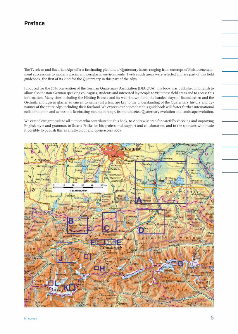
Preface
The Tyrolean and Bavarian Alps offer a fascinating plethora of Quaternary issues ranging from outcrops of Pleistocene sedi-ment successions to modern glacial and periglacial environments. Twelve such areas were selected and are part of this field guidebook, the first of its kind for the Quaternary in this part of the Alps. Produced for the 2014 convention of the German Quaternary Association (DEUQUA) this book was published in English to allow also the non-German speaking colleagues, students and interested lay people to visit these field areas and to access this information. Many sites including the Hötting Breccia and its well-known flora, the banded clays of Baumkirchen and the Gschnitz and Egesen glacier advances, to name just a few, are key to the understanding of the Quaternary history and dy-namics of the entire Alps including their foreland. We express our hopes that this guidebook will foster further international collaboration in and across this fascinating mountain range, its multifaceted Quaternary evolution and landscape evolution. We extend our gratitude to all authors who contributed to this book, to Andrew Moran for carefully checking and improving English style and grammar, to Sascha Fricke for his professional support and collaboration, and to the sponsors who made it possible to publish this as a full-colour and open-access book.

105Excursion H ¬ Innsbruck
H
Notes
106 Excursion I ¬ Innsbruck
I
Landscape archaeological results and discussion of Mesolithic research in the Fotsch valley (Tyrol)
Landschaftsarchäologische Ergebnisse und Diskussion der Mesolithikum- Forschung im Fotschertal (Tirol)
Clemens Geitner, Dieter Schäfer, Stefano Bertola, Sixten Bussemer, Kati Heinrich, Jaroslaw Waroszewski
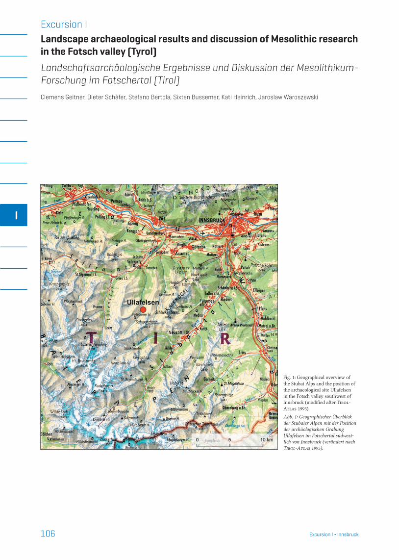
Fig. 1: Geographical overview of the Stubai Alps and the position of the archaeological site Ullafelsen in the Fotsch valley southwest of Innsbruck (modified after Tirol-Atlas 1995).
Abb. 1: Geographischer Überblick der Stubaier Alpen mit der Position der archäologischen Grabung Ullafelsen im Fotschertal südwest-lich von Innsbruck (verändert nach Tirol-Atlas 1995).
Excursion I

107Excursion I ¬ Innsbruck
I1 Study area and field trip sitesOur field trip takes us to the key location of Mesolithic re-search in Tyrol. The archaeological open-air site Ullafelsen is situated at 1860 m a.s.l. in the Fotsch valley of the northern Stubai Alps, around 20 km southwest of Innsbruck (Fig. 1). The catchment reaches from around 900 to 3000 m a.s.l. and
is geologically part of the Ötztal-Stubai crystalline complex, i.e. mainly built up of metamorphic rocks (para- and ortho-gneiss and amphibolite) (Nittel 2011). In terms of climate, the area lies in the transition zone between Northern and Central Alps, so that neither precipitation nor temperature present extreme values (Schlosser 2011). Due to former and recent geomorphological processes, such as glacial sediment accumulation, debris flows and rockfall, both the valley and the slopes are covered by unconsolidated sediments and bedrock is only exposed on steep slopes and on the highest summits.
The vertical sequence of the vegetation units in the Fotsch catchment is typical for the Central Alps with spruce (Picea abies) dominating in the montane and Arolla pine (Pinus cembra) in the subalpine belt. The timber line has been low-ered for centuries by human impact and nowadays reaches elevations of 1800 to 2000 m a.s.l. Nevertheless, the potential timber line reaches at least 2200 m a.s.l. The vegetation pat-tern above the timber line is composed of dwarf-shrub com-munities and alpine grasslands (Kemmer 2011).
Human activity and environmental impact are associa-ted with clearing the natural forests, cattle grazing and tourism, mainly in the form of mountain hiking. The Pots-damer Hütte, a mountain hut of the German Alpine Club, is located at the rear of the valley at about 2000 m a.s.l.
Our field trip will take us to three sites, the most signifi-cant being the Ullafelsen (1860 m a.s.l.). At the top of this site, we will see some typical profiles of the archaeological excavation, which we can compare to a typical podzol near-
Fig. 2: View from the inner Fotsch valley to the north to the Karwendel mountain range of the Northern Calcareous Alps: on the right, in the foreground, the Ullafelsen with its flat top stands out clearly as a roche moutonnée (the white tent is pitched near the archaeological excavation) (photograph: D. Schäfer, 2004).
Abb. 2: Blick vom inneren Fotschertal nach Norden bis zum Karwendelge-birge der Nördlichen Kalkalpen: Rechts im Vordergrund tritt der Ullafelsen mit seiner flachen Kuppe als Härtling deutlich hervor (das weiße Zelt steht nahe der archäologischen Grabung) (Foto: D. Schäfer, 2004).
Fig. 3: Detailed plan of the archaeo-logical excavation site and the pro-file positions 2 to 4 at the top of the Ullafelsen (illustration: D. Schäfer) (Geitner et al. 2011: 119).
Abb. 3: Detailplan der archäologi-schen Ausgrabung und der Lage der Profile 2 bis 4 auf dem Ullafelsen (Graphik: D. Schäfer) (Geitner et al. 2011: 119).

108 Excursion I ¬ Innsbruck
I
by. Additionally, we can visit the Kaseralmschrofen (1755 m a.s.l.), another archaeological site, to discuss aspects of the temporal development of settlement and their respective site elevations in the early Holocene. At the third site, near Potsdamer Hütte 2000 m a.s.l.) we will see the dimension of Lateglacial moraines of the Egesen Stadial and we can also discuss Holocene sediment profiles, which show some simi-larities to those of the Ullafelsen.
2 The archaeological site UllafelsenMotivated by the recovery of the ‘ice man’ at the Tisenjoch, South Tyrol (Italy) in 1991, the University of Innsbruck estab-lished a comparative Alpine archaeology. A few years later a systematic search for Mesolithic sites in the alpine and sub-alpine zone in the Tyrolean Alps began. For the Mesolithic people the tree-line ecotone provided a larger population of game for hunting and offered a diversified repertory for gathering. The alpine zone was also relevant for prospecting and extracting lithic raw materials.
In this context the Ullafelsen site (locally named “Rie-gelschrofen”) was found in 1994 and systematic excavation started in 1995. Since then a total of 12 excavation months (1994–2004) have been invested in this site and some 10 re-
searchers have attended the field campaigns. The main ex-cavation (25 m2) is situated on the top of Ullafelsen (Fig. 2 and 3), which can be described as a resistant rock area (roche moutonnée) at the lower eastern slope. Since 1999, strati-graphic and soil-scientific investigations were included to better understand how and when the manifold excavation profiles developed (Geitner 2010, Geitner & Schäfer 2010, Geitner et al. 2011).
Judging from geomorphological investigations, Ul-lafelsen probably became ice-free at the transition from the Older Dryas to Bølling (Kerschner 2011) and was initially covered with unconsolidated glacial and glaciofluvial de-posits of an average thickness of 0.5 m. In recent years grass, herbs and dwarf shrubs have grown on top of Ullafelsen, and young Arolla pines have sprung up on the surrounding slopes.
In order to better understand both the natural conditions for the prehistoric land use and the early impact of humans, we have included several aspects of geology, geomorpho-logy, meteorology, glacier history, and soil and vegetation sciences in these studies. A comprehensive overview of the interdisciplinary approach and the results was published by Schäfer (2011a).
Fig. 4: The position of the Ullafelsen (U) southwest of Innsbruck and evidence of the lithic raw material groups used at this site: Q (local quartz); BK (mountain crystal); SA (south alpine silex); NK (silex of the Northern Calcareous Alps); FA (silex of the Franconian Alb). (illustration: D. Schäfer).
Abb. 4: Die Position des Ullafelsens (U) südwestlich von Innsbruck und der Nachweis der Gesteinsrohmate-rialien, welche an diesem Fundplatz genutzt wurden: Q (lokaler Quarz); BK (Bergkristall); SA (südalpiner Silex); NK (Silex der Nördlichen Kalkalpen); FA (Silex der Fränki-schen Alb) (Graphik: D. Schäfer).

109Excursion I ¬ Innsbruck
I3 Archaeological highlightsIn total, 7931 artefacts were found in the main excavation area. Two thirds of them have a length of 1 to 6 mm. In addi-tion to yellow and red artefacts, many pieces are grey, black or brownish coloured, i.e. they are quite similar to the soil in which they were discovered. This aspect and the thorough documentation of all findings made the excavation very time-consuming.
Beside the artefacts, we identified and reconstructed at least 14 fireplaces within an excavated area of 25 m2. More than 20 14C-AMS analyses of charcoals allowed to date them to between the mid-Preboreal and the mid-Boreal (9200–7600 cal BC), with a maximum in the second half of the Preboreal. Charcoal wood analysis is in line with the site elevation in
this early period of the Holocene (Oeggl & Schoch 2011).A special highlight is the first successful correlation of
the following features with the Alpine Mesolithic, at least for open-air sites (Schäfer 1998, 2011b):
In some parts of the excavation site we observed a rela-tive stratigraphic sequence of specific artefact raw materials (e.g. the secondary use of fireplace 5 to deposit lithic waste from southern Franconian Alb chert (“Fränkischer Horn-stein”), from Bavaria, around 200 km northeast of Ullafelsen, see Fig. 4).
For the first time in the Alpine Mesolithic, organic tar remains were found on the surface of many of our stone artefacts. With the help of close stratigraphic documentation and soil sampling in the vicinity of fireplace 3, we found
Fig. 5: Section of the archaeologi-cal excavation Ullafelsen, square C9, east profile (cf. Fig. 3). Typical features of LL and typical position of charcoal bands at the top of it (photograph: D. Schäfer, 2003).
Abb. 5: Profil der archäologischen Ausgrabung auf dem Ullafelsen, Quadrat C9, Ostprofil (vgl. Abb. 3). Typische Eigenschaften des LL sowie der Position von Holzkohlebändchen direkt oberhalb der LL (Foto: D. Schäfer, 2003).
Fig. 6: Profile 3 shows the typical sequence of the sampled mineral soil horizons (H1–H6). The naming of the horizons varies considerably, depending on the interpretation of the profile, whether podzolization or sedimentation was the dominant process (cf. Ad-hoc Arbeitsgruppe Boden 2005) (photograph: C. Geit-ner, 2004)
Abb. 6: Profil 3 zeigt die typische Abfolge der beprobten Mineralbo-den-Horizonte (H1–H6). Je nach Interpretation des Profils – Pod-solierung oder Sedimentation als dominanter Prozess – weichen die Bezeichnungen der Horizonte deut-lich voneinander ab (vgl. Ad-hoc Arbeitsgruppe Boden 2005) (Foto: C. Geitner, 2004).

110 Excursion I ¬ Innsbruck
I
clear evidence for the systematic production of birch tar. The microwear analyses of stone artefacts confirm that many of the artefacts were shafted and fixed with it.
We have indications of intentional manipulation of the surface by the Mesolithic inhabitants (smoothing the living floor and covering parts of a fireplace).
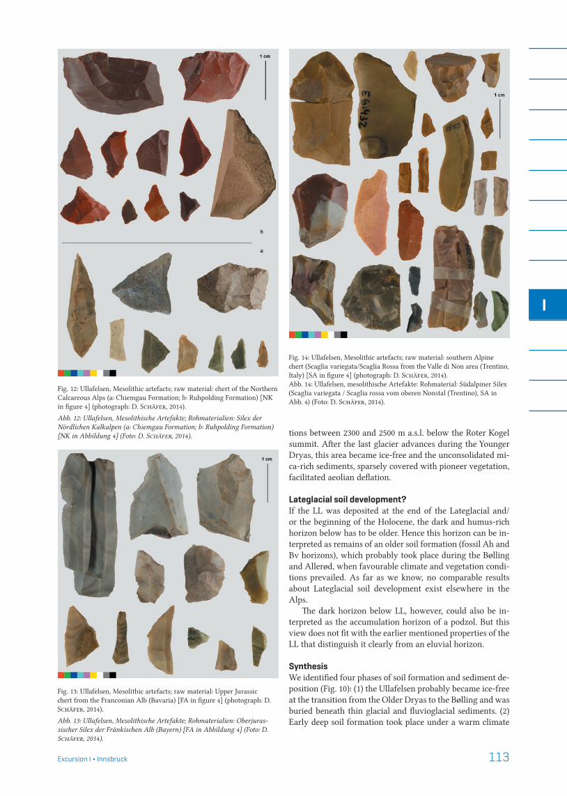
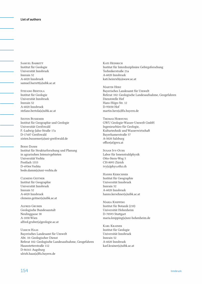
As the stone raw materials could be assigned to sources in northern Italy (Val di Non, Trentino), this inventory seems to be the oldest evidence of people crossing the Alps during the early Holocene (Fig. 4). Together with the chert material from the Franconian Alb, we can hypothesize that the Stubai Alps were in the overlap region of two cultural influences: the Italian Sauveterrian and the South German Beuronian (Figs. 12–16). Apart from the raw materials, there are also typological arguments for this interpretation.
All stone tools, plus several unretouched flakes were ana-lysed for use-wear traces (Pawlik 2011). Nearly half of them corroborate our own story, sometimes connected to a spe-cific maintenance history of repeated use/rejuvenation, etc. Bone or antler, wood, hide and leather could be identified as worked (contact) material. By mapping these results, several of these functions can be correlated with single fireplaces and other features. Combining use-wear traces with those of reshafting, retooling and the occurrence of birch tar helped to reconstruct some tool constructions and provided insights into aspects of that raw material economy.
With the extremely time-consuming method of refitting we could restore more than 20 % of any artefacts larger than 5–6 mm. Based on this we have evidence for several forms of blank production and tool rejuvenation. Mapping these results suggested some functional relationships between several areas of our excavation site. So we can demonstrate that some of the subareas were used by Mesolithic humans at the same time.
Figures 12–16 give an overview of typical raw material groups of the Ullafelsen excavation site.
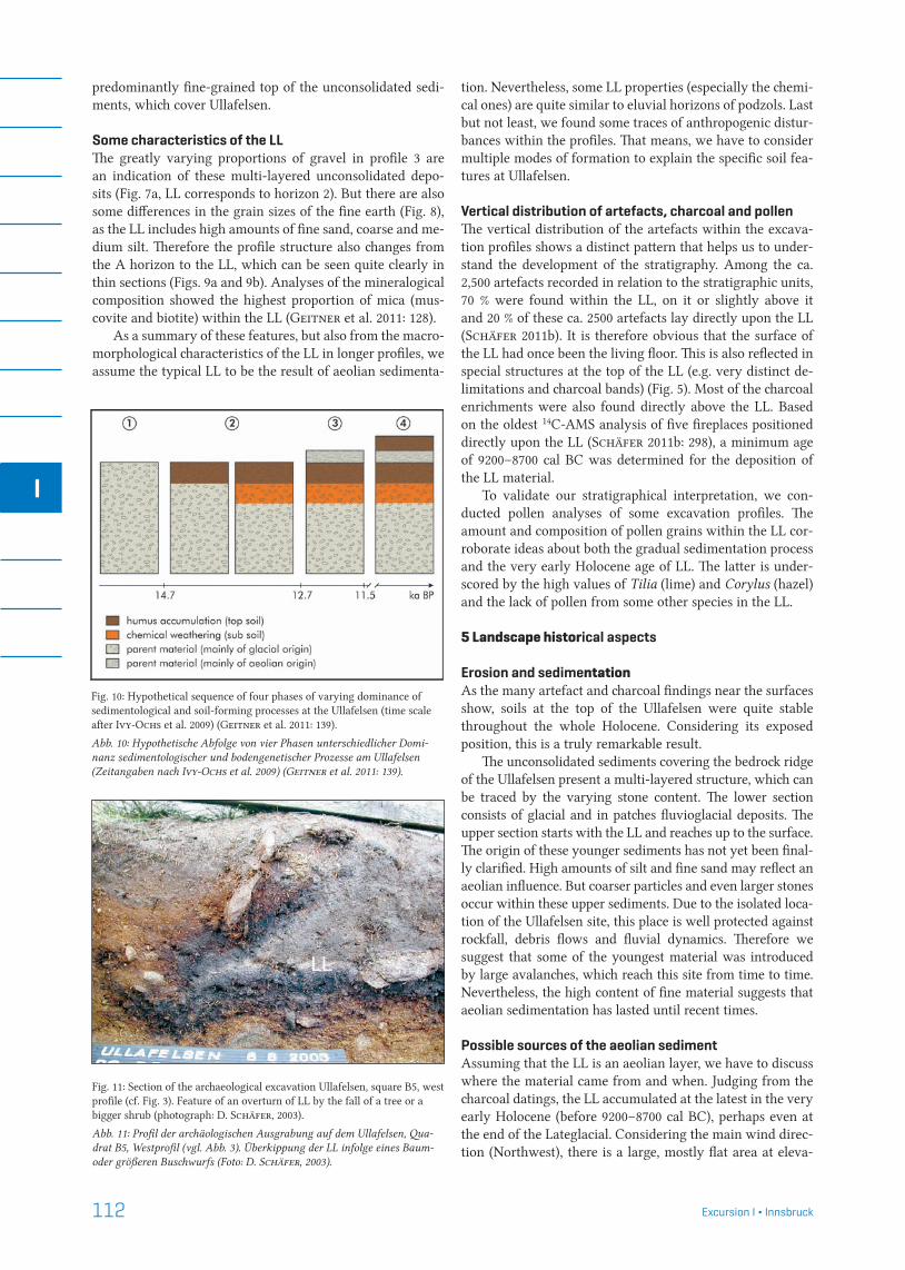
Fig. 7a+b: Amount of fine and medium-size gravel and loss on ignition of fine soil of profile 3 (differentiation of the horizons as in Fig. 6). The strongly varying proportions of gravel are an indication of a multi-layer unconsolidated deposit (Geitner et al. 2011: 127).
Abb. 7a+b: Anteile an Fein- und Mittelkies und Glühverluste der Feinerde des Profils 3 (Zuordnung der Horizonte vgl. Abb. 6). Die stark variierenden Kiesanteile weisen auf ein mehrschichtiges Lockersubstrat hin (Geitner et al. 2011: 127).
Fig. 8: Grain size distribution of the fine soil for profile 2a (data after Ikinger 2001; differentiation of the horizons as in Fig. 6). The LL (horizon 2) is con-spicuous by the high proportion of fine sand, coarse and medium silt (Geitner et al. 2011: 126).
Abb. 8: Korngrößenanteile der Feinerde des Profils 2a (Daten nach Ikinger 2001; Zuordnung der Horizonte vgl. Abb. 6). Die LL (Horizont 2) fällt durch hohe Anteile von Feinsand, Grob- und Mittelschluff auf (Geitner et al. 2011: 126).

111Excursion I ¬ Innsbruck
I
4 Stratigraphical structure of distinct horizons and the LL (= light layer) phenomenonStratigraphic and soil-related research were triggered by an unusual finding in several excavation profiles, i.e. a light-grey layer, referred to as LL (= light layer), which is an im-portant reference (marker) horizon. Figure 5 demonstrates
the typical stratigraphic structure of the excavation profiles at the Ullafelsen site. We can clearly recognize a sequence of four layers or soil horizons. This profile structure can also be found in the vicinity of the excavation site (Fig. 6). A light-grey layer (LL) commonly stands out in the central part of the profile sections. It constitutes the lower part of the
Fig. 9a+b+c: Thin section of profile 2a (cf. Fig. 3) with close-ups (differentia-tion of the horizons as in Fig. 6) (Geitner et al. 2011: 131).a) Section at a glance with the position of the close-ups 9b (1) and 9c (2) marked in red. In the top part of the picture, the recent topsoil with plant residue and dark humic particles are clearly recognizable. The lower third of the picture is brighter and more homogeneous and shows the LL.b) Detail of 9a: the boundary between the recent topsoil and the LL runs just above the middle of the picture, clearly recognizable by the difference in structure.c) Detail of 9a: a charcoal particle, with a clearly recognizable cell structure, from the recent topsoil just above the LL.
Abb. 9a+b+c: Dünnschliff des Profils 2a (vgl. Abb. 3) mit Detailaufnahmen (Zuordnung der Horizonte vgl. Abb. 6) (Geitner et al. 2011: 131)a) Dünnschliff im Überblick mit den rot markierten Ausschnitten der Detail-aufnahmen 9b (1) und 9c (2): Im oberen Bildbereich ist der rezente Oberbo-den mit Pflanzenresten und den dunkel gefärbten Humuspartikeln deutlich zu erkennen, das untere, hellere und homogenere Bilddrittel zeigt die LL.b) Detail von 9a: Die Grenze zwischen dem rezenten Boden und der LL verläuft knapp über der Mitte des Bildes und ist durch den Unterschied in der Struktur gut erkennbar.c) Detail von 9a: Holzkohlepartikel mit gut erkennbarer Zellstruktur vom rezenten Boden knapp oberhalb der LL.
112 Excursion I ¬ Innsbruck
I
predominantly fine-grained top of the unconsolidated sedi-ments, which cover Ullafelsen.
Some characteristics of the LL The greatly varying proportions of gravel in profile 3 are an indication of these multi-layered unconsolidated depo-sits (Fig. 7a, LL corresponds to horizon 2). But there are also some differences in the grain sizes of the fine earth (Fig. 8), as the LL includes high amounts of fine sand, coarse and me-dium silt. Therefore the profile structure also changes from the A horizon to the LL, which can be seen quite clearly in thin sections (Figs. 9a and 9b). Analyses of the mineralogical composition showed the highest proportion of mica (mus-covite and biotite) within the LL (Geitner et al. 2011: 128).
As a summary of these features, but also from the macro-morphological characteristics of the LL in longer profiles, we assume the typical LL to be the result of aeolian sedimenta-
tion. Nevertheless, some LL properties (especially the chemi-cal ones) are quite similar to eluvial horizons of podzols. Last but not least, we found some traces of anthropogenic distur-bances within the profiles. That means, we have to consider multiple modes of formation to explain the specific soil fea-tures at Ullafelsen.
Vertical distribution of artefacts, charcoal and pollenThe vertical distribution of the artefacts within the excava-tion profiles shows a distinct pattern that helps us to under-stand the development of the stratigraphy. Among the ca. 2,500 artefacts recorded in relation to the stratigraphic units, 70 % were found within the LL, on it or slightly above it and 20 % of these ca. 2500 artefacts lay directly upon the LL (Schäfer 2011b). It is therefore obvious that the surface of the LL had once been the living floor. This is also reflected in special structures at the top of the LL (e.g. very distinct de-limitations and charcoal bands) (Fig. 5). Most of the charcoal enrichments were also found directly above the LL. Based on the oldest 14C-AMS analysis of five fireplaces positioned directly upon the LL (Schäfer 2011b: 298), a minimum age of 9200–8700 cal BC was determined for the deposition of the LL material.
To validate our stratigraphical interpretation, we con-ducted pollen analyses of some excavation profiles. The amount and composition of pollen grains within the LL cor-roborate ideas about both the gradual sedimentation process and the very early Holocene age of LL. The latter is under-scored by the high values of Tilia (lime) and Corylus (hazel) and the lack of pollen from some other species in the LL.
5 Landscape historical aspects
Erosion and sedimentationAs the many artefact and charcoal findings near the surfaces show, soils at the top of the Ullafelsen were quite stable throughout the whole Holocene. Considering its exposed position, this is a truly remarkable result.
The unconsolidated sediments covering the bedrock ridge of the Ullafelsen present a multi-layered structure, which can be traced by the varying stone content. The lower section consists of glacial and in patches fluvioglacial deposits. The upper section starts with the LL and reaches up to the surface. The origin of these younger sediments has not yet been final-ly clarified. High amounts of silt and fine sand may reflect an aeolian influence. But coarser particles and even larger stones occur within these upper sediments. Due to the isolated loca-tion of the Ullafelsen site, this place is well protected against rockfall, debris flows and fluvial dynamics. Therefore we suggest that some of the youngest material was introduced by large avalanches, which reach this site from time to time. Nevertheless, the high content of fine material suggests that aeolian sedimentation has lasted until recent times.
Possible sources of the aeolian sedimentAssuming that the LL is an aeolian layer, we have to discuss where the material came from and when. Judging from the charcoal datings, the LL accumulated at the latest in the very early Holocene (before 9200–8700 cal BC), perhaps even at the end of the Lateglacial. Considering the main wind direc-tion (Northwest), there is a large, mostly flat area at eleva-
Fig. 10: Hypothetical sequence of four phases of varying dominance of sedimentological and soil-forming processes at the Ullafelsen (time scale after Ivy-Ochs et al. 2009) (Geitner et al. 2011: 139).
Abb. 10: Hypothetische Abfolge von vier Phasen unterschiedlicher Domi-nanz sedimentologischer und bodengenetischer Prozesse am Ullafelsen (Zeitangaben nach Ivy-Ochs et al. 2009) (Geitner et al. 2011: 139).
Fig. 11: Section of the archaeological excavation Ullafelsen, square B5, west profile (cf. Fig. 3). Feature of an overturn of LL by the fall of a tree or a bigger shrub (photograph: D. Schäfer, 2003).
Abb. 11: Profil der archäologischen Ausgrabung auf dem Ullafelsen, Qua-drat B5, Westprofil (vgl. Abb. 3). Überkippung der LL infolge eines Baum- oder größeren Buschwurfs (Foto: D. Schäfer, 2003).
113Excursion I ¬ Innsbruck
I
Fig. 12: Ullafelsen, Mesolithic artefacts; raw material: chert of the Northern Calcareous Alps (a: Chiemgau Formation; b: Ruhpolding Formation) [NK in figure 4] (photograph: D. Schäfer, 2014).
Abb. 12: Ullafelsen, Mesolithische Artefakte; Rohmaterialien: Silex der Nördlichen Kalkalpen (a: Chiemgau Formation; b: Ruhpolding Formation) [NK in Abbildung 4] (Foto: D. Schäfer, 2014).
Fig. 13: Ullafelsen, Mesolithic artefacts; raw material: Upper Jurassic chert from the Franconian Alb (Bavaria) [FA in figure 4] (photograph: D. Schäfer, 2014).
Abb. 13: Ullafelsen, Mesolithische Artefakte; Rohmaterialien: Oberjuras-sischer Silex der Fränkischen Alb (Bayern) [FA in Abbildung 4] (Foto: D. Schäfer, 2014).
Fig. 14: Ullafelsen, Mesolithic artefacts; raw material: southern Alpine chert (Scaglia variegata/Scaglia Rossa from the Valle di Non area (Trentino, Italy) [SA in figure 4] (photograph: D. Schäfer, 2014).Abb. 14: Ullafelsen, mesolithische Artefakte: Rohmaterial: Südalpiner Silex (Scaglia variegata / Scaglia rossa vom oberen Nonstal (Trentino), SA in Abb. 4) (Foto: D. Schäfer, 2014).
tions between 2300 and 2500 m a.s.l. below the Roter Kogel summit. After the last glacier advances during the Younger Dryas, this area became ice-free and the unconsolidated mi-ca-rich sediments, sparsely covered with pioneer vegetation, facilitated aeolian deflation.
Lateglacial soil development?If the LL was deposited at the end of the Lateglacial and/or the beginning of the Holocene, the dark and humus-rich horizon below has to be older. Hence this horizon can be in-terpreted as remains of an older soil formation (fossil Ah and Bv horizons), which probably took place during the Bølling and Allerød, when favourable climate and vegetation condi-tions prevailed. As far as we know, no comparable results about Lateglacial soil development exist elsewhere in the Alps.
The dark horizon below LL, however, could also be in-terpreted as the accumulation horizon of a podzol. But this view does not fit with the earlier mentioned properties of the LL that distinguish it clearly from an eluvial horizon.
SynthesisWe identified four phases of soil formation and sediment de-position (Fig. 10): (1) the Ullafelsen probably became ice-free at the transition from the Older Dryas to the Bølling and was buried beneath thin glacial and fluvioglacial sediments. (2) Early deep soil formation took place under a warm climate

114 Excursion I ¬ Innsbruck
I
during the Bølling and Allerød. (3) The aeolian deposition of sediments rich in mica most probably occurred from the middle to the end of the Younger Dryas, when large defla-tion areas below the Roter Kogel became ice-free but had not yet been consolidated by vegetation. (4) The youngest cover of the LL indicates that aeolian deposition continued during the Holocene period, albeit at a significantly lower rate.
This hypothesis adds new aspects to the debate about landscape development. Some details of this hypothetical se-quence of processes have not been completely resolved yet and investigations on the phenomenon of the LL are con-tinuing. Nevertheless, the importance of aeolian deposits at high elevations in the Alps is also highlighted by other studies (Küfmann 2008a, 2008b). Thus equivalents of the LL might well be present in other parts of the Alps and used as a marker horizon for the boundary between the Lateglacial and the Holocene.
6 OutlookSome questions related to the LL, and the landscape his-tory associated therewith, are still under discussion. One such aspect is the vegetation history of the Ullafelsen itself, especially the presence or absence of shrubs and trees, since it is surprising that this different layering, including very thin layers, were not disturbed. In fact, it can be assumed that at the latest by the end of the presence of Mesolithic people, a quite dense stand of trees should have been established. But if trees existed there for millennia the manifold stratigraphy would have undoubtedly been destroyed. Is it possible that a site at an elevation of 1860 m a.s.l. had no trees during the entire Holocene? This could only be explained by very spe-cial microclimatic conditions. Because of the exposed posi-tion of the Ullafelsen, snow cover during the winter is quite thin as snow is typically blown away by the wind. Hence only the lower plants are protected against the very low
Fig. 15: Ullafelsen, Mesolithic artefacts of rough local quartz varieties [Q in figure 4] (photograph: D. Schäfer, 2014).
Abb. 15: Ullafelsen, Mesolithische Arte-fakte grober lokaler Quarzvarietäten [Q in Abbildung 4] (Foto: D. Schäfer, 2014).
Fig 16: Ullafelsen, Mesolithic artefacts; raw material: mountain crystal [BK in figure 4] (photograph: D. Schäfer, 2014).
Abb. 16: Ullafelsen, Mesolithische Arte-fakte; Rohmaterialien: Bergkristall [BK in Abbildung 4] (Foto: D. Schä-fer, 2014).

115Excursion I ¬ Innsbruck
I
winter temperatures. These special microclimatic conditions may have prevented the establishment of trees for millennia. Only in one case did we find a clear disturbance of the LL, which should be connected with the fall of a tree or a larger shrub (Fig. 11). So we can conclude that the structure of the LL also indicates a site-specific vegetation history.
Another point worth further discussion is the effect of anthropogenic disturbances. We could ascertain the LL as a former living floor. The trampling of Mesolithic people likely changed the LL material significantly in terms of density and created an artificial surface. For such a more or less open sur-face we also expect some local erosion-transport-accumula-tion processes, which may have affected the grain size dis-tribution of the LL, especially in its upper part. Some of the mentioned differences between LL and eluvial horizons may be explained by these anthropogenic disturbances, thus pod-zolization influences on the LL cannot be totally excluded.
The horizon above the LL seems to be quite weakly developed. This is probably due to continuous sedimenta-tion but perhaps also to the weak growth of the vegetation. Compared with the lower profile sections, Lateglacial soil development within the glacial deposits was quite strong, which remains to be understood.
7 ReferencesAd-hoc-Arbeitsgruppe Boden (2005): Bodenkundliche
Kartieranleitung. – 5. Auflage; Bundesanstalt für Ge-owissenschaften und Rohstoffe in Zusammenarbeit mit den Staatlichen Geologischen Diensten (Hanno-ver), 438 pp.; Stuttgart.
Bertola, S. (2011): The flints of Southern Alps (Non Valley, Italy) provenance found in the Mesolithic site of Ul-lafelsen (Sellrain, Tyrol). – In: Schäfer, D. (ed.): Das Mesolithikum-Projekt Ullafelsen (Teil 1). Mensch und Umwelt im Holozän Tirols 1, 463–505; Innsbruck.
Geitner, C. (2010): Soils as archives of natural and cul-tural history; examples from the Eastern Alps. – In: Borsdorf, A., Grabherr, G., Heinrich, K., Scott, B. & Stötter, J. (eds.): Challenges for mountain re-gions – tackling complexity, 68–75; Innsbruck, Wien (Böhlau).
Geitner, C. & Schäfer, D. (2010): Interdisziplinäre Zusam-menarbeit an der Schnittstelle von Archäologie und Bodenkunde im Gebirge – Grundsätzliche Überle-gungen und Beispiele des Mesolithfundplatzes Ul-lafelsen (Tirol). – In: Mandl, F. & Stadler, H. (eds.): Archäologie in den Alpen – Alltag und Kult. For-
schungsberichte der ANISA 3, 25–42; Haus i. E.Geitner, C., Bussemer, S., Ehrmann, O., Ikinger, A., Schä-
fer, D., Traidl, R. & Tscherko, D. (2011): Boden-kundlich-stratigraphische Befunde am Ullafelsen im hinteren Fotschertal sowie ihre landschaftsgeschicht-liche Interpretation. – In: Schäfer, D. (ed.): Das Me-solithikum-Projekt Ullafelsen (Teil 1). Mensch und Umwelt im Holozän Tirols 1, 109–151; Innsbruck.
Ivy-Ochs, S., Kerschner, H., Maisch, M., Christl, M., Kubik, P.W. & Schlüchter, C. (2009): Latest Pleisto-cene and Holocene glacier variations in the European Alps. – Quaternary Science Reviews 28, 2137–2149.
Kemmer, I. (2011): Die rezente Vegetation im inneren Fot-schertal / Nördliche Stubaier Alpen. – In: Schäfer,
D. (ed.): Das Mesolithikum-Projekt Ullafelsen (Teil 1). Mensch und Umwelt im Holozän Tirols 1, 155–193; Innsbruck.
Kerschner, H. (2011): Spätglaziale Gletschervorstöße im Fotschertal. – In: Schäfer, D. (ed.): Das Mesolithi-kum-Projekt Ullafelsen (Teil 1). Mensch und Umwelt im Holozän Tirols 1, 97–105; Innsbruck.
Küfmann, C. (2008a): Are cambisols in alpine karst auto-chtonous or eolian in origin? – Arctic, Antartic, and Alpine Research 40(3), 506–518.
Küfmann, C. (2008b): Flugstaubeintrag und Bodenbildung im Karst der Nördlichen Kalkalpen. – Forschungs-berichte Nationalpark Berchtesgaden 54: 1–159.
Nittel, P. (2011): Geologie, Hydrogeologie und Geomor-phologie des Fotschertales – Kartierungsergebnisse Projekt „Sellrain“ 2006. – In: Schäfer, D. (ed.): Das Mesolithikum-Projekt Ullafelsen (Teil 1). Mensch und Umwelt im Holozän Tirols 1, 61–92; Innsbruck.
Oeggl, K. & Schoch, W. (2011): Holzkohlenanalysen aus Bodenproben des altmesolithischen Fundplatzes auf dem Ullafelsen im Fotschertal. – In: Schäfer, D. (ed.): Das Mesolithikum-Projekt Ullafelsen (Teil 1). Mensch und Umwelt im Holozän Tirols 1, 197–201; Innsbruck.
Pawlik, A.F. (2011): Die funktionale Analyse der Steingeräte und die Rekonstruktion der Aktivitätsbereiche am Ul-lafelsen. – In: Schäfer, D. (ed.): Das Mesolithikum-Projekt Ullafelsen (Teil 1). Mensch und Umwelt im Holozän Tirols 1, 355–459; Innsbruck.
Schäfer, D. (1998): Zum Untersuchungsstand auf dem altme-solithischen Fundplatz vom Ullafelsen im Fotschertal (Stubaier Alpen, Tirol). – Germania 7: 439–496.
Schäfer, D. (2011a): Das Mesolithikum-Projekt Ullafelsen (Teil 1). Mensch und Umwelt im Holozän Tirols 1, 560 pp.; Innsbruck.
Schäfer, D. (2011b): Das Mesolithikum-Projekt Ullafelsen – Landschaftlicher Rahmen und archäologische Be-funde. Arbeitsstand 2009/2010. – In: Schäfer, D. (ed.): Das Mesolithikum-Projekt Ullafelsen (Teil 1). Mensch und Umwelt im Holozän Tirols 1, 245–351; Innsbruck.
Schlosser, E. (2011): Das Fotschertal – regionale Klima-tologie und gebirgsmeteorologische Aspekte. – In: Schäfer, D. (ed.): Das Mesolithikum-Projekt Ul-lafelsen (Teil 1). Mensch und Umwelt im Holozän Ti-rols 1, 11–16; Innsbruck.
154 Innsbruck
List of authors
Samuel BarrettInstitut für GeologieUniversität InnsbruckInnrain 52A-6020 Innsbrucksamuel.barrett(a)uibk.ac.at
Stefano BertolaInstitut für GeologieUniversität InnsbruckInnrain 52A-6020 Innsbruckstefano.bertola(a)uibk.ac.at
Sixten Bussemer Institut für Geographie und GeologieUniversität GreifswaldF.-Ludwig-Jahn-Straße 17aD-17487 Greifswaldsixten.bussemer(a)uni-greifswald.de
Bodo DammInstitut für Strukturforschung und Planung in agrarischen IntensivgebietenUniversität VechtaPostfach 1553D-49364 Vechtabodo.damm(a)uni-vechta.de
Clemens GeitnerInstitut für GeographieUniversität InnsbruckInnrain 52A-6020 Innsbruckclemens.geitner(a)uibk.ac.at
Alfred GruberGeologische BundesanstaltNeulinggasse 38A-1030 Wienalfred.gruber(a)geologie.ac.at
Ulrich HaasBayerisches Landesamt für UmweltAbt. 10: Geologischer DienstReferat 102: Geologische Landesaufnahme, GeogefahrenHaunstetterstraße 112D-86161 Augsburgulrich.haas(a)lfu.bayern.de
Kati HeinrichInstitut für Interdisziplinäre GebirgsforschungTechnikerstraße 21aA-6020 Innsbruckkati.heinrich(a)oeaw.ac.at
Martin HerzBayerisches Landesamt für UmweltReferat 102: Geologische Landesaufnahme, GeogefahrenDienststelle HofHans-Högn-Str. 12D-95030 Hofmartin.herz(a)lfu.bayern.de
Thomas HornungGWU Geologie-Wasser-Umwelt GmbHIngenieurbüro für Geologie,Kulturtechnik und WasserwirtschaftBayerhamerstraße 57A-5020 Salzburgoffice(at)gwu.at
Susan Ivy-OchsLabor für IonenstrahlphysikOtto-Stern-Weg 5CH-8093 Zürichivy(a)phys.ethz.ch
Hanns KerschnerInstitut für GeographieUniversität InnsbruckInnrain 52A-6020 Innsbruckhanns.kerschner(a)uibk.ac.at
Maria KnippingInstitut für Botanik (210)Universität HohenheimD-70593 Stuttgartmaria.knipping(a)uni-hohenheim.de
Karl KrainerInstitut für GeologieUniversität InnsbruckInnrain 52A-6020 Innsbruckkarl.krainer(a)uibk.ac.at
155Innsbruck
Ernst KroemerBayerisches Landesamt für UmweltReferat 102: Geologische Landesaufnahme, GeogefahrenDienststelle HofHans-Högn-Str. 12D-95030 Hofernst.kroemer(a)lfu.bayern.de
David MairInstitut für GeologieUniversität InnsbruckInnrain 52A-6020 Innsbruckdavid.mair(a)uibk.ac.at
Kurt NicolussiInstitut für GeographieUniversität InnsbruckInnrain 52A-6020 Innsbruckkurt.nicolussi(a)uibk.ac.at
Marc OstermannInstitut für GeologieUniversität InnsbruckInnrain 52A-6020 Innsbruckmarc.ostermann(a)uibk.ac.at
Franz OttnerInstitut für Angewandte GeologieDepartment für Bautechnik und NaturgefahrenUniversität für Bodenkultur WienPeter Jordan Straße 70A-1190 Wienfranz.ottner(a)boku.ac.at
Gernot PatzeltPatscherstraße 20A-6080 Innsbruck-Iglsgernot.patzelt(a)uibk.ac.at
Christoph PrageralpS gmbHGrabenweg 68A-6020 Innsbruckprager(a)alps-gmbh.comILF Beratende IngenieureA-6063 Rum bei Innsbruckchristoph.prager(a)ilf.com
Jürgen ReitnerGeologische BundesanstaltNeulinggasse 38A-1030 Wienjuergen.reitner(a)geologie.ac.at
Diethard SandersInstitut für GeologieUniversität InnsbruckInnrain 52A-6020 Innsbruckdiethard.g.sanders(a)uibk.ac.at
Dieter SchäferInstitut für GeologieUniversität InnsbruckInnrain 52A-6020 Innsbruckdieter.schaefer(a)uibk.ac.at
Christoph SpötlInstitut für GeologieUniversität InnsbruckInnrain 52A-6020 Innsbruckchristoph.spoetl(a)uibk.ac.at
Reinhard StarnbergerInstitut für GeologieUniversität InnsbruckInnrain 52A-6020 Innsbruckreinhard.starnberger(a)uibk.ac.at
Birgit TerhorstInstitut für GeographieUniversität WürzburgAm HublandD-97074 Würzburgbirgit.terhorst(a)uni-wuerzburg.de
Jarosław WaroszewskiInstitute of Soil Science and Environmental ProtectionWrocław University of Environmental and Life Sciencesul. Grunwaldzka 53PL-50-357 Wrocławjaroslaw.waroszewski(a)up.wroc.pl

GEOZON Geozon Science Media
Pettenkoferstr. 16–18
D-10247 Berlin
Germany
F O R S C H U N G U N D M O N I T O R I N G • B A N D 3
Zur jungquartären Landschaftsentwicklung der Mecklenburgischen Kleinseenplatte
F O R S C H U N G U N D M O N I T O R I N G • B A N D 2
Zur Landschafts- und Gewässergeschichte der Müritz
Tel. 030-20 23 83 19-0
Fax 030-20 23 83 19-9
E-Mail: [email protected]
Online: www.geozon.net
Zur Landschafts- und Gewässer-geschichte der Müritz
ISBN 978-3-941971-00-4
94 pp., A4, 29,– Euro
Zur jungquartären Landschaftsent-wicklung der Mecklenburgischen Kleinseenplatte
ISBN 978-3-941971-09-7
78 pp., A4, 22,– Euro
Neubrandenburger Geologische Beiträge 11
ISSN 1616-959X
88 pp., 17 x 24 cm, 8,50 Euro
GEOZON
NeubrandenburgerGeologische Beiträge
Band 11
2 0 1 1
Herausgegeben vomGeowissenschaftlichen Verein
Neubrandenburg e.V.
DEUQUA EXKURSIONSFÜHRER
DEUQUA Exkursionen
Eiszeitlandschaften in Mecklenburg-Vorpommern Herausgegeben von Reinhard Lampe und Sebastian Lorenz
GEOZON
Eiszeitlandschaften in Mecklenburg-Vorpommern
ISBN 978-3-941971-05-9
164 pp., A4, 34,– Euro
From the northern ice shield to the Alpine glaciations – A Quaternary field trip through Germany
ISBN 978-3-941971-06-6
88 pp., A4, 29,– Euro
From the northern ice shield to the Alpine glaciationsA Quaternary field trip through Germany
Edited by Daniela Sauer
GEOZON
DEUQUA excursions
From Paleozoic to Quaternary – A field trip from the Franconian Alb to Bohemia
ISBN 978-3-941971-08-0
120 pp., A4, 34,– Euro
DOI 10.3285/g.00009ISBN 978-3-941971-08-0 www.geozon.net
Excursion guide of the field trips of the DEUQUA Congress in Bayreuth, Germany, September 2012.
Page 6
Page 25
Page 43
Page 55
Page 59
Page 92
Page 117
Landscape development in the Trebgast Valley north of Bayreuth and its surroundings (Upper Franconia) – ongoing researchLandschaftsentwicklung im Trebgasttal nördlich Bayreuth und Umgebung – laufende For-schungenLudwig ZöLLer, uLrich hambach, Thomas KoLb, oLivier moine, PeTer Kühn
River history of the Upper Main River area from Tertiary to HoloceneFlussgeschichte des Obermain-Gebietes vom Tertiär bis zum HolozänwoLfgang schirmer, wiTh conTribuTions of michaeL friedrich, maria KniPPing, bernd Kromer and uwe abramowsKi
Archäologie im Altmühltal Archaeology of the Altmühl ValleyThorsTen uThmeier, chrisTian Züchner, Thomas raThgeber, Ludwig reisch, Leif sTeguweiT, michaeL m. rind
Geologische Highlights OberfrankensGeological Highlights of Upper FranconiaJohann rohrmüLLer, georg LoTh
Mit der „Eiszeit“ ins Quartär und den „Dinos“ zu den Anfängen Europas – Der Bayerisch-Böhmische Geopark und eine Einführung in die Geologie und Landschaftsgeschichte des westlichen Eger-RiftsWith the “Ice Age” to the Quaternary and the “Dinosaurs” to the beginning of Europe - The Czech-Bavarian Geopark and an introduction to the geology and landscape evolution of the western Eger Riftandreas PeTereK, miT einem beiTrag von franK hoLZförsTer
Western part of the Bohemian Massif and Central Bohemia: Landscape evolution, neotectonics, volcanism and paleoclimateWestteil der Böhmischen Masse und Zentralböhmen: Landschaftsentwicklung, Neotektonik, Vulkanismus und Paläoklimaandreas PeTereK, raLf schunK, cLaus-dieTer reuTher, vacLav cíLeK, Jan hošeK, LenKa Lisá, sascha mesZner & iLJa KnésL
List of authors
From Paleozoic to Quaternary A field trip from the Franconian Alb to Bohemia
Edited by Ludwig Zöller and Andreas Peterek
GEOZON
DEUQUA excursions
From Paleozoic to Quaternary
Edited by Ludwig Zöller and Andreas Peterek
OPEN ACCESS eBOOKS
LANDSCHAFTSGESCHICHTE
From the foreland to the Central Alps – Field trips to selected sites of Quaternary research in the Tyrolean and Bavarian Alps
ISBN 978-3-941971-10-3
160 pp., A4, 34,– Euro
From the foreland to the Central AlpsField trips to selected sites of Quaternary research in the Tyrolean and Bavarian Alps
Edited by Hanns Kerschner, Karl Krainer and Christoph Spötl
GEOZON
DEUQUA exCursions
Neubrandenburger Geologische Beiträge 12
ISSN 1616-959X
72 pp., 17 x 24 cm, 8,50 Euro
GEOZON
NeubrandenburgerGeologische Beiträge
Band 12
2 0 1 3
Herausgegeben vomGeowissenschaftlichen Verein
Neubrandenburg e.V.
Gerne unterstützen wir auch Sie bei Ihrer wissenschaftlichen Veröffentlichung. Wir publizieren print und digital:
• Bücher (Monographien, Reihen, Tagungsbände, Festschriften, Dissertationen etc.)• Zeitschriften (Disziplinäre oder institutionelle Journals, Neugründung, Archivierung etc.)• Dokumente (Artikel, Diskussionspapiere, Berichte, Protokolle, Karten, Daten etc.)
GEOZON Geozon Science Media
Pettenkoferstr. 16–18
D-10247 Berlin
Germany
Vol. 61 No 1
2012
issn 0424-7116 | DOi 10.3285/eg.61.1
Edited by the German Quaternary AssociationEditor-in-Chief: Holger Freund
Eiszeitalter und GegenwartQuaternary Science Journal
GEOZON
E&G
LEHnmüHLE rEsErvOir, EastErn ErzgEbirgE (germany)
nOrtHErn CaLCarEOus aLps (austria)
sCHwaLbEnbErg ii (germany)
LOwEr rHinE EmbaymEnt (germany)
spiEgELbErg, KantOn sCHwyz (switzerland)
JungmOränEngEbiEt süD-HOLstEin (germany)
pErmaFrOst sibEria (russia)
Vol. 60 No 4
2011
issn 0424-7116 | DOi 10.3285/eg.60.4
Edited by the German Quaternary AssociationEditor-in-Chief: Holger Freund
Eiszeitalter und GegenwartQuaternary Science Journal
GEOZON
E&G
QuatErnary lanDsCapE EvOlutiOn in tHE pEribaltiC rEgiOn
prOCEEDings OF tHE jOint DEuQua anD inQua pEribaltiC WOrking grOup mEEting 2010 in grEiFsWalD
GuEst Editors reinhard lampe and sebastian lorenz
Tel. 030-20 23 83 19-0
Fax 030-20 23 83 19-9
E-Mail: [email protected]
Online: www.geozon.net
Vol. 60 No 4: Quaternary landscape evolution in the Peribaltic region
104 pp., A4, 27,– Euro
Vol. 61 No 1
100 pp., A4, 27,– Euro
Vol. 60 No 2–3: Glaciations and pe-riglacial features in Central Europe
188 pp., 17 x 24 cm, 54,00 Euro
Vol. 60 No 2–3
2011
issn 0424-7116 | DOi 10.3285/eg.60.2-3
Edited by the German Quaternary AssociationEditor-in-Chief: Holger Freund
Eiszeitalter und GegenwartQuaternary Science Journal
GEOZON
E&G
GlaCiatiOns anD pEriGlaCial FEaturEs in CEntral EurOpE
spECial issuE FOr tHE XViii inQua COnGrEss in BErn, sWitZErlanD
GuEst Editors
Margot Böse (DEuQua – German Quaternary association)
Markus Fiebig (aGaQ – Working Group on the Quaternary of the alpine Foreland)
Vienna
Bern
5° 10° 15°
45°
Bavaria
Baden-Württembg.
France
Italy
Slovenia
Last Glacier Maximum
Austria
Switzerland
E&G – QuATErnAry SciEncE jOurnAl
Vol. 61 No 2
2012
issn 0424-7116 | DOi 10.3285/eg.61.2
Edited by the German Quaternary AssociationEditor-in-Chief: Holger Freund
Eiszeitalter und GegenwartQuaternary Science Journal
GEOZON
E&G
rivErs, lakEs anD pEatlanDs (nE Germany)
YOunGEr MiDDlE tErraCE, HöxtEr/wEsEr (Germany)
lavraDO rEGiOn, rOraiMa (Brazil)
tErna rivEr Basin (india)
kEMEl HEatH, sOutHErn rHEnisH MassiF (Germany)
Vol. 61 No 2
92 pp., A4, 27,– Euro
Vol. 62 No 1: Middle to Upper Pleistocene paleosols in Austria
80 pp., A4, 27,– Euro
Vol. 62No 1
2013
issn 0424-7116 | DOi 10.3285/eg.62.1
Edited by the German Quaternary AssociationEditor-in-Chief: Holger Freund
Eiszeitalter und GegenwartQuaternary Science Journal
GEOZON
E&G
MiDDlE tO UppEr plEistOCEnE palEOsOls in aUstria
GuEst Editor Birgit terhorst
Vol. 62 No 2: Environment – Man – Geohazards in the Quaternary
100 pp., A4, 27,– Euro
Vol. 62 No 2
2013
issn 0424-7116 | DOi 10.3285/eg.62.2
Edited by the German Quaternary AssociationEditor-in-Chief: Holger Freund
Eiszeitalter und GegenwartQuaternary Science Journal
GEOZON
E&G
EnViROnMEnT – MAn – GEOHAZARDs in THE QUATERnARY
GuEst Editors Ludwig Zöller, Holger Freund
CAll for PAPErs
Vol. 63 No 1
104 pp., A4, 27,– Euro
Vol. 63 No 1
2014
issn 0424-7116 | DOi 10.3285/eg.63.1
Edited by the German Quaternary AssociationEditor-in-Chief: Holger Freund
Eiszeitalter und GegenwartQuaternary Science Journal
GEOZON
E&G
sCHlEswig-HOlstEin anD aDjOining arEas (germany)
rHinE glaCiEr anD nOrtHErn switzErlanD (germany/switzerland)
rattlEsnakE MOuntain, wasHingtOn (usa)
kOtyCHi lagOOn, nOrtHErn Elis, PElOPOnnEsE (greece)
wiEsEnt rivEr vallEy OF uPPEr FranCOnia, Bavaria (germany)
Vol. 60 No 1: loess in Europe
208 pp., 17 x 24 cm, 27,00 Euro
Vol. 60 No 1
2011
issn 0424-7116 | DOi 10.3285/eg.60.1
Edited by the German Quaternary AssociationEditor-in-Chief: Holger Freund
Eiszeitalter und GegenwartQuaternary Science Journal
GEOZON
E&G
LOEss in EurOpE GuEst Editor Manfred Frechen
Seit 1951 bietet „Eiszeitalter und Gegenwart“ (heute: E&G – Quaternary Science journal) ein Publikations-forum für die Quartärsforschung. Es erscheinen aus-schließlich begutachtete Original-Artikel und Tagungs-beiträge.Das journal erscheint 2x jährlich als gedruckte und digitale Ausgabe. im rahmen des wissenschaftlichen Open Access stehen alle nummern kostenlos zur An-sicht und zum Download im internet bereit.Für die Einreichung von Artikeln nutzen Sie bitte unser Online-Submission-System unter:
www.quaternary-science.net
Vol. 59 No 1–2
2010
issn 0424-7116 | DOi 10.3285/eg.59.1-2
Edited by the German Quaternary AssociationEditor-in-Chief: Holger Freund
Eiszeitalter und GegenwartQuaternary Science Journal
GEOZON
E&G
BaltiC sEa COast (nE GErmany)
quEBraDa DE purmamarCa (nw arGEntina)
GötzEnHain (HEssE, GErmany)
rODDErBErG CratEr (miDDlE rHinE, GErmany)
GarzwEilEr OpEn-Cast minE (lOwEr rHinE, GErmany)
wEttErstEinGEBirGE (alps, GErmany)
møn (DEnmark)
nOrtHErn rEGiOns (switzErlanD)
GEisEltal (saxOny-anHalt, GErmany)
CHANGING ENVIRONMENTS –YESTERDAY, TODAY, TOMORROWProceedings oF THe deUQUA 2008 in ViennA
GuEST EDITORS Markus Fiebig, christine neugebauer-Maresch, Martina Pacher, Jürgen reitner and Verena Winiwarter
Vol. 58 No 2
2009
issn 0424-7116 | doi 10.3285/eg.58.2
Edited by the German Quaternary Associationeditor-in-chief: Holger Freund
Eiszeitalter und GegenwartQuaternary Science Journal
GEOZON
E&G
Vol. 58 No 2: Changing Environments – Yesterday, today, tomorrow
60 pp., A4, 27,– Euro
Vol. 59 No 1–2
176 pp., A4, 54,– Euro

158 Innsbruck158
E D I T O RDEUQUADeutsche Quartärvereinigung e.V.OfficeStilleweg 2D-30655 HannoverGERMANYTel: +49(0)511-643-36 [email protected]
M A N A G I N G E D I T O R SHanns Kerschner, Karl Krainer,Christoph Spötl
P U B L I S H I N G H O U S EGeozon Science MediaPettenkoferstr. 16-1810247 BerlinGERMANYTel. +49(0)30-20 23 83 [email protected]
D E S I G NSascha Fricke
C O V E R P I C T U R E STop photo: For centuries the Hötting Breccia, a famous Pleistocene slope deposit containing a diverse flora, was mined at Mayr quarry north of Innsbruck. Photo Raimund v. Klebelsberg, probably from early 20th century.Small photos (from left to right):Little Ice Age moraine ridge on the right side of Schlatenkees, Eastern Tyrol. Photo Karl Krainer.Rockslide Tschirgant. Photo Marc Ostermann.Fine-scale, rhythmic bedding of clayey silt of the Middle Würmian palaeolake Baumkirchen. Photo Christoph Spötl.
P A P E RPrinted on 100% recycled paperClimate neutral production
PRINTISBN 978-3-941971-10-3
ONLINEDOI 10.3285/g.00011Free download: www.geozon.net
The Deutsche Nationalbibliothek lists this publication in the Deutsche Nationalbibliografie; detailed bibliographic data are available in the Internet at http://dnb.d-nb.de
All rights reserved by the authors.Licensed under Creative Commons 3.0http://creativecommons.org/licenses/by-nc/3.0/

DOI 10.3285/g.00011ISBN 978-3-941971-10-3www.geozon.net
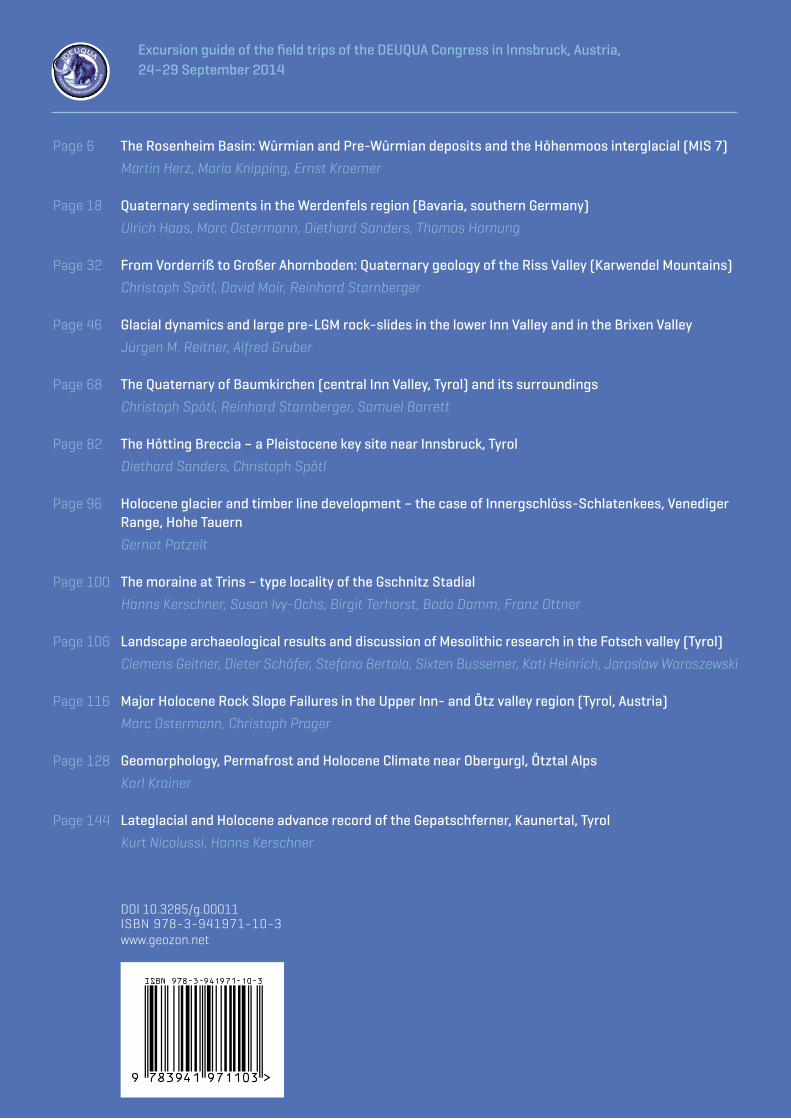
Excursion guide of the field trips of the DEUQUA Congress in Innsbruck, Austria, 24–29 September 2014
Page 6
Page 18
Page 32
Page 46
Page 68
Page 82
Page 96
Page 100
Page 106
Page 116
Page 128
Page 144
The Rosenheim Basin: Würmian and Pre-Würmian deposits and the Höhenmoos interglacial (MIS 7)
Martin Herz, Maria Knipping, Ernst Kroemer
Quaternary sediments in the Werdenfels region (Bavaria, southern Germany)
Ulrich Haas, Marc Ostermann, Diethard Sanders, Thomas Hornung
From Vorderriß to Großer Ahornboden: Quaternary geology of the Riss Valley (Karwendel Mountains)
Christoph Spötl, David Mair, Reinhard Starnberger
Glacial dynamics and large pre-LGM rock-slides in the lower Inn Valley and in the Brixen Valley
Jürgen M. Reitner, Alfred Gruber
The Quaternary of Baumkirchen (central Inn Valley, Tyrol) and its surroundings
Christoph Spötl, Reinhard Starnberger, Samuel Barrett
The Hötting Breccia – a Pleistocene key site near Innsbruck, Tyrol
Diethard Sanders, Christoph Spötl
Holocene glacier and timber line development – the case of Innergschlöss-Schlatenkees, Venediger Range, Hohe Tauern
Gernot Patzelt
The moraine at Trins – type locality of the Gschnitz Stadial
Hanns Kerschner, Susan Ivy-Ochs, Birgit Terhorst, Bodo Damm, Franz Ottner
Landscape archaeological results and discussion of Mesolithic research in the Fotsch valley (Tyrol)
Clemens Geitner, Dieter Schäfer, Stefano Bertola, Sixten Bussemer, Kati Heinrich, Jaroslaw Waroszewski
Major Holocene Rock Slope Failures in the Upper Inn- and Ötz valley region (Tyrol, Austria)
Marc Ostermann, Christoph Prager
Geomorphology, Permafrost and Holocene Climate near Obergurgl, Ötztal Alps
Karl Krainer
Lateglacial and Holocene advance record of the Gepatschferner, Kaunertal, Tyrol
Kurt Nicolussi, Hanns Kerschner