A guide to China excursion, 2006
40
A Guide to China Excursion 2006 Weili Qiu Beijing Normal University Deliang Chen Göteborg University Beijing Oct. 18 – Nov. 4, 2006
Transcript of A guide to China excursion, 2006
A Guide to
China Excursi
2006
Weili Qiu
Beijing Normal University
Deliang Chen
Göteborg University
Beijing
Oct. 18 – Nov. 4, 2006
on

Foreword
The China Excursion is a part of a physical geography course, Climate variations and their impact on landscape development/society/man, at the Earth Sciences Centre, Göteborg University. It offers an opportunity for the students to see a diversity of landscapes in North China, to learn some thing about Chinese culture and to observe the interaction between human activities and natural processes in China today and in the past.
The Excursion 2006 is modified based on excursions carried out in the last four years so that the trip will be more interesting and more convenient. Three main areas, Beijing, Xi’an, and an inland lake, Daihai Lake in Liangcheng, Inner Mongolia are selected as bases along the field trip and several interested sites can be reached from each base. This guidebook gives a brief introduction to what we are going to see. A compilation of further readings is also available which offers some research background about the issued areas in a historical view.
The expedition is mainly composed of Swedish students from Göteborg University. Some Chinese students from Beijing Normal University will also join the excursion. It helps to encourage the communication between Swedish and Chinese students.
Acknowledgement The China Excursion is a cooperative result of the Earth Sciences Centre, Göteborg University and the School of Geography, Beijing Normal University. We would like to gratefully thank both universities and those who help to realize the excursion. We would also express our deep gratitude to the STINT. The China Excursion is granted by a STINT project from 2003 to 2007 and we can expect a better outcome of the excursion as an international teaching cooperation.
Weili Qiu School of Geography, Beijing Normal University Beijing, China.
Deliang Chen Earth Sciences Centre, Göteborg University, Göteborg, Sweden.
Oct. 5, 2006
1

Contents
Time Table………………………………………………………….. 4
Introduction…………………………………………………………. 5
1. Xi’an and its Contiguities………………………………………... 10
1.1 The waterfall and gorges of Yellow River at Hukou…………………………. 10
1.2 The Loess Plateau ……………………………………………………………. 13
1.3 The Terra-cotta warriors ……………………………………………………... 16
2. Datong and its Contiguities ……………………………………. 17
2.1 Daihai Lake…………………………………………………………………... 18
2.2 Nihewan Basin……………………………………………………………….. 20
2.3 The Datong Volcanoes……………………………………………………….. 23
2.4 Yungang stone carving………………………………………………………. 25
3. Beijing and its Contiguities……………………………………… 26
3.1 Zhaitang Basin and Malan Terrace…………………………………………… 27
3.2 Zhoukoudian Site and Shihuadong Karst Cave……………………………… 30
3.3 Great Wall and the Tombs of Ming Dynasty…………………………………. 35
List of Figures Fig. 1 Topographic map of China and the location of excursion bases………….. Fig. 2 Temperature Map of China………………………………………………... Fig. 3 Precipitation Map of China……………………………………………….. Fig. 4 Agriculture map of China……………………………………………………………… Fig. 5 Population map of China……………………………………………………………… Fig. 6 Excursion Routes…………………………………………………………. Fig. 7 Satellite image of issued area…………………………………………….. Fig. 8 Geologic map of issued areas…………………………………………….. Fig. 9 Map of Xi’an and its Contiguities……………………………………………………. Fig. 10 Topographic map of the Yellow River gorge near Hukou………………. Fig. 11 Satellite image of the Yellow River gorge near Hukou…………………. Fig. 12 The Hukou Waterfall of the Yellow River………………………………. Fig. 13 Landscape of the Loess Plateau…………………………………………. Fig. 14 Paleogeographic map of the Loess Plateau in Palaeogen and Neogene… Fig. 15 Sketch of the loess flat and gullies around Louchuan…………………… Fig. 16 Stratigraphic units of the Luochuan loess-paleosol sequences…………..
56677889
1011121213131414
2

Fig. 17 Topographic map of Luochuan………………………………………….. Fig. 18 Satellite image of Luochuan ……………………………………………. Fig. 19 The Terracotta Warriors and Horses…………………………………….. Fig. 20 Location of the Daihai Lake…………………………………………….. Fig. 21 Location of the Nihewan Basin and Datong volcanoes…………………. Fig. 22 Periglacial disturbance at Shimen Reservior……………………………. Fig. 23 Sun setting of the Daihai Basin………………………………………….. Fig. 24 Topographic map of Daihai Basin……………………………………….. Fig. 25 Satellite image of Daihai Basin………………………………………….. Fig. 26 Outcrop of the Nihewan lacustrine deposits…………………………….. Fig. 27 Periglacial disturbance in gravel layers in Nihewan Basin………………. Fig. 28 Satellite image of the east part of Nihewan Basin……………………….. Fig. 29 Topographic map of the east part of Nihewan Basin……………………. Fig. 30 Geologic Map of the east part of Nihewan Basin………………………. Fig. 31 Topographic map of the Datong volcanoes……………………………… Fig. 32 Satellite image of the Datong volcanoes………………………………… Fig. 33 Langwoshan, one of the Datong volcanoes……………………………… Fig. 34 Satellite image of Yungang to the west of Datong………………………. Fig. 35 Stone carving of Yungang……………………………………………….. Fig. 36 Map and satellite image of Beijing and its Contiguities………………… Fig. 37 Landscape sinkhole and sedimentary structure of Malan terrace……….. Fig. 38 Topographic map of Zhaitang Basin…………………………………….. Fig. 39 Satellite image of Zhaitang Basin……………………………………….. Fig. 40 Geologic map of Zhaitang………………………………………………. Fig. 41 Geologic section of Locality 1, Zhoukoudian…………………………… Fig. 42 The Museum of Peking Man……………………………………………. Fig. 43 Topographic map of Zhoukoudian and Nancheying……………………. Fig. 44 Geologic map of Zhoukoudian………………………………………….. Fig. 45 Satellite image of Zhoukoudian………………………………………… Fig. 46 Morphological features of karst cave deposits in Shihuadong…. ………. Fig. 47 Geomorphic Map of Zhoukoudian……………………………………… Fig. 48 Drainage Systems of Peking Man’s Time………………………………. Fig. 49 Topographic map of the Ming Tombs…………………………………… Fig. 50 Satellite image of the Ming Tombs……………………………………… Fig. 51 Geologic Profile of Ming Tombs Basin from Cuihua Hill to God’s Cave.. Fig. 52 Topographic map of the foundation of Ming Tombs Basin……………… Fig. 53 Geologic map of the Ming Tomb…………………………………………
15151617171818191920202121222324242525262728282930313132333334353636373738
Appendix: the Map of Beijing
3
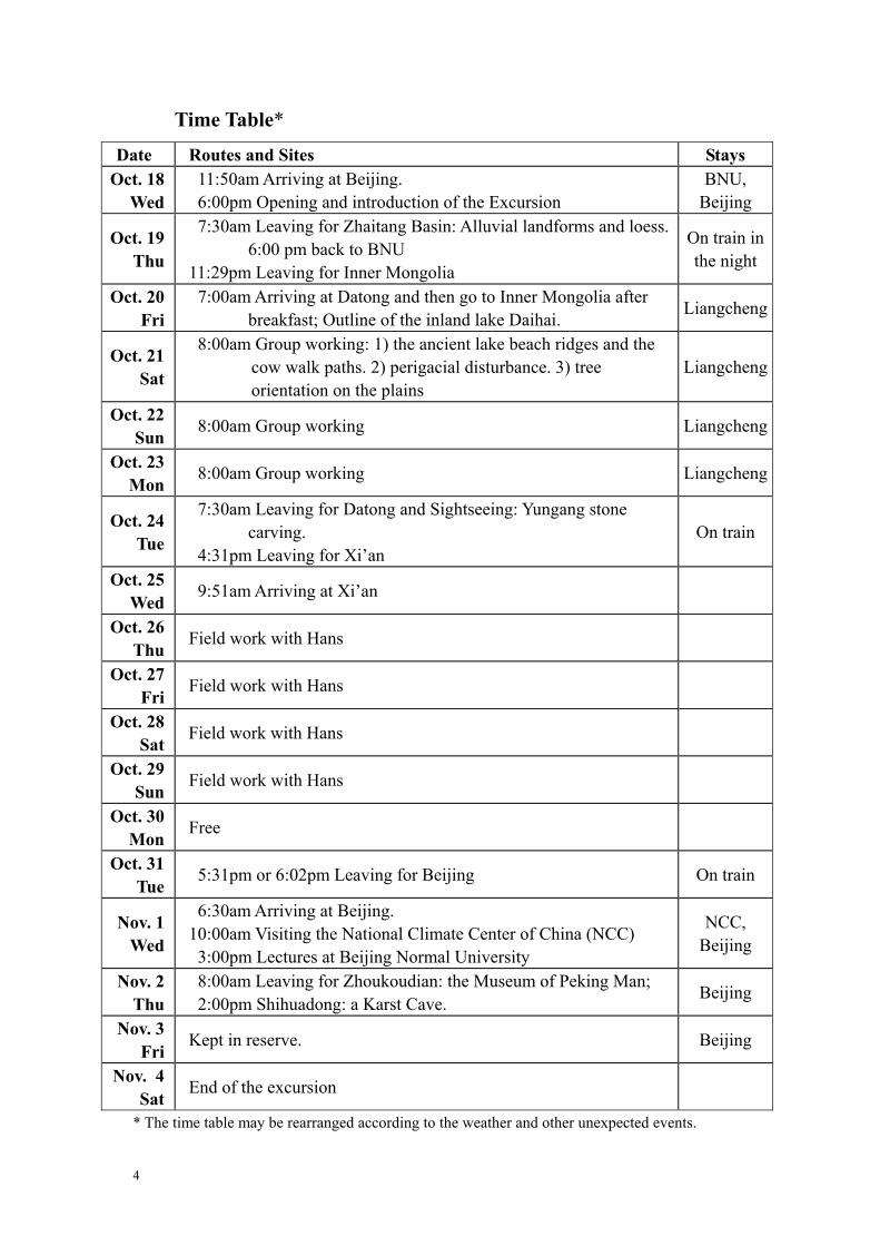
Time Table*
Date Routes and Sites Stays Oct. 18
Wed 11:50am Arriving at Beijing. 6:00pm Opening and introduction of the Excursion
BNU, Beijing
Oct. 19 Thu
7:30am Leaving for Zhaitang Basin: Alluvial landforms and loess. 6:00 pm back to BNU
11:29pm Leaving for Inner Mongolia
On train in the night
Oct. 20 Fri
7:00am Arriving at Datong and then go to Inner Mongolia after breakfast; Outline of the inland lake Daihai. Liangcheng
Oct. 21 Sat
8:00am Group working: 1) the ancient lake beach ridges and the cow walk paths. 2) perigacial disturbance. 3) tree orientation on the plains
Liangcheng
Oct. 22 Sun
8:00am Group working Liangcheng
Oct. 23 Mon
8:00am Group working Liangcheng
Oct. 24 Tue
7:30am Leaving for Datong and Sightseeing: Yungang stone carving.
4:31pm Leaving for Xi’an On train
Oct. 25 Wed
9:51am Arriving at Xi’an
Oct. 26 Thu
Field work with Hans
Oct. 27 Fri
Field work with Hans
Oct. 28 Sat
Field work with Hans
Oct. 29 Sun
Field work with Hans
Oct. 30 Mon
Free
Oct. 31 Tue
5:31pm or 6:02pm Leaving for Beijing On train
Nov. 1 Wed
6:30am Arriving at Beijing. 10:00am Visiting the National Climate Center of China (NCC) 3:00pm Lectures at Beijing Normal University
NCC, Beijing
Nov. 2 Thu
8:00am Leaving for Zhoukoudian: the Museum of Peking Man; 2:00pm Shihuadong: a Karst Cave. Beijing
Nov. 3 Fri
Kept in reserve. Beijing
Nov. 4 Sat
End of the excursion
* The time table may be rearranged according to the weather and other unexpected events.
4

Introduction The China Excursion will be focused on physical landscapes and human activities, based on the studies of geomorphology, sedimentology, Quaternary geology and environmental change (especially during Holocene) in North China. Three bases of different types are chosen for surveying. They are Beijing, Xi’an and Datong (green stars in Fig.1). The topographic features of China are characterized with three huge steps. The first step (Fig.1 yellow part) has an average elevation of about 4 000 ~ 5 000m a.s.l., which is located in the southwest of China and is composed of the Qinghai-Xizang (Tibetan) Plateau. The second step (Fig.1 pale yellow part) has an average elevation of about 1 000 ~ 2 500m a.s.l., which includes the Inner Mongolian Plateau, the Loess Plateau, the Yunnan-Guizhou Plateau and many mountains and basins. The third step (Fig.1 green part) has an average elevation less than 500m a.s.l., which is located in the east of China and is composed of plains at the lower reaches of big rivers, such as the Heilongjiang, the Liaohe, the Yellow, the Yangtze, the Pearl, etc.. The issued area of China Excursion is located on the second and third steps including plains, mountains and river valleys, intermontane basins and inland lake.
Fig. 1 Topographic map of China and the location of excursion bases (8)
The climate of China is famous for the Eastern Asia Monsoon. But the monsoon climate only affects the east and the southeast of China. The Qinghai-Xizang Plateau has a typical highland climate and the northwest of China is an arid and semiarid area.
5
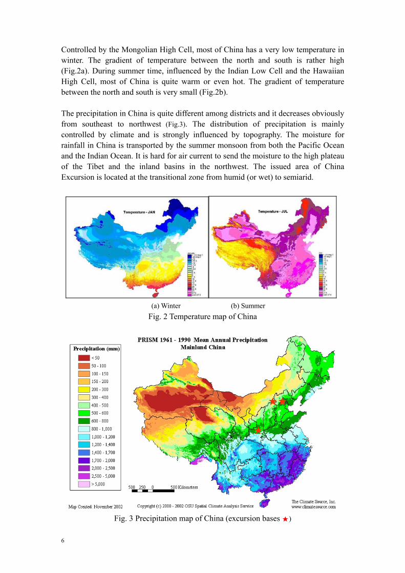
Controlled by the Mongolian High Cell, most of China has a very low temperature in winter. The gradient of temperature between the north and south is rather high (Fig.2a). During summer time, influenced by the Indian Low Cell and the Hawaiian High Cell, most of China is quite warm or even hot. The gradient of temperature between the north and south is very small (Fig.2b). The precipitation in China is quite different among districts and it decreases obviously from southeast to northwest (Fig.3). The distribution of precipitation is mainly controlled by climate and is strongly influenced by topography. The moisture for rainfall in China is transported by the summer monsoon from both the Pacific Ocean and the Indian Ocean. It is hard for air current to send the moisture to the high plateau of the Tibet and the inland basins in the northwest. The issued area of China Excursion is located at the transitional zone from humid (or wet) to semiarid.
Fig. 2 Temperature map of China
(a) Winter (b) Summer
Fig. 3 Precipitation map of China (excursion bases 8)
6
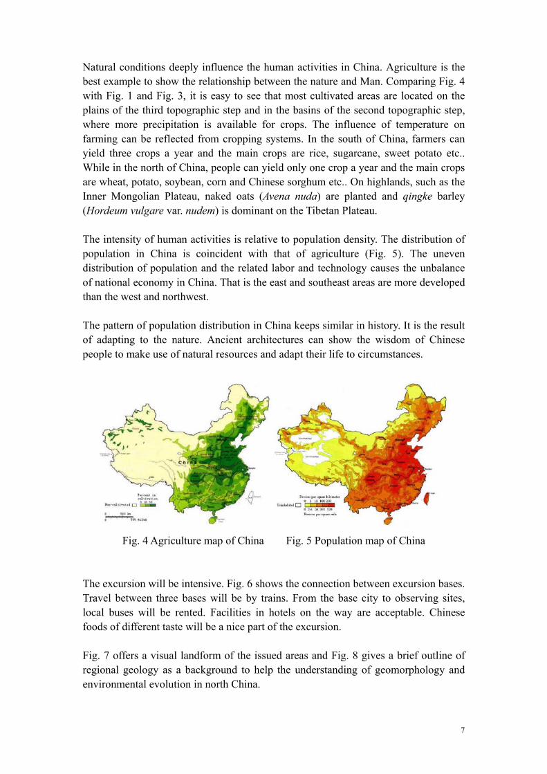
Natural conditions deeply influence the human activities in China. Agriculture is the best example to show the relationship between the nature and Man. Comparing Fig. 4 with Fig. 1 and Fig. 3, it is easy to see that most cultivated areas are located on the plains of the third topographic step and in the basins of the second topographic step, where more precipitation is available for crops. The influence of temperature on farming can be reflected from cropping systems. In the south of China, farmers can yield three crops a year and the main crops are rice, sugarcane, sweet potato etc.. While in the north of China, people can yield only one crop a year and the main crops are wheat, potato, soybean, corn and Chinese sorghum etc.. On highlands, such as the Inner Mongolian Plateau, naked oats (Avena nuda) are planted and qingke barley (Hordeum vulgare var. nudem) is dominant on the Tibetan Plateau. The intensity of human activities is relative to population density. The distribution of population in China is coincident with that of agriculture (Fig. 5). The uneven distribution of population and the related labor and technology causes the unbalance of national economy in China. That is the east and southeast areas are more developed than the west and northwest. The pattern of population distribution in China keeps similar in history. It is the result of adapting to the nature. Ancient architectures can show the wisdom of Chinese people to make use of natural resources and adapt their life to circumstances.
Fig. 4 Agriculture map of China Fig. 5 Population map of China
The excursion will be intensive. Fig. 6 shows the connection between excursion bases. Travel between three bases will be by trains. From the base city to observing sites, local buses will be rented. Facilities in hotels on the way are acceptable. Chinese foods of different taste will be a nice part of the excursion. Fig. 7 offers a visual landform of the issued areas and Fig. 8 gives a brief outline of regional geology as a background to help the understanding of geomorphology and environmental evolution in north China.
7

Fig. 6 Excursion Routes (railway: yellow lines; bases:8 and sites8)
Fig. 7 Satellite image of issued area
8

Fig. 8 Geologic map of issued areas
Legend Sedimentary Rocks Qh: Holocene Qp: Pleistocene N: Neogene E: Paleogene K: Cretaceous J: Jurassic T: Triassic P: Permian C: Carboniferous D: Devonian S: Silurian O: Ordovician є: Cambrian Metamorphic Rocks Pt: Proterozoic Z: upper Neoproterozoic Ar: Archean
Igneous Rocks γ: granite γ1-2: Pre-Cambrian γ3: Caledonian γ4: Hercynian γ5: Old Alpine or Yanshan γ6: Alpine or Himalayan
9
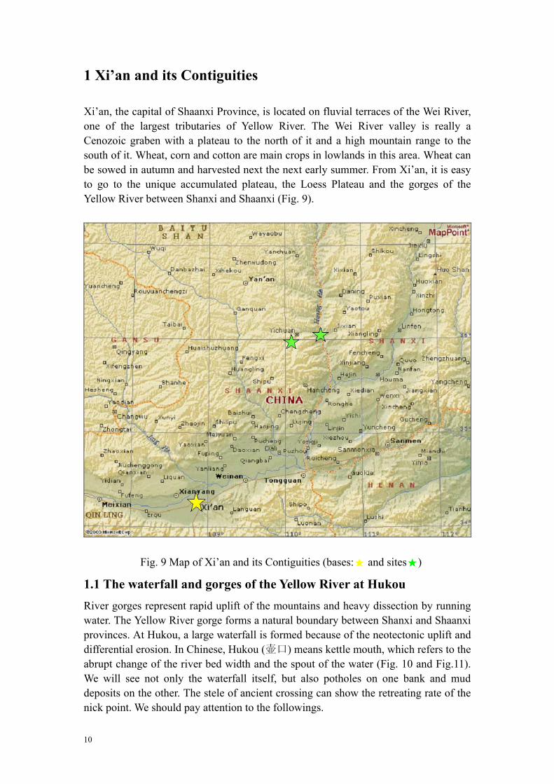
1 Xi’an and its Contiguities Xi’an, the capital of Shaanxi Province, is located on fluvial terraces of the Wei River, one of the largest tributaries of Yellow River. The Wei River valley is really a Cenozoic graben with a plateau to the north of it and a high mountain range to the south of it. Wheat, corn and cotton are main crops in lowlands in this area. Wheat can be sowed in autumn and harvested next the next early summer. From Xi’an, it is easy to go to the unique accumulated plateau, the Loess Plateau and the gorges of the Yellow River between Shanxi and Shaanxi (Fig. 9).
Fig. 9 Map of Xi’an and its Contiguities (bases:8 and sites8)
1.1 The waterfall and gorges of the Yellow River at Hukou River gorges represent rapid uplift of the mountains and heavy dissection by running water. The Yellow River gorge forms a natural boundary between Shanxi and Shaanxi provinces. At Hukou, a large waterfall is formed because of the neotectonic uplift and differential erosion. In Chinese, Hukou (壶口) means kettle mouth, which refers to the abrupt change of the river bed width and the spout of the water (Fig. 10 and Fig.11). We will see not only the waterfall itself, but also potholes on one bank and mud deposits on the other. The stele of ancient crossing can show the retreating rate of the nick point. We should pay attention to the followings.
10

Nick point retreating, terraces and the history of the Yellow River; Where is the ancient ferry crossing? Why? The gradient of the Yellow River and its tributaries and their influence on soil
erosion (sloping fields); The difference of erosion and deposition on two banks and their dynamic
condition.
Fig. 10 Topographic map of the Yellow River gorge near Hukou
11
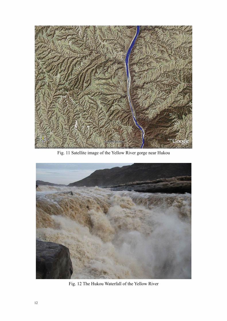
Fig. 11 Satellite image of the Yellow River gorge near Hukou
Fig. 12 The Hukou Waterfall of the Yellow River
12
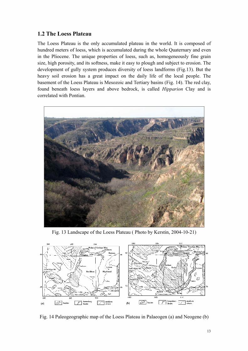
1.2 The Loess Plateau The Loess Plateau is the only accumulated plateau in the world. It is composed of hundred meters of loess, which is accumulated during the whole Quaternary and even in the Pliocene. The unique properties of loess, such as, homogeneously fine grain size, high porosity, and its softness, make it easy to plough and subject to erosion. The development of gully system produces diversity of loess landforms (Fig.13). But the heavy soil erosion has a great impact on the daily life of the local people. The basement of the Loess Plateau is Mesozoic and Tertiary basins (Fig. 14). The red clay, found beneath loess layers and above bedrock, is called Hipparion Clay and is correlated with Pontian.
Fig. 13 Landscape of the Loess Plateau ( Photo by Kerstin, 2004-10-21)
Fig. 14 Paleogeographic map of the Loess Plateau in Palaeogen (a) and Neogene (b)
13

We will stay at Luochuan to have a close observation of the loess-paleosol sequences along the representative profile (Fig.15 and Fig.16) and to visit the Loess Geological Museum. Two aspects of the loess should be focused on.
The characteristics and formation of loess and the Loess Plateau of China;
The loess - paleosol sequences and its implications for global change research.
The traditional crop on the Loess Plateau is millet. What are the modern ones?
Fig. 15 Sketch of the loess flat and gullies around Louchuan (Liu et al. 1985)
Fig. 16 Stratigraphic units of the Luochuan loess-paleosol sequences (Liu et al. 1985)
14

Fig. 17 Topographic map of Luochuan
Fig. 18 Satellite image of Luochuan
15
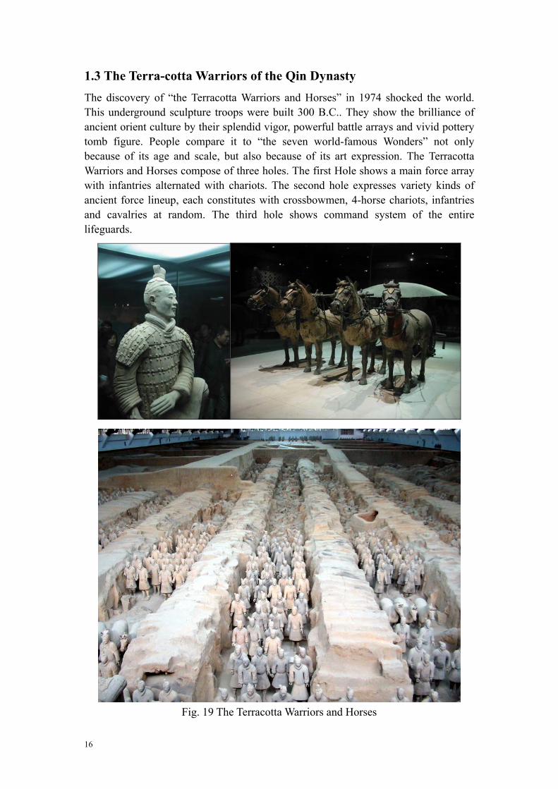
1.3 The Terra-cotta Warriors of the Qin Dynasty The discovery of “the Terracotta Warriors and Horses” in 1974 shocked the world. This underground sculpture troops were built 300 B.C.. They show the brilliance of ancient orient culture by their splendid vigor, powerful battle arrays and vivid pottery tomb figure. People compare it to “the seven world-famous Wonders” not only because of its age and scale, but also because of its art expression. The Terracotta Warriors and Horses compose of three holes. The first Hole shows a main force array with infantries alternated with chariots. The second hole expresses variety kinds of ancient force lineup, each constitutes with crossbowmen, 4-horse chariots, infantries and cavalries at random. The third hole shows command system of the entire lifeguards.
Fig. 19 The Terracotta Warriors and Horses
16

2 Datong and its Contiguities Datong, the second largest city of Shanxi Province, is located in an intermontane basin, in which there was an inland lake during the most part of Quaternary. The activities around Datong include surveying a modern inland lake—Dauhai in the south of Inner Mongolia (Fig. 18), an ancient lake—Nihewan and Quaternary volcanoes (Fig. 19), and stone carving at Yungang, Datong.
Fig. 20 Location of the Daihai Lake
Fig. 21 Location of the Nihewan Basin and Datong volcanoesU
17

2.1 Daihai Lake Daihai Lake is an inland semi-saline lake. The basement of it was faulted and subsided during Pliocene. The lake level changed greatly in the late Quaternary and the lake water could even overflow today’s dividing ridge when the water level reached a height of about 95~100m above the lake level today. The ancient shorelines of the lake can indicate the lake level change and can be used to reconstruct ancient precipitation under certain conditions. Periglacial phenomena were found in lake sediments. They were formed during cold periods of the Holocene. How to identify an ancient shoreline? How to reconstruct ancient precipitation based on inland lake geomorphology? The periglacial phenomena at Daihai basin and its implications. One crop can be yielded a year and the main crops naked oats (Avena nuda), potato and
wheat. Wheat can be planted in the plain and be sowed only in spring and harvested in autumn.
There are several remnants of the ancient great wall along the hill ridges south of the lake.
Fig. 22 Periglacial disturbance at Shimen Reservior
Fig. 23 Sun setting of the Daihai basin
18

Fig.
24
Topo
grap
hic
map
of D
aiha
i Bas
in
19
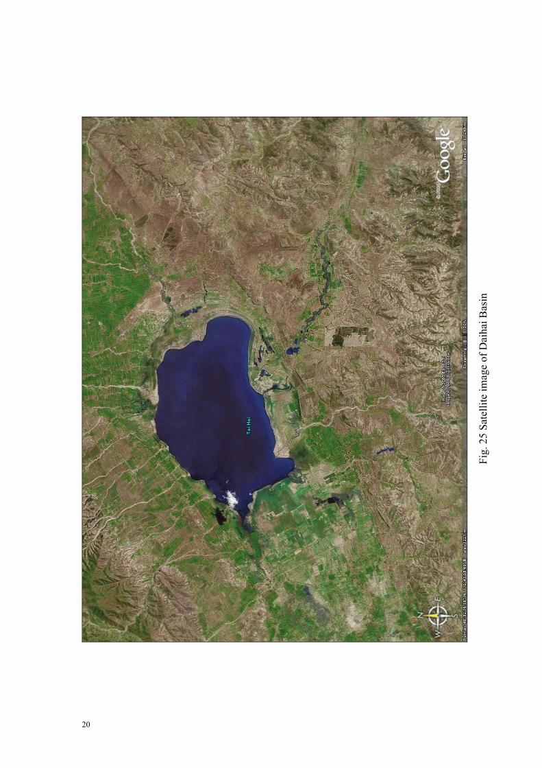
Fig.
25
Sate
llite
imag
e of
Dai
hai B
asin
20

2.2 Nihewan Basin Nihewan Basin was first studied in 1924. From then on, many paleontologists, geologists, geographers and archaeologists have engaged in research of Nihewan. The attached reference materials show that there are abundant environmental records in the alluvial-lacustrine deposits of Nihewan. We can try to discuss several basic topics after a hurry glance of the representative sections and get to know the great significance of Nihewan. The nature of the ancient lake of Nihewan; The fluctuation and evolution of the Nihewan Lake; A brief history of the Nihewan Basin.
Fig. 26 Outcrop of the Nihewan lacustrine deposits
Fig. 27 Periglacial disturbance in gravel layers in Nihewan basin
21

Fig. 28 Satellite image of the east part of Nihewan basin
Fig. 29 Topographic map of the east part of Nihewan basin
22

Fig. 30 Geologic Map of the east part of Nihewan
Z1.dolomite; Z2.dolomite and shale; є 1.shale and limestone; є 2.lime
є 3. limestone; J1. shale and coal; J2j. sandstone, mudstone and cJ2t.andesite; J3d.rhyolite; E2h. conglomerate and sandstone; E
Q1l lacustrine; Q3-4
al+pl alluvial and pluvial.
n
Nihewa
basin stone and shale;
onglomerate; 3y. Basalt;
23

2.3 Datong Volcanoes The volcanoes of Datong were first reported in 1930s. They are located in Datong County (Xiping). The volcanoes maintain a perfect form. They were dated by thermo-luminescence in 1980’ and the results were between 100 000~340 000aBP. What we are going to survey is the contact relation of lava and loess. We will also observe the morphologic features of the volcanoes and discuss their formation.
Fig. 31 Topographic map of the Datong volcanoes
24
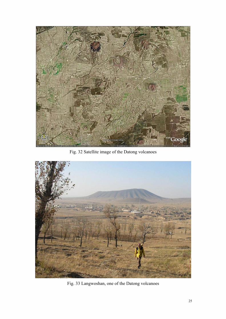
Fig. 32 Satellite image of the Datong volcanoes
Fig. 33 Langwoshan, one of the Datong volcanoes
25

2.4 Yungang Stone Carving Yungang Stone Carving is located on the southern slope of Wuzhou mountains west to Datong. It is the earliest stone carving of Buddha remained in China and has the feature of grandiosity in momentum. The stone carving were made on sandstone about 1 500 years ago in North Wei Dynasty. There are 1 100 Buddha niches of different size and more than 50 000 stone Buddha and Bodhisattva scattering along the hill slope for more than one kilometer.
Fig. 34 Satellite image of Yungang to the west of Datong
Fig. 35 Stone carving of Yungang
26

3 Beijing and its Contiguities
Beijing is located on the northwest edge of North China Plain. The Beijing city is built and developed on alluvial fans of Yongding River.
(a)
(b) Fig. 36 Map(a) and satellite image(b) of Beijing and its Contiguities
27

3.1 Zhaitang Basin and Malan Terrace Zhaitang Basin is located about 100km northwest of Beijing City. It is a part of Qingshui River’s wide valley and is formed by erosion. The oldest gravel beds are dated Pliocene. We can find them on hilltops 80~100m above modern riverbed. The erosion surface beneath the gravel beds is widely distributed in North China and is named Tangxian stage physiographically. Another typical landform is Malan terrace from which the Late Pleistocene loess in China was termed as Malan Loess. We will discuss several topics as: The significance of Tangxian Surface in North China; The sedimentary features and the formation of Malan terrace; The relationship between Qingshui River and regional geologic structures.
Fig. 37 Landscape sinkhole and sedimentary structure of Malan terrace
28

Fig. 38 Topographic map of Zhaitang basin
Fig. 39 Satellite image of Zhaitang basin
29
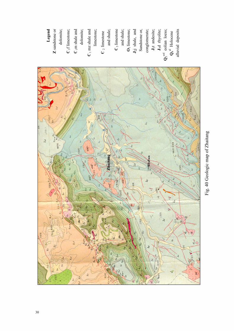
L
egen
d Z
sand
ston
e or
d
olom
ite;
є 1f l
imes
tone
;
є 1m
shal
e an
d
dolo
mite
;
є 1 m
z sh
ale
and
lim
esto
ne;
є 2 li
mes
tone
an
d sh
ale;
є 3 li
mes
tone
a
nd sh
ale;
O
1 lim
esto
ne;
J 2j
shal
e, a
nd
Sand
ston
e or
,
cong
lom
erat
e;
J 2t
ande
site
; J 3
d rh
yolit
e;
Q3eo
l eol
ian
loes
s;
Q4al
Hol
ocen
e
allu
vial
dep
osits
Fig.
40
Geo
logi
c m
ap o
f Zha
itang
Mal
an
Zha
itang
30

3.2 Zhoukoudian Site and Shihuadong Karst Cave Zhoukoudian Paleolithic Site is famous of the discovery of Homo erectus pekinensis (Peking Man). The karst cave, in which Peking Man lived, was carefully excavated. We will visit the museum and study the unearthed fossils and stone artifacts. In neighbor district of Zhoukoudian, karst landscape, which was formed in thick Cambrian and Ordovician limestone, are now exploited as touring resources. The main topics will be follows: The natural environment of Peking Man; The characteristics of karstification in moderate climate area.
Fig. 41 Geologic section of Locality 1, Zhoukoudian
1-2 Breccia containing travertine, about 4m thick. 3 Coarse breccia, containing huge limestone blocks fell down from the cave roof. A
skull of Peking Man was found from this layer in 1966. 4 Laminated ashy layer (Upper Cultural Zone), containing burned bones and stones as
well as huge limestone blocks, about 6m thick. 5 Stalagmite layer, about 1m thick. 6 Breccia, containing huge limestone blocks and hyena coprolites, about 5m thick. 7 Sandy layer, about 2m thick. 8-9 Breccia containing ash (Lower Cultural Zone), about half of Peking Man fossil
assemblage was found from the two layers, about 6m thick. 10 Reddish clay (upper part) and ash (lower part), about 2m thick. 11 Breccia, the first skull of Peking Man was found from the layer corresponding to
this one in 1929, about 2m thick. 12 reddish sandy layer, about 2m thick. 13 Sand and clay containing boulders and hyena coprolites, about 2m thick.
All of the layers mentioned above contain fossils and contain stone artifacts except Layer 12. the deposit under 13th layer was not excavated and only known from the test pit without fossil and stone artifact.
31

Fig. 42 The Museum of Peking Man
Fig. 43 Topographic map of Zhoukoudian and Nancheying (Shihuadong Cave)
32
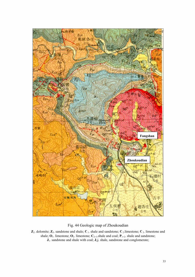
Fig. 44 Geologic map of Zhoukoudia
Z2. dolomite; Z3. sandstone and shale; є 1. shale and sandstone; є 2.lshale; O1. limestone; O2. limestone; C2+3.shale and coal; P1+2
J1. sandstone and shale with coal; J2j. shale, sandstone a
Zhoukoudian
n imestone. shale annd conglo
Fangshan
; є 3. limestone and d sandstone; merate;
33
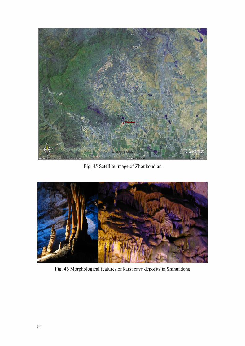
Fig. 45 Satellite image of Zhoukoudian
Fig. 46 Morphological features of karst cave deposits in Shihuadong
34
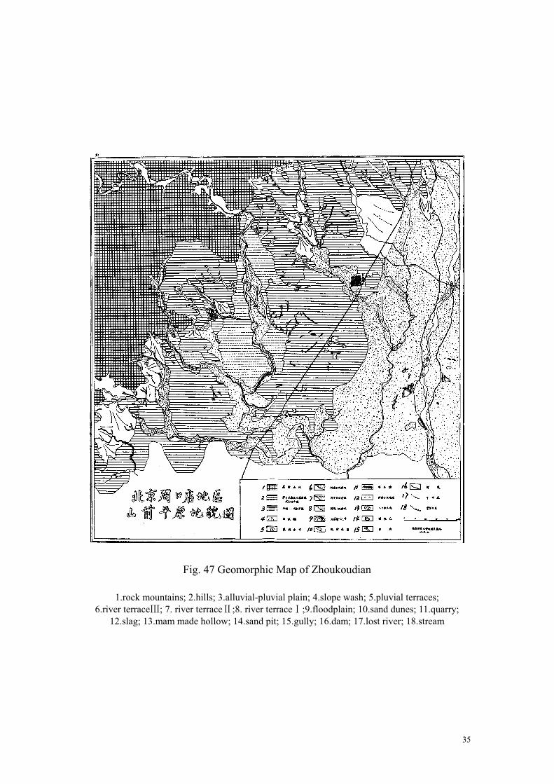
Fig. 47 Geomorphic Map of Zhoukoudian
1.rock mountains; 2.hills; 3.alluvial-pluvial plain; 4.slope wash; 5.pluvial terraces; 6.river terraceⅢ; 7. river terraceⅡ;8. river terraceⅠ;9.floodplain; 10.sand dunes; 11.quarry;
12.slag; 13.mam made hollow; 14.sand pit; 15.gully; 16.dam; 17.lost river; 18.stream
35
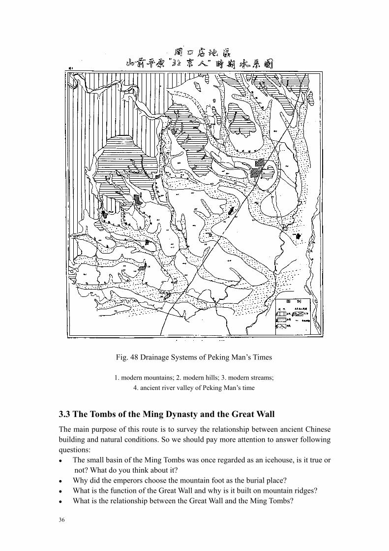
Fig. 48 Drainage Systems of Peking Man’s Times
1. modern mountains; 2. modern hills; 3. modern streams; 4. ancient river valley of Peking Man’s time
3.3 The Tombs of the Ming Dynasty and the Great Wall The main purpose of this route is to survey the relationship between ancient Chinese building and natural conditions. So we should pay more attention to answer following questions: The small basin of the Ming Tombs was once regarded as an icehouse, is it true or
not? What do you think about it? Why did the emperors choose the mountain foot as the burial place? What is the function of the Great Wall and why is it built on mountain ridges? What is the relationship between the Great Wall and the Ming Tombs?
36
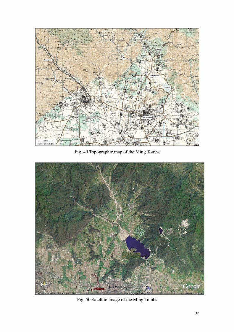
Fig. 49 Topographic map of the Ming Tombs
Fig. 50 Satellite image of the Ming Tombs
37

Fig. 51 Geologic Profile of Ming Tombs Basin from Cuihua Hill to God’s Cave
1.sand; 2.sand and gravel; 3.loess and loessic deposits; 4.sandy silt; 5.red clay and tophaceous clay;
6.volcanic rock; 7.shale; 8.limestone; 9.siliceous limestone; 10.fault.
Fig. 52 Topographic map of the foundation of Ming Tombs Basin
1. Precambrian metamorphic rocks; 2. Z: Precambrian siliceous limestone, C: Cambrian
limestone and shale; 3. J: Jurrasic volcanic rock,δ: intrusive rock; 4. Qaternary; 5. Taipingzhuang - Dingling Fault; 6. Shipaifang - Guayuan Fault;
7. Zhuishikou-Xiaotangshan Fault; 8. Huyü Fault; 9. hills; 10. stream and reservoir; 11.contuor of foundation
38

Fig.
53
Geo
logi
c m
ap o
f the
Min
g To
mbs
Z. d
olom
ite o
r san
dsto
ne; є
. Sha
le, s
ands
tone
and
lim
esto
ne; O
. lim
esto
ne;
Min
g To
mbs
Cha
ngpi
ng
39