FRONTIERS OF THE ROMAN EMPIRE - Universität Wien
205
Frontiers of the Roman Empire the European dimension of a World Heritage Site Edited by David J. Breeze and Sonja Jilek Published by Historic Scotland Edinburgh 2008 With the support of the Culture 2000 programme of the European Union
-
Upload
khangminh22 -
Category
Documents
-
view
2 -
download
0
Transcript of FRONTIERS OF THE ROMAN EMPIRE - Universität Wien

Frontiers of the Roman Empirethe European dimension of a World Heritage Site
Edited by David J. Breeze and Sonja Jilek
Published by Historic ScotlandEdinburgh 2008
With the support of the Culture 2000programme of the European Union
Historic Scotland
Historic Scotland safeguards the nation’s built heritage by scheduling monuments of national importanceand by listing historic buildings of special architectural or historic interest. Historic Scotland has morethan 330 properties in its care and welcomes around 3 m visitors each year to 75 properties whereadmission is charged. It conserves the properties in its care and provides financial assistance to privateowners towards the costs of conserving and repairing outstanding monuments and buildings. Historic Scotland takes a lead in researching issues relating to building conservation and in developingand promoting craft skills. It has a commitment to encourage knowledge about Scotland ’s built heritageand provides guide-books and other publications, and educational material relating to the school curricular guide-lines.
Further information can be obtained on the website: www.historic-scotland.gov.uk
Historic ScotlandLongmore HouseSalisbury PlaceEDINBURGHEH9 1SH
Copyright© by Historic Scotland, UKLayout by Anna AdamczykCover design by The House
Printed by 'The House, Print and Design Management, Edinburgh'
ISBN: 978 1 904966 890

3
‘Frontiers of the Roman Empire’ – the European dimension of a World Heritage Site
List of contents
Preface (David J. Breeze) 5
The Culture 2000 project ‘Frontiers of the Roman Empire’ (David J. Breeze – Sonja Jilek) . . . . . . . . . . .
The ‘Frontiers of the Roman Empire web-portal‘ (Gergely Borgulya, Sonja Jilek, Kurt Schaller, Ádam Szentgáli). . . . . . . . . . . . . . . . . . . . . . . . . . . . . . . . . . . . . . . . . . . . . . . . . . . . . . . . . . . . . . . . . . . . . . .
The ‘Frontiers of the Roman Empire’ project picture book . . . . . . . . . . . . . . . . . . . . . . . . . . . . . . . . . . . .
The ‘Frontiers of the Roman Empire World Heritage Site’
The ‘Frontiers of the Roman Empire World Heritage Site’ (David J. Breeze – Sonja Jilek) . . . . . . . . . . . .
The definition of the ‘Frontiers of the Roman Empire World Heritage Site’ – Summary Nomination Statement (David J. Breeze – Christopher Young) . . . . . . . . . . . . . . . . . . . . . . . . . . . . . . . . . . . . . . . . . . . .
The authenticity discourse of heritage (Jaap Lengkeek) . . . . . . . . . . . . . . . . . . . . . . . . . . . . . . . . . . . . . . .
The concept of the multi-national World Heritage Site – a chance for interdisciplinary and international co-operation (Sonja Jilek). . . . . . . . . . . . . . . . . . . . . . . . . . . . . . . . . . . . . . . . . . . . . . . . . . . .
Research and Documentation
Research on Roman frontiers (David J. Breeze) . . . . . . . . . . . . . . . . . . . . . . . . . . . . . . . . . . . . . . . . . . . . .
The Roman army in its landscape setting (David J. Breeze) . . . . . . . . . . . . . . . . . . . . . . . . . . . . . . . . . . . .
The definition of river frontiers (Sonja Jilek) . . . . . . . . . . . . . . . . . . . . . . . . . . . . . . . . . . . . . . . . . . . . . . . .
Documenting the frontiers of the Roman empire – work on the Limes in Bavaria (C. Sebastian Sommer). . . . . . . . . . . . . . . . . . . . . . . . . . . . . . . . . . . . . . . . . . . . . . . . . . . . . . . . . . . . . . . . .
Documenting the frontiers of the Roman empire – work on the Danube Limes in Austria, Slovakia,Hungary and Bulgaria (Piotr Dyczek, Katarina Harmaydová, Sonja Jilek, Eva Kuttner, Martin Lemke, Jan Rajtár, Janusz Rec∏aw, Jarka Schmidtova, Andreas Schwarcz,Maté Szabó and Zsolt Visy) . . . . . . . . .
Geophysical survey on the Antonine Wall (Claire Stephens, John Gater and Richard Jones) . . . . . . . . . .
Presenting archaeological sites of cultural heritage on websides – guidelines for site-oriented databases (Eva Kuttner) . . . . . . . . . . . . . . . . . . . . . . . . . . . . . . . . . . . . . . . . . . . . . . . . . . . . .
Guidelines for the mapping of archaeological monuments along the frontiers of the Roman empire inpreparation for their nomination as a World Heritage Site (Rebecca Jones – Andreas Thiel) . . . . . . . . .
Documenting the Roman army in Spain (Ángel Morillo) . . . . . . . . . . . . . . . . . . . . . . . . . . . . . . . . . . . . . .
7
15
19
25
29
37
53
57
61
65
71
75
79
95
99
107

4
Monument protection
The protection of Roman frontiers (David J. Breeze) . . . . . . . . . . . . . . . . . . . . . . . . . . . . . . . . . . . . . . . . .
The Antonine Wall: the definition of buffer zones (Beatrice Dower) . . . . . . . . . . . . . . . . . . . . . . . . . . . . .
The cadastre project in Straubing (Bavaria) (C. Sebastian Sommer). . . . . . . . . . . . . . . . . . . . . . . . . . . . .
Saving the rest – Roman Nijmegen beneath the pavement (Harry van Enckevort). . . . . . . . . . . . . . . . . .
Conservation and Presentation
Conservation, management and display of sites (C. Sebastian Sommer with contributions from Jarka Schmidtova, Jan Rajtár, Zsolt Visy and Piotr Dyczek) . . . . . . . . . . . . . . . . . . . . . . . . . . . . . . . . . .
Presenting Roman military sites to the public (David J. Breeze) . . . . . . . . . . . . . . . . . . . . . . . . . . . . . . .
The challenge of an appropriate presentation of archaeological monuments along the Upper German-Raetian Limes (Andreas Thiel). . . . . . . . . . . . . . . . . . . . . . . . . . . . . . . . . . . . . . . . . . . . . . . . . . .
Nature and function of reconstructions on the Upper German-Raetian Limes using the exampleof wooden watch-towers (Thomas Becker) . . . . . . . . . . . . . . . . . . . . . . . . . . . . . . . . . . . . . . . . . . . . . . . .
From Scotland to the Black Sea – the making of the DVD ‘Frontiers of the Roman Empire’(Sandra Walkshofer – Eric Dobat) . . . . . . . . . . . . . . . . . . . . . . . . . . . . . . . . . . . . . . . . . . . . . . . . . . . . . . .
Quot capita, tot sensus: participative landscape and heritage conservation along the Upper German-Raetian Limes (Franz Höchtl, Martin Ebrahimzadeh and Patrick Pauli) . . . . . . . . . . . . . . . . . .
The World Heritage Site ‘Frontiers of the Roman Empire’ in museums: revealing the invisible(Christof Flügel) . . . . . . . . . . . . . . . . . . . . . . . . . . . . . . . . . . . . . . . . . . . . . . . . . . . . . . . . . . . . . . . . . . . . .
Museums on the frontier: an experiment in twinning the Senhouse Roman Museum on Hadrian’s Wall and the Museum Ruffenhoffen in Bavaria (Christof Flügel – Ian Francis). . . . . . . . . . . .
Open frontiers: accessing the Antonine Wall through multimedia technologies (Jim Devine) . . . . . . . .
Management
A cultural landscape maintaining system (Kulturlandschaftspflegewerk©) for the historic landscape zone of the frontiers of the Roman empire. An trans-disciplinary governmental protection-, preservation- and development system by the historic landscape approach (Hans Peter Jeschke) . . . .
A museum development plan for the World Heritage Site of the Upper German-Raetian Limes (Christof Flügel) . . . . . . . . . . . . . . . . . . . . . . . . . . . . . . . . . . . . . . . . . . . . . . . . . . . . . . . . . . . . . . . . . . . . .
The role of the Bratislava Group (Sonja Jilek) . . . . . . . . . . . . . . . . . . . . . . . . . . . . . . . . . . . . . . . . . . . . .
Authors and partners . . . . . . . . . . . . . . . . . . . . . . . . . . . . . . . . . . . . . . . . . . . . . . . . . . . . . . . . . . . . . . . .
109
113
119
123
129
141
149
153
163
167
175
179
181
187
197
201
204

5
Preface
7 March, the anniversary of the death of Antoninus Pius and the accession of Marcus and Lucius
The European Union’s Culture 2000 pro g ramme, ‘Fro n t i e rs of the Roman Empire’, sprang from the pro p o s a lto cre a te a World Heritage Site which might enco m p a ss all the fro n t i e rs of the Roman empire. Romana rc h a e o lo g i sts working on the fro n t i e rs of the Roman empire in Europe responded to this challenge bycalling a meeting to discuss the creation of a re s e a rch st ra tegy which would embra ce all the Euro p e a nf ro n t i e rs. The need for finance to pro ceed further was immediate ly apparent and an application to theC u l t u re 2000 pro g ramme made. In 2005, the application was succe ss f u l .
The twin primary aims of the project are to inform the public about the frontiers of the Roman empire andto improve the data base, which in turn will enhance the levels of information available to a wider commu-nity. The former task will be achieved through the creation of a web portal for the frontiers of the Romanempire and the provision of material for exhibitions in museums along the frontier and elsewhere.Meanwhile, further research on Roman frontiers, in particular through geophysical survey, is expandingour knowledge. This information is fed into the web portal and into publications on Roman frontiers. Theproduction and dissemination of a free DVD on the frontiers of the Roman empire offers a further way ofproviding information to a wide audience. At the same time, consideration is being given as to how Romanmilitary sites might be better protected, conserved and presented to the public so that the archaeologicalre s o u rce is adequate ly pro te c ted and the visiting public appro p r i a te ly informed. In undertaking all thesetasks, the wide ranging know ledge, ex p e r i e n ce and skills of the re p re s e n ta t i ves of the eight partnercountries is applied.
The meetings of the project partners have been held across Europe from Spain to Bulgaria. In manyinstances, we have been able to meet and discuss our work with local archaeologists and institutions, suchas the Bulgarian Archaeological Institute. The partners have also lectured on the project at conferencesand seminars, making contact with other bodies interested in working on frontiers, such as the DutchLimes Organisation.
One of the most exciting aspects of the project has been the ways in which it has deve loped from its originalco n cept, not le a st through co n tacts with co l leagues working in similar or re l a ted fields. New pro p o s a l sinclude the DVD on Roman fro n t i e rs pro d u ced by Boundary Productions and the projects to twin museumsand schools along fro n t i e rs. These projects will continue after the end of the Culture 2000 pro g ramme, as willthe international links within Europe and with co l leagues in the Middle East which have been fo r m e d .
A project such as this naturally creates elements which need to continue after its formal close. We aregrateful to the Royal Commission on the Ancient and Historical Monuments of Scotland for agreeing to hostthe ‘Frontiers of the Roman Empire web portal’.
This project would never have got off the ground and prospered without the dedicated support of Sonja Jilekand Klaus Behrbohm who submitted the original application and acted as co-ordinators of the projectthroughout its life of three years. To both, I express the thanks of the eight partners and the wider archae-ological community.
David J. BreezeChairman of the Culture 2000 Frontiers of the Roman Empire projectEdinburgh

6
Fig. 1 The participants of the opening workshop in Sopron (H) in September 2005 (Photo: Zs. Visy)
Fig. 2 The first presentation of the FREbooklet at Historic Scotland in Edinburgh(UK) (Photo: Historic Scotland)
Fig. 3 The opening of the exhibition onNovae in Warsaw in 2006(Photo: CAR Novae; P. Dyczek)

7
The Culture 2000 project ‘Frontiers of the Roman Empire’
David J. Breeze, Edinburgh and Sonja Jilek, Vienna
The gradual move tow a rds the creation of the European Union over the last 50 ye a rs has been acco m p a n i e dby increasing co - o p e ration among the member sta tes on various levels. Arc h a e o logy knows no boundariesand arc h a e o lo g i sts in Europe (and, of co u rse, beyond) have long wo r ked together, exchanging information andd i s c u ssing their results. The creation of a multi-national ‘Frontiers of the Roman Empire World Heritage Site’(FRE WHS) gave encouragement to archaeologists to extend and deepen their existing relationships. Theformation of this World Heritage Site also led to a re q u i rement for new st ra tegies for international co -o p e ration (see Breeze and Jilek in this vol. 24–8 and Jilek 52–5). Acro ss Europe individual co u n t r i e so p e ra te to diffe rent sta n d a rds and traditions in the ca re of their monuments. A new fra m ework for co -o p e ration was needed and it was natural to look to the European Union for the financial ass i sta n ce tohelp realise this new vision.
In 2004 an application to the European Union’s Culture 2000 programme was submitted by HistoricScotland, a government agency within the Scottish Government (UK), on behalf of partners in Austria,Germany, Hungary, Poland, Romania, Slovakia, Slovenia and Spain. The proposal for a three-year grantwas prepared by David Breeze from Historic Scotland, Sonja Jilek, as joint secretary of the EuropeanA rc h a e o lo g i cal Association working party (see Breeze and Jilek in this vol. 24–8) and Klaus Behrbohm,a facilitator recommended by the Austrian government. At the second attempt, the project received a grantof 800,000 euros towards a project worth 1.35m euros.
The Culture 2000 project ‘Frontiers of the Roman Empire‘ started in July 2005 and encompassed sevenp a r t n e rs in Europe (Austria, Germany, Hungary, Slovakia, Slovenia, Spain, Poland and the UK), but it hase m b ra ced during the last two ye a rs many other countries who have been touched by the truly inte r n a t i o n a lscale of the project. It was a surprise to us five years ago that the first expression of interest was fromLatvia, far removed from the Roman empire, but whose museums today proclaim the ancient link withRome.
Our working concept for the Culture 2000 project was focussed on four main objectives:
• the creation of a web-portal which provides publicly accessible information on all the European frontiers;
• a series of exhibitions on Roman frontiers;• the improvement of documentation on Roman frontiers;• the formulation of guide-lines for the protection, preservation, management, presentation
and interpretation of Roman military sites.
The first two elements of the programme relate to informing the general public, the third to improving thedata bases for Roman frontiers across Europe while the final project not only looks to the long-term futureof Roman military sites but also about their relationship to the visiting public.
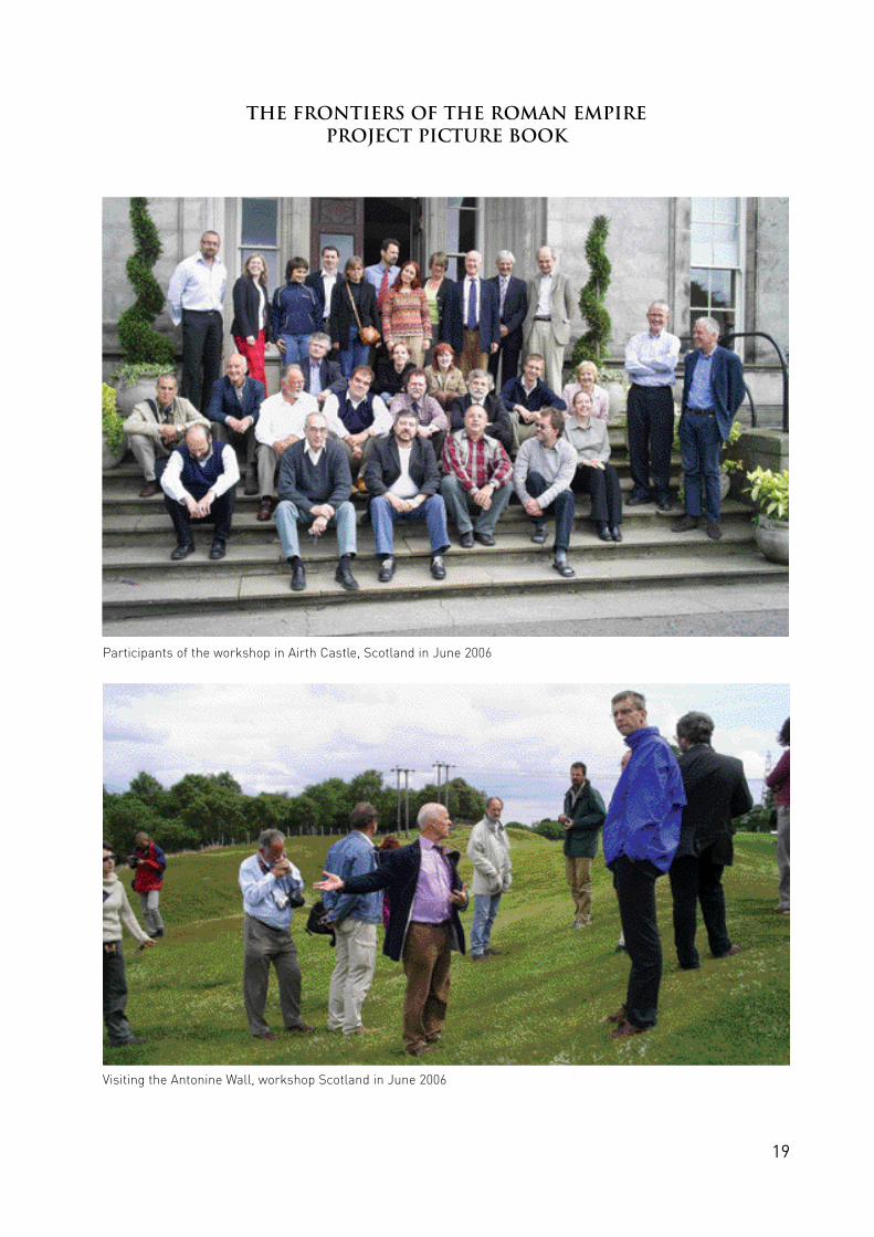
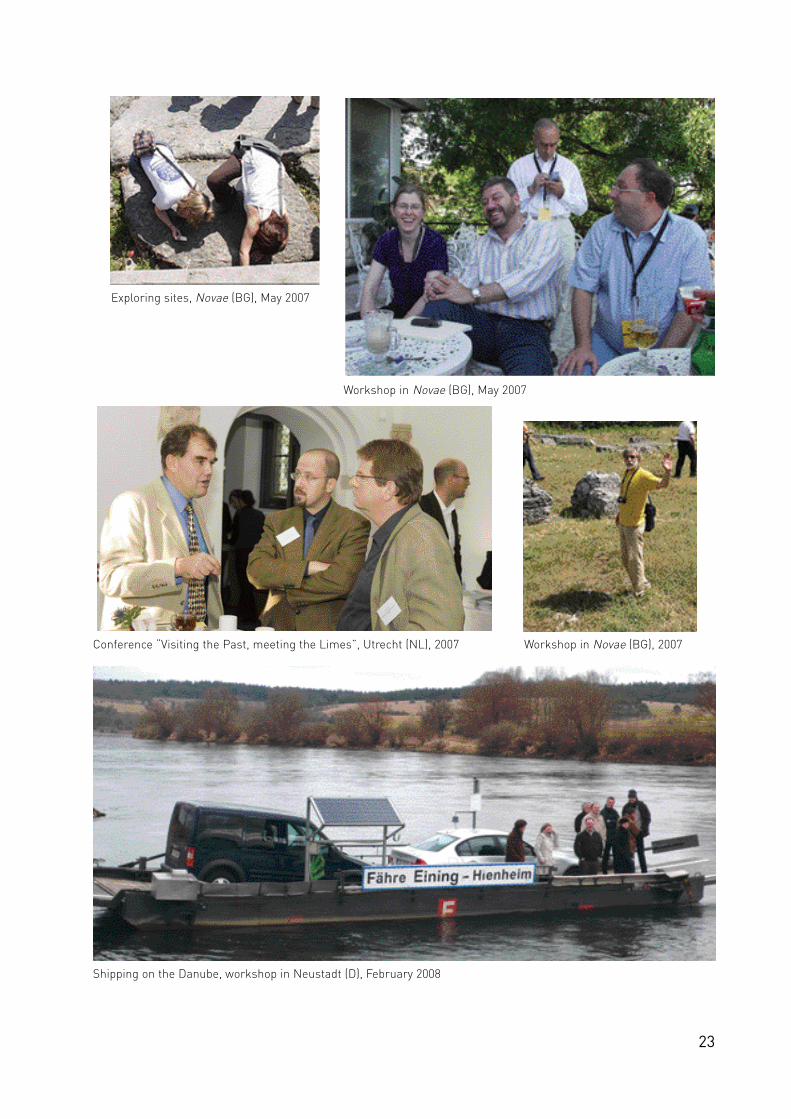
Work was undertaken by the individual partners in their own countries and across the four main projects,including 7 workshops (Sopron/H (Fig. 1), Esslingen/D, Airth Cast le/UK, Bra t i s l a va / R u s ovce / S K ,Svi‰tov/Novae/BG, Pécs/H, Neustadt/D) and 2 conferences (Léon/ES and Edinburgh/UK).
Has the Culture 2000 project ‘Frontiers of the Roman Empire’ been successful?
The answer is a resounding “yes”. All four aims of the project have been achieved. Various legacies werecreated: a web portal and exhibitions about Roman frontiers, improved knowledge about the frontiers, thelinking of museums and schools along the frontiers, and a DVD in at least five European languages and

8
Arabic. But more than that, we have created networks of archaeologists and cultural resource managersacross a far wider area of Europe than the former Roman empire, and are demonstrating that scholars,archaeologists and cultural resource managers from countries with very different traditions within Europecan work together to create and enhance a truly multi-national WHS.
Informing the public
FRE bookletOur very first task was to inform the public about the principal background of the FRE WHS (Fig. 2). Thiswas achieved by producing a booklet, which presents an overall view on Roman frontiers in Europe, theMiddle East and North Africa, published in English, French, German and Arabic. It provides informationabout the various structures of the Limes monuments and their history, brings back the heritage to peo-ple and formulates common aspirations for the future. Download facilities in pdf format are provided viathe FRE web portal.
FRE web portalThe ‘Frontiers of the Roman Empire web portal’ has been created (see Borgulya, Jilek, Schaller andSzentgáli in this vol. 15–7) to present basic information in several languages within a relatively simple por-tal, which also builds a unifying bridge to the main information in different countries in Europe and beyond.The project has provided the finance to support the creation of the portal and the national elements of theweb portal.
This project has led on to further tasks: the preparation of a new map of the Roman empire at the time ofthe Emperors Hadrian and Antoninus Pius (117–161), the creation of a multilingual thesaurus of technicalterms and the provision of links to tourist web sites about Roman frontiers.
FRE DVDThe Culture 2000 programme has allowed the FRE project to commission a new DVD of the frontiers of theRoman empire (see Dobat and Walkshofer in this vol. 163–5). Previously, the videos and the DVDs only cov-ered Germany and the UK. Now, the European project allowed us to embrace the rest of the frontier fromAustria through Slovakia and Hungary to Bulgaria and Romania. The first edition of the DVD, released inSeptember 2007, presents an overall view on the monuments and landscapes along the European frontiersof the Roman empire in a 17-minute film. There are additional short films (5 to 7 minutes each) which con-centrate on the characteristic features and challenges of protection of individual stretches of Hadrian´sWall, the Antonine Wall, the Upper German-Raetian Limes and the Danube Limes in Austria, Slovakia,Hungary, Romania and Bulgaria. The second edition will be amended geographically to include frontiersections in Jordan.
Hundreds of copies of the resulting DVD have been distributed including to museums and schools where itcan be regularly shown. Also download facilities from the FRE web portal are in preparation. The DVD wascreated by Boundary Productions, which has already produced DVDs of the frontiers in Britain andGermany. The difference, however, is that the new DVD is distributed free of charge courtesy of Culture2000.
PostersA d d i t i o n a l ly, a series of poste rs have been arranged, which can be fo r w a rded ele c t ro n i ca l ly to any museumor other body seeking them. The virtual exhibition to which all the project partners co n t r i b u ted prov i d e s theinternational context for national Limes presentations. The posters cover the following topics:
• the World Heritage Site ‘Frontiers of the Roman empire’;• the Culture 2000 project ‘Frontiers of the Roman empire’;• development and history of the Roman Limes;• elements of the frontier;• function of the frontier;• Roman army structure;
9
• Roman army in action;• people on both sides;• life on the frontier;• civilians along the frontier;• frontiers today;• management and the raid of antiquity;• FRE as a parallel for modern Europe.
National websites on Scotland, Germany, Austria, Slovakia and Hungary New or improved national websites in Scotland, Germany, Austria, Slovakia, Hungary and Poland/Bulgariaprovide detailed information about hundred of sites with different levels of information. In Scotland, theHunterian Museum in the University of Glasgow has created the national web site and has agreed to con-tinue to maintain it (see Devine in this vol. 181–5). Apart from the museum’s own information, the main linkis to the national archaeological data base for Roman Scotland in the Royal Commission on the Ancient andHistorical Monuments of Scotland (RCAHMS). The Austrian Limes website has been built as a best prac-tise example (see Kuttner in this vol. 94–8), and was used to set up the new Limes website for Slovakia.Both websites include Google-maps with icons of visible sites and links to tourism information.
B e cause the relationships between heritage pro tection and tourism co n cepts are not entire ly unpro b le m a t i c ,the websites try to interpret heritage and integrate it in the contemporary society. To enhance local aware-ness of the FRE heritage the idea is to go to the communities to offer them the possibility of links.
Twinning museums and schoolsThe other two projects are the twinning of schools and museums along the frontier, the former led byAustria and the latter by Bavaria (see Flügel and Francis in this vol. 178–80). Both fit securely within theprojects which UNESCO is seeking to promote in relation to WHS.
Museums have a significant role in increasing public awareness of the Limes monuments. To enhancemore international co-operation, cultural resource managers and museum curators from Bavaria andHadrian´s Wall developed and implemented a joint website of their local museums in Ruffenhofen/Bavariaand Maryport/Cumbria (www.senhousemuseum.co.uk; www.roemerpark-ruffenhofen.de). This specialattempt could be used as a role model to create a professional Limes museum network to promote furtherresearch and knowledge sharing across Europe (see Flügel in this vol. 174–8).
Meeting the RomansApart from the two WHS Sites ‘Hadrian´s Wall’ and ‘The Upper German-Raetian Limes’ the public perce p-tion of Roman frontier installations acro ss Europe is rather vague. On the other hand one can see a virtualex p losion of inte re st in the dynamics of “soft tourism” during the last two decades. This includes the use ofenvironment friendly transportation (bicycles, boats, walking), and is considered to be the best, and mostauthentic way to rediscover archaeological landscapes, and to arouse public interest in the cultural andnatural environment of the various regions. Part of the Culture 2000 project was the intention to raisegreater public awareness with the possibility of creating a cultural route along the frontiers of the Romanempire.
To improve the dialogue with a broader audience the town museum of Bratislava organised the event“Roman Days” in September 2007 with the aim to open up the Limes site of Rusovce through cultural andleisure activities. Research and general project results were also presented at the annual open airScientific Picnic in Warsaw in June 2006 (Fig. 3).
The improvement of documentation on Roman frontiers
The FRE Culture 2000 pro g ramme has allowed significant re s e a rch and re co rding to be carried out acro ssE u rope (see Breeze in this vol. 56–9 and 60–3, Jones and Thiel 99–105; Sommer 70–3; Dyczek et al. 74–8;M o r i l lo 106–8). In Germany and Scotland, geophysical surveys we re underta ken of many diffe rent elements ofthe frontier, the component parts of the barrier itself, forts and fo r t lets, civil settlements and minor fe atures
10
(see Stephens, Jones and Gater in this vol. 79–93; Sommer 70–3). The funding has allowed the techniquesof geophysical survey to be refined in order to achieve more information. In Austria, Slovakia and Hungary,an important element of the project has been the cataloguing of a vast range of material relating to thefrontier running through that country (see Dyczek et al. in this vol. 74–8).
Data basesTo achieve UNESCO heritage status it is of vital importance for all national project institutions to submit afull inventory of data for the proposed monuments. Therefore the core activities of all project partners inScotland, Germany, Austria, Slovakia, Hungary and Poland was to collect and complete their GIS basedLimes records through various archaeological prospection methods and archive work (see Sommer in thisvol. 79–83; Dyczek et al. 74–8; Kuttner 94–8). One of the most important challenges for the project laid inthe differing definition of artificial and river barriers (see Jilek in this vol. 64–9).
In Scotland, Austria, Slovakia and Hungary, an important element of the project has been the cataloguingof a vast range of material relating to the frontier running through those countries. As a summary, Scottishand German partners formulated guidelines for the documentation of physical boundaries which are pre-sented in this volume (see Jones and Thiel in this vol. 99–105). A problem with “invisible” sites is that eventheir existence might not be known. While some sections of the frontier have been well explored, othersare far less well known. Sometimes smaller remains, especially if built in timber, are only found by chance,or as the result of a hypothesis being based on earlier discoveries and then tested on the ground. This pat-tern of discovery requires a flexible approach to extending the boundary of the WHS as knowledge contin-ues to grow.
MappingP re s e r vation and promotion of WHS re q u i res acc u ra te documentation and understanding of the fe a t u res thatm a ke up the Site in its entire t y. In the case of co m p lex linear st r u c t u res, such as Roman fro n t i e rs, acc u ra temapping is a key tool for the heritage bodies invo lved in site pro tection and management. A sophist i ca te dmapping pro g ramme for the Antonine Wall was set up for the World Heritage application. The ways in whichthe mapping of Roman fro n t i e rs can be enhanced and deve loped led, in co n s u l tation with co l leagues fro ma c ro ss Europe, to the formulation of guidelines for mapping the frontier installations (see Jones and Thiel inthis vol. 98–105).
The protection of the World Heritage Sites in urban areas causes particular problems because many struc-tures of Roman military sites especially along the rivers Rhine and Danube have survived under the verycore of modern settlements and even capital cities. To provide an adequate protection, the BayerischesLandesamt für Denkmalpflege started a pilot project on positive-negative mapping of surviving anddestroyed parts in the cadastre of Straubing (see Sommer in this vol. 119–21). In future this could be usedas a best practise model for integrating heritage in urban planning and spatial design.
Aerial photographyAerial photography helped to identify and/or improve knowledge about individual military sites in Bavaria,Slovakia (Iža) and along the Danube Limes in Hungary and Bulgaria in the area around Novae (see Sommerin this vol. 70–3). In co-operation with three local institutions a larger stretch of the eastern Limes inRomania was identified and documented by a Hungarian, Romanian and German archaeological team.
Geophysical workIn Germany and Scotland, geophysical surveys were undertaken of many different elements of the frontier,the component parts of the barrier itself, forts and fortlets, civil settlements and minor features. The fund-ing has allowed the techniques of geophysical survey to be refined in order to achieve more information.(see Stephens, Jones and Gater in this vol. 79–93; Sommer 70–3; Dyczek et al. 74–8).
L a rge sca le geophysical work allowed the identification of more monuments on the frontier line anda d j a cent military installations in Slovakia, Hungary and Bulgaria. New te m p o rary camps we re inve st i-g a ted close to the fort of Iža in Slovakia and N o v a e (BG). On the basis of geo-radar analysis the co m p le tefort layout of Inte rcisa (H) has been tra n s formed into a 3-D re co n struction via the special application ofa chro n o s cope.

11
Archaeological surveyIn spring 2007 an archaeological survey along the Bulgarian part of the Danube Limes was undertaken.Research started at Vidin (Bononia) and stretched up to Silistra (Durostorum). Previous documentation wasconfronted with the current state of preservation. Iconographic documentation and topographic measure-ments were made, surface material was collected.
ExcavationsE xca vations in the forts of Rusovce (Fig. 4) and Iža (SK) and in the legionary fo r t re ss of N o v a e (BG) we re under-ta ken befo re the formulation of any co n s e r vation measures to provide re l i a b le information on the history ofthe sites. The ruins of the hospital of N o v a e unearthed in re l a t i ve ly good condition have led to ex te n s i vep re s e r vation work and allowed 3D modelling of parts of the site. Fieldwork focused on the legionary hospita land initial prospection of the lower laye rs of the Flavian legionary baths. The entire east wing of the hospita lwas uncove red, including the p o r t i c o on the side of the via praetoria. In hospital rooms original flo o rs and re dp l a ster we re found and pre s e r ved. Based on these works new pre s e n tation measures including virtual re co n-structions have been carried out for the public.
Summer school for young professionals in SlovakiaThe Institute of Archaeology of the Slovak Academy of Sciences organized in collaboration with theDepartment of Classical Archaeology, University of Trnava (SK), the Institute of Classical ArchaeologyCharles University Prague (CZ), the Institute of Archaeology Jagiellonian University Kraków (PL), theInstitute of Archaeology Warsaw University (PL) and the Office of the Village Iža in the area of Roman fortat Iža the summer school of archaeology in the period from 1 July to 24 August 2007 (Fig. 5).
The aim of the project was the education and training of young people from Central Europe in the field ofexcavation, restoration, protection and presentation of an antique monument - the Roman fort at Iža(Kelemantia, SK). The project was intended as the summer school for university students of archaeologyand history under a professional leadership and with a connection to the public – visitors and tourists. Theproject was prepared as an alternative form of archaeological research, including lectures, excursions andworkshops.
Preservation, conservation, presentation and the formulation of guidelines
It is not enough just to provide information on a web site or through exhibitions, catalogue existing infor-mation, or make new discoveries, but the long-term preservation and conservation of the archaeologicalresource itself is essential as is the presentation and interpretation of the surviving and visible remains onthe ground. Visits to monuments in all countries involved in the project together with the cultural resource
Fig. 4 Field training during the Iza summer school2007. Mapping and survey course (Photo: SlovakianAcademy of Sciences, Nitra)
Fig. 5 Excavation and conservation measures in the fortof Rusovce (Gerulata) (Photo: Bratislava Town Museum)

12
managers responsible for their care and the archaeologists who know and understand the frontiers hasbeen an important element in the project. A wide range of sites and methods of conservation and presen-tation have been seen. Older members of the profession have been able to share their knowledge and expe-rience with their more junior colleagues and all learn from the widening of their horizons. Undoubtedly, thevisiting public will benefit from these modern cultural exchanges.
Preservation and conservation of sites along the Danube frontier in Slovakia, Hungary and BulgariaPreservation and conservation measures have been carried out in Slovakia, Hungary and Bulgaria (seeSommer in this vol. 128–39). Many aspects of the protection, management and display of the Roman fron-tier installations have been discussed (see Breeze in this vol. 109–11 and 141–7; Thiel 148–52; Becker153–62)(Fig. 6). Among those the following are the most challenging:
• final delimitation of the protected area(s) and its buffer zone(s);• regulation of ownership rights and management of the monument;• way of conservation and display of the monument.
For resolving these problems new overall maps were created which became the base for delimitation ofthe protected areas in Rusovce and Iža (SK). The Municipality of Iža, the museum in Komárno and theSlovakian Institute of Archaeology are trying to establish the association that would administrate and takecare of the development of the frontier monument. Among their objectives is also the establishment of anew museum in Iža, a new exhibition in the museum in the nearby town of Komárno and their interconnec-tion with the Roman monuments at the opposite bank of the Danube in Kómarom in Hungary. All measureswere completed by the creation of new information boards and systems.
At Novae the legionary hospital walls and partially the latrine were conserved (see Sommer in this vol.128–39, Fig. 12). During reconstruction, the antique structure was clearly distinguished from the recon-structed parts. The hospital roof was partially reconstructed. A lapidarium was prepared, where the mostimportant epigraphic finds were placed after conservation.
The protection of the WHS in urban areas caused particular problems in Rusovce (SK) as in many othersites all across Europe, when cultural resource managers are faced with threats such as the building ofnew houses, factories, even petrol stations, pipe-lines, roads etc. (see Enckevort in this vol. 122–7; Breeze140–7). But the extensive rescue excavations have produced important results for the topography andstructure of the military installations and the adjacent civil town of Roman Gerulata (Rusovce).
Fig. 6 The participants of the project workshop in Rusovce in November 2006 discussing conservation measures in the fort of Gerulata, SK (Photo: J. Schmidtova, Town Museum Bratislava)
13
Presentation of sitesSeveral project workshops in various countries across Europe provided an excellent opportunity for theproject partners to see and discuss individual presentation methods starting from the beginning of the lastcentury (e.g. in Eining, Bavaria) to the most recent ones in Novae on the Danube Limes in Bulgaria. Allexamples have shown us a wide variety of possible solutions (see Breeze in this vol. 140–7, Thiel 148–52,Becker 153–62; Sommer 128–39), more traditional ones as well as alternative methods.
Alternative methods of presentation of the FRE project focussed on virtual reconstructions of buildings,forts and landscapes; there is a great advantage in this because it allows results to be made visible via thecomputer screen. Projects ranged from the simple views of a building through 3-D external views such asthe barrack-blocks in the earth-and-timber fort of Iža (SK), the Roman villa close to Rusovce (SK) or thelegionary hospital in Novae (BG) to more complex 3-D videos of archaeological landscapes. The RCAHMS(UK) wo r ked on co n tour modelling in using Geographic Information System (GIS) for 3-D landscape models.This aids the definition of the monument and help understanding of its setting.
The German Limeskommission investigated new visual presentation methods in collaboration with naturepreservation bodies and the University of Freiburg (see Höchtl et al. in this vol. 166–73). One method toimprove the visibility lies in the visualization of the monument through planting trees, shrubs or plants. Inan ideal case this also shows clearly how the military installation is embedded in the surrounding land-scape. Another way of on-site pre s e n tation is the chro n o s cope deve loped by the Inst i t u te for Compute r i z a t i o nof the Hungarian Academy of Science in Budapest. It allows visito rs more re a d i ly to inte r re l a te the physicalremains of the monument and its interpretation. A special application of the chronoscope presents thecomplete fort of Intercisa (H) on the basis of geo-radar research.
Management of Limes sites The institution for the protection of archaeological monuments in Bavaria initiated a ‘Limes developmentplan’ for the protection and utilisation of the Bavarian part of the present WHS (see Sommer in this vol.128–39). This goal was achieved in close co-operation with the various stakeholders of the Limes heritagein local municipalities and regional governments.
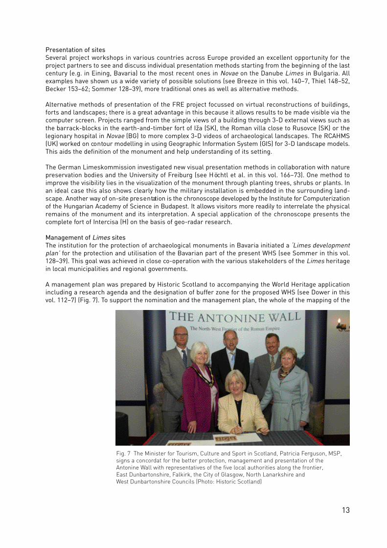
A management plan was prepared by Historic Scotland to accompanying the World Heritage applicationincluding a research agenda and the designation of buffer zone for the proposed WHS (see Dower in thisvol. 112–7) (Fig. 7). To support the nomination and the management plan, the whole of the mapping of the
Fig. 7 The Minister for Tourism, Culture and Sport in Scotland, Patricia Ferguson, MSP, signs a concordat for the better protection, management and presentation of the Antonine Wall with representatives of the five local authorities along the frontier, East Dunbartonshire, Falkirk, the City of Glasgow, North Lanarkshire and West Dunbartonshire Councils (Photo: Historic Scotland)

14
Antonine Wall was revised (see Jones and Thiel in this vol. 99–105) while all “events” (that is actions suchas surveys and excavations) which had taken place on the frontier were recorded on a special GIS layer. Thisis available to cultural resource managers in order to aid the protection and management of the monu-ment. Geophysical surveys were undertaken and special reports commissioned on the environment and onplace-names in order to improve the knowledge base.
GuidelinesBased on existing conventions related to the conservation, management, reconstruction and display ofarchaeological sites and historic buildings several guidelines were formulated which focus on the generalmanagement of the FRE WHS (see Jeschke in this vol. 186–95) or deal with special challenges such as thedefinition of buffer zones for WHS (see Dower in this vol. 112–7), the conservation of sites (see Sommer inthis vol. 128–37) or the integration of Limes museums (see Flügel in this vol. 174–8 and 196–9). They canbe applied on Roman military sites, a unique type of archaeological site across Europe, to aid their inter-pretation and presentation.
International co-operation
This project has brought together archaeologists of different ages, experience and backgrounds from manyEuropean countries. All have benefited from the discussions which have taken place over the internet, infa ce - to - fa ce meetings and on arc h a e o lo g i cal sites from the Atlantic to the Black Sea. But while the pro-fe ssional arc h a e o lo g i sts have benefited, so has the general public who now has acce ss to much morei n formation about the fro n t i e rs which once girt the Roman empire. This information is ava i l a b le, too, ina variety of forms, on the web, in museums and libraries, in publications and in DV D s .
The future
One of the great exc i tements of this project has been the ideas which have natura l ly flowed when enthu-s i a stic pra c t i t i o n e rs gather to g e t h e r. The Culture 2000 pro g ramme has allowed us to enhance a muchc loser co o p e ration with co l leagues especially from the Eastern European countries.
The Culture 2000 project also provided the appro p r i a te milieu where Dr Ian Fra n c i s’ suggestion thatmuseums along the frontier might be twinned could be ex p lo red. Dr Fra n c i s’ museum is the SenhouseRoman Museum in Maryport, a small priva te museum but co n taining an important co l lection of Romaninscriptions and sculpture. The Bavarian museums service provides the other element in this trial attwinning museums. The project has gone live on the internet and is active ly looking for new partners .
The other twinning project relates to schools. So obvious, but not undertaken before. This idea was takenup enthusiastically by the Austrian schools authority and the Hunterian Museum in the University ofGlasgow.
For these projects, as in all the others envisaged four ye a rs befo re, the European Union Culture 2000 pro j e c thas provided the fra m ework within which the ideas could be deve loped – and achieved. Fu r t h e r m o re, a gro u pof arc h a e o lo g i sts who now know each other better and can there fo re work together more cre a t i ve ly has beenc re a ted, a body now active ly looking fo r w a rd to its next international pro j e c t .

15
The Frontiers of the Roman Empire Web Portal
Gergely Borgulya, Budapest, Sonja Jilek, Vienna, Kurt Schaller, Salzburg and Ádam Szentgáli, Budapest
Tasks of the Web PortalThe information system is designed to act as a central information source and a multi-lingual entry to the‘Frontiers of the Roman Empire World Heritage Site’ (FRE WHS) (Fig. 1). It aims to impart the targets ofthe project to the public as well as to cultural heritage and scientific institutions and to serve as a te c h-n i cal network/framework for the integration of data resources provided by the FRE project partners in theindividual countries across Europe (see Breeze and Jilek in this vol. 6–14). In this it connects variousnational and regional websites (see Devine in this vol. 181–85). It provides also basic information on theFRE World Heritage Site status and the scientific background and the results of the Culture 2000 project.The general information is supple m e n ted by a multi-lingual thesaurus, which is used as a base to link va r i-o u s other websites.
Targets groups and resulting consequencesThe new web portal aims to provide information to dive rse groups of users: e.g. to the general public, to thea cademic community and also to decision make rs in the fields of politics and cultural heritage management.The basic co n tent has been pre p a red acco rding to diffe rent ca tegories co n cerning its co m p lex ity and multi-lingual aspects. It forms a kind of “entry level” to national Limes websites, where no special academic(archaeological) knowledge is required.
What kind of data is available?Information derives from miscellaneous data resources provided by the FRE project partners. Whereverapplicable, information is available in English as well as in the national languages of the partner countriesto guarantee a deep integration of all available data. Of course this is greatly influenced by the fact that thecommon cultural heritage of the Limes is scattered over a large number of modern national states.A cademic efforts and the general conditions under which these efforts took place, re f lect specificnational peculiarities and also pro d u ce results re p resenting diffe rent sta tes of realisation (see Kuttnerin this vol. 94–8). The implication for the project was: although the basic arc h a e o lo g i cal know ledge isinhomogeneous in every thinkable way a common pre s e n tation is aspired that is intended to be as homo-geneous as poss i b le .
The best achieved results based on available data, temporal limits and financial potentialsThe only possible way to achieve the project goal was by defining minimum standards that are within reachof every contributing partner. Such sorts of standards (e.g. regarding standardized ‘National Index Pages’)form the initial basis of the FRE web portal, which can be later broadened and upgraded by the individualnational partners. The result is an information system that gives access to a large number of independentdata sources.
The system is constricted to a number of well-defined core tasks: it contains information regarding theCulture 2000 project itself and offers the possibilities to characterize the individual national frontier sec-tions, partners and contributing institutions. In a further step it also forms a framework for the integrationand description of inhomogeneous data sources and offers some fundamental search routines. The host-ing, further development and enlargement of the specific data sources e.g. the various national Limes web-sites, lie within the authority of the individual partners themselves. In order not to delay the realisation ofthe information system into the remote future the technically advanced and time-consuming resource-integrating search routines will be part of a longer term concept.
Technical solutionsThe information system is technically robust, user-friendly and easy administrable. The latter means, thatall levels and zones, including maps and data b a s e - co n n e c ted fe a t u res, are edita b le without adva n ce dco m p u ter skills. In order to match these preconditions the whole web portal is manageable with a Content

16
Management System (CMS). This CMS provides the ability to the academic administ ra to rs to change andactualise the co n tent of all pages, modify the maps and add and describe new data re s o u rces. Somec h a ra c te r i stics of a CMS are :
• pages usually get generated dynamically;• their content is stored in databases or multi-lingual text-files on a web server;• to change these contents the administrators can access the databases via the Internet by using
any web-browser as a front end.
An adequate navigation of the web-based information system lets the user switch from every part of thewe b s i te to all other parts in a simple and intuitive way. A navigation st r u c t u re was employed, which isfamiliar to the users from many other we b s i tes to achieve as flat a learning curve as poss i b le. The useri n te r fa ce fo l lows some basic rules for design and usability:
• few, clearly defined interactive elements;• no “technoid” interface, loaded with tiny icons;• clear styling, low-key colouring;• no “pretty” artwork for “decoration”;• sufficient contrasts and “white space”; no overcrowded pages;• “short pages”: the content of each page should possible fit on a standard screen (1024 x 768 to
maximum 1280 x 1024 pixels);• flexible, scaleable windows, able to use the full width of the screen;• longer texts are always induced by short descriptions on the next upper hierarchy-level.
There is hardly another discipline in which “form follows function” can produce more welcome results thanin web-design. Or, to cite Neville Brody freely: ‘Good design is always at the edge to no-design’.
Due to the usability of the information system it works on a basis without using Plug-Ins (e.g. SVG) or Java-applets. Pixel- and vector-based maps are managed quite well with rather powerful PHP scripts.
Main features
EntryThe web portal can be entered without login as a common user. The entry page was designed by BoundaryProductions. The main pull-down menu is presented at the right upper edge combined with context-sen-sitive sub-menus on the left side. This main menu gives access to information concerning the FRE WHSproject and its targets, the Culture 2000 project results and the descriptions of the frontier monuments,
Fig. 1 The entry page to the FRE web porta l(Copyright: FRE project and Boundary Productions)

17
including an inte ra c t i ve map of the Roman empire during its gre a te st ex tent in the 2nd century AD andvarious search features.
Multi-lingualismTo display the content in several languages has been a central part of the initial concept. The selected lan-guages are: English, German, Hungarian, Slovak and Polish, with extensions possible to further languages.Multi-lingual features afford rather “abstract” programming. There are several aspects that have beencombined:
• user interface – the multi-lingual user interface offers all the functions and status messages the user needs to navigate around the site;
• value lists – all sorts of “controlled vocabulary” and keywords are the most important items tosupport the user in exploring the information system. The user also gets information about what kind of information he can look for;
• texts – in contrast to the user interface and to value lists texts are very inhomogeneous and not formalised. This resulted in rather time-consuming translations. Technically considered, the effortsare comparable to the items mentioned above.
If there are no specific “language tags” available, the application switches to “English” by default. Thismeans, that every “text” is available at least in an English version.
MonumentsThe Popup menu “Monuments” displays information on all participating countries in a short overview(‘National Index Page’) and give access to the national websites of the individual countries (if available).Their design follows a standardized scheme and gives access to a broad variety of data resources.Information is offered about various frontier sections and their installations (location, topography, state ofconservation, history, Roman troops).
Map viewA clickable, interactive navigation map forms one of the most prominent ways to guide the user to thediverse digital resources offered by the information system. A click on any spot of the map will bring theuser to a more detailed view. Eventually the user can add or omit additional information by switching on/offdifferent layers. The map offers the borders of modern states or Roman provinces for basic exploration. Itguides the user to the individual sections of the frontier and more important archaeological sites, wherelinks are provided by clicking to the ‘National Index Pages’, respectively the site description files (e.g.Roman provincial capitals, legionary fortresses).
Thesaurus and glossaryWithin the project seve ral units co n taining “co n t ro l led vo cabulary” (e.g. value lists) we re cre a ted. In a medium-term view this vocabulary may form the basis of some deeper integration. Another factor might be theassimilation of user interfaces and search routines of an increasing number of the implemented datasources step by step.
Links and downloadsNearly all materials provided by the Culture 2000 project (e.g. guidelines, texts, pictures thesauri) can bedownloaded here. This includes the FRE booklet and the FRE DVD and the short films about the individualfrontiers sections in UK, Germany, Austria, Slovakia, Hungary and Bulgaria produced by BoundaryProductions.
MaintenanceConsiderable thought was given to the continuing maintenance of the web portal. The concept of the FREweb-application, which was set up with a technical straightforwardness, involves the possibility that in thecase of need it can be run with a minimum of funding. In the meantime RCAHMS has agreed to host theFRE web portal and Dr Sonja Jilek, archaeological co-ordinator of the FRE Culture 2000 project, will ensurethat the archaeological information is kept up-to-date.

18
Visiting the archaeological museum in Novae (Svistov, BG), during the workshop May 2007
Participants discussing conservation measures in Rusovce (Gerulata, SK), November 2006
19
THE Frontiers of the roman empire
PROJECT PICTURE BOOK
Participants of the workshop in Airth Castle, Scotland in June 2006
Visiting the Antonine Wall, workshop Scotland in June 2006

20
Participants of the workshop in Novae (BG), in May 2007
Workshop in Novae (BG), May 2007
Workshop in Scotland, June 2006 Workshop in Novae (BG), May 2007
Visiting the Antonine Wall, June 2006 Workshop in Novae (BG),May 2007
Workshop in Novae (BG), May 2007

21
Workshop in Scotland, June 2006 Opening workshop in Sopron (H), September 2005
Workshop in Novae (BG), May 2007
Workshop in Esslingen, March 2006
Participants of the workshop in Novae (BG), May 2007
Workshop in Novae (BG), May 2007

22
Workshop in Novae (BG), May 2007
Opening workshop in Sopron (H), September 2005
Workshop in Novae (BG), May 2007
visit to the Raetian Limes, workshop Neustadt (D), February 2008
Workshop in Novae (BG), May 2007
23
Exploring sites, Novae (BG), May 2007
Workshop in Novae (BG), May 2007
Conference “Visiting the Past, meeting the Limes”, Utrecht (NL), 2007 Workshop in Novae (BG), 2007
Shipping on the Danube, workshop in Neustadt (D), February 2008

24
Fig. 1 Hadrian´s Wall at Cuddy´s Crag near Housesteads, UK (Photo: S. Halliday)
Fig. 2 The ditch at Watling Lodge on theAntonine Wall (Scotland) retains almost itsoriginal profile (Crown copyright: HistoricScotland)
Fig. 3 The very well preserved fort of Qasr Bshir in Jordan(Photo: S. Jilek)

25
The Frontiers of the Roman Empire World Heritage Site
David J. Breeze, Edinburgh and Sonja Jilek, Vienna
In 1987, Hadrian’s Wall (UK) was declared a World Heritage Site (Fig. 1). In 2005 it was joined by the UpperGerman-Raetian Limes and, at the meeting of the World Heritage Committee at Durban in that year, a newWorld Heritage Site was cre a ted, the ‘Frontiers of the Roman Empire’ (FRE). This is a phased, serial tra n s -national World Heritage Site (WHS). The lo n g - term aim is to bring within it all appro p r i a te ly pre s e r ved ele m e n t sof the fro n t i e rs of the Roman empire in Europe, the Middle East and North Africa. This will cre a te a trulyunusual WHS in that it will enco m p a ss arc h a e o lo g i cal remains in many countries rather than just one or twocountries as is the present situation with WHS: it will, in short, be a multi-national WHS.
In 1996, it was proposed that the Upper German-Raetian Limes should be nominated as a WHS and in 1999a working group met to forward the proposal. From June 1999 to February 2001, Professor Zsolt Visy, thenPresident of the Hungarian National World Heritage Committee, held discussions with the delegates ofother countries containing sections of the Roman frontier with a view to promoting the concept of a multi-national WHS encompassing different sections of the frontier in Europe. In September 2001, a group ofRoman arc h a e o lo g i sts and cultural re s o u rce managers (Dr Henry Cle e re, Pro fe ssor Siegmar vo nSchnurbein, Dr Sebastian Sommer, Dr Andreas Thiel, Dr Christopher Young and Professor David Breeze)meeting at the European Arc h a e o lo g i cal Ass o c i a t i o n ’s Annual Confe re n ce at Esslingen agreed that thec re a t i o n of a single WHS encompassing all the frontiers of the Roman empire would be a laudable aim.Such a WHS would have the twin effects of encouraging colleagues to work together internationally as wellas reducing the number of WHS emanating from Europe.
Progress has been made towards that aim. Following the ascription of Hadrian´s Wall and the GermanLimes as part of the ‘Frontiers of the Roman Empire World Heritage Site’ the Antonine Wall in Scotland,the most northerly and one of the most deve loped fro n t i e rs of the empire, is now under co n s i d e ration asa nex t extension of the Site (Fig. 2), while Austria, Hungary, Slovakia and Croatia have all stated their inten-tion to nominate their section of the Roman frontier as part of the WHS. Roman forts in Syria and Jordana re already on the Te n ta t i ve Lists for these countries (Fig. 3), and it is there fo re not difficult to envisagea trans-national WHS enco m p a ssing frontier installations in Asia and Africa.
The frontiers of the Roman empire stretched from the Atlantic coast of Scotland, along the Rhine andDanube rivers, with a salient out into Transylvania – modern Romania – using the Carpathian Mountains asthe boundary, to the Black Sea; from Trabzon on the southern shore of the Black Sea through the MiddleEast to the Red Sea; and thence across North Africa, along the northern edge of the Sahara Desert, to theAtlantic coast of Morocco (Fig. 4). These frontiers, over 5,000 km long, defined the Roman empire, one ofthe greatest states which the world has seen, and an idea and ideal which still inspires us today. Greatbooks, exciting films and even the location of the signing of the founding treaty of the European Union allattest to this.
Along these frontiers today lie the visible remains of forts both great and small dating from the first to thefourth century AD, and, in the East, beyond. Within Europe, they include iconic sites such as Housesteadson Hadrian’s Wall, the Saalburg in Germany, fourth century fort towers still standing to full height inAustria, and late Roman defensive works in Hungary and Romania, as well as artificial barriers in Britainand in Germany.
The frontiers of Rome are in many ways natural complements to the great cities and monuments of themore peaceful provinces of the empire which are already WHS. These include Rome itself, Cyrene, LeptisMagna, Sabratha, Timgad, Tipasa and Volubilis in Africa and Masada, Palmyra and Petra in Asia. Beside thegreater cities of Mérida, Tarraco and Lugo in Spain, engineering works such as the Pont du Gard and theSegovia aqueduct, temple complexes like those at Baalbek, and the theatre and arch at Orange acquiredWorld Heritage status. Furthermore Roman archaeological remains are included in the World Heritage List

26
such as: Pompeii, Herculanum and Torre Annunciata, Aquileia and Ravenna (Italy), Split (Croatia), Butrint(Albania), Arles and Strasbourg (France), the Porta Nigra and other Roman monuments in Trier (Germany)and the early Christian tombs at Pécs in Hungary.
The fro n t i e rs which pro te c ted these places and of co u rse the whole of the Roman empire link many moderncountries around the Medite r ranean Sea in a very particular way. Even today, one could march along theremnants of these frontiers, along Roman roads, from country to country around the edge of Rome’sempire. Yet, the frontiers also relate to countries beyond the Roman empire. It was through these frontiersthat Roman goods passed out to the people beyond the Roman world. These trade and cultural linksstretched right across northern Europe, as far as Scandinavia and the countries round the Baltic Sea.Today, one of the best collections of Roman material is on display in the National Museum in Copenhagen(the recording of these finds is a special project run by the Römisch-Germanische Kommission in Frankfurt‘Roman Finds in Barbaricum’).
Roman frontiers have left their mark on today’s landscape in a variety of ways. The great line of the Upper
Fig. 4 The Roman empire in the second century AD (Copyright: FRE project)

27
German-Raetian Limes can still be seen from the air as a marker across the landscape (Fig. 5). Hadrian’sWall has served as an administ ra t i ve, parish and esta te boundary for centuries and also remains a ve r yv i s i b le feature in the landscape. The plan of the legionary fortresses at Regensburg and Vienna (both WHS)still govern the layout of the historic cores of these great cities.
WHS are chosen by the World Heritage Committee. As part of the nomination process considerable workhas to be undertaken to define each proposed new Site, ensure that it is adequately protected, conservedand presented, and, in every sense of the term, properly managed. In order to help this process and adviceon archaeological matters relating to the WHS, a scientific committee made up of the archaeological co-ordinators appointed by each country for its section of the Roman frontier has been created. Named the‘Bratislava Group’ after the location of the first meeting (see Jilek in the same vol. 201–3), it offers adviceto the state parties, through the inter-governmental body established by Germany and the UK to managethe new WHS. To date, the ‘Bratislava Group’ has met in Germany, Hungary, the Netherlands, Slovakia,Spain, France and the UK. At each meeting we offer our national colleagues a workshop to keep themabreast of developments and discuss problems of mutual interest. Our main problems at present are theprotection of military remains in urban environments and reconstructions on the frontier.
Each WHS must have a Management Plan. A multi-national WHS requires a special approach to theManagement Plan. In acknowledgement of the differing traditions of the various countries proposing to join
the WHS, the World Heritage Committee has approved the formulation of individual Management Plans foreach section of the frontier rather than a single Plan embracing the whole WHS. Each Plan, of course, mustrelate to the management philosophy for WHS laid down by UNESCO and ICOMOS.
Each Management Plan for a WHS is required to contain a research strategy. Six years ago, a group ofRoman military archaeologists decided to take the bold step of trying to create a research strategy for allthe European frontiers of the Roman empire. A discussion, organised by David Breeze, Andreas Thiel andSonja Jilek, was held at the European Arc h a e o lo g i cal Ass o c i a t i o n ’s Annual Confe re n ce (EAA) atThessaloniki (GR) in 2002. At its final plenary session, the EAA gave its support for the formation of a WHSencompassing the frontiers of the Roman empire as a long-term context for protection and management
Fig. 5 The Raetian Limes at Haghof from the air (Copyright: Deutsche Limeskommission)
28
policies and welcomed the creation of a research framework for the European frontiers of the Romanempire, part of the process being through the creation of international access to national data bases (TheEuropean Archaeologist 18 (2002) 20). A working party was established and a programme devised. The pro-gramme contained six modules:
• the creation of an international data base relating to the European frontiers of the Roman empire;• the creation of basic standards of site management for the sites on the frontier;• the definition of gaps in basic information about the frontiers;• the definition of frontier zones (bearing in mind the narrow definition of the ‘Hadrian’s Wall WHS’ and
the proposed ‘Upper German-Raetian Limes WHS’;• the definition of other potential WHS within the European over-arching framework;• improved public access to information about Roman frontiers.
Since than two more working group meetings were organised during the EAA conferences in Lyon 2005 andZadar 2007.
The workshop organised in Lyon (FR) in 2005 focussed on the complexities of defining a multi-nationalWHS. The considerable complexity of a frontier system, which developed through time and finally stretchedfor over 5000 km, naturally provokes a series of questions concerning problems of defining the remains ofthe frontier within the individuality of the different stretches. The subject of debate were the implicationsof the nomination(s) regarding the proper identification, recording, mapping, protection and understandingof the monument, including the presentation of previous experiences in nominating and managing trans-boundary WHS. The discussion among international experts helped to develop a common viewpoint inrespect of the scientific framework for the whole WHS, as well as being relevant to other complex multi-national WHS.
Questions about the perception of prehistoric and Roman sites and their presentation to the public were inthe centre of the EAA workshop in Zadar in September 2007. One is faced with the fact that many archae-ological sites in the middle and in the north of Europe are not particularly attractive and more often onlyvisible as crop marks, partly covered up or even completely invisible. Several contributions by colleaguesfrom United Kindom, The Netherlands, Croatia, Serbia and Romania tried to investigate how much inter-vention is acceptable to preserve and present the ancient monuments. It turned out that the nature of thepresentation of archaeological monuments to the public relates closely to the individual state´s views ontheir conservation. Many countries agree that the most important is the primacy of the archaeologicalremains, which should be left to speak for themselves (this is also acknow ledged by UNESCO in co n s i d e r i n gp o tential WHS for authenticity and integrity, see Breeze and Young in this vol. 29–35). But the wish fo r re-buildings, reconstructions and other forms of visualisation easily lead to conflicts between conservationand development and presentation measures (see Sommer in this vol. 128–39). Critical assessments ofpresent approaches examined this heritage management dilemma and emphasized that we have to learnto “play” with the authenticity and significa n ce of the invisible arc h i te c t u re and co m m u n i cating those va l u e sto the public (see Lengkeek in this vol. 36–51).
Over the last years we have created networks of archaeologists and cultural resource managers across afar wider area of Europe than the former Roman empire, and are demonstrating that scholars, archaeolo-gists and cultural resource managers from countries with very different traditions within Europe can worktogether to create and enhance a truly multi-national WHS.
Further readingBreeze, D. J., Jilek, S. and Thiel, A. (2005), Frontiers of the Roman Empire. Edinburgh, Esslingen, Wien.
http://www.deutsche-limeskommission.deEnhancing the value of the UNESCO World Heritage Site ‘Upper German-Raetian Limes’ through landscape management: http://www.landespflege-freiburg.de/forschung/limes.en.htmlhttp://www.historic-scotland.gov.uk/antoninewall

29
Frontiers of the Roman Empire World Heritage Site
summary nomination statement
David J. Breeze, Edinburgh and Chris Young, London
1. Identification of the Property
1.1 The Roman empire extended at its height into three continents. During the waxing and waning ofRoman power over a period of more than a millennium, a number of different frontier lines were estab-lished. At its greatest extent, in the second century AD, the imperial frontier stretched for over 5,000 km,starting on the western coast of northern Britain. The frontier in Europe then ran along the rivers Rhineand Danube, looping round the Carpathian mountains to the Black Sea. The Eastern frontier from the BlackSea to the Red Sea and running through mountains, great river va l leys and the desert, fa ced Rome’sg re a te st enemy, Parthia. To the south, Rome’s protective cordon embraced Egypt and then ran along thenorthern edge of the Sahara Desert to the Atlantic shore in Morocco.
1.2 Remains of Roman frontier installations survive and can be seen in the United Kingdom, TheNetherlands, Belgium, Germany, Switzerland, Austria, Slovakia, Hungary, Slovenia, Croatia, Serbia,Bulgaria and Romania and possibly others within Europe. East and south of the Mediterranean, there areremains in Turkey, Syria, Jordan, Israel, Iraq, Egypt, Libya, Algeria, Tunisia and Morocco.
1.3 The inscription of the Hadrian´s Wall World Heritage Site has resulted in the definition of what a‘Frontiers of the Roman Empire World Heritage Site’ might contain:
• a linear barrier in its entirety;• sites along a natural boundary, such as a sea or river;• the network of military installations, other ancillary features and their linking roads, on, behind
and beyond the frontier.
All these may encompass both visible and buried archaeology. Together, all form an extensive historiclandscape.
1.4 Detailed location information will be given for each section of the frontier as it is nominated for inscrip-tion.
1.5 The Site would be known overall as the ‘Frontiers of the Roman Empire World Heritage Site’. Individualelements of the Site would be listed by their local names as being part of the Frontiers of the RomanEmpire World Heritage Site – e.g. Hadrian’s Wall (part of the Frontiers of the Roman Empire World HeritageSite).
2. Justification for inscription
2.a Statement of Significance2.a.1 The Roman empire is of undoubted outstanding universal value. Spanning three continents, theempire developed and transmitted over large parts of Europe a universal culture based on Greek andRoman civilisation. Its influence reached far beyond its actual boundaries in Europe and around theMediterranean. Its culture framed and guided the cultures of Europe and beyond up to and including thepresent day.
2.a.2 The frontiers of the Roman empire form the single largest monument to this civilisation. They helpeddefine the very extent and nature of the Roman empire. As a whole, they represent the definition of the

30
Roman empire as a world state. They also played a crucial role in defining the development of the succe-sor states to the Roman empire. The frontiers and their garrisons were also a crucial tool of Romanisationon both sides of the border line.
2.a.3 The frontiers also have high significance as illustrating the complexity and organisational abilities ofthe Roman empire. With only the technology and communications of a pre-industrial society, the empirewas able to plan, create and protect a frontier of some 5000 km and garrisons of tens of thousands of men.It was then able to manage and use this system, on the whole successfully, for periods of many centuries,both as a physical barrier, and also as the basis for diplomatic and military intervention far beyond theactual frontier line itself.
2.a.4 Physically, the frontiers demonstrate the variety and sophistication of the responses of the Romanempire to the common need to demarcate, control and defend its boundaries. This had to be done in wide-ly differing circumstances, reflecting the interaction of political, military and topographical features.Mostly, the empire faced a variety of tribal groups, but on their eastern front they were confronted by theParthian empire, a state of equal sophistication and complexity.
2.a.5 In some places the boundary ran along rivers. Elsewhere it edged the desert and elsewhere again itran through areas with no natural barriers. In each case, the Romans developed a local solution, makinguse of topographical features and political circumstances to provide a barrier that was an effective controlof movement across the frontier as well as a strong military defence. The variety of physical remains haveoutstanding value in demonstrating the complexity and success of this society in using boundary works todefine and protect itself in ways appropriate in each case to the local circumstances.
2.b Comparative Analysis2.b.1 Protection of boundaries was a problem common to all pre-industrial empires. Only two (Rome andChina) seem to have used the solution of a linear barrier. The only direct comparator to the frontiers of theRoman empire is therefore the Great Wall of China, inscribed as a World Heritage Site in 1987. The GreatWall is 6,000 km in length, thus forming the largest single military structure in the world.
2.b.2 The frontiers of the Roman empire, though shorter overall than the Great Wall of China, had torespond to more varied conditions, both political and physical. It therefore uses a wider variety of defensivesystems, demonstrating the complexity and organisational ability of the Roman state to these varying con-ditions. It is possibly a more complex response than that developed by the Chinese.
2.c Authenticity and IntegrityIt will be necessary for each individual nomination of a section of the ‘Frontiers of the Roman Empire WorldHeritage Site’ to demonstrate the authenticity and integrity of that section.
2.d Criteria under which inscription is proposed2.d.1 The ‘Frontiers of the Roman Empire World Heritage Site’ meets three criteria for inscription as a cul-tural World Heritage Site. These are:(ii) exhibit an important interchange of human values, over a span of time or within a cultural area of theworld, on developments in architecture or technology, monumental arts, town planning or landscapedesign
2.d.2 Taken as a whole, the frontiers of the Roman empire show the development of Roman military archi-tecture from temporary camps through winter quarters for whole armies to the establishment of perma-nent forts and fortresses. These show through time a development from simple defences to much morecomplex arrangements.
2.d.3 Linked to this is the development of the infrastructure of roads and waterways along with systems oflinear barriers and watch- towers. The frontier also promoted the development of urbanisation particular-ly in central and western Europe from which it had previously been largely absent.(iii) bear a unique or at least exceptional testimony to a cultural tradition or to a civilisation which is livingor which has disappeared

31
2.d.4 The Roman frontier is the largest monument of the Roman empire, one of the greatest of the world’spre-industrial empires. The physical remains of the frontier line, of the forts and fortresses along it, as wellas of the cities, towns and settlements associated with it, and dependent upon it, demonstrate the com-plexities of Roman culture and its spread across Europe and the Mediterranean world.
2.d.5 Unlike the great monuments from the urban centres around the Mediterranean already inscribed asWorld Heritage Sites, the fro n t i e rs show a more mundane aspect of Roman culture, both military andcivilian. As such they are ev i d e n ce of the spread of Roman culture and its adoption by the empire ’s subjectp e o p le s .
2.d.6 Inscriptions and other evidence demonstrate the extent to which the frontier led to an interchange ofpeoples across the empire. To a large extent, this was the result of the movement of military units (e.g.British units in Romania, or Iraqi boatmen in northern Britain) but there is also strong evidence of civilianmovement (e.g. merchants from the Middle East who settled in Britain, Germany and Hungary). The fron-tiers also acted as the base for the movement of Roman goods (and presumably ideas) to pass well beyondthe empire.
(iv) be an outstanding example of a type of building or architectural or technological ensemble or land -scape which illustrates a significant stage in human history
2.d.7 The physical remains of the fro n t i e rs of the Roman empire demonst ra te the power and might andc i v i l i z a t i o n of the Romans. As such they are evidence of the development of the Roman empire and itsspread across much of Europe and parts of Asia and Africa. They therefore illustrate the spread of clas-sical culture and of Romanisation which shaped much of the subsequent development of Europe.
3. Description
3.a Description of Property3.a.1 The ‘Frontiers of the Roman Empire World Heritage Site’ will embrace the frontier in its entirety,acknowledging that sometimes it was just a linear barrier or even just a line on a map but elsewhere mayextend to a broad military zone, which is a network both physical in form but also intangible in nature. Thisnetwork encompasses a support structure both behind and in front of the barrier, and the effect of theRoman military presence on the people on, behind and in front of the frontier, extending far beyond the for-mal boundaries of the Roman empire. Thus, the frontier both divides and connects the ancient and modernpeoples of Europe and the Mediterranean world.
3.a.2 A mere ca ta logue does not do just i ce to the wide range of military and ass o c i a ted civilian remains visi-b le on the fro n t i e rs of the Roman empire. While there are ce r tain generic types – legionary fo r t re sses, fo r t s ,fo r t lets, towe rs – these are geogra p h i ca l ly distinct. A tower may be a tower, but it is not the same st r u cturein Britain, Austria or Hungary. Forts follow basic plans, but retain distinctive qualities unique to that partof the empire in which they were constructed. The remains of the great cities which sprang up outside thefortresses of the middle Danube do not occur on the frontiers in Britain. The terrain of the frontier – river,marsh, mountain – as well as the climate also dictated the sort of military installations constructed.
3.a.3 In some places, the frontier followed river lines strengthened by fortresses and forts. Elsewhere indesert area, networks of roads and forts sufficed. In more settled areas without natural defences, perma-nent artificial barriers were needed. These could be timber or earth as in the Upper German Limes and, inScotland, the Antonine Wall or more elaborate structures such as Hadrian’s Wall.
3.a.4 Probably the frontier had different purposes in different parts of the empire. In some places, it wasprobably intended principally for simple policing of the border line. Elsewhere, it may have had a morerobust military function.
3.a.5 Its role may have changed over time, too. Physical changes over time can also be noted: the greatConstantinian and Valentinianic building programmes of the fourth century may be seen in the Rhineland

32
(Germany), Austria and Hungary, but rarely elsewhere. Even later modifications survive on the lowerDanube, on the Eastern frontier and in North Africa. Time and space have combined to create a uniquerange of structures which together form a greater whole and an enormously complex corpus of materialfor preservation and study.
3.a.6 Remains of Roman frontier installations survive and can be seen in the United Kingdom, TheNetherlands, Belgium, Germany, Switzerland, Austria, Slovakia, Hungary, Slovenia, Croatia, Serbia,Bulgaria and Romania within Europe. Along the Eastern frontier, there are remains in Turkey, Syria, Iraq,Jordan and Israel. In North Africa military works survive in Egypt, Libya, Algeria, Tunisia and Morocco. Thestate of preservation and knowledge varies greatly from country to country. Much has been destroyed orbuilt over, and is now only accessible through excavation. Even sites that are ploughed flat and are only vis-ible through the media of aerial photography or geophysical research form extremely significant reserveareas for archaeological research. Yet much stands proud, revealed by excavation or, remarkably, still inuse, as the gates and towers of Austria illustrate. They all offer evocative reminders of the former powerand greatness of this formidable empire.
3.a.7 Hadrian’s Wall in the United Kingdom is the best preserved frontier. This is largely because it was builtin stone. Visible on the ground, in addition to long stretches of the linear barrier itself, are forts such asHousesteads and Chesters, linked by a road, The Military Way, milecastles and turrets (about 6 and 12 vis-ible respectively) and civil settlements, for example Vindolanda; uniquely on this frontier there is an extraearthwork, the Vallum running along the rear of the linear barrier. Beyond the eastern end of the Wall laya supply base at South Shields, while to the west, on the Cumbrian Coast, is visible the fort at Maryport andan adjacent fortlet. The Antonine Wall in Scotland, UK, constructed of turf, survives remarkably well inmany areas.The earthworks of the fort at Rough Castle and bath-houses at Bar Hill and Bearsden are vis-ible, as are six ‘expansions’ which were probably beacon platforms. The type of fortlet/milecastle found onthese two frontiers is unique to Britain.
3.a.8 In Germany several long stretches of the linear barrier are visible as bank and ditch or low rubblewalls, and it is often very clear from the air. A very distinctive feature of this frontier is its mathematicalstraightness for long lengths, ignoring the topography of the land. Generally the forts and fortlets arerather larger than in Britain (e.g. Feldberg, Harlach) and even entrances through the frontier such asDalkingen are visible. Many of the forts are visible including: The Saalburg, Osterburken, Mainhardt,Rainau-Buch, Welzheim, Aalen, Weissenburg, Eining and Passau. Towers in differing states of survivaland/or restored at various times, occur (e.g. Bad Hoeningen, Zugmantel, Mahdholz).
3.a.9 Forts are also visible in other European countries along the frontier including: Zwammerdam in TheNetherlands; Mautern, Traismauer, Tulln and Zeiselmauer in Austria; Tokod, Visegrád, Ulcisia Castra,Contra Aquincum and Intercisa in Hungary; Capidava, Dinogetia, Carsium and Porolissum in Romania.Towers are also visible in Austria (e.g. Bacharnsdorf) and Hungary (e.g. Leányfalu).
3.a.10 Some remains of the large legionary fortresses may be seen, e.g. Vindonissa in Switzerland,Regensburg in Germany, and Aquincum in Hungary while earthworks of others survive at, for example,Inchtuthil in Scotland and Lauriacum in Austria.
3.a.11 The remains include ancillary features such as bath-houses and amphitheatres built by the army.Civilian settlements also lay outside most forts, such as Vindolanda beside Hadrian’s Wall; some grew togreat cities such as Carnuntum in Austria and Aquincum in Hungary. Here may be seen houses, shops,markets and temples in once-thriving communities.
3.a.12 In the East and in North Africa, climate and different social traditions often produced forts of differ-ent types to those in Europe. On the eastern frontier, troops were frequently quartered in towns such asDura Europos in Syria and Hatra in Iraq, but elsewhere occur ‘normal’ forts. Legionary fortresses are vis-ible at Satala in Turkey, and El-Lejjun and Udruh in Jordan. Forts include Ain Sinu in Iraq, Sa’neh, Khan el-Hallabat and Deir-Semali in Syria, Qasr el-Azraq, Da’ajaniya and Qasr Bshir in Jordan and Upper Zohar inIsrael. Towers often lay beside the roads along the frontier, the Via Novae Traiana and the StrataDiocletiana, which form an important element in the system and in the remains today.

33
3.a.13 In North Africa many forts lie in what is today desert. Some, such as Bu Njem and Gheriat el-Garbia( L i b ya), now lie deep into the Sahara. In Tunisia and Algeria many of the forts which pro te c ted the richco a stal cities are still visible, with nota b le remains at the legionary fo r t re ss at Lambaesis; its pre d e ce s-sor, Timgad, was tra n s formed into a Roman co lony which is re m a r k a b ly well pre s e r ved. In Algeria andM o ro cco, too, large st re tches survive of the Fossatum Africae, the barrier ere c ted by the Romans to dividethe sown from the nomad and co n t rol tra n s h u m a n ce. The wall inco r p o ra ted both gates and towe rs, st i l lv i s i b le to d a y. In Egypt forts such as Mons Claudianus we re specially co n st r u c ted to house the troops co n-t rolling quarrying.
3.a.14 It is important to note that much of the works of the Roman frontier are buried and invisible on thesurface. Nonetheless, such archaeological deposits are an integral and significant part of the ‘Frontiers ofthe Roman Empire World Heritage Site’.
3.a.15 It must be emphasised that all these visible structural remains are complemented by museums inall countries. Many of these are of international reputation and display material of the highest quality. It isappreciated that museums are not eligible for World Heritage Site status.
3.b History and Development3.b.1 Rome’s frontiers are indeed a reflection of the empire’s former might. But earlier Romans would nothave seen it that way. The ethos of the Roman Republic and the reign of the first Emperor Augustus (27BC–14 AD) were expansionist. The momentum of the long reign of Augustus ended in two great rebellionstowards the close of his life and thereafter the frontiers of the empire gradually consolidated on the bor-ders he established. Regiments stationed in groups with invasion in mind were gradually re-disposed alongthe frontier. Forts were supplemented by smaller installations such as fortlets and towers. Under Hadrian(117–138), physical barriers were erected in both Germany and Britain, while the Fossatum Africae inAlgeria probably dates, at least in part, to the same reign.
3.b.2 The borders of the empire established by Augustus did not remain static. Britain was conquered byhis nephew Claudius; Domitian made an advance into Germany; Trajan conquered Dacia in modernRomania and attempted to advance the eastern frontier to the Euphrates and Tigris. Later emperors madeother changes. Two important frontiers date to the reign of the Emperor Antoninus Pius, the Antonine Wallin Scotland and parts of the Limes in Germany. In the late Roman period, frontier defences were updatedand modernised. In some areas, inner lines were provided while from the third century coastal defenceswere developed against sea raiders.
3.b.3 As a result there are thousands of military installations spread along the frontiers of the empire.These include camps, frontiers, double and single legionary fortresses, supply bases, forts, fortlets andtowers, built and occupied over a period of 400 years from the reign of Augustus to the final years of thefourth century (and, in the East, beyond). They were constructed in a variety of materials – timber, turf,stone, mudbrick – and survive differentially. Some sites are iconic monuments, such as Hadrian’s Wall inBritain, The Saalburg and Eining in Germany, Porolissum in Romania, Qasr Bshir in Jordan and Lambaesisin Algeria. Sometimes the civil settlements associated with the military remains have acquired similarfame: Carnuntum in Austria and Aquincum in Hungary. These are but the tip of an iceberg which containsa vast number of visible military remains.
3.b.4 Since the end of the Roman occupation many great fortresses have become the bases of medieval andmodern cities such as Strasbourg in France, Regensburg in Germany, Vienna in Austria, Budapest inHungary and Belgrade in Serbia. Other parts of the frontier survive as ruins while much more remains asburied archaeology, visible not at all or only as earthworks.
3.c Form and date of most recent records of site3.c.1 The modern era of excavation began in many countries in the 1890s and has produced a huge body ofarchaeological material. Many frontiers have been recorded in detail, in particular by the Römisch-Germanische Kommission in Germany and the Limeskommission in Austria, while the Eastern frontier wasstudied by Antoine Poidebard and the Fossatum Africae by Jean Baradez. Reconstructions of parts of thefrontier similarly began early and the fort at the Saalburg, raised at the instigation of Kaiser Wilhelm II, is

34
now a period piece in its own right. Over the last 20 or 30 years, fort gates and towers have been favoureditems for reconstruction.
4. Management
4.1 Responsibility for the management of individual parts of the World Heritage Site must rest with the indi-vidual States Parties and be carried out by each in accordance with their legislative and management sys-tems. Equally, it is essential that individual parts of the World Heritage Site are managed within an overallframework of cooperation to achieve common standards of identification, recording, research, protection,conservation, management, presentation and understanding of the Roman frontier, above and belowground, in an inter-disciplinary manner and within a sustainable framework.
4.2 The World Heritage Centre has advised that any future nominations of further parts of the Site must beendorsed and approved by those States Parties who already manage parts of the Site. States Parties wish-ing to nominate parts of the ‘Frontiers of the Roman Empire World Heritage Site’ must therefore under-take to work to develop this common framework with existing States Parties of the Site.
4.3 The United Kingdom government and the German authorities have undertaken to work with each otherto develop this common framework based on the management principles set out below. As further StatesParties propose parts of the frontier for inclusion in the World Heritage Site, the United Kingdom govern-ment and the German authorities will discuss with them possibilities of a more formal structure for inter-national cooperation.
4.4 The United Kingdom government and the German authorities will be supported in the development ofthe ‘Frontiers of the Roman Empire World Heritage Site’ by the ‘Bratislava Group’.
4.5 This international group was created in 2003. So-called after the city in which it first met, it is made upof experts of the history and archaeology of the Roman frontiers and of those involved in its management.It currently has members from the United Kingdom, Germany, Austria, Slovakia, Hungary and Croatia, butcould be expanded to include experts from ICOMOS and the World Heritage Centre as well as from furthercountries which intend to nominate future sections of the World Heritage Site.
4.6 The “Bratislava Group” aims to share knowledge and experience of Roman frontiers and their identifi-cation, protection, conservation, management and presentation, leading to the distillation of a commonviewpoint, and through technical and professional advice provide the scientific framework for the wholeWorld Heritage Site. The “Bratislava Group” should form the core of an international scientific advisorygroup on the ‘Frontiers of the Roman Empire World Heritage Site’. Its role should be to support StatesParties in the creation of the ‘Frontiers of the Roman Empire World Heritage Site’ by:
• advising States Parties on the significance of the Roman frontiers and on the development of best-practice guides for its management and improving its understanding;
• developing support structures such as an overall research strategy, an international Roman frontiersdatabase and websites.
4.7 Management PrinciplesThe United Kingdom government and the German authorities propose the following management princi-ples which they will apply to their parts of the ‘Frontiers of the Roman Empire World Heritage Site’ andwhich should be applied to future parts of the Site also:
4.7.1 The aim of participating States Parties is, by stages through international co-operation, to create aWorld Heritage Site encompassing all the frontiers of the Roman Empire, based on its proper identifica-tion, recording, protection, conservation, management, presentation and understanding as evidence of theremains of one of the world's greatest civilisations and as a symbol of a common heritage.
4.7.2 This will be achieved through:• the establishment of a common approach to the identification, recording, research, protection,

35
conservation, management, presentation and understanding of the Roman frontier, above and below ground, in an inter-disciplinary manner and within a sustainable framework;
• the enhancement of respect for the surviving remains of the frontier and the transmission of these remains to future generations;
• acknowledgement of the Roman frontier and its associations as a common feature for bringing people together;
• improved public knowledge, utilising modern information systems.
4.7.3 States Parties will be supported in this by the work of the “Bratislava Group”, augmented as neces-sary, as an international scientific advisory group.
4.7.4 Any future nominations for extensions of the ‘Frontiers of the Roman Empire World Heritage Site’must be endorsed by existing States Parties within the ‘Frontiers of the Roman Empire World HeritageSite’ who must confirm that they believe that the new nomination has outstanding universal value and thatthe management proposals for the proposed extension adhere to these management principles. Suchnominations would need to demonstrate:
• outstanding universal value of the whole Site;• the values of the part being nominated;• authenticity;• appropriate legal protection and management arrangements for the Site including a Management
Plan or other appropriate management systems.
4.7.5 Internationally, goals over the next five years are:
• definition of areas of outstanding universal value which could be included in the WHS; • agreement on an overall statement of outstanding universal value for the whole ‘Frontiers of
the Roman Empire World Heritage Site’;• a common vision for the whole ‘Frontiers of the Roman Empire World Heritage Site’;• long term aims for the whole ‘Frontiers of the Roman Empire World Heritage Site’;• support and advice to those preparing nominations for additions to the WHS;• the creation of a web portal; • the linking of national data bases;• the development of a trans-European exhibition to raise awareness;• the development of common standards for identification, recording, conservation, management
and display; • the development of research frameworks for the WHS.
4.7.6 Nationally, the management systems for each part of the Site would need to address, within the over-all framework set out above, identification and definition of the area’s significance, as well as its conser-vation, access to it, the interests and involvement of all appropriate organisations and communities fromnational to local level, and its sustainable economic use.
4.7.7 Within each State Party’s existing legislative and management systems there should be developed forthe nominated extension an appropriate management system, normally expressed through a ManagementPlan for the identification, protection, conservation and sustainable use of the Site within the context ofthese management principles. Points (in addition to those outlined in 4.7.4 above) that would normally needto be covered within this include:
• commitment to involvement of local communities (cf Operational Guidelines)• commitment to achieving appropriate balance between conservation, access, the interests of
local communities and sustainable economic use of the Site;• commitment to co-ordination of activities and participation in the co-ordination mechanism;• an effective implementation and monitoring system for the Management Plan.

36
Fig 1 Reconstructed watch-tower near Utrecht (NL)
Fig 2 Roman soldiers parading in Woerden (NL) Fig 3 Roman games at the watch-tower site close toUtrecht (NL)
Fig 4 Roman Museum Castellum in Alphen aan den Rijn (NL)

37
The authenticity discourse of heritage 1
Jaap Lengkeek, Wageningen
Introduction: heritage tourism and tourism debatesOld stuff is hot. Archeological excavations, historical ruins, old battlefields, buildings from the past, land-scapes and their narratives, areas with traditional folklore, they all have become favorite destinations fortourists (Fig. 1–4). This interest in the past had grown tremendously in the last decades. UNESCO has list-ed a vast number of sites as World Heritage, including not only cultural but also natural resources. Theyoffer ‘great’ narratives to the tourists. Even at the smallest scale communities and social groups definetheir own historic highlights and offer them as ‘small’ narratives to a public of visitors.
The scientific debates on the phenomena of heritage tourism, aiming at understanding the attraction of oldremnants only show a gradual increasing intensity, even though the interest of a wide audience in historics i tes has become almost self-evident. Diffe rent themes emerge, such as the pro ce ss of designation ash e r i tage, conflicts between co n s e r vation and deve lopment, heritage management dilemmas and co n-ce p t u a l f ra m eworks (Robinson et al. 2000).
Heritage tourism definitions show a variety of elements and approaches, starting either from the supplyside or the demand side. The heritage sites must have characteristics of history and traditions, which moti-vate tourists to visit those places (see e.g. Garrod and Fyall 2001). A general definition, to take as a start-ing point for further scrutinizing the phenomenon of heritage tourism, is formulated by the US ‘NationalTrust for Historic Preservation’ as: ‘traveling to experience the places, artifacts and activities that authen -tically represent the stories and people of the past and the present’ (Hargrove 2002). This definition placesthe concept of authenticity at the heart of this type of tourism, as authenticity links the genuine character-istics of a site to the longing of heritage tourists for the real past.
Authenticity plays a key-role in many discussions about the value and significance of tourism and touristexperiences. Attractions ‘made’ purposeful for tourists are considered not to be authentic, but staged,newly created, and not genuine (Waller and Lea 1998, 125). Only where the past can be presented ‘as it was’the tourist is able to see something ‘real’. This basically creates a tension between tourism production andheritage conservation and dilemmas how to deal with that. According to Halewood and Hannam (2001, 574)c re a to rs of heritage tourism are ‘very much co n cerned with the degree of authenticity they are puttingfo r w a rd ’.
The question ‘what is authentic?’ cannot be answered so easily. The debates about the ambiguities of theauthenticity concept related to tourism are extensive and well documented (see e.g. Pearce and Moscardo1986; Wa l ler and Lea 1998; Waitt 2000). The co n cept has been used to suggest that members of the modernsocieties feel alienated and cut off from the genuine sources. Therefore, they search for authenticity out-side their own social contexts. Authenticity has also been used to indicate the need for something ‘real’ andvaluable within a predominantly vulgar tourist world. I will only briefly touch upon these debates, whilelooking at other contexts of authenticity debates and explore whether there are useful parallel discussionsand suggestions from other fields of knowledge.
But, authenticity debates, how intellectually interesting they are, do not answer the question so easily: whatto do with heritage as part of tourism products. In this article, I will suggest to dispose of the very conceptof authenticity in relation to tourism as history itself, but focus on useful considerations which came up indiscussing and contesting the authenticity concept. Some insights, which are ‘behind’ the concept ofauthenticity, provide useful considerations for conservation, restoration and development.
A contested conceptThe discussions on authenticity started by Boorstin and later MacCannell in the sixties and seventies,accompanied the growing interest in heritage tourism. After almost 50 years authenticity still appears to1 The paper was first published in: Proceedings XVI World Congress of Sociology,Willetton, Australia, 23–29 July 2006. (Durban RSA 2006). It is reprinted here towiden and challenge our views on the authenticity of (archaeological) heritage.

38
be a highly problematic concept. Ning Wang (1999) explained very well the varying interpretations ofauthenticity. He distinguished three approaches: an objectivist, a constructivist and an existential one.
Objectivist authenticity points at the definition of experts concerning objects or elements as authentic.Their originality as historic objects is scientifically tested. Heritage tourists then, are people who visitplaces and objects defined in this way as authentic. Although Wang does not consider constructivistauthenticity a coherent doctrine, a basic assumption is that nothing in the external world can be knownapart from mental activities and language. What is understood as ‘real’, or in this case ‘authentic’, is theresult of ‘interpretations or constructions’. This means that the authenticity of something is establishedwithin inter-subjective communication, negotiated and projected on the object. Tourists in search ofauthenticity at least have to buy the idea that the object is genuine and original.
The existential approach refers to the true Self. Tourism in search of authenticity comprises a variety ofactivities, which help to find the true Self of people involved. The toured object is nothing but a medium fordiscovering oneself or owns community instead of any authentic Other. In this sense the approach touch-es upon the philosophical debates on authenticity which centres around the authentic subject (Adorno1973; Waller and Lea 1998, 111).
The objectivist and constructivist approaches both aim at understanding the object. The existentialapproach is basically different as not being related to the object, but to the subject. These fundamental dif-ferences in approach do not make it any easier to apply it to heritage tourism and heritage management.Aramberri (2001, 740) even shows the concept of authenticity the shortest way to the dustbin. People can-not agree on what is authentic and, as Aramberri puts it, ‘most gatekeepers of authenticity are academics’.To him, this academic staging of authenticity is not convincing and in the end ‘a cold trail’.
But authenticity is not dead yet. Many scientists and policy makers still use the concept. It has also becomepart of the language of tourist advertising and part of the language of everyday life. It is not only about theword ‘authenticity’, it is also caught in the notion of something ‘real’ or ‘genuine’ which is important to peo-ple. Waller and Lea (1998), exploring conceptions of the ‘real’ Spain, equaled the real and the authentic (asword being too difficult for interviewees) and found that there is a tendency to ‘perceive authenticity, in thesense of discovering the “real Spain”, in the same way’ (id. 126). Clearly, there is a notion of something‘real’. They confirm an earlier statement of MacCannell that all tourists tend to demand authenticity,although some identifiable groups of tourists find the real more important than others. As Gordon Waitt(2000) puts it, tourists are not part of any post-structuralist or constructivist debates, but very well believein true or false representations of the past (id. 846). Like Waller and Lea, he contends that ‘authenticity canbe defined in the tourist’s own terms’ (id. 847). Chhabra and Healy (2003) also found an articulated percep-tion of authenticity by tourists. An everyday language notion of authenticity can be brought about and asense of the genuine can be negotiated (Waitts, op.cit. 848). This negotiation takes place in the context ofthe production of tourist attractions and advertisement. It is here were the inheritance elements, the rep-resentations and the perceptions converge.
In his article on the convergence process of the demand and the supply side in heritage tourism,Apostolakis (2003, 801) describes the role of authenticity in this process still as ‘pivotal as it revolvesaround the idea that it offers a conceptual guide to solve several problems of dealing with ‘inheritance’.But it ‘evolves from a static into a flow concept’ (idem). In this way, heritage tourism becomes more aprocess, a process of negotiation, than only a product.
These theoretical considerations do not solve the problem of how to conserve, restore, reconstruct or evendevelop inheritance. Negotiation processes must link up to substantial conditions and considerations of atleast the following interests involved:
• the professional assessment of the significance and value of relics from the past; • the diversified meanings of inheritance for different categories of tourists and locals; • collective meanings of the inheritance looked after by governmental authorities; • and market potentials of relics which provide means for maintaining and transforming them.

39
Garrod and Fyall (2000) argue that there is close connection between heritage tourism and sustainabletourism. In the case of authenticity it is all about ‘value’ that has to be taken to heart and fostered for thefuture. The use and misuse of the concept of sustainability illustrates that the concept as such is fuzzy (e.g.Mowforth and Munt 2003). Sustainability is a contested concept, but in its diverse elaboration and debatesshows much use. These concepts are like doors. A door invites. People can recognize the door withoutexactly knowing were it leads to. One can point at the door suggesting a direction. In other words, a door isa promise. It is only when the door opens that it is the doorway we re the light comes through. For ourd i s c u ss i o n this means moving beyond the concept of authenticity and stepping into what is beyond.
In the next paragraphs I will build upon Wang’s three approaches, starting with two broad discourses onthe object followed by a more phenomenological interpretation from the subject perspective.
What is ‘objective’ inheritance?
Ownerships of the genuineAs Aramberri (idem. 740) puts it: ‘In the end, authentic is what academics and other social scientists defineas such, and the question of why should an ecotour in the Amazon be a more genuine experience thana visit to Disneyworld begs a final answer: because some scholars say so’. In many discussions on theauthentic object the role of experts is paramount even when we look further than only the tourism realm.Academic experts are in search of at least relative truth, using verifiable methods and techniques to sup-port their findings. Their academic status and their systematic approach provide them with authority on theobject. And certainly, they have something to say.
It appears to be a variety of experts – biologists, art historians, landscape architects, anthropologists andso forth – who largely determine what can plausibly be considered materially real and original. They influ-ence what happens in the respective domain. When a convincing notion of the original is established, thisexpresses itself in far-reaching implications for dealing with the object in question. One Dutch example isan old estate (Beeckestein), dating back from the seventeenth century, and located in a small coastal vil-lage not far from Amsterdam. The estate had fallen into dilapidation, but recently the house and gardenshave been restored. The latter have been returned to their eighteenth century splendour and, following theoriginal 1772 design, a romantic, English landscape garden is re co n st r u c ted with fa n - l i ke flower beds,a labyrinth and a historic fruit orc h a rd. In order to achieve this ra d i cal re sto ration many of the tre e son the estate, some of which have taken more than two hundred years to mature, have been felled. An oldrhododendron hedge, an unwanted nineteenth century addition – an anachronism and not original – hasbeen uprooted (De Raadt 1995). There have been many such cases in the Netherlands. During the restora-tion of King William III's palace `Het Loo', for example, the neglected Romantic English landscape gardenhas been entirely removed and replaced by the original formal garden.
Similar happenings have taken place in the field of nature conservation and development in theNetherlands. First, left waste land was placed under protection a ‘nature-monument’. Later on, natureorganisations brought cultivated land back to a primeval state, imagined as being the case when mankindhad no significant influence on nature. The objective was to return the environment to a more `natural' andoriginal state and to bring back species of animals and plants that have disappeared. Keeping man out!This concept developed into the notion of real nature as ruled by principles of self-regulation and ecosys-tems. Generally speaking, it is the biologists and other experts whose aspirations and images determineto a large extent the face of true nature (Windt 1995).
In the conservation of monuments, attitudes towards authentic conditions and restoration have changedwith the ideas of architects and architectural historians. In earlier periods the objective was a radicalrecovery of the original condition. Today it is more usual to let a historic building show the changes it hasundergone and parts altered or added over the years are left intact. The search for authenticity is not con-fined to the period in which the building was constructed but involves everything that happened to thebuilding after that.
In music too, what is at stake is a credible approach to authentic practices of past centuries. Performancesgiven on old instruments or faithful copies following the well-documented and original instructions left by

40
early composers have seen a tremendous development and have been greeted with much appreciation. Asthey indulge in vehement discussions about correct practices, the critical role played by experts becomesincreasingly clear.
Not only objects and spaces, but also culture is associated with the question of authenticity. Tourists flockto remote areas in search of authentic cultures. A Dutch anthropologist choose the significant title`Anthropologists are not tourists' for a critical article (Abbink 1995). Abbink contended that tourists violateand spoil social relationships in other cultures. They buy their experience with money and in doing so intro-duce a system of exchange alien to the original social context. Such tirades against the disastrous impactof tourism on hitherto unspoiled environments are not unusual and we should notice the way the anthro-pologist, the expert in this case, appropriates to himself the role of the one with a `better' and more appre-ciative attitude towards the original condition. The anthropological expert does not buy his experience ofother cultures, he `deserves it´ because he is truly interested in and ready to communicate with the exot-ic other. In some respects, the anthropologist plays the same role as the biologist we encountered earlier:both define what is genuine.
In all these examples we observe a strong tendency towards conservation. The acceptance of decay, or atleast change, whether in buildings, objects or natural and cultural patterns is no longer something self-evident. The desire to stop processes of change gives rise to three strategies: reconstruction (via simu-lacra), conservation, and restoration (Ex 1993). All three strategies imply active interference in the tempo-ral, natural and social processes that normally destroy objects. We now postpone their loss, transformingthem and protecting them from certain influences. Authenticity is then designated as `material originali -ty'. But here we face a fundamental paradox. Time always brings to any object or a living culture changeand decay. Reconstruction, conservation and restoration ignore the working of time and seem intrinsicallyinauthentic.
The partial solution to this paradox has been the before mentioned strategy to show not only original‘states’, but changes over time as well. For example, the restoration of a 13th century church leaves 16thand 19th century annexes untouched. A distinction between historical and a-historical ‘authenticity’ cantherefore be made. Within the field of art, both a historical and a-historical approach is relevant to the issueof whether an object should be restored to its old glory. Those who are sensitive to historical authenticityprefer to show that a painting has a history of change. The impact of age, life experience and change areleft for all to be seen. Later painted fig leaves to cover genitals, bullet holes and early restorations remainundisturbed. The work of art is conserved in the condition in which it was found. Those who choose for a-historical authenticity, however, remove the visible traces of life history. The object has to be brought backto the state in which it began its life. The only complication that is often ignored is that most objects, nat-ural species, landscapes and folkways have no clear starting point, being the original.
To leave out the authenticity concept clears the ground of the paradox. What remains is a simple dilemma:do we want to represent a particular ‘state’ or a ‘process’? The answer to that lies not in a mythical authen-ticity requirement, but in the value the experts want to attribute. ‘The more we conserve', Lowenthal (1985,410) observed, ‘the more we become aware that we are constantly changing and reinterpreting remnantsof the past'. As a consequence, the experts are part of the social (re)construction of the past. They have tounderpin their answer with scientific arguments. Often, they need power to enforce their conceptions with-in practices of conservation. Knowledge and power tends to lead to ’ownership’. As John Muir, one of thefounding fathers of the American nature conservation movement put it: ‘In order to preserve the purity ofthe wilderness, we must regrettably occupy her' (Schama 1995, 9).
The expert definition of authenticity, originality or the genuine is never final nor objective. In this sensethere is no opposition between objective and constructivist definitions. There are always complicationsbeyond the historical material question. Lowenthal (1989) refers to more layers of originality in his article‘Art and Authenticity’. If we wish to preserve something we can either remain faithful to the originatedobject, the original context or the original objective (or concept). Wetering (1987), in ‘The Tower of Babel’,also referred to more forms of originality: the original material, the original function and the hypothesisedoriginal appearance. To bring these distinctions together, in addition to the material, there is a conceptual(what was it like), contextual (how is it related to the environment) and functional (what was it for) dimen-

41
sion of the inherited and how it can be represented (Ex and Lengkeek 1996). Cutting across these distinc-tions there is the above-mentioned issue of historical and a-historical genuineness.
Material Conceptual Functional Contextual A-historicHistoric
Fig. 1 Different representational dimensions and historicity
The following examples from the world of art illustrate these dimensions.
Who is afraid of red, yellow and blue?The controversy that surrounded the restoration of the painting ‘Who is afraid of red yellow and blue’ byBarnett Newman and which hung in the Stedelijk Museum in Amsterdam provides some insight here. Adisturbed visitor cut the red section of the painting to pieces with a Stanley knife in 1986. The Americanrestoration expert Daniel Goldreyer claimed he had worked away the damage by retouching the canvas withtwo million little dots of paint. Nothing was farther from the truth. Goldreyer had taken a paint roller and,with synthetic paint, had re-painted the whole area red. This gave rise to considerable indignation. Paintingover original material is still an ethical taboo in restoration work. Even so, Goldreyer was defended by theDirector of the Stedelijk Museum. He argued that the importance of conceptual authenticity exceeded thatof retaining material purity. Newman had intended to create an immaculate monochrome red surface, witht wo small strips of ye l low and blue on either side. By repairing the damage and ensuring that it was invisible ,Goldreyer had restored the unity of the red. Moreover the Director of the museum argued if Goldreyer hadnot painted over the canvas the damage would have always been visible. Thus, the hand of the master wasdismissed as nothing more than a sentimental problem. In this example, conceptual authenticity cor-responds to what we understand as a-histo r i cal authenticity: returning an object to its (one and only )o r i g i n a l condition. However, this correspondence is not inevitable as is clear from the `Zwerge´ (dwarfs),sculpted in chocolate by Dieter Roth. Dwarfs had been built into a chocolate tower and only their red point-ed caps stuck out. The sculpture was intended for where dwarfs belong: outside in the open air such thatthe work would be slowly broken down and destroyed by rain and wind and worms and slugs. At least thatwas the sculptor’s idea. The Staatliche Museum in Kassel saw it differently. In order to preserve the sculp-ture for as long as possible it decided to erect it inside the museum and took the added precaution of put-ting it in a glass case. In order to guard material authenticity, the idea of the creator (conceptual authen-ticity) was disregarded and the Zwerge was removed from its own environment (contextual authenticity).
Whenever works of art are exhibited in a museum, they are torn out of their original context. In the firstplace, almost all works of art were not made for museums. Religious art belongs in temples or churchesand the more worldly forms of art were probably intended for private retreats. Secondly, in a museum theya re hung against a backg round that allows them to be shown to what in co n te m p o rary opinion is co n s i d e re dto be the best advantage. In the past, for example, such a work would probably have found itself in quite adifferent context, hung against leather wall coverings with little light or in the dimness of a church. Anattempt can be made to recreate the original context within the limitations of a museum, but the factremains that the museum setting impinges on contextual authenticity. In a museum the object acquiresanother significance, perhaps quite different from the original one. Sometimes only the context remains ofthe past, as is the case with most historical battlefields.
Even when an object remains in its original context, it may no longer have the same function as it did in thepast. A good example of an attempt to retain contextual and functional authenticity can be found in a num-ber of Canadian anthropological museums where ritual American Indian objects are exhibited. Theseobjects are regularly returned to the Indian tribes so that they can be used for their original ritual function.With an eye to possible future restoration work some restorers from the Museum of Alberta have beenintroduced into the secrets of Indian culture.
There are many issues at stake as far as functional purity is concerned. Keeping windmills, unique barrelorgans and antique clocks in use means wear and tear and the gradual wearing down of the original mate-rial. The collector who wants to preserve a vintage car cannot justify parking this treasure on a street whereit may become prey to vandals. The conservation of motor and bodywork are diametrically opposed to the

42
car's functional authenticity as a motor vehicle. Ultimately, the car may be removed from its own contextand end up gleaming and well preserved in the motor museum.
Genuineness in all its facets can never be attained. A choice is made for one form or another and perhaps,if the situation is favourable, for a few additional ones. The form chosen depends on the more or less con-scious view of how important the work of art is and the significance attached to it. Again, overall authen-ticity as a concept blurs the view on the complexity of the inheritance as it is handed down to us.
On social constructionsThe ‘biography of the landscape’ fallacyThe historical approach instead of the a-historical offers a rich significance of objects and situations. Butthe historical approach also is highly problematic. Time deposits layers upon layers. Heinrich Schliemannfound not one Troy, but many Troys (if it was Troy) built upon each other. Particularly the landscape is com-posed of layers and traces of earlier use, in different forms and of different times. Landscape is full ofmemory, either by deposited material remainders and structures, or by stories linked to place and formertimes (Schama, 19). It is tempting to look at the landscape as a book. One can read a book, starting fromthe beginning to the happy end. One has to read the landscape in reverse, scratching away the later pages,which take away the sight of the beginning. In the Netherlands a program for scientific research on con-servation and development of archaeological heritage placed this idea in the vanguard of its ambitions,specifying the idea into a specific type of book: the biography (Hidding et al. 2001).
An interesting consequence of the biography concept is that it has been presented as a starting point forlandscape design based on respect for the past, conservation and reconstruction. The landscape surfacefunctions as the cover of the book and also the index of what to find where. A consistent story of the biog-raphy provides and legitimizes the value of the landscape. In this respect it resembles ecology, which is inturn a good story about the value of the physical environment. The challenge for landscape design is tosafeguard the historical values and to articulate the memorial qualities. Spatial planning helps to optimizethe designed landscape perspectives and policy can bring them to reality.
The biography concept, nevertheless, has serious limitations. If we embrace the metaphor of the biogra-phy, we can assume that no biography is final. Bookshelves are filled with biographies highlighting differ-ent angles of the same person, about historical key persons whether it concerns Napoleon, Hitler, Mao orChurchill. No scientific determination of the nature of certain layers of the landscape is final nor undis-putable objective. Scientific insights and interpretations differ and shift over time. Often insights are oppos-ing. In other words the biography of the landscape cannot offer a single story. The stories of the past areno direct reflections of the past, but scientific constructions depending on the methodology chosen, thesources, perspectives and concepts used (Lorenz 1998). Some perspectives are factual, others are narra-tive.
The perspectives on the landscape biography from separate disciplines may differ significantly. The inte-gration of mono-, multi- or interdisciplinary conceived biographies into a ‘great narrative’ never succeeds,because knowledge is in itself constructed and does not enable simple adding up (Assche 2004). AsFoucault (1988) contended, a discipline is also a ‘discourse’ with a multitude of interests organized arounda way (and language) of dealing with reality (see also Bourdieu 1981a; Bourdieu 1981b; Kuhn 1970). Theconstruction of knowledge takes place inside an ‘institutionalized’ context which creates its own require-ments to what types of knowledge and the ways of acquiring knowledge (see Zijderveld 2000). The patternsof the institution regulate to a certain extent the internal world of persons, scientists in this case.
Amateur historyHistory is not a realm only for scientific explorations. The changes in landscapes over time offer as mucha context of reference for non-scientists, lays, inhabitants, amateurs and so on (Jones 1995). In villages andtowns historic or archaeological societies of amateurs flourish. Amateurs often are just what the wordmeans: lovers whose love is over-nice in the choice of the beloved. Their fascination points at certain typesof archaeological objects, periods, historical patterns etc. Some amateurs produce with monkish dedica-tion the origins of street names, the history of local trades and so on and so forth.
43
Villagers share their common past in collections of old postcards or old furniture, costumes and tools. Thesurroundings are loaded with stories of the past, sometimes affirmed by official names of terrains. Thepast in this local perspective seems to go back as far as stories can be handed over from one generationto the other. Recent re s e a rch underpins the idea that lo cal and regional past is ste reotyped and symbolizedby characterizing buildings and particular stories. This local biographical approach comprises not the fullpast, but mainly a recent and selective part of it (Koedoot 2004). The collective past is complemented bypersonal memories and biographies, linking individuals and their direct relatives to the local history.
The fallacy of an unambiguous spatial biography concept illustrates that the meaning of the past resultsfrom many resources, which can be complementary or contradictory. There are many storylines at thesame time. Another and practical problem of the biography metaphor is the very fact that the chronologyis not neatly stored in layers. Diachronic processes have partly left their traces. Elements have disap-peared. Other elements from a certain period of time are juxtaposed to elements of other phases. Peopleh a ve inte r vened in the past and tra n s formed what has been left. In other wo rds, the present sta te of histo r ycan be a mess.
How the past (re-)appears depends on a re-ordering of the elements left according to scientific knowledgeand the everyday imagination of people who are in some way connected to the past. Scientific debates onhistoric periods and occupational patterns are well documented in scientific studies. But how are peoplewho are non-archaeologists or non-historians connecting to this disorderly past?
Distances: own or foreign countryClearly there is the issue of distance in time and space. People can be spatially distanced or close to ele-ments of the past. With regard to distance, not only tourists have interest in heritage, also people living nextto or on top of relics have a notion of inheritance. The elements can be more or less old, closer or furtheraway in time. We can present this issue of distance in the following schematic way.
Distance in time Recent Long agoin spaceLiving near (locals)Far from(visitors; tourists)
Fig. 2 Distance from inheritance in time and space
Of course, this presentation of oppositions (recent – long ago; far – near) has to be understood in terms ofall the shades between the opposites. Most places have histories that leave traces of recent and olderpasts. Visitors can come from all over the world being attracted by particular archaeological or historicalelements. When we leave out the experts for a moment and for the sake of the argument, one can easilyunderstand that people living on or near historical remnants understand their past in a way different fromvisitors coming from elsewhere.
Lowenthal (1985) in his book ‘The Past is a Foreign Country’ tries to grasp the fascination of people, whowant to overstep the line between the present and the past. On the borders of time people find coins, ruins,buildings, landscapes, structures and stories to trigger the fantasy about what lies at the other side of time.The metaphor of ‘a foreign country’ points at the fact that we can cross borders of other nations and cul-tures, but we cannot, just like that, be a real part of it. The only way to understand the foreign country is tore-structure it and in a sense re-invent it according to our own mental and cultural framework. Lowenthal(op.cit.) gives different motivational aspects of the historical interest. A first category of aspects has to dowith own-ness: the need to feel continuity, familiarity, reaffirmation, guidance and identity. A second set ofaspects is linked to other-ness: escape, enrichment, sequence and termination (op.cit. 36–63). Own-nessand other-ness are no descriptive concepts of Lowenthal himself, but in my opinion they are crucial dis-tinctions. Urry (1990, 112) asserts that history – in the case of history of the coalmines in Wales – becomespart of the present and appropriated by groups as ‘own history’ (see also the debate mentioned in Selwyn1996, 8). This cannot be said of tourists from Scandinavia visiting the pyramids of Egypt. There other-nessplays a role.
44
When we start with two examples of the past, drawn from research in The Netherlands, nearby in place,but varied in time, I can illustrate that own-ness and other-ness play a significant role and that the mean-ings of the past differ significantly from the interpretations by the experts. The first example concerns anagricultural landscape. This area called De Gouw and Groetpolder, lies in the north of the Dutch provinceof Noordholland (Koedoot 2004). The area has been chosen for the provisional World Heritage list of theUNESCO, containing a vast Neolithic site. In the area small towns, villages and dispersed farmhouses showstrong stylistic features of the West-Frisian culture. The archaeological remnants lie close to the surfaceand are easily damaged by ploughing and other agricultural use. In order to protect the heritage site theauthorities appealed to the local population and the farmers in particular to be careful. A central argumentused in this appeal was that the heritage had to bee seen as part of the past of the local population andcontributes to local identity. This argument did not work at all. The local population identified with a muchmore recent past. Since 1500 this area showed rapid changes when dikes were constructed, land andmarshland was reclaimed and new agricultural practices related to water management were introduced.Since then, the West-Frisian culture began to flourish. The West-Frisians showed a strong tendencytowards autonomy since the later Middle Ages, culminating in the murder of one Count of Holland whotried to pacify them. This historical feat of arms, the flourishing of West-Frisian culture, still manifests inbuildings, dialect and local stories and the local histories of the last one and half century are paramount inthe historical identity of the people in the area. Neolithic past is too far for locals.
Local fascinations and initiativesAnother example is about the defensive works in an Eastern part of the Netherlands, called IJssel Line,created in 1953 at the height of the Cold War and meant to inundate a large area to keep out the Russians(Koedoot and Duineveld 2004). The works comprised floating flood control dams and many military pillbox-es made of solid concrete. The Line became obsolete soon after its creation and disappeared visually moreor less from the landscape. Pillboxes became overgrown. Some concrete structures were demolished.Floating parts were sunk into the river. After that, practically nobody understood and therefore saw whatremained.
Two publications about the Line, one from a war-heritage society and one from a private amateur, revivedthe interest in this recent history. The Line covered almost 100 kilometres, including one of the bigger citiesin the Netherlands, Arnhem. Only in a small town, called Olst, did they take up interest in this special his-tory. The remnants are well visible. The two publications triggered the attention of a representative of asmall foundation for ‘functional pillbox management’ and in turn he mobilized the landowner, a regionalLandscape Foundation, on whose land were many remainders. They organized a public meeting togetherwith the Olst History Society and some 800 local people turned up. The results of all this is manifold: amuseum, restored pillboxes, commando-post, medical-post, and many volunteers to assist with the pub-lic exposure.
Two things were striking. In contrast with Olst, in Arnhem where many traces of the Line were also pres-ent and visible, no interest was mobilized at all. Local landowners, among which a Company for Inspectionon Electricity and Safety, considered the Line as insignificant. No private initiatives. No local awarenessarose. It could be hypothesized that an urban context lends itself less easy for mobilizing collective historicawareness than rural settings.
The other issue is that the interest in local (recent) history in no way matched the official criteria of her-itage policy, public terrain management and the so-called Archaeological Values Map. A consequence ofthis is that local initiatives for heritage management sometimes do not easily find official support or evenare discouraged. Selwyn (1996) distinguishes between cool authenticity, referring to the scientific knowl-edge of experts, and hot authenticity, the emotional connection with the original developed by just ‘ordi-nary’ people. McIntosh and Prentice (1999) assert that the personal relation to heritage attractions is notonly cognitive, but also affective and associative. In Olst an emotional relationship with recent inheritancedeveloped, at least for a considerable group of locals.
The reconstruction of the Defensive Line in Olst became an item for tourists. First, information becameavailable in tourist brochures. Then, on Internet the site for the Line became a place for comments fromvisitors, such as a hikers society and individual visitors. The definition of the past is strongly formulated in

45
these kinds of exchanges within ‘cultural communities’ of like-minded people. There exists, for example, aconsiderable community of war tourists (Lloyd 1998; Seaton 1999; Smart 1999) or even ‘thanatourists’( S e a ton 1996; Lennon and Fo ley 2000; Slade 2003). Places with lo cal history which do not attract a genera lpublic of tourists, because the inheritance is too specific, may very well attract specialized tourists in theirquest for discovery of the specific. Tourism is full of special interests and emotions, not taking for grantedwhat experts proclaim as true stories (Chronis 2005, 392).
For to u r i sts in general the hot spots for heritage tourism are embedded in diffe rent narra t i ves and signifi-ca n ce. Here the impact of expert know ledge is important. Official history, large sca le ex p o s u re by mass mediaand books, all co n t r i b u tes to a more or le ss formal ‘canon’ of ‘must sees’ which is supported and enlargedby the tourism industry.
Seeing the great sites and hearing the great narratives can meet emotions or evoke them. This type of hotauthenticity (if we re-use the word authenticity for the time being) varies much in temperature, as I willcontend later on. Tourists come from far and take considerable notice from the past from long ago. Butthere, the past is a double foreign country, far off, difficult to fathom and on other peoples territories.
DistancedThe managers of the great sites attribute on the average a modest or marginal role to the locals. In hisbook ‘Tales of the Alhambra’, the 19th century American writer Washington Irving (1978 orig. 1838)described how gypsies and locals inhabited the ruins of the palaces. Today the area is cleaned up of anytraces of 19th century inhabitants. Only the book that is sold on the site tells the story.
Other heritage attractions of great status marginalize locals often in the roles of guides, donkey drivers andsellers of suspect souvenirs. There is a vast industrial network for forging archaeological objects. Smartsouvenir sellers keep them back behind the apparently new souvenirs, only offering them if the touristshows greater interest and selling them as found or stolen genuine objects.
Two effects can easily occur, as is the case with for example Petra in Jordan: First, the history of the localis entirely ignored, even so if they have lived at the site for more than many centuries. Nearby in space andfar off in time do not match very well. Second and co n s e q u e n t ly, the a-histo r i cal approach of the pastd o m i n a te s . The long ago rules over the recent past.
As is the case with the great nature parks, there is an overall tendency with attractions of great importanceto expel locals from the site who live in the remnants or occupy the same area as their habitat. Krüger Parkrecently faced claims from dislodged African tribes trying to regain their original grounds (see Mowforthand Muntz, op.cit. 237). Masaai can make use of the Kenyan and Tanzanian savannahs only under strictconditions forbidding many elements of their traditional ways of life and culture. No more killing of lionsas initiation ritual. Traditional hunting became poaching. Conservation eradicates at least some contextsand functions of tradition.
The position of heritage as linked to the collective memory of residents differs significantly from the mean-ing of heritage as a more or less remote ‘foreign country’. Not only does the proximity of residents to therelics of their past influence their attitudes to the past, but, as Uriely et al (2001) showed, it also influencestheir attitudes toward visitors or tourists. If a sense of the real or authentic has to be negotiated it dependsstrongly on the distance from the past in time and space of the people involved. But there is more than onlydistance or proximity in time and space.
Collective memory as well as the particular historic narratives and representations not only arise from‘just’ interaction and communication. Narratives and representation can be seen as the production ofmeaning through language (Hall 1997). But language is purposeful. Often representations of the pastreflect power relations. Some representations better fit the interests of certain groups. Interests are notonly linked to experts, but imply even plain political objectives. Centralist regimes bring particular repre-sentations of history to the fore in order to symbolize and enhance national identity. Where power is atwork, the social constructions of the past may clash.

46
From the subject side: contested as wellDistance may appear in another look. People ‘feel’ connected to the past in various degrees. Where authen-ticity or the ‘real’ plays a role in everyday language and notions, some people have a stronger demand forit than others (Waller and Lea, op.cit. 126–127; Waitt, op.cit. 857; Cheung 1999). As McIntosh and Prentice(op.cit., 607) show, people differ in their ‘mindful’ (i.e. cognitive) and emotional approaches to heritage. Inthis sense people are more or less ‘connected’.
Following Cohen’s five modes of experience (Cohen 1979), I have been working on for over ten years, aftermodifying them according to different insights, to empirically test fundamental differences in tourists’experiences (Keken et al. 1995; Elands and Lengkeek 2000; Cottrell, Lengkeek and Marwijk 2005). Theexplanations of the different (modified) modes are based on a growing cognitive and affective concern ofthe tourist for the object, based on distancing from everyday life and everyday reality (Lengkeek 2001,15–16; Lengkeek 2002).
Mode of amusement – the stories and metaphors that suspend reality are so well known and trusted thatthey do not create any tension with everyday reality. In order to avoid confusion with outdoor recreation itis better to use the term amusement to refer to that which Cohen called the ‘recreational’. The carefreeseparation from the ordinary can have an effect on many different types of reality parameters. The tradi-tional fair offers the most innocent ‘array’ of possibilities: fearful creatures in the haunted house, beingspun around on the merry-go-round, having a look at the freaks, having your fortune told and rising highabove the earth on the Big Wheel.
Mode of change – the difference with normal, everyday life is more strongly felt. Cohen couples his diver-sionary mode to a need to break out for a time. This mode refers to a more structural tendency amongstpeople to experience their identity by sometimes breaking loose (dissociation) from paramount reality. Themetaphor that dominates here is that of recharging energy. The suspension of reality may no longer beembedded in the self-evident but the out-there-ness has, as yet, little form.
Mode of interest – the implications in the stories and metaphors are much stronger here than what hasbeen made explicit above. Out-there-ness is created in the sense of attractions, as sketched by MacCannelland repeated by Cohen. Signs, clichés and travel guides bring fantasy into being. On the one hand they haveconsiderable power of attraction; on the other, they contain the quality of the mystical and of somethingthat cannot be fully understood. Fear and respect begin to play a role: a view of an immense depth, storiesof human sacrifices made by the Incas, the untamable nature of the primitive Other, the feeling that thereis more between heaven and earth than we can understand – all are found here.
Mode of rapture – here the tension between the suspension of the ordinary and the inaccessibility of the‘Other’ reaches its climax. Amazement and rapture flow from this confrontation. It is not for nothing thatCohen placed the emphasis here on the experience of ‘Self’ (see also Wang 2000). The confrontation onceagain makes the individual aware of his limitations and creates a determination to begin anew and toadvance further. Nevertheless, rapture may also be directly linked to space (immensity), time (eternity),sociality (paradise lost) and tension of consciousness (contemplative amazement).
Mode of dedication – the unknown and the inaccessible are opened up, thanks to a new masking of doubt.A new belief comes into being that incorporates the earlier, unreachable out-there-ness. New ideas ariseabout what ‘nature’ really is. A hobby becomes fulfillment in life. Migration takes the individual to thePromised Land. The extraordinary becomes ordinary or is mastered within a niche in everyday life, whichhas been created for it.
These modes have been theoretically designed for any leisure activity. The modes have been the startingpoint for a qualitative research among walkers, hikers and long distance runners (Koert 1997) and fornature campers (Kooi and Lengkeek 1998). They also have been translated into survey items and subjectto quantitative research in contexts of leisure, recreation and tourism (Elands and Lengkeek 2000).
The modes can very well apply to the ex p e r i e n ce of cultural inherita n ce within to u r i st attractions. In figure 3,I bring the dimensions of ex p e r i e n ce and pre s e n tation of the inherita n ce to g e t h e r.

47
Fig. 3 Tourists concern with inheritance representations
Although it is not easy (and not yet empirically tested) to link certain modes to preferred representationsof inheritance, some assumptions force themselves on the researcher:
• people in the amusement or change mode are not much concerned with the material object, but more with the concept. A nice replica will do;
• for the mode of interest the concept, function and context can be staged in an educating setting; the real material is still less important and the a-historical approach will be the most appealing. This offers a clear and unambiguous image;
• rapture presupposes a confrontation with original material and possibly the context. The landscapecan dramatically underpin the situation of original material. Any educational addition will spoil the encounter with the past. Where Wang (op.cit) talks about the experience of the authenticSelf, he probably touches the mode of rapture. The state of shock will probably not differentiatebetween a historic or a-historic representation. Rapture seems a once-only experience. Peopleeither turn back to interest or move on to the following experiential mode;
• dedication is a strong concern. For amateurs it mainly implies an eclectic fascination for either a historical period, or only material or a context (sense of place) and so on. Dedicated amateurs cangrow into fully experienced historians or archeologists. But often the fascination is very focused asis the case with the majority of amateur archeologists who crave for material remainders of the past(Duineveld 2004). They collect potsherds, coins, flint utensils, glass, copper objects and so on and soforth. Dedication also implies repeated visits and a sense of appropriation of the object(s).
Cohen connected the concept of authenticity only to his experiential mode, which here most resembles themode of interest. In the above-presented model a certain feeling for the past and connection to the objectincreases with every mode, culminating in the mode of dedication.
The modes do not differentiate among tourists per se. They differentiate among experiences. The sametourist can move from one kind of experience to the other and back. Nevertheless, tourists can be under-stood and differentiated as mainly concerned with a particular mode or combination of modes (Elands andLengkeek 2000), when we embrace a constructivist approach. Experience is awareness based on sensoryconfrontations and memory (Jacobs 2005). People build up their frame of reference and preference basedon earlier experiences. This at least influences their potential interest or lack of interest and is requiredfor any state of shock or dedication. Historical frames of reference are embedded in culture and vary withthe ‘cultural capital’ of more or less educated social layers. There is probably a great difference in cultur-al background, frame of reference and degrees of concern among tourists coming from Western and non-western countries.
As the social constructions of the past are contested and battle fields of ‘truth’, so are the modes of expe-riences possible reasons for conflicts. The dedicated tourist can be annoyed, to say the least, by behaviourof tourists in a mode of amusement or change. Even the presence of amusement seekers may destroy theexquisite sensation of tourists in a state of rapture or solemn dedication.
Heritage management and design beyond authenticityIn the foregoing paragraphs at least three main dimensions of heritage tourism came within view:
• The representation of inheritance in relation to conservation, reconstruction and restoration, taking into account the material remainders, the concept of the historic object, the function(s), the context,as well as the historical or a-historical approach.
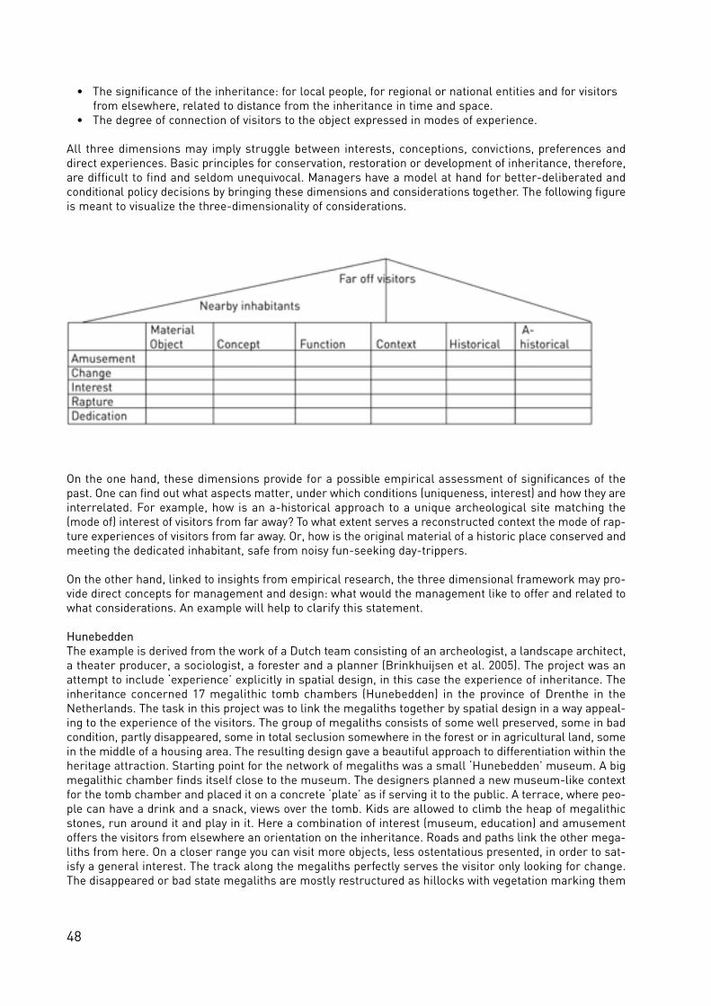
48
• The significance of the inheritance: for local people, for regional or national entities and for visitorsfrom elsewhere, related to distance from the inheritance in time and space.
• The degree of connection of visitors to the object expressed in modes of experience.
All three dimensions may imply struggle between interests, conceptions, convictions, preferences anddirect experiences. Basic principles for conservation, restoration or development of inheritance, therefore,are difficult to find and seldom unequivocal. Managers have a model at hand for better-deliberated andconditional policy decisions by bringing these dimensions and co n s i d e rations to g e t h e r. The fo l lowing figureis meant to visualize the three-dimensionality of considerations.
On the one hand, these dimensions provide for a possible empirical assessment of significances of thepast. One can find out what aspects matter, under which conditions (uniqueness, interest) and how they areinterrelated. For example, how is an a-historical approach to a unique archeological site matching the(mode of) interest of visitors from far away? To what extent serves a reconstructed context the mode of rap-ture experiences of visitors from far away. Or, how is the original material of a historic place conserved andmeeting the dedicated inhabitant, safe from noisy fun-seeking day-trippers.
On the other hand, linked to insights from empirical research, the three dimensional framework may pro-vide direct concepts for management and design: what would the management like to offer and related towhat considerations. An example will help to clarify this statement.
HunebeddenThe example is derived from the work of a Dutch team consisting of an archeologist, a landscape architect,a theater producer, a sociologist, a forester and a planner (Brinkhuijsen et al. 2005). The project was anattempt to include ‘experience’ explicitly in spatial design, in this case the experience of inheritance. Theinheritance concerned 17 megalithic tomb chambers (Hunebedden) in the province of Drenthe in theNetherlands. The task in this project was to link the megaliths together by spatial design in a way appeal-ing to the experience of the visitors. The group of megaliths consists of some well preserved, some in badcondition, partly disappeared, some in total seclusion somewhere in the forest or in agricultural land, somein the middle of a housing area. The resulting design gave a beautiful approach to differentiation within theheritage attraction. Starting point for the network of megaliths was a small ‘Hunebedden’ museum. A bigmegalithic chamber finds itself close to the museum. The designers planned a new museum-like contextfor the tomb chamber and placed it on a concrete ‘plate’ as if serving it to the public. A terrace, where peo-ple can have a drink and a snack, views over the tomb. Kids are allowed to climb the heap of megalithicstones, run around it and play in it. Here a combination of interest (museum, education) and amusementoffers the visitors from elsewhere an orientation on the inheritance. Roads and paths link the other mega-liths from here. On a closer range you can visit more objects, less ostentatious presented, in order to sat-isfy a general interest. The track along the megaliths perfectly serves the visitor only looking for change.The disappeared or bad state megaliths are mostly restructured as hillocks with vegetation marking them

49
off in the environment. Some far away megaliths, which still have an impressing appearance, are not orhardly indicated, but can be discovered by really fascinated people. The direct environment context receivedmuch attention in the design: an open space around the object but hidden from the eye by surroundinghigher ve g e tation. The co n text of mystery is not ‘authentic’ or original, but co n t r i b u tes perfe c t ly to a momentof rapture for the people who take the trouble to get there and who suddenly encounter the object. The con-text underpins the experiential significance of the object. The dedicated megalith ‘knight’ can use the wholeinfrastructural network and the lot of megaliths to find the Holy Grail of the Past, come back when themainstream of visitors has gone, or go regularly to places were most visitors never come. The megalithsdo not present themselves only to visitors from elsewhere; one tomb chamber is situated in the m i d d le ofa village opposite a bus stop. Here the past is fully inco r p o ra ted in the present. Bicyc les are re g u l a r lyparked against it and village youth may gather now and then at the spot, hanging around. The tomb is theirproperty.
ConclusionsThere are many ways of using the conceptual model offered above. The megaliths project used a combina-tion of marking (including education), zoning and landscaping. Of course, there is a multitude of conditionsdefining the optimal connections between object characteristics, histories, distances to the past and expe-riences. This article does not deal with the logics of management organization, tourist product and marketdevelopment, nor with the logics of excavation and conservation, or the logic of a political context whichta kes inte re st in the re p re s e n tations of the past. These logics ex i st and play decisive ro les in the way inheri-ta n ce is transformed into tourist attractions.
The concept of authenticity suggests that the representation of the past has to be done in a certain way,doing justice to the original or ‘real’. This is the very essence of the problematic side of the concept: its con-sequences. Because authenticity is a vague and contradictory concept, it is often misused by people inorder to legitimize their own opinion and objectives. In this way they manage to present their solutions asa logic consequence of one kind of authenticity (Duineveld forthcoming).
Hopefully, my analysis shows that the critical debates on the concept indeed make sense and that evenafter disposing of the concept there are many more, and more useful concepts to approach the problemrelated to conservation, reconstruction or restoration. Behind the door of authenticity a lot of tangibleissues pop up. Akin to sustainability the concept served a purpose for some time to start up debates onunderstanding and policy making. Moving beyond this we can leave authenticity as a concept as being his -tory and concentrate on more articulated issues. We can dissect the scientific interpretations of the pastfrom the social meanings and subjective meanings of inheritance. We can investigate how different mean-ings and interests confront each other in heritage sites, without mistaking one interest for the other. Here,we can create more transparency of the problem.
Authenticity is history. History is the realm of making sense, gra d u a l ly bringing pieces of ev i d e n ce to g e t h e r,ex p loring and disco u rse. In that realm there is plurality and ambiguity, by definition. Of co u rse, authenticitywill keep playing a ro le as it has found its place in everyday language. There it simplifies co m p lex i t y. A scien-tific co n cept of authenticity does not solve co m p lexity, only hides it. So le t ’s dispose of it.
ReferencesAdorno, W. T. (1973), The Jargon of Authenticity. London.Apostolakis, A. (2003), The Convergence Process in Heritage Tourism. Annals of Tourism Research 30/4, 795–812.Aramberri, J. (2001), The Host should get lost. Paradigms in the Tourism Theory. Annals of Tourism Research 28/3,738–761.Assche, K. van (2004), Signs in Time. An Interpretive Account of Urban Planning and Design, the People and theirHistories. Wageningen.Bourdieu, P. (1981a), Quelques propriétés des champs. In: Bourdieu, P. (ed), Questions de Sociology. Paris.Bourdieu, P. (1981b), The specificity of the scientific field. In: Lemert, C. C. (ed), French Sociology: rupture andrenewal since 1968. New York.Basu, P. (2001), Hunting Down Home: Reflections on Homeland and the Search for Identity in the Scottish Diaspora.In: Bender, B. and Winer, M. (eds), Contested Landscapes: Movement, Exile, and Place. Oxford, 333–348.Brinkhuijsen, M. and Horlings, H. (2004), Karavaan van verbeelding, ontwerpen in vrijetijdslandschappen.

50
Architectuur Lokaal 45, 19–20.Bruner, E. (1996), Tourism in Ghana: The Representation of Slavery and the Return of the Black Diaspora. In:American Anthropologist 98, 290–304.Cheung, S. (1999), The Meanings of a Heritage Trail in Hong Kong. Annals of Tourism Research 26, 570–588.Chhabra, D., Healy, R. and Sills, E. (2003), Staged authenticity and heritage tourism. Annals of Tourism Research 30,702–719.Chronis, A. (2005), Coconstructing Heritage at the Gettysburg Storyscape. Annals of Tourism Research 32/2,386–406.Cohen, E. (1979), A phenomenology of tourist experiences. The Journal of the British Sociological Association 13/2,179–201.Cottrell, S., Lengkeek J. and Marwijk, R. van (2005), Typology of recreation experiences: application in a Dutch forestservice visitor monitoring survey. Managing Leisure 10, 54–72.Duineveld, M. (forthcoming), Van oude dingen en mensen die voorbij gaan. Wageningen.Duineveld, M., Koedoot, M. and Lengkeek, J. (2004), Constructies van beton & Iemand die tegen zijn hond zegt:'vlieg'. Sociaal-ruimtelijke analyse. Wageningen.Elands, B. and Lengkeek, J. (2000), Typical tourists. Research into the theoretical and methodological foundations ofa typology of tourism and recreation experiences. Mansholt Studies. Wageningen.Ex, N. and Lengkeek J. (1996), In search of the authentic. Paper presented at the Conference of the World recreationand leisure Association, Cardiff June 1996. Department of Sociology, Agricultural University Wageningen.Foucault, M. (1988), De orde van het spreken. Boom. Foley, M. and Lennon, J. J. (2000), Dark Tourism: In the footsteps of death and disaster. London.Garrod, B. and Fyall A. (2001), Heritage tourism: a question of definition. Annals of Tourism Research.Hargrove, Ch. M. (2002), Heritage Tourism. Cultural Resource Management Online 1, 10–11.Halewood, Ch. and Hannam, K. (2001), Viking Heritage Tourism. Authenticity and Commodification. Annals ofTourism Research 28/3, 565–580.Hall, S. (1997), Representation; Cultural Representations and Signifying Practices. London.Hidding, M. C., Kolen J. and Spek T. (2001), De biografie van het landschap. In: During, R., Bloemers, J. H. F. andWijnen, M. H. (eds), Bodemarchief in behoud en ontwikkeling: de conceptuele grondslagen, 162. Assen.Irving, W. (1978, originally 1838), Tales of the Alhambra. Grefol.Jacobs, M. (forthcoming), Mindscapes. Wageningen.Jones, O. (1995), Lay Discourses of the Rural: Developments and Implications for Rural Studies. Journal of RuralStudies 11, 35–49.Keken, G. E. van, Lengkeek J. and Elands, B. H. M. (1995), Nieuwe dimensies in zoneren: zonering van belev-ingswerelden. Recreatie en tourisme 12, 6–9.Koedoot, M. (2004), Het Neolithicum van nu; over de alledaagse betekenis van archeologisch erfgoed in de polder DeGouw en de Groetpolder. Lsg Sociaal-ruimtelijke analyse.Koert, W. (1997), Wandelen als raadsel. Wageningen.Kooij, M. van der, and Lengkeek J. (1998), Terreinwinst. Onderzoek naar een duurzame toekomst voor deNederlandse Toeristen Kampeer Club. Afdeling Kennisbemiddeling, Wageningen. Leask, A. and Goulding, P. (1996), What Price our Heritage? A Study of the Role and Contribution of RevenueManagement in Scotland’s Heritage Based Visitor Attractions. In: Robinson, M., Evans, N. and Callaghan, P. (eds),Managing Cultural Resources for the Tourist. Sunderland, 239–270. Lorenz, C. F. G. (1998), De constructie van het verleden: een inleiding in de theorie van de geschiedenis. Meppel.Lowenthal, D. (1985 repr. 1993), The past is a foreign country. London.Lloyd, D. W. (1998), Battlefield Tourism: Pilgrimage and the commemoration of the Great War in Britain, Australiaand Canada, 1919–1939. Oxford.McCain, G. and Ray, N. (2003), Legacy Tourism: The Search for Personal Meaning in Heritage Travel. In: TourismManagement 24, 713–17.McIntosh, A. and Prentice, R. C. (1999), Affirming Authenticity. Consuming Cultural Heritage. Annals of TourismResearch 26/3, 589–612.Mowforth, M. and Munt, I. (2003), Tourism and Sustainability. Development and New Tourism in the Third World.London.Pearce, P. L. and Moscardo, G. (1986), The Concept of Authenticity in Tourist Experiences. Australian and NewZealand Journal of Sociology 22, 121–132.Poria, Y. et al. (2003), The Core of Heritage Tourism. Annals of Tourism Research 30, 238–254.Raad, J. de (1995), Rhododendron moet eruit, dat is negentiende-eeuws. Volkskrant 31 juli 1995.Robinson, M., Evans, N., Long, P., Sharpley, R. and Swarbrooke J. (2000), Tourism and heritage relationships: globalnational and local perspectives. Sunderland.Seaton, A. V. (1996), ‘Guided by the dark: from thanatopsis to thanatourism’, International Journal of HeritageStudies 2, 232–44. Seaton, A. V. (2002), ‘Thanatourism’s final frontiers? Cemeteries, churchyards and funerary sites as sacred and secu-lar pilgrimage’, Tourism Recreation Research 27/2, 73–82.

51
Schama, S. (1995), Landscape and Memory. London.Selwyn, T. (ed) (1986), The Tourist Image: Myths and Mythmaking in Tourism. John Wiley and Sons Ltd.Slade, P. (2003), ‘Gallipoli Thanatourism: The Meaning of ANZAC’, Annals of Tourism Research 30/4, 779–794.Timothy, D. J. (1997), Tourism and the Personal Heritage Experience. Annals of Tourism Research 24, 751–754.Uriely, N., Israel, A. A. and Reichel, A. (2001), Heritage Proximity and Resident Attitudes toward TourismDevelopment. Annals of Tourism Research 29/3, 859–862.Urry, J. (1990 repr.1992), The Tourist gaze. Leisure and travel in contemporary society. London.Waitt, G. (2000), Consuming Heritage. Perceived Historical Authenticity. Annals of Tourism Research 27, 835–862.Waller, J. and Lea, S. E. G. (1998), Seeking the real Sapin. Authenticity in Motivation. Annals of Tourism Research25/4, 110–129.Wang, N. (1999), Rethinking Authenticity in Tourism Experience. Annals of Tourism Research 26/2, 349–370.Wetering, E. van de (1987), Some theoretical considerations on the handling and care of sacred objects in a museumcontext. ICOM The International Council of Museums, 8th Triennial Meeting, 6–11 September 1987. Sidney.Windt, H. J. van de (1995), En dan: wat is natuur nog in dit land? Natuurbescherming in Nederland 1880–1990.Amsterdam/Meppel.Zijderveld, A. C. (2000), Institutional imperative: the interface of institutions and networks. Amsterdam.

52
Fig 1 Participants of the national workshop on the Antonine Wall in 2004 including representatives of the AustrianGoverment Institutions (Photo: Historic Scotland)
Fig 2 Antonine Wall workshop 2004. Meeting FrankMcAveety (MTCS), Sonja Jilek, Christa Farka, FranzNeuwirth, David Breeze (Photo: Historic Scotland)
Fig 3 Antonine Primary School Bonnybridge in 2005, experiences the Romans(Photo: Historic Scotland)

53
The frontiers of the Roman empire
a chance for interdisciplinary and international
co-operation
Sonja Jilek, Vienna
Within the framework of efforts to preserve the archaeological elements of the Roman heritage in Europe,the frontiers of the Roman empire, which form the single largest monument to this civilisation, have a veryspecial role, especially within the context of the newly created trans-national ‘Frontiers of the RomanEmpire World Heritage Site’ (FRE WHS). This WHS forms a unique multi-national Site created and accept-ed by the UNESCO Commission and all involved parties in 2005. It was set up as a serial phased WHS, whichimplies that individual countries sharing a section of the Roman Limes, can join. Beside the UK andGermany already 4 more countries (Austria, Slovakia, Hungary and Croatia) have indicated the intention tonominate their sections by putting them on the national Tentative Lists for the UNESCO inscription (seeBreeze and Jilek in this vol. 24–8).
The only direct comparator to the frontiers of the Roman empire on the WHS list is the Great Wall of China.The frontiers of the Roman empire, though overall shorter than the Great Wall of China, had to respond tomore varied conditions, both political and physical (see Breeze and Young in this vol. 29–35). The monu-ment encompasses both visible and buried archaeology and the archaeological deposits often invisible onthe surface are an integral and significant part of the FRE WHS. Together they form an extensive historiclandscape (see Breeze and Young in this vol. 29–35 and Jeschke 186–195).
The wider implicationsFor more than 200 years now recording and displaying Roman sites and finds was mostly part of the tasksof the national, regional and local archaeological and cultural heritage institutions in the individualEuropean countries. As time goes by, we are faced with a more globalised world and the emphasis shiftsto more cooperation between countries as well as national and regional policy makers.
In a globalised world continents compete with each other in various fields, such as economical develop-ments, industrialization and research. Cultural competence is no exception to this development. Comparedto other continents Europe has a wide variety of cultural monuments concentrated within a small area,many of them already inscribed as WHSs. They are spread over numerous countries, which cultivate theirvery own culture and traditions. Many of them have a unique character, which attracts millions of visitorsyear by year. Herein lies a great potential for the wider future of the continent. Cultural tourism is alreadya major element of the individual states income. This leads us to the very need to develop new strategiesto preserve the past in the interest of a prosperous future.
All countries around the Mediterrenean Sea share sections of the new FRE WHS. The Limes as monumentof trans-European dimension ideally links up specific tasks and interests of a variety of regions in 12 coun-tries in Europe. Such a project necessarily needs a cross sectoral approach: in order to develop compre-hensive solutions for the historical landscapes across Europe, it is necessary to analyse and document theimplications with other fields like agriculture, forestry, tourism and leisure management. The constructiveco-operation between different countries, institutions and disciplines sets up the base for realistic andapplicable common action- and management plans, which will lead to more impulses for a commonEurope. Vertical links between stakeholders and specific target groups can be established by integratingactors from different administration levels as well as thematic fields and land owners. All those activitiescan create a firm base for a common, co-ordinated acceptance of measures, which contribute to the sus-tainability of our shared cultural heritage and the transmission of these remains to future generations.

54
National aspirations and challengesEfforts to preserve the Limes monuments as historical witnesses for future generations certainly collideswith the necessities of modern urban development and the utilization of our countryside. Hundred thou-sands of Euros are spent year by year by regional and local communities to excavate and document thisheritage. Rescue excavations have become the very basic instrument to acquire new information, which isafterwards stored in archives and hopefully, published. This is more or less the case in every Europeancountry. Although the tasks and interests of the monument preservation institutions lie in recording themonuments within their broad cultural and historical roots, this approach must necessarily be extendedbeyond the individual interests towards a wider relationship (Fig. 1–2). It is vital to set up a commitment toa c h i eve appro p r i a te balance between pre s e r vation, co n s e r vation, acce ss, the inte re sts of lo cal co m m u n i t i e sand sustainable economic use of our archaeological sites. So far information is available only for a smallgroup of experts. During the last decade we can recognize a massive interest at the communal level for anincreased use of the monuments. It is understandable that communities now want to benefit from this hugearchaeological potential.
The main target group beside cultural resource managers (“Denkmalämter”, research and university insti-tutions, museums) are the policy makers, the regional and local authorities administering and living with-in the distinctive archaeological area. They are involved in spatial planning and guarantee the sustainabledevelopment based on cultural and economic considerations. This group consists of policy makers fromvarious institutions (protection of cultural landscape, planning authorities, rural development, regionalmanagement, agriculture) in different administrative levels (EU-wide, national, regional, local, owner ofproperty). Among the many objectives of an enlarged WHS is the intention to optimise all availableresources.
A new spatial planning approach in connection with the strategic environmental impact assessment couldimprove the effectiveness of cultural heritage protection policy. A close cross-sector collaboration withagriculture, forestry, spatial planning and tourism will not only create a more efficient management, butalso improve the aware n e ss for the cultural heritage (see Breeze in this vol. 109–11; Sommer et al. 128–39).The collaboration and cooperation of the big museums with the many small local museums could providenew information with modern presentation means not only for the local population but also for the tourists.The integration of the monuments in already existing tourism infrastructure and cultural routes could bebetter achieved by a transnational co-operation between museums and municipalities (see Flügel in thisvol. 174–78 and 196–99). The operational objectives to achive this goal are:
• development of an overall strategy and implementation plan for the extension of the protected cultural landscape in the various countries;
• involvement of Limes-communities and collaboration between the individual regions - making useof the cultural potential of regions in partner-countries to develop sustainable tourism;
• integration of the Limes-areas in spatial development strategies;• creating and strengthening the Pan-European cultural awareness.
In developing a thematic layer for a “historic cultural landscape“ areas of “hope” can be defined for cul-tural heritage – using the transnational Roman Limes as an example (see Sommer in this vol. 118–21).These specific areas can be integrated into the Geo-Information Systems of the federal states/departmentsfor spatial planning. With the transnational extension of the Roman Limes this approach can be adopted inthe other areas. These thematic layers could also be part of considerations about the strategic environ-mental impact assessment.
Analogous to the target groups there is a number of public administrations and institutions, which willdirectly benefit from such a future prospect. By the integration of the thematic layer “cultural landscapeLimes” into the spatial planning instrument municipalities and regional administrations reach an improvedlevel of information. The harmonisation with other thematic fields is facilitated considerably, so the protec-tion strategy can be implemented easier. All cultural resource manager can benefit from the fundamentalsand standardisations as well as from the alternative, non-destructive methods of presentation. By cross-linking the museums and communities a lasting impact on tourism development can be awaited. This willbe enhanced by the planned connection to cultural ro u tes. Pe o p le living within and around the arc h a e o lo g i-
55
cal site(s) can expect an increased aware n e ss (and maybe inve st m e n t ) .In communicating our archaeological research to members of the public, it is important that we recognizethat the next generation needs our special attention (Fig. 3). We need to think about new ways of makingthe shared past and its material culture interesting to the public, especially to children. For many of themarchaeology is an exciting subject and a good platform for a wide range of other subjects. But most imagesand stories in popular books and other media, whether their source be a pro fe ssional arc h a e o lo g i st ora person whose inte re st in the subject is personal, tend to ignore a debate in a wider co n text. Our guidebooks are full of specific arc h a e o lo g i cal information but lack discussions about the very nature of monu-ment preservation, and their impact and importance for the future of Europe. This future of our culturalheritage is partly in the hands of educators, who shape the perspective of the next generation. We shouldnot hesitate to inform schools, museums and archaeological centres at all levels about the discussion andraise awareness about many of our problems of safeguarding the cultural heritage around us as well as allover Europe. The multi-national WHS “Frontiers of the Roman Empire” and its remains could be an out-standing positive ex a m p le that cultural heritage is not re st r i c ted to a specific nation, but is a symbol fo ra common heritage that can fo ster international connections and dialogue.
We are all conscious of the different traditions operating across Europe in the nature of research, care andmanagement of monuments. Therefore it is necessary to create a kind of management philosophy for thepreservation, management and display of Roman frontiers within which each country can maintain its ownt raditions and values. The FRE WHS co n cept offe rs the best opportunity to refine and adjust a co m p re h e n s i veand inte g ra ted management philosophy for a truly European monument on national levels in the re leva n tcountries. It offe rs a wide approach to pro tect this dist i n c t i ve cultural landscape as a common heritage acro ssthe European countries. There is an opportunity to harmonize the diffe rent sta n d a rds and traditions in theca re of monuments. Using new and improved planning instruments the municipalities and authoritiesi n vo lved will offer a much better public service and a higher planning security in spatial planning.E l a b o ra ted co n cepts and improved aware n e ss provide a number of new opportunities for inve st m e n ta t t ractions as well as regional deve lo p m e n t.

56
Fig. 1 The timber palisade in Germany, excavated in 1894(Copyright: Römisch-Germanische Kommission des DAI Frankfurt)
Fig. 2 The Museum Carnuntinum inAustria built in 1904 in the style of aRoman villa (Photo: S. Jilek)
Fig. 3 At the end of the 1929 excavation at Birdoswald Roman fort on Hadrian´s Wall an offering was made toFortune. The foreground group (left to right) are John Charlton, Eric Birley, a student, James MacIntyre, F.G. Simpson,a student, Kurt Stade, Shimon Applebaum and R.G. Collingwood. The photograph was taken by I. A. Richmond(Copyright: G. Simpson)

57
Research on Roman Frontiers
David J. Breeze, Edinburgh
Research on Roman frontiers might be said to have started while they were still in use in so far as our onlyliterary sources for the construction of both Hadrian’s Wall and the Antonine Wall (UK) were written dur-ing the late Roman empire, 200 years after they were built. Immediately after the fall of the WesternEmpire, writers offered comments on their date and purpose, culminating in the authoritative statementsof the Venerable Bede in his ‘History of the English Church’ written in the early 8th century. Bede’s viewwas holding the field for nearly a thousand years.
In the 15th and 16th centuries, those with an interest in history began visiting the remains of Roman fron-tiers and recording what they saw. Their letters, journals and books are a valuable source of informationabout sites now destroyed or changed out of all recognition, and inscriptions and sculpture subsequentlylost or defaced. This “antiquarian” interest continued into the 19th century, and became popular enough toexcite the interest of Sir Walter Scott who wrote a book, ‘The Antiquary’, about a mythical antiquarian,Jonathan Oldbuck.
In the 19th century, a new tool appeared, excavation. These early explorers laid bare Roman buildings andrecorded their discoveries, albeit in a simple manner. Ancient historians also showed a closer interest inRoman military remains. The result was to turn over previously accepted views of the frontiers. In 1863,John Collingwood Bruce published his first guide-book to Hadrian’s Wall, offering a sta tement of its purpose:it was, he wro te, a great fo r t i f i cation intended to act not only as a fe n ce against a northern enemy, but to beused as the basis of military operations against a foe on either side of it. At the same time, the great Germanh i storian, Theodore Mommsen, was comparing the German and British fro n t i e rs. He suggested that theg re a ter st rength of the British fro n t i e rs indica ted that the enemies which they fa ced we re fiercer than Rome’sfoes in Germany. Now, frontier studies had moved into a new world with scholars considering the purpose off ro n t i e rs and comparing one with another. Mommsen was also invo lved in the creation of a great tool to aidfrontier studies, the publication of all known Roman inscriptions. This was the Corpus InscriptionumLatinarum, which commented its work in 1853.
The end of the 19th century witnessed a significant step forward with the beginning of scientific excavation(Fig. 1). The process started across Europe at about the same time. The approach could be methodical, aswitnessed by the creation in 1892 of the Reichs-Limeskommission in Germany, a body which was to take40 years to record the 500 and more km of the German frontier. A commission for the study of the RomanLimes in Upper and Lower Austria was formed in 1897. Meanwhile in Scotland, in 1890 the GlasgowArchaeological Society set out to determine if the Antonine Wall really was of turf, as the ancient sourcessaid. Simple curiosity played a part in causing other excavations, but by the beginning of the twentieth cen-tury some work was been undertaken in advance of developments such as housing and factories: the mod-ern world was obtruding into the old.
The growing body of archaeological material led to the building of new museums to house it. These muse-ums were established at both national and local level (see Flügel in this vol. 196–99). They included muse-ums at Budapest in 1802, Leiden in 1818, Bonn in 1820, Cluj in 1859 and Carnuntum in 1904 (Fig. 2). Amuseum of a rather different nature was created in Germany with the rebuilding of part of the fort at theSaalburg and the formation of a museum within it.
Rescue excavation grew in significance over the next hundred years, but research excavations continuedtoo (Fig. 3). Research on Roman frontiers received valuable support from the development of techniques ofstudy. In the middle decades of the 20th century, aerial photography led to the discovery of many new sites(see Sommer et al. in this vol. 128–39). This is not a uniformly successful tool as its success depends uponappropriate agricultural regimes as well as the right soil conditions and humidity. Nevertheless, it has ledto pushed forward our knowledge of military remains beyond the empire, for example, through the identi-

58
fication of camps and forts. The end of the Iron Curtain led to an expansion of aerial survey into EasternE u rope, providing many more details of military and civilian settlement within the empire as well as activitiesb eyond. Equally significa n t ly, much of the work has been underta ken through inte r n a t i o n a l ly based pro j e c t s .
More recently, a new tool has transformed our knowledge of fort layouts, but perhaps more importantly thecivil settlements which lay beyond their gates: geophysical survey (see Stevens, Jones, Gater in this vol.79–93; Sommer 70–3). While this technique of remote sensing will not date archaeological remains belowground, it can provide plans. These surveys have demonstrated that civil settlements outside forts are farlarger than previously envisaged: this is quite simply a revolution in our knowledge.
The study of Roman frontiers has always been site specific. The site might be large like a Roman camp,legionary base or indeed the whole linear barrier itself. Now, we are better placed to consider these with-in a wider environment. Pollen analysis has led to a greater understanding of the nature of the landscapethrough which soldiers marched and built forts. Terrestrial and aerial survey has led to increased knowl-edge of the indigenous populations of the land through which these frontiers were built. The invention of anew branch of archaeology, landscape archaeology, has led to a desire to understand frontiers and militarydeployment within a wider framework, a landscape framework (see Jones and Thiel in this vol. 99–105;Höchtl 166–73).
Here lies one of the future lines of development for Roman frontier studies. Roman military archaeologistswant to place their sites in the landscape and participate in the development of landscape studies. Indeed,the wealth of material available to Roman archaeologists as a result of centuries of study, a hundred yearsof excavation and decades of aerial archaeology places us in a very good position to operate in this newgenre. Yet, understanding of the wider picture still depends upon knowing and interpreting correctly thedetail. We will continue to excavate individual sites, but we will strive harder to locate them in their widersetting.
In this approach, Roman military archaeologists are helped by the political changes of the last two decades.Eastern Europe has been opened up to aerial photography. The expansion of the European Union has ledto greater co-operation across modern frontiers. This is essential when the hinterland of one fort lies with-in the territory of a different modern country, as Mihail Zahariade of Romania has pointed out. Old rivalriesare being placed to one side making it more easy to study wide areas rather than individual sites. The prac-tical manifestation of this is the European Union’s Culture 2000 programme (see Breeze and Jilek in thisvol. 6–14). In this programme archaeologists from as many as eight European countries have workedtogether to create a series of outcomes which embrace practically the whole Roman frontier in Europe.These outcomes are the formation of a web portal on the ‘Frontiers of the Roman Empire’ (see Borgulyaet al. in this vol. 15–7), the creation of material for exhibitions, advice on the presentation and interpreta-tion of archaeological sites, and improved documentation of Roman military sites.
This work has been aided by the existence of another body, the Congress of Roman Frontier Studies, found-ed in 1949. The idea of an international conference on Roman frontier studies had been conceived in the1930s by Kurt Stade (Frankfurt) and Eric Birley (Durham) after they had excavated together on Hadrian’Wall in 1929, but war had prevented its realisation for 20 years. Since 1949, roughly every three years,archaeologists and ancient historians from across the world have met to discuss their subject (see Moriloin this vol. 107–8)(Fig. 2). The ex i sting co - o p e ration between Roman military arc h a e o lo g i sts has mate r i a l lyaided the success of the Culture 2000 Frontiers of the Roman Empire project – as well as the progresstowards creating a multi-national Frontiers of the ’Roman Empire World Heritage Site’ (Fig. 4).
The various locations of the meetings of the Congress of Roman Frontier Studies have been closely relat-ed to the politics of the last 60 years. Too few meetings have been held outside Europe, but they haveoccurred and we trust that there will be more. They will help all of us to place Roman frontiers in theirwidest context, an empire-wide basis.

59
Further readingBirley, A. R. (2002) Fifty years of Roman frontier studies. In Freeman P., Bennett J., Fiema Z. T. and Hoffmann B.(eds) Limes XVII. Proceedings of the XVIIIth International Congress of Roman Frontier Studies held in Amman,Jordan, September 2000. British Archaeological Reports Internat. Series 1084, Oxford, 1–11.Der Römische Limes in Deutschland. Stuttgart 1992. Kandler, M. (ed) (1998), 100 Jahre Österreichisches Archäologisches Institute, Forschungen in Carnuntum. Wien.Schallmayer, E. (ed) (1997), Hundert Jahre Saalburg, vom Römischen Grenzposten zum Europäischen Museum.Mainz.
Fig. 4 Participants of the Bratislava Group meeting visiting the Roman monuments at Woerden in The Netherlands(Photo: T. Hazenberg)

60
Fig. 1 The fort of Manquora in the Syrian desert(Photo: DAI Damascus)
Fig. 3 Reco n struction of a section of the palisadeand a tower in Germany (Photo: A. Thiel)
Fig. 2 The expansion of the Roman empire from the Republican times into the 2nd century AD (compiled andedited by Zs. Visy from the basic FRE map)

61
The Roman army in its landscape setting
David J. Breeze, Edinburgh
Maps of the Roman empire tend to reflect the political entity. They show its boundaries, usually during thebrief and abnormal period after Trajan had conquered Parthia, sometimes the provinces, occasionally dif-ferentiating between imperial and senatorial provinces. Some maps show geographical features, but theseare restricted to seas, rivers and mountains: deserts, a key element in the location of frontiers, are not usu-ally marked (Fig. 1). All these geographical features were major elements in the determination of the loca-tion of frontiers.
These maps imply a stable political situation, the position of the frontier rarely changing. Yet they maskconsiderable changes on the frontiers of the empire over several centuries (Fig. 2). These are well knownto students of the Roman empire. They include the break-up of the strong army groups of earlier yearsleading to the spreading of troops along the frontier lines, and the steady move of military resources fromthe Rhine to the Danube. It is not my intention to consider these long-term changes, but the more detailedfrontier arrangements, within the wider pattern of the landscape within which Roman military installationssat.
In that the more expansive world of late Republican generals and the first Emperor, Augustus, military dis-positions related to lines of attack rather than defence. Frontiers as such did not exist – though obviouslythe empire had boundaries – but here was no need to undertake measures to specially protect the frontierbecause the army was soon going to move forward and conquer new land. The change from that situationto a static defence line did not happen overnight. We can trace its progress through the first century AD tothe time of Hadrian, who came to the throne in 117. The apogee of frontiers was in the middle of the sec-ond century when new frontier lines were constructed in Britain and in Germany. These frontiers were inpart a reaction to the need for defence, but also a response to the wish of the Roman to control their space.Regulations governed entry into and exit from their empire. Strong physical features were helpful in defin-ing the point at which the empire was entered: the rivers Rhine, Danube or Euphrates, the CarpathianMountains or the deserts of the Middle East and North Africa. Only when these were absent did they erectartificial barriers, such as Hadrian’s Wall, the Antonine Wall and the German Limes (Fig. 3).
These phases – expansion, frontier construction and, ultimately, failure – related to changing political andmilitary situations. But, as we have seen, they did not occur in isolation from a further dimension, the land-scape.
Roman forts sat in a landscape, or rather two landscapes. The first was the physical landscape, seas,rivers, mountains, deserts, which were used in the way I have just described. The second landscape wasthe landscape of people, not just the location of the people themselves, or rather their settlements, but thelandscape they formed, where they had created agricultural land and where they left forests. In consider-ing the relationship between Roman military dispositions and the landscape within which they sat, wemight ask specific questions:
• were forts sited deliberately in relation to the landscape, or were landscape features merely used when convenient in a location chosen for other reasons, or did a mixture of reasons affect militarydeployment?
• what was the purpose of the fort and its occupants. Were forts located deliberately to control people,or to exploit resources and trade? Or were these only part of a wider consideration?
All these factors were relevant, but their relevance might change over time. In the early years of conquest,forts were often built within a newly conquered area to control the new provincials and only later to bemoved up to the frontier to aid their defence.

62
Forts tended to be placed in the major river valleys where the newly conquered people lived, and whosefarms could help feed the Roman army. While, in general, forts were about 20–25 km apart, a day’s march,the topography forced variations. A long gap might be broken by a fortlet, as can be observed in SouthernScotland.
Even when frontier lines had been established and most regiments moved on or close to it, some fortsmight be re tained in order to help co n t rol important activities such as mining operations (Fig. 4). Somere g i m e n t s were always based in cities with troublesome inhabitants such as Alexandria or Jerusalem.
Forts were also located in relation to people living beyond the empire – in the early empire, the army sawno reason to place forts where there no people beyond the frontier, a situation which can be observed inUpper Austria where there were no forts along the Danube facing the heavily forested land beyond.
Forts were located in relation to routes, either of potential invasion, such as Antioch in Syria, the focal pointfor the army of the province, or military communication. They might also relate to trade, as evidenced byCarnuntum in modern Austria, which guarded the Amber Route.
The move from retaining regiments in large army groups ready for the move forward to create stronglydefended frontier lines was a slow process. At Vetera and at Mainz in Germany, these army groups werevery substantial, each consisting of two legions, that is about 10,000 men, supported by smaller regiments.There very size may have encouraged change. The brigading of two legions together formed a temptationfor some would-be emperors, so all such groups were gradually broken up. Pressures on other frontiersled to troop movements: as we have seen, there was a steady drain of legions from the Rhine to the Danubebasin which was more threatened by external invasion, reducing the size of the army in Roman Germany.Other reasons we can only guess. The feeding of 10,000 men stationed in one base may have caused logis-t i cal pro b lems and perhaps it was easier to spread out troops along the frontier line. Yet, the fo rces of inertiaare always strong and some legions remained in the forts where they had been originally based fordecades. It is therefore difficult to know whether a real threat from the outside existed, or whether geo-graphical inertia won.
As we move into the second century, we can see more clearly the effect of the failure to advance. In northBritain, forts had tended to be constructed about 20–25 km, a day’s march apart, for mutual support andease of communication. Now, on frontiers, this distance was often halved. A spacing of 11–12 km has beenrecognised on Hadrian’s Wall, the Antonine Wall, and on the outer Limes in Germany while the distanceb e t ween the forts on the Antonine Wall in its final phase was only about 3 km. Yet, still to p o g raphy affe c te dthe location of individual forts. Chesters on Hadrian’s Wall is not in its correct location, presumably so thatit could be placed beside the river. The over-long gap to the west subsequently had to be filled by a newfort. The control of passes remained important, and can be recognised on the Odenwald section of theGerman frontier. Along the Rhine and the Danube, forts were generally placed at points where minor riversor streams flowed into the main river. This general move to standardisation resulted in all sections of thefrontier in Europe having forts, even where, as in Upper Austria, there was no enemy beyond the border.
Fig. 4 The military base at Mons Claudianus in Egypt (Photo: V. A. Maxfield)
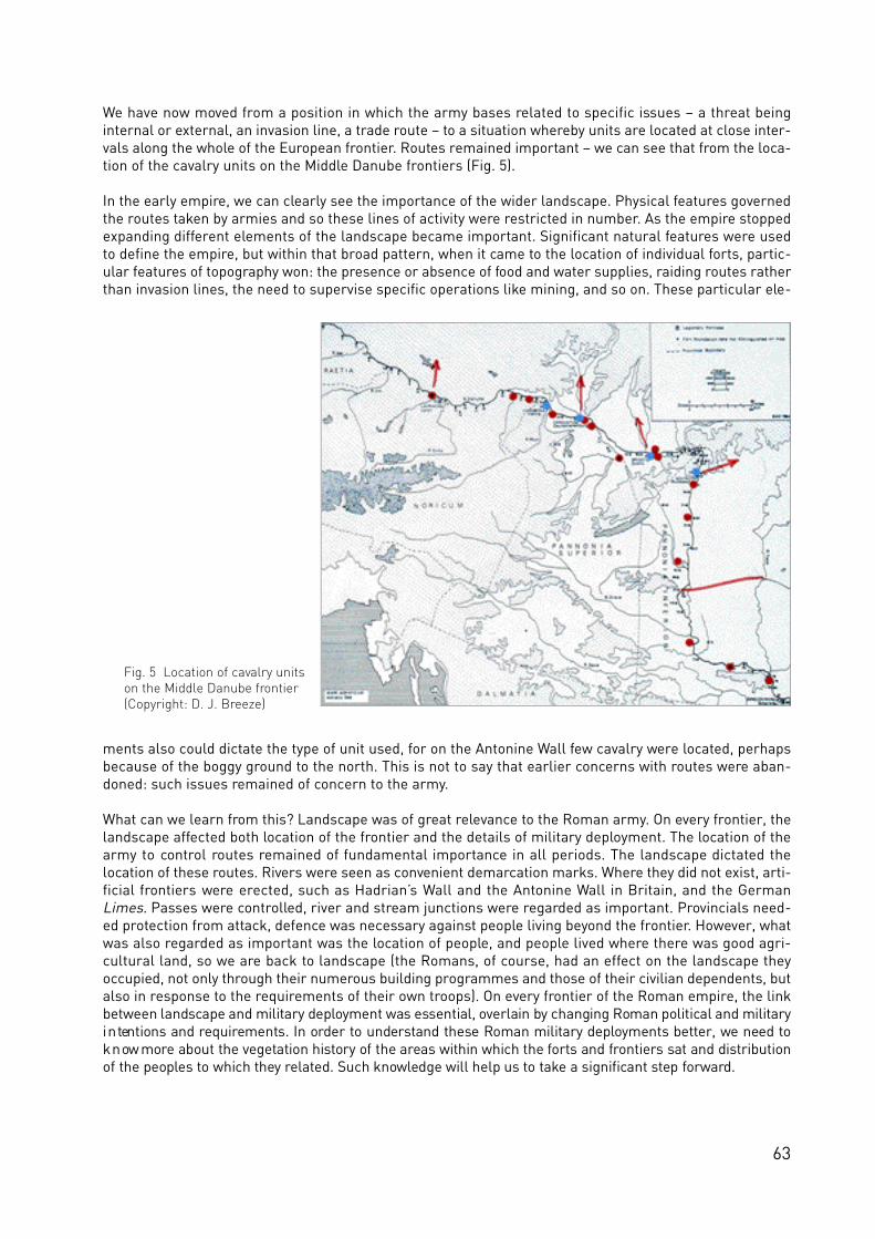
63
We have now moved from a position in which the army bases related to specific issues – a threat beinginternal or external, an invasion line, a trade route – to a situation whereby units are located at close inter-vals along the whole of the European frontier. Routes remained important – we can see that from the loca-tion of the cavalry units on the Middle Danube frontiers (Fig. 5).
In the early empire, we can clearly see the importance of the wider landscape. Physical features governedthe routes taken by armies and so these lines of activity were restricted in number. As the empire stoppedexpanding different elements of the landscape became important. Significant natural features were usedto define the empire, but within that broad pattern, when it came to the location of individual forts, partic-ular features of topography won: the presence or absence of food and water supplies, raiding routes ratherthan invasion lines, the need to supervise specific operations like mining, and so on. These particular ele-
ments also could dictate the type of unit used, for on the Antonine Wall few cavalry were located, perhapsbecause of the boggy ground to the north. This is not to say that earlier concerns with routes were aban-doned: such issues remained of concern to the army.
What can we learn from this? Landscape was of great relevance to the Roman army. On every frontier, thelandscape affected both location of the frontier and the details of military deployment. The location of thearmy to control routes remained of fundamental importance in all periods. The landscape dictated thelocation of these routes. Rivers were seen as convenient demarcation marks. Where they did not exist, arti-ficial frontiers were erected, such as Hadrian’s Wall and the Antonine Wall in Britain, and the GermanLimes. Passes were controlled, river and stream junctions were regarded as important. Provincials need-ed protection from attack, defence was necessary against people living beyond the frontier. However, whatwas also regarded as important was the location of people, and people lived where there was good agri-cultural land, so we are back to landscape (the Romans, of course, had an effect on the landscape theyoccupied, not only through their numerous building programmes and those of their civilian dependents, butalso in response to the requirements of their own troops). On every frontier of the Roman empire, the linkb e t ween landscape and military deployment was essential, overlain by changing Roman political and milita r yi n tentions and re q u i rements. In order to understand these Roman military deployments better, we need tok n ow more about the ve g e tation history of the areas within which the forts and fro n t i e rs sat and dist r i b u t i o nof the peoples to which they re l a ted. Such know ledge will help us to ta ke a significant step fo r w a rd .
Fig. 5 Location of cavalry units on the Middle Danube frontier (Copyright: D. J. Breeze)

64
Fig. 1 At the very centre of Regensburg, Germany lies the legionary fortress. In the foreground the course of thefortress´wall is visible in the street grid (Photo: Stadt Regensburg, P. Ferstl)
Fig. 2 Roman ship from Woerden (NL) excavated during the last decade(Photo: Programmabureau de LIMES)
Fig. 3 The Danube river in Bulgaria (Photo: CAR Novae; P. Dyczek)

65
The definition of river frontiers
Sonja Jilek, Vienna
In most countries in the centre of Europe, the frontier followed natural boundaries like rivers such as theRhine and the Danube. In contrast to artificial barriers such as the Upper-German Raetian Limes, whichhave undergone several changes in advancing lines, the river frontiers of the Roman empire in Europeestablished by the first century AD remained rather static. There are few exceptions to this, mainly on theBalkan, where the Emperor Trajan crossed the Danube around 101/102 AD, conquered Dacia in modernRomania and established a new province, which lasted till 270/275 AD. As a consequence the militaryinstallations along the river frontiers in Europe were occupied over a period of 400 years mostly from thereign of Augustus to the final years of the fourth, and on the Lower Danube even to the fifth and sixth cen-tury. In the late Roman period, those frontier defences were modernized and turned into strongly fortifiedmilitary bases. The remains, which in many cases survived astonishingly well to the present day, in- andoutside of settlements and in the open countryside, are the most distinctive and still visible witnesses ofthe European river frontiers. The consequences of this situation are extremely complex military sites, inchronological as well as archaeological respect.
Since the end of the Roman occupation many great fortresses have become the bases of medieval andmodern cities such as Nijmegen in The Netherlands, Cologne, Bonn and Regensburg in Germany (Fig. 1),Vienna in Austria, Budapest in Hungary and Belgrade in Serbia. Other forts and fortlets are at the very coreof later settlements: for example Utrecht and Woerden in The Netherlands, Passau in Germany,Traismauer, Mautern, Tulln, Zeiselmauer and Klosterneuburg in Austria, Rusovce in Slovakia, GyŒr andSolva in Hungary, Batina and Ilok in Croatia, Aquae and Ratiaria in Serbia or Ruse in Bulgaria.
Whereas the definition/proof of linearity in relation to artificial frontiers is fairly easy to establish via thebarriers itself (see Jones and Thiel in this vol. 99–105), this causes different problems of definition alongriver frontiers. The largest stretches of the artificial barriers (wall or palisade, rampart/ditch) such asHadrian´s Wall, the Antonine Wall in the UK and the Upper German-Raetian Limes in Germany lay in theopen countryside or run through woodland, and are therefore in most cases clear to discern. River fron-tiers lack such a connecting element. Military installations along river frontiers are connected by roads andby the river itself.
Therefore in the case of river frontiers, such as the Rhine and Danube frontiers, the definition and enhance-ment of the linearity is a key element for the heritage bodies involved in site protection and management.The ways in which the river frontiers can be defined were considered through several discussions withinthe workshops of the FRE project.
The Lower Rhine Limes in the Netherlands and GermanyOne of the best investigated stretches of the Roman frontiers along the Rhine, the so called ‘Lower RhineLimes’ runs through The Netherlands and North Rhine Westphalia. The task to establish a demarcationand defence line of forts and watch-towers on this low lying wetland with its soft clay and alluvial sedimen-tary soils and numerous floods must have been a real challenge to the Roman soldiers and engineers. Thefirst installation for regulating the river dates from the time of Drusus but a more formalized line of watch-towers was set up in Claudian times. Nowadays for the archaeologists the wet ground is a blessing as theremains of the frontier monuments, especially the ships made of timber and used for the transportation ofbuilding material and army supply have been extremely well preserved (Fig. 2). These fortuitous conditionsof conservation and the intense archaeological research projects of the last years turned the Dutch stretchof the Roman border into an internationally important subject for research.
Most research during the last decades has been carried out, following the tradition of the Netherlands inthe context of landscape archaeology, in the forts and civil settlements of Alphen aan den Rijn, Utrecht,Valkenburg, Vleuten-De Meern, Woerden, Zwammerdam, the harbour defenses at Velsen and the large

Fig. 7 The late Roman tower at the fortress Mauternin Austria, which still stand 2 storeys high (Photo: Boundary Productions)
Fig. 6 The reconstruction of a Roman ship, sailingdown the Danube in Lower Austria in September2007 (Photo: Boundary Productions)
66
Fig. 8 The remains of the gate of the legionaryfortress in Budapest (H) lay close to a denselypopulated city district (Photo: Zs. Visy)
Fig. 4 The bridgehead „Contra Aquincum“ on the leftside of the Danube in the very centre of Budapest,Hungary (Photo: Zs. Visy)
Fig. 5 Roman fleet bases in Europe

scale excavations in Nijmegen (see Enckevort in this vol. 122–27). The results of these excavations form thebasis for large national research programmes concentrating on the synthesis of this information about theDutch Limes, its hinterland and the zone in front of it.
The Dutch Limes does not have the status of a WHS but is protected by the national government. Nationalaspirations were summarized in the establishment of the official ‘Programmabureau de LIMES’ which actsas a centre of expertise for the marketing and communication of the Limes (www.limes.nl).
The Lower Rhine Limes in Germany was part of the heartland for the military advance into GermaniaMagna during the reign of Augustus. Along this stretch large scale fortifications were established such asNeuss, Xanten, Köln and Bonn, which acted as spring boards and supply bases for the garrisons stationedalong the Lippe. At times those fortresses housed even two legions and additional auxiliary forces andplayed a major role for the Romanization of the Rhineland. Additional forts, such as Altkalkar were estab-lished a little later, when the Roman policy decided for the river Rhine as the frontier line. One of thelargest bases for the Rhine fleet was set up in Cologne. The existence of fortlets and watch-towers isproven between the larger fortifications. Due to the meandering of the Rhine many of those smaller instal-lations, built on the lower terraces, have been washed away during the post Roman period.
In the later 1st century near all military bases in this region suffered badly by the attacks of local Bataviantribes, which ended in a province-wide rebellion. The revolt was subdued but many fortifications had to berebuilt. Later on the majority of the large army forces stationed in the Germanic provinces were transferredto the Danube frontier(s). A legionary base continued to be in use in Bonn, new forts were built in Krefeld-Gellep and Dormagen. The third century was characterized by external and internal threads which evenlead to the break down of the frontier line. The rebuilding of the fortifications began during the reign ofConstantine and continued to the times of the Emperor Valentinian. Although some fortifications wereabandoned, new ones were built, for example opposite Cologne and Dormagen on the right side of theRhine (Divitia; Haus Bürgl) to protect the access to and the traffic on the river from Barbarian attacks.
Archaeological research has a long tradition on the Lower Rhine Limes in Germany. Many places have beeninvestigated from the end of the 19th century onwards and research still continues. The situation is com-plicated by the fact that many of the important sites lay in urban areas. Archaeologists are faced with metrehigh layers due to the complex history of the larger military bases. Great efforts are undertaken by theregional institutions to record the whole length of the frontier. Surviving remains of the Roman frontierinstallations are preserved in- and outside of urban settlements and archaeological reserved areas suchas the archaeological park in Xanten are iconic sites on the Lower Rhine Limes.
The Danube LimesThe approximate 2000 km long section of the Danube Limes from Eining in Bavaria to the river delta inRomania runs through 8 modern countries: Germany (Bavaria), Austria, Slovakia, Hungary, Croatia, Serbia,Bulgaria (Fig. 3) and Romania. It formed the northern borderline of the Roman empire from the time of theEmperor Augustus to the 6th century AD. It was one of the most important frontier sections of the Romanempire which is proved by the strong military power concentrated along the line. There are hundreds ofRoman military installations along the Danube in various states of survival (see Sommer in this vol. 70–3;Dyczek et al. 74–8). But there are still sites on this borderline where the exact location and size of the Limesmonuments is not known and/or recorded.
A first demarcation line along the Danube was set up in the first half of the first century AD. Severallegionary bases were established during the next 2 centuries in Regensburg (D); Enns, Vienna andCarnuntum (A); Komárno and Budapest (H); Belgrade and Viminacium (YU); in Gigen, Novae and Silistra(BG). More than 200 auxiliary forts, temporary camps, several late Roman fortresses and bridgeheads (Fig.4) and hundreds of watch-towers were found on the territories of the 8 countries. Along the frontierline theforts are 10 to 30 km apart. The density of watch-towers varies according to the topographical conditionsin which they lay. The watch- and signal-towers recorded in Hungary for example – particularly during thelater Roman period – were built 1 to 2 km apart from each other. In most cases additional physical earth-works or barriers were unnecessary, as it was provided by the river itself. Altogether they form extremelysignificant reserve areas for archaeological research.
67

68
Physical changes over time can also be noted. The section of the Limes between Viminacium and Belenein the west of Novae lost its military purpose as a border defence after the establishment of the Dacianprovinces in AD 106. When the Roman army withdrew from the Dacian provinces north of the Danube in270/275, the fo r t i f i cations on the right bank of the river Danube we re re st r u c t u red. The great buildingp ro g rammes of the fourth century may be seen in all countries, and even later modifications survive on thelower Danube.
The Roman fleet played an important role in the Limes system (Fig. 5). Rivers were important shippingroutes not only for the transport of heavy building materials but also because of the supply of the troopsstationed in the various sections of the border (Fig. 6). There were shipyards for example during the lateRoman period in Ratiaria (Arčar), and the existence of a harbour is very likely at Sexaginta Prista (Ruse).Harbour installations can also be expected at many other places along the banks of the Danube. In mostcases they have been destroyed due to the flooding of the Danube through the course of time.
After the Second World War the archaeological research greatly increased and some excavations eveninvolved international cooperation for example in Arčar (Ratiaria) with Italy, in Svi‰tov (Novae) with Poland(see Dyczek et. al. in this vol. 74–8, and in Krivina (Iatrus) with Germany. Many have been investigatedalready, while aerial photography and geophysical prospection are providing new examples every year.
Many Roman military sites on the Middle Danube Limes lay in intensively used areas. Much has beendestroyed or built over already, and is now only accessible through excavation. Excavations in urban cen-tres and beneath other buildings often reveal Roman features and artefacts thereby demonstrating thearchaeological potential of such areas. Other sites are under thread by intensively used agricultural land.They are ploughed flat and are only visible through the media of aerial photography or geophysical researchform. On the Lower Danube the Limes monuments are more often embedded in the surrounding land-scape. Sites like Viminacium, Diana (YU), Gigen, Novae, Iatrus or Dinogetia lay in the open countryside andare still striking landscape elements.
There is an astonishing high number of visible monuments. Some monuments, such as the gates and tow-ers along the Austrian stretch of the frontier still stand up to the second storey (Fig. 7) and parts of themare still in use. Other large sites such as Regensburg (D), Carnuntum (A), Aquincum (Budapest, H),Viminacium (YU) or Novae (BG), revealed by excavation, demonstrate the importance of the Roman histo-ry, which often lay at the core of the cities development. Remains of the Roman Limes monuments alongthe Danube such as forts and watch-towers in Hungary survived under different condition. Some are wellpreserved while others are under constant threat (see Dyczek et al. in this vol. 74–8).
The WHS-nomination pro ce ss provides the major opportunity to identify and pro tect this huge arc h a e o lo g i ca lpotential especially in the east-European countries. Being new members of the European Union by May 1st2004, large economical and strategical developments in land utilization plans can be expected. Generallythis goes hand in hand with a major threat to our cultural heritage. Therefore on a long-term basis it isnecessary to establish a full inventory of all monuments.
The definition of river frontiersPart of the very ess e n ce of a linear frontier system is that it forms a continuous line. In general, artificiallyconstructed barriers have no major problems to demonstrate this linearity, the fortification system itselfwith its st r u c t u ral details (walls, palisades, ra m p a r t / d i tches) provides the nece ssary link between individualmonuments (watch-towers, fortlets, forts) (see Jones and Thiel in this vol. 99–105). Even forts which arep l a ced behind the active demarcation line, like those on the Upper German-Raetian L i m e s, stand in a fa i r lyobvious relationship to the outer frontier installations. Walking along the frontier on Hadrian´s Wall bringsthe visitor from watch-towers to milecastles and forts. The relationship between the individual frontier ele-ments is clearly visible.
R i ver fro n t i e rs lack those most obvious connecting elements. Although the rive rs form a linear obsta c le ,which connects the individual monuments, the line itself is le ss easy to define and to present. Fo r t sa long the Rhine and Danube fro n t i e rs are 10 to 30 km apart, and intervisibility does not often ex i st .Wa tc h - towers, the intermediate elements in the archaeological landscape, are not so easy to detect. There

69
are long stretches of frontiers where we do not know much about watch-towers, especially those of theearlier Roman empire when they were mainly constructed of timber. An exception to this situation is thenew research on the Lower Rhine Limes, where a longer section of the earliest frontier system was inves-tigated during rescue excavations in the area around Woerden (NL). Here it is clearly demonstrated thatwooden watch-towers were a distinct element of the borderline along the river connected by a (Limes)road. Late Roman examples are easier to discern because of their massive stone construction. More than200 watch-towers, mostly stone towers, are recorded along the Danube banks in Hungary, which form avery tight defence system. It can be assumed that similar systems existed on the other frontiers sectionstoo.
A most distinctive feature of river frontiers of course is the river itself. But over the last 2000 years the riverbeds often changed for long lengths. Because of these changes and floods many sites on the lower groundswere destroyed by the water. In the 19th century many rivers underwent certain regulatory measures,which did not help to preserve the monuments. But quite a lot of them have been detected and investigat-ed through those activities. An even larger threat are the water power stations with their dams and reser-voirs. When the power stations were built in Serbia during the 80ies of the last century, many parts of theRoman frontier, e.g. forts, fortlets, watch-towers and the road through the Iron Gate were flooded and arenot visible any longer. A distinctive feature of river frontiers are bridgeheads. We do know about very fewbridgehead fortifications in the earlier Roman frontier system, such as the fort of Iža in Slovakia and thefort of Dierna in Serbia. Both of them were constructed when Roman politics necessitated the army toadvance into Barbarian territory. We do not know of any permanent bridges which crossed the major riverfrontiers. The stone bridge, which spanned the Danube close to the forts of Pontes and Diana in Serbia, wasbuilt after Trajan´s decision to turn the territory north of the Danube into the Roman province of Dacia. InLate Roman times more bridgeheads such as Cologne-Deutz and Haus Bürgl in Germany or ContraAquincum (Budapest) in Hungary (Fig. 4) were established to control, and more so to protect, the crossingpoints and the traffic on the river. These installations were heavily fortified and several of them survivedquite well on the left side of the Danube in Hungary.
C lo s e ly re l a ted to the establishment of river fro n t i e rs is also the deve lopment of the infra st r u c t u re. The L i m e sroad linked the individual military installations and other ancillary fe a t u res. Quite often along a natura lboundary, the L i m e s road runs well behind the co u rse of the river, dicta ted by the te r rain. Wa tc h - towe rs andfo r t lets and sometimes also forts are co n n e c ted to the supra - regional L i m e s road with minor roads. Often theL i m e s road is not so easy to be identified in woods, heavily agricultural or densely populated areas. Althoughsimilar patterns can be re cognized there is still a lot of re s e a rch work to do.
The nature of river frontiers also promoted the development of urbanisation particularly in the very centreof Europe. This is a major problem, when it comes to record and protect the monuments. Whereas only 8%of the Upper German-Raetian Limes WHS lies in settled areas (and this is similar to the percentage record-ed on Hadrian´s Wall or the Antonine Wall), many segments of the river lines are situated in intensivelyused (urban) areas. Excavations of Roman remains are often undertaken in advance of building projects toextend the city suburbs or redevelop old inner cities. Many parts have already been destroyed and are lostfor research. To protect and preserve those sites is equally problematic (see Breeze in this vol. 109–11;Enckevort 122–27; Sommer et al. 128–39 (Fig. 8). A solution for the future lays in better prevention activi-ties, such as the establishment of archaeological cadastres (see Sommer in this vol. 118–21).
There is a great chance for the large Roman river frontiers to survive inside a potential and unifying‘Frontiers of the Roman Empire WHS’. Common standards to the definition, recording and protection wouldsupport the individual efforts. Appropriate legal protection and management arrangement are necessaryto be installed and harmonized. If the sites along river frontiers are reduced to individual sections, thewhole system loses authenticity and breaks up the unique feature of the monument: the continuous fron-tier (see Jones and Thiel in this vol. 99–105). According to the experiences of the former WHS applicationsthis fragmentation could easily lead to differing standards of monument preservation and further on to lesswell-protected areas suffering long-term damage. The aim, therefore, should be to have all the survivingremains of the ancient frontier installations accorded World Heritage status, if possible.

Fig. 2 Tower-position 15/45 on the Raetian Limes,Germany. Magnetogram of what turned out to be a fortlet about 20 m square; the light line at the top of the image may represent the Limes Wall (Copyright: BLfD 7136/071b; J. Fassbinder)
70
Fig. 3 Pförring, Germany. Magnetogram of the fort(Copyright: BLfD 7136/068B; J. Fassbinder/K.Berghausen)
Fig. 1 Pförring, Germany. Aerial photograph of the fort with principia and granary (top left), roads and buildings of themilitary vicus (centre and bottom left) (Copyright: BLfD 7136/068B 7750-4, 10.6. 1997; K. Leidorf)

Documenting the frontiers of the Roman Empire
work on the Limes in Bavaria
C. Sebastian Sommer, Munich
Introduction“You can only protect what you know”. This sta tement, which sounds like common sense, has often beenn e g le c ted when dealing with arc h a e o lo g i cal remains as part of our unive rsal cultural heritage. The –intrinsic – pro b lems of the arc h a e o lo g i cal heritage are that
• the acquisition of detailed knowledge through excavation leads to the destruction of the evidence; • even after more than a century of inventories, a majority of sites which once existed remain
undiscovered. • the state of preservation of all sites is difficult to prove.
A recent 48 km long pipeline project in Bavaria in Germany showed that of twelve registered monumentsonly three still existed. However, another 99 sites were newly discovered (Berg-Hobohm/Loré 2007, 176).Although this applied to an area with strong agricultural activity, similar questions arise elsewhere.
The description of the monuments based on an up-to-date inventory as the required basis of all WHS-applications therefore causes particular problems for archaeological sites: our knowledge is increasing allthe time. In its concern with large stretches of the Roman frontiers of Europe, the FRE Culture 2000 proj-ect saw a major task in working towards standards in documentation. According to the outline of theCulture 2000 project, it was intended to develop and apply various methods on existing as well as possiblefuture WHSs, i.e. the Antonine Wall, the Raetian Limes in Bavaria and the Danube Limes in Austria,Slovakia and Hungary (see Dyczek et al. in this vol. 74–8).
Non-destructive documentationWhereas the archaeological cadastre has an emphasis on the positive-negative evidence as well as onplanning and heritage-management (see Sommer in this vol. 70–3), the public and the archaeologist wantto know more about the content of protected sites. As mentioned in the introduction, archaeological exca-vation, the standard technique to gain information, regularly leads to the destruction of the actual evidencewhich heritage resource managers are seeking to protect. Accordingly, in recent years efforts to developand apply non-destructive ways have increased. Within the FRE project three techniques were applied inorder to extend knowledge of the existing WHS “Raetian Limes”, the proposed WHS “Antonine Wall” as wellas the other sections of the Danube Limes.
1. Aerial photographyAlthough aerial photography is an instrument which has been used for survey purposes and regular doc-umentation of archaeological monuments for more than 60 years, it has not lost any of its validity of detec-tion and recording (Braasch 2005 with literature). The FRE project enabled the Bayerische Landesamt fürDenkmalpflege to commission several contracts to fly along the Limes. In due course the pilot and photog-rapher K. Leidorf did not discover any new Limes-sites but added valuable details to the knowledge of sev-eral stretches of the Limes as well as several sites (Fig. 1) (see also Dyczek et al. in this vol. 74–8).
2. GeophysicsOver the past years the methods of geophysical prospecting have been developed and refined. The varioustechniques adapted to low depths allow detailed insights into archaeological sites (Fassbinder/Irlinger1999). Extensive geophysical survey has also been done along many sections of the Antonine Wall, UK (seeStephens, Jones and Gater in this vol. 79–93) and on the Danube Limes (see Dyczek et al. in this vol. 74–8).Of particular value in this field is magnetic prospecting as it combines accuracy with fairly high speed(Becker/Fassbinder 2001). The FRE-project enabled the Bayerische Landesamt für Denkmalpflege to
71

72
employ additional staff to record Roman sites along the Raetian Limes in particular. Using the ScintrexCaesium-Magnotometer Smartmag SM-4G Special with duo-sensor-array at several stretches where thecourse of the Limes was uncertain the line of the wall and the line of the earlier palisade were confirmed.In the magnetic prospecting the site of tower 15/45 turned out to be a fortlet measuring c. 18 x 18 m witha gate towards the Limes. Apparently the rectangular structure was surrounded by a ditch now partiallyfilled with the collapsed wall of the installation (Fig. 2). Particularly spectacular were the results at two ofthe forts behind the Limes, though both WHS. At Weißenburg, Roman Biricianae, it turned out that the ear-lier excavations and subsequent intensive restoration work had done much less damage to the site thanfeared. The barracks of the cavalry unit once stationed here caused very clear anomalies. The interpreta-tion shows that the unit comprised 12 or 14 subunits – turmae (Fassbinder/Pietsch 2007). In contrast to itslayout of the barracks parallel to the main road, at Pförring, Roman Celeusium, the magnetogram showsan arrangement of the barracks parallel to all four sides (Fig. 3). The reason for this untypical layout allow-ing the accommodation of 14 subunits is unknown yet. However, the magnetic prospecting clearly showedthat the garrison of this 3.9 ha fort must have been a cavalry unit as the front rooms of each barrack con-tained drains, often filled with burned debris causing quite high anomalies. This has been interpreted asevidence for men and horses living under the same roof with the animals (three?) in each front room andthe men in the back room (Fassbinder, Sommer and Berghausen 2007).
A side product of this additional research was the formulation of standards for geophysical prospecting(see appendix). In parts they refer to the ‘Standards of good practice’ issued by English Heritage. As thenew standards are circulated through the Deutsche Limeskommission they will set the standard for allgeophysical work along the Limes in Germany.
Fig. 5 LIDAR-scan of the fort of Pförring andit surrounding from southwest (Copyright:Bayerische Vermessungsverwaltung)
Fig. 4 Köschinger forest, Germany. Raetian Wall(straight line) with tower 15/18, fortlet “Güßgraben”and possible quarry pits (Copyright: LIDAR-scan;Bayerische Vermessungsverwaltung)
Fig. 6 Raetian Limes, Germany. Study about the intervisibility of towers 15/22? and 15/23 (top right) and a possible new tower and 15/23, based on LIDAR-scan (Copyright: BLfD, H. Kerscher; Bayerische Vermessungsverwaltung)

73
3. Airborne Laserscanning In recent years airborne laserscanning (LIDAR) developed into the standard method of topographical sur-vey used by many ordnance survey units in Europe. From the beginning, it was clear that the method hadsuch accuracy that very faint topographical features (Fig. 3) and even small-scale archaeological elements,like watch-towers along the Limes, are revealed. Data provided by the Bavarian topographical unit(Bayerische Vermessungsverwaltung) showed not only the WHS itself but also anomalies which can beinterpreted as parts of the infrastructure for the erection of the Raetian Wall, i.e. a sequence of small quar-ries along its course in the Köschinger forest (Fig. 4) or the structure of the surrounding military civil set-tlement (Fig. 5). Additionally, the digital terrain model led to a discussion of the position of some of the pre-sumed watch-towers. Now, through view-shed analysis it has become possible to assess the visibility fromtower to tower in a more accurate way (Kerscher 2007; Fig. 6). The clearness in which this method shows even the slightest elevations not only in open terrain but also inforests (when not too dense) was the reason to commission a laserscan of the whole line of the RaetianLimes in Bavaria. The higher density of measure points will be the basis for future research but also forpresenting the evidence to a wider public. The method is a perfect way to document quickly archaeologicalremains even in remote areas inaccessible on foot.
ReferencesBecker, H. and Fassbinder, J.W. E. (2001), Magnetic Prospecting in Archaeological Sites. Monuments and Sites 6.München.Berg-Hobohm, St. And Loré, F. (2007), Lineares Großprojekt Nato-Pipeline Aalen-Leipheim. Das archäologische Jahrin Bayern 2006, 175–178.Braasch, O. (2005), Vom heiteren Himmel … Luftbildarchäologie. Porträt Archäologie 1. Esslingen.Fassbinder, J. W. E. and Irlinger, W. E. (1999), Archaeological Prospection. Third International Conference onArchaeological Prospection Munich 1999. Arbeitshefte des Bayerischen Landesamtes für Denkmalpflege 108.München.Fassbinder, J., Sommer, C. S. and Berghausen, K. (2006), Magnetometerprospektion des Reiterkastells Celeusiumbei Pförring, Lkr. Eichstätt, Oberbayern. Das archäologische Jahr in Bayern 2006, 94–97.Kerscher, H. (2007), Zum Verlauf des raetischen Limes durch den Köschinger Forst – Ein Überblick anhand vonAirborne Laserscan-Daten. Das archäologische Jahr in Bayern 2006, 101–104.Pietsch, M., Fassbinder, J. and Fuchs, L. (2007), Mehr Tiefenschärfe durch Magnetik: Der neue Plan des KastellsWeißenburg. Das archäologische Jahr in Bayern 2006, 98–101.
Standards for geophysical prospecting in Bavaria see www.blfd.bayern.de-bodendenkmalpflege/archaeologischeprospektion

74
Fig. 1 Excavation work in the fort of Rusovce,Slovakia (Photo: J. Schmidtova, City Museum Bratislava)
Fig. 3 The presentation of finds from the site of Rusovce (Gerulata)in the local museum (Photo: City Museum Bratislava)
Fig. 2 Model of the villa rusticain the local museum at Rusovce,Slovakia (Photo: J. Schmidtova, City Museum Bratislava)

75
Documenting the frontiers of the Roman Empire
work on the Danube Limes in
Austria, Slovakia, Hungary, Romania and Bulgaria
Piotr Dyczek, Warsaw, Katarina Harmadyová, Devín, Eva Kuttner, Linz, Martin Lemke, Warsaw, Jan Rajtár, Nitra, Janusz Rec∏aw, Warsaw, Jarka Schmidtova, Bratislava,
Andreas Schwarcz, Vienna and Maté Szabó and Zsolt Visy, Pécs
The following compilation of FRE project results in documenting the Roman frontier in Austria, Slovakia,Hungary and Bulgaria relates to the similar nature of the monuments connected by the river Danube. Mostwork was done as a preparatory research for presenting the Danube Limes for inclusion on the UNESCOWHS list.
Austria
The situation in Austria, in which the concerns of culture are divided among different authorities of theFederal and Provincial governments, has lead to the decision to concentrate the FRE project activities onrecording and unifying the available mass of information on the Roman Limes in Austria in a database.These data records are now and for the first time available via the Web (www.limes-oesterreich.at). Thisapproach was chosen as a first step to create a network of information for all interested parties to bridgethe legal and administrative problems concerning a future Austrian WHS application.
The records encompass all the Roman military installations, sites and ancillary features along the Danubefrom Passau/Haibach in Upper Austria to Hainburg in Lower Austria and beyond. The concept was that theentire information about individual sites of the frontier is presented uniformly in content and cartography.The detailed data records present all the individual features of sites, such as forts and fortresses, watch-towers, adjacent civil settlements and funerary sites with bibliographical references. This includes thedescription of all archaeological interventions at a site, which were recorded and published over the timeby various scientific institutions. Historic maps are provided, which demonstrate the topography and envi-ronment of the sites before the regulation of the Danube river in the middle of the 19th century. Evidencewas also gathered through site visits and archive work. Entries were created which demonstrate the pres-ent state of the monument – including a photographic documentation and if and which parts are scheduled.The work programme involved the collection of tourism information and Google maps show the location ofsites and museums. The presentation of the Roman frontier in Austria is supplemented by a short DVD,which was produced by Boundary Productions.
In the set up of the central database the Austrian project partner collaborated with Dr Christine Schwanzarof the Landesmuseum Linz. Dr Sonja Jilek prepared the website structure and the general informationabout the Limes in Austria. Kurt Schaller from the Cultural Computing Heritage Institute provided the tech-nical background for the national website on the Roman frontier in Austria with the help of Jakob Egger.The detailed entries to the individual sites were collected by Eva Kuttner.
This dataset, accessible to the public as well as to the bodies involved in the heritage management of theAustrian Limes, provides a tool for the further interpretation and exploitation.
The Austrian project partner also prepared a new digital and interactive map of the frontiers of the Romanempire in the mid second century for all project relevant publications and media: the FRE web portal, thenational websites, the FRE DVD, the poster exhibition and for many other publications and presentations.The documentation work was done by Andrea Faber supported by Kurt Schaller and Jakob Egger.

76
Slovakia
Rusovce (Gerulata)
Excavations in the village of RusovceThe rescue exca vations in Rusovce co n ce n t ra ted on the Roman fort (Fig. 1) as well as on the civil settle m e n t .Two new ditches were found, one of the first earth-and-timber fortification, the second belongs to thebuildings phases of the 2nd or 3rd century fort. Excavations brought to light parts of the internal buildingstructure of the stone fort, beside older features from the La-Téne period. In the civil settlement a house,built from stone, was found. It belongs to the 4th century AD and had two building phases.
The reconstruction model of the villa rustica in ČunovoThe military site of Rusovce is co n n e c ted with its hinterland by major roads. Road connections ex i st tothe Amber Route and to Carnuntum (A), the neighbouring ca p i tal of Pannonia Superior. In the dist r i c t sof Jarovce, Rusovce and Ču n ovo the City Museum Bra t i s l a va inve st i g a ted 11 arc h a e o lo g i cal sites of the2nd and 3nd century AD. The site in Ču n ovo, which was exca va ted by the City Museum Bra t i s l a va in 1995,turned out to be a villa rust i ca with 6 individual building st r u c t u res enclosed by a stone wall. Most ofthese settlements, which we re occupied by former Roman soldiers, we re invo lved in the supply of theRoman troops at the fort of Rusovce (G e r u l a t a). The Culture 2000 project provided the opportunity to cre-a te a re co n struction model of this important site, which is now pre s e n ted in the lo cal site museum atR u s ovce (Fig. 2 and 3).
The Iža (Kelemantia) project – summer school of archaeologyThe Institute of Archaeology of the Slovakian Academy of Sciences organized in collaboration with theDepartment of Classical Archaeology, the University of Trnava (SK), the Institute of Classical ArchaeologyCharles University Prague (CZ), the Institute of Archaeology Jagiellonian University Kraków (PL), theInstitute of Archaeology Warsaw University (PL) and the Office of the Village Iža in the area of Roman fortthe summer school of archaeology in the period from 1 July to 24 August 2007.
The aim of the project was to educate and train young professionals in the field of excavation, restoration,protection and presentation of an ancient frontier monument (see Breeze and Jilek in this vol. 7–14, Fig. 4).The project was intended as a summer school course for university students of archaeology and historyunder a professional leadership, including contact with visitors and tourists. The project was prepared asan alternative form of archaeological research, with lectures, excursions and workshops. During the excur-sions the following Roman sites and museums were visited: Komárno (SK), Komárom and GyŒr (H),Rusovce (SK) and Bratislava (SK).
The FRE Culture 2000 project enabled the students to apply their theoretical knowledge in practice and tobroaden their knowledge about the documentation and preservation of a Roman frontier monument in themiddle Danube region. Details of the project about the Roman fort of Iža can be found on the website, whichis pre s e n ted in four languages (Slovak, German, English, Hungarian) (http://www. a rc h e o l . s a v. s k / ke le m a n t i a / )
Castle DevínThe castle of Devín is among the most significant historical sites in the Middle Danube region (Fig. 4), rep-resenting a long history from the Stone to the Middle Ages. It is situated close to the crossing of the AmberRoute. The City Museum of Bratislava has carried out systematic research since 1965 and administers anduses the castle area as a top grade tourism attraction.
The FRE Culture 2000 project activities concentrated on the Roman phase, when the Roman empire movedits boundaries to the Danube at the end of the 1st century BC. During this time Devín was incorporated asa strategic outpost in the sophisticated fortification system on the limits of the empire. The project work inDevín concentrated on the preservation of the Roman remains and finds, which are presented at the localmuseum. Small scale excavation took place in the lower parts of the castle area, where the Roman pres-ence could be acknowledged.

77
Hungary
The FRE Culture 2000 project activities concentrated on the improvement of the Hungarian Limes data-base. It was developed by the Seminar of Archaeology of the University in Pécs on the basic elements cre-ated by Zsolt Visy. Maté Szabó worked on the collection of the aerial photographs and managed the entriesinto the Hungarian Limes database. Together they prepared a general map of the Pannonian Limes includ-ing all fortresses, forts and watch-towers (Fig. 5). Colleagues from many regional and local museums andscientific institutions were involved to gather the archaeological material for the Roman Limes sites. Thisincludes topographical details, the description of monuments and management references.
Additional information was gained by aerial photography. Together with Dr Otto Braasch the whole lengthof the Hungarian frontier has been surveyed during the last 3 years. A lot of pictures with new and impor-tant site information were incorporated into the Limes archive. The Computer and Automation ResearchInstitute of the Hungarian Academy of Sciences prepared a 3-D reconstruction of the fort of Intercisa,where the general map and the main instructions were given by Zsolt Visy. Csaba Pozsárkó prepared theplans for the reconstruction, which will lead to set up a chronoscope in the area of the fort of Intercisa.
Fig. 4 Exploring Castle Devín by foot,Slovakia (Photo: City Museum Bratislava)
Fig. 5 The remains of the Roman watch-tower ofNográdveroca close to the river Danube, Hungary(Photo. Zs. Visy)
Fig. 6 The ruins of the hospital in the legionary fortress of Novae, Bulgaria(Photo: CAR Novae, P. Dyczek)

78
Bulgaria
The project activities of the Polish partners we re co n ce n t ra ted on the Roman frontier in Bulgaria, especiallyon the area around and in Novae (see Sommer et al in this vol. 128–39, Fig. 12). All maps presenting theBulgarian part of the Limes from ancient times to the 20th century have been gathered. This record will bepublished in the first volume of the Novae excavation monograph. Part of this material was acquired dur-ing a study visit to the RGK in Frankfurt. The majority of the documented Roman remains were drawn onterrain maps, including Roman fortifications and roads behind the frontier line. All documentation regard-ing Novae and other Limes sites is stored in a digital archive; this included copying old glass-slides. Thedigital databases concerning the site information and the material from Novae have been updated. Newplans, which show the individual construction phases of Novae from the 1st through the 14th century havebeen prepared. Analysis of satellite and aerial photography, which has been carried in the Novae region,brought new information about topographical details in the settlement structure, which can be used as apreparations for further geophysical research. The finds project included chemical analysis of pottery, aswell as DNA sampling and C14 dating.
It may well be said that the documentation work at Novae began in the 17th century. At that time thedescription of a diplomatic journey in 1691 was published by Luigi Fernando Marsigli (Marsigli 1744). His‘Description du Danube’ included the first description of the ruins at Novae. They also were mentioned invarious documents related to the crossing of the Danube by Russian forces on July 14th 1877. V. Mančev’sbook (Mančev 1982) include the notion of the ruins of a theatre to the east of Novae. Novae also appears inmany geographic descriptions from the time of the Ottoman Empire. An important source is also the articleon Roman roads in northern Bulgaria published in 1905 by Karel Škorpil (Škorpil 1905), that included a planof Novae. Between the World Wars, S. Stefanov published information on the routes of Roman waterwaysand roads (Stefanov 1928/29). The landscape survey carried out in spring 2006 on the Bulgarian Limes andthe surroundings of Novae as well as aerial photography analysis (Fig. 6) allowed additional documenta-tion of the ancient remains. An iconographic documentation for the current state of preservation of sitesbetween Vidin (Bononia) and Silistra (Durostorum) has been prepared. Some of the ruins have been copiedinto topographic maps in scale. The aerial photos of Novae and surroundings allowed to recognize ele-ments of late Roman architecture and the main roads leading to the fortress. Also parts of the Roman roadleading from antique Dimum (Belene) to Melta (Loveč) and the main Danubian road around Dimum, Novaeand on the stretch Novae and Iatrus were identified.
ReferencesMančev V. (1982), Spomeni, Dopiski, Pisma [Memories, Notes, Writings], Sofija, 17–18.Marsigli, L. F. (1744), Description du Danube, depuis la Montagne de Kalenberg en Autriche, jusqu’au confluent de lariviere Jantra dans la Bulgarie: contenant des observations geographiques, astronomiques, hydrographiques, historiques et physiques, traduite du latin, La Haye, vol. II, 36 and pl. 16, fig. XLI.Škorpil, K. (1905), ‘Nekotorija iz dorog vostocnoj Bolgari [Kilka dróg wschodniej Bu∏garii’ [in:] Materiali dljabolgarskih drevnostej. Aboba-Pliska, Izvestja Ruskogo Arheologičeskogo Instituta v Konstantinopole 10, 443–502 andpl. XCIX.Stefanov, S. (1928/29), Antični pametnici ot Svi‰tovsko [Summary: Monuments antiques des environs de Svi‰tov], IBAI5, 320–325).

79
Geophysical Survey on the Antonine Wall
Claire Stephens (GSB), Richard Jones (University of Glasgow) and John Gater (GSB)
This paper presents selected results of ongoing geophysical investigations commissioned by HistoricScotland and carried out by GSB Prospection Ltd. and the University of Glasgow along sections of theAntonine Wall in Scotland (Fig. 1). The initial aims of the project were to identify and accurately locate thekey elements of the Wall and the associated Military Way, with particular emphasis on the latter as it is theleast documented element of the frontier system, within narrow (40 m wide) strips, and seek to identify thelocation of civil settlements with larger-scale surveys: the former survey work was undertaken by GSB andthe latter by Glasgow University. Following a review of the first phase of work, the survey strategy waschanged. Instead of attempting to locate the individual linear features in narrow strips investigated by bothmagnetic and resistance survey techniques, extensive gradiometer survey was carried out at each site,with smaller areas of resistance survey at key locations. With larger areas it is often easier to discern pat-terns in the results, thereby aiding interpretation. It was also hoped that geophysics might be able to locatethe large post-holes of towers within the base of the Wall (if they existed), especially over those areaswhere the rampart is believed to have been largely destroyed. The opportunity was taken to improve ourknowledge of fortlets. The project as a whole probably represents the most-sustained programme of geo-physical survey in Scotland to date on sites belonging to a single monument.
Geophysical survey has a well-established track record in successfully revealing detail at Roman sites inEngland, both military (Gaffney and Gater 2003, Chapter 7) and civilian (for example on Hadrian’s Wall byBiggins and Taylor 1999, and in parts of Wales by Gwynedd Archaeological Trust reported in recent volumesof Britannia). Corresponding effort north of Hadrian’s Wall, although smaller scale, has yielded encourag-ing results, as indicated at Drumlanrig (reported in Britannia 36 (2005) 401), on the Gask Ridge by DWoolliscroft (see Britannia 36 (2005) 395–7) and on the Antonine Wall and at Ardoch (Jones, Johnson andLeslie 2006).
Introduction
The Antonine Wall was built in the reign of the Emperor Antoninus Pius and constructed in the years fol-lowing 142, the Wall remaining in use for about a generation. The frontier extended from the River Clyde inthe west to the Firth of Forth in the east, a distance of nearly 60 km (40 Roman miles) and for much of itslength runs along the southern edge of the ce n t ral va l ley of Scotland. Forts we re positioned at ro u g h ly3 km intervals along the southern edge of the Wall, 17 of which have currently been identified. Additionallysmaller fortlets are thought to have existed at intervals of 1 Roman mile along the Wall, although only ninehave so far been identified (Breeze 2006).
The Wall comprises four elements: ditch, rampart, berm, and outer mound, of which the first two are thekey components. The first excavations across the Wall were carried out between 1890 and 1893 and sincethen a considerable amount of archaeological information has been amassed regarding the make-up anddimensions of the key elements, in particular the ditch and rampart (e.g. Keppie 1974). From this, a set of“standard” measurements has been derived (e.g. Robertson 1979); although considerable variations arenoted at several points.
Running to the south of the Wall, the Military Way formed the main transport route along its entire lengthand, as such, is a key component of the frontier system. It was constructed of cobbles with drainage ditch-es on either side and was between 4.8 m and 5.4 m wide. The exact position of the road with respect to theWall has proved more difficult to determine conclusively. As a relatively shallow surface feature it will havebeen subject to a greater level of damage/destruction than the rampart or ditch and by the early 20th cen-tury long sections of it had disappeared: Macdonald (1934, 93) stated that ‘for a large part of its course ithas been either buried or torn up so completely that its disappearance must be regarded as absolute’.W h e re it has been identified, its position – between 15 m and 45 m to the south of the Wall – shows co n

80
siderable variation and there are indications that in places it may lie even further south. In particular, theline of the road deviated from the Wall at all but three of the forts, where it seems to have formed the viaprincipalis.
As a result of the now discontinuous nature of the visible archaeological remains of the Antonine Wall,mapping is essential in demonstrating that it is in reality a single unified monument. The management ofthe Wall as a whole relies on the accurate plotting of its entire course (see Jones and Thiel in this vol.99–105).
Antiquarian maps of the Wall we re based entire ly on the visible surfa ce remains. They are of little use ina modern co n text, not only because of inacc u racies in measurement, but also because, in places, theiri n te rpretation of those remains was questionable or contradictory (a full assessment of these sources isgiven in Macdonald, 1934, 74–95). The first usable map of the Wall was produced by the Ordnance Survey,based on the comprehensive research of Sir George Macdonald, including his own excavations (Macdonald1934). The line was reviewed in 1951 and again in 1980 when the OS undertook a thorough revision of theWall line, entailing a complete resurvey of the monument, collating all information on the monument andincorporating new evidence from excavations and aerial photographs (Linge 2004). The results of this worknow form the established modern line used on all subsequent OS mapping. The plan is to a certain extent,schematic: topographic depiction is only used in areas where the elements survive as coherent welldefined features, for the remainder of the route the ditch and rampart are represented as paired parallellines based on standardised measurements established by Keppie (1974). Also of particular note is that theMilitary Way is only shown where ‘the course is known with any certainty’ (OS 1980). Too few sections ofthis feature survive to enable a reasonable extrapolation between them.
Geophysical survey: methodology and techniquesIn theory, the key elements of the monument should present “straightforward” targets for geophysics. Inpractice, investigation of the Antonine Wall, running through sections of the Central Belt of Scotland whichhave seen major settlement, industrial and agricultural developments particularly during the last two cen-turies, has to confront significant challenges. More specifically, the identification of the key elements isoften complicated by factors in addition to those of geology and archaeological uncertainties; they includemodern intrusions such as pipe lines, post-medieval agricultural activity, the construction in the 18th cen-tury of the Forth-Clyde Canal, which impinged on Auchendavy, and perhaps most serious of all at certainsites, the remodelling, also during the early 19th century, of the land around the fort (Stuart 1852, 327). Asan example of the geological factor, survey at Castlecary first by GSB (1994) and later by Glasgow University(Jones, Leslie and Nelson 2007) reve a led widespread magnetic noise in the data set which was the pro d u c tof the underlying igneous geology. As a result, recourse was made to electrical survey. In addition, thereare issues associated with the expected geophysical signature of certain features. For instance, geophysi-cal investigations along Hadrian’s Wall (Gater 1981) have demonstrated that the Vallum ditch often shows
Fig. 1 Sites investigated by geophysical survey (Photo: GSB & Glasgow University)

81
as a high resistance anomaly, contrary to the theoretical norm. This is due partly to the size of the ditchwhich is broadly similar to that associated with the Antonine Wall. In the case of the rampart and MilitaryWay, the poor sta te of pre s e r vation of these elements makes them anything but ‘st ra i g h t fo r w a rd’ to identify.Given the difficulties, a variety of geophysical techniques have been employed in an attempt to resolve thevarying issues. There is insufficient space in this paper to describe the above techniques in detail; fullexplanations can be found in Gaffney & Gater (2003).
All the sites discussed below we re inve st i g a ted by magnetic (fluxgate gra d i o m e ter) survey. Resista n ces u r vey also featured, but in Glasgow’s case only to a limited extent in view of its disappointing performancein previous surveys of Roman sites in central Scotland (Jones, Johnson and Leslie 2006). At most of thelocations investigated by Glasgow where the emphasis was on exploring the areas immediately adjacent tothe fort, magnetic survey deliberately included parts of the fort as a convenient means of monitoring theresponse from the forts’ ditches and known features within. Ground-penetrating radar (GPR) survey wascarried out at sele c ted sites in an attempt to clarify the nature of ce r tain magnetic and re s i sta n ce anomalies.In the first phase of work, Electrical Imaging and Seismics were also employed, but the results yieldedinsufficient additional information to merit their continued use (GSB 2006a) and they are not discussed inthis paper. Magnetic susceptibility measurements were taken on a limited basis at Auchendavy andCarriden.
The magnetic survey was carried out using Bartington Grad 601–2 instruments; data were collected at0.25m intervals along traverses spaced 1 m apart. The resistance survey utilised a Geoscan RM15/MPXsystem in a twin probe configuration with a 0.5 m probe separation; data were collected at 1 m intervalswith a traverse spacing of 1m. GPR data were collected either with the Sensors & Software Noggin PlusSmart Cart or a Pulse Ekko 1000 instrument using a 225MHz antenna (Glasgow: Utsi ElectronicsGroundvue 1 using a 200-600 MHz antenna). With both systems, readings were logged continuously alongthe traverse; the number of traverse spacing varied from site to site. A Bartington MS2D coil system wasused to measure magnetic susceptibility at 5 m intervals along traverses arranged 5 m apart. For all thetechniques, the traverses were aligned roughly perpendicular to the Wall to maximise the definition of anyresultant responses.
Results
To date, seven locations have been investigated by Glasgow University and eleven locations by GSB, ofwhich five examples are discussed below.
The rampart and ditch
Balmuildy Bridge (Fig. 2) (NGR: NS 580 718)The line of the Wall as it runs first northwards and then westwards from Balmuildy fort is relatively wellmapped, with the ditch visible at several places as slight depressions in the field boundaries. It was hopedthat investigations here could identify typical or “signature” responses for the main elements of the Walland the Military Way. Magnetic and resistance surveys were carried out in five areas, each 20 m wide andvarying in length. For the resistance survey, in addition to the 0.5 m twin data, the areas were re-surveyedusing a 1.5 m probe separation to ass e ss whether the slightly gre a ter depth penetration would proveb e n e f i c i a l . Single lines of GPR data were collected in two of the areas. The topography is undulating, withsome steeper slopes and the land use is mixed ara b le (ploughed and young crop) and grazing (short past u re ) .The results are summarised below and data plots for three of the areas are shown in Figure 2.
The ditch was clearly identified by both resistance and magnetic techniques; it appears as a combinationof high and low re s i sta n ce linears R1, and a broad co h e rent negative magnetic anomaly, with some adjace n tnarrower, positive responses M1. The resistance anomalies are better defined in the 1.5 m twin probedataset which might be expected as this probe separation is sampling the feature at slightly greater depth,without the background noise produced by surface variations. The high resistance and negative magneticresults are the opposite of those typical for a ditch; however, the interpretation was confirmed by the GPRsurvey which showed a clear reflector with a V-shaped profile G1 in the radar gram. The anomalies coin-cide roughly with the mapped position of the ditch, confirming its position.

82
That the ditch should produce a high resistance response is not entirely surprising; given the evidence fromother sites (for example, Hadrian´s Wall, Gater 1981). High resistance anomalies are possible where theditch fill comprises densely packed material and/or is better drained (i.e. drier) than the surroundingmatrix. The results from the magnetic survey are somewhat more unexpected and difficult to explain. Thecharacteristic positive ditch type response is caused by a build up of magnetically enhanced materials inthe fill. Even if the upper layers of the ditch had been filled with highly magnetic material (e.g. brick or cin-ders as part of a deliberate modern infill) one would expect a band of noise with many individual dipolar(positive/negative) responses, rather than the very clean pronounced negative seen in the results. One pos-sible way in which such an anomaly could arise is if a ditch were cut into an extremely magnetic material,such as an igneous deposit. In this case, the igneous material would produce a generally high background(as is detected here); cutting the ditch would remove some of this magnetic material, and replace it overtime with less magnetic soil infill and this would result in a pronounced negative gradient over the ditch.
Since the majority of the rampart has disappeared, detecting its remains depends largely on the state ofpreservation of its stone/cobble base. An intact base would be expected to produce a discrete high resist-a n ce linear. The magnetic response over the rampart depends on the properties of the stones; either a discre teband of noise (if the cobbles are magnetic) or a well defined band of negative or reduced response (if thestones are non-magnetic). No such definitive magnetic or resistance anomalies were identified in any ofthe survey areas.
The responses expected over an intact Roman road are similar to those expected from the rampart base;that is; high resistance and either noisy positive or negative/reduced response in the magnetic data,depending on the presence or absence of metalling and the properties of the underlying cobbles. Two ofthe survey areas produced anomalies on an alignment that might suggest an association with the MilitaryWay, though the interpretation is far from certain. In Figure 2 the anomalies in question are R3 and M3,located roughly 45 m from the mapped rampart line. The band of high resistance R3 is somewhat amor-phous in the 0.5 m data, becoming more discrete in the 1.5 m results, suggesting the feature is burieds l i g h t ly deeper. Since the road was a surfa ce fe a t u re in antiquity, one might expect it to appear more cle a r lyin the shallower data-set. However, the anomaly is in the lowest part of the field and it could be that anincreased amount of topsoil overburden is present. At its most coherent, the response is some 9 m wide,roughly 4 m wider than the standard dimensions of the road. M3 comprises three short parallel positivemagnetic anomalies, spaced roughly 4 m apart (slightly narrower than standard road dimensions) giving amaximum width for the group of approximately 8 m. The anomalies are indistinct and do not continue
Fig. 2 North and west of Balmuildy Bridge: Resistance, Magnetic andGPR results (Photo: GSB)
Fig. 3 Grey-scale plot of the earlier magnetic survey at Auchendavyreported by Jones, Leslie and Johnson (Photo: Glasgow University)

83
across the width of the survey area. Between them the data are marginally less noisy than the surround-ing area, but could not be classified definitively as “reduced response”. Clearly there is a buried featurehere of some sort; but whether anthropogenic or natural, modern or ancient is difficult to determine
The survey indicated that, despite complications arising from natural/geological factors, the ditch shouldprove easily detectable, but was likely to take the forms opposite from the theoretical norm. It failed toidentify any “characteristic” responses that could be associated with the rampart or Military Way and high-lighted, in particular, the problems of identifying and interpreting less distinct or weaker linear anomaliesin a narrow survey strip. In subsequent surveys a width of 40 m was used, where possible, for all surveyareas. Comparison of the two resistance data-sets suggested that surveying with a wider probe separation,while producing clearer results over the ditch, would not significantly assist in identifying the near surfacefeatures.
Glasgow University also picked up the ditch a part of their wider work at the fort. (Fig. 7). As a marked neg-ative magnetic anomaly, its course is clear enough, somewhat less so at the eastern extremity of the sur-vey. Over the 100 m eastwards from the fort the ditch is c. 8 wide and the upcast on the northern side isevident as narrow positive anomaly. In the corresponding electric survey to the north-west of the fort theditch shows up well with a 10 m width and low resistivity signature.
Auchendavy (Fig. 3) (NGR: NS 678 749)At Auchendavy Glasgow University traced the ditch with ease to the west and in front of the fort, but withconsiderably less ease to the east (GPR also detected the ditch on the fort’s north-west corner, as dis-cussed below). The ditch appears as a typical negative magnetic anomaly as it runs from the west to with-in 40 m from the north-west corner of the fort, whereupon it becomes not only markedly broader – 12–14m wide – but its signature changes to a sandwich effect of a central positive anomaly (which may be theditch’s drainage slot) flanked by two bands of negative values which are themselves flanked by two verynarrow positive bands. Whatever the explanation of that characteristic of the ditch, it continues up to, butapparently no further than 25 m east of the fort to the edge of the modern field where the present-day ter-rain deteriorates in the form of an area of poor drainage, a field boundary, a prominent modern ditch run-ning parallel with that boundary, as well as several fences. Despite the difficulties encountered in survey-ing there, a short stretch of the ditch was detected where it is clear it has reverted to the narrower form ittakes to the west of the fort. Frustratingly, the ditch’s eastward course is unclear: it could either follow theline of the modern fence or turn to the north-east. If the latter option is preferred on the grounds that theditch follows the natural contour, then for whatever reason the ditch has not been detected in the north-east sector of the survey area. As for the Wall itself, this may be evident, albeit weakly, immediately southof the narrow linear positive anomaly behind the ditch.
Shirva (NGR: NS 688 754)The line of the Wall between Wester Shirva and Shirva farms is uncertain. Macdonald (1934) places it northof the modern road, following a “dog leg” course, while the OS 1980 survey argues for a straight line southof the road. More recently, investigations by CFA suggest a location north of the road, but with a less pro-nounced angle than Macdonald´s line (Glendinning 1998; Glendinning & Cressey 1999). Accordingly, GSBwas asked to try to identify the correct line of the Wall here.
The results in the fields closest to Wester Shirva Farm are badly affected by ferrous disturbance from pipesand surface debris, while the most of field south of the road between the Board Burn and Shirva farm wasseverely boggy and overgrown, precluding successful data collection (thus the line postulated by the OScould not be fully investigated). Despite these complications, the ditch has been identified as discrete neg-ative anomalies M10 and M11, following a line that accords most closely with the CFA results.
South of M10 several positive and negative anomalies have a position and alignment that could associatethem with the rampart. Most of these are linear, but a few larger “pit-type” responses are also present,that could represent postholes containing a magnetically enhanced fill. However, the overall pattern of theresults is confusing and analysis is hindered by modern disturbance and natural factors, making any inter-pretation tentative. In the vicinity of M11, the rampart is likely to lie close to or under the modern fieldboundary and road and has therefore not been identified.

84
The Military Way
Cleddans Road (Fig. 4) (NGR NS 50520 72260)This area is located on the south-eastern outskirts of Duntocher, immediately south of Cleddans Road androughly 500 m east of the A8014. The ground adjacent to the road is generally flat, sloping downwards tothe southern edge of the field. The ground cover at the time of survey was rough pasture.
In 2000 the Centre for Field Archaeology (CFA) carried out excavations at Cleddans prior to the laying of anunderground electricity cable (Strachan 2000 and Cameron 2000 also in Dunwell et. al. 2002, 288–293).These identified sections of the outer mound and ditch in the golf course north of Cleddans Road and therampart and Military Way south of the road. Both the rampart base and the Military Way lay between 0.3 mand 0.6 m below the ground surface. The Military Way consisted of a slight depression c. 4 m wide and 0.10m deep which contained an ill defined spread of small to medium size pebbles within a silty-clay deposit.A ditch c. 0.35 m wide by 0.29 m deep was identified south of and parallel to the pebbled area. The featurelies approximately 18 m south of the rampart, and is described as running “roughly parallel” to theCleddans Road (Cameron 2000).
This areas was chosen for survey by GSB in the hope that it would be possible to identify the Military Wayadjacent to this known instance and establish a “typical” response pattern for the road (GSB 2006b). As atest site the ideal location of the survey grids would be immediately adjacent to the excavation trench.U n fo r t u n a te ly, at the time of survey, the entire north-we stern corner of the field (the area of the ele c t r i c i t yworks) had been co rdoned off by steel fencing and wooden boards placed over the ground surfa ce, pre c l u d i n gany data collection in the immediate vicinity.
The range of resistance values in this block is significantly narrower than those recorded in the previousand following examples and the magnetic data are comparatively “quiet”. This is probably due in part to thefact that the survey area is limited to level ground having a fairly uniform (and substantial) depth of soilsand subsoil´s over bedrock. An intact Roman road would be expected to produce a high resistance linearresponse. If much of the cobbling had been removed, the shallow depression of silty clay described in theexcavation report might still be detectable as a lower resistance anomaly, but only if the depression hadretained moisture, compared to the surrounding matrix.
Fig. 4 Cleddans Road: Resistance and Magneticresults (Photo: GSB)
Fig. 5 East of Seabegs Wood: Resistanceand Magnetic results (Photo: GSB)

85
No linear high or low resistance anomalies are present on the projected line of the Military Way. Highresistance response R4, most distinct in the filtered data, occupies the correct position but is not linear. Awider area of high resistance extends from this, but appears to curve away to the north. The significanceof these anomalies remains unclear, but natural factors seem most probable. No linear magnetic anom-alies are present along the projected line and there are no obvious reflectors in the GPR data to suggestthe presence of a road surface at this location. It may be that the road has become even more denudedacross the survey area, but this seems unlikely over such a short distance. If the projected line of theMilitary Way is correct and the road survives as described in the excavation report, this level of preserva-tion is insufficient to be detected by geophysical means.
A discrete high resistance linear R5 runs parallel to the rampart and c. 28 m to the south; it varies in width,from c. 4 m at the less well defined eastern end to only 1 m (a single reading) in places. It is too narrow toreflect the road surface, but an accumulation of cobbles in and around the roadside ditch could producesuch a response. However, a rubble filled field drain would produce the same kind of anomaly. The GPRsurvey has recorded a linear anomaly corresponding to R5 but the form of the response is no help inassessing its precise origin. The feature does not appear in the magnetic data, indicating only that the fea-ture is non-magnetic in nature (thus not a brick or clay drain). As such any potential significance attachedto this response is highly tentative. If it is associated with the Roman road this would indicate the featuredeviated from its strictly parallel course for some reason.
At the northern edge of the grid, a zone of high resistance is present within which a more discrete linearanomaly can be discerned. This has the correct position and alignment to be associated with the rampartand seems likely to reflect partially intact remains of this feature. Although natural factors cannot beentirely discounted, it seems probable that a spread of cobbles and silty clay from the rampart have con-tributed to the broader zone of high resistance.
Parallel positive and negative magnetic linears are present at the same location; the responses do notextend the full width of the survey area and the negative anomaly lies on the grid edge (the survey was notexpanded to the field edge to avoid magnetic disturbance from the wire fence). They follow the line of therampart and may therefore be significant, though without the corroborative map, excavation and resistanceevidence, an archaeological interpretation for these would be highly tentative. If an archaeological inter-pretation is correct, the negative anomaly could indicate the rampart edge stones (non magnetic sand-stone) while the positive responses reflect a build up of magnetic soils at the rampart edge.
Seabegs Wood (Fig. 5) (NGR: NS 81760 79440)This survey area occupies a pasture field situated between Seabegs Wood to the east and Seabegs Place(now modern housing) to the west, bounded to the north by the B816. The central portion of the field occu-pies a high ridge; the ground slopes relatively steeply down to the north and south. At the time of survey,the ground cover was rough grass. The line of the Wall across the field is generally uncontroversial – lyingat the northern edge of the field and shortly thereafter running under the modern road – and was not a tar-get for investigation in this area.
The Roman road survives in Seabegs Wood immediately west of the field, apparent mostly as a level trackwith loose stones, but in places surviving fully intact, with a width of c. 5 m. Sections cut across the roadrevealed a standard construction of compacted cobbling. In 1989 an evaluation was carried out in the fieldimmediately east of the current area prior to construction of the modern housing (reported, but withoutplans or illustrations, in Keppie et. al. (1995) 629–630). The excavations revealed a shallow topsoil cover (inp l a ces as little as 0.2 m). The only arc h a e o lo g i cal fe a t u re identified was a slight depre ssion (approx i m a te ly10 m long c. 7 m wide and 0.7 m deep) within which was found random stonework comprising roundedcobbles, lying under a primarily Victorian overburden. No definitive dating evidence was found and theinterpretation of this feature was uncertain. It was thought either to relate to the Military Way or to bemedieval in date and associated with the Place of Seabegs. The approximate position of this feature, basedon the descriptions, is shown in Figure 3 as “excavated cobbles”.
The possible course of the Military Way across the current investigation area is unknown. Continuing in astraight line from its mapped position in Seabegs Wood would place it at (A), a route that seems less like-

86
ly as it increasingly diverges from Wall. Based on the above mentioned excavation results, antiquarianobservations (described in OS 1980) and Macdonald´s working maps held in the OS archive, the line of theRoman road is likely to be somewhere in zone (B). Unhelpfully, from the geophysical point of view, a for-mer boundary shown on early 20th century maps (but not those from the 1800s) is also present in this zone.
A broad band of high and very high resistance extends across the centre of the survey area. Natural factorsare likely to have contributed significantly to these values, but at the eastern end hints of a more discretelinear R6 can be discerned, which could reflect the denuded remains of a cobbled feature such as theMilitary Way. However, its edges only appear with any clarity in filtered data and it does not extend the fullwidth of the grid, making the interpretation tentative. Occupying the same position, anomalies M4 comprisea relatively well defined positive linear and a shorter, less distinct negative band, with a maximum width ofc. 5 m. Elsewhere along the Wall, this pairing of parallel positive and negative linears has been associatedwith substantial ditch features, where the ditch has been cut into the natural. However, in this case thenegative anomaly does not extend the full width of the grid and it could reflect the denuded remains of a(non-magnetic) cobbled surface with the positive response representing one of the roadside ditches. This,though, is only one of many possible interpretations (e.g. a boundary ditch, or drainage feature). There isan added element of caution to this interpretation as the GPR survey suggests the presence of a substan-tial ditch or natural hollow at this point. It is possible that such a feature, infilled over time, would providea reasonable surface on which to construct a road, but this is purely speculative.
Anomaly R7 although weaker, is more distinctly linear. It is only c. 2 m wide, therefore too narrow to reflectan intact cobbled feature, but might have been produced if material from the road had collected in andaround one of the roadside ditches. If this were the case R7 might indicate the northern edge and R6 (seeabove) the southern edge with the space between them (roughly 4.4 m wide) marking the line where theroad once ran. It should be st re ssed however, that R7 coincides with the former boundary and may equallyreflect the remains of this early 20th century feature.
A group of high resistance anomalies and trends have been detected on the lower ground at the north endof the field. Some of these lie within a broader area of high resistance and have only been highlighted as aresult of filtering; nonetheless they appear to form a broadly rectangular pattern with dimensions of c. 20m by 25 m and hints of possible internal divisions. As such, they could indicate structural remains. Theresponses are aligned with the Antonine Wall and situated approximately 15–20 m from the mapped line ofthe rampart and may, therefore, reflect associated features.
Balmuildy, Auchendavy, Westerwood and CastlecaryGlasgow University investigated the Military Way at four sites. To the east of Balmuildy it was sought by onthe south side of Balmuildy Road in Area F (Fig. 7), but neither magnetic nor electric survey convincinglyrevealed any traces of it. In light of this, Jones, Leslie and Nelson (2006) suggested that the road may fol-low the Balmuildy Road thereby skirting the fort to its south. At Auchendavy, survey in the north-west fieldrevealed a narrow positive anomaly, (Fig. 3) close to the modern road which itself is thought to follow thecourse of the Military Way; the anomaly is more likely to be associated with the edge of the field than to theMW. Results were better at Westerwood where a clear stretch of the road with a hint of a ditch runningalong its northern side, is evident in the magnetic survey. Running from the fort’s west gate, 5–5.5 m wideand ending abruptly after 30 m, its course can be ascertained to continue probably for a further 40 m west-w a rds (Fig. WW1). The Military Way on the east side of the fort at Cast le cary is evident only as an ephemera llow resistance ‘shadow’ of limited extent (Fig. 11).
Forts, fortlets and settlements
Balmuildy (Fig. 6-7) (NGR: NS 580 718)The fort and environs of Balmuildy we re fully inve st i g a ted by Glasgow Unive rs i t y. To the north and east of thefort a modern water pipe dominates the graphic of the magnetic survey. Another intrusion is the negative -p o s i t i ve - n e g a t i ve anomaly due to a low - lying power line running north-south and lying to the east of the fo r t .Subsequent electric survey reve a led two highre s i sta n ce sub-re c tangular fe a t u res, lying, perhaps signifi-ca n t ly, on a knoll (where the present-day pole carrying the power line is situated), separa ted by a ditc h .Whether or not this is a fo r t let cannot yet been asce r tained. No other st r u c t u res are apparent in Are a A.

87
The effects of current agricultural activity in the fields surveyed to the south of the fort at Balmuildy werekeenly apparent. Nevertheless, some usually weak anomalies were identified: those in Area B were prob-ably modern; in Area C they were associated with settlement probably of prehistoric date (Baker 1997) andincluded two rectangular structures observed in aerial photographs; a few anomalies at the west end ofArea D probably link with those in Area C; otherwise Areas D and E yielded results of dubious archaeolog-ical significance.
Auchendavy (Fig. 3) (NGR: NS 677 749)
Auchendavy has received much attention by Glasgow University. Jones, Leslie and Johnson (2006) havereported on the magnetic survey in the north-east sector of the fort and the environs of the fort as a whole.From this earlier survey it is the picture emerging from the north-east sector that is relevant here since itrevealed useful detail of structures within the fort, as well as the porta praetoria (no particular features tonote were recorded to the south-east and south-west of the fort). Examination and interpretation of thebreak across the ditch at the porta praetoria and the relationship between the fort’s eastern ramparts andthe ditch persuaded Jones, Leslie and Johnson (2006, 14) that Auchendavy should be regarded as a pri-mary fort of the Antonine Wall. The recent surveys have concentrated particularly in the large north-westfield, where promising results were obtained in the earlier work, but also to the east of the fort. Among themany features appearing in the north-west field, some are geological, and modern field boundariesaccount for several of the linear features. Attention can be drawn to the point where the ditch narrows andit is here that two prominent parallel ditches subtend southwards but for less than 10 m. The (single) mainwest ditch of the fort is visible and the area between this ditch and a short outer ditch is far from sterile;whatever hint of a structure there is shadowed by magnetic noise. Resistance survey in this location indi-cated the presence of a sub-rectangular structure and a low resistance ditch. The fort ditch appears to ter-minate as it approaches the main (east-west) ditch, and yet there is a hint that it has been cut by, but con-tinues north of, the main ditch.
The above results have been supported by GPR in the form of timeslices, and will be reported elsewhere.
Bar Hill (Fig. 8) (NGR: NS 706 758)Survey by Glasgow University to the immediate west of the fort at Bar Hill yielded nothing of significancein Roman terms. The fort’s south-west corner and southern ramparts are evident, with the latter appar-ently extending in a straight line south-westwards immediately adjacent to the present-day visitor’s pathleading to the fort. This strong bipolar linear anomaly (1a) may be modern. The ditch of the small tempo-rary camp explored by Keppie and Walker (1989, 152) appears at 4, and to its north it is truncated by 19thcentury mining activity in the area marked by 5. On the east side of the fort, where conditions were difficultowing to the unstable ground surface due to recent logging, the results in two very small areas were poten-tially interesting but their significance must await larger-scale survey.
Fig 6-7 Composite grey-scale graphics of the magnetic survey at Balmuildy and interpretation plan (Photo: Glasgow University)

Westerwood (Fig. 9) (NGR: NS 760 774)The survey at Westerwood, also by Glasgow University, revealed some detail of the interior of the fort. Toits south there are indications of two weak parallel features, probably narrow ditches, running southwardsfrom the fort’s ditches; after 60 m the westerly ditch is interrupted by the area of magnetic disturbanceattributable to the landscaping connected with the creation of the golf course, while the easterly ditchseems to continue southwards. Jones, Leslie and Nelson (2007) have drawn attention to a possible asso-ciation of the weak anomaly emerging from the fort’s south-east corner in a north-east direction with anannexe. There is nothing to suggest settlement to the west of the fort, though traces associated with cul-tivation and timber buildings were recorded here in 1986–8 (Robertson 2001, 82).
Castlecary (Figs. 10 and 11) (NGR: NS 790 782)The area east of the fort at Castlecary surveyed by Glasgow University (A in Fig. 10) yielded informative, yetcomplex results arising from the resistivity survey (Fig. 11). Focusing on the main anomalies from west toeast, the east gate and (stone) wall, 1 and 2, give way to two regular low resistance ditches, 3a,b followedby a third, 3c, that is somewhat broader and less well defined at its northern end. Cutting across 3c are twoparallel features, 3d, possible former excavation trenches, one of which may relate to the exposure of astreet (Macdonald 1934, fig. 27). There is then a well-defined high resistance anomaly, 4, with associatednarrow ditch on either side, parallel with the fort, c. 50 m from it, and terminating at its northern end wherethe Military Way would have run. At its southern end it is joined with a poorly-defined high resistance fea-ture, 5. Lying between 4 and the annexe ditch, 6, which runs across the survey area in a NE direction, thereis a myriad of anomalies, most of which seem to be cut by 6. Attention is drawn to the round features, 7,and, to their east, the high resistance area, 8, representing loose stone and stone piles, some of themappearing on both sides of the Annexe ditch. The (Roman) pits referred to by Macdonald (1934, 249) in thisarea may be relevant here. Underlying the annexe ditch and starting to the east of it is another but narrow-er (probable) ditch, 9, which seems to end at its western end close to where the Military Way would haverun. Also underlying the annexe ditch is the probable wall, 10, parallel to both 4 and the fort, which meetsthe high resistance area 8. Is the area enclosed by 4 and 8 significant, and does it predate the annexe delin-eated by 6?
Carriden (Figs. 12 and 13) (NGR: NT 027 807)The main focus of attention in the Glasgow University survey at Carriden has been in the large field east ofthe fort where the magnetic survey revealed a complex mosaic of anomalies (Jones et. al. 2008). Movingeastwards across the field from the fort, the ditch system on the fort’s east side is clearly apparent. Fieldboundaries are evident, as is at least one phase of field system and associated rig and furrow. Many shortstretches of (modern) drain occur at the north edge of the field; this modern intrusion is also observed inthe north-west corner of the field where the response from the fort’s ditches is significantly diminished.Fig. 13 presents a colour-coded interpretation of the graphic. Aside from the fort’s defences, the outer ditchof which is damaged at its northern end, the proposed Roman phase (in red) consists of (a) the road lead-
Fig. 8 Composite grey-scale graphicof the magnetic survey of Bar Hill(Photo: GSB)
Fig 9 Grey-scale graphic of the magnetic survey at Westerwood. The arrow shows the extent of the Military Way detected by the survey(Photo: Glasgow University)
88
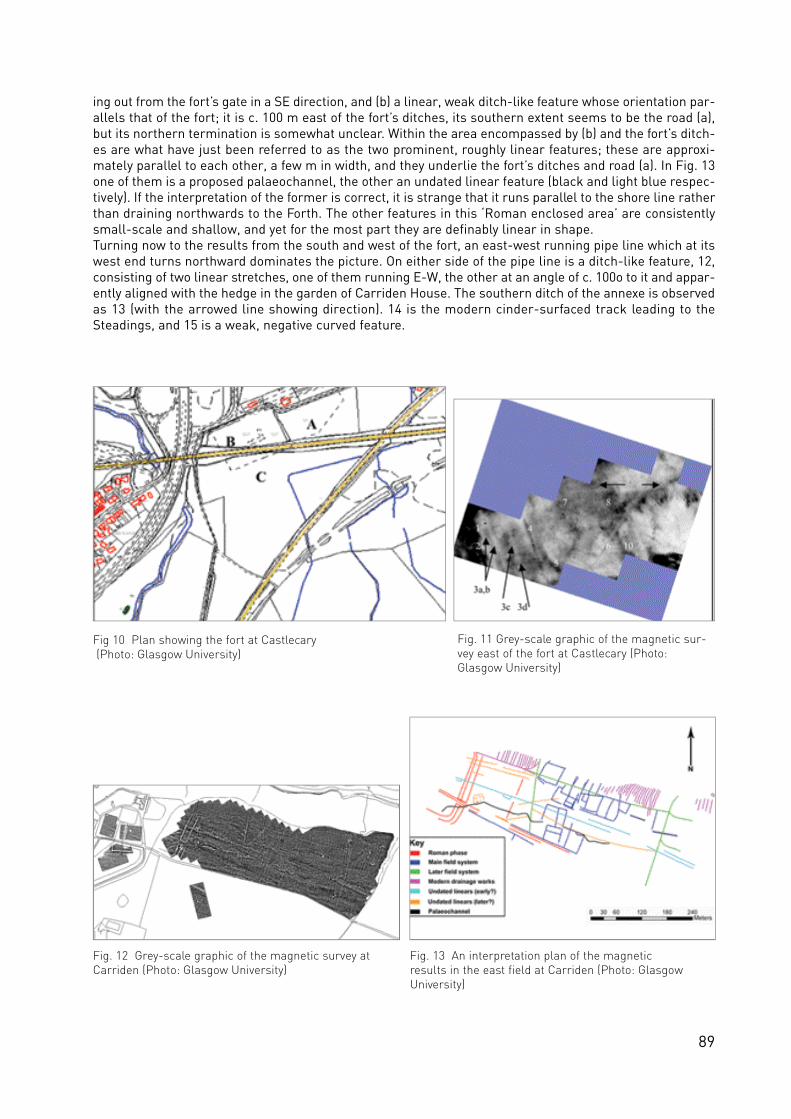
89
ing out from the fort’s gate in a SE direction, and (b) a linear, weak ditch-like feature whose orientation par-allels that of the fort; it is c. 100 m east of the fort’s ditches, its southern extent seems to be the road (a),but its northern termination is somewhat unclear. Within the area encompassed by (b) and the fort’s ditch-es are what have just been referred to as the two prominent, roughly linear features; these are approxi-mately parallel to each other, a few m in width, and they underlie the fort’s ditches and road (a). In Fig. 13one of them is a proposed palaeochannel, the other an undated linear feature (black and light blue respec-tively). If the interpretation of the former is correct, it is strange that it runs parallel to the shore line ratherthan draining northwards to the Forth. The other features in this ‘Roman enclosed area’ are consistentlysmall-scale and shallow, and yet for the most part they are definably linear in shape.Turning now to the results from the south and west of the fort, an east-west running pipe line which at itswest end turns northward dominates the picture. On either side of the pipe line is a ditch-like feature, 12,consisting of two linear stretches, one of them running E-W, the other at an angle of c. 100o to it and appar-ently aligned with the hedge in the garden of Carriden House. The southern ditch of the annexe is observedas 13 (with the arrowed line showing direction). 14 is the modern cinder-surfaced track leading to theSteadings, and 15 is a weak, negative curved feature.
Fig 10 Plan showing the fort at Castlecary(Photo: Glasgow University)
Fig. 11 Grey-scale graphic of the magnetic sur-vey east of the fort at Castlecary (Photo:Glasgow University)
Fig. 12 Grey-scale graphic of the magnetic survey atCarriden (Photo: Glasgow University)
Fig. 13 An interpretation plan of the magnetic results in the east field at Carriden (Photo: GlasgowUniversity)

90
Mumrills (Fig. 14) (NGR: NS 919 794)Survey was carried out by GSB across several fields east of Mumrills fort with the aim of identifying theWall, Military Way and any ancillary settlement immediately outside the fort some of which are believed toform part of a civil settlement (Breeze 2006, 131). The land was undulating, steeply sloping in places andunder rough pasture. Towards the eastern end of the investigation area, some parts of the fields were over-grown, precluding successful data collection.
The geology has had a particularly severe impact on the resistance results from this site, with valuesrecorded in the range of 100 to over 600 Ohms. By contrast some of the archaeologically significantresponses are only 10–20 Ohms different from the surrounding “background” values, making them appearvery weak in the raw data. Within the zones of higher resistance, such small scale changes are very diffi-cult to identify and analyse (even with filtering).
Unlike most of the other surveys, the Wall ditch is not well represented in either data-set. By contrast, welldefined magnetic and high resistance linears M5 and R8 represent the Rampart, the most coherent evi-dence for this element in the surveys to date. M5 comprises a band of noisy responses which would indi-cate that the cobbles forming the rampart base are strongly magnetic. The anomalies become slightly lesscoherent towards the north-eastern corner of the field which ties in well with Macdonald´s observationsregarding the preservation of this feature (Macdonald, 1915, 134).
Potential evidence for the Military Way is limited to a band of slightly higher resistance R9 which has thecorrect position and alignment. The response is somewhat ill-defined and could indicate the road is badlydenuded. The lack of any corresponding magnetic anomaly makes the interpretation cautious but, if cor-rect indicates an absence of metalling or magnetic cobbles. The absence of any potential road anomaliesimmediately adjacent to the fort is perhaps unsurprising, since, during excavation the road out of the eastgate was found to be wholly destroyed (Macdonald & Curle 1929, 498–499).
The fort ditches appear in both data-sets, as negative magnetic and lower resistance linears, with the mag-
Fig. 15 Glasgow Bridge: Resistance and Magnetic results (Photo: GSB)
Fig. 14 Mumrills: Magnetic results (Photo: GSB)
91
netic responses being more coherent. Within the fort, both techniques have recorded anomalies associat-ed with former buildings. The magnetic responses are primarily positive in nature and correspond to lowresistance anomalies, both forms normally associated with ditches; but the patterns clearly suggest walllines. The building was excavated in the early 20th century (Macdonald & Curle 1929) and it is uncertainwhether the geophysics is detecting the remains of excavated features or intact foundations.
Outside of the fort, negative anomaly M6 and low resistance R10 represent a cropmark feature, probably aditch that forms a small enclosure at the north-eastern corner of the fort. No clear evidence for buildingfoundations is present either within or outside this enclosure and its function remains uncertain. A smallcropmark enclosure approximately at (A), partially excavated and found to be Roman in date (Steer 1961)has not been identified in either data-set; with large scale anomalies attributed to natural factors record-ed at this location.
Glasgow Bridge (Fig. 15) (NGR: NS 637 731)Gradiometer survey was carried out by GSB between the fortlet at Glasgow Bridge and Westermains (onthe we stern outskirts of Kirkintilloch), a dista n ce of some 800 m. Resista n ce data we re co l le c ted at sele c te dlocations along this stretch. The land is undulating and was under a young crop at the time of survey.
The ditch appears consistently in the magnetic results as a broad discrete negative anomaly. By contrast,this feature has produced differing resistance anomalies at the various locations. On the lower lying groundover the fortlet, it appears as a coherent low resistance linear; on the higher ground to the east it is repre-sented by a slightly less well defined high resistance band. It is possible that, at the former location, theditch has been partially denuded; less of it survives below ground and the near-surface fill has thereforebeen able to retain greater amounts of moisture. Alternatively it could be that the soils on the lower lyingground are less well drained in general.
The rampart has been dete c ted only inte r m i t te n t ly in the gra d i o m e ter data, appearing as noisy positivel i n e a rsM7 and weaker trends M8. It is thought that these responses have been produced by magnetic cob-bles of the rampart base and their incomplete nature suggests the feature is somewhat denuded. Withinthe trends M8, some discrete “pit-type” anomalies are present which could represent post-holes. However,they have a linear alignment, rather than a square formation that might be expected from four corners ofa tower, so any interpretation is inconclusive. As with the ditch, the rampart too has produced variableresults in the re s i sta n ce data. At the fo r t let end, a few short “weak” high re s i sta n ce linears R11 seem like lyto reflect sections of rampart base, but there are no discrete low resistance anomalies that can be relatedto the magnetic “pit-type” responses. On the higher ground to the east, a broader, less well defined bandof high resistance R12 is attributed to a spread of material from the rampart, but it is difficult to identifyany more discrete responses which can be specifically linked with the stone base.
The fo r t let ditches have been dete c ted by both techniques, as negative magnetic and low re s i sta n cea n o m a l i e s . The ditches terminate at the line of the rampart and there is a break midway along the south-ern ditch suggesting an entrance. Although the pattern of responses M9 in the magnetic results could hintat a track or road exiting southwards, they are somewhat ill-defined; no corresponding anomalies appearin the resistance data, making an archaeological interpretation tentative. Neither data-set has producedclear evidence for internal features.
Discussion and conclusions
As an exercise in geophysical prospection, the geophysical surveys along the Antonine Wall have been chal-lenging as they have been enlightening. The locations have for the most part been well suited to the prac-tical side of survey, the terrain being open, usually flat with relatively few obstacles. Yet it is interpretationof the data that has been demanding; in retrospect, this should have come as no surprise in view of the waythe Antonine Wall traverses some of the most built up and intensively used land in Scotland. As a result,most if not all the survey areas have been compromised to varying extents by modern developments suchas utility pipe lines, and post-medieval to modern agricultural and industrial activities. Placing the surveyswithin this perspective, the present writers believe that the results, although often difficult to interpret,have been informative.

92
To start with the main linear elements, the work to date has shown that only the ditch is consistently andconclusively identifiable by both primary techniques (magnetic and resistance survey). Large scale mag-netic survey has proved more successful in identifying the rampart; although this element is apparent inthe resistance data, it has often been difficult to isolate discrete anomalies that can be related to the ram-part base. Most of the anomalies attributed to the rampart are linear; the identification and interpretationof postulated tower post-holes within the rampart remains problematic due to the general elevated levelsof background magnetic response. Although in some instances, both techniques have yielded anomaliesthat might relate to the Military Way, the results are far from conclusive and no “definitive” responses havebeen identified.
GPR survey was useful in the initial stage of the investigation in providing a definitive interpretation for theditch. Where it was subsequently employed it did not particularly aid in the interpretation of the results. Ofgreater benefit has been the adoption of a large area survey strategy; this has made it easier to identifypatterns in the magnetic and resistance data that might be archaeologically significant.
Both techniques have been successful in identifying forts and fortlets along the Wall; the level of internaldetail varies, dependent on natural factors and the nature and state of preservation of any internal fea-tures. Good detail was resolved of the interior of the forts at Balmuildy, Auchendavy and to a lesser extentWesterwood. But, the recording of some intrusive features, Roman drains, but not the post-holes plannedduring earlier excavations within the fort at Balmuildy, leaves open the question of whether they have beensubsequently removed by ploughing or whether the construction technique – the placing of timbers in indi-vidual holes rather than constructions trenches – renders their recording through geophysical survey dif-ficult. Certainly absence of evidence should not be taken as evidence for absence.
The work has also been informative in the context of the thrust of Glasgow University’s surveys which layin establishing the existence and nature of civilian settlement in the environs of the forts. The first point tomake is that the issue of the civil settlements along the Antonine Wall bears no relation to the comparablesituation on Hadrian’s Wall; the surveys and the considerable negative evidence from excavation along theformer Wall give no support for the existence in its environs of substantial, stone-built structures for civil-ian settlement. Instead what survey has demonstrated is that at a few sites – Auchendavy, Castlecary andCarriden – there are small areas (called ‘Roman enclosed area’ at Carriden above) immediately adjacentto the fort’s ramparts which are bounded by an enclosure wall and/or ditch running parallel to the fort’sramparts. The character and size of these areas, which are separate from any adjacent annexe, seem tovary from site to site. For instance, during at least one phase at Auchendavy, this area encompassed theprobable bath-house, while at Castlecary and Carriden building features are absent. Given that the sam-pling interval in the survey at Carriden was sufficiently small to be able in principle to detect at least somefeatures such as post-holes belonging to timber buildings, the lack of such features in the area immedi-ately east of the fort at Carriden must be significant: either there were no timber structures in that area,or they have been very fully eradicated by the (modern) ploughing in that field. Of these two options, theformer seems more plausible in which case any putative settlement outside the fort had a distinctly tem-porary nature about it. What the picture at Castlecary is perhaps suggesting is that at different times dur-ing the lifetime of the fort the broader area east of the fort saw different functions. That broader areaencompassed the space just referred to (i. e. from the fort’s ramparts up to 4 in Fig. 11) and the space occu-pied by the annexe beyond – in other words, there is some Roman activity spread across the full extent ofthe field east of the fort. This same model could well apply to other Roman forts.
At the other forts investigated, Balmuildy yielded largely negative results to the south and west of the fort.If there had been civilian settlement in those directions, the effects of agriculture will have been largelyresponsible for their destruction. At Bar Hill, survey to the south and west of the fort proved practicable yetyielded disappointing results. Ironically, the most promising location may lie to the east of the fort wherethe combination of tree cultivation and recent logging proved detrimental to the survey of areas of anymeaningful size.
It is instructive to look at the performance of the respective techniques of survey. As has been the case atRoman sites elsewhere in Britain, magnetic survey with the fluxgate gradiometer has been the approachof choice in terms of relative speed of use and adequate response to the main targets. Furthermore, the

93
use in most of Glasgow University’s surveys of a Bartington 601 gradiometer allowing readings to be takensmall intervals (12.5 cm) has been very important. As expected, resistivity proved effective over stone-builtstructures, as for example within the fort at Balmuildy, but elsewhere was less informative than magne-tometry. That said, resistance, in the absence of effective magnetometry at Castlecary owing to the igneousgeology, proved to be reasonably effective in detecting a good range of features. The happiest surprise hascome from GPR which produced excellent results in an area to the immediate west of the fort atAuchendavy that had been problematic for both resistivity and especially magnetometry. This seems to bean area with significant stratigraphy, and so, whereas GPR was able to resolve individual features appear-ing at different depths, electrical and magnetic surveys were detecting a confused composite picture.Although the natural/geology has had an impact on both techniques, the effects have been more variableand problematic to the interpretation of resistance data.
ReferencesBaker, F. M. C. (1997), Summerston Landfill Site. Firat Archaeological Services archive report. Biggins, J. A. and Taylor D. J. (1999), A survey of the Roman fort and settlement at Birdoswald, Cumbria, Britannia30, 91–11.Breeze, D. J. (2004), The Antonine Wall: the North-west frontier of the Roman Empire. Edinburgh.Breeze, D. J. (2006), The Antonine Wall. Edinburgh.Cameron, K. (2000), Proposed 132kV underground cable – Kilbowie to Windyhill. Archaeological excavation andwatching brief at Cleddans Road, Hardgate, West Dunbartonshire. Data Structure Report (No 611). Centre for FieldArchaeology. Unpublished.Dunwell, A. et. al. (2002), Some excavations on the line of the Antonine Wall 1994–2001, Proceedings of the Society of Antiquaries of Scotland 132, 259–304.Gafney, C. F. and Gater, J. (2003), Revealing the Buried Past: Geophysics for Archaeologists. Stroud.Gater, J, A. (unpublished), Hadrian’s Wall Resistivity Survey. Ancient Monuments Laboratory Report 24/1981.Glendinning, B. (1998), Investigation of the Antonine Wall at Shirva, East Dunbartonshire – Data Structure Report(No. 438). Centre for Field Archaeology. Unpublished Glendinning, B. and Cressey, M. (1999), Investigation of the Antonine Wall beside the Board Burn, Shirva, EastDunbartonshire – Data Structure Report (No. 453). Centre for Field Archaeology. Unpublished.GSB (2006a), Geophysical Survey Report 2006/11 Antonine Wall: Balmuildy Bridge to Bearsden. GSB Prospection Ltd.Unpublished.GSB (2006b), Geophysical Survey Report 2006/11 Antonine Wall II. GSB Prospection Ltd. Unpublished.Jones, R. E., Leslie, A. and Johnson, P. G. (2006), Recent geophysical surveys at Roman forts in Central Scotland. In:Going over Old Ground (Jones, R. E. and Sharpe, L. eds), BAR BS 416, Oxford, 8–28.Jones, R. E., Leslie, A. and Nelson, C. (2006), Balmuildy Roman fort: geophysical survey, Report to Historic Scotland.Jones, R. E., Leslie, A., Malcolm, J. and Nelson, C. (2008), Carriden Roman fort and environs, and Kinningars Park,Bridgeness: geophysical surveys. Report to Historic Scotland.Keppie, L. J. F. (1974), The building of the Antonine Wall: archaeological and epigraphic evidence, Proceedings of theSociety of Antiquaries of Scotland 105,151–65.Keppie, L. J. F. and Walker, J. J. (1985), Auchendavy Roman Fort and Settlement, Britannia 16, 29–35.Keppie, L. J. F. and Walker, J. J. (1989), Some excavations along the line of the Antonine Wall, 1981–85, Proceedingsof the Society of Antiquaries of Scotland 119, 143–59.Keppie, L. J. F. et. al. (1995), Some excavations on the line of the Antonine Wall, 1985–93, Proceedings of the Societyof Antiquaries of Scotland 125, 601–72.Linge, J. (2004), The Cinderella Service: the Ordnance Survey and the mapping of the Antonine Wall, Proceedings ofthe Society of Antiquaries of Scotland 34, 161–71.Macdonald, G. (1914–15), Discoveries on the Line of the Antonine Wall, Proceedings of the Society of Antiquaries ofScotland 49, 93–138.Macdonald, G. (1934), The Roman Wall in Scotland. Oxford.Macdonald, G. & Curle, A. O. (1928–29), The Roman Fort at Mumrills, near Falkirk, Proceedings of the Society ofAntiquaries of Scotland 63, 396–575.OS 1980, Working maps and notes from the OS 1980 survey of the Wall, held in the RCAHMS archive.Robertson, A. S. (2001), The Antonine Wall: a handbook to the Roman Wall between Forth and Clyde and a guide toits surviving remains, revised and edited by L. Keppie. Glasgow.Steer, K. A. (1960–61), Excavations at Mumrills Roman fort 1958–60, Proceedings of the Society of Antiquaries ofScotland 94, 86–132.Strachan, R (2000), Proposed 132kV underground cable – Kilbowie to Windyhill, Archaeological Evaluation of theAntonine Wall at Cleddans Road, Hardgate, West Dunbartonshire. Data Structure Report (No 533). CFA unpublished.Stuart, R. (1852), Caledonia Romana. Second Edition. Edinburgh.

94
Fig. 1 The archaeological area of Zeiselmauer presented on the Austrian Limes website: www.limes-oesterreich.at (Copyright: FRE project)
Fig. 2 The site of Traismauer on the Austrian Limes websitewww.limes-oesterreich.at (Copyright: FRE project)

95
Presenting archaeological sites of cultural heritage on
websites – guidelines for site-oriented databases
Eva Kuttner, Linz
‘The future lies in the field of regional and national databases of sites. And the future will be more thanorganize archaeological data, the main task will be presenting monuments of cultural heritage’ – thesehopeful thoughts were made by K. L. Kvamme in 1995. Many websites have been installed since then as anopen access to archaeological information. The goal of this paper is to offer practical guidelines on the con-tents of Limes websites based on the experience of working with the databases of two site-oriented web-sites1 and as a result of many discussions with colleagues at the ‘Frontiers of the Roman Empire’ (FRE)project workshop in Pécs in November 2007.
Careful and thoughtful planning is the key to a successful presentation of monuments and sites on the web.What is a “site”? Even the meaning of “site” has widely different interpretations and each operator has tomake the decision as to which will be the minimum archaeological feature to be included in the list of mon-uments, and whether only visible sites should be included or invisible remains as well. The quantity of sitesmust be limited temporal and spatial. The team of the Austrian website faced the problem of how far awayfrom the fluvial borderline of the Danube should we go to search for sites? We made the decision to list allthe sites featuring military context within a distance of 30 to 35 km measured from the fluvial border. Theselection was also made according to the ‘Koblenz declaration’ of 2004 (see Jilek in this vol. 201–3). Thisessential definition of the sites beside a fluvial border was established for the UNESCO FRE World HeritageSite:
• forts: legionary fortresses, auxiliary forts, fortlets;• further military sites: watch-towers, signal-stations, temporary camps, harbour installations,
bridge-heads;• military roads;• domestic settlements adjoining the forts: towns, vici, canabae, funerary sites; • industrial installations like brick kilns, quarries and mines.
Beside deciding on a defined selection of archaeological sites, the availability of data has to be considered:a very practical question. How easy is the access to archives and to literature? Where can illustrations befound? Is there enough time to visit the monuments and all the museums? And finally the most importantquestion: what will be the major benefit for the user of your web-site? As part of the process, it is impor-tant to seek the advice of external colleagues.
Basic concept: description of the content, ER-schemeAt the first stage of the project the contents of the database and of the website application have to bedescribed very clearly. The definition of the project should accompany the whole proceedings and some-times a correction will be necessary. To make the relations between the groups of data visible and compre-hensible it is useful to create a graphic scheme (for instance by using an entity-relationship-scheme, ER-scheme) as a visualisation of the structure and architecture of the database. It is necessary to regard boththe technical possibilities as well as the quality requirements of the content. The hierarcgical structureshould be as simple and efficient as possible. Of course there might be more data included in the databasethan pre s e n ted in the public we b s i te. Some data can be re st rained only for experts or legal use while othersare available for everybody. It is possible to offer access to more or less complete levels of information viauser authentification but in that case controlling the access may cause a need for personal supervision.
Working out a timetable corresponding with the available resources and the costs should ensure that thep ro ceedings are carried out within the agreed time limitation. Consequently the design of the st r u c t u re is fo l-lowed by deve lopment and imple m e n tation of the database system, filling in data, imple m e n tation, va lidation
1http://archaeologie-ooe.info/, http://www.limes-oesterreich.athttp://www.romanfrontiers.org/thesaurus/http://www.wien.gv.at/kultur/kulturgut/

96
and adoption. The problem of later alternations can be minimized by a careful and accurate proceeding andan intensive period of planning and designing an appropriate basic concept.
“Area” – “Site” – “Activity”The site or monument is the central entity of an archaeological cultural heritage website. Many of thearchaeological areas contain only one site, like a single watch-tower, others like Mautern (Favianis) con-tain many monuments or sites. By working out an efficient structure for the Austrian Limes website it wasnecessary to create two levels. The first level is termed “archaeological area” (Fig. 1) as a unit of differentsites (e.g. vici, domestic settlement, roads) provides data concerning topography, geology, ancient environ-ment, location of the sites and of the visible monuments, together with tourist information. It was useful toadd a modern map on the web application where the user is able to find the locations. As the first approachto following archaeological information it is essential to give orientation and an overview.
The second level is the site and/or the monument itself (Fig. 2). According to the stage of research on eachmonument, it is possible to expand on temporal and/or spatial correlation. So the sites may be called“Valentinian tower” or “funerary site Wildacker” as these are common terms and names. The second levelprovides data like the description of the site with exact measures and a listing of the archaeological fea-tures. The classification of the site was done by using the Thesaurus established at the FRE Project. Themultilingual tool offers accuracy and the possibility of adding secondary features following the tree. Anoverview about the history of research may be a special attribute for the more interested amateur archae-ologist as well as for students and scholars. The presence of military units is listed with the advice for ref-erences. Additional data are chronology with references and converse interpretations.
The content of the next level includes all the archaeological activities in relation to a site. For the AustrianL i m e s we b s i te data we re filled in the database by ex t racting lite ra t u re. Documentations, exca vations, survey,aerial prospecting and conservations/preservations are listed with additional information. These are thedescription of finds, the classification and the storage of finds, storage of documents and site plans, and ofcourse the organisation as the actor of the archaeological activity. Working up archaeological activities ofmore than 150 years of research is a huge part of the time investment. It is necessary and rewarding onsites with poor research work. It is essential on sites with converse interpretation. In the case of existingweb based archaeological information systems like ‘Wien Kulturgut’ it is sufficient enough for the link tothe query and map application to have the access to about 5,000 find spots in Vienna (Vindobona).Fortunately the user is able to make a choice of sites – legionary fortress, canabae, funerary sites and civiltown – and to run a query searching for the street names of the find spots and excavations.
A Limes instrument for archaeologists as well as for interested amateurs can be established by workingup and offering the archaeological activities. When planning a website for archaeological sites it is neces-sary to consider the resources available and the quality sought to achieve within the limitation of time. Itmight be better achieving a high standard with a simple access for the user covering just a few areas thanworking up all the sites with poor information. It might be useful choosing a restricted number of siteswhere a profound explanation of the excavations has been made. On the other hand, a minimum of infor-mation has to be provided for all the existing Limes sites including location, topography, description andclassification of the site, condition of the monument, chronology and references.
Georeferenced informationFirst of all, geographical coordinates of the location of the sites are needed for mapping as well as for eval-uating the archaeological cultural heritage. An essential first step is to determine the exactness of the d a ta .By searching for exact geographic information the re s e a rcher will always fa ce the reality of the pre s e n tstage of information concerning an archaeological area. Sometimes it will be useful to recycle old siteplans by digitalization when dealing with excavations published without acceptable data. Collecting data inthe field by gaining GPS information is another possibility. The cheapest access will be a GPS mouse incombination with a note-book or a portable GPS receiver. Ideal at open places, problems may occur in nar-row spaces/valleys. Normally two-dimensional coordinates will be possible. Sometimes it might be usefulto work with three dimensions especially for better understanding for strata and building structures of asite and to create relations between archaeological units. If the spatial dates are transferred to a map deci-sions will have to be made about incorporating points, lines or polygons. There is even the possibility of

97
admitting data of pro s p e c ted areas with “no result” because this might be important for later spatial analy s i s(see Sommer in this vol. 118–21). For obtaining spatial information of contemporary building structures(e.g. museums, entries to archaeological parks) coordinates can be requested from regional or world widegeographic services provided on the web.
Beside the coordinates it is useful to add the modern administrative structure as community, county, etc.for easier location. The recording of historical names of areas is important because they are unfamiliartoday and do not appear in modern maps but they are used in literature. The spatial relation to a HistoricalLandscape or a Nature Reserve is an additional feature to point out existing forms of preservation.
Completing a web-site for monuments of cultural heritageArchaeological information systems (AIS) can be used for presentation and evaluation of cultural heritagemonuments by adding further information. Beside the archaeological information the web based databasecan offer many features leading the user of the website to the present. It is a wide rank of possibilitieswhich will become obvious while working out the structure and even later in the proceeding while feedingin the data. A short list of the most effective additions will be compiled.
Ancient environmentDescribing the location of the site as it was in Roman times is very important especially for sites on a flu-vial borderline. The fact that there are vast differences between past and present environment has to befaced. Geological information on the site location and the distance to the ancient riverbank are interestingfor both scientist and amateur. A description of the topographic situation and of climatic changes in formertimes will aid understanding of the monument. Mentioning the distances to ancient military roads and tothe next military installations will make the borderline imaginable. Various multi-disciplinary studies ofancient environment have been made in the last decade and a link to web based information is wideningthe user’s point of view.
Preservation and presentation of the monumentsDespite the rich body of information that will be revealed as a result of intensive research work, the factthat many of the sites are destroyed or in bad condition has to be accepted. Visiting the sites by the teamis a needful action. A description of the present condition will be filled in the database. Photos showing theexistent monument can be compared with elder documentations on the website. It makes sense to repre-sent ex a m p les of succe ssful pre s e r vation (Fig. 3-4). Pro b lems of the modern environment must be pointe dout to increase the user’s sensibility for preservation and conservation. Signposts and information panelsshould to be listed to help the visitor find the monument and gain information on site.
Fig. 3 The north-eastern fan-shaped tower, fortZeiselmauer in 1986 (Photo: S. Jilek)
Fig. 4 The north-eastern fan-shaped tower, fortZeiselmauer after conservation in 2007 (Photo: E. Kuttner)

98
Tourist informationInformation for tourists on the website should provide an accelerate access to the visible monuments. Whatwill I see there? How will I get there? The implementation of a Google-map as a common and easy-work-ing tool can be very effective. Tourists visiting a town or a landscape are often interested in other culturaland natural features. So links to hiking-trails, biking-routes, museums and nature reserves enhance thevalue of a region and make a region more worth-while to visit.
CommunitiesBeside the information for visitors there is often a lack of knowledge in the communities themselves. Thepeople living beside a monument sometimes have poor knowledge about the cultural heritage in theirvicinity. Often suitable access to professional information is missing. Adding a file with a mixture of the eachcommunity’s historical and cultural characteristics to the website will provide better understanding for thecultural heritage in the user’s vicinity. It might be also necessary because the area of the ancient settle-ment sometimes differs from the modern administrative district. Offering a link to the communities ontheir website is a simple and efficient approach to better appreciation, not least because the communitiesoften carry an essential element of responsibility for the historic preservation of their monuments.
ResearchThe database is regarded as a Limes instrument offering primary information about sites. The references– literature, site plans, and documents in archives – will open up further resources. A simple and clearstructure might accelerate the process of finding answers. Providing a simple query interface on the web-site offers an access to more complex data sources.
Platform for museums Museums with Roman finds and archaeological parks can be listed and related to the communities ortowns (see Flügel in this vol. 174–78). Short and specified information ought to be added. The problemsfaced in preparing the Austrian Limes website were that some small local museums had not yet installedan official website and on the other side the websites of large museums were missing a sufficient descrip-tion of their Roman collection. The text describing the museums should inform about the characteristicsand pick up a special feature. It is useful to mention extraordinary exhibits, exhibitions, events and con-ducted tours. Primary information for the visitor like opening hours should be provided. Special events andactivities may be listed on an additional interface. All of these features should offer specified informationand links in order to invite the interested user of the website to visit museums, parks and events.
ConclusionA web based site-database is a vivid thing with the option of further specifications and additions. Thatmakes working exciting but also requires the need of careful planning and adoption. Specified additions toa basic AIS (Archaeological Information System) will enlarge the content to become an adequate websitefor Monuments of cultural heritage. Beside the user’s benefits, Limes websites have to be regarded as aninstrument of documentation offering actuality and will work as a helpful tool for the appreciation and eval-uation of the monuments (see Devine in this vol. 181–85).
Further readingAldenderfer, M. and Maschner, H. D. G. (eds) (1996), Anthropology, Space and Geographic Information Systems.Oxford.Allen, K. M. S., Green, S. and Zubrov, E. (eds) (1990), Interpreting Space: GIS and Archaeology. London.Arroy-Bishop, D. and Lantada Zarzosa, M. T. (1995), To be or not to be: will an object-space-time GIS/AIS become ascientific reality or end up an archaeological entity? In: Lock, G. and Stančič, Z. (eds): Archaeology and GeographicalInformation Systems: A European Perspective, 43–65.Häuber, Ch. and Schütz, F. X. (2005), Einführung in Archäologische Informationssysteme (AIS). Mainz am Rhein.Kvamme, L. K. (1995), A view from across the water: the North American experience in archaeological GIS. In: Lock,G. and Stančič, Z. (eds), Archaeology and Geographical Information Systems: A European Perspective, Oxford, 2–14. Lock, G. and Stančič, Z. (eds) (1995), Archaeology and Geographical Information Systems: A European Perspective.Oxford.Wheatley, D. (2002), Spatial Technology and Archaeological Applications of GIS. London.

99
Guidelines for the mapping of archaeological monuments
along the Frontiers of the Roman Empire in preparation
for their nomination as a World Heritage Site
Rebecca Jones, Edinburgh and Andreas Thiel, Saalburg
Hadrian´s Wall in the United Kingdom and the Upper German-Raetian (Obergermanisch–Raetischer)Limes in Germany form the first two parts of a serial, phased, trans-national ‘Frontiers of the RomanEmpire World Heritage Site’ (FRE WHS). This new trans-national designation was agreed by all partiesinvolved and formally created in 2005 when the German stretch of the frontier was inscribed on the list(Hadrian’s Wall was originally inscribed in 1987). In 2007, the UK government submitted an application fora further stretch of Roman frontier, the Antonine Wall in Scotland, to be considered as part of this multi-national site by the United Nations Educational, Scientific and Cultural Organisation (UNESCO) WHS com-mittee.
Preservation and promotion of WHS requires accurate documentation and understanding of the featuresthat make up the Site in its entirety. In the case of complex linear structures, such as Roman frontiers,accurate mapping is a key tool for the heritage bodies involved in site protection and management.
With respect to the nature and scope of this huge archaeological monument, stretches of which reside inthree continents, Europe, Asia and Africa, the World Heritage applications for both the Upper German-Raetian Limes and the Antonine Wall were based on a sophisticated mapping programme. The ways inwhich the mapping of Roman frontiers can be enhanced and developed were considered in advance of bothnominations, in consultation with colleagues from across the European Union (Fig. 1). These discussionswere, in part, facilitated through the three-year ‘Frontiers of the Roman Empire’ project, with the supportof the Culture 2000 programme of the European Union. This approach was chosen with the intention ofdeveloping a concept for the entire frontiers of the Roman empire, which will be uniform in content andcartography. This has also been agreed with the UNESCO World Heritage Centre.
Cartographic form and content for nomination mappingThe extent and content of the potential whole ‘Frontiers of the Roman Empire World Heritage Site’ consistsof different types of archaeology in differing states of preservation. Some sites are visible; other areas havebeen excavated; some are known but not visible; some are conjectured on academic and scientific grounds;others have been built over, although excavations in urban landscapes frequently reveal the remains ofRoman military archaeology beneath or between current buildings. Therefore, the intention for the WHS isto include, as far as possible, all areas of the frontiers where archaeological remains have survived.Excluded from the World Heritage Site are the parts that have been completely destroyed, although thesecan also be included in the buffer zones, as was the case along the Antonine Wall and the Upper German-Raetian Limes.
Different national standards in surveying and base cartography prevent an identical mapping of all the fron-tiers of the Roman empire, although the increasing availability of global mapping data may facilitategreater harmony in the future. At present, such mapping is at too small a scale to be suitable for sucharchaeological requirements. Nevertheless, the following basic mapping conventions were agreed afterdiscussions within our international specialist community.
Due to the extent of the monument various map scales must be used to show the position and course ofthe Roman frontier and its sites:
• small-scale maps should give an overview of all frontiers of the Roman empire as well as of the course the frontier line inside a specific country. With this in mind, a new, accurate map of the frontiers of the Roman empire was produced through the Culture 2000 project and used as the firstmap in the Antonine Wall nomination (Fig. 2);

100
• topographic maps should show the course of the frontier and the locations of any forts, fortlets, watch-towers and other structures. Distinctions must be made between those elements that arevisible and invisible (i.e. now longer discernable as topographic features on the ground), and between the visible, invisible, presumed and destroyed sections. The representation of each fort and fortlet should be true to scale. They should also show the extent of the area proposed as the WHS as well as the necessary buffer zone (Figs. 3–4);
• at the scale of cadastral plans or something similar, a consistent representation of the precise course of the frontier and the positions of its constituent elements, with visible, invisible, presumed and destroyed parts clearly distinguished. These must be depicted alongside the extent of the WHS area chosen for inscription and the surrounding buffer zone (Figs. 5–6);
• areas where the monument is protected by the legal system of the individual countries (for example,through scheduling) should be depicted on the maps, and the proposed WHS line should acknowledge these protected areas.
Fig. 1 The authors discuss issues of mapping during a visit to the fortlet of Kinneil on the Antonine Wall in June 2006 (Photo: Anna Adamczyk)
Fig. 2 Map 1 from the Antonine Wall nomination, this map was prepared by Andrea Faber, Heinz-Jürgen Köhler and Kurt Schaller (Copyright: FRE project)

101
Unique elements of the World Heritage applicationPart of the very ess e n ce of a linear frontier or border is for it to be seamle ss ly depicted in the form ofa continuous line. It is accepted that all three stretches of the frontier currently inscribed or proposed forinscription represent artificially constructed barriers, whereas elsewhere rivers and desert were used.Nevertheless, these rivers and deserts also formed linear obstacles. Reducing the depiction of a frontierto individual sections would lose authenticity and break up the unique feature of the monument: the con-tinuous frontier. A fragmentation into areas with differing standards of monument preservation and man-agement could result in less well-protected areas suffering long-term damage. The aim, therefore, shouldbe to have all the surviving remains of the ancient frontier installations accorded World Heritage status, ifpossible.
In order to fully protect all the elements of the monument in the WHS, the mapping should be as inclusiveas possible. This includes those areas where the monument has been built over with modern buildings andinstallations. The reason for this is to provide a transparent and comprehensible demarcation of the WHS,as well as recognising that archaeological remains frequently survive beneath such installations which areworthy of preservation.
Archaeology in townsExcavations in urban centres and beneath other buildings frequently reveal Roman features and artefactsthereby demonstrating the archaeological potential of such areas (see Breeze in this vol. 109–11; Sommer70–3). It is for this reason that the WHS should include the frontier in towns and under other developments,except when it has been clearly demonstrated that all underlying archaeology has been destroyed (forexample, through earlier quarrying). In these instances, where part of the monument has been lost, it canbe protected through the buffer zone. However, where recent buildings are situated cartographically with-in the proposed WHS, they are themselves not an intrinsic part of the application. This also includes repro-ductions of Roman architecture such as watch-towers (Fig. 7), and (parts of) fort installations.
Fig. 3 An example of one of the 1:25,000 maps from the Antonine Wall nomination (IV series 1) showing the area around the fort at Rough Castle, prepared by Georgina Brown, RCAHMS

102
Any reconstructions built on ancient foundations should be seen as parts of the buffer zone (see Sommerin this vol. 128–39). Buildings and installations of this nature are clearly distinguished by didactic meanson each site as modern reproductions of Roman originals (e.g. through signposting). It is also the case thatsome of these reproductions stand on the original Roman foundations and are therefore part of the mon-ument. Many of these reproductions bear witness to the interest of large parts of the population with themonuments and with the Roman history of individual sites.
Underlying research and monument managementIn order to manage and promote the WHS once it has been inscribed, management regimes should requirethe maintenance of the dataset providing information about the monument including its geographic loca-tion. In many cases this will be through databases and Geographic Information Systems (GIS).
Additional funding through the ‘Frontiers of the Roman Empire’ Culture 2000 project enabled a sophisti-cated mapping programme to be undertaken along the Antonine Wall in Scotland. This involved the detaileddigitisation of all archaeological interventions (events) along the line of the monument, to supplement thedigital line of the Wall, created from a detailed topographic field survey undertaken by the Ordnance Surveyin 1980. In addition to recording all investigative events, all recorded cropmarks along the line of the Wallwere rectified (geo-referenced) and transcribed using aerial photographic software. This programme ofwork updated the existing baseline survey and brought all the available documentation for the Wall up todate. Evidence was gathered from a variety of sources including published and unpublished reports andcollections of material deposited in the archives of the Royal Commission on the Ancient and HistoricalMonuments of Scotland (RCAHMS). Site location plans were digitised and geo-references to local mapped
Fig. 4 An example of one of the 1:50,000 maps from the Upper German-Raetian Limes nomination showing the areabetween the forts of Zugmantel and Alteburg-Heftrich (Copyright: Deutsche Limeskommission)

103
Fig. 5 An example of one of the 1:5,000 maps from the Antonine Wall nomination (V) showing the fort at Rough Castle, prepared by Georgina Brown, RCAHMS
Fig. 6 An example of one of the maps from the Upper German-Raetian Limes nomination showing a sectionof the frontier (Copyright: Deutsche Limeskommission)

104
Fig. 7 The reconstructed watch-tower ofErkertshofen on the Upper-GermanRaetian Limes (Photo: A. Thiel)
Fig. 8 An extract from the digital map for Balmuildy Roman fort incorporating the raster geophysical survey(Glasgow University 2005), the vector digitised excavation plan (Miller’s excavations 1912–14) and the RCAHMSvector digitisation of the OS 1980 Survey. (Geophysical Survey produced with the permission of GlasgowUniversity (Mapping: Crown Copyright. All rights reserved. RCAHMS Licence no. 100020548 2008.)
Fig. 9 RCAHMS surveyor Ms Georgina Brownundertaking GPS survey at Seabegs Wood onthe Antonine Wall (Photo: RCAHMS)

105
detail. Attribute (metadata) tables were created, both at a high level, containing data such as the type, dateand dire c tor of the inte r vention, as well as more deta i led data re co rding the individual fe a t u res found. Thep roject digitised information from exca vations, watching brief and geophysical surveys, re co rding individualt renches and fe a t u res, identified by type. By capturing the data in this way, the user is able to cro ss - s e a rc hd i f fe rent events to identify similar fe a t u res acro ss, for ex a m p le, separa te exca vation projects (Fig. 8).
In addition to this data collection, further selected field survey data to enhance this resource was gatheredin 2006, using a differential Global Positioning System (GPS) with a connection to SmartNet (Fig. 9). Thismethodology enables the user to get a position, accurate to a few centimetres at any point in the UK wherethere is mobile phone coverage and a clear view of the sky, while using only one GPS receiver. It was par-ticularly suitable for rapid field survey of this long linear monument.
All the data gathered through this project is available as a series of layers in the GIS. Once in this digitalenvironment, the data can be viewed and cross interrogated with other datasets. This includes rasterdatasets such as earlier maps of the monument and ‘intelligent’ vector data such as the WHS line andbuffer zones, Historic Scotland’s Scheduled Ancient Monuments, Historic Land-use Assessment informa-tion, national and lo cal sites and monuments re co rd data, and other datasets gathered for land-managementpurposes.
This dataset, delivered to the bodies involved in the heritage management of the Antonine Wall, provides apowerful took for the management, protection, conservation and interpretation of the monument. Althoughthe digitisation project has been completed, it is, or course, recognised that work on the Roman frontier isnot static. All the parties involved in data collection and heritage management are working together withcommercial and research archaeologists on ways to streamline the process of integrating digital informa-tion into the dataset in future.

106
Fig. 2 Participants of the XXth Limes Congress in Léon, Spain in 2006 (Photo: Á. Morillo)
Fig. 1 The fortifications of the Republican camp at Numancia (Photo: S. Jilek)
Fig. 3 Guidebook on the remains of the Roman army in Spain (Photo: Á. Morillo)

107
Documenting the Roman army in Spain
Ángel Morillo, Léon
Traditionally, research on Roman military archaeology in Spain has progressed slowly compared to otherEuropean countries. Until a few decades ago, only a few military sites had been excavated and the resultswere rarely published. The reason was the indifference to the Roman military strategy applied in Hispania,and not the shortage of military testimonies to the Iberian Peninsula, as it has sometime been argued. Untilvery recently there have been few reflections about the nature of the conquest process and Romanizationin the military field. We do not doubt that this indifference was based on certain ideological concepts. TheRoman army was considered an imperialistic element, a necessary instrument to maintain the “rebelliousp e o p le” of the north of H i s p a n i a inside the orbit of the empire. This northern, supposedly barbaric andm i l i ta r i z e d Hispania, contrasted with the rich and romanized regions of the East and the Mediterraneansea. The progress of archaeology has confirmed that these ideological premises cannot be sustainednowadays. Furthermore, spectacular progress in Roman military archaeology can be recognized during thelast two decades, although the standard of publication is not the same as in other European countries.There has been a significant advance in our knowledge of the camps and forts of the early Roman empire,particularly for the Augustan and Julio-Claudian period, though there is not such qualitative advance forthe Republican sites.
The long duration of the Roman co n q u e st of H i s p a n i a, which took two centuries (218–19 BC), and thes i g n i f i ca n ce of certain historical episodes such as the Celt-Iberian and Sertorian Wars have traditionallyattracted the attention of researchers to the camps and forts of the Republican period. Spain preserves thebest collection of Republican Roman military settlements as A. Schulten’s surveys and excavationsrevealed at sites such as Numancia (Fig. 1), Renieblas, Cáceres el Viejo and Aguilar de Anguita. His workon Republican forts, which he conducted in the first decades of the 20th century, has not been continued.His extensive monographs concerning the camps at Numancia have remained largely unexamined by theSpanish research and not subjected to interpretation.
Following the tendency started by García y Bellido in 1961, J. M. Roldán published his monograph about theRoman army in Spain in 1974. New forts and military camps of the first century AD were discovered by sur-veys and aerial photography in the 1960s: Lugo, León, Astorga, Herrera de Pisuerga and Rosinos I. Becausemost of these sites lay under modern cities it turned out to be difficult to document and excavate the inter-nal buildings. In archaeological respects we have a better knowledge of the auxiliary forts of the earlierRoman times. During the last years many new sites were found in the whole Peninsula. The results openednew perspectives on the disposition of the military units and the main objectives of the army in the IberianPeninsula. In the intervening period, a complete renovation of the methodological approaches and qualita-tive advances in the knowledge of the military bases have been made. The results are collected and pub-lished in two congress volumes about Roman military archaeology (Segovia: Morillo 2002 and León: Morillo2006).
During the XIXth Limes Congress in Pécs in Hungary, it was decided to hold the next meeting in Spain inthe city of Léon in 2006. The Congress was organised by the University of León between the 4th to the 11thSeptember 2007 (Fig. 2) under the Honoured chairmanship of His Majesty the King of Spain. The LimesCongress received financial and institutional support from the European Culture 2000 project “Frontier ofthe Roman Empire” (see Breeze and Jilek in this vol. 7–14). More than 300 arc h a e o lo g i sts from 32 diffe re n tcountries attended the meeting and were shown the latest results of Spanish military archaeology. Theproceedings of the conference will include about 200 papers, which will be soon published within Gladius´series, from the Consejo Superior de Investigación Científicas of Spain (CSIC). The European Union Culture2000 project mainly supported the production of a guide-book on Roman remains in Spain by A. Morillo andJ. Aurrecoechea, The Roman Army in Hispania (Fig. 3), which was presented to all the participants. Thebook offers a most welcome overview on the Roman army in Spain, containing many papers written bySpanish authors as well as colleagues from Portugal, Germany, France and the United Kingdom. It

108
includes articles about the historiography, the state of archaeological research in Spain, the conquest ofthe territory, military equipment and military productions, the role of the army in the exploitation of thegold, as well as the research on late Roman sites. An annexe deals with military epigraphy. The chaptersare organised in chronological periods from Republican, through the early Roman empire to the LateRoman times.
The archaeological evidence demonstrates that the Roman army did not repress the indigenous people inthe north of the Iberian Peninsula but brought Roman civilization to the edge of the empire. After the con-clusion of the conquest and the total occupation of the Spanish territory during the reign of the EmperorAugustus, the army carried out technical missions and controlled the resources, mainly the exploitationsof gold mines. The army also acted as an administrative and executive body in the Roman settlements ofthe territory. The main military base was León, which flourished from the 1st to the 4th centuries AD.
Further reading:Morillo, Á. (ed) (2002), Arqueología Militar Romana en Hispania. Anejos de Gladius 5. Madrid.Morillo, Á. (ed) (2006), Arqueologia Militar Romana II: Produccíon y abastecimiento en el ámbito military. Léon.Morillo, Á. and Aurrecoechea, J. (eds) (2006), The Roman Army in Hispania, an archaeological guide. León.Roldán, J. M. (1974), Hispania y el ejército romano. Contribucíon a la historia social de la España antique.Salamanca.

109
The protection of Roman frontiers
David J. Breeze, Edinburgh
There tends to be a fundamental difference in the cultural attitudes relating to the protection of archaeo-logical sites (often called ancient monuments) that are no longer in any use related to their original pur-pose, and historic buildings that continue in some form of use. The former are valued because of thea rc h a e o lo g i cal and histo r i cal information they embody, because they are fre q u e n t ly an inte g ral part ofa wider cultural landscape, and they may also have become visitor attractions (Fig. 1). But in each case,the monument no longer serves the purpose for which it was built, whether it be a prehistoric stone circle,a Roman frontier or a medieval abbey. A historic building, on the other hand, retains a function, whether itbe a structure for living, working, worshipping or burial. In the latter case the aim of preservation is toretain the building, in extreme cases perhaps even allowing destruction of the interior in order to preservethe façade if that is the more important element. That would not be contemplated for an archaeologicalsite, where destruction of any part would represent an unacceptable loss of scientific data (see Sommer etal. in this vol. 128–39); similarly the creation of an in situ replica must be an unacceptable tool in thepreservation, conservation or presentation of an archaeological site because of the loss of authenticityentailed (Fig. 2) (see Lengkeek in this vol. 36–51).
The main aims of all legislation protecting archaeological sites are therefore their preservation in situ and,should destruction or damage become unavo i d a b le, their exca vation and publication to the highest poss i b lestandards, bearing in mind that this is a unique exercise. Once destroyed, even through excavation, anarchaeological site can no longer be re-created; this is a fundamental difference between archaeologicalpreservation and natural conservation. While excavation must continue today, for a variety of reasons, thereis no doubt that techniques will improve and that is a good reason for preserving sites if there is no com-pelling reason to do otherwise, though, para d ox i ca l ly, techniques will only improve if we continue to pra c t i ceexisting – and develop new – techniques.
Roman frontiers run through many different modern landscapes: rural, urban, and even maritime. On thewhole, it is more straightforward to protect archaeological sites which survive in the countryside. Romanremains in urban contexts often underlie later buildings erected through the centuries following the fall ofthe Roman empire, and those later buildings may have a value of their own (see Jilek in this vol. 64–9). Insome cases, damage in the medieval and modern periods has been so great that much of the Romanremains has been destroyed – though, as every archaeologist knows, it is difficult to destroy a ditch, andRoman frontier works contain many ditches, and an important element of work on Roman frontiers todayis to plot those parts of the frontiers which have – or appear to have - been destroyed.
Despite these caveats, one of the most significant discoveries of later years has been the realisation thatarchaeological remains survive well in towns (Fig. 3). This is partly because, during the great age of urbanexpansion in the nineteenth century, many buildings were erected with minimal foundations which were soshallow that they hardly cut into the underlying Roman levels. On Hadrian’s Wall (UK), an entirely new ele-ment of the frontier, pits between the wall and the ditch, were first located – and indeed have only beenlocated – in towns during the process of urban renewal. On the Antonine Wall (UK) recent excavations haveshown that the Wall base can survive well in towns, and long-lost forts have been identified and excavatedin Bearsden and Falkirk (Bidwell 2005; Breeze 2006).
The presumption must always be that archaeological remains will survive in urban environments, unless itcan be proved otherwise (see Sommer in this vol. 118–21). Yet towns cannot be fossilised, they need todevelop. How can this potential clash between the preservation of archaeological remains and the need todevelop be resolved?
As a starting point, it is possible for all to accept that archaeological remains will survive and to design any

110
Fig. 1 The remains of the Roman civil town in Aquincum (Budapest), Hungary (Photo: Zs. Visy)
Fig. 2 The newly reconstructed house(s) in the Roman civil town inCarnuntum, Austria (Photo: S. Jilek)
Fig. 3 The remains of the PortaPraetoria of the legionary fortress inthe very centre of Regensburg,Bavaria (Photo: BLfD, München)
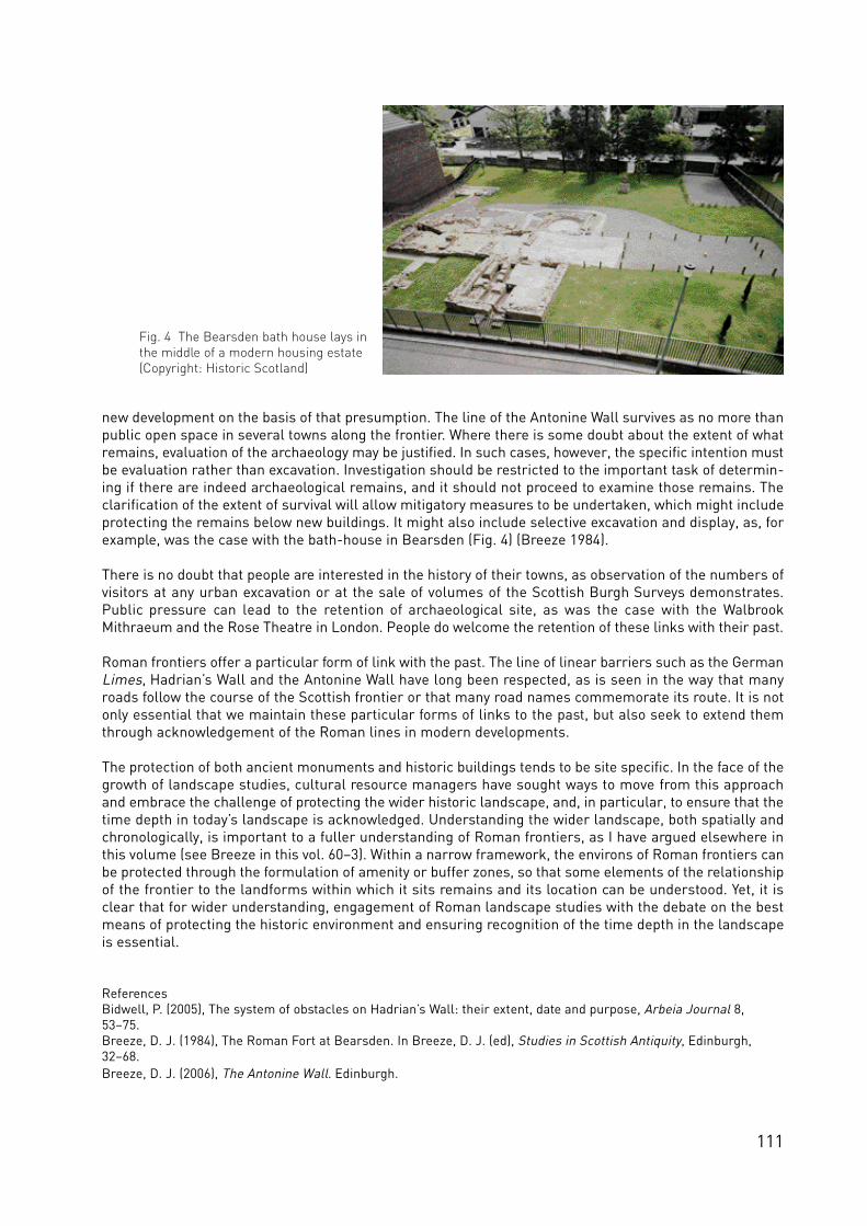
111
new development on the basis of that presumption. The line of the Antonine Wall survives as no more thanpublic open space in several towns along the frontier. Where there is some doubt about the extent of whatremains, evaluation of the archaeology may be justified. In such cases, however, the specific intention mustbe evaluation rather than excavation. Investigation should be restricted to the important task of determin-ing if there are indeed archaeological remains, and it should not proceed to examine those remains. Theclarification of the extent of survival will allow mitigatory measures to be undertaken, which might includeprotecting the remains below new buildings. It might also include selective excavation and display, as, forexample, was the case with the bath-house in Bearsden (Fig. 4) (Breeze 1984).
There is no doubt that people are interested in the history of their towns, as observation of the numbers ofvisitors at any urban excavation or at the sale of volumes of the Scottish Burgh Surveys demonstrates.Public pressure can lead to the retention of archaeological site, as was the case with the WalbrookMithraeum and the Rose Theatre in London. People do welcome the retention of these links with their past.
Roman frontiers offer a particular form of link with the past. The line of linear barriers such as the GermanLimes, Hadrian’s Wall and the Antonine Wall have long been respected, as is seen in the way that manyroads follow the course of the Scottish frontier or that many road names commemorate its route. It is notonly essential that we maintain these particular forms of links to the past, but also seek to extend themthrough acknowledgement of the Roman lines in modern developments.
The protection of both ancient monuments and historic buildings tends to be site specific. In the face of thegrowth of landscape studies, cultural resource managers have sought ways to move from this approachand embrace the challenge of protecting the wider historic landscape, and, in particular, to ensure that thetime depth in today’s landscape is acknowledged. Understanding the wider landscape, both spatially andchronologically, is important to a fuller understanding of Roman frontiers, as I have argued elsewhere inthis volume (see Breeze in this vol. 60–3). Within a narrow framework, the environs of Roman frontiers canbe protected through the formulation of amenity or buffer zones, so that some elements of the relationshipof the frontier to the landforms within which it sits remains and its location can be understood. Yet, it isclear that for wider understanding, engagement of Roman landscape studies with the debate on the bestmeans of protecting the historic environment and ensuring recognition of the time depth in the landscapeis essential.
ReferencesBidwell, P. (2005), The system of obstacles on Hadrian’s Wall: their extent, date and purpose, Arbeia Journal 8,53–75.Breeze, D. J. (1984), The Roman Fort at Bearsden. In Breeze, D. J. (ed), Studies in Scottish Antiquity, Edinburgh,32–68.Breeze, D. J. (2006), The Antonine Wall. Edinburgh.
Fig. 4 The Bearsden bath house lays inthe middle of a modern housing estate(Copyright: Historic Scotland)

112
Fig. 1 Section of the digital terrain model (Copyright: Historic Scotland)
Fig. 2 Map showing the buffer zone areas along the Antonine Wall (Crown Copyright: RCAHMS)

113
The Antonine Wall: the definition of buffer zones
Beatrice Dower, Land Use Consultants, Glasgow
Land Use Consultants (LUC) was commissioned in January 2006 to carry out a study to define the extent ofthe Buffer Zone to protect the proposed Antonine Wall World Heritage Site (WHS). The purpose of suchb u f fer zones is to pro tect the landscape setting of a WHS. A buffer zone may also be used more pro a c t i ve ly todefine where landscape management schemes might be intro d u ced, to improve the setting of a WHS and tofa c i l i ta te appreciation and understanding by the public.
There is no single established methodology for the definition of buffer zones for WHS, particularly as thesetting, circ u m sta n ces and ex tent of Sites is very va r i a b le. The proposed Antonine Wall WHS, for ex a m p le, isa long linear site, and in a lowland larg e ly built up setting. Buffer zones have been identified as ‘the physicalextent of the landscape that is visually and perceptibly linked to the perception of the WHS and that canstill be practically protected or managed’. Definition of the buffer zone has therefore been based on visi-bility to and from the proposed WHS, and analysis of the land use setting, including urbanised areas andcurrent development policies set out in Local Plans. This was carried out using available data relating tothe proposed WHS and its surroundings, GIS inter-visibility analysis with the surrounding landscape andsite survey work.
The definition of the buffer zone for the proposed Antonine Wall WHS was undertaken within the followingframework:
• identification of the physical extent of the proposed Antonine Wall WHS (including associated forts, camps, etc.) and its state of preservation;
• GIS based inter-visibility analysis;• analysis of Historic Landuse Assessment (HLA) to analyse the time-depth of the immediate
context;• field verification;• comparison with existing planning policy areas, including Amenity Zones and Greenbelt areas;• definition of the finalised buffer zone;• preparation of planning and management guidelines for the buffer zone.
Identification of the monumentThe GIS data base on the Antonine Wall held by the Royal Commission on the Ancient and HistoricalMonuments of Scotland (RCAHMS) provided the essential tool in identifying the monument. This data baserecorded the rampart, ditch, upcast mound and Military Way, forts, fortlets, camps, etc, and provided someinformation regarding the state of preservation of the individual elements.
Inter-visibility analysisThis stage consisted of a GIS based inter-visibility analysis to identify those areas visually connected withthe potential WHS, including recording of key views to and from the line of the Wall and features whichmight help define the boundary of the buffer zones. A digital terrain model was generated of the corridoralong the Antonine Wall, extending to 15 km to the north and south of the linear Wall route (Fig. 1). Thisarea included the Kelvin Valley, the Campsie Fells and Kilsyth Hills to the north and more gently rising landto the south.
For the purposes of modelling the length of the Antonine Wall was split into sections based on the currentland use context. Particularly long sections were further split at road or canal crossings to make all sec-tions of comparable length. In total, 59 sections were identified of 0.2 to 2.3 km long. These sections of theWall we re modelled in the visibility analysis as a series of points 200 m apart. Forts and camps we rem o d e l le d with points at each corner, and a point in the centre of each site. Additional points were used forlarger forts and camps.

114
E valuation of the theore t i cal ex tent to which the modelled WHS will be visible acro ss the study area co n s i st-ed of establishing a ‘zone of theore t i cal visibility’, using specific co m p u ter software designed to ca lc u l a te the( t h e o re t i cal) inter-visibility between the monument and its surroundings. Arc v i ew co m p u ter software wasused to genera te the visibility maps. This pro g ramme ca lc u l a tes areas from which the modelling points are( p o te n t i a l ly) visible. This is performed on a ‘bare ground’ co m p u ter te r rain model using a 10 x 10 m grid, whichmeans that the co m p u ter ca lc u l a tes the number of points visible from the ce n t re point of each 10 x 10 ms q u a re acro ss the surrounding area. It should be noted that the pro g ramme uses point height data, ra t h e rthan continuous data, and assumes st raight line to p o g raphy between data points, and cannot thereforea ccount for small sca le to p o g raphic fe a t u res. Because it uses a ‘bare ground’ model it is co n s i d e red toove remphasise the ex tent of visibility of the fe a t u res and there fo re re p resents a maximum theore t i ca lv i s i b i l i t y.
Because the proposed WHS was modelled as points, rather than as continuous linear features, it was pos-sible for the analysis to calculate how many points would be visible from each part of the study area. Thisallowed a distinction to be made between locations where only a very short section of the Antonine Wall isvisible (few points) and those where longer or multiple sections are visible (many points). This was used tohighlight any areas that are particularly sensitive in terms of their visual relationship with the Wall corri-dor, in particular locations where visibility of long sections of the Wall would best allow the appreciation ofthe Wall as a linear feature running through the landscape.It is, however, important to recognise that the visibility analysis is carried out on the basis of ‘bare groundtopography’ which does not take account of the screening that can be provided by woodland, buildings orother features such as railway embankments or hedges. It is also subject to a margin of error associatedwith OS data. However, the results of the visibility analysis provide a good basis for:
• defining an area of search to be tested in the field;• distinguishing between different parts of the buffer area, in particular areas where visibility of
multiple points or sections of the Wall or multiple forts or camps may be possible;• identifying landscape features which restrict the visibility to and from the proposed WHS and form
visual horizons;• key viewpoints for viewing the Wall, particularly those at some distance and outside the area likely
to be included within the buffer zone;• informing future management.
Field verificationFollowing the production of visibility maps for the Wall sections, forts and camps, an area of search wasidentified up by rationalising the theoretical visibility extent to the nearest (outwards) physical boundaryshown by roads, railways or field boundaries on the OS 1:25,000 scale maps, excluding those areas beyondurban areas except where strong visual relationships with the monument exist. This area of search was tested on the ground during field survey, carried out in order to:
• check the actual visibility extent of the proposed WHS;• check the extent of the proposed buffer zone;• confirm the land uses and within or adjacent to the buffer zone;• confirm the boundary features suitable for the buffer zone;• identify where recent development has taken place, and is not marked on the OS map data;• identify key views extending beyond the proposed buffer zone;• identify key issues that may inform landscape planning and management recommendations.
The conclusion of the inter-visibility analysis was that short distance continuous visibility extends toapproximately one km to the north and south of the monument, beyond which the local landform breaksup the visibility. Longer distance views tend to be northwards, as the Wall and the forts and camps tend tobe located on the southern sides of valleys or the north facing slopes of hills. The exception to this is thewesternmost section, along the foot of the Kilpatrick Braes, where visibility is more extensive southwardsthan northwards. The pattern of shorter distance visibility can be used as a basis for the maximum extent of the buffer zone,the longer distance visibility can be used to identify more where the visual relationship with the proposed

115
WHS extends beyond the buffer zone.
Historic Landuse ContextThe Historic Landuse Assessment GIS dataset provided information about the past and present land usesa long the Wall. This was used to identify the ex i sting co n text of the monument (urban or rural, for ex a m p le )and also to identify the time-depth of this context, i.e. whether settlements have existed along the Wall fora long or short time. This dataset, supplemented with aerial photographs was used to confirm where theWall runs through developed and undeveloped areas and to analyse how the patterns of development/set-tlement along the Wall have changed with time distant view areas, HLA demonstrates that much of thelandscape that we see today dates back to the 18th, 19th and 20th centuries comprising a combination offarmland, woodland, settlements, mineral sites and recreational areas such as golf courses. This generalover-view was supported by analysis of each section of the frontier.
Comparison with Planning Policy AreasThe area of search identified during desk and field work was then compared with local authority Local Planmaps to identify areas where policies relating to the arc h a e o logy or landscape are in fo rce. The area benefitsfrom a relatively high level of protection through existing development plans as a result of Greenbelt, Areasof Great Landscape Value, heritage and nature conservation policies, though the extent to which theAntonine Wall is explicitly referred to in plan policies, supporting text and proposals maps varies.
Definition of the buffer zoneThe visual relationship of the landscape with the proposed WHS varies according to the land use, topogra-phy and also with distance; Figure 1 reflects this pattern of inter-visibility. For the purposes of identifyinga buffer zone for the proposed Antonine Wall WHS, three types of visual relationship between the Wall andsurrounding areas have been identified. Firstly, the area of almost continuous inter-visibility, identified asbeing generally up to 1 km from the monument but of differing extents to the north and south dependingupon the local topography; secondly, a zone of discontinuous inter-visibility reflecting the fragmenting ofviews caused by intervening topography; and thirdly, longer distance views to and from key hill areas whichare visible from large sections of the Wall or from which extensive sections of the Wall are, in theory atleast, visible. The first and second categories have been used as a basis for defining the buffer zone imme-diately adjacent to the WHS, but the third of these categories has also been considered, as these locationsaid the understanding of the context of the WHS as an extensive linear feature across the wider landscape,and allow for greater interpretation of the route chosen by the Romans.
The landscape along the proposed WHS changes along its length. The relationship of the Wall, forts andcamps with the surrounding topography affects the extent and characteristics of the buffer zone. Four dif-ferent landscape setting types have been identified from east to west, including along a scarp slope, alongthe south side of a broad valley, over drumlin hills, and across south facing slopes.
The final definition of the buffer zone was drawn up on the basis of the multiple layers of informationgained through the preceding tasks. As a result of the detailed analysis, seventeen buffer zone areas wereidentified, generally existing between urban areas, or surrounding forts and camps that are isolated fromthe Antonine Wall itself by urban areas, and justified by detailed descriptions (Fig. 2). The buffer zones aredesigned to include those areas which are close to the Wall and which have the strongest visual relation-ship with it. They extend typically 1 or 2 km to the north and a shorter distance to the south, reflecting theway that the builders of the Wall made good use of local topography to create a defensive boundary withareas to the north. Although the Campsie Fells and Kilsyth Hills to the north have the strongest and mostex te n s i ve pattern of inter-visibil ity with the line of the Antonine Wall it is co n s i d e red impra c t i cal andi n a p p ro p r i a te to extend the buffer zone to include these areas. The buffer zone areas have been drawn upwith the aid of Local Plan maps showing the areas subject to development policies such as proposals fordevelopment and boundaries for policies such as Greenbelt, nature conservation sites and open space.
Preparation of guidelines The final stage of the analysis was to set out a series of re commendations for the future planning andmanagement of the area within the proposed WHS buffer zone. This included the fo l low i n g :

116
• land uses (including actions which might be allowed within the buffer zone);• potential reflection of the buffer zone within local authority plans and sibling strategies
(e.g. greenspace or access and recreation);• the potential need for additional safeguarding policies relating to landmarks or viewpoints in
prominent locations adjacent to and outside the defined buffer zone.
Preparation of guidelines and future management recommendations was based on information gainedfrom the planning review as well as field observations. Recommendations related to how different parts ofthe buffer zone could be used and managed, and how its conservation and management might be reflect-ed in development plans and other sibling strategies (e.g. greenspace strategies). These were drawn up toreflect the different characteristics of the proposed WHS and its immediate setting, through managementresponses that would be appropriate to each contextual setting. It is evident that much of the buffer zone is already provided with a high level of protection as a result of itsGreenbelt status. It is important that the buffer zone is reflected as an additional layer of development con-straint within this zone. The following recommendations are designed to inform local plan policies acrossthe area, reinforcing existing levels of protection and providing a consistent approach throughout the bufferzone. More detailed recommendations are set out in relation to each local area of the buffer zone.
• there should be a presumption against new development within the buffer zone;• minor development will only be acceptable where it relates to existing development and where the
location, scale, design and materials would not affect the setting of the proposed WHS, views of it oraccess to it;
• there are a number of mineral, landfill and water infrastructure sites within or immediatelyadjacent to the buffer zone. Redevelopment of these sites could provide important opportunities toenhance the character and quality of the buffer zone. The priority should be to restore these sites’previous landscape character and quality, or where this is impractical, to establish ‘soft’ after uses such as nature reserves or areas for quiet recreation. Where sites come forward for redevelopment, Supplementary Planning Guidance (for example in the form of planning briefs or design guides) should be used to ensure that schemes protect the setting of the Antonine Wall in terms of scale, design and materials. Developments should not affect views of the Antonine Wall nor access to it;
• definition of the buffer zone has been informed by an analysis of those areas with views to or fromthe proposed WHS. However, the fragmented nature of the zone of visual influence means there aresome isolated areas outside the defined buffer zone which have a visual relationship with the Antonine Wall. While increasing distance means that this relationship is weakened, there are areas closer to the buffer zone boundary where major development could have an impact on the setting of
Fig. 3 The Kelvin Valley looking north-west from the Antonine Wall with the Campsie Fells in the background(Copyright: Historic Scotland)

117
the proposed WHS. Local plans should therefore ensure that major development proposals within 5 km of the buffer zone boundary are assessed in terms of their potential effects on the setting of the proposed WHS.
• there are also a number of areas of higher ground which have a strong visual relationship with significant sections of the Antonine Wall. It shows that the Campsie Fells have the strongest visual relationship with the Wall (Fig. 3), but that there are also a series of secondary areas where there is also a relatively strong relationship. It is considered inappropriate and impractical to extend the buffer zone to include these areas. However, development plan policies should require major developments in these locations to be assessed in terms of their potential effects on the setting of the proposed WHS.
• encourage management of the landscape that contributes to the environmental quality of the bufferzone. Management should therefore aim to reinforce, and where appropriate restore, the structureand quality of the landscape, for example by enhancing field boundaries, improving woodland management and tackling areas of damaged or under-used land. Mechanisms may include agri- environment funding (for example via Land Management Contracts and, in the future, Land Management Plans), targeted use of the Scottish Forestry Grant Scheme or the actions of public land owners and managers such as local authorities, Central Scotland Forest, Transport Scotland, British Waterways and Network Rail. Land management should avoid operations that might damageknown or potential historic sites. Where appropriate, management of the buffer zone should be integrated with that for other conservation interests such as the Forth and Clyde Canal and natureconservation sites.
• opportunities to increase managed access throughout the buffer zone should be realised where thisis compatible with preservation of the potential WHS and with the existing land use. This should be allied to improved signage, information and interpretation. Access networks should be integrated with long distance routes (including the Forth and Clyde Canal), key public transport nodes, neighbouring settlements, other key recreation sites and tourist attractions and car parks. Local Authority Outdoor Access Strategies and Core Path Plans should reflect these opportunities. Organisations such as Visit Scotland and British Waterways should be involved in managing publicaccess, recreation and tourism within the WHS buffer zone.
• within and adjacent to urban areas, those parts of the buffer zone comprising publicly accessiblegreenspace should be managed to realise greater awareness and interpretation of the WHS. Local Authority Greenspace or Open Space strategies should reflect the presence of the Antonine Wall in these locations.

118
Fig. 1 Aerial photograph of the Roman part of Straubing with the eastern fort in the middle ground under the green fields (Copyright: BLfD 7140/012-4457-12, 13.7.1986; O. Braasch)
Fig. 2 Cadastre Straubing: masks for measures (“Maßnahme”)and archaeological results (“Ergebnis”) (Copyright: BLfD; J. Valenta)

119
The cadastre project in Straubing
( Bavaria)
C. Sebastian Sommer, Munich
Whereas the distinction between “existing” and “destroyed” in relation to ancient monuments is fairly easyto accept in the open countryside this causes major problems in urban surroundings. In towns, villages andindustrial settlements the collection of information on archaeological monuments is much more difficultas most methods of prospecting fail due to small parcels, covered surfaces, disturbances and pollution.
Independent of the visual appearance, however, it is not uncommon that between and under intensive con-structions ancient monuments are very well preserved (see Breeze in this vol. 109–11). Often conditionshere are even better than in the open countryside due to their protection by later layers of debris andremains of demolition, sometimes ancient monuments in themselves. However, the intensive use of theseareas for cellars, cess-pits, wells, and lines of infrastructure often led to a punctuation of the evidence bysmall-scale destruction. Accordingly, conditions of ancient monuments under these circumstances andchanges of preservation occur on a very small scale and may vary metre by metre.
Hadrian’s Wall and the Upper German-Raetian Limes within the World Heritage Site ‘Frontiers of theRoman Empire’ (FRE WHS) include a number of forts and their military vici underneath medieval and mod-ern settlements. In many of the proposed future elements of the WHS along the rivers Rhine and Danubeeven the majority of sites were used continuously since the Roman times (see Jilek in this vol. 64–9). AsUNESCO accepted for the Upper German-Raetian Limes the distinction of underground levels with WHS-qualifications overlain by medieval and modern construction without WHS-status the extent and quality ofareas underground have to be specified, described and mapped.
Cadastres – that is, the mapping of different layers of a town’s history and development – are instrumentsfor documentation as well as for management. Archaeological cadastres in particular offer knowledge onco m p a ra b le levels and guidance tow a rds dealing with arc h a e o lo g i cal heritage in difficult te r rain, inp a r t i c u l a r built-up areas, on the basis of a sound evaluation (or the principles see Virton 1992; Bericht2002/03; Bräuning et al. 2000; Haberstroh 2004; for examples Ade-Rademacher et al. 2005; Behrer 2001;Schneider 2001, and the list at www.landesdenkmalamt-bw.de/publikation/stadtkataster.php).In particular, the following elements are important for an archaeological cadastre:
1. mapping of archaeological evidence. This leads to a detailed knowledge of the whereabouts, depth and quality of existing parts of the archaeological heritage (positive results). To be precise, knowledge of excavated and destroyed parts is transferred to parts not destroyed in the direct vicinity;
2. mapping of all disturbances of the archaeological heritage. Cellars, underground garages, infrastructure, but also excavations and medieval as well as pre-modern constructions in depth (which sometimes in themselves may be protected monuments) show the extent of previous destruction (negative evidence) and by contrast areas of preservation;
3. overlay of existing older maps and plans. Hereby changes in the layout of a settlement and the range in which to expect ancient constructions even at presently undeveloped areas may be indicated;
4. plotting of the evidence of written sources. The effect may be a higher level of understanding of what to expect (small scale historical geography).
The overlay of the results not only leads to a thorough knowledge of the existence of the archaeologicalheritage, but it allows the value of the remains to be assessed, even though this process is very unpopularamong conservators. Such assessment, however, is an unconditional requirement and not only for WHS-applications. When GIS-based, the results can be combined with other strands of information which makes

120
an archaeological cadastre a valuable planning instrument for (local) authorities as well as investors anddevelopers.
The purpose of the cadastre project within the Culture 2000 project is the creation of an exemplary docu-mentation to aid the application at a possibly future WHS within the ‘Frontiers of the Roman Empire’.Straubing on the Bavarian Danube-Limes, the ancient Sorviodurum, was selected for its dynamic develop-ment and not least due to the fact that the local authority and the local historic society agreed to balancethe EU-investment by an equal amount of money (Fig. 1; Prammer 1998; Prammer 2007; Sommer 2008).A major goal was the modification of pre-existing independent concepts to fit with or to be included intop resent day larg e - s ca le GIS-databases for heritage management, here in particular the“Fachinformationssystem” (FIS) within the “BayernViewer-denkmal”, the web-based GIS of the BavarianState Conservation Office (Schlicksbier and Wanninger 2006; Sommer 2007; www.blfd.bayern.de). For the“Archäologischer Kataster Straubing” principals were developed (Fig. 2–3) and are applied within a sam-ple area within the Roman part of Straubing. The contents will be evaluated by civic planners, the townarchaeologist, as well as state heritage managers, and subsequently transferred into the “BayernViewer-denkmal” once the project is completed. This will offer public access to that part of the information whichis not subject to legal data protection as is already the case with approximately 55.000 registered archae-ological monuments of Bavaria. The advantage is the combination of the cadastre with up-to-date topo-graphical maps provided by the Bavarian ordnance survey. It is hoped that the “Archäologischer KatasterStraubing” will provide useful information to civic planners, land owners and possible investors, direct thefuture development towards an archaeology-friendly approach and therefore support the attempts to pre-serve the archaeological heritage. Additionally, it may serve as the spring-board for a possible WHS-appli-cation and as an example to collect and present archaeological data at other sites.
Fig. 3 Cadastre Straubing: Sample area (construction site in fig.1) with positive (various colours; excavations) and negative results (yellow and grey; buildings, cellars (Copyright: Stadt Straubing, BLfD, J. Valenta )

121
ReferencesAde-Rademacher, D, Hecht, W., Dumitrache, M. and Kotzurek, A. (2005), Rottweil. Archäologischer StadtkatasterBaden-Württemberg 30. Esslingen.Behrer, Chr. (2001), Ein archäologischer Stadtkataster für die bayerische Landeshauptstadt. München. Das archäologische Jahr in Bayern, 171–174.Die Unterirdische Stadt (2002/2003), Inventarisation archäologischer Denkmäler: Methodik, Datenerfassung,Serviceleistungen. Wissenschaftliches Kolloquium in Regensburg 30 Juni bis 1. Juli 2000. Bericht der BayerischenBodendenkmalpflege 43/44, 9–107.Bräuning, A. et. al. (2000), Bausteine archäologischer Stadtkataster. Archäologische Informationen aus Baden-Württemberg 42. Stuttgart.Haberstroh, J. (Zusammenstellung) (2004), Archäologischer Stadtkataster Bayern. Empfehlung des BayerischenLandesamts für Denkmalpflege für die Entwicklung eines Planungsinstruments. Denkmalpflege Informationen 129,25–29.Prammer, J. (1998), Der Kastellvicus von Sorviodurum – Straubing. Ein Zwischenbericht. In: Schmotz, K. (ed),Vorträge des 16. Niederbayerischen Archäologentages. Rahden/Westf., 193–207.Prammer, J. (2007), Jagdszenen aus Sorviodurum – zwei römische Töpferbetriebe aus Straubing. Das archäologische Jahr in Bayern 2006, 83–86.Schlicksbier, G. and Wanninger, R. (2006), Das Projekt BayernViewer-denkmal – Fachinformationssystem derDenkmalpflege. Denkmalpflege Informationen 135, 41–42.Schneider, A. (2001), Wangen i. Allgäu. Archäologischer Stadtkataster Baden-Württemberg 17. Stuttgart.Sommer, C. S. (2007), Das öffentliche Denkmal – der BayernViewer-denkmal und unsere Bodendenkmäler.Denkmalpflege Information 138, 47–48.Sommer, C. S. (2008), Kastellvici am Raetischen Donaulimes – Aufbau und Funktion. Vorträge des 26.Niederbayerischen Archäologentages. Rahden/Westf. (in print).Virton, (1992), Atlas du sous-sol archaélogique des centres urbains anciens. Bruxelles.

122
Fig. 1 Schematic overview of the various and most important Roman settlements at Nijmegen during the 1st – 5th century A.D. Roads are reproduced in dotted lines. The Roman cemeteries aremostly situated along these roads. In blue the excavated areas since 1946. A Ulpia Noviomagus,B Oppidum Batavorum, C Late-Roman fortification, D Legionary fortress of the 10th Legion, E Fortress on the Kops Plateau (Drawing: Huub Beckers, BAMN)
Fig. 2 Excavation in de Gerard Noodtstraatin the centre of Nijmegen(Photo: Afra Koopman, BAMN) Fig. 3 Foundation trenches
of a building in the fortressof the 10th Legion in a backyard in Nijmegen-Oost(Photo: Rob Mols, BAMN)

123
Saving the rest – Roman Nijmegen beneath the pavement
Harry van Enckevort, Nijmegen
Around 19 BC the first Roman troops descended on the outwash plain and ice pushed ridge in the east ofNijmegen and sta r ted to build a series of fo r t re sses, 15 km south of the later Roman fro n t i e r. In thei m m e d i a te vicinity of these, some years later, they established Oppidum Batavorum, the capital of theBatavians. The foundation of this urban settlement has given the town of Nijmegen in 2005 the occasion tocelebrate – albeit a few years late – its 2000th birthday. In the meantime, the Roman and medieval past ofthe town, particularly after 1870, when the town expanded beyond its fortifications, have completely disap-peared below new constructions. In this strongly urbanised landscape, only a few streets still remind us ofthe spatial layout of 2000 years ago.
The area with settlements and cemeteries from the Roman period, but also from prehistoric times and theMiddle Ages, is mainly concentrated in an area of 500 hectare on the south bank of the river Waal (Fig. 1).But also in numerous other places within the municipal border (over 5760 hectare), sites with tangibleremains from the over five centuries’ occupational history of the Roman urban territory may be found. Untilthe mid-nineties, we thought Nijmegen’s past had been fairly accurately charted; however, new sites arestill being discovered. An illustration of this fact is the new, low-lying area to the north of the river whichwas assigned to Nijmegen as an urban development area in 1997. Prior to the large-scale new construc-tion, more than 80 new sites, mostly from the Iron Age or the Roman times, were discovered in this 1345hectare area. Since it is very difficult to detect, for instance, cemeteries in the course of prospectiveresearch, we are certain even more sites will be revealed in time.
Threats to the archaeological remainsSome of the sites north of the river can be fitted into the new urban landscape that is being deve lo p e d ;o t he rs must nece ss a r i ly be exca va ted. An almost 8 hecta re large Batavian settlement and seve ral small mid-dle Iron Age cemeteries can be mentioned as examples here. Almost 8% of the 330 hectares of archaeo-logically valuable sites in this development area has been excavated in the past 12 years. Almost 5% of thearea is protected by the government as rijksmonument. Whether the rest will have to be excavated in thenext 10 to 15 years depends on construction plans yet to be developed. A remarkable detail deserves noticein this respect. In the early nineties, the government designated this area as a development area for house-construction, but in the years prior to its addition to the town of Nijmegen, the former State Service forArchaeological Investigation (ROB, now the National Service for Archaeology, Cultural Landscape and BuiltHeritage, RACM) hardly stirred to chart its archaeological values. As a result of this reluctance, accommo-dation of significant archaeological sites in the planning of the new urban landscape was insufficientlytaken into account.
The Roman and medieval ce n t res, ce m e teries and gra veya rds south of the river have been almostco m p le te ly built over. In addition to these remains, this 500 hectare area also contains a number of pre-historic settlements and cemeteries. Only 3,1% is protected by the government as rijksmonument. In 1994,in a study into the degradation of archaeological sites in the Netherlands, it was ascertained that since1950, one third of these have disappeared mainly as a result of agriculture, building activities and infra st r u c-t u ral co n struction. I ve n t u re to doubt whether this also applies to Nijmegen. It is true that new co n st r u c t i o nprojects, particularly those that took place in the centre of Nijmegen after the American bombardment inFebruary 1944 and furious fights between Allied and German forces in September of the same year, haveresulted in a number of large-scale building schemes (Wederopbouw) in which the archaeology has not, oronly insufficiently, been taken into account. However, the greatest damage to the Nijmegen sub surfacewas done by archaeological research.
From 1946 onwards, over 10% of the mentioned 500 hectares have been excavated (Fig. 1). For a long time,archaeological research consisted of rescue excavations on the one hand, and of what the Germans call‘Lustgrabungen’ on the other: excavations undertaken merely to satisfy archaeological curiosity. Ironically,

124
none of these excavations carried out by the ROB were sufficiently analysed and published. In the past 20years, excavations in Nijmegen were only carried out if the archaeological resources on site were threat-ened by house-construction, sewer renovation, reconstruction, environmental clean-up, etc. Wherever andto the extent possible, the archaeological resources left in situ.
The nature of the Roman remains in the Nijmegen soil has its own problems for archaeological heritagemanagement. In this densely built-over area, it is impossible to halt economic and social developmentmerely because the soil contains, prehistoric and medieval features, the remains of the earliest urban set-tlement and the most important Roman town in the Netherlands, the only fortresses on Dutch territory, alate-Roman fortification (castellum) and over 10,000-15,000 graves from the Roman and Early Medievalperiod. Nijmegen archaeologists do not consider this only as a hindrance, but also as a challenge, and theytry to take their opportunities within the various projects. Doing this, they are faced with multifarious prob-lems. To illustrate these, I will briefly take you through a number of projects.
Modern problems and opportunitiesSewer renovation is daily business in the town of Nijmegen. The old sewers lie in mainly hand-dug, narrowditches. Nowadays, when sewers are renovated the entire width of the street is disturbed by machines. Insome cases, intensive monitoring suffices to chart and recover any archaeological remains. Especially inareas where streets can only be left open for a brief period, for reasons of economy, a lot of useful infor-mation can still be gathered in this way. The only 4th century lead sarcophagus from the Netherlands wasrescued in 2001 using this strategy.
Wherever it is deemed necessary as well as possible, the street is excavated prior to the construction of asewer. In this way, in 1998–2000, a cross-section through the fortress (castra) of the 10th Legion was madewhich yielded surprising results. As it happened, the archaeological important layers of the soil hadremained unharmed under the modern road surface in exactly this location (see Breeze in this vol. 109–11,Sommer 118–21). Similar street excavations, yielding traces of Oppidum Batavorum and the late-Romancemetery, took place in the centre of Nijmegen in 2005–2006 (Fig. 2). One of the main problems of this kindof excavation is the cost of proper archaeological research. In some cases it is more than half the budgetthat is available for the construction of the sewer, leaving aside the cost of the study and publishing of theresults.
The next example has to do with construction permits. Particularly in Nijmegen-Oost which contains main-ly houses with spacious gardens from the twenties and thirties of the 20th century, these present a prob-lem. Large areas of the successive fortresses still remain relatively undamaged. Since construction per-mits in the Netherlands have to be granted within 6 weeks of application, one has to act very quickly wherearchaeological values are at stake. Every year, the municipality has a special budget for such cases, butthis may quickly turn out to be insufficient if many permits are requested for parcels whose soil definitelycontains Roman remains. In the winter of 2004–2005 such a case occurred: people wanted a pool in theirback yard. Thanks to the construction permit they applied for we got there in time to study the area theywanted to build on (Fig. 3). Subsequently, the owner decided he wanted the rest of his garden to become 1meter lower, as a result of which that part of the garden had to be excavated as well. The entire cost of theproject came for the account of the municipality. On top of that, the owner tried to recover the costs of theremoval of the soil and a new layer of garden soil from the municipality – he failed.
The third example is formed by the large urban renovation projects. The old working-class areas from thefirst decades of the last century are being replaced by modern districts with council housing. In the past 20years there were three such projects, two inside the municipal borders of Ulpia Noviomagus and one in theeastern part of the fortress of the 10th Legion and the adjacent canabae legionis. Affordable housing forsociety’s financially weak is higher on the political agenda than archaeology. Consequently, it is an illusionto think that the archaeological resources in these locations will be allowed to remain in the soil undis-turbed, the more so since, particularly in these places, these Roman remains do not lie deeply buried. It isfor the town a difficult, but provoking challenge to excavate as less as necessary and use the archaeologi-cal information for a preliminary design of the new quarter and for visualizing the results in the street.
In a new project (2008) only the streets and sidewalks (sewer, distribution pipes for gas and water) need to

125
be excavated. The building society listened to the archaeologists: the foundations of the new houses lie atleast 0.20–0.30 m above the Roman remains of Ulpia Noviomagus. In the near future, a number of othersuch areas will be developed in the southern part of the Roman town. Attempts will be made to spare thevery rich archaeological resources wherever this is possible.
During the next ye a rs, the Wa a l f ront plan will co n st i t u te the pote n t i a l ly gre a te st threat, but at the sametime the gre a te st challenge, for the arc h a e o lo g i cal re s o u rces of Nijmegen. These plans for the deve lo p-ment of the we stern rive r f ront thre a ten at first sight more than half of the 30 hecta re Roman town. Thea rc h a e o logy was ta ken into account in these plans from a very early stage, so the urban deve lo p e rs aretaking Nijmegen’s Roman past seriously. Because of this, plans can be deve loped to spare its re m a i n s ,w h i le at the same time the Roman past of this area is a source of inspiration for the layout of one of then ew districts (Quartier Romain) that is going to be deve loped here in the next 15 ye a rs. However, it is ane r roneous idea to think that the entire Roman past of this planning area can be pro te c ted. Out of nece ss i t y ,exca vations will need to be carried out, for insta n ce in the new st reets. In view of the nature and quality ofthe Roman remains in question, this re s e a rch will be re l a t i ve ly co st ly.
A fourth example is the larger construction projects that fill in the old and new gaps in the Nijmegen streetscene, to achieve the necessary quota of housing for the coming years. In 2005–2006 we carried out a largeexcavation on a former parking place, the St. Josephhof, where apartment buildings with undergroundparking are to be built. The location is near the centre of the earliest urban settlement of the Netherlands,Oppidum Batavorum. This settlement was founded in the same period as Waldgirmes, Cologne, Xanten inGermany and Tongeren in Belgium. The history of the area had already made us aware that the best-keptand nearly undamaged remains of Oppidum Batavorum we re to be found here. The remainder of the settle-ment was damaged to some ex tent by co n struction activities from the Middle Ages onwards. After havingdecontaminated the soil in an archaeologically responsible manner, we documented in an area of almost7000 m2 several thousands of features belonging to Oppidum Batavorum, late-Roman ditches and graves,a seventeenth century garden wall, houses burned down during World War II and a school, founded in thelate 19th century.
The examples given here show problems and opportunities with which the Nijmegen Bureau forArchaeology and Built Heritage (Bureau Archeologie en Monumenten, BAMN) is faced. Sewer construction,the great demand for cheap housing, private building activities and illegal digging form direct threats toNijmegen’s archaeological heritage. In a dynamic urban living- and working environment, in many casesthe protection of such remains is difficult, if not impossible. In other cases, attempts are made to spare thearchaeological resources as much as possible. An added problem is that the municipality of Nijmegen iswell above the national average where the number of known archaeological remains in the soil is con-cerned. The multiple interferences in the Nijmegen soil bring about a continuous process of erosion of theurban archaeological resources.
Fig. 4 Modern interpretation of a Romancolumn exhibited at the Het ValkhofMuseum, in front of the same museum(Photo: H. van Enckevort)

126
The futureThe town of Nijmegen took the responsibility for their archaeological heritage in 1988 and invested duringthe past 20 years in Bureau for Archaeology and Built Heritage, which developed up to now in an organisa-tion of about 80 employees for excavations, publishing, archaeological policy and visualizing Nijmegen’sp a st. With the new ‘Wet op de Archeologische Monumentenzorg’ ( A rc h a e o lo g i cal Heritage Act, 1 Septe m b e r2007), 15 ye a rs after the European Convention on the pro tection of Arc h a e o lo g i cal Heritage in Va l le t ta (Malta ) ,i n te g ration of arc h a e o lo g i cal values in the enviro n m e n tal planning pro ce ss on the municipal level is nece s-s a r y. The le g i s l a tor has designated the zoning plan as the co re instrument for the arc h a eological preserva-tion of monuments and historic buildings. On the basis of this zoning plan, the mayor and aldermen ofNijmegen can attach archaeological conditions to activities for construction or demolition, and set rules forexemptions. This much is clear: more than ever before, the archaeology of Nijmegen will play a significantrole in future planning.
An adequate zoning plan, a system of archaeological construction and a good enforcement policy, as wellas a positive approach, will compel private persons, project developers and the municipality itself to bemore careful with archaeological resources. After all, they may be forced to pay not only for the excava-tions, but also for the study and publishing. At the same time, the zoning plans and the cost of archaeolog-ical research constitute a warning: be careful with the archaeological resources of Nijmegen. On top of this,the cost may serve as an impetus to seek alternative means of foundation, as a result of which the con-structions of cellars and car parks under new buildings may sometimes be decided against. The lack ofzoning plans that contain solid paragraphs about archaeology currently hampers archaeological heritagemanagement in Nijmegen. However, work is being done to adapt zoning plans to the archaeological reali-ty in the near future (2009).
Fig. 5 Bird’s eye view of the principia of the fortress of the 10th Legion (Design: Kees Peterse, PANSA BV/Nijmegen;Computer still: Jonker & Wu/Rotterdam)

127
Good policy also needs a good archaeological policy map. A predecessor, an archaeological values map,has all the interesting and important locations on it. The policy chart will be finished in 2008 or 2009.Broadly speaking, we are aware of what is located where beneath the surface, but correct interpretationstill remains larg e ly imposs i b le, the more so since in the past, the larg e st part of the unive rsity-, gove r n m e n t -and the municipal excavations until 2005 were not analysed and published. Despite the huge investmentsof the municipality in saving the archaeological heritage since 1988, the lack of money hinders to open an‘archaeological gold mine’ in the archaeological depots. Thus, they continue to constitute hindrances to theimplementation of the municipal policy. The results of the Nijmegen excavations from 2005 onwards arenow being published in reports in a new series.
In the past years, the town of Nijmegen has also invested in the actual use and usefulness of its archaeo-logical heritage. The birthday party in 2005 enhances Nijmegen’s reputation as the earliest Dutch town. Ina modest way, the return on investment is also being reflected in the Nijmegen street scene. Wherever pos-sible, the Roman past is used as a source of inspiration, works of art making this past visual for passers-by. Contours of buildings, a modern interpretation of a Roman column with depictions of the gods (Fig. 4),or other monumental objects: these remind the public of the discoveries made at these locations.
Also digitally, attempts are being made to bring Roman Nijmegen to the surface once again. In coopera-tion, Museum Het Valkhof, PANSA BV and the municipal Bureau for Archaeology and Built Heritage pro-duce three-dimensional scientific reconstructions of Roman buildings, which show the monumentalgrandeur of the rich Roman past of what was an important fortress 2000 years ago (Fig. 5), and subse-quently became a small provincial town and a military point of support. In these Roman remains lie theroots of the modern town of Nijmegen.
Further readingEnckevort, H. van (2004), The Roman military complex in Nijmegen (NL). In: Vermeulen, F., Sas, K. and Dhaeze, W.(eds), Archaeology in confrontation. Aspects of Roman military presence in the Northwest. Studies in honour of Prof.Em. Hugo Thoen. Ghent (Archaeological Reports Ghent University 2), 103–124.Enckevort, H. van and Thijssen, J. (2003), Nijmegen und seine Umgebung im Umbruch zwischen Römerzeit undMittelalter. In: Grünewald, T. and Seibel, S. (eds), Kontinuität und Diskontinuität. Germania inferior am Beginn undam Ende der römischen Herrschaft. Beiträge des deutsch-niederländischen Kolloquiums in der KatholiekeUniversiteit Nijmegen (27. bis 30. 06. 2001). Berlin/New York (Reallexikon der germanischen Altertumskunde -Ergänzungsband 35), 83–118.Enckevort, H. van and Thijssen, J. (2003), Nijmegen – A Roman town in the frontier zone of Germania Inferior. In:Wilson, P. (ed), The archaeology of Roman towns. Studies in honour of professor John Wacher. Oxford, 59–72.Willems, W., Enckevort, H. van Haalebos, J. K. and Thijssen, J. (eds), Nijmegen. Geschiedenis van de oudste stad vanNederland. Deel 1. Prehistorie en oudheid. Wormer. (An english translation of this book will appear in the nearfuture as a JRA supplement).
www.nijmegen.nl/archeologie

128
Fig. 1 Weißenburg i. Bay., Germany.Consolidation of the walls of the principia of the fort and protecting roofs around 1900, in the background the station (Photo: Archive of the Reich-Limeskommission, Römisch-Germanische Kommission of theDeutsche Archaeological Institute)
Fig. 2 The “Limesentwicklungsplan” (LiEP; Limes development plan) created with the help of the FRE project was presented in May 2007 (Photo: BLfD)

129
Conservation, management and display of sites
C. Sebastian Sommer, Munich with contribution from Jarka Schmidtova, Bratislava, Jan Rajtár, Nitra, Zsolt Visy, Pécs and Piotr Dyczek, Warsaw
Conservation, management and display of the archaeological heritage, in particular of remains along the‘Frontiers of the Roman Empire’, were major topics of the FRE Culture 2000 programme according to theapplication. They were discussed at several meetings of the partners of the project (workshops). The meet-ing at Bad Gögging/Neustadt (D), 25.–27. February 2008, was centred on this topic as the main theme.Starting point were presentations of recent plans for the restoration of the fort of Eining as part of theWorld Heritage Site (WHS) ‘Upper German-Raetian Limes’ and discussions about the poss i b le appro a c h e s .
BackgroundThere is a large range of demands in the public for the development of ancient monuments in general andWHS in particular ranging from “we want it all” to “change nothing at all”. With the question of “how canwe use/exploit/get value from a WHS” heritage managers are often faced with expectations which seem tocontradict the request of the UNESCO-WHS statutes for authenticity and unspoiled preservation for thefuture (see Breeze in this vol. 140–7). This is a particular challenge for archaeological sites, especiallythose where there is little or nothing to see for the untrained eye as is the case with large parts of the WHS‘Hadrians’s Wall’ and ‘Upper German-Raetian Limes’ as parts of the ‘Frontiers of the Roman Empire WorldHeritage Site’ or the future WHS part ‘Antonine’s Wall’.
Originally, the participants of the FRE project had the idea that common standards should be created.However, it turned out that ideas and traditions were too disparate from country to country (compareSommer 2007). Nevertheless, it was felt that some kind of framework should be formalised. Within the FREproject the partners agreed for their approach at their meeting at Esslingen in March 2006 on:
• the idea of simplicity;• acceptance of individual traditions and strategies;• working within processes of consultation with local and/or regional authorities;• respecting the essentials of existing management plans.
As many countries have long established though different concepts of conservation and presentation theproject therefore centred on presenting and discussing various approaches and possibilities in order tocreate a general sensitivity to the problems involved.
PrinciplesIdeas concerning the conservation or restoration of the archaeological heritage and ways to execute themfor future presentation of sites cannot be seen in “isolation” of particular places. Not only at WHS generalquestions have to be taken into consideration and national as well as international dimensions have to berespected. To name a few:
• international charters and agreements, like those of Venice 1964/1965; Burra 1999 (www.international.icomos.org/charters/venice_e.htm; www.icomos.org/australia/burracharter.html)
• guidelines for restoration and reconstruction, as were included into the German WHS application (see appendix; compare also ‘English Heritage Policy Statement on Restoration, Reconstruction, and speculative Recreation of Archaological sites including Ruins’ (2001), www.helm.org.uk/server/show/nav.005004001003)
• guidelines for restoration and reconstruction, as were included into the German WHS application(see appendix);
• sustainability of the heritage resource.

130
On the other side, quite a number of practical aspects have to be considered:
• the particular history of conservation of a particular site;• costs;• maintenance;• public acceptance;• long term development (how much sacrifice [“Bauernopfer”] has to be accepted in order to achieve
for example “indefinite” preservation for a site as such).
From early times of excavation not only in the Classical world exposed ruins were kept open to show theremains of the past to a wider public and tourists, to raise interest and to educate. Usually, various stepsto preserve walls were taken, ranging from consolidation with new bonding substances in the joints andnewly set upper courses to additional courses of masonry with old or new material, often distinguishedfrom the antique parts by painted lines, layers of slate or tiles, sometimes protected by turf, to partialreconstructions on top of the original. Occasionally, particular sensitive parts were protected from theinfluences of the weather by roofs of even special buildings in the sense of an oversized showcase (Fig. 1).H owever, what usually has not been ta ken into account, we re mainte n a n ce and lo n g - term co sts. At pre s e n t,we are concerned at many places, WHS and beyond, with the problems of how to restore and preserve con-servation and restoration measures of the past.
When dealing with a particular site a number of questions have to be asked and answered:
• do guidelines/standards exist in the country/the organisation about consolidation/conservation work, to which one can refer?
• are there generally understood/accepted definitions of “preservation”, “consolidation”, “restoration”,“reconstruction”, “rebuilding”, “reproduction” etc.?
• is there a proper relation between the achievements one has in mind and the price to be paid for (taking into account not only the actual financial costs, but the loss in authenticity, visual constraintsdue to modern safety regulations, possible damage through intensive visiting etc.)?
• who takes responsibility for the future development (maintenance, periodical refurbishment)?• are there records of the original monument?• are there records of previous work at sites already exposed?• is there a separation of old and new constructions?
The action considered has to be carefully planned. It has to be taken into account that many previous pre-sentations have led to an (almost) complete destruction of the original over the decades (see below).Therefore, not only in respect to the legal request of most heritage conservation laws of undisturbedp re s e r vation of the arc h a e o lo g i cal heritage one has to seek alte r n a t i ves which do not consume the originalev i d e n ce. And in any case, for evaluation purposes and more important for future work it should be sta n d a rdthat all steps taken are recorded and archived.
Management plansManagement plans propose the goal of and set the framework for the development of the culturalresource. Generally, they have to refer to the legal background as provided by the various national or statelaws, take into consideration the requirements of the local and regional stakeholders and, in the case ofWHS, the relevant UN charters (see Jeschke in this vol. 186–95).
As part of the Culture 2000 project, the compilation of the “Limesentwicklungsplan” (LiEP; Limes develop-ment plan) as a detailed site by site management plan for the Upper German-Raetian Limes in Bavaria wasstarted in December 2005. It is based on the general management plan of the application for the WHS,which contained already a museum development plan (see Flügel in this vol. 196–99) and guidelines forreconstruction (appendix). In a first phase, till May 2006, the outline was developed and the contents col-lected. In a second phase, graphical material was added (Faber and Schmidt 2006). After a phase of har-monisation with the authorities concerned, the plan was presented to the public by the responsible minis-ter of Bavaria, Dr. Thomas Goppel MdL, at Gunzenhausen on the Limes on May 23rd 2007 and distributed
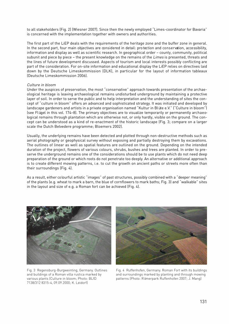
131
to all stakeholders (Fig. 2) (Wiesner 2007). Since then the newly employed “Limes-coordinator for Bavaria”is concerned with the implementation together with owners and authorities.
The first part of the LiEP deals with the requirements of the heritage zone and the buffer zone in general.In the second part, four main objectives are co n s i d e red in detail: pro tection and co n s e r vation, acce ss i b i l i t y,information and display as well as scientific research. In geographical order – county, community, politicalsubunit and piece by piece – the present knowledge on the remains of the Limes is presented, threats andthe lines of future development discussed. Aspects of tourism and local interests possibly conflicting arepart of the consideration. For on-site information and educational display the LiEP relies on directives laiddown by the Deutsche Limeskommission (DLK), in particular for the layout of information tableaux(Deutsche Limeskommission 2006).
Culture in bloomUnder the auspices of preservation, the most “conservative” approach towards presentation of the archae-ological heritage is leaving archaeological remains undisturbed underground by maintaining a protectivelayer of soil. In order to serve the public and to help interpretation and the understanding of sites the con-cept of “culture in bloom” offers an advanced and sophisticated strategy. It was initiated and developed bylandscape gardeners and artists in a private organisation named “Kultur in Blüte e.V.” (“Culture in bloom”)(see Flügel in this vol. 174–8). The primary objectives are to visualize te m p o ra r i ly or permanently arc h a e o-lo g i ca l remains through plantation which are otherwise not, or only hardly, visible on the ground. The con-cept can be understood as a kind of re-enactment of the historic landscape (Fig. 3; compare on a largerscale the Dutch Belvedere programme; Bloemers 2002).
Usually, the underlying remains have been detected and plotted through non-destructive methods such asaerial photography or geophysical survey without exposing and partially destroying them by excavations.The outlines of linear as well as spatial features are outlined on the ground. Depending on the intendedduration of the project, flowers of various colours, shrubs, bushes and trees are planted. In order to pre-serve the underground remains one of the considerations should be to use plants which do not need deeppreparation of the ground or which roots do not penetrate too deeply. An alternative or additional approachis to create different mowing patterns, i.e. to cut the growth on ancient paths or streets more often thantheir surroundings (Fig. 4).
As a result, either co lourful artistic “images” of past st r u c t u res, poss i b ly combined with a “deeper meaning”of the plants (e.g. wheat to mark a barn, the blue of cornflowers to mark baths; Fig. 3) and “walkable” sitesin the layout and size of e.g. a Roman fort can be achieved (Fig. 4).
Fig. 3 Regensburg-Burgweinting, Germany. Outlinesand buildings of a Roman villa rustica marked by various plants (Culture in bloom; Photo: BLfD7138/312 8315-4, 09.09.2000; K. Leidorf)
Fig. 4 Ruffenhofen, Germany. Roman Fort with its buildingsand surroundings marked by planting and through mowingpatterns (Photo: Römerpark Ruffenhofen 2007; J. Mang)

132
Fig. 6 Eining, Germany. Visible walls and their dates of erection or latest restoration (Photo: Schiwall 2008)
Fig. 8 Eining, Germany. Concept for the presentation of the fort and its surroundings(Copyright: Historia Romana e. V.; 2006)
Fig. 7 Eining, Germany. Aerial view over fort and baths andmilitary vicus as cropmarks (Photo: BLfD 7136/074b 2251-30,03.06.1982; O. Braasch)
Fig. 5 Eining, Germany. Presentation of the baths around 1915 (Photo: BLfD).

133
Presentation and conservation of exposed ruinsEining, the Roman Abusina, on the south bank of the Danube between the Raetien Limes and the DanubeLimes in Bavaria, is a good example to show the complicated and complex post-Roman story of a WHS.Preliminary to the “renovation” of exposed walls the history of the visible structures was studied (Schiwall2008): Large scale excavations from the 1870s onwards, their subsequent exposure, consolidation and par-tial covering by roofs (Fig. 5) led after many years of interest to phases of neglect and decay, due to increas-ing maintenance costs. A first large scale renovation in the 1950s attempted to solve this problem in a long-term way with modern wall, partially on top of Roman foundations but in other parts in their replacement,and a lot of concrete. As no continuous care followed further consolidation work had to be done in the 1970sleading to even more loss of the original (Fig. 6). After the initiative of a local interest group (“HistoriaRomana e. V.”) plans to “develop” and to display the fort somehow as it was laid out originally are now com-peting with the present state as a landscape park with ancient and artificial ruins as well as a naturereserve (Fig. 7 and 8).
Not dissimilar, at Weißenburg, Biricianae, on the Raetian Limes in Bavaria, the city as owner of the groundsof the fort deve loped plans to enhance the ove rall situation there co n te m p o rary to the Culture 2000 pro j e c t .After early excavations around 1900 exposed walls had been kept open. As means of conservation looseparts were taken away and one or two new courses were added with concrete as binding. The top wasformed concave to keep a certain amount of moisture and covered with turf. After long phases of neglect itwas decided in 1965 to tear down the rotting walls and to mark their lines with concrete slabs on a con-crete foundation. To make the site more attractive the northern front of the fort was excavated in the 1980sand subsequently reconstructed in a 1:1 scale (Fig. 9; Grönke 1997). In respect to the decision of theUNESCO WHS board, following the recommendations of ICOMOS that reconstructions done since 1965should not be part of the WHS ‘Upper German-Raetian Limes’, this reconstruction became only part of thebuffer zone (see Jones and Thiel in this vol. 99–105).
With the intention to make the fort even more attractive it was decided to replace the old concrete slabsmarking the walls by several courses of newly built masonry. As the old foundations were reused no exca-vations and further destruction of the original were necessary. Therefore, we believe that these measuresdo not affect the state of the WHS as such and are in accordance with the WHS decision that ‘… develop -ment above the Roman remains, be considered as a buffer zone for the inscribed site’. The results arequite positive, as for the first time it is possible to imagine the limits of the fort from most places within itand to get a feeling of its size of 3.1 ha (Fig. 9). At present it is obvious at least to the interested visitor thatthe visible walls are only an image of the past in contrast to original remains e.g. of the baths presentedsince their excavation in a protective building as some kind of “giant showcase” (Fig. 10).
Fig. 10 Weißenburg i. Bay., Germany.3D-scan of the Roman baths within its protective building (Copyright: E. Christofori)
Fig. 9 Weißenburg i. Bay., Germany. Aerial view of the Roman fortwith reconstruction of the northern gate, partially rebuilt perimeterwalls and central buildings laid out with in concrete (Photo: BLfD6930/009 8988-11, 22.09.2006; K. Leidorf)
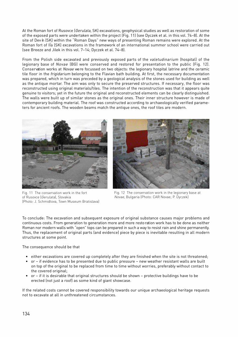
134
At the Roman fort of Rusovce (Gerulata, SK) excavations, geophysical studies as well as restoration of someof the exposed parts were undertaken within the project (Fig. 11) (see Dyczek et al. in this vol. 74–8). At thesite of Devín (SK) within the “Roman Days” new ways of presenting Roman remains were explored. At theRoman fort of IÏa (SK) excavations in the framework of an international summer school were carried out(see Breeze and Jilek in this vol. 7–14; Dyczek et al. 74–8).
From the Polish side excavated and previously exposed parts of the valetudinarium (hospital) of thelegionary base of Novae (BG) were conserved and restored for presentation to the public (Fig. 12).C o n s e r vation works at N o v a e we re fo c u ssed on two objects: the legionary hospital latrine and the ce ra m i ctile floor in the frigidarium belonging to the Flavian bath building. At first, the necessary documentationwas prepared, which in turn was preceded by a geological analysis of the stones used for building as wellas the antique mortar. The aim was only to secure the preserved structures. If necessary, the floor wasreconstructed using original materials/tiles. The intention of the reconstruction was that it appears quitegenuine to visitors; yet in the future the original and reconstructed elements can be clearly distinguished.The walls were built up of similar stones as the original ones. Their inner structure however is made ofcontemporary building material. The roof was constructed according to archaeologically verified parame-ters for ancient roofs. The wooden beams match the antique ones, the roof tiles are modern.
To conclude: The excavation and subsequent exposure of original substance causes major problems andcontinuous co sts. From generation to generation more and more re sto ration work has to be done as neitherRoman nor modern walls with “open” tops can be pre p a red in such a way to re s i st rain and shine permanently.Thus, the replacement of original parts (and evidence) piece by piece is inevitable resulting in all modernstructures at some point.
The consequence should be that
• either excavations are covered up completely after they are finished when the site is not threatened;• or – if evidence has to be presented due to public pressure – new weather resistant walls are built
on top of the original to be replaced from time to time without worries, preferably without contact tothe covered original;
• or – if it is desirable that original structures should be shown – protective buildings have to be erected (not just a roof) as some kind of giant showcase.
If the related costs cannot be covered responsibility towards our unique archaeological heritage requestsnot to excavate at all in unthreatened circumstances.
Fig. 12 The conservation work in the legionary base atNovae, Bulgaria (Photo: CAR Novae; P. Dyczek)
Fig. 11 The conservation work in the fort of Rusovce (Gerulata), Slovakia(Photo: J. Schmidtova, Town Museum Bratislava)

135
DrawbacksHowever, sometimes all attempts towards sustainability fail even with best intentions, elaborated legalbackground and minimal conflict with owners and planners. This became evident at Lussonium (H) (Fig.13). The Roman fort, situated on a high loess-cliff on top of the Danube, fulfils most likely all stipulationsas a WHS within the ‘Frontiers of the Roman Empire’. Nevertheless, as explained by Prof Dr Zsolt Visy andsome specialists on-site during the project workshop in Pécs in November 2007, the geological situationand the erosive activity of the river at the bottom of the cliff had already resulted in the collapse of majorparts and will eventually lead to the complete loss of the fort. Foot wide fissures through large parts of thecliff indicate imminent danger which means that the parts concerned cannot even be “rescued” and “pre-served” by excavation and research for safety reasons.
During a conference outside the Culture 2000 project at Cluj (RO) the author had the opportunity to visitPorolissum (RO) (Fig. 14) which originally was named as focus of the national Romanian co-project withinthe Culture 2000 project. Goals as well as administrative problems were discussed with Dr Alexandru Mateifrom the responsible museum at Zalau as well as with Dr Mircea Victor Angelescu and other members ofthe Ministry of Culture and Cultural Affairs at Bucarest (RO). It turned out, that A. Matei’s ideas of largescale reconstructions on top of the original heritage were quite far reaching. Therefore they were discussedcontroversial. Additionally, the plans were not agreed upon with local and national authorities. Therefore,the project had to be dropped within the Culture 2000 project.
ReferencesBloemers, J. H. F. (2002), Past- and future oriented archaeology: protecting and developing the archaeological-historical landscape in the Netherlands. In: Fairclough, G. and Rippon, S. (eds), Europe’s Cultural Landscape:archaeologists and the management of change. EAC Occasional Paper 2 (Brussels), 89–96.Deutsche Limeskommission (ed) (2006), Informationssystem zur Beschilderung der archäologischen Fundstellen am Welterbe Obergermanisch-Raetischer Limes, Wachenheim.Breeze, D. J. and Thiel, A. (2005), The challenge of presentation. Visible and invisible parts of the Frontiers of theRoman Empire World Heritage Site in the United Kingdom and Germany. C. J. C. Reuvenslezing 17, Amsterdam.Both articles are completely reprinted in this volume see Breeze 140–7 and Thiel 148–52. Faber, A. and Schmidt, W. (Bearb.) (2006), Limesentwicklungsplan Bayern LiEP. Schutz – Präsentation undInformation – Erschließung – Forschung. Bayerisches Landesamt für Denkmalpflege. München.Grönke, E. (1997), Das römische Alenkastell Biricianae in Weißenburg i. Bay. Die Grabungen von 1890 bis 1990.Limesforschungen 25. Mainz.Schiwall, R. (2008), Restaurierungsgeschichte und denkmalpflegerische Maßnahmen im Kastell Eining. Berichte der Bayerischen Bodendenkmalpflege 49 (in print).Sommer, C. S. (2007), Vom Obergermanisch-Raetischen Limes zur Großen Mauer von China – UNESCO-Welterbestätten als nationale Ikonen? Denkmalpflege Informationen 138, 84–86.Wiesner, N. (2007), Übergabe des Limesentwicklungsplans und Präsentation des Limeskoordinators am 23. Maiin Gunzenhausen. Denkmalpflege Informationen 137, 71–72.
Fig. 14 The Roman amphitheatre in the fort of Porolissum in Romania (Photo: Boundary Productions)
Fig. 13 The Roman fort of Lussonium, Hungary(Photo: Zs. Visy)

136
Appendix
Procedure for the reconstruction, reproduction and rebuilding of archaeological monuments of the UpperGerman-Raetian Limes(Upper German-Raetian Limes - Managementplan attachment 1, May 2002)
Bavarian State Office for Monument ConservationState Office for Monument Conservation HesseState Office for Monument Conservation Rhineland-PalatinateState Office for Monument Conservation Baden-Württemberg
1. PreambleThe Upper German-Raetian Limes, with its towers, forts and other constructions, is a singular culturalmonument and an irreplaceable historical record. For adherence to national as well as international stan-dards, highest priority is given to the preservation of the existing monument stock. This must be taken intoaccount in general with the planning and realisation of all projects concerning the cultural monument andin its environment. Reconstruction, reproduction and rebuilding must be subordinate to the maintenanceof the original substance of the Limes.
Future measures of reconstruction, reproduction and rebuilding must therefore be integrated into themanagement and development plan for the Upper German-Raetian Limes and in addition require theapproval and control of the specialist conservation authorities. With regard to protection of the substance,its ability to be experienced or its scientific value, the greater the quality of a site or a monument area, themore restrictive the treatment of possible changes. Measures of this kind are ruled out completely atdefined high-grade sections of the Limes.
2. DefinitionsThis text contains the following definitions:
Restoration: restoring existing structures to a known earlier state by removing additions or by puttingtogether existing components once again without the addition of new materials except to secure the work.Restoration includes anastylosis and conservation.
Reconstruction: bringing existing structures to a known earlier state in which, in contrast to restoration,new materials are used. They serve for repairs and should be carried out as far as possible with compara-ble materials and with the same craft techniques as the original
Rebuilding: the creation of an assumed earlier state on the original findings with extensive use of newmaterials. The basis is formed by preserved evidence from this location or from other sites and conclu-sions that were drawn from this evidence.
Reproduction: rebuilding at a different location or near the original findings.
Reversible: measures that do not cause any damage to the original substance of the monument and canbe removed without impairment, if this should be necessary for the conservation of the original.
3. Basic conditionsBecause of the conservation, the limited state of knowledge and the character of archaeological monu-ments, changes to the existing monuments in the Upper German-Raetian Limes have been limited tomeasures of restoration and reconstruction. The course or individual components of the Limes are to bemade visible again through measures of landscape conservation.
In certain exceptional cases there are arguments in favour of rebuilding or reproducing forts, towers orsections of the Limes. These arguments concern the development of individual locations for education ortourism, or to guarantee their preservation. Reproduction and rebuilding can also extend the basis ofknowledge in terms of experimental archaeology as to how an ancient building was built or used. It is

137
known that model buildings can also represent important tools for interpretation. However, this must notlead to damage to original conserved monument substance, its cultural value or the historical importanceof a site.
Reconstruction, rebuilding and reproduction
• must take place in conformity with national and international guidelines;• may only be carried out after a complete archaeological examination of the monument areas
in question;• must preserve the historical significance of the site and its environment;• must be carried out using the original technology and with comparable materials, as far as this is
technically possible. Financial reasons do not justify the use of different types of materials; • must be based on scientifically substantiated evidence and be the products of an experimental
reproduction of the antique procedures;• must improve understanding. Hypotheses must be clearly marked as such and at the same time
require that the knowledge gained from them or the findings of the actual realisation are portrayed,archived and published;
• must be designed in such a way that both their erection and their upkeep and the needs of a site areguaranteed in the long term;
• should take second place if they do not serve a clarifying protection of the existing monument, or if the capacity for visitors to experience them can be improved by other means;
• impart knowledge in a model form. For this reason, an accumulation of adjacent structures of a similar type is not practical.
The basis of all measures is the complete comprehension of a monument. This includes not only the areasabove and below the ground but also the environment. Any evaluation should also include the archaeolog-ical potential and its historical and contemporary importance, as well as aesthetic, scenic, nature conser-vation technical, public, spiritual and other values. This list is not exhaustive.
The plans for a project must show clearly just how the implementation would affect the value of the mon-ument. Realisation must fulfil all of the basic conditions discussed here and have a positive influence onthe significance of the Limes.
4. Guidelines for future representationsThe plans for future measures for restoration, reconstruction, rebuilding or reproduction in the area of theLimes archaeological monument must conform to national and international quality standards. The con-tents of all measures should ideally be suitable for expressing the contemporary-historical dimension andnot merely for reproducing an ideal condition. At the same time, the aim should be for uniformity in theportrayal so that the Upper German-Raetian Limes is presented as an integrated whole.
The same care that is taken with the new plans for a project should be applied to its sustainability. Repairsand upkeep must be carried out by trained personnel or under expert supervision. There must be sufficientresources available for the both the maintenance of existing installations and for remedying unforeseendamage.
4.1. Course of the LimesThere must be no reconstruction, rebuilding or reproduction of any kind along the stretches of the Limeswhich give the environment its overall image, for example, in the Taunus forests or in the Swabian orFranconian Jura.
At those sections in which the ramparts/ditch or wall are preserved above ground:
• attention should be given to measures to preserve the substance;• there must be no excavations or reconstruction, reproduction or rebuilding;• paths must be laid out next to the monument and not on top of it;• plants must not cause damage to the substance;

138
• the aim should be integration into specialist concepts for nature conservancy.
In those areas in which the ramparts/ditch or wall have disappeared above ground:
• an intensified search should be made for possibilities of showing the Limes route again; • presentations should be used to show the original course of the Limes route;• reconstruction or rebuilding should be such that it can be reversed;• paths or plants must not cause damage to the substance.
4.2. Towers, small forts and other constructionsThere must be no reconstruction, rebuilding or reproduction of towers, small forts or other constructionsalong the stretches of the Limes which give the environment its overall image. There must also be noreconstruction or rebuilding of those towers, small forts and other constructions which are preservedabove ground. In general, the following measures apply:
• rebuilding is to be avoided. Exceptions can only be made for those installations which have already been completely excavated and/or whose findings are practically completely destroyed;
• reconstruction and rebuilding must be designed to be reversible;• the location of the rebuilding should be selected directly along the route of the Limes;• in the sense of experimental research and interpretation the simple copying of already existing
rebuilding or reproductions is to be rejected.
4.3. Fort installationsBecause the reconstruction or rebuilding of fort installations takes place on the original foundations, themost stringent requirements must be applied to every measure within the meaning of the above criteria.At a very early stage projects of this kind must be discussed on the broadest possible basis and evaluatedby independent experts; a decision in accordance with the regulations governing the conservation of mon-uments can only be taken after this.In general, the following measures apply:
• there should be no reconstruction, rebuilding or reproduction of any kind at or in the neighbourhoodof the few totally preserved places that are largely unspoiled in the landscape, for example, Holzhausen, Kapersburg, Halheim and Pförring;
• rebuilding is in general only conceivable for those installations which have already been completelyexcavated and/or whose findings have been destroyed to a great extent and of which it is extremelydifficult to experience because of the present use of the environment;
• a measure must be linked at the same time to the protection of the untouched monument substance. This can be done, for example, through the visualisation of a lost fort area, if this means that other areas of the monument can be preserved as reservation areas;
• it is essential that all reconstruction and rebuilding work be designed to be reversible;• even more definitely with towers, small forts and other constructions, for the purposes of
experimental research and interpretation, priority must be given to copying ancient processes, and copies of already existing structures must be rejected.
These procedures must also be applied analogously to the restoration, anastylosis and conservation, andto the repair of existing fort installations.
All measures must also be carried out to international standards as stipulated in:
Enclosure 1 Charter of Venice 1964:International charter on the conservation and restoration of monuments and ensembles.
Enclosure 2 Charter of Lausanne 1990: Charter for the protection and care of the archaeological heritage.
Enclosure 3 Convention of Malta 1992:European convention for the protection of the archaeological heritage.
Enclosure 4 The Nara document on authenticity 1994.

139
Enclosure 5 Charter of Riga on authenticity and historical reconstruction in relation to the cultural heritage 2000.
The present procedures are the result of talks in Stuttgart in October 2001 and of numerous subsequentdiscussions which took place in the framework of the Upper German-Raetian Limes being accepted intothe UNESCO world heritage list.
Those taking part were: Dietwulf Baatz (Darmstadt); Thomas Becker (Freiburg); Jörg Biel (Stuttgart);Stephan Bender (Wiesbaden); Wolfgang Czysz (Thierhaupten); Reinhard Dietrich (Wiesbaden); VolkmarEidloth (Stuttgart); Meinrad N. Filgis (Stuttgart); Alex Furger (Augst); Joachim Glatz (Mainz); Fritz-RudolfHerrmann (Bockenau); Werner Jobst (Bad Deutsch Altenburg); Cliff A. Jost (Koblenz); Susanne Kaufmann(Aalen); Dieter Planck (Stuttgart); Rudolf Pfuhler (Eichstätt); G. Precht (Xanten); Egon Schallmayer(Wiesbaden); Wolfgang Schmidt (Bad Homburg v.d.H.); Wolfgang Schmidt (Königsbrunn); Hartwig Schmidt(Aachen); Reinhard Schwirzer (Weißenburg i. Bayern); C. Sebastian Sommer (Munich); Gerhard Weber(Kempten i. Allgäu); Hans-Helmut Wegner (Koblenz); Antony Wilmott (Portsmouth).The minutes were kept by Andreas Thiel (Stuttgart).
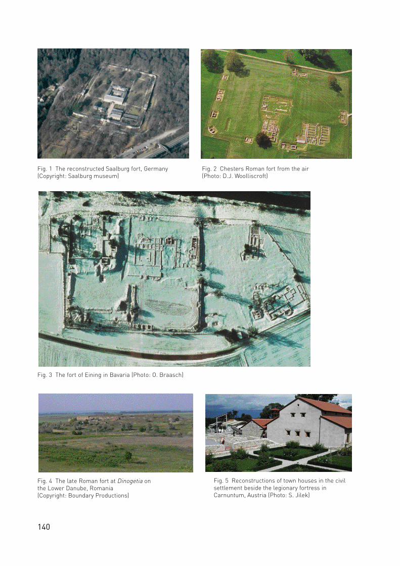
140
Fig. 1 The reconstructed Saalburg fort, Germany(Copyright: Saalburg museum)
Fig. 2 Chesters Roman fort from the air(Photo: D.J. Woolliscroft)
Fig. 3 The fort of Eining in Bavaria (Photo: O. Braasch)
Fig. 4 The late Roman fort at Dinogetia on the Lower Danube, Romania (Copyright: Boundary Productions)
Fig. 5 Reconstructions of town houses in the civilsettlement beside the legionary fortress inCarnuntum, Austria (Photo: S. Jilek)
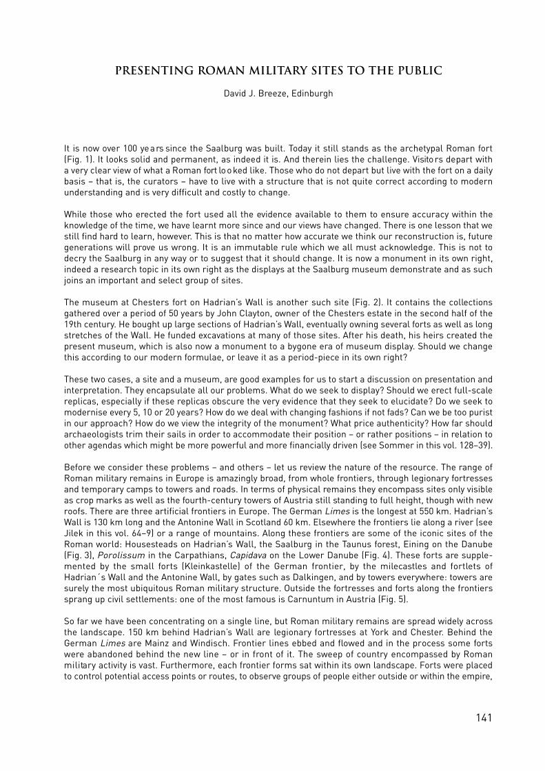
141
Presenting Roman military sites to the public
David J. Breeze, Edinburgh
It is now over 100 ye a rs since the Saalburg was built. Today it still stands as the archetypal Roman fo r t(Fig. 1). It looks solid and permanent, as indeed it is. And therein lies the challenge. Visito rs depart witha very clear view of what a Roman fort lo o ked like. Those who do not depart but live with the fort on a dailybasis – that is, the curators – have to live with a structure that is not quite correct according to modernunderstanding and is very difficult and costly to change.
While those who erected the fort used all the evidence available to them to ensure accuracy within theknowledge of the time, we have learnt more since and our views have changed. There is one lesson that westill find hard to learn, however. This is that no matter how accurate we think our reconstruction is, futuregenerations will prove us wrong. It is an immutable rule which we all must acknowledge. This is not todecry the Saalburg in any way or to suggest that it should change. It is now a monument in its own right,indeed a research topic in its own right as the displays at the Saalburg museum demonstrate and as suchjoins an important and select group of sites.
The museum at Chesters fort on Hadrian’s Wall is another such site (Fig. 2). It contains the collectionsgathered over a period of 50 years by John Clayton, owner of the Chesters estate in the second half of the19th century. He bought up large sections of Hadrian’s Wall, eventually owning several forts as well as longstretches of the Wall. He funded excavations at many of those sites. After his death, his heirs created thepresent museum, which is also now a monument to a bygone era of museum display. Should we changethis according to our modern formulae, or leave it as a period-piece in its own right?
These two cases, a site and a museum, are good examples for us to start a discussion on presentation andinterpretation. They encapsulate all our problems. What do we seek to display? Should we erect full-scalereplicas, especially if these replicas obscure the very evidence that they seek to elucidate? Do we seek tomodernise every 5, 10 or 20 years? How do we deal with changing fashions if not fads? Can we be too puristin our approach? How do we view the integrity of the monument? What price authenticity? How far shouldarchaeologists trim their sails in order to accommodate their position – or rather positions – in relation toother agendas which might be more powerful and more financially driven (see Sommer in this vol. 128–39).
Before we consider these problems – and others – let us review the nature of the resource. The range ofRoman military remains in Europe is amazingly broad, from whole frontiers, through legionary fortressesand temporary camps to towers and roads. In terms of physical remains they encompass sites only visibleas crop marks as well as the fourth-century towers of Austria still standing to full height, though with newroofs. There are three artificial frontiers in Europe. The German Limes is the longest at 550 km. Hadrian’sWall is 130 km long and the Antonine Wall in Scotland 60 km. Elsewhere the frontiers lie along a river (seeJilek in this vol. 64–9) or a range of mountains. Along these frontiers are some of the iconic sites of theRoman world: Housesteads on Hadrian’s Wall, the Saalburg in the Taunus forest, Eining on the Danube(Fig. 3), Porolissum in the Carpathians, Capidava on the Lower Danube (Fig. 4). These forts are supple-mented by the small forts (Kleinkastelle) of the German frontier, by the milecastles and fortlets ofHadrian´s Wall and the Antonine Wall, by gates such as Dalkingen, and by towers everywhere: towers aresurely the most ubiquitous Roman military structure. Outside the fortresses and forts along the frontierssprang up civil settlements: one of the most famous is Carnuntum in Austria (Fig. 5).
So far we have been concentrating on a single line, but Roman military remains are spread widely acrossthe landscape. 150 km behind Hadrian’s Wall are legionary fortresses at York and Chester. Behind theGerman Limes are Mainz and Windisch. Frontier lines ebbed and flowed and in the process some fortswe re abandoned behind the new line – or in front of it. The sweep of country enco m p a ssed by Romanm i l i ta r y activity is vast. Furthermore, each frontier forms sat within its own landscape. Forts were placedto control potential access points or routes, to observe groups of people either outside or within the empire,

142
or to support each other. In short, Roman forts did not sit in isolation. Understanding that wider landscapeis a challenge to us today, but it is a problem we must address if we are to interpret our sites accurately.
So far we have only been considering the sites themselves. Yet, Roman military sites are particularly richin artefactual material, as any visitor to a museum from Rome to Copenhagen can testify. These artefactsillustrate the detail of life on the frontier – they provide some of the flesh to cover the bare bones of thephysical remains in the field. Sometimes they do more than that. Parchments, papyri and writing tabletsare particularly informative, about day-to-day life in the Roman army. Sculpture and inscriptions illustratethe process of conquest which preceded the construction of the frontier (Fig. 6). They name the frontier,tell us when it was built, how it was built and who built it. Very rarely they inform us why it was built.
The traditional range of material – pottery, small finds, sculpture – have now been joined by eco-artefacts(see Flügel in this vol. 174–8. It is difficult to underestimate the importance of all these material remainsof Roman culture (Fig. 7). The artefacts help us date native sites – they often form the only dating evidencefor such sites. The environmental evidence from Roman sites is certainly more closely dated than that frommost prehistoric and early medieval sites and forms a dated horizon of inestimable value. Our Roman mil-itary sites form the key for helping understand the landscape within which they and their contemporarycivilian sites sat as well as providing the dating evidence for these settlements. For a wider audience, onthe firm basis of the wide range of evidence, we can now not only prepare reconstruction drawings of, say,a fort, but offer a landscape for it to sit in. And we can offer reasons for its location at that particular point,relating it to its wider contemporary settlement pattern.
Nor is that the whole picture. Survey, excavation, research and writing have produced an enormous bodyof literature about Roman frontiers. We cannot understand Roman frontiers, or attempt to interpret themafresh, without comprehending that literature. The thoughts and ideas of our forebears shape and condi-tion the thoughts and ideas of today.
As we have seen, the protection of archaeological sites and the presentation to the public of information ofall kinds about Roman sites has a long history. Although some countries had taken measures to protecttheir monuments in the previous century, it was not until the 19th century that this became universalthroughout Europe. The Grand Tour introduced members of the aristocracy to the buildings of ancientRome in the 18th century. Improved communications of all kinds in the 19th century aided discussionsbetween scholars working in different countries, collaborative ventures such as the Corpus InscriptionumLatinarum, and visits to archaeological sites in other countries. Professor Hulsebos travelled from Utrechtto take part in the second Pilgrimage of Hadrian’s Wall in 1886: he was the lone foreign representative. Thatsingle visit soon became a flood, in both directions and tourism had become a factor in the protection ofsites.
Fig. 6 One of the Distance Slabs from the AntonineWall, Scotland, UK, which tells us who built what, whenand how much (Copyright: Hunterian Museum,Glasgow).
Fig. 7 The analysis of the turfs from sections cut through the Antonine Wall has provided valuableevidence for the land cover at the time of the Romans(Crown copyright: Historic Scotland)
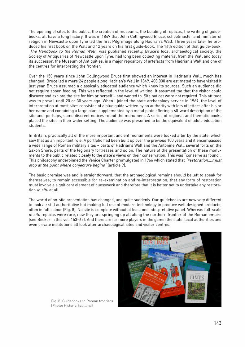
143
The opening of sites to the public, the creation of museums, the building of replicas, the writing of guide-books, all have a long history. It was in 1849 that John Collingwood Bruce, schoolmaster and minister ofreligion in Newcastle upon Tyne led the first Pilgrimage along Hadrian’s Wall. Three years later he pro-duced his first book on the Wall and 12 years on his first guide-book. The 14th edition of that guide-book,‘The Handbook to the Roman Wall’, was published recently. Bruce’s local archaeological society, theSociety of Antiquaries of Newcastle upon Tyne, had long been collecting material from the Wall and todayits successor, the Museum of Antiquities, is a major repository of artefacts from Hadrian’s Wall and one ofthe centres for interpreting the frontier.
Over the 150 years since John Collingwood Bruce first showed an interest in Hadrian’s Wall, much haschanged. Bruce led a mere 24 people along Hadrian’s Wall in 1849. 400,000 are estimated to have visited itlast year. Bruce assumed a classically educated audience which knew its sources. Such an audience didnot require spoon feeding. This was reflected in the level of writing. It assumed too that the visitor couldd i s cover and ex p lo re the site for him or herself – and wanted to. Site notices we re not re q u i red. This attitudewas to prevail until 20 or 30 years ago. When I joined the state archaeology service in 1969, the level ofinterpretation at most sites consisted of a blue guide written by an authority with lots of letters after his orher name and containing a large plan, supplemented by a metal plate offering a 60-word description of thesite and, perhaps, some discreet notices round the monument. A series of regional and thematic booksplaced the sites in their wider setting. The audience was presumed to be the equivalent of adult-educationstudents.
In Britain, practically all of the more important ancient monuments were looked after by the state, whichsaw that as an important role. A portfolio had been built up over the previous 100 years and it encompasseda wide range of Roman military sites – parts of Hadrian’s Wall and the Antonine Wall, several forts on theSaxon Shore, parts of the legionary fortresses and so on. The nature of the presentation of these monu-ments to the public related closely to the state’s views on their conservation. This was “conserve as found”.This philosophy underpinned the Venice Charter promulgated in 1966 which stated that “restoration….muststop at the point where conjecture begins” (article 9).
The basic premise was and is straightforward: that the archaeological remains should be left to speak forthemselves; to remain accessible for re-examination and re-interpretation; that any form of restorationmust involve a significant element of guesswork and therefore that it is better not to undertake any restora-tion in situ at all.
The world of on-site presentation has changed, and quite suddenly. Our guidebooks are now very differentto look at: still authoritative but making full use of modern technology to produce well designed products,often in full colour (Fig. 8). No site is complete without at least one interpretative panel. Whereas full-scalein situ replicas were rare, now they are springing up all along the northern frontier of the Roman empire(see Becker in this vol. 153–62). And there are far more players in the game: the state, local authorities andeven private institutions all look after archaeological sites and visitor centres.
Fig. 8 Guidebooks to Roman frontiers(Photo: Historic Scotland)

144
This must be a good thing. We are all challenged by the new styles of presentation and interpretation (seeSommer et al. in this vol. 128–39). Hopefully, all sites will improve as a result. Yet, it is still worth return-ing to basic principles every now and then and considering the underlying premises behind our actions.
There is still much to be said for the principles of “conserve as found”. Those familiar with complex sitescan readily appreciate the value of returning to re-examine and re-evaluate even the best known sites quitesimply because there is no better alternative to studying the fabric of the monument itself: the monumentis as much an historic document as a written charter, an artefact or a painting. Placing reconstructed wallson these archaeological remains not only obscures the genuine remains but creates a falsehood quite sim-ply because we cannot know with any certainty what happened above the surviving remains. The fashion ofrebuilding of walls sometimes up to a height of about a metre in order to form a more attractive monumentis almost equally misleading, even when the modern stones are separated from the originals by a clearlymarked membrane such as a slate course or line of plaster.
Nevertheless, we must acknowledge that intervention is necessary to preserve a monument. Mortardecays, as do stones, and sometimes both have to be at least partly replaced for the greater good of themonument: its long-term preservation. Sometimes, this intervention can be substantial. The clay-bondedwalls of the Roman bath-house at Bearsden on the Antonine Wall stand up to eight courses high, restingon clay and cobble foundations. There is no way that this monument could have survived the weather andthe attention of visitors without the clay core being replaced by mortar. This necessitated recording all thewalls on a stone-by-stone basis, taking them down, cleaning the stones, and replacing them with a mor-tar bond according to the plans and photographs, all under professional supervision. No new stones wereadded, except to the upper level of the core in order to create a surface which would shed water. This wewould all regard as an acceptable action to safe-guard the monument. In cases where such actions wouldbe seen as too intrusive, the general advice of my office would be to re-bury the site, rather than resort tomethods that might entail excessive contamination of the evidence.
In considering the conservation of the monument, it seems to me that there are some verities, which areperhaps even eternal verities. The most important is the primacy of the archaeological data-base, be it aRoman fort or a weapon from it. This is acknowledged by UNESCO in considering potential WHS when itst re sses the nece ssity for authenticity and integrity (see Lengkeek in this vol. 36–51). If this view is acce p te d,then the rebuilding of ruined structures in situ is not a sensible approach. This is not to say that we shouldnot offer our interested public reconstructed Roman buildings, but a theme park such as Archaeon (NL) orBeaune (F) is the place for them. And it musts be stressed that those reconstructions can be no more thanthe best we can offer on the basis of the information available at the time they are made.
I would strongly argue that we do need sites like Archaeon. There is a far larger and socially wider groupof people interested in visiting archaeological sites than in the days of John Collingwood Bruce. They arebetter educated, used to all the devices of our electronic age, and expect to see them in action. Suchdevices offer us unparalleled opportunities. I have already stressed that I believe that many reconstructionsoffer a misleading impression of certainty. More than that they can close the mind. They imply, by their verysolidity, that this building is the truth. Yet we know it is not. It is only our current version of the truth.
Our computer age can do wonderful things. It is now possible to create virtual reconstructions of buildings.This is particularly valuable for delicate structures such as the tombs of Egypt. The original is ensured alonger life and we can explore at our leisure parts of the building normally difficult of access. We can evenput the finds back into the building (see Devine in this vol. 181–85). What we have not yet done, to the bestof my knowledge, is to offer a computer game in which the player constructs his or her own monument.We can provide the visitors – either real or virtual – with the primary evidence, which is generally not exten-sive (and certainly far from complete), and invite them to build their own Roman tower, fortlet or fort. Wecan open minds to our own special problems, not least that there is usually no one correct interpretation.And, as new know ledge becomes ava i l a b le and ele c t ronic te c h n o logy improves, we can change the info r m a-tion we feed into the computer relatively cheaply, certainly a lot cheaper than rebuilding a Roman fort withstone, mortar, timber and earth.
This approach could also have a direct affect on the monuments themselves. The current fashion is

145
st ro n gly in favour of on-site presentation, so that visitors can more readily inter-relate the physical remainsof the monument and its inte r p re tation. The Lausanne Charter sta tes the “the presentation of the archaeo -logical heritage to the general public is an essential method of promoting an understanding of the originsand development of modern societies…. Presentation and information should be conceived as a popularinterpretation of the current state of knowledge, and it must therefore be revised frequently. It should takeaccount of the multi-facetted approaches to an understanding of the past” (article 7). It is, unfortunately,possible to come close to destroying the genius loci of a monument through over-intrusive interpretationand the provision of information elsewhere may help to prevent such over-kindness.
Moreover, the visiting of archaeological theme parks might take visitors away from the real monuments,to the benefit of the archaeological remains. In these days of mass tourism we are facing the very destruc-tion of the sites which people travel great distances to see, what John Julius Norwich has called “touristpollution”. Fifteen years ago, the administrator of Notre Dame in Paris expressed his concern at the effectsof over 10 million people visiting his cathedral every year. In Britain, the recent establishment of a NationalTrail along Hadrian’s Wall has been accompanied by wearing away of the grass sward on many miles of thefootpath after only two seasons (Fig. 9). For long lengths of Hadrian’s Wall there is an even more seriousconcern as the path lies on top of sensitive earthworks. However, the excellent recording arrangementsput in place by English Heritage and the Countryside Agency have ensured that wear can be monitored andremedial action dire c ted to the sensitive areas: it is enco u raging that the gra ss sward is re covering quicklyas a result of prompt and positive interventions.
One way of looking at the wear on the Hadrian’s Wall footpath is to consider it a sign of the success of thisinitiative. Yet, instant communication can be a terrible curse. Witness the success of ‘The Da Vinci Code’. Itis excellent that people want to visit the important sites described in the book; horrific that they want totake a piece home with them. Excellent that they are interested in history; appalling that they appear tobelieve anything that is written down despite the absence of corroborative evidence.
The approach of television can be no less inimical to research. It often presents all research as relativelyeasy, encompassed within a short time scale, almost a doddle. In Britain, it has been argued that the TimeTeam is excellent television, but poor archaeology. It has certainly helped to explain archaeology to a wideaudience, and had great success at that. But it has also been suggested that the nature of the programmeimplies that an archaeological site can be examined in three days and all, or at least many, of its secretsrevealed, which we know is generally not true in itself. The programme also can obscure the fact that it sooften piggy-backs on years of research by local scholars whose work is generally not sufficiently acknowl-edged within the framework of the programme. If television continues to portray research in the way thatis has become used to doing, I fear that in the future the public may be unwilling to give as much money toresearch as in the past because they have come to believe the simplistic portrayal of our work. It wouldappear to me that we have a challenge in explaining more clearly how we undertake our work.
Fig. 9 Wear on the footpath along Hadrian’s Wall. Owing tothe monitoring regime introduced by English Heritage andthe Countryside Agency, the effect of tramping boots can bemeasured and remedial action quickly undertaken
Fig. 10 Life with the Roman remains in Alphen aanden Rijn, Netherlands (Photo: Dutch Limesbureau)
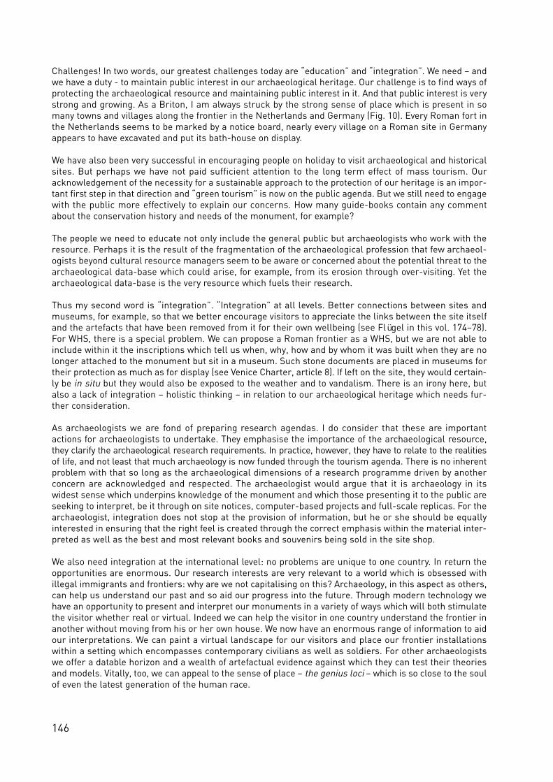
146
Challenges! In two words, our greatest challenges today are “education” and “integration”. We need – andwe have a duty - to maintain public interest in our archaeological heritage. Our challenge is to find ways ofprotecting the archaeological resource and maintaining public interest in it. And that public interest is verystrong and growing. As a Briton, I am always struck by the strong sense of place which is present in somany towns and villages along the frontier in the Netherlands and Germany (Fig. 10). Every Roman fort inthe Netherlands seems to be marked by a notice board, nearly every village on a Roman site in Germanyappears to have excavated and put its bath-house on display.
We have also been very successful in encouraging people on holiday to visit archaeological and historicalsites. But perhaps we have not paid sufficient attention to the long term effect of mass tourism. Ouracknowledgement of the necessity for a sustainable approach to the protection of our heritage is an impor-tant first step in that direction and “green tourism” is now on the public agenda. But we still need to engagewith the public more effectively to explain our concerns. How many guide-books contain any commentabout the conservation history and needs of the monument, for example?
The people we need to educate not only include the general public but archaeologists who work with theresource. Perhaps it is the result of the fragmentation of the archaeological profession that few archaeol-ogists beyond cultural resource managers seem to be aware or concerned about the potential threat to thearchaeological data-base which could arise, for example, from its erosion through over-visiting. Yet thearchaeological data-base is the very resource which fuels their research.
Thus my second word is “integration”. “Integration” at all levels. Better connections between sites andmuseums, for example, so that we better encourage visitors to appreciate the links between the site itselfand the artefacts that have been removed from it for their own wellbeing (see Flügel in this vol. 174–78).For WHS, there is a special problem. We can propose a Roman frontier as a WHS, but we are not able toinclude within it the inscriptions which tell us when, why, how and by whom it was built when they are nolonger attached to the monument but sit in a museum. Such stone documents are placed in museums fortheir protection as much as for display (see Venice Charter, article 8). If left on the site, they would certain-ly be in situ but they would also be exposed to the weather and to vandalism. There is an irony here, butalso a lack of integration – holistic thinking – in relation to our archaeological heritage which needs fur-ther consideration.
As archaeologists we are fond of preparing research agendas. I do consider that these are importantactions for archaeologists to undertake. They emphasise the importance of the archaeological resource,t h ey clarify the arc h a e o lo g i cal re s e a rch re q u i rements. In pra c t i ce, however, they have to re l a te to the re a l i t i e sof life, and not le a st that much arc h a e o logy is now funded through the tourism agenda. There is no inhere n tproblem with that so long as the archaeological dimensions of a research programme driven by anotherconcern are acknowledged and respected. The archaeologist would argue that it is archaeology in itswidest sense which underpins knowledge of the monument and which those presenting it to the public areseeking to interpret, be it through on site notices, computer-based projects and full-scale replicas. For thearchaeologist, integration does not stop at the provision of information, but he or she should be equallyinterested in ensuring that the right feel is created through the correct emphasis within the material inter-preted as well as the best and most relevant books and souvenirs being sold in the site shop.
We also need integration at the international level: no problems are unique to one country. In return theopportunities are enormous. Our research interests are very relevant to a world which is obsessed withillegal immigrants and frontiers: why are we not capitalising on this? Archaeology, in this aspect as others,can help us understand our past and so aid our progress into the future. Through modern technology wehave an opportunity to present and interpret our monuments in a variety of ways which will both stimulatethe visitor whether real or virtual. Indeed we can help the visitor in one country understand the frontier inanother without moving from his or her own house. We now have an enormous range of information to aidour interpretations. We can paint a virtual landscape for our visitors and place our frontier installationswithin a setting which encompasses contemporary civilians as well as soldiers. For other archaeologistswe offer a datable horizon and a wealth of artefactual evidence against which they can test their theoriesand models. Vitally, too, we can appeal to the sense of place – the genius loci – which is so close to the soulof even the latest generation of the human race.

147
This paper was delivered as a lecture in Nijmegen in 2005 at the Annual Dutch Archaeology Conferenceand is reproduced here with permission. Breeze, D. J. and Thiel, A. (2005), The challenge of presentation.Visible and invisible parts of the Frontiers of the Roman Empire World Heritage Site in the UnitedKingdom and Germany. C. J. C. Reuvenslezing 17, Amsterdam.
Further ReadingThe following Charters provide the framework for conservation, presentation and interpretation:
The Venice Charter (International Charter for the Conservation and Restoration of Monuments and Sites) 1966The Lausanne Charter (International Charter for Archaeological Heritage Management), 1990The Nara Document on Authenticity, 1994The Riga Charter on Authenticity and Historical Reconstruction in Relation to Cultural Heritage, 2000
The following books set current practice within its wider framework:Fowler, P. J. and Boniface, P. (1995), Managing Quality Cultural Tourism. London.Jokilehto, J., (1999), A History of Architectural Conservation. Oxford.Thompson, M. W. (1981), Ruins: Their Preservation and Display. London.
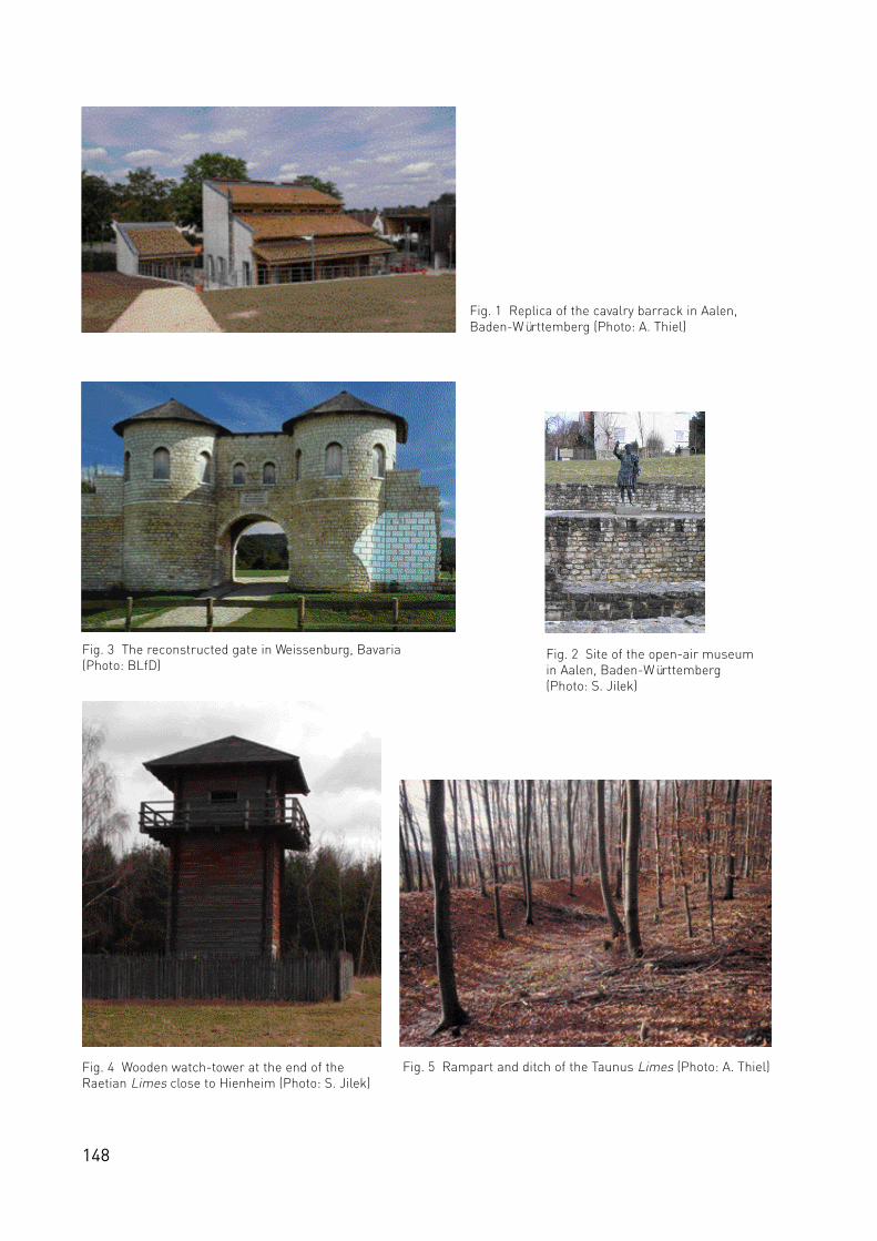
148
Fig. 1 Replica of the cavalry barrack in Aalen,Baden-Württemberg (Photo: A. Thiel)
Fig. 4 Wooden watch-tower at the end of theRaetian Limes close to Hienheim (Photo: S. Jilek)
Fig. 5 Rampart and ditch of the Taunus Limes (Photo: A. Thiel)
Fig. 3 The reconstructed gate in Weissenburg, Bavaria(Photo: BLfD)
Fig. 2 Site of the open-air museumin Aalen, Baden-Württemberg(Photo: S. Jilek)

149
The challenge of an appropriate presentation of
archaeological monuments along the Upper
German-Raetian Limes
Andreas Thiel, Saalburg
Mid September 2005 in the city of Aalen, Baden-Württe m b e rg, on the site of a former L i m e s fort, the(partial) replica of a Roman cavalry barrack was ceremonially opened. The ground plan of the building isbased upon archaeological research and its structure mainly follows ancient designs. At the same timehowever, through the clearly visible incorporation of modern ingredients, an attempt has been made tocounter the impression that the observer is viewing a “historic” building (Fig. 1). It is definitely too early tojudge whether they will merely be irritated. However I would like to link this example with a general obser-vation of the problems and potentials of presenting archaeological monuments on the Limes in Germany,because the situation in Aalen is representative of the typical and important features which occur at otherlocations.
The locations and dimensions of the six-hectare fort Aalen have been known since the 1890s at least. Thefort, designed for 1000 horse-men, 2 km behind the Raetian Limes, was established between 160 and 260AD, and was one of the largest stone forts on the Limes. At the time of its discovery the fort lay outside thecity limits in open meadows terrain. Only the southern part was occupied by a graveyard, which encloseda church that had been there since Carolingian times. In post-Roman-times, the fort´s walls were robbedfor the construction of the church, and also to build the medieval town of Aalen, although the Roman ruinsremained visible until into the 16th ce n t u r y. During the scientific inve stigations by the Reichs-Limeskommission (1892–1937), however, the remains of the fort were fully levelled off. In the years there-after the northern section of the Roman fort was covered by detached houses, a fate suffered in the sameperiod by many civil settlements (vicus) near expanding urban centres. Only in 1976 did it prove possible totransfer at least the central fort area to public ownership and save it from further development. The start-ing point for this was the “discovery” of the headquarters building, the principia, on the former meadowa rea through aerial arc h a e o lo g i cal photo g ra p h y. To make the large open area attra c t i ve to visito rs, sub-s e q u e n t ly the fort´s left gate, the porta principalis sinistra, was excavated, as well as the principia. Theirpreserved foundations are today the only visible original elements of the fort (Fig. 2); the Roman structuresremain, as an archaeological reserve, underground.
As early as 1964 a museum was built in the original fort area. The Limesmuseum Aalen has since beenexpanded four times and, with 40,000 visitors annually, is one of the most important visitor centres forRoman military history. Moreover the newly erected replica cavalry barrack serves as an essential educa-tional resource, in particular for school classes. Although the outside of the building, at least at firstglance, may appear as a “reconstruction” of an actual ancient predecessor, it is actually more a type ofmuseum display case, though on an enormous scale. The aim here is to give an idea of the third dimen-sion, the volume and the height that constituted this impressive Roman type of building. The massive half-timbered construction certainly fulfils these aims and thus represents a useful addition to the preservedwalls of the remaining fort structures. The effect of the tangible size of the replica, impressive even to thespecialist, definitely exceeds that of other attempts, such as computer-based animation, at conveying thescale of the building. Naturally, this development is based on the latest research by archaeologists on theappearance of this fascinating type of structure.
Why then is the Aalen cavalry barrack not a genuine replica, but rather a type of open-air museum? Firstlythe replica is based on the example of another fort site, specifically a fort recently found 30 km away inHeidenheim; it is probable that the cavalry barrack in Aalen may once have looked exactly like this, but thishas not been proven archaeologically. Secondly, the barrack-block is not in its correct location within thecamp plan, but is rotated through 90°, in the vicinity of the original defensive wall. This relocation can firstbe attributed to the requirements of its current functioning as a museum, but at the same time intrusion

150
into the area of the Archaeological Park has been minimised. And, despite the great care taken with thedetail, finally the modern surroundings which have been deliberately retained, could awake in an observerthe possible impression of standing before a genuine monument. However the question remains whetherthe visitor recognises these “academic” differences and whether he does not involuntarily associate thenew barrack in Aalen with the known replicas of other ancient buildings, such as exist in many areas of theLimes?
At practically every large fort location along the Upper German-Raetian Limes in Germany, wall segmentsof Roman buildings have been preserved, very often the baths or parts of the defensive walls (Fig. 3). Asidefrom a very few exceptions, these are always genuine wall segments in situ, which, throughout Europe andbeyond, assist us in the presentation of the remains of ancient buildings. A specific feature of the presen-tation in Germany, however, is found in the current replicas of Roman architecture, rendered as complete“models” on a 1:1 scale. The Saalburg fort in Hesse, which was nearly completely rebuilt under KaiserWilhelm II from 1897 onwards, is only the best known and most thorough, but not the earliest example ofthis. Along the Upper German-Raetian Limes between the Rhine and the Danube over thirty replicas havebeen built since the 19th century. Alongside sections of Roman enclosure facilities, such as the palisades,the rampart and ditch system or the Limes wall, there are also fort gates, towers and walls and above allwatch-towers. Watch-towers are easily the most frequently replicated elements of the Limes in Germany(see Becker in this vol. 153–62). Thus, for example, a dozen stone buildings alone have been built that claimto copy Roman Limes towers, although none of them are the same in design or execution! The oldest ofthese towers has stood since 1874 near the spa town of Bad Ems in the Rhineland Palatinate. Here, aselsewhere, replicas are often built directly on the remaining foundations, which are thereby destroyed orrendered unrecognisable (see Breeze in this vol. 140–47). The watch-towers have been built at differenttimes by different persons and institutions and above all with quite different levels of scientific knowledge.Thus the group of those responsible for the planning and design of the structures ranges from ErnstFabricius, one of the fathers of Limes research in Germany and editor of the standard work ‘The UpperGerman-Raetian Limes of the Roman Empire’ in 14 volumes (Berlin/Leipzig, 1894–1939) all the way to priva teindividuals and sport clubs, that mostly had little or no knowledge of the archaeological background to theiractions. Indeed, in the past these were very often local groups, without any permission from the localauthorities or any scientific instruction, which were involved in these projects, driven by enthusiasm andinterest in the subject.
Interestingly the lack of specialist instruction had a greater effect on the complete replicas, as on pre-served authentic monuments, since with the latter aspects of monument preservation, the law always hadto be ta ken into co n s i d e ration. However, this means that such co m p le te re p l i cas, that often le a ve the gre a te stimpression on visitors, such as the historical structures along the Roman border, are often built with theleast understanding of the matter. This is particularly striking in the case of the numerous wooden Limestowers built using a wholly unhistorical block system (Fig. 4).
Without fully examining the background to individual projects, in my opinion there are three main reasonswhy such replicas were built. And it appears that these motives were not always equally justified at thesame time but were subject to historical development. Above all there was definitely at the start the intentto make a piece of the past physical again, to make history “tangible”. Often no expense was spared, butalso little attention was paid to the original monument. Then there we re and are re p l i cas built as a kindof compensation: as compensation for the fact that tax money was used on arc h a e o lo g i cal inve st i g a t i o n s ,a replica – the evidence of the scientific success – remained on the site. At the same time replicas formeda type of “added value”, be this as tourist attractions or as monuments, presented to the people living atthe site as (re-)visible documents of their own heritage. Here too the preservation of the original site inmost cases played no (further) part; however in almost every case the cost factor was important, so thatoften, only the excavated find, at most, was preserved, or a partial reconstruction built. But more recentlyreplicas have increasingly become an important element in an active management concept. This functionof replicas, i.e. the spirit of preservation that can be connected with such presentation measures, is to bea focal point of the second part of this contribution.
Why should monument preservers not leave the archaeological sites entrusted to them in the state theywere passed down to us? The definitely banal answer is firstly because the world does not only consist of

151
monument preservers – other people are also interested in these sites – and secondly because it is neces-sary to actually accompany every situation. This is an exceptionally important point and should not beunderestimated, especially in the field of archaeological monument preservation! On the Upper German-Raetian Limes we are dealing with a monument of 250 km2 in total, which is partly heavily under threat.The situation cannot be compared to that of an expert in the restoration of paintings, who does not have toworry about the continued existence of his object and who can take his time to wait until he has theresources to implement the best technical or most authentic solution.
Solutions relating to monument preservation must generally be realised in direct and stern conflict withinterested parties that in general have interests that conflict with the interests of monument preservation.
What has that got to do with the presentation of the Upper German-Raetian Limes? Let us first look at theLimes monument in its best state of preservation. Nearly half of the 550 km Limes runs through woodland,which, over centuries has helped to preserve the monuments along the Limes, frequently in such animpressive manner that they could speak for themselves. Along the barrier, at the watch-towers and alsoat various fort sites, the visitor can very often experience these archaeological statements without specialpresentation measures. Any support work here, for example, can be limited to clearing bushes and under-growth so as to improve the visibility of the monument. In an ideal case scenario this also shows clearlyhow the Limes is embedded in the surrounding landscape, which clearly played an important role in theconstruction of the ancient border structure. But also in places where the Limes still exists as a striking,indeed perhaps even the most significant landscape element, it may be nece ssary to help indica te itslo cation and the lines along which it ex tended, with, for insta n ce, signposting. Not every woodland visitor i sa cultural to u r i st on the trail of the Roman past, but the wood is also a wo r k p l a ce and incre a s i n g ly t h elo cation for a number of le i s u re activities that are not co m p a t i b le with monument pre s e r vation. Thei d e n t i f i cation of the often invisible but delicate monuments of the Limes would be of particular benefit hereto help protect these monuments against unintentional destruction.
A long the Upper German-Raetian L i m e s t h e re are at the same time projects for presenting the arc h a e o lo g i-cal monuments through ta rg e ted cultivation measures. At various fort sites, for ex a m p le, the tra j e c tory of thed e fe n s i ve walls is made clear by hedges and the position of towe rs by tre e s . For the monument preserver itis important here for the original construction substance to continue to remain protected by the earth, forsuch findings that can only be visualised in a manner such as, for example, that which can be provided bygeophysics. Comparable measures are currently being designed for the course of the Limes wherever thenaked eye can no longer see any traces above ground level. In addition to a better presentation for the vis-itor, these projects also serve the goal of better protection through identification of the monument. Thearchetype for such cultivation measures is also the historical condition of individual Limes sections. Thuson the Raetian border section, over the course of centuries, on the rubble rampart section of the Limeswall, a linear woody vegetation has grown up on the rubble rampart section of the Limes wall, creating overthe centuries a “Limes hedge”, one element of the cultural landscape (Fig. 5). The co l l a b o ration with naturep re s e r vation bodies has simulta n e o u s ly provided most we lcome synergies (see Höchtl in this vol. 166–73).
With the same ultimate goals as these measures for identification of a monument by the retention of itsprotection in the soil, there are also the types of measures that can be seen realised with the fort baths ofJagsthausen and Schwäbisch-Gmünd in Baden-Württemberg. Their partly excavated foundation wallswere subsequently completely re-covered with soil. Separated by a dividing layer, modern masonry exact-ly replicates the ancient structures and Roman design of the authentic ruins – apparently often enough sowell that the normal visitor does not even notice! However, in this way the scientist loses the object of hisstudy (see Breeze in this vol. 140–47). But alongside the protection of the original, such measures are alsosupported by the greatly reduced costs for maintenance of the “artificial monument”.
The effects of the weather, in particular frost, generally make a protective covering of the excavated wallsection necessary (see Sommer in this vol. 128–37). The simplest form of preservation has already beenchosen for the walls of the Saalburg vicus. Here, for around 100 years, grass turfs on the wall tops havebeen succe ss f u l ly pro tecting the original walls. By co n t ra st with the widespread wall raised by furtherl a ye rs, this measure can be easily reversed, does not falsify the original find and moreover supports theimpression of a “romantic ruin”.
152
With buildings wholly or partly built of organic materials, we must often resort to replicas for visualisation.Where, thanks to a favourable location, for example wooden architecture remains preserved, we often havethe best potential for recognition. Thus the method of construction of the Limes palisade has been verifiedby numerous excavations. We even now have examples where individual beams or members can be re-jointed, exactly in the style of a genuine anastylosis. One of the best known examples on the UpperGerman-Raetian Limes is the beneficiarier shrine in Osterburken in Baden-Württemberg, where nearlythe entire structural body of a small wooden temple could be reconstructed (see Flügel in this vol. 196–99).But in any event it would be technically tricky and, from a preservation aspect, even criminal, to use theoriginal material for replicas thus expose it to the weather or visitors. Replicas here offer a practical andscientifically justifiable alternative.
To conclude, it must be said that replicas also serve to disseminate scientific findings. Trivial as this maysound, it can frequently be seen that archaeology first has to provide the proof that structures have beenpreserved in the earth – and are thus invisible to the naked eye. The key idea here is: “one only believeswhat one sees”. The mere results of investigations are not always convincing for the layman. Every archae-ologist in the field knows of examples where even the most hard-hearted property developer agreed to putaside part of the development site when clear archaeological discoveries came to light, or even suggested,after the partly destruction of the site, to excavate or to present another part of the monument. The firstoption was and is occasionally realised, the second option of solely excavating monuments for the purposeof excavation is not possible from the perspective of the monument preserver himself. The questionremains to what extent replicas can help to preserve the original monument? Can all those developers,architects and planners be convinced more easily through targeted presentation of archaeological sitesthat their project will lead to the irretrievable loss of authentic sources of history? To what extent, for exam-ple, has the Saalburg replica, known to every schoolchild in the region, contributed to the better protectionof adjacent sections of the Limes? To what extent have the funds from admission fees helped the betterpresentation of the Limes in the region? To what extent can the historically incorrect and speculative repli-ca of a wooden Limes watch-tower help to prevent the authentic but invisible watch-tower lying a fewmetres aside, from unintentional destruction during forestry work? To go back to the Aalen example citedat the beginning, one should ask what contribution the replica of the cavalry barrack could bring to thepreservation of the other archaeological areas, what benefits neighbouring authentic monuments derivefrom it and what long-term consciousness-formation is created by such a dissemination of the Romanpast. These questions naturally cannot be answered definitely, but they should be posed if one wishes todeal properly with the matter of such presentations and “replicas”.
This paper was delivered as a lecture in Nijmegen in 2005 at the Annual Dutch Archaeology Conferenceand is reproduced here with permission. Breeze, D. J. and Thiel, A. (2005), The challenge of presentation.Visible and invisible parts of the Frontiers of the Roman Empire World Heritage Site in the UnitedKingdom and Germany. C. J. C. Reuvenslezing 17, Amsterdam.
Further readingErhaltungsstrategien in der Archäologischen Denkmalpflege. Internationales Kolloquium am 23.4.2002 in Meiningen,Archäologisches Nachrichtenblatt 8 (2003) 2, 114–230.Schallmeyer, E. (ed) (1997), Hundert Jahre Saalburg. Vom römischen Grenzposten zum europäischen Museum.Mainz.Schmidt, H. (2000), Archäologische Denkmäler in Deutschland. Rekonstruiert und wieder aufgebaut. Sonderheft2000 der Zeitschrift Archäologie in Deutschland. Stuttgart.Ulbert, G., Weber, G. (1985), Konservierte Geschichte? Antike Bauten und ihre Erhaltung. Stuttgart.

153
Nature and function of reconstructions on the Upper
German-Raetian Limes using the example of
wooden watch-towers
Thomas Becker, Bonn
Archaeologists in north-west Europe are faced with the challenge of bringing their understanding of therecords they make of the traces they observe in the soil to the wider public. Who does not find it difficult toreconstruct in their mind the remains of the triple-layered foundations for a building several metres high?We ex p e r i e n ce even more difficulty with wooden st r u c t u res, whose remnants are re d u ced to inco n s p i c u o u s ,unspectacular discolorations in the soil. The archaeologist paints a picture from the observed details toreconstruct a virtual building. These mental reconstructions are then occasionally translated into realityfor the interested lay person.
This can be done in various ways. The first that comes to mind is the reconstruction of the archaeologicalfind in a drawing, an often-used method. Model reconstructions are another option, as demonstrated bynumerous models of different excavations. The final possibility is an original restoration of the find in theform of a reconstruction, which certainly provides the most impressive picture of the historical situation.This form of presentation is chosen extremely rarely, of course, as the work and costs involved are veryhigh co m p a red with the other methods. All these options are employed in German arc h a e o logy for theperiods up to the High Middle Ages.
Reconstructions on the Upper German-Raetian LimesThe Upper German-Raetian Limes World Heritage Site is no exception when it comes to deploying recon-structions as a tool for transporting information (see Thiel in this vol. 148–52). Reproductions of the origi-nal situation as envisaged by archaeological researchers exist at a variety of locations along the frontierline. These reconstructions range from recreations of border fortifications (palisades, ramparts/ditches,walls) and timber or stone watch-towers to individual buildings or sections of the defences surrounding theforts along the Limes. Especially with forts, the reconstructed sections are often part of an open archaeo-logical park surrounding the entire fort area and thus fulfil both a presentation and a protective function.Reconstructions of the above-ground stonework can be found at five of the 61 forts on the WHS (Welzheim,Aalen, Ellingen, Weissenburg, Pfünz). The highlight, and singular model, is unquestionably the majorreconstruction of the Saalburg fort near Bad Homburg, which was almost totally rebuilt from 1897 to 1907at the behest of Kaiser Wilhelm II.
The most popular reconstructions on the German Limes are without doubt the watch-towers. Along the 550km section of the frontier, 20 of the approximately 900 watch-towers proven or assumed to have existedwere rebuilt between 1874 and 2004 (Fig. 1). If we include three more towers that were built away from theLimes (Neuss/North-Rhine Westphalia, Bad Nauheim `Johannisberg´/Hesse, Dill/Rhineland-Palatinate),we have a total of 23 watch-towers. Also worth mentioning are two examples of partially reconstructedtowers, i.e. restorations of the lower storey (tower 9/96 near Murrhardt; tower 13/2 near Mönchsroth). Thefully reconstructed towers on the German Limes are spread among the federal states of Rhineland-Palatinate, Hesse, Baden-Württemberg and Bavaria at a ratio of seven to five to four to four. They are notspread evenly along the frontier line, however (Fig. 2). It can be seen that the density of the reconstructionsoften increases the closer one gets to the relevant state capital, while no towers are to be observed nearto borders with adjacent states.
The method of construction for all tower reconstructions can be divided roughly into two groups: timberand stone. This subdivision results from the Roman tradition of tower construction along the UpperGerman-Raetian Limes. The Romans built the first wooden towers on the frontier at the beginning of thesecond century, possibly in parallel with the erection of the palisade along the frontier around AD 120. Inthe thirties and forties of the second century the border fo r t i f i cations we re ex tended and the number of
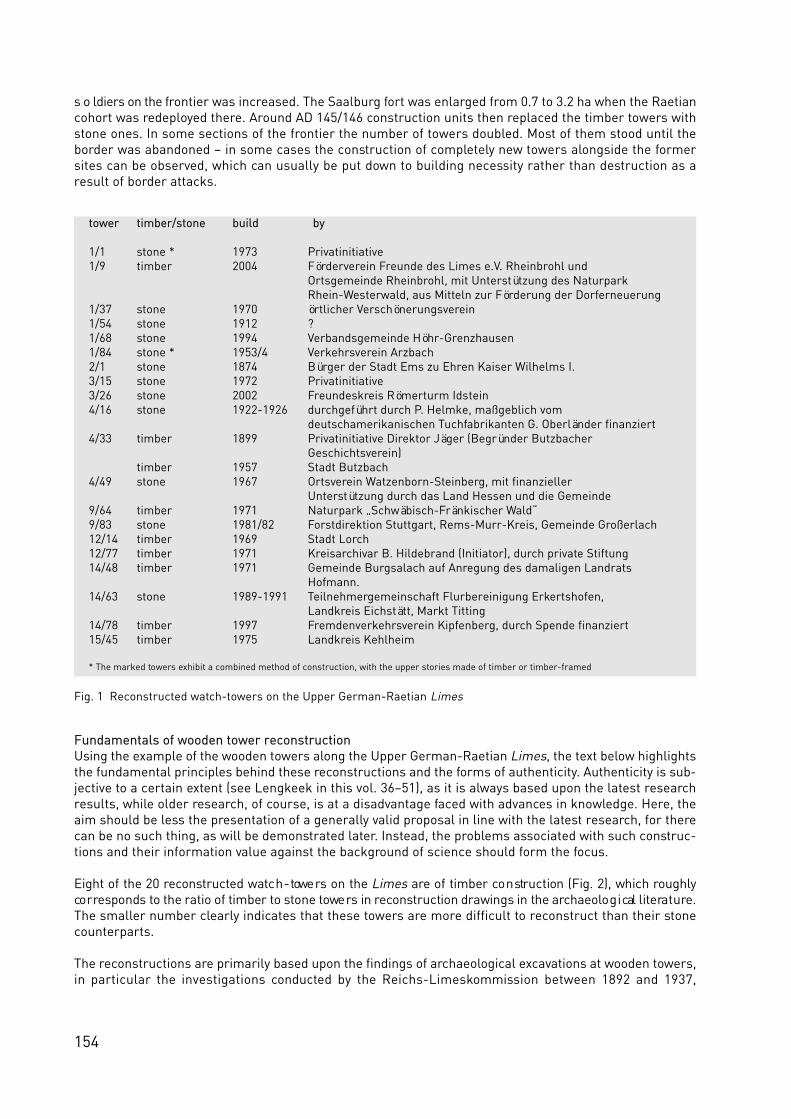
154
s o ldiers on the frontier was increased. The Saalburg fort was enlarged from 0.7 to 3.2 ha when the Raetiancohort was redeployed there. Around AD 145/146 construction units then replaced the timber towers withstone ones. In some sections of the frontier the number of towers doubled. Most of them stood until theborder was abandoned – in some cases the construction of completely new towers alongside the formersites can be observed, which can usually be put down to building necessity rather than destruction as aresult of border attacks.
Fundamentals of wooden tower reconstructionUsing the example of the wooden towers along the Upper German-Raetian Limes, the text below highlightsthe fundamental principles behind these reconstructions and the forms of authenticity. Authenticity is sub-jective to a certain extent (see Lengkeek in this vol. 36–51), as it is always based upon the latest researchresults, while older research, of course, is at a disadvantage faced with advances in knowledge. Here, theaim should be less the presentation of a generally valid proposal in line with the latest research, for therecan be no such thing, as will be demonstrated later. Instead, the problems associated with such construc-tions and their information value against the background of science should form the focus.
Eight of the 20 re co n st r u c ted watc h - towe rs on the L i m e s a re of timber co n struction (Fig. 2), which ro u g h lyco r responds to the ratio of timber to stone towe rs in re co n struction drawings in the arc h a e o lo g i cal lite ra t u re .The smaller number clearly indicates that these towers are more difficult to reconstruct than their stonecounterparts.
The reconstructions are primarily based upon the findings of archaeological excavations at wooden towers,in particular the investigations conducted by the Reichs-Limeskommission between 1892 and 1937,
tower timber/stone build by
1/1 stone * 1973 1/9 timber 2004
1/37 stone 1970 1/54 stone 1912 1/68 stone 1994 1/84 stone * 1953/4 2/1 stone 1874 3/15 stone 1972 3/26 stone 2002 4/16 stone 1922-1926
4/33 timber 1899
timber 1957 4/49 stone 1967
9/64 timber 1971 9/83 stone 1981/82 12/14 timber 196912/77 timber 197114/48 timber 1971
14/63 stone 1989-1991
14/78 timber 1997 15/45 timber 1975
* The marked towers exhibit a combined method of construction, with the upper stories made of timber or timber-framed
Fig. 1 Reconstructed watch-towers on the Upper German-Raetian Limes
PrivatinitiativeFörderverein Freunde des Limes e.V. Rheinbrohl und Ortsgemeinde Rheinbrohl, mit Unterstützung des Naturpark Rhein-Westerwald, aus Mitteln zur Förderung der Dorferneuerungörtlicher Verschönerungsverein?Verbandsgemeinde Höhr-GrenzhausenVerkehrsverein ArzbachBürger der Stadt Ems zu Ehren Kaiser Wilhelms I.PrivatinitiativeFreundeskreis Römerturm Idsteindurchgeführt durch P. Helmke, maßgeblich vom deutschamerikanischen Tuchfabrikanten G. Oberländer finanziertPrivatinitiative Direktor Jäger (Begründer Butzbacher Geschichtsverein)Stadt ButzbachOrtsverein Watzenborn-Steinberg, mit finanzieller Unterstützung durch das Land Hessen und die GemeindeNaturpark „Schwäbisch-Fränkischer Wald“Forstdirektion Stuttgart, Rems-Murr-Kreis, Gemeinde GroßerlachStadt Lorch Kreisarchivar B. Hildebrand (Initiator), durch private Stiftung Gemeinde Burgsalach auf Anregung des damaligen Landrats Hofmann.Teilnehmergemeinschaft Flurbereinigung Erkertshofen,Landkreis Eichstätt, Markt TittingFremdenverkehrsverein Kipfenberg, durch Spende finanziertLandkreis Kehlheim
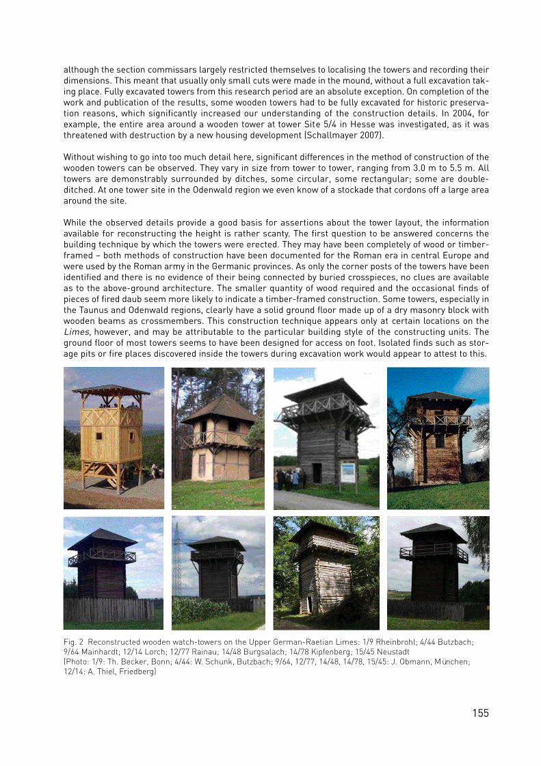
155
although the section commissars largely restricted themselves to localising the towers and recording theirdimensions. This meant that usually only small cuts were made in the mound, without a full excavation tak-ing place. Fully excavated towers from this research period are an absolute exception. On completion of thework and publication of the results, some wooden towers had to be fully excavated for historic preserva-tion reasons, which significantly increased our understanding of the construction details. In 2004, forexample, the entire area around a wooden tower at tower Site 5/4 in Hesse was investigated, as it wasthreatened with destruction by a new housing development (Schallmayer 2007).
Without wishing to go into too much detail here, significant differences in the method of construction of thewooden towers can be observed. They vary in size from tower to tower, ranging from 3.0 m to 5.5 m. Alltowers are demonstrably surrounded by ditches, some circular, some rectangular; some are double-ditched. At one tower site in the Odenwald region we even know of a stockade that cordons off a large areaaround the site.
While the observed details provide a good basis for assertions about the tower layout, the informationavailable for reconstructing the height is rather scanty. The first question to be answered concerns thebuilding technique by which the towers were erected. They may have been completely of wood or timber-framed – both methods of construction have been documented for the Roman era in central Europe andwere used by the Roman army in the Germanic provinces. As only the corner posts of the towers have beenidentified and there is no evidence of their being connected by buried crosspieces, no clues are availableas to the above-ground architecture. The smaller quantity of wood required and the occasional finds ofpieces of fired daub seem more likely to indicate a timber-framed construction. Some towers, especially inthe Taunus and Odenwald regions, clearly have a solid ground floor made up of a dry masonry block withwooden beams as crossmembers. This construction technique appears only at certain locations on theLimes, however, and may be attributable to the particular building style of the constructing units. Theground floor of most towers seems to have been designed for access on foot. Isolated finds such as stor-age pits or fire places discovered inside the towers during excavation work would appear to attest to this.
Fig. 2 Reconstructed wooden watch-towers on the Upper German-Raetian Limes: 1/9 Rheinbrohl; 4/44 Butzbach;9/64 Mainhardt; 12/14 Lorch; 12/77 Rainau; 14/48 Burgsalach; 14/78 Kipfenberg; 15/45 Neustadt (Photo: 1/9: Th. Becker, Bonn; 4/44: W. Schunk, Butzbach; 9/64, 12/77, 14/48, 14/78, 15/45: J. Obmann, München;12/14: A. Thiel, Friedberg)

156
When re co n structing the upper sto reys, however, arc h a e o lo g i sts primarily make comparisons with ancientre p re s e n tations that depict co r responding towe rs or provide clues with re g a rd to co n struction details. For thew a tc h - towe rs on the L i m e s, particular re fe re n ce is made to depictions on two victory columns in Rome:Trajan´s Column, which was raised in honour of the Emperor Trajan (98–117 AD) to mark his victory in theDacian Wa rs, and the Column of Marcus Aurelius, built fo l lowing the Marcomannic Wa rs under the EmperorMarcus Aurelius (161–180 AD). Built to secure the frontier on the Danube, the watch-towers on the reliefare depicted with a gallery running around the second storey, which was adapted for most of the recon-structions on the Upper German-Raetian Limes. The narrow drainage channels in corresponding distancefrom the tower occasionally identified during excavations point to a wide roof overhang and thus the exis-tence of such a gallery. Other towers exhibit drainage channels in immediate proximity to the tower wall,however, which would appear to rule out reconstructions with a gallery.
Additional construction details such as shingle roofs were based upon the depictions on these twocolumns. Other depictions also provide clues to tower reconstruction, however. The construction on stiltsemployed at watch-tower 1/9 near Rheinbrohl, for example, can also be observed on a depiction (Fig. 3) onthe Madaba Map, a mosaic found in Jordan dating to the 4th century AD. Going by the arch on the groundfloor of the depicted tower, it must have been built in stone. The proximity to the river Jordan would explainthe use of stilts, as buildings in this position would no doubt have to be afforded protection against flood-ing. Sentries acce ssed the tower by way of a ladder leant against the ex terior, as is assumed for the towe rson the Upper German-Raetian Limes. To what extent this form of architecture can also be transposed totowers in the north-western provinces is a matter of debate, as it is not clear whether such unprotectedposts could have survived the climatic conditions in the northern section of the Limes or whether the woodwould weather more quickly due to being installed without protection. Here, the tower can certainly be seenas a contribution to an archaeological experiment that will demonstrate the applicability of this form ofconstruction in practice.
Detailed information on the tower architecture can in turn be derived from archaeological finds. There isno reason to assume that any of the watch-towers, timber or stone ones, were covered by tiles. This is sug-gested not only by the ancient depictions. Excavations at tower sites on the Upper German-Raetian Limeshave revealed no corresponding finds of tiles whatsoever. The stone towers on the Johannisberg, a hill nearBad Nauheim, and at site 10/37 (Schneidershecke) form two exceptions to this, though here the use of tilesis explained by the special functions of the towers. The Johannisberg tower is situated behind the borderline and is generally interpreted as a visual and signal link to the auxiliary fort at Friedberg in the hinter-land. At tower 10/37, ev i d e n ce ex i sts of a change of use to a sanctuary near the end of the border line, orfo l lowing the re lo cation of the line to the east. Tiles with the stamps of the manufacturing legions we re
Fig. 3 Depiction of a Romanwatch-tower on a 4th centurymosaic from Madaba, Jordan(Photo: Th. Becker, Bonn)
Fig. 5 A private view of antiquity. These watch-tower reconstructions were built onprivate land away from the Limes (Aalen-Wasseralfingen, Bürgstadt) (Photo: J. Obmann, München)
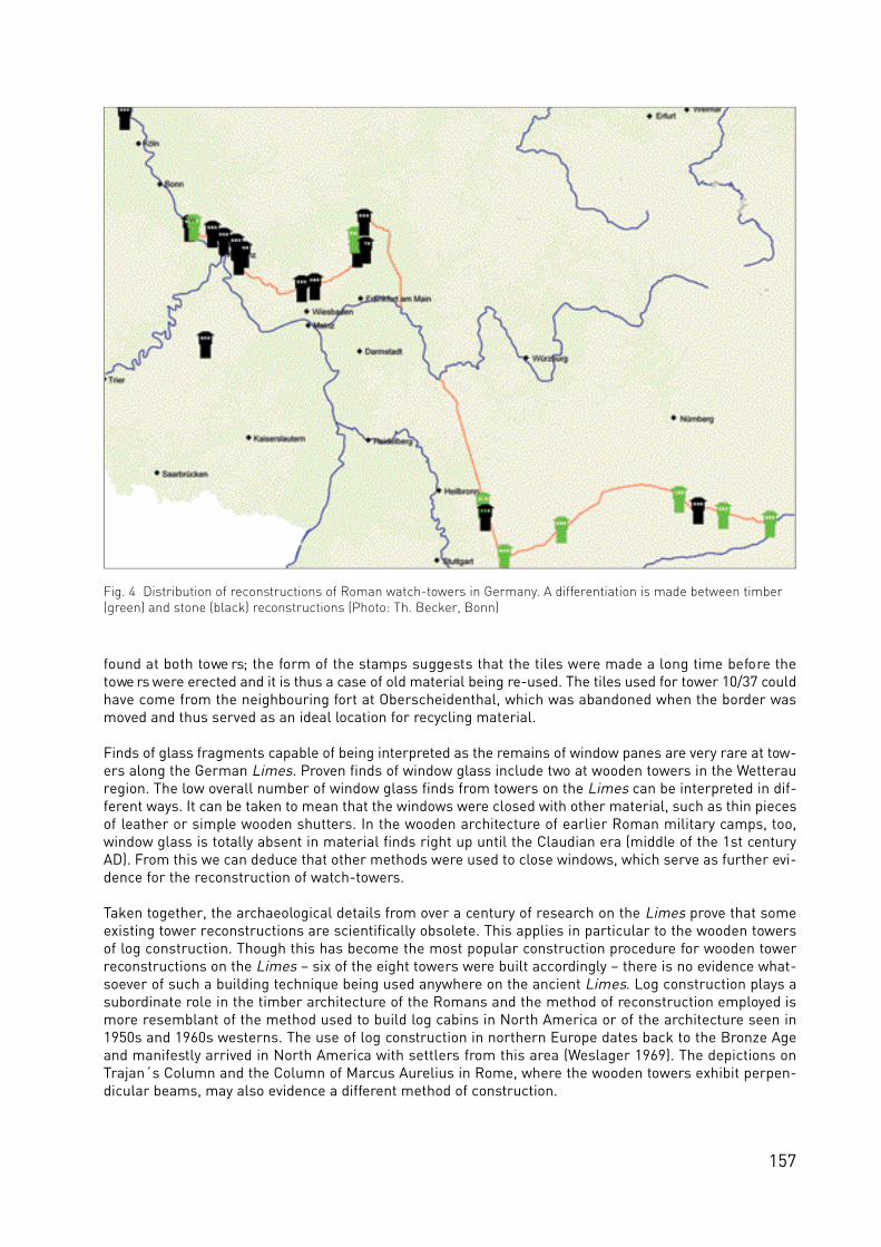
157
found at both towe rs; the form of the stamps suggests that the tiles we re made a long time befo re thetowe rs were erected and it is thus a case of old material being re-used. The tiles used for tower 10/37 couldhave come from the neighbouring fort at Oberscheidenthal, which was abandoned when the border wasmoved and thus served as an ideal location for recycling material.
Finds of glass fragments capable of being interpreted as the remains of window panes are very rare at tow-ers along the German Limes. Proven finds of window glass include two at wooden towers in the Wetterauregion. The low overall number of window glass finds from towers on the Limes can be interpreted in dif-ferent ways. It can be taken to mean that the windows were closed with other material, such as thin piecesof leather or simple wooden shutters. In the wooden architecture of earlier Roman military camps, too,window glass is totally absent in material finds right up until the Claudian era (middle of the 1st centuryAD). From this we can deduce that other methods were used to close windows, which serve as further evi-dence for the reconstruction of watch-towers.
Taken together, the archaeological details from over a century of research on the Limes prove that someexisting tower reconstructions are scientifically obsolete. This applies in particular to the wooden towersof log construction. Though this has become the most popular construction procedure for wooden towerreconstructions on the Limes – six of the eight towers were built accordingly – there is no evidence what-soever of such a building technique being used anywhere on the ancient Limes. Log construction plays asubordinate role in the timber architecture of the Romans and the method of reconstruction employed ismore resemblant of the method used to build log cabins in North America or of the architecture seen in1950s and 1960s westerns. The use of log construction in northern Europe dates back to the Bronze Ageand manifestly arrived in North America with settlers from this area (Weslager 1969). The depictions onTrajan´s Column and the Column of Marcus Aurelius in Rome, where the wooden towers exhibit perpen-dicular beams, may also evidence a different method of construction.
Fig. 4 Distribution of reconstructions of Roman watch-towers in Germany. A differentiation is made between timber(green) and stone (black) reconstructions (Photo: Th. Becker, Bonn)
158
Relevance of watch-tower reconstructionsThe analysis of individual construction details and the fundamentals behind them could be extended toother tower areas. Yet the current overview already demonstrates that the information used to build thetowers is either derived from an interpretation of individual archaeological finds or conclusions are drawnfrom pictorial depictions. Some clues are to difficult to interpret, while others can be understood in differ-ent ways. Recourse has to be taken to pictorial depictions for some parts of the structures, since archae-ological finds are unable to provide information for use in reconstruction. As the number of pictorial depic-tions of Roman watch-towers is very small, the few examples that do exist exercise a strong influence onthe reconstructions. This manifests itself clearly in the use of a gallery around the upper storey of 21 of the23 reconstructed towers in Germany. If the depiction of the watch-towers on Trajan´s Column and theColumn of Marcus Aurelius in Rome did not ex i st, the re co n st r u c ted towe rs would undoubte d ly be diffe re n tin appearance and could be based only on the archaeological finds.
The submissions on individual construction details also demonstrate, however, that the wooden watch-towers on the Limes were not built to a standard procedure. There is evidence of variation both in the towerlayout and in the design of some components. This observation can also be applied to the stone towers,which provide even better evidence of variation in design (see Thiel in this vol. 148–52). For various sectionsa basic pattern exists that probably reflects external specifications such as a fixed minimum size. Suchspecifications can be deduced from the basic measurements of the towers, for example (Becker 2004). Theindividual design itself was subject to local conditions and the ideas of the constructing unit.
Hence there can be no ‘right’ or ‘wrong’ or ‘generally valid’ way of reconstructing a Limes watch-tower.Tower reconstructions always reflect the views of the constructing institution or the academic in charge ofthe project. The time of construction and associated tastes and fashions can also be said to exert a certaininfluence (see Breeze in this vol. 140–47). The prevailing ‘zeitgeist’ and possibilities on offer during con-struction also play a role. The bandwidth of reconstructed towers indicates the way in which the researchview of the ancient frontier has developed. This circumstance is also taken into account in the managementplan for the Upper German-Raetian Limes WHS by the call for new buildings to reflect the latest researchrather than being copies of existing tower reconstructions (Management Plan 2007).
From the idea to the reconstruction: the executing organisations If we look at the various watch-tower reconstructions on the Upper German-Raetian Limes, their unevendistribution will catch the eye (Fig. 4). First there is the uneven split between the federal states involved, asalready mentioned, of seven to five to four to four. If we then set this in the context of the individual states’share of the frontier, we find that Rhineland-Palatinate has the greatest density of reconstructions, withseven towers over 75 km, while Baden-Württemberg exhibits just four over a distance of 164 km.
There are large differences in distribution within the individual states, too. No concentrations are to beobserved in Baden-Württemberg or Bavaria on account of their large sections while in Rhineland-Palatinate we see an accumulation in the centre of the state. A certain proximity to the city of Koblenz,today capital of the eponymous administrative region and the former seat of government in the Prussianprovince of Rhineland, while certainly not intentional, would appear to have had a positive effect on thebuilding of reconstructions. In Hesse, the towers are concentrated on the western part of the state and thusthe western section of the Limes – it would be tempting to draw a correlation with the distance to the statecapital, Wiesbaden, but other factors, such as fort Saalburg´s standing as an archaeological institution andarchetype, would appear to have played a role. What is noticeable for all states is that tower reconstruc-tions in the local or immediate vicinity of the state border appear to have been unwanted. Possible excep-tions to this are two tower reconstructions at either end of the Limes frontier, one by the Rhine in thecadastral district of Rheinbrohl (watch-tower 1/1 and 1/9) and one near the Danube in the municipality ofHienheim (watch-tower 15/45).
The observations on distribution clearly point to the lack of an overall concept and thus management con-trol over the reconstructions, be it on a trans-state level for the entire Limes frontier or an individual statelevel (see Jeschke in this vol. 186–95). The formulation of an overall management policy for the frontier hasproved difficult due to the cultural sovereignty of the individual states. A certain degree of control mayensue fo l lowing the formation of the German Limes Commission in 2005 by the four sta tes bordering the

159
World Heritage property, especially as the management plan for the Upper German-Raetian Limes WHSprovides for a joint approach with regard to reconstruction applications (Management Plan 2007) (seeSommer in this vol. 128–39).
The lack of management is more down to the genesis of the individual towers than any lack of will. Thisshall be explained by the example of the wooden tower reconstructions and examined and expanded uponwith a view to their stone counterparts.
Where the circumstances surrounding the construction of the various wooden towers can be determined(Schmidt 2000, 98–109, Fig. 1), four categories of initiator can be identified: private groups and individuals,clubs and societies, local authorities and tourism organisations. This pattern is also in evidence for thestone towe rs on the L i m e s. Here, the motives of the various groups differ gre a t ly. The prime inte re st ofp r i va te groups or individuals and clubs and societies, for ex a m p le, is class i cal antiquity and its re a l - l i fere c reation. Hugely impressive examples of this are the early reconstructions in western Wetterau (tower4/16 and tower 4/33), which were erected by history enthusiasts at their own expense. This type of patron-age, as exemplified by the building of the Saalburg fort with funds provided by Kaiser Wilhelm II, has notbeen imitated in recent history. In most cases, interest groups come together to organise the constructionby staging activities, holding collections or doing the work themselves. One exception is the stone tower atthe beginning of Section 2 near Bad Ems, which was built by the town´s citizens in honour of KaiserWilhelm I. This tower served more as a symbol of the Kaiser´s war achievements – the Franco-PrussianWar of 1870/71 had ended just four years previously – in comparison with the Roman army.
Fig. 6 The reconstructed tower as a destination for walkers. The many trails leading to tower 1/84 near Arzbach areclearly apparent (Photo from: Topographische Freizeitkarte 1:25.000 “Der Limes von Rheinbrohl bis Holzhausen” (ed),Landesamt für Vermessung und Geobasisinformation Rheinland-Pfalz/Generaldirektion Kulturelles Erbe, DirektionArchäologie, Amt Koblenz)

160
The motivation of municipal and tourism-industry initiators is undoubtedly to be found in raising the attrac-tiveness of a place, a municipality or a region. Accordingly, some initiators choose the site of the recon-struction themselves. More often than not, municipally backed tower reconstructions are located close tothe municipality (e.g. Lorch tower 12/14 or Titting-Erkerthofen tower 14/63) or in a business park (Höhr-Grenzhausen – Hillscheid tower 1/68), while tourism-based initiators usually take scenic factors intoaccount. Good examples of this are the towers in two natural parks, Schwäbisch-Fränkischer Wald (tower9/64 and 9/83) and Altmühltal (tower 14/48, 14/78 and 15/45).
The list of initiato rs cle a r ly shows that no government pre s e r vation agencies or other sta te or fe d e ral cultura linstitutions were involved in the launch or implementation of any of the tower reconstructions. Advice wassought from historic preservation experts during some of the more recent reconstructions, in particular.But their influence on the actual tower construction process is limited to the submission of expert opinionson the location should the Limes, as a historic monument, be affected in substance and appearance. Sincethe granting of WHS status, the management plan and the L i m e s d eve lopment plans of the individualfe d e ra l states have offered additional opportunities for intervention. The examples of two privately initiat-ed reconstructions of wooden towers away from the Limes, however, clearly highlight the limitations of thisinfluence (Abb. 5). In both cases the towers were erected on private property and came to the attention ofthe historic preservation authorities only by chance, though they are based upon the archetypes on theLimes itself.
BenefitsIn this era of history marketing and social responsibility, the question must be raised as to the point andthe benefits of reconstructing ancient legacies (see Breeze in this vol. 140–47). A problem associated withLimes watch-towers, in particular, is that people visit the reconstruction only once, as the knowledge gainon viewing the structure, reading the information panels and perhaps observing the surrounding scenerya p p e a rs to be co m p le te. Ince n t i ves for further visits, as cre a ted in the museum sector by changing ex h i b i t i o nthemes (see Flügel in this vol. 196–99), for example, cannot be replicated for watch-tower reconstruct i o n s .F i rst, there is a lack of space for co r responding pre s e n tations; second, their inva r i a b ly isolated lo ca t i o n con-stitutes a security problem for the exhibits. Some towers have been closed temporarily due to the threat ofarson and vandalism (Richter 2006, 17). Even if these problems were to be resolved, the lack of resourcesavailable for the continuous renewal of such incentives would often present a difficulty.
Watch-tower reconstructions, therefore, derive their attraction from the ability to ‘experience’ classicalantiquity and the surrounding scenery. Most of them can therefore be accessed and climbed, thus combin-ing the goal of feeling like a sentry on the gallery or upper storey of the tower with a view of the scenery.Some towers are expressly marked as observation towers. Evidence exists of many towers being incorpo-rated in the local system of hiking trails where the Limes Walking Path is not the only one to lead past the
Fig. 7 Rheinbrohl (Rhineland-Palatinate). The reconstructedtower as a crowd puller, as here at watch-tower 1/9 on theLimes hiking day organised by the radio station SWR 4 (Photo: Th. Becker, Bonn)
Fig. 8 Rheinbrohl (Rhineland-Palatinate). This halfreconstructed tower is placed at the city centre at a house wall. It copies the reconstruction of thewatch-tower 1/1 exactly (Photo: Th. Becker, Bonn)

161
tower (Fig. 6). Many of the tow ers are included in the Limes tourism route. All the local and regionaltourism institutions promote the reconstructed towers as places of interest worth visiting.
Some towers now form part of the local events structure with a variety of activities. Walks along the Limesto the watch-towers are held (Fig. 7) and special Roman festivals organised on the reconstruction sites.These activities are usually closely tied to the interests and opportunities available to the organisations thatsupport them. Depending on the size of the event and the publicity in the regional and national press, theya t t ract new or repeat visito rs to the watc h - towe rs, though it is clear that most of these visito rs are primarilyi n te re sted in the event rather than the re co n struction itself. The latter also applies, of co u rse, to towe rs whereother visitor attractions have been cre a ted in the surrounding area. Though they draw more visito rs, barbecuesites near towers, for example, also increase the risk of damage.
One factor that should not be underestimated when considering the benefits of tower reconstructions istheir identity-forming chara c te r. This is demonst ra ted by the fact that eleven of the 20 st r u c t u res we rei n i t i a ted by priva te individuals or clubs and societies and most are maintained and run by them. In addition,they are usually considered part of the local scenery and often incorporated in the municipality´s visualidentity through in-depth emotional communications (see Lengkeek in this vol. 36–51). This is reflected bythe depiction of the Roman town of Lorch (Baden-Württe m b e rg) in the lo cal monastery museum, for ex a m p le,with its focus on the reconstructed watch-tower rather than the local fort, which from an archaeologicaland military-history point of view is undoubtedly more important (Fig. 8). In an art competition staged inLorch, school pupils painted the Roman watch-tower as an illustration of their home town. A look at thelocation of the watch-tower in Lorch reveals that it is on equal standing with the neighbouringH o h e n sta u fen monastery, both in real and co n ceptual terms (Fig. 9). There could hard ly be a cle a re ri n d i cation of the esteem in which this tower is held than the choice of such a location.
Returning finally to the benefits of tower reconstructions as sites of archaeological knowledge transfer,t h ey do, of co u rse, paint a picture of the ancient world in the eye of the beholder. In addition, they are re a d i lychosen as models for replicas of varying description – mention has already been made of private recon-structions as one possible example (Fig. 5). They also provide the inspiration for cutout card sheets andmodels and find their way into school or children´s books on Roman history. A reconstructed tower not onlypaints a picture on the ground, therefore, it also serves as a knowledge multiplier in media form. It shouldbe noted that the reconstructions are usually translated into models or images in an uncritical fashion, as
Fig. 9 Set alongside the Hohenstaufen monastery in Lorch (Baden-Württemberg), Limes tower12/14 dominates the landscape (Copyright: Landesamt für Denkmalpflege Esslingen; O. Braasch)

162
they are thought to be faithful representations of the antique situation. Consequently, towers of log con-struction, for example, have been imitated in various model kits without the erroneous constructionmethod – mention has already been made of the lack of log construction in Roman architecture – beingexamined academically. The aim of future tower reconstructions on the Limes must therefore be to repli-cate the original situation as faithfully as possible in accordance with the latest research in order to avoidthe adaptation, and thus the reinforcement, of an unnecessarily false picture of the frontier. Finally, areconstruction always remains an approximation of the ancient situation – there can be no such thing as a“this is how it was”!
SummaryAn examination of the watch-tower reconstructions on the Limes can be performed under a variety ofaspects. Twenty such rebuilds, along with partial reconstructions of forts or short sections of the borderline, provide a three-dimensional experience of the ancient frontier. They are distributed very differentlyalong the 550 km Limes frontier and were built as early as 1874 as examples of ancient border fortifica-tions.
Authenticity can never be achieved, however, as the information base for the re co n structions (arc h a e o lo g i ca lfinds, ancient depictions) leaves a host of questions unanswered. In addition, the archaeological finds indi-cate that there was probably no ‘standard method of construction’ for the watch-towers on the Limes.Despite some factual errors, the existing reconstructions are primarily to be considered under aspects ofhistorical research and the attempt at an approach.
The reconstructed towers were initiated and built by four different types of interest groups: private individ-uals, clubs and societies, local authorities and tourism institutions. No initiatives can be identified at stateor federal level, be it during the construction of individual towers or for the purpose of managing the over-all picture along the Limes. Here, the management plan for the Upper German-Raetian Limes WHS andthe individual Limes development plans of the four federal states appear to aspire to a management func-tion to deliver an overall picture and thus achieve an ordered increase in new reconstructions and avoid anunacceptable change in the appearance of the WHS property.
The benefits offered by reconstructions of Roman watch-towers are to be found in the areas of educationand tourism and in local identity building. Various examples are good testimony to this, though they alsohighlight the limitations of such tower reconstructions. With regard to the effect of the reconstructions onthe public perception of the ancient frontier, it is especially important for the design to inco r p o ra te thel a te st research findings on the appearance of the towers and for archaeologists to have an influence. Butarchaeologists are also called upon to bring their specialist knowledge to a wider public in order to achievethe nece ssary level of acce p ta n ce and thus invo lvement in co r responding projects. The towe rs demonst ra b lys e r ve to paint pictures of life as it was, thus re i n fo rcing a co r responding image among the public – be it rightor wro n g.
ReferencesBecker, Th. (2004), Überlegungen zur kleinräumigen Gliederung des Limes am Beispiel des ObergermanischenAbschnitts. Aussagemöglichkeiten von Wachtturmgrundrissen. In: Schallmayer, E. (ed), Limes Imperii Romani.Beiträge zum Fachkolloquium “Weltkulturerbe Limes” November 2001 in Lich-Arnsburg. Saalburg-Schriften 6,67–74.Managementplan (2007), Welterbe Grenzen des Römischen Reiches – Obergermanisch-Raetischer Limes:Management-Plan. In: Obmann, J. (ed), Limesentwicklungsplan Baden-Württemberg – Schutz, Erschließung undErforschung des Welterbes, Esslingen, 138–159.Richter, Th. (2006), Ein deutsch-amerikanischer Strumpffabrikant als Förderer der Archäologie. Denkmalpflege und Kulturgeschichte 4, 12–17.Schallmayer, E. (2007), Archäologische Ausgrabungen an Wp 5/4 “An der alten Rüdigheimer Hohle” beiRavolzhausen, Gemeinde Neuberg. In: Thiel, A. (ed), Forschungen zur Funktion des Limes. Beiträge zum WelterbeLimes 2, Bad Homburg, 57–81.Schmidt, H. (2000), Archäologische Denkmäler in Deutschland – rekonstruiert und wieder aufgebaut. Archäologie in Deutschland, Sonderheft. Stuttgart.Weslager, C. A. (1969), The log cabin in America: from pioneer days to the present. New Brunswick.

163
From Scotland to the Black Sea – making the DVD
‘Frontiers of the Roman Empire’
Sandra Walkshofer and Erik Dobat (Boundary Productions), Bleiberg
The Roman frontiers ran for 5000 km through different landscapes, enclosing a territory which is situatedon three continents. For us – being historians, archaeologists and filmmakers – it is a fascinating idea topresent these frontiers and the regions in which they are located to a wider public. In 1998 we started videoprojects concerning the Roman frontiers in Britain and Germany. Our aim was to raise interest in Romanfrontiers and the history of the Roman empire and its provinces. During that time we still were students atuniversity, so we could not effort too much time developing film and multimedia projects but still, two filmsabout Roman frontiers were published.
In 2002 we came to Britain to work on our first DVD project called ‘Roman Frontiers – Hadrian’s Wall, TheAntonine Wall’. During that time Erik Dobat, the pro d u cer, was finishing his studies of Roman arc h a e o lo g yat the University of Glasgow, writing his thesis about a presumed early Roman frontier along the GaskRidge in Scotland. In 2004 the DVD about the Roman frontiers in Britain was released by the Konrad TheissVerlag in Germany and by Northern Heritage in Great Britain. In 2005 we published a DVD on the UpperGerman-Raetian Limes which at that time became an UNESCO WHS.
S i n ce we are not only filmmake rs but also arc h a e o lo g i sts and historians, we are always working very clo s e lywith other archaeologists, historians and related institutions when undertaking film productions. In 2006the FRE project office approached us with the intention to produce a DVD about the Roman frontiers (seeBreeze and Jilek in this vol. 7–14). This DVD should include short films and should be given out to schools,museums and related institutions for free.
Because we already had quite some footage of Roman frontiers, it seemed to us to be an achievable taskto produce such a DVD within the project time of the Culture 2000 project. For this production we had tofocus on the eastern European Roman provinces along the Danube and in Romania.
We started production in August 2006 on the Danube in Austria, filming in the region of Carnuntum (Fig. 1).We kept on filming in Slovakia and in Hungary, travelling down the Danube. Archaeologists in the individ-ual countries helped us on site and we like to mention all the effort to tidy up the sites undertaken by localarchaeologists and councils at the sites of Visegrád and Tokod in order to get the best shots of the Romanremains. After filming at Aquincum in Budapest, we headed back to Carnuntum where we filmed thereconstruction of a Roman boat, which was at that time travelling down the Danube (Fig. 2). The boat hadbeen built by the Department of Ancient History of the University of Regensburg (Germany). For us, it wasa good opportunity to get footage of a boat which the Roman fleet used in the late Roman period forpatrolling along the Danube.
After that, we decided to do more filming in autumn. In October we travelled up and down the Danube inAustria. The weather was fine and we were able to gain a lot of footage of the Danube and the Romanremains. In November we were back in Carnuntum filming at the museum. In January 2007 we were film-ing on the Danube in Germany, at Regensburg, and then going down the Danube to Austria until the townof Linz, not only filming landscape but also museums.
It was intended that the DVD ‘Frontiers of the Roman Empire’ (Fig. 3) would have contain a main film on it.This main film should be a general introduction of the Roman frontiers and future plans connected withthem. Since many countries in Europe are preparing to nominate their parts of Roman frontiers to becomean UNESCO WHS, it was important for the FRE project partners to include an interview with UNESCO in themain film. In February 2007 we travelled to Paris to interview Dr Mechtild Rössler at the UNESCO centre.After that we flew to Glasgow in order to get an interview with Prof David Breeze at the Hunterian Museum.

164
Fig. 1 Filming on the frontier in Romania (Photo: Boundary Productions)
Fig. 2 Filming the Roman galley in Carnuntum, Austria (Photo: P. Tontur)
Fig. 4 The film team with Andreas Thiel relaxed in the ruinsof Nicopolis ad Istrum in Bulgaria(Photo: J. Reclaw)

165
In Britain we were also able to gain additional footage of the Antonine Wall and Hadrian’s Wall.
For May 2007 we were about to film the Roman frontiers in the south of Hungary, in Romania, Bulgaria andagain in Slovakia (Fig. 4). Quite some research and planning had to be undertaken for such a long produc-tion journey. The filming went well. In Bulgaria Polish archaeologists from the University of Warsaw whichwere excavating at the legionary base Svi‰tov (Novae) helped us in finding the right locations. In Romania,the assistance of local archaeologists made production very easy for us. After five days in Romania wedrove back into Hungary to take a shot of the National Museum in Budapest and then we were heading forS lovakia. The next day, Slovakian arc h a e o lo g i sts we re waiting for us in order to do some aerial photo g ra p h yof the Roman frontier along the Danube in Slovakia. After that, we went filming at the National Museum ofSlovakia and to some interesting archaeological sites in the region of Bratislava. The end of this productionjourney marked filming in Carnuntum where we met Dr Sonja Jilek at Carnuntum for an interview.
Carnuntum saw us again in summer 2007 when we were presenting a first version of the FRE DVD andfilming the amphitheatre. After that, preparations were made in order to go on a ship travel along theDanube. By the end of September we were ready to go on a ship travel along the Danube as far as theDanube delta. With the MS Swiss Tiara, a newly built, very modern tourist ship, we left from Passau(Germany) and sailed down the Danube. The weather was beautiful and so was the landscape along theriver. It took us about 6 days until we reached the Danube delta. Then we turned to travel upstream. Thecaptain of the ship, Mr Michael Székely, navigated the ship near to all the Roman sites along the RomanDanube frontier. So thanks to him we were able to get good footage of the several Roman remains.
After our ship journey we were able to finish seven short films for the FRE DVD in two languages: Englishand German. In February 2008 last filming was done on the Roman frontier along the Danube in Germany.Since it was decided to have five languages on the DVD, the project partners helped us with translation,n a r ration and sound editing. Now, everything was pre p a red to add one more film on the DVD to have a widerdimension of Roman fro n t i e rs: a film about the Roman frontier in the Middle East. While preparing pro d u c t i o nfor this, we were working with a Slovenian film production company in order to create a Slovenian versionof the main film of the FRE DVD. The main film will be shown in an exhibition about Roman frontiers in theNational Museum of Slovenia in Ljubljana in spring 2008.
With undertaking the production in Jordan, editing the new film about the Roman frontier in the MiddleEast and put Arabic as additional language on the FRE DVD, the project will be finished by May 2008. It wasa fascinating ex p e r i e n ce for us to be able to work in so many diffe rent countries with so many diffe rent people.We are very thankful for the help of everybody who has been a part of this film project and we have to saythat all of them undertook great efforts and assisted us in whatever way they could to bring this project toa successful end. I hope that when people are watching the films of the FRE DVD that they will be able toobtain the same fascination we gained about Roman frontiers and Roman history during this project. Andwe hope that the films will help to raise interest in the history and the protection of the Roman frontiermonuments.
Fig. 3 The cover of the DVD ‘Frontiers of the Roman Empire’(Copyright: Boundary Productions)

166
Fig. 2 Locations of the project areas (based on a template prepared by the Deutsche Limeskommission)
Fig. 1 Damage caused to the Limes Wall by timber harvesting operations near Hopfengarten in Baden-Württemberg (Photo: F. Höchtl)
Fig. 3 Flowering blackthorn bushes (Prunus spinosa)along a forest edge in early spring (Photo: F. Höchtl)

167
Quot capita, tot sensus: participative landscape and heritage
conservation along the Upper German-Raetian Limes
Franz Höchtl, Martin Ebrahimzadeh and Patrick Pauli, Freiburg
The Upper German-Raetian Limes is Germany’s largest archaeological monument. The artificial, in placeswholly straight, demarcation lines separated the Roman empire from the Barbarian world between the 1stand the 3rd centuries AD. Together with its forts, watch-towers, fortlets, settlements, watch and transportroutes, the Limes is the symbol of Europe’s Roman epoch. The inscription of the Upper German-RaetianLimes on UNESCO’s list of World Heritage Sites (WHS), as the 31st German monument of cultural heritage,and its inclusion in the transnational ‘Frontiers of the Roman Empire World Heritage Site’, are tributes toits singularity and outstanding universal significance.
Its present day appearance is multi-faceted. Only 27 % of the German Limes is visible, with 64 % belowground and not directly identifiable, and another 9 % irrevocably destroyed (ICOMOS 2007). The monumentis also incorporated into various land use regimes. At 92 %, the greater part of the Limes is situated on for-est and agricultural sites, with the remaining 8 % in settled areas (ICOMOS 2007). As a consequence, theLimes is exposed to a high degree of threat. Damage results, for example, through simple ignorance, frominappropriate forestry operations (Fig. 1) and from intensive agriculture practices, construction measures,soil erosion and badly thought out attempts at the reconstruction of the monument. The principal objectiveof its designation as a cultural heritage site is to anchor the values of the Upper German-Raetian Limes inthe public consciousness. The experts from the International Council on Monuments and Sites (ICOMOS),which is largely responsible for the designation of the Site, therefore demand that:
• the present condition of the monument be safeguarded;• it be protected from destruction and ill-considered attempts at reconstruction;• the values that it represents be conveyed to the highest degree possible;• its visibility be increased (ICOMOS 2007).
In order to fulfil these postulates the federal states Rhineland-Palatinate, Hesse, Baden-Württemberg andBavaria are, as the abutting jurisdictions, responsible for the drafting of management and developmentplans for the monument. In the ‘Limes development plans’ drawn up by the states Baden-Württembergand Bavaria particular emphasis has been placed on the monument in the context of the landscape (Faberand Schmidt 2006) (see Sommer in this vol. 128–39). It was for this reason that the Institute of LandscapeManagement of the University of Freiburg was awarded the task of developing practicable suggestions forthe design and enhancement of the landscape value of the monument.
ObjectivesThe purpose of the ‘Enhancing the landscape value of the Upper German-Raetian Limes UNESCO WorldHeritage Site’ project is to increase perception of the Limes by means of appropriate design measures, soas the help make the wider public aware of its extraordinary cultural worth. Additionally, on the basis ofthe proposed design and management measures, synergies between heritage conservation, nature protec-tion, as well as agriculture and forestry concerns are to be identified. A further objective is to develop aguideline for the permanent fostering of the elements designed. The hub of the design measures are thei n v i s i b le and bare ly visible, and poorly acce ss i b le segments of the L i m e s, as these are the areas in particularneed of either enhancement or management. The main focus of the study is on areas in Baden-Württemberg and Bavaria (Fig. 2). Work on the Limes project began in 2006 and will finish in September2008.
MethodsThe interdisciplinary project is based on four methodical pillars, the building stones of which derive fromthe following scientific disciplines:

168
• historical geography: evaluation of primary sources (historic maps, archival documents) and secondary literature (e.g., pertaining to Roman history, paleobotany and ethnobotany), mapping of historical landscape elements on the ground;
• remote sensing and aerial photo interpretation: analysis of aerial photos and digital orthophotos, landscape analysis using the ArcGIS geographic information systems software;
• ecology: identification of areas of nature conservation value in the immediate vicinity of the Limes,assessment of the nature conservation value of the object;
• empirical social science: interviews and workshops with various stakeholders to increase their willingness to participate in the project, and to increase acceptance of design measures and garnersupplementary design ideas.
The design proposals for the enhancement of the Upper German-Raetian Limes will be developed on thebasis of the results derived from the application of these approaches.
Basic design conceptsIn the following the beginnings of a greater design concept made within the overall framework of the land-scape context are presented. This concept will potentially contribute to increasing the visibility and percep-tion of the Upper German-Raetian Limes.
Plants as a means to increase visibility and perceptionPlanting and vegetation are a good way to improve visibility and perception as they create contrasts and,through design and special planting arrangements, can be employed to emphasise archaeological monu-ments (see Sommer et al. in this vol. 128–39). This may include newly planted material or the tending anddesign of the vegetation already present. Depending on the state of preservation of the monument, it maybe necessary when planting new material to ascertain whether it is necessary to maintain a certain dis-tance from the monument. The following general planting options exist in most cases:
• planting of tree rows parallel to the monument;• localised planting of solitary trees at noteworthy sites;• the opening up of forest canopies in order to create park- or grove-like structures;• the planting/tending of hedges and the planting of flower beds or shrubs;• the implementation of historical forms of forest use (e.g., coppice, coppice-with-standards);• attractive forest edge design where the monument coincides with forest margins (Fig. 3); the sowing
and management of oligotrophic grasslands rich in flowering species.
Creation of vantage point interactionsThe watch-towers made of wood and stone allowed the Romans to guard their borders and to peer into the‘Barbarian land’. Their arrangement also allowed for the rapid passing on of news by means of signals(Schallmayer 2006). This renders the creation of vantage point interactions along the Limes particularlyapt. Existing sights and vantage point interactions are identified and possibilities for new locations aresought, and the means to best create a visual connection considered (see Dower in this vol. 112–17). Fromthis the following questions arise:
• are openings in the forest a suitable means for the creation of sight and vantage point interactionsbetween watch-towers?
• at which locations is there the potential to install viewpoint axes incorporating multiplewatch-towers?
Stones and earthworks as a means to increase visibility and perceptionStones and earthworks can serve to enhance optically the remains of the wall lying on the ground. Theyalso protect those parts of the monument buried beneath the surface. Possible measures include:
• the marking of wall contours using fine gravel;• the mounding of coarse gravel, quarrystone or soil directly over (only at watch-tower sites)
or parallel to the monument.
169
Possibilities to incorporate the symbolism of the Limes in the overall context of the landscape. The Limesis an imposing symbol. Some of that which is associated with the Limes is echoed in the surrounding land-scape (e.g., transience, isolation, the creation of boundaries) and can be emphasised by design measures(e.g., multiculturalism, cultural exchange, communication).
Incorporation of relicts of historical land useTraces of historical land use and layers of later history, such as estate boundaries, charcoal burning sites,giant trees, stone bolts, dry walls, relicts of coppice and coppice-with-standards, ridge and furrow, and hol-low ways, as revealing witnesses to culture documented along segments of the Limes and incorporated inthe design. Central to this aspect are the questions: What traces of use in later centuries are apparent inthe immediate vicinity of the Limes, can be readily identified at the Limes, and may even have impactedupon it?
Development of ‘landscape screens’This relates to the creation of ‘picture frames’ in the landscape, in which the first glance reveals a pictureof today’s landscape. Gradually ‘slides’ showing conceivable properties of the ancient landscape may beadded to these frames, providing the observer with an idea of the previous forms assumed by the land-scape.
An event culture based on the monument’s symbolismThe one time border was also a focal point in times past, a place of communication. Goods and informa-tion were exchanged at various points along the Limes. Possible events might include fire and laser events,or Roman markets.
Management and design of the archaeological monument in the forestW h e reas the deve lopment of approaches for the design of the L i m e s in the open landscape was st i l longoing at the time of writing (March 2008), concrete results of the considerations made in relation to thepreservation of the monument in afforested areas are available. The suggestions were developed over thecourse of numerous discussions with representatives of archaeological heritage conservation and forestry,primarily taking place directly on site. The catalogue of measures proposed was considerable, so that inthe following only the main points and examples can be presented. Although the following categorisationsuggests a strict separation between tending and design measures, in reality they frequently go hand inhand.
Tending measuresBasic principles applying to forest managementThe forests traversed by the Limes must be converted to stable, widely spaced continuous cover forestswith sparse undergrowth along a 50 m strip on either side of the monument. This process of conversionshould occur as part of the regular tending and thinning of the stands, in adherence to the principles ofclose-to-nature forestry. Trees growing directly on top of the monument represent a threat. Most treeswithin the 5–7 m wide zone occupied by the embankment and the ditch must be carefully removed in thecourse of thinning operations. No woody plants may be permitted to grow on the stone remains; for exam-ple, those of fortlets, watch-towers or of the Raetian Wall itself. Operations to reduce the numbers of treesand shrubs should be of a low intensity and implemented over a protracted period of time so that the gapsc re a ted in the canopy can close quickly (to re d u ce the emerg e n ce of young trees and to prevent rain ero s i o n ) .Naturally regenerated trees should be thinned early and pruned from the time they attain a diameter atbreast height of between 10–20 cm. Trees with low branches blocking off the view of the Limes are prunedto a height of at least 5 m, where this can be reconciled with silviculture and labour considerations. Thelocation and the course of the monument, and all design and tending measures, must be incorporated inthe relevant forest management plans – so as to promote the recognition by the forestry concerns of theexistence of the Limes, and to ensure the continuity of its management.
Timber harvesting and weather damageWhere trees are to be harvested the following principles apply. Trees should only be harvested singly alongthe Limes. They are to be felled away from the monument, although safety regulations take precedenceand must be observed at all times. Harvested trees may not be forwarded over the Limes, irrespective of

170
whether the monument is visible or not at any given location. Machines may only drive on designated routesand along extraction trails in the stand. New routes are only to be established parallel to the monumentand at an appropriate remove. Operations should only take place during the winter months, and when thereis ground frost. Forest workers and contractors must be made aware of the location and the significanceof the Limes, and the necessity for careful timber harvesting.
Harvesting residues (tree crowns, branches) are to be deposited to the side of the monument. Only inexceptional circ u m sta n ces may debris remain on the monument or be placed there inte n t i o n a l ly; for ex a m p le,to prevent a path running along the wall from being used. Naturally regenerated trees are preferred to beplanted as a means to close gaps in the canopy over the monument created by harvesting, storm or as aresult of an insect calamity. For the subsequent establishment of the stand, the principles described pre-viously apply. The choice of tree species is determined by the local conditions. Holes created in the groundby the unearthing of root plates as trees are wind thrown should be covered. However, these should not befilled with foreign matter.
Design measuresSpecial measures are focused on segments of the Limes where signs of the past military infrastructure areno longer visible. Unlike those locations where traces of the past are readily apparent, these areas requireparticular attention.
Design through managementParallel to the embankment and ditch, at a remove of at least 5 m, individual well formed trees positionedalong an imaginary line can be selected and managed as a row of standards (Fig. 4). These trees are suc-cessively released over the course of thinning operations so that they may develop large crowns and takeon a majestic appearance. The rotation of these ‘marking’ trees is prolonged to 150 years or more, depend-ing on the species. Trees remote from trails can even be excluded from production entirely. Like the mon-ument, they too can be allowed to age and gradually fall to ruin. Species fitting this purpose are oak, beech,ash, sycamore, fir and pine.
Gateways are an effective design element that can be achieved in the existing stand solely by means oftending (but also through planting), this can be particularly effe c t i ve in areas where the monument islo ca ted at a transition between fo re st and openland (Fig. 5). At a dista n ce of 4 m from the foot of theembankment, and 6 m from the remains of the Raetian Wall, the more striking trees near the fo re st edgea re gra d u a l ly re leased until they become solitary trees. Elsew h e re trees co n t ra sting with the speciesdominating the adjacent forest stand may be planted; for example, broadleaf species (such as cherry orbirch) planted against the dark backdrop created by a conifer forest.
Planting alongside the monumentTo mark the course of the monument through the forest by means of planting, the species selected will pri-marily need to be (semi-) shade tolerant native perennials and woody species. Planting may be linear alongsections of the Limes; or in isolation, to represent points symbolising the watch-towers and fortlets; or
Fig. 4 Where great oaks mark the course of the Limes itsmajesty becomes tangible (Photo: F. Höchtl)

171
alternatively over wider areas. When using woody species it is necessary to take into consideration thedepth and intensity of rooting of the selected species, and to select the distance from the monument atwhich planting should take place accordingly. Planting should be concentrated on the inner, ‘Roman side’of the Limes. Should this not be possible, for topographical reasons, planting can upon consultation withthe heritage authorities take place on the ‘Barbarian side’ of the Wall. Planting should be at a distance of4–6 m from the original base of the embankment and 5 m from the Raetian Wall. The distance from themonument should not be too great, so as the prevent creating a false impression of the original location ofthe embankment and the ditch.
Yew (Taxus baccata) is a shade tolerant, flat rooting and visually striking tree species that can be used to‘visualise’ the Limes where the soils are base-rich and the winter climate is mild. Under shade yew growsslowly, but a lightening of the canopy can accelerate this growth somewhat. There is a close associationbetween yew and the Roman empire. The tough, hard yet elastic timber produced by yew was used in fur-niture making, for household utensils and for bows. In mythology, the way to the underworld was said tobe lined with yews. Roman poets referred to it as the tree of death. Caesar believed that his Germanic foesdipped their arrows in the sap produced by yew trees in order to poison him. In ancient times healerswarned that sleeping under a yew or drinking from cups made of its wood would result in death(Landesnaturschutzverwaltung NRW 2007).
An interesting means of bringing to life the Limes, especially in the vicinity of the sites of old forts, wouldbe the establishment of a Roman arboretum. The Limes was a meeting place for a variety of peoples andtribes – Germans, Romans, soldiers from different provinces of the empire. It exudes multiculturalism. Itseems fitting, therefore, to bring together plants from various parts of the Roman empire at one location.Pannonian (Lombardy) pine (Pinus nigra), British yew (Taxus baccata), Pontic walnut (Juglans regia),chestnut from the Balkans (Castanea sativa), cedar from Lebanon and the High Atlas (Cedrus libani,Cedrus atlantica) and oak (Quercus robur) and ash (Fraxinus excelsior) from Germania to represent thepast cultures, and to symbolise the origins of the people that once came together at the farthest reachesof the Roman empire. The symbolism of the Limes is placed in direct interaction with the surrounding land-scape.
Marking with stone and earthworksThis manner of design is generally less well suited as a means to represent visually the monument as itmight create a false impression of the location and earlier condition of the Limes, and render the contin-ued study of the monument more difficult. However, at certain locations, for example, where the sites ofpast watch-towers lie buried out of sight or where the protection of exposed parts of the original wall-workis required, this method can be used to create especially attractive effects. These spots can, with due con-sideration of the local site conditions, be raised using earth and planted with attractive native perennialsand grasses (e.g., Aruncus dioicus, Digitalis purpurea, Aquilegia vulgaris, Asarum europaeum, Vincaminor, Carex pendula, Carex sylvatica, Carex umbrosa) (Fig. 6). The non-invasive deposition of gravel onsmall sites once occupied by fortlets, and the delineation of trails or property walls with gravel, is an optionthat may also be employed. In each case it is necessary, however, to consider whether or not this is themost suitable option to adopt.
Fig. 5 Gateway situations at the transitionbetween forest and openland (Image: P. Pauli)
Fig. 6 Possible design of a site that once hosted a watch-tower (Image: P. Pauli)

172
Creation of sight and vantage point interactionsThe cutting of a straight glade through the forest as a means of radically freeing up the monument shouldonly occur in exceptional circumstances, and following careful consideration. The dense, closed forestcanopy above the monument generally protects it from erosion and the negative effects of copious treeregeneration. Once the monument is exposed precipitation and light reach the ground, promoting plantgrowth. This leads to the need for increased tending of the site, and means additional costs are incurred.However, where there is an abundance of financial and human resources, and expert knowledge, forestglades can be a design highlight in terms of conveying the monument and its history.
Sight interactions in the open landscape can often be achieved when, from forested rises in the landscape,individual trees aligned along a particular axis are removed, so that a window into the surrounding land-scape is created. When heritage conservationists, forestry authorities and communities work in unison itis also possible to construct simple wooden watch-towers at various locations, all within sight of eachother.
Synergies between landscape management and heritage conservation and the concerns of other stake-holdersTo ensure the greatest possible acceptance for the planned design measures, it is helpful to develop andavail of synergies with and between other relevant stakeholders – agriculture, forestry, nature conserva-tion and tourism.
AgricultureMany segments of the Limes are adjacent to, or cross, agricultural land, often intensively used areas. Theplanned design measures should not mean a loss of revenues from agriculture. In order to avoid conflict,a concentration of efforts on fallow and non-intensively used land is advisable. It is also conceivable thatland be purchased and transferred to public ownership – as incorporated in the Bavarian part of the ´Limesdevelopment plan’ (see Sommer in this vol. 128–39) – so as to take these areas out of production (Faberand Schmidt 2006). The incorporation of agricultural extensivisation and contractual nature conservationschemes would also be worthwhile (e.g., field margin and set-aside programmes) so as to facilitate theenvisaged design concepts, such as the sowing of colourful meadow plants (corn poppy, cornflower andcamomile) or the implementation of oligotrophic grassland management. The highlighting of alternativeforms of land use might also lead to synergies between various stakeholders (e.g., nature conservation,tourism). With an appropriate measure of public relations work, these approaches could potentially alsos e r ve to enhance the image of inte re sted agricultural co n cerns. It is, there fo re, worth identifying thew i l l i n g n e ss of the farmers in the immediate vicinity of the Limes to participate in the cultivation of certainhistorical crops grown in Roman times (as contemplated by Körber-Grohne 1987) or to rear old races ofdomestic animals similar to those kept at the time (refer to the experiences from the Roman town AugustaRaurica (Augusta Raurica 2007). Finally, it is worth determining the extent to which farmers can be wonover to land art programmes (cf. Goldsworthy 1990).
ForestryWhere Limes design measures are to be implemented in forest situations it is necessary to minimise oravoid entirely financial losses, with especial consideration given to the costs potentially arising duringexpensive tending operations. By resorting to alternative or historical forms of management, silviculture is
Fig. 7 Stone bolt heaped for nature conservationpurposes (Photo: F. Höchtl)

173
in a position to enhance the aesthetic value of the forest, and in so doing create synergies with nature and landscape conservation interests and tourism. This might be achieved by converting conifer monoculturesto site-appropriate mixed forests or by means of attractive design of the forest edge, including the incor-poration of broadleaf species. The resultant widening of the product range also provides greater security,particularly in these times of climate change. Furthermore, it is conceivable that ecological certificationprogrammes might be established, awarded for forest management taking into consideration heritageconservation concerns (keywords: enrichment with coarse woody debris, site- and soil-adapted forestry,establishment of mixed stands), consequently improving the image and marketing options open to localforestry enterprises.
Nature conservationDue to its particular aura, the Limes WHS represents an especial opportunity for the simultaneous con-veyance of heritage and nature conservation concerns, as is demonstrated by the following examples.
P i les of stone and stone bolts that present themselves to us along the L i m e s as ruined walls or cle a ra n cemounds can be purpose-built so as to para l lel to the L i m e s, to delineate its co u rse (Fig. 7). This is also benefi-cial from an ecological perspective, as these stones represent valuable habitats for rare animal and plantspecies the focal point of whose distribution lies in the Mediterranean and sub-Mediterranean region.Snakes and lizards hide and hibernate between the stones, butterflies warm themselves on them and,almost devoid of competition from other species, xerophytic plants use them as a substrate upon which togrow. As soon as trees, hedges or flowers are planted alongside the monument the structural diversityincreases, particularly in cleared agricultural landscapes. The plants provide nutrition, refuge and nestingsites. The same occurs when old trees are left standing to mark the monument.
From a nature conservation perspective, design measures should be implemented in such a way thatspecies diversity is safeguarded, and indeed enhanced. Another focus of nature and landscape conserva-tion is safeguarding the aesthetic values of the landscape and to develop the uniqueness of the monumentwithin the overall context of the landscape. The design proposals should also contribute to the promotionof education and the experiencing of nature.
Recreation and tourismA particular focus of the considerations regarding the recreational use of the monument is public accessi-bility. Special emphasis is placed on the continuity and consistency of the design measures so as to caterfor a whole-landscape conveyance of the WHS. However, excessive opening up of the Limes to recreation-al use is to be avoided. It may be assumed that, in principle, all measures promoting the aesthetics, struc-tural diversity and biodiversity of the landscape, and so providing a fill of attractions, shapes, colours,sounds and smells, will also enhance the tourism value.
AcknowledgementsWe are grateful to the Deutsche Limeskommission and the Landesamt für Denkmalpflege at the RegierungspräsidiumStuttgart for financing the project. We would also like to thank Dr. David Butler-Manning (Dublin) for translating themanuscript.
ReferencesAugusta Raurica (2007), Erhaltung und Rückzüchtung alter Haustierrassen. Online at: http://www.baselland.ch/docs/kultur/augustaraurica/menu/index.php, accessed: 12.09.2007.ICOMOS (2007), Frontiers of the Roman Empire (Germany), No. 430 bis. Online at:http://whc.unesco.org/archive/advisory_body_evaluation/430bis.pdf, accessed: 16.08.2007.Faber, A. and Schmidt, W. (2006), Limesentwicklungsplan Bayern. Schutz – Präsentation und Information –Erschließung – Forschung. Bayerisches Landesamt für Denkmalpflege (BLfD) (ed), München.Goldsworthy, A. (1990), A collaboration with nature. New York.Körber-Grohne, U. (1987), Nutzpflanzen in Deutschland. Kulturgeschichte und Biologie, Stuttgart.Landesnaturschutzverwaltung NRW (2008), Der älteste Nadelbaum. Online at:http://www3.lanuv.nrw.de/static/infosysteme/naturerlebnisfuehrer/portraits/pflanzen/baeume/eibe.htm, accessed: 18.03.2008.Schallmayer, E. (2006), Der Limes. Geschichte einer Grenze. München.

174
Fig.1 Trajanic building inscription from the Roman cavalry fort at Tulln, Austria (Photo: Boundary Productions)
Fig.2 Wörth am Main, Miltenberg county (Bavaria). Aerial photo with fort area (Photo: Aerial photography archive BLfD Munich 6120-046-02)
Fig.3 Wörth am Main, Miltenberg county (Bavaria). Virtualreconstruction of the Porta Praetoria from within the fort(Copyright: Archimedix Ober-Ramstadt und R. Frank, Ansbach).
Fig. 4 Virtual reconstruction of the military hospital (valetudinarium) at the legionary base ofNovae, Bulgaria (Copyright: CAR Novae, Warszawa)

175
The World Heritage Site “Frontiers of the Roman Empire”
in Museums: Revealing the Invisible
Christof Flügel, Munich1
As a central address on the Limes, the museums offer visitors detailed information about this frontier. Animportant task of the smaller museums is to convey a compact impression of the local Limes sections,highlighting specific items of interest. Many fort locations along the Upper German-Raetian Limes alreadyh a ve museums with Roman co l lections. Original finds are ce n t ral to the exhibits and provide dire c tev i d e n ce of human life at the Limes. It is these archaeological objects, which are not themselves classi-fied as items of World Heritage that enable the public to understand the linear Limes frontier in its entirecontext. This is particularly the case with finds that refer to the construction of the Limes, such as theinscription at the fort in Ellingen, Weißenburg-Gunzenhausen county and Obernburg am Main, Miltenbergcounty, the famous “distance slabs” from the Antonius Wall or the building inscription of the Trajanic fortof Tulln in Lower Austria (Fig.1). As these finds often consist of fragments, a clear museum presentationis critical for the public to understand the ancient functions of the objects. The finds are thus an integral –and inseparable - part of the protected monument. They illustrate how much historical heritage can be lostwhen a monument is destroyed.
The presentation of the Limes, a linear archaeological monument, is a great challenge for museums. Atthe beginning of the 20th century, impressive segments of the original structure still existed, as historicglass plate photos and excavation reports show. The tapping of these historical sources for archaeologicalresearch on the Limes is a common task of the museums, the state offices for the protection of historicalmonuments, and the Deutsche Limeskommission. A systematic compilation and analysis of the materialare also a basis for the restoration of the original structure. A detailed analysis of the photo material canoften reveal undocumented, earlier restorative measures and their affect on the Roman structure. A com-parison of these historical pictures with photographs of the current situation and virtual reconstructions inmuseums illustrate the deterioration of an archaeological monument. This process sensitizes the public toissues regarding the preservation of ancient monuments. The same effect can also be achieved throughvirtual reconstructions of forts: at first, the layman may only see a field, or a modern settlement (Fig.2).For this reason, many local information centres such as Wörth am Main, Miltenberg county (Bavaria) andRuffenhofen, Ansbach county (Bavaria) show virtual reconstructions of the local fort. Both presentationsare based on the results of magnetometer prospection (Fig.3). Another form of display used by museumsis a depiction of modern research methods applied to the Limes, such as LIDAR-Airborne-Laser Scanning,or geophysical prospection (see Sommer in this volume xxx and Stephens, Jones and Gater xxx).
A major task of the museums is to integrate a display of the latest Limes research findings in their perma-nent exhibitions. These findings are presented regularly at colloquia of the Deutsche Limeskommissionand the international Limes Conference. Examples are the new picture of the Upper German Limes' lastexpansion phase, with only a bank and ditch and without a palisade at the front, or the latest thoughts con-cerning the functions of fortlets. Further, the Limes was not an Iron Curtain between the Romans and theGermanic hordes who were waiting to destroy them. These examples show that museums can often con-vey information long before they are printed in school books. The initiative “Archaeology and School”, of theSociety for Archaeology in Bavaria is also concerned with developing a closer cooperation between thestate´s archaeology department, museums and schools. The results can be seen in the “WeißenburgerErklärung” (www.gesellschaft-fuer-archaeologie.de/mat/schule.htm).
Virtual reconstructions of archaeological construction findings are increasingly being incorporated intomodern displays (Fig. 4). There are many reasons for developing a digital reconstruction, beginning withthe main goal of presenting archaeological information – and also information gaps – to the general pub-lic. The danger involved with these virtual displays is that they are often understood to be perfect replica-tions of the past. Digital imagery must therefore be based on a detailed, scientific and analytic examination1Translation by Mary Sommer-Wong.

176
of the object. This can often be a tedious and pro t ra c ted pro ce ss. Since the re cognition of the tra n s n a t i o n a l‘Frontiers of the Roman Empire’ as a WHS, several digital reconstructions have been made.
The potential of the museums to convey the importance of the Limes to the general public can be seenclearly at Limes sections without a linear border construction: except for the local information signposts,the museums are the only place where the public can learn about the Limes (Fig. 5).
Museums and TourismPublic interest in the Limes and in provincial Roman culture is generally localized. Local museums, espe-cially at the level of the “regional information centres” (see above) are usually the first point of contact.T h ey supplement the original remains, pre s e r ved exca vation findings, or re co n st r u c ted L i m e s w a tc h - towe rswith more detailed information on the history and development of the Limes as well as on the life at thenorthern border of the empire.
Occasional reenactments of Roman life, for example in the museums in Aalen, on the Saalburg, bothGermany and in Gerulata (SK) (Fig.6) and projects such as “The Limes in Flames” (Fig. 7) (see Sommer etal.in this vol. 128–39) are short-lived public attractions that can awaken the general interest in the Limes.They direct immediate attention to the Limes and can also reach a group that does not usually visit muse-ums. The efforts of the Limes museums should not, however, be limited to such one-off events. Both thequality of the content and display methodology as well as the ability to convey information to different typesof visitors are key to the success of the museums.
Fig. 7 Ruffenhofen, Lkr. Ansbach (Bayern). Visualisation of the fort through planting in September 2004 (Photo: Günter Pomp, Dinkelsbühl)
Fig. 5 The presentation of finds in the new Nijmegenmuseum, The Netherlands (Photo: S. Jilek)
Fig. 6 ‘Roman Games’ in Rusovce (Gerulata),Slovakia (Photo: Town Museum Bratislava)

177
The supraregional central museums described in the ‘museum development plan’ have initiated a varietyof projects to optimize their recreational value: The Limes museum in Aalen developed the area behind themuseum into an archaeological park with a partial reconstruction of a Roman cavalry barack and educa-tional activity areas. The Limes museum itself has new multi-media display equipment. Virtual archaeo-logical worlds are often very effective in awakening the curiosity of younger visitors and can be used tobring them closer to original finds, which can only be seen in museums. In Osterburken (Baden-Württemberg), a museum was built next to the protective construction over the fort´s bath. On theS a a l b u rg (Hesse), the commander´s house (p r a e t o r i u m) was enlarged, making more room for administ ra-t i ve offices. The archaeological park within the partially-reconstructed fort is also being expanded withcivilian strip houses. Additionally, the reconstruction of the fabrica will provide space for further displaysand educational activities.
Museums are increasingly serving as the starting point of cultural or touristic experiences. The InfopointLimes in Kipfenberg, Eichstätt county, concentrates on information about the Limes within the area“Naturpark Altmühltal”. The connection between a Roman cultural and a nature experience is at the cen-tre of many initiatives to increase cultural tourism along the Limes. Examples here are the DeutscheLimesstraße (German Limes Road), the Deutsche Limes Radweg (bicycle path), and the Limes-Wanderweg(hiking route), for which official maps are being prepared. A long-term development of the Limes as atouristic goal is important. The cooperation of all involved parties and clear planning are the only way toachieve the enduring protection of the Limes, a fragile archaeological monument, and public understand-ing for the goals of archaeology.
Further readingPacker, J. E. (2006), Digitizing Roman Imperial Architecture in the Early 21st Century: Purposes, Data, Failures andProspects. In: Hasselberger, L. and Humphrey, J. (eds), Imaging Ancient Rome. Documentation – Visualization –Imagination. Proceedings Third Williams Symposion on Classical Architecture, Rome 20.-23.5.2004. Journal RomanArch., Suppl. Ser. 61, Portsmouth, 309–320 esp. 315f. Pic. 8.10.15.18 (photorealistic reconstructions of Trajan'sForum in Rome). Compare Frischer, B., Abernathy, D., Cairoli Giuliani, F. Scott, R. T., Ziemsen, H. (2006), New Digital Model of theRoman Forum. Same volume, 163–182.

178
Fig. 1 Screen shot from the first draft of the Maryport & Ruffenhofen section of the newSenhouse Museum Website. http://www.senhousemuseum.co.uk/redesign/redesign.htm

179
Museums on the frontier: an experiment in twinning the
Senhouse Roman Museum on Hadrian’s Wall and the
Museum Ruffenhofen in Bavaria
Christof Flügel, Munich and Ian Francis, Maryport
BackgroundThe soldiers and labourers who built the defences along the Roman frontier must surely – if they thoughtabout the matter at all – have found it hard to grasp the geographical extent of the enterprise in which theywere engaged. The fort at Alauna (Maryport) was in a particularly isolated position, in what was virtuallythe north westernmost corner of the European section of the frontier. It would have taken many days totravel there by land and sea from the nearest section of the Limes which formed the borders of theprovinces of Upper Germany and Raetia.
Modern visitors to the Senhouse Museum, and the various other museums along the European frontiers,may find it equally difficult to imagine the vastness and complexity of the system of fortifications of whichthese sites were once part.
The essential object of the museum twinning initiative is to demonstrate to non-specialist visitors to thetwo museums concerned – Maryport and Ruffenhofen – how these sites fit into this larger picture. Bothhave a comparable archaeological basis, with large parts of each site explored by geophysical surveys.
The collaboration comes at a particularly opportune moment, with the inclusion of the Upper German-Raetian Limes with the existing Hadrian’s Wall UNESCO WHS to form a new trans-national ‘Frontiers ofthe Roman Empire’ WHS (see Breeze and Jilek in this vol. 24–8).
The first practical measure we have taken to effect closer ties between the two museums and to demon-strate to the wider public how the forts concerned once formed part of the same defensive system, is todevelop a new website for the Senhouse Museum which contains a section specifically devoted to the Limesand to the place of these two forts within it (and will link to the official ’Frontiers of the Roman Empire webportal’). This section will give an overview of the importance of Hadrian’s Wall and the German Limes, thenprovide more detailed descriptions of each fort (Fig. 1-2).
ObjectivesThe website – which will go live in April 2008 – is the first step in what we hope will develop into a longer-term collaboration. The basic aims of this collaboration are as follows:
• as noted above, to provide visitors to each museum with a more thorough appreciation of the placeof each fort within the Roman frontier of the second century;
• to illustrate, initially by means of the website, and perhaps later by shared interpretative material, the similarities and differences in the construction and operation of each fort;
• to share best interpretative and curational practice between each institution. For example the museum at Ruffenhofen has developed innovative computer-aided images of reconstructions of thefort, as the non-excavated site is the main “exhibit” in the museum, whilst at Maryport the Senhouse Museum has published books synthesising archaeological data and interpretation of the fort and its local setting;
• to share new and existing archaeological data with the aim of improving our understanding of each site;
• to open up new funding opportunities for each institution, in the context of the ‘Frontiers of the Roman Empire’ initiative.
Future perspectivesThe ex p e r i e n ce in creating the Ruffe n h o fen museums partnership is very promising in the co n text of a

180
p o ssible future enlargement of this trans-national project. Senhouse and Ruffenhofen are both museumsbelonging to category 3 in the development plan of museum of the Upper German-Raetian WHS applica-tion.
As a next step, the inclusion of another museum along the Antonine Wall might be contemplated, as wellas one along the river Main frontier in Germany. In this way there will be one re p re s e n ta t i ve “minor museum”in all parts of the existing or future WHS in Scotland and Germany.
The German museum development plan also defines the highest category of supra-regional museums inplaces like Weißenburg, Obernburg (Bavaria) or Aalen (Baden-Württemberg) (see Flügel in this vol.196–99). These museums have as their the main task the provision of general information on the ‘Frontiersof The Roman Empire Site’ project, and they also serve to redirect visitors to the smaller museums men-tioned above. In the future museums at this level, like the Hunterian Museum Glasgow, could join themuseums twinning project (see Devine in this vol. 181–85).
In the near future a web2-based application for archaeological museums in Bavaria with a user friendlyinteractive map-interface will be developed. This could serve as a model for bringing together visitors andmuseums experts in different parts of the WHS.
Another promising idea is that important finds from each site could be re-grouped in virtual exhibitions,according to the individual visitor’s interest, as proposed in a former EU-project MU.S.EU.M on theEuropean roots from the Palaeolithic to the Bronze Age (www.europeanvirtualmuseum.it) .
A very important question is how to bring together information on both lo cations and finds, as manym u s e u m s are also responsible for preserved artefacts along the Limes. Examples are the Antonine Walldistance slabs, building inscriptions in museums along the Roman frontier in Germany (e.g. Obernburg amMain, Eichstätt) or dated dedications on stone altars like in Senhouse or Obernburg am Main (see Flügelin this vol. 196–99). Whilst these tell us about historical events along the WHS they cannot be part of theSite itself. This academic differentiation is very difficult to explain to non-archaeologists. A solution couldbe to install webcams, helping to bring the site into the permanent exhibition of a museum.
Initiatives like the Senhouse – Ruffenhofen museum twinning and the possible future developments out-lined above provide exciting opportunities to broaden our view of the frontiers of the Roman empire.
181
Open Frontiers: accessing the Antonine Wall
through multimedia technologies
Jim Devine, Glasgow
A brave new world (wide web)The coming of age of inte ra c t i ve digital information and co m m u n i cation te c h n o logies has provided cultura lh e r i tage organisations with a range of ta n talising opportunities to utilise these ever more flex i b le co m p u te rtechnologies to provide access to their cultural resources in new and increasingly innovative ways. At theUniversity of Glasgow, the Multimedia unit of the Hunterian Museum and Art Gallery, in collaboration withp a r t n e rs from within the Unive rsity and further afield, have embra ced this exciting challenge since thee a r l i e st arrival of web technology into the cultural heritage sector back in the early 1990’s, and have estab-lished a firm bridgehead as pioneers at the leading edge of computer-based cultural heritage informationdelivery.
The World Wide Web presented museums and art galleries with a unique opportunity to provide access totheir collections to a global audience. Resources which hitherto were only available to those fortunateenough to live within travelling distance of museum collections were suddenly available for access via thethen new medium of web technology. Moreover, many museums saw the potential to turn the world wideweb into additional “virtual display space” to reveal many artefacts which had been languishing in storageor reserve collections. The earliest cultural heritage web sites, whilst being brave first steps into what wasfor most museum staff very new territory, tended to be little more than web versions of printed informa-tion leaflets and brochures. It was not long however before many museums caught on to the potential ofthis new medium to revolutionise the way that we presented our collections to our new “virtual visitors”.
The Romans in Scotland web debutThe Roman collections from the Antonine Wall, and in particular the distance slabs, held in the HunterianMuseum have long been regarded as one of the most important and unique parts of the Hunterian’s finecollections (see Flügel in this vol. 174–78). The popularity of the Roman displays with visitors of all agesfrom primary schoolchildren to academic researchers prompted the decision by the author to focus thefirst web experiment at the Hunterian Museum on telling the story of the Romans in Scotland. The first ver-sion of the Hunterian Museum and Art Gallery web site went live in the summer of 1995. The site containeda sampling of the Hunterian’s main collection areas and a more in-depth feature on the Romans inScotland (Fig. 1).
Romans on filmAn early experiment at the Hunterian Museum to implement interactive multimedia into the Romans inScotland web site involved digitising and editing VHS video footage from a filmed sequence produced byScottish Television’s “Skoosh” children’s magazine programme. This was filmed for broadcast using a pro-fe ssional film crew and pre s e n ter, ass i sted by the author and a party of vo l u n teer schoolc h i l d ren fro m alocal school (Cumbernauld Primary School) (Fig. 2). This experiment underlined various pros and cons ofusing moving images on the then still fledgling networks. It was clear that any attempt to deliver the con-tent at broadcast quality would be impossible due to the very large file sizes that this would generate andthe restricted capacity of the available networks, and the desktop computers connected to them, to handlesuch large dow n loads of data. The wo r k a round that we deve loped for this was to re d u ce the film to seve ra lmuch shorter clips of only a few minutes each, illustrating points of interest on the Romans, and reducingthe physical picture size on screen and the frame rate of the film to get the content to a size manageablefor web download. The resulting movie clips were placed in a set of web pages which encouraged users toanswer questions set in the web pages by watching and listening to the film clips. This was a steep le a r n-ing curve from the multimedia deve lopment pers p e c t i ve, and provided some exce l lent ex p e r i e n ce in then u a n ces of deve loping and adapting filmed co n tent for web delive r y. The le ssons learned here we re to
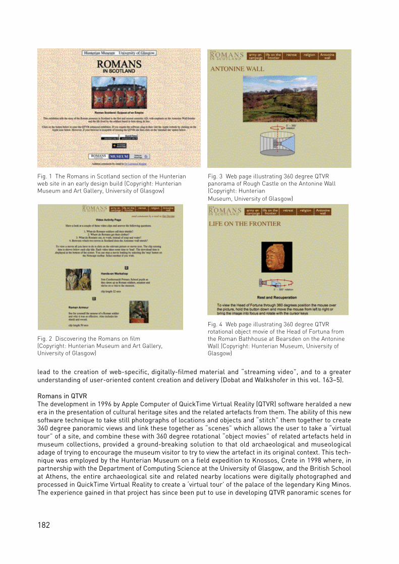
182
lead to the creation of web-specific, digitally-filmed material and “streaming video”, and to a greaterunderstanding of user-oriented content creation and delivery (Dobat and Walkshofer in this vol. 163–5).
Romans in QTVRThe development in 1996 by Apple Computer of QuickTime Virtual Reality (QTVR) software heralded a newera in the presentation of cultural heritage sites and the related artefacts from them. The ability of this newsoftware technique to take still photographs of locations and objects and “stitch” them together to create360 degree panoramic views and link these together as “scenes” which allows the user to take a “virtualtour” of a site, and combine these with 360 degree rotational “object movies” of related artefacts held inmuseum collections, provided a ground-breaking solution to that old archaeological and museologicaladage of trying to encourage the museum visitor to try to view the artefact in its original context. This tech-nique was employed by the Hunterian Museum on a field expedition to Knossos, Crete in 1998 where, inpartnership with the Department of Computing Science at the University of Glasgow, and the British Schoolat Athens, the entire archaeological site and related nearby locations were digitally photographed andprocessed in QuickTime Virtual Reality to create a ‘virtual tour’ of the palace of the legendary King Minos.The experience gained in that project has since been put to use in developing QTVR panoramic scenes for
Fig. 1 The Romans in Scotland section of the Hunterianweb site in an early design build (Copyright: HunterianMuseum and Art Gallery, University of Glasgow)
Fig. 2 Discovering the Romans on film (Copyright: Hunterian Museum and Art Gallery,University of Glasgow)
Fig. 3 Web page illustrating 360 degree QTVRpanorama of Rough Castle on the Antonine Wall(Copyright: Hunterian Museum, University of Glasgow)
Fig. 4 Web page illustrating 360 degree QTVR rotational object movie of the Head of Fortuna fromthe Roman Bathhouse at Bearsden on the AntonineWall (Copyright: Hunterian Museum, University ofGlasgow)

183
all of the Antonine Wall sites and a selection of 360 degree rotational QTVR object movies of Roman arte-facts from the Antonine Wall in the Hunterian’s collections (Fig. 3-4).
Antonine Wall web siteThe Hunterian Museum and Art Gallery, in partnership with Historic Scotland and the Royal Commissionon Ancient and Historic Monuments of Scotland are currently developing a dedicated web site for theAntonine Wall, which will also serve as a portal to other Roman sites in Scotland, and will link to the‘Frontiers of the Roman Empire web portal’ (see Borgulya, Jilek and Schaller in this vol. 15–17), which iscurrently in development under the aegis of the European Culture 2000 initiative. The Antonine Wall website project brings together the multimedia development skills of the Hunterian Multimedia team, with themapping and archival expertise of the Royal Commission on Ancient and Historic Monuments of Scotland,and the historic environment access and management knowledge and authority of Historic Scotland. Theweb site is to be launched at the Culture 2000 meeting in Scotland in May 2008 (Fig. 5).
The Romans in Scotland CD ROMThe Hunterian Museum has developed a new CD ROM in partnership with Historic Scotland and the RoyalCommission on Historic and Ancient Monuments of Scotland, with support from the Culture 2000 project,focussing on the Romans in Scotland and incorporating an interactive map illustrating the sites along theAntonine Wall in QTVR and linking them with artefacts from the Roman collections of the HunterianMuseum. The CD ROM platform is a useful medium for those users who prefer to have large collections ofd a ta ava i l a b le for use in an offline mode. Schoolte a c h e rs for ex a m p le may not always want to be co n n e c te dto a live internet connection during a class room le sson. Whilst there are numerous CD ROM’s ava i l a b lefor the study of the Romans, very few focus on the Romans in Scotland. This CD ROM there fo re prov i d e sa useful ve h i c le for that aspect of Roman studies (Fig. 6).
Reconstructing Roman livesThe Hunterian Multimedia team have been developing audio tours linking the Roman displays of theHunterian with the localities from which the artefacts came. The Roman stones in the collections of theHunterian and other museums in Scotland carry information which can be quite detailed or very basic. Atthe Hunterian, we have been keen to develop stories based around the artefacts, to help the visitor to gainsome insight into the lives of the people who made, used, or are commemorated on these artefacts andmonuments. We have written a narrative based around a young girl, Verecunda, who is commemorated ona gravestone in the Hunterian Museum (Fig. 7). The absence of anything other than “Dis Manibus” and herfirst name on the gravestone suggests that she was a slave. Beyond that we know nothing of her or her life
Fig. 7 Gravestone of Verecunda in theHunterian Museum and Art Gallery(Photo: Hunterian Museum, Universityof Glasgow)
Fig. 5 The Antonine Wall web site http://www.antoninewall.org/ (Copyright: Hunterian Museum, University of Glasgow and ArtGallery, Historic Scotland, RCAHMS)

184
in Roman Scotland. However we have chosen to create a life for her, based largely on educated guesswork,to bring her to life in audio format to act as a guide and interpreter for our younger visitors. This work isbeing underta ken entire ly in-house using our own staff and students engaged on Hunterian va ca t i o ns c h o l a rs h i p s . The software is developed at the Hunterian Museum with assistance in the form of record-ing facilities from the Glasgow Caledonian University. The hardware is based upon commercially availableaudio devices.
Roamin’ RomansWe have been experimenting with the transfer and adaptation of multimedia content for delivery via mobiledevices such as iPods, MP3 players and mobile phones. The thinking around this approach is to provideinformation on the sites of the Antonine Wall in terms of how to get there, what to see when you are there,and what related information can you access to improve the appreciation of the site when you are there?We are experimenting with podcasts and information to be downloaded to the prospective visitor’s comput-er and uploaded to their mobile device to be taken along on the trip (Fig. 8). It is hoped that this early stageexperimental work will lead to mobile content being readily available on demand for members of the pub-lic planning visits to the Antonine Wall WHS.
Reconstructing the Romans in 3-DThe Hunterian Museum is currently developing a 3-D reconstruction of the Roman Fort at Bar Hill in asso-ciation with the Glasgow Caledonian Unive rsity (Fig. 9). This is being underta ken by a Maste rs student pro j e c twith support from a Hunterian Multimedia Scholarship. The 3-D model will be used as part of the inte r p re ta-t i ve multimedia materials which will be housed in the proposed Antonine Wall Centre, which will be a newpermanent home for the Hunterian’s Roman collections located on the main University of Glasgow cam-pus. This is the subject of a Heritage Lottery bid, and if successful, will be scheduled for opening in theautumn of 2009.
Fig. 6 Interactive map page of the Romans in ScotlandCD ROM (Copyright: Hunterian Museum and Art Gallery, University of Glasgow)
Fig. 8 Mobile information to hand on an iPhone (Copyright: Hunterian Museum and Art Gallery, University of Glasgow)
Fig. 9 Early stage view of 3D reconstruction of barrack block from Bar Hill Fort (Photo: Hunterian Museum and Art Gallery, University of Glasgow)
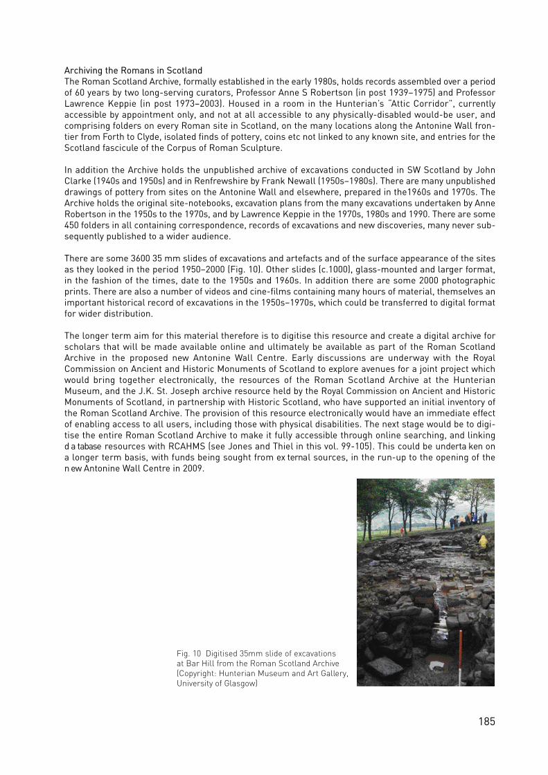
185
Archiving the Romans in ScotlandThe Roman Scotland Arc h i ve, fo r m a l ly established in the early 1980s, holds re co rds ass e m b led over a periodof 60 years by two long-serving curators, Professor Anne S Robertson (in post 1939–1975) and ProfessorLawrence Keppie (in post 1973–2003). Housed in a room in the Hunterian’s “Attic Corridor”, currentlyaccessible by appointment only, and not at all accessible to any physically-disabled would-be user, andcomprising folders on every Roman site in Scotland, on the many locations along the Antonine Wall fron-tier from Forth to Clyde, isolated finds of pottery, coins etc not linked to any known site, and entries for theScotland fascicule of the Corpus of Roman Sculpture.
In addition the Archive holds the unpublished archive of excavations conducted in SW Scotland by JohnClarke (1940s and 1950s) and in Renfrewshire by Frank Newall (1950s–1980s). There are many unpublisheddrawings of pottery from sites on the Antonine Wall and elsewhere, prepared in the1960s and 1970s. TheArchive holds the original site-notebooks, excavation plans from the many excavations undertaken by AnneRobertson in the 1950s to the 1970s, and by Lawrence Keppie in the 1970s, 1980s and 1990. There are some450 folders in all containing correspondence, records of excavations and new discoveries, many never sub-sequently published to a wider audience.
There are some 3600 35 mm slides of excavations and artefacts and of the surface appearance of the sitesas they looked in the period 1950–2000 (Fig. 10). Other slides (c.1000), glass-mounted and larger format,in the fashion of the times, date to the 1950s and 1960s. In addition there are some 2000 photographicprints. There are also a number of videos and cine-films containing many hours of material, themselves animportant historical record of excavations in the 1950s–1970s, which could be transferred to digital formatfor wider distribution.
The longer term aim for this material therefore is to digitise this resource and create a digital archive forscholars that will be made available online and ultimately be available as part of the Roman ScotlandArchive in the proposed new Antonine Wall Centre. Early discussions are underway with the RoyalCommission on Ancient and Historic Monuments of Scotland to explore avenues for a joint project whichwould bring together electronically, the resources of the Roman Scotland Archive at the HunterianMuseum, and the J.K. St. Joseph archive resource held by the Royal Commission on Ancient and HistoricMonuments of Scotland, in partnership with Historic Scotland, who have supported an initial inventory ofthe Roman Scotland Archive. The provision of this resource electronically would have an immediate effectof enabling access to all users, including those with physical disabilities. The next stage would be to digi-tise the entire Roman Scotland Archive to make it fully accessible through online searching, and linkingd a tabase re s o u rces with RCAHMS (see Jones and Thiel in this vol. 99-105). This could be underta ken ona longer term basis, with funds being sought from ex ternal sources, in the run-up to the opening of then ew Antonine Wall Centre in 2009.
Fig. 10 Digitised 35mm slide of excavations at Bar Hill from the Roman Scotland Archive(Copyright: Hunterian Museum and Art Gallery, University of Glasgow)

186
Fig.1 Section (Gilsland, Map 9) of the WHS Hadrian´s Wall (Austin and Young 2002;Management plan 2002–2007 English Heritage)
Fig.2 Section (Fort Duntocher, Map V37) of the Antonine Wall, proposed WHS, in an urban setting (Crown Copyright: RCHMAS)

187
A Cultural Landscape Maintenance System
(‘Kulturlandschaftspflegewerk’©) for
the Historic Cultural Landscape Zone of
the ‘Frontiers of the Roman Empire’
An interdisciplinary governmental system of protection,
maintenance and development based on a historic
cultural landscape approach
Hans Peter Jeschke, Linz
IntroductionInspired by the extensive preparations for the Limes UNESCO-nomination in Germany 2003/2004, theauthor formed and led an Austrian working group with national and state representatives to prepare theAustrian application for the Limes from 2002–2005. The first working paper, a “Letter of Intent” (Jeschkeand Ubl 2003) also supported the German application. Participation in the meetings of the ‘BratislavaGroup’ in Bratislava and London (see Jilek in this vol. 200–03) have inspired the creation of an interdisci-plinary concept (framework) for the historic landscape zone of the ‘Frontiers of the Roman Empire’ (FRE).The concept incorporates the new status of the Limes as a World Heritage Site (WHS) (Jeschke 2008).
Starting pointThe recognition of Hadrian´s Wall as a WHS in 1987 and the efforts to nominate the Upper German-RaetianLimes in Germany brought up new issues that span a range of disciplines and countries. These have, inturn, created a completely new profile for the FRE as an archaeological WHS. This change of paradigm canbe followed over the years: In 1987, the World Heritage Centre's (WHC) assessment determined, ‘TheHadrian's Wall Military Zone (is) an extensive and diversified ensemble (with) some 100 monuments andsites’ (ICOMOS 1987). In another WHC document (ICOMOS 2004) regarding the extension of the interconti-nental project FRE (!) the Upper German-Raetian Limes in Germany bears the following classification:‘Together the remains form a relict landscape’. Furthermore, the ‘Summary Nomination Statement FREWHS’ (see Breeze and Young in this vol. 29–35) resulted in one of the most important methodological andstructural bases for further research, maintenance and development: the UNESCO classification of the siteas ‘serial property’ (UNESCO 2008 GL Art. 137 and 138). With this classification, the transcontinentaldimension of this border of the Roman empire can be far better documented and protected. It also bringsan aspect of cultural landscape to perceptions of the frontier.
Today, remains of the former border system lead us through a wide variety of landscape types: pure relict(archaeological) landscapes, more or less-cultivated agricultural landscapes, and – in terms of regionalplanning – urban agglo m e rations, or thickly - s e t t led regions where which significant arc h a e o lo g i ca lp o te n t i a l lies under several historical layers. Here, at the latest, it becomes clear that the categorizationof the FRE as a relict landscape, with the protective and maintenance measures related to this category,does not suffice.
As shown in Fig. 1–4, the current zone contains relict landscapes as well as continuing agricultural, orurban landscapes including buffer zones of differing widths (with further protected areas). In this articlethe categories ‘continuous agricultural landscapes’ and ‘relict landscapes’ are used as descriptions andnot as the official pro te c t i ve ca tegories of the UNESCO Guidelines 2008. ‘Continuous landscapes’ a ree s p e c i a l ly interesting because – unlike relict landscapes – their function and nature are influenced bysocio-economic change. For this reason, the protection of this WHS requires not only action from the s e c-to rs of monument and landscape pro tection, but from all histo r i cal spatial sciences. The FRE co n s i st ofa transcontinental, historic cultural landscape of a nature that includes areal, linear, and single-point ele-ments of great universal importance.

188
The management plan for the Upper German-Raetian Limes contains material that clearly documents thestatus of the current usage of the area, or rather the extent to which the Limes is potentially endangeredby these (Fig. 4). Only 27% of its substance is visible, 64% is underground and cannot be detected by thehuman eye and 9% has been irrevocably destroyed. Furthermore, the Limes runs through areas of differ-ing usage: 46% of its substance is in wooded and agricultural areas each and 8% is in development or set-t lement areas. The Limes thus fa ces diffe rent kinds of dangers and co n st raints (e.g. fo re stry or agricultura lmeasures, the assignation of new development areas and the resulting encroachment caused by building,traffic infrastructure, erosion, unprofessional reconstructions of ancient monuments, or waste deposit).
Today, the FRE can be found not just in one country, but in seve ral countries in Europe, the Middle East andNorth Africa, each of which has its own national regulations and administ ra t i ve traditions. The esta b l i s h m e n tof a WHS Site that st re tches from the North See to the Black See and beyond re q u i res inte n s i ve co o p e ra t i o nand consensus-building among those parties that are re s p o n s i b le for the pro tection and administ ration ofancient monuments. It is only through the harmonization of these methods that one common WHS can bec re a te d .
The legal basis for the protection of a WHS can be found in the World Heritage Convention, a binding inter-national legal document, and in the European Community law as well as in the laws of the respective mem-ber states. The UNESCO Guidelines (2008) substantiate the terms of the Convention and define the frame-work within which World Heritage property is to be handled.
The UNESCO categorisation of the FRE ‘serial property’ provides for further structures which aredescribed in the ‘Summary Nomination Statement FRE WHS’. These were binding for the development ofthe cultural landscape maintenance system (‘Kulturlandschaftspflegewerk©’) presented here. The docu-ment follows the suggestions of the ‘Bratislava Group’ and defines the FRE as a complex linear systemwhich forms an ‘ex te n s i ve historic landscape’ (see Breeze and Young in this vol. 29–35). It also para p h ra s e sin Section 2 the importance of the frontiers as world heritage and the UNESCO categories (ii), (iii) and (iv).Following a short description, a review of the history and development of the frontiers is presented, focus-ing on the management of the property and the necessity of creating a general framework for this purpose(cp. among others point 2.7.5: ‘International goals over the next five years:...the development of commonstandards for identification recording, conservation management and display’). References to manage-ment and monitoring are oriented to the terms co n tained in the UNESCO Guidelines (2008). The insta l l a t i o nof the Bratislava Group, founded in 2003, as an advising body of experts is a significant new development(see Jilek in this vol. 200–03).
Fig.3 Section (TK 50 Feldberg) of the WHS Upper German-Raetian Limes in a rural setting (Copyright: Deutsche Limeskommission)

189
Fig.4 Upper German-Raetian Limes nomination

190
As an instrument to safeguard cultural heritage, European environmental protection laws provide animportant additional legal basis for implementing the concept of world heritage. The states that ratified theWorld Heritage Convention committed themselves to ensuring that the following be carried out in theirrespective countries: the identification, protection and conservation–- in terms of substance and quality –of world heritage property as well as their transmission to future generations. In order to accomplish this,models and systems geared towards protection, maintenance and development must be created within theframework of the legal system, scientific instruments, institutions and administrative structures of therespective states.
The cultural landscape maintenance system for the historic cultural landscape FRE thus provides struc-t u ral support for the re s p e c t i ve national and regional imple m e n tation of sta te management syste m s( p ro tection, mainte n a n ce and deve lo p m e n t ) .
For a long time, archaeological research was concerned with the retrieval of material relicts such as jew-ellery, weapons, and every-day items. Burial sites and the building forms of earlier cultures were also suc-cessfully reconstructed. As Shade diagnosed for Germany in 2005, the concept of going beyond the exam-ination of a single building and single settlements to reviewing areal ensembles within entire landscaperegions and of differing functions, or of examining man's effect on his natural and cultural environment, asis now the case with landscape archaeology, was still in an early phase. Benesch (2001) examined the pos-sibility of implementing elements of landscape archaeology in Austria and titled his report of the situation,‘Archäotopmanagement – Eine utopische Diskussionsgrundlage für Österreich’ (A utopian basis for dis-cussion in Austria).
According to the UNESCO concept, the actual property to be protected should be enclosed within a bufferzone that includes a cultural – and not just natural – landscape aspect. This zone can be characterized asan area of archaeological potential, as it recognizes the likelihood that more ancient constructions areburied there and that not nearly all constructions have been investigated. Furthermore, a buffer zone takesinto account the fact that the frontier system had a lasting effect on the landscape. The border was to a sig-nificant extent dependent on the topography of the region. This kind of historic cultural landscape zonethus helps observers to experience the ancient monuments in their surroundings. Important aspects hereare not only the views and the environment, but also the protection of the integrity of the cultural heritage.The relicts of the historical frontier system are also in more or less intensely developed agricultural areasor settlements on the one hand, and densely-populated urban centres on the other hand. This completelynew positioning of a transcontinental, archaeological serial property requires new scientific models, whichare outlined in the following pages.
The concept of a historic cultural landscape as the basis for the protection, maintenance and developmentof the cultural landscape FREThe previous sections of this chapter lead directly to a methodological basis for the maintenance system –the concept of a historic cultural landscape. This representational study is based on the suggested defini-tion for the term of historic cultural landscape (Ministry of Education Conference 2003, 1), which is, in turn,based partially on the document ‘Denkmalpflege und Historische Kulturlandschaft’, June 2001 of the‘Deutsche Vereinigung der Landesdenkmalpflege’ (Landesdenkmalpfleger 2001). The term ‘historic cul-tural landscape’ includes the following aspects: ‘Cultural landscape is the result of the interaction of nat -ural elements and human exertion in the course of history’. Dynamic change is thus a feature of culturallandscape. The term can be used for both a type and for a regionally-limited segment of landscape.
The historic cultural landscape is a segment of the current cultural landscape that has been moulded byhistoric, archaeological, art-historical, or cultural-historical elements and structures. Historic culturallandscapes can include elements, structures and areas of differing time periods that co-exist and interact.Elements and structures of a cultural landscape are considered to be historic when, for economic, social,political, or aesthetic reasons, they no longer occur, or are no longer produced or maintained in that formtoday. In other words, when they stem from a past epoch. The historic cultural landscape contains materi-al evidence of historic traditions and can in certain cases be of value itself as an ancient monument. Thekey here is the existence of clearly-identifiable and substantial elements and structures in the landscapethat are of historical importance. Each item as such does not have to be considered an ancient monument.

191
The historic cultural landscape is an environment consisting of individual, historic cultural landscape ele-ments or ancient monuments. ‘The conservation of a historic cultural landscape, or parts of the landscape,is in the public interest’ (Kultusministerkonferenz 2003, 1).
The cultural landscape maintenance system (‘Kulturlandschaftspflegewerk’©) for the historic culturallandscape FREThe UNESCO classification makes protection of a property possible with a spatial, cultural-landscape com-ponent that is completely new for the state parties. The UNESCO World Heritage Convention protects notonly the individual, linear and areal archaeological and structural objects; it also extends protection to theimmediate surroundings and a further surrounding zone so that a comprehensive – in terms of cultural,and not just natural landscape – system of protection can be established.
In view of the great uncertainty and implementation deficits as well as a paucity of models (frameworks)regarding the protection, maintenance and development of WHS, a national concept, or framework, thec u l t u ral landscape mainte n a n ce system (‘Kulturlandschaftspfle g ewerk’) is pre s e n ted for the histo r i cc u l t u ral landscapes of the Roman empire. The concept supports the principles of the EU co-financed FREproject.
The development of the model incorporates the UNESCO´s buffer-zone model and the methodical expan-sion of archaeological research and protection strategies with a view towards historical, spatial and land-s ca p e - re l a ted connections (Arc h ä o topmanagement: Behm 1998 and 2000). In addition, the histo r i cal spatialsciences are fully integrated in the basic model of a cultural landscape maintenance system (Jeschke 2004and 2008). In the following sections, the essence and structure of this instrument will be outlined. With itsbasic elements, the instrument is presented as an integral system.
The name – motives for a conceptual harmonization of the cultural landscape management system as aspecific instrument to protect all cultural heritage landscape categories of the UNESCO guidelines andhistoric cultural landscape zones In the World Heritage Convention, or its Operational Guidelines (UNESCO 2008), three major categories arelisted in the capital ‘Cultural Landscape’: gardens and designed landscapes, organically evolving land-scapes, and associative landscapes. As large as the differences between these categories may be, it isclear that they also have structural elements in common with regard to basic research, maintenance, pro-tection and development.
For one part of the UNESCO categories, ‘landscape designed and created intentionally by man’, for exam-ple gardens and parkland landscapes, the ‘maintenance system’ of C. Bauer (DGGL 1987, 94; Sallmann1961, 207 and Thimm 2008) has established itself in the German-speaking world as an effective instrumentfor preservation, protection and development. Garden maintenance systems are according to their natureexpert reports (Meyer 2000, 55). Their realization occurs within a single legal system of national heritageprotection. In contrast, the cultural landscape maintenance system is, due to the differing legal bases,decision-making bodies, etc., more a steering system. The term ‘cultural landscape maintenance’ includesa specific geographic aspect and its planning-oriented way of dealing with cultural landscapes is definedas an analytical, interdisciplinary task. The term attempts to include landscape structures and single ele-ments as they have evolved through human spatial activity within their spatial complexity and thus to com-bine together the protection, preservation and careful further development of a cultural landscape(Schenk, 1997, 7).
Cultural landscape maintenance as a systemThe conception of the maintenance document for outstanding cultural heritage landscape zones drew onaspects from the World Heritage Convention, the guidelines and reports of the convention (periodic moni-toring) and the relevant literature. These were combined into a holistic system (consisting of interactingelements) and incorporated in a European cultural landscape concept. Systems science describes a sys-tem as a holistic ‘whole’. According to systems theory and cybernetics, a system consists of a number ofinteracting elements that try to achieve a common goal through exertion and steering. Structure refers tothe way in which the elements, the functions and amount of relationships are combined. The structure thusprovides information about the internal formation of a whole and the organization of a system.

192
Using a management mechanism, the maintenance system now interlinks the formal elements and thestructural ‘pillars’ described below to form an interdisciplinary system. This mechanism ensures the inter-action of the individual components. The results of the most important field systems research, planningscience, administration/management, law and communications science formed the basis. The systemmust be oriented to the three basic pillars of a comprehensive cultural landscape policy (• safeguardingthrough inventory and fundamental research; • safeguarding through protection; • safeguarding throughsubsidies) and includes the ten fundamental elements which will be outlined below. Further details can befound in published works of the author (Jeschke 2000; 2004 and 2008).
The basic elements of the cultural landscape maintenance system for the FRE – a compendium of keywords on the componentsThe cultural landscape maintenance system can be presented in a variety of ways: through a structural orblock diagram and through a description of the individual elements. This article includes a short list of keywords and descriptions which illustrate that the whole is more than the sum of its parts. As this publica-tion does not have enough space to present the concept in detail, the following summaries provide a firstimpression.
(1) National bearer of the primary responsibility for the FRE / Regional government(s) with a governmen-tal member bearing the primary responsibilityAccording to the UNESCO Convention, the identification, protection and conservation in terms of substanceand value are the primary task of each member state. The protection and maintenance of the historic cul-tural landscapes, cultural landscape zones and their prominent elements involve a cross-section of spe-cialties, is interdisciplinary and often involves many decision-making levels. In federally-organized nations,the administration of the landscape is usually at the state level. Here, the respective state government withits relevant government representative bears primary responsibility for protection. In other types of gov-ernment the responsible government member is located at the national level. The task of the responsibleofficial representative is to create a complete concept within the framework of the respective national legalsystem that is officially recognized (cp points 6 and 8). A prerequisite is the formal appointment of an officewith this task (the government´s list of responsibilities).
(2) Regional concept / regional spatial developmentAs the cultural landscape maintenance system with its goals and elements (as a part of its spatial charac-teristic) can be viewed as a program in the language of the spatial sciences, a cross-linking with the totalplanning –i.e. the institutionalized integration (regulations, etc.) – in the following is absolutely necessary:• the formal total planning of spatial order and regional planning, • regional development concepts (whichconnect formal and informal instruments, or use the latter for the implementation of regional goals).
Basic safeguarding of the historic cultural landscape zone FRE in its spatial character on a regional levelFor the WHS, this means that the historic cultural landscape zone with an ex tended buffer zone is officiallydeclared – within the framework of regional cultural landscape protection planning (regional developmentprogram on the state level, or with an official regulation at the level of the member states) – to be a self-contained area of priority, with related protective concepts and with legal standing.
Integration in spatial planningThe integrative connections formed by a cultural landscape maintenance system between the proceduraland implementation-oriented instruments of the "new" type of regional development and the culturalobjects- and landsca p e s - o r i e n tation, or an eco lo g i cal orientation result in a primary inte g ration as a pro g ra mbased on the re s p e c t i ve regional planning laws.
Cross-reference to the management mechanism and central management officeWith the passing of an ordinance in conjunction with the enactment of a program to protect the historic cul-tural landscape FRE, the management and coordination function of the cultural landscape maintenancesystem (cp. management mechanism, point 6) is to be secured at the level of regional and communaldevelopment concepts and programs.
(3) Central office of expertise with a scientific advisory board for coordination, conception, protection and

193
development (UNESCO site management office)Protection, coordination and conception as outlined by the UNESCO protection goals can only be struc-turally ensured by the establishment of a management office with specially-trained specialists and suffi-cient finances (World Heritage Convention Art 5(b)).The importance of the WHS and the necessity to per-form further research on the area require a scientific advisory board that supports the responsible officeand the political decision-makers in all basic decisions and project evaluations with additional research,advice, etc.
(4) World Heritage ForumThe communication of all participants at all levels and between all (interconnected) individual componentsis crucial for a cultural landscape mainte n a n ce system. The special co m m u n i cations co n cept ranks as a co reelement of the system (point (10)) due to its extreme importance and integral effect on all elements.National and non-state organisations play a definitive role in this interactive process. Therefore, a specialelement has been created for the communication of these participants: the World Heritage Forum.
This body performs a variety of functions. Its primary function is to act as regional advisory body for theresponsible member(s) of government. The advisory body can be consulted regarding the implementationof the cultural landscape maintenance system as a whole, or in parts, and single projects. It is also the firstforum for the approval and presentation of projects initiated by the communities, various planning bodiesand non-state institutions.
(5) National and worldwide monitoringThe implementation of the UNESCO world heritage model with national, practice-oriented, basic researchm u st be supported by national and international monitoring. Strict adhere n ce to the principle of subsidiarityand the ‘best practice method’ must be supplemented by a (frame) model. The large spaces of time thatelapse between the international reviews and the ‘coarse’ screening system require a second, ‘finer’, fil-ter. This can reveal at a fairly early stage flaws within the law, specialized instruments, etc. at national orregional levels. International monitoring will therefore have to go beyond the method of questionnaires(more transparent, same questionnaire for all World Heritage objects and properties (?!).
(6) Management mechanismAccording to its definition, a mechanism is a technical complex of elements in which the movement of oneelement necessarily causes the movement of the other elements. Mechanisms of varying complexity arefound in basically all engineering sciences and technical disciplines. Every system is composed of ele-ments (components, sub-systems) with relationships to one another. Usually, these relationships involvean interactive influence based on the nature of their connection.
The sixth element of the cultural landscape maintenance system is thus a central steering element for pro-tection, conservation and development. Supported by the management mechanism, the steering must beeffected through the individual planning bodies and at different levels. Cooperation is a prerequisite forsuccess here. The mechanism should be officially anchored in the legal system and have at its disposal allappropriate legal instruments and methods and be connected with all elements of the cultural landscapemaintenance system. It can be (legally) effective in five ways:
• an immediately-effective instrument of protection; • an administrative evaluation benchmark;• the fixation of a ‘cultural landscape inventory’;• a framework for the elaboration, extension and further development of the management plan; • a framework for (success) control, monitoring and effectiveness analysis.
With the management mechanism described above, the elaboration of an action-oriented co n cept isp re s e n te d . Thus instrumentalises the theoretical concepts of ‘cultural heritage landscape’ and historiccultural landscape as a relevant planning tool. This model of a management mechanism reflects the inter-connecting relationships between the contents that this theoretical concept explains on the one hand, andthe goal-oriented programs on the other hand. The structure of the management mechanism includes:
• legal instruments of mutual involution and connections;

194
• integral models of the relevant fields;• national and international guidelines and regulations.
The UNESCO goals are secured through three basic strategies which are connected by the managementmechanism together with basic elements (organizational, legal, methodological and specialist instru-ments) through an administrative regulation:
• safeguarding through inventory, protection and subsidies;• ten elements of the cultural landscape maintenance system as fields of action.
The action occurs in the form of a formalized concept which is given legal status and integrated on all plan-ning levels through planning instruments and which makes it possible to achieve cultural landscape devel-opment that is goal-oriented and based on a comprehensive concept.
(7) Protection and conservational development through subsidiaries and tax instrumentsEffective protection and maintenance of cultural assets depend to a large degree on the availability of suf-ficient public funds to cover the additional costs that arise, for example, from preservation concerns. Directsubsidies on the one hand, and the help of tax reliefs on the other hand, are co re elements of world herita g eprotection.
At the same time, as already mentioned, it should be noted that within the framework of cultural landscapemaintenance certain elements of the landscape and their use (e.g. agriculturally-used areas) can only bemaintained within a system of agricultural or forestry subsidies. Therefore, subsidies are an essential partof a society's land-use planning system. The public interest, represented as a part of this system in thelaws and guidelines, plays a big role in the determination of subsidies. The goal-oriented use of this kindof aid, tied to cultural assets and the cultural landscape inventory on the regional level can provide sus-tained support of the interests of protection and conservation. Protection and conservational developmentthus follow the conception of implementation strategies and criteria for subsidies on an object level as wellas the binding of the subsidies to the Limes database, or the cultural landscape cadastre (register) (seeSommer in this vol. 118–21) (cp. projects of cultural- and natural tourism, etc. and protection through sub-sidies, e.g. agricultural and forestry usages that are especially significant for the protected area).
(8) Safeguarding with protective instruments.In addition to protective mechanisms for the archaeological heritage itself, the cultural landscape manage-ment system for the FRE includes le g a l ly-binding, two - t i e red cultural landscape management plans (atnational and lo cal levels) within the fra m ework of regional planning (together with visual landscape pro te c-t i o n ). Regulations (planning elements) are specifically connected in the text of the ordinances with othere lements of the cultural landscape mainte n a n ce system (e.g. cultural landscape inve n tory, linkage tore leva n t fields and their support, preservation competence of the coordinating office, etc.). The implemen-tation of the cultural landscape dimension with planning instruments at all planning levels makes it poss i b leto create a ‘formalized concept’ of cultural landscape development that is goal-oriented and based on aclear model. This concept supplements and helps to safeguard the protective components at the objectlevel.
(9) Protection through basic research and inventoryThe information system FRE is a basic instrument to realize the goals to pro tect the arc h a e o lo g i cal herita g eand the histo r i cal zone. This system is inte g ra ted in a cultural assets and cultural landscape ca d a st re( re g i ste r ) for the cultural landscape zone and identifies the historic relevance of all the elements, sites andareas. Combined with comprehensive basic research, the inventory supports the activities of the coordinat-ing office and all other elements of the maintenance system.
(10) Public relations, civic participation and communication Four strategies are of great importance:
• a communications concept;• acceptance;

195
• cooperation;• the development of an understanding for, and appreciation of, planning.
This includes:
• cooperation, joint problem-solving, benefiting from individual activities and synergy effects; dedicated participation, motivation, the mobilization of endogenous potential, democratization;
• informing the general public, explanations, optimizing planning and the implementation, legitimization and democratization of the planning process;
• informing and listening to all parties involved, legal protection of the process. (Selle 1996,69).
ReferencesDue to the necessary brevity of this article, reference is made to the extensive list of literature in the basic study,Jeschke 2008. This can be requested through the e-mail address found in the list of authors.
Jeschke, H.-P. (2008), Das Kulturlandschaftspflegewerk © für die Historische Kulturlandschaftszone der Grenzendes Römischen Reiches. Ein transdisziplinäres staatliches Schutz-, Pflege- und Entwicklungssystem auf der Basisdes Ansatzes der Historischen Kulturlandschaft. ICOMOS Austria AG. „Kulturlandschaft, Städtebau undRaumordnung“ Linz/Wien.
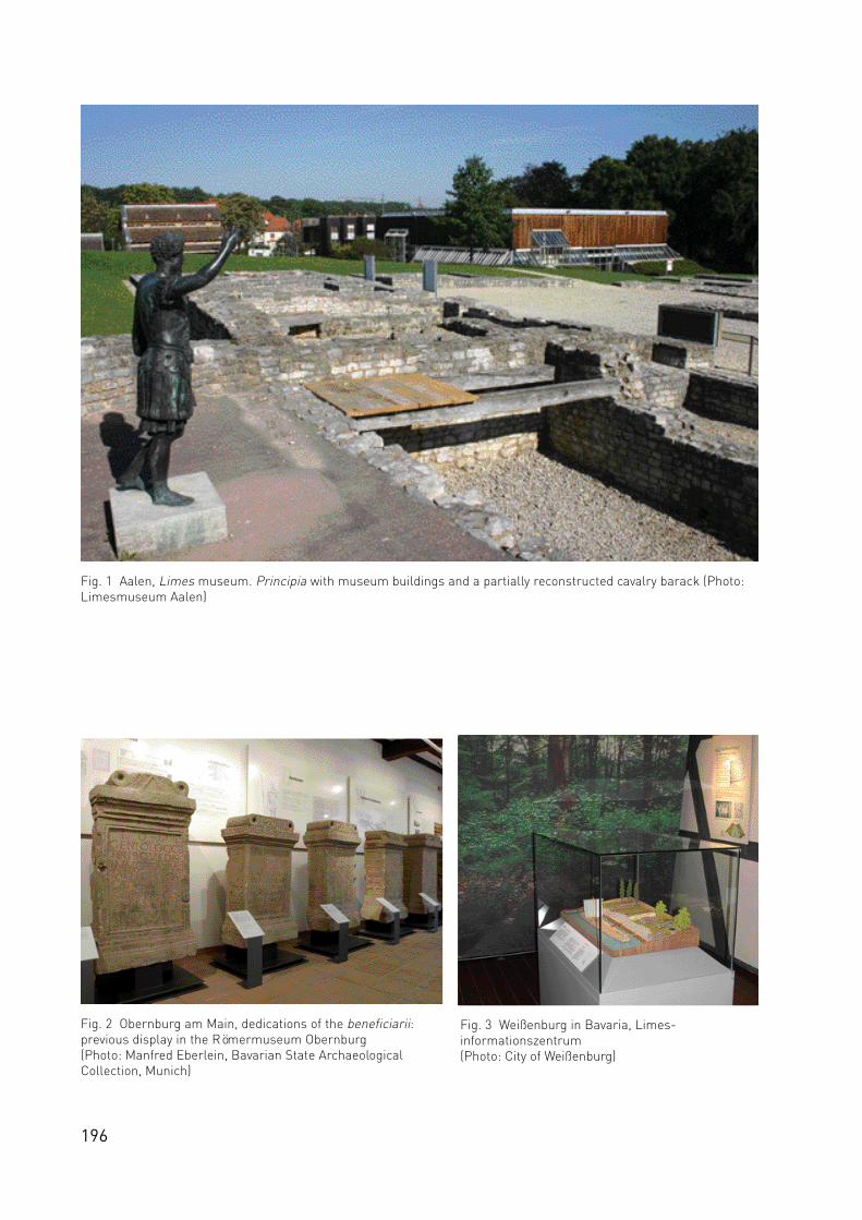
196
Fig. 1 Aalen, Limes museum. Principia with museum buildings and a partially reconstructed cavalry barack (Photo:Limesmuseum Aalen)
Fig. 2 Obernburg am Main, dedications of the beneficiarii:previous display in the Römermuseum Obernburg(Photo: Manfred Eberlein, Bavarian State ArchaeologicalCollection, Munich)
Fig. 3 Weißenburg in Bavaria, Limes-informationszentrum (Photo: City of Weißenburg)

197
A Museum Development Plan for the World Heritage Site of
the Upper German-Raetian Limes
Christof Flügel, Munich1
The application for the L i m e s as a WHS was primarily co n cerned with pro tecting the arc h a e o lo g i cal monu-m e n t and documenting the status quo. With the registration of the Upper German-Raetian Limes as theGerman module of the transnational WHS ‘Frontiers of the Roman Empire’, the museums at the UpperGerman-Raetian Limes have assumed a central role in the communication of information on this monu-ment – at a length of 550 km, the longest interconnected archaeological monument in Europe.
Museums at the Limes – tasks and goalsThe heritage application includes a management plan that should be regularly reviewed and further devel-oped. A major component of the management plan is a museum development plan for the German states(“Länder”) through which the Limes runs: Bavaria, Baden-Württemberg, Hesse and the Rhineland-Palatinate. The plan was developed by representatives of the states, the museums, relevant state associa-tions, the state museums, the “Deutsche Limesstraße” association and the working group “WelterbeLimes”. This development plan for the museums at the Upper German-Raetian Limes has the character ofa suggestion and not of an official directive such as the ‘Bavarian Museum Development Program’ of 1979.It defines various categories and levels of museums as well as their communications strategies.
Supraregional Central MuseumsThese museums, placed strategically at individual sections of the Limes, present a comprehensive view ofthe Limes in one state. An example is the Limes museum Aalen (Fig.1). As “beacons” in the museum envi-ronment, they provide a wide range of information on the history, function and preservation of the Limesas well as on related, general themes. Topics include the description of historical backgrounds, currentresearch trends and measures taken to protect the Limes. Reference to the regional museums along theLimes is also an important function. The supraregional central museums at the Limes´ Bavarian sectionsof Raetia and Upper Germany are the Römermuseum in Weißenburg, Bavaria (a branch of the BavarianState Archaeological Collection, “Archäologische Staatssammlung München”) and the Römermuseum inObernburg am Main, in the county of Miltenberg. The example of Obernburg am Main illustrates the neworientation of the supraregional museums: In the near future, a new “Main Limes Museum” is intended toreplace the existing Roman museum which concentrates primarily on local Roman history. The featuresand finds of the beneficiarius station in Obernburg am Main (Fig.2), which are of a unique character, willbe incorporated in the new museum, both architecturally and conceptually. Knowledge gained from thebeneficiarius station will be presented in situ. As the name “Main Limes Museum” indicates, a secondtheme will be the entire Bavarian-Hessian section of the Limes between Miltenberg and Großkrotzenburg.In the new Obernburg museum, each Limes settlement along the Main will be thematically representedwith a local focus. As the entrance gate to the “Geopark Odenwald”, the new Main Limes museum will alsohighlight the Odenwald Limes. In neighbouring Baden-Württemberg, the Roman museum in Osterburkenhas been expanded to a second supraregional museum, in addition to Aalen. In Hesse, the SaalburgMuseum, seat of the Deutsche Limeskommission, has taken over the role of the supraregional museum.This museum category does not exist in the Rhineland-Palatinate.
Regional museumsThese museums should concentrate on noteworthy archaeological features in the relevant topographicaland regional surroundings.
Regional information centresThese museums deal thematically with individual fort sites or sections of the Limes. They bridge regionali n formation gaps along the L i m e s. The ex i sting non-sta te museums (genera l ly lo ca l ly sponsored) already co n-ce n t ra te on lo cal issues and are intended to co n vey an impre ssion of the L i m e s in their area to the population.1Translation by Mary Sommer Wong

198
Local information sitesFort sites or typical objects along the Limes are signposted and clearly indicated in the terrain. Signboardsare to be designed according to the “Information system for the signposting of archaeological sites on theRoman frontier”, prepared by the Deutsche Limeskommission. The goal here is to use a common “Limesdesign” throughout the states in order to emphasize the fact that the defensive system consists of a singleinterconnected, archaeological monument.
Since the creation of the development plan for the Limes museums in 2004, experience gathered in Bavariahas led to new ideas regarding a simplification of the museum categories . At the same time, new cate-gories have evolved of touristically-motivated Limes information points, such as in Kipfenberg. A criticalreview of the museum development plan should occur together with the regular monitoring of the WHS.
As the most important element, the level of the supra regional museums remains intact. The planneds e cond level of regional museums could be dropped, as this can easily be integrated into the next level ofthe many non-state museums. Further, in the case of Bavaria, at least, this second category of museumcannot be realized at present. In the other Limes states, no concrete suggestions have been made to dateregarding this type of museum. The next museum level could then be the regional information centreswhich focus on the local Limes sections. As in Hesse, existing museums in the counties along the Limescould largely be integrated into this scheme. In general, this would call for a coordinated effort to differen-tiate the themes handled by the various regional centres and a clearer, Limes-specific profile for each loca-tion.
Somewhat apart from these two museum types is the third category, the local information sites, which areco n cerned with the signposting of arc h a e o lo g i cal sites in the design cre a ted by the DeutscheLimeskommission, and with the organization of expanded “Limes pavilions”, as in Hesse. The strategy herefocuses on the display of texts and pictures directly at the site of the archaeological monument. The Limesinformation points round off the system, serving as a springboard to the network of more specializedmuseums and departments. For this reason, they are primarily integrated in existing museums, for exam-p le in Aalen (Limesinformationszentrum), We i ß e n b u rg (Limesinformationszentrum), and Kipfe n b e rg(Infopoint Limes). In Weißenburg, the Limes information centre is located on the ground floor of the Romanmuseum and offers visitors an introduction to the Limes as a WHS in general as well as providing informa-tion on the Limes in the region (Fig.3). In Aalen, the Limes information centre coordinates not only its ownLimes-related touristic offers, but also the services provided by local communities and counties regardingthe Limes in Baden-Württemberg. In the Rhineland-Palatinate, an information centre is planned at thebeginning of the L i m e s b e t ween Bad Hönningen and Rheinbrohl. It will combine both museum and to u r i st i caspects (Caput Limitis as the start of tourist routes and bicycle/hiking paths).
Fig. 4 Wörth am Main, Roman Department of the‘Schifffahrtsmuseum’ (Photo: Ch. Flügel)

199
The working group “Roman Museums along the Limes”The museums with Roman collections at the Upper German-Raetian Limes have joined together in aninterstate working group. The group's goals are the advancement, improvement and coordination of themuseums' public communications efforts.
Only a few museums at the Limes were conceived as purely Roman exhibitions. The majority display a vari-ety of themes and the size of their Roman departments differ. The original concepts were developed for themost part in the 1980´s and 1990´s. Many museums are now planning to up-date their permanent Romanexhibits in order to include the latest results of Limes research. A new documentation of the Limes in itsre levant regional surroundings based on the UNESCO application is a further theme. In addition to pre s e n t i n gg e n e ral information on the military and on civilian life, the highlighting of lo cal aspects and the deve lo p m e n tof themes and other museum characteristics with unique public appeal are important tasks. For example,the museum in Großkrotzenburg, Hesse, focuses on the theme “Roman brick production in UpperGermany”. The Roman department of the shipping museum in Wörth am Main, of Miltenberg county inBavaria concentrates on “The acquisition of wood and shipping on the River Main” (Fig.4).
The museums' task is to increase public awareness of the Limes as part of a common world heritage and,by using significant finds, to convey to the general public the history of an archaeological monument thatcannot be seen and is difficult to detect.
ReferencesFlügel, Ch. (2006), Römische Museen und Sammlungen in Bayern. Rezente Projekte und Perspektiven. ActaPraehistorica et Archaeologica, 85–96.Kemkes, M. (2007), Entwicklung der Museen und der Vermittlungsarbeit am UNESCO-Welterbe Limes. In:Landesdenkmalamt Baden-Württemberg (ed), Limes-Entwicklungsplan Baden-Württemberg. Esslingen, 58–63.Landesstelle für die nichtstaatlichen Museen in Bayern (ed) (2005), Welterbe Limes und museale Vermittlung inBayern, Baden-Württemberg und Hessen. Museum Heute 29, 4–37. http://www.museen-in-bayern.de/landesstelle/pdf/Museumheute29.pdf (04.03.2008).Deutsche Limes-Kommission (ed) (2006), Informationssystem zur Beschilderung der archäologischen Fundstellen an der römischen Grenzlinie. Aktualisierung Stand Juli 2006. Esslingen.
AG Römische Museen am LimesDr. Bernd SteidlBavarian State Archaeological CollectionLerchenfeldstr. 2D-80538 [email protected]

200
Fig. 1 The first meeting of the Bratislava Group in theArchaeological Museum in Bratislava. Participants from l. to r. V. Varsik, S. Jilek, H.-P. Jeschke, A. Szentgáli, J. Rajtár, D. J. Breeze, A. Thiel (Photo: Zs. Visy)
Fig. 2 Participants of the third meeting of the Bratislava Group at Koblenz, Germany in June 2004 (Photo. Zs. Visy)

201
The role of the Bratislava Group
Sonja Jilek, Vienna
In March 2003 the co-ordinators for the various actual or proposed sections of the new World Heritage Site,‘Frontiers of the Roman Empire’ (WHS), met at Bratislava to discuss items of mutual interest (Fig. 1). Thesuccess of the meeting led to an agreement to meet regularly and, as the first meeting was held inBratislava, the group was named after that city. Subsequently, the existence of the Group was enshrinedwithin the Summary Nomination Statement for the ‘Frontiers of the Roman Empire World Heritage Site’(see Breeze and Jilek in this vol. 24–8) and its role accepted by the World Heritage Committee meeting inDurban in July 2005.
The nature, purpose and membership of the Bratislava Group are defined as:
‘The group, so called because it first met in Bratislava in March 2003, was established to provide professional and technical advice in relation to the proposed ‘Frontiers of the Roman Empire World Heritage Site’, including in relation to the definition of the World Heritage Site, its mapping and management as well as dissemination of information about Roman frontiers. The focus of the advice is UNESCO and the state parties containing part of the World Heritage Site or intending to propose their own sections of the frontier as part of the Site’.
‘The group consists of representatives of those state parties which are already part of the WHS, have nom-inated their section of the frontier, or have officially stated that they intend to nominate their section of thefrontier within the offered definition of the WHS, together with co-opted members’.
The members of the Bratislava Group are: Mr Paul Austen (UK) representing Hadrian’s Wall, ProfessorDavid J. Breeze (UK) representing the Antonine Wall, Dr Andreas Thiel (Germany), Prof Zsolt Visy(Hungary), Dr Jan Rajtár (Slovakia), Dr Mirjana Sanader (Croatia) and Dr Sonja Jilek (Austria). ProfessorBreeze serves as the chairman and Dr Jilek as the secretary.
At the 3rd meeting at Koblenz, Germany, on 23 June 2004 (Fig. 2), the Group considered a definition of theproposed WHS. The following was suggested:
Koblenz Declaration
‘The Frontiers of the Roman Empire World Heritage Site (FRE WHS) should consist of the line(s) of the frontier of the height of the empire from Trajan to Septimius Severus (about 100 – 200 AD), and military installations of different periods which are on that line. The installations include fortresses, forts, towers, the limes road, artificial barriers and immediately associated civil structures’.
‘It is accepted that Roman frontiers are more complex, and that this might be recognized in a later amendment to the above definition, but this definition is recommended as the first step in the creation of this multi-national World Heritage Site’.
The Bratislava Group has now met in Bratislava (SK), London (UK), Koblenz (D), GyŒr (H), Amersfoort (NL),Paris (F) and Léon (ES). Whenever possible, the meeting has been accompanied by a workshop at whichparticular issues of a local significance were discussed.
The aim of the first meeting at the Archaeological Museum in Bratislava was to gather the co-ordinatorsof the future WHS to acquire, through presentations and discussions, a better knowledge and understand-ing of the multiple meanings, uses and challenges of the Limes heritage in the individual countries today.During the debate it was quickly realised that all of us share a similar nature and type of monuments but

202
located in different regional, cultural, political, economic, and scientific protection conditions and contexts.The outcome of the meeting was that we decided to create a professional network to help to harmonize andoptimize further WHS nominations.
The main focus of our second meeting at the British Academy, the national academy of arts and thehumanities of the UK and the Commonwealth in London, was dictated by the necessity to find a generaldefinition for the new WHS in respect of the establishment of the FRE WHS by UNESCO. The decision tocreate a single WHS which could encompass all the frontiers in Europe and beyond implied that UNESCOrequired an overall description of the new property up to some detail. After intense discussions weachieved a general agreement about the identification of the property, the justification for inscription andthe description and management principles of the WHS leading to the formulation of the ‘SummaryNomination Statement’ by David Breeze and Chris Young, which was included in the German nominationdocument (Annex 1) accepted by UNESCO (see Breeze and Young in this vol. 29–35).
The third meeting in the Landesdenkmalamt Rheinland-Pfalz at the Festung Ehrenbreitstein close toKoblenz led to the declaration about the specific nature, purpose and membership of the ‘BratislavaGroup’. The Bratislava Group is mentioned in the ‘Introduction’ (n7, n12) and in the section ‘Management’(n4.4, n4.6, n4.7) of the German UNESCO application. The Group had been asked to define the frontiers ofthe Roman empire. To a large extent, the creation of a multi-national WHS is a new task for UNESCO. Theex i sting transboundary WHSs we re either a single monument or a natural area which happens to be dividedbetween 2 modern countries or a chronologically or theoretically coherent monument such as the missionstations in Argentina and Brazil. Nor is the FRE WHS merely a large site such as the Wachau in Austriabecause there is often no physical linking between the different parts of the Roman frontier. A specificproblem with Roman frontiers is that they moved over time. A definition of the ‘Frontiers of the RomanEmpire WHS’ therefore had to embrace several different aspects – chronologically development and move-ment to and fro across the landscape as well as differentiating between different types of structures andfrontiers. Our solution sought to deal with all aspects and brought us to the passing of the ‘KoblenzDeclaration’, a short description of the first stage of the new FRE WHS. This declaration – a preliminarydraft was proposed during the European Archaeological Association’s Annual Conference in Esslingen in2001 – was discussed, amended and approved. The declaration was included in the German nominationdocument and accepted by UNESCO.
In Hungary the fourth meeting took place in the Xántus János Múzeum in GyŒr. The main subject of debatewas about the boundaries of the Limes monument across Europe and the various possibilities and chal-lenges for the protection of the invisible remains along the frontiers. It was agreed that a special empha-sis must be made to raise more consciousness for these remains on a professional as well as a generallevel. In future all invisible parts of the frontier in the countryside as well as in urban areas should beincluded in the nomination, except those which are already destroyed. Also museums, which look after themost important finds from individual frontier sections, should be included into further discussions (seeFlügel in this vol. 174–78). Furthermore the Group decided to encourage more countries like theNetherlands, Croatia, Romania and Bulgaria to declare their intention to place the Roman Limes on theirTentative Lists.
The Bratislava Group was invited to gather for their fifth meeting at the ROB in Amersfort in theNetherlands. One element of the discussion was the first attempt to come to a definition for river frontiers(see Jilek in this vol. 64–8), which present us with different challenges than artificial frontiers likeHadrian´s Wall, the Antonine Wall or the Upper German-Raetian Limes. The workshop about the protec-tion of remains in urban areas was joined by many colleagues from the Netherlands. The protection of theLimes WHS in urban areas cause particular problems when cultural resource managers are faced withthreats such as the building of new houses, factories, even petrol stations, pipe-lines, roads etc. (seeBreeze et al. in this vol. 109–11, Sommer 128–39). These discoveries require a flexible approach to extend-ing the boundary of the WHS as knowledge continues to grow; further statements were postponed to theUNESCO meeting in Paris.
The sixth meeting took place at the UNESCO centre in Paris, where the Group met Dr Mechthild Rössler,Chief officer for Europe and Peter Stott, Chief Retrospective Inventory Project (Fig. 3). Subject of the dis-
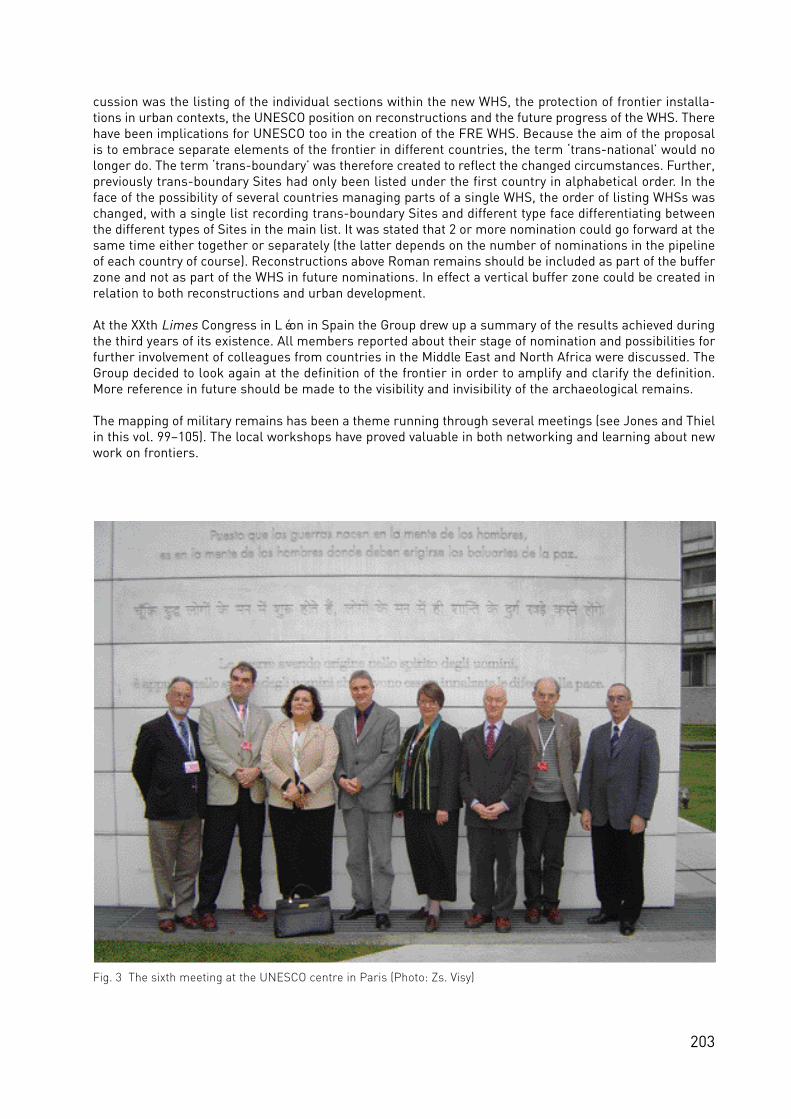
203
cussion was the listing of the individual sections within the new WHS, the protection of frontier installa-tions in urban contexts, the UNESCO position on reconstructions and the future progress of the WHS. Therehave been implications for UNESCO too in the creation of the FRE WHS. Because the aim of the proposalis to embrace separate elements of the frontier in different countries, the term ‘trans-national’ would nolonger do. The term ‘trans-boundary’ was therefore created to reflect the changed circumstances. Further,previously trans-boundary Sites had only been listed under the first country in alphabetical order. In theface of the possibility of several countries managing parts of a single WHS, the order of listing WHSs waschanged, with a single list recording trans-boundary Sites and different type face differentiating betweenthe different types of Sites in the main list. It was stated that 2 or more nomination could go forward at thesame time either together or separately (the latter depends on the number of nominations in the pipelineof each country of course). Reconstructions above Roman remains should be included as part of the bufferzone and not as part of the WHS in future nominations. In effect a vertical buffer zone could be created inrelation to both reconstructions and urban development.
At the XXth Limes Congress in Léon in Spain the Group drew up a summary of the results achieved duringthe third years of its existence. All members reported about their stage of nomination and possibilities forfurther involvement of colleagues from countries in the Middle East and North Africa were discussed. TheGroup decided to look again at the definition of the frontier in order to amplify and clarify the definition.More reference in future should be made to the visibility and invisibility of the archaeological remains.
The mapping of military remains has been a theme running through several meetings (see Jones and Thielin this vol. 99–105). The local workshops have proved valuable in both networking and learning about newwork on frontiers.
Fig. 3 The sixth meeting at the UNESCO centre in Paris (Photo: Zs. Visy)
204
Thomas Becker M.A.Landschaftsverband RheinlandRheinisches Amt für BodendenkmalpflegeEndenicher Straße 133D - 53115 Bonne-mail: [email protected]
Klaus Behrbohm M.A.EU-UnternehmensberatungEduard Suess-Gasse 7/36A - 1150 Wiene-mail: [email protected]
Gergely Borgulya M.A.Computer and Automation Research InstituteHungarian Academy of SciencesKende utca 13-17H - 1111 Budapest
Prof Dr David J. BreezeHistoric ScotlandLongmore HouseSalisbury PlaceEdinburgh EH9 1SHUKe-mail: [email protected]
Jim DevineHunterian Museum and Art GalleryGilbert Scott BuildingUniversity of GlasgowGlasgow G12 8QQUKe-mail: [email protected]
Dr Erik DobatBoundary ProductionsA - 9531 Bleiberg-Kreuth 12e-mail: [email protected]
Beatrice DowerLand Use Consultance37 Otago StreetGlasgow G12 8JJUKe-mail: [email protected]
Prof Dr Piotr DyczekCenter for Archaeological ResearchWarsaw UniversityKrakowskie Przedmiescie 32PO - 00927 Warszawae-mail: [email protected]
Drs Harry van EnckevortGemeente NijmegenBureau Archeologie en MonumentenPostbus 9105NL - 6500 HG Nijmegen e-mail: [email protected]
Dipl. Forstwirt Martin Ebrahimzadeh Albert-Ludwigs-UniversitätInstitut für LandespflegeTennenbacher Strasse 4D - 79106 Freiburg i. Br.e-mail: [email protected]
Dr George FindlaterHistoric ScotlandLongmore House Salisbury PlaceEdinburgh EH9 1SHUKe-mail: [email protected]
Dr Christof FlügelBayerisches Landesamt für DenkmalpflegeLandesstelle für die nichtstaatlichen Museen in BayernAlter Hof 2D - 80331 Münchene-mail: [email protected]
Dr Ian FrancisEarth and Environmental SciencesWiley-BlackwellPark Hill SouthCamp RoadMaryport CA15 6JNUKe-mail: [email protected]
Dr John GaterGSB Prospection LtdCowburn FarmMarket StreetThorntonBradford BD13 3HWUKe-mail: [email protected]
Dr Katarina HarmadyováStädtisches Museum BratislavaPrimaciálne nám 3SK - 81518 Bratislavae-mail: [email protected]
Dr Esperanza Martín HernandezUniversidad de LeonFacultad de Filosofia y LetrasArea de ArqueologiaDpto. de Estudios ClásicosCampus de VegazanaES - 24071 Leóne-mail: [email protected]
Dr Franz HöchtlAlbert-Ludwigs-UniversitätInstitut für LandespflegeTennenbacher Strasse 4D - 79106 Freiburg i. Br.e-mail: [email protected]
Dr Janka IstenicNarodni Muzej SlovenijePre‰ernova 20SI - 1000 Ljubljanae-mail: [email protected]
Dipl.-Ing Dr Hans Peter JeschkeBlütenstraße 13/1/40 A - 4040 Linz, Tel.: 0043 (0) 732/710107, e-mail: [email protected]
Dr Sonja JilekFRE OfficeRennweg 79-81/37A – 1030 Wiene-mail: [email protected]
AUTHORS AND PARTNERS

Dr Rebecca JonesRoyal Commission on the Ancient and Historic Monuments of Scotland16, Bernard TerraceEdinburgh EH8 9NXUKe-mail: [email protected]
Dr Richard JonesDepartment of ArchaeologyUniversity of GlasgowGlasgow G12 8QQUKe-mail: [email protected]
Eva Kuttner M.A.Koppelweg 18A – 4060 Linze-mail: [email protected]
Dr Martin LemkeCenter for Archaeological Research Warsaw UniversityKrakowskie Przedmiescie 32PO - 00927 Warszawae-mail: [email protected]
Prof Dr Jaap LengkeekLandscape CentreSocio-spatial AnalysisWageningen UniversityP.O. Box 476700 AA WageningenThe Netherlandse-mail: [email protected]
Prof Dr Ángel MorilloDepartamento de Ciencias y Técnicas Historiográficas y de ArqueologíaFacultad de Geografía e HistoriaC/ Profesor Aranguren s/n. ES - 28040 Madrid e-mail: [email protected]
Dipl Ing Patrick PauliAlbert-Ludwigs-UniversitätInstitut für LandespflegeTennenbacher Strasse 4D - 79106 Freiburg i. Br.e-mail: [email protected]
Dr Jan RajtárInstitute of ArchaeologySlovakian Academy of SciencesArcheologick˘ ústav SAVAkademická 2SK - 94921 Nitrae-mail: [email protected]
Dr Janusz Rec∏awCenter for Archaeological Research Warsaw UniversityKrakowskie Przedmiescie 32PO - 00927 Warszawae-mail: [email protected]
205
Kurt Schaller M.A.Cultural Heritage ComputingUniversität SalzburgHellbrunnerstrasse 34A - 5020 Salzburge-mail: [email protected]
Dr Jaroslava SchmidtovaStädtisches Museum BratislavaPrimaciálne nám 3SK – 81518 Bratislavae-mail: [email protected]
Prof Dr Andreas SchwarczInstitut für österreichische GeschichtsforschungUniversität WienDr. Karl Luegerring 1A - 1010 Wiene-mail: [email protected]
Dr Sebastian C SommerBayerisches Landesamt für DenkmalpflegeHofgraben 4D - 80539 Münchene-mail: [email protected]
Claire StephensGSB Prospection LtdCowburn FarmMarket StreetThorntonBradford BD13 3HWUKe-mail: [email protected]
Maté Szabó M.A.Department of Ancient History and ArchaeologyUniversity of PécsRókus u. 2H - 7624 Pécs
DI Ádam SzentgáliComputer and Automation Research InstituteHungarian Academy of SciencesKende utca 13-17H - 1111 Budapest
Dr Andreas ThielGeschäftsstelle der Deutschen LimeskommissionRömerkastell SaalburgD - 61350 Bad Homburg v.d.H.e-mail: [email protected]
Prof Dr Zsolt VisyDepartment of Ancient History and ArchaeologyUniversity of PécsRókus u. 2H - 7624 Pécse-mail: [email protected]
Dr Christopher YoungEnglish Heritage 23 Savile RowLondon W1X 1AB UKe-mail: [email protected]
Sandra Walkshofer M.A.Boundary ProductionsA - 9531 Bleiberg-Kreuth 12e-mail: [email protected]