
Planning Annualised Hours with a Finite Set of Weekly Working Hours and Joint Holidays
Upload
khangminh22Category
view
0download
0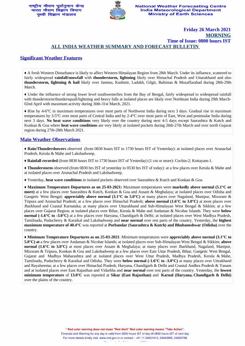
Friday 26 March 2021MORNING
Time of Issue: 0800 hours ISTALL INDIA WEATHER SUMMARY AND FORECAST BULLETIN
Significant Weather Features
♦ A fresh Western Disturbance is likely to affect Western Himalayan Region from 28th March. Under its influence, scattered to fairly widespread rainfall/snowfall with thunderstorm, lightning likely over Himachal Pradesh and Uttarakhand and also thunderstorm, lightning & hail likely over Jammu, Kashmir, Ladakh, Gilgit, Baltistan & Muzaffarabad during 28th-29th March.
♦ Under the influence of strong lower level southwesterlies from the Bay of Bengal, fairly widespread to widespread rainfall with thunderstorm/thundersquall/lightning and heavy falls at isolated places are likely over Northeast India during 29th March-02nd April with maximum activity during 30th-31st March, 2021.
♦ Rise by 4-6°C in maximum temperatures over most parts of Northwest India during next 3 days. Gradual rise in maximum temperatures by 3-5°C over most parts of Central India and by 2-4°C over most parts of East, West and peninsular India during next 3 days. No heat wave conditions very likely over the country during next 4-5 days except Saurashtra & Kutch and Konkan & Goa where heat wave conditions are very likely at isolated pockets during 26th-27th March and over north Gujarat region during 27th-28th March 2021.
Main Weather Observations
♦ Rain/Thundershowers observed (from 0830 hours IST to 1730 hours IST of Yesterday): at isolated places over Arunachal Pradesh, Kerala & Mahe and Lakshadweep.
♦ Rainfall recorded (from 0830 hours IST to 1730 hours IST of Yesterday) (1 cm or more): Cochin-2; Kottayam-1.
♦ Thunderstorm observed (from 0830 hrs IST of yesterday to 0530 hrs IST of today): at a few places over Kerala & Mahe and at isolated places over Arunachal Pradesh and Lakshadweep.
♦ Yesterday, heat wave conditions in isolated pockets observed over Saurashtra & Kutch and Konkan & Goa.
♦ Maximum Temperature Departures as on 25-03-2021: Maximum temperatures were markedly above normal (5.1°C or more) at a few places over Saurashtra & Kutch, Konkan & Goa and Assam & Meghalaya; at isolated places over Odisha and Gangetic West Bengal; appreciably above normal (3.1°C to 5.0°C) at many places over Nagaland, Manipur, Mizoram & Tripura and Arunachal Pradesh; at a few places over Himachal Pradesh; above normal (1.6°C to 3.0°C) at most places over Jharkhand and Coastal Karnataka; at many places over Uttarakhand and Sub-Himalayan West Bengal & Sikkim; at a few places over Gujarat Region; at isolated places over Bihar, Kerala & Mahe and Andaman & Nicobar Islands. They were below normal (-1.6°C to -3.0°C) at a few places over Haryana, Chandigarh & Delhi; at isolated places over West Madhya Pradesh, Tamilnadu, Puducherry & Karaikal and Lakshadweep and near normal over rest parts of the country. Yesterday, the highest maximum temperature of 40.4°C was reported at Porbandar (Saurashtra & Kutch) and Bhubaneshwar (Odisha) over the country.
♦ Minimum Temperature Departures as on 25-03-2021: Minimum temperatures were appreciably above normal (3.1°C to 5.0°C) at a few places over Andaman & Nicobar Islands; at isolated places over Sub-Himalayan West Bengal & Sikkim; above normal (1.6°C to 3.0°C) at most places over Assam & Meghalaya; at many places over Jharkhand, Nagaland, Manipur, Mizoram & Tripura, Konkan & Goa and Lakshadweep at a few places over East Uttar Pradesh, Bihar, Gangetic West Bengal, Gujarat and Madhya Maharashtra and at isolated places over West Uttar Pradesh, Madhya Pradesh, Kerala & Mahe, Tamilnadu, Puducherry & Karaikal and Odisha. They were below normal (-1.6°C to -3.0°C) at many places over Uttrakhand and Rayalseema; at a few places over Himachal Pradesh, Haryana, Chandigarh & Delhi and Coastal Andhra Pradesh & Yanam and at isolated places over East Rajasthan and Vidarbha and near normal over rest parts of the country. Yesterday, the lowest minimum temperature of 13.0°C was reported at Sikar (East Rajasthan) and Karnal (Haryana, Chandigarh & Delhi) over the plains of the country.
* Red color warning does not mean "Red Alert" Red color warning means "Take Action". Forecast and Warning for any day is valid from 0830 hours IST of day till 0830 hours IST of next day
For more details kindly visit www.imd.gov.in or contact : +91 11 24631913, 24643965, 24629798 (Service to the Nation since 1875)
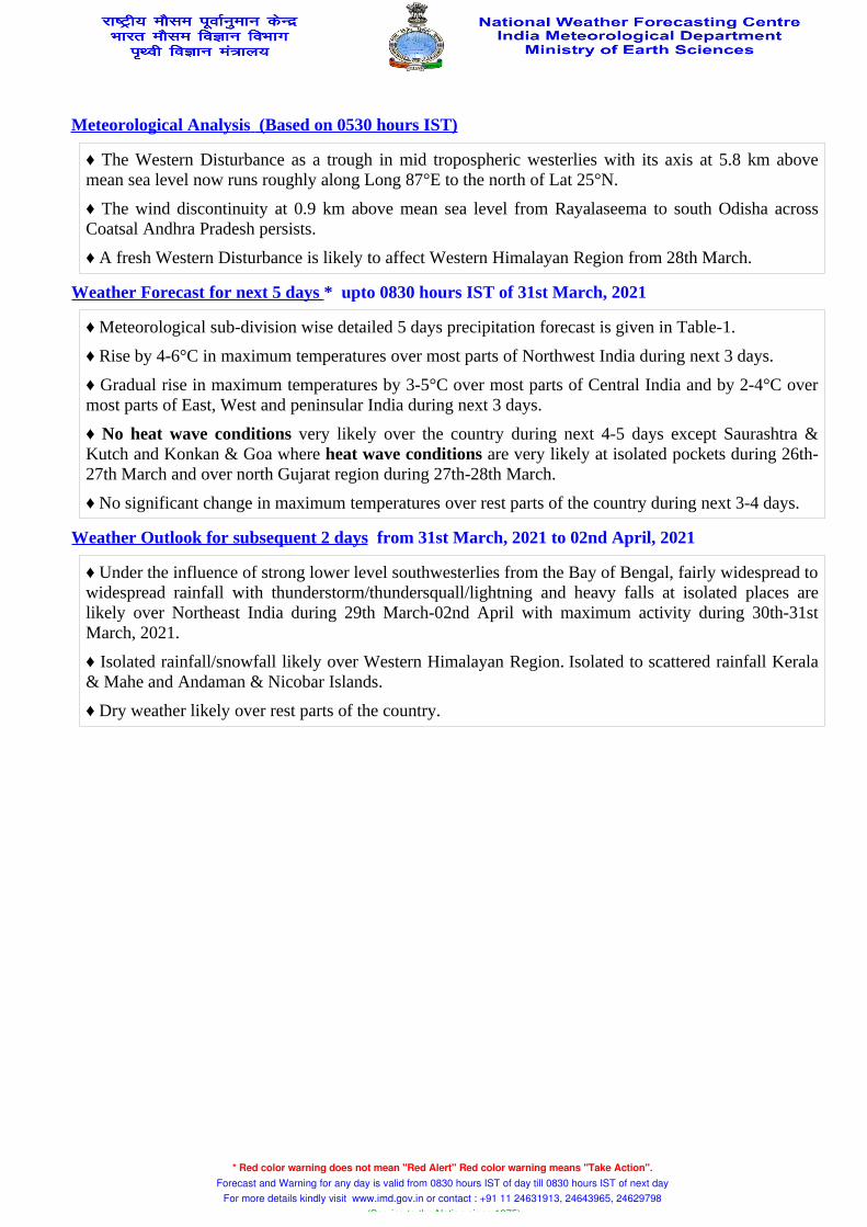
Meteorological Analysis (Based on 0530 hours IST)
♦ The Western Disturbance as a trough in mid tropospheric westerlies with its axis at 5.8 km above mean sea level now runs roughly along Long 87°E to the north of Lat 25°N.
♦ The wind discontinuity at 0.9 km above mean sea level from Rayalaseema to south Odisha across Coatsal Andhra Pradesh persists.
♦ A fresh Western Disturbance is likely to affect Western Himalayan Region from 28th March.
Weather Forecast for next 5 days * upto 0830 hours IST of 31st March, 2021
♦ Meteorological sub-division wise detailed 5 days precipitation forecast is given in Table-1.
♦ Rise by 4-6°C in maximum temperatures over most parts of Northwest India during next 3 days.
♦ Gradual rise in maximum temperatures by 3-5°C over most parts of Central India and by 2-4°C over most parts of East, West and peninsular India during next 3 days.
♦ No heat wave conditions very likely over the country during next 4-5 days except Saurashtra & Kutch and Konkan & Goa where heat wave conditions are very likely at isolated pockets during 26th-27th March and over north Gujarat region during 27th-28th March.
♦ No significant change in maximum temperatures over rest parts of the country during next 3-4 days.
Weather Outlook for subsequent 2 days from 31st March, 2021 to 02nd April, 2021
♦ Under the influence of strong lower level southwesterlies from the Bay of Bengal, fairly widespread to widespread rainfall with thunderstorm/thundersquall/lightning and heavy falls at isolated places are likely over Northeast India during 29th March-02nd April with maximum activity during 30th-31st March, 2021.
♦ Isolated rainfall/snowfall likely over Western Himalayan Region. Isolated to scattered rainfall Kerala & Mahe and Andaman & Nicobar Islands.
♦ Dry weather likely over rest parts of the country.
* Red color warning does not mean "Red Alert" Red color warning means "Take Action". Forecast and Warning for any day is valid from 0830 hours IST of day till 0830 hours IST of next day
For more details kindly visit www.imd.gov.in or contact : +91 11 24631913, 24643965, 24629798 (Service to the Nation since 1875)
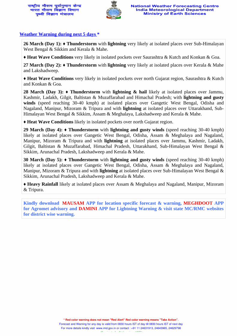
Weather Warning during next 5 days *
26 March (Day 1): ♦ Thunderstorm with lightning very likely at isolated places over Sub-Himalayan West Bengal & Sikkim and Kerala & Mahe.
♦ Heat Wave Conditions very likely in isolated pockets over Saurashtra & Kutch and Konkan & Goa.
27 March (Day 2): ♦ Thunderstorm with lightning very likely at isolated places over Kerala & Mahe and Lakshadweep.
♦ Heat Wave Conditions very likely in isolated pockets over north Gujarat region, Saurashtra & Kutch and Konkan & Goa.
28 March (Day 3): ♦ Thunderstorm with lightning & hail likely at isolated places over Jammu, Kashmir, Ladakh, Gilgit, Baltistan & Muzaffarabad and Himachal Pradesh; with lightning and gusty winds (speed reaching 30-40 kmph) at isolated places over Gangetic West Bengal, Odisha and Nagaland, Manipur, Mizoram & Tripura and with lightning at isolated places over Uttarakhand, Sub-Himalayan West Bengal & Sikkim, Assam & Meghalaya, Lakshadweep and Kerala & Mahe.
♦ Heat Wave Conditions likely in isolated pockets over north Gujarat region.
29 March (Day 4): ♦ Thunderstorm with lightning and gusty winds (speed reaching 30-40 kmph) likely at isolated places over Gangetic West Bengal, Odisha, Assam & Meghalaya and Nagaland, Manipur, Mizoram & Tripura and with lightning at isolated places over Jammu, Kashmir, Ladakh, Gilgit, Baltistan & Muzaffarabad, Himachal Pradesh, Uttarakhand, Sub-Himalayan West Bengal & Sikkim, Arunachal Pradesh, Lakshadweep and Kerala & Mahe.
30 March (Day 5): ♦ Thunderstorm with lightning and gusty winds (speed reaching 30-40 kmph) likely at isolated places over Gangetic West Bengal, Odisha, Assam & Meghalaya and Nagaland, Manipur, Mizoram & Tripura and with lightning at isolated places over Sub-Himalayan West Bengal & Sikkim, Arunachal Pradesh, Lakshadweep and Kerala & Mahe.
♦ Heavy Rainfall likely at isolated places over Assam & Meghalaya and Nagaland, Manipur, Mizoram & Tripura.
Kindly download MAUSAM APP for location specific forecast & warning, MEGHDOOT APP for Agromet advisory and DAMINI APP for Lightning Warning & visit state MC/RMC websites for district wise warning.
* Red color warning does not mean "Red Alert" Red color warning means "Take Action". Forecast and Warning for any day is valid from 0830 hours IST of day till 0830 hours IST of next day
For more details kindly visit www.imd.gov.in or contact : +91 11 24631913, 24643965, 24629798 (Service to the Nation since 1875)
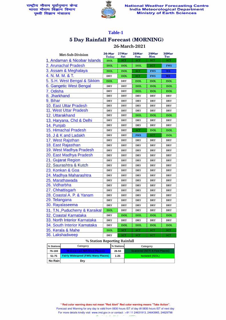
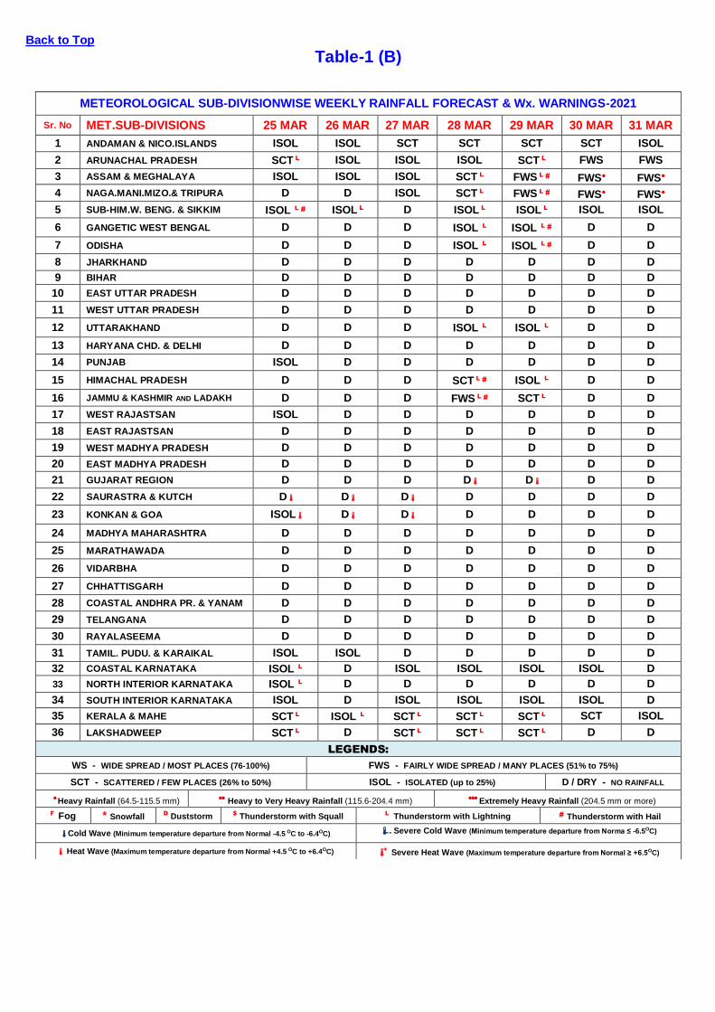
Table-1
* Red color warning does not mean "Red Alert" Red color warning means "Take Action". Forecast and Warning for any day is valid from 0830 hours IST of day till 0830 hours IST of next day
For more details kindly visit www.imd.gov.in or contact : +91 11 24631913, 24643965, 24629798 (Service to the Nation since 1875)
ALL INDIA WEEKLY WEATHER REPORT
18 MARCH – 24 MARCH, 2021
Table-1(A) Table-1(B) Table-1(C) Table-2 Table-3 Fig-1 Fig-2 Annexure-1
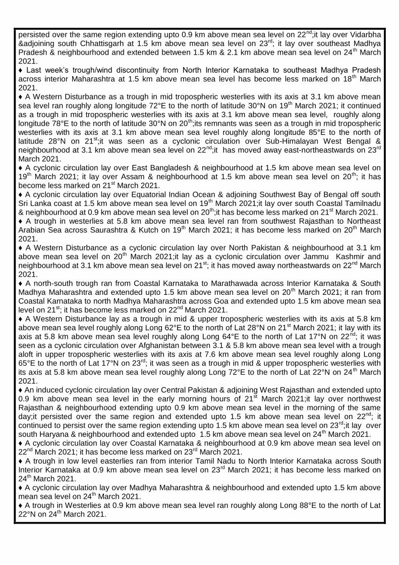
SIGNIFICANT WEATHER FEATURES
♦ Passage of two to three Western Disturbances in quick succession has caused isolated rainfall/snowfall/thunderstorm activity over Western Himalayan Region in the first half of the week. ♦ Movement of an active Western Disturbance and its induced cyclonic circulation have caused fairly widespread to widespread rainfall/snowfall/thunderstorm activity over Western Himalayan Region and over Punjab during the second half of the week; passage of these systems has also caused isolated to scattered rainfall/thunderstorm activity over remaining parts of Northwest India and over northern parts of Central india during the same period; isolated hailstorm /dust storm activity also had been reported from Rajasthan on one or two days along with. ♦ Under the influence of a cyclonic circulation in the lower tropospheric levels which persisted throughout the week and trough/wind discontinuities in the lower levels, parts of Central India and West India received isolated to scattered rainfall/thunderstorm activity on many days with Vidarbha reporting fairly widespread to widespread rainfall /thunderstorm activity on three to four days during the week; isolated hailstorm activity also had been reported from parts of Central India and Madhya Maharashtra on one or two days during the week. ♦ Remnants of Western Disturbances have caused isolated to scattered rainfall/thunderstorm/snowfall activity over Arunachal Pradesh and isolated rainfall/thunderstorm activity over remaining parts of Northeast India and adjoining areas of East India during the week. ♦ Under the influence of trough in low level easterlies and cyclonic circulations in the lower tropospheric levels, parts of south Peninsular India received isolated rainfall/thunderstorm activity during the week. Heavy Rain: ♦ Heavy rainfall had occurred at isolated places over Jammu Kashmir & Ladakh on two days during the week. Temperature Scenario:
♦ Heat wave conditions had occurred at isolated places over Konkan & Goa on one day during the week. ♦ The highest maximum temperature of 41.0 o C had been recorded at Churu (West Rajasthan) on 21st March 2021 and the lowest minimum temperature of 11.9 o C had been recorded Pantnagar (Uttarakhand) on 18th March 2021 over the plains of the country during the week.
LEGEND: A few days- 3 days, Many days- 4 to 5 days and Most days- 6 to 7 days during the week.
METEOROLOGICAL ANALYSIS
♦ Last week’s Western Disturbance as a cyclonic circulation over north Pakistan and adjoining Jammu & Kashmir lay over Jammu & Kashmir and neighbourhood at 3.1 km above mean sea level on 18 th March 2021; it has moved away east-northeastwards on 19th March 2021. ♦ Last week’s cyclonic circulation over northwest Rajasthan & neighbourhood lay over East Rajasthan & neighbourhood and extended upto 0.9 km above mean sea level on 18th March 2021; it lay over southeast Rajasthan & neighbourhood and extended upto 0.9 km above mean sea level on 19th; it has become less marked on 20th March 2021. ♦ Last week’s trough in low level westerlies with its axis at 1.5 km above mean sea level roughly along longitude 88°E to the north of latitude 25°N ran roughly along the same longitude but to the north of latitude 22°N on 18th March 2021; it has become less marked on 19th March 2021. ♦ Last week’s cyclonic circulation over Madhya Maharashtra and neighbourhood lay over Marathwada & neighbourhood and extended upto 1.5 km above mean sea level on 18th March 2021; it lay over Vidarbha & neighbourhood and extended upto 1.5 km above mean sea level on 19th; it lay over southeast Madhya Pradesh & adjoining Vidarbha and extended upto 0.9 km above mean sea level on 20th; it lay over southeast Madhya Pradesh & neighbourhood and extended upto 0.9 km above mean sea level on 21st; it
Government of India Ministry of Earth Sciences
India Meteorological Department
National Weather Forecasting Centre
persisted over the same region extending upto 0.9 km above mean sea level on 22nd;it lay over Vidarbha &adjoining south Chhattisgarh at 1.5 km above mean sea level on 23rd; it lay over southeast Madhya Pradesh & neighbourhood and extended between 1.5 km & 2.1 km above mean sea level on 24 th March 2021. ♦ Last week’s trough/wind discontinuity from North Interior Karnataka to southeast Madhya Pradesh across interior Maharashtra at 1.5 km above mean sea level has become less marked on 18th March 2021. ♦ A Western Disturbance as a trough in mid tropospheric westerlies with its axis at 3.1 km above mean sea level ran roughly along longitude 72°E to the north of latitude 30°N on 19th March 2021; it continued as a trough in mid tropospheric westerlies with its axis at 3.1 km above mean sea level, roughly along longitude 78°E to the north of latitude 30°N on 20th;its remnants was seen as a trough in mid tropospheric westerlies with its axis at 3.1 km above mean sea level roughly along longitude 85°E to the north of latitude 28°N on 21st;it was seen as a cyclonic circulation over Sub-Himalayan West Bengal & neighbourhood at 3.1 km above mean sea level on 22nd;it has moved away east-northeastwards on 23rd March 2021. ♦ A cyclonic circulation lay over East Bangladesh & neighbourhood at 1.5 km above mean sea level on 19th March 2021; it lay over Assam & neighbourhood at 1.5 km above mean sea level on 20th; it has become less marked on 21st March 2021. ♦ A cyclonic circulation lay over Equatorial Indian Ocean & adjoining Southwest Bay of Bengal off south Sri Lanka coast at 1.5 km above mean sea level on 19th March 2021;it lay over south Coastal Tamilnadu & neighbourhood at 0.9 km above mean sea level on 20th;it has become less marked on 21st March 2021. ♦ A trough in westerlies at 5.8 km above mean sea level ran from southwest Rajasthan to Northeast Arabian Sea across Saurashtra & Kutch on 19th March 2021; it has become less marked on 20th March 2021. ♦ A Western Disturbance as a cyclonic circulation lay over North Pakistan & neighbourhood at 3.1 km above mean sea level on 20th March 2021;it lay as a cyclonic circulation over Jammu Kashmir and neighbourhood at 3.1 km above mean sea level on 21st; it has moved away northeastwards on 22nd March 2021. ♦ A north-south trough ran from Coastal Karnataka to Marathawada across Interior Karnataka & South Madhya Maharashtra and extended upto 1.5 km above mean sea level on 20th March 2021; it ran from Coastal Karnataka to north Madhya Maharashtra across Goa and extended upto 1.5 km above mean sea level on 21st; it has become less marked on 22nd March 2021. ♦ A Western Disturbance lay as a trough in mid & upper tropospheric westerlies with its axis at 5.8 km above mean sea level roughly along Long 62°E to the north of Lat 28°N on 21st March 2021; it lay with its axis at 5.8 km above mean sea level roughly along Long 64°E to the north of Lat 17°N on 22nd; it was seen as a cyclonic circulation over Afghanistan between 3.1 & 5.8 km above mean sea level with a trough aloft in upper tropospheric westerlies with its axis at 7.6 km above mean sea level roughly along Long 65°E to the north of Lat 17°N on 23rd; it was seen as a trough in mid & upper tropospheric westerlies with its axis at 5.8 km above mean sea level roughly along Long 72°E to the north of Lat 22°N on 24 th March 2021. ♦ An induced cyclonic circulation lay over Central Pakistan & adjoining West Rajasthan and extended upto 0.9 km above mean sea level in the early morning hours of 21st March 2021;it lay over northwest Rajasthan & neighbourhood extending upto 0.9 km above mean sea level in the morning of the same day;it persisted over the same region and extended upto 1.5 km above mean sea level on 22nd; it continued to persist over the same region extending upto 1.5 km above mean sea level on 23rd;it lay over south Haryana & neighbourhood and extended upto 1.5 km above mean sea level on 24th March 2021. ♦ A cyclonic circulation lay over Coastal Karnataka & neighbourhood at 0.9 km above mean sea level on 22nd March 2021; it has become less marked on 23rd March 2021. ♦ A trough in low level easterlies ran from interior Tamil Nadu to North Interior Karnataka across South Interior Karnataka at 0.9 km above mean sea level on 23rd March 2021; it has become less marked on 24th March 2021. ♦ A cyclonic circulation lay over Madhya Maharashtra & neighbourhood and extended upto 1.5 km above mean sea level on 24th March 2021. ♦ A trough in Westerlies at 0.9 km above mean sea level ran roughly along Long 88°E to the north of Lat 22°N on 24th March 2021.
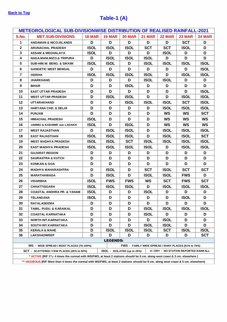
RAINFALL SUMMARY
Category of the rainfall
WEEK SEASON
18.03.2021 TO 24.03.2021 01.03.2021 TO 24.03.2021
Number of Sub-divisions Number of Sub-divisions
LARGE EXCESS (+60% or more) 5 2 EXCESS (+20% to +59%) 1 5 NORMAL (+19% to -19%) 2 1 DEFICIENT (-20% to -59%) 6 9 LARGE DEFICIENT (-60% to -99%) 19 16 NO RAIN (-100%) 3 3
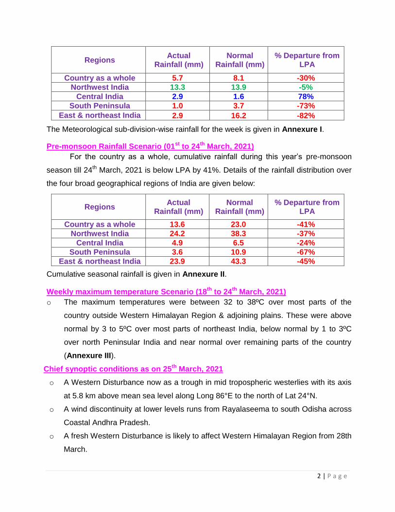
Cumulative rainfall (mm) Actual Normal % Departure Actual Normal % Departure
EAST & NORTH-EAST INDIA 2.9 16.2 -82% 23.9 43.3 -45% NORTH-WEST INDIA 13.3 13.9 -5% 24.2 38.3 -37% CENTRAL INDIA 2.9 1.6 78% 4.9 6.5 -24% SOUTH PENINSULA 1.0 3.7 -73% 3.6 10.9 -67%
country as a whole 5.7 8.1 -30% 13.6 23.0 -41%
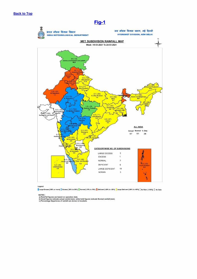
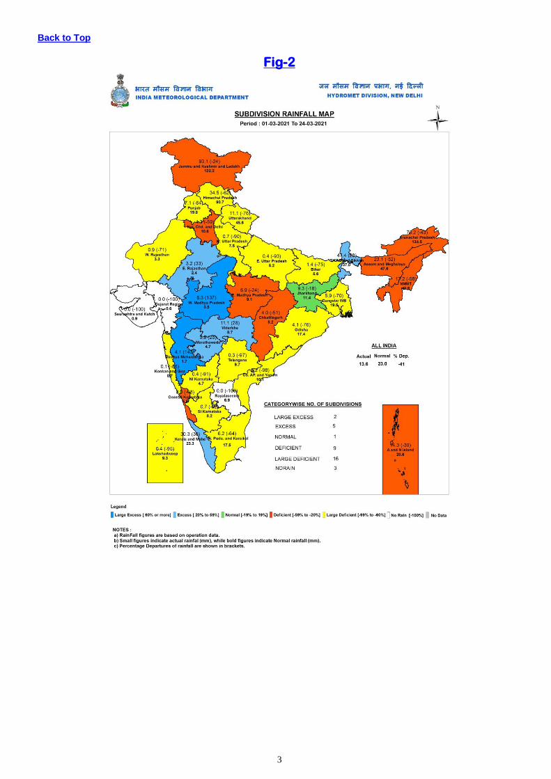
Sub-division wise weekly and seasonal rainfall distribution is presented in Fig-1 and Fig-2.
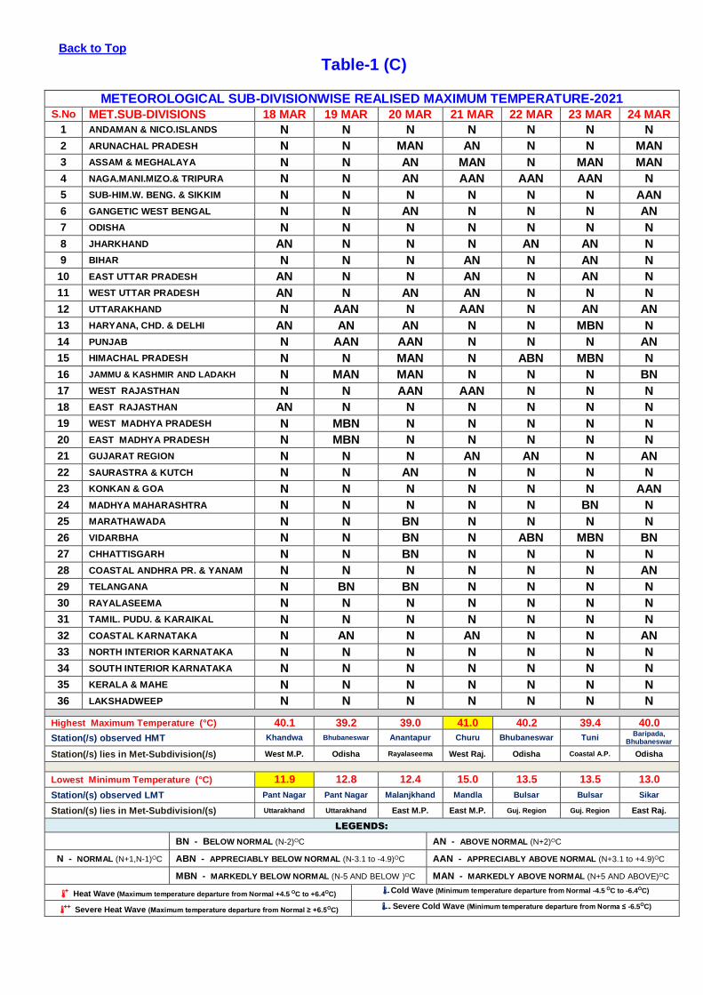
Sub-divisionwise daily distribution of realised Rainfall is shown in Table-1(A).
Sub-divisionwise departure of realised Maximum temperature from Normal is shown in Table-1(C)
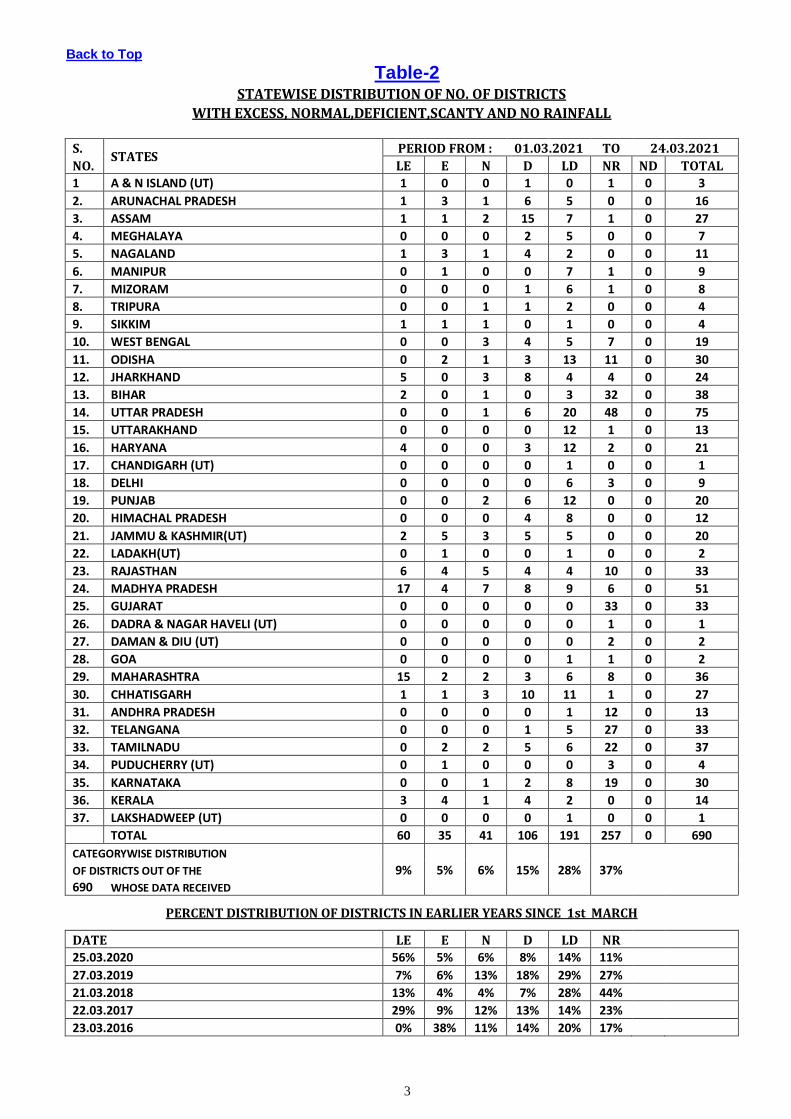
Statewise distribution of number of districts with Large-Excesse, Excess, Normal, Deficient, Large-deficient and no rainfall
is shown in Table-2.
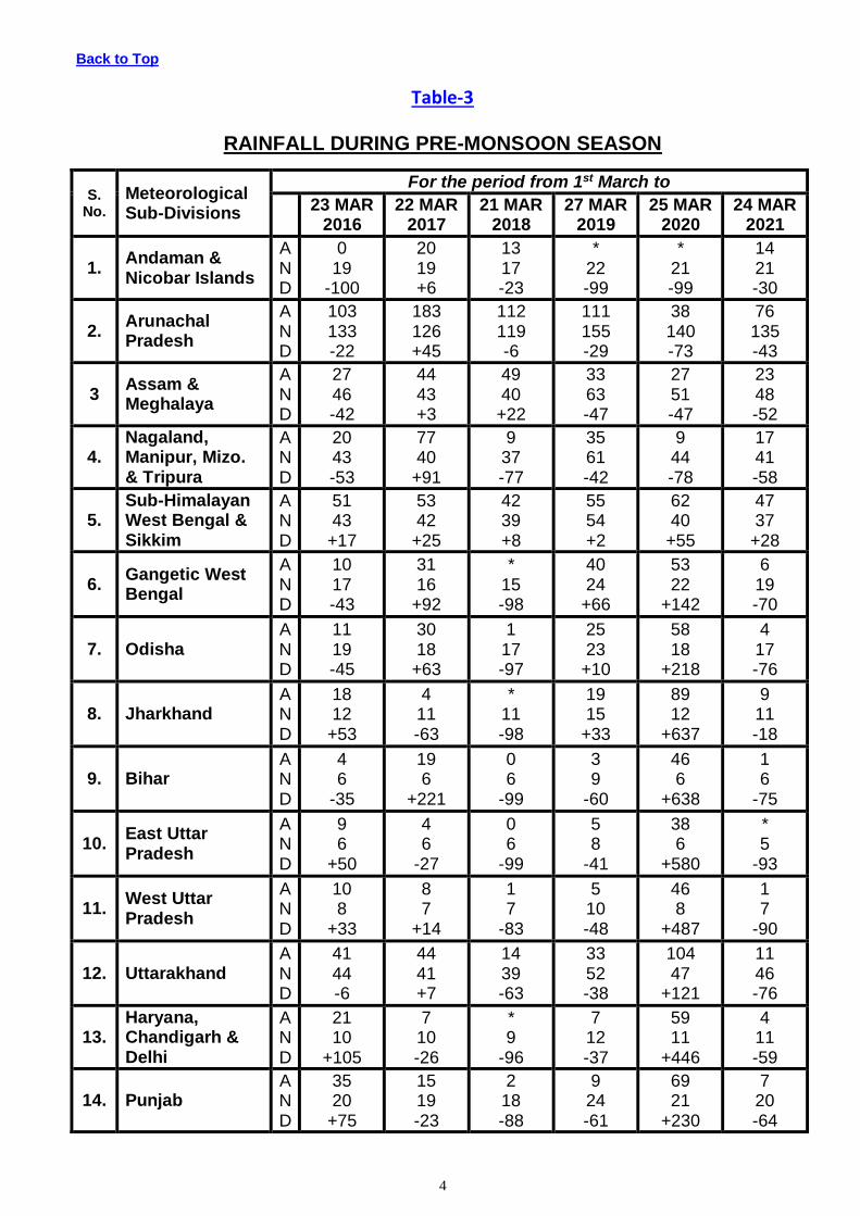
Cumulative seasonal rainfall data during the corresponding weekly period for the last five years are given in Table-3.
Sub-divisionwise realised weekly rainfall (in cm) is shown in Annexure-1.
FORECAST & WARNING FOR THE NEXT WEEK 25 March TO 31 March, 2021
Detailed seven days Sub-division wise rainfall-forecast & weather-warning is given in Table-1(B).
Back to Top
Table-1 (A)
METEOROLOGICAL SUB-DIVISIONWISE DISTRIBUTION OF REALISED RAINFALL-2021
S.No. MET.SUB-DIVISIONS 18 MAR 19 MAR 20 MAR 21 MAR 22 MAR 23 MAR 24 MAR
1 ANDAMAN & NICO.ISLANDS D D D D D SCT D
2 ARUNACHAL PRADESH ISOL ISOL ISOL SCT SCT ISOL D
3 ASSAM & MEGHALAYA ISOL D D D ISOL D D
4 NAGA.MANI.MIZO.& TRIPURA D ISOL ISOL ISOL D D D
5 SUB-HIM.W. BENG. & SIKKIM ISOL ISOL D ISOL ISOL ISOL ISOL
6 GANGETIC WEST BENGAL D D D D D D ISOL
7 ODISHA ISOL ISOL ISOL ISOL D ISOL ISOL
8 JHARKHAND D D D ISOL ISOL D D
9 BIHAR D D ISOL D D D D
10 EAST UTTAR PRADESH D D D D D D ISOL
11 WEST UTTAR PRADESH D ISOL ISOL D D ISOL ISOL
12 UTTARAKHAND D D ISOL ISOL ISOL SCT ISOL
13 HARYANA CHD. & DELHI D D D D ISOL ISOL ISOL
14 PUNJAB D D D D WS WS SCT
15 HIMACHAL PRADESH ISOL D D D WS WS WS
16 JAMMU & KASHMIR AND LADAKH ISOL D ISOL D WS WS WS
17 WEST RAJASTHAN D ISOL ISOL D ISOL ISOL ISOL
18 EAST RAJASTHAN ISOL ISOL ISOL D ISOL ISOL SCT
19 WEST MADHYA PRADESH ISOL ISOL SCT ISOL ISOL ISOL ISOL
20 EAST MADHYA PRADESH ISOL ISOL ISOL ISOL D ISOL ISOL
21 GUJARAT REGION D D D D D D D
22 SAURASTRA & KUTCH D D D D D D D
23 KONKAN & GOA D D D D D D D
24 MADHYA MAHARASHTRA D ISOL D SCT ISOL SCT SCT
25 MARATHAWADA D ISOL D ISOL ISOL FWS D
26 VIDARBHA ISOL FWS FWS WS SCT FWS SCT
27 CHHATTISGARH ISOL ISOL ISOL D ISOL ISOL ISOL
28 COASTAL ANDHRA PR. & YANAM ISOL D D ISOL D D D
29 TELANGANA ISOL D D D D ISOL D
30 RAYALASEEMA D D D D D D D
31 TAMIL. PUDU. & KARAIKAL D D D ISOL ISOL ISOL ISOL
32 COASTAL KARNATAKA D D D ISOL D D D
33 NORTH INT.KARNATAKA D D D D ISOL D D
34 SOUTH INT.KARNATAKA D D D ISOL ISOL D D
35 KERALA & MAHE D ISOL ISOL ISOL SCT ISOL ISOL
36 LAKSHADWEEP D D D D D D SCT
LEGENDS:
WS - WIDE SPREAD / MOST PLACES (76-100%) FWS - FAIRLY WIDE SPREAD / MANY PLACES (51% to 75%)
SCT - SCATTERED / FEW PLACES (26% to 50%) ISOL - ISOLATED (up to 25%) D / DRY - NO STATION REPORTED RAINFALL
* ACTIVE (R/F 11/2- 4 times the normal with WS/FWS, at least 2 stations should be 5 cm. along west coast & 3 cm. elsewhere )
** VIGOROUS (R/F More than 4 times the normal with WS/FWS, at least 2 stations should be 8 cm. along west coast & 5 cm. elsewhere)
Back to Top
Table-1 (B)
METEOROLOGICAL SUB-DIVISIONWISE WEEKLY RAINFALL FORECAST & Wx. WARNINGS-2021
Sr. No MET.SUB-DIVISIONS 25 MAR 26 MAR 27 MAR 28 MAR 29 MAR 30 MAR 31 MAR
1 ANDAMAN & NICO.ISLANDS ISOL ISOL SCT SCT SCT SCT ISOL
2 ARUNACHAL PRADESH SCT L ISOL ISOL ISOL SCT L FWS FWS
3 ASSAM & MEGHALAYA ISOL ISOL ISOL SCT L FWS L # FWS● FWS●
4 NAGA.MANI.MIZO.& TRIPURA D D ISOL SCT L FWS L # FWS● FWS●
5 SUB-HIM.W. BENG. & SIKKIM ISOL L # ISOL L D ISOL L ISOL L ISOL ISOL
6 GANGETIC WEST BENGAL D D D ISOL L ISOL L # D D
7 ODISHA D D D ISOL L ISOL L # D D
8 JHARKHAND D D D D D D D
9 BIHAR D D D D D D D
10 EAST UTTAR PRADESH D D D D D D D
11 WEST UTTAR PRADESH D D D D D D D
12 UTTARAKHAND D D D ISOL L ISOL L D D
13 HARYANA CHD. & DELHI D D D D D D D
14 PUNJAB ISOL D D D D D D
15 HIMACHAL PRADESH D D D SCT L # ISOL L D D
16 JAMMU & KASHMIR AND LADAKH D D D FWS L # SCT L D D
17 WEST RAJASTSAN ISOL D D D D D D
18 EAST RAJASTSAN D D D D D D D
19 WEST MADHYA PRADESH D D D D D D D
20 EAST MADHYA PRADESH D D D D D D D
21 GUJARAT REGION D D D D D D D
22 SAURASTRA & KUTCH D D D D D D D
23 KONKAN & GOA ISOL D D D D D D
24 MADHYA MAHARASHTRA D D D D D D D
25 MARATHAWADA D D D D D D D
26 VIDARBHA D D D D D D D
27 CHHATTISGARH D D D D D D D
28 COASTAL ANDHRA PR. & YANAM D D D D D D D
29 TELANGANA D D D D D D D
30 RAYALASEEMA D D D D D D D
31 TAMIL. PUDU. & KARAIKAL ISOL ISOL D D D D D
32 COASTAL KARNATAKA ISOL L D ISOL ISOL ISOL ISOL D
33 NORTH INTERIOR KARNATAKA ISOL L D D D D D D
34 SOUTH INTERIOR KARNATAKA ISOL D ISOL ISOL ISOL ISOL D
35 KERALA & MAHE SCT L ISOL L SCT L SCT L SCT L SCT ISOL
36 LAKSHADWEEP SCT L D SCT L SCT L SCT L D D
LEGENDS:
WS - WIDE SPREAD / MOST PLACES (76-100%) FWS - FAIRLY WIDE SPREAD / MANY PLACES (51% to 75%)
SCT - SCATTERED / FEW PLACES (26% to 50%) ISOL - ISOLATED (up to 25%) D / DRY - NO RAINFALL
● Heavy Rainfall (64.5-115.5 mm) ●● Heavy to Very Heavy Rainfall (115.6-204.4 mm) ●●● Extremely Heavy Rainfall (204.5 mm or more)
F Fog * Snowfall D Duststorm $ Thunderstorm with Squall L Thunderstorm with Lightning # Thunderstorm with Hail
Cold Wave (Minimum temperature departure from Normal -4.5 OC to -6.4OC) - - Severe Cold Wave (Minimum temperature departure from Norma ≤ -6.5OC)
Heat Wave (Maximum temperature departure from Normal +4.5 OC to +6.4OC) + Severe Heat Wave (Maximum temperature departure from Normal ≥ +6.5OC)
Back to Top
Table-1 (C)
METEOROLOGICAL SUB-DIVISIONWISE REALISED MAXIMUM TEMPERATURE-2021 S.No MET.SUB-DIVISIONS 18 MAR 19 MAR 20 MAR 21 MAR 22 MAR 23 MAR 24 MAR
1 ANDAMAN & NICO.ISLANDS N N N N N N N
2 ARUNACHAL PRADESH N N MAN AN N N MAN
3 ASSAM & MEGHALAYA N N AN MAN N MAN MAN
4 NAGA.MANI.MIZO.& TRIPURA N N AN AAN AAN AAN N
5 SUB-HIM.W. BENG. & SIKKIM N N N N N N AAN
6 GANGETIC WEST BENGAL N N AN N N N AN
7 ODISHA N N N N N N N
8 JHARKHAND AN N N N AN AN N
9 BIHAR N N N AN N AN N
10 EAST UTTAR PRADESH AN N N AN N AN N
11 WEST UTTAR PRADESH AN N AN AN N N N
12 UTTARAKHAND N AAN N AAN N AN AN
13 HARYANA, CHD. & DELHI AN AN AN N N MBN N
14 PUNJAB N AAN AAN N N N AN
15 HIMACHAL PRADESH N N MAN N ABN MBN N
16 JAMMU & KASHMIR AND LADAKH N MAN MAN N N N BN
17 WEST RAJASTHAN N N AAN AAN N N N
18 EAST RAJASTHAN AN N N N N N N
19 WEST MADHYA PRADESH N MBN N N N N N
20 EAST MADHYA PRADESH N MBN N N N N N
21 GUJARAT REGION N N N AN AN N AN
22 SAURASTRA & KUTCH N N AN N N N N
23 KONKAN & GOA N N N N N N AAN
24 MADHYA MAHARASHTRA N N N N N BN N
25 MARATHAWADA N N BN N N N N
26 VIDARBHA N N BN N ABN MBN BN
27 CHHATTISGARH N N BN N N N N
28 COASTAL ANDHRA PR. & YANAM N N N N N N AN
29 TELANGANA N BN BN N N N N
30 RAYALASEEMA N N N N N N N
31 TAMIL. PUDU. & KARAIKAL N N N N N N N
32 COASTAL KARNATAKA N AN N AN N N AN
33 NORTH INTERIOR KARNATAKA N N N N N N N
34 SOUTH INTERIOR KARNATAKA N N N N N N N
35 KERALA & MAHE N N N N N N N
36 LAKSHADWEEP N N N N N N N
Highest Maximum Temperature (°C) 40.1 39.2 39.0 41.0 40.2 39.4 40.0
Station(/s) observed HMT Khandwa Bhubaneswar Anantapur Churu Bhubaneswar Tuni Baripada,
Bhubaneswar
Station(/s) lies in Met-Subdivision(/s) West M.P. Odisha Rayalaseema West Raj. Odisha Coastal A.P. Odisha
Lowest Minimum Temperature (°C) 11.9 12.8 12.4 15.0 13.5 13.5 13.0
Station/(s) observed LMT Pant Nagar Pant Nagar Malanjkhand Mandla Bulsar Bulsar Sikar
Station/(s) lies in Met-Subdivision/(s) Uttarakhand Uttarakhand East M.P. East M.P. Guj. Region Guj. Region East Raj.
LEGENDS:
BN - BELOW NORMAL (N-2)OC AN - ABOVE NORMAL (N+2)OC
N - NORMAL (N+1,N-1)OC ABN - APPRECIABLY BELOW NORMAL (N-3.1 to -4.9)OC AAN - APPRECIABLY ABOVE NORMAL (N+3.1 to +4.9)OC
MBN - MARKEDLY BELOW NORMAL (N-5 AND BELOW )OC MAN - MARKEDLY ABOVE NORMAL (N+5 AND ABOVE)OC
+ Heat Wave (Maximum temperature departure from Normal +4.5 OC to +6.4OC) - Cold Wave (Minimum temperature departure from Normal -4.5 OC to -6.4OC)
++ Severe Heat Wave (Maximum temperature departure from Normal ≥ +6.5OC) - - Severe Cold Wave (Minimum temperature departure from Norma ≤ -6.5OC)
3
Back to Top
Table-2 STATEWISE DISTRIBUTION OF NO. OF DISTRICTS
WITH EXCESS, NORMAL,DEFICIENT,SCANTY AND NO RAINFALL
S. STATES
PERIOD FROM : 01.03.2021 TO 24.03.2021
NO. LE E N D LD NR ND TOTAL
1 A & N ISLAND (UT) 1 0 0 1 0 1 0 3
2. ARUNACHAL PRADESH 1 3 1 6 5 0 0 16
3. ASSAM 1 1 2 15 7 1 0 27
4. MEGHALAYA 0 0 0 2 5 0 0 7
5. NAGALAND 1 3 1 4 2 0 0 11
6. MANIPUR 0 1 0 0 7 1 0 9
7. MIZORAM 0 0 0 1 6 1 0 8
8. TRIPURA 0 0 1 1 2 0 0 4
9. SIKKIM 1 1 1 0 1 0 0 4
10. WEST BENGAL 0 0 3 4 5 7 0 19
11. ODISHA 0 2 1 3 13 11 0 30
12. JHARKHAND 5 0 3 8 4 4 0 24
13. BIHAR 2 0 1 0 3 32 0 38
14. UTTAR PRADESH 0 0 1 6 20 48 0 75
15. UTTARAKHAND 0 0 0 0 12 1 0 13
16. HARYANA 4 0 0 3 12 2 0 21
17. CHANDIGARH (UT) 0 0 0 0 1 0 0 1
18. DELHI 0 0 0 0 6 3 0 9
19. PUNJAB 0 0 2 6 12 0 0 20
20. HIMACHAL PRADESH 0 0 0 4 8 0 0 12
21. JAMMU & KASHMIR(UT) 2 5 3 5 5 0 0 20
22. LADAKH(UT) 0 1 0 0 1 0 0 2
23. RAJASTHAN 6 4 5 4 4 10 0 33
24. MADHYA PRADESH 17 4 7 8 9 6 0 51
25. GUJARAT 0 0 0 0 0 33 0 33
26. DADRA & NAGAR HAVELI (UT) 0 0 0 0 0 1 0 1
27. DAMAN & DIU (UT) 0 0 0 0 0 2 0 2
28. GOA 0 0 0 0 1 1 0 2
29. MAHARASHTRA 15 2 2 3 6 8 0 36
30. CHHATISGARH 1 1 3 10 11 1 0 27
31. ANDHRA PRADESH 0 0 0 0 1 12 0 13
32. TELANGANA 0 0 0 1 5 27 0 33
33. TAMILNADU 0 2 2 5 6 22 0 37
34. PUDUCHERRY (UT) 0 1 0 0 0 3 0 4
35. KARNATAKA 0 0 1 2 8 19 0 30
36. KERALA 3 4 1 4 2 0 0 14
37. LAKSHADWEEP (UT) 0 0 0 0 1 0 0 1
TOTAL 60 35 41 106 191 257 0 690
CATEGORYWISE DISTRIBUTION
OF DISTRICTS OUT OF THE 9% 5% 6% 15% 28% 37%
690 WHOSE DATA RECEIVED
PERCENT DISTRIBUTION OF DISTRICTS IN EARLIER YEARS SINCE 1st MARCH
DATE LE E N D LD NR
25.03.2020 56% 5% 6% 8% 14% 11%
27.03.2019 7% 6% 13% 18% 29% 27%
21.03.2018 13% 4% 4% 7% 28% 44%
22.03.2017 29% 9% 12% 13% 14% 23%
23.03.2016 0% 38% 11% 14% 20% 17%
4
Back to Top
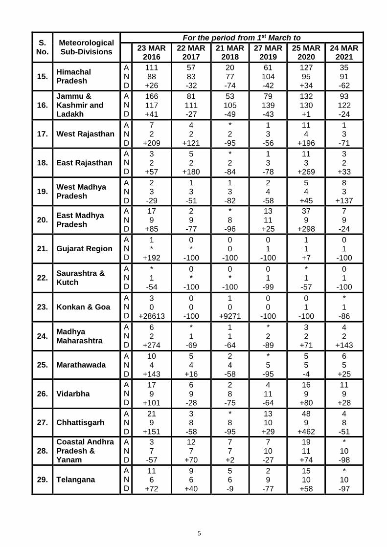
Table-3
RAINFALL DURING PRE-MONSOON SEASON
S. No.
Meteorological Sub-Divisions
For the period from 1st March to
23 MAR
2016 22 MAR
2017 21 MAR
2018 27 MAR
2019 25 MAR
2020 24 MAR
2021
1. Andaman & Nicobar Islands
A N D
0 19
-100
20 19 +6
13 17 -23
* 22 -99
* 21 -99
14 21 -30
2. Arunachal Pradesh
A N D
103 133 -22
183 126 +45
112 119 -6
111 155 -29
38 140 -73
76 135 -43
3 Assam & Meghalaya
A N D
27 46 -42
44 43 +3
49 40
+22
33 63 -47
27 51 -47
23 48 -52
4. Nagaland, Manipur, Mizo. & Tripura
A N D
20 43 -53
77 40
+91
9 37 -77
35 61 -42
9 44 -78
17 41 -58
5. Sub-Himalayan West Bengal & Sikkim
A N D
51 43
+17
53 42
+25
42 39 +8
55 54 +2
62 40
+55
47 37
+28
6. Gangetic West Bengal
A N D
10 17 -43
31 16
+92
* 15 -98
40 24
+66
53 22
+142
6 19 -70
7. Odisha A N D
11 19 -45
30 18
+63
1 17 -97
25 23
+10
58 18
+218
4 17 -76
8. Jharkhand A N D
18 12
+53
4 11 -63
* 11 -98
19 15
+33
89 12
+637
9 11 -18
9. Bihar A N D
4 6
-35
19 6
+221
0 6
-99
3 9
-60
46 6
+638
1 6
-75
10. East Uttar Pradesh
A N D
9 6
+50
4 6
-27
0 6
-99
5 8
-41
38 6
+580
* 5
-93
11. West Uttar Pradesh
A N D
10 8
+33
8 7
+14
1 7
-83
5 10 -48
46 8
+487
1 7
-90
12. Uttarakhand A N D
41 44 -6
44 41 +7
14 39 -63
33 52 -38
104 47
+121
11 46 -76
13. Haryana, Chandigarh & Delhi
A N D
21 10
+105
7 10 -26
* 9
-96
7 12 -37
59 11
+446
4 11 -59
14. Punjab A N D
35 20
+75
15 19 -23
2 18 -88
9 24 -61
69 21
+230
7 20 -64
5
S. No.
Meteorological Sub-Divisions
For the period from 1st March to
23 MAR
2016 22 MAR
2017 21 MAR
2018 27 MAR
2019 25 MAR
2020 24 MAR
2021
15. Himachal Pradesh
A N D
111 88
+26
57 83 -32
20 77 -74
61 104 -42
127 95
+34
35 91 -62
16. Jammu & Kashmir and Ladakh
A N D
166 117 +41
81 111 -27
53 105 -49
79 139 -43
132 130 +1
93 122 -24
17. West Rajasthan A N D
7 2
+209
4 2
+121
* 2
-95
1 3
-56
11 4
+196
1 3
-71
18. East Rajasthan
A N D
3 2
+57
5 2
+180
* 2
-84
1 3
-78
11 3
+269
3 2
+33
19. West Madhya Pradesh
A N D
2 3
-29
1 3
-51
1 3
-82
2 4
-58
5 4
+45
8 3
+137
20. East Madhya Pradesh
A N D
17 9
+85
2 9
-77
* 8
-96
13 11
+25
37 9
+298
7 9
-24
21. Gujarat Region
A N D
1 *
+192
0 *
-100
0 0
-100
0 1
-100
1 1
+7
0 1
-100
22. Saurashtra & Kutch
A N D
* 1
-54
0 *
-100
0 *
-100
0 1
-99
* 1
-57
0 1
-100
23. Konkan & Goa
A N D
3 0
+28613
0 0
-100
1 0
+9271
0 0
-100
0 1
-100
* 1
-86
24. Madhya Maharashtra
A N D
6 2
+274
* 1
-69
1 1
-64
* 2
-89
3 2
+71
4 2
+143
25. Marathawada A N D
10 4
+143
5 4
+16
2 4
-58
* 5
-95
5 5 -4
6 5
+25
26. Vidarbha
A N D
17 9
+101
6 9
-28
2 8
-75
4 11 -64
16 9
+80
11 9
+28
27. Chhattisgarh A N D
21 9
+151
3 8
-58
* 8
-95
13 10
+29
48 9
+462
4 8
-51
28. Coastal Andhra Pradesh & Yanam
A N D
3 7
-57
12 7
+70
7 7
+2
7 10 -27
19 11
+74
* 10 -98
29. Telangana
A N D
11 6
+72
9 6
+40
5 6 -9
2 9
-77
15 10
+58
* 10 -97
6
S. No.
Meteorological Sub-Divisions
For the period from 1st March to
23 MAR
2016 22 MAR
2017 21 MAR
2018 27 MAR
2019 25 MAR
2020 24 MAR
2021
30. Rayalaseema
A N D
1 5
-82
13 4
+197
23 4
+436
* 6
-98
7 7
-12
0 7
-100
31. Tamil Nadu, Puducherry & Karaikal
A N D
1 13 -90
35 13
+171
24 13
+92
3 16 -81
4 18 -76
6 17 -64
32. Coastal Karnataka
A N D
0 2
-100
2 2 -1
25 2
+1075
3 3
+13
7 6
+11
3 6
-48
33. North Interior Karnataka
A N D
4 2
+71
11 2
+426
9 2
+336
4 4
+9
11 5
+103
* 5
-91
34. South Interior Karnataka
A N D
3 5
-48
18 5
+235
29 5
+486
1 7
-89
8 9 -6
1 8
-92
35. Kerala & Mahe
A N D
18 19 -7
83 18
+364
37 17
+120
13 24 -46
39 25
+60
30 23
+30
36. Lakshadweep A N D
2 9
-79
100 9
+977
155 9
+1626
4 10 -58
13 9
+40
* 9
-95
Country as a whole A N D
25.0 22.1 +13
23.9 20.9 +14
12.8 19.8 -35
17.2 27.1 -36
35.5 24.3 +46
13.6 23.0 -41
SUMMARY
No. of Sub-Divisions with rainfall
For the period from 1st March to
23 MAR 2016
22 MAR 2017
21 MAR 2018
27 MAR 2019
25 MAR 2020
24 MAR 2021
Large Excess Excess Normal Total
- 18 03 21
13 03 06 22
08 01 04 13
01 03 04 08
18 05 06 29
02 05 01 08
Deficient Large Deficient Scanty No rain Total
10 -
03 02 15
08 03 -
03 14
03 18 -
02 23
14 12 -
02 28
02 04 -
01 07
09 16 -
03 28
Data Inadequate 00 00 00 00 00 00
TOTAL 36 36 36 36 36 36
* Data is rounded off to nearest full figure according to Meteorological convention.
SEASONS : WINTER SEASON (January-February) PRE-MONSOON SEASON (March-May)
MONSOON SEASON (June-September) POST-MONSOON SEASON (October-December)
LEGENDS:
Large Excess: (+60% or more) Large Deficient: (-60% to -99%) A: Actual Rainfall (mm)
Excess: (+20% to +59%) Scanty: (-20% to -99%) N: Normal Rainfall (mm)
Normal: (+19% to -19%) No Rain (-100%) D: Departure from normal (%)
Deficient: (-20% to -59%) Data Inadequate: ** Rainfall upto 0.4 mm : *
Back to Top
Fig-1
3
Back to Top
Fig-2
4
Back to Top
ANNEXURE-1
RAINFALL DURING THE WEEK (in cm.)
(18 March – 24 March 2021)
18 MARCH 2021 ARUNACHAL PRADESH: YINGKIONG-1, SHWB & SIKKIM: KABI-4, SINGHIK-2, CHUNGTHANG-1, SHIPGYAR-1, MANGAN-1, SANKALAN-1, ODISHA: SIMILIGUDA-2, VIDARBHA: KHARANGHA-1, CHHATTISGARH: JAGDALPUR-1, ORCHA-1.
19 MARCH 2021 SHWB & SIKKIM: GANGTOK-1, TADONG-1, ODISHA: UMARKOTE-3, EAST RAJASTHAN: SAMBHAR SR-1, WEST MADHYA PRADESH: BHAINSDEHI-4, GODADONGRI-2, SHAHPUR-2, VIDISHA-AWS-1, BHOPAL-AWS-ARG-1, ARERA HILLS-1, RAISEN-AWS-1, LATERI-1, ICHHAWAR-1, MULTAI-1, EAST MADHYA PRADESH: PANDHURNA-1, GARHAKOTA-1, REHLI-1, MALTHONE-1, PATHARIA-1, SAGAR-AWS-1, VIDARBHA: KAMPTEE-2, KHARANGHA-2, PERSEONI-1, MAUDA-1, KUHI-1, ARVI-1, NAGPUR
AERODROME-1, TUMSAR-1, RAMTEK-1. 20 MARCH 2021 WEST MADHYA PRADESH: CHACHODA-2, BAGLI-2, KARERA-2, RAISEN-AWS-1, SHAJAPUR-AWS-1,
BHITARWAR-1, KHAKNAR-1, ICHHAWAR-1, BEGUMGANJ-1, GOHARGANJ-1, BHOPAL-AWS-ARG-1, NABIBAGH-1, MULTAI-1, KURWAI-1, KOLARAS-1, SEHORE-AWS-1, LATERI-1, GYARASPUR-1, NARSINGARH-1, GAIRATGANG-1, EAST MADHYA PRADESH: DHANORA-1, VIDARBHA: NER-1,
KUHI-1, KARANJALAD-1, MAUDA-1, LAKHANI-1, MALEGAON-1, ARJUNI MORGAON-1, UMRER-1, LAKHANDUR-1, SELU-1, SADAKARJUNI-1, BULDANA-1, BABULGAON-1, NAGPUR AERODROME-1, DEOLI-1, DEORI-1, KAMPTEE-1. 21 MARCH 2021 ARUNACHAL PRADESH: ANINI-4, ROING-2, PASIGHAT AERO-1, SHWB & SIKKIM: SINGHIK-2, MANGAN-2, SHIPGYAR-2, SANKALAN-2, CHUNGTHANG-1, WEST MADHYA PRADESH: SONDWA-2, BETUL-AWS-2, BHIKANGAON-1, SEHORE-AWS-1, KHANDWA-AWS-1, MADHYA MAHARASHTRA: JAMNER-1, MARATHWADA: PARBHANI IMD OBSY-1, VIDARBHA: MANGRULPIR-2, DEOLI-1,
BULDANA-1, DARWHA-1, RALEGAON-1, KUHI-1, DIGRAS-1, MANORA-1, YEOTMAL-1, MAREGAON-1, NER-1, TAMIL.,PUDU.&KARAIKAL: CHITTAR–1, PECHIPARAI-1, VALPARAI TALUK OFFICE-1, COASTAL KARNATAKA: SUBRAMANYA-2, S. I. KARNATAKA: KUSHALNAGAR-1, BHAGAMANDALA-1, KERALA & MAHE: KONNI-5, PEERMADE TO-1.
22 MARCH 2021 ARUNACHAL PRADESH: ANINI-2, KOLORIANG-1, BASAR-1, SHWB & SIKKIM: MANGAN-3, SANKALAN-2, SINGHIK-2, KABI-2, HAR. CHD & DELHI: SIWANI-1, PUNJAB: FARIDKOT-1, MALAKPUR-1, FARIDKOT AWS-1, HIMACHAL PRADESH: KOTHI-5, MANALI-3, TISSA-3, UDAIPUR-3, GOHAR-2, SEO BAGH-2, HMO SHILLARO-2, KOTKHAI-1, BHARMAUR-1, PTO GONDLA-1, BHUNTAR AERO-1, BAJURA AWS-1, KUMARSAIN-1, BIJAHI-1, KASAULI-1, PANDOH-1, CHHATRARI-1, MANDI-1, THEOG-1, WANGTOO-1, DALHOUSI ALHA AWS-1, KARSOG-1, RAMPUR BUSHAR-1, KEYLONG-1, NARKANDA AWS-1, SUNDARNAGAR-1, RAJGARH-1, SHIMLA AERO-1, SARAHAN-1, JAMMU & KASHMIR: RAJ PURA ARG-2, KUPWARA-2, BADARWAH-2, BANIHAL-2, SRINAGAR AGRO AWS-2,
SHALIMAR AGRO-2, BATOTE-2, GULMARG R.S.-2, GUND-1, PAHALGAM AWS-1, PAHALGAM-1, KULGAM AWS-1, RAJOURI-1, KISTWAR AWS-1, SRINAGAR-1, RAMBAGH AWS-1, KUKERNAG-1, GOVINDPURA AWS-1, SRINAGAR AERO-1, WEST RAJASTHAN: ANUPGARH TEHSIL SR-1, MADHYA MAHARASHTRA: DHULE-1, VIDARBHA: KHAMGAON-1, BULDANA-1, BATKULI-1, SINDKHED RAJA-1, LONAR-1, TAMIL.,PUDU.&KARAIKAL: SANKARANKOIL-3, KODAIKANAL-2, BODINAYAKANUR ARG-2, VALPARAI PTO-1, N. I. KARNATAKA: HIDKAL DAM-1, KERALA & MAHE: KOTTAYAM-3,
VADAKKANCHERRY-3, KANJIRAPPALLY-2, OTTAPALAM-2, KOLLAMKODE-2, NEDUMANGAD-2, KONNI-2, MUNNAR KSEB-2, MANNARKKAD-2, PALAKKAD-1, CHITTUR-1, PEERMADE TO-1, PERUMPAVUR-1, ALWAYE PWD-1, MYLADUMPARA AGRI-1, IDUKKI-1, THRITLA-1, PATTEMBI-1.
5
23 MARCH 2021 A & N ISLAND: HUT BAY-2, ARUNACHAL PRADESH: BOMDILA-2, WEST UTTAR PRADESH: FATEHABAD-1, UTTARAKHAND: UKHIMATH-2, KARNAPRAYAG-1, JOSHIMATH-1, CHAMOLI-1, GAIRSAIN-1, PUNJAB: BATALA-1, AMRITSAR AWS-1, ADAMPUR IAF-1, MALAKPUR-1, TARAN TARAN-1, FEROZEPUR-1, AMRITSAR-1, HIMACHAL PRADESH: DALHOUSI ALHA AWS-4, RAMPUR
BUSHAR-3, KOTHI-2, PTO GONDLA-2, MANALI-2, SIMLA-2, SARAHAN-2, RECKONG PEO AWS-1, NARKANDA AWS-1, KALPA-1, BALDWARA-1, ROHRU-1, JANJEHLI-1, BANGANA_F-1, DHARMSALA-1, NURPUR/JASSUR-1, NAHAN-1, BHARMAUR-1, KHERI-1, KUMARSAIN-1, BHUNTAR AERO-1, THEOG-1, SEO BAGH-1, HMO HANSA-1, JAMMU & KASHMIR: RAJ PURA ARG-8, BANIHAL-5, KULGAM AWS-5, QAZI GUND-5, GOVINDPURA AWS-5, KUPWARA-4, GUND-4, SRINAGAR AGRO AWS-4, SHALIMAR AGRO-4, RAJOURI-4, BATOTE-4, KONIBAL-4, BANDIPORA-3, SRINAGAR AERO-3, RAMBAGH AWS-3, KUKERNAG-3, SRINAGAR-3, AWANTIPUR IAF-3, UDHAMPUR(IAF)-3, ANANTNAG-3, PAHALGAM AWS-2, BADARWAH-2, PAHALGAM-2, ZAINAPORA ARG-2, ANANTNAG AWS-2, KATRA-2, KHUDWANI ARG-2, KAWA AWS-2, JAMMU AERO-2, CHATHA_AGRO AWS-1, GULMARG R.S.-1, JAMMU-1, SHOPIAN AWS-1, MALANGPURA AWS-1, EAST RAJASTHAN: PAOWTA-1, VALLABHNAGAR-1, WEST MADHYA PRADESH: BHIND-AWS-2, BEGUMGANJ-1, MADHYA MAHARASHTRA: MAHABALESHWAR- IMD OBSY-1, MARATHWADA: MANJLEGAON-1, NANDED IMD PARTTIME-1, WADAWANI-1, VIDARBHA: SELU-3, ARVI-2, ASHTI-1, HINGANGHAT-1, TELANGANA: NAGA REDDIPET-3, PAPANNAPET-3, TEKMAL-2, VICARABAD-1, TAMIL.,PUDU.&KARAIKAL: TIRUCHENDUR-2, THENKASI-1, MANIMUTHARU-1, KERALA & MAHE:
CHALAKUDI-2, PERUMPAVUR-2, MANNARKKAD-2, KODUNGALLUR-1, KOCHI C.I.A.L.-1, ALWAYE PWD-1, KONNI-1. 24 MARCH 2021 SHWB & SIKKIM: GANGTOK-1, SANKALAN-1, SINGHIK-1, ODISHA: BORIGUMMA-1, WEST UTTAR PRADESH: GOVARDHAN-1, UTTARAKHAND: CHAKRATA-1, PUNJAB: DERABASSI(BASI)-1, MADHOPUR-1, PHANGOTA-1, HIMACHAL PRADESH: GOHAR-3, DALHOUSI ALHA AWS-2,
SARAHAN-1, WANGTOO-1, RAMPUR BUSHAR-1, CHAMBA AWS-1, KEYLONG-1, KANDAGHAT-1, BIJAHI-1, HMO SHILLARO-1, SEO BAGH-1, SIMLA-1, BALDWARA-1, JAMMU & KASHMIR: GOVINDPURA AWS-7, KULGAM AWS-6, SHALIMAR AGRO-5, QAZI GUND-5, BANIHAL-5, GUND-4, SRINAGAR AGRO AWS-4, KONIBAL-4, KUPWARA-3, KUKERNAG-3, RAMBAGH AWS-3, SRINAGAR-3, RAJ PURA ARG-3, KATRA-3, AWANTIPUR IAF-3, SRINAGAR AERO-3, PAHALGAM-3, GULMARG R.S.-3, PAHALGAM AWS-2, ZAINAPORA ARG-2, ANANTNAG-2, ANANTNAG AWS-2, BADARWAH-2, BATOTE-2, KISTWAR AWS-1, BANDIPORA-1, RAJOURI-1, SHOPIAN AWS-1, MALANGPURA AWS-1, EAST RAJASTHAN: DEEG SR-2, SHAHPURA SR-1, RAJGARH-1, NAGAR SR-1, WEST MADHYA PRADESH: GOHAD-1, MADHYA MAHARASHTRA: BHADGAON-1, VIDARBHA: WARDHA-2, ARJUNI MORGAON-1, TAMIL.,PUDU.&KARAIKAL: MYLAUDY-2, NAGERCOIL-1, KERALA & MAHE:
KUMARAKAM-2, IRINJALAKUDA-1, KONNI-1, PUNALUR-1, ARYANKAVU-1.
LEGENDS: CWC Central Water Commission PT/PTO Part Time Observatory
AP Airport FMO Flood Meteorological Office PBO Pilot Balloon Observatory
AWS Automated Weather Station IAF Indian Air Force REV Revenue
ARG Automated Rain Gauge IMD India Meteorological Department SR State Raingauge
CDR Cyclone Detection Radar PWD Public Works Department
1 | P a g e
Government of India
Earth System Science Organization
Ministry of Earth Sciences
India Meteorological Department
Dated: 25 March, 2021
Subject: Current Weather Status and Outlook for next two weeks (25 March to 07
April, 2021)
Salient Features
• An active Western Disturbance & its induced cyclonic circulation caused fairly
widespread to widespread rainfall/snowfall/thunderstorm activity over Western
Himalayan Region & Punjab during 22nd to 24th March, 2021. Isolated to scattered
rainfall/thunderstorm activity also occurred over remaining parts of Northwest &
adjoining central India during the same period; isolated hailstorm /dust storm activity
also reported from Rajasthan on one or two days of this period.
• Due to cyclonic circulation/trough over central parts of country, light to moderate
isolated/scattered rain/thundershower occurred over central India during past week
(18th to 24th March, 2021).
• Under the influence of strong lower level southwesterly winds from the Bay of
Bengal, fairly widespread to widespread rainfall with heavy falls at isolated places
are likely over Northeast India during 29th March to 03rd April, 2021. Flood like
situation may also occur over the region during this period.
• Heat wave conditions at isolated pockets are very likely over Saurashtra &
Kutch and Konkan & Goa during 25th - 27th March and over north Gujarat
region on 27th & 28th March, 2021.
Weekly Rainfall Scenario (18th to 24th March, 2021)
During the week, rainfall for the country as a whole was below Long Period
Average (LPA) by 30%. Details are given below:
2 | P a g e
Regions Actual
Rainfall (mm) Normal
Rainfall (mm) % Departure from
LPA
Country as a whole 5.7 8.1 -30%
Northwest India 13.3 13.9 -5%
Central India 2.9 1.6 78%
South Peninsula 1.0 3.7 -73%
East & northeast India 2.9 16.2 -82%
The Meteorological sub-division-wise rainfall for the week is given in Annexure I.
Pre-monsoon Rainfall Scenario (01st to 24th March, 2021)
For the country as a whole, cumulative rainfall during this year’s pre-monsoon
season till 24th March, 2021 is below LPA by 41%. Details of the rainfall distribution over
the four broad geographical regions of India are given below:
Regions Actual
Rainfall (mm) Normal
Rainfall (mm) % Departure from
LPA
Country as a whole 13.6 23.0 -41%
Northwest India 24.2 38.3 -37%
Central India 4.9 6.5 -24%
South Peninsula 3.6 10.9 -67%
East & northeast India 23.9 43.3 -45%
Cumulative seasonal rainfall is given in Annexure II.
Weekly maximum temperature Scenario (18th to 24th March, 2021)
o The maximum temperatures were between 32 to 38ºC over most parts of the
country outside Western Himalayan Region & adjoining plains. These were above
normal by 3 to 5ºC over most parts of northeast India, below normal by 1 to 3ºC
over north Peninsular India and near normal over remaining parts of the country
(Annexure III).
Chief synoptic conditions as on 25th March, 2021
o A Western Disturbance now as a trough in mid tropospheric westerlies with its axis
at 5.8 km above mean sea level along Long 86°E to the north of Lat 24°N.
o A wind discontinuity at lower levels runs from Rayalaseema to south Odisha across
Coastal Andhra Pradesh.
o A fresh Western Disturbance is likely to affect Western Himalayan Region from 28th
March.
3 | P a g e
Large scale features as on 25th March, 2021
• Currently, moderate La Niña conditions are prevailing over equatorial Pacific and
Sea Surface Temperatures (SSTs) are below normal over central & eastern
equatorial Pacific Ocean. The latest Monsoon Mission Climate Forecasting System
(MMCFS) forecast indicates warming of SSTs over Nino 3.4 region during the
coming season and there is a possibility of transition of La Niña conditions to ENSO
neutral conditions during the forthcoming season. However, model skill during this
period is supposed to be limited because of the spring barrier.
• At present, neutral Indian Ocean Dipole (IOD) conditions are observed over Indian
Ocean and the latest MMCFS forecast indicates neutral IOD conditions are likely to
continue up to May, June & July (MJJ) months and negative IOD conditions likely to
develop thereafter.
• The Madden Julian Oscillation (MJO) index lies in Indian Ocean (Phase 3) with
amplitude nearly one. As per the latest projections, it is likely to move over Maritime
Continent (Phase 4) with amplitude nearly one during next one week.
Forecast for next two week
Weather systems & associated Precipitation during Week 1 (25th to 31st March,
2021) and Week 2 (01st to 07th April, 2021)
Rainfall for week 1: (25th to 31st March, 2021)
• A fresh Western Disturbance very likely to cause scattered to fairly widespread
rainfall/snowfall over Western Himalayan Region with thunderstorm/ lightning over
Himachal Pradesh & Uttarakhand and thunderstorm, lightning & hail over Jammu,
Kashmir, Ladakh, Gilgit, Baltistan & Muzaffarabad during 28th- 29th March, 2021.
• Under the influence of strong lower level southwesterly winds from the Bay of
Bengal, fairly widespread to widespread rainfall with
thunderstorm/thundersquall/lightning and heavy falls at isolated places are
likely over Northeast India during 29th March to 03rd April, 2021. It may cause
landslides and low level inundation at some places during same period.
• Isolated to scattered rainfall/thundershowers are very likely over Tamilnadu,
Puducherry & Karaikal, Telangana, Kerala & Mahe and coastal & south Interior
Karnataka during most days of the week 1 (Annexure IV).
4 | P a g e
• Cumulatively, above normal to above rainfall very likely over parts of
northeastern states and Kerala and below normal over remaining parts of the
country (Annexure V).
Rainfall for week 2: (01st to 07th April, 2021)
• Due to strong lower level southwesterly winds from the Bay of Bengal to
northeastern states, fairly widespread to widespread rainfall with heavy falls at
isolated places are likely over this region during 1st half of the week 2. As a
result above normal rainfall activity likely over this region.
• Due to absence of any active Western Disturbance, rainfall activity is likely to
below normal over northwest India. It is likely to be below normal to normal
over remaining parts of the country (Annexure V).
Temperature for week 1 & 2: (25th March to 07th April, 2021)
• Maximum temperatures are very likely to rise gradually by 4-6°C over Northwest
India during first half of the week 1. Gradual rise in maximum temperatures by 3-5°C
over most parts of Central India and by 2-4°C over most parts of East, West and
peninsular India during first half of the week 1.
• No heat wave conditions very likely over the country during next 4-5 days except
Saurashtra & Kutch and Konkan & Goa where heat wave conditions are very
likely at isolated pockets during 25th - 27th March and over north Gujarat region
during 27th - 28th March, 2021.
• During week 2, due to likely dry weather over most parts of the country (outside
northeast India), the maximum temperatures are very likely to rise gradually
over most parts of the country. Hence, normal to above normal maximum
temperatures likely over northwest, east India and east coast. These are likely
to be below normal by 1-2°C over north eninsular & adjoining central India
(Annexure VI).
Cyclogenesis:
• There is a low probability of cyclogenesis over southeast BoB during the latter half of week 1 (26.03.2021 to 01.04.2021). Next weekly update will be issued on next Thursday i.e. 01st April, 2021
24.03.2021
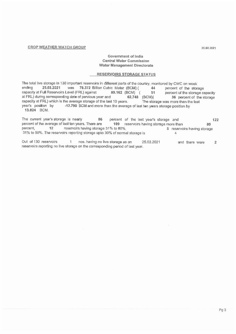
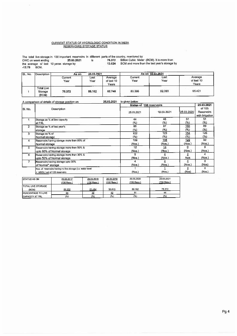
(1) Area Weighted Rainfall (mm) for the country as a whole :
Rainfall
ActualNormal% Dep.
(2) Categorywise No. of Subdivisions & % Area of the Country :
L. ExcessExcessNormalDeficientL. DeficientNo Rain
(3) Categorywise comparative distribution of Sub-divisions ( cumulative rainfall ) and All India % Rainfall Departure for last five years since March 1st
CategoryL. ExcessExcessNormalDeficientL. DeficientNo RainAll India% Dep.
(4) Categorywise comparative % distribution of districts ( cumulative rainfall ) for last five years since March 1st
Category 25-3-2020 27-3-2019 21-3-2018 22-3-2017 23-3-2016L. Excess 9% 56% 7% 13% 29% 0%Excess 5% 5% 6% 4% 9% 38%Normal 6% 6% 13% 4% 12% 11%Deficient 15% 8% 18% 7% 13% 14%L. Deficient 28% 14% 29% 28% 14% 20%No Rain 37% 11% 27% 44% 23% 17%
HAR. CHD & DELHI LD(-61)---->D(-59) ASSAM & MEGHALAYA N(-14)---->D(-52)EAST RAJASTHAN D(-27)---->E(33) SHWB & SIKKIM LE(73)---->E(28)WEST MADHYA PRADESH N(10)---->LE(137) GANGETIC WEST BENGAL D(-52)---->LD(-70)MADHYA MAHARASHTRA NR(-100)---->LE(143) BIHAR D(-59)---->LD(-75)MARATHWADA NR(-100)---->E(25) TAMIL., PUDU. & KARAIKAL D(-55)---->LD(-64)VIDARBHA LD(-96)---->E(28) COASTAL KARNATAKA N(-2)---->D(-48)TELANGANA NR(-100)---->LD(-97)N. I. KARNATAKA NR(-100)---->LD(-91)
3 7 3(8%) 7(20%)
6 5 9(25%)69%
10(33%)67%
19 13 16(44%) 13(34%)
5 5 2(9%)23%
1(1%)13%1 2 5(12%) 1(1%)
-30% -34% -41% -47%
24.03.2021 17.03.2021 24.03.2021 17.03.2021
12
1
24.03.2021 17.03.2021 24.03.2021 17.03.20215.7 4.6 13.6 8.0
46
25-3-2020
318
23-3-201622-3-2017
22%
13
14
1
43%
163
5
50%26%
2
9
20%
1
21%
24-3-2021
67%
2
83
-41% 46%
PRE-MONSOON SEASON-2021
Performance since 1st March up to
CategoryWeek Ending on Cumulative upto
5
Week Ending on Cumulative upto
21-3-2018
13%
18
14%-36%
4 3 3
49%
34%
-35%
18
104
3
6 3
35%
1324-3-2021
Improvements Deteriorations
27%47%
22
8
2 027-3-2019
8.1 6.9 23.0 14.9
2 4 1(2%) 4(11%)
(ii)
S. METEOROLOGICAL WEEK : 18.03.2021 TO 24.03.2021 PERIOD: 01.03.2021 TO 24.03.2021NO. SUBDIVISIONS ACTUAL NORMAL % DEP. CAT. ACTUAL NORMAL % DEP. CAT.EAST & NORTH EAST INDIA 2.9 16.2 23.9 43.31 ARUNACHAL PRADESH 15.3 44.4 -66% LD 76.2 134.5 -43% D2 ASSAM & MEGHALAYA 0.1 20.7 -99% LD 23.1 47.6 -52% D3 N M M T 0.1 19.4 -99% LD 17.2 40.6 -58% D4 SHWB & SIKKIM 8.0 14.7 -45% D 47.4 37.0 28% E5 GANGETIC WEST BENGAL 0.0 7.2 -99% LD 5.9 19.5 -70% LD6 JHARKHAND 0.1 2.9 -95% LD 9.3 11.4 -18% N7 BIHAR 0.0 2.1 -99% LD 1.4 5.6 -75% LDNORTH WEST INDIA 13.3 13.9 24.2 38.31 EAST U.P. 0.1 1.2 -94% LD 0.4 5.2 -93% LD2 WEST U.P. 0.4 1.9 -77% LD 0.7 7.5 -90% LD3 UTTARAKHAND 3.8 17.2 -78% LD 11.1 45.6 -76% LD4 HAR. CHD & DELHI 1.3 2.8 -54% D 4.3 10.6 -59% D5 PUNJAB 5.3 6.9 -23% D 7.1 19.8 -64% LD6 HIMACHAL PRADESH 22.1 32.0 -31% D 34.5 90.7 -62% LD7 J & K AND LADAKH 50.2 46.6 8% N 93.1 122.2 -24% D8 WEST RAJASTHAN 0.8 1.1 -24% D 0.9 3.3 -71% LD9 EAST RAJASTHAN 1.9 0.7 178% LE 3.2 2.4 33% ECENTRAL INDIA 2.9 1.6 4.9 6.51 ODISHA 0.6 4.3 -87% LD 4.1 17.4 -76% LD2 WEST MADHYA PRADESH 5.1 0.6 752% LE 8.3 3.5 137% LE3 EAST MADHYA PRADESH 1.6 1.9 -18% N 6.9 9.1 -24% D4 GUJARAT REGION 0.0 0.5 -100% NR 0.0 0.6 -100% NR5 SAURASHTRA & KUTCH 0.0 0.7 -100% NR 0.0 0.9 -100% NR6 KONKAN & GOA 0.1 0.4 -83% LD 0.1 0.7 -86% LD7 MADHYA MAHARASHTRA 4.1 0.5 726% LE 4.1 1.7 143% LE8 MARATHWADA 5.9 0.6 876% LE 5.9 4.7 25% E9 VIDARBHA 10.8 1.6 576% LE 11.1 8.7 28% E10 CHHATTISGARH 0.6 2.2 -71% LD 4.0 8.2 -51% DSOUTH PENINSULA 1.0 3.7 3.6 10.91 A & N ISLAND 4.6 6.8 -33% D 14.3 20.6 -30% D2 COASTAL A. P.& YANAM 0.1 3.7 -97% LD 0.2 10.1 -98% LD3 TELANGANA 0.3 3.8 -91% LD 0.3 9.7 -97% LD4 RAYALASEEMA 0.0 2.0 -100% NR 0.0 6.9 -100% NR5 TAMIL., PUDU. & KARAIKAL 0.6 5.2 -88% LD 6.2 17.5 -64% LD6 COASTAL KARNATAKA 0.5 3.2 -86% LD 3.0 5.8 -48% D7 N. I. KARNATAKA 0.4 2.5 -83% LD 0.4 4.7 -91% LD8 S. I. KARNATAKA 0.3 2.5 -90% LD 0.7 8.2 -92% LD9 KERALA & MAHE 10.6 8.6 23% E 30.3 23.3 30% E10 LAKSHADWEEP 0.2 3.5 -95% LD 0.4 9.3 -95% LDCOUNTRY AS A WHOLE 5.7 8.1 13.6 23.0
CATEGORYWISE NO. OF SUBDIVISIONS & % AREA (SUBDIVISIONAL) OF THE COUNTRY
WEEK : 18.03.2021 TO 24.03.2021 PERIOD: 01.03.2021 TO 24.03.2021CATEGORY
LARGE EXCESSEXCESSNORMALDEFICIENTLARGE DEFICIENTNO RAIN
2
19 50% 16 44%3 8% 3 8%
6 12% 9 25%11%1%
1 2%5
SUBDIVISIONS % AREA OF COUNTRY5 2 9%1 12%
SUBDIVISION-WISE RAINFALL (MM) DISTRIBUTION
-82% -45%
-5% -37%
78% -24%
SUBDIVISIONS % AREA OF COUNTRY
(iii)
-67%
-30% -41%
-73%
NO. OF SUBDIVISIONAL NO. OF SUBDIVISIONAL
18%
Note: The rainfall values are rounded off upto one place of decimal.
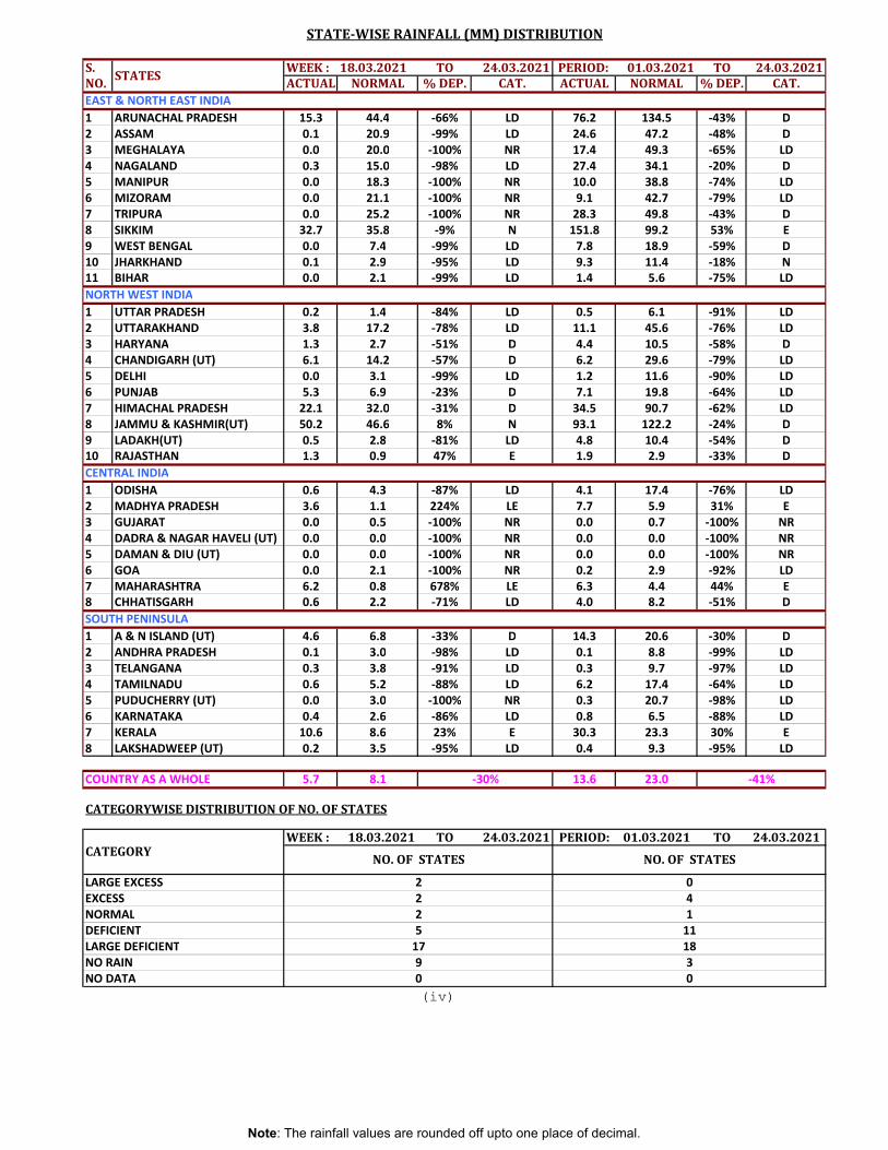
S. WEEK : 18.03.2021 TO 24.03.2021 PERIOD: 01.03.2021 TO 24.03.2021NO. ACTUAL NORMAL % DEP. CAT. ACTUAL NORMAL % DEP. CAT.
1 ARUNACHAL PRADESH 15.3 44.4 -66% LD 76.2 134.5 -43% D2 ASSAM 0.1 20.9 -99% LD 24.6 47.2 -48% D3 MEGHALAYA 0.0 20.0 -100% NR 17.4 49.3 -65% LD4 NAGALAND 0.3 15.0 -98% LD 27.4 34.1 -20% D5 MANIPUR 0.0 18.3 -100% NR 10.0 38.8 -74% LD6 MIZORAM 0.0 21.1 -100% NR 9.1 42.7 -79% LD7 TRIPURA 0.0 25.2 -100% NR 28.3 49.8 -43% D8 SIKKIM 32.7 35.8 -9% N 151.8 99.2 53% E9 WEST BENGAL 0.0 7.4 -99% LD 7.8 18.9 -59% D10 JHARKHAND 0.1 2.9 -95% LD 9.3 11.4 -18% N11 BIHAR 0.0 2.1 -99% LD 1.4 5.6 -75% LD
1 UTTAR PRADESH 0.2 1.4 -84% LD 0.5 6.1 -91% LD2 UTTARAKHAND 3.8 17.2 -78% LD 11.1 45.6 -76% LD3 HARYANA 1.3 2.7 -51% D 4.4 10.5 -58% D4 CHANDIGARH (UT) 6.1 14.2 -57% D 6.2 29.6 -79% LD5 DELHI 0.0 3.1 -99% LD 1.2 11.6 -90% LD6 PUNJAB 5.3 6.9 -23% D 7.1 19.8 -64% LD7 HIMACHAL PRADESH 22.1 32.0 -31% D 34.5 90.7 -62% LD8 JAMMU & KASHMIR(UT) 50.2 46.6 8% N 93.1 122.2 -24% D9 LADAKH(UT) 0.5 2.8 -81% LD 4.8 10.4 -54% D10 RAJASTHAN 1.3 0.9 47% E 1.9 2.9 -33% DCENTRAL INDIA1 ODISHA 0.6 4.3 -87% LD 4.1 17.4 -76% LD2 MADHYA PRADESH 3.6 1.1 224% LE 7.7 5.9 31% E3 GUJARAT 0.0 0.5 -100% NR 0.0 0.7 -100% NR4 DADRA & NAGAR HAVELI (UT) 0.0 0.0 -100% NR 0.0 0.0 -100% NR5 DAMAN & DIU (UT) 0.0 0.0 -100% NR 0.0 0.0 -100% NR6 GOA 0.0 2.1 -100% NR 0.2 2.9 -92% LD7 MAHARASHTRA 6.2 0.8 678% LE 6.3 4.4 44% E8 CHHATISGARH 0.6 2.2 -71% LD 4.0 8.2 -51% DSOUTH PENINSULA1 A & N ISLAND (UT) 4.6 6.8 -33% D 14.3 20.6 -30% D2 ANDHRA PRADESH 0.1 3.0 -98% LD 0.1 8.8 -99% LD3 TELANGANA 0.3 3.8 -91% LD 0.3 9.7 -97% LD4 TAMILNADU 0.6 5.2 -88% LD 6.2 17.4 -64% LD5 PUDUCHERRY (UT) 0.0 3.0 -100% NR 0.3 20.7 -98% LD6 KARNATAKA 0.4 2.6 -86% LD 0.8 6.5 -88% LD7 KERALA 10.6 8.6 23% E 30.3 23.3 30% E8 LAKSHADWEEP (UT) 0.2 3.5 -95% LD 0.4 9.3 -95% LD
COUNTRY AS A WHOLE 5.7 8.1 13.6 23.0
CATEGORYWISE DISTRIBUTION OF NO. OF STATES
WEEK : 18.03.2021 TO 24.03.2021 PERIOD: 01.03.2021 TO 24.03.2021
(iv)
11
LARGE EXCESSEXCESS
2
NO. OF STATES
42
-41%
CATEGORY NO. OF STATES
90 0
3
NORMAL
-30%
02
NORTH WEST INDIA
LARGE DEFICIENT 17 18
NO DATA
DEFICIENT1
5
NO RAIN
STATE-WISE RAINFALL (MM) DISTRIBUTION
EAST & NORTH EAST INDIA
STATES
Note: The rainfall values are rounded off upto one place of decimal.
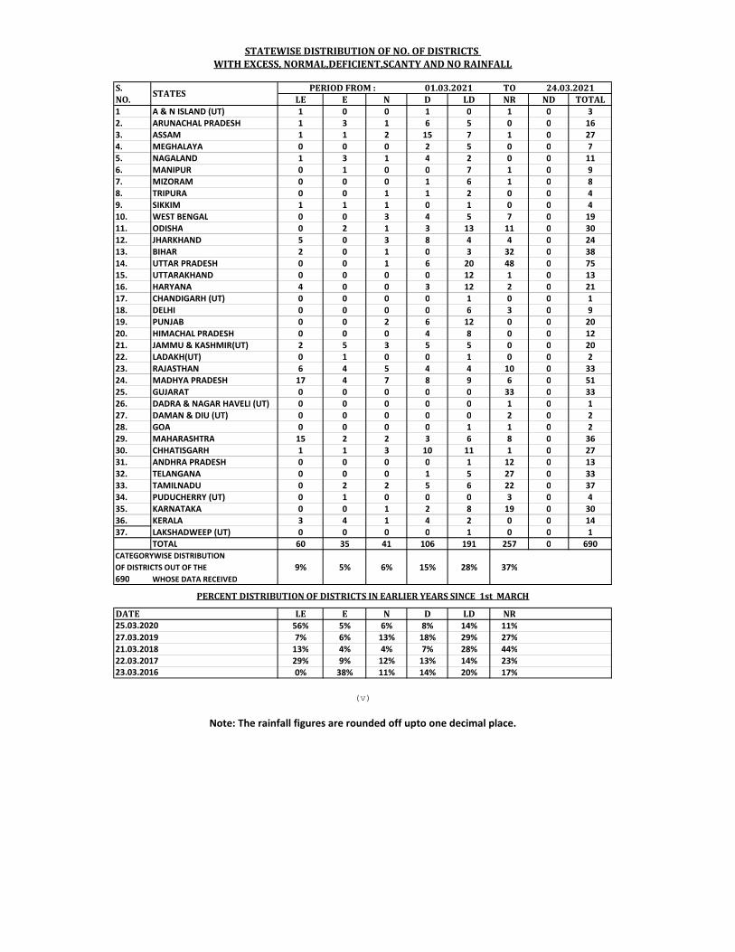
S. TONO. LE E N D LD NR ND TOTAL1 A & N ISLAND (UT) 1 0 0 1 0 1 0 32. ARUNACHAL PRADESH 1 3 1 6 5 0 0 163. ASSAM 1 1 2 15 7 1 0 274. MEGHALAYA 0 0 0 2 5 0 0 75. NAGALAND 1 3 1 4 2 0 0 116. MANIPUR 0 1 0 0 7 1 0 97. MIZORAM 0 0 0 1 6 1 0 88. TRIPURA 0 0 1 1 2 0 0 49. SIKKIM 1 1 1 0 1 0 0 410. WEST BENGAL 0 0 3 4 5 7 0 1911. ODISHA 0 2 1 3 13 11 0 3012. JHARKHAND 5 0 3 8 4 4 0 2413. BIHAR 2 0 1 0 3 32 0 3814. UTTAR PRADESH 0 0 1 6 20 48 0 7515. UTTARAKHAND 0 0 0 0 12 1 0 1316. HARYANA 4 0 0 3 12 2 0 2117. CHANDIGARH (UT) 0 0 0 0 1 0 0 118. DELHI 0 0 0 0 6 3 0 919. PUNJAB 0 0 2 6 12 0 0 2020. HIMACHAL PRADESH 0 0 0 4 8 0 0 1221. JAMMU & KASHMIR(UT) 2 5 3 5 5 0 0 2022. LADAKH(UT) 0 1 0 0 1 0 0 223. RAJASTHAN 6 4 5 4 4 10 0 3324. MADHYA PRADESH 17 4 7 8 9 6 0 5125. GUJARAT 0 0 0 0 0 33 0 3326. DADRA & NAGAR HAVELI (UT) 0 0 0 0 0 1 0 127. DAMAN & DIU (UT) 0 0 0 0 0 2 0 228. GOA 0 0 0 0 1 1 0 229. MAHARASHTRA 15 2 2 3 6 8 0 3630. CHHATISGARH 1 1 3 10 11 1 0 2731. ANDHRA PRADESH 0 0 0 0 1 12 0 1332. TELANGANA 0 0 0 1 5 27 0 3333. TAMILNADU 0 2 2 5 6 22 0 3734. PUDUCHERRY (UT) 0 1 0 0 0 3 0 435. KARNATAKA 0 0 1 2 8 19 0 3036. KERALA 3 4 1 4 2 0 0 1437. LAKSHADWEEP (UT) 0 0 0 0 1 0 0 1
TOTAL 60 35 41 106 191 257 0 690
9% 5% 6% 15% 28% 37%690 WHOSE DATA RECEIVED
LE E N D LD NR56% 5% 6% 8% 14% 11%
27.03.2019 7% 6% 13% 18% 29% 27%21.03.2018 13% 4% 4% 7% 28% 44%22.03.2017 29% 9% 12% 13% 14% 23%
0% 38% 11% 14% 20% 17%
STATES
STATEWISE DISTRIBUTION OF NO. OF DISTRICTS WITH EXCESS, NORMAL,DEFICIENT,SCANTY AND NO RAINFALL
PERIOD FROM : 01.03.2021 24.03.2021
Note: The rainfall figures are rounded off upto one decimal place.
(v)
PERCENT DISTRIBUTION OF DISTRICTS IN EARLIER YEARS SINCE 1st MARCH
OF DISTRICTS OUT OF THECATEGORYWISE DISTRIBUTION
DATE25.03.2020
23.03.2016
Copyright © 2022 FDOKUMEN