Friday 23 July 2021 - Time of Issue: 0800 hours IST
72
Friday 23 July 2021 MORNING Time of Issue: 0800 hours IST ALL INDIA WEATHER SUMMARY AND FORECAST BULLETIN Significant Weather Features ♦ A Low Pressure Area lies over Northwest Bay of Bengal & neighbourhood. It is likely to move west-northwestwards along the monsoon trough during next 2 days. Under its influence, fairly Widespread to widespread rainfall with isolated heavy to very heavy falls very likely over east and adjoining central India during 23rd-24th July with reduction thereafter. ♦ An off-shore trough at mean sea level runs from south Gujarat coast to Kerala coast. It is likely to persist during next 2 days. Under its influence, fairly widespread to widespread rainfall with isolated heavy to very heavy falls very likely to continue over west coast during next 2 days with reduction thereafter. ♦ The western end of monsoon trough at mean sea level has moved slightly southward but still runs north of its normal position. It is likely to shift to the normal position during next 2 days. Its eastern end now runs south of its normal position dipping to eastcentral Bay of Bengal. Under its influence, fairly widespread to widespread rainfall with isolated heavy falls very likely over Himachal Pradesh and Uttarakhand on 23rd and enhanced rainfall activity with isolated heavy to very heavy falls on 25th and 26th July over these areas. Scattered to fairly widespread rainfall over plains of northwest India during next 2 days with enhanced rainfall activity thereafter with isolated heavy to very heavy falls over Uttar Pradesh on 25th & 26th July. ♦ Increase in rainfall activity over northeast India likely from 26th July onwards with fairly widespread to widespread rainfall with isolated heavy to very heavy falls over these areas. Main Weather Observations ♦ Rain/Thundershowers observed (from 0830 hours IST to 1730 hours IST of yesterday): at most places over Konkan & Goa, Telangana and Coastal Karnataka; at many places over Odisha, East Madhya Pradesh, Himachal Pradesh, Uttarakhand, Vidarbha, Chhattisgarh, Madhya Maharashtra South & North Interior Karnataka, Coastal Andhra Pradesh & Yanam and Kerala & Mahe; at a few places over West Bengal & Sikkim West Madhya Pradesh, Rayalaseema, Lakshadweep and Andaman & Nicobar Islands and at isolated places over Jammu, Kashmir, Ladakh, Gilgit-Baltistan & Muzaffarabad, Nagaland, Manipur, Mizoram & Tripura, Bihar, Uttar Pradesh, East Rajasthan, Saurashtra & Kutch and Tamilnadu, Puducherry & Karaikal. ♦ Heavy Rainfall recorded (from 0830 hours IST to 1730 hours IST of yesterday): Extremely Heavy Rainfall at isolated places over Madhya Maharashtra and Heavy Rainfall at isolated places over Telangana. ♦ Rainfall recorded (from 0830 hours IST to 1730 hours IST of yesterday)(3cm or more): Mahabaleshwar( Madhya Maharashtra)-32; Nizamabad(Telangana) -10; Paradip, Hanamkonda, Chanderpur, Kolhapur and Vijaywada -6 each; Khammam, Goa and Ramagundam -5 each; Chindwara, Pachmarhi, Nagpur, Belgum and Honavar - 4 each; Nowgong, Damoh, Karwar, Valprai, Coonoor, Maya Bandar and Machilipatanam -3 each. ♦ Thunderstorm observed (from 0830 hours IST to 1730 hours IST of yesterday): at isolated places over Vidarbha, Bihar, Jharkhand, Odisha, West Uttar Pradesh, East Madhya Pradesh and Chhattisgarh. ♦ Maximum Temperature Departures as on 22-07-2021: Maximum temperatures were markedly below normal (5.1°C or More) at a few places over Arunachal Pradesh and at isolated places over Assam & Meghalaya; appreciably above normal (3.1°C to 5.0°C) at a few places over Sub-Himalayan West Bengal & Sikkim and East Rajasthan; above normal (1.6°C to 3.1°C) at most places over Bihar and Gujarat Region; at a few places over gangetic West Bengal and Odisha and at isolated places over Saurashtra & Kutch, Kerala & Mahe, Andaman & Nicobar Islands and Tamilnadu, Puducherry & Karaikal. They were markedly below normal (-5.1°C or less) at many places over Telangana, Coastal Andhra Pradesh & Yanam, Rayalaseema and North Interior Karnataka; appreciably below normal (-3.1°C to -5.0°C) at many places over South Interior Karnataka and Marathwada; at a few place over Vidarbha and at isolated places over West Uttar Pradesh; below normal (-1.6°C to -3.0°C) at many places over Uttarakhand, Haryana, Chandigarh & Delhi and Coastal Karnataka; at a few places over Himachal Pradesh, Madhya Maharashtra and Konkan & Goa and at isolated places over Jammu, Kashmir, Ladakh, Gilgit- Baltistan & Muzaffarabad, East Uttar Pradesh, Madhya Pradesh and West Rajasthan and near normal over rest parts of the country. Yesterday, the highest maximum temperature of 39.5°C was reported at Bikaner (West Rajasthan). ♦ Minimum Temperature Departures as on 22-07-2021: Minimum temperatures were above normal (1.6°C to 3.0°C) at many places over East Rajasthan and West Madhya Pradesh; at a few places over Sub-Himalayan West Bengal & Sikkim and Saurashtra & Kutch. They were below normal (-1.6°C to -3.0°C) at most places over Telangana and Coastal Andhra Pradesh & Yanam; at a few places over Coastal Karnataka; at isolated places over Jammu, Kashmir, West Rajasthan, East Uttar Pradesh, East Madhya Pradesh and Madhya Maharashtra and near normal over rest parts of the country. * Red color warning does not mean "Red Alert" Red color warning means "Take Action". Forecast and Warning for any day is valid from 0830 hours IST of day till 0830 hours IST of next day For more details kindly visit www.imd.gov.in or contact : +91 11 24631913, 24643965, 24629798 (Service to the Nation since 1875)
-
Upload
khangminh22 -
Category
Documents
-
view
3 -
download
0
Transcript of Friday 23 July 2021 - Time of Issue: 0800 hours IST
Friday 23 July 2021MORNING
Time of Issue: 0800 hours ISTALL INDIA WEATHER SUMMARY AND FORECAST BULLETIN
Significant Weather Features
♦ A Low Pressure Area lies over Northwest Bay of Bengal & neighbourhood. It is likely to move west-northwestwards along the monsoon trough during next 2 days. Under its influence, fairly Widespread to widespread rainfall with isolated heavy to very heavy falls very likely over east and adjoining central India during 23rd-24th July with reduction thereafter.
♦ An off-shore trough at mean sea level runs from south Gujarat coast to Kerala coast. It is likely to persist during next 2 days. Under its influence, fairly widespread to widespread rainfall with isolated heavy to very heavy falls very likely to continue over west coast during next 2 days with reduction thereafter.
♦ The western end of monsoon trough at mean sea level has moved slightly southward but still runs north of its normal position. It is likely to shift to the
normal position during next 2 days. Its eastern end now runs south of its normal position dipping to eastcentral Bay of Bengal. Under its influence, fairly widespread to widespread rainfall with isolated heavy falls very likely over Himachal Pradesh and Uttarakhand on 23rd and enhanced rainfall activity with isolated heavy to very heavy falls on 25th and 26th July over these areas. Scattered to fairly widespread rainfall over plains of northwest India during next 2 days with enhanced rainfall activity thereafter with isolated heavy to very heavy falls over Uttar Pradesh on 25th & 26th July.
♦ Increase in rainfall activity over northeast India likely from 26th July onwards with fairly widespread to widespread rainfall with isolated heavy to very heavy falls over these areas.
Main Weather Observations
♦ Rain/Thundershowers observed (from 0830 hours IST to 1730 hours IST of yesterday): at most places over Konkan & Goa, Telangana and Coastal Karnataka; at many places over Odisha, East Madhya Pradesh, Himachal Pradesh, Uttarakhand, Vidarbha, Chhattisgarh, Madhya Maharashtra South & North Interior Karnataka, Coastal Andhra Pradesh & Yanam and Kerala & Mahe; at a few places over West Bengal & Sikkim West Madhya Pradesh, Rayalaseema, Lakshadweep and Andaman & Nicobar Islands and at isolated places over Jammu, Kashmir, Ladakh, Gilgit-Baltistan & Muzaffarabad, Nagaland, Manipur, Mizoram & Tripura, Bihar, Uttar Pradesh, East Rajasthan, Saurashtra & Kutch and Tamilnadu, Puducherry & Karaikal.
♦ Heavy Rainfall recorded (from 0830 hours IST to 1730 hours IST of yesterday): Extremely Heavy Rainfall at isolated places over Madhya Maharashtra and Heavy Rainfall at isolated places over Telangana.
♦ Rainfall recorded (from 0830 hours IST to 1730 hours IST of yesterday)(3cm or more): Mahabaleshwar( Madhya Maharashtra)-32; Nizamabad(Telangana) -10; Paradip, Hanamkonda, Chanderpur, Kolhapur and Vijaywada -6 each; Khammam, Goa and Ramagundam -5 each; Chindwara, Pachmarhi, Nagpur, Belgum and Honavar - 4 each; Nowgong, Damoh, Karwar, Valprai, Coonoor, Maya Bandar and Machilipatanam -3 each.
♦ Thunderstorm observed (from 0830 hours IST to 1730 hours IST of yesterday): at isolated places over Vidarbha, Bihar, Jharkhand, Odisha, West Uttar Pradesh, East Madhya Pradesh and Chhattisgarh.
♦ Maximum Temperature Departures as on 22-07-2021: Maximum temperatures were markedly below normal (5.1°C or More) at a few places over Arunachal Pradesh and at isolated places over Assam & Meghalaya; appreciably above normal (3.1°C to 5.0°C) at a few places over Sub-Himalayan West Bengal & Sikkim and East Rajasthan; above normal (1.6°C to 3.1°C) at most places over Bihar and Gujarat Region; at a few places over gangetic West Bengal and Odisha and at isolated places over Saurashtra & Kutch, Kerala & Mahe, Andaman & Nicobar Islands and Tamilnadu, Puducherry & Karaikal. They were markedly below normal (-5.1°C or less) at many places over Telangana, Coastal Andhra Pradesh & Yanam, Rayalaseema and North Interior Karnataka; appreciably below normal (-3.1°C to -5.0°C) at many places over South Interior Karnataka and Marathwada; at a few place over Vidarbha and at isolated places over West Uttar Pradesh; below normal (-1.6°C to -3.0°C) at many places over Uttarakhand, Haryana, Chandigarh & Delhi and Coastal Karnataka; at a few places over Himachal Pradesh, Madhya Maharashtra and Konkan & Goa and at isolated places over Jammu, Kashmir, Ladakh, Gilgit-Baltistan & Muzaffarabad, East Uttar Pradesh, Madhya Pradesh and West Rajasthan and near normal over rest parts of the country. Yesterday, the highest maximum temperature of 39.5°C was reported at Bikaner (West Rajasthan).
♦ Minimum Temperature Departures as on 22-07-2021: Minimum temperatures were above normal (1.6°C to 3.0°C) at many places over East Rajasthan and West Madhya Pradesh; at a few places over Sub-Himalayan West Bengal & Sikkim and Saurashtra & Kutch. They were below normal (-1.6°C to -3.0°C) at most places over Telangana and Coastal Andhra Pradesh & Yanam; at a few places over Coastal Karnataka; at isolated places over Jammu, Kashmir, West Rajasthan, East Uttar Pradesh, East Madhya Pradesh and Madhya Maharashtra and near normal over rest parts of the country.
* Red color warning does not mean "Red Alert" Red color warning means "Take Action". Forecast and Warning for any day is valid from 0830 hours IST of day till 0830 hours IST of next day
For more details kindly visit www.imd.gov.in or contact : +91 11 24631913, 24643965, 24629798 (Service to the Nation since 1875)
Meteorological Analysis (Based on 0530 hours IST)
♦ The Low Pressure Area over Northwest Bay of Bengal & neighbourhood persists and the associated cyclonic circulation extending upto 7.6 km above mean sea level tilting southwestwards with height also persists.
♦ The Monsoon Trough at mean sea level continues to pass through Firozepur, Rohtak, Aligarh, Churk, Ranchi, Balasore, the centre of low pressure area over Northwest Bay of Bengal and thence southeastwards to eastcentral Bay of Bengal and extends upto 0.9 km above mean sea level.
♦ The off-shore trough at mean sea level from south Gujarat coast to north Kerala coast persists.
♦ The Western Disturbance as a trough in mid & upper tropospheric westerlies with its axis at 5.8 km above mean sea level roughly along Long. 70°E to the north of Lat. 28°N persists.
♦ The cyclonic circulation over West Uttar Pradesh & neighbourhood between 1.5 km and 3.1 km above mean sea level persists.
♦ The another cyclonic circulation over North Pakistan & adjoining Jammu at 1.5 km above mean sea level persists.
Weather Forecast for next 5 days * upto 0830 hours IST of 28th July, 2021
♦ Meteorological sub-division wise detailed 5 days precipitation forecast is given in Table-1.
♦ No significant change in maximum temperatures over most parts of the country during next 5 days.
Weather Outlook for subsequent 2 days from 28th July 2021 to 30th July 2021
♦ Active monsoon conditions likely to prevail over the country.
♦Widespread rainfall with isolated heavy to very heavy falls likely over Western Himalayan Region, parts of East India and along the west coast. Scattered rainfall activity likely over rest part of the country except interior Maharashtra, Telangana, Coastal Andhra Pradesh, Rayalaseema, Interior Karnataka and Tamilnadu where isolated rainfall is likely.
* Red color warning does not mean "Red Alert" Red color warning means "Take Action". Forecast and Warning for any day is valid from 0830 hours IST of day till 0830 hours IST of next day
For more details kindly visit www.imd.gov.in or contact : +91 11 24631913, 24643965, 24629798 (Service to the Nation since 1875)
Weather Warning during next 5 days *
23 July (Day 1): ♦ Heavy to Very Heavy Rainfall very likely at a few places over Konkan & Goa; Heavy to Very Heavy Rainfall at isolated places over Madhya Pradesh, Vidarbha, Chhattisgarh, Odisha, Ghat Areas of Madhya Maharashtra, Telangana, Coastal & South Interior Karnataka and Kerala & Mahe and Heavy rainfall at isolated places over Uttarakhand, West Uttar Pradesh, East Rajasthan, Jharkhand, Gangetic West Bengal, Assam & Meghalaya, Gujarat region, Marathwada, Coastal Andhra Pradesh & Yanam, North Interior Karnataka Tamil Nadu, Puducherry & Karaikal.
♦ Thunderstorm accompanied with lightning & gusty wind(speed 30-40 kmph) very likely at isolated places over Telangana and with lightning at isolated places over Himachal Pradesh, Uttarakhand, Uttar Pradesh, Rajasthan, Jharkhand, West Bengal & Sikkim, Assam & Meghalaya, Nagaland, Manipur, Mizoram & Tripura and Rayalaseema.
♦ Strong winds (speed 40-50 kmph gusting to 60 kmph) very likely over Southwest & Westcentral Arabian Sea; North Arabian Sea and along & off Gujarat-Maharashtra-Goa coasts; Southeast Arabian Sea and along & off Karnataka-Kerala coasts & Lakshadweep area; North Arabian Sea and along & off West Bengal and Odisha coasts; South & adjoining Central Bay of Bengal & Andaman Sea and south Tamilnadu & Andhra Pradesh coasts. Fishermen are advised not to venture into these areas.
24 July (Day 2): ♦ Heavy to Very Heavy Rainfall very likely at isolated places over West Madhya Pradesh, Gujarat region and Konkan & Goa and Heavy rainfall at isolated places over West Uttar Pradesh, East Rajasthan, East Madhya Pradesh, Odisha, Saurashtra & Kutch, Ghat areas of Madhya Maharashtra, Telangana, Coastal & South Interior Karnataka and Kerala & Mahe.
♦ Thunderstorm accompanied with lightning very likely at isolated places over Uttarakhand, Uttar Pradesh, West Rajasthan and Telangana.
♦ Strong winds (speed 40-50 kmph gusting to 60 kmph) very likely over Southwest & Westcentral Arabian Sea; North Arabian Sea and along & off Gujarat-Maharashtra-Goa coasts; Southeast Arabian Sea and along & off Karnataka-Kerala coasts & Lakshadweep area; North Arabian Sea and along & off West Bengal and Odisha coasts; South & adjoining Central Bay of Bengal & Andaman Sea and south Tamilnadu & Andhra Pradesh coasts. Fishermen are advised not to venture into these areas.
25 July (Day 3): ♦ Heavy to Very Heavy Rainfall likely at isolated places over Uttarakhand, West Uttar Pradesh, Gujarat state and Konkan & Goa and Heavy rainfall at isolated places over Himachal Pradesh, East Uttar Pradesh, Rajasthan, Madhya Pradesh, Odisha, Assam & Meghalaya, Nagaland, Manipur, Mizoram & Tripura, Ghat areas of Madhya Maharashtra, Coastal Karnataka and Kerala & Mahe.
♦ Thunderstorm accompanied with lightning likely at isolated places over Himachal Pradesh, Punjab, Haryana, Chandigarh & Delhi, Uttar Pradesh, West Rajasthan, Bihar and Telangana.
♦ Strong winds (speed 40-50 kmph gusting to 60 kmph) likely over Southwest & Westcentral Arabian Sea; North Arabian Sea and along & off Gujarat-Maharashtra-Goa coasts; Southeast Arabian Sea and along & off Karnataka-Kerala coasts & Lakshadweep area; North Arabian Sea and along & off West Bengal and Odisha coasts; South & adjoining Central Bay of Bengal & Andaman Sea and south Tamilnadu & Andhra Pradesh coasts. Fishermen are advised not to venture into these areas.
26 July (Day 4): ♦ Heavy to Very Heavy Rainfall likely at isolated places over Himachal Pradesh, Uttarakhand, Uttar Pradesh and Assam & Meghalaya and Heavy rainfall at isolated places over Jammu, Kashmir, Ladakh, Gilgit-Baltistan & Muzaffarabad, Punjab, Haryana, Chandigarh & Delhi, East Madhya Pradesh, Bihar, Jharkhand, West Bengal & Sikkim, Odisha, Arunachal Pradesh, Nagaland, Manipur, Mizoram & Tripura, Gujarat state, Konkan & Goa, Coastal Karnataka and Kerala & Mahe.
♦ Thunderstorm accompanied with lightning & squall (speed 50-60 kmph) likely at isolated places over Andaman & Nicobar Islands and with lightning at isolated places over Himachal Pradesh, Jammu, Kashmir, Ladakh, Gilgit-Baltistan & Muzaffarabad, Punjab, Haryana, Chandigarh & Delhi, Uttar Pradesh, West Rajasthan, Bihar, Jharkhand, Gangetic West Bengal and Telangana.
♦ Strong winds (speed 40-50 kmph gusting to 60 kmph) likely over Southwest & Westcentral Arabian Sea; North Arabian Sea and along & off Gujarat-Maharashtra-Goa coasts; Southeast Arabian Sea and along & off Karnataka-Kerala coasts & Lakshadweep area; North Arabian Sea and along & off West Bengal and Odisha coasts; South & adjoining Central Bay of Bengal & Andaman Sea and south Tamilnadu & Andhra Pradesh coasts. Fishermen are advised not to venture into these areas.
27 July (Day 5): ♦ Heavy to Very Heavy Rainfall likely at isolated places over Himachal Pradesh, Uttarakhand, Uttar Pradesh and Assam & Meghalaya and Heavy rainfall at isolated places over Jammu, Kashmir, Ladakh, Gilgit-Baltistan & Muzaffarabad, Punjab, Haryana, Chandigarh & Delhi, East Madhya Pradesh, Bihar, Jharkhand, West Bengal & Sikkim, Odisha, Arunachal Pradesh, Nagaland, Manipur, Mizoram & Tripura, Gujarat state, Konkan & Goa, Coastal Karnataka and Kerala & Mahe.
♦ Thunderstorm accompanied with lightning & squall (speed 50-60 kmph) likely at isolated places over Andaman & Nicobar Islands and with lightning at isolated places over Himachal Pradesh, Jammu, Kashmir, Ladakh, Gilgit-Baltistan & Muzaffarabad, Punjab, Haryana, Chandigarh & Delhi, Uttar Pradesh, West Rajasthan, Bihar, Jharkhand, Gangetic West Bengal and Telangana.
♦ Strong winds (speed 40-50 kmph gusting to 60 kmph) likely over Southwest & Westcentral Arabian Sea; North Arabian Sea and along & off Gujarat-Maharashtra-Goa coasts; Southeast Arabian Sea and along & off Karnataka-Kerala coasts & Lakshadweep area; North Arabian Sea and along & off West Bengal and Odisha coasts; South & adjoining Central Bay of Bengal & Andaman Sea and south Tamilnadu & Andhra Pradesh coasts. Fishermen are advised not to venture into these areas.
Kindly download MAUSAM APP for location specific forecast & warning, MEGHDOOT APP for Agromet advisory and DAMINI APP for Lightning Warning & visit state MC/RMC websites for district wise warning.
* Red color warning does not mean "Red Alert" Red color warning means "Take Action". Forecast and Warning for any day is valid from 0830 hours IST of day till 0830 hours IST of next day
For more details kindly visit www.imd.gov.in or contact : +91 11 24631913, 24643965, 24629798 (Service to the Nation since 1875)
Table-1
* Red color warning does not mean "Red Alert" Red color warning means "Take Action". Forecast and Warning for any day is valid from 0830 hours IST of day till 0830 hours IST of next day
For more details kindly visit www.imd.gov.in or contact : +91 11 24631913, 24643965, 24629798 (Service to the Nation since 1875)
ALL INDIA WEEKLY WEATHER REPORT
15 JULY – 21 JULY, 2021
Go to: Table-1(A) Table-1(B) Table-1(C) Table-2 Table-3 Fig-1 Fig-2 Annexure-1
SIGNIFICANT WEATHER FEATURES
♦ An off shore trough at mean sea level which lay extending from Maharashtra coast to Karnataka coast on most of the days of the week, convergence of strong westerlies along the west coast and presence of an east west shear zone at mid tropospheric levels roughly along 17°-18°N have caused widespread rainfall /thunderstorm activity along with heavy to very heavy rainfall over the coastal districts and over the ghat areas of Maharashtra and Karnataka on most of the days and it has also caused isolated extremely heavy rainfall over coastal districts of Maharashtra on three to four days; in addition to that, it has caused fairly widespread to widespread rainfall/thunderstorm activity over Gujarat Region with heavy to very heavy rainfall on two to three days and extremely heavy rainfall on one or two days during the week. ♦ Positioning of the western end of the monsoon trough close to its normal position and presence of a cyclonic circulation in the middle levels of the atmosphere over Uttar Pradesh & neighbourhood have caused fairly widespread to widespread rainfall/thunderstorm activity over plains of Northwest India and over Madhya Pradesh during the second half of the week; isolated heavy/very heavy rainfall on a few days with isolated extremely heavy rainfall over Uttar Pradesh on a single day also had been reported over these areas along with; these synoptic features along with a cyclonic circulation in the lower tropospheric levels over north Pakistan & neighbourhood have caused fairly widespread to widespread rainfall/thunderstorm activity along with isolated heavy to very heavy and isolated extremely heavy rainfall over Western Himalayan Region also during the week. ♦ The east west shear zone at mid tropospheric levels roughly along 17-18 °N along with cyclonic circulations in the lower/middle tropospheric levels have caused fairly widespread to widespread rainfall/thunderstorm activity over eastern parts of Central India, parts of East India and adjoining areas of South peninsular India on many days during the week; it has also caused isolated heavy/very heavy rainfall activity over these areas on a few days. Heavy Rain: ♦Heavy to Very heavy rainfall with extremely heavy falls at isolated places had occurred over Konkan & Goa on four days; over Gujarat Region on two days; over East & West Uttar Pradesh, Uttarakhand, Haryana, Chandigarh & Delhi, Himachal Pradesh, Madhya Maharashtra, Telengana, Rayalseema, Coastal Karnataka and Kerala & Mahe on one day each during the week. ♦ Heavy to Very heavy rainfall at isolated places had occurred over Madhya Maharashtra on four days; over Andaman & Nicobar Islands, Assam & Meghalaya, West Uttar Pradesh, Punjab, West Madhya Pradesh, Konkan & Goa and South Interior Karnataka on three days each; over Sub Himalayan West Bengal & Sikkim, Gangetic West Bengal, East Uttar Pradesh, Uttarakhand, Haryana, Chandigarh & Delhi, East Rajasthan, Telangana and Coastal Karnataka on two days each; over Odisha, Bihar, Jammu Kashmir & Ladakh, East Madhya Pradesh, Gujarat Region, Chhattisgarh and Coastal Andhra Pradesh Yanam on one day each during the week. ♦ Heavy rainfall at isolated places had occurred at isolated places over Tamil Nadu, Puducherry & Karaikkal and Bihar on five days each; over Nagaland, Manipur, Mizoram & Tripura, Jammu Kashmir & Ladakh, Coastal Andhra Pradesh & Yanam, Coastal & South Interior Karnataka and Kerala & Mahe on four days each; over Sub Himalayan West Bengal & Sikkim, Odisha, Jharkhand, Uttarakhand, Marathwada and Telangana on three days each; over Arunachal Pradesh, Assam & Meghalaya, East Uttar Pradesh, Haryana, Chandigarh & Delhi, Himachal Pradesh, East Rajasthan, East & West Madhya Pradesh, Gujarat Region, Saurashtra & Kutch and Chhattisgarh on two days each; over Gangetic West Bengal, West Uttar Pradesh, West Rajasthan, Madhya Maharashtra, Vidarbha, Rayalseema and North Interior Karnataka on one day each during the week. Temperature Scenario: ♦ The highest maximum temperature of 42.5oC had been recorded at Ganganagar (West Rajasthan) on 18th July 2021 and the lowest minimum temperature of 15.8 oC had been recorded at Coonoor (Tamil Nadu, Puducherry & Karaikkal) on 19th July 2021 over the plains of the country during the week.
LEGEND: A few days- 3 days, Many days- 4 to 5 days and Most days- 6 to 7 days during the week.
Government of India Ministry of Earth Sciences
India Meteorological Department
National Weather Forecasting Centre
METEOROLOGICAL ANALYSIS
♦ The axis of Monsoon Trough at mean sea level passed through Amreli, Surat, Buldana, Adilabad, Jagdalpur, Vishakhapatnam and thence east-southeastwards to Eastcentral Bay of Bengal and extended upto 1.5 km above mean sea level on 15th July 2021;it passed through Naliya, Ratlam, Sagar, Churk, Chapra, Golpara and thence eastwards to Nagaland on 16th; the western parts of the monsoon trough at mean sea level passed through Bikaner, Rohtak & Sultanpur whereas the eastern end ran close to the foothills of the Himalayas and extended upto 0.9 km above mean sea level on 17th; it passed through Ganganagar, Narnaul, Aligarh, Kanpur, Daltonganj, Shantiniketan, Cherrapunji and thence eastwards to Nagaland and extended upto 0.9 km above mean sea level on 18th; it passed through Ganganagar, Narnaul, Gwalior, Churk, Gaya, Behrampore and thence eastwards to Manipur and extended upto 0.9 km above mean sea level on 19th; it passed through Ganganagar, Delhi, Hardoi, Daltonganj, Medinipur and thence southeastwards to North Bay of Bengal and extended upto 0.9 km above mean sea level on 20th; it passed through Amritsar, Karnal, Aligarh, Sultanpur, Jamshedpur, Chandbali and thence east-southeastwards to Northeast Bay of Bengal and extended upto 0.9 km above mean sea level on 21st July 2021. ♦ Last week’s east-west shear zone roughly along Lat. 19°N persisted along the same latitude and was seen between 2.1 km & 7.6 km above mean sea level tilting southwards with height on 15th July 2021; it ran roughly along Lat. 15°N between 3.1 km & 5.8 km above mean sea level tilting southwards with height on 16th; it has become less marked on 17th July 2021. ♦ Last week’s Low Pressure Area over coastal areas of Kutch & neighbourhood has become less marked and its associated cyclonic circulation extending upto 3.1 km above mean sea level has merged with the monsoon trough and the east-west shear zone on 15th June 2021. ♦ Last week’s cyclonic circulation over south Chhattisgarh & neighbourhood lay over east Vidarbha & neighbourhood and extended upto 4.5 km above mean sea level tilting southwestwards with height on 15th July 2021;it lay over north Madhya Maharashtra & neighbourhood and extended upto 2.1 km above mean sea level on 16th; it has become less marked on 17th July 2021. ♦ Last week’s off-shore trough at mean sea level off Karnataka-Kerala coasts persisted on 15th July 2021; it ran from Maharashtra coast to north Kerala coast on 16th and from Maharashtra coast to Karnataka coast during 17th to 20th; it ran from south Gujarat coast to Karnataka coast on 21st July 2021. ♦ Last week’s cyclonic circulation over central Assam & neighbourhood extending upto 1.5 km above mean sea level has become less marked on 15th July 2021. ♦ Last week’s trough from the cyclonic circulation associated with the Low Pressure Area over coastal areas of Kutch & neighbourhood to northwest Rajasthan at 0.9 km above mean sea level has become less marked on 15th July 2021. ♦ A cyclonic circulation lay over southwest Rajasthan & neighbourhood at 1.5 km above mean sea level on 17th July 2021; it has become less marked on 18th July 2021. ♦ A cyclonic circulation lay over south Coastal Andhra Pradesh & neighbourhood between 1.5 & 4.5 km above mean sea level tilting southwestwards with height on 17th July 2021; it lay over north Coastal Andhra Pradesh & neighbourhood at 1.5 km above mean sea level on 18th; it has become less marked on 19th July 2021. ♦ An east-west trough ran from North Arabian Sea to the cyclonic circulation over south Coastal Andhra Pradesh & neighbourhood across north Maharashtra and Telangana between 3.1 km & 4.5 km above mean sea level tilting southwards with height on 17th July 2021;it has become less marked on 18th July 2021. ♦ An east-west shear zone ran roughly along Lat.17°N between 3.1 km & 5.8 km above mean sea level tilting southwards with height on 18th July 2021; it ran roughly along Lat.17°N and was seen between 4.5 km & 5.8 km above mean sea level tilting southwards with height on 19th; it ran roughly along Lat.18°N between 4.5 km & 5.8 km above mean sea level tilting southwards with height on 20th; it has become less marked on 21st July 2021. ♦ A cyclonic circulation lay over north Pakistan & neighbourhood and extended upto 1.5 km above mean sea level on 18th July 2021; it persisted over the same areas and extended upto 2.1 km above mean sea level on 19th and 20th;it has become less marked on 21st July 2021. ♦ A north-south trough ran from central Madhya Pradesh to south Tamilnadu across Vidarbha, Telangana and Rayalaseema at 0.9 km above mean sea level on 18th July 2021; it has become less marked on 19th July 2021. ♦ A cyclonic circulation lay over central Assam & neighbourhood at 0.9 km above mean sea level on 18th July 2021; it persisted over the same areas and extended upto 2.1 km above mean sea level on 19th; it has become less marked on 20th July 2021. ♦ A cyclonic circulation lay over southwest Uttar Pradesh & neighbourhood and extended between 3.1 &

5.8 km above mean sea level on 19th July 2021; it lay over West Uttar Pradesh & neighbourhood between 3.1 & 5.8 km above mean sea level on 20th; it lay over East Uttar Pradesh & neighbourhood and extended upto 3.1 km above mean sea level on 21st July 2021. ♦ A cyclonic circulation lay over south Gujarat region & neighbourhood at 3.6 km above mean sea level on 19th July 2021; it persisted over the same region at 3.6 km above mean sea level on 20th;it has become less marked on 21st July 2021. ♦ A cyclonic circulation lay over south Bangladesh & neighbourhood at 1.5 km above mean sea level on 20th July 2021; it lay over West Bengal & adjoining Bangladesh at 1.5 km above mean sea level on 21st July 2021. ♦ A Western Disturbance as a trough in mid and upper tropospheric westerlies with its axis at 5.8 km above mean sea level ran roughly along Long. 64°E to the north of Lat. 30°N in the evening of 20th July 2021;it continued to be seen as a trough in mid & upper tropospheric westerlies with its axis at 5.8 km above mean sea level roughly along Long. 66°E to the north of Lat. 28°N on 21st July 2021. ♦ A cyclonic circulation lay over central Assam & neighbourhood at 0.9 km above mean sea level on 21st July 2021. ♦ A cyclonic circulation lay over Northwest Bay of Bengal & neighbourhood and extended between 3.1 km & 7.6 km above mean sea level tilting southwestwards with height on 21st July 2021.
RAINFALL SUMMARY
Category of the rainfall
WEEK SEASON
15.07.2021 TO 21.07.2021 01.06.2021 TO 21.07.2021
Number of Sub-divisions Number of Sub-divisions
LARGE EXCESS (+60% or more) 8 3 EXCESS (+20% to +59%) 7 5 NORMAL (+19% to -19%) 6 16 DEFICIENT (-20% to -59%) 14 12 LARGE DEFICIENT (-60% to -99%) 1 0 NO RAIN (-100%) 0 0
Cumulative rainfall (mm) Actual Normal % Departure Actual Normal % Departure
EAST & NORTH-EAST INDIA 62.9 99.7 -37% 563.3 648.5 -13% NORTH-WEST INDIA 58.0 52.9 10% 193.0 212.2 -9% CENTRAL INDIA 64.7 76.3 -15% 352.1 381.7 -8% SOUTH PENINSULA 83.5 50.7 65% 363.5 303.2 +20%
country as a whole 66.0 67.8 -3% 339.1 356.7 -5%
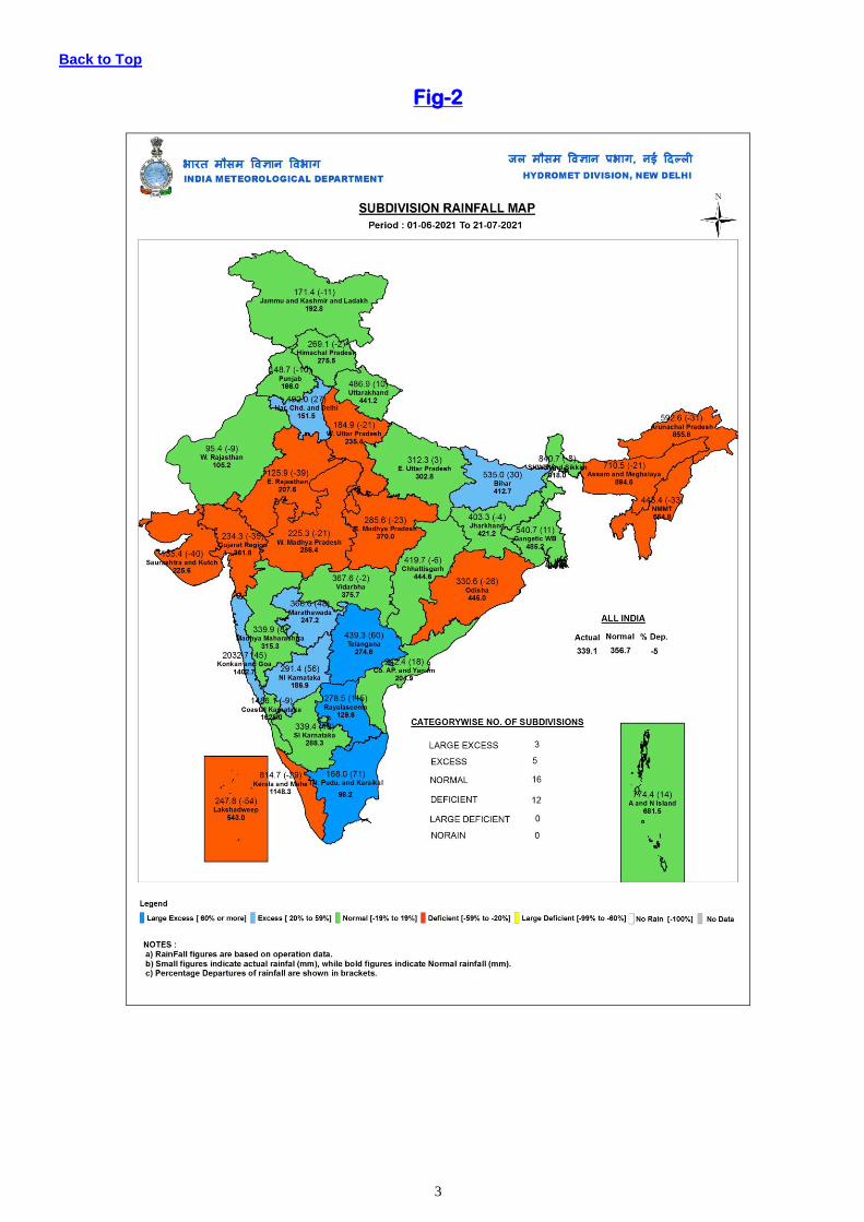
Sub-division wise weekly and seasonal rainfall distribution is presented in Fig-1 and Fig-2.
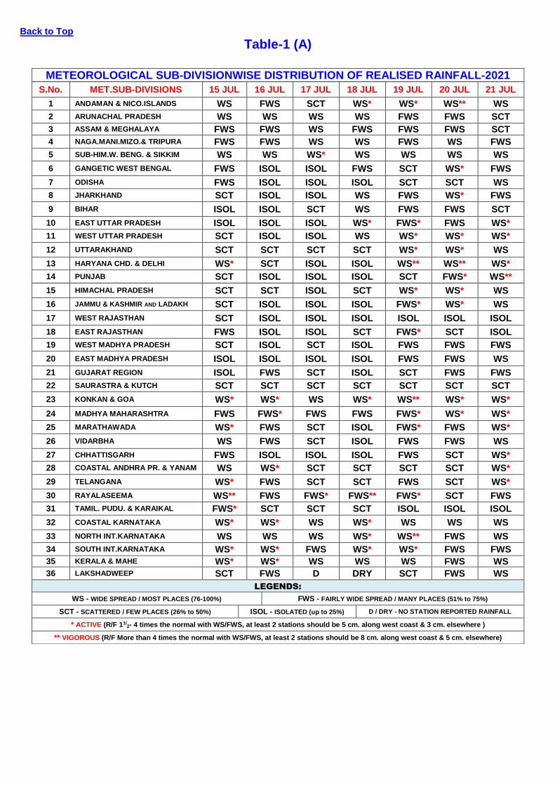
Sub-divisionwise daily distribution of realised Rainfall is shown in Table-1(A).
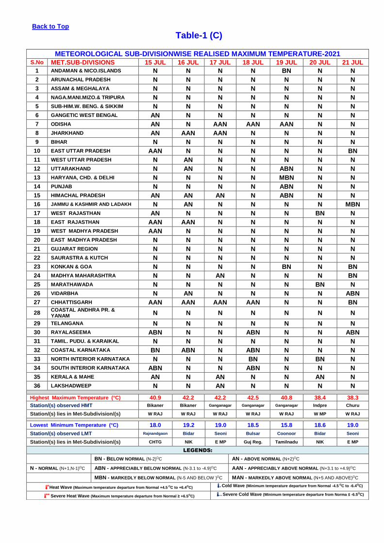
Sub-divisionwise departure of realised Maximum temperature from Normal is shown in Table-1(C)
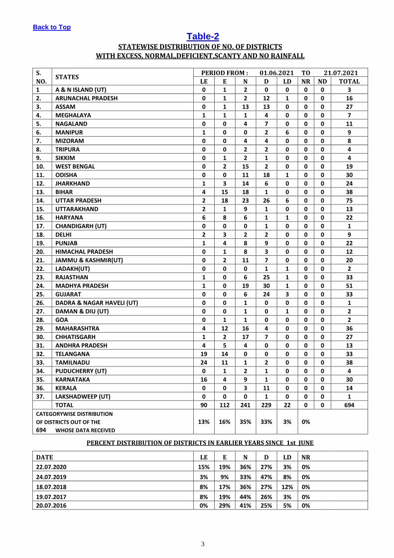
Statewise distribution of number of districts with Large-Excesse, Excess, Normal, Deficient, Large-deficient and no
rainfall is shown in Table-2.
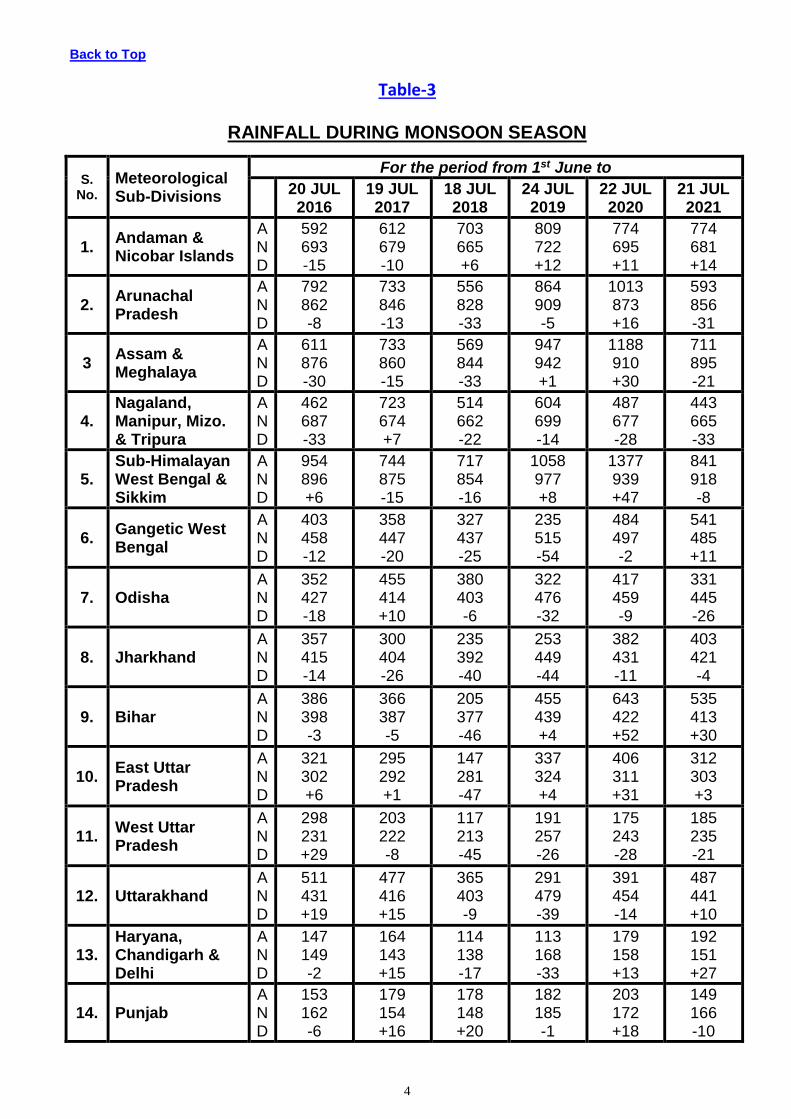
Cumulative seasonal rainfall data during the corresponding weekly period for the last five years are given in Table-3.
Sub-divisionwise realised weekly rainfall (in cm) is shown in Annexure-1.
FORECAST & WARNING FOR THE NEXT WEEK 22 July TO 28 July, 2021
Detailed seven days Sub-division wise rainfall-forecast is given in Table-1(B).
Back to Top
Table-1 (A)
METEOROLOGICAL SUB-DIVISIONWISE DISTRIBUTION OF REALISED RAINFALL-2021
S.No. MET.SUB-DIVISIONS 15 JUL 16 JUL 17 JUL 18 JUL 19 JUL 20 JUL 21 JUL
1 ANDAMAN & NICO.ISLANDS WS FWS SCT WS* WS* WS** WS
2 ARUNACHAL PRADESH WS WS WS WS FWS FWS SCT
3 ASSAM & MEGHALAYA FWS FWS WS FWS FWS FWS SCT
4 NAGA.MANI.MIZO.& TRIPURA FWS FWS WS WS FWS WS FWS
5 SUB-HIM.W. BENG. & SIKKIM WS WS WS* WS WS WS WS
6 GANGETIC WEST BENGAL FWS ISOL ISOL FWS SCT WS* FWS
7 ODISHA FWS ISOL ISOL ISOL SCT SCT WS
8 JHARKHAND SCT ISOL ISOL WS FWS WS* FWS
9 BIHAR ISOL ISOL SCT WS FWS FWS SCT
10 EAST UTTAR PRADESH ISOL ISOL ISOL WS* FWS* FWS WS*
11 WEST UTTAR PRADESH SCT ISOL ISOL WS WS* WS* WS*
12 UTTARAKHAND SCT SCT SCT SCT WS* WS* WS
13 HARYANA CHD. & DELHI WS* SCT ISOL ISOL WS** WS** WS*
14 PUNJAB SCT ISOL ISOL ISOL SCT FWS* WS**
15 HIMACHAL PRADESH SCT SCT ISOL SCT WS* WS* WS
16 JAMMU & KASHMIR AND LADAKH SCT ISOL ISOL ISOL FWS* WS* WS
17 WEST RAJASTHAN SCT ISOL ISOL ISOL ISOL ISOL ISOL
18 EAST RAJASTHAN FWS ISOL ISOL SCT FWS* SCT ISOL
19 WEST MADHYA PRADESH SCT ISOL SCT ISOL FWS FWS FWS
20 EAST MADHYA PRADESH ISOL ISOL ISOL ISOL FWS FWS WS
21 GUJARAT REGION ISOL FWS SCT ISOL SCT FWS FWS
22 SAURASTRA & KUTCH SCT SCT SCT SCT SCT SCT SCT
23 KONKAN & GOA WS* WS* WS WS* WS** WS* WS*
24 MADHYA MAHARASHTRA FWS FWS* FWS FWS FWS* WS* WS*
25 MARATHAWADA WS* FWS SCT ISOL FWS* FWS WS*
26 VIDARBHA WS FWS SCT ISOL FWS FWS WS
27 CHHATTISGARH FWS ISOL ISOL ISOL FWS SCT WS*
28 COASTAL ANDHRA PR. & YANAM WS WS* SCT SCT SCT SCT WS*
29 TELANGANA WS* FWS SCT SCT FWS SCT WS*
30 RAYALASEEMA WS** FWS FWS* FWS** FWS* SCT FWS
31 TAMIL. PUDU. & KARAIKAL FWS* SCT SCT SCT ISOL ISOL ISOL
32 COASTAL KARNATAKA WS* WS* WS WS* WS WS WS
33 NORTH INT.KARNATAKA WS WS WS WS* WS** FWS WS
34 SOUTH INT.KARNATAKA WS* WS* FWS WS* WS* FWS FWS
35 KERALA & MAHE WS* WS* WS WS WS FWS WS
36 LAKSHADWEEP SCT FWS D DRY SCT FWS WS
LEGENDS:
WS - WIDE SPREAD / MOST PLACES (76-100%) FWS - FAIRLY WIDE SPREAD / MANY PLACES (51% to 75%)
SCT - SCATTERED / FEW PLACES (26% to 50%) ISOL - ISOLATED (up to 25%) D / DRY - NO STATION REPORTED RAINFALL
* ACTIVE (R/F 11/2- 4 times the normal with WS/FWS, at least 2 stations should be 5 cm. along west coast & 3 cm. elsewhere )
** VIGOROUS (R/F More than 4 times the normal with WS/FWS, at least 2 stations should be 8 cm. along west coast & 5 cm. elsewhere)

Back to Top
Table-1 (B)
METEOROLOGICAL SUB-DIVISIONWISE WEEKLY RAINFALL FORECAST -2021
Sr. No MET.SUB-DIVISIONS 22 JUL 23 JUL 24 JUL 25 JUL 26 JUL 27 JUL 28 JUL
1 ANDAMAN & NICO.ISLANDS FWS FWS WS WS WS WS WS
2 ARUNACHAL PRADESH SCT SCT SCT FWS FWS● SCT WS
3 ASSAM & MEGHALAYA SCT SCT● SCT FWS
● FWS
●● SCT WS
4 NAGA.MANI.MIZO.& TRIPURA FWS FWS FWS FWS● FWS
● FWS WS
5 SUB-HIM.W. BENG. & SIKKIM FWS● FWS FWS FWS WS
● FWS SCT
6 GANGETIC WEST BENGAL FWS● FWS
● FWS FWS WS
● WS WS
7 ODISHA WS●● WS
●● FWS
● FWS
● FWS
● SCT FWS
8 JHARKHAND WS● WS
● FWS FWS WS
● WS WS
9 BIHAR SCT SCT SCT SCT FWS● WS WS
10 EAST UTTAR PRADESH FWS● SCT ISOL FWS
● FWS
●● FWS WS
11 WEST UTTAR PRADESH WS● FWS
● SCT
● FWS
●● WS
●● FWS FWS
12 UTTARAKHAND FWS● FWS
● SCT WS
●● WS
●● WS WS
13 HARYANA CHD. & DELHI SCT SCT ISOL SCT FWS● FWS SCT
14 PUNJAB SCT ISOL ISOL ISOL SCT● FWS FWS
15 HIMACHAL PRADESH FWS● FWS SCT FWS
● WS
●● WS WS
16 JAMMU & KASHMIR AND LADAKH ISOL ISOL ISOL ISOL SCT● SCT WS
17 WEST RAJASTSAN SCT SCT ISOL ISOL● SCT SCT ISOL
18 EAST RAJASTSAN FWS● FWS
● FWS
● SCT
● SCT SCT SCT
19 WEST MADHYA PRADESH WS●● WS
●● WS
●● WS
● FWS SCT SCT
20 EAST MADHYA PRADESH WS●● WS
●● WS
● FWS
● FWS
● FWS FWS
21 GUJARAT REGION SCT● FWS
● WS
●● WS
●● FWS
● SCT ISOL
22 SAURASTRA & KUTCH SCT SCT SCT● WS
●● FWS
● SCT ISOL
23 KONKAN & GOA WS●●●
WS●●●
WS●● WS
●● WS
● WS WS
24 MADHYA MAHARASHTRA WS●●●
WS●● FWS
● FWS
● SCT
● SCT SCT
25 MARATHAWADA WS●● FWS
● SCT SCT SCT ISOL ISOL
26 VIDARBHA WS●●●
WS●● FWS FWS FWS SCT SCT
27 CHHATTISGARH WS●●●
WS●● FWS FWS FWS FWS FWS
28 COASTAL ANDHRA PR. & YANAM WS●● WS
● SCT ISOL ISOL ISOL ISOL
29 TELANGANA WS●●●
WS●● FWS
● SCT SCT ISOL ISOL
30 RAYALASEEMA WS● SCT SCT ISOL ISOL ISOL ISOL
31 TAMIL. PUDU. & KARAIKAL ISOL● ISOL
● ISOL ISOL ISOL ISOL ISOL
32 COASTAL KARNATAKA WS●●●
WS●● WS
● WS
● WS
● WS WS
33 NORTH INTERIOR KARNATAKA WS●● WS
● FWS SCT SCT ISOL ISOL
34 SOUTH INTERIOR KARNATAKA WS●● WS
●● FWS
● SCT SCT SCT ISOL
35 KERALA & MAHE WS●● WS
●● WS
● WS
● WS
● FWS SCT
36 LAKSHADWEEP FWS FWS FWS FWS FWS SCT SCT
LEGENDS:
WS - WIDE SPREAD / MOST PLACES (76-100%) FWS - FAIRLY WIDE SPREAD / MANY PLACES (51% to 75%)
SCT - SCATTERED / FEW PLACES (26% to 50%) ISOL - ISOLATED (up to 25%) D / DRY - NO RAINFALL
● Heavy Rainfall (64.5-115.5 mm) ●● Heavy to Very Heavy Rainfall (115.6-204.4 mm) ●●● Extremely Heavy Rainfall (204.5 mm or more)
Back to Top
Table-1 (C)
METEOROLOGICAL SUB-DIVISIONWISE REALISED MAXIMUM TEMPERATURE-2021 S.No MET.SUB-DIVISIONS 15 JUL 16 JUL 17 JUL 18 JUL 19 JUL 20 JUL 21 JUL
1 ANDAMAN & NICO.ISLANDS N N N N BN N N
2 ARUNACHAL PRADESH N N N N N N N
3 ASSAM & MEGHALAYA N N N N N N N
4 NAGA.MANI.MIZO.& TRIPURA N N N N N N N
5 SUB-HIM.W. BENG. & SIKKIM N N N N N N N
6 GANGETIC WEST BENGAL AN N N N N N N
7 ODISHA AN N AAN AAN AAN N N
8 JHARKHAND AN AAN AAN N N N N
9 BIHAR N N N N N N N
10 EAST UTTAR PRADESH AAN N N N N N BN
11 WEST UTTAR PRADESH N AN N N N N N
12 UTTARAKHAND N AN N N ABN N N
13 HARYANA, CHD. & DELHI N N N N MBN N N
14 PUNJAB N N N N ABN N N
15 HIMACHAL PRADESH AN AN AN N ABN N N
16 JAMMU & KASHMIR AND LADAKH N AN N N N N MBN
17 WEST RAJASTHAN AN N N N N BN N
18 EAST RAJASTHAN AAN AAN N N N N N
19 WEST MADHYA PRADESH AAN N N N N N N
20 EAST MADHYA PRADESH N N N N N N N
21 GUJARAT REGION N N N N N N N
22 SAURASTRA & KUTCH N N N N N N N
23 KONKAN & GOA N N N N BN N BN
24 MADHYA MAHARASHTRA N N AN N N N BN
25 MARATHAWADA N N N N N BN N
26 VIDARBHA N AN N N N N ABN
27 CHHATTISGARH AAN AAN AAN AAN N N BN
28 COASTAL ANDHRA PR. & YANAM
N N N N N N N
29 TELANGANA N N N N N N N
30 RAYALASEEMA ABN N N ABN N N ABN
31 TAMIL. PUDU. & KARAIKAL N N N N N N N
32 COASTAL KARNATAKA BN ABN N ABN N N N
33 NORTH INTERIOR KARNATAKA N N N BN N BN N
34 SOUTH INTERIOR KARNATAKA ABN N N ABN N N N
35 KERALA & MAHE AN N AN N N AN N
36 LAKSHADWEEP N N AN N N N N
Highest Maximum Temperature (°C) 40.9 42.2 42.2 42.5 40.8 38.4 38.3
Station/(s) observed HMT Bikaner Bikaner Ganganagar Ganganagar Ganganagar Indpre Churu
Station/(s) lies in Met-Subdivision/(s) W RAJ W RAJ W RAJ W RAJ W RAJ W MP W RAJ
Lowest Minimum Temperature (°C) 18.0 19.2 19.0 18.5 15.8 18.6 19.0
Station/(s) observed LMT Rajnandgaon Bidar Seoni Bulsar Coonoor Bidar Seoni
Station/(s) lies in Met-Subdivision/(s) CHTG NIK E MP Guj Reg. Tamilnadu NIK E MP
LEGENDS:
BN - BELOW NORMAL (N-2)OC AN - ABOVE NORMAL (N+2)OC
N - NORMAL (N+1,N-1)OC ABN - APPRECIABLY BELOW NORMAL (N-3.1 to -4.9)OC AAN - APPRECIABLY ABOVE NORMAL (N+3.1 to +4.9)OC
MBN - MARKEDLY BELOW NORMAL (N-5 AND BELOW )OC MAN - MARKEDLY ABOVE NORMAL (N+5 AND ABOVE)OC
+ Heat Wave (Maximum temperature departure from Normal +4.5 OC to +6.4OC) - Cold Wave (Minimum temperature departure from Normal -4.5 OC to -6.4OC)
++ Severe Heat Wave (Maximum temperature departure from Normal ≥ +6.5OC) - - Severe Cold Wave (Minimum temperature departure from Norma ≤ -6.5OC)
3
Back to Top
Table-2 STATEWISE DISTRIBUTION OF NO. OF DISTRICTS
WITH EXCESS, NORMAL,DEFICIENT,SCANTY AND NO RAINFALL
S. STATES
PERIOD FROM : 01.06.2021 TO 21.07.2021
NO. LE E N D LD NR ND TOTAL 1 A & N ISLAND (UT) 0 1 2 0 0 0 0 3
2. ARUNACHAL PRADESH 0 1 2 12 1 0 0 16
3. ASSAM 0 1 13 13 0 0 0 27
4. MEGHALAYA 1 1 1 4 0 0 0 7
5. NAGALAND 0 0 4 7 0 0 0 11
6. MANIPUR 1 0 0 2 6 0 0 9
7. MIZORAM 0 0 4 4 0 0 0 8
8. TRIPURA 0 0 2 2 0 0 0 4
9. SIKKIM 0 1 2 1 0 0 0 4
10. WEST BENGAL 0 2 15 2 0 0 0 19
11. ODISHA 0 0 11 18 1 0 0 30
12. JHARKHAND 1 3 14 6 0 0 0 24
13. BIHAR 4 15 18 1 0 0 0 38
14. UTTAR PRADESH 2 18 23 26 6 0 0 75
15. UTTARAKHAND 2 1 9 1 0 0 0 13
16. HARYANA 6 8 6 1 1 0 0 22
17. CHANDIGARH (UT) 0 0 0 1 0 0 0 1
18. DELHI 2 3 2 2 0 0 0 9
19. PUNJAB 1 4 8 9 0 0 0 22
20. HIMACHAL PRADESH 0 1 8 3 0 0 0 12
21. JAMMU & KASHMIR(UT) 0 2 11 7 0 0 0 20
22. LADAKH(UT) 0 0 0 1 1 0 0 2
23. RAJASTHAN 1 0 6 25 1 0 0 33
24. MADHYA PRADESH 1 0 19 30 1 0 0 51
25. GUJARAT 0 0 6 24 3 0 0 33
26. DADRA & NAGAR HAVELI (UT) 0 0 1 0 0 0 0 1
27. DAMAN & DIU (UT) 0 0 1 0 1 0 0 2
28. GOA 0 1 1 0 0 0 0 2
29. MAHARASHTRA 4 12 16 4 0 0 0 36
30. CHHATISGARH 1 2 17 7 0 0 0 27
31. ANDHRA PRADESH 4 5 4 0 0 0 0 13
32. TELANGANA 19 14 0 0 0 0 0 33
33. TAMILNADU 24 11 1 2 0 0 0 38
34. PUDUCHERRY (UT) 0 1 2 1 0 0 0 4
35. KARNATAKA 16 4 9 1 0 0 0 30
36. KERALA 0 0 3 11 0 0 0 14
37. LAKSHADWEEP (UT) 0 0 0 1 0 0 0 1
TOTAL 90 112 241 229 22 0 0 694
CATEGORYWISE DISTRIBUTION
OF DISTRICTS OUT OF THE 13% 16% 35% 33% 3% 0%
694 WHOSE DATA RECEIVED
PERCENT DISTRIBUTION OF DISTRICTS IN EARLIER YEARS SINCE 1st JUNE
DATE LE E N D LD NR
22.07.2020 15% 19% 36% 27% 3% 0%
24.07.2019 3% 9% 33% 47% 8% 0%
18.07.2018 8% 17% 36% 27% 12% 0%
19.07.2017 8% 19% 44% 26% 3% 0%
20.07.2016 0% 29% 41% 25% 5% 0%
4
Back to Top
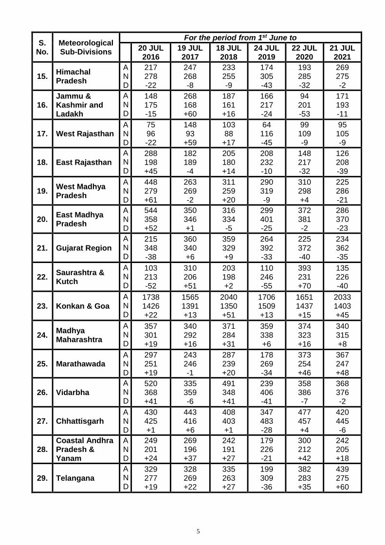
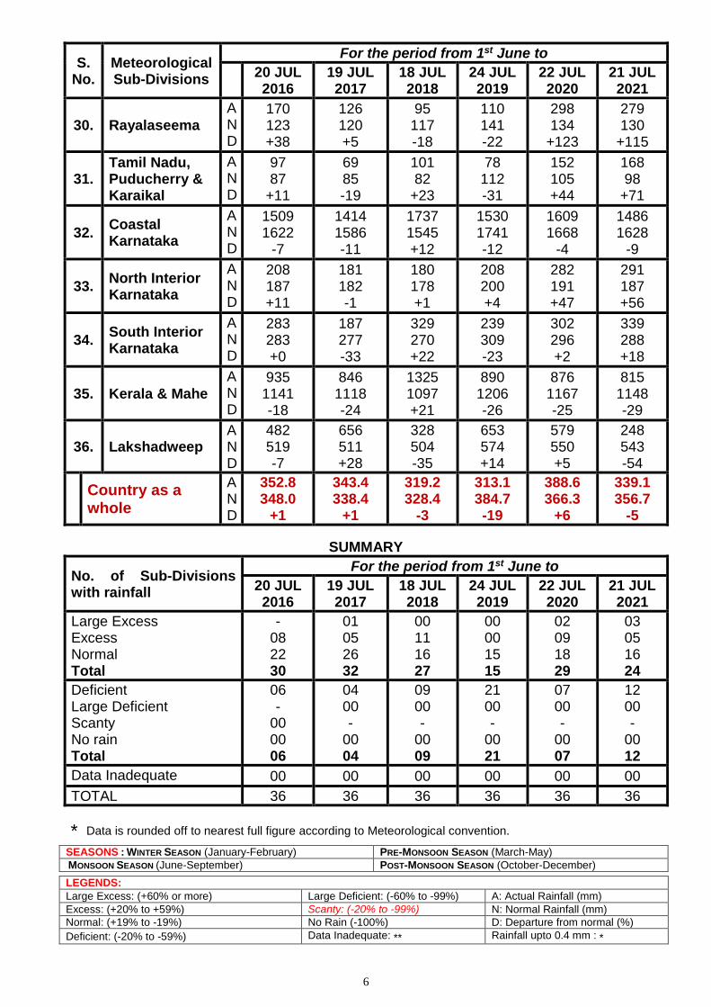
Table-3
RAINFALL DURING MONSOON SEASON
S. No.
Meteorological Sub-Divisions
For the period from 1st June to
20 JUL 2016
19 JUL 2017
18 JUL 2018
24 JUL 2019
22 JUL 2020
21 JUL 2021
1. Andaman & Nicobar Islands
A N D
592 693 -15
612 679 -10
703 665 +6
809 722 +12
774 695 +11
774 681 +14
2. Arunachal Pradesh
A N D
792 862 -8
733 846 -13
556 828 -33
864 909 -5
1013 873 +16
593 856 -31
3 Assam & Meghalaya
A N D
611 876 -30
733 860 -15
569 844 -33
947 942 +1
1188 910 +30
711 895 -21
4. Nagaland, Manipur, Mizo. & Tripura
A N D
462 687 -33
723 674 +7
514 662 -22
604 699 -14
487 677 -28
443 665 -33
5. Sub-Himalayan West Bengal & Sikkim
A N D
954 896 +6
744 875 -15
717 854 -16
1058 977 +8
1377 939 +47
841 918 -8
6. Gangetic West Bengal
A N D
403 458 -12
358 447 -20
327 437 -25
235 515 -54
484 497 -2
541 485 +11
7. Odisha A N D
352 427 -18
455 414 +10
380 403 -6
322 476 -32
417 459 -9
331 445 -26
8. Jharkhand A N D
357 415 -14
300 404 -26
235 392 -40
253 449 -44
382 431 -11
403 421 -4
9. Bihar A N D
386 398 -3
366 387 -5
205 377 -46
455 439 +4
643 422 +52
535 413 +30
10. East Uttar Pradesh
A N D
321 302 +6
295 292 +1
147 281 -47
337 324 +4
406 311 +31
312 303 +3
11. West Uttar Pradesh
A N D
298 231 +29
203 222 -8
117 213 -45
191 257 -26
175 243 -28
185 235 -21
12. Uttarakhand A N D
511 431 +19
477 416 +15
365 403 -9
291 479 -39
391 454 -14
487 441 +10
13. Haryana, Chandigarh & Delhi
A N D
147 149 -2
164 143 +15
114 138 -17
113 168 -33
179 158 +13
192 151 +27
14. Punjab A N D
153 162 -6
179 154 +16
178 148 +20
182 185 -1
203 172 +18
149 166 -10
5
S. No.
Meteorological Sub-Divisions
For the period from 1st June to
20 JUL 2016
19 JUL 2017
18 JUL 2018
24 JUL 2019
22 JUL 2020
21 JUL 2021
15. Himachal Pradesh
A N D
217 278 -22
247 268 -8
233 255 -9
174 305 -43
193 285 -32
269 275 -2
16. Jammu & Kashmir and Ladakh
A N D
148 175 -15
268 168 +60
187 161 +16
166 217 -24
94 201 -53
171 193 -11
17. West Rajasthan A N D
75 96 -22
148 93
+59
103 88
+17
64 116 -45
99 109 -9
95 105 -9
18. East Rajasthan
A N D
288 198 +45
182 189 -4
205 180 +14
208 232 -10
148 217 -32
126 208 -39
19. West Madhya Pradesh
A N D
448 279 +61
263 269 -2
311 259 +20
290 319 -9
310 298 +4
225 286 -21
20. East Madhya Pradesh
A N D
544 358 +52
350 346 +1
316 334 -5
299 401 -25
372 381 -2
286 370 -23
21. Gujarat Region
A N D
215 348 -38
360 340 +6
359 329 +9
264 392 -33
225 372 -40
234 362 -35
22. Saurashtra & Kutch
A N D
103 213 -52
310 206 +51
203 198 +2
110 246 -55
393 231 +70
135 226 -40
23. Konkan & Goa
A N D
1738 1426 +22
1565 1391 +13
2040 1350 +51
1706 1509 +13
1651 1437 +15
2033 1403 +45
24. Madhya Maharashtra
A N D
357 301 +19
340 292 +16
371 284 +31
359 338 +6
374 323 +16
340 315 +8
25. Marathawada A N D
297 251 +19
243 246 -1
287 239 +20
178 269 -34
373 254 +46
367 247 +48
26. Vidarbha
A N D
520 368 +41
335 359 -6
491 348 +41
239 406 -41
358 386 -7
368 376 -2
27. Chhattisgarh A N D
430 425 +1
443 416 +6
408 403 +1
347 483 -28
477 457 +4
420 445 -6
28. Coastal Andhra Pradesh & Yanam
A N D
249 201 +24
269 196 +37
242 191 +27
179 226 -21
300 212 +42
242 205 +18
29. Telangana
A N D
329 277 +19
328 269 +22
335 263 +27
199 309 -36
382 283 +35
439 275 +60
6
S. No.
Meteorological Sub-Divisions
For the period from 1st June to
20 JUL 2016
19 JUL 2017
18 JUL 2018
24 JUL 2019
22 JUL 2020
21 JUL 2021
30. Rayalaseema
A N D
170 123 +38
126 120 +5
95 117 -18
110 141 -22
298 134
+123
279 130
+115
31. Tamil Nadu, Puducherry & Karaikal
A N D
97 87
+11
69 85 -19
101 82
+23
78 112 -31
152 105 +44
168 98
+71
32. Coastal Karnataka
A N D
1509 1622
-7
1414 1586 -11
1737 1545 +12
1530 1741 -12
1609 1668
-4
1486 1628
-9
33. North Interior Karnataka
A N D
208 187 +11
181 182 -1
180 178 +1
208 200 +4
282 191 +47
291 187 +56
34. South Interior Karnataka
A N D
283 283 +0
187 277 -33
329 270 +22
239 309 -23
302 296 +2
339 288 +18
35. Kerala & Mahe
A N D
935 1141 -18
846 1118 -24
1325 1097 +21
890 1206 -26
876 1167 -25
815 1148 -29
36. Lakshadweep A N D
482 519 -7
656 511 +28
328 504 -35
653 574 +14
579 550 +5
248 543 -54
Country as a whole
A N D
352.8 348.0
+1
343.4 338.4
+1
319.2 328.4
-3
313.1 384.7 -19
388.6 366.3
+6
339.1 356.7
-5
SUMMARY
No. of Sub-Divisions with rainfall
For the period from 1st June to
20 JUL 2016
19 JUL 2017
18 JUL 2018
24 JUL 2019
22 JUL 2020
21 JUL 2021
Large Excess Excess Normal Total
- 08 22 30
01 05 26 32
00 11 16 27
00 00 15 15
02 09 18 29
03 05 16 24
Deficient Large Deficient Scanty No rain Total
06 -
00 00 06
04 00 -
00 04
09 00 -
00 09
21 00 -
00 21
07 00 -
00 07
12 00 -
00 12
Data Inadequate 00 00 00 00 00 00
TOTAL 36 36 36 36 36 36
* Data is rounded off to nearest full figure according to Meteorological convention.
SEASONS : WINTER SEASON (January-February) PRE-MONSOON SEASON (March-May)
MONSOON SEASON (June-September) POST-MONSOON SEASON (October-December)
LEGENDS:
Large Excess: (+60% or more) Large Deficient: (-60% to -99%) A: Actual Rainfall (mm)
Excess: (+20% to +59%) Scanty: (-20% to -99%) N: Normal Rainfall (mm)
Normal: (+19% to -19%) No Rain (-100%) D: Departure from normal (%)
Deficient: (-20% to -59%) Data Inadequate: ** Rainfall upto 0.4 mm : *
Back to Top
Fig-1
3
Back to Top
Fig-2
1 | P a g e
Government of India
Earth System Science Organization
Ministry of Earth Sciences
India Meteorological Department
Dated: 22 July, 2021
Subject: Current Weather Status and Extended range Forecast for next two weeks
(22 July-4 August 2021)
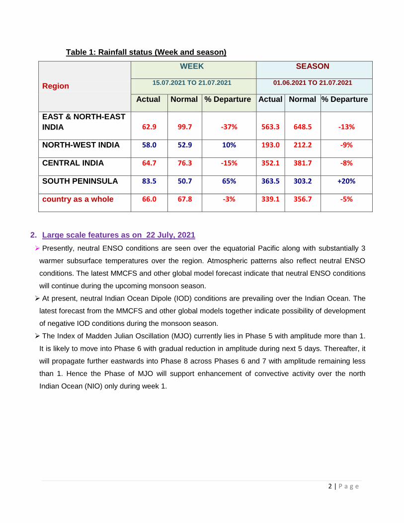
1. Significant Features for the Country Prolonged isolated extremely heavy rainfall spells (24 hours rainfall > 204.4 mm) occurred
over Konkan and Goa including Mumbai and its sub-urban areas, and Ghat areas of
Maharashtra when it was observed in almost all dates of the week of 15-21 July. It causes
severe flooding and inundation over some districts of Konkan areas including over Mumbai.
Isolated extremely heavy rainfall also occurred over Western Himalayan Region and
adjoining plains (Himachal Pradesh and Uttarakhand and Punjab and Haryana), but it was
during 2nd half of the week i.e. 18-21 July.
Weekly cumulative % rainfall departure for the country as a whole from its Long Period
Average (LPA) was -3% during the week, while it’s Seasonal cumulative % Rainfall departure
from LPA since 1 June till 21 July, 2021 was -5 %. Details of the rainfall distribution over the
four broad geographical regions of India are given Table 1 with met sub-divisions-wise rainfall
both for week and season given in Annex 1.
Forecast for next 2 weeks: Week 1 (22 to 28 July, 2021) and Week 2 (29 July-4 August 2021) based
on NWP model consensus shows “On-going normal to above normal active monsoon conditions
for the country as a whole is likely to continue during the first week and subdued activity is
likely during the second week”.
Based on current model guidance, a low pressure area is very likely to develop over north Bay
of Bengal and neighbourhood during the end of week 1 and beginning of week 2.
2 | P a g e
Table 1: Rainfall status (Week and season)
Region
WEEK SEASON
15.07.2021 TO 21.07.2021 01.06.2021 TO 21.07.2021
Actual Normal % Departure Actual Normal % Departure
EAST & NORTH-EAST
INDIA 62.9 99.7 -37% 563.3 648.5 -13%
NORTH-WEST INDIA 58.0 52.9 10% 193.0 212.2 -9%
CENTRAL INDIA 64.7 76.3 -15% 352.1 381.7 -8%
SOUTH PENINSULA 83.5 50.7 65% 363.5 303.2 +20%
country as a whole 66.0 67.8 -3% 339.1 356.7 -5%
2. Large scale features as on 22 July, 2021
Presently, neutral ENSO conditions are seen over the equatorial Pacific along with substantially 3
warmer subsurface temperatures over the region. Atmospheric patterns also reflect neutral ENSO
conditions. The latest MMCFS and other global model forecast indicate that neutral ENSO conditions
will continue during the upcoming monsoon season.
At present, neutral Indian Ocean Dipole (IOD) conditions are prevailing over the Indian Ocean. The
latest forecast from the MMCFS and other global models together indicate possibility of development
of negative IOD conditions during the monsoon season.
The Index of Madden Julian Oscillation (MJO) currently lies in Phase 5 with amplitude more than 1.
It is likely to move into Phase 6 with gradual reduction in amplitude during next 5 days. Thereafter, it
will propagate further eastwards into Phase 8 across Phases 6 and 7 with amplitude remaining less
than 1. Hence the Phase of MJO will support enhancement of convective activity over the north
Indian Ocean (NIO) only during week 1.
3 | P a g e
3. Forecast for next two week
Weather systems & associated Precipitation during Week 1 (22 to 28 July, 2021) and Week 2
(29 July-4 August, 2021)
Rainfall for week 1: (22 to 28 July, 2021)
A Low Pressure Area lies over Northwest Bay of Bengal & neighbourhood. The associated
cyclonic circulation extends upto upper tropospheric level tilting southwest with height. It is
very likely to move west-northwestwards along the monsoon trough during next 2-3 days.
The western end of monsoon trough at mean sea level is north of its normal position and its
eastern end is south of its normal position dipping to eastcentral Bay of Bengal across
northwest Bay of Bengal. The western end is very likely to shift gradually to its normal
position and eastern end likely to be south of its normal position during next 3 days.
Thereafter, the monsoon trough likely to shift northwards during subsequent 3-4 days.
An off-shore trough at mean sea level runs from south Gujarat coast to Kerala coast. It is
likely to persist during next 2-3 days.
Under the influence of these meteorological conditions;
Fairly widespread to widespread rainfall with isolated heavy falls very likely over
Himachal Pradesh and Uttarakhand on 22nd and 23rd which is likely to increase to
isolated heavy to very heavy falls on 25th and 28th July, 2021. Fairly widespread to
widespread rainfall with isolated heavy falls very likely over Jammu & Kashmir and
Ladakh on 27th & 28th July, 2021.
Scattered to fairly widespread rainfall over plains of northwest India likely during 1st
half of the week with enhanced rainfall activity thereafter with isolated heavy to very
heavy falls over Uttar Pradesh on 25th & 26th and isolated heavy falls on 27th & 28th
July, 2021.
Fairly widespread to widespread rainfall with isolated heavy to very heavy falls very
likely to continue over west coast till 24th July and reduce thereafter. Isolated
extremely heavy falls also very likely over Konkan & Goa & adjoining Ghat
areas of Madhya Maharashtra and Coastal Karnataka today, the 22nd July, 2021.
Scattered to fairly widespread rainfall with isolated heavy falls likely to continue over
Gujarat state till 23rd and fairly widespread to widespread rainfall with isolated heavy
4 | P a g e
to very heavy falls on 25th & 26th July, 2021.
Fairly Widespread to widespread rainfall with isolated heavy to very heavy falls
likely over east & adjoining central India during 22nd to 24th July and reduce
thereafter. Isolated extremely heavy falls also likely over Telangana, south
Chhattisgarh and Vidharbha today, the 22nd July, 2021.
Increase in rainfall activity over northeast India likely on 26th July with fairly
widespread to widespread rainfall with isolated heavy to very heavy falls over the
region.
Isolated to scatted rainfall activity is likely over remaining parts of the country during the
week (Annexure IV).
Rainfall for week 2: (29 July to 04 August, 2021)
The monsoon trough is very likely to be north of its normal position during most days of the week.
Hence rainfall activity is very likely to be confined to the northern parts of the country during this
week.
Fairly widespread to widespread rainfall with isolated heavy to heavy falls very likely over northeast &
adjoining east India during most days of the week.
Fairly widespread to widespread rainfall with isolated heavy falls also likely over Western Himalayan
Region & adjoining plains of northwest India and Uttar Pradesh during most days of the week.
Overall, normal to above normal rainfall activity is likely over Western Himalayan Region, Punjab,
Haryana, Chandigarh & Delhi, Uttar Pradesh, Bihar, Jharkhand, West Bengal & Sikkim and
northeastern states.
4. Cyclogenesis:
Considering existing environmental features and model guidance, it may be concluded that no
cyclogenesis is likely over the north Indian Ocean during the forecast period. However, a
low pressure area is very likely to develop over north BoB and neighbourhood during the
end of week 1 and beginning of week 2.
https://rsmcnewdelhi.imd.gov.in/uploads/archive/24/24_2b1c7f_Extended%20Range%20Outlook_220
72021.pdf
Next weekly update will be issued on next Thursday i.e. 29 July 2021
21.07.2021
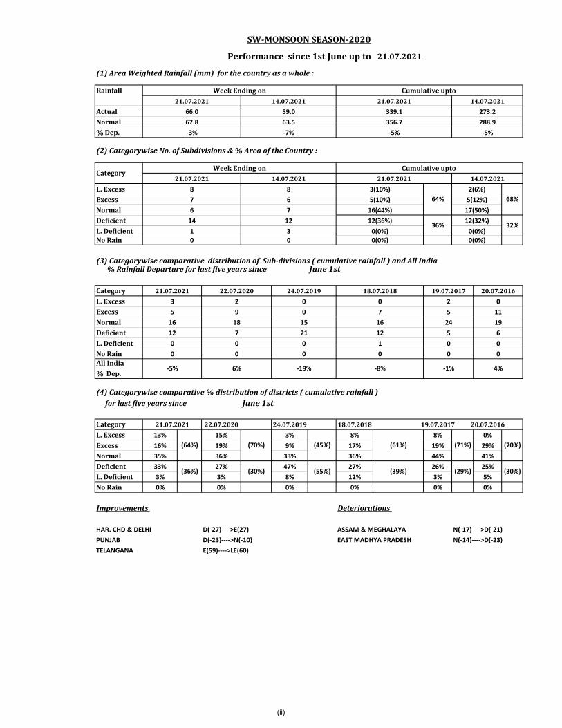
(1) Area Weighted Rainfall (mm) for the country as a whole :
Rainfall
ActualNormal% Dep.
(2) Categorywise No. of Subdivisions & % Area of the Country :
L. ExcessExcessNormalDeficientL. DeficientNo Rain
(3) Categorywise comparative distribution of Sub-divisions ( cumulative rainfall ) and All India % Rainfall Departure for last five years since June 1st
CategoryL. ExcessExcessNormalDeficientL. DeficientNo RainAll India% Dep.
(4) Categorywise comparative % distribution of districts ( cumulative rainfall ) for last five years since June 1st
Category 22.07.2020 24.07.2019 18.07.2018 19.07.2017 20.07.2016L. Excess 13% 15% 3% 8% 8% 0%Excess 16% 19% 9% 17% 19% 29%Normal 35% 36% 33% 36% 44% 41%Deficient 33% 27% 47% 27% 26% 25%L. Deficient 3% 3% 8% 12% 3% 5%No Rain 0% 0% 0% 0% 0% 0%
HAR. CHD & DELHI D(-27)---->E(27) ASSAM & MEGHALAYA N(-17)---->D(-21)PUNJAB D(-23)---->N(-10) EAST MADHYA PRADESH N(-14)---->D(-23)TELANGANA E(59)---->LE(60)
3
67.8-3%
0
18
22.07.2020
029
15
19.07.2017
(30%)
00
21
7
(36%)
012
0
(71%)(45%)
0
12
(64%)
4%-19%
0 0
16
(61%)
21.07.2021
(70%)
7
5
-5% 6%
1
-1%
SW-MONSOON SEASON-2020
Performance since 1st June up to
CategoryWeek Ending on Cumulative upto
5
20.07.2016
Week Ending on Cumulative upto
18.07.20180
(70%)
(30%)
-8%
11
616
0
24 19
(39%)
024.07.2019
221.07.2021
Improvements Deteriorations
(29%)(55%)
0
16(44%) 17(50%)
21.07.2021 14.07.2021 21.07.2021 14.07.2021
288.966.0 59.0 339.1
0
50
6
14.07.2021 21.07.2021 14.07.20213(10%)
64%2(6%)
273.263.5 356.7
68%7 6 5(10%) 5(12%)7
-7% -5% -5%
21.07.2021
32%1 3 0(0%) 0(0%)
8 8
0 0(0%) 0(0%)
14 12 12(36%)36%
12(32%)
0
(ii)
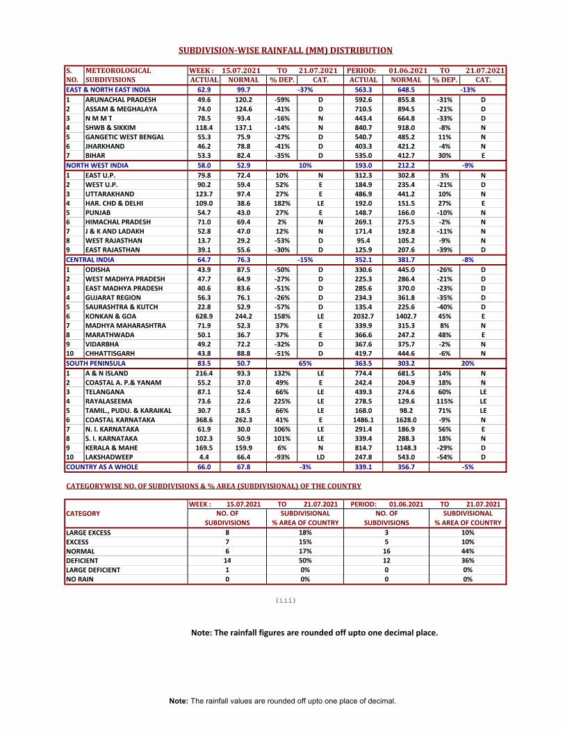
S. METEOROLOGICAL WEEK : 15.07.2021 TO 21.07.2021 PERIOD: 01.06.2021 TO 21.07.2021NO. SUBDIVISIONS ACTUAL NORMAL % DEP. CAT. ACTUAL NORMAL % DEP. CAT.EAST & NORTH EAST INDIA 62.9 99.7 563.3 648.51 ARUNACHAL PRADESH 49.6 120.2 -59% D 592.6 855.8 -31% D2 ASSAM & MEGHALAYA 74.0 124.6 -41% D 710.5 894.5 -21% D3 N M M T 78.5 93.4 -16% N 443.4 664.8 -33% D4 SHWB & SIKKIM 118.4 137.1 -14% N 840.7 918.0 -8% N5 GANGETIC WEST BENGAL 55.3 75.9 -27% D 540.7 485.2 11% N6 JHARKHAND 46.2 78.8 -41% D 403.3 421.2 -4% N7 BIHAR 53.3 82.4 -35% D 535.0 412.7 30% ENORTH WEST INDIA 58.0 52.9 193.0 212.21 EAST U.P. 79.8 72.4 10% N 312.3 302.8 3% N2 WEST U.P. 90.2 59.4 52% E 184.9 235.4 -21% D3 UTTARAKHAND 123.7 97.4 27% E 486.9 441.2 10% N4 HAR. CHD & DELHI 109.0 38.6 182% LE 192.0 151.5 27% E5 PUNJAB 54.7 43.0 27% E 148.7 166.0 -10% N6 HIMACHAL PRADESH 71.0 69.4 2% N 269.1 275.5 -2% N7 J & K AND LADAKH 52.8 47.0 12% N 171.4 192.8 -11% N8 WEST RAJASTHAN 13.7 29.2 -53% D 95.4 105.2 -9% N9 EAST RAJASTHAN 39.1 55.6 -30% D 125.9 207.6 -39% DCENTRAL INDIA 64.7 76.3 352.1 381.71 ODISHA 43.9 87.5 -50% D 330.6 445.0 -26% D2 WEST MADHYA PRADESH 47.7 64.9 -27% D 225.3 286.4 -21% D3 EAST MADHYA PRADESH 40.6 83.6 -51% D 285.6 370.0 -23% D4 GUJARAT REGION 56.3 76.1 -26% D 234.3 361.8 -35% D5 SAURASHTRA & KUTCH 22.8 52.9 -57% D 135.4 225.6 -40% D6 KONKAN & GOA 628.9 244.2 158% LE 2032.7 1402.7 45% E7 MADHYA MAHARASHTRA 71.9 52.3 37% E 339.9 315.3 8% N8 MARATHWADA 50.1 36.7 37% E 366.6 247.2 48% E9 VIDARBHA 49.2 72.2 -32% D 367.6 375.7 -2% N10 CHHATTISGARH 43.8 88.8 -51% D 419.7 444.6 -6% NSOUTH PENINSULA 83.5 50.7 363.5 303.21 A & N ISLAND 216.4 93.3 132% LE 774.4 681.5 14% N2 COASTAL A. P.& YANAM 55.2 37.0 49% E 242.4 204.9 18% N3 TELANGANA 87.1 52.4 66% LE 439.3 274.6 60% LE4 RAYALASEEMA 73.6 22.6 225% LE 278.5 129.6 115% LE5 TAMIL., PUDU. & KARAIKAL 30.7 18.5 66% LE 168.0 98.2 71% LE6 COASTAL KARNATAKA 368.6 262.3 41% E 1486.1 1628.0 -9% N7 N. I. KARNATAKA 61.9 30.0 106% LE 291.4 186.9 56% E8 S. I. KARNATAKA 102.3 50.9 101% LE 339.4 288.3 18% N9 KERALA & MAHE 169.5 159.9 6% N 814.7 1148.3 -29% D10 LAKSHADWEEP 4.4 66.4 -93% LD 247.8 543.0 -54% DCOUNTRY AS A WHOLE 66.0 67.8 339.1 356.7
CATEGORYWISE NO. OF SUBDIVISIONS & % AREA (SUBDIVISIONAL) OF THE COUNTRY
WEEK : 15.07.2021 TO 21.07.2021 PERIOD: 01.06.2021 TO 21.07.2021CATEGORY
LARGE EXCESSEXCESSNORMALDEFICIENTLARGE DEFICIENTNO RAIN
-9%
-15% -8%
65% 20%
-3% -5%
Note: The rainfall figures are rounded off upto one decimal place.
(iii)
6
1 0% 0 0%0 0% 0 0%
7
14 50% 12 36%17%15%
16 44%
% AREA OF COUNTRY SUBDIVISIONS % AREA OF COUNTRY8 3 10%
5 10%18%
SUBDIVISION-WISE RAINFALL (MM) DISTRIBUTION
SUBDIVISIONSNO. OF SUBDIVISIONAL NO. OF SUBDIVISIONAL
-37% -13%
10%
Note: The rainfall values are rounded off upto one place of decimal.
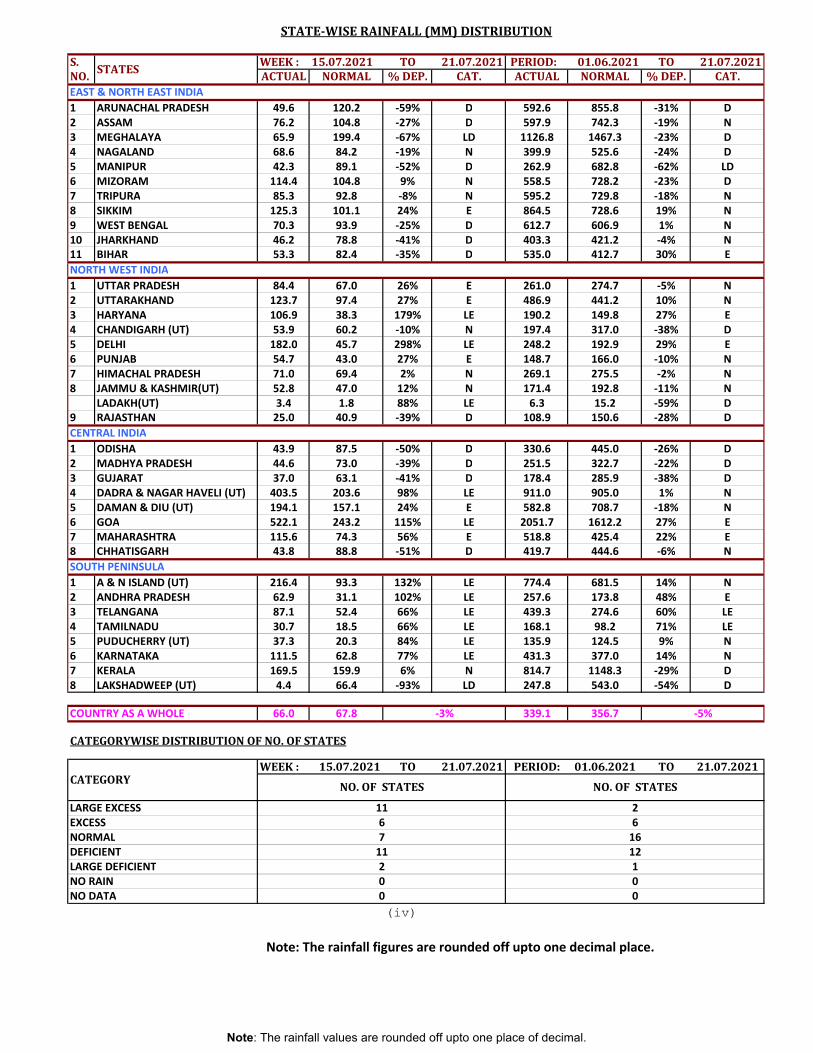
S. WEEK : 15.07.2021 TO 21.07.2021 PERIOD: 01.06.2021 TO 21.07.2021NO. ACTUAL NORMAL % DEP. CAT. ACTUAL NORMAL % DEP. CAT.
1 ARUNACHAL PRADESH 49.6 120.2 -59% D 592.6 855.8 -31% D2 ASSAM 76.2 104.8 -27% D 597.9 742.3 -19% N3 MEGHALAYA 65.9 199.4 -67% LD 1126.8 1467.3 -23% D4 NAGALAND 68.6 84.2 -19% N 399.9 525.6 -24% D5 MANIPUR 42.3 89.1 -52% D 262.9 682.8 -62% LD6 MIZORAM 114.4 104.8 9% N 558.5 728.2 -23% D7 TRIPURA 85.3 92.8 -8% N 595.2 729.8 -18% N8 SIKKIM 125.3 101.1 24% E 864.5 728.6 19% N9 WEST BENGAL 70.3 93.9 -25% D 612.7 606.9 1% N10 JHARKHAND 46.2 78.8 -41% D 403.3 421.2 -4% N11 BIHAR 53.3 82.4 -35% D 535.0 412.7 30% E
1 UTTAR PRADESH 84.4 67.0 26% E 261.0 274.7 -5% N2 UTTARAKHAND 123.7 97.4 27% E 486.9 441.2 10% N3 HARYANA 106.9 38.3 179% LE 190.2 149.8 27% E4 CHANDIGARH (UT) 53.9 60.2 -10% N 197.4 317.0 -38% D5 DELHI 182.0 45.7 298% LE 248.2 192.9 29% E6 PUNJAB 54.7 43.0 27% E 148.7 166.0 -10% N7 HIMACHAL PRADESH 71.0 69.4 2% N 269.1 275.5 -2% N8 JAMMU & KASHMIR(UT) 52.8 47.0 12% N 171.4 192.8 -11% N
LADAKH(UT) 3.4 1.8 88% LE 6.3 15.2 -59% D9 RAJASTHAN 25.0 40.9 -39% D 108.9 150.6 -28% DCENTRAL INDIA1 ODISHA 43.9 87.5 -50% D 330.6 445.0 -26% D2 MADHYA PRADESH 44.6 73.0 -39% D 251.5 322.7 -22% D3 GUJARAT 37.0 63.1 -41% D 178.4 285.9 -38% D4 DADRA & NAGAR HAVELI (UT) 403.5 203.6 98% LE 911.0 905.0 1% N5 DAMAN & DIU (UT) 194.1 157.1 24% E 582.8 708.7 -18% N6 GOA 522.1 243.2 115% LE 2051.7 1612.2 27% E7 MAHARASHTRA 115.6 74.3 56% E 518.8 425.4 22% E8 CHHATISGARH 43.8 88.8 -51% D 419.7 444.6 -6% NSOUTH PENINSULA1 A & N ISLAND (UT) 216.4 93.3 132% LE 774.4 681.5 14% N2 ANDHRA PRADESH 62.9 31.1 102% LE 257.6 173.8 48% E3 TELANGANA 87.1 52.4 66% LE 439.3 274.6 60% LE4 TAMILNADU 30.7 18.5 66% LE 168.1 98.2 71% LE5 PUDUCHERRY (UT) 37.3 20.3 84% LE 135.9 124.5 9% N6 KARNATAKA 111.5 62.8 77% LE 431.3 377.0 14% N7 KERALA 169.5 159.9 6% N 814.7 1148.3 -29% D8 LAKSHADWEEP (UT) 4.4 66.4 -93% LD 247.8 543.0 -54% D
COUNTRY AS A WHOLE 66.0 67.8 339.1 356.7
CATEGORYWISE DISTRIBUTION OF NO. OF STATES
WEEK : 15.07.2021 TO 21.07.2021 PERIOD: 01.06.2021 TO 21.07.2021
(iv)
16
EAST & NORTH EAST INDIA
-3% -5%
0 00
67
122
Note: The rainfall figures are rounded off upto one decimal place.
STATE-WISE RAINFALL (MM) DISTRIBUTION
STATES
LARGE EXCESS
NORTH WEST INDIA
LARGE DEFICIENT
NO. OF STATES
26EXCESS
1
NO DATANO RAIN 0
CATEGORY NO. OF STATES
11
NORMAL11DEFICIENT
Note: The rainfall values are rounded off upto one place of decimal.
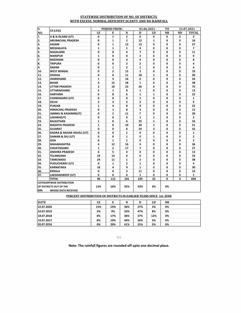
S. TONO. LE E N D LD NR ND TOTAL1 A & N ISLAND (UT) 0 1 2 0 0 0 0 32. ARUNACHAL PRADESH 0 1 2 12 1 0 0 163. ASSAM 0 1 13 13 0 0 0 274. MEGHALAYA 1 1 1 4 0 0 0 75. NAGALAND 0 0 4 7 0 0 0 116. MANIPUR 1 0 0 2 6 0 0 97. MIZORAM 0 0 4 4 0 0 0 88. TRIPURA 0 0 2 2 0 0 0 49. SIKKIM 0 1 2 1 0 0 0 410. WEST BENGAL 0 2 15 2 0 0 0 1911. ODISHA 0 0 11 18 1 0 0 3012. JHARKHAND 1 3 14 6 0 0 0 2413. BIHAR 4 15 18 1 0 0 0 3814. UTTAR PRADESH 2 18 23 26 6 0 0 7515. UTTARAKHAND 2 1 9 1 0 0 0 1316. HARYANA 6 8 6 1 1 0 0 2217. CHANDIGARH (UT) 0 0 0 1 0 0 0 118. DELHI 2 3 2 2 0 0 0 919. PUNJAB 1 4 8 9 0 0 0 2220. HIMACHAL PRADESH 0 1 8 3 0 0 0 1221. JAMMU & KASHMIR(UT) 0 2 11 7 0 0 0 2022. LADAKH(UT) 0 0 0 1 1 0 0 223. RAJASTHAN 1 0 6 25 1 0 0 3324. MADHYA PRADESH 1 0 19 30 1 0 0 5125. GUJARAT 0 0 6 24 3 0 0 3326. DADRA & NAGAR HAVELI (UT) 0 0 1 0 0 0 0 127. DAMAN & DIU (UT) 0 0 1 0 1 0 0 228. GOA 0 1 1 0 0 0 0 229. MAHARASHTRA 4 12 16 4 0 0 0 3630. CHHATISGARH 1 2 17 7 0 0 0 2731. ANDHRA PRADESH 4 5 4 0 0 0 0 1332. TELANGANA 19 14 0 0 0 0 0 3333. TAMILNADU 24 11 1 2 0 0 0 3834. PUDUCHERRY (UT) 0 1 2 1 0 0 0 435. KARNATAKA 16 4 9 1 0 0 0 3036. KERALA 0 0 3 11 0 0 0 1437. LAKSHADWEEP (UT) 0 0 0 1 0 0 0 1
TOTAL 90 112 241 229 22 0 0 694
13% 16% 35% 33% 3% 0%694 WHOSE DATA RECEIVED
LE E N D LD NR15% 19% 36% 27% 3% 0%
24.07.2019 3% 9% 33% 47% 8% 0%18.07.2018 8% 17% 36% 27% 12% 0%19.07.2017 8% 19% 44% 26% 3% 0%
0% 29% 41% 25% 5% 0%
STATES
STATEWISE DISTRIBUTION OF NO. OF DISTRICTS WITH EXCESS, NORMAL,DEFICIENT,SCANTY AND NO RAINFALL
PERIOD FROM : 01.06.2021 21.07.2021
Note: The rainfall figures are rounded off upto one decimal place.
(v)
PERCENT DISTRIBUTION OF DISTRICTS IN EARLIER YEARS SINCE 1st JUNE
OF DISTRICTS OUT OF THECATEGORYWISE DISTRIBUTION
DATE22.07.2020
20.07.2016