franklin county board of county commissioners regular ...
372
FRANKLIN COUNTY BOARD OF COUNTY COMMISSIONERS REGULAR MEETING COURTHOUSE ANNEX, COMMISSION MEETING ROOM FEBRUARY 16, 2021 9:00 AM AGENDA The Board of County Commissioners asks that all cell phones are turned off or placed on silent (vibrate) mode. Any handouts (information) for distribution to the Commission must be submitted to the Board Secretary (Clerk’s Office) or to the County Coordinator on or before the Thursday prior to that Tuesday’s meeting. Failure to do so will result in your removal from the agenda or a delay of any action relating to your request until a future meeting. Meeting Information To comply with CDC and Government social distancing requirements, the general public will not be allowed in the commission meeting room for this meeting; therefore, this Board of County Commission regular meeting will be accessible via livestream and Zoom. Those wanting to view the meeting can use the livestream link (https://facebook.com/forgottencoasttv/) or go to Forgotten Coast TV's Facebook Page. The livestream feed will promptly start 5 minutes before the meeting commences. You do not need a Facebook account to view Facebook live. Those wanting to participate during the meeting should use the Zoom log-in/call-in information provided below. There is a link to a list of videos and Getting Started Resources on the main "Agenda and Minutes" webpage for those unfamiliar with Zoom. To join Zoom via computer, use the link (https://zoom.us/j/98252218277) on the meeting date and time. If you do not have speakers or a microphone on your computer or prefer to call, you can dial in for audio. Call (301) 715-8592 or (312) 626- 6799 or (929) 205-6099 and enter ID number (982 5221 8277). All attendees are muted by default. If you would like to speak during the meeting, you have the following options: First complete the virtual speaker card (https://www.franklincountyflorida.com/virtual-speaker- card/). This card must be submitted to the County Commission Administrative Office prior to the start of the meeting in order for you to speak during the meeting. During "Public Comments" you may comment on a non-agenda item or a non-action item for up to 3-minutes when recognized by the Chairman. You may also address the Commission on an agenda action item for one minute (which may change based on the number of speakers waiting to comment) during the meeting after a motion has been seconded and you are recognized by the Chairman. Once recognized by the Chairman, if you are on Zoom with a computer or smart device select the 'raise hand' icon. If you have dialed in to the meeting by phone press *9 to raise your hand, then *6 to unmute. If you are experiencing any issues with the livestream or Zoom, or if you have questions regarding the virtual speaker card, call (850) 653-9783 extension 373 for assistance. Public engagement is 1
-
Upload
khangminh22 -
Category
Documents
-
view
2 -
download
0
Transcript of franklin county board of county commissioners regular ...

FRANKLIN COUNTY BOARD OF COUNTY COMMISSIONERS REGULAR MEETING
COURTHOUSE ANNEX, COMMISSION MEETING ROOM
FEBRUARY 16, 2021
9:00 AM
AGENDA
The Board of County Commissioners asks that all cell phones are turned off or placed on silent (vibrate) mode. Any handouts (information) for distribution to the Commission must be submitted to the Board Secretary (Clerk’s Office) or to the County Coordinator on or before the Thursday prior to that Tuesday’s meeting. Failure to do so will result in your removal from the agenda or a delay of any action relating to your request until a future meeting.
Meeting Information
To comply with CDC and Government social distancing requirements, the general public will not be allowed in the commission meeting room for this meeting; therefore, this Board of County Commission regular meeting will be accessible via livestream and Zoom. Those wanting to view the meeting can use the livestream link (https://facebook.com/forgottencoasttv/) or go to Forgotten Coast TV's Facebook Page. The livestream feed will promptly start 5 minutes before the meeting commences. You do not need a Facebook account to view Facebook live. Those wanting to participate during the meeting should use the Zoom log-in/call-in information provided below. There is a link to a list of videos and Getting Started Resources on the main "Agenda and Minutes" webpage for those unfamiliar with Zoom.
To join Zoom via computer, use the link (https://zoom.us/j/98252218277) on the meeting date and time. If you do not have speakers or a microphone on your computer or prefer to call, you can dial in for audio. Call (301) 715-8592 or (312) 626- 6799 or (929) 205-6099 and enter ID number (982 5221 8277). All attendees are muted by default.
If you would like to speak during the meeting, you have the following options:
First complete the virtual speaker card (https://www.franklincountyflorida.com/virtual-speaker-card/). This card must be submitted to the County Commission Administrative Office prior to the start of the meeting in order for you to speak during the meeting. During "Public Comments" you may comment on a non-agenda item or a non-action item for up to 3-minutes when recognized by the Chairman. You may also address the Commission on an agenda action item for one minute (which may change based on the number of speakers waiting to comment) during the meeting after a motion has been seconded and you are recognized by the Chairman.
Once recognized by the Chairman, if you are on Zoom with a computer or smart device select the 'raise hand' icon. If you have dialed in to the meeting by phone press *9 to raise your hand, then *6 to unmute.
If you are experiencing any issues with the livestream or Zoom, or if you have questions regarding the virtual speaker card, call (850) 653-9783 extension 373 for assistance. Public engagement is
1

important to us, and use of Zoom for public participation is still a new process. We appreciate your understanding.
Call to Order
Prayer and Pledge
Approval of Minutes
A. February 2, 2021 Regular Meeting
Payment of County Bills
Awards and Recognitions
Recognition of Mrs. Amy Ham-Kelly's years of services as the County's Zoning Administrator and Floodplain Manager.
Public Comments
This is an opportunity for the public to comment on a non-agenda or non-action agenda item. When you are recognized to be heard by the Chairman, please adhere to the 3-minute time limit.
Department Directors Report
Superintendent of Public Works – Howard Nabors
A. Informational Item
1. Detail of Work Performed and Material Hauled by District (attached)
Solid Waste Director – Fonda Davis
A. Informational Item
1. Right-of-Way Debris Pickup/Recycle Material Hauled Report (attached)
Emergency Management Director – Pam Brownell
A. Informational Items
1. EOC Staff and CERT Volunteers assisted the Florida Department of Health Franklin at the COVID 19 Vaccine POD on 02/05/20.
2. EOC Staff has placed 6 of the 7 COVID Cares Kiosk throughout Franklin County. They are at the following locations: Apalachicola Post Office and Chamber, City of Carrabelle Chamber and Courthouse Annex, Eastpoint Napa, St. George Island Visitors Center, and the final Kiosk will be placed at Chillas Hall in Lanark Village. These Kiosk will allow the EOC to Display COVID information pertaining to vaccines, testing, protections, etc.
3. EOC Staff have also placed Sanitation Stations with the Kiosk and also at the Library in Carrabelle and Eastpoint.
4. EOC Staff have also assembled and distributed approximately 3000 COVID Care Bags to members of the vulnerable population throughout Franklin County. We will continue to assemble and distribute to vulnerable population as long as supply last.
5. EOC Staff have submitted our EMPG & EMPG-S grants for reimbursement. We will be submitting EMPA this week.
6. EOC Staff continues to work Hurricane Sally from 09/12/20 and continues to work with FDEM and FEMA. Franklin County has two projects for Hurricane Sally.
7. Amanda Anthony and Jennifer Daniels passed the All Hazards Events class online with Texas A&M University on 01/28/21. Pamela Brownell is scheduled for the February Class.
2

8. EOC Staff along with our CERT Volunteers continue to distribute washable & reusable cloth mask throughout our community. We have partnered with the City of Carrabelle and City of Apalachicola Chamber of Commerce along with the St. George Island & Eastpoint Visitor Centers to assist with distribution to local businesses and residents. We will continue this effort as long as supplies are available.
9. EOC Staff are working diligently with DOH Staff regarding the COVID-19 virus. This includes hosting meetings with representatives from DOH, Sheriff’s Dept. Weems, EMS, as needed. We also are assisting with Conference Calls, information distribution from DOH via Alert Franklin, Facebook and our EOC Website.
10. EOC Staff continue to participate in conference calls with State DEM, Region 2, DOH, FEMA, etc. regarding COVID 19. We also continue to update WebEOC with Local State of Emergency and SitReps.
11. EOC Staff continue to work on FEMA reimbursement claims from Hurricane Michael. This includes working with FEMA staff regarding mitigation of damaged parks, roads, etc. Mitigation takes some time but EOC Staff continue to work diligently with FEMA Staff on the most beneficial repairs for Franklin County. We are in contact with our PDMG regularly regarding these projects and will update the Board as soon as the State Review is completed. EOC Staff has also began the FEMA reimbursement claim process for COVID-19 and Hurricane Sally.
Extension Office Director – Erik Lovestrand
A. Informational Items
General Extension Activities:
1. During this period, the Extension office assisted citizens on the topics of soil sample results, local area paddling trails, vegetable garden seed distribution to local libraries, and more.
Sea Grant Extension:
2. Extension Director met with UF’s molluscan shellfish specialist and other UF molluscan shellfish scientists regarding a grant proposal to study the Ecosystem Services (i.e. nitrogen removal) provided by the shellfish aquaculture industry. If funded, some of the study sites would be in Franklin County, Alligator Harbor.
3. Extension Director participated in an online workshop hosted by the Gulf Shellfish Institute on the subject of hard clam biology and their role in the ecosystem.
4-H Youth Development:
4. Our 4H youth District Council met to discuss potential youth activities in the coming months and plan accordingly.
5. County Extension staff coordinated the annual 4H Public Speaking Competition to determine County-level winners, who will move on to the District competition in April.
Family and Consumer Sciences:
6. Family Nutrition Program assistant continues to conduct in-person lessons in local schools, with required safety measures in place.
Agriculture/Home Horticulture:
7. Provided advice to City of Apalachicola regarding recently planted cedar tree.
TDC Administrator -- John Solomon -- Report
A. Informational Item
3

1. The November 2020 collections were $86,469.54 compared to 2019 collections which were $57,067.01. This is an increase of $29,402.53 a 51.5% increase over the 2019.
Evergreen Solutions LLC -- Dr. Jeff Ling (President) -- Presentation
A. Evergreen Solutions LLC. President, Dr. Jeff Ling, will discuss, with a presentation, the development of a job classification and pay plan for County employees.
Planning and Zoning – Cortni Bankston – Report
* If you plan to comment on any of the Planning and Zoning items before the Board this morning, you are required to complete a speaker card (https://www.franklincountyflorida.com/virtual-speaker-card/) and submit that speaker card to the County's Administrative Office prior to the start of the meeting.
Critical Shoreline Applications
A. Consideration of a request to construct a Single Family Private Dock located at 261 River Road, Carrabelle, Franklin County, Florida. Applicant will be contingent upon Federal Permits. The Dock walkway will be 27x8 Foot with a 8x40 Hinged Floating Terminus. Request submitted by Garlick Environmental Associates, agent for William Phelan, applicant. (Proposed House) Planning & Zoning Board recommended approval contingent upon Federal Permits.
BOARD ACTION: Approve, Table, or Deny
B. Consideration of a request to construct a Single Family Dock and Boat Ramp located at 315 Gander Street, Lot 4 Block 51 Unit 5, St. George Island, Franklin County, Florida. Applicant will be contingent upon State and Federal Permits. The Dock walkway will be 34x4 with a 8x20 Terminus and a 12x38 Boat Ramp. Request submitted by Garlick Environmental Associates, agent for Terry Mick, applicant. (Proposed House) Planning & Zoning Board Recommended approval contingent upon State and Federal Permits.
BOARD ACTION: Approve, Table, or Deny
C. Consideration of a request to construct a Single Family Residential Pier located at 1721 East Gulf Beach Drive, Lot 11 Shell Harbour, St. George Island, Franklin County, Florida. State and Federal Permits attached. The Pier will be 168x4 over Marsh & 30x4 Over open waters with a 6x20 Terminus with a 6x20 step down. Request submitted by Garlick Environmental Associates, agent for Bruce Schneider, applicant. (Proposed House) Planning & Zoning Board Recommended to approve.
BOARD ACTION: Approve, Table, or Deny
Final Plat Approval
A. Consideration of a request for Final Plat Approval of a 5.66 acre parcel of land lying in Section 36, Township 8 South, Range 7 West, Eastpoint, Franklin County, Florida. The subdivision will be named "The Bluffs of North Bayshore" and will consist of 5 lots over 1 acre each. Request submitted by Andy Durham, agent for LMKS, LLC. Planning & Zoning Board Recommended approval.
BOARD ACTION: Approve, Table, or Deny
Commercial Site Plan Application
A. Consideration of a request for Commercial Site Plan Review of a 7,636 square feet Retail Commercial Building over 6 Lots described as Lots 3, Lot 5, Lot 6, Lot 7, Lot 28, and Lot 25 Block 6E Unit 1, St. George Island, Franklin County Florida. Request submitted by Lance Watson, Southeastern Consulting Engineers, Agent for Yaish Alon. Planning & Zoning Board recommend approval contingent upon Septic and Storm Water review approvals.
BOARD ACTION: Approve, Table, or Deny
4

Lot Re-Configuration
A. Consideration of a request for amendment of the St. James Bay PUD to allow for the construction of 16 more golf villas and a 72 room Inn in St. James Bay, Franklin County Florida. Request submitted by Robert A. Williams, Agent for St. James Bay PUD. Planning & Zoning Board recommend approval to go before Public Hearing.
BOARD ACTION: Approve, Table, or Deny
Public Hearings 10:30am (ET)
* If you plan to comment on any of the Public Hearing items before the Board this morning, you are required to complete a speaker card (https://www.franklincountyflorida.com/virtual-speaker-card/) and submit that speaker card to the County's Administrative Office prior to the start of the meeting.
A. 10:30 a.m. (ET): Consideration of a request for Land Use Change of a 6.08 acre parcel lying in Section 22, Township 6 South, Range 4 West, 2514 Highway 67, Carrabelle, Franklin County, Florida from Residential to Commercial. Request submitted by Jamey and Beverly Sapp, applicants.
BOARD ACTION: Approve, Table or Deny
B. 10:35 a.m. (ET): Consideration of a request to Re-Zone a 6.08 acre parcel lying in Section 22, Township 6 South, Range 4 West, 2514 Highway 67, Carrabelle, Franklin County, Florida from R-2 Single Family Mobile Home to C-3 Commercial Recreation. Request submitted by Jamey and Beverly Sapp, applicants.
BOARD ACTION: Approve, Table or Deny
C. 10:40 a.m. (ET): Consideration of a request for Land Use Change of a 10 acre parcel lying in Section 22, Township 6 South, Range 4 West, 2536 Highway 67, Carrabelle, Franklin County, Florida from Agriculture and Residential to Commercial. Request submitted by Jamey and Beverly Sapp, applicants.
BOARD ACTION: Approve, Table or Deny
D. 10:45 a.m. (ET): Consideration of a request for a Re-Zoning of a 10 acre parcel lying in Section 22, Township 6 South, Range 4 West, 2536 Highway 67, Carrabelle, Franklin County, Florida from A-2 Forestry Agriculture and R-2 Residential to C-3 Commercial Recreation. Request submitted by Jamey and Beverly Sapp, applicants.
BOARD ACTION: Approve, Table or Deny
Clerk of Courts – Michele Maxwell – Report
Fiscal Manager/Grants Coordinator – Erin Griffith – Report
A. Action Items
1. Authorization for Chairman to sign the Title VI / Nondiscrimination Assurance Form and renew the Title VI and Nondiscrimination Policy and Plan: The county abides by nondiscriminatory policies and procedures and State and Federal Grants require the acknowledgement and documentation of these practices every three years. The previous acknowledgement and policy were last signed in February of 2018. The updated documents are attached to this report.
It is recommended that the Board authorize the chairman to sign the Title VI / Nondiscrimination Assurance Form and renew the Title VI and Nondiscrimination Policy and Plan.
2. Approval of three resolutions and ranking Transportation Alternatives: Requesting adoption of the attached three resolutions from the Board authorizing the Chairman to sign
5

the grant applications for the three Transportation Alternatives projects the County is applying for this year: a sidewalk along Otter Slide Road and Avenue A in Eastpoint, a multi-use path along River Road in Carrabelle, and the widening/resurfacing of the multi-use path on St. George Island between 6th Street East and 7th Street West. The Board also needs to rank these applications. Based upon funding viability, Mark Curenton recommends ranking the Otter Slide and Avenue A project first, the River Road project second and the St. George Island project third.
It is recommended that the Board authorize the adoption of the three resolutions and confirm the suggested ranking of the projects.
3. Approval to advertise for CEI services Alligator Point Multi-Use Path: The Planning Office is requesting approval from the Board to proceed with advertising for a consultant to provide CEI services for the construction of the Alligator Point Multi-Use Path at Alligator Point from George Vause Street to Gulf Shore Boulevard. FDOT has recommended proceeding with selecting a CEI consultant for this phase of the project. This consultant will be paid out of the FDOT grant for this phase of the project.
It is recommended that the Board authorize the advertisement for CEI services for the Alligator Point Multi-Use Path.
4. Approval of Amendment Two / DEO Grant Time Extension: In October of 2019, Franklin County received a $750,000 Hurricane Michael Assistance Grant from the Florida Department of Economic Opportunity. This grant will fund the 12.5% FEMA match for the repair/replacement of Alligator Drive and the 12.5% match for the C30 East and West shoulder repairs. The total obligated FEMA cost estimate for Alligator Drive is $5,583,530 and the C30 East and West Repairs is $387,336. Franklin County will be opening bids for the construction of Alligator Drive at the next meeting and the design work for the C30 repairs is underway. This extension will extend the grant agreement end date from June 30, 2021 to June 30, 2022 for these two projects.
It is recommended that the Board authorize the chairman to sign the extension agreement for the DEO Hurricane Michael Assistance Grant DL012.
5. Approval of Amendment One / Airport Master Plan Update Grant: In March of 2019, Franklin received a grant from the Florida Department of Transportation for the Airport Master Plan Update. This project had been delayed due to COVID-19 with the public meeting for input having to be rescheduled until just this past November – approximately nine months were lost in the overall schedule of this project due to the Pandemic. This project will be complete no later than December 31, 2021 and this amendment will move the original end date of the contract from March 1, 2021 to December 31, 2021.
It is recommended that the Board authorize the chairman to sign the extension agreement and Resolution of Authorization for the Airport Master Plan Update Grant G1695.
B. Informational Items
1. RESTORE Update: After the January 29th Conference Call with the US Treasury regarding RESTORE Franklin County was awaiting answers from Treasury in regards to RESTORE grant procedures:
a. Franklin County had asked permission to begin advertising for design consultants on the dune restoration project and the St. George Island Stormwater project while Treasury finished the review of various documents submitted by Langton. Treasury responded that Franklin County can begin advertising for design consultants while the review is ongoing, however, the contract should not be awarded until the review is finalized and the grant is formally approved.
6

b. Franklin County asked for permission to submit an amendment to the MYIP (Multi-Year Implementation Plan) for construction funds while the Planning grant is being utilized. Treasury responded with clarification of when an amendment would actually be needed. An amendment to the MYIP would be required if there was a material change in direct component funds resulting from “the addition of a new activity or change to the scope or size of an existing activity”. “Minor changes to a budget activity” is a non-material change that would not require an amendment. Treasury is encouraging Franklin County to include both planning and implementation phases simultaneously in the MYIP so the public can comment at the same time and expedite the process. Langton Consulting will assist with preparation and submittal of the MYIP for construction funds.
c. Franklin County asked for permission to make Budget amendments between the two construction grants at a staff level without having to get a full MYIP amendment. Treasury responded that an amendment would not be required unless amounts varied significantly from the amount budgeted or if there was a material modification, if the differences were to be material, then a full MYIP review would be required.
Once the County receives the go ahead and the planning grants are formally approved by Treasury, with authorization granted at the last meeting, the Chairman will accept the planning grants and the county will advertise for design consultants.
After the staff call on January 29th, Mr. Pierce advised me that Langton Consulting had made progress with Treasury on several issues such that Langton felt comfortable in having Mr. Moron sign Task Orders for both the Dune Restoration and the St. George Island Storm Water projects. The Task Orders are consistent with the contract Langton signed with the Board in 2019. There are actually 2 Task Orders for each project for a total of 4 Task Orders:
a. A pre-award Task Order for each project to reimburse Langton for all the work done in getting the project through Treasury. The Pre-award cost for each project is the same, at $3,000 for each contract. These funds are reimbursable out of RESTORE projects. Each project has the same budget of $100,000, so this fee represents 3% of the project. These two pre-award task orders would represent the first payment Langton will receive even though they have been assisting the county on RESTORE for over 2 years.
b. A post-award Task Order for each project for the work to be done once Treasury awards the projects (expecting award in March). The post award work is also reimbursable out of RESTORE funds for each project and will be $7,000 for each, or 7% of the project budget. Since each design project had a total budget of $100,000, once the Langton pre-award and post-award fees are deducted (the only fees generated by two years spent working to get to this point), the remaining $90,000 will be available to the consulting firm awarded the design work.
The four signed Task Orders are attached to this report as part of the Board record.
2. Funding Opportunity Notification Volunteer Fire Departments: At the last commission meeting, Commissioner Ward mentioned a funding announcement that she had received by email in regards to the 2020 Fire Prevention and Safety Grant Program. Letters have been sent forwarding this information on to all seven volunteer fire departments within the county and copies of those letters are attached to this report.
County Coordinator – Michael Morón – Report
A. Action Items
1. Code Enforcement Public Workshops: At your last meeting there was a lengthy discussion about Code Enforcement in the County. After the meeting, Attorney Shuler suggested that I look for a third party to conduct and facilitate workshops throughout the County to get a feel
7

of what residents would expect of a Code Enforcement department. I asked Chairman Jones to contact the Apalachee Regional Planning Council (ARPC), as he is the County’s ARPC representative and sits on their Executive Board, to find out if they would be interested in facilitating those workshops and then presenting a summary report to the Board. They are very much interested in this project, as they have planners on staff that can do that. In order for them to prepare a quote, they will need to know how many workshops the Board would like conducted in the County. Board discussion and direction.
2. Bridges at Syrup Branch & Trout Creek: At your November 17, 2020 the Board was informed of extensive repairs, based on FDOT inspections, that are needed to the bridges at Syrup Branch and Trout Creek, both located in Tate’s Hell Forest. These bridges are used mostly by the State, loggers, campers, and hunters as there are no private property owners in that area. The Board directed staff to research how and why the County became owners of the roads leading up to both bridges, Mr. Howard Nabors and Mr. Alan Pierce should be able to shed light on that matter this morning. With that information, I recommend that the Board start the abandonment process for the roads leading to both bridges. If the Board proceeds with that action, the maintenance of the bridges will then revert to the State, keeping in mind that the State benefits from the fees paid by loggers, hunters, and campers. If the Board does not proceed with abandonment of the roads, our only funding option is applying for a FDOT SCOP Bridge grant which is very competitive and will only help with one bridge. The County has applied for this grant in the past but has never scored high enough to be successful. Board discussion and direction.
3. FAC Conference: The Florida Association of Counties 2021 Legislative Day is scheduled for Wednesday, March 17, 2021 in Tallahassee. “This is a great opportunity to show legislators the impact you are having at home and remind them of the importance of preserving and strengthening home rule. Governor DeSantis, his Cabinet, legislators and agency heads have been invited!” If you are planning on attending, please contact Mrs. Cortni Bankston as soon as possible. Board action to authorize travel and expenses for Commissioners attending FAC 2021 Legislative Day in Tallahassee.
4. Road Paving change Order: Attached is change order #5 which wraps up the county road paving project with Roberts and Roberts – this change order is the final adjustment to quantities for reconciliation of over and under-runs of materials. The Net amount of the change order is a decrease in overall contract price of $26,532.95. The new final contract sum for Roberts and Roberts will be $510,294.04. Board Action: Approve final change order #5 for Roberts and Roberts for a decrease of $26,532.95.
5. Building Inspector Status: At your last meeting the Board authorized a salary increase for the County’s Building Inspector. I included language in my narrative that this change should have been done effective January 1, 2021 but did not include that language in the request for Board action. Board action to authorize retroactive pay for Mr. Steve Paterson, the County’s Certified Building Inspector, salary increase to January 1, 2021.
6. CDBG-CV Public Hearing: This item is from Mrs. Deborah Belcher, the County’s CDBG Administrator. “The Board directed me to pursue applying for CDBG-CV funding for expanding Broadband service. I requested technical assistance from DEO regarding whether the improvements would have to serve only LMI neighborhoods, and what expectations they would have about residents subscribing to a service they might not be able or willing to afford, especially with children going back to school and not having to work from home. No answer has been given. I also spoke with the Director of the DEO Office of Broadband and learned that they don’t have information about where broadband service exists in Franklin County and where it is lacking. I also twice contacted the Florida Internet and Television, the association representing internet providers, in an attempt to find out what is needed and where, and which companies might be interested in serving LMI neighborhoods, but still
8

don’t have any information. At this time, I still don’t have information to develop a viable grant application.
We can schedule the CDBG-CV mandatory grant application public hearing for the March 2, 2021 BOCC meeting. That which would allow us to continue pursuing the grant and submit something by the March 15, 2021 deadline if feasible.” A planning component should be part of the application. Board action to authorize a CDBG-CV public hearing for the March 2, 2021 regular meeting at 11:15 a.m. (ET).
B. Informational Items
1. Camp Gordon Johnston Parade: The 26th Annual Camp Gordon Johnston Parade is scheduled for Saturday, March 13, 2021 at 10:45 a.m. (ET). Camp Gordon Johnston Association has decided to limit CGJ Days to the Parade only due to potential COVID risk. Let Mrs. Cortni Bankston know if you are planning to participate in the parade so she can make adequate arrangements for ATV/UTVs.
2. FWC Commission Meeting: “The Florida Fish and Wildlife Conservation Commission (FWC) will meet virtually on February 25th & 26th beginning at 9 a.m. (ET) each day. This meeting is being held by communications media technology (CMT), specifically using Adobe Connect with a telephone conference line for accepting public comments during the meeting. The Adobe Connect link for this meeting will be provided on MyFWC.com closer to the meeting date. Stakeholders may also choose to watch The Florida Channel broadcast at TheFloridaChannel.org.”
3. CDBG Eastpoint Wildfire: Per Mrs. Deborah Belcher, the last Eastpoint Wildfire CDBG mobile home replacements are now underway, with the final 2 being scheduled for delivery. By the April 30, 2021 grant expiration, 23 homes will have been replaced.
County Attorney – Michael Shuler – Report
A. Action Items:
1. 329 Hwy. 98 Eastpoint: Board authority to enforce apparent building code and zoning code violation for the construction of a two-story structure without a permit and without compliance with the Flood Plain Management Ordinance. If structure and use cannot be made to comply with the code, the county will seek a court order for it to be dismantled and removed in its entirety.
2. 331 Hwy. 98 Eastpoint: Board authority to enforce apparent building code and zoning code violation for the construction of multiple finished structures permitted as two unheated sheds which are apparently being rented and/or owner occupied while the main house is rented out. These uses appear to violate the county’s building code, zoning code and the Flood Plain Management Ordinance. If structure and use cannot be made to comply with the code, the county will seek a court order for it to be dismantled and removed in its entirety.
3. 2036 Hwy 98, Carrabelle Beach area: Dwelling and sewer septic more than 50% destroyed and appears to constitute a public nuisance and public safety hazard. Since the structure cannot be rebuilt as a nonconforming use, the county will seek a court order for it to be dismantled and removed in its entirety.
4. 2626 Hwy 98, Carrabelle Beach area: Dwelling and sewer septic more than 50% destroyed and appears to constitute a public nuisance and public safety hazard.
Since the structure cannot be rebuilt as a nonconforming use, the county will seek a court order for it to be dismantled and removed in its entirety.
Commissioners’ Comments
Adjournment
9

Any person who wishes to appeal a decision made by the Franklin County Board of County Commissioners, with respect to any matter considered at the meeting, must have a record of the proceedings. He or she may need to ensure that a verbatim record of the proceedings is made
10

FRANKLIN COUNTY BOARD OF COUNTY COMMISSIONERS REGULAR MEETING
COURTHOUSE ANNEX, COMMISSION MEETING ROOM FEBRUARY 02, 2021
9:00 AM MINUTES
Commissioners Present: Ricky Jones-Chairman, Bert Boldt, II-Vice Chairman, Joseph Parrish, and Jessica V. Ward Commissioners Present Via Zoom: Noah Lockley Others Present: Michele Maxwell-Clerk of Court, Michael Shuler-County Attorney, Michael Moron-County Coordinator, and Jessica Gay-Deputy Clerk to the Board
Call to Order
Chair Jones called the meeting to order.
Prayer and Pledge
Commissioner Boldt said a prayer followed by the Pledge of Allegiance.
Commissioner Lockley joined the meeting via Zoom.
Approval of Minutes
A. January 19, 2021 Regular Meeting
On motion by Commissioner Boldt, seconded by Commissioner Ward, and by a unanimous vote of the Board present, it was agreed to approve the minutes from the meeting held on January 19, 2021. Motion carried 4-0.
Payment of County Bills
On motion by Commissioner Parrish, seconded by Commissioner Boldt, and by a unanimous vote of the Board present, it was agreed to approve payment of the County Bills. Motion carried 4-0.
Public Comments
There were no public comments.
Department Directors Report
Superintendent of Public Works – Howard Nabors
A. Informational Item
1. Detail of Work Performed and Material Hauled by District Report (Agenda Packet)
Mr. Nabors gave a brief update to the Board regarding the water issue. Commissioner Boldt confirmed a conversation he had with Mr. Nabors regarding radar enforced signs to be distributed throughout the county. Mr. Nabors said he had received a quote for the signs at $20 each. Mr. Nabors noted he had obtained a quote for the electronic signs which are solar powered at $3,830 each.
11
A.

FCBCC REGULAR MEETING February 2, 2021 Page 2 of 15
Mr. Moron and Mr. Nabors informed the Board that the County was contacted by the City of Apalachicola to assist with drainage issue on Squire Road, the property being right inside the airport fence. Mr. Nabors said the road department should be able to assist and remedy the issue.
Commissioner Ward noted that we do have a stormwater problem in our County. Commissioner Ward asked that Mrs. Griffith look into the grant that Governor DeSantis recently approved that could possibly be used to address stormwater issues.
Solid Waste Director – Fonda Davis
A. Informational Item
1. Right-of-Way Debris Pickup/Recycle Material Hauled Report (Agenda Packet).
Mr. Davis reported the landfill had 234 customers on amnesty day. Mr. Davis’s staff is working to remedy the lighting issue at the basketball court, and he has requested a quote for resurfacing the court. Mr. Davis reported his staff is preparing the baseball fields for the upcoming season. Mr. Davis noted that animal control is currently running smoothly.
Emergency Management Director – Pam Brownell
A. Action Item
1. Request the Board adopt and sign the attached resolution for the County Approved Local Mitigation Strategy (LMS).
RESOLUTION
BOARD OF COUNTY COMMISSIONERS
FRANKLIN COUNTY
WHEREAS, the Franklin County Board of County Commissioners created a Local Mitigation Strategy Task Force comprised of county, municipal representatives, private citizens, local and regional agencies involved in hazard mitigation activities, and agencies having authority to regulate development including businesses and other private and non-profit interests; and
WHEREAS, the Board charged the Task Force with the responsibility to assess the hazards facing the county and to identify the initiatives designed to reduce the impacts of those hazards; and
WHEREAS, the Task Force has completed the hazard assessment and has identified numerous initiatives designed to reduce the impact of future disasters; and
WHEREAS, the Task Force has incorporated their finding and recommendations into the Franklin County Local Mitigation Strategy; and
WHEREAS, the Board is committed to reducing the impact of hazard for all county residents; and
WHEREAS, The Franklin County Local Mitigation Strategy supports hazard mitigation throughout the entire county.
NOW, THEREFORE, BE IT RESOLVED, the Board adopts the Franklin County Local Mitigation Strategy to reflect the current need and citizens desire to identify and implement hazard mitigation initiatives that will reduce the county’s susceptibility to numerous hazards. And, at the appropriate time, the Board will develop and submit funding proposals to appropriate
12
A.

FCBCC REGULAR MEETING February 2, 2021 Page 3 of 15
agencies to implement the hazard mitigation initiatives identified in the Franklin County Local Mitigation Strategy.
THIS RESOLUTION adopted this 2nd day of February 2021.
Franklin County Board of County Commissioners Franklin County, Florida
/s/Ricky Jones
Ricky Jones, Chairman
/s/Michele Maxwell
Michele Maxwell, Clerk of Court
On motion by Commissioner Boldt, seconded by Commissioner Ward, and by a unanimous vote of the Board present, it was agreed to approve the adoption of the resolution for the County Approved Local Mitigation Strategy (LMS). Motion carried 4-0.
Mr. Moron presented the following item from his report.
3. New EOC Building: The Board has been discussing the need for a new EOC since Hurricane Michael. During the last legislative session, the County received approximately $100,000 for design and engineering of a new EOC, which was decided at a previous meeting, would be located at the airport. Attached (Agenda Packet) to my report is a 4,884 square foot floor plan concept for the new EOC. Discussed at the last meeting, the project architect estimates a cost of $300 per square foot for total building cost of $1,465,200.00. This cost does not include other expenses such as office furniture, IT equipment, a generator, site work, parking area, stormwater, water and sewer hook ups, etc. Before proceeding with the actual design, Dewberry, the project engineers, would like the Board to agree to a final concept and square footage.
The Board, Mr. Moron, Mr. Pierce, and Mrs. Brownell discussed the proposed plans for the new EOC building. Mrs. Brownell noted that we have already cut our plan down three times. Mrs. Brownell said the plan was to use the current building for bunk rooms. Mrs. Brownell said the cost for a new generator was added into the mitigation project. The plan is to leave the current generator on the old building to be used as a bunkhouse. Commissioner Lockley said he would like to make sure that we have room to expand. Mr. Moron said the plans have been designed so that the exit door could be used as a hallway in the event an addition is constructed in the future.
On motion by Commissioner Parrish, seconded by Commissioner Boldt, and by a unanimous vote of the Board present, the Board agreed to move forward with the design of the new EOC building with considerations as discussed. Motion carried 4-0.
B. Informational Items
1. Franklin County has received a waiver for our match portion from Hurricane Hermine.
13
A.

FCBCC REGULAR MEETING February 2, 2021 Page 4 of 15
2. EOC Staff continues to work Hurricane Sally from 09/12/20 and continues to work with FDEM and FEMA. Franklin County has two projects for Hurricane Sally.
3. Amanda Anthony and Jennifer Daniels passed the All Hazards Events class online with Texas A&M University on 01/28/21. Pamela Brownell is scheduled for the February Class.
4. Amanda Anthony attended and passed her G-300 Class 01/19/21 - 01/21/21.
5. EOC Staff along with our CERT Volunteers continue to distribute washable & reusable cloth mask throughout our community. We have partnered with the City of Carrabelle and City of Apalachicola Chamber of Commerce along with the St. George Island & Eastpoint Visitor Centers to assist with distribution to local businesses and residents. We will continue this effort as long as supplies are available.
6. EOC Staff are working diligently with DOH Staff regarding the COVID-19 virus. This includes hosting meetings with representatives from DOH, Sheriff’s Dept. Weems, EMS, as needed. We also are assisting with Conference Calls, information distribution from DOH via Alert Franklin, Facebook and our EOC Website.
7. EOC Staff continue to participate in conference calls with State DEM, Region 2, DOH, FEMA, etc. regarding COVID 19. We also continue to update WebEOC with Local State of Emergency and SitReps.
8. EOC Staff continue to work on FEMA reimbursement claims from Hurricane Michael. This includes working with FEMA staff regarding mitigation of damaged parks, roads, etc. Mitigation takes some time but EOC Staff continue to work diligently with FEMA Staff on the most beneficial repairs for Franklin County. We are in contact with our PDMG regularly regarding these projects and will update the Board as soon as the State Review is completed. EOC Staff has also began the FEMA reimbursement claim process for COVID-19 and Hurricane Sally.
9. Attached is a copy of the DOH Dashboard regarding COVID-19 Cases in Franklin County as of 1/28/21 at 3:00 PM.
Extension Office Director – Erik Lovestrand
A. Informational Items
Mr. Lovestrand informed the Board that he is working in conjunction with FWC to remove derelict vessels left banked on the shoreline from Hurricane Michael. Commissioner Boldt stated that there is a sailboat banked on the shoreline in St. Teresa and he will reach out to Mr. Lovestrand to give him the location.
General Extension Activities:
1. During this period, the Extension office assisted citizens on the topics of identifying issues with coastal live oaks, soil sampling for pH test, injured wildlife assistance, and more.
2. Extension Director participated in NW Extension district County Director virtual meeting to plan for 2021.
3. Extension Director participated as a judge for the ABC School-wide spelling bee.
4. Extension Staff assisted a UF student who received an internship during this past semester. As part of her requirements, she needed to interview staff in an Extension office to learn about the role of Extension and responsibilities of various Extension faculty and staff. The interview was conducted virtually, using a video conferencing application.
Sea Grant Extension:
14
A.

FCBCC REGULAR MEETING February 2, 2021 Page 5 of 15
5. Extension Director assisted UF’s molluscan shellfish specialist during 2 days of field work on Wakulla and Franklin County oyster aquaculture leases. Four cooperating growers are participating in a study to compare growth and survival of triploid oysters from two different parental lines (Louisiana and Florida Broodstock). Temperature loggers have also been placed in growing bags to assess potential stressors that may be correlated with mortality events.
6. Extension Director coordinated with Bay and Gulf Extension faculty to plan for this year’s volunteer Scallop Sitter program (FWC funded project to restore bay scallops in the Florida Panhandle)
4-H Youth Development:
7. Public speaking contest is underway in local schools, in preparation for the countywide contest. Competition will take place virtually with students recording their speech and submitting a YouTube video for the judges. County contest has a due date of February 12 for video uploads. Winners will be announced shortly thereafter.
Family and Consumer Sciences:
8. Family Nutrition Program assistant continues to conduct in-person lessons in local schools, with required safety measures in place.
Agriculture/Home Horticulture:
9. Planning is underway for a 2021 Master Gardener course to be offered in the County.
Library Director – Whitney Roundtree
A. Informational Items
1. On Saturday, January 23rd, the Friends of the Franklin County Public hosted their annual soup, bread, and book sale fundraiser at the Eastpoint Branch. Thank you to the volunteers and all who attended for their continued support of the libraries. The event will be held again at the Carrabelle Branch on Saturday, February 20th at 10:00 AM.
2. A PT employee of the Carrabelle Branch has resigned due to health issues. Since the applicant pool was still fresh and of good quality, I reached out to the previous applicants to see if they would be interested in the position. I reinterviewed applicants and an offer has been extended to a qualified candidate contingent upon successfully passing pre-employment drug screening and background check.
3. Program Attendance:
Eastpoint Branch:
Story Time- 9 total Anime Club- 4 Book Chat – 6 Writer’s Forum- 5 Diabetes Awareness -1
Carrabelle Branch:
Book Chat- 4 Anime Club- 3 Makerspace- 3 Story Time- 0
4. Upcoming Events:
Eastpoint Branch:
Diabetes Awareness- First Tuesday of the month at 10:00 AM. Book Chat- First Tuesday of the month at 1:30 PM Story Time- 2nd and 4th Tuesday of the month at 3:30 PM. Anime Club- 2nd Thursday of the month at 4:00 PM. Writer’s Forum- Third Wednesday of the month at 1:00 PM.
15
A.

FCBCC REGULAR MEETING February 2, 2021 Page 6 of 15
Carrabelle Branch:
Book Chat- First Friday of the month at 1:30 PM. Anime Club- 2nd Tuesday of the month at 4:00 PM. Story Time- 2nd and 4th Wednesdays of the month at 3:30 P.M. Makerspace- Third Thursday of month at 4:00 PM.
Commissioner Lockley inquired about hiring without Board approval. Mr. Moron said Ms. Roundtree had contacted him and he told her to draw from the current pool of applicants since it had been less than six months.
Airport Manager -- Jason Puckett -- Report
A. Informational Items
1. The airport is fully operational with no issues to report at this time. I wanted to take a quick moment and say a big thank you for the equipment purchase that was approved last meeting. We should be receiving the much needed new Zero-Turn mower and new Gator XUV at any time now. This new equipment will be kept in the hangar adjacent to Centric Aviation.
2. There is a FDOT grant that will be available in August, 2021 to purchase a new larger tractor and implements for the major mowing at the airport. I am attempting to secure funding for an equipment shed/enclosure so old and new equipment can be kept out of the elements etc…
3. Please find below an update on the current projects. There are fewer than normal projects ongoing right now since we completed and closed several grants last year and the FDOT removed the FY2021 funding due to COVID impacts to the state budgets.
A. Runway 6-24 Electrical Improvements: The construction contact has been executed and the contractor is scheduled to start work soon. This work includes the complete replacement of the Runway 6-24 edge lighting system.
B. Fuel Farm Replacement: The County received TRIUMPH grant funds to replace the aged fuel farm and design with AVCON will begin as soon as the design task order is approved by TRIUMPH. This project will evaluate three potential fuel farm locations to assist the County in selecting the ultimate location, two new 12,000-gallon tanks, entirely new fuel system, and self-serve card reader.
C. Apron Rehabilitation: The County has an FDOT grant to rehabilitate the apron pavement in front of the FBO and along the east and west aprons. As part of this project, the FAA and FDOT are requesting AVCON prepare an apron utilization study which will evaluate the current and future uses of the apron to confirm that all of the apron pavement is justified for federal and state funding.
4. I am proud of our airport and the economic impact that it provides to Franklin County. We have a respected name in the aviation community and that speaks volumes to the hard work of all involved to make the airport the best it can be.
Mrs. Griffith presented the following item from his report.
4. Acceptance of Task Order for Airport Fuel Farm Project (Moved from Fiscal Manager/Grants Coordinator)
Early last week, AVCON’s Task Order #7 for the planning, design, bidding and construction phase services for the Airport Fuel Farm Project was submitted to
16
A.

FCBCC REGULAR MEETING February 2, 2021 Page 7 of 15
Triumph for their approval. Franklin County received notification late yesterday that the Task Order had been approved. Once this Board authorizes the acceptance of AVCON’s Task Order #7, the design work will take about 90 days to complete and then the county can proceed with advertising for construction. The total cost of this project is estimated to be $1,084,000 with Triumph funding $1,059,000 and $25,000 being paid by the Airport Fund. This project should be on track for completion by June 30th, 2021.
On motion by Commissioner Parrish, seconded by Commissioner Boldt, and by a unanimous vote of the Board present, to authorize the acceptance of AVCON’s Task Order #7 for the Airport Fuel Farm Project. Motion carried 4-0.
CARES Act Consultant -- Traci Buzbee -- Update
A. Informational Items
1. After FDEM questioned the submitted payroll documents, we received additional documentation from the sheriff’s office to correct the Phase 1&2 submittal and the Phase 3 request for reimbursement.
2. We worked with our liaison last week and submitted the revised request for validation (Phase 1 & 2)
3. We submitted the revised Phase 3 on Monday and had discussions with our FDEM liaison.
4. We submitted the letter for an extension of the 2020 funds and have until Friday to submit a spend plan. At this time, we do not think we will need the extension, but we will determine that by Thursday once the state has reviewed the RFR we submitted today. FCSO also submitted additional documents that even if there is a question on some of the salaries that we submitted, we still have additional documents that we can compile and submit for the full allocation.
5. Phase 1 & 2 - $952,074 (previously received). Phase 3 - $1,163,645 currently under review at the state. Total $2,115,720.
6. Funds spent to date as of 12-30-20 -- $910,023.26 (unsure if checks have been written in January).
7. Outstanding CARES expenses to be paid once you receive the rest of the funds:
LCSO - Deese Elite $62,558
LCSO – CAD system $224,835
Carrabelle Public Safety Employees - $250,663.02
Apalachicola Public Safety Employees - $393,093.85
Remaining balance after the above expenses are paid: $274,546.87
Mr. Moron presented the following item from his report.
8. CARES Act Funds Extension Letter (Moved from County Coordinator)
During Ms. Traci Buzbee’s report, the need for the County to request an extension of the agreement (Agreement Y2314) between Franklin County Board of County Commissioners and the Florida Division of Emergency Management for the CARES
17
A.

FCBCC REGULAR MEETING February 2, 2021 Page 8 of 15
Act funding beyond the January 29thdeadline was addressed. This extension allowed Ms. Buzbee to submit a revised spend plan on Friday, February 5th. Chairman Jones signed the extension request.
On motion by Commissioner Ward, seconded by Commissioner Boldt, and by a unanimous vote of the Board present, to ratify the Chairman’s signature on the CARES Act extension letter. Motion carried 4-0.
ARPC -- Evan Blythe & Josh Adams -- Presentation
A. Mr. Blythe and Mr. Adams will present their findings on the Alligator Point Resiliency Study Presentation.
Mr. Blythe provided a PowerPoint presentation to the Board. The PowerPoint included the following highlights.
Project background: County awarded grants from the Florida Resilient Coastlines Program and Northern Gulf of Mexico Sentinel Site Cooperative
Issues/Assets: Flooding, chronic and acute erosion
Potential Management Strategies: “Hold the Line” (build seawall); “Feed the System” (add sand); “Avoid the Danger Zone” (relocate and/or elevate roadway); “Add Buffering Capacity” (build significant dune system; “Reduce Wave Energy” (offshore breakwaters to reduce wave energy and capture sediments; “Soft Repairs” (low cost and temporary repair road with gravel, providing limited access to vehicles, 4-wheel drive)
Chairman Jones called for a short recess at 10:25 a.m. and resumed the meeting at 10:42 a.m.
Clerk of Courts – Michele Maxwell – Report
Clerk Maxwell did not have a report for the Board.
Fiscal Manager/Grants Coordinator – Erin Griffith – Report
A. Action Items
1. Summary of January 29th Conference Call with US Treasury Regarding RESTORE Projects and authorization to accept planning grant once awarded
Chairman Ricky Jones, Alan Pierce, and I joined Melissa Beaudry and Heather Pullen, Langton Consulting, for an hour long conference call with the new Bureau Chief, Ms. Maureen Klover of the US Treasury RESTORE program. Ms. Klover initiated the call because she wanted to hear from local governments on what needed to be improved in the RESTORE program to make it more responsive to the recipients.
Alan started off the call with a short history of Franklin County’s efforts to get projects through the RESTORE system. Ms. Klover seemed receptive to the comments and is working to respond to the requests to Treasury below:
A. Permission for Franklin County to begin advertising for planning consultants on the dune restoration project and the St. George Island Stormwater project while Treasury finishes the review of various documents that Langton will be submitting. If Treasury
18
A.

FCBCC REGULAR MEETING February 2, 2021 Page 9 of 15
will allow Franklin County to advertise while they are reviewing documents this will save one month’s time.
B. Permission to submit an amendment to the MYIP (Multi-Year Implementation Plan) for construction funds while the Planning grant is being utilized. If allowed by Treasury, this will save months of waiting for Treasury to approve funds that have already been authorized for Franklin County.
C. Permission to make Budget amendments between the two construction grants at a staff level without having to get a full MYIP amendment. If Treasury allows for the staff level approval, then the Board would have latitude to make budget amendments based upon what is in the best interest of the county without going through a full Treasury approval process.
Ms. Klover is checking with her superiors at Treasury regarding the requests above and will let Franklin County know answers as soon as possible. In the event the County receives the go ahead and the planning grant is formally approved by Treasury.
On motion by Commissioner Ward, seconded by Commissioner Boldt, and by a unanimous vote of the Board present, the Board authorized the Chairman to accept the Planning Grant, and authorized the advertising for planning consultants; Motion carried 4-0.
2. Extension of FEMA Funded Recovery Professional Services Agreement
In late 2017, Franklin County solicited an RFQ for engineering services relative to FEMA Funded Recovery Efforts. Franklin County entered into an agreement with Dewberry Engineers to provide this service in February of 2018. The agreement allowed for two (2) year continuing services contract extensions from the date of signature with an option of renewals for up to (5) years total. A draft letter of authorization to extend the agreement as well as a copy of the original agreement and RFQ is attached to this report.
On motion by Commissioner Parrish, seconded by Commissioner Boldt, and by a unanimous vote of the Board present, the Board authorized the extension of the professional services agreement for the additional two year term and authorized the Chairman to sign the letter of authorization. Motion carried 4-0.
3. Island View Park – FEMA Funded Recovery Task Order
Island View Park opened as a new park in August of 2018. Just two months later, Hurricane Michael devastated the area and the park was almost completely destroyed. The construction of this park was handled directly by the various state agencies and upon completion Franklin County was responsible for the maintenance and operation of the park. After Hurricane Michael, the original contractor who did the project, Woods Partners Inc., assisted with the development of the damage descriptions and cost assessment for the FEMA restoration project. The total estimated project cost for the restoration is $1,325,471. Included in the cost estimate is approximately $421,000 in mitigation work which will make the park more resilient to damage from future storms. A copy of the project scope which outlines the damages and mitigation work is attached.
Dewberry Engineers has submitted a Task Order in the amount of $144,476 to do the necessary design, permitting work, draft bid specifications, construction administration and inspection services to see the project to completion. This proposal is consistent with the FEMA cost curve specification for this type of project.
19
A.
FCBCC REGULAR MEETING February 2, 2021 Page 10 of 15
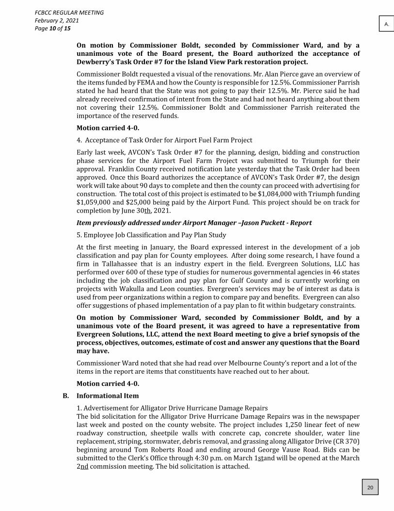
On motion by Commissioner Boldt, seconded by Commissioner Ward, and by a unanimous vote of the Board present, the Board authorized the acceptance of Dewberry’s Task Order #7 for the Island View Park restoration project.
Commissioner Boldt requested a visual of the renovations. Mr. Alan Pierce gave an overview of the items funded by FEMA and how the County is responsible for 12.5%. Commissioner Parrish stated he had heard that the State was not going to pay their 12.5%. Mr. Pierce said he had already received confirmation of intent from the State and had not heard anything about them not covering their 12.5%. Commissioner Boldt and Commissioner Parrish reiterated the importance of the reserved funds.
Motion carried 4-0.
4. Acceptance of Task Order for Airport Fuel Farm Project
Early last week, AVCON’s Task Order #7 for the planning, design, bidding and construction phase services for the Airport Fuel Farm Project was submitted to Triumph for their approval. Franklin County received notification late yesterday that the Task Order had been approved. Once this Board authorizes the acceptance of AVCON’s Task Order #7, the design work will take about 90 days to complete and then the county can proceed with advertising for construction. The total cost of this project is estimated to be $1,084,000 with Triumph funding $1,059,000 and $25,000 being paid by the Airport Fund. This project should be on track for completion by June 30th, 2021.
Item previously addressed under Airport Manager –Jason Puckett - Report
5. Employee Job Classification and Pay Plan Study
At the first meeting in January, the Board expressed interest in the development of a job classification and pay plan for County employees. After doing some research, I have found a firm in Tallahassee that is an industry expert in the field. Evergreen Solutions, LLC has performed over 600 of these type of studies for numerous governmental agencies in 46 states including the job classification and pay plan for Gulf County and is currently working on projects with Wakulla and Leon counties. Evergreen’s services may be of interest as data is used from peer organizations within a region to compare pay and benefits. Evergreen can also offer suggestions of phased implementation of a pay plan to fit within budgetary constraints.
On motion by Commissioner Ward, seconded by Commissioner Boldt, and by a unanimous vote of the Board present, it was agreed to have a representative from Evergreen Solutions, LLC, attend the next Board meeting to give a brief synopsis of the process, objectives, outcomes, estimate of cost and answer any questions that the Board may have.
Commissioner Ward noted that she had read over Melbourne County’s report and a lot of the items in the report are items that constituents have reached out to her about.
Motion carried 4-0.
B. Informational Item
1. Advertisement for Alligator Drive Hurricane Damage Repairs The bid solicitation for the Alligator Drive Hurricane Damage Repairs was in the newspaper last week and posted on the county website. The project includes 1,250 linear feet of new roadway construction, sheetpile walls with concrete cap, concrete shoulder, water line replacement, striping, stormwater, debris removal, and grassing along Alligator Drive (CR 370) beginning around Tom Roberts Road and ending around George Vause Road. Bids can be submitted to the Clerk’s Office through 4:30 p.m. on March 1stand will be opened at the March 2nd commission meeting. The bid solicitation is attached.
20
A.

FCBCC REGULAR MEETING February 2, 2021 Page 11 of 15
Commissioner Ward would like Mrs. Griffith to look into an available grant through Homeland Security for fire prevention and safety noting Josh Gable as a contact for Senator Marc Rubio’s office.
County Coordinator – Michael Morón – Report
A. Action Items
1. Duck Hunting Update: At a recent meeting, the Board discussed complaints received regarding the influx of out of area duck hunter’s destruction of local resources such as the recently revived grass beds, the illegal practice of exceeding the allowed bag limits, and the total disregard of local duck hunting customs. Instead of sending a letter, I contacted the department directly and spoke to Mr. George Warthen, FWC’s Director of Hunting and Game Management, about the Board concerns. After meeting with his regional director and staff, Mr. Warthen explained that FWC officers do have access to the shallow water and are doing target enforcement on duck hunters. They are watchful to ensure no natural resources are being destroyed by any of the hunters. He also explained that this is a state-wide problem, and FWC is looking for a long-term solution to hunting issues. In addition, there is an amendment that will be presented to the FWC Commission at this month’s meeting that will create a “buffer zone” between hunting and residential areas. What presents an issue for the agency is dealing with the confrontational problems between the local and out of town hunters, but the officers will continue to educate all hunters in order to try and reduce the confrontations. Mr. Warthen is willing to meet with any Commissioner, including going out on the water, to discuss these and other FWC concerns.
Chairman Jones requested an update regarding the buffer zone at the next meeting.
2. Vaccine Distribution Update: At your last meeting the Board discussed vaccine distribution issues in the County and directed me to send a letter to Governor DeSantis requesting additional vaccine units on a weekly basis, but a lot has transpired state-wide regarding additional vaccine doses since that meeting. Of significance, is the Small County Coalition’s (SCC) executive meeting held to address some of the same concerns raised by this Board at the last meeting. Attached is the SCC’s Executive Summary on Vaccine Program Observations and Suggestions Zoom meeting held on January 21st. Last week SCC’s President, Chris Doolin, discussed how the Board’s concerns aligned and how the Board could support SCC in its efforts to secure additional vaccines for small rural counties like Franklin, especially those that are fiscally constrained. Mr. Doolin agreed to word a draft letter, which is attached to this report, the County could send to FDEM Director Mr. Jared Moskowitz supporting SCC and the Florida Association of Counties efforts to secure an equitable allotment of vaccines in Franklin County.
On motion by Commissioner Parrish, seconded by Commissioner Ward, and by a unanimous vote of the Board present, the Board authorized the Chairman’s signature on the letter to (FDEM) Director Moskowitz. Motion carried 4-0.
The Board discussed shot hunting, vaccination screening and vaccination distribution. On a related COVID matter, since the beginning of January 2021, COVID positivity trends in Franklin County have been above the recommended 10%, which represents significant community spread and increased exposure to our most vulnerable populations. The first two weeks of January 2021 reported a 20% positivity trend, with 155 new positive cases out of 761 people tested. From January 15th through January 28th positivity trends are still above the recommended benchmark at 16% with 118 new cases. There have been 5 new COVID-19 documented deaths which totals 10 deaths in the County. Positivity trends and COVID-19 documented deaths are monitored using Florida Department of Health data. I provide this
21
A.

FCBCC REGULAR MEETING February 2, 2021 Page 12 of 15
information to the Board and public so that everyone continues to follow the CDC guidelines of washing your hands, avoiding large crowds especially inside buildings and poorly ventilated areas, and wearing a mask whenever you are out in public.
3. New EOC Building: The Board has been discussing the need for a new EOC since Hurricane Michael. During the last legislative session, the County received approximately $100,000 for design and engineering of a new EOC, which was decided at a previous meeting, would be located at the airport. Attached (Agenda Packet) to my report is a 4,884 square foot floor plan concept for the new EOC. Discussed at the last meeting, the project architect estimates a cost of $300 per square foot for total building cost of $1,465,200.00. This cost does not include other expenses such as office furniture, IT equipment, a generator, site work, parking area, stormwater, water and sewer hook ups, etc. Before proceeding with the actual design, Dewberry, the project engineers, would like the Board to agree to a final concept and square footage.
Item previously addressed under Emergency Management Director – Pam Brownell.
4. Weems EMS Grant: Weems is seeking Board approval for what has been referred to as the EMS “Baby” grant. The $813 grant amount, with an additional $58.66 from last year’s grant, will be used to send one paramedic to a Critical Care Paramedicine program.
On motion by Commissioner Boldt, seconded by Commissioner Ward, and by a unanimous vote of the Board present, the Board authorized the Chairman’s signature on the Resolution for the State of Florida EMS $813 Grant. Motion carried 4-0.
5. Tax Collector Budget Option: After every election of a new or re-elected tax collector, the Florida Department of Revenue (DOR) offers the tax collector the option of becoming/ remaining a budget or fee officer for the next four years. The Franklin County Tax Collector has always been a budget officer, adhering to the budget policies and procedures of the BOCC, and Mr. Watson would like to remain a budget officer. In order to keep the budget officer status, DOR requires a resolution with the Chairman’s signature.
RESOLUTION
FRANKLIN COUNTY
BOARD OF COUNTY COMMISSIONERS
WHEREAS, Section 145.022, Florida Statutes provides that the Board of County Commissioners, with the concurrence of the Franklin County Tax Collector as provided for in said section, shall by resolution guarantee and appropriate a salary to the Franklin County Tax Collector in and amount not to exceed that specified in said chapter, and
WHEREAS, the Franklin County Tax Collector has requested and concurred with the Franklin County Board of County Commissioners that said Tax Collector be placed on a salary as provided in said Section, and
WHEREAS, the said Tax Collector will pay all fees collected by said office to the Franklin County Board of County Commissioners as provided in said as provided in said Section.
NOW, THEREFORE, BE IT RESOLVED:
22
A.

FCBCC REGULAR MEETING February 2, 2021 Page 13 of 15
1. That the Board of County Commissioners of Franklin County, Florida, pays the Franklin County Tax Collector a guaranteed salary as provided for in Section 145.022, Florida Statutes.
2. That said board will provide funds according to the budget as submitted by said Tax Collector and approved by the Board, which will include each and every item of expenditure necessary to operate said office, including the salary of the Franklin County Tax Collector.
3. That said Board would pay over said funds to the Tax Collector as provided by law or upon monthly requisition.
4. That a copy of this resolution be filed with the Florida Department of Banking, the Florida Department of Revenue and the Auditor General.
THIS RESOLUTION ADOPTED by the Franklin County Board of County.
Franklin County Board of County Commissioners Franklin County, Florida
/s/Ricky Jones
Ricky Jones, Chairman
/s/Rick Watson
Rick Watson, Tax Collector
On motion by Commissioner Parrish, seconded by Commissioner Boldt, and by a unanimous vote of the Board present, the Board authorized the Chairman’s signature on the DOR Resolution to keep the Tax Collector as a budget officer. Motion carried 4-0.
6. Sheriff’s 911 Grants: Due to pending deadlines, the Sheriff’s Office asked the Chairman to sign two 911 grant agreements prior to today’s meeting. The first is the annual maintenance grant totaling $34,366.21 and the second is a GIS Data Support grant totaling $188,270.
On motion by Commissioner Ward, seconded by Commissioner Parrish, and by unanimous vote of the Board present, the Board ratified the Chairman’s signature on both grant agreements. Motion carried 4-0.
7. CareerSource Agreements: As stated in Mrs. Kim Bodine’s attached cover letter, “Local workforce development areas that receive an initial designation by the Governor may be granted a subsequent designation if, for the most two recent program years, the local area performed successfully and sustained fiscal integrity, and in the case of a local area in a planning region, met the regional planning requirements as described in WIOA Sec. 106. The chief elected official must submit a request for subsequent designation (Attachment A) to CareerSource Florida and DEO every two years beginning July 1, 2017. The application to request subsequent designation is due by April 15 of the renewal year.” Attached is the Application for Subsequent Local Workforce Development Area Designation, the Local Workforce Development Board Composition and Certification, and the Local Workforce Development Area Designation for the Chairman’s signature. Even though these are standard documents signed by the Board every two years, if the Board authorizes the Chairman’s signature it will be contingent on Attorney Shuler’s review of the documents.
23
A.

FCBCC REGULAR MEETING February 2, 2021 Page 14 of 15
On motion by Commissioner Parrish, seconded by Commissioner Boldt, and by a unanimous vote of the Board present, the Board authorized the Chairman’s signature on the CareerSource documents contingent on Attorney Shuler’s review and approval. Motion carried 4-0.
8. CARES Act Funds Extension Letter: During Ms. Traci Buzbee’s report, the need for the County to request an extension of the agreement (Agreement Y2314) between Franklin County Board of County Commissioners and the Florida Division of Emergency Management for the CARES Act funding beyond the January 29thdeadline was addressed. This extension allowed Ms. Buzbee to submit a revised spend plan on Friday, February 5th. Chairman Jones signed the extension request.
Item previously addressed under CARES Act Consultant -- Traci Buzbee – Update.
9. Building Inspector Status: In December Mr. Steve Paterson received his Florida State Building Inspector certification. That was one of the main reasons Mr. Garry Millender was able to request to change his employment status as the County’s Building Official from an employee to a contractor. When the Board approved that change, I should have requested an increase in Mr. Patterson’s base annual salary to $40,000 since, with his certification, his role and responsibility in the Building Department would increase. The Building Department’s budget is fee based, not funded from ad valorem taxes.
On motion by Commissioner Ward, seconded by Commissioner Boldt, and by unanimous vote of the Board present, the Board authorized the increase in Mr. Paterson’s salary to $40,000 as the County’s Building Inspector. Motion carried 4-0.
Commissioner Jones inquired about Mr. Paterson obtaining his state credential as a County building official, Mr. Moron stated the review board is behind due to Covid and he is hopeful it should be completed by April.
B. Informational Items
1. Airport Project Time Extension: Last week, John Collins (AVCON) informed me that the Runway 6-24 Lighting Rehabilitation project contractor, TCA Electrical Construction, requested a 90-day extension of the project time due to delays in receiving materials from suppliers because of COVID. FDOT will extend this grant which is set to expire on April 30th if the contractor is impacted by COVID, therefore, I authorized Mr. Collins to request this extension. I will update the Board on the outcome of the extension request.
2. Building Department New Hires: Until further notice the Building Department will be closed to the public (walk-ins & phone calls) on Fridays at 12 noon to allow staff to process permit applications. Hopefully, with our new hires starting this month, Mr. Chance White started yesterday, and Ms. Tanicia Pugh will start on February 15th, we will be in better shape by month’s end.
3. CDBG Report: Attached to the agenda packet is an information report from Mrs. Deborah Belcher. If you have any questions regarding the report, Mrs. Belcher asked that you give her a call.
4. ARPC Meeting Notes: Attached to my report are the January 2021 Board Notes for the Apalachee Regional Planning Council.
5. COVID-19 LSE: The Chairman has signed, as authorized by the Board, COVID-19 Local State of Emergency Declarations for the weeks starting January 4th, 11th, 18th, and 25th.
24
A.

FCBCC REGULAR MEETING February 2, 2021 Page 15 of 15
6. ANERR Burn: The Apalachicola National Estuarine Research Reserve is planning a burn at the Nick’s Hole section of property within the St. George Island Plantation on Thursday, February 4th at 9 am ET. A total of 50 acres will be burned. A map is attached.
County Attorney – Michael Shuler – Report
Attorney Shuler had no action items and noted he updated the Board via email regarding several informational matters. Commissioner Ward noted that the County may need to look into code enforcement and uninhabitable properties, noting two properties that were damaged in Hurricane Michael that the owners have not torn down. Commissioner Ward will get with Attorney Shuler regarding sending a letter to the property owners. Attorney Shuler recommended sending the building inspector over to access, and then report back to him.
Commissioners’ Comments
Chairman Jones and Commissioner Boldt shared the same sentiment as Commissioner Ward regarding the need for code enforcement. Commissioner Parrish cautioned Board on setting rules that will ultimately have to be enforced. Mr. Moron suggested we identify the problems and create solutions or codes to remedy them. Chairman Jones said the Board would need to set policy based on the needs of the community without overreaching their authority.
Adjournment
There being no further business to come before the Board, the meeting was adjourned at 11:57 a.m.
________________________________________ Ricky Jones – Chairman Attest: ____________________________________________ Michele Maxwell – Clerk of Courts
25
A.

February 16, 2021Franklin County Road Department
Detail of Work Performed and Material Hauled by DistrictDetail from 1/28/2021 ‐ 2/10/2021
District 1
Work Performed: Date Road
Cleaned out culverts 3rd Street1/28/2021
Loaded Trucks Howell Street1/28/2021
Sign Maintenance Eastpoint Library2/1/2021
Litter Pickup, Cut grass in ditches, Weed Eat & Cut Grass around signs & Culverts
Jefferson Street2/2/2021
Litter Pickup, Cut grass in ditches, Weed Eat & Cut Grass around signs & Culverts
Washington Street2/2/2021
Litter Pickup, Cut grass in ditches, Weed Eat & Cut Grass around signs & Culverts
Adams Street2/2/2021
Litter Pickup, Cut grass in ditches, Weed Eat & Cut Grass around signs & Culverts
N Franklin Street2/2/2021
Litter Pickup, Cut grass in ditches, Weed Eat & Cut Grass around signs & Culverts
Patton Drive2/2/2021
Graded Road(s) Bell Street2/3/2021
Box drag W 11th Street2/3/2021
Box drag W 10th Street2/3/2021
Box drag W 9th Street2/3/2021
Box drag Marks Street2/3/2021
Box drag Akel Street2/3/2021
Box drag W 8th Street2/3/2021
Box drag W 6th Street2/3/2021
Box drag W 5th Street2/3/2021
Box drag Wing Street2/3/2021
Box drag W 3rd Street2/3/2021
Box drag E 2nd Street2/3/2021
Graded Road(s) E Pine Avenue2/3/2021
Box drag W 4th Street2/3/2021
Box drag Quinn Street2/3/2021
Box drag Bledsoe Street2/3/2021
Box drag Palmer Street2/3/2021
Graded Road(s) Bruce Street2/3/2021
Box drag E 1st Street2/3/2021
Graded Road(s) Randolph Street2/3/2021
Box drag Gunn Street2/3/2021
Box drag E 4th Street2/3/2021
Box drag E 6th Street2/3/2021
Box drag E 7th Street2/3/2021
Box drag E 8th Street2/3/2021
Box drag E 9th Street2/3/2021
Box drag E 10th Street2/3/2021
Box drag Baine Street2/3/2021
Box drag Howell Street2/3/2021
Litter Pickup, Weed Eat & Cut Grass around signs & Culverts, Cut grass in ditches
Tip Tucker Road2/3/2021
Weed Eat & Cut Grass around signs & Culverts, Cut grass in ditches Barber St 2/3/202126
A.
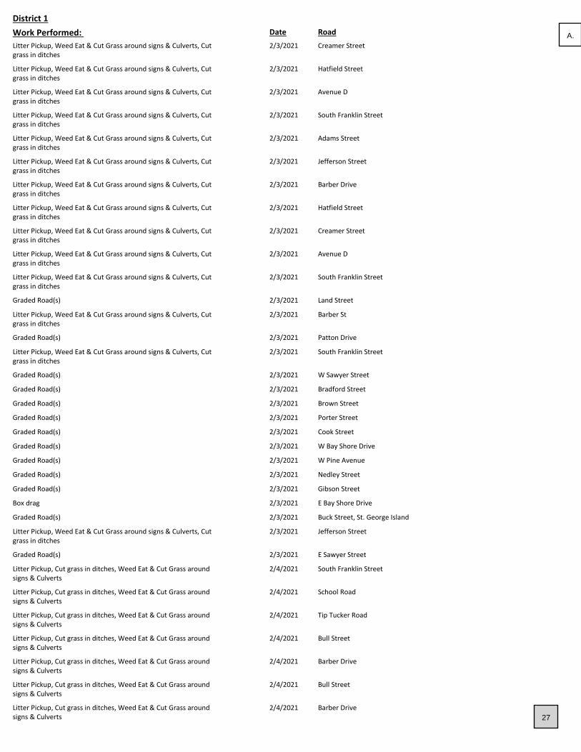
District 1
Work Performed: Date Road
Litter Pickup, Weed Eat & Cut Grass around signs & Culverts, Cut grass in ditches
Creamer Street2/3/2021
Litter Pickup, Weed Eat & Cut Grass around signs & Culverts, Cut grass in ditches
Hatfield Street2/3/2021
Litter Pickup, Weed Eat & Cut Grass around signs & Culverts, Cut grass in ditches
Avenue D2/3/2021
Litter Pickup, Weed Eat & Cut Grass around signs & Culverts, Cut grass in ditches
South Franklin Street2/3/2021
Litter Pickup, Weed Eat & Cut Grass around signs & Culverts, Cut grass in ditches
Adams Street2/3/2021
Litter Pickup, Weed Eat & Cut Grass around signs & Culverts, Cut grass in ditches
Jefferson Street2/3/2021
Litter Pickup, Weed Eat & Cut Grass around signs & Culverts, Cut grass in ditches
Barber Drive2/3/2021
Litter Pickup, Weed Eat & Cut Grass around signs & Culverts, Cut grass in ditches
Hatfield Street2/3/2021
Litter Pickup, Weed Eat & Cut Grass around signs & Culverts, Cut grass in ditches
Creamer Street2/3/2021
Litter Pickup, Weed Eat & Cut Grass around signs & Culverts, Cut grass in ditches
Avenue D2/3/2021
Litter Pickup, Weed Eat & Cut Grass around signs & Culverts, Cut grass in ditches
South Franklin Street2/3/2021
Graded Road(s) Land Street2/3/2021
Litter Pickup, Weed Eat & Cut Grass around signs & Culverts, Cut grass in ditches
Barber St 2/3/2021
Graded Road(s) Patton Drive2/3/2021
Litter Pickup, Weed Eat & Cut Grass around signs & Culverts, Cut grass in ditches
South Franklin Street2/3/2021
Graded Road(s) W Sawyer Street2/3/2021
Graded Road(s) Bradford Street2/3/2021
Graded Road(s) Brown Street2/3/2021
Graded Road(s) Porter Street2/3/2021
Graded Road(s) Cook Street2/3/2021
Graded Road(s) W Bay Shore Drive2/3/2021
Graded Road(s) W Pine Avenue2/3/2021
Graded Road(s) Nedley Street2/3/2021
Graded Road(s) Gibson Street2/3/2021
Box drag E Bay Shore Drive2/3/2021
Graded Road(s) Buck Street, St. George Island2/3/2021
Litter Pickup, Weed Eat & Cut Grass around signs & Culverts, Cut grass in ditches
Jefferson Street2/3/2021
Graded Road(s) E Sawyer Street2/3/2021
Litter Pickup, Cut grass in ditches, Weed Eat & Cut Grass around signs & Culverts
South Franklin Street2/4/2021
Litter Pickup, Cut grass in ditches, Weed Eat & Cut Grass around signs & Culverts
School Road2/4/2021
Litter Pickup, Cut grass in ditches, Weed Eat & Cut Grass around signs & Culverts
Tip Tucker Road2/4/2021
Litter Pickup, Cut grass in ditches, Weed Eat & Cut Grass around signs & Culverts
Bull Street2/4/2021
Litter Pickup, Cut grass in ditches, Weed Eat & Cut Grass around signs & Culverts
Barber Drive2/4/2021
Litter Pickup, Cut grass in ditches, Weed Eat & Cut Grass around signs & Culverts
Bull Street2/4/2021
Litter Pickup, Cut grass in ditches, Weed Eat & Cut Grass around signs & Culverts
Barber Drive2/4/2021
27
A.

District 1
Work Performed: Date Road
Litter Pickup, Cut grass in ditches, Weed Eat & Cut Grass around signs & Culverts
South Franklin Street2/4/2021
Litter Pickup, Cut grass in ditches, Weed Eat & Cut Grass around signs & Culverts
Varnes Street2/4/2021
Culvert repair, Cut grass in ditches, Weed Eat & Cut Grass around signs & Culverts
Carroll Street2/4/2021
Litter Pickup, Cut grass in ditches, Weed Eat & Cut Grass around signs & Culverts
Moore Street2/4/2021
Litter Pickup, Cut grass in ditches, Weed Eat & Cut Grass around signs & Culverts
Varnes Street2/4/2021
Litter Pickup, Cut grass in ditches, Weed Eat & Cut Grass around signs & Culverts
South Franklin Street2/4/2021
Litter Pickup, Cut grass in ditches, Weed Eat & Cut Grass around signs & Culverts
Moore Street2/4/2021
Litter Pickup, Cut grass in ditches, Weed Eat & Cut Grass around signs & Culverts
South Franklin Street2/8/2021
Litter Pickup, Cut grass in ditches, Weed Eat & Cut Grass around signs & Culverts
Carroll Street2/8/2021
Litter Pickup, Cut grass in ditches, Weed Eat & Cut Grass around signs & Culverts
David Street2/8/2021
Litter Pickup, Cut grass in ditches, Weed Eat & Cut Grass around signs & Culverts
Varnes Street2/8/2021
Litter Pickup, Cut grass in ditches, Weed Eat & Cut Grass around signs & Culverts
East Bay Drive2/8/2021
Litter Pickup, Cut grass in ditches, Weed Eat & Cut Grass around signs & Culverts
David Street2/8/2021
Litter Pickup, Cut grass in ditches, Weed Eat & Cut Grass around signs & Culverts
Power Drive2/8/2021
Litter Pickup, Cut grass in ditches, Weed Eat & Cut Grass around signs & Culverts
East Bay Drive2/8/2021
Litter Pickup, Cut grass in ditches, Weed Eat & Cut Grass around signs & Culverts
State Street2/8/2021
Litter Pickup, Cut grass in ditches, Weed Eat & Cut Grass around signs & Culverts
Power Drive2/8/2021
Cut grass in ditches, Weed Eat & Cut Grass around signs & Culverts Carroll Street2/8/2021
Litter Pickup, Cut grass in ditches, Weed Eat & Cut Grass around signs & Culverts
State Street2/8/2021
Sign Maintenance Creamer Street2/9/2021
Cut grass in ditches, Weed Eat & Cut Grass around signs & Culverts Millender Street2/9/2021
Cut grass in ditches, Weed Eat & Cut Grass around signs & Culverts Norvell Street2/9/2021
Cut grass in ditches, Weed Eat & Cut Grass around signs & Culverts South Bay Shore Drive2/9/2021
Litter Pickup Patton Drive2/9/2021
Sign Maintenance Patty Lane (Private)2/9/2021
Litter Pickup, Cut grass in ditches, Weed Eat & Cut Grass around signs & Culverts
Norvell Street2/9/2021
Cut grass in ditches, Weed Eat & Cut Grass around signs & Culverts South Bay Shore Drive2/9/2021
Litter Pickup Patton Drive2/9/2021
Litter Pickup, Cut grass in ditches, Weed Eat & Cut Grass around signs & Culverts, Cleaned out culverts
N Bay Shore Drive2/9/2021
Flagged N Bay Shore Drive2/9/2021
Flagged Begonia Street2/9/2021
Flagged Creamer Street2/9/2021
Flagged N Bay Shore Drive2/9/2021
Cut bushes back, Cut grass in ditches N Bay Shore Drive2/9/2021
Cut bushes back, Cut grass in ditches Creamer Street2/9/2021
Litter Pickup, Cut grass in ditches, Weed Eat & Cut Grass around signs & Culverts
Millender Street2/9/202128
A.

District 1
Work Performed: Date Road
Weed Eat & Cut Grass around signs & Culverts, Litter Pickup South Bay Shore Drive2/10/2021
Flagged N Bay Shore Drive2/10/2021
Weed Eat & Cut Grass around signs & Culverts, Litter Pickup Tallahassee Street2/10/2021
Weed Eat & Cut Grass around signs & Culverts, Litter Pickup Carroll Street2/10/2021
Weed Eat & Cut Grass around signs & Culverts, Litter Pickup N Bay Shore Drive2/10/2021
Flagged N Bay Shore Drive2/10/2021
Weed Eat & Cut Grass around signs & Culverts, Litter Pickup, Sidewalk Maintenance (Build, Take Out, etc), Blowed off road/parking lot/intersection
South Bay Shore Drive2/10/2021
Flagged N Bay Shore Drive2/10/2021
Pot hole Repair (Fill) W Bay Shore Drive2/10/2021
Weed Eat & Cut Grass around signs & Culverts Patton Drive2/10/2021
Cut grass in ditches N Bay Shore Drive2/10/2021
Litter Pickup Patton Drive2/10/2021
Litter Pickup Patton Drive2/10/2021
Pot hole Repair (Fill) Millender Street2/10/2021
Pot hole Repair (Fill) Power Drive2/10/2021
0
Material HAUL From: Date Road TonsCubic Yards
Debris Bruce Street1/28/2021 36 0
Debris TOTAL 36 0
Litter Patton Drive2/2/2021 0.5 0
Litter N Franklin Street2/2/2021 0.5 0
Litter Washington Street2/2/2021 0.5 0
Litter Jefferson Street2/2/2021 0.5 0
Litter Adams Street2/2/2021 0.5 0
Litter Hatfield Street2/3/2021 1 0
Litter Creamer Street2/3/2021 1 0
Litter South Franklin Street2/3/2021 0.5 0
Litter Tip Tucker Road2/3/2021 0.5 0
Litter South Franklin Street2/3/2021 0.5 0
Litter Avenue D2/3/2021 0.5 0
Litter Tip Tucker Road2/4/2021 0.300000012 0
Litter South Franklin Street2/4/2021 1 0
Litter Varnes Street2/4/2021 1 0
Litter Moore Street2/4/2021 2 0
Litter Barber Drive2/4/2021 1 0
Litter Bull Street2/4/2021 2 0
Litter School Road2/4/2021 0.300000012 0
Litter South Franklin Street2/4/2021 0.300000012 0
Litter Carroll Street2/8/2021 1 0
Litter State Street2/8/2021 1 0
Litter East Bay Drive2/8/2021 1 0
Litter Power Drive2/8/2021 1 0
Litter South Franklin Street2/8/2021 1 0
Litter David Street2/8/2021 1 0
Litter Millender Street2/9/2021 2 0
Litter Norvell Street2/9/2021 1 0
Litter N Bay Shore Drive2/9/2021 1 0
29
A.

District 1
Material HAUL From: Date Road TonsCubic Yards
Litter Patton Drive2/10/2021 2 0
Litter South Bay Shore Drive2/10/2021 2 0
Litter Patton Drive2/10/2021 1 0
Litter South Bay Shore Drive2/10/2021 2 0
Litter TOTAL 31.40000004 0
Material HAUL To: Date Road TonsCubic Yards
50# Bagged Asphalt W Bay Shore Drive2/10/2021 5 0
50# Bagged Asphalt Millender Street2/10/2021 3 0
50# Bagged Asphalt Power Drive2/10/2021 4 0
50# Bagged Asphalt TOTAL 12 0
Dirty 89 Lime Rock 3rd Street1/28/2021 9 0
Dirty 89 Lime Rock W Bay Shore Drive2/3/2021 18 0
Dirty 89 Lime Rock Carroll Street2/4/2021 9 0
Dirty 89 Lime Rock TOTAL 36 0
District 2
Work Performed: Date Road
Box drag Ken Cope Ave1/28/2021
Cut bushes back, Trim Trees Bald Point Road1/28/2021
Sign Maintenance Carrabelle City Hall (City of Carrabelle)1/28/2021
Cut bushes back, Trim Trees Bald Point Road1/28/2021
Litter Pickup CR671/28/2021
Litter Pickup Maxine Road1/28/2021
Litter Pickup West Drive1/28/2021
Checked county roads for safety of traveling for public Duvall Road2/1/2021
Checked county roads for safety of traveling for public McIntyre Road2/1/2021
Checked county roads for safety of traveling for public West Drive2/1/2021
Checked county roads for safety of traveling for public Rio Vista Drive2/1/2021
Checked county roads for safety of traveling for public Alligator Drive2/1/2021
Beaver Dam ‐ Take Out Baywood Drive (City of Carrabelle)2/1/2021
Checked county roads for safety of traveling for public McIntyre Road2/1/2021
Checked county roads for safety of traveling for public Rio Vista Drive2/1/2021
Checked county roads for safety of traveling for public Alligator Drive2/1/2021
Cleaned out culverts Baywood Drive (City of Carrabelle)2/1/2021
Checked county roads for safety of traveling for public Duvall Road2/1/2021
Pot hole Repair (Fill) California Street2/2/2021
Pot hole Repair (Fill) Pine Street2/2/2021
Pot hole Repair (Fill) Lake Morality Road2/2/2021
Pot hole Repair (Fill) Lake Morality Road2/2/2021
Pot hole Repair (Fill) Pine Street2/2/2021
Pot hole Repair (Fill) California Street2/2/2021
Sign Maintenance East Pine Street (Lanark)2/3/2021
Box drag 3rd Street E (City of Carrabelle)2/4/2021
Box drag Jeff Sanders Road2/4/2021
Beaver Dam ‐ Take Out Baywood Drive (City of Carrabelle)2/8/2021
Beaver Dam ‐ Take Out Baywood Drive (City of Carrabelle)2/8/2021
Beaver Dam ‐ Take Out McIntyre Road2/8/2021
Beaver Dam ‐ Take Out McIntyre Road2/8/2021 30
A.

District 2
Work Performed: Date Road
Beaver Dam ‐ Take Out Baywood Drive (City of Carrabelle)2/8/2021
Beaver Dam ‐ Take Out McIntyre Road2/8/2021
0
Material HAUL From: Date Road TonsCubic Yards
Litter CR671/28/2021 1 0
Litter West Drive1/28/2021 1 0
Litter Maxine Road1/28/2021 1 0
Litter TOTAL 3 0
Trees Bald Point Road1/28/2021 9 0
Trees TOTAL 9 0
Material HAUL To: Date Road TonsCubic Yards
50# Bagged Asphalt Lake Morality Road2/2/2021 1.5 0
50# Bagged Asphalt Pine Street2/2/2021 0.5 0
50# Bagged Asphalt California Street2/2/2021 3.5 0
50# Bagged Asphalt TOTAL 5.5 0
Dirty 89 Lime Rock Jeff Sanders Road2/4/2021 54 0
Dirty 89 Lime Rock TOTAL 54 0
District 3
Work Performed: Date Road
Graded Road(s) Earl King Street (City of Apalachicola)2/4/2021
Litter Pickup Earl King Street (City of Apalachicola)2/10/2021
Litter Pickup 21st Avenue (City of Apalachicola)2/10/2021
Litter Pickup Avenue H (City of Apalachicola)2/10/2021
Litter Pickup 20th Avenue (City of Apalachicola)2/10/2021
Litter Pickup 10th Street (City of Apalachicola)2/10/2021
Litter Pickup Avenue G (City of Apalachicola)2/10/2021
Litter Pickup Avenue I (City of Apalachicola)2/10/2021
Litter Pickup 12th Street (City of Apalachicola)2/10/2021
Litter Pickup Martin Luther King Jr. Ave. (City of Apalachicola)2/10/2021
Litter Pickup 12th Street (City of Apalachicola)2/10/2021
Litter Pickup Martin Luther King Jr. Ave. (City of Apalachicola)2/10/2021
Litter Pickup Avenue H (City of Apalachicola)2/10/2021
Litter Pickup 21st Avenue (City of Apalachicola)2/10/2021
Litter Pickup Earl King Street (City of Apalachicola)2/10/2021
Litter Pickup 20th Avenue (City of Apalachicola)2/10/2021
Litter Pickup Avenue G (City of Apalachicola)2/10/2021
Litter Pickup 10th Street (City of Apalachicola)2/10/2021
Litter Pickup Avenue I (City of Apalachicola)2/10/2021
0
Material HAUL From: Date Road TonsCubic Yards
Litter Martin Luther King Jr. Ave. (City of Apalachicola)2/10/2021 1 0
Litter Avenue H (City of Apalachicola)2/10/2021 1 0
Litter Earl King Street (City of Apalachicola)2/10/2021 1 0
Litter 20th Avenue (City of Apalachicola)2/10/2021 1 0
Litter Avenue G (City of Apalachicola)2/10/2021 1 0
Litter 10th Street (City of Apalachicola)2/10/2021 1 031
A.

District 3
Material HAUL From: Date Road TonsCubic Yards
Litter Avenue I (City of Apalachicola)2/10/2021 1 0
Litter 12th Street (City of Apalachicola)2/10/2021 1 0
Litter 21st Avenue (City of Apalachicola)2/10/2021 1 0
Litter TOTAL 9 0
District 4
Work Performed: Date Road
Litter Pickup Brownsville Road1/28/2021
Litter Pickup Oyster Road1/28/2021
Litter Pickup Bluff Road1/28/2021
Litter Pickup Thomas Drive1/28/2021
Litter Pickup Brownsville Road2/1/2021
Litter Pickup Highland Park Road2/1/2021
Litter Pickup Bluff Road2/1/2021
Cleaned out culverts Teat Road2/1/2021
Cleaned out culverts Teat Road2/1/2021
Litter Pickup 26th Avenue2/1/2021
Litter Pickup Kevin Road2/1/2021
Litter Pickup Pal Rivers Road2/1/2021
Pot hole Repair (Fill) 8 Mile2/1/2021
Litter Pickup Pine Log Road2/2/2021
Weed Eat & Cut Grass around signs & Culverts, Cut grass in ditches Bay City Road2/2/2021
Pot hole Repair (Fill) CR30A2/2/2021
Litter Pickup Pine Log Road2/2/2021
Weed Eat & Cut Grass around signs & Culverts, Litter Pickup, Cut grass in ditches
Bay City Road2/2/2021
Litter Pickup Pine Log Road2/2/2021
Litter Pickup, Weed Eat & Cut Grass around signs & Culverts, Cut grass in ditches
Bay City Road2/2/2021
Pot hole Repair (Fill) 8 Mile2/2/2021
Weed Eat & Cut Grass around signs & Culverts, Cut grass in ditches Bluff Road2/3/2021
Graded Road(s) Teat Road2/4/2021
Graded Road(s) Buddy Ward Park2/4/2021
Cleaned out culverts Bay City Road2/8/2021
Cleaned out culverts Long Road2/9/2021
Cleaned out culverts Long Road2/10/2021
Cleaned out culverts Long Road2/10/2021
0
Material HAUL From: Date Road TonsCubic Yards
Ditch Dirt Teat Road2/1/2021 18 0
Ditch Dirt TOTAL 18 0
Litter Pal Rivers Road2/1/2021 1 0
Litter Highland Park Road2/1/2021 1 0
Litter Bluff Road2/1/2021 6 0
Litter Kevin Road2/1/2021 1 0
Litter Brownsville Road2/1/2021 1 0
Litter 26th Avenue2/1/2021 1 0
Litter TOTAL 11 0
Trees Bluff Road2/10/2021 9 0
32
A.

District 4
Material HAUL From: Date Road TonsCubic Yards
Trees TOTAL 9 0
Material HAUL To: Date Road TonsCubic Yards
50# Bagged Asphalt 8 Mile2/2/2021 2.5 0
50# Bagged Asphalt TOTAL 2.5 0
Milled Asphalt 8 Mile2/1/2021 3 0
Milled Asphalt TOTAL 3 0
District 5
Work Performed: Date Road
Litter Pickup Carlton Millender Road1/28/2021
Pot hole Repair (Fill) Sanborn Road1/28/2021
Litter Pickup 4th Street1/28/2021
Litter Pickup Otterslide Road1/28/2021
Litter Pickup Ridge Road1/28/2021
Litter Pickup Sanborn Road1/28/2021
Checked county roads for safety of traveling for public Owl Creek Road (Forestry Road #129A)2/1/2021
Checked county roads for safety of traveling for public Brick Yard Road (Forestry Road #129)2/1/2021
Checked county roads for safety of traveling for public Ashley Landing Road (Forestry Road #101‐A)2/1/2021
Checked county roads for safety of traveling for public Sand Beach Road2/1/2021
Checked county roads for safety of traveling for public Power Line Road (Forestry Road #166)2/1/2021
Checked county roads for safety of traveling for public Gardners Landing Road2/1/2021
Checked county roads for safety of traveling for public Wright Lake Road (Forestry Road #101)2/1/2021
Checked county roads for safety of traveling for public North Road2/1/2021
Beaver Dam ‐ Take Out Lighthouse Road (Paved Portion)2/1/2021
Checked county roads for safety of traveling for public North Road2/1/2021
Checked county roads for safety of traveling for public New River Road2/1/2021
Litter Pickup Bear Creek Rd2/1/2021
Litter Pickup Wilderness Road2/1/2021
Checked county roads for safety of traveling for public Bloody Bluff Road2/1/2021
Litter Pickup Ridge Road2/1/2021
Litter Pickup Wilderness Road2/1/2021
Litter Pickup Bear Creek Rd2/1/2021
Litter Pickup Ridge Road2/1/2021
Litter Pickup Ridge Road2/1/2021
Litter Pickup Wilderness Road2/1/2021
Litter Pickup Bear Creek Rd2/1/2021
Trim Trees, Cut bushes back Bloody Bluff Road2/2/2021
Checked county roads for safety of traveling for public Owl Creek Road (Forestry Road #129A)2/2/2021
Checked county roads for safety of traveling for public Ashley Landing Road (Forestry Road #101‐A)2/2/2021
Checked county roads for safety of traveling for public Power Line Road (Forestry Road #166)2/2/2021
Checked county roads for safety of traveling for public Brick Yard Road (Forestry Road #129)2/2/2021
Checked county roads for safety of traveling for public Sand Beach Road2/2/2021
Checked county roads for safety of traveling for public Wright Lake Road (Forestry Road #101)2/2/2021
Checked county roads for safety of traveling for public Gardners Landing Road2/2/2021
Litter Pickup, Weed Eat & Cut Grass around signs & Culverts, Cut grass in ditches
Wylonda Avenue2/3/2021
Litter Pickup, Weed Eat & Cut Grass around signs & Culverts, Cut grass in ditches
Michael Way2/3/2021
33
A.

District 5
Work Performed: Date Road
Litter Pickup, Weed Eat & Cut Grass around signs & Culverts, Cut grass in ditches
Wylonda Avenue2/3/2021
Box drag Quail Run Drive2/4/2021
Box drag 4th Street W (City of Carrabelle)2/4/2021
Box drag Herndon Road2/4/2021
Box drag Avenue G NW (City of Carrabelle)2/4/2021
Cut grass in ditches, Weed Eat & Cut Grass around signs & Culverts Whispering Pines Drive2/8/2021
Litter Pickup, Cut grass in ditches, Weed Eat & Cut Grass around signs & Culverts
Whispering Pines Drive2/8/2021
Litter Pickup, Cut grass in ditches, Weed Eat & Cut Grass around signs & Culverts
Whispering Pines Drive2/8/2021
0
Material HAUL From: Date Road TonsCubic Yards
Litter 4th Street1/28/2021 3 0
Litter Otterslide Road1/28/2021 4 0
Litter Sanborn Road1/28/2021 1 0
Litter Ridge Road1/28/2021 4 0
Litter Carlton Millender Road1/28/2021 1 0
Litter Bear Creek Rd2/1/2021 6 0
Litter Ridge Road2/1/2021 3 0
Litter Wilderness Road2/1/2021 3 0
Litter Michael Way2/3/2021 0.5 0
Litter Wylonda Avenue2/3/2021 0.5 0
Litter Whispering Pines Drive2/8/2021 2 0
Litter TOTAL 28 0
Material HAUL To: Date Road TonsCubic Yards
Milled Asphalt Sanborn Road1/28/2021 4 0
Milled Asphalt TOTAL 4 0
34
A.

MEETING DATE: February 16, 2021
NAME/DEPARTMENT/AGENCY: Fonda D. Davis
Solid Waste & Recycling, Animal Control, Parks & Recreation
TOTAL ATTACHMENTS: 0
============================================================================
Information Items: None
FOR BOARD INFORMATION:
Right-of-Way Debris Pickup/Recycle Material Hauled
January 27, 2021-Februar 9, 2021
RIGHT–OF–WAY DEBRIS PICKUP
Apalachicola Eastpoint St George
Island
Carrabelle Lanark Alligator Point
44.98
TONS
38.84
TONS
31.28
TONS
13.46
TONS
21.80
TONS
36.04
TONS
RECYCLE MATERIAL HAULED
Apalachicola Eastpoint St.
George
Island
Carrabelle Lanark Alligator
Point
St.
James
Cardboard 5.13
TONS
5.01
TONS
2.08
TONS
1.14
TONS
-0-
TONS
-0-
TONS
.19
TONS
Plastic,Paper,Glass,
Aluminum
-0- TONS
-0- TONS
-0- TONS
-0- TONS
-0- TONS
-0- TONS
-0-TONS
REQUESTED ACTION: None
35
A.

From: Lovestrand,Erik L [email protected]: Angler travel and targeting reports for Franklin County 2019
Date: February 11, 2021 at 12:29 PMTo: [email protected], Michael Moron [email protected], [email protected]: Rex Pennycuff [email protected]
Good Afternoon All, I wanted to share the two attached “Angler Travel and Targeting” reports that are relevantto the value of fishing-related business we do here in Franklin County. One is a shortsummary and the other is the full report (summary is the 12 KB document). They havebeen compiled by Dr. Ed Camp, a UF fisheries scientist/economist who resides oncampus in Gainesville. There are details on where people come from to fish here, what species they aretargeting and much more. I think they may be useful for our guide fishing businesses,local TDC, and in general to those of you involved in our County Administration. Feelfree to share with others you think may be interested in the data. Dr. Camp is doing this annually now at no cost to us, as well as several other counties. Ihave data from 2018 as well if you are interested. All the Best,
ErikErik LovestrandUF/IFAS Franklin County Extension DirectorSea Grant Regional Specialized Agent [email protected](850) 653-9337 Office(850) 766-8929 Cell
DID_ATT_Lovestrand_F…9.docx
DID_ATT_Lovestrand_F…p.docx
36
A.

Angler Travel and Targeting Summary: Franklin County
Prepared for the Franklin County Visitors Bureau by Eric Lovestrand, Franklin County Extension Director, Regional Specialized Sea Grant Agent ([email protected]) and Ed
Camp, Assistant Professor, University of Florida ([email protected])
How to use this summary
This summary can inform how to advertise or promote local fishing and fishing-based tourism specifically in Franklin County. The report describes information about where people come from when they fish Franklin County, and what they fish for. Where people come from (the “origin” of their fishing trip) may help identify advertising locations. The species they fish for, or “target” may inform the photos or text to use in advertisements or other outputs. All data here come from the National Marine Fisheries Service Marine Recreational Information Program. Additional information can be found in the full Angler Travel and Targeting Report: 2020 Franklin County, which Eric Lovestrand can provide you.
Where people come from to fish Franklin County
Table 1: Out-of-state angler origins comparison
Trips to Florida Prop.
Trips to North Big Bend Prop.
Trips to Franklin County Prop.
Georgia 0.157 Georgia 0.650 Georgia 0.678
Alabama 0.075 Alabama 0.129 Alabama 0.115
Not Available 0.074 Tennessee 0.047 Tennessee 0.055
Tennessee 0.053 Kentucky 0.014 Indiana 0.014
Texas 0.053 South Carolina 0.014 Louisiana 0.012
Table 1. The origins of out-of-state angler trips for Florida, the North Big Bend region, and specifically Franklin County, for 2009-2019. Columns 1-2 show the top 5 out-of-state origins of angler trips throughout Florida state. Columns 3-4 show the top out-of-state origins for just trips made to the North Big Bend region. Columns 5-6 show the top out-of-state origins for trips made to just Franklin County. Comparing the columns shows how Franklin County attracts visitors relative to the surrounding region or state. “Not Available” mostly describes visitors from outside the U.S.
37
A.

Table 2: In-state angler origin comparison
Out-of-county Orig Prop. Any Orig. Prop.
Leon 0.498 Leon 0.402
Wakulla 0.188 Franklin 0.192
Gadsden 0.064 Wakulla 0.152
Liberty 0.023 Gadsden 0.051
Jefferson 0.016 Liberty 0.019
Table 2. The origins of Florida resident anglers fishing in Franklin County, for 2009-2019. This table shows where Florida resident anglers come from when they fish Franklin County. Columns 1 & 2 show origins of trips in Franklin County by anglers who are not residents of Franklin County, and columns 3 & 4 show origins of all Florida-resident trips in Franklin County. This information can be used to identifying in-state advertising.
What people fish for in Franklin County
Table 3: Proportion of species targeted, comparing county to state
All Franklin County trips Prop.
In county trips Prop.
Out of county trips Prop.
Out of state trips Prop.
No Target 0.422 No Target 0.410 No Target 0.424 No Target 0.409
Spotted seatrout
0.160 Spotted seatrout
0.167 Spotted seatrout
0.159 Spotted seatrout
0.198
Red drum 0.124 Red drum 0.143 Red drum 0.121 Red drum 0.117
Red snapper 0.072 Red snapper
0.079 Red snapper 0.071 Red snapper
0.058
Gag 0.039 Gag 0.048 Gag 0.038 Atlantic tarpon
0.038
Table 3. Proportions of species targeted by fishing trips made in Franklin County by anglers from various origins, for 2009-2019. This table shows the top 5 species anglers fish in Franklin County, depending on where they live. Columns 1-2 shows what anglers fish for in Franklin County regardless of where they come from. Columns 3-4 shows what Franklin County resident anglers fish for, Columns 5-6 shows what anglers who live in Florida but not Franklin County fish for, and Columns 7-8 shows what out-of-state anglers fish for. The information here can be used to fine-tune advertising (photos and text) or informational content for out-of-county or out-of-state anglers.
38
A.

Angler Travel and Targeting Report 2020: Franklin County
A data report for the Franklin County Visitors Bureau prepared by:
Erik Lovestrand, Franklin County Extension Director, Regional Specialized Sea Grant Agent. [email protected]
Ed Camp, Assistant Professor of Fisheries and Aquaculture Governance, University of Florida. [email protected]
Table of Contents Abbreviations and Definitions ................................................................................................................ 2
Overview Summary .................................................................................................................................... 3
NMFS MRIP background ........................................................................................................................... 5
Fishing Trip Origins: Where do your anglers come from? .......................................................... 6
Fishing Trip Origins Results: Tables .................................................................................................... 7
Fishing Trip Origin Results: Maps ...................................................................................................... 10
Species targeted: What do your anglers fish for? ......................................................................... 17
Species Targeted Results: Tables ....................................................................................................... 18
Species Targeted Results: Time series figures .............................................................................. 21
References ................................................................................................................................................... 23
39
A.

Abbreviations and Definitions
NMFS: National Marine Fisheries Service. MRIP: Marine Recreational Information Program, which is operated by NMFS to survey coastal anglers. APAIS: Access Point Angler Intercept Survey, the survey implemented by MRIP to collect information about angling. North Big Bend region: refers to the areas of and marine waters adjacent to Gulf, Franklin, Wakulla, and Jefferson counties.
40
A.

Overview Summary
Why this report might be important Recreational fishing is one of the dominant recreational uses of marine ecosystems globally, and marine recreational fisheries (recreational fisheries occurring in saltwater) are particularly important to Florida. Florida has more saltwater anglers than any other state—2.4 million (USFWS 2011), with over a million saltwater fishing licenses sold annually. The total economic output (market activity) of saltwater fishing in Florida was estimated at around $8b annually (NOAA 2017), making fishing a vital part of Florida’s overall economy, and especially critical for coastal counties. Because of their importance, marine recreational fisheries in Florida are carefully managed by state (Florida Fish and Wildlife Conservation Commission; FWC) and by federal (NOAA’s National Marine Fisheries Service, NMFS) agencies. These two agencies partner to collect information about recreational fishing that is freely available to the public in the form of large databases. Extracting and visualizing these data can be challenging. We have queried these databases and summarized information we think may be helpful to the Franklin County Visitors Bureau. Specifically this information can be used to inform advertisements of fishing-related tourism in Franklin County.
What this report can be used for This report is designed to provide information about marine recreational fishing dynamics in Franklin County. Fishing dynamics include information about what species of fish recreational fishers (commonly called “anglers”) are most often trying to catch and where anglers come from when they fish marine waters from Franklin County. Angler targeting and travel information may have several uses. Understanding what fish species are commonly targeted may help inform:
• Which species are most popular with local or non-local anglers.
• How to best advertise fishing in this area–e.g. what fish species should be pictured in advertisements.
• Which rule changes local anglers will care the most about.
• How changes in fish populations (like from a habitat change or fish kill) may affect fishing effort, angler travel, and eventually, local economies.
Information on where anglers come from when they fish local waters has multiple potential uses as well, and we think it can inform:
• Locations to place advertisements for local fishing. For example, does it make more sense to advertise Franklin County recreational fishing in New York, or in Georgia?.
• Which people might want to be involved in local fisheries decision-making. For example, if many Franklin County anglers reside in other counties, these anglers should perhaps be surveyed prior to any rule changes.
Together, this information is intended to help local governance entities, like the Franklin County Visitors Bureau, access and use data that can help them better serve their constituents and sustain or improve the economic effects of marine recreational fishing in Franklin County.
41
A.

Where the information from this report comes from All of the data in this report come from the NOAA’s National Marine Fisheries Program (NMFS) Marine Recreational Information Program (MRIP). These data are publicly available for download at https://www.fisheries.noaa.gov/recreational-fishing-data/data-downloads. The MRIP program contains information voluntarily provided by anglers at fishing locations surveyed according to a scientifically designed sampling program. Data are continuously collected, but data in this report are for years 2009-2019. Future reports will show updated data as they are available.
42
A.

NMFS MRIP background
What is MRIP? While commercial fishers have a separate reporting system with specific requirements for commercial fishers to report fishing locations and catches to state and federal agencies, no such requirements exist for recreational fishers The MRIP is NMFS’s way of gathering information needed to sustainably manage recreational fisheries. The MRIP allows state and federal researchers and managers to understand things like:
• How many recreational fishing trips are being taken in a region and time period?
• How many of these trips target a certain species?
• What are angling catch rates and how are they changing?
• What are the sizes of fish that are harvested?
These things can be important for developing stock assessments that inform fisheries management decisions. The MRIP system includes two main surveys. One is an “access point” or “intercept” survey designed to understand aspects of fishing trips like length of trip, origin, target species, etc. The other, which this report does not use, is designed to understand what proportion of the human population in an area is engaging in these types of fishing trips. Information from the two surveys is combined to allow researchers to estimate some of the information described in the bullet points above, as well as important things like the total amount of a certain fish species that recreational fishers harvest or remove in a region and time.
What MRIP information does this report use? It is important to understand that this report does not use the estimates from MRIP. This report only uses the actual data provided by the angler intercept survey. This means all the data here are exactly what anglers are telling surveyors when they are interviewed. This distinction is important for a couple reasons. The data used here are simply descriptive. We do not show “error” or “uncertainty” around them, because we are reporting the metrics from the database, and not extrapolating the data by any factors or subjecting them to statistical estimation processes. What this means, is that the data here will be correct as long as anglers are correctly reporting to surveyors what they did when they went fishing.
Additional information about MRIP A lot of additional information is available about the NMFS MRIP data and how these data are used. We have described the parts of this information that are important to know to understand and best use the data provided in this report. Additional information directly through NOAA Fisheries at https://www.fisheries.noaa.gov/topic/recreational-fishing-data, as well as through the Marine Resource Education Program, MREP (different from MRIP), for which more information is available at: https://www.gmri.org/our-work/fisheries-convening/mrep-southeast. Finally, many Florida Sea Grant agents and county faculty, FWC personnel, and University of Florida researchers know about MRIP and may be able to answer additional questions.
43
A.

Fishing Trip Origins: Where do your anglers come from?
Background on data used Every recreational fishing trip made has an origin and a destination. In the MRIP data system, the origin is described as the angler’s residence, and the destination is defined as where the angler was intercepted (e.g., boat ramp, fishing pier, etc.). For this report, the residence is considered to be the population centroid of the angler’s county-of-residence. The population centroid is the spatial location in a county that “balances” the counties population. This means the centroid isn’t the geographical center of the county, but it is the most likely “average” location for a person to come from, given we know they live in a certain county. The fishing site destinations that are surveyed include those in the MRIP Access Point Angler Intercept Survey (APAIS). What is important is that these destination sites are selected as part of a statistically designed survey. Further information about APAIS and the specific destinations is available at: https://www.fisheries.noaa.gov/recreational-fishing-data/public-access-fishing-site-register
Fishing Trip Origins: Background on methods used For the recreational fishing trip origin information, we use data available in the MRIP “trips” databases that describe the results of the MRIP APAIS survey—this is the information that anglers tell surveyors when they are interviewed about their trips. We designed queries that let us look at the anglers that were interviewed in specifically Franklin County—i.e. the trips where anglers’ fishing destination was in marine waters adjacent to Franklin County, regardless of where the origin was. Once we have isolated the trips occurring in Franklin County, we can analyze where most of these trips came from. Specifically, we can look at things like:
• The proportion of trips sampled in Franklin County that come from out-of-state origins.
• The proportion of trips sampled in Franklin County with in-state origins.
• Both the above, but for trips in a multi-county region that includes Franklin County.
One thing that is important to note is that we report the proportion of the sampled trips. This is not the same as reporting the total number of trips. Enumerating the total number of trips would require estimation tools that are not described here. However, because of the statistical design that the MRIP APAIS survey is implemented, the proportions we use (of sampled trips) should correspond to the total numbers of trips. What this means is that the information in this report can be very useful for things like understanding where people, on average, are coming from when then fish Franklin County. Additional information on angler trip analyses is provided in (Camp et al. 2018).
We provide two types of information about angler origins:
• Tables describing where anglers come from.
• Figures of maps graphically illustrating anglers travel.
44
A.

Fishing Trip Origins Results: Tables
We provide two tables summarizing where anglers come from when they fish various parts of Florida and specifically the North Big Bend region and Franklin County. Table 1 compares the states that out-of-state anglers come from when they fish either anywhere in Florida, the North Big Bend region, or specifically Franklin County. Table 2 shows the county-origins of trips made by Florida residents. It compares the proportion of sampled trips coming from counties by anglers (i) living outside of the North Big Bend region, (ii) living outside of Franklin County, and (iii) living anywhere in Florida, including Franklin County.
We anticipate these tables may be useful in several ways, including:
• Understanding where anglers fishing in Franklin County come from, which may inform placement of fishing and tourism advertisements.
• Understanding how angler origins may differ between Franklin County and surrounding areas. This can potentially be used to further fine tune efficient advertisement placement by identifying locations where Franklin County may compete more or less with nearby counties for angling visitors.
• Understanding what proportion of anglers fishing Franklin County are local vs. visitors, which may be useful for deciding where to have meetings about Franklin County fishing.
45
A.

Table 1 Out-of-state angler origins comparison
Orig.(FL) Prop. Orig.(North Big Bend) Prop. Orig.(Franklin) Prop.
Georgia 0.157 Georgia 0.650 Georgia 0.678
Alabama 0.075 Alabama 0.129 Alabama 0.115
Not Available 0.074 Tennessee 0.047 Tennessee 0.055
Tennessee 0.053 Kentucky 0.014 Indiana 0.014
Texas 0.053 South Carolina 0.014 Louisiana 0.012
Illinois 0.046 North Carolina 0.013 North Carolina 0.011
Ohio 0.044 Illinois 0.012 Texas 0.011
New York 0.043 Indiana 0.012 Wisconsin 0.011
Michigan 0.042 Texas 0.012 South Carolina 0.010
Pennsylvania 0.032 Louisiana 0.010 Illinois 0.008
Table 1. State origins of anglers fishing Florida, the North Big Bend region, and Franklin County, for 2009-2019. This table compares which states out-of-state anglers come from when they fish either Florida as a whole, the North Big Bend region (here defined as including Gulf, Franklin, Wakulla, and Jefferson counties), or Franklin County.
• Columns 1 & 2 show the state origins of non-Florida residents when they fish in Florida.
• Columns 3 & 4 show the state origins of non-Florida residents when they fish the North Big Bend region.
• Columns 5 & 6 show the state origins of non-Florida residents when they fish Franklin County.
This comparison allows understanding where (i) out of state anglers fishing Franklin County come from, and (ii) how that compares to the local region and broader state of Florida. This may be helpful for understanding if Franklin County is attracting anglers from specific origins differently than the surrounding region of the North Big Bend, or Florida as a whole. The “Not Available” is returned either when anglers refuse to give state of origin, or do not reside in the US-i.e. international visitors.
46
A.
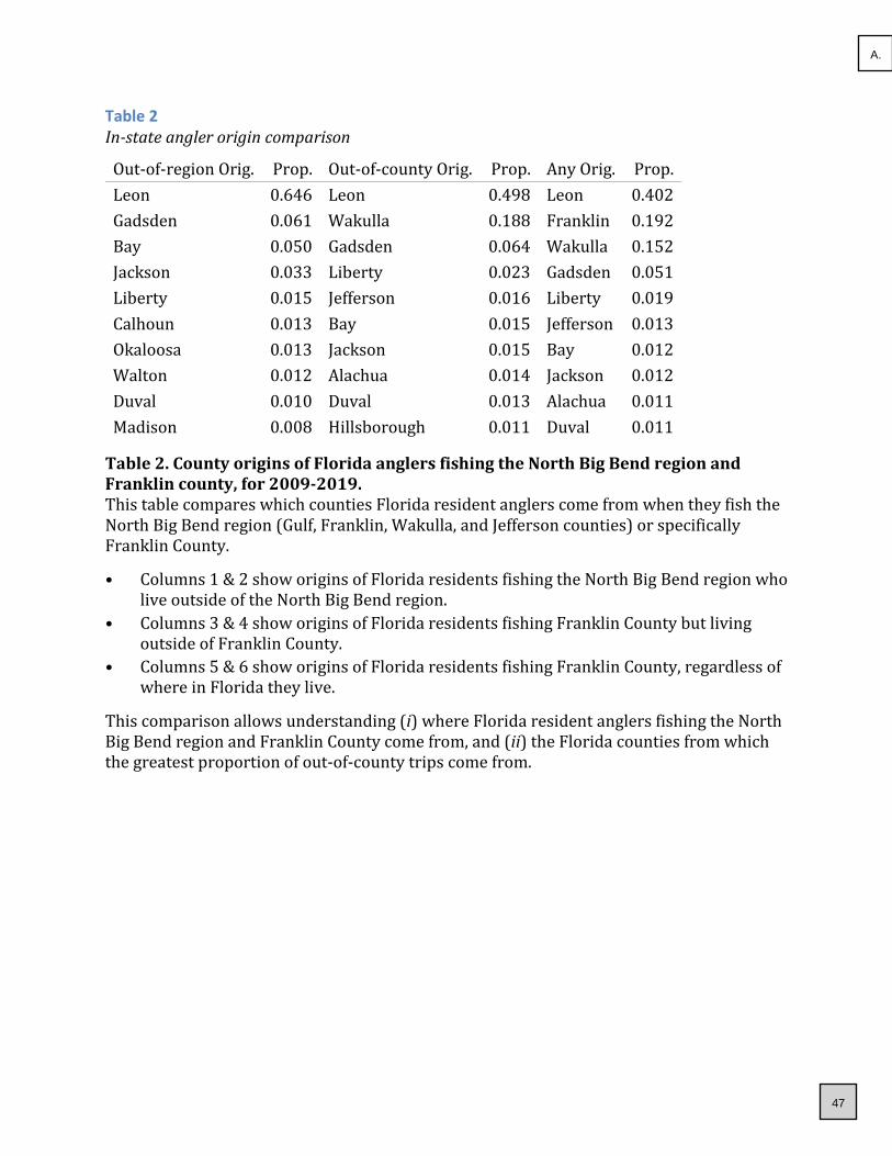
Table 2 In-state angler origin comparison
Out-of-region Orig. Prop. Out-of-county Orig. Prop. Any Orig. Prop.
Leon 0.646 Leon 0.498 Leon 0.402
Gadsden 0.061 Wakulla 0.188 Franklin 0.192
Bay 0.050 Gadsden 0.064 Wakulla 0.152
Jackson 0.033 Liberty 0.023 Gadsden 0.051
Liberty 0.015 Jefferson 0.016 Liberty 0.019
Calhoun 0.013 Bay 0.015 Jefferson 0.013
Okaloosa 0.013 Jackson 0.015 Bay 0.012
Walton 0.012 Alachua 0.014 Jackson 0.012
Duval 0.010 Duval 0.013 Alachua 0.011
Madison 0.008 Hillsborough 0.011 Duval 0.011
Table 2. County origins of Florida anglers fishing the North Big Bend region and Franklin county, for 2009-2019. This table compares which counties Florida resident anglers come from when they fish the North Big Bend region (Gulf, Franklin, Wakulla, and Jefferson counties) or specifically Franklin County.
• Columns 1 & 2 show origins of Florida residents fishing the North Big Bend region who live outside of the North Big Bend region.
• Columns 3 & 4 show origins of Florida residents fishing Franklin County but living outside of Franklin County.
• Columns 5 & 6 show origins of Florida residents fishing Franklin County, regardless of where in Florida they live.
This comparison allows understanding (i) where Florida resident anglers fishing the North Big Bend region and Franklin County come from, and (ii) the Florida counties from which the greatest proportion of out-of-county trips come from.
47
A.

Fishing Trip Origin Results: Maps
We provide several maps to graphically illustrate where sampled anglers come from when they fish the North Big Bend region and Franklin County. The maps show the “direct line” paths between the population centroids of anglers’ county of residence and the location where they were sampled by the MRIP APAIS survey-i.e. their fishing destinations. For all maps, thicker and warmer colored lines indicate more trips from a given county to a given destination, and thinner and cooler colors suggests fewer trips. Here, different maps are created for different species, including the top five species targeted in the North Big Bend region. Figure 1 maps trips to Franklin County regardless of species targeted. Figure 2 maps trips to the North Big Bend region when anglers targeted Spotted seatrout. Figure 3 maps trips to the North Big Bend region when anglers targeted Red drum. Figure 4 maps trips to the North Big Bend region when anglers targeted Red snapper. Figure 5 maps trips to the North Big Bend region when anglers targeted Gag. Figure 6 maps trips to the North Big Bend region when anglers targeted Sea bass family.
The primary purpose of these figures is to serve as a visual aid to augment the use of the previous tables.
48
A.
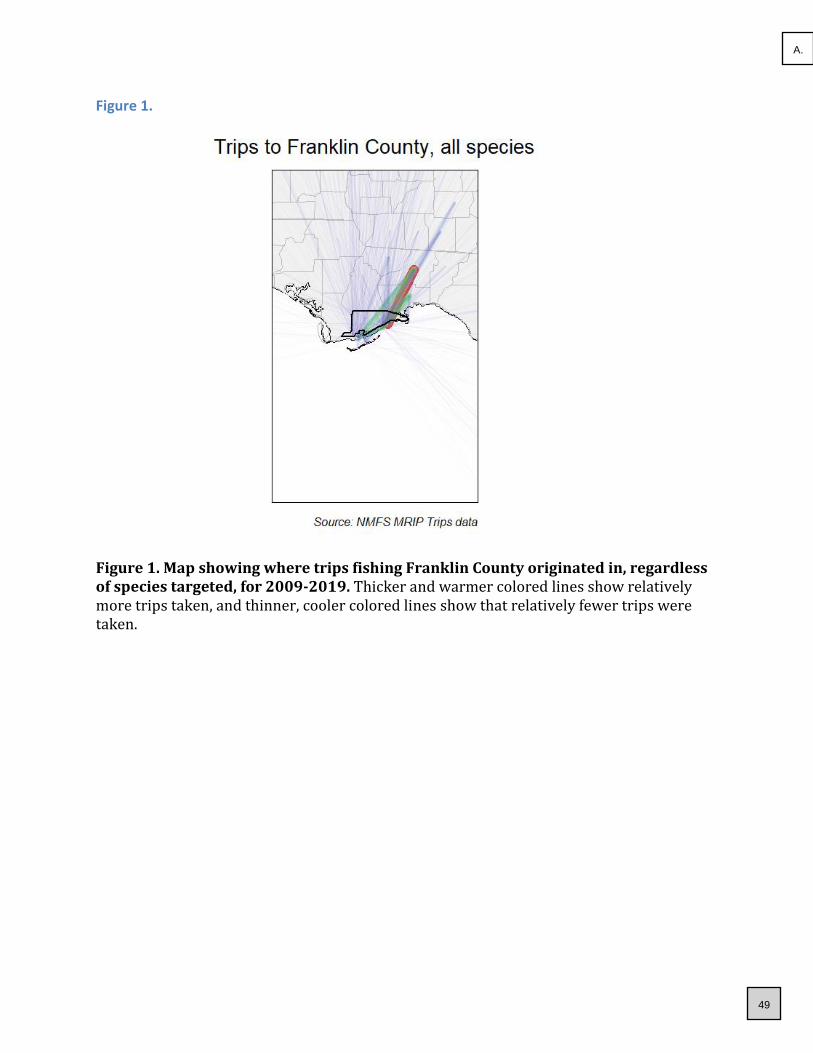
Figure 1.
Figure 1. Map showing where trips fishing Franklin County originated in, regardless of species targeted, for 2009-2019. Thicker and warmer colored lines show relatively more trips taken, and thinner, cooler colored lines show that relatively fewer trips were taken.
49
A.

Figure 2.
Figure 2. Map showing where trips fishing the North Big Bend region originated in, when targeted Spotted seatrout, for 2009-2019. Thicker and warmer colored lines show relatively more trips taken, and thinner, cooler colored lines show that relatively fewer trips were taken.
50
A.

Figure 3.
Figure 3. Map showing where trips fishing the North Big Bend region originated in, when targeted Red drum, for 2009-2019. Thicker and warmer colored lines show relatively more trips taken, and thinner, cooler colored lines show that relatively fewer trips were taken.
51
A.

Figure 4.
Figure 4. Map showing where trips fishing the North Big Bend region originated in, when targeted Red snapper, for 2009-2019. Thicker and warmer colored lines show relatively more trips taken, and thinner, cooler colored lines show that relatively fewer trips were taken.
52
A.

Figure 5.
Figure 5. Map showing where trips fishing the North Big Bend region originated in, when targeted Gag, for 2009-2019. Thicker and warmer colored lines show relatively more trips taken, and thinner, cooler colored lines show that relatively fewer trips were taken.
53
A.

Figure 6.
Figure 6. Map showing where trips fishing the North Big Bend region originated in, when targeted Sea bass family, for 2009-2019. Thicker and warmer colored lines show relatively more trips taken, and thinner, cooler colored lines show that relatively fewer trips were taken.
54
A.

Species targeted: What do your anglers fish for?
Background on data used The MRIP APIAS includes questions about the species that interviewed anglers were targeting on their recently completed fishing trips. Specifically, anglers are asked what their “primary” and “secondary” targeted species were. Not all anglers provide a specific species. Statewide, nearly 50% of trips do not have a listed target, though certain regions have much greater proportions trips targeting specific fish. The species targeted information is used by MRIP to estimate fishing effort, but can be used here to understand what species are most commonly fished for. Further information about APAIS and the specific destinations is available at: https://www.fisheries.noaa.gov/recreational-fishing-data/public-access-fishing-site-register.
Species targeted: Background on methods used To understand what fish species anglers most commonly fished for, we use data available in the MRIP “trips” databases that describe the results of the MRIP APAIS survey. The “trips” database contains the information that anglers tell surveyors when they are interviewed about their recreational fishing trips. We designed a series of queries to calculate the proportions of trips targeting specific fish species. Queries represented different scenarios regarding where anglers were intercepted (their destinations) and where they listed their home residence (their origin). This information was summarized by pooling trips over time—i.e. looking at the last 10 years (2009-2019) together. To assess potential changes in the fish that anglers target, we also analyzed time series for some of the most commonly targeted species. Time series were constructed by assessing the proportions of trips intercepted in the North Big Bend region that targeted a specific species for each of the last 10 years.
Species targeted: Information provided Two types of information products were developed:
• Tables describing the proportions of trips targeting different fish species at various combinations of fishing locations and residences.
• Figures showing the time series of proportion of trips taken in the North Big Bend region targeting the most popular fish species.
One thing that is important to note is that we report the proportion of the sampled trips targeting a certain species. This is not the same as reporting the total number of trips. Enumerating the total number of trips would require estimation tools that are not described here. However, because of the statistical design used to implement the MRIP APAIS survey, the proportions we use (of sampled trips) should correspond to the total numbers of trips. What this means is that the information in this report can be very useful for things like understanding where people, on average, are coming from when then fish Franklin County.
55
A.

Species Targeted Results: Tables
Tables describing the proportions of trips targeting different fish species at various combinations of fishing locations and residences, including:
• Trips in all of Florida, regardless of origin.
• Trips in Florida’s Gulf coast, regardless of origin.
• Trips in the North Big Bend region, regardless of origin.
• Trips taken in Franklin County, regardless of origin.
• Trips taken in Franklin County by Franklin County residents.
• Trips taken in Franklin County by non-residents of Franklin County.
• Trips taken in Franklin County by out-of-state anglers.
These results are summarized in two separate tables that promote comparison of Franklin County to surrounding areas. All results represent data pooled over the last 10 years (2009-2019).
We anticipate these tables may be useful in several ways, including:
• Understanding what species anglers are targeting when they fish in Franklin County, which may help inform local government interest in state and regional fisheries management issues.
• Understanding what species visiting (non Franklin-County residents) anglers target, which may inform the media outlets and visuals (e.g., fish photos) of future advertisements).
56
A.

Table 3 Proportion of species targeted, comparing county to state
FL trips Prop. FL Gulf trips Prop.
North Big Bend trips Prop.
Franklin trips Prop.
No Target 0.491 No Target 0.481 No Target 0.365 No Target 0.422
Red drum 0.098 Red drum 0.099 Spotted seatrout
0.267 Spotted seatrout
0.160
Spotted seatrout
0.076 Spotted seatrout
0.096 Red drum 0.135 Red drum 0.124
Dolphin 0.035 Common snook
0.031 Red snapper 0.046 Red snapper
0.072
Common snook
0.031 Spanish mackerel
0.031 Gag 0.029 Gag 0.039
King mackerel
0.026 Red snapper
0.028 Sea bass family
0.017 Atlantic tarpon
0.029
Spanish mackerel
0.024 King mackerel
0.025 Atlantic tarpon
0.016 Sea bass family
0.029
Red snapper 0.021 Gag 0.023 Lefteye flounder family
0.016 King mackerel
0.012
Sheepshead 0.018 Gray snapper
0.020 King mackerel
0.011 Red grouper
0.012
Gag 0.016 Atlantic tarpon
0.019 Spanish mackerel
0.011 Black sea bass
0.010
Table 3. Comparison of species targeted in Franklin county to other regions of Florida, for 2009-2019.
• Columns 1 & 2 show species targeted for trips made throughout Florida.
• Columns 3 & 4 show species targeted for trips made to the Gulf coast of Florida.
• Columns 5 & 6 show species targeted for trips made in the North Big Bend region.
• Columns 7 & 8 show species targeted for trips made in Franklin County.
57
A.

Table 4 Proportion of species targeted, comparing county to state
All Franklin trips Prop. In county trips Prop.
Out of county trips Prop.
Out of state trips Prop.
No Target 0.422 No Target 0.410 No Target 0.424 No Target 0.409
Spotted seatrout
0.160 Spotted seatrout
0.167 Spotted seatrout
0.159 Spotted seatrout
0.198
Red drum 0.124 Red drum 0.143 Red drum 0.121 Red drum 0.117
Red snapper
0.072 Red snapper 0.079 Red snapper
0.071 Red snapper 0.058
Gag 0.039 Gag 0.048 Gag 0.038 Atlantic tarpon
0.038
Atlantic tarpon
0.029 King mackerel 0.026 Sea bass family
0.032 Gag 0.028
Sea bass family
0.029 Requiem shark family
0.013 Atlantic tarpon
0.031 Sea bass family
0.023
King mackerel
0.012 Sheepshead 0.013 Red grouper
0.013 Black sea bass
0.013
Red grouper
0.012 Gulf kingfish 0.011 Black sea bass
0.011 Sand seatrout
0.010
Black sea bass
0.010 Spanish mackerel
0.011 King mackerel
0.011 Sheepshead 0.010
Table 4. Proportions of species targeted by fishing trips made in Franklin county by anglers from various origins, for 2009-2019.
• Columns 1 & 2 show the species targeted by all trips made in Franklin County.
• Columns 3 & 4 show the species targeted in Franklin County by Franklin residents.
• Columns 5 & 6 show the species targeted in Franklin County by Florida residents not living in Franklin County.
• Columns 7 & 8 shows the species targeted in Franklin County by non-residents of Florida.
58
A.

Species Targeted Results: Time series figures
We provide time series of the proportion of intercepted trips that targeted each of the top nine species fished for in the North Big Bend region. Data are available for each year from 2009-2019, and represent the raw proportions of surveyed trips, which means that no uncertainty estimates (e.g. “error” bars) are relevant to these data.
The multi-panel figure below should primarily be useful for understanding how the species of fish anglers target when they fish has changed in recent years. These changes may be related to changes in angler’s preferences, but can have other causes as well, such as:
• Changes in costs of fishing (e.g., fuel), since some species require larger boats or longer travel times to target.
• Changes in fishing regulations for specific species.
• Changes in knowledge of how to successfully target specific species.
• Changes in fish populations, which can be the result of changing fishing, fisheries management, or habitat, as well as perturbations like red tide or cold kills.
59
A.

Figure 6. Time series of the proportion of intercepted trips targeting each of the top 9 fish species targets in the North Big Bend region, for 2009-2019. Each panel describes the time series for one of the top-targeted fish species (including no species targeted, “No Target”). Proportion of total trips targeting each species over the entire span of years (2009-2019) shown is provided in parentheses following each species’ name.
60
A.

References Camp, E. V., Ahrens R. N. M., C. Crandall, and K. Lorenzen. 2018. “Angler travel distances: Implications for spatial approaches to marine recreational fisheries governance.” Marine Policy 87: 263–74.
NOAA, National Marine Fisheries Service. 2017. “Fisheries Economics of the United States, 2015.” NOAA Tech. Memo. NMFS-F/SPO-170. U.S. Depart. of Commerce.
USFWS, U. S. Fish Wildlife Service. 2011. “National Survey of Fishing, Hunting, and Wildlife-Associated Recreation.” U.S. Depart. of Commerce.
61
A.

FCTDC Collections Report for
2020-21 Year-to-Date Report
Through November 2020
1
2
3
4
5
6
7
8
9
10
11
12
13
14
15
16
17
18
19
20
21
22
23
24
25
26
27
28
29
30
31
32
33
34
35
36
37
38
39
40
41
42
A B C D E F G H I J K L M
Month 2005-06 2006-07 2007-08 2008-09 2009-10 2010-11 2011-12 2012-13 2013-14 2014-15 2015-16 2016-17October 35,408.91$ 32,809.57$ 39,697.19$ 38,597.69$ 39,568.32$ 36,996.34$ 48,383.10$ 53,543.22$ 57,651.88$ 58,875.87$ 75,084.59$ 95,107.96$ November 24,824.38$ 24,717.35$ 27,182.76$ 25,888.92$ 25,863.47$ 26,438.49$ 34,441.98$ 40,334.08$ 34,740.65$ 40,065.78$ 44,449.24$ 46,043.65$ December 20,421.74$ 16,055.89$ 22,986.95$ 23,167.33$ 16,530.96$ 19,936.19$ 21,597.00$ 21,510.93$ 29,747.90$ 30,978.80$ 24,692.82$ 41,580.49$ January 19,681.48$ 26,489.68$ 22,911.37$ 22,960.20$ 26,170.57$ 23,359.12$ 30,392.62$ 33,657.09$ 34,707.03$ 38,805.36$ 47,001.63$ 41,668.57$ February 29,294.47$ 44,900.59$ 40,835.29$ 39,452.32$ 33,678.97$ 34,980.88$ 52,045.79$ 49,365.87$ 52,883.10$ 42,754.53$ 64,493.95$ 60,422.61$ March 51,243.40$ 45,643.22$ 61,090.70$ 49,778.57$ 53,116.79$ 61,989.52$ 66,597.90$ 80,880.36$ 78,180.12$ 83,626.43$ 80,017.67$ 84,583.19$ April 69,608.73$ 70,430.06$ 66,135.24$ 73,880.65$ 53,934.68$ 70,610.82$ 81,641.55$ 90,242.68$ 81,115.14$ 101,310.37$ 103,120.37$ 89,949.68$ May 100,486.16$ 114,100.71$ 123,221.80$ 104,769.28$ 120,470.95$ 90,634.75$ 140,203.97$ 115,589.54$ 135,897.45$ 143,700.44$ 131,348.44$ 110,484.59$ June 107,484.39$ 166,403.90$ 138,839.79$ 143,507.76$ 151,640.61$ 172,029.99$ 143,805.29$ 195,838.11$ 210,505.76$ 195,093.30$ 213,948.96$ 226,795.48$ July 149,857.23$ 95,128.02$ 128,027.35$ 131,276.62$ 114,121.18$ 147,874.24$ 140,000.40$ 153,197.77$ 164,199.99$ 182,235.52$ 253,603.30$ 242,036.51$ August 51,353.14$ 69,863.99$ 57,497.82$ 56,312.21$ 71,377.70$ 60,698.01$ 93,912.12$ 86,742.96$ 107,783.56$ 129,879.50$ 82,664.07$ 121,808.90$ September 38,597.72$ 46,282.27$ 45,739.57$ 41,298.87$ 47,760.09$ 57,592.93$ 63,037.18$ 57,170.58$ 64,199.48$ 75,778.00$ 81,869.35$ 90,214.19$ Totals 698,261.75$ 752,825.25$ 774,165.83$ 750,890.42$ 754,234.29$ 803,141.28$ 916,058.90$ 978,073.19$ 1,051,612.06$ 1,123,103.90$ 1,202,294.39$ 1,250,695.82$
YOY % 54,563.50$ 21,340.58$ (23,275.41)$ 3,343.87$ 48,906.99$ 112,917.62$ 62,014.29$ 73,538.87$ 71,491.84$ 79,190.49$ 48,401.43$ 7.8% 2.8% -3.0% 0.4% 6.5% 14.1% 6.8% 7.5% 6.8% 7.1% 4.0%
Month 2017-18 2018-19 2019-20 2020-21
Increase /
Decrease % of Change
To Date
% of ChangeOctober 85,823.35$ 38,416.89$ 89,660.28$ 147,542.08$ 57,881.80$ 64.56% 64.56%November 49,440.74$ 87,784.31$ 57,067.01$ 86,469.54$ 29,402.53$ 51.52% 116.08%December 37,182.43$ 46,715.00$ 52,526.91$ January 51,388.51$ 52,063.46$ 54,422.25$ February 58,337.94$ 66,632.44$ 95,017.02$ March 111,947.32$ 127,975.20$ 71,946.84$ April 103,422.44$ 82,258.08$ 20,066.60$ May 140,130.14$ 166,129.65$ 123,839.27$ June 269,049.32$ 300,092.38$ 283,734.76$ July 215,933.34$ 209,374.07$ 253,488.28$ August 111,322.92$ 134,238.67$ 190,136.02$ September 70,419.47$ 90,051.57$ 140,186.24$ Totals 1,304,397.92$ 1,401,731.72$ 1,432,091.48$ 234,011.62$ 87,284.33$ 58.04%
YOY % 53,702.10$ 97,333.80$ 30,359.76$ 4.29% 7.46% 2.17%
* October and November 2018 due to Hurricane Michael statistically are outliers. October and November 2019 compared with 2017-18 amounts are more representative, thus, these months show increases of 10% and 9% respectively, or YTD increase of 31%.* Coronoviris-19 March 1 - May 18 2020
$-
$250,000.00
$500,000.00
$750,000.00
$1,000,000.00
$1,250,000.00
$1,500,000.00
$1,750,000.00
File:TDC Collections YTD.xl
Updated 01/26/2021 Revised 02:21p62
A.

A Presentation to Conduct aClassification and Compensation Study
for Franklin County, FL
February 16, 2021
Presented by:
63
A.

1
Presentation Outline
• Who We Are
• Evergreen’s Florida Experience
• Work Plan
• Project Timeline
• Why Choose Evergreen?
64
A.

2
Who We Are
• National Public Sector Consulting Experience
➢ Work in 46 States
➢ Extensive Experience Working with Local Gov’t Clients
➢ Over 600 Classification and/or Compensation Studies
➢ Full-Service Human Resources Consulting Practice
• Public Sector Expertise
➢ Local Governments
➢ Colleges and Universities
➢ School Districts
➢ Quasi-Governmental Organizations
➢ Non-Profits
65
A.

3
FL Local Government Experience
➢ City of St. Petersburg
➢ City of Cocoa
➢ City of Daytona Beach
➢ City of Orlando
➢ City of Clermont
➢ City of Kissimmee
➢ City of Ocala
➢ City of Winter Park
➢ City of Orange City
➢ City of Hollywood
➢ City of Dania Beach
➢ City of Coral Springs
➢ City of Doral
➢ City of Parkland
➢ City of North Miami Beach
➢ City of Tamarac
➢ City of Key West
➢ City of Dunedin
➢ City of Largo
➢ City of St. Petersburg
➢ City of Cape Coral
➢ City of Ft. Myers
➢ City of Sarasota
➢ City of Gainesville
➢ City of North Port
➢ City of Palm Beach Gardens
➢ City of North Palm Beach
➢ City of Ft. Myers
➢ City of Plantation
➢ City of High Springs
➢ City of Punta Gorda
➢ City of Plant City
➢ City of Melbourne
➢ City of West Melbourne
➢ City of Fort Walton Beach
➢ City of Panama City
➢ City of St. Cloud
➢ City of Holmes Beach
➢ City of Lake City
➢ City of Sunny Isles Beach
➢ Village of N. Palm Beach
➢ Village of Pinecrest
➢ Miami Shores Village
➢ Town of Davie
➢ Town of Cutler Bay
➢ Town of Juno Beach
➢ Gulf County
➢ Bay County
➢ Santa Rosa County
➢ Okaloosa County
➢ Escambia County
➢ Hillsborough County
➢ Manatee County
➢ Pinellas County
➢ Sarasota County
➢ Miami-Dade County
➢ Monroe County
➢ Palm Beach County
➢ Santa Rosa County
➢ Alachua County
➢ Flagler County
➢ Seminole County
➢ Osceola County
➢ Hernando County
➢ Gadsden County
➢ Brevard County
➢ Martin County
➢ Highlands County
➢ Charlotte County 66
A.

4
Work Plan
Step 1
Overview of
Work Plan
Step 2
Job Categories
Step 3
Salary Structure
Step 3
Job Classification
Analysis
Step 1
Project Initiation
Introduce team members
Finalize project planning
Finalize work plan
Establish a communication schedule
Collect data
Conduct employee orientation sessions and focus groups
Interview department heads/supervisors
Administer JATs and MITs
Perform job analysis
Analyze results
Review all class specifications
Review work performed by each classification
Develop classification structure based on JAT scores
Evaluate and build projected classification plan
Develop internal job classification hierarchies
Validate internal equity
Step 2
Project Outreach
and Employee
Participation
Step 3
Job Classification
Analysis
67
A.

5
Work Plan (Continued)
Step 1
Overview of
Work Plan
Step 3
Assess Current
Structure
Step 4
Conduct Market
Salary Survey
Step 5
Solution Analysis
and Development
Step 6
Finalize Project
Identify benchmark positions and peer organizations
Conduct a labor market salary survey
Collect and analyze market salary data
Prepare draft summary of the County’s market position
Conduct compensation analysis
Develop new/revised pay grades and ranges for review
Slot classifications into pay plans
Conduct solution analysis
Develop draft and final reports to include cost analysis for implementing recommendations
Present the final report
Develop a communication plan for employees
Develop recommendations for the continued administration of the recommended plans
Revise job descriptions and provide FLSA determinations
Provide training
68
A.
6
Why Choose Evergreen?
• Unparalleled experience in conducting classification and
compensation studies for local governments and other
public sector clients⎯especially in the State of Florida
• Nationally recognized knowledge of and experience with
local government operations
• An experienced collaborative and professional team
• Real world methodology that is industry standard
• Tested tools for knowledge transfer
69
A.

7
Thank You!
Dr. Jeff Ling, PresidentEvergreen Solutions, [email protected] Remington Green CircleTallahassee, Florida 32308850.383.0111850.383.1511 faxwww.ConsultEvergreen.com
70
A.

71
A.

72
A.

73
A.

74
A.

75
A.

76
A.

77
A.

78
A.

79
A.

80
A.

81
A.

82
A.

83
A.

84
A.

85
A.

86
A.

87
A.

88
A.

89
A.

90
A.

91
A.

92
A.

93
A.

94
B.

95
B.

96
B.

97
B.

98
B.

99
B.

100
B.

101
B.

102
B.

103
B.

104
B.

105
B.

106
B.

107
B.

108
B.

109
B.

110
B.

111
B.

112
B.

113
B.

114
B.

115
B.

116
C.

117
C.

118
C.

119
C.
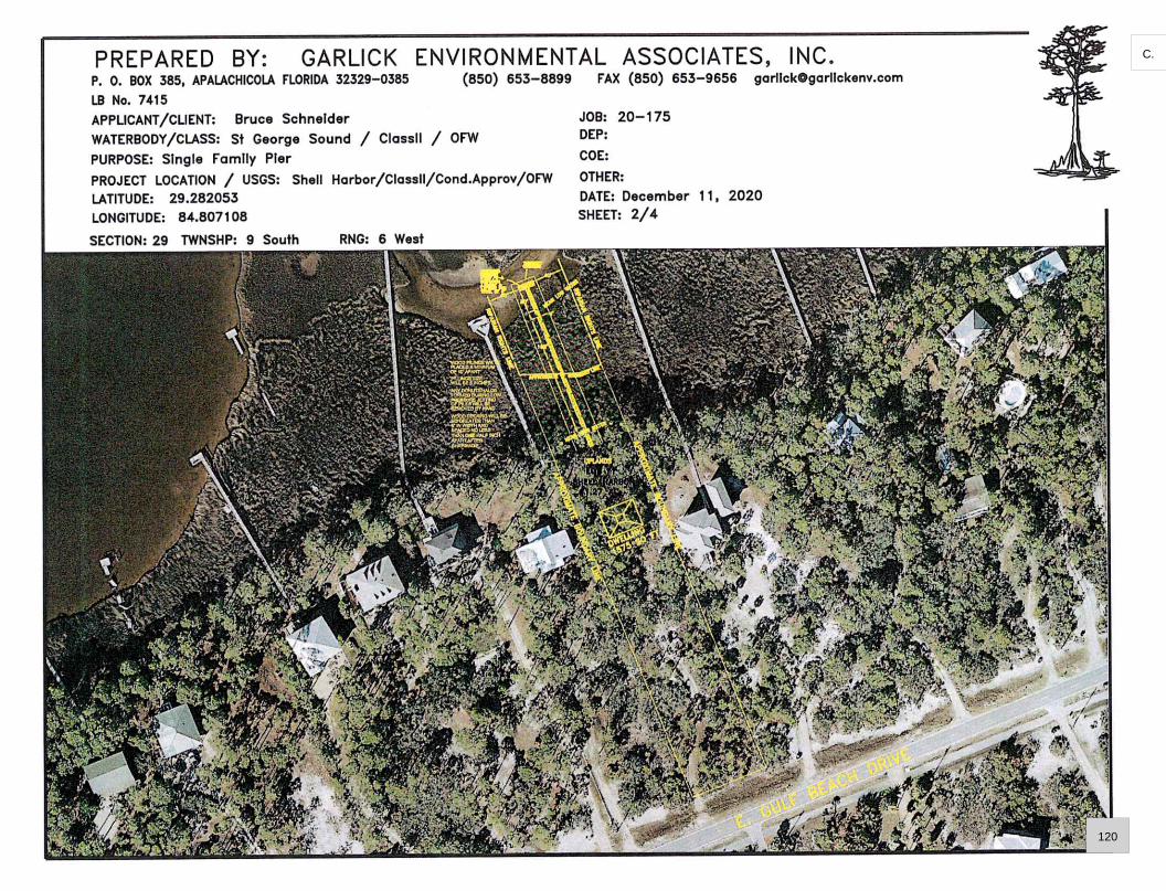
120
C.

121
C.

122
C.

123
C.

124
C.

125
C.

126
C.

127
C.

128
C.

129
C.

130
C.

131
C.

132
C.

133
C.

134
C.

135
C.

136
C.

www.dep.state.fl.us
January 13, 2021
Bruce Schneider
606 Self Mountain Road
Blairsville, Georgia 30512
File No.: 0395855-001-EG/19, Franklin County
Dear Mr. Schneider:
On December 14, 2020, we received your notice of intent to use a General Permit (GP) pursuant
to Rule 62-330.427, Florida Administrative Code (F.A.C.) to construct a single-family pier
totaling less than 2,000 square feet within St. George Sound, Class III Outstanding Florida
Waters, Approved (1601) Shellfish Harvesting Area. The project is located at 1721 East Gulf
Beach Drive, Eastpoint, Florida 32320, Parcel No. 29-09S-06W-7319-0000-0110, in Section 29,
Township 9 South, Range 6 West of Franklin County; at approximately 29°40′56.67″ North
Latitude, 84°48′25.82″ West Longitude.
Your intent to use a general permit has been reviewed by Department staff for three types of
authorization: (1) regulatory authorization, (2) proprietary authorization (related to state-owned
submerged lands), and (3) federal authorization. The authority for review and the outcomes of
the reviews are listed below. Please read each section carefully.
Your project qualifies for all three authorizations. However, this letter does not relieve you
from the responsibility of obtaining other federal, state, or local authorizations that may be
required for the activity.
If you change the project from what you submitted, the authorization(s) granted may no longer
be valid at the time of commencement of the project. Please contact us prior to beginning your
project if you wish to make any changes.
1. Regulatory Review – Approved
Based on the forms, drawings, and documents submitted with your notice, it appears that the
project meets the requirements for the General Permit under Rule 62-330.427, F.A.C. Any
activities performed under a general permit are subject to general conditions required in Rule
62-330.405, F.A.C. (attached) and the specific conditions of Rule 62-330.427, F.A.C. (attached).
Any deviations from these conditions may subject the permittee to enforcement action and
possible penalties.
Please be advised that the construction phase of the GP must be completed within five years
from the date the notice to use the GP was received by the Department. If you wish to continue
137
C.

File Name: Schneider Pier
File No.: 0395855-001-EG/19
Page 2 of 25
this GP beyond the expiration date, you must notify the Department at least 30 days before its
expiration.
Authority for review – Part IV of Chapter 373, Florida Statutes (F.S.), Title 62, F.A.C., and in
accordance with the operating agreements executed between the Department and the water
management districts, as referenced in Chapter 62-113, F.A.C.
2. Proprietary Review – Granted
The Department acts as staff to the Board of Trustees of the Internal Improvement Trust Fund
(Board of Trustees) and issues certain authorizations for the use of sovereign submerged lands.
The Department has the authority to review activities on sovereign submerged lands under
Chapters 253 and 258, F.S. and Chapters 18-20 and 18-21, F.A.C.
The activity appears to be located on sovereign submerged lands owned by the Board of
Trustees. The activity is not exempt from the need to obtain the applicable proprietary
authorization. As staff to the Board of Trustees, the Department has reviewed the activity
described above and has determined that the activity qualifies for a Letter of Consent under
Section 253.77, F.S. to construct and use the activity on the specified sovereign submerged
lands, as long as the work performed is located within the boundaries as described herein and is
consistent with the terms and conditions herein.
During the term of this Letter of Consent you shall maintain satisfactory evidence of sufficient
upland interest as required by paragraph 18-21.004(3)(b), F.A.C. If such interest is terminated or
the Board of Trustees determines that such interest did not exist on the date of issuance of this
Letter of Consent, this Letter of Consent may be terminated by the Board of Trustees at its sole
option. If the Board of Trustees terminates this Letter of Consent, you agree not to assert a claim
or defense against the Board of Trustees arising out of this Letter of Consent.
Please be advised that any use of sovereign submerged lands without specific prior authorization
from the Board of Trustees will be considered a violation of Chapter 253, F.S. and may subject
the affected upland riparian property owners to legal action as well as potential fines for the prior
unauthorized use of sovereign land.
Authority for review – Chapter 253, F.S., Chapter 18-21, F.A.C., and Section 62-330.075,
F.A.C., as required.
3. Federal Review – SPGP Approved
Your proposed activity as outlined in your application and attached drawings qualifies for
Federal authorization pursuant to the State Programmatic General Permit V-R1, and a
SEPARATE permit or authorization will not be required from the Corps. Please note that the
Federal authorization expires on July 26, 2021. However, your authorization may remain in
effect for up to 1 additional year, if provisions of Special Condition 19 of the SPGP V-R1 permit
instrument are met. You, as permittee, are required to adhere to all General Conditions and
Special Conditions that may apply to your project. Special conditions required for your project
are attached. A copy of the SPGP V-R1 with all terms and conditions and the General Conditions
may be found at https://www.saj.usace.army.mil/Missions/Regulatory/Source-Book.
138
C.

File Name: Schneider Pier
File No.: 0395855-001-EG/19
Page 3 of 25
Authority for review - an agreement with the USACOE entitled “Coordination Agreement
Between the U. S. Army Corps of Engineers (Jacksonville District) and the Florida Department
of Environmental Protection (or Duly Authorized Designee), State Programmatic General
Permit”, Section 10 of the Rivers and Harbor Act of 1899, and Section 404 of the Clean Water
Act.
Additional Information
Please retain this general permit. The activities may be inspected by authorized state personnel in
the future to ensure compliance with appropriate statutes and administrative codes. If the
activities are not in compliance, you may be subject to penalties under Chapter 373, F.S. and
Chapter 18-14, F.A.C.
NOTICE OF RIGHTS
This action is final and effective on the date filed with the Clerk of the Department unless a
petition for an administrative hearing is timely filed under Sections 120.569 and 120.57, F.S.,
before the deadline for filing a petition. On the filing of a timely and sufficient petition, this
action will not be final and effective until a subsequent order of the Department. Because the
administrative hearing process is designed to formulate final agency action, the subsequent order
may modify or take a different position than this action.
Petition for Administrative Hearing
A person whose substantial interests are affected by the Department’s action may petition for an
administrative proceeding (hearing) under Sections 120.569 and 120.57, F.S. Pursuant to Rules
28-106.201 and 28-106.301, F.A.C., a petition for an administrative hearing must contain the
following information:
(a) The name and address of each agency affected and each agency’s file or identification
number, if known;
(b) The name, address, and telephone number of the petitioner; the name, address, and
telephone number of the petitioner’s representative, if any, which shall be the address for
service purposes during the course of the proceeding; and an explanation of how the
petitioner’s substantial interests are or will be affected by the agency determination;
(c) A statement of when and how the petitioner received notice of the agency decision;
(d) A statement of all disputed issues of material fact. If there are none, the petition must so
indicate;
(e) A concise statement of the ultimate facts alleged, including the specific facts that the
petitioner contends warrant reversal or modification of the agency’s proposed action;
(f) A statement of the specific rules or statutes that the petitioner contends require reversal or
modification of the agency’s proposed action, including an explanation of how the
alleged facts relate to the specific rules or statutes; and
(g) A statement of the relief sought by the petitioner, stating precisely the action that the
petitioner wishes the agency to take with respect to the agency’s proposed action.
The petition must be filed (received by the Clerk) in the Office of General Counsel of the
Department at 3900 Commonwealth Boulevard, Mail Station 35, Tallahassee, Florida 32399-
139
C.

File Name: Schneider Pier
File No.: 0395855-001-EG/19
Page 4 of 25
3000, or via electronic correspondence at [email protected]. Also, a copy of the
petition shall be mailed to the applicant at the address indicated above at the time of filing.
Time Period for Filing a Petition
In accordance with Rule 62-110.106(3), F.A.C., petitions for an administrative hearing by the
applicant and persons entitled to written notice under Section 120.60(3), F.S., must be filed
within 21 days of receipt of this written notice. Petitions filed by any persons other than the
applicant, and other than those entitled to written notice under Section 120.60(3), F.S., must be
filed within 21 days of publication of the notice or within 21 days of receipt of the written
notice, whichever occurs first. You cannot justifiably rely on the finality of this decision unless
notice of this decision and the right of substantially affected persons to challenge this decision
has been duly published or otherwise provided to all persons substantially affected by the
decision. While you are not required to publish notice of this action, you may elect to do so
pursuant Rule 62-110.106(10)(a).
The failure to file a petition within the appropriate time period shall constitute a waiver of that
person's right to request an administrative determination (hearing) under Sections 120.569 and
120.57, F.S., or to intervene in this proceeding and participate as a party to it. Any subsequent
intervention (in a proceeding initiated by another party) will be only at the discretion of the
presiding officer upon the filing of a motion in compliance with Rule 28-106.205, F.A.C. If you
do not publish notice of this action, this waiver may not apply to persons who have not received
a clear point of entry.
Extension of Time
Under Rule 62-110.106(4), F.A.C., a person whose substantial interests are affected by the
Department’s action may also request an extension of time to file a petition for an administrative
hearing. The Department may, for good cause shown, grant the request for an extension of time.
Requests for extension of time must be filed with the Office of General Counsel of the
Department at 3900 Commonwealth Boulevard, Mail Station 35, Tallahassee, Florida 32399-
3000, or via electronic correspondence at [email protected], before the deadline
for filing a petition for an administrative hearing. A timely request for extension of time shall
toll the running of the time period for filing a petition until the request is acted upon.
Mediation
Mediation is not available in this proceeding.
FLAWAC Review
The applicant, or any party within the meaning of Section 373.114(1)(a) or 373.4275, F.S., may
also seek appellate review of this order before the Land and Water Adjudicatory Commission
under Section 373.114(1) or 373.4275, F.S. Requests for review before the Land and Water
Adjudicatory Commission must be filed with the Secretary of the Commission and served on the
Department within 20 days from the date when this order is filed with the Clerk of the
Department.
140
C.

File Name: Schneider Pier
File No.: 0395855-001-EG/19
Page 5 of 25
Judicial Review
Once this decision becomes final, any party to this action has the right to seek judicial review
pursuant to Section 120.68, F.S. by filing a Notice of Appeal pursuant to Florida Rules of
Appellate Procedure 9.110 and 9.190 with the Clerk of the Department in the Office of General
Counsel (Station #35, 3900 Commonwealth Boulevard, Tallahassee, Florida 32399-3000) and
by filing a copy of the Notice of Appeal accompanied by the applicable filing fees with the
appropriate district court of appeal. The notice must be filed within 30 days from the date this
action is filed with the Clerk of the Department.
141
C.

File Name: Schneider Pier
File No.: 0395855-001-EG/19
Page 6 of 25
If you have any questions regarding this matter, please contact Hali Troendle at the letterhead
address, at (850)595-6010, or at [email protected]
EXECUTION AND CLERKING
Executed in Pensacola, Florida.
STATE OF FLORIDA DEPARTMENT OF ENVIRONMENTAL PROTECTION
_________________________________
Hali Troendle
Environmental Specialist
Submerged Lands and Environmental Resources Program
Attachments:
1. Rule 62-330.427, F.A.C., 2 pages
2. General Conditions for All General Permits, Rule 62-330.405, F.A.C., 3 pages
3. Special Consent Conditions for Use of Sovereignty Submerged Lands, 1 page
4. General Consent Conditions for Use of Sovereignty Submerged Lands, 2 pages
5. Special Conditions for Federal Authorization for SPGP V-R1, 7 pages
6. General Conditions for Federal Authorization for SPGP V-R1, 2 pages
7. Standard Manatee Conditions for In-Water Work, 2 pages
8. Project Drawings, 4 pages
CERTIFICATE OF SERVICE
The undersigned duly designated deputy clerk hereby certifies that this document and all
attachments were sent on the filing date below to the following listed persons:
Wade Dandridge, DEP, [email protected]
Franklin County, [email protected]
Garlick Environmental Associates. Inc., Agent, [email protected],
FILING AND ACKNOWLEDGMENT
FILED, on this date, pursuant to Section 120.52, F.S., with the designated Department Clerk,
receipt of which is hereby acknowledged.
January 13, 2021
Clerk Date
142
C.

File Name: Schneider Pier
File No.: 0395855-001-EG/19
Page 7 of 25
62-330.427 General Permit for Docks, Piers and Associated Structures.
(1) A general permit is granted to any person to construct, extend, or remove a dock or pier and
associated structures as described below:
(a) A private, single-family pier or dock with up to two boat lifts that, together with all existing
structures on the shoreline of the property, does not exceed a total area of 2,000 square feet over
surface waters. Such a structure:
1. Shall not accommodate the mooring of more than two vessels, either in the water or on a boat
lift. Solely for purposes of this general permit, up to two personal watercraft as defined in section
327.02(33), F.S., may be moored in lieu of either or both allowable vessels of another type.
These limits shall not apply to the mooring, storage or other use of the dock or pier by:
a. Non-motor-powered vessels less than 16 feet in length that are stored on or under the dock or
pier, or within an authorized mooring area; or
b. Personal watercraft, dinghies or similar small vessels that are stowed out of the water, upon a
larger parent vessel that is moored at the dock in compliance with this general permit.
2. Shall be located such that all areas used for vessel mooring and navigational access already
provide a minimum depth of two feet below the mean low water level for tidal waters, or two
feet below the expected average low water depth for non-tidal waters as determined based on
best available information for the water body at the project location; and
3. May include a roof over the vessel mooring areas, boat lifts, and terminal platform, or any
portions thereof, subject to the applicable provisions of chapters 253 and 258, F.S., and the rules
adopted thereunder. Portions of such roofs that overhang beyond the edge of decked portions of
the pier or dock shall be included in the calculation of the total square footage of over-water
structure allowed under paragraph (1)(a), above.
(b) A public fishing pier that does not exceed a total area of 2,000 square feet provided the
structure is designed and built to discourage boat mooring by elevating the fishing pier to a
minimum height of five feet above mean high water or ordinary high water, surrounding the pier
with handrails, and installing and maintaining signs that state “No Boat Mooring Allowed.”
(2) This general permit shall be subject to the following specific conditions:
(a) Construction or extension of the boat lift, boat mooring locations, or terminal platform, shall
not occur over submerged grassbeds, coral communities or wetlands. However, the access
walkway portion of the pier may traverse these resources provided it is elevated a minimum of
five feet above mean high water or ordinary high water, contains handrails that are maintained in
such a manner as to prevent use of the access walkways for boat mooring or access, and does not
exceed a width of six feet, or a width of four feet in Aquatic Preserves;
(b) There shall be no structures enclosed by walls, screens, or doors on any side;
(c) The dock or pier will not facilitate vessel rentals, charters, or serve any other commercial
purpose;
(d) There shall be no fish cleaning facilities, boat repair facilities or equipment, or fueling
facilities on the structures authorized by this general permit. In addition, no overboard discharges
of trash, human or animal waste, or fuel shall occur from any structures authorized by this
general permit;
(e) This general permit shall not authorize the construction or extension of more than one dock or
pier per parcel of land or individual lot. For the purposes of this general permit, multi-family
living complexes shall be treated as one parcel of property regardless of the legal division of
ownership or control of the associated property; and
143
C.

File Name: Schneider Pier
File No.: 0395855-001-EG/19
Page 8 of 25
(f) Notwithstanding any other provisions of this general permit, the design, construction and
operation of the dock or pier and associated vessels shall not conflict with any manatee
protection plan approved and adopted under section 379.2431(2)(t), F.S.
Rulemaking Authority 373.026(7), 373.043, 373.118(1), 373.406(5), 373.4131, 373.414(9),
373.418, 403.805(1) FS. Law Implemented 373.118(1), 373.406(5), 373.413, 373.4131,
373.414(9), 373.416, 373.418, 373.426, 403.814(1) FS. History–New 10-3-95, Formerly 62-
341.427, Amended 10-1-13, 6-1-18.
144
C.

File Name: Schneider Pier
File No.: 0395855-001-EG/19
Page 9 of 25
62-330.405 General Conditions for All General Permits.
The following general permit conditions are binding upon the permittee and are enforceable
under chapter 373, F.S. These conditions do not apply to the general permit for stormwater
management systems under section 403.814(12), F.S.
(1) The general permit is valid only for the specific activity indicated. Any deviation from the
specified activity and the conditions for undertaking that activity shall constitute a violation of
the permit and may subject the permittee to enforcement action and revocation of the permit
under chapter 373, F.S.
(2) The general permit does not eliminate the necessity to obtain any required federal, state, local
and special district authorizations prior to the start of any construction, alteration, operation,
maintenance, removal or abandonment authorized by this permit; and it does not authorize any
violation of any other applicable federal, state, local, or special district laws (including, but not
limited to, those governing the “take” of listed species).
(3) The general permit does not convey to the permittee or create in the permittee any property
right, or any interest in real property, nor does it authorize any entrance upon or activities on
property which is not owned or controlled by the permittee, or convey any rights or privileges
other than those specified in the general permit.
(4) The general permit does not relieve the permittee from liability and penalties when the
permitted activity causes harm or injury to: human health or welfare; animal, plant or aquatic
life; or property. It does not allow the permittee to cause pollution that violates state water
quality standards.
(5) Section 253.77, F.S., provides that a person may not commence any excavation, construction,
or other activity involving the use of state-owned or other lands of the state, the title to which is
vested in the Board of Trustees of the Internal Improvement Trust Fund without obtaining the
required consent, lease, easement, or other form of authorization authorizing the proposed use.
Therefore, the permittee is responsible for obtaining any necessary authorizations from the Board
of Trustees prior to commencing activity on state-owned lands.
(6) The authorization to conduct activities under a general permit may be modified, suspended or
revoked in accordance with chapter 120, F.S., and section 373.429, F.S.
(7) The general permit is not transferable to a new third party. To be used by a different
permittee, a new notice to use a general permit must be submitted in accordance with rule 62-
330.402, F.A.C. Activities constructed in accordance with the terms and conditions of a general
permit are automatically authorized to be operated and maintained by the permittee and
subsequent owners in accordance with subsection 62-330.340(1), F.A.C. Any person holding the
general permit, persons working under the general permit, and owners of land while work is
conducted under the general permit shall remain liable for any corrective actions that may be
required as a result of any permit violations prior to sale, conveyance, or other transfer of
ownership or control of the permitted project, activity, or the real property at which the permitted
project or activity is located.
(8) Upon reasonable notice to the permittee, Agency staff with proper identification shall have
permission to enter, inspect, sample and test the permitted system to ensure conformity with the
plans and specifications approved by the general permit.
(9) The permittee shall maintain any permitted project or activity in accordance with the plans
submitted to the Agency and authorized in the general permit.
(10) A permittee’s right to conduct a specific activity under the general permit is authorized for a
duration of five years.
145
C.

File Name: Schneider Pier
File No.: 0395855-001-EG/19
Page 10 of 25
(11) Activities shall be conducted in a manner that does not cause or contribute to violations of
state water quality standards. Performance-based erosion and sediment control best management
practices shall be implemented and maintained immediately prior to, during, and after
construction as needed to stabilize all disturbed areas, including other measures specified in the
permit to prevent adverse impacts to the water resources and adjacent lands. Erosion and
sediment control measures shall be installed and maintained in accordance with the State of
Florida Erosion and Sediment Control Designer and Reviewer Manual (Florida Department of
Environmental Protection and Florida Department of Transportation, June 2007), available at
https://www.flrules.org/Gateway/reference.asp?No=Ref-04227, and the Florida Stormwater
Erosion and Sedimentation Control Inspector’s Manual (Florida Department of Environmental
Protection, Nonpoint Source Management Section, Tallahassee, Florida, July 2008), available at
http://publicfiles.dep.state.fl.us/DEAR/Stormwater_Training_Docs/erosion-inspectors-
manual.pdf.
(12) Unless otherwise specified in the general permit, temporary vehicular access within
wetlands during construction shall be performed using vehicles generating minimum ground
pressure to minimize rutting and other environmental impacts. Within forested wetlands, the
permittee shall choose alignments that minimize the destruction of mature wetland trees to the
greatest extent practicable. When needed to prevent rutting or soil compaction, access vehicles
shall be operated on wooden, composite, metal, or other non-earthen construction mats. In all
cases, access in wetlands shall comply with the following:
(a) Access within forested wetlands shall not include the cutting or clearing of any native
wetland tree having a diameter four inches or greater at breast height;
(b) The maximum width of the construction access area shall be limited to 15 feet;
(c) All mats shall be removed as soon as practicable after equipment has completed passage
through, or work has been completed, at any location along the alignment of the project, but
in no case longer than seven days after equipment has completed work or passage through
that location; and
(d) Areas disturbed for access shall be restored to natural grades immediately after the
maintenance or repair is completed.
(13) Barges or other work vessels used to conduct in-water activities shall be operated in a
manner that prevents unauthorized dredging, water quality violations, and damage to submerged
aquatic communities.
(14) The construction, alteration, or use of the authorized project shall not adversely impede
navigation or create a navigational hazard in the water body.
(15) Except where specifically authorized in the general permit, activities must not:
(a) Impound or obstruct existing water flow, cause adverse impacts to existing surface water
storage and conveyance capabilities, or otherwise cause adverse water quantity or flooding
impacts to receiving water and adjacent lands; or
(b) Cause an adverse impact to the maintenance of surface or ground water levels or surface
water flows established pursuant to section 373.042, F.S., or a Works of the District
established pursuant to section 373.086, F.S.
(16) If prehistoric or historic artifacts, such as pottery or ceramics, projectile points, stone tools,
dugout canoes, metal implements, historic building materials, or any other physical remains that
could be associated with Native American, early European, or American settlement are
encountered at any time within the project site area, the permitted project shall cease all activities
involving subsurface disturbance in the vicinity of the discovery. The permittee or other designee
146
C.

File Name: Schneider Pier
File No.: 0395855-001-EG/19
Page 11 of 25
shall contact the Florida Department of State, Division of Historical Resources, Compliance
Review Section (DHR), at (850)245-6333, as well as the appropriate permitting agency office.
Project activities shall not resume without verbal or written authorization from the Division of
Historical Resources. If unmarked human remains are encountered, all work shall stop
immediately and the proper authorities notified in accordance with section 872.05, F.S.
(17) The activity must be capable, based on generally accepted engineering and scientific
principles, of being performed and of functioning as proposed, and must comply with any
applicable District special basin and geographic area criteria.
(18) The permittee shall comply with the following when performing work within waters
accessible to federally- or state-listed aquatic species, such as manatees, marine turtles,
smalltooth sawfish, and Gulf sturgeon:
(a) All vessels associated with the project shall operate at “Idle Speed/No Wake” at all times
while in the work area and where the draft of the vessels provides less than a four-foot
clearance from the bottom. All vessels will follow routes of deep water whenever possible.
(b) All deployed siltation or turbidity barriers shall be properly secured, monitored, and
maintained to prevent entanglement or entrapment of listed species.
(c) All in-water activities, including vessel operation, must be shut down if a listed species
comes within 50 feet of the work area. Activities shall not resume until the animal(s) has
moved beyond a 50-foot radius of the in-water work, or until 30 minutes elapses since the
last sighting within 50 feet. Animals must not be herded away or harassed into leaving. All
onsite project personnel are responsible for observing water-related activities for the presence
of listed species.
(d) Any listed species that is killed or injured by work associated with activities performed
shall be reported immediately to the Florida Fish and Wildlife Conservation Commission
(FWC) Hotline at 1(888)404-3922 and [email protected].
(e) Whenever there is a spill or frac-out of drilling fluid into waters accessible to the above
species during a directional drilling operation, the FWC shall be notified at
[email protected] with details of the event within 24 hours following detection
of the spill or frac-out.
(19) The permittee shall hold and save the Agency harmless from any and all damages, claims,
or liabilities which may arise by reason of the construction, alteration, operation, maintenance,
removal, abandonment or use of any activity authorized by the general permit.
(20) The permittee shall immediately notify the Agency in writing of any submitted information
that is discovered to be inaccurate.
Rulemaking Authority 373.026(7), 373.043, 373.118(1), 373.406(5), 373.4131, 373.414(9),
373.4145, 373.418, 403.805(1) FS. Law Implemented 373.044, 373.118(1), 373.129, 373.136,
373.406(5), 373.413, 373.4131, 373.414(9), 373.4145, 373.416, 373.422, 373.423, 373.429,
403.814(1) FS. History–New 10-3-95, Amended 10-1-07, Formerly 62-341.215, Amended 10-1-
13, 6-1-18.
147
C.

File Name: Schneider Pier
File No.: 0395855-001-EG/19
Page 12 of 25
Special Consent Conditions
1. The applicant agrees to indemnify, defend and hold harmless the Board of Trustees and the
State of Florida from all claims, actions, lawsuits and demands in any form arising out of the
authorization to use sovereignty submerged lands or the applicant’s use and construction of
structures on sovereignty submerged lands. This duty to indemnify and hold harmless will
include any and all liabilities that are associated with the structure or activity including special
assessments or taxes that are now or in the future assessed against the structure or activity during
the period of the authorization.
2. Failure by the Board of Trustees to enforce any violation of a provision of the authorization
or waiver by the Board of Trustees of any provision of the authorization will not invalidate the
provision not enforced or waived, nor will the failure to enforce or a waiver prevent the Board of
Trustees from enforcing the unenforced or waived provision in the event of a violation of that
provision.
3. Applicant binds itself and its successors and assigns to abide by the provisions and conditions
set forth in the authorization. If the applicant or its successors or assigns fails or refuses to
comply with the provisions and conditions of the authorization, the authorization may be
terminated by the Board of Trustees after written notice to the applicant or its successors or
assigns. Upon receipt of such notice, the applicant or its successors or assigns will have thirty
(30) days in which to correct the violations. Failure to correct the violations within this period
will result in the automatic revocation of this authorization.
4. All costs incurred by the Board of Trustees in enforcing the terms and conditions of the
authorization will be paid by the applicant. Any notice required by law will be made by certified
mail at the address shown on page one of the authorization. The applicant will notify the Board
of Trustees in writing of any change of address at least ten days before the change becomes
effective.
5. This authorization does not allow any activity prohibited in a conservation easement or
restrictive covenant that prohibits the activity.
148
C.

File Name: Schneider Pier
File No.: 0395855-001-EG/19
Page 13 of 25
General Conditions for Authorizations for Activities on State-Owned Submerged Lands:
All authorizations granted by rule or in writing under rule 18-21.005, F.A.C., except those for
geophysical testing, shall be subject to the general conditions as set forth in paragraphs (a)
through (j) below. The general conditions shall be part of all authorizations under this chapter,
shall be binding upon the grantee, and shall be enforceable under chapter 253 or 258, part II, F.S.
(a) Authorizations are valid only for the specified activity or use. Any unauthorized deviation
from the specified activity or use and the conditions for undertaking that activity or use shall
constitute a violation. Violation of the authorization shall result in suspension or revocation of
the grantee’s use of the sovereignty submerged land unless cured to the satisfaction of the Board.
(b) Authorizations convey no title to sovereignty submerged land or water column, nor do they
constitute recognition or acknowledgment of any other person’s title to such land or water.
(c) Authorizations may be modified, suspended or revoked in accordance with their terms or the
remedies provided in sections
253.04 and 258.46, F.S., or chapter 18-14, F.A.C.
(d) Structures or activities shall be constructed and used to avoid or minimize adverse impacts to
sovereignty submerged lands and resources.
(e) Construction, use, or operation of the structure or activity shall not adversely affect any
species which is endangered, threatened or of special concern, as listed in rules 68A-27.003,
68A-27.004 and 68A-27.005, F.A.C.
(f) Structures or activities shall not unreasonably interfere with riparian rights. When a court of
competent jurisdiction determines that riparian rights have been unlawfully affected, the
structure or activity shall be modified in accordance with the court’s decision.
(g) Structures or activities shall not create a navigational hazard.
(h) Activities shall not interfere with the public easement for traditional uses of the sandy
beaches provided in section 161.141, F.S.
(i) Structures shall be maintained in a functional condition and shall be repaired or removed if
they become dilapidated to such an extent that they are no longer functional. This shall not be
construed to prohibit the repair or replacement subject to the provisions of rule 18-21.005,
F.A.C., within one year, of a structure damaged in a discrete event such as a storm, flood,
accident, or fire.
(j) Structures or activities shall be constructed, operated, and maintained solely for water
dependent purposes, or for non-water dependent activities authorized under paragraph 18-
21.004(1)(g), F.A.C., or any other applicable law.
Rulemaking Authority 253.03(7), 253.73 FS. Law Implemented 253.001, 253.03, 253.141,
253.0347, 253.665, 253.71, 253.68, 253.72, 253.74, 253.75, 253.77 FS. History–New 3-27-82,
149
C.

File Name: Schneider Pier
File No.: 0395855-001-EG/19
Page 14 of 25
Amended 8-1-83, Formerly 16Q-21.04, 16Q-21.004, Amended 12-25-86, 1-25-87, 3-15-90, 8-18-
92, 10-15-98, 12-11-01, 10-29-03, 12-16-03, 3-8-04, 10-27-05, 4-14-08, 9-1-09, 3-21-19.
150
C.

File Name: Schneider Pier
File No.: 0395855-001-EG/19
Page 15 of 25
Special Conditions for Federal Authorization for SPGP V-R1 Note: JAXBO (Jacksonville District’s Programmatic Biological Opinion), referenced
throughout, may be found online in the Jacksonville District Regulatory Division Sourcebook, or
at http://cdm16021.contentdm.oclc.org/utils/getfile/collection/p16021coll3/id/577.
The SPGP V-R1 instrument and all attachments may be found online through the Sourcebook, or
at https://www.saj.usace.army.mil/SPGP/
In addition to the conditions specified above, the following Special Conditions apply to all
projects reviewed and/or authorized under the SPGP V-R1.
Special Conditions for All Projects
1. Authorization, design and construction must adhere to the terms of the SPGP V-R1 instrument
including the Procedure and Work Authorized sections.
2. Design and construction must adhere to the PDCs for In-Water Activities (Attachment 6, from
PDCs AP.7 through AP11, inclusive, of JAXBO) (Reference: JAXBO PDC AP.1.).
3. All activities performed during daylight hours (Reference: JAXBO PDC AP.6.).
4. For all projects involving the installation of piles or sheet piles, the maximum number of piles,
sheet piles or concrete slab walls or boatlift I-beams installed by impact hammer per day is
limited to no more than 5 per day. Any installation of metal pipe or metal sheet pile by impact
hammer is not authorized (Reference: Categories D and E of JAXBO PDCs for In-Water
Noise from Pile and Sheet Pile Installation, page 86.).
5. Projects within the boundary of the NOAA Florida Keys National Marine Sanctuary require
prior approval from the Sanctuary (Reference: JAXBO PDCs AP.14 and A1.6).
6. Notifications to the Corps. For all authorizations under this SPGP V-R1, including Self-
Certifications, the Permittee shall provide the following notifications to the Corps:
a. Commencement Notification. Within 10 days before the date of initiating the work
authorized by this permit or for each phase of the authorized project, the Permittee shall
provide a written notification of the date of commencement of authorized work to the
Corps.
b. Corps Self-Certification Statement of Compliance form. Within 60 days of completion of
the work authorized by this permit, the Permittee shall complete the “Self-Certification
Statement of Compliance” form (Attachment 32) and submit it to the Corps. In the event
that the completed work deviates in any manner from the authorized work, the Permittee
shall describe the deviations between the work authorized by this permit and the work as
constructed on the “Self-Certification Statement of Compliance” form. The description of
any deviations on the “Self-Certification Statement of Compliance” form does not
constitute approval of any deviations by the Corps.
c. Permit Transfer. When the structures or work authorized by this permit are still in
existence at the time the property is transferred, the terms and conditions of this permit
151
C.

File Name: Schneider Pier
File No.: 0395855-001-EG/19
Page 16 of 25
will continue to be binding on the new owner(s) of the property. To validate the transfer of
this permit and the associated liabilities associated with compliance with its terms and
conditions, have the transferee sign and date the enclosed form (Attachment 2).
d. Reporting Address. The Permittee shall submit all reports, notifications, documentation,
and correspondence required by the general and special conditions of this permit to the
following address.
(1) For standard mail: U.S. Army Corps of Engineers, Regulatory Division,
Enforcement Section, P.O. Box 4970, Jacksonville, FL, 32232-0019.
(2) For electronic mail: [email protected] (not to exceed 10 MB).
The Permittee shall reference this permit number, SAJ- 2015-02575 on all
submittals.
7. The District Engineer reserves the right to require that any request for authorization under
this SPGP V-R1 be evaluated as an Individual Permit. Conformance with the terms and
conditions of the SPGP V-R1 does not automatically guarantee Federal authorization.
8. On a case-by-case basis, the Corps may impose additional Special Conditions which are
deemed necessary to minimize adverse environmental impacts.
9. Failure to comply with all conditions of the SPGP V-R1 constitutes a violation of the Federal
authorization.
10. No structure or work shall adversely affect or disturb properties listed in the National
Register of Historic Places or those eligible for inclusion in the National Register. Prior to the
start of work, the Applicant/Permittee or other party on the Applicant’s/Permittee’s behalf,
shall conduct a search of known historical properties by contracting a professional
archaeologist, and contacting the Florida Master Site File at 850-245-6440 or
[email protected]. The Applicant/Permittee can also research sites in the National
Register Information System (NRIS). Information can be found at
http://www.cr.nps.gov/nr/research.
a. If, during the initial ground disturbing activities and construction work, there are
archaeological/cultural materials unearthed (which shall include, but not be limited to:
pottery, modified shell, flora, fauna, human remains, ceramics, stone tools or metal
implements, dugout canoes or any other physical remains that could be associated with
Native American cultures or early colonial or American settlement), the Permittee shall
immediately stop all work in the vicinity and notify the Compliance and Review staff of
the State Historic Preservation Office at 850-245-6333 and the Corps Regulatory Project
Manager to assess the significance of the discovery and devise appropriate actions,
including salvage operations. Based on the circumstances of the discovery, equity to all
parties, and considerations of the public interest, the Corps may modify, suspend, or
revoke the permit in accordance with 33 C.F.R. § 325.7.
152
C.

File Name: Schneider Pier
File No.: 0395855-001-EG/19
Page 17 of 25
b. In the unlikely event that human remains are identified, the remains will be treated in
accordance with Section 872.05, Florida Statutes; all work in the vicinity shall
immediately cease and the local law authority, and the State Archaeologist (850-245-
6444) and the Corps Regulatory Project Manager shall immediately be notified. Such
activity shall not resume unless specifically authorized by the State Archaeologist and the
Corps.
11. The Permittee is responsible for obtaining any “take” permits required under the U.S. Fish
and Wildlife Service’s regulations governing compliance with these laws. The Permittee
should contact the appropriate local office of the U.S. Fish and Wildlife Service to determine
if such “take” permits are required for a particular activity.
12. For Projects authorized under this SPGP V-R1 in navigable waters of the U.S., the Permittee
understands and agrees that, if future operations by the United States require the removal,
relocation, or other alteration, of the structures or work herein authorized, or if, in the opinion
of the Secretary of the Army or his authorized representative, said structure or work shall
cause unreasonable obstruction to the free navigation of the navigable waters, the Permittee
will be required, upon due notice from the Corps of Engineers, to remove, relocate, or alter
the structural work or obstructions caused thereby, without expense to the United States. No
claim shall be made against the United States on account of any such removal or alteration.
13. The SPGP V-R1 will be valid through July 26, 2021 unless suspended or revoked by
issuance of a public notice by the District Engineer. The Corps, in conjunction with the
Federal resource agencies, will conduct periodic reviews to ensure that continuation of the
permit during the period ending July 26, 2021, is not contrary to the public interest. The
SPGP V-R1 will not be extended beyond July 26, 2021, but may be replaced by a new SPGP.
If revocation occurs, all future applications for activities covered by the SPGP V-R1 will be
evaluated by the Corps.
14. If the SPGP V-R1 expires, is revoked, or is terminated prior to completion of the authorized
work, authorization of activities which have commenced or are under contract to commence
in reliance upon the SPGP V-R1 will remain in effect provided the activity is completed
within 12 months of the date the SPGP V-R1 expired or was revoked.
Special Conditions for Docks, Piers, Associated Facilities, and other Minor Piling-
Supported Structures
1. For temporary structures associated with marine events. Upon completion of the event, these
structures must be removed and, to the maximum extent practical, the site must be restored to
pre-construction elevations. Water depths in the area of marine events must be deep enough to
support at least 5 ft of water depth under the keel of a vessel and between the keel of a vessel
and Endangered Species Act listed coral colonies, if present, when transiting to the mooring
areas (Reference: JAXBO PDC A2.1.4.).
153
C.

File Name: Schneider Pier
File No.: 0395855-001-EG/19
Page 18 of 25
2. Educational Signs. For commercial, multi-family, or public facilities, and marine events, signs
must be posted as described below (Reference: These replicate JAXBO PDCs A.2.2 and
A.2.2.1 to A.2.2.3., inclusive, within the table PDCs Specific to Activity 2 - Pile Supported
Structures and Anchored Buoys, starting on page 112.):
a. (A2.2.) For commercial, multi-family, or public facilities, and marine events, signs must
be posted in a visible location(s), alerting users of listed species in the area susceptible to
vessel strikes and hook-and-line captures. The most current version of the signs that must
be downloaded and sign installation guidance are available at:
(http://sero.nmfs.noaa.gov/protected_resources/section_7/protected_species_educational_s
igns/index.html). The signs required to be posted by area are stated below:
(1) (A2.2.1.) All projects in Florida shall use the Save Sea Turtle, Sawfish, and Dolphin
sign. These signs shall include contact information to the sea turtle and marine
mammal stranding networks and smalltooth sawfish encounter database.
(2) (A2.2.2.) Projects within the North Atlantic right whale educational sign zone shall
post the Help Protect North Atlantic Right Whales sign.
(3) (A2.2.3.) On the east coast of Florida, projects located within the St. Johns River and
those occurring north of the St. Johns River to the Florida-Georgia line shall post the
Report Sturgeon sign. On the west coast of Florida, projects occurring from the Cedar
Key, Florida north to the Florida-Alabama line.
3. Monofilament Recycling Bins. For commercial, multi-family, or public facilities,
monofilament recycling bins must be provided as described below (Reference: The below
replicates PDC A.2.3 within the table PDCs Specific to Activity 2 - Pile Supported Structures
and Anchored Buoys, the PDC itself on page 113 of the JAXBO.):
a. (A2.3.) For commercial, multi-family, or public facilities, monofilament recycling bins
must be provided at the docking facility to reduce the risk of turtle or sawfish
entanglement in, or ingestion of, marine debris. Monofilament recycling bins must:
(1) (A2.3.1.) Be constructed and labeled according to the instructions provided at
http://mrrp.myfwc.com.
(2) (A2.3.2.) Be maintained in working order and emptied frequently (according to
http://mrrp.myfwc.com standards) so that they do not overflow.
4. North Atlantic Right Whale. The attached North Atlantic Right Whale Information Form
(Attachment 27) describes the presence of North Atlantic right whales in the area and the
Federal regulations governing the approach to North Atlantic right whales. (The FDEP or
Designee will attach this document to their authorizations for a dock project (new
construction, repair, or replacement) at a private residence located within 11 nautical miles of
North Atlantic right whale critical habitat as measured in a radius from the center of the
nearest inlet to open ocean described by Attachment 29, the North Atlantic Right Whale
Educational Sign Zones (from Section 2.1.1.4 of JAXBO, pages 31 and 32, inclusive)
(Reference: JAXBO PDC A2.4.).
154
C.

File Name: Schneider Pier
File No.: 0395855-001-EG/19
Page 19 of 25
5. Aids to Navigation. Aids to navigation must be approved by and installed in accordance with
the requirements of the U.S. Coast Guard (i.e., 33 C.F.R., chapter I, subchapter C, part 66,
Section 10 of the Rivers and Harbors Act, and any other pertinent requirements) (Reference:
JAXBO PDC A2.5.).
6. Lighting for docks installed within visible distance of ocean beaches. If lighting is necessary,
then turtle-friendly lighting shall be installed. Turtle-friendly lighting is explained and
examples are provided on the Florida Fish and Wildlife Conservation Commission website:
http://myfwc.com/wildlifehabitats/managed/sea-turtles/lighting/ (Reference: JAXBO PDC
A2.8.).
7. Construction Location. Project construction shall take place from uplands or from floating
equipment (e.g., barge); prop or wheel-washing is prohibited (Reference: JAXBO PDC
A2.9.).
8. Regarding submerged and emergent aquatic vegetation, the design and construction of a
Project must comply with the following:
a. A pile supported structure (i) that is located on a natural waterbody (i.e., outside an
artificial waterway that was excavated for boating access and is bordered by residential
properties) and (ii) that is within the range of seagrass (estuarine waters within all coastal
counties except for Nassau, Duval, St Johns, Flagler and Volusia north of Ponce Inlet),
will be constructed to the following standards:
(1) Must comply with or provide a higher level of protection than, the protective criteria in
the joint U.S. Army Corps of Engineers’/National Marine Fisheries Service’s
“Construction Guidelines in Florida for Minor Piling-Supported Structures
Constructed in or over Submerged Aquatic Vegetation (SAV), Marsh or Mangrove
Habitat” updated November 2017 (Attachment 5).
(2) In addition to (1), above, IF the project is within range of Johnson’s seagrass (the
range of Johnson’s seagrass is defined as Turkey Creek/Palm Bay south to central
Biscayne Bay in the lagoon systems on the east coast of Florida), THEN the design
and construction shall comply with, in some cases, the more restrictive requirements
within paragraph 8.c., below (Reference: JAXBO PDC A2.17).
b. For all other Projects,
(1) Within the range of Johnson’s seagrass (the range of Johnson’s seagrass is defined as
Turkey Creek/Palm Bay south to central Biscayne Bay in the lagoon systems on the
east coast of Florida), the presence of submerged aquatic vegetation will be
determined utilizing the “Submerged Aquatic Vegetation Survey Guidelines”
(Attachment 7). If no survey performed, aquatic vegetation, including Johnson’s
seagrass, will be presumed to be present for purposes of this Special Condition.
(2) Outside the range of Johnson’s seagrass but within the range of seagrass (estuarine
waters within all coastal counties except for Nassau, Duval, St Johns, Flagler and
Volusia County north of Ponce Inlet) and within tidal waters, the presence of seagrass
and tidal freshwater submerged aquatic vegetation will be determined using the
155
C.

File Name: Schneider Pier
File No.: 0395855-001-EG/19
Page 20 of 25
“Submerged Aquatic Vegetation Survey Guidelines” (Attachment 7) unless a site visit
or aerial photography observes absence during the growing season (if water depth and
clarity allows) or aquatic vegetation has not been found in the vicinity in the past.
(3) Pile-supported structures, IF aquatic vegetation is present (including seagrass, tidal
freshwater submerged aquatic vegetation and emergent vegetation), THEN must
comply with or provide a higher level of protection than, the protective criteria in the
joint U.S. Army Corps of Engineers’/National Marine Fisheries Service’s
“Construction Guidelines in Florida for Minor Piling-Supported Structures
Constructed in or over Submerged Aquatic Vegetation (SAV), Marsh or Mangrove
Habitat” updated November 2017 (Attachment 5).
(4) In addition to (1) to (3) above, IF the proposed dock or proposed structure is within
range of Johnson’s seagrass (the range of Johnson’s seagrass is defined as Turkey
Creek/Palm Bay south to central Biscayne Bay in the lagoon systems on the east coast
of Florida), and IF the proposed dock or proposed structure falls within the following
scenarios, THEN the design and construction shall comply with, in some cases, the
more restrictive requirements within paragraph 8.c.,below. (Reference: The following
replicates “Scenario B” as defined within A2.17., PDCs for Docks or Other Minor
Structures of JAXBO.):
(i) Dock replacement in the exact footprint (i.e., same location/configuration/size) as
the previous dock and:
(a) within Johnson’s seagrass critical habitat with No current seagrass survey
(completed no earlier than 1 year before submitting the application); or,
Johnson’s seagrass under the dock; or, Native seagrass, other than Johnson’s
seagrass, under the dock; or,
(b) within the Range of Johnson’s seagrass (outside of critical habitat) with No
current seagrass survey or, Johnson’s seagrass under the dock,
(ii) New docks or dock expansions and:
(a) within Johnson’s seagrass critical habitat; or,
(b) within the Range of Johnson’s seagrass (outside of critical habitat) with: No
current seagrass survey (completed no earlier than 1 year before submitting the
application) or, Johnson’s seagrass within property limit.
c. The following additional restrictions apply when required by paragraphs 8.a.(2) or 8.b.(4),
above (Reference: The following replicates the “Dock PDCs for Scenario B” within
A2.17. PDCs for Docks or Other Minor Structures of JAXBO.):
(1) To avoid and minimize impacts to Johnson’s seagrass and native, non-listed seagrasses
to the maximum extent practicable:
(i) The dock must be positioned to avoid and minimize effects to Johnson’s seagrass.
(ii) Over any area that contains Johnson’s seagrass or native, non- listed seagrasses,
the dock shall be oriented in a north-south orientation to the maximum extent that
is practicable to allow maximum sunlight under the structure.
(iii) If practicable, terminal platforms shall be placed in deep water, waterward of
Johnson’s seagrass beds or native, non-listed seagrasses beds or in an area devoid
of Johnson’s seagrass or native, non-listed seagrasses.
156
C.

File Name: Schneider Pier
File No.: 0395855-001-EG/19
Page 21 of 25
(iv) Piles must be spaced a minimum of 10 ft apart in any area that contains Johnson’s
seagrass to minimize direct impacts.
(v) Piles shall be installed in a manner that will not result in the formation of
sedimentary deposits (e.g., donuts or halos) around the newly installed pilings.
(vi) No covered boat lifts are allowed over any Johnson’s seagrass.
(2) Decking options: Deck surfaces (parallel with the water) that are located waterward of
the MHWL must be constructed of grated materials or plank construction or a
combination of the both methods (e.g. plank decking on the walkway and grated
decking on the terminal platform). These decking options are described below:
(i) For grated decking:
(a) Height requirement: The surface of the structure, including the dock walkway
(the over- water narrow portion connecting the terminal platform to the shore
and any over-water ramp required for access) and the dock, must be a
minimum of 3 ft above MHW when constructed with grated decking.
(b) Size limitations: The dock walkway is limited to a width of 4 ft. The terminal
platform is limited to a total area of 160 ft². Marginal docks are limited to a
width of 5 ft. The 5 ft width restriction is measured from wet side of the
seawall. For example, if a seawall cap is 3 feet overwater then the dock would
be limited to 2 feet.
(c) Material description: Decking materials shaped in the form of grids, grates,
lattices, etc., to allow the passage of light through the open spaces. These
materials must provide a minimum of 43% open space.
(ii) For plank decking:
(a) Height requirement: The surface of the structure, including the dock walkway
(the over- water narrow portion connecting the terminal platform to the shore
and any over-water ramp required for access) and the dock, must be a
minimum of 5 ft above MHW when constructed of plank decking.
(b) Size limitations: The dock walkway is limited to a width of 4 ft. The terminal
platform is limited to a total area of 120 ft². Marginal docks are limited to a
width of 5 ft.
(c) Material description: Deck boards may be constructed of any material. Deck
Boards must be installed to provide a minimum of a 0.5-in gap between
individual deck boards.
d. Aids to Navigation in Acropora critical habitat. The distance from Aids to Navigation
(ATONs) to ESA-listed corals and Acropora critical habitat shall ensure there are no
impacts to the corals or the essential feature of Acropora critical habitat from the
movement of buoys and tackle. The appropriate distance shall be based on the size of the
anchor chain or other tackle to be installed to secure the buoy to its anchor, particularly
when the design of the ATON does not prohibit the contact of tackle with the marine
bottom. In all cases, buoy tackle will include flotation to ensure there is no contact
between the anchor chain or line and the marine bottom (Reference: JAXBO PDC
A2.10.).
157
C.

File Name: Schneider Pier
File No.: 0395855-001-EG/19
Page 22 of 25
General Conditions for Federal Authorization for SPGP V-R1
1. The time limit for completing the work authorized ends on July 26, 2021.
2. You must maintain the activity authorized by this permit in good condition and in
conformance with the terms and conditions of this permit. You are not relieved of this
requirement if you abandon the permitted activity, although you may make a good faith
transfer to a third party in compliance with General Condition 4 below. Should you wish to
cease to maintain the authorized activity or should you desire to abandon it without a good
faith transfer, you must obtain a modification of this permit from this office, which may
require restoration of the area.
3. If you discover any previously unknown historic or archeological remains while
accomplishing the activity authorized by this permit, you must immediately notify this office
of what you have found. We will initiate the Federal and State coordination required to
determine if the remains warrant a recovery effort or if the site is eligible for listing in the
National Register of Historic Places.
4. If you sell the property associated with this permit, you must obtain the signature of the new
owner on the enclosed form and forward a copy of the permit to this office to validate the
transfer of this authorization.
5. If a conditioned water quality certification has been issued for your project, you must
comply with the conditions specified in the certification as special conditions to this permit.
6. You must allow representatives from this office to inspect the authorized activity at any
time deemed necessary to ensure that it is being or has been accomplished in accordance
with the terms and conditions of your permit.
Further Information:
1. Limits of this authorization.
a. This permit does not obviate the need to obtain other Federal, State, or local
authorizations required by law.
b. This permit does not grant any property rights or exclusive privileges.
c. This permit does not authorize any injury to the property or rights of others.
d. This permit does not authorize interference with any existing or proposed
Federal projects.
2. Limits of Federal Liability. In issuing this permit, the Federal Government does not
assume any liability for the following:
a. Damages to the permitted project or uses thereof as a result of other permitted or
unpermitted activities or from natural causes.
b. Damages to the permitted project or uses thereof as a result of current or future
activities undertaken by or on behalf of the United States in the public interest.
c. Damages to persons, property, or to other permitted or unpermitted activities or
158
C.

File Name: Schneider Pier
File No.: 0395855-001-EG/19
Page 23 of 25
structures caused by the activity authorized by this permit.
d. Design or Construction deficiencies associated with the permitted work.
e. Damage claims associated with any future modification, suspension, or
revocation of this permit.
3. Reliance on Applicant’s Data: The determination of this office that issuance of this
permit is not contrary to the public interest was made in reliance on the information you
provided.
4. Reevaluation of Permit Decision: This office may reevaluate its decision on this permit at
any time the circumstances warrant. Circumstances that could require a reevaluation
include, but are not limited to, the following:
a. You fail to comply with the terms and conditions of this permit.
b. The information provided by you in support of your permit application proves to
have been false, incomplete, or inaccurate (see 3 above).
c. Significant new information surfaces which this office did not consider in reaching
the original public interest decision.
5. Such a reevaluation may result in a determination that it is appropriate to use the
suspension, modification, and revocation procedures contained in 33 CFR 325.7 or
enforcement procedures such as those contained in 33 CFR 326.4 and 326.5. The referenced
enforcement procedures provide for the issuance of an administrative order requiring you
comply with the terms and conditions of your permit and for the initiation of legal action
where appropriate. You will be required to pay for any corrective measures ordered by this
office, and if you fail to comply with such directive, this office may in certain situations
(such as those specified in 33 CER 209.170) accomplish the corrective measures by contract
or otherwise and bill you for the cost.
6. When the structures or work authorized by this permit are still in existence at the time the
property is transferred, the terms and conditions of this permit will continue to be binding
on the new owner(s) of the property. To validate the transfer of this permit and the
associated liabilities associated with compliance with its terms and conditions, have the
transferee sign and date the enclosed form.
7. The Permittee understands and agrees that, if future operations by the United States
require the removal, relocation, or other alteration, of the structures or work herein
authorized, or if, in the opinion of the Secretary of the Army or his authorized
representative, said structure or work shall cause unreasonable obstruction to the free
navigation of the navigable waters, the Permittee will be required, upon due notice from
the U.S. Army Corps of Engineers, to remove, relocate, or alter the structural work or
obstructions caused thereby, without expense to the United States. No claim shall be
made against the United States on account of any such removal, relocation or alteration.
159
C.

File Name: Schneider Pier
File No.: 0395855-001-EG/19
Page 24 of 25
160
C.

File Name: Schneider Pier
File No.: 0395855-001-EG/19
Page 25 of 25
161
C.

0395855-001-EG/191 of 4
162
C.

0395855-001-EG/192 of 4
163
C.

0395855-001-EG/193 of 4
164
C.

0395855-001-EG/194 of 4
165
C.

166
A.

167
A.

168
A.

E Gulf Beach Dr - Franklin County GIS Parcel ID: 29-09S-06W-7310-006E-0030
Municipality: Franklin County
169
A.

E Gulf Beach Dr - Franklin County GIS Parcel ID: 29-09S-06W-7310-006E-0030
Exposure: D/C
170
A.

E Gulf Beach Dr - Franklin County GIS Parcel ID: 29-09S-06W-7310-006E-0030
Map
171
A.

E Gulf Beach Dr - Franklin County GIS Parcel ID: 29-09S-06W-7310-006E-0030
Soils: Newhan-Corolla complex, 2 to 30 percent slopes
172
A.

E Gulf Beach Dr - Franklin County GIS Parcel ID: 29-09S-06W-7310-006E-0030
National Flood Map
Parcel
173
A.

E Gulf Beach Dr - Franklin County GIS Parcel ID: 29-09S-06W-7310-006E-0030
Effective Flood Zone: AE Effective Base Flood Elevation: 11.0 ft – 13.0 ft
174
A.

E Gulf Beach Dr - Franklin County GIS Parcel ID: 29-09S-06W-7310-006E-0030
CCCL and Coastal Monuments
Parcel
175
A.

MEXICO
OF
GULF
OCEAN
ATLANTIC
GEORGIA
ALABAMA
PROJECTVICINITY
29 9S
SGI 2 COMMERCIAL BUILDINGPERMIT DRAWINGS
CONSULTING ENGINEERS, INC.SOUTHEASTERN
TOWNSHIP RANGE
EAST GULF BEACH DRIVE, ST. GEORGE ISLAND, FLORIDA
FRANKLIN COUNTY PARCEL ID: 29-09S-06W-7310-006E-0250FRANKLIN COUNTY PARCEL ID: 29-09S-06W-7310-006E-0280FRANKLIN COUNTY PARCEL ID: 29-09S-06W-7310-006E-0070FRANKLIN COUNTY PARCEL ID: 29-09S-06W-7310-006E-0060FRANKLIN COUNTY PARCEL ID: 29-09S-06W-7310-006E-0050FRANKLIN COUNTY PARCEL ID: 29-09S-06W-7310-006E-0030
FORSGI REAL ESTATE INC.
SECTION 6W
THE ABOVE NAMED PROFESSIONAL ENGINEER SHALL BERESPONSIBLE FOR THE SHEETS LISTED IN THE SHEET INDEX
BELOW IN ACCORDANCE WITH RULE 61615-23.004, F.A.C.
PROJECT VICINITY LOCATION MAP SHEET INDEX
PROJECTVICINITY
SHEET SHEET NAME
C-00 COVER SHEETC-01 GENERAL NOTESC-02 EXISTING CONDITIONSC-03 PRE & POST DRAINAGE BASIN MAPC-04 DEMOLITION PLANC-05 OVERALL SITE PLANC-06 SITE GEOMETRY PLANC-07 GRADING PLANC-08 SWMF PLANC-09 UTILITY PLAND-01 - D-08 DETAILS
NOTE:THE SCALE OF THESE PLANS MAY HAVECHANGED DUE TO REPRODUCTION.
MEXICO
OF
GULF
OCEAN
ATLANTIC
GEORGIA
ALABAMA
THESE PLANS ARE DESIGNED IN ACCORDANCE WITH:- MUTCD (MANUAL ON UNIFORM TRAFFIC CONTROL DEVICES) CURRENT EDITION- FDOT STANDARD PLANS FOR ROAD CONSTRUCTION CURRENT EDITION- FDOT DESIGN MANUAL CURRENT EDITION- FDEP FLORIDA STORMWATER EROSION AND SEDIMENTATION CONTROL INSPECTORS MANUAL
CO
VER
SH
EET
C-00sheet no.
DATE:
PR
OJEC
T N
UM
BER
:
drawn b
y:
desig
ned b
y:
checked b
y:
l.
watson
j.
taylor
t.
marsh
REVIS
ION
S:
SG
I 2 C
OM
MER
CIA
L B
UIL
DIN
GEAS
T G
ULF B
EAC
H D
RIV
ES
T. G
EO
RG
E IS
LAN
D, FL
11/19/20
FO
R:S
GI R
EAL E
STATE IN
C.
10
1 F
RAN
KLIN
BLVD
.S
T.
GEO
RG
E IS
LAN
D,
FL 3
23
28
DATE
BY
ITEM
17-1
8-0
1
p.o
. box 1
41
wewahit
chka, fl 3
2465
(850) 639-3
860
LB
# 2
9064
southeastern
consultin
g e
ngin
eers, in
c.
seal florida
professional engineer
s. lance watson, p.e.
license number 83335
date:
12/4
/2020 1
:06 P
M, fil
e l
ocatio
n:
s:\0 - p
rojects\0
- d
wg\2
018 j
obs\1
8-1
7-0
1 s
gi real e
state - s
gi 2 t
radin
g c
ompany - e
ast g
ulf b
each d
r. lots 3
and 4
- (yair
alon) - arch, mech, str\c
ivil
plans\d
wg\s
heet\0
1_s
gi2
_planset.d
wg
1ST STREET E
EAST GULF BEACH DRIVE
FRANKLIN BLVD
EAST PINE STREET
PROJECTAREA
Digitally signed by S. Lance Watson Reason: This item has been digitally signed and sealed by S. Lance Watson, P.E. on the date adjacent to the seal.Printed copies of this document are not considered signed and sealed and the signature must be verified. Date: 2020.12.07 13:29:18 -06'00'
176
A.

GEN
ER
AL N
OTES
C-01sheet no.
DATE:
PR
OJEC
T N
UM
BER
:
drawn b
y:
desig
ned b
y:
checked b
y:
l.
watson
j.
taylor
t.
marsh
REVIS
ION
S:
SG
I 2 C
OM
MER
CIA
L B
UIL
DIN
GEAS
T G
ULF B
EAC
H D
RIV
ES
T. G
EO
RG
E IS
LAN
D, FL
11/19/20
FO
R:S
GI R
EAL E
STATE IN
C.
10
1 F
RAN
KLIN
BLVD
.S
T.
GEO
RG
E IS
LAN
D,
FL 3
23
28
DATE
BY
ITEM
17-1
8-0
1
p.o
. box 1
41
wewahit
chka, fl 3
2465
(850) 639-3
860
LB
# 2
9064
southeastern
consultin
g e
ngin
eers, in
c.
seal florida
professional engineer
s. lance watson, p.e.
license number 83335
date: 12/4
/2020 1
:06 P
M, fil
e l
ocatio
n: s:\0 - p
rojects\0
- d
wg\2
018 j
obs\1
8-1
7-0
1 s
gi real e
state - s
gi 2 t
radin
g c
ompany - e
ast g
ulf b
each d
r. lots 3
and 4
- (yair
alon) - arch, mech, str\c
ivil
plans\d
wg\s
heet\0
1_s
gi2
_planset.d
wg
GENERAL NOTES
1. THE CONTRACTOR SHALL VERIFY ALL EXISTING CONDITIONS AND DIMENSIONSAT THE JOB SITE TO INSURE THAT ALL NEW WORK WILL FIT IN THE MANNERINTENDED ON THE PLANS. SHOULD ANY CONDITIONS EXIST THAT ARECONTRARY TO THOSE SHOWN ON THE PLANS, THE CONTRACTOR SHALL NOTIFYTHE ENGINEER AND THE LOCAL GOVERNING BODY OF SUCH DIFFERENCESIMMEDIATELY AND PRIOR TO PROCEEDING WITH THE WORK.
2. THE CONTRACTOR SHALL COMPLY WITH ALL CONDITIONS AS SET FORTH BY THENORTHWEST FLORIDA WATER MANAGEMENT DISTRICT AND FLORIDADEPARTMENT OF ENVIRONMENTAL PROTECTION.
3. THE CONTRACTOR SHALL MAINTAIN THE CONSTRUCTION SITE IN A SECUREMANNER. ALL OPEN TRENCHES AND EXCAVATED AREAS SHALL BE PROTECTEDFROM ACCESS BY THE GENERAL PUBLIC.
4. ANY PUBLIC LAND CORNER WITHIN THE LIMITS OF CONSTRUCTION SHALL BEPROTECTED. IF A CORNER MONUMENT IS IN DANGER OF BEING DESTROYED ANDHAS NOT BEEN PROPERLY REFERENCED, THE CONTRACTOR SHOULD NOTIFYTHE ENGINEER.
5. THE CONTRACTOR SHALL IMPLEMENT ALL COMPONENTS OF THE EROSION ANDSEDIMENTATION CONTROL PLAN PRIOR TO ANY EARTH DISTURBING ACTIVITIES.ALL COMPONENTS SHALL BE MAINTAINED BY THE CONTRACTOR UNTIL ALLVEGETATION IS ESTABLISHED, THE ENTIRE PROJECT AREA IS STABILIZED ANDTHE OWNER HAS ACCEPTED OPERATION AND MAINTENANCE.
6. ALL DISTURBED AREAS NOT SODDED SHALL BE SEEDED WITH A MIXTURE OFLONG-TERM VEGETATION AND QUICK GROWING SHORT-TERM VEGETATION FORTHE FOLLOWING CONDITIONS. FOR THE MONTHS FROM SEPTEMBER THROUGHMARCH, THE MIX SHALL CONSIST OF 70 POUNDS PER ACRE OF LONG-TERM SEEDAND 20 POUNDS PER ACRE OF WINTER RYE. FOR THE MONTHS OF APRILTHOUGH AUGUST, THE MIX SHALL CONSIST OF 70 PER ACRE OF LONG-TERMSEED AND 20 POUNDS PER ACRE OF MILLET.
7. THE LOCATION OF THE UTILITIES SHOWN IN THE PLANS ARE APPROXIMATE ONLY.THE EXACT LOCATION SHALL BE DETERMINED BY THE CONTRACTOR DURINGCONSTRUCTION. CONTRACTOR SHALL PROTECT ALL UTILITIES WITHIN THEPROJECT AREAS.
8. ALL UTILITY CONSTRUCTION SHALL MEET THE WATER AND WASTEWATERUTILITY STANDARDS OF THE UTILITY SERVICE PROVIDER IN THE PROJECT AREA.
9. THE CONTRACTOR SHALL WASTE ALL EXCESS EARTH ON SITE AS DIRECTED BYTHE ENGINEER.
10. ALL SITE CONSTRUCTION SHALL BE IN ACCORDANCE WITH THE LOCALGOVERNING BODY'S LAND DEVELOPMENT REGULATIONS.
11. CONTRACTOR SHALL REVIEW AND BECOME FAMILIAR WITH ALL REQUIREDUTILITY CONNECTIONS PRIOR TO BIDDING. CONTRACTOR SHALL PROVIDE ALLWORK AND MATERIALS REQUIRED TO COMPLETE CONNECTION TO THE EXISTINGUTILITIES. THIS INCLUDES BUT IS NOT LIMITED TO MANHOLE CORING, WET TAPS,PAVEMENT REPAIRS AND DIRECTIONAL BORING.
12. CONTRACTOR SHALL COORDINATE ALL WORK WITH OTHER CONTRACTORSWITHIN PROJECT AREA.
13. CONTRACTOR SHALL PROVIDE ACTUAL INVERT ELEVATIONS ON ALL DRAINAGESTRUCTURES, INCLUDING CULVERTS, PRIOR TO PLACING ANY BASE MATERIAL.DEVIATIONS FROM THE PLANS SHALL BE APPROVED BY THE ENGINEER BEFORECONTINUING WORK.
14. THIS PROJECT IS TO BE CONSTRUCTED IN ACCORDANCE WITH THE F.D.O.T.STANDARD SPECIFICATIONS FOR ROAD AND BRIDGE CONSTRUCTION (CURRENTEDITION) AND THE F.D.O.T. DESIGN STANDARDS (CURRENT EDITION), AWWASPECIFICATIONS, AND THE LOCAL GOVERNING BODY'S DEVELOPMENTSTANDARDS UNLESS OTHERWISE NOTED.
15. IF UNSUITABLE MATERIAL IS ENCOUNTERED DURING GRADING, CONTRACTORSHALL REMOVE UNSUITABLE MATERIAL TO A DEPTH OF 24" BELOW FINISHEDGRADE WITHIN THE CONSTRUCTION LIMITS AND REPLACE WITH CLEAN COARSESAND HAVING NO MORE THAN 5% PASSING THE No. 200 SIEVE KVS= 23.4 FT/DAY.
16. THE CONTRACTOR SHALL NOTIFY THE LOCAL GOVERNING BODY AT LEAST 48HOURS IN ADVANCE PRIOR TO BEGINNING OF CONSTRUCTION.
17. THE CONTRACTOR SHALL BE RESPONSIBLE FOR THE CONSTRUCTIONCOMMENCEMENT NOTICE AND NOTIFYING THE ENGINEER OF THECONSTRUCTION SCHEDULE.
18. THE CONTRACTOR SHALL INSTALL CONSTRUCTION FENCING AND NOTRESPASSING SIGNS FOR THE DURATION OF CONSTRUCTION.
19. THE CONTRACTOR IS CAUTIONED TO VISIT THE SITE AND FAMILIARIZE HIMSELFWITH THE PROJECT PRIOR TO BIDDING.
20. THESE DRAWINGS REPRESENT KNOWN STRUCTURES AND UTILITIES LOCATED INTHE PROJECT AREA. THE CONTRACTOR IS CAUTIONEDTHAT OTHER STRUCTURES AND UTILITIES, ABOVE OR BELOW GROUND, MAY BEENCOUNTERED DURING THE COURSE OF THE PROJECT. THE
CONTRACTOR SHOULD NOTIFY THE ENGINEER IMMEDIATELY UPON ENCOUNTERINGBANY UNEXPECTED STRUCTURE, UTILITY LINE, OR OTHER UNUSUAL CONDITION.
21. IT IS THE CONTRACTOR'S RESPONSIBILITY TO DETERMINE THE EXACT LOCATIONOF EXISTING UTILITIES AND TO TAKE WHATEVER STEPS
NECESSARY TO PROVIDE FOR THEIR PROTECTION.
22. ADEQUATE PROVISIONS SHALL BE MADE FOR FLOW OF SEWERS, DRAINS, ANDWATER COURSES ENCOUNTERED DURING CONSTRUCTION.
23. THE CONTRACTOR SHALL PLACE AND MAINTAIN ADEQUATE BARRICADES,CONSTRUCTION SIGNS, FLASHING LIGHTS, TORCHES, RED
LANTERNS AND GUARDS DURING CONSTRUCTION WORK UNTIL IT IS SAFE FOR BOTHPEDESTRIAN AND VEHICULAR TRAFFIC.
24. ALL DEMOLISHED ASPHALT, CONCRETE, PIPE, STRUCTURES AND OTHER DEBRISSHALL BE REMOVED FROM THE PROJECT SITE AND
DISPOSED OF IN A LEGAL MANNER.
25. MAINTAIN 12" VERTICAL SEPARATION BETWEEN ALL POTABLE WATER MAINS ANDSANITARY SEWER GRAVITY AND FORCE MAINS.
26. WHERE WATER MAINS CROSS THE SANITARY SEWER, THE SEWER MAIN SHALLBE ENCASED IN CONCRETE FOR A DISTANCE OF 10 FEET
BOTH SIDES OF THE WATER MAIN, UNLESS A MINIMUM OF 12" VERTICAL SEPARATIONIS MAINTAINED WITH THE WATER ABOVE TO SEWER
MAIN.
27. ALL NEW SEWER MAINS SHALL HAVE A MINIMUM COVER OF 36".
28. ALL EXISTING DRIVES, ROADS, CULVERTS, ETC. THAT ARE DAMAGED DURING CONSTRUCTION ARE TO BE RESTORED TO THEIR ORIGINAL CONDITION.
29. ALL DISTURBED AREAS ARE TO BE CLEANED, GRADED AND ROLLED TO ORIGINALCONTOURS, HYDROSEEDED TO DOT SPECIFICATIONS
UNLESS SPECIFICALLY NOTED OTHERWISE. CONTRACTOR SHALL MAINTAINDISTURBED AREAS UNTIL A SATISFACTORY STAND OF GRASS IS
ESTABLISHED WITHOUT BARE SECTIONS OR ERODED AREAS.
30. CONTRACTOR SHALL PROVIDE, AS-BUILTS SIGNED AND SEALED BY A LICENSEDPLS TO THE CITY FOR REVIEW AND APPROVAL. (3 HARD
COPIES, 1 DIGITAL) (SEE MINIMUM TECHNICAL STANDARDS ON THIS SHEET)
EROSION CONTROL NOTES1. THIS EROSION AND SEDIMENTATION CONTROL PLAN COMPLIES WITH THE REQUIREMENTS
OF THE "FLORIDA DEVELOPMENT MANUAL" AND THE "FLORIDA EROSION AND SEDIMENTCONTROL INSPECTOR'S MANUAL".
2. THE CONTRACTOR SHALL ADHERE TO THE LOCAL GOVERNING BODY, F.D.E.P, AND OTHERGOVERNING AUTHORITIES FOR EROSION AND SEDIMENT CONTROL REGULATIONS. IF THECONTRACTOR NEEDS TO CHANGE THIS PLAN TO MORE EFFECTIVELY CONTROL EROSIONAND SEDIMENTATION, THE CONTRACTOR SHALL USE BMP's FROM THE "FLORIDA EROSIONAND SEDIMENT CONTROL INSPECTOR'S MANUAL".
3. THE CONTRACTOR SHALL ADJUST AND REVISE THIS PLAN TO MEET ACTUAL FIELDCONDITIONS. ANY REVISIONS SHALL BE APPROVED BY THE REVIEWING AGENCIES.
4. SEDIMENT AND EROSION CONTROL FACILITIES, STORM DRAINAGE FACILITIES ANDDETENTION BASINS SHALL BE INSTALLED PRIOR TO ANY OTHER CONSTRUCTION.
5. EROSION CONTROL MEASURES SHALL BE INSPECTED WEEKLY AND AFTER EACH RAINFALLAND REPLACED AS NECESSARY.
6. SEDIMENT AND EROSION CONTROL MEASURES SHALL NOT BE REMOVED UNTIL ALLCONSTRUCTION IS COMPLETE AND UNTIL A PERMANENT GROUND COVER HAS BEENESTABLISHED.
7. ALL OPEN DRAINAGE SWALES SHALL BE GRASSED AND RIPRAP SHALL BE PLACED ASREQUIRED TO CONTROL EROSION.
8. SILT FENCES SHALL BE LOCATED ON SITE TO PREVENT SEDIMENT AND EROSION FROMLEAVING PROJECT LIMITS.
9. CONTRACTOR SHALL PLACE A DOUBLE ROW OF SILT FENCE IN AREAS WHERE RUNOFFFROM DISTURBED AREAS MAY ENTER WETLANDS.
10. DURING CONSTRUCTION AND AFTER CONSTRUCTION IS COMPLETE, ALL STRUCTURESSHALL BE CLEANED OF ALL DEBRIS AND EXCESS SEDIMENT.
11. ALL GRADED AREAS SHALL BE STABILIZED IMMEDIATELY WITH A TEMPORARYFAST-GROWING COVER AND/OR MULCH.
12. A PAD OF RUBBLE RIP RAP SHALL BE PLACED AT THE BOTTOM OF ALL COLLECTION FLUMESAND COLLECTION PIPE OUTLETS. GRANITE OR LIMESTONE RIPRAP IS REQUIRED, NOBROKEN CONCRETE WILL BE ACCEPTED.
13. ALL SIDE SLOPES STEEPER THAN 3:1 SHALL BE ADEQUATELY PROTECTED FROM EROSIONTHROUGH THE USE OF HAY BALES OR SODDING.
14. ALL STABILIZATION PRACTICES SHALL BE INITIATED AS SOON AS PRACTICABLE IN AREAS OFTHE JOB WHERE CONSTRUCTION ACTIVITIES HAVE TEMPORARILY OR PERMANENTLYSTOPPED, BUT IN NO CASE SHALL THE DISTURBED AREA BE LEFT UNPROTECTED FOR MORETHAN SEVEN DAYS.
15. ALL WASTE GENERATED ON THE PROJECT SHALL BE DISPOSED OF BY THE CONTRACTOR INAREAS PROVIDED BY CONTRACTOR.
16. LOADED HAUL TRUCKS SHALL BE COVERED WITH TARPS.
17. EXCESS DIRT SHALL BE REMOVED DAILY.
18. THIS PROJECT SHALL COMPLY WITH ALL WATER QUALITY STANDARDS.
19. QUALIFIED PERSONNEL SHALL INSPECT THE AREA USED FOR STORAGE OF STOCKPILES,THE SILT FENCE AND STRAW BALES, THE LOCATION WHERE VEHICLES ENTER OR EXIT THESITE, AND THE DISTURBED AREAS THAT HAVE NOT BEEN FINALLY STABILIZED, AT LEASTONCE EVERY SEVEN CALENDAR DAYS AND WITHIN 24 HOURS OF THE END OF A STORM OF0.5 INCHES OR GREATER.
20. SITES THAT HAVE BEEN FINALLY STABILIZED WITH SOD OR GRASSING SHALL BE INSPECTEDAT LEAST ONCE EVERY WEEK.
RIGHT-OF-WAY CONSTRUCTION NOTESALL WORK IN THE COUNTY RIGHT OF WAY SHALL CONFORM TO THE FOLLOWING:
1. CONTRACTOR SHALL NOTIFY THE FRANKLIN COUNTY PUBLIC WORKS DEPT.24 HOURS IN ADVANCE OF STARTING PROPOSED WORK. CALL 850- 784-4060.
2. MAINTENANCE OF TRAFFIC SHALL BE IN ACCORDANCE WITH STANDARDFDOT INDICES 600 AND 604.
3. ALL DISTURBED AREAS IN THE COUNTY RIGHT OF WAY NOT RESTORED ASPAVEMENT SHALL BE SODDED.
4. NOTE: RPM'S SHALL BE INSTALLED IN ACCORDANCE WITH FDOT STANDARDINDEX 17352.
5. ALL PERMANENT STRIPING IN COUNTY R.O.W. SHALL BE THERMOPLASTIC.
WATER AND SEWER GENERAL NOTES
1. ALL UTILITY CONSTRUCTION SHALL MEET THE UTILITY PROVIDER AND LOCAL GOVERNING BODY'S WATER AND WASTEWATER UTILITYSTANDARDS.
2. THE CONTRACTOR SHALL MAINTAIN EXISTING WATER MAINS IN SERVICE DURING CONSTRUCTION. IN THE EVENT INTERRUPTIONS TO SERVICEARE REQUIRED DURING CONSTRUCTION, SUCH INSTANCES SHALL BE MINIMIZED.
3. ALL NEW OR RELOCATED WATER MAINS THAT SERVE FIRE HYDRANTS AND ALL FIRE HYDRANT LEADS SHALL BE NO SMALLER THAN SIX INCHES INDIAMETER. AUXILIARY VALVES SHALL BE PROVIDED ON ALL HYDRANT LEADS.
4. SUFFICIENT VALVES SHALL BE PROVIDED IN NEW AND RELOCATED WATER MAINS SO THAT INCONVENIENCE AND SANITARY HAZARDS WILL BEMINIMIZED DURING REPAIRS. (VALVES SHALL BE PLACED IN NO MORE THAN 500-FOOT INTERVALS IN COMMERCIAL DISTRICTS AND AT NO MORETHAN ONE-BLOCK OR 800-FOOT INTERVALS IN OTHER DISTRICTS.)
5. IF THERE ARE ANY NEW OR RELOCATED WATER MAINS THAT CROSS UNDER ANY SURFACE WATER, A MINIMUM COVER OF TWO FEET SHALL BEPROVIDED OVER THE WATER MAIN PIPE AT EACH SURFACE WATER CROSSING, AND IF THE SURFACE WATER IS GREATER THAN 15 FEET IN WIDTH,THE FOLLOWING FEATURES SHALL BE PROVIDED: (A) FLEXIBLE WATER TIGHT JOINTS FOR THE WATER MAIN PIPE AT THE CROSSING, (B) EASILYACCESSIBLE VALVES LOCATED IN A MANHOLE, AND (C) PERMANENT TAPS ON EACH SIDE OF THE VALVE WITHIN THE MANHOLE TO ALLOW FORSAMPLING AND INSERTION OF A SMALL METER TO DETERMINE LEAKAGE.
6. PROPER BACKFLOW-PREVENTION ASSEMBLIES/DEVICES SHALL BE PROVIDED IN ACCORDANCE WITH RULE 62-555.360, F.A.C., AND THE AWWA'SMANUAL M/4, RECOMMENDED PRACTICE FOR BACKFLOW PREVENTION AND CROSS-CONNECTION CONTROL.
7. THIS PROJECT SHALL NOT INCLUDE ANY INTERCONNECTION BETWEEN PREVIOUSLY SEPARATE PUBLIC WATER SYSTEMS THAT HAVE SEPARATEWATER SUPPLY SOURCES. (A SPECIFIC CONSTRUCTION PERMIT IS REQUIRED FOR SUCH AN INTERCONNECTION.)
8. ALL NEW RELOCATED WATER LATERALS THAT CROSS ANY SANITARY SEWERS, STORM SEWERS, FORCE MAINS, OR RECLAIMED WATER LINESSHALL CROSS ABOVE SUCH PIPELINES.
9. CONTRACTOR SHALL PROVIDE AN AS-BUILT SURVEY MEETING THE REQUIREMENTS OF CHAPTER 61G17 F.A.C. FOR THE POTABLE WATER MAINEXTENSION AND THE SANITARY SEWER MAIN EXTENSIONS. INCLUDE HORIZONTAL AND VERTICAL DIMENSIONAL DATA SO THAT IMPROVEMENTSARE LOCATED AND DELINEATED RELATIVE TO THE BOUNDARY. PROVIDE SUFFICIENT DETAILED DATA TO DETERMINE WHETHER THEIMPROVEMENTS WERE CONSTRUCTED IN ACCORDANCE WITH THE PLANS. SUBMIT THE SURVEY TO THE ENGINEER ON REPRODUCIBLE INDIGITAL AUTOCAD FORMAT.
10. COPPER TRACER WIRE SHALL BE PLACED ON ALL POTABLE WATER LINES AND WATER LATERALS. TRACER WIRE SHALL BE CONTINUOUS WITHNO INTERRUPTIONS.
11. LOCATOR BALLS SHALL BE PROVIDED AT END OF ALL WATER AND SANITARY SEWER LATERALS. THE LOCATOR BALLS SHALL BE SECURED TOTHE LATERALS WITH A PLASTIC TIE STRAP.
12. WATER AND SANITARY SEWER LATERALS SHALL BE LEFT UNCOVERED UNTIL INSPECTED BY THE ENGINEER OR THE ENGINEER'S INSPECTOR.
13. CONTRACTOR SHALL PROVIDE TEMPORARY STAKES (2" BY 2" WOODEN STAKES) AT THE END OF EACH LATERAL. EACH STAKE SHALL INDICATEEITHER WATER OR SANITARY SEWER LATERAL. CONTRACTOR SHALL MAINTAIN THE STAKES UNTIL AN AS-BUILT SURVEY OF WATER ANDSANITARY SEWER MAINS AND LATERALS ARE COMPLETE AND APPROVED BY THE ENGINEER.
14. MEGALUG MECHANICAL JOINT RESTRAINTS OR SERIES 1390 UNI-FLANGE BLOCK BUSTER RESTRAINT DEVICES SHALL BE USED WITHMANUFACTURER'S RECOMMENDATIONS. ALL RESTRAINED JOINTING MUST BE LEFT OPEN UNTIL VIEWED BY THE CITY INSPECTOR.
15. FOR SANITARY SEWER PERFORM HYDROSTATIC TEST. ALLOWABLE LEAKAGE IS A MAXIMUM OF 50 GAL. PER INCH OF NOMINAL PIPE SIZE PERMILE OF PIPE, DURING A 24-HOUR PERIOD. OPTION: TEST DUCTILE-IRON PIPING ACCORDING TO AWWA C600, SECTION "HYDROSTATIC TESTING".USE TEST PRESSURE OF AT LEAST 10 PSI. FOR SANITARY SEWERAGE, PERFORM AIR TEST ACCORDING TO UNI-B-6.
16. FOR SANITARY SEWERAGE ALIGNMENT: EACH SECTION OF THE COMPLETED SEWER SYSTEM SHALL BE INSPECTED FOR PROPER ALIGNMENT.INSPECTION SHALL CONSIST OF "LAMPING" FROM MANHOLE TO MANHOLE. ANY SECTION OF THE SEWER SYSTEM, WHICH DOES NOT DISPLAYTRUE, CONCENTRIC ALIGNMENT, SHALL BE INSTALLED AT NO ADDITIONAL EXPENSE TO THE OWNER.
17. CLEAN AND DISINFECT WATER DISTRIBUTION PIPING SYSTEMS AND PARTS OF EXISTING SYSTEMS THAT HAVE BEEN ALTERED, EXTENDED ORREPAIRED BEFORE USE. USE PURGING AND DISINFECTING PROCEDURE PRESCRIBED BY AUTHORITIES HAVING JURISDICTION OR USEPROCEDURE PRESCRIBED BY AUTHORITIES HAVING JURISDICTION OR USE PROCEDURE DESCRIBED IN AWWA C651.
18. PVC GRAVITY FLOW SEWER PIPE AND FITTINGS 15 INCH AND SMALLER IN DIAMETER SHALL BE SDR35 PIPE WITH BELL AND SPIGOT GASKET JOINTTHAT COMPLIES WITH THE REQUIREMENTS OF ASTM D3034.
19. ALL PIPE, PIPE FITTINGS, PIPE JOINT PACKING AND JOINTING MATERIALS, VALVES, FIRE HYDRANTS, AND METERS INSTALLED UNDER THISPROJECT SHALL CONFORM TO APPLICABLE AMERICAN WATER WORKS ASSOCIATION (AWWA) STANDARDS.
20. ALL PUBLIC WATER SYSTEM COMPONENTS, EXCLUDING FIRE HYDRANTS, THAT WILL BE INSTALLED UNDER THIS PROJECT AND THAT WILL COMEINTO CONTACT WITH DRINKING WATER SHALL CONFORM TO NSF INTERNATIONAL STANDARD 61 AS ADOPTED IN RULE 62-555.335, F.A.C., OROTHER APPLICABLE STANDARDS, REGULATIONS, OR REQUIREMENTS REFERENCED IN PARAGRAPH 62- 555.320(3)(B), F.A.C.
21. ALL PIPE AND PIPE FITTINGS INSTALLED UNDER THIS PROJECT SHALL CONTAIN NO MORE THAN 8.0% LEAD, AND ANY SOLDER OR FLUX USED INTHIS PROJECT WILL CONTAIN NO MORE THAN 0.2% LED.
22. ALL WATER PIPE AND PIPE FITTINGS INSTALLED UNDER THIS PROJECT SHALL BE COLOR CODED OR MARKED IN ACCORDANCE WITHSUBPARAGRAPH 62-555.320(21)(B) 3, F.A.C., USING BLUE AS A PREDOMINANT COLOR. (UNDERGROUND PLASTIC PIPE SHALL BE SOLID-WALL BLUEPIPE, WILL HAVE A CO-EXTRUDED BLUE EXTERNAL SKIN, OR WILL BE WHITE OR BLACK PIPE WITH BLUE STRIPES INCORPORATED INTO, ORAPPLIED TO, THE PIPE WALL; AND UNDERGROUND METAL OR CONCRETE PIPE SHALL HAVE BLUE STRIPES APPLIED TO THE PIPE WALL. PIPESTRIPED DURING MANUFACTURING OF THE PIPE SHALL HAVE CONTINUOUS STRIPES THAT RUN PARALLEL TO THE AXIS OF THE PIPE, THAT ARELOCATED AT NO GREATER THAN 90-DEGREE INTERVALS AROUND THE PIPE, AND THAT WILL REMAIN INTACT DURING AND AFTER INSTALLATIONOF THE PIPE. IF TAPE OR PAINT IS USED TO STRIPE PIPE DURING PIPE AND THAT IS LOCATED ALONG THE TOP OF THE PIPE; FOR PIPE WITH ANINTERNAL DIAMETER OF 24 INCHES OR GREATER, TAPE OR PAINT WILL BE APPLIED IN CONTINUOUS LINES ALONG EACH SIDE OF THE PIPE ASWELL AS ALONG THE TOP OF THE PIPE. ABOVEGROUND PIPE SHALL BE PAINTED BLUE OR WILL BE COLOR-CODED OR MARKED LIKEUNDERGROUND PIPE.)
23. SUFFICIENT VALVES SHALL BE PROVIDED ON NEW OR ALTERED WATER MAINS INCLUDED IN THIS PROJECT SO THAT INCONVENIENCE ANDSANITARY HAZARDS WILL BE MINIMIZED DURING REPAIRS.
24. NEW OR ALTERED CHAMBERS, PITS, OR MANHOLES THAT CONTAIN VALVES, BLOW-OFFS, METERS, OR OTHER SUCH WATER DISTRIBUTIONSYSTEM APPURTENANCES AND THAT ARE INCLUDED IN THIS PROJECT WILL NOT BE CONNECTED DIRECTLY TO ANY SANITARY OR STORM SEWER,AND BLOW-OFFS OR AIR RELIEF VALVES INSTALLED UNDER THIS PROJECT SHALL NOT BE CONNECTED DIRECTLY TO ANY SANITARY OR STORMSEWER.
25. NEW OR ALTERED WATER MAINS INCLUDED IN THIS PROJECT SHALL BE INSTALLED IN ACCORDANCE WITH APPLICABLE AWWA STANDARDS OR INACCORDANCE WITH MANUFACTURERS' RECOMMENDED PROCEDURES.
26. A CONTINUOUS AND UNIFORM BEDDING SHALL BE PROVIDED IN TRENCHES FOR UNDERGROUND PIPE INSTALLED UNDER THIS PROJECT;BACKFILL MATERIAL WILL BE TAMPED IN LAYERS AROUND UNDERGROUND PIPE INSTALLED UNDER THIS PROJECT AND TO A SUFFICIENT HEIGHTABOVE THE PIPE TO ADEQUATELY SUPPORT AND PROTECT THE PIPE; AND UNSUITABLY SIZED STONES (AS DESCRIBED IN APPLICABLE AWWASTANDARDS OR MANUFACTURERS' RECOMMENDED INSTALLATION PROCEDURES) FOUND IN TRENCHES WILL BE REMOVED FOR A DEPTH OF ATLEAST SIX INCHES BELOW THE BOTTOM OF UNDERGROUND PIPE INSTALLED UNDER THIS PROJECT.
27. ALL WATER MAIN TEES, BENDS, PLUGS, AND HYDRANTS INSTALLED UNDER THIS PROJECT SHALL BE PROVIDED WITH RESTRAINED JOINTS TOPREVENT MOVEMENT.
28. NEW OR ALTERED WATER MAINS THAT ARE INCLUDED IN THIS PROJECT AND THAT WILL BE CONSTRUCTED OF ASBESTOS-CEMENT OR POLYVINYLCHLORIDE PIPE SHALL BE PRESSURE AND LEAKAGE TESTED IN ACCORDANCE WITH AWWA STANDARD C603 OR C605, RESPECTIVELY, ASINCORPORATED INTO RULE 62-555.330, F.A.C., AND ALL OTHER NEW OR ALTERED WATER MAINS INCLUDED IN THIS PROJECT SHALL BE PRESSUREAND LEAKAGE TESTED IN ACCORDANCE WITH AWWA STANDARD C600 AS INCORPORATED INTO RULE 62-555.330.
29. NEW OR ALTERED WATER MAINS, INCLUDING FIRE HYDRANT LEADS AND INCLUDING SERVICE LINES THAT WILL BE UNDER THE CONTROL OF APUBLIC WATER SYSTEM AND THAT HAVE AN INSIDE DIAMETER OF THREE INCHES OR GREATER, SHALL BE DISINFECTED ANDBACTERIOLOGICALLY EVALUATED IN ACCORDANCE WITH RULE 62-555.340, F.A.C.
30. NEW OR ALTERED WATER MAINS THAT ARE INCLUDED IN THIS PROJECT AND THAT WILL BE INSTALLED IN AREAS WHERE THERE ARE KNOWNAGGRESSIVE SOIL CONDITIONS SHALL BE PROTECTED THROUGH USE OF CORROSION-RESISTANT WATER MAIN MATERIALS, THROUGHENCASEMENT OF THE WATER MAINS IN POLYETHYLENE, OR THROUGH PROVISION OF CATHODIC PROTECTION.
31. NEW OR RELOCATED, UNDERGROUND WATER MAINS INCLUDED IN THIS PROJECT SHALL BE LAID TO PROVIDE A HORIZONTAL DISTANCE OF ATLEAST THREE FEET BETWEEN THE OUTSIDE OF THE WATER MAIN AND THE OUTSIDE OF ANY EXISTING OR PROPOSED VACUUM-TYPE SANITARYSEWER, STORM SEWER, STORMWATER FORCE MAIN, OR PIPELINE CONVEYING RECLAIMED WATER REGULATED UNDER PART III OF CHAPTER62-610, F.A.C.
32. NEW OR RELOCATED, UNDERGROUND WATER MAINS INCLUDED IN THIS PROJECT SHALL HAVE A HORIZONTAL DISTANCE OF AT LEAST SIX ANDTEN FEET IS PREFERRED BETWEEN THE OUTSIDE OF THE WATER MAIN AND THE OUTSIDE OF ANY EXISTING OR PROPOSED GRAVITY-TYPESANITARY SEWER, EXISTING OR PROPOSED PRESSURE-TYPE SANITARY SEWER, WASTEWATER FORCE MAIN, OR PIPELINE CONVEYINGRECLAIMED WATER NOT REGULATED UNDER PART III OF CHAPTER 62-610, F.A.C.
33. THE HORIZONTAL SEPARATION DISTANCE BETWEEN WATER MAINS AND GRAVITY-TYPE SANITARY SEWERS MAY BE REDUCED TO THREE FEETWHERE THE BOTTOM OF THE WATER MAIN IS LAID AT LEAST TWELVE INCHES ABOVE THE TOP OF THE SEWER
34. A HORIZONTAL DISTANCE OF AT LEAST TEN FEET BETWEEN THE OUTSIDE OF THE WATER MAIN AND ALL PARTS OF ANY EXISTING OR PROPOSED"ON-SITE SEWAGE TREATMENT AND DISPOSAL SYSTEM."
35. NEW OR RELOCATED, UNDERGROUND WATER MAINS THAT ARE INCLUDED IN THIS PROJECT AND THAT WILL CROSS ANY EXISTING OR PROPOSEDGRAVITY- OR VACUUM-TYPE SANITARY SEWER OR STORM SEWER SHALL BE LAID SO THE OUTSIDE OF THE WATER MAIN IS AT LEAST 12 INCHESABOVE THE OTHER PIPELINE. NEW OR RELOCATED, UNDERGROUND WATER MAINS THAT ARE INCLUDED IN THIS PROJECT AND THAT WILL CROSSANY EXISTING OR PROPOSED PRESSURE-TYPE SANITARY SEWER, WASTEWATER OR STORMWATER FORCE MAIN, OR PIPELINE CONVEYINGRECLAIMED WATER WILL BE LAID SO THE OUTSIDE OF THE WATER MAIN IS AT LEAST 12 INCHES ABOVE THE OTHER PIPELINE.
36. AT THE UTILITY CROSSINGS DESCRIBED ABOVE, SEPARATION DISTANCE SHALL NOT APPLY WHERE A WATER SERVICE PIPE CROSSES A SEWERPIPE, PROVIDED THE WATER SERVICE PIPE IS SLEEVED TO AT LEAST FIVE FEET HORIZONTALLY FROM THE SEWER PIPE CENTERLINE ON BOTHSIDES OF SUCH CROSSINGS PIPE MATERIAL LISTED IN FLORIDA BUILDING CODE SECTION 603.2.
37. NEW OR ALTERED WATER MAINS THAT ARE INCLUDED IN THIS PROJECT AND THAT WILL CROSS ABOVE SURFACE WATER SHALL BE ADEQUATELYSUPPORTED AND ANCHORED, PROTECTED FROM DAMAGE AND FREEZING, AND ACCESSIBLE FOR REPAIR OR REPLACEMENT.
38. NEW OR ALTERED WATER MAINS THAT ARE INCLUDED IN THIS PROJECT AND THAT WILL CROSS UNDER SURFACE WATER COURSES GREATERTHAN 15 FEET IN WIDTH SHALL HAVE FLEXIBLE OR RESTRAINED, WATERTIGHT PIPE JOINTS AND WILL INCLUDE VALVES AT BOTH ENDS OF THEWATER CROSSING SO THE UNDERWATER MAIN CAN BE ISOLATED FOR TESTING AND REPAIR; THE AFOREMENTIONED ISOLATION VALVES WILL BEEASILY ACCESSIBLE AND WILL NOT BE SUBJECT TO FLOODING; THE ISOLATION VALVE CLOSEST TO THE WATER SUPPLY SOURCE WILL BE IN AMANHOLE; AND PERMANENT TAPS WILL BE PROVIDED ON EACH SIDE OF THE ISOLATION VALVE WITHIN THE MANHOLE TO ALLOW FOR INSERTIONOF A SMALL METER TO DETERMINE LEAKAGE FROM THE UNDERWATER MAIN AND TO ALLOW FOR SAMPLING OF WATER FROM THE UNDERWATERMAIN.
39. AIR RELIEF VALVES SHALL BE INSTALLED AT HIGH POINTS IN THE FORCE MAIN AT ANY LOCATIONS HAVING 3' OR GREATER ELEVATION CHANGEWITHIN 100 LF OF LINE.
40. THE CONTRACTOR IS CAUTIONED TO VISIT THE SITE AND COMPLETELY FAMILIARIZE HIMSELF WITH THE PROJECT PRIORTO SUBMITTING A BID. SUBSURFACE CONDITIONS SHALL BE FIELD VERIFIED BY THE CONTRACTOR.
41. THE CONTRACTOR SHALL BE RESPONSIBLE FOR DETERMINING THE EXACT LOCATION OF EXISTING UTILITIES AND TODETERMINE IF OTHER UTILITIES WILL BE ENCOUNTERED DURING THE COURSE OF THE WORK AND TAKE SPECIFICALLYSHOWN, THE CONTRACTOR SHALL NOTIFY THE CITY AND REQUEST DIRECTION AS TO HOW THE CONFLICTS WILL BERESOLVED.
42. THE CONTRACTOR SHALL NOTIFY ALL UTILITY OWNERS 48 HOURS PRIOR TO COMMENCING CONSTRUCTION.
43. UTILITY SERVICE INTERRUPTIONS SHALL BE COORDINATED WITH THE RESPECTIVE UTILITY TO MINIMIZE OUTAGES.
44. ALL PROPOSED UTILITY MAINS SHALL BE CONSTRUCTED TO PROVIDE 36" (MIN.) COVER BELOW PROPOSED FINISHGRADES, UNLESS SHOWN OTHERWISE.
45. PROVIDE BENDS AND FITTINGS AS NECESSARY IN ORDER TO CLEAR EXISTING STRUCTURES.46. ALL PIPE SHALL BE INSTALLED IN DRY CONDITIONS .
47. WHERE THERE IS LESS THAN 12" CLEARANCE BETWEEN THE NEW FORCE MAINS AND EXISTING WATER MAINS, THE NEWFORCE MAIN SHALL BE ENCASED IN CONCRETE .
48. ALL WORK SHALL BE PERFORMED IN ACCORDANCE WITH THE LATEST EDITION OF THE FRANKLIN COUNTY UTILITYACCOMMODATION GUIDE AND THE CONDITIONS LISTED BELOW.
lOa. ALL ROAD CUTS MUST BE PATCHED WITHIN SEVEN DAYS AFTER THE CUT AND OVERLAID AT THE END OF THE PROJECT. lOb. ALL DRIVEWAY CULVERTS MUST BE RESTORED TO EQUAL OR BETTER THAN EXISTING CONDITIONS AND MATCH EXISTING INVERT ELEVATIONS AS SHOWN ON THE PLANS. lOc. ALL ROADS MUST BE SWEPT OFF AT THE END OF EACH DAY.
49. THE CONTRACTOR SHALL PLACE AND MAINTAIN ADEQUATE BARRICADES, CONSTRUCTION SIGNS, FLASHING LIGHTS ANDGUARDS PER F.D.O.T. INDEX NUMBERS 611 AND 612 DURING PROGRESS OF CONSTRUCTION WORK AND UNTIL IT IS SAFEFOR BOTH PEDESTRIAN AND VEHICULAR TRAFFIC.
50. THE CONTRACTOR SHALL PROVIDE EROSION CONTROL PER F.D.O.T. INDEX 102 TO PREVENT EROSION RESULTING FROMINCREASED RUNOFF DURING UTILITY CONSTRUCTION.
51. ALL WORK SHALL BE PERFORMED WITHIN THE LIMITS OF THE APPROXIMATE RIGHTS-OF-WAY AS SHOWN ON THE PLANS.THE CONTRACTOR SHALL TAKE WHATEVER PRECAUTIONS NECESSARY TO AVOID TRESPASSING ON AND DAMAGINGPRIVATE PROPERTY.
52. ALL FORCE MAIN FITTINGS 3" AND LARGER SHALL BE DUCTILE IRON-MECHANICAL JOINT AND PRESSURE RATED AT 250PSI.
53. ALL MAIN LINE VALVES SHALL BE RESILIENT SEAT GATE VALVES AS SPECIFIED ON PLANS.
54. ALL VALVE BOXES SHALL BE SET FLUSH AND TO FINISH GRADE.
55. ON CONSTRUCTION INVOLVING NONMETALLIC PIPE, 14 GAUGE, THHN INSULATED, SOLID COPPER WIRE SHALL BE LAID INTHE PIPE TRENCH 1" MAX ABOVE THE PIPE. WIRE SHALL BE CONTINUOUS FROM VALVE BOX TO VALVE BOX, WRAPPEDTWO TIMES AROUND EACH VALVE AND EXTENDED 24" INSIDE EACH VALVE BOX TO ENABLE LOCATION DEVICES TO BEATTACHED WITHOUT DIGGING UP THE VALVE BOX. ALL WIRE SPLICES SHALL BE INSULATED.
56. ALL PIPE BENDS AND FITTINGS ARE TO BE FULLY RESTRAINED AGAINST THRUST. THRUST BLOCKS OR MECHANICALRESTRAINTS MAY BE USED AS DESCRIBED HEREIN.
57. DESIGNATION "RESTORE" ON PLANS MEANS RECONSTRUCT WITH LIKE MATERIALS EQUAL TO OR BETTER THAN EXISTINGCONDITIONS, AND INCLUDES SEEDING AND MULCHING OR SODDING.
58. CONTRACTOR TO RESTORE ALL DISTURBED RIGHTS-OF-WAY TO A CONDITION EQUAL TO OR BETTER THAN ITS PREVIOUSCONDITION. DISTURBED AREAS ARE TO BE SEEDED AND MULCHED UNLESS NOTED OTHERWISE. DITCH/SWALE SIDESLOPES STEEPER THAN 1 UNIT VERTICAL TO 3 UNITS HORIZONTAL ARE TO BE SODDED AND THE SOD IS TO BE PINNED.STABILIZATION IS TO BE PERFORMED IMMEDIATELY FOLLOWING FORCE MAIN CONSTRUCTION. RIGHT- OF- WAYRESTORATION MUST NOT LAG CONSTRUCTION BY MORE THAN 14 DAYS.
59. CULVERT AND STORM DRAIN RESTORATION IS TO INCLUDE MAINTENANCE OF POSITIVE DRAINAGE (FLOW) IN ADJACENTDITCHES AND SWALES.
60. MAILBOXES, FENCES, PLANTERS, LANDSCAPING AND OTHER PRIVATE STRUCTURES/IMPROVEMENTS LOCATED WITHINTHE COURSE OF CONSTRUCTION WHETHER SPECIFICALLY SHOWN OR CALLED OUT ON THE PLANS OR NOT, SHALL BERESTORED TO EQUAL OR BETTER THAN EXISTING CONDITIONS. MAILB0XES MUST BE RESTORED THE SAME DAY ASREMOVAL. ALL OTHER PRIVATE STRUCTURE/IMPROVMENTS RESTORATION SHALL NOT LAG BACK FILLING ANDCOMPACTION BY MORE THAN 24 HOURS.
61. UTILITY POLES ARE TO BE PROTECTED AND BRACED PER THE STANDARDS AND SPECIFICATIONS OF THE OWNERCOMPANIES AT THE EXPENSE OF THE CONTRACTOR.
62. CONTRACTOR SHALL FOLLOW FDEP PERMIT REQUIREMENTS FOR CONSTRUCTION IN WETLANDS (WHERE APPLICABLE).SEE SPECIFICATIONS FOR PERMIT.
63. WHEN TRENCHING IN DESIGNATED WETLANDS, THE ORGANIC TOPSOIL LAYER WILL BE REMOVED AND STOCKPILED FORREPLACEMENT FOLLOWING PIPELINE INSTALLATION. ONLY SHORT SEGMENTS OF TRENCH IN WETLANDS WILL BEOPENED AT ONE TIME AND PIPE WILL BE INSTALLED IMMEDIATELY AFTER OPENING THE THE PIPE WILL BE INSTALLED TOA DEPTH OF AT LEAST 3 FEET BELOW GROUND SURFACE AND FILL MATERIAL WILL BE REPLACED AND COMPACTED OVERTHE PIPELINE. IN WETLANDS, THE SURFACE SOILS WILL NOT BE COMPACTED. THE EXPECTED TIME FROM OPENING THETRENCH TO CLOSURE AND RE-GRADING WILL BE LESS THAN 24 HOURS AND IN MOST CASES WILL BE LESS THAN 12HOURS.
64. ALL CONSTRUCTION AREAS NEAR WETLANDS ARE TO BE MONITORED CLOSELY FOR EROSION.
65. CONTRACTOR SHALL NOTIFY AND COORDINATE WITH ENGINEER 48 HOURS PRIOR TO PRESSURE TESTING. PRESSURETESTING SHALL BE VALVE TO VALVE. CONTRACTOR WILL BE RESPONSIBLE FOR ALL FITTINGS, TAPS, EQUIPMENT ASREQUIRED FOR PRESSURE TESTING.*
66. BASE AND BACK FILL MATERIALS SHALL BE EITHER OF THE SAME TYPE AND COMPOSITION AS THE MATERIALS REMOVED,OR OF EQUAL OR GREATER STRUCTURAL ADEQUACY. MATERIALS CONTAMINATED WITH DELETERIOUS SUBSTANCESDURING EXCAVATION SHALL NOT BE USED FOR FILL.
67. ALL SPOIL MATERIAL FROM EXCAVATION SHALL BE PLACED ON THE UPLAND SIDE OF ANY SLOPED CONSTRUCTION AREA.
68. STAKE OUT SHALL BE PERFORMED BY A REGISTERED LAND SURVEYOR TO ENSURE PROPER PLACEMENT OF PIPEAND/OR STRUCTURES.
69. CONTRACTOR IS TO FURNISH "AS BUILT" PLANS CERTIFIED BY A REGISTERED LAND SURVEYOR INDICATING LOCATIONSOF ALL FITTINGS, VALVES AND DEAD END RUNS WITH THREE FEATURES (LOT CORNERS, TREES ETC.). THIS ISMANDATORY, NO EXCEPTIONS.
70. ALL EXPOSED FERROUS METAL SHALL BE PAINTED WITH 2 COATS OF EXTERIOR ENAMEL PAINT.
71. FLEXIBLE COUPLING SHALL BE SLEEVE TYPE.
72. DUCTILE IRON SHALL BE FACTORY THREADED FLANGED OR WELDED ONLY. FLANGE ADAPTERS NOT PERMITTED.
73. A COMPLETED BORE LOG SHALL BE PROVIDED FOR EACH DIRECTIONAL BORE. SINCE FORCE MAINS ARE NOT FLUSHED,EXTRA CARE SHALL BE TAKEN TO KEEP DEBRIS AND SAND OUT OF PIPE DURING INSTALLATION.
177
A.

25' BUILDING SETBACK
25' BUILDING SETBACK
10' BUILDING SETBACK
25' BUILDING SETBACK
10' BUILDING SETBACK
10' BUILDING SETBACK
10' BUILDING SETBACK
L E G E N D
EXISTING ST-25FDOT TYPE "C" INLET
TOP = 9.00'E. INV. = 5.50'
SUMP W/ WEEP HOLE = 4.50'
EXISTING ST-15FDOT TYPE "C" INLET W/ 6" X24" SLOT ON W. FACETOP = 9.00'N. INV. = 5.50'E. INV. = 5.50'SUMP W/ WEEP HOLE = 4.50'
EXISTING ST-10FDOT TYPE "C" INLETTOP = 8.70'W. INV. = 6.00'
EXISTING ST-40FDOT TYPE "C" INLET w/ 6" X 24"SLOT ON S. FACETOP = 6.90'N. INV. = 4.60'S. INV. = 4.60'E. INV. = 4.60'SUMP w/ WEEP HOLE = 3.60'
EXISTING ST-30FDOT TYPE "C" INLET w/ 6" X 24"SLOT ON S. FACETOP = 7.00'W. INV. = 4.70'SUMP w/ WEEP HOLE = 3.70'
EXISTING ST-50FDOT TYPE "C" INLET w/ 6"
X 24" SLOT ON S. FACETOP = 6.00'
S. INV. = 4.50'
EXISTING 18" ADS TEE (TYP.)
EXISTING ±135 LF OF 18" EXFIL. PIPE
EXISTING ±280 LF OF 18" EXFIL. PIPE
PROPOSED 18" ADS TEE (TYP.)
EXISTING ±150 LF OF 18" RCP
EXISTING ±60 LF OF 18" RCP
EXISTING ±32 OF 18" RCP
EXISTING ST-20FDOT TYPE "C" INLET
TOP = 9.50'N. INV. = 7.00'S. INV. = 5.50'W. INV. = 5.50'
SUMP W/ WEEP HOLE = 4.50'
EXIS
TIN
G C
ON
DIT
ION
S
C-02sheet no.
DATE:
PR
OJEC
T N
UM
BER
:
drawn b
y:
desig
ned b
y:
checked b
y:
l.
watson
j.
taylor
t.
marsh
REVIS
ION
S:
SG
I 2 C
OM
MER
CIA
L B
UIL
DIN
GEAS
T G
ULF B
EAC
H D
RIV
ES
T. G
EO
RG
E IS
LAN
D, FL
11/19/20
FO
R:S
GI R
EAL E
STATE IN
C.
10
1 F
RAN
KLIN
BLVD
.S
T.
GEO
RG
E IS
LAN
D,
FL 3
23
28
DATE
BY
ITEM
17-1
8-0
1
p.o
. box 1
41
wewahit
chka, fl 3
2465
(850) 639-3
860
LB
# 2
9064
southeastern
consultin
g e
ngin
eers, in
c.
seal florida
professional engineer
s. lance watson, p.e.
license number 83335
date: 12/4
/2020 1
:06 P
M, fil
e l
ocatio
n: s:\0 - p
rojects\0
- d
wg\2
018 j
obs\1
8-1
7-0
1 s
gi real e
state - s
gi 2 t
radin
g c
ompany - e
ast g
ulf b
each d
r. lots 3
and 4
- (yair
alon) - arch, mech, str\c
ivil
plans\d
wg\s
heet\0
1_s
gi2
_planset.d
wg
178
A.
AutoCAD SHX Text
LOT 30
AutoCAD SHX Text
MAGNOLIA
AutoCAD SHX Text
MAG
AutoCAD SHX Text
DOGWOOD
AutoCAD SHX Text
DOG
AutoCAD SHX Text
CRAB APPLE
AutoCAD SHX Text
CA
AutoCAD SHX Text
PINE
AutoCAD SHX Text
P
AutoCAD SHX Text
LIVEOAK
AutoCAD SHX Text
LO
AutoCAD SHX Text
CH
AutoCAD SHX Text
CHERRY
AutoCAD SHX Text
O
AutoCAD SHX Text
OAK
AutoCAD SHX Text
HICKORY
AutoCAD SHX Text
H or HIC
AutoCAD SHX Text
CM
AutoCAD SHX Text
CONCRETE MONUMENT
AutoCAD SHX Text
ROUND
AutoCAD SHX Text
RND
AutoCAD SHX Text
RP
AutoCAD SHX Text
RECORD PLAT
AutoCAD SHX Text
FOUND
AutoCAD SHX Text
FND
AutoCAD SHX Text
FIRC
AutoCAD SHX Text
FOUND (5/8") IRON ROD AND CAP
AutoCAD SHX Text
SET (5/8") IRON ROD AND CAP #7160
AutoCAD SHX Text
SIRC
AutoCAD SHX Text
FCM
AutoCAD SHX Text
M
AutoCAD SHX Text
MEASURED
AutoCAD SHX Text
NOT TO SCALE
AutoCAD SHX Text
POINT NOT SET OR FOUND
AutoCAD SHX Text
RIGHT-OF-WAY
AutoCAD SHX Text
R/W
AutoCAD SHX Text
FOUND CONCRETE MONUMENT
AutoCAD SHX Text
S
AutoCAD SHX Text
FIRC (5/8") #7160
AutoCAD SHX Text
SIRC
AutoCAD SHX Text
250.00'(RP)
AutoCAD SHX Text
S65°42'00"W
AutoCAD SHX Text
25.00'(M)
AutoCAD SHX Text
N65°45'46"E
AutoCAD SHX Text
30.00'(M)
AutoCAD SHX Text
N24°16'18"W
AutoCAD SHX Text
25.00'(M)
AutoCAD SHX Text
S65°45'46"W
AutoCAD SHX Text
250.15'(M)
AutoCAD SHX Text
S65°45'38"W
AutoCAD SHX Text
135.06'(M)
AutoCAD SHX Text
N24°16'17"W
AutoCAD SHX Text
46.71'
AutoCAD SHX Text
N24°16'17"W
AutoCAD SHX Text
88.35'(M)
AutoCAD SHX Text
N24°16'17"W
AutoCAD SHX Text
250.00'(M)
AutoCAD SHX Text
N65°45'48"E
AutoCAD SHX Text
88.24'(M)
AutoCAD SHX Text
S24°18'00"E
AutoCAD SHX Text
FIRC (5/8") #7160
AutoCAD SHX Text
FIRC (5/8") #7160
AutoCAD SHX Text
FIRC (5/8") #4261
AutoCAD SHX Text
211.87'(M)
AutoCAD SHX Text
S24°18'00"E
AutoCAD SHX Text
LOT 21
AutoCAD SHX Text
N65°42'00"E(RP)
AutoCAD SHX Text
CM #2919
AutoCAD SHX Text
FND 4"X4"
AutoCAD SHX Text
CM #2919
AutoCAD SHX Text
FND 4"X4"
AutoCAD SHX Text
CM (1"DISK IN TOP)
AutoCAD SHX Text
FND 4"X4"
AutoCAD SHX Text
SIGN
AutoCAD SHX Text
METAL
AutoCAD SHX Text
CM (FT)
AutoCAD SHX Text
FND 3"X3"
AutoCAD SHX Text
CM (FT)
AutoCAD SHX Text
FND 3"X3"
AutoCAD SHX Text
BLOCK "6"
AutoCAD SHX Text
BLOCK "6"
AutoCAD SHX Text
BLOCK "6"
AutoCAD SHX Text
LOT 9
AutoCAD SHX Text
LOT 8
AutoCAD SHX Text
CONCRETE PAD
AutoCAD SHX Text
CONCRETE PAD
AutoCAD SHX Text
LOT 24
AutoCAD SHX Text
LOT 23
AutoCAD SHX Text
LOT 22
AutoCAD SHX Text
LOT 7
AutoCAD SHX Text
6' PLASTIC FENCE
AutoCAD SHX Text
CONCRETE SIDEWALK
AutoCAD SHX Text
CONCRETE SIDEWALK
AutoCAD SHX Text
x
AutoCAD SHX Text
x
AutoCAD SHX Text
x
AutoCAD SHX Text
x
AutoCAD SHX Text
x
AutoCAD SHX Text
x
AutoCAD SHX Text
x
AutoCAD SHX Text
x
AutoCAD SHX Text
x
AutoCAD SHX Text
x
AutoCAD SHX Text
x
AutoCAD SHX Text
x
AutoCAD SHX Text
x
AutoCAD SHX Text
x
AutoCAD SHX Text
x
AutoCAD SHX Text
x
AutoCAD SHX Text
x
AutoCAD SHX Text
x
AutoCAD SHX Text
x
AutoCAD SHX Text
x
AutoCAD SHX Text
x
AutoCAD SHX Text
x
AutoCAD SHX Text
x
AutoCAD SHX Text
x
AutoCAD SHX Text
x
AutoCAD SHX Text
OHE
AutoCAD SHX Text
1'
AutoCAD SHX Text
LOT 20
AutoCAD SHX Text
LOT 19
AutoCAD SHX Text
LOT 18
AutoCAD SHX Text
LOT 17
AutoCAD SHX Text
LOT 16
AutoCAD SHX Text
LOT 15
AutoCAD SHX Text
LOT 14
AutoCAD SHX Text
LOT 13
AutoCAD SHX Text
LOT 10
AutoCAD SHX Text
LOT 11
AutoCAD SHX Text
LOT 12
AutoCAD SHX Text
T
AutoCAD SHX Text
STOP
AutoCAD SHX Text
OHE
AutoCAD SHX Text
OHE
AutoCAD SHX Text
OHE
AutoCAD SHX Text
OHE
AutoCAD SHX Text
OHE
AutoCAD SHX Text
OHE
AutoCAD SHX Text
OHE
AutoCAD SHX Text
OHE
AutoCAD SHX Text
OHE
AutoCAD SHX Text
OHE
AutoCAD SHX Text
OHE
AutoCAD SHX Text
OHE
AutoCAD SHX Text
OHE
AutoCAD SHX Text
OHE
AutoCAD SHX Text
OHE
AutoCAD SHX Text
(ROCK & GRAVEL ROADWAY)
AutoCAD SHX Text
EDGE OF PAVEMENT
AutoCAD SHX Text
EDGE OF PAVEMENT
AutoCAD SHX Text
EDGE OF PAVEMENT
AutoCAD SHX Text
EDGE OF PAVEMENT
AutoCAD SHX Text
EDGE OF PAVEMENT
AutoCAD SHX Text
EDGE OF ROADWAY
AutoCAD SHX Text
EDGE OF ROADWAY
AutoCAD SHX Text
PARKING AREA OYSTER SHELL
AutoCAD SHX Text
10.15'
AutoCAD SHX Text
31.98'
AutoCAD SHX Text
10.17'
AutoCAD SHX Text
28'
AutoCAD SHX Text
7'
AutoCAD SHX Text
4'
AutoCAD SHX Text
13'
AutoCAD SHX Text
3'
AutoCAD SHX Text
CONCRETE
AutoCAD SHX Text
CONCRETE STEPS
AutoCAD SHX Text
CONCRETE
AutoCAD SHX Text
COMMUNICATIONS BUILDING
AutoCAD SHX Text
13'
AutoCAD SHX Text
15'
AutoCAD SHX Text
8'
AutoCAD SHX Text
1'
AutoCAD SHX Text
9'
AutoCAD SHX Text
9'
AutoCAD SHX Text
10' CHAIN LINK FENCE
AutoCAD SHX Text
8'
AutoCAD SHX Text
20.5'
AutoCAD SHX Text
20'
AutoCAD SHX Text
35'
AutoCAD SHX Text
35'
AutoCAD SHX Text
3.8'
AutoCAD SHX Text
3.4'
AutoCAD SHX Text
33.5'
AutoCAD SHX Text
22'
AutoCAD SHX Text
11.50'
AutoCAD SHX Text
33.5'
AutoCAD SHX Text
FIRC #6596
AutoCAD SHX Text
FIRC #6596
AutoCAD SHX Text
FCM #2919 (3" ROUND)
AutoCAD SHX Text
FCM
AutoCAD SHX Text
25.00'(RP)
AutoCAD SHX Text
25.00'(RP)
AutoCAD SHX Text
25.00'(RP)
AutoCAD SHX Text
25.00'(RP)
AutoCAD SHX Text
25.00'(RP)
AutoCAD SHX Text
25.05'(M)
AutoCAD SHX Text
N66°01'36"E
AutoCAD SHX Text
N19°21'29"E
AutoCAD SHX Text
1.49'(M)
AutoCAD SHX Text
FIR
AutoCAD SHX Text
R/W
AutoCAD SHX Text
LOT 22 BLOCK "5"
AutoCAD SHX Text
LOT 21 BLOCK "5"
AutoCAD SHX Text
30' ALLEY
AutoCAD SHX Text
(60' R/W ~ PAVED ~ PINE STREET)
AutoCAD SHX Text
EAST BAYSHORE DRIVE
AutoCAD SHX Text
N24°18'00"W
AutoCAD SHX Text
135.00'(RP)
AutoCAD SHX Text
S65°42'00"W
AutoCAD SHX Text
100.00'(RP)
AutoCAD SHX Text
135.00'(RP)
AutoCAD SHX Text
S24°18'00"E
AutoCAD SHX Text
(BEARING BASE)
AutoCAD SHX Text
100.00'(RP)
AutoCAD SHX Text
135.19'(M)
AutoCAD SHX Text
N24°16'32"W
AutoCAD SHX Text
100.23'(M)
AutoCAD SHX Text
S65°42'00"W
AutoCAD SHX Text
135.19'(M)
AutoCAD SHX Text
S24°16'32"E
AutoCAD SHX Text
100.23'(M)
AutoCAD SHX Text
N65°42'00"E
AutoCAD SHX Text
FIRC #7160
AutoCAD SHX Text
1st STREET EAST
AutoCAD SHX Text
(60' R/W ~ PAVED)
AutoCAD SHX Text
1 STORY WOOD FRAME DWELLING ON CONCRETE PILING FOUNDATION
AutoCAD SHX Text
FIRC
AutoCAD SHX Text
(5/8")
AutoCAD SHX Text
#7160
AutoCAD SHX Text
LOT 6
AutoCAD SHX Text
LOT 5
AutoCAD SHX Text
LOT 4
AutoCAD SHX Text
LOT 3
AutoCAD SHX Text
LOT 2
AutoCAD SHX Text
LOT 1
AutoCAD SHX Text
LOT 25
AutoCAD SHX Text
LOT 26
AutoCAD SHX Text
LOT 27
AutoCAD SHX Text
LOT 28
AutoCAD SHX Text
LOT 29
AutoCAD SHX Text
BLOCK "5"
AutoCAD SHX Text
LOT 17
AutoCAD SHX Text
LOT 18
AutoCAD SHX Text
LOT 19
AutoCAD SHX Text
LOT 20
AutoCAD SHX Text
EDGE OF PAVEMENT
AutoCAD SHX Text
EDGE OF PAVEMENT
AutoCAD SHX Text
EDGE OF PAVEMENT
AutoCAD SHX Text
EDGE OF PAVEMENT
AutoCAD SHX Text
EDGE OF PAVEMENT
AutoCAD SHX Text
BIKE PATH
AutoCAD SHX Text
BIKE PATH
AutoCAD SHX Text
BIKE PATH
AutoCAD SHX Text
EDGE OF PAVEMENT
AutoCAD SHX Text
EDGE OF PAVEMENT
AutoCAD SHX Text
LOT 14
AutoCAD SHX Text
LOT 15
AutoCAD SHX Text
LOT 16
AutoCAD SHX Text
LOT 17
AutoCAD SHX Text
LOT 18
AutoCAD SHX Text
LOT 19
AutoCAD SHX Text
BLOCK "5"
AutoCAD SHX Text
1 STORY METAL BUILDING ON CONCRETE SLAB FOUNDATION
AutoCAD SHX Text
1 STORY RETAIL COMMERCIAL BUILDING ON CONCRETE SLAB FOUNDATION
AutoCAD SHX Text
LOW GRADE STORMWATER STORAGE CHAMBERS
AutoCAD SHX Text
FIRC (5/8") #7160
AutoCAD SHX Text
FIRC (5/8") #7160
AutoCAD SHX Text
FRANKLIN BOULEVARD
AutoCAD SHX Text
(220' R/W ~ PAVED)
AutoCAD SHX Text
(150' R/W ~ PAVED)
AutoCAD SHX Text
EAST GULF BEACH DRIVE
AutoCAD SHX Text
R/W
AutoCAD SHX Text
R/W
AutoCAD SHX Text
R/W
AutoCAD SHX Text
R/W
AutoCAD SHX Text
R/W
AutoCAD SHX Text
R/W
AutoCAD SHX Text
R/W
AutoCAD SHX Text
R/W
AutoCAD SHX Text
R/W
AutoCAD SHX Text
R/W
AutoCAD SHX Text
R/W
AutoCAD SHX Text
R/W
AutoCAD SHX Text
R/W
AutoCAD SHX Text
R/W
AutoCAD SHX Text
STOP
AutoCAD SHX Text
STOP
AutoCAD SHX Text
SIDEWALK ~ CONCRETE
AutoCAD SHX Text
SIDEWALK ~ CONCRETE
AutoCAD SHX Text
SIDEWALK ~ CONCRETE
AutoCAD SHX Text
SIDEWALK ~ CONCRETE
AutoCAD SHX Text
WM
AutoCAD SHX Text
WM
AutoCAD SHX Text
WM
AutoCAD SHX Text
WM
AutoCAD SHX Text
WM
AutoCAD SHX Text
ST
AutoCAD SHX Text
ST
AutoCAD SHX Text
ST
AutoCAD SHX Text
WM
AutoCAD SHX Text
WM
AutoCAD SHX Text
(1.5' DEEP)
AutoCAD SHX Text
1 STORY BUILDING ON CONCRETE SLAB FOUNDATION
AutoCAD SHX Text
1 STORY BUILDING ON CONCRETE SLAB FOUNDATION
AutoCAD SHX Text
1 STORY BUILDING ON CONCRETE SLAB FOUNDATION
AutoCAD SHX Text
1 STORY BUILDING (APPROXIMATE LOCATION)
AutoCAD SHX Text
ICE HOUSE
AutoCAD SHX Text
SIDEWALK ~ CONCRETE
AutoCAD SHX Text
SIDEWALK ~ CONCRETE
AutoCAD SHX Text
1 STORY BUILDING ON CONCRETE SLAB FOUNDATION
AutoCAD SHX Text
1 STORY BUILDING ON CONCRETE SLAB FOUNDATION
AutoCAD SHX Text
ES
AutoCAD SHX Text
ES
AutoCAD SHX Text
ES
AutoCAD SHX Text
ES
AutoCAD SHX Text
ES
AutoCAD SHX Text
ES
AutoCAD SHX Text
ES
AutoCAD SHX Text
ES
AutoCAD SHX Text
ES
AutoCAD SHX Text
ES
AutoCAD SHX Text
ES
AutoCAD SHX Text
ES
AutoCAD SHX Text
ES
AutoCAD SHX Text
ES
AutoCAD SHX Text
ES
AutoCAD SHX Text
ES
AutoCAD SHX Text
ELECTRIC SERVICE
AutoCAD SHX Text
ES
AutoCAD SHX Text
T
AutoCAD SHX Text
WM
AutoCAD SHX Text
TELEPHONE PEDESTAL
AutoCAD SHX Text
WATER METER
AutoCAD SHX Text
POWER POLE
AutoCAD SHX Text
GUY WIRE
AutoCAD SHX Text
S65°45'48"W
AutoCAD SHX Text
50.00'(M)
AutoCAD SHX Text
S24°18'00"E
AutoCAD SHX Text
135.04'(M)
AutoCAD SHX Text
S24°18'00"E
AutoCAD SHX Text
135.01'(M)
AutoCAD SHX Text
S65°47'27"W
AutoCAD SHX Text
50.00'(M)
AutoCAD SHX Text
T
AutoCAD SHX Text
E
AutoCAD SHX Text
TV
AutoCAD SHX Text
TV
AutoCAD SHX Text
E
AutoCAD SHX Text
CABLE TV BOX
AutoCAD SHX Text
ELECTRICAL BOX
AutoCAD SHX Text
E
AutoCAD SHX Text
SITE BENCHMARK DOT CM 49-99-E01V ELEV. @ 5.58' (NAVD '88)
AutoCAD SHX Text
ST
AutoCAD SHX Text
SEPTIC TANK LID
AutoCAD SHX Text
T
AutoCAD SHX Text
T
AutoCAD SHX Text
T
AutoCAD SHX Text
TV
AutoCAD SHX Text
T
AutoCAD SHX Text
TV
AutoCAD SHX Text
TV
AutoCAD SHX Text
TV
AutoCAD SHX Text
SITE BENCHMARK 60d NAIL IN POWER POLE ELEV. @ 10.75' (NAVD '88)
AutoCAD SHX Text
WM
AutoCAD SHX Text
0.15 ACRES±
AutoCAD SHX Text
HB
AutoCAD SHX Text
HB
AutoCAD SHX Text
HOSE BIBB
AutoCAD SHX Text
HB
AutoCAD SHX Text
2
AutoCAD SHX Text
3
AutoCAD SHX Text
3
AutoCAD SHX Text
3
AutoCAD SHX Text
4
AutoCAD SHX Text
4
AutoCAD SHX Text
4
AutoCAD SHX Text
5
AutoCAD SHX Text
5
AutoCAD SHX Text
5
AutoCAD SHX Text
5
AutoCAD SHX Text
5
AutoCAD SHX Text
5
AutoCAD SHX Text
5
AutoCAD SHX Text
5
AutoCAD SHX Text
5
AutoCAD SHX Text
6
AutoCAD SHX Text
6
AutoCAD SHX Text
6
AutoCAD SHX Text
6
AutoCAD SHX Text
6
AutoCAD SHX Text
6
AutoCAD SHX Text
6
AutoCAD SHX Text
6
AutoCAD SHX Text
6
AutoCAD SHX Text
6
AutoCAD SHX Text
6
AutoCAD SHX Text
7
AutoCAD SHX Text
7
AutoCAD SHX Text
7
AutoCAD SHX Text
7
AutoCAD SHX Text
7
AutoCAD SHX Text
7
AutoCAD SHX Text
7
AutoCAD SHX Text
7
AutoCAD SHX Text
7
AutoCAD SHX Text
7
AutoCAD SHX Text
7
AutoCAD SHX Text
7
AutoCAD SHX Text
7
AutoCAD SHX Text
7
AutoCAD SHX Text
7
AutoCAD SHX Text
7
AutoCAD SHX Text
7
AutoCAD SHX Text
8
AutoCAD SHX Text
8
AutoCAD SHX Text
8
AutoCAD SHX Text
9
AutoCAD SHX Text
9
AutoCAD SHX Text
10
AutoCAD SHX Text
10
AutoCAD SHX Text
10
AutoCAD SHX Text
10
AutoCAD SHX Text
10
AutoCAD SHX Text
10
AutoCAD SHX Text
10
AutoCAD SHX Text
6
AutoCAD SHX Text
8
AutoCAD SHX Text
8
AutoCAD SHX Text
8
AutoCAD SHX Text
8
AutoCAD SHX Text
8
AutoCAD SHX Text
8
AutoCAD SHX Text
8
AutoCAD SHX Text
9
AutoCAD SHX Text
9
AutoCAD SHX Text
9
AutoCAD SHX Text
9
AutoCAD SHX Text
9
AutoCAD SHX Text
9
AutoCAD SHX Text
8
AutoCAD SHX Text
7
AutoCAD SHX Text
7
AutoCAD SHX Text
7
AutoCAD SHX Text
6
AutoCAD SHX Text
6
AutoCAD SHX Text
6
AutoCAD SHX Text
CONCRETE
AutoCAD SHX Text
PAD
AutoCAD SHX Text
9
AutoCAD SHX Text
9
AutoCAD SHX Text
9
AutoCAD SHX Text
9
AutoCAD SHX Text
9
AutoCAD SHX Text
9
AutoCAD SHX Text
9
AutoCAD SHX Text
9
AutoCAD SHX Text
10
AutoCAD SHX Text
SIDEWALK
AutoCAD SHX Text
SIGN
AutoCAD SHX Text
METAL
AutoCAD SHX Text
x
AutoCAD SHX Text
x
AutoCAD SHX Text
x
AutoCAD SHX Text
x
AutoCAD SHX Text
x
AutoCAD SHX Text
x
AutoCAD SHX Text
x
AutoCAD SHX Text
x
AutoCAD SHX Text
x
AutoCAD SHX Text
x
AutoCAD SHX Text
x
AutoCAD SHX Text
1 inch = ft.
AutoCAD SHX Text
( IN FEET )
AutoCAD SHX Text
GRAPHIC SCALE
AutoCAD SHX Text
0
AutoCAD SHX Text
40
AutoCAD SHX Text
40
AutoCAD SHX Text
80
AutoCAD SHX Text
40
AutoCAD SHX Text
160
AutoCAD SHX Text
20
AutoCAD SHX Text
SURVEY NOTE: : ELEVATIONS AND CONTOURS SHOWN HEREON ARE TRUE ELEVATIONS BASED ON THE NORTH AMERICAN VERTICAL DATUM OF 1988.

25' BUILDING SETBACK
25' BUILDING SETBACK
10' BUILDING SETBACK
25' BUILDING SETBACK
10' BUILDING SETBACK
10' BUILDING SETBACK
10' BUILDING SETBACKEXISTING & PROPOSEDDRAINAGE BASIN (SWMF 01)42,861.85 SQ. FT. (0.98 AC)
PR
E &
PO
ST D
RAIN
AG
E B
AS
IN M
AP
C-03sheet no.
DATE:
PR
OJEC
T N
UM
BER
:
drawn b
y:
desig
ned b
y:
checked b
y:
l.
watson
j.
taylor
t.
marsh
REVIS
ION
S:
SG
I 2 C
OM
MER
CIA
L B
UIL
DIN
GEAS
T G
ULF B
EAC
H D
RIV
ES
T. G
EO
RG
E IS
LAN
D, FL
11/19/20
FO
R:S
GI R
EAL E
STATE IN
C.
10
1 F
RAN
KLIN
BLVD
.S
T.
GEO
RG
E IS
LAN
D,
FL 3
23
28
DATE
BY
ITEM
17-1
8-0
1
p.o
. box 1
41
wewahit
chka, fl 3
2465
(850) 639-3
860
LB
# 2
9064
southeastern
consultin
g e
ngin
eers, in
c.
seal florida
professional engineer
s. lance watson, p.e.
license number 83335
date: 12/4
/2020 1
:06 P
M, fil
e l
ocatio
n: s:\0 - p
rojects\0
- d
wg\2
018 j
obs\1
8-1
7-0
1 s
gi real e
state - s
gi 2 t
radin
g c
ompany - e
ast g
ulf b
each d
r. lots 3
and 4
- (yair
alon) - arch, mech, str\c
ivil
plans\d
wg\s
heet\0
1_s
gi2
_planset.d
wg
179
A.
AutoCAD SHX Text
LOT 30
AutoCAD SHX Text
FOUND (5/8") IRON ROD AND CAP
AutoCAD SHX Text
SET (5/8") IRON ROD AND CAP #7160
AutoCAD SHX Text
S
AutoCAD SHX Text
FIRC (5/8") #7160
AutoCAD SHX Text
SIRC
AutoCAD SHX Text
250.00'(RP)
AutoCAD SHX Text
S65°42'00"W
AutoCAD SHX Text
25.00'(M)
AutoCAD SHX Text
N65°45'46"E
AutoCAD SHX Text
30.00'(M)
AutoCAD SHX Text
N24°16'18"W
AutoCAD SHX Text
25.00'(M)
AutoCAD SHX Text
S65°45'46"W
AutoCAD SHX Text
250.15'(M)
AutoCAD SHX Text
S65°45'38"W
AutoCAD SHX Text
135.06'(M)
AutoCAD SHX Text
N24°16'17"W
AutoCAD SHX Text
46.71'
AutoCAD SHX Text
N24°16'17"W
AutoCAD SHX Text
88.35'(M)
AutoCAD SHX Text
N24°16'17"W
AutoCAD SHX Text
250.00'(M)
AutoCAD SHX Text
N65°45'48"E
AutoCAD SHX Text
88.24'(M)
AutoCAD SHX Text
S24°18'00"E
AutoCAD SHX Text
FIRC (5/8") #7160
AutoCAD SHX Text
FIRC (5/8") #7160
AutoCAD SHX Text
FIRC (5/8") #4261
AutoCAD SHX Text
211.87'(M)
AutoCAD SHX Text
S24°18'00"E
AutoCAD SHX Text
LOT 21
AutoCAD SHX Text
N65°42'00"E(RP)
AutoCAD SHX Text
CM #2919
AutoCAD SHX Text
FND 4"X4"
AutoCAD SHX Text
CM #2919
AutoCAD SHX Text
FND 4"X4"
AutoCAD SHX Text
CM (1"DISK IN TOP)
AutoCAD SHX Text
FND 4"X4"
AutoCAD SHX Text
CM (FT)
AutoCAD SHX Text
FND 3"X3"
AutoCAD SHX Text
CM (FT)
AutoCAD SHX Text
FND 3"X3"
AutoCAD SHX Text
BLOCK "6"
AutoCAD SHX Text
BLOCK "6"
AutoCAD SHX Text
BLOCK "6"
AutoCAD SHX Text
LOT 9
AutoCAD SHX Text
LOT 8
AutoCAD SHX Text
CONCRETE PAD
AutoCAD SHX Text
CONCRETE PAD
AutoCAD SHX Text
LOT 24
AutoCAD SHX Text
LOT 23
AutoCAD SHX Text
LOT 22
AutoCAD SHX Text
LOT 7
AutoCAD SHX Text
CONCRETE SIDEWALK
AutoCAD SHX Text
CONCRETE SIDEWALK
AutoCAD SHX Text
OHE
AutoCAD SHX Text
1'
AutoCAD SHX Text
LOT 20
AutoCAD SHX Text
LOT 19
AutoCAD SHX Text
LOT 18
AutoCAD SHX Text
LOT 17
AutoCAD SHX Text
LOT 16
AutoCAD SHX Text
LOT 15
AutoCAD SHX Text
LOT 14
AutoCAD SHX Text
LOT 13
AutoCAD SHX Text
LOT 10
AutoCAD SHX Text
LOT 11
AutoCAD SHX Text
LOT 12
AutoCAD SHX Text
T
AutoCAD SHX Text
STOP
AutoCAD SHX Text
OHE
AutoCAD SHX Text
OHE
AutoCAD SHX Text
OHE
AutoCAD SHX Text
OHE
AutoCAD SHX Text
OHE
AutoCAD SHX Text
OHE
AutoCAD SHX Text
OHE
AutoCAD SHX Text
OHE
AutoCAD SHX Text
OHE
AutoCAD SHX Text
OHE
AutoCAD SHX Text
OHE
AutoCAD SHX Text
OHE
AutoCAD SHX Text
OHE
AutoCAD SHX Text
OHE
AutoCAD SHX Text
OHE
AutoCAD SHX Text
(ROCK & GRAVEL ROADWAY)
AutoCAD SHX Text
EDGE OF PAVEMENT
AutoCAD SHX Text
EDGE OF PAVEMENT
AutoCAD SHX Text
EDGE OF PAVEMENT
AutoCAD SHX Text
EDGE OF PAVEMENT
AutoCAD SHX Text
EDGE OF PAVEMENT
AutoCAD SHX Text
EDGE OF ROADWAY
AutoCAD SHX Text
EDGE OF ROADWAY
AutoCAD SHX Text
PARKING AREA OYSTER SHELL
AutoCAD SHX Text
10.15'
AutoCAD SHX Text
31.98'
AutoCAD SHX Text
10.17'
AutoCAD SHX Text
28'
AutoCAD SHX Text
7'
AutoCAD SHX Text
4'
AutoCAD SHX Text
13'
AutoCAD SHX Text
3'
AutoCAD SHX Text
CONCRETE
AutoCAD SHX Text
CONCRETE STEPS
AutoCAD SHX Text
CONCRETE
AutoCAD SHX Text
COMMUNICATIONS BUILDING
AutoCAD SHX Text
13'
AutoCAD SHX Text
15'
AutoCAD SHX Text
8'
AutoCAD SHX Text
1'
AutoCAD SHX Text
9'
AutoCAD SHX Text
9'
AutoCAD SHX Text
10' CHAIN LINK FENCE
AutoCAD SHX Text
8'
AutoCAD SHX Text
20.5'
AutoCAD SHX Text
20'
AutoCAD SHX Text
35'
AutoCAD SHX Text
35'
AutoCAD SHX Text
3.8'
AutoCAD SHX Text
3.4'
AutoCAD SHX Text
33.5'
AutoCAD SHX Text
22'
AutoCAD SHX Text
11.50'
AutoCAD SHX Text
33.5'
AutoCAD SHX Text
FIRC #6596
AutoCAD SHX Text
FIRC #6596
AutoCAD SHX Text
FCM #2919 (3" ROUND)
AutoCAD SHX Text
FCM
AutoCAD SHX Text
25.00'(RP)
AutoCAD SHX Text
25.00'(RP)
AutoCAD SHX Text
25.00'(RP)
AutoCAD SHX Text
25.00'(RP)
AutoCAD SHX Text
25.00'(RP)
AutoCAD SHX Text
25.05'(M)
AutoCAD SHX Text
N66°01'36"E
AutoCAD SHX Text
N19°21'29"E
AutoCAD SHX Text
1.49'(M)
AutoCAD SHX Text
FIR
AutoCAD SHX Text
R/W
AutoCAD SHX Text
LOT 22 BLOCK "5"
AutoCAD SHX Text
LOT 21 BLOCK "5"
AutoCAD SHX Text
30' ALLEY
AutoCAD SHX Text
(60' R/W ~ PAVED ~ PINE STREET)
AutoCAD SHX Text
EAST BAYSHORE DRIVE
AutoCAD SHX Text
N24°18'00"W
AutoCAD SHX Text
135.00'(RP)
AutoCAD SHX Text
S65°42'00"W
AutoCAD SHX Text
100.00'(RP)
AutoCAD SHX Text
135.00'(RP)
AutoCAD SHX Text
S24°18'00"E
AutoCAD SHX Text
(BEARING BASE)
AutoCAD SHX Text
100.00'(RP)
AutoCAD SHX Text
135.19'(M)
AutoCAD SHX Text
N24°16'32"W
AutoCAD SHX Text
100.23'(M)
AutoCAD SHX Text
S65°42'00"W
AutoCAD SHX Text
135.19'(M)
AutoCAD SHX Text
S24°16'32"E
AutoCAD SHX Text
100.23'(M)
AutoCAD SHX Text
N65°42'00"E
AutoCAD SHX Text
FIRC #7160
AutoCAD SHX Text
1st STREET EAST
AutoCAD SHX Text
(60' R/W ~ PAVED)
AutoCAD SHX Text
1 STORY WOOD FRAME DWELLING ON CONCRETE PILING FOUNDATION
AutoCAD SHX Text
FIRC
AutoCAD SHX Text
(5/8")
AutoCAD SHX Text
#7160
AutoCAD SHX Text
LOT 6
AutoCAD SHX Text
LOT 5
AutoCAD SHX Text
LOT 4
AutoCAD SHX Text
LOT 3
AutoCAD SHX Text
LOT 2
AutoCAD SHX Text
LOT 1
AutoCAD SHX Text
LOT 25
AutoCAD SHX Text
LOT 26
AutoCAD SHX Text
LOT 27
AutoCAD SHX Text
LOT 28
AutoCAD SHX Text
LOT 29
AutoCAD SHX Text
BLOCK "5"
AutoCAD SHX Text
LOT 17
AutoCAD SHX Text
LOT 18
AutoCAD SHX Text
LOT 19
AutoCAD SHX Text
LOT 20
AutoCAD SHX Text
EDGE OF PAVEMENT
AutoCAD SHX Text
EDGE OF PAVEMENT
AutoCAD SHX Text
EDGE OF PAVEMENT
AutoCAD SHX Text
EDGE OF PAVEMENT
AutoCAD SHX Text
EDGE OF PAVEMENT
AutoCAD SHX Text
BIKE PATH
AutoCAD SHX Text
BIKE PATH
AutoCAD SHX Text
BIKE PATH
AutoCAD SHX Text
EDGE OF PAVEMENT
AutoCAD SHX Text
EDGE OF PAVEMENT
AutoCAD SHX Text
LOT 14
AutoCAD SHX Text
LOT 15
AutoCAD SHX Text
LOT 16
AutoCAD SHX Text
LOT 17
AutoCAD SHX Text
LOT 18
AutoCAD SHX Text
LOT 19
AutoCAD SHX Text
BLOCK "5"
AutoCAD SHX Text
1 STORY METAL BUILDING ON CONCRETE SLAB FOUNDATION
AutoCAD SHX Text
1 STORY RETAIL COMMERCIAL BUILDING ON CONCRETE SLAB FOUNDATION
AutoCAD SHX Text
LOW GRADE STORMWATER STORAGE CHAMBERS
AutoCAD SHX Text
FIRC (5/8") #7160
AutoCAD SHX Text
FIRC (5/8") #7160
AutoCAD SHX Text
FRANKLIN BOULEVARD
AutoCAD SHX Text
(220' R/W ~ PAVED)
AutoCAD SHX Text
(150' R/W ~ PAVED)
AutoCAD SHX Text
EAST GULF BEACH DRIVE
AutoCAD SHX Text
R/W
AutoCAD SHX Text
R/W
AutoCAD SHX Text
R/W
AutoCAD SHX Text
R/W
AutoCAD SHX Text
R/W
AutoCAD SHX Text
R/W
AutoCAD SHX Text
R/W
AutoCAD SHX Text
R/W
AutoCAD SHX Text
R/W
AutoCAD SHX Text
R/W
AutoCAD SHX Text
R/W
AutoCAD SHX Text
R/W
AutoCAD SHX Text
R/W
AutoCAD SHX Text
R/W
AutoCAD SHX Text
STOP
AutoCAD SHX Text
STOP
AutoCAD SHX Text
SIDEWALK ~ CONCRETE
AutoCAD SHX Text
SIDEWALK ~ CONCRETE
AutoCAD SHX Text
SIDEWALK ~ CONCRETE
AutoCAD SHX Text
SIDEWALK ~ CONCRETE
AutoCAD SHX Text
WM
AutoCAD SHX Text
WM
AutoCAD SHX Text
WM
AutoCAD SHX Text
WM
AutoCAD SHX Text
WM
AutoCAD SHX Text
WM
AutoCAD SHX Text
WM
AutoCAD SHX Text
(1.5' DEEP)
AutoCAD SHX Text
1 STORY BUILDING ON CONCRETE SLAB FOUNDATION
AutoCAD SHX Text
1 STORY BUILDING ON CONCRETE SLAB FOUNDATION
AutoCAD SHX Text
1 STORY BUILDING ON CONCRETE SLAB FOUNDATION
AutoCAD SHX Text
1 STORY BUILDING (APPROXIMATE LOCATION)
AutoCAD SHX Text
ICE HOUSE
AutoCAD SHX Text
SIDEWALK ~ CONCRETE
AutoCAD SHX Text
SIDEWALK ~ CONCRETE
AutoCAD SHX Text
1 STORY BUILDING ON CONCRETE SLAB FOUNDATION
AutoCAD SHX Text
1 STORY BUILDING ON CONCRETE SLAB FOUNDATION
AutoCAD SHX Text
S65°45'48"W
AutoCAD SHX Text
50.00'(M)
AutoCAD SHX Text
S24°18'00"E
AutoCAD SHX Text
135.04'(M)
AutoCAD SHX Text
S24°18'00"E
AutoCAD SHX Text
135.01'(M)
AutoCAD SHX Text
S65°47'27"W
AutoCAD SHX Text
50.00'(M)
AutoCAD SHX Text
E
AutoCAD SHX Text
SITE BENCHMARK DOT CM 49-99-E01V ELEV. @ 5.58' (NAVD '88)
AutoCAD SHX Text
T
AutoCAD SHX Text
T
AutoCAD SHX Text
TV
AutoCAD SHX Text
T
AutoCAD SHX Text
TV
AutoCAD SHX Text
TV
AutoCAD SHX Text
TV
AutoCAD SHX Text
SITE BENCHMARK 60d NAIL IN POWER POLE ELEV. @ 10.75' (NAVD '88)
AutoCAD SHX Text
WM
AutoCAD SHX Text
0.15 ACRES±
AutoCAD SHX Text
2
AutoCAD SHX Text
3
AutoCAD SHX Text
3
AutoCAD SHX Text
3
AutoCAD SHX Text
4
AutoCAD SHX Text
4
AutoCAD SHX Text
4
AutoCAD SHX Text
5
AutoCAD SHX Text
5
AutoCAD SHX Text
5
AutoCAD SHX Text
5
AutoCAD SHX Text
5
AutoCAD SHX Text
5
AutoCAD SHX Text
5
AutoCAD SHX Text
5
AutoCAD SHX Text
5
AutoCAD SHX Text
6
AutoCAD SHX Text
6
AutoCAD SHX Text
6
AutoCAD SHX Text
6
AutoCAD SHX Text
6
AutoCAD SHX Text
6
AutoCAD SHX Text
6
AutoCAD SHX Text
6
AutoCAD SHX Text
6
AutoCAD SHX Text
6
AutoCAD SHX Text
6
AutoCAD SHX Text
7
AutoCAD SHX Text
7
AutoCAD SHX Text
7
AutoCAD SHX Text
7
AutoCAD SHX Text
7
AutoCAD SHX Text
7
AutoCAD SHX Text
7
AutoCAD SHX Text
7
AutoCAD SHX Text
7
AutoCAD SHX Text
7
AutoCAD SHX Text
7
AutoCAD SHX Text
7
AutoCAD SHX Text
7
AutoCAD SHX Text
7
AutoCAD SHX Text
7
AutoCAD SHX Text
7
AutoCAD SHX Text
7
AutoCAD SHX Text
8
AutoCAD SHX Text
8
AutoCAD SHX Text
8
AutoCAD SHX Text
9
AutoCAD SHX Text
9
AutoCAD SHX Text
10
AutoCAD SHX Text
10
AutoCAD SHX Text
10
AutoCAD SHX Text
10
AutoCAD SHX Text
10
AutoCAD SHX Text
10
AutoCAD SHX Text
10
AutoCAD SHX Text
8
AutoCAD SHX Text
8
AutoCAD SHX Text
8
AutoCAD SHX Text
8
AutoCAD SHX Text
8
AutoCAD SHX Text
8
AutoCAD SHX Text
8
AutoCAD SHX Text
9
AutoCAD SHX Text
9
AutoCAD SHX Text
9
AutoCAD SHX Text
9
AutoCAD SHX Text
9
AutoCAD SHX Text
9
AutoCAD SHX Text
7
AutoCAD SHX Text
7
AutoCAD SHX Text
6
AutoCAD SHX Text
6
AutoCAD SHX Text
6
AutoCAD SHX Text
CONCRETE
AutoCAD SHX Text
PAD
AutoCAD SHX Text
9
AutoCAD SHX Text
9
AutoCAD SHX Text
9
AutoCAD SHX Text
9
AutoCAD SHX Text
9
AutoCAD SHX Text
9
AutoCAD SHX Text
9
AutoCAD SHX Text
9
AutoCAD SHX Text
10
AutoCAD SHX Text
1 inch = ft.
AutoCAD SHX Text
( IN FEET )
AutoCAD SHX Text
GRAPHIC SCALE
AutoCAD SHX Text
0
AutoCAD SHX Text
30
AutoCAD SHX Text
30
AutoCAD SHX Text
60
AutoCAD SHX Text
30
AutoCAD SHX Text
120
AutoCAD SHX Text
15
AutoCAD SHX Text
SURVEY NOTE: : ELEVATIONS AND CONTOURS SHOWN HEREON ARE TRUE ELEVATIONS BASED ON THE NORTH AMERICAN VERTICAL DATUM OF 1988.

25' BUILDING SETBACK
25' BUILDING SETBACK
10' BUILDING SETBACK
25' BUILDING SETBACK
10' BUILDING SETBACK
10' BUILDING SETBACK
10' BUILDING SETBACK
DEMOLISH 3 EXISTING PARKINGSPACES (ASPHALT TO REMAIN)
CONTRACTOR TO REMOVE AND REPLACEEXISTING SIGN AS INSTRUCTED BY OWNER
CONTRACTOR SHALL REMOVE ANDRELOCATE UTILITY POLE *PER COUNTY*
CONTRACTOR TO REMOVEEXISTING VINYL FENCE
REMOVE EXISTING DRAINAGE STRUCTURE (WITHINDEVELOPMENT) AND EXFILTRATION TRENCH.GROUT STRUCTURE IN R.O.W. AS REQUIRED.
SEPTIC CONTRACTOR TO REMOVE EXISTINGSEPTIC TANKS AND RELOCATE PER SITE PLAN
REMOVE EXISTING ELECTRICAL SERVICE,TELEVISION/CABLE BOX, TELEPHONE SERVICE, HOSEBIBB, WATER METER (TYP. THROUGHOUT SITE)
REMOVE EXISTING LIGHT POLE (CONSULT WITHOWNER REGARDING RE-USE) (TYP. OF 6)
DEM
OLIT
ION
PLAN
C-04sheet no.
DATE:
PR
OJEC
T N
UM
BER
:
drawn b
y:
desig
ned b
y:
checked b
y:
l.
watson
j.
taylor
t.
marsh
REVIS
ION
S:
SG
I 2 C
OM
MER
CIA
L B
UIL
DIN
GEAS
T G
ULF B
EAC
H D
RIV
ES
T. G
EO
RG
E IS
LAN
D, FL
11/19/20
FO
R:S
GI R
EAL E
STATE IN
C.
10
1 F
RAN
KLIN
BLVD
.S
T.
GEO
RG
E IS
LAN
D,
FL 3
23
28
DATE
BY
ITEM
17-1
8-0
1
p.o
. box 1
41
wewahit
chka, fl 3
2465
(850) 639-3
860
LB
# 2
9064
southeastern
consultin
g e
ngin
eers, in
c.
seal florida
professional engineer
s. lance watson, p.e.
license number 83335
date: 12/4
/2020 1
:06 P
M, fil
e l
ocatio
n: s:\0 - p
rojects\0
- d
wg\2
018 j
obs\1
8-1
7-0
1 s
gi real e
state - s
gi 2 t
radin
g c
ompany - e
ast g
ulf b
each d
r. lots 3
and 4
- (yair
alon) - arch, mech, str\c
ivil
plans\d
wg\s
heet\0
1_s
gi2
_planset.d
wg
180
A.
AutoCAD SHX Text
LOT 30
AutoCAD SHX Text
S
AutoCAD SHX Text
FIRC (5/8") #7160
AutoCAD SHX Text
SIRC
AutoCAD SHX Text
250.00'(RP)
AutoCAD SHX Text
S65°42'00"W
AutoCAD SHX Text
25.00'(M)
AutoCAD SHX Text
N65°45'46"E
AutoCAD SHX Text
30.00'(M)
AutoCAD SHX Text
N24°16'18"W
AutoCAD SHX Text
25.00'(M)
AutoCAD SHX Text
S65°45'46"W
AutoCAD SHX Text
250.15'(M)
AutoCAD SHX Text
S65°45'38"W
AutoCAD SHX Text
135.06'(M)
AutoCAD SHX Text
N24°16'17"W
AutoCAD SHX Text
46.71'
AutoCAD SHX Text
N24°16'17"W
AutoCAD SHX Text
88.35'(M)
AutoCAD SHX Text
N24°16'17"W
AutoCAD SHX Text
250.00'(M)
AutoCAD SHX Text
N65°45'48"E
AutoCAD SHX Text
88.24'(M)
AutoCAD SHX Text
S24°18'00"E
AutoCAD SHX Text
FIRC (5/8") #7160
AutoCAD SHX Text
FIRC (5/8") #7160
AutoCAD SHX Text
FIRC (5/8") #4261
AutoCAD SHX Text
211.87'(M)
AutoCAD SHX Text
S24°18'00"E
AutoCAD SHX Text
LOT 21
AutoCAD SHX Text
N65°42'00"E(RP)
AutoCAD SHX Text
CM #2919
AutoCAD SHX Text
FND 4"X4"
AutoCAD SHX Text
CM #2919
AutoCAD SHX Text
FND 4"X4"
AutoCAD SHX Text
CM (1"DISK IN TOP)
AutoCAD SHX Text
FND 4"X4"
AutoCAD SHX Text
SIGN
AutoCAD SHX Text
METAL
AutoCAD SHX Text
CM (FT)
AutoCAD SHX Text
FND 3"X3"
AutoCAD SHX Text
CM (FT)
AutoCAD SHX Text
FND 3"X3"
AutoCAD SHX Text
BLOCK "6"
AutoCAD SHX Text
BLOCK "6"
AutoCAD SHX Text
BLOCK "6"
AutoCAD SHX Text
LOT 9
AutoCAD SHX Text
LOT 8
AutoCAD SHX Text
CONCRETE PAD
AutoCAD SHX Text
CONCRETE PAD
AutoCAD SHX Text
LOT 24
AutoCAD SHX Text
LOT 23
AutoCAD SHX Text
LOT 22
AutoCAD SHX Text
LOT 7
AutoCAD SHX Text
6' PLASTIC FENCE
AutoCAD SHX Text
CONCRETE SIDEWALK
AutoCAD SHX Text
CONCRETE SIDEWALK
AutoCAD SHX Text
x
AutoCAD SHX Text
x
AutoCAD SHX Text
x
AutoCAD SHX Text
x
AutoCAD SHX Text
x
AutoCAD SHX Text
x
AutoCAD SHX Text
x
AutoCAD SHX Text
x
AutoCAD SHX Text
x
AutoCAD SHX Text
x
AutoCAD SHX Text
x
AutoCAD SHX Text
x
AutoCAD SHX Text
x
AutoCAD SHX Text
x
AutoCAD SHX Text
x
AutoCAD SHX Text
x
AutoCAD SHX Text
x
AutoCAD SHX Text
x
AutoCAD SHX Text
x
AutoCAD SHX Text
x
AutoCAD SHX Text
x
AutoCAD SHX Text
x
AutoCAD SHX Text
x
AutoCAD SHX Text
x
AutoCAD SHX Text
x
AutoCAD SHX Text
OHE
AutoCAD SHX Text
1'
AutoCAD SHX Text
LOT 20
AutoCAD SHX Text
LOT 19
AutoCAD SHX Text
LOT 18
AutoCAD SHX Text
LOT 17
AutoCAD SHX Text
LOT 16
AutoCAD SHX Text
LOT 15
AutoCAD SHX Text
LOT 14
AutoCAD SHX Text
LOT 13
AutoCAD SHX Text
LOT 10
AutoCAD SHX Text
LOT 11
AutoCAD SHX Text
LOT 12
AutoCAD SHX Text
T
AutoCAD SHX Text
STOP
AutoCAD SHX Text
OHE
AutoCAD SHX Text
OHE
AutoCAD SHX Text
OHE
AutoCAD SHX Text
OHE
AutoCAD SHX Text
OHE
AutoCAD SHX Text
OHE
AutoCAD SHX Text
OHE
AutoCAD SHX Text
OHE
AutoCAD SHX Text
OHE
AutoCAD SHX Text
OHE
AutoCAD SHX Text
OHE
AutoCAD SHX Text
OHE
AutoCAD SHX Text
OHE
AutoCAD SHX Text
OHE
AutoCAD SHX Text
OHE
AutoCAD SHX Text
(ROCK & GRAVEL ROADWAY)
AutoCAD SHX Text
EDGE OF PAVEMENT
AutoCAD SHX Text
EDGE OF PAVEMENT
AutoCAD SHX Text
EDGE OF PAVEMENT
AutoCAD SHX Text
EDGE OF PAVEMENT
AutoCAD SHX Text
EDGE OF PAVEMENT
AutoCAD SHX Text
EDGE OF ROADWAY
AutoCAD SHX Text
EDGE OF ROADWAY
AutoCAD SHX Text
PARKING AREA OYSTER SHELL
AutoCAD SHX Text
10.15'
AutoCAD SHX Text
31.98'
AutoCAD SHX Text
10.17'
AutoCAD SHX Text
28'
AutoCAD SHX Text
7'
AutoCAD SHX Text
4'
AutoCAD SHX Text
13'
AutoCAD SHX Text
3'
AutoCAD SHX Text
CONCRETE
AutoCAD SHX Text
CONCRETE STEPS
AutoCAD SHX Text
CONCRETE
AutoCAD SHX Text
COMMUNICATIONS BUILDING
AutoCAD SHX Text
13'
AutoCAD SHX Text
15'
AutoCAD SHX Text
8'
AutoCAD SHX Text
1'
AutoCAD SHX Text
9'
AutoCAD SHX Text
9'
AutoCAD SHX Text
10' CHAIN LINK FENCE
AutoCAD SHX Text
8'
AutoCAD SHX Text
20.5'
AutoCAD SHX Text
20'
AutoCAD SHX Text
35'
AutoCAD SHX Text
35'
AutoCAD SHX Text
3.8'
AutoCAD SHX Text
3.4'
AutoCAD SHX Text
33.5'
AutoCAD SHX Text
22'
AutoCAD SHX Text
11.50'
AutoCAD SHX Text
33.5'
AutoCAD SHX Text
FIRC #6596
AutoCAD SHX Text
FIRC #6596
AutoCAD SHX Text
FCM #2919 (3" ROUND)
AutoCAD SHX Text
FCM
AutoCAD SHX Text
25.00'(RP)
AutoCAD SHX Text
25.00'(RP)
AutoCAD SHX Text
25.00'(RP)
AutoCAD SHX Text
25.00'(RP)
AutoCAD SHX Text
25.00'(RP)
AutoCAD SHX Text
25.05'(M)
AutoCAD SHX Text
N66°01'36"E
AutoCAD SHX Text
N19°21'29"E
AutoCAD SHX Text
1.49'(M)
AutoCAD SHX Text
FIR
AutoCAD SHX Text
R/W
AutoCAD SHX Text
LOT 22 BLOCK "5"
AutoCAD SHX Text
LOT 21 BLOCK "5"
AutoCAD SHX Text
30' ALLEY
AutoCAD SHX Text
(60' R/W ~ PAVED ~ PINE STREET)
AutoCAD SHX Text
EAST BAYSHORE DRIVE
AutoCAD SHX Text
N24°18'00"W
AutoCAD SHX Text
135.00'(RP)
AutoCAD SHX Text
S65°42'00"W
AutoCAD SHX Text
100.00'(RP)
AutoCAD SHX Text
135.00'(RP)
AutoCAD SHX Text
S24°18'00"E
AutoCAD SHX Text
(BEARING BASE)
AutoCAD SHX Text
100.00'(RP)
AutoCAD SHX Text
135.19'(M)
AutoCAD SHX Text
N24°16'32"W
AutoCAD SHX Text
100.23'(M)
AutoCAD SHX Text
S65°42'00"W
AutoCAD SHX Text
135.19'(M)
AutoCAD SHX Text
S24°16'32"E
AutoCAD SHX Text
100.23'(M)
AutoCAD SHX Text
N65°42'00"E
AutoCAD SHX Text
FIRC #7160
AutoCAD SHX Text
1st STREET EAST
AutoCAD SHX Text
(60' R/W ~ PAVED)
AutoCAD SHX Text
1 STORY WOOD FRAME DWELLING ON CONCRETE PILING FOUNDATION
AutoCAD SHX Text
FIRC
AutoCAD SHX Text
(5/8")
AutoCAD SHX Text
#7160
AutoCAD SHX Text
LOT 6
AutoCAD SHX Text
LOT 5
AutoCAD SHX Text
LOT 4
AutoCAD SHX Text
LOT 3
AutoCAD SHX Text
LOT 2
AutoCAD SHX Text
LOT 1
AutoCAD SHX Text
LOT 25
AutoCAD SHX Text
LOT 26
AutoCAD SHX Text
LOT 27
AutoCAD SHX Text
LOT 28
AutoCAD SHX Text
LOT 29
AutoCAD SHX Text
BLOCK "5"
AutoCAD SHX Text
LOT 17
AutoCAD SHX Text
LOT 18
AutoCAD SHX Text
LOT 19
AutoCAD SHX Text
LOT 20
AutoCAD SHX Text
EDGE OF PAVEMENT
AutoCAD SHX Text
EDGE OF PAVEMENT
AutoCAD SHX Text
EDGE OF PAVEMENT
AutoCAD SHX Text
EDGE OF PAVEMENT
AutoCAD SHX Text
EDGE OF PAVEMENT
AutoCAD SHX Text
BIKE PATH
AutoCAD SHX Text
BIKE PATH
AutoCAD SHX Text
BIKE PATH
AutoCAD SHX Text
EDGE OF PAVEMENT
AutoCAD SHX Text
EDGE OF PAVEMENT
AutoCAD SHX Text
LOT 14
AutoCAD SHX Text
LOT 15
AutoCAD SHX Text
LOT 16
AutoCAD SHX Text
LOT 17
AutoCAD SHX Text
LOT 18
AutoCAD SHX Text
LOT 19
AutoCAD SHX Text
BLOCK "5"
AutoCAD SHX Text
1 STORY METAL BUILDING ON CONCRETE SLAB FOUNDATION
AutoCAD SHX Text
1 STORY RETAIL COMMERCIAL BUILDING ON CONCRETE SLAB FOUNDATION
AutoCAD SHX Text
LOW GRADE STORMWATER STORAGE CHAMBERS
AutoCAD SHX Text
FIRC (5/8") #7160
AutoCAD SHX Text
FIRC (5/8") #7160
AutoCAD SHX Text
FRANKLIN BOULEVARD
AutoCAD SHX Text
(220' R/W ~ PAVED)
AutoCAD SHX Text
(150' R/W ~ PAVED)
AutoCAD SHX Text
EAST GULF BEACH DRIVE
AutoCAD SHX Text
R/W
AutoCAD SHX Text
R/W
AutoCAD SHX Text
R/W
AutoCAD SHX Text
R/W
AutoCAD SHX Text
R/W
AutoCAD SHX Text
R/W
AutoCAD SHX Text
R/W
AutoCAD SHX Text
R/W
AutoCAD SHX Text
R/W
AutoCAD SHX Text
R/W
AutoCAD SHX Text
R/W
AutoCAD SHX Text
R/W
AutoCAD SHX Text
R/W
AutoCAD SHX Text
R/W
AutoCAD SHX Text
STOP
AutoCAD SHX Text
STOP
AutoCAD SHX Text
SIDEWALK ~ CONCRETE
AutoCAD SHX Text
SIDEWALK ~ CONCRETE
AutoCAD SHX Text
SIDEWALK ~ CONCRETE
AutoCAD SHX Text
SIDEWALK ~ CONCRETE
AutoCAD SHX Text
WM
AutoCAD SHX Text
WM
AutoCAD SHX Text
WM
AutoCAD SHX Text
WM
AutoCAD SHX Text
WM
AutoCAD SHX Text
ST
AutoCAD SHX Text
ST
AutoCAD SHX Text
ST
AutoCAD SHX Text
WM
AutoCAD SHX Text
WM
AutoCAD SHX Text
(1.5' DEEP)
AutoCAD SHX Text
1 STORY BUILDING ON CONCRETE SLAB FOUNDATION
AutoCAD SHX Text
1 STORY BUILDING ON CONCRETE SLAB FOUNDATION
AutoCAD SHX Text
1 STORY BUILDING ON CONCRETE SLAB FOUNDATION
AutoCAD SHX Text
1 STORY BUILDING (APPROXIMATE LOCATION)
AutoCAD SHX Text
ICE HOUSE
AutoCAD SHX Text
SIDEWALK ~ CONCRETE
AutoCAD SHX Text
SIDEWALK ~ CONCRETE
AutoCAD SHX Text
1 STORY BUILDING ON CONCRETE SLAB FOUNDATION
AutoCAD SHX Text
1 STORY BUILDING ON CONCRETE SLAB FOUNDATION
AutoCAD SHX Text
ES
AutoCAD SHX Text
ES
AutoCAD SHX Text
ES
AutoCAD SHX Text
ES
AutoCAD SHX Text
ES
AutoCAD SHX Text
ES
AutoCAD SHX Text
ES
AutoCAD SHX Text
ES
AutoCAD SHX Text
ES
AutoCAD SHX Text
ES
AutoCAD SHX Text
ES
AutoCAD SHX Text
ES
AutoCAD SHX Text
ES
AutoCAD SHX Text
ES
AutoCAD SHX Text
ES
AutoCAD SHX Text
ES
AutoCAD SHX Text
S65°45'48"W
AutoCAD SHX Text
50.00'(M)
AutoCAD SHX Text
S24°18'00"E
AutoCAD SHX Text
135.04'(M)
AutoCAD SHX Text
S24°18'00"E
AutoCAD SHX Text
135.01'(M)
AutoCAD SHX Text
S65°47'27"W
AutoCAD SHX Text
50.00'(M)
AutoCAD SHX Text
T
AutoCAD SHX Text
E
AutoCAD SHX Text
TV
AutoCAD SHX Text
E
AutoCAD SHX Text
SITE BENCHMARK DOT CM 49-99-E01V ELEV. @ 5.58' (NAVD '88)
AutoCAD SHX Text
T
AutoCAD SHX Text
T
AutoCAD SHX Text
T
AutoCAD SHX Text
TV
AutoCAD SHX Text
T
AutoCAD SHX Text
TV
AutoCAD SHX Text
TV
AutoCAD SHX Text
TV
AutoCAD SHX Text
SITE BENCHMARK 60d NAIL IN POWER POLE ELEV. @ 10.75' (NAVD '88)
AutoCAD SHX Text
WM
AutoCAD SHX Text
0.15 ACRES±
AutoCAD SHX Text
HB
AutoCAD SHX Text
HB
AutoCAD SHX Text
2
AutoCAD SHX Text
3
AutoCAD SHX Text
3
AutoCAD SHX Text
3
AutoCAD SHX Text
4
AutoCAD SHX Text
4
AutoCAD SHX Text
4
AutoCAD SHX Text
5
AutoCAD SHX Text
5
AutoCAD SHX Text
5
AutoCAD SHX Text
5
AutoCAD SHX Text
5
AutoCAD SHX Text
5
AutoCAD SHX Text
5
AutoCAD SHX Text
5
AutoCAD SHX Text
5
AutoCAD SHX Text
6
AutoCAD SHX Text
6
AutoCAD SHX Text
6
AutoCAD SHX Text
6
AutoCAD SHX Text
6
AutoCAD SHX Text
6
AutoCAD SHX Text
6
AutoCAD SHX Text
6
AutoCAD SHX Text
6
AutoCAD SHX Text
6
AutoCAD SHX Text
6
AutoCAD SHX Text
7
AutoCAD SHX Text
7
AutoCAD SHX Text
7
AutoCAD SHX Text
7
AutoCAD SHX Text
7
AutoCAD SHX Text
7
AutoCAD SHX Text
7
AutoCAD SHX Text
7
AutoCAD SHX Text
7
AutoCAD SHX Text
7
AutoCAD SHX Text
7
AutoCAD SHX Text
7
AutoCAD SHX Text
7
AutoCAD SHX Text
7
AutoCAD SHX Text
7
AutoCAD SHX Text
7
AutoCAD SHX Text
7
AutoCAD SHX Text
8
AutoCAD SHX Text
8
AutoCAD SHX Text
8
AutoCAD SHX Text
9
AutoCAD SHX Text
9
AutoCAD SHX Text
10
AutoCAD SHX Text
10
AutoCAD SHX Text
10
AutoCAD SHX Text
10
AutoCAD SHX Text
10
AutoCAD SHX Text
10
AutoCAD SHX Text
10
AutoCAD SHX Text
8
AutoCAD SHX Text
8
AutoCAD SHX Text
8
AutoCAD SHX Text
8
AutoCAD SHX Text
8
AutoCAD SHX Text
8
AutoCAD SHX Text
8
AutoCAD SHX Text
9
AutoCAD SHX Text
9
AutoCAD SHX Text
9
AutoCAD SHX Text
9
AutoCAD SHX Text
9
AutoCAD SHX Text
9
AutoCAD SHX Text
7
AutoCAD SHX Text
7
AutoCAD SHX Text
6
AutoCAD SHX Text
6
AutoCAD SHX Text
6
AutoCAD SHX Text
CONCRETE
AutoCAD SHX Text
PAD
AutoCAD SHX Text
9
AutoCAD SHX Text
9
AutoCAD SHX Text
9
AutoCAD SHX Text
9
AutoCAD SHX Text
9
AutoCAD SHX Text
9
AutoCAD SHX Text
9
AutoCAD SHX Text
9
AutoCAD SHX Text
10
AutoCAD SHX Text
SIGN
AutoCAD SHX Text
METAL
AutoCAD SHX Text
x
AutoCAD SHX Text
x
AutoCAD SHX Text
x
AutoCAD SHX Text
x
AutoCAD SHX Text
x
AutoCAD SHX Text
x
AutoCAD SHX Text
x
AutoCAD SHX Text
x
AutoCAD SHX Text
x
AutoCAD SHX Text
x
AutoCAD SHX Text
x
AutoCAD SHX Text
1 inch = ft.
AutoCAD SHX Text
( IN FEET )
AutoCAD SHX Text
GRAPHIC SCALE
AutoCAD SHX Text
0
AutoCAD SHX Text
30
AutoCAD SHX Text
30
AutoCAD SHX Text
60
AutoCAD SHX Text
30
AutoCAD SHX Text
120
AutoCAD SHX Text
15
AutoCAD SHX Text
SURVEY NOTE: : ELEVATIONS AND CONTOURS SHOWN HEREON ARE TRUE ELEVATIONS BASED ON THE NORTH AMERICAN VERTICAL DATUM OF 1988.

STORAGEOFFICE A
BOVE
ARCADE
RETAIL A
REA
STOP
25' BUILDING SETBACK
25' BUILDING SETBACK
10' BUILDING SETBACK
25' BUILDING SETBACK
10' BUILDING SETBACK
10' BUILDING SETBACK
10' BUILDING SETBACK
PROPOSED ASPHALT ENTRANCE WIDENING (24'WIDE). REFER TO ASPHALT SECTION (DETAIL 8-D1)
PROPERTY LINE (TYP.)
PROPOSED 10' X 24' CONCRETE DUMPSTER PADPER DETAIL 7-D1 w/ ± 35 LF 6' TALL WOOD
SHADOW BOX PRIVACY FENCE PER DETAIL 5-D1
PROPOSED CONC. WHEEL STOPPER DETAIL 4-D1 (TYP. OF 31)
PROPOSED APPROXIMATE SEPTIC DRAINFIELD SIZE AND LOCATION. FINAL SIZE AND
LOCATION PER SEPTIC INSTALLER.
REFER TO DETAIL 8-D1 FORASPHALT PARKING SECTION
PROPOSED 24" x 48" ADA APPROVEDDETECTABLE WARNING PER FDOTINDEX NO. 522-002
PROPOSED RETAIL BUILDING
PROPOSED ±15LF OF 2' WHITETHERMOPLASTIC STOP BAR AND MESSAGE
PROPOSED ±40 LF TYPE ACURB PER FDOT INDEX NO. 300
PROPOSED LOCATION OF EXISTING (RELOCATED)SEPTIC TANKS/PUMPS. DESIGN, RELOCATION AND
RECONNECTION BY OTHERS.
PROPOSED SEPTIC TANKS/PUMPS FORPROPOSED DEVELOPMENT BY OTHERS
PROPOSED 5-BIKE (MINIMUM) BIKERACK (SEE CONCEPTUAL DETAIL 10-D1)
PROPOSED ± 503 (TOTAL) LF 5' WIDECONCRETE SIDEWALK (SEE DETAIL 9-D1)
PROPOSED ASPHALT 45° 9' x 20'PARKING SPOTS (TYP. OF 4)
PROPOSED ASPHALT 45° 12' X 20' HANDICAP PARKINGW/ 5' ACCESS AISLE (TYP. OF 2), SEE DETAIL 1-D1
PROPOSED ASPHALT 90°9' X 18' PARKING (TYP. OF 37)
PROPOSED TYPE C INLET PER FDOTINDEX NO. 452-052 (TYP. OF 2)
PROPOSED TYPE C INLET PER FDOTINDEX NO. 425-052 (TYP. OF 2)
PROPOSED 30" DIAMETER NYOPLAST DRAINBASIN (STD. AASHTO H-20 TRAFFIC RATED),(TYP. OF 6)
SITE PLAN NOTES:1. LOADING ZONE WILL BE SHARED w/ ADJACENT
BUILDINGS AT EXISTING LOADING ZONE.
PROPOSED 5' LANDSCAPE BUFFER(SEE LANDSCAPE PLAN)
OVER
ALL S
ITE P
LAN
C-05sheet no.
DATE:
PR
OJEC
T N
UM
BER
:
drawn b
y:
desig
ned b
y:
checked b
y:
l.
watson
j.
taylor
t.
marsh
REVIS
ION
S:
SG
I 2 C
OM
MER
CIA
L B
UIL
DIN
GEAS
T G
ULF B
EAC
H D
RIV
ES
T. G
EO
RG
E IS
LAN
D, FL
11/19/20
FO
R:S
GI R
EAL E
STATE IN
C.
10
1 F
RAN
KLIN
BLVD
.S
T.
GEO
RG
E IS
LAN
D,
FL 3
23
28
DATE
BY
ITEM
17-1
8-0
1
p.o
. box 1
41
wewahit
chka, fl 3
2465
(850) 639-3
860
LB
# 2
9064
southeastern
consultin
g e
ngin
eers, in
c.
seal florida
professional engineer
s. lance watson, p.e.
license number 83335
date: 12/4
/2020 1
:06 P
M, fil
e l
ocatio
n: s:\0 - p
rojects\0
- d
wg\2
018 j
obs\1
8-1
7-0
1 s
gi real e
state - s
gi 2 t
radin
g c
ompany - e
ast g
ulf b
each d
r. lots 3
and 4
- (yair
alon) - arch, mech, str\c
ivil
plans\d
wg\s
heet\0
1_s
gi2
_planset.d
wg
PARKING TABLERETAIL/ARCADE (7992.05 SQ. FT.) (1/200 SQ. FT.) 40HANDICAP PARKING SPOTS PROVIDED 2ADDITIONAL SPACES (SEE DEMO PLAN) 3TOTAL PARKING SPOTS REQUIRED 43TOTAL PARKING SPOTS PROVIDED 43
SITE AREA TABLEPROPOSED STRUCTURE 7,636.00 SQ. FT.PROPOSED ASPHALT PARKING 16,369.72 SQ. FT.PROPOSED CONCRETE SIDEWALK 2,495.18 SQ. FT.PROPOSED CONCRETE DUMPSTER PAD 240.00 SQ. FT.PROPOSED TYPE-A CURB 51.58 SQ. FT.TOTAL PROJECT AREA 41,667.24 SQ. FT.TOTAL IMPERVIOUS AREA 26,792.48 SQ. FT.IMPERVIOUS AREA PERCENTAGE 64.30 %ALLOWABLE IMPERVIOUS AREA 80.00 %
181
A.
AutoCAD SHX Text
LOT 30
AutoCAD SHX Text
S
AutoCAD SHX Text
FIRC (5/8") #7160
AutoCAD SHX Text
SIRC
AutoCAD SHX Text
250.00'(RP)
AutoCAD SHX Text
S65°42'00"W
AutoCAD SHX Text
25.00'(M)
AutoCAD SHX Text
N65°45'46"E
AutoCAD SHX Text
30.00'(M)
AutoCAD SHX Text
N24°16'18"W
AutoCAD SHX Text
25.00'(M)
AutoCAD SHX Text
S65°45'46"W
AutoCAD SHX Text
250.15'(M)
AutoCAD SHX Text
S65°45'38"W
AutoCAD SHX Text
135.06'(M)
AutoCAD SHX Text
N24°16'17"W
AutoCAD SHX Text
46.71'
AutoCAD SHX Text
N24°16'17"W
AutoCAD SHX Text
88.35'(M)
AutoCAD SHX Text
N24°16'17"W
AutoCAD SHX Text
250.00'(M)
AutoCAD SHX Text
N65°45'48"E
AutoCAD SHX Text
88.24'(M)
AutoCAD SHX Text
S24°18'00"E
AutoCAD SHX Text
FIRC (5/8") #7160
AutoCAD SHX Text
FIRC (5/8") #7160
AutoCAD SHX Text
FIRC (5/8") #4261
AutoCAD SHX Text
211.87'(M)
AutoCAD SHX Text
S24°18'00"E
AutoCAD SHX Text
LOT 21
AutoCAD SHX Text
N65°42'00"E(RP)
AutoCAD SHX Text
CM #2919
AutoCAD SHX Text
FND 4"X4"
AutoCAD SHX Text
CM #2919
AutoCAD SHX Text
FND 4"X4"
AutoCAD SHX Text
CM (1"DISK IN TOP)
AutoCAD SHX Text
FND 4"X4"
AutoCAD SHX Text
CM (FT)
AutoCAD SHX Text
FND 3"X3"
AutoCAD SHX Text
CM (FT)
AutoCAD SHX Text
FND 3"X3"
AutoCAD SHX Text
BLOCK "6"
AutoCAD SHX Text
BLOCK "6"
AutoCAD SHX Text
BLOCK "6"
AutoCAD SHX Text
LOT 9
AutoCAD SHX Text
LOT 8
AutoCAD SHX Text
CONCRETE PAD
AutoCAD SHX Text
CONCRETE PAD
AutoCAD SHX Text
LOT 24
AutoCAD SHX Text
LOT 23
AutoCAD SHX Text
LOT 22
AutoCAD SHX Text
LOT 7
AutoCAD SHX Text
CONCRETE SIDEWALK
AutoCAD SHX Text
CONCRETE SIDEWALK
AutoCAD SHX Text
OHE
AutoCAD SHX Text
1'
AutoCAD SHX Text
LOT 20
AutoCAD SHX Text
LOT 19
AutoCAD SHX Text
LOT 18
AutoCAD SHX Text
LOT 17
AutoCAD SHX Text
LOT 16
AutoCAD SHX Text
LOT 15
AutoCAD SHX Text
LOT 14
AutoCAD SHX Text
LOT 13
AutoCAD SHX Text
LOT 10
AutoCAD SHX Text
LOT 11
AutoCAD SHX Text
LOT 12
AutoCAD SHX Text
T
AutoCAD SHX Text
STOP
AutoCAD SHX Text
OHE
AutoCAD SHX Text
OHE
AutoCAD SHX Text
OHE
AutoCAD SHX Text
OHE
AutoCAD SHX Text
OHE
AutoCAD SHX Text
OHE
AutoCAD SHX Text
OHE
AutoCAD SHX Text
OHE
AutoCAD SHX Text
OHE
AutoCAD SHX Text
OHE
AutoCAD SHX Text
OHE
AutoCAD SHX Text
OHE
AutoCAD SHX Text
OHE
AutoCAD SHX Text
OHE
AutoCAD SHX Text
OHE
AutoCAD SHX Text
(ROCK & GRAVEL ROADWAY)
AutoCAD SHX Text
EDGE OF PAVEMENT
AutoCAD SHX Text
EDGE OF PAVEMENT
AutoCAD SHX Text
EDGE OF PAVEMENT
AutoCAD SHX Text
EDGE OF PAVEMENT
AutoCAD SHX Text
EDGE OF PAVEMENT
AutoCAD SHX Text
EDGE OF ROADWAY
AutoCAD SHX Text
EDGE OF ROADWAY
AutoCAD SHX Text
PARKING AREA OYSTER SHELL
AutoCAD SHX Text
10.15'
AutoCAD SHX Text
31.98'
AutoCAD SHX Text
10.17'
AutoCAD SHX Text
28'
AutoCAD SHX Text
7'
AutoCAD SHX Text
4'
AutoCAD SHX Text
13'
AutoCAD SHX Text
3'
AutoCAD SHX Text
CONCRETE
AutoCAD SHX Text
CONCRETE STEPS
AutoCAD SHX Text
CONCRETE
AutoCAD SHX Text
COMMUNICATIONS BUILDING
AutoCAD SHX Text
13'
AutoCAD SHX Text
15'
AutoCAD SHX Text
8'
AutoCAD SHX Text
1'
AutoCAD SHX Text
9'
AutoCAD SHX Text
9'
AutoCAD SHX Text
10' CHAIN LINK FENCE
AutoCAD SHX Text
8'
AutoCAD SHX Text
20.5'
AutoCAD SHX Text
20'
AutoCAD SHX Text
35'
AutoCAD SHX Text
35'
AutoCAD SHX Text
3.8'
AutoCAD SHX Text
3.4'
AutoCAD SHX Text
33.5'
AutoCAD SHX Text
22'
AutoCAD SHX Text
11.50'
AutoCAD SHX Text
33.5'
AutoCAD SHX Text
FIRC #6596
AutoCAD SHX Text
FIRC #6596
AutoCAD SHX Text
FCM #2919 (3" ROUND)
AutoCAD SHX Text
FCM
AutoCAD SHX Text
25.00'(RP)
AutoCAD SHX Text
25.00'(RP)
AutoCAD SHX Text
25.00'(RP)
AutoCAD SHX Text
25.00'(RP)
AutoCAD SHX Text
25.00'(RP)
AutoCAD SHX Text
25.05'(M)
AutoCAD SHX Text
N66°01'36"E
AutoCAD SHX Text
N19°21'29"E
AutoCAD SHX Text
1.49'(M)
AutoCAD SHX Text
FIR
AutoCAD SHX Text
R/W
AutoCAD SHX Text
LOT 22 BLOCK "5"
AutoCAD SHX Text
LOT 21 BLOCK "5"
AutoCAD SHX Text
30' ALLEY
AutoCAD SHX Text
(60' R/W ~ PAVED ~ PINE STREET)
AutoCAD SHX Text
EAST BAYSHORE DRIVE
AutoCAD SHX Text
N24°18'00"W
AutoCAD SHX Text
135.00'(RP)
AutoCAD SHX Text
S65°42'00"W
AutoCAD SHX Text
100.00'(RP)
AutoCAD SHX Text
135.00'(RP)
AutoCAD SHX Text
S24°18'00"E
AutoCAD SHX Text
(BEARING BASE)
AutoCAD SHX Text
100.00'(RP)
AutoCAD SHX Text
135.19'(M)
AutoCAD SHX Text
N24°16'32"W
AutoCAD SHX Text
100.23'(M)
AutoCAD SHX Text
S65°42'00"W
AutoCAD SHX Text
135.19'(M)
AutoCAD SHX Text
S24°16'32"E
AutoCAD SHX Text
100.23'(M)
AutoCAD SHX Text
N65°42'00"E
AutoCAD SHX Text
FIRC #7160
AutoCAD SHX Text
1st STREET EAST
AutoCAD SHX Text
(60' R/W ~ PAVED)
AutoCAD SHX Text
1 STORY WOOD FRAME DWELLING ON CONCRETE PILING FOUNDATION
AutoCAD SHX Text
FIRC
AutoCAD SHX Text
(5/8")
AutoCAD SHX Text
#7160
AutoCAD SHX Text
LOT 6
AutoCAD SHX Text
LOT 5
AutoCAD SHX Text
LOT 4
AutoCAD SHX Text
LOT 3
AutoCAD SHX Text
LOT 2
AutoCAD SHX Text
LOT 1
AutoCAD SHX Text
LOT 25
AutoCAD SHX Text
LOT 26
AutoCAD SHX Text
LOT 27
AutoCAD SHX Text
LOT 28
AutoCAD SHX Text
LOT 29
AutoCAD SHX Text
BLOCK "5"
AutoCAD SHX Text
LOT 17
AutoCAD SHX Text
LOT 18
AutoCAD SHX Text
LOT 19
AutoCAD SHX Text
LOT 20
AutoCAD SHX Text
EDGE OF PAVEMENT
AutoCAD SHX Text
EDGE OF PAVEMENT
AutoCAD SHX Text
EDGE OF PAVEMENT
AutoCAD SHX Text
EDGE OF PAVEMENT
AutoCAD SHX Text
EDGE OF PAVEMENT
AutoCAD SHX Text
BIKE PATH
AutoCAD SHX Text
BIKE PATH
AutoCAD SHX Text
BIKE PATH
AutoCAD SHX Text
EDGE OF PAVEMENT
AutoCAD SHX Text
EDGE OF PAVEMENT
AutoCAD SHX Text
LOT 14
AutoCAD SHX Text
LOT 15
AutoCAD SHX Text
LOT 16
AutoCAD SHX Text
LOT 17
AutoCAD SHX Text
LOT 18
AutoCAD SHX Text
LOT 19
AutoCAD SHX Text
BLOCK "5"
AutoCAD SHX Text
1 STORY METAL BUILDING ON CONCRETE SLAB FOUNDATION
AutoCAD SHX Text
1 STORY RETAIL COMMERCIAL BUILDING ON CONCRETE SLAB FOUNDATION
AutoCAD SHX Text
LOW GRADE STORMWATER STORAGE CHAMBERS
AutoCAD SHX Text
FIRC (5/8") #7160
AutoCAD SHX Text
FIRC (5/8") #7160
AutoCAD SHX Text
FRANKLIN BOULEVARD
AutoCAD SHX Text
(220' R/W ~ PAVED)
AutoCAD SHX Text
(150' R/W ~ PAVED)
AutoCAD SHX Text
EAST GULF BEACH DRIVE
AutoCAD SHX Text
R/W
AutoCAD SHX Text
R/W
AutoCAD SHX Text
R/W
AutoCAD SHX Text
R/W
AutoCAD SHX Text
R/W
AutoCAD SHX Text
R/W
AutoCAD SHX Text
R/W
AutoCAD SHX Text
R/W
AutoCAD SHX Text
R/W
AutoCAD SHX Text
R/W
AutoCAD SHX Text
R/W
AutoCAD SHX Text
R/W
AutoCAD SHX Text
R/W
AutoCAD SHX Text
R/W
AutoCAD SHX Text
STOP
AutoCAD SHX Text
STOP
AutoCAD SHX Text
SIDEWALK ~ CONCRETE
AutoCAD SHX Text
SIDEWALK ~ CONCRETE
AutoCAD SHX Text
SIDEWALK ~ CONCRETE
AutoCAD SHX Text
SIDEWALK ~ CONCRETE
AutoCAD SHX Text
WM
AutoCAD SHX Text
WM
AutoCAD SHX Text
WM
AutoCAD SHX Text
WM
AutoCAD SHX Text
WM
AutoCAD SHX Text
WM
AutoCAD SHX Text
WM
AutoCAD SHX Text
(1.5' DEEP)
AutoCAD SHX Text
1 STORY BUILDING ON CONCRETE SLAB FOUNDATION
AutoCAD SHX Text
1 STORY BUILDING ON CONCRETE SLAB FOUNDATION
AutoCAD SHX Text
1 STORY BUILDING ON CONCRETE SLAB FOUNDATION
AutoCAD SHX Text
1 STORY BUILDING (APPROXIMATE LOCATION)
AutoCAD SHX Text
ICE HOUSE
AutoCAD SHX Text
SIDEWALK ~ CONCRETE
AutoCAD SHX Text
SIDEWALK ~ CONCRETE
AutoCAD SHX Text
1 STORY BUILDING ON CONCRETE SLAB FOUNDATION
AutoCAD SHX Text
1 STORY BUILDING ON CONCRETE SLAB FOUNDATION
AutoCAD SHX Text
S65°45'48"W
AutoCAD SHX Text
50.00'(M)
AutoCAD SHX Text
S24°18'00"E
AutoCAD SHX Text
135.04'(M)
AutoCAD SHX Text
S24°18'00"E
AutoCAD SHX Text
135.01'(M)
AutoCAD SHX Text
S65°47'27"W
AutoCAD SHX Text
50.00'(M)
AutoCAD SHX Text
E
AutoCAD SHX Text
SITE BENCHMARK DOT CM 49-99-E01V ELEV. @ 5.58' (NAVD '88)
AutoCAD SHX Text
T
AutoCAD SHX Text
T
AutoCAD SHX Text
TV
AutoCAD SHX Text
T
AutoCAD SHX Text
TV
AutoCAD SHX Text
TV
AutoCAD SHX Text
TV
AutoCAD SHX Text
SITE BENCHMARK 60d NAIL IN POWER POLE ELEV. @ 10.75' (NAVD '88)
AutoCAD SHX Text
WM
AutoCAD SHX Text
0.15 ACRES±
AutoCAD SHX Text
CONCRETE
AutoCAD SHX Text
PAD
AutoCAD SHX Text
STOP
AutoCAD SHX Text
R1-1
AutoCAD SHX Text
1 inch = ft.
AutoCAD SHX Text
( IN FEET )
AutoCAD SHX Text
GRAPHIC SCALE
AutoCAD SHX Text
0
AutoCAD SHX Text
30
AutoCAD SHX Text
30
AutoCAD SHX Text
60
AutoCAD SHX Text
30
AutoCAD SHX Text
120
AutoCAD SHX Text
15
AutoCAD SHX Text
SURVEY NOTE: : ELEVATIONS AND CONTOURS SHOWN HEREON ARE TRUE ELEVATIONS BASED ON THE NORTH AMERICAN VERTICAL DATUM OF 1988.

U
P
STORAGE
OFFICE ABOVE
ARCADE
RETAIL AREA
STOP25' BUILDING SETBACK
25' BUILDING SETBACK
10' BUILDING SETBACK
25' BUILDING SETBACK
10' BUILDING SETBACK
10' BUILDING SETBACK
10' BUILDING SETBACK
24.0'
65.0'
38.4'92.0'
23.0' 60.3'
20.0'72.0'
10.0'
24.0'
9.0' 18.0'
24.0'
24.0'
24.0'
11.2'
30.0'
9.0'
30.2'
12.0'
15.0'
5.0'
21.4'33.3'
10.9'
7.1'
5.0'
24.0'18.0'
18.0'
16.1'13.9'
5.0'
5.0' LANDSCAPEBUFFER (TYP.)
R20'
R20'
R17'
R30'R30'
R17'
R20'
R6.6'R2'
R2'
R30'
R30'
R30'R30'
R30'
5.0'35.0'
45.0'
58.0'
20.8'6.1'
27.1'
10.0'
8.7'
78.8' 6.0' 16.0'6.0'7.1'
45.0' 54.0' 7.0'5.0'15.1'
60.2'
20.0'
6.3' 110.0' 8.7'
21.4'12.1'
5.0'
27.2'
45°'
33.5'56.9'
45.6'29.1'
26.5' 82.2' 41.6'
11.2'
16.7' 24.7'108.8'
41.5'50.7'
81.0'
28.8'
13.3'
SIT
E G
EO
METR
Y P
LAN
C-06sheet no.
DATE:
PR
OJEC
T N
UM
BER
:
drawn b
y:
desig
ned b
y:
checked b
y:
l.
watson
j.
taylor
t.
marsh
REVIS
ION
S:
SG
I 2 C
OM
MER
CIA
L B
UIL
DIN
GEAS
T G
ULF B
EAC
H D
RIV
ES
T. G
EO
RG
E IS
LAN
D, FL
11/19/20
FO
R:S
GI R
EAL E
STATE IN
C.
10
1 F
RAN
KLIN
BLVD
.S
T.
GEO
RG
E IS
LAN
D,
FL 3
23
28
DATE
BY
ITEM
17-1
8-0
1
p.o
. box 1
41
wewahit
chka, fl 3
2465
(850) 639-3
860
LB
# 2
9064
southeastern
consultin
g e
ngin
eers, in
c.
seal florida
professional engineer
s. lance watson, p.e.
license number 83335
date: 12/4
/2020 1
:06 P
M, fil
e l
ocatio
n: s:\0 - p
rojects\0
- d
wg\2
018 j
obs\1
8-1
7-0
1 s
gi real e
state - s
gi 2 t
radin
g c
ompany - e
ast g
ulf b
each d
r. lots 3
and 4
- (yair
alon) - arch, mech, str\c
ivil
plans\d
wg\s
heet\0
1_s
gi2
_planset.d
wg
182
A.
AutoCAD SHX Text
LOT 30
AutoCAD SHX Text
S
AutoCAD SHX Text
FIRC (5/8") #7160
AutoCAD SHX Text
SIRC
AutoCAD SHX Text
250.00'(RP)
AutoCAD SHX Text
S65°42'00"W
AutoCAD SHX Text
25.00'(M)
AutoCAD SHX Text
N65°45'46"E
AutoCAD SHX Text
30.00'(M)
AutoCAD SHX Text
N24°16'18"W
AutoCAD SHX Text
25.00'(M)
AutoCAD SHX Text
S65°45'46"W
AutoCAD SHX Text
250.15'(M)
AutoCAD SHX Text
S65°45'38"W
AutoCAD SHX Text
135.06'(M)
AutoCAD SHX Text
N24°16'17"W
AutoCAD SHX Text
46.71'
AutoCAD SHX Text
N24°16'17"W
AutoCAD SHX Text
88.35'(M)
AutoCAD SHX Text
N24°16'17"W
AutoCAD SHX Text
250.00'(M)
AutoCAD SHX Text
N65°45'48"E
AutoCAD SHX Text
FIRC (5/8") #7160
AutoCAD SHX Text
FIRC (5/8") #4261
AutoCAD SHX Text
LOT 21
AutoCAD SHX Text
N65°42'00"E(RP)
AutoCAD SHX Text
CM #2919
AutoCAD SHX Text
FND 4"X4"
AutoCAD SHX Text
CM (1"DISK IN TOP)
AutoCAD SHX Text
FND 4"X4"
AutoCAD SHX Text
CM (FT)
AutoCAD SHX Text
FND 3"X3"
AutoCAD SHX Text
CM (FT)
AutoCAD SHX Text
FND 3"X3"
AutoCAD SHX Text
BLOCK "6"
AutoCAD SHX Text
BLOCK "6"
AutoCAD SHX Text
BLOCK "6"
AutoCAD SHX Text
LOT 9
AutoCAD SHX Text
LOT 8
AutoCAD SHX Text
CONCRETE PAD
AutoCAD SHX Text
CONCRETE PAD
AutoCAD SHX Text
LOT 24
AutoCAD SHX Text
LOT 23
AutoCAD SHX Text
LOT 22
AutoCAD SHX Text
LOT 7
AutoCAD SHX Text
CONCRETE SIDEWALK
AutoCAD SHX Text
CONCRETE SIDEWALK
AutoCAD SHX Text
1'
AutoCAD SHX Text
LOT 20
AutoCAD SHX Text
LOT 19
AutoCAD SHX Text
LOT 18
AutoCAD SHX Text
LOT 17
AutoCAD SHX Text
LOT 16
AutoCAD SHX Text
LOT 15
AutoCAD SHX Text
LOT 14
AutoCAD SHX Text
LOT 13
AutoCAD SHX Text
LOT 10
AutoCAD SHX Text
LOT 11
AutoCAD SHX Text
LOT 12
AutoCAD SHX Text
T
AutoCAD SHX Text
STOP
AutoCAD SHX Text
OHE
AutoCAD SHX Text
OHE
AutoCAD SHX Text
OHE
AutoCAD SHX Text
OHE
AutoCAD SHX Text
OHE
AutoCAD SHX Text
OHE
AutoCAD SHX Text
OHE
AutoCAD SHX Text
OHE
AutoCAD SHX Text
OHE
AutoCAD SHX Text
(ROCK & GRAVEL ROADWAY)
AutoCAD SHX Text
EDGE OF PAVEMENT
AutoCAD SHX Text
EDGE OF PAVEMENT
AutoCAD SHX Text
EDGE OF ROADWAY
AutoCAD SHX Text
EDGE OF ROADWAY
AutoCAD SHX Text
PARKING AREA OYSTER SHELL
AutoCAD SHX Text
10.15'
AutoCAD SHX Text
31.98'
AutoCAD SHX Text
10.17'
AutoCAD SHX Text
28'
AutoCAD SHX Text
7'
AutoCAD SHX Text
4'
AutoCAD SHX Text
13'
AutoCAD SHX Text
3'
AutoCAD SHX Text
CONCRETE
AutoCAD SHX Text
CONCRETE STEPS
AutoCAD SHX Text
CONCRETE
AutoCAD SHX Text
COMMUNICATIONS BUILDING
AutoCAD SHX Text
13'
AutoCAD SHX Text
15'
AutoCAD SHX Text
8'
AutoCAD SHX Text
1'
AutoCAD SHX Text
9'
AutoCAD SHX Text
9'
AutoCAD SHX Text
10' CHAIN LINK FENCE
AutoCAD SHX Text
8'
AutoCAD SHX Text
20.5'
AutoCAD SHX Text
20'
AutoCAD SHX Text
35'
AutoCAD SHX Text
35'
AutoCAD SHX Text
3.8'
AutoCAD SHX Text
3.4'
AutoCAD SHX Text
33.5'
AutoCAD SHX Text
22'
AutoCAD SHX Text
11.50'
AutoCAD SHX Text
33.5'
AutoCAD SHX Text
FIRC #6596
AutoCAD SHX Text
FIRC #6596
AutoCAD SHX Text
FCM #2919 (3" ROUND)
AutoCAD SHX Text
FCM
AutoCAD SHX Text
25.00'(RP)
AutoCAD SHX Text
25.00'(RP)
AutoCAD SHX Text
25.00'(RP)
AutoCAD SHX Text
25.00'(RP)
AutoCAD SHX Text
25.00'(RP)
AutoCAD SHX Text
25.05'(M)
AutoCAD SHX Text
N66°01'36"E
AutoCAD SHX Text
N19°21'29"E
AutoCAD SHX Text
1.49'(M)
AutoCAD SHX Text
FIR
AutoCAD SHX Text
R/W
AutoCAD SHX Text
LOT 22 BLOCK "5"
AutoCAD SHX Text
LOT 21 BLOCK "5"
AutoCAD SHX Text
30' ALLEY
AutoCAD SHX Text
(60' R/W ~ PAVED ~ PINE STREET)
AutoCAD SHX Text
EAST BAYSHORE DRIVE
AutoCAD SHX Text
N24°18'00"W
AutoCAD SHX Text
135.00'(RP)
AutoCAD SHX Text
S65°42'00"W
AutoCAD SHX Text
100.00'(RP)
AutoCAD SHX Text
135.00'(RP)
AutoCAD SHX Text
S24°18'00"E
AutoCAD SHX Text
(BEARING BASE)
AutoCAD SHX Text
100.00'(RP)
AutoCAD SHX Text
135.19'(M)
AutoCAD SHX Text
N24°16'32"W
AutoCAD SHX Text
100.23'(M)
AutoCAD SHX Text
S65°42'00"W
AutoCAD SHX Text
135.19'(M)
AutoCAD SHX Text
S24°16'32"E
AutoCAD SHX Text
100.23'(M)
AutoCAD SHX Text
N65°42'00"E
AutoCAD SHX Text
FIRC #7160
AutoCAD SHX Text
1st STREET EAST
AutoCAD SHX Text
(60' R/W ~ PAVED)
AutoCAD SHX Text
1 STORY WOOD FRAME DWELLING ON CONCRETE PILING FOUNDATION
AutoCAD SHX Text
FIRC
AutoCAD SHX Text
(5/8")
AutoCAD SHX Text
#7160
AutoCAD SHX Text
LOT 6
AutoCAD SHX Text
LOT 5
AutoCAD SHX Text
LOT 4
AutoCAD SHX Text
LOT 3
AutoCAD SHX Text
LOT 2
AutoCAD SHX Text
LOT 1
AutoCAD SHX Text
LOT 25
AutoCAD SHX Text
LOT 26
AutoCAD SHX Text
LOT 27
AutoCAD SHX Text
LOT 28
AutoCAD SHX Text
LOT 29
AutoCAD SHX Text
BLOCK "5"
AutoCAD SHX Text
LOT 17
AutoCAD SHX Text
LOT 18
AutoCAD SHX Text
LOT 19
AutoCAD SHX Text
LOT 20
AutoCAD SHX Text
EDGE OF PAVEMENT
AutoCAD SHX Text
EDGE OF PAVEMENT
AutoCAD SHX Text
EDGE OF PAVEMENT
AutoCAD SHX Text
EDGE OF PAVEMENT
AutoCAD SHX Text
EDGE OF PAVEMENT
AutoCAD SHX Text
BIKE PATH
AutoCAD SHX Text
BIKE PATH
AutoCAD SHX Text
BIKE PATH
AutoCAD SHX Text
LOT 14
AutoCAD SHX Text
LOT 15
AutoCAD SHX Text
LOT 16
AutoCAD SHX Text
LOT 17
AutoCAD SHX Text
LOT 18
AutoCAD SHX Text
LOT 19
AutoCAD SHX Text
BLOCK "5"
AutoCAD SHX Text
1 STORY METAL BUILDING ON CONCRETE SLAB FOUNDATION
AutoCAD SHX Text
1 STORY RETAIL COMMERCIAL BUILDING ON CONCRETE SLAB FOUNDATION
AutoCAD SHX Text
LOW GRADE STORMWATER STORAGE CHAMBERS
AutoCAD SHX Text
FIRC (5/8") #7160
AutoCAD SHX Text
FIRC (5/8") #7160
AutoCAD SHX Text
(150' R/W ~ PAVED)
AutoCAD SHX Text
EAST GULF BEACH DRIVE
AutoCAD SHX Text
R/W
AutoCAD SHX Text
R/W
AutoCAD SHX Text
R/W
AutoCAD SHX Text
R/W
AutoCAD SHX Text
R/W
AutoCAD SHX Text
R/W
AutoCAD SHX Text
R/W
AutoCAD SHX Text
R/W
AutoCAD SHX Text
R/W
AutoCAD SHX Text
R/W
AutoCAD SHX Text
R/W
AutoCAD SHX Text
R/W
AutoCAD SHX Text
WM
AutoCAD SHX Text
WM
AutoCAD SHX Text
(1.5' DEEP)
AutoCAD SHX Text
1 STORY BUILDING ON CONCRETE SLAB FOUNDATION
AutoCAD SHX Text
1 STORY BUILDING ON CONCRETE SLAB FOUNDATION
AutoCAD SHX Text
1 STORY BUILDING (APPROXIMATE LOCATION)
AutoCAD SHX Text
ICE HOUSE
AutoCAD SHX Text
S65°45'48"W
AutoCAD SHX Text
50.00'(M)
AutoCAD SHX Text
S24°18'00"E
AutoCAD SHX Text
135.04'(M)
AutoCAD SHX Text
S24°18'00"E
AutoCAD SHX Text
135.01'(M)
AutoCAD SHX Text
S65°47'27"W
AutoCAD SHX Text
50.00'(M)
AutoCAD SHX Text
T
AutoCAD SHX Text
T
AutoCAD SHX Text
TV
AutoCAD SHX Text
SITE BENCHMARK 60d NAIL IN POWER POLE ELEV. @ 10.75' (NAVD '88)
AutoCAD SHX Text
WM
AutoCAD SHX Text
0.15 ACRES±
AutoCAD SHX Text
CONCRETE
AutoCAD SHX Text
PAD
AutoCAD SHX Text
1 inch = ft.
AutoCAD SHX Text
( IN FEET )
AutoCAD SHX Text
GRAPHIC SCALE
AutoCAD SHX Text
0
AutoCAD SHX Text
20
AutoCAD SHX Text
20
AutoCAD SHX Text
40
AutoCAD SHX Text
20
AutoCAD SHX Text
80
AutoCAD SHX Text
10
AutoCAD SHX Text
SURVEY NOTE: : ELEVATIONS AND CONTOURS SHOWN HEREON ARE TRUE ELEVATIONS BASED ON THE NORTH AMERICAN VERTICAL DATUM OF 1988.

U
P
STORAGE
OFFICE ABOVE
ARCADE
RETAIL AREA
STOP25' BUILDING SETBACK
25' BUILDING SETBACK
10' BUILDING SETBACK
25' BUILDING SETBACK
10' BUILDING SETBACK
10' BUILDING SETBACK
10' BUILDING SETBACK
0.5%
0.4%
1.0%
0.8%
0.7%
0.6%
0.9%
0.7%
2.9%
3.7%
2.8%
1.4%
0.7%
0.6%
1.0% 1.3
%
0.5%1.5
%
1.9% 1.3%
1.1%
1.1%
0.4%
0.9%1.1
%0.7%
0.7%
1.7%
1.6%
1.4%
1.2%1.3%
2.1%
3.0%
2.7%
1.8%
2.1%
3.3%
4.6%
7' 8' 9'
7'
8'
9'
7'
8'
9'
8'
9'
7'8'
9'
10'
9'
10'
10'
9'9'
8'
9'
9'
8'
TOC EL:10.10'TOA EL:9.96'
TOC EL:9.62'TOA EL:9.62'
TOC EL:9.62'TOA EL:9.62'
TOC EL:9.83'TOA EL:9.61'TOC EL:9.86'
TOA EL:9.63'
EL:10.20'
EL:10.20'
EL:10.10'
EL:10.10'
EL:10.00'
EL:10.10'
EL:10.10'
EL:10.10'
EL:9.70'
EL:9.75'
TOC EL:9.30'TOA EL:9.30'
TOC EL:9.30'TOA EL:9.30'
TOC EL:9.30'TOA EL:9.30'
TOC EL:9.30'TOA EL:9.30'
EL:9.45'EL:9.45'
EL:9.45'
EL:9.45'EL:9.50'
EL:9.45'
EL:9.45'
EL:9.40'
EL:9.40'
EL:9.41'EL:9.45' EL:9.40' EL:9.30' EL:9.32'
EL:9.55'EL:9.44'
EL:9.49'
EL:9.55'
EL:9.45'EL:9.30'
EL:9.40'
MATCH EXISTING MATCH EXISTING
EL:8.83'EL:8.90' EL:9.65'
MATCH EXISTING
MATCH EXISTING
EL:9.30'
EL:10.20'
EL:9.78' EL:9.70'FOC EL:9.70'BOC EL:10.12'
MATCH EXISTING
EL:9.60'
MATCH EXISTING
EL:9.30'EL:9.33'EL:9.35' EL:9.25'EL:9.45'EL:9.66' EL:9.40'
FOC EL:9.85'BOC EL:10.27'
FOC EL:9.00'BOC EL:9.42'
FOC EL:9.00'BOC EL:9.42'
FOC EL:9.00'BOC EL:9.42'
FOC EL:9.00'BOC EL:9.42'
TOC EL:10.10'TOA EL:9.66'
FOC EL:9.62'BOC EL:10.20'
0.6%
0.9%
0.8%
1.5%
2.0%0.5%
EL:10.10'
EL:10.20'
TOC EL:10.10'TOA EL.:9.72'
EL:10.20'
EL:10.20' EL:10.20'
EL:10.20'
EL:10.20'
EL:10.10'
EL:9.46'
EL:9.50'
EL:9.21' EL:9.10'
EL:9.30'
EL:9.30'
GR
AD
ING
PLAN
C-07sheet no.
DATE:
PR
OJEC
T N
UM
BER
:
drawn b
y:
desig
ned b
y:
checked b
y:
l.
watson
j.
taylor
t.
marsh
REVIS
ION
S:
SG
I 2 C
OM
MER
CIA
L B
UIL
DIN
GEAS
T G
ULF B
EAC
H D
RIV
ES
T. G
EO
RG
E IS
LAN
D, FL
11/19/20
FO
R:S
GI R
EAL E
STATE IN
C.
10
1 F
RAN
KLIN
BLVD
.S
T.
GEO
RG
E IS
LAN
D,
FL 3
23
28
DATE
BY
ITEM
17-1
8-0
1
p.o
. box 1
41
wewahit
chka, fl 3
2465
(850) 639-3
860
LB
# 2
9064
southeastern
consultin
g e
ngin
eers, in
c.
seal florida
professional engineer
s. lance watson, p.e.
license number 83335
date: 12/4
/2020 1
:06 P
M, fil
e l
ocatio
n: s:\0 - p
rojects\0
- d
wg\2
018 j
obs\1
8-1
7-0
1 s
gi real e
state - s
gi 2 t
radin
g c
ompany - e
ast g
ulf b
each d
r. lots 3
and 4
- (yair
alon) - arch, mech, str\c
ivil
plans\d
wg\s
heet\0
1_s
gi2
_planset.d
wg
GRADING PLAN ABBREVIATION LEGEND- TOC: TOP OF CONCRETE- TOA: TOP OF ASPHALT- FOC: FACE OF CURB- BOC: BACK OF CURB- FFE: FINISH FLOOR ELEVATION
CUT AND FILL TABLEPROPOSED SITE CUT 6.15 CY.PROPOSED SITE FILL 2,023.82 CY.PROPOSED NET FILL 2,017.68 CY.
FFE ELEV.:10.3'
GRADING PLAN NOTES1. PROPOSED STRUCTURE SHALL BE
DRY-FLOOD-PROOFED, PER STRUCTURAL PLANS.2. THE PROPOSED BUILDING ROOF RUNOFF SHALL
BE ROUTED TO SWMF VIA DOWNSPOUT PIPINGPER DETAIL 2-D2
PROPOSED TYPE C INLET PERFDOT INDEX NO. 425-052RIM EL.:8.00'N. INV. EL.:5.00'S. INV. EL.:5.10'W. INV. EL.:5.50'
PROPOSED TYPE C INLET PERFDOT INDEX NO. 425-052RIM EL.:9.00'N. INV. EL.:6.00'
PROPOSED 30" DIAM. NYOPLAST BASINRIM EL.:9.60'S. INV. EL.:5.50'
PROPOSED 30" DIAM. NYOPLAST BASINRIM EL.:9.00'E. INV. EL.:6.10'
PROPOSED 30" DIAM. NYOPLAST BASINRIM EL.:9.00'(REFER TO SHEETS D-03 - D-08 FORSTORM CHAMBER DETAILS)
PROPOSED 30" DIAM. NYOPLAST BASINRIM EL.:9.00'(REFER TO SHEETS D-03 - D-08 FORSTORM CHAMBER DETAILS)
PROPOSED 30" DIAM. NYOPLAST BASINRIM EL.:9.00'(REFER TO SHEETS D-03 - D-08 FORSTORM CHAMBER DETAILS)
PROPOSED 30" DIAM. NYOPLAST BASINRIM EL.:9.00'
(REFER TO SHEETS D-03 - D-08 FORSTORM CHAMBER DETAILS)
PROPOSED ±925 LF TYPE III SILTFENCE, PER DETAIL 7-D2
183
A.
AutoCAD SHX Text
LOT 30
AutoCAD SHX Text
S
AutoCAD SHX Text
FIRC (5/8") #7160
AutoCAD SHX Text
SIRC
AutoCAD SHX Text
250.00'(RP)
AutoCAD SHX Text
S65°42'00"W
AutoCAD SHX Text
25.00'(M)
AutoCAD SHX Text
N65°45'46"E
AutoCAD SHX Text
30.00'(M)
AutoCAD SHX Text
N24°16'18"W
AutoCAD SHX Text
25.00'(M)
AutoCAD SHX Text
S65°45'46"W
AutoCAD SHX Text
250.15'(M)
AutoCAD SHX Text
S65°45'38"W
AutoCAD SHX Text
135.06'(M)
AutoCAD SHX Text
N24°16'17"W
AutoCAD SHX Text
46.71'
AutoCAD SHX Text
N24°16'17"W
AutoCAD SHX Text
88.35'(M)
AutoCAD SHX Text
N24°16'17"W
AutoCAD SHX Text
250.00'(M)
AutoCAD SHX Text
N65°45'48"E
AutoCAD SHX Text
FIRC (5/8") #7160
AutoCAD SHX Text
FIRC (5/8") #4261
AutoCAD SHX Text
LOT 21
AutoCAD SHX Text
N65°42'00"E(RP)
AutoCAD SHX Text
CM #2919
AutoCAD SHX Text
FND 4"X4"
AutoCAD SHX Text
CM (1"DISK IN TOP)
AutoCAD SHX Text
FND 4"X4"
AutoCAD SHX Text
CM (FT)
AutoCAD SHX Text
FND 3"X3"
AutoCAD SHX Text
CM (FT)
AutoCAD SHX Text
FND 3"X3"
AutoCAD SHX Text
BLOCK "6"
AutoCAD SHX Text
BLOCK "6"
AutoCAD SHX Text
BLOCK "6"
AutoCAD SHX Text
LOT 9
AutoCAD SHX Text
LOT 8
AutoCAD SHX Text
CONCRETE PAD
AutoCAD SHX Text
CONCRETE PAD
AutoCAD SHX Text
LOT 24
AutoCAD SHX Text
LOT 23
AutoCAD SHX Text
LOT 22
AutoCAD SHX Text
LOT 7
AutoCAD SHX Text
CONCRETE SIDEWALK
AutoCAD SHX Text
CONCRETE SIDEWALK
AutoCAD SHX Text
1'
AutoCAD SHX Text
LOT 20
AutoCAD SHX Text
LOT 19
AutoCAD SHX Text
LOT 18
AutoCAD SHX Text
LOT 17
AutoCAD SHX Text
LOT 16
AutoCAD SHX Text
LOT 15
AutoCAD SHX Text
LOT 14
AutoCAD SHX Text
LOT 13
AutoCAD SHX Text
LOT 10
AutoCAD SHX Text
LOT 11
AutoCAD SHX Text
LOT 12
AutoCAD SHX Text
T
AutoCAD SHX Text
STOP
AutoCAD SHX Text
OHE
AutoCAD SHX Text
OHE
AutoCAD SHX Text
OHE
AutoCAD SHX Text
OHE
AutoCAD SHX Text
OHE
AutoCAD SHX Text
OHE
AutoCAD SHX Text
OHE
AutoCAD SHX Text
OHE
AutoCAD SHX Text
OHE
AutoCAD SHX Text
(ROCK & GRAVEL ROADWAY)
AutoCAD SHX Text
EDGE OF PAVEMENT
AutoCAD SHX Text
EDGE OF PAVEMENT
AutoCAD SHX Text
EDGE OF ROADWAY
AutoCAD SHX Text
EDGE OF ROADWAY
AutoCAD SHX Text
PARKING AREA OYSTER SHELL
AutoCAD SHX Text
10.15'
AutoCAD SHX Text
31.98'
AutoCAD SHX Text
10.17'
AutoCAD SHX Text
28'
AutoCAD SHX Text
7'
AutoCAD SHX Text
4'
AutoCAD SHX Text
13'
AutoCAD SHX Text
3'
AutoCAD SHX Text
CONCRETE
AutoCAD SHX Text
CONCRETE STEPS
AutoCAD SHX Text
CONCRETE
AutoCAD SHX Text
COMMUNICATIONS BUILDING
AutoCAD SHX Text
13'
AutoCAD SHX Text
15'
AutoCAD SHX Text
8'
AutoCAD SHX Text
1'
AutoCAD SHX Text
9'
AutoCAD SHX Text
9'
AutoCAD SHX Text
10' CHAIN LINK FENCE
AutoCAD SHX Text
8'
AutoCAD SHX Text
20.5'
AutoCAD SHX Text
20'
AutoCAD SHX Text
35'
AutoCAD SHX Text
35'
AutoCAD SHX Text
3.8'
AutoCAD SHX Text
3.4'
AutoCAD SHX Text
33.5'
AutoCAD SHX Text
22'
AutoCAD SHX Text
11.50'
AutoCAD SHX Text
33.5'
AutoCAD SHX Text
FIRC #6596
AutoCAD SHX Text
FIRC #6596
AutoCAD SHX Text
FCM #2919 (3" ROUND)
AutoCAD SHX Text
FCM
AutoCAD SHX Text
25.00'(RP)
AutoCAD SHX Text
25.00'(RP)
AutoCAD SHX Text
25.00'(RP)
AutoCAD SHX Text
25.00'(RP)
AutoCAD SHX Text
25.00'(RP)
AutoCAD SHX Text
25.05'(M)
AutoCAD SHX Text
N66°01'36"E
AutoCAD SHX Text
N19°21'29"E
AutoCAD SHX Text
1.49'(M)
AutoCAD SHX Text
FIR
AutoCAD SHX Text
R/W
AutoCAD SHX Text
LOT 22 BLOCK "5"
AutoCAD SHX Text
LOT 21 BLOCK "5"
AutoCAD SHX Text
30' ALLEY
AutoCAD SHX Text
(60' R/W ~ PAVED ~ PINE STREET)
AutoCAD SHX Text
EAST BAYSHORE DRIVE
AutoCAD SHX Text
N24°18'00"W
AutoCAD SHX Text
135.00'(RP)
AutoCAD SHX Text
S65°42'00"W
AutoCAD SHX Text
100.00'(RP)
AutoCAD SHX Text
135.00'(RP)
AutoCAD SHX Text
S24°18'00"E
AutoCAD SHX Text
(BEARING BASE)
AutoCAD SHX Text
100.00'(RP)
AutoCAD SHX Text
135.19'(M)
AutoCAD SHX Text
N24°16'32"W
AutoCAD SHX Text
100.23'(M)
AutoCAD SHX Text
S65°42'00"W
AutoCAD SHX Text
135.19'(M)
AutoCAD SHX Text
S24°16'32"E
AutoCAD SHX Text
100.23'(M)
AutoCAD SHX Text
N65°42'00"E
AutoCAD SHX Text
FIRC #7160
AutoCAD SHX Text
1st STREET EAST
AutoCAD SHX Text
(60' R/W ~ PAVED)
AutoCAD SHX Text
1 STORY WOOD FRAME DWELLING ON CONCRETE PILING FOUNDATION
AutoCAD SHX Text
FIRC
AutoCAD SHX Text
(5/8")
AutoCAD SHX Text
#7160
AutoCAD SHX Text
LOT 6
AutoCAD SHX Text
LOT 5
AutoCAD SHX Text
LOT 4
AutoCAD SHX Text
LOT 3
AutoCAD SHX Text
LOT 2
AutoCAD SHX Text
LOT 1
AutoCAD SHX Text
LOT 25
AutoCAD SHX Text
LOT 26
AutoCAD SHX Text
LOT 27
AutoCAD SHX Text
LOT 28
AutoCAD SHX Text
LOT 29
AutoCAD SHX Text
BLOCK "5"
AutoCAD SHX Text
LOT 17
AutoCAD SHX Text
LOT 18
AutoCAD SHX Text
LOT 19
AutoCAD SHX Text
LOT 20
AutoCAD SHX Text
EDGE OF PAVEMENT
AutoCAD SHX Text
EDGE OF PAVEMENT
AutoCAD SHX Text
EDGE OF PAVEMENT
AutoCAD SHX Text
EDGE OF PAVEMENT
AutoCAD SHX Text
EDGE OF PAVEMENT
AutoCAD SHX Text
BIKE PATH
AutoCAD SHX Text
BIKE PATH
AutoCAD SHX Text
BIKE PATH
AutoCAD SHX Text
LOT 14
AutoCAD SHX Text
LOT 15
AutoCAD SHX Text
LOT 16
AutoCAD SHX Text
LOT 17
AutoCAD SHX Text
LOT 18
AutoCAD SHX Text
LOT 19
AutoCAD SHX Text
BLOCK "5"
AutoCAD SHX Text
1 STORY METAL BUILDING ON CONCRETE SLAB FOUNDATION
AutoCAD SHX Text
1 STORY RETAIL COMMERCIAL BUILDING ON CONCRETE SLAB FOUNDATION
AutoCAD SHX Text
LOW GRADE STORMWATER STORAGE CHAMBERS
AutoCAD SHX Text
FIRC (5/8") #7160
AutoCAD SHX Text
FIRC (5/8") #7160
AutoCAD SHX Text
(150' R/W ~ PAVED)
AutoCAD SHX Text
EAST GULF BEACH DRIVE
AutoCAD SHX Text
R/W
AutoCAD SHX Text
R/W
AutoCAD SHX Text
R/W
AutoCAD SHX Text
R/W
AutoCAD SHX Text
R/W
AutoCAD SHX Text
R/W
AutoCAD SHX Text
R/W
AutoCAD SHX Text
R/W
AutoCAD SHX Text
R/W
AutoCAD SHX Text
R/W
AutoCAD SHX Text
R/W
AutoCAD SHX Text
R/W
AutoCAD SHX Text
WM
AutoCAD SHX Text
WM
AutoCAD SHX Text
(1.5' DEEP)
AutoCAD SHX Text
1 STORY BUILDING ON CONCRETE SLAB FOUNDATION
AutoCAD SHX Text
1 STORY BUILDING ON CONCRETE SLAB FOUNDATION
AutoCAD SHX Text
1 STORY BUILDING (APPROXIMATE LOCATION)
AutoCAD SHX Text
ICE HOUSE
AutoCAD SHX Text
S65°45'48"W
AutoCAD SHX Text
50.00'(M)
AutoCAD SHX Text
S24°18'00"E
AutoCAD SHX Text
135.04'(M)
AutoCAD SHX Text
S24°18'00"E
AutoCAD SHX Text
135.01'(M)
AutoCAD SHX Text
S65°47'27"W
AutoCAD SHX Text
50.00'(M)
AutoCAD SHX Text
T
AutoCAD SHX Text
T
AutoCAD SHX Text
TV
AutoCAD SHX Text
SITE BENCHMARK 60d NAIL IN POWER POLE ELEV. @ 10.75' (NAVD '88)
AutoCAD SHX Text
WM
AutoCAD SHX Text
0.15 ACRES±
AutoCAD SHX Text
5
AutoCAD SHX Text
6
AutoCAD SHX Text
6
AutoCAD SHX Text
6
AutoCAD SHX Text
6
AutoCAD SHX Text
6
AutoCAD SHX Text
6
AutoCAD SHX Text
7
AutoCAD SHX Text
7
AutoCAD SHX Text
7
AutoCAD SHX Text
7
AutoCAD SHX Text
7
AutoCAD SHX Text
7
AutoCAD SHX Text
7
AutoCAD SHX Text
7
AutoCAD SHX Text
7
AutoCAD SHX Text
7
AutoCAD SHX Text
7
AutoCAD SHX Text
7
AutoCAD SHX Text
8
AutoCAD SHX Text
8
AutoCAD SHX Text
10
AutoCAD SHX Text
10
AutoCAD SHX Text
10
AutoCAD SHX Text
10
AutoCAD SHX Text
10
AutoCAD SHX Text
8
AutoCAD SHX Text
8
AutoCAD SHX Text
8
AutoCAD SHX Text
8
AutoCAD SHX Text
8
AutoCAD SHX Text
8
AutoCAD SHX Text
8
AutoCAD SHX Text
9
AutoCAD SHX Text
9
AutoCAD SHX Text
9
AutoCAD SHX Text
9
AutoCAD SHX Text
7
AutoCAD SHX Text
6
AutoCAD SHX Text
CONCRETE
AutoCAD SHX Text
PAD
AutoCAD SHX Text
9
AutoCAD SHX Text
9
AutoCAD SHX Text
9
AutoCAD SHX Text
9
AutoCAD SHX Text
9
AutoCAD SHX Text
9
AutoCAD SHX Text
9
AutoCAD SHX Text
9
AutoCAD SHX Text
1 inch = ft.
AutoCAD SHX Text
( IN FEET )
AutoCAD SHX Text
GRAPHIC SCALE
AutoCAD SHX Text
0
AutoCAD SHX Text
20
AutoCAD SHX Text
20
AutoCAD SHX Text
40
AutoCAD SHX Text
20
AutoCAD SHX Text
80
AutoCAD SHX Text
10
AutoCAD SHX Text
SURVEY NOTE: : ELEVATIONS AND CONTOURS SHOWN HEREON ARE TRUE ELEVATIONS BASED ON THE NORTH AMERICAN VERTICAL DATUM OF 1988.

U
P
STORAGE
OFFICE ABOVE
ARCADE
RETAIL AREA
STOP25' BUILDING SETBACK
25' BUILDING SETBACK
10' BUILDING SETBACK
25' BUILDING SETBACK
10' BUILDING SETBACK
10' BUILDING SETBACK
10' BUILDING SETBACK
15' MIN.31.5'
13.0'
88.1'32.2'
34.8' 22.3'93.0'
31.5'12.9'
77.9' 22.5'24.8' SW
MF P
LAN
C-08sheet no.
DATE:
PR
OJEC
T N
UM
BER
:
drawn b
y:
desig
ned b
y:
checked b
y:
l.
watson
j.
taylor
t.
marsh
REVIS
ION
S:
SG
I 2 C
OM
MER
CIA
L B
UIL
DIN
GEAS
T G
ULF B
EAC
H D
RIV
ES
T. G
EO
RG
E IS
LAN
D, FL
11/19/20
FO
R:S
GI R
EAL E
STATE IN
C.
10
1 F
RAN
KLIN
BLVD
.S
T.
GEO
RG
E IS
LAN
D,
FL 3
23
28
DATE
BY
ITEM
17-1
8-0
1
p.o
. box 1
41
wewahit
chka, fl 3
2465
(850) 639-3
860
LB
# 2
9064
southeastern
consultin
g e
ngin
eers, in
c.
seal florida
professional engineer
s. lance watson, p.e.
license number 83335
date: 12/4
/2020 1
:06 P
M, fil
e l
ocatio
n: s:\0 - p
rojects\0
- d
wg\2
018 j
obs\1
8-1
7-0
1 s
gi real e
state - s
gi 2 t
radin
g c
ompany - e
ast g
ulf b
each d
r. lots 3
and 4
- (yair
alon) - arch, mech, str\c
ivil
plans\d
wg\s
heet\0
1_s
gi2
_planset.d
wg
PROPOSED ±129 LF12" HDPE PIPE
PROPOSED TYPE C INLET PERFDOT INDEX NO. 425-052RIM EL.:9.00'N. INV. EL.:6.00'
PROPOSED TYPE C INLET PERFDOT INDEX NO. 425-052RIM EL.:8.00'N. INV. EL.:5.00'S. INV. EL.:5.10'W. INV. EL.:5.50'
PROPOSED 30" DIAM. NYOPLAST BASINRIM EL.:9.60'S. INV. EL.:5.50'
PROPOSED 30" DIAM. NYOPLAST BASINRIM EL.:9.00'E. INV. EL.:6.10'
PROPOSED 30" DIAM. NYOPLAST BASINRIM EL.:9.00'
(REFER TO SHEETS D-03 - D-08 FORSTORM CHAMBER DETAILS)
PROPOSED 30" DIAM. NYOPLAST BASINRIM EL.:9.00'(REFER TO SHEETS D-03 - D-08 FORSTORM CHAMBER DETAILS)
PROPOSED 30" DIAM. NYOPLAST BASINRIM EL.:9.00'(REFER TO SHEETS D-03 - D-08 FORSTORM CHAMBER DETAILS)
PROPOSED 30" DIAM. NYOPLAST BASINRIM EL.:9.00'
(REFER TO SHEETS D-03 - D-08 FORSTORM CHAMBER DETAILS)
PROPOSED ±25 LF 12" HDPE PIPE
EXISTING ST-40FDOT TYPE "C" INLET w/ 6" X 24" SLOTON S. FACETOP = 6.90'N. INV. = 4.60'S. INV. = 4.60'E. INV. = 4.60'SUMP w/ WEEP HOLE = 3.60'
13.3'
25.1'
REFER TO SHEETS D-03 - D-08FOR STORM CHAMBER DETAILS
184
A.
AutoCAD SHX Text
LOT 30
AutoCAD SHX Text
S
AutoCAD SHX Text
FIRC (5/8") #7160
AutoCAD SHX Text
SIRC
AutoCAD SHX Text
250.00'(RP)
AutoCAD SHX Text
S65°42'00"W
AutoCAD SHX Text
25.00'(M)
AutoCAD SHX Text
N65°45'46"E
AutoCAD SHX Text
30.00'(M)
AutoCAD SHX Text
N24°16'18"W
AutoCAD SHX Text
25.00'(M)
AutoCAD SHX Text
S65°45'46"W
AutoCAD SHX Text
250.15'(M)
AutoCAD SHX Text
S65°45'38"W
AutoCAD SHX Text
135.06'(M)
AutoCAD SHX Text
N24°16'17"W
AutoCAD SHX Text
46.71'
AutoCAD SHX Text
N24°16'17"W
AutoCAD SHX Text
88.35'(M)
AutoCAD SHX Text
N24°16'17"W
AutoCAD SHX Text
250.00'(M)
AutoCAD SHX Text
N65°45'48"E
AutoCAD SHX Text
FIRC (5/8") #7160
AutoCAD SHX Text
FIRC (5/8") #4261
AutoCAD SHX Text
LOT 21
AutoCAD SHX Text
N65°42'00"E(RP)
AutoCAD SHX Text
CM #2919
AutoCAD SHX Text
FND 4"X4"
AutoCAD SHX Text
CM (1"DISK IN TOP)
AutoCAD SHX Text
FND 4"X4"
AutoCAD SHX Text
CM (FT)
AutoCAD SHX Text
FND 3"X3"
AutoCAD SHX Text
CM (FT)
AutoCAD SHX Text
FND 3"X3"
AutoCAD SHX Text
BLOCK "6"
AutoCAD SHX Text
BLOCK "6"
AutoCAD SHX Text
BLOCK "6"
AutoCAD SHX Text
LOT 9
AutoCAD SHX Text
LOT 8
AutoCAD SHX Text
CONCRETE PAD
AutoCAD SHX Text
CONCRETE PAD
AutoCAD SHX Text
LOT 24
AutoCAD SHX Text
LOT 23
AutoCAD SHX Text
LOT 22
AutoCAD SHX Text
LOT 7
AutoCAD SHX Text
CONCRETE SIDEWALK
AutoCAD SHX Text
CONCRETE SIDEWALK
AutoCAD SHX Text
1'
AutoCAD SHX Text
LOT 20
AutoCAD SHX Text
LOT 19
AutoCAD SHX Text
LOT 18
AutoCAD SHX Text
LOT 17
AutoCAD SHX Text
LOT 16
AutoCAD SHX Text
LOT 15
AutoCAD SHX Text
LOT 14
AutoCAD SHX Text
LOT 13
AutoCAD SHX Text
LOT 10
AutoCAD SHX Text
LOT 11
AutoCAD SHX Text
LOT 12
AutoCAD SHX Text
T
AutoCAD SHX Text
STOP
AutoCAD SHX Text
OHE
AutoCAD SHX Text
OHE
AutoCAD SHX Text
OHE
AutoCAD SHX Text
OHE
AutoCAD SHX Text
OHE
AutoCAD SHX Text
OHE
AutoCAD SHX Text
OHE
AutoCAD SHX Text
OHE
AutoCAD SHX Text
OHE
AutoCAD SHX Text
(ROCK & GRAVEL ROADWAY)
AutoCAD SHX Text
EDGE OF PAVEMENT
AutoCAD SHX Text
EDGE OF PAVEMENT
AutoCAD SHX Text
EDGE OF ROADWAY
AutoCAD SHX Text
EDGE OF ROADWAY
AutoCAD SHX Text
PARKING AREA OYSTER SHELL
AutoCAD SHX Text
10.15'
AutoCAD SHX Text
31.98'
AutoCAD SHX Text
10.17'
AutoCAD SHX Text
28'
AutoCAD SHX Text
7'
AutoCAD SHX Text
4'
AutoCAD SHX Text
13'
AutoCAD SHX Text
3'
AutoCAD SHX Text
CONCRETE
AutoCAD SHX Text
CONCRETE STEPS
AutoCAD SHX Text
CONCRETE
AutoCAD SHX Text
COMMUNICATIONS BUILDING
AutoCAD SHX Text
13'
AutoCAD SHX Text
15'
AutoCAD SHX Text
8'
AutoCAD SHX Text
1'
AutoCAD SHX Text
9'
AutoCAD SHX Text
9'
AutoCAD SHX Text
10' CHAIN LINK FENCE
AutoCAD SHX Text
8'
AutoCAD SHX Text
20.5'
AutoCAD SHX Text
20'
AutoCAD SHX Text
35'
AutoCAD SHX Text
35'
AutoCAD SHX Text
3.8'
AutoCAD SHX Text
3.4'
AutoCAD SHX Text
33.5'
AutoCAD SHX Text
22'
AutoCAD SHX Text
11.50'
AutoCAD SHX Text
33.5'
AutoCAD SHX Text
FIRC #6596
AutoCAD SHX Text
FIRC #6596
AutoCAD SHX Text
FCM #2919 (3" ROUND)
AutoCAD SHX Text
FCM
AutoCAD SHX Text
25.00'(RP)
AutoCAD SHX Text
25.00'(RP)
AutoCAD SHX Text
25.00'(RP)
AutoCAD SHX Text
25.00'(RP)
AutoCAD SHX Text
25.00'(RP)
AutoCAD SHX Text
25.05'(M)
AutoCAD SHX Text
N66°01'36"E
AutoCAD SHX Text
N19°21'29"E
AutoCAD SHX Text
1.49'(M)
AutoCAD SHX Text
FIR
AutoCAD SHX Text
R/W
AutoCAD SHX Text
LOT 22 BLOCK "5"
AutoCAD SHX Text
LOT 21 BLOCK "5"
AutoCAD SHX Text
30' ALLEY
AutoCAD SHX Text
(60' R/W ~ PAVED ~ PINE STREET)
AutoCAD SHX Text
EAST BAYSHORE DRIVE
AutoCAD SHX Text
N24°18'00"W
AutoCAD SHX Text
135.00'(RP)
AutoCAD SHX Text
S65°42'00"W
AutoCAD SHX Text
100.00'(RP)
AutoCAD SHX Text
135.00'(RP)
AutoCAD SHX Text
S24°18'00"E
AutoCAD SHX Text
(BEARING BASE)
AutoCAD SHX Text
100.00'(RP)
AutoCAD SHX Text
135.19'(M)
AutoCAD SHX Text
N24°16'32"W
AutoCAD SHX Text
100.23'(M)
AutoCAD SHX Text
S65°42'00"W
AutoCAD SHX Text
135.19'(M)
AutoCAD SHX Text
S24°16'32"E
AutoCAD SHX Text
100.23'(M)
AutoCAD SHX Text
N65°42'00"E
AutoCAD SHX Text
FIRC #7160
AutoCAD SHX Text
1st STREET EAST
AutoCAD SHX Text
(60' R/W ~ PAVED)
AutoCAD SHX Text
1 STORY WOOD FRAME DWELLING ON CONCRETE PILING FOUNDATION
AutoCAD SHX Text
FIRC
AutoCAD SHX Text
(5/8")
AutoCAD SHX Text
#7160
AutoCAD SHX Text
LOT 6
AutoCAD SHX Text
LOT 5
AutoCAD SHX Text
LOT 4
AutoCAD SHX Text
LOT 3
AutoCAD SHX Text
LOT 2
AutoCAD SHX Text
LOT 1
AutoCAD SHX Text
LOT 25
AutoCAD SHX Text
LOT 26
AutoCAD SHX Text
LOT 27
AutoCAD SHX Text
LOT 28
AutoCAD SHX Text
LOT 29
AutoCAD SHX Text
BLOCK "5"
AutoCAD SHX Text
LOT 17
AutoCAD SHX Text
LOT 18
AutoCAD SHX Text
LOT 19
AutoCAD SHX Text
LOT 20
AutoCAD SHX Text
EDGE OF PAVEMENT
AutoCAD SHX Text
EDGE OF PAVEMENT
AutoCAD SHX Text
EDGE OF PAVEMENT
AutoCAD SHX Text
EDGE OF PAVEMENT
AutoCAD SHX Text
EDGE OF PAVEMENT
AutoCAD SHX Text
BIKE PATH
AutoCAD SHX Text
BIKE PATH
AutoCAD SHX Text
BIKE PATH
AutoCAD SHX Text
LOT 14
AutoCAD SHX Text
LOT 15
AutoCAD SHX Text
LOT 16
AutoCAD SHX Text
LOT 17
AutoCAD SHX Text
LOT 18
AutoCAD SHX Text
LOT 19
AutoCAD SHX Text
BLOCK "5"
AutoCAD SHX Text
1 STORY METAL BUILDING ON CONCRETE SLAB FOUNDATION
AutoCAD SHX Text
1 STORY RETAIL COMMERCIAL BUILDING ON CONCRETE SLAB FOUNDATION
AutoCAD SHX Text
LOW GRADE STORMWATER STORAGE CHAMBERS
AutoCAD SHX Text
FIRC (5/8") #7160
AutoCAD SHX Text
FIRC (5/8") #7160
AutoCAD SHX Text
(150' R/W ~ PAVED)
AutoCAD SHX Text
EAST GULF BEACH DRIVE
AutoCAD SHX Text
R/W
AutoCAD SHX Text
R/W
AutoCAD SHX Text
R/W
AutoCAD SHX Text
R/W
AutoCAD SHX Text
R/W
AutoCAD SHX Text
R/W
AutoCAD SHX Text
R/W
AutoCAD SHX Text
R/W
AutoCAD SHX Text
R/W
AutoCAD SHX Text
R/W
AutoCAD SHX Text
R/W
AutoCAD SHX Text
R/W
AutoCAD SHX Text
WM
AutoCAD SHX Text
WM
AutoCAD SHX Text
(1.5' DEEP)
AutoCAD SHX Text
1 STORY BUILDING ON CONCRETE SLAB FOUNDATION
AutoCAD SHX Text
1 STORY BUILDING ON CONCRETE SLAB FOUNDATION
AutoCAD SHX Text
1 STORY BUILDING (APPROXIMATE LOCATION)
AutoCAD SHX Text
ICE HOUSE
AutoCAD SHX Text
S65°45'48"W
AutoCAD SHX Text
50.00'(M)
AutoCAD SHX Text
S24°18'00"E
AutoCAD SHX Text
135.04'(M)
AutoCAD SHX Text
S24°18'00"E
AutoCAD SHX Text
135.01'(M)
AutoCAD SHX Text
S65°47'27"W
AutoCAD SHX Text
50.00'(M)
AutoCAD SHX Text
T
AutoCAD SHX Text
T
AutoCAD SHX Text
TV
AutoCAD SHX Text
SITE BENCHMARK 60d NAIL IN POWER POLE ELEV. @ 10.75' (NAVD '88)
AutoCAD SHX Text
WM
AutoCAD SHX Text
0.15 ACRES±
AutoCAD SHX Text
CONCRETE
AutoCAD SHX Text
PAD
AutoCAD SHX Text
1 inch = ft.
AutoCAD SHX Text
( IN FEET )
AutoCAD SHX Text
GRAPHIC SCALE
AutoCAD SHX Text
0
AutoCAD SHX Text
20
AutoCAD SHX Text
20
AutoCAD SHX Text
40
AutoCAD SHX Text
20
AutoCAD SHX Text
80
AutoCAD SHX Text
10
AutoCAD SHX Text
SURVEY NOTE: : ELEVATIONS AND CONTOURS SHOWN HEREON ARE TRUE ELEVATIONS BASED ON THE NORTH AMERICAN VERTICAL DATUM OF 1988.

U
P
STORAGE
OFFICE ABOVE
ARCADE
RETAIL AREA
STOP25' BUILDING SETBACK
25' BUILDING SETBACK
10' BUILDING SETBACK
25' BUILDING SETBACK
10' BUILDING SETBACK
10' BUILDING SETBACK
10' BUILDING SETBACK
PROPOSED APPROXIMATE SEPTIC DRAINFIELD SIZE AND LOCATION. FINAL SIZE AND
LOCATION PER SEPTIC INSTALLER.
PROPOSED SEPTIC TANKS/PUMPS FORPROPOSED DEVELOPMENT BY OTHERS
PROPOSED LOCATION OF EXISTING (RELOCATED)SEPTIC TANKS/PUMPS. DESIGN, RELOCATION AND
RECONNECTION BY OTHERS.
PROPOSED 1" RPZ BACKFLOWPREVENTER, PER DETAIL 5-D2
PROPOSED ±170 LF 1" SCH80 PVCPOTABLE WATER SERVICE LINE
CONTRACTOR TO TIE INTO EXISTING WATER METER.OWNER/CONTRACTOR SHALL VERIFY WITH THEFRANKLIN COUNTY UTILITY DEPARTMENT PRIOR TOCONNECTION TO INSURE THAT THE EXISTING METERSHOWN IS ASSOCIATED WITH THE SUBJECTPROPERTY.
CONTRACTOR TO TIE PROPOSED POTABLEWATER SUPPLY LINE INTO BUILDING.
UTIL
ITY P
LAN
C-09sheet no.
DATE:
PR
OJEC
T N
UM
BER
:
drawn b
y:
desig
ned b
y:
checked b
y:
l.
watson
j.
taylor
t.
marsh
REVIS
ION
S:
SG
I 2 C
OM
MER
CIA
L B
UIL
DIN
GEAS
T G
ULF B
EAC
H D
RIV
ES
T. G
EO
RG
E IS
LAN
D, FL
11/19/20
FO
R:S
GI R
EAL E
STATE IN
C.
10
1 F
RAN
KLIN
BLVD
.S
T.
GEO
RG
E IS
LAN
D,
FL 3
23
28
DATE
BY
ITEM
17-1
8-0
1
p.o
. box 1
41
wewahit
chka, fl 3
2465
(850) 639-3
860
LB
# 2
9064
southeastern
consultin
g e
ngin
eers, in
c.
seal florida
professional engineer
s. lance watson, p.e.
license number 83335
date: 12/4
/2020 1
:06 P
M, fil
e l
ocatio
n: s:\0 - p
rojects\0
- d
wg\2
018 j
obs\1
8-1
7-0
1 s
gi real e
state - s
gi 2 t
radin
g c
ompany - e
ast g
ulf b
each d
r. lots 3
and 4
- (yair
alon) - arch, mech, str\c
ivil
plans\d
wg\s
heet\0
1_s
gi2
_planset.d
wg
UTILITY NOTESSEWER/WATER
1. OWNER/CONTRACTOR SHALL CONSULT w/ SEPTICDESIGNER/INSTALLER FOR DESIGN, PERMITTING, &INSTALLATION OF SEPTIC SYSTEM.
2. OWNER/CONTRACTOR SHALL CONSULT w/ FIRE SPRINKLERDESIGNER FOR THE DESIGN, PERMITTING, & INSTALLATION OFFIRE SPRINKLER SYSTEM AS REQUIRED. THE FIRE SPRINKLERINSTALLER IS RESPONSIBLE FOR AN INDEPENDENT WATERSUPPLY LINE ENTERING THE SITE.
ELECTRICAL1. OWNER/CONTRACTOR SHALL CONSULT w/ ELECTRICAL UTILITY
PROVIDER FOR ALL ELECTRICAL LINES, CONDUIT, EQUIPMENT,SITE LIGHTING, ETC.
185
A.
AutoCAD SHX Text
LOT 30
AutoCAD SHX Text
S
AutoCAD SHX Text
FIRC (5/8") #7160
AutoCAD SHX Text
SIRC
AutoCAD SHX Text
250.00'(RP)
AutoCAD SHX Text
S65°42'00"W
AutoCAD SHX Text
25.00'(M)
AutoCAD SHX Text
N65°45'46"E
AutoCAD SHX Text
30.00'(M)
AutoCAD SHX Text
N24°16'18"W
AutoCAD SHX Text
25.00'(M)
AutoCAD SHX Text
S65°45'46"W
AutoCAD SHX Text
250.15'(M)
AutoCAD SHX Text
S65°45'38"W
AutoCAD SHX Text
135.06'(M)
AutoCAD SHX Text
N24°16'17"W
AutoCAD SHX Text
46.71'
AutoCAD SHX Text
N24°16'17"W
AutoCAD SHX Text
88.35'(M)
AutoCAD SHX Text
N24°16'17"W
AutoCAD SHX Text
250.00'(M)
AutoCAD SHX Text
N65°45'48"E
AutoCAD SHX Text
FIRC (5/8") #7160
AutoCAD SHX Text
FIRC (5/8") #4261
AutoCAD SHX Text
LOT 21
AutoCAD SHX Text
N65°42'00"E(RP)
AutoCAD SHX Text
CM #2919
AutoCAD SHX Text
FND 4"X4"
AutoCAD SHX Text
CM (1"DISK IN TOP)
AutoCAD SHX Text
FND 4"X4"
AutoCAD SHX Text
CM (FT)
AutoCAD SHX Text
FND 3"X3"
AutoCAD SHX Text
CM (FT)
AutoCAD SHX Text
FND 3"X3"
AutoCAD SHX Text
BLOCK "6"
AutoCAD SHX Text
BLOCK "6"
AutoCAD SHX Text
BLOCK "6"
AutoCAD SHX Text
LOT 9
AutoCAD SHX Text
LOT 8
AutoCAD SHX Text
CONCRETE PAD
AutoCAD SHX Text
CONCRETE PAD
AutoCAD SHX Text
LOT 24
AutoCAD SHX Text
LOT 23
AutoCAD SHX Text
LOT 22
AutoCAD SHX Text
LOT 7
AutoCAD SHX Text
CONCRETE SIDEWALK
AutoCAD SHX Text
CONCRETE SIDEWALK
AutoCAD SHX Text
1'
AutoCAD SHX Text
LOT 20
AutoCAD SHX Text
LOT 19
AutoCAD SHX Text
LOT 18
AutoCAD SHX Text
LOT 17
AutoCAD SHX Text
LOT 16
AutoCAD SHX Text
LOT 15
AutoCAD SHX Text
LOT 14
AutoCAD SHX Text
LOT 13
AutoCAD SHX Text
LOT 10
AutoCAD SHX Text
LOT 11
AutoCAD SHX Text
LOT 12
AutoCAD SHX Text
T
AutoCAD SHX Text
STOP
AutoCAD SHX Text
OHE
AutoCAD SHX Text
OHE
AutoCAD SHX Text
OHE
AutoCAD SHX Text
OHE
AutoCAD SHX Text
OHE
AutoCAD SHX Text
OHE
AutoCAD SHX Text
OHE
AutoCAD SHX Text
OHE
AutoCAD SHX Text
OHE
AutoCAD SHX Text
(ROCK & GRAVEL ROADWAY)
AutoCAD SHX Text
EDGE OF PAVEMENT
AutoCAD SHX Text
EDGE OF PAVEMENT
AutoCAD SHX Text
EDGE OF ROADWAY
AutoCAD SHX Text
EDGE OF ROADWAY
AutoCAD SHX Text
PARKING AREA OYSTER SHELL
AutoCAD SHX Text
10.15'
AutoCAD SHX Text
31.98'
AutoCAD SHX Text
10.17'
AutoCAD SHX Text
28'
AutoCAD SHX Text
7'
AutoCAD SHX Text
4'
AutoCAD SHX Text
13'
AutoCAD SHX Text
3'
AutoCAD SHX Text
CONCRETE
AutoCAD SHX Text
CONCRETE STEPS
AutoCAD SHX Text
CONCRETE
AutoCAD SHX Text
COMMUNICATIONS BUILDING
AutoCAD SHX Text
13'
AutoCAD SHX Text
15'
AutoCAD SHX Text
8'
AutoCAD SHX Text
1'
AutoCAD SHX Text
9'
AutoCAD SHX Text
9'
AutoCAD SHX Text
10' CHAIN LINK FENCE
AutoCAD SHX Text
8'
AutoCAD SHX Text
20.5'
AutoCAD SHX Text
20'
AutoCAD SHX Text
35'
AutoCAD SHX Text
35'
AutoCAD SHX Text
3.8'
AutoCAD SHX Text
3.4'
AutoCAD SHX Text
33.5'
AutoCAD SHX Text
22'
AutoCAD SHX Text
11.50'
AutoCAD SHX Text
33.5'
AutoCAD SHX Text
FIRC #6596
AutoCAD SHX Text
FIRC #6596
AutoCAD SHX Text
FCM #2919 (3" ROUND)
AutoCAD SHX Text
FCM
AutoCAD SHX Text
25.00'(RP)
AutoCAD SHX Text
25.00'(RP)
AutoCAD SHX Text
25.00'(RP)
AutoCAD SHX Text
25.00'(RP)
AutoCAD SHX Text
25.00'(RP)
AutoCAD SHX Text
25.05'(M)
AutoCAD SHX Text
N66°01'36"E
AutoCAD SHX Text
N19°21'29"E
AutoCAD SHX Text
1.49'(M)
AutoCAD SHX Text
FIR
AutoCAD SHX Text
R/W
AutoCAD SHX Text
LOT 22 BLOCK "5"
AutoCAD SHX Text
LOT 21 BLOCK "5"
AutoCAD SHX Text
30' ALLEY
AutoCAD SHX Text
(60' R/W ~ PAVED ~ PINE STREET)
AutoCAD SHX Text
EAST BAYSHORE DRIVE
AutoCAD SHX Text
N24°18'00"W
AutoCAD SHX Text
135.00'(RP)
AutoCAD SHX Text
S65°42'00"W
AutoCAD SHX Text
100.00'(RP)
AutoCAD SHX Text
135.00'(RP)
AutoCAD SHX Text
S24°18'00"E
AutoCAD SHX Text
(BEARING BASE)
AutoCAD SHX Text
100.00'(RP)
AutoCAD SHX Text
135.19'(M)
AutoCAD SHX Text
N24°16'32"W
AutoCAD SHX Text
100.23'(M)
AutoCAD SHX Text
S65°42'00"W
AutoCAD SHX Text
135.19'(M)
AutoCAD SHX Text
S24°16'32"E
AutoCAD SHX Text
100.23'(M)
AutoCAD SHX Text
N65°42'00"E
AutoCAD SHX Text
FIRC #7160
AutoCAD SHX Text
1st STREET EAST
AutoCAD SHX Text
(60' R/W ~ PAVED)
AutoCAD SHX Text
1 STORY WOOD FRAME DWELLING ON CONCRETE PILING FOUNDATION
AutoCAD SHX Text
FIRC
AutoCAD SHX Text
(5/8")
AutoCAD SHX Text
#7160
AutoCAD SHX Text
LOT 6
AutoCAD SHX Text
LOT 5
AutoCAD SHX Text
LOT 4
AutoCAD SHX Text
LOT 3
AutoCAD SHX Text
LOT 2
AutoCAD SHX Text
LOT 1
AutoCAD SHX Text
LOT 25
AutoCAD SHX Text
LOT 26
AutoCAD SHX Text
LOT 27
AutoCAD SHX Text
LOT 28
AutoCAD SHX Text
LOT 29
AutoCAD SHX Text
BLOCK "5"
AutoCAD SHX Text
LOT 17
AutoCAD SHX Text
LOT 18
AutoCAD SHX Text
LOT 19
AutoCAD SHX Text
LOT 20
AutoCAD SHX Text
EDGE OF PAVEMENT
AutoCAD SHX Text
EDGE OF PAVEMENT
AutoCAD SHX Text
EDGE OF PAVEMENT
AutoCAD SHX Text
EDGE OF PAVEMENT
AutoCAD SHX Text
EDGE OF PAVEMENT
AutoCAD SHX Text
BIKE PATH
AutoCAD SHX Text
BIKE PATH
AutoCAD SHX Text
BIKE PATH
AutoCAD SHX Text
LOT 14
AutoCAD SHX Text
LOT 15
AutoCAD SHX Text
LOT 16
AutoCAD SHX Text
LOT 17
AutoCAD SHX Text
LOT 18
AutoCAD SHX Text
LOT 19
AutoCAD SHX Text
BLOCK "5"
AutoCAD SHX Text
1 STORY METAL BUILDING ON CONCRETE SLAB FOUNDATION
AutoCAD SHX Text
1 STORY RETAIL COMMERCIAL BUILDING ON CONCRETE SLAB FOUNDATION
AutoCAD SHX Text
LOW GRADE STORMWATER STORAGE CHAMBERS
AutoCAD SHX Text
FIRC (5/8") #7160
AutoCAD SHX Text
FIRC (5/8") #7160
AutoCAD SHX Text
(150' R/W ~ PAVED)
AutoCAD SHX Text
EAST GULF BEACH DRIVE
AutoCAD SHX Text
R/W
AutoCAD SHX Text
R/W
AutoCAD SHX Text
R/W
AutoCAD SHX Text
R/W
AutoCAD SHX Text
R/W
AutoCAD SHX Text
R/W
AutoCAD SHX Text
R/W
AutoCAD SHX Text
R/W
AutoCAD SHX Text
R/W
AutoCAD SHX Text
R/W
AutoCAD SHX Text
R/W
AutoCAD SHX Text
R/W
AutoCAD SHX Text
WM
AutoCAD SHX Text
WM
AutoCAD SHX Text
(1.5' DEEP)
AutoCAD SHX Text
1 STORY BUILDING ON CONCRETE SLAB FOUNDATION
AutoCAD SHX Text
1 STORY BUILDING ON CONCRETE SLAB FOUNDATION
AutoCAD SHX Text
1 STORY BUILDING (APPROXIMATE LOCATION)
AutoCAD SHX Text
ICE HOUSE
AutoCAD SHX Text
S65°45'48"W
AutoCAD SHX Text
50.00'(M)
AutoCAD SHX Text
S24°18'00"E
AutoCAD SHX Text
135.04'(M)
AutoCAD SHX Text
S24°18'00"E
AutoCAD SHX Text
135.01'(M)
AutoCAD SHX Text
S65°47'27"W
AutoCAD SHX Text
50.00'(M)
AutoCAD SHX Text
T
AutoCAD SHX Text
T
AutoCAD SHX Text
TV
AutoCAD SHX Text
SITE BENCHMARK 60d NAIL IN POWER POLE ELEV. @ 10.75' (NAVD '88)
AutoCAD SHX Text
WM
AutoCAD SHX Text
0.15 ACRES±
AutoCAD SHX Text
5
AutoCAD SHX Text
6
AutoCAD SHX Text
6
AutoCAD SHX Text
6
AutoCAD SHX Text
6
AutoCAD SHX Text
6
AutoCAD SHX Text
6
AutoCAD SHX Text
7
AutoCAD SHX Text
7
AutoCAD SHX Text
7
AutoCAD SHX Text
7
AutoCAD SHX Text
7
AutoCAD SHX Text
7
AutoCAD SHX Text
7
AutoCAD SHX Text
7
AutoCAD SHX Text
7
AutoCAD SHX Text
7
AutoCAD SHX Text
7
AutoCAD SHX Text
7
AutoCAD SHX Text
8
AutoCAD SHX Text
8
AutoCAD SHX Text
10
AutoCAD SHX Text
10
AutoCAD SHX Text
10
AutoCAD SHX Text
10
AutoCAD SHX Text
10
AutoCAD SHX Text
8
AutoCAD SHX Text
8
AutoCAD SHX Text
8
AutoCAD SHX Text
8
AutoCAD SHX Text
8
AutoCAD SHX Text
8
AutoCAD SHX Text
8
AutoCAD SHX Text
9
AutoCAD SHX Text
9
AutoCAD SHX Text
9
AutoCAD SHX Text
9
AutoCAD SHX Text
7
AutoCAD SHX Text
6
AutoCAD SHX Text
CONCRETE
AutoCAD SHX Text
PAD
AutoCAD SHX Text
9
AutoCAD SHX Text
9
AutoCAD SHX Text
9
AutoCAD SHX Text
9
AutoCAD SHX Text
9
AutoCAD SHX Text
9
AutoCAD SHX Text
9
AutoCAD SHX Text
9
AutoCAD SHX Text
1 inch = ft.
AutoCAD SHX Text
( IN FEET )
AutoCAD SHX Text
GRAPHIC SCALE
AutoCAD SHX Text
0
AutoCAD SHX Text
20
AutoCAD SHX Text
20
AutoCAD SHX Text
40
AutoCAD SHX Text
20
AutoCAD SHX Text
80
AutoCAD SHX Text
10
AutoCAD SHX Text
SURVEY NOTE: : ELEVATIONS AND CONTOURS SHOWN HEREON ARE TRUE ELEVATIONS BASED ON THE NORTH AMERICAN VERTICAL DATUM OF 1988.

DETAIL
S
D-01sheet no.
DATE:
PR
OJEC
T N
UM
BER
:
drawn b
y:
desig
ned b
y:
checked b
y:
l.
watson
j.
taylor
t.
marsh
REVIS
ION
S:
SG
I 2 C
OM
MER
CIA
L B
UIL
DIN
GEAS
T G
ULF B
EAC
H D
RIV
ES
T. G
EO
RG
E IS
LAN
D, FL
11/19/20
FO
R:S
GI R
EAL E
STATE IN
C.
10
1 F
RAN
KLIN
BLVD
.S
T.
GEO
RG
E IS
LAN
D,
FL 3
23
28
DATE
BY
ITEM
17-1
8-0
1
p.o
. box 1
41
wewahit
chka, fl 3
2465
(850) 639-3
860
LB
# 2
9064
southeastern
consultin
g e
ngin
eers, in
c.
seal florida
professional engineer
s. lance watson, p.e.
license number 83335
date: 12/4
/2020 1
:06 P
M, fil
e l
ocatio
n: s:\0 - p
rojects\0
- d
wg\2
018 j
obs\1
8-1
7-0
1 s
gi real e
state - s
gi 2 t
radin
g c
ompany - e
ast g
ulf b
each d
r. lots 3
and 4
- (yair
alon) - arch, mech, str\c
ivil
plans\d
wg\s
heet\0
1_s
gi2
_planset.d
wg
1D1
D14 WHEEL STOP DETAIL
N.T.S.
2 ~ 18", #4 BARS(2 PER WHEEL STOP TYP.)
12"
6'-0"
2" MIN. 3" MAX
4" MIN.
5" MAX.
5" M
IN.
6" M
AX
2" M
IN.
3" M
AX2"
MIN
.3"
MAX
8" MIN.
9"MAX
58" OR 3 4" HOLES
1/4" PITCH OPTIONAL
R=2" CAST OR RUBBED
SIGN NOTES:
1. SIGN CONSTRUCTION, DESIGN AND PLACEMENT SHALLCOMPLY WITH STATE AND LOCAL STATUES.
2. POSTS SHALL BE INSTALLED PLUMB3. ALL SIGN POSTS SHALL BE 4.9 LB/FT CHANNEL. REFER TO
FDOT STANDARD INDEX 11862 FOR HARDWARE DETAILSAND SPECIFICATIONS
3' MIN.
7'2' MIN.FROM
PAVEMENT
EMBED.
TYPICAL SIGN DETAILN.T.S.
GROUNDSURFACE
E.O.P.
FINISHED GRADE
SIGN NOTES:
1. SIGN CONSTRUCTION, DESIGN AND PLACEMENT SHALLCOMPLY WITH STATE AND LOCAL STATUES.
PARKING BYDISABLED
PERMITONLY
$250 FINE
POST
SIGN FTP-25
REFLECTIVE WHITE
REFLECTIVE BLUE
SIGN FTP 55 FINE = $250.00FINE AMOUNT VARIES FROM
CITY/COUNTY. REFER TO LOCALJURISDICTION FOR AMOUNT.
CONTRACTOR SHALL VERIFY.
REFLECTIVE BLUE
REFLECTIVE WHITE
REFLECTIVE WHITE
1.5" SERIES "C" LETTERS
BLACK BORDER
BLACK BORDERAND LETTERS
12"
6"10
.5"
12"
4"
1.5"
18"
7'
REFLECTIVE 1.25"WHITE LETTERS
DISABLED PARKING SIGNN.T.S.
2D1
3D1
2% MAX. SLOPE
R2"
4" 2500 PSI FDOTN.S. CONCRETESIDEWALK
6" TURNED DOWNFTG
4" CONCRETE
NOTE:
1. PROVIDE 18" CONTRACTION JOINTS AT 5' O.C. (MAX.).2. INSTALL 12" BITUMINOUS EXPANSION JOINT AT NEW TO EXISTING SIDEWALK
TRANSITION & AT 50' O.C. MAX.
SIDEWALK DETAILN.T.S.
9D1
7D1
TYPICAL CONCRETE DUMPSTER PAD DETAILN.T.S.
NOTES:1. LIMEROCK BASE COURSE SHALL BE L.B.R. 100.2. A 12" BITUMINOUS EXPANSION JOINT SHALL BE CONSTRUCTED AT THE
CONCRETE/BUILDING CONNECTION LOCATION.3. 1
8"-14" CONTRACTION JOINTS SHALL BE PROVIDED EVERY 10'
12" SUBGRADE (MIN.) SHALL BECOMPACTED TO 95% MODIFIEDPROCTOR OR 98% STANDARDPROCTOR.
4" LIME ROCK BASE
6" 4,000 PSI CONCRETE
8D1
SUBGRADE
NOTES:1. 12" COMPACTED SUBGRADE MIN (CONTRACTOR SHALL NOTIFY EOR FOR APPROVAL OF MATERIAL
PRIOR TO INSTALLATION/CONSTRUCTION) L.B.R. 40. COMPACTED TO 100% OF MAXIMUM DRYDENSITY AS ESTABLISHED BY AASHTO T-180.
2. LIMEROCK BASE COURSE SHALL BE MINIMUM L.B.R. 100, COMPACTED TO 98% MODIFIEDPROCTOR.
8" LIMEROCK BASE
SLOPE PERGRADING PLAN
DRIVE AND PARKING DETAILN.T.S.
TYPICAL ON-SITE ASPHALT
2.0" TYPE SP9.5MM ASPHALT
DISABLED PARKING STALL DETAILN.T.S.
SIGN SHALL BE PLACED IN FRONT OF ALLDESIGNATED DISABLED SPACES. SIGNHEIGHT SHALL BE 7' FROM PAVEMENT TOBOTTOM OF SIGN. 5' ACCESS AISLE MAY BEPLACED ON THE RIGHT OR LEFT SIDE OFPARKING STALL. DISABLED PARKINGSYMBOL SHALL BE 3 OR 5 FT. HIGH ANDBLUE IN COLOR
4" BL
UE4" BL
UE4" BL
UEAC
CESS
AISL
E
12'
5'
ADA RAMP DETAILN.T.S.
6D1
TYPICAL 6' TALL WOOD FENCE SECTIONN.T.S.D1
5
2 X 4 SP P.T. RUNNER @ 3' O.C. MAX. VERTICALSPACING w/ (2) 3" S.S. #10 DECK SCREWS @ EACHRUNNER TO P.T. POST CONNECTION (EACH WAY), TYP.
4 X 4 SP P.T. POST @ 8' O.C. MAX. SPACING (3/ MINIMUMEMBEDMENT) w/ 80 LB BAG OF SAKRETE @ EACH POST
1 X 6 SP P.T. VERTICAL FENCE PLANKS w/ (2) 8D NAILS(MIN.) @ EACH RUNNER CONNECTION (TYP.)
1:12 (MAX.)
1:12 (MAX.)
1%
5.6"
6" X 5.6" OR 6" X 12"SIDEWALK CURB
5' MIN. SIDEWALK
5' SIDEWALK
BIKE RACK DETAILN.T.S.
10D1
20'
186
A.
AutoCAD SHX Text
STOP
AutoCAD SHX Text
R1-1

DETAIL
S
D-02sheet no.
DATE:
PR
OJEC
T N
UM
BER
:
drawn b
y:
desig
ned b
y:
checked b
y:
l.
watson
j.
taylor
t.
marsh
REVIS
ION
S:
SG
I 2 C
OM
MER
CIA
L B
UIL
DIN
GEAS
T G
ULF B
EAC
H D
RIV
ES
T. G
EO
RG
E IS
LAN
D, FL
11/19/20
FO
R:S
GI R
EAL E
STATE IN
C.
10
1 F
RAN
KLIN
BLVD
.S
T.
GEO
RG
E IS
LAN
D,
FL 3
23
28
DATE
BY
ITEM
17-1
8-0
1
p.o
. box 1
41
wewahit
chka, fl 3
2465
(850) 639-3
860
LB
# 2
9064
southeastern
consultin
g e
ngin
eers, in
c.
seal florida
professional engineer
s. lance watson, p.e.
license number 83335
date: 12/4
/2020 1
:06 P
M, fil
e l
ocatio
n: s:\0 - p
rojects\0
- d
wg\2
018 j
obs\1
8-1
7-0
1 s
gi real e
state - s
gi 2 t
radin
g c
ompany - e
ast g
ulf b
each d
r. lots 3
and 4
- (yair
alon) - arch, mech, str\c
ivil
plans\d
wg\s
heet\0
1_s
gi2
_planset.d
wg
WATER VALVE
CONCRETE COLLAR
BURIED EMS MARKERSCOTCHMARK #1252
24"
24"
PLAN VIEW
PAVED STREET OFF ROAD AREAGRADED STREET
3 TYPICAL VALVE DETAILSN.T.S.
6"
ROADWAY SCREW TYPEVALVE BOXES
CONCRETE ASPHALT 6"
24"
CONCRETE COLLAR
24"
6"
TWO -PIECE SLIDING TYPEVALVE BOX8:1 SAND-CEMENT
OTHER PIPE HORIZONTAL SEPARATION CROSSINGS (1) JOINT SPACING @ CROSSINGS(FULL JOINT CENTERED)
STORM SEWER,STORMWATER FORCE MAIN,RECLAIMED WATER (2)
VACUUM SANITARY SEWER
GRAVITY OR PRESSURESANITARY SEWER,SANITARY SEWER FORCE MAIN,RECLAIMED WATER (4)
WATER MAIN
10 FEET MINIMUM ---- ----ON-SITE SEWAGE TREATMENT& DISPOSAL SYSTEM
1. Water main should cross above other pipe. When water main must be below other pipe, the minimum separation is 12 inches.2. Reclaimed water regulated under Part III of Chapter 62-610, F.A.C.3. 3 ft. for gravity sanitary sewer where the bottom of the water main is laid at least 6 inches above the top of the gravity sanitary sewer.4. Reclaimed water not regulated uin Part III of Chapter 62-610, F.A.C.
WATER NOTES:1. ALL WATER MAINS SHALL BE INSTALLED ACCORDING TO ENGINEERING PLANS AND FRANKLIN COUNTY
SPECIFICATIONS.2. WATER MAIN SHALL BE INSTALLED ON NORTH OR EAST ROAD CENTERLINE AT A DISTANCE TO INSURE MAIN IS A
MINIMUM OF 6' FROM EDGE OF PAVEMENT OR IN ACCORDANCE WITH COUNTY AND STATE RECOMMENDEDGUIDELINES FOR UTILITY PLACEMENT.
3. ALL PAVEMENT SHALL BE CUT AND PATCHED IN ACCORDANCE WITH COUNTY AND STATE SPECIFICATIONS.4. ALL VALVES AND MATERIALS SHALL COMPLY WITH AWWA (AMERICAN WATER WORKS ASSOCIATION)
STANDARDS.5. MATERIALS APPROVED FOR WATER MAIN CONSTRUCTION INCLUDES:
A. PVC CLASS 900 DR 186. ALL MAIN LINE VALVES SHALL BE RESILIENT SEATED GATE VALVES.7. SERVICE TAPS SHALL NOT BE LESS THAN 7/8" (OPENING CUT) IN SADDLE CLAMP.8. WATER SERVICE TUBING SHALL HDPE DR-9 MEETING ASTM D3350, RATED AT 250 P.S.I. WATER SERVICE TUBING
SHALL BE BLUE ICE TUBING AS MANUFACTURED BY CHARTER PLASTICS, INC. OR APPROVED EQUAL.9. FLUSH PIPE DISCHARGE SHALL BE OPPOSITE DIRECTION OF VALVE AND AND PIPE SHALL EXTEND 20" TO 30"
ABOVE GROUND LEVEL.10. MAINS SHALL HAVE A MINIMUM OF 36" COVER. IN DITCH BOTTOMS SERVICE LINES SHALL HAVE A MINIMUM OF 30"
OF COVER.11. ALL WATER MAINS AND SERVICE LINES SHALL HAVE 12 GAUGE, THIN INSULATED, SOLID COPPER WIRE COILED
AROUND ALL WATER MAINS AND SERVICE LINES. ALL WIRE SHALL BE JOINED BY A COMMON BOND USING "BUTTSPLICE". WHERE A SERVICE WIRE IS BEING BONDED TO A MAIN WIRE, THE BOND (CONNECTION) SHALL BE MADEWITH A "T" BUTT SPLICE. IN THE EVENT THE "T" BUTT SPLICE IS NOT AVAILABLE, THE BOND SHALL BE MADE BYTIGHTLY WRAPPING THE SERVICE LINE WIRE TO THE MAIN WIRE WITH A MINIMUM OF TEN WRAPS. WIRESPLICES SHALL BE WRAPPED WITH SCOTCH E-Z SEAL NO. 2200 ELECTRICAL INSULATING PAD WITH VINYLBACKING. THE SERVICE LINE WIRE SHALL EXTEND 12" INTO THE METER BOX.
12. "AS BUILT PLANS" SHALL INDICATE LOCATIONS OF ALL SERVICES WITH RESPECT TO LOT CORNERS, LOCATIONSAND TYPES OF ALL FITTINGS, LOCATION OF ALL VALVES, AND DEAD END RUNS WITH THREE (3) PHYSICALFEATURES (LOT CORNERS, TREES, ETC.).
13. ALL STUB-OUTS SHALL HAVE WATER EMS MARKERS INSTALLED 18" BELOW GROUND LEVEL.14. ALL MAINS AND SERVICE LINES SHALL BE PRESSURE TESTED AND DISINFECTED IN ACCORDANCE WITH AWWA
C-601 UNDER SUPERVISION OF PSJ INSPECTORS.15. COMPACTING REQUIREMENTS: REFERENCE COUNTY, AND STATE SPECIFICATIONS.16. ALL SERVICES SHALL BE INSTALLED IN THE APPROXIMATE CENTER OF EACH LOT.17. ALL PIPE USE IN WATER DISTRIBUTION SYSTEMS SHALL BE N.S.F. APPROVED FOR POTABLE WATER USE.18. THE TWO INCH STAND PIPE SHALL BE THE #77 MAINGUARD HYDRANT BY KUPFERLE FOUNDRY.19. ALL CONSTRUCTION STAKING SHALL BE DONE AT CONTRACTORS EXPENSE.20. BEFORE ANY CONSTRUCTION BEGINS "SHOP DRAWINGS" SHALL BE APPROVED BY ENGINEER OF RECORD.21. CONSTRUCTION OF PIPE ALONG AN ARC SHALL BE IN ACCORDANCE WITH THE PIPE MANUFACTURER'S
INSTALLATION GUIDELINES. THE PIPE SHALL BE CURVED UNIFORMLY THROUGHOUT ITS LENGTH AND NO JOINTDEFLECTION WILL BE ALLOWED. THE MAXIMUM PIPE RADIUS BASED ON J-M BLUE BRUTE AND RING TITE PIPESHALL BE AS FOLLOWS:
12" - 300 FEET10" - 250 FEET8" - 200 FEET6" - 150 FEET4" - 100 FEET2" - 25 FEET
22. FOR FURTHER DETAILS SEE FRANKLIN COUNTY SPECIFICATIONS.
WATER MAIN
WATER MAIN
10' PREFERRED6' MIN. (3)
10' PREFERRED3' MIN. (3)
3' MIN.
LOCATION OF PUBLIC WATER SYSTEM MAINS IN ACCORDANCE WITH F.A.C. RULE 62-555.314
1D2
SEPARATION DETAILN.T.S.
12" IS THE MINIMUM, EXCEPT FORSTORM SEWER, THEN 6" ISMINIMUM AND12" IS PREFERRED.
WATER MAIN
WATER MAIN
WATER MAIN
12 INCHES IS PREFERRED6 INCHES MINIMUM.
12" IS THE MINIMUM, EXCEPT FORSTORM SEWER, THEN 6" ISMINIMUM AND12" IS PREFERRED.
WATER MAIN
WATER MAIN
WATER MAIN
ALTERNATE 3' MIN.
ALTERNATE 3' MIN.
ALTERNATE 6' MIN.
BURIED EMS MARKERSCOTCHMARK #1252
BURY 1" VALVE (CLOSED) MUELLERB-25172 SET 2" PVC ATOP VALVE &
EXTEND 2' ABOVE GRADE
12 GA. TRACER WIRE
1" HDPE - FROM SERVICE1" TAPPING SADDLE & 1" CORP. STOP
6 SINGLE WATER SERVICE CONNECTIONN.T.S.
CORPORATION STOPAND FITTING
(NORMALLY OPEN)
NOTES:1. ALL FITTINGS SHALL BE BRASS WITH COMPRESSION/ PACK JOINT TYPE CONNECTIONS.2. NO SERVICE LINE SHALL TERMINATE UNDER A DRIVEWAY.3. EACH SERVICE SHALL TERMINATE AT A CURB STOP WHICH SHALL BE BURIED APPROXIMATELY 3" BELOW FINAL GRADE AND SHALL BE CLEARLY
MARKED WITH A 2"x2"x18" STAKE WITH THE TOP PAINTED BLUE AND MARKED WITH THE NUMBER OF THE LOT TO BE SERVED.4. CONTRACTOR SHALL PROVIDE LOCATOR BALLS W/ PLASTIC TIE STRAPS. LOCATOR BALLS SHOULD BE SECURED TO LATERAL W/ TIE STRAP.5. IF WATER METER NOT INSTALLED AT THE SAME TIME AS CURB STOP, CONTRACTOR SHALL LEAVE 2' (MIN.) SERVICE TUBING ABOVE GROUND.6. SERVICES REQUIRING EXISTING PAVED ROAD CROSSINGS SHALL BE DIRECTIONAL BORED.7. CURB STOP SHALL BE A FORD BALL METER VALVE B43-342WG, B43-444WG OR CITY APPROVED EQUAL.8. ALL SERVICE TAPS TO BE LOCATED IN FIELD. TAPS SHALL BE NO CLOSER THAN AND WILL NOT BE SET IN DRAINAGE SWALES, EASEMENTS OR
SIDEWALKS.9. METER BOXES & YOKE ARE TO BE INSTALLED BY THE INFRASTRUCTURE CONTRACTOR AND WILL NOT BE SET IN DRAINAGE SWALES,
EASEMENTS OR SIDEWALKS.10. CORPORATION STOP SHALL BE FORD CORP. STOP F1000-4 OR CITY APPROVED EQUAL.11. ALL SERVICE TAPS SHALL BE NO CLOSER THAN 36" APART AND NOT WITHIN 24" FROM BACK OF PIPE BELL OR SPIGOT INSERTION LINE.12. TAPPING SADDLE: MODEL FL202 FORD METER BOX CO.13. ALL PIPING SPECIALTIES SHALL BE SUPPLIED AS SPECIFIED OR APPROVED EQUAL
30" M
IN.
45°
24" MAX.
12" M
IN.
18" M
AX.
AWWA TYPECC THREADS
SADDLE
WATER MAIN
DUAL CHECK VALVE(BY CITY)METER TO BE CENTERED
UNDER METER BOX DOOR(BY CITY)
CURB STOP
25# BRONZE GATE VALVE WITHRISING STEM (SAME SIZE AS METER)(BY CITY)METER BOX
GRADEPOLYETHYLENE SERVICETUBING w/ 12 GA. TRACER WIRE
34" & 1" WATER SERVICE CONNECTION DETAIL
N.T.S.4
INSERT INJECTION MOLDED, GASKETED SPIGOT BYBELL REDUCER
INJECTION MOLDEDWT 45° WYE
INJECTION MOLDED WT TEE HDPE PIPE (TYP)
GASKETEDCONNECTION
INJECTION MOLDED WT 90° BEND
DOWNSPOUT ADAPTER - INSERTED IN RISER PIPE
NYOPLAST CLEANOUT END CAP - ADJUST GRADE PER PLAN
FINISHED GRADE
INJECTION MOLDEDWT 45° BEND
DOWNSPOUT
PROPOSED BUILDINGFOUNDATION
BUILDING WALL
2 NYOPLAST DOWNSPOUT DETAILN.T.S.
D2
D2
D2
D2
FROMMAIN
90° BEND
90° BEND
FINISHED GRADE
90° BEND
90° BEND
18" M
IN
TOSERVICE
NOTES:
1. UNDER NO CONDITION WILL ANY CONNECTION BE ALLOWED BETWEEN THE SERVICE METER AND ABACKFLOW PREVENTER USED FOR SYSTEM CONTAINMENT. BACKFLOW PREVENTER SHALL ALWAYS BEINSTALLED DOWNSTREAM OF METER.
2. IF A PRESSURE MONITOR IS TO BE INSTALLED, ADD A TEE, VALVE FITTINGS, AND MOUNT ON SUPPLYSIDE PRIOR TO BACKFLOW PREVENTION DEVICE: UNDER NO CIRCUMSTANCE, SHALL TEST PORTS BEMODIFIED OR UTILIZED FOR THIS OR OTHER APPLICATION OTHER THAN BACKFLOW DEVICE TESTING.
3. A CONBRACO SERIES 40-000 FREEZE PROTECTION VALVE SHALL BE INCLUDED.4. INSTALL INSULATION AS REQUIRED.
MATERIALS
ITEM DESCRIPTION
1 RPZ BACKFLOW PREVENTER
2 GATE VALVE
3 UNION
4 TEST COCKS
5 THREADED NIPPLE
REDUCED PRESSURE ZONE BACKFLOW PREVENTER N.T.S.
36" M
IN
18" DIAMETER BY 6" OR 18" x 18" x 6"CONCRETE COLLAR WITH #4 BAR ALLAROUND (2 REQ'D)
5D2
POST (OPTIONS: 2"X4" OR 21/2" MIN. DIA. WOOD; STEEL
1.33LBS/FT. MIN.)
3' OR MORE15" TO 18"
8"
12" MIN.
6' MAX.
FILTER FABRIC(IN CONFORMANCEWITH SEC. 985 F.D.O.T SPEC.)
VERTICAL
SILT FLOW
20°
FILTER FABRIC
POULTRY MESH OR TYPEA FENCE FILTER FABRIC
PRINCIPLE POSTPOSITION (CANTED20° TOWARD FLOW)
SECTION
ELEVATION
OPTIONAL POST POSITIONS
TYPE III SILT FENCEN.T.S.
NOTE:DO NOT INSTALL SILT FENCE IN A MANNER AS TOBLOCK WATER FLOW ALONG PERMANENT FLOWINGWATER COURSES. SILT FENCES ARE TO BE USEDAT UPLAND LOCATIONS AND TURBIDITY BARRIERSARE TO BE USED AT PERMANENT WATER BODIES
7D2
187
A.
AutoCAD SHX Text
5
AutoCAD SHX Text
3
AutoCAD SHX Text
1
AutoCAD SHX Text
2
AutoCAD SHX Text
4
AutoCAD SHX Text
2

DETAIL
S
D-03sheet no.
DATE:
PR
OJEC
T N
UM
BER
:
drawn b
y:
desig
ned b
y:
checked b
y:
l.
watson
j.
taylor
t.
marsh
REVIS
ION
S:
SG
I 2 C
OM
MER
CIA
L B
UIL
DIN
GEAS
T G
ULF B
EAC
H D
RIV
ES
T. G
EO
RG
E IS
LAN
D, FL
11/19/20
FO
R:S
GI R
EAL E
STATE IN
C.
10
1 F
RAN
KLIN
BLVD
.S
T.
GEO
RG
E IS
LAN
D,
FL 3
23
28
DATE
BY
ITEM
17-1
8-0
1
p.o
. box 1
41
wewahit
chka, fl 3
2465
(850) 639-3
860
LB
# 2
9064
southeastern
consultin
g e
ngin
eers, in
c.
seal florida
professional engineer
s. lance watson, p.e.
license number 83335
date: 12/4
/2020 1
:06 P
M, fil
e l
ocatio
n: s:\0 - p
rojects\0
- d
wg\2
018 j
obs\1
8-1
7-0
1 s
gi real e
state - s
gi 2 t
radin
g c
ompany - e
ast g
ulf b
each d
r. lots 3
and 4
- (yair
alon) - arch, mech, str\c
ivil
plans\d
wg\s
heet\0
1_s
gi2
_planset.d
wg
©2013 ADS, INC.
PROJECT INFORMATION
ADS SALES REP:
ENGINEEREDPRODUCTMANAGER:
PROJECT NO:
SGI2 COMMERCIAL BUILDINGST. GEORGE ISLAND, FL
ADVANCED DRAINAGE SYSTEMS, INC.S149875
RYAN [email protected]
IMPORTANT - NOTES FOR THE BIDDING AND INSTALLATION OF THE SC-310 SYSTEM1. STORMTECH SC-310 CHAMBERS SHALL NOT BE INSTALLED UNTIL THE MANUFACTURER'S REPRESENTATIVE HAS
COMPLETED A PRE-CONSTRUCTION MEETING WITH THE INSTALLERS.
2. STORMTECH SC-310 CHAMBERS SHALL BE INSTALLED IN ACCORDANCE WITH THE "STORMTECH SC-310/SC-740/DC-780CONSTRUCTION GUIDE".
3. CHAMBERS ARE NOT TO BE BACKFILLED WITH A DOZER OR AN EXCAVATOR SITUATED OVER THE CHAMBERS.STORMTECH RECOMMENDS 3 BACKFILL METHODS:· STONESHOOTER LOCATED OFF THE CHAMBER BED.· BACKFILL AS ROWS ARE BUILT USING AN EXCAVATOR ON THE FOUNDATION STONE OR SUBGRADE.· BACKFILL FROM OUTSIDE THE EXCAVATION USING A LONG BOOM HOE OR EXCAVATOR.
4. THE FOUNDATION STONE SHALL BE LEVELED AND COMPACTED PRIOR TO PLACING CHAMBERS.
5. JOINTS BETWEEN CHAMBERS SHALL BE PROPERLY SEATED PRIOR TO PLACING STONE.
6. MAINTAIN MINIMUM - 6" (150 mm) SPACING BETWEEN THE CHAMBER ROWS.
7. EMBEDMENT STONE SURROUNDING CHAMBERS MUST BE A CLEAN, CRUSHED, ANGULAR STONE 3/4-2" (20-50 mm).
8. THE CONTRACTOR MUST REPORT ANY DISCREPANCIES WITH CHAMBER FOUNDATION MATERIALS BEARING CAPACITIESTO THE SITE DESIGN ENGINEER.
9. ADS RECOMMENDS THE USE OF "FLEXSTORM CATCH IT" INSERTS DURING CONSTRUCTION FOR ALL INLETS TO PROTECTTHE SUBSURFACE STORMWATER MANAGEMENT SYSTEM FROM CONSTRUCTION SITE RUNOFF.
NOTES FOR CONSTRUCTION EQUIPMENT1. STORMTECH SC-310 CHAMBERS SHALL BE INSTALLED IN ACCORDANCE WITH THE "STORMTECH SC-310/SC-740/DC-780
CONSTRUCTION GUIDE".
2. THE USE OF CONSTRUCTION EQUIPMENT OVER SC-310 & SC-740 CHAMBERS IS LIMITED:· NO EQUIPMENT IS ALLOWED ON BARE CHAMBERS.· NO RUBBER TIRED LOADERS, DUMP TRUCKS, OR EXCAVATORS ARE ALLOWED UNTIL PROPER FILL DEPTHS ARE
REACHED IN ACCORDANCE WITH THE "STORMTECH SC-310/SC-740/DC-780 CONSTRUCTION GUIDE".· WEIGHT LIMITS FOR CONSTRUCTION EQUIPMENT CAN BE FOUND IN THE "STORMTECH SC-310/SC-740/DC-780
CONSTRUCTION GUIDE".
3. FULL 36" (900 mm) OF STABILIZED COVER MATERIALS OVER THE CHAMBERS IS REQUIRED FOR DUMP TRUCK TRAVEL ORDUMPING.
USE OF A DOZER TO PUSH EMBEDMENT STONE BETWEEN THE ROWS OF CHAMBERS MAY CAUSE DAMAGE TO THE CHAMBERSAND IS NOT AN ACCEPTABLE BACKFILL METHOD. ANY CHAMBERS DAMAGED BY THE "DUMP AND PUSH" METHOD ARE NOTCOVERED UNDER THE STORMTECH STANDARD WARRANTY.
CONTACT STORMTECH AT 1-888-892-2694 WITH ANY QUESTIONS ON INSTALLATION REQUIREMENTS OR WEIGHT LIMITS FORCONSTRUCTION EQUIPMENT.
SC-310 STORMTECH CHAMBER SPECIFICATIONS1. CHAMBERS SHALL BE STORMTECH SC-310.
2. CHAMBERS SHALL BE ARCH-SHAPED AND SHALL BE MANUFACTURED FROM VIRGIN, IMPACT-MODIFIED POLYPROPYLENE ORPOLYETHYLENE COPOLYMERS.
3. CHAMBERS SHALL MEET THE REQUIREMENTS OF ASTM F2922 (POLETHYLENE) OR ASTM F2418-16a (POLYPROPYLENE), "STANDARDSPECIFICATION FOR CORRUGATED WALL STORMWATER COLLECTION CHAMBERS".
4. CHAMBER ROWS SHALL PROVIDE CONTINUOUS, UNOBSTRUCTED INTERNAL SPACE WITH NO INTERNAL SUPPORTS THAT WOULDIMPEDE FLOW OR LIMIT ACCESS FOR INSPECTION.
5. THE STRUCTURAL DESIGN OF THE CHAMBERS, THE STRUCTURAL BACKFILL, AND THE INSTALLATION REQUIREMENTS SHALL ENSURETHAT THE LOAD FACTORS SPECIFIED IN THE AASHTO LRFD BRIDGE DESIGN SPECIFICATIONS, SECTION 12.12, ARE MET FOR: 1)LONG-DURATION DEAD LOADS AND 2) SHORT-DURATION LIVE LOADS, BASED ON THE AASHTO DESIGN TRUCK WITH CONSIDERATIONFOR IMPACT AND MULTIPLE VEHICLE PRESENCES.
6. CHAMBERS SHALL BE DESIGNED, TESTED AND ALLOWABLE LOAD CONFIGURATIONS DETERMINED IN ACCORDANCE WITH ASTM F2787,"STANDARD PRACTICE FOR STRUCTURAL DESIGN OF THERMOPLASTIC CORRUGATED WALL STORMWATER COLLECTION CHAMBERS".LOAD CONFIGURATIONS SHALL INCLUDE: 1) INSTANTANEOUS (<1 MIN) AASHTO DESIGN TRUCK LIVE LOAD ON MINIMUM COVER 2)MAXIMUM PERMANENT (75-YR) COVER LOAD AND 3) ALLOWABLE COVER WITH PARKED (1-WEEK) AASHTO DESIGN TRUCK.
7. REQUIREMENTS FOR HANDLING AND INSTALLATION:· TO MAINTAIN THE WIDTH OF CHAMBERS DURING SHIPPING AND HANDLING, CHAMBERS SHALL HAVE INTEGRAL, INTERLOCKING
STACKING LUGS.· TO ENSURE A SECURE JOINT DURING INSTALLATION AND BACKFILL, THE HEIGHT OF THE CHAMBER JOINT SHALL NOT BE LESS
THAN 2”.· TO ENSURE THE INTEGRITY OF THE ARCH SHAPE DURING INSTALLATION, a) THE ARCH STIFFNESS CONSTANT AS DEFINED IN
SECTION 6.2.8 OF ASTM F2922 SHALL BE GREATER THAN OR EQUAL TO 400 LBS/IN/IN. AND b) TO RESIST CHAMBER DEFORMATIONDURING INSTALLATION AT ELEVATED TEMPERATURES (ABOVE 73° F / 23° C), CHAMBERS SHALL BE PRODUCED FROMREFLECTIVE GOLD OR YELLOW COLORS.
8. ONLY CHAMBERS THAT ARE APPROVED BY THE SITE DESIGN ENGINEER WILL BE ALLOWED. UPON REQUEST BY THE SITE DESIGNENGINEER OR OWNER, THE CHAMBER MANUFACTURER SHALL SUBMIT A STRUCTURAL EVALUATION FOR APPROVAL BEFOREDELIVERING CHAMBERS TO THE PROJECT SITE AS FOLLOWS:· THE STRUCTURAL EVALUATION SHALL BE SEALED BY A REGISTERED PROFESSIONAL ENGINEER.· THE STRUCTURAL EVALUATION SHALL DEMONSTRATE THAT THE SAFETY FACTORS ARE GREATER THAN OR EQUAL TO 1.95 FOR
DEAD LOAD AND 1.75 FOR LIVE LOAD, THE MINIMUM REQUIRED BY ASTM F2787 AND BY SECTIONS 3 AND 12.12 OF THE AASHTOLRFD BRIDGE DESIGN SPECIFICATIONS FOR THERMOPLASTIC PIPE.
· THE TEST DERIVED CREEP MODULUS AS SPECIFIED IN ASTM F2922 SHALL BE USED FOR PERMANENT DEAD LOAD DESIGNEXCEPT THAT IT SHALL BE THE 75-YEAR MODULUS USED FOR DESIGN.
9. CHAMBERS AND END CAPS SHALL BE PRODUCED AT AN ISO 9001 CERTIFIED MANUFACTURING FACILITY.
FOR STORMTECHINSTRUCTIONS,DOWNLOAD THE
INSTALLATION APP
188
A.
AutoCAD SHX Text
R

DETAIL
S
D-04sheet no.
DATE:
PR
OJEC
T N
UM
BER
:
drawn b
y:
desig
ned b
y:
checked b
y:
l.
watson
j.
taylor
t.
marsh
REVIS
ION
S:
SG
I 2 C
OM
MER
CIA
L B
UIL
DIN
GEAS
T G
ULF B
EAC
H D
RIV
ES
T. G
EO
RG
E IS
LAN
D, FL
11/19/20
FO
R:S
GI R
EAL E
STATE IN
C.
10
1 F
RAN
KLIN
BLVD
.S
T.
GEO
RG
E IS
LAN
D,
FL 3
23
28
DATE
BY
ITEM
17-1
8-0
1
p.o
. box 1
41
wewahit
chka, fl 3
2465
(850) 639-3
860
LB
# 2
9064
southeastern
consultin
g e
ngin
eers, in
c.
seal florida
professional engineer
s. lance watson, p.e.
license number 83335
date: 12/4
/2020 1
:06 P
M, fil
e l
ocatio
n: s:\0 - p
rojects\0
- d
wg\2
018 j
obs\1
8-1
7-0
1 s
gi real e
state - s
gi 2 t
radin
g c
ompany - e
ast g
ulf b
each d
r. lots 3
and 4
- (yair
alon) - arch, mech, str\c
ivil
plans\d
wg\s
heet\0
1_s
gi2
_planset.d
wg
©2013 ADS, INC.
CONCETPUAL LAYOUT205 STORMTECH SC-310 CHAMBERS48 STORMTECH SC-310 END CAPS6 STONE ABOVE (in)6 STONE BELOW (in)40 % STONE VOID
7320 INSTALLED SYSTEM VOLUME (CF) (PERIMETER STONE INCLUDED)5898 SYSTEM AREA (ft²)445 SYSTEM PERIMETER (ft)
CONCEPTUAL ELEVATIONS14.83 MAXIMUM ALLOWABLE GRADE (TOP OF PAVEMENT/UNPAVED)8.83 MINIMUM ALLOWABLE GRADE (UNPAVED WITH TRAFFIC)8.33 MINIMUM ALLOWABLE GRADE (UNPAVED NO TRAFFIC)8.33 MINIMUM ALLOWABLE GRADE (BASE OF FLEXIBLE PAVEMENT)8.33 MINIMUM ALLOWABLE GRADE (TOP OF RIGID PAVEMENT)7.33 TOP OF STONE6.83 TOP OF SC-310 CHAMBER5.79 8" TOP MANIFOLD INVERT5.58 12" ISOLATOR ROW CONNECTION INVERT5.58 12" BOTTOM MANIFOLD / CONNECTION INVERT5.50 BOTTOM OF SC-310 CHAMBER5.00 BOTTOM OF STONE
NOTES· MANIFOLD SIZE TO BE DETERMINED BY SITE DESIGN ENGINEER. SEE TECHNICAL NOTE 6.32 FOR MANIFOLD SIZING
GUIDANCE.· DUE TO THE ADAPTATION OF THIS CHAMBER SYSTEM TO SPECIFIC SITE AND DESIGN CONSTRAINTS, IT MAY BE
NECESSARY TO CUT AND COUPLE ADDITIONAL PIPE TO STANDARD MANIFOLD COMPONENTS IN THE FIELD.· THE SITE DESIGN ENGINEER MUST REVIEW ELEVATIONS AND IF NECESSARY ADJUST GRADING TO ENSURE THE CHAMBER
COVER REQUIREMENTS ARE MET.· THIS CHAMBER SYSTEM WAS DESIGNED WITHOUT SITE-SPECIFIC INFORMATION ON SOIL CONDITIONS OR BEARING
CAPACITY. THE SITE DESIGN ENGINEER IS RESPONSIBLE FOR DETERMINING THE SUITABILITY OF THE SOIL ANDPROVIDING THE BEARING CAPACITY OF THE INSITU SOILS. THE BASE STONE DEPTH MAY BE INCREASED OR DECREASEDONCE THIS INFORMATION IS PROVIDED.
· THE SITE DESIGN ENGINEER MUST REVIEW THE PROXIMITY OF THE CHAMBERS TO THE BUILDING/STRUCTURE. NOFOUNDATION LOADS SHALL BE TRANSMITTED TO THE CHAMBERS. THE SITE DESIGN ENGINEER MUST CONSIDER EFFECTSOF POSSIBLE SATURATED SOILS ON BEARING CAPACITY OF SOILS AND SEEPAGE INTO BASEMENTS.
· NOT FOR CONSTRUCTION: THIS LAYOUT IS FOR DIMENSIONAL PURPOSES ONLY TO PROVE CONCEPT & THEREQUIRED STORAGE VOLUME CAN BE ACHIEVED ON SITE.
8" X 8" ADS N-12 TOP MANIFOLDINVERT 3.5" ABOVE CHAMBER BASE
(SEE NOTES)
STRUCTURE PER PLAN SHOWN AS 30" NYLOPLASTMAXIMUM INLET FLOW 4.6 CFS
(24" SUMP MIN)
ISOLATOR ROW(SEE DETAIL / TYP 4 PLACES)
PLACE MINIMUM 12.5' OF ADS GEOSYNTHETICS 315WTK WOVENGEOTEXTILE OVER BEDDING STONE AND UNDERNEATH CHAMBERFEET FOR SCOUR PROTECTION AT ALL CHAMBER INLET ROWS
12" PREFABRICATED END CAP, PART# SC310EPE12BTYP OF ALL SC-310 12" BOTTOM CONNECTIONS AND ISOLATOR ROWS
8" X 8" ADS N-12 TOP MANIFOLDMAXIMUM INLET FLOW 2.3 CFSINVERT 3.5" ABOVE CHAMBER BASE(SEE NOTES)
12" X 8" ADS N-12 CROWN MATCHING REDUCING TEE12" INVERT 0.9" ABOVE CHAMBER BASE8" INVERT 3.5" ABOVE CHAMBER BASE
STRUCTURE PER PLAN SHOWN AS 30" NYLOPLAST(24" SUMP MIN/ DESIGN BY ENGINEER)
8" X 8" ADS N-12 TOP MANIFOLDINVERT 3.5" ABOVE CHAMBER BASE(SEE NOTES)
PROPOSED STRUCTURE SHOWN AS 30" NYLOPLASTMAXIMUM INLET FLOW 4.6 CFS(24" SUMP MIN)
8" X 8" ADS N-12 TOP MANIFOLDINVERT 3.5" ABOVE CHAMBER BASE(SEE NOTES)
12" X 8" ADS N-12 CROWN MATCHING REDUCING TEE12" INVERT 0.9" ABOVE CHAMBER BASE8" INVERT 3.5" ABOVE CHAMBER BASE8" X 8" ADS N-12 TOP MANIFOLDMAXIMUM INLET FLOW 2.3 CFSINVERT 3.5" ABOVE CHAMBER BASE(SEE NOTES)
STRUCTURE PER PLAN SHOWN AS 30" NYLOPLAST(24" SUMP MIN)
8" X 8" ADS N-12 TOP MANIFOLDINVERT 3.5" ABOVE CHAMBER BASE
(SEE NOTES)
STRUCTURE PER PLAN SHOWN AS 30" NYLOPLASTMAXIMUM INLET FLOW 1.7 CFS(24" SUMP MIN)
8" X 8" ADS N-12 TOP MANIFOLDINVERT 3.5" ABOVE CHAMBER BASE(SEE NOTES)
PROPOSED OUTLET STRUCTURE SHOWN AS 30" NYLOPLASTMAXIMUM OUTLET FLOW RATE 2.7 CFS(DESIGN BY ENGINEER)
12" ADS N-12 BOTTOM CONNECTIONINVERT 0.9" ABOVE CHAMBER BASE(SEE NOTES)
189
A.

DETAIL
S
D-05sheet no.
DATE:
PR
OJEC
T N
UM
BER
:
drawn b
y:
desig
ned b
y:
checked b
y:
l.
watson
j.
taylor
t.
marsh
REVIS
ION
S:
SG
I 2 C
OM
MER
CIA
L B
UIL
DIN
GEAS
T G
ULF B
EAC
H D
RIV
ES
T. G
EO
RG
E IS
LAN
D, FL
11/19/20
FO
R:S
GI R
EAL E
STATE IN
C.
10
1 F
RAN
KLIN
BLVD
.S
T.
GEO
RG
E IS
LAN
D,
FL 3
23
28
DATE
BY
ITEM
17-1
8-0
1
p.o
. box 1
41
wewahit
chka, fl 3
2465
(850) 639-3
860
LB
# 2
9064
southeastern
consultin
g e
ngin
eers, in
c.
seal florida
professional engineer
s. lance watson, p.e.
license number 83335
date: 12/4
/2020 1
:06 P
M, fil
e l
ocatio
n: s:\0 - p
rojects\0
- d
wg\2
018 j
obs\1
8-1
7-0
1 s
gi real e
state - s
gi 2 t
radin
g c
ompany - e
ast g
ulf b
each d
r. lots 3
and 4
- (yair
alon) - arch, mech, str\c
ivil
plans\d
wg\s
heet\0
1_s
gi2
_planset.d
wg
©2013 ADS, INC.
119.
64'
31.5
0'
29.5
0'
88.1
4'
101.
09'
93.7
2'
7.51
'11
.04'
102.62'
77.86' 7.28'
17.48'
36.7
8'43
.90'
79.4
8'
72.37'
190
A.
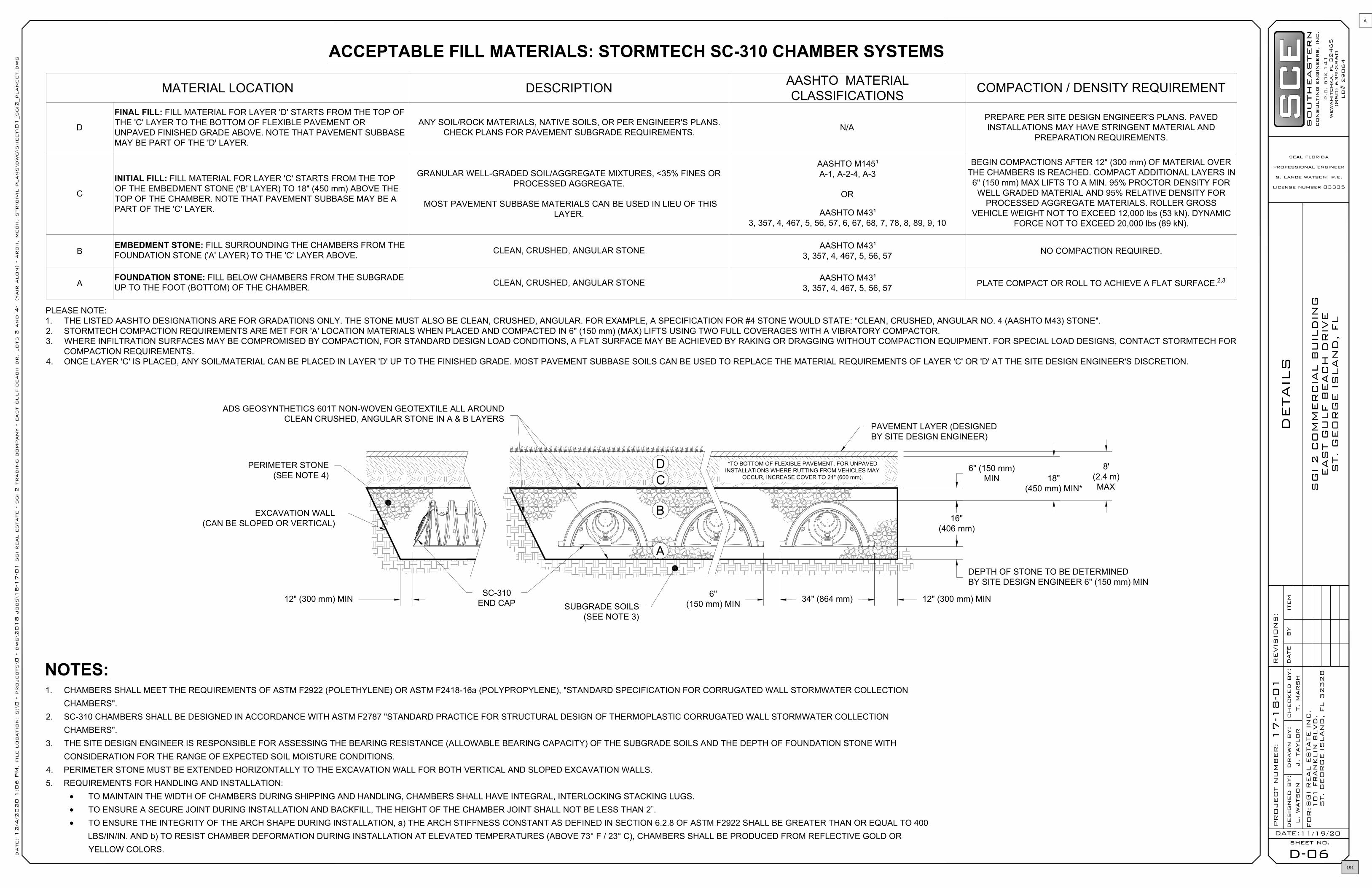
DETAIL
S
D-06sheet no.
DATE:
PR
OJEC
T N
UM
BER
:
drawn b
y:
desig
ned b
y:
checked b
y:
l.
watson
j.
taylor
t.
marsh
REVIS
ION
S:
SG
I 2 C
OM
MER
CIA
L B
UIL
DIN
GEAS
T G
ULF B
EAC
H D
RIV
ES
T. G
EO
RG
E IS
LAN
D, FL
11/19/20
FO
R:S
GI R
EAL E
STATE IN
C.
10
1 F
RAN
KLIN
BLVD
.S
T.
GEO
RG
E IS
LAN
D,
FL 3
23
28
DATE
BY
ITEM
17-1
8-0
1
p.o
. box 1
41
wewahit
chka, fl 3
2465
(850) 639-3
860
LB
# 2
9064
southeastern
consultin
g e
ngin
eers, in
c.
seal florida
professional engineer
s. lance watson, p.e.
license number 83335
date: 12/4
/2020 1
:06 P
M, fil
e l
ocatio
n: s:\0 - p
rojects\0
- d
wg\2
018 j
obs\1
8-1
7-0
1 s
gi real e
state - s
gi 2 t
radin
g c
ompany - e
ast g
ulf b
each d
r. lots 3
and 4
- (yair
alon) - arch, mech, str\c
ivil
plans\d
wg\s
heet\0
1_s
gi2
_planset.d
wg
ACCEPTABLE FILL MATERIALS: STORMTECH SC-310 CHAMBER SYSTEMS
PLEASE NOTE:1. THE LISTED AASHTO DESIGNATIONS ARE FOR GRADATIONS ONLY. THE STONE MUST ALSO BE CLEAN, CRUSHED, ANGULAR. FOR EXAMPLE, A SPECIFICATION FOR #4 STONE WOULD STATE: "CLEAN, CRUSHED, ANGULAR NO. 4 (AASHTO M43) STONE".2. STORMTECH COMPACTION REQUIREMENTS ARE MET FOR 'A' LOCATION MATERIALS WHEN PLACED AND COMPACTED IN 6" (150 mm) (MAX) LIFTS USING TWO FULL COVERAGES WITH A VIBRATORY COMPACTOR.3. WHERE INFILTRATION SURFACES MAY BE COMPROMISED BY COMPACTION, FOR STANDARD DESIGN LOAD CONDITIONS, A FLAT SURFACE MAY BE ACHIEVED BY RAKING OR DRAGGING WITHOUT COMPACTION EQUIPMENT. FOR SPECIAL LOAD DESIGNS, CONTACT STORMTECH FOR
COMPACTION REQUIREMENTS.4. ONCE LAYER 'C' IS PLACED, ANY SOIL/MATERIAL CAN BE PLACED IN LAYER 'D' UP TO THE FINISHED GRADE. MOST PAVEMENT SUBBASE SOILS CAN BE USED TO REPLACE THE MATERIAL REQUIREMENTS OF LAYER 'C' OR 'D' AT THE SITE DESIGN ENGINEER'S DISCRETION.
NOTES:1. CHAMBERS SHALL MEET THE REQUIREMENTS OF ASTM F2922 (POLETHYLENE) OR ASTM F2418-16a (POLYPROPYLENE), "STANDARD SPECIFICATION FOR CORRUGATED WALL STORMWATER COLLECTION
CHAMBERS".2. SC-310 CHAMBERS SHALL BE DESIGNED IN ACCORDANCE WITH ASTM F2787 "STANDARD PRACTICE FOR STRUCTURAL DESIGN OF THERMOPLASTIC CORRUGATED WALL STORMWATER COLLECTION
CHAMBERS".3. THE SITE DESIGN ENGINEER IS RESPONSIBLE FOR ASSESSING THE BEARING RESISTANCE (ALLOWABLE BEARING CAPACITY) OF THE SUBGRADE SOILS AND THE DEPTH OF FOUNDATION STONE WITH
CONSIDERATION FOR THE RANGE OF EXPECTED SOIL MOISTURE CONDITIONS.4. PERIMETER STONE MUST BE EXTENDED HORIZONTALLY TO THE EXCAVATION WALL FOR BOTH VERTICAL AND SLOPED EXCAVATION WALLS.5. REQUIREMENTS FOR HANDLING AND INSTALLATION:
· TO MAINTAIN THE WIDTH OF CHAMBERS DURING SHIPPING AND HANDLING, CHAMBERS SHALL HAVE INTEGRAL, INTERLOCKING STACKING LUGS.· TO ENSURE A SECURE JOINT DURING INSTALLATION AND BACKFILL, THE HEIGHT OF THE CHAMBER JOINT SHALL NOT BE LESS THAN 2”.· TO ENSURE THE INTEGRITY OF THE ARCH SHAPE DURING INSTALLATION, a) THE ARCH STIFFNESS CONSTANT AS DEFINED IN SECTION 6.2.8 OF ASTM F2922 SHALL BE GREATER THAN OR EQUAL TO 400
LBS/IN/IN. AND b) TO RESIST CHAMBER DEFORMATION DURING INSTALLATION AT ELEVATED TEMPERATURES (ABOVE 73° F / 23° C), CHAMBERS SHALL BE PRODUCED FROM REFLECTIVE GOLD ORYELLOW COLORS.
MATERIAL LOCATION DESCRIPTION AASHTO MATERIALCLASSIFICATIONS COMPACTION / DENSITY REQUIREMENT
D
FINAL FILL: FILL MATERIAL FOR LAYER 'D' STARTS FROM THE TOP OFTHE 'C' LAYER TO THE BOTTOM OF FLEXIBLE PAVEMENT ORUNPAVED FINISHED GRADE ABOVE. NOTE THAT PAVEMENT SUBBASEMAY BE PART OF THE 'D' LAYER.
ANY SOIL/ROCK MATERIALS, NATIVE SOILS, OR PER ENGINEER'S PLANS.CHECK PLANS FOR PAVEMENT SUBGRADE REQUIREMENTS. N/A
PREPARE PER SITE DESIGN ENGINEER'S PLANS. PAVEDINSTALLATIONS MAY HAVE STRINGENT MATERIAL AND
PREPARATION REQUIREMENTS.
C
INITIAL FILL: FILL MATERIAL FOR LAYER 'C' STARTS FROM THE TOPOF THE EMBEDMENT STONE ('B' LAYER) TO 18" (450 mm) ABOVE THETOP OF THE CHAMBER. NOTE THAT PAVEMENT SUBBASE MAY BE APART OF THE 'C' LAYER.
GRANULAR WELL-GRADED SOIL/AGGREGATE MIXTURES, <35% FINES ORPROCESSED AGGREGATE.
MOST PAVEMENT SUBBASE MATERIALS CAN BE USED IN LIEU OF THISLAYER.
AASHTO M145¹A-1, A-2-4, A-3
OR
AASHTO M43¹3, 357, 4, 467, 5, 56, 57, 6, 67, 68, 7, 78, 8, 89, 9, 10
BEGIN COMPACTIONS AFTER 12" (300 mm) OF MATERIAL OVERTHE CHAMBERS IS REACHED. COMPACT ADDITIONAL LAYERS IN
6" (150 mm) MAX LIFTS TO A MIN. 95% PROCTOR DENSITY FORWELL GRADED MATERIAL AND 95% RELATIVE DENSITY FOR
PROCESSED AGGREGATE MATERIALS. ROLLER GROSSVEHICLE WEIGHT NOT TO EXCEED 12,000 lbs (53 kN). DYNAMIC
FORCE NOT TO EXCEED 20,000 lbs (89 kN).
BEMBEDMENT STONE: FILL SURROUNDING THE CHAMBERS FROM THEFOUNDATION STONE ('A' LAYER) TO THE 'C' LAYER ABOVE. CLEAN, CRUSHED, ANGULAR STONE AASHTO M43¹
3, 357, 4, 467, 5, 56, 57 NO COMPACTION REQUIRED.
AFOUNDATION STONE: FILL BELOW CHAMBERS FROM THE SUBGRADEUP TO THE FOOT (BOTTOM) OF THE CHAMBER. CLEAN, CRUSHED, ANGULAR STONE AASHTO M43¹
3, 357, 4, 467, 5, 56, 57 PLATE COMPACT OR ROLL TO ACHIEVE A FLAT SURFACE.2,3
DC
B
A
18"(450 mm) MIN*
8'(2.4 m)MAX
6" (150 mm)MIN
12" (300 mm) MIN 12" (300 mm) MIN34" (864 mm)6"(150 mm) MIN
ADS GEOSYNTHETICS 601T NON-WOVEN GEOTEXTILE ALL AROUNDCLEAN CRUSHED, ANGULAR STONE IN A & B LAYERS
*TO BOTTOM OF FLEXIBLE PAVEMENT. FOR UNPAVEDINSTALLATIONS WHERE RUTTING FROM VEHICLES MAY
OCCUR, INCREASE COVER TO 24" (600 mm).
PERIMETER STONE(SEE NOTE 4)
EXCAVATION WALL(CAN BE SLOPED OR VERTICAL)
SC-310END CAP SUBGRADE SOILS
(SEE NOTE 3)
PAVEMENT LAYER (DESIGNEDBY SITE DESIGN ENGINEER)
DEPTH OF STONE TO BE DETERMINEDBY SITE DESIGN ENGINEER 6" (150 mm) MIN
16"(406 mm)
191
A.

DETAIL
S
D-07sheet no.
DATE:
PR
OJEC
T N
UM
BER
:
drawn b
y:
desig
ned b
y:
checked b
y:
l.
watson
j.
taylor
t.
marsh
REVIS
ION
S:
SG
I 2 C
OM
MER
CIA
L B
UIL
DIN
GEAS
T G
ULF B
EAC
H D
RIV
ES
T. G
EO
RG
E IS
LAN
D, FL
11/19/20
FO
R:S
GI R
EAL E
STATE IN
C.
10
1 F
RAN
KLIN
BLVD
.S
T.
GEO
RG
E IS
LAN
D,
FL 3
23
28
DATE
BY
ITEM
17-1
8-0
1
p.o
. box 1
41
wewahit
chka, fl 3
2465
(850) 639-3
860
LB
# 2
9064
southeastern
consultin
g e
ngin
eers, in
c.
seal florida
professional engineer
s. lance watson, p.e.
license number 83335
date: 12/4
/2020 1
:06 P
M, fil
e l
ocatio
n: s:\0 - p
rojects\0
- d
wg\2
018 j
obs\1
8-1
7-0
1 s
gi real e
state - s
gi 2 t
radin
g c
ompany - e
ast g
ulf b
each d
r. lots 3
and 4
- (yair
alon) - arch, mech, str\c
ivil
plans\d
wg\s
heet\0
1_s
gi2
_planset.d
wg
INSPECTION & MAINTENANCESTEP 1) INSPECT ISOLATOR ROW FOR SEDIMENT
A.INSPECTION PORTS (IF PRESENT)A.1.REMOVE/OPEN LID ON NYLOPLAST INLINE DRAINA.2.REMOVE AND CLEAN FLEXSTORM FILTER IF INSTALLEDA.3.USING A FLASHLIGHT AND STADIA ROD, MEASURE DEPTH OF SEDIMENT AND RECORD ON MAINTENANCE LOGA.4.LOWER A CAMERA INTO ISOLATOR ROW FOR VISUAL INSPECTION OF SEDIMENT LEVELS (OPTIONAL)A.5.IF SEDIMENT IS AT, OR ABOVE, 3" (80 mm) PROCEED TO STEP 2. IF NOT, PROCEED TO STEP 3.
B. ALL ISOLATOR ROWSB.1.REMOVE COVER FROM STRUCTURE AT UPSTREAM END OF ISOLATOR ROWB.2.USING A FLASHLIGHT, INSPECT DOWN THE ISOLATOR ROW THROUGH OUTLET PIPE
i) MIRRORS ON POLES OR CAMERAS MAY BE USED TO AVOID A CONFINED SPACE ENTRYii)FOLLOW OSHA REGULATIONS FOR CONFINED SPACE ENTRY IF ENTERING MANHOLE
B.3.IF SEDIMENT IS AT, OR ABOVE, 3" (80 mm) PROCEED TO STEP 2. IF NOT, PROCEED TO STEP 3.
STEP 2) CLEAN OUT ISOLATOR ROW USING THE JETVAC PROCESSA.A FIXED CULVERT CLEANING NOZZLE WITH REAR FACING SPREAD OF 45" (1.1 m) OR MORE IS PREFERREDB. APPLY MULTIPLE PASSES OF JETVAC UNTIL BACKFLUSH WATER IS CLEANC.VACUUM STRUCTURE SUMP AS REQUIRED
STEP 3) REPLACE ALL COVERS, GRATES, FILTERS, AND LIDS; RECORD OBSERVATIONS AND ACTIONS.
STEP 4) INSPECT AND CLEAN BASINS AND MANHOLES UPSTREAM OF THE STORMTECH SYSTEM.
NOTES1. INSPECT EVERY 6 MONTHS DURING THE FIRST YEAR OF OPERATION. ADJUST THE INSPECTION INTERVAL BASED ON PREVIOUS
OBSERVATIONS OF SEDIMENT ACCUMULATION AND HIGH WATER ELEVATIONS.
2. CONDUCT JETTING AND VACTORING ANNUALLY OR WHEN INSPECTION SHOWS THAT MAINTENANCE IS NECESSARY.
SUMP DEPTH TBD BYSITE DESIGN ENGINEER
(24" [600 mm] MIN RECOMMENDED)
CATCH BASINOR
MANHOLE
SC-310 ISOLATOR ROW DETAILNTS
OPTIONAL INSPECTION PORT
SC-310 END CAP
COVER ENTIRE ISOLATOR ROW WITH ADSGEOSYNTHETICS 601T NON-WOVEN GEOTEXTILE
5' (1.5 m) MIN WIDE
SC-310 CHAMBERSTORMTECH HIGHLY RECOMMENDSFLEXSTORM PURE INSERTS IN ANY UPSTREAM
STRUCTURES WITH OPEN GRATES
12" (300 mm) HDPE ACCESS PIPE REQUIREDUSE FACTORY PRE-FABRICATED END CAPPART #: SC310EPE12B
TWO LAYERS OF ADS GEOSYNTHETICS 315WTK WOVENGEOTEXTILE BETWEEN FOUNDATION STONE AND CHAMBERS4' (1.2 m) MIN WIDE CONTINUOUS FABRIC WITHOUT SEAMS
192
A.

DETAIL
S
D-08sheet no.
DATE:
PR
OJEC
T N
UM
BER
:
drawn b
y:
desig
ned b
y:
checked b
y:
l.
watson
j.
taylor
t.
marsh
REVIS
ION
S:
SG
I 2 C
OM
MER
CIA
L B
UIL
DIN
GEAS
T G
ULF B
EAC
H D
RIV
ES
T. G
EO
RG
E IS
LAN
D, FL
11/19/20
FO
R:S
GI R
EAL E
STATE IN
C.
10
1 F
RAN
KLIN
BLVD
.S
T.
GEO
RG
E IS
LAN
D,
FL 3
23
28
DATE
BY
ITEM
17-1
8-0
1
p.o
. box 1
41
wewahit
chka, fl 3
2465
(850) 639-3
860
LB
# 2
9064
southeastern
consultin
g e
ngin
eers, in
c.
seal florida
professional engineer
s. lance watson, p.e.
license number 83335
date: 12/4
/2020 1
:06 P
M, fil
e l
ocatio
n: s:\0 - p
rojects\0
- d
wg\2
018 j
obs\1
8-1
7-0
1 s
gi real e
state - s
gi 2 t
radin
g c
ompany - e
ast g
ulf b
each d
r. lots 3
and 4
- (yair
alon) - arch, mech, str\c
ivil
plans\d
wg\s
heet\0
1_s
gi2
_planset.d
wg
TRAFFIC LOADS: CONCRETE DIMENSIONSARE FOR GUIDELINE PUPOSES ONLY.ACTUAL CONCRETE SLAB MUST BEDESIGNED GIVING CONSIDERATION FORLOCAL SOIL CONDITIONS, TRAFFICLOADING & OTHER APPLICABLE DESIGNFACTORS
ADAPTER ANGLES VARIABLE 0°- 360°ACCORDING TO PLANS
A
18" (457 mm)MIN WIDTH
AASHTO H-20 CONCRETE SLAB8" (203 mm) MIN THICKNESS
VARIABLE SUMP DEPTHACCORDING TO PLANS
[6" (152 mm) MIN ON 8-24" (200-600 mm),10" (254 mm) MIN ON 30" (750 mm)]
4" (102 mm) MIN ON 8-24" (200-600 mm)6" (152 mm) MIN ON 30" (750 mm)
12" (610 mm) MIN(FOR AASHTO H-20)
INVERT ACCORDING TOPLANS/TAKE OFF
BACKFILL MATERIAL BELOW AND TO SIDESOF STRUCTURE SHALL BE ASTM D2321CLASS I OR II CRUSHED STONE OR GRAVELAND BE PLACED UNIFORMLY IN 12" (305 mm)LIFTS AND COMPACTED TO MIN OF 90%
INTEGRATED DUCTILE IRONFRAME & GRATE/SOLID TO
MATCH BASIN O.D.
NYLOPLAST DRAIN BASINNTS
NOTES1. 8-30" (200-750 mm) GRATES/SOLID COVERS SHALL BE DUCTILE IRON PER ASTM A536
GRADE 70-50-052. 12-30" (300-750 mm) FRAMES SHALL BE DUCTILE IRON PER ASTM A536 GRADE 70-50-053. DRAIN BASIN TO BE CUSTOM MANUFACTURED ACCORDING TO PLAN DETAILS4. DRAINAGE CONNECTION STUB JOINT TIGHTNESS SHALL CONFORM TO ASTM D3212
FOR CORRUGATED HDPE (ADS & HANCOR DUAL WALL) & SDR 35 PVC5. FOR COMPLETE DESIGN AND PRODUCT INFORMATION: WWW.NYLOPLAST-US.COM6. TO ORDER CALL: 800-821-6710
A PART # GRATE/SOLID COVER OPTIONS8"
(200 mm) 2808AG PEDESTRIAN LIGHTDUTY
STANDARD LIGHTDUTY SOLID LIGHT DUTY
10"(250 mm) 2810AG PEDESTRIAN LIGHT
DUTYSTANDARD LIGHT
DUTY SOLID LIGHT DUTY
12"(300 mm) 2812AG PEDESTRIAN
AASHTO H-10STANDARD AASHTO
H-20SOLID
AASHTO H-2015"
(375 mm) 2815AG PEDESTRIANAASHTO H-10
STANDARD AASHTOH-20
SOLIDAASHTO H-20
18"(450 mm) 2818AG PEDESTRIAN
AASHTO H-10STANDARD AASHTO
H-20SOLID
AASHTO H-2024"
(600 mm) 2824AG PEDESTRIANAASHTO H-10
STANDARD AASHTOH-20
SOLIDAASHTO H-20
30"(750 mm) 2830AG PEDESTRIAN
AASHTO H-20STANDARD AASHTO
H-20SOLID
AASHTO H-20
VARIOUS TYPES OF INLET ANDOUTLET ADAPTERS AVAILABLE:
4-30" (100-750 mm) FORCORRUGATED HDPE
WATERTIGHT JOINT(CORRUGATED HDPE SHOWN)
PART # STUB A B CSC310EPE06T / SC310EPE06TPC 6" (150 mm) 9.6" (244 mm)
5.8" (147 mm) ---SC310EPE06B / SC310EPE06BPC --- 0.5" (13 mm)SC310EPE08T / SC310EPE08TPC 8" (200 mm) 11.9" (302 mm)
3.5" (89 mm) ---SC310EPE08B / SC310EPE08BPC --- 0.6" (15 mm)SC310EPE10T / SC310EPE10TPC 10" (250 mm) 12.7" (323 mm)
1.4" (36 mm) ---SC310EPE10B / SC310EPE10BPC --- 0.7" (18 mm)
SC310EPE12B 12" (300 mm) 13.5" (343 mm) --- 0.9" (23 mm)
ALL STUBS, EXCEPT FOR THE SC310EPE12B ARE PLACED AT BOTTOM OF END CAP SUCH THAT THE OUTSIDE DIAMETER OFTHE STUB IS FLUSH WITH THE BOTTOM OF THE END CAP. FOR ADDITIONAL INFORMATION CONTACT STORMTECH AT1-888-892-2694.
* FOR THE SC310EPE12B THE 12" (300 mm) STUB LIES BELOW THE BOTTOM OF THE END CAP APPROXIMATELY 0.25" (6 mm).BACKFILL MATERIAL SHOULD BE REMOVED FROM BELOW THE N-12 STUB SO THAT THE FITTING SITS LEVEL.
NOTE: ALL DIMENSIONS ARE NOMINAL
NOMINAL CHAMBER SPECIFICATIONSSIZE (W X H X INSTALLED LENGTH) 34.0" X 16.0" X 85.4" (864 mm X 406 mm X 2169 mm)CHAMBER STORAGE 14.7 CUBIC FEET (0.42 m³)MINIMUM INSTALLED STORAGE* 31.0 CUBIC FEET (0.88 m³)WEIGHT 35.0 lbs. (16.8 kg)
*ASSUMES 6" (152 mm) ABOVE, BELOW, AND BETWEEN CHAMBERS
PRE-FAB STUBS AT BOTTOM OF END CAP FOR PART NUMBERS ENDING WITH "B"PRE-FAB STUBS AT TOP OF END CAP FOR PART NUMBERS ENDING WITH "T"PRE CORED END CAPS END WITH "PC"
34.0"(864 mm)
16.0"(406 mm)
90.7" (2304 mm) ACTUAL LENGTH 85.4" (2169 mm) INSTALLED LENGTH
BUILD ROW IN THIS DIRECTION
A A
B C
SC-310 TECHNICAL SPECIFICATIONNTS
9.9"(251 mm)
15.6"(396 mm)
OVERLAP NEXT CHAMBER HERE(OVER SMALL CORRUGATION)
START END
193
A.

Franklin County, FL
Developed by
Parcel ID 05-07S-03W-000-0010-0000
Sec/Twp/Rng n/a
Property Address
Alternate ID n/a
Class n/a
Acreage n/a
Owner Address n/a
District n/a
Brief Tax Description n/a
(Note: Not to be used on legal documents)
Date created: 2/1/2021Last Data Uploaded: 2/1/2021 7:54:41 AM
971 ft
Overview
Legend
Parcels
Roads
City Labels
194
A.

195
A.

Attorneys at Law llw-law.com
JACKSONVILLE 245 Riverside Ave., Suite 510 Jacksonville, Florida 32202 T: 904.353.6410 F: 904.353.7619
ST. PETERSBURG 100 Second Ave., South Suite 501-S St. Petersburg, Florida 33701 T: 727.245.0820 F: 727.290.4057
TALLAHASSEE 315 South Calhoun St. Suite 830 Tallahassee, Florida 32301 T: 850.222.5702 F: 850.224.9242
TAMPA 301 West Platt St. Suite 364 Tampa, FL 33606 T: 813.775.2331
WEST PALM BEACH 515 North Flagler Dr., Suite 1500 West Palm Beach, Florida 33401 T: 561.640.0820 F: 561.640.8202
01430006-1
See Things Differently®
Reply to: Tallahassee Office
January 21, 2021
Via U.S. Mail & Electronic Mail: [email protected]
Mr. Mark Curenton Franklin County Planner Planning and Building Department 34 Forbes Street, Suite 1 Apalachicola, Florida 32320
Re: St. James Bay PUD Request to Amend
Dear Mr. Curenton:
Please find the attached correspondence from Mr. Jim Waddell addressing the County’s concerns outlined in your letter dated January 6, 2021. The information provided by Mr. Waddell specifically addresses the water and wastewater capacity available from the City of Carrabelle. Mr. Waddell further provides information that demonstrates adequate parking and transportation capacity.
We appreciate your timely review of the application to amend the St. James Bay PUD. We trust that this information fully responds to your request and the application can be scheduled for the February 9, 2021 Planning and Zoning Commission meeting. If you need any additional information or have other questions, please do not hesitate to contact me at your convenience.
Sincerely,
Lewis, Longman & Walker, P.A.
Robert A. Williams Of Counsel
Cc: John Green
196
A.

197
A.
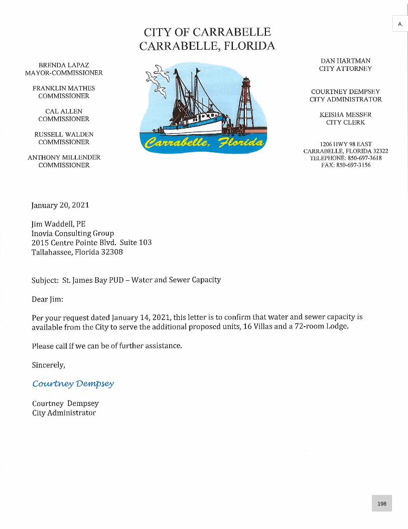
198
A.

199
A.

200
A.

201
A.

202
A.

Page 1 of 2
AGENDA FOR PUBLIC HEARING
ON
JAMEY AND BEVERLY SAPP’S LAND USE CHANGE & REZONING REQUEST
DATE: FEBRUARY 16, 2021, AT 10:30 A.M. (ET)
LOCATION: 34 FORBES STREET, APALACHICOLA, FLORIDA
_____________________________________________________________________________________
1. CHAIRMAN CALLS PUBLIC HEARING TO ORDER AS THAT ITEM APPEARS ON THE AGENDA.
2. EMAIL COMMUNICATIONS ARE TO BE MADE PART OF THE RECORD.
3. PUBLIC COMMENT
a. Individuals should be no more than three minutes.
b. Persons representing a group or factions should be no more than five minutes.
c. Public comments are unsworn.
d. Persons providing public comment are not required to be subject to cross-
examination.
4. PRESENTATION BY COUNTY STAFF
a. Up to 20 minutes allowed for presentation including questions from the County
Commissioners, if any.
b. At the conclusion of the presentation, the Chairman will inquire if any of the County
Commissioners have any questions for staff members or may hold all County
Commissioners’ questions until the conclusion of all presentations.
c. The Applicants have a right to cross examine the County Staff if they chose to
following the County Staff’s presentation. A total of 10 minutes per party is set
aside for cross-examination.
d. The public does not have a right to cross-examine the County Staff.
e. Testimony will be unsworn.
5. PRESENTATION BY APPLICANTS JAMEY AND BEVERLY SAPP
a. Up to 20 minutes allowed for presentation including questions from the County
Commissioners, if any.
b. At the conclusion of the presentation, the Chairman will inquire if any of the County
Commissioners have any questions for the Applicants or their representatives or
may hold all County Commissioners’ questions until the conclusion of all
presentations.
c. The County has a right to cross examine the Applicants’ representative(s) if they
chose to following the Applicants’ presentation. A total of 10 minutes per party is
set aside for cross-examination.
d. The public does not have a right to cross-examine the Applicants.
e. Testimony will be unsworn.
203
A.

Page 2 of 2
6. PRESENTATION BY PARTY OBJECTOR, IF ANY
a. Up to 20 minutes allowed for presentation including questions from the County
Commissioners, if any.
b. At the conclusion of the presentation, the Chairman will inquire if any of the County
Commissioners have any questions for the Party Objector or may hold all County
Commissioners’ questions until the conclusion of all presentations.
c. The Applicants and the County have a right to cross examine the Party Objector if
they chose to following their presentation. A total of 10 minutes per party is set
aside for cross-examination.
d. The public does not have a right to cross-examine the Party Objector.
e. Testimony will be unsworn.
7. REBUTTAL
a. Both the Applicants and the Party Objector, if any, have five minutes each for
rebuttal; first by the Applicants, followed by the Party Objector.
b. The County Staff has five minutes for rebuttal following the Applicants and the Party
Objector.
8. COUNTY COMMISSIONERS DISCUSSION AND POSSIBLE ACTION TO APPROVE OR DENY THE
ORDINANCE AS SUBMITTED.
a. If motion is to approve, then first motion to pass the ordinance approving the land
use change. Then, second motion to pass the ordinance rezoning the property.
b. If the motion is to deny, the first motion to deny the ordinance changing the land
use. Then, second motion to deny the ordinance rezoning the property.
c. The County Commission has the option to table the matter.
9. PUBLIC HEARING ADJOURNED.
10. NEXT ITEM ON THE AGENDA.
204
A.
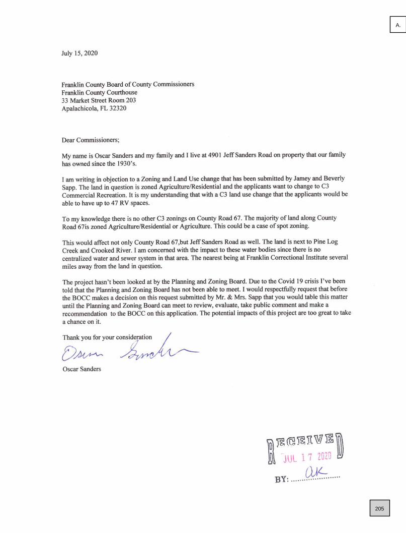
205
A.

206
A.

207
A.

208
A.

209
A.

2514 HIGHWAY 67, CARRABELLE, FL
LAND USE CHANGE OF 6.08 ACRES FROM
RESIDENTIAL TO COMMERICAL
210
A.

211
A.

212
A.

213
A.

214
A.

215
A.

216
A.

217
A.

218
A.

219
A.

220
A.

221
A.

222
A.

223
A.

224
A.

225
A.

226
A.

227
A.

228
A.

229
A.

230
A.

231
A.

232
A.

233
A.
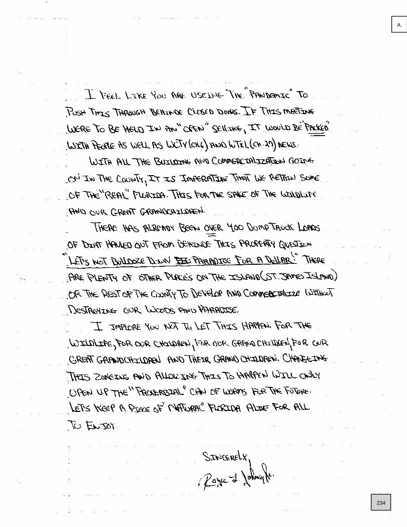
234
A.

235
A.

February 16, 2021
To Whom It May Concern:
It is my pleasure to strongly recommend the zoning change for an RV Park on the Sapp property
on Highway 67 in Carrabelle. I am Corena Granger, a lifelong friend of the Sapp Family. I have
directly observed their outstanding qualities in leadership and professionalism. I feel that the
RV Park would be a great place for not only the people looking for a retreat off the beaten path
but also for Franklin County residents wanting to get away for a weekend. The location of the
Sapp property is also extremely convenient for guests who participate in hunting, being that its
located near hunting areas but not so far from town. The RV park could result as a gain for the
economy of our amazing county. I camp every year for two weeks during hunting season at
Womack Creek Campground. My family and I would personally love to have the opportunity to
make this great location our new retreat each year. I am confident that the Sapp family is a
good fit for this opportunity.
If you need mor information, please do not hesitate to contact me at 850-227-4642 or by email
Sincerely,
Corena Lynn Granger
236
A.

2514 HIGHWAY 67, CARRABELLE, FLRE-ZONING OF 6.08 ACRES FROM R-2 SINGLE FAMILY MOBILE TO C-3 COMMERCIAL RECREATION
EXHIBIT B
237
B.

238
B.

239
B.

240
B.

241
B.

242
B.

243
B.

244
B.

245
B.

246
B.

247
B.

248
B.

249
B.

250
B.
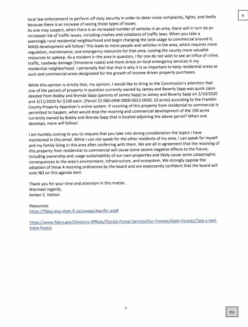
251
B.

252
B.

253
B.

254
B.

255
B.

256
B.

257
B.

258
B.

259
B.

260
B.

261
B.

262
B.

263
B.

264
B.

265
B.

266
B.

267
B.

February 16, 2021
To Whom It May Concern:
It is my pleasure to strongly recommend the zoning change for an RV Park on the Sapp property
on Highway 67 in Carrabelle. I am Corena Granger, a lifelong friend of the Sapp Family. I have
directly observed their outstanding qualities in leadership and professionalism. I feel that the
RV Park would be a great place for not only the people looking for a retreat off the beaten path
but also for Franklin County residents wanting to get away for a weekend. The location of the
Sapp property is also extremely convenient for guests who participate in hunting, being that its
located near hunting areas but not so far from town. The RV park could result as a gain for the
economy of our amazing county. I camp every year for two weeks during hunting season at
Womack Creek Campground. My family and I would personally love to have the opportunity to
make this great location our new retreat each year. I am confident that the Sapp family is a
good fit for this opportunity.
If you need mor information, please do not hesitate to contact me at 850-227-4642 or by email
Sincerely,
Corena Lynn Granger
268
B.

2536 HIGHWAY 67, CARRABELLE, FL
LAND USE CHANGE OF 10 ACRES FROM
AGRICULTURAL & RESIDENTIAL TO COMMERICAL
EXHIBIT B
269
C.

270
C.

271
C.

272
C.

273
C.

274
C.

275
C.

276
C.

277
C.

278
C.

279
C.

280
C.

281
C.

282
C.

283
C.

284
C.

285
C.

286
C.
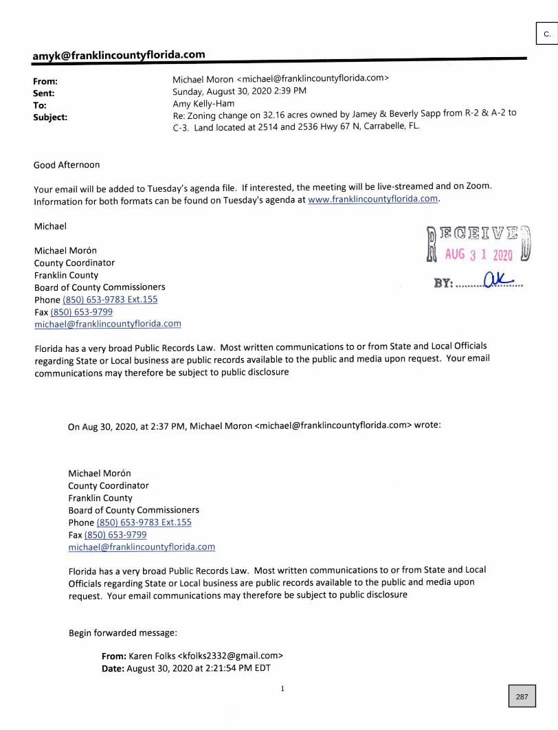
287
C.
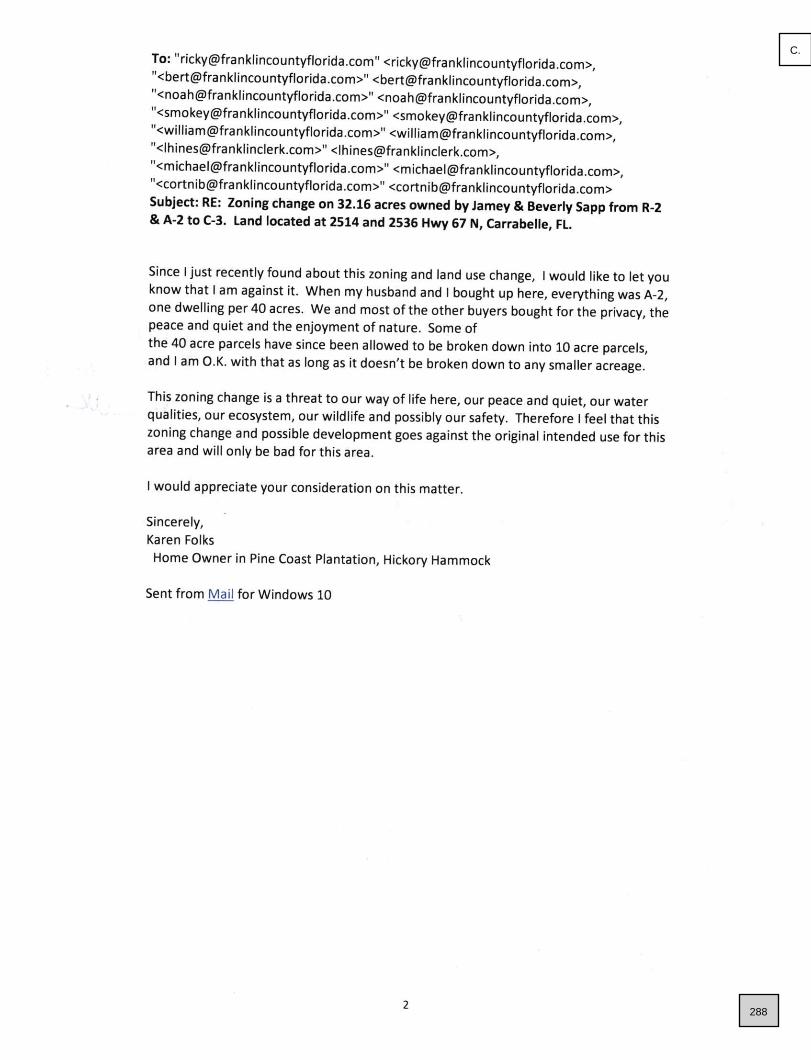
288
C.

289
C.

290
C.

291
C.

292
C.

293
C.

294
C.

295
C.
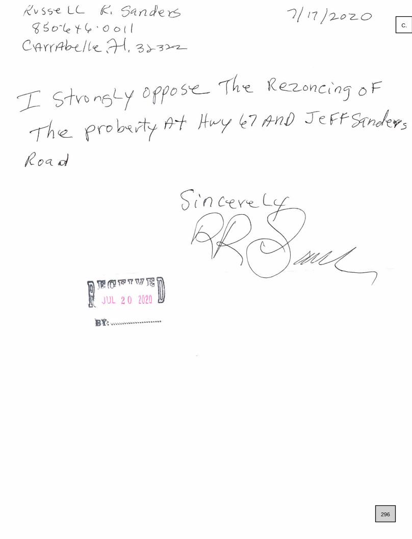
296
C.

297
C.

298
C.

299
C.

February 16, 2021
To Whom It May Concern:
It is my pleasure to strongly recommend the zoning change for an RV Park on the Sapp property
on Highway 67 in Carrabelle. I am Corena Granger, a lifelong friend of the Sapp Family. I have
directly observed their outstanding qualities in leadership and professionalism. I feel that the
RV Park would be a great place for not only the people looking for a retreat off the beaten path
but also for Franklin County residents wanting to get away for a weekend. The location of the
Sapp property is also extremely convenient for guests who participate in hunting, being that its
located near hunting areas but not so far from town. The RV park could result as a gain for the
economy of our amazing county. I camp every year for two weeks during hunting season at
Womack Creek Campground. My family and I would personally love to have the opportunity to
make this great location our new retreat each year. I am confident that the Sapp family is a
good fit for this opportunity.
If you need mor information, please do not hesitate to contact me at 850-227-4642 or by email
Sincerely,
Corena Lynn Granger
300
C.

2536 HIGHWAY 67, CARRABELLE, FLRE-ZONING OF 10 ACRES FROM A-2 FORESTRY AGRICULTURE &
R-2 SINGLE FAMILY MOBILE TO C-3 COMMERCIAL RECREATION
EXHIBIT B
301
D.

302
D.

303
D.

304
D.

305
D.

306
D.

307
D.

308
D.

309
D.

310
D.

311
D.

312
D.

313
D.
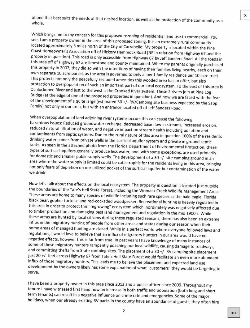
314
D.

315
D.

316
D.

317
D.

318
D.

319
D.

320
D.

321
D.

322
D.

323
D.

324
D.

325
D.

326
D.

327
D.

328
D.

329
D.

330
D.

331
D.

February 16, 2021
To Whom It May Concern:
It is my pleasure to strongly recommend the zoning change for an RV Park on the Sapp property
on Highway 67 in Carrabelle. I am Corena Granger, a lifelong friend of the Sapp Family. I have
directly observed their outstanding qualities in leadership and professionalism. I feel that the
RV Park would be a great place for not only the people looking for a retreat off the beaten path
but also for Franklin County residents wanting to get away for a weekend. The location of the
Sapp property is also extremely convenient for guests who participate in hunting, being that its
located near hunting areas but not so far from town. The RV park could result as a gain for the
economy of our amazing county. I camp every year for two weeks during hunting season at
Womack Creek Campground. My family and I would personally love to have the opportunity to
make this great location our new retreat each year. I am confident that the Sapp family is a
good fit for this opportunity.
If you need mor information, please do not hesitate to contact me at 850-227-4642 or by email
Sincerely,
Corena Lynn Granger
332
D.
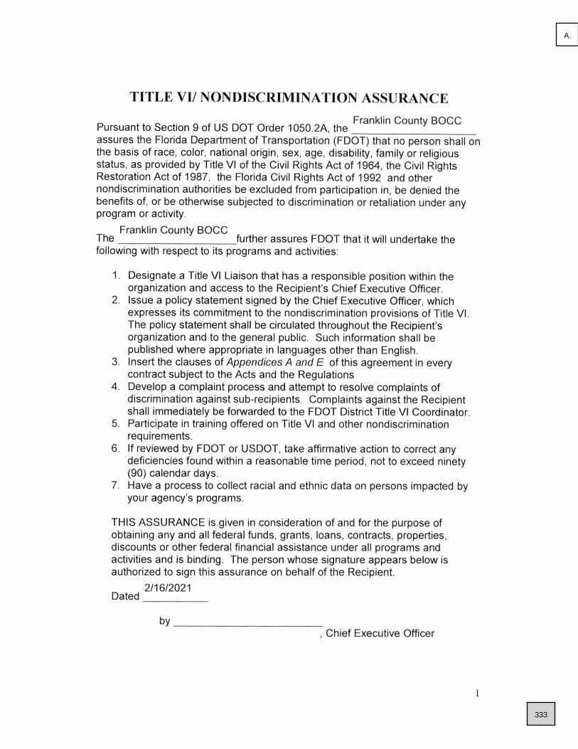
333
A.

334
A.

335
A.

336
A.

337
A.

338
A.

339
A.

340
A.

341
A.

342
A.

343
A.

344
A.

345
A.

346
A.

347
A.

348
A.

Erin Griffith
G1695
1
Tim Smith, P. E.
Director of Transportation Development
349
A.

RESOLUTION
FRANKLIN COUNTY, FLORIDA
BOARD OF COUNTY COMMISSIONERS
WHEREAS, Franklin County has received a grant from the Florida Department
of Transportation
WHEREAS, the grant for the Airport Master Plan Update Project PTGA G1695
has been delayed due to COVID-19 and the County would like to request a nine month
extension.
WHEREAS, the Planning Alternatives Chapter was ready for presentation to the
public in April, however is was not possible to host a public meeting at that time due to
the restrictions in travel and public gatherings.
WHEREAS, the public meeting was finally able to be held in November and this
resulted in a schedule delay of approximately nine months.
NOW, THEREFORE, BE IT RESOLVED BY THE FRANKLIN COUNTY
BOARD OF COUNTY COMMISSIONERS that they support the request to extend the
date of the grant agreement to the 31st day of December 2021, and Ricky D. Jones, the
Chairman of the Board of County Commissioners, is hereby authorized to sign the
Amendment for Extension of Public Transportation grant agreement for the Airport
Master Plan Update Grant.
This Resolution adopted by the Franklin County Board of County Commissioners
this 16th day of February, 2021.
BY: _______________________________
Ricky D. Jones, Chairman
Board of County Commissioners
ATTEST:
_____________________________________
Michele Maxwell, Clerk
350
A.

351
B.

352
B.

353
B.

354
B.
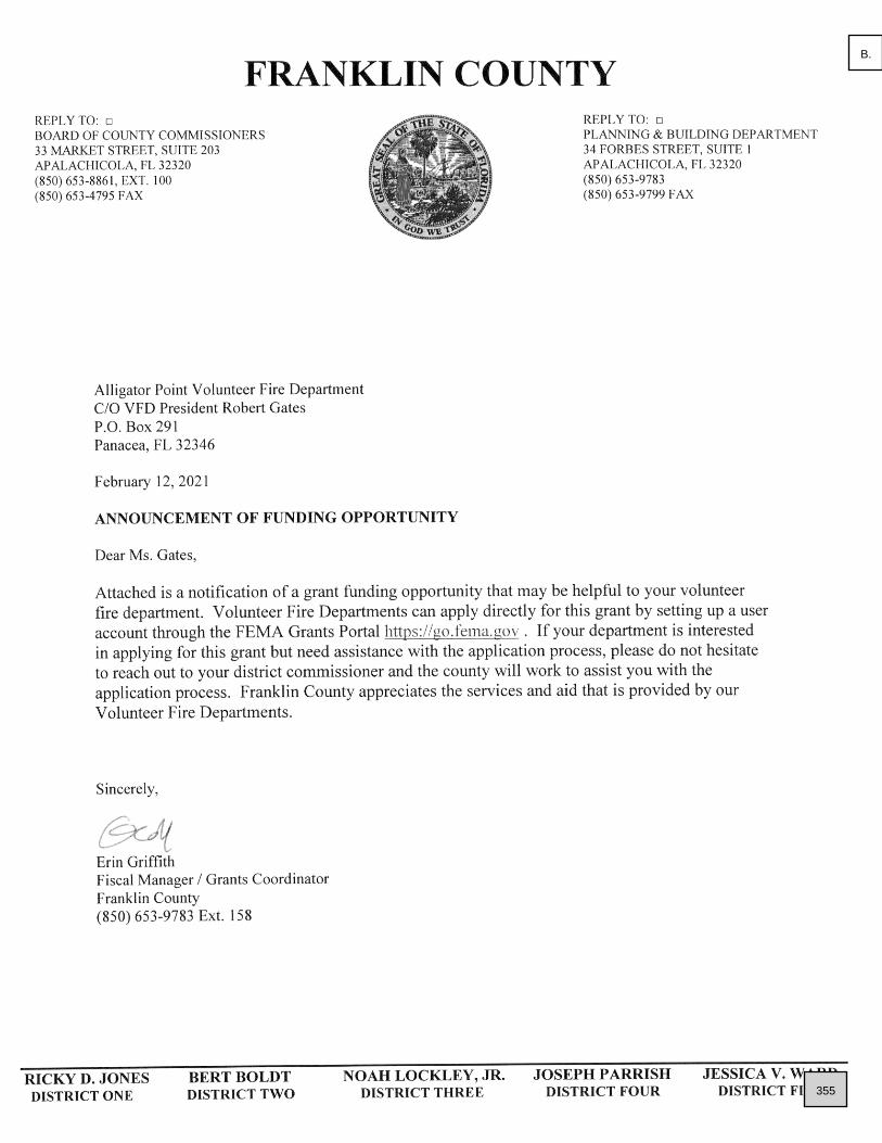
355
B.

356
B.

357
B.

358
B.

359
B.

360
B.

361
B.

362
B.

363
B.

364
B.

365
B.

366
B.
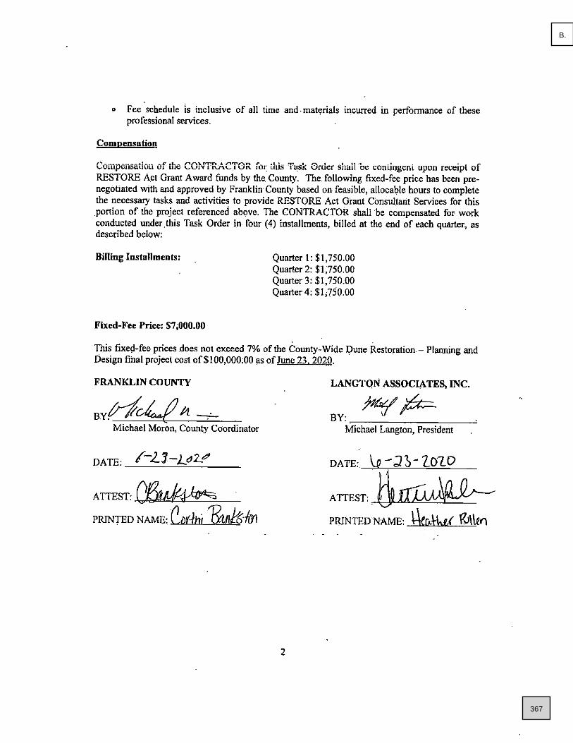
367
B.

368
B.

369
B.

370
B.

371
B.

372
A.