Food culture and land use in ancient times
14
Cultural Dynamics in a Globalized World – Budianta et al. (Eds) © 2018 Taylor & Francis Group, London, ISBN 978-1-138-62664-5 695 Food culture and land use in ancient times Taqyuddin & N. Susanti Department of Archaeology, Faculty of Humanities, Universitas Indonesia, Depok, Indonesia ABSTRACT: Discovery of ruins or artifacts of ancient times may lead to the discovery of their food culture, land use traditions, and agricultural system. Analyzing from different perspectives and using numerous theories as well as the findings from previous studies on ancient food culture and land use tradition, we could generate new approaches that can enrich and develop archeology and other fields of sciences and technology. From the analysis of the spatial archeology of the location of a temple built during ancient times, we might surmise that people who lived in that location may have had a certain agricultural system. This assumption, however, needs further research. Through epigraphic, toponymic, and geographical analyses; spatial archeological analysis of the locations described in the inscriptions; and by further observing and studying the ruins of the material culture, we could deduce the tradition and culture as well as the food habits at that time, including their preparation and processing methods using the available technology. Although data about the ruins of material culture and associated inscriptions are primarily used to support these findings, study of the environment of the area where these people lived, including its climate, geographical landscapes, and land and soil quality, is also considered as an influencing factor. We study the methods of maintaining, storing, processing, and consuming food to investigate our current tradition and culture, the results of which may serve as an evidence to deduce the past tradition and culture. In this study, we investigate whether the ancient food and land use cultures still exist today and whether they are being properly identified in the island of Java. 1 INTRODUCTION In this archeological research, we carry out a spatial study on food culture and land use for agricultural purposes across the island of Java; this study needs to be accompanied by other studies on ancient political and economic systems derived from the ancient artifacts found in Java. Here, we focus on the ancient food culture and the culture of land use and explore how agricultural activities produced food in the ancient Mataram era by studying its culture, knowledge on land use, and spatial identity with regard to agricultural activities. We also refer the findings of several studies, which generally reaffirm the fact that the power and political stability of the ancient Mataram Kingdom depended more on its agri- cultural orientation than on other sources of income, such as trading. A few of the artifacts from that era provided the evidence of land use for agriculture, and various archeological studies suggested a strong governmental influence in the management of agricultural land use activities. A close examination of the numerous written evidence found through many studies gives an indication of food culture and agriculture-related development (land use) as well as how the onsite existing evidence reflects the food sustainability and the culture of land use in the ancient Mataram era.
-
Upload
khangminh22 -
Category
Documents
-
view
6 -
download
0
Transcript of Food culture and land use in ancient times
Cultural Dynamics in a Globalized World – Budianta et al. (Eds)© 2018 Taylor & Francis Group, London, ISBN 978-1-138-62664-5
695
Food culture and land use in ancient times
Taqyuddin & N. SusantiDepartment of Archaeology, Faculty of Humanities, Universitas Indonesia, Depok, Indonesia
ABSTRACT: Discovery of ruins or artifacts of ancient times may lead to the discovery of their food culture, land use traditions, and agricultural system. Analyzing from different perspectives and using numerous theories as well as the findings from previous studies on ancient food culture and land use tradition, we could generate new approaches that can enrich and develop archeology and other fields of sciences and technology. From the analysis of the spatial archeology of the location of a temple built during ancient times, we might surmise that people who lived in that location may have had a certain agricultural system. This assumption, however, needs further research. Through epigraphic, toponymic, and geographical analyses; spatial archeological analysis of the locations described in the inscriptions; and by further observing and studying the ruins of the material culture, we could deduce the tradition and culture as well as the food habits at that time, including their preparation and processing methods using the available technology. Although data about the ruins of material culture and associated inscriptions are primarily used to support these findings, study of the environment of the area where these people lived, including its climate, geographical landscapes, and land and soil quality, is also considered as an influencing factor. We study the methods of maintaining, storing, processing, and consuming food to investigate our current tradition and culture, the results of which may serve as an evidence to deduce the past tradition and culture. In this study, we investigate whether the ancient food and land use cultures still exist today and whether they are being properly identified in the island of Java.
1 INTRODUCTION
In this archeological research, we carry out a spatial study on food culture and land use for agricultural purposes across the island of Java; this study needs to be accompanied by other studies on ancient political and economic systems derived from the ancient artifacts found in Java.
Here, we focus on the ancient food culture and the culture of land use and explore how agricultural activities produced food in the ancient Mataram era by studying its culture, knowledge on land use, and spatial identity with regard to agricultural activities.
We also refer the findings of several studies, which generally reaffirm the fact that the power and political stability of the ancient Mataram Kingdom depended more on its agri-cultural orientation than on other sources of income, such as trading. A few of the artifacts from that era provided the evidence of land use for agriculture, and various archeological studies suggested a strong governmental influence in the management of agricultural land use activities.
A close examination of the numerous written evidence found through many studies gives an indication of food culture and agriculture-related development (land use) as well as how the onsite existing evidence reflects the food sustainability and the culture of land use in the ancient Mataram era.
696
This study is based on a thorough examination of some ancient writings found in differ-ent regions of Mataram (Sumatera, Java, Madura and Bali), which were compiled by L.CH. Damais and published in 1952. A total of 290 partial and 81 complete transcripts and trans-lations were methodically examined.
Spatial verification has also been carried out with regard to the territories of the Mata-ram Kingdom that encompassed the central part of Java to the eastern part of the island and matched the time line or the chronology of the ruling kings at the time. The facts were verified using inscriptions from the Airlangga Kingdom during the 11th century that encom-passed the neighboring territories of Sidoarjo, Jombang, Kediri, to Malang located in the present province of East Java.
Typonomic indications, as mentioned in the inscriptions, have been confirmed and spa-tially plotted by field studies, which show that the current land and agricultural use reflects the past activities. By using this method, we could better understand the food culture and land use culture in the ancient Mataram era.
1.1 Theoretical view
A theory constitutes a set of thoughts containing general principles that can be used to assume, predict, explain, and complete a scientific analysis. Archeological theories can also be used to examine the food supply, food production methods, and land use in ancient times.
In particular, epigraphic theory is used to describe the culture and livelihood in ancient times on the basis of a valid, complete, and thorough analysis of ancient inscriptions from the Airlangga period. Some of these ancient stone inscriptions were found intact, and others were broken and hard to decipher. To overcome these problems, we employ the service of an epigraphist who can infer the lost data using Sanskrit Mantras.
After obtaining a full set of scripts, we have to translate these ancient scripts to our mod-ern language to reveal their content. In this particular text of the Airlangga Period, we found a record of land autonomous status being awarded as a gift and a guideline about tax exemp-tion policy in the kingdom. The document also contained a magical curse intended for those who disobeyed the king’s edict. Time stamps containing year, month, and day were written in full, including a list of names of the king and members of the royal court. The inscription also provides information about the period of the king’s reign and the territory under his rule.
In addition to studies, we rely on the theory of location, a geographic setting analysis to indicate the location where certain economic activities were carried out. We would plot the geographical location of the places (toponymy) indicated in the translated texts or inscrip-tions from the Airlangga Period on a modern-day map. By comparing the toponymy of mod-ern names, we could indicate a particular location down to the lowest level such as a village.
We next discuss about the spatial theory. First, it helps to understand the change and dynamics on the earth surface and then connects physical geographical condition to the changes in human dynamics, cultural behaviors, names of places, and the dynamics of food culture and land use throughout the region.
1.2 Bureaucracy theory
Max Weber Theory of Bureaucracy is important in any archeological study, as it helps to understand the dynamics of duties in a society and the role of government in both ancient and modern eras. Other scholars, including Peter M. Blau and Marshall W. Meyer, described the following six main characteristics of bureaucracy: (1) having a formal job description, (2) a hierarchical structure of authority, (3) execution of tasks and decision-making based on a consistent system of regulation, (4) officials shall carry out their duties professionally, (5) working in a bureaucratic organization constitutes a career level, and (6) administrative staff will play major roles.
Previous studies show that ancient and traditional kingdoms in the Airlangga era applied a type of bureaucratic system, albeit a simple one as viewed by Max Weber (1971: 18–23; cf.
697
Blau 1970: 141–143), and a solid governmental structure with the best approach and policies in the use of land and water resources.
A cultural viewpoint would lead this study into a living culture, in which people try to fulfill their needs, ancient culture would be discarded by modern society, and old practices would be forgotten because of the development of the culture or buried as a lost civilization due to catastrophic disaster. In most cases, the lost culture and its associated civilization lay the foundation of archeological studies, which would provide a better understanding of the dynamics of our living culture.
A close examination of the manuscripts and artifacts would provide invaluable informa-tion with regard to the way of use and method of production of various resources as well as the tools used in agricultural activities, either in its basic form or as a product of an advanced technology. These parameters may be used to determine whether a particular cul-ture is dependent on land-based resources or maritime resources.
2 RESEARCH METHOD
2.1 Data collection method
In this study, we used inscriptions from the Airlangga era discovered in East Java province as the research object, translated by experts in the field. The data, including toponymy, were analyzed to find evidence that can support the study hypothesis on food culture, land use, and their association with the surrounding natural resources.
The toponymy of names of places in the inscription was cartographically plotted on a modern-day map of East Java to determine their locations and positions, in which some of the names could not be identified.
2.2 Study on food culture and land use culture in ancient Java
Identifications of words found on the inscriptions revealed a certain food culture encompass-ing the raw ingredients used in food, type of food, methods of processing, and utilization. The spatial perspective also includes the attributes of the location based on the thematic distribution map.
2.3 Study on land use in ancient Java
The study of texts in the inscriptions provides clues and identifies the words containing infor-mation about land use in ancient times, especially for agriculture use, tool use, mystic rituals confirming the land use for agricultural purposes, the bureaucratic system, policies on taxes, and other related activities. It also provides geographical attributes for a specific location. Then, we will prepare a spatially developed thematic distribution map of land use.
2.4 Study on the utilization concept
Overall, data regarding the utilization of land and other important resources related to agri-culture mentioned in the inscription, such as river network, basin, and topographic and geo-morphologic aspects, were plotted in the thematic map, assuming that the overall condition has not changed much from the 11th century to the present day.
2.5 Distributional and overlay analysis
Spatial distributional analysis (SDA) was used to provide in-depth details necessary to view the structure of land use for agriculture as described by the inscriptions, including the dimen-sions of the location, morphometry, and other numerical measurements. Maps of various themes were shown by SDA to transform the information from the inscriptions into a spatial analysis.
698
Overlay analysis, based on the distributional map of various spatial themes, was con-ducted to provide more information about specific geographical settings according to the inscriptions. The findings from the overlay analysis were later used to find the pat-tern of food culture and the culture of land use during the Airlangga era (the ancient Java).
A number of relevant information were provided, including the subjects, tools used, model experiment and design, data collection technique, variables to be measured to support the spatial distributional and overlay analysis.
3 RESEARCH FINDINGS
The data source for this study was inscriptions from the ancient Mataram era and particu-larly those from the Airlangga era that began from year 941 Saka (1019 AD) to 959 Saka (1037 AD), and consisted of the followings:
1. The Pucangan inscription of 941 Saka (1019 AD) describing the inauguration of Air-langga as the king succeeding Dharmawangsa Teguh who died during a battle against King Wurawari.
2. Cane inscription of 943 Saka (1921 AD) mentioning the king awarding an autonomy and tax exemption status of the people of Cane village (Sima) as the kingdom’s western stronghold and the title bestowed upon King Airlangga himself as the Mahapurusa, making him equal to God Vishnu.
3. Kagurukan inscription of 944 Saka (1921 AD) containing information on the granting of Sima status to the family of Dyah Kaki Ngadu for showing their high dedication to the king.
4. Baru inscription of 952 Saka (1030 AD) mentioning the granting of Sima status to Baru Village for providing boarding for the royal troops.
5. Pucangan inscription (in Sanskrit) of 954 Saka (1032 AD) containing the confirmation of the title bestowed to Airlangga as God Shiva using another name of the god, which is Sthanu (line 3).
6. Terep inscription of 954 Saka (1032 AD) containing information about King Airlangga leaving his Wwatan Mas Palace to travel to Patakan.
7. Kamalagyan inscription (Kelagen) containing commemoration about the construction of a dam at Waringin Sapta and the granting of Sima status to the village managing the dam.
8. Turun Hyang inscription of 958 Saka (1036 AD) mentioning the bestowing of Sima status for Han Hyang village.
9. Gandakuti inscription of 964 Saka (1042 AD) stating the status of King Airlangga as the Cakravarttin or the umbrella of the world, which is mentioned in Pucangan, Turun Hyang, and Kamalagyan inscriptions. This inscription (Gandakuti) describes the status of King Airlangga as a priest, indicating that he had renounced his throne.
10. Pamotan inscription of 964 Saka (1042 AD) stating that the center of the Airlangga Kingdom was at Dahana village. The inscription was found in the area of the present Pamotan village, the subdistrict of Sambeng, the district of Mojokerto, East Java.
11. Pandan inscription of 964 Saka (1042 AD) containing information of the granting of Sima status to Pandan village as a reward to the village officials.
12. Pasar Legi inscription of 965 Saka (1943 AD) mentioning the return of Airlangga as a king after chaos had befallen the kingdom.
13. Turun Hyang B inscription of 966 Saka (1944 AD) mentioning about the battle between King Garasakan and King Panjalu and the split of the Airlangga Kingdom into two kingdoms.
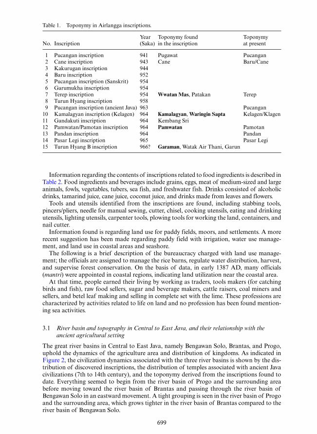
The toponymy of locations from the Airlangga era in the lowland and near the seashore starting from the villages of Waringin Sapta, Pamwata, and Kamalgyan is presented in Table 1.
699
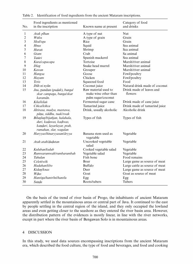
Information regarding the contents of inscriptions related to food ingredients is described in Table 2. Food ingredients and beverages include grains, eggs, meat of medium-sized and large animals, fowls, vegetables, tubers, sea fish, and freshwater fish. Drinks consisted of alcoholic drinks, tamarind juice, cane juice, coconut juice, and drinks made from leaves and flowers.
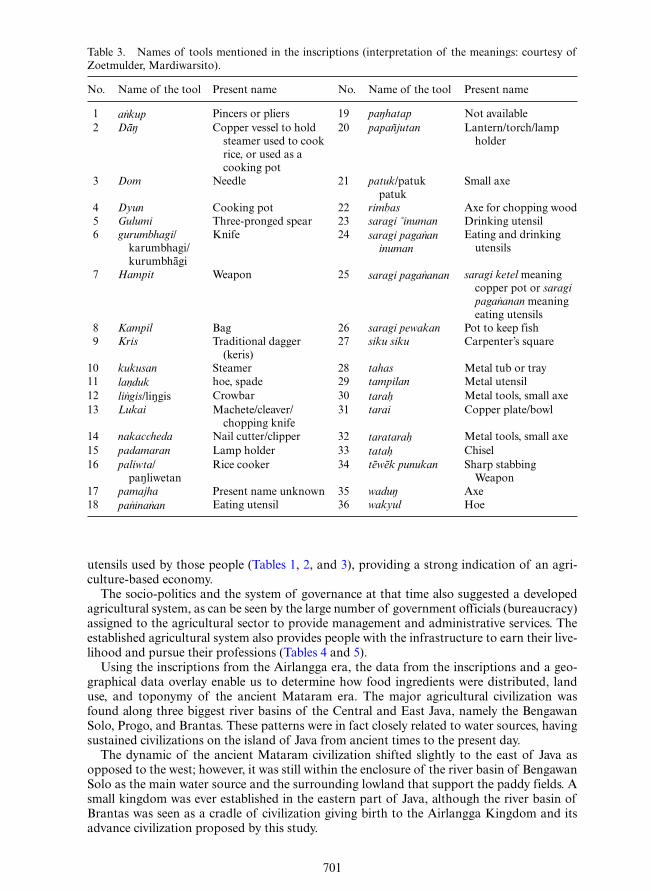
Tools and utensils identified from the inscriptions are found, including stabbing tools, pincers/pliers, needle for manual sewing, cutter, chisel, cooking utensils, eating and drinking utensils, lighting utensils, carpenter tools, plowing tools for working the land, containers, and nail cutter.
Information found is regarding land use for paddy fields, moors, and settlements. A more recent suggestion has been made regarding paddy field with irrigation, water use manage-ment, and land use in coastal areas and seashore.
The following is a brief description of the bureaucracy charged with land use manage-ment; the officials are assigned to manage the rice barns, regulate water distribution, harvest, and supervise forest conservation. On the basis of data, in early 1387 AD, many officials (mantri) were appointed in coastal regions, indicating land utilization near the coastal area.
At that time, people earned their living by working as traders, tools makers (for catching birds and fish), raw food sellers, sugar and beverage makers, cattle raisers, coal miners and sellers, and betel leaf making and selling in complete set with the lime. These professions are characterized by activities related to life on land and no profession has been found mention-ing sea activities.
3.1 River basin and topography in Central to East Java, and their relationship with the ancient agricultural setting
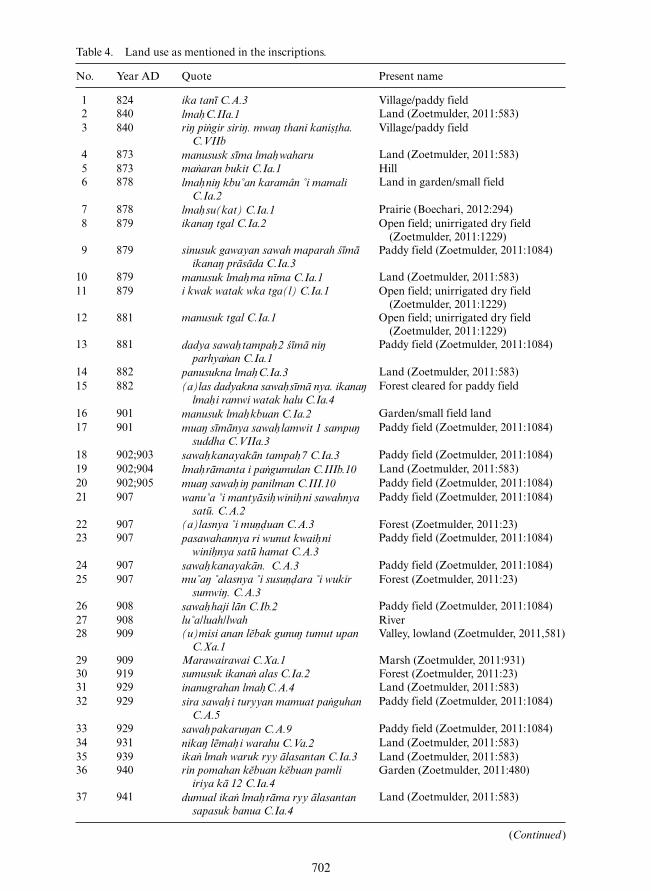
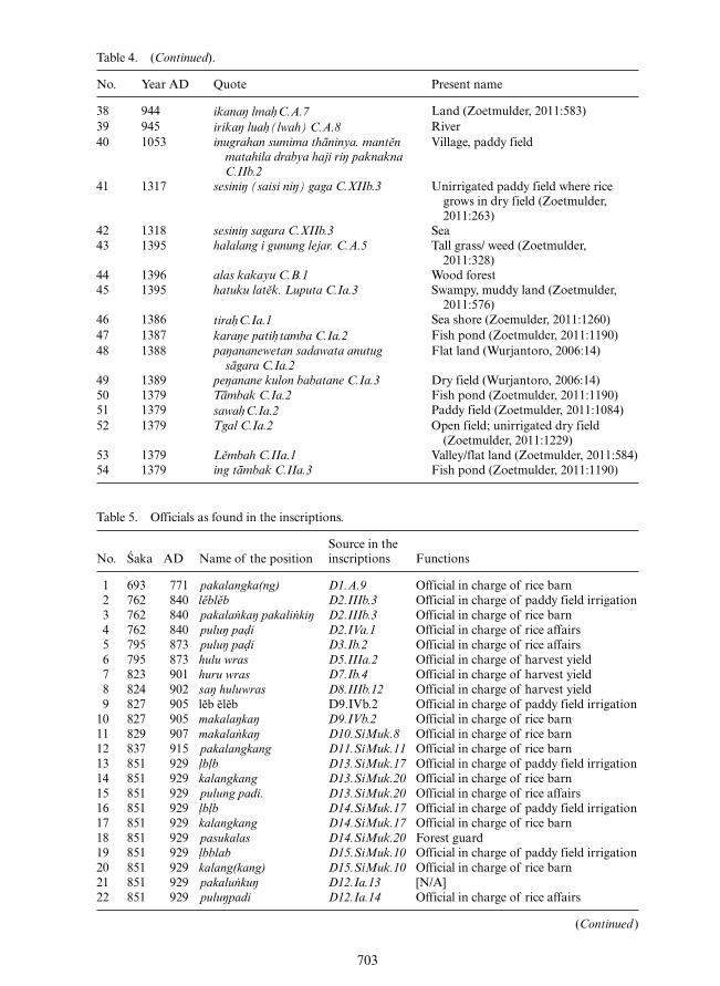
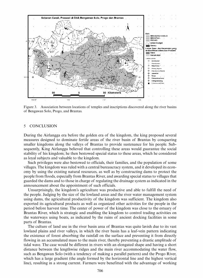
The great river basins in Central to East Java, namely Bengawan Solo, Brantas, and Progo, uphold the dynamics of the agriculture area and distribution of kingdoms. As indicated in Figure 2, the civilization dynamics associated with the three river basins is shown by the dis-tribution of discovered inscriptions, the distribution of temples associated with ancient Java civilizations (7th to 14th century), and the toponymy derived from the inscriptions found to date. Everything seemed to begin from the river basin of Progo and the surrounding area before moving toward the river basin of Brantas and passing through the river basin of Bengawan Solo in an eastward movement. A tight grouping is seen in the river basin of Progo and the surrounding area, which grows tighter in the river basin of Brantas compared to the river basin of Bengawan Solo.
Table 1. Toponymy in Airlangga inscriptions.
No. InscriptionYear (Saka)
Toponymy found in the inscription
Toponymy at present
1 Pucangan inscription 941 Pugawat Pucangan 2 Cane inscription 943 Cane Baru/Cane 3 Kakurugan inscription 944 4 Baru inscription 952 5 Pucangan inscription (Sanskrit) 954 6 Garumukha inscription 954 7 Terep inscription 954 Wwatan Mas, Patakan Terep 8 Turun Hyang inscription 958 9 Pucangan inscription (ancient Java) 963 Pucangan10 Kamalagyan inscription (Kelagen) 964 Kamalagyan, Waringin Sapta Kelagen/Klagen11 Gandakuti inscription 964 Kembang Sri12 Pamwatan/Pamotan inscription 964 Pamwatan Pamotan13 Pandan inscription 964 Pandan14 Pasar Legi inscription 965 Pasar Legi15 Turun Hyang B inscription 966? Garaman, Watak Air Thani, Garun
700
On the basis of the trend of river basin of Progo, the inhabitants of ancient Mataram apparently settled in the mountainous areas or central part of Java. It continued to the east by people settling in the central region of the island, and they only occupied the lowland areas and even getting closer to the seashore as they entered the river basin area. However, the distribution pattern of the evidences is mostly linear, in line with the river networks, except in part where the river basin of Bengawan Solo is in mountainous areas.
4 DISCUSSION
In this study, we used data sources encompassing inscriptions from the ancient Mataram era, which described the food culture, the type of food and beverages, and food and cooking
Table 2. Identification of food ingredients from the ancient Mataram inscriptions.
No.Food ingredients as mentioned in the inscription Known name at present
Category of food and drinks
1 Atak pīhan A type of nut Nut 2 Wuku A type of grain Grain 3 Skul/sgu Rice Grain 4 Hnus Squid Sea animal 5 Huran⋅ Shrimp Sea animal 6 Gtam Crab Sa animal 7 Tan⋅iri Spanish mackerel Sea animal 8 Kura/capacapa Tortoise Marsh/river animal 9 Dlag Snake head murrel Marsh/river animal10 Kawan Grouper Marsh/river animal11 Hangsa Goose Fowl/poultry12 Hayam Chicken Fowl/poultry13 Tetis Squeezed food Food14 Dūh ni nyūn Coconut juice Natural drink made of coconut15 Jnu, pandan (pud⋅ak), bunga/
skar campaga, bunga/skar karamān.
Raw material used to make wine other than palm sugar/coconut
Drink made of leaves and flowers
16 Kila/kilan⋅ Fermented sugar cane Drink made of cane juice17 Ciñca/kiñca Tamarind juice Drink made of tamarind juice18 Jātirasa, madya, mastawa,
pān⋅a, siddhu, tuak/twakDrink, usually alcoholic Alcoholic drink
19 Biluŋluŋ/bijañjan, halahala, duri, kad⋅awas, kad⋅ iwas, kan⋅d⋅ari, layarlayar, prah, rumahan, slar, wagalan
Types of fish Types of fish
20 Haryyas/hinaryyasan/āryya Banana stem used as vegetable
Vegetable
21 Atah atah/d⋅ud⋅utan Uncooked vegetable salad
Vegetable
22 Kuluban/kulub Cooked vegetable salad Vegetable23 Rumwarumwah/rumbarumbah Vegetable salad Vegetable24 Tahulan Fish bone Food remains25 Celen⋅/wök Boar Large game as source of meat26 Hadahan/kbo Buffalo Large cattle as source of meat27 Kidaŋ/knas Deer Large game as source of meat28 Wd⋅us Goat Goat as source of meat29 Hantiga/hantrīni/hantlu Egg Egg30 Sun⋅d⋅a Roots/tubers Tubers
701
utensils used by those people (Tables 1, 2, and 3), providing a strong indication of an agri-culture-based economy.
The socio-politics and the system of governance at that time also suggested a developed agricultural system, as can be seen by the large number of government officials (bureaucracy) assigned to the agricultural sector to provide management and administrative services. The established agricultural system also provides people with the infrastructure to earn their live-lihood and pursue their professions (Tables 4 and 5).
Using the inscriptions from the Airlangga era, the data from the inscriptions and a geo-graphical data overlay enable us to determine how food ingredients were distributed, land use, and toponymy of the ancient Mataram era. The major agricultural civilization was found along three biggest river basins of the Central and East Java, namely the Bengawan Solo, Progo, and Brantas. These patterns were in fact closely related to water sources, having sustained civilizations on the island of Java from ancient times to the present day.
The dynamic of the ancient Mataram civilization shifted slightly to the east of Java as opposed to the west; however, it was still within the enclosure of the river basin of Bengawan Solo as the main water source and the surrounding lowland that support the paddy fields. A small kingdom was ever established in the eastern part of Java, although the river basin of Brantas was seen as a cradle of civilization giving birth to the Airlangga Kingdom and its advance civilization proposed by this study.
Table 3. Names of tools mentioned in the inscriptions (interpretation of the meanings: courtesy of Zoetmulder, Mardiwarsito).
No. Name of the tool Present name No. Name of the tool Present name
1 an⋅kup Pincers or pliers 19 paŋhatap Not available 2 Dāŋ Copper vessel to hold
steamer used to cook rice, or used as a cooking pot
20 papañjutan Lantern/torch/lamp holder
3 Dom Needle 21 patuk/patuk patuk
Small axe
4 Dyun Cooking pot 22 rimbas Axe for chopping wood 5 Gulumi Three-pronged spear 23 saragi ˚inuman Drinking utensil 6 gurumbhagi/
karumbhagi/kurumbhāgi
Knife 24 saragi pagan⋅an inuman
Eating and drinking utensils
7 Hampit Weapon 25 saragi pagan⋅anan saragi ketel meaning copper pot or saragi pagan⋅anan meaning eating utensils
8 Kampil Bag 26 saragi pewakan Pot to keep fish 9 Kris Traditional dagger
(keris)27 siku siku Carpenter’s square
10 kukusan Steamer 28 tahas Metal tub or tray11 lan⋅duk hoe, spade 29 tampilan Metal utensil12 lin⋅gis/liŋgis Crowbar 30 tarah⋅ Metal tools, small axe13 Lukai Machete/cleaver/
chopping knife31 tarai Copper plate/bowl
14 nakaccheda Nail cutter/clipper 32 taratarah⋅ Metal tools, small axe15 padamaran Lamp holder 33 tatah⋅ Chisel16 paliwta/
paŋliwetanRice cooker 34 tēwēk punukan Sharp stabbing
Weapon17 pamajha Present name unknown 35 waduŋ Axe18 pan⋅inan⋅an Eating utensil 36 wakyul Hoe
702
Table 4. Land use as mentioned in the inscriptions.
No. Year AD Quote Present name
1 824 ika tanī C.A.3 Village/paddy field 2 840 lmah⋅ C.IIa.1 Land (Zoetmulder, 2011:583) 3 840 riŋ pi gir siriŋ. mwaŋ thani kani ha.
C.VIIbVillage/paddy field
4 873 manususk sīma lmah⋅ waharu Land (Zoetmulder, 2011:583) 5 873 ma aran bukit C.Ia.1 Hill 6 878 lmah⋅ niŋ kbu˚an karamân ˚i mamali
C.Ia.2Land in garden/small field
7 878 lmah⋅ su(kat) C.Ia.1 Prairie (Boechari, 2012:294) 8 879 ikanaŋ tgal C.Ia.2 Open field; unirrigated dry field
(Zoetmulder, 2011:1229) 9 879 sinusuk gawayan sawah maparah śīmā
ikanaŋ prāsāda C.Ia.3Paddy field (Zoetmulder, 2011:1084)
10 879 manusuk lmah⋅ ma nīma C.Ia.1 Land (Zoetmulder, 2011:583)11 879 i kwak watak wka tga(l) C.Ia.1 Open field; unirrigated dry field
(Zoetmulder, 2011:1229)12 881 manusuk tgal C.Ia.1 Open field; unirrigated dry field
(Zoetmulder, 2011:1229)13 881 dadya sawah⋅ tampah⋅ 2 śīmā niŋ
parhya an C.Ia.1Paddy field (Zoetmulder, 2011:1084)
14 882 panusukna lmah⋅ C.Ia.3 Land (Zoetmulder, 2011:583)15 882 (a)las dadyakna sawah⋅ sīmā nya. ikanaŋ
lmah⋅ i ramwi watak halu C.Ia.4Forest cleared for paddy field
16 901 manusuk lmah⋅ kbuan C.Ia.2 Garden/small field land17 901 muaŋ sīmānya sawah⋅ lamwit 1 sampuŋ
suddha C.VIIa.3Paddy field (Zoetmulder, 2011:1084)
18 902;903 sawah⋅ kanayakān tampah⋅ 7 C.Ia.3 Paddy field (Zoetmulder, 2011:1084)19 902;904 lmah⋅ rāmanta i pa gumulan C.IIIb.10 Land (Zoetmulder, 2011:583)20 902;905 muaŋ sawah⋅ iŋ panilman C.III.10 Paddy field (Zoetmulder, 2011:1084)21 907 wanu˚a ˚i mantyāsih⋅ winih⋅ ni sawahnya
satū. C.A.2Paddy field (Zoetmulder, 2011:1084)
22 907 (a)lasnya ˚i mu uan C.A.3 Forest (Zoetmulder, 2011:23)23 907 pasawahannya ri wunut kwaih⋅ ni
winih⋅ nya satū hamat C.A.3Paddy field (Zoetmulder, 2011:1084)
24 907 sawah⋅ kanayakān. C.A.3 Paddy field (Zoetmulder, 2011:1084)25 907 mu˚aŋ ˚alasnya ˚i susu ara ˚i wukir
sumwiŋ. C.A.3Forest (Zoetmulder, 2011:23)
26 908 sawah⋅ haji lān C.Ib.2 Paddy field (Zoetmulder, 2011:1084)27 908 lu˚a/luah/lwah River28 909 (u)misi anan lĕbak gunuŋ tumut upan
C.Xa.1Valley, lowland (Zoetmulder, 2011,581)
29 909 Marawairawai C.Xa.1 Marsh (Zoetmulder, 2011:931)30 919 sumusuk ikana alas C.Ia.2 Forest (Zoetmulder, 2011:23)31 929 inanugrahan lmah⋅ C.A.4 Land (Zoetmulder, 2011:583)32 929 sira sawah⋅ i turyyan mamuat pa guhan
C.A.5Paddy field (Zoetmulder, 2011:1084)
33 929 sawah⋅ pakaruŋan C.A.9 Paddy field (Zoetmulder, 2011:1084)34 931 nikaŋ lēmah⋅ i warahu C.Va.2 Land (Zoetmulder, 2011:583)35 939 ika lmah waruk ryy ālasantan C.Ia.3 Land (Zoetmulder, 2011:583)36 940 rin pomahan kĕbuan kĕbuan pamli
iriya kā 12 C.Ia.4Garden (Zoetmulder, 2011:480)
37 941 dumual ika lmah⋅ rāma ryy ālasantan sapasuk banua C.Ia.4
Land (Zoetmulder, 2011:583)
(Continued )
703
Table 4. (Continued).
No. Year AD Quote Present name
38 944 ikanaŋ lmah⋅ C.A.7 Land (Zoetmulder, 2011:583)39 945 irikaŋ luah⋅ (lwah) C.A.8 River40 1053 inugrahan sumima thāninya. mantĕn
matahila drabya haji riŋ paknakna C.IIb.2
Village, paddy field
41 1317 sesiniŋ (saisi niŋ) gaga C.XIIb.3 Unirrigated paddy field where rice grows in dry field (Zoetmulder, 2011:263)
42 1318 sesiniŋ sagara C.XIIb.3 Sea43 1395 halalang i gunung lejar. C.A.5 Tall grass/ weed (Zoetmulder,
2011:328)44 1396 alas kakayu C.B.1 Wood forest45 1395 hatuku latĕk. Luputa C.Ia.3 Swampy, muddy land (Zoetmulder,
2011:576)46 1386 tirah⋅ C.Ia.1 Sea shore (Zoemulder, 2011:1260)47 1387 karaŋe patih⋅ tamba C.Ia.2 Fish pond (Zoetmulder, 2011:1190)48 1388 paŋananewetan sadawata anutug
sāgara C.Ia.2Flat land (Wurjantoro, 2006:14)
49 1389 peŋanane kulon babatane C.Ia.3 Dry field (Wurjantoro, 2006:14)50 1379 Tāmbak C.Ia.2 Fish pond (Zoetmulder, 2011:1190)51 1379 sawah⋅ C.Ia.2 Paddy field (Zoetmulder, 2011:1084)52 1379 Tgal C.Ia.2 Open field; unirrigated dry field
(Zoetmulder, 2011:1229)53 1379 Lĕmbah C.IIa.1 Valley/flat land (Zoetmulder, 2011:584)54 1379 ing tāmbak C.IIa.3 Fish pond (Zoetmulder, 2011:1190)
Table 5. Officials as found in the inscriptions.
No. Śaka AD Name of the positionSource in the inscriptions Functions
1 693 771 D1.A.9 Official in charge of rice barn 2 762 840 D2.IIIb.3 Official in charge of paddy field irrigation 3 762 840 D2.IIIb.3 Official in charge of rice barn 4 762 840 D2.IVa.1 Official in charge of rice affairs 5 795 873 D3.Ib.2 Official in charge of rice affairs 6 795 873 D5.IIIa.2 Official in charge of harvest yield 7 823 901 D7.Ib.4 Official in charge of harvest yield 8 824 902 D8.IIIb.12 Official in charge of harvest yield 9 827 905 D9.IVb.2 Official in charge of paddy field irrigation10 827 905 D9.IVb.2 Official in charge of rice barn11 829 907 D10.SiMuk.8 Official in charge of rice barn12 837 915 D11.SiMuk.11 Official in charge of rice barn13 851 929 D13.SiMuk.17 Official in charge of paddy field irrigation14 851 929 D13.SiMuk.20 Official in charge of rice barn15 851 929 D13.SiMuk.20 Official in charge of rice affairs16 851 929 D14.SiMuk.17 Official in charge of paddy field irrigation17 851 929 D14.SiMuk.17 Official in charge of rice barn18 851 929 D14.SiMuk.20 Forest guard19 851 929 D15.SiMuk.10 Official in charge of paddy field irrigation20 851 929 D15.SiMuk.10 Official in charge of rice barn21 851 929 D12.Ia.13 [N/A]22 851 929 D12.Ia.14 Official in charge of rice affairs
(Continued )
Table 4. (Continued) .
No. Year AD Quote Present name
38 944 ikanaiJ lmah CA. 7 Land (Zoetmulder, 2011:583) 39 945 irikal) luah(lwah) CA.8 River 40 1053 inugrahan sumima thiininya. manten Village, paddy field
matahila drabya haji ril] paknakna C!Ib.2
41 1317 sesinil] ( saisi nil]) gaga C XIIb.3 Unirrigated paddy field where rice grows in dry field (Zoetmulder, 2011 :263)
42 1318 sesinil] sagara CXIIb.3 Sea 43 1395 halalang i gunung lejar. CA.5 Tall grass/ weed (Zoetmulder,
2011 :328) 44 1396 alas kakayu C B. I Wood forest 45 1395 hatuku latek Luputa Cia.3 Swampy, muddy land (Zoetmulder,
2011 :576) 46 1386 tira/:lCia.l Sea shore (Zoemulder, 2011: 1260) 47 1387 karal)epati/:ltamba Cia.2 Fish pond (Zoetmulder, 2011 :1190) 48 1388 pal)ananewetan sadawata anutug Flat land (Wurjantoro, 2006:14)
siigara Cia.2 49 1389 peiJanane kulon babatane Cia.3 Dry field (Wurjantoro, 2006:14) 50 1379 Tiimbak Cia.2 Fish pond (Zoetmulder, 2011: 1190) 51 1379 sawahCia.2 Paddy field (Zoetmulder, 2011: 1084) 52 1379 Tgal Cia.2 Open field; unirrigated dry field
(Zoetmulder, 2011 :1229) 53 1379 Lembah CIIa. l Valley/flat land (Zoetmulder, 2011 :584) 54 1379 ing tiimbak CIIa.3 Fish pond (Zoetmulder, 2011 :1190)
Table 5. Officials as found in the inscriptions.
Source in the No. Saka AD N arne of the position inscriptions Functions
1 693 771 pakalangka(ng) Dl.A.9 Official in charge of rice barn 2 762 840 lib lib D2.IIIb.3 Official in charge of paddy field irrigation 3 762 840 pakalailkaJj pakaliilld1) D2.IIIb.3 Official in charge of rice barn 4 762 840 puluyparji D2.IVa.J Official in charge of rice affairs 5 795 873 puluyparji D3.Ib.2 Official in charge of rice affairs 6 795 873 hulu-.was D5.IIIa.2 Official in charge of harvest yield 7 823 901 huruwras D7.Ib.4 Official in charge of harvest yield 8 824 902 Sa1J hulu-.was D8.IIIb.J2 Official in charge of harvest yield 9 827 905 leb eleb D9.IVb.2 Official in charge of paddy field irrigation
10 827 905 makala1Jka1J D9.IVb.2 Official in charge of rice barn 11 829 907 makalailkmj DJO.SiMuk.8 Official in charge of rice barn 12 837 915 pakalangkang Dll.SiMuk.JJ Official in charge of rice barn 13 851 929 /bib Dl3.SiMuk.I7 Official in charge of paddy field irrigation 14 851 929 kalangkang Dl3.SiMuk.20 Official in charge of rice barn 15 851 929 pulung padi. Dl3.SiMuk.20 Official in charge of rice affairs 16 851 929 /bib Dl4.SiMuk.I7 Official in charge of paddy field irrigation 17 851 929 kalangkang Dl4.SiMuk.I7 Official in charge of rice barn 18 851 929 pasuka/Qs Dl4.SiMuk.20 Forest guard 19 851 929 fbblab Dl5.SiMuk.JO Official in charge of paddy field irrigation 20 851 929 kalang(kang) Dl5.SiMuk.JO Official in charge of rice barn 21 851 929 pakalu-nlauj Dl2.Ia.J3 [N/A] 22 851 929 puluypadi Dl2.Ia.l4 Official in charge of rice affairs
(Continued)
703
704
Table 6. Professions as found in the inscriptions.
No. Name of the profession Meaning
1 Food vendor 2 Fruit vendor 3 Mengkudu (noni fruit) vendor 4 Bird trap maker 5 [N/A] 6 Sugar maker 7 ańjariŋ./mańjariŋ Animal catcher using net/net maker 8 Duck, buffalo, cow/ox, boar, goat vendor
9 [N/A]10 Garlic/shallot vendor11 Lime maker12 Animal catcher using net13 makala kalā/manuk Animal/bird trap maker14 Castor oil maker15 mamēlut/mamulanŋ wlut Eel vendor16 Fish catcher using net17 Bird catcher18 Trap maker (usually for birds)19 Net maker20 [N/A]21 Lime (for betel) maker22 Lime (for betel) maker23 Processing of noni fruit24 Vendor of food made of beef, buffalo, duck25 Lime (for betel) maker26 Coal vendor27 Maker of a type of drink28 Betel vendor29 Lime (for betel) buyer
Table 5. (Continued).
No. Śaka AD Name of the positionSource in the inscriptions Functions
23 852 930 D16.SiMuk.7 Official in charge of rice barn24 853 931 D17.IVa.7 Official in charge of rice barn25 861 939 D18.Ia.10 Official in charge of paddy field irrigation26 861 939 D18.Ia.10 Official in charge of rice barn27 975 1053 D19.IIIa.5 Official in charge of rice barn28 1022 1100 D20.IIa.11 Official in charge of paddy field irrigation29 1022 1100 D20.IIa.12 Official in charge of rice barn30 1245 1323 D21.VIb.2 Official in charge of rice barn31 1245 1323 D21.VIb.3 Official in charge of rice affairs32 1309 1387 D21.A.1 Official (mantri) in coastal area (tira )
The notion about an advanced Airlangga civilization was supported by the morphology of the wide and deep Brantas River, thus enabling it to be used as waterways and major transportation routes in the kingdom; later, it would play an important role in the interaction between the kingdom and foreign civilizations, such as India, China, and Arab during the Airlangga era.
Table 5. (Continued).
Source in the No. Saka AD Name of the position inscriptions Functions
23 852 930 kalailkang DJ6.SiMuk.7 Official in charge of rice barn 24 853 931 pakalailka1). pakaliriki1) Dl7.1Va.7 Official in charge of rice barn 25 861 939 liblab DJ8.Ia.JO Official in charge of paddy field irrigation 26 861 939 kalangkail DJ8.Ia.JO Official in charge of rice barn 27 975 1053 pakalatilau:J D 19.IIIa.5 Official in charge of rice barn 28 1022 1100 lebaleb D20.Ila.JJ Official in charge of paddy field irrigation 29 1022 1100 pakalQ1)ka1) D20.Ila.l2 Official in charge of rice barn 30 1245 1323 paka/Q1]ka1)-pakali1)kilj D21. Vlb.2 Official in charge of rice barn 31 1245 1323 pulUI)[JQIIi D21. Vlb.3 Official in charge of rice affairs 32 1309 1387 mantrirJ tirab D2I.A.J Official (mantri) in coastal area (tirab)
Table 6. Professions as found in the inscriptions.
No. Name of the profession Meaning
1 "ahikana Food vendor 2 abakul wwawwahan. Fruit vendor 3 adagang wwiku(iu Mengkudu (noni fruit) vendor 4 amisa(l(iun!mamis~u(1J) manuk Bird trap maker 5 anepis. [N/A] 6 ailgula/magula/manggula Sugar maker 7 anjariYj ./mm1jariYj Animal catcher using net/net maker 8 ailulan/pa1iulQ1] ail{ia/1. ailulQ1] kbo. sapi. Duck, buffalo, cow/ox, boar, goat vendor
CelQ1], w4zts 9 Anwa1) [N/A]
10 BaWQ1) Garlidshallot vendor 11 haiJapu Lime maker 12 majari Animal catcher using net 13 makala kalii/manuk Animal/bird trap maker 14 maluru1Jimalilurulilmanglurung Castor oil maker 15 mamelut/mamulanYJ wlut Eel vendor 16 mamulwt Fish catcher using net 17 manahab manuk Bird catcher 18 manat.Jkeb. Trap maker (usually for birds) 19 Manawang Net maker 20 ManawaiJ [N/A] 21 Manghapii Lime (for betel) maker 22 manghapii. Lime (for betel) maker 23 maniila w)ulikur,Iulanula1J wwikur,Iu Processing of noni fruit 24 maliula1J hQ{iailan sapi wf[us a(lr,la/1 Vendor of food made of beef, buffalo, duck 25 ma1Jhapii Lime (for betel) maker 26 mQ1jhari1J Coal vendor 27 pabrsi/pambr~i/pamr~Vmamrsi Maker of a type of drink 28 pucQ1) sere/!. Betel vendor 29 wlihapii Lime (for betel) buyer
The notion about an advanced Airlangga civilization was supported by the morphology of the wide and deep Brantas River, thus enabling it to be used as waterways and major transportation routes in the kingdom; later, it would play an important role in the interaction between the kingdom and foreign civilizations, such as India, China, and Arab during the Airlangga era.
704
705
Figure 1. Ten largest river basins (DAS) in the island of Java.
Figure 2. Topography.
From a much broader perspective, the inscriptions and various analyses conducted on them and the geographical setting indicate that a basic agricultural civilization would progress with river transportation that will result in technology advancement and a full range of economic benefits.
The ancient Mataram civilization in Central Java up to the Airlangga era is viewed from the spatial perspective, particularly its natural resources that encompassed the topography, river networks, river basins, and the geomorphology aspects. In particular, the kings of the ancient Mataram era were adept in managing their natural resources. It would be seen that the crucial aspect in maintaining a great kingdom relies on the ability to provide for its people, to make them prosperous. Some efforts were made to be adaptive to a region, par-ticularly the river basin area or the vast plains and fertile valleys that had sufficient supply of water.
706
5 CONCLUSION
During the Airlangga era before the golden era of the kingdom, the king proposed several measures designed to dominate fertile areas of the river basin of Brantas by conquering smaller kingdoms along the valleys of Brantas to provide sustenance for his people. Sub-sequently, King Airlangga believed that controlling these areas would guarantee the social stability of his kingdom; he then bestowed special status to these areas, which he considered as loyal subjects and valuable to the kingdom.
Such privileges were also bestowed to officials, their families, and the population of some villages. The kingdom was ruled with a central bureaucracy system, and it developed its econ-omy by using the existing natural resources, as well as by constructing dams to protect the people from floods, especially from Brantas River, and awarding special status to villages that guarded the dams and to those in charge of regulating the drainage system as indicated in the announcement about the appointment of such officials.
Unsurprisingly, the kingdom’s agriculture was productive and able to fulfill the need of the people. Judging by the size of the lowland areas and the river water management system using dams, the agricultural productivity of the kingdom was sufficient. The kingdom also exported its agricultural products as well as organized other activities for the people in the period before harvest time. The center of power of the kingdom was close to the estuary of Brantas River, which is strategic and enabling the kingdom to control trading activities on the waterways using boats, as indicated by the ruins of ancient docking facilities in some parts of Brantas.
The culture of land use in the river basin area of Brantas was quite lavish due to its vast lowland plains and river valleys, in which the river basin has a leaf-vein pattern indicating the existence of forest absorbing the rainfall on the surface and preventing it from directly flowing in an accumulated mass to the main river, thereby preventing a drastic amplitude of tidal wave. The case would be different in rivers with an elongated shape and having a short distance between the lengthwise ridges and the main river accommodating the water flow, such as Bengawan Solo (with a tendency of making a parallel pattern) and the Progo River, which has a large gradient (the angle formed by the horizontal line and the highest vertical line), resulting in a strong current. Farmers were benefitted with the advantage of working
Figure 3. Association between locations of temples and inscriptions discovered along the river basins of Bengawan Solo, Progo, and Brantas.
707
on flat ground in the lowland with a thick layer of soil and a fine texture that contained vol-canic nutrient element and an abundant supply of water. The land use culture was not strong and did not require more energy despite the modest tools available, compared with farming in hilly areas with strong sliding water, thin layer of soil, and coarse to rocky textures, where only certain plants could strive.
The spatial pattern found throughout this era indicates that the people in the Airlangga era utilized the areas in a linear position parallel to the river basin of Brantas on the riversides. It is apparent in the distribution of names in the inscriptions found in the proximity of Brantas River.
REFERENCES
Berger, P. & Luckman, T. (1979) The Social Construction of Reality: A Treatise in the Sociology of Knowledge. Penguin Book, New York.
Brandes, JLA. (1913) Oud Javaansche-Oorkonden, Nagelaten Transscripties. VBG deel LX (Verhandelingen Genootschap van Kunsten en Wetenschappen) M.Nijhoff,’s Hage.
Branson, J. & Miller, D., & Bourdieu, P. (2002) In: Beilharz, P. Teori-Teori Sosial: Observasi Kritis terhadap Para Filosof Terkemuka (Social Theories: Critical observation toward the prominent philosophers). Yogyakarta, Pustaka Pelajar, pp. 43–57.
Bunasor. (1989) Diversifikasi dan Program Pembangunan Pertanian. Hasil Konpernas X PERHEPI dalam Diversifikasi Pertanian (Diversification and Agricultural Development Program: The results of Konpernas X PERHEPI in Agricultural Diversification), 1995. Jakarta, Pustaka Sinar Harapan.
Daniel, R. & Giddens, A. (2002) In: Peter Beilharz. Teori-Teori Sosial: Observasi Kritis terhadap Para Filosof Terkemuka (Social Theories: Critical observation toward the prominent philosophers). Yogyakarta, Pustaka Pelajar, pp. 191–200.
Dant, T. (1991) Knowledge, Ideology and Discourse: A Sociological Perspective. London, Routledge.Danusubroto, A.S. (2008) RAA Cokronagoro I (1831–1857) Pendiri Kabupaten Purworejo (The founding
fathers of Purworejo Regency). Purworejo, Diterbitkan atas prakarsa HR Budi Sarjono BRE.Ekadjati, E.S. (1988) Naskah Sunda (Sundanese Manuscripts). Kerjasama Lembaga Penelitian
Pajajaran dan the Toyota Foundation. Bandung Forum Kajian Komuniti Pesisir, Depok, FISIP UI.Gittinger, J.P. (1986) Economic Analysis of Agricultural Projects. Second Edition. Jakarta, UI-Press.Hardjowigeno, S. (2003) Klasifikasi Tanah dan Pedogenesis (Land Classification and Pedogenesis).
Jakarta, Akademika Pressindo.Hardjowigeno, S. (2007) Evaluasi Kesesuaian Lahan dan Perencanaan Tataguna Lahan (Evaluation of
Land Suitability and Land Use Planning). Yogyakarta, Gadjah Mada University Press.Herman, C. (1985) Culture, Health, and Illness. Bristol, Wright.Kastaman, R., Kendarto, D.R. & Aji, A.M. (2007) Model Optimasi Pola Tanam pada Lahan Kering
di Desa Sarimukti Kecamatan Pasirwangi Kabupaten Garut (Planting Pattern Optimizing Model in Dry Land in Sarimukti Village, Pasirwangi District, Garut Regency). Jurnal Teknotan, 1 (1), 1–12.
Koentjaraningrat. (1987) Sejarah Teori Antropologi I (Anthropology Theory History I). Jakarta, UI Press.Koga, Y. (1988) Farm Machinery Vol. II. Tsukuba International Agricultural Training Centre. JICA.Kuntowijoyo. (2006) Raja Priyayi dan Kawula (The Noble King and the common people). Yogyakarta,
Penerbit Ombak.Maryoto, A. (2009) Jejak Pangan, Sejarah, Silang Budaya dan Masa Depan (The trace of food, history,
cross culture, and the future). Jakarta, Penerbit Buku Kompas.Metutia F.S. (1985) Makanan Kelompok Lanjut Usia dan Konteks Budaya, Khasiat Makanan Tradisional
(The food for the elderly group and cultural context, the benefits of traditional food). Jakarta, Kantor Menteri Negara Urusan Pangan RI, pp. 99–109.
Mubaryato. (1989) Pengantar Ekonomi Pertanian (The Introduction to Agricultural Economy). PT. Jakarta, Pustaka LP3ES Indonesia, anggota IKAPI.
Munandar, A.A. (2011) Majapahit: Kerajaan Agraris-Maritim di Nusantara (Majapahit: The Agrarian-Maritime Kingdom in Indonesian Archipelago). Depok, Departemen Arkeologi, FIB UI.
Munandar, A.A. (2012) Pentingnya Arkeologi dalam Membangun Budaya Bangsa menurut R.M. Ng. Poerbatjaraka (The importance of archeology in building a nation culture according to R.M. Ng. Poerbatjajraka). Depok, Departemen Arkeologi, Fakultas Ilmu Pengetahuan Budaya, Universitas Indonesia.
Munandar, A.A. (2012) Peradaban Majapahit: Data dan Masalah Interpretasinya (Majapahit Civilization: Data and its interpretation problem). Depok, Departemen Arkeologi, FIB UI.
708
Munandar, A.A. (2013) Tidak Ada Kanal di Kota Majapahit (No canal in Majapahit cities). Depok, Departemen Arkeologi, FIB UI.
Nainggolan, K. (2005) Pertanian Indonesia Kini dan Esok (Indonesian Agriculture: Now and Tomorrow). Jakarta, Pustaka Sinar Harapan.
Nganro, N.R. (2009) Dukungan Kebijaksanaan Pemerintah dalam Pengembangan Komoditas Pertanian yang Mendukung Ketahanan Pangan Nasional (Government Policy Support in Agricultural Com-modity Development in Supporting National Food Endurance). SEMILOKA Pengembangan dan Penerapan IPTEK dalam Mendukung Ketahanan Pangan dan Energi (Science and Technology Devel-opment and Application in supporting food and energy resilience). Organized by Kedeputian Bidang Dinamika Masyarakat, Kementerian Negara Riset dan Teknologi. 10 November 2009, Jakarta.
Pakpahan, A. (1989) Refleksi Diversifikasi dalam Teori Ekonomi. Hasil Konpernas X PERHEPI dalam Diversifikasi Pertanian (Diversification Reflection in Economic Theory: The results of Konpernas X PERHEPI in Agricultural Diversification), 1995. Jakarta, Pustaka Sinar Harapan.
Pigeaud, Th.G. (1967) Literature of Java, vol. I-III. The Hague, Martinus Nijhoff.Rahardjo. (1999) Pengantar Sosiologi Pedesaan dan Pertanian (Introduction to Rural Area Sociology and
Agriculture). Yogyakarta, Gadjah Mada University Press.Sandy, I.M. (1977) Penggunaan Tanah di Indonesia (The Land Use in Indonesia). Jakarta, Publikasi
No.75. Direktorat Tata Guna Tanah, Ditjen Agraria, Departemen Dalam Negeri.Sandy, I.M. (1995) Republik Indonesia Geografi Regional (The Regional Geography of the Republic of
Indonesia). Depok, Department of Geography, Faculty of Mathematics and Natural Sciences, Uni-versitas Indonesia.
Santiko, H. (1986) Mandala (Kadewaguruan) pada Masyarakat Majapahit (Mandala (Kadewaguruan) in Majapahit Society). Paper presented at the Pertemuan Ilmiah Arkeologi IV Cipanas.
Setiawan, R.P.A. (2001) Research Report on Development of Variable Rate Granular Applicator for Paddy Field. Laboratory of Agricultural Machinery. Kyoto University, Research Report.
Siswoputranto, P.S. (1987) Komoditi Ekspor Indonesia (Indonesian Export Commodity). Jakarta, PT. Gramedia.
Srivastava, A.K., Goering, C.E. & Rohrbach, R.P. (1993) Engineering Principles of Agricultural Machines. ASAE Textbook Number 6, American Society of Agricultural Engineers.
Sumodiningrat, G. (1989) Aspek Sosial Ekonomi Diversifikasi Sektor Pertanian Pangan. Hasil Konpernas X PERHEPI dalam Diversifikasi Pertanian (The Diversification Economic Social Aspects of the Food Agricultural Sector: The results of Konpernas X PERHEPI in Agricultural Diversification), 1995. Jakarta, Pustaka Sinar Harapan.
Susanti, N. & Kriswanto, A. (2008) Damalung; Skriptoria pada Masa Hindu-Buddha sampai dengan Masa Islam (Damalung: Scriptoria during the Hindu-Buddhism Era until the Islamic Era). Paper presented at the Simposium Internasional Manassa, Bandung.
Susanti, N. (2003) Masa Pemerintahan Erlangga (During Erlangga Government). [Thesis]. Depok, Department of Archeology, Faculty of Humanities, Universitas Indonesia.
Susanti, N. (2008) Bahasa dan Aksara di dalam Prasasti dan Naskah; Wujud Kekuasaan Simbolik pada Masyarakat Jawa Kuno (Language and Letters in Inscriptions and Manuscripts; the symbolic power realization in ancient Javanese society). Paper presented at the Kongres Kebudayaan, Bogor.
Taqyuddin. (2004) Pengelolaan Bangunan Air di DAS Ciliwung Masa Kolonial (Water Building Manage-ment in Ciliwung DAS during the Colonial Era). [Thesis]. Depok, Department of Geography, Faculty of Mathematics and Natural Sciences, Universitas Indonesia.
Weber. (2015) In Weber’s Rationalism and Modern Society. Edited and Translated by Tony Waters and Dagmar Waters, New York, Palgrave Macmillan.
Zimmerer, K.S. (2007) Agriculture, livelihoods, and globalization: The analysis of new trajectories (and avoidance of just-so stories) of human-environment change and conservation. Journal of Agriculture and Human Values, 24 (1), 9–16.
Zoetmulder, PJ. (1995) Kamus Jawa Kuna-Indonesia (Ancient Javanese-Indonesian Dictionary). Jakarta, Penerbit Gramedia Pustaka Utama.