FOCUSED FORMER SMELTER PHASE I REPORT - Records ...
297
I I I I I I I I I I I I I I I I I I I Appendix E: Focused Former Smelter Phase I Report: Group B Smelters United Zinc #1 - lola, Kansas Prepared by Maxim Technologies for KDHE, December 19,2003 40249508 SUPERFUND RECORDS
-
Upload
khangminh22 -
Category
Documents
-
view
1 -
download
0
Transcript of FOCUSED FORMER SMELTER PHASE I REPORT - Records ...

IIIIIIIIIIIIIIIIIII
Appendix E: Focused Former Smelter Phase I Report:Group B Smelters
United Zinc #1 - lola, Kansas
Prepared by Maxim Technologies for KDHE,December 19,2003
40249508
SUPERFUND RECORDS
111111
111111111111
FOCUSED FORMER SMELTER PHASE I REPORT
GROUP
UNITED ZINC
B SMELTERS
#1-IOLA,' KANSAS
p I K l / V l ' . ^SflNAi-Prepared For:
Kansas Department
,
of Health «& Environment
Bureau of Environmental Remediation
State Water Plan
1 000 S W Jackson, Suite 410
Topeka, Kansas 66612-1367
^olgpNMf/V/^o
QO« -^ \jl/^T cfflQCn ^9B 10 \ 0
* \^4>i A$P«§S •
\G£6\$%*** o* '^ **
MAXIM PROJECT NO. 3390184
^ ^^JWJAJ^^tytJd^^Theresa Ferguson ^
Geological Engineer
I/ 0 /n^O'T^L-'
RogeriLamb
Senior Hydrogeologist
s
DECEMBER 19, 2003
MAYIMArlHAilrlt_J • v c ^ u b J s s t A ^ t c e i f t j fT E C H N O L O G I E S I N C

IIIIIIIIIIIIIIII
IIilIII
TABLE OF CONTENTS
1.0 INTRODUCTION 1
2.0 PROPERTY DESCRIPTION 1i
2.1 United Zinc #1 Property :. 12.2 Adjoining Properties 2
3.0 PHYSICAL SETTING 3
4.0 HISTORICAL RECORDS 3
4.1 Allen County Plat Map 44.2 Ownership Records 44.3 Chain of Title Records 44.4 City Directories 54.5 Sanborn Fire Insurance Maps 54.6 Aerial Photography 6
5.0 REGIONAL HISTORY 7
5.1 United Zinc #1 Site Operational History 75.2 East lola Site Operational History 85.3 Coberly Site Operational History 8
6.0 INTERVIEWS 9
7.0 ENVIRONMENTAL RECORDS SEARCH 9
8.0 PREVIOUS INVESTIGATIONS AND CORRECTIVE ACTION 13
9.0 SITE RECONNAISSANCE..... 14
10.0 RECEPTOR SURVEY 15
11.0 RECOGNIZED ENVIRONMENTAL CONDITIONS 18
12.0 CONCLUSIONS 19
FIGURES
1 Site Location map
2 Site and Surrounding Properties (Receptor Survey) Map
3 Site Property Map
MAXIMT I C H N O I O G I E S I N C

I1 4 1906 Allen County Plat Map (lola, Gas, LaHarpe Area)
5 1921 Allen County Plat Map (lola, Gas, LaHarpe Area)
1 6 1906 lola Plat Map
7 1986 Aerial Photograph - United Zinc #1
• 8 1992 Aerial Photograph - United Zinc # 1 (Terraserver)
APPENDIX
• A Sanbora Maps
• B Ownership Tables (Table 1)
• C Chain of Title Information (Table 2)
* E EDR Package
F Site Photographs
G References
H Field Notes
D Kansas Geological Survey Water Well Records (Table 3, Web Records)
I
I
I
(I
II
I
II
I
II
il
(I|L_ MAXIM
T E C H N O L O G I E S I N C

1.0 Introduction
I
I
I
I
I
I
I
I
I
I
I
I
I
I
I
The Kansas Department of Health and Environment, in a correspondence dated February 13,2003, has requested Maxim Technologies, Inc. (Maxim) to conduct a Focused Former SmelterAssessment (FFSA) a property located in Allen County, Kansas in the city of lola, Kansas.
The primary objective of the FFSA is to preliminarily evaluate environmental impacts associatedwith former smelter properties located in Allen County, and to evaluate the implications of anyidentified contamination relative to current land use. Investigation activities for this Phase IEnvironmental Assessment included historical research to identify areas most likely to have beenimpacted, to identify potentially responsible parties, and to identify potential human andenvironmental contaminant receptors.
Historical documents were reviewed including Sanbora Fire Insurance maps, Allen Countyregister of deeds documents, Allen County Historical Society documents and photos, and aerialphotographs from the Allen County Assessor. Interviews with persons familiar with the propertywere also conducted in order to supplement the information obtained from the various historicalreviews. Allen County Register of Deeds and Assessor's office documents were reviewed in aneffort to delineate the specific locations and approximate dimensions of the former smelteroperations and facilities. Copies of all maps, photos, records, etc. reviewed are provided withthis assessment.
A site reconnaissance and receptor survey was also conducted for these properties to identify anypotential receptors on and off-site. A visual survey of the properties and adjacent properties wasconducted to document current on and off-site conditions and identify any areas of concern suchas smelter waste piles and contaminant migration conduits.
Land and property in locations near the present day towns of lola, Gas, and LaHarpe, Kansaswere chosen in the early 1900's as locations to begin lead smelting operations. The discovery ofnumerous low cost natural gas fields in and around lola spurred the expansion/relocation of thezinc and lead smelting business from Pittsburg, Kansas, where it was started in the Midwest andutilized coal as an energy source, to lola, Gas, and LaHarpe. Natural gas as a fuel for smeltingoperations was not introduced to the lola area until approximately 1899 to 1900. Smeltercompanies often purchased land nearby their smelting operations and drilled wells to producenatural gas as a fuel source. As early as 1921 smelting companies were ceasing operations afterthe natural gas boom came to a halt and the properties were sold and divided into individualparcels.
2.0 Property Description
2.1 United Zinc #1 Property
The United Zinc #1 (UZ1) Site is the former location of the United Zinc and Chemical CompanyZinc and Lead Smelter. The site is located in lola, Allen County, Kansas in the S % SW % and
MAXIM

IIIIIIiiiii•
I
I
I
I
I
I
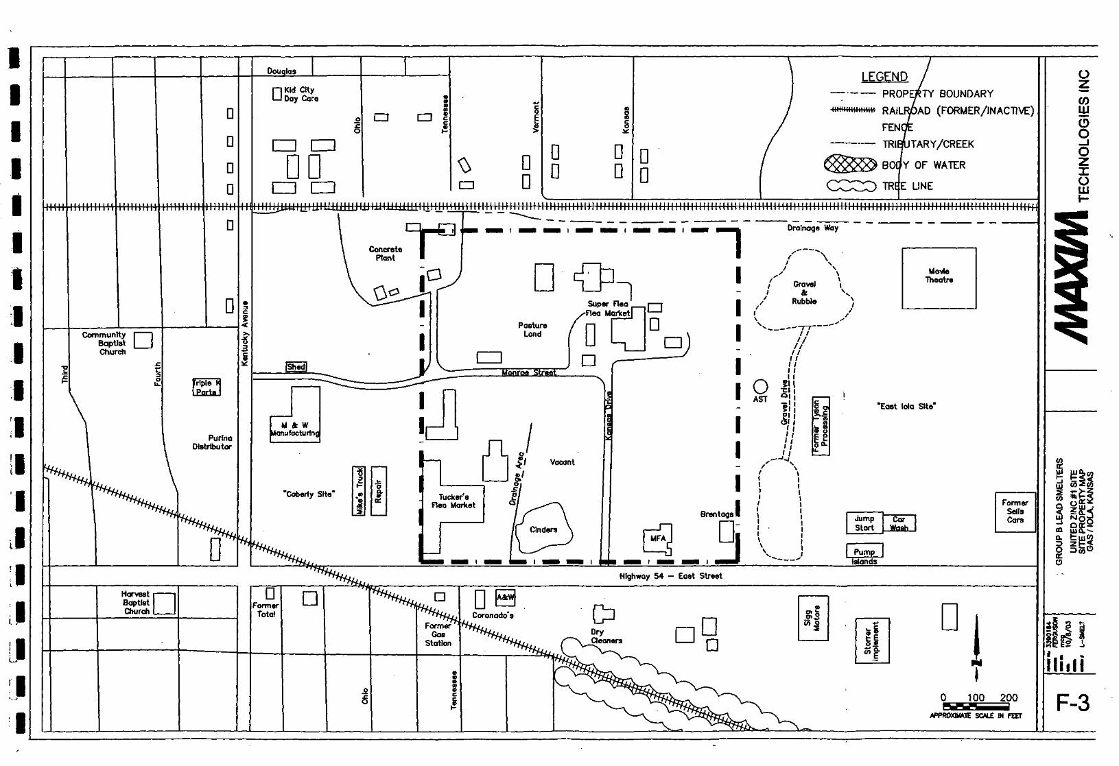
the SE l/4 SW l/4 of Section 25, Township 24 South, Range 18 East (Figure 1). The approximatelongitude and latitude of the center of the property is Latitude North 37.922800 and LongitudeWest 95.385900. The UZ1 site is located on both the northwest and northeast comer of theintersection of Kansas Drive and East Street and is comprised of approximately 17 acres, andincludes ten separate parcels of land, each owned by separate owners, private and commercial.All onsite smelter facilities including the furnaces and processing facilities, building foundations,and all rail lines have been removed. The property has been graded, leveled, and developedsince former smelter operations ceased in the 1920s.
The subject property is located within a commercial area on the east side of lola and iscomprised of a vacant piece of property, Brentagg Southwest, Inc. (Chemical Distributioncompany), an MFA Distributor, the Superflea Flea Market (with associated sheds and storagebuildings), Tucker's Flea Market (with associated sheds and storage buildings), a portion of asmall concrete plant, and a section of pastureland containing a few abandoned structures. Adrainage ditch flowing east to west separates the site from residential properties, located directlyto the north. An inactive rail line is also located directly to the south of this drainage ditch andruns east to west. All rail lines and spurs have been removed and there is no existing evidenceon site.
According to the Allen County Appraiser, the following areas of the UZ1 Site are zoned asfollows: heavy industrial - north of Monroe Street, light industrial near the intersection ofMonroe Street and Kansas Drive to the east and west, and general business west of KansasDrive. Several entrances are located on the Site. The Site can be accessed from Monroe Streetand Kansas Drive. .Each individual parcel also has a private and/or public driveway associatedwith each. A fence surrounds a portion of the Site, north of Monroe Street, used as pastureland.Access is extremely limited to the public in this area. In the remaining portions of the site publicaccess is unlimited.
2.2 Adjoining Properties
The East lola and the Coberly Sites are adjacent the Site to the east and the west, respectively.The East lola Site is the former location of the Prime Western Smelting Company Works #3 andthe J.B. Kirk Gas and Smelting Company. The Coberly Site is the former location of the UnitedIron Works Company, depicted on Figure 6 (1906 lola Plat Map). The Coberly Site comprisesapproximately 6.1 acres on the northeast corner of Kentucky Street and East Street (Hwy 54) andincludes three separate parcels of land. The East lola Site is comprised of approximately 21acres and includes five separate parcels of land. Each is currently owned by private and/orpublic parties not associated with former smelter activity.
All smelter facilities including the furnaces and processing facilities, building foundations, andall rail systems have also been removed at these sites and both sites have been graded, leveled, •and developed since former smelter operations ceased. Previous investigations by KDHE havebeen conducted on the Coberly Site and the East lola Site and will be discussed briefly in thefollowing sections.
I
IIIIIIIIIIIIII
3.0 Physical Setting
The 1965 (Photorevised 1984) United States Geological Survey (USGS) 7.5 Minute TopographicMap of the lola, Kansas, Quadrangle (Photo revised 1984) indicates the Group B Smelters -UZ1site is located on a generally flat area that slopes slightly to the southeast toward Rock Creek, atributary of Elm Creek (Figure 1). The elevation of the ground surface of the property isapproximately 960 feet above mean sea level. Surface drainage from the site is directed to adrainage ditch located north of the site that then drains into a ditch that flows to the southeasttowards Rock Creek and eventually drain into the Neosho River from these entry points. Thesite is located approximately 2.5 miles from the Neosho River. There are no surface waterbodies including ponds or lakes located onsite. According to the EDR report, the site is notlisted within a flood plain.
According to a preliminary investigation report produced by KDHE at the East lola Site inFebruary 1994, Allen County is underlain by sedimentary rocks from the Paleozoic andCenozoic Eras. These rocks are largely comprised largely of interbedded limestone and shaleunits with rare interformational sandstones. These units are relatively impermeable in thesubsurface, however generally weather at or near the surface. The surface weathering cangreatly increase the water bearing capacity. Shallow weathered rocks of this age form importantlow-yielding aquifers throughout Allen County. An unconfined groundwater system is presentin the shallow bedrock as indicated by flooded limestone quarries in the site vicinity.
According to the same report, the area is estimated to be underlain by five to twenty feet ofunconsolidated material composed of silty clay and fine-grained colluvium and residuum. Theunconsolidated materials in the vicinity of the Site do not yield appreciable amounts of potablegroundwater. A seasonal perched water zone is present during wet periods of the year.According to information obtained from the Kansas Geological Survey water well database forAllen County, the depth to groundwater in area wells ranges from approximately 25 to 40 feetbelow ground surface. A drainage way, which was dry at the time of this assessment, is locatedimmediately north of the Site. Another drainage way, which was also dry at the time of thisassessment, was located near the south central portion of the property. According to topographicmaps and visual observation, the anticipated groundwater flow is directed to the south-southeasttowards Rock Creek.
4.0 Historical Records
Sanborn maps, aerial photographs, historical documents, including newspaper articles and others,and interviews with persons familiar were utilized in an effort to delineate the location of smelteroperations in the location of the UZl Site. Newspaper articles chronicled in the City of lolalibrary were also reviewed to determine any operational histories of the smelter sites or anyadjacent operations. The only aerial photograph available in the city of lola and in Allen Countywas from 1986 (Figure 7). A 1992 aerial photograph was also obtained from the MicrosoftTerraserver website (Figure 8).
MAXIM

I4.1 Allen County Plat Maps
A 1906 Allen County Plat Map for the city of lola, Kansas was obtained from the Allen CountyHistorical Society in lola, Kansas (Figure 6). This plat map presented property boundaries,owner names, large businesses and structures, and any underground utilities. The UZ1 Site ispictured east of the town and is occupied by the United Zinc and Chemical Company lead andzinc smelter. There appears to be several buildings pictured associated with lead smeltingoperations and several railroad spurs connecting the Site to the main railroad line. PrimeWestern Smelting Company is also pictured to the east of this property with several buildingspictured. Several buildings are also pictured to the west of the UZ1 Site on the Coberly Sitepictured as the United Iron Works Company. A 1906 Allen County Plat map encompassing thecities of lola, Gas, and LaHarpe was also obtained from the Allen County Historical Society(Figure 4). This plat map presented property boundary lines-as well as property owners. Thisplat map does not indicate who the owner of the property is and does not mention the UnitedZinc and Chemical Company, however a few structures are identified. Prime Western SmeltingCompany is pictured to the east with associated buildings. The United Iron Works Company isalso pictured but does not indicate an owner name.
A 1921 Allen County Plat Map for the cities of Gas, lola, and LaHarpe was also obtained fromthe city of lola Public Library (Figure 5). This plat map indicated ownership by the United Zincand Chemical Company but did not indicate any buildings or structures on site. J.B. Kirk GasCompany is identified to the east and United Iron Works Company is identified to the west.Historical plat maps from additional years were not available in the city of lola or in AllenCounty. Current plat maps were not available in the city of lola or Allen County. Parcelboundaries are indicated on the 1986 aerial photograph and a list of property owners for eachparcel is included as an additional table (Appendix B).
4.2 Ownership Records
As indicated on the 1906 Allen County Plat Map, the 1921 Plat Map, Register of Deeds records,and other historical records, the property was owned by the United Zinc and Chemical Companyfrom approximately 1902 to 1925. William Lanyon, co-owner of Lanyon Zinc Company, alsoowned the property from 1901 to 1902. A detailed chain-of title search was performed by StreetAbstract Company, Inc. in lola, Kansas and is described below in the following section. A tabledetailing the chain of title information for the Site is also attached as Table 1, Appendix B.
4.3 Chain of Title Records
Street Abstract Company, Inc., located in lola, Kansas prepared a detailed and complete chain oftitle search for the parcels comprising the UZ1 Site (Table 2, Appendix C). There are tenindividual parcels that comprise the UZ1 site. Each property was researched and a certificate oftitle was prepared. According to the records, the United Zinc and Chemical Company owned theland as early as 1902 and continued to occupy the land until 1925, when it was transferred toprivate ownership. William Lanyon, a co-owner of the Lanyon Zinc Company, owned the landfrom 1901 till 1902. It is unclear whether or not he operated a lead smelter on this propertyduring that period of time. William Lanyon transferred the parcels of property to the United
MAXIM

I
IIIIIIIII
Zinc and Chemical Company in 1902. United Zinc and Chemical Company owned and operateda lead smelter until 1912. It is unknown as to how the land was utilized after this period anduntil the end of its ownership.
4.4 City Directories• • • **•— "L-1"— i
City directories include listings of residences, businesses and professional concerns organizedalphabetically by name and alphanumerically by street name then specifically by street address.City directories used in this study were made available through the lola Public Library.
A review of the various City of lola, including Gas and LaHarpe City Directories from 1901 to1936 (approximate years of smelter operation in these cities) was conducted to evaluate landusage for the site pertaining to any lead smelting activities. The only available city directorieswere from the years 1901-1902, 1908, 1921-1922, 1923-1924, 1928, and 1936. Due to thelocation of each historical smelter, mainly on the outside of the city limits, city directory listingsdid not give the address listings but instead gave directions from city limits. No addresses weregiven for each facility. The listings and associated locations for the United Zinc and ChemicalCompany were as follows:
• 1901George E. Nicholson Spelter - east bey limits (location of East lola Site)United Zinc and Chemical Company - not listedUnited Iron Works Company - not listed
• 1908United Zinc and Chemical Company - V* e of city limits, city directory did not give anaddress for this site, only an approximate locationUnited Iron Works Company - ne corner of Kentucky (location of Coberly Site)Prime Western Spelter Company Works #3— '/» e of city limits (location of East lola Site)
• 1921-1924United Zinc and Chemical Company - not listedHalted Iron Works - no address listed (location of Coberly Site)JB Kirk Gas and Smelting Company - 4-8 Northrup Bldg (location of East lola Site)
• 1936JB Kirk Gas and Smelting Company - 4-8 Northrup Bldg (location of East lola Site)
4.5 Sanborn Fire Insurance Maps
In the late nineteenth century, the Sanbom Company began preparing maps for use by fireinsurance companies. These maps indicate construction materials for specific structures and thepresence of flammable materials. These maps were updated and expanded geographically atvarious periods during the twentieth century, Sanborn Maps are typically published for centralbusiness districts and were not discovered for the subject site. Maxim performed research forSanborn Maps at the Allen County Historical Society, Kansas Historical Society, lola Public

I
I
I
I
I
I
i
I
Library, and Kansas City, Kansas Public Library. The United Zinc and Chemical Company isidentified on Sanbom Maps from the years 1901, 1905, and 1912 and is described below.Sanbom Maps from each year are included as Appendix A.
• 1901It appears that the site was originally occupied by the Standard Acid Company. No otherhistorical resources reviewed indicated the presence or existence of this company on theSite. There appears to be a furnace building housing three furnaces and 12 retorts,located on the most western side of the property. A pottery and clay building is picturedto the east of the furnace building. A railroad line or spur dissects the property in thecenter and separates the furnace and pottery buildings from the rest of the facility. Achamber building, tower building, and machinery kiln are located to the east of therailroad line and extends over the entire property north and south. A nitrate acid buildingis also pictured on the east side, west of the chamber building. Several small structuresincluding an office, store rooms, and miscellaneous buildings are located throughout theproperty.
• 1905The property is occupied by the United Zinc and Chemical Company. The Standard AcidCompany buildings appear to be utilized with some additional structures. There appearsto be two furnace buildings housing four furnaces. The pottery room is still utilized assuch with additional small buildings surrounding which appear to be utilized as orecrushing houses and kilns. A second pottery building is located to the north of thisstructure. A sulfuric acid storage building is located in the center of the railroad spurdissecting the property. Several store rooms and ore houses are pictured directly east ofthe railroad. The chamber building is pictured on the east side of the property andappears to contain acid chambers. The tower building and machinery kiln buildings arepictured with several additional small buildings utilized as ore houses. An additionalbuilding located south of the machinery kiln appears to have been utilized as an ore houseand crushing house. Several other miscellaneous storage buildings and an office arelocated throughout the property.
• 1912The United Zinc and Chemical Company no longer occupies the property. What appearsto have been the former pottery rooms and associated buildings are the only structuresshown on the Sanborn Map. The railroad system and spurs are pictured to the east of thebuildings. The property and buildings are marked as "Formerly United Zinc andChemical Co.". The office also still remains on the south side of the property.
4.6 Aerial Photography
The 1986 aerial photograph (Figure 7) shows the property usage as follows:
• The south portion of the site is occupied by several commercial structures. Thesoutheast comer is occupied by two companies including a grain and fertilizer distributorand a chemical distributor, with associated buildings and supplies. The central portion is
MAXIM

I
I' l
IIIIIIIi
occupied by a commercial structure and a couple of associated structures.' The west sideis occupied by a flea market and associated storage sheds and buildings. Monroe Streetseparates the south side from the north side of the property.
• The northern half of the property appears also to be occupied by commercial structuresand some vacant land. The northeast corner is occupied by a flea market and associated'buildings. The center of the property is occupied by an open field that appears to be usedas pastureland with a few abandoned buildings used as hay and equipment storage. Anunknown shed is located on the southwest comer. The furthest west portion of thisproperty is an extension of a small concrete plant on the west adjacent property.
Property boundaries and land utilization as pictured on the 1986 aerial photograph are alsopictured on the 1992 aerial photograph (Figure 8).
5.0 Regional History
The discovery of numerous gas fields in and around Tola spurred the expansion of the zinc andlead smelting business to expand from Pittsburg, Kansas where it was started in the Midwest andutilized coal as a fuel source, to lola, Gas, and LaHarpe, Kansas. Natural gas as a fuel forsmelting operations was not introduced to the lola area until approximately 1899 to 1900.Cherokee Zinc Company, Prime Western Smelting Company, Lanyon Zinc Company, A. B.Cockerill Zinc Smelter, George E. Nicholson Zinc Smelter, J.B. Kirk Gas and SmeltingCompany, and United Zinc and Chemical Company all constructed plants in and around lola,Kansas by the early 1900s and through the 1930s. Often the individual smelters were bought andsold by different operators. Smelting operations ceased or slowed in this area after the storesand supply of natural gas became less abundant and less cost effective. The first smelter wasconstructed and started in approximately 1896 and the last known existence of operations in thistri city area was around 1924. Actual records of the smelter operations and waste handlingpractices were not available at the time of this assessment. Any available information regardingplant buildings and foundations was taken from Sanborn Maps, ownership records, register ofdeeds records, city directories, historical plat maps, historical articles, and interviews with thosepersons familiar with the site.
5.1 United Zinc #1 Site Operational History
According to plat maps from 1901 this property was the location of the Standard Acid Company.It is unknown what operations were conducted at this company. Other historical resourcesincluding chain of title, city directories, plat maps, and register of deeds information did notindicate any presence of this company on this site. According to the 1901 Sanborn Map, theStandard Acid Company consisted of three furnaces (in one building) with 12 retorts. A potteryroom with associate kilns is also pictured. A chamber building, possibly housing acid chambers,and a machinery kiln are also pictured. A railroad spur dissects the property in the center.
According to plat maps from 1906, the United Zinc and Chemical Company owned and operateda plant in the location of the UZ1 site, located north of Hwy 54 and east of Kentucky Street.Historical Sanbom index records indicate that the company occupied and operated at this site as
MAXIM

Iearly at 1906 and as late as 1912. However, the property was owned by the company as late as1925. It appeared that United Zinc and Chemical Company operated approximately fourfurnaces with approximately eight kilns, 14 retorts, and used several buildings located to the eastfor crushing and roasting processes. An acid chamber building is pictured with six chambers anda machinery kiln building. A railroad spur is indicated on the center of the property separatingthe furnaces from the acid towers. Actual records of the smelter operations and waste handling'practices were not available at the time of this assessment. According to chain of title records,William Lanyon, a co-owner of the Lanyon Zinc Company, owned this parcel of land from 1901till 1902. It is unclear whether or not he operated a lead smelter on this property during thatperiod of time. William Lanyon transferred the parcels of property to the United Zinc andChemical Company in 1902. Smelting operations by additional companies, including LanyonZinc Company, were not identified on this property during the time of this assessment.
5.2 East loia Site Property Operational History
According to historical records including, plat maps, register of deeds records, newspaperarticles, and Sanborn Maps and a preliminary assessment report by KDHE, in!899 George E.Nicholson built and operated a zinc smelter plant in the location of the East lola site, locatednorth of Hwy 54 and west of Hwy 169. According to Sanbom Maps, this plant appeared to havetwo furnaces with 20 retorts, five kilns, and two associated buildings south of the furnaces thatincluded pottery and roasting buildings. Several railroad spurs connected the buildings with thefurnaces. A later Sanborn Map depicts the Nicholson smelter similar to the later illustration ofthe Prime Western smelting operations. Around 1902, the smelter was purchased from PrimeWestern Smelting Company and the Works #3 plant was constructed. According to SanbomMaps this plant appeared to operate five furnaces with 20 retorts, ten kilns, and also includedseveral buildings used in the roasting and crushing process. These buildings were located southof the furnaces and were connected by railroad spurs to and from the furnaces. This plantconstruction did not appear very different from the previous operation. The Prime WesternSpelling Company owned and operated the smelter until approximately the early 1920's whenthe smelter was then bought by J. B. Kirk Gas and Smelting Company. J.B. Kirk owned andoperated a smelter in this location until approximately 1925. According to Sanborn Maps, thisplant appeared to have three furnaces with ten retorts, four kilns, and a pottery and ore crushingand storage building. Several other associated buildings are pictured throughout the property.Since the smelting operations ceased, the East lola Site has been developed and operated byseveral commercial or retail businesses. These businesses do not apparently have an associationwith former smelter operations.
5.3 Coberly Site Property Operational History
According to Sanborn Maps available and a preliminary assessment report by KDHE, the lolaBrick Company #1 plant operated at the Site as early at 1901 and discontinued as late as 1906.Four natural gas fueled kilns were located south of a dry shed. In 1906, United Iron Works, Inc.,operated a steel foundry and iron works facility. The dry shed appeared to have been convertedinto a machine shop and the four kilns were removed. According to a 1912 Sanbom Map, theplant consisted of a foundry building, a boiler shop, a machine shop, and associated storage areasand offices. According to the 1924 Sanborn Map, additional buildings consisting of storage
MAXIM

I
IIIIIIilIIIIIIIII
areas and bath houses were constructed and the boiler shop was expanded. According to citydirectories and other historical resources, the United Iron Works operated at the location as lateas 1924. The Site was not used for commercial purposes until approximately 1986 when M&DEnterprises, Inc., a gasket manufacturing company, operated at the site. In 1990, The CoberlyRecycling Company, operated a collecting center for recyclable materials, including aluminumcans. In 1990 the Empire Bank of lola took over the property. Michael Truck Repair iscurrently operating at the site.
6.0 Interviews
Michael Anderson, Allen County Historical Society, lola, KansasMr. Anderson was interviewed on June 20 and July 16, 2003. A map of the area was presentedto him. He was aware of a zinc smelter in that area but was unclear on the exact location ofsmelter operations and the name of that operation.
Dave Sherrill, former owner of the north adjacent property, lola, KansasOn July 15, 2003, Mr. Sherrill was interviewed by Maxim personnel. Mr. Sherrill stated that hehad just sold the land to a separate party but did mention the former uses of the property inquestion. He stated that the north adjacent property had been used as a processing plant and thathe had worked there from 1955 to 1988 when the property was sold. He also stated that he hadbeen told at one time the property had been occupied by a glass factory and to his knowledge hadnot been part of the property used for smelting operations. He was aware of the property justsouth of his property being used for smelting operations but did not know the specifics.
Lawrence Macha, owner of a portion of the East lola SiteInterview and discussion detailed in Section 8.0, Previous Investigations and Corrective Action
Dawn M. Mueller, owner of a portion of the UZ1 SiteOn July 14, 2003, Ms. Dawn Mueller was interviewed by Maxim personnel. Ms. Mueller statedthat she did not know of any former smelter companies that had operated on the property. Shedid not know of any waste that had been identified on the property.
7.0 Environmental Records (EDR) Search
A review of databases and files from federal, state, and local environmental regulatory agencieswas conducted to identify use, generation, storage, treatment, or disposal of hazardous materialsand chemicals, or release incidents of such materials, which may impact the site. EnvironmentalDatabase Resources, Inc. (EDR) provided the federal and state environmental databaseinformation. EDR minimum search distances for each database are consistent with thosepresented in ASTM standard El527. A complete copy of the regulatory review is included inAppendix E. A specific description of each database researched is also provided in the EDRsummary. A summary of federal and state databases researched is included in the followingtable.

IFederal ASTM Standard Records Researched
Iiiiiiiiiiiiii
Record
National Priority List (NPL)Comprehensive Environmental Response,Compensation, and Liability Information System(CERCLIS)CERCLIS-NFRAP (No Further Remedial ActionProposed)Corrective Action Report (CORRACTS)Resource Conservation and Recovery informationSystem (RCRJS) (TSD)RCRIS - Large Quantity GeneratorRCRJS - Small Quantity GeneratorEmergency Response Notification System (ERNS)Delisted NPLMines Master Index File (MINES)Superfund Consent Decrees (CONSENT)Records of Decision (ROD)
ASTM radiussearch (miles)
1.0
0.5
Property andadjoining properties
1.0
0.5
0.50.5
Site property— .
———
Actual radiussearch
1.5
1.0
0.75
1.51.0
0.750.750.51.01.01.01.0
— ASTM does not list a standard search distance
State ASTM Standard Records SearchedRecord
State Hazardous Waste (SHWS)Directory of Sanitary Landfills, Solid Waste TransferStations and Collectors in Kansas (SWF/LF)Leaking Underground Storage Tanks (LUST)Underground Storage Tanks (UST)
Underground Storage Tanks' on Indian Land (INDIAN)
Aboveground Storage Tanks (AST)Leaking Aboveground Storage Tanks (LAST)Kansas Spills Database (SPILLS)Areas of Concern (AOCONCERN)
ASTM SearchRadius
1.0
0.5
0.5Site and adjoining
propertiesSite and adjoining
properties0.50.5
——
Actual SearchRadius
1.5
1.0
1.0
0.75
0.75
1.01.01.01.0
— ASTM does not list a standard search distance
Other Databases Searched
Record
Oil/Gas Pipelines/Electrical Transmission LinesSensitive ReceptorsFlood Zone Data .National Wetlands Inventory (NWI)
ASTM SearchRadius
—r
——
Actual SearchRadius
1.01.01.01.0
— ASTM does not list a standard search distance
A summary of EDR report results is as follows:
Adjacent Sites• Jump Start Travel Center, located approximately 800 feet to the east of the Site, was
reported on the Underground Storage Tank (UST) database. Four USTs, three gasolineand one diesel, are currently in use at the facility.
10

I
I
I
I
I
I
I
I
I
I
I
Ii
• Coberly Recycling (location of Mike's Truck Repair), formerly located at 1304 EastStreet and approximately 1000 feet west of the Site, was listed on the federal CERCLISand SHWS databases. Site status is listed as "No Further Remedial Action Planned".The SHWS database lists the existence of smelter waste piles on this site with possiblesoil contamination and the potential for groundwater contamination. According to a'KDHE Identified Sites List, 20 cubic yards of contaminated soil was removed from thesite in 1990, encapsulated in cement, and taken to the Allen County Landfill with KDHEapproval. A responsible party has not been identified since the soil removal in 1990.This site is still listed as an active site on the KDHE Orphan Sites database.
• The East lola Site was listed as a State Hazardous Waste Site (SHWS) as part of theVoluntary Cleanup Program (VCP). According to a KDHE Identified Sites List, areas ofhigh lead concentration have been excavated and consolidated in one corner of theproperty. A plan to cap the contaminated soils is currently being implemented.
Within Search Distance• Storrer Implement, located at 1801 East Street and approximately 800 feet to the east of
the Site, was reported on the RCRIS, Small Quantity Generator (SQG) database,violation is reported with a compliance date listed.
One
• Hiser Implement (location of Lucky Stop Gasoline Service Station), located at 1810 EastStreet and approximately 800 feet east of the Site, is reported on the RCRIS, SHWS,LUST, and UST database. Three violations with subsequent dates of compliance arelisted on the RCRIS database. Metals were indicated in the soil and this site is part of anongoing investigation as part of the VCP. A "Closed" status has been reported on theLUST database. The Lucky Stop L. L. C is listed on the UST database with three USTs,two gasoline and one diesel, currently in use. According to a KDHE Identified SitesList, this site is part of the VCP Program. A concrete and asphalt cap has been installedon the property to address the contamination and this property is in the final stages ofcompleting the cleanup.
• L&S Motors (location of Sigg Motors), located at 1305 East Street and approximately1000 feet west-southwest of the Site, is listed on the UST database. Three tankscontaining gasoline are currently listed as permanently out of use.
• A former gasoline station referred to as U-DO Self Service and Vista Stores #2023,located approximately 1000 feet west of the Site and at former address 1201 East Street,was listed on the LUST and UST databases. U-DO Self Service was listed on the LUSTdatabase with a "Closed" status. Vista Stores was listed on the UST database with threeUSTs listed as "Temporarily Out of Use".
• Convenient Mart, located at 1107 East Street and approximately V* to Vi mile west of theSite, is listed on the LUST and UST databases. The LUST database listed the site as an"Active" site indicating that contamination levels exist exceeding state cleanupguidelines. The UST database lists three USTs as "permanently out of use".
n

I
• Allen County Hospital, located approximately 1 mile west of the Site, is listed on theLUST, UST and RCRIS databases. The UST database listed one 2000-gallon UST as"permanently out of use" and 2000-gallon UST as "current in use". The LUST databaselisted this site with a "Closed" status. The RCRIS database listed the site with noviolations reported.
• Casey's General Store and Casey's General Store #1794, located approximately one milewest of the Site, was listed on the LUST and UST databases. According to the LUSTdatabase, the site is listed with a "Closed" status. The UST database lists two 10,000-gallon USTs "current in use".
• Johnson Property and Southwestern Bell, both located within one mile from the Site,were listed on the LUST database. Each site is listed with a status of "Closed".
A list of Orphan Sites was also summarized on the EDR Report. EDR defines Orphan sites asthose that have unmappable addresses or locations (i.e. no address, bad zip code, etc.) or do nothave a latitude or longitude assigned to it. The sites with corresponding databases are as listed.
Site NameEast lola Smelter Site
lola Concrete Products,Inc.
Carmel Energy, Inc.
Sohigro Svc CoCoberly Recycling
Sinclair Pipe Line Co.Mike's Body Shop
Emprise Bank/CoberlyRecycling
Site AddressEast and Kentucky
Streets
— *-fc—
3 MN 1 MW on Hwy169
E Hwy 54E Hwy 54S Hwy 169
2.5 MS on Hwy 169E US Hwy 54
Location to SiteAdjacent
Adjacent
Within 1 mile
Within 1 mileAdjacent
Within 1 mileAdjacentAdjacent
DatabaseCERC-NFRAP
UST
RCRIS-SQG, FINDS
RCRIS-SQG, FINDSUST (Closed)
USTRCRIS-SQG, FINDS
LUST
Those orphan sites listed on the EDR report outside of a one mile radius were omitted from this table.
According to the KDHE, Storage Tank Section, lola Concrete Products is a non-active site. A500 gallon UST was installed in 1970. According to records the UST is listed as "temporary outof service". Emprise Bank/Coberly Recycling is also listed on the LUST database and accordingto the KDHE one tank of an unknown quantity has been removed. During a cleanup of this site a500 gallon UST was discovered and removed. A follow up site assessment was conducted and areport turned in. Emprise Bank (owner) then was taken out of the KDHE Storage Tank TrustFund and according to the Storage Tank Section, this site is no longer active with regards toUSTs.
12
MAXZM- •• i » « i N r

8.0 Previous Investigations and Corrective Action
No previous investigationgjiay* h^" ™"dacted for the UZ1 property; however, the East lola,Hiser Implement, and Coberly Sites have been subject to previous KDHE investigations. Apreliminary investigation was conducted on the East lola Site in February 1 994. During the site _reconnaissance, the site appeared to have been leveled and graded. Thejurface soil appeared to •haye_beejLmixed with^smelterjwastes consistin£o£sl.a^, broken cla^tjks[&PJDiJI^6£ts^_and some
stes^ This present waste area appeared to cover approximatelyjwo,acres. The depth of these waste piles at this site was unknown. The area was not fenced andcould be accessed by the general public.
During this investigation several surface soil samples were collected. Surface soil analyticalresults indicate that total lead concentrations exceeded the KDHE residential risk value of 400mg/kg in a large percentage of the samples. Each of these samples was taken from an area thatappeared to be a waste/slag soil pile. A surface soil sample collected from an offsite area to thenortheast indicated some lead impact also exceeding the 400 mg/kg residential risk value forlead.
i
I
East lola SiteA second site investigation of the East lola Site was conducted in June 1998. Several soilsamples were collected and XRF results were collected. According to the XRF results, surfacesoil at several locations is impacted with high concentrations of lead, exceeding the residentialrisk value. This site is being addressed under the KDHE Voluntary Cleanup and PropertyRedevelopment Program. According to a KDHE Identified Sites List, areas of high leadconcentrations haye l3ejeruexGavated..aadLcQnsolidated in one corner of^ the property.^A plan tocap~~tnTcontaminated soil is currently being implemented.
An interview from Lawrence Macha concluded the following:
Lawrence Macha, owner of a portion of the East lola Site property, lola, KansasIn April 2003, Mr. Macha was interviewed by Maxim personnel. Mr. Macha was hesitant togive access to the site because of the previous work that had been done on his site by the KDHE.Mr. Macha had been told by KDHE. in 1994 about the levels of contamination that had beenfound on his property and that if he was to sell or develop his 'property he was to notify theKDHE. Mr. Macha stated that the property immediately adjacent to his, now occupied by theLucky Stop gasoline station has been developed, to his knowledge had not notified the KDHEand was not taking the necessary precautions to minimize lead contamination migration toadjacent properties.
The Hiser ImplementThe Hiser Implement property, located adjacent to the East lola Site, is also currently beingaddressed under the VCP program. According to a KDHE Identified Sites List, a concrete andasphalt cap has been installed and the property is in the final stages of completing the cleanup.
13
MAXIM

IIIIIIIIIIII
I'-
II"
IIIIII
Coberly SiteA few site investigations were also conducted on the Coberly Site, located adjacent to the UZ1site to the west. An underground storage tank (UST) was removed from the former CoberlyRecycling facility in February 1992. A soil sample collected from the excavated soil indicatedlead concentrations at 47,000 milligram per killigram (mg/kg) of total lead, exceeding the KDHEresidential risk values of 400 mg/kg. The soil was stabilized and taken to 'an approved landfillfor disposal. During 1998, Kingston Environmental conducted an additional site investigation.Former slag piles were indicated on a north section of the property. Several soil samples werecollected onsite and in the area of these former slag piles using an XRF. Total leadconcentrations exceeded 400 mg/kg in a large percentage of the surface soil samples. Slagmaterial located on the eastern property boundary of UZ1 site contained lead at 27,167 mg/kg.According to a KDHE Identified Sites List, 20 cubic yards of contaminated soil was removedfrom the site in 1990, encapsulated in cement, and taken to the Allen County Landfill withKDHE approval. A responsible party has not been identified since the soil removal in 1990.
9.Q Site Reconnaissance
An attempt to contact current owners by telephone was conducted before the site visit of UZ1.Six of the owners were unavailable at the time of this site reconnaissance. The owner of thegrain/fertilizer distributor, located on the east side, refused access for a visual survey.Permission to perform a visual survey was obtained from one private owner for the center of theproperty. Maxim personnel conducted a site visit on June 30, 2003. Photographs documentingthe site conditions during the reconnaissance are presented in Appendix F, A map detailing theSite property is included as Figure 3.
A vacant portion of the former smelter property located near the center was visually observed.All building foundations had been removed after smelter operations ceased in the 1920's.Distinctive waste, piles, slag piles, buildings,etc. from former smelter operations were notvisible. A_jortion^ofJheIsite ia=the,5puthwest.cp.nier. di.d^conl^rwhat appealed".to,E^e.bje"ferL_a__waste pile but had_been jgraded and leveled. This portion of the site had been occupiedhistorically by a business with a gravel lot used for parking. The gravel lot is the only featureleft. Additional waste was observed mixed in with the soil and spread throughout the site. Itappeared that some, of the waste was also mixed in with roadbedjnaterial as part of the_adjacentroads, Monroe Street and Kansas Drive. The smelter waste appears to be concentrated in thesouthwest comer,~where cinders are at the surface and vegetation is distressed. The remainingportions of the vacant site were heavily vegetated with no visible areas of stress. No additionalindications of impact including staining, stressed vegetation, or waste non-smelter related wereobserved during this site reconnaissance.
A newspaper article in December 1907 documented that the city had been using cinders as a roadbase but had discontinued use due to the acid in the cinders corroding the gas and water pipes. Anewspaper article from March 1916 also documented that the smelters were beginning to selltheir waste and cinders to railroad companies that were using them as roadbed materials for theirrailroads.
14
MAXIM

IIIIIIIIIIIIIIIIIII
A small concrete foundation was observed on the northwest portion of this parcel but did notappear to have been part of the former operations. A small building is visible in this location onthe 1986 aerial photograph. A small drainage area was located west of this piece of propertybetween the flea market to the west and the property. The perimeter of the site was not fencedand access from the general public was unlimited.
The topography of the immediate site location and surrounding properties is relatively flat with agentle slope to the south and southeast. A drainage way was observed near the center of theproperty extending from the south border to the center of the property near Monroe Street. Atthe time of the site reconnaissance the drainage way was dry. Immediately north of the property,a creek or drainage way was also observed. This also appeared to be dry or contained randomareas of water.
A small pond or area of ponded water was observed on the adjacent property, north of the MFAdistributor. However, during the site reconnaissance it appeared to be dry. A large aboveground storage tank was located on the bank of this ponded area of water. The primary use ofthis aboveground storage tank is unknown. Several portable tanks of fertilizer and bags offertilizer were also observed on the MFA distributor property during the site reconnaissance.
The property occupied by a flea market on the west side was observed from public vantagepoints. There appeared to be no visual evidence of lead smelter waste. However, in the rear ofthe property there appeared to be waste mixed in with the parking lot material and the road bedmaterial. The front of the property was occupied by an asphalt parking lot and a large retailbuilding.
The property owner of the area occupied by the grain and fertilizer distributor denied Maximaccess. It appeared, from public vantage points,- that this area did not contain smelter waste andwas covered with grass and some concrete debris. The owner of the adjacent property to the eastcould not be reached after several attempts to gain access. As observed from public vantagepoints, it also appeared to not contain smelter waste and was covered with gravel and grass.These areas were also not fenced and were generally accessible to the general public.
The center portion of this area was being utilized as a pastureland with a couple of abandonedbuildings used as hay and equipment storage. During this site investigation, the area was beingused at patureland and was occupied by cattle. This area was not walked due to the cattle in thearea. The east portion of this property is currently utilized as a flea market with severalassociated storage buildings and discarded items. The owners of the properties north of MonroeStreet (Super Flea Flea Market) could not be contacted during this site assessment and did notrespond to request to enter property. The northeast portion of the Super Flea site is vacant and isbounded by Monroe Street to the east. An inactive railroad bed was observed north of the Sitethat extended from the adjacent properties to the east and continued to the west.
10.0 Receptor Survey
A receptor survey was conducted to identify potential receptors of any identified contamination.The following potential receptors were investigated during the site reconnaissance. The findings
15
MAXIM

IIIIIIiiiii
'm
I
I
I
i.iii
of the survey are listed below. Potential receptors were verified during the site reconnaissanceand by using the EDR report Detail Map and page GR-7. Figure 2 illustrates surrounding landuse and receptor survey findings.
Onsite• No residential areas were indicated on the site property
• No residential or possible receptors were identified on the site property
• Surface Water - A drainage area was located on the site property near the center startingat the south boundary and extending north to Monroe Street near the center of theproperty. At the time of the assessment the drainage way was dry. No ponds, lakes, orrivers were identified on the site property.
• Water Wells - No domestic or public water wells were indicated on the site property.
• Sensitive Environments - EDR provided a NEPA Check for federal and state informationon sensitive environments. According to EDR, no aquatic or wetland ecosystems,critical habitats, officially designated wilderness areas, wildlife preserves, or threatenedor endangered species were identified on the site property. The site and the surroundingareas were not listed within a flood plain.
Adjacent Property• Residential areas were indicated on adjoining properties within a % mile radius.
Predominantly residential areas were observed to the north,, northeast, northwest, west,and southwest of the site and include approximately 80 homes. Five of these homes arelocated immediately adjacent to the site on its north boundary. Information for the fivehomes is as follows:
305 Kansas DriveOwner: First Title Service, Edmond, OklahomaNo children identified
304 Kansas DriveOwner: Donald and Susan DieboldtNo children identified
307 North Vermont StreetOwner and resident:Children:
303 N. Tennessee StreetOwner and resident:No children identified
Danny Dee - Renee Sams2 boys
Robert W. and Janet C. Wilson
16
MAXIM

I
3I
I
I
I
I
Ii
I
I
I
I
fl
I
I
304 N. VermontOwner and resident:Children:
Norma YanceyNo
• No schools, churches, day cares, nursing homes, parks or public recreation areas, orpedestrian routes were identified on adjoining properties
• Surface Water Bodies - A drainage way was located directly north of the site property.During the time of the site reconnaissance, it appeared to contain very minimal water. Asmall pond was located directly east of the property. During the site reconnaissance thepond appeared to be dry. No ponds, lakes, or rivers were identified adjacent to the siteproperty.
• Water Wells - According to the KGS Water Well Database, one monitoring well, locatedon the southwest adjoining property, was identified. No public water supply wells ordomestic water wells were indicated adjacent to the site during the site reconnaissance.
• Sensitive Environments - EDR provided a NEPA Check for federal and state informationon sensitive environments. According to EDR, no aquatic or wetland ecosystems orcritical habitats were observed adjacent to the site. No officially designated wildernessareas, wildlife preserves, or threatened or endangered species were indicated adjacent tothe site. The site and the surrounding areas were not listed within a flood plain.
Within '/2 Mile• Residential areas were indicated on adjoining properties within a Yi mile radius.
Predominantly residential areas were observed to the north, northeast, northwest, west,and southwest of the site and include approximately 80 homes. Five of these homes arelocated immediately adjacent to the site on its north boundary.
• The following potential residential receptors were also observed during the sitereconnaissance within a l/2 mile radius of the site:Schools - 4Churches - 5Day Cares - 2Nursing Homes - 0Parks or Public Recreation Areas - 0Pedestrian Routes - sidewalks and road right of ways located on south adjacent property
• Surface Water Bodies within a % mile radius were observed and they are as follows:
Ponds .- An agricultural pond was observed approximately 1,800 feet southeast of thesite. No inlets or outlets were observable.
Lakes - No lakes were observed within a Y* mile radius
17
I
I
I
I
I
I
I
I
I
I
I
Ii
I
I
I
I
Intermittent Creeks and Tributaries and Rivers and River Basins - Rock Creek flowsnortheast/southwest into Elm Creek and is located approximately 2,200 feet southeast ofthe site. Elm Creek, a major tributary to the Neosho River is located approximately 4,200feet southwest of the site. The Neosho River is located approximately 2.3 milessouthwest of the site. As indicated on the topographic map, an intermittent tributary isalso located approximately 1,000 feet east of the site.
• Water Wells - Several water wells were indicated on the Kansas Geological Survey(KGS) Water Well Database within '/z mile of the site. A detailed list is included asAppendix D. The majority of the domestic wells identified have been plugged. Onedomestic well, located approximately one mile to the southwest, was indicated on thedatabase. No public water supply wells or domestic water wells were indicated.within aVi mile of the site during the site reconnaissance from observations and reviewing EDRRecords.
• Sensitive Environments - EDR provided a NEPA Check for federal and state informationon sensitive environments. According to EDR, no aquatic or wetland ecosystems orcritical habitats were observed within a i/i mile radius, of the site. No officiallydesignated wilderness areas, wildlife preserves, or threatened or endangered species wereindicated within a one mile radius of the site. The site and the surrounding areas were notlisted within a flood plain.
According to the City of lola administration office, the City of lola receives its water supplyfrom the Neosho River, City of lola Water Works Water Plant, west of the city andapproximately two miles from the UZ1 site.
11.0 Recognized Environmental Conditions
Based on the Phase IFFSA research discussed herein, RECs are as follows:
1. The Coberly and East lola Sites are located directly adjacent 'to the UZ1 property.Previous investigations identified lead impacts significantly above KDHE standards atboth of these sites. Further, Phase I research and site reconnaissance findings indicatethat smelter wastes may have been distributed throughout the UZ1 and adjacentproperties as a result of both smelting and improvement activities. Although the East lolaand Coberly sites are being addressed under KDHE programs, no previous environmentalassessment or corrective measures have occurred at the UZ1 property.
2. Phase I research indicates that the UZ1 property operated as a smelter facility forapproximately six to seven years in the early 1900s. Lead impact is often associated withsmelting facilities and apparent smelter waste piles were observed on the UZ1 property inareas located on the southwest comer and mixed with material and spread throughout theentire site.
18
MAXIM

3. A former gas station, Convenient Mart, located approximately 1000 feet west of the siteis listed as "Active" and may still contain petroleum contamination levels above statecleanup levels.
12.0 Conclusions '
Information obtained during the Phase I investigation indicates that smelting facilities werelocated at the UZ1 (operating from approximately 1906 to 1912) and adjacent East Tolaproperties. The Coberly Site also contained some smelter wastes from the UZ1 property. As aresult of these operations, heavy metal-impacted waste and/or surface soil may be present on theproperty. Access to the site is not restricted to the general public, resulting in the potential for acomplete exposure pathway to residents living or working in the site vicinity. Given theelevated concentrations of lead detected in surface soil samples collected from previousinvestigation on the property immediately adjacent to the UZ1 site and the potential for acompleted human exposure pathway, a Phase II investigation designed to preliminary ascertainthe potential exposure risk is warranted.
MAXW

III
I
I
I
I
I
I
I
Jl
ilt.
II
1
' }
~\
I ,• .•'
FIGURES

IIII
1
III
I ^
IIIIII
11II
LII
Maxim Technologies, Inc.721 S. PackardKansas City, Kansas 66105
SITE LOCATION MAP
United Zinc #1 Smelter SiteEast lola, Kansas
Figure 1
Date: 1966, Photorevised 1984
Project No.: 3390184
Source: USGS 7.5 Minute
Topographic Map, lola, KansasScale: 1 inch = 2,000 feet

r I
i!
LEGEND
PROPERTY BOUNDARY
' '"""I"" RAILROAD (FORMER/INACTIVE)
FENCE
TRIBUTARY/CREEK
BODY OF WATER
TREE LINE
AgriculturalLand KEY TO SURROUNDING CHURCHES AND SCHOOLS
Kid City Daycare
tola Baptist Church
Community Baptist Church
Sandbox Day Care
Allen County Hospital
Harvest Baptist Church
Trinity United Methodist Church
McKinley Elementary School
lola Preschoollola Preschool for Exceptional
Car'Jump. *—Start I C - I
Highway 54 - East Street
200 400
APPROXIMATE SCAL£ IN FEET
1IIIiIiiiiiiiiii
11II
LEGENDPROPERTY BOUNDARY
" "i" RAILROAD (FORMER/INACTIVE)
FEN
TRlSUTARY/CREEK
BODY OF WATER
TREE LINE
iiiniiiiiiiniiiiiiiiiiiiiiiiiDrainage Way
ConcretePlant
Super FleaFlea Market
CommunityBaptistChurch
M & WManufacturing
Tucker'sFlea Market Former
SellsCars
Highway 54 - East Street
HarvestBaptistChurch
100 200
APPROXIMATE SCALE IN FEET

A it il r. r .V </ 7/ F i. ft. d / t -r d^•3. Strife.-f
" Ji-rc-i:-?:r
Lrdi,£ A. M:
I hf.rfihru f,nHJift nsn 4 /x^o r if In Jid.
- ,>'~^r."~~ ^V' AV*\X
iVvVrTiV • ">-^ »^.« . •> j!T*>>a«i.Nvrvwv^SvTVN «?^ ^ -\ •"
-!
Figure 4Allen County Plat Maplola, Gas, and LaHarpe, Kansas1906

• If-- " -J-*J siomofon
r* -*7-.—»•
CT-^k00^&>:• ..,; -. . tip. ..... •;..•...'...
JtTor-thr-un00 23a.nt.et
JforvitleJC. a.urreDie&oft
ENTER PRISHSCH- _,
35
ff.T. :Sa-rneii
tto
Roil.]?.li IT i van
VALLEYSCH.
MR
. <SO1/i'ilenbiirj
83'
Figure 5Allen County Plat Maplola, Kansas1921

AMD ..: | T E..XA
FIGURE 6Tola Plat Maplola, Kansas1906

IIIIII
: I
If 1
III
f »
III
IIIIii
Maxim Technologies, Inc.721 S. PackardKansas City, Kansas 66105
AERIAL PHOTOGRAPH
United Zinc #1 Smelter Sitelola, Kansas
Figure 8
Date: 1992Project No.: 3390184Source: Microsoft TerraserverwebsiteScale: 1 inch = 328 feet

IIiI
I - . . - . . APPENDIX A• SANBORNMAPS
'I..-, ' • : ' '•'••-. " '/• • ' '

IIIIIIII
III
( ••_
IIIIIII
Srjjffofffo ffcib Co. itf*tr *
rtrihi ** i+rrwft
Maxim Technologies, Inc.721 S. PackardKansas City, Kansas 66105
SANBORNMAP
Standard Acid CompanyTola, Kansas
Date: November 1901
Source: Kansas HistoricalSociety
Project No.: 3390184
Scale: N.T.S.

I
I
I
I
I
Maxim Technologies, Inc.721 S. PackardKansas City, Kansas 66105
SANBORNMAP
United Zinc and Chemical Companylola, Kansas
Date: December 1905
Source: Kansas HistoricalSociety
Project No.: 3390184
Scale: N.T.S.

IIIIIIIIIIIIIIIIIII
Maxim Technologies, Inc.721 S. PackardKansas City, Kansas 66105
SANBORNMAP
Former United Zinc and ChemicalCompany
lola, Kansas
Date: May 1912
Source: Kansas HistoricalSociety
Project No.: 3390184
Scale: N.T.S.
I• 1
II
• 1
II
r
I
I! A
Ir r
APPENDKBI OWNERSHIP TABLES

Table 1Property Ownership/Access Information
FFSA United Zinc #1 SiteMaxim Project #3390184
Site
United Zinc #1
Parcel
077-25-0-30-19-014.01-0-0
077-25-0-30-19-014.00-0-0
077-25-0-30-1 9-01 5.00-0-0
077-25-0-30-19-016.00-0-0
077-25-0-30-19-017.00-0-0
077-25-0-30-1 9-0 1 8.00-0-0
077-25-0-30-19-019.00-0-0
077-25-0-30-1 9-01 9.01 -0-0
077-25*30-1 9-004 .0 1 -0-0
077-25-0-30-1 9-004.00-0-0
077-25-0-30-1 9-002.00-0-0
077-25-0-30-19-002.01-0-0
077-25-0-30-19-001 .00-0-0
077-25-0-30-19-009.00-0-0
077-25-0-30-1 9-01 1 .00-0-0
Property Owner
City of lola
Donald E. & Ella M.Britt
Rick Michael
Willard Horde,Testamentary Trust
c/o Robert Walden
John L. & Rita M.Dietrich
Scott A. & Dawn M.Mueller
c/o Donald & SusanPlatt
MFA Enterprises, Inc.
Scott A. & Dawn M.Mueller
Farmers Friend &Associates
Advance ChemicalDistribution, Inc.
c/o BrenntagSouthwest Inc.
Lawrence L. Macha
B & B Theatres, LLC
c/o Robert & BridgetBagby
lola Industries, Inc.
Physical Address
2 W. Jackson, lola, KS 66749
802 E. Carpenter, lola. KS 66749
2930 Cedarbrook Drive, lola, KS 66749
1104 N. Walnut lola, KS 66749
1510 N. Walnut Rd, lola, KS 66749
John & Marilyn - 626 N. 3rd Street, lola, KS66749
1220 Mississippi Road, lola, KS 66749
201 Ray Young Drive, Columbia, MO 65201
1220 Mississippi Road, lola, KS 66749
1508 E. Monroe, lola, KS 66749
1520 Barwise Street, Wichita, KS 67214
Corporate - 610 Fisher Road, Longview, TX75604
Larry Macha - 41 1 Mustang Circle, lola, KS
Sterling Six- 1802% East Street, lola, KS66749, P.O. Box 381(Jason Foster, GeneralManager, Jeff White, Operations Manager)
811 Kings Ridge, Liberty, MO 64068
Contact Max Snodgrass (lola Industries) orDoug Colvin (city of lola)
Mailing Address
2 W. Jackson, lola, KS 66749
802 E. Carpenter, lola. KS 66749
2930 Cedarbrook Drive, lola. KS66749
1104 N. Walnut, lola, KS 66749
1510 N. Walnut Rd, lola, KS 66749
2604 2600 Street, Colony, KS 66015
P.O. Box 128, lola, KS 66748
Rt. 2, lola. 66749
201 Ray Young Drive, Columbia, MO65201
P.O. Box 128, lola, KS 66748
1508 E. Monroe, P.O. Box 353, lola,KS 66749
1521 Barwise Street, Wichita. KS67214
615 S. Broadway, Suite 218, Tyler,TX 75701
P.O. Box 323, lola, KS 66749
P.O. Box 129, Liberty, MO 64069
P.O. Box 171, Salisbury, MO 65281
P.O. Box 768, lola, KS 66749
Phone Number
620-365-4900
620-365-2902
620-365-6618
620-365-2690
620-365-6163
620-365-7731
620-365-7420
620-365-3841
573-874-5111
620-365-7420
316-267-5987
903-759-7151
620-365-8141
816-407-7469620-365-5511
816-781-1025
620-365-7969620-365-4900
Access(Y/N)

I'" T
I
I•• i
I'"!
' ' ' } •
1
v . . ; - • .
APPENDIX CI CHAIN OF TITLE INFORMATION
f

Table 2Chain of Title InformationFFSA United Zinc #1 SiteMaxim Project #3390184
Parcel # Date of Ownership Grantor Grantee Record Type077-25-0-30-19-004.01-0-0 1893
1897190119021925193319391940194519501970197119911997
George Sleeper and Alice Sleepertenry P. Merriman and Grace R. Merrimanola Realty CompanyWilliam LanyonUnited Zinc and Chemical CompanyR.A. Fry and R.U. FryJ.M. Holmes and W.J. Rileyola Oil and Gas ServiceAcme Asphalt and Gas, Inc.Harold C. AdkinsLine-X Company
'aul DelozierTreat-Rite Water Laboratories, Inc.
Advance Chemical Distribution, Inc.
tenry P. Memmanlie lola Realty CompanyWilliam Lanyon (son of Robert Lanyon)United Zinc and Chemical CompanyR.A. Fry and R.U. Fry.M. Holmes and W.J. Rileyola Oil and Gas ServiceAcme Asphalt and Gas, Inc.Harold C. Adkins.ine-X Company
Paul DelozierTreat-Rite Water Laboratories, Inc.
Advance Chemical Distribution, Inc.Farmer's Friend and Associates
WDWDWDWDQCD
QCD and WDWDWDWDWDWDWDWDWD
077-25-0-30-19-019.00-0-0 18931897190119021925193319331995199919992001
ieorge Sleeper and Alice SleeperHenry P. Memman and Grace R. Merrimanola Realty CompanyWilliam LanyonUnited Zinc and Chemical CompanyRA Fry and R.U. FryHolmes & Riley, by J.M. Holmes and W.J. RileyMissouri Pacific Railroad CompanyTerra International, Inc.Terra International, Inc.AGRO Distribution, LLC
Henry P. MerrimanThe lola Realty CompanyWilliam Lanyon (son of Robert Lanyon)United Zinc and Chemical CompanyR.A. Fry and R.U. FryJ.M. Holmes and W.J. RileyMissouri Pacific Railroad CompanyTerra International, Inc.Scott A/Dawn M. MuellerAGRO Distribution, LLCMFA Enterprises, Inc.
WDWDWDWDQCD
QCD and WDQCDQCDWDWDWD
077-25-0-30-19-005.00-0-0 18931897190119021925193319351940194419471958198319901998
George Sleeper and Alice SleeperHenry P. Merriman and Grace R. Memmanlola Realty CompanyWilliam LanyonUnited Zinc and Chemical CompanyR.A. Fry and R.U. FryJ.M. Holmes and W.J. RileyGraver Menzie and W.P. McFaddenM&M Packing Company, Inc.W.F.Wright and Essie WrightW.P. McFaddenlola Land and Cattle Company, Inc.City of lolalola Industries, Inc.
Henry P. MerrimanThe lola Realty CompanyWilliam Lanyon (son of Robert'Lanyon)United Zinc and Chemical CompanyR.A. Fry and R.U. FryJ.M. Holmes and W.J. RileyGraver Menzie and W.P. McFaddenM&M Packing Company, Inc.Graver Menzie and W.P. McFaddenGraver Menzie and W.P. McFaddenM&M Packing Company, Inc.City of lolalola Industries, Inc.Les Dietrich
WDWDWDWDQCD
QCD and WDQCDWDWDWDWDWDWDWD

Table 2Chain of Title InformationFFSA United Zinc #1 SiteMaxim Project #3390184
Parcel # Date of Ownership Grantor Grantee Record Type077-25-0-30-19-004.00-0-0 1893
1897190119021925193319391940194519501970197119911997
eorge Sleeper and Alice SleeperHenry P. Merriman and Grace R. Merrimanola Realty CompanyWlliam LanyonUnited Zinc and Chemical CompanyR.A. Fry and R.U. FryJ.M. Holmes and W.J. Rileyola Oil and Gas ServiceAcme Asphalt and Gas, Inc.Harold C. AdkinsLine-X CompanyDaul DelozierTreat-Rite Water Laboratories, Inc.Advance Chemical Distribution, Inc.
Henry P. MerrimanThe lola Realty CompanyWilliam Lanyon (son of Robert Lanyon)United Zinc and Chemical CompanyR.A. Fry and R.U. FryJ.M. Holmes and W.J. Rileyola Oil and Gas ServiceAcme Asphalt and Gas, Inc.Harold C. AdkinsJne-X CompanyPaul DelozierTreat-Rite Water Laboratories, Inc.Advance Chemical Distribution, Inc.Farmer's Friend and Associates
WDWDWDWDQCD
QCD and WDWDWDWDWDWDWDWDWD
077-25-0-30-19-007.00-0-0 18931897190119021925193319361943197419771995
George Sleeper and Alice SleeperHenry P. Merriman and Grace R. Merrimanola Realty CompanyWilliam LanyonUnited Zinc and Chemical CompanyR.A. Fry and R.U. FryJ.M. Holmes and W.J. RileyFlossie FosterBelvah McFaddenJames P. McFadden/Dave Sherrilllola Bank and Trust/Trustee of James McFadden
Henry P. MerrimanThe lola Realty CompanyWilliam Lanyon (son of Robert Lanyon)United Zinc and Chemical CompanyR.A. Fry and R.U. FryJ.M. Holmes and W.J. RileyL.E.FosterW.P.McFaddenJames P. McFadden/Dave SherrillJames P. McFadden/Jacquelyn McFaddenJack McFadden
WDWDWDWDQCD
QCD and WDQCDWDWDWDWD
077-25-0-30-19-008.000-0 18931897190119021925193319361943197419771995
George Sleeper and Alice SleeperHenry P. Merriman and Grace R. Merrimanlola Realty CompanyWilliam LanyonUnited Zinc and Chemical CompanyR.A. Fry and R.U. FryJ.M. Holmes and W.J. RileyFlossie FosterBelvah McFaddenJames P. McFadden/Dave Sherrilllola Bank and Trust/Trustee of James McFadden
Henry P. MerrimanThe lola Realty CompanyWilliam Lanyon (son of Robert Lanyon)United Zinc and Chemical CompanyR.A. Fry and R.U. FryJ.M. Holmes and W.J. RileyL.E.FosterW.P.McFaddenJames P. McFadden/Dave SherrillJames P. McFadden/Jacquelyn McFaddenJack McFadden
WDWDWDWDQCD
QCD and WDQCDWDWDWDWD

Table 2Chain of Title InformationFFSA United Zinc #1 SiteMaxim Project #3390184
Parcel # Date of Ownership Grantor Grantee Record Type077-25-0-30-19-018.00-0-0077-25-O-30-19-019.01 -0-0
1893189719011902192519331935194619471947199719991999
George Sleeper and Alice SleeperHenry P. Merriman and Grace R. Merrimanlola Realty CompanyWilliam LanyonUnited Zinc and Chemical CompanyR.A. Fry and R.U. FryJ.M. Holmes and W.J. RileyJ.M. Holmes and W.J. RileyW.F. Wright/Essie WrightW.F. Wright/Essie WrightEdward C./E. Anne RanzScott AJDawn M. MuellerTerra International, Inc.
Henry P. MerrimanThe lola Realty CompanyWilliam Lanyon (son of Robert Lanyon)United Zinc and Chemical CompanyR.A. Fry and R.U. FryJ.M. Holmes and W.J. RileyGrover Menzie and W.P. McFaddenW.F. Wright/Essie WrightGrover Menzie and W.P. McFaddenHomer G/Blanche V. TiceScott A./Dawn M. MuellerTerra International. Inc.Scott A./Dawn M. Mueller
WDWDWDWDQCD
QCD and WDQCDWDWDWDWDWDWD

ItIIIIKtreet
StractICompanp•3n
I
I
I
bribe!)(ractersf
I
I
I
«Ien,ftep.
VttJ
bson
Counties
I
No. 13047
CERTIFICATE OF TITLE
STATE OF KANSAS, COUNTY OF ALLEN, ss:
We the undersigned, being duly licensed and bonded abstractors in and for said county andstate, do hereby certify that we have examined the records in the office of the Register of Deeds,County Treasurer and District Court, affecting the title to the following described real estate in saidCounty and State, to-wif.
A tract of land more particularly described as follows: Beginning at apoint 1413.9 feet East and 290 feet North of the Southwest Comer ofthe Southwest Quarter (SW/4) of Section 25, Township 24 South, Range18 East of the Sixth Principal Meridian; thence West 118.9 feet, thenceNorth 362.6 feet, thence East 253 feet, thence South 50 feet, thence West134.1 feet, thence South 312.6 feet to point ofbeginning.
That there are the following deeds of record affecting said real estate:
ABSTRACTERS NOTE: See deeds recorded Bookl2, page 537; Book 19, page 318;Book 25, page 459; Book 31, page 411; Book 27, page 476; Book 83, page 335; Book 85,page 305; Book 101, page 204; Book 101, page 287; Book 104, page 396; Book 107, page 6;Book 112, page 586; Book 126, page 214; Book 150, page 332; Book 152, page 83; Book183, page 632; Book 195; page 390; Book A18, page 107. (COPIES ATTACHED)
That there are the following mortgages of record affecting said real estate:
ABSTRACTERS NOTE: See Mortgages recorded Book 206, page 492; Book A7,page 149. (COPIES ATTACHED)
uz i — -7-7-2.6-0 -3cj-' ^
That there are following cases filed of record in the District Court of said county against:
John L. Dietrich, Jr. a/k/a John Dietrich a/k/a Les DietrichDBA Farmer's Friend & Associates:
93D80; 99C4; OOPT321; 01C14; 01C17; 01PT294; 01PT298; 01PT321;01PT327; 01PT370, 01PT382; 01PT400; 02CV35; 02CV49; 02CV52; 02CV94
That the records in the office of the County Treasurer show the taxes for the first half of year000 and prior years paid. Taxes for the last half of year 2000 and years 2001 and 2002 NOT paid.ax tract IA 03735A2, KSCAMA 077-25-0-30-19-004.01-0-0
s'This Certificate is made upon the mutual understanding that the maker thereof has not
tamined all instruments and proceedings in the chain of title to above described real estate; that suchrtificate is not a guarantee of title and that the maker thereof shall not be liable for defects in the titlethe above described real estate.
That the undersigned is a duly licensed and qualified abstracter in and for the county and stateoresaid, whose bond as required by law is in force at the date of this certificate.
Dated at lola, Kansas, this 9th day of September A.D., 2003 at 7:00 A.M.

IIIIIII
page 17«
George Sleeper and AliceSleeper, bis wife.
to
Henry P. Merrlman.
Abstract No. 6230.
Warranty Deed $4000.00Duted Ji'uy 31, 1893Aok. June 1, 1893Before Henry Hosin, N.P.Cook County, 111 (SEAL)i'iled June 5, 1803Recorded Book 12, Page 537.
Convoy and Warrantt- swj of Section 25, Townahip 24, Range 18,_Allen County, Kanans. aubjeot to mortgage o.f §2000.00.
In deed and acknowledgment, Alice M. Sleeper.I
I
I
Ie
Henry P. Morrlman andGrace R. Merriman, his wife.
to
The lola Realty Co.
Warranty Deed $5150.00Doted Huron 3, 1807-ACk. March 3, 1807Before C.E. Peifal, N.P.o'ook County, 111 (SEAL)Filed March 9, 1897Recorded Book 19, Page 318.
Convoy and Warrant:- SWj of Section 25, Township 24, Range 18, lesaright of way of Kansas &. Colorado Pacific ivailroad Co. und less a atrip25 feet wide off north side of said quarter, Allen County, Kansas.
IMary E. Northrup, widow;Frank A. Northrup and AliceM. Northrup, hia wife; LewisL. Northrup and Lettle A.
•Northrup, his wife; and Calmer•p. Northrup and Dooia A.
Northrup, hia wife; sole heirsat law of L.L. Northrup, deo'd.
I to
The lola Healty Company.
'4Uit-Claim Deed $1.00Dated Auf. '21, 1902/ick. Aug. 21, 1002Before Craigie ,3. McDowell. N.P.Allon County, Kansas (SKAL)
Filed AUG. 25, 1002Recorded Book £5, Page 459.
I. Remise, Release and £uit-Claim:- Coinmonolne at a point 860 feetEast of Southwest corner of sWi, Section £5, Township 24, Range. 18, thenoeNorth 44S feet, thenoe V.'eot 200 feet, thenoe North 59G feet, thenoe East888 feet, thenoe South 1044 feet, thence West 688 feet to place of beginning.
• "George Sleeper and wife mortgn^od, the SV/i of said section to L.L*fttorthrup. L.L. Northrup assigned the said note and mortgage to n.B.Me:
who subsequently released the same. The aaid assignment from L.L7 Nor'to H._B_A(}MerriniBn was not acknowledged and the sole purpose of this deed
•is to correct said defect end perfect the release of record".
;an,P
I

IIIIIIIIIII
I •>
IIIIIII
The lola Realty Company,a corporation, ByF.A, Northrup, Preat.,Attest: Chas T. Scott.
to
William Lanyon (son ofRobert Lanyon).
Warranty Deed -$4000.00Dated Jan. 31, 1001Aok. Jan. 31, 1901Before J.n. Vannuys, N.P.Allen County, Kansas (SliAL)
Filed Oot. 28, 1901Recorded Book 31, Page 411.
Convey and Warrant:- Commencing at a point 860 feet Eastoof.Southwestcorner of SV/iy Section £5, Tov/nship L4, Range 18, thenoe-Nortb'-445 .feet,thence West 200 feet, thenoe North 590 feet, thenoe East 688 feet, thenoeSouth; 1044 feat, thenoa '.Vest 688 foot to place of beginning, subject toa sv/ltoh privilege granted the Mo, Pao. R.R. Oo» : • : . •
William Lanyon (son of RobertLanyon) and Annie G. Lanyon,wife of said Will lorn Lanyon.
to
The United Zinb and ChemicalCompany, a corporation.
V.'arrnnty Deed §1.00Dated Feb. E5, 1902Ack. Feb. £5, 1908P.afore Ooorgo V. Lewis, M.P.
Uo. Mo.
filed Feb. 27, 1902Recorded Book 27, Page 476.
Convey and Warrant:- A tract of land us followat-Beginning at a point 800 feet Hnst of ikmtliweat corner of SWi, Section
25, Township 2-1, Ronge 10, thonce North 445 faet, thence V.'ost 200 feet,thence North 509 feet, thenoe East 8fi9 feet, thence ilouth 1044 feet, thenceWest 088 feet to place of beginning. Jubjeet to switch 'privileges ofUo. Pacific.

IIIIIIIII
I
I
I
I
I
I
Oeo Seymour* Oounty Clerk . Tax Deed V376.21Allen County, Kansas (SEALf Dated Sept. 8, 1935
Aok. Sept, 8, 192Sto . . . Before J..B. Smith, P.J..
Allen County. Kansas (SEAL): Filed Sept. 9, 1925 at 2 P.M*
R«A. and R.U. Fry* Recorded Book 83» Page 335*
KNOW ALL MEN BY THESE PRESENTS:That Whereas,.The following described real property, viz:.Com*,1548
ft East of SW corner of SW£ Section 25, 24-18, thence North 1044 ft, W.888 ft* S« 590 'ft. E, 200 ft. S. 445 feet B. 688 ft to beg* containing .19.29 acres situated in the Oounty of Allen and State of Kansas* wassubject to taxation for the year A.D. 1921}
And Whereas, The taxes assessed upon snid real property for theyear aforesaid remained due and unpaid at the date of sale hereinaftermentioned;
And Whereas, The Treasurer of said County did, on the 5th day of Sept*A.D. 1922, pursuant to notice given as required by law, at a public saleof real property for delinquent taxes, held at his office in the countyseat of so.id County, and by virtue of authority in him vested, and inpursuance of a resolution of the Bo<ird of County Commissioners of-saidCounty, on the 4th day of Aug, 1921, entered at page 604, volume 'K, of therecord of said Board, adopting the provisions of Chapter 162, Session Lawsof 1891, bid off in the name of said County the said property for the sumof One Hundred Twelve 65/100 Dollars, being the whole amount of taxes andcharges thereon; <.. ,>,
And Whereas, the ilexes and charges against said property for the year1922, amounting to Eighty five &, 39/3)00 Dollirs, and for the year 1923,amounting to Eighty seven & 38/100 Dollars, and foi the year 1924, amountingto Seventy one fc 32/100 Dollars, were duly entured on the book of Tax Salesopposite said property;
And Whereas, The said property htio rema. ned unredeemed fromsaid salefor the period of .turee yeurs;
And Whereas, On the 8" day of tiept, 1925, 11.A. & R.U. Fry of theCounty of Allen and State of Knnsna offered to purchase said property forthe sum of Three Hundred Seventy five 21/100 Uollnrs, being the amountof taxes, penalties and oosta then due thoreon, and paid, said sum to theTreasurer of said County, and thereupon the said Treasurer d'id issue to saidR.A.& R.U. Fry a certificate of trmt dite, as in*-, ouch case provided by law,for and concerning said property, und the County Clerk of said County did,on the same day, duly assign to the purchaser aforesaid the said certificateof sale and all the interoat of said County in and to saldpropertyt
And Whereas, NO port of the said prope 'ty has been redeemed from saidsale as provided by law, the said unredeemed real property having,beenadvertised and notice given that it would be conveyed unless redeemed by acertain day named, said advertisement and notice having been made in sub-stantial conformity with a 11the requisitions of the statute In such casemade and provided.
1
I

IIIIIIIIIIII
United Zinc & Chemical Co.By A.R. Meyer, President(3EAL)
to
R.A. Fry and R.U. Fry.
Quit-Claim Deed $500.00Dated April 23, 1928Ack. May 18, 19 2BBefore Joseph T. Book,H.P.New York Co. N.Y.I SEAL)Filed Sept. 8, 19E5.Hocor''ed Book 85, Ppge 305.
Remise, Release and Quit-Claim:- £0 acres, more or lees, .commencingat a point 860 feet Eont of Southwest corner of GWj, Section 25, Township24, Range 18, thence North 445 feet, thence West 200 feet, thence North509 feet, thenoe East 800 fnet, thenoe Uuuth 1044 feet, thenoe West 608
Subject to switch privilege granted to the Mo. Pan. R.R. Co. andsubject uleo to the R.n. right of way heretofore granted for existingtracts.
R.A. Pry and H.U. Fry,By Rjfc "
J.M. Holmea and W.J. fliloy*
Quit-Claim Deed $100.00Dated Jan.. 2, 1933Aok. Jan. 17, 1933Before Viola D. Dalgarno, N.P,Allen County| Kansas (SEAL)Filed Nov. 23, 1935Recorded Book 101, Pago 204.
Reraise, flalonaa and ."oult-Claim:- A certain tract or parcel of laudsituotod at.or near loin, Alien County, Kunaua, containing about 20 acres,more or leas, described aa followu:-
Commencing at a point 860 foot oaat of the t>outhweot corner of the3VV4 of Section 23, Township 24, firing a 18, thenoo North 445 feet, thenoeWest 200 feet, thence North 509 feet, theno~e East 888 feet, thenoe South1044 feet, >thonce West 608 fast to place of beginnine.
SubJe'Ot to u switch prlviloeo grunted to the Missouri PacificRailroad right of way horobefore granted for existing tracks.
(USR3 Cancelled $1.00). ,, • . , , .- r\ A ! : , .- ' • "•' ' 1': M ' }^']n-
I
I
I
I
I
I
R.A, Fry and Mary Fry,hia wifa and R.U. Fryand Eve P. Pry, his wife
to
J.M. Rolnes and W.J. Riley
Oonsideration $1.00
WARRANTY DEED .Dated Feb. £4, 1936
Aok. Feb. 29. 1936 by R.A.Fry.and Mary Fry hla wifsBefore Clyde Thompson. N.P.Allen Oounty, Kansas (SEAL)Aok. March 24, 1936 by R.U.Fry and Eve P. Fry» hie wifeBefore H.B. Emerson, N.P.Pontotoo.County, Oklahoma (SEAL)
Filed March 26, 1036 at 3 P.M.Recorded Book 101, Page £87.
Convey and Warrant:- Commencing at a point 860 feet East of SWcorner of SWfc, Section 35, Township <14, Range 18, thenoe North 445 feet,thenoe Weet 200 feet, thenoe North 599 feet, thenoe East 888 feet, 'thenoe South 1044 feet, thenoe West 688 feet to place of beginning.
Subject to any encumbrance, if any, of record. Subject alao toa lease made to W.J. Siley and J.M. Holmes, grantors rights under aaidlease have been assigned to Paul Klein. Subject to a switch privilegegranted to the Missouri Pacific Railroad right of way heretoforegranted for existing tracks.

IIIIIIIIIII
?
IIIIIII
J. K. Holmes and GeorgiaHolmes, his wife,W. J. Riley and FrancesRiley, his wife
to
lola Oil & Gas Service,Incorporated•
Consideration $1.00
WARRANTY DEED
Dated September 29-, 1939
Ack. September 30, 1939By W. J. Riley and FrancesRiley, his wife, J. M. HolmesIs. Georgia Holmes, his wife,Before J. H. Wille, N.P. ,Woodson County, Kansas (SEAL)
Filed Sept. 30, 1939 at 11:45 A.M.
Recorded Book 104, Page 396.
(U.S.I.R. Stamps Shown 500)
Convey and Warrant:- Beginning at a point 1413.9 feet east of theSouth-west corner of the SVfJ of Section 25, Township 24,South, Range 18East of the Sixth Principal Meridian, Thence East 134.1 feet; ThenceNorth 652.6 feet; Thence West 253 feet; Thence South 362.b feet; ThenceEast 118.9 feet; Thence South 290 feet to place of beginning, containing3 acres, more or less.
Except Rail-road.right-of-way.Signed: W. J. Riley
Frances RileyJ. M. HolmesGeorgia Holmes
lola Oil & Gas Service, Inc.,a Kansas corporationby G. E. Robertus, PresidentAttest: J. W. McMillianSecretary (SEAL)
to
Acme Asphalt & Gas, Inc.,a corporation
Consideration $1.00
WARRANTY DEED
Dated May 9, 1940
Ack. May 9, 1940Before Elaine Lynn, N.P.,Jackson County, Missouri (SEAL)
Filed May 11, 1940 at 9:30 A.M.
Recorded Book 107, Page 6.
Convey and Warrant:- Beginning at a point 1413.9 feet east ofthe southwest corner of the southwest quarter of Section 25, Township24 south, Range 18 east of the Oth P.M., thence east 134.1 feet, thencenorth 652.6 feet, thence west 253 feet, thence south 362.6 feet thenceeast 118.9 feet, thence south 290 feet to place of beginning,' containingthree acres more or less.
Acme Asphalt & Gas, Inc.,a corporation By James V.Harrington PresidnetJames E. Campbell, Secretary(SEAL)
to
Harold C. Adkins
Consideration #850.00
V/AHUANTY DEED
Dated July 31, 1945
Ack. July 31, 1945Before Elaine Lynn, N.P.Jackson Coun ty , Missouri (SEAL)
Filed Aug. 1, 1945 at 9:45 A.M.
Recorded Book 112, Page 586.
(U.O.I .K. Stamp's Shown $1.10.)
Convey and Warrant:- Keginnin-* at a point 1413.9 feefreast of thesouthwest corner of the 3Wi of Section 25, Township 24 South, Range 18east of the 6th P .M. , thence east 134.1 feet , thence north 652.6 feet,thence west 253 feet, thence south 362.6 feet, thence East 118.9 feetthence south 290 feet to place of beginning, containing 3 acres more orless.

Iota R*oinv, lalo, Kora. i«M* t-«i ^ tj
THIS INDENTURE, Modo thii 3nth day of Julie,
Hnrold 0. tdkina ond Gladys E. Adldns, hin ulf«,
A. D., 19 50 , between
of Barnadall,
of the first port, ond
in the County of Oanga
Line-OC Company, Inc., Q Ktuinaf! Corporation,
and State of Oklahoma,
of
ond Stole of Kansas
loin
of the second port:
WITNESSETH, That laid part iefl of the first port, In consideration of the sum of
_ _ - - Onfi Dollar nnd other vnlunble oonaiderfttions -
to then duly poid, hove told, ond by these presents do
part, i-t8/SUOaOS3CKll» and assigns, oil that tract or porcel of land situated In the County of
and State of Kansas, as follows, tc-wlr:
GRANT and CONVEY to the said part y
AUen
in the County of
TOtiKKW
of the Second
Beginning nt a point 17,13.9 foot eaat, of tho Southwest norner of theSouthvroot Quurtor of Section 25, Township 24 South, Range Eighteen, Eaatof tha Stirth Principal Maridion, thenoe East 134.1 feat, thence Horth652.6 feat, thnnce Heat 253 fset, thonoa South 362.6 foot, thence East118,9 feet, thenoe South 290 faet to plane of bejlrmdjig, containing3 aaroa, more or lose, except railroad right of way;
/' US.T;(nANca ;
Vt^a
1with the appurtenances, ond all the estate, title ond Interost of the said port lea of tho flnrt part therein. And the (Old part lea Iof the first port do hereby covenonf ond agree thot ot the delivery hereof they arn the lawful owner a of tho premises Iabove granted and seized of a good and Indefeasible estate of Inheritance therein, free and clear of all Incumbrnnces »exnopt tnortjraco of record in fnvar of The Tola Stoto Bnnk, a, bnnklnij corporation, j
and thot they will WARRANT and DEFEND the same In the quiet ond peaceful possession of the sold porty of the secondport, itfl BUcneflS^nefts and assigns, forevor, against all persons lawfully claiming, the same.
IN WITNESS WHEREOF, The sold parties of the first part have hereunto set the.trrhe day ond year above written.
hon4 ond
(SEAL)
, (SEAL)
_- (SEAL)
Hnrold .CU..iH3djia.._ _ (SEAL)
01ndya..E.-AdtiiUl (SEAL)
(SEAL)
COUNTY, ss.STATE OF KANSAS, A.TJenBE IT REMEMBERED, That on this 30 day of Junn,
me, the undersigned, a Notory Public In and for sold County and Stole aforesaid, came
Harold 0. Adldna nnd Qlodya E. Adltinc, hia «lfa. ...who are personally known to me to be the same persona who executed the withiond such persona duly ocknowledged the execution of the some.
A. D., 19 50 , before
In Instrument of writing,
IN TESTIMONY WHEREOF, I hove hereunto ser my hand ond affixed my offlclol leol, (he doy ond yearlost obove written. -• '\
... .Oorn8,t.C. Jtaora : •.•:i'.'At ) _My Commission expires .....Aug.. 23. ... . .._ -_^ 19...52 "NotorY Putlic
Entered In Transfer Record .. in my office, Ihis 31 dayof July. A. D., 19 54.
L. H. .Parrott,..!
• STATE OF KANSAS A.Uen -
This instrument was filed for record on the .. 30 ..
County Clerk
COUNTY, ss.
doy of July _. _ _ _. .. . A. D., 19 .54 ,
at 10125 o'clock....*. M., ond duly recorded in Book 126 . of Deeds, at poge .. 214...... ,., .
By..„ ... . .Genevlevo JTudge [-.ShAL, •).. .
Deputy Register, of Deeds 7
FEES
Register of Deeds, for recording J _ _ . County Clerk, for transfer $_ . Total J..1.7D
•t -" ;•

•V
I-
of-1- - K a n s a s , .; • • • ' ; rf .'tin, atri-'rutJsaA •".-'201 East Delaware, Howata, oltlahoinrti ;.'••]
» sac-
WITNESSKTH, That tha aald party o.
'-—Onernollar and other good and valuable
tho receipt Trhoroof la
.• E»«tKfU>oaffl{Sl3!POft' .'•' ' . . - ; • - . ' • ' ^oftW.mcond parti':;.-'"^"'C,v''^1
of ttw flrtt- Jiort, in connlderatlou'rf tlia Bum rf.'—rrr-^r'T~^~'^~~r'.^'r~~~f' V '•"'. *|
; :.-100;r
doon by thofle proaont]] ffrnnt, Ldrgoln, wll nnd convoy .unto Dald'pixrt ioS)f- tli« ••&] '• "'•''t|
socond port, their liolrs nud aaslgnn, all tha.following deecrlbe^ renl estnto, ritanted In the County ofV. I'flild'tii •';•.. •'.§.-. -'' 31
and Btatn ol .Kanaaa, ' • • ' • . t o w l t i , ' ' • • . ' ' . . ; • : ; • - • • • " • • ' : ' • - • ' . « ' 'vl' ' . "• •' • •' . ' • ' . ' • . ' ' ' , :--':-'"^"'''--;.:.-:•••-•>.'•:'-'•.-..? ...^?I
Beginning at a/point .1413^9'feeb east qj? tho .Soubhyest'-cprriej:-;':..•: ''::..y-l[ -..-. ?of. tho Southweot' Quarter" of .:Sebtioh- 25,:. TcfWn'ship-'Z4 gouthf'Rdnga\:" •; ''IJ ;': :
.18, East of ths Sixth Principal Meridian,' 'thence''East^ i3.4M''!^pet;.'';'•: -f: f'.'y.thence- Horth. 6S2-.6' :fegtr.- :th'ence West; 253;. feat, •theric:e::&p.u^:3S2t&V,v-;, |;--..!;:])feet,, thenco Eas.t. 118.9;S6eti -thenae .Sb«th;':290'Seisfc to,glaceV^%>:.';;-.::§•- ': |oS beginning,- qontaining.-iSV'ipres,. inora.-:pr ;iess:>";.exoe"8fe.*':.,"•-''j:'- ..';"- '• ".?V .>'S-.;" ; '
...railroad rightr-bf-way,''1 '".'•';-''/'•"'•'."•'•.• •{'/ ;"••• : >:"V'r-''jV-:vi'- v-iv K£'''J~':'?!VJ frf;^

|V'--ffiAvv.ffi^^ "• ' • • • ' • " . ' • : - ' • ' • '•>4.:^x:^x^;^-^^^'^^vv^^;C-^v-.^'-•• " ' . . • . • 'v - • • • ' . • - ' . . 'y.fe>:;-;; ^ -•• : • • . - ; -.;••-, . . • . . - . '
I'-':- .:f •••^^P^^H^ ^•••:; '/•:': ',; :TOH' : ..; : :• ••- • _COUNTT, i..I • * • ' V^^^'-^i'ii-vii^^roy^-:^^?-^ V.W-Y-'v''^ "v - . ^ v - . . •; :.-:•;: Jp '•-••• BEJT-EgMlSMBBHjBDvJImt oa,^^ • .^jffi^* ' .-ij-.y Af y - ; ,•:;: Ayipusi; t . . - . • • ' ft;rlf
I. ' '..|j. :hrfoi'6m«, bl,ViinilOT.Ifi^/iiiJ.^'HQt:a£V' •Pu' l^ic.!i|' •' ' •;• •": •'• •'' • ITJ nijj fo'r (lio Qniiiitf i - ' "•--•
|: I •• jj-'' G^dy a: fl 'I'./'^ijltin-p;. '/'{' ;~:'' • V:: •'' • -•''-.';'.'. '; iji j-,, ^JLJJifi^X^Claitigaix^
•" si •
'omit? ana BUts aforaiald, i
—-1;—i' ^•'•'•-- .•• corporation duly o'l-tranueil, Incorporated and axltitlnB midu kud by virtno ^!
• .-|',';"-ni'>'?t'0n; ridn,ally known.to ma to be tlio aania ponoiu I
, and auoh persona duly udnunrl- S'••''., • jjjv:who oJtacutod,.u9 ouch'oHlwrii.tlia^thlu itutnun^nt of writing qn-holmH of:oald oorpot
•? -;-/. ^-.•:1;flrfgd3.tljoi)Wfflcut!6p-or.tlia'flftini* t6J.7ba.thaI.abbPandyddfid.o{-&ald corpoi^tloTi;
i V | i'/.'.:j'?r*""t'!;;$£; '•:•[/ r'^' TK.Sli'iMONlf• WJpiiilEpP, I ha,T« bwflimto aat my liaiirt, and aUtad my notarial
-••'•'>%•''/'• /•' ft,"*^''' )'\' '.':] ;' - \'SaaJ.tlX:da.yancj>i!ii.TliiBt»hoveiiient(9nea.^..fe-^f^'f-rx^lt.-;^. , ::.;---i.::>.::;.....:;; „;•:.•• v^.....;,--/..., .. ,,•••?•',v^l>-VbVa:<fiWS--' -':i':T • •:•- : ••.'.•.••-• ••j^f^^g?- -/3<*4<*?&\tt-^$fe-•• ''• - • ;••=.. •-•-.-• ^^. /I.-•'"•^'•'•v'%''"-"'' •*•'•' ••'•••• -: ••' •• -•"••' - :- '•' • '• f««"• "r1"' -^^y^• ~••••':-:|]''•'•.'••'• :fi«X»''^-.'..-":i' ..'-.'..-"•• ; . ' ' . , -".-:"; '.'!...: '.. . ;^'•;^,' . ''. •:'• /•'.•''•.-;:'•'/;-'•'•—; -'.£ii.*-;-''"-J','.-:-:&.';'. '•'. •
v/ IJ-"'.'.. ',''•: '''.i-'iV..'.^'-..;'-'',"^'./?:'.-.';;? ••;'<' 'f^i-c-v';;•''•''.v..^•.:i'-'.. ;-,./;v:.i ..:- •.-. :••...•• •,-.-..-
Wotury Pnblli
lli '••'- A.Wi*i!:!>
•^.-• • • ••' •• • j ' si . .OK -I' '^t^'lHJj^*Lv.;>it-^.A-'AV:^^J^irAi:tJli*JJ^l - I / I
•• . . . • .,-. ,.;•...-. , • - oo<» v\333

i: .:4 .S^CM ' %^ •'- . - . • • • •••••• •;•.': ••..•:•-.. •>.•• ••*> ,.•'.•-•,-:•. . ••• ,••• . ' • ; - :• ' •?:• ' , , ,-;.'lf9
re5-:v.:.••. ;;'.- •. nagbiiar.of Deeds'' ':• .;V^^:-;VM-^":-^^^
. - - : - , . . : .-.> ; :"•••• •.:.::.-'* .•• •• •.-••••••;:•"'•. - v-V»' •••'•.- ",&:<• •••.-- •. r.'•--....--.- .-. •."TXi^.UWARRANTY'DEED
I' . • • " - • • ; • . . ' ' : ' • • ' : . ' . ' • , - . ' ' • • ' • ' . • ' • ' f" • '• ' . '" ' ; 1<" : •.'•?"•':",;'.'•!." <•>•:"••'. •••V'- :
: . ; . ' ."- .VL: ; , V ;-.r ; • - , ' •••:!'•''--•: :•> • • • ' • ' ' : ' • • - . ' . . • . . . . • •THIS iNDJ^TURB, Made'thifl'2^th .da.y pf._-.£ J^rr...pecdmber;'^--:;;,:,;1;:;';; V .:;..,,A;p:,;19 -71,,between ' .
Paul DeLozie-r and Dbr'o'thy;'beLbsiBr^ .'' '•. .•v DeLbziei---arid-:Mabei HvlBBtiteler^:'•hu.ska'n&ia^ ' r .
'5D*;v •• • In.tho cbiraty-qf ".jflowa'ta .,.':•";' "• •_'.-. -.0 £•:;''; andistpte rf^^Ojcof the first port, nnd . ; ireat-Riee >?ato-r:-L'^bo^afe6riesr'''lnc:;;/-. '-.'"• :" • • •
I
I
I
I
I
I
I
• • • • - . - •.. "'- . •/. '•-,! - ' • - 'of 'Howata,; .. ^ ••' in the Countyof; Nowata. ': and'State bfoklahoma'j'; . ' • ; . . ' . ' • ' . , - . -of theBecbhd.'partV ' " ' • • •
WITNE3SBTH, That said'parties'"of thefirst '.part,: ih.c6rislderatl<jn Of the.snbVof -------.-r— ,;-—One Dollar-and other valuable cbrisiaer'atiohs-r--——-----—-.--.—.JJeftA&JKh
to them duly paid, ha ve sold; and^thflMUgrap^its do;- ;• • • GRANT and CONVEY to the saidpart y of the Second part, its/ TSsBfcj and assigns!, all that tract or parcel of,land situated -in thecountyof Allen, ' aud State of Kansas, as follows, to-wlt: , : .
A tract of land beginning at a point 1,413;9 feat East of the.Southvest cornerof ' the southwest Quarter (SWJj) of Section. Twenty-five (25),. Township Twenty-four(24) South, Range Eighteen (18), East of the sixty. Principal Meridian, thenceEast 134.1 .feet, thence North 290'feet, 'thence West 134.1 feat, thance South29.0 feet to the place of. beginning, containing 0;89 acres more or less, exceptrailroad right-of-way, and •
R tract of land which has its point of beginning 1,548 feet East.of the Southwea1
corner of the Southwest Quarter of Section Twenty-five (25) , Township Twenty-four (24) South, Range Eighteen. (18) East, of the .sixth Principal Meridian,and 290 feet North therefrom to the point of beginning, thence North from thepoint of beginning 362.6 feet, thance West 253 feet, thence south 362.6 feet,thence East 253 feet, to the point of beginning, containing 2.11 acres,more or less.
with the appurtenances, and all the estate, title and Interest of the aaid .paries of the first part hereto.And the said part ies of the-flrat part do hereby covenant aiid agree that at the delivery hereof they arethe the lawful owner a of the promiaos above grouted and seized of a sootl and Indefensible estate ofInheritance thereto, free and clear of nil.incumbrancea , except easements of record for sewer
line and power transmission lines.
and that they will WAIHIANT and DEFEND the aame In the quiot and peaceful possession of theadd part y of the second part, its /sucfiSrl!M?ifisaaslgns, forever, against nil persons lawfully claimingthe some. . • N •
'•^WITNESS WHEREOF, The HrJd-part ies of the first part ha ve • hflrountq,set theirand/seal £ /C5e daw and yew above written.
Xrrf«n»Bsnwr^a^^ Beal ^MSS^f^Sf^^-- 3enl
Seal . ; _Jt^ ,ffl , ^ Seal
I STATE OP KBiratB; OKIiAIIOMB ,/^rf6WM'7\ . COUNTY, SB.iJE IT nEMBBfBEnED, Tlwt.on Ibis -29th ' : - day of . Daoembor, . ' ' ' ; ' ' •'.', A.pp.,:lfi .71. ,
mi, the. undonlgned, »• Notary Pabllc to:and for'nnld Cpunty:attl SUta afoieesald, catao\. Paul. DeLbzier and Dorotliy • ',DeLozier, his v/ife, and -Gerald E. • DaLozie.r and Mabel R. .DeLozier, his
J- • wifo jr."-;-.... ' ' . • • • • ' • ' •.-•; ' - , . ' • • . . ' • ; , .v • ;
'..v;1 »-!-.*.:•,•:•. ' ' ' ' ; . . ' • ' . • ' • " • • ' - ' . - "•,'•..•'.••' '_ ../'••.\rlio9XQ personally known to. me to be Iho aame parson s who oxociitcd'lho within Instrument of .writing, • ;•'•'.••'..'.•'"... ;;.:aWf.sUchpenonS <hOy nclLtumleaseit tlia-'exBcutlbiat tlio same. ' ;! . . . ' . . • . - . .
•'•" / '.".' '•' '."/ 'w'-13SSTIMOMY WHEHEOF, j have Iiorounli) cot my hand >nd'ottttwl my-oBlclarteal, Uio day nritTyeor last
I : c 1 '" ' • ' • • rs.! Bbore!.wrlHen. ' ' • A . . . : . . . - ' ' • • , . ' • '
lV^. ^nn^.—'lhfl!.^1 A^nlM^^ •' T . .Kllen .Grant)'. Notary rubllo.

5s]w«»»«««S«a» ^^K FORM 14—Burkhtrt Printing 4 Stationery Co., Tulia, Okla. -- —
IGrantee: P. 0. Box 70Sand Springs, OK 74063
Sfarratttg(CORPORATION FORM)
STATE yf KANSAS, COUNTY OF AL1INDC-ran TUK /O"1 HAvnp«SepfeOTJFOB RECORD TH&
• 4^ /O omiyv /V A^mDUIY
THIS INDENTURE, Made this. of A.. D.,TREAT-RITE WATER LABORATORIES . INC .
a corporation, organized under the laws of the State nf Oklahoma
of the County nf Nowata state of Oklahoma, party of the first part,ftT1H ADVANCE CHEMICAL DISTRIBUTION, INC,.^ an Oklahgma^corppration,
part,..y , of the second part
WTTNESSETH, That in consideration of the sum of_-I§IL.Dollar3 ($10,00) and othergood and valuable consideration,
the receipt of which is hereby acknowledged, said party of the firqt part does, by theits successc— —
grant, bargain, sell and convey unto said party of the second part..
presents',assj~ ~
all of,the following described real estate, situated in the County of_to-wit:
Allen
State ofA tract of land more particularly described asBeginning at a point 1413.9 feet East of the Southwest Cornerof:.'.,the Southwest Quarter (SW/4) _ of Section 25, Township 24South. Range 18 East of the Sixth Principal, Meridian: thence,.East 134. ..EhmcLQ?prth.j6.5.Z..-6_f eet : thenc.fi Wsst 253..thence South 362.6 feet; thence East 118.9 feet; thence South290' feet to Place of BeginninR;, containing 3 acres .-._more.-.Qr_less , EXCEPT, railroad right-of_-way
TO HAVE AND TO HOLD THE SAME, together with all and singular the tenements, hereditamentsand appurtenances thereto belonging or in any wise appertaining forever.And sa£d __ TjysAjtjajrjM^^ ______its successors or assigns, does hereby covenant, promise and agree to and with said parflL. of the secondpart at the delivery of these presents it is lawfully seized in its own right of an absolute andindefeasible estate of inheritance in fee simple, of and in all singular the aboyje granted and describedpremises, with the appurtenances ; that the same are free, clear, and discharged and unencumbered ofand from all former and other grants, titles, charges, estates, judgments, taxes; assessments and encum-
E.-ittffld-JO-afamef....tttc«il. ,.fcLbrances, of whatsoever nature and kind. EXCEPT, ,fliy
County CM
and that said Corporation will WARRANT and FOREVER DEFEND the same unto said partX ofthe second part_,_i.tfi heirs, executors or administrators, against said party of the first part, theirsuccessors or assigns, and all and every person or persons whomsoever, lawfully claiming or to claimthe same.
IN WITNESS WHEREOF, The said party of the first part hereto has caused these presents to besigned in its name by its president, and the corporate seal to be affixed, attested by its—Secretaryat ;Tulsa. Oklahoma the year and day first above written.
CORPORATIONSEAL
TREAT-RITE WATER LABORATORIES, INC.
ATTEST:
Debra S. Fink Secirtirr
STATE'OP OKLAHOMA,:
Connrj- «fl _ Tulsa_(CORPORATION ACKNOWLBDCUZHT)
•"' Before'me the undenigned, a Notary Public, in and for uid County and State, on thii_—5~?/ [«7of
July.01
19 '?•*• , penonally appeared. GERALD E. DELOZIERto me •known< to be the identical penon_ who lubieribed. the name of the maker thereof to the foregoing instrument u it»
- President -- ,nd acknowledged to me that — he_ executed theand Toluntuy act and deed ind at the free and voluntary act and deed o^ii^ch corporation, for jhe uiei and p
\ Given under my .hand and teal of office the day and year lait
. . .My comnuaion eipirci
iits_
atricia A. Kii
XXXt^^

Corporation Deed (General Warranty)
STATE OF KANSAS, 1ALLEN County, J ™'
This instrument was filed for recordon the 27TH day of OMI1AEY- A.D.19lfi_, at Ui£0_.o'clock -E.M., andduly recorded In Book 125_of Deeds,at page 390
JACQUELINE WEBB
-5
Py
FEESRegister of Deeds,for recording, $ 8.00County Clerk, for Transfer
Total, $.£,0.0...
Entered in Transfer Recordin my oHIce, this &f1day ntfTn/nJ A.D.,
THIS INDENTURE, Made this. 14th day of August
A. D. 10 97 between Advance Chemical Distribution. Inc.
a corporation duly organized, incorporated and existing under and by virtue
of the laws of the State of nvi aVinma and having its principal
place of business at 206 E Morrow Road. Sand Springs in
the State of Oklahoma of the firs( part< and
Farmer's Friend & Associates
.of Allen County, In the State
Of Kansas of the second part:
WITNESSETH, That said parti of the first part, In consideration of
the sum "f Ten and nfl/IflQ_ DOLLARStoo
the receipt of which is hereby acknowledged, do by these presents,
Grant, Bargain, Sell, and convey unto said part_y. of the second part,
its halr« and assigns, all the following-described real estate, situated
in Allen County and State of Kansas , to wit:
A tract of land more particularly described as follows: Beginning at a point 1413.9 feetEast and 290 feet North of the Southwest Corner of the Southwest Quarter (SW/4) of Section25, Township 24 South, Range 18 East of the Sixth Principal Meridian; thence West 118.9feet, thence North 362.6 feet, thence east 253 feet, thence South 50 feet, thence West134.1 feet, thence South 312.6 feet to point of beginning ' • '
e it known by these presences that Advance Chemical Distribution Inc. does hereby reservethe right of ingress and egress in, through and across the above described property forthe purpose of entering, maintaining, accessing their utilities, and their remainingwned property to the east of the subject tract of land. It is understood that theseights shall be a permanent part of this deed and shall remain in force ad infinitum.
TO HAVE AND TO HOLD THE SAME, Together with all and singular the tenements, hereditaments and appurten-ances thereunto belonging or in anywise appertaining, forever.
And said grantor for itself, its successors and assigns, does hereby covenant, promise and agree, to and with said party. of the second part, that at the delivery of these presents It is lawfully seized in its own right, of an absolute and
indefeasible estate of inheritance, in fee simple, of and in all and singular the abo've granted and described premises, withthe appurtenances; that the same are free, clear, discharged and unincurnbered of and from all former and other grants,titles, charges, estates, |udgments, taxes, assessments and incumbrances, of what nature or kind soever;
and that it will warrant and forever defend the same unto said part y_ _of the second part, itflheirs and assigns,' against said party of the first part, its successors and assigns, and all and every person or personswhomsoever, lawfully claiming or to claim the same.
IN WITNESS WHEREOF, the said party of the first part has hereunto caused this Deed to be signed on its behalf by| its President thereunto duly authorized so to do, and has caused its corporate seal to be hereunto affixed the dayand year first above.written.
I
I

1•
1111111•
1111111
1
—•"•*• ' •••—•—'-••— •-...•»--- .»....-„-,-.. '
KANSAS QUITCLAIM DEED
On this %* day of May, 2002
Patricia S. Thyer, a single person
('Grantor(s)") aufTCLAiM(S) to jonn (_ Dietrich and Rita M. Dietrich, his wife, as Joint Tenants
("Granlee(s)°) all of the following-described real estate In Allen County, Kansas:
*£%%A TR BEG 1413.9' E & 290' N SW COR SW/4 S EC 25; TH W 118.9' N 362.6'; E
253'; S50'; W 134.1'; S 312.6' to POB
Entered In Transfer Hocord in myo(flcothls^_2iiiL riayof.7y'i>-y
f ^icb5countyci8rlc
i
':>'-;
. •''•
'• -, -
;- ••' •• '
.'
•" ', ' .' '. •.• • • .-•
'•' ":" " .:(.• •.-* •, ._ . ' >.
'••-. &-lk
'•i •! S'for me sum of $1.00 and other good and valuable consideration I " ;•. t\.f
^t JBJPCT TO*Easements and Restrictions of Record
/}
Printed Name: / PaVicia sTfhyer
STATE OF J KANSAS ))SS.
COUNTY OF AtLEN ),-<vw-\ Thl8 Instrument waa acknowledged before me on ^dS day of May, 2002 by
Patricia S. Thyer, a single person
' (OCALi yj"\Uo.i lO^-Ylfl'rvVri
itUSlWL MyAppL&rp, Hf^/jfif^^
My Appointment Expires:
Pursuant to K.S.A. 79-1 437a. a real ealale validationquestionnaire Is not required due to Exception No. 12(complete If applicable).
. rn (
Copyrifltil »1 W5 try lh* Ktni» &v Anociklbm
.";. .'•- ~'\_
'•• .•,"•'•*•*
•• ' • ; : ;,;•;•
• '•']; '*• ' i:\
*• .x'SjSWiJs-*.. '•';:• '•: :.'.'•'..•:
Printed Name: '^•-.'•'"ftr •$&?'' . ' • " . ' • • • ' ? - '
'f'f:'^' ^Jfrfy- &::
RaB8rv«i tor f^j^^^, ";< (%>; X'r. ;:V.
'"'\^^ i?y '•jt/'rV?'./ isilfrT'" ' '•!••' .-.s ''.
r^.J II ~& '• ••'• i 1 . -STATE OF KANSAS. COUNTY OF ALLEN | SS . - . •
FILED FOR RECORD THIS 28 DAY OF MAY A.D. • - '.20 02 AT lp:10. AM AND DULY RECORDED INnflQK AXB_ - *" PAGE 107
c ^••f.f.'^A. r \A^z- . *- pt. '<™W'tPEE J 6. 00 ' REGISTER OF DEEDS
-. 107?o»a.i«. •: . .

IIII
AllenS7AT4J OF KANSAS, '
UE IT REMEMUERED.That on this.
-ii.
7th day of. July A.D., 1998
before me, a Near? Public in and for said County and Stale, came Le3 Dietrich and Rita M. Dietrich Husband' a n d Wife
who aEe to me personally known to be thcsame person — who executed tlie foregoing instrument,and duly acknowledgedjtlie execution of ihe lame.
IN WITNESS WHEREOF, I liave licreuuto subscribed my name and affixed my officiaj4e.il oiylic ye]iraiid d;iy last above written.
LARfirj.NEt.SOMState of Kansas
My lenn as Notary Public expires. July 30,
ASSIGNMENTFor and in consideration of the sum of. -DOLLARS,
to it in hand paid, the .receipt of wh ich ii hereby acknowledged docs hereby sell and transfer to .
the within mortgage, and the note hereby secured, without recourse.
IN WITNESS WHEREOF. PIQUA STATE BANK, PIQUA, KANSAS, has hereunto set iis hand and fixed in corporate seal on
_'•"' day -r
^EAL) Uy.
STATE OF KANSAS, WOODSON COUNTY—n.
P1QUA STATE UANK, PI QUA, KANSAS
us its Vice President Cashier.
IDC ITKEMEMUERED.Thiuoiiihis, day of . .A. 0., 19 .before
me, the undersigned, a Notary Public in and for laid county and siatr. cnme .
Iice President Cashier of PIQUA STATE DANK, IMQUA, KANSAS, who is to mi: prrai>imlly known to lie such ufficrr as aforesaid andho is to me personally known to be Ihi: saint* pfi'Mon who t>)ii:ctMt:d ilur ftirrgiiing insliiiment. and such person duly acknowledgedc execution ol'the same to be the voluntary ;ici and ih-cd ufiaitl i:i>rpor.ition for the purpose therein expressed.
IN WITNESS WHliREOF, I have hereunto sub.icribrd my name and affixed my official seal on the year and day last above written
Residence .
Notary Public.
.. Kansas.
,'
•
r
' terii) as'Notary'Public expire! ."V • k' •'•.. I'- •
' ^ ' ,
••V-vi^
o-
cT
s> 03z>
X
^ HIP
ow
RELEASEThe note hereby secured having been paid in full thii mortgage ii hereby released and ordered cancelled of record this
- day of 19
ATTEST:
I
I
Uy.
PIQUA STATE BANK, PIQUA, KANSAS
u its Vice President Cashier.
•1'j't

II
THIS INDENTURE, made ihis -1
Les Dietrich and Rita M. Dietrich, Husband and Wife
MORTGAGE
day of Jtjty _ , 13_£5. by ami between
of _ Allen _ : _ Cmmiy, Kansas, as Mortgagors, and PIQUA STATE DANK, a banking corporation.
organized and existing under tlic laws of Kansas, w i t h its principal office and place of business at Piqua, Kansas, as Mortgagee;
WITNESSETH, that said mortgagor __, for and in consideration of the suni "fSixty Thousand Dollars and no/100's • • nntt^nt
H and the further covenants, agreements anil advancements herein specified, in ^ -l"ly paid, the receipt of which
^ Is hereby acknowledged, ha ve sold and by these presents tlo grant, bargain, sell and mortgage to the mortgagee, its successors
nnd assigns, all that tract or parcel of land situated in ihc County nf Allen aml &ate of !£,„,.,,_tlcscribed as follows, to-wit:
1 Commencing at a point 1,548 feet East and 652,6 feet North of the Southwest corner ofthe Southwest Quarter (SW-f) of Section Twenty-five (25), Township Twenty-four (24) South,Range Eighteen (18) East of the Sixth Principal Meridian, thence West 556.4 feet, thence
I North 391.4 feet, thence East 556.4 feet, thence South 391.4 feet to point of beginningin Allen County, Kansas.
Tract 2 A Tract of land more particularly described as follows: Beginning at a point 1413.9feet East and 290 feet North of the Southwest Corner of the Southwest Quarter (SW-{)
I of Section Twenty Five (25), Township Twenty Four (24) South,1 Range Eighteen (18)East of the 6th P.M.; Thence West 118.9 feet, Thence North 362.6 feet, thence East 253feet, thenc South 50.feet, thence West 134.1 feet, thenc South 312.6 feet to pointof beginning. .
I
I
I
I
I
I
I
I
I
•
PROVIDED ALWAYS, thai (his iiMtrume.nl is executed and delivered to secure the payment o f i h e sum ofS—60, OOP. 00 |with interest thereon together with charges and advances as may be due and payable lo.said mortgagee under the terms and conditions rifthe promissory nole ol'even date herewith and secured hereby, executed by said mortgagor 5^_io said mortgager, payable as expressedin said note and to secure ihn performance ul 'a l l the terms anil aincliiioiis coniaiiieJ therein. The terms of said note .TIT hereby incor-porated herein by this reference, and in addition (hereto.
I ll is the intention and agreement of the parlies hereto lhai this mnrtc.ai'e shall, in addition to ihe securinc the payment ofihc note60 OOfl 00referred to in paragraph above in the amount nf S ' , secure nny sum or sums of money which may be advanced
by the moii|nigRc nr it.i assigns, lo the parlies ol'the limi pan herein or in either n f ihe iu , at dale hereof, or from lime m lime as the partieshereto or either of tlic.iu may now or hcreina It IT agree, w i t h interest on said advancements from the date of the advancement unti l paid;it being the intention of the panie.s hereto that this mortgage shall secure any advancements made from lime, fo rime to the mortgagors,
Iby the mortgagee, however evidenced, whether by nine, check, receipt, ur book account, and lo remain in ful l force and effect betweenthe panics hereto, nrassigns, iinfflnHddvam.'criicnrAiniidr 'by virtue hereof arc paid in full, will) interest; and this conveyance shall be void ifsuch payments are made a.i herein specified. Uut i f t l e fa i i l l be made in such payments, or any part thereof, or interest thereon, or the taxes,or the insurance maintained ihcreiut, then ihis i:/mvL>ya»cc shall become absolute, and ih? whole a mount shall become due and payable,and it shall be lawful for the naid mortgagee, insuccessors and assigns, at any lime i hereafter, to tell the premises hereby granted, or any panthereof, in the manner prescribed bylaw. In ca«r nf foreclosure, naid mortgagee, or oisign*, flcill UR entitled to have a recciverappoimed by
Ithe Con it, who shall enter and take possession of the premises, collect the rents and profits thereon and apply (he same as the Court maydirect.
As addit ional and collateral srcuriiv for tin: payment of Hie said note, ihe mongagor_iL hereby assign __to ihcsaid parly of itii:second nan, its successors or assigns, all me righin, benefits, renis, royalties, production, and payments accruing to and due or becomingdue said mortgagor by or through the use nr occupancy of said nretm.ses, wliciher or not leased, and, if leased, under any and all leaseswhether verbal or written, including nil and gas leases, mineral leases, agricultural leases, or any other lease whatsoever now on saidpremised, or hereafter placed thereon during ilie lerm of i his innitgagr. This assignment shall terminate nnd become void upon release ofthis mortgage, and the rights under such assignment shall only be exercised by said mortgagee in (he event nf the delinquency ordclault incomplying wi lh the terms fur payment ofsaid advancements secured by this mortgage. The lessees in nny such lease shall account for suchrights, rents, royalties and payments or benefits to ihe said mortgagors, or assigns, until notified in writing by the said mortgagee, itssuccessors or assigns, to account fur ur pay over the same in sa iupany of the mortgagee, or assigns.
Mortgagors) covenants) not to sell the tireiurics or any piirlion (hereof, and {finch sale be made, the entire balance secured by llii.imnngage.shall be immediately due and payalile, and mortgagee in event u rdcfau l ln fpaynien i may at its option foreclose according lo law.
IN WITNESS WHEREOF, The mortgagor ha _X?hereunto set their j.y,,) 3 ,y. (|av .,,y| ycar r;ral a|)ov(. wrilten.
together with all the heating, lighting and plumbing equipment, and fixtures, including corrals, fences, gates, and service buildings used on .• ..-,, -.- •• \.\or in connection with *aiu property whether ihe xamr are now lorairil on said property or thereafter placed thereon. '•. \;.,,-;';-'t
TO HAVE AND TO MOLD THE SAMlv, together wilh all and singular ihc tenements, hereditaments and appurtenances there- V '..''...
unto belonging, or in anywise appertaining, forever, and warrant the title to the same. Said mortgagor? hereby covenant with :' •' • -•
said mnngagethat __t he_JL_ are ;itilii .ili-li«i-i 'y I........r i in. ln.uf.il «^n,...9—nfiheprrmiscs ' • ' • - . - ' • ' •
above conveyed atid drscribed, and "^ ^eixed of a jjood and indefeasible estate of inheritance therein, free and clear of all . . .... •].
encumbrances, and that t: !»• y iwin warrjm and defend the lide thereto forever against the claims and demands of all persons ' ''. --^ ,';,'.whomsoever. . ;• •;•
PROVIDED ALWAYS, thai ihis i iMtrnmenl is executed and delivered to secure the payment of (he sum "ft 60.000.00
(SEA L)

IIIIIIIIIIIII
)H-SSTATE OF KANSAS. COUNTY OF ALLEN J SS
FILED FOR RECORD THIS ...24-,. DAV OF MSL A.O.2001_AT_ 1Q: 45 . A.M AND DULY RECORDED INnrm* T? PAGE _L42 -
COMMON-LAW LIEN ON PROPERT¥E$ 6'°°
(LIEN OF FACTOR AT COMMON-LAW)
(PREJUDICAL BEFORE STATUTORY, EQUITABLE & MARITIME...
. REGISTER OF DEEDS
Common intendmeht, whereas Patricia S. Thyer, _.. .-v™_flmonth and year of December 2000-January 2001-February io'gi.,.did hereby (advance) to Farmers Friends & Associates, (1508E. Monroe-Iola, Kansas 66749) sums of, as and for, but notlimited to, monies as and for, utility payments,- telephonebills, insurance premiums, back labor bills, equipment,other labor, taxes, supplies and numerous other advancementsum (needs), in which exceeds a sum in excess of $35,000.00.
Whereas, Patricia S. Thyer, with common repute, doeshereby attach this Common-Law Lien, (in which is first andforemost before any and all other liens), for sum due andpayable of $35,000-plus dollars, plus interest of 1156 perannum, (until fully paid and satisfied), to the belowproperty, for and which sum's (now due), was given inadvance to and for Farmers Friends and Associates or anyother named business that was or is located at 1508 E.Monroe, iola,.Kansas 66749, with legal description ofproperty for lien listed below:
Parcel•# 005-0000318000CAMA# (J77-25-0-30-19-004-01-0-01Sec 25 Twn. 24 Rng. 18Legal. IA03735A2
A TR BEG 1413.9'E S. 290" N SW COR SW/4 SEC 25; TH W 118.9' N -J
Witnesses:
Patricia S. Thyer
I
I
I

Iriiii
treet
sftract
Company
• Inc.
I
I
I
onieb•alters
I
I
I
SLOW 5':- ?-=•No. 10114
CERTIFICATE OF TITLE
STATE OF KANSAS, COUNTY OF ALLEN, ss:
We the undersigned, being duly licensed and bonded abstracters in and for said county andstate, do hereby certify that we have examined the records in the office of the Register of Deeds,County Treasurer and District Court, affecting the title to the following described real estate in saidCounty and State, to-wit:
Beginning at a point on the South line of Section 25, Township24, Range 18, 1010 feet East of the Southwest corner of saidSection, thence East 403.9 feet; thence North 290 feet; thenceWest 253.9 feet thence South 200 feet; thence West 150 feet;thence South 90 feet to the point of beginning.
ALSO a tract described as follows:Beginning at a point which is 1,160 feet East and 290 feet Northof the Southwest comer of said Section 25, thence East 135.0 feet;thence North 100 feet; thence West 135.0 feet; thence South 100 feetto the point of beginning.
LESS land taken for highway purposes.
That there are the following deeds of record affecting said real estate:
ABSTRACTERS NOTE: See deeds recorded Book 12, page 537; Book 19, page318; Book 25, page 459; Book 31, page 411; Book 27, page 476; Book 83, page 335; Book85, page 305; Book 101, page 204; Book 98, page 253; Book 191, page 434; Book 197, page284; Book 198, page 71; Book 199, page 114; Book Al, page 370. (COPIES ATTACHED)
That there is the following mortgage of record affecting said real estate:
ABSTRACTERS NOTE: See Mortgage recorded Book A2, page 130:(COPY ATTACHED)
That there are no Probate Proceedings, judgments, mechanic's liens, executions, foreignexecutions, attachments, or suits pending or transcripts of judgments from State or United States
ourt of record in the District Court of said county against:
MFA Enterprises, Inc.;
That the records in the office of the County Treasurer show the taxes for the year 2002 andrior years paid. Tax tract IA 03 73 Sal KSCAMA 077-25-0-30-19-019.00-0-0
This Certificate is made upon the mutual understanding that the maker thereof has notxamined all instruments and proceedings in the chain of title to above described real estate; that suchertificate is not a guarantee of title and that the maker thereof shall not be liable for defects in the titleo the above described real estate.
That the undersigned is a duly licensed and qualified abstractor in and for the county and stateaforesaid, whose bond as required by law is in force at the date of this certificate.
Dated at Tola, Kansas, this 9th day of September A.D., 2003 at 7:00 AM
By fe._ ji-rOQ.^ ._ ..Licensed^^Bonded Abstractor

IIIIIIIIIIIIII
IIiiii
Page 17«
George Sleeper and AliceSleeper, his wife.
to
Henry P. Merrlman.
Abstract No. 6230.
Warranty Deed $4000.00Duted Utiy 31, 1893Aok. June 1, 1893Before Henry HOB in, N.P.Cook County, 111 (SEAL)filed June 3, 1893Recorded Book 18, Page 537. ••V; V,
Convey and Warrant}- SWj of Section 25, Township 24, Range 18,Allen County, Kenans. Subject to mortgage of $2000.00»
In deed and acknowledgment, Alice M. Sleeper*
Henry P. Morrlraan andGrace H. Herriraan, hio wife.
to
The lola Realty Co.
v/urranty Deed $5150.00Doted March 3, 1807-*ck. March 3, 1807Before C.E. Peifal, N.P.Cook County, 111 (SEAL)Filed March 8, 1857Recorded Book 19, Page 318.
Convoy and Warrant:- Uw£ of Section 25, Township 24, Range 18, lessright of way of Kansas A. Colorado Pacific iiailroad Co. and less a strip25 feet wide off north side of said quarter, Allen County, Kansas*
Mary E. Northrup, widow}Frank A. Northrup and AliceM. Northrup, his wife; LewisL. Northrup and Lottie A,Northrup, his wife; and DelmerP. Northrup and Dooio. A.Northrup, his wife; sole heirsBt law of L.L. Northrup, deq 'd .
to
The lola Healty Company.
'-iuit-Claim Deed $1.00Dated Aug. '21, 1902/,ok. Aug. 21, 190EBefore Craigie ,J. McDowell. N.P,Allon County, Kansas (SKAL)
Piled Aup.. 25, 1002Recorded Book £5, Page 450.
Remise, Release and Quit-Claim:- Commencing at a point 860 feetEast of Southwest corner of SWi, Section £5, Township 24, Range.18, thenoeNorth 445 feet, thenoe West 200 feet, thenoe North 596 feet, thenoe Bast888 feet, thenoe South 1044 feet, thence West 688 feet to place of beginning.
"George Sleeper and wife mortgnfj^d, the SV/i of said section to L.L.Northrup. L.L. Northrup assigned the snid note and mortgage to n.B.jjjerriman.who subsequently released the same. The said assignment from L.L. Northrupto H.J^Merriman was not acknowledged and the sole purpose of this deedis to correct said defect ond perfect the release of record".
.an

IIIIIIIIIIIIIIIIIII
The lole Realty Company,a corporation, Byy.A. Northrup, Prest.,Attest; Chas T. Scott.
to
William Lanyon (son ofRobert Lanyon)i
Warranty Deedi.$4000.00Dated Jan. 31, 1001Aok. Jan. 31, 1901 .Before J.H, Vannuys, N.P.
County, Kansas (SISAL)
Filed Oot. 28, 1901Recorded Book 31, Page 411.
Convey and Warrant:- Commencing at a point SCO feet Kaa't^of-..Southwestcorner of SWi, Section 25, Township £4, Range 18, thence-Korth-.4'l5,feet,thence West 200 feet, thence North Ii9S> feet, thence = Bast' 888 feet, • thenoe.South'1044 feat, thenoe '.Vest 605 fo«t to place of beginning, subject toa switch privilege granted the Mo. Pao. R.R. Co. • v:
William Lanyon (eon of HobortLanyon) and Annie 0. Lanyon,wife of said William Lanyon.
to
The United Zinc and ChemicalCompany, a corporation.
Warranty Deed $1.00Dated Feb. Z5, 1902AcV. feb. £5, 1902lief ore George V. Lewis, t!.P.
Co. Mo. (SEAI.)
filed Feb. 27, 1902Recorded Book 27, Page 476.
Convey and Warrant:- A tract of land us followsi-Beginning at a point SCO feet Itest of Couthweat corner of SW£, Section
25, Township 2*1, Ranee IB, thunce North 445 feet, thence V/ost 200 feet,thence North 599 feet, thenoe Bast 8HO feet, thence aouth 1044 feet, thenceWest CSS feet to place of beginning. Subject to'switch privileges ofUo. Pacific.

IIIIIIIIIIIIIIIIIII
Oeo Seymour, County Clerk . Tax Deed S375..S1Allen County, Kansas (SEAL? Dated Sept. 8, 1925
Aok. Hept.- 8, 1925to . . Before J.B. Smith,. P.J*
Allen Bounty. Kansas:(SEAL): Filed Sept. 9, 1925 at 2 P.M.
H.A. and R.U. Fry. Recorded Book 83, Page 333.
KNOW ALL MEN BY THESE PRESENTS;That Whereas,.The following described real propertyf vizi Com* 1548
ft East of SVJ comer or SWi Section 25, 24-18, thence North 1044 ft» ff.888 ft* S. 590 ft. E, 200 ft. S. 445 feet E. 688 ft to beg* oontainlng .19.29 aorea situated in the County of Allen and State of Kansas, wassubject to taxation for the year A.D. 1921;
And Whereas, The taxes assessed upon s»id real property for theyear aforesaid remained due and unpaid at the date of sale hereinaftermentioned;
And Whoreas, The Treasurer of said County did, on the 5th day of Sept.A.D. 1922, pursuant to notice given as required by law, at a public saleof real property for delinquent taxes, held at his office in' the countyseat of ss,id County, and by virtue of authority in him vested, and inpursuance of a resolution of the Bo<>rd of County Commissioners of-saidCounty, on the 4th day of Aug, 1921, entered at page 504, volume K, of therecord of said Board, adopting the provisions of Chapter 162,' Session Lawsof 1891, bid off in the name of said County the said property for the sumof One Hundred Twelve 65/100 Dollars, being the whole amount of taxes andcharges thereon; <.. ,?,
And Whereas, The taxes and charges against said property for the year1922, amounting to'Eighty five & 39/3)00 Dollars, and for the year 1923',amounting to Eighty seven & 38/100 Dollars, and foi the year 1924, amountingto Seventy one & 32/100 Dollars, wore duly entured on the book of Tax Salesopposite sold property;
And Whereas, The said property hwa reina* ned unredeemed fromsaid solofor the period of .tnree years;
And Whereas, On the 0" day of tiept, 1025, H.A. & R.U. Fry of theCounty of Allen and State of Kanens offered to purchase said property forthe aum of Three Hundred Seventy five 21/100 Dollars, being the amountof taxes, penalties and coots then due thoreon, and paid, said sum to theTreasurer of said County, and thereupon the said Treasurer did issue to saidB.A.& R.U. Fry a certificate of tnut d ite, as JjJ such case provided by law,for and concerning aald property, and the County Clerk of said County did,on the same day, duly assign to the purchaser aforesaid the said certificateof sale and all the interuut of said County in and to saldpropertyj
And Whereas, Ho part of the said prope 'ty has been redeemed from saidsale as provided by law, the said unredeemed real property having beenadvertised and notice given that it would be oonveyod unless redeemed by acertain day named, said advertisement and notice having been made in sub*stantlal conformity with alltho requisitions of the statute in such casemade and provided.

IIIIIIIII
R.A. Fry and H.U. Fry,By R^.
-J.M. Holmes and V/.J. Riloy,
Quit-Claim Deed $100.00Dated Jon. 2, 1933Aok. Jan. 17, 1933Before Viola D. Dalgarno, N.P.Allen County, Kansas (SEAL)Filed Nov. 23, 193SRecorded Book 101, Pago £04.
IIIIIIIII
Remise, Release and Quit-Claim:- A certain tract or parcel of landsituated at .or near lola, Allan County, Kansas, containing about 20 acres,more or less, described us followa:-
Coaaenoing at a point 860 foot east of the Southwest corner of the3W4 of Section 25, Township 24, Range 18, thence North 445 feet, thenceWest £00 feet, thence North 599 feet, thence East 888 feet, thence South1044 feet, ..thence West 668 feet to place of beginning.
Subject to u switch privilogo granted to the Missouri PacificRailroad right of way har.itofore granted for existing tracks.
(USR3 Cancelled £] '
?.iuit-Claim Deed 1.00Uutod Aug. £ti, 1333 'a ok . AUK. iJB, 1933Before M.A, iiohliok,,N.P,Allan County, Ksnuas (iJI
Filed Sept. 18, 1933Recorded Book ^8, Page
Holmes & Riley, byJ.K. Holmes and V/.J.
to
Missouri PROifica Missouri corporation.
Company,
Remise, Jteleusa und .tuit-Claim:- Beginning at a point 'la the southline of Section 25, Township <M, Hunge 18, 1010 feet east of the Southwestcorner of saia section, thonco 2ast 403.0 feet, thenoa North 890 feet,thence West 253.9 foot, thence Uuuth 200 feet, thence West 150 feet, the'noaSouth 90 feet to point of beginning.

rORIGINAL
392-95
QUITCLAIM DEED
MISSOURI PACIFIC RAILROAD COMPANY, a Delaware corporation,Grantor, in consideration of the sum of Ten Dollars (SIO'.OO), and othervaluable consideration, to it duly paid, the receipt whereof is herebyacknowledged, does hereby REMISE, RELEASE and forever QUITCLAIM unto TERRAINTERNATIONAL1, INC., a Delaware corporation, Grantee, whose address is 600Fourth Street, Sioux City, Iowa 51101, and unto its successors and assignsforever all of Grantor's right, title, interest, estate, claim and demand,both at law and in equity, of, in, and to the real estate consisting of 1.5acres, more or less, (hereinafter the "Property") situated in the town oflola, in Allen County, State of Kansas, as more particularly described inExhibit A, hereto attached and hereby mode a part hereof.
EXCEPTING from this quitclaim and RESERVING unto Grantor, itssuccessors and assigns, all coal, oil, gas, and the minerals and mineralrights of whatever nature of description, kind or character, like or unlike,known or unknown, and whether occurring in solid, liquid, vaporous or otherand different forms in, on or under the Property; provided, however, that nooperation of investigation, exploring, prospecting or mining for or storing ortransporting said minerals or any of them, shall be conducted or placed uponthe Property.
TOGETHER with all and singular the hereditaments and appurtenancesthereunto belonging; TO HAVE AND TO HOLD, subject to the aforesaid provisions,the property described in Exhibit A unto the said Grantee and unto itssuccessors and assigns.
Grantor, Federal ID No. 43-1118635, is not a foreign corporationand withholding of Federal Income Tax from the amount realized will not bemade by Grantee. A Certification prepared in conformance with IRS regulationsunder Section 1445 of the Internal Revenue Code is attached as Exhibit B.
IN WITNESS WHEREOF,.y the Grantor has caused this deed tobe duly executed as of the ~3Q- day of ACJJLObfc.f~ 1995.
Attest:
/o>r. i" i>r. &faf/t(fiv^-''* , :' Aaa'istarft Secretary
MISSOURI PACIFIC RAILROAD COMPANY,
By
• is
•(.S'enl)
|red in Transfer Record in my
office thii // da* ol,
/Title: />. £),
STATE OF :WA-:.,\':. C : J\V .' OF ALLEN } S3FILED FOR nECOFTO THIS// «£nAY o£2a*£*££ A.D.
10.£f£AT_jit22.0lCLCei(.2:_M AND DULY RECOI10CD INBOOK Iff or-fle&cfs PAGE
FEES/-?. flEGI'JTEB OF DEEDS
iy/^^iiiyvsp/a^' County Clert
I43-3
I

IIIIIII•
•
•| •'••
I
I
I
I
I
I
I
I
I
ACKNOWLEDGEMENT
STATE OF NEBRASKA )
COUNTY OF DOUGLAS )) S3.
The foregoing instrument was acknowledged on this f>< day of
<&, 19 r , before me, a Notary Public duly commissioned,
qualified and ..acting, within and for the said County and State, by
R. C. INGnAMand . . ^ ^ persona
A i 7T~ JK J <r —-I^S^A . I/Z^JL T P i^U/V^v^/ and' '
personally known,
~.—-and Assistantwho stated that they were the
Secretary, respectively, of Missouri Pacific Railroad Company, a Delaware
corporation, and were duly authorized in their respective capacities to
execute the foregoing instrument for and in the name and behalf of said
corporation, and further stated and acknowledged that they had so signed,
executed and delivered said foregoing instrument for the consideration, uses
and purposes therein mentioned and set forth.
Notary Public
My commission expires: W- "SW-.•r","u..
:..'. . . " ..," ••.; ! •'

MISSOURI PACIFIC RAILROAD COMPANYtola, Allen County, Kansas
EXHIBIT "A"
A parcel of land situate in the SW'/« of Section 25, Township 24 South, Range 18East of the Sixth Principal Meridian in Allen County, Kansas, said parcel being all of thatcertain parcel of land conveyed by Deed dated August 26, 1933, from J.M. Holmes, et al,to Missouri Pacific Railroad Company identified in Railroad Company Record's as AuditNumber 1600110*114.
Excepting therefrom all of that certain parcel of land conveyed by CondemnationOrder dated August 5, 1940, identified in Railroad Company Record's as Audit Number1600110*114-2.
Also excepting therefrom all of that certain parcel of land conveyed byCondemnation Order dated March 19, 1956, identified in Railroad Company Record's asAudit Number 1600110*114-1.
Containing a net area of 1.5 acres, more or less.
Office of Contracts & Real EstateOmaha, NebraskaOctober 11, 1995
Written by: LEFTERRA. LGL392-95
436

WARRANTY DEED (Kansas Statutory Form)
P
P
P
P
P
P
P
P
I
I
I
I
I
I
I
I
I
I
s ,£ 4;
15
J
Scott A. Mueller and Dawn M. Mueller, husband and wife andDonald L. Platt and Susan Platt, husband and wife
CONVEY ._. AND WARRANT TO
TERRA INIERNATIONAL, INC.,
all the following described REAL ESTATE in the County of Allen
ond Iho Slolo of Kansas, to-wil:
A tract of land in the Southwest Quarter. (SW/4) of Section .Twenty-five (25), Township Twenty-four (24) South, RangeEighteen (18) East of.the Sixth Principal-Meridian,.describedas follows, to-wit:
Beginning at a point which is 1,160 feet East and 290 feet Northof the Southwest corner of.said Section 25, thence East. 135;0 'feet; thence North 100 feet; thence West 135.0 feet; thence South100 feet to the point of beginning; . . .:.<.
for the sum of One Dollar and other valuable considerations
EXCEPT AND SUBJECT TO:
Daled
STATE OF KANSAS, —.Align COUNTY, ss
BE IT REMEMBERED, That on this ___ js«3, ______ day
A. D. 19—5^ before me, the undersigned, « Notary Public
in and for the County and State aforesaid, come
Scott A. Mueller and Dawn M.Mueller, husband and wife
whoJ i6 personally known to me to be the same personJL whoexecuted the within Instrument of writing and such person-?, dulyacknowledged the execution of the same.
IN WITNESS WHEREOF, I have hereunto let my hind and affixedmy teal, the day and year last above written.
Term expire
STATE' OF JO
This instrument Wa&tileal fat rejCorcfcbnj me :
Mv^A r^ •' ' -S-• .' /£• ;
_i§™ dBy of j&p^^ 'iffi/\ » \'' '"""'^X v .*'
«i l! 25 o'clock __EjM^/-8na duly^recordod
in book 197 of .. PEIJPS
at page _JM_
JACQUELINE WEBB
BY
Regular of Deeds.
Deputy.F«es. J8.- P
I 284

I Corporation Deed (General Warranty-Joint Tenancy)
STATEFATE OF KANSAS, 1ALLEN ' Counly, /
.'/*Tliis instrument was filed For record
on Ilio 24 day of _-™*?5.._ A.D.Wjl. at lLAA_o'clock _L-M., andduly recorded in-Book J:£.9..of Deeds,al page 7/
By (/of Deeds.
"L Depuly.
FEESRegister of Deeds,for recording, .' t-Counly Clerlj,. fp/ Transfer
. ' _> -••'"•'• ' •?•?•.'•'. "
8.00
nler'elf'irv.Tr'ansfer .Recqt'.ctA -n m / t l
,
f^i&iau^'<'i'/i.'
i"^('.';Counly Clerk. (
THIS INDENTURE, Made this -day of _v
A.D., 19.9A. between TERRA INTERNATIONAL, INC.
a corporation duly organized, incorporated and existing under and by virtue
of the laws of the Stole of Delaware ancj having its principal
place of business ol , in the Stale
of _._ of Ihe first parl, and Scott_A._Mueller andDawn M. Mueller, husband and wife as joint tenants and not__ , ^_ ._ as,.to aruundiviaed. One-half interest
^n^usaa_Eratt»_nushana_aiia_wlEr -- H^ Eelas..not as tenants in cannon, as to an un-
. of _.All_en County, in Ihe
joint tenandivided One-
Stale of _Ksnsas_ as joint tenants with the right of survivorship.and not as tenants in common, of the second part;
WITNESSETH, That said partY. of Ihe firs) part, in consideration
of the sum of Pne..Dollar and _np_ DOLLARStoo
the receipt of which is hereby acknowledged, do.es by these presents
Grant, Bargain, Sell, and convey unto said part..4-GS of the second part,as joint tenants and nol as tenants in common, with Ihe right of survivor-ship, the whole oslnlc to vest in Ihe survivor in the event of the death of
either, all Ihe following-described real estate, situated in . "A .n.
Counly and Slnlo of Kansas ,o wil.
A tract of land in the Southwest Quarter (SW/4) of Section Twenty-five(25), Township Twenty-four (24) South, Range Eighteen (18) East of theSixth Principal Meridian, described as follows, to-wit:
Beginning at a point on the South section line which is 1,010 feet Eastof the .Southwest corner of said Section 25; thence East 150 feet; thenceNorth 90 feet; thence West 150 feet; thence South 90 feet to the pointof beginning.
TO HAVE AND TO HOLD THE SAME, Together with all and singular the tenements, hereditaments and appurtenancesthereunto belonging or In anywise appertaining, forever, as join! lenanti and nol at tenants in common, with Ihe rightof survivorship, Ihe whole estate to vest in Ihe survivor in the event of the death of either.
And said Grantor for itself, its successors and assigns, does horoby covenant, promise and agree, to and with (aid part.. ies.... of the second part, that at Ihe delivery of these presents it is lawfully seized in Its own right, of an absolute andindefeasible estate of inheritance, In fee simple, of and In all and singular Ihe above granted and described premises,with Ihe appurtenances; that Ihe same are free, clear, discharged and unincum^ored of and from fill former and othergrants, lilies, charges, estates, judgments, taxes, assessment: nnd lneumbrances,.of what nature or kind soever;
and that It will warrant and forevor defend Ihe some unto said parlies .. __ of Iho second part, as jointtenants and nol as tenants in common, wllh Ihe right of survivorship, the whole estate to vest in the survivor in Ihe eventof Ihe death of either, against said parly of Ihe first pan, its successors'and assigns, and all and every person or personswhomsoever, lawfully claiming or lo claim the samo.
its.IN WITNESS WHEREOF, the said parly of Ihe first port has hereunto caused this deed lo be signed on its behalf by
President thereunto duly authorized so lo do, and has caused ils corporate seal lo be here unto af f ixed the day»nd yoar first above written.
TERRA INTEnNATIONAL,
presldem
(C -porale Seal)
'•• V..

IIIIIIIIIII
I
I
I
I
1
I
I
WARRANTY DEED
THIS INDENTURE, is made as of lune $£, 1999, by and between TERRAINTERNATIONAL, INC., a Delaware corporation, successor by merger to Terra International,Inc., an Illinois corporation ("Grantor"), having its principal place of business at 600 FourthStreet, Sioux City, IA 51101 and AGRO DISTRIBUTION, LLC, a Delaware limited liabilitycompany ("Grantee"), having a mailing address of 5500 Cenex Drive, Inver Grove Heights, MN55055.
WITNESSETH THAT SAID Grantor, in consideration of the sum of Ten Dollars($10.00) and other good and valuable consideration, to it paid by Grantee, the receipt of which ishereby acknowledged, does by these presents GRANT, BARGAIN, SELL AND CONVEY untoGrantee, its successors and assigns, the following described real estate in lola County, State ofKansas:
See Exhibit "A" attached hereto and made a part hereof.
TO HAVE AND TO HOLD THE SAME, together with all and singular thetenements, hereditaments and appurtenances belonging thereto.
And said Grantor for its successors and assigns does hereby covenant, promise andagree to and with said Grantee, that at the delivery of these presents, Grantor is lawfully seized inits own right of an absolute and indefeasible estate of inheritance, in fee simple, of and in all andsingular the above granted and described premises, with the appurtenances; that the same are free,clear, discharged and unincumbered of and from all former and other grants, titles, charges,estates, judgments, taxes, assessments and encumbrances, EXCEPT: (1) any easement, right-of-way, reservation of title, covenant, condition or restriction that does not materially interfere withthe current use of the real estate, (2) any encroachment or other matter that would be revealed bya current survey and inspection of the real estate and that does non materially interfere with thecurrent use of the real estate, or (3) any lien for taxes not yet due or payable; and that saidGrantor will forever warrant and defend the same unto Grantee and its successors and assignsagainst all and every person or persons whomsoever, lawfully claiming or to claim the same.
IN WITNESS WHEREOF, Grantor has executed this Deed as of the day and yearfirst above written.
TERRA;C-
'••:' >*•'
Name: George H. ValentineIts: Vice President
KS-144 /f -SSTATE OF KANSAS. COUNTY OP AUJN) 83 Entered In Transfar Recort
FILEDKWRECORD 1MB21— DAVo7£EL_A.D. _,„„.,.,. jj ,,„.„, &
f££1.10,00

IIIIII
! ;
II •
Ir
I
I
Ii >
I
I
I
I
I
Tii
ACKNOWLEDGMENT
STATE OF MINNESOTA;. ))ss.
COUNTY OF HENNEPIN )
BE IT REMEMBERED, That on this 29th day of June, A.D., 1999, before ma aNotary Public/ in and foe said County and State cameGeorge H. Valentine / Vice President of Terra International/Inc., a Delaware corporation, successor by merger toTerra International, Inc., an Illinoia corporation, to mapersonally known to be the aaoia parson who executed thewithin and foregoing instrument, and duly acknowledged theexecution of the Bares, for and on behalf, and as the actand dead of said company.
IN WITNESS WHEREOF, I have hereunto subscribed my nameand affixed my official seal, the day and year last abovewritten.
My commision expires
This Instrument was prepared by:Carrie W. CotterSidley & AustinOne First National PlazaChicago, Illinoia 60603
Who recorded, mail to:Lorraine M. PrindleDorsey 4 Whitney220 South Sixth StreetMinneapolis, MN 55402-1498
Send future tax bills to:Agro Distribution/ LLCP.O, Box 64133St Paul, MN 55164 0133
TRACY LMcGUIRENOTARY PUBUO-UINNE6OTA
HENNEPIN COUNTY
115

IIIIIIIIIIIIIIIIIII
P.O. Box 236IoIa,KS 66749
EXFDBITAT pofll Description
Tract I: A tract of land In the Southwest Quarter (SWi) of Section Twenty Five(25), Township Twenty Four (24) South, Range Eighteen (18) East ofthe Sixth Principal Meridian, Allen County, Kansas, described asfollows, to-wlt:
Beginning at a point which 1s 1,160 feet East and 290 feet Northof the Southwest corner of said Section 25, thence East 135.0feet; thence North 100 feet; tlience West 135.0 feet; thence South100 feet to the point of beginning.
Tract II: A parcel of land situate In the SWi of Section 25, Township 24South, Range 18 East of the Sixth Principal Meridian in Allen County,
' Kansas, said parcel being all of that certain parcel of landconveyed by Deed dated August 26, 1933, From J.H. Holmes, et al.,to Missouri Pacific Railroad Company Identified in Railroad CompanyRecord's as Audit Number 1600110*114.
Excepting therefrom all of that certain parcel of land conveyed byCondemnation Order dated August 5, 1940, Identified in RailroadCompany Record's as Audit Number 1600110*114-2.
Also excepting therefrom all of that certain parcel of land conveyed•by Condemnation Order dated March 19, 1956, identified In RailroadCompany Record's as Audit Number 16001101114-1.

IIIIIIIII
IIIII
tola, KansasCORPORATE WARRANTY DEED
THIS INDENTURE, made on the 1" day of February, 2001, by and between AgroDistribution, LLC, a limited liability company duly organized under the laws of the State ofDelaware, (Grantor), and MFA Enterprises, Inc., of the County of Boons, State of Missouri.(Grantee), (Mailing address of the Grantee is MFA Enterprises, Inc. Attn: Accounting, 201 RayYoung Drive, Columbia, Missouri 65201).
WITNESSETH: THAT SAID GRANTOR, in consideration of the sum of One HundredDollars and other good and valuable consideration, to it in hand paid by the said party of thesecond part, the receipt of which Is hereby acknowledged, does by these presents, GRANT,BARGAIN AND SELL, CONVEY AND CONFIRM, unto the said Grantee, its successors, andassigns, subject to any easements, reservations, and reservations of record affecting the subjectland, the following described lots, tracts or parcels of land, lying, being and situate in the Countyof Allen and State of Kansas, to-wit:
See attached Exhibit A.
TO HAVE AND TO HOLD, the premises aforesaid, with all and singular the rights,privileges, appurtenances and immunities thereto belonging or in anywise appertaining, unto thesaid Grantee and unto Its successors, and assigns forever, the said Grantor hereby covenantingthat it is lawfully seized of an indefeasible estate in fee in the premises herein conveyed; that It hasgood right to convey the same; that the said premises are free and clear from any encumbrancedone or suffered by It or those under whom it claims: and that Grantor will warrant and defend thetitle of the said premises unto the said party of trie second part and unto its successors, andassigns forever, against the lawful claims and demands of all persons whomsoever.
The undersigned person executing this Deed on behalf of Grantor represents and certifiesthat he is a duly authorized agent of Grantor and has been fully empowered, by proper Officer'sCertificate in accordance with the Operating Agreement of the Grantor, to execute and deliver thisDeed; that Grantor has full corporate capacity to convey the real estate described herein; and thatall necessary corporate action for the making of such conveyance has been taken and done.
IN WITNESS WHEREOF, Grantor has executed this Deed this 1" day of February, 2001.
l\Agro Distribution. LLC
STATE Of KANSAS, COUNTY OF ALIEN ] SSFILED FOR RECORD THIS _J _ DAY OF £££>A.D.an a / AT j-> I A pju AND DULY RECORDED INBOOK ^/ PA66
FEES v±.jo REGISTER OF DEEDS
*,Printed Name of Authorized A§ent
Entered In Transfer Record in my,— " T day of fflt
/ "/'*:.'•;;•;'-r • ; • • / ; '» •»".-" /' •'"'." y vA£xV>;-^;-,f,H^/-:>v-i;• ' • ! • , > • V • ' - i '•* I\. M .y ,- • '-k'-,:
WV; •-..• .•;>•/,:.*. ; 370

1loin, Kansas
I ACKNOWLEDGMENT
STATE OF KANSAS )
1 ) SS.COUNTY OF LYON )
•w. t
On this 1* day of February, in the year 2001 . before me *S «Ap -^X-W-Vjy^
1 a Notary Public in and for said state, oersonallv aooeared /y\:«.K<vt\ J. ?K«.\p-i ofAgra Distribution, LLC, known to me to be the person who executed the within warranty deed inbehalf of said limited liability company and acknowledged to ma that he executed the same for thepurposes therein stated.
• IN WITNESS WHEREOF, t have hereunto subscribed my name and affixed my official sea!.
">>% RE
fljssn STA
J•
STATE OF KANSAS )
1 } SS.COUNTY OF ALLEN )
•=-c .j, -Tar"--— yf.^pY^Cf-^"^
TA JACKSON -^ Vex '.r~^ /-. \<<4» Y" VrE01^^ f|t Notary Namef"
1. . Recorder of said County, do hereby certify that the within
1 instrument of writing was, at o'clock and minutes M., on the day of. 2001 . duly filed for record in my office, and is recorded in the records of this
office, in Book , at Page .IN WITNESS WHEREOF, I have hereunto set my hand and affixed my official seal at _
!'• this day of
•1
1
1
1
1
1
1
1
1
, 2001.
RECORDER
371

IIIIIIIIIIIIIIIIIII
P.O Box 236loIa.KS 6674$
EXfflBITA
Tract I: A tract of lind in the Southwest Quarter (Sttl) of Section Twenty Five(25), Township Twenty Four (24) South. Range Eighteen (18) East ofthe Sixth Principal Meridian. A)l«n County, Kansas, described asfollows, to-wlt:
Beginning it & point which Is 1,160 feet East and 290 feet northof the Southwest corner of said Section 25, thence East 135.0feet; thinca north 100 feet; thence West 135.0 feet; thence South100 fett to the point of beginning.
Tract 11: A wrcel of land situate in tht 3Hi of Sectj'on 25. Townshtp 24South, Range 10 Cast of the Sixth Principal Meridian In Alien County,tansts, said parcel being all of that certain parcel of landconvtytd by Deed dated August Z6. 1933, from J.H. tlolmet. et »!.,to Missouri Pacific Railroad Company identified in Railroad CompanyRecord's as Audit Number 1 60011011 U.
Excepting thertfron all of that certain pircel of land conveyed byCondemnation Ord«r dated August 5, 1940. identified In RailroadCompany Racord's as Audit Number 1600110<114>Z.
Also e^captinq therefrom alt of that certain parcel of land conveyedt>y Condemnation Order dated torch 19, >9S£, Identified in RailroadCompany Accord's as Audit Number 16001101 11»»1,
3-V2

IIIIIIII
r •
I
I
I
I
I 2. Future Advances. This Mortgage also secures all additional indebtedness of Mortgagor toMortgagee of any kind or nature, previously or later arising, whether or not evidenced by additional
I promissory notes referring to this Mortgage, and whether or not matured, direct, optional, obligatory,contingent, or primary. This Mortgage also secures any extensions or renewals of the additional debtAll of the indebtedness secured by this Mortgage, together with all amounts in excess of the principal
I debt that may be advanced by the Mortgagee from time to time to protect the Property or the securityinterest created by this document (as provided in this Mortgage) sliall have the same priority overany intervening encumbrances as that priority afforded the original principal debt secured. Nothingin this Mortgage shall be construed to obligate Mortgagee to make any renewals or additional loans
f or advances.
3. Mortgagor's Covenants. Mortgagor covenants to timely make all payments due on the, _ Promissory Note; to keep the Property in good condition and repair; to maintain good and sufficient;' • title to the Property against, any legal challenges: to timely pay all general and special taxes,; • assessments and other charges that may be levied or assessed upon the Property, and to furnish
Mortgagee with receipts showing such payments, if demanded; to pay all present and future debts
'•V:-
FIRST MORTGAGEMoran & lola, Allen County, Kansas
THIS MORTGAGE is made this <?F day of February, 2001, by and between MFAEnterprises, Inc. ("Mortgagor"), a Missouri corporation and MFA Incorporated, a Missouricorporation ("Mortgagee").
For and in consideration of the debt referred to below, which is owed by Mortgagor toMortgagee, Mortgagor grants, sells, mortgages, conveys and warrants to Mortgagor all of thefollowing described real properly located in Alien County, Kansas (the "Property"):
All that real estate described in Exhibit "A" attached hereto and incorporated herein by thisreference as (hough fully sel forth.
Together with all fixtures, improvements, rights, privileges, easements, hereditaments andappurtenances belonging or pertaining to the Property, the rents and profits of the Property, and allequipment and property of any nature now or hereafter attached to or used in connection, with theProperty (all of the above arc deemed fixtures and are included wilhin the term "Property" as usedin this agreement).
I. Promissory Note. This Mortgage is given as security for the performance of the covenantscontained in this Mortgage, and is given to partially secure a $10,000,000 promissory note datedFebruary 21,2001, herewith of which this Mortgage secures only $434,000.00, a copy of whichis attached as Exhibit "B", and incorporated as a part of this instrument by this reference. This ./ '.J | ^..Mortgage is a purchase money Mortgage. This Mortgage also secures the payment of any and all ;. i; ;£.''•.*;•extension agreements or renewal notes that may be given from time to time in the event the time forpayment of the Promissory Note is extended or the terms of the Promissory Note are modified. Anychanges in the terms of any debt secured by this Mortgage shall not affect the liability of Mortgagorhereunder or the security of this Mortgage.
I 130

IIIIIIIIIIIIII•I
•j^f ijfy^k i ^y wnm^^&H1 & Brian Griffith,
I
I
in lull force and effect and shall in no way he impaired. The covenants, terms and provisions of thisMortgage arc binding upon and are individually and jointly applicable to all individuals and entitiesincluded within the term "Mortgagor," and the successors, assigns of each such Mortgagor. A1Jcovenants, terms and provisions shall inure to the benefit of the Mortgagee and its successors, andassigns, and future holders or owners of the Promissory Note and other secured indebtedness. Thecaptions of the sections of this Mortgage shall not be used in the interpretation of this Mortgage.
If all payments are made as provided in this Mortgage, and if all covenants in this Mortgageare fulfilled, this Mortgage shall be void, and shall be released. If, however, Mortgagor (a) defaultsin the payment of the Promissory Note or any other indebtedness secured by this Mortgage, or(b) violates any terms of this Mortgage, then all of the amounts secured by this Mortgage shall, atthe sole option of the Mortgagee, become immediately due and payable without notice. In suchevent this Mortgage shall become absolute, and Mortgagee may immediately, or at any timethereafter, cause this Mortgage to be foreclosed in the manner prescribed by law. Mortgagor shallbear all expeases of any foreclosure proceeding which is terminated before sale at Mortgagor'srequest. Mortgagee shall be entitled to have a receiver appointed to take charge of the Property, rentthe Property, and collect the rents and profits of the Properly, under direction of the court. Anyamounts collected by the receiver shall be applied, under direction of the court, to the payment ofany judgment rendered, and for the payment of any amounts found due upon foreclosure of thisMortgage. Any proceeds of the foreclosure sale which may remain after payment of amount1! dueto Mortgagee and junior mortgagees and lienholdws shall be applied to principal and interest thendue (by virtue of acceleration or otherwise) under senior mortgages and other encumbrances.Mortgagor hereby waives and relinquishes any and all rights of redemption which Mortgagor mayhave in and to the Property, in connection wilh any foreclosure proceedings.
Intending to be fully bound, Mortgagor has executed this Mortgage the day and year firstabove written.
MFA ENTERPRISES, INC.Mortgagor a Missouri corporation
Bv:Print Name: B/ly G. StreeterPrint Title: Vice-President
Secreti/ '
137

111111
1
11M
1
1•
I
1
1
1' V
1
STATE OF MISSOURI ))3S.
COUNTY OF BOONE )
BE IT REMEMBERED, that on this G*\& Notary Public in and for said County
v •&ffg^ny dav of February. 2001. before me the undersigned.and State aforesaid, came Billy G. Streeter, Vice-President
of MFA Enterprises, Inc., a Missouri corporation, and J. Brian Griffith, Secretary of said corporation.who are personally known to me to be sucli officers, and who are personally known to me to be thesame persons who executed, as such officers, the within instrument on behalf of said corporation,and such persons duly acknowledged the execution of the same to be the act and deed of saidcorporation.
IN WITNESS WHEREOF, I have hereunto set my hand and affixedmy official seal, the day and year last above written.
LYNETTE M. STOKESNotary Public - Notary Seal
State of MissouriCounty of Boons
My Onrrmi':0'nn P»pi™«
My Commission Expires:
dpul ^JQttt"T
\\\STATE OF KANSAS. COUNTY OF ALLEN | SS
FILED FOR RECORD THIS -3 DAY OF MftK AD.jn & i AT *t • n .r f\ u inn m n v BEr.nnnED INP(VM< AJ. PARE IRQ
PsAjr *- ^&,is- AffJ ,o_P flfEE t • -p ff ™ REGISTER OF DEEDS
0 ,,w •;"•" 1*:-^.., >^w.\'-/ • :*..' '-. ^ , '.
.''•'," **»"'•' '' V*' * "** '
"• ^'- . '• • . ->'
jf^r/n.jdtfaNota^ Public in and for Said County andState
) jio xvi OL //•t^JftC~nf~ F f I • <jJQKi!£(Type, print or stamp the Notary's name belowhis or her signature.)
% '
~-JHRW5Se./ ,apiiirfHtk ^t jUj jj/ioA @ oaaJL HA' ~\ °i 'yCT;, _Aiv- iKatauLj? '
REGISTER OP DEEDS, ALLEN COUNTY, KANSAS
^ " .y- ^^ <
{JtAjf I
138
9

IIII
sot By: The General Counsel, Ltd.; 703 404 2059; Jan-29.<Ji 7:5flAM; Page 7/8i— 203 N. Locust• P.O. BOX 188• Moran, KS 66755
EXHIBIT A
• All of Lots One (1). Two (2). Three (3), Four (4), Five (5)and Si* (6), In Block Thirty (30), Moran City
• AND
™ Lots Five (5), Six (6). Seven (7), Eight (8) and Nine (9),In Block Thirty One (31), Moran City
I
I
I
I
I
I
I
I
I
I
139

IIII
I
IIIII
int By: rna General Counsel, Ltd.; 7634042059; Jan-29-Oi 1:40PM; Page 13/13
P.O. Box 236Iola.KS 66749
EXHIBIT AT f-oft TV<grinrinn
IIIIIIIII
Tract I: A tract of land in the Southwest Quarter (SWl) of Section Twenty Five(25), Township Twenty Four (24) South, flange Eighteen (IB) East ofthe Sixth Principal Meridian, Allen County, Kansas, described asfollows, to-wlt:
Beginning at a point which is 1J160 feet Cast and 290 feet Northof the Southwest comer of said Section 25. thence East 135.0feet; thence North 100 feet; thence West 135.0 feet; thence South100 f»tt to the point of t-ginnirig.
Tract II: A parcel of land situate in the SWl of.Section 25. Township 24South, Range 18 Cast of the Sixth Principal Meridian in Allen County,Kansas, said parcel being all of that certain parcel of landconveyed by Deed dated August Z6, 1933. from J,H. Holmes, et al..to Missouri Pacific Railroad Company identified in Railroad Company .Record's as Audit Number 1600110*1)4.
Excepting therefrom all of that certain parcel of land conveyed byCondemnation Order dated August 5. 1940, Identified in RailroadCompany Record's at Audit Number 16001101114-2.
Also excepting therefrom all of that certain parcel of land conveyedby Condemnation Order dated March 19, 1956. identified in RailroadCompany Record's as Audit Number 1600110*114-1.
140

ItIIII
itreetbiJ tract
. QCompanp•3nc.
I
I
I
lonbeb
tartera
I
I
I
VIen.Hep,
J^eostjo
fnbjbsfoninties
No. 7998
CERTIFICATE OF TITLE
STATE OF KANSAS, COUNTY OF ALLEN, ss:
We the undersigned, being duly licensed and bonded abstractors in and for said county andstate, do hereby certify that we have examined the records in the office of the Register of Deeds,
Bounty Treasurer and District Court, affecting the title to the following described real estate in saidCounty and State, to-wit:
Commencing at a point 1,548 feet East and 652.6 feet North of theSouthwest corner of the Southwest Quarter (SW/4) of SectionTwenty-five (25), Township Twenty-four (24) South, Range Eighteen(18) East of the Sixth Principal Meridian, thence West 556.4 feet, thenceNorth 391.4 feet, thence East 556.4 feet, thence South 391.4 feet to pointof beginning
As a part of consideration hereof, this conveyance is made upon thefollowing conditions, covenants and reservations which shall attach toand run with the real estate herein described, to-wit: The premises hereindescribed and conveyed shall not in any event or at any time be used oroccupied as a salvage yard or for any type of salvage operation or business.
That there are the following deeds of record affecting said real estate:
ABSTRACTERS NOTE: See deeds recorded Bookl2, page 537; Book 19, page 318;Book 25, page 459; Book 31, page 411; Book 27, page 476;Book 83, page 335; Book 85,page 305; Book 101, page 204; Book 101, page 334; Book 106, page 416; Book 112, page185; Book 117, page 445; Book 129, page 213; Book 129, page 590; Book 171, page 56;Book 181, page 504; Book 196; page 366. (COPIES ATTACHED)
That there are the following mortgages of record affecting said real estate:
ABSTRACTERS NOTE: See Mortgage recorded Book 206, page 492.(COPIES ATTACHED)
That there are following cases filed of record in the District Court of said county against:
John L. Dietrich, Jr. a/k/a John Dietrich a/k/a Ltss Dietrich:
93D80; 99C4; OOPT321; 01C14; OJC17; 01PT294; 01PT298; 01PT321;01PT327; 01PT370; 01PT382; 01PT400; 02CV35; 02CV49; 02CV52; 02CV94
That the records in the office of the County Treasurer show the taxes for the first half of year000 and prior years paid. Taxes for the last half of year 2000 and years 2001 and 2002 NOT paid,ax tract IA 03734, KSCAMA 077-25-0-30-19-005.00-0-0
This Certificate is made upon the mutual understanding that the maker thereof has notcammed all instruments and proceedings in the chain of title to above described real estate; that suchrtificate is not a guarantee of title and that the maker thereof shall not be liable for defects in the titlethe above described real estate.

ItIIIIKtreet
StratiCompany
nc.
I
I
I
ibeb
IIII
ffep.
^•Cou
obsfonounties
Page 2
That the undersigned is a duly licensed and qualified abstractor in and for the county and stateaforesaid, whose bond as required by law is in force at the date of this certificate.
Dated at tola, Kansas, this 9th day of September.A.D., 2003 at 7:00 A.M.
Banded Abstractor

IIIIIIIIIIIII
page 17.
George Sleeper and AliceSleeper, his wife.
to
Henry P. Merriman.
Abstract No. 6230.
Warranty Deed $4000.00Duted il'uy 31, 1893Aok. June 1, 1893Before Henry Rosin, N.F.Cook County, 111 (SEAL)Filed June 3, 1893Recorded Boole IE, Page 637.
Convoy and Warranti- SWj of Section 25, Township 24, Range 18,Allen County, Kansas. Subject to mortgage of §2000.00.
In deed and acknowledgment, Alice Al. Sleeper.
Henry P. Uorrlman andGrace R. Merriman, his wife.
to
The lola Realty Co.
V/urranty Deed $5150.00Dated March 3, 1897-Ack. March 3, 1897Before O.K. PeifaJ, N.P.Oook County, 111 (SEAL)Filed March 9, 1897Recorded Book 19, Pa^e 318.
Convoy and Warrant:- swj of Section 25, Township 24, Range 18, lessright of way of Kansua &, Colorado Pacific iiailroad Co. and leas a strip£5 feet wide off north side of said quarter, Allen County, Kansas*
I
Mary E. Northrup, widow;Frank A. Northrup and AliceM. Northrup, his wife; LewisL. Northrup and Lottie A.Northrup, his wife; and DelmerP. Northrup and Doc la A.Northrup, his wife; sole heirsat law of L.L. Northrup, deo'd,
to
The lola Healty Company.
'•iuit-Claira Deed $1.00Duted AUJJ. '21, 1902Aok . Aug. 21, 1902Before Craigie -J-. McDowell. N.P.Allen County, Kansas (SKAL)
Filed AUG. 25, 1002Recorded Book 25, Page 459.
^
Remise, Release and ^uit-Claim:- Commencing at a point 860 feetast of Southwest corner of ^VV£, Section 25, Township 24, Range. 18, thenceorth 449 feet, thence West 200 feet, thence North 509 feet, thence East838 feet, thence South 1044 feet, thence West 688 feet to place of beginning.
*
"George Sleeper and wife mortgaged, the SWj of said section to L.L.orthrup. L.L. Northrup assigned the said note and mortgage to n.B.Merrlman.ho subsequently released the same. The said assignment from L.L. Northrup
to H._B. Merriman was not acknowledged and the sole purpose of this deeda to correct snid defect ond perfect the release of record".II

IIIIIIIII1IIIIIIIII
Tha lola Realty Company,a corporation, ByF.A. Northrup, Preat.,Attest: Chae T. Scott.
to
William Lanyon (son ofRobert Lanyon).
Warranty Deed ;.$4000.00Dated Jan. 31, 1901Ack. Jan. 31, 1901 ,Before J.B. Vannuys, N.P.
County, Kansas (SEAL)
?ilad Oct. 28, 1901Recorded Book 31, Page 411.
Convey and Warrant:- Commanding at a point 860 feet East--Of-Southwestcorner of SWi,-1-Section 25, Township £4, Range 18, thence-Nortb-.445,feet,thence West £00-feet, thenceforth 599 feet, thence East 888 feet,-thence;South'1044 feet, thence '.Vest'60S font to place of beginning, subject toa switch privilege granted the Ho. Pao. R.R. Co. . • . . - , . • ; •
William Lunyon (son of HobortLanyon) and Annie G. Lanyon,wife of said William Lanyon.
to
The United Zinc and ChemicalCompany, a corporation.
Warranty Deed §1.00Dated Feb. 25, 1902AcV. J'eb. 25, 1902Before Goorge V. Lewis, K.P.>Jackuon Co. Mo.
Filed Feb. 27, 1902Recorded Book 27, Page 476.
Convey and Warrant:- A tract of lund us followsi-Beginning at a point 800 feet East of Southwest corner of SW^, Section
25, Township 24, Range 10, thonce North 445 feet, thence V/est 200 feet,thence North 599 feet, thence East Bfi8 feet, thence South 1044 feet, thonoeWest 688 feet to place of beginning. Subject to" switch^privileges ofMo. Pacific.
'••V

IIIIIIIIIIIIIIIIIII
Oeo Seymouri County Clerk . Tax Deed #375*21Allen County, Kansas (SEAL$. Dated Sept* 8, 1925
Aok. Sept. 8, 1929to . . . . Before J.B. Smith, P. J>
Allen County, Kansas'(SEAL): Filed Sept. 9, 19225 at 2 P.M.
R.A. and R.U. Fry* Recorded Book S3, Page 339*
KNOW ALL JULW BY THESE PRESENTS:That Whereas, The following described real property* rizi Ooau .1548
ft East of SV) corner of SWi Sootion 25, £4-18, thenoe North 1044 ft» ff.888 ft, 3* 590 >ft* Z, 200 ft. S. 445 feet K. 688 ft to beg* containing .19.29 aorea situated In the County of Allen and State of Kansas* wassubject to taxation for the year A.D. 1921;
And Whereas, The taxes ausesaod upon anId real property for theyear aforesaid remained due and unpaid at the date of sale hereinaftermentioned;
And Whereas, The Treasurer of oaid County did, on the 5th day of Sept.A.D. 1922, pursuant to notioe given as required by Ian, at a public saleof real property for delinquent taxes, held at his office In'the countyseat of aa.1 d County, and by virtue of authority in him vested, and in • .,'pursuance of a resolution of the ao'ird of County Commissioners .of-said :County, on the 4th day of Aug, 1921, entered at pnge 504, volume X, of therecord of said Board, adopting the provisions of Chapter 162, Session Laws :.'.• .of 1891, bid off in the name of said County the said property for the sum . -of One Hundred Twelve 65/100 Dollars, being the whole amount of taxes and : .charges thereon; *. ,,>, . :•;' • ?•*
And Hheroas, the #axes and charges against said property for the year -:.-1922, amounting to'Eighty five & 39/2)00 Doll ire, and for the year 1023, ; -•'.';'amounting to Eighty seven & 38/100 Dollars, and foi the yenr 1924, amounting • :>to Seventy one & 32/100 Dollars, wore duly entored on the book of Tax Sales : ...:•; :;opposite said property; .-'. :; ;:
And Whereas, The said property huu remained unredeemed fromsaid sale ; { '•'for the period of turee yours;
And Whereas, On the 0" day of iiept, 1925,,H..A. & R,u. Fry of the '•:County of Allen and State of Karons offered to purchase said property for 'the sum of Three Hundred Seventy five 21/100 Dollars, being the amount * : .of taxes,' penalties and ooata then due thoreon, and paid, said sum to the . .Treasurer of said County, and thereupon the said Treasurer did issue to saidR.A.& R.U. Iry a certificate of tmt dtte, ne lg cuoh case provided by law, • :/for and concerning said property, and the County Olerk of said County did, *'•'.•''•'on the same day, duly assign to the purchaser aforesaid the said certificate ' .of sale and all the interout of said County in and to saidpropertyi
And V/heroas, No part of the said property has been redeemed from said , ••sale as provided by law, the sold unredeemed real property having, beenadvertised and notioe given that it would be conveyed unless redeemed by a Vcertain day named, aaid advertisement and notice having been made in sub- , 'stantial conformity with alltho requisitions of the statute in such casemade and provide** .' , ,

IIIIIIIIIIIIIIIIIII
United Zinc & Chemical Co,By A.R. Meyer, President(SEAL)
to
R.A. Fry and R.U. Fry.
Quit-Claim Deed $500.00Dated April 23, 1923Ack. May 18, 1925Before Joseph T. Beck,N.P.New York Co. N.Y.(SEAL)Filed Sept. 3, 19E5Hocor-'ed Book 85, Fogs 305.
Demise, Release and Quit-Claim:- £0 acres, more or less, commencinget a point 860 feet East of Southwest corner of CWi, Section £5, Township84, Range 18, thence North 445 feat, thenoe West £00 feet, thence North509 feet, thence Beat 800 feet, thence tiouth 1044 feet, thence West 608feet to beginning;.
Subject to switch privilege granted to the Mo. Pao. R.R. Co. andsubject tilco to the R.n. right of way heretofore granted for existingtracts. :
R.A. Fry and R.U. Fry,By
J.M. Holmes and V/.J. Riloy.
Quit-Claim Deed $100.00Dated Jan.. 2, 1933Aok. Jan. 17, 1933Before Viola D. Dalgarno, N.P.Allen County, Kansas (SEAL)Filed Nov. 23, 1935Recorded Book 101, Pago 204.
Ramiee, Release and Quit-Claim:- A certain tract or parcel of landsituated at or near lola, Allen County, Kunsua, containing about 20 acres,more or less, described aa follows:-
Coaraenoing at a point 860 foot east of the ^outhweot corner of theSWi of Section 25, Township 24, Range 18, thenoo North 445 feet, thenceWest 200 feet, thence North 599 feet, thence East 888 feet, thence South1044 feet, >thonc8 Wost 688 feet to place of beginning.
Subject to u switch privilege granted to the Missouri PacificRailroad right of way heretofore granted for existing tracks.
(USR3 C:inoallod Cl.OSU „ • • < < • r X.». ^ w ' . i M * I \' - ' I * « • •
r. (• j , \ v, -CTi t • ' ( ( i.Tf— \-r ' t *M ' . .1 i . ('. '' i !' ••• I ' 10 H
W.J. Riley, Mrs. W.J. Riley, hiswife and J.M. Holmes and GeorgiaHolmes, his wife
to
Orovar Menzle and W,P.UoFadden
Consideration $250,00
CLAIM DEEDDated Dec. 44, 1935
Aok. Deo. a?, 1935 'Riley and Mrs. W.J.wifeBefore J.H. Wille, IWoodson County, KaniAok, Feb. 5, 1936 by J.U. nw—and Georgia Holmes, his wifeBefore L.V. Watson, N.P.Ooffey'County, Kansas (SEAL)
Filed July £, 1936 at 1:50 P.M.Recorded Book 101, Page 334.
(USin Stamps shown $.50)
Remise, Release, and C^uit-Claimi- A certain tract or parcel ofland situated at or near lola Allen County, Kansas, containing 5 aoers,described as follows! to-wit:
Commencing at a point 1548 feet east and 652.6 feet north of theSW corner of the SH$ of Sec. £5, T a4 3, R 18 E, Allen County, Kansas;thence west 556.4 feet; thence north 391.4 feet; thence east 556.4 ft;thence south 391.4 feet to point of beginning.
We further agree to protect the said second party from anyone elseentering on the land owned by tho first party surrounding this tractdescribed above and installing or erecting a slaughter house of any kind.The first party also agrees to n^s the seaottidi'jHTty the privilege of aright-of-way or roadway in 'md out over their own tract of land to thesecond parties' property free of charge. The second party agrees toprovide and maintain their own £rus, water and electric line and be theowner'of same.

i WARRANTY DEED
I
I
I
I
THIS INURNTU11E, Mnile this -..&..... day of ....... :
jLlt.A. D. !()..'/.£ between
ft j_/.*£o/..r in the County of _ i LC^m/. ...- and State ofV > v . v —J * . .-I n
of the. first pnrt, und
"I vJe.A&Orf.j. , in the County of - LA.££t,Kj., „ _ _ and Slate »( J^I._1*2*?.S:£h*Jl_.
of the secnnd part:
WITNESSfri'lI, That thu snid parUWr1 of. tho flint pnrt in consideration of thu Hum of..~.....'. .7. .".........: :.:...-
l<>M^...$tt^...slt.AM^^k...^&a<iM<&trLA£tf.M-.*t...- .7. IV...-.'. . — JMMftMMH9,
"> JLdU&KHS.— duly puid \\nMfrttM, nnd by these presents do.. : GRANT and CONVEY to the said parUi ofj
Ihe second part, jiJLf..^t<tf^.^Utn und uasiirnH, all tlmt tract or purcal of lund situated In tho County of (.,• /r a
had State of Kansas, as follow*, i
mm•*••"*&;*!&'.
I
I
I
I
I
I
II
I
I
I
^^.,.dfL(i.^
. . .</
with tho cppurlenancei, nnd ill UirfaUta, titlo and Interest of the mid parue^f the first part therein. And the slid paru«*6f Uu
first pert do.— hwcby covenant and agrea that at the delivery hereof _. .-jie<M.—CA it the tawful owner^d^ of th«
lirtmlaea above granted and seized of a rood and IndefeHeible ostate of inherltancs tlierein, froe and clear of all incumbronces
and that ....AAU., ,... will WARRANT AND DEFEND the same In the nuict and peaceful possession of tho said pnrt.*,/. of the
recond part, JMlJ..../? ...... Juton nnd luiigna, forovcr, nunlnst all persons lawfully claiming the same.
IN WITNESS WHEUKOK, The snid pnrt<fe<:?fi[ tho first part hik-JCtliereunlo net LtiM:(f!. haml.iA'nnil »e\l^ahcdiiy and year ubovo written.
(Seal)
STATE OF KANSAS — L<<i<UJC.<ltlS.:..n. _ _.County,.«s.BE IT USUEMBKHED, That on this ..JajAi.*.. day of Ctbfe/iAjL^ _ . . . . , A. D. V)i/.i, before me, the un-
dei-iiuned, a Notary Public in and for tho County and State afqruaald, came ln fa.£, >-fr^ .'/,*,/^/^f.\
...personally known to me to be the same person.^ who executed the within instrument of writing, and tuch per-'i duly acknowledged the execution of the same.
IN TKSTIMONY WiiEUior, I have hereunUi set my hand and utflxcd my 4MMM seal, thfrduy and year laat above writteD./^^t
jSEA{My Commission expires L£.fefc,....VL_5rT_ ]
Entered in Transfor Rcconl In my ciHioi this L^-tii^.. djiy of ._ &£ .. , A. D.
County Clerk.
STATB OK KANSAS, —^6££t* ..: County, ss.This instrument was filed for record on the /..<£... day of CAr.-Jifte.lL —, A. D. 10..$ft!, at .MJ..'fAI;ffl
.'.I..U fL H nnrt Hnlv rumrtnUn Book /.Q.6.* on Page ,..&...£-... f f \~-Al
I

It
IIi
IIIi
I;
Ii
IiIII
* * * CORPORATION DEED « * *
THIS IIJDBHTUEB. Mada thia 30 dny of Juno, A. D. 1944, betnefln The H. 4 M. PnuJeiug Company,Inc., n. corporation duly organltod, incorporated, and oxiabing undar and by virtue of the laws oftho Ctats of Kanaae, and having iti prinuipn.1 place of byaineea at lolft, in the State of K*n»aO,if Uio first jinrt, and'Grovcr C. Menilo tnd T/. P. HoFe>.ddcn of .^al*, Allan County In tlio "tate ofHuns 9.0, of tho oocond partj
TH, That tho eaid party of tho firct pm't, In ooii/ildoration of tho nun of --------One Dollar and other valuable oouoidorRtiunii-— ~--- ----- ..-—--...—— ------- -.— _. — «-- -Dollars ,th« receipt whoreof io hereby flokno"lo<1god, doaa by thoao pronents grant, be.rgMn, sell wid oonvoy unto«*ld pprtJeo of tho second p&rt,'l:halr hoiro and an signs, ftll tha follawiPg deaorlbod real eofc«tc fBituntad in tho Counhy of Allsn and Stftfc? ol1 KunfiRa, tu-witi
That osrtsiin trnot oi' Imd oomniBnuing at i point 1G48 foot east *hd 353, G factnorth of the Southwest oornor of tlie Bouthwoat Qmrtor. of S«*sblon Tviantv-f^Vit(2D) , Tormfjliip Trrenty-fgur (24), Kongo Eighteen (.IB) thnnoe Werl 550. ly thenooMorth 391.4 feot, thonuo i:ant 050.4 foat, thinoe South 391.* foot to the plnuooT beginning, containing fivo e.oroa, moro OP loss, -,Jo «|;viifMM' Rr OtJi l - ' vD
TO IIAVE AND TO HOLD THE SAME1, Together wltfiUll !\nd singular tho tenomeotrs, h«rodiUmento^nd i-ppurtftninoon thereunto bfllonging or in aaywioo n.pport»inlng, foroven
And ifeid Tlie M, it M. Paoklng Conjinny, Inu., for i tna l f , ita cuuceanors D»d v.a«ignaf doeahereby covenant;, promine and ogroe to and rfith oald partieo of the scoond part, that Rt the deliveryoftJieae proaonts, it iti lawfully nnlned in itn onu right , of an abnolute and indafeaslble oat*. to ofinhoritn.uuo, in foe olmple, of and in all ".nd singular the nbovs-granted and described prviisos,with tho appwtonnnuM j that tho cum* r.ro fr*>?, oloar, dJiohrvrgod and unlnounbered of find from all1'ormor n.nd othor granta, t.ltloo, ohnrgeo, eotatos, Judgments ' taxoo, r.ooeonm«!nte and unuumbraniioa ,oT what: na.turo nnd kind auovei- nnd thrvt it will T[ARRAHT AJ1D FOHCVER DEFIiHD the a«me, unto onidpartioo of the aeoond part, thoir hairs and nsoigna, ngainat cold party of the firat part, ita auo-Cfooors and nnaigno and a.11 anO every paroon OP personc whomsoever, lawfully olnimlng or to claimtho BARte*
IU T/ITirTCSn ffirEHCOF, Tha aald party of tho drat pw*t has hereunto cau.iedthla ^esd to baoigncd on itc behalf by Itc Prwidont, thereunto duly aubhorised so to do, and to be atfcootid byit.o SocroUory, and Imn cnuood Itn ot?remon cflftl to bo hereunto affixed, the day and year lant abovewrit-ten.
Tha M. & M. PnaJdng Company, Inc.,Dy W, P._MoFadflqn ita FrnBidont; I '*
and A. fl. MoPo«Te_l_l, Itn Seorcfcf.ry '• .. _ . . f:
3TATE OP KANSAS, ALIJEH
HE IT REWTiWBGnED, That on thlo 30th day of Juno A. D. 1914, before me, the undersigned,a Notary J*ublio In and for the ^ounivy f.nd ^tate afornfiald, oarae Tf. P. MoFadden, ^rcoident ofTJie W. 4 U. Paoldng Company Ino f'fjitfuljfc 3, HoDownll, ^ncrotary of said oorporatio", who nro .per-nona l ly Unarm to toe to bo euoh of f loeru , and who Eire poroonnlly knrrrn to ma to be tho same per-sona who executed ao suuh offioar?, the within, instrument of writing ou^behalf of said corporation,and euoh persona duly aoknor/lodgodtJio er.D«irl;5,on of the oama to be tlie aot&iuid rlood of Bald rjor-pomtion.
IH TEST3MQMT YnWREOF, I he.ro hereunto aat my hand, and affixed my Notarial 3qoJ.' theand yoo.r Imit above rnentioned, - / ";,
• ' i- i* ! 'iQirnnt C, C U B O . Kp^flLrv Public, ' ,- - " • • • • 1
Torm explroa Out . 4, 1946.
3TATE OF KAHCAS
ALLIIB COUHTY I53
Thia instrument waa filed forrauord on tho 30th dg.y of June A. Dit DiOO o'clock A. M., and duly raourde'din Book 112, on page 13G. {.' ^
Eflbnlla Cprr ^nogifltir of- Deedo ""•''
Fooi 51.10 L • •
Entflpod in TransferRecord In my offioathia 1 d»y of JulyA. D. 1944.
U. D. NcvittCounty m»rk
Iil
I
I

THIS INDENTUBE, Mado thin __lilj . day of A. D., 19-.42 , between
_ __ _of -___; feift -.. in the County of _AUaH and State of SUHMf tho first nart and -.——., ................ . ... __.. ,,* «iu v v , uu.* _»™ .. _ ...
jy.K.JUJ*J;wi.'iBn.jtfi„ ....... flptn^ >Ml«4pjen p )i », .!. »., pm\lri tig C^
„ „ ...of •.- -.. Llu. in the County of ,,_;Vy_?3 and State of .KM19BS.. of the second port:
WITNESSETH, That said part-ion... of tho flr»t part, in conaldoratlon of the sum of —s_.r...=..»_^w..Bnllax._n4in..athfli:._v^unHa..ui»Ltunriiii3ii_=._r_=...'r..r..j1 DOLLARS
f._*h.am_.... duly paid, ha_..T.S.... sold, and by these presents do __.. GRANT and CONVEY to tho said part.ian of tho Second part,Uiair. heirs and assigns, all that trnct or parcel of land situated in the County of All«l - and StateKansas, as follows, to-wit:
tos.^in£._ttt.&..TO.;nJ.3fiQ..toe.^
:.
:
t!
I:Ith the appurtenances, nnd nil the estate, title and Interest of the said part.lfle.-.. of the first port therein. And the said pnrtiaa— of the
first part do_ hereby covenant and am'eu that at the delivery hereof .thny...ara. the lawful owner. J o( the premisea above grantednnd seized of a uood and Indefeasible ostote of inheritance therein, free and clear of all Incumbranccs -
~ " rz" zzz~zrzz— """"" """"" _^ _ _and that .._.tlieji will WA1UIANT and DEFEND the actno ;'n the quiet and peaceful possession of the said part_i»o... of the second
tfc ihflir. heirs and anniitus, forever, against all persons lawfully claiming tho aamo.IN WITNESS WHEREOF, Tho nald part-tSB of tho first pitrt ba...XB_... hereunto set ....their hand 0 and seaLa thennd yeur ubove written.
?..Ji.?riBi>* - -..(SEAL) .BBsi.j.HeAaht.. —(SEAL)• •.„.... Hoaar...a...IiJio- (SEAL) a«nato-.;t....IlSii (SEAL);• • (SEAL) - (SEAL)
STATE OK KANSAS AUen, County, us.•HE-IT REMEMBEHED, That on this _...*.£>. day of - ...J.W.?. - A. D.r IS.i'f. before
Ie, tho undeeijned. a Notary Public In and for said County and State uforeanld, came —_ .^..£t..aEAUi.t.Jfld-Jtoai.a..yjJihfc,..hia..^
who iu:jn.._ personally known to me to be the earno porson..o_ who oxucuted the within Instrument of writing, and such porson.Jl.. duty
f ltnowlcdgod the execution of the same.IN TESTIMONY WHEREOF, I have hereuuto set my hand and affixed my oftlclnl seal, the day and year'laffcalJovo,written.
._Ity Commission expu-ea .Qui....4_»_ „.. „....., 10...ia...-
I. -—• " ~—• ' -» " '
Entered In Transfer Record In my.offlca this 7__ day of -.JUDff«*-i)
County Clerk.
FATE OF KANSAS wiiiea county, »s.This Instrument was filed for record on the .—6 day of _.i!uuu— _...A. D., 19—4Z-- at ._!iO£L
t R....JI., and duly recorded In Book.._-..".li.7_ on Pago...-._.jitOm., //^^^^
"Bepliry.' " ~ \Regliiter"6f Bn&s.• e , ' • - • '
I
I

IIIIIIIIIIIIIIIIIII
» ,> « <t n EXECUTOR'S DEKD AND CONVEYANCE « ft » » »
KNOW ALL, MEN SI THESE PRESENTS: 'HIAT WHEREAS, the Probats Court of Allan County and the State ofKansas, did, gn the 1st day of February, A.D. , 19J8> make »n order authorizing the Exucutor or theEstate of rirover C. Manzio to comply with thfi terms of a certain contract and modification thereof,dated August 21, 1951, and September 21, 1953, respectively, a true copy of which io attached to thePetition of George Hade ag Trustee for authority to complete laid contract; and
WHERIUS, the terms and conditions of naiil contract have bean fully carried out by the said W. p.McFodden by the payment of the sum of 550,000.00 caah due the Trustee, Coot-go Hack, aid the deliveryof hia note in the sum of $20,000.00, and which the Trustee has delivered to the Era out or hnreln; aid
WHEREAS, the Court did on said date find said contract to be legal and in full force and effectaccording to tha terme and conditions thereof;
NOW, THEREFORE;, In conformity with said order of the Court and the payment of the sum of £1/1,000.as hereinbefore set forth by the naid H. p. HcKadden, paid to the said George Hack, Executor of theEstate of Orover (.'. Nannie, deeaased, the receipt whoroof is hereby acknowledged, I, the undersigned,George Hack, the duly appointed and qualified and acting Exucutor ot the Estate of Graver C. Heniie,deceased, do hereby bargain, sell, convey and set over unto the said W. P. HcFaddcn art Belvah HcFodde;their heirs and assigns, all the right, title and interest of the said estate of said deceased and theright, title and interest of the said Grover C. Manzio, deceased, in'the Co-partnership of Grover C.Menzie and W. P. MeFaddan, d/b/a H 4 M Packing Company of lola, Kansas, in and to the following deacried property, situated in the County of Allen and the State of Kansas, to-witi
IIEAL ESTATE
A certain tract or parcel of land situated at or near lola, Allen County, Kansas, containing Five(5) acres, described aa follows, to-witi Comnencing at a point 15MS feet East and 652.6 feet North ofthe Southwest Corner of the Southwest Quarter of Section Twenty-five (25), Township Twenty-four (2A 3)
,: South, Range Eighteen (IS E) Kant, Allan County, Kansas; thanco West 556.A feet; thence North 391.4feet; thence East 5^6.4 feat; thenen South 391.it feet to point of beginning.
He further agree bo protect the said second party from anyone else entering on the land owned by1 the first party surrounding thin tract descr.lbed above and installing or erecting a slaughter house of
.;• any kind. The first party also agroes to give the second party the privilege of a right-of-way orroadway in and out over their own tract of land to the second parties' property free of charge. The
'.. second party agrnes to provide and maintain their own gas, water, and electric line and be the owner of
All that tract, or parcel of land situated in the County of Allen and State of Kansas, as follows,4. to-wlts Beginning at a point 860 feet East, /i45 feet North, 200 rent Wost, and 207.6 feet North of thef\ Southwest Comer of the Southvaat Quarter of Section Twenty-five (25), Township Twenty-four (24),
Range Eighteen (18), thence East 635 feet, thence South 50 feet, thenoa Meat 635 feet, the nee North 50feet to the place of beginning;
PERSONAL PHOPERK
Stock in Trade, Machinery, Accounts Recslvable, Monies on Hand or in the Bank, Trucks, Tractors,Equipment, Choses in Action, Merchandise and Supplies, whether specil'ically named or set out herein,and wherever located, which was and is of the property of the Co-partnership of Crovor C. Homie andW. P. McFauden, d/b/a/ M ft H Packing Company, as and of the date of January 1, 1953;
the interest of the said Qrover C. Menzie, deceased, and which this conveyance conveys, being an un-divided one-half (1/2) interest in aLL of the lands and peraonal property ard appurtenances thereuntobelonging being the property of the co-partnership formerly existing between Grovar C. Henzle and W.P. MeFodden, d/b/a M & M Packing Company, of lola, Kansas, it being the Intent and purpose of this con-veyance to convey all. of the right, title and interest of tho sold Grover C. Monzio, deceased, in andto said above described property, both real and personal, together with all other rights, title andInterest which the said Grover C. Honzie had as of January 1, 1958, In and to the assets and propertyof the co-partnership composed of Grovor C. Monzio and W. P. HcFaddan, d/b/a H & M Packing Company oflola, Kansas, and this conveyance is intended not only to convey such real estate but also to conveythe personal property herein described, together with such othor property aa thnre may be belonging tosaid co-partnership as of January 1, 1958, whether described or set out specifically herein or not.
IN TESTIMONY WHEREOF, I hnve hereunto subscribed my name this the let day of February, 1959.
Oaorne HackExecutor
STATE OF KANSAS, COUNT* OF ALUSNl S3:On this 1st day of February, A.L). 1958, before mo, a Notary Public in and for aold County, coma
Goorga Hack, to me personally knoim to be the identical person described in, and who executed the aboveconveyance as grantor* and acknowledged the same to be his own free act and deed.
IN WITNESS WHEREOF, I hereunto subscribe my1 name the day and year lost above written.
Virginia Cunningham •HIT commisBion Expiresi January ID, 1962 Notary Public
The within Deed approved by itto th.ln 1st day of February, A.fl.' 1938.
• Howard T._UpshawProbate Judge
Entered in Trtnofor Rocord in my office this 6 day of Feb. A.D. 1958.
L. M. PttDenut-r County Clerk
STATE OF KANSAS, ALIEN COUNTY i SSFiled for record this 5 day of Feb. A.D. 1958 at Bt30 o'clock A.M. and duly .recorded in Book 129,Page 213. ..- —T-.
Ena Ammon . ^Fee 52.70 Heater of Deeds •-.''.I. _J
•V*'

IIIIIIIIIIIIIIIIIII
'•V
^»TJ^^
.TTferiji^KDJS 5*iir4cS- S3^AvTWi -ET-™ i-j—S5^V*5-
THIS INDENTURE, Mode thla_
between _________ W.....R..J4tfaddaiL.ani.Be;i\siiJ(cEn<i(Uro -------
„ _...of the County of..._.,&Ufin...
-J9J§_
. and
Stats of Kansas, of the first part, and
W1TNES3BTH, That the said pnrt.i'.lfl.... of the first part. In consideration of the sum of.
__of the second part;
to ...J,tm duly paid haVS.... 80ld and by these presents do REMISE. RELEASE AND QUIT-CLAIM to said party.—
i of the second part, ._itS.jL>uiini and assigns, alt .thfllr. right, title and interest in tho tract or parcel of land situated In.—
AH.?fl
I, ...,
r\ _..3.?A.-.it..fa.9-t...io.JSiiit..o
j_ l
County and Stflta of Kansas, and described a« followi, to-wlt:
.{.5.)...5.':rS.?.Ji_?!.9.!l?mor les«_i __ AND ____ ...................... ______________
------
TO HAVE AND TO HOLD the abovo described premises, together with the appurtenances, unto the said party. of the second.auccoasorti
port, ....itfl../. koixx and assigns forever.
IN WITNESS WHEREOF, The said pnrt.ias.... of the first part ha.VB _ hereunto set i.h«At: .„ hand...a..._ and seaUU__
the day and year abnve written.
_ _ _ Seal W....P,...(tt?i»d(lBn Seal
_ __ .,.._ Seal H?,lXS.h...HSiaWsn. S«d
^ _ _ _ ; ^w _ ; geai _ Saal
_ Seal ._ Seal
[ STATE OF KANSAS, /Ulen. ....County, ss.
| BE IT REMEMBERED, That on this .......lat day of..... fiatObSS- A. D., 19j6_
| before me, the undersigned, a Notary Public In and lor the County and Stata aforesnld/came.
Knt SeiyiiYi Hcreiien _
who—js.ro personally known to me to bo the same person..?. who executed the within Instrument of writing, and such per-
son..0- duly acknowledged the execution of the some.
IN TESTIMONY WHEREOF, I have hereunto set my hand and affixed my official seal, the day and year- fast -'above written.
My Commission expires. March
f Entered In Transfer Record In my off Ico, this ?J)—. day of J8HX.«I k:..1!k..>'.*r™iL| ~ "' Daputy
A.D..19..5S
County Clerk
! STATE OF KANSAS _AUSH. County, ss.
j This Instrument was filed for record on the.... 35. day of.._.:—.f-2.Yj
j at _.?;.5Q. o'clock ,._....-4. M., and duly recorded In book.—!?.? at pa»a.... 5?.?
i Recording Fee J1..65 Transfer Fee f _ J!Q
..._...^. D, 19 JL.
Depu r Register of D«di 4

IIIYI
I
I
I
I
I
I
I
I
I
I
I
I
I
I
I
THIS INDEMU8E, made on the 13th day of April A.D., OneThousand Nine hundred and Eighty-three, by and between IOLA LAND CCATTLE COHPANY, INC., a Kansas corporation, party of the firstpart, and the CITY OF IQLA, KANSAS, a city duly -organi7ad underthe laws of the State of Kansas, party of the second part, whosemailing address is Tcla Municipal Building, 2 West Jackson, tola,Kansas 66749.
HITNSSSETH: THAT SAID PARTY OF THE FIRST PAHT, in con-sideration of the sun of TEN DOLLARS (S10.00) and other good andvaluable considerations, to it in hand paid by the said party ofthe second part, the receipt of which is hereby acknowledged, doesby these presents GBANT, BARGAIN AMD SELL, CONVEY AND CONFIRM,unto the said party of the second part, its successors and as-signs, the following described lots, tracts or parcels of landlying, being and situated in the County of Allen and State cfKansas, to-wit:
Commercing at a point 1,5i(6 feet East and652.6 feet North of the Southwest corner ofSouthwest Quarter (SW/4) Section Twenty-five(25), Township Twenty-four (?U) South, RangeEighteen (1ft) East of the Sixth PrincipalMeridian, thence West 556.U feet, thence North391.4 feet, thence East 556.U feet, thenceSouth 391.4 feet to point of beginning.
Subject to: (i) easements, restrictionsand reservations how of record, (ii) therights of the public in and to any part of thepremises lying or being in public roads,alleys or highways, and (ili) taxes and as-sessments, general and special, not now due orpayable.
TO HAVE AND TO HOLD the premises aforesaid, with all andsingular the rights, privileges, appurtenances and immunitiesthereto belonging or In anywise appertaining, unto the said partyof the second cart and unto its successors and assigns forever,the said grantor herein, for itself and for its successors and as-signs, hereby covenanting that it is lawfully sel?e'd of an inde-feasible estate in fee in the premises herein conveyed; that ithas good right to cor-vey the same; that the said premises are freeand clear from any incumbrance done or suffered by It cr thoseunder whom it claims; and that it will, except as hereinabovespecifically set forth, warrant and defend the title of the saidpremises unto the said party of the second part and unto its suc-cessors and assigns forever, against the lawful claims and demandsof all persons whomsoever.
56

II
IIIIIIIIIIIIIIII
. IN HITNESS WHEREOF, the said party of the first part hascaused these presents to be signed by its President and Secretary,the day and year first above written.
IQLfl LAND C CATTLE COMPART, IHC.
President (Edward P.
ATTEST:.'
-J^mJ"I"IVft''^ ^bjjLs 1 (_&•('! S"-^-Secretary (Suzahne~Hoyt Marquis)
*~ 57

I
I ":il&-
>
iiiiiiiiiiiiiiii
SPECIAL WARRANTY DEED
THIS INDENTURE made this fi *-* day of /ffa* 1990,^/
between the CITY OF IOLA, KANSAS, a municipal, corporation duly
organized, incorporated and existing under and by virtue of the laws
of the State of Kansas, party of the first part, and IOLA INDUSTRIES,
INC., a Kansas corporation having its principal place of business at
1 1/2 West Madison, lola, of Allen County in the State of Kansas,
party of the second part:
WITNESSETH:
THAT SAID PARTY OF THE FIRST PART, in consideration of the sum of
One Dollar ($1.00) to it in hand paid by said party of the second
part, for the lola Meat Processors facility, does hereby grant,
bargain, and sell unto the said party of the second part, its
successors and assigns forever, all\of the' right, title and interest
of the City of lola, Kansas, in and to the following described real
estate, lying and situated in the County of Allen and State of Kansas,
to-wit:
Commencing at a point 1548 feet East and 652.6 feet Northof the Southwest corner of Southwest Quarter (SW/4) SectionTwenty-five (25), Township Twenty-four (24) South, RangeEighteen (18) East of the Sixth Principal Meridian, thenceWest 556.4 feet, thence North 391.4 feet, thence East 556.4feet, thence South 391.4 feet to point of beginning, inAllen County, Kansas.
TO HAVE AND TO HOLD THE SAME, together with all and singular the
tenements, hereditaments and appurtenances thereunto belonging or in
any wise appertaining, unto said party of the second part, its
successors and assigns forever.
504
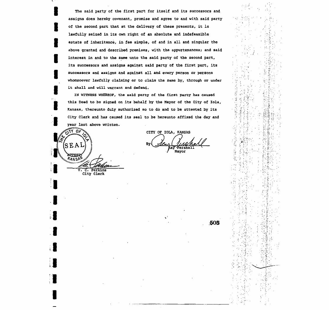
IIIIIIII
The said party of the first part for itself and its successors and
assigns does hereby covenant, promise and agree to and with said party
of the second part that at the delivery of these presents, it is
lawfully seized in its own right of an absolute and indefeasible
estate of inheritance, in fee simple, of and in all and singular the
above granted and described premises, with the appurtenances; and said
interest in and to the same unto the said party of the second part,
its successors and assigns against said party of the first part, its
successors and assigns and against all and every person or persons
whomsoever lawfully claiming or to claim the same by., through or under
it shall and will warrant and defend.
IN WITNESS WHEREOF, the said party of the first party has caused
this Deed to be signed on its behalf by the Mayor of the City of lola,
Kansas, thereunto duly authorized so to do and to be attested by its
City Clerk and has caused its seal to be hereunto affixed the day and
year last above written.
3''X CITY OF IOLA, KANSAS•_ / f. *
1 SEAL
I• •
IIIIIII
:ayr'£ershallMayor
V. C. PerkinsCity Clerk
,505
iA •:

IIIIIIIII
t., .''•.
I'
I
I
§
I
I
I
I
STATE OF KANSAS )ss.
COUNTY OF ALLEN )
BE IT REMEMBERED, that on this 8th day of Hay , 1990,
before me, the undersigned, a Notary Public in and for the County and
State aforesaid, came RAY PERSHALL, Mayor of the' City of lola, Kansas,
and V. C. PERKINS, City Clerk of the City of lola, Kansas, who are
personally known to me to be the same persons who executed the within
Special Warranty Deed and said RAY PERSHALL as Mayor'of said City,
duly acknowledged the execution of the same as Mayor of said City and
acknowledged the same to be the act of the City; and V. C. PERKINS,
City Clerk of the said City duly acknowledged the attestation of the
same as such City Clerk for and on behalf of said City and that he
affixed the seal of the said City.
IN WITNESS WHEREOF, I have hereunto subscribed my name and affixed
my official seal the day and year last above written.
NOTARY \<«\* ;
einn Hxpires: November 21, 1992
Notary Public
STATC or KANSASAllEN COUNTY
m Transfer Raced ft ny
506

IIIIIIIIII
IIIIII
-L, IMMGL&
ORKS, H. A.
S AT uw4 EAST JACKSON
O. BOX ««
, KANSAS M7«
1C) JM-51I!f
I
Entered in Transfer Record
,>-, .".- ..;. STATE OF KANSAS. COUNTY OF ALLEN }SS.-, r .;;p- y-£fv;./ f- ^ - " |' RLED FOR "ECORO THIS _9TH DAY OF JULY ,5,3,r""S- S'&j! '' '.! '"'' j':189-fi. ATiilPO'CLOCK A_M AND DULY RECORDED IN'r;. '-V^:'il^ .rt'" ',... BOOK 196 OF DEEDS RAGE _. 3661 *™yCv"-;^!Y' '.f" JACQUELINE WEBB
' ' -"• ''"'' : '"*' " ' HtoisTEn OF DEEDS"
j Cletk^ WARRANTY DEED
This Indenture, Made this 1st day of February, .1994, betweenIOLA INDUSTRIES, INC., a corporation, duly organized,incorporated and existing under and by virtue of the laws of theState of Kansas and having its principal place of business atlola in the state of Kansas, party of the first part, and LESDIETRICH, party of the second part:
WITNESSETH, THAT THE SAID PARTY OF THE FIRST PART, inconsideration of the sum of ONE AND NO/100 ($1.00) DOLLAR ANDOTHER GOOD AND VALUABLE CONSIDERATION, the receipt whereof ishereby acknowledged, does by these presents grant, bargain, selland convey unto said party of the second part, all of thefollowing described REAL ESTATE, situated in the County of Allenand State of Kansas, to-wit:
Commencing at a point 1,548 feet East and 652.6 feet Northof the Southwest corner of Southwest Quarter (SW/4) ofSection Twenty-five (25), Township Twenty-four (24) South,Range Eighteen (18) East of the Sixth Principal Meridian,thence West 556.4 feet, thence North 391.4 feet, thence East556.4 feet, thence South 391.4 feet to point of beginning,
TO HAVE AND TO HOLD THE SAME, together with all and singularthe tenements, hereditaments and appurtenances thereunto belong-ing or in any wise appertaining forever.
And said IOLA INDUSTRIES, INC. for itself, its successorsand assigns, does hereby covenant, promise and agree, to and withsaid party of the second part, that at the delivery of thesepresents, it is lawfully seized in its own right of an absoluteand indefeasible estate of inheritance, in fee simple, of and inall and singular the above granted and described premises, withthe appurtenances; that the same are free, clear, discharged andunencumbered of and from all former and other grants, titles,charges, estates, judgments, taxes, assessments and encumbrances,of what nature and kind soever, and that it will WARRANT andFOREVER DEFEND the same unto said party of the second part, andto his heirs and assigns, against said party of the first part,its successors . and assigns, and all and every person or personswhomsoever, lawfully claiming or to claim the same.
366

IIIIIIIII1
Iiiiiii
iTORNR
4 EAST
I(iitn
I
I •-, IMMIiLi
pts, P. A.ATTORNEYS AT LAW
< EAST JACKSON
J nox >u
ANSAS «;«
J6S-MJJ
As a part of the consideration hereof, this conveyance ismade upon the following conditions, covenants and reservationswhich shall attach to and run with the real estate hereindescribed, to-wit: The premises herein described and conveyedshall not in any event or at any time be used or occupied as asalvage yard or for any type of salvage operation or business.
IN WITNESS WHEREOF, The said party of the first part'hashereunto caused this Deed to be signed on its behalf by itsPresident, thereunto duly authorized so to do, and to be attestedby its Secretary, and has caused its common seal to be hereuntoaffixed, the day and year last above written.
IOLA INDUSTRIES, INC.
: JL^LByRalph Moser, President
ATTEST :
lTed W. Lucas, Secretary
STATE OF KANSAS
COUNTY OF ALLEN
BE IT REMEMBERED, That on this 1-H- day of February, 1994,before me the undersigned, a Notary Public in.and for the Countyand state aforesaid, came Ralph Moser, President of- IOLAINDUSTRIES, INC., a corporation duly organized, incorporated andexisting under and by virtue of the laws of Kansas and Ted W.Lucas, Secretary of said corporation, who are personally known tome to be such officers, and who are personally known to me to bethe same persons who executed, as 'such officers, the withininstrument on behalf of said corporation, and such persons dulyacknowledged the execution of the same to be the act and deed ofsaid corporation.
IN WITNESS WHEREOF, I have, hereunto set my hand and affixedmy official seal, the day and year last above written.
JOHNCTTA S. HOFERStc'.e of Kunsasay itei. EM. 1.15.15 . C\v£3co- si ,
N o t r y Public
367

I
I
I
MORTGAGE
THIS INDENTURE, made this ?th day of Juty , loj™, by and betweenLes Dietrich and Rita M. Dietrich, Husband and Wife
of Allen ; Cciuniy, Kansas, as Mortgagors, and PIQIM STATE BANK, a banting corporation,
organized and existing under tlie laws of Kansas, wii l i in principal office and place of business at Piqua, Kansas, as Mortgagee;
WITNESSETH, that said mortgagor , for and in consideration of the sum "f ,Sixty Thousand Dollars and no/100's • nniiAn<;
and the further covenants, agreements and advancements herein specified, to "^ 'Inly paid, the receipt of which
is hereby acknowledged, ha V6 sold and by these presents do grant, bargain, set I and mortgage to the mortgagee, its successors
and assigns, all that tract or parcel of land situated in the County of f_i . .and State of Kansas, .described as follows, to-wir.
§ct 1 Commencing at a point 1,548 feet East and 652.6 feet North of the Southwest corner ofthe Southwest Quarter (SVtfs) of Section Twenty-five (25), Township Twenty-four (24) South,Range Eighteen (18) East of the Sixth Principal Meridian, thence West 556.4 feet, thence
_ North 391.4 feet, thence East 556.4 feet, thence South 391.4 feet to point of beginningI in Allen County, Kansas.
Tract'2 A Tract of land more particularly described as follows: Beginning at a point 1413.9feet East and 290 feet North of the Southwest Corner of the Southwest Quarter (SW-j)
I of Section Twenty Five (25), Township Twenty Four (24) South,' Range Eighteen (18)East of the 6th P.M.; Thence West 118.9 feet, Thence North 362.6 feet, thence East 253feet, thenc'South 50.feet, thence West 134.1 feet, thenc South 312.6 feet to pointof beginning. .
I
I
I
I
I
I
together wi th all the heating, lighting and plumbing equipment, and fixtures, including corrals, fences, gates, and service buildings used onor in connection with saiu property whether the same are now Incaicd on said property or thereafter placed thereon.
TO HAVE AND TO HOLD THE SAME, together with all and s ingular the tenements, hereditaments and appurtenances there-
unto belonging, or in anywise appertaining, forever, and warrant the t i t l e to (he same. Said mortgagors hereby covenant with
said mortgage thar ^ h* _V are ,nnhi? delivery hereof, . the lawful owner? ofthc premises
above conveyed and described, and are sei/ed of a good and indefeasible estate of inheritance (herein, free and clear of all
encumbrances, and lhlit__l.he_}L_will warrant and defend the tide thereto forever against the claims antl demands of all personswhomsoever.
P R O V I D E D ALWAYS, t ha t this ins t rument is executed and delivered to secure the payment of the sum nCt 60.000.00with interest thereon together with charges and advances as may be due and payable in said mortgagee under the terms and conditions ofthe promissory note of even date herewith and secured hereby, executed by saitl mortgagors! to said mortgagee, payable as expressedIn said note and to secure the performance of all the icrms and conditions contained therein. The terms of said note are hereby incor-porated herein by this reference, and in addit ion iherelo.
Ill is the intention and agreement ul'lhc panirs herein ihat this mortgage shall, in addition to the securing the payment nfthe non-
referred to in paragraph above in the amount of J I I , secure any sum or sums of money which may be advancedhy the mortgagee or \m assigns, to the parties nf ihe fiwtpart herein or to e i ther of I hem, at date hereof, or from lime to time as the partiesherein or either of them may now or hereinafter agree, w i l l i interest on said advancements from the date of the advancement unt i l paid:it being the intention nfthe parties hereto lhat this mortgage shall secure any advancements made from time to time to the mortgagors,by the mortgagee, however evidenced, whether by nole, check, receipt, or book account, and in remain in full force and effect betweenthe parties hereto, or assigns, unti l all ad vancements made by virtue herenfarcpaitl in fu l l , with interest; and th is conveyance shall be void ifsuch payments arc made as herein specified. But ifdefaidt be made in such payments, or ^ny part thereof, or interesi thereon, or the taxes,or the insurance main ta ined thereon, then (his conveyance shall become absolute, and the whole amount shall become due and payable,antl it shall be lawful for the said mortgagee, its successors and assigns, at any time thereafter, to sell the premises hereby granted, or any panthereof, in the manner prescribed by law. I nose of foreclosure, said mortgagee, or assigns, shall be enti t led to hnve a receiver appointed bythe Court, who shall enter and take possession n f the premises, collect the rents and profits thereon and apply the same as the Cntirt maydirect.
_hereby assign to the said party of tayments accruing to and due or becoming
ancy 01 said premises, whether or not leased, and, if leased, under any and all lea.'I pas ItsI lie ten
I
I
I
I
I
I
As additional and collateral security for the payment of the said note, the mortgagor _2_hert:by assign to the said party of thesecond part, its successors or assigns, all me right*, benefits, reins, royalties, production, and payments accruing to and due or becomingdue said mortgagor by or through the use or occupancy of said premises, whether or not leased, and, if leased, under any and all leaseswhether verbal or written, including oil and pas leasi-s, mineral leases, agricultural leases, or any other lease whatsoever now on said
successors or assigns, to account for or pay over the .tame to said party of the mortgagee, or assigns.Mortgagors) covenant?*) not to sell the nrfimines nrany^>nriinn (hereof, and if such sale be. made, the entire balance secured by (his .:•• • '••'-:/."•
mortgage shall be immediately due and payable, a ml tnorigagee in event of defaul t of [iaymentmay.it its option foreclose accord ing to law. ,.;.V- -'*.
IN WITNESS WHEREOF, The mortgagor ha .YJhercunm .„, their
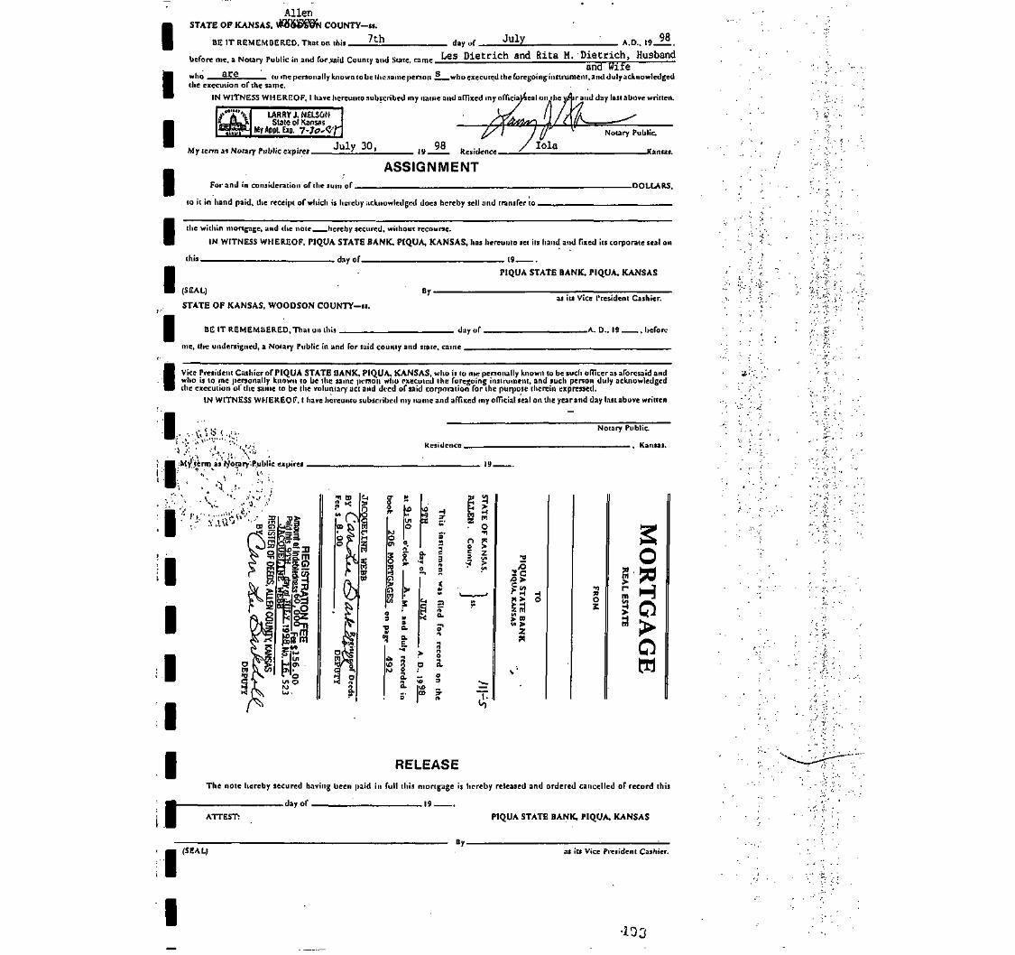
Iiiiiiiii1
i
iiiiiii
AllenSTATE OF KANSAS, $888g9fa COUNTY-ii.
7thBE IT REMEMBERED, That on this . day of. July A.D., 19 98
before me, a Notary Public in and for said County and Sate, came LeS Dietrich and Rita M. Dietrich, Husbandand Wife
who §££ to me personally known to be Hie same person j* who executed the foregoing instrument, ami duly acknowledgedthe execution of the same.
IN WITNESS WHEREOF, I have hereunto subscribed my name and affixed my officialieal on the yAr and day last above written.
LARRV J. NELSONState of Kansas
My AppL E»p. 7-Jp'<Z'i
My term as Notary Public expires Juxy JU|
ASSIGNMENTFor and in consideration of the sum of. -DOLLARS.
to it in hand paid, the receipt of which is hereby acknowledged docs hereby sell and transfer to.
the within mortgage, and the note hereby secured, without recourse.
IN WITNESS WHEREOF, PIQUA STATE BANK, PIQUA, KANSAS, has hereunto set its hand and fixed its corporate teal on
this day of 19
(SEAL)
STATE OF KANSAS, WOODSON COUNTY-is.
By.
PIQUA STATE BANK, PIQUA, KANSAS
as its Vice President Cashier.
BE IT REMEMBERED,That on this. . duy of. _A. D., 19 , before
me, the undersigned, a Notary Public in and for said county and state, came .
Vice President Cashier of PIQUA STATE BANK, PIQUA. KANSAS, who is to me personally known to be such officer as aforesaid andwho is lo me personally known to be the same person who executed the foregoing instrument, and such person duly acknowledgedthe execution ol' the same to be the voluntary act and deed of said corporation for I hi: purpose therein expressed.
IN WITNESS WHEREOF, I have hereunto subscribed my name and affixed my official seal on the yearand day lastabove written
Residence.
Notary Public
, Kansas.
y terrn as ryotary'-P.ublic expires .• • • > > . v - ; . •
'i . "' <•• •
, 19-
':•''i." L--;V^V^:...-' -:.- *A^ a
er M
g o.o
I Sn jso >5 z
>• a<A >
3o
H
?
S
HO
ow
RELEASEThe note hereby secured having been paid in full this mortgage is hereby released and ordered cancelled of record this
day of 19
PIQUA STATE BANK, PIQUA, KANSASATTEST:
(SEAL)By.
as iu Vice President Cashier.
•103

1•11
1•
. QlljetreetStract
Companp
t tu.
1'
1t
nbebrattersf
1
1'
•
Serbing
j |«°?-#eo*[jo
F"iSon
Counties
No. 8140
CERTIFICATE OF TITLE
STATE OF KANSAS, COUNTY OF ALLEN, ss:
We the undersigned, being duly licensed and bonded abstractors in and for said county andstate, do hereby certify that we have examined the records in the office of the Register of Deeds,County Treasurer and District Court, affecting the title to the following described real estate in saidCounty and State, to-wit:
A tract of land more particularly described as follows: Beginning at apoint 1413.9 feet East of the Southwest Comer of the SouthwestQuarter (SW/4) of Section 25, Township 24 South, Range 18 East ofthe Sixth Principal Meridian; thence East 134.1 feet; thence North 652.6feet; thence West 253 feet; thence South 362.6 feet; thence East 1 18.9feet; thence South 290 feet to Place of Beginning; EXCEPT railroadright-of-way and LESS and EXCEPT Beginning at a point 1413.9 feetEast and 290 feet North of the Southwest Corner of the Southwest Quarter(SW/4) of said Section 25; thence West 118.9 feet, thence North 362.6 feet,thence East 253 feet, thence South 50 feet, thence West 134. 1 feet, thenceSouth 3 12.6 feet to point of beginning.
That there are the following deeds of record affecting said real estate:
ABSTRACTORS NOTE: See deeds recorded Bookl2, page 537; Book 19, page 318;Book 25, page 459; Book 31, page 411; Book 27, page 476; Book 83, page 335; Book 85,page 305; Book 101, page 204; Book 101, page 287; Book 104, page 396; Book 107, page 6;Book 1 12, page 586; Book 126, page 214; Book 150, page 332; Book 152, page 83; Book183, page 632; Book 195, page 390. (COPIES ATTACHED)
That there are no mortgages of record affecting said real estate.
That there are no Probate Proceedings, judgments, mechanic's liens, executions, foreignxecutions, attachments, or suits pending or transcripts of judgments from State or United States
Court of record in the District Court of said county against:
Advance Chemical Distribution, Inc.;
That the records in the office of the County Treasurer show the taxes for the year 2002 andrior years paid. Tax tract IA 03735, KSCAMA 077-25-0-30-19-004.00-0-0
This Certificate is made upon the mutual understandingthat the maker thereof has notxamined all instruments and proceedings in the chain of title to above described real estate; that suchertificate is not a guarantee of title and that the maker thereof shall not be liable for defects in the title
the above described real estate.
That the undersigned is a duly licensed and qualified abstracter in and for the county and statebresaid, whose bond as required by law is in force at the date of this certificate.
Dated at lola, Kansas, this 9th day of September A.D., 2003 at 7:00 A.M.
r^ : f\
Licensed (u?cl£ljohded Abstracter

III
?age 17.
I
rGeorge Sleeper and Aliceloeper, hia wife.
to
lenry P. Merrlmon.
Abstract No. 6230,
Warranty Deed• $4000.00Duted May 31, 1603Aok. Juno 1, 1893Before Henry Hosin, N.P.Cook County, 111 (SEAL)Filed Juue 3, 1893Recorded Book 12, Page 537.
I
I
Convey and Warrant!- 3Wi of Section 25, Township £4, Range 18,Allen County, Kenans. Subject to mortgage o.f $2000*00.
In deed and acknowledgment, Alice M. Sleeper.
enry P,Grace R,
Morrlman andMerriraan, hia wife.
to
The lola Realty Co.
v/urranty Deed $5150.00Doted March 3, 1807-nek. March 3, 1807Before C.E, Peifal, N.P.Cook County, 111 (SSAL)Filed March 9, 18S7Recorded Book 19, Pap.a 318.
Convoy and Warrant:- awj of Section 25, Township 24, Range 18, lassright of way of Kansas & Colorado Pacific iiailroad Co. and less a strip25 feet wide off north side of said quarter, Allen County, Kurisas.
I
It/ary E. Norturup, widow;•Frank A. Northrup and Alloe
M. Northrup, his wife; LewisNorthrup and Lettie A.
Slorthrup, his wife; and DelmorNorthrup and Dooia A.
Northrup, his wife; wole hairsat law of L.L. Northrup, deo'd.
I to
The lola Healty Company.
'-iuit-Claim Deed il.OODoted AU(£. '21, 1902Aok. Aug. 21, 1902Before Craigie -J-. McDowell.Mlon County, Kansas (SKAJJ
Filed AuE. 25, 1002Recorded Book £5, Page 450.
N.P,
I Remiae, Release and Quit-Claim:- Commencing at a point 660 feetast of Southwest corner of iJWi, Section 85, Township 24, Range. 18, thence
North 443 feet, thenoe West 200 feet, thence North 509 feet, thence East_888 feet, thence South 1044 feet, thence West 688 feet to place of beginning.• "George Sleeper and wife mortgaged, the sv/i of said section to L.L,jNorthrup. L.L. Northrup assigned the said note and mortgage to Il.B.Uerriman,
who subsequently released the same. The said assignment from L.L. Nortnrupto H.BJ. Merriman was not acknowledged and the sole purpose of this deed
•is to correct said defect ond perfect the release of record".'•V
I

IIIIIII
I 1
IIIIIIIIIII
The lola Realty Company,a corporation, ByIT.A. Northrup, Prest.,Attest: Chae T. Scott.
to
William Lanyon (son ofRobert Lanyon }•
Warranty Dead-$4,000.00Dated Jan. 31, 1901Aok. Jan. 31, 1901Before J.H. Vannuys, N.P.Allen County, Kansas (3iiAL)
Filed Got. 28, 1001Recorded Book 31, Page 411.
Convey and Warrant:- Commencing at a point 860 feet Bast-;of .Southwestcorner.of SWi; Section E5, Township £4, Range 18, thencei-Nortb:.445,feet,thence West 200 feet, thenoe North 590 feet, thence.Sast 888 feet,.thenoeSouth'1044 feet, thence '.Vest 606 font to place of beginning, subject toa switch privilege granted the Mo. Pao. R.H. Go. • . . - . - . •
William Lunyon (son of KobortLanyon) and Annie 0. Lanyon,wife of sold Wllllora Lanyon.
to
The United Zinc and ChemicalCompany, a corporation.
Warranty Deefi §1.00Dated Feb. 25, 1902Ack. Feb. £5, 1902T-.efore George V. Lewis, M.P.Juokaon Co. Mo. (SEAL)
Filed Feb. £7, 1002Recorded Book £7, Page 476.
Convey and Warrant:- A tract of lund oa followsi-Beginning at a point SCO feet East of Southwest corner of SWi, Section
25, Township 2-1, Range 10, thonce North 445 faet, thence V/oot 200 feet,thence Worth 599 feet, thenoe Eaat BfiB feet, thence iiouth 1044 feet, thenceWest 688 feet to place of beginning. Subject to switch-privilegeo ofMo. Pacific.

IIIIIIIIIIIIIIIIIII
Oeo Seymour* Oounty Cleric Tax Deed *375.,21Allen County, Kanaas (SEAL# Dated Sept. 8, 1925
Aok. Sept. 8, 1923 .to . Before J.B. Smith, P«J.
Allen County. Kansas (SEAL): Filed Sept. 9, 1925 at.2 P.M.
B.A. and R«U. Fry* Recorded Book 83, Page 339*• . - • • - . .
KNOW ALL MEN BY THESE PRESENTS:That Whereas,.The following described real property, vizi.Com. 1548
ft East of SW corner or S'tfi Sootlon 25, 24-18, tbenoe North 1044 ft, W.888 ft» S. 590'ft. E, £00 ft. S. 445 feet K. 688 ft to beg. containing .19.29 aores situated in the Oounty of Allen and State of Kansas* waseubjeot to taxation for the year A.D. 1921;
And Whereasi The taxes assessed upon s.<iid real property for theyear aforesaid remained due and unpaid at the date of sale hereinaftermentioned;
And Whereas, The Treasurer of aaid County did, on the 5th day of Sept.A.D. 1922, pursuant to notice given as required by Ian, at a public saleof real property for delinquent taxes, held at his office in' the countyseat of sqid County, and by virtue of authority in him rested, and inpursuance of a resolution of the ^o-ird of County Commissioners of-saidCounty, on the 4th day of Aug, 1921, entered at page 604, volume K, of therecord of said Board, adopting the provisions of Chapter 162, session Lawsof 1891, bid off in the name of said County the said property for the sumof One Hundred Twelve 65/100 Dollars, being the whole amount of taxes andcharges thereon; <.. ,,,,
And Whereas, The flaxes and charges against said property for the year1922, amounting to:Eighty five It 39/1)00 Doll irs, and for the year 1923,amounting to Sighty seven & 38/100 Dollars, and fo; the yenr 1924, amountingto Seventy one & 32/100 Dollars, wore duly entered on the book of Tax Salesopposite said property;
And Whereas, The said property hue remai ned unredeemed fromsaid solofor the period of tiiree yours;
And Whereas, On the U" day of Uept, 1925, H.A. & R.u. Fry of theCounty of Allen and State of Xanana offered to purchase said property forthe sum of Three Hundred Seventy five 21/100 Dollars, being the amountof taxes, penalties and ooots then due thoreon, and paid, said sum to theTreasurer of said County, and thereupon the said Treasurer did issue to saidR.A.& R.U. Fry a certificate of tiat dite, as 1$ auoh case provided by law,for and concerning said property, and the County Clerk of said County did,on the same day, duly assign to the purchaser aforesaid the said certificateof sale and all the intercut of said County in and to saidpropertyt
And Ylhereas, No part of the said prope'ty has been redeemed from saidsale as provided by low, the said unredeemed real property having beenadvertised and notice given that it would be conveyed unless redeemed by acertain day named, said advertisement nnd notice having been made in sub-stantial conformity with allthe requisitions of the statute In such casemade and provided.

IIII
United Zino & Cheraloal Co.By A.R. Meyer, President(SEAL)
to
I R.A. Fry and R.U. Fry,
I
I
Quit-Claim Deed $500.00Dated April 23, WEBfcck. May 18, 1925Before Joseph T. Back,N.P.New York Co, K.Y.I SEAL)Filed Sept. 5, 1925.Hocor-'ed Bnok 85, Poge 305.
Remise,- Release njid Quit-Olaim:- £0 acres, more or lees, commenoingat a point 860-feet Enot of Bouthwoat, corner of CWj, Section 25, Township24,, Hange 18: thanoe North 445 feet, thence West 200 feet, thence North509 feet, thenoe Beat 000 fnat , thenoe Uouth 1044. feet, thence West 608feet to beginnine;. „ .
Subject to switch [u-lvfileeo grnnted to the Uo. Pao. n.H. Co. anasubject tiloo to the H.N. rlipt of way heretofore granted for existingtrants.
Iii
iiiiii
R.U. Fry,
J.M. Holme a and '-V.J. lUloy
Quit-Claim Deed $100.00Dated Jan.. 2, 1933Aok. Jan. 17, 1933Before Viola D. Dalgarno, N.P.Allon County, Kansas (SEAL)Filed Nov. 23, 1035Recorded Book 101, Pago £04.
Reraise, Release and -iult-Clulm:- A certain tract or parcel of landsituated at .or noar lolo, Allen County, Kunsus, containing about 20 acres,more or leas, described ua fallows;-
Canraenoins at a point 860 foot oust of the Uouthweot corner of the3W/4 of Sootion 25, Townohip 2<1, Rdnge 18, thonoo North 445 feet, thenoeWest 200 feet, thence North 509 feet, thsnoe Seat 888 feet, thenoe South1044 feet,ythoaoe West 008 fast to plaoe of beginning.
Subject to u switch prlvilogo grunted to the Missouri PacificRailroad right of way horobofore granted for oxistlntj tracks.
.OO) . . ,, • . ( f i- n r{,\ , .' l ' " " ' ! M " K ' r u ' -
WARRANTY DBBDDated Feb. «4, 1930
s' • .Aok. Feb. 2Si 1038 by R.A.Fry.and Mary Fry his wifeBefore Clyde Thompson, N,P.Allen Oounty, Kansas (SEAL)Aok. March 84, 1936 by R.U.Fry and Eve P. Fry, his wifeBefore H.B. Zmerson, N.P.Pontotoo.County, Oklahoma (SEAL)
Filed Maroh 26, 1936 at 3 P.M.Recorded Book 101, Page 287.
R.A, Fry and Mary Fry,hia wife and -R.U. Fryand Eve P. Fry, hia wife
to
J.M. Holmes and W.J, Rlley
Consideration $1.00
Convey and Warrant:- Commencing at a point 860 feet East of SWcorner of SWi, Section 25, Township <S4, Hangs 18, thanoe North 445 feet,thenoe West 200 feet, thenoe North 599 feet, thenoe East 888 feet, 'thenoe South 1044 feet, thenoe West 388 feet to place of beginning.
Subject to any encumbrance, if any, of record. Subjeot also toa lease made to W.J. Rlley and J.M. Holmes, grantors rights under saidlease have been assigned to Paul Klein. Subjeot to a switch privilegegranted to the Missouri Pacific Railroad right of way heretoforegranted for existing tracks.

IIIIIIIIIIIIIIIIIII
J. M. Holmes and GeorgiaHolmes, his wife,W. J. Riley and FrancesRiley, his wife
to
lola Oil & Gas Service,Incorporated.
Consideration $1.00
WARRANTY DEED
Dated September 29, 1939
Ack. September 30, 1939By W. J. Riley and FrancesRiley, his wife, J. M. Holmes& Georgia Holmes, his wife,Before J. H. Wille, N.P. ,"Joodson County, Kansas (SEAL)
Filed Sept. 30, 1939 at 11:45 A.M.
Recorded Book 104, Page 396.
(U.S.I.R. Stamps Shown 50(0
Convey and Warrant:- Beginning at a point 1413.9 feet east of theSouth-west corner of the SW-i of Section 25, Township 24,South, Range 18East of the Sixth Principal Meridian, Thence East 134.1 feet; ThenceNorth 652.6 feet; Thence West 253 feet; Thence South 362.6 feet; ThenceEast 118.9 feet; Thence South 290 feet to place of beginning, containing3 acres, more or less.
Except Rail-road right-of-way. _.Signed: W. J. Riley
Frances RileyJ. U. HolmesGeorgia Holmes
'lola Oil & Gas Service, Inc.,a Kansas corporationby G. E. Robertus, PresidentAttest: J. W. McMillianSecretary (SEAL)
Acme Asphalt &. Gas, Inc.,a corporation
Consideration $1.00
y/ARRANTY DEED
Dated May 9, 1940
Ack. May 9, 1940Before Elaine Lynn, N.P.,Jackson Cpunty, Missouri (SEAL)
Filed May 11, 1940 at 9:30 A.M.
Recorded Book 107, Page 6.
Convey and Warrant:- Beginning at a point 1413.9 feet east ofthe southwest corner of the southwest quarter of Section 25, Township24 south, Range 18 .east of the Oth P.M., thence east 134.1 feet, thencenorth 652.6 feet, thence west 253 feet, thence south 362.6 feet thenceeast 118.9 feet, thence south 290 feet to place of beginning, containingthree acres more or less.
Acme Asphalt & Gas, Inc.,a corporation By James V.Harrington PresidnetJames li. Campbell, Secretory(SEAL)
to
Harold C. Adkina
Consideration $850.00
WAKUANTY DEED
Dated July 31, 1945
Ack. July 31, 1945Before Elaine Lynn, H.P.Juckoon County, Missouri (SEAL)
Filed Aug. 1, 1945 at 9:45 A.M.
Recorded Hook 112, Page 586.
(U.LJ . I .U . Stamp's Shown $1.10)
Convey and Warrant:- l-iegitmirif. nt a point 1413.9 feefreast of thesouthwest corner of the 3W;i of Section ED, Township 24 South, Range 18east of the 6th P.M., thence east 1154.1 feet, thence north 652.6 feet,thence west 253 feet, thence south 362.6 feet , thence East 118.9 feetthence south 290 feet to place of beginning, containing 3 acres more orless.
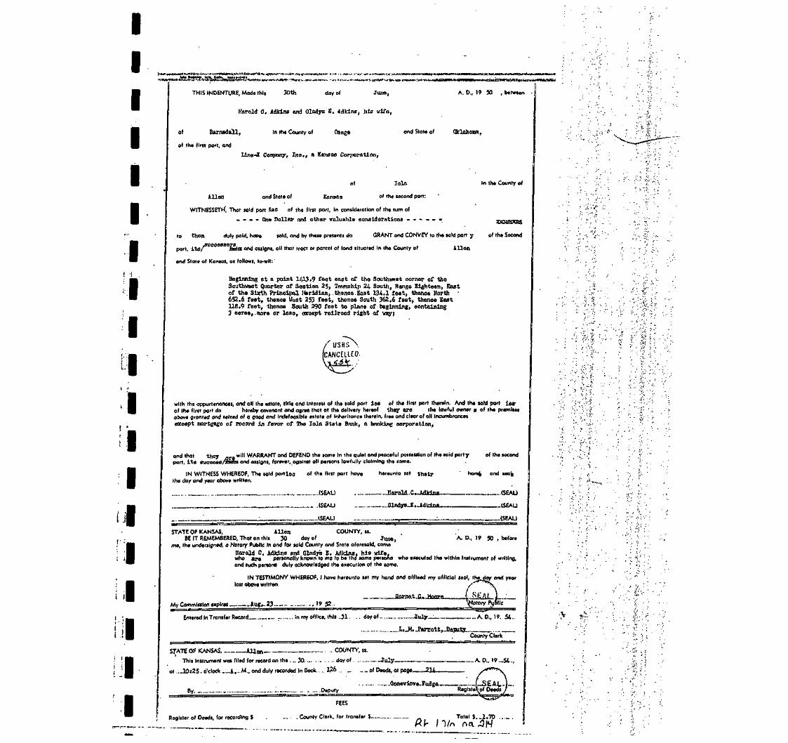
IIIIIII
! I .
I
I
I
II 4
I
I
I
I
I
I
I
I : . .'I Inilr I II
THIS INDENTURE, Mode this 30th day of June,
Harold 0. AdM.no and Olodyo E. Arlkino, hlfl wife,
In the County of Qacige ond Stole of
C Company, Xna., n Karuiae Corporation,
of Barnadall,
of the flrtt port, and
A. D., 19 50 , between
Oklahoma,
of
Allan and Stole of Kansas
loin
of the second parr:
In the County of
WITNESSETH1, That uld port leo of the flrlt part, In conilderallan of the sum of
- - - - Qnfl Dollnr and other valuable consideration - •
to them duly paid, have laid, and by these pretenti do GRANT and CONVEY to the told part y of the Second
part, ita/ inria and assigns, oil that tract or parcel of land iltualed In the County of Allon
and State of Kansas, as follows, lo-wlr:'
Beginning at a point 1413.9 feat east of the Southwnat oornar of theSouthuaat Quarter of Section 25, Township 2lt South, Range Eighteen, Eastof the Sixth Principal Meridian, .thenoa Boat. 134.1 feet, thance North •652.6 feet, thence Hoot 253 feet, thence South 362.6 feet, thence East118.9 feet, thanoo South 290 feet to plane of beginning, containing3 acrea,.more or loon, accept railroad right of way)
with the appurtenances, and all the estate, title and Interest of the sold port lee of the first part therein. And Inn uld part ierrof the first port do hereby covenant and agree that at the delivery hereof they are the lawful owner a of the premisesobove granted and seized of o good ond Indefeasible estate of Inheritance therein, free and clear of oil Incumbrancesexcept mortgage of record in favor of The Tola Stata Bonk, a banking corporation,
and that they „,_ will WARRANT ond DEFEND the some In the quiet and peaceful possession of the said partyport, ita Buooesa/TDOTi and assigns, forever, against all persons lawfully claiming the some.
IN WITNESS WHEREOF, The sold portion of the flrlt port hovethe day and year obove written.
..(SEAL)
hereunto set their
JIarold..C.JuUcia
.(SEAL)
(SEAL)
of the second
hondj and ftea^
(SEAL)
(SEAL)
(SEAL)
STATE OF KANSAS, Allen COUNTY, ss.BE IT REMEMBERED, That on this 30 doy of June,
me, the undeclared, a Notary Public In ond for sold County and State aforesaid, cameA. D., 19 50 , before
Harold C. AdJdnu and Qlndyrs E. Adklns, his wife,who are personally known to me to be the same persoha who executed the within Instrument of writing.and such penora duly acknowledged the execution of the same.
IN TESTIMONY WHEREOF, I have herounlo set my hand ond affixed my official seal, thelast above written.
My Commission expires _ ...Aug...Z3 -..,19 52-
ond year
Entered In Transfer Record- In my office, this .31 .. dayof .............. —July.- ....... A.D., )». .54.
I.....M...PaJT.oll,...DapuJte ____________County Clerk
S^ATE OF KANSAS Allen - COUNTY, ss.
This Instrument was filed for record on the ... 30 dayof -...July—
of ...10i2J. o'clock _...A.- M., ond duly recorded in Book. .. W6 Of Deeds, at poge 21
A.D., I9._54.
By ......... _ ..... .... ..... ---- ........ _... ........:. .. ..... DeputyOojiGvlova-Fudgo — LSEAL-J~
Reglstetof Deeds ,
Register of Deeds, for recording $
FEES
. County Clerk, for transfer
/nTotal $__1.70 .

niTmirwiFmmi?Tirn^f>nrtJt^^^'irii^^«w^3ni^
=. • : ' ..,:;:.v:ivv.::;;:.:-.^• • ' - • •v - " : i -si-..' ^•-•^y:1^-^ ,M^&?te.dniot ' Auq'USt .';' •..; .;: - V^^D^i^P'-.brt^Mn^Sfc:.' ' ' ' ' " ' ' '
. , . • • . . . • ' / . / I
ao itlitu, W :', .THIQ INDENTS ajJ,M«ao itlitu
iha-ir Riid by.lflrhia of tto liUra;6{;tlui:tt«in »{v;B.n8^V- iyi;V' ;;;.|'i?:corporation duly orgnnliod,. Inoorim'inUd, null «tlntl»(t
. .'•• • • - . • " > • ••], , .hml Imrlnj ltd prlncipnl plun of l>u«luwj» nt JCOla>
... •. ,-. ' - . ' .Kauaaa, ; ' '
. . . .\ Deloaior ;ana^G.'«BJ';Bei;Ozi^itt:;i;V vrijQ
201 Eaot HelawajJo, towatn, Oltlahoma, //<3 .-^Sf"' '
WITN1SSSET1I, Tlmt tho nnld potfcj of llio flmb jmrt, In connlOornUon of tin onm at
— One ,Dol.lar and
tha receipt whereof tn Ucrol
aecund part, tlloir liol
nod Otntn o£
foot, thonce East .1.10.9 faotof beginning, containing 3 ..railrond right-of-way,

iti J
.(lay of__ -A; b. ia•.' 7Q
4n and for.tlio Comity and State aforesaid; cama
^Vcla'd^s'^iS../^^^^'./'":':''^':"---.;'1^'' ';. • j Presiding'i.f.I.ino-'lC Onmpnny, Tnn _.~.
;'*'•'- '•" '• : ' •' '^. ' . ' ' . ; ' ' i ' ' ," ' _!' —...' --.— n ciirnuvhtinn duly uruanlzed, InuonioraUd nnd eilaHng under and by virtue
••of ' _ ~».i MltohalL H. Buahey ' 8«entaty o{ uld
K''•'•'*• K- '.coiiibritli)n,'wlii6!»rii Barooiinlly iniown: Wniti''ta<ba »nnh otflcori, and wlm arc puionally known to mo to'be'the uuna pononi
dbly nelmowUI j y .'-•;wjio' oiooutod, aa:muh;ntflceni-tllo-wltlilu ihutrument oj.wi'ltinu on bolmK pf onld eoiimrallon. and suoh poroona div
.,1-'.-. ^ '"edg'tid-^ .exoqutlon.of Uio Aama.to.'boithe-det and.dntil of snlil corporation.
• 'll .- ' .' .•'"•^9 '•' :V m TflyriMONV WHBttlSOF, I liuva Uaminto BBt my Imiiil, »nd aUlxri niy_notarial
Be»1 Uio ilny and y«ir lait> nl.ove miiutlonAA.
-a«\*ri Pnblla..
Tetm oiplres i-Si
-;-;S.a^r
'•yl-ni.-.'-O ?: .-.
m
«>^ulMOf. ^lr>vK'uw>.:!v.A:(,u•Ji4l^!j '. .\a•i .'.f1M^ymlUaau.»^i^«^lu.;/:-.v. :^; . ' . . . - • - • - . . - . .. ' ?.VTitift»iiiii^yj*i:H«Wi5'fl^fft1«ftiiftri'n~f'1»V''ftW;''1"A^ S
• 'i-. ''.',';.-•'„'••' ^:. ' . •• n 01 .I*1'- •••!"• '"';' ^j
i'-. t;;. 1

ofitbe'.f^s.tipBrtiiaiid ji'i'-rjireiaS-'iu'ge'' Wa.t'e'r VTjab'6'ra'tpr:i'es f !$nc';:V>'^-^ ^'v^'l?••'• -\-^-:-'• '" •.'' '<'.
of
- . . V.
•Nowata,;.of^v Npwata.j,- - • • " . - • • • • ;. ''^ WITNEMETn,'That sold :
in;, the County." Jf
'mM. . ;% WITNEMETn, That sold parties 'pf the:;first:pttr(;; Ui'conBlderation of the.suitS of --™^---- . -)
•• • --pne'^Dp'llar''ahdI-pth&r'•yaluable^cphsiQ erationa-r—-•- -a-.T-l-.--.r'i—:-tiiOMflttlS^ •! '; 'to ''*• them • duly pald,-ha ve sold, w^ijHvg^gfff^ts do--;t .', • QHANT: and CONVEY to the said
:'•• ' .•• partly -.of-the Second 'part,, its/ ^rasw.-anUiassigiiaJj.all-tliat tract or parcel1 of |land situated :ln the
I-. county of , Allen, '. .,; /•' and Sta'te of ICausas, as follows,' to-wlt: '•'.• . S •A~ tract AO£' land beginning at Q .point- 1,413.9 feel: Bast of the; Southwest corner
. of.: the..-, Southwest Quarter (SWJj). 'Of, Section"; Twentyrfive-(Z) /'Township a-wdnty-four(24) south. Range Eighteen (18), 'East pf G\e sixty Principal Meridian, thence i
- East.:-. 134.i-;:fee.t, thence Nprth 290 feeb, thence-West.,134,1 feet,- thence South : i• 29,0V feet ,tp 'the place' of. beginning,:, containing 0;89 acres-more .or .leas, except• railroad-right-of-way, and '•",' - .'. • :
A tract- of land which has 'its :point of beginning .1,543 feet Baat.of the Southweeigiicorner: of the Southwest Quartet 'of Section iwenty^five (25)., TOWnship Twenty-
I four (24.) South, Range Eighteen.:-(18)'Ea.st, of. the Sixth.Principal. Meridian,..and 290 feet North therefrpm tO; the.'point of beginning, thence1 North from the.point of/beginning 362.6 feet, ifchence West 253 feet, thence South 362.6 feet,'thence,'East 253 faet, to-the point of beginning,' containing 2.11 acres,
' — more, or less. •'•••• . • '
. | with the appurtenances, and all the estate, title and Interest of the said .paries . of the first part herein.And the said part ies of tho first part do ' • hereby covenant and agree that at the delivery hereof 'they arethe , the lawful owner- s' of the promises above granted and seized of a good and indefeasible estate of
I inheritance therein, free and clear of oil Incumbnuicoa , except easements of record-for a ewerline and power transmission lines.
and that they will WARRANT and. DKITEN0 the saute in the quiet and peaceful possession of the
I sold part y of the second port, its /3UC6SlSaBl1a6lu5BignB, forever, against all persons lawfully claiming. the same. . : ' . •• • . ' • • • • - . ' "
^WITNESS WIIffiREOlf, 'fhe said port ies Of the first port ha ve heroundaw and year above written.
' _ L _ . i Seal -
et 'their
I f VUUialra^lJ^fCto'STATE .OF IBaHSU;'..OKLAHOMA COUNTY, 19.
BnirBE^MDEiiED,.Tiiiit.outata' :"29th'' •-• ' i iBjrJBl i - : . , Deoember1;- . • • - ' - • • :-V'.-<:,."A,''.D.^ifl>;7l:|.,berore-'' . -il"'|i,-maund^lp«d,^a:'Notarjr'pubilo-.laiiidlw«*ia(^untKindsUle''^orBe3iiIU, cainovyPaull.DeliOzier'-.nn'd.'Dorothy; tfjlL.OziBr';-'!ni n- vt-l fa J ' .anflVHornTi^ . TH.•.."'TlnT.n'al «*r' and MaVinl ' PL-'-'naT.nf.taV.: liin - . - • • . • ' tB-ll
. f -m* ! . "S" •1\*"?:':<:tyfa'''.'! • ''." ;•-''••• '; -;. • ' ' ' • • ' • -. i , - ;C .V .i K^:'n;^:-^i-r^r'i^i^i,:'''r^^^ ^^^^^ fe ' -fe -?
83:

cw«^>?«^^^w«^^FohM 14—Burkhirt PrinUnf A Stationery Co,, Tulu, Oltla.
[Grantee: P. 0. Box 70Sand Springs, OK 74063
(tamtl Marnmtij(CORPORATION FORM)
AD.
THIS INDENTURE, .day of_ JulyTREAT-RITE WATER LABORATORIES. INC.
a corporation,
of the County
under the laws of the State of..
Nowata____state of Oklahoma, party of the first part,ADVANCE CHEMICAL DISTRIBUTION, INC. , an Oklahoma corporation.
, ., part_X— of the second part.
WITNESSBTH, That in consideration of the sum of_Ten_Dol.lar8 (.510. OOLjindgood and valuable consideration,
the receipt of which is hereby acknowledged, said party of the first part does, by these presents,its successors and assigns
grant, bargain, sell and convey unto said part_X—of the second part " 'XgttH&iCKKaui, all of,the following described real estate, situated in the County of_State of:
Allen
A tract of land more particularly described- aj? follcjasjBeginning at a point 1413.9 feet_East of the Southwest Corner
• of.;:-.the Southwest Quarter (SW/4) of Section 25, Township 24
South. Range 18 East of the Sixth Principal Meridian: thence
Eas'p 134.1 feet: EhejXg£-JJtQJC£kJi52. 6 £egJKj th.en.ce West 253 feet;thence South 362.6 feet; thence East 118.9 feet; thence South
290 feet to Place of Beginningj eontainine; 3 acres. more or
.legs., EXCEPXjailrjojLl-r.lg.h£.r.o.t-way
TO HAVE AND TO HOLD THE SAME, together with all and singular the tenements, hereditamentsand appurtenances thereto belonging or in any wise appertaining forever.
TREAT-RITE :WATER LABORATORIES. ,INC_^_for itself_gndits successors or assigns, does hereby covenant, promise and agree to and with said parflL. of the secondpart at the delivery of these presents it is lawfully seized in its own right of an absolute andindefeasible estate of inheritance in fee simple, of and in all singular the 'above granted and describedpremises, with the appurtenances; that the same are free, clear, and discharged and unencumbered ofand from all former and other grants, titles, charges, estates, judgments, taxes-, assessments and encum-brances, of whatsoever nature and kind. EXCEPT, '""l..." if-.n-.JRr htcani hi my
CMMyOerfc
and that said Corporation will WARRANT and FOREVER DEFEND the same unto said part/ - of" second part. i.tfl—.heirs, executors or administrators, against said party of the first part, theirsuccessors or assigns, and all and every person or persons whomsoever, lawfully claiming or to claimthe same.
IN WITNESS WHEREOF, The said party of the first part hereto has caused these presents to besigned in its name by its president, and the corporate seal to be affixed, attested byat Tulsa. Oklahoma tha year and day first above written.
CORPORATIONSEAL
TREAT-RITE WATER LABOJUTORIES, INC.i o^Corpontioa
ATTEST! By/Geral cLozier
ra S. F Sccrtuiy
' OKLAHOMA,:
Tulsa(CORPORATION ACKNOWLBDCUBNT)
County " ~~
• **' 'Before 'me the undenigned, a Notary Public, in and for laid County and State,' on thiiJuly 19/91 ,,„ „—„,, GERALD E. DELOZIER
-day of
penonally appeared.
iliato me .known to be the identical penon — who iiibjcribed the name of the maker thereof to the foregoing initmment u iu
- President -- an(j acknowledged to me that _ he __ executed theand voluntary act and deed and u the free and voluntary act and deed o^ch corporation, for_the uiei and puj.
: Giren under my .hand- and teal of office the day and year lait al
/ ' / / OMy commiiaion ezpirei

Corporation Deed (General Warranty)
1y, J
STATE OF KANSAS,ALLEN County
This instrument was filed for recordon the 27TH day nf JANUARY AD.19jJ8_, at Ui2Q_o'clock _P_,M., andduly recorded in Book 125_of Deeds,at page 35fl
JACQUELINE WEBB
"-5
FEESRegister of Deeds,for recording $ 8.00County Clerk, for Transfer
Total, $_8.0Q
Entered in Transfer Recordin my oMice, this &flday nfffQ/TTJ A.D.,'
THIS INDENTURE, Made this. 14th ,jay Of August
A. D., 19 97 between Advance Chemical Distribution. Inc'.
a corporation duly organized, incorporated and existing under and by virtue
of the laws of the State of fivlahnpi3 and having its principal
place of business at 206 E Morrow Road. Sand Springs in
the State of Oklahoma of )he first part_ and
Farmer's Friend & Associates
.of Allen County, in the State
of Kansas of the second part:
WITNESSETH, That said partJ! of the first part, in consideration of
the sum of- Ten
the receipt of which is hereby acknowledged, do
Grant, Bargain, Sell, and convey unto said part_2£
and no/100 DOLLARS100
by these presents,
in
of the second part,
- heirs and assigns, all the following-described real estate, situated
Allen _ County and State of Kansas _ , to wit:
JA tract of land more particularly described as follows: Beginning at a point 1413.9 feet(East and 290 feet North of the Southwest Corner of the Southwest Quarter (SW/4) of Section25, Township 24 South, Range 18 East of the Sixth Principal Meridian; thence West 118.9feet, thence North 362.6 feet, thence east 253 feet, thence South 50 feet, thence West|134.1 feet, thence South 312.6 feet to point of beginning '
Be it known by these presences that Advance Chemical Distribution Inc. does hereby reservethe right of ingress and egress in, through and across the above described property forthe purpose of entering, maintaining, accessing their utilities, and their remainingbwned property to the east of the subject tract of land. It is understood that theserights shall be a permanent part of this deed and shall remain in force ad infinitum.
TO HAVE AND TO HOLD THE SAME, Together with all-and- singular the tenements, hereditaments and appurten-pnces thereunto belonging or in anywise appertaining, forever.
And said grantor for itself, its successors and assigns, does hereby covenant, promise and agree, to and with said part•—JL of the second part, that at the delivery of these presents It is lawfully seized in its own right, of an absolute and'•ndefeasible estate of inheritance, in fee simple, of and in all and singular the above granted and described premises, with^he appurtenances; that the same are free, clear, discharged and unlncumbered of and from all former and other grants,
titles, charges, estates, judgments, taxes, assessments and incumbrances, of what nature or kind soever;
Ind that it will warrant and forever defend the same unto said part y_ _of the second part,leirs and assigns,' against said party of the first part, its successors and assigns, and all and every person or persons
whomsoever, lawfully claiming or to claim the same.
I IN WITNESS WHEREOF, the said party of the first part has hereunto caused this Deed to be signed on its behalf by5 President thereunto duly authorized so to do, and has caused its corporate seal to be hereunto affixed the day
and year first above.written.i ^^
I
I

IIIIIIIIIIIIIII
OF Oklahoma Nowata
BE IT REMEMBERED, That on this 30th
before me, the undersigned, a Notary Public
came Monte Naff , General Manager
On50fc *B
s
November A n ,,, 97
_.ln and for the County and State aforesaid
Advance Chemical Dist. Inc.
OW1
a corporation duly organized, Incorporated and existing under and by virtue of the laws of
_ who Is personally known to me to be such officer, and who is per-sonally known to me to be the same person who executed, as such officer, the Within instrument of writing on behalf ofsaid corporation, and such person duly acknowledged the execution of the same to be the act and deed of said cor-poration.
. . . . . IN TESTIMONY WHEREOF, I have hereunto set my hand, and affixed my official seal the day
. - • • i •••'•' ' i,*' ""d V88r 'ast 'bove mentioned.
.Notary Public.
XX 2001
I
I
I
Term expires _ 1-11
391

IIIIII
5>treetbstract
Company|3Jnc.
I
I
I
iIonbeb
trailers
I
I
I
I
Ieo
I
IHen,
w.lobsfon
Counties
No. 9130
CERTIFICATE OF TITLE
STATE OF KANSAS, COUNTY OF ALLEN, ss:
We the undersigned, being duly licensed and bonded abstractors in and for said county andstate, do hereby certify that we have examined the records in the office of the Register of Deeds,County Treasurer and District Court, affecting the title to the following described real estate in saidCounty and State, to-wit:
Commencing at a point 660 feet East and 652.6 feet North of theSouthwest corner of SW/4, thence East 331.6 feet; thence.North391.4 feet, thence West 331.6 feet, thence South 391.4 feet tobeginning, Section 25, Township 24, Range 18, Allen County, Kansasless and except a tract described as follows:
Beginning 652.6 feet North and 660 feet East of the Southwest cornerof said SW/4, thence North 62.0 feet, thence East 140.0 feet, thenceSouth 62.0 feet, thence West 140.0 feet to the point of beginning
That there are the following deeds of record affecting said real estate:
ABSTRACTORS NOTE: See deeds recorded Book 12, page 537; Book 19, page318; Book 25, page 459; Book 31, page 411; Book 27, page 476; Book 83, page 335; Book85, page 305; Book 101, page 204; Book 101, page 397; Book 110, page 56; Book 156, page306; Book 161, page 184; Book 190, page 394. (COPIES ATTACHED)
That there are'no mortgages of record affecting said real estate.
That there are no Probate Proceedings, judgments, mechanic's liens, executions, foreignxecutions, attachments, or suits pending or transcripts of judgments from State or United States}ourt of record in the District Court of said county against:
Jack W. McFadden; Dave L. Sherrill;
That the records in the office of the County Treasurer show the taxes for the year 2002 anddor years paid. Tax tract IA 03743 KSCAMA 077-25-0-30-19-007.00-0-0
This Certificate is made upon the mutual understanding that the maker thereof has notixamined all instruments and proceedings in the chain of title to above described real estate; that such:ertificate is not a guarantee of title and that the maker thereof shall not be liable for defects in the titleo the above described real estate. >'
That the undersigned is a duly licensed and qualified abstracter in and for the county and state[aforesaid, whose bond as required by law is in force at the date of this certificate.
Dated at lola, Kansas, this 9th day of September A.D., 2003 at 7:00 AM.
Licensed a Abstracter

IIIIIIIIIIII
Page 17,
George Sleeper and AliceSleeper, hia wife.
to
Hanry P. Merriman.
Abstract No. 6230.
Warranty Deed $4000.00Duted Hay 31, 1893Aok. Juno 1, 1893Before Henry Hosin, N.P.Cook Oouaty, 111 (SEAL)Filed June 9, 1893Recorded Book IS, Page 537*
Convoy and Warrant}- SWj of Section £5, Townohip £4, Range 18,Allen County, Kenans. Subject to mortgage of 32000.00.
In deed and acknowledgment, 'Alice M. Sleeper.
Henry f. Morrlman andOraoe R. Merriraau, bin wife.
to
Tha lola flealty Co.
Warranty Deed $5150.00Doted Jiurch 3, 1807-rt.ok. March 3, 1807Before C.E. Peifal, N.P.Oook County, 111 (SEAL)Filed March 9, 1897Recorded Book 19, Page 318.
Convoy and Warrant:- SWj of Section 25, Township 24, Range 18, leseright of way of Kansas &. Colorado i'Qoific Kailroad Co. and less a atrip25 feet wide off north aide of said quarter, Allen County, Kansas.
IMary E. Northrup, widow;Frank A. Northrup and Alicei£. Northrup, his wife; LewisL. Northrup and Lettie A.
JNorthrup, hia wife; and CalmerIBP. Northrup and Dooia A.
Northrup, his wife; sole hairsat law of L.L. Northrup, deo'd.II to
The lola Healty Company.
Deed -*1.00Dated AUK, •£!, 1902/.ok. Aug. 21, 1908}3ei"ore Craigie ,J. UoDowell. N.P.Allon County, Kansas (SKAL)
Filed Aue. 25, 1C02Recorded Book £5, Page 450.
I Remise, Release and Quit-Claim:- Commencing at a point 860 feetEast of Southwest corner of 3W£, Section £5, Township 24, flange..18, thenceNorth 443 feet, thence West 200 feet, thence North 596 feet, thence East
.888 feet, thence South 1044 feet, thence West 688 feet to place of beginning."George Sleeper and wife mortgaged, the HVVj of said section to L.L.
L jNorthrup, L.L, Northrup assigned the said note and mortgage to IUB.Merriaan.who subsequently released the same. The said assignment from L.L7 Nortfirupto H.jJ^. Merriraan was not acknowledged and the sole purpose of this deed
• is to correct said defect end perfect the release of record".
•j
I

The lola Realty Company,a corporation, ByF.A. Northrup, Prest.,Attest: Ohae T. Scott.
to
William Lanyon (son ofRobert Lanyon)•
Warranty Deed ..$4000.00Dated Jan. 31, 1001Ack. Jan. 31, 1901Before J.H. Vannuys, N.P.
Oounty, Kansas
Filed Oct. 28, 1901Recorded Book 31', Page 411.
Convey and Warrant:- Commencing at a point 860 feet Bast'-'Of-.Southwestcorner of 3Wfc,- -Section 25, Township £4, Range 18, thenae Nortb^-445,feet,thence West 200 feet, thenceforth 599 feet, thence Kast 888 feet, thenoe;South 1044 feat, thence '.Vest'606 fo«t to place of beginning, subject toa switch privilege granted the Mo. Pao. n.R. Oo. • : =•
William Lunyon (son of HobortLanyon) and Annie 0. Lanyon,wife of Bald rtllliora Lanyon.
to
The United Zinc and ChemicalCompany, a corporation.
Warranty J>eefi $1.00Dated Feb. 25, 1902AcV. Feb. E5, 1902p.efore George V. Lewis,' Co. Mo. (,'iKAL)
M.P.
i'iled Feb. 27, 1908Recorded Book 27, Page 470.
Convey and V/arrant:- A tract of lund ns follows ;-Beginning at a point SCO feet East of £outhweat corner of SWi, Section
25, Township 2-1, Ranee 10, thonce North 445 feet, thence V/cst 200 feet,thence North 599 feet, thenoe East 8ii8 feet, thonoe iiouth 1044 feet, thonoeWest 688 feet to place of beginning. Subject to switch-privileges ofMo. Pacific.

IIIIII
IIIIIIIIIIIIII
Oeo Seymour| County ClerkAllen County, Kansas (S
to .
H.A. and H.U. Fry.
Tax Deed *375..21Dated Sept* 8, 1025Aok. sept. 8, 1923 .Before J..B» Smith, P.J*Allen County, Kansas (SEAL)Filed Sept. fl, 1926 at & P.M.Recorded Book 83, Page 335.
KNOW ALL MEM BY THESE PRESENTS:That Whereas,.The following described real property, vizi.Com* 1648
ft East of SVf corner of SW& Sootlon 25, £4-18, theaae North 1044 ft, W«8GS ft* 3. 890 :>ft* E, £00 ft, S. 445 feet E. 688 ft to beg* containing ,IS.29 aores situated In the County of Allen and State of Kansas* wassubject to taxation for the year A.O. 1921;
And Whereas, The taxes assessed upon anId real property for theyear aforesaid remained due and unpaid at the date of sale hereinaftermentioned;
And Whereas, The Treasurer of said County did, on the 5th day of Sept.A.O. 1922, pursuant to notice given as required by law, at a public saleof real property for delinquent taxes, held at his office in' the countyseat of sqid County, and by virtue of authority in him vested, and inpursuance of a resolution of the o-ird of County Commissioners of saidCounty, on the 4th day of Aug, 1921, entered at page 504, volume K, of therecord of said Board, adopting the provisions of Chapter 160, Session Lawsof 1891, bid off in the name of aaid County the said property for the sumof One Hundred Twelve 65/100 Dollnrs, being the whole amount of taxes andcharges thereon; *. <v,
And Whereas, The axes and ohm-gas against said property for the year1922, amounting to'Eighty five & 39/3)00 Doll ire, and for the year 1923',amounting to Eighty seven & 38/100 Dollars, and foi the year 1924, amountingto Seventy one & 32/100 Dollars, wore duly entored on the book <?f Tax Salesopposite said property;
And Whereas, The said property hue rema, ned unredeemed fromaaid salefor the period of turee years;
And Whereas', On the 0" day of iiept, 1925, H.A. & R.U. Fry of theCounty of Allen and State of Kansas offered to purchase said property forthe aum of Three Hundred Seventy five 21/100 Dollars, being the amountof taxes, penalties and coots then due thoreon, and paid, said sum to theTreasurer of said County, and thereupon the said Treasurer did issue to saidR.A.& R.U. Fry a certificate of tuit dite, as ifl ouch case provided by law,for and concerning said property, and the CountV Clerk of said County did,on the enrae day, duly assign to the purchaser aforesaid the said certificateof sale and all the Interoat of said County in and to saidproperty:
And Whereas, No part of the said prope -ty has been redeemed from saidsale as provided by law, the said unredeemed real property having, beenadvertised and notice given that it would be conveyed unless redeemed by acertain day named, said advertisement nnd notice having been made in sub-stantial conformity with a 11the requisitions of the statute in such casemade and provided.
V
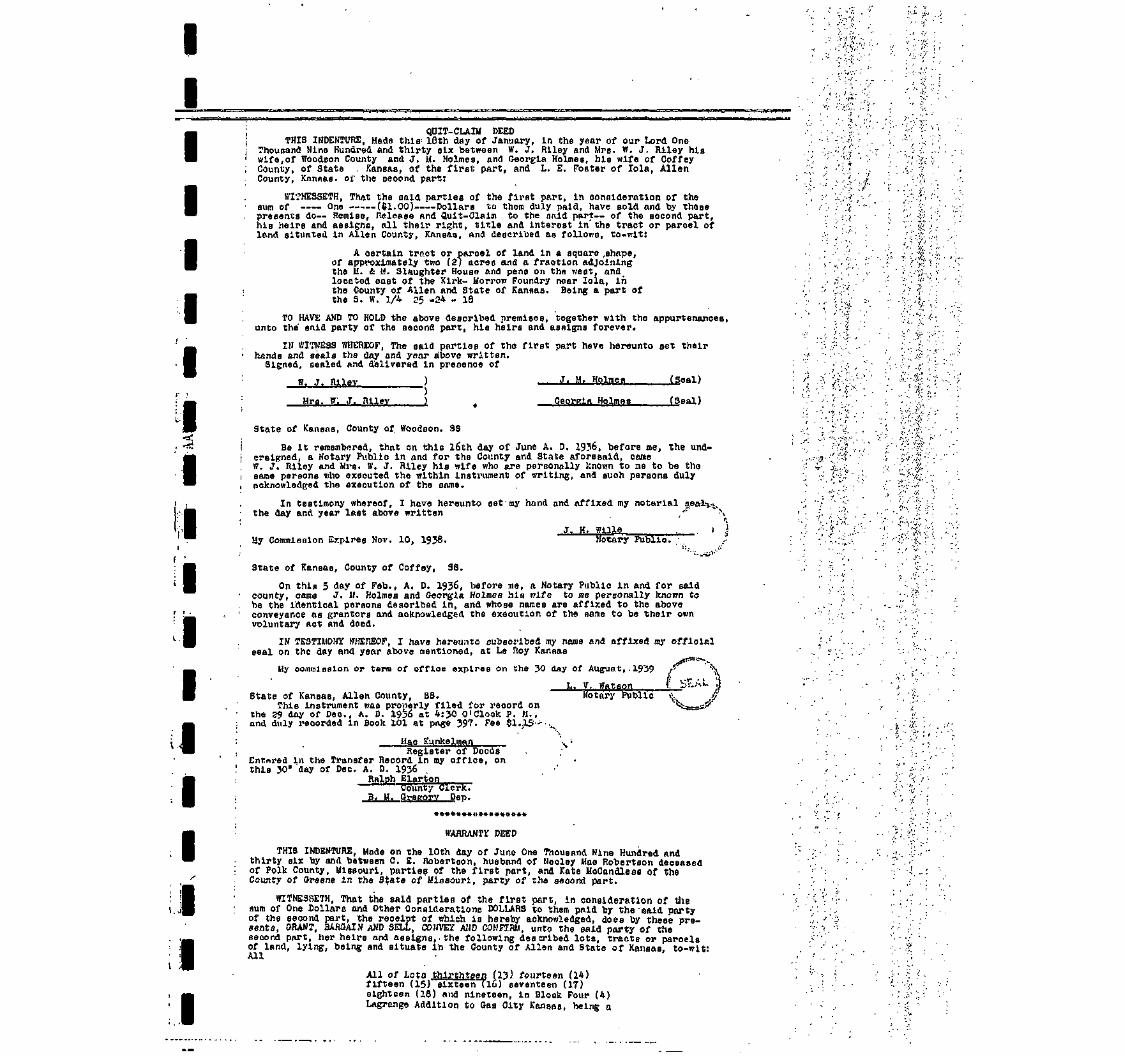
II
QUIT- CLAIM DEEDTHIS INDENTURE, Hads this-- 18th day of January, In the year of our Lord One
Thousand Nino Hundred and thirty alx between W. J. Rlley and Mrs. W. J. Riley hiswife, of Wbodson County and J. M. Holmes, and Georgia Holmes, MB wife of CoffeyCounty, of State Kansas, of the first part, and L. E. Foster of Tola, AllenCounty, Knnnaa. oi' the second part:
WI?NESSETH, Thp.t the said parties of the first part, in consideration of thesum of One (ftl.Oo) Dollare to them duly paid, have sold and by thesepresents do— Remise, Release nnd Quit-Claim to the smld part— of the second part,his heirs and assigns, nil their right, title and interest in'the tract or parcel ofland situated in Allen County, Kansas, and described as follov;s, to-wlt:
A osrtaln trnct or parcel of land in a square ,shape,of approximately two (2) acres and a fraction adjoiningthe II. £ U. Slaughter House and pens on the west, andlocated east of the Kirk- Korrow Foundry near lola, inthe County of Alien and State of Kansas. Being a part ofthe S. W. 1/4 25 -34 - 18
TO HAVE AND TO HOLD the above described premises, together with the appurtenances,unto the snid party of the second part, hie heirs and assigns forever.
IN WITNESS WHEREOF, The said parties of the first part have hareunto set theirhands and seals the day and year above written.Signed, senled nnd delivered In preoenoe of
W. J. Riley ) J. H. Holmes (jjeal)
Mrs, ff'. J. Rllev I t Georgia Holmas (j3eal)
State of Kanens, County of Woodson. SS
Be it remembered, that on this l6th day of June A. D. 19?6, before me, the und-ersigned, a Notary Public In and for the County and State aforesaid, comeVT. J. Riley and Mrs. W. J. Riley his wife who are personally known to me to be thesame persons v/ho executed the within instrument of writing, and such persons dulyacknowledged the execution of the same.
In testimony whereof, I have hereunto set-my hand and affixed my notarial seaL*-the day and year laet above written . ," \
J. H. BUlS-
I
I
I
I
I
I<*-Si
I
II
Ii r .
I^ liy commission or tarra of office expires on the ?0 day of August, . 1939 ^ \•• • • / i '^• L. V. Watson \'. SE-At- ,J• State of Kansas, Allen County, S3. Notary Public^ $
This Instrument was properly filed for record on ^^m^• the 29 day of Deo., A. D. 1936 at 4s30 O^Clook P. Mlf
I
I
I
I
I
I
Hy Commission Empires Nov. 10, 1936. Notary Public. •"•'-i. i'-'-'
State of Kansas, County of Coffey, SS.
On thin 5 day of Feb., A. D. 1936, before me, a Notary Public in and for ealdcounty, came J, M. Holmes and Georgia Holmes his wife to me personally known tobe the 1'dentlcal persons described In, and whose names are affixed to the aboveconveyance as grantors and acknowledged the execution of the same to be their ownvoluntary act and deed.
IN TESTIMONY WHEREOF, I have hereunto subscribed my name and affixed my officialseal on the day and year above mentioned, at Le Roy Kansae
and duly recorded in Book 101 at page 397. Fee $1.15----..K
MaeRegister of Doous
Entnred In the Transfer Record in ray office, onthis 30" day of Dec. A. D. 1936
Ralph Elartoncounty Clerk.
3. M. Gregory Den.
WARRANTY DEED
THIS INDENTURE, Made on the 10th day of June One Thousand Nine Hundred andthirty alx by and between C. S. Roberteon, husband of Heoley Mae Robertson deceasedof Polk County, Missouri, parties of the first part, and Kate UoCandleaa of theCounty of Greene In the B^ate of Missouri, party of the second part.
WITNE3SETH, That the said parties of the first oart, in consideration of thesum of One Dollars and Other Considerations DOLLARS to them paid by the 'said partyof the second part, the receipt of which io hereby aoknovjledged, does by these pre-sento, GRANT, BARGAIN AND SELL, CONVEY AND CONFIRM, unto the said party of thesecond part, her helre and assigns,, the following described lots, tracts or parcelsof land, lying, being nnd situate in the County of Allen and State of Kansas, to-wlt:All
All of Loto thirthteen (13) fourteen (14)f i f teen (15) sixteen fl6) seventeen (17)eighteen (18) and nineteen, In Block Four (4)Lagrange Addition to Gas City Kansas, being a

IIIIIIIIIIII
IIIIIII
THIS INDENTURE, Made this ;':!.>.Bl day of -....y.Sli.tSRfe?.1: —, A. D., 19—ii.between I M n K - H n F»ni.»r_ fi tvjllnrf. , „„ . ---
I and State of Kansas, of the first part, and-
of the County of—
oa..«...~. ., „ ........... ; ,._of the second part;
WITNESSETH, That the said partx—....of the first port, in consideration of the sura of.DOLLARS
: to linr..._ duly paid, has gold and by these presents do..ui REMISE, RELEASE AND QUIT--
; CLAIM to the said portji of tho second part.— —Ilia heirs and assigns, all :..hw. right, title
and interest in tho tract or parcel of land situated in.._ Allan — County,, and State of Kansas, and described as follows, to-wit:
Saujfeacj; .....fo'.S.'Jgr !...(.») ...9J LJiqy.'A1?". ."nl-.y-riyq (2S). ftmnnnli'Jitnen ( i f l j ghat , A^lou QrmntV. Imnsu:: i Thonmt «iu;t fljlwcm t1. TS] . C feofc t'mmaij flmihli ^Oli^fout^ t t - . o j i l f t u e i>f brifc
-_f!aiiL_C£4lJ-,Sou.i;|iJ Bnnr.of: . tlunuin_riorth_;50i.4 Pedl : ; . tit onus
n^nfij (ir.ntfiinin/, 2.00 ucrec m o r e .
TO HAVE AND TO HOLD the above described prsmltca, (onether with the appurtances unto the said parti
of the second part .....liit heirs and asslffns forever.
i IN WITNESS WHEREOF, The said partjt of the first part ha..s hereunto set ...Jiar.j hand and seal the day and year above written.
... _ (Seal) i'lai;nic..iV^lJir. (Seal)iI (Seal) _ (Seal): (Seal) (Seal)
I _.... _ (Soal) _ (Seal)
; STATE OF KANSAS __.__LL..L..R..i: , COUNTY, SB.i BE IT REMEMBERED, That on this day of _..„.. .„.„, A, D., 19 ,
before me, the undersigned, a Notary Public in and for Lha County and State aforesaid, came „
I
who ....... ill ............. ponnnally known to mo to be the same poi-aon ........ who executed the within Instrument of writing,
; and euch person ____ duly aclntowladffed the execution of the aamu.i IN TESTIMONY WHEREOF, I have hereunto sot my hand and affixed my official seal, the day and year last
above written.
My Commission expires — „ — J)iUi.iJJib...)J1.4 Notary Public.
j Entered in Transfer Record In my office this ..... .5™.'., .......... day of ...... — &&fl.ta£ ------- ..... ---- , A. Ds 10.J
Owner Olert
STATE OF KANSAS, ___ L.U...IL.1J _________ .................. . COUNTY, sa.This instrument was filed for Record on the .......... Sih. ........ „ ..... _ ......... day of ......... .
A. D., 19..:'Ji..., at ____ 1£U2GL_. o'clock ____ A..._Mu and duly recorded in book ...... HP.. ------ at page. — IX ----------Recording Fee ?....3fl -------- Transfer Fee ? — ii ------------
Ooputy. Rtftiurof

THIS.
of -lola •. of-the first']
•... ...... . ,y..:-::.'~'f-^^ ;:•'.,: =4; Y-Y.:^ ; .',:'"'/"V:.-^ •/•-; •'••'•;-•.::;.'. '-'• ..••; :•''•••'•'^•-.'•C.,-~~ •" •™"nniE;vtoae:%iSv7:^day.:of'V., .- '.-'December1.. ' ; .; " ' . ,.&. X>.;19 -.'^.between.
11 i ' . ,_• ' !_ -A :i ••"•> • •;' ~1,:V*1 I A w1'.' " * ' . . ' : .'•' • ': • ' ' . • • ' "' ...'•> ,3 C-t-.i^u. '/\-P' K-ST1R3 R. Kansas
- . v . - • . . . .
Cnnimlssii
fuui. bui^ii ^iiu a < > i i L - , , - . y.M{y-;O>;i\«wwt'r«at'i "•« -u**i .v«i . iwii UA uiu i»u»i..;. .. , • • , _ ., ^. . - , . • - . . .jj; • •. ,. , * • • i • : , - r . = fl
.' IN" 'niSTIMOjJfy'.\VJjfejlEQl;,:.f hnve hiivouhlO::seVmy';biinil>nna iiffisoii-mj- p{flfiai;>ea'i;''Uiif;il'ny.'i(ul:-year.1Uiitt'-. .'".'..I• • - r - - . ' : • < • -J...- - ; . ' . ' . v;'--- • - , • " • • . ; . : - . • ^ . ^ • - . • . \ . • . . ' - . • • . • ' - , - ' • ' . • . . • : - . - . ' . . ' ; ' v " • • ' • l-'v • • ' - • ^ D
• above .flTitten." ; • - r:^ • • - " . ' ; - i • •.. •: . '". : - :., v '' -i .- •' '. -K-;. -:'-' ' " - ' • ;1 ' ^ " " - • • " " . - 'f-1 .\fci \ *-•'»r-. . . , .'.' '.'.:' - ' ' '." \'l•• .:•'•' ,- . ; • • • . - ; ; • ///J,•,-+- •'.://. '•::.-..::• j \,'~-\ ' •': . :.-. ••• • • • • • • • -Vi- ' • - . ' :-~r I1 •u^*res;..i...^.PERrAANN;JEFFERl(;.]..l.i 19, .;.......,.. :•• : ; ; • . <Sf*4**^Ji-'-t f** :'?- ^ '.'•• '•- i
IS^TOJl M/Commmlon'Expirtf. 'I. ? ' '-- '• '.'•' 'i ' '. '• - '•'•' ";. ' . . ' • '"' '. .'T'' '•! ' .:'"; !.''!'-': • :..'" V v.*?''-"!
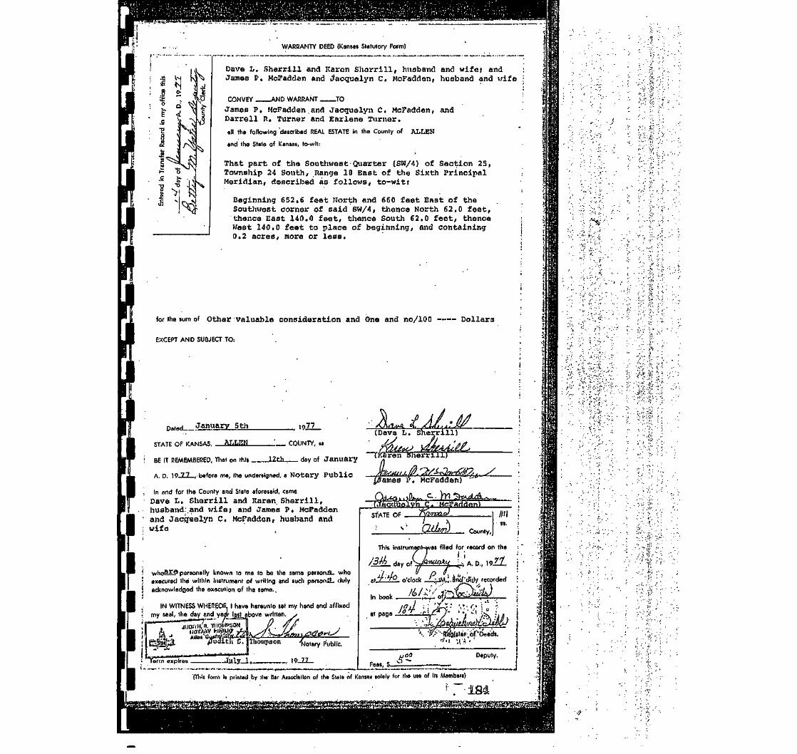
WARRANTY DEED (Kansas Statutory Form)
1/1
'•£8it>.E.c
§""«
|,Jd£C
T3
BJL
^
0
c•{
\
l-O
t>K
•DS.
v
l \
i 1: :
I 1
"\rs^
XJv1 \.Is
rO
^
V
S
jC
($
^j
S,
Dave L. Sherrill and Karen Shcrrill, huaband and wife; andJames P. McPadden and Jacquelyn C. McFadden, huaband and wife
CONVEY AND WARRANT TO
James P. McFadden. and Jacquelyn C. McPadden, andDarrell R. Turner and Earlene Turner.
all the following 'described REAL ESTATE In the County of ALLEN
and the State of Kansas, to-wlt:
-•
That part of the Southwest- Quarter (SW/4) of Section 25,Township 24 South, Range 10 East of the Sistth PrincipalMeridian, described as follows, to-witt
Beginning 652.6 feet Worth and 660 feet East of theSouthwest corner of said SW/4, thence North 62.0 feet,thence East 140.0 feet, thence South 62.0 feet, thenceWest 140.0 feet to place of beginning, and containing0.2 acres, more or less.
for tha sum of Other valuable consideration and One and no/100 Dollars
EXCEPT AND SUBJECT TO:
Dated .'ii1January 5th 19ZL
STATE OF KANSAS,
BE IT REMEMBERED, That on this.
: COUNTY, s>
12th day of January
A. D. 19JL2-, before me, the undersigned, a Notary Public
In and for the County and State aforesaid, cameDave L. Sherrill and Karen. Sherrill,husband:.and wife; and Janes P( McFaddenand Jacijtaalyn C. McFadden, husband andwife
,,,h^ara personally known to me to be the same person.8- whoexecuted the within Instrument of writing and such personS. dulyacknowledged the execution of tha same..
IN WITNESS WHEREOF.. | have hereunto aat my hand and affixedmy seal, the day and year last above written.
JUD!riil/S. THOMPSON IJ iioriysv Mflu? /-A. ^/{_Allen C^JWasM5Eii\<y .->ia
Public.
Term _, 10 n
(Dava L. She
snerrill)
tames I5. McFadden)
Ivh C.STATE OF .
County,
This Instrument-was filed for record on the
M day oJ*™*3*y^, A. D., wll.
recorded
Deputy.
Fees, $.
(Thli form It printed by the B»r Aiioclallon of the Stata nf Knnia« tolaly for Ihe uaa of III Memberi)

0\
WARRANTY DEED (Kansas Statutory Form)
r-
f;
Darrell R. Turner and Earlene Turner, husband and wife
CONVEY . _AND WARRANT TO
James P. McFadden and Jacquelyn C. McFadden, husband and wife
all the following described REAL ESTATE In the County of Allen
and the State of Kansas, to-wit:
That part of the Southwest Quarter (SW/-1) of Section 25,Township 24 South, Range.18 East of the Sixth PrincipalMeridian, described as follows, to-wit:
Beginning 652.6 feet North and 660 feet East of the Southwestcorner of said SW/4, thence North 62.0 feet, thence East 140.0feet, thence South 62.0 feet, thence West 140.0 feet to placeof beginning, and containing 0.2 acres,, more or less.
for the sum of One Dollar and other valuable considerations
EXCEPT AND SUBJECT TO:
Dated.... ________ March 31 , __, 19_ZZ_
STATE OF KANSAS, - ALLEN ___ COUNTY, »s
BE IT REMEMBERED, That on this — lot.h _ day of April
A. D. 19JZ— , before ma, the undersigned, aNotary Public
In and for the County and State aforesaid, cams
Darrell R. Turner and Earlene Turner,husband and wife
to ma to be the sama parson , whoJIed iS i)t)ilfilr/ ij*|-||nont of writing and such person J. dulyiv BdgaU.'i*ie execWI|5n of tha same.
P U B ^ X / J " /\r5rjtfilNESS 1-TEiEGn, I have hereunto set my hand and affixedy''£ei5V/VII'\>4n5.'year last above written.
Turner
If Thomas I. Powell Notary Public.
jj Term expires —1& f(a S-H'ST. , 19_LZ.
STATE
County,
This instrument was filed for record on the !
/J)_ day pk jpJu x. , A n., ioZ_Z. j
at/LA_D_ o'clock'C——AA/i'-and'duly recorded '
I J '/' y \ '- "*''! • !in book / fft I —.;;- rof v-\f B,Ps i<Q-> '
' ' • I •**• ^ ' • • • _ . I
At page4j?g.-; ',' '• : '.•* -' '•" .• - ' •:, ;•• •
Register.of Da«ds. jtrl /_ 'f\[) at. * ~- >
(Tlilt form Is printed by tha Dor Auoclallon of tha Slate of Konsui lolflly lor llw usa of hi Memberi)

1 -STATE OF KANSAS, 1
ft //e /O County, JITh is instrument was fifed for record
on the /-^- day of y**-^ A.D.10 /y~, at /' 30 o'rloek /7:..M , and
duly recorded in Book Z^Lof Deeds,
1st page •3<7''r
Q<^^A~J Z£M->
| FEESRegister of Deeds, .fnr recording, $ U> . 0 &:
•
County Clerk, for TransferTotal, $
Fnterad in Transfer Record
Iin my offirn, thi« uii.
H«y nf , A,D, 19'
^ County Clerk.
&Jj,
THIS INDENTURE, M.HO thk 13th H»y nf June
A.D 1995 hptwpsn lola Bark & Trust, Trustee of Janas P. NfcftdfenTrust under Will of James P. Miaddenof Allen rvinnty in thn <;tptf> nf Kansas
nf thH first part, ann1 Jade W. NfcFadden
of the second part:
WITNESSETH, That said part-^ of the first part, in consideration of
thp sum nf && ($1-00) „„„> °O p,QL|AR$100
the receipt of which is hereby acknowledged, dr> es by these presents.
Grant, Bargain, Sell, and convey unto said part_¥ of the second part,
.nis ...heirs and assigns all tho following-dftscribed real estate, situated
ftn undivided cra-telf (1/2) interest in and to:
• : . '.• -•;• .-' - .;•;(
; '' •'" • • ''*?' '/
'-• .-• . :
'• •- ''•'.
•'-.:• ' *. ' '
• '. -.*.
'• j; •/ •
-' - •-•••<.•"• -i. •• '';
•'. . f
at a point 660 feat east and 652.6 feet north of the Southwest oomar of 30/4, therce east 331.6 feet; .;therce north 391.4 feet, thenos test 331.6 feet, therce south 391.4 feet to beginning, Secticn 25, TbwnSup 24, j
18, Allen County, Kansas, less and except a tract dascrited as follows: j
g 552.6 feet north and 660 feet east of the authsest comsr of said SK/4, thaws north 62.0 feet, therce !140.0 feet, therce south 62.0 feat, theree west 140.0 feat to the point of beginning, and containing 0.2
acres, rrore or less. ;
ITO HAVE AND TO HOLD THE SAME, Together with all and singular the tenements, hereditaments and appurten-jnces thereunto belonging or in anywise appertaining, forever.
Arid said party of the first part
§, itsalf
agree, to and
t itbed in i^-
1 t*O ,Q^ T 3C!T^ "'>* Of* 3>^vtlfn r^
with said part Y of the second part, that at the delivery of the
3 ovjun rlnht of Jin nhcnlutA ano1 inHafnattihlA «ttat« of
id singular the above granted and described premises, with the appurtenances;and unincumbered of and from all former and other grants, titles, charges, estat
' ijncumbrances, of what nature or kind soever;
* ^^frid that . It _ wj|| i^nf-fAnr and fnrflvpr nWflnn* thp nflmp pntrt said n
his
•arsons whom
IN WITNESfirst above wr
1
f ATE OF KAN
BE IT REME/
1
y commissii n
P
i hereby covenant, promise and
5f> prftdflnfj .. IS . . lawfully
inheritance, in fee simple, of and in allthat the same are free, clear, dischargedes, judgments, taxes, assessments and
.rt 'V of th» ternnr) o«rt
V 1 fcfl *3 1 1 i J 11 'S
oever, lawfully claiming or to claim the same.
5 WHFRFOF, thp said pnrt V of the f'«t nnrtODSS horBiintn set its hsnd . the dav and vearlten' unMr Ll or s1
ByQ^^^g"> JaWy S. Gilpin
HAS, AT.T,^ rr>IINTY, ss,
SABERED, That nn this 13th Hay nf June
undersigned, a notary public In nnrl fr
jampH <^, flilpin. Trust Officer. Tola n,P. MpFadden Truat under will of James Pwho . TH personally known to me to DO the same
going instrument of writing, and duly acknowledged tIN TESTIMONY WHEREOF, 1 have hereunto set my
seal on the day and year last above written.
Kfp-.iuaat PU8I.C • Stic °' toB3 19 o '
ajsteeofJaies P. Mi ifai Trust
5%UL_., TBttst Officer
r 10 95 ; bpfnre me, the
r the County and State aforesaid, cameank S. Trust. Trustep of James. McFadden , ' . . .
person who executed the fore-le execution of the same. •h»nH aniH affl«Br( my Official
; iJaaAj^Notary Public.
I (This form ii printed by tha Bar Anocialion of tho State of Kanjos solely for the use of ill Members)
394

IIIIIIfttreetRstractCompanyfttu.
I
I
I
pntiebrsctera
IIII&ei
IJSei
.1
&ertinij
Elen,Hep,
bflonCounties
Nln QHfla
CERTIFICATE OF TITLE
STATE OF KANSAS, COUNTY OF ALLEN, ss:
We the undersigned, being duly licensed and bonded abstractors in and for said county andstate, do hereby certify that we have examined the records in the office of the Register of Deeds.County Treasurer and District Court, affecting the title to the following described real estate in saidCounty and State, to-wit:
That part of the Southwest Quarter (SW/4) of Section 25,Township 24, Range 18, Allen County, Kansas described-as follows:
Beginning 652.6 feet North and 660 feet East of the Southwest comerof said SW/4, thence North 62.0 feet, thence East 140.0 feet, thenceSouth 62.0 feet, thence West 140.0 feet to the point of beginning
That there are the following deeds of record affecting said real estate:
ABSTRACTERS NOTE: See deeds recorded Book 12, page 537; Book 19, page318; Book 25, page 459; Book 31, page 411; Book 27, page 476; Book 83, page 335; Book85, page 305; Book 101, page 204; Book 101, page 397; Book 110, page 56; Book 156, page306; Book 161, page 184; Book 161, page 488. (COPIES ATTACHED)
That there are no mortgages of record affecting said real estate.
That there is the following case of record in the District Court of said county regardiing James'. McFadden:
89P81
That the records in the office of the County Treasurer show the taxes for the year 2002 andprior years paid. Tax tract IA 03743A1 KSCAMA 077-25-0-30-19-008.00-0-0
This Certificate is made upon the mutual understanding that the maker thereof has notxamined all instruments and proceedings in the chain of title to above described real estate; that such ]ertificate is not a guarantee of title and that the maker thereof shall not be liable for defects in the :itle to the above described real estate. '
That the undersigned is a duly licensed and qualified abstractor in and for the county and stateforesaid, whose bond as required by law is in force at the date of this certificate.
Dated at lola, Kansas, this 9th day of September A.D., 2003 at 7:00 A.M.
License Eftjnded Abstractor
—en .-£••
i.

IIIIIII
1 -1
II
page 17,
George Sleeper and MiceSleeper, his wife.
to
Henry P. Merriman.
Abstract Ho. 6230.
Warranty Deed' $4000.00Duted liny 31, 1393Aok. June 1, 1693BeTore Henry HOB in, N.P.Cook; County, 111 (SEAL)Filed June S, 1603Recorded Book IS, Page 537.
Convey'and Warranti- SWi of Section 25, Townahlp £4, Range 18,Allen County, Kans«a. aubjeot to mortgage of $2000.00.
In daed and acknowledgment, Alice U. Sleeper.
I
I
i
Henry P. Uorrlman andOraoe R. Merriman, hin wife.
to
The lola Realty Co.
Warranty Deed $5150.00Dated Murch 3, 1897-nek. March 3, 1897Before C.E. Peifal, N.P.Cook County, 111 (SEAL)Filed March 9, 1887Recorded Book 19, Page 318.
Convoy and Warrant:- SWfc of Section 25, Township 24, Range 18, less"rient °t way of Kansas &, Colorado I'ooiflc Hailroad Co. und leas a strip25 feet wide off north side of aaid quarter, Allen County, Kansas.
•Mary E. Northrup, widow;•Frank A. Northrup and Alioe
M. Nortnrup, his wife; LewisL. Northrup and Lottie A,
•Northrup, his wife; and Delmer•P. Northrup and Dooiu A.
Northrup, hia wife; sole hoiraet law of L.L. Northrup, deo'd.
I to
The lola Healty Company.
'iuit-Claim Deed il.OODated Aug. '21, 1902Aok. Aug. 21, 1902Before Craigie ,3. McDowell. N.P.Allun County, Kansas (SKAL)
Piled AUE. 25, 1002Recorded Book £5, Page 459.
Iflemiae, Release and quit-Claim:- Coiumerioine at a point 660 feetast of Southwest corner of JWi, Section 25, Township 24, Hauga.18, thenoe
North 443 feet, thenoe Went 200 feet, thenoe North 509 feet, thenoe East888 feet, thenoe South 1044 feet, thence West 688 feet to place of beginning.
( "George Sleeper and wife mortgQKod, the ;5Wi of said section to L.L.orthrup. L.L. Northrup assigned the snid note and mortgage to n,B.Me
II
~who subsequently released the same. The aaid assignment front L.L. Nor'to H.JJ^ Merriman was not acknowledged and the sole purpose of this deedis to correct snid defect end perfect the release of record".
an,P

IIIIIIII1IIIIIIIIII
The lole Realty Company,a corporation, By7,A. Northrup, Prest.,Attest: Chac T. Scott.
to £-71William Lanyon (son ofRobert Lanyon)•
Warranty Deed "; $4000.00Dated Jan. 31, 1901Ack. Jan, 31, 1901He'f ore J.H. Vannuys', N.P.
County, Kansas (SKAL)
Filed Oct. 86, 1901Recorded Book 31, Page 411.
Convey and Warrant:- Commanding at a point 860 feet Saet^of-Southwestcorner of 3W£, Section 25, Township £4, Range 18, thence-Horth".445, feet,thence West 200 feet, theno« 'North B99 feet, thence•East 888 feet, thenceSouth'.1044 feet, thenoe '.Vest'606 font to place of beginning, subject toa av/itoh privilege granted the Mo. Pao. R .H. Oo. • : . . • :
William Lunyon (son of liobortLanyon) and Annie G. Lanyon,wife of said Willlorn Lanyon.
to
The United Zinb and ChemicalCompany, a corporation.
V.'urranty Deed §1.00Dftted Feb. 25, 1902AcV". Feb. 25, 1902Tiefore Ooorge V. Lewis, M.P.
;o. Mo. (.liEAJ.)
filed Feb. 27, 190fiRecorded Book £7, Page 476.
Convey and Warrant:- A tract of land na followsj-Beginning at a point BOO feet East of Southwest corner of SWi, 3oction
£S, Township 2-1, Ranee 10, thunce North 445 faet, thenco v/est SOO feet,thence North 599 feet, thenoe East 858 feet, tlience Uouth 1044 feet, thenoeWeat 688 feet to place of beginning. Subject to' switch -privileges ofMo. Pacific.

IIIIIII
t
III
F •
I
I
I
I
I
I
I
Oeo Seymouri County Clerk .Alien County, Kansas (S1£AL$
to • . . .
R«A. and R»U. Fry*
Tax Deed *375.21Dated Sept* 6, 1925Aok. Sept. 8, 19£5Before J..B* Smith» P.J*Allen Uounty. Kansas (SEAL)Filed Sept. 0, 1925 at & P.M.Heoorded Boole 83, Page 335,
KNOW ALL KEN BY THESE PRESETS!That Whereasi The following described real property, vizi.Com* 1548
ft East of SW comer of SW$ Sootion 25, £4-18, thence North 1044 ft, ff*888 ft* 3. 690 >ft» E, 200 ft. S. 445 feet E. 688 ft to beg* containing .19.29 acres situated in the County of Allen and State of Kansas, wassubject to taxation for the year A*D« 1921;
And Whereas, The taxes assessed upon said real property for theyear aforesaid remained due and unpaid at the date of sale hereinaftermentioned;
And Whereas, The Treasurer of oaid County did, on the 5th day of Sept.A.D. 1922, pursuant to notice given as required by law, at a public saleof real property for delinquent taxes, held ot his office in the countyseat of sqid County, and by virtue of authority in him vested, and inpursuance of a resolution of the -Uo'ird of County Commissioners of saidCounty, on the 4th day of Aug, 19&1, entered at page 504, volume K, of therecord of said Board, adopting the provisions of Chapter 162, Session Lawaof 1891, bid off in the name of said County the said property for the sumof One Hundred Twelve 65/100 Dollnrs, being the whole amount of taxes andcharges thereon; *. <*
And Whereas, The Taxes and ohm-sea against said property for the year1922, a noun ting to Eighty five & 39/3)00 Dollars, and for the year 1923,amounting to Eighty seven & 38/100 Dollars, and to, the yenr 1924, amountingto Seventy one & 32/100 Dollars, were duly entured on the book of Tax Salesopposite said property;
And Whereas, The said property hua remai ned unredeemed fromsald salefor the period of .tnree years;
And Whereas, On the 8" day of 8ept, 1923, H.A. & R.U. Fry of theCounty of Allen and State of Kansas offered to purchase said property forthe sum of Three Hundred Seventy five 21/100 Dollars, being the amountof taxes, penalties and coats then due thereon, and paid, said sum to theTreasurer of said County, and thereupon the said Treasurer d'id issue to saidR.A.& R.U. Fry a oertifionte of trmt dite, as id. ouch case provided by law,for and concerning said property, and the County Clerk of said County did,on the same day, duly assign to the purchaser aforesaid the said certificateof sale and all the interest of said County in and to saidproperty:
And Whereas, No part of the said prope 'ty has been redeemed from saidsale as provided by law, the said unredeemed real property having beenadvertised and notice given that it would be conveyed unless redeemed by acertain day named, said advertisement and notice having been made in sub-stantial conformity with alltho requisitions of the statute in such casemade and provided*

II
I<t
II
I
r
/
QUIT-CLAIM DEEDTHIS INDENTURE, Made thla- 16th day of January, in the year of our Lord One
Thousand Nine Hundred and thirty six between W. J. Riley and Mrs. W. J. Riley hiswife,of Woodson County and J. 11. Holmes, and Georgia Holmes, his wife of CoffeyCounty, of State Kansas, of the flrat part, and L. E. Foster of lola, AllenCounty, K.innas. 01' the second part:
WITNESSETH, That the said parties of the first part, in oonaiderat.ion of thesum of One (61.00) Dollars to them duly paid, have sold and by thesepresents do-- Rsmlse, Release and Quit-Claim to the anid par^~ of the second part,his heirs and assigns, all thalr right, title and Interest in the tract or parcel ofland situated in Allen County, Kansas, and described as follows, to-v.'lt:
A certain tract or parcel of land in a square .shape,of approximately two (2j acres and a fraction adjoiningthe U. £ a. Slaughter House and pens on the west, andlocated oast of the Kirk- h'orrow Foundry near lola, Inthe County of Ansn and State of Kansas. Being ft part ofthe 3. W. 1/4 25 -24 - 18
TO HAVE AND TO HOLD the above described premises, together with the appurtenances,unto the said party of the second part, his heirs and assigns forever.
IN WITNESS WHEREOF, The said parties of tho first part have hereunto set theirhands and seals the day and year above written.Signed, sealed and delivered in preoence of
Lgeal)W. J. Riley
Mrs. W. J. Riley
,.Ji Ht..H9J,BPP
Oeor^a. H.olitiBs (Seal)
State of Kenans, County of Woodson. S3
Be it remembered, that on this l6th day of June A. D. 19?6> before me, the und- •erslgned, a Notary Public in and for the County and State aforesaid, cameW. JJ Riley and lira. W. J. Riley his wife who are personally known to me to be thosome persons who executed the within instrument of writing, and such persons dulyacknowledged the execution of the same.
In testimony whereof, I have hereunto set my hand and affixed my notarial a.ealj,sthe day and year last above written ,•*" ' >\
My Commission Expires Nov. 10, 1938.J. H.
Notary Public. ,
State of Kansas, County of Coffey, S3.
On thla 5 day of Feb., A. D. 1936, before me, a Notary Public in and for saidcounty, came J. II. Holmes and Georgia Holmes his wife to me peroonally known tobe the Identical persons described in, nnd whose names are affixed to the aboveconveyance as grantors and acknowledged the execution of the sasie to be their ownvoluntary act and deed.
IH TESTIMONY WHEREOF, I have hereunto subscribed my name and affixed my officialseal on the day and year above mentioned, at Le Roy Kansas
Hy commission or term of of floe expires on the ?0 day of Aujjus.t, . 1939
L. V. ffataonState of Kansas, Allen County, 38.
This instrument was properly filed for record onthe 29 day of Dec., A. D. 193(5 at 4:30 O'clock P. «.,and duly recorded in Book 101 at page 397. Fee IS1..15-*-x
Notary Public
Register of DoeusEntered in the Transfer Record in my office, onthis 30" day of Dec. A. D. 1936
Ralph Elartoncounty Clerk.
3. U. Gregory Den.
«0*HK»#<HHH>#*MKH**«
WARRANTY DEED
THIS INDENTURE, Made on the 10th day of June One Thousand Nino Hundred andthirty six by ana between C. E. Robertson, husband of Necley Mae Robertson deceasedof Polk County, Missouri, parties of the first port, and Kate MoCandlena of theCounty of Greene in the State of Missouri, party of the second part.
WITNESHETH, That the said partieo of the flrat part, in consideration of thesum of One Dollars and Other Considerations DOLLARS to them paid by the 'said partyof the second part, the receipt of which la hereby acknowledged, does by these pre-sents, GRANT, BARGAIN AND SELL, CONVEY AHD CONFIRM, unto the sold party of thesecond part, her heirs and assigns, the following described lots, tracts or parcelsof land, lying, being and situate -in the County of Allen and State of Kansas, to-wit:All
All of Lots thirthteen (13) fourteen (14)fifteen (15) sixteen (16) seventeen (17)eighteen (16) and nineteen, in Block Four (4)Lagrange Addition to Gas City Kansas, being a

IIIIIIiiiiiiiiiiiii
THI3 INDENTURE, Made this Sillill. day of...
between l£l.aa::.La..E'i3£.ti!j:.,
_, A. D.,
__of the County of 4JJ.iiu_.
and State at Kansas, of the first part, and II.. J-..ilil''.addiin
....of the aecond part;I WITNESSETH, That the said party. of the first port, In consideration of the sum of...
DOLLARS
i to her. duly paid, hoc sold and by these presents AO..UU. HEMISE, RELEASE AND QUIT-
; CLAIM to the said part^f of tho second part, Ida— heirs and assigns, all.——'_har right, title
and Intereat in tho tract or parcel of land altuatcd in AI>IAA — ™—....._..«.«... Count?t: and State of Kaunas, and described ea follows, to-wit:
j SiSJillEiili- Qum-tar (?;) of Santlnn Tirnn by-."_iv o (3rQ. ToBnnhla Twenty-"->\ir .(.ML Soul.li. H..nro
i —jy£!&?£uu.i.aL&u<^.ju^woat ^!iK|C< j*BQl;{ tl-.onun flnulih 3t']..4_font. t to plaun iif frujinninE, opntainin^ 2.00 norus mnro
' nr lose.i
^
I ~" ~
: TO HAVE AND TO HOLD the above described promises, together with the appurtences unto the said parti
• of the second part tus. heirs nnd assigns forever.
: IN WITNESS WHEKEOP, Tlie said party of tho first part ha..s hereunto set .._lu=r__i hand and seal. the day and year above written.
_-p „„,..„..„ (Seal) _ p^-.,!.H.\ r \ ( f i i*^ _ (Seal)i! (Seal) (Seal)i
_ _ (Seal) _ (Seal)
(Seal) ,_ _ _' (Seal)
i STATE OF KANSAS A.J..JL..EJ.' — .-..., COUNTY, as.
I BE IT IlEMEMBERBD, That on this _ day of. _ , A. D., IB ,
i before me, the undersigned, A Notary Public in and for the County and State aforesaid, came
who—J.ti-. personally known to me to be tho same person who executed the within Instrument of writing,
i and euuh person duly acknowledged tho execution of the aamu.| IN TESTIMONY WHEREOF, I have hereunto set my hand and affixed my official seal, the day and year lastj above written.: eujN-Mi-JiSBt „
My Commission expires BI1K...J.S.-..13A& Notary Public.
I ' '| Entered In Transfer Hecord In my office this til.1.1. day of «...fet.nl*)r. —_, A. D., 19_Jj*_
....._™.... » p N"v1_t i:County OUrk.
, STATE OF KANSAS A..l_i..J:JI. — COUNTY. SB.' This instrument was died for Record on the —Si.1! day of jQc.totcu-. ,
A. D., 19..23...., at lO.iia....o'clock A....Mi, and duly recorded in book 110...... at page—IXJvecordlng Foe y -'J(\ ___Trnnafflr Fee y, ,lp
' !?.-<• M\1 ii i'.n-L. ...
Deputy. Bttfiur of Detdv

• • ' • ' . . - ' ;.;-.-:* ].^~---''-'-'-:--•'• . , - - • • i'1 •; .• ' . « '.' i ..':.' , . ' ' : - ' • •'„'''.'';j . > - ' . - • -.- -'• .' ' '' . . ; > ' ' • - - ; ; . ' ' ' V i , ""•;.",',; V.;0,EBl^irt lir^rriwrim<rv£*ovrt3Mn .my.nt/jho-.-'-Stata/^oJ .Kansas;.-;AJIpn County,'-BB. .
• ' .'••••" ••'.•••'.•.J',':'./•., ."'i--- r ?''/ '.:':.'" .-•;'•' "^ ;".- / -. .. •''••-.-.'\,. .--•'v.'."!-" ^'.V *•_'.'.' ' • ' " ? • ' / ' ' ' ' • ;
•"";.' "';• ,_.;..'.'._.'..•' ....;.,.r.I.li.;^,r,^; ^>l]±!:£^.'.;f V^St/1--'.;' '.i'%.': '&#$£•& ]&£&*ffi*$Q.Li&£2? '•
•• :' . f . : ~ /',-• Tn_.' ; :v:V£i;V;-3£j| ^^
j|P . " : ""_: :": f--v ,;-;•-; r:;-;V;--;:;;r^-^, .^| ^.f •/;:•'; •-: - . • • • • ' ^ •; ^ • , ; 1^^^™^ ^p--;--r--^
• ^ " WAnBANTY. T>Ei5E(:.'; ','^'.-' /,^. 'i-f^, ~ ., "'.'/••.;;' ' ' '"- . : ; . - . ;' .Iv'1 C :r ' ^: • " . i . i - > ' ' ' v " " ' \ .
. • THIS INTJENijJTR.Ji!', Maaeithia^'--^^^-.-"'! '.'•• De'dembsr;'._ •' '"_
/.woman, ;
.'of.Iola'
. .O'fJola' '• in the''cbuntjpr'ot^i',-':/All'eji? ?-;•. '. f' . -'• , ••• •; ~: and. Stiite-'of- Kansas' : : • •'the 'first'pnT^.-aTi(3>-^;-'v;.
v...;';,''-i'^j, .' -••••'/ •/•• .•• .' ..'." :.J'..'••-. .'.- .'-.,"'. •.'''''. ~'\':-''•''••', •'.--• ''•
'.'..'.'"' .: . : . • ' • ' '•'' "''*'.'•'' •'•• ?:'' '.'-'.i: * ; ' • ' : ' . ' ' . ''.'.''';' 'l.: '''•• . • . ' ' • • . ' • - • • ' V :,' „••'•' ' - • - ' . ' • • ' • ' [ . -
'•'' of' .'. "• Ailen: \L'":;•'•''/;\^'5''ijid'|tiit6-of-i'-'/'f 'K^fi sag;;-'.:; ;_':, /.^;. \ '" . •;'pf-the"sec£)?iai)irt;;..-•. .• - .. ': ••:• yvri'NESi3ETil,>TKat;!Bold 1'p'ftf^•'•yl:--i.'-ji'f..tlie-firjt;'p!vi:t, 1l> doiisulenitlon bf.fte.fium.^f.,; / One_ - ' • /:;-. -^.s. •.
"-1 ••*'.": • • • • ' •• TvYliar (f t l ':finV-an*'6thHf-aoed':''andvaluable cbnsidaratlohs '!-;.----i ^3bO31ffi£KH$8x"-' ' - . '
•'-'•'•.'.'. .'i "•• '',':•' ' .•• r--- ' : ' ' - ' '•': '.'•'.'li-;.-';'#::'.";"";•'•:.•'-'! 'C:.^'f'~". ''" -j :-i.'"' ' ' '/ ' .-•"{'. '.'':'. I-'. ','- '••'.'• "''.v-'-.f."'" jj ., •" ••"':•''•.! ' .'."''.-./.-v.'/,,.'-•/ !;..--. ^j/i-.-f'vr.'.'-j.i-iUvJ.pi?^ '.T-vX1-'I•'••,"•' :"-;->;.'-• -ij -i'-:-, :." ;S"- - • i....-?;-;'-^:?*'i;i'"'-'v1.'.: -:
j^l i;.'v with tli^'.aiiinirtenaiiRcSfJanrt'ab'jl^.e^to^titlerand-lnteroqt'JoLt^ of tlie'-tfrfft-parth'erem-....--' •>.?I''-'',' .'AncI'tJi'e flwlilVpart '.'..".^••.of.'tlie;;ftjloh;ji'afti:io '•agiJibirEbyi-Jcbv^harib'a.'n'^ iijiree. tViat' aV:tha.delivBry-:-fiei1eq;f-.-;'''-.'-"1;-,;!:'-." '• •-'-'' -
, ".Allin County.-Kt.~: -'I Uii Ctommlaslon- E»pltM
•-. ;M«y 22. W7V '.'.;; :

WARRANTY DEED (Kanaan Statutory Form)
2 •£
>
Dave L. Sherrill and Karen Sherrill, husband and wife; andJames P. McFadden and Jacquelyn C. McFadden, husband and wife
CONVEY AND WARRANT TO
Jamas P. McFaddan.and Jacquelyn C. McFadden, andDarrall R. Turnar and Earlane Turner.
all the following 'described REAL ESTATE In the County of ALLEN
and the State of Kansas, to-wlt:
That part of the Southwest Quarter (SW/4) of Section 25,Township 24 South, Range IB East of the Sixth PrincipalMeridian, described as follows, to-wit:
Beginning 652,6 feet North and 660 feet East of theSouthwest corner of said SW/4, thence North 62.0 feet,thence East 140.0 feet, thence South 62.0 feet, thenceWest 140.0 feet to place of beginning, and containing0.2 acres, more OK less.
for the sum of other valuable consideration and One and no/100 —- Dollars
EXCEPT AND SUBJECT TO:
Dated January Sth ., 19zz_ •.JL^t.A/.sMSTATE OF KANSAS, ..COUNTY, it
(Dave L. Sherrill)
^BE IT REMEMBERED, That on this lith day of January
A. D. 19_ZZ_, before me, the undersigned, a Notary Public
In and for tha County and State aforesaid, came
Dave L. Sherrill and Karen. Sherrill,husband:.and v;ife; and Jamas P* McFaddanand Jaccftielyn C. McFadden, husband andwifa
whoSE6 personally known to me to ha the same persons, whoexecuted the within Instrument of writing and tuch psrsonS. dulyacknowledged the execution of tha same.,
IN WITNESS WHEREOF. I have hereunto set my hand and affixedmy seal, tha day and yam* last above written.
Sherriii)
JUDITH, a.nir/MPSOHliOYiinv vaautf foAlton C««K-!JS«4*1
/Juclith S.
Term expires .
Thompson {)otsry pubnt..
, 19JU_
STATE OF
County,
This Instrumeri
day
as filed for record on the
**.! '•*, A. D., \*>H.n
;V°_ o'clock _^M.H.and'-dij)y recorded
Fees, $. ^
Deputy.
(Tliit form Is prlnnd by th» Bar Alioclallon of tho Slata of Kansni lololy for th» use of Hi Mombort)

E <
WARRANTY DEED (Kansas Statutory Form)
Darrell R. Turner and Earlene Turner, husband and wife
CONVEY . _AND WARRANT . -TO
James P. McFadden and Jacquelyn C. McFadrien, husband and wife
all the following described REAL ESTATE in the County of Allen
and the Slots of Kansas, to-wit:
That part of the Southwest Quarter (SU/4) of Section 25,Township 24 South, Range 18 East of the Sixth PrincipalMeridian, described as follows, to-w1t:
Beginning 652.6 feet North and 660 feet East of the Southwestcorner of said SW/4, thence North 62.0 feet, thence East 140.0feet, thence South 62.0 feet, thence West 140.0 feet to placeof beginning, and containing 0.2 acres,, more or. less.
for the sum of One Dollar and other valuable considerations
EXCEPT AND SUBJECT TO: .
Dated-.. -, 19-ZL.
STATE OF KANSAS ALLEN COUNTY, ss
BE IT REMEMBERED, That on this 19»-h day of April
A. D. 19-ZJ-, before me, tho undersigned, flNotary Public
in and for the County and State aforesaid, came
Darrell fl. Turner and Earlene Turner,husband and wife
to ma to be the same parion-g. whoexsEjrad tJfiS V)ilfflrj/iiiifc|n8nt of writing and such person JL duly
same.
•o BxecWf jpn of the
tf/f , I have harsunto set my hand and affixed
last above written.
lrThomas I. Public.
Term expires , 10 77
STATE
County,
This Instrument was filed for record on the
I 9 f)r\^- fi *-, 11-3 day of --*%^Vf-,, A" D" 19^- '
In book jLu2,Z_.',L "of J^-V/^Qv/-^
at page .
'' Regliter.of Doeds.
Fees, $-iI
ffhli form It printed by Ida Bar Ajsoclallon of Ilia SHU of Kanjai jolaly for the uio of Hi Members)

"at-
tGeneral Warranty DeeflA. 79-1437e, EXEMPTJON NO.
TATE OF KANSAS, 1/? //e /O County. J "'
IThis instrument was filed for record/ **'vD fi 1
n the . '•*-_ day of y**J>J A.D.?3£., at /''•&? o'clock ^M., and
duly recorded in Book /E^-of Deeds,it page
1^BWiopi ity
I FEESRegister of Deeds, .for recording, $ <&• <^
tounty Clerk, for TransferTotal, $
Entered in Transfer Record» my office, this ,>y of A.D., 19_
County Clerk.
THIS INDENTURE, Made this 13th -day of June
A. D., 19.95..., between lola Banjc & Trust, Trustee of Janes P. ftfaddsnTrust' under Will of Jamas P. E-fcPftfrten
Kansasof ___ AUai County, in the State of
Kansas
of the first part, and Jack W. MJadfal
of Allan County, in the State of
of the second part:
WITNESSETH, That said part./ of the first part, in consideration of
the sum of fog, ft1-99-) and JE_ DOLLARS100
the receipt of which is hereby acknowledged, do_Js___ by these presents.
Grant, Bargain, Sell, and convey unto said partjf of the second part,
_Ifi§_—heirs and assigns, al! the following-described real estate, situated
Allan County and State of j "533 , to wit:
urriividgd cne-talf (1/2) interest in and to:
at a point 660 feat east and 652.6 feet north oE the Southwest comar of 3^4, thence east 331.6 feet; ;
thaxoe north 391.4 feet, thare west 331.6 feet, thence south 391.4 feat to beginning, Section 25, Tt»n*ip 24, j18, Allen Oxnty, Kansas, less and except a tract ttescribsJ as follow: • j
, 652.6 feet north and 660 feet east of the Southwest corner of said 3^4, throe north 62.0 fast, therts i14oTo feet, thacs south 62.0 feet, thsncs west 140.0 feet to tire point of teginning, and ocntaining 0.2
acres, more or less. •
iTO HAVE AND TO HOLD THE SAME, Together with all and singular the tenements, hereditaments and appurten-
pces thereunto belonging or in anywise appertaining, forever.
nd said rarty of the first part '
itself
agree, to and with said part.
iized in its
if.q successors or assigns_, *0CKKX»OflaflZa«SCXaaeOoOOOBt»s>K do S. hereby covenant, promise and
of the second part, that at the delivery of these presents _,it is lawfully
own right, of an absolute and indefeasible estate of inheritance, in fee simple, of and in allid singular the above granted and described premises, with the appurtenances; that the same are free, clear, discharged
and unincumbered of and from all former and other grants, titles, charges, estates, judgments, taxes, assessments andipcumbrances, of what nature or kind soever;
Iid that _
his
will warrant and forever defend the same unto said part ..Y , of the second part,
Ihefrs and assigns, against said parf_Z of rhe first part,
irsons whomsoever, lawfully claiming or to claim the same.and all and every person or
II
IN WITNESS WHEREOF, the said partirst above written.
of the first OBrt does hereunto set__its___ hand , the day and yearlola EacJc S, Trust, Tkustee of Janes P. MSaddan TrustSSer r
S. Gilpin, Toast Officer
I
I
ITATE OF KANSAS, COUNTY, ss.
BE IT REMEMBERED, That on this 13th_ _day of June _, 1° 95 before me, theundersigned, a notary public in and for the County and State aforesaid, came
.Tampa S. f^lnin, Trust-. Officer. Tola Bank S, Trust. Trustee oF Jamps,P. McFadden Trust under Will of James P. McFadden~
who . _.Is_ personally known to me to oe me same person who executed the fore-going instrument of writing, and duly acknowledged the execution of the same. •
IN TESTIMONY WHEREOF, I have hereunto set my hand and affixed my Officialseal on the day and year last above written.
Ay commissi*
IiMAMRY PUBIC -StltlOlKiMU
JOYCE C. FOSTBTiMy<pptE»n./7-^-'i!? Vr Notary Public.
(Thil form is primed by the Bar Association of the Stale of Kaniat solely for the use of its Mamberi)
394

IIIIIIKtrcet
stratiCompanp
nc.
IIIIaflUrisctenf
I
I
I
Nln
CERTIFICATE OF TITLE
STATE OF KANSAS, COUNTY OF ALLEN, ss:
We the undersigned, being duly licensed and bonded abstractors in and for said county andstate, do hereby certify that we have examined the records in the office of the Register of Deeds.County Treasurer and District Court, affecting the title to the following described real estate in saidCounty and State, to-wit:
That part of the Southwest Quarter (SW/4) of Section Twenty-five(25), Township Twenty-four (24), Range Eighteen (18) East of the6th P.M., described as follows, to-wit:
Commencing at a point 860 feet East of the Southwest corner ofsaid SW/4, thence North 445 feet, thence West 200 feet, thenceNorth 157.6 feet, thence South 200 feet, thence West 150 feet,thence South 90 feet, thence West 150 feet to beginning, AllenCounty, Kansas ANDBeginning at a point on the South section line which is 1,010 feetEast of the Southwest comer of said Section 25; thence East 150feet; thence North 90 feet; thence West 150 feet; thence South 90feet to the point of beginning
That there are the following deeds of record affecting said real estate:
ABSTRACTERS NOTE: See deeds recorded Book 12, page 537; Book 19, page318; Book 25, page 459; Book 31, page 411; Book 27, page 476; Book 83, page 335; Book85, page 305; Book 101, page 204; Book 101, page 287; Book 116, page 127; Book 117. page445; Book 118, page 292; Book 172, page 3; Book 180, page 20; Book 183, page 290; Book194, page 120; Book 197, page 284; Book 198, page 71. (COPIES ATTACHED)
That there is the following Mortgage of record affecting said real estate:
ABSTRACTERS NOTE: See mortgage recorded Book 199, page 509. (COPYATTACHED)
That there are no Probate Proceedings, judgments, mechanic's liens, executions, foreignxecutions. attachments, or suits pending or transcripts of judgments from State or United States
Court of record in the District Court of said county against:
Donald L. Platt; Susan Platt; Scott A. Mueller; Dawn M. Mueller;
That the records in the office of the County Treasurer show the taxes for the year 2002 andrior years paid. Tax tracts IA 03733 and IA 03735A3 KSCAMA 077-25-0-30-19-018.00-0-0 and77-25-0-30-19-019.01-0-0

Iriiiittreet
itractCompany
I
I
I
nbeb
iiii
f b
"Loun'
I
"ifion
naunties
This Certificate is made upon the mutual understanding that the maker thereof has notexamined all instruments and proceedings in the chain of title to above described real estate; that suchcertificate is not a guarantee of title and that the maker thereof shall not be liable for defects in thetitle to the above described real estate.
That the undersigned is a duly licensed and qualified abstracter in and for the county and stateaforesaid, whose bond as required by law is in force at the date ofthis certificate.
Dated at lola, Kansas, this 9th day of September A.D., 2003 at 7:00 A.M.
ByLicensed ajic^Cjjtded Abstracter

IIIIIII
Convoy and Warrant;- SWj of Section 25, Township 24, Range 18,1 Allen County, Kanana. Subject to mortgage of 52000.00.I In deed and acknowledgment, <U.loe M. Sleeper.
Page
George Sleeper and AliceSleeper, hia wife.
to
Henry P. Merriman.
Abstraot No.. 6230.
Warranty Deed' $4000.QQDated Kay 31, 1803Aok. June 1, 1893Before Henry HOB in, N.P.Cook County, 111 (SEAL)Filed June S, 1803Recorded Book IS, Page 537.
Ii
I^ l
I
'Henry P. Morriman andGrace R. Merriman, hia wife.
to
The lola flealty Co.
Warranty Deed $5150.00Dated Jiurch 3, 1807.-ick. March 3, 1807Before C.E. Peifal, N.P.Uook County, 111 (SEAL)Filed Maroh 9, 1897Recorded Book 19, Page 318.
Convoy and Warrant:- SWfc of Section 25, Township 24,right of way of Kansas & Colorado I'Doifie Hallroad Co. and25 feet wide off north aide of said quarter, Allen County,
Range 18, lassless a stripKansas.
t!ary £. Northrup, widowj.'rank A. Northrup and Aliceif. Northrup, his wife} Lewis
;
, Northrup and Lettie A,orthrup, hio wife; and Delmer. Northrup and Dooiu A.
Northrup, his wife; aole hairsat law of L.L, Northrup, deo'd.
I to
The lola Healty Company.
Viu it-Claim Deed $1.00Dated Aug. '21, 1902/,ok. Aug. 21, 1902Before Craigie -J. McDowell. N.P.Allun County, Kansas (SKALJ
Filed Aug. E5, 1002Recorded Bcok £5, Page 459.
'•'V.
I Remise, Release and Q.ult-Claim:- Commencing at a point 860 feetast of Southwest corner of i3Wj, Section 25, Township 24, Range. 18, thence
North 445 feet, thence V.'eat 200 feet, thence North 509 feet, thence East388 feet, thence South 1044 feet, thence West 688 feet to place of beginning.
"George Sleeper and wife mortgaged, the SW$ of said section to L.L.tforthrup. L.L. Northrup assigned the said note and mortgage to H.B.Merrlman.who subsequently released the same. The said assignment from L.L. Nortnrupto H.J . Merriman was not acknowledged and the sole purpose of this deed
•is to correct said defect ond perfect the release of record".
I
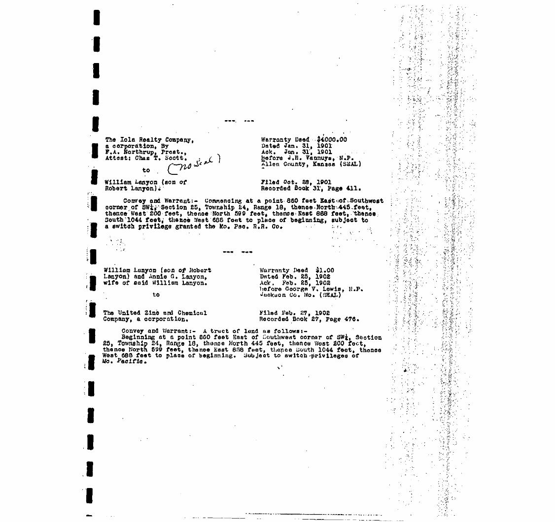
II
t
f
I
The lola Realty Company,a corporation, ByF.A. Northrup, Prest.,Attest: Chas T. Scott.
to
Warranty Deed $4000.00Dated Jan. 31, 1901Aok. Jan. 31, 1901Before J.H. Vannuys, N.P.JCilen County, Kansas (SEAL)
William Lanyon (son ofRobert Lanyon)i
Oct. 28, 1901Recorded Book 31', Page 411.
Convey and Warrant:- Commencing at a point 860 feet Hast oof--Southwestcorner.of SV/ij Section £5, Tov/nehlp £4, Range 18, tbenoe-Nortb-.445,faet,thence West 200 feet, thence North 590 feet, thence:East 838 feet, .'thence.South'1044 foet^ the&oe '.Vest 608 font to place of beginning, subject toa ev/It oh privilege granted the Mo. Pao. H.R. Co. ;. •..
William Lunyon (son of UobortLanyon) and Annie 0. Lanyon,wife of said William Lanyon.
to
The United Zinc and ChemicalCompany, a corporation.
V/arrnnty Deed $1.00Dated Feb. 25, 190£AcV. J'eb. 25, 19OSbefore Ooorga V. Lewis, H.P,>Juokuon Co. Mo. (SEAL)
Filed Feb. 27, 1902Recorded Book 27, Page 476.
Convey and Warrant:- A tract of land na followst-Beginning at a point SCO feet East of Southwest corner of SWi, Section
25, Township 2-1, Range 10, thonce Worth 445 feet, thence V/out £00 feet,thence North 599 feet, thence East 8f58 feet, thence iiouth 1044 feet, thonoeWest 088 feet to place of beginning. Subject to awltoh-prlvllegeo ofMo. Pacific.

IIIIIIIIIIIIIIIIIII
Oeo Seymour, County Clerk Tax Deed if375*21Allen County, Kansas (SEAL? Dated Sept. 8, 1925
Aok. bept, 8, 1925to . . . . Before J.«B. Smith» P.J.
Allen County, Kansas'(SEAL): Filed Sept. 0, 1925 at 2 P.M.
R.A. and R.U. Fry* Reoorded Boole 83, Page 335*
KNOW ALL MEN BY THESE PRESENTS:That Whereas,.The following doaoribed real property, vizJ Com* 1648
ft East of SW corner or 3«i Sootlon 25, £4-18, thenoe North 1044 ft, ff.868 ft» S. 590:ft, E, 200 ft. S. 445 feet E. 688 ft to beg, containing .19.29 acres situated In the County of Allen and State of Kansas* wassubject to taxation for the yoar A.D. 1921;
And Whereas,. The taxea assessed upon snld real property for theyear aforesaid remained due and unpaid at the date of sale hereinaftermentioned;
And Whereas, The Treasurer of said County did, on the 5th day of Sept*A.D. 1922, pursuant to notice given as required by Ian, at a public saleof real property for delinquent taxes, held at his office in'the countyseat of sa.id County, and by virtue of authority in him vested, and inpursuance of a resolution of the ^o«ird of County Commissioners of saidCounty, on the 4th day of Aug, 1921, entered at page 504, volume K, of therecord of said Board, adopting the provisions of Chapter 16£, Session Lawsof 1891, bid off in the name of aald County the said property for the sumof One Hundred Twelve 85/100 Dollars, being the whole amount of taxes andcharges thereon; *. (S, =.
And Whereas, The Taxes and ohurges against aald property for the year1922, amounting to Eighty five & 39/2)00 Doll ire, and for the year 1923',amounting to Eighty seven & 38/100 Dollars, and foi the yenr 1924, amountingto Seventy one & 32/100 Dollars, wore duly entorod on the book of Tax Salesopposite said property;
And Whereas, The said property huu remained unredeemed fromsaid salofor the period of ti/ree years;
And Whereas, On the 0" day of iiept, 1925, H.A. &. R,U. Fry of theCounty of Allen and State of Xanana offered to purchase said property forthe sum of Three Hundred Seventy five 21/100 Dollars, being the smount *of taxes, penalties and costs then due thoreon, and paid, said sum to theTreasurer of said County, and thereupon the said Treasurer d'id issue to saidR.A.& R.U. Fry a certificate of tnut d<te, as i$ such case provided by lav,for and concerning aaid property, and the County Clerk of said County did,on the same day, duly assign to the purchaser aforesaid the aald certificateof sale and all the intaroot of said County in and to saidpropertyt
And Whereas, NO part of the said prope 'ty has been redeemed from saidaale as provided by law, the said unredeemed real property having beenadvertised and notice given that Ik would be conveyed unless redeemed by aoert'iin day named, said Advertisement and notice having been made in sub* •stantlal conformity with a11the requisitions of the statute in such casemade and provided.

IIIII
United Zinc 4 Chemical Co.By A.R. Meyer, President(SEAL)
to
R,A. Fry and R.U. Pry.
Quit-Claim Deed $500.00Dated April 23, 1923fcck. May 18, 1925Before Joseph T. Beck,N.P.New York Co. N.Y.(SEAL)Filed Sept. 8, 1985necor'ed Btiofc 85, Puge 305.
Remise, Release and Quit-Olain:- LO acres, more or leas, commencingat a point 860 feet East of Southwest corner of GWi, Section 25, Township24, Range 18, theuoe North 445 feot, thenoe West 200 feet, thence North500 feet, the no e East 300 fnet, thenoe tiouth 1044. feet, thence West 608feet to beginning.
Subject to switch privilege granted to the Mo. Pao. R.H. Co. andsubject uleo to the R.R. right of way heretofore granted for existingtroots.
R.U. Fry,
III
J.M. Holnea and V/.J. fliloy
Quit-Claim Deed $100.00Dated Jan. 2, 1933Aok. Jan. 17, 1933Before Viola D. Dalgarno, N.P.Alien County, Kansas (SEAL)Filed Nov. 33, 1935Recorded Book 101, paga £04.
Remiee, Release and ^uit-Claliv.- A certain tract or parcel of laudsituotod at or noar lola, Allen County, Kansas, containing about 20 acres,more or less, described ua follows:-
Commencing at a point 860 feot east of the Southwest corner of theSWi of Section 25, Township 24, flange 18, thenoo North 445 feet, thenceWest 200 feet, thence North 599 feet, thenoe East 888 feet, thenoe South1044 feet, >thBnc« West 688 feet to place of beginnine.
Subje'ot to u switch privilege granted to the Missouri PacificRailroad right of way heretofore "granted for existing tracks^
(U3H3 Oanoellad Cl.OO). , . . , , . ,, r<-
S tM"-- -*'' ''V '•••'•'• ''' '-: ' "V"' " °''M * -• > "<• •• ' •'
I
I
I
I
I
I
I
I
W.J. Riley, Mrs. W.J. Rlley, hiswife and J.M. Holmes and GeorgiaHolmes, his wife
to
Orover Menzle and W.p.MoFadden
Consideration $250.00
CLAIM DEEDDated Deo. £4, 1935
Ack. Deo. 21, 1935 'Riley and Mrs. W.J.wifeBefore J.H. Wille, TWoodson County, KaniAok. Feb. 5, 1936 by J.U. no .and Georgia Holmes, his wifeBefore L.V. Watson, N.P,CoffeysCounty, Kansas (SEAL)
Filed July 2, 1936 at 1:50 P.M.Recorded Book 101, Page 334.
(U5IR Stamps shown $.50)
Remise, Release, and Cluit-Claim:- A certain tract or parcel ofland situated at or near lola Allen County, Kansas, containing 5 aoers.described as follows: to-wit:
Commencing at a point 1548 feet east and 652.6 feet north of theSW corner of the SW£ of Sec. US, T <J4 a, R 18 E, Allen County, Kansas;thenoe west 556.4 feet; thence north 391.4 feet; thenoe east 556.4 ft;thenoe south 391.4 feet to point of beginning.
We further agree to protect the said second party from anyone elseentering on the land owned by tho first party surrounding this tractdescribed above arid installing or erecting a slaughter house of any kind.The first .party also agrens to ci^e the aemoitd i-<p»rty the privilege of aright-of-way or roadway in and out over their own tract of 'land to thesecond parties' property fCee of charge. The second party agrees toprovide and maintain their own eus< water and electric line and be theowner of same.

IIIWII
T
.8 INDENTURE, Uade thla 22nd day of April, A. D. 1948, between H, Jt Rliey and franco a Ritey, hi* wife, ofKansaai Georgia Holme*, • widow, Iran* Jlolni*. * (ingle porion, and lien* Reed and John Earl Reed, her hueband,Topeka, Xaneaii and LeRoy Uolne* and 7*ra A. Koine*, hii wife, of LeRoy, Xaniaa, of'the firit part, and
It, f, Wright and B*ele Wright, Hie wife, of Eldorado, .Butler County, in .the State ofKane**, of the i*oond part'i
ItrTHESSETH, That tho ««ld partial of th* firet part, In oonaideratlan of the lua of
—-One Collar and other Taluable oonilderatione ..'•-.--
Iit Halpt whereof ia hereby acknowledged, do by then preeenta, {rant, bargain, aell and convey unto the laid.rtiea of the ieoon'd port, and the ourvivor of then, ai joint tenanti,.»nd not ai tenaata in oonaon, all the followingu—Ibod Real Bitate. altuated ID the County of Allan, State of Sanaa.*, to witi
•eMln
of the Boutlweet quarter of Section 28, Townihip 24, Ranee 18, deioribed aa folio", *o-»itl
_ at a point 880 feet east of th* Seutliweit aorner of *ald Southweit Quarter, thenoe North 446 feet, thencei*t EDO feet, thenoe North EOT.6 feet, thence (alt 888 feat, thenoa South 862.6 feet, thenoe west 688 feet ta placeI '.Inning, but excepting hnrefrooi and axoluding fro! thl* conveyance the following deioribed traote, to-«itl
i; ^** Inning at a point in the South line of eald Sootlon 26, 1010 feat caat of the Bouthweet aorner of laid Section,hi ^Tealt 403.9 feet, thenoe North 290 feet, thenoe west 263,9 feet, thence South 200 feet, thenoe lie it 160 flit,herM South 90 feet, to the point of beginning, being th* tract conveyed by quit elaia deed dated Aug. 26, 19S3,ceouted by Holme* and [Uley by J. U. Kolas* and W. J. Rlley to Uinouri Paoifio Railroad Cw«p«ny, a Uiitourl Corpora-ion, recorded in Book 98, page 863 of th* deed reoord* of (aid County) (b) Beginning at a point 1413.9 feet eait of theo' gJMit corner of the Soutnwoit Quarter of *aid Section 26, thence eut 134.1 feet, thenoe Rorth 6B8.6 feet, thence• MB3 feet, thence South 362.6 feet; thenoe Eait 118.9 feet, thence South 290 feet, to place of beginning, being theri Haonveyed by warranty deed dated Sept. 89, 1939, by J. U. Holme* and Georgia Hoi no i, hi* wife, and*. J. Riley andreJBi Rlley, hii wife, to lola Oil and da* Service, Ina., and reaorded In Book lot, peg* 196 of th* deed reoordi ofaid County)
I conveyance it lubjoot to the public road and the railroad right af way of llisiourl, Paoifio Railroad Company.
f HAVE AM) TO HOLD THE 8AUE, Together with all and lingulir the tenement*, hereditament* and appurtenance* thore-into belonging or in any*!** appertaining, forever.
said parties of the flrat part, for th*m*elves and their heir*, axeoufcor* and adoinlatrator* do hereby covenant,and agree to and with laid partlea of the leoond part, that at the delivery of thoie proiente, they are lawfully
in their own right of an abaolute and indefeailbl* estate of inheritance, in fee ainple, of and in all and alngularthe above granted and deioribed premlies, with the appurtenances) that the lame are free, clear, discharged and unlneua-bered of and from ell former and other grants, titles, ehargei, estates, Judgment!, taxea, asiaiimant* and inaumbranoas,of _£ft nature or kind eoaverij|yit
HiatilPan
a{ iat they will TTAJWAJiT AND FOREVER DEFBHD th* lane unto the laid partial of the aeaond part, their anlgni, and theheilPand a**lgn* of tha lurrlvor of then, ajalnit the laid fart lei of the firit part, their heir*, and all and everyperaon or perion* whonioever lawfully olalaing or to claim the »«me,
N WITNESS WIEREOF, The laid parti** of the firit part have hereunto let their hande, tha dayand year flrataboven.
Hlley -— ^^^ Fraaoee Rlley
Helmee Ajf^NS^ Irene ' Holmea
I • llolmee \p>^ tbT / Ilene Reed"i.VerTA. Holmee " John Earl ReW
I fl OIT KARBAS, ALLEN CODHTT, S3,IT REMEMBERED, That on tU« 4th day of llay A. D, 1B46>before me, the undersigned, a Hotary Public in and for
lounty and State aforesaid, oane R. 1, Bilay and franoei Rlley, his wife, who ar« penonoily known to aa to be the.lane perioni who exeouted the within liutnownt of writing and luch perioni duly acknowledged th* execration of the• an*.
IIN WITNESS WHEREOF, I haw hereunto let my hand and nottriU.ladal, the day and year lait above written.
J. li. Itllle Hotary Public
Term expire* Nor 10, 1946, . \
\ I07 UKSAS, Allen County, is. ' ,PuKttt'in§0 ,
It Remembered, That in thli • day of April, A. D. 1946, before me, the underlined, a Rotary PuKttt'in and forunty and State aforeiald, eaneTeRoy Holne* and Vera A. Holme I, hii wife, a ho are perionally knovn to M to b*
the eane perion* who exeouted the within instrument of writing, ond nuoh perione duly acknowledced the -execution of th*lane.
. IH TESTIUOWT KICEFBOr, I have hereunto let ay hand and affixed my teal, the day and year la*t above written.
..(••bnni
I
C. t. Card Notary Publicnien explrei Auguit 13, 1949« ~" "
ireied on page 128) > ,

IIIIIIII4iIiiiiiiii
THIS INDENTURE, Made thl« ._..4±h. ...... - ........ „ day at -------- JilUB ___________________ A. D., 19—11 ------ , between
_____________ ..... ___________ gUni-lin V- Tina, M n wil'3
of Ma In tho County of AUSJA __ and State of -of thfl first port, and ..».«..«_....«.«._»..._»»».»....»»..»>»_ *....._ _,___._,,.„..,.,,,..,.......j--,.,.,,.
of Ini& In the County of .
.Mi5S and State of ,&M]Sflfi._ __ of the second part:WITNESSETH, That laid pnrt..Aos... of the first port, In consideration of the sum of ,
±iciia.^5mr_j;..rms^R DOLLARSto .-SJ.9.S duly paid, ha_Z?..... sold, anrt by these present! do GRANT and CONVEY to tho enld port.ioo of tho Second part,....ihair heira and aaaigns, nil tbnt tract or parcel of land situated In the County of AlLiM) „ _ _ — and Stateof Kanaaa, OB follows, to-\7lt:
and that .they will WARRANT and DEFEND the fcma in tha quiet nnd peaceful possession of the said port_.ioe— of the second
pnrt .thflir. heira and assigns, foravor, against nil iwrsonB lawfully claiming tho same.IN WITNESS WHEREOF, Tlie »ald pavtiSS of the firnt imrl ha...Yfl hereunto set ..Jtluit.— hand 9 _ and seaL.S the
day and j'em1 above wrltfon.?;F. Bright (SEAL) _..J&.Si.V..£r&8!lli (SEAL)
_._.ilcminr...ru..Ilo.a _ ...(SEAL) _.Sl(inaJw...y...J3.na. (SEAL)_ (IJ15.1.U _..\..' — (SEAL)
STATE OF KANSAS, JOlan. - Comity, as.-filMT REMIZMBEKED, That on thla _....*& dnj- of . W?.?. —.__ A. D., 10 *? before
me, the unduloiwd, a Notary Public In and for said County nnd State, aforesaid, came
who ...... «r.o ........... personally known to me to bo the same peraon..«_ who executed the within Instrumont of writing, ond such pcrson_S_ dulyoclcnowlcdffod the execution of the aama.
IN TESTIMOrnr WHEREOF, I have hereunto sat my liand nnd affixed my official seal, the day and yearla^tbova, written.
____ Qnnjfl.t..£.».- Cflaa. ____ r ^F At 'j _____My Commiasion empires ______ .Qisi...A...r. ........ . ...... ............. 10...4S. ..... ' |J UT-"'- Rotary Public,
Entered in Transfer Record In my ofnoe thil ..... „.'/. ............. dny of . ......... __ ..... JuiW. ----------------------- A. D., 1B.A7. -----
County Clerk.
STATE OF KANSAS ------- ............... jaiea ...... ------------ County, ss.This Instrument wa« fllod for vecord on tho ,........S ...... ----- ..... day of ------------- Juna ----------------------- ...... -A. D., 19 — .47_. at —
o'clock ___ EI....M., and duly recorded In Book.. ...'117. ..... .... on Page ...... — ALE .....
........... ________ .............. ___________ ..; ________________ ...... .... ____________________ E3.taJU«1_C.cj£ ...... ____ i-LDeputy. \ Register fit Deeds.
Fee, $....J..Ott ------- - ''^.-if'
with the Hppnrtenancea, and oil the estate, title and Interest of the said part.i»A.... of tho drat part therein. And tho said partijaa.— of the -. "•first, part do hereby covenant and ajrec that at the delivery hereof .thoy.Mirfl.. the lawful o\vner...a of tho premises iihove pnntjd • : :
and seized of a good and Intlei'ensible estnte of Inhorltanco thorain, free and clear of all Inciimbrancea - ' . '.r .' ._ _ . • •V

III
DEED—General Warranty—Joint Tenancy
THIS INDENTURE, Made this 4,tb.— dny of J»THttween : IV.....!
. A. D., 194_7_.
of ___________ lola., ........ JiH.an. County, In the Stato of of the first part
of' ______ ... __ loin, ________ Allan. ....... _ ...... ___.._...„_._. __ County, In the State of' ____ ..... ____________ .WITNESSETH, Thnt the Mid part.iaa.... of the first port, in consideration of the Bum of
lsrjind. othe.rjynluablo considerations -~~ ........... ~ ........................................
...... ________ of the second part:
.the receipt whereof Is hereby acknowledged, do. .......... by these presents, grant, barirnln, sell and convey unto the said parties of the second
frt, (and the survivor of them as joint tenimts, and not as tenants In common,) all the following described Real Estate, situated In the Conn-of .. Allan ...... __ ....... State of ........... Kj.n.?.S?.._ ..... __ ....... ____ . ___ to-wit: . .
*
I
I
I
I
I
|mt p&rt of tho Southwest Quarter of Section 25, Township 24, Range 18, described as follows, to-witi
Commenoiiig at a point 060 feet east of the .Southwest oorner of said Southwest Quarter, thenoeNorth 145 foot, thonoo West 200 feot, thsnoe North 207.6 feot, thenbo East 008 foot, thenoeSouth 052.6 feot, hhonoe wost 600 foot to plaoo of beginning, but excepting therafrom andexcluding from thic conveyance the following dosoribod tracts, to-witi (a) Beginning at a pointin the South line of said Soot inn 26, 1010 feot east of the Southwent corner of said Sootion, thenoe •East 403.9 foot , thonoe "orth 290 feat, thenoe went 2S3.9 feot, thenoe South ZOO feot, tlmnco Wost160 foot, tltonoe Smith 90 foot, to tho point of beginning, being the traot oonvoyod by quit clalnJood dated Aug. 26, 1933, executed by Holmes and Riloy by J. M. Holmes and W. J. Dlley, to MissouriPacific Rail road Conpany, - Hlnsouri Corporation, recorded in Doolc 90, page 253 of tho flood raoordc of saidCo'.mtyj (b) Beginning at a point 1413.9 foot east of tho Southwest oomsr of the Soiithwost Quarter ofsaid Section 26, thonoo Cent 134.1 feat, thonoe North 652.6 foot, thenco nest 25} foet, thonoo South3fi2.fl feet, tlionoo Ennt 116.9 foet, thonoo South 290 feet, to plaoe of boglmin^, being tho traotoanvoyed by warranl:y dead dated Qnpt. 29, 1939, by J. M. llolmoo and Georgia Hnlmos, his wife, and Yf. J.Rlley and Franco3 Itlloy, his wife, to lola Oil and Can Sarvioo, Ino., and recorded in Book 104, page 396of the deed roconlc of said county; but this oonvoyanao Is subjoot to the public road and tho railroadri£]it 01' way of Mlcootirl, Faoifio Railroad Company.
TO HAVE AND TO HOLD THE SAME, Together with all and singular the tenements, hereditaments and appurtenances thereunto be-inglng or in Anywise appertaining forever.
And snid part.iaa.... of the first part, for .tlioo!l_l.Yea.._Jid..);IU3.ir heirs, executors and administrators do___icreby covenant, promise and agree to and with said parties of the second part, that at the delivery of these presents, ._thoy...orj»
lawfully seized In their. own right of an absolute and Indefeasible estate of inheritance, in fee simple,-of and In all and singular
E above granted and described premises, with the appurtenances; that the same are free, clear, discharged and unincumbered of and fromformer and other grants, titles, charges, estates, judgments, tsxes, assessments and Incumbranccs, of whet nature or kind soever;
Hnd that ...,.._...th-y. _ will WARRANT AND DEFEND the same unto the said parties of the second part, their assigns, and theHeirs and assigns of the survivor of them, against the said port..ion of the first part, their heirs, and all and every person or
persons whomsoever lawfully claiming ni* to claim the name.IN WITNESS WHEREOF, The said pnrt..loji.._ of tho firat part .Imyfl. hereunto set .tfedir....... lumdA..., the day
Hnd year first above written.
I'ATE OF KANSAS, AUan. '. COUNTY, ss.BE IT REMEMBERED, That on (his ._...s±li day of _ ..Juno — , A. D. 19 A7._. before mo,
undersigned, a .............IIotajy..£ublio In and for the County and State aforesaid, came —
! •
10 ..-.A.r.9 ...... personally known to me to be the sumo person.fi ..... whooxecuted the within Instrument of writing and such per«on...'.._ dulyknowlcdged the execution of the same.
IN WITNESS WHEREOF, I hove hercunlo set my hnml and afiUod my nutarioJ ..._..above written.
'day and year last
I'ornt expires •»uot. 10 A? „ — ^rnB.t._9.i....SA!lfl Ljg.A.t_A Notary Public
Entered in Transfer Uecorrl , _..ln my office, this ........... 7 ....... day or . „ ...... June. --- ^S* -.,<'.. ---- A. D. 19_47_
".•...P.i.Jo.Y.i.W. ......... -------- , County Clerk
ITATE OF KANSAS. ... .......... AUjBn ------------------- County s«.This Instrument was died for record on the ._fi _________ „ ....... day of ........... Juno ....... _ ...................... - ...... _ ........ , A. D. 19. ..A3 ----- . at
' o'clock....!?..... .M., and duly recorded in BooltJ.18. ._-...»( Deeds at nage.~ia2-.— -if- " .^^^.
___ ..... _____ _______ ______________ ........ Deputy .„ ............ K&talla,..Corr. ---------- /_._........, Hcgistcr of Deeds
""*"" FEES ~ /ifrlHlc. nnilB, fur rmnnllnn nnimU Hcrlr, for \mm(nr . .Is™

NT TENANCY WARRANTY DEED (Following Kansas Statutory Warranty Form)
r§iii
This day ofHomer G.Tice and Velma L. Tice7 husband and wife
December 19. 83
CONVEY AND WARRANT TO
Homer G. Tice and Velma L. Tice, husband and wife
as JOINT TENANTS and not as tenants In common, with full rights of survivorship, the whol
estate to vest In the survivor in the event of the death of either, all the following described REA
ESTATE in the County of Allen
and the Slate of Kansas, to-wlhThat part of the Southwest Quarter of Section 25,Township 24, Range 18, described as follows, to-wit: Commencing at a point860 feet east of the Southwest corner of said Southwest Quarter, thence North445 feet, thence West 200 feet, thence North 207.6 feet, thence P.ast 8fl8 feet,thence South 652.6 feet, thence west 688 feet to place of beginning, but ex-cepting therefrom and excluding from this conveyance the following describedtracts, to-wit: (a) Beginning at a point in the South line of said Section 251010 feet east of the Southwest corner of said Section, thence East 403.9 feet
ice iNortn 9.0 feet, thence west 253.9 feet, thence South 200 feet, thence West 150 feet,nee South 90 feet, to the point of beginning, being the tract conveyed by quit claim deed
dated Aug. 26, 1933, executed by Holmes and Riley by J.M. Holmes and W.J. Riley, to Missouri'"•ific Railroad Company, a Missouri Corporation, recorded in Book 98, page 253 of the deedords of said County; (b) Beginning at a point 1413.9 feet east of the Southwest comerthe Southwest Quarter of said Section 25, thence East 134.1 feet, thence North 652.6 feetmce west 253 feet, thence South 362.6 feet, thence East 118.9 feet, thence South 290 feetplace of beginning, being the tract conveyed by warranty deed dated Sept. 29, 1939, byHolmes and Georgia Holmes, his wife, and W.J. Riley and Frances Riley, his wife, to
a Oil and Gas Service, Inc., and recorded in Book 104, page 396 of the deed records of.d county; (c) Beginning at a point 860 feet east>445 feet north, 200 feot west and 207.6
" the Southwest corner of the S.W. 1/4 of Section 25, Township 24, Range 18,>35 feet, thence South 50 feet, thence West 635 feet, thence North 50 feet to
of beginning; but this conveyance is subject to the public road and the railroad:t of way of Missouri, Pacific Railroad Company.
EXCEPT AND SUBJECT TO.
tor the sum of: $1.00 and other good and valuable consideration and love arid affection
I
I
I
DAI..H December
ITATE OF KANSAS,
£ IT REMEMBERED, That on this .
COUNTY, ss ' . .-^AjLtrrwn-s^(Homer G. Tice)
—3 ^ day of December .
_*-e_
,. D. 19 B3 , before me, the undersigned, a notary public
and for the County and State aforesaid, came
Homer G. Tice and Velma L. Tice, husband and wife Velma L-
./ "1-<!__JS-L-/.'/,^
Iw
I
xaxe gersonaljy Jthown to jne to be the same person_S who
YOHO
My Appointment ExpitBs:N WITNESS WHEREOF, I*9iiifitneiday- and- year
bf writing and such person S dulyha same.
^hereunto set my hand and affixedva written.
irm expires
Notary Public.
STATE O
This instrument wos filed for record on the
lj**> day of (j'kf r/f>MA'" ', A. D., 196 Jl
al\' £l o'clock 5?- -M., and duly recorded
in book .. 1,.1/tj. of L ili t fl V \
at page • '
C\ f\i^ yFees,
0035
I(Thii form ii prlnlod by iha Kanm Bar Asmcialion lololy lor ilia ui« nl in Membursl
t

I
II
I
I
I
I
If' '•
I
I
I
I
I
I
I
I
I
I
Emwod to Two* nwart IB my
19ff *? ^ . r.l.dlorroco«lihll£<£I.doxo» S&ggJS. A.D
19 2. aMiaejj'doct-. ^£_M, and duly rotordod In
County ClerK foot Afc' ni gaa^«,?. _d7<j
f'ltj.je r f lUgllttrolDoodi
WARRANTS DEED &£ > # . - « >
Homer G. Tice and Velma L. Tice, husDand and wife,
CONVEY AND WARRANT TO
Homer G. Tice
All of the following described real estate in the County of A l l e n ,State of Kansas, to-wit:
That part of the Southwest Quarter of Section 25.Township 24, Ranqe 18, described as follows, to-wit:Commencing at a point 860 feet east of the Southwestcorner of said Southwest Quarter, thence North 445 feet,thence west 200 feet, thence North 207.6 feet, thenceEast 888 feet, thence South 652.6 feet, thence West 688feet to place of beginning, but excepting therefrom andexcluding therefrom the following described tracts, to-wit:
(a) Beginning at a point in the South line of saidSection 25, 1010 feet east of the Southwest corner ofsaid Section, thence East 403.9 feet, thence North 290feet, thence west 253.9 feet, thence South 200 feet,thence West 150 feet, thence South 90 feet, to the pointof beginning, being the tract conveyed by quit claim deeddated August 26, 1933, executed by Holmes and Riley byJ.M. Holmes and W.J. Riley, to Missouri Pacific RailroadCompany', a Missouri Corporation, recorded in Book 98.page 253 of the deed records of said County;
(b) Beginning at a point 1413.9 feet east of theSouthwest corner of the Southwest Quarter of said Section25, thence East 134.1 feet, thence North 652.6 feet,thence West 253 feet, thence' South 362.6 feet, thenceEast 118.9 feet, thence South 290 feet, to place ofbeginning, being the tract conveyed by warranty deeddated September 29. 19'39. by J.M. Holmes and GeorgiaHolmes, his wife, and W.J. Ri ley and Frances Riley, hiswife, to l o l a O i l and Gas Service. Inc., and recorded inBook 104, Pace 396 of the deed records of said County;
(c) Beginning at a point 860 feet,'East. 445 feetNorth, 200 feet West, and 207.6 feet .north of theSouthwest corner of the Southwest Quarter of Section 25,Township 24, Range 18, thence East 635 feet, thence South50 feet, thence West 635 feet, thence North So feet tothe place of beginning,
said real estate being subject to public road and railroad rightof way of Missouri Pacific Railroad Company.
FOR THE SUM OF -Ten Dollars and other good and valuableconsideration
EXCEPT AND SUBJECT TO Easements and rights of way of record
Dated March 28, 1989.
(Homer G. Tice) ( Velma L. Tice )

IIIIII
t
IIIIIIIIIIII
wife, to lolaoil and Gas »'"-"llf-a .Book 104, Page 396 of the deed cacorHaJof* saitL'ICBuQtyjT^
i-.o. di.-i,f ^(C) Beginning at a point 860 feet East, 445 feetWest and 207.6 feet north of the
:>uthwes&0g£f r pf the Sotith'we'sji'.'Qqarter of Section 25,18, thencA!:Eaal;:.ft.3.6 fss.ti .theufia.south..
'60 fe'eiftjlMMtfe Jest 635 feet, thence No'rth 50 feet toFnning,
8aid''r'eal|JestateJbeing:''8Ub3ec-t'to'"pu'Bl'ic''road and railroad rightof way'of^i's'sour'ii1 Pacific Ra'i'11-dad 'Company. " ' • ' • • J " ' ; • • • • • • • •
?7! • " : « . . ! • • • : 3?:- i-ii--;. iV ^c'.pjn.. • -, j !.:..- aw
FOR";TH| , SUM 'tip ',;'•_ Ten' |Dbl I are' efhd';' other' °good;;; and "val uabl e
EXCEPT A'ND SUBJECT1 TO |. Easements'and; r.igfcts'of'way: of record1 '
Dated June ig . 1990.
L/£</WUiu rT,(Homer G. Tice) (Velma L. Tice)
JOINT TENANCY WARRANTY DEED
Homer G. Tice and Velma L. Tice, husband and wife,
CONVEY AND WARRANT TO
Edward C. Ranz and E. Anne Ranz, husband and wife, as joint tenantsand not as tenants in common, with full rights of survivorship, thewhole estate to vest in the survivor in the event of the death ofeither, all of the following described real estate in the Countyof Allen, State of Kansas, to-wit:
That part of the Southwest Quarter of Section 25,Township 24, Range 18, described as follows, to-wit:Commencing at a point 860 feet east of the Southwestcorner of said Southwest Quarter, thence North 445 f,eet, •:''••;.thence West 200 feet, thence North 207.6 feet, thenceEast 888 feet, thence South 652.6 feet, thence West 688feet to place of beginning, but excepting therefrom andexcluding therefrom the following described tracts, to-wit:
(a) Beginning at a point In the South line of saidSection 25, 1010 feet east of the Southwest corner ofsaid Section, thence East 403.9 feet, thence North 290feet, thence west 253.9 feet, thence South 200 feet,thence West 150 feet, thence South 90 feet,.to the pointof beginning, being the tract conveyed by quit claim deeddated August 26, 1933, executed by Holmes and Riley byJ.M. Holmes and W.J. Riley, to Missouri Pacific RailroadCompany, a Missouri Corporation, recorded 1n Book 98,page 253 of-the deed records of said County;
(b) Beginning at a point 1413.9 feet east of theSouthwest corner of the Southwest Quarter of said Section25. thertpenAEaet 134.1 'feet., thence North 652.6 feet,'thence west 263 feet, thence South' 362.6 feet, thence
ty~ East 118.9 feet, thence .Southf?i290 feet, to place ...pf, ...eiwS(arJaag-jjiniaa»«J3a.1ng the tract cphVe7Scr"by~waTrarrty~;'deed-
dated September 29, 1939, by „J. " "-" —J ° J-r-Mv, •Hdlmea,-''lhvp8»-w1fe, and W.J. —"-"-'
290

TENANCY WARRANTY DEED (Following Kansas Statutory Warranty Form)
IPI-™ ~ *40 d >|
i^T
(M§%
J
Thi. 17th A
j Edward C. Ranz and E. Anne Rana\ CONVEY__s__ . AND WARRANT — S — TOp Scott A. MueLle r and Dawn M. M3 undivided One-half interest A3 Platt, husband and wife , as to
as JOINT TENANTS and not as tenants in c
estate to vest in the survivor in the event o
ESTATE In the County of Al len
and the Stale of Kansas, to-wlls That paof Section Twenty-five ( 2 5 ) , TRange Eighteen (18) East of thto wit:Commencing at a p6int 860 feet
!^> said SW/4, thence North 445 feNorth-157.6 feet, thence East 6thence West 135 feet, thence Sthence South 90 feet, thence WAllen County, Ks.
1
: Br the sum of Ten Dollars ($10.00) and other v<
»CEPT AND SUBJECT TOi Easements, 'restrictions, £record, if any.
1
« n.u^ April 17th 10 97
ATE OF KAt
I IT REMEMB
D. 19^2_,
§ and for the
dward .C-.husba
1
Iho.areperso
executed the v.Iknowledged
IN WITNESSmy seal, the di
1
|
TT25h
05AS Allen cnUMTY »
FRFp Th*' o« thlc 17t-,ri Hty of April
before me, the undersigned, a Notary Public
County and State aforesaid, came
Ranz and E. Anne Ranz,nd and wife
nally known to me to be the same parsons- who
/llhln Instrument of writing and such persons, dulythe execution of the same. • '•'-."
•WHEREOF, 1 have hereunto set my hand: and. affixed' 'y and year last above written. ... #:••;.'' "- '•• ,
[/ •'!!•> • • • * '
^) ' • Notary Public.•^1^ iff?
[r»jw^££M22.
.v «« Aoril , 19 91
z, husband and wife
ueller, husband and wife, as to anND Donald L. Platt and Susanan undivided One-half interestommon, with full rights of survivorship, the whole: the death of either, all the following described REAL
rt of the Southwest Quarter ( S W / 4 )ownship Twenty-four ( 2 4 ) South,e Sixth P . M . , described as follows
East of the Southwest corner ofet, thence West '200 feet, thence35 feet, thence South 312.6 feet,outh 200 feet, thence West 150 fee:est 150 feet to beginning, in
md right-of-ways, of public
fidwa-nd C. . Ra^nz y^^s.&". /jii£K^t— «_\/""<xz--r— — v __ —*-E. Anne Ranz J (^T
, / \
5Tj»TB nsB ' -j^omaijo) i "
CaL) r_,vf "•This Instrument was filed for record on the/<? n D 9/7 •10 H,yof \JnMO ; A D.^ }Ql I,
••at_L2i/P o'clock ,.|7 -M., and-duly recorded
,.il-b /9'T n( tJWJ
; ^° Cjcu^Ji^/()jlj*"".. . ll Ij Register of Deeds.
J 00 • ' '• Deputy.Co... ^ 0 — . ' - .:mi • . . . •
; 120

WARRANTY DEED (Kansas Slalulory Form)
lilj6 < I -i
1• §
? ^
• -s \*• : r:•< >•o T
II*-*ls
•
h--1'
oc
. <£V.
c?jioiu1"36
Scott A. Mueller and Dawn. M. Mueller, husband and wife andDonald L. Platt and Susan Platt, husband and wife
CONVEY ....AND WARRANT . . _..TO
TERRA BTCERNATIONAL, INC.,
all Ihe following described RGAL ESTATE in the County of Allen
and Ilic Stalo of Kansas, lo-wil:
A tract of land in the Southwest Quarter (SW/4) of Section .Twenty-five' (25), Township Twenty-four (24) South, RangeEighteen (18) East of.the Sixth Principal::Meridian, -describedas follows, to-wit:
Beginning at a point which is 1,160 feet East and 290 feet Northof the Southwest corner of.said Section 25, thence East.135.0feet; thence North 100 feet; thence West 135.0 feet; thence South100 feet to .the point of beginning. .
for the sum of One and other valuable considerations ---
EXCEPT AND SUBJECT TO:
. Dated
STATE OF KANSAS, _Alien COUNTY,
BE IT REMEMBERED, Thai on this __ a ______ day
A. D. 19_°fy before me, the undersigned, a Notary Public
in and for Ihe County and Slain aforesaid, como
Scott A. Mueller and Dawn M.Mueller, husband and wife
who_§£P personally known to ma to be Ihe same person.?, whoexecuted Ihe within Instrument of writing and such person.?, dulyacknowledged the execution of Ihe same.
IN WITNESS WHEREOF, I have hereunto set my hand and affixedmy teal, the day and year last above written.
NolAry Public - Slato ol Id.
Term nn|.lr.fi "XA"PI-*""""""-" lnon
STATE" OF JW5AS L. . ' E 1 » /i''
c " - : .••"•>.•: f;; ./ •. d.This Instrument Jait/Jled[fcl/ reaMrdl-'prJ tfie
'\\-"^\ -r" /' ' '*' !~ •? IT' '™ JAM ' 'l-.™ day of _J
at J-J.25_ o'clock
in book _i21__ of . DEBB.S
at page -JM
JACQUELINE WEBBRegister of Deeds.
BY { AAtL
F«es. J'-Deputy.
284

1 Corporation Deed (General Warranty-Joint Tenancy)
STATE OF KANSAS, 1 "/*1 ALLEN County, J "'
This instrument was filed for recordon thB 24 H,,y 0, JUNE A.D
19.21, at U^—o'clock JLM.. andduly rarori-I^HjpRonk ,."j? nf n<"?"\
1 fl* page 2(/^...) v. ..
• L/^iXiL/? Register of Deeds.
• By (.J Deputy.
• FEESRegister of Deeds,.
1far rerording,., '...••.';" ,$, 8.00
County Clerk.Vfo; Transfer.- . \.-. ......;••• .'Tfttnl,-*
_ P.ntfrtot'fa TVflnltfpr 'Rorffi \ '.
• in rny/^fi&.Mhif'^^l^M4*
•^V^^f :;;kV''^<*,'••. :>-V ;. '.: . • • • . ' • . • . " ,'.:
. . j^ffitfit&^iJJz^W^tyult-• • \ %0f •^•^y&Bn'ly Clerk. (
J.
1
1A tract of land in the S
a (25) , Township Twenty-fo•:'• Sixth Principal Meridian
' Beginning at a point onof the .Southwest corner
1 North 90 feet; thence Weof beginning.
1™ TO HAVE AND TO HOLD THE SAME, '
thereunto belonging or in anywise apperta(f survivorship, the whole estate to vest ir
THi* INPFNTIIBF MnHfl 'his , £-5 ' Hny nf jAr*J*«-Y
fAn 10 9Ji h- .n TERRA INTERNATIONAL, INC.
a corporation duly organized, incorporated and existing under and by virtue
of lh» Ifm/t Of 'hi? SlfltO of ...PSl.aWare .nn> h»u;no It, pnnripffl
plflria of hinlnmi pi , , . , '" '"<• talo
of _. nf ih» fir.i p.ri anH Scott A. Mueller andDawn M. Mueller, husband and wife as joint tenants and notsJS tenants on paitiun, as. to an-undivided. One-half interestAhJT) [jnn^Tn T7 Pl rr Ann sn^an pTaYr r nn^nand ann wTYp p«^joint tenants and. not as tenants in common, as to an un-divided One- half interest , , , __
of Allen rn.mty in Iho
Sifltfl of Kao flS ,.,. ., flj joint t(.niin's with tho right of n^rvivorjh'p,and not as tenants in common, of the second part:
WITNESSETH, That said parlY of the first part, in consideration
nf Ina eum r\f On6 DOllaT anrl nO HOI 1 AD^
100
the rftrpipt of which is hereby acknowledged, do^S by these present*
Grant, Bargain, Sell, and convey unto said parLiSS — of the second part,as joint tenants and not as tenants in common, with the right of survivor-ship, the whole estate to vest in the survivor in the event of the death of
ei'hpr nil thp following-dpscnbed real i 'nto, *it"ntfld 1" ...AH?.!}.
County »nH *!B|O nf KanS3S _ _ tn w|t.
outhwest Quarter (SW/4) of Section Twenty-fiveur ( 24 ) South, Range Eighteen (18) East of the, described as follows, to-wit:
the South section line which is 1,010. feet Eastof said Section 25; thence East 150 feet; thencest 150 feet; thence South 90 feet to the point
'ogether with all and singular the tenements, hereditaments and appurtenancesining, forever, as joint tenants and not as tenants in common, with the righti the survivor in the event of the death of either.
nd said Grantor for itself, its successors and assigns, does hereby covenant, promise and agree, to and with said part..JL.es— of the second part, that at the delivery of these presents it is lawfully seized in its own right, of an absolute and(•defeasible estate of Inheritance, in fee simple, of and in all and singular the above granted and described premises,
, Jilh the appurtenances; that the same are free, clear, discharged and unlncumbered of and from all former and otherants, titles, charges, estates, judgments, taxes, assessments and incumbrances, of what nature or kind soever;f' *
'a
and that it will warrant and forever defend the same unto said parlies . of the second part, as joint«IC
na'nls and not as tenants in common, with the right of survivorship, the whole estate to vest In tha survivor in the eventthe death of either, against said party of the first part, its successors'and assigns, and all and every person or persons
whomsoever, lawfully claiming or to claim the same.
1
I
I
'.i IN WITNESS WHEREOF, the said party of the first part has hereunto caused this deed to be signed on its behalf byPresident thereunto duly authorized so to do, and has caused its corporate seal to be here unto affixed the day
id year first above written.
TERRA INTERNATIONAL, -
Vide- President
KCcrporate Seal)
(Thil form is printed by Ihe KlnlM B«r Allocation lolctly for the uie of ill Members) 71

I
I
I
I
I
I
I
I
I
I
ilI
carr
I
(/i
i
O n
'ATE OF
BE IT REMEMBERED, That on this
. COUNTY, ss.
fore me, the undersigned, a
A.No.tary_£uhlic_
_____ dfly of Qft9
. A.D. 19_2C_
In and for the County and State aforesaid
President ~< TERRA. DJTERN?VTIQNRI.f
a corporation duly organized, incorporated and existing under and by virtue of the laws of
Delaware
I
I
_, who is personally known to me to be such officer, and who is per-ally known to me to be The same person who executed, as such officer, the within instrument of writing on- behalf of
id corporation, and such person duly acknowledged the execution of the sample be the act and deed of said cor-•atlon.
IN TESTIMONY WHEREOF, I have hereunto set my hand, and affixed my official seal the dayand year last above mentioned.
A )/) Jli , . A / / . / I , ...~.Notary Public.
Term expires /WWffU**. tf 19f
•
II
' •'•'.•I''!'•v-.. \
*•

I• I
II, . .Ii:I • • ' . - . ' • ;
'5
" * * ' - - ' . ' • ' -
I APPENDIXpKANSAS GEOLOGICAL SURVEY WATER
WELLRECORDS

Table 3KGS Water Well RecordsFFSA United Zinc #1 SiteMaxim Project #3390184
S-T-R
NW 1/4, NE 1/4. SE 1/4 ofSection 25, T24S, R18E
NW 1/4. NE 1/4, SE 1/4 ofSection 25, T24S. R18E
NW 1/4. NE 1/4, SE 1/4 ofSection 25, T24S, R18E
SW 1/4, SW 1/4. NE 1/4 ofSection 35. T24S, R18E
SW 1/4. NE 1/4 of Section 35,T24S, R18E
NE 1/4, NE 1/4..NE 1/4 of Section35, T24S, R18E
NE 1/4, NE 1/4, NE 1/4 of Section35, T24S, R18E
SE 1/4, NW 1/4, NE 1/4 ofSection 36, T24S. R18E
Owner
KDOT
KDOT
KDOT
Kerr McGeeRefinery
Kerr McGeeRefinery
KDOT
Address
1 mile east of lolastation 127+58
1 mile east of lolastation 12+85
1 mile east of lolastation 127+80
100 West pf the Stateand Madison
Intersection, lola,Kansas
201 South StateStreet, lola, Kansas
1/2 mile east of lola,Kansas Station 09.011 5' from cl for ramp
Distance/Directionfrom the Site
- 1 mile east
- 1 mile east
- 1 mile east
-1 mile SW
- 3/4 mile SW
SW adjoiningproperty
SW adjoiningproperty
- 1/2 mile SE
WellDepth (ft.)
15
25
30
37
50
21.7
21.23
14
Static WaterLevelift.)
3
3
2
6
0
14.1
14.67
4
Well Use
Domestic(plugged)
Domestic(plugged)
Domestic(plugged)
Domestic
Domestic(plugged)
MonitoringWell
MonitoringWell
(plugged)
Domestic(plugged)
CompletionDate
08/15/97
08/05/97
08/05/97
06/14/78
06/10/78
7/25/1995
10/16/00
08/06/97

>Kansas•Geological
An~""r-T--"-"-shi[^ IIS.J^ ge:__^_. S^ 'n:
Township: 24S, Range: 18E, Section: 35.
Select location of well to view details.Click on column heading to sort.
Savp DatatoFile
13 records returned.
T-R-S OwnerWell Depth
Ascend.Desc.
Static WaterLevel
Ascend. Desc.
Est. YieldAscend.
Desc.Well Use
ActionTaken
CompleticDate
Ascend. De
Sec. 35NWSWSW 79 ft. 8ft. 1.5 gpm. Domestic Constructed 27-Apr-197l
Sec. 35NENWNW 36ft. 8ft. Ogpm. Domestic Constructed 08-Jun-197i
Sec. 35SWSWNE 37 ft. 6ft. 0 gpm. Domestic Constructed 14-Jun-197i
Sec. 35SWNE" 50ft. Oft. Domestic Plugged 10-Jun-197l
Sec. 35NWNWNW KERR MCGEE REFI 23ft. 15.8 ft. Monitoring
Well/Observation/Piezometer Constructed 24-Jul-1995
Sec. 35NWNWNW KERR MCGEE REFI 23 ft., 15ft.
Sec. 35NWNWNW
Sec. 35NWNWNW
KERR MCGEE REFI 28.8 ft.
MonitoringWell/Observation/Piezometer
MonitoringWell/Observation/Piezometer
KERR MCGEE REFllpft Hll5.8 ft. Ogpm. MonitoringWell/Observation/Piezometer
Constructed 25-Jul-1995
Constructed 24-Jul-1995
Constructed 26-Jul-1995
Sec. 35NENENE KERR MCGEE REFI 21.7ft. 14.1 ft. Ogpm. Monitoring
Well/Observation/Piezometer Constructed 25-Jul-1995
Sec. 35NWNWNW
KERR MCGEECORP 22ft. 15.3ft. 0 gpm. I
MonitoringWell/Observation/Piezometer Constructed 26-Jul-1995
Sec. 35CNNENW ,CITY OF IOLA 20ft. 10ft. Ogpm. Other Plugged 14-Nov-199
Sec. 35NWNWNW KERR-MCGEE 23.8 ft. 16.07 ft. Ogpm. I
MonitoringWell/Observation/Piezometer Plugged 08-Dec-199
Sec. 35NENENE
Kerr McGee RefiningCorp. 21.23ft. 14.67 ft. Monitoring
Well/Observation/Piezometer Plugged 16-Oct-200(
http://abyss.kgs.ku.edu/pls/abyss/wwc5.wwc5d2.mainQuerv ru/n/o

^.J An&»tj.,, . n
^KansasTownship: 24S, Range: 18E, Section: 26,
Select location of well to view details.Click on column heading to sort.
Savp Datato File
6 records returned.
T-R-S
Sec. 26NWNWSW
Sec. 26NWNWSW
Sec. 26NWNWSW
Sec. 26NWNWSW
Sec. 26NWNWSW
Sec. 26NWNWSW
Owner
CoastalMart
CoastalMart
CoastalMart
CoastalMart
CoastalMart
i 1CoastalMart
*
Well DepthAscend.Desc.
13 ft.
13ft.
13ft.
13ft.
13ft.
13ft.
Static WaterLevel
Ascend. Desc.
Est. YieldAscend.
Desc.Well Use
MonitoringWell/Observation/Piezometer
MonitoringWell/Observation/Piezometer
MonitoringWell/Observation/Piezometer
MonitoringWell/Observation/Piezometer
MonitoringWell/Observation/Piezometer
MonitoringWell/Observation/Piezometer
ActionTaken
Constructed
Constructed
Constructed
Constructed
Constructed
Constructed
CompletioiDate
Ascend. De;
18-Feb-1998
19-Feb-1998
18-Feb-1998
31-Jul-1998
18-Feb-1998
31-Jul-1998
Kansas Geological SurveyComments to [email protected]=http://www.kgs.ku.edu/Magellan/WaterWell/index.htmlDisplay Programs Updated June 17, 2002Data added continuously.
http://abyss.kgs.ku.edu/pls/abyss/wwc5.wwc5d2.mainQuerv 04/11/9
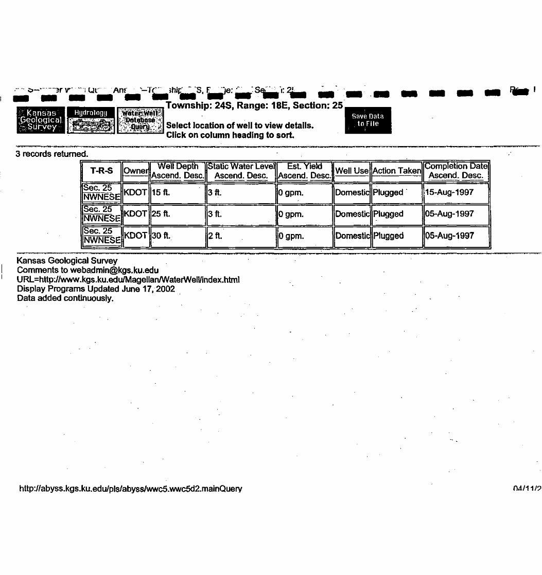
O— 3F V"" I Ul
rf. Kansas'J5eo]pgica] v Database>t;
Township: 24S, Range: 18E, Section: 25,
Select location of well to view details.Click on column heading to sort.
Save Datato File
3 records returned.
T-R-S
Sec. 25NWNESESec. 25 INWNESEJ
Sec. 25NWNESE
Owner]I
KDOT
IKDOT
IKDOT
I Well DepthAscend. Desc.
15ft.
25ft.
30ft.
Static Water LevelAscend. Desc.
3ft.
3ft.
2ft.
Est. Yield IAscend. Desc.1
Ogpm.
Well Use
Domestic
Action Taken
Plugged
0 gpm. Domestic Plugged
Completion DateAscend. Desc.
15-Aug-1997
05-Aug-1997
Ogpm. Domestic Plugged Q5-Aug-1997
Kansas Geological SurveyComments to [email protected]=http://www.kgs.ku.edu/Magellan/WaterWell/index.htmlDisplay Programs Updated June 17, 2002Data added continuously.
http://abyss.kgs.ku.edu/pls/abyss/wwc5.wwc5d2.mainQuery 04/11/9

Kansas | HydrologybeologicalI Survey
WalerWellTownship: 24S, Range: 18E, Section: 25,
Select location of well to view details.Click on column heading to sort.
Save Datato File
records returned.
Well DepthAscend. Desc.
Static Water LevelAscend. Desc.
Est. YieldAscend. Desc
Completion DateAscend. Desc.Action Taken
15-Aug-1997
05-Aug-1997
Sec. 25NWNESE
05-Aug-1997
lansas Geological Surveyicnts to [email protected]
>=http://www .kgs.ku.edu/Magellan/WaterWell/index.html)!splay Programs Updated July 23,2003
. added continuously.
I
I
I
I
I
I
I
I
I
IB//abyss.kgs.ku.edu/pls/abyss/wwc5.wwc5d2.mainQuery 10/29/200

KansasGeologicalSurvey
HydrologyDatabase Specific Water Well Detail
IYell T24S, RISE, Sec. 25, NWNESE, Action: PluggedILocation Info
1
1
County: Allen | Location: T24S, Rl 8E, Sec. 25, NWNESE
Owner: KDOT Status: Plugged
Directions: 1 MILE EAST OF IOLA STATION 127+58
Longitude: -95.37555 | Latitude: 37.92841
f neral Info
1
Well Depth: 15 ft. Elevation: ft.
Static Water Level: 3 ft. Well Use: Domestic
Est. Yield: 0 gpm.
filler Info
1 Driller: Jim Kepley, K-W Oil Well Service, Inc. License #: 591
Comp. Date: 1 5- Aug- 1 997 DWR Applic. #:
Chemical Sample Submitted?: N
Casing Infori
Casing Type: OTHER
Diam: 42 in. to 0 ft.
Diam: 0 in. to 0 ft.
Diam: 0 in. to 0 ft.
§out Info
1
Grout used: CEMENT GROUTFrom: 15 to Oft .
From: 0 to 0 ft.
From: 0 to 0 ft.
ntamination Info
Contamination type: none
Direction: i Distance: 0
as Geological Surveyents to [email protected]
,=http://www.kgs.ku.edu/MagellanAVaterWell/uidex.htmllay Programs Updated July 23,2003added continuously.
I
I|//abyss.kgs.ku.edu/pls/abyss/wwc5.wwc5d2.well_details?well_id=l 15767 10/29/200

Kansas I HydrologyieologicalSurvey
Water WellDatabase , Specific Water Well Detail
rIell T24S, RISE, Sec. 25, NWNESE, Action: Plugged
Location Info
1
(County: Allen | Location: T24S, Rl 8E, Sec. 25, NWNESEOwner: KDOT ((Status: PluggedDirections: 1 MILE EAST OF IOLA, KS STATION 12+85Longitude: -95.37555 ((Latitude: 37.92841
f neral Info
1
Well Depth: 25 ft. Elevation: ft.Static Water Level: 3 ft. Well Use: DomesticEst. Yield: 0 gpm. |
Driller Info
1Driller: Jim Kepley, K-W Oil Well Service, Inc. | License #: 591Comp. Date: 05-Aug-1997 | DWR Applic. #:
Chemical Sample Submitted?: NCasing Info
I
1
Casing Type: OTHERDiam: 48 in. to 0 ft.Diam: 0 in. to 0 ft.Diam: 0 in. to 0 ft.
Iout Info
1
Grout used: CEMENT GROUTFrom: 25 to 0 ft.From: 0 to 0 ft.From: 0 to 0 ft.
Jntamination Info
1Contamination type: noneDirection: ((Distance: 0
' »sas Geological SurveyJunents to [email protected]=http://www.kgs.ku.edu/MagellanAVaterWell/index.html«' ' lay Programs Updated July 23, 2003
added continuously.
Il^/abyss.kgs.ku.edu/pls/abyss/wwc5.wwc5d2.well_details?well_id=l 17474 10/29/200

x age i Ui
KansasGeologicalSurvey
HydrologySpecific Water Well Detail
I
IVeil T24S, RISE, Sec. 25, NWNESE, Action: Plugged
location Info
1
1
County: Allen ((Location: T24S, Rl 8E, Sec. 25, NWNESEOwner: KDOT Status: PluggedDirections: 1 MILE FROM IOLA, KS STATION 127 + 80Longitude: -95.37555 ((Latitude: 37.92841
f neral Info
1
Well Depth: 30 it. Elevation: ft.Static Water Level: 2 ft. Well Use: DomesticEst. Yield: 0 gpm.
rerlnfo
I_
Driller: Jim Kepley, K-W Oil Well Service, Inc. License #: 591Comp. Date: 05-Aug-1997 DWR Applic. #:
Chemical Sample Submitted?: NCasing Info
T1
Casing Type: OTHERDiam: 48 in. to 0 ft.Diam: 0 in. to 0 ft.Diam: 0 in. to 0 ft.
1out Info
1A
Grout used: CEMENT GROUTFrom: 30 to 0 ft.
From: 0 to 0 ft.From: 0 to 0 ft.
i ^itamination InfoContamination type: none
Direction: Distance: 0
sas Geological SurveyJments to [email protected]^=http://www.kgs.ku.edu/Magellan/WaterWell/index.html
•' !.«lay Programs Updated July 23,2003• added continuously.
IJ|/abyss.kgs.ku.edu/pls/abyss/wwc5.wwc5d2.well_details?well_id=l 17477 10/29/200

Kansasoeological
Survey
Hydrology' ^Database:
Township: 24S, Range: 18E, Section: 36,
Select location of well to view details.Click on column heading to sort
Save Datato File
>ne record found.11
T-R-S
Sec. 36SENWNE
Owner
KDOT
Well DepthAscend. Desc.
14ft.
Static Water LevelAscend. Desc.
4ft.
Est YieldAscend. Desc.
Ogpm.
Well Use
Domestic
Action Taken
Plugged
Completion DateAscend. Desc.
06-Aug-1997
sas Geological SurveyJmments to [email protected]^=http://www.kgs.kii.edu/MageUan/WaterWeliyindex.hmil
E' play Programs Updated July 23,2003:a added continuously.
I
I
I
I
I
I
I
I
I
I
I
I
I://abyss.kgs.ku.edu/pls/abyss/wwc5.wwc5d2.mauiQuery 10/29/200

Kansas | HydrologyVeologicalSurvey
Specific Water Well Detail
I
iell T24S, RISE, Sec. 36, SENWNE, Action: Plugged
Location Info
1
1
County: Allen
Owner: KDOT
Location: T24S, RISE, Sec. 36, SENWNE
Status: Plugged
Directions: 1/2 MILE EAST OF IOLA, KS STATION 09.0 115'FROM CL FOR RAMP
Longitude: -9537787 | Latitude: 37^1933
1Well Depth: 14 tt.
Static Water Level: 4 ft.
Est. Yield: 0 gpm.
IH
Elevation: ft.
Well Use: Domestic
erlnfo
[Driller: JimKepIeyJEC-W Oil Well Service, Inc.
[Comp. Date; 06-Aug-1997
1 Chemical Sample Submitted?:
IEing Info
Casing Type: OTHER
1Diam: 48 in. to (Jit
Diam: 0 in. to 0 ft.
Diam: 0 in. to 0 ft.
1Grout used: NEAT CEMENT
From: 5 to 2 ft.
From: 0 to 0 tt.
From: 0 to 0 tt.
Contamination Info
Contamination type: LATERAL LINES
Direction: E Distance: 0
lisas Geological SurveyComments to [email protected]=http://www.kgs.ku.edu/Magellan/WaterWell/index.html(play Programs Updated July 23,2003)ata added continuously.
II|://abyss.kgs.ku.edu/pls/abyss/wwc5.wwc5d2.well_details?well_id=l 17475 10/29/200

Township: 24S, Range: 18E, Section: 31
Select location of well to view details.Click on column heading to sort.
to File-
Township: 24S, Range: 18E, Section: 31
No data was returned from the query. There are no wells in the database from that area.
Kansas Geological [email protected]=http://www.kgs.ku.edu/Magellan/WaterWell/index.htmlDisplay Programs Updated June 17, 2002Data added continuously.
http://abyss.kgs.ku.edu/pls/abyss/wwc5.wwc5d2.mainQuery

Township: 24S, Range: 18E, Section: 19,
Select location of well to view details.Click on column heading to sort.
Save Data;,:
Township: 24S, Range: 18E, Section: 19
No data was returned from the query. There are no wells in the database from that area.
Kansas Geological SurveyComments to [email protected]=http://www.kgs.ku.edu/MagellanAIVaterWell/index.htmlDisplay Programs Updated June 17, 2002Data added continuously.
http://abyss.kgs.ku.edu/pls/abyss/wwc5.wwc5d2.mainQuery

—'.r-'P nshi~ "^S^L- ae-^^:, >n:t
Township: 24S, Range: 18E, Section: 23,
Select location of well to view details.Click on column heading to sort
;Save Date!
Township: 24S, Range: 18E, Section: 23
No data was returned from the query. There are no wells in the database from that area.
Kansas Geological [email protected]=http://www.kgs.ku.edu/Magellan/WaterWell/index.htmlDisplay Programs Updated June 17, 2002Data added continuously.
http://abyss.kgs.ku.edu/pls/abyss/wwc5.wwc5d2.mainQuerv

fK^hsasv I-'Hydrology
' SS r^^ •• •• •• ••Township: 24S, Range: 1 BE, Section: 30
Select location of well to view detailkClick on column heading to sort.
:Save Data'to: File
Township: 24S, Range: 18E, Section: 30
No data was returned from the query. There are no wells in the database from that area.
Kansas Geological [email protected]=http://www.kgs.ku.edu/Magellan/WaterWell/index.htmlDisplay Programs Updated June 17, 2002Data added continuously.
http://abyss.kgs.ku.edu/pls/abyss/wwc5.wwc5d2.mainQuerv

-.. 7C>_M»~-er v^1", Qi--- -faTownship: 24S, Range: 18E, Section: 24,
Select location of well to view details.Click on column heading to sort.
Sav4 DatatbiFile
One record found.
T-R-S
Sec. 24NWSESE
Owner
KDOT
Well DepthAscend. Desc.
18ft.
Static Water LevelAscend. Desc.
2 ft.
Est. YieldAscend. Desc.
Ogpm.
Well Use
Domestic
Action Taken
Plugged'
Completion DateAscend. Desc.
06-Aug-1997
Kansas Geological [email protected]=http://www.kgs.ku.edu/Magellan/WaterWell/index.htm)Display Programs Updated June 17, 2002Data added continuously.
http://abyss.kgs.ku.edu/pls/abvss/wwc5.wwc5d2.mainOufirv
n :
f.:V-' ••:•
| APPENDKEr EDR PACKAGE
I
i

IIIIIIIIIIIIIIIIIII
EDR Site Report™
EAST IOLA SMELTER SITE1702 EAST STREET
IOLA, KS
Inquiry Number:
April 9,2003
•Environmental[Data: Resources, Inc.
The SourceFor EnvironmentalRisk ManagementData
3530 Post RoadSouthport, Connecticut 06490
Nationwide Customer Service
Telephone: 1-800-352-0050Fax: 1-800-231-6802Internet: www.edrnet.com

IIIIIIIIIIIIIIIIIII
TABLE OF CONTENTS
The EDR-Site Report™ is a comprehensive presentation of government filings on a facility identified ina search of over 4 million government records from more than 600 federal, state and local environmentaldatabases. The report is divided into three sections:
Section 1: Facility Summary Page 3
Summary of facility filings including a review of the following areas: waste management,waste disposal, multi-media issues, and Superfund liability.
Section 2: Facility Detail Reports Page 4
All available detailed information from databases where sites are identified.
Section 3: Databases Searched and Update Information Page 5
Name, source, update dates, contact phone number and description of each of the databasessearched for this report.
Thank you for your business.Please contact EDR at 1-800-352-0050
with any questions or comments.
DisclaimerCopyright and Trademark Notice
This report contains information obtained from a variety of public and other sources. NO WARRANTY EXPRESSED OR IMPLIED,IS MADE WHATSOEVER IN CONNECTION WITH THIS REPORT. ENVIRONMENTAL DATA RESOURCES INC. SPECIFICALLYDISCLAIMS THE MAKING OF ANY SUCH WARRANTIES, INCLUDING WITHOUT LIMITATION. MERCHANTABILITY OR FITNESSFOR A PARTICULAR USE OR PURPOSE. ALL RISK IS ASSUMED BY THE USER. IN NO EVENT SHALL EDR BE LIABLE TOANYONE, WHETHER ARISING OUT OF ERRORS OR OMISSIONS, NEGLIGENCE, ACCIDENT OR ANY OTHER CAUSE, FOR ANYLOSS OR DAMAGE, INCLUDING, WITHOUT LIMITATION, SPECIAL. INCIDENTAL, CONSEQUENTIAL, OR EXEMPLARY DAMAGES.
Entire contents copyright 2001 by Environmental Data Resources, Inc. All rights reserved. Reproduction in any media or format, in wholeor in part, of any report or map of Environmental Data Resources, Inc., or its affiliates, is prohibited without prior written permission.
EDR and the edr logos are trademarks of Environmental Data Resources, Inc. or its affiliates. All other trademarks used herein are theproperty of their respective owners.
Report# Prepared for / April 9, 2003 Page* 2 of 9

IIIIII
>.
If- "^
II
f •
IIIIIIIIII
SECTION 1: FACILITY SUMMARY
FACILITY
AREA
WASTE MANAGEMENTFacility generates hazardous waste (RCRIS)
Facility treats, stores, or disposes of hazardous wasteon-site (RCRIS/TSDF)
Facility has received Notices of Violations (RCRIS/VIOL)
Facility has been subject to RCRA administrativeactions (RAATS)
Facility has been subject to corrective actions (CORRACTS)
Facility handles PCBs (PADS)
Facility uses radioactive materials (MLTS)
Facility manages registered aboveground storagetanks (AST)
Facility manages registered underground storagetanks (UST)
Facility has reported leaking underground storagetank incidents (LUST)
Facility has reported emergency releases to the soil (ERNS)
Facility has reported hazardous material incidentsto DOT (HMIRS)
WASTE DISPOSALFacility Is a Supetfund Site (NPL)
Facility has a known or suspect abandoned, Inactive oruncontrolled hazardous waste site (CERCLIS)
Facility has a reported Superfund Lien on It (LIENS)
Facility Is listed as a state hazardous waste site (SHWS)
Facility has disposed of solid waste on-site (SWF/LF)
MULTIMEDIAFacility uses toxic chemicals and has notified EPAunder SARA Title III, Section 313 (TRIS)
Facility produces pesticides and has notified EPAunder Section 7 of FIFRA (SSTS)
Facility manufactures or imports toxic chemicalson the TSCA list (TSCA)
Facility has Inspections under FIFRA, TSCAorEPCRA(FTTS)
Facility is listed in EPA's index system (FINDS)
Facility Is listed in a county/local unique database (LOCAL)
POTENTIAL SUPERFUND LIABILITYFacility has a list of potentially responsible parties PRP
TOTAL (YES)
FACILITY 1EAST IOLA SMELTER SITE1702 EAST STREETIOLA, KSEDR ID #3104959476
NO
NO
NO
NO
NO
NO
NO
NO
NO
NO
NO
NO
NO
NO
NO
YES-p4
NO
NO
NO
NO
NO
NO
NO
NO
1
Report* Prepared for / April 9, 2003 Page#3of9

11•
1•
1
1 ';
1
1
1
I•
1
i
SECTION 2: FACILI
WASTE DISPOSAL
Facility is listed as a state hazardous waste site
DATABASE: State Hazardous Waste Sites (SHWS)
EAST IOLA SMELTER SITE1702 EAST STREETIOLA, KSEDR ID #8104959476
SHWS:Contaminants: : Not reportedSource: : Not reportedProject code: C3001 03004Quarter 4 : Not reportedQuarter 3 : Not reportedQuarter 2 : Not reportedQuarter 1 : SESection : 25Township : 24Range : 18EAcid : FALSEBase Neutral : FALSEPesticide : FALSEProgram : Voluntary CleanupVOC : FALSEHeavy Metal : TRUEInorganic : FALSECurde oil : FALSERefined petroleum : FALSENitrates : FALSEChlorides : FALSEGroundwater : FALSESurface water : FALSESoil : TRUE-Public water supply : FALSEPrivate well : FALSEWaste : FALSEAir : FALSEPotential GW : TRUEPotential Surface water : FALSEPotential Soil : FALSEPotential Air : TRUEPot Public Water Supp : FALSEPoten Pvt Well : FALSEUndergmd Tnk/Plping : FALSESpill : FALSEPipeline leak : FALSELagoon/Impoundment : FALSESalt prod Ipg : FALSEDumping drums : FALSEAbandoned facility : TRUEOil production : FALSEClosed Non Perm LF : FALSEAgricultural facility : FALSESeptic tank : FALSEActive permit well : FALSEAboveground tank : FALSEFacility operations : FALSEClosed Permitted LF : FALSEDrycleaner : FALSEDate resolved : Not reportedPreparer : JONES, T.County Code : ALSlteLat/Long : 3S/-95NELat/Long : 0/0NWLat/Long : 0/0SELat/Long : 0/0SWLat/Long : 0/0None In Progress : FALSEOn Going : TRUERemediation Complete : FALSE 'River Basin : Neosho
II Reportff Prepared for/ April 9, 2003 Page#4of9

IIIIIIIIIIIIIIIIII1
SECTION 3: DATABASES SEARCHED AND UPDATE DATES
To maintain currency of the following federal, state and local databases, EDR contacts the appropriate government agency on a monthlyor quarterly basis as required.
Elapsed ASTM days: Provides confirmation that this report meets or exceeds the 90-day updating requirementof the ASTM standard.
WASTE MANAGEMENT
RCRIS: Resource Conservation and Recovery Information SystemSource: EPA/NTISTelephone: 800-424-9346
Resource Conservation and Recovery Information System. RCRIS includes selective Information on siteswhich generate, transport, store, treat and/or dispose of hazardous waste as defined by the ResourceConservation and Recovery Act (RCRA).
Date of Government Version: 09/09/2002 Date of Last EDR Contact: 03/07/2003Database Release Frequency: Varies Date of Next Scheduled Update: 03/24/2003
BRS: Biennial Reporting SystemSource: EPA/NTISTelephone: 800-424-9346
The Biennial Reporting System is a national system administered by the EPA that collects data on thegeneration and management of hazardous waste. BRS captures detailed data from two groups: Large QuantityGenerators (LOG) and Treatment, Storage, and Disposal Facilities.
Date of Government Version: 12/31/1999 Date of Last EDR Contact: 03/17/2003Database Release Frequency: Biennially Date of Next Scheduled Update: 06/16/2003
RAATS: RCRA Administrative Action Tracking SystemSource: EPATelephone: 202-564-4104
RCRA Administration Action Tracking System. RAATS contains records based on enforcement actions issuedunder RCRA pertaining to major violators and includes administrative and civil actions brought by theEPA. For administration actions after September 30, 1995, data entry in the RAATS database was discontinued.EPA will retain a copy of the database for historical records. It was necessary to terminate RAATSbecause a decrease in agency resources made it impossible to continue to update the information containedin the database.
Date of Government Version: 04/17/1995 Date of Last EDR Contact: 03/10/2003Database Release Frequency: No Update Planned Date of Next Scheduled Update: 06/09/2003
CORRACTS: Corrective Action ReportSource: EPATelephone: 800-424-9346
CORRACTS identifies hazardous waste handlers with RCRA corrective action activity.
Date of Government Version: 01/15/2003 Date of Last EDR Contact: 03/10/2003Database Release Frequency: Semi-Annually Date of Next Scheduled Update: 06/09/2003
PADS: PCB Activity Database SystemSource: EPATelephone: 202-564-3887
PCB Activity Database. PADS Identifies generators, transporters, commercial storers and/or brokersand disposers of PCB's who are requiredto notify the EPA of such activities.
Date of Government Version: 12/12/2002 Date of Last EDR Contact: 02/10/2003Database Release Frequency: Annually Date of Next Scheduled Update: 05/12/2003
MLTS: Material Licensing Tracking SystemSource: Nuclear Regulatory CommissionTelephone: 301-415-7169
MLTS is maintained by the Nuclear Regulatory Commission and contains a list of approximately 8,100sites which possess or use radioactive materials and which are subject to NRC licensing requirements.To maintain currency, EDR contacts the Agency on a quarterly basis.
Date of Government Version: 01/16/2003 Date of Last EDR Contact: 01/06/2003Database Release Frequency: Quarterly Date of Next Scheduled Update: 04/07/2003
Report* Prepared for/ Aprils, 2003 Page#5of9

IIIIIIIIIIIIIIIIIII
SECTION 3: DATABASES SEARCHED AND UPDATE DATES...Continued...
KS AST: Aboveground Storage Tank DataSource: Department of Health and EnvironmentTelephone: 785-296-1685
Registered Aboveground Storage Tanks.
Date of Government Version: 12/06/2002Database Release Frequency: Quarterly
Date of Last EDR Contact: 12/09/2002Date of Next Scheduled Update: 03/31/2003
KS UST: Underground Storage Tank DataSource: Department of Health and EnvironmentTelephone: 785-296-1685
Registered Underground Storage Tanks. USTs are regulated under Subtitle I of the Resource Conservationand Recovery Act (RCRA) and must be registered with the state department responsible for administeringthe UST program. Available information varies by state program.
Date of Government Version: 12/06/2002Database Release Frequency: Quarterly
Date of Last EDR Contact: 12/09/2002Date of Next Scheduled Update: 03/31/2003
KS LUST: Leaking Underground Storage Tank DataSource: Department of Health and EnvironmentTelephone: 785-296-1685
Leaking Underground Storage Tank Incident Reports. LUST records contain an inventory of reported leakingunderground storage tank incidents. Not all states maintain these records, and the information storedvaries by state.
Date of Government Version: 12/06/2002Database Release Frequency: Quarterly
Date of Last EDR Contact 12/09/2002Date of Next Scheduled Update: 03/31/2003
ERNS: Emergency Response Notification SystemSource: National Response Center, United States Coast GuardTelephone: 202-260-2342
Emergency Response Notification System. ERNS records and stores Information on reported releases ofoil and hazardous substances.
Date of Government Version: 12/31/2001Database Release Frequency: Annually
Date of Last EDR Contact: 01/27/2003Date of Next Scheduled Update: 04/28/2003
HMIRS: Hazardous Materials Information Reporting SystemSource: U.S. Department of TransportationTelephone: 202-366-4555
Hazardous Materials Incident Report System. HMIRS contains hazardous material spill incidents reportedto DOT.
Date of Government Version: 11/30/2002Database Release Frequency: Annually
WASTE DISPOSAL
Date of Last EDR Contact: 01/23/2003Date of Next Scheduled Update: 04/21/2003
NPL: National Priority ListSource: EPATelephone: Not reported
National Priorities List (Superfund). The NPL is a subset of CERCLIS and Identifies over 1,200 sitesfor priority cleanup under the Superfund Program. NPL sites may encompass relatively large areas. Assuch, EDR provides polygon coverage for over 1,000 NPL site boundaries produced by EPA's EnvironmentalPhotographic Interpretation Center (EPIC) and regional EPA offices.
Date of Government Version: 01/29/2003Date Made Active at EDR: 03/04/2003Database Release Frequency: Seml-Annually
PROPOSED NPL: Proposed National Priority List SitesSource: EPATelephone: Not reported
Date of Government Version: 01/29/2003Date Made Active at EDR: 03/04/2003Database Release Frequency: Semi-Annually
Date of Data Arrival at EDR: 02/04/2003Elapsed ASTM Days: 28Date of Last EDR Contact: 02/04/2003
Date of Data Arrival at EDR: 02/04/2003Elapsed ASTM Days: 28Date of Last EDR Contact: 02/04/2003
Report^ Prepared for/ April 9, 2003 Page#6of9

IIIIIIIII
1 •;
I
I
I
I
I
I
I
I
I
SECTION 3: DATABASES SEARCHED AND UPDATE DATES...Continued...
DELISTED NPL: National Priority List DeletionsSource: EPATelephone: Not reported
The National Oil and Hazardous Substances Pollution Contingency Plan (NCP) establishes the criteriathat the EPA uses to delete sites from the NPL. In accordance with 40 CFR 300.425.(e), sites maybe deleted from the NPL where no further response is appropriate.
Date of Government Version: 01/29/2003 Date of Data Arrival at EDR: 02/04/2003Date Made Active at EDR: 03/04/2003 Elapsed ASTM Days: 28Database Release Frequency: Quarterly Date of Last EDR Contact: 02/04/2003
CERCLIS: Comprehensive Environmental Response, Compensation, and Liability Information SystemSource: EPATelephone: 703-413-0223
CERCLIS contains data on potentially hazardous waste sites that have been reported to the USEPA bystates, municipalities, private companies and private persons, pursuant to Section 103 of the ComprehensiveEnvironmental Response, Compensation, and Liability Act (CERCLA). CERCLIS contains sites which areeither proposed to or on the National Priorities List (NPL) and sites which are in the screeningand assessment phase for possible inclusion on the NPL.
Date of Government Version: 03/19/2003 Date of Data Arrival at EDR: 03/24/2003Date Made Active at EDR: 04/08/2003 Elapsed ASTM Days: 15Database Release Frequency. Quarterly Date of Last EDR Contact: 03/24/2003
CERCLIS-NFRAP: CERCLIS No Further Remedial Action PlannedSource: EPATelephone: 703-413-0223
As of February 1995, CERCLIS sites designated "No Further Remedial Action Planned" (NFRAP) have beenremoved from CERCLIS. NFRAP sites may be sites where, following an initial Investigation, no contaminationwas found, contamination was removed quickly without the need for the site to be placed on the NPL,or the contamination was not serious enough to require Federal Superfund action or NPL consideration.EPA has removed approximately 25,000 NFRAP sites to lift the unintended barriers to the redevelopmentof these properties and has archived them as historical records so EPA does not needlessly repeat theinvestigations in the future. This policy change is part of the EPA's Brownfields Redevelopment Programto help cities, states, private investors and affected citizens to promote economic redevelopment ofunproductive urban sites.
Date of Government Version: 03/19/2003 Date of Last EDR Contact: 03/24/2003Database Release Frequency: Quarterly Date of Next Scheduled Update: 06/23/2003
NPL LIENS: Federal Superfund LiensSource: EPATelephone: 205-564-4267
Federal Superfund Liens. Under the authority granted the USEPA by the Comprehensive Environmental Response,Compensation and Liability Act (CERCLA) of 1980, the USEPA has the authority to file liens againstreal property in order to recover remedial action expenditures or when the property owner receivesnotification of potential liability. USEPA compiles a listing of filed notices of Superfund Liens.
Date of Government Version: 10/15/1991 Date of Data Arrival at EDR: 02/02/1994Date Made Active at EDR: 03/30/1994 Elapsed ASTM Days: 56Database Release Frequency: No Update Planned Date of Last EDR Contact: 02/27/2003
KS SHWS: Identified Sites ListSource: Department of Health and EnvironmentTelephone: 785-296-1660
State Hazardous Waste Sites. State hazardous waste site records are the states' equivalent to CERCLIS.These sites may or may not already be listed on the federal CERCLIS list. Priority sites planned forcleanup using state funds (state equivalent of Superfund) are identified along with sites where cleanupwill be paid for by potentially responsible parties. Available information varies by state.
Date of Government Version: 03/05/2003 Date of Last EDR Contact: 02/10/2003Database Release Frequency: Semi-Annually Date of Next Scheduled Update: 05/12/2003
KS SWF/LF: Directory of Sanitary Landfills, Solid Waste Transfer Stations and Collector in KansasSource: Department of Health and EnvironmentTelephone: 785-296-1590
Solid Waste Facilities/Landfill Sites. SWF/LF type records typically contain an Inventory of solidwaste disposal facilities or landfills in a particular state. Depending on the state, these may beactive or inactive facilities or open dumps that failed to meet RCRA Subtitle D Section 4004 criteriafor solid waste landfills or disposal sites.
Date of Government Version: 03/01/2003 Date of Last EDR Contact: 02/19/2003Database Release Frequency: Annually Date of Next Scheduled Update: 05/19/2003
Report? Prepared for/ April 9, 2003 Page#7of9

IIIIIIIIII
IIIIIIIII
SECTION 3: DATABASES SEARCHED AND UPDATE DATES...Continued...
MULTIMEDIA
TRIS: Toxic Chemical Release Inventory SystemSource: EPATelephone: 202-260-1531
Toxic Release Inventory System. TRIS Identifies facilities which release toxic chemicals to the air,water and land In reportable quantities under SARA Title III Section 313.
Date of Government Version: 12/31/2000 Date of Last EDR Contact 12/26/2002Database Release Frequency: Annually Date of Next Scheduled Update: 03/24/2003
SSTS: Section 7 Tracking SystemsSource: EPATelephone: 202-564-5008
Section 7 of the Federal Insecticide, Fungicide and Rodenticlde Act, as amended (92 Stat. 829) requiresall registered pesticide-producing establishments to submit a report to the Environmental ProtectionAgency by March 1st each year. Each establishment must report the types and amounts of pesticides,active ingredients and devices being produced, and those having been produced and sold or distributedin the past year.
Date of Government Version: 12/31/2000 Date of Last EDR Contact 01/21/2003Database Release Frequency: Annually Date of Next Scheduled Update: 04/21/2003
TSCA: Toxic Substances Control ActSource: EPATelephone: 202-260-5521
Toxic Substances Control Act. TSCA identifies manufacturers and Importers of chemical substances includedon the TSCA Chemical Substance Inventory list. It includes data on the production volume of these substancesby plant site.
Date of Government Version: 12/31/1998 Date of Last EDR Contact 03/06/2003Database Release Frequency: N/A Date of Next Scheduled Update: 06/09/2003
FTTS: FIFRA/ TSCA Tracking System - FIFRA (Federal Insecticide, Fungicide, & Rodenticide Act)/TSCA (Toxic Substances Control Act)Source: EPA/Office of Prevention, Pesticides and Toxic SubstancesTelephone: 202-564-2501
FTTS tracks administrative cases and pesticide enforcement actions and compliance activities relatedto FIFRA, TSCA and EPCRA (Emergency Planning and Community Right-to-Know Act). To maintain currency.EDR contacts the Agency on a quarterly basis.
Date of Government Version: 01/28/2003 Date of Last EDR Contact 12/26/2002Database Release Frequency: Quarterly Date of Next Scheduled Update: 03/24/2003
FTTS INSP: FIFRA/ TSCA Tracking System • FIFRA (Federal Insecticide, Fungicide, & Rodenticide Act)/TSCA (Toxic Substances Control Act)Source: EPATelephone: 202-564-2501
Date of Government Version: 01/28/2003 Date of Last EDR Contact: 12/26/2002Database Release Frequency: Quarterly Date of Next Scheduled Update: 03/24/2003
FINDS: Facility Index System/Facility Identification Initiative Program Summary ReportSource: EPATelephone: Not reported
Facility Index System. FINDS contains both facility information and 'pointers' to other sources thatcontain more detail. EDR Includes the following FINDS databases in this report: PCS (Permit ComplianceSystem), AIRS (Aerometric Information Retrieval System), DOCKET (Enforcement Docket used to manageand track Information on civil judicial enforcement cases for all environmental statutes), FURS (FederalUnderground Injection Control), C-DOCKET (Criminal Docket System used to track criminal enforcementactions for all environmental statutes), FFIS (Federal Facilities Information System), STATE (StateEnvironmental Laws and Statutes), and PADS (PCB Activity Data System).
Date of Government Version: 01/14/2003 Date of Last EDR Contact: 01/06/2003Database Release Frequency: Quarterly Date of Next Scheduled Update: 04/07/2003
Report* Prepared for/ April 9, 2003 Page#8of9

IIIIIIIIIIIIIIIIIII
SECTION 3: DATABASES SEARCHED AND UPDATE DATES...Continued...
Former Manufactured Gas (Coal Gas) Sites: The existence and location of Coal Gas sites is provided exclusivelyto EDR by Real Property Scan, Inc. (C) Copyright 1993 Real Property Scan, Inc. For a technical description of thetypes of hazards which may be found at such sites, contact your EDR customer service representative.
Disclaimer Provided by Real Property Scan, Inc.
The information contained In this report has predominantly been obtained from publicly available sources produced by entitiesother than Real Property Scan. While reasonable steps have been taken to insure the accuracy of this report, Real PropertyScan does not guarantee the accuracy of this report. Any liability on the part of Real Property Scan is strictly limited to a refundof the amount paid. No claim is made for the actual existence of toxins at any site. This report does not constitute a legalopinion.
POTENTIAL SUPERFUND LIABILITY
PRP: Potentially Responsible PartiesSource: EPATelephone: 202-564-6064
A listing of verified Potentially Responsible Parties
Date of Government Version: 01/08/2003Database Release Frequency: Quarterly
Date of Last EDR Contact: 01/07/2003Date of Next Scheduled Update: 04/07/2003
Reportff Prepared for/ Aprils, 2003 Page#9of9

IIIIIIIIIIIIIIIIIII
The EDR Radius Mapwith GeoCheck®
lola East1702 East Streetlola, KS 66749
Inquiry Number: 0954877.7s
April 07,2003
•Environmental: Data: Resources, Inc.
The SourceFor EnvironmentalRisk ManagementData
3530 Post RoadSouthport, Connecticut 06890
Nationwide Customer Service
Telephone: 1-800-352-0050Fax: 1-800-231-6802Internet: www.edmet.com

IIIIIII
t :
I
I
Ir •
I
I
I
I
I
I
I
I
I
SECTION PAGE
Executive Summary. ES1
Overview Map. ._ _ _ 2
Detail Map. 3
Map Findings Summary. __ 4
Map Findings. 5
Orphan Summary. 28
Government Records Searched/Data Currency Tracking. GR-1
GEOCHECK ADDENDUM
Physical Setting Source Addendum. A-1
Physical Setting Source Summary. .... A-2
Physical Setting Source Map. A-6
Physical Setting Source Map Findings. _ __ A-7
Physical Setting Source Records Searched. A-12
Thank you for your business.Please contact EDR at 1-800-352-0050
with any questions or comments.
DisclaimerCopyright and Trademark Notice
This report contains Information obtained from a variety of public and other sources. NO WARRANTY EXPRESSED OR IMPLIED,IS MADE WHATSOEVER IN CONNECTION WITH THIS REPORT. ENVIRONMENTAL DATA RESOURCES INC. SPECIFICALLYDISCLAIMS THE MAKING OF ANY SUCH WARRANTIES. INCLUDING WITHOUT LIMITATION. MERCHANTABILITY OR FITNESSFOR A PARTICULAR USE OR PURPOSE. ALL RISK IS ASSUMED BY THE USER. IN NO EVENT SHALL EDR BE LIABLE TOANYONE, WHETHER ARISING OUT OF ERRORS OR OMISSIONS, NEGLIGENCE, ACCIDENT OR ANY OTHER CAUSE. FOR ANYLOSS OR DAMAGE, INCLUDING. WITHOUT LIMITATION, SPECIAL, INCIDENTAL, CONSEQUENTIAL. OR EXEMPLARY DAMAGES.
Entire contents copyright 2003 by Environmental Data Resources, Inc. All rights reserved. Reproduction In any media or format, In wholeor In part, of any report or map of Environmental Data Resources, Inc., or Its affiliates, is prohibited without prior written permission.
EDR and the edr logos are trademarks of Environmental Data Resources, Inc. or its affiliates. All other trademarks used herein are theproperty of their respective owners.
TC0954877.7S Page 1

IIIIIIIIIII
I •
II
IIIII
A search of available environmental records was conducted by Environmental Data Resources, Inc.(EDR). The report meets the government records search requirements of ASTM Standard Practice forEnvironmental Site Assessments, E 1527-00. Search distances are per ASTM standard or customdistances requested by the user.
TARGET PROPERTY INFORMATION
ADDRESS
1702 EAST STREETIOLA, KS 66749
COORDINATES
Latitude (North): 37.922800 - 37' 55' 22.1"Longitude (West): 95.385900 - 95' 23' 9.2"Universal Tranverse Mercator. Zone 15UTM X (Meters): 290284.8UTM Y (Meters): 4199728.5
USGS TOPOGRAPHIC MAP ASSOCIATED WITH TARGET PROPERTY
Target Property: 2437095-H4 IOLA, KSSource: USGS 7.5 min quad index
TARGET PROPERTY SEARCH RESULTS
The target property was identified in the following government records. For more information on thisproperty see page 5 of the attached EDR Radius Map report
Site Database(s) EPA ID
EAST IOLA SMELTER SITE SHWS N/A1702 EAST STREETIOLA, KS
DATABASES WITH NO MAPPED SITES
No mapped sites were found in EDR's search of available ("reasonably ascertainable ") governmentrecords either on the target property or within the ASTM E 1527-00 search radius around the targetproperty for the following databases:
FEDERAL ASTM STANDARD
NPL, National Priority ListProposed NPL Proposed National Priority List SitesCERC-NFRAP. CERCLIS No Further Remedial Action PlannedCORRACTS. Corrective Action ReportRCRIS-TSD. Resource Conservation and Recovery Information SystemRCRIS-LQG. Resource Conservation and Recovery Information System
TC0954877.78 EXECUTIVE SUMMARY 1

IIIIIIIIIIIIIIIIIII
ERNS. Emergency Response Notification System
STATE ASTM STANDARD
INDIAN UST. Underground Storage Tanks on Indian Land
FEDERAL ASTM SUPPLEMENTAL
CONSENT. Superfund (CERCLA) Consent DecreesROD. Records Of DecisionDellsted NPL National Priority List DeletionsFINDS. Facility Index System/Facility Identification Initiative Program Summary ReportHMIRS. Hazardous Materials Information Reporting SystemMLTS. Material Licensing Tracking SystemMINES. Mines Master Index FileNPL Liens. Federal Superfund LiensPADS. PCB Activity Database SystemRAATS. RCRA Administrative Action Tracking SystemTRIS. Toxic Chemical Release Inventory SystemTSCA. Toxic Substances Control ActSSTS. Section 7 Tracking SystemsFTTS FIFRA/TSCA Tracking System - FIFRA (Federal Insecticide/Fungicide. &
Rodenticide Act)/TSCA (Toxic Substances Control Act)
STATE OR LOCAL ASTM SUPPLEMENTAL
AST. Aboveground Storage Tank DataLAST. Leaking Aboveground Storage TanksSPILLS Kansas Spills DatabaseAOCONCERN. Area of Concern
EDR PROPRIETARY HISTORICAL DATABASES
Coal Gas. Former Manufactured Gas (Coal Gas) Sites
SURROUNDING SITES: SEARCH RESULTS
Surrounding sites were identified.
Elevations have been determined from the USGS Digital Elevation Model and should be evaluated ona relative (not an absolute) basis. Relative elevation information between sites of close proximityshould be field verified. EDR's definition of a site with an elevation equal to the target propertyincludes a tolerance of +/- 10 feet. Sites with an elevation equal to or higher than the target propertyhave been differentiated below from sites with an elevation lower than the target property (by more than10 feet). Page numbers and map identification numbers refer to the EDR Radius Map report where detaileddata on individual sites can be reviewed.
Sites listed In bold Italics are In multiple databases.
Unmappable (orphan) sites are not considered in the foregoing analysis.
TC0954877.78 EXECUTIVE SUMMARY 2
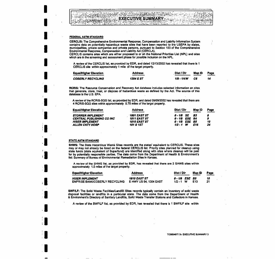
IIIIIIIIIIIIIIIIIII
FEDERAL ASTM STANDARD
CERCLIS: The Comprehensive Environmental Response, Compensation and Liability Information Systemcontains data on potentially hazardous waste sites that have been reported to the USEPA by states,municipalities, private companies and private persons, pursuant to Section 103 of the ComprehensiveEnvironmental Response, Compensation and Liability Act (CERCLA).CERCLIS contains sites which are either proposed to or oh the National Priorities List (NPL) and siteswhich are In the screening and assessment phase for possible inclusion on the NPL
A review of the CERCLIS list, as provided by EDR, and dated 12/13/2002 has revealed that there is 1CERCLIS site within approximately 1 mile of the target property.
Equal/Higher Elevation Address . Dlst / Dlr Map ID Page
COBERLY RECYCLING 1304 E ST 1/8-1/4W C6 14
RCRIS: The Resource Conservation and Recovery Act database includes selected information on sitesthat generate, store, treat, or dispose of hazardous waste as defined by the Act. The source of thisdatabase is the U.S. EPA.
A review of the RCRIS-SQG list, as provided by EDR, and dated 09/09/2002 has revealed that there are4 RCRIS-SQG sites within approximately 0.75 miles of the target property.
Equal/Higher Elevation Address Dlst / Dlr Map ID Page
STORRER IMPLEMENT 1801 EAST ST 0-1/8 SE B3 8CENTRAL PUBLISHING CO INC 1811 EAST ST 0-1/8 ESE B4 9HISER IMPLEMENT 1810 EAST ST 0-1/8 ESE B5 10ALLEN CNTY HOSP 101S 1ST 1/2-1 W E16 24
STATE ASTM STANDARD
SHWS: The State Hazardous Waste Sites records are the states' equivalent to CERCLIS. These sitesmay or may not already be listed on the federal CERCLIS list. Priority sites planned for cleanup usingstate funds (state equivalent of Superfund) are identified along with sites where cleanup will be paidfor by potentially responsible parties. The data come from the Department of Health & Environment'slist Summary of Bureau of Environmental Remediation Sites in Kansas.
A review of the SHWS list, as provided by EOR, has revealed that there are 2 SHWS sites withinapproximately 1.5 miles of the target property.
Equal/Higher Elevation Address Dlst/Dlr Map ID Page
HISER IMPLEMENT 1810 EAST ST 0-1/8 ESE BS 10EMPRISE BANK/COBERLY RECYCLING E HWY US 54, 1304 EAST 1/2-1 W E13 21
SWF/LF: The Solid Waste Facilities/Landfill Sites records typically contain an inventory of solid wastedisposal facilities or landfills in a particular state. The data come from the Department of Health& Environment's Directory of Sanitary Landfills, Solid Waste Transfer Stations and Collectors in Kansas.
A review of the SWF/LF list, as provided by EDR, has revealed that there is 1 SWF/LF site within
TC0954877.78 EXECUTIVE SUMMARY 3

IIIIIIIII
IIIIIIIII
approximately 1 mile of the target property.
Equal/Higher Elevation
WALTON FOUNDRY
Address
105 N. KENTUCKY
Dist / Dlr
1/4 - 1/2W
Map ID Page
8 17
LUST: The Leaking Underground Storage Tank Incident Reports contain an inventory of reportedleaking underground storage tank incidents. The data come from the Kansas Department of EnvironmentalProtection's LUST Incident Report
A review of the LUST list, as provided by EDR, and dated 12/06/2002 has revealed that there are 7LUST sites within approximately 1 mile of the target property.
Equal/Higher Elevation
HISER IMPLEMENTU-DO SELF SERVICECONVENIENCE MARTCASEY'S GENERAL STORE, IOLAALLEN CO HOSPITALJOHNSON PROPERTYSW BELL TELEPHONE
Address
1810 EAST ST1201 EAST ST1107 EAST ST1ST / HWY54101S1STSTPEACH / OAK STREETS222 S SYCAMORE ST
Dist/Dlr Map ID Page
0-1/8 ESE B51/4 - 1/2W D91/4-1/2W D111/2-1 W E141/2-1 W E171/2-1 WNW191/2-1 W 20
UST: The Underground Storage Tank database contains registered USTs. USTs are regulated underSubtitle I of the Resource Conservation and Recovery Act (RCRA). The data come from theDepartment of Health & Environment's UST (Report) Listing Including Names.
A review of the UST list, as provided by EDR, and dated 12/06/2002 has revealed that there are 7 USTsites within approximately 0.75 miles of the target property.
Equal/Higher Elevation
JUMP START TRAVEL CENTERHISER IMPLEMENTL & S MOTORSVISTA STORES #2023CONVENIENT MARTALLEN COUNTY HOSPITALCASEY'S GENERAL STORE #1794
Address
1700 EAST STREET1810 EAST ST1305 E ST1201 EAST STREET1107 E STREET101 SOUTH 1ST ST.712 E MADISON AVENUE
0-1/8 SSE A20-1/8 ESE B51/8 - 1/4 WSW C71/4-1/2W D101/4-1/2W D121/2-1 W E151/2-1 W 18
10171923252627
Dist /Dlr Map ID Page
6101517192325
TC0954877.78 EXECUTIVE SUMMARY 4

IIIIIIII
IIIIIIIIIII
Due to poor or inadequate address information, the following sites were not mapped:
Site Name
IOLA-CITY POWER PITEAST IOLA SMELTER SITEEMPRISE BANK/COBERLY RECYCLINGIOLA CONCRETE PRODUCTS INC.COBERLY RECYCLING (CLOSED)SINCLAIR PIPE LINE CO.CITY OF IOLA, POWER PLANT #1NEW DIMENSION HOMESCARMEL ENERGY INCSOHIGRO SVC COJ&WEQUIPMENTINCMIKES BODY SHOPROBERT WILLEIOLAWWTPCITY OF IOLA POWER PLANTIOLA POST OFFICEIOLA GRAIN INCORPORATEDIOLA GRAIN INC
Database(s)
FTTS .CERC-NFRAPLUSTUSTUSTUSTASTRCRIS-SQGRCRIS-SQG, FINDSRCRIS-SQG, FINDSRCRIS-SQG, FINDSRCRIS-SQG, FINDSRCRIS-SQG, FINDSFINDSFINDSFINDSFINDSSSTS
TC0954877.78 EXECUTIVE SUMMARY 5

OVERVIEW MAP - 0954877.7s - Maxim Technologies, Inc.
I
I
I
J
* Target Property
A Sites at elevations higher thanor equal to the target property
• Sites at elevations lower thanthe target property
1 Coal Gasification Sites
F3 National Priority List Sites
^1 Landfill Sites
/V" Power transmission lines
// Oil & Gas pipelines
Areas of Concern
TARGET PROPERTY: lolaEastADDRESS: 1702 East StreetCITY/STATE/ZIP: lolaKS 66749LAT/LONG: 37.9228/95.3859
CUSTOMER: Maxim Technologies, Inc.CONTACT: Shannon AllenINQUIRY*: 0954877.7sDATE: April 07,2003 1:45 pmCopyright o 2903 EDH, Inc. o 2003 SOT. Inc. RiL 07/2002. AD R/jM» Riurvid.

DETAIL MAP - 0954877.7s • Maxim Technologies. Inc.m ^ ^ "" "" ^ H* ^™™ " ™^ ^ ™" ^ ™^ ^ ^ " ™^ ^ ^ ^™^ ^™^™,
I
I
I
* Target Property
Sites at elevations higher thanor equal to the target property
» Sites at elevations lower thanthe target property
1 Coal Gasification Sites
t Sensitive Receptors
I7?'] National Priority List Sites
>3 Landfill Sites
f\f Power transmission lines
/V Oil & Gas pipelines
m TARGET PROPERTY:• ADDRESS:| CITY/STATE/ZIP:
LAT/LONG:
1
lola East1702 East Streetlola KS 6674937.9228/95.3859
CUSTOMER:CONTACT:INQUIRY*:DATE:
Maxim Technologies, Inc.Shannon Allen0954877.7sApril 07, 2003 1:46 pm

IIIIII
1 •
I* •"
IIIIIIIIIIII
-. • /y'p^P'p ii iw?
Database
SearchTarget DistanceProperty (Miles)
FEDERAL ASTM STANDARD
NPLProposed NPLCERCLISCERC-NFRAPCORRACTSRCRIS-TSDRCRIS Lg. Quan. Gen.RCRIS Sm. Quan. Gen.ERNS
STATE ASTM STANDARD
State Haz. Waste XState LandfillLUSTUST.INDIAN UST
FEDERAL ASTM SUPPLEMENTAL
CONSENTRODDellsted NPLFINDSHMIRSMLTSMINESNPL LiensPADSRAATSTRISTSCASSTSFTTS
STATE OR LOCAL ASTM SUPPLEMENTAL
ASTLASTSPILLSAOCONCERN
1.5001.5001.0000.7501.5001.0000.7500.7500.500
1.5001.0001.0000.7500.750
1.0001.0001.000TPTPTP
0.250TPTPTPTPTPTPTP
TPTPTP
1.000
EDR PROPRIETARY HISTORICAL DATABASES
Coal Gas 1.000
< 1/8 . 1/8 -1/4 1/4-1/2 1/2-1 > 1
10120
000
NRNRNR0
NRNRNRNRNRNRNR
NRNRNR0
NOTES:
AQUIFLOW - see EDR Physical Setting Source Addendum
TP = Target Property
NR = Not Requested at this Search Distance
Sites may be listed in more than one database
001000000
00010
000NRNRNR0NRNRNRNRNRNRNR
NRNRNR0
000000000
01220
000NRNRNRNRNRNRNRNRNRNRNR
NRNRNR0
00000001NR
10420
000NRNRNRNRNRNRNRNRNRNRNR
NRNRNR0
00NRNR0NRNRNRNR
0NRNRNRNR
NRNRNRNRNRNRNRNRNRNRNRNRNRNR
NRNRNRNR
NR
TotalPlotted
001000040
21770
00000000000000
0000
TC0954877.7S Page 4

IIIIIIII
f •
IIIIIIIIIII
Map IDDirectionDistanceDistance (ft.)Elevation Site Database(s)
EDR ID NumberEPA ID Number
Coal Gas Site Search: No site was found In a search of Real Property Scan's ENVIROHAZ database.
A1 EAST IOLA SMELTER SITETarget 1702 EAST STREETProperty IOLA, KS
SHWS S104959476N/A
Site 1 of 2 In cluster A
SHWS:Contaminants: :Source: :Project code :Quarter 4 :Quarter 3 :Quarter 2 :Quarter 1 :Section :Township :Range :Acid:Base Neutral :Pesticide :Program :VOC:Heavy Metal :Inorganic :Curde oil :Refined petroleum :Nitrates :Chlorides :Groundwater :Surface water :Soil :Public water supply :Private well :Waste :Air:Potential GW :Potential Surface waterPotential Soil :Potential Air :Pot Public Water Supp :PotenPvtWell:Undergmd TnWPipIng :Spill :Pipeline leak :Lagoon/Impoundment :Salt prod Ipg :Dumping drums :Abandoned facility :OH production :Closed Non Perm LF :Agricultural facility :Septic tank :Active permit well :Aboveground tank :Facility operations :
Not reportedNot reportedC3001 03004Not reportedNot reportedNot reportedSE252418EFALSEFALSEFALSEVoluntary CleanupFALSETRUEFALSEFALSEFALSEFALSEFALSEFALSEFALSETRUEFALSEFALSEFALSEFALSETRUE
: FALSEFALSETRUEFALSEFALSEFALSEFALSEFALSEFALSEFALSEFALSETRUEFALSEFALSEFALSEFALSEFALSEFALSEFALSE
TC0954877.7S Page 5

IIIIIIIIIIIIIIIIIII
Map IDDirectionDistanceDistance (ft.)Elevation Site
EDR ID NumberDatabase(s) EPA ID Number
A2SSE
EAST IOLA SMELTER SITE (Continued) S104959476
Closed Permitted LF :Drycleaner :Date resolved :Preparer :County Code :Site Lat/Long :NE Let/Long :NW Lat/Long :SE Lat/Long :SW Lat/Long :None In Progress :On Going :Remediation CompleteRiver Basin :
FALSEFALSENot reportedJONES, T.AL38 / -950 / 00 /00 / 00 / 0FALSETRUE
: FALSENeosho
217ft.Higher -
JUMP START TRAVEL CENTER1700 EAST STREETIOLA, KS 66749
Site 2 of 2 In cluster A
LIST:Facility ID:Tank ID:Contact:OwnerOwner Address:
Owner Tel:Date Removed:
30152001Brenda HollowayMACHA ENTERPRISES, INC.P.O. BOX 220-515 SOUTH MAIGAS, KS 66742316-365-2481Not reported
Principal CERCLA Substance/Cham Abstract Service Num:Facility DistrictFacility 911 Address:
Facility Lat/Lon:Facility Location Method:Facility Feature:Facility Datum:Contact Title:Owner/Rep Name:Owner/Rep Title:Owner County:Tank Type:Marketer?:Standby?:Tank Status:Estimated Year In Service:Current Permit Printed:Material of Construction:Internal Protection:External Protection:Out of service Mo/Yr:Piping type:Substance stored:Owner Type:
Facility ID:Tank ID:Contact
30152002Brenda Holloway
UST U003756215N/A
Owner ID:Capacity (Gals):Facility Tel:
3015212000316-365-8280
QTY Remaining in Tank: 0 .Not reportedSE1700 East Streetlola, Ks 6674937.92254 / -95.36364000000001GARMIN 3 PLUSFacility CenterWGSB4Store ManagerLinda WalterSec/treas.ALLENUYesNoCurrent In Use200005/28/02Fbr Ref PlasticNoneFbr Ref Piste CoatNot reportedFbr Ref PisteGas (Incl Alcohol)Private Or Corp.
Owner ID:Capacity (Gals):Facility Tel:
3015212000316-365-8280
TC0954877.7S Page 6

IIIIIII
I ••>
I
IIIIIIIIIII
Map IDDirectionDistanceDistance (ft.)Elevation Site
MAP FINDINGS^
Database(s)
JUMP START TRAVEL CENTER (Continued)
Owner MACHA ENTERPRISES. INC.Owner Address: P.O. BOX 220 - 515 SOUTH MAI
GAS. KS 66742Owner Tel: 316-365-2481Date Removed: Not reportedPrincipal CERCLA Substance/Chem Abstract Service Mum:Facility District:Facility 911 Address:
EDR ID NumberEPA ID Number
U003756215
Facility Lst/Lon:Facility Location Method:Facility Feature:Facility Datum:Contact Title:Owner/Rep Name:Owner/Rep Title:Owner County:Tank Type:Marketer?:Standby?:Tank Status:Estimated Year in Service:Current Permit Printed:Material of Construction:Internal Protection:External Protection:Out of service Mo/YrPiping type:Substance stored:Owner Type:
Facility ID:Tank ID:Contact:OwnerOwner Address:
Owner Tel:Date Removed:
30152003Brenda HollowayMACHA ENTERPRISES. INC.P.O. BOX 220 - 515 SOUTH MAIGAS. KS 66742316-365-2481Not reported
Principal CERCLA Substance/Chem Abstract Service Num:Facility DistrictFacility 911 Address:
Facility Lat/Lon:Facility Location Method:Facility Feature:Facility Datum:Contact Title:Owner/Rep Name:Owner/Rep Title:Owner County:Tank Type:Marketer?:Standby?:Tank Status:Estimated Year in Service:Current Permit. Printed:
QTY Remaining In Tank: 0Not reportedSE1700 East Streetlola, Ks 6674937.92254 / -95.38384000000001GARMIN 3 PLUSFacility CenterWGSB4Store ManagerLinda WalterSec/treas.ALLENUYesNoCurrent In Use200005/28/02Fbr Ref PlasticNoneFbr Ref Piste CoatNot reportedFbr Ref PisteDieselPrivate Or Corp.
Owner ID:Capacity (Gals):Facility Tel:
301526000316-365-8280
QTY Remaining in Tank: 0Not reportedSE1700 East Streetlola, Ks 6674937.92254 / -95.38384000000001GARMIN 3 PLUSFacility CenterWGSB4Store ManagerLinda WalterSec/treas.ALLENUYesNoCurrent In Use200005/28/02
TC0954877.7S Page 7

IIIIII
:• i
f
I
I
I
I
I
I
I
I
I
I
I
I
Map IDDirectionDistanceDistance (ft.)Elevation Site Database(s)
JUMP START TRAVEL CENTER (Continued)
Material of Construction:Internal Protection:External Protection:Out of service Mo/Yr.Piping type:Substance stored:Owner Type:
Facility ID: 30152Tank ID: 004Contact Brenda HollowayOwner MACHA ENTERPRISES. INC.Owner Address: P.O. BOX 220-515 SOUTH MAI
GAS, KS 66742Owner Tel: 316-365-2481Date Removed: Not reported
Principal CERCLA Substance/Chem Abstract Service Num:Facility DistrictFacility 911 Address:
Facility Lat/Lon:Facility Location Method:Facility Feature:Facility Datum:Contact Title:Owner/Rep Name:Owner/Rep Title:Owner County:Tank Type:Marketer?:Standby?:Tank Status:Estimated Year In Service:Current Permit Printed:Material of Construction:Internal Protection:External Protection:Out of service Mo/Yr:Piping type: •Substance stored:Owner Type:
Fbr Ref PlasticNoneFbr Ref Piste CoatNot reportedFbr Ref PisteGas (Incl Alcohol)Private Or Corp.
Owner ID:Capacity (Gals):Facility Tel:
QTY Remaining In Tank:Not reportedSE1700 East Streettola, Ks 66749
301526000316-365
0
37.92254 / -95.38384000000001GARMIN 3 PLUSFacility CenterWGS84Store ManagerLinda WalterSec/treas.ALLENUYesNoCurrent In Use200005/28/02Fbr Ref PlasticNoneFbr Ref Piste CoatNot reportedFbr Ref PisteDieselPrivate Or Corp.
EDR ID NumberEPA ID Number
U003756215
B3SE
378 ftHigher
STORRER IMPLEMENT1801 EAST STIOLA, KS 66749
Sltel of 3 In cluster B
RCRIS-SQG 1000368731FINDS KSD061269023
TC0954B77.7S Page 8

IIIIIIIII•
IIIIIIIII
;2 :( ' DiNG^ y||| ;J :1JMap IDDirectionDistanceDistance (ft.) EDR ID NumberElevation Site Database(s) EPA ID Number
STORRER IMPLEMENT (Continued) 1000368731
RCRIS:Owner ROBERT STORRER & STEVE FRANK
(316)365-5692EPA ID: KSD061269023
Contact: MARSHA STORRER(316)365-5692
Classification: Conditionally Exempt Small Quantity GeneratorUsed Oil Recyc: NoTSDF Activities: Not reported
Violation Status: Violations exist
Regulation Violated: 4Qcfr27922cArea of Violation: GENERATOR-GENERAL REQUIREMENTSDate Violation Determined: 04/15/1999Actual Date Achieved Compliance: 04/15/1999
Enforcement Action: WRITTEN INFORMALEnforcement Action Date: 04/15/1999Penalty Type: Not reported
There are 1 violation record(s) reported at this site:
Date ofEvaluation Area of Violation ComplianceCompliance Evaluation Inspection GENERATOR-GENERAL REQUIREMENTS 19990415
FINDS:Other Pertinent Environmental Activity Identified at Site:
Facility Registry System (FRS)Resource Conservation and Recovery Act Information system (RCRAINFO)
B4 CENTRAL PUBLISHING CO INC RCRIS-SQG 1001481B64ESE 1811 EAST ST FINDS KSR000011973< 1/8 IOLA, KS 66749400 ftHigher Site 2 of 3 In cluster B
RCRIS:Owner: CENTRAL PUBLISHING CO INC
(316)365-2108EPA ID: KSR000011973
Contact GARY COLLINS(316)365-2106
Classification: Small Quantity GeneratorUsed OK Recyc: NoTSDF Activities: Not reported
Violation Status: No violations found
FINDS:Other Pertinent Environmental Activity Identified at Site:
Facility Registry System (FRS)Resource Conservation and Recovery Act Information system (RCRAINFO)
TC0954877.7S Page 9

IIIIIIIIIIIIIIIIIII
Map IDDirectionDistanceDistance (ft.)Elevation. Site Database(s)
EDR ID NumberEPA ID Number
B5ESE
400 aHigher
HISER IMPLEMENT1810 EAST STIOLA.KS 66749
Site 3 of 3 In cluster B
RCRIS-SQG 1000210673SHWS KSD031278179FINDSLUST
UST
RCRIS:Owner:
EPA ID:
Contact
WAYNE HISER(316) 365-2451KSD031278179
WAYNE HISER(316) 365-2451
Classification: Small Quantity GeneratorUsed Oil Recyc: NoTSDF Activities: Not reported
Violation Status: Violations exist
Regulation Violated: 'Area of Violation:Date Violation Determined:Actual Date Achieved Compliance:
Enforcement Action:Enforcement Action Date:'Penally Type:
Regulation Violated:Area of Violation:Date Violation Determined:Actual Date Achieved Compliance:
Enforcement Action:Enforcement Action Date:Penalty Type:
Regulation Violated:Area of Violation:Date Violation Determined:Actual Date Achieved Compliance:
Enforcement Action:Enforcement Action Date:Penalty Type:
KAR 28-31-4(C)GENERATOR-GENERAL REQUIREMENTS01/30/199202/24/1992
WRITTEN INFORMAL02/07/1992Not reported
KAR2B-31-4(H)(1)(F)GENRATOR-SQG REQUIREMENTS01/30/199202/24/1992
WRITTEN INFORMAL02/07/1992Not reported
KAR28-31-4(H)(1)(G)GENRATOR-SQG REQUIREMENTS01/30/199202/24/1992
WRITTEN INFORMAL02/07/1992Not reported
There are 3 violation record(s) reported at this site:
Evaluation Area of ViolationCompliance Evaluation Inspection GENERATOR-GENERAL REQUIREMENTS
GENRATOR-SQG REQUIREMENTSGENRATOR-SQG REQUIREMENTS
Date ofCompliance,199202241992022419920224
FINDS:Other Pertinent Environmental Activity Identified at Site:
Facility Registry System (FRS)Resource Conservation and Recovery Act Information system (RCRAINFO)
SHWS:Contaminants:: Not reportedSource:: Not reportedProject code: C30017094BQuarter 4 : Not reported
TC0954877.7S Page 10

IIIIIII
'.
II•
I
I
IIIIIII
Map IDDirectionDistanceDistance (ft.)Elevation Site
EDR ID NumberDatabase(s) EPA ID Number
HISER IMPLEMENT (Continued) 1000210673
Quarter 3:Quarter 2:Quarter 1 :Section:Township:Range:Add:Base Neutral:Pesticide:Program:VOC:Heavy Metal:Inorganic:Curde oil:Refined petroleum:Nitrates:Chlorides:Groundwatar:Surface water:Soil:Public water supply:Private well:Waste:Air:Potential GW:Potential Surface waterPotential Soil:Potential Air:Pot Public Water Supp :Poten Pvt Well:Undergmd Tnk/Piplng:Spill:Pipeline leak:Lagoon/Impoundment:Salt prod Ipg:Dumping drums:Abandoned facility:Oil production:Closed Non Perm LF :Agricultural facility:Septic tank:Active permit well:Aboveground tank:Facility operations:Closed Permitted LF:Drycleaner:Data resolved :Preparer :County Code :Site Lat/Long :NE Lat/Long :NW Lat/Long :SE Lat/Long :SW Lat/Long :None in Progress :On Going :Remediation Complete :
SESESW25241BEFALSEFALSEFALSEVoluntary CleanupFALSETRUEFALSEFALSEFALSEFALSEFALSEFALSEFALSETRUEFALSEFALSEFALSEFALSEFALSE
: FALSEFALSEFALSEFALSEFALSEFALSEFALSEFALSEFALSEFALSEFALSETRUEFALSEFALSEFALSEFALSEFALSEFALSEFALSEFALSEFALSENot reportedJONES, T.AL38 / -950/00 / 00 / 00 /0FALSETRUEFALSE
TC0954877.7S Page 11

IIIIIIII
! • '•
I
I
I
I
I
I
I
I
I
Map IDDirectionDistanceDistance (ft.)Elevation Site Database(s)
HISER IMPLEMENT (Continued)
River Basin : Neosho
EDR ID NumberEPA ID Number
1000210673
15480HISER IMPLEMENTU300100528Not reportedSESWSESW241BE25
LUST:Facility ID:Project Name:Project NumberProject Num Extension:Quarter Fraction of Section:Section, Township, Range:Buried Tank Leak Assessment Date: 08/20/1992Initial Report Date: 08/19/1992County Abbreviation: ALFacility Status: CLOSED - a 'Closed* status indicates that according to the data available, levels of contamination
at the site do not exceed cleanup levels set by the state.
UST:Facility ID:Tank ID:Contact:OwnerOwner Address:
Owner Tel:Date Removed:
15480001ALDEN ENSMINGERLUCKY STOP L.L.C.4218 ROANOKE, SUITE 301KANSAS CITY. MO 64111620-365-711708/15/92
Owner ID:Capacity (Gals):Facility Tel:
154801500620-365-7117
Principal CERCLA Substance/Chem Abstract Service Num:Facility DistrictFacility 911 Address:
Facility Lat/Lon:Facility Location Method:Facility Feature:Facility Datum:Contact Title:Owner/Rep Name:Owner/Rep Title:Owner County:Tank Type:Marketer?:Standby?:Tank Status:Estimated Year In Service:Current Permit Printed:Material of Construction:Internal Protection:External Protection:Out of service Mo/YrPiping type:Substance stored:Owner Type:
QTY Remaining in Tank: 0Not reportedSE1810 East Stlola, Ks 6674937.92271 / -95.38191999999999GARMIN 3 PLUSFacility CenterWGS84SITE MGRALDEN ENSMINGERCHAIRMAINNot reportedUNot reportedNot reportedPermanently Out Of Use1982Not reportedSteelUnknownPainted081992Galv SteelGas (Incl Alcohol)Current.Private Or Corp.
Facility ID:Tank ID:Contact:OwnerOwner Address:
Owner Tel:Date Removed:
15480002ALDEN ENSMINGERLUCKY STOP L.L.C.4218 ROANOKE, SUITE 301KANSAS CITY, MO 84111620-365-7117Not reported
Owner ID:Capacity (Gals):Facility Tel:
1548015000620-365-7117
QTY Remaining In Tank: Not reported
TC0954877.7S Page 12

IIIIIIiiiiiiiiiiiii
Map IDDirectionDistanceDistance (ft.)Elevation Site Database(s)
HISER IMPLEMENT (Continued)
Principal CERCLA Substance/Cham Abstract Service Num:Facility District:Facility 911 Address:
EDR ID NumberEPA ID Number
1000210673
Facility Lat/Lon:Facility Location Method:Facility Feature:Facility Datum:Contact Tttle:Owner/Rep Name:Owner/Rep Title:Owner County:Tank Type:Marketer?:Standby?:Tank Status:Estimated Year In Service:Current Permit Printed:Material of Construction:Internal Protection:External Protection:Out of service Mo/YrPiping type:Substance stored:Owner Type:
Facility ID:Tank ID:Contact:OwnerOwner Address:
Owner Tel:Date Removed:
15480003ALDEN ENSMINGERLUCKY STOP LL.C.4218 ROANOKE, SUITE 301KANSAS CITY, MO 64111620-365-7117Not reported
Principal CERCLA Substance/Chem Abstract Service Num:Facility DistrictFacility 911 Address:
Facility Lat/Lon:Facility Location Method:Facility Feature:Facility Datum:Contact Title:Owner/Rep Name:Owner/Rep Title:Owner County:Tank Type:Marketer?:Standby?:Tank Status:Estimated Year In Service:Current Permit Printed:Material of Construction:Internal Protection:External Protection:Out of service Mo/YrPiping type:
Not reportedSE1810 East Stlola, Ks 6674937.92271 / -95.38191999999999GARMIN 3 PLUSFacility CenterWGS84SITE MGRALDEN ENSMINGERCHAIRMAINNot reportedUYesNoCurrent In Use200105/28/02 .Fbr Ref PlasticNoneFbr Ref Piste CoatNot reportedFbr Ref PisteGas (Incl Alcohol)Current.Private Or Corp.
Owner ID:Capacity (Gals):Facility Tel:
1548010000620-365-7117
QTY Remaining in Tank: Not reportedNot reportedSE1810 East Stlola. Ks 6674937.92271 / -95.38191999999999GARMIN 3. PLUS
' Facility CenterWGS84 .SITE MGRALDEN ENSMINGERCHAIRMAINNot reportedUNot reportedNoCurrent In Use200105/28/02Fbr Ref PlasticNoneFbr Ref Piste CoatNot reportedFbr Ref Piste
TC0954877.7s Page 13

IIIIIIIII
I
IIIIIIII
Map IDDirectionDistanceDistance (ft.)Elevation Site Database(s)
HISER IMPLEMENT (Continued)
Substance stored:Owner Type:
EDR ID NumberEPA ID Number
1000210673
Gas (Incl Alcohol)Current.Private Or Corp.
Facility ID: 15480Tank ID: 004Contact ALDEN ENSMINGEROwner ' LUCKY STOP LLC.Owner Address: 421 8 ROANOKE, SUITE 301
KANSAS CITY, MO 641 11Owner Tel: 620-365-7117Date Removed: Not reportedPrincipal CERCLA Substance/Chem Abstract Service Num:Facility District:Facility 911 Address:
Facility Lat/Lon:Facility Location Method:Facility Feature:Facility Datum:Contact Title:Owner/Rep Name:Owner/Rep Title:Owner County:Tank Type:Marketer?:Standby?:Tank Status:Estimated Year In Service:Current Permit Printed:Material of Construction:Internal Protection:External Protection:Out of service Mo/Yr.Piping type:Substance stored:Owner Type:
Owner ID:Capacity (Gals):Facility Tel:
QTY Remaining in Tank:Not reportedSE1810 East Stlola, Ks 66749
154806000620-365-7117
Not reported
37.92271 / -95.38191 999999999GARMIN 3 PLUSFacility CenterWGS84SITE MGRALDEN ENSMINGERCHAIRMAINNot reportedUYesNoCurrent In Use200105/28/02Fbr Ref PlasticNoneFbr Ref Piste CoatNot reportedFbr Ref PisteDieselCurrent.Private Or Corp.
C6West1/8-1/41070ftHigher
COBERLY RECYCLING1304 ESTIOLA, KS 66749
Site 1 of 2 In cluster C
CERCLIS Classification Data:Site Incident Category: Not reportedNon NPL Status: NFRAPOwnership Status: PrivateContact , O - KS STATE COORContact Title: Not reportedSite Description: 1987 ASBESTOS INVESTIGATION - NAN.
FILE REOPENED.CERCLIS Assessment History:
Assessment: DISCOVERYAssessment: PRELIMINARY ASSESSMENTAssessment: PRELIMINARY ASSESSMENT
CERCLIS Site Status:NFRAP (No Futher Remedial Action Planned
CERCLIS Alias Name(s):M & D ENTERPRISES
CERCLIS 1000109912FINDS KSD981708654
Federal Facility: Not a Federal Facility
NPL Status:Contact Tel:
Not on the NPL(913) 551-7708
1995 SOIL CONTAMINATION (LEAD) -
Completed: 02/20/1986Completed: 12/11/1987Completed: 08/31/1995
TC0954877.7s Page 14

IIIIIII
I • i
I
I
I
I
I
I
I
I
I
I
I
I
Map IDDirectionDistanceDistance (ft.)Elevation Site Database(s)
EDR ID NumberEPA ID Number
COBERLY RECYCLING (Continued) 1000109912
FINDS:Other Pertinent Environmental Activity Identified at Site:
Comperhenslve Environmental Response, Compensation and Liability Information-System (CERCLIS)Facility Registry System (FRS)
C7WSW1/8-1/41082 ftHigher
L & S MOTORS1305 E STIOLA, KS 66740
Site 2 of 2 In cluster C
UST:Facility ID: 26068Tank ID: 001Contact: Ron SIggOwner . SIGG, RONOwner Address: XXXXX
IOLA, KS 66749Owner Tel: 316-365-2445Date Removed: Not reportedPrincipal CERCLA Substance/Chem Abstract Service Num:Facility District:Facility 911 Address:
Facility Lat/Lon:Facility Location Method:Facility Feature:Facility Datum:Contact Title:Owner/Rep Name:Owner/Rep Title:Owner County:Tank Type:Marketer?:Standby1?:Tank Status:Estimated Year in Service:Current Permit Printed:Material of Construction:Internal Protection:External Protection:Out of service Mo/YrPiping type:Substance stored:Owner Type:
Facility ID: 26068Tank ID: 002Contact Ron SIggOwner. SIGG, RONOwner Address: XXXXX
IOLA, KS 66749Owner Tel: 316-365-2445Date Removed: Not reported
UST U000873035N/A
Owner ID: 02933Capacity (Gals): 5000Facility Tel: 316-365-2445
QTY Remaining in Tank: 0Not reportedSE1305 E Sttola. Ks 6674037.92187 / -95.38939000000001GARMIN 3 PLUSFacility CenterWGS84OwnerRon SiggOwnerALLENUYesNoPermanently Out Of Use1971Not reported.SteelUnknownPainted001900Bare SteelGas (Ind Alcohol) -Private Or Corp.
Owner ID: 02933Capacity (Gals): 5000Facility Tel: 316-365-2445
QTY Remaining In Tank: 0Principal CERCLA Substance/Chem Abstract Service Num:Facility District:Facility 911 Address:
Not reportedSE1305 E Stlola, Ks 66740
TC0954877.7s Page 15

IIIIIIII
IIIIIIIIIII
Map IDDirectionDistanceDistance (ft.)Elevation Site Database(s)
L&SMOTORS (Continued)
Facility Lat/Lon:Facility Location Method:Facility Feature:Facility Datum:Contact Title:Owner/Rep Name:Owner/Rep Title:Owner County:Tank Type:Marketer?:Standby?:Tank Status:Estimated Year In Service:Current Permit Printed:Material of Construction:Internal Protection:External Protection:Out of service Mo/YrPiping type: .Substance stored:Owner Type:
Facility ID:Tank ID:ContactOwnerOwner Address:
Owner Tel:Date Removed:
26088003Ron SlggSIGG. RONxxxxxIOLA, KS 66749316-365-2445Not reported
Principal CERCLA Substance/Chem Abstract Service Mum:Facility District:Facility 911 Address:
Facility Lat/Lon:Facility Location Method:Facility Feature:Facility Datum:Contact Title:Owner/Rep Name:Owner/Rep Title:Owner County:Tank Type:Marketer?:Standby?:Tank Status:Estimated Year In Service:Current Permit Printed:Material of Construction:Internal Protection:External Protection:Out of service Mo/YrPiping type:Substance stored:Owner Type:
EDR ID NumberEPA ID Number
U000873035
37.92187 / -95.38939000000001GARMIN 3 PLUSFacility CenterWGS84OwnerRon SiggOwnerALLENUYesNoPermanently Out Of Use1971Not reportedSteelUnknownPainted001900Bare SteelGas (Incl Alcohol)Private Or Corp.
Owner ID:Capacity (Gals):Facility Tel:
029335000316-365-2445
QTY Remaining in Tank: 0Not reported
. SE1305ESIlota, Ks 6674037.92187 / -95.38939000000001GARMIN 3 PLUSFacility CenterWGS84OwnerRon SlggOwnerALLENUYesNoPermanently Out Of Use1971Not reportedSteelUnknownPainted001900Bare SteelGas (Incl Alcohol)Private Or Corp.
TC0954877.7S Page 16

IIIIIIIIIII
< -:
I
I
I
I
I
I
I
Map IDDirectionDistanceDistance (ft.)Elevation Site Database(s)
EDR ID NumberEPA ID Number
BWest1/4-1/21401 ftHigher
WALTON FOUNDRY105 N.KENTUCKYIOLA, KS 66749
LF:Permit NumberMailing Address:
Fax NumberOwner Name:Owner Type:
Penult NumberMailing Address:
Fax NumberOwner Name:Owner Type:
SWF/LF 10029121 SON/A
0338P.O. Box 505lola, KS 66749
Not reportedPrivately Owned
0409P.O. Box 505lola, KS 66749
Not reportedPrivately Owned
09West1/4-1/21434 ftHigher
U-DO SELF SERVICE LUST S1018339831201 EAST ST . N/AIOLA, KS 66749
Sltel of 4 In cluster D
LUST:Facility ID: 03142Project Name: U-DO STORE #2Project Number U300100555Project Num Extension: Not reportedQuarter Fraction of Section: NWNWNWNWSection, Township, Range: 2418E36Buried Tank Leak Assessment Date: 01/19/1993Initial Report Date: 01/06/1993County Abbreviation: ALFacility Status: CLOSED - a 'Closed' status indicates that according to the data available, levels of contamination
at the site do not exceed cleanup levels set by the state.
D10West1/4-1/21434ftHigher
VISTA STORES #20231201 EAST STREETIOLA, KS 66749
Site 2 of 4 In cluster D
UST:Facility ID:Tank ID:ContactOwnerOwner Address:
Owner Tel:Date Removed:
UST U000195782N/A
03142001Rose JohnsonVISTA STORES. LLC - % VEEDER-RP.O. BOX 141188-% PERMITTINGAUSTIN, TX 78714512-380-715606/19/01
Principal CERCLA Substance/Chem Abstract Service Num:Facility DistrictFacility 911 Address:
Facility Lat/Lon:
Owner ID:Capacity (Gals):Facility Tel:
QTY Remaining in Tank:Not reportedSE1201 East Stlola, Ks 6674937.92208 / -95.3903
300366000913-365-6797
TC0954877.7s Page 17

IIIIIIIIIIIIIIIIIII
Map IDDirectionDistanceDistance (ft.)Elevation Site
..dr. ..';!«- -1 ';W"'ijj'^" ^1 •'••'•' ?...'••••' ' .'•-" ' .ST .~. •^•-'^•~'>-,rV[;r-;---<-_- ; :-;.-;i i -'i-. •=-•'." .im^MvW^?wm?mm£^-'EDR ID Number
Database(s) EPA ID Number
VISTA STORES #2023 (Continued) U0001 95782
Facility Location MethodFacility Feature:Facility Datum:Contact Title:Owner/Rep Name:Owner/Rep Title:Owner County:Tank Type:Marketer?:Standby?:Tank Status: '
: GARMIN 3 PLUSFacility CenterWGS84Contact PersonEMILY DAIGNEAUContact PersonNot reportedUYesNo •Temporarily Out Of Use
Estimated Year In Service: 1967Current Permit Printed:Material of Construction:Internal Protection:External Protection:Out of service Mo/YrPiping type:Substance stored:Owner Type:
Not reportedSteelInt LiningOther.PAINTEDNot reportedOther.COPPERGas (Incl Alcohol)Private Or Corp.
Facility ID: ' 03142 . Owner ID: 30036Tank ID: 002 Capacity (Gals): . 6000Contact Rose Johnson > Facility Tel: 913-365-6797Owner. VISTA STORES, LLC - % VEEDER-ROwner Address: P.O. BOX 141188-% PERMITTING
AUSTIN, TX 78714Owner Tel: 512-380-7156Date Removed: 06/19/01 QTY Remaining In Tank: 0Principal CERCLA Substance/Chem Abstract Service Num: Not reportedFacility District:Facility 911 Address:
Facility Lal/Lon:Facility Location Method:Facility Feature:Facility Datum:Contact Title:Owner/Rep Name:Owner/Rep Title:Owner County:Tank Type:Marketer?:Standby?:Tank Status:
SE1201 East Sttola, Ks 6674937.92208 / -95.3903GARMIN 3 PLUSFacility CenterWGS84Contact PersonEMILY DAIGNEAUContact PersonNot reportedUYesNoTemporarily Out Of Use
Estimated Year in Service: 1967Current Permit Printed:Material of Construction:Internal Protection:External Protection:Out of service Mo/Yr:Piping type:Substance stored:Owner Type:
Not reportedSteelInt LiningOther.PAINTEDNot reportedOther.COPPERGas (Incl Alcohol)Private Or Corp.
Facility ID: 03142 Owner ID: 30036Tank ID: 003 Capacity (Gals): 6000
TC0954877.7S Page 18

IIIIIII
r • •*!
I
I
I
I
I
I
I
I
I
I
I
Map 10DirectionDistanceDistance (ft.)Elevation Site
^- . ! ; i . . K K L - - J g i - y - l l g i - - a i a i B : > t ' , : 1 v • •: '
Database(s)EDR ID NumberEPA ID Number
VISTA STORES 82023 (Continued) U000195782
Contact . Rose JohnsonOwner VISTA STORES. LUC - % VEEDER-ROwner Address: P.O. BOX 141188-% PERMITTING
AUSTIN, TX 787.1 4Owner Tel: 512-380-7156Date Removed: 06/19/01Principal CERCLA Substance/Chem Abstract Service Mum:Facility District:Facility 911 Address:
Facility Lat/Lon:Facility Location Method:Facility Feature:Facility Datum:Contact Title:Owner/Rep Name:Owner/Rep Title:Owner County:Tank Type:Marketer?:Standby?:Tank Status:Estimated Year in Service:Current Permit Printed:Material of Construction:Internal Protection:External Protection:Out of service Mo/YnPiping type:Substance stored:Owner Type:
Facility Tel:
QTY Remaining In Tank:Not reportedSE1201 East Stlola, Ks 6674937.92208 / -95.3903GARMIN 3 PLUSFacility CenterWGS84Contact PersonEMILY DAIGNEAUContact PersonNot reportedUYesNoTemporarily Out Of Use1967Not reportedSteelInt LiningUnknownNot reportedOther.COPPERGas (Incl Alcohol)Private Or Corp.
913-365-6797
011West1/4-1/21702ftHigher
CONVENIENCE MART LUST S1048183551107 EAST ST N/AIOLA, KS
Site 3 of 4 In cluster D
LUST:Facility ID:Project Name:Project NumberProject Mum Extension:Quarter Fraction of Section:Section, Township, Range:Buried Tank Leak Assessment Date: 06/14/2000Initial Report Date: 06/14/2000County Abbreviation: ALFacility Status: ACTIVE - An 'Active' status Indicates that there exists levels of contamination at the site that are
greater than cleanup levels set by the state. Active sites require that additional remedial work becompleted to bring the site Into compliance with state and federal law.
07020CONVENIENCE MARTU300112921Not reportedNENENENE2418E35
D12West1/4-1/21704ftHigher
CONVENIENT MART1107 E STREETIOLA, KS 66749
Site 4 of 4 In cluster D
UST U000717424N/A
TC0954877.7S Page 19

IIIIIIIIII
IIIIIIIII
MapID m^ggMf^m^
DistanceDistance (ft.)Elevation Site
CONVENIENT MART (Continued)
UST:Facility ID: 07020Tank ID: 001Contact: Phil NerrOwner: CRESCENT OIL COMPANY, INC.Owner Address: 1 020 W. SYCAMORE - BOX 667
INDEPENDENCE, KS 67301Owner Tel: 800-798-2597Date Removed: 06/13/00
Principal CERCLA Substance/Chem Abstract Service Num:Facility District:Facility 911 Address:
Facility Lat/Lon:Facility Location Method:Facility Feature:Facility-Datum:Contact Title:Owner/Rep Name:Owner/Rep Title:Owner County:Tank Type:Marketer?:Standby?:Tank Status:Estimated Year in Service:Current Permit Printed:Material of Construction:Internal Protection:External Protection:Out of service Mo/YrPiping type:Substance stored:Owner Type:
Facility ID: 07020Tank ID: 002Contact Phil NerrOwner CRESCENT OIL COMPANY, INC.Owner Address: 1 020 W. SYCAMORE - BOX 667
INDEPENDENCE, KS 67301Owner Tel: 800-798-2597Date Removed: 06/13/00
Principal CERCLA Substance/Chem Abstract Service Num:Facility District:Facility 911 Address:
.
Facility Lat/Lon:Facility Location Method:Facility Feature:Facility Datum:Contact Title:Owner/Rep Name:Owner/Rep Title:Owner County:Tank Type: .Marketer?:
:|p|;:«fe
EDR ID NumberDatabase(s) EPA ID Number
U000717424
Owner ID: 13607Capacity (Gals): 10000Facility Tel: 316-331-2850
QTY Remaining in Tank: 0Not reportedSE11 07 East Stlola, Ks 6674937.92196 / -95.39149GARMIN 3 PLUSFacility CenterWGS84ContactPhil NearVice PresidentMONTGOMERYUNot reportedNot reportedPermanently Out Of Use197BNot reportedSteelNoneNone062000Galv SteelGas (Incl Alcohol)Current
Owner ID: 13607Capacity (Gals): 6000Facility Tel: 316-331-2850
QTY Remaining In Tank: 0Not reportedSE11 07 East Stlola, Ks 6674937.921 96 / -95.39149GARMIN 3 PLUSFacility CenterWGS84ContactPhil NearVice PresidentMONTGOMERYUNot reported
TC0954877.7S Page 20

III
IIII
IIIIIIIIIII
Map IDDirectionDistanceDistance (R.)Elevation Site Database(s)
CONVENIENT MART (Continued)
EDR ID NumberEPA ID Number
U000717424
Standby?:Tank Status:Estimated Year In Service:Current Permit Printed:Material of Construction:Internal Protection:External Protection:Out of service Mo/Vr:Piping type:Substance stored:Owner Type:
Facility ID: 07020Tank ID: 003Contact: Phil NerrOwner CRESCENT OIL COMPANY. INC.Owner Address: 1 020 W. SYCAMORE - BOX 667
INDEPENDENCE, KS 67301Owner Tel: 800-798-2597Date Removed: 06/13/00
Principal CERCLA Substance/Cham Abstract Service Num:Facility District:Facility 911 Address:
Facility Lat/Lon:Facility Location Method:Facility Feature:Facility Datum:Contact Title:Owner/Rep Name:Owner/Rep Title:Owner County:Tank Type:Marketer?:Standby?:Tank Status:Estimated Year In Service:Current Permit Printed:Material of Construction:Internal Protection:External Protection:Out of service Mo/Yr:Piping type:Substance stored:Owner Type:
Not reportedPermanently Out Of Use1978Not reportedSteelNoneNoneOS2000Galv SteelGas (Incl Alcohol)Current
Owner ID: 13607Capacity (Gals): 6000Facility Tel: 316-331-2850
QTY Remaining In Tank: 0Not reportedSE11 07 East Sttola, Ks 6674937.92196 / -95.39149GARMIN 3 PLUSFacility CenterWGS84ContactPhil NearVice PresidentMONTGOMERYUNot reportedNot reportedPermanently Out Of Use1978Not reportedSteelNoneNone062000Galv SteelGas (Incl Alcohol)Current
E13West1/2-12683ftHigher
EMPRISE BANK/COBERLY RECYCLINGE HWY US 54,1304 EAST STIOLA.KS
SHWS S101713331N/A
Slto 1 of 5 In cluster E
SHWS:Contaminants::Source::Project code:Quarter 4:Quarter 3:Quarter 2:
Not reportedSMELTER WASTE PILES. DISPOSALC300103000SWSW.SW
TC0954877.7S Page 21

Map IDDirectionDistanceDistance (ft.)Elevation Site
£ $ : ; :!\, I:?1;! L-.:i-t,.j.yU.•'.'• ji.41.-JL-I--?.fe32:r'-a.\e-wry'• <?-" •'• ;•••'*
EDR ID NumberDatabase(s) EPA ID Number
EMPRISE BANK/COBERLY RECYCLING (Continued) S101713331
Quarter 1:Section:Township:Range:Acid:Base Neutral:Pesticide:Program:VOC:Heavy Metal:Inorganic.:Curde oil:Refined petroleum:Nitrates:Chlorides:Groundwater:Surface water:Soil:Public water supply:Private well:Waste:Air:Potential GW:Potential Surface waterPotential Soil:Potential Air:Pot Public Water Supp :PotenPvtWell:Undergmd Ink/Piping:Spill:Pipeline leak:Lagoon/impoundment:Salt prod Ipg:Dumping drums:Abandoned facility:OH production:Closed Non Perm LF :Agricultural facility:Septic tank:Active permit well :Aboveground tank:Facility operations:Closed Permitted LF:Drycleaner:Date, resolved :Preparer :County Code :Site Lai/Long :NELat/Long :NWLat/Long :SELat/Long :SWLat/Long :None In Progress :On Going :Remediation CompleteRiver Basin :
SW252418EFALSEFALSEFALSEState CooperativeFALSETRUEFALSEFALSEFALSEFALSEFALSEFALSEFALSETRUEFALSEFALSEFALSEFALSETRUEFALSETRUETRUEFALSEFALSEFALSEFALSEFALSEFALSEFALSEFALSEFALSEFALSEFALSEFALSEFALSEFALSEFALSETRUEFALSEFALSENot reportedPORTER, D.AL38 / -950 / 00 / 00 / 00 / 0TRUEFALSEFALSE'Neosho
TC0954877.7S Page 22

IIIIIIII
II
IIIIIIIII
Map IDDirectionDistanceDistance (ft.)Elevation Site Database(s)
EDR ID NumberEPA ID Number
E14West1/2-12712ftHigher
CASEY'S GENERAL STORE, IOLA1ST / HWY54IOLA, KS 66749
Site 2 of 5 In cluster E
LUST:Facility ID:Project Name:Project Number:Project Num Extension:Quarter Fraction of Section:Section, Township, Range:
LUST S101833988N/A
81208CASEY'S GENERAL STOREU300110172Not reportedNENENWNE2418E35
Burled Tank Leak Assessment Date: 08/08/1994Initial Report Date: 08/02/1994County Abbreviation: ALFacility Status: CLOSED - a 'Closed' status Indicates that according to the data available, levels of contamination
at the site do not exceed cleanup levels set by the state.
E15West1/2-12727ft.Higher
ALLEN COUNTY HOSPITAL101 SOUTH 1ST ST.IOLA. KS 66749
Site 3 of 5 In cluster E
UST:Facility ID: 08129Tank ID: 001Contact: Allen County HospitaOwner. ALLEN COUNTY HOSPITALOwner Address: 101 S 1ST BOX 540
IOLA, KS 66749Owner Tel: 316r365-3131Date Removed: 12/04/98Principal CERCLA Substance/Chem Abstract Service Num:Facility District:Facility 911 Address:
Facility Lat/Lon:Facility Location Method:Facility Feature:Facility Datum:Contact Title:Owner/Rep Name:Owner/Rep Title:Owner County:Tank Type:Marketer?:Standby?:Tank Status:Estimated Year in Service:Current Permit Printed:Material of Construction:Internal Protection:External Protection:Out of service Mo/YrPiping type:Substance stored:Owner Type:
UST 1000470958N/A
Owner ID: 06129Capacity (Gals): 2000Facility Tel: 316-365-3131
QTY Remaining In Tank: 0Not reportedSE101 SlstSttola, Ks 6674937.921 83 / -95.39391 999999999GARMIN 3 PLUSFacility CenterWGS84Director Envlr ServlBill MayExec DlrALLENUNot reportedNot reportedPermanently Out Of Use1981Not reportedSteelNoneNone071998Bare SteelDieselCurrent
Facility ID: 06129 Owner ID: 06129
TC0954877.7S Page 23

IIIIIIIIIIIIIIIIIII
Map IDDirectionDistanceDistance (ft.)Elevation Site Database(s)
EDR ID NumberEPA ID Number
ALLEN COUNTY HOSPITAL (Continued)
Tank ID:Contact:Owner
1000470958
Owner Address:
002Allen County HospltaALLEN COUNTY HOSPITAL101 S 1ST BOX 540IOLA, KS 66749
Capacity (Gals):Facility Tel:
2000316-365-3131
OwnerTel: 316-365-3131Date Removed: Not reportedPrincipal CERCLA Substance/Chem Abstract Service Num:Facility District:Facility 911 Address:
Facility Lat/Lon:Facility Location Method:Facility Feature:Facility Datum:Contact Title:Owner/Rep Name:Owner/Rep Title:Owner County:Tank Type:Marketer?:Standby?:Tank Status:Estimated Year In Service:Current Permit Printed:Material of Construction:Internal Protection:External Protection:Out of service Mo/Yr:Piping type:Substance stored:Owner Type:
QTY Remaining in Tank: 0Not reportedSE101 SlstStlola, Ks 6674937.92183 / -95.39391 999999999GARMIN 3 PLUSFacility CenterWGSB4Director Envlr ServiBill MayExec DlrALLENUNoYesCurrent In Use199805/28/02Fbr Ref PlasticNoneFbr Ref Piste CoatNot reportedFbr Ref PisteDieselCurrent
E16West1/2-12727ftHigher
ALLEN CNTY HOSP101 S 1STIOLA, KS 66749
Site 4 of 5 In cluster E
RCRIS-SQG 1004704609FINDS KSD984988170
RCRIS:Owner.EPA ID:
Contact:
ALLEN COUNTYKSD984988170
LUCILLE HILLBRANT(316)365-3131
Classification: . Conditionally Exempt Smell Quantity GeneratorUsed Oil Recyc: NoTSDF Activities: Not reported
Violation Status: No violations found
TC0954877.7S Page 24

IIIIIIII
IIIIIIIIIII
Map IDDirectionDistanceDistance (ft.)Elevation Site
^s£!g$^^
E17West1/2-12733ftHigher
18West1/2-13009ft.Higher
ALLEN CNTY HOSP (Continued)
FINDS:Other Pertinent Environmental Activity Identified at Site:
Facility Registry System (FRS)Resource Conservation and Recovery Act Information system (RCRAINFO)
ALLEN CO HOSPITAL101 S 1ST STIOLA.KS 66749
EDR ID NumberDatabase(s) EPA ID Number
1004704609
LUST S103370568N/A
Site 5 of 5 In cluster E
LUST:Facility ID:Project Name:Project NumberProject Sum Extension:Quarter Fraction of Section:Section, Township, Range:Buried Tank Leak Assessment Date: 08/10/1998Initial Report Date: 08/04/1998County Abbreviation: ALFacility Status: CLOSED - a 'Closed' status Indicates that according to the data available, levels of contamination
at the site do not exceed cleanup levels set by the state.
06129ALLEN CO HOSPITALU300112050Not reportedNWNWNENE2418E35
CASEY'S GENERAL STORE #1794712 E MADISON AVENUEIOLA, KS 66749
LIST:Facility ID: 29794Tank ID: 001Contact . Glenn NorgartOwner CASEY'S GENERAL STORES, INC.Owner Address: PO BOX 3001, ONE CONVENIENCE B
ANKENY, IA S0021Owner Tel: 515-965-6100Date Removed: Not reportedPrincipal CERCLA Substance/Chem Abstract Service Num:Facility District:Facility 911 Address:
Facility Lat/Lon:Facility Location Method:Facility Feature:Facility Datum:Contact Title:Owner/Rep Name:Owner/Rep Title:Owner County:Tank Type:Marketer?:Standby?:Tank Status:Estimated Year in Service:Current Permit Printed:Material of Construction:
UST U001960398N/A
Owner ID:Capacity (Gals):Facility Tel:
0688410000515-965-6238
QTY Remaining In Tank: 0Not reportedSE712 E Madison Avenuelola, Ks 6674937.92189 / -95.39548000000001GARMIN 3 PLUSFacility CenterWGS84Environmental MgrGlenn NorgartEnvlro. Mgr.POLKUYesNoCurrent In Use199405/28/02Fbr Ref Plastic
TC0954877.7s Page 25

IIIIIIIIIIIIIIIIIII
Map IDDirectionDistanceDistance (ft.)Elevation Site
iji.'jj-.jrf .;;r..:i> '/'..-';..••;•;• 4'• '•• •;!?'*.'•'"':'-::' *.T[ ','•'•'
Database(s)
CASEY'S GENERAL STORE #1794 (Continued)
Internal Protection:External Protection:Out of service Mo/YrPiping type:Substance stored:Owner Type:
Facility ID: 29794Tank ID: 002Contact: Glenn NorgartOwner. CASEY'S GENERAL STORES, INC.Owner Address: PO BOX 3001, ONE CONVENIENCE B
ANKENY. IA 50021
EDR ID NumberEPA ID Number
U001960398
NoneFbr Ref Piste Coat001900Fbr Ref PisteGas (Ind Alcohol)Private Or Corp.
Owner ID:Capacity (Gals):Facility Tel:
0688410000515-965-6238
Owner Tel: 515-965-6100Date Removed: Not reportedPrincipal CERCLA Substance/Chem Abstract Service Nvim:Facility District:Facility 911 Address:
Facility Lat/Lon:Facility Location Method:Facility Feature:
. Facility Datum:Contact Tide:Owner/Rep Name:Owner/Rep Title:Owner County:Tank Type:Marketer?:Standby?:Tank Status:Estimated Year In Service:Current Permit Printed:Material of Construction:Internal Protection:External Protection:Out of service Mo/Yr:Piping type:Substance stored:Owner Type:
QTY Remaining In Tank: 0No\ reportedSE712 E Madison Avenuetola, Ks 6674937.92189 / -95.39548000000001GARMIN 3 PLUSFacility CenterWGSB4Environmental MgrGlenn NorgartEnvlro. Mgr.POLKUYesNoCurrent In Use199405/28/02Fbr Ref PlasticNoneFbr Ref Piste Coat001900Fbr Ref PisteGas (Incl Alcohol)Private Or Con?.
19WNW10-13516 ftHigher
JOHNSON PROPERTYPEACH / OAK STREETSIOLA, KS 66749
LUST S101901099N/A
81123JOHNSON PROPERTYU300110060Not reportedNWNESWSE241BE26
LUST:Facility ID:Project Name:Project NumberProject Num Extension:Quarter Fraction of Section:Section, Township, Range:Burled Tank Leak Assessment Date: 11 /28/1994Initial Report. Date: 11/28/1994County Abbreviation: ALFacility Status: CLOSED - a 'Closed' status Indicates that according to the data available, levels of contamination
at the site do not exceed cleanup levels set by the state.
JC0954877.7S Page 26

1Map ID KftiL&rljfe: ;;.;
• Distance• Distance (ft.)
Elevation Site
| 20 SW BELL TELEPHONEWest 222 S SYCAMORE ST1/2-1 IOLA, KS 66749
• 4724 ft£ Higher
^A^Fi iNGSfllfia^LJ^v::•'.;.:;•! rv.-.rf?*" . "."";Z£:i:i:~i_i'"i|;;:L!;". .•- • •> f^i -"?•" ;U-~' :-~ • — ,
EDR ID NumberDatabase(s) EPA ID Number
LUST S103710617N/A
IIIIIIIIIIIIII
I
LUST:Facility ID: 81653Project Name: SW BELL TELEPHONEProject Number U300112303Project Num Extension: Not reportedQuarter Fraction of Section: SENWNENWSection, Township, Range: 2418E35Burled Tank Leak Assessment Date: 01/14/1999 •Initial Report Date: 01/14/1999County Abbreviation: ALFacility Status: CLOSED - a 'Closed' status indicates that according to the data available, levels of contamination
at the site do not exceed cleanup levels set by the state.
TC0954877.7S Page 27

City
EMPORIA
IOIAIOLAIOLAIOLAIOLAIOLAIOLAIOLAIOLAIOLAIOLA
IOLAIOLAIOLAIOLAIOLAIOLA
EDR ID
1004704175A10005341Z1003877238100061687610002973801005916B0110045022201004701553U000199499UOOOT16869
10045005341000310101
100470136110047029851005881730
1004501990S101B33976
1006409403
Site Name
NEW DIMENSION HOMESCFTY OF IOLA. POWER PLANT fflEAST IOLA SMELTER SITE[OLA CONCRETE PRODUCTS INC.CARMEL ENERGY INCIOLA GRAIN INCIOLAWWTPSOHIGRO SVC COCOBERLY RECYCLING (CLOSED)SINCLAIR PIPE LINE CO.CITY OF IOLA POWER PLANTJ&W EQUIPMENT INC
MIKES BODY SHOPROBERT WILLE
IOLA POST OFFICEIOLA GRAIN INCORPORATEDEMPRISE BANK/COBERLY RECYCLINGIOLA - CITY POWER PLT
ORPHAN SUMMARY
Site Address
2910WHWY50
54 WEST & RIVEREAST & KENTUCKY STS-
3MN1MWONHWY169
RR BOX 394P.O. BOX 308EHWY54EHWY54SHWY169WESTONHWY541/4 MN ON HWY 169
2.5 MS ON HWY 1691.5 MN ON HWY 54
120 WEST ST502 W STREET
E US HWY 541 Ml W OF CITY ON 54 HWY
Zip
66749
6674966749667496674966749
6674966749
66749667496674966749
6674966749667496674966749
66749
Database(s)
RCRIS-SQG
AST
CERC-NFRAPUSTRCRIS-SQG. FINDSSSTSFINDSRCRIS-SQG, FINDSUST
USTFINDSRCRIS-SQG, FINDS
RCRIS-SQG, FINOSRCRIS-SQG. FINDSFINDSFINDS
LUSTFTTS
TC0954877.7S Page 28

IIIIIIIIIIIIIIIIIII
GOVERNMENT RECORDS
To maintain currency of the following federal and state databases, EDR contacts the appropriate governmental agencyon a monthly or quarterly basis, as required.
Elapsed ASTM days: Provides confirmation that this EDR report meets or exceeds the 90-day updating requirementof the ASTM standard.
FEDERAL ASTM STANDARD RECORDS
NPL: National Priority ListSource: EPATelephone: N/ANational Priorities List (Superfund). The NPL Is a subset of CERCLIS and Identifies over 1.200 sites for priority
cleanup under the Superfund Program. NPL sites may encompass relatively large areas. As such, EDR provides polygoncoverage for over 1,000 NPL site boundaries produced by EPA's Environmental Photographic Interpretation Center(EPIC) and regional EPA offices.
Date of Government Version: 01/29/03Date Made Active at EDR: 03/04/03Database Release Frequency: Seml-Annually
NPL Site Boundaries
Sources:
EPA's Environmental Photographic Interpretation Center (EPIC)Telephone: 202-564-7333
EPA Region 1Telephone 617-918-1143
EPA Region 3Telephone 215-814-5418
EPA Region 4Telephone 404-562-8033
Proposed NPL: Proposed National Priority List SitesSource: EPATelephone: N/A
Date of Government Version: 01/29/03Date Made Active at EDR: 03/04/03Database Release Frequency: Seml-Annually
Date of Data Arrival at EDR: 02/04/03Elapsed ASTM days: 28Date of Last EDR Contact: 02/04/03
EPA Region 6Telephone: 214-655-6659
EPA Region 8Telephone: 303-312-6774
Date of Data Arrival at EDR: 02/04/03Elapsed ASTM days: 28Date of Last EDR Contact 02/04/03
CERCLIS: Comprehensive Environmental Response, Compensation, and Liability Information SystemSource: EPATelephone: 703-413-0223CERCLIS contains data on potentially hazardous waste sites that have bean reported to the USEPA by states, municipalities,
private companies and private persons, pursuant to Section 103 of the Comprehensive Environmental Response, Compensation,and Liability Act (CERCLA). CERCLIS contains sites which are either proposed to or on the National PrioritiesList (NPL) and sites which are in the screening and assessment phase for possible Inclusion on the NPL
Date of Government Version: 12/13/02Date Made Active at EDR: 01/15/03Database Release Frequency: Quarterly
Date of Data Arrival at EDR: 12/26/02Elapsed ASTM days: 20Date of Last EDR Contact: 12/26/02
CERCLIS-NFRAP: CERCLIS No Further Remedial Action PlannedSource: EPATelephone: 703-413-0223As of February 1995. CERCLIS sites designated "No Further Remedial Action Planned' (NFRAP) have been removed
from CERCLIS. NFRAP sites may be sites where, following an Initial Investigation, no contamination was found,contamination was removed quickly without the need for the site to be placed on the NPL, or the contaminationwas not serious enough to require Federal Superfund action or NPL consideration. EPA has removed approximately25,000 NFRAP sites to lift the unintended barriers to the redevelopment of these properties and has archived themas historical records so EPA does not needlessly repeat the investigations In the future. This policy change Is'part of the EPA's Brownfields Redevelopment Program to help cities, states, private Investors and affected citizensto promote economic redevelopment of unproductive urban sites.
TC0954877.7s Page GR-1

IIIIIIIIIIIIIIIIIII
T^QKING
Date of Government Version: 1 2/1 3/02 . Date of Data Arrival at EDR: 1 2/26/02Date Made Active at EDR: 01/1 5/03 Elapsed ASTM days: 20Database Release Frequency: Quarterly Date of Last EDR Contact: 12/26/02
CORRACTS: Corrective Action ReportSource: EPATelephone: 800424-9346CORRACTS Identifies hazardous waste handlers with RCRA corrective action activity.
Date of Government Version: 01/1 5/03 ' Date of Data Arrival at EDR: 01/21/03Date Made Active at EDR: 03/04/03 Elapsed ASTM days: 42Database Release Frequency: Seml-Annually Date of Last EDR Contact 03/1 0/03
RCRIS: Resource Conservation and Recovery Information SystemSource: EPA/NTISTelephone: 600-424-9346Resource Conservation and Recovery Information System. RCRIS includes selective information on sites which generate,
transport, store, treat and/or dispose of hazardous waste as defined by the Resource Conservation and RecoveryAct (RCRA).
Date of Government Version: 09/09/02 Date of Data Arrival at EDR: 09/24/02Date Made Active at EDR: 1 0/28/02 Elapsed ASTM days: 34Database Release Frequency: Varies Date of Last EDR Contact: 03/07/03
ERNS: Emergency Response Notification SystemSource: National Response Center, United States Coast GuardTelephone: 202-260-2342Emergency Response Notification System. ERNS records and stores Information on reported releases of oil and hazardous
substances.
Date of Government Version: 12/31/01 Date of Data Arrival at EDR: 07/02/02Date Made Active at EDR: 07/1 5/02 Elapsed ASTM days: 1 3Database Release Frequency: Annually Date of Last EDR Contact: 01/27/03
FEDERAL ASTM SUPPLEMENTAL RECORDS
BRS: Biennial Reporting SystemSource: EPA/NTISTelephone: 80CM24-9346The Biennial Reporting System is a national system administered by the EPA that collects data on the generation
and management of hazardous waste. BRS captures detailed data from two groups:. Large Quantity Generators (LOG)and Treatment, Storage, and Disposal Facilities.
Date of Government Version: 12/31/99 Date of Last EDR Contact: 03/1 7/03Database Release Frequency: Biennially . Date of Next Scheduled EDR Contact: 06/16/03
CONSENT: Superfund (CERCLA) Consent DecreesSource: EPA Regional OfficesTelephone: VariesMajor legal settlements that establish responsibility and standards for cleanup at NPL (Superfund) sites. Released
periodically by United States District Courts after settlement by parties to litigation matters.
Date of Government Version: N/A Date of Last EDR Contact: N/ADatabase Release Frequency: Varies Date of Next Scheduled EDR Contact: N/A
ROD: Records Of DecisionSource: EPATelephone: 703-416-0223Record of Decision. ROD documents mandate a permanent remedy at an NPL (Superfund) site containing technical
and health Information to aid In the cleanup.
TC0954877.78 Page GR-2

IIIIIIIIIIIIIIIIIII
;G9VERNMENJR&CORDS SEARCHED/DATA CURRENCY TRACKING
Date of Government Version: 01/09/03Database Release Frequency: Annually
Date of Last EDR Contact: 01/07/03Date of Next Scheduled EDR Contact: 04/07/03
DELISTED NPL: National Priority List DeletionsSource: EPATelephone: N/AThe National Oil and Hazardous Substances Pollution Contingency Plan (NCP) establishes the criteria that the
EPA uses to delete sites from the NPL In accordance with 40 CFR 300.425.(e), sites may be deleted from theNPL where no further response is appropriate.
Date of Government Version: 01/29/03Database Release Frequency: Quarterly
Date of Last EDR Contact: 02/04/03Date of Next Scheduled EDR Contact: 05/05/03
FINDS: Facility Index System/Facility Identification Initiative Program Summary ReportSource: EPATelephone: N/AFacility Index System. FINDS contains both facility information and 'pointers' to other sources that contain more
detail. EDR Includes the following FINDS databases in this report: PCS (Permit Compliance System). AIRS (AerometricInformation Retrieval System), DOCKET (Enforcement Docket used to manage and track information on civil judicialenforcement cases for all environmental statutes), FURS (Federal Underground Injection Control), C-DOCKET (CriminalDocket System used to track criminal enforcement actions for all environmental statutes), FFIS (Federal FacilitiesInformation System), STATE (State Environmental Laws and Statutes), and PADS (PCB Activity Data System).
Date of Government Version: 01/14/03Database Release Frequency: Quarterly
Date of Last EDR Contact: 01/06/03Date of Next Scheduled EDR Contact: 04/07/03
HMIRS: Hazardous Materials Information Reporting SystemSource: U.S. Department of TransportationTelephone: 202-366-4555 •Hazardous Materials Incident Report System. HMIRS contains hazardous material spill Incidents reported to DOT.
Date of Government Version: 11/30/02Database Release Frequency: Annually
Date of Last EDR Contact 01/23/03Date of Next Scheduled EDR Contact: 04/21/03
MLTS: Material Licensing Tracking SystemSource: Nuclear Regulatory CommissionTelephone: 301-415-7169MLTS Is maintained by the Nuclear Regulatory Commission and contains a list of approximately 8,100 sites which
possess or use radioactive materials and which are subject to NRC licensing requirements. To maintain currency,EDR contacts the Agency on a quarterly basis.
Date of Government Version: 01/16/03Database Release Frequency: Quarterly
MINES: Mines Master Index FileSource: Department of Labor, Mine Safety and Health AdministrationTelephone: 303-231-5959
Date of Government Version: 09/10/02Database Release Frequency: Seml-Annually
Date of Last EDR Contact: 01/06/03Date of Next Scheduled EDR Contact: 04/07/03
Date of Last EDR Contact 01/03/03Date of Next Scheduled EDR Contact: 03/31/03
NPL LIENS: Federal Superfund LiensSource: EPATelephone: 205-564-4267Federal Superfund Liens. Under the authority granted the USEPA by the Comprehensive Environmental Response, Compensation
and Liability Act (CERCLA) of 1960, the USEPA has the authority to file liens against real property In orderto recover remedial action expenditures or when the property owner receives notification of potential liability.USEPA compiles a listing of filed notices of Superfund Liens.
TC0954877.7S Page GR-3

IIIIIIIIIIIIIIIIIII
G^
Date of Government Version: 1 0/1 5/91Database Release Frequency: No Update Planned
Date of Last EDR Contact: 02/27/03Date of Next Scheduled EDR Contact: 05/26/03
PADS: PCB Activity Database SystemSource: EPATelephone: 202-564-3887PCB Activity Database. PADS Identifies generators, transporters, commercial storers and/or brokers and disposers
of PCB's who are required to notify the EPA of such activities.
Date of Government Version: 12/12/02Database Release Frequency: Annually.
Date of Last EDR Contact: 02/10/03Date of Next Scheduled EDR Contact: 05/12/03
RAATS: RCRA Administrative Action Tracking SystemSource: EPATelephone: 202-564-4104RCRA Administration Action Tracking System. RAATS contains records based on enforcement actions issued under RCRA
pertaining to major violators and includes administrative and civil actions brought by the EPA. For administrationactions after September 30, 1995, data entry In the RAATS database was discontinued. EPA win retain a copy ofthe database for historical records. It was necessary to terminate RAATS because a decrease in agency resourcesmade it impossible to continue to update the information contained In the database.
Date of Government Version: 04/1 7/95Database Release Frequency: No Update Planned
Date of Last EDR Contact: 03/1 0/03Date of Next Scheduled EDR Contact: 06/09/03
TRIS: Toxic Chemical Release Inventory SystemSource: EPATelephone: 202-260-1531 -Toxic Release Inventory System. TRIS Identifies facilities which release toxic chemicals to the air, water and
land In reportable quantities under SARA Title III Section 313.
Date of Government Version: 12/31/00Database Release Frequency: Annually
Date of Last EDR Contact 12/26/02Date of Next Scheduled EDR Contact: 03/24/03
TSCA: Toxic Substances Control ActSource: EPATelephone: 202-260-5521Toxic Substances Control Act. TSCA Identifies manufacturers and Importers of chemical substances included on the
TSCA Chemical Substance Inventory list. It Includes data on the production volume of these substances by plantsite.
Date of Government Version: 12/31/98Database Release Frequency: Every 4 Years
Date of Last EDR Contact: 03/06/03Date of Next Scheduled EDR Contact: 06/09/03
FTTS INSP: FIFRA/ TSCA Tracking System - FIFRA (Federal Insecticide, Fungicide, & Rodenticide ActyTSCA (Toxic Substances Control Act)Source: EPATelephone: 202-564-2501
Date of Government Version: 01/28/03Database Release Frequency: Quarterly
Date of Last EDR Contact: 12/26/02Date of Next Scheduled EDR Contact: 03/24/03
SSTS: Section 7 Tracking SystemsSource: EPATelephone: 202-564-5008Section 7 of the Federal Insecticide, Fungicide and Rodentldde Act, as amended (92 StaL 829) requires all
registered pesticide-producing establishments to submit a report to the Environmental Protection Agency by March1st each year. Each establishment must report the types and amounts of pesticides, active ingredients and devicesbeing produced, and those having been produced and sold or distributed In the past year.
Date of Government Version: 12/31/00Database Release Frequency: Annually
Date of Last EDR Contact: 01/21/03Date of Next Scheduled EDR Contact: 04/21/03
TC0954877.7S Page GR-4

IIIIIIIIIIIIIIIIIII
GOVERNMENT RECORDS SEARCHED / DATA CURRENCY TRACKING
FTTS: FIFRA/ TSCA Tracking System - FIFRA (Federal Insecticide, Fungicide, & Rodenticide Act)/TSCA (Toxic Substances Control Act)Source: EPA/Office of Prevention, Pesticides and Toxic SubstancesTelephone: 202-564-2501FTTS tracks administrative cases and pesticide enforcement actions and compliance activities related to FIFRA,
TSCA and EPCRA (Emergency Planning and Community Right-to-Know Act). To maintain currency, EDR contacts theAgency on a quarterly basis.
Date of Government Version: 01/26/03 Date of Last EDR Contact: 12^6/02Database Release Frequency: Quarterly Date of Next Scheduled EDR Contact: 03/24/03
STATE OF KANSAS ASTM STANDARD RECORDS
SHWS: Identified Sites ListSource: Department of Health and EnvironmentTelephone: 785-295-1660State Hazardous Waste Sites. State hazardous waste site records are the states' equivalent to CERCLIS. These sites
may or may not already be listed on the federal CERCLIS list. Priority sites planned for cleanup using state funds• (state equivalent of Superfund) are identified along with sites where cleanup will be paid for by potentially
responsible parties. Available information varies by state.
Date of Government Version: 03/05/03 Date of Data Arrival at EDR: 03/17/03Date Made Active at EDR: 04/04/03 Elapsed ASTM days: 18Database Release Frequency: Semi-Annually Date of Last EDR Contact: 02/10/03
SWF/LF: Directory of Sanitary Landfills, Solid Waste Transfer Stations and Collector in KansasSource: Department of Health and EnvironmentTelephone: 785-296-1590Solid Waste Facilities/Landfill Sites. SWF/LF type records typically contain an inventory of solid waste disposal
facilities or landfills in a particular state. Depending on the state, these may be active or inactive facilitiesor open dumps that failed to meet RCRA Subtitle D Section 4004 criteria for solid waste landfills or disposalsites.
Date of Government Version: 03/01/03 Date of Data Arrival at EDR: 03/10/03Date Made Active at EDR: 04/04/03 Elapsed ASTM days: 25Database Release Frequency: Annually Date of Last EDR Contact: 02/19/03
LUST: Leaking Underground Storage Tank DataSource: Department of Health and EnvironmentTelephone: 785-296-1685Leaking Underground Storage Tank Incident Reports. LUST records contain an inventory of reported leaking underground
storage tank incidents. Not all states maintain these records, and the information stored varies by state.
Date of Government Version: 12/06/02 Date of Data Arrival at EDR: 12/09/02Date Made Active at EDR: 12/24/02 Elapsed ASTM days: 15Database Release Frequency: Quarterly Date of Last EDR Contact: 12/09/02
UST: Underground Storage Tank DataSource: Department of Health and EnvironmentTelephone: 785-296-1685Registered Underground Storage Tanks. UST's are regulated under Subtitle I of the Resource Conservation and Recovery
Act (RCRA) and must be registered with the state department responsible for administering the UST program. Availableinformation varies by state program.
Date of Government Version: 12/06/02 Date of Data Arrival at EDR: 12/09/02Date Made Active at EDR: 12/24/02 Elapsed ASTM days: 15Database Release Frequency: Quarterly Date of Last EDR Contact: 12/09/02
INDIAN UST: Underground Storage Tanks on Indian LandSource: EPA Region 7Telephone: 913-551-7003
TC0954877.7S Page GR-5

IIIIIIIIIII
IIIIIIII
GOVERNMENT RECORDS SEARCHED / DATA CURRENCY TRACKING
Date of Government Version: 10/07/02Date Made Active at EDR: 12/04/02Database Release Frequency: Varies
STATE OF KANSAS ASTM SUPPLEMENTAL RECORDS
AST: Aboveground Storage Tank DataSource: Department of Health and EnvironmentTelephone: 785-296-1685Registered Aboveground Storage Tanks.
Date of Government Version: 12/06/02Database Release Frequency. Quarterly
LAST: Leaking Aboveground Storage TanksSource: Department of Health & EnvironmentTelephone: 785-296-1685
Dale of Government Version: 12/06/02Database Release Frequency: Quarterly
SPILLS: Kansas Spills DatabaseSource: Department of Health and EnvironmentTelephone: 785-296-1660
Date of Government Version: 03/10/03Database Release Frequency: Semi-Annually
Date of Data Arrival at EDR: 11/07/02Elapsed ASTM days: 27Date of Last EDR Contact: 02/25/03
Date of Last EDR Contact: 12/09/02Date of Next Scheduled EDR Contact: 03/31/03
Date of Last EDR Contact: 12/09/02Date of Next Scheduled EDR Contact: 03/31/03
Date of Last EDR Contact: 02/10/03Date of Next Scheduled EDR Contact: 05/12/03
AOCONCERN: Area of ConcernSource: Department of Environmental HealthTelephone: 315-268-8351The City of Wichita has taken the lead for the investigation and remediation efforts with the Kansas Department
of Health & Environment, Bureau of Remediation. The primary contaminates of concern are chlorinated solvents andtheir degradation products.
Date of Government Version: N/ADatabase Release Frequency: N/A
Date of Last EDR Contact: 04/19/02Date of Next Scheduled EDR Contact: N/A
EDR PROPRIETARY HISTORICAL DATABASES
Former Manufactured Gas (Coal Gas) Sites: The existence and location of Coal Gas sites is provided exclusively toEDR by Real Property Scan, Inc. ©Copyright 1993 Real Property Scan, Inc. For a technical description of the typesof hazards which may be found at such sites, contact your EDR customer service representative.
Disclaimer Provided by Real Property Scan, Inc.
The information contained in this report has predominantly been obtained from publicly available sources produced by entitiesother than Real Property Scan. While reasonable steps have been taken to insure the accuracy of this report, Real PropertyScan does not guarantee the accuracy of this report. Any liability on the part of Real Property Scan is strictly limited to a refundof the amount paid. No claim is made for the actual existence of toxins at any site. This report does not constitute a legalopinion.
TC0954877.7s Page GR-6

IIIIIII
III
II
IIIIIII
GOVERNMENT RECORDS SEARCHED / DATA CURRENCY TRACKING
OTHER DATABASE(S)
Depending on the geographic area covered by this report, the data provided in these specialty databases may or may not becomplete. For example, the existence of wetlands information data in a specific report does not mean that all wetlands in thearea covered by the report are included. Moreover, the absence of any reported wetlands information does not necessarilymean that wetlands do not exist in the area covered by the report.
Oil/Gas Pipelines/Electrical Transmission Lines: This data was obtained by EDR from the USGS in 1994. It is referred to byUSGS as GeoData Digital Line Graphs from 1:100,000-Scale Maps. It was extracted from the transportation category includingsome oil, but primarily gas pipelines and electrical transmission lines.
Sensitive Receptors: There are individuals deemed sensitive receptors due to their fragile immune systems and special sensitivityto environmental discharges. These sensitive receptors typically include the elderly, the sick, and children. While the location of allsensitive receptors cannot be determined, EDR indicates those buildings and facilities - schools, daycares, hospitals, medical centers,and nursing homes - where individuals who are sensitive receptors are likely to be located.
Flood Zone Data: This data, available in select counties across the country, was obtained by EDR in 1999 from the FederalEmergency Management Agency (FEMA). Data depicts 100-year and 500-year flood zones as defined by FEMA.
NWI: National Wetlands Inventory. This data, available in select counties across the country, was obtained by EDRin 2002 from the U.S. Fish and Wildlife Service.
STREET ANO ADDRESS INFORMATION
© 2003 Geographic Data Technology, Inc., Rel. 07/2001. This product contains proprietary and confidential property of GeographicData Technology, Inc. Unauthorized use, including copying for other than testing and standard backup procedures, of this product isexpressly prohibited.
TC0954877.7s Page GR-7

IIIIIIIIIIIIIIIIIII
GEOCHECK®- PHYSICAL SETTING SOURCE ADDENDUM
TARGET PROPERTY ADDRESS
IOLA EAST1702 EAST STREETIOLA, KS 66749
TARGET PROPERTY COORDINATES
Latitude (North): 37.922798 - 37' 55' 22.1"Longitude (West): 95.385902 - 95' 23' 9.2"Universal Tranverse Mercator Zone 15UTM X (Meters): 290284.8UTM Y (Meters): 4199728.5
EDR's GeoCheck Physical Setting Source Addendum has been developed to assist the environmental professionalwith the collection of physical setting source information in accordance with ASTM 1527-00, Section 7.2.3.Section 7.2.3 requires that a current USGS 7.5 Minute Topographic Map (or equivalent, such as the USGS DigitalElevation Model) be reviewed. It also requires that one or more additional physical setting sources be soughtwhen (1) conditions have been identified in which hazardous substances or petroleum products are likelyto migrate to or from the property, and (2) more information than is provided in the current USGS 7.5 MinuteTopographic Map (or equivalent) is generally obtained, pursuant to local good commercial or customary practice,to assess the impact of migration of recognized environmental conditions in connection with the property. Suchadditional physical setting sources generally include information about the topographic, hydrologic, hydrogeologic,and geologic characteristics of a site, and wells in the area.
Assessment of the impact of contaminant migration generally has two principle investigative components:
1. Groundwater flow direction, and2. Groundwater flow velocity.
Groundwater flow direction may be impacted by surface topography, hydrology, hydrogeology, characteristicsof the soil, and nearby wells. Groundwater flow velocity is generally impacted by the nature of the geologic strata.EDR's GeoCheck Physical Setting Source Addendum is provided to assist the environmental professional informing an opinion about the impact of potential contaminant migration.
TC0954877.7s Page A-1
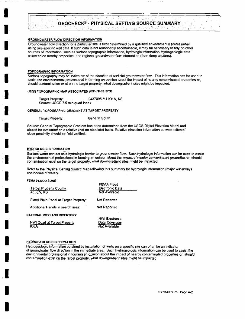
IIIIIIIIIIIIIIIIIII
GEOCHECrt8'- PHYSICAL SETTING SOURCE SUMMARY
GROUNDWATER FLOW DIRECTION INFORMATION
Groundwater flow direction for a particular site is best determined by a qualified environmental professionalusing site-specific well data. If such data is not reasonably ascertainable, it may be necessary to rely on othersources of information, such as surface topographic information, hydrologic information, hydrogeologic datacollected on nearby properties, and regional groundwater flow information (from deep aquifers).
TOPOGRAPHIC INFORMATIONSurface topography may be indicative of the direction of surficial groundwater flow. This information can be used toassist the environmental professional in forming an opinion about the impact of nearby contaminated properties or,should contamination exist on the target property, what downgradient sites might be impacted.
USGS TOPOGRAPHIC MAP ASSOCIATED WITH THIS SITE
Target Property: 2437095-H4 IOLA, KSSource: USGS 7.5 min quad index
GENERAL TOPOGRAPHIC GRADIENT AT TARGET PROPERTY
Target Property. General South
Source: General Topographic Gradient has been determined from the USGS Digital Elevation Model andshould be evaluated on a relative (not an absolute) basis. Relative elevation information between sites ofclose proximity should be field verified.
HYDROLOGIC INFORMATION
Surface water can act as a hydrologic barrier to groundwater flow. Such hydrologic information can be used to assistthe environmental professional in forming an opinion about the impact of nearby contaminated properties or, shouldcontamination exist on the target property, what downgradient sites might be impacted.
Refer to the Physical Setting Source Map following this summary for hydrologic information (major waterwaysand bodies of water).
FEMA FLOOD ZONEFEMA Flood
Target Property County Electronic DataALLEN, KS Not Available
Flood Plain Panel at Target Property: Not Reported
Additional Panels in search area: Not Reported
NATIONAL WETLAND INVENTORYNWI Electronic
NWI Quad at Target Property Data CoverageIOLA Not Available
HYDROGEOLOGIC INFORMATION
Hydrogeologic information obtained by installation of wells on a specific site can often be an indicatorof groundwater flow direction in the immediate area. Such hydrogeologic information can be used to assist theenvironmental professional in forming an opinion about the impact of nearby contaminated properties or, shouldcontamination exist on the target property, what downgradient sites might be impacted.
TC0954877.7S Page A-2

IIIIIIIIIIIIIIIIIII
GEOCHECtf^ - PHYSICAL SETTING SOURCE SUMMARY
AQUIFLOW*
Search Radius: 2.000 Miles.
EDR has developed the AQUIFLOW Information System to provide data on the general direction of groundwaterflow at specific points. EDR has reviewed reports submitted by environmental professionals to regulatoryauthorities at select sites and has extracted the date of the report, groundwater flow direction as determinedhydrogeologically, and the depth to water table.
LOCATION GENERAL DIRECTIONMAP ID FROM TP GROUNDWATER FLOWNot Reported
GROUNDWATER FLOW VELOCITY INFORMATION
Groundwater flow velocity information for a particular site is best determined by a qualified environmental professionalusing site specific geologic and soil strata data. If such data are not reasonably ascertainable, it may be necessaryto rely on other sources of information, including geologic age identification, rock stratigraphic unit and soilcharacteristics data collected on nearby properties and regional soil information. In general, contaminant plumesmove more quickly through sandy-gravelly types of soils than silty-clayey types of soils.
GEOLOGIC INFORMATION IN GENERAL AREA OF TARGET PROPERTY
Geologic information can be used by the environmental professional in forming an opinion about the relative speedat which contaminant migration may be occurring.
ROCK STRATIGRAPHIC UNIT GEOLOGIC AGE IDENTIFICATION
Era: Paleozoic Category: Stratifed SequenceSystem: PennsylvanianSeries: Missourian SeriesCode: PP3 (decoded above as Era, System & Series)
Geologic Age and Rock Stratigraphic Unit Source: P.G. Schruben, R.E. Arndt and W. J. Bawiec, Geologyof the Conterminous U.S. at 1:2,500,000 Scale - a digital representation of the 1974 P.B. King and H.M. BeikmanMap, USGS Digital Data Series DOS -11 (1994).
DOMINANT SOIL COMPOSITION IN GENERAL AREA OF TARGET PROPERTY
The U.S. Department of Agriculture's (USDA) Soil Conservation Service (SCS) leads the National Cooperative SoilSurvey (NCSS) and is responsible for collecting, storing, maintaining and distributing soil survey informationfor privately owned lands in the United States. A soil map in a soil survey is a representation of soil patternsin a landscape. Soil maps for STATSGO are compiled by generalizing more detailed (SSURGO) soil survey maps.The following information is based on Soil Conservation Service STATSGO data.
Soil Component Name: OSAGE
Soil Surface Texture: silty clay
Hydrologic Group: Class D - Very slow infiltration rates. Soils are clayey, have a highwater table, or are shallow to an impervious layer.
Soil Drainage Class: Poorly. Soils may have a saturated zone, a layer of low hydraulicconductivity, or seepage. Depth to water table is less than 1 foot.
TC0954877.7s Page A-3

IIIIIIIIIIIIIIIIIII
GEOCHECk® - PHYSICAL SETTING SOURCE SUMMARY
Hydric Status: Soil meets the requirements for a hydric soil.
Corrosion Potential - Uncoated Steel: HIGH
Depth to Bedrock Min: > 60 inches
Depth to Bedrock Max: > 60 inches
Soil Layer Information
Layer
1
2
Boundary
Upper
0 inches
15 inches
Lower
1 5 inches
60 inches
Soil Texture Class
silty clay
silty clay
Classification
AASHTO Group
Silt-ClayMaterials (morethan 35 pet.passing No.200), ClayeySoils.Silt-ClayMaterials (morethan 35 pet.passing No.200), ClayeySoils.
Unified Soil
FINE-GRAINEDSOILS, Siltsand Clays(liquid limit50% or more),Fat Clay.FINE-GRAINEDSOILS, Siltsand Clays(liquid limit50% or more),Fat Clay.
PermeabilityRate (in/hr)
Max: 0.06Min: 0.00
Max: 0.06Min: 0.00
Soil Reaction(PH)
Max: 7.80Min: 5.10
Max: 7.80Min: 5.60
OTHER SOIL TYPES IN AREA
Based on Soil Conservation Service STATSGO data, the following additional subordinant soil types mayappear within the general area of target property.
Soil Surface Textures: silt loamclaysilty clay loam
Surficial Soil Types:
Shallow Soil Types:
Deeper Soil Types:
silt loamclaysilty clay loam
No Other Soil Types
silt loamsilty clay loam
ADDITIONAL ENVIRONMENTAL RECORD SOURCES
According to ASTM E 1527-00, Section 7.2.2, "one or more additional state or local sources of environmentalrecords may be checked, in the discretion of the environmental professional, to enhance and supplement federaland state sources... Factors to consider in determining which local or additional state records, ifany, should be checked include (1) whether they are reasonably ascertainable, (2) whether they are sufficientlyuseful, accurate, and complete in light of the objective of the records review (see 7.1.1), and (3) whether theyare obtained, pursuant to local, good commercial or customary practice." One of the record sources listed in Section7.2.2 is water well information. Water well information can be used to assist the environmental professional inassessing sources that may impact groundwater flow direction, and in forming an opinion about the impact ofcontaminant migration on nearby drinking water wells.
TC0954877.7S Page A-4

IIIIIIIIIIIIIIIIIII
GEOCHECf^'•••- PHYSICAL SETTING SOURCE SUMMARY
WELL SEARCH DISTANCE INFORMATION
DATABASE
Federal USGSFederal FRDS PWSState Database
SEARCH DISTANCE (miles)
1.000Nearest PWS within 1 mile1.000
FEDERAL USGS WELL INFORMATION
MAP ID WELL ID
USGS0276714
FEDERAL FRDS PUBLIC WATER SUPPLY SYSTEM INFORMATION
MAP ID WELL ID
8 KS2000119
Note: PWS System location is not always the same as well location.
STATE DATABASE WELL INFORMATION
MAP ID
A1A24B5B6B7C9C1011
WELL ID
KS316615KS101416KS117475KS115767KS117474KS117477KS21KS20KS103618
LOCATIONFROM TP
1/4-1/2 Mile East
LOCATIONFROM TP
1/2 -1 Mile West
LOCATIONFROM TP
1/4-1/2 Mile WSW1/4-1/2 Mile WSW1/4 -1/2 Mile ESE1/2-1 Mile NE1/2 -1 Mile NE1/2-1 MileNE1/2-1 Mile WSW1/2 -1 Mile SW1/2-1 Mile West
TC0954877.7S Page A-5

PHYSICAL SETTING SOURCE MAP - 0954877.7s
I
I
I
I
I
County Boundary
f\/ Major Roads
,V Contour Lines
(O) Earthquake epicenter, Richter 5 or greater
® Water Wells
© Public Water Supply Wells
• Cluster of Multiple Icons
1/2 ZMIlei
t Groundwater Row Direction
Q[T) Indeterminate Groundwater Flow at Location
:Ccv) Groundwater Row Varies at Location
TARGET PROPERTY:ADDRESS:CITY/STATE/ZIP:LAT/LONG:
lola East1702 East Streetlola KS 6674937.9228/95.3859
CUSTOMER: Maxim Technologies, Inc.CONTACT: Shannon AllenINQUIRY*: 0954877.7sDATE: April 07, 2003 1:47 pmCopyright O 2003 EDK. Inc. O 2003 GDI. Inc. RoL 07/2002. All RlgMi Haurvati.

IIIIIIIIII
I
IIIIIIII
1 1
GEOCHECK®- PHYSICAL SETTING SOURCE MAP FINDINGS
Map IDDirectionDistanceElevation
A1WSW1/4 - 1/2 MileHigher
Well id:Township:Range:Section:Longitude:OwnerWell use:Completed date:Appl number:Directions:Well depth:Static depth:
12/vsw/4 - 1/2 Mile
Higher
Well id:Township:Range:Section:Longitude:OwnerWell use:Completed date:Appl number:Directions:Well depth:Static depth:
ast/4 - 1/2 Mileigher
Agency:Site Name:Dec. Latitude:Dec. Longitude:Coord Sys:State:County.Altitude:Hydrologic code:Topographic:Site Type:Const Date:Well Type:Primary Aquifer:Aquifer type:Hole depth:Project no:
316615241835-95.39167Kerr McGee Refining Corp.
County:Town dir:Range dir:Spot:Latitude:
Database EDR ID Number
KS WELLS KS316615
AllenSENE NE NE37.92119
MONITORING WELUOBSERVATION/PIEZOMETER16-Oct-2000Not Reported201 S State St, lola21.2314.67
101416241B35-95.39167KERR MCGEE REFI
Status:
Elevation:Driller:
County:Town dirRange dir:Spot:Latitude:
PLUGGED
Not Reportedunknown
KS WELLS KS101416
AllenSENENENE37.92119
MONITORING WELUOBSERVATION/PIEZOMETER25-Jul-1995Not Reported
Status:
100 W OF THE STATE AND MADISON INTERSECTION21.714.1
uses24S 18E36AAA0137.92254-95.37887NAD83KSAllen CountyNot Reported11070204Not ReportedGround-water other than SpringNot Reported
Elevation:Driller:
Site ID:
Inven Date:
CONSTRUCTED
IOLAKSNot ReportedPaul Fancher, Layne-Westem
FED USGS USGS0276714
375521095224301
Not ReportedSingle well, other than collector or Ranney typeNot ReportedNot ReportedNot ReportedNot Reported
Well depth:Source:
Not ReportedNot Reported
TC0954877.7s Page A-7

IIIIIIIIIIIIIIIIIII
GEOCHECK®- PHYSICAL SETTING SOURCE MAP FINDINGS
Map IDDirectionDistanceElevation
4ESE1/4 - 1/2 MileHigher
Well id:Township:Range:Section:Longitude:Owner:Well use:Completed date:Appl number:Directions:Well depth:Static depth:
35ME1/2 - 1 MileHigher
Well id:Township:Range:Section:Longitude:OwnerWell use:Completed date:Appl number:Directions:Well depth:Static depth:
16JE12 - 1 Mileigher
Well id:Township:Range:Section:Longitude:OwnerWell use:Completed date:Appl numberDirections:Well depth:Static depth:
Database EDR ID
i
Number
KS WELLS KS 11 7475
117475241836-95.37787KDOTDOMESTIC06-Aug-1997Not Reported
County:Town dir.Range dir:Spot:Latitude:
Status:
1/2 MILE EAST OF IOLA, KS STATION 09.0 115' FROM144
115767241825-95.37555KDOTDOMESTIC15-Aug-1997Not Reported1 MILE EAST OF IOLA153
117474241825-95.37555KDOTDOMESTIC05-Aug-1997Not Reported1 MILE EAST OF IOLA,253
Elevation:Driller:
County:Town dir:Range dir.Spot:Latitude:
Status:
STATION 127+58Elevation:Driller:
County:Town dir:Range dirSpot:Latitude:
Status:
KS STATION 12+85Elevation:Driller:
AllenSESENWNE37.91933
PLUGGED
CL FOR RAMPNot ReportedJim Kepley, K-W Oil Well Service
KS WELLS KS1 15767
AllenSENWNESE37.92841
PLUGGED
Not ReportedJim Kepley, K-W Oil Well Service
KS WELLS KS1 17474
AllenSENWNESE37.92841
PLUGGED
Not ReportedJim Kepley, K-W Oil Well Service,
, Inc.
Inc.
Inc.
TC0954877.7s Page A-8

GEOCHECK®- PHYSICAL SETTING SOURCE MAP FINDINGS
Map IDDirectionDistanceElevation87NE1/2 - 1 MileHigher
Well id:Township:Range:Section:Longitude:OwnerWell use:Completed date:Appl numberDirections:Well depth:Static depth:
117477241825-95.37555KDOTDOMESTIC05-Aug-1997Not Reported1 MILE FROM302
County:Town dir.Range dir:Spot:Latitude:
Status:
IOLA, KS STATION 127 + 80Elevation:Driller:
Database EDR ID
KS WELLS KS 11 7477
AllenSENWNESE37.92841
PLUGGED
Not ReportedJim Kepley, K-W Oil Well Service,
Number
Inc.
8West1/2 -1 MileHigher
PWS ID:Date Initiated:PWS Name:
PROS PWS KS2000119
KS2000119 PWS Status: Not ReportedNot Reported Date DeactivatedMot ReportedPUBLIC WHOLESALE WSD #5 - IOLAMANAGERRR2IOLA, KS 66749
Treatment Objective: PARTICULATE REMOVALTreatment Process: FILTEREDSource: Surface water
Addressee / Facility: Not Reported
Facility Longitude095 23 58
Population: 3650
PWS currently has or had major violation(s) or enforcement Yes
Facility Latitude:City Served:Treatment Class:
37 55 27IOLATreated
VIOLATIONS INFORMATION:
Violation ID:Vio. beginning Date:Num required Samples:Analysis Result-Analysis Method:Violation Type:ContaminantVio. Awareness Date:
940000101/01/94Not ReportedNot ReportedNot ReportedMonitoring, Routine Minor (TCR)COLIFORM (TCR)Not Reported
Source ID: Not ReportedVio. end Date: 01/31/94Number of Samples Taken:Maximum Contaminant Level:
PWS Phone:Vio. Period:Not ReportedNot Reported
Not Reported001 Months
ENFORCEMENT INFORMATION:
System Name:Violation Type:Contaminant:Compliance Period:Violation ID:Enforcement Date:
PUBLIC WHOLESALE WSD #5 -Monitoring, Routine Minor (TCR)COLIFORM (TCR)1994-01-01 - 1994-01-3194000011994-02-01
Analytical Value:Enforcement ID:Enf. Action:
00000000.009400101State Compliance Achieved
TC0954877.7S Page A-9

IIIIIIIIIIIIIIIIIII
1 1
-•IrV-v;^;-:
Map IDDirectionDistanceElevation
C9WSW1/2 - 1 MileHigher
Well id:Township:Range:Section:Longitude:Owner:Well use:
GEOCHECK®- PHYSICAL
21241835-95.39743Not ReportedDOMESTIC
Completed date: 10-Jun-1978Appl number:Directions:Well depth:Static depth:
C10swf / 2 -1 MileHigher
Well id:Township:Range:Section:Longitude:Owner.Well use:Completed dateAppl numberDirections:Well depth:Static depth:
1Vest12 - 1 Mileiigher
Well id:Township:Range:Section:Longitude:OwnerWell use:Completed date:Appl numberDirections:Well depth:Static depth:
Not ReportedNot Reported500
20241835-95.39857Not ReportedDOMESTIC14-Jun-1978Not ReportedNot Reported376
103618241835-95.40199CITY OF IOLAOTHER14-Nov-1995Not ReportedIN FRONT OF 15 E MADISON2010
SETTING
County:Town dir:Range dirSpot:Latitude:
Status:
Elevation:Driller:
County:Town dir:Range dirSpot:Latitude:
Status:
Elevation:Driller:
County:Town dirRange dirSpot:Latitude:
Status:
IOLAKSElevation:Driller
SOURCE MAP FINDINGS
Database EDR ID Number
KS WELLS KS21
AllenSESWNE37.91668
PLUGGED
Not ReportedTrue M. Ashlock, Eureka Well Service
KS WELLS KS20
AllenSESWSWNE37.91577
CONSTRUCTED
Not ReportedTrue M. Ashlock, Eureka Well Service
KS WELLS KS103618
AllenSECNNENW37.92034
PLUGGED
Not ReportedNot Reported
TC0954877.7s PageA-10

IIIIIIIIIII
I
I
I
I
I
I
I
GEOCHECK®- PHYSICAL SETTING SOURCE MAP FINDINGS'-•'•"• • - , - • : : ; RADON '"'?••.•:.;;•'•' r'v.:-';-. ' • • ^ - . ' • " •
AREA RADON INFORMATION
Federal EPA Radon Zone for ALLEN County: 2
Note: Zone 1 indoor average level > 4 pCi/L.: Zone 2 indoor average level >= 2 pCi/L and <= 4 pCi/L.: Zone 3 indoor average level < 2 pCi/L.
Federal Area Radon Information for Zip Code: 66749
Number of sites tested: 12
Area Average Activity % <4 pCi/L % 4-20 pCi/L % >20 pCi/L
Living Area-1st Floor 0.442 pCi/L 100% 0% 0%Living Area - 2nd Floor Not Reported Not Reported Not Reported Not ReportedBasement 2.400 pCi/L 100% 0% 0%
TC0954877.7S PageA-11

IIIIIIIIIIII
IIIm
III
PHYSICAL SETTING SOURCE RECORDS SEARCHED
HYDROLOGIC INFORMATION
Flood Zone Data: This data, available in select counties across the country, was obtained by EDR in 1999 from the FederalEmergency Management Agency (FEMA). Data depicts 100-year and 500-year flood zones as defined by FEMA.
NWI: National Wetlands Inventory. This data, available in select counties across the country, was obtained by EDRin 2002 from the U.S. Fish and Wildlife Service.
HYDROGEOLOGIC INFORMATION
AQUIFLOW* Information SystemSource: EDR proprietary database of groundwater flow informationEDR has developed the AQUIFLOW Information System (AIS) to provide data on the general direction of groundwater
flow at specific points. EDR has reviewed reports submitted to regulatory authorities at select sites and hasextracted the date of the report, hydrogeologically determined groundwater flow direction and depth to water tableinformation.
GEOLOGIC INFORMATION
Geologic Age and Rock Stratigraphic UnitSource: P.G. Schruben, R.E. Amdt and W.J. Bawiec, Geology of the Conterminous U.S. at 1:2,500,000 Scale - A digitalrepresentation of the 1974 P.B. King and H.M. Beikman Map, USGS Digital Data Series DOS -11 (1994).
STATSGO: State Soil Geographic DatabaseThe U.S. Department of Agriculture's (USDA) Soil Conservation Service (SCS) leads the national CooperativeSoil Survey (NCSS) and is responsible for collecting, storing, maintaining and distributing soil surveyinformation for privately owned lands in the United States. A soil map in a soil survey is a representation ofsoil patterns in a landscape. Soil maps for STATSGO are compiled by generalizing more detailed (SSURGO) soilsurvey maps.
ADDITIONAL ENVIRONMENTAL RECORD SOURCES
FEDERAL WATER WELLS
PWS: Public Water SystemsSource: EPA/Office of Drinking WaterTelephone: 202-554-3750Public Water System data from the Federal Reporting Data System. A PWS is any water system which provides water to at
least 25 people for at least 60 days annually. PWSs provide water from wells, rivers and other sources.
PWS ENF: Public Water Systems Violation and Enforcement DataSource: EPA/Office of Drinking WaterTelephone: 202-564-3750Violation and Enforcement data for Public Water Systems from the Safe Drinking Water Information System (SDWIS) after
August 1995. Prior to August 1995. the data came from the Federal Reporting Data System (FRDS).
USGS Water Wells: In November 1971 the United States Geological Survey (USGS) implemented a national water resourceinformation tracking system. This database contains descriptive information on sites where the USGS collects or has collecteddata on surface water and/or groundwater. The groundwater data includes information on more than 900,000 wells, springs, andother sources of groundwater.
TC0954877.7s Page A-12

IIIIIIIIIIIIIIIIIII
PHYSICAL SETTING SOURCE RECORDS SEARCHED
STATE RECORDS
Kansas Water Well Completion Records DatabaseSource: Kansas Geological SurveyTelephone: 913-864-3965
RADON
Area Radon InformationSource: USGSTelephone: 703-356-4020The National Radon Database has been developed by the U.S. Environmental Protection Agency(USEPA) and is a compilation of the EPA/State Residential Radon Survey and the National Residential Radon Survey.The study covers the years 1986 - 1992. Where necessary data has been supplemented by information collected atprivate sources such as universities and research institutions.
EPA Radon ZonesSource: EPATelephone: 703-356-4020Sections 307 & 309 of IRAA directed EPA to list and identify areas of U.S. with the potential for elevated indoorradon levels.
OTHER
Epicenters: World earthquake epicenters, Richter 5 or greaterSource: Department of Commerce, National Oceanic and Atmospheric Administration
TC0954877.7s PageA-13

IIIIIIIIIIIIIIIIIII
EDR NEPACheck®
lola East1702 East StreetIola,KS 66749
Inquiry Number: 0954877.8s
April 07,2003
•Environmental[Datai Resources, Inc.
The SourceFor EnvironmentalRisk ManagementData
3530 Post RoadSouthport, Connecticut 06890
Nationwide Customer Service
Telephone: 1-800-352-0050Fax: 1-800-231-6802Internet: www.edrnet.com

IIIIIIII
IIIIIIIIII
TABLE bF CONTENTS
SECTION
EDR NEPACheck® Description.
PAGE
1
Map Findings Summary 2
Natural Areas 3
Historic Sites 5
Flood Plain 8
Wetlands 10
Wetlands Classification System 12
FCC & FAA Sites 16
Key Contacts and Government Records Searched 18
Thank you for your business.Please contact EDR at 1-800-352-0050
with any questions or comments.
DisclaimerCopyright and Trademark Notice
This report contains information obtained from a variety of public and other sources. NO WARRANTY EXPRESSED OR IMPLIED,IS MADE WHATSOEVER IN CONNECTION WITH THIS REPORT. ENVIRONMENTAL DATA RESOURCES INC. SPECIFICALLYDISCLAIMS THE MAKING OF ANY SUCH WARRANTIES, INCLUDING WITHOUT LIMITATION, MERCHANTABILITY OR FITNESSFOR A PARTICULAR USE OR PURPOSE. ALL RISK IS ASSUMED BY THE USER. IN NO EVENT SHALL EDR BE LIABLE TOANYONE, WHETHER ARISING OUT OF ERRORS OR OMISSIONS, NEGLIGENCE, ACCIDENT OR ANY OTHER CAUSE, FOR ANYLOSS OR DAMAGE. INCLUDING, WITHOUT LIMITATION, SPECIAL, INCIDENTAL, CONSEQUENTIAL, OR EXEMPLARY DAMAGES.
Entire contents copyright 2003 by Environmental Data Resources, Inc. All rights reserved. Reproduction in any media or format, in wholeorin part, of any report or map of Environmental Data Resources, Inc., or its affiliates, is prohibited without prior written permission.
EDR and the edr logos are trademarks of Environmental Data Resources, Inc. or its affiliates. All other trademarks used herein are theproperty of their respective owners.

IIIIIIII
IIIIIIIIII
EDR NEPACheck® DESCRIPTION
The National Environmental Policy Act of 1969 (NEPA) requires that Federal agencies include in theirdecision-making processes appropriate and careful consideration of all environmental effects and actions,analyze potential environmental effects of proposed actions and their alternatives for publicunderstanding and scrutiny, avoid or minimize adverse effects of proposed actions, and restore andenhance environmental quality as much as possible.
The EDR NEPACheck provides information which may be used, in conjunction with additional research,to determine whether a proposed site or action will have significant environmental effect.
The report provides maps and data for the following items (where available). Search results are providedin the Map Findings Summary on page 2 of this report.
SectionNatural Areas Map• Federal Lands Data:
- Officially designated wilderness areas- Officially designated wildlife preserves, sanctuaries
and refuges- Wild and scenic rivers- Fish and Wildlife
• Threatened or Endangered Species, Fishand Wildlife, Critical Habitat Data (where available)
Historic Sites Map• National Register of Historic Places• State Historic Places (where available)
Flood Plain Map• National Flood Plain Data (where available)
Wetlands Map• National Wetlands Inventory Data (where available)
FCC & FAA Map• FCC antenna/tower sites, AM Radio Towers, FAAMarkings and Obstructions, AM Radio Interference Zones,Airports, Topographic gradient
Key Contacts and Government Records Searched
Regulation
47 CFR 1.1307(1)47 CFR 1.1307(2)
40 CFR 6.302(e)40 CFR 6.30247 CFR 1.1307(3); 40 CFR 6.302
47 CFR 1.1307(4); 40 CFR 6.302
47 CFR 1.1307(6); 40 CFR 6.302
47 CFR 1.1307(7); 40 CFR 6.302
47 CFR 1.1 307(8)
TC0954877.8S Page 1 of 23

IIIIIIIIIIIIIIIIIII
MAP FINDINGS SUMMARY
The databases searched in this report are listed below. Database descriptions and other agency contact informationis contained in the Key Contacts and Government Records Searched section on page 18 of this report.
TARGET PROPERTY ADDRESS
IOLA EAST1702 EAST STREETIOLA, KS 66749
TARGET PROPERTY COORDINATES
Latitude (North):Longitude (West):Universal Tranverse Mercator:UTM X (Meters):UTM Y (Meters'):
Inquiry #: 0954877.8sDate: 4/7/3
37.922798-37'55'22.1"95.385902 - 95' 23' 9.2"Zone 15290284.84199728.5
Applicable Regulation from 47 CFR/FCC Checklist
NATURAL AREAS MAP1.1307a (1) Officially Designated Wilderness Area1.1307a (2) Officially Designated Wildlife Preserve1.1307a (3) Threatened or Endangered Species or
Critical Habitat
HISTORIC SITES MAP1 .1307a (4) Listed or eligible for National Register1.1307a (4) Listed or eligible for National Register
Database
US Federal LandsUS Federal LandsKS Critical Habitat
National Register Hist. PlacesKS Historic Sites
SearchDistance(Miles)
1.001.001.00
1.001.00
WithinSearch
NONONO
YESYES
Within1/8 Mile
NONONO
NONO
FLOODPLAIN MAP1.1307 (6) Located in a Flood Plain
WETLANDS MAP1.1307 (7) Change in surface features (wetland fill)
FCC & FAA SITES MAP
FLOODPLAIN
NWI
FCC CellularFCC AntennaFCC TowerFCC AM TowerFAADOF
1.00
1.00
1.001.001.001.001.00
NO
NO
NONONONONO
NO
NO
NONONONONO
TC0954877.8S Page 2 of 23
I Natural Areas Map
• ir Target Property
A/ Roads •
I
I
I
I
A/ County Boundary
A/ Waterways
BI Water
* Locations :
sx^ Federal Areas
i i>" Federal Linear Features
State Areas
State Linear Features
1/4 1/2 1 Mitel
TARGET PROPERTY:ADDRESS:CITY/STATE/ZIP:LAT/LONG:
lola East1702 East Streetlola KS 6674937.9228/95.3859
CUSTOMER: Maxim Technologies, Inc.CONTACT: Shannon AllenINQUIRY*: 0954877.8sDATE: April 07,2003 TCW54877.8j Page3of2
Copyright * 2003 EDR. Int O 2003 BDT. Inc. RiL 07/2002. AO Rlghli FUlirviiJ.

IIIIIIIIIIIIIIIIIII
Map IDDirectionDistanceDistance (ft)
EDRIDDatabase
No mapped sites were found in EDR's search of available government recordswithin the search radius around the target property.
TC0954877.8s Page 4 of 23

I Historic Sites Map
* Target PropertyA/ Streets
_ A/ County Boundary
• A/ Waterways
••> Historic Sites£21 Federal Historic AreasPT3 State Historic Areas/\/ Scenic Trail
1/4 1/2 1MOai
Water
ITARGET PROPERTY: lolaEastADDRESS: 1702 East StreetCITY/STATE/ZIP: lola KS 66749LAT/LONG: 37.9228 / 95.3859
CUSTOMER: Maxim Technologies, Inc.CONTACT: Shannon AllenINQUIRY*: 0954877.8sDATE: April 07,2003 TCW54877.8s P»ge5of23
I
Copyright O 2003 EDR. Ire. o 2003 6DT. Int. Ril 07/3)02. AH Righto Rinrvid.

IIIIIIIIIIIIIIIIIII
EDRIDDatabase
Northrup HouseNot Reported318 East St.Buildinglola, KSAllen, KSListed In the national register
1 Resource Name:West Alternate Name:1/2-1 mi Resource Address:3897 Resource Type:
Location:County:Primary Certification:Certification Date: 19970512Number of Buildings: 2Number of Sites: 0Number of non-contributing Buildings:Number of non-contributing Objects:Number of non-contributing Sites:Num. of non-contributing Structures:Applicable Criteria: Architecture/EngineeringAreas of Significance: ArchitectureCurrent Function: DomesticBuilding Material: Weatherboard, Shingle, Limestone, Iron, Tin, Other
97000395National Register Hist. Places
Acreage: 9Number of Objects: 0Num. of Structures: 00000
2West1/2-1 miA *"»O J4284
A3West1/2-1 ml4957
Name:Type:County:Address:City:Date Added:
Resource Name:Alternate Name:Resource Address:Resource Type:
Northrup HouseNot ReportedAllen County318 East Streetlola05/12/97
Allen County JailNot Reported204 N. Jefferson St.Building
KS20000003KS Historic Sites
71000300National Register H
lola, KSAllen, KSListed in the national register
Location:County:Primary Certification:Certification Date: 19710125Number of Buildings: 1Number of Sites: 0Number of non-contributing Buildings:Number of non-contributing Objects:Number of non-contributing Sites:Num. of non-contributing Structures:Applicable Criteria: EventAreas of Significance: Politics/governmentCurrent Function: Recreation and cultureBuilding Material: None listed, Limestone
Acreage: . 9Number of Objects: 0Num. of Structures: 00000
A4West1/2-1 miCA*5 A5034
Name:Type:County:Address: •City:Date Added:
Allen County JailNot ReportedAllen County204 North Jeffersonlola01/25/71
KS20000002KS Historic Sites
TC0954877.8S Page 6 of 23

IIIIIIIIIIIIIIIIIIi
Due to poor or Inadequate address Information, the following sites were not mapped:StatusEDRIDDatabase
No unmapped sites were found in EDR's search of available government records.
TC0954B77.8S Page 7 of 23 -.

I Flood Plain Map
I
I"
I
I
I
A/ Major Roads
A/ Contour Lines
i\/ Waterways
County Boundary
/V/ Powor Unas
/\/ PlpeUnes
At Fault Unas
Water fc
100-year flood zone
500-year flood zone
1/4 1/2
/y.' Electronic FEW A data available
. •' Electronic FEMA data not availableN
TARGET PROPERTY:ADDRESS:CITY/STATE^IP:LAT/LONG:
lola East1702 East Streetlola KS 6674937.9228/95.3859
CUSTOMER: Maxim Technologies, Inc.CONTACT: Shannon AllenINQUIRY*: O954877.flsDATE: April 07,2003 TC095C7.8s
Copyright O 2003 EDS. liu. O 2003 SOT. Inc. R>L 07/2002. M Rlghh Riiirvid.

IIIIIIIIIIIIIIIIIII
Source: FEMA Q3 Flood Data
County FEMA flood data electronic coverage
ALLEN, KS NO
Flood Plain panel at target property: None ReportedAdditional Flood Plain panel(s) in search area: None Reported
TC0954877.88 Page 9 of 23

I National Wetlands Inventory Map
I
I
I
I
I
I
A/ Major Roads
A/ Contour Unos
/'.,/ Watarways
A/ County Boundary
yV Power Unas
A/ PlpeUnan
jkf Fault Unas
Water I
Wetlands
Electronic NWI data available
Electronic NWI data not available
1/4 IMDn
TARGET PROPERTY: lolaEastADDRESS: 1702 East StreetCITY/STATE/ZIP: lota KS 66749LAT/LONG: 37.9228/95.3859
CUSTOMER: Maxim Technologies, Inc.CONTACT: Shannon AllenINQUIRY*: 0954877.8sDATE: April 07,2003 TC095487ZSs PigclOofB
ICopyright Ci 2003 EDR. Inc. O 2003 6DT. Inc R>l. 07/2902. AI RJghtl Rtuiytd.

IIIIIIIIIIIIIIIIIII
Source: Fish and Wildlife Service NWI data
NWI hardcopy map at target property: lolaAdditional NWI hardcopy map(s) in search area:
La Harpe
Map IDDirectionDistanceDistance (ft.) Code and Description* Database
No Sites Reported.
'See Wetland Classification System for additional information. TC0954877.8S Page 11 of 23

111•
11•
f •
1'
I•
1111
i$s<y^..; &$&v£^^
National Wetland Inventory Maps are produced by the U.S. Fish and Wildlife Service, a sub-department
of the U.S. Department of the Interior. In 1974, the U.S. Fish and Wildlife Service developed a criteria for
wetland classification with four long range objectives:
• to describe ecological units that have certain homogeneous natural attributes,
• to arrange these units in a system that will aid decisions about resource management,
• to furnish units for inventory and mapping, and
• to provide uniformity in concepts and terminology throughout the U.S.
High altitude infrared photographs, soil maps, topographic maps and site visits are the methods
used to gather data for the productions of these maps. In the infrared photos, wetlands appear as
different colors and these wetlands are then classified by type. Using a hierarchical classification,
the maps identify wetland and deepwater habitats according to:
• system
• subsystem
• class
• subclass
• modifiers
(as defined by Cowardin, et al. U.S. Fish and Wildlife Service FWS/OBS 79/31. 1979.)
The classification system consists of five systems:
1. marine2. estuarine
3. riverine
4. lacustrine
5. palustrine
The marine system consists of deep water tidal habitats and adjacent tidal wetlands. The riverine
system consists of all wetlands contained within a channel. The lacustrine systems includes allnontidal wetlands related to swamps, bogs & marshes. The estuarine system consists ofdeepwater tidal habitats and where ocean water is diluted by fresh water. The palustrine system
includes nontidal wetlands dominated by trees and shrubs and where salinity Is below .5% in tidal
areas. All of these systems are divided in subsystems and then further divided into class.
National Wetland Inventory Maps are produced by transferring gathered data on a standard 7.5
minute U.S.G.S. topographic map. Approximately 52 square miles are covered on a National
Wetland Inventory map at a scale of 1 :24,000. Electronic data is compiled by digitizing these
National Wetland Inventory Maps.
t.
TC0954877.88 Page 12 of 23
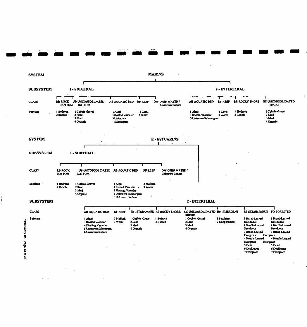
SYSTEM
SUBSYSTEM
MARINE
II
1 - SUBTIDAL
I
2 - INTERTIDAL
CLASSI T I I IRB-ROCK UB-UNCONSOLIDATED AB-AQUATIC BED RF-REEF OW-OPEN WATER /
BOTTOM BOTTOM Unknown BottomAB-AQUATIC BED RF-REEF RS-ROCK.Y SHORE US-UNCONSOUDATED
SHORE
Subclass 1 Bedrock 1 Cobble-Gravel2 Rubble 2 Sand
3 Mud4 Organic
1 Algal3 Rooted Vascular5 Unknown
Submergent
1 Coral3 Worm
1 Algal 1 Coral 1 Bedrock3 Rooted Vascular 3 Worm 2 RubbleS Unknown Submergent
.1 Cobble-Gravel2 Sand3 Mud4 Organic
SYSTEM
SUBSYSTEM
CLASS
Subclass
SUBSYSTEM
E - ESTUAR1NEI •
1 - SUBTIDAL
RB-ROC1CBOTTOM
1 Bedrock2 Rubble
UB-UNCONSOLIDATED AB-AQUATIC BEDBOTTOM
RF-REEF OW-OPEN WATER/Unknown Bottom
1 Cobble-Gravel2 Sand3 Mud4 Organic
I Algal 2 Mollusk3 Rooted Vascular • 3 Worm4 Floating Vascular5 Unknown Submergent6 Unknown Surface
2 - INTERTIDAL
TJ01
CLASS
Subclass
I I I I I IAB-AQUATIC BED RF-REEF SB - STREAMBED RS-ROCKY SHORE US-UNCONSOL1DATED EM-EMERGENT SS-SCRUB SHRUB FO-FORESTED
I Algal3 Rooted Vascular4 Floating Vascular5 Unknown Submergent6 Unknown Surface
2 Mollusk3 Worm
1 Cobble- Gravel2 Sand3 Mud4 Organic
1 Bedrock2 Rubble
SHORE1 Cobble-Gravel2 Sand3 Mud4Organic
1 Persistent I Broad-Leaved I Broad-Leaved2 Nonpenistent Deciduous Deciduous
2 Needle-Leaved 2 Needle-LeavedDeciduous Deciduous3 Broad-Leaved 3 Broad-LeavedEvergreen Evergreen4 Needle-Leaved 4 Needle-LeavedEvergreen Evergreen5 Dead 5 Dead6 Deciduous. 6 Deciduous7 Evergreen 7 Evergreen

SYSTEM
SUBSYSTEM
CLASS
Subclass
R- RIVERINE
r i T1 - TIDAL 2 - LOWER PERENNIAL 3 - UPPER PERENNIAL 4 - INTERMITTENT
I
5 - UNKNOWN PERENNIAL
RB-ROCK UB-UNCONSOLIDATED »SB-STREAMBED AB-AQUATIC BED RS-ROCKY US-UNCONSOLIDATEDBOTTOM BOTTOM SHORE SHORE
1 Bedrock2 Rubble
1 Cobble-Gravel2 Sand3 Mud4 Organic
1 Bedrock2 Rubble3 Cobble-Gravel4 Sand5 Mud
1 Algal2 Aquatic Moss3 Rooted Vascular4 Floating Vascular5 Unknown Subntergent6 Unknown Surface
(Bedrock2 Rubble
1 Cobble-Gravel2 Sand3 Mud4 Organic5 Vegetated
•EM-EMERGENT
2 Nonperaistent
OW-OPEN WATER/Unknown Bottom
7 Vegetated
• STREAMBED is limited to TIDAL and INTERMITTENT SUBSYSTEMS, and comprises the only CLASS in the INTERMITTENT SUBSYSTEM.••EMERGENT is limited to TIDAL and LOWER PERENNIAL SUBSYSTEMS.
SYSTEM
SUBSYSTEM
CLASS
Subclass
L - LACUSTRINEI
1- LIMNETIC1
RB-ROCK.BOTTOM
1 Bedrock2 Rubble
1
UB-UNCONSOLIDATEDBOTTOM
1 Cobble-Gravel2 Sand3 Mud4 Organic
1
AB-AQUATIC BED
1 Algal2 Aquatic Moss3 Rooted Vascular4 Floating Vascular5 Unknown Submergenl6 Unknown Surface
1
OW-OPEN WATER/Unknown Bottom
SUBSYSTEM 2 - LITTORAL
oI CLASS
CO
CD Subclass
•g£o
I I I 1RB-ROCK. UB-UNCONSOLIDATED AB-AQUATIC RS-ROCKY
BOTTOM BOTTOM BED SHORE
1 Bedrock2 Rubble
1 Cobble-Gravel2 Sand3 Mud4 Organic
1 Algal 1 Bedrock2 Aquatic Moss 2 Rubble3 Rooted Vascular
. 4 Floating Vascular5 Unknown Submergenl6 Unknown Surface
US-UNCONSOLIDATEDSHORE
1 Cobble-Gravel2 Sand3 Mud4 Organic5 Vegetated
1
EM-EMERGENT
2 Nonpcrsistent
OW-OPEN WATER/Unknown Bottom

SUBSYSTEM P - PALUSTR1NEI
CLASS
Bottom
iRB-ROCK
BOTTOM
1UB-UNCONSOLIDATED
BOTTOM
1AB-AQUATICBED
1US-UNCONSOLIDATED
SHORE
1ML-MOSS-
LICHEN
|EM-EMERGENT
1SS-SCRUB-SHRUB
1FO-FORESTED
1OW-OPEN WATER/
Unknown
Subclass 1 Bedrock2 Rubble3 Mud4 Organic
1 Cobble-Gravel2 Sand
1 Algal2 Aquatic Moss3 Rooted Vascular4 Floating Vascular5 Unbiown
Subrnergent6 Unknown Surface
1 Cobble-Gravel2 Sand3 Mud4 Organic5 Vegetated
IMoss2 Lichen.
1 Persistent2 Nonpersistent
1 Broad-LeavedDeciduous2 Needle-Leaved
Deciduous3 Broad-Leaved
1 Broad-LeavedDeciduous2 Needle-Leaved
Deciduous3 Broad-Leaved
Evergreen Evergreen4 Needle-Leaved 4 Needle-Leaved
Evergreen Evergreen5 Dead 5 Dead6 Deciduous 6Deciduous7 Evergreen 7 Evergreen
MODIFIERS
In order to more adequately describe wetland and deepwater habitats one or more of the water regime, water chemistry,soil, or special modifiers may be applied at the class or lower level in the hierarchy. The farmed modifier may also be applied to the ecological system.
WATER REGIME
Non-Tidal Tidal CoutalHalinitylnluidSillnitypUModillenror
A Temporarily Flooded H Permanently Flooded K Artificially Flooded • *S Temporary-TidalB Saturated J Intermittently Flooded L Subtidal *R Seasonal-TidalC Seasonally Flooded K. Artificially Flooded M Irregularly Exposed *T Semipermanent -TidalD Seasonally Flooded/ W Intermittently N Regularly Flooded V Permanent -Tidal
Well Drained Flooded/Temporary P Irregularly Flooded U UnknownE Seasonally Flooded/ Y Saturated/Semipermanent/
Saturated SeasonalF Semipermanently Z Intermittently *These water regimes are only used in
Flooded Exposed/Permanent tidalry influenced, freshwater systems.G Intermittently U Unknown
Exposed
WATER CHEMISTRY
all Fresh Water1 Hyperhaline 7 Hypersaline2Euhaline SEusaline a Acid3 Mixohaline (Brackish) 9 Mixosaline t Circumneutral4 Polyhaline 0 Fresh i Alkaline5 Mesohaline6 Oligohaline0 Fresh
SOIL
g Organicn Mineral
SPECIAL MODIFIERS
b Beaverd Partially Drained/Ditchedf Farmedh Diked/Impoundedr Artificial Substrates Spoilx Excavated
Source: U.S. Department of the InteriorFish and Wildlife ServiceNational Wetlands Inventory

IIIIIIIIIIIIII
IIIII
FCC & FAA Sites Map
A/ Streets
A/ Contour Unas
A/ County Boundary
A/ WaterwaysWater
Sites
Omni Directional AM Interference
Directional AM Interferenca
1/2 1MUei
TARGET PROPERTY: lolaEastADDRESS: 1702 East StreetCITY/STATE/ZIP: lola KS 66749LAT/LONG: 37.9228/95.3859
CUSTOMER: Maxim Technologies, Inc.CONTACT: Shannon AllenINQUIRY*: 0954877.8sDATE: April 07, 2003 TCW54J77.8i Pap 16 of 23
CapyitgM « 2003 EDR, Inc. O 2003 SOT, Inc. RtL 07/2002. All Rig Mi Rtumd.

IIIIIII
! 1
I
I
I
I
I
I
I
I
I
I
I
Map 10DirectionDistanceDistance (ft)
EDRIDDatabase
No Sites Reported.
TC0954877.8S Page 17 of 23

IIIIIIIIIIIIIIIIIII
Various Federal laws and executive orders address specific environmental concerns. NEPA requires the responsibleoffices to Integrate to the greatest practical extent the applicable procedures required by these laws and executiveorders. EDR provides key contacts at agencies charged with implementing these laws and executive orders tosupplement the information contained in this report.
NATURAL AREASOfficially designated wilderness areasGovernment Records Searched In This ReportFED.LAND: Federal Lands
Source: USGSTelephone: 703-648-5094Federal data from Bureau of Land Management, National Park Service, Forest Service, Fish and Wildlife Service,and Bureau of Indian Affairs.- National Parks- Forests- Monuments- Wildlife Sanctuaries, Preserves, Refuges- Federal Wilderness Areas.- Indian ReservationsDate of Government Version: 09/01/1997
Federal Contacts for Additional InformationNational Park Service, Midwest Region
1709 Jackson StreetOmaha, NE 68102402-221-3471
USDA Forest Service, Rocky Mountain740 Simms Street P.O. Box 25127Lakewood, CO 80225303-275-5160
BLM- New Mexico State Office1474 Rodeo RoadSanta Fe.NM 87502-0115505-438-7400
Fish & Wildlife Service, Region 6P.O. Box 25486 Denver Federal CenterDenver, CO 80225303-236-7917
Officially designated wildlife preserves, sanctuaries and refugesGovernment Records Searched In This ReportFED_LAND: Federal Lands
Source: USGSTelephone: 703-648-5094Federal data from Bureau of Land Management, National Park Service, Forest Service, Fish and Wildlife Service,and Bureau of Indian Affairs.- National Parks- Forests- Monuments- Wildlife Sanctuaries, Preserves, Refuges- Federal Wilderness Areas.- Indian ReservationsDate of Government Version: 09/01/1997
TC0954877.BS Page 18 of 23

IIIIIIIIIIIIIIIII
I
Federal Contacts for Additional InformationFish & Wildlife Service, Region 6P.O. Box 25486 Denver Federal CenterDenver, CO 80225303-236-7917
State Contacts for Additional InformationDept. of Wildlife and Parks 785-273-6740
Wild and scenic riversGovernment Records Searched in This ReportFED_LAND: Federal Lands
Source: USGSTelephone: 703-648-5094Federal data from Bureau of Land Management, National Park Service, Forest Service, Fish and Wildlife Service,and Bureau of Indian Affairs.- National Parks- Forests- Monuments- Wildlife Sanctuaries, Preserves, Refuges- Federal Wilderness Areas.- Indian ReservationsDate of Government Version: 09/01/1997
Federal Contacts for Additional InformationFish & Wildlife Service, Region 6P.O. Box 25486 Denver Federal CenterDenver, CO 80225303-236-7917
Endangered Species
Government Records Searched in This ReportKS Designated Critical Habitat: KS Designated Critical HabitatCritical habitats Include those areas documented as currently supporting self-sustaining populations of any threatenedor endangered species of wildlife as well as those areas determined by the Kansas Department of Wildlife and Parks tobe essential for the conservation of any threatened or endangered species of wildlifeSource: Department of Wildlife and Parks.Telephone: 316-672-5911
Federal Contacts for Additional Information •Fish & Wildlife Service, Region 6P.O. Box 25486 Denver Federal CenterDenver, CO 80225303-236-7917
State Contacts for Additional InformationNatural Heritage Inventory, Kansas Biological Survey 785-864-3453
TC0954877.8S Page 19 of 23

IIIIIIIIIIII
IIIIIII
LANDMARKS, HISTORICAL, AND ARCHEOLOGICAL SITESHistoric PlacesGovernment Records Searched In This ReportNational Register of Historic Places:
The National Register of Historic Places is the official federal list of districts, sites, buildings,structures, and objects significant in American history, architecture, archeology, engineering, andculture. These contribute to an understanding of the historical and cultural foundations of the nation.The National Register includes:- All prehistoric and historic units of the National Park System;- National Historic Landmarks, which are properties recognized by the Secretary of the Interior as
possessing national significance; and-.Properties significant in American, state, or local prehistory and history that have been nominated
by State Historic Preservation Officers, federal agencies, and others, and have been approved forlisting by the National Park Service.
Date of Government Version: 03/15/2000
. KS Historic Sites: State RegisterListing of historic sites included on the State Register.Source: Kansas State Historical Society.Telephone: 785-272-8681
KS Historic Sites: National Register of Historic PlacesListing of historic sites included on the National Register for Kansas.Source: Kansas State Historical Society.Telephone: 785-272-8681
Federal Contacts for Additional InformationPark Service; Advisory Council on Historic Preservation1849 C Street NWWashington, DC 20240Phone: (202) 208-6843
State Contacts for Additional InformationKansas State Historical Society 785-272-8681
Indian Religious SitesFederal Contacts for Additional InformationDepartment of the Interior- Bureau of Indian AffairsOffice of Public Affairs1849 C Street, NWWashington, DC 20240-0001Office: 202-208-3711Fax:202-501-1516
National Association of Tribal Historic Preservation Officers1411 K Street NW, Suite 700Washington, DC 20005Phone: 202-628-8476Fax: 202-628-2241
TC0954877.8S Page20-of23

IIIIIIII
' •
I
IIIIIIII
KEY CONTACTS £ GOVERNMENT RECORDS SEARCHEDr^r iL^---1-^!::.1 •••'•- • .- .• •??:-.£•*•* s^.-'Ji.i'Ji •*-:::"::.«';:., •:ij|rti.J .•'•••r.-c :-: •...?.• • 1- •,-"-y.,:!- • H-I-'..-*- . _ -.^ -• - . - _• •' - :> r—.. . ":-J:L -'.j\il"> ':=•
State Contacts for Additional InformationA listing of local Tribal Leaders and Bureau of Indian Affairs Representatives can be found at:http://www.doi.gov/bia/areas/agency.html
Anadarko Area Office, Bureau of Indian AffairsWCD Office Complex P.O. Box 368Anadarko, OK 73005405-247-6673
FLOOD PLAIN, WETLANDS AND COASTAL ZONE
Flood Plain ManagementGovernment Records Searched In This ReportFlood Zone Data: This data, available in select counties across the country, was obtained by EDR in 1999 from the FederalEmergency Management Agency (FEMA). Data depicts 100-year and 500-year flood zones as defined by FEMA.
Federal Contacts for Additional InformationFederal Emergency Management Agency 877-3362-627
State Contacts for Additional InformationDlv. Of Emergency Management 785-274-1409
Wetlands ProtectionGovernment Records Searched In This ReportNWI: National Wetlands Inventory. This data, available in select counties across the country, was obtained by EDRin 2002 from the U.S. Fish and Wildlife Service.
Federal Contacts for Additional InformationFish & Wildlife Service 813-570-5412
State Contacts for Additional InformationDept. of Wildlife & Parks 785-273-6740
Coastal Zone ManagementGovernment Records Searched in This ReportCAMA Management Areas
Dept. of Env., Health & Natural Resources919-733-2293
Federal Contacts for Additional InformationOffice of Ocean and Coastal Resource Management
N/ORM, SSMC41305 East-West HighwaySilver Spring, Maryland 20910301-713-3102
State Contacts for Additional Information
TC0954B77.8S Page 21 of 23

IIIIIIIIIIIIIIIIIII
FCC & FAA SITES MAPFor NEPA actions that come under the authority of the FCC, the FCC requires evaluation of Antenna towers and/orsupporting structures that are to be equipped with high intensity white lights which are to be located in residentialneighborhoods, as defined by the applicable zoning law.
Government Records Searched In This ReportCellularFederal Communications Commission
Mass Media Bureau2nd Floor - 445 12th Street SWWashington DC 20554 USATelephone (202) 418-2700
Portions copyright (C) 1999 Percon Corporation. All rights reserved.
TowerFederal Communications Commission
Mass Media Bureau2nd Floor- 445 12th Street SWWashington DC 20554 USATelephone (202) 418-2700
Portions copyright (C) 1999 Percon Corporation. All rights reserved.
Antenna RegistrationFederal Communications Commission
Mass Media Bureau2nd Floor - 445 12th Street SWWashington DC 20554 USATelephone (202) 418-2700
Portions copyright (C) 1999 Percon Corporation. All rights reserved.
AM TowerFederal Communications Commission
Mass Media Bureau2nd Floor- 445 12th Street SWWashington DC 20554 USATelephone (202) 418-2700
FAA Digital Obstacle FileNational Oceanic and Atmospheric Administration
Telephone: 301-436-8301Describes known obstacles of interest to aviation users in the US. Used by the FederalAviation Administration (FAA) and the National Oceanic and Atmospheric Administration tomanage the National Airspace System.
Excessive Radio Frequency EmissionFor NEPA actions that come under the authority of the FCC, Commission actions granting construction permits,licenses to transmit or renewals thereof, equipment authorizations or modifications in existing facilities, requirethe determination of whether the particular facility, operation or transmitter would cause human exposure to levelsof radio frequency in excess of certain limits.
Federal Contacts for Additional InformationOffice of Engineering and Technology
Federal Communications Commission445 12th Street SWWashington, DC 20554Phone: 202-418-2470
TC0954877.8S Page 22 of 23

IIIIIIIIIIIIIIIIIII
OTHER CONTACT SOURCES
STREET AND ADDRESS INFORMATION
(c) 2001 Geographic Data Technology, Inc., Rel. 07/2001. This product contains proprietary and confidential property ofGeographic Data Technology, Inc. Unauthorized use, including copying for other than testing and standard backup procedures,of this product is expressly prohibited.
TC0954877.8S Page 23 of 23

I
II •
Ii- .
I
II
• •••
JIJI
APPENDIX FSITE PHOTOGRAPHS

III
\
II
' !
I
1
I
I
j
I
I
I
I
I
I
I
I
' . . . . UNITED23NC.fl---- ;-;.:,,.. . 'GROUP B FORMER t^AI) SMELTERS
PROJECT NO.: 3390184CLIENT: KDHE
1.. Subject Property - View of property, looking northwest
2, Subject Property - View of northwest side of property - looking southeast

IIIIIIii
'•• >
iiiiiiiiii
•*;..:• ; UNITED
GROUP B FORMER LEAD SMELTERS
- • - . - : I T • . ' PROJECT NQ.t 339QI84
'
Siibjpcl Property - ylevy of northeast edige of property - looking southwest' ' " ' ' ' ' ' '
- -
4. Subject Property - View of graded area of waste -looking southwest

IIIIIIIIIIIIIIIIIIII
UNITED ZINCB FORMER LEAD SMELTERS
PROJECT NO.: 3390184
SJOy?jef't Pff^ffyl Y!6^ ?t property and east adjacent property.in the background - looking
. . . _ . . . .:*-r v • -- ' • 6v Subject Property - View of a srnall graded waste area - looking southwest

IIIIIIIIIIIIIIIIIII
, ; •" •" : UNITED ZINC fa : ; vGROUP B FORMER 'iJE ADSMELTERS
PROJECT NO,; 3390184
iubfect Property - View of property and graded waste area • looking southwest' ' ' ' '
8- Subject Property - View of graded waste area - looking northwest

IIIIII
' I
If'
I
I
I
I
I
I
I
I
I
I
QRQUP B FORMER LEAD SMELTERS- - ' : T « ' : > . - - . • - • • • v • - - ' • - - : • • • • ' • • , ' ' • ' •
PROJECT NO.: 3390184
s^gf-ltt'-.-A-jfr^ir \-f'[ -h~ ' - •
ubject Property ^Vjew.'of northwest corner of property - looking southwest
Subject Property - View of northeast side of property with northeast adjacent property in background - looking' northeast • : ; --• :

IIIIIII
I 1III
' J.If "*
IIIIIII
: PROJECT NO.: 3390184
Subject Property • .View of north and central portions of property - looking north*-:.<^^.^.^^-^>I-.----;•.•• • • ' • • • ' . ' : •-:.-,;• . • -
'*»&i& '12., Adjacent Property -. View of rear and north end of west adjacent property - looking south >

IIIIIIII
r t
I
I
I
I
I
I
I
I
I
I
•
. UNITEDFORMER ] Ap SMELTERS
PROJECT NO.: 339018
porrter of property ahd'east adjacent property in the background - looking»;
' ' • - -
14, Subject Property - View of a portion of the northeast comer - looking north

IIIIIIIIIIIIIIII
IIIII
UNITED ZINC # 1 ^ -GROUP B FORMER LEAD SMELTERS
PROJECT KO;: 3390184
- •. • -j^m ^<:^-"\:^^f^.l^^^
. . . . . . . . . .
.1 &.' SubjecH Property • View of east portion of property from central north side of subject property - looking east;:/•/•'• •:":•,'.:-\£>Jf->: ' '*•'•.- •;•-..• •• ' • • ' • •• • - - . • • : - . • • • - - . . ' '.' ' ''
16. Subject Property - View of central north portion of subect property - looking east
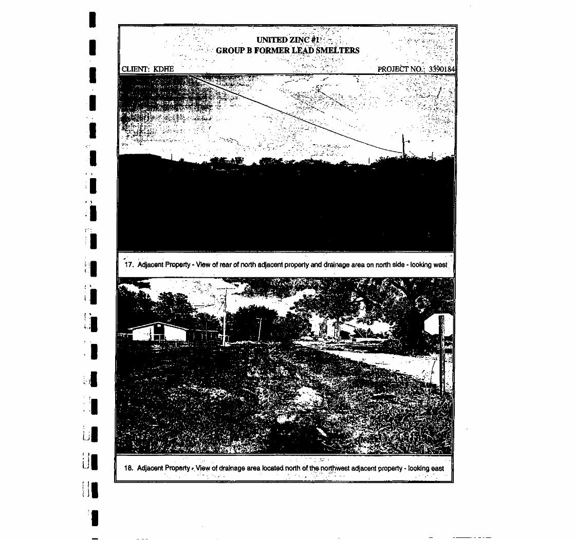
IIIIII
'. "]
I/ 1
f:
I* VI( >IIIIII
HII
UNITEDGROUP B FORMERLEAjD SMETERS
CLIENT: KDHE PROJECT NO.: 3390184
n^pt%-a§:/;.
17. Adjacent Property - View of rear of north adjacent property and drainage area on north side - looking west
18. Adjacent Property --View of drainage area located north of the northwest adjacent property - looking east

IIIIIIIII4IIIIIIIII
iSfcS^W-^;;• UNITED ZINC?1':-^;:;..' -^ ^M! GROUP B FORMER LEAD SMELTERS
PROJECT NO.:' 3390184
Subject Property - View pf. graded waiste area - looking^K^^^^'^^--'^-- •^•••- - • :'f ••••
- - .;>", ,U;' 20. Subject Property - View of north portion of propertyjn the background - looking north

IIIIIII4iiiiiiiiuii
.UNITEDFORMER
PROJECT NO.: 3390184
: Adjacenii Property - View of northwest adjacent property - looking northwest* *r-f£j§L*l*&fc* '!••.-*•••"' '-v • ' - • • /\.'V ' . ' ' . .' ;-'.'•*-••--• . „ - - . . . . • : • . . ' . - . - • . .-
22.1 Adjacent Property and Subject Property - View of northwest adjacent property and west edge of subject... . i : : . property - looking northwest

IIIIIIIIII1
»
IIIIIII
!*i; " Kv?•£^ f ^Sl l ^ feF^^
north portion of bfdberty'- Idbking north ~%%^^'*^^:^:.m^f^;-x^f*..-.t-•:^-i':;;-vv.?:7^,-.-•;*

IIIIIIIIIII
' •
IIIIII
PROJECT NO.; 3390184
v ..
25. Subject Property - View of north portion of property - looking north
P^^^^m-^^-'if•.•'•-.;* '•!.-•:'-•' . -^•••^••^;^*--^M:V-; :•-:•<•
26. Subject Property • View of north portion of property - looking north

IIIIII
' • IIf 1
IIIII
IIIIII
UNITED ZINC#l/:;,;:,;;'&,£%:.£&;;}.,v--. A: ; '£ GROUP B FORMER LEAD SMELTERSgjfe«^^^^^^;^i .r[,;. '7. ^. ;-x^f: ™>:. /• :• ;•:;:.:.
PROJECT K6,: .'3390184
' •i-.'.viZ:*.W*i.7-T- "- .'•W.lr*^-'*'.:"' ' J.
.27F Subject Property - View of north portion of property - looking northwest
^::-::. . - . i . . ' V ; / , ; • , . ' . . : : . . - - - • , . . • •
. .28/ Adjacent Property • View of west adjacent property - looking southwest
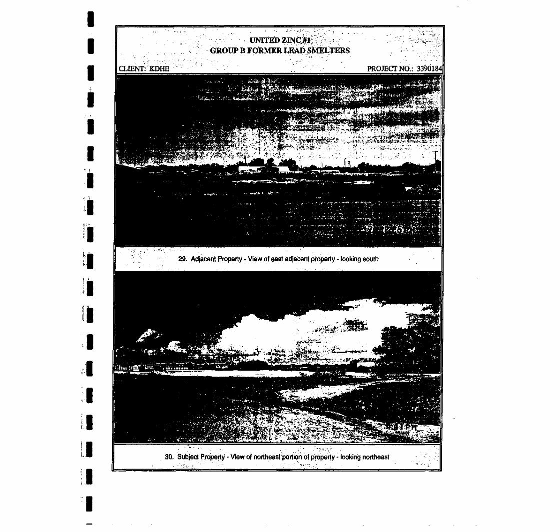
IIIiIii
iiiiiii
ii
.GROUP B FORMER LEAD SJMELTERS
CLIENT: KDHE PROJECT NO.: 3390184
29. Adjacent Property - View of east adjacent property - looking south
30, Subject Property - view of northeast portion of property - looking northeast

IIIIIII
.': !
I' ' '*
I
I
I
I
I
I
I
I
I
I
PROJECT NO.: 3390184
iew of a portion of the northwest adjacent property - looking southwestr - " " - ' • • - • • •
Subject Property • view of north portion.of property - looking west

IIIIIII
(•: i
II •
I
I
I
I
I
I
J
11
I
UNITEDGROjUP B FORMER LEAD SMLTERS
^rt&;^;;:^-;;^.-;:'-^™Tr-'•;'-•• ••' PROJECT NO,: 3390184
. . . . . .portfpn of the property ^nd drainage area in foreground - looking
• " • • • - • " "
34, Adjacent Property • View of northeast adjacent property - looking southeast

IIIIIII
! I
I
/ •,
I
I
/ ^
I
I
I
I
I
I
I
I
I
^2g'«ISS^ B FO^^? P4W**
Pl|%^ ! . . . . . v: .'.. / .;-..,; ..•-,mm^^^^^^'^M^-^--^ r-"' PROJECT NO.: 33:9c
acent Property (Coberly Site) - View of west adjacenJ. --:Av7v:: ^
erly Site) - looking north
: asfi a? . . ••• •": •X-.-'-r-sSf.--."?-':-;..'
36, Adjacent Property (Coberly Site).; looking east
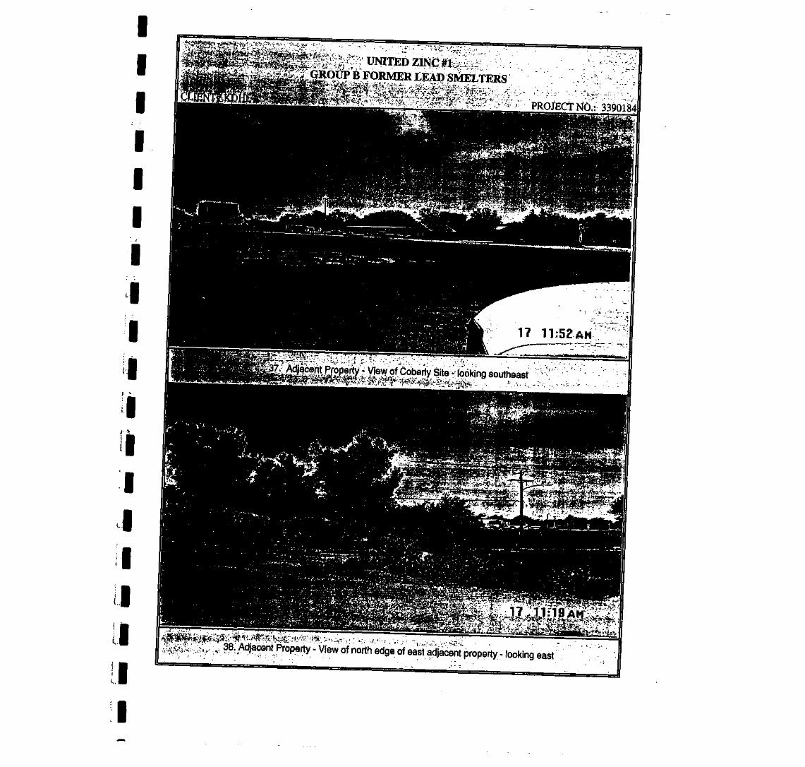
fuV^0*=jpj5^r.i> .f .J^.-VAVv-W-'- •-"• -- ,'~ ' V ' ' • •'-'--••' - . - 1 ' - '•• --^.. f'-
y^^:t^::>--'.y.-: • PROffirtxfn..:. 3390184
^^^^^^^^^^^^^^^^^^^^^^^^^^^^^^^^HHBBBBl BKMK^BBF3!t3vaBMMM
. . .38: Adjacent Property - View of north edge of east adjacenf property - looking east
I

IIIIIII
f . •
IIIIiiiiiiii
" • , . UNITED ZINC#I; •""••• -•GROUP B FORMER LEAD^SMELTERS
PROJECT NO.: 3390184
39. Adjacent Property - View of northeast adjacent property - looking east'
40. Adjacent Property - View of northeast adjacent, property - looking northeast

IIIIIII
1III
IIII
01HII
U
UNITED ZINCB FORMER
PROJECT NO.: 3390184
'*§&-•&'• - •'•
.4*. :'-. .v-<41, East tola Site - View of west edge of East lola Site - looking north
42. East "lola Site - View of north and west portions ^looking west

IIIIIIIIIIIIIIIIIiI
UNITED ZING #1GROUP B FORMER LEAD SMELtERS
CLIENT: KDHE PROJECT NO.: 339018
43. - East lola Site - view of north edge of site - looking northwest
17 11:03AH
44. East lola Site • View of north edge of site and north adjacent property in background • looking north .'••'

III
I
III
I 1I'• •',II
' \
IIIIIIIII
; . - - . - ' .UNITED ZINp:|I:rk;:_< .GROUP B FORMER LEAD SMELTERS
CLIENT: KDHR PROJECT NO.: 3390184
45, East ;lola Site - View of north adjacent property - loooking west
17 11:15AM
46. East lola Site - View of west side of property - looking northwest

IIIIIIIIIIIIIIIIIII
; i ; i : - ; • ; , UNITEDZINO ;;^-V-; .£RQUP B FORMER LEAP SMELfERS
. , .j»&:fe;;«;!^
PROJECT NO.: 3390184
. . . . . . . . .
iew"of fonrief gas station located south of United Zinc #1 property - looking southwest' •—' - - -~ : - - - ; -> - •" •»?• ' • -V ' 1 - ' • • ' • • J " • • ; - • ' J ...'. • - . . . ' - . • - • • ' " f t * * *W^S^ -.t '"' : " ' ^ ' "^ ' . :I:-^--P& ' • ' " • • " . . .
48. EastJola Site - View of former processing plant • looking north

IIIIII
. I
'••}
I- • 1
II
! '
I
I
I
I
I
I
I
I
I
• . . . - . ; • • UNITED ZINC M-'.v.:..;.' ' .GROUP B FORMER LEAD SMELlERS
PROJECT NO.: 3390184
49. East lola Site - View of drainage channel and former railroad north of the site - looking east
:•*::«,•».**.••,•'?lf' £* S* aM^uAtM :
50. East lola Site - View of former Sells Construction - looking south

IIIIIIi!
•
I
I
I>
it
I
I
I
I
I
I
' . : • ' " '" . . UNITED ZINC Si -' -GROUP B FORMER LEAD SMElfERS
CLIENT: KDHE PROJECT NO.;; 3390184
51. East tola Site - View of Jump Start gas station - looking northeast
-.. .^-.--:. ' - : ' So1' '
52. East lola Site - View of Jump Start gas station - looking east

IIIIII
i !
I
f - »
1
I
11
I
I
I
I
11
HII
- , . :. : • UNITED ZINCll ;"GROUP B FORMER IJEAD SMELTERS
PROJECT NO.: 3390184CLIENT: KDHE.
53. East lola Site - view of Jump Start and a portion of East lola Site - looking south
54. East lola Site - View of former processing plant - looking north

IIIIIIIIIIIIIIIIIII
' • - . . • • : . UNITEDGROUP B FORMER LEAD SMELTERS
* • • j: •• ' • =J ' i .
CLIENT: KDHE PROJECT NO.: 3390184
iiiTii/iiiii'Tiiii'i]rri 11 w i;
55. East lola Site - view of former processing plant - looking southwest
56. East lola - View of Sigg Motors and south adjacent property - looking south

IIIIIIII1IIIIII
LIIIII
- • • : . ' • UNITED ZINC#1;GROUP B FORMER LB^AD jSMELTERS
PROJECT NO.: 3390T84CLIENT: KDHE
57. East lola Site and United Zinc #1 • View of southwest adjacent property of East lola and of south adjacentproperty of United Zinc #1 - looking southwest
58. East lola Site -View of northeast portion of the site and graded area of waste • looking north

IIIIII
-' 'I
I- •>
I
IIIIIIII
; . • . 'UNITEDGROUP B FORMER LEAD SMELTERS
PROJECT NO.: 3390184
.59. East tola - View of north edge of site -,looking northwest
1 5:17 PM
60. Coberly Site - View of south edge of Coberly site and a former gas station on the south adjacent property- • :r . looking northeast /'.:/' ^: -.

APPENDIX G; > . ' • . ' - ' • • • ' ' • REFERENCES* . ' • . . " • ' f . •- •' \ •
^ . • » • ' • • .
i . ' - • ' . ' ' . - • . • .
_ • • • ' ' . '
' . , . ' • ' ' • • ' ; >
_ • ' ' . • • '
: -_r . ' • . ' • ' . . . ' '
-• ' ' • - - '•.
• * . : ' • • • : • ' '

IUNITED ZINC #1 SITE
• REFERENCES
• U.S.G.S. 7.5 Minute Topographic Quadrangle Map, La Harpe, Kansas, 1965,Photorevised 1984.
U.S.G.S. 7.5 Minute Topographic Quadrangle Map, lola, Kansas, 1966,Photorevised 1984.
http//www.terraserver.microsoft.com, Aerial Photographs, 1992, lola, Gas, and LaHarpe,Kansas
Allen County Appraiser's Office, Aerial Photographs, 1986.
I• Kansas Geological Survey, Water Well Database
Allen County Historical Society, Historical Archives, lola, Kansas
• Allen County Register of Deeds Office, Ownership Records, lola, Kansas
I Alldritt, James, Kansas Department of Health and Environment, Bureau ofEnvironmental Remediation, Remedial Unit/Remedial Section, Preliminary Assessment,Coberly Recycling Site, lola, Kansas, May 1995.
™ Alldritt, James, Kansas Department of Health and Environment, Bureau ofEnvironmental Remediation, Remedial Unit/Remedial Section, Preliminary Assessment,
• East lola Smelter Site, lola, Kansas, February 1994^
Sanborn Map Company, 1899-1924, Digital Sanbom Maps for lola, Gas, and LaHarpe,• Kansas. Available Online at www.umi.com (verified 18 Nov. 2003). Proquest
Information and Learning Company, Ann Arbor, Michigan
• Environmental Database Resource #0954877.7s, including the following:
IEPA NPL listing, updated 05/09/03.
EPA CORRACTS listing, updated 05/08/03.
I EPA RCRIS-TSD listing, updated 04/18/03.
EPA CERCLIS listing, updated 04/08/03.
; • EPA NFRAP listings, updated 04/08/03.
' '* EPA RCRIS-SQG listings, updated 04/18/03.
! • EPA RCRIS-LQG listings, updated 04/18/03.
EPA ERNS listings, updated 04/28/03.
I
I

IKDHE LUST listing, updated 05/01 /03.
I KDHE UST istings, updated 05/23/03.
- KDHE SWHS listings, updated 05/12/03.
I KDHE SWF/LF listings, updated 05/19/03.
I KDHE AST listings, updated 06/30/03.
KDHE Spills listings, updated 08/11/03.
I
I
I
I
I
I
I
Environmental Database Resource, NEPA Check. #0954877.8s, including the following:
Natural AreasWilderness Areas listings, version 09/01/97
_ Wildlife Preserves, Sanctuaries, and Refuges, version 09/01/97• Wild and Scenic-Rivers, version 09/01/97
Endangered Species
- • Landmarks, Historical, and Archaeological SitesHistoric Places, version 03/15/2000
'. • Indian Religious Sites
Flood Plain, Wetlands, and Coastal Zonej, m Flood Plain Managementi-'.-.'l Wetlands Protection
Coastal Zone Management
FCC and FAA Sites MapCellular
I TowerAntenna RegistrationAM Tower
I FAA Digital Obstacle FileAirport Landing FacilitiesElectric Power Transmission Line Data
• Excessive Radio Frequency Emission

IIIII
•
I* .
M
ILJ
I
• . . . . .
I APPENDIX H| FIELDNOTES


^m

&>?!<£ nncti
2 ', 5 O //yrt(Us -


r r

u(yj\lio^^