Fluorescence‐based detection of field targets using an ...
9
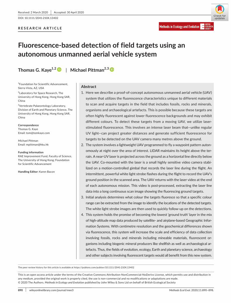
890 | Methods Ecol Evol. 2020;11:890–898. wileyonlinelibrary.com/journal/mee3 Received: 2 March 2020 | Accepted: 30 April 2020 DOI: 10.1111/2041-210X.13402 RESEARCH ARTICLE Fluorescence-based detection of field targets using an autonomous unmanned aerial vehicle system Thomas G. Kaye 1,2 | Michael Pittman 2,3 1 Foundation for Scientific Advancement, Sierra Vista, AZ, USA 2 Laboratory for Space Research, The University of Hong Kong, Hong Kong SAR, China 3 Vertebrate Palaeontology Laboratory, Division of Earth and Planetary Science, The University of Hong Kong, Hong Kong SAR, China Correspondence Thomas G. Kaye Email: [email protected] Michael Pittman Email: [email protected] Funding information RAE Improvement Fund, Faculty of Science, The University of Hong Kong; Foundation for Scientific Advancement Handling Editor: Karen Bacon Abstract 1. Here we describe a proof-of-concept autonomous unmanned aerial vehicle (UAV) system that utilizes the fluorescence characteristics unique to different materials to scan and acquire targets in the field that includes fossils, rocks and minerals, organisms and archaeological artefacts. This is possible because these targets are often highly fluorescent against lower fluorescence backgrounds and may exhibit different colours. To detect these targets from a moving UAV, we utilize laser- stimulated fluorescence. This involves an intense laser beam that—unlike regular UV light—can project greater distances and generate sufficient fluorescence for targets to be detected on the UAV camera many metres above the ground. 2. The system involves a lightweight UAV programmed to fly a waypoint pattern auton- omously at night over the area of interest. LIDAR maintains its height above the ter - rain. A near-UV laser is projected across the ground as a horizontal line directly below the UAV. Co-mounted with the laser is a small highly sensitive video camera stabi- lized on a motion-controlled gimbal that records the laser line during the flight. An intermittent, powerful white light strobe flashes during the flight to record the UAV's ground position in the scanned area. The UAV returns with the laser video at the end of each autonomous mission. This video is post-processed, extracting the laser line data into a long continuous scan image showing the fluorescing ground targets. 3. Initial analysis determines what colour the targets fluoresce so that a specific colour range can be extracted from the image to identify the locations of the detected targets. The white light strobe images are then used to quickly follow-up on the detections. 4. This system holds the promise of becoming the lowest ‘ground truth’ layer in the mix of high-altitude map data produced by satellite- and airplane-based Geographic Infor- mation Systems. With centimetre resolution and the geochemical differences shown via fluorescence, this system will increase the scale and efficiency of data collection involving fossils, rocks and minerals including mineable materials, fluorescent or - ganisms including biogenic mineral producers like shellfish as well as archaeological ar - tefacts. Thus, the fields of evolution, ecology, Earth and planetary science, archaeology and other subjects involving fluorescent targets would all benefit from this new system. This is an open access article under the terms of the Creative Commons Attribution-NonCommercial-NoDerivs License, which permits use and distribution in any medium, provided the original work is properly cited, the use is non-commercial and no modifications or adaptations are made. © 2020 The Authors. Methods in Ecology and Evolution published by John Wiley & Sons Ltd on behalf of British Ecological Society The peer review history for this article is available at https://publons.com/publon/10.1111/2041-210X.13402
-
Upload
khangminh22 -
Category
Documents
-
view
3 -
download
0
Transcript of Fluorescence‐based detection of field targets using an ...
890 | Methods Ecol Evol. 2020;11:890–898.wileyonlinelibrary.com/journal/mee3
Received: 2 March 2020 | Accepted: 30 April 2020
DOI: 10.1111/2041-210X.13402
R E S E A R C H A R T I C L E
Fluorescence-based detection of field targets using an autonomous unmanned aerial vehicle system
Thomas G. Kaye1,2 | Michael Pittman2,3
1Foundation for Scientific Advancement, Sierra Vista, AZ, USA2Laboratory for Space Research, The University of Hong Kong, Hong Kong SAR, China3Vertebrate Palaeontology Laboratory, Division of Earth and Planetary Science, The University of Hong Kong, Hong Kong SAR, China
CorrespondenceThomas G. KayeEmail: [email protected]
Michael PittmanEmail: [email protected]
Funding informationRAE Improvement Fund, Faculty of Science, The University of Hong Kong; Foundation for Scientific Advancement
Handling Editor: Karen Bacon
Abstract1. Here we describe a proof-of-concept autonomous unmanned aerial vehicle (UAV)
system that utilizes the fluorescence characteristics unique to different materials to scan and acquire targets in the field that includes fossils, rocks and minerals, organisms and archaeological artefacts. This is possible because these targets are often highly fluorescent against lower fluorescence backgrounds and may exhibit different colours. To detect these targets from a moving UAV, we utilize laser-stimulated fluorescence. This involves an intense laser beam that—unlike regular UV light—can project greater distances and generate sufficient fluorescence for targets to be detected on the UAV camera many metres above the ground.
2. The system involves a lightweight UAV programmed to fly a waypoint pattern auton-omously at night over the area of interest. LIDAR maintains its height above the ter-rain. A near-UV laser is projected across the ground as a horizontal line directly below the UAV. Co-mounted with the laser is a small highly sensitive video camera stabi-lized on a motion-controlled gimbal that records the laser line during the flight. An intermittent, powerful white light strobe flashes during the flight to record the UAV's ground position in the scanned area. The UAV returns with the laser video at the end of each autonomous mission. This video is post-processed, extracting the laser line data into a long continuous scan image showing the fluorescing ground targets.
3. Initial analysis determines what colour the targets fluoresce so that a specific colour range can be extracted from the image to identify the locations of the detected targets. The white light strobe images are then used to quickly follow-up on the detections.
4. This system holds the promise of becoming the lowest ‘ground truth’ layer in the mix of high-altitude map data produced by satellite- and airplane-based Geographic Infor-mation Systems. With centimetre resolution and the geochemical differences shown via fluorescence, this system will increase the scale and efficiency of data collection involving fossils, rocks and minerals including mineable materials, fluorescent or-ganisms including biogenic mineral producers like shellfish as well as archaeological ar-tefacts. Thus, the fields of evolution, ecology, Earth and planetary science, archaeology and other subjects involving fluorescent targets would all benefit from this new system.
This is an open access article under the terms of the Creative Commons Attribution-NonCommercial-NoDerivs License, which permits use and distribution in any medium, provided the original work is properly cited, the use is non-commercial and no modifications or adaptations are made.© 2020 The Authors. Methods in Ecology and Evolution published by John Wiley & Sons Ltd on behalf of British Ecological Society
The peer review history for this article is available at https://publo ns.com/publo n/10.1111/2041-210X.13402
| 891Methods in Ecology and Evolu onKAYE And PITTMAn
1 | INTRODUC TION
Many field-based disciplines have traditionally been strictly human endeavours. The introduction of satellite- and airplane-based mapping has proven useful at the macro-scale in predicting where fossil localities may exist (Anemone, Emerson, & Conroy, 2011; Conroy, 2014; Conroy, Emerson, Anemone, & Townsend, 2012; Emerson & Anemone, 2012; Emerson, Bommersbach, Nachman, & Anemone, 2015; Malakhov, Dyke, & King, 2009; Oheim, 2007; Stucky & Krishtalka, 1991; Stucky, Krishtalka, & Dawson, 1989; Wills, Choiniere, & Barrett, 2017), where living species and their habitats may occur (Norberg et al., 2019; Rushton, Lurz, Fuller, & Garson, 1997; Sperduto & Congalton, 1996; Tucker, Rushton, Sanderson, Martin, & Blaiklock, 1997; Van Manen & Pelton, 1997), where minerals may be mined (Carranza, 2009) and where archaeological artefacts may be discovered (Kohler & Parker, 1986; Kvamme, 1992; Mehrer & Westcott, 2019). This ‘upper layer’ technology can determine where to send ground-based investigations. However, they do not have sufficient resolution at the centimetre scale to ver-ify specific targets. While field crews can always be deployed to search for and find any targets, funding constraints usually preclude sending teams large enough to search extensive areas based solely on satellite data. Here we use palaeontology as an evolution-related proof-of-con-cept case study to illustrate how a newly developed fluorescence-based autonomous unmanned aerial vehicle (UAV) detection system interfac-ing at the lowest level of a tiered GIS system could improve the effi-ciency of fossil collection. Building on this proof-of-concept, we suggest other potential applications of the UAV system in the fields of ecology, Earth and planetary sciences and archaeology.
Modern UAV systems offer highly sophisticated and transport-able aerial platforms able to autonomously fly detection instrumen-tation (Krajník, Vonásek, Fišer, & Faigl, 2011; Saska, Krajník, Faigl, Vonásek, & Preucil, 2012; Figure 1). Ariel surveying is now common
and 3D scanning systems are coming into regular use (Anemone, Emerson, Jones, Liu, & Henderson, 2018; Bindemann, Fysh, Sage, Douglas, & Tummon, 2017; Floreano & Wood, 2015; Gao, Xu, Klinger, van der Woerd, & Tapponnier, 2017; Petti et al., 2018; Romilio et al., 2017; Siebert & Teizer, 2014). Many of the once heavy instruments like compasses and inertial sensors are now down to the chip level allowing for greater payloads but still having advanced capability similar to full-size aircraft. Current UAV technology allows for affordable, sophisticated, autonomous aerial reconnaissance with a variety of instrumentation.
Laser-stimulated fluorescence (LSF) uses high-power lasers to stimulate fluorescence in fossils (Kaye et al., 2015; Wang et al., 2017). This technique has revealed signatures of previously un-seen soft tissues in famous fossil lagerstätten (Falk, Kaye, Zhou, & Burnham, 2016; Kaye, Pittman, Marugán-Lobón, et al., 2019; Kaye, Pittman, Mayr, Schwarz, & Xu, 2019; Vinther et al., 2016; Wang et al., 2017; Yang et al., 2018). Ultraviolet (UV) lamps have tradition-ally been used on fossils (Frey, Tischlinger, Buchy, & Martill, 2003; Hone, Tischlinger, Xu, & Zhang, 2010; Tischlinger & Arratia, 2013; Tischlinger & Unwin, 2004), but the laser's higher photon flux per square centimetre produces higher levels of fluorescent signal mak-ing the same fossil glow brightly when little or no fluorescence is visible when using lamp-based UV (Croft, Kaye, & Panko, 2004; Kaye et al., 2015; Kaye, Pittman, Marugán-Lobón, et al., 2019; Kaye, Pittman, Mayr, et al., 2019). The laser's higher intensity allows it to be projected over much greater distances than UV with little reduc-tion in power (inverse square law = intensity ∝ 1/distance2). The la-ser's ability to be utilized at distance is the basis for current airborne laser fluorometers used to detect organic matter in water systems (Rogers, Webster, & Livingstone, 2012). The use of a true UV laser would be greatly preferred as it incorporates both the benefits of a collimated light source and the specific UV wavelength, but at this time UV lasers are only commercially available in the lower milliwatt range.
The fluorescence of rocks originates from contamination in the mineral lattice (Shopov, 2003, 2009). This can be detected even when the contamination is in the parts per million level (de-Neufville, Kasdan, & Chimenti, 1981). Differences in fluorescent colour are indicative of a change in the underlying geochemistry. While the colour is not diagnostic by itself (Shopov, 2009), unusual colours indicate outliers in need of further investigation. If the tar-get is rare, such as fossils, economic minerals, gemstones, archae-ological artefacts, stony meteorites or particular microbes, it will often show up in the scan images as a rare colour that makes the target easily detectable.
Here we describe the first viable autonomous system to detect fossils in the field arising from the intersection of UAV technology
K E Y W O R D S
applied ecology, community ecology, conservation, evolutionary biology, microbial ecology, population ecology
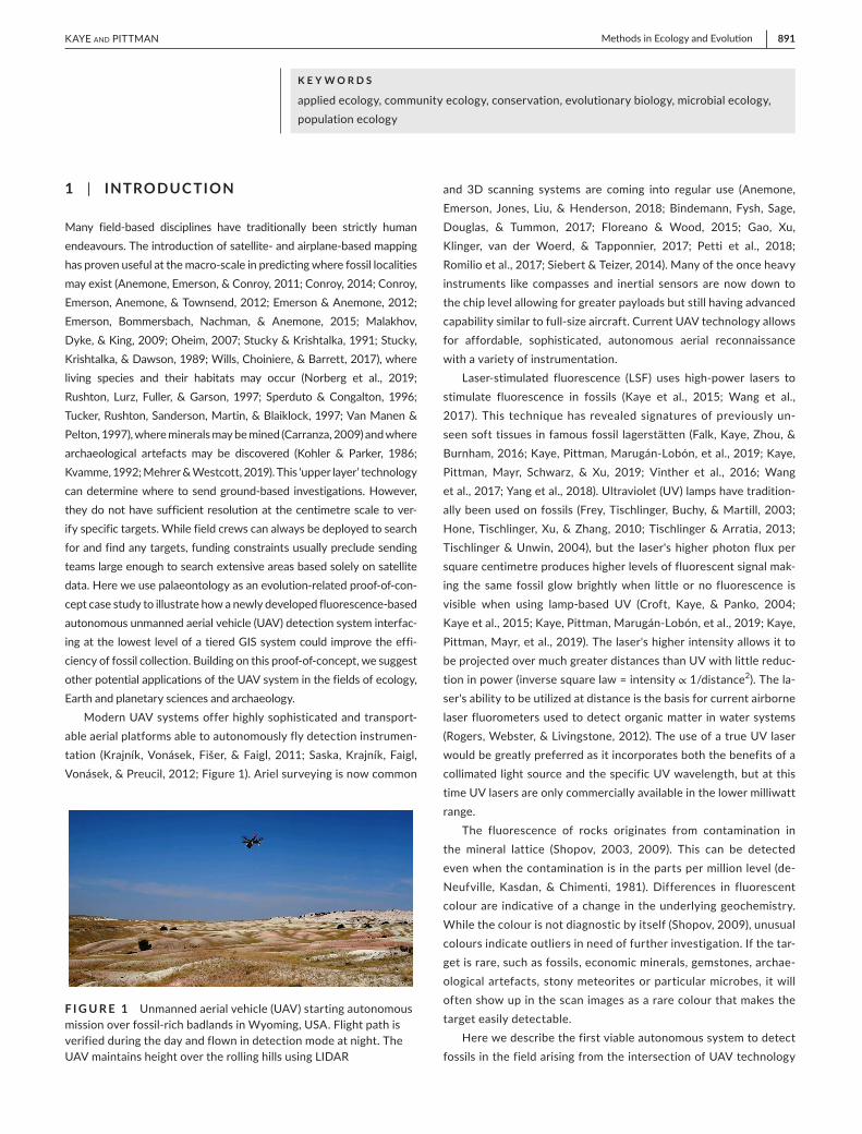
F I G U R E 1 Unmanned aerial vehicle (UAV) starting autonomous mission over fossil-rich badlands in Wyoming, USA. Flight path is verified during the day and flown in detection mode at night. The UAV maintains height over the rolling hills using LIDAR
892 | Methods in Ecology and Evolu on KAYE And PITTMAn
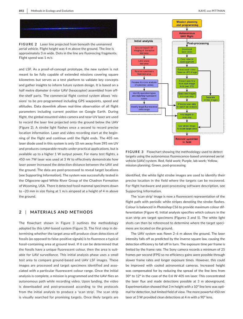
and LSF. As a proof-of-concept prototype, the new system is not meant to be fully capable of extended missions covering square kilometres but serves as a test platform to validate key concepts and gather insights to inform future system design. It is based on a half metre diameter 6-rotor UAV (hexacopter) assembled from off-the-shelf parts. The commercial flight control system allows ‘mis-sions’ to be pre-programmed including GPS waypoints, speed and altitudes. Data downlink allows real-time observation of all flight parameters including current position on Google Earth. During flight, the gimbal mounted video camera and near-UV laser are used to record the laser line projected onto the ground below the UAV (Figure 2). A strobe light flashes once a second to record precise location information. Laser and video recording start at the begin-ning of the flight and continue until the flight ends. The 405 nm laser diode used in this system is only 10 nm away from 395 nm UV and produces comparable results under practical applications, but is available up to a higher 1 W output power. For many test flights, a 450 nm 7W laser was used at 3 W to effectively demonstrate how laser power increased the detection distance between the UAV and the ground. The data are post-processed to reveal target locations (see Supporting Information). The system was successfully tested in the Oligocene-aged White River Group of the Chadron Formation of Wyoming, USA. There it detected fossil mammal specimens down to ~20 mm in size flying at 1 m/s airspeed at a height of 4 m above the ground.
2 | MATERIAL S AND METHODS
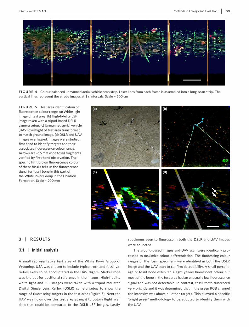
The flowchart shown in Figure 3 outlines the methodology adopted by this UAV-based system (Figure 3). The first step in de-termining whether the target area will produce clean detections of fossils (as opposed to false-positive signals) is to fluoresce a typical fossil-containing area at ground level. If it can be determined that the fossils have a unique fluorescent colour, then the area is suit-able for UAV surveillance. This initial analysis phase uses a small test area to compare ground-based and UAV LSF images. These images are processed and target specimens identified and asso-ciated with a particular fluorescent colour range. Once the initial analysis is complete, a mission is programmed and the UAV flies an autonomous path while recording video. Upon landing, the video is downloaded and post-processed according to the protocols from the initial analysis to produce a ‘scan strip’. The scan strip is visually searched for promising targets. Once likely targets are
identified, the white light strobe images are used to identify their precise location in the field where the targets can be recovered. For flight hardware and post-processing software description, see Supporting Information.
The ‘scan strip’ image is now a fluorescent representation of the flight path with periodic white stripes denoting the strobe flashes. Colour is balanced in Photoshop CS6 to provide maximum colour dif-ferentiation (Figure 4). Initial analysis specifies which colours in the scan strip are target specimens (Figures 3 and 5). The white light shots can then be referenced to determine where the target speci-mens are located on the ground.
The UAV system was flown 2–6 m above the ground. The laser intensity falls off as predicted by the inverse square law, causing the detection efficiency to fall off in turn. The exposure time per frame is limited by the frame rate. The Sony camera records a minimum of 25 frames per second (FPS) so no efficiency gains were possible through slower frame rates and longer exposure times. However, this could be improved with cooled astronomical cameras. Increased height was compensated for by reducing the spread of the line lens from 30° to 12° in the case of the 0.6 W 405 nm laser. This concentrated the laser flux and made detections possible at 3 m aboveground. Experimentation showed that 3 m height with a 10° line lens was opti-mal for detection, but limited field of view. The more powerful 450 nm laser at 3 W provided clean detections at 4 m with a 90° lens.
F I G U R E 2 Laser line projected from beneath the unmanned aerial vehicle. Flight height was 4 m above the ground. The line is approximately 3 m wide. Dots in the line are fluorescing fragments. Flight speed was 1 m/s
F I G U R E 3 Flowchart showing the methodology used to detect targets using the autonomous fluorescence-based unmanned aerial vehicle (UAV) system. Red, field work; Purple, lab work; Yellow, mission planning; Green, post-processing
| 893Methods in Ecology and Evolu onKAYE And PITTMAn
3 | RESULTS
3.1 | Initial analysis
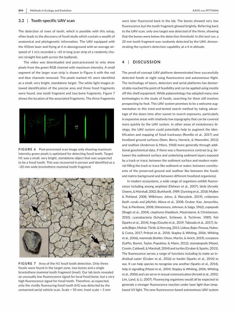
A small representative test area of the White River Group of Wyoming, USA was chosen to include typical rock and fossil va-rieties likely to be encountered in the UAV flights. Marker rope was laid out for positional reference in the images. High-fidelity white light and LSF images were taken with a tripod-mounted Digital Single Lens Reflex (DSLR) camera setup to show the range of fluorescing targets in the test area (Figure 5). Next the UAV was flown over this test area at night to obtain flight scan data that could be compared to the DSLR LSF images. Lastly,
specimens seen to fluoresce in both the DSLR and UAV images were collected.
The ground-based images and UAV scan were identically pro-cessed to maximize colour differentiation. The fluorescing colour ranges of the fossil specimens were identified in both the DSLR image and the UAV scan to confirm detectability. A small percent-age of fossil bone exhibited a light yellow fluorescent colour but most of the bone in the test area had an unusually low fluorescence signal and was not detectable. In contrast, fossil teeth fluoresced very brightly and it was determined that in the green RGB channel the intensity was above all other targets. This allowed a specific ‘bright green’ methodology to be adopted to identify them with the UAV.
F I G U R E 4 Colour balanced unmanned aerial vehicle scan strip. Laser lines from each frame is assembled into a long ‘scan strip’. The vertical lines represent the strobe images at 1 s intervals. Scale = 500 cm
F I G U R E 5 Test area identification of fluorescence colour range. (a) White light image of test area. (b) High-fidelity LSF image taken with a tripod-based DSLR camera setup. (c) Unmanned aerial vehicle (UAV) overflight of test area transformed to match ground image. (d) DSLR and UAV images overlapped. Images were studied first hand to identify targets and their associated fluorescence colour range. Arrows are ~15 mm wide fossil fragments verified by first-hand observation. The specific light brown fluorescence colour of these fossils tells us the fluorescence signal for fossil bone in this part of the White River Group in the Chadron Formation. Scale = 200 mm
(a) (b)
(c) (d)
894 | Methods in Ecology and Evolu on KAYE And PITTMAn
3.2 | Tooth-specific UAV scan
The detection of rows of teeth, which is possible with this setup, often leads to the discovery of fossil skulls which contain a wealth of anatomical and phylogenetic information. The UAV equipped with the 450nm laser and flying at 4 m aboveground with an average air-speed of 1 m/s recorded a ~65 m long scan strip of a randomly cho-sen straight line path across the badlands.
The video was downloaded and post-processed to only show pixels from the green RGB channel with maximum intensity. A small segment of the larger scan strip is shown in Figure 6 with the red and blue channels removed. The pixels marked H1 were identified as a small, very bright, standalone target. The white light images al-lowed identification of the precise area and three fossil fragments were found, one tooth fragment and two bone fragments. Figure 7 shows the location of the associated fragments. The three fragments
were later fluoresced back in the lab. The bones showed very low fluorescence but the tooth fragment glowed brightly. Referring back to the UAV scan, only one target was detected of the three, showing that the bones were below the detection threshold. In this test run, a 20 mm tooth fragment was randomly detected by the UAV, demon-strating the system's detection capability at a 4 m altitude.
4 | DISCUSSION
The proof-of-concept UAV platform demonstrated here successfully detected fossils at night using fluorescence and autonomous flight. The technology of lasers, detectors and aerial platforms has demon-strably reached the point of feasibility and can be applied using mostly off-the-shelf equipment. While palaeontology has adopted many new technologies in the study of fossils, searching for them still involves prospecting by foot. This UAV system promises to be a welcome aug-mentation to this tried-and-tested search method by taking advan-tage of the down time after sunset to search exposures, particularly in expansive areas with relatively low topography that can be covered more quickly by the UAV system. In other areas of evolutionary bi-ology, the UAV system could potentially help to augment the iden-tification and mapping of fossil trackways (Romilio et al., 2017) and fossilized ground surfaces (Stein, Berry, Hernick, & Mannolini, 2012) and seafloor (Anderson & Misra, 1968) more generally through addi-tional geochemical data, if there was a fluorescence contrast (e.g. be-tween the sediment surface and underlying sediment layers exposed by a track or trace; between the sediment surface and modern mate-rial filling the track or trace like sediment or water; between constitu-ents of the preserved ground and seafloor like between the fossils and matrix background and between different fossilized organisms).
In modern ecosystems, a wide range of organisms exhibit fluores-cence including among amphioxi (Deheyn et al., 2007), birds (Arnold, Owens, & Marshall, 2002; Burkhardt, 1989; Dunning et al., 2018; Mullen & Pohland, 2008; Wilkinson, Johns, & Warzybok, 2019), cnidarians (both corals and jellyfish; Alieva et al., 2008; Gruber, Kao, Janoschka, Tsai, & Pieribone, 2008; Shimomura, Johnson, & Saiga, 1962), copepods (Shagin et al., 2004), ctephores (Haddock, Mastroianni, & Christianson, 2010), cyanobacteria (Schubert, Schiewer, & Tschirner, 1989), fish (Sparks et al., 2014), frogs (Goutte et al., 2019; Taboada et al., 2017), liz-ards (Bajer, Molnár, Török, & Herczeg, 2011; Lisboa, Bajer, Pessoa, Huber, & Costa, 2017; Prötzel et al., 2018; Stapley & Whiting, 2006; Whiting et al., 2006), mammals (Kohler, Olson, Martin, & Anich, 2019), scorpions (Gaffin, Bumm, Taylor, Popokina, & Mann, 2012), stomatopods (Mazel, Cronin, Caldwell, & Marshall, 2004) and turtles (Gruber & Sparks, 2015). The fluorescence serves a range of functions including to make an in-dividual easier (Gruber et al., 2016) or harder (Sparks et al., 2014) to see. It can help species to recognize one another (Sparks et al., 2014), help in signalling (Mazel et al., 2004; Stapley & Whiting, 2006; Whiting et al., 2006) and can serve in sexual communication (Arnold et al., 2002; Lim, Land, & Li, 2007). Fluorescing organisms would all be expected to generate a stronger fluorescence reaction under laser light than lamp-based UV light. The new fluorescence-based autonomous UAV system
F I G U R E 6 Post-processed scan image only showing maximum intensity green pixels is optimized for detecting fossil teeth. Target H1 was a small, very bright, standalone object that was suspected to be a fossil tooth. This was recovered in person and identified as a ~20 mm wide brontothere mammal tooth fragment
F I G U R E 7 Area of the H1 fossil tooth detection. Only three fossils were found in the target zone, two bones and a single brontothere mammal tooth fragment (inset). Our lab tests revealed an unusually low fluorescence signal for local fossil bone, but a very high fluorescence signal for fossil teeth. Therefore, as expected, only the vividly fluorescing fossil tooth (H1) was detected by the unmanned aerial vehicle scan. Scale = 50 mm. Inset scale = 5 mm
| 895Methods in Ecology and Evolu onKAYE And PITTMAn
would be particularly useful in establishing the number and distribution of fluorescent animals, especially endangered ones like the hawksbill sea turtle (Gruber & Sparks, 2015) and can build upon existing UAV study practices (Rees et al., 2018). It would also be helpful in monitoring ecosystem productivity and health, especially threatened ones. For ex-ample, monitoring the cyanobacterial mats of the unique McMurdo Dry Valleys of Antarctica (Bollard-Breen et al., 2015). In any case, it would be important to thoroughly check and mitigate any potential risk the laser may pose to target organisms, in line with existing practices associated with performing research on living organisms.
In Earth and planetary science, many of the current applications of UAV systems in geological mapping and investigation (Bemis et al., 2014; Chesley, Leier, White, & Torres, 2017), mineral explora-tion and mining (Jackisch et al., 2019; Kirsch et al., 2018) as well as landslide and slope investigation (Hellmuth, Hunter, & Barclay, 2018; Pellicani et al., 2019) would be extendable to the new UAV system provided that clear fluorescence targets can be established. For example, calcite is highly fluorescent and so are economically im-portant materials like fluorite. These fluorescing targets could, for example, enable investigations of carbonate rock exposures and cal-cite vein structure as well as exploration for fluorite seams.
Certain pottery, paints, soils and vegetation can show fluores-cence-detectable geochemical differences as can weathering and erosion products. In utilizing these potential fluorescence proper-ties, the new UAV system can be applied in archaeology to augment the mapping of field sites and excavations as well as assessments of monument condition to build upon existing UAV systems that have already been used in the field (Agudo, Pajas, Pérez-Cabello, Redón, & Lebrón, 2018; Campana, 2017; Hill, Laugier, & Casana, 2020; Smith, Passone, al-Said, al-Farhan, & Levy, 2014).
To maximize the delivery of the aforementioned applications, it will be necessary to achieve further development of the fluorescence-based UAV system:
GPS-linked video stream: is ideal for locating targets revealed in the scan. The Sony camera used in these tests has onboard GPS but this did not function due to the antenna being blocked in its position under the UAV. Currently, the prototype uses the strobe images combined with the approximate UAV location via telemetry to pro-vide location data. In future versions, the UAV's GPS position could be fed directly into the video display. A logical improvement would be to use infrared LEDs to continuously illuminate the ground. The far red colour of the LEDs would not interfere with the fluores-cence, which is usually in the middle of the visible range. This would give a rapid idea of what is creating the fluorescent response and allow quicker positive IDs of potentially fruitful locations on site.
Flight time: for typical consumer UAVs have been historically lim-ited by the batteries with a maximum duration of ~30 min. With a 1 m/s average airspeed, as tested here, this translates into a scan strip about 100 m long after deducting for take-off, turn-around and landing time. New technologies are demonstrating multi-hour flight times using other energy sources like gasoline
(Matheson, 2017) and hydrogen (Dutczak, 2018; Swider-Lyons et al., 2014). Such multi-hour duration platforms would make better use of the time available during an expedition between sunset and bedtime. All the technology required to develop such a long duration autonomous UAV is currently available and should be incorporated as part of future development efforts.
Detection distance: Increasing flying altitude allows the laser line to spread out more over the ground creating a wider scan strip increasing overall per square kilometre scanning efficiency while still providing sufficient laser power at ground level. Using the 450 nm laser at 3 W gives a 3 m wide scan strip. To increase detec-tion distance, next-generation designs should incorporate multiple near-UV lasers with the lines overlapping. This concept has already been demonstrated in caves where images of entire cavern cham-bers up to 30 m away have been fluoresced in their entirety for the first time (Kaye & Garcia, 2017; Kaye, Garcia, & Pittman, 2019).
Predictive models: used at the ‘Mission planning and programming’ stage of Figure 3 could help to further increase the detection ef-ficiency of the proposed UAV system. Such models have been es-tablished using a range of approaches in search of body and trace fossils (Anemone et al., 2011; Conroy, 2014; Conroy et al., 2012; Emerson & Anemone, 2012; Emerson et al., 2015; Malakhov et al., 2009; Mensing, Elston, Raines, Tausch, & Nowak, 2000; Oheim, 2007; Wills et al., 2017), living species and their hab-itats (Norberg et al., 2019; Rushton et al., 1997; Sperduto & Congalton, 1996; Tucker et al., 1997; Van Manen & Pelton, 1997), minerals (Carranza, 2009) and archaeological artefacts (Kohler & Parker, 1986; Kvamme, 1992; Mehrer & Westcott, 2019).
The current system's 4 m detection distance and 30 min flight time translates to a ground scan covering 4,500 square metres. Four batteries could provide 2 hr of flight time covering 18,000 square metres per night. Over 10 nights, the system could theoret-ically cover 180,000 square metres. These estimates are based on the current system with its mostly low-cost consumer equipment. However, with commercial heavy lift UAVs (10+ kg), high sensitivity cooled purpose specific astronomical cameras, custom data process-ing software, a high-performance laptop and an array of lasers, the area of coverage could potentially be improved by a factor of 2–3x.
5 | CONCLUSIONS
The technology to autonomously search for fluorescent targets from a flying platform exists today. This feasibility study was undertaken with consumer-level products and has proven capable of detecting fossils and would be able to detect other fluorescent targets including rocks and minerals, organisms and archaeological artefacts. These baseline data allow calculations for an improved platform that could efficiently scan large areas using larger commercial products. In addition to body and trace fossil detection, other potential field uses for the system in
896 | Methods in Ecology and Evolu on KAYE And PITTMAn
the areas of ecology and evolution include studies of the population and distribution of living species and monitoring of modern ecosystem productivity and health, especially those that are threatened. These applications would all provide important primary data with a wide range of upstream spin-off benefits. The fluorescence-based UAV system also has potential applications in a broader range of fields in-cluding in Earth and planetary science and in archaeology.
ACKNOWLEDG EMENTSThis study was supported by the Foundation for Scientific Advance-ment and the RAE Improvement Fund of the Faculty of Science, The University of Hong Kong. Robert C. Roberts (University of Texas El Paso) is thanked for advice and discussions about the project.
CONFLIC T OF INTERE S TThe authors (T.G.K. and M.P.) declare no competing interests.
AUTHORS' CONTRIBUTIONSThe study was designed, performed and written up by T.G.K. and M.P.
DATA AVAIL ABILIT Y S TATEMENTAll data results (LSF images) are made available in this manuscript. IDL code for laser line and colour extractions in the laser scan strip are available on Dryad at the https://doi.org/10.5061/dryad.9w0vt 4bc3 (Kaye & Pittman, 2020).
ORCIDThomas G. Kaye https://orcid.org/0000-0001-7996-618X Michael Pittman https://orcid.org/0000-0002-6149-3078
R E FE R E N C E SAgudo, P. U., Pajas, J. A., Pérez-Cabello, F., Redón, J. V., & Lebrón, B.
E. (2018). The potential of drones and sensors to enhance detec-tion of archaeological cropmarks: A comparative study between multi-spectral and thermal imagery. Drones, 2, 29. https://doi.org/10.3390/drone s2030029
Alieva, N. O., Konzen, K. A., Field, S. F., Meleshkevitch, E. A., Hunt, M. E., Beltran-Ramirez, V., … Matz, M. V. (2008). Diversity and evolu-tion of coral fluorescent proteins. PLoS ONE, 3, e2680. https://doi.org/10.1371/journ al.pone.0002680
Anderson, M. M., & Misra, S. B. (1968). Fossils found in pre-Cambrian Conception Group of southeastern Newfoundland. Nature, 220, 680–681.
Anemone, R., Emerson, C., & Conroy, G. (2011). Finding fossils in new ways: An artificial neural network approach to predicting the lo-cation of productive fossil localities. Evolutionary Anthropology, 20, 169–180. https://doi.org/10.1002/evan.20324
Anemone, R. L., Emerson, C. W., Jones, T. W., Liu, J., & Henderson, C. (2018). Taking virtual anthropology to the field: Building three-dimensional digital outcrop models of fossil localities. In R. L. Anemone & G. C. Conroy (Eds.), New geospatial approaches to the anthropological sciences (pp. 81–100). Santa Fe, NM: School for Advanced Research Press.
Arnold, K. E., Owens, I. P. F., & Marshall, N. J. (2002). Fluorescent sig-naling in parrots. Science, 295, 92. https://doi.org/10.1126/scien ce.295.5552.92
Bajer, K., Molnár, O., Török, J., & Herczeg, G. (2011). Ultraviolet nup-tial colour determines fight success in male European green lizards (Lacerta viridis). Biology Letters, 7, 866–868.
Bemis, S. P., Micklethwaite, S., Turner, D., James, M. R., Akciz, S., Thiele, S. T., & Bangash, H. A. (2014). Ground-based and UAV-based pho-togrammetry: A multi-scale, high-resolution mapping tool for struc-tural geology and paleoseismology. Journal of Structural Geology, 69, 163–178. https://doi.org/10.1016/j.jsg.2014.10.007
Bindemann, M., Fysh, M. C., Sage, S. S. K., Douglas, K., & Tummon, H. M. (2017). Person identification from aerial footage by a remote- controlled drone. Scientific Reports, 7, 13629. https://doi.org/ 10.1038/s4159 8-017-14026 -3
Bollard-Breen, B., Brooks, J. D., Jones, M. R. L., Robertson, J., Betschart, S., Kung, O., … Pointing, S. B. (2015). Application of an unmanned aerial vehicle in spatial mapping of terrestrial biology and human dis-turbance in the McMurdo Dry Valleys, East Antarctica. Polar Biology, 38, 573–578. https://doi.org/10.1007/s0030 0-014-1586-7
Burkhardt, D. (1989). UV vision: A bird's eye view of feathers. Journal of Comparative Physiology A, 164, 787–796. https://doi.org/10.1007/BF006 16750
Campana, S. (2017). Drones in archaeology. State-of-the-art and future perspectives. Archaeological Prospection, 24, 275–296. https://doi.org/10.1002/arp.1569
Carranza, E. J. M. (2009). Predictive modeling of mineral exploration targets. In E. J. M. Carranza (Ed.), Geochemical anomaly and mineral prospectivity mapping in GIS (pp. 3–21). Amsterdam, The Netherlands: Elsevier Science.
Chesley, J. T., Leier, A. L., White, S., & Torres, R. (2017). Using unmanned aerial vehicles and structure-from-motion photogrammetry to characterize sedimentary outcrops: An example from the Morrison Formation, Utah, USA. Sedimentary Geology, 354, 1–8. https://doi.org/10.1016/j.sedgeo.2017.03.013
Conroy, G. C. (2014). Walking back the cat: Unsupervised classification as an aid in ‘remote’ fossil prospecting. Evolutionary Anthropology, 23, 172–176. https://doi.org/10.1002/evan.21422
Conroy, G., Emerson, C., Anemone, R., & Townsend, K. E. B. (2012). Let your fingers do the walking: A simple spectral signature model for ‘remote’ fossil prospecting. Journal of Human Evolution, 63, 79–84. https://doi.org/10.1016/j.jhevol.2012.04.002
Croft, D. A., Kaye, T., & Panko, L. (2004). A new method for finding small vertebrate fossils: Ultraviolet light at night. Palaeontology, 47, 795–800. https://doi.org/10.1111/j.0031-0239.2004.00398.x
Deheyn, D. D., Kubokawa, K., McCarthy, J. K., Murakami, A., Porrachia, M., Rouse, G. W., & Holland, N. D. (2007). Endogenous green fluores-cent protein (GFP) in amphioxus. The Biological Bulletin, 213, 95–100. https://doi.org/10.2307/25066625
deNeufville, J. P., Kasdan, A., & Chimenti, R. J. L. (1981). Selective de-tection of uranium by laser-induced fluorescence: A potential remote-sensing technique. 1: Optical characteristics of uranyl geo-logic targets. Applied Optics, 20, 1279–1296.
Dunning, J., Diamond, A. W., Christmas, S. E., Cole, E. L., Holberton, R. L., Jackson, H. J., … Hanley, D. (2018). Photoluminenscence in the bill of the Atlantic Puffic Fratercula artica. Bird Study, 65, 1–4.
Dutczak, J. (2018). Issues related to fuel cells application to small drones propulsion. IOP Conference Series: Materials Science and Engineering, 421, 042014. https://doi.org/10.1088/1757-899X/421/4/042014
Emerson, C. W., & Anemone, R. L. (2012). An artificial neural net-work-based approach to identifying mammalian fossil localities in the Great Divide Basin, Wyoming. Remote Sensing Letters, 3, 453–460. https://doi.org/10.1080/01431 161.2011.621463
Emerson, C., Bommersbach, B., Nachman, B., & Anemone, R. (2015). An object-oriented approach to extracting productive fossil localities from remotely sensed imagery. Remote Sensing, 7, 15848. https://doi.org/10.3390/rs712 15848
Falk, A. R., Kaye, T. G., Zhou, Z. H., & Burnham, D. A. (2016). Laser flu-orescence illuminates the soft tissue and life habits of the Early Cretaceous bird Confuciusornis. PLoS ONE, 11, e0167284. https://doi.org/10.1371/journ al.pone.0167284
| 897Methods in Ecology and Evolu onKAYE And PITTMAn
Floreano, D., & Wood, R. J. (2015). Science, technology and the future of small autonomous drones. Nature, 521, 460–466. https://doi.org/10.1038/natur e14542
Frey, E., Tischlinger, H., Buchy, M. C., & Martill, D. M. (2003). New spec-imens of Pterosauria (Reptilia) with soft parts with implications for pterosaurian anatomy and locomotion. In E. Buffetaut, & J. M. Mazin (Eds.), Evolution and palaeobiology of pterosaurs (pp. 233–266). London, UK: Geological Society of London.
Gaffin, D. D., Bumm, L. A., Taylor, M. S., Popokina, N. V., & Mann, S. (2012). Scorpion fluorescence and reaction to light. Animal Behaviour, 83, 429–436. https://doi.org/10.1016/j.anbeh av.2011.11.014
Gao, M. X., Xu, X. W., Klinger, Y., van der Woerd, J., & Tapponnier, P. (2017). High-resolution mapping based on an Unmanned Aerial Vehicle (UAV) to capture paleoseismic offsets along the Altyn-Tagh fault, China. Scientific Reports, 7, 8281. https://doi.org/10.1038/s4159 8-017-08119 -2
Goutte, S., Mason, M. J., Antoniazzi, M. M., Jared, C., Merle, D., Cazes, L., … Thoury, M. (2019). Intense bone fluorescence reveals hidden patterns in pumpkin toadlets. Scientific Reports, 9, 5388. https://doi.org/10.1038/s4159 8-019-41959 -8
Gruber, D. F., Kao, H. T., Janoschka, S., Tsai, J., & Pieribone, V. A. (2008). Patterns of fluorescent protein expression in scleractinian corals. The Biological Bulletin, 215, 143–154. https://doi.org/10.2307/25470695
Gruber, D. F., Loew, E. R., Deheyn, D. D., Akkaynak, D., Gaffney, J. P., Smith, W. L., … Sparks, J. S. (2016). Biofluorescence in Catsharks (Scyliorhinidae): Fundamental description and relevance for elasmobranch visual ecol-ogy. Scientific Reports, 6, 24751. https://doi.org/10.1038/srep2 4751
Gruber, D. F., & Sparks, J. S. (2015). First observation of fluorescence in marine turtles. American Museum Novitates, 3845, 1–8. https://doi.org/10.1206/3845.1
Haddock, S. H. D., Mastroianni, N., & Christianson, L. M. (2010). A photo-activatable green-fluorescent protein from the phylum Ctenophora. Proceedings of the Royal Society B: Biological Sciences, 277, 1155–1160.
Hellmuth, J., Hunter, A., & Barclay, A. (2018). Unmanned aerial vehicles (UAV) and their continuing application to geotechnical slope risk as-sessment and design. Australian Geomechanics Journal, 53, 41–49.
Hill, A. C., Laugier, E. J., & Casana, J. (2020). Archaeological remote sensing using multi-temporal, drone-acquired thermal and near infrared (NIR) imagery: A case study at the Enfield Shaker Village, New Hampshire. Remote Sensing, 12, 690. https://doi.org/10.3390/rs120 40690
Hone, D. W. E., Tischlinger, H., Xu, X., & Zhang, F. C. (2010). The extent of the preserved feathers on the four-winged dinosaur Microraptor gui under ultraviolet light. PLoS ONE, 5, e9223. https://doi.org/10.1371/journ al.pone.0009223
Jackisch, R., Madriz, Y., Zimmermann, R., Pirttijarvi, M., Saartenoja, A., Heincke, B. H., … Gloaguen, R. (2019). Drone-borne hyperspectral and magnetic data integration: Otanmaki Fe-Ti-V deposit in Finland. Remote Sensing, 11, 2084.
Kaye, T. G., Falk, A. R., Pittman, M., Sereno, P. C., Martin, L. D., Burnham, D. A., … Wang, Y. (2015). Laser-stimulated fluorescence in paleontology. PLoS ONE, 10, e0125923. https://doi.org/10.1371/journ al.pone.0125923
Kaye, T. G., & Garcia, J. (2017). Laser stimulated imaging of large scale flu-orescence in caves. National Speleological Society News, 75(7), 11–15.
Kaye, T. G., Garcia, J., & Pittman, M. (2019). Cavern imaging using Laser-Stimulated Fluorescence. CREG Journal, 105, 21–24.
Kaye, T. G., & Pittman, M. (2020). IDL code used for laser line and color extractions in Kaye & Pittman 2020. Dryad, https://doi.org/10.5061/dryad.9w0vt 4bc3
Kaye, T. G., Pittman, M., Marugán-Lobón, J., Martín-Abad, H., Sanz, J. L., & Buscalioni, A. D. (2019). Fully fledged enantiornithine hatchling revealed by laser-stimulated fluorescence supports precocial nesting behavior. Scientific Reports, 9, 5006. https://doi.org/10.1038/s4159 8-019-41423 -7
Kaye, T. G., Pittman, M., Mayr, G., Schwarz, D., & Xu, X. (2019). Detection of lost calamus challenges identity of isolated Archaeopteryx feather. Scientific Reports, 9, 1182. https://doi.org/10.1038/s4159 8-018-37343 -7
Kirsch, M., Lorenz, S., Zimmermann, R., Tusa, L., Mockel, R., Hodl, P., … Gloaguen, R. (2018). Integration of terrestrial and drone-borne hy-perspectral and photogrammetric sensing methods for exploration mapping and mining monitoring. Remote Sensing, 10, 1366. https://doi.org/10.3390/rs100 91366
Kohler, A. M., Olson, E. R., Martin, J. G., & Anich, P. S. (2019). Ultraviolet fluorescence discovered in new world flying squirrels (Glaucomys). Journal of Mammalogy, 100, 21–30.
Kohler, T. A., & Parker, S. C. (1986). Predictive models for archaeological resource location. Advances in Archaeological Method and Theory, 9, 397–452.
Krajník, T., Vonásek, V., Fišer, D., & Faigl, J. (2011). AR-Drone as a platform for robotic research and education (D. Obdržálek & A. Gottscheber, Eds., pp. 172–186). Berlin, Germany: Springer.
Kvamme, K. A. (1992). Predictive site location model on the high plains: An example with an independent test. Plains Anthropology, 37, 19–40.
Lim, M. L. M., Land, M. F., & Li, D. (2007). Sex-specific UV and fluo-rescence signals in jumping spiders. Science, 315, 481. https://doi.org/10.1126/scien ce.1134254
Lisboa, C. M. C. A., Bajer, K., Pessoa, D. M. A., Huber, M. A. A., & Costa, G. C. (2017). Female Brazilian whiptail lizards (Cnemidophorus ocellifer) prefer males with high ultraviolet ornament reflec-tance. Behavioural Processes, 142, 33–39. https://doi.org/10.1016/ j.beproc.2017.05.009
Malakhov, D. V., Dyke, G. J., & King, C. (2009). Remote sensing applied to paleontology: Exploration of Upper Cretaceous sediments in Kazakhstan for potential fossil sites. Palaeontologia Electronica, 12, 12.12.13T.
Matheson, R. (2017). Hybrid drones carry heavier payloads for greater dis-tances. Cambridge: MIT News.
Mazel, C. M., Cronin, T. W., Caldwell, R. L., & Marshall, N. J. (2004). Fluorescent enhancement of signaling in a mantis shrimp. Science, 303, 51. https://doi.org/10.1126/scien ce.1089803
Mehrer, M. W., & Westcott, K. L. (2019). GIS and archaeological site loca-tion modeling. Boca Raton, FL: CRC Press.
Mensing, S. A., Elston, R. G. J., Raines, G. L., Tausch, R. J., & Nowak, C. L. (2000). A GIS model to predict the location of fossil packrat (Neotoma) middens in central Nevada. Western North American Naturalist, 60, 111–120.
Mullen, P., & Pohland, G. (2008). Studies on UV reflection in feathers of some 1000 bird species: Are UV peaks in feathers correlated with violet-sensitive and ultraviolet-sensitive cones? Ibis, 150, 59–68. https://doi.org/10.1111/j.1474-919X.2007.00736.x
Norberg, A., Abrego, N., Blanchet, F. G., Adler, F. R., Anderson, B. J., Anttila, J., … Ovaskainen, O. (2019). A comprehensive evaluation of predictive performance of 33 species distribution models at species and community levels. Ecological Monographs, 89, e01370. https://doi.org/10.1002/ecm.1370
Oheim, K. B. (2007). Fossil site prediction using geographic information systems (GIS) and suitability analysis: The two medicine formation, MT, a test case. Palaeogeography, Palaeoclimatology, Palaeoecology, 251, 354–365. https://doi.org/10.1016/j.palaeo.2007.04.005
Pellicani, R., Argentiero, I., Manzari, P., Spilotro, G., Marzo, C., Ermini, R., & Apollonio, C. (2019). UAV and airborne LiDAR data for inter-preting kinematic evolution of landslide movements: The case study of the Montescaglioso landslide (Southern Italy). Geosciences, 9, 248. https://doi.org/10.3390/geosc ience s9060248
Petti, F. M., Petruzzelli, M., Conti, J., Spalluto, L., Wagensommer, A., Lamendola, M., … Tropeano, M. (2018). The use of aerial and close-range photogrammetry in the study of dinosaur tracksites: Lower Cretaceous (upper Aptian/lower Albian) Molfetta ichnosite (Apulia, southern Italy). Palaeontologia Electronica, 21(23), 23T. https://doi.org/10.26879 /845
Prötzel, D., Heß, M., Scherz, M. D., Schwager, M., Padje, A. V., & Glaw, F. (2018). Widespread bone-based fluorescence in chameleons. Scientific Reports, 8, 698. https://doi.org/10.1038/s4159 8-017-19070 -7
898 | Methods in Ecology and Evolu on KAYE And PITTMAn
Rees, A. F., Avens, L., Ballorain, K., Bevan, E., Broderick, A. C., Carthy, R. R., … Godley, B. J. (2018). The potential of unmanned aerial sys-tems for sea turtle research and conservation: A review and future directions. Endangered Species Research, 35, 81–100. https://doi.org/10.3354/esr00877
Rogers, S. R., Webster, T., Livingstone, W., & O’Driscoll, N. J. (2012). Airborne laser-induced fluorescence (LIF) light detection and ranging (LiDAR) for the quantification of dissolved organic matter concentra-tion in natural waters. Estuaries and Coasts, 35, 959–975. https://doi.org/10.1007/s1223 7-012-9509-8
Romilio, A., Hacker, J. M., Zlot, R., Poropat, G., Bosse, M., & Salisbury, S. W. (2017). A multidisciplinary approach to digital mapping of dino-saurian tracksites in the Lower Cretaceous (Valanginian–Barremian) Broome Sandstone of the Dampier Peninsula, Western Australia. Peerj, 5, e3013. https://doi.org/10.7717/peerj.3013
Rushton, S. P., Lurz, P. P. W., Fuller, R., & Garson, P. J. (1997). Modelling the distribution of the red and grey squirrel at the landscape scale: A combined GIS and population dynamics approach. Journal of Applied Ecology, 34, 1137–1154. https://doi.org/10.2307/2405227
Saska, M., Krajník, T., Faigl, J., Vonásek, V., & Preucil, L. (2012). Low cost MAV platform AR-drone in experimental verifications of methods for vision based autonomous navigation. IROS, 4808–4809. https://doi.org/10.1109/iros.2012.6386277
Schubert, H., Schiewer, U., & Tschirner, E. (1989). Fluorescence char-acteristics of cyanobacteria (blue-green algae). Journal of Plankton Research, 11, 353–359. https://doi.org/10.1093/plank t/11.2.353
Shagin, D. A., Barsova, E. V., Yanushevich, Y. G., Fradkov, A. F., Lukyanov, K. A., Labas, Y. A., … Matz, M. V. (2004). GFP-like proteins as ubiq-uitous metazoan superfamily: Evolution of functional features and structural complexity. Molecular Biology and Evolution, 21, 841–850. https://doi.org/10.1093/molbe v/msh079
Shimomura, O., Johnson, F. H., & Saiga, Y. (1962). Extraction, purification and properties of aequorin, a bioluminescent protein from the lumi-nous hydromedusan, Aequorea. Journal of Cellular and Comparative Physiology, 59, 223–239. https://doi.org/10.1002/jcp.10305 90302
Shopov, Y. Y. (2003). Luminescence of speleothems. Studi Trentini di Scienze Naturali – Acta Geologica, 80, 95–104.
Shopov, Y. Y. (2009). Activators of luminescence in speleothems as source of major mistakes in interpretation of luminescent paleocli-matic records. arXiv preprint arXiv:0909.1539.
Siebert, S., & Teizer, J. (2014). Mobile 3D mapping for surveying earth-work projects using an unmanned aerial vehicle (UAV) system. Automation in Construction, 41, 1–14. https://doi.org/10.1016/j.autcon.2014.01.004
Smith, N. G., Passone, L., al-Said, S., al-Farhan, M., & Levy, T. E. (2014). Drones in archaeology: Integrated data capture, processing, and sissemination in the al-Ula Valley, Saudi Arabia. Near Eastern Archaeology, 77, 176–181.
Sparks, J. S., Schelly, R. C., Smith, W. L., Davis, M. P., Tchernov, D., Pieribone, V. A., & Gruber, D. F. (2014). The covert world of fish biofluorescence: A phylogenetically widespread and phenotypically variable phenomenon. PLoS ONE, 9, e83259. https://doi.org/10.1371/journ al.pone.0083259
Sperduto, M. B., & Congalton, R. G. (1996). Predicting rare orchid (small whorled pogonia) habitat using GIS. Photogrammetric Engineering and Remote Sensing, 62, 1269–1279.
Stapley, J., & Whiting, M. J. (2006). Ultraviolet signals fighting abil-ity in a lizard. Biology Letters, 2, 169–172. https://doi.org/10.1098/rsbl.2005.0419
Stein, W. E., Berry, C. M., Hernick, L. V., & Mannolini, F. (2012). Surprisingly complex community discovered in the mid-Devonian fossil forest at Gilboa. Nature, 483, 78–81. https://doi.org/10.1038/natur e10819
Stucky, R., & Krishtalka, L. (1991). The application of geologic remote sensing to vertebrate biostratigraphy: General results from the Wind River basin, Wyoming. The Mountain Geologist, 28, 75–82.
Stucky, R. K., Krishtalka, L., & Dawson, M. R. (1989). Paleontology, geol-ogy and remote sensing of paleogene rocks in the Northeastern Wind
River Basin, Wyoming, USA. In J. J. Flynn (Ed.), Mesozoic/Cenozoic vertebrate paleontology: Classic localities, contemporary approaches (pp. 34–44). Washington, DC: American Geophysical Union.
Swider-Lyons, K., O'Neil Stroman, R., Gould, B. D., Rodgers, J. A., Mackrell, J., Schuette, M., & Page, G. (2014). Hydrogen fuel cells for small unmanned air vehicles. ECS Transactions, 64, 963–972. https://doi.org/10.1149/06403.0963ecst
Taboada, C., Brunetti, A. E., Pedron, F. N., Carnevale Neto, F., Estrin, D. A., Bari, S. E., … Faivovich, J. (2017). Naturally occurring fluores-cence in frogs. Proceedings of the National Academy of Sciences of the United States of America, 114, 3672–3677. https://doi.org/10.1073/pnas.17010 53114
Tischlinger, H., & Arratia, G. (2013). Ultraviolet light as a tool for inves-tigating Mesozoic fishes, with a focus on the ichthyofauna of the Solnhofen archipelago. In G. Arratia, H. P. Schultze, & M. V. H. Wilson (Eds.), Mesozoic fishes 5 – Global diversity and evolution (pp. 549–560). München: Verlag Dr. Friedrich Pfeil.
Tischlinger, H., & Unwin, D. (2004). UV-Untersuchungen des Berliner Exemplars von Archaeopteryx lithographica H. v. Meyer 1861 und der isolierten Archaeopteryx-Feder. Archaeopteryx, 22, 17–50.
Tucker, K., Rushton, S. P., Sanderson, R. A., Martin, E. B., & Blaiklock, J. (1997). Modelling bird distributions – A combined GIS and Bayesian rule-based approach. Landscape Ecology, 12, 77–93. https://doi.org/10.1007/BF026 98209
Van Manen, F. T., & Pelton, M. R. (1997). A GIS model to predict black bear habitat use. Journal of Forestry, 95, 6–12.
Vinther, J., Nicholls, R., Lautenschlager, S., Pittman, M., Kaye, T. G., Rayfield, E., … Cuthill, I. C. (2016). 3D camouflage in an ornithischian dinosaur. Current Biology, 26, 2456–2462. https://doi.org/10.1016/ j.cub.2016.06.065
Wang, X. L., Pittman, M., Zheng, X. T., Kaye, T. G., Falk, A. R., Hartman, S. A., & Xu, X. (2017). Basal paravian functional anatomy illuminated by high-detail body outline. Nature Communications, 8, 14576. https://doi.org/10.1038/ncomm s14576
Whiting, M. J., Stuart-Fox, D. M., O'Connor, D., Firth, D., Bennett, N. C., & Blomberg, S. P. (2006). Ultraviolet signals ultra-aggression in a liz-ard. Animal Behaviour, 72, 353–363. https://doi.org/10.1016/j.anbeh av.2005.10.018
Wilkinson, B. P., Johns, M. E., & Warzybok, P. (2019). Fluorescence orna-mentation in the Rhinoceros auklet Cerorhinca monocerata. Ibis, 161, 694–698. https://doi.org/10.1111/ibi.12715
Wills, S., Choiniere, J., & Barrett, P. (2017). Predictive modelling of fossil-bearing locality distributions in the Elliot Formation (Upper Triassic-Lower Jurassic), South Africa, using a combined multivariate and spatial statistical analyses of present-day environmental data. Palaeogeography, Palaeoclimatology, Palaeoecology, 489, 186–197. https://doi.org/10.1016/j.palaeo.2017.10.009
Yang, Z. X., Jiang, B. Y., McNamara, M. E., Kearns, S. L., Pittman, M., Kaye, T. G., … Benton, M. J. (2018). Pterosaur integumentary structures with complex feather-like branching. Nature Ecology & Evolution, 3, 24–30. https://doi.org/10.1038/s4155 9-018-0728-7
SUPPORTING INFORMATIONAdditional supporting information may be found online in the Supporting Information section.
How to cite this article: Kaye TG, Pittman M. Fluorescence-based detection of field targets using an autonomous unmanned aerial vehicle system. Methods Ecol Evol. 2020;11:890–898. https://doi.org/10.1111/2041-210X.13402