Microclimatic Variations in a Brownfield Site in Sao Paulo, Brazil
Upload
khangminh22Category
view
0download
0
This document is prepared for the New York State Department of State with funds provided as a result of the General Municipal Law Article 18-C, Section 970-f.
PREPARED BY:
FIRST WARD BROWNFIELD OPPORTUNITY AREA CITY OF LACKAWANNA, NEW YORK STEP 2 NOMINATION
FEBRUARY 2012 2010.0358.00

First Ward BOA Nomination City of Lackawanna February 2012
THIS PAGE INTENTIONALLY LEFT BLANK

First Ward BOA Nomination i City of Lackawanna February 2012
FIRST WARD BOA
BROWNFIELD OPPORTUNITY AREA
CITY OF LACKAWANNA ERIE COUNTY, NEW YORK
NOMINATION STUDY
TABLE OF CONTENTS
EXECUTIVE SUMMARY ........................................................................................................................................ V
1.0 INTRODUCTION ........................................................................................................................................... 1
2.0 PROJECT DESCRIPTION AND BOUNDARY .......................................................................................... 4
2.1 LEAD PROJECT SPONSORS ................................................................................................................... 4 2.2 PROJECT OVERVIEW AND DESCRIPTION ....................................................................................... 4 2.3 COMMUNITY VISION, GOALS AND OBJECTIVES .......................................................................... 6 2.3.1 CHALLENGES ............................................................................................................................... 6 2.3.2 COMMUNITY VISION ................................................................................................................. 8 2.3.3 PRIOR LACKAWANNA STUDIES ............................................................................................. 8 2.4 BROWNFIELD OPPORTUNITY AREA BOUNDARY DESCRIPTION AND JUSTIFICATION .. 12
3.0 COMMUNITY PARTICIPATION PLAN AND TECHNIQUES TO ENLIST PARTNERS ................ 15
3.1 COMMUNITY PARTICIPATION PLAN .............................................................................................. 15 3.1.1 INTRODUCTION ......................................................................................................................... 15 3.1.2 UNDERSTANDING THE AUDIENCES .................................................................................... 15 3.1.3 COMMUNICATION STRATEGIES ......................................................................................... 16 3.1.4 COMMUNITY PARTICIPATION PLAN ................................................................................. 16 3.2 TECHNIQUES TO ENLIST PARTNERS .............................................................................................. 20
4.0 ANALYSIS OF THE BROWNFIELD OPPORTUNITY AREA .............................................................. 22
4.1 COMMUNITY AND REGIONAL SETTING ........................................................................................ 22 4.2 EXISTING LAND USE AND ZONING .................................................................................................. 24 4.3 LAND OWNERSHIP ................................................................................................................................ 33 4.4 PARKS AND OPEN SPACE .................................................................................................................... 34 4.5 HISTORIC OR ARCHEOLOGICALLY SIGNIFICANT AREAS AND BUILDINGS ..................... 37 4.6 TRANSPORTATION SYSTEMS ............................................................................................................ 37 4.7 INFRASTRUCTURE ................................................................................................................................ 42 4.8 NATURAL RESOURCES AND ENVIRONMENTAL FEATURES ................................................... 43 4.9 BROWNFIELD, ABANDONED AND VACANT SITES ...................................................................... 51
5.0 ECONOMIC AND MARKET TRENDS ANALYSIS ................................................................................ 79
5.1 SUMMARY OF FINDINGS ..................................................................................................................... 79 5.2 DEMOGRAPHIC ANALYSIS ................................................................................................................. 82 5.3 ANALYSIS OF REAL ESTATE MARKET ........................................................................................... 85 5.3.1 RESIDENTIAL MARKET .......................................................................................................... 85 5.3.2 INDUSTRIAL MARKET ............................................................................................................. 89 5.3.3 RETAIL MARKET ...................................................................................................................... 92 5.3.4 HOTEL MARKET ....................................................................................................................... 94 5.3.5 COMMERCIAL OFFICE MARKET ......................................................................................... 95 5.4 LABOR MARKET ANALYSIS ............................................................................................................... 96

First Ward BOA Nomination ii City of Lackawanna February 2012
6.0 SUMMARY OF COMMUNITY PARTICIPATION, PHYSICAL ANALYSIS AND ECONOMIC ANALYSIS ................................................................................................................................................... 105
6.1 STEERING COMMITTEE AND PUBLIC INPUT ............................................................................. 105 6.2 PHYSICAL ANALYSIS SUMMARY ................................................................................................... 110 6.3 DEMOGRAPHIC, REAL ESTATE AND LABOR MARKET ANALYSIS SUMMARY ................ 117
7.0 RECOMMENDATIONS OF THE BOA: REDEVELOPMENT FRAMEWORK AND STRATEGIC SITES: REDEVELOPMENT FRAMEWORK ....................................................................................... 119
7.1 OVERVIEW ............................................................................................................................................. 121 7.1.1 A MIX OF LAND USES ............................................................................................................. 123 7.1.2 ECONOMIC AND EMPLOYMENT EMPHASIS .................................................................. 123 7.1.3 A COMPLETE STREET ALONG RIDGE ROAD ................................................................. 125 7.1.4 A REVITALIZED COMMUNITY............................................................................................ 127 7.1.5 ENHANCED AND INTEGRATED NETWORK OF OPEN SPACES.................................. 127 7.1.6 OPPORTUNITIES FOR GREEN INFRASTRUCTURE ....................................................... 128 7.2 REINVESTMENT AREAS .................................................................................................................... 131 RIDGE ROAD: MIXED USE ‘MAIN STREET’ .................................................................... 135 STEELAWANNA: LARGE FORMAT BUSINESS PARK ................................................... 139 HAMBURG TURNPIKE: EMPLOYMENT CORRIDOR .................................................... 143 FIRST WARD NEIGHBORHOOD: A REVITALIZED COMMUNITY ............................ 147
SMOKES CREEK: BUSINESS PARK AND RE-NATURALIZED OPEN SPACE CORRIDOR ................................................................................................................................ 153
7.3 STRATEGIC SITES ............................................................................................................................... 157 7.4 REDEVELOPMENT FEASIBILITY ASSESSMENT ......................................................................... 160 FIGURES Figure 1 Community Context and Study Area Context Map Figure 2 Brownfield Opportunity Area Boundary Map Figure 3A Existing Zoning Map Figure 3B Special Zoning Districts Figure 4A Existing Land Use Map Figure 4B Existing Land Use Map Figure 5 Land Ownership Map Figure 6 Parks and Open Space Map Figure 7 Historic or Archeologically Significant Areas and Buildings Map Figure 8 Transportation Systems Map Figure 9 Natural Resources and Environmental Features Map Figure 10A Brownfield, Vacant and Underutilized Sites Map Figure 10B Brownfield, Vacant and Underutilized Sites Map Figure 11 Known Environmental Information Figure 12 Land Use Plan Figure 13 Concept Plan Figure 14 Green Infrastructure Opportunities Map Figure 15 Target Areas Figure 16 Ridge Road Target Area Figure 17 Steelawanna Target Area Figure 18 Hamburg Turnpike Employment Target Area Figure 19 First Ward Neighborhood Target Area Figure 20 First Ward Strategies and Initiatives Figure 21 Smokes Creek Business Park Target Area Figure 22 Strategic Sites

First Ward BOA Nomination iii City of Lackawanna February 2012
TABLES Table 1 Community Challenges Table 2 Zoning Table 3 Land Use Table 4 Land Ownership by Public Entities Table 5 Bus Ridership Table 6 Population Trends 1990-2015 Table 7 Population by Age 2010 Table 8 Immigration Table 9 Median Household Income Table 10 Percent Population Below Poverty Line Table 11 Percent Residents Bachelor's Degree or Higher Table 12 Housing Stock Table 14 Home Ownership Table 15 Median Home Values Table 16 Asking Sales Prices Table 17 Analysis of Unmet Retail Demand in First Ward Table 18 Employment and Earnings by Industry Group, Erie County Table 19 Compensation Trends in Erie County Table 20 Employment Trends in Erie County Table 21 Manufacturing Employment in Erie County Table 22 Travel Time to Work Table 23 Industry Clusters in Buffalo/Niagara Table 24 Opportunities Table 25 Strategic Sites Summary CHARTS Chart 1 City of Lackawanna Population 1910-2010 Chart 2 Industrial Vacancy and Rental Rates 2007-2010 Chart 3 Comparison of Flex and Warehouse Markets 2007-2010 Chart 4 Retail Vacancy and Rents 2007-2010 Chart 5 Office Vacancy and Rental Rates 2007-2010 ATTACHMENTS Appendix 1 Feasibility Analysis Appendix 2 SEQR Correspondence and Environmental Assessment Form Appendix 3 Site Profiles

First Ward BOA Nomination iv City of Lackawanna February 2012
THIS PAGE INTENTIONALLY BLANK

First Ward BOA Nomination 1 City of Lackawanna February 2012
1.0 INTRODUCTION
This report was prepared in accordance with the guidelines established by the New York State Department of State (NYSDOS) and the NYS Department of Environmental Conservation (NYSDEC) for the Nomination Stage (Step 2) of the Brownfield Opportunity Area (BOA) Program. T he BOA program provides resources to plan for the revitalization of communities that are plagued with brownfield, underutilized and vacant sites. The program allows the community to develop a vision for redevelopment and to develop implementation strategies to begin the process of returning those sites to productive and/or beneficial uses. New York State Environmental Conservation Law defines a brownfield site as “…any real property, the redevelopment or reuse of which may be complicated by the presence or potential presence of a contaminant.” Cleaning up and reinvesting in these properties relieves development pressures on undeveloped open land, improves the community’s quality of life, and protects the environment. Like most cities in Western New York, the historical use of properties throughout the City of Lackawanna has left a legacy of properties with the stigma of contamination- real or perceived. The BOA program was developed with this focus, enabling communities to identify a vision for redevelopment of blighted areas that will lead to the revitalization of the community. This Nomination Study is the second of three steps in the BOA program:
1. The Pre-Nomination Study (Step 1) involves the selection of an area in need of cleanup and
redevelopment. The Pre-Nomination Study also collects basic information about the characteristics of the BOA and the brownfields within the given area. Finally, the Pre-Nomination Study provides a preliminary analysis and recommendations that are intended to facilitate the revitalization of the proposed BOA and support the City’s intentions to participate in the subsequent stages of the BOA program. The City of Lackawanna completed the First Ward BOA Pre-Nomination Study and submitted it to the NYSDOS and NYSDEC in 2005.
2. The second step of the BOA program is the Nomination Phase (Step 2), in which more specific information on the area is obtained and utilized to analyze economic and market trends. The visioning process initiated in Step 1 is also advanced in this step, further developing the community’s vision for successful redevelopment. S tep 2 results in a Nomination Document and supporting revitalization plan.
3. The third and final step of the BOA program is the Implementation Strategy and/or Site Assessments
(Step 3). This phase includes strategic planning to define the specific activities necessary to achieve the successful redevelopment of high-priority sites and the areas as a whole. Where appropriate, site assessments will be used to evaluate the environmental conditions of targeted brownfield sites and determine the remedial efforts necessary, if any, to make those sites shovel-ready.
The City of Lackawanna understands that brownfield redevelopment is critical to the revitalization of the City and has taken steps necessary to begin to realize the vision of a o nce-again thriving community, including the development of a brownfields program. This program has included the application for and use of assessment funds from the USEPA to begin to address some of the more problematic brownfield sites and the application for New York State planning funds under the Brownfield Opportunity Area program. The following chart summarizes the City of Lackawanna’s brownfield assessment history:

First Ward BOA Nomination 2 City of Lackawanna February 2012
YEAR
ACTION
2003
City awarded EPA Brownfields Assessment Grant. University at Buffalo CIWM enlisted to manage grant program
2004
Brownfield sites throughout the City are identified and prioritized through efforts of the City and a broad-based community advisory committee.
2005
Completed Environmental Site Investigations (ESAs) on two key properties:
• Six Vacant Lots on Ridge Road • Former City Incinerator Site
2005
City applied for New York State BOA funding to help plan for reuse of stigmatized properties in the First Ward.
2005
The City of Lackawanna completed the First Ward BOA Pre-Nomination Study and submitted it to the NYSDOS and NYSDEC in 2005.
2006 The City successfully applies for two new EPA Brownfield Assessment Grants.
2006
Completed Interim Remedial Measures on the Six Vacant Lots site through the NYS Environmental Restoration Program (ERP). Site is now ready for redevelopment, with minor restrictions.
2006
City works with NYSDEC to find funding for clean-up at Former City Incinerator Site. Process is on-going in 2011.
2007 Update of inventory and ranking of potential development sites.
2007
Completed Phase I ESAs on six properties:
• Former Spanish House • West End of Edna Place • 2380 Hamburg Turnpike • Former Lakefront Recycling • Former Friendship House – 264 Ridge Road • Former Friendship House – 100 Dona Street
2008
Completed Phase II ESAs on three key properties:
• Former Lakefront Recycling • Former Friendship House – 264 Ridge Road • Former Friendship House – 100 Dona Street
2009 EPA grants closed out.
2010
City is awarded NYS BOA grant and project begins after finalization of contract and selection of technical consultant for Phase II Nomination and project begins in December 2010.
2011 First Ward BOA Phase II Nomination preparation substantially completed
2012
First Ward BOA Phase II Nomination preparation was completed and submitted to the NYS DOS. Phase III BOA Application submitted.

First Ward BOA Nomination 3 City of Lackawanna February 2012
The City of Lackawanna was awarded a grant in 2010 through the BOA program to conduct this Nomination Study for the First Ward BOA. The City of Lackawanna issued a Request for Proposals (RFP) in 2010 to seek consultants to prepare the Nomination. Through the selection process, a consultant project team was finalized. The consultant team included TVGA Consultants (TVGA) as the prime consultant, along with Urban Strategies, Inc.(USI) and HR&A Advisors(HR&A). TVGA was responsible for project management, infrastructure analysis, brownfield characterization, reuse evaluation, SEQRA compliance, and the BOA document. USI completed the public participation, visioning, land use analysis, urban design, and master planning. HR&A completed the market trends analysis, economic analysis and the economic development strategy. This Nomination Study strives to do the following:
1. Create a plan that engages the community and garners broad public support 2. Create a feasible development plan that identifies real economic opportunities and capitalizes on
the City’s strengths 3. Create a vision for the future which can enhance the city’s economic, social and environmental
circumstances In support of the Nomination Report, analysis of physical characteristics and market conditions were combined with the community’s goals and vision to develop a redevelopment strategy for revitalization of the BOA study area. The Lackawanna First Ward BOA represents a unique opportunity for the community and the City to work together to capitalize on core strengths, mitigate environmental and market challenges and capture projected local and regional growth industries, making economic growth and community renewal the focus for the First Ward. As the strategy for the Lackawanna First Ward BOA evolved, boundaries for smaller Target Areas, each with distinct qualities, assets and potential, were first identified and then revised. Each area represents a logical collection of land parcels and has its own development emphasis. W hile the Target Areas are unique in character, land uses within and between areas are complementary. T his provides a v ibrant overall land use mix while ensuring compatibility between adjacent uses.

First Ward BOA Nomination 4 City of Lackawanna February 2012
2.0 PROJECT DESCRIPTION AND BOUNDARY
2.1 Lead Project Sponsors The City of Lackawanna is the lead project sponsor and lead agency pursuant to the State Environmental Quality Review Act (SEQRA) and its implementing regulations (6 NYCRR Part 617). The City has taken steps to begin to realize the vision of a thriving community, including the development of a brownfields program. The program has included the application for and use of assessment funds from the USEPA to address some of the more problematic brownfield sites, and application and acceptance into the New York State Brownfield Opportunity Area (BOA) Program. In New York State, most projects or activities proposed by a state agency or unit of local government require an environmental assessment as prescribed by 6 N YCRR Part 617 S tate Environmental Quality Review (SEQR). T he SEQR process requires agencies to consider the environmental, social and economic impacts that may occur as the result of a project. The SEQR process has been initiated for the City of Lackawanna First Ward BOA, as the planning process for redevelopment of the study area is considered an action with respect to SEQR. SEQR request letters have been sent to the NYSDEC Division of Fish, Wildlife and Marine Resources New York Natural Heritage Program, the US Department of the Interior Fish and Wildlife Service and the NYS Office of Parks, Recreation and Historic Preservation. The Full Environmental Assessment Form (EAF) has been completed and submitted for review. The SEQR correspondence and EAF are included in Appendix 1.
2.2 Project Overview and Description The Lackawanna First Ward BOA is located on the western edge of the City of Lackawanna, Erie County, New York. T he City shares municipal borders with the City of Buffalo, Village of Blasdell, and Towns of West Seneca, Hamburg, and Orchard Park. R efer to Figure 1 for Community Context and Study Area Context Maps. T he First Ward BOA encompasses 2,062 acres situated around Ridge Road and Hamburg Turnpike (NYS Route 5). H istorically, this portion of the City of Lackawanna was the epicenter of Bethlehem Steel operations. More information regarding existing conditions within the project study area can be found in Section 3.0.

Lake Erie
Village ofBlasdell
B u f f a l oB u f f a l o
H a m b u r gH a m b u r g
L a c k a w a n n aL a c k a w a n n a
W e s t S e n e c aW e s t S e n e c a
O r c h a r d P a r kO r c h a r d P a r k
Canada
ErieCounty
WyomingCounty
GeneseeCounty
CattaraugusCounty
NiagaraCounty
ChautauquaCounty Allegany
County
Buffalo
Hamburg
West Seneca
New YorkErie
BOA'S RELATIONSHIP TO NEW YORK STATE
BOA'S RELATIONSHIP TO ERIE COUNTY
BOA'S RELATIONSHIP TO CITY OF LACKAWANNA AND SURROUNDING MUNICIPALITIES
FIGURE NO. 1
Communty Context and Study Area Context MapsCity of Lackawanna Brownfield Opportunity Area
620 MAIN STREETBUFFALO NY 14202
P 716.849.8739F 716.856.0981
WWW.TVGA.COM
PROJECT NO. 2010.0358.00 DATE: JUNE 2010² This map is prepared for the
New York State Departmentof State and the New York
State Department of Environmental Conservation
with funds provided as a resultof the General Municipal Law,
Article 18-C, Section 970-f.0 3,200 6,4001,600 Feet

First Ward BOA Nomination 6 City of Lackawanna February 2012
2.3 Community Vision, Goals and Objectives 2.3.1 Challenges
The knowledge and insights of the community were integral to the analysis of the First Ward BOA and the formation of the Redevelopment Framework. D iscussions with a r ange of interested parties focused on the benefits and draw-backs of particular land uses, the role of specific streets or the potential development of certain land parcels. A t other times, conversations were open ended, exploring themes that were relevant to the entire BOA, such as providing new housing opportunities, attracting higher paying jobs, seeking new recreational, natural and open space amenities and, generally, improving overall community well-being. It is evident that after three decades the First Ward is still struggling with the consequences of the closing of Bethlehem steel. Declining residential population, vacant brownfields and neglected properties have resulted in negative perceptions of the area and a self-perpetuating cycle of neglect and decline. Through public participation, residents, businesses and stakeholders identified many challenges that have limited improvements to quality of life and inhibited economic growth, as detailed in Table 1.

First Ward BOA Nomination 7 City of Lackawanna February 2012
Table 1
Focus Area Challenges
Economy
• Lackawanna residents own and work for businesses elsewhere rather than in their own community • Nearby municipalities offer a more appealing physical setting and business climate • Small businesses struggle or do not last • There is a perception that commercial tax rates are too high (3 times the residential tax rate and much higher
than adjacent municipalities), which inhibits businesses from locating in the First Ward and throughout the City
• Although the market potential for new businesses is small, it does exist; it is limited because of the appearance of vacant buildings, properties and streets, poor connectivity and options for business addresses, and few training opportunities
• First Ward investment has been scattered, without a shared or clear vision • While Steelawanna, Ridge Road and the Hamburg Turnpike have potential, the emphasis has been directed
towards Bethlehem Steel
Community
• The population is declining • Route 5 highway has created a by-pass, rather than an entrance, to the City • The First Ward is an eyesore for Lackawanna • Lack of home ownership decreases interest and pride in the City • Market housing cannot be developed in the First Ward; incentives are required • Housing stock is old and of poor quality; the economics do not support renovations • The Friendship House on Ridge Road and the closed school are large, derelict properties in prominent
locations but the cost of redevelopment is prohibitive • Poor quality of the public realm keeps property values low • There are few places for residents, particularly youth, to gather and engage in recreation
Commercial Centre
• Ridge Road is the First Ward’s ‘Main Street’ but there are few reasons for residents or visitors to spend time there
• The street is unattractive due to the poor quality of the façades and streetscape and the number of vacant buildings and properties
• The number of stores, restaurants, residents and open spaces is insufficient to foster a healthy ‘Main Street’ • Ridge Road is an important connection for the City but has poor lighting, inadequate parking, no bike lanes
and is not pedestrian friendly
Industry
• Residential and commercial land uses often conflict with existing industrial uses • The southwest Bethlehem Steel site is heavily contaminated and could require a 15 year clean up • While road infrastructure is acceptable for the Port, rail and servicing is insufficient • Additional land adjacent to the Port is not currently available to support increased Port operations • Although the Buffalo Lakeside Commerce Park (BLCP) has been successful, this success has not translated
into increased interest in Steelawanna lands • While road access from Ridge Road and BLCP exists to the Steelawanna lands, internal road connections are
limited, lighting is poor and there is no rail access at present • Steelawanna land is well located, inexpensive, available and serviced but the extent of contamination is
uncertain and no tax incentives exist at present for this site
Environment
• Open spaces are disconnected and poorly maintained • There is no access to Lake Erie • Access to Smokes Creek is limited and there are few amenities adjacent to the Creek • The full potential for the generation of green energy or the manufacturing of renewable energy systems has
not been explored
Collaboration • There are few visual signs that the City is invested in the neighborhood • There is a level of tension and lack of trust between the City and Community • Residents have not been encouraged to care about their community or input into the process of revitalizing it

First Ward BOA Nomination 8 City of Lackawanna February 2012
2.3.2 Community Vision
Despite the First Ward’s many challenges, there is a strong desire on behalf of the community to reinvest in and strengthen their neighborhood. Residents want to transform their Ward into a great place to live, work, and raise families and they see the First Ward BOA project as an opportunity to help articulate these aspirations and provide a road map to realize this long standing aspiration. While it i s supported that the BOA help to deliver new employment opportunities, it is also desired that the area contribute to community development through the inclusion of a mix of land uses, improving connectivity, and strategies that can foster an attractive neighborhood with a strong sense of place and enhanced natural environment. The businesses and residential community of Lackawanna wish to reposition their brownfield sites from liabilities to opportunities to transform the image, quality of life and economic base across the BOA. The overriding Vision for the Lackawanna First Ward BOA is captured as follows:
Over the coming years, the Lackawanna First Ward BOA will be transformed into a desirable destination for new employment and residential living. Businesses and residents will be attracted to the area for its job opportunities and proud residential neighborhood. Ridge Road, Hamburg Turnpike and Steelawanna will be the economic centerpieces of a renewed First Ward and a symbol of a more optimistic future, promoted as high quality, easily accessible and high-visibility locations for new businesses. I n addition to the introduction of Business Park uses, the former Bethlehem Steel lands will remain as a d estination for light and heavier manufacturing and will strive to attract additional industries focused on ‘green manufacturing’ and expansion of the Port. The First Ward neighborhood will undertake modest, but essential, initiatives to improve the condition of housing, streets and community amenities as well as enhancing access to Smokes Creek and Lake Erie. These changes will tie the neighborhood together and create a more attractive setting for the community.
Ultimately, the Vision for the First Ward BOA is more complex than a few statements. It is further detailed in the goals and objectives Section 6.4 and is physically captured in the Redevelopment Framework Section 7.
2.3.3 Prior Lackawanna Studies The Lackawanna First Ward BOA Study was not completed in isolation. The Vision, community goals and project priorities build on previous work undertaken within the City. The Lackawanna First Ward BOA Vision, Goals and Objectives are complementary to these policy documents and studies and work to positively reinforce much of this previous work. Key studies consulted are:
City of Lackawanna Comprehensive Plan Local Waterfront Revitalization Program City of Lackawanna Zoning Ordinance and Bethlehem Redevelopment Area Zoning
Code A snapshot of the objectives and key themes of each study is provided below. City of Lackawanna Comprehensive Plan (March 2001) The City of Lackawanna Comprehensive Plan is an action oriented 20 year vision for the future of Lackawanna, prepared with extensive public input. The Plan has several broad objectives, such as documenting existing conditions; providing a framework for the evaluation of development proposals; providing leverage for securing federal and state funding; and, promoting open space conservation. Mo re specifically, it establishes goals, policies and implementation actions for

First Ward BOA Nomination 9 City of Lackawanna February 2012
various elements of the City including housing, economy, open spaces and transportation. The document also includes flexible plans for several strategic areas and investment opportunities:
The Central Business District; Future Land Uses; A Recreation Trail; and, Capital Improvements
The goals and actions that are most relevant to the First Ward are: Population
Involve residents in planning issues that will shape the future of the City Consider redeveloping brownfield lands into clean industrial uses, creating a significant
employment center and long-term employment for Lackawanna residents Housing
Adopt a procedure for demolition or rehabilitation of abandoned or damaged properties Determine where to locate new infill housing, locate affordable housing throughout the
City, and encourage a variety of housing types Economy
Enhance retail opportunities and direct large scale retail towards Hamburg Turnpike Integrate the Bethlehem Steel lands with the rest of the City through land use patterns,
circulation systems and an accessible waterfront Plan for economic development on a regional basis, establish a supportive relationship
with the City of Buffalo and coordinate future industrial development with the South Buffalo Redevelopment Plan
Explore the tourism potential of the Basilica, Botanical Gardens and the City’s industrial heritage and waterfront
Land Use
Develop land uses in accordance with the Future Land Use Map: • Neighborhood Commercial: Ridge Road • Regional Commercial: Route 5 • Industrial: Adjacent to the Rail Corridor and north of Ridge Road • Bethlehem Steel: develop a separate comprehensive plan • Open Space: Small neighborhood parks and the Smokes Creek and Seaway Trail
overlays • Single Family Residential and High Density Residential: Remainder of First Ward
Open Space
Implement a Smokes Creek Corridor Management Plan and a L ake Erie Open Space Management Plan
Investigate the need for additional parks of various scales Provide access to water resources for recreation enjoyment
Environment
Restore former industrial brownfield sites for future reuse Restrict future uses on brownfield sites to commercial, industrial and open space Restore the Lake Erie shoreline for public access Adopt a development plan for Bethlehem Steel lands that incorporates waterfront goals
and access Transportation and Infrastructure
Enhance pedestrian and cycling movements and trail systems

First Ward BOA Nomination 10 City of Lackawanna February 2012
Encourage the development or regional bicycle paths through the City Encourage the expansion of rail infrastructure to facilitate the development of a regional
intermodal trans-shipment facility Enhance infrastructure to encourage industrial and commercial development to encourage
job growth and economic development Elements of the Plans for strategic areas and investments that are most relevant to the First Ward include: A Recreation Trail Lackawanna does not have a co mprehensive trail system and the Plan proposed a series of interconnected routes that would link existing features and provide a recreation opportunity in each of the City’s four Wards. Alignments in the First Ward included:
North-South: On the east side of Route 5 from Smokes Creek and connecting to Union Ship Canal lands in Buffalo
East-West: Adjacent to Smokes Creek from the Lake Erie shoreline to the Second Ward along the abandoned rail right-of-way in the southern end of the City
Smokes Creek Smokes Creek is an underused natural asset, particularly in the First Ward, given its connection to Lake Erie. T he Plan envisions the inclusion of a number of amenities along a naturalized pathway, such as plantings, benches and fishing platforms, and recommends the purchase of easements over private lands to accommodate a trail. Capital Improvements The few parks and community services in the First Ward are limited to a police and fire station, religious institutions, a few neighborhood parks, a small number of historically significant sites and a social services site (Friendship House). There are no schools. The Plan recommends:
Jeffrey Taggert Memorial Park: Upgrades to create a neighborhood focus in the center of the First Ward
Youth Community Center: Conversion of the Friendship House on Ridge Road, which has been closed for 6 years, to a co mmunity center catering to the City’s younger population
Local Waterfront Revitalization Program (June 1989) Lackawanna’s waterfront is comprised of the entire western portion of the City, from the Hamburg Turnpike to the lakefront, as well as the portion of Smokes Creek east of the Hamburg Turnpike to Electric Avenue. T he Revitalization Program includes policies to improve both the natural and economic potential of this significant asset. Policies relevant to the Lackawanna First Ward BOA study include: Economic
Restore, revitalize and redevelop deteriorated and underutilized waterfront areas for commercial, industrial, cultural, recreational and other compatible uses.
Further develop the Gateway Metroport within the former Bethlehem Steel Plant site as a center of commerce and industry
Recreation and Naturalization
Facilitate the siting of water-dependent uses and facilities on or adjacent to coastal waters Maintain and restore, where practical, the Smokes Creek habitat Protect, maintain and increase the level and types of access to public water-related
recreation resources and facilities

First Ward BOA Nomination 11 City of Lackawanna February 2012
Increase Lake Erie access via a public corridor between Smokes Creek and the Town of Hamburg
Support creating a l andscape corridor along the Lake Erie shore and maintaining the Smokes Creek corridor
Route 5
Restore the scenic qualities of the Route 5 corridor Enhance the New York State Route 5 and Ridge Road intersection as an attractive
gateway to the City City of Lackawanna Zoning Ordinance (March 2001) Lackawanna’s Zoning Ordinance is the primary means by which the City regulates land use and development. W ithin the First Ward, the lands east of the Hamburg Turnpike are zoned for primarily residential and commercial uses south of Ridge Road and for industrial uses north of Ridge Road, with an additional industrial area in the southern portion of the BOA. The area west of the Hamburg Turnpike, the former Bethlehem Steel lands, is governed by a supplementary ordinance, the City Zoning Code for the Bethlehem Redevelopment Area. Zoning within the First Ward is described in detail in Section 4.2. Both the main Zoning Ordinance and the Bethlehem Redevelopment Area Zoning Code outline permitted and prohibited uses for specific zones as well as built form and lot criteria including lot size, lot coverage and building height. Land adjacent to the west side of Hamburg Turnpike is subject to supplemental regulations, such as building entrances, parking and architectural detailing, to promote a higher standard of visual quality for development. Summary It should be noted that, although broader economic and industrial conditions are different today than they were 10 to 20 years ago when these documents were prepared, Lackawanna is still suffering the economic and social effects of the closure of the steel plants in the early 1980s. Many of the community goals and City perspectives originally identified in these studies remain relevant today – particularly with respect to the importance of job creation, neighborhood renewal, community facilities and water access. It is important to recognize the strategic work completed to date and, where feasible, to reflect and build upon the directions and proposed actions in these related studies. Many of the goals and recommendations of these prior planning efforts have not yet been implemented. Several of the Lackawanna First Ward BOA Goals and Objectives and related Redevelopment Framework ideas in this Nomination Document bring forward these perspectives, incorporating them into this contemporary plan.

First Ward BOA Nomination 12 City of Lackawanna February 2012
2.4 Brownfield Opportunity Area Boundary Description and Justification
The BOA boundary follows the boundary of the First Ward of Lackawanna. The northern and southern boundaries are the municipal boundaries between the City of Lackawanna/City of Buffalo and City of Lackawanna/Town of Hamburg. The western boundary is the Lake Erie shoreline. T he eastern boundary generally follows the rail corridor that traverses the City; however, several properties east of the rail corridor to Center Street are also included. Figure 2 depicts the BOA boundary. While the economic impacts of the shift away from manufacturing and industrial jobs have been felt throughout WNY, impacts to the First Ward of Lackawanna have been severe. The former Bethlehem Steel property consists of approximately 1100 acres of blighted brownfield property within the First Ward. The First Ward has a high poverty rate; in 2009, approximately 39% of individuals within the First Ward lived below poverty levels. In addition to the vacant, underutilized and brownfield sites, there are high levels of vacant residential properties. According to the 2010 Census, 16 percent of housing units were vacant within the First Ward. A dditionally, the number of housing units declined by 89 units within the First Ward between 2000 and 2010 due to demolition. In addition to having the highest concentration of brownfield sites within Lackawanna, the First Ward is also one of the main gateways into the City of Lackawanna. Revitalization of the First Ward will help improve the image of the City of Lackawanna, and serve as catalyst for redevelopment city wide.

HAMBURG TURNPIKE (NYS ROUTE 5)RIDGE ROAD
STEE
LAWA
NNA A
VE
FIGURE NO. 2
Brownfield Opportunity Area Boundary MapCity of Lackawanna Brownfield Opportunity Area
1000 MAPLE ROADELMA, NEW YORK 14059-9530
P. 716.655.8842F. 716.655.0937
WWW.TVGA.COM
PROJECT NO. 2010.0358.00 DATE: JUNE 2011
This map is prepared for theNew York State Departmentof State and the New York
State Department of Environmental Conservation
with funds provided as a result of the General Municipal Law,
Article 18-C, Section 970-f.
0 920 1,840460 Feet
²

First Ward BOA Nomination 14 City of Lackawanna February 2012
THIS PAGE INTENTIONALLY BLANK

First Ward BOA Nomination 15 City of Lackawanna February 2012
3.0 COMMUNITY PARTICIPATION PLAN AND TECHNIQUES TO ENLIST PARTNERS
3.1 Community Participation
3.1.1 Introduction
The Lackawanna First Ward BOA Community Participation Plan provided a comprehensive approach to public participation, ensuring an effective means to inform and engage the public, stakeholders and partners in the development of the Nomination Document. Public participation was organized around the project’s Scope of Work, to allow for direct and timely inputs into the project deliverables, and was supported by a variety of strategies, employed at different times, in order to address multiple groups on a variety of topics. The program of engagement included the following:
Understanding the Audiences: anticipating the many groups and individuals with whom the
BOA team interacted; Communication Strategies: tools that were employed to enhance participation, improve
communication, and gain the support of the public throughout the Nomination process; and, Community Participation Plan: e vents and opportunities for broad-based public
participation.
3.1.2 Understanding the Audiences
Throughout the course of the Nomination process, numerous groups were consulted, each of which brought different interests and focus to the process. These included:
General Public: While everyone is a member of the general public, there are obvious times
in the BOA Nomination process when the topics discussed are aimed at a general public as opposed to any specific interest group. Public Open Houses are two-way conversations that allowed an opportunity to educate the general public about specific issues facing the BOA, but also allowed the general public to provide meaningful input into the process. Given the range of other issues that take up people’s time on a daily basis and the general fatigue that is often associated with the public participation process, Open House sessions were both creative and focused.
Steering Committee: Charged with the tasks of advising the project team, the Lackawanna
First Ward BOA Steering Committee was a particularly important group who worked closely with the Consultant Team through special sessions and key discussions where issues were explored, directions were establish and decisions were made. The Steering Committee also acted as a key point of contact for the community.
Elected Officials: Elected officials, as representatives of general community interests,
provide leadership and will actively champion implementation of the Nomination Document. They were actively involved at various points throughout the process, including as members of the Steering Committee and through participation at major public events. By encouraging their ongoing commitment throughout implementation they can act as points of contact for community members by conveying upcoming events and relaying community issues.
Landowners and Developers: Within the Nomination process, landowners and developers
were interviewed, given that the land-use decisions contemplated for the BOA study area may have direct impact on private properties or land interests. It is especially important to maintain ongoing contact with landowners and developers, where feasible, to discuss any potential impacts to their properties. In particular, the City has a Memorandum of Understanding with the owner of the former Bethlehem Steel lands. Although the owner was not extensively involved in the BOA Nomination process, dialogue with the owners should intensify through

First Ward BOA Nomination 16 City of Lackawanna February 2012
implementation of the BOA study, as the potential of the Port and other lands is significantly tied to economic growth within the First Ward and the City.
Community Leaders (Business owners and institutional and residential leaders): Public
participation events are most successful when they involve key community leaders and visionaries. Such leaders come from various backgrounds and are usually well-known members of the community. They include businesses, institutional and religious leaders, resident association leaders, and environmental and social activists. Working closely with these individuals and involving them in public sessions enabled access to community networks and ideas that could be further elaborated and built upon as the process moved ahead - this was particularly important during the visioning stage.
Neighborhood Groups: Citizens often take part in the planning process as a co ncerned
neighbor or member of a neighborhood group. Maintaining healthy neighborhoods is critical, and specific community issues were freely discussed throughout the Nomination process. However, as this project is about the creation of a Nomination Document for an over 2,000 acre BOA, presentations and discussions encouraged people to think beyond their own neighborhood, especially during the visioning stage.
3.1.3 Communication Strategies
The public participation program employed outreach methods to ensure robust involvement throughout the course of the Nomination study. Designing and producing accessible materials, ensuring that these materials were readily available and providing multiple opportunities for feedback and comments were key to developing a successful communication strategy. The broad communication strategy included:
Maintaining and Building Contact Lists: In order to effectively keep track of the various
groups and individuals contributing to the Study, contact lists were maintained and updated with names, addresses, telephone numbers, and email addresses. Key groups included:
• Community Groups, Key Stakeholders and Special Interest Groups; • Local, state, and federal agencies; • City departments and boards; • Elected officials; • Non-governmental organizations; • Steering Committee members; and • Private landowners.
Communication Tools: One of the most effective tools for conveying concepts, ideas and
issues is the use of graphic and illustrative techniques, which allowed the community to readily understand the challenges and opportunities facing the Lackawanna First Ward BOA and demonstrated the various elements of the redevelopment concept and their potential to invigorate the BOA and the surrounding context. This approach allowed the messaging to be continually updated and refined and the flexibility of the graphics ensured that new information could be incorporated easily into drawings, maps and presentations. G raphic materials were multi-purpose documents, easily adapted for a variety of groups and formats, including:
• Graphic Panels; • Integrated text and graphic displays; and, • Power Point presentations
3.1.4 Community Participation Plan

First Ward BOA Nomination 17 City of Lackawanna February 2012
It is through a Community Participation Plan that the public provides strategic input concerning project development and outcomes. The Participation Plan outlines the events that ensured residents, businesses, land owners, politicians and special interest groups were included in the project process and that their views informed the preparation of the Nomination Document. Several different opportunities were undertaken to work with the City and engage the Steering Committee, key stakeholders and the general public, including: A Project Kick Off Meeting One-on-one and Small Group Interviews 2 Public Open House Events 3 Steering Committee Meetings Stakeholder and Steering Committee meetings and workshops occurred in the morning or afternoon, depending on the event, while full evening events were generally open to the public. The Community Participation Plan is based on NYSDOS requirements and the Project Team’s extensive experience with BOA and other visioning projects. All elements of the project were vetted during public participation events and feedback was directly incorporated into the background analysis, Community Vision, project goals and objectives and the Redevelopment Framework. A list of the specific challenges identified by stakeholders and workshop participants is presented in Section 2.3.1. The range of opportunities presented by stakeholders, the Steering Committee and the general public is included in Section 6.4.
1. Project Kick Off
Touring the BOA The foundation for the technical and economic analysis and design work was set with a BOA tour conducted by the City. This initial reconnaissance allowed the Consultant Team to familiarize itself with the area and gave the City an opportunity to voice interests and concerns about particular sites or general challenges within the BOA study area. Project Initiation Meeting The Consultant Team met with the City’s project team to launch the project following the BOA tour. The agenda for the meeting included: Confirmation of the work plan, project schedule and the type and nature of deliverables; Briefing on recent, current and anticipated planning and development initiatives; Receipt of relevant background documents and digital base mapping files and air photography
of the BOA; and, Discussion of public participation events, including goals, timing, logistics and venue
locations
2. Stakeholder Interviews In order to ensure a meaningful consultative process over the course of the entire project, the project team members interviewed key stakeholders - individually or in small groups - over the course of two sessions (following the Kick Off meeting and prior to the first Steering Committee Meeting). These occurred early in the process to help the team identify key issues to address in later stages of the work plan. S takeholders perspectives were solicited on the various, social, economic, environmental and physical issues facing the BOA and the stakeholders were invited to provide input into BOA opportunities. S takeholders included representatives from local and county government agencies, property owners, private sector interests, including landowners and developers, and not-for-profit organizations. Throughout the discussions: Participants were informed about the study process, goals and time line;

First Ward BOA Nomination 18 City of Lackawanna February 2012
The unique geography, attributes, and opportunities within the study area were reviewed; Community member views on the Lackawanna First Ward BOA initiative were recorded,
including policy and development concerns, issues and opportunities which community members feel are important to address;
Potential community improvement projects and initiatives which would benefit the community were identified;
Potential public, private sector and non-profit partners that are invested in bringing part of the vision into reality were identified,
Next steps in the process, including additional opportunities for participation were outlined.
3. Steering Committee Workshops The Lackawanna First Ward BOA Steering Committee consisted of a cross section of representatives from City and County departments, elected officials, businesses and residents. The Consultant Team drew upon the Steering Committee’s diverse knowledge and expertise at critical junctures throughout the process to discuss key elements of the plan and to vet important ideas and approaches prior to public open house events. T hese were important working meetings and workshops where choices were presented, conflicts resolved and decisions made. Each of the Steering Committee sessions had a different focus and each was central to developing a robust and comprehensive Nomination Document: Steering Committee Meeting 1: Exchanging Information and Setting a Direction (January 20, 2011) The purpose of the first steering committee meeting was to describe the intent, general goals, methods, and deliverables of the BOA Program and to discuss the specifics of the Lackawanna First Ward BOA project. Input on potential project goals and objectives, opportunities and constraints was solicited, the preliminary description of the project boundary was presented, key elements of the analysis (environmental, market, regulatory, and urban structure) were explored, and the intent and structure of the two open houses were discussed. Steering Committee Meeting 2: Establishing a Guiding Framework (April 28, 2011) This meeting provided an opportunity to present the Steering Committee with the work completed to date as well as feedback from the stakeholder interviews. T he project team presented an analysis of current environmental, engineering, physical and economic conditions; reviewed the project’s draft goals and objectives; and presented, for discussion, a C oncept with a range of realistic approaches to redevelopment and revitalization, based on the market analysis, for various Reinvestment Areas. The Committee was engaged in a visioning exercise as a contribution to the development of the Community Vision. T he intent and structure of the public open house occurring that evening as well as the second open house occurring at the end of August were also discussed. Steering Committee Meeting 3: Summarizing the Redevelopment Framework (September 2011) Near the end of the project, following distribution of the draft Nomination Document, the project team presented a v ision for redevelopment and revitalization of the study area. The discussion included detailed findings of the analyses completed during the project; a proposed approach to re-

First Ward BOA Nomination 19 City of Lackawanna February 2012
visioning and revitalizing the study area; and, a presentation and discussion of the proposed land uses, urban design directions and related strategies for the targeted areas. In addition, a discussion of strategic sites was incorporated into the meeting which considered available information on site characterization associated with potential priority sites that are integral to the Redevelopment Framework. The aim was to determine the desirability of additional site assessments or characterization for key sites and only those sites that were deemed appropriate will become the subject of a remediation strategy. 4. Public Open House Events Two open house events occurred during the two intensive public participation visits to Lackawanna aimed at the general public. T hey included a p resentation of key material, as well as an opportunity for the general public to review display panels, engage City staff and the Consultant Team, and contribute their views and suggestions on the Lackawanna First Ward BOA study. PowerPoint Presentations were given to allow information to be shared and to help focus discussions and a series of highly illustrated Information Panels were displayed. All graphic materials produced by the consultant team were multi-purpose documents coordinated to a consistent style and format, and easily adapted for a variety of groups and mediums, including integration with text or incorporated into display panels, PowerPoint presentations and website materials. The two Open House sessions were structured as follows: Public Open House 1: BOA Kick-off and Community Visioning Workshop (April 28, 2011) The first public open house event launched the Lackawanna First Ward BOA into the public domain. I t was designed to inform the general public about the Consultant Team, the BOA program, the project’s intent and scope, and to solicit public input in order to guide the development of the community’s vision for the study area. The project team stressed the importance of the community’s active participation in the study. Topics explored included: Fleshing out project and community goals and objectives for redevelopment of the
Lackawanna First Ward BOA; Discussing BOA opportunities, challenges and constraints (SWOT analysis); and, Understanding the community’s vision for the BOA that captures the broad ideas and interests
of residents and stakeholders within the local context. Primarily, the event focused on articulating a vision for the future: o ne that considers new possible land uses/infrastructure requirements and reuse possibilities. The open house included two presentations. The first provided an overview of the BOA Study, a summary of the land base and market potential findings, opportunities and challenges facing the area and the emerging goals and objectives for the BOA. Following the presentation the consultants worked with participants to discuss the strengths, weaknesses and opportunities in greater detail and to obtain feedback on the draft goals. Comments were recorded on a series of large sheets and on a map of the area. A second presentation focused on potential land uses and public investment opportunities throughout the BOA and identified directions for change: key organizing elements and

First Ward BOA Nomination 20 City of Lackawanna February 2012
connections, opportunity areas, high profile sites and city investment opportunities. A visioning exercise was conducted by mapping potential uses, development scenarios and investment possibilities. Prompted by specific questions, participants explored what the BOA should look like in 25 years, where specific land uses should be located, where public investment should be directed and how the community, City and business interests could work together for change. By presenting to members of the wider community an overview of existing conditions along with a realistic range of potential land uses and development prospects, participants at the Open House were able to provide focused and informed input into the evolving directions for the study area. Public Open House 2: Draft Redevelopment Framework (September 2011) Similar to the final steering committee meeting, the final open house unveiled the draft Nomination Document and provided a forum for feedback on the analyses and the proposed vision for the study area and associated Redevelopment Framework. The meeting allowed members of the public an opportunity to review and comment on the materials prior to the finalization of the plan. The vision was gradually revised as the project progressed through feedback from the Steering Committee and a final vision and list of goals and objectives for the BOA was presented during the second Open House for further feedback and revision. Collectively, the consultant team walked the community through a summary of the final Summary Analysis, Findings and Recommendations, including: market potential, recommendations for strategic sites, development and public investment opportunities and future land uses. The intent of the event was to: solicit public input on approaches to redevelopment and revitalization in the BOA and on the
draft Redevelopment Framework confirm with the general public the direction of the draft Redevelopment Framework, discuss
the relevance and merit of the land use, urban design directions and related strategies and demonstrate the achievement of the community vision and goals and objectives established through community visioning
provide an opportunity for participants to offer directed comments on new development and uses in the study area
3.2 Techniques to Enlist Partners
The City identified groups and individuals to be included in the Steering Committee, public meetings and other public participation. Additionally, the City continued to seek assistance from a variety of potential partners in refining and implementing the vision for the Nomination document. The City of Lackawanna has been pro-active in working with various partners in conjunction with the BOA program. Over the past several years, the City has successfully applied for funding from the Environmental Protection Agency (USEPA) for three Brownfield Community Wide Assessment grants. These grants were used to complete Phase I ESAs and, when necessary, Phase II ESAs of seven properties within the First Ward. This effort led to the completion of the Step One BOA process and the application for this Step 2 BOA. During the last decade, the City has begun to work with Tecumseh Redevelopment, a subsidiary of the site owners of the Former Bethlehem Steel Site. Tecumseh Redevelopment is the party responsible for the cleanup and redevelopment of the Former Bethlehem Steel Site. A Memorandum of Understanding was signed in 2006 between the City of Lackawanna, Erie County and Tecumseh Redevelopment. The MOU describes the types of reuse the developers hope to attract on the site. A s a result of the MOU, a zoning district for the Bethlehem Redevelopment Area was written through a multi-stakeholder process. This zoning amendment

First Ward BOA Nomination 21 City of Lackawanna February 2012
was adopted by the City in 2009. More information about the Former Bethlehem Steel site can be found in Section 4.9. In 2011, the City of Lackawanna and Tecumseh worked together to successfully apply for a USEPA Re-Powering Feasibility Study for the Bethlehem Redevelopment Area. The study will look to build upon the success of the Steel Winds project, and help spur redevelopment opportunities using renewable energy technologies. T he Feasibility Study offers an opportunity for the City to work with federal and state agencies who are completing remedial investigations and remediation strategies in order to integrate potential renewable energy technology and remediation approaches. The City has also begun to work with the United States Army Corps (USACE) and the NYSDEC regarding Smoke’s Creek. The USACE is completing a "modifications for improvement of the environment" (Section 1135) project. The USACE built the flood control project on Smokes Creek in 1970. They are currently in the feasibility phase of the Section 1135 project, and are working on a Preliminary Site Assessment, more extensive H&H model, and wetland delineation. USACE is looking at a p ossible jetty at the mouth of the creek and improving environmental conditions throughout the corridor. The NYSDEC is responsible for the RCRA and BCP cleanups at the former Bethlehem Steel Site, as well as the Great Lakes Legacy Project. A ll of these projects, along with the BOA, have the potential to greatly improve conditions along Smokes Creek and have the potential to allow the public to access the creek and enjoy a portion of their waterfront. The City will continue to work with the USACE and NYSDEC to ensure these projects work in conjunction with planning work being completed in the BOA project.

First Ward BOA Nomination 22 City of Lackawanna February 2012
4.0 ANALYSIS OF THE BROWNFIELD OPPORTUNITY AREA
4.1 Community and Regional Setting Historical Development of Lackawanna
The City of Lackawanna is located along the eastern shore of Lake Erie, directly south of the City of Buffalo in Erie County, New York. The City of Lackawanna was originally part of the Buffalo Creek Indian Reservation, then the Town of West Seneca. During the 1870s, several railroads were built through what would become the City of Lackawanna; including the Buffalo, Rochester, and Pittsburgh Railroad; the Erie Railroad; the Lake Shore Railroad; and the Nickel Plate Railroad. As freight transport by rail became established, the rail companies built rail yards near Lackawanna to ease congestion on rail lines. The location on the lakeshore and proximity to the railroad made Lackawanna a p rime spot for industrial development at the end of the 19th Century. The first blast furnaces in Lackawanna began operation in 1903. The Lackawanna plant was the first fully integrated steel plant in the country. In 1909, the City of Lackawanna was chartered, separating the industrialized portion from the remainder of the Town of West Seneca. The City of Lackawanna’s development revolved mainly around the steel industry. The Lackawanna plant was acquired by Bethlehem Steel in 1922 from the Lackawanna Steel Company. The Bethlehem Steel Company would eventually own approximately 1400 acres within the City of Lackawanna. The steel mill’s huge complex employed more than 20,000 at its peak, and was the fourth-largest steel producer in the United States. In addition to steel operations, Buffalo Slag Company used the slag by-product created during the steel process for building roads and other structural uses. The Bethlehem complex had fully staffed fire and police departments, and a cl inic the size of a small hospital. Housing for steel plant employees was built by the steel company, throughout the First Ward. Bethlehem Park is an example of this company built housing, which remains today. Steelmaking in Lackawanna started to decline in 1970, and by 1983, all steelmaking operations were terminated at the plant. As the steel operations slowed, numerous other service, support and other commercial businesses were also forced to downsize and/or close. Current Conditions in Lackawanna The City of Lackawanna has struggled to redefine its economy and deal with the environmental conditions left behind by years of heavy industrial development. The First Ward BOA includes approximately 2,000 acres along the shore of Lake Erie that comprises the First Ward of Lackawanna. In the years since the departure of industrial uses, the BOA area has seen population decline, increased unemployment and high vacancy rates.

First Ward BOA Nomination 23 City of Lackawanna February 2012
Population The population of the City of Lackawanna has declined approximately 38 percent from a high of 29,584 in the 1960s to 18,141 in 2010. The chart below shows the population of the City of Lackawanna since 1910.
Chart 1 – City of Lackawanna Population 1910-2010
In the last decade, the First Ward BOA has lost approximately 8 percent of its population, declining from 4128 residents in 2000 to 3783 residents in 2010. Housing According to the US Census 2010 da ta, there are 9,200 housing units within Lackawanna. Approximately 9 percent of housing units were vacant city-wide. The majority of housing units (37 percent) within Lackawanna were built prior to 1939. Nearly 90 percent of housing within Lackawanna was built prior to 1970. C ity-wide, 57.3 percent of housing in Lackawanna is owner-occupied. W ithin the First Ward BOA area, 16 percent of housing units are vacant within the First Ward. A dditionally, the number of housing units declined by 89 units within the First Ward between 2000 and 2010 due to demolition. Employment According to the US Census American Community Survey (ACS) 2009 data, for the employed population 16 or older, the top five industries in Lackawanna are as follows: Industry Percent Educational, Health and Social Services 19 Manufacturing 16 Retail Trade 16 Arts, entertainment, recreation and food services 9 Finance and insurance, real estate and rental/leasing 8 ACS 2009 data indicated that 17 percent of households in Lackawanna do not have access to a vehicle. The average travel time to work is approximately 19 minutes. Approximately 19 percent of the population of Lackawanna lives below the poverty line, and 30 percent of children under 18
0
5000
10000
15000
20000
25000
30000
35000
1910
1920
1930
1940
1950
1960
1970
1980
1990
2000
2010
Popu
latio
n
City of Lackawanna Population

First Ward BOA Nomination 24 City of Lackawanna February 2012
were below the poverty level. The average salary for jobs within Lackawanna was estimated at $29,354 and the Lackawanna unemployment rate was 7.3 percent. More information regarding demographics within the BOA can be found in Section 5.2.
4.2 Existing Land Use and Zoning The existing land use and zoning within the First Ward BOA study area were evaluated using data provided by the Erie County Department of Environment and Planning geographic information system (GIS) data. GIS is a tool used to assemble large data sets to facilitate storage, analysis, management, and presentation of spatially referenced information. Existing land use, ownership, and other important metrics for the study area were utilized to develop a series of interactive maps using ArcView GIS version 9.3. Zoning and Land Use Controls Land use within the BOA is regulated by the City of Lackawanna Zoning Ordinance. A mix of zoning consistent with typical urban areas exists within the BOA, including residential, industrial, and commercial uses. T he former Bethlehem Steel properties are considered the Bethlehem Redevelopment Area and are regulated by an addendum to the City’s zoning ordinance. The following table shows the distribution of the number of acres and number of parcels in each zoning category.
Table 1: Zoning Zoning Acres Percent
of Acres Parcels Percent of
Parcels
Bethlehem Redevelopment Area 1258 61 8 1
Open Space 310 15 61 4
Industrial 199 10 69 4
Mixed Residential 156 8 940 61
Regional Commercial 89 4 80 5
Residential 34 2 319 21
Neighborhood Commercial 13 1 66 4
Central Business District 2 0.1 10 1
As depicted in Figure 3A, there are eight zoning designations located within the BOA: Single Family Residential: This designation is intended for single-family detached dwellings, with a maximum density of seven units per acre and a maximum building height of 2.5 stories or 25 feet. Approximately 2 percent (34 acres) of the BOA’s land area is zoned for single family residential. Mixed Residential: T his designation allows for a variety of housing styles and flexibility in building placement, with a maximum density of 36 units per acre and a maximum building height of 3 stories or 30 feet. Approximately 8 percent (156 acres) of the BOA’s land area is zoned for mixed residential. Central Business District: This designation applies to the area along Ridge Road, and regulations seek to preserve the urban character of the corridor. M aximum building height permitted is 4

First Ward BOA Nomination 25 City of Lackawanna February 2012
stories or 40 feet. Less than 1 percent (2 acres) of the BOA’s land area is zoned as Central Business District. This area is located along Ridge Road in the northeastern corner of the BOA. Neighborhood Commercial: This designation is designed to allow for development of services used by residents on a day-to-day basis, such as pedestrian oriented commercial uses including small retail and/or personal service establishments, convenience businesses, restaurants, taverns, and professional offices. Maximum building height permitted is 3 s tories or 30 feet. Approximately 1 percent (13 acres) of the BOA’s land area is zoned for neighborhood commercial use. Regional Commercial: This designation is designed to allow for the development of large-scale commercial uses while protecting surrounding uses from increased traffic, lighting, noise and other encroachments. Maximum building height permitted is 3 stories or 30 feet. Approximately 4 percent (89) acres of the BOA’s land area is zoned for regional commercial use. Industrial: This designation is designed for light industrial, production, office, and accessory uses, while also protecting surrounding uses. M aximum building height permitted is 4 stories or 40 feet. Approximately 10 percent (199 acres) of the BOA’s land area is zoned for industrial use. Open Space: This designation is designed to preserve and protect natural resources, while allowing for utilization of the property for recreation and open space uses. It should be noted that much of the land within the BOA zoned as Open Space consists of an active railroad corridor. Approximately 15 percent (310 acres) of the BOA’s land area is zoned for open space uses. Bethlehem Redevelopment Area: T he Bethlehem Redevelopment area(BRA) has a separate zoning code, which functions as an amendment to the City’s Zoning Ordinance. The BRA Zoning addendum future land uses include the following:
• Light Industrial Use Area – 266 acres of land which is available for light industrial redevelopment, these areas are referred to as Tecumseh Business Park Phases I, II and III. These areas are discussed further in Section 4.9.
• Medium Industry Use Area – 149 acres of land (which includes the portion designated as Wind Energy Conversion Overlay). This area will be available for redevelopment after the Light Industrial Use area and is designated to provide a buffer between the high industrial and light industrial areas.
• Intermodal Use area – this area is designated to encourage continued use and expansion of the existing shipping and rail infrastructure, including the existing Gateway Metroport.
• Wind Energy Conversion System Overlay – this overlay district is located along the lakefront both north and south of the existing wind turbines. Within this overlay district, the development of commercial scale wind turbines and wind farms are allowable and regulated. The overlay applies to the area 2,000 feet east from the westerly line of the City along the Lake Erie Shoreline.
• Lakefront Buffer Overlay – this area encourages public access and use of the Lake Erie waterfront, while also providing safe operation of wind turbines. The area includes a 50-foot butter along the shoreline free of significant building structures, with the exception of wind towers, which are allowed within the Wind Energy Conversion Overlay area. Other industrial uses are not allowed within this buffer area.
• Open Space and Recreation Use areas – Open space, waterfront access, and multi-use trails planned for the BRA included 91 acres along NYS Route 5, Smoke’s Creek and adjacent to Lake Erie. T hese areas included for recreation/open space include the following
o Smokes Creek Recreational Trail – open space linkage approximately 50 feet on either the north or south side of Smokes Creek between the Hamburg Turnpike and the Lake Erie waterfront. This feature is implemented in the zoning code through a development-free buffer in the Smokes Creek overlay (discussed below).

First Ward BOA Nomination 26 City of Lackawanna February 2012
o NY Route 5 multi-use trail – the NYSDOT planned reconstruction and rehabilitation of NYS Route 5 calls for a multi-use trail to parallel the road on the western side of Route 5. This area falls within the existing Seaway Trail Overlay District (discussed below)
o Open Space and Passive Recreational Area – 74 acres set aside along the lakefront, south of Smokes Creek was set aside for non-development activities. This area is referred to as Slag Fill Area (discussed in Section 4.9). The area would be reclaimed and vegetated for open space and recreational uses
Zoning Overlays The City of Lackawanna has two zoning overlay districts that are located within the First Ward BOA, the Seaway Trail Overlay District and the Smokes Creek Overlay District. These overlay districts, as well as other special zoning designated areas can be seen on Figure 3B. The Seaway Trail Overlay District is comprised of the former Bethlehem Redevelopment Area, as well as the land on the east side of Hamburg Turnpike. The district regulates development to maintain views of Lake Erie. The following design guidelines apply to the district:
• A public view of Lake Erie shall not be obstructed for more than 400 feet. • Where a public view of Lake Erie is obstructed, side yards shall be a minimum of 100
feet in width • Parking lots shall be screened from view through the use of dense vegetation • No fences, walls, or hedges greater than 4 feet shall be erected placed or maintained
between the waters of Lake Erie and the nearest point of the principal building located on the premises.
The Smokes Creek Overlay District is located along Smokes Creek throughout the City of Lackawanna. This district is designed to allow public recreation access to Smokes Creek and to develop a vegetative buffer to lessen non-point source pollution within the Creek. The following uses are prohibited within 50 feet of the mean water line of Smokes Creek:
• Sand and gravel excavations • Dumping of snow, or ice containing de-icing agents • Bulk storage of salt, chemicals, or petroleum products • Parking Lots
Special Designations
LWRP: As discussed in Section 2.4.2, the City of Lackawanna adopted a Local Waterfront Revitalization Plan (LWRP) in 1989. The LWRP includes the land in the City of Lackawanna between the Lake Erie shoreline and the eastern right-of-way of Hamburg Turnpike, as well as Smoke’s Creek from the mouth of the creek to Electric Avenue. The LWRP Boundary follows the same borders as the Seaway Trail Overlay District discussed above.
New York State Empire Zone: The Lackawanna Empire Zone was created under the
NYS Economic Development Zone program, which was designated to stimulate business and employment growth. Incentive packages were provided to businesses that located in a designated Empire Zone. The City of Lackawanna Empire Zone is separated into two areas. The first Empire Zone is the Central Business District along Ridge Road, centered around the corner of South Park Avenue and Ridge Road. The second Empire Zone area is within the BOA and is comprised of nearly the entire First Ward, with the exception of the land east of the railroad corridor, Bethlehem Park, and the westernmost portion of the former Bethlehem Steel Site. Additionally, the one of City of Buffalo’s Empire Zones is

First Ward BOA Nomination 27 City of Lackawanna February 2012
located directly north of the BOA, in Buffalo Lakeside Commerce Park. T he Empire Zone program is currently closed to new entrants.
Federal Renewal Community: The Renewal Community program is a federal
initiative designed to stimulate economic development in neighborhoods qualified by the Department of Housing and Urban Development (HUD). Businesses which located in eligible areas could receive federal tax credits and deductions. The northern portion of the First Ward BOA was designated as a p art of the Buffalo-Lackawanna Renewal Community, however, the Renewal Community tax incentives have not been extended past December 31, 2009.
Environmental Justice Area: Portions of the First Ward neighborhood is considered a New York State designated potential Environmental Justice area. A ny projects which will occur will need to analyze if the project could potentially have significant, adverse environmental impacts on this area, and if applicable, ways to avoid, minimize or mitigate the potential impacts.

First Ward BOA Nomination 28 City of Lackawanna February 2012
Land Use The First Ward BOA contains a mix of land uses that is typical of most urbanized areas. However, due to the large amount of land dedicated to vacant industrial use at Bethlehem Steel, the BOA is unique. The primary land use within the BOA, vacant land, occupies 37.2 percent of the BOA’s 2062 acres. The majority of this acreage (803 acres) is portions of the former Bethlehem Steel plant, which occupies all of the land in Lackawanna east of Hamburg Turnpike and is primarily vacant. Land use patterns within the BOA are depicted on Figure 4. Some of the largest tracts of vacant land within the City of Lackawanna are located within the First Ward BOA. In addition to the vacant lands of the former Bethlehem Steel facility, there are several vacant lots along the east side of Hamburg Turnpike. Additionally, the Ridge Road Corridor also includes many smaller vacant and underutilized sites. Industrial land within the First Ward BOA makes up 30 percent of the BOA and is generally concentrated north of Ridge Road, in the Steelawanna Industrial Park and New Village Industrial Park. Commercial lands within the First Ward BOA are concentrated along Hamburg Turnpike and Ridge Road. A pproximately 4.4 percent of land within the First Ward BOA is used for commercial purposes. Historically, Ridge Road was an important commercial corridor, however much of the land along this corridor is now vacant, underutilized or abandoned. Land used by the railroad occupies approximately 15 percent of the First Ward BOA. This use is primarily located within the railroad corridor that forms the eastern boundary of the BOA. These rail lines form a physical barrier between the BOA area and the rest of the City of Lackawanna. Other public services (sewer/water utilities) occupy approximately 1% of the BOA. Within the BOA, very little land is devoted to community services (such as schools, libraries, churches) and recreation and entertainment. Less than 1% of the BOA falls into these land use categories. Additionally, 6 percent (131 acres) is committed to roads and right-of-way. The following table shows the breakdown of land use throughout the BOA:
Table 2: Land Use
Land Use
Number of Parcels
Percent of Parcels
AcresPercent of
Acres
Vacant 335 25.8 803.89 37.2
Industrial 18 1.4 657.35 30.4
Railroad 49 3.8 319.27 14.8
Commercial 137 10.6 96.13 4.4
Residential 634 48.9 71.98 3.3
No Data 75 5.8 38.05 1.8
Community Services 26 2.0 18.16 0.8
Public Services 13 1.0 14.29 0.7
Recreation and Entertainment 6 0.5 10.44 0.5

Buffalo
Hamburg
BUFFALO SKYWAYBUFFALO SKYWAY
CENT
ER S
TCE
NTER
ST
CENT
ER S
T
DONA ST
HAMB
URG
TPK
HAMB
URG
TPK
MADISON AVE
RIDGE RD
STEE
LAWA
NNA A
VE
FIGURE NO. 3A
Zoning MapCity of Lackawanna Brownfield Opportunity Area
620 MAIN STREETBUFFALO NY 14202
P. 716.849.8739F. 716.856.0981
WWW.TVGA.COM
PROJECT NO. 2010.0358.00 DATE: JUNE 2010
LegendrailLakesBOA Boundary
ZoningBethlehem Redevelopment AreaCentral Business DistrictIndustrialMixed ResidentialNeighborhood CommercialOpen SpaceRegional CommercialSingle Family Residential
This map is prepared for theNew York State Departmentof State and the New York
State Department of Environmental Conservation
with funds provided as a result of the General Municipal Law,
Article 18-C, Section 970-f.
0 1,000 2,000500 Feet
²

First Ward BOA Nomination City of Lackawanna February 2012
THIS PAGE INTENTIONALLY LEFT BLANK

RIDGE RD
HAMB
URG
TPK
LAKE AVE
TIFFT ST
BUFFALO SKYWAY
INGH
AM AV
E
ELEC
TRIC
AVE
LEHI
GH AV
E
PARK RD
FRAN
KLIN
ST
ODELL ST
OHIO ST
CENT
ER S
T
PINE S T
A ST
WILL
MUTH
AVE
HOPK
INS
ST
MILESTRIP RD
DONA ST
1ST AVE2ND AVE3RD AVE
WILSON AVE
6TH AVE5TH AVE4TH AVE
HOLBROOK ST
7TH AVE
STEE
LAWA
NNA A
VE
MART
IN AV
ELINCOLN AVE
BEEC
H ST
HOLL
AND
AVE
WOOD
ST
EDNA PL
MADISON AVE
WOOD
LAWN
AVE
KIRBY AVE
FURHMANN BLVD
W
ARSA W ST
WALN
UT STWELL ST
WASS
ON AV
E
WILK
ESBA
RRE A
VE
KA
N E ST
SWAN ST
POINT ST
PEARL ST
MA RILLA ST
OLCOTT ST
STONY ST
CALDWELL PL
CARTER ST
ROLAND AVE
LADNER AVE
ALTRURIA ST
SCHOOL ST
MILNOR AVE
SOUTH ST
LABE
LLE A
VE
CLINTON ST
KRAKOW ST
SEAL
PL
NELSO N AVE
W WOODSIDE AVE
PROSPECT PL
COMM
ERCI
AL ST
EDGEWOOD PL
HOME PL
GRAVEL ST
BUFFALO SKYWAY
HAMB
URG
TPK
FIGURE NO. 3B
Special Zoning DistrictsCity of Lackawanna Brownfield Opportunity Area
620 MAIN STREETBUFFALO NY 14202
P. 716.849.8739F. 716.856.0981
WWW.TVGA.COM
PROJECT NO. 2010.0358.00 DATE: JUNE 2010
LegendBOA BoundaryLakesFormer New York State Empire ZonesFormer Buffalo-Lackawanna Renewal CommunitySeayway Overlay/ LWRP BoundarySmokes Creek Overlay
This map is prepared for theNew York State Departmentof State and the New York
State Department of Environmental Conservation
with funds provided as a result of the General Municipal Law,
Article 18-C, Section 970-f.
0 1,000 2,000500 Feet
²

First Ward BOA Nomination City of Lackawanna February 2012
THIS PAGE INTENTIONALLY LEFT BLANK

HAMB
URG
TPK
BUFFALO SKYWAY
RIDGE RD
STEE
LAWA
NNA A
VE
ODELL ST
WASS
ON AV
E
KANE ST
HOLBROOK ST
OLCOTT ST
WILSON AVE
STEEL ST
PEARL ST
DONA ST
SIMO N AVE
HAMB
URG
TPK
BUFFALO SKYWAY
FIGURE NO. 4A
Land UseCity of Lackawanna Brownfield Opportunity Area
620 Main StreetBuffalo, NY 14202
P.849-8739F.858-0981
WWW.TVGA.COM
PROJECT NO. 2010.0358.00 DATE: JUNE 2010
LegendLackawanna BOA
Land UseNo DataRailroadResidentialVacantCommercialRecreation and EntertainmentCommunity ServicesIndustrialPublic ServicesParks and Open Space
This map is prepared for theNew York State Departmentof State and the New York
State Department of Environmental Conservation
with funds provided as a result of the General Municipal Law,
Article 18-C, Section 970-f.
0 480 960240 Feet
²
MAP C
ONTIN
UES O
N FIG
URE 4
B

First Ward BOA Nomination Study City of Lackawanna February 2012
THIS PAGE INTENTIONALLY LEFT BLANK

RIDGE RD
HAMB
URG
TPK
INGH
AM AV
E
BUFFALO SKYWAYLE
HIGH
AVE
PARK RD
FRAN
KLIN
ST
ODELL ST
CENT
ER S
T
PINE ST
A ST
WILL
MUTH
AVE
DONA ST
WILSON AVE
HOLBROOK ST
STEE
LAWA
NNA A
VE
LINCOLN AVE
BEEC
H ST
HOLL
AND
AVE
WOOD
ST
EDNA PL
MADISON AVE
KIRBY AVE
SPRU
CE ST
ELEC
TRIC
AVE
WARSAW ST
WALN
UT ST
WELL ST
WASS
ON AV
E
WILK
ESBA
RRE A
VEKANE ST
SWAN ST
POINT ST
PEARL ST
JACKSON AVE
OLCOTT ST
STONY ST
ELM
ST
CALDWELL PL
ROLAND AVEBIRCH
ST
SCHOOL ST
ADRI
AN ST
MILNOR AVE
NELSON PL
MYRT
LE AV
E
PULASKI PL
SOUTH ST
CLINTON ST
WILL
OW ST
KRAKOW S T
SEAL
PL
STEEL ST
WASHINGTON AVE
LEBANON ST
PROSPECT PL
FRONT ST
CLARK ST
JAMES ST
EATON ST
EDGEWOOD PL
SIMO N AVE
KEEVER AVE
VAN WYCK ST
HOMESTEAD ST
GIRA
RD ST
HOME PL
FOWLER AVE
SAND ST
CLAY ST
COOKE ST
GRAVEL ST
MUCK ST
CENT
ER S
T
BUFFALO SKYWAY
HAMB
URG
TPK
OLCOTT ST
BIRCH
ST
FIGURE NO. 4B
Land UseCity of Lackawanna Brownfield Opportunity Area
620 Main StreetBuffalo, NY 14202
P.849-8739F.858-0981
WWW.TVGA.COM
PROJECT NO. 2010.0358.00 DATE: JUNE 2010
LegendLackawanna BOA
Land UseNo DataRailroadResidentialVacantCommercialRecreation and EntertainmentCommunity ServicesIndustrialPublic ServicesParks and Open Space
This map is prepared for theNew York State Departmentof State and the New York
State Department of Environmental Conservation
with funds provided as a result of the General Municipal Law,
Article 18-C, Section 970-f.
0 470 940235 Feet
²
MAP C
ONTIN
UES O
N FIG
URE 4
A

First Ward BOA Nomination Study City of Lackawanna February 2012
THIS PAGE INTENTIONALLY LEFT BLANK

First Ward BOA Nomination Study 33 City of Lackawanna February 2012
4.3 Land Ownership The Lackawanna First Ward BOA study area is comprised of 1553 parcels. Of these parcels, 132 are publicly owned. A t approximately 252 a cres (11.5 percent), the publicly owned land is a significant asset available to the City. Land ownership patterns are depicted on Figure 5. As shown in the table below, publicly owned land within the First Ward BOA, is held by the following interests:
Table 3: Land Ownership by Public Entities Owner Parcels Acres
City of Lackawanna 96 69.20City School District 1 0.97County of Erie 9 126.68ECIDA 1 1.70Erie County Sewer District 11 12.80Lackawanna Community Development Corporation 6 9.79Lackawanna Municipal Housing 7 25.52NYSDOT 1 5.23
The City of Lackawanna owns the following 13 brownfield and underutilized sites: • Former Lackawanna Foundry • Former Amadori Construction Site • Friendship House Main Building – Dona Street • Albright Court Properties • Kane Street Properties • Six Vacant Lots • Steelawanna #1 • Former Friendship House Site – Ridge Road • Former Lakefront Recycling • 175 Ridge Road • Former Dry Cleaners • West End Edna Street • 511 Ridge Road
The Lackawanna Community Development Corporation owns the following brownfield and underutilized sites: • End of Gates Avenue • Mill Street Property • Former Machine Shop
Key Findings: Land Ownership: • Approximately 9 percent of parcels within the First Ward BOA are publicly owned. This
9 percent of parcels represents 252 acres of land. • Approximately 60 acres of publicly held land is currently vacant • A substantial amount of frontage along the Ridge Road Corridor is publicly owned
vacant land • Additionally, the City of Lackawanna owns 55 vacant residential properties throughout
the First Ward BOA. These parcels range from 0.01 acres to 1.0 acre in size.

First Ward BOA Nomination 34 City of Lackawanna February 2012
4.4 Parks and Open Space Recreational uses in the Lackawanna First Ward BOA are depicted on Figure 6 and include the following city-owned parks:
• The Jeffrey Taggart Memorial Playground is located on Odell, Wilson, and Wilmuth Avenues. T he 5-acre park contains a b all diamond, three basketball courts, playing field, swings, climbing equipment and slides.
• The Yemen Soccer Field is located on Lehigh Street and consists of 1.25 acres with two soccer fields, swings, playground equipment, slides, and picnic table.
• A neighborhood park is located on Madison Avenue in Bethlehem Park. The 2.25-acre park contains one basketball court, swings, climbing equipment, slides, 2 bocce ball courts and a softball diamond.
• The Bocce Club is located on Madison Avenue and is 1.5 acres in size. • The Former Lackawanna Foundry site operates as an unofficial park. • Playground at Friendship House - 5 acres with 1 ba ll diamond, 3 ba sketball courts,
playing field, swings, climbing equipment and slides. T his playground is not currently being maintained.
The Lackawanna Municipal Housing Authority owns the Willie Cotton Memorial Playground, which is located on Gates Avenue. The 0.125-acre playground contains climbing equipment, slides, a shelter, and bike racks.

FIGURE NO. 5
Land OwnershipCity of Lackawanna Brownfield Opportunity Area
620 MAIN STREETBUFFALO NY 14202
P. 716.849.8739F. 716.856.0981
WWW.TVGA.COM
PROJECT NO. 2010.0358.00 DATE: JUNE 2011
LegendLackawanna BOA
PUBLIC OWNERSHIPCITY OF LACKAWANNACITY SCHOOL DISTRICTERIE COUNTYERIE COUNTY IND DEVELOPMENT AGENCYLACKAWANNA COMM. DEVELOPMENT CORPLACKAWANNA MUNICIPAL HOUSING AUTHORITYSTATE OF NEW YORK
This map is prepared for theNew York State Departmentof State and the New York
State Department of Environmental Conservation
with funds provided as a result of the General Municipal Law,
Article 18-C, Section 970-f.
0 570 1,140285 Feet
²
³

First Ward BOA Nomination City of Lackawanna February 2012
THIS PAGE INTENTIONALLY LEFT BLANK

FIGURE NO. 6
Parks and Open Space MapCity of Lackawanna Brownfield Opportunity Area
620 MAIN STREETBUFFALO NY 14202
P. 716.849.8739F. 716.856.0981
WWW.TVGA.COM
PROJECT NO. 2010.0358.00 DATE: JUNE 2010
LegendLackawanna BOA RoadsRailroadLakes
ParksGOLF COURSEMARINACITY OF LACKAWANNA PARKATHLETIC FIELDSCITY OF BUFFALO PARKNEW PARK UNDER CONSTRUCTIONPLAYGROUNDS/INFORMAL PARKS
This map is prepared for theNew York State Departmentof State and the New York
State Department of Environmental Conservation
with funds provided as a result of the General Municipal Law,
Article 18-C, Section 970-f.
0 620 1,240310 Feet
²

First Ward BOA Nomination City of Lackawanna February 2012
THIS PAGE INTENTIONALLY LEFT BLANK

First Ward BOA Nomination City of Lackawanna February 2012
Several parks are located just outside the boundaries of the First Ward BOA: • A Neighborhood park at Franklin, Center, and Clinton. This 5-acre park is owned by the
City of Lackawanna and contains two softball diamonds, two basketball courts, tennis court, swings, climbing equipment, and slides.
• The Carestio Memorial Field is located on Ridge Road near Center, also owned by the City of Lackawanna, encompasses 4 acres, and contains one softball diamond, and two tennis courts.
• South Park is located in and owned by the City of Buffalo, across the railroad tracks from the First Ward BOA.
A trail was proposed along the Smokes Creek corridor in the City’s Comprehensive Plan. A Recreational Trail Overlay applies to the Smokes Creek Corridor. The overlay is designed to preserve the openness of the corridor for the public. However, currently, public access to Smoke’s Creek is limited within the First Ward BOA, with the exception of the small informal park near Bethlehem Park.
4.5 Historic or Archeologically Significant Areas and Buildings The New York State Office of Parks, Recreation, and Historic Preservation (OPRHP) was consulted in regard to historic and archeologically significant areas within the First Ward BOA. Historic and archeologically significant areas are depicted on Figure 7. J ust to the northeast of the BOA is the National Register-listed Cazenovia Park-South Park System. These parks, along with McKinley Parkway, are an important part of the Frederick Law Olmsted’s park system. Staff from OPRHP indicated that much of the land within the BOA area is archeologically sensitive. Correspondence from OPRHP can be found in Appendix 1. The OPRHP recommends a Cultural Resource Report and Phase I Archeological Survey be included in the BOA project. These studies can be completed as part of Step 3 of the BOA project. While not listed on the State or National Historic Register, there are several unique and historic buildings located within the BOA. These buildings include the Bethlehem Steel Corporation Main Office Building located on Hamburg Turnpike, the Dom Polski Association Building located at 283-285 Ridge Road, and the First Ward Fire House located at 205-207 Ridge Road.
4.6 Transportation Systems The Lackawanna First Ward BOA is located in close proximity to a b roader regional transportation system as the City of Lackawanna has easy access to major regional routes. Important routes within the City of Lackawanna include New York State Route 5 (called Hamburg Turnpike within Lackawanna), US Route 61 (South Park Avenue), Abbott Road, and the New York State Thruway (Interstate 90). The BOA’s transportation network is depicted on Figure 8.

First Ward BOA Nomination 38 City of Lackawanna February 2012
Road Network The main transportation system within the First Ward BOA is comprised of surface roads consisting primarily of local roads located throughout the BOA and two principal arterials (Ridge Road and Hamburg Turnpike/Route 5). These thoroughfares are shown on Figure X. North of the BOA, Route 5 changes to an expressway, which connects with Interstate 190 within the City of Buffalo. E ast of the BOA, Ridge Road connects with the Southern Tier Expressway (US 219) and Interstate 90. The Greater Buffalo Niagara Regional Transportation Council (GBNRTC) rates Ridge Road and Hamburg Turnpike within the BOA as being in good condition. The portion of Ridge Road east of the BOA boundary to the I-90 interchange is rated as poor condition. While local roads are not rated by GBNRTC, they are generally in fair condition. More than half of the BOA is not served by public roads, as the land between Hamburg Turnpike and the Lake Erie shoreline is occupied by the former Bethlehem Steel. Access and Entryway There are three primary entryways to the BOA from surrounding areas. Ridge Road serves as a regional gateway to the City from NYS Route 5 from both the City of Buffalo and the Town of Hamburg. Due to the rail corridor, the only road that connects the BOA to the rest of the City of Lackawanna is Ridge Road. No road transportation improvements in the vicinity of the BOA are currently planned. Road Usage Traffic count data was provided by GBNRTC. In 2009, Annual Average Daily Traffic (AADT) on Hamburg Turnpike within the First Ward BOA was 36,150. In 2006, AADT on Ridge Road between Route 5 and South Park Avenue was 12,800. These roads were built originally to handle much different traffic conditions, and as such, are currently oversize and can handle increased traffic.

FIGURE NO. 7
Historic or Archeologically Significant Areas and Buildings Map
City of Lackawanna Brownfield Opportunity Area1000 MAPLE ROADELMA, NEW YORK 14059-9530
P. 716.655.8842F. 716.655.0937
WWW.TVGA.COM
PROJECT NO. 2010.0358.00 DATE: JUNE 2011
This map is prepared for theNew York State Departmentof State and the New York
State Department of Environmental Conservation
with funds provided as a result of the General Municipal Law,
Article 18-C, Section 970-f.
0 775 1,550387.5 Feet
²
LegendLackawanna BOA Archeologically Significant AreaImportant Historical BuildingOlmsted Parks Historic District

First Ward BOA Nomination City of Lackawanna February 2012
THIS PAGE INTENTIONALLY LEFT BLANK

Buffalo
Hamburg
Orchard Park
Cheektowaga
West Seneca
ElmaLackawanna
Aurora
Lancaster
Evans
Ontario
LegendBOA Boundary
Lakes and RiversMajor Roads
Interstate
Expressway
Principal Arterial
FIGURE NO. 8
Transportation SystemsCity of Lackawanna Brownfield Opportunity Area
620 MAIN STREETBUFFALO NY 14202
P 716.849.8739F 716.856.0981
WWW.TVGA.COM
PROJECT NO. 2010.0358.00 DATE: JUNE 2011² This map is prepared for the
New York State Departmentof State and the New York
State Department of Environmental Conservation
with funds provided as a resultof the General Municipal Law,
Article 18-C, Section 970-f.
!(
!(!(
!(!(
!(!(!(!(!(!(
!(!(!(
!(!(!(!(!(!(!(!(!(
!(!(
Lackawanna
Buffalo
Hamburg
Buffalo
Lackawanna
Hamburg
West Seneca
LegendBOA BoundaryLake Erie
!( Bus StopsBus Routes
427476
RAILROAD NETWORK
PUBLIC TRANSPORTATION
ROAD NETWORK
0 0.4 0.80.2 Miles0 1 20.5 Miles
0 0.6 1.20.3 Miles

First Ward BOA Nomination City of Lackawanna February 2012
THIS PAGE INTENTIONALLY LEFT BLANK

First Ward BOA Nomination 41 City of Lackawanna February 2012
Railroads The eastern boundary of the BOA is formed by a r ailroad corridor that runs north-south through the City of Lackawanna. CSX, Norfolk Southern, and South Buffalo Railroad operate rail lines through this active rail corridor. A second South Buffalo Railroad rail line runs along the former Bethlehem Steel property on the western side of Hamburg Turnpike within the BOA. E rie County has plans to move this rail line further away from the road to allow for development of the west side of Hamburg Turnpike in this area. The BOA Framework for Redevelopment (Section 7.0) supports the relocation of the railroad, as this would present redevelopment opportunities along Hamburg Turnpike. Public Transportation Niagara Frontier Transportation Authority (NFTA) provides Bus service in Lackawanna on four bus lines: Routes 36, 42, 74 and 76. These routes run along Ridge Road, Hamburg Turnpike and Steelawanna Avenue. The following weekday ridership data was provided by NFTA:
Table 4: Bus Ridership
Route Daily On Daily Off 36 80 77 42 47 33 74 11 10 76 5 2
Total 143 121
The NFTA has recently restructured their regional bus routes and this has led to some changes in bus service within the First Ward BOA. The restructuring occurred in October 2010. For a brief time following the restructuring, there was no bus service within the BOA on weekends; however, Saturday service was recently restored on Route 36 in December 2010. There is no weekend service on the other bus routes in the BOA. Additionally, Supplemental School Route 106 travels through the BOA area. However, there is no activity on the route within the BOA, as the purpose of the route is to carry students from the City of Buffalo to Saint Francis and Immaculata High Schools in Hamburg. The route travels along Ridge Road and the Hamburg Turnpike and carries an average of 51 students on schooldays through the BOA area. Key Findings: Transportation:
• Because the BOA was once a part of an industrial powerhouse which revolved around Bethlehem Steel, highway, rail and water transportation systems converge in the First Ward.
• Ridge Road represents the main entrance to the City from the west.

First Ward BOA Nomination 42 City of Lackawanna February 2012
• The extensive transportation facilities and industrial plants that helped to make the First Ward an industrial powerhouse have resulted in its isolation from the waterfront to the west and to the rest of the City to the east.
• Connections into South Buffalo north of the First Ward BOA are also limited. • The City and County should continue to work together in support of the moving of the
railroad corridor along Hamburg Turnpike to assist with redevelopment opportunities in the First Ward BOA.
4.7 Infrastructure
Water and Sewer
The First Ward BOA is serviced by public water and sewer systems. Water distribution within the City of Lackawanna is provided by the Erie County Water Authority (ECWA). T he ECWA provides both operation and maintenance of the distribution system. ECWA facilities produce 24.9 billion gallons of high-quality water a year for its more than 550,000 consumers across Erie County. Because the population of Western New York continues to decline, the average age of ECWA customers is increasing, and appliances that use less water are becoming more standard in homes and businesses, water consumption within ECWA’s service district is projected to trend downward for the foreseeable future. The Lackawanna Waste Water Treatment Plant is owned by Erie County Sewer District Number 6. The Erie County Sewer District Number 6 operates and maintains the network of sanitary and storm sewers in the City of Lackawanna as well as a s ewage treatment facility. T he Sewage Treatment Facility is staffed and operates 24 hours/day. The City is serviced primarily by separate sanitary and storm sewer systems. A limited network of combined sanitary and storm sewer lines is located in portions of the First Ward BOA. T he Western New York Stormwater Coalition (WNYSC) Stormwater Management Plan (SMP) has been developed to comply with the New York State Department of Environmental Conservation General Permit for Stormwater Discharges from Municipal Separate Storm Sewer Systems (GP-0-08-002). It is a shared SMP providing policy and management guidance to the regulated municipalities and agencies that are members of the WNYSC. The Erie County Sewer District No. 6 is a member of the WNYSC and a party to this SMP. T he SMP is based on the Federal Stormwater Phase II rule, issued in 1999, which requires municipal separate storm sewer system (MS4) owners and operators, in U.S. Census-defined urbanized areas, to develop a Stormwater Management Program. The public water and sewer system service for both residential properties and businesses throughout the City of Lackawanna is provided by Erie County. These systems were designed for heavy industrial users, many of which no longer operate in the area. This system was also built to accommodate a much larger population, and the associated land base including a s ignificant amount of employment/commercial land intended for large industrial operations. W ith the continuing decline of both residential and industrial bases, the City’s infrastructure is now ‘oversized’, with an excess of infrastructure and vacant land in relation to actual use and municipal tax return. According to staff from the Erie County Department of Sewage Management, the Wastewater Treatment Plant currently has available capacity. T he capacity available in the sanitary sewer system is dependent on the location of the project site. Capacity allocations are only made upon NYSDEC approval of plans in the case of subdivision and extensions of the sanitary sewer system; or issuance of a sewer connection permit in the case of a building sewer tap. Based on information from the City of Lackawanna Department of Public Works (DPW), there are no proposed stormwater and/or sanitary sewer improvements in the First Ward BOA. Additionally, sewer and water lines are antiquated and may need improvements prior to redevelopment. T he water and sewer systems should not pose any restrictions on new

First Ward BOA Nomination 43 City of Lackawanna February 2012
development; however, a d etailed analysis should be performed on a site-by-site basis to determine precise conditions and constraints. It should be noted that if redevelopment activities involve land disturbance of 1 acre or more, the project sponsor, owner or operator must obtain a State Pollutant Discharge Elimination System General Permit for Stormwater Discharge from Construction Activity (GP-0-10-001). T his general permit requires the project sponsor, owner, or operator to control stormwater runoff according to a Stormwater Pollution Prevention Plan (SWPPP), which is to be prepared prior to filing a Notice of Intent (NOI) and prior to commencement of the project. Since Lackawanna is a designated MS4 community, the SWPP must be reviewed and accepted by the MS4 Community and an “MS4 SWPPP Acceptance” form must be filed with the NYSDEC. If reuse of any of the properties within the First Ward BOA requires sewer extension approval, consultation with the Erie County Health Department is required. Gas and Electric Natural gas services within the City are provided by National Fuel Gas. National Fuel has no significant planned projects within the First Ward BOA project area. As with the wastewater and drinking water utilities, natural gas and electric utilities were constructed to serve a larger city with a substantial industrial base. W ith the decline in population and industrial activity, excess capacity exists for both natural gas and electric service. National Grid provides electric service within the City and the First Ward BOA. National Grid’s Brownfield Redevelopment Assistance Program provides grants to fund utility related infrastructure improvements, demolition, and other costs that are necessary to progress the redevelopment of a brownfield site or abandoned building. Key Findings: Infrastructure:
• Infrastructure within the First Ward BOA is general underutilized and has available capacity to accommodate redevelopment
• Some components of the infrastructure system are antiquated and may need to be replaced in conjunction with new uses.
4.8 Natural Resources and Environmental Features Natural resources within the First Ward BOA are depicted on Figure 9 and are summarized below. Surface Water The City of Lackawanna is situated on the eastern shore of Lake Erie. Waterfront usage has been limited by the lack of public access to the lakeshore caused by the presence of the Bethlehem Steel Plant. Bethlehem Steel has occupied these lands for more than a century. Smokes Creek transverses the southern portion of the BOA. T he North and South Branches of Smokes Creek converge near the eastern boundary of the BOA. Smokes Creek is classified by the NYSDEC as class C. Class C waters support fisheries, are suitable for non-contact activities and are not considered protected streams. There is currently no public access to the Lake Erie waterfront or Smokes Creek within the BOA.

First Ward BOA Nomination 44 City of Lackawanna February 2012
Wetlands The NYSDEC regulates state-mapped wetlands and regulates the 100-foot buffer area around the boundary of state-designated wetlands. Any activities proposed for both the wetland and the buffer area must be reviewed and approved by the NYSDEC. T here is one area of NYSDEC regulated wetlands that falls within the BOA: State Wetland BU-14. This wetland is 35 acres in size and is located adjacent to the railroad tracks on the southeastern boundary of the BOA. Both this wetland and the 100-foot buffer area fall within the railroad corridor portion of the BOA and are not likely to hinder development within the BOA.
There are two federally designated wetlands also located within the BOA. Activities within these wetland areas must be reviewed and approved by the U.S. Army Corps of Engineers. These areas are located within the railroad corridor on the eastern boundary of the BOA, and are not likely to hinder development within the BOA. Floodplains Information on floodplain boundaries is mapped by the Federal Emergency Management Agency (FEMA). FEMA designates areas that require special flood insurance if built upon. Zone A designates areas likely to experience a flood once every 100 years. Data from FEMA from 2009 indicates that the southern portion of the BOA is within Zone A of the floodplain associated with Smokes Creek. Areas around Smokes Creek also contain New York State flood control easements for the Smokes Creek – Lackawanna Flood Control Project. It should be noted that these easements are for flood control and do n ot currently grant use of the site. Any work which will occur within these easements requires a Permit for Use of State Maintained Flood Control Land. Additionally, any projects which would be proposed in the areas of the flood control easements must not impair the integrity of the flood control facilities or impede their maintenance and operation. Permits must be obtained from the NYSDEC. Fish and Wildlife Habitat The New York State National Heritage Program was contacted to determine if any rare, threatened or endangered species or ecological communities are located in the BOA. Lake Sturgeon is a threatened species that is found in Lake Erie and Smoke Creek in the vicinity of the BOA. A Gull Colony exists at Stony Point, the northwestern corner of the BOA. This colony consists of more than 6,000 nests. Additionally, the BOA is adjacent to a designated Significant Coastal Fish and Wildlife Habitat, which is part of the NYS Coastal Management Program (CMP), administered by the NYSDOS. Projects that occur within this area must be reviewed by NYSDOS for consistency with the CMP. Soil The Erie County Soil Survey classifies the majority of the soil within the BOA as urban land. Urban land refers to areas in which 80 percent or more of the soil surface is covered by asphalt, concrete, buildings, or other impervious structures.
Along the Lake Erie coastline, the soil is classified as Udorthents. T he Udorthents consist of excessively drained to moderately well-drained soils near industrial sites, construction sites, and urban development. These soils are in variable manmade cut and fill areas and have very little to no profile development. Depth to bedrock and texture are quite variable. On-site soil investigation are necessary to determine the suitability and limitations for proposed reuse of sites.

First Ward BOA Nomination 45 City of Lackawanna February 2012
Key Findings: Natural Resources: • Most significant natural resource in the study area is the Lake Erie shoreline, which
extends along the western boundary of the BOA for 2 miles. • Smoke’s Creek is an important feature within the BOA. Currently, the USACE and the
NYSDEC are working on projects involving Smoke’s Creek. These projects, along with the BOA, have the potential to greatly improve conditions along Smoke’s Creek. These projects have the potential to allow the public to access the creek and enjoy a portion of their waterfront.
• Because of the urban, industrial nature of the BOA, other natural resources and environmental features are limited.

First Ward BOA Nomination 46 City of Lackawanna February 2012
THIS PAGE INTENTIONALLY BLANK

FIGURE NO. 9
Natural ResourcesCity of Lackawanna Brownfield Opportunity Area
620 MAIN STREETBUFFALO NY 14202
P. 716.849.8739F. 716.856.0981
WWW.TVGA.COM
PROJECT NO. 2010.0358.00 DATE: JUNE 2011
LegendLackawanna BOA NYSDOS Coastal Zone Mgmt Act BoundaryNYSDEC Wetlands100 Year FloodplainNational Wetlands InventoryLakes
This map is prepared for theNew York State Departmentof State and the New York
State Department of Environmental Conservation
with funds provided as a result of the General Municipal Law,
Article 18-C, Section 970-f.
0 600 1,200300 Feet
²

First Ward BOA Nomination City of Lackawanna February 2012
THIS PAGE INTENTIONALLY LEFT BLANK

2
3
2
23
4
5
22
2019
14
7
1110
15
8
1718
9
39
12
16
37
6
38
25 21
13
31
28
45
24 3644
43
353026 27 2932 33
41
40 42
LegendLackawanna BOA Brownfields, Vacant and Underutilized SitesVacant Residential Properties
Vacant, Underutilized, and Brownfield Sites1 - Army Corps Disposal Site 2 - Bethlehem Steel 3 - Steel Mill 4 - Former Lackawanna Foundry Site 5 - Former Amadori Construction Site 6 - Corner Route 5 and Madison 7 - Friendship House Main Building 8 - 2540 Hamburg Turnpike (Route 5 and Dona) 9 - 2520 Hamburg Turnpike 10 - Albright Court Properties 11 - 2380 Hamburg Turnpike 12 - Former Auto Repair 13 - Kane St Properties 14 - Mill Street Properties 15 - End of Gates Avenue 16 - Mill Street Properties 17 - Former Machine Shop 18 - 206 Ridge Road 19 - Friendship House Site 20 - Steelawanna 2 21 - Former Church22 - Former Lakefront Recycling 23 - 300 Commerce Drive 24 - Six Vacant Lots 25 - Wasson to Steelawanna 26 - 171 Ridge 27 - 175 Ridge 28 - Former Fire Hall 29 - 215 Ridge 30 - Former Spanish House 31 - Dom Polski 32 - 291 Ridge Road 33 - 297 Ridge Road 34 - 303 Ridge Road 35 - 305 Ridge Road 36 - 321 Ridge Road 37 - Storage Yard 38 - Former Dry Cleaners 39 - West End Edna Place 40 - 499 Ridge Road 41 - 501 Ridge Road 42 - 503 Ridge Road 43 - 507 Ridge Road 44 - 511 Ridge Road 45 - 523 Ridge Road
NOTE
: THI
S MAP
CON
TINUE
S ON
FIGUR
E 10A
RIDGE ROAD
HAMBURG TURNPIKE (RT 5)
FIGURE NO. 10B
VACANT, BROWNFIELD AND UNDERUTILIZED SITESCITY OF LACKAWANNA BROWNFIELD OPPORTUNITY AREA
620 MAIN STREETBUFFALO NY 14202
P. 716.849-8739F. 716.655.0937
WWW.TVGA.COM
PROJECT NO. 2010.0358.00 DATE: JUNE 2011² This map is prepared for the
New York State Departmentof State and the New York
State Department of Environmental Conservation
with funds provided as a resultof the General Municipal Law,
Article 18-C, Section 970-f.0 420 840210 Feet

First Ward BOA Nomination City of Lackawanna February 2012
THIS PAGE INTENTIONALLY LEFT BLANK

2
1
2
20
14
1110
15
8
1718
9
12
16
6
25
13
282426 27
LegendLackawanna BOA Brownfields, Vacant and Underutilized SitesVacant Residential Properties
Vacant, Underutilized, and Brownfield Sites1 - Army Corps Disposal Site 2 - Bethlehem Steel 3 - Steel Mill 4 - Former Lackawanna Foundry Site 5 - Former Amadori Construction Site 6 - Corner Route 5 and Madison 7 - Friendship House Main Building 8 - 2540 Hamburg Turnpike (Route 5 and Dona) 9 - 2520 Hamburg Turnpike 10 - Albright Court Properties 11 - 2380 Hamburg Turnpike 12 - Former Auto Repair 13 - Kane St Properties 14 - Mill Street Properties 15 - End of Gates Avenue 16 - Mill Street Properties 17 - Former Machine Shop 18 - 206 Ridge Road 19 - Friendship House Site 20 - Steelawanna 2 21 - Former Church22 - Former Lakefront Recycling 23 - 300 Commerce Drive 24 - Six Vacant Lots 25 - Wasson to Steelawanna 26 - 171 Ridge 27 - 175 Ridge 28 - Former Fire Hall 29 - 215 Ridge 30 - Former Spanish House 31 - Dom Polski 32 - 291 Ridge Road 33 - 297 Ridge Road 34 - 303 Ridge Road 35 - 305 Ridge Road 36 - 321 Ridge Road 37 - Storage Yard 38 - Former Dry Cleaners 39 - West End Edna Place 40 - 499 Ridge Road 41 - 501 Ridge Road 42 - 503 Ridge Road 43 - 507 Ridge Road 44 - 511 Ridge Road 45 - 523 Ridge Road
NOTE
: THI
S MAP
CON
TINUE
S ON
FIGUR
E 10B
RIDGE ROAD
HAMBURG TURNPIKE (RT 5)
FIGURE NO. 10A
VACANT, BROWNFIELD AND UNDERUTILIZED SITESCITY OF LACKAWANNA BROWNFIELD OPPORTUNITY AREA
620 MAIN STREETBUFFALO NY 14202
P. 716.849-8739F. 716.655.0937
WWW.TVGA.COM
PROJECT NO. 2010.0358.00 DATE: JUNE 2011² This map is prepared for the
New York State Departmentof State and the New York
State Department of Environmental Conservation
with funds provided as a resultof the General Municipal Law,
Article 18-C, Section 970-f.0 420 840210 Feet

First Ward BOA Nomination City of Lackawanna February 2012
THIS PAGE INTENTIONALLY LEFT BLANK

First Ward BOA Nomination 51 City of Lackawanna February 2012
4.9 Brownfield, Abandoned and Vacant Sites An inventory of brownfield, abandoned and vacant sites was completed for the BOA study area. Analysis of the BOA has identified 45 of these sites throughout the study area. The location of these sites can be seen on Figures 10A and 10B. A site profile was prepared for each site that summarizes basic property information and summarizes indicators of potential environmental conditions or development constraints. T his data was compiled from readily available public records, interviews with people who are familiar with the history of the site, field observations, and existing remedial investigations, studies and reports. A summary of information found on the site profiles can be found below. Site profiles are included in Appendix 2 and will be expanded upon throughout the BOA process.. These vacant, abandoned and underutilized sites are mainly clustered around four main areas: the waterfront, the Ridge Road North Corridor, the Ridge Road South Corridor and the Hamburg Turnpike Corridor. Since many of the sites are clustered around areas with similar conditions, Target Areas were established. For more information on these Target Areas, please see Section 6.3.2.
1 Army Corps Disposal Site
This property consists of one parcel which is 105 acres in size. North and west of the property is Lake Erie. South and east of the property is the Bethlehem Steel Site. The property consists of a confined disposal facility used by the Army Corps of Engineers for sediments dredged from the Buffalo River. The facility has been in use since 1972. The area has been named by the New York State National Heritage Program as an important gull habitat. As a result, no dredged material may be placed within the area during the period when gulls are nesting, i.e. March 1 until July 15.
2 Bethlehem Steel Site This property consists of four parcels that total 994 acres. T his property occupies the entire area west of Hamburg Turnpike and the entire Lake Erie waterfront shoreline within the City of Lackawanna. North of the property is the Army Corps Disposal Site and Union Ship Canal. South of the property is additional former steel mill property that is located in the Town of Hamburg. W est of the property is Lake Erie. E ast of the property, across Hamburg Turnpike, are commercial businesses and some residential properties. T he property occupies nearly 2 miles of frontage along Hamburg Turnpike. Historically, the property was used for steelmaking purposes since 1903. The majority of steelmaking at the property ceased in 1983, and much of the property has been vacant since that time. Approximately 133 acres of the former steel mill property is used as the Port of Buffalo. The Port of Buffalo is owned and operated by Gateway Metroport and is a deep-water port located on t he Lackawanna Ship Canal.

First Ward BOA Nomination 52 City of Lackawanna February 2012
A Memorandum of Understanding (MOU) has been signed by Tecumseh Redevelopment, Erie County, and the City of Lackawanna to promote and implement redevelopment of the former BSC property following cleanup. C onceptual redevelopment plans exist for the entire site. The site has been divided into the following sections:
• Steel Winds • Corrective Measures Site • Business Park Phase I • Business Park Phase II • And Business Park Phase III
The Steel Winds area is an approximately 30-acre portion of the site, adjacent to Lake Erie. The site was entered into the Brownfield Cleanup Program (BCP) in 2006. The site is impacted by semi-volatile organic compounds (SVOCs) from a v ariety of sources associated with the operation of the former steel mill, coal handling, coke manufacturing and coal tar processing. A dditionally, the site consists of slag fill, and metal contamination is naturally occurring in slag fill. The surficial slag/fill was found not to contain Chemicals of Concern (COCs), however COCs were present in groundwater and subsurface slag/fill. Remedial activities were completed to address the impacted fill and groundwater. The entire site was re-graded, notably impacted soils were removed, and a one-foot vegetated cover was placed over the entire site. T he contains eight 2.5-megawatt wind turbines, which began full operation in 2007. An additional six turbines (2 in Lackawanna and 4 in Hamburg) were added to the site in 2011. An environmental easement is in on file for this portion of the property and the site is maintained as an industrial property. The easement restricts access to the property, prohibits the use of groundwater and incorporates a Soil Management Plan. The Corrective Measures Site area was characterized in the 2009 Focused Corrective Measures Study. T his area encompasses approximately 500 acres of the Former Bethlehem Steel Site, west of the Lackawanna Ship Canal. A pproximately 40 Solid Waste Management Units (SWMUs) on the site have been found to exhibit soil/fill and/or groundwater contamination, and require further investigation and clean-up. Several interim clean-up actions have been completed on the site to restrict the migration of contamination from the site. T hese actions include installing and operating a groundwater collection and treatment system in the coke by-products yard; collection, treating and disposing or recycling residual wastewater and tar from various pipes, tanks, vessels and containment areas; and dredging contaminated sediment and restoring floodwater flow capacity from the lower reach of Smokes Creek. Waste on site from the Agitator Sludge Area and Acid Tar Pits was consolidated into a s ingle on-site containment cell to limit movement of contaminants into adjacent groundwater and Smokes Creek. Phase I of the Tecumseh Business Park is approximately 150 acres, located adjacent to Hamburg Turnpike on the northern portion of the site, near the intersection of Ridge Road. This property has been accepted into the BCP. This portion of the site is vacant, semi-wooded land containing foundations, floors and remnants of other buildings. Steel operations lead to metals contamination, as well as petroleum and coke processing waste contamination. A Phase I Environmental Site Assessment(ESA) was completed in 2001, a Remedial Investigation Report was completed in 2007 a nd an Interim Remedial Measures Work Plan was completed in 2008. A removal action completed in 2009 on site included excavation and enhanced bio-remediation of petroleum contaminated soils on site and removal of underground storage tanks. However, soils remaining throughout the site contain elevated concentrations of metals. A protective cover to limit exposure

First Ward BOA Nomination 53 City of Lackawanna February 2012
and prevent dispersion of contaminated soils, and placement of an environmental easement is necessary before commercial reuse of the site is possible. Phase II of the Tecumseh Business Park encompasses approximately 173 acres of the former Bethlehem Steel site, located along Hamburg Turnpike south of Phase I of the Business Park. A Phase I ESA was completed for the site in 2002. The site is likely impacted by SVOCs and metals associated with the operation of steel operations. Portions of the site exhibit visible petroleum staining. The site has been accepted in to the BCP and a Remedial Investigation Work Plan was submitted in 2009 and is under review. Phase III of the Tecumseh Business Park encompasses approximately 128 acres, located south of Phase I and west of Phase II. The site has been accepted into the BCP. A Site Investigation Work Plan was approved in 2008 and a Remedial Investigation and Analysis Report is anticipated to be completed shortly. The site has been impacted by SVOCs and metals associated with the operations of the steel making process. Portions of the site have visible petroleum staining.
3 Former Steel Mill
This property consists of one property that is 70.7 acres in size and contains a l arge building that was part of a large manufacturing facility. T he property is located immediately south of the Bethlehem Park neighborhood. R esidential properties are located north and west of the property. The railroad corridor is located along the eastern boundary of the property. S outh of the property are additional steel manufacturing buildings. The property was historically owned and operated by Bethlehem Steel. N o environmental information is known about this property. The property was recently purchased, along with the property to the south, for industrial development.

First Ward BOA Nomination 54 City of Lackawanna February 2012
4 Former Lackawanna Foundry Site – 2 Elm Street
This property consists of one parcel that is 4.9 acres in size. The property is accessed via a short driveway known as Maple Street, located near the intersection of Elm Street and Jackson Avenue. The parcel is irregularly shaped and a portion of the property follows a thin strip of land approximately 50 feet along the shore of Smokes Creek. The property is south of Smokes Creek. East of the property is the railroad corridor. South of the property is a B occe Club. West of the property are residential homes that front Elm Street. The property was formerly the Lackawanna Foundry. The Foundry produced specialty cast iron molds for more than 60 years. Operations at Foundry ceased in 1997. The EPA completed a Removal Action on the property during 1999-2000. At the time of the Removal Action, the property consisted of several buildings, deteriorating drums, laboratory containers, gas cylinders and transformers. Wastes on s ite included slag, foundry sand, binders, oils, resins and other wastes. On-side buildings were demolished and contaminated soil was excavated. T wo feet of clean soil was placed over the excavated areas, the site was seeded with grass, and the wetland was restored by the use of clean marsh sediment from a NYS Parks dredging project. The Removal Action was completed in September 2000 and the property now consists of an open grassy plot with a vegetated wetland area located in the central portion of the property. In June 2001, a Brownfield Site Investigation was completed for the site. S ubsurface soil samples indicated the presence of SVOCs and metals exceeding NYSDEC RSCOs. The contamination was attributable to former site operations, but was found at depths below what had been previously removed. However, a two-foot cap of clean fill was placed at the site and the EPA concluded that the site appears to be suitable for nonresidential use, so long as the soil cap is maintained. The property is currently vacant and is zoned for Open Space. Residents currently use a portion of the property for recreational purposes to fish in Smokes Creek.

First Ward BOA Nomination 55 City of Lackawanna February 2012
5 Former Amadori Construction Site
The property is also known as the Lackawanna Business Park site. The property consists of two parcels that total 8.1 acres. The parcels are located on Alliance Drive. T he Former Amadori Site included a third parcel, which is located in the middle of these two parcels and has been redeveloped with a light industrial manufacturing facility. North of the property is the CIR Electrical business park. E ast of the property is a s ewage treatment plant. South of the property is Smokes Creek. W est of the property is an engine manufacturing facility. Historically, the property was used for company owned housing for the steel mill from 1902 until the 1930s. The property was vacant and used for community gardens and recreational purposes, including a bike trail and ballfield, until the 1970s. Amadori Construction Company, located west of the property, then used the property for equipment storage. The City of Lackawanna took ownership of the site in 1996. The City of Lackawanna entered into a S tate Assistance Contract with the NYSDEC under the Environmental Restoration Program (ERP) in 1998. A Site Investigation completed on the property showed low levels of PAHs and metals across the property with a small area of elevated chromium concentrations in surface soil. Remedial actions completed on the property in 1999 included removal of 428 cubic yards of debris from site, and excavation of 1400 tons of chromium contaminated soil. Engineering and Institutional controls were placed on the property. These controls are on file with the Erie County Clerk and include the following:
• The property may not be used for any purposes other than commercial/industrial uses contained within buildings, parking, streets, or public safety facilities without prior written approval by NYSDEC
• Any proposed soil excavation from the site may be placed on the site as fill, graded and covered with topsoil and seeded.
• Any soil on the property that is not covered by an impervious product such as concrete, asphalt, or structures must be covered with a layer of clean soil and this soil layer must be vegetated and maintained.
• The municipality and successors in title shall submit an annual report certifying that the controls remain in place.
The property is currently zoned for Regional Commercial and is currently vacant. A portion of the Amadori Site was redeveloped in 2008 and now contains Alliance Innovative Manufacturing.

First Ward BOA Nomination 56 City of Lackawanna February 2012
6 Corner of Madison Avenue and Hamburg Turnpike
This property consists of one parcel that is located on the northeast corner of Madison Avenue and Hamburg Turnpike. The property is 0.35 acres in size and has access from both Madison Avenue and Hamburg Turnpike. The property contains two buildings that total 1,260 square feet in size and were formerly used as an automobile service station. The property was used as a gas station during the 1920s. N o other historical or environmental information is known about the property. The property is currently zoned for single family residential and is currently vacant.
7 Friendship House Main Building – 100 Dona Street
This property consists of one parcel that is 2.2 acres in size and contains a 3-story brick building that is 51,156 square feet in size. The property has frontage along Dona Street, School Street, and Willmuth Avenue. N orth and south of the property are residential homes. East of the property is a collision shop. West of the property is an active boat storage yard. The property was most recently occupied by Friendship House of WNY, a community service organization. Previously, the building was Lincoln Junior High School/New Lincoln Elementary School (Public School #5). The building was built before 1927, and additions were added in 1956. Vandalism and trespass has affected the building interior.

First Ward BOA Nomination 57 City of Lackawanna February 2012
A Phase I ESA was completed on the property in 2007. T he Phase I revealed the following recognized environmental conditions:
• A UST is shown on the property at the eastern boundary. No records of removal exist.
• Lead-based paint, mold and asbestos surveys are recommended for the building
• Small quantities of chemicals and paints found in the building should be inventoried and disposed of
The property is currently zoned for Mixed Residential. The building appears to be in poor condition and likely needs to be demolished.
8 2540 Hamburg Turnpike (Route 5 and Dona)
This property consists of one parcel that is located at the southeast corner of Hamburg Turnpike and Dona Street. The property encompasses 0.79 acres and is currently vacant. North of the property, across Dona Street, is an active gas station. East of the property are manufactured residential housing units. South of the property is an active office building. West of the property, across Hamburg Turnpike, is the former Bethlehem Steel site. Past use and the environmental condition of the site are not known. T he property is currently a vacant grass covered lot that is zoned for Regional Commercial use.

First Ward BOA Nomination 58 City of Lackawanna February 2012
9 2520 Hamburg Turnpike
This property consists of one parcel that is 1.1 acres in size and is currently vacant. The property is located on the eastern side of Hamburg Turnpike. North of the property is a coffee bean distributer. E ast of the property, across Albright Court, is a b oat storage facility. S outh of the property is an active gas station. West of the property, across Hamburg Turnpike, is the former Bethlehem Steel site. Past use and the environmental condition of the site are not known. T he property is currently a vacant grass covered lot that is zoned for Regional Commercial use.
10 Albright Court Properties
This property consists of three parcels that total 8.18 acres and are centered around Albright Court. One of the parcels is City-owned. North and east of the property are residential homes. South of the property is a Best Western Inn. West of the property is the 2380 Hamburg Turnpike Site and the Former Auto Repair Site. During the 1920s, the property was the location of Albright Court Defense Housing Project. Use of the property since that time and the environmental condition of the site are not known. T he property is currently a v acant grass covered lot that is zoned for Regional Commercial use.

First Ward BOA Nomination 59 City of Lackawanna February 2012
11 2380 Hamburg Turnpike
This property is located on the east side of Hamburg Turnpike, south of Holbrook Street. The property is comprised of one parcel that is 4.0 acres in size and only has a small amount of frontage along Hamburg Turnpike. The property is vacant and undeveloped. North of the property is a gas station and residential properties. East of the property is a vacant grassy field. South of the property is a hotel. West of the property is a former auto repair facility. A Phase I ESA was completed in 2007. The property appears to have never been developed. The property contains fill and slight mounding. S ome construction and demolition debris and slag type fill was observed on site. The property appears to be a low areas, receives drainage from other properties and contains cattails and wetland plants. The Phase I revealed the following recognized environmental conditions:
• The potential for uncontrolled dumping and filling exists on the property and slag fill was observed along the western property line
• A portion of the property was being used for storage of wrecked vehicles
• The use of the adjacent property as a gas station with multiple spill records
A Phase II was recommended to assess the potential RECs, asses surface and near surface soil due to historical uses of adjacent properties and the potential for fill.
.

First Ward BOA Nomination 60 City of Lackawanna February 2012
12 Former Auto Repair – 2424 Hamburg Turnpike
This property consists of one parcel which is 1.2 acres in size. The property is on the east side of Hamburg Turnpike. The property contains two buildings: an 8,016 square foot former auto repair shop near the center of the property and a smaller shed on the southern edge of the property. A concrete foundation of a former third building appears on the northern portion of the property. N orth of the property is a gas station. E ast of the property is the 2380 Hamburg Turnpike Site. South of the property is a commercial retail store. W est of the property, across Hamburg Turnpike is the former Bethlehem Steel Site. The property was formerly used as an auto repair facility. No environmental information is known about the property. The property is currently vacant and zoned for Regional Commercial use.
13 Kane Street Properties
This site consists of two parcels that total 0.54 acres and are located at the end of Kane Street. K ane Street terminates at a c ul-de-sac near this site; however, Kane Street formerly connected to Hamburg Turnpike. North of this property are vacant commercial stores along Kane Street. E ast of the property are residential homes. S outh of the property is a wholesale retail outlet. West of the property is Hamburg Turnpike.

First Ward BOA Nomination 61 City of Lackawanna February 2012
No historical or environmental information is known about the property. The property is currently vacant and is zoned for Regional Commercial use.
14 Mill Street Property #1
This property is located on the south side of Mill Street and consists of one parcel that is6.13 acres in size. The property is irregularly shaped and has frontage along Mill Street, Steelawanna Avenue, and Kane Street. North of the property, across Mill Street is the End of Gates Avenue Site. East and south of the property are residential homes. West of the property is the Mill Street Properties #2 Site. Past use and the environmental condition of the site are not known. T he property is currently a vacant overgrown lot that is zoned for Regional Commercial use.
15 End of Gates Avenue – 0 Gates Avenue
This property consists of one parcel that is 2.5 acres in size. The property has frontage along Gates Avenue, Mill Street, and Wasson Avenue. North of the property are apartments operated by Lackawanna Municipal Housing Authority. East of the property is a vacant grass covered field. South of the property is the Mill Street Property #1. West of the property is Mill Street Property #2.

First Ward BOA Nomination 62 City of Lackawanna February 2012
Past use and the environmental condition of the site are not known. T he property is currently a vacant grass covered lot that is zoned for Regional Commercial use.
16 Mill Street Property #2
This property is located at the corner of Gates Avenue and Mill Street. The Property is 0.88 acres in size and is currently vacant. North and south of the property is vacant right-of-way associated with the ramp from Route 5 to Ridge Road, which is located west of the property. East of the property is the Mill Street Property #1 Site. Past use and the environmental condition of the site are not known. T he property is currently a vacant grass covered lot that is zoned for Regional Commercial use.
17 Former Machine Shop
This property consists of four parcels that total 2.6 acres. The property is located at the northeast corner of North Gates Road and Ridge Road. The property contains a 24,000 square foot building constructed in 1994. N orth of the property is a concrete making facility. East of the property is a light industrial facility. South of the property, across Ridge Road are commercial businesses and vacant lots. West of the property, across North Gates Road is a light industrial business.

First Ward BOA Nomination 63 City of Lackawanna February 2012
The property was most recently used by a machine shop that vacated the premises in March 2011. The property is currently zoned for Industrial use.
18 206 Ridge Road
This property consists of one parcel that is 1.1 acres in size. The property is on the north side of Ridge Road and contains a 1,120 square foot brick building that was built in 1931. Past use and the environmental condition of the site are not known. T he building is currently being used for storage by OLV Homes of Charity.
19 Former Friendship House - 264 Ridge Road
This property consists of one parcel that is 5.03 acres in size and is located along the north side of Ridge Road, at the corner of Fairview Avenue. The property contains a 15,500 square foot 1-story brick and cement block building that was built between 1958 and 1966. North of the property is the Former Can Fiber facility in the Steelawanna Business Park. East of the property is the 206 Ridge Road Site (Number 18). South of the property are vacant commercial properties and a church. East of the property is the Former Magyar United Presbyterian Church Site (Number 21). The property historically contained a hospital that was positioned near the center of the property. The Friendship House purchased the property in 1953 to use for their social

First Ward BOA Nomination 64 City of Lackawanna February 2012
programs. In 1966, both the hospital and the current 15,500 square foot building were present on the property. In 1978, only the current building remained on the property. The property is currently zoned industrial and is vacant. A Phase II was completed on the property in February 2009. The Phase II found asbestos containing materials and lead-based paints throughout the building. No evidence of contamination was observed in the backfilled foundations of the old hospital, and no evidence of drums or USTs was found from the geophysical survey. Low concentrations of PAHs were detected in four of six soil/fill samples, with only one compound exhibiting concentrations exceeding restricted commercial soil cleanup objectives. N o contamination was found in groundwater samples. Site remediation was not recommended at the time of the Phase II due to the type of contamination and low concentrations found and assumed limited time of exposure. However, the asbestos and lead in the building, as well as the disrepair of the building, poses a risk and should be considered during redevelopment or demolition of the building.
20 Steelawanna 2
This property consists of one parcel that is 6.26 acres in size and is located on North Steelawanna Avenue. T he property is triangular shaped and is located in a heavy commercial and industrial area. Past use and the environmental condition of the site are not known. T he property is vacant and the City of Lackawanna uses this lot for snow storage during the winter.

First Ward BOA Nomination 65 City of Lackawanna February 2012
21 Former Magyar United Presbyterian Church
This property is located on the north side of Ridge Road, in between Fairview Avenue and Kossuth Avenue. The property is 0.55 acres in size and contains a 4,992 square foot former church that was built in 1913 and a 1,880 square foot rectory building. North of the property are residential properties. East of the property, across Kossuth Avenue, is an auto sales and service facility. W est of the property, across Fairview Avenue, is the Former Friendship House Site. South of the property, across Ridge Road, are a variety of vacant retail properties. This property has been a ch urch since 1913, but the church has been closed for some time. Prior uses of the property are unknown. No environmental information is known about this property. The property is zoned for Neighborhood Commercial.
22 Former Lakefront Recycling – 2 North Steelawanna Avenue This property consists of one parcel that is 8.37 acres in size. The property is irregularly shaped and is situated entirely between two sets of railroad tracks. T he property is located in a heavy commercial and manufacturing area, Steelawanna Industrial Park. An old dilapidated trailer is located at the far north portion of the property Lakefront Recycling, a wood recycling company, most recently used the property. The property was used for rail car storage during the 1960s. The property is currently zoned industrial and is vacant. A Phase I ESA was completed on the property in 2006. The Phase I revealed the following recognized environmental conditions:
• Property and adjacent property is listed as a S W/LF, associated with wood wastes and some construction and demolition debris. Multiple piles of debris and mounds of unknown contents exist on site.
• Property is located in an area of heavy industry. T here is known contamination at adjacent properties and property may have been a storage area for waste material and rail storage.
• Fill of unknown quality and quantity exists on site
A Phase II ESA was completed for the property. Surface/subsurface soil, waste pile and groundwater samples were taken. SVOCs were found in surface soil, but levels did not exceed restricted commercial soil cleanup objectives (SCOs). Cyanide was also found in surface and subsurface soils, in levels that exceeded SCOs. SVOCs and metals were also

First Ward BOA Nomination 66 City of Lackawanna February 2012
found in the waste piles, but in levels below SCOs, with the exception of benzo(a)pyrene which was above SCOs. E levated sodium and phenol were detected which slightly exceeded NYSDEC Class “GA” standards. Class GA waters are usable as potable water supply; however, all drinking water in Lackawanna is provided by public water, therefore this is not likely to be a concern. At the time of the Phase II, the intended future use of the site was for storage and distribution of bulk landscaping material. Based on this future use, no remediation was necessary because there is no potential for adverse human health effects due to the type and low concentrations of contaminants detected and assumed limited exposure. If future redevelopment involves other end uses, including building construction or utility installation, the site should be reevaluated.
23 300 Commerce Drive This property consists of one parcel that is 29.5 acres in size. The property is located in Steelawanna Industrial Park, and can be accessed via Commerce Drive from the north and North Steelawanna Avenue from the south. N orth of the property is Buffalo Lakeside Commerce Park. W est of the property is a ce ment company. S outh of the property is the Steelawanna # 2 Site, the Friendship House site and residential homes. East of the property is a rail corridor and the Former Lakefront Recycling Site. This property contains a 174,000 square foot building that was built in 1999. Additionally, the property contains an 80,000 square foot former chip storage (open-sided) building. T he building was used by Great Lakes MDF, a manufacturer of fiberboard. The company closed in 2007. All equipment has been removed from the buildings. The property can support a minimum of 300,000 square feet of developable space. There is currently no rail access to the property; however, access could be brought onto the site if the demand suits it.
24 Six Vacant Lots
This property consists of six adjacent parcels along the south side of Ridge Road, which total 0.77 acres. The property is located at the corner of Wasson Avenue and consists of a vacant lot covered with grass, dirt, and weeds. West of the property is the Yemenite Benevolent Association. North of the property, across Ridge Road, are light industrial facilities. E ast of the property, across Wasson Avenue, are vacant lots. S outh of the

First Ward BOA Nomination 67 City of Lackawanna February 2012
property are residential properties. The property is currently zoned for Neighborhood Commercial. Historically, commercial buildings were located on this site, including a tin shop, bakery, jeweler, men’s clothing store, and restaurants. The structures are believed to have been demolished in the 1960s. The City of Lackawanna acquired the property in the 1970s.
A Site Investigation/Remedial Alternatives Report was completed for the site in 2006. PAHs and metals in surface soil/fill were detected at concentrations above TAGM. Two areas of elevated chromium were remediated under an Interim Remedial Measure through the NYS ERP program. If future plans include leaving soil/fill on site, even if covered, proper handling by implementing a soil/fill management plan and safety measures should be followed to minimize human exposure during development, site use and maintenance activities on site.
25 Wasson to Steelawanna
This property consists of three parcels located on the south side of Ridge Road. Two of these parcels are located between Wasson and Steelawanna Avenues, and the third parcel is located on the southeast corner of Ridge Road and Steelawanna Avenue. The property is 0.78 acres in size. N orth of the property, across Ridge Road, is a light industrial manufacturing facility and a Halel Market. East of the property is the 171 Ridge Road Site. South of the property are residential properties. West of the property is the Six Vacant Lots site. Near the middle of the property is a 12,000 square foot building that formerly contained a retail store. These lots were once part of the commercial corridor that was located along Ridge Road that dates back to the 1900s. No other historical or environmental information is known about the property. The property is zoned for Neighborhood Commercial use.

First Ward BOA Nomination 68 City of Lackawanna February 2012
26 171 Ridge Road
This property consists of one parcel that is 0.09 acres in size. The property contains a building with two vacant storefronts. North of the property, across Ridge Road, is the Lackawanna Halel Market. East of the property is the 175 Ridge Road site. South of the property are residential properties. West of the property is the Wasson to Steelawanna Site. Past use and the environmental condition of the site are not known. T he property is currently zoned for Neighborhood Commercial use.
27 175 Ridge Road This property is a vacant lot located on the south side of Ridge Road. N orth of the property, across Ridge Road, is the Lackawanna Halel Market. East of the property is a parking lot and barbershop. South of the property are residential properties. West of the property is the 171 Ridge Road site. The property formerly contained a building that was demolished within the last 5 years. Past use and the environmental condition of the site are not known. T he property is currently a vacant grass covered lot that is zoned for Neighborhood Commercial use.
28 Former Fire Hall

First Ward BOA Nomination 69 City of Lackawanna February 2012
This property is 0.28 acres in size and contains a former Fire Hall. The building is 5,184 square feet. North of the property, across Ridge Road, is the 206 Ridge Road Site. East of the property is the 215 R idge Road Site. S outh of the property are residential properties. West of the property is Ebenezer Baptist Church. The property operated as a fire hall from the 1920s until the 1980s, but is currently vacant. The environmental condition of the site is not known. The property is currently zoned for Neighborhood Commercial use.
29 215 Ridge
This property is 0.08 acres in size and contains a 4,680 square foot building that was built in 1928. North of the property, across Ridge Road, is the 206 Ridge Road Site. East of the property is a parking lot owned by OLV Medical, which is located across Wilkesbarre Avenue from the parking lot. South of the property are residential properties. West of the property is the Former Fire Hall Site. Past use and environmental condition of the site is not known. The property is currently zoned for Neighborhood Commercial use and is currently vacant.
30 Former Spanish House – 229-233 Ridge Road

First Ward BOA Nomination 70 City of Lackawanna February 2012
This property consists of three parcels that total 0.258 acres. The property is located on the south side of Ridge Road and is currently vacant. A Phase I ESA was completed on the property in 2007. At that time, a 1-story brick building was located on the property. The Friendship House had purchased this building in 1984 in order to expand youth arts programming. Previously, the building was used as a movie theater and store, and the Lackawanna Spanish Welfare Association. The Phase I found unknown containers and brownish staining on cement along the western side of the building, and PVC piping was observed on eastern side of building which use was unknown. Historically, other buildings had been located on the property, and the nature of fill that may have been brought on property could not be verified. The building on the property has since been demolished. T he property is currently vacant, and zoned for Neighborhood Commercial use.
31 Dom Polski
This property consists of one parcel that is 0.39 acres in size and is located at 283-285 Ridge Road. The property contains an 8,000 square foot building that was built in 1919, and a paved parking lot. The adjacent property to the east contains a vacant storefront. The adjacent property to the north, across ridge road is a vacant church and rectory. The adjacent properties to the west and south are residential homes. The building on this property was originally known as the Lenahan Building and was originally designed as a hotel. The Dom Polski Association purchased the building in 1919 and used it as a Polish Home. The building was used for club meetings, banquets, weddings and other social events. The property is zoned Neighborhood Commercial and the front portion of the building is currently being used for a small convenience market.

First Ward BOA Nomination 71 City of Lackawanna February 2012
32 291 Ridge Road
This property consists of one parcel that is 0.08 acres in size. The property contains a building that is 2844 square feet in size and was built in 1924. North of the property, across Ridge Road, is the Former Magyar United Presbyterian Church Site. East of the property is the 297 R idge Road Site. S outh of the property are residential properties. West of the property is the Dom Polski Site. Past use and environmental condition of the site is not known. The building has been condemned and the property is zoned for Neighborhood Commercial.
33 297 Ridge Road
This property consists of one parcel that is 0.08 acres in size and is located on the southwest corner of Ridge Road and Ingham Avenue. T he property contains a 5.860 square foot building that was built in 1920. North of the property is the Former Magyar United Presbyterian Church Site. East of the property, across Ingham Avenue, is the 303 Ridge Road Site. Past use and environmental condition of the site is not known. The building has been condemned and the property is zoned for Neighborhood Commercial.

First Ward BOA Nomination 72 City of Lackawanna February 2012
34 303 Ridge Road
This property is located at the southeast corner of Ridge Road and Ingham Avenue. The property is 0.05 acres in size and contained a building that was razed due to a fire in early 2012. North of the property is the Former Magyar United Presbyterian Church Site. East of the property is the 305 Ridge Road site. S outh of the property are residential properties. West of the property, across Ingham Avenue is the 297 Ridge Road Site. Past use and environmental condition of the site is not known. T he property is vacant and is zoned for Neighborhood Commercial.
35 305 Ridge Road
This property is 0.09 acres in size and contains a 4,600 square foot building that was built in 1921. North of the property is the Former Magyar United Presbyterian Church Site. East and south of the property are residential properties. West of the property is the 303 Ridge Road site. Past use and environmental condition of the site is not known. The building has been condemned and the property is zoned for Neighborhood Commercial.

First Ward BOA Nomination 73 City of Lackawanna February 2012
36 321 Ridge Road This property is located at the southwest corner of Ridge Road and Lehigh Avenue. The property consists of two parcels, which total 0.22 acres. The property contains 5,900 square foot building that was built in 1940. North of the property, across Ridge Road, is an automobile sales and service facility. East of the property, across Lehigh Avenue is a warehouse. South and west of the property are residential properties. Past use and environmental condition of the site is not known. The building has recently been remodeled to include two storefronts, but the building is currently vacant. T he property is zoned for Neighborhood Commercial.
37 Storage Yard This property is located adjacent to the railroad corridor, along Lehigh Avenue near the Ridge Road Bridge. The property does not have frontage along Ridge Road, due to the rise of the bridge. The property has consists of three parcels that total 3.325 acres and contains three buildings: a 9,336 square foot building built in 1936, and a 1,400 square foot and a 6,640 square foot warehouses built in 1940. N orth of the property, across Ridge Road is an automobile sales and service facility. East of the property is an active rail corridor. South and west of the property are residential properties and the 321 Ridge Road Site. The property was historically used as a lumberyard in the 1920s and currently appears to be used for the storage of cars. No other historical or environmental information is known about the property. The property is zoned for Neighborhood Commercial.
38 Former Dry Cleaners
This property consists of one parcel that is 0.63 acres in size. The property is located on the south side of Ridge Road adjacent to the railroad corridor. Due to the rise of the bridge, there is no access to the property from Ridge Road, however, the property can be accessed via Caldwell Place. North of the property, across Ridge Road, is the entrance to South Park. E ast of the property is an auto repair shop. S outh of the property are residential properties. West of the property is an active railroad corridor. This property was a dry cleaner in the 1920s. N o other historical or environmental information is known about the property. The property is currently vacant and is zoned Central Business District.

First Ward BOA Nomination 74 City of Lackawanna February 2012
39 West End Edna Place
This property consists of one parcel that is located at 1-9 Cooke Street. The property is 1.4 acres in size and is located between the west end of Cooke Street and the west end of Edna Place. Both of these streets terminate at the property. The property is surrounded by residential properties on the north, south, and east, and by the railroad corridor to the west. The property was historically used for commercial purposes, but has been vacant since the 1950s. In 1915, the property was used by Buffalo Building Supply Company, and in 1927, the property was used by Buffalo Art Stone Corporation. I n 1927, a gasoline underground storage tank was shown on Sanborn maps. A Phase I ESA was completed on the property in 2006, which found the following recognized environmental conditions:
• Property was associated with stone manufacturing • A gas tank was shown on property and no records of removal of the
tank exist • Adjacent property was part of a coal storage yard and rail yard since the
1800s. • Black cherty soil was observed on the property
The Phase I ESA recommended a Phase II be completed on the property. The property is currently a vacant, grass-covered lot with a foundation/cement floor located on a portion of the property. The property is zoned for residential use and currently serves as a buffer between the residential homes and the rail corridor.
40 499 Ridge Road This property consists of one parcel that is 0.1 acres in size and contains a 1,714 square foot building that was built in 1900. N orth of the property, across Ridge Road, is a parking lot for athletic fields. East of the property is the 501 Ridge Road Site. South of the property are residential properties. West of the property is an auto repair shop. No historical or environmental information is known about the property. The property is currently vacant and is zoned Central Business District.

First Ward BOA Nomination 75 City of Lackawanna February 2012
41 501 Ridge Road
This property consists of one parcel that is 0.09 acres in size and contains a 3,432 square foot building that was built in 1910. N orth of the property, across Ridge Road, is a parking lot for athletic fields. East of the property is the 503-505 Ridge Road Site. South of the property are residential properties. West of the property is the 499 Ridge Road Site. No historical or environmental information is known about the property. The property is currently vacant and is zoned Central Business District.
42 503-505 Ridge Road
This property consists of one parcel that is 0.09 acres in size and contains a 3,276 square foot building that was built in 1910. N orth of the property, across Ridge Road, is a parking lot for athletic fields. East of the property is the 507-509 Ridge Road Site. South of the property are residential properties. West of the property is the 501 Ridge Road Site. No historical or environmental information is known about the property. The property is currently vacant and is zoned Central Business District.

First Ward BOA Nomination 76 City of Lackawanna February 2012
43 507-509 Ridge Road
This property consists of one parcel that is 0.14 acres in size and contains a 2,505 square foot building that was built in 1930. N orth of the property, across Ridge Road, is a parking lot for athletic fields. East of the property is the 511 Ridge Road Site. South of the property are residential properties. West of the property is the 503 Ridge Road Site. No historical or environmental information is known about the property. The property is currently vacant and is zoned Central Business District.
44 511 Ridge Road This property consists of one parcel that is 0.15 acres in size and is currently vacant. North of the property, across Ridge Road, is a parking lot for athletic fields. East of the property is the 523 R idge Road Site. S outh of the property are residential properties. West of the property is the 507 Ridge Road Site. No historical or environmental information is known about the property. The property is currently vacant and is zoned Central Business District.
45 523 Ridge Road

First Ward BOA Nomination 77 City of Lackawanna February 2012
This property is located at the southwest corner of Ridge Road and Center Street. The property consists of one parcel, which is 0.23 acres in size and contains a 2,520 square foot building that was built in 1920. The building was recently remodeled to include two new storefronts but is currently vacant. North of the property, across Ridge Road, is a parking lot for athletic fields. East of the property, across Center Street, is St. Barbara’s church. South of the property are residential properties. West of the property is the 511 Ridge Road Site. No historical or environmental information is known about the property. The property is currently vacant and is zoned Central Business District.

First Ward BOA Nomination 78 City of Lackawanna February 2012
THIS PAGE INTENTIONALLY LEFT BLANK

First Ward BOA Nomination 79 City of Lackawanna February 2012
5.0 ECONOMIC AND MARKET TRENDS ANALYSIS
5.1 Summary of Findings Lackawanna’s First Ward was built around one of the Buffalo-Niagara Region’s major industrial enterprises, Bethlehem Steel. The loss of Bethlehem Steel and other neighborhood manufacturers has been detrimental to the neighborhood, leading to a series of challenging trends common to post-industrial cities. The loss of employment has led to a loss of population, depressed real estate values and disinvestment in older neighborhoods.
The following analysis of demographic, real estate and labor market conditions acknowledges the relative challenges of both real estate and labor market conditions in the First Ward. However, the analysis also seeks to identify where there may be opportunities for interventions that could begin to revitalize the neighborhood and reverse the decline that the First Ward has experienced over recent decades.
Summary of Demographic Findings
The First Ward’s population comes from diverse racial and national backgrounds, with significant African-American, Hispanic and predominantly Yemeni immigrant communities. T he First Ward’s population has experienced economic and educational disadvantages, and suffers from poverty and unemployment at a higher rate than neighboring communities. A more detailed analysis of demographic findings is contained in Section 5.2.
Summary of Real Estate Market Analysis Findings
The First Ward currently contains a range of active uses, including residential, retail, industrial, hotel and office. R esidential and industrial are the most dominant, while office is the least dominant.
• Residential: Sales prices and rents in the First Ward are significantly below the average for the Buffalo-Niagara Region. The neighborhood’s housing stock is weighted heavily toward older, multifamily rental units, while homeownership is significantly lower. However, vacancy is lower in the First Ward than in the Buffalo-Niagara Region.
• Industrial/Flex: Lackawanna’s First Ward is known for its industrial history, but the neighborhood’s major industrial employers have left. T here is currently demand for industrial uses in and around the neighborhood, as evidenced by the success of the adjacent Buffalo Lakeside Commerce Park and Lackawanna’s Steelawanna Industrial Park.
• Retail: The First Ward currently has a small amount of retail space and could support significantly more solely from demand generated by neighborhood residents. Highway retail is concentrated on Hamburg Turnpike, which has attracted new businesses, while neighborhood retail is concentrated on Ridge Road.
• Hotel: The First Ward contains one moderately priced hotel on Hamburg Turnpike that has been successful in attracting tourists and sports fans due to its proximity to downtown Buffalo.
• Office: The First Ward has very little office space and is considered by local real estate professionals as unlikely to attract much future use.

First Ward BOA Nomination 80 City of Lackawanna February 2012
A more detailed analysis of real estate findings is contained in Section 5.3.
Summary of Labor Market Findings
Since the closure of the neighborhood’s large factories, the First Ward has offered limited employment opportunities to its residents. However, the neighborhood’s central location as well as its supply of vacant land can be leveraged to attract new employers who can improve the economic livelihood of the community. The service sector has shown modest growth regionally, with new employment in professional services, education and health care. Manufacturing, while shrinking overall, remains the region’s employment base, pays relatively well and has been expanding in the region to the north of the First Ward. This area, rebranded as the “Buffalo Green Belt,” has been able to successfully attract a number of logistics and sustainable industries. A more detailed analysis of labor market findings is contained in Section 5.4.
Summary of Community Needs
The study surveyed community needs through one-on-one interviews, public meetings, data analysis and observations from site tours. Residents of the First Ward suffer from higher rates of poverty and unemployment and a l ower rate of educational attainment than other Lackawanna residents. T he First Ward also lacks access to critical neighborhood amenities, including retail, childcare services, local medical services and local school and community facilities.
A variety of interventions could help improve the lives of neighborhood residents and draw new vitality to the First Ward. Community stakeholders focused on needs and desires that were to the redevelopment of the First Ward. Desired interventions include improvements to the quality of the aging housing stock, improvements to the First Ward’s quality of life and image by improving the streetscape and attracting new retail uses, and interventions that can support employment.
• Housing Stock: Area residents would like assistance renovating older homes in the area, in order to create a more desirable and stable residential neighborhood. Raising the home ownership rate would also help to stabilize the neighborhood.
• Quality of Life: Residents have noted that many basic amenities are not available within the First Ward, and have expressed a desire to see more restaurants and shopping on the Hamburg Turnpike and Ridge Road. Along with attracting new retail uses, streetscaping could help transform Ridge Road into a “crisp and clean” street that residents would feel more comfortable walking along.
• Neighborhood Image: The First Ward’s lack of neighborhood amenities and poor streetscaping have helped contribute to a negative image of the neighborhood among outsiders, which hinders the neighborhood’s ability to capitalize on its favorable location between central Lackawanna and downtown Buffalo and attract new employment.
• Creating Employment Opportunities: With the decline of industry in the region, many job opportunities have disappeared, leaving the First Ward economically distressed. Desired interventions would attract green technology-related firms to the First Ward, building off of the success of the Steel Winds project, while also supporting employment through energy- retrofits of neighborhood homes and attracting retail and commercial uses. S ecuring better employment opportunities for First Ward residents would also reduce the number of residents with no access to health insurance.

First Ward BOA Nomination 81 City of Lackawanna February 2012
• Preparing Residents for Employment: With lower educational attainment in the First Ward, many neighborhood residents would benefit from additional workforce training opportunities to improve their ability to compete for any new employment opportunities. Additionally, with a significantly larger population of school-age children in the First Ward and a higher rate of poverty, many parents would likely require assistance securing child care in order to be able to take advantage of new employment opportunities.
Study Area
Lackawanna’s Brownfield Opportunity Area is located within the City’s First Ward, in the western section of the City. The First Ward is the Primary Study Area for the Demographic and Real Estate Market Analysis section and has been broken out into five Reinvestment Areas for more detailed analysis. F or comparative purposes, the Primary Study Area was compared to several Secondary Study Areas, including the City of Lackawanna, the Buffalo-Niagara Region and New York State. T he Buffalo-Niagara Region is equivalent to the US Census-designated “Buffalo-Niagara Metropolitan Statistical Area,” which consists of Erie and Niagara Counties. The Study Area for the Labor Market Analysis is Erie County
Data Sources
Demographic, labor and housing market data was drawn from the US Census’s decennial census, the American Community Survey, with population projections provided by ESRI. A dditional labor market data was provided by the Economic Census, the New York State Department of Labor, the United States Bureau of Labor Statistics’ Quarterly Census of Employment and Wages and Harvard Business School’s Cluster Mapping Project. Real Estate market data was collected from market reports, sales and rental listings, and reports from local economic development agencies. The following individuals were also consulted:
• Mr. Jaison Abel, Senior Economist, Federal Reserve Bank of New York • Mr. Steve Blake, Partner and Ms. Lida Eberz, Sales Associate, CBRE • Mr. Chris Dirr, Vice President of Development, NRP Group • Mr. Steve Hunt, Hunt Commercial Real Estate • Mr. Mike Jaarah, Owner, Halal Market • Mr. Gary Keith, Regional Economist, M&T Bank • Mr. Woodrow Maggard, Associate Vice Provost, University at Buffalo, The State
University of New York • Mr. James Manno, Vice-President, Sonwil Distribution • Mr. Carl Montante, President & Managing Director, Uniland Development • Mr. Paul Neureuter, President, Krog Corp. • Mr. Ben Obletz, President, First Amherst Development Group • Ms. Christina Orsi, Western New York Regional Director, Empire State Development • Mr. Chris Pawenski, Erie County Environment and Planning Department • Mr. Dennis Penman, Broker, MJ Peterson Real Estate • Staff of Best Western Lackawanna

First Ward BOA Nomination 82 City of Lackawanna February 2012
5.2 Demographic Analysis Demographic trends in the First Ward reveal a co mmunity that is suffering from a d eclining population, high poverty and insufficient educational and employment opportunities. The neighborhood is attracting a growing immigrant population and has a significantly younger population than surrounding areas due to a large number of school-age children.
Population Trends: Declining Population
The City of Lackawanna is situated in a rustbelt region that has been losing population steadily for decades. H owever, the City of Lackawanna, and particularly the First Ward section of Lackawanna, has lost population more quickly than the region as a whole. Whereas the Buffalo-Niagara Region lost 0.4% of its population annually between 2000 and 2010, Lackawanna lost 0.7% and Lackawanna’s First Ward lost 1.4%. T he table below details historic and projected population trends through 2015.
Table 1: Population Trends, 1990-2015
Annualized Growth
Location 1990 2000 2010 2015 1990-2000
2000-2010
2010-2015
First Ward 4,290 4,101 3,579 3,400 -0.4% -1.4% -1.0% Lackawanna 20,585 19,064 17,711 17,154 -0.8% -0.7% -0.6% Buffalo-Niagara
1,189,288 1,170,111 1,127,524 1,104,357 -0.2% -0.4% -0.4%
New York 17,990,455 18,976,457 19,543,731 19,736,749 0.5% 0.3% 0.2%
Source: US Census 2000; ESRI Projections for 2010 and 2015 Through 2015, The First Ward is expected to lose population more quickly (-1% annually) than either the City of Lackawanna (-0.6% annually) or the Buffalo-Niagara Region (-0.4% annually).
High Population of School-Age Children
Lackawanna’s median age is significantly lower than that of surrounding communities, due largely to a relatively high population of school-age children. B oth the City of Lackawanna and the Buffalo-Niagara Region have populations that are older than New York State, with current median ages of 39.8 and 40.7, respectively, compared to a median age of 37.7 for New York State. In contrast, the First Ward has an average age of only 29.9. 37.2% of the First Ward’s population is aged 19 or under, compared to 25% for the Buffalo-Niagara Region.
Table 2: Population by Age (2010)
Location Total Ages 0 - 19
Ages 20 - 44
Ages 45 - 64
Ages 65 +
Median Age
First Ward 3,579 37.2% 29.7% 20.2% 11.1% 29.9 Lackawanna 17,711 26.6% 30.4% 25.1% 15.1% 39.8 Buffalo-Niagara 1,127,524 25.0% 30.7% 28.0% 13.6% 40.7 New York 19,543,731 26.3% 33.7% 26.6% 11.4% 37.7 Source: US Census 2000; ESRI Projections for 2010

First Ward BOA Nomination 83 City of Lackawanna February 2012
Racial Diversity
Lackawanna’s First Ward is significantly more racially diverse than the Buffalo-Niagara Region area. A frican-Americans represent over one third of the population of the First Ward, with Hispanics (of any race) representing another twelve percent. O f the neighborhood’s white residents, it is likely that a significant portion are foreign-born, with an especially large share of Yemeni immigrants. T he analysis of ancestry below suggests that Yemeni immigrants may comprise a fifth of the First Ward’s population.
Table 3: Racial Breakdown
Race First Ward Lackawanna Buffalo-Niagara
New York
White 54% 83% 81% 60% African-American 34% 10% 12% 15% Hispanic (Of Any Race) 12% 6% 3% 16% Other 0% 1% 4% 9% Total 100% 100% 100% 100% Source: American Community Survey, 2005-2009
Immigration
Lackawanna’s First Ward has attracted a growing community of immigrants. Over twenty percent of residents are foreign-born, a share of the population that is over four times as high as in the Buffalo-Niagara Region, which has attracted very few immigrants. The vast majority (94.1%) of immigrants in the First Ward are from Asia, due largely to the neighborhood’s growing Yemeni population, with smaller populations from Latin America (4.0%), Africa (1.7%) and North America (0.3%).
Table 4: Immigration
Region of Origin
Location Foreign-Born
Population Asia Latin
America Africa North
America Europe Oceania First Ward 22.7% 94.1% 4.0% 1.7% 0.3% 0.0% 0.0% Lackawanna 10.9% 55.3% 6.9% 1.7% 0.6% 35.5% 0.0% Buffalo Niagara 5.3% 30.6% 13.8% 7.3% 11.3% 36.7% 0.2% New York 21.3% 25.6% 49.2% 3.6% 1.4% 19.9% 0.3% Source: American Community Survey, 2005-2009
Income
Lackawanna’s First Ward lags behind the rest of the City, the Region and the State in income. In 2010, the First Ward had a median household income of only $27,300, compared to $39,600 for Lackawanna, $51,000 for the Buffalo-Niagara Region and $58,100 for New York State. Median household income in the First Ward grew faster than in Lackawanna, the Buffalo-Niagara Region and New York State in the 1990s but slower in the 2000s. Through 2015, household income is projected to grow more slowly in the First Ward than in Lackawanna, the Buffalo-Niagara Region and New York State.
Median Age, 1990-2015

First Ward BOA Nomination 84 City of Lackawanna February 2012
Table 5: Median Household Income
Annualized Growth
Location 1990 2000 2010 2015 1990-2000
2000-2010
2010-2015
First Ward $13,485 $21,949 $27,334 $31,394 5.0% 2.2% 2.8% Lackawanna $21,310 $29,298 $39,588 $47,252 3.2% 3.1% 3.6% Buffalo-Niagara $28,084 $38,513 $50,984 $58,716 3.2% 2.8% 2.9% New York $32,965 $43,582 $58,128 $67,526 2.8% 2.9% 3.0% Source: US Census 2000; ESRI Projections for 2010
Economic Distress
A large portion of individuals and families in the First Ward suffer from poverty and unemployment. T he poverty level in the First Ward is more than double that of Lackawanna, which itself has a significantly higher incidence of poverty than both the Buffalo-Niagara Region and New York State. The percent of First Ward families below the poverty line is four times that of the Buffalo-Niagara Region and New York State. The unemployment rate in the First Ward is nearly double that of the City of Lackawanna.
Table 6: Percent of Population Below Poverty Line
Location Individuals Families First Ward 39.6% 40.2% Lackawanna 18.5% 16.8% Buffalo-Niagara 13.6% 9.9% New York 13.8% 10.5% Source: American Community Survey, 2005-2009
Table 7: Unemployment
Location Rate
First Ward 14.5%
Lackawanna 7.6%
Buffalo-Niagara 7.2%
New York 7.0% Source: American Community Survey, 2005-2009
Lower Educational Attainment
Lackawanna’s First Ward has lagged behind the rest of the City, the region and the State in educational attainment as well. 5 3.9% of First Ward residents have a high school diploma or higher, compared with 65.1% in Lackawanna, 69.8% in New York State and 70.6% in the Buffalo-Niagara Region. 7 .8% of First Ward residents have a Bachelor’s degree or higher, compared with 14.8% in Lackawanna, 27.7% in the Buffalo-Niagara Region and 32.6% in New York State.
Table 8: Educational Attainment

First Ward BOA Nomination 85 City of Lackawanna February 2012
Location
Professional Degree or
Higher Bachelor's Degree
or Higher
Associate's Degree or
Higher
High School Graduate or
Higher
First Ward 0.8% 7.8% 15.3% 53.9% Lackawanna 5.9% 14.8% 25.0% 65.1% Buffalo-Niagara 11.9% 27.7% 38.7% 70.6% New York 14.0% 32.6% 40.9% 69.8% Source: US Census 2000; ESRI Projections for 2010
5.3 Analysis of Real Estate Market
5.3.1 Residential Market
Residential Conditions in the Reinvestment Areas
The five Reinvestment Areas in the First Ward currently have a range of residential conditions, with the central neighborhood (Reinvestment Area 4, First Ward Neighborhood) and Bethlehem Park (adjacent to Reinvestment Area 5, Smokes Creek Business Park) predominantly residential and the remainder of the district predominantly commercial and industrial. The Reinvestment Areas exhibit varying degrees of residential market stress, as exemplified by the number of vacant lots, the low rate of home ownership and the age of the housing stock. The following is a brief overview of current residential market conditions in the Five Reinvestment Areas.
1. Ridge Road Corridor: The Ridge Road corridor currently includes a mix of uses, including a small number of detached houses that are located mostly on the southern side of Ridge Road. These houses are interspersed with light industrial, retail and commercial uses. Ridge Road is currently not an ideal location for residential use due to the dominance of active business uses.
2. Steelawanna Industrial Park: The Steelawanna neighborhood does not currently contain any residential use. It is not an ideal location for single family residential use due to the industrial character of the neighborhood.
3. Hamburg Turnpike Corridor: Few residential properties currently front the Hamburg Turnpike, but both of the First Ward’s public housing complexes are located approximately one block east of the Turnpike. N o residential properties exist on the former Bethlehem Steel Site, located to the east of the Hamburg Turnpike. Residential use is most appropriate furthest from the Turnpike.
4. First Ward Neighborhood: The First Ward neighborhood, which includes the area located roughly one block east of the Hamburg Turnpike, one block south of Ridge Road and north of the industrial properties fronting Smokes Creek, contains the majority of the First Ward’s housing stock. Both public housing complexes fall mostly within this area, in addition to a large number of single family homes and homes that are rented to multiple households. This neighborhood contains the majority of the First Ward’s vacant residential lots and a number of older housing in need of repair.
5. Smokes Creek Business Park: The Smokes Creek Business Park lies adjacent to single family homes, including a trailer park to the North. To the South is the First Ward’s healthiest and densest residential neighborhood, Bethlehem Park, which has few vacant lots and a somewhat healthier housing stock.
A more detailed description of the Reinvestment Areas is contained in Section 7.2.

First Ward BOA Nomination 86 City of Lackawanna February 2012
Older Housing Stock
Because the First Ward’s housing stock was built in tandem with the growth of Bethlehem Steel, it is particularly old, with only 15.5% built during the past 50 years. The First Ward’s two public housing developments, Baker Homes and 67 G ates Avenue, were built in 1937 a nd 1966, respectively.
Vacancy
Lackawanna’s First Ward contains a significant number of vacant residential lots, especially in the First Ward Neighborhood (Reinvestment Area Four). H owever, the neighborhood contains a smaller number of vacant housing units than nearby areas, thanks in part to an inflow of immigrants to the First Ward. While the First Ward has a current vacancy rate of approximately 9.5%, the City of Buffalo recently had a vacancy rate of over 15%. Indeed, Buffalo sought to demolish 5,000 abandoned housing units between 2007 a nd 2012 i n order to bring down its vacancy rate. The City of Lackawanna as a whole has a current vacancy rate that is 2.3% higher than in the First Ward. The neighborhood’s two public housing projects have little vacancy and an extensive waiting list of prospective residents.
Table 9: Housing Stock
Location Built Pre-
1940 Built Pre-
1960 Vacant Units First Ward 58.9% 84.5% 9.5%
Lackawanna 37.0% 72.5% 11.8% Buffalo-Niagara 34.8% 62.6% 10.2% New York 34.3% 59.3% 10.2% Source: American Community Survey, 2005-2009
Dominance of Multifamily and Public Housing
Multifamily and rental units represent a larger share of housing in the First Ward than in the rest of Lackawanna, totaling approximately 1,020 out of 1,715 housing units, or 59.5%. Of the First Ward’s 1,020 multifamily units, 397, or nearly 40%, are located in the Baker Homes and 47 Gates Avenue, located mostly within the First Ward Neighborhood (Reinvestment Area Four).
Table 10: Home Ownership
Location Rental Units Owned
Units Single
Family Units Multifamily
Units First Ward 55.6% 44.4% 40.5% 59.5% Lackawanna 37.6% 62.4% 46.3% 53.7% Buffalo-Niagara 29.3% 70.7% 61.3% 38.7% New York 39.7% 60.3% 47.0% 53.0% Source: American Community Survey, 2005-2009

First Ward BOA Nomination 87 City of Lackawanna February 2012
Rental Market
According to the US Census’s American Community Survey, the gross median rent in the First Ward is approximately $421, which is lower than gross median rent in Lackawanna, the Buffalo-Niagara Region and New York State.
Table 11: Median Rent
Location Median Rent
First Ward $421
Lackawanna $551
Greater Buffalo $661 New York $945 Source: American Community Survey, 2005-2009
The following table summarizes recent asking rents in and around the First Ward. Units located closer to the First Ward tend to have somewhat lower asking rents than units located in the central and western sections of Lackawanna.
Table 12: Asking Rents in the City of Lackawanna
Address Monthly Rent Size Utilities First Ward
Ingham & Clark $340 1 br N/A Elm St. & Madison St. $650 3 br Gas
Adjacent to First Ward 26 Milnor $375 1 br Not Included 13 Prospect $400 2 br Water Franklin St. $450 2 br Not Included 104 Warsaw $465 2 br Water Center St. & Ridge Rd. $475 3 br Water
Central and Eastern Lackawanna 453 Dorrance Ave. $525 1 br Heat & Water South Park & Kirby $450 2 br Not Included Colton $475 2 br Water Electric & Ridge Rd. $490 2 br Water 967 Ridge Rd. $600 2 br Heat & Water 18 Maple Grove $625 2 br Heat & Water Victory & Ridge Rd. $525 3 br Not Included
Source: Classified Advertisements, February & March 2011.
As public housing developments, the Baker Homes and 47 Gates Avenue both limit rents to 30% of tenants’ gross adjusted income, with maximum rents ranging from $514 for a one-bedroom apartment to $968 for a five-bedroom apartment.
For-Sale Market
Owner-occupied units represent 44.4% of the First Ward’s housing stock and have a median value of $47,800, significantly below the median home value in Lackawanna, Erie County and New York State, as displayed in the table below.

First Ward BOA Nomination 88 City of Lackawanna February 2012
Table 13: Median Home Values
Location Median Home Value First Ward $47,770 Lackawanna $79,700 Greater Buffalo $109,100 New York $300,600 Source: American Community Survey, 2005-2009
As of March 2011, average asking prices for houses in and around the First Ward remain significantly lower than in central and eastern Lackawanna, as detailed in the table below.
Table 14: Asking Sale Prices in Lackawanna
Location Asking Price Square Feet Price Per Square
Foot
First Ward
75 Madison Ave. $30,000 1,289 $23 106 Madison Ave. $49,900 1,536 $32
Adjacent to First Ward 29 Wood St. $25,900 1,138 $23 93 Kirby Ave $45,900 2,408 $19 27 Edgewood Pl. $59,500 1,201 $50 1801 Electric Ave. $61,900 3,304 $19 102 Center St. $65,000 1,614 $40 78 Center St. $84,900 2,444 $35
Central and Eastern Lackawanna Newman St. $42,065 1,380 $30 96 Kennedy Dr. $74,900 1,036 $72 46 Gibbons St. $84,900 1,334 $64 71 Parkview Ave. $97,900 2,200 $45 38 Smith Dr. $104,900 1,668 $63 47 W Elmview Ave. $107,900 1,182 $91 126 Shannon Dr. $109,900 1,444 $76
Source: Classified Advertisements, March 2011.
Recent Interest in Affordable Housing Construction
The Lackawanna City Council recently voted to support a plan by The NRP Group, a national real estate developer, to build forty homes for low-income households on empty lots in the First Ward. The project, called Lackawanna Homes, is to be supported by Low Income Housing Tax Credits and other government subsidies for affordable housing, and will allow tenants to rent units for a period of 15 y ears with the option of purchasing for a subsidized price thereafter.1
1 Harold McNeil, “Lackawanna Housing Plan Backed,” The Buffalo News, 8 February 2011.
As the redevelopment of the First Ward proceeds, there may be future demand for additional affordable housing construction; however, developers have noted that the First Ward is better suited to smaller-scale projects due to problematic geotechnical conditions which necessitate expensive supports to connect large buildings to the bedrock.

First Ward BOA Nomination 89 City of Lackawanna February 2012
Community Needs
Conversations with the Steering Committee and local stakeholders reveal a s trong desire to strengthen the fabric of the neighborhood by refurbishing older, rundown homes and promoting home-ownership. To the extent that it is economically feasible, infill development of vacant lots can bring new residents and new life to the neighborhood, supporting area businesses and strengthening the health of the residential market.
There is also a need for new affordable housing in the area, given the waiting lists for Baker Homes and 67 Gates Avenue. G iven the numerous subsidies that are available to promote affordable housing, including tax-exempt financing and low-income housing tax credits, affordable housing may be the most viable means of bringing construction and new housing to the First Ward.
5.3.2 Industrial Market Industrial Conditions in the Reinvestment Areas
The First Ward’s five Reinvestment Areas contain a mix of abandoned industrial facilities and active industrial uses. Below is a b rief overview of each Reinvestment Area’s industrial sites, followed by a detailed analysis of the regional industrial market. A detailed inventory of vacant and underutilized industrial sites within the First Ward is contained in section 4.9.
• Ridge Road Corridor: Most industrial properties along this corridor are located on the north side of Ridge Road, with one additional industrial property on the south side of Ridge Road, adjacent to the railroad tracks. Current industrial uses along Ridge Road include warehouse space and an automobile repair facility on the north side of the road and several additional industrial properties near the railroad tracks. Former uses include a machine shop at the northeast corner of North Gates Road and Ridge Road and an abandoned hospital that is zoned for industrial use on the corner of Fairview Avenue and Ridge Road.
• Steelawanna Industrial Park: On the north side of Ridge Road, the Steelawanna Industrial Park houses a number of active industrial users including Safety Kleen, Orkin, landscaping companies and trucking companies, mostly located on 1-2 acres sites with free-standing buildings. Brokers have estimated sale prices within the park at $25,000 per acre, significantly below prices for the best industrial park land located on newer, suburban sites, which can reach $45,000 to $50,000 per acre. W ith sufficient public support and marketing efforts, Steelawanna Industrial Park is poised to capitalize on the success of the adjacent Buffalo Lakeside Commerce Park, which has attracted new businesses under the direction of the Buffalo Urban Development Corporation.
• Hamburg Turnpike Corridor: Most industrial land abutting the Hamburg Turnpike lies on the former Bethlehem Steel Site, to the west of the Turnpike. According to the Memorandum of Understanding between Tecumseh Redevelopment, Erie County and the City of Lackawanna, the site is to be redeveloped following environmental remediation, starting with the portion adjacent to the Hamburg Turnpike near Ridge Road. Active industrial sites on the east side of the Turnpike include the Park Avenue Wholesale warehouse at 2300 H amburg Turnpike, which supplies a clothing store in downtown Buffalo, as well as the Ferrous Manufacturing facility at 1951 Hamburg Turnpike.

First Ward BOA Nomination 90 City of Lackawanna February 2012
• First Ward Neighborhood: The First Ward Neighborhood contains little industrial use. It is directly north of the industrial properties comprising the Smokes Creek Business Park. Industrial use is generally inconsistent with the residential character of the neighborhood.
• Smokes Creek Business Park: The Smokes Creek Business Park currently contains several industrial and warehouse facilities, including Alliance Innovative Manufacturing’s new facility at the corner of Alliance Drive and A Street. A number of vacant parcels exist that could be redeveloped for industrial use.
A more detailed description of the Reinvestment Areas is contained in Section 7.2. Outside of the five Reinvestment Areas are several large industrial sites that have been abandoned, including the remainder of the Bethlehem Steel site and the former Bethlehem Steel manufacturing facility located south of Lincoln Avenue. The latter was recently purchased for industrial development.
Adjacent Precedents for Successful Industrial Revitalization
Buffalo Lakeside Commerce Park, situated across the Buffalo-Lackawanna city line from the Steelawanna Industrial Park, is being redeveloped and marketed by the Buffalo Urban Development Corporation (BUDC) and is considered a relative success. Three industrial users have built large facilities at the park, including Sonwil, CertainTeed and Cobey, but BUDC has had difficulty selling some of the smaller parcels. Sonwil built its facility only after obtaining land for a low cost, with remediation expenses covered by public funds, while CertainTweed and Cobey used tax credits to cover over 10% of development costs.
The success of Buffalo Lakeside Commerce Park indicates that brownfield sites can be successfully redeveloped when large lots are available for a low price and the public sector makes a sustained effort to direct the marketing and redevelopment of targeted sites.
Industrial Market in Buffalo-Niagara Region
The First Ward is centrally located within the Buffalo-Niagara industrial market, one of the nation’s preeminent industrial regions. The following table displays industrial market trends since 2007 for the Buffalo-Niagara Region. Rents have fallen from a high of over $5.50 per square foot per year to just over $4.00 per square foot per year. T he vacancy rate for active industrial properties fell from 13% to 7% during 2007 but has crept up to over 8% since then.

First Ward BOA Nomination 91 City of Lackawanna February 2012
Chart 1: Industrial Vacancy and Rental Rates in the Buffalo-Niagara Region, 2007-2010
Source: The Co-Star Industrial Report: Buffalo/Niagara Falls Industrial Market
Flex Market Stronger than Warehouse Market
The warehouse market in the Buffalo-Niagara Region supports lower rents than the flex market and has higher vacancy. As displayed in the chart below, average quoted warehouse rents have ranged from $4.00 to $5.50 since 2007, while average quoted flex rents have ranged from $8.00 to $9.50. F lex space generally rents for a h igher rate than warehouse space because flex space includes a mixture of more finished office space and warehouse space. V acancy has been significantly higher for warehouses, ranging from 10% to 18.6% compared to a range of 6% to 12.8% for flex space.
Chart 2: Comparison of Flex and Warehouse Markets in the Buffalo-Niagara Region, 2007-2010
Source: The Co-Star Industrial Report: Buffalo/Niagara Falls Industrial Market
Community Needs and Opportunities
Reviving the industrial sector in the First Ward is crucial to providing jobs for a community that has suffered economically as its industrial employment base has declined. As described in Section 5.5, the First Ward may be poised to attract new employment in the green industry and logistics sectors, given the recent growth of green industries on brownfield sites to the north of the First Ward and the districts favorable access to multimodal transportation networks.
0%
2%
4%
6%
8%
10%
12%
14%
$0
$1
$2
$3
$4
$5
$6
Q1 2007
Q2 2007
Q3 2007
Q4 2007
Q1 2008
Q2 2008
Q3 2008
Q4 2008
Q1 2009
Q2 2009
Q3 2009
Q4 2009
Q1 2010
Q2 2010
Q3 2010
Quoted Rates PSF
0% 2% 4% 6% 8% 10% 12% 14% 16% 18% 20%
$0
$2
$4
$6
$8
$10
$12
Q1 2007
Q2 2007
Q3 2007
Q4 2007
Q1 2008
Q2 2008
Q3 2008
Q4 2008
Q1 2009
Q2 2009
Q3 2009
Q4 2009
Q1 2010
Q2 2010
Q3 2010
Quoted Rates PSF, Warehouse Quoted Rates PSF, Flex

First Ward BOA Nomination 92 City of Lackawanna February 2012
5.3.3 Retail Market
Existing Retail Conditions in the Reinvestment Areas
1. Ridge Road Corridor: The Ridge Road corridor is the most advantageous location for neighborhood retail, given the numerous underutilized or vacant sites currently zoned for retail and the connectivity that Ridge Road provides between downtown Lackawanna and the Hamburg Turnpike. Most vacant lots and buildings are zoned for neighborhood retail or central business district uses. A number of unique, older buildings exist that could be repurposed for neighborhood retail use, including the former Dom Polski Association building at 283-285 Ridge Road and the former Fire Hall at 207 Ridge Road. However, the significant gaps between existing retail uses could pose a problem for the creation of a continuous neighborhood retail destination. E xisting retail uses include the Lackawanna Halal Market and medical clinic space, but many storefronts are currently vacant.
2. Steelawanna Industrial Park: There is currently no retail use in the Steelawanna Industrial Park.
3. Hamburg Turnpike Corridor: Retail uses on the Hamburg Turnpike are geared more toward highway customers than First Ward residents. Current retail uses include a strip mall and gas station at the intersection of the Turnpike and Holbrook Street, the newly opened Premium Coffee Roasters near the Best Western Hotel and an additional gas station at the intersection of the Turnpike and Dona Street. Successful highway retail requires not only frontage on the Turnpike but also adequate automobile access, which is currently unavailable between Ridge Road and Odell Street.
4. First Ward Neighborhood: Several neighborhood grocery/convenience stores within the First Ward Neighborhood occupy the ground floors of residential buildings near the center of the neighborhood. However, the vast majority of buildings in the First Ward Neighborhood contain exclusively residential use.
5. Smokes Creek Business Park: There is currently no retail use in the Smokes Creek Business Park.
A more detailed description of the Reinvestment Areas is contained in Section 7.2.
Unmet Demand for Neighborhood Retail on Ridge Road
The table below analyzes spending and unmet demand for both the First Ward and a 1.5 mile radius around the retail core of the First Ward at Ridge Road. The analysis used ESRI spending data to compare current retail sales within these two zones and potential retail sales across a range of retail categories, given the characteristics of the population currently living within each zone. Current retail uses in the First Ward are unable to meet the full demand of First Ward residents, with $3.1 million in unmet food and beverage sales flowing to districts outside of the First Ward, for example. By applying ratios of spending per square foot for each category, derived by the Urban Land Institute and the International Council of Shopping Centers, to unmet retail demand, estimates of supportable square feet of retail for can be determined for each retail category. Using this methodology, the First Ward could support nearly 11,000 square feet of food and beverage

First Ward BOA Nomination 93 City of Lackawanna February 2012
retail simply by meeting the demand from neighborhood residents that is currently lost to other districts.2
Unmet demand from residents residing within 1.5 miles of Ridge Road could support an additional 35,000 square feet of general merchandise stores and an additional 25,000 square feet of food service and drinking places, a portion of which could potentially be captured within the First Ward. H owever, without a concerted effort to make Ridge Road an attractive destination for outsiders, it may be difficult to attract a significant number of customers from beyond the neighborhood.
Table 15: Analysis of Unmet Retail Demand in First Ward3
Category
Sales Unmet
Potential
Spending per Square
Foot
Additional Supportable Square Feet
Within First Ward Bldg Materials, Garden Equip. & Supply Stores $0 $608,523 $174 3,507 Food & Beverage Stores $811,962 $3,086,254 $284 10,882
Grocery Stores $559,772 $2,910,587 $284 10,262 Specialty Food Stores $252,190 $0 $231 - Beer, Wine, and Liquor Stores $0 $250,024 $411 609
Health & Personal Care Stores $0 $897,727 $515 1,742 Miscellaneous Store Retailers $0 $406,475 $247
Florists $0 $46,551 $318 146 Office Supplies, Stationery, and Gift Stores $0 $63,421 $243 261 Used Merchandise Stores $0 $12,617 $247 51 Other Miscellaneous Store Retailers $0 $283,886 $177 1,606
1.5 Mile Radius of Ridge Road Furniture & Home Furnishings Stores $1,933,653 $1,646,899 $251 6,551 Electronics & Appliance Stores $643,579 $3,101,571 $368 8,420 Clothing and Clothing Accessories Stores $751,380 $4,778,759 $280 17,097 Sporting Goods, Hobby, Book, and Music Stores $237,122 $1,584,125 $264 5,998 General Merchandise Stores $116,775 $6,373,841 $180 35,491 Food Services & Drinking Places $8,238,343 $9,436,877 $377 25,009
Full-Service Restaurants $3,788,242 $6,908,449 $377 18,308 Limited-Service Eating Places $1,897,658 $2,555,545 $377 6,772 Special Food Services $87,856 $1,425,540 $377 3,778 Drinking Places - Alcoholic Beverages $2,464,587 $0 $325 -
Source: ESRI, Urban Land Institute and International Council of Shopping Centers, “Dollars and Cents of Shopping Centers: The Score 2008,” US Census and HR&A.
2 For comparison, an average grocery store is between 40,000 and 50,000 square feet, according to the Food Marketing Institute, while convenience stores average under 3,000 square feet, according to the National Association of Convenience Stores. 3 Estimating unmet demand for retail space in a given area is more straightforward than estimating demand for other uses, given the relationship between the demographic characteristics of a l ocal neighborhood and typical retail spending patterns. Other uses, such as office and industrial, are often not the byproduct of local population demand, and are governed by more complex location decision parameters.

First Ward BOA Nomination 94 City of Lackawanna February 2012
Retail Market in Buffalo-Niagara Region
The following table displays retail market trends since 2007 for the Buffalo-Niagara Region. After a drop at the beginning of 2007, rents have remained flat at approximately $10 per square foot per year. The vacancy rate has also been relatively steady, ranging from 8% to 9.5% since 2007.
Chart 3: Retail Vacancy and Rents in the Buffalo-Niagara Region, 2007-2010
Source: The Co-Star Retail Report: Buffalo/Niagara Falls Retail Market
Community Needs and Opportunities
Neighborhood and highway-supported retail uses can provide amenities to local residents while generating employment and promoting neighborhood vitality. Redeveloping Ridge Road in particular as an active retail corridor will be enormously helpful for the revitalization of the First Ward. Section 5.4 discusses opportunities for retail to generate employment for First Ward residents.
5.3.4 Hotel Market
Hotel Market in First Ward
The First Ward currently contains one hotel, the Best Western Inn of Lackawanna. The hotel is located on t he Hamburg Turnpike (Reinvestment Area 3) and was built four years ago. Hamburg Turnpike is significantly more feasible as a site for hotel development due to its superior accessibility.
0%
2%
4%
6%
8%
10%
12%
$0
$2
$4
$6
$8
$10
$12
$14
Q1 2007
Q2 2007
Q3 2007
Q4 2007
Q1 2008
Q2 2008
Q3 2008
Q4 2008
Q1 2009
Q2 2009
Q3 2009
Q4 2009
Q1 2010
Q2 2010
Q3 2010
Quoted Rates PSF Vacancy

First Ward BOA Nomination 95 City of Lackawanna February 2012
Average daily rates at the Best Western Inn Lackawanna can reach $140 per night for the busiest weekends in July and August but are generally below $100 per night during slower periods. Occupancy is highest during the summer months or during sports games. The hotel is particularly appealing to those attending Sabres games at HSBC Arena, given the hotel’s accessibility to downtown Buffalo and its substantially lower rates. The hotel is also accessible to Ralph Wilson Stadium in Orchard Park, home of the Buffalo Bills.
Nearby Hotels
Nearby hotels include the Hampton Inn Buffalo and Staybridge Suites at I-90 and Ridge Road and McKinley’s Hotel, Banquet and Conference Center adjacent to the McKinley Mall. Nearby hotels are generally adjacent to the New York State Thruway and tend to have rates that are similar to the Best Western’s rates.
Opportunities and Challenges for Hotel Development in the First Ward
A number of factors favor hotel use within the First Ward, including the district’s central location within metropolitan Buffalo, proximity to downtown and its sporting venues, a ccess to the Hamburg Turnpike and proximity to Our Lady of Victory Basilica, Lackawanna’s most popular destination. Challenges include the neighborhood’s lack of immediate access to the New York State Thruway and the neighborhood’s poor reputation among outsiders.
Community Needs
Ensuring the success of the First Ward’s hotel, as well as any additional hotels that may be built in the future, can help provide employment opportunities for First Ward residents while helping to revitalize the Hamburg Turnpike and generating additional local retail demand.
5.3.5 Commercial Office Market
Office Market in First Ward
The First Ward currently has a limited supply of office space. Local real estate professionals have expressed skepticism that the neighborhood could attract large-scale office users, given the competition from new, suburban office parks with easy highway access. However, there may be some opportunity for smaller, local office tenants to locate in existing buildings, especially above any renovated ground-floor retail spaces on Ridge Road (Reinvestment Area 1). The willingness of small office tenants to relocate to the First Ward will depend upon the degree to which the First Ward can be transformed into an attractive destination.
Steady Office Market in the Buffalo-Niagara Region
The following table displays retail market trends since 2007 for the Buffalo-Niagara Region. Office rents have crept slightly upward since 2007 and are currently at nearly $15 per square foot per year. Vacancy has fallen slightly from over 10% to 9%. It is expected that any office tenants in the First Ward would pay rents that are lower than the Buffalo-Niagara Region averages, since

First Ward BOA Nomination 96 City of Lackawanna February 2012
statistics for the Buffalo-Niagara Region are inflated by higher rents in downtown Buffalo and new, suburban office parks.
Chart 4: Office Vacancy and Rental Rates in Buffalo-Niagara Region, 2007-2010
Source: The Co-Star Office Report, Buffalo-Niagara Falls Office Market
Community Needs
Although office use in the First Ward is generally not supported by the market, limited office refurbishment, especially on upper floors of buildings on Ridge Road, can bring employment and street life to the neighborhood.
5.4 Labor Market Analysis
Study Area
For the Labor Market Analysis, Erie County is the Primary Study Area and is compared as appropriate to New York State and other geographies, according to the availability of information.
Access to Employment in the First Ward
While the First Ward no longer contains major manufacturing employers such as Bethlehem Steel, the neighborhood is relatively accessible to other employment opportunities in the area. Mean travel time to work is only slightly higher for First Ward residents than for residents living elsewhere in Erie County, at 22.3 minutes versus 21.3 minutes. However, despite the proximity of the First Ward to employment centers, many neighborhood residents lack access to cars and rely instead on public transportation. This may help explain why the First Ward has a significantly higher portion of residents with commutes of 45 minutes or more.
0%
2%
4%
6%
8%
10%
12%
$0
$2
$4
$6
$8
$10
$12
$14
$16
$18
Q1 2007
Q2 2007
Q3 2007
Q4 2007
Q1 2008
Q2 2008
Q3 2008
Q4 2008
Q1 2009
Q2 2009
Q3 2009
Q4 2009
Q1 2010
Q2 2010
Q3 2010
Quoted Rates PSF Vacancy

First Ward BOA Nomination 97 City of Lackawanna February 2012
Table 16: Travel Time to Work
Area Less Than
15 Min. 15 to 29 Min. 30 to 44 Min. 45 or More Min. Mean Travel Time
to Work First Ward 26.6% 50.4% 10.6% 12.4% 22.3 min Lackawanna 31.6% 48.1% 12.7% 7.6% 20.8 min Erie County 31.1% 45.2% 16.7% 7.1% 21.3 min New York State 23.3% 30.5% 20.1% 26.0% 31.7 min Source: US Census, 2000.
Summary of Regional Employment Dynamics
As described below, manufacturing remains a crucial employment sector for Erie County, despite overall industrial employment losses in recent years. However, the County remains strong in key industrial sectors, including production technology, distribution, metal manufacturing and plastics. Manufacturing jobs pay nearly as much in Erie County as in the rest of the State, even though overall compensation is generally lower than the New York State average in Erie County. Additionally, slower wage inflation in the industrial sector in recent years should support the region’s competitiveness. W ith numerous underutilized industrial sites, access to transportation networks and proximity to a growing green technology cluster, the First Ward is poised to attract new industrial employment.
Opportunities also exist in the service sector, though the First Ward is less well positioned regionally to absorb employment growth in the professional service sectors. There is a significant opportunity for the First Ward to attract service sector employment by creating new retail space to serve unmet neighborhood and regional needs, though wages in the retail sector remain low.
Decline in Industrial Employment; Increase in Service Employment
In line with trends in older industrial areas, Erie County’s workforce has been shedding industrial jobs and gaining service sector jobs. Manufacturing, once the mainstay of the metropolitan area’s economy, declined at a 4% annual pace between 2001 and 2009, while health care and education grew annually by 1% and 3%, respectively, during the same period. N early one third of manufacturing jobs in Erie County have been lost since 2001.

First Ward BOA Nomination 98 City of Lackawanna February 2012
Table 17: Employment Trends
Sector Employment, 2001 Employment, 2009 Annual Change
Growing Sectors Management of Companies and Enterprises 6,230 10,406 8.4% Educational Services 9,019 11,190 3.0% Mining 226 267 2.3% Professional and Technical Services 21,044 24,382 2.0% Accommodation and Food Services 32,895 37,394 1.7% Arts, Entertainment, and Recreation 5,382 5,974 1.4% Health Care and Social Assistance 56,004 60,463 1.0% Administrative and Waste Services 25,650 27,476 0.9% Finance and Insurance 22,050 23,562 0.9% Government 74,070 75,691 0.3%
Shrinking Sectors Other Services 16,873 16,592 -0.2% Real Estate and Rental and Leasing 6,106 5,905 -0.4% Retail Trade 53,031 50,068 -0.7% Construction 16,881 15,850 -0.8% Wholesale Trade 20,786 18,305 -1.5% Transportation and Warehousing 13,370 11,289 -1.9% Unclassified 369 301 -2.3% Agriculture, Forestry, Fishing Hunting 925 748 -2.4% Information 9,437 7,336 -2.8% Manufacturing 62,284 42,107 -4.0% Utilities 2,136 1,322 -4.8%
Total, All Industries 454,767 446,628 -0.2% Source: Quarterly Census of Employment and Wages; data for Erie County.
Industrial Growth Sectors: Comparison to National Clusters
While overall industrial employment has declined over the past decade, a number of employment clusters have increased their national share since 1998. The following table displays the growth or decline of the region’s largest industrial employment clusters (employment of greater than 4,000) since 1998.

First Ward BOA Nomination 99 City of Lackawanna February 2012
Table 18: Change in Relative Strength of Industrial Employment Clusters, 1998-2009
Sector Employment
Share of National Cluster
Employment
Change in Share of National Cluster
Employment
Growing Sectors Production Technology 12,369 2.4% 100.7% Distribution Services 10,786 0.5% 9.6% Metal Manufacturing 6,364 0.7% 0.9%
Declining Sectors
Chemical Products 4,238 1.2% -4.9% Transportation and Logistics 4,921 0.3% -8.9% Processed Food 8,675 0.7% -9.6% Heavy Construction Services 4,119 0.3% -19.6% Automotive 5,541 0.7% -46.7% Motor Driven Products 4,665 1.8% -88.6%
Source: Harvard Business School Cluster Mapping Project; data for Buffalo-Niagara region
Three industrial clusters have strengthened their national position since 1998, including production technology, distribution services and metal manufacturing. The following table breaks out growing sub-sectors within each growth cluster.
Table 19: Analysis of Growth Industries within Strongest Sectors, 1998-2009
Sub-Sector Employment Share of National
Cluster Employment
Change in Share of National Cluster
Employment
Production Technology
Process Machinery 870 3.7% 168% Ball and Roller Bearings 7,738 3.1% 164% Fabricated Plate Work 2,898 3.4% 124% Process Equipment Sub-Systems 560 0.8% 6%
Distribution Services Catalog and Mail-Order 1,388 0.4% 25% Merchandise Wholesaling 8,328 0.7% 10% Transportation Vehicle & Equipt. Distr. 220 0.4% 8%
Metal Manufacturing
Pumps 385 1.2% 69% Fasteners 1,787 1.5% 65% Saw Blades and Handsaws 70 1.3% 62% Laundry and Cleaning Equipment 60 0.4% 37% Nonferrous Mills and Foundries 306 0.5% 21% Precision Metal Products 574 0.9% 9%
Source: Harvard Business School Cluster Mapping Project; data for Buffalo-Niagara region

First Ward BOA Nomination 100 City of Lackawanna February 2012
Growth in the Production Technology sector has been driven by manufacturers of process machinery and other industrial components. Within Distribution Services, growth has been driven by merchandise wholesalers and catalog companies. W ithin Metal Manufacturing, the fastest growing sub-sectors include the production of pumps and fasteners.
Industries with Critical Mass: Comparison to New York State
A number of industrial sectors are particularly well established in Erie County. Fabricated metal products, machinery, plastics, rubber and food all constitute a larger share of manufacturing employment than in New York State.
Despite lower wages overall, certain industrial sectors pay better in Erie County than the State average, including fabricated metal products, food manufacturing, plastics and rubber products, transportation equipment and electrical equipment and appliances.
Table 20: Manufacturing Employment
Category
Percent of Manufacturing
Employment
Difference from New York State
Average Average Wage
Difference from New York State
Average Fabricated Metal Products 12.5% 1.9% $48,188 0.3% Food Manufacturing 11.8% 1.2% $45,080 16.1% Machinery Manufacturing 9.9% 0.7% $55,244 -19.6% Plastics and Rubber Products 9.2% 4.7% $58,324 24.1% Chemical Manufacturing 8.2% -1.0% $71,748 -0.1% Miscellaneous Manufacturing 7.3% 0.1% $47,868 -0.9% Transportation Equipment 6.0% 0.9% $72,904 8.5% Computer and Electronic Products 5.9% -7.7% $57,016 -50.5% Printing and Related Support Activities 5.6% 0.4% $37,304 -21.7% Electrical Equipment and Appliances 5.5% 2.6% $71,748 22.5% Other 18.1% -3.8% $47,202 -4.0% Source: New York State Department of Labor; data for Erie County. Wages reflect annualized Q2 2010 data.
High Relative Wages for Manufacturing, Low Wages for Professional Services
Average wages are significantly lower in Erie County than in New York State. In 2010, Erie County’s average wage was estimated at $51,300, compared to $58,100 for New York State. Sectors with the biggest wage differential include finance and insurance, where wages were 184% lower in Erie County than in New York State, and professional services, where wages were 64% lower in Erie County than in New York State. However, manufacturing jobs in Erie County pay relatively well, with wages only 6% lower than the State average. The table below compares employment and wages in Erie County and New York State.

First Ward BOA Nomination 101 City of Lackawanna February 2012
Table 21: Employment and Earnings by Sector
Sector
Percent of Total
Employment
Comparison to New York State
Average Average
Wage
Comparison to New York State
Average Government 17.7% -0.3% $50,356 -12.6% Health Care 13.7% -1.5% $37,924 -16.0% Retail Trade 11.1% 0.8% $22,856 -27.4% Manufacturing 9.1% 3.7% $53,864 -5.9% Hospitality 8.7% 1.6% $14,820 -46.6% Administration 6.1% 1.2% $31,120 -24.6% Professional Services 5.5% -1.0% $51,892 -63.6% Finance and Insurance 5.0% -0.7% $53,804 -184.1% Other 23.2% -3.7% $41,696 -38.4% Source: New York State Department of Labor; data for Erie County. Wages reflect annualized Q2 2010 data for Erie County and New York State.
Wage Trends
Compensation in Erie County increased at a steady pace between 2001 and 2009. Wages for manufacturing and transportation/warehousing grew at the slowest annual pace, at 2.6% and 2.1%, respectively. T he slow growth of manufacturing and distribution sector wages may help keep these industries competitive with other regions in the region and beyond. .
Table 22: Compensation Trends
Sector
Average Wages,
2001
Average Wages,
2009
Average Annual Change
Utilities $57,818 $81,760 5.2%
Mining $46,089 $65,138 5.2%
Arts & Entertainment $35,037 $48,614 4.8%
Information $39,010 $52,708 4.4%
Educational Services $22,207 $29,674 4.2%
Hospitality $10,829 $14,410 4.1%
Administrative and Waste Services $23,120 $30,735 4.1%
Health Care and Social Assistance $28,351 $37,346 4.0%
Construction $37,307 $48,906 3.9%
Wholesale Trade $39,670 $51,833 3.8%
Agriculture, Forestry, Fishing Hunting $18,776 $24,312 3.7%
Professional & Technical Services $41,628 $53,039 3.4%
Real Estate and Rental and Leasing $26,612 $33,587 3.3%
Government $36,973 $46,372 3.2%
Management of Companies and Enterprises $52,713 $65,746 3.1%
Retail Trade $18,532 $22,739 2.8%
Finance and Insurance $45,717 $55,870 2.8%
Manufacturing $45,515 $55,086 2.6%
Transportation and Warehousing $32,361 $37,682 2.1%
Total, All Industries $32,102 $39,861 3.0% Source: Quarterly Census of Employment and Wages; data for Erie County.

First Ward BOA Nomination 102 City of Lackawanna February 2012
Opportunities for Employment Growth in the First Ward
The First Ward can benefit from pockets of strength in the regional industrial sector as well as opportunities to increase retail employment by meeting local demand.
• Industrial Opportunities: Despite decades of job losses, the regional labor market remains weighted toward manufacturing jobs. W hile regional wages are significantly below New York State average for most categories, manufacturing sector wages in the region nearly reach the State average. Three of the five regional employment clusters with the fastest growing national shares are manufacturing-related, including production technology, distribution services and metal manufacturing. W ith sufficient incentives and local support, the First Ward may be able to draw on some of the enduring strength of the region’s manufacturing sector, especially given the ample under-utilized industrial sites. The neighborhood’s connection to various sustainable companies and infrastructure as well as its favorable location and transportation infrastructure could prove useful when marketing the neighborhood to new industrial firms.
• Logistics/Distribution: A variety of factors make Erie County an ideal center for logistics and distribution. Erie County’s position on the US-Canada border ensures a heavy volume of international trade; approximately thirty percent of US-Canada trade passes through the region. An increasing reliance on waterborne transportation may further boost the region’s logistics industry. The Erie County EDC expects waterborne freight passing through the region to double by 2035. Flex space generates higher rental income but has higher vacancy than warehouse space.
The First Ward, adjacent to four class-one rail lines as well as the Port of Buffalo and the Seneca Yards intermodal facility, is particularly well positioned to take advantage of a growing logistics industry. Sonwil has located a 300,000 square foot distribution center in Buffalo Lakeside Commerce Park, adjacent to the First Ward’s Steelawanna Industrial Park.
• Green Industry: The proximity of a variety of green and sustainable industrial facilities to the First Ward makes the area a favorable location for the growing green tech industry. The region’s reputation as a site for sustainable industry is improved significantly by the presence of the windmills on the Bethlehem Steel site. Honeywell operates a nearby facility that manufactures green alternative air conditioner fluid, while RiverWright recently considered a site located just north of the First Ward for an $80 million ethanol plant. This cluster of green industries was recently rebranded by the City of Buffalo as the Buffalo Green Belt Energy and Technology Corridor.4
• Service Sector Employment Opportunities: The regional service sector has shown more growth than the industrial sector in recent years. The First Ward is less well positioned to absorb growth in office employment, as a large portion of regional office development has been channeled to suburban locations. However, there may be opportunities to increase employment in the retail sector. As described in Section 5.3, the
4 The Buffalo Greenbelt contains a number of sustainable buildings, green manufacturing facilities and ecological assets, including Honeywell’s Buffalo lab, where researchers are currently developing a green alternative to conventional automobile air conditioner fluid, the First Ward’s Steel Winds wind turbine facility and three LEED-certified buildings. (Source: City of Buffalo)

First Ward BOA Nomination 103 City of Lackawanna February 2012
First Ward currently contains insufficient retail space to meet demand from neighborhood and regional residents.
• Neighborhood Retail: The First Ward could support nearly four times as much spending at food & beverage s tores by meeting demand from neighborhood residents. Meeting this demand could generate significant employment.
• Highway Retail: The First Ward’s frontage on the Hamburg Turnpike, a key regional thoroughfare, could help it capture retail demand from elsewhere in the Buffalo-Niagara region. Clothing stores, home goods stores and restaurants are particularly underrepresented in and around the First Ward.
• Community-Based Retail: One way to ensure that First Ward residents are able to benefit from this local retail demand would be to create a kitchen incubator, a facility that would permit catering, wholesale and other food industry start-ups to establish themselves without having to make expensive upfront capital investments in kitchen facilities. A kitchen incubator would help to build community around food traditions and draw outside visitors while boosting local employment and tax revenues.5
5 One recent example, La Marqueta in East Harlem, New York, repurposed underutilized space underneath a rail viaduct to support small, artisanal and ethnic food businesses in making the transition from operating out of home kitchens to becoming professional businesses. Combined with a public market, La Marqueta has become a popular local destination. Another example of a unique kitchen incubator is Emerson Commons, a restaurant and catering facility in downtown Buffalo run by Emerson High School. Emerson Commons teaches students about the food industry while providing affordable breakfast and lunch to downtown customers. Creating a kitchen incubator for local entrepreneurs and youths could help reduce unemployment while promoting the First Ward as a regional destination.

First Ward BOA Nomination 104 City of Lackawanna February 2012
THIS PAGE INTENTIONALLY LEFT BLANK

First Ward BOA Nomination 105 City of Lackawanna February 2012
6.0 SUMMARY OF COMMUNITY PARTICIPATION, PHYSICAL ANALYSIS AND ECONOMIC ANALYSIS
Through extensive research, analysis and community engagement undertaken, several key elements have emerged and informed the development of the Framework for Redevelopment (Section 7.0). A summary of the key findings can be found below.
6.1 Steering Committee and Public Input
As detailed in the Community Participation Plan in Section 3, the Redevelopment Framework and the analysis that led to its creation were the focus of three Steering Committee Meetings and two Public Open Houses, with particular emphasis on exploring potential directions for the Redevelopment Framework. Stakeholders, the Steering Committee and residents provided a range of ideas for improving the First Ward, as presented in Table 24 on the following page. While there were a number of individual perspectives, informed by people’s backgrounds and expertise, there were surprisingly few conflicting opinions. Subject to our analysis of the physical and market conditions of the First Ward BOA, many of these have been incorporated directly into the Goals and Objectives and subsequently into the Redevelopment Framework.

First Ward BOA Nomination 106 City of Lackawanna February 2012
Table 24
Focus Area Opportunities
Economy
• Encourage and support residents to open small businesses tailored to the community, through grants, loans and/or favorable land lease agreements
• Attract and retain community focused businesses, such as retail, restaurants, pharmacies or grocery stores, through marketing, grant programs and/or tax incentives
• Explore the potential for a restaurant incubator to assist those who want to open restaurants or catering businesses
• Plan for First Ward improvements to connect with tourism opportunities, such as the basilica, the lake and South Park
Community
• Enhance the appearance of the First Ward Community by: • Encouraging residents to renovate their housing through grants or loans • Beautifying parks and streetscapes • Exploring redevelopment opportunities or building conversations for vacant
structures and properties • Increase the population of the First Ward over time through programs aimed at
attracting new residents and retaining existing residents • Improve pedestrian and bicycle street and trail connections to destinations throughout
the First Ward including parks, the lakefront, the BLCP canal park and Ridge Road services
• Increase the provision of amenities, such as a youth center, playgrounds, skateparks, swimming facilities and tennis courts, throughout the First Ward
Commercial Centre
• Strengthen Ridge Road as the First Ward’s Main Street, with a consistent identity from a gateway entrance at Hamburg Turnpike to South Park, downtown and the Basilica
• Diversify the uses and increase activity along the street by supporting new small businesses, restaurants, and retail stores and by providing open spaces, bike lanes and parking opportunities
• Seek to enhance the appearance of the Ridge Road streetscape, with façade improvement programs, quality lighting and street furniture, signage and plantings
Industry
• Support implementation of the former Bethlehem Steel lands MOU through development of Business Park 1 (100 acres on northeast portion of site) with photovoltaic and silica manufacturers or other businesses
• Preserve land along Ridge Road and Hamburg Turnpike for Bethlehem Steel spin-off businesses, such as small offices or business services
• Extend the brand of Buffalo Lakeside Commerce Park into Steelawanna • Work with landowners to seek appropriate development of the 300 Commerce Drive
site, with uses such as back office, light manufacturing or food processing • Explore increased opportunities for the Port, given the proximity of rail, road and land
resources
Environment
• Enhance and restore smokes creek and lands immediately adjacent to the creek to improve water quality and wildlife habitat
• Seek to improve access to and along Smokes Creek to support recreation, fishing and a connection to the lakefront
• Leverage the connection to the Buffalo Green Belt by further exploring new opportunities for wind energy
Collaboration
• Encourage residents to be a part of the revitalization process through on-going outreach and engagement, access to housing improvement programs and participation in BOA implementation committees
• Work with Buffalo River Keepers to seek grants and improve the health Smokes Creek

First Ward BOA Nomination 107 City of Lackawanna February 2012
Eight goals, with related objectives, have been developed to address the context, strengths and weaknesses of the First Ward BOA. They respond to the issues and challenges that have been identified in prior planning studies, determined throughout our analysis and raised by community members and are drawn from the opportunities and key messages identified by stakeholders, residents and the Steering Committee. T hey have been refined throughout the analysis and through visioning sessions with the Steering Committee and the general public. They build upon and add further detail to the City’s and community’s Vision for the First Ward BOA, presented in Section 2.3.2, and examine diverse aspects of the First Ward, such as land use potential, the economic base, environmental health and community investment. The Goals and Objectives seek to bring back community vitality through a range of strategic actions that target neighborhood, economic and environmental health and growth. They support establishing new land uses, buildings, streets and pathways that will physically, socially and economically re-connect much of the First Ward BOA internally and with adjoining areas, revitalizing the existing neighborhood and enhancing access to jobs, the water and open space assets. They encourage the City, residents and businesses to collectively take ownership of their community by improving the condition of public and private properties, by taking a leadership role to champion quality of life initiatives and by seeking partners and additional funding sources for larger revitalization projects. The ambitions captured within the Goals and Objectives directly shaped the Lackawanna First Ward BOA Redevelopment Framework.
1. Economic Opportunity
Reposition the First Ward as a successful place for employment within the City by strengthening and diversifying the economic base and by supporting local opportunities for employment and small business development. Objectives:
Create an economic development strategy aimed at promoting incentives, improving the physical context and undertaking marketing
Target industries and employment opportunities that have local and regional growth potential such as retail, professional services, green industry, logistics/distribution and flex commercial
Explore opportunities throughout the various areas of the First Ward Increase operational and financial support for training, jobs, apprentice programs and local
business ownership Consider re-balancing homestead and non-homestead tax rates
2. Land Use Management
Manage land use decision-making strategically when determining which uses are appropriate for the First Ward BOA, and when deciding how and where these uses should be sited, balancing near term objectives with long term growth. Objectives:
Diversify the land uses located throughout the First Ward to build a more complete urban
community
Allocate future employment uses to best suit the physical context and to support a diversified economy: main street uses, highway related uses, industrial uses, offices uses and neighborhood commercial uses
Preserve lands with a high profile location, good access and successful land use adjacencies, such as in Steelawanna, along the Hamburg Turnpike and adjacent to the Port, to take advantage of local, regional and national market trends

First Ward BOA Nomination 108 City of Lackawanna February 2012
Ensure that new land uses do not preclude the introduction of higher value uses or impact the potential of adjacent properties
Ensure that heavier industry is away from areas that have residential, retail, community, office or natural heritage potential
Establish policies and guidelines to ensure that logistics and heavier industry are appropriately buffered from residential and mixed use areas
3. City Image
Work towards a more positive image for the First Ward and City through place-making strategies that strengthen the physical appearance of the community, change negative perceptions and set the stage for new investment. Objectives:
Identify priority streetscape and open space improvements
Maintain roads and infrastructure and improve connections to Buffalo Lakeside Commerce Park, pulling its success into Lackawanna and Ridge Road
Establish a series of distinct character areas that should be gradually enhanced to increase pride and sense of place
Reinforce the entrance to the City at the Ridge Road/Hamburg Turnpike intersection
Consider exploring green industry as a brand for the First Ward BOA, including the manufacture of photovoltaic systems and additional wind power generation
Undertake a set of strategies, over the long term, aimed at reducing the stock of derelict buildings creating new development sites for future use
4. Natural Heritage Restoration Celebrate the area’s primary natural feature, water, by improving land and aquatic habitats, enhancing access and establishing new recreational opportunities adjacent to these features. Objectives:
Preserve habitats and link disconnected natural features
Establish an open space buffer along Smokes Creek and the waterfront and develop an enhancement and recreational use strategy for these areas
Invest in an expanded network of open spaces and trails that traverse the BOA and connect to area assets, including an accessible and rehabilitated Smokes Creek, neighborhood parks, Lake Erie and open spaces in adjacent municipalities
Incorporate a more sustainable approach to future development, ensuring that existing and new industrial uses are not a detriment to livability and do not impede access to natural features
5. Partnerships Actively build partnerships between City, regional and state departments, private individuals, agencies, businesses within the First Ward BOA community and regional and local growing market sectors.

First Ward BOA Nomination 109 City of Lackawanna February 2012
Objectives:
Position the City of Lackawanna as an open, accessible and transparent municipality by re-establishing an on-going collaboration and dialogue with residents of the First Ward and the broader community
Demonstrate commitment through the implementation of initiatives that improve not only the business environment but also quality of life
Seek support from residents and community leaders to work with public sector partners to champion aspects of the First Ward BOA’s redevelopment
Maintain on ongoing dialogue with DEC and DOS throughout the implementation phase of the First Ward BOA study to address land use contamination
Collaborate with businesses, non-profit organizations, philanthropists and local and regional institutions to seek grants, explore tourism opportunities and undertake community initiatives, such as Smokes Creek rehabilitation
Explore a co mbined marketing strategy with the Buffalo Urban Development Corporation for the Buffalo Lakeside Commerce Park and Steelawanna Business Park lands
6. Ridge Road Main Street Foster the economic potential of Ridge Road, reinforcing it as a local and regional destination that supports a diversity of uses and transitions to the City’s central business district. Objectives:
Establish a Ridge Road business improvement area that targets potential businesses, retail, restaurants and professional services to the main street and can initiate a co mbined marketing strategy
Permit a greater range of land use to encourage a diversity of uses
Pursue good design for new buildings and consider a façade improvement program to enhance the existing stock
Encourage a two sided main street with active uses at grade
Utilize vacant publicly owned lands as a catalyst to kick start renewal
Embrace the ethnic and cultural strengths of the community and market them as a d istinct regional asset
7. Neighborhood Improvement Improve the neighborhood, establishing the First Ward as a desirable place for people to live, visit and work. Objectives:
Reduce isolation through improved street and open space connectivity
Undertake a range of programs or strategies aimed at improving the quality of the housing stock
Establish a community task force to champion park and streetscape improvement, exploring the potential for new uses such as community gardens and weekend farmers markets.

First Ward BOA Nomination 110 City of Lackawanna February 2012
Ensure new commercial and employment uses are appropriately buffered from adjacent residential uses
8. Lake Erie Port Monitor the long-term potential for Lackawanna to be a more active port as the City is in close proximity to a large percentage of the Canadian and American population and rail, road and additional land access could be extended to the existing port. Objectives:
Research the potential for increased commercial shipping along either the St. Lawrence Seaway or the Erie Canal
Consider the feasibility of potential increased port operations when realigning the rail line that currently runs through the eastern portion of the former Bethlehem Steel lands
Explore appropriate locations for Bethlehem Redevelopment Area road connections to nearby arterial roads and highways, ensuring that new development does not compromise this potential street network
Balance the development of the northern Bethlehem Redevelopment Area lands for industrial, manufacturing or business park uses with the preservation of land for future port activity
6.2 Physical Analysis Summary
Zoning and Land Use:
• A limited number of commercial, community service and recreational/entertainment uses
exist within the First Ward BOA community. This is indicative of some important voids within the community.
• There is opportunity for the redevelopment of many of these vacant parcels, including infill development in residential neighborhoods and commercial development along transportation corridors.
• There are limited areas where there are incompatible land uses, such as in Bethlehem Park where residential properties abut industrial properties. The redevelopment plan may need to consider and address these incompatibilities in order to successfully transform the community.
• There are some areas where land use and zoning are not consistent – i.e. along Ridge Road where land is zoned for industrial but is currently used for commercial and residential uses
• Nearly 50 percent of the First Ward BOA is comprised of vacant, brownfield or abandoned land. Approximately 1,000 acres of this land occurs within the Former Bethlehem Steel site.
Land Ownership
• Approximately 9 percent of parcels (132 parcels and 252 acres) within the First Ward
BOA are publicly owned. • Approximately 60 acres of publicly held land is currently vacant • A substantial amount of frontage along Ridge Rd is publicly-owned vacant land • The following 13 br ownfield and underutilized sites are owned by the City of
Lackawanna: o Former Lackawanna Foundry o Former Amadori Construction Site

First Ward BOA Nomination 111 City of Lackawanna February 2012
o Friendship House Main Building – Dona Street o Albright Court Properties o Kane Street Properties o Six Vacant Lots o Steelawanna #1 o Former Friendship House Site – Ridge Road o Former Lakefront Recycling o 175 Ridge Road o Former Dry Cleaners o West End Edna Street o 511 Ridge Road
• The Lackawanna Community Development Corporation owns the following brownfield and underutilized sites:
o End of Gates Avenue o Mill Street Property o Former Machine Shop
• Additionally, the City of Lackawanna owns 55 vacant residential properties throughout the First Ward BOA. These parcels range from 0.01 acres to 1.0 acre in size.
• No large, publicly owned properties are available for redevelopment, with the exception of the Friendship House Ridge Road site, which is five acres in size. As a result, public-private partnerships may be necessary in order to create assemblages of parcels for redevelopment.
Transportation Network
• Because the First Ward BOA was once a part of an industrial powerhouse which revolved around Bethlehem Steel, highway, rail and water transportation systems converge in the First Ward.
• Ridge Road represents the main entrance to the City from the west. • The extensive transportation facilities and industrial plants that helped to make the First
Ward an industrial powerhouse have resulted in its isolation from the waterfront to the west and to the rest of the City to the east.
• Connections into South Buffalo north of the First Ward BOA are also limited. • The City and County should continue to work together in support of the moving of the
railroad corridor along Hamburg Turnpike to assist with redevelopment opportunities in the First Ward BOA.
Infrastructure
• Sewer and water infrastructure within the First Ward BOA is generally underutilized and has available capacity to accommodate redevelopment
• Some components of the sewer and water infrastructure system are antiquated and may need to be replaced in conjunction with new uses.
Natural Resources
• Most significant natural resource in the study area is the Lake Erie shoreline, which
extends along the western boundary of the First Ward BOA for 2 miles. • Smoke’s Creek is an important feature within the First Ward BOA. Currently, the
USACE and the NYSDEC are working on projects involving Smoke’s Creek. T hese projects, along with the First Ward BOA, have the potential to greatly improve conditions
First Ward BOA Nomination 112 City of Lackawanna February 2012
along Smoke’s Creek. These projects have the potential to allow the public to access the creek and enjoy a portion of their waterfront.
• Because of the urban, industrial nature of the First Ward BOA, other natural resources and environmental features are limited.
Brownfields, Vacant and Underutilized Sites
• There has been a long term stigma associated with the area due to its previous industrial
uses. • Within the First Ward BOA there are 45 vacant, underutilized and brownfield sites.
These sites contain 63 parcels which total 1264 acres and range in size from 0.06 acres to 970 acres.
• These sites are mainly clustered around Hamburg Turnpike and Ridge Road. The level of investigation for each of the brownfield, vacant and underutilized sites is shown on Figure 11 and in the table below:

First Ward BOA Nomination 113 City of Lackawanna February 2012
Site Phase
I ESA Phase II
ESA Cleanup Ongoing/ Planned
Cleanup Completed
No Known Environmental
Information 1 - Army Corps Disposal Site X 2 - Bethlehem Steel X 3 - Steel Mill X 4 - Former Lackawanna Foundry Site X 5 - Former Amadori Construction Site X 6 - Corner Route 5 and Madison X 7 - Friendship House Main Building X X 8 - 2540 Hamburg Turnpike (Route 5 & Dona) X 9 - 2520 Hamburg Turnpike X 10 - Albright Court Properties X 11 - 2380 Hamburg Turnpike X 12 - Former Auto Repair X 13 - Kane St Properties X 14 - Mill Street Properties X 15 - End of Gates Avenue X 16 - Mill Street Properties X 17 - Former Machine Shop X 18 - 206 Ridge Road X 19 - Friendship House Site X X 20 - Steelawanna 2 X 21 - Former Church X 22 - Former Lakefront Recycling X X 23 - 300 Commerce Drive X 24 - Six Vacant Lots X 25 - Wasson to Steelawanna X 26 - 171 Ridge X 27 - 175 Ridge X 28 - Former Fire Hall X 29 - 215 Ridge X 30 - Former Spanish House X 31 - Dom Polski X 32 - 291 Ridge Road X 33 - 297 Ridge Road X 34 - 303 Ridge Road X 35 - 305 Ridge Road X 36 - 321 Ridge Road X 37 - Storage Yard X 38 - Former Dry Cleaners X 39 - West End Edna Place X 40 - 499 Ridge Road X 41 - 501 Ridge Road X 42 - 503 Ridge Road X 43 - 507 Ridge Road X 44 - 511 Ridge Road X 45 - 523 Ridge Road X

First Ward BOA Nomination 114 City of Lackawanna February 2012
THIS PAGE INTENTIONALLY LEFT BLANK

2
1
3
2
23
4
5
22
2019
14
5
7
11 10
10
15
10
8
1718
37
9
39
12
16
37
6
38
1725 21
13
31 3728
45
24
36
4443
24 25
13
3530 36
FIGURE NO. 11
VACANT, BROWNFIELD AND UNDERUTILIZED SITESCITY OF LACKAWANNA BROWNFIELD OPPORTUNITY AREA
620 MAIN STREETBUFFALO NY 14202
P. 716.849-8739F. 716.655.0937
WWW.TVGA.COM
PROJECT NO. 2010.0358.00 DATE: JUNE 2011² This map is prepared for the
New York State Departmentof State and the New York
State Department of Environmental Conservation
with funds provided as a resultof the General Municipal Law,
Article 18-C, Section 970-f.0 860 1,720430 Feet
LegendLevel of Investigation
No Known Environmental InformationCleanup CompletedCleanup Planned/OngoingPhase I CompletedPhase II CompletedLackawanna BOA
Vacant, Underutilized, and Brownfield Sites1 - Army Corps Disposal Site 2 - Bethlehem Steel 3 - Steel Mill 4 - Former Lackawanna Foundry Site 5 - Former Amadori Construction Site 6 - Corner Route 5 and Madison 7 - Friendship House Main Building 8 - 2540 Hamburg Turnpike (Route 5 and Dona) 9 - 2520 Hamburg Turnpike 10 - Albright Court Properties 11 - 2380 Hamburg Turnpike 12 - Former Auto Repair 13 - Kane St Properties 14 - Mill Street Properties 15 - End of Gates Avenue 16 - Mill Street Properties 17 - Former Machine Shop 18 - 206 Ridge Road 19 - Friendship House Site 20 - Steelawanna 2 21 - Former Church22 - Former Lakefront Recycling 23 - 300 Commerce Drive 24 - Six Vacant Lots 25 - Wasson to Steelawanna 26 - 171 Ridge 27 - 175 Ridge 28 - Former Fire Hall 29 - 215 Ridge 30 - Former Spanish House 31 - Dom Polski 32 - 291 Ridge Road 33 - 297 Ridge Road 34 - 303 Ridge Road 35 - 305 Ridge Road 36 - 321 Ridge Road 37 - Storage Yard 38 - Former Dry Cleaners 39 - West End Edna Place 40 - 499 Ridge Road 41 - 501 Ridge Road 42 - 503 Ridge Road 43 - 507 Ridge Road 44 - 511 Ridge Road 45 - 523 Ridge Road

First Ward BOA Nomination City of Lackawanna February 2012
THIS PAGE INTENTIONALLY LEFT BLANK

First Ward BOA Nomination 117 City of Lackawanna February 2012
6.3 Demographic, Real Estate and Labor Market Analysis Summary Lackawanna’s First Ward has experienced a number of challenges since the departure of the neighborhood’s large industrial employers. As described in Section 5, the neighborhood’s population has declined, and the neighborhood has seen limited investment in its aging housing stock and defunct industrial sites.
• Summary of Demographic Analysis: The First Ward is a diverse, multi-racial community with a high population of immigrants. In recent years, it has experienced a number of problems, including a declining population, high poverty, high unemployment, below average income and below average educational attainment. It has a particularly high proportion of children.
• Summary of Real Estate Analysis
o Residential: The First Ward’s housing stock was mostly built before 1940 and is dominated by multifamily rental, including two public housing projects. Due in part to the older and rundown state of some properties, the neighborhood’s residential properties rent and sell on average for significantly lower prices than in other Lackawanna neighborhoods. Developers have recently shown interest in building new affordable housing in the neighborhood.
o Industrial: A large share of the First Ward consists of active and underutilized industrial sites that are available for redevelopment. The neighborhood may be able to benefit from local competitive advantages in distribution and recent growth north of the neighborhood, especially in sustainable industries. T he regional industrial market has seen slowly declining rents since the onset of the recession but steady vacancy. Flex space generates higher rental income but has higher vacancy than warehouse space.
o Retail: The regional retail market has remained relatively healthy over the past few years, but poorer neighborhoods such as the First Ward have seen little growth and lack sufficient retail to meet local demand. Demand from First Ward residents alone could potentially support a handful of new small stores, with additional demand potentially generated by the neighborhood’s favorable location on the Hamburg Turnpike.
o Hotel: The First Ward has one successful hotel, attracting business due to its accessibility to downtown Buffalo and various sporting events, as well as local and regional tourist destinations.
o Office: Although the region has had a relatively steady office market over the past few years, the competitive advantages of suburban locations will make it more difficult for the First Ward to attract significant growth.
• Summary of Labor Market Analysis: Although employment has declined in recent decades, the regional labor market remains weighted toward manufacturing jobs, which pay relatively well. W ithin the manufacturing sector, a number of sectors have been particularly resilient, including production technology, distribution services and metal manufacturing. Service sector jobs have grown more quickly, but the First Ward is less well positioned to absorb office demand than industrial demand.
Opportunities for Redevelopment and Neighborhood Renewal

First Ward BOA Nomination 118 City of Lackawanna February 2012
• The housing stock could be revitalized by assisting homeowners with repairs and energy retrofits and by building new affordable housing on the neighborhood’s vacant residential lots. W hile building market housing is not likely to be feasible given current market conditions, the subsidies available for affordable housing make new construction more realistic.
• The Steelawanna Industrial Park and Smokes Creek Industrial Park can seek to attract new businesses, especially the green technology and logistics businesses that have succeeded to the north of the First Ward in the Buffalo Green Belt. Given the alternatives available outside of the First Ward, attracting new businesses will likely require low land prices and government assistance with environmental remediation efforts.
• The First Ward currently has insufficient retail space to meet neighborhood demand. New retail use is feasible on Ridge Road and the Hamburg Turnpike, especially if government resources can be focused on streetscaping efforts and supporting community retail incubators. Promoting retail will generate employment, provide critical amenities to neighborhood residents and help transform the First Ward into a more vibrant and community.

First Ward BOA Nomination 119 City of Lackawanna February 2012
7.0 RECOMMENDATIONS OF THE BOA: REDEVELOPMENT FRAMEWORK AND STRATEGIC SITES
Redevelopment Framework
The Lackawanna First Ward BOA Redevelopment Framework represents the culmination of analysis and public participation that occurred between December 2010 and September 2011. It establishes a direction for transforming the First Ward BOA with plans for higher value employment areas, complemented by a more organized land use mix, strengthened neighborhood, and natural area and open space enhancements. The Framework sets out an ambitious program and captures the broad elements of a plan for community revitalization and economic growth. Identified strategies are intended to leverage private and public sector investment but they are not representative of a detailed implementation scheme. S pecific strategies for housing, economic development and environmental restoration should be explored in detail in Step 3 of the BOA process. While many of the strategies, and the Framework as a whole, seek to improve quality of life and thereby slow or reverse population decline, a comprehensive plan for encouraging growth within the City is beyond the scope of this study. Over time, the City will need to work to increase its population base through policies and actions that support housing, business and labor initiatives.
The Redevelopment Framework is presented as follows:
Overview This identifies the principal themes and strategies of the Framework, illustrating the long-range potential of the First Ward BOA. These themes are drawn from the Vision and Goals and Objectives and address the existing physical and desired place-making characteristics of the BOA, emphasizing potential economic sectors, better connectivity, the natural environment, a renewed community and a ‘Main Street’ corridor. They examine the structure of the BOA as a whole, describing how diverse land uses are allocated throughout the BOA, how various sub-areas inter-relate and how these areas will function as a complete district. Key themes and strategies are:
A Mix of Land Uses Economic and Employment Emphasis A Complete Street along Ridge Road A Revitalized Community Enhanced and Integrated Network of Open Spaces Opportunities for Green Infrastructure Reinvestment Areas This describes the smaller areas within the First Ward BOA, each with a distinct character, proposed land use mix and bundle of potential initiatives. The areas are depicted on Figure 15 and are as follows: Ridge Road Steelawanna Business Park Hamburg Turnpike Employment Corridor First Ward Neighborhood Smokes Creek Business Park

First Ward BOA Nomination 120 City of Lackawanna February 2012
7.1 Overview
To be beneficial to the community, brownfield remediation must create employment opportunities and holistic neighborhood development in an environmental setting free from derelict properties and environmental degradation. The Community Vision, restated here, in addition to the Goals and Objectives presented previously, capture this sentiment and they have directly informed the land use, movement and market solutions incorporated into the Redevelopment Framework:
Over the coming years, the Lackawanna First Ward BOA will be transformed into a desirable destination for new employment and residential living. B usinesses and residents will be attracted to the area for its job opportunities and proud residential neighborhood. Ridge Road, Hamburg Turnpike and Steelawanna will be the economic centerpieces of a r enewed First Ward and a symbol of a m ore optimistic future, promoted as high quality, easily accessible and high-visibility locations for new businesses. In addition to the introduction of Business Park uses, the former Bethlehem Steel lands will remain as a destination for light and heavier manufacturing and will strive to attract additional industries focused on ‘green manufacturing’ and expansion of the Port. The First Ward neighborhood will undertake modest, but essential, initiatives to improve the condition of housing, streets and community amenities as well as enhancing access to Smokes Creek and Lake Erie. These changes will tie the neighborhood together and create a more attractive setting for the community.
The Lackawanna First Ward BOA represents a unique opportunity for the community and the City to work together to capitalize on core strengths, mitigate environmental and market challenges and capture projected local and regional growth industries, making economic growth and community renewal the focus for the First Ward. Given the size and complexity of the BOA, it will not redevelop in either the short or medium term. Full build out, even with aggressive marketing and a favorable economy, could take decades. Long term success will rely on a strategy that seeks to create a s etting for new development while responding to market trends and an ultimately changing context. T he public sector will need to lead through investments and strategies that target community improvement, infrastructure and the public realm. Such positive change will transform the image of the First Ward BOA, bolster a greater sense of civic pride, position the First Ward as a co mpetitive location for growth within the region and catalyze private sector investment. The Redevelopment Framework reflects several themes, detailed below, which highlight the place-making and physical characteristics of the First Ward BOA, including growing economic sectors, the natural environment, a renewed community and a ‘Main Street’ corridor. Three maps, Figure 12 – Land Use, Figure 13 – The Concept Plan and Figure 14 – Green Infrastructure, illustrate the core underlying structure of the Framework, with emphasis on the land use, potential long term build out and open space potential of the First Ward BOA.

First Ward BOA Nomination 121 City of Lackawanna February 2012
Figure 12

First Ward BOA Nomination 122 City of Lackawanna February 2012
7.1.1 A Mix of Land Uses
The First Ward BOA Framework is designed to achieve a broad mix of land uses, as illustrated on Figure 12. The land use mix includes a range of employment types, natural areas, and residential neighborhoods, supported by parks and small commercial and retail businesses located in mixed use buildings. The diversity of land uses is based on market data and intended to enable the First Ward BOA to evolve as a s table, complete and economically resilient community over time. Attracting new businesses, residents, and activities will create a v ibrant and economically sustainable Ward, benefitting the entire City of Lackawanna. There are several broad categories of land uses proposed across the First Ward BOA study area. The following identifies a sampling of permitted uses within each of the categories:
Neighborhood: Low to Medium Density Residential, Live/Work, Institutional/ Educational, Cultural, Community and small scale retail Mixed Use: Commercial/Retail, Residential (above Commercial/Retail), Live/Work, Institutional/Educational, Civic/Community and Cultural Business Services: Professional Services such as Contractors, Copy Shops and Independent or Branch Businesses, Office and Light Industry Highway Commercial: Hotel/Hospitality, Large Format Retail, Gas Stations and Institutional/Educational Business Park: Larger Format (Steelawanna): Back Office, Flex Office, Call Centers, smaller scale Advanced Manufacturing, Warehousing, Logistics and R&D Smaller Format (Smokes Creek): Office, Flex Office, Light Industry, Live/Work and Small Scale Retail Port and Industrial Related Uses: Shipping, Warehouse and Distribution, Logistics, Green Energy Manufacturing and Advanced Manufacturing Utilities and Green Energy: Stormwater Management, Sewage Treatment, Green Energy Manufacturing and Generation Open Space: Trails, Creek and Recreation Park: Passive and Active Recreation
The intent of the land use plan is to allow for the flexibility to accommodate a spectrum of uses appropriate to each of the primary land use areas. The creation of jobs has generally been encouraged north of Ridge Road, north of Smokes Creek and on the Bethlehem Steel lands. Industrial uses have been retained on the western portion of the former Bethlehem Steel lands and elsewhere are limited to land adjacent to the rail corridor in the northeast corner of the First Ward BOA. Residential uses are to be protected for and strengthened in the center of the First Ward BOA with parks and open spaces dispersed across the site. Ridge Road is strengthened as a ‘Main Street’ and hub of the community with opportunities for residential, retail, commercial, live/work and institutional uses. 7.1.2 Economic and Employment Emphasis

First Ward BOA Nomination 123 City of Lackawanna February 2012
The land use strategy positions the First Ward BOA to capitalize on the economic strengths of the City and the Region. The strategy allows for a breadth of land uses that will support new jobs, with a focus on achieving greater long-term employment diversification. Business parks, retail and industrial uses in various locations throughout the First Ward BOA are emphasized (Figure 12) with an emphasis on sectors which have growth potential and higher value employment opportunities, as determined by the market analysis. I n order for the First Ward BOA to be an engine of growth, the Framework anticipates that appropriate growth industries are targeted with priority initiatives: p ublic sector investment in new roads, green spaces and improved streetscapes. The long-term economic success of the First Ward BOA will depend upon a range of redevelopment strategies, identified for each of the Reinvestment Areas. These are aimed at leveraging near-term opportunities and position the First Ward BOA for more sustainable long-term growth. Ridge Road will be reinforced as the retail heart for the community providing local services and neighborhood amenities. The extension of the Buffalo Lakeside Commerce Park into Steelawanna with improved road access is a key strategy aimed at attracting a higher value, more diversified employment base. T he Hamburg Turnpike will satisfy demand for highway commercial uses seeking higher profile sights along Route 5 with good road access leading into and out of Buffalo. The Bethlehem Steel site has a d etailed Memorandum of Understanding (MOU), detailed in Section 4.8, between the City and the owner guiding its redevelopment. As a result, this area has not been examined in detail as part of the First Ward BOA Study and is not a focus of the Redevelopment Framework. Land use recommendations for new business park uses west of Hamburg Turnpike, industrial uses on the western half of the site, expansion of the Port and green energy generation along the Lake Erie shore are in line with the MOU. To facilitate development of Bethlehem Steel over time, Nomination Document strategies do encourage:
improving the site’s image from the highway; establishing connectivity across Hamburg Turnpike so that employment areas support and
relate to the community and other employment lands; planning an internal street grid to define logical development parcels and reinforce
community connectivity; guiding the form and scale of development, such as locating buildings to face the turnpike and
create an attractive urban frontage; and, enhancing open space amenities with rehabilitated areas adjacent to Smokes Creek and a
green recreation corridor between the turnpike and business park development. It is recommended that opportunities for increased use of the Gateway Metroport on the Bethlehem Steel lands be explored. The current widening of the Panama Canal, combined with higher costs for air, road and rail transportation, is globally shifting the transportation of freight towards container shipping. Should this result in a major change in the distribution of goods, with greater reliance on water transportation, there may be a significant increase in Port activity on the east coast of the United States. The Canal shortens the trip between Asia and America’s east coast by several thousand miles, as ships do not have to travel around South America, and can reduce travel times by over a week. As well, it i s significantly less expensive to transport goods from America’s west coast to east coast by ship through the Canal, than it is to transport goods using rail or road infrastructure. While expansion of the Canal will generally benefit larger ships, which can only be accommodated on ocean ports on the east coast, mid-sized ships might be directed to inland ports to better allocate demand and relieve east-coast port congestion. Although this is not formally part of the MOU, expansion of the port may be feasible and practical. T he site is in close proximity to rail and road infrastructure, there is vacant land adjacent to the Lackawanna Ship Canal and there may be market potential as Lackawanna is within 500 miles of 55 % of the American population and 60% of the Canadian population. While this is a long range and complex proposition, and there will be significant competition amongst

First Ward BOA Nomination 124 City of Lackawanna February 2012
ports along America’s eastern cost, many of these ports are currently looking to modernize and expand their facilities under the belief that global shipping will seek to regain its dominance in the coming decades. Benefits to Lackawanna cannot be determined now, as the future shipping of freight will depend upon major globalization issues, but the City and State should assess whether there is a potential role for the Gateway Metroport and what infrastructure investment would be required to capture this opportunity. 7.1.3 A Complete Street along Ridge Road
Ridge Road will be celebrated as the ‘Main Street’ for the First Ward community – a place where people are drawn to for shops, businesses, and civic events. New opportunities for businesses and local shopping will bring life back to the street. Currently vacant or underutilized buildings along Ridge Road will be reclaimed with new uses that bring a more confident face to the street and contribute more positively to the community. T he street will accommodate pedestrians, cars, transit and bicycles and will be generously treed to enhance the image of ward and the gateway to the City for motorists. As illustrated in Figure 13, over time, Ridge Road will be strengthened with new one and two story buildings containing a mix of businesses services, commercial and retail uses at grade with space for residential above. The potential for an open air market on the north side of Ridge Road, adjacent to a new park, and the expansion of the existing Yemeni meeting hall on the south side of the street, offer possibilities for cultural activities that may draw interest from beyond the First Ward’s boundaries. N ew infill development will be appropriately scaled to integrate with the adjacent low rise neighborhood, support the character of the neighborhood and create a renewed commercial corridor. While Ridge Road will serve as a buffer between single family homes to the south and the larger scaled employment area to the north, it will also be the principal crossroads of the First Ward BOA as it is the only east-west street that traverses the rail corridor and links the First Ward to the rest of the City. The road will improve east-west connectivity from the intersection at Ridge Road and the Hamburg Turnpike, a potential hub situated at one of the First Ward BOA’s most visible junctures, to Lackawanna’s downtown, South Park and the Basilica, all prominent draws for tourism. Improved tree line streets will connect to and cross Ridge Road, leading from the First Ward neighborhood through Steelawanna north to the Union Ship Canal Park.

First Ward BOA Nomination 125 City of Lackawanna February 2012
Figure 13

First Ward BOA Nomination 126 City of Lackawanna February 2012
7.1.4 A Revitalized Community
To bring about sustainable social change, the existing community needs to be revitalized and strengthened. The Framework aims to build a healthy residential neighborhood by stabilizing the housing stock though targeted residential repair programs of infill, parcel consolidation, site specific rehabilitation and neighborhood beautification. The 50 affordable housing developments proposed by NRP Group will help to commence this revitalization. Over the long term, as the First Ward BOA transitions from an underutilized industrial and residential area into a competitive local employment center and stable community, there may be opportunities to introduce new mixed tenure or market rate housing. In the more immediate term, publicly supported housing renewal should continue along with on-going support for community based services, including training, education, employment, and cultural activities. As an important objective of the Lackawanna First Ward BOA study is to create a more livable First Ward, a clearer segregation between residential areas and more intensive employment areas has been incorporated into the Framework. H eavier industrial uses should be moved to areas adjacent to the rail corridor north of Ridge Road or within Bethlehem Steel. Transition zones, either natural or developed, such as the Fuhrmann Blvd Trail, the landscaped buffer south of Lincoln Avenue and the Ridge Road ‘Main Street’ work to provide further separation between large scale industrial uses and the smaller scale residential neighborhood. 7.1.5 Enhanced and Integrated Network of Open Spaces
The Redevelopment Framework expands and improves existing open space assets to create a desirable setting for new investment, provide support for recreational activities and enhance the First Ward’s image as an attractive residential community. Presented in Figure 12, important open spaces include:
Smokes Creek: A continuous creekside trail from the rail corridor to Lake Erie, an important reconnection of the City to the waterfront, envisioned with frequent access from adjacent residential and business areas and active and passive recreation opportunities throughout. Easements should be sought and development criteria should be implemented on the Bethlehem Steel lands to ensure that industrial activities do not interfere with the land and water habitats of the Creek and to allow for public access, where feasible. Lake Erie Shore: Public recreation facilities situated on either side of Smokes Creek to create the only publicly-accessible connection to the Lake Erie shoreline in Lackawanna. Bridge over Smokes Creek: If it proves to be feasible, a re-opened pedestrian bridge to connect the isolated residential community in the south to the rest of the First Ward neighborhood and to improve access to either side of Smokes Creek. Fuhrmann Blvd Trail Extension: The extension of the Fuhrmann Blvd Trail south along the west side of the Hamburg Turnpike creates an attractive setting for Bethlehem Steel redevelopment, a t ransition in land use between employment and residential areas and an important connection for the community and wider city between Smokes Creek and the Lake Erie shoreline in Buffalo. Ridge Road Square: A new gateway park to Steelawanna that creates an attractive setting for commercial development and an open space amenity for a local ethnic market or other events adjacent to Ridge Road. Neighborhood Parks and Streetscapes: A series of small but improved and programmed neighborhood open spaces, including expanded playing fields, Ridge Road Square, a

First Ward BOA Nomination 127 City of Lackawanna February 2012
landscaped buffer south of Lincoln Avenue and the park at Wilmuth Avenue and Odell Street. Enhanced streetscapes, with a network of cycle lanes, will connect these areas to Smokes Creek, the Fuhrmann Blvd Trail, the Union Ship Canal and South Park.
7.1.6 Opportunities for Green Infrastructure
Figure 14 illustrates a range of potential initiatives that could be implemented throughout the First Ward BOA, contributing to a green brand for the area. These opportunities focus on energy generation and use, water management and improvements to natural heritage.
Green Roofs The large surface areas associated with logistics, manufacturing and commercial buildings represent an opportunity for the incorporation of green roofs. The incorporation of green roofs on new buildings or through the retrofit of existing buildings would help to reduce heat gain during summer months and control runoff within the First Ward BOA while helping to contribute to the “Green Image” and branding of the area. Rain Gardens The incorporation of rain gardens (landscaped areas designed to receive, store and dissipate storm water runoff), throughout employment areas within the First Ward BOA would help to reduce storm water runoff entering the system, minimizing the stress on the areas older collection systems. The use of rain gardens would reduce the need for larger single retention ponds and can be used to help enhance the image of the First Ward BOA through associated plantings and landscaping. Rain Barrels The use of rain barrels at houses throughout the neighborhood to trap and store water runoff could help to provide free source of grey water for residents which they could use for gardening or outdoor maintenance, reducing the demand for and consumption of treated water. Green Streets Where there is the requirement for the repair or reconstruction of streets within the First Ward BOA, the incorporation of green infrastructure such as bio-swales should be explored. The incorporation of BIO-swales along key streets within the First Ward BOA would help to enhance the sustainable image of the First Ward BOA through increased street plantings while filtering and reducing water runoff into the system. The strategy is particularly applicable towards the southern end of the First Ward BOA where bio-swales could help to improve the quality of water entering Smokes Creek from both surface run-off and local outfalls. Wind Energy The continued use and expansion of the Bethlehem wind farm along the shores of Lake Erie represents an important opportunity to continue to brand the First Ward BOA as a desirable location for green energy generation and manufacturing. This image could be further highlighted by emphasizing the relationship between local energy consumption and local energy production.

First Ward BOA Nomination 128 City of Lackawanna February 2012
Native, Locally Grown Trees and Landscaping As an interim use, the development of a local tree farm or farms on vacant properties within the First Ward BOA, specializing in native species, represents an opportunity to increase the local tree canopy at reduced costs for the city. As market conditions improve, the tree farm property or properties could be developed at a later time. By providing conditions that will enable trees to mature before transplanting them, a local tree farm will enable the city to plant more mature trees at reduced costs along the First Ward BOA’s streets and within neighborhood open spaces. This will enhance the image of the First Ward BOA by creating more attractive neighborhoods and can help to reduce cooling costs for buildings while enhancing the pedestrian environment during hot summer months. In the short-term a t ree farm can be used to provide employment to local youth and create a s ource of revenue through sale of trees to private owners. Flood Plain Preservation The establishment of re-naturalized corridor along Smokes Creek represents an important strategy to enhance the quality of surface runoff entering the creek and protect against flood damage over the longer term. In the short-term, the establishment of a naturalized Smokes Creek corridor will help to create an additional neighborhood amenity with opportunities for passive recreational uses and connections to Lake Erie for local residents. Permeable Paving Permeable paving materials such as porous asphalt, reinforced turf or open jointed blocks can be incorporated on surface parking lots throughout the First Ward BOA as a strategy to reduce surface runoff. Areas where permeable paving techniques should be encouraged include in employment areas where there are larger areas of surface parking and in the residential neighborhood where permeable paving could be incorporated into the refurbishment of existing or creation of new driveways.

First Ward BOA Nomination 129 City of Lackawanna February 2012
Figure 14

First Ward BOA Nomination 130 City of Lackawanna February 2012
7.2 Reinvestment Areas
As the strategy for the Lackawanna First Ward BOA evolved, boundaries for smaller Reinvestment Areas, each with unique qualities, assets and potential, were first identified and then revised. Reinvestment Areas represent a l ogical collection of land parcels, have their own development emphasis and will play a distinct primary role in the First Ward. While significant land use diversity is encouraged throughout the First Ward, it is proposed that there be a more limited range within each Reinvestment Area. Although the Reinvestment Areas are discrete in character, land uses within and between nearby areas are complementary. T his will provide a vibrant overall land use mix while ensuring compatibility between adjacent uses. It is important to recognize that while each Reinvestment Area will benefit from a unique set of strategies and proposed land uses, the boundaries are illustrative and not intended to create districts with hard edges. D evelopment occurring along the boundary between two Reinvestment Areas must be conscious to appropriately address the interface. The selection of Reinvestment Areas was not solely based on their individuality; it was also necessary to understand their potential. It was crucial that each Area could either leverage existing market demand or significantly benefit from public investment in community and natural amenities, which might encourage private development at a later time. Boundaries were determined based on a similarity of proposed land uses and the scale of built form throughout the Area as well as the need for cohesive design, marketing, development, infrastructure, investment and/or circulation strategies. The Reinvestment Areas are (Figure 15): Ridge Road Main Street Steelawanna Business Park Hamburg Turnpike Employment Corridor First Ward Neighborhood Smokes Creek Business Park and Re-naturalized Corridor

First Ward BOA Nomination 131 City of Lackawanna February 2012
The Reinvestment Areas are presented in detail below with the following information:
Concept: an illustration of the Reinvestment Area’s potential build-out over the long term, depicting the location and configuration of buildings, park and open space enhancements and new roads and green connections. Description: an explanation as to why the area was selected as a Reinvestment Area and a vision of the character the Reinvestment Area is desired to achieve Proposed Permitted Land Uses: a range of uses that has been determined to be appropriate for the Area’s desired character, is feasible in terms of market demand and does not create conflict with other proposed land uses Performance Criteria Considerations: guidelines and standards that set the parameters for the form and character of development, controlling how the development of buildings, roads and open spaces will occur Strategies and Initiatives: proposed planning, investment and development actions, drawn from consultation input, site analysis and market feasibility, that should be undertaken to gradually achieve the character desired for the Area, organized by time frame. A ctions include fostering partnerships, administering assets, such as the acquisition of land, undertaking studies, creating guidelines and constructing infrastructure. While they capture desired overall public benefit and outline outcomes to be achieved during the next 25 to 30 years, they are high level recommendations and a more detailed implementation strategy should be developed in Step 3. Precedent Images: a visual depiction of the type of development envisioned, in terms of scale and design quality, for various proposed permitted land uses

First Ward BOA Nomination 132 City of Lackawanna February 2012
Figure 15

First Ward BOA Nomination 133 City of Lackawanna February 2012
Figure 16

First Ward BOA Nomination 134 City of Lackawanna February 2012
Ridge Road: Mixed Use ‘Main Street’
Description Ridge Road was selected as a Reinvestment Area as it is the commercial anchor for the First Ward community. Although its role as a ‘Main Street’ has declined in recent years, the desire is to strengthen its retail and mixed use character. Boundaries were specifically selected to include properties on both the north and south sides of Ridge Road as one sided ‘Main Streets’ are generally less successful, drawing fewer residents and visitors. Land uses along both sides of the street should relate more to each other than to the business/industrial uses or residential uses to the north and south as Ridge Road is a transition zone between these disparate uses. Positioning Ridge Road as a unified district, rather than as a seam between two areas, will facilitate the development of coordinated streetscape and marketing strategies. Additionally, including properties to the east of the rail corridor will help to create the impression of Ridge Road in the First Ward as a continuation of Ridge Road in greater Lackawanna, decreasing the sense of isolation in the Ward. Ridge Road will be an inviting and reinvigorated two-sided ‘Main Street’ with a mix of local and destination amenities, such as commercial, retail, residential and community uses, and a design that supports cars, transit, pedestrians and bicycles. It will have strong connections to the east (downtown and the Basilica), to the north (Buffalo Lakeside Commerce Park and South Park), to the west (a gateway entrance with higher value uses at the Hamburg Turnpike) and to the south (the First Ward residential neighborhood). As it matures, Ridge Road will be the cultural and retail heart of the First Ward and an invaluable amenity for the City and broader area.
Proposed Permitted Land Uses (Figure 16)
• Mixed Used (Permitted Residential – 2nd story) • Live/work • Retail • Commercial/Office/Business Services • Institutional/Educational • Civic • Cultural/Community • Open Space/Recreation
Performance Criteria Considerations
• Built form and frontage criteria to create a high quality street, to promote building orientation towards the street and to enhance the character and animation of the street
• Establish setback standards to encourage buildings that consistently line the street
• Encourage retail and commercial building height of 2 stories for new construction to create a defined street and open spaces
• Encourage maximum ground floor area limits to discourage large format retail and commercial • Encourage retail, commercial, institutional or community uses at grade • Site plan guidelines to encourage access management techniques and promote a walkable
environment • Streetscape guidelines • Surface parking to the rear

First Ward BOA Nomination 135City of Lackawanna February 2012
Strategies and Initiatives
Priority Actions: 0 – 5 years • Produce a conceptual/schematic design of a new public area (Ridge Road Square)
in the vicinity of a new entrance road to the Steelawanna Business Park. Establish appropriate partnerships to fund/coordinate/assemble land for design and construction of the Square adjacent to Ridge Road.
• Develop a branding, management and marketing strategy for Ridge Road that encourages small retail and office development tailored to the community and supports resident ownership of businesses.
• Examine City’s Comprehensive Plan and current zoning regulations as they affect the north side of Ridge Road being used for Mixed Use (neighborhood commercial) development. Develop regulatory amendments and changes as deemed necessary.
• If required from above analyses develop infill guidelines to shape new development and ensure compatibility with existing buildings.
• Conduct a feasibility study for the design and construction of a new community education and apprenticeship center, such as a restaurant incubator, focused on skills training and small business ownership.
• When available publicize the City’s façade improvement program (building materials, signs, lighting) to assist with refurbishment of privately owned businesses.
Mid-term Actions: 5 – 15 years • Design and implement primary streetscape treatment (trees, street furniture,
lighting, paving, bike lanes, public signage). • Carry out final design and construct Ridge Road Square. • Plan for a gateway feature at the Hamburg Turnpike/Ridge Road intersection. •

First Ward BOA Nomination 136 City of Lackawanna February 2012
Precedent Images – Ridge Road
Up to 15,000 square feet of unmet demand for new neighborhood retail, such as a small grocery store or pharmacy, to serve the needs of the local community Up to 25,000 square feet of unmet demand within 1.5miles of Ridge Road for restaurants and special food services
A new or expanded destination market could celebrate the diversity of the First Ward, catering to the local and regional market
A new public park or square would provide the setting for community gatherings and events such as the destination market, and would be an attractive visible asset for the downtown
An improved streetscape with plantings, lighting, furniture and refreshed façades could celebrate the “Gateway” to the City and establish a setting for investment and change perceptions

First Ward BOA Nomination 137 City of Lackawanna February 2012
Figure 17

First Ward BOA Nomination 138 City of Lackawanna February 2012
Steelawanna: Large Format Business Park
Description As a Reinvestment Area, Steelawanna Business Park comprises all land bounded by properties on the north side of Ridge Road, the Hamburg Turnpike, the City of Buffalo border and the rail corridor, generally the boundaries of the existing commercial/industrial area. This is a logical delineation as the range of proposed land uses within this area is limited and the proposed built form quite homogenous: large one and two story business park and industrial buildings, similar in character to BLCP and markedly different from Ridge Road. Steelawanna is an appropriate focus for investment as it is well positioned for growth, in terms of location and land availability, and can build off of the success of BLCP. For the purposes of marketing, infrastructure investment, transportation planning and design criteria, these lands should be examined as one area. Steelawanna will be intensified as a commercial/employment zone, an extension of BLCP, with better access, an improved street network and increased opportunities for street frontages. Heavy industries will be relocated over the long term to more suitable areas, and the site will be rebranded as appropriate for higher value uses including back office, flex office, business services or light industrial/ manufacturing. The improved street network will support addresses for higher profile businesses and will become an important element of the open space system, connecting Union Ship Canal Park to the north of the Reinvestment Area to the neighborhood parks and Smokes Creek to the south.
Proposed Permitted Land Uses (Figure 17)
• Business Park/Flex Office • Light Industry (Warehousing, Logistics and Distribution; Advanced
Manufacturing; Green Industry) • R&D • Open Space/Recreation
Performance Criteria Considerations
• Parking and site plan guidelines aimed at consolidating servicing and promoting a more consistent walkable structure
• Building setback and separation standards • Outdoor storage restrictions to eliminate unsightly lots • Landscape standards to promote environmentally sensitive development • Roadway infrastructure design criteria • Streetscape guidelines • Surface parking to the rear

First Ward BOA Nomination 139 City of Lackawanna February 2012
Strategies and Initiatives
Priority Actions: 0 – 5 years Carry out Preliminary Design activities (alignment, traffic and environmental
analyses, cost estimates, etc.) for a new entrance road between Ridge Road and Buffalo Lakeside Commerce Park.
Establish appropriate partnerships to fund/coordinate/assemble land for design and construction of the new entrance road. Acquire land necessary for construction of the new entrance road.
Examine the City’s Comprehensive Plan and current zoning regulations as they affect the use of the area north of Ridge Road and west of the rail corridor as Commercial/Business Park. If indicated, develop guidelines and amendments to support such use.
Develop a branding, management and marketing strategy for the Businesses Park that encourages business park/office/light industrial uses and that takes into account the proximity of Buffalo Lakeside Commerce Park.
Mid-term Actions: 5 – 15 years Carry out final design and construct the new entrance road. In conjunction,
design and implement secondary streetscape treatment (trees, lighting, bike lanes) on the new entrance road.
Long-term Actions: Beyond 15 years If development in the area dictates, conduct a feasibility study for the design and
construction of new a rail spur into the industrial lands adjacent to the rail corridor.
Gradually work to relocate heavier industries to the Bethlehem Steel site to unlock land for higher value uses (business park/flex office).
• Establish appropriate partnerships to fund/coordinate/assemble land for design
and construction of a new road between Ridge Road and Buffalo Lakeside Commerce Park
• Develop design guidelines and rezoning and policy amendments which support designating sites north of Ridge Road and west of the rail corridor as Commercial/Business Park
• Create more stringent built form and design criteria for properties adjacent to Ridge Road Square
• Work with the Buffalo Urban Development Corporation to develop a branding, management and marketing strategy for the Businesses Park that extends the Buffalo Lakeside Commerce Park into Steelawanna and encourages business park/office/light industrial uses

First Ward BOA Nomination 140 City of Lackawanna February 2012
Precedent Images – Steelawanna
New street connections and improvements would elevate the profile of Steelawanna, enhance the relationship with BLCP and create new frontage locations for higher value businesses
Commercial flex space, averaging around 20,000 square feet, could cater to a variety of use
Logistics and distribution, on the eastern edge of the Area, could capitalize on the proximity to rail and water and strategic bi-national location
Green energy/manufacturing would contribute to the branding of the area and build on Buffalo’s emerging green economy

First Ward BOA Nomination 141 City of Lackawanna February 2012
Figure 18

First Ward BOA Nomination 142 City of Lackawanna February 2012
Hamburg Turnpike: Employment Corridor
Description As with Ridge Road, Hamburg Turnpike is a transition zone, in this instance between the First Ward residential community and the former Bethlehem Steel lands. The boundary of the Reinvestment Area comprises properties within one block of the Turnpike, zoned either Bethlehem Redevelopment Area or Regional Commercial. Although the east and west sides of the corridor are planned to differ in terms of land use and scale of development, it is viewed as a Reinvestment Area for several reasons: Development is sited to create a visible and prominent corridor and would best be supported by a coordinated
design strategy for both sides of the Turnpike Establishments on the east side of the Turnpike may provide supporting services to businesses on the west The Regional Commercial zoning allows for a unique set of uses, including large-format and regional retail, for
which market demand exists The large parcel size and prominent location, combined with a high vacancy rate and therefore flexibility and
opportunity to assemble land, would appeal to larger format regional retailers New intersections will allow for additional connections across the turnpike, linking the community to
Bethlehem Steel Hamburg Turnpike will capture existing regional market potential and support opportunities for larger retail and employment uses seeking a highly visible location adjacent to the highway. Streetscape improvements to the Turnpike will provide a focal point for services for Bethlehem Steel businesses, the adjacent neighborhood and those travelling on the highway, and, with adherence to design guidelines, will create an appropriate transition and buffer between the community and Bethlehem Steel. The west side of the turnpike will conform to the development plans in the Bethlehem Steel MOU, reserving land for Business Park uses in the northeast corner of Bethlehem Steel and along the Turnpike. A linear green space is envisioned adjacent to the turnpike to further buffer the community, allow for a recreation trail and establish a quality setting for development.
Proposed Permitted Land Uses (Figure 18)
• Highway Commercial • Business Services • Large format retail • Hotel/Hospitality • Gas Station • Institutional/Educational • Open Space/Recreation
Performance Criteria Considerations
• Built form criteria to encourage good quality urban development that addresses both the turnpike and the residential neighborhood to the east
• Building setback and separation standards • Surface parking to the rear • Outdoor storage restrictions to eliminate unsightly lots • Streetscape guidelines • Landscape standards to promote environmentally sensitive development • Specific design criteria for development adjacent to open spaces • Sustainable trail standards

First Ward BOA Nomination 143 City of Lackawanna February 2012
Strategies and Initiatives
Priority Actions: 0 – 5 years Undertake a conceptual/schematic design process for a Bike Path to extend the
Fuhrmann Boulevard multi-use trail south along Hamburg Turnpike through the City of Lackawanna. The process would include coordination with the owners of the Bethlehem Development Area and other stakeholders.
Examine current land use regulations to determine potential changes that could improve the quality of development on both sides of the corridor.
Develop a branding, management and marketing strategy for a highway/Regional corridor, targeting large format retail and accommodation related uses.
Conduct a feasibility study for an additional hotel along the corridor. Mid-term Actions: 5 – 15 years Provide for the ability to connect the First Ward neighborhood to the Bethlehem
Redevelopment Area through key street connections across the Turnpike. Create intersections and traffic controls that help ensure businesses and the community are not by-passed.
Long-term Actions: Beyond 15 years Consider the potential for removal of the elevated portions of Route 5 to make at
an-grade entrance/gateway to the City possible at Ridge Road. •

First Ward BOA Nomination 144 City of Lackawanna February 2012
Precedent Images – Hamburg Turnpike
An additional hotel could serve the wider Western New York community and capture existing market potential
Up to 35,000 square feet of unmet demand within 1.5miles of Ridge Road for retail merchandise, such as home furnishings, electronics, clothing and accessories Enhanced streetscaping, built form and property standards would improve this important entry to Lackawanna and establish an attractive physical context to better attract investment
An extension of the Fuhrmann Blvd trail could connect to the lake via Smokes Creek and enhance the image of the Hamburg Turnpike
New street connections across the Turnpike would reduce community isolation and strengthen the relationship between new businesses west of the highway and services to the east

First Ward BOA Nomination 145 City of Lackawanna February 2012
Figure 19

First Ward BOA Nomination 146 City of Lackawanna February 2012
First Ward Neighborhood: A Revitalized Community
Description This area comprises the majority of residential properties in the First Ward BOA. It is a physically integrated neighborhood as properties are not disconnected by major roads, natural features or rail corridors. While there is little evidence of market interest at this time, it is considered a Reinvestment Area as land is available for development or new community amenities. It is an area that would benefit from investment targeted at building a greater sense of community. At this time, only residential blocks in the neighborhood to the north of Smokes Creek are included. The residential area to the south is seen as stable, without the need for the focused revitalization efforts planned to the north. Land directly west of the rail line is also excluded from the Reinvestment Area as residential strategies would not be directed to this area: it is not zoned residential, is not used as residential and is not appropriate for residential development. The First Ward will be a gateway to Lackawanna; a stable and attractive neighborhood with a vibrant and diverse residential base, access to amenities and an improved environment and quality of life. Implementation of First Ward BOA recommendations will positively impact the community, meet the needs of a dynamic and changing residential base and gradually build the reputation that the First Ward is a place where people want to live. Initiatives will not only improve physical conditions and social bonds within the community but will also support connections to adjacent employment, commercial and recreation areas. The main structuring element will be a north-south green spine, connecting the Union Ship Canal Park to Smokes Creek.
Proposed Permitted Land Uses (Figure 19)
• Residential (single family and semi-detached homes, duplexes, townhouses) • Live/Work • Small Scale Retail • Institutional/Educational • Cultural/Community • Open Space/Recreation
Performance Criteria Considerations
• Infill guidelines to promote new development that fits within the neighborhood
• Use restrictions to strengthen the existing residential character of the area • Streetscape guidelines • Open space programming • Specific design criteria for development adjacent to open spaces

First Ward BOA Nomination 148 City of Lackawanna February 2012
Strategies and Initiatives (Figure 20 – Neighborhood Strategies)
Priority Actions: 0 – 5 years Seek community partners and volunteers to beautify neighborhood spaces
with additional plantings and local art. Encourage high levels of community participation to expand local food
production during the growing season Conduct a neighborhood stabilization and rehabilitation study to prioritize
homes that are in the greatest state of disrepair. Develop a single point of reference, such as a website, to promote and direct
area residents to sources of funding (loans or grants) for housing rehabilitation and guide them through the application process.
Develop infill guidelines to shape new development and ensure compatibility with the existing housing.
Design and implement secondary streetscape treatment on key roads (trees, lighting, bike lanes).
Consider a tree planting program for roads aimed at increasing the tree canopy within the neighborhood, creating a series of tree lined residential streets.
Establish a vacant property management program realizing that it may be unrealistic for all vacant properties to redevelop in the short to medium term given the weak residential market and abundance of vacant properties within the First Ward BOA.
Explore programs to attract new residents to the neighborhood such as providing vacant houses to artists or other small business owners at reduced costs with the caveat that they inhabit the homes and use them as base for their local businesses.
Consolidate parcels, where small lots exist side-by-side, to create a single larger residential parcel that may be more desirable for new development and would help to accelerate the reduction of vacant properties (eliminating two or more vacant parcels for every new house).
Enable owners of occupied parcels to lease or acquire adjacent vacant land at a reduced rate with an agreement that they maintain the lands as part of an expanded residential property.
Encourage the use of these acquired parcels with housing additions, expanded play spaces for children or areas for private gardening to help improve the physical setting throughout the First Ward and increase the desirability of the community for new residents.

First Ward BOA Nomination 149 City of Lackawanna February 2012
Figure 20

First Ward BOA Nomination 150 City of Lackawanna February 2012
Precedent Images – First Ward Neighborhood
New subsidized housing should be strategically directed to fill in the gaps in the street and replace derelict homes and coordinated with other improvements to create a bigger impact
Rehabilitated housing could tap into state and federal programs and ultimately create a better living environment
Street, trail and open space upgrades would enhance the pedestrian and cycling environment, and could improve connections to Ridge Road and downtown
Temporary and converted buildings could affordably accommodate community meeting spaces and neighborhood events
Open spaces and vacant properties could be used creatively as community gardens to produce local food or as a tree farm to grow plants to beautify community streets
Storm water management throughout the community would slow and filter runoff and enhance surface water quality


First Ward BOA Nomination 151 City of Lackawanna February 2012
Figure 21

First Ward BOA Nomination 152 City of Lackawanna February 2012
Smokes Creek: Business Park and Re-naturalized Open Space Corridor
Description While this area has had some success attracting small and mid-sized commercial (non-retail) businesses, much of the land remains vacant. The area is selected as a Reinvestment Area as there might be existing market demand to develop some of these properties or expand existing businesses. The Business Park portion is currently zoned regional commercial, though uses are distinct from Hamburg Turnpike, with a commercial rather than a retail focus. It is well-defined by the residential neighborhood to the north, the railway corridor to the east, Smokes Creek to the south and the Hamburg Turnpike to the west. Although a somewhat distinct natural feature, Smokes Creek is considered part of this Reinvestment Area as it provides a scenic background for adjacent development in the Business Park and, in the First Ward, can only be accessed from the north by traversing properties in the Business Park. The Reinvestment Area boundary extends west along the Creek to Lake Erie to establish a First Ward connection to the lakefront. Smokes Creek Business Park will be a unique employment cluster within the First Ward supporting businesses that don’t require a retail component, although small cafés or corners stores will cater to workers and those accessing Smokes Creek. Development will be sensitive to the adjacent Smokes Creek ensuring that habitat restoration, creek remediation and passive recreation are successfully integrated along the waterway. Tandem development of commercial uses and open spaces within an improved road network will create a beautiful employment district that is also an important green amenity for adjacent neighborhoods. A revitalized Creek with an adjacent trail will provide the City’s only access to the Lake Erie waterfront and will establish an attractive setting for the strengthened business park. A reopened bridge over the Creek, linking A Street and Spruce Street, will reconnect the residential area south of Smokes Creek to the neighborhood north of the Business Park and ultimately to Ridge Road, along a green corridor.
Proposed Permitted Land Uses (Figure 21)
• Live/Work • Business Park/Flex Office • Commercial/Office/Business Services • Light Industry (Green Energy) • Small scale retail • Open Space/Conservation/Recreation
Performance Criteria Considerations
• Parking and site plan guidelines aimed at consolidating servicing and promoting a more consistent walkable structure
• Surface parking to the rear • Streetscape guidelines • Building setback and separation standards • Outdoor storage restrictions to eliminate unsightly lots • Landscape standards to promote environmentally sensitive development • Specific design criteria for development adjacent to open spaces • Sustainable trail standards

First Ward BOA Nomination 153 City of Lackawanna February 2012
Strategies and Initiatives
Priority Actions: 0 – 5 years Examine current land use regulations to determine potential changes that could
shape new development and ensure compatibility with existing buildings Continue to work with regional, state and federal agencies to seek funding for
improvements to Smokes Creek - including aquatic habitat restoration, flood control and recreational opportunities.
Develop a preliminary design for a multi-use walking/biking trail. Determine the need for purchase of land adjacent to the creek or establishment of
easements to permit creek access. If required seek funding to accomplish increased access.
Mid-term Actions: 5 – 15 years Develop the final engineering design/documents and construct a multi-use
walking/biking trail along Smokes Creek that incorporates enhanced flood control features and supports habitat restoration efforts as well.
Design, engineer and construct new roads to better define development parcels and establish a more efficient street grid.
Improve the public realm with plantings and small open space features. Seek to naturalize wider areas, up to several hundred feet, of open space in
certain locations along the Creek. Examine the feasibility of opening the pedestrian bridge over Smokes Creek.

First Ward BOA Nomination 154 City of Lackawanna February 2012
Precedent Images – Smokes Creek
Environmental enhancements to Smokes Creek would improve fish and wildlife habitat and return an important open space feature to the First Ward
Establishing unobstructed access to Smokes Creek would create opportunities for new recreational uses, such as fishing or hiking, and could connect with the potential Hamburg Turnpike Trail and ultimately the Fuhrmann Blvd trail
A local tree nursery could provide materials for reforestation of city streets at very low cost, and enhance the visual appeal of the Reinvestment Area
Appropriate infill would strengthen the street structure and create attractive real estate for small employers

First Ward BOA Nomination 155 City of Lackawanna February 2012
FIGURE 22

First Ward BOA Nomination 156 City of Lackawanna February 2012
7.3 Strategic Sites Based upon the physical and market analysis, community goals and objectives and the framework for redevelopment, strategic sites were selected. Strategic sites can either be brownfield or potential brownfield sites requiring remediation or assessment, or they can be redevelopment sites, clean and available for reuse. They are located within the various reinvestment areas and are generally viewed as catalysts for kick-starting renewal through clean-up, management or investment infrastructure or public realm improvements. Factors used to identify strategic sites included property size, overall importance to the community and the revitalization efforts, ownership, contamination levels, and the existing infrastructure and transportation system. Strategic sites were discussed amongst the Project Team, the City, and the Steering Committee. The sites selected are summarized in Table 25 and depicted on F igure 22. T he strategic sites include the following: 1. This site represents an opportunity to enhance the connection between Ridge Road, Steelawanna
Business Park and Buffalo Lakeside Commerce Park. Included in the land use plan for this site are a new public park and a new road to connect Ridge Road directly to Buffalo Lakeside Commerce Park. This site would include redevelopment of the former Friendship House site, a property with significant frontage along Ridge Road.
2. This site was formerly used as a machine shop. The property has frontage along Ridge Road and has a building that was only recently vacated and therefore can be assumed reusable by a light industrial business..
3. This site is located adjacent to the Ridge Road Bridge. T he site is an auto transmission
shop/underutilized storage yard. The is one of the first sites visible as traffic along Ridge Road enters the First Ward BOA study area and has high visibility and could be viewed as a gateway site into the First Ward. The site also occupies a strategic location along the railroad corridor and may be suitable for a business which could utilize rail transport or act as an intermodal site.
4. This site is located near the end of Gates and Wasson Avenues. The properties are mostly vacant and
have high visibility along Route 5; however, they are not currently accessible from Route 5. Through assemblage of the parcels into one larger strategic site, the property may be attractive for regional commercial use.
5. This site has significant frontage along Route 5 and is vacant. A former auto repair shop is currently
situated along Hamburg Turnpike and the rear portion of the property is comprised of vacant land. The site is adjacent to the Best Western hotel and has the potential to build off the development at the hotel.
6. This site is a vacant lot at the corner of Hamburg Turnpike and Dona Street. While this property is only
0.79 acres in size, the site’s high visibility on Hamburg Turnpike as well as its location on a corner parcel gives it an advantage.
7. This site is the former Dona Street School. The site’s proximity to the neighborhood, along with the fact
that it is already City-owned makes the site an important property.
8. This site is the former Amadori Construction site and consists of two additional parcels on Alliance Drive. The property can build off the success of Alliance Manufacturing, which is adjacent to the property, as well as potentially allow for access to Smokes Creek, which is to the south of the property.
9. This property is along the western side of Hamburg Turnpike and is in private ownership. Access to
this property may allow for an extension of the Fuhrman Blvd bike trail and has the potential to allow for public realm improvements to increase the aesthetic value of the Route 5 Corridor.
Several of the strategic sites were deemed to be of higher priority due to their location and potential for redevelopment. Possible redevelopment strategies for strategic sites 1, 4,5, and 7 are discussed in Appendix A: D evelopment Feasibility Analysis.

Strategic Site Parcels Address Corresponding Brownfields Current Status Zoning Acres Owners141.08-2-9 264 Ridge Road Former Friendship House Vacant 5.03 City of Lackawanna
141.08-1-13.111 0 N Steelawanna Ave Steelawanna #2 Vacant 6.26 City of Lackawanna
141.08-1-13.121 300 Commerce Drive 300 Commerce Drive Vacant small portion of parcel G.K. Commerce Drive LLC
141.07-5-2.13 N/A Vacant 1.05 unknown141.07-4-8.111 0 Commerce Drive N/A Vacant 1.75 City of Lackawanna
141.08-1-4 0 N/A Vacant 0.31 South Buffalo Railway141.07-4-5.1 Gates and Mill Vacant 0.574141.07-2-53 0 Ridge Road Vacant Industrial 1.168141.07-3-27 100 Ridge Road Vacant Industrial 0.609141.44-5-3 355 Ridge Road 2.12141.44-5-2 343 Ridge Road 0.87141.44-5-1 333 Ridge Road Vacant Commercial 0.34141.11-1-42 143 Steelawanna N/A 230-3 Fam Residential 0.07 Barbara Peoples141.11-1-7 145 Steelawanna N/A 482 - Detached Row 0.08 Elnora Williams141.11-1-8 149 Steelawanna N/A 311- Vacant Res 0.08 Elnora Williams141.11-1-43 155 Steelawanna N/A 210 - 1 fam res 0.19 Annie Morman141.11-1-9 161 Steelawanna N/A 482 - Detached Row 0.11 Milicia Evanovich Estate141.11-1-23 48 Kane Street N/A 210 - 1 fam res 0.10 Daniel Cizdziel141.11-1-24 46 Kane Street N/A 311 - vacant res 0.09 Daniel Cizdziel141.11-1-26 38 Kane Street N/A 330 - Vacant comm 0.09 Daniel Cizdziel141.11-1-25 42 Kane Street N/A 330 - Vacant comm 0.09 Daniel Cizdziel141.11-1-28 34 Kane Street N/A 330 - Vacant comm 0.09 Gobran Albanna141.11-1-27 36 Kane Street N/A 330-Vacant comm 0.09 Daniel Cizdziel141.11-1-29 30 Kane Street N/A 482 - Detached Row 0.09 Gobran Albanna
141.11-1-30.1 18 Kane Street N/A 230 - 3 fam res 0.37 Fruci Apartments LLC
141.11-1-47.1 2300 Hamburg Turnpike N/A 449 - warehouse 3.88 T & T Andolino Properties LLC
141.11-1-15.1 13 Kane Street N/A 210 - 1 fam res 0.15 Angel Mercado141.11-1-10-1 2290 Hamburg Turnpike N/A 474 - billboard 0.69 City of Lackawanna 141.11-1-18.1 23 Kane Street N/A 411- apartment 0.22 Ellen Pauley-Blaze141.11-1-20 33 Kane Street N/A 220 - 2 fam res 0.09 Joseph Pajak141.11-1-21 37 Kane Street N/A 330 - Vacant comm 0.09 Joseph Pajak141.11-1-22 39 Kane Street N/A 425 - bar 0.24 Daniel Cizdziel141.11-1-46 2770 Hamburg Turnpike 846 - connectors 0.10 State of New York
141.11-1-10.1 2290 Hamburg Turnpike 474 - billboard 0.68 City of Lackawanna 141.11-1-40.11 129 Gates Ave 330 - vacant comm 0.30 Paul Olszowy
141.11-1-34 0 Gates Ave 311 - vacant res 6.13 Lackawanna Community Development Corporation
141.11-1-36.1 2256 Hamburg Turnpike 330 - Vacant comm 0.08 City of Lackawanna 141.59-5-3 2380 Hamburg Turnpike 2380 Hamburg Turnpike 3.77 Mid-East Enterprizes141.59-5-50 0 Willmuth Rear 3.99 MD&S Resources Group
141.67-4-1.111 0 Willmuth Rear 1.9 City of Lackawanna141.59-5-49 2502 Hamburg Turnpike 1.7 Ellicott Lodging Inc141.59-5-1 2470 Hamburg Turnpike Retail Store 0.40 FTS Development
141.67-4-1.12 2500 Hamburg Turnpike Hotel 1.98 Ellicott Lodging Inc141.67-4-7.1 2520 Hamburg Turnpike Vacant 1.1 Devincentis and Demarco141.59-5-2 2424 Hamburg Turnpike Former Auto Repair 1.04 Samuel Siegel
6 141.20-1-10.2 2540 Hamburg Turnpike Route 5 and Dona vacant Regional Commercial 0.68 Transad Inc
7 141.67-3-1 100 Dona Street Former Friendship House - Main Building vacant Residential 2.2 City of Lackawanna
141.20-1-12.1 0 Alliance Drive 4.8141.20-1-14 0 Alliance Drive 2.25141.11-1-48 0 Hamburg Turnpike 8.5
141.11-1-1.111 0 Hamburg Turnpike 8.28
City of LackawannaRegional CommercialVacant
2 Former Machine Shop Industrial Lackawanna Community Development Corporation
Residential
Vacant Bethlehem Redevelopment
Albright Court Properties
Underutilized Regional Commercial
Former Amadori Construction
5
8
9
Table 25: Strategic Sites Summary
1
4
Mill Street Properties
Kane Street Properties
Regional Commercial
Lois Fadale3 Underutilized - WarehouseStorage Yard
Industrial
Bethlehem Steel CorpBethlehem Steel

First Ward BOA Nomination 158 City of Lackawanna February 2012
THIS PAGE INTENTIONALLY LEFT BLANK

First Ward BOA Nomination 159 City of Lackawanna February 2012
7.4 Redevelopment Feasibility Assessment
Following the selection of the target sites, a feasibility analysis was completed for the First Ward BOA. The analysis assessed the feasibility of developing a range of uses for the First Ward BOA by analyzing real estate market conditions, construction costs, remediation cost ranges and potential gap financing sources. T he analysis was first conducted by general use (residential, commercial, industrial)and then applied to specific target sites in order to illustrate hypothetical redevelopment scenarios for the First Ward. The following is a summary of the Feasibility Analysis,which can be found in Appendix A.
Summary of Residential Market Findings: Residential development was found to be feasible only with subsidies such as Low-Income Housing Tax Credits (LIHTC) that the federal government provides to builders of new affordable housing. W hile current market values for both owner-occupied and rental units are well below the cost of replacement, LIHTC financing more than makes up the gap. Without this subsidy, the value of residential units is approximately one half of replacement cost, making new construction highly infeasible. Summary of Retail Market Findings: Under current market conditions, the construction of new retail in the First Ward is marginally feasible only for larger-scope projects, which have a l ower cost of construction per square foot. T he creation of smaller-scale neighborhood retail would require a modest capital subsidy of approximately 20% to enable development. M oderately improved market conditions eliminate the need for capital cost subsidization. Alternatively, existing buildings may provide opportunities to house new neighborhood retail, assuming owners can be incentivized to bring their buildings to adequare conditions for rental by business owners. Many municipalities have introduced retail storefront improvement programs and subsidies to spur reactivation and improvement of retail and mixed-use building stock.
Summary of Industrial Market Findings: New industrial development was found to be less feasible for warehouse space than for flex space, which commands significantly higher rents than warehouse space. The value of new warehouse space ranges from 40% of replacement cost under current market conditions to 50% of replacement cost under moderately improved market conditions.
The BOA Team assessed the feasibility of development across five of the eight Strategic Sites identified in the Nomination Document, including one site along Ridge Road (Site One) , two sites fronting the Hamburg Turnpike (Sites Four and Five), one site encompassing the former Dona Street School (Site Seven) and one site adjacent to Smokes Creek, surrounding the existing Alliance Innovative Manufacturing facility (Site Eight). Uses were projected for these five sites based on existing neighborhood character, zoning restrictions and desired community uses, including the creation of a m ixed-use retail corridor along Ridge Road, the strengthening of employment-generating industrial zones and the establishment of a retail amenities and a community facility within the district.
• Site One: This site combines several development sites in the Steelawanna Industrial Park as well as significant frontage on Ridge Road. Within Steelawanna, flex space was found to be a more feasible development use, with a p otential residual value, assuming modest capital subsidies, of $0.1 to $4 million, depending on market conditions. The Ridge Road corridor was found to be potentially feasible either as a mixed-use corridor combining affordable housing and neighborhood retail, with a potential residual value, assuming modest capital

First Ward BOA Nomination 160 City of Lackawanna February 2012
subsidies, of $0.2 to $2 million, depending on market conditions. Remediation costs could add between $0.3 and $2.8 million in costs to development within Site One, depending on if contamination is found and, if so, to what degree. Without additional subsidy to cover these costs, development would only be possible either if remediation costs are found to be very low or if market values improve.
• Sites Four and Five: These sites include significant frontage on the Hamburg Turnpike. Highway retail was found to be a more feasible use than flex industrial space for the two sites. Developed as highway retail, Sites Four and Five each have a potential residual value of $0.3 to $3 million, depending on market conditions. Investigation and remediation costs could add between $0.1 and $1.3 million in costs for each site, meaning development would be possible either if remediation costs are found to be low, market values improve modestly or remediation costs are subsidized.
• Site Seven: This site includes the former Dona School. The BOA Team compared the cost of creating a new community facility on the site, either by converting the existing facility or by demolishing it and constructing a n ew facility on the same site. G iven preliminary cost estimates, renovation is projected to be more than twice as expensive as demolition and new construction, ranging from $13.7 to $14.4 million versus $5.7 to $6.6 million for demolition and new construction, depending on the degree of contamination that is found.
• Site Eight: This site includes a number of parcels surrounding the Alliance Innovative Manufacturing facility near Smokes Creek. F lex space was found to be a more feasible development use than warehouse use, with a potential residual value, assuming modest capital subsidies, of $0.0 to $1 million, depending on market conditions. Given prior remediation work, remediation costs are expected to be limited to $0.1 million. W ithout additional subsidy to cover this cost, development would only be possible if market values improve.
The redevelopment of the First Ward is challenging, but possible. In the short-term, it will require modest subsidies from a range of state and federal sources to underwrite a portion of the cost of brownfield remediation and construction costs. As redevelopment proceeds and market conditions improve, less subsidy will be required for new development. A number of initiatives could help jumpstart redevelopment while supporting the real estate market and making future redevelopment more feasible.
• On Ridge Road, streetscaping and landscaping efforts could help draw shoppers to the First Ward and make new retail construction more feasible.
• Due to the subsidies available through Low-Income Housing Tax Credits, affordable housing construction is feasible in the First Ward and could bring new residents and investment to the neighborhood.
• As Buffalo Lakeside Commerce Park continues to grow, Steelawanna Industrial Park is a natural location to absorb overflow development. Focused efforts to attract new businesses to the Park by subsidizing remediation and construction costs could bring new employment and vitality to the First Ward.
Short-term, visible efforts such as these can bring new employment, residents, amenities and energy to the First Ward and pave the way for future redevelopment efforts throughout the community.

Appendix A Development Feasibility Analysis
The City of Lackawanna | Brownfield Opportunity Area

Table of Contents Page I. Introduction 2
II. Development Feasibility Analysis 2
A. Residential Market 3
B. Retail 6
C. Industrial 9
III. Site-Specific Implications 12
Remediation Costs 12
Site One 13
Site Four 17
Site Five 20
Site Seven 22
Site Eight 24
IV. Infrastructure Investments to Spur Private Redevelopment 27
V. Conclusion 28
Appendix A. Financing Tools 29
A. Main Street Revitalization / Streetscaping 29
B. Transportation 31
C. Economic Development 32
D. Brownfields 33
E. Affordable Housing 35
F. Energy Efficiency 37

Appendix A: First Ward Development Feasibility Analysis | 2
I. Introduction This report is intended to serve as an addendum to the First Ward Brownfield Opportunity Area Nomination Study, submitted for review in September of 2011. The report assesses the feasibility of developing a range of uses in Lackawanna’s First Ward by analyzing real estate market conditions, construction costs, remediation cost ranges and potential gap financing sources. The analysis is first conducted by use and then applied to specific strategic sites in order to illustrate hypothetical redevelopment scenarios for the First Ward. II. Development Feasibility Analysis This section assesses the feasibility of developing a range of key uses in the First Ward, including warehouse space, industrial flex, market-rate residential, affordable residential, highway retail and neighborhood retail. The analysis compares the market value that would be generated by each use to the projected cost of construction, net of available subsidies, in order to determine the feasibility of developing each use. Because the feasibility of each use is evaluated at a general level in Section II, site-specific remediation costs are not considered in this section. However, the results of this analysis form the basis of the site-specific programming analysis in Section III, which does consider remediation costs. Residual Value: The analysis assesses development feasibility using the residual value technique, which compares the market value of a real estate asset to the cost of structural improvements in order to generate a high-level estimate of unimproved land value assuming a given land use. If the market value of a real estate asset is greater than the asset’s cost of construction, the asset generates positive residual value, meaning that a developer would be more likely to consider pursuing the project. On the other hand, if the market value of a real estate asset is less than the asset’s cost of construction, the asset generates negative residual value and a developer would be unlikely to consider pursuing the project without sufficient subsidy to ensure positive residual value. Market Value: For properties generating rental income, i.e. all product types except for owner-occupied homes, market value was determined using the income capitalization approach. This approach assumes that the ratio of market value to net operating income, or rental income after operating expenses and vacancy losses, fluctuates over time according to market conditions. Market value can therefore be determined by dividing net operating income by the current capitalization rate. Rental income and for-sale prices were projected using market data described in Section V of the Nomination Document. Market values were calculated under two scenarios intended to demonstrate current market conditions, as well as market conditions that could be expected with modest growth.
• Current Market Scenario: The Current Market Scenario applies market assumptions based on current conditions in and adjacent to the First Ward. These market conditions are negatively

Appendix A: First Ward Development Feasibility Analysis | 3
impacted by the current real estate downturn and could be expected to improve with a market recovery.1
• Growth Scenario: The hypothetical Growth Scenario assumes that market conditions in the First Ward will improve due to a market recovery and the impact of redevelopment efforts in the First Ward, including streetscaping, environmental remediation and new construction. For the purposes of this analysis, the BOA team assumed that rental income, sale prices and vacancy rates could each improve by 25 percent over current market conditions. The actual improvement will vary with the success of redevelopment efforts in the First Ward and the magnitude of the economic recovery.
Construction Cost: The BOA team relied on construction cost estimates from R.S Means and the 2011 National Building Cost Manual in order to project the cost of construction by use.2 Both sources provide geographically-specific construction cost estimates for a range of uses. The BOA team assumed that the lower end of construction cost estimates could be applied to development in the First Ward due to value engineering. A soft cost contingency of 15 percent was added to cost estimates in order to account for soft costs not included by cost estimating services, including design and financing costs.3
Development Subsidy: A range of subsidies is available to developers in order to help them fill funding gaps. For the purposes of this analysis, the BOA team identified several means by which funding gaps might be closed through state and federal incentive programs. These grants and programs are primarily discretionary, meaning that the size of grants and the chances of winning would vary according to the merits of the project and the quality of competing projects. Sources of funding other than those selected in this analysis for illustrative purposes are also potentially available to support redevelopment, as described further in Appendix A. A. Residential Market As described in Section V of the Nomination Document, the First Ward has seen little residential development in the past several decades, with over 85% of the residential building stock built over 50 years ago. Based on a recent survey of rental units on the market, rents for apartment units located in and adjacent to the First Ward currently average under $500 per month, while home prices average under $55,000.
1 Rental rates and sale prices for the residential market were taken from properties recently on the market in the
First Ward and the neighborhood immediately east of the First Ward. Rental rates for industrial, flex and retail were taken from current market conditions within a two mile radius of the center of the First Ward, which includes most of Lackawanna, southern Buffalo and Blasdell. Vacancy rates for each use were taken from the average for the metropolitan area, while capitalization rates were taken from national averages for each use.
2 2011 National Building Cost Manual data evaluated using Building-Cost.net, a service provided by the Craftsman Book Company.
3 Residential construction costs were obtained from the 2011 National Building Cost Manual, which includes certain soft costs such as architectural and engineering costs in construction cost estimates. Additional financing costs for residential construction assume a one year construction period, an 80% loan-to-value ratio and a 7% interest rate.

Appendix A: First Ward Development Feasibility Analysis | 4
• Current Market Scenario: The current market value of residential rental property was determined by dividing net operating income by a capitalization rate of 6.0%. Net operating income of $2,700 per unit was based off of a monthly rental rate of $450 per unit, net of vacancy losses and operating expenses. This calculation generates a rental market value of approximately $45,000 under current market conditions. The market value of owner-occupied homes was determined using a survey of homes recently on the market near the First Ward, resulting in a slightly higher market value of $53,000.
• Growth Scenario: In order to account for an eventual real estate market recovery and the effects of redevelopment in the First Ward on market conditions, the BOA team assumed a 25% increase in rental revenues and home prices and a reduction in the vacancy loss rate of 25% (from 9.5% to 7.1%). Under this scenario, the value of rental units increases from $45,000 to $59,000, while the value of owner-occupied units increases from $53,000 to $66,000.
Residential Market Summary
Current Conditions Growth Scenario
Category Per Unit Per SF* Per Unit Per SF
Rental Monthly Rent $450 $0.41 $560 $0.51
Annual Rent $5,410 $4.92 $6,770 $6.15 Vacancy 9.5% 9.5% 7.1% 7.1% Operating Expenses 45% 45% 45% 45% Net Operating Income $2,690 $2.45 $3,460 $3.14 Capitalization Rate 6.0% 6.0% 6.0% 6.0% Market Value $45,000 $40.97 $58,000 $52.56
For Sale Sale Price $53,000 $48.18 $66,000 $60.23
Source: HR&A survey of classified listings (3-11), American Community Survey, CBRE Cap Rate Survey (3-11) *Assumes 1,100 SF per new unit
Financing Gap: For a home of basic standard quality, construction costs in the First Ward are slightly under $100,000 per unit, or $87 per square foot for a medium-sized unit of 1,100 square feet. The significant gap between construction costs and the average market values calculated under the Current Market and Growth Scenarios indicates that new development without subsidization is infeasible. Rental and for-sale units have a funding gap of $50,800 per rental unit and $42,800 per owner-occupied unit. Impact of Subsidization: The subsidies available for affordable housing construction can cover a significant portion of the cost of construction. In order to illustrate the increased feasibility of affordable housing construction, the BOA team assumed that Low-Income Housing Tax Credits (LIHTC) could be available to cover a portion of the construction cost. The LIHTC program is a federally-sponsored

Appendix A: First Ward Development Feasibility Analysis | 5
program that awards tax credits to developers on a competitive basis according to the merits of a project. These tax credits are then syndicated to limited partners, which purchase them at a discount. For the purposes of this analysis, the BOA team made the following assumptions:
• All units within a residential development would be affordable rental units, meaning that tax credits can be calculated off of 100% of the “eligible basis,” which includes the cost of construction as well as architectural and engineering fees.
• The First Ward market rents calculated under both the Current Market and Growth Scenarios would remain under the affordable housing rental limits set by the federal government, which vary according to the Area Median Gross Income of a metropolitan area, household size, and number of bedrooms. Market rents under both scenarios are under the rental thresholds set by the federal government. 4
• The current tax credit rate of 7.44%, set by the IRS in November of 2011, and the current market discount of 82% were assumed to be valid going forward. These rates may increase or decrease according to market conditions.
• The eligible basis was assumed to be equal to construction costs less financing costs, which were calculated assuming a one year construction period, 80% loan-to-value ratio and 7% interest rate.
By applying these assumptions to the cost of construction, the BOA team estimated that approximately 59% of the cost of construction could be covered by LIHTC equity, leaving a net cost of construction of$40,000 per unit, as described in the following table. This net cost is less than the current market value $45,000 per rental unit, leaving a residual value of $5,000, in line with the price recently paid by the NRP group for residential lots in the First Ward (approximately $5,600).5
Under the Growth Scenario, residual value would be significantly higher. Additional information on affordable housing subsidy programs is contained in Appendix A.
4 For example, a 3-person household making 60% of median income could pay a maximum of $840 per month in
rent and utilities, based on the current Area Median Gross Income for the Buffalo-Niagara Metropolitan Statistical Area, compared to the average of $450 under current conditions and $560 under the Growth Scenario.
5 Harold McNeil, “Lackawanna Housing Plan Backed,” Buffalo News, 8 February 2011.

Appendix A: First Ward Development Feasibility Analysis | 6
Residential Feasibility Analysis
Current Conditions Growth Scenario
Category Per Unit Per SF* Per Unit Per SF*
For Sale Sale Price $53,000 $48 $66,000 $60
Construction Cost $99,000 $90 $99,000 $90 Residual Value ($46,000) ($42) ($33,000) ($30)
Unsubsidized Rental Market Value $45,000 $41 $58,000 $53
Construction Cost $99,000 $90 $99,000 $90 Residual Value ($54,000) ($49) ($41,000) ($37)
Affordable Rental Market Value $45,000 $41 $58,000 $53
Net Construction Cost* $40,000 $36 $40,000 $36 Residual Value $5,000 $5 $18,000 $16
Source: HR&A, 2011 National Building Cost Manual, Novogradac Co., National Housing and Rehabilitation Association *Assumes 1,100 SF per new unit *Construction cost less subsidies
Summary of Residential Market Findings: Residential development was found to be feasible only with subsidies such as Low-Income Housing Tax Credits (LIHTC) that the federal government provides to builders of new affordable housing. While current market values for both owner-occupied and rental units are well below the cost of replacement, LIHTC financing more than makes up the gap. Without this subsidy, the value of residential units is approximately one half of replacement cost, making new construction highly infeasible.
B. Retail The First Ward currently has a mix of highway retail on Hamburg Turnpike and limited neighborhood retail on Ridge Road. The BOA team tested the feasibility of both forms of retail development, assuming that highway retail would require larger buildings, and thus lower construction costs per square foot.
• Current Market Scenario: Retail rents near the First Ward currently average $8 per square foot and are generally triple net, meaning real estate taxes, utilities and insurance are passed along to tenants on a pro rata basis. With vacancy of 8.1% and a current retail capitalization rate of 9.0%, the average market value for retail space near the First Ward is approximately $84 per square foot. For a small neighborhood store of 1,500 square feet, this translates to a market value of $127,000 under current market conditions. For a big box store of 40,000 square feet, this translates to a market value of $3.4 million under current market conditions.

Appendix A: First Ward Development Feasibility Analysis | 7
• Growth Scenario: In order to account for an eventual real estate market recovery and the effects of redevelopment in the First Ward on market conditions, the BOA team assumed a 25% increase in retail rental revenues and a reduction in the vacancy loss rate of 25% (from 8.8% to 6.6%). Under this scenario, the value of retail space increases to $108 per square foot. For a 1,500 square foot store, this translates to a market value of $162,000. For a 40,000 square foot store, this translates to a market value of over $4.3 million under improved future market conditions.
Retail Market Summary
Current Conditions Growth Scenario
Category Per Store Per SF Per Store Per SF
Neighborhood Retail (1,500 SF) Annual Rent $12,000 $8 $15,000 $10
Vacancy 8.8% 8.8% 6.6% 6.6% Capitalization Rate 9.0% 9.0% 9.0% 9.0% Market Value $127,000 $84 $162,000 $108
Highway Retail (40,000 SF) Annual Rent $313,000 $8 $391,000 $10
Vacancy 8.8% 8.8% 6.6% 6.6% Capitalization Rate 9.0% 9.0% 9.0% 9.0% Market Value $3,378,000 $84 $4,324,000 $108
Source: Local and regional retail market data from CoStar, CBRE Cap Rate Survey (3-11) Financing Gap: For a 1,500 square foot store, construction costs are slightly under $100 per square foot, or $156,000. Construction costs are lower for highway retail, averaging $77 per square foot, or $3.1 million for a 40,000 square foot store. Neighborhood retail has a funding gap of $12 per square foot under current market conditions, while highway retail is barely feasible under current market conditions. Under the Growth Scenario, both types of retail development are feasible.

Appendix A: First Ward Development Feasibility Analysis | 8
Retail Feasibility Analysis
Current Conditions Growth Scenario
Category Per Store Per SF Per Store Per SF
Neighborhood Retail (5,000 SF) Market Value $127,000 $84 $162,000 $108
Construction Cost $156,000 $104 $156,000 $104 Gap ($29,000) ($19) $6,000 $4
Highway Retail (40,000 SF) Market Value $3,378,000 $84 $4,324,000 $108
Construction Cost $3,267,000 $82 $3,267,000 $82 Gap $110,000 $3 $1,057,000 $26
Source: HR&A, R.S. Means
Impact of Subsidization: A number of subsidies are available to support economic development and job creation, including retail development. In order to illustrate how economic development grants could help meet the gap for neighborhood retail stores, the BOA team assumed that a small retail store could obtain an Upstate Regional Blueprint grant up to the maximum coverage of 20% of project budget. The program offers grants and low-interest loans to support job-creation as well as downtown redevelopment, both of which could potentially apply to neighborhood retail initiatives on Ridge Road. Because the minimum Upstate Regional Blueprint grant is $100,000, the store would have to receive financing as part of a larger development including several neighborhood stores.
As described in the table below, for a 1,500 square foot store, an Upstate Regional Blueprint Grant could cover the entire financing gap. Other potentially relevant economic development programs are described in Appendix A.
Subsidized Retail Feasibility Analysis (Neighborhood Retail)
Current Conditions Growth Scenario
Category Per
Building Per SF Per
Building Per SF
Market Value $127,000 $84 $162,000 $108
Construction Cost Base Construction Cost $156,000 $104 $156,000 $104
Upstate Regional Blueprint Grant ($31,000) ($21) ($31,000) ($21) Net Construction Cost $125,000 $83 $125,000 $83
Residual Value $2,000 $1 $38,000 $25 Source: HR&A, R.S. Means

Appendix A: First Ward Development Feasibility Analysis | 9
Summary of Retail Market Findings: Under current market conditions, the construction of new retail in the First Ward is marginally feasible only for larger-scope projects, which have a lower cost of construction per square foot. The creation of smaller-scale neighborhood retail would require a modest capital subsidy of approximately 20% to enable development. Moderately improved market conditions eliminate the need for capital cost subsidization. Alternatively, existing buildings may provide opportunities to house new neighborhood retail, assuming owners can be incentivized to bring their buildings to adequare conditions for rental by business owners. Many municipalities have introduced retail storefront improvement programs and subsidies to spur reactivation and improvement of retail and mixed-use building stock.
C. Industrial A number of factors make the First Ward an attractive destination for industrial users, including its access to intermodal transportation networks and its favorable location within the Buffalo Greenbelt. The BOA team evaluated the feasibility of new industrial construction by comparing two industrial uses, traditional warehouse space and flex space, which combines office with industrial use. Flex space commands a significantly higher rent than warehouse space, and therefore requires less of a capital subsidy to achieve feasibility.
• Current Market Scenario: Industrial rents near the First Ward currently average $3.25 per square foot for warehouses. Flex rates, which vary based on the share of office and industrial space, currently average $8.71 per square foot. With a vacancy rate of 8.3% and a current industrial capitalization rate of 9.0%, the market value for warehouse space near the First Ward is approximately $33 per square foot. Flex space, with a higher vacancy rate and higher rent, has a current market value of $79 per square foot. As described in the table below, for a 55,000 square foot building, this translates to a market value of $1.8 million for warehouse space and $4.3 million for flex space.
• Growth Scenario: In order to account for an eventual real estate market recovery and the effects of redevelopment in the First Ward on market conditions, the BOA team assumed a 25% increase in industrial rental revenues and a reduction in the vacancy loss rate of 25% (from 7.2% to 5.4% for warehouse and from 18.5% to 13.9% for flex space). Under this scenario, the value of warehouse space increases to $43 per square foot and the value of flex space increases to $104 per square foot. As described in the table below, for a 55,000 square foot building, this translates to a market value of $2.3 million for warehouse space and $5.7 million for flex space.

Appendix A: First Ward Development Feasibility Analysis | 10
Industrial Market Summary
Current Market Scenario Growth Scenario
Category Per Building Per SF Per Building Per SF
Warehouse (55,000 SF) Annual Rent PSF $179,000 $3.25 $223,000 $4.06
Vacancy 7.2% 7.2% 5.4% 5.4% Capitalization Rate 9.0% 9.0% 9.0% 9.0% Market Value $1,833,000 $33.34 $2,336,000 $42.48
Flex (55,000 SF) Annual Rent PSF $479,000 $8.71 $599,000 $10.89
Vacancy 18.5% 18.5% 13.9% 13.9% Capitalization Rate 9.0% 9.0% 9.0% 9.0% Market Value $4,315,000 $78.45 $5,699,000 $103.62
Source: Local and regional industrial market data from CoStar, CBRE Cap Rate Survey (3-11)
Financing Gap: For warehouse space, construction costs average $82 per square foot, or $4.5 million for a 55,000 square foot building. Under both the Current Market and Growth Scenarios, this construction cost is significantly higher than the market value of warehouse space. For flex space, construction costs average $102 per square foot, or $4.5 million for a 55,000 square foot building. As described in the table below, under the Current Market Scenario, construction costs are superior to the market value of flex space, while under the Growth Scenario, construction costs are slightly lower than market value, meaning flex construction could be feasible with a moderate improvement in market conditions.
Construction Feasibility Analysis
Current Market Scenario Growth Scenario
Category Per Building Per SF* Per Building Per SF*
Warehouse (55,000 SF) Market Value $1,833,000 $33 $2,336,000 $42
Construction Cost* $4,507,000 $82 $4,507,000 $82 Residual Value ($2,674,000) ($49) ($2,171,000) ($39)
Flex (55,000 SF) Market Value $4,315,000 $78 $5,699,000 $104
Construction Cost* $5,619,000 $102 $5,619,000 $102 Residual Value ($1,305,000) ($24) $80,000 $1
Source: HR&A, R.S. Means
Impact of Subsidization: Given the competition from existing warehouse space with low rents, warehouse space is unlikely to be a feasible development option in the First Ward in the near term.

Appendix A: First Ward Development Feasibility Analysis | 11
However, flex space can be made viable with a moderate level of capital subsidy. In order to illustrate how economic development programs could help meet the gap for flex space, the BOA team assumed that a flex space construction project could cover approximately 25% of its construction cost with a range of subsidies. The following two programs distribute funds on a competitive basis, meaning that the ability of a project to secure financing would depend both on the project’s merits and on the policy priorities of relevant government agencies.
• Upstate Regional Blueprint Grant of $500,000: As described previously, the Upstate Regional Blueprint program provides grants and low-interest financing to a range of projects supporting economic development. Funding for industrial construction would most likely be provided via the Business Investment Track, which supports the creation of new jobs. The grant amount of $500,000 that was assumed for illustrative purposes is well below the financing limit of 20% of budget imposed by the program.
• New Markets Tax Credit Equity of $843,000, or 15% of total construction cost: The New Markets Tax Credit program is intended to subsidize long-term capital investments that foster job creation and community development in low-income areas. Although New Markets Tax Credits can fund up to 25% of project costs, a tax credit of 15% was assumed in this analysis in order to be conservative.
A number of other economic development programs could potentially help subsidize industrial development, as described in Appendix A. As indicated in the table below, these two subsidy programs fill the feasibility gap for flex development identified in the previous table. Under the Growth Scenario, subsidized flex development generates a positive residual value of over $1.4 million.
Subsidized Flex Space Feasibility Analysis
Current Conditions Growth Scenario
Category Per Building Per SF Per Building Per SF
Market Value $4,315,000 $78 $5,699,000 $104
Construction Cost Base Construction Cost $5,619,000 $102 $5,619,000 $102
Upstate Regional Blueprint Grant ($500,000) ($9) ($500,000) ($9) New Markets Tax Credit ($843,000) ($15) ($843,000) ($15) Net Construction Cost $4,276,000 $78 $4,276,000 $78
Residual Value $38,000 $1 $1,423,000 $26 Source: HR&A, R.S. Means
Summary of Industrial Market Findings: New industrial development was found to be less feasible for warehouse space than for flex space, which commands significantly higher rents than warehouse space. The value of new warehouse space ranges from 40% of replacement cost under current market conditions to 50% of replacement cost under moderately improved market conditions.

Appendix A: First Ward Development Feasibility Analysis | 12
III. Site-Specific Implications The purpose of this section is to determine the implications of the use-specific feasibility analysis on the development of a range of sites that are likely to contain a representative mix of development, and specifically to understand the impact of potential remediation costs on the feasibility of development in the First Ward. Out of the nine Strategic Sites identified in the Nomination Document, the Lackawanna BOA Steering Committee selected five sites for further analysis, including Sites One, Four, Five, Seven and Eight. Figure 22 on page 155 indicates the locations of each Strategic Site within the First Ward. Remediation Costs The BOA team generated preliminary, order-of-magnitude estimates of remediation costs for each site based on three scenarios: a Low-Cost Scenario, a Medium-Cost Scenario and a High-Cost Scenario. These scenarios were selected in order to convey the uncertainty of eventual remediation costs required to develop most sites in the First Ward, since environmental analyses have only been conducted to-date on a handful of sites.
• Low-Cost Scenario: For sites that have not yet undergone environmental testing, this scenario assumes that testing reveals no significant contamination, limiting the required cost to the cost of environmental testing. For sites that have undergone testing that identified environmental hazards, the low-cost scenario assumes the same remediation costs as medium cost scenario, as described below.
• Medium-Cost Scenario: The medium cost scenario assumes that moderate environmental contamination is identified, requiring the site to be covered with clean soil before development can proceed. The total cost for this scenario includes the cost of environmental testing and soil remediation.
• High-Cost Scenario: The high cost scenario assumes that additional environmental contamination is identified, requiring a further investment of $100,000 per acre. This estimate is based on similar remedial projects in the area, not on specific site conditions, and includes but is not limited to the cost of contaminated soil excavation/disposal, groundwater remediation, etc.
The costs projected for the purposes of this analysis include only those costs directly associated with projected development parcels within each site. Additional remediation costs would be incurred for the portions of each site that are projected to remain undeveloped in this illustrative example.. Costs are provided for preliminary purposes only, and may increase or decrease significantly based on site conditions discovered during site assessments. Additional environmental analyses are required for the purpose of understanding true redevelopment viability. These scenarios should serve as an illustrative approximation of possible remediation costs.

Appendix A: First Ward Development Feasibility Analysis | 13
Site One Steelawanna Industrial Park and Ridge Road Neighborhood Retail Corridor This site was identified as particularly relevant for further study because it includes both industrial sites located within the Steelawanna Industrial Park and a potential anchor for the neighborhood retail corridor that is planned for Ridge Road. Redeveloping this site is particularly promising due to the potential synergies between retail development along Ridge Road and industrial and flex development in Steelawanna Business Park and Buffalo Lakeside Commerce Park. Additional employment in Steelawanna Industrial Park would help generate new demand for Ridge Road’s retail corridor, while the existence of adjacent retail uses could serve as an amenity for nearby workers. In order to project possible uses for Site One, the BOA team compared the residual value for a range of industrial and retail corridor uses. When projecting a hypothetical development scheme, the BOA team distinguished between sites fronting Ridge Road and those located further away, closer to existing Steelawanna Industrial Park properties. Five parcels were assumed to develop into a range of uses, as displayed in the diagram below.
• Parcels C and F front Ridge Road and could form a suitable anchor for a revitalized neighborhood retail corridor along the street.
• Located further from the Ridge Road retail corridor, Parcels A, B, D and E were considered to be natural extensions of Steelawanna Industrial Park. They could be appropriate sites for industrial and business service uses, though parcels B, D and E would be less appropriate locations for heavier industrial uses due to their proximity to the Ridge Road retail corridor.

Appendix A: First Ward Development Feasibility Analysis | 14
Site One: Projected Development
Lettered sites correspond to uses as indicated in table below.
The following table compares the residual value of industrial and retail corridor uses, including warehouse, flex space, neighborhood retail and mixed residential-retail development. As described in Section II, the feasibility of the following uses varies according to the availability of development subsidies and changes in market conditions:
• Warehouse use with or without a moderate subsidy is projected to be infeasible under both the Current Market and Growth Scenarios.
• Flex use is projected to be feasible under the Current Market Scenario with a moderate capital subsidy and under the Growth Scenario with or without a capital subsidy.
• Neighborhood retail is projected to be feasible under current conditions with a moderate capital subsidy and under the Growth Scenario with or without a subsidy.
• Mixed-Use is only projected to be feasible if housing is built as affordable housing and financed using Low Income Housing Tax Credits.
A
B
CD E
F

Appendix A: First Ward Development Feasibility Analysis | 15
Residual Value of Site One Use Options (Per Square Foot) Before Remediation Costs
Unsubsidized With Capital Subsidy*
Category
Current Conditions
Growth Scenario
Current Conditions
Growth Scenario
Parcels A, B, D and E Option 1: Warehouse
($48.6) ($39.5) ($27.2) ($18.1) Option 2: Industrial/Flex ($23.7) $1.5 $0.7 $25.9 Preferred Option: Industrial Flex
Parcels C and F Option 1: Neighborhood Retail ($19.4) $4.2 $1.3 $25.0
Option 2: Mixed Use**
($34.1) ($16.5) $2.9 $20.6
Both Options Can Be Feasible
Source: HR&A Advisors *Net of subsidies as described in previous section
**Neighborhood retail on first floor and affordable housing on second floor
Because industrial flex space is feasible either with improved market conditions or a moderate capital subsidy, while warehouse space is not, all industrial parcels in Site One, including Parcels A, B, D and E were assumed to be developed as flex space. While neighborhood retail was found to be slightly more financially feasible than mixed use, both were included in development projections in order to create a more vibrant live-work environment to serve as a better anchor to the Ridge Road retail corridor.
• Parcel C was assumed to be developed as a low-scale neighborhood retail building, which could potentially house the restaurant incubator use identified in the Nomination Document.
• Parcel F was assumed to be developed as mixed use space, with neighborhood retail on the ground floor and affordable housing on the second floor.
The following table applies the preferred development uses from the above analysis to the development parcels in Site One, detailing the feasibility of developing each use under the Current Market and Growth Scenarios, both with and without modest capital cost subsidies.

Appendix A: First Ward Development Feasibility Analysis | 16
Residual Value of Selected Site One Uses Before Remediation Costs
Unsubsidized (000s)
With Capital Subsidy* (000s)
Use Parcels Total
SF Current
Conditions Growth
Scenario Current
Conditions Growth
Scenario
Industrial / Flex A, B, D, E 135,300 ($3,209.7) $196.7 $93.8 $3,500.2
Neighborhood Retail C 18,000 ($349.7) $76.1 $24.3 $450.1 Mixed Use F 75,600 ($2,579.1) ($1,246.8) $222.3 $1,554.6 Total 228,900 ($6,138.5) ($974.0) $340.4 $5,504.9 Source: HR&A Advisors, Urban Strategies
*Includes subsidies described previously
As indicated in the above table, with a moderate capital subsidy, projected development on Site One is feasible under both the Current Market and Growth Scenarios, before considering possible remediation costs. The following table compares potential remediation costs to the residual value of development subsidized with a moderate capital subsidy. Under the Current Market Scenario, the Medium-Cost and High-Cost scenarios would both require additional subsidies to cover remediation costs, while the Low-Cost scenario would not. Under the Growth Scenario, remediation costs could potentially be covered by developers without additional subsidy.
Residual Value of Subsidized Site One Uses Net of Remediation Costs
Remediation Cost Range (000s)
Category Low Medium High
Current Market Scenario Subsidized Residual Value* $340.4 $340.4 $340.4
Less Remediation Costs ($321.0) ($993.1) ($2,670.5) Net Residual Value $19.4 ($652.7) ($2,330.1)
Growth Scenario Subsidized Residual Value* $5,504.9 $5,504.9 $5,504.9
Less Remediation Costs ($321.0) ($993.1) ($2,670.5) Net Residual Value $5,183.9 $4,511.8 $2,834.4
Source: Residual value calculated by HR&A Advisors; Remediation costs calculated by TVGA using Roblin Engineering cost estimates *Includes subsidies described previously

Appendix A: First Ward Development Feasibility Analysis | 17
Site Four: Projected Development
Site Four Highway Retail on Hamburg Turnpike Site Four was identified as suitable for further study due to its frontage on the Hamburg Turnpike, a corridor that has seen a certain amount of commercial development in recent years and could continue to grow as the former Bethlehem Steel Site on the western side of the Turnpike is redeveloped over the coming decades. This site, which lies a few blocks south of the intersection of Ridge Road and the Hamburg Turnpike, could serve not only as a source of employment and retail amenity for First Ward residents, but also as a new gateway to the First Ward for travelers coming from Downtown Buffalo and the southern metropolitan area. The following diagram illustrates a potential layout of new development on Site Four.
The BOA team identified this site as a good candidate for either highway retail or business service use due to its accessibility and size. The viability of these two uses is compared in the table below, before adding in the potential cost of remediation.

Appendix A: First Ward Development Feasibility Analysis | 18
Residual Value of Site Four Use Options (Per Square Foot) Before Remediation Costs
Unsubsidized
Use Option Current
Conditions Growth
Scenario Highway Retail $2.8 $26.4 Flex ($23.72) $1.45 Source: HR&A Advisors
With no capital subsidy, highway retail generates positive residual value under both the Current Market Scenario and the Growth Scenarios. Flex generates negative residual land value under the Current Market Scenario but positive residual land value under the Growth Scenario. Because of its greater economic feasibility, the BOA team projected highway retail development rather than flex development on Site Four. The following table displays the total residual value for Site Four when redeveloped as a 109,000 square foot highway retail store. While this store is larger than could be supported by existing demand for retail from nearby residents (See Section V of the Nomination Document), the site’s location on Hamburg Turnpike is likely to draw customers residing further away.
Residual Value of Highway Retail Use in Site Four Before Remediation Costs
Category Current
Conditions* Growth
Scenario* Residual Value Per Square Foot $2.8 $26.4 Square Footage 109,200 109,200 Total Residual Value $302,000 $2,885,000 Source: HR&A Advisors, Urban Strategies *No capital subsidy assumed
Under Current Market Scenario, a 109,000 square foot store is projected to have a residual value of $300,000, which would increase to over $2.8 million under the Growth Scenario. However, depending on the degree of remediation required, additional subsidy may be necessary. The following table details the effect of a range of remediation costs on the feasibility of highway retail development on Site Four.

Appendix A: First Ward Development Feasibility Analysis | 19
Residual Value of Highway Retail Development on Site Four Net of Remediation Costs
Remediation Cost Range (000s)
Category Low Medium High
Current Market Scenario Residual Value* $302.0 $302.0 $302.0
Less Remediation Costs ($109.3) ($502.0) ($1,265.4) Net Residual Value $192.7 ($200.0) ($963.4)
Growth Scenario Residual Value* $2,885.0 $2,885.0 $2,885.0
Less Remediation Costs ($109.3) ($502.0) ($1,265.4) Net Residual Value $2,775.7 $2,383.0 $1,619.6
Source: Residual value calculated by HR&A Advisors; Remediation estimates calculated by TVGA with Roblin Engineering Cost Estimates *No capital subsidy assumed
In the Current Market Scenario, a certain amount of subsidy would be required if the site is found to require medium-cost or high-cost remediation. High remediation costs would require nearly $1 million dollars in remediation subsidies in order to generate positive residual value. In the Growth Scenario, residual value net of low, medium and high remediation costs remains positive, eliminating the need for additional remediation-related subsidies.

Appendix A: First Ward Development Feasibility Analysis | 20
Site Five Additional Highway Retail Development Site Site Five, located just to the south of Site Four on Hamburg Turnpike, could be another appropriate location for highway retail. The BOA team applied the usage and residual value conclusions developed previously to Site Five in order to test the effect of remediation costs on development feasibility. For illustrative purposes, the design team projected approximately 110,000 square feet of highway retail space on Site Five. The following diagram illustrates a potential development layout for Site Five.
The following table displays the total residual value for Site Five when redeveloped into 110,000 square feet of highway retail space, before accounting for site-specific remediation costs.
Residual Value of Highway Retail in Site Five Before Remediation Costs
Unsubsidized*
Category Current
Conditions Growth
Scenario Residual Value PSF $2.8 $26.4 Square Footage 109,900 109,900 Total Residual Value $303,000 $2,903,000 Source: HR&A Advisors, Urban Strategies *No capital subsidy assumed to be required for highway retail
Site Five: Projected Development

Appendix A: First Ward Development Feasibility Analysis | 21
Under Current Market Scenario, 110,000 square feet of highway retail space is projected to have a residual value of approximately $300,000, which would increase to over $2.9 million under the Growth Scenario. Depending on the degree of remediation required, additional subsidy may be necessary. The following table details the effect of a range of remediation costs on the feasibility of highway retail development on Site Five.
Residual Value of Highway Retail Development on Site Five Net of Remediation Costs
Remediation Cost Range (000s)
Category Low Medium High
Current Market Scenario Residual Value* $426.0 $426.0 $426.0
Less Remediation Costs ($163.1) ($872.0) ($2,225.0) Net Residual Value $262.9 ($446.0) ($1,799.0)
Growth Scenario Residual Value* $4,076.0 $4,076.0 $4,076.0
Less Remediation Costs ($163.1) ($872.0) ($2,225.0) Net Residual Value $3,912.9 $3,204.0 $1,851.0
Source: Residual value calculated by HR&A Advisors; Remediation estimates calculated by TVGA with Roblin Engineering Cost Estimates
In the Current Market Scenario, a certain amount of subsidy would be required if the site is found to require medium-cost or high-cost remediation. High remediation costs would require nearly $1.8 million dollars in remediation subsidies in order to generate positive residual value. In the Growth Scenario, residual value net of low, medium and high remediation costs remains positive, eliminating the need for additional remediation-related subsidies.

Appendix A: First Ward Development Feasibility Analysis | 22
Site Seven Community Facility Site Seven consists of the former Dona Street School, which is not currently in use. Given its central location within the First Ward and current underutilization, the former School building was identified as a potential location for a new First Ward community center. The analysis below compares the cost of renovating the existing building into a community facility to the cost of demolishing the structure and erecting a new community facility of similar size. The following diagram indicates the boundaries of Site Seven and the location of existing structures.
As indicated in the following table, the high cost of restoring the building makes it more expensive to renovate than to demolish. Renovation, including remediation, could cost between $13.7 million and $14.3 million, while demolition and new construction could cost between $5.8 million and $6.5 million.
Site Seven: Community Facility Location

Appendix A: First Ward Development Feasibility Analysis | 23
Comparison of Renovation and Demolition/New Construction Dona Street School
Total Cost (000s)
Category Low Costs Medium
Costs High Costs
Option A: Refurbishment Renovation Cost $13,610.0 $13,610.0 $13,610.0
Site Remediation $46.0 $530.0 $820.0 Total $13,656.0 $14,140.0 $14,430.0
Option B: New Building Demolition of Current $288.0 $288.0 $288.0
New Construction $5,445.0 $5,445.0 $5,445.0 Site Remediation $46.0 $530.0 $820.0 Total $5,779.0 $6,263.0 $6,553.0
Preferred Option: New Building
Source: TVGA, Roblin Engineering cost estimates
As a community center, Site Seven would be expected to generate little revenue to offset the cost of construction and would instead require considerable private and/or public funds to cover the cost of construction and remediation. Due to the high cost of both renovation and new construction, the BOA team recommends pursuing other redevelopment efforts first.

Appendix A: First Ward Development Feasibility Analysis | 24
Site Eight Additional Industrial Development Site
Site Eight, surrounded by active industrial uses, could be another appropriate location for infill industrial development. The BOA team applied the usage and residual value conclusions developed previously to Site Eight in order to test the effect of remediation costs on development feasibility. For illustrative purposes, the design team projected approximately 48,000 square feet of new industrial flex space on Site Eight, located on several parcels surrounding the existing Alliance Innovative Manufacturing facility. The following diagram illustrates a potential development layout for Site Eight.
The following table displays the total residual value for Site Eight when redeveloped into 48,000 square feet of industrial flex space, before accounting for site-specific remediation costs.
Residual Value of Industrial Flex Development on Site Eight Before Remediation Costs
Unsubsidized (000s) With Capital Subsidy (000s)
Category Current
Conditions Growth
Scenario Current
Conditions Growth
Scenario Residual Value PSF ($23.7) $1.5 $0.7 $25.9 Square Footage 48,400 48,400 48,400 48,400 Total Residual Value ($1,148,000) $70,000 $34,000 $1,252,000 Source: HR&A Advisors, Urban Strategies
Under Current Market Scenario, 48,000 square feet of flex space is projected to have a negative residual value of approximately $1.1 million with no subsidization and a positive residual value of $34,000 with a
Site Eight: Projected Development

Appendix A: First Ward Development Feasibility Analysis | 25
modest capital subsidy. Under the Growth Scenario, positive residual value increases to $70,000 with no subsidization and over $1.2 million with a modest capital subsidy. The following table details the effect of the cost of additional remediation expenses for Site Eight, which has already undergone significant remediation. Outstanding expenses are limited to the cost of covering the portions of the site projected to be developed with clean soil, estimated at approximately $87,000 for the parcels considered in this analysis.
Residual Value of Industrial Flex Development on Site Eight Net of Remediation Costs
Category Net Residual Value (000s)
Current Market Scenario Residual Value*
$34.0
Less Remediation Costs
(86.7) Net Residual Value ($52.7)
Growth Scenario Residual Value*
$1,252.0
Less Remediation Costs
(86.7) Net Residual Value $1,165.3
Source: Residual value calculated by HR&A Advisors; Remediation estimates calculated by TVGA with Roblin Engineering Cost Estimates
In the Current Market Scenario, a certain amount of subsidy is required in order to cover remaining remediation costs. In the Growth Scenario, residual value net of remaining remediation costs remains positive, eliminating the need for additional remediation-related subsidies.
Summary of Site Analysis Findings The BOA Team assessed the feasibility of development across five of the eight Strategic Sites identified in the Nomination Document, including one site along Ridge Road (Site One) , two sites fronting the Hamburg Turnpike (Sites Four and Five), one site encompassing the former Dona Street School (Site Seven) and one site adjacent to Smokes Creek, surrounding the existing Alliance Innovative Manufacturing facility (Site Eight). Uses were projected for these five sites based on existing neighborhood character, zoning restrictions and desired community uses, including the creation of a mixed-use retail corridor along Ridge Road, the strengthening of employment-generating industrial zones and the establishment of a retail amenities and a community facility within the district.
• Site One: This site combines several development sites in the Steelawanna Industrial Park as well as significant frontage on Ridge Road. Within Steelawanna, flex space was found to be a more feasible development use, with a potential residual value, assuming modest capital subsidies, of $0.1 to $4 million, depending on market conditions. The Ridge Road corridor was found to be

Appendix A: First Ward Development Feasibility Analysis | 26
potentially feasible either as a mixed-use corridor combining affordable housing and neighborhood retail, with a potential residual value, assuming modest capital subsidies, of $0.2 to $2 million, depending on market conditions. Remediation costs could add between $0.3 and $2.8 million in costs to development within Site One, depending on the degree of contamination that is found. Without additional subsidy to cover these costs, development would only be possible either if remediation costs are found to be very low or if market values improve.
• Sites Four and Five: These sites include significant frontage on the Hamburg Turnpike. Highway retail was found to be a more feasible use than flex industrial space for the two sites. Developed as highway retail, Sites Four and Five each have a potential residual value of $0.3 to $3 million, depending on market conditions. Remediation costs could add between $0.1 and $1.3 million in costs for each site, meaning development would be possible either if remediation costs are found to be low, market values improve modestly or remediation costs are subsidized.
• Site Seven: This site includes the former Dona School. The BOA Team compared the cost of creating a new community facility on the site, either by converting the existing facility or by demolishing it and constructing a new facility on the same site. Given preliminary cost estimates, renovation is projected to be more than twice as expensive as demolition and new construction, ranging from $13.7 to $14.4 million versus $5.7 to $6.6 million for demolition and new construction, depending on the degree of contamination that is found.
• Site Eight: This site includes a number of parcels surrounding the Alliance Innovative Manufacturing facility near Smokes Creek. Flex space was found to be a more feasible development use than warehouse use, with a potential residual value, assuming modest capital subsidies, of $0.0 to $1 million, depending on market conditions. Given prior remediation work, remediation costs are expected to be limited to $0.1 million. Without additional subsidy to cover this cost, development would only be possible if market values improve.

Appendix A: First Ward Development Feasibility Analysis | 27
IV. Infrastructure Investments to Spur Private Redevelopment A number of infrastructure initiatives could help support the private development market by increasing the market value of new construction, while also making the First Ward a more pleasant community for its residents and workers. Below is a brief summary of desirable infrastructure improvements in the First Ward as well as programs that could help pay for infrastructure improvements that could help jumpstart the redevelopment of the First Ward.
1. Streetscaping and Landscaping: First Ward residents and community stakeholders have identified streetscaping and landscaping as a critical means of improving the quality of life and neighborhood image. Ridge Road in particular has been identified as a promising location for a revitalized retail corridor that could both serve as a focal point of the First Ward and a new gateway into the City of Lackawanna. A number of federal and State programs exist that could help cover the cost of these programs, including but not limited to the following:
• Transportation Enhancement Program: Sponsored by the Federal Highway Administration, this program provides funding of up to $2.5 million per project for new sidewalks, bike lanes, street lighting and landscaping.
• New York Main Street Program: Sponsored by the New York Office of Community Renewal, this program provides up to $500,000 for building façade improvements, street lighting, tree planting, landscaping and other efforts to redevelop older retail corridors.
2. New Road Construction: The BOA team has identified approximately 2,700 feet of new roadway that could help activate the industrial lots located in Site 1, within the Steelawanna Industrial Park. Building these new roads would cost the public sector approximately $1.5 million A portion of the cost of new roads could be covered through the Consolidated Local Street and Highway Improvement Program, sponsored by the New York State Department of Transportation, which reimburses local governments for the cost of road improvements.
3. Renovation of Existing Homes: Homeowners and tenants in the First Ward have expressed a desire for assistance with home renovation expenses. The following programs could help subsidize the cost of rehabilitating residential buildings in the First Ward.
• Assisted Home Performance with ENERGY STAR: Sponsored by the New York State Energy Research and Development Authority, this program subsidizes 60% of the cost of approved energy efficiency improvements and low interest rate loans of up to $20,000 for the balance of the cost of the improvements.
• Community Development Block Grant: Sponsored by HUD and administered by the New York State Office of Community Renewal, this program provides grants to local communities to help pay for activities such as housing rehabilitation and homeownership initiatives.
• HOME Investment Partnership: Also sponsored by HUD, this program provides grants, direct loans, loan guarantees or other forms of credit enhancement, rental assistance, or security deposits

Appendix A: First Ward Development Feasibility Analysis | 28
to homeowners and renters in order to expand the supply of decent, affordable housing. Permitted uses of funds include home rehabilitation.
V. Conclusion The redevelopment of the First Ward is challenging, but possible. In the short-term, it will require modest subsidies from a range of state and federal sources to underwrite a portion of the cost of brownfield remediation and construction costs. As redevelopment proceeds and market conditions improve, less subsidy will be required for new development. A number of initiatives could help jumpstart redevelopment while supporting the real estate market and making future redevelopment more feasible.
• On Ridge Road, streetscaping and landscaping efforts could help draw shoppers to the First Ward and make new retail construction more feasible.
• Due to the subsidies available through Low-Income Housing Tax Credits, affordable housing construction is feasible in the First Ward and could bring new residents and investment to the neighborhood.
• As Buffalo Lakeside Commerce Park continues to grow, Steelawanna Industrial Park is a natural location to absorb overflow development. Focused efforts to attract new businesses to the Park by subsidizing remediation and construction costs could bring new employment and vitality to the First Ward.
Short-term, visible efforts such as these can bring new employment, residents, amenities and energy to the First Ward and pave the way for future redevelopment efforts throughout the community.

Appendix A: First Ward Development Feasibility Analysis | 29
Appendix A. Financing Tools The following provides a high-level summary of a range of state and federal programs that could potentially be used to help pay for infrastructure improvements, renovation and new construction in the First Ward. A. Main Street Revitalization / Streetscaping
1. Transportation Enhancement Program Source: US Department of Transportation Federal Highway Administration
o The Federal Highway Administration, through the Transportation Enhancement (TE)
activities program, provides funding opportunities for surface transportation improvements. Eligible activities include:
I. Provision of facilities for pedestrians and bicycles including sidewalks, walkways, curb ramps, bike land striping, bike parking, bridges and underpasses for pedestrians.
II. Educational activities to promote safe walking and bicycling III. Acquisition of scenic easements or scenic sights. IV. Scenic/historic highway projects. V. Landscaping and scenic beautification including street furniture, lighting, public
art. VI. Historic preservation.
VII. Rehabilitation of historic transportation buildings. VIII. Preservation of abandoned railway corridors.
IX. Control of non-conforming billboards. X. Archeological planning.
XI. Environmental mitigation for road/highway runoff: soil erosion controls, river clean-ups.
XII. Establishment of transportation museums. o This federal program is administered by the New York State Department of
Transportation (NYSDOT). This is a federal reimbursement program, not a grant program. The upfront costs of the project must be incurred by the sponsor/applicant. Upon completion of work, the reimbursement can be requested.
o Transportation Enhancement funds can reimburse a maximum of 80 percent of eligible costs.
o Projects must have a total cost of at least $200,000 and federal participation will be limited to $2.5 million per project.
o Application is submitted to NYDOT. o This program, along with many other federal transportation programs, requires extension
through legislative action by Congress. o Precedents: (2009):

Appendix A: First Ward Development Feasibility Analysis | 30
I. City of Buffalo $3,125,000 II. City of Rochester $3,839,000
2. New York Main Street Program (NYMS)
Source: NY Office of Community Renewal
o NYMS provides grants for revitalization projects in main street/downtown business districts.
o The Office of Community Renewable administers the program under the direction of the New York State Housing Trust Fund Corporation, which also provides funding.
o Program funds are awarded on a competitive basis, with a maximum award of $500,000. o Successful applicants will serve as ‘Local Program Administrator’ (LPA), assuming
responsibility for ensuring completion of all projects. o Projects must be concentrated in a mixed-use target area (typically no larger than three
contiguous blocks) that has experienced neglect and/or decay, and has substandard buildings with vacant residential and commercial spaces.
o The target area must be located in a service area in which more than half of residents earn less that 90% of median income of the surrounding community.
o Eligible activities include: I. Building renovation: LPA provides participating owners with matching
renovation grants: • Building renovation grants may be for façade renovations or interior
work. • $50,000 per building for first and/or second floor civic/commercial use. • Additional funds of $25,000 for each residential unit. • Grant may not exceed lesser of 75% of total project cost or $150,000 per
building. II. Creation of downtown anchors: LPA provides grants up to $250,000 per building
(but not exceeding 40% of total project cost) to establish or expand business/cultural anchors. All anchor grant projects require a market analysis. The inclusion of residential units on upper floors will improve likelihood of successful application.
III. Streetscape enhancement: Up to $60,000 in grants may be provided for tree planting, landscaping, street furniture, trash receptacle, new signage, and street lighting. A streetscape enhancement grant is only available if it is ancillary to building renovation and/or anchor projects.
3. New York State Community Development Block Grant Program (CDBG)
Source: New York State Office of Community Renewal/Department of Housing and Urban Development
o CDBG program is federally-funded.

Appendix A: First Ward Development Feasibility Analysis | 31
o Funding can be used for a wide range of activities. Projects must meet the primary objective: to develop viable communities by providing decent housing and a suitable living environment by expanding economic opportunities, primarily for low to moderate income individuals. Projects must also meet one of three national objectives: 1) benefits low income persons; 2) prevent urban slums and blight; or 3) address an urgent community development need.
o Examples of eligible projects: I. Housing rehabilitation
II. Homeownership III. Wastewater system assistance IV. Flood control and storm water drainage V. Parking
VI. Streetscaping o Grant amounts:
I. Housing and Public Facilities: $400,000 maximum II. Public Infrastructure (water/sewer): $600,000 maximum
o 70% of all activities funded under program must primarily benefit low and moderate income households (those with incomes at or below 80% of the area median income).
o Grants are competitive, with various rounds of funding during the year. Towns must complete and submit an application.
B. Transportation
4. Transit State Dedicated Fund (SDF) Program
Source: New York State Department of Transportation (NYDOT)
o The SDF funds capital projects. Eligible entities: counties, cities, and upstate regional transportation authorities.
o Funding is made available each year, with the complete program announced in October/November. Funding is provided from New York State’s Dedicated Mass Transportation Trust Fund.
o Eligible mass transportation projects include: I. Replacement buses
II. Facilities/garage modernization III. Transit-related equipment
o Process: Applications are submitted for projects and NYDOT determines unfunded transportation needs and allocates fund to projects through grant rewards.
o Total funding SFY 2009-2010 was $21 million.
5. Consolidated Local Street and Highway Improvement Program (CHIPS) Source: New York State Department of Transportation

Appendix A: First Ward Development Feasibility Analysis | 32
o Municipalities can request reimbursements from the State for expenditures made for transportation-related capital projects.
o Projects must have a minimum ten-year service life or be completed by March 31, 2012. o Eligible activities:
I. Microsurfacing II. Paver placed surface treatment
III. Single course surface treatment involving chip seals or oil and stone IV. Double course surface treatment involving chip seals or oil and stone
C. Economic Development
6. Economic Development Fund Source: New York State Empire State Development
o The program provides financial assistance for projects that increase economic activity
and support the creation and/or retention of jobs in New York State. o Funding available to municipalities, not-for-profits, local development corporations, and
businesses involved in industrial, manufacturing, warehousing and distribution sectors. o Program funds: construction, expansion, and rehabilitation of buildings; purchase of
machinery and equipment; working capital; and permanent, full-time workforce training. o Funds may be used for:
I. Real estate and land acquisition II. Demolition
III. Construction and renovation IV. Site and infrastructure V. Machinery and equipment
VI. Inventory VII. Construction-related planning/design
VIII. Training IX. Soft costs X. Feasibility studies
7. Upstate Regional Blueprint & Downstate Revitalization Funds
Source: New York State Empire State Development
o The program finances capital investments, typically disbursed as reimbursement for expenses.
o The following entities are eligible for assistance: for-profit businesses, not-for-profit corporations, local/economic development corporations, academic institutions, technology parks, municipalities, and counties.
o Funds are allocated in three ‘tracks’: I. Business investment track: capital investments that enable an employer to create
new jobs or retain jobs in jeopardy.

Appendix A: First Ward Development Feasibility Analysis | 33
II. Infrastructure investment track: infrastructure investments that attract new businesses and support the expansion of existing businesses including transportation, water/sewer, communication, energy production/distribution, construction of parking garages, and feasibility studies.
III. Downtown redevelopment track: funding for new construction in downtown areas for commercial/office/retail uses, tourism and streetscape improvements.
o Assistance amounts:
I. Minimum assistance level is $100,000 ($250,000 for subsidized loans). II. Maximum assistance level is $5,000,000.
III. Assistance not to exceed 20% of project budget. IV. Applicant must provide minimum 10% equity contribution which may not be
funded by borrowing against items in project budget. V. Land acquisition is limited to 25% of total project cost.
VI. Soft costs limited to 25% of total project costs. o There are three forms of assistance:
I. Subsidized loans: subordinate, asset-backed amortizing loans at 2% interest. II. Convertible loans: 3% interest-only loans to operating businesses.
III. Grants. o Applications are submitted to the ESD Regional Office.
8. EB-5 Regional Center
Source: Federal Government
o Program summary: The EB-5 investment visa program directs foreign investment in real estate projects to spur job creation in areas of high unemployment. Investments must be channeled through federally approved entities.
o Program structure: I. Projects can raise $500,000 for every 10 direct or indirect permanent jobs
created. II. Loans generally feature below market interest rates and are interest-only for the
full term of five to seven years. III. Projects can raise money for multiple phases, with up to $249 million per
offering.
D. Brownfields
9. Brownfield Cleanup Program Source: New York State Department of Environmental Conservation and New York State Department of Taxation and Finance
o The program provides tax credits to developers in order to support cleanup and development of brownfield sites.

Appendix A: First Ward Development Feasibility Analysis | 34
o Four types of tax credits: I. Site Preparation and On-Site Remediation Credits:
• Covers site preparation and groundwater cleanup. • Includes remediation, demolition, excavation, fencing, security, and
other costs associated with redevelopment, excluding site acquisition. • Equals 22-50% of total remediation cost.
II. Tangible Property Credit: • Covers cost of buildings/improvements/structural components that are
placed into service within 10 years after site cleanup certificate of completion is issued.
• Equals 10-24% of eligible cost subject to caps o Non-manufacturing projects: lesser of $35 million or three times
remediation costs. o Manufacturing projects: lesser of $45 million or six times
remediation costs. III. Real Property Tax Credit:
• Covers potion of real property taxes for qualified remediation site. • Total amount determined by employee-related formula with maximum of
$10,000 per employee. IV. Remediation Insurance Credit:
• Covers premiums paid for environmental remediation insurance. • Capped at lesser of 50% of premium cost or $30,000.
o Eligibility: I. Companies must complete approved cleanup program and obtain Certificate of
Completion.
10. Brownfields Economic Development Initiative (BEDI) Source: US Department of Housing and Urban Development
o This competitive grant program assists cities with the redevelopment of brownfields sites. o BEDI grants must be used in conjunction with a Section 108 loan guarantee commitment,
a provision of the Community Development Block Grant (CDBG) program. o Activities must meet one of the CDBG’s three national objectives: 1) benefit low and
moderate income persons; 2) prevent slums or blight; and 3) address urgent community needs.
o Grant funds may be used for: I. Land write-downs
II. Site remediation costs III. Funding reserves IV. Over-collateralizing the Section 108 Loan V. Direct enhancement of the security of the Section 108 Loan
VI. Provision of financing to for-profit businesses at a below market interest rest.

Appendix A: First Ward Development Feasibility Analysis | 35
o The local government would apply for this grant opportunity.
11. EPA Grants Source: Environmental Protection Agency
o Program Summary: EPA sponsors two grant programs for Site Cleanup and Site Assessment. Eligible applicants for these programs are generally government, quasi-government and Non-profit organizations.
o Program Structure: I. Assessment Grants: provide funding for compiling site data, determining scope,
remediation planning, and community engagement. • Program limits applicant to $200,000 per site, with waver of up to
$350,000 for highly contaminated sites. A coalition of applicants can apply for up to $1 million in funding. Applicants must provide min 20% of funding cost.
II. Site Cleanup Grants: Provide funding to carry out cleanup activities at specific brownfield sites owned by the applicant.
• Applicant can apply for up to $200,000 per brownfield site and can submit proposals for up to three site sites. Applicants must provide min 20% of funding cost.
o Considerations: I. Eligibility may be contingent on application by EDC or another government
agency on behalf of the developer/project. E. Affordable Housing
12. HOME Investment Partnerships Program Source: HUD Office of Affordable Housing Preservation
o This program helps to expand the supply of decent, affordable housing for low- and very low-income families by providing grants to States and local governments called participating jurisdictions or "PJs".
o PJs use their HOME grants to fund housing programs that meet local needs and priorities. PJs have a great deal of flexibility in designing their local HOME programs within the guidelines established by the HOME program statute.
o PJs may use their HOME funds to help renters, new homebuyers, or existing homeowners through grants, direct loans, loan guarantees or other forms of credit enhancement, rental assistance, or security deposits.
o Local jurisdictions are eligible for $500,000 or $335,000 depending on the funding level for the program determined each year by Congress.
13. Self-Help Homeownership (SHOP)

Appendix A: First Ward Development Feasibility Analysis | 36
Source: HUD Office of Affordable Housing Preservation
o This program provides grants to non-profit organizations to purchase home site and develop infrastructure needed to establish sweat equity and volunteer-based homeownership programs for low-income persons and families. Applicants must have completed at least 30 units of self-help housing within the last 24 months.
o Grants may only be used for land acquisition, infrastructure improvements, and administrative costs where administrative costs cannot exceed 20% of grant amount.
o Total grant amount is capped at $15,000 per home.
14. Housing Trust Fund Program (HTF)
Source: New York State Homes and Community Renewal (HCR)
o This program provides funding to: I. Construct low-income housing
II. Rehabilitate vacant/distressed/underutilized residential property III. Convert vacant/underutilized non-residential property into low-income housing.
o Eligible applicants include not-for-profit corporations, private developers and municipalities.
o Projects must be located in a blighted/deteriorated area and is limited to persons whose incomes do not exceed 90% of the median income for the area.
o Funding is limited to $125,000 per unit. Seed money funding is limited to $5,000 per unit with a maximum of $45,000 for the entire project.
o No more than 50% of the funding may be used to acquire property.
15. Low-Income Housing Tax Credit Program (LIHTC) Source: US Department of Housing and Urban Development (HUD)
o This federal program provides a dollar-for-dollar reduction in federal income tax liability for project owners who develop rental housing that services low-income households, defined as households with incomes up to 60% of area median income.
o The LIHTC dollar mount is based on capital costs (exclusive of land costs) of acquiring, developing or rehabilitating low-income housing units.
16. New York State Low-Income Housing Tax Credit Program (SLIHC)
Source: New York State Homes and Community Renewal (HCR)
o This state program provides a dollar-for-dollar reduction in state tax liability for investors who develop rental housing that services low-income households, defined as households with incomes up to 90% of area median income.
17. Homes for Working Families (HWF)

Appendix A: First Ward Development Feasibility Analysis | 37
Source: HUD Office of Affordable Housing Preservation
o This program provides low-interest loans for capital costs and soft costs associated with new construction or rehabilitation of affordable housing, defined as households with incomes at 60% or less of area median income.
o More than 50% of total project cost must be financed by tax-exempt bonds. o Funding priorities:
I. Affordable Housing Preservation II. Transit Oriented Development
III. Supportive Housing IV. Housing Opportunity Projects
o Up to $7 million is available for State Fiscal Year 2011-12 o The maximum award per project is $2,500,000
F. Energy Efficiency
18. NYSERDA New Construction Program Source: New York State Energy Research and Development Authority
o Program summary: Incentives offset costs to improve energy efficiency in new and substantially renovated commercial facilities.
o Program structure: I. Incentives are based on projections of the first year’s kilowatt-hour (kWh)
savings due to installed measures, and must exceed designated baseline levels by at least 3% to receive incentives.
II. Incentives are generally capped at $1.65 million per project, not to exceed 50% of the project cost.
III. Bonus incentives are available for select projects, such as LEED projects pursuing certain credits ($10,000), and those purchasing super-efficient chillers (capped at $2 million or 50% of incremental cost).
IV. NYSERDA pays 60% of the projected incentive upon installation of equipment, and the balance during the measurement and verification period.
o Precedents: I. Museum of Modern Art
II. Anheuser-Busch Regional Distribution Center (Bronx)
19. NYSERDA Existing Facilities Program Source: New York State Energy Research and Development Authority.
o The program offers performance-based and equipment-based programs, the latter of
which provides greater incentives. o This program is not available to residential properties.

Appendix A: First Ward Development Feasibility Analysis | 38
o For equipment-based applications, the maximum incentive per facility is capped at $30,000.
o For performance-based applications involving electric efficiency, the maximum incentive per facility is capped at $2,000,000 (maximum incentive amounts vary for different type of energy conservation improvements).
o For upstate facilities, program participants will receive $0.12 for every kWh of reduced electricity usage.
o Precedents: I. Eastman Business Park
II. Macy’s
20. NYSERDA Multifamily Building Performance Program Source: New York State Energy Research and Development Authority
o This program provides incentives for new construction and existing multifamily buildings. The amount of the incentive varies depending on income eligibility and efficiency level.
o This program is open to developers and property owners. o To be eligible to participate in the program, buildings must have five or more units. o Higher incentive levels are available to affordable housing properties, which must satisfy
one of the following conditions: I. The property is publicly-subsidized
II. 25% of residents receive public assistance III. 25% of residents earn below 80% of the State Median Income.
21. New York ENERGY STAR Homes
Source: New York State Energy Research and Development Authority
o The program offers incentives to builders in order to support the construction of energy efficient residential dwelling units.
o The builder first executes a Partnership Agreement with the EPA’s ENERGY STAR Homes program, and then with the New York ENERGY STAR Homes Program.
o For the purposes of this program, new residential construction is defined as the ground-up new construction of dwelling unit(s) contained within residential buildings of not more than three (3) stories in height.
o Incentives amounts vary depending on the scope of work. 22. Federal Energy-Efficient Commercial Tax Deduction
Source: Internal Revenue Service
o A tax deduction is available for eligible energy efficiency improvements to commercial buildings.

Appendix A: First Ward Development Feasibility Analysis | 39
o The size of the tax deduction ranges from $0.30 to $1.80 per square foot, depending on the amount of energy reduction and the types of energy conservation measures installed.
23. Federal Residential Energy Efficiency Tax Credit
Source: Internal Revenue Service
o A tax credit is available for eligible energy efficiency improvements to residential properties. The credit is capped at $500.
G. Environmental Protection Fund
24. Environmental Protection Fund Municipal Grant Program Source: New York State Office of Parks, Recreation and Historic Preservation
o Funding is available for the acquisition, planning, development and improvement of parks, historic properties and heritage areas. Municipalities and not-for-profit organizations with an ownership interest in the property are eligible to apply.
25. Environmental Protection Fund Local Waterfront Revitalization Program
Source: New York State Department Of State
o Funding provides matching grants to revitalize communities and waterfronts. Funding is available for program planning, feasibility, design or marketing of specific projects, and construction projects.

APPENDIX B
SEQR CORRESPONDENCE AND ENVIRONMENTAL ASSESSMENT
FORM


PART 1--PROJECT INFORMATIONPrepared by Project SponsorNOTICE: This document is designed to assist in determining whether the action proposed may have a significant effect on the
environment. Please complete the entire form, Parts A through E. Answers to these questions will be considered as part of the
application for approval and may be subject to further verification and public review. Provide any additional information you believe
will be needed to complete Parts 2 and 3.
It is expected that completion of the full EAF will be dependent on information currently available and will not involve new studies,
research or investigation. If information requiring such additional work is unavailable, so indicate and specify each instance.
Name of Action
Location of Action (include Street Address, Municipality and County)
Name of Applicant/Sponsor
Address
City / PO State Zip Code
Business Telephone
Name of Owner (if different)
Address
City / PO State Zip Code
Business Telephone
Description of Action:
Lackawanna First Ward BOA
The Lackawanna First Ward BOA is located on the western edge of the City of Lackawanna and consists of the first ward boundary.
The City of Lackawanna
714 Ridge Road
Lackawanna NY 14218
Various Owners
The redevelopment and analysis of the Brownfield Opportunity Area (BOA) for the City of Lackawanna.
The purpose of this BOA plan will be to provide in-depth and thorough description and analysis of existing conditions, opportunities andreuse potential for properties located in the BOA.
The Plan will be developed with guidance from the Project Steering Committee comprised of state and local officials, communityresidents, groups and organizations and local and regional planning entities.
Page 2 of 21

Please Complete Each Question--Indicate N.A. if not applicableA. SITE DESCRIPTIONPhysical setting of overall project, both developed and undeveloped areas.1. Present Land Use: Urban Industrial Commercial Residential (suburban) Rural (non-farm)
Forest Agriculture Other
2. Total acreage of project area: acres.APPROXIMATE ACREAGE PRESENTLY AFTER COMPLETIONMeadow or Brushland (Non-agricultural) acres acresForested acres acresAgricultural (Includes orchards, cropland, pasture, etc.) acres acresWetland (Freshwater or tidal as per Articles 24,25 of ECL) acres acresWater Surface Area acres acresUnvegetated (Rock, earth or fill) acres acresRoads, buildings and other paved surfaces acres acresOther (Indicate type) acres acres
3. What is predominant soil type(s) on project site?a. Soil drainage: Well drained % of site Moderately well drained % of site.
Poorly drained % of siteb. If any agricultural land is involved, how many acres of soil are classified within soil group 1 through 4 of the NYS LandClassification System? acres (see 1 NYCRR 370).
4. Are there bedrock outcroppings on project site? Yes Noa. What is depth to bedrock (in feet)
5. Approximate percentage of proposed project site with slopes: 0-10% % 10- 15% % 15% or greater %6. Is project substantially contiguous to, or contain a building, site, or district, listed on the State or National Registers ofHistoric Places? Yes No7. Is project substantially contiguous to a site listed on the Register of National Natural Landmarks? Yes No8. What is the depth of the water table? (in feet)9. Is site located over a primary, principal, or sole source aquifer? Yes No10. Do hunting, fishing or shell fishing opportunities presently exist in the project area? Yes No
✔
BOA encompasses 2,062 acres made up of
2,062
2,062
✔ 20
✔ 80
■
■
12.9
■
■
Page 3 of 21
residential, commercial and industiral
properties.
Lacustrine silt and clay and Till

11. Does project site contain any species of plant or animal life that is identified as threatened or endangered? Yes NoAccording to:
Identify each species:
12. Are there any unique or unusual land forms on the project site? (i.e., cliffs, dunes, other geological formations? Yes No
Describe:
13. Is the project site presently used by the community or neighborhood as an open space or recreation area? Yes No
If yes, explain:
14. Does the present site include scenic views known to be important to the community? Yes No
15. Streams within or contiguous to project area:
a. Name of Stream and name of River to which it is tributary
16. Lakes, ponds, wetland areas within or contiguous to project area:
b. Size (in acres):
■
■
■
■
The wind turbines at Steelwinds is an important scenic view known to be important to the community.
Smokes Creek is located within the project area, stretching from west to east from Lake Erie.
Lake Erie is located along the western portion of the project area with the Lackawanna Canal located to the northwest of the projectarea. A few wetland areas were identified in the southwest corner of the project area.
Page 4 of 21

17. Is the site served by existing public utilities? Yes Noa. If YES, does sufficient capacity exist to allow connection? Yes Nob. If YES, will improvements be necessary to allow connection? Yes No
18. Is the site located in an agricultural district certified pursuant to Agriculture and Markets Law, Article 25-AA, Section 303 and304? Yes No19. Is the site located in or substantially contiguous to a Critical Environmental Area designated pursuant to Article 8 of the ECL,and 6 NYCRR 617? Yes No
20. Has the site ever been used for the disposal of solid or hazardous wastes? Yes NoB. Project Description1. Physical dimensions and scale of project (fill in dimensions as appropriate).
a. Total contiguous acreage owned or controlled by project sponsor: acres.b. Project acreage to be developed: acres initially; acres ultimately.c. Project acreage to remain undeveloped: acres.d. Length of project, in miles: (if appropriate)e. If the project is an expansion, indicate percent of expansion proposed. %f. Number of off-street parking spaces existing ; proposed g. Maximum vehicular trips generated per hour: (upon completion of project)?h. If residential: Number and type of housing units:
One Family Two Family Multiple Family CondominiumInitiallyUltimately
i. Dimensions (in feet) of largest proposed structure: height; width; length.j. Linear feet of frontage along a public thoroughfare project will occupy is? ft.
2. How much natural material (i.e. rock, earth, etc.) will be removed from the site? tons/cubic yards.3. Will disturbed areas be reclaimed Yes No N/A
a. If yes, for what intended purpose is the site being reclaimed?
b. Will topsoil be stockpiled for reclamation? Yes Noc. Will upper subsoil be stockpiled for reclamation? Yes No
4. How many acres of vegetation (trees, shrubs, ground covers) will be removed from site? acres.
■
■
■
■
N/A
TBD
TBD
N/A
TBD
TBD
TBD
TBD TBD TBD
TBD
TBD
■
TBD
TBD
Page 5 of 21

5. Will any mature forest (over 100 years old) or other locally-important vegetation be removed by this project? Yes No6. If single phase project: Anticipated period of construction: months, (including demolition)7. If multi-phased:
a. Total number of phases anticipated (number)b. Anticipated date of commencement phase 1: month year, (including demolition)c. Approximate completion date of final phase: month year.d. Is phase 1 functionally dependent on subsequent phases? Yes No
8. Will blasting occur during construction ? Yes No9. Number of jobs generated: during construction ; after project is complete 10. Number of jobs eliminated by this project . 11. Will project require relocation of any projects or facilities? Yes No
If yes, explain:
12. Is surface liquid waste disposal involved? Yes Noa. If yes, indicate type of waste (sewage, industrial, etc) and amountb. Name of water body into which effluent will be discharged
13. Is subsurface liquid waste disposal involved? Yes No Type14. Will surface area of an existing water body increase or decrease by proposal? Yes No
If yes, explain:
15. Is project or any portion of project located in a 100 year flood plain? Yes No16. Will the project generate solid waste? Yes No
a. If yes, what is the amount per month? tonsb. If yes, will an existing solid waste facility be used? Yes Noc. If yes, give name ; location d. Will any wastes not go into a sewage disposal system or into a sanitary landfill? Yes No
■
N/A
TBD
TBD
TBD
■
TBD
TBD
TBD
TBD
■
■
TBD
■
TBD
■
TBD
TBD
TBD
Page 6 of 21

e. If yes, explain:
17. Will the project involve the disposal of solid waste? Yes Noa. If yes, what is the anticipated rate of disposal? tons/month.b. If yes, what is the anticipated site life? years.
18. Will project use herbicides or pesticides? Yes No19. Will project routinely produce odors (more than one hour per day)? Yes No20. Will project produce operating noise exceeding the local ambient noise levels? Yes No21. Will project result in an increase in energy use? Yes No
If yes, indicate type(s)
22. If water supply is from wells, indicate pumping capacity gallons/minute.23. Total anticipated water usage per day gallons/day.24. Does project involve Local, State or Federal funding? Yes No
If yes, explain:
■
TBD
■
■
■
■
Depending on the type of redevelopment alternatives chosen, the project may result in an increase of electricity, natural gas and orfuel oil for new buildings in the BOA.
New York State Department of State Brownfield Opportunity Area Grant.
TBD
N/A
■
Page 7 of 21

25. Approvals Required: Type Submittal Date
City, Town, Village Board Yes No
City, Town, Village Planning Board Yes No
City, Town Zoning Board Yes No
City, County Health Department Yes No
Other Local Agencies Yes No
Other Regional Agencies Yes No
State Agencies Yes No
Federal Agencies Yes No
C. Zoning and Planning Information1. Does proposed action involve a planning or zoning decision? Yes No
If Yes, indicate decision required:Zoning amendment Zoning variance New/revision of master plan SubdivisionSite plan Special use permit Resource management plan Other
■Approval and adoption of Nov. 2011
■TBD
■TBD
■TBD
■
TBD
TBD
■NYSDEC and NYSDOS
■
■
■
■
plan.
adoption and approval of
plan.
Nov. 2011
Page 8 of 21

2. What is the zoning classification(s) of the site?
3. What is the maximum potential development of the site if developed as permitted by the present zoning?
4. What is the proposed zoning of the site?
5. What is the maximum potential development of the site if developed as permitted by the proposed zoning?
6. Is the proposed action consistent with the recommended uses in adopted local land use plans? Yes No
7. What are the predominant land use(s) and zoning classifications within a ¼ mile radius of proposed action?
8. Is the proposed action compatible with adjoining/surrounding land uses with a ¼ mile? Yes No9. If the proposed action is the subdivision of land, how many lots are proposed?
a. What is the minimum lot size proposed?
Varies - Central business district, industrial, commercial, mixed residential, neighborhood commercial, regional commercial andopen space.
TBD
TBD
TBD
■
Varies - residential, railroad, vacant, commercial, recreation and entertainment, community services, industrial, public servicesparks and open space.
■
TBD
Page 9 of 21

10. Will proposed action require any authorization(s) for the formation of sewer or water districts? Yes No
11. Will the proposed action create a demand for any community provided services (recreation, education, police, fire protection? Yes No
a. If yes, is existing capacity sufficient to handle projected demand? Yes No
12. Will the proposed action result in the generation of traffic significantly above present levels? Yes Noa. If yes, is the existing road network adequate to handle the additional traffic. Yes No
D. Informational DetailsAttach any additional information as may be needed to clarify your project. If there are or may be any adverse impactsassociated with your proposal, please discuss such impacts and the measures which you propose to mitigate or avoid them.
E. VerificationI certify that the information provided above is true to the best of my knowledge.Applicant/Sponsor Name Date
Signature
Title
If the action is in the Coastal Area, and you are a state agency, complete the Coastal Assessment Form before proceeding with thisassessment.
■
■
TBD
Mayor
Page 10 of 21

PART 2 - PROJECT IMPACTS AND THEIR MAGNITUDEResponsibility of Lead Agency
General Information (Read Carefully)! In completing the form the reviewer should be guided by the question: Have my responses and determinations been
reasonable? The reviewer is not expected to be an expert environmental analyst.! The Examples provided are to assist the reviewer by showing types of impacts and wherever possible the threshold of
magnitude that would trigger a response in column 2. The examples are generally applicable throughout the State and for
most situations. But, for any specific project or site other examples and/or lower thresholds may be appropriate for a
Potential Large Impact response, thus requiring evaluation in Part 3.! The impacts of each project, on each site, in each locality, will vary. Therefore, the examples are illustrative and have been
offered as guidance. They do not constitute an exhaustive list of impacts and thresholds to answer each question.! The number of examples per question does not indicate the importance of each question.! In identifying impacts, consider long term, short term and cumulative effects.
Instructions (Read carefully)
a. Answer each of the 20 questions in PART 2. Answer Yes if there will be any impact.
b. Maybe answers should be considered as Yes answers.
c. If answering Yes to a question then check the appropriate box(column 1 or 2)to indicate the potential size of the impact. If
impact threshold equals or exceeds any example provided, check column 2. If impact will occur but threshold is lower than
example, check column 1.
d. Identifying that an Impact will be potentially large (column 2) does not mean that it is also necessarily significant. Any
large impact must be evaluated in PART 3 to determine significance. Identifying an impact in column 2 simply asks that it
be looked at further.
e. If reviewer has doubt about size of the impact then consider the impact as potentially large and proceed to PART 3.
f. If a potentially large impact checked in column 2 can be mitigated by change(s) in the project to a small to moderate
impact, also check the Yes box in column 3. A No response indicates that such a reduction is not possible. This must be
explained in Part 3.
Impact on Land
1. Will the Proposed Action result in a physical change to the project
site?
NO YES
Examples that would apply to column 2• Any construction on slopes of 15% or greater, (15 foot
rise per 100 foot of length), or where the general slopes
in the project area exceed 10%.
• Construction on land where the depth to the water table
is less than 3 feet.
• Construction of paved parking area for 1,000 or more
vehicles.
• Construction on land where bedrock is exposed or
generally within 3 feet of existing ground surface.
• Construction that will continue for more than 1 year or
involve more than one phase or stage.
• Excavation for mining purposes that would remove
more than 1,000 tons of natural material (i.e., rock or
soil) per year.
1
Small to
Moderate
Impact
2
Potential
Large
Impact
3
Can Impact Be
Mitigated by
Project Change
Yes No
Yes No
Yes No
Yes No
Yes No
Yes No
Page 11 of 21

• Construction or expansion of a santary landfill.
• Construction in a designated floodway.
• Other impacts:
2. Will there be an effect to any unique or unusual land forms found on
the site? (i.e., cliffs, dunes, geological formations, etc.)NO YES
• Specific land forms:
Impact on Water
3. Will Proposed Action affect any water body designated as protected?
(Under Articles 15, 24, 25 of the Environmental Conservation Law,
ECL)
NO YES
Examples that would apply to column 2• Developable area of site contains a protected water body.
• Dredging more than 100 cubic yards of material from channel of
a protected stream.
• Extension of utility distribution facilities through a protected water
body.
• Construction in a designated freshwater or tidal wetland.
• Other impacts:
4. Will Proposed Action affect any non-protected existing or new body of
water?
NO YES
Examples that would apply to column 2
• A 10% increase or decrease in the surface area of any body of
water or more than a 10 acre increase or decrease.
• Construction of a body of water that exceeds 10 acres of surface
area.
• Other impacts:
1
Small to
Moderate
Impact
2
Potential
Large
Impact
3
Can Impact Be
Mitigated by
Project Change
Yes No
Yes No
Yes No
Yes No
Yes No
Yes No
Yes No
Yes No
Yes No
Yes No
Yes No
Yes No
Page 12 of 21

5. Will Proposed Action affect surface or groundwater quality or
quantity?
NO YES
Examples that would apply to column 2• Proposed Action will require a discharge permit.
• Proposed Action requires use of a source of water that does not
have approval to serve proposed (project) action.
• Proposed Action requires water supply from wells with greater
than 45 gallons per minute pumping capacity.
• Construction or operation causing any contamination of a water
supply system.
• Proposed Action will adversely affect groundwater.
• Liquid effluent will be conveyed off the site to facilities which
presently do not exist or have inadequate capacity.
• Proposed Action would use water in excess of 20,000 gallons
per day.
• Proposed Action will likely cause siltation or other discharge into
an existing body of water to the extent that there will be an
obvious visual contrast to natural conditions.
• Proposed Action will require the storage of petroleum or
chemical products greater than 1,100 gallons.
• Proposed Action will allow residential uses in areas without
water and/or sewer services.
• Proposed Action locates commercial and/or industrial uses
which may require new or expansion of existing waste treatment
and/or storage facilities.
• Other impacts:
1
Small to
Moderate
Impact
2
Potential
Large
Impact
3
Can Impact Be
Mitigated by
Project Change
Yes No
Yes No
Yes No
Yes No
Yes No
Yes No
Yes No
Yes No
Yes No
Yes No
Yes No
Yes No
Page 13 of 21

6. Will Proposed Action alter drainage flow or patterns, or surface water
runoff?
NO YES
Examples that would apply to column 2• Proposed Action would change flood water flows
• Proposed Action may cause substantial erosion.
• Proposed Action is incompatible with existing drainage patterns.
• Proposed Action will allow development in a designated
floodway.
• Other impacts:
IMPACT ON AIR
7. Will Proposed Action affect air quality?NO YES
Examples that would apply to column 2
• Proposed Action will induce 1,000 or more vehicle trips in any
given hour.
• Proposed Action will result in the incineration of more than 1 ton
of refuse per hour.
• Emission rate of total contaminants will exceed 5 lbs. per hour
or a heat source producing more than 10 million BTU’s per
hour.
• Proposed Action will allow an increase in the amount of land
committed to industrial use.
• Proposed Action will allow an increase in the density of
industrial development within existing industrial areas.
• Other impacts:
IMPACT ON PLANTS AND ANIMALS
8. Will Proposed Action affect any threatened or endangered species?NO YES
Examples that would apply to column 2
• Reduction of one or more species listed on the New York or
Federal list, using the site, over or near
the site, or found on the site.
1
Small to
Moderate
Impact
2
Potential
Large
Impact
3
Can Impact Be
Mitigated by
Project Change
Yes No
Yes No
Yes No
Yes No
Yes No
Yes No
Yes No
Yes No
Yes No
Yes No
Yes No
Yes No
Page 14 of 21

• Removal of any portion of a critical or significant wildlife habitat.
• Application of pesticide or herbicide more than twice a year,
other than for agricultural purposes.
• Other impacts:
9. Will Proposed Action substantially affect non-threatened or non-
endangered species?NO YES
Examples that would apply to column 2
• Proposed Action would substantially interfere with any resident
or migratory fish, shellfish or wildlife species.
• Proposed Action requires the removal of more than 10 acres of
mature forest (over 100 years of age) or other locally important
vegetation.
• Other impacts:
IMPACT ON AGRICULTURAL LAND RESOURCES
10. Will Proposed Action affect agricultural land resources?NO YES
Examples that would apply to column 2
• The Proposed Action would sever, cross or limit access to
agricultural land (includes cropland, hayfields, pasture, vineyard,
orchard, etc.)
• Construction activity would excavate or compact the soil profile of
agricultural land.
• The Proposed Action would irreversibly convert more than 10
acres of agricultural land or, if located in an Agricultural District,
more than 2.5 acres of agricultural land.
1
Small to
Moderate
Impact
2
Potential
Large
Impact
3
Can Impact Be
Mitigated by
Project Change
Yes No
Yes No
Yes No
Yes No
Yes No
Yes No
Yes No
Yes No
Yes No
Page 15 of 21

• The Proposed Action would disrupt or prevent installation of
agricultural land management systems (e.g., subsurface drain
lines, outlet ditches, strip cropping); or create a need for such
measures (e.g. cause a farm field to drain poorly due to
increased runoff).
• Other impacts:
IMPACT ON AESTHETIC RESOURCES
11. Will Proposed Action affect aesthetic resources? (If necessary, use
the Visual EAF Addendum in Section 617.20, Appendix B.)
NO YES
Examples that would apply to column 2• Proposed land uses, or project components obviously different
from or in sharp contrast to current surrounding land use
patterns, whether man-made or natural.
• Proposed land uses, or project components visible to users of
aesthetic resources which will eliminate or significantly reduce
their enjoyment of the aesthetic qualities of that resource.
• Project components that will result in the elimination or
significant screening of scenic views known to be important to
the area.
• Other impacts:
IMPACT ON HISTORIC AND ARCHAEOLOGICAL RESOURCES
12. Will Proposed Action impact any site or structure of historic,
prehistoric or paleontological importance?NO YES
Examples that would apply to column 2
• Proposed Action occurring wholly or partially within or
substantially contiguous to any facility or site listed on the State
or National Register of historic places.
• Any impact to an archaeological site or fossil bed located within
the project site.
• Proposed Action will occur in an area designated as sensitive
for archaeological sites on the NYS Site Inventory.
1
Small to
Moderate
Impact
2
Potential
Large
Impact
3
Can Impact Be
Mitigated by
Project Change
Yes No
Yes No
Yes No
Yes No
Yes No
Yes No
Yes No
Yes No
Yes No
Page 16 of 21

• Other impacts:
IMPACT ON OPEN SPACE AND RECREATION
13. Will proposed Action affect the quantity or quality of existing or future
open spaces or recreational opportunities?
NO YES
Examples that would apply to column 2• The permanent foreclosure of a future recreational opportunity.
• A major reduction of an open space important to the community.
• Other impacts:
IMPACT ON CRITICAL ENVIRONMENTAL AREAS
14. Will Proposed Action impact the exceptional or unique
characteristics of a critical environmental area (CEA) established
pursuant to subdivision 6NYCRR 617.14(g)?
NO YES
List the environmental characteristics that caused the designation of
the CEA.
Examples that would apply to column 2
• Proposed Action to locate within the CEA?
• Proposed Action will result in a reduction in the quantity of the
resource?
• Proposed Action will result in a reduction in the quality of the
resource?
• Proposed Action will impact the use, function or enjoyment of the
resource?
• Other impacts:
1
Small to
Moderate
Impact
2
Potential
Large
Impact
3
Can Impact Be
Mitigated by
Project Change
Yes No
Yes No
Yes No
Yes No
Yes No
Yes No
Yes No
Yes No
Yes No
Page 17 of 21

IMPACT ON TRANSPORTATION
15. Will there be an effect to existing transportation systems?
NO YES
Examples that would apply to column 2• Alteration of present patterns of movement of people and/or
goods.
• Proposed Action will result in major traffic problems.
• Other impacts:
IMPACT ON ENERGY
16. Will Proposed Action affect the community’s sources of fuel or
energy supply?
NO YES
Examples that would apply to column 2
• Proposed Action will cause a greater than 5% increase in the
use of any form of energy in the municipality.
• Proposed Action will require the creation or extension of an
energy transmission or supply system to serve more than 50
single or two family residences or to serve a major commercial
or industrial use.
• Other impacts:
NOISE AND ODOR IMPACT
17. Will there be objectionable odors, noise, or vibration as a result of
the Proposed Action?
NO YES
Examples that would apply to column 2
• Blasting within 1,500 feet of a hospital, school or other sensitive
facility.
• Odors will occur routinely (more than one hour per day).
• Proposed Action will produce operating noise exceeding the
local ambient noise levels for noise outside of structures.
• Proposed Action will remove natural barriers that would act as a
noise screen.
• Other impacts:
1
Small to
Moderate
Impact
2
Potential
Large
Impact
3
Can Impact Be
Mitigated by
Project Change
Yes No
Yes No
Yes No
Yes No
Yes No
Yes No
Yes No
Yes No
Yes No
Yes No
Yes No
Page 18 of 21

IMPACT ON PUBLIC HEALTH
18. Will Proposed Action affect public health and safety?NO YES
• Proposed Action may cause a risk of explosion or release of
hazardous substances (i.e. oil, pesticides, chemicals, radiation,
etc.) in the event of accident or upset conditions, or there may be
a chronic low level discharge or emission.
• Proposed Action may result in the burial of “hazardous wastes”
in any form (i.e. toxic, poisonous, highly reactive, radioactive,
irritating, infectious, etc.)
• Storage facilities for one million or more gallons of liquefied
natural gas or other flammable liquids.
• Proposed Action may result in the excavation or other
disturbance within 2,000 feet of a site used for the disposal of
solid or hazardous waste.
• Other impacts:
IMPACT ON GROWTH AND CHARACTER
OF COMMUNITY OR NEIGHBORHOOD
19. Will Proposed Action affect the character of the existing community?NO YES
Examples that would apply to column 2
• The permanent population of the city, town or village in which the
project is located is likely to grow by more than 5%.
• The municipal budget for capital expenditures or operating
services will increase by more than 5% per year as a result of
this project.
• Proposed Action will conflict with officially adopted plans or
goals.
• Proposed Action will cause a change in the density of land use.
• Proposed Action will replace or eliminate existing facilities,
structures or areas of historic importance to the community.
• Development will create a demand for additional community
services (e.g. schools, police and fire, etc.)
1
Small to
Moderate
Impact
2
Potential
Large
Impact
3
Can Impact Be
Mitigated by
Project Change
Yes No
Yes No
Yes No
Yes No
Yes No
Yes No
Yes No
Yes No
Yes No
Yes No
Yes No
Page 19 of 21

• Proposed Action will set an important precedent for future
projects.
• Proposed Action will create or eliminate employment.
• Other impacts:
20. Is there, or is there likely to be, public controversy related to potential
adverse environment impacts?NO YES
1
Small to
Moderate
Impact
2
Potential
Large
Impact
3
Can Impact Be
Mitigated by
Project Change
Yes No
Yes No
Yes No
If Any Action in Part 2 Is Identified as a Potential Large Impact or If you Cannot Determine the Magnitude of
Impact, Proceed to Part 3
Page 20 of 21

Part 3 - EVALUATION OF THE IMPORTANCE OF IMPACTS
Responsibility of Lead Agency
Part 3 must be prepared if one or more impact(s) is considered to be potentially large, even if the impact(s) may
be mitigated.
Instructions (If you need more space, attach additional sheets)
Discuss the following for each impact identified in Column 2 of Part 2:
1. Briefly describe the impact.
2. Describe (if applicable) how the impact could be mitigated or reduced to a small to moderate impact by
project change(s).
3. Based on the information available, decide if it is reasonable to conclude that this impact is important.
To answer the question of importance, consider:
! The probability of the impact occurring! The duration of the impact! Its irreversibility, including permanently lost resources of value! Whether the impact can or will be controlled! The regional consequence of the impact! Its potential divergence from local needs and goals! Whether known objections to the project relate to this impact.
ResetPage 21 of 21


APPENDIX C
SITE PROFILES


This document was prepared for the City of Lackawanna, the New York State Department of State and the New York State Department of Environmental Conservation, with funds provided as a result of the General Municipal Law, Article 18-C, Section 907-r.
ENVIRONMENTAL HISTORY (Previous Assessments)
The area has been named by the New York State National Heritage Program as an important gull habitat. As a result, no dredged material may be placed within the area during the period when gulls are nesting, i.e. March 1 until July 15.
POTENTIAL FUTURE USES
Site Profile
KNOWN DEVELOPMENT INTEREST
PROPERTY DESCRIPTION This property consists of one parcel which is 105 acres in size. The property consists of a confined disposal facility used by the Army Corps of Engineers for sediments dredged from the Buffalo River. The facility has been in use since 1972.
CURRENT USE OF SITE The site is currently used by the Army Corps of Engineers for the disposal of dredging sediment from the Buffalo River.
ADJACENT BUSINESS DEVELOPMENT North and west of the property is Lake Erie. South and east of the property is the Bethlehem Steel Site.
SITE CHARACTERISTICS Number of structure on site: 0 Condition of structures: N/A Square footage of structures: N/A Zoning: Bethlehem Redevelopment Area Property Class Code: Site Located in Special Zoning Districts? Seaway Overlay Owner: County of Erie Site is publicly owned? Yes Owner address: 95 Franklin Street Buffalo, NY 14202 Site is tax delinquient? No Site size: 105 acres Current assessment: $628,400 Previous land use: Confined disposal facility Surrounding land use: Industrial and Lake Erie Adjacent public road: None Nearest highway: Route 5
SITE NAME: Army Corps Disposal Site ADDRESSS: SBL NUMBER: 141.05-1-1 BOA SITE NUMBER: 1
CITY OF LACKAWANNA BROWNFIELD
OPPORTUNITY AREA

This document was prepared for the City of Lackawanna, the New York State Department of State and the New York State Department of Environmental Conservation, with funds provided as a result of the General Municipal Law, Article 18-C, Section 907-r.
ENVIRONMENTAL HISTORY
(Previous Assessments)
The site has been divided into the following sections: • Steel Winds
• Corrective Measures Site • Business Park Phase I • Business Park Phase II • And Business Park Phase III
The Steel Winds area is an approximately 30-acre portion of the site, adjacent to Lake Erie. Remedial activities were completed to address impacted fill and groundwater. Notably impacted soils were removed, and a one-foot vegetated cover was placed over the entire site. The site now contains eight 2.5 megawatt wind turbines, which began full operation in 2007. The Corrective Measures Site area was characterized in the 2009 Focused Corrective Measures Study. This area encompasses approximately 500 acres of the Former Bethlehem Steel Site, west of the Metroport Ship Canal. The site has been found to exhibit soil/fill and/or groundwater contamination, and require further investigation and clean-up. Several interim clean-up actions have been completed on the site to restrict the migration of contamination from the site. These actions include installing and operating a groundwater collection and treatment system in the coke by-products yard; collection, treating and disposing or recycling residual wastewater and tar from various pipes, tanks, vessels and containment areas; and dredging contaminated sediment and restoring flood water flow capacity from the lower reach of Smokes Creek. Waste on site from the Agitator Sludge Area and Acid Tar Pits was consolidated into a single on-site containment cell to limit movement of contaminants into adjacent groundwater and Smokes Creek. Phase I, Phase II and III of the Tecumseh Business Park encompasses approximately 150, 173 and 128 acres of the former Bethlehem Steel site, respectively. The sites have been impacted by SVOCs and metals associated with the operations of the steel making process. The sites have been accepted into the BCP. A Remedial Investigation Report was completed in 2007 and an Interim Remedial Measures Work Plan was completed in 2008 for the Phase I Site. A removal action completed in 2009 on site included remediation of petroleum contaminated soils on site and removal of underground storage tanks. However, soils remaining throughout the site contain elevated concentrations of metals. A protective cover to limit exposure and prevent dispersion of contaminated soils, and placement of an environmental easement is necessary before commercial reuse of the site is possible. A Remedial Investigation Work Plan was submitted in 2009 and is under review for the Phase II site and a Site Investigation Work Plan was approved in 2008 and a Remedial Investigation and Analysis Report is anticipated to be completed shortly for the Phase III site.
POTENTIAL FUTURE USES
Planned future uses include Business Parks I, II and III,
along the portions of the Former Bethlehem Steel Site
along Hamburg Turnpike.
Site Profile
KNOWN DEVELOPMENT INTEREST
A Memorandum of Understanding (MOU) has been signed by Tecumseh Redevelopment, Erie County, and the City of Lackawanna to promote and implement redevelopment of the former BSC property following cleanup. Conceptual redevelopment plans exist for the entire site.
PROPERTY DESCRIPTION
This property consists of four parcels that total 994 acres. This property occupies the entire area west of Hamburg Turnpike and the entire Lake Erie waterfront shoreline within the City of Lackawanna. The property occupies nearly 2 miles of frontage along Hamburg Turnpike. Historically, the property was used for steelmaking purposes since 1903. The majority of steelmaking at the property ceased in 1983, and much of the property has been vacant since that time.
CURRENT USE OF SITE
The property is currently vacant with the excep-tion of the 30-acre portion, adjacent to Lake Erie, containing wind turbines. The property is currently zoned as Bethlehem Redevelopment Area.
ADJACENT BUSINESS DEVELOPMENT
North of the property is the Army Corps Dis-posal Site and Union Ship Canal. South of the property is additional former steel mill property that is located in the Town of Hamburg. West of the property is Lake Erie. East of the prop-erty, across Hamburg Turnpike, are commercial businesses and some residential properties.
SITE CHARACTERISTICS
Number of structure on site: Condition of structures: Square footage of structures: Zoning: Bethlehem Redevelopment Area Property Class Code: 710—Manufacturing 843—Non-Ceiling Railroad Site Located in Special Zoning Districts? Seaway Overlay Owner: Tecumseh Redevelopment Site is publicly owned? No Owner address: Site is tax delinquient? No Site size: 994 acres Current assessment: $8,670,515 Previous land use: Manufacturing Surrounding land use: Industrial, Residential, Commercial and Lake Erie Adjacent public road: Route 5 Nearest highway: Route 5
SITE NAME: Bethlehem Steel Site ADDRESSS: 0 Hamburg Turnpike SBL NUMBER: 141.11-1-1.111, 150.07-1-1 BOA SITE NUMBER: 2
CITY OF LACKAWANNA BROWNFIELD
OPPORTUNITY AREA
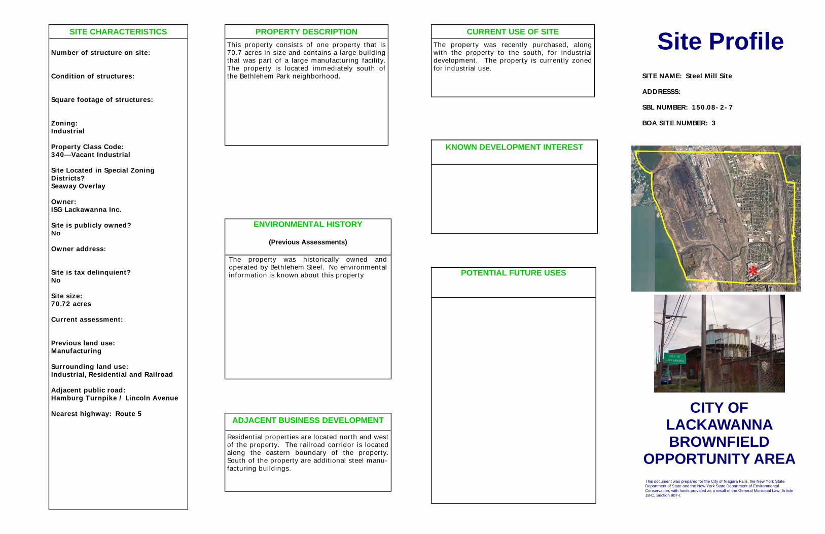
This document was prepared for the City of Niagara Falls, the New York State Department of State and the New York State Department of Environmental Conservation, with funds provided as a result of the General Municipal Law, Article 18-C, Section 907-r.
ENVIRONMENTAL HISTORY (Previous Assessments)
The property was historically owned and operated by Bethlehem Steel. No environmental information is known about this property POTENTIAL FUTURE USES
Site Profile
KNOWN DEVELOPMENT INTEREST
PROPERTY DESCRIPTION This property consists of one property that is 70.7 acres in size and contains a large building that was part of a large manufacturing facility. The property is located immediately south of the Bethlehem Park neighborhood.
CURRENT USE OF SITE The property was recently purchased, along with the property to the south, for industrial development. The property is currently zoned for industrial use.
ADJACENT BUSINESS DEVELOPMENT Residential properties are located north and west of the property. The railroad corridor is located along the eastern boundary of the property. South of the property are additional steel manu-facturing buildings.
SITE CHARACTERISTICS Number of structure on site: Condition of structures: Square footage of structures: Zoning: Industrial Property Class Code: 340—Vacant Industrial Site Located in Special Zoning Districts? Seaway Overlay Owner: ISG Lackawanna Inc. Site is publicly owned? No Owner address: Site is tax delinquient? No Site size: 70.72 acres Current assessment: Previous land use: Manufacturing Surrounding land use: Industrial, Residential and Railroad Adjacent public road: Hamburg Turnpike / Lincoln Avenue Nearest highway: Route 5
SITE NAME: Steel Mill Site ADDRESSS: SBL NUMBER: 150.08-2-7 BOA SITE NUMBER: 3
*
CITY OF LACKAWANNA BROWNFIELD
OPPORTUNITY AREA

This document was prepared for the City of Niagara Falls, the New York State Department of State and the New York State Department of Environmental Conservation, with funds provided as a result of the General Municipal Law, Article 18-C, Section 907-r.
ENVIRONMENTAL HISTORY (Previous Assessments)
The property was historically the Lackawanna Foundry. The EPA completed a removal action on the property.
POTENTIAL FUTURE USES
Site Profile
KNOWN DEVELOPMENT INTEREST
PROPERTY DESCRIPTION This property consists of one parcel that is 4.9 acres in size. The property is accessed via a short driveway known as Maple Street, located near the intersection of Elm Street and Jackson Avenue. The parcel is irregularly shaped and a portion of the property follows a thin strip of land approximately 50 feet along the shore of Smokes Creek.
CURRENT USE OF SITE The property is currently vacant and is zoned for Open Space. Residents currently use a por-tion of the property for recreational purposes to fish in Smokes Creek.
ADJACENT BUSINESS DEVELOPMENT The property is south of Smokes Creek. East of the property is the railroad corridor. South of the property is a Bocce Club. West of the prop-erty are residential homes that front Elm Street.
SITE CHARACTERISTICS Number of structure on site: 0 Condition of structures: N/A Square footage of structures: N/A Zoning: Open Property Class Code: 340—Vacant Industrial Site Located in Special Zoning Districts? Smokes Creek Overlay Owner: City of Lackawanna Site is publicly owned? Yes Owner address: 714 Ridge Road Lackawanna NY 14218 Site is tax delinquient? No Site size: 4.91 acres Current assessment: $26,000 Previous land use: Surrounding land use: Industrial, Residential, Regional Commercial and Railroad Adjacent public road: Elm Street / Jackson Avenue / Walnut Street / Spruce Street / Maple Street Nearest highway: Route 5
SITE NAME: Former Lackawanna Foundry Site ADDRESSS: 0 Elm Street SBL NUMBER: 141.20-1-5.1 BOA SITE NUMBER: 4
*
CITY OF LACKAWANNA BROWNFIELD
OPPORTUNITY AREA

This document was prepared for the City of Lackawanna, the New York State Department of State and the New York State Department of Environmental Conservation, with funds provided as a result of the General Municipal Law, Article 18-C, Section 907-r.
ENVIRONMENTAL HISTORY (Previous Assessments)
Entered into NYSDEC ERP in 1998. A Site Investigation completed on the property showed low levels of PAHs and metals across the property with a small area of elevated chromium concentrations in surface soil. Remedial actions completed on the property in 1999 included removal of 428 cubic yards of debris from site, and excavation of 1400 tons of chromium contaminated soil. Engineering and Institutional controls were placed on the property. These controls are on file with the Erie County Clerk and include the following: The property may not be used for any purposes other than commercial/industrial uses contained within buildings, parking, streets, or public safety facilities without prior written approval by NYSDEC; Any proposed soil excavation from the site may be placed on the site as fill, graded and covered with topsoil and seeded; Any soil on the property that is not covered by an impervious product such as concrete, asphalt, or structures must be covered with a layer of clean soil and this soil layer must be vegetated and maintained; The municipality and successors in title shall submit an annual report certifying that the controls remain in place.
POTENTIAL FUTURE USES
Business Park Tree Farm Utilities and Green Energy Open Space
Site Profile
KNOWN DEVELOPMENT INTEREST None
PROPERTY DESCRIPTION The property is also known as the Lackawanna Business Park site. The property consists of two parcels which total 8.1 acres. Historically, the property was used for company owned housing for the steel mill from 1902 until the 1930s. The property was vacant and used for community gardens and recreational purposes, including a bike trail and ballfield, until the 1970s. Amadori Construction Company, located west of the property, then used the property for equipment storage. The City of Lackawanna took ownership of the site in 1996.
CURRENT USE OF SITE The property is currently zoned for Regional Commercial and is currently vacant. A portion of the Amadori Site was redeveloped in 2008 and now contains Alliance Innovative Manufac-turing.
ADJACENT BUSINESS DEVELOPMENT Alliance Innovative Manufacturing; CIR Electrical; Great Lakes Diesel
SITE CHARACTERISTICS Number of structure on site: 0 Condition of structures: N/A Square footage of structures: N/A Zoning: Regional Commercial Property Class Code: 340– Vacant Industrial Site Located in Special Zoning Districts? No Owner: City of Lackawanna Site is publicly owned? Yes Owner address: 714 Ridge Road Lackawanna NY 14218 Site is Tax Delinquent? No Site size: 8.1 acres Current assessment: $130,000 Previous land use: Industrial Surrounding land use: Railroad, residential, vacant Adjacent public road: Ingham / Alliance Nearest highway: Route 5
SITE NAME: Former Amadori Construction Site / Lackawanna Business Park ADDRESSS: 0 Alliance Drive SBL NUMBER: 141.20-1-12.1, 141.20-1-14 BOA SITE NUMBER: 5
*
CITY OF LACKAWANNA BROWNFIELD
OPPORTUNITY AREA

This document was prepared for the City of Lackawanna, the New York State Department of State and the New York State Department of Environmental Conservation, with funds provided as a result of the General Municipal Law, Article 18-C, Section 907-r.
ENVIRONMENTAL HISTORY (Previous Assessments)
The property was used as a gas station during the 1920s. No other historical or environmental information is known about the property.
POTENTIAL FUTURE USES
Highway Commerical
Site Profile
KNOWN DEVELOPMENT INTEREST
None
PROPERTY DESCRIPTION This property consists of one parcel that is located on the northeast corner of Madison Avenue and Hamburg Turnpike. The property is 0.35 acres in size and has access from both Madison Avenue and Hamburg Turnpike. The property contains two buildings that total 1,260 square feet in size and were formerly used as an automobile service station.
CURRENT USE OF SITE The property is currently zoned for single family residential and is currently vacant.
ADJACENT BUSINESS DEVELOPMENT The property is south of Smokes Creek. South and east of the property are residential proper-ties. South of the property is a Bocce Club. West of the property, across Route 5 is the Bethlehem Steel Site.
SITE CHARACTERISTICS Number of structure on site: 2 Condition of structures: Average Square footage of structures: 1,260 Zoning: Residential Property Class Code: 432—Gas Station Site Located in Special Zoning Districts? Seaway Overlay Owner: Daren Selvaggio Site is publicly owned? No Owner address: 36 Julian Avenue Lackawanna NY 14218 Site is tax delinquient? Yes Site size: 0.35 acres Current assessment: $75,000 Previous land use: Automotive Repair Shop Surrounding land use: Industrial, Residential and Regional Commercial Adjacent public road: Hamburg Turnpike / Madison Avenue Nearest highway: Route 5
SITE NAME: Corner Route 5 and Madison Site ADDRESSS: 2646 Hamburg Turnpike SBL NUMBER: 141.83-6-48 BOA SITE NUMBER: 6
*
CITY OF LACKAWANNA BROWNFIELD
OPPORTUNITY AREA

This document was prepared for the City of Lackawanna , the New York State Department of State and the New York State Department of Environmental Conservation, with funds provided as a result of the General Municipal Law, Article 18-C, Section 907-r.
ENVIRONMENTAL HISTORY
(Previous Assessments)
The property was most recently occupied by Friendship House of WNY, a community service organization. Previously, the building was Lincoln Junior High School/New Lincoln Elementary School (Public School #5). The building was built before 1927, and additions were added in 1956. Vandalism and trespass has effected the building interior.
A Phase I ESA was completed on the property in 2007. The Phase I revealed the following recognized environmental conditions:
• A UST is shown on the property at the eastern boundary. No records of removal exist.
• Lead-based paint, mold and asbestos surveys are recommended for the building
• Small quantities of chemicals and paints found in the building should be inventoried and disposed of
POTENTIAL FUTURE USES
Mixed Use office and residential
Site Profile
KNOWN DEVELOPMENT INTEREST
None
PROPERTY DESCRIPTION This property consists of one parcel that is 2.2 acres in size and contains a 3-story brick building that is 51,156 square feet in size. The property has frontage along Dona Street, School Street and Willmuth Avenue
CURRENT USE OF SITE The property is currently zoned for Mixed Resi-dential and is currently vacant. The building appears to be in poor condition and likely needs to be demolished.
ADJACENT BUSINESS DEVELOPMENT
North and south of the property are residential homes. East of the property is a collision shop. West of the property is an active boat storage yard
SITE CHARACTERISTICS
Number of structure on site: 1 Condition of structures: Poor Square footage of structures: 51,156 Zoning: Mixed Residential Property Class Code: 652– Government Building Site Located in Special Zoning Districts? No Owner: City of Lackawanna Site is publicly owned? Yes Owner address: 714 Ridge Road Lackawanna NY 14218 Site is tax delinquient? No Site size: 2.2 acres Current assessment: $31,600 Previous land use: School and Community Center Surrounding land use: Mixed Residential and Regional Commercial Adjacent public road: Dona Street/ School Street/Willmuth Avenue Nearest highway: Route 5
SITE NAME: Friendship House Site ADDRESSS: 100 Dona Street SBL NUMBER: 141.67-3-1 BOA SITE NUMBER: 7
*
CITY OF LACKAWANNA BROWNFIELD
OPPORTUNITY AREA

This document was prepared for the City of Lackawanna, the New York State Department of State and the New York State Department of Environmental Conservation, with funds provided as a result of the General Municipal Law, Article 18-C, Section 907-r.
ENVIRONMENTAL HISTORY (Previous Assessments)
Past use and the environmental condition of the site are not known.
POTENTIAL FUTURE USES
Highway Commercial
Site Profile
KNOWN DEVELOPMENT INTEREST
None The property is available for sale
PROPERTY DESCRIPTION This property consists of one parcel that is located at the southeast corner of Hamburg Turnpike and Dona Street. The property encompasses 0.79 acres and is currently vacant.
CURRENT USE OF SITE The property is currently a vacant grass covered lot that is zoned for Regional Commercial use.
ADJACENT BUSINESS DEVELOPMENT North of the property, across Dona Street, is an active gas station. East of the property are manufactured residential housing units. South of the property is an active office building. West of the property, across Hamburg Turnpike, is the former Bethlehem Steel site.
SITE CHARACTERISTICS Number of structure on site: 0 Condition of structures: N/A Square footage of structures: N/A Zoning: Regional Commercial Property Class Code: 330—Vacant Commercial Site Located in Special Zoning Districts? Seaway Overlay Owner: Transad Inc. Site is publicly owned? No Owner address: 120 Mitchell Road East Aurora NY 14052 Site is tax delinquient? Yes Site size: 0.68 acres Current assessment: $30,000 Previous land use: Unknown Surrounding land use: Industrial and Regional Commercial Adjacent public road: Hamburg Turnpike / Dona Street Nearest highway: Route 5
SITE NAME: 2540 Hamburg Turnpike Site ADDRESSS: 2540 Hamburg Turnpike SBL NUMBER: 141.20-1-10.2 BOA SITE NUMBER: 8
*
CITY OF LACKAWANNA BROWNFIELD
OPPORTUNITY AREA

This document was prepared for the City of Lackawanna, the New York State Department of State and the New York State Department of Environmental Conservation, with funds provided as a result of the General Municipal Law, Article 18-C, Section 907-r.
ENVIRONMENTAL HISTORY (Previous Assessments)
Past use and the environmental condition of the site are not known.
POTENTIAL FUTURE USES
Highway Commercial
Site Profile
KNOWN DEVELOPMENT INTEREST
None The property is available for sale
PROPERTY DESCRIPTION This property consists of one parcel that is 1.1 acres in size and is currently vacant. The property is located on the eastern side of Hamburg Turnpike.
CURRENT USE OF SITE The property is currently a vacant grass covered lot that is zoned for Regional Commercial use.
ADJACENT BUSINESS DEVELOPMENT North of the property is a coffee bean distrib-uter. East of the property, across Albright Court, is a boat storage facility. South of the property is an active gas station. West of the property, across Hamburg Turnpike, is the former Bethle-hem Steel site.
SITE CHARACTERISTICS Number of structure on site: 0 Condition of structures: N/A Square footage of structures: N/A Zoning: Regional Commercial Property Class Code: 330—Vacant Commercial Site Located in Special Zoning Districts? Seaway Overlay Owner: Anthony Devincentis Site is publicly owned? No Owner address: 1094 Lovejoy Street Buffalo NY 14202 Site is tax delinquient? No Site size: 1.1 acres Current assessment: $50,000 Previous land use: Unknown Surrounding land use: Industrial and Regional Commercial Adjacent public road: Hamburg Turnpike Nearest highway: Route 5
SITE NAME: 2520 Hamburg Turnpike Site ADDRESSS: 2520 Hamburg Turnpike SBL NUMBER: 141.67-4-7.1 BOA SITE NUMBER: 9
*
CITY OF LACKAWANNA BROWNFIELD
OPPORTUNITY AREA

This document was prepared for the City of Lackawanna, the New York State Department of State and the New York State Department of Environmental Conservation, with funds provided as a result of the General Municipal Law, Article 18-C, Section 907-r.
ENVIRONMENTAL HISTORY (Previous Assessments)
During the 1920s, the property was the location of Albright Court Defense Housing Project. Use of the property since that time and the environmental condition of the site are not known.
POTENTIAL FUTURE USES
Highway Commercial
Site Profile
KNOWN DEVELOPMENT INTEREST
None
PROPERTY DESCRIPTION This property consists of three parcels that total 8.18 acres and are centered around Albright Court.
CURRENT USE OF SITE The property is currently a vacant grass covered lot that is zoned for Regional Commercial use.
ADJACENT BUSINESS DEVELOPMENT North and east of the property are residential homes. South of the property is a Best Western Inn. West of the property is the 2380 Hamburg Turnpike Site and the Former Auto Repair Site.
SITE CHARACTERISTICS Number of structure on site: 0 Condition of structures: N/A Square footage of structures: N/A Zoning: Regional Commercial Property Class Code: 330—Vacant Commercial Site Located in Special Zoning Districts? Seaway Overlay Owner: Ellicott Lodging Inc. (2520 Hamburg Turnpike) City of Lackawanna (0 Willmuth Avenue Rear) Site is publicly owned? No Owner address: 3940 Southwestern Boulevard Orchard Park NY 14127 (Ellicott Lodging Inc.) 714 Ridge Road Lackawanna NY 14218 (City of Lackawanna) Site is tax delinquient? No Site size: 8.2 acres Current assessment: $183,800 Previous land use: Housing Project Surrounding land use: Industrial, Mixed Residential and Regional Commercial Adjacent public road: Hamburg Turnpike Nearest highway: Route 5
SITE NAME: Albright Court Properties Site ADDRESSS: 2502 Hamburg Turnpike, 0 Will-muth Avenue Rear SBL NUMBER: 141.59-5-49, 141.59-5-50, 141.67-4-1.111 BOA SITE NUMBER: 10
*
CITY OF LACKAWANNA BROWNFIELD
OPPORTUNITY AREA

This document was prepared for the City of Lackawannals, the New York State Department of State and the New York State Department of Environmental Conservation, with funds provided as a result of the General Municipal Law, Article 18-C, Section 907-r.
ENVIRONMENTAL HISTORY (Previous Assessments)
A Phase I ESA was completed in 2007. The property appears to have never been developed. The property contains fill and slight mounding. Some construction and demolition debris and slag type fill was observed on site. The property appears to be a low areas, receives drainage from other properties and contains cattails and wetland plants. The Phase I revealed the following recognized environmental conditions:
The potential for uncontrolled dumping and filling exists on the property and slag fill was observed along the western property line
A portion of the property was being used for storage of wrecked vehicles
The use of the adjacent property as a gas station with multiple spill records
A Phase II was recommended to assess the potential RECs, asses surface and near surface soil due to historical uses of adjacent properties and the potential for fill.
POTENTIAL FUTURE USES
Highway Commercial
Site Profile
KNOWN DEVELOPMENT INTEREST
None
PROPERTY DESCRIPTION This property is located on the east side of Hamburg Turnpike, south of Holbrook Street. The property is comprised of one parcel that is 3.77 acres in size and only has a small amount of frontage along Hamburg Turnpike. The property is vacant and undeveloped.
CURRENT USE OF SITE The property is currently a vacant grass covered lot that is zoned for Regional Commercial use.
ADJACENT BUSINESS DEVELOPMENT North of the property is a gas station and resi-dential properties. East of the property is a va-cant grassy field. South of the property is a ho-tel. West of the property is a former auto repair facility.
SITE CHARACTERISTICS Number of structure on site: 0 Condition of structures: N/A Square footage of structures: N/A Zoning: Regional Commercial Property Class Code: 474—Billboard Site Located in Special Zoning Districts? Seaway Overlay Owner: Mid-East Enterprises Inc. Site is publicly owned? No Owner address: 2368 Hamburg Turnpike Lackawanna NY 14218 Site is tax delinquient? No Site size: 3.77 acres Current assessment: $150,000 Previous land use: Unknown Surrounding land use: Industrial, Mixed Residential and Regional Commercial Adjacent public road: Hamburg Turnpike Nearest highway: Route 5
SITE NAME: 2380 Hamburg Turnpike Site ADDRESSS: 2380 Hamburg Turnpike SBL NUMBER: 141.59-5-3 BOA SITE NUMBER: 11
*
CITY OF LACKAWANNA BROWNFIELD
OPPORTUNITY AREA

This document was prepared for the City of Lackawanna, the New York State Department of State and the New York State Department of Environmental Conservation, with funds provided as a result of the General Municipal Law, Article 18-C, Section 907-r.
ENVIRONMENTAL HISTORY (Previous Assessments)
The property was formerly used as an auto repair facility. No environmental information is known about the property.
POTENTIAL FUTURE USES
Highway Commercial
Site Profile
KNOWN DEVELOPMENT INTEREST
None The property is available for sale
PROPERTY DESCRIPTION This property consists of one parcel which is 1.04 acres in size. The property is on the east side of Hamburg Turnpike. The property contains two buildings: an 8,016 square foot former auto repair shop near the center of the property and a smaller shed on the southern edge of the property. A concrete foundation of a former third building appears on the northern portion of the property.
CURRENT USE OF SITE The property is currently vacant and zoned for Regional Commercial use.
ADJACENT BUSINESS DEVELOPMENT North of the property is a gas station. East of the property is the 2380 Hamburg Turnpike Site. South of the property is a commercial retail store. West of the property, across Hamburg Turnpike is the former Bethlehem Steel Site.
SITE CHARACTERISTICS Number of structure on site: 2 Condition of structures: Average Square footage of structures: 8,016 Zoning: Regional Commercial Property Class Code: 433—Auto Body Site Located in Special Zoning Districts? Seaway Overlay Owner: Samuel Siegel Site is publicly owned? No Owner address: 300 Main Street Buffalo NY 14202 Site is tax delinquient? No Site size: 1.04 acres Current assessment: $137,000 Previous land use: Automotive Repair Shop Surrounding land use: Industrial, Mixed Residential and Regional Commercial Adjacent public road: Hamburg Turnpike Nearest highway: Route 5
SITE NAME: Former Auto Repair Site ADDRESSS: 2424 Hamburg Turnpike SBL NUMBER: 141.59-5-2 BOA SITE NUMBER: 12
*
CITY OF LACKAWANNA BROWNFIELD
OPPORTUNITY AREA

This document was prepared for the City of Lackawanna, the New York State Department of State and the New York State Department of Environmental Conservation, with funds provided as a result of the General Municipal Law, Article 18-C, Section 907-r.
ENVIRONMENTAL HISTORY (Previous Assessments)
No historical or environmental information is known about the property.
POTENTIAL FUTURE USES
Highway Commercial Reconnect to ROS
Site Profile
KNOWN DEVELOPMENT INTEREST
None
PROPERTY DESCRIPTION This site consists of two parcels that total 0.54 acres and are located at the end of Kane Street. Kane Street terminates at a cul-de-sac near this site; however, Kane Street formerly connected to Hamburg Turnpike.
CURRENT USE OF SITE The property is currently vacant and is zoned for Regional Commercial use.
ADJACENT BUSINESS DEVELOPMENT North of this property are vacant commercial stores along Kane Street. East of the property are residential homes. South of the property is a wholesale retail outlet. West of the property is Hamburg Turnpike.
SITE CHARACTERISTICS Number of structure on site: 0 Condition of structures: N/A Square footage of structures: N/A Zoning: Regional Commercial Property Class Code: 846—Connectors (2770 Hamburg Turnpike) 474—Billboard (2290 Hamburg Turnpike) Site Located in Special Zoning Districts? Seaway Overlay Owner: State of New York (2770) City of Lackawanna (2290) Site is publicly owned? Yes Owner address: 182 East Union Street Allegany NY 14706 (2770 Hamburg Turnpike) 714 Ridge Road Lackawanna NY 14218 (2290 Hamburg Turnpike) Site is tax delinquient? No Site size: 0.54 acres Current assessment: $128,900 Previous land use: Automotive Repair Shop Surrounding land use: Industrial, Mixed Residential and Regional Commercial Adjacent public road: Hamburg Turnpike Nearest highway: Route 5
SITE NAME: Kane Street Properties Site ADDRESSS: 2770, 2290 Hamburg Turnpike SBL NUMBER: 141.11-1-46, 141.11-1-10.1 BOA SITE NUMBER: 13
*
CITY OF LACKAWANNA BROWNFIELD
OPPORTUNITY AREA

This document was prepared for the City of Lackawanna, the New York State Department of State and the New York State Department of Environmental Conservation, with funds provided as a result of the General Municipal Law, Article 18-C, Section 907-r.
ENVIRONMENTAL HISTORY (Previous Assessments)
No historical or environmental information is known about the property.
POTENTIAL FUTURE USES
Highway Commercial Following reconnection to Route 5
Site Profile
KNOWN DEVELOPMENT INTEREST
None
PROPERTY DESCRIPTION This property is located on the south side of Mill Street and consists of one parcel that is 4.7 acres in size. The property is irregularly shaped and has frontage along Mill Street, Steelawanna Avenue, and Kane Street.
CURRENT USE OF SITE The property is currently vacant and is zoned for Regional Commercial use.
ADJACENT BUSINESS DEVELOPMENT North of the property, across Mill Street is the End of Gates Avenue Site. East and south of the property are residential homes. West of the property is the Mill Street Properties #2 Site.
SITE CHARACTERISTICS Number of structure on site: 0 Condition of structures: N/A Square footage of structures: N/A Zoning: Regional Commercial Property Class Code: 311—Vacant Residential Site Located in Special Zoning Districts? Owner: Lackawanna Community Development Site is publicly owned? No Owner address: 640 Ridge Road Lackawanna NY 14218 Site is tax delinquient? No Site size: 4.68 acres Current assessment: $11,300 Previous land use: Surrounding land use: Industrial, Mixed Residential and Regional Commercial Adjacent public road: Mill Street / Steelawanna Avenue / Kane Street Nearest highway: Route 5
SITE NAME: Mill Street Properties Site ADDRESSS: 2770, 2290 Hamburg Turnpike SBL NUMBER: 141.11-1-34 BOA SITE NUMBER: 14
*
CITY OF LACKAWANNA BROWNFIELD
OPPORTUNITY AREA

This document was prepared for the City of Lackawanna, the New York State Department of State and the New York State Department of Environmental Conservation, with funds provided as a result of the General Municipal Law, Article 18-C, Section 907-r.
ENVIRONMENTAL HISTORY (Previous Assessments)
Past use and the environmental condition of the site are not known.
POTENTIAL FUTURE USES
Highway Commercial
Site Profile
KNOWN DEVELOPMENT INTEREST
None
PROPERTY DESCRIPTION This property consists of one parcel that is 2.5 acres in size. The property has frontage along Gates Avenue, Mill Street, and Wasson Avenue.
CURRENT USE OF SITE The property is currently a vacant grass covered lot that is zoned for Regional Commercial use.
ADJACENT BUSINESS DEVELOPMENT North of the property are apartments operated by Lackawanna Municipal Housing Authority. East of the property is a vacant grass covered field. South of the property is the Mill Street Property #1. West of the property is Mill Street Property #2.
SITE CHARACTERISTICS Number of structure on site: 0 Condition of structures: N/A Square footage of structures: N/A Zoning: Regional Commercial Property Class Code: 311—Vacant Residential Site Located in Special Zoning Districts? Owner: Lackawanna Community Development Site is publicly owned? No Owner address: 640 Ridge Road Lackawanna NY 14218 Site is tax delinquient? No Site size: 2.51 acres Current assessment: $11,300 Previous land use: Surrounding land use: Industrial, Mixed Residential and Regional Commercial Adjacent public road: Mill Street / Gates Avenue / Wasson Avenue Nearest highway: Route 5
SITE NAME: End of Gates Avenue Site ADDRESSS: O Gates Avenue SBL NUMBER: 141.11-1-45 BOA SITE NUMBER: 15
*
CITY OF LACKAWANNA BROWNFIELD
OPPORTUNITY AREA

This document was prepared for the City of Lackawanna, the New York State Department of State and the New York State Department of Environmental Conservation, with funds provided as a result of the General Municipal Law, Article 18-C, Section 907-r.
ENVIRONMENTAL HISTORY (Previous Assessments)
Past use and the environmental condition of the site are not known.
POTENTIAL FUTURE USES
Highway Commercial
Site Profile
KNOWN DEVELOPMENT INTEREST
None
PROPERTY DESCRIPTION This property is located at the corner of Gates Avenue and Mill Street. The Property is 0.89 acres in size and is currently vacant.
CURRENT USE OF SITE The property is currently a vacant grass covered lot that is zoned for Regional Commercial use.
ADJACENT BUSINESS DEVELOPMENT North and south of the property is vacant right-of-way associated with the ramp from Route 5 to Ridge Road, which is located west of the prop-erty. East of the property is the Mill Street Prop-erty #1 Site.
SITE CHARACTERISTICS Number of structure on site: 0 Condition of structures: N/A Square footage of structures: N/A Zoning: Regional Commercial Property Class Code: 330—Vacant Commercial Site Located in Special Zoning Districts? Owner: Paul Olszowy Site is publicly owned? No Owner address: PO BOX 12 Lackawanna NY 14218 Site is tax delinquient? Yes Site size: 0.89 acres Current assessment: $6,500 Previous land use: Surrounding land use: Industrial and Regional Commercial Adjacent public road: Hamburg Turnpike / Mill Street / Gates Avenue Nearest highway: Route 5
SITE NAME: Mill Street Properties # 2 Site ADDRESSS: 129 Gates Avenue SBL NUMBER: 141.11-1-40.11 BOA SITE NUMBER: 16
*
CITY OF LACKAWANNA BROWNFIELD
OPPORTUNITY AREA

This document was prepared for the City of Lackawanna, the New York State Department of State and the New York State Department of Environmental Conservation, with funds provided as a result of the General Municipal Law, Article 18-C, Section 907-r.
ENVIRONMENTAL HISTORY (Previous Assessments)
No historical or environmental information is known about the property.
POTENTIAL FUTURE USES
Mixed Use
Site Profile
KNOWN DEVELOPMENT INTEREST
None
PROPERTY DESCRIPTION This property consists of four parcels that total 2.6 acres. The property is located at the northeast corner of North Gates Road and Ridge Road. The property contains a 24,000 square foot building constructed in 1994.
CURRENT USE OF SITE The property was used by a machine shop that vacated the premises in March 2011. The property is currently zoned for Industrial use.
ADJACENT BUSINESS DEVELOPMENT North of the property is a concrete making fa-cility. East of the property is a light industrial facility. South of the property, across Ridge Road are commercial businesses and vacant lots. West of the property, across North Gates Road is a light industrial business.
SITE CHARACTERISTICS Number of structure on site: 1 Condition of structures: Average Square footage of structures: 24,000 Zoning: Industrial Property Class Code: 340—Vacant Industrial (0 Ridge Road) 714—Iight Industrial Manufacturing (100 Ridge Road) Site Located in Special Zoning Districts? Owner: Lackawanna Community Development Site is publicly owned? No Owner address: 640 Ridge Road Lackawanna NY 14218 Site is tax delinquient? No Site size: 2.6 acres Current assessment: $609,400 Previous land use: Industrial Surrounding land use: Industrial and Neighborhood Commercial Adjacent public road: Ridge Road / North Gate Avenue Nearest highway: Route 5
SITE NAME: Former Machine Shop Site ADDRESSS: 0, 100 Ridge Road SBL NUMBER: 141.07-2-53, 141.07-3-27, 141.07-4-4.111, 141.07-4-5.1 BOA SITE NUMBER: 17
*
CITY OF LACKAWANNA BROWNFIELD
OPPORTUNITY AREA

This document was prepared for the City of Lackawanna, the New York State Department of State and the New York State Department of Environmental Conservation, with funds provided as a result of the General Municipal Law, Article 18-C, Section 907-r.
ENVIRONMENTAL HISTORY (Previous Assessments)
No historical or environmental information is known about the property.
POTENTIAL FUTURE USES
Mixed Use
Site Profile
KNOWN DEVELOPMENT INTEREST
None
PROPERTY DESCRIPTION This property consists of one parcel that is 1.1 acres in size. The property is on the north side of Ridge Road and contains a 1,120 square foot brick building that was built in 1931.
CURRENT USE OF SITE The building is currently being used for storage by OLV Homes of Charity and is currently zoned for industrial use.
ADJACENT BUSINESS DEVELOPMENT North of the property is the Steelawanna 2 Site. East of the property is the Friendship House Site. South of the property, across Ridge Road are commercial businesses and vacant lots in-cluding the Former Fire Hall Site and the 215 Ridge Road Site. West of the property is a light industrial business.
SITE CHARACTERISTICS Number of structure on site: 1 Condition of structures: Average Square footage of structures: 1,120 Zoning: Industrial Property Class Code: 449—Warehouse Site Located in Special Zoning Districts? Owner: Our Lady of Victory Homes of Charity Site is publicly owned? No Owner address: 780 Ridge Road Lackawanna NY 14218 Site is tax delinquient? No Site size: 1.1 acres Current assessment: $50,000 Previous land use: Surrounding land use: Industrial and Neighborhood Commercial Adjacent public road: Ridge Road Nearest highway: Route 5
SITE NAME: 206 Ridge Road Site ADDRESSS: 206 Ridge Road SBL NUMBER: 141.08-2-8.1 BOA SITE NUMBER: 18
*
CITY OF LACKAWANNA BROWNFIELD
OPPORTUNITY AREA

This document was prepared for the City of Lackawanna, the New York State Department of State and the New York State Department of Environmental Conservation, with funds provided as a result of the General Municipal Law, Article 18-C, Section 907-r.
ENVIRONMENTAL HISTORY (Previous Assessments)
The property historically contained a hospital that was positioned near the center of the property. The Friendship House purchased the property in 1953 to use for their social programs. In 1966, both the hospital and the current 15,500 square foot building were present on the property. In 1978, only the current building remained on the property. A Phase II was completed on the property in February 2009. The Phase II found asbestos containing materials and lead-based paints throughout the building. No evidence of contamination was observed in the backfilled foundations of the old hospital, and no evidence of drums or USTs was found from the geophysical survey. Low concentrations of PAHs were detected in four of six soil/fill samples, with only one compound exhibiting concentrations exceeding restricted commercial soil cleanup objectives. No contamination was found in groundwater samples.
Site remediation was not recommended at the time of the Phase II due to the type of contamination and low concentrations found and assumed limited time of exposure. However, the asbestos and lead in the building, as well as the disrepair of the building, poses a risk and should be considered during redevelopment or demolition of the building.
POTENTIAL FUTURE USES
Mixed Use/Community Square/Community Hub
Site Profile
KNOWN DEVELOPMENT INTEREST
None
PROPERTY DESCRIPTION This property consists of one parcel that is 5.03 acres in size and is located along the north side of Ridge Road, at the corner of Fairview Avenue. The property contains a 15,500 square foot 1-story brick and cement block building that was built between 1958 and 1966.
CURRENT USE OF SITE The property is currently zoned industrial and is vacant.
ADJACENT BUSINESS DEVELOPMENT North of the property is the Former Can Fiber facility in the Steelawanna Business Park. East of the property is the 206 Ridge Road Site. South of the property are vacant commercial properties and a church. West of the property is the Former Magyar United Presbyterian Church Site.
SITE CHARACTERISTICS Number of structure on site: 1 Condition of structures: Fair Square footage of structures: 15,500 Zoning: Industrial Property Class Code: 682—Recreational Facility Site Located in Special Zoning Districts? Owner: City of Lackawanna Site is publicly owned? Yes Owner address: 714 Ridge Road Lackawanna NY 14218 Site is tax delinquient? No Site size: 5.03 acres Current assessment: $150,000 Previous land use: Hospital Surrounding land use: Industrial and Neighborhood Commercial Adjacent public road: Ridge Road / Fairview Avenue Nearest highway: Route 5
SITE NAME: Friendship House Site ADDRESSS: 264 Ridge Road SBL NUMBER: 141.08-2-9 BOA SITE NUMBER: 19
*
CITY OF LACKAWANNA BROWNFIELD
OPPORTUNITY AREA

This document was prepared for the City of Lackawanna, the New York State Department of State and the New York State Department of Environmental Conservation, with funds provided as a result of the General Municipal Law, Article 18-C, Section 907-r.
ENVIRONMENTAL HISTORY (Previous Assessments)
Past use and the environmental condition of the site are not known.
POTENTIAL FUTURE USES
Site Profile
KNOWN DEVELOPMENT INTEREST
PROPERTY DESCRIPTION This property consists of one parcel that is 6.32 acres in size and is located on North Steelawanna Avenue. The property is triangular shaped and is located in a heavy commercial and industrial area.
CURRENT USE OF SITE The property is vacant and the City of Lacka-wanna uses this lot for snow storage during the winter.
ADJACENT BUSINESS DEVELOPMENT Northwest of the property is a concrete manu-facturing facility and northeast is the 300 Com-merce Drive Site. East of the property is the Friendship House Site. South of the property is the 206 Ridge Road Site.
SITE CHARACTERISTICS Number of structure on site: 0 Condition of structures: N/A Square footage of structures: N/A Zoning: Industrial Property Class Code: 340—Vacant Industrial Site Located in Special Zoning Districts? Owner: City of Lackawanna Site is publicly owned? Yes Owner address: 714 Ridge Road Lackawanna NY 14218 Site is tax delinquient? No Site size: 6.32 acres Current assessment: $126,600 Previous land use: Surrounding land use: Industrial and Neighborhood Commercial Adjacent public road: North Steelawanna Avenue Nearest highway: Route 5
SITE NAME: Steelawanna 2 Site ADDRESSS: 0 North Steelawanna Avenue SBL NUMBER: 141.08-1-13.111 BOA SITE NUMBER: 20
*
CITY OF LACKAWANNA BROWNFIELD
OPPORTUNITY AREA

This document was prepared for the City of Lackawanna, the New York State Department of State and the New York State Department of Environmental Conservation, with funds provided as a result of the General Municipal Law, Article 18-C, Section 907-r.
ENVIRONMENTAL HISTORY (Previous Assessments)
This property has been a church since 1913, but the church has been closed for some time. Prior uses of the property are unknown. No environmental information is known about this property.
POTENTIAL FUTURE USES
Mixed Use
Site Profile
KNOWN DEVELOPMENT INTEREST
None
PROPERTY DESCRIPTION This property is located on the north side of Ridge Road, in between Fairview Avenue and Kossuth Avenue. The property is 0.55 acres in size and contains a 4,992 square foot former church that was built in 1913 and a 1,880 square foot rectory building.
CURRENT USE OF SITE The property is zoned for Industrial use and is currently vacant.
ADJACENT BUSINESS DEVELOPMENT North of the property are residential properties. East of the property, across Kossuth Avenue, is an auto sales and service facility. West of the property, across Fairview Avenue, is the Former Friendship House Site. South of the property, across Ridge Road, are a variety of vacant retail properties.
SITE CHARACTERISTICS Number of structure on site: 2 Condition of structures: Average Square footage of structures: 4,992 (Former Church) 1,880 (Rectory Building) Zoning: Industrial Property Class Code: 620—Religious Site Located in Special Zoning Districts? Owner: Lynn P. Craig Site is publicly owned? No Owner address: 96 W Bihrwood Drive West Seneca, NY 14224 Site is tax delinquient? No Site size: 0.55 acres Current assessment: $150,000 Previous land use: Church Surrounding land use: Industrial and Neighborhood Commercial Adjacent public road: Ridge Road / Fairview Avenue / Kossuth Avenue Nearest highway: Route 5
SITE NAME: Former Church Site ADDRESSS: 300 Ridge Road SBL NUMBER: 141.08-2-17 BOA SITE NUMBER: 21
*
CITY OF LACKAWANNA BROWNFIELD
OPPORTUNITY AREA

This document was prepared for the City of Lackawanna, the New York State Department of State and the New York State Department of Environmental Conservation, with funds provided as a result of the General Municipal Law, Article 18-C, Section 907-r.
ENVIRONMENTAL HISTORY (Previous Assessments)
A Phase I ESA was completed on the property in 2006. The Phase I revealed the following recognized environmental conditions:
Property and adjacent property is listed as a SW/LF, associated with wood wastes and some construction and demolition debris. Multiple piles of debris and mounds of unknown contents exist on site.
Property is located in an area of heavy industry. There is known contamination at adjacent properties and property may have been a storage area for waste material and rail storage.
Fill of unknown quality and quantity exists on site
A follow up assessment of piles and mounds, surface and subsurface soil and groundwater was recommended for the property.
POTENTIAL FUTURE USES
Industrial
Site Profile
KNOWN DEVELOPMENT INTEREST
None
PROPERTY DESCRIPTION This property consists of one parcel that is 8.42 acres in size. The property is irregularly shaped and is situated entirely between two sets of railroad tracks. The property is located in a heavy commercial and manufacturing area, Steelawanna Industrial Park. An old dilapidated trailer is located at the far north portion of the property
Lakefront Recycling, a wood recycling company, most recently used the property. The property was used for rail car storage during the 1960s.
CURRENT USE OF SITE The property is currently zoned industrial and is vacant.
ADJACENT BUSINESS DEVELOPMENT North of the property is a large manufacturing facility. East of the property are railroad tracks. West of the property, across the railroad track is the 300 Commerce Drive Site. South of the property is the Friendship House Site and com-mercial properties.
SITE CHARACTERISTICS Number of structure on site: 0 Condition of structures: N/A Square footage of structures: N/A Zoning: Industrial Property Class Code: 330—Vacant Commercial Site Located in Special Zoning Districts? Owner: City of Lackawanna Site is publicly owned? Yes Owner address: 714 Ridge Road Lackawanna NY 14218 Site is tax delinquient? No Site size: 8.42 acres Current assessment: $96,300 Previous land use: Recycling Facility Surrounding land use: Industrial and Railroad Adjacent public road: Ridge Road / Fairview Avenue / Kossuth Avenue Nearest highway: Route 5
SITE NAME: Former Lakefront Recycling Site ADDRESSS: 2 North Steelawanna Avenue SBL NUMBER: 141.08-1-13.21 BOA SITE NUMBER: 22
*
CITY OF LACKAWANNA BROWNFIELD
OPPORTUNITY AREA

This document was prepared for the City of Lackawanna, the New York State Department of State and the New York State Department of Environmental Conservation, with funds provided as a result of the General Municipal Law, Article 18-C, Section 907-r.
ENVIRONMENTAL HISTORY (Previous Assessments)
The property was previously occupied by Great Lakes MDF, a manufacturer of fiberboard. The environmental condition of the site is not known.
POTENTIAL FUTURE USES
Business Park/Industrial
Site Profile
KNOWN DEVELOPMENT INTEREST
Krog is planning to develop, use not determined yet
PROPERTY DESCRIPTION This property consists of one parcel that is 29.5 acres in size. The property is located in Steelawanna Industrial Park, and can be accessed via Commerce Drive from the north and North Steelawanna Avenue from the south. This property contains a 174,000 square foot building that was built in 1999. Additionally, the property contains an 80,000 square foot former chip storage (open-sided) building. The building was used by Great Lakes MDF, a manufacturer of fiberboard. The company closed in 2007. All equipment has been removed from the buildings. The property can support a minimum of 300,000 square feet of developable space. There is currently no rail access to the property; however, access could be brought onto the site if the demand suits it.
CURRENT USE OF SITE The property is currently zoned industrial and is vacant.
ADJACENT BUSINESS DEVELOPMENT North of the property is Buffalo Lakeside Com-merce Park. West of the property is a cement company. South of the property is the Steela-wanna # 2 Site, the Friendship House site and residential homes. East of the property is a rail corridor and the Former Lakefront Recycling Site.
SITE CHARACTERISTICS Number of structure on site: 2 Condition of structures: Good Square footage of structures: 174,000 and 80,000 Zoning: Industrial Property Class Code: 710—Manufacturing Site Located in Special Zoning Districts? Owner: G.K. Commerce Drive LLC. Site is publicly owned? No Owner address: 4 Centre Drive Orchard Park NY 14127 Site is tax delinquient? No Site size: 29.5 acres Current assessment: $8,000,000 Previous land use: Manufacturing Surrounding land use: Industrial and Railroad Adjacent public road: Commerce Drive / North Steelawanna Avenue Nearest highway: Route 5
SITE NAME: 300 Commerce Drive Site ADDRESSS: 300 Commerce Drive SBL NUMBER: 141.08-1-13.121 BOA SITE NUMBER: 23
*
CITY OF LACKAWANNA BROWNFIELD
OPPORTUNITY AREA

This document was prepared for the City of Lackawanna, the New York State Department of State and the New York State Department of Environmental Conservation, with funds provided as a result of the General Municipal Law, Article 18-C, Section 907-r. This form was modified from the Niagara County Center for Economic Development Brownfields Inventory Form.
ENVIRONMENTAL HISTORY (Previous Assessments)
A Site Investigation/Remedial Alternatives Report was completed for the site in 2006. PAHs and metals in surface soil/fill were detected at concentrations above TAGM. Two areas of elevated chromium were remediated under an Interim Remedial Measure.
If future plans include leaving soil/fill on site, even if covered, proper handling by implementing a soil/fill management plan and safety measures should be followed to minimize human exposure during development, site use and maintenance activities on site.
POTENTIAL FUTURE USES
Mixed Use
Site Profile
KNOWN DEVELOPMENT INTEREST None
PROPERTY DESCRIPTION This property consists of six adjacent parcels along the south side of Ridge Road, which total 0.77 acres. The property is located at the corner of Wasson Avenue and consists of a vacant lot covered with grass, dirt, and weeds. Historically, commercial buildings were located on this site, including a tin shop, bakery, jeweler, men’s clothing store, and restaurants. The structures are believed to have been demolished in the 1960s. The City of Lackawanna acquired the property in the 1970s.
CURRENT USE OF SITE The property is currently zoned for Neighbor-hood Commercial and is currently vacant.
ADJACENT BUSINESS DEVELOPMENT West of the property is the Yemenite Benevolent Association. North of the property, across Ridge Road, are light industrial facilities. East of the property, across Wasson Avenue, are vacant lots. South of the property are residential properties.
SITE CHARACTERISTICS Number of structure on site: 0 Condition of structures: N/A Square footage of structures: N/A Zoning: Neighborhood Commercial Property Class Code: 330—Vacant Commercial Site Located in Special Zoning Districts? Owner: City of Lackawanna Site is publicly owned? Yes Owner address: 714 Ridge Road Lackawanna NY 14218 Site is tax delinquient? No Site size: 0.77 acres Current assessment: $29,800 Previous land use: Commercial Surrounding land use: Neighborhood commercial, industrial and residential Adjacent public road: Ridge Road / Wasson Avenue Nearest highway: Route 5
SITE NAME: Six Vacant Lots ADDRESSS: 113, 117, 121, 125, 129, 135 Ridge Road SBL NUMBER: 141.43-1-6, 141.43-1-7, 141.43-1-8, 141.43-1-9, 141.43-1-10, 141.43-1-11
*
CITY OF LACKAWANNA BROWNFIELD
OPPORTUNITY AREA

This document was prepared for the City of Lackawanna, the New York State Department of State and the New York State Department of Environmental Conservation, with funds provided as a result of the General Municipal Law, Article 18-C, Section 907-r.
ENVIRONMENTAL HISTORY (Previous Assessments)
These lots were once part of the commercial corridor that was located along Ridge Road that dates back to the 1900s. No other historical or environmental information is known about the property.
POTENTIAL FUTURE USES
Mixed Use - Main Street
Site Profile
KNOWN DEVELOPMENT INTEREST
None
PROPERTY DESCRIPTION This property consists of three parcels located on the south side of Ridge Road. Two of these parcels are located between Wasson and Steelawanna Avenues, and the third parcel is located on the southeast corner of Ridge Road and Steelawanna Avenue. The property is 0.78 acres in size. Near the middle of the property is a 12,000 square foot building that formerly contained a retail store.
CURRENT USE OF SITE The property is zoned for Neighborhood Com-mercial use and is currently vacant.
ADJACENT BUSINESS DEVELOPMENT North of the property, across Ridge Road, is a light industrial manufacturing facility and a Halel Market. East of the property is the 171 Ridge Road Site. South of the property are residential properties. West of the property is the Six Va-cant Lots site.
SITE CHARACTERISTICS Number of structure on site: 1 (155 Ridge Road) Condition of structures: Average Square footage of structures: 12,000 Zoning: Neighborhood Commercial Property Class Code: 482—Det. Row Building (155 Ridge Road) 330—Vacant Commercial (161 Ridge Road) 474—Billboard (167 Ridge Road) Site Located in Special Zoning Districts? Owner: 155 Ridge Road RE Corp and 167 Ridge Road Site is publicly owned? No Owner address: 174 Ridge Road Lackawanna, NY 14218 and 167 Ridge Road Lackawanna, NY 14218 Site is tax delinquient? No Site size: 0.79 acres Current assessment: $82,100 Previous land use: Commercial Surrounding land use: Neighborhood commercial, industrial and residential Adjacent public road: Ridge Road / Wasson Avenue / Steelawanna Avenue Nearest highway: Route 5
SITE NAME: Wasson to Steelawanna Site ADDRESSS: 155, 161, 167 Ridge Road SBL NUMBER: 141.43-2-1.1, 141.43-2-7, 141.43-3-1 BOA SITE NUMBER: 25
*
CITY OF LACKAWANNA BROWNFIELD
OPPORTUNITY AREA

This document was prepared for the City of Lackawanna, the New York State Department of State and the New York State Department of Environmental Conservation, with funds provided as a result of the General Municipal Law, Article 18-C, Section 907-r.
ENVIRONMENTAL HISTORY (Previous Assessments)
Past use and the environmental condition of the site are not known.
POTENTIAL FUTURE USES
Mixed Use
Site Profile
KNOWN DEVELOPMENT INTEREST
None
PROPERTY DESCRIPTION This property consists of one parcel that is 0.09 acres in size. The property contains a building with two vacant storefronts.
CURRENT USE OF SITE The property is currently zoned for Neighbor-hood Commercial use and is currently vacant.
ADJACENT BUSINESS DEVELOPMENT North of the property, across Ridge Road, is the Lackawanna Halel Market. East of the property is the 175 Ridge Road site. South of the property are residential properties. West of the property is the Wasson to Steelawanna Site.
SITE CHARACTERISTICS Number of structure on site: 1 Condition of structures: Average Square footage of structures: 1,445 Zoning: Neighborhood Commercial Property Class Code: 485—> 1 Use Small Building Site Located in Special Zoning Districts? Owner: Roosevelt Jones Site is publicly owned? No Owner address: PO BOX 114 Lackawanna NY 14218 Site is tax delinquient? No Site size: 0.09 acres Current assessment: $13,000 Previous land use: Commercial Surrounding land use: Neighborhood commercial, industrial and residential Adjacent public road: Ridge Road Nearest highway: Route 5
SITE NAME: 171 Ridge Road Site ADDRESSS: 171 Ridge Road SBL NUMBER: 141.43-3-2 BOA SITE NUMBER: 26
*
CITY OF LACKAWANNA BROWNFIELD
OPPORTUNITY AREA

This document was prepared for the City of Lackawanna, the New York State Department of State and the New York State Department of Environmental Conservation, with funds provided as a result of the General Municipal Law, Article 18-C, Section 907-r.
ENVIRONMENTAL HISTORY (Previous Assessments)
Past use and the environmental condition of the site are not known.
POTENTIAL FUTURE USES Mixed Use
Site Profile
KNOWN DEVELOPMENT INTEREST
None
PROPERTY DESCRIPTION This property is a vacant grass covered lot located on the south side of Ridge Road. The property formerly contained a building that was demolished within the last 5 years.
CURRENT USE OF SITE The property is currently a vacant grass covered lot that is zoned for Neighborhood Commercial use.
ADJACENT BUSINESS DEVELOPMENT North of the property, across Ridge Road, is the Lackawanna Halel Market. East of the property is a parking lot and barbershop. South of the property are residential properties. West of the property is the 171 Ridge Road site.
SITE CHARACTERISTICS Number of structure on site: 0 Condition of structures: N/A Square footage of structures: N/A Zoning: Neighborhood Commercial Property Class Code: 330—Vacant Commercial Site Located in Special Zoning Districts? Owner: City of Lackawanna Site is publicly owned? Yes Owner address: 714 Ridge Road Lackawanna NY 14218 Site is tax delinquient? No Site size: 0.09 acres Current assessment: $4,500 Previous land use: Commercial Surrounding land use: Neighborhood commercial, industrial and residential Adjacent public road: Ridge Road Nearest highway: Route 5
SITE NAME: 175 Ridge Road Site ADDRESSS: 175 Ridge Road SBL NUMBER: 141.43-3-3 BOA SITE NUMBER: 27
*
CITY OF LACKAWANNA BROWNFIELD
OPPORTUNITY AREA

This document was prepared for the City of Lackawanna, the New York State Department of State and the New York State Department of Environmental Conservation, with funds provided as a result of the General Municipal Law, Article 18-C, Section 907-r.
ENVIRONMENTAL HISTORY (Previous Assessments)
Past use and the environmental condition of the site are not known.
POTENTIAL FUTURE USES
Mixed Use
Site Profile
KNOWN DEVELOPMENT INTEREST
None
PROPERTY DESCRIPTION This property is 0.28 acres in size and contains a former Fire Hall. The building is 5,184 square feet. The property operated as a fire hall from the 1920s until the 1980s, but is currently vacant.
CURRENT USE OF SITE The property is currently zoned for Neighbor-hood Commercial use and is currently vacant.
ADJACENT BUSINESS DEVELOPMENT North of the property, across Ridge Road, is the 206 Ridge Road Site. East of the property is the 215 Ridge Road Site. South of the property are residential properties. West of the property is Ebenezer Baptist Church.
SITE CHARACTERISTICS Number of structure on site: 1 Condition of structures: Average Square footage of structures: 5,184 Zoning: Neighborhood Commercial Property Class Code: 481—Attached Row Building Site Located in Special Zoning Districts? Owner: Richard Wendt Site is publicly owned? No Owner address: 106 Oakwood Avenue Orchard Park NY 14127 Site is tax delinquient? Yes Site size: 0.28 acres Current assessment: $31,000 Previous land use: Fire Hall Surrounding land use: Neighborhood commercial, industrial and residential Adjacent public road: Ridge Road Nearest highway: Route 5
SITE NAME: Former Fire Hall Site ADDRESSS: 205 Ridge Road SBL NUMBER: 141.43-3-14.1 BOA SITE NUMBER: 28
*
CITY OF LACKAWANNA BROWNFIELD
OPPORTUNITY AREA

This document was prepared for the City of Lackawanna, the New York State Department of State and the New York State Department of Environmental Conservation, with funds provided as a result of the General Municipal Law, Article 18-C, Section 907-r.
ENVIRONMENTAL HISTORY (Previous Assessments)
Past use and environmental condition of the site is not known.
POTENTIAL FUTURE USES Mixed Use
Site Profile
KNOWN DEVELOPMENT INTEREST
None
PROPERTY DESCRIPTION This property is 0.08 acres in size and contains a 4,680 square foot building that was built in 1928.
CURRENT USE OF SITE The property is currently zoned for Neighbor-hood Commercial use and is currently vacant.
ADJACENT BUSINESS DEVELOPMENT North of the property, across Ridge Road, is the 206 Ridge Road Site. East of the property is a parking lot owned by OLV Medical, which is lo-cated across Wilkesbarre Avenue from the park-ing lot. South of the property are residential properties. West of the property is the Former Fire Hall Site.
SITE CHARACTERISTICS Number of structure on site: 1 Condition of structures: Average Square footage of structures: 4,680 Zoning: Neighborhood Commercial Property Class Code: 482—Detached Row Building Site Located in Special Zoning Districts? Owner: Michael P. Oleksa Site is publicly owned? No Owner address: 215 Ridge Road Lackawanna NY 14218 Site is tax delinquient? No Site size: 0.09 acres Current assessment: $34,000 Previous land use: Surrounding land use: Neighborhood commercial, industrial and residential Adjacent public road: Ridge Road Nearest highway: Route 5
SITE NAME: 215 Ridge Road Site ADDRESSS: 215 Ridge Road SBL NUMBER: 141.43-3-17 BOA SITE NUMBER: 29
*
CITY OF LACKAWANNA BROWNFIELD
OPPORTUNITY AREA

This document was prepared for the City of Lackawanna, the New York State Department of State and the New York State Department of Environmental Conservation, with funds provided as a result of the General Municipal Law, Article 18-C, Section 907-r.
ENVIRONMENTAL HISTORY (Previous Assessments)
A Phase I ESA was completed on the property in 2007. At that time, a 1-story brick building was located on the property. The Friendship House had purchased this building in 1984 in order to expand youth arts programming. Previously, the building was used as a movie theater and store, and the Lackawanna Spanish Welfare Association. The Phase I found unknown containers and brownish staining on cement along the western side of the building, and PVC piping was observed on eartern side of building which use was unknown. Historically, other buildings had been located on the property, and the nature of fill that may have been brought on property could not be verified.
POTENTIAL FUTURE USES Mixed Use
Site Profile
KNOWN DEVELOPMENT INTEREST
None
PROPERTY DESCRIPTION This property consists of three parcels which total 0.258 acres. The property is located on the south side of Ridge Road and is currently vacant.
CURRENT USE OF SITE The building on the property has since been de-molished. The property is currently vacant, and zoned for Neighborhood Commercial use.
ADJACENT BUSINESS DEVELOPMENT North of the property, across Ridge Road, is the 206 Ridge Road Site. East of the property is a parking lot owned by OLV Medical, which is lo-cated across Wilkesbarre Avenue from the park-ing lot. South of the property are residential properties. West of the property is the Former Fire Hall Site.
SITE CHARACTERISTICS Number of structure on site: 0 Condition of structures: N/A Square footage of structures: N/A Zoning: Neighborhood Commercial Property Class Code: 330—Vacant Commercial (229 and 233 Ridge Road) 482—Detached Row Building (231 Ridge Road) Site Located in Special Zoning Districts? Owner: City of Lackawanna Site is publicly owned? Yes Owner address: 714 Ridge Road, 233 Ridge Road and 235 Ridge Road, Lackawanna, NY 14218 Site is tax delinquient? No Site size: 0.26 acres Current assessment: $33,600 Previous land use: Surrounding land use: Neighborhood commercial, industrial and residential Adjacent public road: Ridge Road Nearest highway: Route 5
SITE NAME: Former Spanish House Site ADDRESSS: 229, 231, 233 Ridge Road SBL NUMBER: 141.43-7-2, 141.43-7-3, 141.43-7-4 BOA SITE NUMBER: 30
*
CITY OF LACKAWANNA BROWNFIELD
OPPORTUNITY AREA

This document was prepared for the City of Lackawanna, the New York State Department of State and the New York State Department of Environmental Conservation, with funds provided as a result of the General Municipal Law, Article 18-C, Section 907-r.
ENVIRONMENTAL HISTORY (Previous Assessments)
The building on this property was originally known as the Lenahan Building and was originally designed as a hotel. The Dom Polski Association purchased the building in 1919 and used it as a Polish Home. The building was used for club meetings, banquets, weddings and other social events. Environmental conditions of the site are unknown.
POTENTIAL FUTURE USES Mixed Use
Site Profile
KNOWN DEVELOPMENT INTEREST
None
PROPERTY DESCRIPTION This property consists of one parcel that is 0.39 acres in size and is located at 283-285 Ridge Road. The property contains an 8,000 square foot building that was built in 1919, and a paved parking lot.
CURRENT USE OF SITE The property is zoned Neighborhood Commer-cial and the building is currently vacant.
ADJACENT BUSINESS DEVELOPMENT The adjacent property to the east contains a va-cant storefront. The adjacent property to the north, across ridge road is a vacant church and rectory. The adjacent properties to the west and south are residential homes.
SITE CHARACTERISTICS Number of structure on site: 1 Condition of structures: Average Square footage of structures: 8,000 Zoning: Neighborhood Commercial Property Class Code: 482—Detached Row Building Site Located in Special Zoning Districts? Owner: All-My-Own-Stuff Inc. Site is publicly owned? No Owner address: 74 Lincoln Avenue Lackawanna NY 14218 Site is tax delinquient? No Site size: 0.39 acres Current assessment: $60,000 Previous land use: Commercial Surrounding land use: Neighborhood commercial, industrial and residential Adjacent public road: Ridge Road Nearest highway: Route 5
SITE NAME: Dom Polski Site ADDRESSS: 283 Ridge Road SBL NUMBER: 141.44-1-10.1 BOA SITE NUMBER: 31
*
CITY OF LACKAWANNA BROWNFIELD
OPPORTUNITY AREA

This document was prepared for the City of Lackawanna, the New York State Department of State and the New York State Department of Environmental Conservation, with funds provided as a result of the General Municipal Law, Article 18-C, Section 907-r.
ENVIRONMENTAL HISTORY (Previous Assessments)
Past use and environmental condition of the site is not known.
POTENTIAL FUTURE USES
Mixed Use
Site Profile
KNOWN DEVELOPMENT INTEREST
None
PROPERTY DESCRIPTION This property consists of one parcel that is 0.08 acres in size. The property contains a building that is 2844 square feet in size and was built in 1924.
CURRENT USE OF SITE The building has been condemned and the property is zoned for Neighborhood Commer-cial.
ADJACENT BUSINESS DEVELOPMENT North of the property, across Ridge Road, is the Former Magyar United Presbyterian Church Site. East of the property is the 297 Ridge Road Site. South of the property are residential properties. West of the property is the Dom Polski Site.
SITE CHARACTERISTICS Number of structure on site: 1 Condition of structures: Average Square footage of structures: 2,844 Zoning: Neighborhood Commercial Property Class Code: 482—Detached Row Building Site Located in Special Zoning Districts? Owner: Stanley C. Tyrpak Site is publicly owned? No Owner address: 291 Ridge Road Lackawanna NY 14218 Site is tax delinquient? No Site size: 0.08 acres Current assessment: $30,000 Previous land use: Unknown Surrounding land use: Neighborhood commercial, industrial and residential Adjacent public road: Ridge Road Nearest highway: Route 5
SITE NAME: 291 Ridge Road Site ADDRESSS: 291 Ridge Road SBL NUMBER: 141.44-1-13 BOA SITE NUMBER: 32
*
CITY OF LACKAWANNA BROWNFIELD
OPPORTUNITY AREA

This document was prepared for the City of Lackawanna, the New York State Department of State and the New York State Department of Environmental Conservation, with funds provided as a result of the General Municipal Law, Article 18-C, Section 907-r.
ENVIRONMENTAL HISTORY (Previous Assessments)
Past use and environmental condition of the site is not known.
POTENTIAL FUTURE USES
Mixed Use
Site Profile
KNOWN DEVELOPMENT INTEREST
None
PROPERTY DESCRIPTION This property consists of one parcel that is 0.08 acres in size and is located on the southwest corner of Ridge Road and Ingham Avenue. The property contains a 5.860 square foot building that was built in 1920.
CURRENT USE OF SITE The building has been condemned and the property is zoned for Neighborhood Commer-cial.
ADJACENT BUSINESS DEVELOPMENT North of the property is the Former Magyar United Presbyterian Church Site. East of the property, across Ingham Avenue, is the 303 Ridge Road Site.
SITE CHARACTERISTICS Number of structure on site: 1 Condition of structures: Fair Square footage of structures: 5,860 Zoning: Neighborhood Commercial Property Class Code: 482—Detached Row Building Site Located in Special Zoning Districts? Owner: City of Lackawanna Site is publicly owned? Yes Owner address: 714 Ridge Road Lackawanna NY 14218 Site is tax delinquient? No Site size: 0.08 acres Current assessment: $21,800 Previous land use: Surrounding land use: Neighborhood commercial, industrial and residential Adjacent public road: Ridge Road / Ingham Avenue Nearest highway: Route 5
SITE NAME: 297 Ridge Road Site ADDRESSS: 297 Ridge Road SBL NUMBER: 141.44-1-14 BOA SITE NUMBER: 33
*
CITY OF LACKAWANNA BROWNFIELD
OPPORTUNITY AREA

This document was prepared for the City of Lackawanna, the New York State Department of State and the New York State Department of Environmental Conservation, with funds provided as a result of the General Municipal Law, Article 18-C, Section 907-r.
ENVIRONMENTAL HISTORY (Previous Assessments)
Past use and environmental condition of the site is not known.
POTENTIAL FUTURE USES Mixed Use
Site Profile
KNOWN DEVELOPMENT INTEREST
None
PROPERTY DESCRIPTION This property is located at the southeast corner of Ridge Road and Ingham Avenue. The property is 0.06 acres in size and contained a 3,558 square foot building that was razedi in 2012 following a fire.
CURRENT USE OF SITE The property is vacant is zoned for Neighborhood Commercial.
ADJACENT BUSINESS DEVELOPMENT North of the property is the Former Magyar United Presbyterian Church Site. East of the property is the 305 Ridge Road site. South of the property are residential properties. West of the property, across Ingham Avenue is the 297 Ridge Road Site.
SITE CHARACTERISTICS Number of structure on site: 1 Condition of structures: Average Square footage of structures: 3,558 Zoning: Neighborhood Commercial Property Class Code: 482—Detached Row Building Site Located in Special Zoning Districts? Owner: Gelt Group LLC Site is publicly owned? No Owner address: 266 Hooper Street Brooklyn NY 11211 Site is tax delinquient? Yes Site size: 0.06 acres Current assessment: $32,000 Previous land use: Unknown Surrounding land use: Neighborhood commercial, industrial and residential Adjacent public road: Ridge Road / Ingham Avenue Nearest highway: Route 5
SITE NAME: 303 Ridge Road Site ADDRESSS: 303 Ridge Road SBL NUMBER: 141.44-4-1.2 BOA SITE NUMBER: 34
*
CITY OF LACKAWANNA BROWNFIELD
OPPORTUNITY AREA

This document was prepared for the City of Lackawanna, the New York State Department of State and the New York State Department of Environmental Conservation, with funds provided as a result of the General Municipal Law, Article 18-C, Section 907-r.
ENVIRONMENTAL HISTORY (Previous Assessments)
Past use and environmental condition of the site is not known.
POTENTIAL FUTURE USES
Mixed Use
Site Profile
KNOWN DEVELOPMENT INTEREST
None
PROPERTY DESCRIPTION This property is 0.09 acres in size and contains a 4,600 square foot building that was built in 1921.
CURRENT USE OF SITE The building has been condemned and the property is zoned for Neighborhood Commer-cial.
ADJACENT BUSINESS DEVELOPMENT North of the property is the Former Magyar United Presbyterian Church Site. East and south of the property are residential properties. West of the property is the 303 Ridge Road site.
SITE CHARACTERISTICS Number of structure on site: 1 Condition of structures: Average Square footage of structures: 4,600 Zoning: Neighborhood Commercial Property Class Code: 482—Detached Row Building Site Located in Special Zoning Districts? Owner: Eric T. Eads Site is publicly owned? No Owner address: 614 D Street Washington DC 20002 Site is tax delinquient? No Site size: 0.09 acres Current assessment: $46,000 Previous land use: Unknown Surrounding land use: Neighborhood commercial, industrial and residential Adjacent public road: Ridge Road Nearest highway: Route 5
SITE NAME: 305 Ridge Road Site ADDRESSS: 305 Ridge Road SBL NUMBER: 141.44-4-2 BOA SITE NUMBER: 35
*
CITY OF LACKAWANNA BROWNFIELD
OPPORTUNITY AREA

This document was prepared for the City of Lackawanna, the New York State Department of State and the New York State Department of Environmental Conservation, with funds provided as a result of the General Municipal Law, Article 18-C, Section 907-r.
ENVIRONMENTAL HISTORY (Previous Assessments)
Past use and environmental condition of the site is not known.
POTENTIAL FUTURE USES Mixed Use
Site Profile
KNOWN DEVELOPMENT INTEREST
None
PROPERTY DESCRIPTION This property is located at the southwest corner of Ridge Road and Lehigh Avenue. The property consists of two parcels, which total 0.22 acres. The property contains 5,900 square foot building that was built in 1940.
CURRENT USE OF SITE The building has recently been remodeled to include two storefronts, but the building is cur-rently vacant. The property is zoned for Neighborhood Commercial.
ADJACENT BUSINESS DEVELOPMENT North of the property, across Ridge Road, is an automobile sales and service facility. East of the property, across Lehigh Avenue is a ware-house. South and west of the property are resi-dential properties.
SITE CHARACTERISTICS Number of structure on site: 1 Condition of structures: Average Square footage of structures: 4,600 Zoning: Neighborhood Commercial Property Class Code: 438—Parking Lot 449—Warehouse Site Located in Special Zoning Districts? Owner: Thabit Hussoni Site is publicly owned? No Owner address: 156 Holland Lackawanna NY 14218 Site is tax delinquient? No Site size: 0.23 acres Current assessment: $54,000 Previous land use: Unknown Surrounding land use: Neighborhood commercial, industrial and residential Adjacent public road: Ridge Road / Lehigh Avenue Nearest highway: Route 5
SITE NAME: 321 Ridge Road Site ADDRESSS: 321 Ridge Road SBL NUMBER: 141.44-4-53.1, 141.44-4-7.1 BOA SITE NUMBER: 36
*
CITY OF LACKAWANNA BROWNFIELD
OPPORTUNITY AREA

This document was prepared for the City of Lackawanna, the New York State Department of State and the New York State Department of Environmental Conservation, with funds provided as a result of the General Municipal Law, Article 18-C, Section 907-r.
ENVIRONMENTAL HISTORY (Previous Assessments)
The property was historically used as a lumberyard in the 1920s and currently appears to be used for the storage of cars. No other historical or environmental information is known about the property.
POTENTIAL FUTURE USES Business Service
Site Profile
KNOWN DEVELOPMENT INTEREST
None
PROPERTY DESCRIPTION This property is located adjacent to the railroad corridor, along Lehigh Avenue near the Ridge Road Bridge. The property does not have frontage along Ridge Road, due to the rise of the bridge. The property consists of three parcels that total 3.325 acres and contains three buildings: a 9,336 square foot building built in 1936, and a 1,400 square foot and a 6,640 square foot warehouses built in 1940.
CURRENT USE OF SITE The property is zoned for Mixed Residential.
ADJACENT BUSINESS DEVELOPMENT North of the property, across Ridge Road is an automobile sales and service facility. East of the property is an active rail corridor. South and west of the property are residential proper-ties and the 321 Ridge Road Site.
SITE CHARACTERISTICS Number of structure on site: 3 Condition of structures: Poor/Average Square footage of structures: 9,336 (333 Ridge Road) 1,400 (343 Ridge Road) 6,640 (355 Ridge Road) Zoning: Mixed Residential Property Class Code: 449—Warehouse (343 and 355 Ridge Road) 331—Commercial Vacant with Improvements (333 Ridge Road) Site Located in Special Zoning Districts? Owner: Lois Fadale Site is publicly owned? No Owner address: 4041 Loring Avenue Blasdell NY 14219 Site is tax delinquient? No Site size: 3.33 acres Current assessment: $48,700 Previous land use: Surrounding land use: Neighborhood commercial, industrial, residential and railroad Adjacent public road: Ridge Road / Lehigh Avenue Nearest highway: Route 5
SITE NAME: Storage Yard Site ADDRESSS: 333, 343, 355 Ridge Road SBL NUMBER: 141.44-5-1, 141.44-5-2, 141.44-5-3 BOA SITE NUMBER: 37
*
CITY OF LACKAWANNA BROWNFIELD
OPPORTUNITY AREA

This document was prepared for the City of Lackawanna, the New York State Department of State and the New York State Department of Environmental Conservation, with funds provided as a result of the General Municipal Law, Article 18-C, Section 907-r.
ENVIRONMENTAL HISTORY (Previous Assessments)
This property was a dry cleaner in the 1920s. No other historical or environmental information is known about the property.
POTENTIAL FUTURE USES
Mixed Use
Site Profile
KNOWN DEVELOPMENT INTEREST
PROPERTY DESCRIPTION This property consists of one parcel that is 0.63 acres in size. The property is located on the south side of Ridge Road adjacent to the railroad corridor. Due to the rise of the bridge, there is no access to the property from Ridge Road, however, the property can be accessed via Caldwell Place.
CURRENT USE OF SITE The property is currently vacant and is zoned Central Business District.
ADJACENT BUSINESS DEVELOPMENT North of the property, across Ridge Road, is the entrance to South Park. East of the property is an auto repair shop. South of the property are residential properties. West of the property is an active railroad corridor.
SITE CHARACTERISTICS Number of structure on site: 0 Condition of structures: N/A Square footage of structures: N/A Zoning: Central Business District Property Class Code: 330—Vacant Commercial Site Located in Special Zoning Districts? Owner: City of Lackawanna Site is publicly owned? Yes Owner address: 714 Ridge Road Lackawanna NY 14218 Site is tax delinquient? No Site size: 0.63 acres Current assessment: $5,000 Previous land use: Dry Cleaner Surrounding land use: Residential and railroad Adjacent public road: Ridge Road / Caldwell Place Nearest highway: Route 5
SITE NAME: Former Dry Cleaner Site ADDRESSS: 469 Ridge Road SBL NUMBER: 142.37-2-1.1 BOA SITE NUMBER: 38
*
CITY OF LACKAWANNA BROWNFIELD
OPPORTUNITY AREA

This document was prepared for the City of Lackawanna, the New York State Department of State and the New York State Department of Environmental Conservation, with funds provided as a result of the General Municipal Law, Article 18-C, Section 907-r.
ENVIRONMENTAL HISTORY (Previous Assessments)
The property was historically used for commercial purposes, but has been vacant since the 1950s. In 1915, the property was used by Buffalo Building Supply Company, and in 1927, the property was used by Buffalo Art Stone Corporation. In 1927, a gasoline underground storage tank was shown on Sanborn maps.
A Phase I ESA was completed on the property in 2006, which found the following recognized environmental conditions:
Property was associated with stone manufacturing
A gas tank was shown on property and no records of removal of the tank exist
Adjacent property was part of a coal storage yard and rail yard since the 1800s.
Black cherty soil was observed on the property
The Phase I ESA recommended a Phase II be completed on the property.
POTENTIAL FUTURE USES
Residential
Site Profile
KNOWN DEVELOPMENT INTEREST
None
PROPERTY DESCRIPTION This property consists of one parcel that is located at 1-9 Cooke Street. The property is 1.4 acres in size and is located between the west end of Cooke Street and the west end of Edna Place. Both of these streets terminate at the property.
CURRENT USE OF SITE The property is currently a vacant, grass-covered lot with a foundation/cement floor lo-cated on a portion of the property. The property is zoned for residential use and currently serves as a buffer between the residential homes and the rail corridor.
ADJACENT BUSINESS DEVELOPMENT The property is surrounded by residential prop-erties on the north, south, and east, and by the railroad corridor to the west.
SITE CHARACTERISTICS Number of structure on site: 0 Condition of structures: N/A Square footage of structures: N/A Zoning: Mixed Residential Property Class Code: 311—Vacant Residential Site Located in Special Zoning Districts? Owner: City of Lackawanna Site is publicly owned? Yes Owner address: 714 Ridge Road Lackawanna NY 14218 Site is tax delinquient? No Site size: 1.39 acres Current assessment: $4,400 Previous land use: Building Supply, Stone Manufacturing Surrounding land use: Residential and railroad Adjacent public road: Cooke Street / Edna Place Nearest highway: Route 5
SITE NAME: West End Edna Site ADDRESSS: 1 Cooke Street SBL NUMBER: 142.45-1-1.1 BOA SITE NUMBER: 39
*
CITY OF LACKAWANNA BROWNFIELD
OPPORTUNITY AREA

This document was prepared for the City of Lackawanna, the New York State Department of State and the New York State Department of Environmental Conservation, with funds provided as a result of the General Municipal Law, Article 18-C, Section 907-r.
ENVIRONMENTAL HISTORY (Previous Assessments)
No historical or environmental information is known about the property.
POTENTIAL FUTURE USES
Mixed Use
Site Profile
KNOWN DEVELOPMENT INTEREST
None
PROPERTY DESCRIPTION This property consists of one parcel that is 0.1 acres in size and contains a 1,714 square foot building that was built in 1900.
CURRENT USE OF SITE The property is currently vacant and is zoned Central Business District.
ADJACENT BUSINESS DEVELOPMENT North of the property, across Ridge Road, is a parking lot for athletic fields. East of the prop-erty is the 501 Ridge Road Site. South of the property are residential properties. West of the property is an auto repair shop.
SITE CHARACTERISTICS Number of structure on site: 1 Condition of structures: Average Square footage of structures: 1,714 Zoning: Central Business District Property Class Code: 220—2 Family Residential Site Located in Special Zoning Districts? Owner: Mary Ann Romaniak Site is publicly owned? No Owner address: 499 Ridge Road Lackawanna NY 14218 Site is tax delinquient? Yes Site size: 0.1 acres Current assessment: $49,000 Previous land use: Unknown Surrounding land use: Residential and Commercial Adjacent public road: Ridge Road Nearest highway: Route 5
SITE NAME: 499 Ridge Road Site ADDRESSS: 499 Ridge Road SBL NUMBER: 142.37-2-8 BOA SITE NUMBER: 40
*
CITY OF LACKAWANNA BROWNFIELD
OPPORTUNITY AREA

This document was prepared for the City of Lackawanna, the New York State Department of State and the New York State Department of Environmental Conservation, with funds provided as a result of the General Municipal Law, Article 18-C, Section 907-r.
ENVIRONMENTAL HISTORY (Previous Assessments)
No historical or environmental information is known about the property.
POTENTIAL FUTURE USES
Mixed Use
Site Profile
KNOWN DEVELOPMENT INTEREST
None
PROPERTY DESCRIPTION This property consists of one parcel that is 0.09 acres in size and contains a 3,432 square foot building that was built in 1910.
CURRENT USE OF SITE The property is currently vacant and is zoned Central Business District.
ADJACENT BUSINESS DEVELOPMENT North of the property, across Ridge Road, is a parking lot for athletic fields. East of the prop-erty is the 503-505 Ridge Road Site. South of the property are residential properties. West of the property is the 499 Ridge Road Site.
SITE CHARACTERISTICS Number of structure on site: 1 Condition of structures: Fair Square footage of structures: 3,432 Zoning: Central Business District Property Class Code: 220—2 Family Residential Site Located in Special Zoning Districts? Owner: Leo W. Rydel Site is publicly owned? No Owner address: 15 Drechsler Court Hamburg NY 14075 Site is tax delinquient? No Site size: 0.09 acres Current assessment: $43,000 Previous land use: Unknown Surrounding land use: Residential and Commercial Adjacent public road: Ridge Road Nearest highway: Route 5
SITE NAME: 501 Ridge Road Site ADDRESSS: 501 Ridge Road SBL NUMBER: 142.37-2-9 BOA SITE NUMBER: 41
*
CITY OF LACKAWANNA BROWNFIELD
OPPORTUNITY AREA

This document was prepared for the City of Lackawanna, the New York State Department of State and the New York State Department of Environmental Conservation, with funds provided as a result of the General Municipal Law, Article 18-C, Section 907-r.
ENVIRONMENTAL HISTORY (Previous Assessments)
No historical or environmental information is known about the property.
POTENTIAL FUTURE USES
Mixed Use
Site Profile
KNOWN DEVELOPMENT INTEREST
None
PROPERTY DESCRIPTION This property consists of one parcel that is 0.1 acres in size and contains a 3,276 square foot building that was built in 1910.
CURRENT USE OF SITE The property is currently vacant and is zoned Central Business District.
ADJACENT BUSINESS DEVELOPMENT North of the property, across Ridge Road, is a parking lot for athletic fields. East of the prop-erty is the 507-509 Ridge Road Site. South of the property are residential properties. West of the property is the 501 Ridge Road Site.
SITE CHARACTERISTICS Number of structure on site: 1 Condition of structures: Average Square footage of structures: 3,276 Zoning: Central Business District Property Class Code: 230—3 Family Residential Site Located in Special Zoning Districts? Owner: Stephen F. Tripodi Site is publicly owned? No Owner address: 5140 Main Street Williamsville NY 14221 Site is tax delinquient? No Site size: 0.1 acres Current assessment: $55,000 Previous land use: Surrounding land use: Residential and Commercial Adjacent public road: Ridge Road Nearest highway: Route 5
SITE NAME: 503 Ridge Road Site ADDRESSS: 503 Ridge Road SBL NUMBER: 142.37-2-10 BOA SITE NUMBER: 42
*
CITY OF LACKAWANNA BROWNFIELD
OPPORTUNITY AREA

This document was prepared for the City of Lackawanna, the New York State Department of State and the New York State Department of Environmental Conservation, with funds provided as a result of the General Municipal Law, Article 18-C, Section 907-r.
ENVIRONMENTAL HISTORY (Previous Assessments)
No historical or environmental information is known about the property.
POTENTIAL FUTURE USES
Mixed Use
Site Profile
KNOWN DEVELOPMENT INTEREST
None
PROPERTY DESCRIPTION This property consists of one parcel that is 0.14 acres in size and contains a 2,505 square foot building that was built in 1930.
CURRENT USE OF SITE The property is currently vacant and is zoned Central Business District.
ADJACENT BUSINESS DEVELOPMENT North of the property, across Ridge Road, is a parking lot for athletic fields. East of the prop-erty is the 511 Ridge Road Site. South of the property are residential properties. West of the property is the 503 Ridge Road Site.
SITE CHARACTERISTICS Number of structure on site: 1 Condition of structures: Average Square footage of structures: 2,505 Zoning: Central Business District Property Class Code: 425—Bar Site Located in Special Zoning Districts? Owner: Triple C Rentals Site is publicly owned? No Owner address: 21 Beech Street Lackawanna NY 14218 Site is tax delinquient? No Site size: 0.14 acres Current assessment: $43,000 Previous land use: Surrounding land use: Residential and Commercial Adjacent public road: Ridge Road Nearest highway: Route 5
SITE NAME: 507 Ridge Road Site ADDRESSS: 507 Ridge Road SBL NUMBER: 142.37-2-11 BOA SITE NUMBER: 43
*
CITY OF LACKAWANNA BROWNFIELD
OPPORTUNITY AREA

This document was prepared for the City of Lackawanna, the New York State Department of State and the New York State Department of Environmental Conservation, with funds provided as a result of the General Municipal Law, Article 18-C, Section 907-r.
ENVIRONMENTAL HISTORY (Previous Assessments)
No historical or environmental information is known about the property.
POTENTIAL FUTURE USES
Mixed Use
Site Profile
KNOWN DEVELOPMENT INTEREST
None
PROPERTY DESCRIPTION This property consists of one parcel that is 0.15 acres in size and is currently vacant.
CURRENT USE OF SITE The property is currently vacant and is zoned Central Business District.
ADJACENT BUSINESS DEVELOPMENT North of the property, across Ridge Road, is a parking lot for athletic fields. East of the prop-erty is the 523 Ridge Road Site. South of the property are residential properties. West of the property is the 507 Ridge Road Site.
SITE CHARACTERISTICS Number of structure on site: 0 Condition of structures: N/A Square footage of structures: N/A Zoning: Central Business District Property Class Code: 330—Vacant Commercial Site Located in Special Zoning Districts? Owner: Triple C Rentals Site is publicly owned? Yes Owner address: 21 Beech Street Lackawanna NY 14218 Site is tax delinquient? No Site size: 0.15 acres Current assessment: $12,100 Previous land use: Surrounding land use: Residential and Commercial Adjacent public road: Ridge Road Nearest highway: Route 5
SITE NAME: 511 Ridge Road Site ADDRESSS: 511 Ridge Road SBL NUMBER: 142.37-2-12 BOA SITE NUMBER: 44
*
CITY OF LACKAWANNA BROWNFIELD
OPPORTUNITY AREA

This document was prepared for the City of Lackawanna, the New York State Department of State and the New York State Department of Environmental Conservation, with funds provided as a result of the General Municipal Law, Article 18-C, Section 907-r.
ENVIRONMENTAL HISTORY (Previous Assessments)
No historical or environmental information is known about the property.
POTENTIAL FUTURE USES
Mixed Use
Site Profile
KNOWN DEVELOPMENT INTEREST
None
PROPERTY DESCRIPTION This property is located at the southwest corner of Ridge Road and Center Street. The property consists of one parcel, which is 0.23 acres in size and contains a 2,520 square foot building that was built in 1920. The building was recently remodeled to include two new storefronts but is currently vacant.
CURRENT USE OF SITE The property is currently vacant and is zoned Central Business District.
ADJACENT BUSINESS DEVELOPMENT North of the property, across Ridge Road, is a parking lot for athletic fields. East of the prop-erty, across Center Street, is St. Barbara’s church. South of the property are residential properties. West of the property is the 511 Ridge Road Site.
SITE CHARACTERISTICS Number of structure on site: 1 Condition of structures: Average Square footage of structures: 2,520 Zoning: Central Business District Property Class Code: 482—Detached Row Building Site Located in Special Zoning Districts? Owner: Gregory J. Leonard Site is publicly owned? No Owner address: 1675 Electric Lackawanna NY 14218 Site is tax delinquient? No Site size: 0.23 acres Current assessment: $56,000 Previous land use: Surrounding land use: Residential and Commercial Adjacent public road: Ridge Road / Center Street Nearest highway: Route 5
SITE NAME: 523 Ridge Road Site ADDRESSS: 523 Ridge Road SBL NUMBER: 142.37-2-13.1 BOA SITE NUMBER: 45
*
CITY OF LACKAWANNA BROWNFIELD
OPPORTUNITY AREA
Copyright © 2022 FDOKUMEN