City of Lackawanna First Ward
271
City of Lackawanna First Ward | Brownfield Opportunity Area Step 3 | Draſt Implementaon Strategy BROWNFIELD OPPORTUNITY AREA STEP 3 Draft Implementation Strategy November 2018 City of Lackawanna City of Lackawanna First Ward
-
Upload
khangminh22 -
Category
Documents
-
view
0 -
download
0
Transcript of City of Lackawanna First Ward

City of Lackawanna First Ward | Brownfield Opportunity Area Step 3 | Draft Implementation Strategy
BROWNFIELD OPPORTUNITY AREA STEP 3
Draft Implementation Strategy
November 2018
City of Lackawanna
City of Lackawanna First Ward

2 C&S Engineers | Joy Keubler Landscape Architects | Sasaki, AKRF, Inc.| Data Validation Services | Nature’s Way Environmental | Paradigm Environmental Services | Panamerican Consultants
PROJECT TEAM
New York Department of State
City of Lackawanna, NY
C&S Companies
Joy Kuebler Landscape Architects, PC
Sasaki
AKRF, Inc.
Data Validation Services
Nature’s Way Environmental
Paradigm Environmental Services
Panamerican Consultants
Photos courtesy of: Jim Cielencki
Step 3 Draft Implementation Strategy
Draft Generic Environmental Impact Statement
City of Lackawanna First Ward Brownfield Opportunity Area Plan
LEAD SPONSOR
City of Lackawanna, Erie County, New
York
September 2018
This document was prepared with the
assistance of:
C&S Companies
141 Elm St, Buffalo, NY, 14203
Final Draft Prepared by:
C&S Companies
This document was prepared for the City of Lackawanna, the New York State Department of
State with state funds provided through the Brownfield Opportunity Areas Program

3 City of Lackawanna First Ward | Brownfield Opportunity Area Step 3 | Draft Implementation Strategy
Contents 1.0 EXECUTIVE SUMMARY
2.0 INTRODUCTION
3.0 BACKGROUND
Brownfield Opportunity Area Steps
BOA Step 2 Nomination Study Findings
4.0 ENVIRONMENTAL SETTING
Historic Context
First Ward BOA Boundary
Physical Site Context
Land Use and Zoning
Natural Resources and Environmental Features
5.0 COMMUNITY PARTICIPATION AND ENGAGEMENT
Meetings
6.0 ECONOMIC CONTEXT
Demographic Trends
Real Estate Market Analysis
Hamburg Turnpike Corridor
Ridge Road Corridor
Hamburg Turnpike and Ridge Road Corridor Conclusion
Community Services
Community Center
Workforce Training Center
Mixed-use Office Building
Industrial Demand Analysis
Industrial Parks
Transportation and Access
Roadway Network
Air Transportation
Public Infrastructure
7.0 ENVIRONMENTAL CONDITIONS
Former Bethlehem Steel Site
Tecumseh Phase I Business Park
Tecumseh Phase II Business Park
Tecumseh Phase III Business Park
Environmental Site Assessments
8.0 DEVELOPMENT FOLLOWING STEP 2 NOMINATION
9.0 DESIGN FRAMEWORK
Vision
Promotion of Economic Development
Improvement of Transportation Networks
Enhance Connections to Natural Resources and Recreational Amenities
Boost Community and Neighborhood Amenities
Leveraging Previous Planning Work

4 City of Lackawanna First Ward | Brownfield Opportunity Area Step 3 | Draft Implementation Strategy
Reinvestment Areas
Ridge Road Corridor
Hamburg Turnpike Corridor
First Ward Neighborhood
Smokes Creek Corridor
10.0 IMPLEMENTATION STRATEGIES
Conceptual Land Use Plan
Master Plan, Redevelopment Plans, and Implementation Projects
Lackawanna BOA Master Plan
Master Plan Strategies
Master Plan Road Network
Master Bike Plan and Recreational Paths
Ridge Road Corridor
Master Planning – Ridge Road Corridor
Transportation Enhancements
Community Enhancement and Place-Making Techniques
Potential Ridge Road Historic District
Hamburg Turnpike Corridor
Transportation Enhancements
Economic Development Projects
First Ward Neighborhood
Community Enhancement Projects
Smokes Creek Corridor
Community Enhancement and Environmental Restoration Projects
Economic Development Projects
Bethlehem Steel
Reinvestment Strategies
11.0 STRATEGIC SITES
Preferred Strategic Site Redevelopment
150-170 Ridge Road
0 Noth Steelawanna Avenue
264 Ridge Road
229-231 Ridge Road
303-305 Ridge Road
333-335 Ridge Road
469-477 Ridge Road
Mill Street Property
2290 Hamburg Turnpike
Albright Court Property
100 Dona Street
Alliance Drive
12.0 IMPLEMENTATION STRATEGIES
Potential Redevelopment Projects
Transportation Improvement Projects
Public Improvement Projects
Environmental Improvement Projects
5 City of Lackawanna First Ward | Brownfield Opportunity Area Step 3 | Draft Implementation Strategy
Preconstruction Activities
Preconstruction Matrix
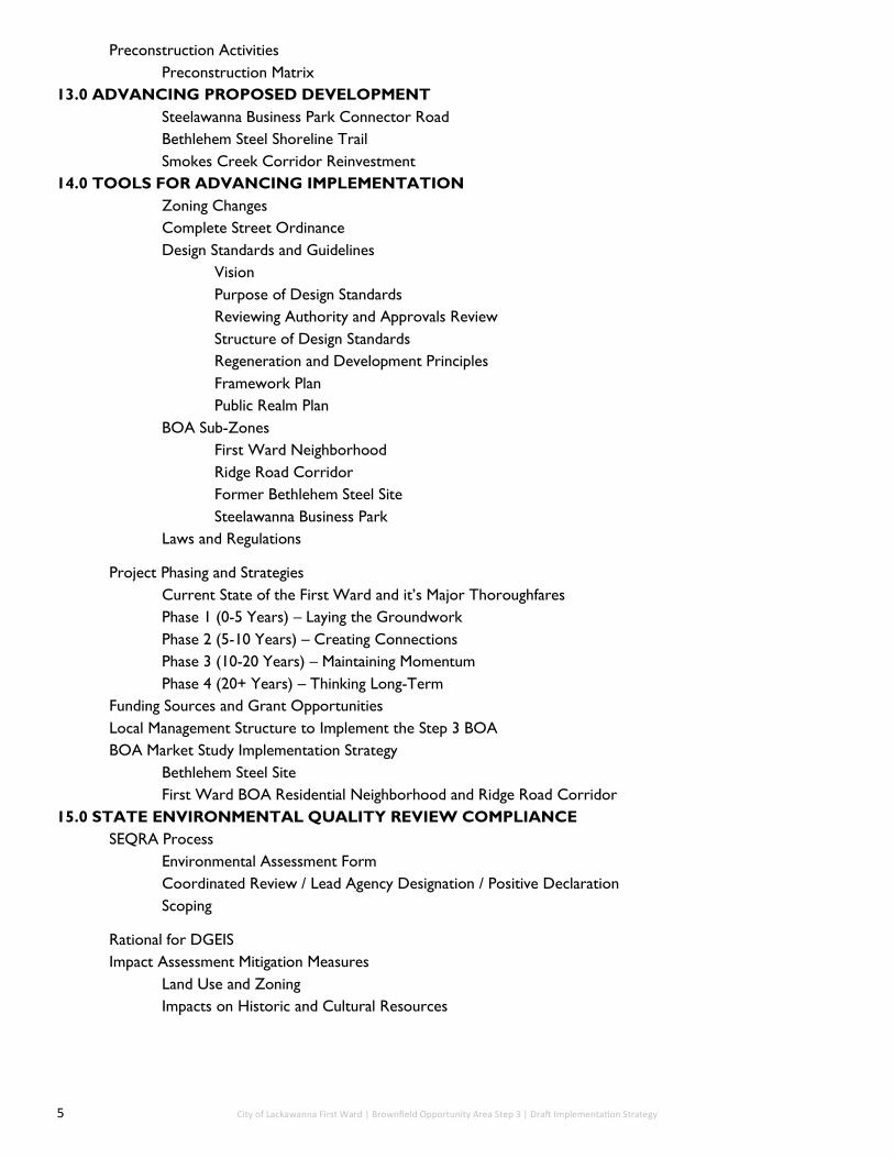
13.0 ADVANCING PROPOSED DEVELOPMENT
Steelawanna Business Park Connector Road
Bethlehem Steel Shoreline Trail
Smokes Creek Corridor Reinvestment
14.0 TOOLS FOR ADVANCING IMPLEMENTATION
Zoning Changes
Complete Street Ordinance
Design Standards and Guidelines
Vision
Purpose of Design Standards
Reviewing Authority and Approvals Review
Structure of Design Standards
Regeneration and Development Principles
Framework Plan
Public Realm Plan
BOA Sub-Zones
First Ward Neighborhood
Ridge Road Corridor
Former Bethlehem Steel Site
Steelawanna Business Park
Laws and Regulations
Project Phasing and Strategies
Current State of the First Ward and it’s Major Thoroughfares
Phase 1 (0-5 Years) – Laying the Groundwork
Phase 2 (5-10 Years) – Creating Connections
Phase 3 (10-20 Years) – Maintaining Momentum
Phase 4 (20+ Years) – Thinking Long-Term
Funding Sources and Grant Opportunities
Local Management Structure to Implement the Step 3 BOA
BOA Market Study Implementation Strategy
Bethlehem Steel Site
First Ward BOA Residential Neighborhood and Ridge Road Corridor
15.0 STATE ENVIRONMENTAL QUALITY REVIEW COMPLIANCE
SEQRA Process
Environmental Assessment Form
Coordinated Review / Lead Agency Designation / Positive Declaration
Scoping
Rational for DGEIS
Impact Assessment Mitigation Measures
Land Use and Zoning
Impacts on Historic and Cultural Resources

6 C&S Engineers | Joy Keubler Landscape Architects | Sasaki, AKRF, Inc.| Data Validation Services | Nature’s Way Environmental | Paradigm Environmental Services | Panamerican Consultants
Impacts on Transportation
Impacts
Mitigation Measurse
Thresholds
Visual and Aesthetic Impacts
Impacts
Mitigation Measures
Thresholds
Contamination and Hazardous Materials Impacts
Impacts
Mitigation Measures
Thresholds
Temporary and Short-Term Impacts
Stormwater
Nosie
Odors
Cumulative Impacts
Unavoidable Adverse Environmental Impacts
Irreversible and Irretrievable Commitment of Resources
16.0 ALTERNATIVES ANALYSIS
Reasonable Alternative Redevelopment Scenario
No-Action Alternative
Consistency with NYS Policies and Strategy Compliance
DGEIS References and Underlying Studies
Look for boxes representing
Key Takeaways

7 C&S Engineers | Joy Keubler Landscape Architects | Sasaki, AKRF, Inc.| Data Validation Services | Nature’s Way Environmental | Paradigm Environmental Services | Panamerican Consultants
List of Figures Figure 2.1: Brownfield Opportunity Area Steps
Figure 3.1: First Ward BOA Boundary
Figure 3.2: Erie County, New York—with municipalities
Figure 3.3: City of Lackawanna with surrounding Cities and Towns
Figure 3.4: City of Lackawanna with First Ward BOA and major transportation routes
Figure 3.5: First Ward BOA and surrounding previous BOA’s
Figure 3.6: Second Baptist Church within the First Ward BOA
Figure 3.7: Commercial Buildings along Ridge Road
Figure 3.8: Land use for the City of Lackawanna
Figure 3.9: Land Use for the First Ward BOA
Figure 3.10: Zoning for the First Ward BOA
Figure 3.11: Special Zoning Overlay Districts within the First Ward BOA
Figure 3.12: Archeological Sensitive Areas within the First Ward BOA
Figure 3.13: City of Lackawanna Public Library
Figure 3.14: Our Lady of Victory Basilica located in Lackawanna
Figure 3.15: Lackawanna Firefighters and Historical Preservation
Museum
Figure 3.16: Buffalo and Erie County Botanical Gardens
Figure 3.17: Wind Mills on the shoreline of Lake Erie within the
Bethlehem Redevelopment Area
Figure 3.18: Flood Zones, Wetland Inventory, Contours and Water Bodies
within the First Ward BOA
Figure 3.19: “Jalapeno Lake” located within the First Ward BOA and
Bethlehem Redevelopment Area
Figure 3.20: Parks and Open Space within the First Ward BOA
Figure 3.21: What remains after the 2016 fire at Industrial Materials
Recycling facility
Figure 3.22: St. Mark AME Zion Church located on Dona Street
Figure 3.23: Property Ownership within the First Ward BOA
Figure 3.24: Vacant Industrial Facility located within the Bethlehem
Redevelopment Area
Figure 4.1: City of Lackawanna Public Notice for BOA Implementation Meeting
Figure 4.2: Site Visioning Tours throughout the BOA
Figure 4.3: Site Visioning Tours throughout the BOA
Figure 4.4: Revive Ridge Bash Event Poster
Figure 4.5: Vendors at the Revive Ridge Bash
Figure 4.6: Community Member at Arts on the Ridge
Figure 4.7: Project Team, Steering Committee and Community members on Site Visioning Tours within the BOA
Figure 5.1: Population Change from 1970-2016 within the Western New York Region and New York State
Figure 5.2: Community members and Senator Tim Kennedy at the First Ward BOA Pop up Park
Figure 5.4: Age Percentages for the First Ward BOA Population and Surrounding Trade Areas
Figure 5.5: Homes within the First Ward Neighborhood
Figure 5.6: Our Lady of Victory School located in Lackawanna
Figure 5.7: Local businesses along Ridge Road
Figure 5.8: Destination Retail Trade Area
Figure 5.9 : Expenditure Leakage and Surplus for Destination Retail Trade
Area 2017
Figure 5.10: First Ward BOA Expenditure Leakage and Surplus for Local
Retail Goods
Figure 5.11: Eastern Lackawanna Expenditure Leakage and Surplus for
Local Retail Goods
Figure 5.12: Building located within the First Ward BRA
Figure 5.13: Industry Restructuring within the City of Buffalo, NY
Figure 5.14: Transportation routes located within the First Ward BOA
Figure 5.15: Greater Buffalo Niagara Regional Transportation Council Bicycle Level of Service Map for the City of Lackawanna
Figure 5.16: Available Public Transportation Routes within the First Ward BOA
Figure 5.17: Rail lines within the First Ward BOA
Figure 5.18: The Gateway Metroport located off Lake Erie within the first Ward BOA
Figure 5.19: Remains following the fire of 2016 on the Hamburg Turnpike
Figure 5.20: Lackawanna City Hall
Figure 6.1: Brownfield Sites, Vacant Residential Parcels and Vacant Parcels within the First Ward BOA
Figure 6.2: Photo Source: Buffalo News—Vacant Industrial Building within the First Ward BOA
Figures 8.1 Photo source: Buffalo News - Rail lines made by Lackawanna Steel Company in 1975
Figure 8.2: Community Visioning Tour near Ridge Road
Figure 8.3: Catalyst Site located at Ridge Road and Ingham Avenue
Figure 8.4: Ridge Road Bridge and Bike Lane
Figure 8.5: Vacant Commercial buildings on Ridge Road
Figure 8.6: Smokes Creek Corridor
Figure 8.7: Community Members at REVIVE Ridge Bash
Figure 8.8: Community Members on a Visioning Tour within the First Ward Neighborhood
Figure 8.9: All Reinvestment Areas within the First Ward BOA

8 City of Lackawanna First Ward | Brownfield Opportunity Area Step 3 | Draft Implementation Strategy
Figure 8.10: Parcels surrounding the Ridge Road Corridor within the First Ward BOA
Figure 8.11: Parcels surrounding the Ridge Road Corridor within the First Ward BOA
Figure 8.12: Parcels surrounding the Hamburg Turnpike Corridor within the First Ward BOA
Figure 8.13: Parcels surrounding the Hamburg Turnpike Corridor within the First Ward BOA
Figure 8.14: Parcels within and Surrounding the First Ward Neighborhood within the First Ward BOA
Figure 8.15: Parcels within and Surrounding the First Ward Neighborhood within the First Ward BOA
Figure 8.16: Parcels surrounding Smokes Creek Corridor within the First Ward BOA
Figure 8.17: Parcels surrounding Smokes Creek Corridor within the First Ward BOA
Figure 8.18: Land leading up to the Lake Erie Waterfront within the BRA
Figure 9.1: Crosswalk streetscaping example on Ridge Road
Figure 9.2: City of Lackawanna’s Marketing Campaign logo —’About FACE’
Figure 9.3: Art Installation using House hold items on Ridge Road
Figure 9.4: Community members working on the First Wards public art installation
Figure 9.5: A public art mural within the City of Buffalo
Figure 9.6: Pop up Farmer’s Market at REVIVE Ridge Bash
Figure 9.7: Bidwell Farmer’s Market in the Elmwood Village of Buffalo, NY
Figure 9.8: Shovel Ceremony for Bethlehem Steel Shoreline Trail
Figure 9.9: The building of Bethlehem Steel Shoreline Trail
Figure 9.10: Recent Gallagher Pier enhancement Project located at the Buffalo Outer Harbor
Figure 9.11: Example of underpass enhancement using mural paintings
Figure 9.12: Community members at the First Ward BOA Pop up Park Event
Figure 9.13: Community members at the First Ward BOA Pop up Park Event
Figure 9.14: Vacant parcel on within the First Ward BOA that can be used for a community field on the corner of School and Ingham Street
Figure 9.15: Potential usage for a First Ward Neighborhood soccer field
Figure 9.16: Smokes Creek Bridge
Figure 9.17: Examples of Wetlands Parks
Figure 9.18: Examples of Wetlands Parks
Figure 9.19: Creek Overlook
Figure 9.20: City Hall located on Ridge Road
Figure 9.21: Construction of the Shoreline Trail through the Bethlehem
Steel Site
Figure 9.22: Demolition of 100 Dona St. Former Friendship House
Figure 9.23: Smokes Creek
Figure 9.24: Industrial building located within the Bethlehem Redevelop-
ment Area
Figure 10.1: Twelve Strategic Sites that have potential to catalyze develop-ment within the First Ward BOA
Figure 10.2: Strategic Sites within the First Ward BOA to catalyze develop-ment
Figure 10.3: Development site characteristics for potential Ridge Road
grocery store
Figure 10.4: Ridge Road grocery store rendering
Figure 10.5: Steelawanna Avenue Business Park rendering
Figure 10.6: Development site characteristics for potential Ridge Road
community facility
Figure 10.7: Ridge Road community facility rendering
Figure 10.8: Ridge Road mixed-use building rendering
Figure 10.9: Ridge Road mixed-use building rendering
Figure 10.10: Development site characteristics for potential Albright Court
Large-Format commercial building
Figure 10.11: Albright Court large-format commercial building rendering
Figure 10.12: Albright Court large-format commercial building rendering
Figure 10.13: 100 Dona Street infill housing rendering
Figure 10.14: Alliance Drive Light Industrial and Workforce Development
Center rendering
Figure 12.1: Steelawanna Business Park Connector Road rendering
Figure 12.2: Bethlehem Steel Shoreline Trail rendering
Figure 13.1: Low Income Communities, Eligible Non-LIC and Suggested
Census Tracts for the Federal Opportunity Zone Program

9 C&S Engineers | Joy Keubler Landscape Architects | Sasaki, AKRF, Inc.| Data Validation Services | Nature’s Way Environmental | Paradigm Environmental Services | Panamerican Consultants
List of Tables Table 3.1: Zoning Types within the First Ward BOA
Table 3.2: Land Ownership by Public Authority
Table 4.1: City of Lackawanna Phase 3 BOA Steering Committee
Table 5.1: Population Trends from 2000-2016 within the First Ward
BOA and the City of Lackawanna
Table 5.2: Trade Area Median Household Income
Table 5.3: Top Industry Sectors for Employment as a Percentage of the Working Population
Table 5.4: Educational Attainment within the First Ward BOA compared to local, regional and state percentages
Table 5.5: Commuting Patterns within the First Ward BOA compared to other nearby municipalities, regional and state percentages
Table 5.6: Destination Retail Trade Area Retail Goods and Services Expenditure Gap
Table 5.7: Destination Retail Unmet Demand and Supportable Space
Table 5.8: Local Retail Trade Area Goods and Services Expenditure Gap
Table 5.9: Local Retail Trade Area Unmet Demand and Supportable Space
Table 5.10: Churches within the First Ward BOA
Table 5.11: NRPA Standards and Recommendations for the First Ward BOA
Table 5.12: Buffalo-Niagara MSA Location Quotient for Industrial Sub
Sector (2017)
Table 5.13 Total Employment by Industrial Sub Sector (2001 and 2010)
Table 5.14: Total Employment by Industrial Sub Sector (2010 and 2017)
Table 5.15: Growth Sector Employment Projections (2015 to 2022)
Table 5.16: Level of Service Criteria
Table 5.17: Traffic Counts for the First Ward BOA
Table 6.1: Summaries of environmental site assessments
Table 7.1: Developments following the First Ward Step 2 Nomination
Table 10.1: Strategic Sites within the First Ward BOA to catalyze development
Table 11.1: Construction ready projects and activities
Table 13.1: Acreage for buildout and zoning of properties for Phase 2
Table 13.2: Acreage buildout and zoning for properties in Phase 3
Table 13.3: Funding and grant opportunities

10 C&S Engineers | Joy Keubler Landscape Architects | Sasaki, AKRF, Inc.| Data Validation Services | Nature’s Way Environmental | Paradigm Environmental Services | Panamerican Consultants
1.0 Executive Summary
This executive summary outlines the key issues, opportunities and challenges
defining an overall vision for the City of Lackawanna’s First Ward Opportunity Area
(BOA) and the recommendations for Implementation to achieve the vision. This
document is the third step in the New York State Brownfield Opportunity Area
(BOA) program and is focused on implementation. Key takeaways are provided
from the following topics that are further described in greater detail later in this
document:
Overview of the City of Lackawanna First Ward BOA
Background and Setting
Community Participation and Engagement
Economic Context
Development Following Step 2
Vision
Reinvestment Areas
Implementation Strategies
Strategic Sites
Implementation Projects and Locations
Tools for Advancing Implementation
Project Phasing
State Environmental Quality Review (SEQR) Compliance

11 C&S Engineers | Joy Keubler Landscape Architects | Sasaki, AKRF, Inc.| Data Validation Services | Nature’s Way Environmental | Paradigm Environmental Services | Panamerican Consultants
City of Lackawanna First Ward BOA The City of Lackawanna is located in Erie County, New York and is situated directly south of the
City of Buffalo and just north of the Town of Hamburg and the Town of Orchard Park. The City
of Lackawanna First Ward Study Area is approximately 2,062 acres. The area is comprised of
the western portion of the City of Lackawanna and generally follows the perimeter of the First
Ward neighborhood. The Project boundaries include the Lake Erie shoreline to the west, City
of Buffalo to the north, Center Street to the east, and the Town of Hamburg to the south. The
majority of the BOA study area includes what was formerly known as the Bethlehem Steel
property, owned by both public and private entities.
Due to the recent restructuring of the economy after the Bethlehem Steel plant closure, there
had been large tracts of land left behind. The sites where the former steel plant was located as
well as other large parcels dispersed throughout the First Ward are now labeled as brownfields
and underutilized sites. Fortunately, many of these sites are located in an area of rich
resources such as the Lake Erie shoreline, existing rail lines and several highway thoroughfares
with high amounts of traffic by local citizens as well as commuters to and from the City of
Buffalo.
This report has been prepared in accordance to the guidelines established by the New York
State Department of State (DOS) and the New York State Department of Environmental
Conservation (DEC) for the Implementation Study of the Brownfield Opportunity Area Program
in the City of Lackawanna. This BOA is located in the First Ward neighborhood of Lackawanna,
New York. The purpose of this study is to provide municipalities, across New York State, the
opportunity and resources to revitalize their economies and produce implementation
strategies necessary to cultivate a vision for community redevelopment. This Implementation
Strategy is the final step in a three tiered process to produce a community driven plan for
revitalization of underutilized land.
The conduction of the Step 2 Nomination Study for the First Ward BOA led to five target
reinvestment areas. The purpose of each reinvestment area is to create a diverse mixture of
land uses with complementary features. In addition, the reinvestment areas are designed to be
illustrative and not intended to create districts with hard edges.
Ridge Road Main Street
Steelawanna Business Park
Hamburg Turnpike Employment Corridor
First Ward Neighborhood
Smokes Creek Business Park and Re-naturalized Corridor
After moving forward with Step 3, Steelawanna Business Park was removed now bringing it to
four reinvestment areas total.
In this study, the redevelopment opportunity of specific sites within the Reinvestment Areas
will be determined and the methodology to enable increased development within the City will
be explored and presented. This study is expected to be conducted and completed through
December 2018.
Step 2 Nomination

12 C&S Engineers | Joy Keubler Landscape Architects | Sasaki, AKRF, Inc.| Data Validation Services | Nature’s Way Environmental | Paradigm Environmental Services | Panamerican Consultants
Background and Setting
The Study Area is comprised of the western portion of the City of Lackawanna and generally
follows the perimeter of the First Ward neighborhood. The majority of the BOA Study Area
includes what was formerly known as the Bethlehem Steel property which plays a major part in
deciding future uses of the area, zoning and economic opportunities.
The First Ward BOA is unique because of the large tract of land dedicated to industrial use on the
western portion of the site; however most of this land (referred to as the former Bethlehem Steel
site) is vacant and underutilized. The primary land use within the total First Ward BOA is vacant
land, which occupies 37.2 percent of the just over 2,000 acres.
There is a mix of zoning uses within the BOA including single family residential, mixed residential,
central business district, neighborhood commercial, regional commercial, industrial, open space,
and the Bethlehem Redevelopment Area (BRA). Zoning west of Route 5 has since been updated
since June of 2018 to be Light Industrial, Medium Industrial, Heavy Industrial, Intermodal Port and
Green Space. Retail along the waterfront will no longer be zoned as such due to providing
amenities closer to residential and commercial districts east of the Hamburg Turnpike to allow
both accessibility for community members.
The First Ward BOA also lies directly south of the three previously analyzed BOA projects in the
City of Buffalo; the Buffalo Harbor BOA, the Buffalo River Corridor BOA, and the South Buffalo BOA
which sets up the City of Lackawanna to work in tandem to continue revitalization of the Buffalo-
Niagara region.
There are no listings within the First Ward BOA on the National Register of Historic Places (NHRP).
The Buffalo Harbor South Entrance Light is listed on the NHRP but lies outside of the northern
border of the First Ward BOA.
One of the most important natural resources in the First Ward BOA is its adjacency to Lake Erie.
Lake Erie is a major component of the Great Lakes system and carries immense potential in terms
of navigation, commerce, and trade among the United States and Canada. In addition, the First
Ward BOA contains Smokes Creek running directly through the southern park of the Study Area
and discharging into Lake Erie. Smokes Creek is part of a large environmental ecosystem that has
been disturbed by both clearing and new development in the past.
13 C&S Engineers | Joy Keubler Landscape Architects | Sasaki, AKRF, Inc.| Data Validation Services | Nature’s Way Environmental | Paradigm Environmental Services | Panamerican Consultants
The Project Team utilized a “Place-making Methodology” as the primary method for
engagement to obtain creative ideas, build and strengthen relationships and inspire
imagination for the City of Lackawanna. This was accomplished through:
Traditional Public Meetings
Steering Committee Meetings
Site Analysis and Visioning Tours
Small Community Conversations
Marketing and Branding Efforts
Two public meetings were coordinated and led; one at the onset and one at the close of
the BOA process.
At the onset of the BOA, a Steering Committee was established and was comprised of
local and state agencies, local business owners, citizens, and community organizations.
The Steering Committee played a vital role and worked very closely and collaboratively
with the Project Team. The two groups met on a regular basis for review and feedback
throughout the development of the BOA Plan.
Place-making techniques were integrated into various site visioning tours throughout the
BOA process in order to engage the community in a more natural and conversational
method. Site analysis and visioning tours involved a ‘boots on the ground’ approach to
engage the public and Steering Committee. Three site analysis and visioning tours
occurred in 2015 and 2016 within the proposed Reinvestment Areas.
Additional outreach efforts with City residents included “meeting the public” where they
are, which involved the Project Team spending time in places where residents spend their
everyday lives, rather than inviting residents to take time out of busy schedules.
There were a number of key engagements specifically during Step 3 that helped shape and
enhance the Implementation Plan:
June 6, 2018: Steering Committee Meeting
October 3, 2018: Developer Forum
November 7, 2018: Final Steering Committee Meeting
November 13, 2018: Public Meeting / Community Presentation and SEQR Hearing
Process
Community Participation and Engagement
Economic Context The viability and feasibility of the First Ward BOA Redevelopment Plan will ultimately
depend on the market conditions and demands in the local and regional area. Therefore,
it is necessary to evaluate the First Ward BOA and surrounding region to determine the
economic context to assess the First Ward BOA’s economic development potential. Based
on traffic volume, community perception, and strategic location, there are two major
corridors in the BOA that, if redeveloped strategically, could catalyze the revitalization of
the entire BOA area. The two significant corridors for the Market Study later in this
document are Hamburg Turnpike and Ridge Road.

14 C&S Engineers | Joy Keubler Landscape Architects | Sasaki, AKRF, Inc.| Data Validation Services | Nature’s Way Environmental | Paradigm Environmental Services | Panamerican Consultants
Several developments have taken place since the Step 2 Nomination Document completion
in 2012. Many of these developments were directly stated as improvements to be made
within the BOA or are aligned with the general recommendations in Step 2:
Secured funding for the Dona Street extension
10 North Gates warehouse expansion approved by City Planning board
Completed Demolition of 100 Dona Street former Lincoln School
Purchase of Bethlehem Steel Property by Erie County
Completed Design of potential Net Zero Energy building to be put on the BRA
Construction started on the Bethlehem Steel Shoreline Trail
Completion of 32-unit apartment complex—Ridgeway Commons
Grand opening on new Family Dollar located on Ridge Road
Complete installation of Steel Sun Solar Panels
Approved site plans for two parcels on Wasson Ave and Ridge Road to be turned into a
new gas station
Development following Step 2 BOA Nomination
15 C&S Engineers | Joy Keubler Landscape Architects | Sasaki, AKRF, Inc.| Data Validation Services | Nature’s Way Environmental | Paradigm Environmental Services | Panamerican Consultants
Vision and Design Framework
“Through the efforts of community members, stakeholders and City leadership, the First
Ward BOA will be transformed into a desirable destination centered on the
redevelopment of vacant and underutilized properties along the major thoroughfares of
Ridge Road and Hamburg Turnpike since they are of high visibility and easily accessible.
Development will work to attract retail business and light industrial manufacturing to
create additional job opportunities and tax revenue. The First Ward BOA will also work
to improve the residential neighborhood’s housing stock, streets, and community
amenities as well as implement plans to increase access to the natural resources of
Smokes Creek and Lake Erie. “
Promotion of Economic Development
Improvement of Transportation Networks
Enhance Connections to Natural Resources and Recreational Amenities
Boost Community and Neighborhood Amenities
Encourage mix of uses and establish increased density of major thoroughfares
Utilize heavy commuter traffic to increase retail opportunities
Streetscaping improvements to enhance walkability and the pedestrian
experience
Create an attractive gateway into the City
Work on connections with between Wards and day to day needs
Utilize Smokes Creek as a recreational connection to Lake Erie
Provide learning opportunities in tandem with the environmental and industrial
history of the area
Increase open space in Neighborhoods
Ridge Road transformation into a “Main Street” that includes Farmer’s Markets,
music festivals and art events
Establish a new community center that is accessible for all
Continue improving housing stock

16 C&S Engineers | Joy Keubler Landscape Architects | Sasaki, AKRF, Inc.| Data Validation Services | Nature’s Way Environmental | Paradigm Environmental Services | Panamerican Consultants
Reinvestment Areas and Key Focuses
Smokes Creek Corridor: Habitat restoration, creek remediation and new active /
passive recreation
First Ward Neighborhood: Increase housing stock as well as new recreation sites
Hamburg Turnpike Corridor: Additional retail and landscape updates as well as
new industrial development
Ridge Road Corridor: Implementation of retail and commercial outlets as well as
creating neighborhood connections
Implementation Strategies Through extensive collaboration with the community, steering committee, state and
local agencies, a Master Redevelopment Plan was created to synthesize the
opportunities of the First Ward BOA and spur renewed investment within the City of
Lackawanna. The Master Redevelopment Plan is comprised of a Conceptual Land
Use Plan, which describes the intended future land uses within the First Ward BOA,
the identification of specific redevelopment projects within the First Ward BOA, as
well as specific redevelopment strategies that will assist and compliment strategic
sites and the overall vision.
The First Ward BOA Master Redevelopment Plan not only outlines suggested uses
for all strategic sites but also lays out a program for the Bethlehem Redevelopment
Area. The Bethlehem Redevelopment Area, mentioned previously within this
document is an extremely large amount of land and thus has been separated into
zones with different uses based on market analysis. Zoning changes on the
property as distance from the Hamburg Turnpike increases.
The Conceptual Land Use Plan is intended to guide the City’s physical development
for the next 20 to 30 years and is a conceptual representation of the ultimate build-
out of the First Ward BOA on a block-by-block basis. The proposed future land uses
for the First Ward BOA were generated based on the recommendations presented
in the Step 2 Nomination Document, multiple conversations between the steering
committee and community, site visits and assessments throughout the study, as
well as the prepared economic and market demand analysis. This information was
synthesized together to generate a comprehensive land use plan for the First Ward
BOA to showcase the highest and best uses for each area.

17 C&S Engineers | Joy Keubler Landscape Architects | Sasaki, AKRF, Inc.| Data Validation Services | Nature’s Way Environmental | Paradigm Environmental Services | Panamerican Consultants
Master Plan Strategies
Ridge Road Corridor—New local serving retail, community services, and
promotion of an pedestrian friendly environment
Smokes Creek Corridor—Creek restoration, wetland planting, new
neighborhood connections to natural resources
Commercial and Community Nodes—offer retail and services for
neighborhoods, nodes are well connected by road network, accessible within
10 minutes walking from Strategic Sites
Road Network—Assist in bridging divide between east and west sections of the
city and improve major intersections
New and continued Bicycling and Recreational Paths
Strategic Sites
1. 150-170 Ridge Road
2. 0 N. Steelawanna Avenue
3. 264 Ridge Road
4. 229-231 Ridge Road
5. 303-305 Ridge Road
6. 333-335 Ridge Road
7. 469-477 Ridge Road
8. 0 Gates Avenue
9. 2290 Hamburg Turnpike
10. 2380-2502 Hamburg Turnpike
11. 100 Dona St
12. 0 Alliance Drive
Redevelopment of the strategic sites are expected to spur economic growth and
catalyze future development. A comparative analysis of redevelopment of the
highest priority strategic sites within the First Ward BOA has been conducted. Sites
analyzed with a cost-benefit scenario later in this document are expected to create
the most catalytic economic benefits within the First Ward BOA. Based on the
future land use plan and information available, specific future development uses
for each strategic site has been identified and is explained in the subsequent
sections.

18 C&S Engineers | Joy Keubler Landscape Architects | Sasaki, AKRF, Inc.| Data Validation Services | Nature’s Way Environmental | Paradigm Environmental Services | Panamerican Consultants
Implementation Projects and Locations
Potential Redevelopment Projects Transportation Improvement Projects
Public Improvement Projects Environmental Improvement Projects
1. Steelawanna Business Park – 0 N. Steelawanna
Avenue
2. Local Supermarket – 150-170 Ridge Road
3. Recreational Fields – Mill Street Property
4. Big Box Retail – Albright Court Property
5. Housing Redevelopment – 100 Dona Street
6. Light Industrial/Workforce Development Center –
Alliance Drive
7. Local Brewery – 469-477 Ridge Road
8. Small Scale Retail - 303-305 Ridge Road
9. Mixed-Use Commercial/Residential – 229-231
Ridge Road
1. Ridge Road Corridor Streetscape Enhance-
ments (lane reduction/crosswalks)
2. Ridge Road Bridge Reconstruction
3. Lakeside Commerce Park Connector Road
4. Dona Street Extension
5. Hamburg Turnpike Streetscape Enhancements
6. Enhanced Gateway into the City
7. Ridge Road/Hamburg Turnpike Underpass
8. Pedestrian Bridge Restoration
1. Ridge Road Mixed-Use Community Center –
264 Ridge Road
2. Bethlehem Steel Shoreline Trail/Shoreline
Trailhead Enhancement
3. First Ward Pocket Park/Greenway Connections
4. First Ward Soccer Recreational Space
5. Demolition of Hazardous Structures
6. Smokes Creek Multi-Use Trail
7. Smokes Creek Overlook
1. Smokes Creek Reclamation Park
2. Smokes Creek Restoration
3. Remediation of Former Bethlehem Steel Site
4. Open Space Network in Bethlehem Steel Site
A number of Implementation Projects have been developed for after the submission of the Step 3
BOA Document. The purpose of the Step 3 Document is to provide the City of Lackawanna with
projects that will aid in sustainable development while also contributing to a sense of place and
emphasize community development.

19 C&S Engineers | Joy Keubler Landscape Architects | Sasaki, AKRF, Inc.| Data Validation Services | Nature’s Way Environmental | Paradigm Environmental Services | Panamerican Consultants
Tools for Advancing Implementation Zoning Changes
Complete Street Ordinance
Design Standards and Guidelines
Laws and Regulations
Any new zoning changes the City of Lackawanna makes to advance implementation and develop
new projects within the BOA First Ward community should be consistent with the goals
presented in the updated city Comprehensive Plan from 2016. The City of Lackawanna updated
their Plan extensively which included a layout of multiple policies and goals for growth and
strengthening the community as a whole. Zoning changes allow for new growth and a variety of
mixed uses.
Buffalo’s Complete Streets movement began in 2008. Through the creation of a coalition and
engaging partners from multiple sectors within the area, milestones have been reached and
Buffalo’s streets are becoming safer for all modes of transportation. As part of Lackawanna’s
Comprehensive Plan update in 2016 there were several goals relating to complete streets
encouraging safe pedestrian and bicycle circulation as well as having a positive impact on the
Aesthetic Resources within the City. Lackawanna becoming a more pedestrian conscious area
with Complete Streets aids in a regional transformation and allows the municipality to act as a
bridge connecting the City of Buffalo to the South Towns.
Design Standards describe intended physical outcomes for Lackawanna’s First Ward BOA. As
such, they provide prescriptions and recommendations for achieving the vision for the BOA
nomination study area. Public entities shall use the Design Standards as a guideline, and will
endeavor to adhere to both their spirit and their specific content wherever feasible within the
context of strategic and operational considerations. The Design Standards and Guidelines are
laid out later within this document.
The City of Lackawanna has a number of established public regulations as well as actively
practices code enforcement to ensure preservation and help improve the quality of life and
safety for all within the community. Code enforcement plays an important role in home
maintenance as well as zoning. The City of Lackawanna’s code enforcement also serves the
Building Department which has major impacts on new construction, demolition and storm
water / floodplain regulations.

20 C&S Engineers | Joy Keubler Landscape Architects | Sasaki, AKRF, Inc.| Data Validation Services | Nature’s Way Environmental | Paradigm Environmental Services | Panamerican Consultants
Project Phasing and Strategies Having a phasing timeline for redevelopment throughout the City of Lackawanna is a
helpful tool to stay on track and implement new major projects or improvements at
an appropriate speed. After the closing of Bethlehem Steel and the vacancies that
resulted in it, certain parts of the City of Lackawanna - especially the First Ward, had
to move forward without a redevelopment plan.
The proposed phasing outlines a 20+ year plan starting with small development first
and eventually leading to sustainable, equitable development projects for all
involved. Leveraging Lackawanna’s industrial potential with high level of commuters
as well as improving the First Ward Neighborhood both have quick wins and long
term goals that may happen before or after suggest phasing. The strategy provided
has four phases:
Phase 1 (year 0-5) - Laying the groundwork
Phase 2 (year 5-10) - Creating connections
Phase 3 (year 10-20) - Maintaining momentum
Phase 4 (20+ years) - Thinking long-term

21 C&S Engineers | Joy Keubler Landscape Architects | Sasaki, AKRF, Inc.| Data Validation Services | Nature’s Way Environmental | Paradigm Environmental Services | Panamerican Consultants
State Environmental Quality Review Compliance In accordance with the BOA Program and the City of Lackawanna First Ward Step 3
Implementation Strategy, a Draft Generic Environmental Impact Statement (DGEIS) is to be
incorporated into the body of the BOA plan so that it comprises one unified document. This
section provides a description of how the requirements of the State Environmental Quality
Review Act (SEQR) have been met, and identifies any conditions or mitigations required for future
actions and when subsequent SEQR compliance is necessary. The adoption and implementation
of this BOA plan constitutes the “action” subject to SEQR.
The environmental assessment herein has been prepared in accordance with 6 NYCRR 617.10
(Generic Environmental Impact Statements), and as such, will present a more general set of
existing conditions and analyses than a conventional or project specific Draft EIS. The analyses are
based on conceptual plans and available information. Where no detail is available, qualitative
estimations of impacts are provided, and where appropriate analyses are identified that should
be required when future individual projects are proposed.
Certain elements in other sections of the BOA meet minimum DGEIS requirements (See Table
14.1). This section relies heavily on the inventory and analysis prepared in Step 2 Nomination
Study and is supplemented by information obtained during the preparation of the Step 3
Implementation Strategy. The general framework of this section provides content requirements in
the below table:
DGEIS Topic Document Section(s) or Map Page(s)
Description of Project (Action)
Step 2 Nomination Study
Step 3 Implementation Strategy
Step 2:
Section 2.0—Project Description and Boundary
Step 3: Section 9-Implementation Strategies, Sec-tion 10.0-Stategic Sites, Section 11.0-Implementation Projects, Section 12.0-Advancing Proposed Redevelopment, Section 13.0– Tools for Advancing Implementation
115-158
159-185
186-190
191-194
195-235
SEQRA Public Hearing Step 3 Implementation Strategy Section 14.0-Scoping 236-245
Description of Environmental Setting
Step 2 Nomination Study
Step 3 Implementation Strategy
Step 2: Section 4.0-Analysis of the Brownfield Op-portunity Area, Figure 3A through Figure 11
Step 3: Section 3.0-Environmental Setting
18-36
Impact Assessment/Mitigation Measures/Thresholds
Step 3 Implementation Strategy Section 14.0-Impact Assessment and Mitigation Measures
236-245
Alternatives to the Proposed Action
Step 3 Implementation Strategy Section 15.0-Alternatives Analysis 246-248
Consistency with NYS CMP Coastal Policies/NY Heritage Area
Step 3 Implementation Strategy Section 15.0-Consistency with NYS Policies and Strategy Compliance
246-248
Coordinated Review / Lead Agency Designation / Positive Declaration
In the Step 2 Nomination Document, the City of Lackawanna Common Council was designated as
SEQRA Lead Agency, receiving no objections from involved agencies included in the Coordinated
Review. The City then determined that a DGEIS would be prepared. A notice for a public scoping
comment period was distributed to involved agencies, published in the Environmental Notice
Bulletin (ENB) and at City Hall and the City of Lackawanna Library.

22 C&S Engineers | Joy Keubler Landscape Architects | Sasaki, AKRF, Inc.| Data Validation Services | Nature’s Way Environmental | Paradigm Environmental Services | Panamerican Consultants
Land Use and Zoning
Historic and Cultural Resources
Transportation
Minor changes to existing land use patterns due to the majority of the First
Ward containing past development
Existing land use pattern will contain a mix of uses including commercial,
residential and industrial
Proposed uses are consistent with the Comprehensive Plan
A Phase IA Cultural Resources Investigation was conducted for the entire First
Ward BOA which provides an in-depth settlement and history of the BOA and
City of Lackawanna
Five archeological sites were identified within or immediately adjacent to the
First Ward BOA. None of these sites have been determined eligible for listing on
the NHRP, due to previous disturbance of the area
A TIS was conducted for the proposed developments as part of the First Ward
BOA Plan. The study indicates that existing traffic volumes on Route 5 and Ridge
Road are approaching the capacity of the existing transportation infrastructure
There is insufficient reserve capacity to be able to accommodate the traffic
anticipated to be generated by the projected development
Visual and Aesthetic
Implementation of the BOA Plan may result in significant changes in the visible
landscape. These changes are expected to be positive since many of the
redevelopment recommendation convert underutilized, abandoned and vacant
land into new and productive uses
Proposed redevelopment has been developed to maintain the existing
streetscape and urban characteristics of the relative reinvestment area. Specific
guidelines and standards have been created to guide future development to
conform to existing landscape and ensure quality
Contamination and Hazardous Materials
There is both known and suspected contamination within the First Ward BOA.
There are potential impacts resulting from the proximity to or disturbance of
known existing contaminated sites
Level of remediation completed on sites is dictated by the redevelopment use
Temporary and short-term impacts include potential stormwater run off, noise, and odors

23 City of Lackawanna First Ward | Brownfield Opportunity Area Step 3 | Draft Implementation Strategy
2.0 Introduction

24 C&S Engineers | Joy Keubler Landscape Architects | Sasaki, AKRF, Inc.| Data Validation Services | Nature’s Way Environmental | Paradigm Environmental Services | Panamerican Consultants
2.0 Introduction The City of Lackawanna has a rich industrial history and is comprised of passionate residents,
stakeholders and business owners who are driven to not only see areas of opportunity grow but the
community succeed as a whole. For this to happen, Lackawanna’s First Ward is in need of and ready for
intensive work and redevelopment. This will not only serve those who already reside in the area but also
bring in new community members, businesses and activity that will positively contribute to a renewed
sense of place as well as economic and social well-being.
In order to create sustainable redevelopment that will have a substantial impact, recommendations must
be pragmatic and have an abundance of local support. As the City of Buffalo is experiencing a
renaissance, excitement within the region is spreading and, due to it’s proximity, there is potential for
the City of Lackawanna to feed off and then contribute to Buffalo’s growth. Proposed strategic sites and
design plans were made possible by community involvement, steering committee guidance and public
meetings.
As the City of Lackawanna and the First Ward wrestle with the difficulties of Bethlehem Steel no longer
being an active, economic contributor to the area, it is critically important to work with State and Federal
governments to allow access to technical assistance, grant funding and financing to redevelop chosen
strategic sites in order to positively influence the First Ward on the most eastern portion of the City.
This document outlines the City of Lackawanna’s steps and efforts leading up to Step 3 of the Brownfield
Opportunity Area (BOA) Program facilitated by New York State Department of State. Following an
overview of history, environmental conditions and social participation - implementation concepts,
framework, guidelines and strategies are presented to move the City of Lackawanna progressively
forward in terms of continued sustainable development within the First Ward. Development within the
First Ward will enhance and focus on connections to the remainder of Lackawanna.
This Implementation Strategy will provide a thorough description of existing conditions of the City,
identify new development opportunities and also re-use potential for properties located in the First
Ward BOA. The purpose of this step in the BOA process is to strategically plan the actions necessary to
achieve the successful redevelopment of the high-priority sites and, consequently, the City as a whole.
These actions are based off of the previous studies in the Pre-Nomination and Nomination Brownfield
Opportunity Area Phases. Furthermore, final recommendations are provided to encourage both public
and private investment as well as improve environmental quality throughout the
Study Area and the region. It also necessary to conduct site assessments of particular areas in order to
evaluate the environmental condition of the site as well as determine remedial measures necessary for
redevelopment for all projects to become possible.

25 City of Lackawanna First Ward | Brownfield Opportunity Area Step 3 | Draft Implementation Strategy
3.0 Background

26 C&S Engineers | Joy Keubler Landscape Architects | Sasaki, AKRF, Inc.| Data Validation Services | Nature’s Way Environmental | Paradigm Environmental Services | Panamerican Consultants
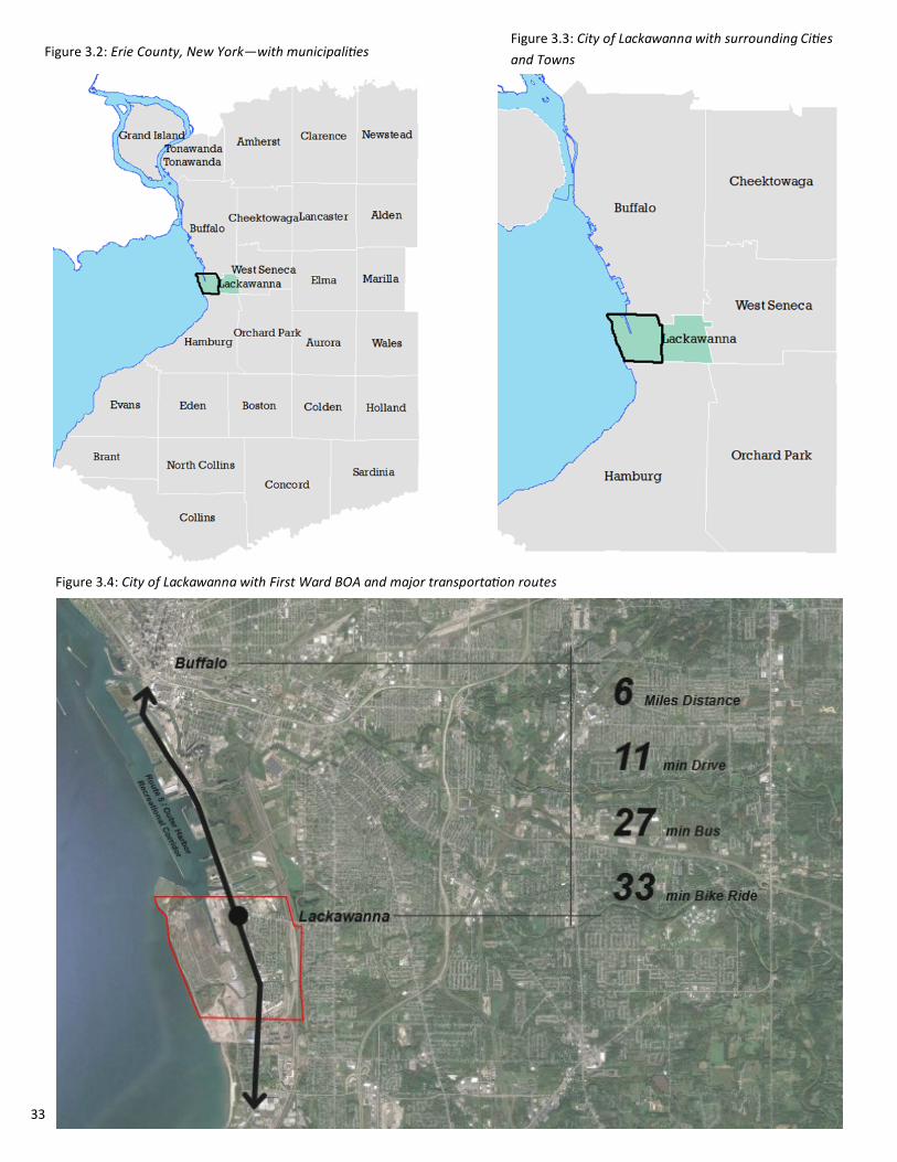
3.0 Background The City of Lackawanna is located in Erie County, New York and is situated directly south of the City
of Buffalo and just north of the Towns of Hamburg and Orchard Park. The City of Lackawanna First
Ward Study Area (Study Area) is approximately 2,062 acres. The area is comprised of the western
portion of the City of Lackawanna and generally follows the perimeter of the First Ward
neighborhood. The Project boundaries include the Lake Erie shoreline to the west, City of Buffalo to
the north, Center Street to the east, and the Town of Hamburg to the south. The majority of the
BOA Study Area includes what was formerly known as the Bethlehem Steel property which plays a
major part in deciding future uses of the area, zoning and economic opportunities.
The City of Lackawanna was at it’s height of steel manufacturing throughout the majority of the
20th century. Lackawanna Steel Company, later known as Bethlehem Steel Company, was once
America’s second largest steel producer. The steel plant closed in 1982.
Due to the recent restructuring of the economy after the steel plant closure, there had been large
tracts of land left behind. The sites where the former steel plant was located as well as other large
parcels dispersed throughout the First Ward are now labeled as brownfields and underutilized sites.
Fortunately, many of these sites are located in an area of rich resources such as the Lake Erie
shoreline, existing rail lines and several highway thoroughfares with high amounts of traffic by local
citizens as well as commuters to and from the City of Buffalo. The abundance of resources in near
proximity to the brownfield sites provides several opportunities for redevelopment and overall
revitalization of the community as a whole.
The First Ward BOA also lies directly south of the three previously analyzed BOA projects in the City
of Buffalo; the Buffalo Harbor BOA, the Buffalo River Corridor BOA and the South Buffalo BOA. The
First Ward BOA carries the potential to build off of these redevelopment strategies and efforts in
order to spur revitalization within the City of Lackawanna that will be beneficial to all. The boundary
of the First Ward BOA is outlined in Figure 3.1
This report has been prepared in accordance to the guidelines established by the New York State
Department of State (DOS) and the New York State Department of Environmental Conservation
(DEC) for the Implementation Study of the Brownfield Opportunity Area Program in the City of
Lackawanna. The purpose of the New York State Brownfield Opportunity Areas Program is to
provide municipalities, across New York State, the opportunity and resources to revitalize their
economies and produce implementation strategies necessary to cultivate a vision for community
redevelopment. This Implementation Strategy is the final step in a three tiered process to produce
a community driven plan for revitalization of underutilized land.

27 City of Lackawanna First Ward | Brownfield Opportunity Area Step 3 | Draft Implementation Strategy
Brownfield Opportunity Area Steps Step 1: Pre-Nomination - The first step in the BOA program is referred to as the Pre-Nomination
Study, which involves the gathering and collection of data pertinent to inventory of the area as a
whole, as well as the selection of a particular area in need of remediation and redevelopment. This
study provides a preliminary analysis of city characteristics such as land use, zoning, natural
resources, and identification of vacant and underutilized sites. Furthermore, the Pre-Nomination
Document uses this analysis to form the pilot recommendations for BOA revitalization. The
Lackawanna First Ward BOA entered Step 2 of the program after a large amount of planning and
inventory completed by this phase of the process.
Step 2: Nomination - The second step of the BOA program is the Nomination Document. In this step it
is appropriate to obtain more detailed information about the First Ward BOA, which is utilized to
focus more intently on economic and market trends. It is also necessary to develop and further the
visioning process to the community’s desires for successful redevelopment. This phase recognizes
specific sites and recommendations for revitalization and proposed implementation strategies. This
phase of the program was completed in February 2012.
Step 3: Implementation Strategy - The final step of the program is referred to as the Implementation
Strategy and/or Site Assessments. The purpose of this step in the procedure is to strategically plan
the actions necessary to achieve the successful redevelopment of the high-priority sites and the City
as a whole. Furthermore, the recommendations that are proposed are guided to encourage public
investment and improve environmental quality throughout the study area and the region.
Figure 2.1: Brownfield Opportunity Area Steps

28 C&S Engineers | Joy Keubler Landscape Architects | Sasaki, AKRF, Inc.| Data Validation Services | Nature’s Way Environmental | Paradigm Environmental Services | Panamerican Consultants
BOA Step 2 Nomination Study Findings
The Step 2 Nomination Study for the First Ward BOA led to five target reinvestment areas. These areas
have been defined based on their current and future land uses. The purpose of each reinvestment
area is to create a diverse mixture of land uses with complementary features. In addition, the
reinvestment areas are designed to be illustrative and not intended to create districts with hard edges.
The five reinvestment areas are as follows:
Ridge Road Main Street
Steelawanna Business Park
Hamburg Turnpike Employment Corridor
First Ward Neighborhood
Smokes Creek Business Park and Re-naturalized Corridor
Additionally, strategic sites were identified within the reinvestment areas that were categorized as
either brownfield, underutilized or vacant sites requiring remediation or sites that are clean and
available for redevelopment. Twelve sites were viewed as catalytic for the redevelopment of
Lackawanna that reside within the aforementioned reinvestment areas.
A number of focus area opportunities were also mentioned in the Step 2 Nomination Study.
Opportunities emphasizing the local economy, enhancing the First Ward appearance, creating a
Commercial Centre, supporting industry all while continuing community collaboration and outreach.
The Step 2 Nomination Study also did an extensive redevelopment framework and feasibility analysis
to develop a range of different uses within the First Ward by analyzing real estate market conditions,
construction costs, remediation costs and potential gaps in financing sources. Following analyzation
hypothetical redevelopment scenarios were illustrated to create a vision moving forward with
redevelopment.
In this study, the redevelopment opportunity of specific sites will be determined and the methodology
to enable increased development within the City will be explored and presented. This study is
expected to be conducted and completed through December 2018.
Key Takeaways: Due to its past industrial sector being the primary amount of revenue and sustainability no
longer being feasible, the City of Lackawanna is ready for new development The First Ward BOA is in close proximity to the City of Buffalo which gives the area ample
opportunity to positively contribute to the resurgence of the Western New York (WNY) region Step 2 led to five target areas with 12 sites that are viewed as catalytic for growth for both the
First Ward neighborhood and City of Lackawanna as a whole

29 City of Lackawanna First Ward | Brownfield Opportunity Area Step 3 | Draft Implementation Strategy
4.0 Environmental Setting
30 C&S Engineers | Joy Keubler Landscape Architects | Sasaki, AKRF, Inc.| Data Validation Services | Nature’s Way Environmental | Paradigm Environmental Services | Panamerican Consultants
4.0 Environmental Setting Historic Context
The City of Lackawanna was originally formed as a Native American settlement in the mid 1600’s. In the
year 1780, the British assisted the Seneca Tribe with establishing Villages along both Buffalo and
Smokes Creek. Throughout the following decades, the land continued to be developed and was moved
into by settlers from the East Coast and Europe. In 1821, Niagara County was divided into Erie and
Niagara County and the creation of towns continued. In 1842, the Buffalo Creek and Tonawanda
Reservations were both sold to Ogden Land Company permitting that the Seneca Tribe could retain
Cattaraugus and Allegany Reservations. The Town of Seneca was formed in 1851 and a year following
the name was changed to West Seneca located just south of the City of Buffalo. In 1909, the area now
known as the City of Lackawanna was officially separated from the Town of West Seneca.
Lackawanna Steel Company was originally founded in Scranton, Pennsylvania and moved its operations
to the City of Lackawanna in 1902. In 1922, Bethlehem Steel (the second largest Steel Company in the
United States at the time) purchased Lackawanna Steel Company that spanned over 1,100 acres on the
western portion of the City for $60 million. This area is now referred to as the Bethlehem
Redevelopment Area (BRA).
Throughout the next two decades the company prospered and employed over 20,000 workers.
Operations were focused on steel plate production for ships and tanks for the United State military and
World War II operations. In 1965, the company was working at full capacity and was supporting the bulk
of the City’s tax base. In 1970, growth began to slow and employment decreased. Over 10 years later
Steel making officially ceased and workers continued to be laid off, which caused high unemployment
throughout the Western New York region.
In the late 1980’s the Environmental Protection Agency declared the Bethlehem Steel Corporation and
Lackawanna Plant within the First Ward a Superfund Site as well as a candidate for cleanup due to
posing a risk to those within the community. At the turn of the century in 2001, Bethlehem Steel
completely ended coke production and declared bankruptcy. Tecumseh Redevelopment purchased the
property.
In 2006, Steel Winds purchased land along the waterfront and established a wind farm of 14 turbines. In
2013, Welded Tube invested $102 million on 40 acres of the site. Erie County then relocated two miles
of the rail line. A year later, Solar Sun panel farm located on 20 acres of Bethlehem Steel’s Property
continuing environmental efforts. In 2016, Erie County allocated money for the initial design stage of a
net zero energy building as well as announced an agreement with Tecumseh to purchase 150 acres of
land along the Hamburg Turnpike as well as 80 more acres in the later part of 2018.

31 C&S Engineers | Joy Keubler Landscape Architects | Sasaki, AKRF, Inc.| Data Validation Services | Nature’s Way Environmental | Paradigm Environmental Services | Panamerican Consultants
1600 Native American settlement begins
1780: Seneca Nation establishes
Villages along Buffalo and Smokes
Creek 1821: Niagara County is divided into
Niagara and Erie County
1842: Buffalo Creek and Tonawanda
Reservations are sold to Odgen
Land Company 1851: The town of Seneca is formed and
officially changed to West Seneca a year
later
1909: The area now known as
Lackawanna officially separates
from the Town of West Seneca due
to the quick success of the new
steel industry along Lake Erie
1902: Lackawanna Steel Company moves
it’s operations from Scranton
Pennsylvania to the future City of
Lackawanna
1922: Bethlehem Steel purchases
Lackawanna Steel Company for $60
million 1920’s and 1930’s: Bethlehem
Steel’s employee base continues to
grow to an upwards of 20,000 and
Lackawanna’s population grows
1965: Bethlehem Steel is running at full
capacity and supports the bulk of the
City’s tax base and provides vitality to the
area 1970: Production begins to decrease
and the company begins to lay
workers off Late 1980’s: Bethlehem Steel is deemed a
Superfund Site by the Environmental
Protection Agency 2001: Coke production officially
ceases and Bethlehem Steel
declares bankruptcy. Tecumsuh
purchases the land shortly
thereafter and obtains all cleanup
obligations
2009: Steel rolling and galvanizing
production stops
2006: Steel Winds purchases land along
the waterfront and established a wind
farm of 14 turbines
2013: Welded Tube invests $13
million in the Bethlehem Steel Site
2018: Erie County purchases an
additional 80 acres and begins
construction on the Bethlehem Steel
Shoreline Trail along the Turnpike
2016: Erie County purchases 150
acres along the Hamburg turnpike

32 City of Lackawanna First Ward | Brownfield Opportunity Area Step 3 | Draft Implementation Strategy
First Ward BOA Boundary
The City of Lackawanna’s First Ward BOA Boundary consists of Lake Erie to the west, and the
municipal borders of the City of Buffalo to the North and the Town of Hamburg to the South. The
eastern boundary follows the rail line corridor with a number residential properties east of the line
extending to Center Street. Overall, the boundary generally follows the delineation of the First
Ward Neighborhood within the City as shown in Figure 3.1.
Justification for this area lies within a number of reasons. One of the main being that the
Bethlehem Steel Plant closure left thousands of acres of land vacant and contaminated. The
economic impacts of this loss of industry resulted in the loss of jobs and severe downturn of the
economy for the City of Lackawanna. The negatively impacted economy is solidified by the
number of vacant and decrepit residences and properties in near proximity to the former
industrial facility. Lackawanna’s First Ward boundary is also political, being one of four wards
located within the City itself the boundary also stops when entering the Second Ward to the east.
Additionally, Hamburg Turnpike, which cuts through the entire First Ward BOA, is a heavily
traversed road for travel into and out of the City of Buffalo and is underutilized in terms of the
business potential the Turnpike could attract. Being that the First Ward Neighborhood is a major
gateway into Western New York, revitalization and increased competition in the City of
Lackawanna could serve as a catalyst for city-wide redevelopment in terms of economic well-being
as well as improving resident’s quality of life. It was impertinent to ensure the boundary included
major thoroughfares to ensure redevelopment. Lackawanna is now struggling to attract new
tenants to the area at the same time that other businesses in the City continue to fail. These
major economic factors as well as the delineation of the First Ward neighborhood create a
boundary that focuses on both spurring redevelopment and revitalizing the community and
creating a positive impact for those who reside within it.
Figure 3.1: First Ward BOA Boundary
33 C&S Engineers | Joy Keubler Landscape Architects | Sasaki, AKRF, Inc.| Data Validation Services | Nature’s Way Environmental | Paradigm Environmental Services | Panamerican Consultants
Figure 3.2: Erie County, New York—with municipalities Figure 3.3: City of Lackawanna with surrounding Cities
and Towns
Figure 3.4: City of Lackawanna with First Ward BOA and major transportation routes

34 City of Lackawanna First Ward | Brownfield Opportunity Area Step 3 | Draft Implementation Strategy
The First Ward BOA also lies directly south of the three previously analyzed BOA projects in the
City of Buffalo; the Buffalo Harbor BOA, the Buffalo River Corridor BOA, and the South Buffalo
BOA.
This First Ward BOA carries the potential to build off of and continue redevelopment strategies
developed for these areas in order to spur revitalization within the City of Lackawanna and
contribute to growth along Lake Erie and within Erie County. Continuous development along the
waterfront as well as main transportation corridors that are highly utilized allows for the
continued pattern of effort focused on neighborhoods and areas located directly adjacent to Lake
Erie. Continuing development to the south allows communities to draw upon the benefits of
being close to the waterfront by developing or redeveloping vacant or underutilized sites that
have a great deal of potential.
Figure 3.5: First Ward BOA and surrounding previous BOA’s
Surrounding BOA’s

35 C&S Engineers | Joy Keubler Landscape Architects | Sasaki, AKRF, Inc.| Data Validation Services | Nature’s Way Environmental | Paradigm Environmental Services | Panamerican Consultants
Physical Site Context
Land Use and Zoning
Due to the extraordinary steel making operations that once occurred on the former Bethlehem Steel
Site, the shoreline has expanded over the course of time. Therefore, the majority of the land on the
western portion of the First Ward BOA is manmade.
The First Ward BOA offers a multitude of resources and assets that can be leveraged to bring
renewed prosperity to the City of Lackawanna. Its locational proximity to the City of Buffalo and
Canada, the presence of a deep water port, industrial heritage, and natural resources are the central
features of the First Ward BOA and its revitalization.
The existing land use and zoning within the First Ward BOA Study Area were evaluated using data
provided by the Erie County Department of Environment and Planning (ECDEP) Geographic
Information System (GIS). Existing land use, zoning and property ownership maps were developed
using ArcGIS version 10.3.
Current land useswithin the First Ward BOA are shown in Figure 3.9. The First Ward BOA contains a
mix of land uses that is typical of urban areas. However, the Study Area is especially unique because
of the large tract of land dedicated to industrial use on the western portion of the site. The primary
land use within the BOA is vacant land, which occupies 37.2 percent of the BOA. A majority of zoning
is dedicated to residential in the most north and south portions of the City and commercial
surrounding major thoroughfares and areas of high traffic and Industrial along off the shoreline.
Lackawanna’s Comprehensive Plan encourages the development of new commercial uses in areas
such as Abbott and Ridge Road as well as the Route 5 Corridor that includes big-box developments
with high visibility and good road access. Another goal of the plan in regards to land use is the
preservation of natural and open space to allow opportunities for recreational enjoyment in areas
such as Smokes Creek corridor. Policy 1.3 within the City of Lackawanna’s Comprehensive Plan aims
to ensure flexibility in the future development of Bethlehem Steel lands to allow the flow of new
economic opportunities within the area.
Figure 3.7: Commercial Buildings along Ridge Road Figure 3.6: Second Baptist Church
within the First Ward BOA
36 City of Lackawanna First Ward | Brownfield Opportunity Area Step 3 | Draft Implementation Strategy
Land Use
Figure 3.8: Land use for the City of Lackawanna
Figure 3.9: Land Use for the First Ward BOA

37 C&S Engineers | Joy Keubler Landscape Architects | Sasaki, AKRF, Inc.| Data Validation Services | Nature’s Way Environmental | Paradigm Environmental Services | Panamerican Consultants
Zoning
In the City of Lackawanna, land use is regulated by the City of Lackawanna Zoning Ordinance. The
zoning delineations for the First Ward BOA is displayed above in Figure 3.10. There are mix of
zoning uses within the BOA including single family residential, mixed residential, central business
district, neighborhood commercial, regional commercial, industrial, open space, and the
Bethlehem Redevelopment Area (BRA). Zoning west of Route 5 has since been updated since
June of 2018 to be Light Industrial, Medium Industrial, Heavy Industrial, Intermodal Port and
Green Space. Retail along the waterfront will no longer be zoned as such due to providing
amenities closer to residential and commercial districts east of the rail lines. The divisions of this
zoning for the Entire BOA is listed in on the following page.
Figure 3.10: Zoning for the First Ward BOA
38 City of Lackawanna First Ward | Brownfield Opportunity Area Step 3 | Draft Implementation Strategy
Zoning Designation Descriptions:
Single-family Residential – this designation is intended for single-family detached dwellings, with
a maximum density of seven units per acre and a maximum building height of 2.5 stories or 25
feet. Approximately two percent (34 acres) of the BOA’s land area is zoned for single family
residential.
Mixed Residential - This designation allows for a variety of housing styles and flexibility in
building placement, with a maximum density of 36 units per acre and a maximum building
height of 3 stories or 30 feet. Approximately 8 percent (156 acres) of the BOA’s land area is
zoned for mixed residential.
Central Business District - This designation applies to the area along Ridge Road, and regulations
seek to preserve the urban character of the corridor. Maximum building height permitted is 4
stories or 40 feet. Less than 1 percent (2 acres) of the BOA’s land area is zoned as Central
Business District. This area is located along Ridge Road in the northeastern corner of the BOA.
Neighborhood Commercial - This designation is designed to allow for development of services
used residents on a day-to-day basis, such as pedestrian oriented commercial uses including
small retail and/or personal service establishments, convenience businesses, restaurants,
taverns, and professional offices. Maximum building height permitted is 3 stories or 30 feet.
Approximately 1 percent (13 acres) of the BOA’s land area is zoned for neighborhood
commercial use.
Regional Commercial - This designation is designed to allow for the development of large-scale
commercial uses while protecting surrounding uses from increased traffic, lighting, noise and
other encroachments. Maximum building height permitted is 3 stories or 30 feet. Approximately
4 percent (89) acres of the BOA’s land area is zoned for regional commercial use.
Table 3.1: Zoning Types within the First Ward BOA
Zone Acres Percent Acres Parcels Percent Parcels
Residential 34 2% 319 21%
Mixed Residential 156 8% 940 61%
Central Business District 2 0.1% 10 1%
Neighborhood Commercial 13 1% 66 4%
Regional Commercial 89 4% 80 5%
Industrial 199 10% 69 4%
Open Space 310 15% 61 4%
Bethlehem Redevelopment
Area
1258 61% 8 1%

39 C&S Engineers | Joy Keubler Landscape Architects | Sasaki, AKRF, Inc.| Data Validation Services | Nature’s Way Environmental | Paradigm Environmental Services | Panamerican Consultants
Industrial - This designation is designed for light industrial, production, office, and accessory uses, while
also protecting surrounding uses. Maximum building height permitted is 4 stories or 40 feet.
Approximately 10 percent (199 acres) of the BOA’s land area is zoned for industrial use.
Open Space - This designation is designed to preserve and protect natural resources, while allowing for
utilization of the property for recreation and open space uses. It should be noted that much of the land
within the BOA zoned as Open Space consists of an active railroad corridor. Approximately 15 percent (310
acres) of the BOA’s land area is zoned for open space uses.
Bethlehem Redevelopment Area - The BRA has a separate zoning code, which functions as an
amendment to the City’s Zoning Ordinance. The BRA zoning addendum future land uses include
the following:
Light Industry District– 266 acres of land which is available for light industrial redevelopment, these
areas are referred to as Tecumseh Business Park Phases I, II and III. These areas are discussed further
in Section X. This district encourages the development of a mix of uses such as: offices, research and
development facilities, wholesale, warehousing/distribution, and light manufacturing uses with the
intent to offer a wide range of job opportunities.
Medium Industry District – 149 acres of land (which includes the portion designated as Wind Energy
Conversion Overlay). This area will be available for redevelopment after the Light Industrial Use area
and is designated as a transitional zone between the high industrial and light industrial areas to
encourage “non-smokestack
manufacturing and high employment uses to promote redevelopment.
Heavy Industry District – 425 acres of land designated to accommodate the redevelopment of the site
for wind power, heavy industry and general manufacturing and production uses.
Intermodal District – 101 acres designated to encourage continued use and expansion of the BRA’s
existing shipping and rail infrastructure. The area within this district benefits from the location of the
Gateway Trade Center and rail lines.
Wind Energy Conversion System Overlay – This overlay district is located along the lakefront both north
and south of the existing wind turbines. Within this overlay district, the development of commercial
scale wind turbines and wind farms are allowable and regulated. The overlay applies to the area 2,000
feet east from the westerly line of the City along the Lake Erie Shoreline.
Lakefront Buffer Overlay – This area encourages public access and use of the Lake Erie waterfront,
while also providing safe operation of wind turbines. The area includes a 50-foot butter along the
shoreline free of significant building structures, with the exception of wind towers, which are allowed
within the Wind Energy Conversion Overlay area. Other industrial uses are not allowed within this
buffer area.
Open Space District – 161 acres established to provide for habitat restoration and limited opportunities
for passive public open space within the constraints of the site. The area shall include an establishment
of a 100-foot vegetative buffer alone the top of the bluff. Site conditions preclude public access along
most of the shoreline but scenic overlooks may be feasible near Smokes Creek.
Use regulations, supplemental requirements and some design standards have been passed by the City of
Lackawanna for the BRA.

40 City of Lackawanna First Ward | Brownfield Opportunity Area Step 3 | Draft Implementation Strategy
The City of Lackawanna has two zoning overlay districts located in the First Ward BOA. These
overlay districts can be seen in Figure 3.11.
The Seaway Trail Overlay District is comprised of the former Bethlehem Redevelopment Area, as
well as the land on the east side of Hamburg Turnpike. The district regulates development to
maintain views of Lake Erie. The following design guidelines apply to the district:
A public view of Lake Erie shall not be obstructed for more than 400 feet.
Where a public view of Lake Erie is obstructed, side yards shall be a minimum of 100 feet in
width
Parking lots shall be screened from view through the use of dense vegetation
No fences, walls, or hedges greater than 4 feet shall be erected placed or maintained
between the waters of Lake Erie and the nearest point of the principal building located on
the premises.
Since new zoning was applied to the BRA in July of 2018, all design guidelines west the Hamburg
Turnpike now follow updated use regulations, supplemental requirements and some design
standards that have been passed by the City of Lackawanna.
Figure 3.11: Special Zoning Overlay Districts within the First Ward BOA
Special Zoning Overlay Districts

41 C&S Engineers | Joy Keubler Landscape Architects | Sasaki, AKRF, Inc.| Data Validation Services | Nature’s Way Environmental | Paradigm Environmental Services | Panamerican Consultants
The Smokes Creek Overlay District is located along Smokes Creek throughout the City of Lackawanna. This
district is designed to allow public recreation access to Smokes Creek and to develop a vegetative buffer to
lessen non-point source pollution within the Creek. The following uses are prohibited within 50 feet of the
mean water line of Smokes Creek:
Sand and gravel excavations
Dumping of snow, or ice containing de-icing agents
Bulk storage of salt, chemicals, or petroleum products
Parking Lots
Figure 3.12: Archeological Sensitive Areas within the First Ward BOA
Archeological Sensitive Areas and Historic Preservation
There are no listings within the First Ward BOA on the National Register of Historic Places (NHRP). The
Buffalo Harbor South Entrance Light is listed on the NHRP but lies outside of the northern border of the First
Ward BOA. According to the New York State Historic Preservation Office (SHPO), the Cazenovia Park-South
Park System is registered under the National Register of Historic Places; however, this lies outside
(northeast) of the First Ward BOA and the City of Lackawanna. In addition, the archeological significant
areas map indicates that the entire eastern portion of the BOA is categorized as an archeological significant
area (See Figure 3.12). However, much, if not all, of the First Ward BOA has previously been altered by late
19th century and early 20th century construction and development activities, making it unlikely that
archeological or cultural resources would be present in this area.

42 City of Lackawanna First Ward | Brownfield Opportunity Area Step 3 | Draft Implementation Strategy
There are a number of historic structures within the First Ward and the City of Lackawanna including:
First Ward Fire House
Dom Polski Association Building
Hale Nursery House
Marine Corps League Building
Reed Cemetery
Old Toll House
Colonel John B. Weber House
Reed Cemetery
Lackawanna Firefighters and Historical Preservation Museum
Our Lady of Victory Basilica, Homes of Charity and Hospital
Lackawanna Public Library
Lackawanna City Hall
Figure 3.14: Our Lady of Victory Basilica located in Lackawanna
Further investigation to determine whether this district could be designated by SHPO is required to
obtain sufficient information. A designated historic district can assist in the revitalization process due to
the NYS Historic Properties Tax Credit Program. The building to be rehabilitated must be either
designated on the State or National Register of Historic Places or be listed as a ‘contributing’ building in
a historic district in order to receive credits.
Figure 3.13: City of Lackawanna Public Library
Figure 3.15: Lackawanna Firefighters and Historical Preservation
Museum Figure 3.16: Buffalo and Erie County Botanical Gardens

43 C&S Engineers | Joy Keubler Landscape Architects | Sasaki, AKRF, Inc.| Data Validation Services | Nature’s Way Environmental | Paradigm Environmental Services | Panamerican Consultants
During this project, a Phase IA Archeological Survey was conducted for the entire First Ward BOA,
which can be located in the Appendix—A. The purpose of this Phase IA investigation was to identify
cultural resources that may be impacted by any proposed development activities within the First Ward
BOA, assess the likelihood that unrecorded resources may be present, and identify the presence of
historic properties.
This investigation provides an in-depth settlement and history of the First Ward BOA and City of
Lackawanna. Additionally, five archeological sites were identified within or immediately adjacent to
the First Ward BOA. None of these sites have been determined eligible for listing on the NHRP, due to
previous disturbance of the area.
Potential historic districts were identified within the First Ward BOA: Ridge Road Historic District and
Kane Street Historic District. The potential Ridge Road Historic District is comprised of a 0.24-mile
stretch along Ridge Road containing 16 buildings and seven undeveloped lots. The buildings from
Wilkesbarre Street to Ingham Avenue represent a cohesive collection of buildings along this roadway.
Additionally, the potential Kane Street Historic District is comprised of a cluster of five early 20th
century commercial buildings that, collectively, retain sufficient integrity to convey their association
and use as former support for the large Bethlehem Steel Plant workforce.
Further investigation of these areas as potential historic districts is required to obtain sufficient
information for SHPO to convey official determination eligibility.
The City of Lackawanna provides efforts and detailed plans on how to continue historic preservation
within the City and new methods and modes to continue the addition of new historic commercial
buildings or districts.
Figure 3.17: Wind Mills on the shoreline of Lake Erie within the Bethlehem Redevelopment Area

44 City of Lackawanna First Ward | Brownfield Opportunity Area Step 3 | Draft Implementation Strategy
Natural Resources and Environmental Features
One of the most important natural resources in the First Ward BOA is its adjacency to Lake Erie. As
mentioned before, Lake Erie is a major component of the Great Lakes system and carries immense potential
in terms of navigation, commerce, and trade among the United States and Canada. Lake Erie has a long-
standing reputation and history of being a major driving force in both past and present development. Within
the First Ward BOA exists a large port with the capacity to accept trade as well as cargo ships.
Smokes Creek
In addition, the First Ward BOA contains Smokes Creek which can be seen in Figure 3.18 running directly
through the southern park of the Study Area and discharging into Lake Erie. Smokes Creek is part of a large
environmental ecosystem that has been disturbed by both clearing and new development in the past.
Federal wetlands are likely associated with the South Branch of the creek which meanders around open
space before flowing beneath the NYS Thruway into Orchard Park. Smokes Creek is further discussed in
Section 8.0—Implementation Strategies.
Wetlands
Wetlands within the First Ward BOA are minimal, with a very small percentage of both National Wetland
Inventory (NWI) Wetlands and DEC Wetlands. These delineations are evidenced in Figure 3.18. The NWI
areas include the extent of Smokes Creek, the Gateway Port Inlet and a small portion on the eastern half of
the BOA, within the distance of the rail lines and utility segment. There is one portion of State-designated
wetlands that are located within the City. It is a 35-acre area located immediately east of the railroad
corridor and then extends south into the Village of Blasdell.
Figure 3.18: Flood Zones, Wetland Inventory, Contours and Water Bodies within the First Ward BOA

45 C&S Engineers | Joy Keubler Landscape Architects | Sasaki, AKRF, Inc.| Data Validation Services | Nature’s Way Environmental | Paradigm Environmental Services | Panamerican Consultants
Currently, there is one designated Significant Coastal Fish and Wildlife Habitat (SCFWH) within the City.
Smokes Creek Shoals is located on the Shoreline of Lake Erie, on the boundary between the City of
Lackawanna and the Town of Hamburg within the official BOA and First Ward. It is approximately 500
acres of open water located in a one-half mile radius of the mouth of Smokes Creek. It is classified as a
Class C Stream and serves as a spawning area for a variety of warm water fish including: Walleye,
Yellow Perch and Smallmouth Bass due to relatively shallow water and adequate water circulation.
The City of Lackawanna is located in the southwest portion of Erie County. Erie County accumulates on
average 38 inches of rain per year and 75 inches of snow per year, about three times the national
average. Summer highs are in the 80’s and mid-winter low is 18. Erie County receives some kind of
precipitation, on average, 95 days per year.
Species and Wildlife
Climate
Figure 3.19: “Jalapeno Lake” located within the First Ward BOA and Bethlehem Redevelopment Area
46 City of Lackawanna First Ward | Brownfield Opportunity Area Step 3 | Draft Implementation Strategy
Parks and Open Space
In the First Ward BOA Step 2 Nomination Study it was found that land available for parks and open space to
the public within the First Ward BOA is relatively low compared to other land uses. Currently, parks and open
space with the First Ward comprise only 6.35% of the City of Lackawanna’s total parks and open space overall.
There are a limited number of small athletic fields and play areas within the boundary as shown in Figure 3.20;
however recreational opportunities remain scarce for Lackawanna’s residents when looking at all land uses.
Recreational parks or other unofficial areas for recreation within the First Ward BOA include:
Jeffrey Taggart Memorial Playground
Yemen Soccer Field
Bocce Club
Former Lackawanna Foundry
According to the City of Lackawanna’s Comprehensive Plan update from 2016, future development of parks
and open space is encouraged in the areas of Holy Cross Cemetery and south of Martin road between the two
branches of Smokes Creek as a nature park. It is also deemed that new recreational areas will be permitted in
any future land use designation.
According to a Community Survey made available to residents within Lackawanna to gage public opinion on
certain services provided by local government, the community expressed dissatisfaction with Parks and
Recreation available within the area.
The Buffalo and Erie County Botanical Gardens are just outside of the First Ward Study Area to the north east
as well as Woodlawn Beach State Park to the South on the shore of Lake Erie. Although these areas are in
close proximity to the Study Area it is crucial to implement new outdoor recreational opportunities within
community members own neighborhoods without travel being necessary.
Figure 3.20: Parks and Open Space within the First Ward BOA

47 C&S Engineers | Joy Keubler Landscape Architects | Sasaki, AKRF, Inc.| Data Validation Services | Nature’s Way Environmental | Paradigm Environmental Services | Panamerican Consultants
Property Ownership
Property ownership within the BOA is shown in Figure 3.23. Out of the
1548 parcels within the First Ward BOA, 125 of them are publicly
owned, which accounts for approximately 8 percent of the total
parcels. These entities include the municipal bodies such as the City of
Lackawanna, Erie County and New York State. Erie County obtained a
$980,000 Transportation Alternatives Program grant from the New
York State Department of Transportation to change and update the
façade of the former Bethlehem Steel Property. Other public entities
include the City of Lackawanna School District, Erie County Industrial
Development Agency, Erie County Sewer Authority, Lackawanna
Community Development Corporation (LCDC) and Lackawanna
Municipal Housing Authority (LMHA). Table 3.2 on the following page
represents the divisions of public ownership within the First Ward
BOA.
Figure 3.23: Property Ownership within the First Ward BOA
Figure 3.22: St. Mark AME Zion Church located on
Dona Street
Figure 3.21: What remains after the 2016 fire at Industrial
Materials Recycling facility

48 City of Lackawanna First Ward | Brownfield Opportunity Area Step 3 | Draft Implementation Strategy
In addition to the public ownership of the BOA, a large sum of the area is owned by private entities.
Approximately 943 acres of the BOA is currently owned by Tecumseh Redevelopment, Inc (Tecumsuh). More
information regarding the property owned by Tecumsuh is located in Section 6.0 – Environmental Conditions.
The Erie County Industrial Land Development Corporation is currently carrying out Master Planning for
approximately 240 acres along Route 5 this includes the 150 aceres the ECILDC purchased in 2017 as well as
ana ddtional 90 acres in the process of being purchased one either side of Smokes Creek. It is 11 sub-parcels in
Business Park I and 12 sub-parcels in Business Park II (See section 6.0)
Owner Parcels Acres
City of Lackawanna/ City of Lackawanna School District 89 68.57
Erie County/Erie County Sewer District 21 244.52
ECIDA 1 1.78
Lackawanna Community Development Corporation 5 8.41
Lackawanna Municipal Housing 5 25.52
New York State 4 0.46
Key Takeaways: The First Ward BOA and the City of
Lackawanna as a whole has a large mix of land uses with large tracts dedicated to industrial use
The Bethlehem Redevelopment Area was rezoned in June of 2018 for mostly industrial purposes and minimal commercial activity
The BOA is located near an abundance of natural resources that will allow continued economic and social well-being
Table 3.2: Land Ownership by Public Authority
Figure 3.24: Vacant Industrial Facility located within the Bethle-
hem Redevelopment Area

49 C&S Engineers | Joy Keubler Landscape Architects | Sasaki, AKRF, Inc.| Data Validation Services | Nature’s Way Environmental | Paradigm Environmental Services | Panamerican Consultants
5.0 Community Participation
And Engagement

50 City of Lackawanna First Ward | Brownfield Opportunity Area Step 3 | Draft Implementation Strategy
5.0 Community Participation and
Engagement
At the onset of the Project, the Project Team created a Community Participation Plan (CPP) to ensure the
local community was given a voice in the redevelopment planning. This document is attached in
Appendix B and includes the combination of different methods for accomplishing public outreach
activities.
Due to the increasing lack of interest and citizen participation in traditional public engagement methods,
the Project Team approached this process from a different perspective. The Project Team utilized a
“Place-making Methodology” as the primary method for engagement to obtain creative ideas, build and
strengthen relationships and inspire imagination for the City of Lackawanna. This was accomplished
through:
Traditional Public Meetings
Steering Committee Meetings
Site Analysis and Visioning Tours
Small Community Conversations
Marketing and Branding Efforts
Public Meetings
The Project Team understands that the public is the First Ward BOA’s ultimate constituent and biggest
champion. Larger community knowledge and support means long term success for any project.
Particular outreach efforts were planned to involve the residents and various stakeholders directly
impacted by this First Ward BOA redevelopment plan.
The Project Team coordinated and led / will lead two public meetings; one at the onset and one at the
close of the BOA process. The initial kick-off meeting was held on February 24, 2016 at Saint Anthony’s
Church. This meeting was a joint effort between the Project Team and the DEC. Discussion of the meeting
involved an overview of the goals for the BOA program and Implementation Strategy, the Project’s intent
and scope, solicitation of public input on a vision for the BOA, as well as a remedial update on the former
Bethlehem Steel site. This meeting was supported by representatives from the City’s DOD, Department
of Public Works, NYS DOS and NYS DEC.
Meetings

51 C&S Engineers | Joy Keubler Landscape Architects | Sasaki, AKRF, Inc.| Data Validation Services | Nature’s Way Environmental | Paradigm Environmental Services | Panamerican Consultants
The second public meeting will be held at the conclusion of the Project and presented the findings of the
Implementation Strategy in November of 2018.
Members from the Project Team also attended other Public Meetings held within the City of Lackawanna to ensure
residents and any officials were up to date on the BOA Process and to answer any questions community members may
have. A meeting for this will be held on October 28, 2018.
Steering Committee Meetings
At the onset of the BOA, a Steering Committee was
established and was comprised of local and state
agencies, local business owners, citizens, and
community organizations (See Table 4.1). The Steering
Committee played a vital role and worked very closely
and collaboratively with the Project Team. It was
imperative that the Project Team and the Steering
Committee meet on a regular basis (approximately
every six to eight weeks) for review and feedback of
analysis, project opportunities and the development of
the BOA plan. A Steering Committee was imperative to
proper collaboration between all affiliations to establish
clear goals, ensure all opinions are heard and make all
potential projects feasible. Meeting minutes from each
steering committee meeting is provided in Appendix C.
The Steering Committee consisted of the following:
Figure 4.1: City of Lackawanna Public Notice for BOA
Implementation Meeting

52 City of Lackawanna First Ward | Brownfield Opportunity Area Step 3 | Draft Implementation Strategy
Table 4.1: City of Lackawanna Phase 3 BOA Steering Committee
City of Lackawanna Advisors
Drew Shapiro City of Lackawanna, Director of Development
Fred Heinle City of Lackawanna, Former Director of Development
Phil Lowery Lackawanna Community Development Corporation
Marsha ____ City of Lackawanna Parks and Recreation
Regional, State and Local Agencies
Chris Pawenski Erie County Department of Environment and Planning
Chris Bauer New York State Department of State
Maurice Moore New York State Department of Environmental Conservation
Hal Morse Greater Buffalo Niagara Regional Transportation Council
Citizen and Community Organization Advisors
Lisa Tucker Field and Fork
Gjamil Lackawanna Resident
Jason Kalzewski PUSH Buffalo
Chris Wietig Great Lakes Industrial Development
John Ingram Lackawanna Resident
Michele Pratt Great Lakes Environment
Bernadette Giles PUSH Buffalo and Lackawanna Resident
Project Team
Daniel Riker C&S Companies
Emma Phillips C&S Companies
Crystal Surdyk Joy Kuebler Landscape Architect, PC
Joy Kuebler Joy Kuebler Landscape Architect, PC
Christian Michael AKRF
Lindsay Shields AKRF
Frederick Merrill Sasaki Associates
Paul Schlapobersky Sasaki Associates
Vee Petchthevee Sasaki Associates
Site Analysis and Visioning Tours
The Project Team integrated place-making techniques into various site visioning tours
throughout the BOA process in order to engage the community in a more natural and
conversational method. These techniques cultivated more efficient, productive, and quality data
collection. Through these visioning sessions, a spirit of cooperation and creative problem solving
was fostered within the community, which combined with a transparent process that helped to
build trust from the onset of the BOA project. Approaching the engagement process in this non-
traditional fashion proved to be an effective and efficient, as well as an approachable and
engaging way to interact with the community.
Site analysis and visioning tours involved a ‘boots on the ground’ approach to engage the public
and Steering Committee. The Project Team, Steering Committee, municipal department heads,
community members, and stakeholders participated in three site analysis and visioning tours; the
entire BOA area on November 18, 2015, Ridge Road and Hamburg Turnpike Corridor on June 24,
2016, and First Ward Neighborhood and Smokes Creek Corridor on September 9, 2016.

53 C&S Engineers | Joy Keubler Landscape Architects | Sasaki, AKRF, Inc.| Data Validation Services | Nature’s Way Environmental | Paradigm Environmental Services | Panamerican Consultants
Together, participants discovered the challenges and constraints of the sites, discussed real
solutions in real time, and identified creative ways to re-envision the areas as integral parts of the
community. These tours allowed participants to move toward consensus much faster than
traditional public meeting methods and provided participants with a shared sense of pride and
ownership of the ongoing development of the final community vision and redevelopment plan.
Visioning activity workbooks provided during the site analysis and visioning tours are provided in
Appendix D.
Figures 4.2 and 4.3: Site Visioning Tours throughout the BOA

54 City of Lackawanna First Ward | Brownfield Opportunity Area Step 3 | Draft Implementation Strategy
Small Community Conversations
Additional outreach efforts with City residents included
“meeting the public” where they are, which involved the
Project Team spending time in places where residents
spend their everyday lives, rather than inviting residents to
take time out of busy schedules. These small community
discussions occurred in situations such as the Arts on Ridge
Event.
The goal of the community conversations was to hear the
local perspective, from as many view points as possible. By
going to the community where they already were, the
Project Team was able to have many casual conversations,
which resulted in real and valuable contributions.
REVIVE Ridge Bash
As part of the community conversation piece, the Project
Team worked to throw a Ridge Road Bash on Ridge Road
located at the former Friendship House site. This tactical
event was held on July 30th, 2016 (See Figure 4.4). The
purpose of the event was to create an interactive
experience on Ridge Road to facilitate conversation about
how the commercial corridor along the road can be re-
envisioned.
Event programming included:
Building façades created with scaffolding to showcase what a two-story building would look like
Streetscape design created out of duct tape crosswalks, trees and public space with seating
“box city” where children were able to imagine and create their ideal city
site tours of the Ridge Road Corridor and First Ward neighborhood to discuss constraints and opportunities
Public art installation on the Ridge Road Bridge in order to show how the daunting bridge acts as a divider rather than a connector between both sides of the City
Open festival where food, art, and community vendors from Lackawanna were able to display their work and allow the community to interact on a different level
Live concert to activate the space
Tent with presentation boards to talk with community members and gain feedback on community needs
Figure 4.4: Revive Ridge Bash Event Poster
Figure 4.5: Vendors at the Revive Ridge Bash

55 C&S Engineers | Joy Keubler Landscape Architects | Sasaki, AKRF, Inc.| Data Validation Services | Nature’s Way Environmental | Paradigm Environmental Services | Panamerican Consultants
Key Takeaways:
The Project team emphasized place-making
methodology
Plans were presented at public meetings for input
and revisioning purposes
A Steering Committee was developed
Site analysis & Visioning Tours were conducted to
discover challenges, share ideas and discuss
solutions
Community conversations were essential and
valuable when creating a vision for the Step 3 BOA
implementation
Communication strategies including utilizing the
Lackawanna municipal website, creating a
Facebook page for the BOA and having genuine
conversation with community members
Communication Strategies
A variety of communication strategies were used leading up to the City of Lackawanna Step 3
Implementation report. It is both necessary and important to use a variety of forms of communication to
reach the diverse population within the BOA spanning across different ages, backgrounds and family
structures. Social Media was one of the main communication strategies utilized as a digital medium for
promotion of different events and as a way to introduce visioning opportunities. The Project Team created
a Facebook Page (found at: https://www.facebook.com/lackawannafirstwardboa/) for community members
to stay in touch and engaged with BOA project happenings as well as any meetings. This site, in addition to
the City of Lackawanna Municipal webpage and Lackawanna’s Community Hub page were avenues for the
public to provide comments on all materials that were presented throughout the Project.
Figure 4.6: Community Member at Arts on the Ridge
Figure 4.7: Project Team, Steering Committee and Community members on Site Visioning Tours within the BOA

56 City of Lackawanna First Ward | Brownfield Opportunity Area Step 3 | Draft Implementation Strategy
6.0 Economic Context
57 C&S Engineers | Joy Keubler Landscape Architects | Sasaki, AKRF, Inc.| Data Validation Services | Nature’s Way Environmental | Paradigm Environmental Services | Panamerican Consultants
6.0 Economic Context The viability and feasibility of the First Ward BOA Redevelopment Plan will ultimately depend on the
market conditions and demands in the local and regional area. Because of this reality, it is necessary to
evaluate the First Ward BOA and surrounding region to determine the economic context to assess the
First Ward BOA’s economic development potential.
This section provides an update to the Step 2 Nomination Document. Data for this study is derived
from the U.S. Census Bureau Decennial Census and American Community Survey 5-Year Estimates
(2012-2016).
In order to use the most accurate data for the First Ward BOA, Census Tract 174 (previously Census
Tracts 121 and 122) was used for data collection and statistics.
Table 5.1: Population Trends from 2000-2016 within the First Ward BOA and the City of Lackawanna
Demographic Trends
Demographics are a tool that can be utilized to understand the context of a select population and the
particular groups that reside within it. For the purpose of the demographic analysis, the City of
Lackawanna was divided into eastern Lackawanna and the First Ward BOA. The breakdown into these
areas helps highlight the demographic disparities between those residents living on the east side of
the railroad tracks outside of the BOA and those on the west side of the railroad tracks within the
BOA. All of the geographies were also compared with Erie County and New York State to provide
context.
This demographic information generates the ability to view changes and identify shifts in the
population as well as predict future trends.
Population
In the height of Bethlehem Steel Company, Lackawanna had developed a large population base. The
majority of the population was comprised of the industrial giant’s workforce who built homes in the
direct vicinity to the steel manufacturer’s land. In 1970, the City of Lackawanna had a population of
about 28,476. This population base began to decline with the gradual loss of industry in the 1970s
which then led to eventual termination. According to the U.S. Census Bureau, the City’s population in
2010 had declined to 18,141. In 2016, the population was reported at 17,992. In comparison, the
population within the First Ward BOA declined from 5,065 in 1970 to 4,027 in 2010 and 4,240 in 2016
showing the region appearing to be stabilizing with a growth of 12.08% in six years (See Table 5.1).
Area 2000 2010 2016
Percent Change
(2000-2010)
Percent Change
(2010-2016)
First Ward BOA 4,128 3,783 4,240 -8.36 12.08
Eastern Lackawanna 14,936 14,358 13,752 -3.87 -4.22
City of Lackawanna 19,064 18,141 17,992 -4.84 -0.82
Town of Hamburg 56,259 56,936 57,934 1.20 1.75
Town of Eden 8,076 7,688 7,693 -4.80 0.07
Town of Evans 17,594 16,356 16,299 -7.04 -0.35
Town of Brant 1,906 2,065 2,113 8.34 2.32
Erie County 950,265 919,040 922,129 -3.29 0.34
New York State 18,976,457 19,378,102 19,697,457 2.12 1.65

58 City of Lackawanna First Ward | Brownfield Opportunity Area Step 3 | Draft Implementation Strategy
In order to grasp the concept of the City of Lackawanna’s decline, it is important to compare population
growth rates to the surrounding region. As can be seen in Figure 5.1, although there was growth from 2010-
2016 the First Ward BOA is on par for decline with Erie County and the City of Lackawanna’s population
decline is dramatic compared to Erie County and the State of New York. It is clear, however, that other
cities, within Erie County, such as the City of Buffalo, have suffered decline as well. The First Ward BOA itself
has lost 16 percent of its population while the City of Lackawanna has decreased by approximately 37
percent. This loss has drastically altered the City of Lackawanna in a variety of ways including vacancies, less
spending within the area and less job potential or economic opportunity for existing residents. As
population declined average family size grew from 2.67 in 2010 to 3.0 in 2016.
Figure 5.1: Population Change from 1970-2016 within the Western New York Region and New York State
The following sections further detail the demographic characteristics of the First Ward BOA, the City of
Lackawanna and four towns south of the City (including the Towns of Hamburg, Eden, Evans, and Brant).
These townships are included in this analysis because of their proximity and residents often pass through
the First Ward BOA and can be considered potential future users of any new land uses following
redevelopment of the First Ward BOA.
Age and Gender
The First Ward BOA (predominately Census Tract 174 within Erie County) has a wide variety of ages. The lowest percentage being the population above 84 and the highest percentage being within the ages of 5-18 and 25-34.
Figure 5.2: Community members and Senator Tim Kennedy

59 C&S Engineers | Joy Keubler Landscape Architects | Sasaki, AKRF, Inc.| Data Validation Services | Nature’s Way Environmental | Paradigm Environmental Services | Panamerican Consultants
A majority of the residents in each of Erie County’s municipalities are of working age. As shown in
Figure 5.4 above, a majority of the population are between the ages of 25 and 64. According to the
U.S. Census Bureau, County Business Patterns 2015 data, most residents of Lackawanna and the
comparison geographies work in Healthcare and Social Assistance, Retail Trade, Manufacturing,
Education Services, and Accommodation and Food Services (see Table 5.3). In the First Ward BOA,
18.1 percent of workers (237 people) work in the Healthcare and Social Assistance industry, 13.5
percent of workers (176 people) work in the Retail Trade industry, 11.3 percent (148 people) are
employed in the Manufacturing industry, and 10.8 percent (141 people) work in Accommodation and
Food Services. Combined, employees in these four sectors represent more than 50 percent of the total
employed population in the First Ward.
Area Median Household In-come
Number of Housing Units
Average House-hold Size
First Ward BOA $27,240 1,665 3.0
Eastern Lackawanna $38,103 7,061 2.2
City of Lackawanna $35,563 8,635 2.3
Town of Hamburg $65,234 24,997 2.4
Town of Eden $62,794 3,258 2.5
Town of Evans 2.4 7,873 $60,313
Town of Brant $56,250 1,053 2.3
Erie County $52,744 421,361 2.3
New York State $60,741 8,191,568 2.6
Figure 5.4: Age Percentages for the First Ward BOA Population and surrounding Trade Area
Median Household Income
Residents of the City and the First Ward BOA have lower median household incomes than residents of
all other comparison geographies (see Table 5.2). The median household income for the First Ward
BOA is $27,240, which is substantially lower than the City of Lackawanna at $35,563 and Erie County
at $52,744. The towns of Hamburg, Eden, and Brant have median household incomes above $55,000
giving them greater spending power than the average Erie County household.
Table 5.2: Trade Area Median Household Income
Employment

60 City of Lackawanna First Ward | Brownfield Opportunity Area Step 3 | Draft Implementation Strategy
Of the 5,708 workers living in eastern Lackawanna, 15.3 percent (875 people) are employed in the
Healthcare and Social Assistance industry, 13.2 percent (755 people) are employed in the Retail Trade
industry, 10.5 percent (599 people) are employed in the Manufacturing industry, and 9.1 percent (521
people) work in Accommodation and Food Services
The comparison geographies of Hamburg, Eden, Evans, and Brant have a similar predominance of people
working in the Health Care and Social Assistance industry (ranging from 13.8 to 15.4 percent of workers).
Retail Trade and Education Services are the next largest industries in the comparison geographies, with
employment rates ranging from 10.4 to 12.7 percent of workers. Compared with Erie County and the
comparison geographies, Lackawanna, has a larger percentage of workers that are employed in Health Care
and Social Assistance, Retail Trade, and Accommodation and Food Services. Lackawanna has the smallest
percentage of workers in Education Services among all of the comparison geographies.
Sources: U.S. Census Bureau, OnTheMap Application and LEHD Origin-Destination Employment Statistics beginning of Quarter Em-
ployment, 2nd Quarter of 2002-2014
Most of the people who are employed in the trade area municipalities and working in the industries noted in
Table 5.3 commute to the City of Buffalo. The most direct route to Buffalo from each of the discussed
locations is by driving through the City Lackawanna BOA on Hamburg Turnpike. The largest percentage of
people commuting to the City of Buffalo for work reside in the First Ward BOA, where almost 30% of working
residents work in Buffalo. The eastern section of Lackawanna has the next largest portion of people
commuting to Buffalo (25.3 percent). The municipality with the lowest percentage of people commuting to
Buffalo is the Town of Brant, which is also the municipality that is furthest from Buffalo. A total of 11,704
people commute from Lackawanna, Hamburg, Eden, and Brant to Buffalo. Ideally, residents have the
opportunity to work in the same town in which they live. None of the aforementioned towns or cities
provides more than 10 percent of their residents a place to work.
Table 5.3: Top Industry Sectors for Employment as a Percentage of the Working Population
Area
Industry Sector
Healthcare and Social Assistance Retail Trade
Education Services Manufacturing
Accommodation and Food Services
First Ward BOA 18.1 13.5 7.2 11.3 10.8
Eastern Lackawanna 15.3 13.2 7.4 10.5 9.1
City of Lackawanna 15.8 13.3 7.4 10.6 9.4
Town of Hamburg 14.9 11.1 11.6 9.8 8.3
Town of Eden 13.8 11.1 10.9 10.7 7.4
Town of Evans 15.4 11.0 12.7 11.0 8.5
Town of Brant 14.6 12.7 10.4 10.9 6.8
Erie County 15.6 10.7 10.4 9.4 8.6
New York State 17.1 10.4 10.7 5.6 7.7

61 C&S Engineers | Joy Keubler Landscape Architects | Sasaki, AKRF, Inc.| Data Validation Services | Nature’s Way Environmental | Paradigm Environmental Services | Panamerican Consultants
Educational attainment directly relates to the capability of the community to obtain a certain caliber of jobs and
contribute to the overall workforce. This attainment level also sets a standard for the amount capital the
population can invest in the community and transform the economy into a knowledge-based economy from a
primarily industrial economy. The educational attainment for the City of Lackawanna is lower than the City of
Buffalo, Erie County and New York State in terms of College education and obtaining degrees. While 30.6% of the
City of Buffalo ages 25 and older has some college education or higher, only 28.6% in the City of Lackawanna
have reached this level. While the First Ward BOA population has nearly the same level of Some College
education as the City of Buffalo and Erie County – it has a substantially lower percentage of actually obtaining a
Bachelor’s Degree, only 8.1% compared to 14.4 and 17.8% (See Table 5.4) .
Educational Attainment
Area High School Graduate Some
College
Bachelor's
Degree
Master's
Degree
Doctorate
First Ward BOA 39% 30.6% 8.1% 2.3% 0%
City of Lackawanna 38% 28.6% 9.6% 4.4% 0.3%
City of Buffalo 27.4% 30.6% 14.4% 7.7% 1.3%
Erie County 28.2% 30.4% 17.8% 10.7% 1.5%
New York State 26.4% 24.8% 19.7% 10.9% 1.5%
Table 5.4: Educational Attainment within the First Ward BOA compared to local, regional and state percentages
Figure 5.6: Our Lady of Victory School located in Lackawanna

62 City of Lackawanna First Ward | Brownfield Opportunity Area Step 3 | Draft Implementation Strategy
Table 5.5: Commuting Patterns within the First Ward BOA compared to other nearby municipalities, regional and state
percentages
Commuting Patterns
Most of the people employed in the comparison geographies and working in the industries noted in Table 5.3
commute to the City of Buffalo. The largest percentage of people commuting to the City of Buffalo for work
reside in the First Ward BOA, where 30.5 percent of working residents work in Buffalo. Eastern Lackawanna
has the next largest portion of people commuting to Buffalo (27.2 percent). A total of 11,632 people
commute from Lackawanna, Hamburg, Eden, Evans, and Brant to Buffalo.
Ideally, residents should have the opportunity to work close to where they live. None of the aforementioned
towns or cities provides more than 10 percent of their residents a place to work. The most direct route to
Buffalo from each of these places is to take Hamburg Turnpike, which passes through the Lackawanna BOA.
Area Car, Truck, or Van Public Transportation Other (Bike, Walk, Work
at Home)
First Ward BOA 77.3% 11.2% 11.5%
Eastern Lackawanna 93.1% 3.4% 3.5%
City of Lackawanna 90.5% 4.7% 4.9%
Town of Hamburg 94.8% 0.7% 4.5%
Town of Eden 94.7% 0.0% 5.4 %
Town of Evans 96.3% 0.3% 3.4%
Town of Brant 91.9% 0.0% 5.2%
Erie County 89.4% 3.7% 8.1%
New York State 59.7% 28.6% 11.6%
A vast majority of people commute to work using a car, truck, or van (see Table 5.5). Over 90 percent of
people in the City of Lackawanna and towns of Hamburg, Eden, Evans, and Brant take their personal vehicle
to work (ranging from 90.5 to 96.3 percent. This is greater than Erie County (89.4 percent) and New York
State (60.4 percent).
Mode share in the First Ward BOA is particularly interesting. If New York State is excluded, the First Ward
BOA has the lowest rate of car ridership to work (77.3 percent), and highest rate of taking public transit (11.2
percent) or any other mode to work (11.2 percent). According to conversations with local residents and
government employees, First Ward BOA residents have a very low rate of car ownership and have voiced the
need for more reliable public transportation.
Lackawanna stands out among the comparison geographies. The City of Lackawanna’s median household
income is more than $25,000 lower than those of Hamburg, Eden, Evans, and Brant—all of which have
median household incomes above $56,000, which is also above the median household income for Erie
County. Lackawanna residents, and in particular the First Ward BOA residents, have a lower percentage of
residents who work in Education Services and more residents who work in lower-paying service industries
such as Accommodation and Food Services. Lackawanna residents are more likely to take public
transportation or alternative transit compared with comparison geography residents who are more likely to
take their car, truck, or van.
Based on their traffic volume, community perception, and strategic location, there are two major corridors in
the BOA that, if redeveloped strategically, could catalyze the revitalization of the entire BOA area: Hamburg
Turnpike and Ridge Road.

63 City of Lackawanna First Ward | Brownfield Opportunity Area Step 3 | Draft Implementation Strategy
The following sections is a general summary of the real estate market study and analysis. The entirety of
the economic and market demand analysis is provided in Appendix E.
The following market study examines conditions in the City of Lackawanna and its surrounding area to
determine the potential for development in the Lackawanna Brownfield Opportunity Area (BOA). The
study draws on demographic trends, retail demand, employment projections, and community feedback
to identify strategies to guide potential development in the BOA, with the goal to increase tax revenues,
provide new jobs, and better serve the needs of Lackawanna residents. This study found that demand for
local retail (specifically, a grocery store), destination retail in the furniture store and building material
supplier sectors; and industrial development in advanced manufacturing rate highly; it also identified the
need for a community center, a workforce training center, and a mixed-use office building.
Key Takeaways:
The First Ward along with the City of Buffalo, Erie
County and the City of Lackawanna have been
dealing with stead population decline
The First Ward has the lowest Median Household
Income compared to surrounding municipalities
A majority of residents within the BOA have
obtained a high school degree or higher
The First Ward along with the City of Lackawanna
is deemed food insecure by the USDA
Economic Strengths of the First Ward:
Ample recreational opportunity
including proximity to the Botanical
Gardens, Woodlawn Beach and the
City of Buffalo
Major transportation routes
connecting the area to suburban
municipalities
Comparatively low cost of living and
housing prices
Real Estate Market Study
Figure 5.7: Local businesses along Ridge Road
There are currently efforts under way to invigorate the area. Community stakeholders, local
governments, and professional groups have been working together to develop a revitalization plan for
the Lackawanna BOA. Based on Lackawanna’s traffic volume, community perception, and strategic
location, there are two major corridors in the BOA that, if redeveloped strategically, could catalyze the
revitalization of the entire BOA area. The two significant corridors for this Market Study are Hamburg
Turnpike and Ridge Road.
64 C&S Engineers | Joy Keubler Landscape Architects | Sasaki, AKRF, Inc.| Data Validation Services | Nature’s Way Environmental | Paradigm Environmental Services | Panamerican Consultants
Hamburg Turnpike Corridor
The larger of the two strategic corridors, Hamburg Turnpike, also known as Route 5, has a variety of
strengths that could be leveraged as part of the BOA redevelopment. Its strengths range from geographic
location to abutting and underutilized land uses and the political support that exists for its redevelopment.
Major challenges include speed of traffic and existing perceptions of the abutting land (industrial site). The
challenges appear to be able to be addressed thorough mitigation, and the strengths can serve to ensure
the success of any future redevelopment of the corridor.
Hamburg Turnpike is the regional transportation gateway of Lackawanna and is a well-used commuter
corridor. The turnpike is on the fringe of the Buffalo-Cheektowaga-Niagara Falls Metropolitan Statistical
Area (Buffalo-Niagara MSA), running from the City of Buffalo to the north to the affluent suburbs to the
south, including the Towns of Hamburg, Eden, Evans, and Brant. According to the Greater Buffalo-Niagara
Regional Transportation Council (GBNRTC), the annual average daily traffic (AADT) on the corridor in 2009
was 36,150 trips. Over time, AADT has increased to 42,204 trips in 2015 (GMNRTC). Even in the face of
high usage, the GBNRTC rates the turnpike as in “Good Condition,” according to the First Ward BOA, City
of Lackawanna, New York, Step 2 Nomination Study (the “Nomination Study”).
Desirable uses along the highly trafficked commuter corridor are few. The mostly vacant former
Bethlehem Steel Site lies on the west side of Route 5. The large site would be easy to assemble and
provides an opportunity for a master-planned development. As noted in the Nomination Study, the size of
the site, and perception and level of environmental contamination could be seen as a challenge. However,
recent assemblage and acquisition activities by the Erie County Industrial Development Agency (ECIDA),
have sent a strong signal that redevelopment is imminent.
The east side of Route 5 is composed of mid-sized lots, several with highway commercial uses, but most of
which are vacant. Existing businesses include the Premium Coffee Roasters, Best Western hotel (built in
2007), and on the southern portion of the turnpike, the Steelworks Industrial Park that is approximately
75percent occupied. Less desirable uses on the east side of the turnpike include an adult video store and
gas stations. The buildings for these businesses are set back from the road and provide parking in the
front. The City owns several vacant lots along Route 5, which presents an opportunity for redevelopment.
As noted above, the public, community groups, and city, county, and state governments support
redevelopment along the Hamburg Turnpike. Several newspaper articles note the public’s concern about
environmental contamination on the Bethlehem Steel Site and their desire to see redevelopment. The city,
county, state governments, and the ECIDA have all taken initiative in moving the BOA process forward.
Further, Erie County has approved plans and earmarked funds for infrastructure investments that will
enhance the image of the turnpike and provide pedestrian and bike access. Government investments into
infrastructure are an important tool for catalyzing private investment.
Hamburg Turnpike currently functions as a commuter corridor and regional connector providing passage
for over 40,000 trips per day. As much as the roadway is utilized, the land next to it remains underutilized.
From the vacant Bethlehem Steel Site to the sparse highway commercial uses, the land is a highly visible
and obvious opportunity for redevelopment. In terms of road function, Hamburg Turnpike rises above
grade right where it intersects with Ridge Road, creating a challenge not only for drivers who feel as
though they are on a high-speed, above-grade expressway, but also for Ridge Road, which sees traffic
diverted away from it.

65 C&S Engineers | Joy Keubler Landscape Architects | Sasaki, AKRF, Inc.| Data Validation Services | Nature’s Way Environmental | Paradigm Environmental Services | Panamerican Consultants
Opportunities Challenges
High-volume commuter traffic; visibility and accessibility
Gateway to Lackawanna
Mid- to large-sized, underutilized lots can be easily as-sembled for master-planning
Several recent commercial developments
Political Support
Public property ownership and recent Erie County ac-
High-speed traffic
Privately owned Bethlehem Steel site notorious for environmental contamination
Negative perception
Above-grade at Ridge Road
Ridge Road Corridor
Similar to that of Hamburg Turnpike, the Ridge Road corridor has many strengths, which include its location
and the political and public support it enjoys in favor of redevelopment. Challenges to development of this
locally serving corridor are the noticeable lot and building vacancies and its mix of incompatible uses. In
light of the audible public support behind it and the potential redevelopment of Hamburg Turnpike, Ridge
Road represents a prime target for revitalization.
Ridge Road is without the same capacity as Hamburg Turnpike; however, its utilization and location are
strengths for a different purpose. It is the only east-west thoroughfare transecting the City of Lackawanna.
As such, the traffic volume is significant for the area. According to the GBNRTC, Ridge Road’s AADT in 2009
was 12,800 trips, which declined slightly to 11,155 trips in 2015. The Nomination Study noted that the
GBNRTC rated Ridge Road as in “Good Condition.” Outside of the BOA, east of the rail tracks, Ridge Road
has a Main Street feel, with several eating establishments, convenience retail uses, and institutional and
municipal service buildings. The abutting property along Ridge Road in the BOA, in contrast, is less well
utilized.
Within the BOA, the north side of Ridge Road is zoned for industrial uses while the south side is zoned for
neighborhood commercial uses. The lots on the north side are predominantly vacant. Steelawanna
Industrial Park, newly constructed and 100 percent leased, is located on the western portion of Ridge Road,
near Hamburg Turnpike. Industrial lessees include Safety Kleen and Orkin. Another new development on
the north side of Ridge Road is Ridgeway Commons, a 32-unit, low-income housing complex that opened in
June 2018 on the western portion of the site of the former “Friendship House,” a community center that
closed in 1997. Employees of the industrial park and residents of Ridgeway Commons will slightly increase
the demand for existing locally serving retail goods and services along Ridge Road.
The south side of Ridge Road is characterized by smaller-sized lots that those found along Hamburg
Turnpike. The buildings are not significantly set back from the road and street parking is utilized. Such
smaller, individual lots would require less capital for acquisition, however. Several of the lots have
restaurant and retail uses such as a halal market, deli, and fast food restaurant. Most of the lots are either
vacant without improvements or vacant with abandoned improvements. There are also several residential
uses along this commercial corridor.
Many lots along Ridge Road are publicly owned, such as 175 Ridge Road, 511 Ridge Road, and the eastern
portion of the site of the now-demolished Friendship House. The Nomination Study considered the share of
lots owned by the City to be substantial. The Nomination Study also noted the road’s poor pedestrian and
car lighting, limited internal road connections, building vacancies, and derelict land as challenges. Bus
transportation access, however, was deemed to be reasonable, with access to four different routes. The
Nomination Study also found that public ownership of the land along Ridge Road supports the notion that
there is great political and public support for redevelopment along Ridge Road.

66 C&S Engineers | Joy Keubler Landscape Architects | Sasaki, AKRF, Inc.| Data Validation Services | Nature’s Way Environmental | Paradigm Environmental Services | Panamerican Consultants
Opportunities Challenges
Only east-west corridor across Lackawanna
“Main Street” character outside of BOA
New senior housing development
Political support for redevelopment
Public property ownership
Industrial zoning on lands north of Ridge Road
Vacancies, abandoned buildings lead to unfavorable perception
Poor pedestrian and car lighting
Hamburg Turnpike and Ridge Road Corridor Conclusion Based on existing strengths and lot and use characteristics, each of the corridors lends itself to specific sets of
uses. Hamburg Turnpike with its large lots and high volumes of traffic is most suitable for uses that require a
larger footprint and take advantage of the area’s access characteristics and strategic location within the
region. Ridge Road has smaller lots with retail gaps that are ideal for infill development that would address
the needs of local population segments. Potential future uses of each corridor would complement each
other.
Use Recommendations
Based on the existing attributes of Hamburg Turnpike and Ridge Road and an assessment of the local and
regional real estate market, the analysis focused on the following four use categories for the strategic
corridors: Destination Retail; Locally Serving Retail; Community Services; and Industrial.
1. Destination Retail
Destination retail goods and services are typically purchased periodically by consumers who generally travel
farther to compare price, quality, and variety of these types of goods. Products such as apparel, furniture,
and services not needed on a daily basis are typical destination retail goods. While groceries are typically
purchased regularly in a location close to home, large-format grocery stores offer the opportunity to buy
products in bulk and less frequently and, therefore, can be included in the destination retail category.
For destination retail segments, a trade area was delineated. Next, existing retail sales (supply) in the area
were estimated and compared with estimates of potential expenditures (demand). The difference between
the retail sales and the potential expenditures equates to a retail surplus or gap in supply. The results of the
analysis were used to inform and shape recommendations for future destination retail development,
including strategic locations, size, and type of retail mix.
a) Trade Area Characteristics
Retail expenditures are always measured for a specific trade area. A trade area commonly refers to the area
from which a particular store receives the majority of its repeat sales. Customers tend to travel farther for
destination goods and, as such, the trade area for destination goods is larger than the trade area for locally
serving retail goods. For example, customers shopping for new furniture tend to visit a variety of stores with
a driving-time distance of at least 15 minutes, while supermarket shoppers are likely to get most of their
shopping done within 5 minutes of their place of residence.
In order to determine the trade area for destination retail uses, a reasonable drive time of 15 minutes from
the BOA was used as starting point. The trade area was adjusted by incorporating factors that could limit
people’s willingness to travel. For example, because of competing destination retail, towns north of
Lackawanna were not included in the destination retail trade area. Towns south of Lackawanna were
included because commuters depart from these towns and travel north along Hamburg Turnpike to their
jobs in Buffalo. As a result, it is assumed that the destination retail trade area would be comprised primarily
to the south and southeast of Lackawanna, and would include the towns of Hamburg, Evans, Eden, and Brant
(see Destination Retail Trade Area).

67 C&S Engineers | Joy Keubler Landscape Architects | Sasaki, AKRF, Inc.| Data Validation Services | Nature’s Way Environmental | Paradigm Environmental Services | Panamerican Consultants
To delineate a trade area for potential destination retail uses in Lackawanna, commuting patterns and the existence of
potential competitors in the region were assessed. As previously stated, Hamburg Turnpike provides a direct connection
for residents south of Lackawanna commuting to job centers in and around Buffalo.
Based on commuting patterns available through the U.S. Census Bureau’s OnTheMap tool, a little more than 11,000 of
the turnpike’s over 40,000 daily trips are commuters from the towns of Brant, Evans, Eden, and Hamburg. In 2015, 17.7
percent of Brant commuters, 21.2 percent of Evans commuters, 20.8 percent of Eden commuters, and 24.7 percent of
Hamburg commuters travel along Hamburg Turnpike to work in the City of Buffalo. These commuters represent
potential destination retail customers and are included in the trade area.
1.) Commuting Patterns
As shown on in the image below, travelers have few options for large-scale retail shopping on their way to and from
Buffalo. The two major grocery stores are a Walmart and a members-only BJ’s, both of which are in Hamburg, outside
of the trade area studied. The Walmart is part of a 250,000-gross-leasable area (GLA) strip center with a small apparel
store and bank. The BJ’s is part of a 175,965-GLA shopping center with service uses and quick-service restaurants. A
240,591-GLA strip center anchored by a Home Depot is located east of the trade area in West Seneca, also outside of
the trade area. With these competitors located outside of the trade area and not on the commuting path between the
southern suburbs and the City of Buffalo, it is clear that there is opportunity for destination retail development along
the section of Hamburg Turnpike within the BOA.
b) Retail Expenditure Gap Analysis
To quantify the potential for additional destination re-
tail establishments in the trade area, AKRF conducted a
“retail gap” analysis. A retail gap analysis measures the
percentage of retail-related household expenditures
that are “captured” by retailers in a trade area. If total
sales in a trade area are lower than the expenditure
potential of households (i.e., low capture rate) then
residents are spending a portion of their available dol-
lars outside of the trade area. In this instance, there
may be room for additional stores to capture the de-
mand that is currently satisfied by out-of-trade-area
stores. However, if sales are higher than the expendi-
ture potential (i.e., high capture rate), the area may be
“saturated,” suggesting that additional stores may not
be supportable, or that new stores may cannibalize
from existing retail uses. It can also indicate that there
is an influx of customers and expenditures from outside
of the trade area. This can be observed in locations that
receive a large number of tourists or other assets that
draw people from beyond a typical trade area.
2.) Market Competition

68 C&S Engineers | Joy Keubler Landscape Architects | Sasaki, AKRF, Inc.| Data Validation Services | Nature’s Way Environmental | Paradigm Environmental Services | Panamerican Consultants
The Leakage/Surplus Factor provides an indication of which segments are saturated or underserved within a
trade area. A negative Leakage/Surplus Factor indicates market saturation with business attracting
expenditures from outside the trade area. For example, as shown in Chart 2, Automobile Dealers, Special
Food Services, and Gasoline Stations are oversaturated and are attracting buyers from outside the trade
area. A positive Leakage/Surplus Factor, on the other hand, is an indication of an underserved market. In
other words, a positive Leakage/Surplus Factor means trade area businesses are not capturing the total
available demand in a particular segment. As shown in Chart 2, there are more retail categories that have a
high leakage factor in the trade area than compared with industries that have a surplus of businesses.
Figure 5.9: Expenditure Leakage and Surplus for Destination Retail Trade Area 2017
Source: ESRI Business Analyst and AKRF
Some industries where demand exceeds supply include Furniture and Home Furnishing Stores, Electronics
and Appliance Stores, Clothing and Clothing Accessories Stores, and Florists.
The leakage factor can be translated into dollars of unmet potential (see Table 5). According to ESRI’s
Business Analyst Online, destination retail trade area businesses are currently selling over $232 million worth
of goods. The demand for those goods, however, is much greater.
Certainly a retail gap analysis cannot identify specifically where expenditures originate (e.g., spending by
residents, commuters, or local employees); however, it can nevertheless provide a good indication of
potentially saturated conditions, or conversely, retail supply gaps that could be converted into new
opportunities.
In order to provide a realistic picture of the potential for new opportunities in the trade area, this retail
expenditure gap analysis assumes that destination retail uses in the BOA could potentially capture up to 65
percent of the unmet destination retail sales. The reason why the analysis does not assume 100 percent
capture is because there are competing destination retailers at the fringe of the trade area and customers
may decide to shop at these instead.
1.) Leakage and Surplus Factor

69 C&S Engineers | Joy Keubler Landscape Architects | Sasaki, AKRF, Inc.| Data Validation Services | Nature’s Way Environmental | Paradigm Environmental Services | Panamerican Consultants
Of the destination retail business categories that have a high Leakage/Surplus Factor (that have higher
demand than supply) there is a total of $360,222,423 in retail potential, but only $232,246,860 in supply (see
Table 5.6). Some of the top industries in demand in the destination retail trade area are Clothing and Clothing
Accessories stores with over $108 million in demand but only $70 million supplied in the trade area; Furniture
and Home Furnishings stores have $49 million in demand and only $23 million in supply; and Building
Materials and Supplies Dealers which have over $80 million in demand and only $54 million in supply. While
each of the industry categories listed in Table 5.6 has over 19 businesses, the markets are currently
underserved and there potentially exists the opportunity to expand destination retail floor space in these
categories.
Category
Demand
(Retail Potential)
Supply
(Retail Sales) Number of Businesses
Furniture and Home Furnishings Stores $49,190,643 $23,506,011
20
Electronics and Appliances Stores $50,193,800 $37,517,885
19
Building Materials & Supplies Dealers $80,121,914 $54,589,483
27
Clothing & Clothing Accessories Stores $108,085,907 $70,108,070
52
Miscellaneous Store Retailers (e.g., Florists, Pet Supplies, Office Supplies)
$72,630,159
$46,525,411
85
Total $360,222,423 $232,246,860
203
Table 5.6: Destination Retail Trade Area Retail Goods and Services Expenditure Gap
Sources: ESRI, Business Analyst Online. Accessed August 15, 2018
Although the destination retail markets in Table 5.6 currently show unmet demand for a number of categories,
sufficient support may not materialize for all. Brick and mortar retail sales have been affected by an increase in
e-commerce sales. Electronic and Appliance Store sales have declined by 11 percent since 2008 (pre-recession)
and the annual rate of decline is increasing.5 This resulted in a high rate of store closings in recent years and
chains such as Best Buy have closed a significant number of stores in the past years. In addition, Clothing and
Clothing Accessory Stores and Miscellaneous Store retail show a leakage of expenditures for the trade area.
However, online stores have also become strong competitors of clothing stores, absorbing a noticeable
portion of expenditure potential in this particular segment.
Retail sales in Furniture and Home Furnishing Stores and Building Materials and Supplies Dealers have
increased by approximately 19 percent and 25 percent, respectively, since 2008 and show a continued trend of
increasing annual growth. Therefore, Furniture and Home Furnishing Stores and Building Materials and
Supplies Dealers are a suitable candidates for destination retail uses in Lackawanna. As shown in Table 5.7, the
target destination retail sectors, Furniture and Home Furnishing Stores and Building Materials and Supplies,
each have over $25 million of unmet demand in the trade area. Lackawanna residents are annually spending
over $50 million at retailers in these sectors located outside of Lackawanna.
3.) Demand for Destination Retail Space
2.) Expenditure Gap

70 C&S Engineers | Joy Keubler Landscape Architects | Sasaki, AKRF, Inc.| Data Validation Services | Nature’s Way Environmental | Paradigm Environmental Services | Panamerican Consultants
It would be inaccurate to assume that new destination retailers would attract 100 percent of shoppers
moving through the BOA. Instead, this analysis assumes that only 65 percent of the unmet potential could
initially be captured by new destination retail opportunities in the BOA. Capture rates are expected to
increase as retailers move to the area and people alter their shopping patterns. The unmet total demand
potential of each target sector was multiplied by 65 percent to develop a realistic scenario of the expenditure
potential that could be absorbed by destination retail stores in the BOA. This resulted in up to $33 million of
destination retail shopping expenditures in the Furniture and Home Furnishing Stores and Building Materials
and Supplies sectors.
Based on the captured unmet potential and the average sales per square foot for each industry, one can
estimate the sales floor square footage that could be added to the trade area. Based on these assumptions,
the trade area market could absorb approximately 161,900 square feet of destination retail. Broken down by
retail sector, the trade area could support 66,500 square feet of Furniture and Home Furnishings Stores, and
95,400 square feet of Building Materials & Supplies Dealers (see Table 5.7). The large lot sizes, existing
commercial uses, vacancies, and commuter rates indicate that larger-scale sites along Hamburg Turnpike
would be most suitable for use as additional destination retail.
Category Unmet Demand
(Demand minus Supply)
Capture-able Unmet Demand (65%)
Sales per Square Foot*
Additional Supportable Square Feet
Furniture and Home Furnishings Stores $25,684,632 $16,695,011 $251 ~66,500
Building Materials & Supplies Dealers $25,532,431 $16,596,080 $174 ~95,400
Total $51,217,063 $33,231,091 - ~161,900
Notes: *Sales Per Square Foot data was obtained from the ICSC and is based on 2016 sales for the Middle-Atlantic Region, which includes NY, NJ, and PA. Sources: ESRI, Business Analyst Online. Accessed August 21, 2018; ICSC QuickStats, Accessed July 25, 2016.
2.) Local Retail
Local retailers tend to supply residents within the same neighborhood with goods and services needed on a
daily basis. Generally, consumers do not travel very far to compare prices or quality for these types of prod-
ucts but shop at stores that are convenient and nearby. Locally serving retail businesses could include min-
imarts, small-format grocery stores, dry cleaners, laundromats, pharmacies, or beauty parlors. Local retail
uses require smaller lot sizes than destination retail uses.
a) Trade Area Characteristics
The trade area commonly refers to the area from where a particular store receives the majority of its repeat
sales. Local retailers cater to people living within a 1-mile radius or a 5 to 10 minute drive. As such, the local
retail expenditure trade area is smaller than the destination retail expenditure trade area. For example, cus-
tomers who need to pick up a prescription will likely stop at the pharmacy close to home and convenient to
access. Customers do not price compare and do not go out of their way to use a locally serving retail service.
To determine the trade area for local retail uses, a reasonable drive time of 10 minutes from the BOA was
used as a starting point. The trade area was adjusted by incorporating factors that may limit people’s willing-
ness to travel. For example, because of competing retail opportunities, the towns east of Lackawanna and
east of Interstate 90 are not included in the local retail trade area. Given the drive time and competing local
retailers, the City of Lackawanna is the only municipality included in the local retail trade area.
Table 5.7: Destination Retail Unmet Demand and Supportable Space

71 C&S Engineers | Joy Keubler Landscape Architects | Sasaki, AKRF, Inc.| Data Validation Services | Nature’s Way Environmental | Paradigm Environmental Services | Panamerican Consultants
The commuting patterns and the existence of potential competitors in the region were assessed to determine
appropriate sites for local retail use within the trade area. Ridge Road runs through Lackawanna and serves as an
access road to Hamburg Turnpike, Route 62, and I-90, connecting Lackawanna to the region. As noted in the
“Existing Conditions” section, Ridge Road currently serves as the local retail corridor for the City and is bordered
by small lots that are predominantly vacant. According to ESRI’s Business Analyst Online and New York State
Traffic Data Viewer, between 11,000 and 13,000 commuters travel along Ridge Road on a daily basis. Traffic
count numbers increase at the count locations along Ridge Road that are closest to Hamburg Turnpike and I-90.
The Ridge Road corridor appears to be locally serving and used by Lackawannans as an access road to regional
transportation routes.
City of Lackawanna residents have few options for local retail shopping and services. Close to and along Ridge
Road are seven convenience stores, three of which are in converted residential structures in the First Ward
neighborhood and two of which serve a specific population (one halal market and one “Islamic Imports”
market). There are 10 food service businesses, including three locally owned sit-down restaurants, three to-go
restaurants, three bars, and one liquor store. There are also several service businesses, such as a bank, gas
station, and optician. These locally serving retail uses occupy smaller buildings and lots than destination retail
uses.
b) Retail Expenditure Gap Analysis
AKRF conducted a retail gap analysis based on resident spending and retail market data for the local-retail trade
area. As with the destination retail section, the purpose of the analysis is to quantify the potential for additional
establishments in the trade area. The local retail analysis assumes that only certain percentage of local trade
area residents will initially shop at retail stores along the portion of Ridge Road that runs through the BOA. The
reason that the analysis will not assume 100 percent capture is because residents who live east of the railroad
tracks have access to more retail options than those living west of the tracks and would be less likely to cross the
tracks to shop for local retail goods. Second, as previously mentioned, there is a negative stigma associated with
the BOA portion of Ridge Road. As such, for the purposes of the retail expenditure gap analysis, the trade area is
again divided into two parts: those residents living within the BOA, west of the tracks, and those in the
remainder of the City, east of the tracks. The analysis assumes that 80 percent of residents living west of the
tracks and only 20 percent of residents living east of the tracks will shop along the BOA portion of Ridge Road.
Their expenditures will be weighted accordingly to give a realistic picture of the retail expenditure gap.
Leakage and Surplus Factor
Most retail sectors in eastern Lackawanna and the First Ward BOA are undersupplied so that expenditures leak
into the neighboring areas. Only automobile dealers; auto parts stores; and drinking places in the local retail
trade area are able to capture expenditures from outside of the trade area. A positive Leakage/Surplus Factor is
an indication of an underserved market. In particular, the First Ward BOA local trade area has a high leakage
factor for furniture stores; shoes stores; jewelry, luggage, and leather goods stores department stores, and even
florists (see Figure 5.10). As for eastern Lackawanna, the local trade area has a high leakage factor for furniture
and home furnishing stores, food and beverage stores, lawn and garden equipment stores, and department
stores, to name a few (see Figure 5.11). The residents of the local retail trade areas are buying products in the
aforementioned industry groups outside of the trade area because their demands are not being met by the retail
options within the trade area. By putting a monetary value to their demand and the extent to which it is being
met within the local retail trade area, one can determine the local retail trade gap.
1.) Commuting Patterns
2.) Market Competition

72 C&S Engineers | Joy Keubler Landscape Architects | Sasaki, AKRF, Inc.| Data Validation Services | Nature’s Way Environmental | Paradigm Environmental Services | Panamerican Consultants
Figure 5.10: First Ward BOA Expenditure Leakage and Surplus for Local Retail Goods
Figure 5.11: Eastern Lackawanna Expenditure Leakage and Surplus for Local Retail Goods

73 C&S Engineers | Joy Keubler Landscape Architects | Sasaki, AKRF, Inc.| Data Validation Services | Nature’s Way Environmental | Paradigm Environmental Services | Panamerican Consultants
The potential demand for goods and services of First Ward BOA and eastern Lackawanna residents,
based on the projected expenditure potential, is compared with the supply of goods and services within
the same geography (see Table 5.8). Two things become immediately apparent. Both trade areas have
very few businesses in those retail sectors, for which undersupply is projected. In the First Ward BOA,
there is nearly $5 million of demand for general merchandise and health and personal care stores, but
no businesses to meet that demand. The second characteristic that becomes apparent is that the First
Ward BOA has significantly lower purchasing power and expenditures than eastern Lackawanna, even
when accounting for the disparity in population size. So, while the First Ward BOA residents do not
have expenditures as high as their eastern or southern counterparts, their expenditures are enough to
support a small number of locally serving retail uses.
Category Demand
(Retail Potential)
Supply
(Retail Sales)
Number of Businesses
First Ward BOA
General Merchandise $2,933,895 $0 0
Health and Personal Care Stores $2,059,251 $0 0
Grocery Stores1 $3,784,830 $2,333,464 6
Miscellaneous Store Retailers (incl. florists, stationary $902,660 $0 0
Sporting Goods, Hobby, Book & Music Stores $704,132 $0 0
Total $10,384,768 $2,333,464 6
Eastern Lackawanna
General Merchandise Stores $17,952,553 $2,499,056 3
Food & Beverage Stores $27,082,786 $15,416,014 9
Food Services & Drinking Places $15,723,277 $13,796,005 29
Clothing & Clothing Accessories Stores $11,587,015 $1,076,354 2
Sporting Goods, Hobby, Book & Music Stores $4,244,294 $2,649,638 3
Miscellaneous Store Retailers (incl. florists, stationary $5,884,511 $4,687,779 8
Total $82,474,436 $40,124,846 54
Table 5.8: Local Retail Trade Area Goods and Services Expenditure Gap
Subtracting the total trade area supply from the trade area demand provides an idea of how much the
retail sales in the trade area are leaking (see Table 5.9). These sales are occurring, but just not in a
convenient location for residents and not in a place where the City of Lackawanna can benefit from the
business or sales taxes.
Notes: 1. The Grocery Store NAICS code includes convenience stores. There are no large-format grocery stores in the City of
Lackawanna
Sources: ESRI, Business Analyst Online. (Accessed August 21, 2018)
3.) Demand for Local Retail Space
2.) Expenditure Gap

74 C&S Engineers | Joy Keubler Landscape Architects | Sasaki, AKRF, Inc.| Data Validation Services | Nature’s Way Environmental | Paradigm Environmental Services | Panamerican Consultants
Category Unmet Demand
(Demand minus Supply)
Capture-able Unmet Demand
(80%) Sales per
Square Foot1
Additional Supportable Square Feet
First Ward BOA
Health and Personal Care Stores $2,059,251 $1,647,401 $920 1,791
Grocery Stores (Part of Food & Bev-erage Stores) $1,451,366 $1,161,093 $507 2,290
Miscellaneous Store Retailers (incl. florists, stationary stores, and office supplies) $902,660 $722,128 $100 7,221
Sporting Goods, Hobby, Book & Mu- $704,132 $563,306 $264 2,134
Total (West) $5,117,409 $4,093,927 - 13,436
Category Unmet Demand
(Demand minus Supply)
Capture-able Unmet Demand
(20%) Sales per
Square Foot1
Additional Supportable Square Feet
Eastern Lackawanna
Food & Beverage Stores $11,666,772 $2,333,354 $300 7,778
Food Services & Drinking Places $1,927,272 $385,454 $377 1,022
Clothing & Clothing Accessories $10,510,661 $2,102,132 $300 7,007
Sporting Goods, Hobby, Book & Music Stores $1,594,656 $318,931 $264 1,208
Miscellaneous Store Retailers (incl. florists, stationary stores, and de-partment stores) $1,196,732 $239,346 $100 2,393
Total (East) $42,349,590 $8,469,918 - 19,409
Total (East and West) $50,400,894 $10,080,179 32,845
Table 5.9: Local Retail Trade Area Unmet Demand and Supportable Space
Notes: 1. Sales Per Square Foot data was obtained from the ICSC and is based on 2016 sales for the Middle-Atlantic Region, which includes NY, NJ, and PA.
Sources: ESRI, Business Analyst Online. Accessed August 21, 2018; ICSC QuickStats, Accessed July 25, 2016. Grocery Sales per square foot were acquired from JLL.
As mentioned previously, the local retail goods and services stores are not assumed to capture the full
spending potential of eastern Lackawanna and the First Ward BOA. Instead local stores are assumed
to capture 80 percent for the First Ward BOA and 20 percent for eastern Lackawanna unmet demand.
Based on these assumptions, local retail stores can expect to capture a total of $10,080,179 of sales
initially from the First Ward BOA and eastern Lackawanna (see Table 5.9). It is expected that capture
will increase over time as more businesses are attracted to the area and as the stigma of the
neighborhood begins to shift.
Applying typical sales-per-square-foot estimates, the First Ward BOA could potentially support a total
of 32,845 square feet of local retail uses. In particular, the area could potentially support 10,068
square feet of food and beverage sales, which include grocery stores. Additionally, the area could
potentially support 7,007 square feet of clothing sales and more than 3,000 square feet of sporting
goods and book stores. Local retail stores and service providers need smaller spaces and accessible
locations, both of which could potentially be provided along Ridge Road.

75 City of Lackawanna First Ward | Brownfield Opportunity Area Step 3 | Draft Implementation Strategy
As mentioned previously, the local retail goods and services are not assumed to capture the
full spending potential of eastern portion of Lackawanna and the western portion of
Lackawanna. Multiplying the unmet demand by 80 percent for the western portion of
Lackawanna capture and 20 percent for the eastern portion of Lackawanna capture provides
a realistic picture of how much square footage of local retail can be absorbed by the market.
Local retail stores can expect to capture a total of $18,421,835 of sales initially from
Lackawanna households. It is expected that capture will increase over time as more
businesses are attracted to the area and as the stigma of the neighborhood begins to shift.
Dividing the proportion of retail sales captured by the average sales per square foot equates
to the amount of retail space the First Ward BOA can realistically expect to absorb and
support. Based on the above calculations, the First Ward BOA could potentially support a
total of 37,196 square feet of local retail uses. In particular, the area could potentially support
13,890 square feet of food and beverage sales, which include grocery stores. Additionally, the
area could potentially support 6,000 square feet of clothing sales, a small electronics store,
and almost 3,000 square feet of sporting goods and book stores. Local retail stores and
service providers need a smaller amount of space and accessible locations, which both could
potentially be provided along Ridge Road.
Community Services
The Destination Retail and Local Retail use recommendations were based on quantifiable,
market-based industry and real estate trends. The Community Services use recommendation
section places a stronger emphasis on the soft demand factors for community uses needed to
develop a stronger neighborhood fabric. Besides assessing “classic” market factors, this
section provides a closer examination of socioeconomic challenges that have a profound
impact on the neighborhood’s ability to provide a prospering environment to all its residents.
There are three community-oriented uses missing in Lackawanna: A community center with
recreational opportunities, a workforce training center to develop needed skills, and a smaller
-scale, mixed-use building that could house professional neighborhood services. The purpose
of these developments is to encourage economic stability and strength in the First Ward and
the City of Lackawanna.
Key Takeaways:
Implementation of retail on the east side of the Hamburg Turnpike
(Rt. 5) that is accessible to both commuters and community
members is in demand
The First Ward’s retail supply isn’t matching the demand in areas
such as sporting goods, grocery stores, clothing, and general
merchandise

76 C&S Engineers | Joy Keubler Landscape Architects | Sasaki, AKRF, Inc.| Data Validation Services | Nature’s Way Environmental | Paradigm Environmental Services | Panamerican Consultants
For a full list of social service providers, including their location and services offered, please refer to the Community Report of the City of Lackawanna prepared for The John R. Oishei Foundation by the University at Buffalo Regional Institute (the “Community
City of Lackawanna Community Center Market Study, Lackawanna Community Development Corp. 2006
Community Center
The First Ward is home to particularly vulnerable population segments. As noted in the “Existing Conditions”
section, the City of Lackawanna’s population has seen decline and poverty has increased. However, as
previously shown, population decline has begun to level off in recent years. Population and poverty trends
suggest that those residents who are able to improve their economic situation are leaving while those
residents who remain stay impoverished.
One in five residents surveyed have reported difficulty getting services according to a survey conducted by
the University at Buffalo Regional Institute and the Mobile Safety-Net Team (the “Community Report”). Since
the closing of The Friendship House in 1997, which used to provide social services to the First Ward,
residents have expressed concern over not having a community gathering place or a safe place for children
and teens to go after school. The existing social service providers do not address the needs of the First Ward
population, who would be better served by a new community center for recreation, community gatherings,
and continued learning located on Ridge Road in the BOA. The services provided by the community center
could reduce hardships on First Ward residents, enabling residents to spend time on other actions to
increase their own economic stability. This concern and need for a Community Center is resonated by the
Lackawanna Community Development Corporation’s City of Lackawanna Community Center Market Study
done in 2006.
Existing services meet many needs, but do not meet the needs of the most vulnerable. For example, there
are three organizations in the city that provide legal services—Lackawanna Treatment Court Program;
Lackawanna Area Chamber of Commerce; and the Senior Citizens Complex—none of which are in the First
ward, and none of which serve the vulnerable populations that live there.
One in five Lackawannan adults (21 percent) and 42 percent of children are living at or below the poverty
level according to the most recent ACS. Compared with surrounding towns, the City of Lackawanna and the
First Ward in particular have fewer people making more than $60,000 per year and more people making less
than $25,000 per year. Economically disadvantaged people are a vulnerable population that can easily be
trapped in a cycle of poverty if not given access to health and human services.
Lackawanna is home to other vulnerable populations such as foreign-born citizens and single-parent families.
Of the total First Ward population, 18 percent of residents are foreign-born. In comparison, 9.1 percent of
Lackawanna residents and 6.6 percent of Erie County residents are foreign-born. This shows that there is a
higher concentration of foreign-born citizens in the First Ward. Foreign-born populations are considered
vulnerable because they could be linguistically isolated at school and other social settings. As for single-
householder families, 27.2 percent of Lackawanna households are single-householder families and 41.4
percent of First Ward households are single-householder families (Erie County: 17.9 percent single-
householder family). As with foreign-born residents, there is a concentration of single-householder families
in the First Ward. With only one income, single-householder families tend to have less income available for
housing, food, healthcare, and childcare. An important role of local government is to provide services to
those residents who are disadvantaged and/or underserved, with the goal of helping those residents achieve
greater economic stability.
1.) Key Characteristics

77 C&S Engineers | Joy Keubler Landscape Architects | Sasaki, AKRF, Inc.| Data Validation Services | Nature’s Way Environmental | Paradigm Environmental Services | Panamerican Consultants
Two existing churches are located on Ridge Rd (Ebenezar Baptist Church and St. Hyacinth Parish) and
others are located on smaller side streets on the eastern portion of the BOA. Mount Olive Baptist
Church located on Wasson Ave and community members recently worked to create a second
Community Garden located in the back of their parcel in June of 2018. Community Gardens are used as
an effort to combat “food deserts” and food insecure areas as well as create social capital and improve
relationships within the area. The other Community Garden is located at 245 Lakeshore Boulevard.
An alternative location for the First Ward center can be the utilization of vacant or underutilized
churches (see Table 5.10) within the area. Within the First Ward alone there are 9 churches that may
have space or capacity to accommodate a new community center to provide basic daily needs to those
residing in nearby neighborhoods. There is also potential to add additional space onto these churches
since they don’t fill up entire lot sizes. Lot size varies from 1/10 of an acre to almost 1.4 acres.
Church Address Land Use Lot Size (acres)
Owner
Ebenezar Baptist Church
195 Ridge Rd C - Religious 0.28 Ebenezar Baptist Church
Mt. Olive Baptist Church
66 Wasson Ave R - Residential 0.079 Missionary Baptist Church
First Baptist Church 320 Ingham Ave C - Religious 0.237 The First Baptist Church
Second Baptist Church
18 Church St C - Religious 0.63 Second Baptist Church
St. Anthony’s 306 Ingham Ave C - Religious 1.38 St Anthony’s R C Church
St. Michaels 144 Warsaw St C - Religious 0.758 Queen of Angels Church
Polish National Catho-lic Church
39 Pulaski St C - Religious 0.731 The River of WNY
St. Hyacinth Parish 253 Ridge Rd C - Educational Facility 0.9862 CAO of Erie County Inc
True Church of the Lord
36 Pearl Ave C - Religious 0.139 Elnora Williams
Table 5.10: Churches within the First Ward BOA

78 City of Lackawanna First Ward | Brownfield Opportunity Area Step 3 | Draft Implementation Strategy
Facility Type NRPA Standard NRPA Recommended Quantity Existing Quantity
Basketball Court 1 per 5,000 people 4 5
Diamond Field
(baseball, softball, kickball) 1 per 3,000 people 6 3
Rectangular Field (football, soccer) 1 per 15,000 people 1 2
Tennis Court (outdoor) 1 per 2,000 people 9 4
Horseshoe Pits 1 per 7,500 people 2 0
Picnic Shelter 1 per 2,000 people 9 3 (tables only)
Playground 1 per 2,000 people 9 3
Bocce Court N/A N/A 0
In the In addition to gaps in human services, the city also has gaps in recreational options. The National Parks
and Recreation Association (NPRA) published guidelines to quantify the number of recreation facilities
recommended based on the size of the population (see Table 5.11). The NPRA suggests one park for every 2,114
residents and 10.1 acres of designated park land for every 1,000 residents within the jurisdiction. Based on the
most recent American Community Survey population estimate for the City of Lackawanna (17,992 residents in
2016) and the NPRA recommendations, the city could potentially add six playgrounds, six picnic shelters, two
horseshoe pits, five tennis courts, and three baseball diamonds. Adding new recreational facilities based on the
NPRA is only part of what can determine the demand for recreation facilities. The other half of the demand can
come from public surveys. For example, according to local government officials, rectangular fields for soccer are
always in high demand even though the City has double the number recommended by the NRPA.
Table 5.11: NRPA Standards and Recommendations for the First Ward BOA
A new community center or development of an existing church could have classrooms for programming such as
after-school programs, ESL classes, continued education for adults, and financial literacy classes. The community
center could also be a place for the dissemination of information, cultural exchanges, and a gathering place.
Outdoor recreation spaces provide an area for after-school activities and friendly competition among neighbors,
leading to a sense of community pride. A community center with strategic programming could begin to address
some of the gaps in human services that exist in the First Ward, easing the hardships of many First Ward
residents, and enabling residents to focus on actions that would lead to better individual economic stability.
2.) Development Opportunity
The foreign-born population concentrated in the First Ward has a need for legal services specializing in
immigration issues and services that help new residents to adjust to their new country. Financial literacy
programs represent another pressing area of need. Low-income residents just do not have adequate access to
amenities that can help them prepare for a more stable life. In addition, the Community Report noted gaps in
basic neighborhood goods such as affordable grocery stores and points out the area’s need for general public
services, such as specialty health services, after-school programs for the youth, affordable and flexible
transportation, and effective information channels. Residents could opt to seek services outside of Lackawanna;
however, low levels of car ownership and inadequate public transportation impede such travel. With adequate
programming, a community center with flex space and use arrangements could begin to address some of these
public service gaps.

79 C&S Engineers | Joy Keubler Landscape Architects | Sasaki, AKRF, Inc.| Data Validation Services | Nature’s Way Environmental | Paradigm Environmental Services | Panamerican Consultants
As stated previously, Lackawanna’s economy has lost jobs since the closure of Bethlehem Steel over 30
years ago. The loss of Bethlehem Steel was particularly difficult for First Ward residents, many of whom
were employed at the steel manufacturer. City of Lackawanna residents have lower levels of educational
attainment and higher levels of unemployment than Erie County and surrounding towns. With low
education levels, lack of local jobs, and lack of transportation access to jobs outside of the City, Lackawanna
residents face high barriers to employment.
First Ward residents, in particular, have lower education levels than the rest of Lackawanna. In the First
Ward, only 10.4 percent of residents over the age of 25 have achieved a bachelor’s degree or higher,
compared to 14.5 percent in all of Lackawanna, and 32.2 percent in Erie County. Low levels of education
can be a factor in the high unemployment rate in the First Ward, where 17.7 percent were unemployed as
of the 2012-2016 ACS, compared with 9.7 percent in all of Lackawanna and 6.1 percent in Erie County. A
well-educated workforce has been shown to lead to higher productivity and economic prosperity.
Workforce Training Center
1.) Key Characteristics
2.) Development Opportunity
A workforce training center located in the First Ward could make a strong contribution to the economic
revival of the City and the former Bethlehem Steel site. Existing and projected company relocation and
employment trends show an increase in firms and employment in the advanced manufacturing sector
throughout the region. Incoming businesses provide job opportunities to people with the required skills. A
workforce training center could be geared towards providing job training opportunities specifically for
advanced manufacturing employees.
There has been a resurgence of the advanced manufacturing sector in the region and South Buffalo in
particular. New York State programs such as the Buffalo Billion have provided incentives to advanced
manufacturing businesses willing to locate in the Buffalo area. For example, the State and the region were
able to attract Elon Musk’s SolarCity GigaFactory to the Buffalo High-Tech Manufacturing Innovation Hub at
RiverBend. Other advanced manufacturing companies have since followed and are bringing employment
opportunities to the region. According to the Brookings Institute, manufacturing in the U.S. has shifted from
low-skilled jobs to jobs requiring more advanced skills. This shift has resulted in the need for new
mechanisms to train workers so they can be take advantage of these new opportunities. Lack of skills in
advanced manufacturing is a nationwide challenge and could be addressed locally by a new workforce
training center in Lackawanna. Not only will an advanced manufacturing workforce training center benefit
the First Ward residents by increasing their employability, but it will also benefit incoming firms looking for
skilled employees and will attract new firms to the region.
In addition, advanced manufacturing jobs pay more than the currently prevailing industry sectors of retail
and food service and wages are in-line with the second prevailing industry sector of Healthcare and Social
Assistance., Average annual wages in manufacturing in 2017 were $64,426 per employee. This is three times
higher than average annual wages in Accommodation and Food Services ($19,136 per employee), and more
than twice as high as Retail Trade ($26,965 per employee.)

80 City of Lackawanna First Ward | Brownfield Opportunity Area Step 3 | Draft Implementation Strategy
Ridge Road has the potential to become a focal point in the First Ward, a place where residents can shop,
recreate, and live. First Ward residents resoundingly desire for Ridge Road to become a true “Main Street”
offering retail options, restaurants, safe sidewalks, and a more pedestrian-friendly environment. Currently,
the portion of Ridge Road in the First Ward is wrought with vacant buildings and empty lots, and poorly
maintained sidewalks.
There are few businesses on the BOA portion of Ridge Road. The corridor lacks grocery stores providing
healthy food options; bank branches serving the local community; and pharmacies to pick up prescriptions.
The area also lacks basic neighborhood services such as lawyer’s offices, doctor’s offices, and mental
healthcare facilities but also laundromats or dry cleaners. There are only a few local convenience goods stores
and quick-service restaurants in the First Ward. They are located in older, dilapidating structures, separated
from each other by vacant buildings and lots, and thus creating a disjointed environment. Walking from one
store to another is not a pedestrian friendly experience and discourages people from spending time on Ridge
Road. The corridor also lacks amenities such as pedestrian lighting, benches, or other amenities, that could
help create an attractive commercial corridor.
In addition to more retail uses, mixed-use development can create more activity on Ridge Road. Residents as
well as new commercial users such as attorneys and doctors can add activity and movement to the otherwise
calm and quiet corridor. New, mixed-use development on Ridge Road could bundle demand and ultimately
act as a catalyst for a more attractive commercial corridor in the First Ward.
Mixed-Use Office Building
According to a study conducted by the Economic Analysis and Research Network in 2013, there is a strong
connection between education and income: “A more educated individual is more likely to participate in the
job market, to have a job, to work more hours, and to be paid more, and less likely to be unemployed.” This
leads to a beneficial cycle as working people who can afford to buy goods and services support local
businesses and economic growth. A workforce training center that closes the gap between the Lackawanna
residents and advanced manufacturing job skills requirements will not only benefit local people, but will also
benefit the City, County, and State economies.
1.) Key Characteristics
2.) Development Opportunity
A mixed-use development with small office spaces on the first floor and apartment dwellings on the second
floor could help address a number of housing and business issues, and be a catalyst for future development.
Developing a mixed-use building on Ridge Road could be a signal to First Ward residents and potential
investors and developers that the revitalization of the corridors continues. Creating this momentum is
important to stimulate additional growth and create a critical mass of development and activity along Ridge
Road. Mixed-use development would make Ridge Road more attractive to the surrounding businesses and
pedestrians and create safer and more inviting environment.

81 C&S Engineers | Joy Keubler Landscape Architects | Sasaki, AKRF, Inc.| Data Validation Services | Nature’s Way Environmental | Paradigm Environmental Services | Panamerican Consultants
Industrial Demand Analysis
A mixed-use development contributes to this by generating new foot traffic from new businesses and
new residents. Adequate programming in terms of commercial uses can lead to a greater variety of
goods and services offer on Ridge Road. The current mix does not provide residents with many
choices and a wider range of goods and services would improve the quality of life of the population.
New residential apartments above ground-floor businesses would not only increase the range of
housing options for Lackawannans, it would help create a safer environment and possibly even
generate demand for new businesses. When businesses close and turn off their lights, residents would
continue to maintain a presence in the area that would make the corridor safer and more welcoming
beyond business hours.
Overall, Main Streets with their mix of uses maximize existing infrastructure, reinforce the pedestrian-
scale environment, and support dense, compact development. Ridge Road could become an active
commercial corridor reflecting the community’s character and diversity while offering a space for
human interaction and community-building.
All three of the recommended community services—a community center, a workforce training center,
and a mixed-use building—would therefore positively benefit the wellbeing of the First Ward
residents and would lead to overall economic benefits in the long run.
Industrial development in the City of Lackawanna was identified in the Nomination Report as one of
the suitable uses in BOA. This section intends to continue the discussion to provide additional detail
about Lackawanna’s potential for industrial development in terms of recent trends, suitable locations,
and overall demand.
Similar to the southern fringes of Buffalo, the City of Lackawanna has historically been the site of large
-scale industrial activity; and for many of the former industrial properties that are now vacant and
underutilized, it would seem that reintroducing parcels industrial uses would be an appropriate
option. According to the Nomination Study, vacant or undeveloped properties comprise a significant
share of the total land available within the BOA. Currently, approximately 804 acres or 37.2 percent of
all the properties within the BOA are vacant.
A few larger clusters of vacant parcels exist east of Route 5; however, most of these sites, especially
south of Ridge Road, would be unsuitable for industrial development but should be developed with
uses that could be integrated and which would be compatible with the surrounding First Ward
residential neighborhood.
In recent years, Lackawanna has begun to reintroduce productive uses on vacant and underutilized
sites in this area. In particular, in the area south of Ridge Road in the residential portions of the BOA,
the City has started an affordable, residential rent-to-own program on parcels that had either been
abandoned or burdened with tax liens. Many of the sites east of Route 5 would also be suitable for
retail and community uses that complement and support the residential areas. Sites fronting Route 5
could potentially support larger format destination retail. Potential demand for these uses is
discussed in the Local Retail and Destination Retail sections.
82 C&S Engineers | Joy Keubler Landscape Architects | Sasaki, AKRF, Inc.| Data Validation Services | Nature’s Way Environmental | Paradigm Environmental Services | Panamerican Consultants
East of Route 5 and north of Ridge Road, the Steelawanna Industrial Park (discussed in more detail below)
houses a number of prospering industrial businesses. Many of these businesses have been located in the
industrial park for more than 5 years and a few are looking to expand. However, all of the properties are
currently occupied by active users and cannot accommodate additional industrial businesses.
The Bethlehem Steel Site
The only area that could accommodate significant industrial growth is the area west of Route 5—the
former Bethlehem Steel site. The site is privately owned by Tecumseh Redevelopment Inc., a fully owned
subsidiary of ArcelorMittal, one of the world’s largest steel producers.
The Bethlehem Steel site is contaminated, a legacy of its steel-producing past. However, the site includes
the largest vacant land area in the BOA and the City of Lackawanna as a whole, occupying 61 percent of
the BOA acreage. Industrial uses have previously been contemplated for the site; the Nomination Study
recommended industrial, manufacturing, and warehousing uses. Contamination notwithstanding, any
prospective industrial businesses will find in Lackawanna large sites that are suitable for commercial and
industrial uses, accessible by many transportation modes, and serviced by utilities that can meet future
capacity needs. Considering the manufacturing past of the site, (re)introducing industrial activities is not
farfetched. Industrial uses typically require larger properties for production, storage, and distribution
purposes. Easy access is also a typical requirement. Trucks can easily access Lackawanna from the New
York State Thruway (I-90), take Route 79 to Pittsburgh, or use Route 190 to connect with Canada.
International travel and shipment of goods is also enabled through Buffalo-Niagara International Airport.
In addition, infrastructure elements available within the site are a major asset for some industrial sectors
that rely on the efficient movement of goods. Industrial users on the Bethlehem Steel site have access to
a variety of transportation modes and other large-scale infrastructure options. For example, the deep sea
port can accommodate up to seven vessels at a time. In addition, the three railroad companies operating
within City boundaries including CSX, Norfolk Southern, and South Buffalo Railroad. The Bethlehem Steel
site used to be serviced by rail, and remnants of the rail network are still present. In 2013, the Rail
Improvements and Relocation Project, funded by a $4.4 million NYS Multimodal grant, created a new
main line to provide better rail access to the Port of Buffalo for businesses on the site. However,
additional investment would be required to improve access across the site.
Beyond transportation infrastructure, the public water and sewer system, according to the Nomination
Study, was designed for heavy industrial users and is now considered “oversized.” Based on the study, the
Erie County Department of Sewage Management reported that the Wastewater Treatment plan had
available capacity in 2012. In 2013, Erie County completed the installation of a new public water line to
support a new facility by Welded Tube (of Canada), one of handful of firms to recently reintroduce
industrial activity in this area. The electric and gas infrastructure was also built to handle heavy industrial
users, and National Grid has recently completed a demand study for the site to project the magnitude of
investment that would be necessary to accommodate potential future industrial users.
Remediation efforts on the site will likely be substantial. Besides the contamination related to steel
production, the site’s eastern portion consists of fill material that reaches approximately 80 feet below
the surface. According to the New York State Department of Environmental Conservation, cleaning the
entire site to industrial clean-up standards is possible, whereas cleaning it to residential standards would
require disturbing stabilized soil layers, which could in turn lead to more environmental concerns and
would cost beyond what can be considered reasonable and financially viable.
While the site’s internal infrastructure inherited from its industrial past can be an asset to potential users,
other elements are a major obstacle for industrial development.
83 C&S Engineers | Joy Keubler Landscape Architects | Sasaki, AKRF, Inc.| Data Validation Services | Nature’s Way Environmental | Paradigm Environmental Services | Panamerican Consultants
Deep foundations of foundries and other steel production facilities are difficult to remove and add to the
already substantial remediation costs. New roadway and possibly rail infrastructure needs to be
developed for better access to the site’s interior. A comprehensive road network does not currently
exist. Water and sewer networks would need to be reconfigured to serve individual users on smaller
parcels. Economic development professionals in the Buffalo-Niagara MSA believe that the cost
associated with the removal of facility remnants and the installation of new infrastructure—as opposed
to tax issues—are the main hurdle when attracting new users to the site. Erie County has already spent
several million dollars to study infrastructure conditions and to connect the site to the outside road
network. Much more will need to be done to prepare the site for a more prosperous future.
In light of these challenges, however, the site is perceived to be a major asset with great potential for housing new
industrial users. This a major shift from the more traditional view of how brownfield sites were regarded a
decade ago, when similar sites were considered to be unproductive burdens with little or no value. The
Bethlehem Steel site is the last remaining, large (re)development site in the Buffalo-Niagara MSA, and
economic development agencies have signaled that significant demand exists from industrial users
intending to locate to the site. The site is also the only remaining property in New York State on which
100 percent of capital infrastructure costs could be applied toward tax credits from the Brownfield
Cleanup Program (BCP). This represents a substantial savings for those interested in developing the site.
And although large portions of the site remain vacant und undeveloped, Erie County has in fact already
attracted a few new users, such Welded Tube and BQ Energy, to the site. The County and its Industrial
Development Agency have remained active in the redevelopment of the site and are currently in
negotiations to acquire additional land from the current holding company.
Attracting Industrial Uses to Lackawanna and the Bethlehem Steel Site
Considering the readiness of the site for industrial properties and the strengthening demand for same in
the larger Buffalo-Niagara MSA, (re)using it for such uses is considered a suitable alternative. In
particular, a revitalized Bethlehem Steel site would:
1. Contribute to a more sustainable fiscal situation in the City of Lackawanna;
2. Provide much needed employment opportunities for the local and regional workforce; and
3. Provide a setting for an alternative energy sector cluster where supply chain businesses can grow
and prosper.
Industrial Sector in the Buffalo—Niagara Region
Urban areas in Western New York State have been hubs for manufacturing since before World War II.
Certain amenities including a large urban center, the availability of locally generated electricity, access to
transportation infrastructure, and its location at the border to Canada, have contributed to the success
of the manufacturing and industrial sector in the region. However, starting in the 1970s and lasting to the
late 2000s, as has been the case for similar industrial centers around the country, the Buffalo-Niagara
MSA experienced a substantial loss of industrial businesses and employment.
In recent years, the region has seen renewed activity in the industrial sector. Commitments from the
state and private investors have created momentum that must be maintained and reinforced in order to
sustain the current growth trends. In particular, areas related to advanced manufacturing and alternative
energy production have been identified as areas to focus on by the Regional Economic Development
Council. Efforts to attract these industries have already resulted in the relocation of new businesses to
the Buffalo-Niagara MSA.

84 City of Lackawanna First Ward | Brownfield Opportunity Area Step 3 | Draft Implementation Strategy
Figure 5.12: Building located within the
First Ward BRA
A case in point is the RiverBend Industrial Park, which previously went through Steps 1 and 2 of the BOA
program, and was able to stimulate major development. The park was able to attract SolarCity, which is at
the forefront of alternative energy creation and storage. Once completed, SolarCity’s new production facility
will become one of the main anchors for alternative energy sector activity in the Buffalo-Niagara MSA.
With the recent surge in the industrial sector, the Buffalo-Niagara MSA has begun to hold a competitive edge
over many competing industrial areas in the Northeast. To assess which sectors have the highest potential to
grow, the Location Quotient (LQ) was used to identify existing, strong industry clusters currently present in
the Buffalo-Niagara MSA. The assessment also reviewed past employment growth patterns for industry
sectors in order to project and quantify potential future demand for additional industrial space in the region.
Significant Industrial Clusters in the Buffalo-Niagara MSA
The LQ is a powerful indicator that identifies strong and growing industries in a local area. It measures how
concentrated a particular industry sector is by comparing a particular industry sector’s share in a local area to
the same sector’s share on a state or national level.
For example, an LQ greater than one for a specific sector in a particular geography indicates a higher
concentration of this sector than in the area it is compared with. This typically means that a local sector
cluster is present and that this specific sector is employing a larger share of people (and/or producing more
goods and services) than that of the comparison geography. It can therefore be assumed that this cluster
produces products and services destined to be exported and consumed outside of the trade area. These
sectors tend to (1) have a net new economic effect rather than circulating money within the region; (2) tend
to be competitive on a larger scale; and (3) are often growing.
The Buffalo-Niagara MSA is home to a number of industry clusters.
Table 5.12 compares sector employment concentration of the
Buffalo-Niagara MSA to New York State and the entire United
States. Sectors that show a much higher concentration of
employment than at state and national levels are:
“Chemical Manufacturing,” “Plastics and Rubber Products
Manufacturing,” “Nonmetallic Mineral Products Manufacturing,”
“Primary Metal Manufacturing,” “Fabricated Metal Products
Manufacturing,” “Machine Manufacturing” and “Electrical
Equipment and Appliances Manufacturing.”
While the LQ of these industry sectors illustrates the importance of
them for the region, it also provides an indication of the skill sets
present in the area. Labor force and skill set availability are typically
the most important elements when companies are selecting a new
location for a specific facility.
State and local governments, with the help of the BOA program, have heavily invested in the underlying
infrastructure and created new industrial areas to accommodate new business growth. These industrial parks
provide an attractive environment to businesses seeking new space that is suitable for value-added
manufacturing.
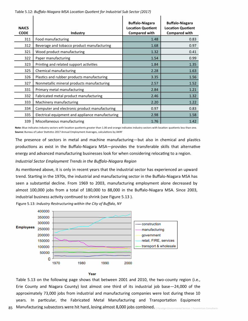
85 C&S Engineers | Joy Keubler Landscape Architects | Sasaki, AKRF, Inc.| Data Validation Services | Nature’s Way Environmental | Paradigm Environmental Services | Panamerican Consultants
Table 5.12: Buffalo-Niagara MSA Location Quotient for Industrial Sub Sector (2017)
The presence of sectors in metal and machine manufacturing—but also in chemical and plastics
productions as exist in the Buffalo-Niagara MSA—provides the transferable skills that alternative
energy and advanced manufacturing businesses look for when considering relocating to a region.
Industrial Sector Employment Trends in the Buffalo-Niagara Region
As mentioned above, it is only in recent years that the industrial sector has experienced an upward
trend. Starting in the 1970s, the industrial and manufacturing sector in the Buffalo-Niagara MSA has
seen a substantial decline. From 1969 to 2003, manufacturing employment alone decreased by
almost 100,000 jobs from a total of 180,000 to 88,000 in the Buffalo-Niagara MSA. Since 2003,
industrial business activity continued to shrink (see Figure 5.13 ).
Figure 5.13: Industry Restructuring within the City of Buffalo, NY
NAICS CODE Industry
Buffalo-Niagara Location Quotient
Compared with
Buffalo-Niagara Location Quotient
Compared with
311 Food manufacturing 1.48 0.83
312 Beverage and tobacco product manufacturing 1.68 0.97
321 Wood product manufacturing 1.32 0.41
322 Paper manufacturing 1.54 0.99
323 Printing and related support activities 1.84 1.35
325 Chemical manufacturing 2.28 1.63
326 Plastics and rubber products manufacturing 3.35 1.56
327 Nonmetallic mineral products manufacturing 2.57 1.52
331 Primary metal manufacturing 2.84 1.21
332 Fabricated metal product manufacturing 2.46 1.32
333 Machinery manufacturing 2.20 1.22
334 Computer and electronic product manufacturing 0.97 0.83
335 Electrical equipment and appliance manufacturing 2.98 1.58
339 Miscellaneous manufacturing 1.76 1.42
Note: Blue indicates industry sectors with location quotients greater than 1.00 and orange indicates industry sectors with location quotients less than one.
Source: Bureau of Labor Statistics 2017 Annual Employment Averages, calculations by AKRF
Table 5.13 on the following page shows that between 2001 and 2010, the two-county region (i.e.,
Erie County and Niagara County) lost almost one third of its industrial job base—24,000 of the
approximately 73,000 jobs from industrial and manufacturing companies were lost during these 10
years. In particular, the Fabricated Metal Manufacturing and Transportation Equipment
Manufacturing subsectors were hit hard, losing almost 8,000 jobs combined.

86 City of Lackawanna First Ward | Brownfield Opportunity Area Step 3 | Draft Implementation Strategy
It is notable that with the exception of the food and beverage subsector, which experienced a total marginal
job growth of 29 employees, all other subsectors have seen double digit losses, with companies in the
Petroleum and Coal Products sector shedding almost three quarters of its employees.
It should be noted that only the Plastics and Rubber Manufacturing and Machinery Manufacturing sectors
were able to increase their share of the total industrial labor force by more than 1 percent, indicating
relative strength in an otherwise weak sector.
Table 5.13: Total Employment by Industrial Sub Sector (2001 and 2010)
Source: Bureau of Labor Statistics and AKRF
2010 appears to have marked the tipping point for industrial sectors in the region. Table 5.14 compares
employment numbers for industrial subsectors in the Buffalo-Niagara MSA for the years 2010 and 2017. A
few subsectors continued to lose a substantial number of jobs. In particular, Miscellaneous Manufacturing
(302 employees), Food Manufacturing (278 employees), and Printing and Related Support Activities (245
employees) were the three sectors that lost the largest total number of employees during the five-year
period.
The majority of subsectors have stabilized over the seven-year period, and close to half have even
experienced substantial growth.
NAICS Code Manufacturing Subsector
2000 2010 2000-2010
Employment Percent of Total Employment Percent of Total Total Change Percent
311 Food manufacturing 7,846 10.8% 5,147 10.5% (2,699) (0)
312 Beverage and tobacco product manufacturing 479 0.7% 508 1.0% 29 0
313 Textile mills 225 0.3% 200 0.4% (25) (0)
314 Textile product mills 328 0.4% 264 0.5% (64) (0)
315 Apparel manufacturing 1,629 2.2% 722 1.5% (907) (1)
316 Leather and allied product manu-facturing - 0.0% - 0.0% - NA
321 Wood product manufacturing 1,269 1.7% 604 1.2% (665) (1)
322 Paper manufacturing 2,414 3.3% 1,558 3.2% (856) (0)
323 Printing and related support activities 3,600 4.9% 2,451 5.0% (1,149) (0)
324 Petroleum and coal products manufacturing 1,197 1.6% 311 0.6% (886) (1)
325 Chemical manufacturing 6,139 8.4% 4,851 9.9% (1,288) (0)
326 Plastics and rubber products manufacturing 5,334 7.3% 4,205 8.6% (1,129) (0)
327 Nonmetallic mineral product manufacturing 3,325 4.6% 2,353 4.8% (972) (0)
331 Primary metal manufacturing 2,356 3.2% 1,880 3.8% (476) (0)
332 Fabricated metal product manu-facturing 9,606 13.2% 6,599 13.5% (3,007) (0)
333 Machinery manufacturing 6,076 8.3% 4,799 9.8% (1,277) (0)
334 Computer and electronic product manufacturing 3,589 4.9% 2,809 5.7% (780) (0)
335 Electrical equipment and appli-ance mfg. 3,294 4.5% 2,276 4.6% (1,018) (0)
336 Transportation equipment manu-facturing 8,971 12.3% 3,978 8.1% (4,993) (1)
337 Furniture and related product 889 1.2% 482 1.0% (407) (0)
339 Miscellaneous manufacturing 4,818 6.6% 3,424 7.0% (1,394) (0)
Total 72,905 100.0% 48,951 100.0% (23,954) (0)

87 C&S Engineers | Joy Keubler Landscape Architects | Sasaki, AKRF, Inc.| Data Validation Services | Nature’s Way Environmental | Paradigm Environmental Services | Panamerican Consultants
Beverage and Tobacco Product Manufacturing had the largest rate of employment growth (85.8
percent) and added the most jobs of any subsector (436). This substantial growth is likely related to
the boom in breweries, specifically craft and farm breweries throughout New York State.
Three other subsectors have also had significant growth in employment: Transportation Equipment
Manufacturing added 406 jobs, Chemical Manufacturing added 376 jobs, and Computer and
Electronic Product Manufacturing added 387 jobs. Two of these sectors, Fabricated Metal Product
Manufacturing and Chemical Manufacturing, have developed into strong clusters in the region, with
location quotients over 2.0 and are likely to continue to grow. And while activities in Computer and
Electronic Product Manufacturing did not stand out when compared with the state and the nation,
growth in this sector will be vital as a support function for other growth sectors.
NAICS Code Manufacturing Subsector
2010 2017 2010 to 2017
# #
% of Total Mfg Sector
% of Total Mfg
Sector Total Change
Percent Change
311
Food manufacturing 5,147 10.5% 4,869 9.8% (278) -5.4%
312 Beverage and tobacco product manufacturing 508 1.0% 944 1.9% 436 85.8%
313 Textile mills 200 0.4% 0 0.0% (200) -100.0%
314 Textile product mills 264 0.5% 29 0.1% (235) -89.0%
315 Apparel manufacturing 722 1.5% 737 1.5% 15 2.1%
316 Leather and allied product manufacturing 0 0.0% 0 0.0% 0 0.0%
321 Wood product manufacturing 604 1.2% 602 1.2% (2) -0.3%
322 Paper manufacturing 1,558 3.2% 1,345 2.7% (213) -13.7%
323 Printing and related support activities 2,451 5.0% 2,206 4.5% (245) -10.0%
324 Petroleum and coal products manufacturing 311 0.6% 368 0.7% 57 18.3%
325 Chemical manufacturing 4,581 9.3% 4,957 10.0% 376 8.2%
326 Plastics and rubber products manufacturing 4,205 8.6% 4,141 8.4% (64) -1.5%
327 Nonmetallic mineral product manufacturing 2,353 4.8% 2,317 4.7% (36) -1.5%
331 Primary metal manufacturing 1,880 3.8% 1,657 3.4% (223) -11.9%
332 Fabricated metal product manufacturing 6,599 13.4% 6,955 14.1% 356 5.4%
333 Machinery manufacturing 4,799 9.8% 4,866 9.8% 67 1.4%
334 Computer and electronic product manufactur-ing 2,809 5.7% 3,196 6.5% 387 13.8%
335 Electrical equipment and appliance mfg. 2,276 4.6% 2,261 4.6% (15) -0.7%
336 Transportation equipment manufacturing 3,978 8.1% 4,384 8.9% 406 10.2%
337 Furniture and related product manufacturing 482 1.0% 499 1.0% 17 3.5%
339 Miscellaneous manufacturing 3,424 7.0% 3,122 6.3% (302) -8.8%
Total 49,151 100.0% 49,455 100.0% 304 0.6%
Table 5.14: Total Employment by Industrial Sub Sector (2010 and 2017)
Source: Bureau of Labor Statistics and AKRF

88 C&S Engineers | Joy Keubler Landscape Architects | Sasaki, AKRF, Inc.| Data Validation Services | Nature’s Way Environmental | Paradigm Environmental Services | Panamerican Consultants
Overall, employees in the above three subsectors have the skills necessary to compete in today’s value-
added manufacturing market. Products in this market segment include high-technology machinery and
equipment that are able to produce complex products for a global market. In particular, energy production
and storage equipment and technology require cutting-edge knowledge and a specialized set of skills that
can help to translate the latest technological innovations into a workable product. Having these
transferable skill sets in the Buffalo-Niagara MSA will be critical when expanding these sectors and
attracting new ones that require similar skill profiles.
Table 5.15: Growth Sector Employment Projections (20157 to 2022)
Source: Bureau of Labor Statistics and AKRF
NAICS Manufacturing Subsector
Compound Annual
Growth Rate
2010-2017
5-Year Growth Pro-jection 2017-
2022 Per-cent
5-Year Growth Projection 2017-2022
Total
332 Fabricated metal product manufacturing 0.75% 3.82% 7,221
334 Computer and electronic product manufacturing 1.86% 10.13% 3,520
336 Transportation equipment manufacturing 1.40% 7.19% 4,699
With current efforts to attract additional businesses in advanced manufacturing and alternative energy
production and storage, it is very probable that the three sectors at the center of this effort will continue to
grow at a similar pace, if not faster. All three sectors grew by approximately 1 percent annually over the
past seven years. Based on the assumption that the three sectors would continue to grow at the same rate
over the coming 10 years, the three sectors combined would add approximately 905 additional jobs to the
Buffalo-Niagara MSA labor market by 2025.
Since manufacturing sector businesses use approximately 1,000 square feet per employee, the
employment growth of the three growth sectors would result in a total demand of approximately 900,000
square feet in industrial space over the coming decade.
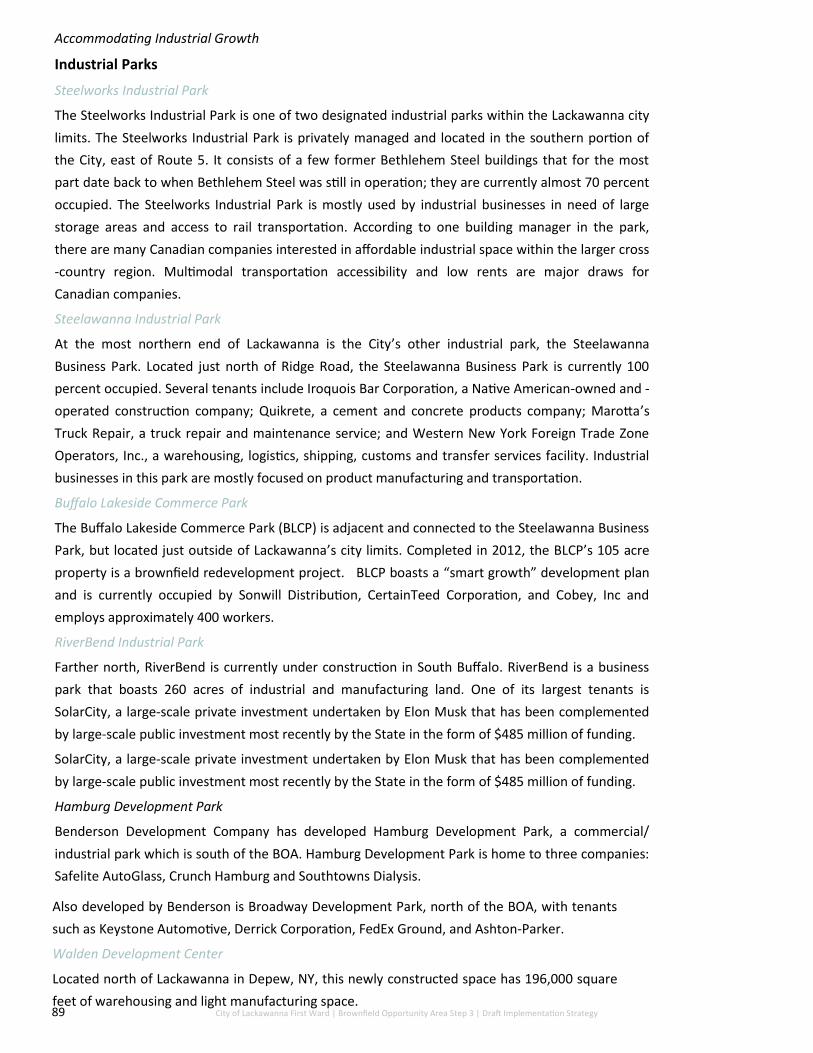
89 City of Lackawanna First Ward | Brownfield Opportunity Area Step 3 | Draft Implementation Strategy
Accommodating Industrial Growth
Industrial Parks
Steelworks Industrial Park
The Steelworks Industrial Park is one of two designated industrial parks within the Lackawanna city
limits. The Steelworks Industrial Park is privately managed and located in the southern portion of
the City, east of Route 5. It consists of a few former Bethlehem Steel buildings that for the most
part date back to when Bethlehem Steel was still in operation; they are currently almost 70 percent
occupied. The Steelworks Industrial Park is mostly used by industrial businesses in need of large
storage areas and access to rail transportation. According to one building manager in the park,
there are many Canadian companies interested in affordable industrial space within the larger cross
-country region. Multimodal transportation accessibility and low rents are major draws for
Canadian companies.
Steelawanna Industrial Park
At the most northern end of Lackawanna is the City’s other industrial park, the Steelawanna
Business Park. Located just north of Ridge Road, the Steelawanna Business Park is currently 100
percent occupied. Several tenants include Iroquois Bar Corporation, a Native American-owned and -
operated construction company; Quikrete, a cement and concrete products company; Marotta’s
Truck Repair, a truck repair and maintenance service; and Western New York Foreign Trade Zone
Operators, Inc., a warehousing, logistics, shipping, customs and transfer services facility. Industrial
businesses in this park are mostly focused on product manufacturing and transportation.
Buffalo Lakeside Commerce Park
The Buffalo Lakeside Commerce Park (BLCP) is adjacent and connected to the Steelawanna Business
Park, but located just outside of Lackawanna’s city limits. Completed in 2012, the BLCP’s 105 acre
property is a brownfield redevelopment project. BLCP boasts a “smart growth” development plan
and is currently occupied by Sonwill Distribution, CertainTeed Corporation, and Cobey, Inc and
employs approximately 400 workers.
RiverBend Industrial Park
Farther north, RiverBend is currently under construction in South Buffalo. RiverBend is a business
park that boasts 260 acres of industrial and manufacturing land. One of its largest tenants is
SolarCity, a large-scale private investment undertaken by Elon Musk that has been complemented
by large-scale public investment most recently by the State in the form of $485 million of funding.
SolarCity, a large-scale private investment undertaken by Elon Musk that has been complemented
by large-scale public investment most recently by the State in the form of $485 million of funding.
Hamburg Development Park
Benderson Development Company has developed Hamburg Development Park, a commercial/
industrial park which is south of the BOA. Hamburg Development Park is home to three companies:
Safelite AutoGlass, Crunch Hamburg and Southtowns Dialysis.
Also developed by Benderson is Broadway Development Park, north of the BOA, with tenants
such as Keystone Automotive, Derrick Corporation, FedEx Ground, and Ashton-Parker.
Walden Development Center
Located north of Lackawanna in Depew, NY, this newly constructed space has 196,000 square
feet of warehousing and light manufacturing space.

90 C&S Engineers | Joy Keubler Landscape Architects | Sasaki, AKRF, Inc.| Data Validation Services | Nature’s Way Environmental | Paradigm Environmental Services | Panamerican Consultants
Encouraging Industrial Growth in the Buffalo-Niagara Region
Encouraging industrial business activity in Western New York has been one of the focus areas of
economic development efforts of Governor Cuomo, and is one that aligns well with locating industrial
uses on the Bethlehem Steel site. Since Governor Cuomo’s administration started its Regional Economic
Development Council initiative in 2011, New York State has awarded $170 million in funding to projects
in Western New York that have leveraged over $708 million in further investment. “Western New York
has invested over $766 million in projects that have leveraged 2.9 billion”. A large portion of the
investments were made to support industrial activity in the region. For example, the South Buffalo BOA
received almost $1.7 billion in public and private sector investments since 2008 in an effort to create the
Buffalo High-Tech Manufacturing Innovation Hub within the RiverBend Industrial Park.
Overall, “the Buffalo Billion” initiative intends to create innovation hubs that will act as catalysts to draw
new businesses. At the core of this initiative in terms of industrial growth are the Advanced
Manufacturing and Energy subsectors, which are two of the seven subsector focus areas identified by
the Western NYREDC economic development strategy.
Western NYREDC Sector Strategies are:
Advanced Manufacturing;
Health / Life Sciences;
Agriculture;
Professional Services;
Bi-National Logistics;
Tourism; and
Energy
Industrial development on the Bethlehem Steel site would also help further New York State’s greater
development planning strategy by encouraging the implementation of smart-growth development
goals. Development on the site would result in remediated brownfield sites, decreased vacancies [and
underutilization], and development focused on areas already developed.
South Buffalo & River bend Infrastructure Needs Assessment
In light of the recent resurgence of industrial activity and redevelopment in the South Buffalo area, the
Buffalo Niagara Partnership surveyed 120 businesses and land owners as well as economic development
agencies and utility and service providers in the South Buffalo/Lackawanna area to help determine
future growth and related infrastructure requirements. The project study area is based upon existing
National Grid infrastructure and recognized development plans, generally along the Ohio Street/Buffalo
River corridor and in the South Buffalo brownfields area. It is also significant to note that these
projections do not include conceptual planning for the Outer Harbor, which was recently conducted by
the Erie Canal Harbor Development Corporation.
The project area is slated to experience a tremendous level of growth that is expected to nearly double
the amount of development from 2016 to 2020. By 2020, 2.8 million square feet of new space will be
constructed throughout seven of the eight precincts.

91 C&S Engineers | Joy Keubler Landscape Architects | Sasaki, AKRF, Inc.| Data Validation Services | Nature’s Way Environmental | Paradigm Environmental Services | Panamerican Consultants
Estimated Current and Future Space Demand in the South Buffalo / Lackawanna Area
Source: South Buffalo & RiverBend Infrastructure Needs Assessment, 2015
The highest concentration of growth is on the River Bend site (1.345 million square feet), a direct result of
Solar City’s investment. Four other precincts (Bethlehem, Lakeside, River East and Outer Harbor)
anticipate more than a quarter million square feet of new development by 2020. For the Bethlehem Steel
site, the needs assessment anticipates new development of more than 400,000 square feet alone.
Industrial Development Potential
Next to the Health and Life Science sector, Industrial Activity has seen the largest growth and investment
in the Buffalo-Niagara MSA. Asset managers have observed strong demand for industrial space and CBRE,
a leading real estate research firm, reports premium rental rates for industrial and warehouse space and
decreasing vacancies for the region (i.e., less than 5 percent), all signs of a strengthening industrial
market.
The Buffalo-Niagara MSA has all the ingredients in place to make the revitalization of the the First Ward
BOA a lasting success. The overall environment for industrial business growth is strong with:
Strong support from public agencies;
Strong concentration of target industrial sectors;
Strong regional demand from existing businesses;
Strong employment growth trend of selected industrial target sectors; and
Strong interest from potential industrial users and developers.
Projected demand for new industrial space is significant. If employment in a few target sectors continues
to grow at the same rate as in the prior five years, the Buffalo-Niagara MSA would need approximately 3.3
million square feet of additional industrial space by 2025. For the South Buffalo/Lackawanna area alone,
the Buffalo Niagara Partnership estimates that 1.8 million square feet of space will be needed by 2020.
How much of this demand over the next 10 years the Bethlehem Steel Site can absorb will depend on the
continuing support from the State and the success of the businesses anchoring the target sectors. It will
also depend if the comprehensive concept can be developed for the Bethlehem Steel Site to become
more than a random agglomeration of industrial businesses but one of the main (alternative supply chain)
clusters in the Buffalo-Niagara Region. Assuming a slow growth over the next 10 years, demand is likely to
stagnate at around 500,000 square feet. However, with a master planned concept in place and continued
industrial growth, the demand can easily surpass the 1 million square feet threshold.

92 C&S Engineers | Joy Keubler Landscape Architects | Sasaki, AKRF, Inc.| Data Validation Services | Nature’s Way Environmental | Paradigm Environmental Services | Panamerican Consultants
Transportation and Access
The City of Lackawanna is served by multiple transportation systems including vehicular, rail and transit
systems. The City of Lackawanna and First Ward BOA has excellent transportation access on a local and
regional basis, including Hamburg Turnpike, several regional rail lines, and deep water port access on Lake
Erie. These ties to the regional transportation network will allow the planned revitalization of the First Ward
BOA to be realized. This section further details the transportation and access of the City of Lackawanna.
Roadway Network
The main transportation system within the First Ward BOA is comprised of surface road consisting of
primarily local/residential roads. There are also two main thoroughfares within the First Ward BOA; these are
Hamburg Turnpike (otherwise known as Route 5), which travels north-south from the City of Buffalo to the
Town of Hamburg, as well as Ridge Road, which is an east-west roadway. All other roads within the First Ward
BOA are local roads shown in Figure 5.14. It should be noted that all of these roads lie east of Hamburg
Turnpike. The following is an in-depth description of the major roadways within the First Ward BOA:
NYS Route 5 is classified as a principal
arterial running in the north-south
direction with a posted speed of 40 miles
per hour (mph). This is a major
thoroughfare for commuting traffic from
southern Buffalo suburbs, such as
Hamburg, to the City of Buffalo. This road
is owned and maintained by the New York
State Department of Transportation
(NYSDOT), with an Annual Average Daily
Traffic (AADT) of approximately 42,000
vehicles per day (vpd). Through the First
Ward BOA, there are three northbound
lanes and two southbound lanes. The
lane widths are 12 feet, with 10-foot
shoulders. The northbound and
southbound directions are separated by
different types of treatments throughout
the First Ward BOA, including bi-
directional left turn lanes, hatched
pavement, and a concrete barrier.
Ridge Road is classified as a principal
arterial running in the east-west direction
with a posted speed of 30 mph. Ridge
Road is currently under jurisdiction and
maintained by the City of Lackawanna.
The AADT of Ridge Road is approximately
16,000 vpd. The typical section of Ridge
Road varies throughout the study area,
but is typically comprised of two travel
lanes in each direction with sidewalks on
both sides. On-street parking is permitted
in the curb lane east of North Gates
Avenue.
Figure 5.14: Transportation routes located within the
First Ward BOA

93 City of Lackawanna First Ward | Brownfield Opportunity Area Step 3 | Draft Implementation Strategy
Existing Traffic Volumes
Traffic count data for the First Ward BOA were derived from the New York State Department of
Transportation (NYSDOT) Traffic Data Viewer. This web-based system provided traffic counts for
roadways within the City of Lackawanna. Data that is presented is categorized by annual average daily
traffic (AADT). AADT is a measure that is frequently and primarily used in transportation planning and
engineering. It is calculated by recording the total volume of traffic for one year divided by 365
days. Looking at traffic count data is helpful in a variety of ways. One of the biggest components is
seeing how many cars travel through the area and another is getting a feel for seeing how big of a
catchment area that is. Specific periods of time along with traffic counts of major roadways are
extremely helpful when determining where and what to develop.
The traffic counts for the BOA on the Hamburg Turnpike totaled 35,635 AADT in 2013. This congestion
has slightly decreased since a total of 36,150 in 2009. On Ridge Road, between the Hamburg Turnpike
and South Park Avenue the traffic congestion was 11,918 in 2013. This is also a slight decrease from an
AADT of 12,800 in 2006.
Additionally, a Level Of Service (LOS) analysis was completed at each signalized intersection for the
morning and afternoon peak hours on Hamburg Turnpike and Ridge Road. Level of Service criteria are
stated in terms of the control delay per vehicle for a 15-minute analysis period and range from “A” to
“F”. Level of Service A is representative of a movement that is free flowing with very minimal delay,
while LOS F generally represents long delays and higher amounts of traffic (see Table 5.16). LOS D is
generally considered acceptable in urban environments due to increased density.
The ranges of delay for each level of service, as contained in the 2000 Highway Capacity Manual, are
shown in the table below.
Table 5.16: Level of Service Criteria
Level of Service
(LOS)
Signalized Intersections Unsignalized Intersections
Delay (sec) Delay (sec)
A 0-10 0-10
B > 10-20 > 10-15
C > 20-35 > 15-25
D > 35-55 > 25-35
E > 55-80 > 35-50
F over 80 over 50
For existing conditions, the signalized intersections operate at an acceptable LOS for the overall
intersections. Dona Street and Hamburg Turnpike operates at a LOS C in the AM and PM peak hours.
The side street movement, Dona Street, operates at a LOS E in both peak hours. At Holbrook and
Route 5 in the AM peak hour, the Holbrook westbound approach and Rt. 5 southbound left turn
movement operate at a LOS F.
Additionally, under existing conditions, all intersections along Ridge Road operate at an acceptable
level of service of C or better, and all intersection movements operate at a LOS D or better.
Traffic counts were highest on the Hamburg Turnpike/Ridge Road, Route 5 Ramps, Gates Avenue and
Steelawanna Avenue from 4:00-5:30 PM.
Traffic counts were highest on Dona Street, Holbrook St and Odell Street from 7:15-8:15 AM.

94 C&S Engineers | Joy Keubler Landscape Architects | Sasaki, AKRF, Inc.| Data Validation Services | Nature’s Way Environmental | Paradigm Environmental Services | Panamerican Consultants
Roadway 7:15 - 8:15 4:00 - 5:00 4:30 - 5:30
Dona Street 4,302 4,053 4,157
Holbrook Street 4,317 4,051 4,151
Odell Street 4,345 4,111 4,246
Hamburg Turnpike/Ridge Road 199 305 390
Route 5 Ramps 1,031 1,123 1,092
Gates Avenue 1,096 1,215 1,207
Steelawanna Avenue 1,035 1,184 1,167
Total 15,290 16,042 16,410
Table 5.17: Traffic Counts for the First Ward BOA
Source: C&S Engineers, Inc. 2018
As you can see in Table 5.17, overall counts for all major roadways were highest from 4:30
to 5:30 PM.
Bicycle and Pedestrian Facilities
According to Greater Buffalo-Niagara Regional Transportation Council (GBNRTC) existing
bicycling facilities within the City of Lackawanna (including the First Ward BOA) are currently
limited. There are no bike shops or bike racks with City boundaries. There is a New York State
Bicycle Route as well as a small portion of a marked bike lane over the rail road just south of
South Park heading toward Lake Erie on Ridge Road.
There is also a proposal within the GBNRTC 2009 Bicycle & Pedestrian Master Plan for a multi
-use trail along Smokes Creek that would be off-road and extend along the corridor from
Ridge Road into the town of West Seneca to the west as part of the Erie County Regional
Bikeway Network.
The GBNRTC also created a Bicycle Level of Service guide to assist bicyclists with
recommendations on how comfortable or safe they may feel along any routes. Ratings and
recommendations are based on a number of factors such as: surface conditions, width of
shoulder, posted speeds and land use. Routes can be graded from A to F where an A means
extreme ease and F indicates the route could be dangerous. Currently no routes within the
First Ward BOA are considered ‘Suitable’ for riders and the main Route along Route 5 is
designated as ‘Caution Advised’.
The GBNRTC is responsible for developing a long-range Metropolitan Transportation Plan
(MTP) for the Buffalo-Niagara region that reflects transportation needs as a macro and micro
level. This provides a vision for development, identifies transportation needs and
improvements, provides direction for any necessary infrastructure investment throughout
the region, and a framework for the Transportation Improvement Plan. The GBNRTC officially
approved a 2040 Long-Range Plan Update in May of 2014 that outlines major projects
through the year of 2039 using 70% of total funds in both Erie and Niagara Counties. Within
the Transportation Improvement Plan, the City of Lackawanna has a project listed within the
Bethlehem Steel section of the Erie County Shoreline Trail (awarded $980,160 in funding)
and is expected to be commenced in the fall of 2018. If available discretionary funds become
available in following years a project involving Erie County’s Southtowns and increased
access along NYS Route 5 from Ridge to NUS Route 179 in Hamburg would be next in line.

95 City of Lackawanna First Ward | Brownfield Opportunity Area Step 3 | Draft Implementation Strategy
Public Transportation
The City of Lackawanna is serviced by the four bus routes provided by the Niagara Frontier
Transportation Authority (NFTA). These routes include Route 36, Route 42, Route 74 and Route 76.
These routes operate alone Ridge Road, Hamburg Turnpike and Steelawanna Avenue following the
major roadways leading to surrounding municipalities such as the City of Buffalo and the Town of
Hamburg. Shown in Figure 5.16.
Figure 5.16: Available Public Transportation Routes within the First Ward BOA

96 C&S Engineers | Joy Keubler Landscape Architects | Sasaki, AKRF, Inc.| Data Validation Services | Nature’s Way Environmental | Paradigm Environmental Services | Panamerican Consultants
Rail lines
Towards the eastern half of the First Ward BOA lies multiple railroad tracks that run in the north-
south direction (see Figure 5.17). The Buffalo-Niagara Region is served by four Class I railroads, one
Class II railroad and two Class III railroads. The rail companies that operate these lines include:
Norfolk Southern Railway Company, Buffalo and Pittsburgh Railroad Company, CSX Transportation,
Amtrak and Buffalo Southern Railroad, Inc.
Norfolk Southern Railway Company is a Class I rail line that is a major transporter of domestic and
export coal to the eastern United States. The Buffalo & Pittsburgh Railroad Company is a rail line
that travels from Pittsburgh, Erie and the City of Buffalo carrying good ranging from aggregates,
brick, cement, automobiles, chemicals, coal, food and feed, metallic ores, steel and scrap. It is the
only Class II railroad in the area. CSX Transportation is a Class I rail line that primarily serves the
eastern coast of the United States as well as the Canadian Provinces of Ontario and Quebec. The
main transport on this line includes Tropicana Orange Juice, coke for steel making and garbage.
Lastly, the Buffalo Southern Railroad Inc. is a Class III short line railroad that travels from the City of
Buffalo to the City of Jamestown.
According to a study by the GBNRTC, rail traffic through the region, including the Lackawanna rail
corridor, is expected to increase. Regional intermodal facility locations include the Gateway Trade
Center (port of Buffalo) and existing railyards both are located within the BOA.
Amtrak is the only provider of passenger service within the area and the United States as a whole.
There are three passenger stations in the region: City of Buffalo, Depew and Niagara Falls. Amtrak
travels on the CSX line through the City of Lackawanna.
Figure 5.17: Rail lines within the First Ward BOA

97 City of Lackawanna First Ward | Brownfield Opportunity Area Step 3 | Draft Implementation Strategy
Waterborne Transport and Activity
The Port of Buffalo
The Port of Buffalo, otherwise known as the Gateway Metroport or Gateway Trade Center, is located in the
northwestern portion of the First Ward BOA (See Figure 5.18). This port ranks 28th among all United States
seaports and seventh busiest port of all Great Lakes ports. This port is the first of call in the United States for
vessels entering or leaving the Great Lakes. The Gateway Metroport is able to support a variety of commodities
and provides access to markets in southern Ontario, the northeastern United States and St. Lawrence Seaway
making it a domestic and international importer and exporter. It as a major bulk cargo storage and transfer
facility with 20 acres of storage space and 10 acres of open storage area. It can accommodate up to eight
vessels with 9,000 feet of dock space on either side of the Lackawanna Canal.
The Gateway Trade Center includes a 40,000 square-foot terminal building for both warehousing and
distribution with access to water, rail and local truck routes.
Docks, Marinas and Bulkheads
There are no private or public marinas, docking facilities or boat launch ramps for recreational vessels in the
BOA. Approval for docks and pilings on Lake Erie is regulated by the Army Corp of Engineers as well as NYSDEC
for certain circumstances.
Since the Gateway Metroport is located 22
miles from Port Colborne, Ontario, it lies within
500 miles of the major population and
distribution centers of the Northeast and North
Central States, and within 500 miles of 75
percent of Canada’s population.
Features of this port which make for an ideal
location for industry and distribution include:
Accommodation of seven vessels simultaneously
200 acres of surrounding land dedicated to bulk cargo storage and conventional bulk carriers
Convenient access to regional railroad interchange that serves five Class I rail lines
Close proximity to New York State Interstate-90
Minutes away from the Peace Bridge to Canada
Within a U.S. Foreign Trade Zone
Air Transportation
There are no public or private airports within the
City of Lackawanna. The closest and largest
airport is the Buffalo-Niagara International
Airport located 13 miles northeast in the town of
Cheektowaga which provides passenger and
commercial air services.
Figure 5.18: The Gateway Metroport located off Lake Erie within
the first Ward BOA

98 C&S Engineers | Joy Keubler Landscape Architects | Sasaki, AKRF, Inc.| Data Validation Services | Nature’s Way Environmental | Paradigm Environmental Services | Panamerican Consultants
Key Takeaways:
The City of Lackawanna and the First Ward BOA have
limited cycling facilities available to community
members
Currently no bikes trails within the BOA are seen as
“suitable” for riders according to the GBNRTC
There are four NFTA bus routes within the City of
Lackawanna. Ridership of these routes continues to
decrease yet the First Ward has high percentages of
public transportation usage for commuting to work
The BOA walk score is 41/100—meaning that most
day to day errands are car dependent an there is
limited access to multiple modes of public
transportation
Major rail lines run through the BOA and rail traffic is
expected to increase
Public Infrastructure
The following sections will detail the existing infrastructure within the First Ward BOA. Due to the
historical immense growth and later decline of population within City of Lackawanna, there is
sufficient infrastructure to support the planned revitalization of the area. Municipal infrastructure
includes: water supply, stormwater management, stormwater collection and treatment,
transportation facilities and private utility services.
Water
The City of Lackawanna obtains water distribution from the Erie County Water Authority (ECWA).
In 2014, the EWCA facilities produced 25.1 billion gallons of high-quality water a year for more
than 500,000 customers across Western New York. The two main sources of this water is from
Lake Erie and the Niagara River. Overall water consumption in Erie County’s service district is
projected to decline due to the decrease in population and increase in efficiency of appliances that
use less water. Currently, businesses and residents purchase 47.5 million gallons of water per
month on average from the ECWA. Water is pumped from the Sturgeon Point Water Treatment
facility located in the town of Evans.
Sanitary Sewer
The City of Lackawanna is serviced by Erie County Sewer District Number 6 and the Lackawanna
Waste Water Treatment Plant. The Lackawanna Waste Water Treatment Plant is owned by the
Erie County Sewer District 6. The main function of the Erie County Sewer District Number 6 is to
operate and maintain the network of sanitary and storm sewers in the City of Lackawanna as well
as a sewage treatment facility.
All wastewater flow collected flows through a 30-inch force main at the Willmuth Avenue pump
station. Effluent is discharged through a 30-inch outfall to Smokes Creek. The entire treatment
facility is designed to treat 4.5 million gallons per day and a peak capacity of 11.75 mgd. Present
average daily flow is approximately 3.37 mgd. According to the Erie County Department of Sewage
Management, the Wastewater Treatment Plant has available capacity since the City was built to
support a much larger population that exists today.
Figure 5.19: Remains following the fire of
2016 on the Hamburg Turnpike
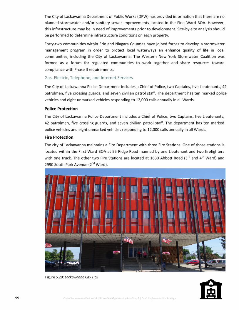
99 City of Lackawanna First Ward | Brownfield Opportunity Area Step 3 | Draft Implementation Strategy
Gas, Electric, Telephone, and Internet Services
The City of Lackawanna Police Department includes a Chief of Police, two Captains, five Lieutenants, 42
patrolmen, five crossing guards, and seven civilian patrol staff. The department has ten marked police
vehicles and eight unmarked vehicles responding to 12,000 calls annually in all Wards.
Police Protection
The City of Lackawanna Police Department includes a Chief of Police, two Captains, five Lieutenants,
42 patrolmen, five crossing guards, and seven civilian patrol staff. The department has ten marked
police vehicles and eight unmarked vehicles responding to 12,000 calls annually in all Wards.
Fire Protection
The city of Lackawanna maintains a Fire Department with three Fire Stations. One of those stations is
located within the First Ward BOA at 55 Ridge Road manned by one Lieutenant and two firefighters
with one truck. The other two Fire Stations are located at 1630 Abbott Road (3rd and 4th Ward) and
2990 South Park Avenue (2nd Ward).
The City of Lackawanna Department of Public Works (DPW) has provided information that there are no
planned stormwater and/or sanitary sewer improvements located in the First Ward BOA. However,
this infrastructure may be in need of improvements prior to development. Site-by-site analysis should
be performed to determine infrastructure conditions on each property.
Forty-two communities within Erie and Niagara Counties have joined forces to develop a stormwater
management program in order to protect local waterways an enhance quality of life in local
communities, including the City of Lackawanna. The Western New York Stormwater Coalition was
formed as a forum for regulated communities to work together and share resources toward
compliance with Phase II requirements.
Figure 5.20: Lackawanna City Hall

100 C&S Engineers | Joy Keubler Landscape Architects | Sasaki, AKRF, Inc.| Data Validation Services | Nature’s Way Environmental | Paradigm Environmental Services | Panamerican Consultants
7.0 Environmental Conditions

101 City of Lackawanna First Ward | Brownfield Opportunity Area Step 3 | Draft Implementation Strategy
7.0 Environmental Conditions As part of the Step 2 Nomination Document, a total of 43 sites were identified as brownfield,
underutilized and/or vacant sites (See Figure 6.1). Generally, due to the former steel making
operations on the Bethlehem Steel Site, almost every site within the First Ward BOA could
potentially be eligible for the DEC Brownfield Cleanup Program (BCP). Known environmental
information about each site is displayed in the table below. Being aware of the implications of
contamination before the carrying out of redevelopment is crucial for sustainable and safe
development within an area. Potential contamination not only affects residents but can also
hinder any progress a municipality makes in the development in terms of infrastructure, social
well-being for residents or economy.
Figure 6.1: Brownfield Sites, Vacant Residential Parcels and Vacant Parcels within the First Ward BOA
102 C&S Engineers | Joy Keubler Landscape Architects | Sasaki, AKRF, Inc.| Data Validation Services | Nature’s Way Environmental | Paradigm Environmental Services | Panamerican Consultants
Former Bethlehem Steel Site
The 1,010 acres that lie along the western portion of the First Ward BOA is referred to as the former
Bethlehem Steel site. This property occupies the entire City of Lackawanna Lake Erie shoreline and is
virtually inaccessible to the public. Historically, the property was utilized for steelmaking from
approximately 1903 until the early 1980s.
A large proportion of the site is currently within the BCP. The large tract of land is divided into three main
“business parks” and each of these parks is further subdivided into separate BCP parcels. These parcels
have been created by the DEC to help manage the environmental information and remedial strategies; they
do not represent Erie County tax parcels. The business parks are identified as follows:
Tecumseh Phase I Business Park
Tecumseh Phase II Business Park
Tecumseh Phase II Business Park
As part of the BCP, each site within the former Bethlehem Steel site has undergone detailed environmental
assessment. Before remediation begins on the site, a Decision Document is created to outline the specific
remedial strategy to be implemented. For remedial purposes, all sub-parcels within the Tecumseh Phase I
Business Park have been grouped together into one Decision Document and remediation strategy. All other
sub-parcels within the other two business parks each have individual Decision Documents. The following
sections detail the environmental condition and remedial strategy for each business park.
Tecumseh Phase I Business Park
The Tecumseh Phase I Business Park (Phase I) is located at 1958 Hamburg Turnpike. This 102.51-acre site is
subdivided into 11 sub-parcels. It is a generally flat, slag filled site vegetated with natural grasses, shrubs
and poplar trees. An active rail line parallels the eastern portion of the site.
Figure 6.2: Photo: Buffalo News—Vacant Industrial Building within the First Ward BOA

103 City of Lackawanna First Ward | Brownfield Opportunity Area Step 3 | Draft Implementation Strategy
The entire site is mostly filled land with approximately two to eight feet of steel and iron-making slag as
well as other fill material. Due to the nature of the slag material, the site is fairly porous. A Remedial
Investigation (RI) of the site revealed contaminants of concern on the property. A contaminant of
concern is defined as a “contaminant that is sufficiently present in frequency and concentration in the
environment to require evaluation for remedial action”. Contaminants of concern on the site include
the following:
Arsenic
Chromium Lead
Mercury Cyanides (soluble cyanide salts)
Benzo(a)pyrene Sodium
Dibenz[a,h]anthracene
Benzo(b)fluoranthene Benz(a)anthracene
Indeno(1,2,3-cd)pyrene Barium
Iron Manganese
Magnesium
Based on investigations, the primary contaminants of concern for soils include metals and semi-volatile
organic compounds (SVOC’s).
Interim Remedial Measures (IRM) have been completed on the site. These include the excavation and
bio-remediation of approximately 12,000 cubic yards of petroleum impacted fill, excavation and
disposal of 100 cubic yards of soils impacted by lead and 45 cubic yards of coal tar-impacted soil,
removal of two former underground storage tanks (USTs) and backfill of excavations with reclaimed
slag material under DEC issued Beneficial Use Determination.
According to the Decision Document for the Phase I site, remedial design includes the placement of a
soil cover to allow for commercial use on the Site. This cover is required to be a one-foot cover over a
demarcation layer. An environmental easement will be placed on the site to allow for the use of
commercial and industrial development, restrict the use of groundwater as a source of potable or
process water without proper treatment, and requirement of a Site Management Plan (SMP).
Tecumseh Phase II Business Park
The Tecumseh Phase II Business Park (Phase II) is located on the former Bethlehem Steel site at 2303
Hamburg Turnpike. Phase II is comprised of 142.23-acres, adjacent to Phase I to the south, and is
subdivided into 12 sub-parcels. Unlike Phase I, each sub-parcel in Phase II has been assessed by the
DEC separately; however, environmental conditions and remedial strategy for each sub-parcel is largely
similar.
The land that comprises Phase II was formerly utilized for steelmaking operations and amenities.
Specific uses of the site included pattern storage, rail lines, and parking. The entire Phase II is filled with
between two to eight feet of steel and iron-making slag as well as other fill material.
The nature and extent of contamination on Phase II is consistent with former site uses a steel
manufacturing facility. SVOCs and metals are widespread throughout Phase II. Many contaminants are
PAHs and are usually associated with the burning of fossil fuels and heavy rail use.
The selected remedial strategies for each of the Phase II sub-parcels vary slightly; however, all include a
site cover of a minimum of one-foot to allow for the commercial use of the site, the imposition of an
institution control in the form of an environmental easement, and the requirement of a SMP. Some sub
-parcels within Phase II also require in-situ stabilization for groundwater remediation.

104 C&S Engineers | Joy Keubler Landscape Architects | Sasaki, AKRF, Inc.| Data Validation Services | Nature’s Way Environmental | Paradigm Environmental Services | Panamerican Consultants
Tecumseh Phase III Business Park
The Tecumseh Phase II Business Park (Phase III) is also located on the former Bethlehem Steel site to the west
of Phase II. It is comprised of 150.35-acres subdivided into 10 sub-parcels. Five of the sub-parcels within Phase
III have undergone remediation and have obtained their Certificate of Completion (COC), which are issued to
sites whom have participated in the BCP and been issues a no further action decision document. The COC
provides liability protections for site owners, developers, lessees and will trigger the availability of tax credits
for eligible parties, as well as allow the certificate holder to redevelop the site.
Sub-Parcel III-1, III-5, III-6, III-7 and III-8 all have obtained their COC and either include redeveloped uses on the
site or are in the process of being redevelopment into productive use. The remaining parcels have obtained
their Decision Document, which outlines the remedial strategy for each individual sub-parcel.
The land that comprises Phase III was formerly utilized for steelmaking operations. Specific processes and
facilities performed on or proximate to the site include slab yards, scale flume sluiceway, settling basin, and
motor room. As with Phase II, Semivolatile Organic Compounds (SVOCs) and metal contamination is ubiquitous
throughout Phase III.
The remedial strategy for the remaining three sub-parcels within Phase III includes:
III-2 – site cover across the entire site and additional cover over a portion of the site containing asbestos
containing material
III-9 - removal of abandoned subsurface product piping, which will either be cleaned and capped or
recycled off site, based on field conditions. In situ stabilization (ISS) to treat petroleum contamination and
VOCs in groundwater
III-10 - pipe removal of abandoned piping impacted with coke gas residuals, excavation and removal of
8,500 cubic yards of grossly contaminated soil, ISS of groundwater to treat VOCs in groundwater and
extraction of groundwater in a 2.8-acre area, site cover to allow for commercial use of the site, and an
institutional control in the form of an environmental easement. Any future buildings on site will also be
required to have a sub-slab depressurization system to prevent migration of vapors into the building from
soil and groundwater.
Environmental Site Assessments
Phase I and Phase II Environmental Site Assessments (ESA) were conducted on five of the identified strategic
sites within the First Ward BOA in this study. The purpose of a Phase I ESA is to identify possible environmental
contamination, ascertain past and present uses of the site and surrounding properties through historical
records, and identify possible Recognized Environmental Conditions (RECs) associated with the site. An REC is
defined as the “presence of likely presence of any hazardous substance or petroleum products in, on, or at a
property: (1) due to any release to the environment; (2) under conditions indicative of a release to the
environment; or (3) under conditions that pose a material threat to the environment.” To further this analysis,
Phase II ESAs were conducted to advance the findings of the Phase I ESA. This assessment typically involves a
soil and groundwater investigation of the site to solidify if contamination exists.
Five sites were identified in the Step 2 Nomination Document for the completion of Phase I and Phase II ESAs.
The sites selected for these assessments are listed below and shown in Figure X. The full assessment package
for each site is in Appendix F.
The site assessments conducted as part of this study are important resources to have when both determining
the redevelopment use of the property as well as incentivizing private developers to invest in particular sites.
Transparency of site conditions and potential future use is a driver to sell particular City owned sites.
Summaries of the environmental assessments performed during the course of this study is provided in Table
6.1.

105 City of Lackawanna First Ward | Brownfield Opportunity Area Step 3 | Draft Implementation Strategy
The BCP has been highly effective in incentivizing the development of previously underutilized
and vacant sites in Western New York. According to the DEC webpage, “The goal of the BCP is to
encourage private-sector cleanups of brownfields and to promote their redevelopment as a
means to revitalize economically blighted communities. The BCP is an alternative to Greenfield
development and is intended to remove some of the barriers to, and provide tax incentives for,
the redevelopment of urban brownfields”. Tax credit breaks for cleanup costs are a major
incentive for developers and can help with financial feasibility of proposed redevelopment.
Site Name RECs Phase II ESA Results BCP Eligible?
100 Dona Street
Former school building was heat-ed by oil located on the property;
UST was formerly located on the southeast corner of the property;
Former automotive station located east and upgradient to the proper-ty.
Fill material was encountered on the eastern portion of the site;
Visual and olfactory indications of petroleum impairment were evident north of the building;
SVOCs detected above Industrial Use SCOs in surface soil;
Metals detected above Unrestricted Use SCOs;
Contaminants in groundwater ex-ceeding standards.
Yes
Albright Court Property
Past use of property for residential use suggests fill was potentially placed in basements locations, therefore, fill is considered a REC;
Unknown fill material following demolition of on-site residential structures;
Former petroleum spill in close proximity to property.
Yes
Mill Street Property
Unknown fill material following demolition of on-site residential structures and closure of two streets on property.
Fill material encountered at depths of 0-2 feet;
SVOCs and metals detected in sur-face and subsurface soils at signifi-cantly elevated concentrations;
VOCs and PCBs detected above Unre-stricted Use SCOs;
Contaminants in groundwater ex-ceeding standards.
Yes
Steelawanna #2
Property located in industrial area;
Past use of property included stor-age of unknown material.
Fill material encountered on western portion;
SVOCs detected above Industrial Use SCOs in surface soil;
Metal concentrations exceeding Un-restricted Use SCOs in subsurface soil.
Yes
10 N. Gates Avenue
Unknown fill material following demolition of on-site residential structures;
Unknown origin of fill material on eastern portion of property.
Site owner elected to not perform a phase II ESA
Unknown
Table 6.1: Summaries of environmental site assessments

106 C&S Engineers | Joy Keubler Landscape Architects | Sasaki, AKRF, Inc.| Data Validation Services | Nature’s Way Environmental | Paradigm Environmental Services | Panamerican Consultants
8.0 Development Following
Step 2 Nomination

107 City of Lackawanna First Ward | Brownfield Opportunity Area Step 3 | Draft Implementation Strategy
8.0 Development Following Step 2
Nomination Several developments have taken place since the Step 2 Nomination Document completion in 2012.
Many of these developments were directly stated as improvements to be made within the BOA or
are aligned with the general recommendations for Reinvestment Areas. A majority of proposed and
implemented developments are related to the remediation and redevelopment of the former
Bethlehem Steel site; however, progress in other sections of the City, east of Route 5 have taken
place as well. New development throughout the City of Lackawanna addresses areas of blight,
vacant lots, and the need for new sustainable energy sources as well as new recreational
opportunities for residents, commuters and visitors to the area. New developments also provide
jobs in multiple sectors which enhances the City and First Ward’s economic well-being.
Development and Description Stage and Phase
The Erie County Industrial Development
Agency (ECIDA) has undertaken
multiple studies to relocate rail lines
that run alongside the Hamburg
Turnpike and extend Dona Street west
onto the former Bethlehem Steel
Property. This funding has been secured
and the design process should begin in
2018
Secured Funding
Table 7.1: Developments following the First Ward Step 2 Nomination
Dona Street Extension
10 North Gates Expansion Approved by City of Lackawanna Planning Board
Owner of 10 North Gates is expanding
the current warehouse 20,000 sq. ft.
This will essentially double it in size to
increase capacity

108 C&S Engineers | Joy Keubler Landscape Architects | Sasaki, AKRF, Inc.| Data Validation Services | Nature’s Way Environmental | Paradigm Environmental Services | Panamerican Consultants
100 Dona Street—Demolition of
Former Lincoln School
In 2017, the City secured $500,000 in
Restore New York funds and $300,000
in Community Development Block
Grant funds through the Erie County
Consortium for asbestos abatement
and demolition of the Former Lincoln
School on Dona Street. Demolition was
approved on June 4, 2018 but it is not
shovel ready and will require $228,000
in order to redevelop following
demolition.
Complete
Erie County Land Purchase of
Bethlehem Steel
Erie County agreed to purchase 148
acres on the former Bethlehem Steel
site along the Hamburg Turnpike for
remediation and development for
$6.7 million. These parcels include all
DEC Phase I and Phase II-8, II-9, II-10, II
-11, and II-12 parcels.
Net Zero Energy Building
The ECIDA designed an 80,000 sq. ft.
net zero energy building to be
constructed on the former Bethlehem
Steel site along the Hamburg Turnpike.
This building will utilize geothermal
energy, solar panels, wind turbines and
architectural features aimed at
lowering energy use. The building will
contain both light manufacturing use
and office space.
Completed Design—Funding Needed
Purchased

109 City of Lackawanna First Ward | Brownfield Opportunity Area Step 3 | Draft Implementation Strategy
Bethlehem Steel Shoreline Trail Construction in process
In March of 2016, the Erie County
Department of Environment and
Planning (DEP) completed the design
phase of the Bethlehem Steel Shoreline
Trail on the western portion of the
Hamburg Turnpike. This 1.4 mile trail
will accommodate pedestrian and
bicycle use by linking the Union Ship
Canal in the city of Buffalo to the
Hamburg Turnpike/Dona Street
intersection. Future Plans involve the
connection of the trail to Woodlawn
Beach State Park. Groundbreaking
started at the end of May 2018 and
construction began on June 4, 2018.
Ridgeway Commons
In February of 2017, the City approved
development of the western portion of
264 Ridge Road for a 32-unit
apartment complex. The apartment
complex had its grand opening on June
5, 2018 with 22 unites already
occupied. It is expected to be fully
occupied by the end of 2018.
Complete
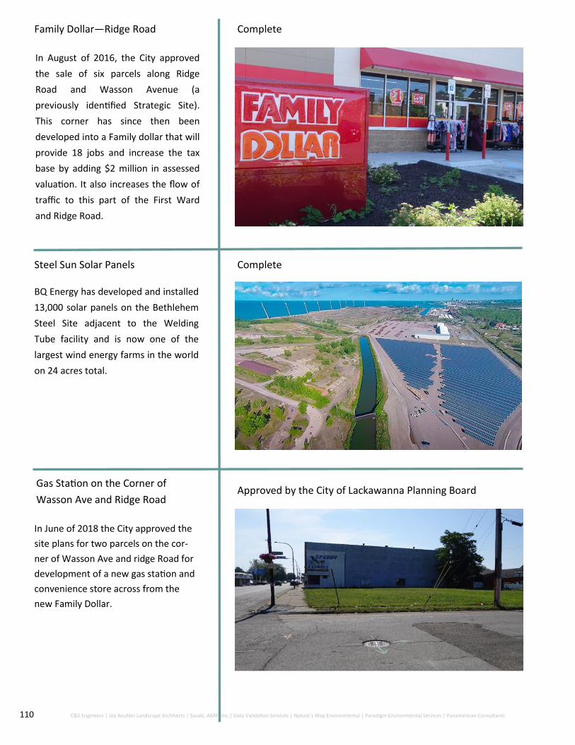
110 C&S Engineers | Joy Keubler Landscape Architects | Sasaki, AKRF, Inc.| Data Validation Services | Nature’s Way Environmental | Paradigm Environmental Services | Panamerican Consultants
Family Dollar—Ridge Road Complete
In August of 2016, the City approved
the sale of six parcels along Ridge
Road and Wasson Avenue (a
previously identified Strategic Site).
This corner has since then been
developed into a Family dollar that will
provide 18 jobs and increase the tax
base by adding $2 million in assessed
valuation. It also increases the flow of
traffic to this part of the First Ward
and Ridge Road.
Steel Sun Solar Panels Complete
BQ Energy has developed and installed
13,000 solar panels on the Bethlehem
Steel Site adjacent to the Welding
Tube facility and is now one of the
largest wind energy farms in the world
on 24 acres total.
Gas Station on the Corner of
Wasson Ave and Ridge Road Approved by the City of Lackawanna Planning Board
In June of 2018 the City approved the
site plans for two parcels on the cor-
ner of Wasson Ave and ridge Road for
development of a new gas station and
convenience store across from the
new Family Dollar.

111 City of Lackawanna First Ward | Brownfield Opportunity Area Step 3 | Draft Implementation Strategy
9.0 Design Framework

112 C&S Engineers | Joy Keubler Landscape Architects | Sasaki, AKRF, Inc.| Data Validation Services | Nature’s Way Environmental | Paradigm Environmental Services | Panamerican Consultants
9.0 Design Framework In the Step 2 Nomination Document, community participation techniques lead to the creation of a
community vison for the redevelopment of the First Ward BOA. In this Step 3 Implementation Strategy,
the general consensus on the vision for this BOA has largely remained the same. A higher emphasis has
been put on the portion of the BOA surrounding Smokes Creek and land east of the Hamburg Turnpike
which is more likely to make a positive impact on residents in relation to jobs, higher quality of housing
and increased quality of life. The Vision for the Study Area has created a design framework consisting
of increased economic development, a focus on transportation networks, connections to natural
resources and centering in on community amenities and quality of housing. These frameworks set the
stage for new development projects and improvements within the First Ward.
Vision The First Ward BOA has great existing assets including rich history, culture, industrial building stock,
natural resources and a mixed-use community located on Lake Erie and directly south of Buffalo. The
redevelopment framework presented in the Step 2 Nomination Document is the basis of this
Implementation Strategy. The overall vision for this BOA is as follows:
Figures 8.1:Photo Source: Buffalo News - Rail lines made
by Lackawanna Steel Company in 1975
Figure 8.2: A Community Visioning Tour near
Ridge Road
“Through the efforts of community members, stakeholders and City leadership, the First Ward BOA will
be a phased transformed into a desirable destination centered on the redevelopment of vacant and
underutilized properties along the major thoroughfares of Ridge Road and Hamburg Turnpike since
they are of high visibility and easily accessible. Development will work to attract retail business and
light industrial manufacturing to create additional job opportunities and tax revenue. The First Ward
BOA will also work to improve the residential neighborhood’s housing stock, streets, and community
amenities as well as implement plans to increase access to the natural resources of Smokes Creek and
Lake Erie. “

113 City of Lackawanna First Ward | Brownfield Opportunity Area Step 3 | Draft Implementation Strategy
The following topics outline the vision of the BOA through the following lenses:
Promotion of Economic Development
Encourage development of vacant and underutilized parcels on Ridge Road and Hamburg Turnpike to include mix of uses and establish density
Revise and revisit current tax structure to incentivize development
Increase retail businesses, goods and services, community centers, office parks, and light industrial uses in the BOA
Continue marketing campaign to heighten developer interest in Ridge Road and Hamburg Turnpike
Encourage conversion of vacant Bethlehem Steel land into multiple types of productive industrial uses
Cooperate with local educational institutions to build a skilled workforce
Utilize heavy commuter traffic as a means and justification to increase retail opportunities within the BOA
Improvement of Transportation Networks
Implement streetscaping improvements along Ridge Road and the Hamburg Turnpike
Improve walkability and the pedestrian experience on Ridge Road through multiple enhancement projects
Create an attractive gateway to the City of Lackawanna to the Hamburg Turnpike and Ridge Road intersection
Introduce traffic calming methods on major thoroughfares to improve pedestrian experiences
Increase east-west connection within the BOA
Improve sidewalks within the First and Second Ward Neighborhoods
Figure 8.3: Catalyst Site located at Ridge
Road and Ingham Avenue
Figure 8.5: Vacant Commercial buildings on Ridge Road
Figure 8.4: Ridge Road Bridge and Bike Lane
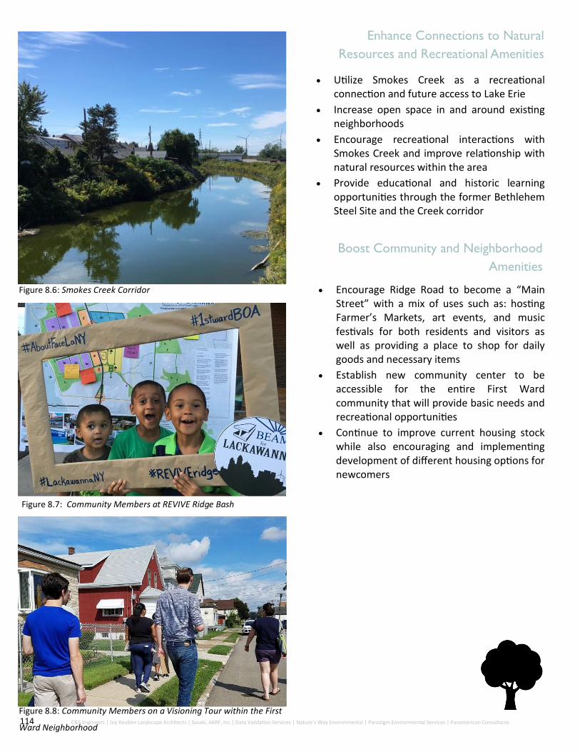
114 C&S Engineers | Joy Keubler Landscape Architects | Sasaki, AKRF, Inc.| Data Validation Services | Nature’s Way Environmental | Paradigm Environmental Services | Panamerican Consultants
Enhance Connections to Natural
Resources and Recreational Amenities
Utilize Smokes Creek as a recreational connection and future access to Lake Erie
Increase open space in and around existing neighborhoods
Encourage recreational interactions with Smokes Creek and improve relationship with natural resources within the area
Provide educational and historic learning opportunities through the former Bethlehem Steel Site and the Creek corridor
Boost Community and Neighborhood
Amenities
Encourage Ridge Road to become a “Main Street” with a mix of uses such as: hosting Farmer’s Markets, art events, and music festivals for both residents and visitors as well as providing a place to shop for daily goods and necessary items
Establish new community center to be accessible for the entire First Ward community that will provide basic needs and recreational opportunities
Continue to improve current housing stock while also encouraging and implementing development of different housing options for newcomers
Figure 8.6: Smokes Creek Corridor
Figure 8.7: Community Members at REVIVE Ridge Bash
Figure 8.8: Community Members on a Visioning Tour within the First
Ward Neighborhood

115 City of Lackawanna First Ward | Brownfield Opportunity Area Step 3 | Draft Implementation Strategy
Leveraging Previous Planning Work One of the core principals of the BOA program is to utilize previous or on-going planning done to date and
leverage knowledge or framework that may be helpful or crucial in the implementation of Step 3 for that
municipality. Studies done for the same area often have over-lapping themes and goals that vocalize the
concerns and hopes of residents. In order to make brownfield redevelopment possible, strategically
unifying multiple plans and recognizing how they have shaped the area as a whole is essential for
sustainable progress within the First Ward BOA.
As mentioned previously, the City of Lackawanna updated their Comprehensive Plan in 2016 which
provided a number of visions and goals for multiple types of possible redevelopment and implementation
throughout the City. The City of Lackawanna Step 3 BOA Implementation Strategy is not a comprehensive
plan but does aim to build upon the efforts of the 2016 Updated Plan within its framework.
The City of Lackawanna also has a current on-going Local Waterfront Revitalization Program which puts its
main focus on the City’s Lake Erie Waterfront within the First Ward BOA. In 2015, the City of Lackawanna
was awarded funding for the continuation of the LWRP to address the critical issues facing a significant
portion of the waterfront. This plan will allow the City of Lackawanna to work with public officials, the
community and private land owners to strategize opportunities revitalization of the waterfront for the
future. It also provides key information regarding the waterfront, habitats surrounding the waterfront and
recreational opportunities.
Planning documents, initiatives, studies and Analysis used:
City of Lackawanna Local Waterfront Revitalization Program Preliminary Draft – May 2018
City of Lackawanna Comprehensive Plan Update – July 2016
The City of Lackawanna Comprehensive Plan 2020: The Future Defined - 2001
Greater Buffalo Niagara Regional Transportation Council 2040 Long Range Plan Update
Greater Buffalo Niagara Regional Transportation Council Transportation Improvement Program
City of Lackawanna Downtown Revitalization Initiative – 2010
Feasibility Study of Economics and Performance of Solar Photovoltaics at the Former Bethlehem Steel
Plant Brownfield Site in Lackawanna, New York
Strengthening WNY’s Safety Net: A Community Report, City of Lackawanna – 2014
Western New York Community Health Needs Assessment: Volume One CNA Summary – 2014
City of Lackawanna Community Center Market Study, Lackawanna Community Development Corp. -
2006
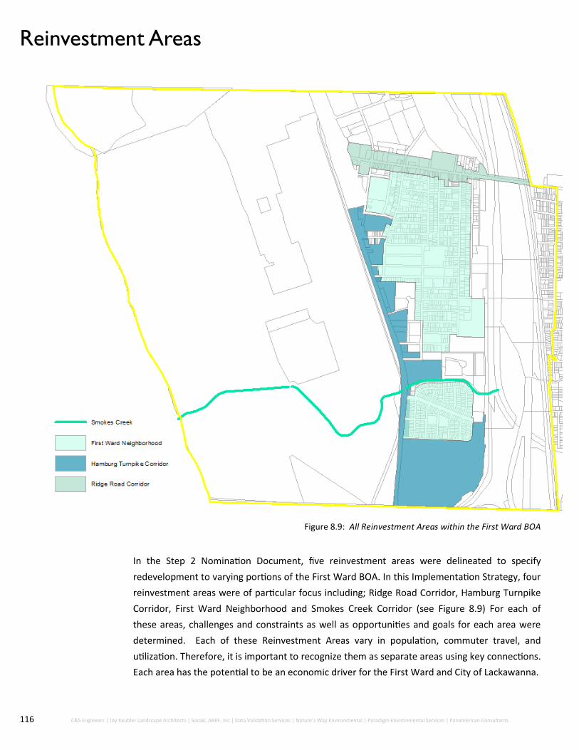
116 C&S Engineers | Joy Keubler Landscape Architects | Sasaki, AKRF, Inc.| Data Validation Services | Nature’s Way Environmental | Paradigm Environmental Services | Panamerican Consultants
In the Step 2 Nomination Document, five reinvestment areas were delineated to specify
redevelopment to varying portions of the First Ward BOA. In this Implementation Strategy, four
reinvestment areas were of particular focus including; Ridge Road Corridor, Hamburg Turnpike
Corridor, First Ward Neighborhood and Smokes Creek Corridor (see Figure 8.9) For each of
these areas, challenges and constraints as well as opportunities and goals for each area were
determined. Each of these Reinvestment Areas vary in population, commuter travel, and
utilization. Therefore, it is important to recognize them as separate areas using key connections.
Each area has the potential to be an economic driver for the First Ward and City of Lackawanna.
Reinvestment Areas
Figure 8.9: All Reinvestment Areas within the First Ward BOA

117 City of Lackawanna First Ward | Brownfield Opportunity Area Step 3 | Draft Implementation Strategy
Ridge Road Corridor
Figure 8.10 and 8.11: Parcels surrounding the Ridge Road Corridor within the First Ward BOA

118 C&S Engineers | Joy Keubler Landscape Architects | Sasaki, AKRF, Inc.| Data Validation Services | Nature’s Way Environmental | Paradigm Environmental Services | Panamerican Consultants
Description
The Ridge Road Corridor runs east-west through the First Ward BOA (see Figure 8.10) . Currently, this
corridor includes a mix of uses including a small number of detached housing interspersed with light
industrial, retail and commercial uses. Most industrial properties are located on the north side of
Ridge Road which is home to warehouse space, automobile repair facility and several additional
industrial properties near the railroad tracks. Ridge Road is the most advantageous location for locally
-serving retail given the connectivity between downtown Lackawanna and the Hamburg Turnpike.
Constraints and Challenges
Based on interactions with the steering committee and community members throughout this process,
constraints and challenges of the Ridge Road Corridor were discussed and encompassed a common
theme for the area. The Ridge Road Corridor suffers from a lack of connections the residents of the
First Ward neighborhood to amenities and services. This includes: grocery stores, barber shops,
coffee shops, and restaurants, among others. Residents repeatedly expressed concern over the
difficulty of transport; whether by foot or by automobile to services throughout the City. This is
because the majority of the services within the City are on the eastern side of the Ridge Road Bridge.
A major hindrance to services within the City is a daunting experience of the Ridge Road Bridge,
which connects Ridge Road over the railroad bed that cuts through the City from north to south. The
entirety of the Ridge Road Bridge is almost one quarter of a mile long with a moderate incline and
decline on either side. This bridge is extremely hard to walk or bike over in both the summer and
winter months. In the summer, the bridge is hot due to the amount of concrete and lack of shade to
shield from the summer sun. In the winter, the incline on the bridge makes the bridge icy. Overall, the
bridge is an intimidating experience due to the lack of separation between automobiles and
pedestrians/bicyclists. While a bike lane exists on both sides of the bridge, it only extends to the
length of the bridge creating a connection gap after the rail lines.
In the same vein, the entire streetscape of Ridge Road is in need of improvement. Ridge Road is a
four lane road on the western side of the bridge, a four lane bridge, and a two lane road on the
eastern portion (with lanes that are double the width on the western portion). The current design of
Ridge Road places utmost attention on the automobile, with little to no respect for pedestrians or
bicyclists. Additionally, Ridge Road lacks pedestrian crossings at major intersections making it
extremely difficult to travel from the First Ward neighborhood to the northern side of Ridge and vice
versa.
Vacant lots and buildings are continuously spread out along all of Ridge Road. Old dilapidated
buildings are currently characteristic of the street landscape in this portion of the City and cast blight
out onto the community. Reinvestment in the form of re-adaptive use and new construction is highly
necessary to revitalize this portion of the BOA.
Opportunities and Goals
The Ridge Road Corridor is abundant with enhancement opportunities throughout. The existing
infrastructure, including underground utilities (electric, gas, water and sewer) are located throughout
the corridor and have ample capacity for additional development. Therefore, the vacant lots and
currently underutilized buildings within the corridor are ripe and ready for redevelopment.

119 City of Lackawanna First Ward | Brownfield Opportunity Area Step 3 | Draft Implementation Strategy
Additionally, Ridge Road contains excess space to tailor the roadway towards pedestrian and
bicyclist usage, rather than focusing solely on automobile transport. The amount of space that
exists between the vehicle and sidewalk on Ridge Road is an untapped asset to be capitalized
upon. Projects to scale back the roadway, including reducing the amount traffic lanes, repairing
sidewalks, addition of crosswalks, planting of street trees, and improvements to the Ridge Road
Bridge are feasible and realistic projects to transform the “urban feel” of the landscape.
Ridge Road contains all of the basic infrastructure to become an urban “Main Street”. As
mentioned previously, Ridge Road is the major east-west directional thoroughfare through the City
of Lackawanna and the First Ward neighborhood meaning that the road obtains a high number of
visitors and traffic, both City residents and commuters. The majority of the existing buildings
located on Ridge are an extreme advantage to creating this “Main Street” because of their minimal
“city-like” set backs up to the front lot line. This maintained urban edge is highly desirable on
urban streets due to their authentic appeal and pedestrian orientation. Additionally, the majority
of the existing buildings are architecturally appealing due to their historic nature, which enriches
the authenticity and attraction of a place. According to the Urban Land Institute, “Communities
should make every effort to preserve the authentic aspects of local heritage and culture, including
food, art, music, handicrafts, architecture, landscape, and traditions”.
Every urban Main Street needs retail and commercial outlets to both sustain itself and continue
the flow of newcomers and community members utilizing the area. Since the Ridge Road Corridor
lacks a healthy array of particular retail needs, additional storefronts are of necessity. Locally
serving retail such as grocery stores, pharmacies, dry cleaners, coffee shops, barber shops are
among several examples of retail that can be introduced on Ridge Road. These services will
enhance the vitality and vibrancy of the street, while also creating additional job opportunities for
the residents.
Furthermore, the Ridge Road Corridor is a perfect opportunity to connect multiple neighborhoods
within the City of Lackawanna. There are multiple examples where the activation of spaces along
this route will work to reinvent public spaces to become more inclusive and attractive. Since the
City of Lackawanna is home to many cultures and backgrounds, opportunity exists to celebrate
these individualities. For example, a community center on the former Friendship House is one way
to unite the community. This community center should be created to be inclusive of all peoples
and cultures as well as include educational and workforce development components to augment
skills training and small business ownership in the area.
http://urbanland.uli.org/industry-sectors/ten-principles-responsible-tourism/

120 C&S Engineers | Joy Keubler Landscape Architects | Sasaki, AKRF, Inc.| Data Validation Services | Nature’s Way Environmental | Paradigm Environmental Services | Panamerican Consultants
Hamburg Turnpike Corridor
Figure 8.12 and 8.13: Parcels surrounding the Hamburg Turnpike Corridor within the First Ward BOA

121 City of Lackawanna First Ward | Brownfield Opportunity Area Step 3 | Draft Implementation Strategy
Description
The Hamburg Turnpike Corridor (see Figure 8.12) is situated between the First Ward neighborhood and
the former Bethlehem Steel site. The boundary is this area comprises properties within one block on
either side of the Hamburg Turnpike. Few residential properties front the Turnpike; however, two
public housing complexes lie about one block east of this highway. The majority of industrial land lies on
the former Bethlehem Steel site. Other industrial land includes the Park Avenue Wholesale warehouse
and Ferrous Manufacturing facility. Current retail use in the Hamburg Turnpike Corridor are geared
toward highway users and include gas stations, Premium Coffee Roasters, Best Western Hotel, and
several commercial outlets.
Constraints and Challenges
As it currently exists, the Hamburg Turnpike Corridor is made up of large swaths of undeveloped or
underutilized land. The former Bethlehem Steel site which lies to the west of Hamburg Turnpike is
currently vacant, fenced off land that fronts the roadway with overgrown brush and grass. When
traveling along this route, one feels a sense of disrepair and desolation due to these conditions.
Additional land along this route is also made up of former industrial or commercial businesses that are
either vacant buildings or warehouse type space. These conditions combined create a roadway that is
desperate need of activity and vitality.
In the City of Lackawanna, most of the sparse local retail/commercial uses are located along Ridge
Road. Generally, as discussed in the Market Analysis, the commercial, retail and office space type uses
are lacking within the City. This lack of developed and active land within the City has hindered the City
in terms of economic stability and tax revenue. Action must be taken to convert this inactive land into
revenue producing and job creating opportunity.
In addition to the land that surrounds this roadway, the wide street (six lanes) encourages automobiles
to travel at increasingly high speeds. At peak hours both in the AM and PM, high congestion is a
recurring condition, making travel along this route difficult. At other times in the day, the traffic along
this 40 Miles Per Hour (MPH) route can exceed 50 MPH, creating unsafe conditions for fellow
commuters, pedestrians and bicyclists.
Opportunities and Goals
The Hamburg Turnpike lies in the center of a high commuting route from the south towns to the City of
Buffalo. This route is located on the fringe of the Buffalo-Niagara Metropolitan Statistical Area (MSA).
This commuter corridor and regional connector provides the passage of upwards of 40,000 trips per
day. While the high commuter traffic was discussed as a challenge above, this high level traffic pattern
can be seen as an opportunity as well. The need to capture these commuters by instituting potential
destination retail, additional commercial use and service type amenities will transform the landscape of
this portion of the First Ward BOA significantly.
The vacant land and knowledge of the overwhelming amount of traffic that travels along this route will
act as an incentive for developers to build plaza retail spaces and encourage commercial/office space
development. Since the City of Lackawanna owns several of the vacant parcels along the Hamburg
Turnpike, redevelopment of these sites is an extremely likely opportunity.

122 C&S Engineers | Joy Keubler Landscape Architects | Sasaki, AKRF, Inc.| Data Validation Services | Nature’s Way Environmental | Paradigm Environmental Services | Panamerican Consultants
The former Bethlehem Steel site was recognized as a brownfield site in the Step 2 Nomination
Document; however, due to complications and difficulty with redeveloping this site, options of
revitalization were steered away from. Due to recent increased public interest in the redevelopment of
this site, this Implementation Strategy will focus more on future improvements to revitalize this area.
The City, County and State governments have all taken initiative in moving the redevelopment process of
this site forward by negotiating the sale of a portion of the land that fronts the Hamburg Turnpike for
industrial development. This sale and transformation of at least this portion of this site is expected to
incentive additional spin off development with the encouragement of shovel ready land.
Traffic calming is seen as an opportunity to encourage additional retail development on the eastern
portion of the Hamburg Turnpike. This is because creating more efficient but welcoming streets to
accommodate all users is increasingly sustainable and allows for increased economic development.
Overall traffic calming along the Hamburg Turnpike will increase safety, mobility, access and economic
vitality.
The recommended redevelopment projects will transform the Hamburg Turnpike into an active
commercial, light industrial corridor supported by the highly efficient traffic that travels through the
area. The roadway will no longer be solely focused on commuter automobile transport but a destination
for commuters to visit for their retail needs, as well as an invigorating space and increasing job creation
in light industrial development within the former Bethlehem Steel site.
First Ward Neighborhood
Figure 8.14: Parcels within and Surrounding the First Ward Neighborhood within the First Ward BOA

123 City of Lackawanna First Ward | Brownfield Opportunity Area Step 3 | Draft Implementation Strategy
Description
The First Ward Neighborhood (see
Figure 8.15) is located to the east of
the Hamburg Turnpike Corridor and
south of the Ridge Road Corridor.
This area comprises the majority of
residential properties in the First
Ward BOA, as well as the majority
of the First Ward’s vacant
residential lots. Industrial uses
within the First Ward neighborhood
are minimal and inconsistent with
residential character of the
neighborhood. The limited retail
uses include several neighborhood
grocery and convenient stores.
Constraints and Challenges
Through various site visits and conversations with the steering committee and the public, constraints and
challenges within the First Ward neighborhood have been identified. The area currently consists of two, large
multi-unit low income housing complexes, vacant land, park land, rundown single family and multifamily
housing, and low quality housing stock. The low quality housing stock in the area has hindered development
within the First Ward due to the subpar conditions and buildings in disrepair.
Low quality housing stock or ill-maintained properties concentrated within a particular area has extremely
reduced the quality of life and physical appearance of a neighborhood. Not only are the home conditions
poor, but there are multiple properties and sites with overgrown lawns, collected litter and overall signs of
neglect.
The concentrated housing blight within the First Ward neighborhood coupled with the lack of services
available has caused a tangible reduction in property values as well as tax revenue losses for the City. The
reduction in property values has a snowball effect, creating additional social issues and cultural tensions
within the neighborhood and the City.
In addition to the apparent housing disinvestment, vacant lots, and in most cases overgrown lots, can be
found scattered throughout the First Ward neighborhood. These vacant lots have resulted in a lack of density
within the neighborhood and decreasing the population within the City.
First Ward residents have expressed difficulty in obtaining access to everyday needs, such as fresh food,
grocery stores, laundromats, as well as retail and service needs. These types of services are hard to obtain
due to their location on the east side of the Ridge Road Bridge and the unreliability of the public
transportation within the City.
Opportunities and Goals
While there are hindrances to development within the First Ward neighborhood, opportunities to continue
increasing housing stock are likely.
Figure 8.15: Parcels within and Surrounding the First Ward Neighborhood within the First Ward BOA

124 C&S Engineers | Joy Keubler Landscape Architects | Sasaki, AKRF, Inc.| Data Validation Services | Nature’s Way Environmental | Paradigm Environmental Services | Panamerican Consultants
Within the last few years, over four dozen single family homes were built in the First Ward neighborhood. This
effort was funded by the New York State Office of Homes and Community Renewal, City of Lackawanna and Erie
County. These homes are rented to low-mid income families whom will have the option to purchase the property
after 15 years. The presence of new, high quality housing has drastically reduced the vacancy rate within the First
Ward and is expected to increase property values of the surrounding neighborhood.
With the rapid development within the City of Buffalo, rental prices on both apartments and single family homes
has dramatically increased in recent years. Many residents and young professionals whom wish to live in the City
of Buffalo are finding it difficult to afford the price of rent per month. As more and more people are being pushed
out of the housing market in Buffalo, increased opportunity exists to expand both single family and multifamily
dwelling units within the First Ward. Development of this type of housing will lend a different option for young
professionals whom wish to live near the City of Buffalo, but not pay an extraordinary rate for housing.
The great thing about the First Ward neighborhood is that there are an abundant number of vacant sites and
derelict properties to incentivize additional private development for housing. A major goal of the First Ward
neighborhood is to infill these vacant properties with homes or activating spaces for residents to utilize, such as
pocket parks.
The children within the First Ward neighborhood are highly interested in soccer; however, fields to play soccer on
are scarce for residents. Additional park space within the neighborhood would be a benefit to the community
due to positive social benefits such as improvement of public health. Park amenities and active open space in
close proximity to neighborhoods helps reverse sedentary lifestyles, reduces the risk of obesity and other health
issues, improves psychological well-being and increases social interactions.
Smokes Creek Corridor
Figure 8.16: Parcels surrounding Smokes Creek Corridor within the First Ward BOA

125 City of Lackawanna First Ward | Brownfield Opportunity Area Step 3 | Draft Implementation Strategy
Description
Smokes Creek Corridor (see Figure 8.17) follows the Smokes Creek stream path from Lake Erie to the
Hamburg Turnpike, as well as the residential area south of the First Ward Neighborhood. This area lies
adjacent to the First Ward’s healthiest and densest residential neighborhood, Bethlehem Park, which
contains a somewhat healthy housing stock. Industrial uses include several industrial and warehouse
facilities including Alliance Innovative Manufacturing. There is currently no retail use within Smokes
Creek Business Park.
Constraints and Challenges
The biggest challenge of the Smokes Creek Corridor is the lack of accessibility to the water, namely to
Smokes Creek and Lake Erie. Both residents and visitors have been cut off from the natural resources
provided by these waterbodies. The City of Lackawanna is technically a waterfront community;
however, access to Lake Erie for residents has never been a reality due to the presence of the former
steel manufacturer.
Additionally, much of the land within the Smokes Creek Corridor is within the former Bethlehem Steel
land and privately owned. On-going remediation of portions of the property is underway along Smokes
Creek and will eventually lead to the restoration of the waterway and waterbody.
Figure 8.17: Parcels surrounding Smokes Creek Corridor within the First Ward BOA

126 C&S Engineers | Joy Keubler Landscape Architects | Sasaki, AKRF, Inc.| Data Validation Services | Nature’s Way Environmental | Paradigm Environmental Services | Panamerican Consultants
Opportunities and Goals
Increased access to natural resources for residents and businesses will enhance the quality of life and
standard of living in the City of Lackawanna. In 1989, the City of Lackawanna adopted the City of
Lackawanna Local Waterfront Revitalization Program (LWRP). This plan encompassed the lands of the
former Bethlehem Steel site as well as north and south branches of Smokes Creek. The LWRP
acknowledged that the City of Lackawanna is the only municipality along the Lake Erie shoreline without
public access to the waterfront.
While the western section of Smokes Creek is privately owned, portions of the Smokes Creek waterfront
east of Hamburg Turnpike is owned by the City of Lackawanna. This ownership allows the City increased
opportunity and controlled development of the Smokes Creek Corridor. Development of this corridor
could include the development of a light industrial/workforce training center along the creek to establish
Specific goals for Smokes Creek reinvestment include:
Provide a scenic background for adjacent development
Ensure habitat restoration, creek remediation
Increase active and passive recreation along the Creek
Additionally, in July 2017, Erie County announced agreement with Tecumseh Development to purchase
148 acres of the former Bethlehem Steel site along Hamburg Turnpike. The turnover of the previously
privately owned land to Erie County along with the planned construction of the Bethlehem Steel Shoreline
Trail connecting Lackawanna to the City of Buffalo is considered progress in terms of advancing the
redevelopment goals of the former Bethlehem Steel site and increasing access to recreational
opportunities.
Key Takeaways:
Reinvestment areas include:
Ridge Road Corridor: Implementing
retail and commercial outlets as well
as creating neighborhood
connections
Hamburg Turnpike Corridor:
Additional retail and landscape
updates as well as new industrial
development
First Ward Neighborhood: Increase
housing stock as well as new
recreation sites
Smokes Creek Corridor: Habitat
restoration, creek remediation and
new active / passive recreation
Figure 8.18: Land leading up to the Lake Erie Waterfront within the
BRA

127 City of Lackawanna First Ward | Brownfield Opportunity Area Step 3 | Draft Implementation Strategy
10.0 Implementation Strategies

128 C&S Engineers | Joy Keubler Landscape Architects | Sasaki, AKRF, Inc.| Data Validation Services | Nature’s Way Environmental | Paradigm Environmental Services | Panamerican Consultants
10.0 Implementation Strategies Through extensive collaboration with the community, steering committee, state and local
agencies, a Master Redevelopment Plan was created to synthesize the opportunities of the First
Ward BOA and spur renewed investment within the City of Lackawanna. The Master
Redevelopment Plan is comprised of a Conceptual Land Use Plan, which describes the intended
future land uses within the First Ward BOA, the identification of specific redevelopment projects
within the First Ward BOA, as well as specific redevelopment strategies that will assist and
compliment strategic sites and the overall vision. The redevelopment projects proposed are
categorized by each Reinvestment Area described earlier in the document.
Conceptual Land use Plan
The Conceptual Land Use Plan is intended to guide the City’s physical development for the next 20
to 30 years and is a conceptual representation of the ultimate build-out of the First Ward BOA on a
block-by-block basis. The proposed future land uses for the First Ward BOA were generated based
on the recommendations presented in the Step 2 Nomination Document, multiple conversations
between the steering committee and community, site visits and assessments throughout the study,
as well as the prepared economic and market demand analysis. This information was synthesized
together to generate a comprehensive land use plan for the First Ward BOA to showcase the
highest and best uses for each area. The conceptual diagram presents the structure and divisions
of land uses recommended to revitalize the First Ward BOA. It is crucial to develop a concept plan
with intended future physical development first so use strategies within the Master Plan following
are consistent.

129 City of Lackawanna First Ward | Brownfield Opportunity Area Step 3 | Draft Implementation Strategy
The First Ward BOA is extremely segmented; therefore, a focus of this plan is to enhance connections throughout
this section of the City. Enhanced connections to various sections of the BOA will increase the overall vitality of
the area , strengthen community ties, enhance economic development and increase the quality of life. Therefore,
this plan involves the redevelopment of multiple areas and potential methods of connections to each. The
redevelopment opportunities for these areas will be explained further in the subsequent sections; however,
these areas are targeted mainly at commercial/retail redevelopment, light industrial development, housing and
community improvement and green/open space enhancement. These ideologies together will spur increased
economic development and revitalize the community in a variety of ways.
The land use categories presented in the Conceptual Land Use Plan largely remained the same since the
completion of the Step 2 Nomination Document, but have been refined in this Implementation Strategy and are
described as:
Neighborhood/Residential (Yellow): This area generally encompasses the First Ward neighborhood from Route 5, from Ridge Road to Smokes Creek, east to the railroad tracks. Intended to primarily contain medium to high density single family or multi-family residential use with support of institutional/educational type uses such as workforce training and development, cultural and community type development uses, and small scale retail.
The land fronting the eastern side of Hamburg Turnpike is intended to cater to commuters in the form of retail and service needs. Specific uses include hotel/hospitality, destination retail, locally-serving retail, gasoline stations, car washes, etc.
Mixed-Use/General Business (Red): This area generally encompasses Ridge Road from Route 5 east to Center Street. Intended to accommodate a wide range of retail, service and office type uses to provide convenient locations for businesses that serve the needs of the surrounding residents without disrupting the character of the neighborhood. Other uses include commercial and retail use, combination of first floor retail with residential on upper floors, community service/civil types uses, locally serving retail such as grocery stores, dry cleaners, laundromats, coffee shops, barbers, etc.
Light Industrial/Highway Commercial (Purple): This district is intented to accommodate wholesale uses including fabrications light manufacturing, assembly and processing of materials, as well as retail, service and distributive use needs with access to frontage on Hambrug Turnpike. This land use is intended to provide establishments which cater primarily to passing motorists and require the high visibility and road access that Hamburg Turnpike provides.
High-Quality Industrial (Blue): Area includes former Bethlehem Steel Site. Intended to provide space for supply-chain type businesses as well as include training and research space. Also intended to accommodate a wide range of assembling, fabricating and heavy manufacturing activities Strategic location of this section with access to the deep sea port facilities. Potential intended use as a foreign trade zone.
Open Space (Green): Intended to provide recreational opportunities for residents and visitors. Amenities include pedestian/bicycle trails, locally-serving parks and green space, active and passive recreational space, access to Smokes Creek and Lake Erie.
The main difference between this Conceptual Land Use Plan and the plan presented in the Step 2 Nomination
Document is the additional detail of future uses for the former Bethlehem Steel site, including the division of
land into light industrial use, high quality industrial use, warehousing and heavy industrial use. The Bethlehem
Steel site is seen as an asset that can be utilized to spur economic development throughout the First Ward and
City of Lackawanna. Utilizing this large piece of land for a positive impact is essential for growth within the
community and the opportunity for Lackawanna to be an active contributor throughout western New York.
This Conceptual Land Use Plan also highlights the connections throughout the BOA and the City of Lackawanna
that will boost the resident’s quality of life by increasing access to recreational activities and natural resources.
The Conceptual Land Use Plan envisions a highly integrated network of connections to park space within the First
Ward neighborhood, to Smokes Creek and Lake Erie, as well as to the park space in the eastern portion of the
City of Lackawanna.

130 C&S Engineers | Joy Keubler Landscape Architects | Sasaki, AKRF, Inc.| Data Validation Services | Nature’s Way Environmental | Paradigm Environmental Services | Panamerican Consultants
Master Plan, Redevelopment Plans, and Implementation
Projects The First Ward BOA Master Redevelopment Plan for the First Ward BOA is intended to provide a
redevelopment strategy to ensure successful projects over the next 20 to 30 years. This plan takes the
Conceptual Land Use Plan a few steps further to showcase the specific redevelopment projects and
sites that will enhance the First Ward BOA. As shown in the figure, development projects and
strategies will take place throughout multiple sectors within the First Ward BOA to create an
economically thriving, service-oriented and desirable destination. Redevelopment opportunities and
strategies are presented by each Reinvestment Area.
The First Ward BOA Master Redevelopment Plan not only outlines suggested uses for all strategic
sites but also lays out a program for the Bethlehem Redevelopment Area. The Bethlehem
Redevelopment Area, mentioned previously within this document is an extremely large amount of
land and thus has been separated into zones with different uses based on market analysis. Zoning
changes as distance from the Hamburg Turnpike increases. It is suggested that Zone 1 (closest to the
Turnpike) be utilized for Retail due to the ease and accessibility when driving on the Turnpike. This
not only gives opportunity to commuters but also those who will eventually be taking advantage of
the Shoreline Trail. Zone 2 be used as a space for Light Industrial manufacturing as well as
Commercial office buildings. Zone 3 be used for Warehousing purposes and Zone 4 be used for Heavy
Manufacturing in conjunction with solar/wind production.
First Ward BOA Master Redevelopment Plan
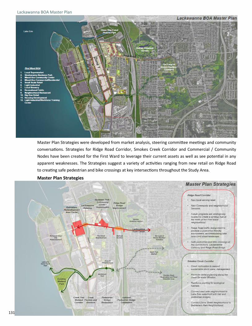
131 C&S Engineers | Joy Keubler Landscape Architects | Sasaki, AKRF, Inc.| Data Validation Services | Nature’s Way Environmental | Paradigm Environmental Services | Panamerican Consultants
Master Plan Strategies were developed from market analysis, steering committee meetings and community
conversations. Strategies for Ridge Road Corridor, Smokes Creek Corridor and Commercial / Community
Nodes have been created for the First Ward to leverage their current assets as well as see potential in any
apparent weaknesses. The Strategies suggest a variety of activities ranging from new retail on Ridge Road
to creating safe pedestrian and bike crossings at key intersections throughout the Study Area.
Lackawanna BOA Master Plan
Master Plan Strategies

132 C&S Engineers | Joy Keubler Landscape Architects | Sasaki, AKRF, Inc.| Data Validation Services | Nature’s Way Environmental | Paradigm Environmental Services | Panamerican Consultants
Creating connections throughout the First Ward BOA is one of the main focuses on the Master
Plan Strategies. Having an efficient network on major roads with a focus on key nodes and
intersections that tie Reinvestment Areas together with Strategic Sites can be seen as one of the
most important features. Allowing community members, commuters and visitors to the area
access to potential new development is crucial for sustainability and the maintenance of any Study
Area project. If there are increases in connections the community as well as those visiting the area
are more likely to explore not only the First Ward but the remainder of the City as a whole.
Master Plan Road Network

133 C&S Engineers | Joy Keubler Landscape Architects | Sasaki, AKRF, Inc.| Data Validation Services | Nature’s Way Environmental | Paradigm Environmental Services | Panamerican Consultants
Strategies for the Road Network allow for movement within the First Ward while enhancing key assets
that provide flow into other Wards of the City. This is beneficial to all residents and those visiting the
area. The rail lines running directly through the City of Lackawanna creates a divide into a western (the
First Ward) portion and an eastern portion(Second, Third and Fourth Wards). Transportation
improvements help bridge the divide for increased sense of community.
As mentioned previously, the new Bethlehem Steel Shoreline Trail being built by Erie County Parks and
Recreation is a substantial step forward for recreational opportunities for First Ward and City of
Lackawanna Residents. It opens the door to allow visitors and ecotourism that stems from visiting the
trail into to the area as well as highlights the history of Bethlehem Steel and it’s contribution to the
greater Buffalo region. The Shoreline Trail also allows links to municipalities such as South Buffalo to the
north and Hamburg to the south.
New trails and parks highlighting key environmental features such as wetlands, the Canal, the waterfront
and Smokes Creek within the First Ward can be used as an educational tool. Attaching those features to
notable attractions throughout the City of Lackawanna such as Our Lady of Victory Basilica and the
Buffalo Botanical Gardens by using new trails and improved pedestrian-friendly streetscaping is a way to
grab the attention and interest of those who have never visited the First Ward or City of Lackawanna.
This can also aid in sparking a sense of community pride. Knowledge about the area and being able to
discuss it’s rich history as well as future potential allows for storytelling and can be impactful on the
region in years to follow.
Eco and recreational tourism will have both a positive effect on increased foot traffic throughout the area
and increased economic impact. Implementation of a master bike plan as well as new recreational paths
that keep visitors around for the day means families, groups and individuals are more likely to spend
within the area. Local businesses as well as vendors at possible markets have the potential to benefit
from those choosing to stay in Lackawanna to grab a bite to eat or wander through different commercial
shops. This ties in with suggested planning for Ridge Road Corridor on the following page.
Master Bike Plan and Recreational Paths

134 C&S Engineers | Joy Keubler Landscape Architects | Sasaki, AKRF, Inc.| Data Validation Services | Nature’s Way Environmental | Paradigm Environmental Services | Panamerican Consultants
Ridge Road Corridor
Ridge Road Corridor will be transformed into an urban “Main Street” through the enhancement of
transportation networks, aesthetic improvements, increase of locally-serving retail uses, and the
establishment of connections. A variety of uses such as senior housing, commercial businesses and
industrial manufacturing throughout the Ridge Road Corridor creates an active space for a diverse
population. An active space typically has people utilizing a variety of businesses, walking paths or
recreational opportunities which can make the area more inviting. This ties into the goal of
establishing an urban, walkable main street that is west of the rail lines.
Ridge Road Currently has four lanes of traffic expanding from the Hamburg Turnpike to the rail lines.
Immediately after crossing Ridge Road Bridge, Ridge Road cuts down to two lanes of traffic. Current
uses on the corridor include Light Industrial, Commercial and Senior Housing.
Master Planning—Ridge Road Corridor
Current State of Ridge Road Corridor

135 City of Lackawanna First Ward | Brownfield Opportunity Area Step 3 | Draft Implementation Strategy
1. Streetscape Enhancements
A. Lane Reduction
The western portion of Ridge Road, extending from Route 5 until the eastern end of the Ridge Road
Bridge, is made up of four-lanes; two traffic lanes in each direction. Despite the two travels lanes on both
the northern and southern side, the lane closest to the sidewalk is typically utilized as a parking lane,
typically resulting in the need for automobiles to move over. Traffic counts on this route indicate that the
level of service along this stretch is in good condition, meaning that there is room for additional traffic or
a need of lane reduction.
Transportation Enhancements
Intended Future State of Ridge Road Corridor
The above are intended future improvements to enhance Ridge Road Corridor. Improvements include
lane reduction, addition of bike lanes, and a First Ward Business Park off of Steelawanna Avenue.

136 C&S Engineers | Joy Keubler Landscape Architects | Sasaki, AKRF, Inc.| Data Validation Services | Nature’s Way Environmental | Paradigm Environmental Services | Panamerican Consultants
To remedy this situation, re-striping can be implemented by the City Department of Public Works to
create a two lane roadway with a parking lane and bicycle lane in between on both sides. The conditions
of the roadway suggest that, in the future, a newly paved roadway, new curbs, sidewalk repairs and
planting of trees is needed. For the next 0 to 5 years, simple restriping of the roadway can be completed,
with complete overhaul of the roadway to be completed in 10 to 15 years. Conceptual design of the
proposed restriping is shown below.
In the South Buffalo BOA, directly north of the First Ward BOA, proposed bicycle lane connections were
identified. Ridge Road in the First Ward BOA was proposed as a dedicated bike path; therefore, this
improvement is supported and encouraged by surrounding municipalities and provides another
opportunity for increased connections. Below is an example of future roadway improvements on Ridge
Road.
Phase I of the Ridge Road streetscaping project (including restriping of the roadway) will cost
approximately $15,000. Phase II of the Ridge Road streetscaping project (including complete
reconstruction of the roadway) is estimated at approximately $2.2 million. Application for New York
State Funding under the NYS DOT Transportation Enhancement Plan is suggested to secure funding for
this type of project.
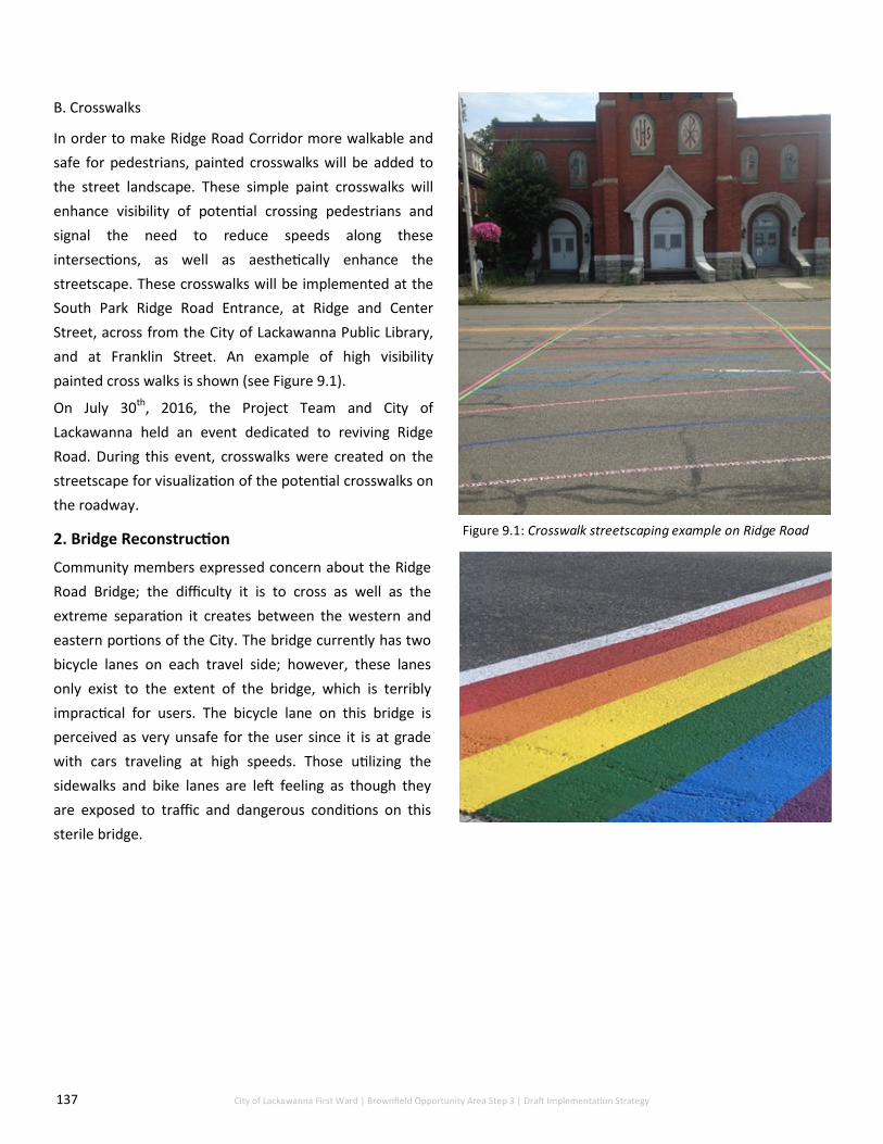
137 City of Lackawanna First Ward | Brownfield Opportunity Area Step 3 | Draft Implementation Strategy
B. Crosswalks
In order to make Ridge Road Corridor more walkable and
safe for pedestrians, painted crosswalks will be added to
the street landscape. These simple paint crosswalks will
enhance visibility of potential crossing pedestrians and
signal the need to reduce speeds along these
intersections, as well as aesthetically enhance the
streetscape. These crosswalks will be implemented at the
South Park Ridge Road Entrance, at Ridge and Center
Street, across from the City of Lackawanna Public Library,
and at Franklin Street. An example of high visibility
painted cross walks is shown (see Figure 9.1).
On July 30th, 2016, the Project Team and City of
Lackawanna held an event dedicated to reviving Ridge
Road. During this event, crosswalks were created on the
streetscape for visualization of the potential crosswalks on
the roadway.
2. Bridge Reconstruction
Community members expressed concern about the Ridge
Road Bridge; the difficulty it is to cross as well as the
extreme separation it creates between the western and
eastern portions of the City. The bridge currently has two
bicycle lanes on each travel side; however, these lanes
only exist to the extent of the bridge, which is terribly
impractical for users. The bicycle lane on this bridge is
perceived as very unsafe for the user since it is at grade
with cars traveling at high speeds. Those utilizing the
sidewalks and bike lanes are left feeling as though they
are exposed to traffic and dangerous conditions on this
sterile bridge.
Figure 9.1: Crosswalk streetscaping example on Ridge Road
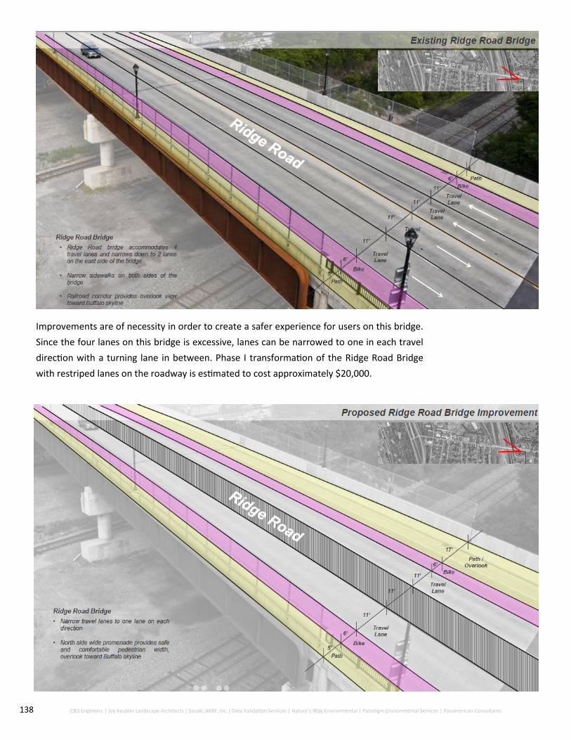
138 C&S Engineers | Joy Keubler Landscape Architects | Sasaki, AKRF, Inc.| Data Validation Services | Nature’s Way Environmental | Paradigm Environmental Services | Panamerican Consultants
Improvements are of necessity in order to create a safer experience for users on this bridge.
Since the four lanes on this bridge is excessive, lanes can be narrowed to one in each travel
direction with a turning lane in between. Phase I transformation of the Ridge Road Bridge
with restriped lanes on the roadway is estimated to cost approximately $20,000.

139 City of Lackawanna First Ward | Brownfield Opportunity Area Step 3 | Draft Implementation Strategy
Phase II transformation of the Ridge Road Bridge includes the addition of a north side promenade that is
slightly above grade and includes a guard rail will create a space that is to be utilized by both pedestrians
and bicyclists; this will induce a hard separation between automobiles and make walking more of an
enjoyable experience for the user. This is estimated to cost approximately $320,000.
3. Lakeshore Commerce Park Connector Road
In the Step 2 Nomination Document, a roadway was proposed to connect Steelawanna Business Park to
Lakeside Commerce Park. This roadway was proposed to provide a gateway for increased commercial
activity in this area of the City of Lackawanna and provide an additional link to the City of Buffalo industrial
park. This roadway would begin at Wilksbarre Avenue and extend north to connect to Commerce Drive,
completing the connection from Ridge Road to Lakeside Commerce Park.
According to the Traffic Impact Study conducted, Ridge Road currently contains sufficient commercial
traffic to support this link to Lakeside Commerce Park. However, in this report it is recommended that this
connector road be designed to discourage cut-through traffic to avoid the roadway serving as a Hamburg
Turnpike by-pass alternative route. Additional analysis to support the design of this connector road is
provided in Appendix G.
Community Enhancement and Place-Making Techniques
Place-making techniques are important beginning steps to the revitalization of any community. Place-
making is a facet of community planning that works to leverage existing assets in order to create spaces
that promote well-being for all. Place-making has the potential to provide the First Ward BOA with simple,
inexpensive projects, installations and events can be implemented in order to boost community pride and
activity within the Ridge Road Corridor. Specific enhancements and place-making techniques are:
1. Marketing Campaign
The City of Lackawanna’s existing ‘About FACE’ campaign as well as the continuing Arts on Ridge Festival
have been widely successful in recent years. In order to keep this momentum thriving, a branding
campaign of the City and the Ridge Road Corridor itself should be kept alive. In this capacity, the Ridge
Road Corridor will have a recognizable face to any event or association that takes place in the area.
Continuing the use of the ‘About FACE’ logo during local events, grand openings of redevelopment projects
and at Public Meetings is a beneficial way for both community members and those from outside of the
community to associate new development with the City’s efforts.
Figure 9.2: City of Lackawanna’s Marketing Campaign logo —’About FACE’

140 C&S Engineers | Joy Keubler Landscape Architects | Sasaki, AKRF, Inc.| Data Validation Services | Nature’s Way Environmental | Paradigm Environmental Services | Panamerican Consultants
2. Art Installations
In order to create a lively and thriving district, it is
necessary for the experience of the street to be vibrant
and active. The City has already taken steps to achieve
this with flower pots lined along ridge road. This is a
great, relatively inexpensive method of activating a space.
Also known as, arts-based place-making, this integrated
approach has been shown to stimulate local economies as
well as lead to increased innovation, cultural diversity and
civic engagement. The goal of this type of work is to build
strong, healthy, resilient and creative cities.
In July of 2016, the Project Team created an art
installation made out of everyday household objects to
showcase the simplicity of art as an attractor on Ridge
Road Bridge (See Figures 9.3 and 9.4). The art installation
was produced to represent the windmills along the Lake
Erie shoreline within the First Ward BOA. This type of
creativity was proudly received by the community;
community members expressed delight and positivity
when walking across the bridge and desired to see more
examples of art throughout the City an First Ward.
Other examples of art that can transform and bring life to
the public space are paintings and murals on the side of
an underutilized building, or paintings on the pavement of
sidewalks and crosswalks. This type of initiative can be
broadcasted by the City to local artists and visionaries
whom would like to opportunity activate spaces in their
hometown. The City of Buffalo and surrounding
municipalities have several murals throughout the City
that create a sense of place in a particular neighborhood
(see Figure 9.5). The art in the City of Lackawanna could
be tailored to the industrial heritage and remembrance of
it’s history. Place-making is highly focused on a grassroots
approach to community building and revitalization.
Figure 9.3: Art Installation using House hold items on Ridge
Road
Figure 9.4: Community members working on the First Wards
public art installation
Figure 9.5: A public art mural within the City of Buffalo

141 City of Lackawanna First Ward | Brownfield Opportunity Area Step 3 | Draft Implementation Strategy
3. Healthy Food Markets
Through ongoing interactions with community members, it is clear that access to healthy food in the First
Ward is difficult and insufficient. In order to get to a grocery store or market without a car, residents must
either walk several miles from their homes, take a taxi or rely on the undependable public transportation
in the area.
Local markets are successful in strengthening the local identity of a community as well as supporting local
neighborhood revitalization (see Figure 9.7). This is because the partnerships involved in maintaining a
marketplace involves a wide network of local businesses, organizations and vendors and strong
relationships are formed from them.
264 Ridge Road serves as a perfect start-up location for a healthy food market due to its high visibility and
centrality. Several food vendors have used this space for this type of exposure in the recent past. This type
of endeavor involves the following steps:
Obtain a permit from the City of Lackawanna Gather a list of farmers, vendors and local businesses Contact said organizations and choose several dates and times that work best (typically Saturday and
Sunday mornings to early afternoon) Begin a marketing campaign for the market with posted flyers throughout the neighborhood, within
local businesses and multiple types of media (print, social and news)
4. Ridge Road Community Hub
The Former Friendship House is located on Ridge Road, which is one of the most traversed roads in the
City of Lackawanna, and the only east-west corridor that transects the City, making its location highly
accessible to both residents and commuters. Additionally, this parcel of land is in close proximity to the
residential neighborhood of the First Ward, is owned by the City of Lackawanna, and is of ample parcel
size, deeming it ripe for development. Once place-making techniques are begun on and around the site,
the resulting spurred activity will create the demand for a mixed-use community center with retail
components.
The Former Friendship House is an ideal location for a mixed-use community and retail center. This
entirety of the building will be approximately 20,000-square feet; 10,000-square feet dedicated to the
community center and 10,000-square feet dedicated to five retail outlets (about 2,000-square feet each).
This center and retail will provide up to 40 jobs within the First Ward neighborhood and enhance the
quality of life by bringing increased vitality to the neighborhood. Residents will be inclined to spend
money at this location shown on the following page due to its convenience and easy accessibility for
everyday needs.
Figure 9.6: Pop up Farmer’s Market at REVIVE Ridge Bash Figure 9.7: Bidwell Farmer’s Market in the
Elmwood Village of Buffalo, NY

142 C&S Engineers | Joy Keubler Landscape Architects | Sasaki, AKRF, Inc.| Data Validation Services | Nature’s Way Environmental | Paradigm Environmental Services | Panamerican Consultants
This facility will likely remain City owned property and be operated in part by a non-profit entity as
well as private business owners for the individual shops.
Potential Ridge Road Historic District
The Phase IA Archeological Survey conducted during this project identified a potential Ridge Road
Historic District based off of the existing buildings and features along the western section of the
roadway. The potential Ridge Road Historic District shown below is comprised of a 0.24-mile
stretch along Ridge Road containing 16 buildings and seven undeveloped lots. The extant buildings
from about Wilkesbarre Street to Ingham Avenue represent a cohesive collection of buildings along
this roadway.

143 C&S Engineers | Joy Keubler Landscape Architects | Sasaki, AKRF, Inc.| Data Validation Services | Nature’s Way Environmental | Paradigm Environmental Services | Panamerican Consultants
Further investigation to determine whether this district could be designated by SHPO is
required to obtain sufficient information. A designated historic district can assist in the
revitalization process due to the NYS Historic Properties Tax Credit Program. This program
provides credits to both federal and state income taxes, each providing 20% tax credits up to $5
million for Qualified Rehabilitation Expenditures (QRE). The building to be rehabilitated must be
either designated on the State or National Register of Historic Places or be listed as a
‘contributing’ building in a historic district in order to receive credits. Developers are
significantly incentivized to rehabilitate particular buildings based on their tax credit potential;
therefore, the designation of this district should be investigated further to determine eligibility.

144 C&S Engineers | Joy Keubler Landscape Architects | Sasaki, AKRF, Inc.| Data Validation Services | Nature’s Way Environmental | Paradigm Environmental Services | Panamerican Consultants
Hamburg Turnpike Corridor
The recommended redevelopment projects will transform the Hamburg Turnpike into an active
commercial, light industrial corridor supported by the highly efficient traffic that travels through the
area. The roadway will no longer be solely focused on commuter automobile transport but a
destination for commuters to visit for their retail needs, as well as an invigorating space for
industrial development within the former Bethlehem Steel site.

145 City of Lackawanna First Ward | Brownfield Opportunity Area Step 3 | Draft Implementation Strategy
Transportation Enhancements
1. Hamburg Turnpike Intersections
A redeveloped Hamburg Turnpike has the potential to also improve relationships with the environment
throughout the First Ward and City of Lackawanna as provide access to Smokes Creek and possible water-
front activities. There is also the possibility of the possible expansion of Steelawanna Business Park making it
not only a site on Ridge Road but on the Turnpike as well.
It is no doubt that the heavy load of traffic traveling north and southbound on the Hamburg Turnpike has
created an auto-centric environment within the City. For this reason, lane reduction on Hamburg Turnpike
was discussed as a potential remedy to the high commuter traffic speeds on this roadway; however,
according to the Traffic Impact Study, lane reduction along this route is infeasible due to amount of traffic
traveling on Hamburg Turnpike at peak hours.
Lane reduction is not the only way to achieve traffic calming and enhancement of the pedestrian
environment. Alteration of the conditions of the roadway can be achieved through improved landscaping,
reconstructed sidewalks and shoulders, street furniture and lighting, pedestrian refuge and mid-block
islands, modified intersection and channelization, higher visibility crosswalks, signage as well as regulations
and enforcement. Since Hamburg Turnpike is a New York State owned road, specific procedures will need to
be followed for implementation.
It is recommended as a transportation enhancement for Hamburg Turnpike Corridor for an extension of
Holbrook Street onto the former Bethlehem Steel site to increase access to the Site further. In order to
ensure ease of access for this extension, the traffic light at Odell Street must be relocated to the Holbrook
Street intersection. The same estimate for the Dona Street extension can be used for the construction of the
Holbrook Street Extension at $1,584,980.000.

146 C&S Engineers | Joy Keubler Landscape Architects | Sasaki, AKRF, Inc.| Data Validation Services | Nature’s Way Environmental | Paradigm Environmental Services | Panamerican Consultants
2. Traffic and Street Landscape Improvements
Intersection improvements provide ample opportunity for a safer Hamburg Turnpike. Intersections has
the capability to be a deciding factor in reducing accidents, allow a greater amount of access to the
Highway and other major roads within the area and provide a gateway to access any retail or
commercial businesses. With Dona and Holbrooke Street extensions, ties are created to the Bethlehem
Steel Shoreline Trail currently under construction by Erie County as well. This allows visitors and
community members access to both sides of Hamburg Turnpike is crucial to balance spending within the
area.

147 C&S Engineers | Joy Keubler Landscape Architects | Sasaki, AKRF, Inc.| Data Validation Services | Nature’s Way Environmental | Paradigm Environmental Services | Panamerican Consultants
Street extensions as well as having appealing commercial frontage are important steps when
improving the Hamburg Turnpike streetscape. “Big Box” retail is suggested and typically has a
negative connotation but, having appealing frontages with proper landscaping and signage that fits
the area can create a positive impact of the overall visual appeal of the turnpike.
Eastside Traffic
Other strategies for the east side of Hamburg Turnpike are also suggested. Having a larger buffer
between the highly commuted road and homes residing is a calming method that can also take green
infrastructure into account. A “green buffer” in front of Bethlehem Park homes to allow more
landscaping in this area and a higher sense of home owner pride. This is not only a positive step
forward for those residing within the Bethlehem Park neighborhood but also makes the area more
appealing to potential developers and those visiting from outside of Lackawanna.
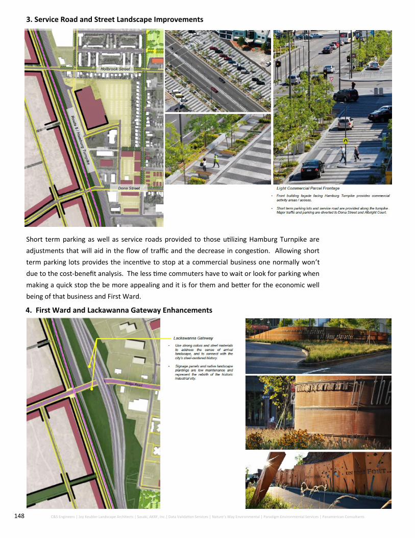
148 C&S Engineers | Joy Keubler Landscape Architects | Sasaki, AKRF, Inc.| Data Validation Services | Nature’s Way Environmental | Paradigm Environmental Services | Panamerican Consultants
3. Service Road and Street Landscape Improvements
Short term parking as well as service roads provided to those utilizing Hamburg Turnpike are
adjustments that will aid in the flow of traffic and the decrease in congestion. Allowing short
term parking lots provides the incentive to stop at a commercial business one normally won’t
due to the cost-benefit analysis. The less time commuters have to wait or look for parking when
making a quick stop the be more appealing and it is for them and better for the economic well
being of that business and First Ward.
4. First Ward and Lackawanna Gateway Enhancements

149 City of Lackawanna First Ward | Brownfield Opportunity Area Step 3 | Draft Implementation Strategy
The addition of signage and landscaping can transform a small space in a big way. Both elements
along the Ridge Road/Hamburg Turnpike overpass will assist with slowing commuter speeds,
enhancing the vacant space along Hamburg Turnpike, and activating space for pedestrians and
bicyclists. Signage such as the examples shown in the image on the previous page will embrace
the unique industrial heritage of the area while activating the dead greenspace in between
Hamburg Turnpike and the former Bethlehem Steel site access road to the west. Additionally,
with the newly announced net zero energy building to be constructed in the near future,
increased employees will be utilizing the nearby space; therefore, signage and landscaping such
as this will bring sense of arrival to the area with low expense and maintenance.
Hamburg Turnpike is undoubtedly utilized as a commuter corridor into and out of the City of
Buffalo. The way that it exists today, there is a lack of prominent entryway into the City of
Lackawanna for these commuters; no signage welcoming commuters into the City as well as
barren land on either side of the overpass. Additionally, the Ridge Road/Hamburg Turnpike
intersection consists of a raised bridge above Ridge Road. There is an opportunity to tailor this
overpass into a gateway into the City of Lackawanna and former Bethlehem Steel site. In the
early stages of the Step 3 Implementation Strategy, the removal of the Hamburg Turnpike
overpass and conversion into an at-grade roundabout was discussed as a potential option to act
as a traffic calming solution. However, the traffic impact study conducted in 2017 revealed that
the existing traffic volumes along the Hamburg Turnpike/Ridge Road intersection were too
significant to support the conversion into a roundabout. Therefore, this traffic calming method
was eliminated from the Projects to be implemented.

150 C&S Engineers | Joy Keubler Landscape Architects | Sasaki, AKRF, Inc.| Data Validation Services | Nature’s Way Environmental | Paradigm Environmental Services | Panamerican Consultants
5. Addition of Bethlehem Steel Shoreline
In March of 2016, the Erie County Department of Environment and Planning (DEP) completed the design
phase of the Bethlehem Steel Shoreline Trail on the western portion of the Hamburg Turnpike. This 1.4-
mile trail will accommodate pedestrian and bicycle use by linking the Union Ship Canal in the City of
Buffalo to the Hamburg Turnpike/Dona Street intersection. Groundbreaking for the Trail was at the end
of May 2018 (see Figure 9.8) and construction of the Trail began on June 4, 2018 (see Figure 9.9). Future
plans involve the connection of the trail to Woodlawn Beach State Park, eventually connecting the Town
of Hamburg to Niagara County along multiple multi-use trails in Western New York.
Figure 9.8: Shovel Ceremony for Bethlehem Steel
Shoreline Trail
Figure 9.9: The building of Bethlehem Steel Shoreline Trail

151 City of Lackawanna First Ward | Brownfield Opportunity Area Step 3 | Draft Implementation Strategy
5. Bethlehem Steel Shoreline and Gateway Bike Trailhead Enhancement
Plans to construct the Bethlehem Steel Shoreline Trail should be accompanied by trail and bicycle
amenities in order to attract additional visitors to the recreational trail. Experience along this trail with
amenities such as signage and bike racks will work to further enhance the connection of the City of
Lackawanna to the City of Buffalo through the Buffalo Outer Harbor Waterfront Trail.
Application through NYS DOT Transportation Enhancement Program grant will provide funds necessary
to establish these amenities along the anticipated trail. Examples of amenities include the Gallagher
Pier enhancement project that recently took place along the Buffalo Outer Harbor (see Figure 9.10).
Figure 9.10: Recent Gallagher Pier enhancement Project located at the Buffalo Outer Harbor
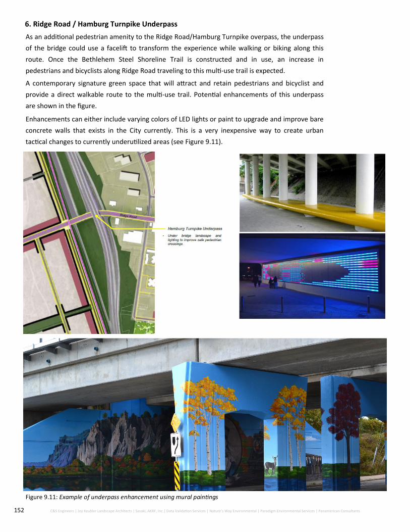
152 C&S Engineers | Joy Keubler Landscape Architects | Sasaki, AKRF, Inc.| Data Validation Services | Nature’s Way Environmental | Paradigm Environmental Services | Panamerican Consultants
6. Ridge Road / Hamburg Turnpike Underpass
As an additional pedestrian amenity to the Ridge Road/Hamburg Turnpike overpass, the underpass
of the bridge could use a facelift to transform the experience while walking or biking along this
route. Once the Bethlehem Steel Shoreline Trail is constructed and in use, an increase in
pedestrians and bicyclists along Ridge Road traveling to this multi-use trail is expected.
A contemporary signature green space that will attract and retain pedestrians and bicyclist and
provide a direct walkable route to the multi-use trail. Potential enhancements of this underpass
are shown in the figure.
Enhancements can either include varying colors of LED lights or paint to upgrade and improve bare
concrete walls that exists in the City currently. This is a very inexpensive way to create urban
tactical changes to currently underutilized areas (see Figure 9.11).
Figure 9.11: Example of underpass enhancement using mural paintings

153 City of Lackawanna First Ward | Brownfield Opportunity Area Step 3 | Draft Implementation Strategy
Economic Development Projects
1. Albright Court
Due to the commuting patterns on Hamburg Turnpike there is a demand for increased retail services along
this roadway. The economic and market analysis of the First Ward BOA and surrounding region showed a
demand gap for retail services of $200 million in the City of Lackawanna; therefore, indicating that the
retail market is underserved and an opportunity to expand destination retail floor space exists. Based on
the assumptions of the analysis, the First Ward BOA could absorb approximately 687,000 square feet of
retail and service industry businesses.
For this reason, the preferred redevelopment of the Albright Court Property is a large-format commercial
store of approximately 50,000 square feet along Hamburg Turnpike. This retail service would be branded
as a “big-box” store, which is defined as a physically large retail establishment typically part of a retail
chain and offers a variety of products to its customers. This retail store would be beneficial to the City
of Lackawanna and the surrounding region as a whole due to its accessibility for both residents and
commuters. Additionally, since the frontage portion of the property is currently within the NYS BCP,
tangible tax credits for any hard development costs on the site could be recovered under the program.
Additional information about the development of this property is provided in Strategic Sites.
First Ward Neighborhood
The recommended projects that follow will transform the First Ward Neighborhood into a unified area
with an abundance of recreational and gathering space supported by a diversified housing stock.
Community Enhancement Projects
1. Pocket Parks and Greenway
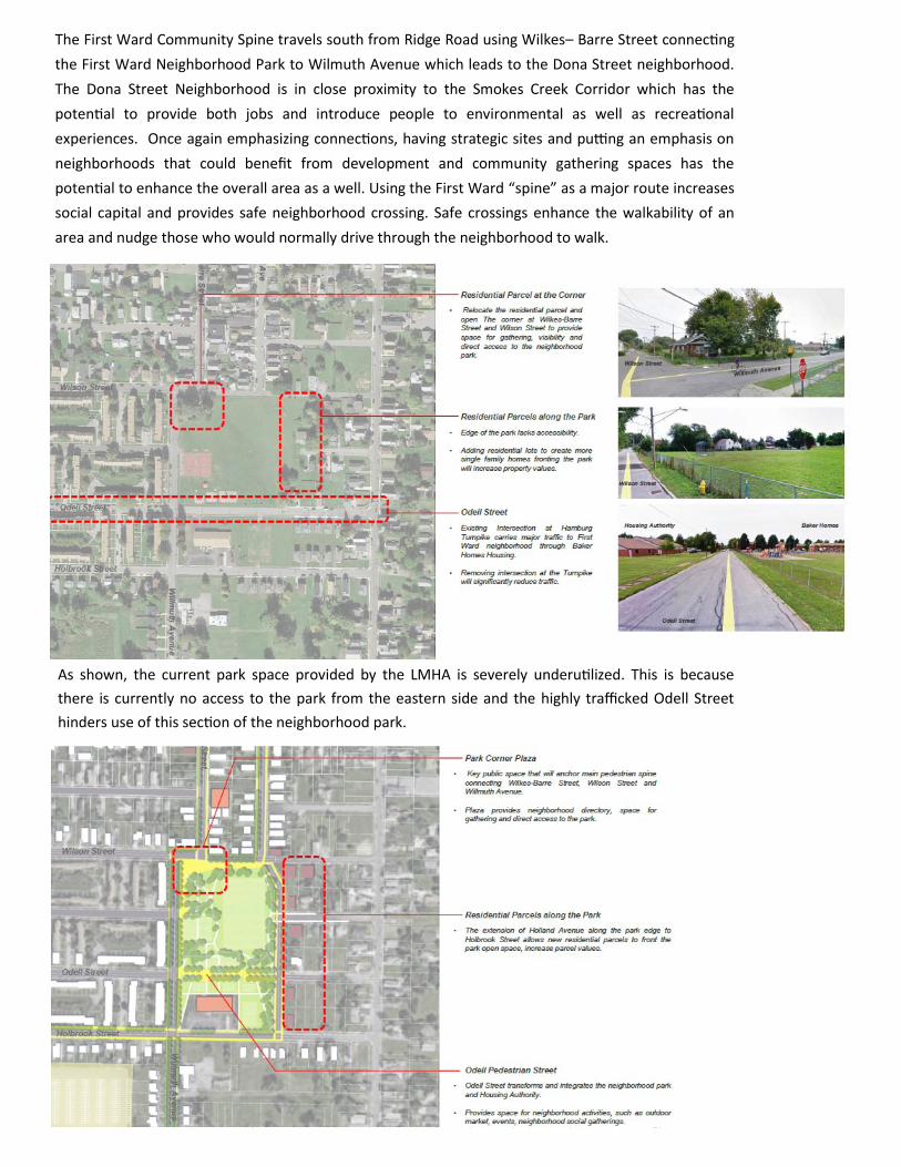
154 City of Lackawanna First Ward | Brownfield Opportunity Area Step 3 | Draft Implementation Strategy
The First Ward Community Spine travels south from Ridge Road using Wilkes– Barre Street connecting
the First Ward Neighborhood Park to Wilmuth Avenue which leads to the Dona Street neighborhood.
The Dona Street Neighborhood is in close proximity to the Smokes Creek Corridor which has the
potential to provide both jobs and introduce people to environmental as well as recreational
experiences. Once again emphasizing connections, having strategic sites and putting an emphasis on
neighborhoods that could benefit from development and community gathering spaces has the
potential to enhance the overall area as a well. Using the First Ward “spine” as a major route increases
social capital and provides safe neighborhood crossing. Safe crossings enhance the walkability of an
area and nudge those who would normally drive through the neighborhood to walk.
As shown, the current park space provided by the LMHA is severely underutilized. This is because
there is currently no access to the park from the eastern side and the highly trafficked Odell Street
hinders use of this section of the neighborhood park.

155 C&S Engineers | Joy Keubler Landscape Architects | Sasaki, AKRF, Inc.| Data Validation Services | Nature’s Way Environmental | Paradigm Environmental Services | Panamerican Consultants
Figure 9.12 & 9.13: Community members partici-
pating in Lackawanna’s first Pop up Park event
2. New Multi-use Soccer Field
A Park Corner Plaza is a way to anchor the redevelopment of space and can provide a directory and access
to the park. New residential parcels with park frontage on Holland Avenue and Holbrook Street are an
incentive to move into the park and aid in the increase in parcel values.
Across the community the need for additional
parks and recreation space for residents in the
First Ward neighborhood is evident. Pocket
parks can be instituted as a viable solution to
redevelop the stream of vacant parcels that
exist within the neighborhood. A pocket park is
a small, outdoor space, usually approximately
1/4-acre, located in an urbanized area. These
areas provide safe environments for
surrounding community members to have a
small event space, play areas for children, or an
area to enjoy the outdoors.
By linking the entire First Ward neighborhood
through park space and greenway connections,
a greater sense of community and well-being
will be established. With the development of a
new community center and the establishment
of a more accessible Smokes Creek Corridor
(described in subsequent sections), the need
for a connecting First Ward Neighborhood Park
is necessary. The current Lackawanna
Municipal Housing Authority (LMHA) park
space on Odell Street will be enhanced. The
following figure shows the existing conditions
of the site.
This project proposes the annexation of the residential parcel at the intersection of Wilkesbarre and Wilson
streets into the current LMHA Park, the extension of Holland Avenue to Holbrook Street and the closure of
Odell Street in between Willmuth Avenue and the eastern border of the park to automotive traffic. Since
this Implementation Strategy proposes the relocation of the Hamburg Turnpike/Odell Street intersection
traffic light to Holbrook Street, this closure a feasible alteration of the network.
First Ward residents have expressed the need for additional soccer fields for their children to play in
several organized leagues in the City. 31 South Street (otherwise known to the NYSDEC as “Lehigh
Industrial Park Site” just north of CIR (see Figure 9.14 and 9.15), is owned by the Islamic Mosque, whom
intends to use this site as a soccer field for residents. The DEC stipulates that this site only needs one foot
of cover material to permit this parcel for recreational use. Following coverage, this site can then be striped
to create an official soccer field for City residents to utilize.

156 C&S Engineers | Joy Keubler Landscape Architects | Sasaki, AKRF, Inc.| Data Validation Services | Nature’s Way Environmental | Paradigm Environmental Services | Panamerican Consultants
Figure 9.15: Potential usage for a First Ward Neighborhood soccer field
Figure 9.14: Vacant parcel on within the First
Ward BOA that can be used for a community
field on the corner of School and Ingham
Street

157 City of Lackawanna First Ward | Brownfield Opportunity Area Step 3 | Draft Implementation Strategy
3. Demolition of Hazardous Structures
Some structures within the First Ward neighborhood are in such a condition that they can be
considered a threat to public safety. Structures that display disrepair and are at risk of collapse and
debris falls or potential problems with rodents. The City should first work with property owners
through code enforcement procedures to either repair or demolish these structures. A second option
for the Lackawanna Municipal Housing Authority is to obtain U.S. Department of Housing and Urban
Development grants for the demolition of severely distressed housing units. Properties identified as
needing attention in the immediate future are:
35 Steelawanna Avenue
89 Holland Avenue
4. Encourage More Housing Infill through Various Programs
The First Ward neighborhood is overwhelmingly ridden with vacant properties, which contribute to
instability of the neighborhood. The City of Lackawanna is also burdened with their ownership of a
large number of vacant parcels since these properties are not contributing to tax revenue. There are a
number of options the City has in obtaining private interest on these properties and incentivizing
private investment dollars to redevelop these properties for residential development. These include:
First time Home Buyers Program
Rehabilitation Loans
Community Development Block Grant Funds
In addition to obtaining outside interest in these properties, the City and the LCDC should advertise
these programs to the residents of the First Ward. Many residents may not know about these
programs and would benefit immensely. Homeownership instills pride within community members
and develops the potential for block clubs as well as a strong sense of security.
Construction of new housing within the First Ward Neighborhood has been ongoing in recent years. If
programs and housing continue to accelerate the First Ward Neighborhood and those residing within
it will benefit immensely.
Concepts were created for the First Ward BOA on how to utilize this parcel as a multi-use field to its
fullest extent. An itemized breakdown of all proposed improvements such as landscaping, fencing,
paving, building, and utilities can be found in Appendix H.

158 C&S Engineers | Joy Keubler Landscape Architects | Sasaki, AKRF, Inc.| Data Validation Services | Nature’s Way Environmental | Paradigm Environmental Services | Panamerican Consultants
5. Redevelopment of 100 Dona Street
100 Dona Street, as previously discussed, was once the location of the Friendship House. The building which
formerly operated as the Friendship House was recently dilapidated and a safety hazard for the community
due to falling portions of the structure. Additionally, according to the Phase I/II ESA that was performed as
part of this study, the structure contains hazardous asbestos and lead material as well as petroleum, SVOC
and metal contamination on the site.
In 2016, the City of Lackawanna was awarded RestoreNY funds to demolish the hazardous building. This
demolition took place in the summer of 2018. The demolition of the structure alone has potential to
increase the quality of life within the First Ward neighborhood as well as remove a significant eyesore on
the community.
Based on the Phase II ESA conducted in 2016, contaminates on the property exist. This contamination
suggests that the property may be eligible for remediation and redevelopment under the NYS BCP. The
cleanup and redevelopment of this property would greatly improve the First Ward neighborhood and
increase economic stability in the City of Lackawanna. Greater detail of the potential redevelopment is
provided in Section 10 – Strategic Sites.
Smokes Creek Corridor
The recommended projects that follow will transform Smokes Creek into a recreational, economic and
community resource to be enjoyed by all residents of the City of Lackawanna and the Western New York
region. Projects will link the Smokes Creek Corridor to the regional trail system as well as provide incentive
to work and reside within the area.
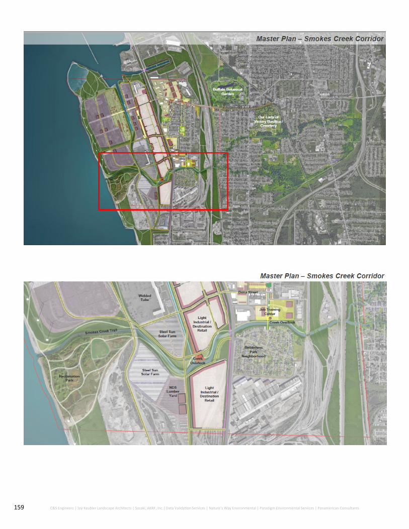
159 C&S Engineers | Joy Keubler Landscape Architects | Sasaki, AKRF, Inc.| Data Validation Services | Nature’s Way Environmental | Paradigm Environmental Services | Panamerican Consultants

160 C&S Engineers | Joy Keubler Landscape Architects | Sasaki, AKRF, Inc.| Data Validation Services | Nature’s Way Environmental | Paradigm Environmental Services | Panamerican Consultants
Community Enhancement and Environmental Restoration Projects
Multiple community enhancement installments along Smokes Creek Corridor can lead to big
changes in environmental appreciation, stewardship and pride in natural resources. Key
strategies along Smokes Creek have been chosen to connect community members and visitors
back to the area due to not having access for many years. It is suggested that green
infrastructure be used whenever possible along Smokes Creek Corridor to ensure the area
remain as undisturbed as possible. Habitat restoration and creek remediation are suggested
along with the strategies to attract tourism. Practices such as stream restoration, bio retention
and flooding mitigation can help with overflow, runoff and maintaining biodiversity.

161 City of Lackawanna First Ward | Brownfield Opportunity Area Step 3 | Draft Implementation Strategy
1. Construct Multi-Use Trail along Smokes Creek
As discussed previously, despite common misconceptions, Lake Erie waterfront has never been
publicly accessible due to private ownership and former steel operations. Smokes Creek access is
also limited in the First Ward BOA due to almost half of the corridor located on the former
Bethlehem Steel Site, as well.
An identified goal in the Step 2 Nomination Document was to create increased access to both
waterfronts as well as improve recreational activities surrounding these natural resources. For this
reason, a multi-use trail is an incredible opportunity to both connect residents to the water as well
as open up land for public use.
The multi-use trail would extend from the railroad tracks on the eastern side of the First Ward
BOA and extend east to the Lake Erie waterfront through the Smokes Creek Corridor. Toward the
western side of the First Ward BOA, the multi-use trail would split to conform around the current
location of the acid tar pits, giving access to this future ‘Reclamation Park’. This multi-use trail
would be similar to the future Bethlehem Steel Shoreline Trail in width and function.
2. Pedestrian Bridge Restoration
The condition of the Smokes Creek Bridge was a major community concern revealed during the
BOA Process. This bridge lies in between Bethlehem Park and Alliance Drive. This bridge once
connected the First Ward to the Second Ward (Bethlehem Park); however, has since been closed
down (with barriers and fencing on the entryways of the bridge) impeding all access. The picture
to the left depicts the current state of the Smokes Creek Bridge.
Additionally, A Street, which lies just to the north of the Smokes Creek Bridge currently terminates
where the light manufacturing company, Alliance Drive Manufacturing, is located. This
disconnection creates a hindrance of community members to access Smokes Creek.
This bridge and the surrounding area (see Figure 9.16) should be restored to allow pedestrian
access to the Smokes Creek Corridor as well as connect the two neighborhoods north and south of
the bridge. This will both encourage continued community interaction as well as provide
recreational access.

162 C&S Engineers | Joy Keubler Landscape Architects | Sasaki, AKRF, Inc.| Data Validation Services | Nature’s Way Environmental | Paradigm Environmental Services | Panamerican Consultants
Figure 9.16: Smokes Creek Bridge
Restoration activities include:
1. Connect A Street to Smokes Creek Bridge
In order to create a seamless connection of A Street to the Smokes Creek
Bridge, 310 feet of pavement at 25 feet wide should be placed in the north-
south directional.
2. Reopening of Smokes Creek Bridge
Smokes Creek Bridge is currently closed off to any type of access. Removing
these fences and restoring the Bridge will be beneficial for the entire
community.
The reopening of the Bridge will add even more connections throughout the
area and once again connect people within the City of Lackawanna and First
Ward to existing natural resources that have once been closed off or off
limits to them.

163 City of Lackawanna First Ward | Brownfield Opportunity Area Step 3 | Draft Implementation Strategy
A new park can be implemented near the Lake
Erie Waterfront as an educational trail for all
ages. Environmental and history makers can be
implemented throughout the park to continue
connections with natural resources as well as tie
in the former Bethlehem Steel Site and the
history of the City of Lackawanna as a whole.
Reclamation Park will have trails throughout
with an overall connection to Smokes Creek
Trail. This park has opportunities to connect to
the Bethlehem Steel Shoreline Trail as well as
potential commercial development on the
Hamburg Turnpike.
Since Reclamation Park is within the City of
Lackawanna Limits and resides in the First Ward
BOA, it drastically increases the percentage of
land dedicated to green and open space. It was
mentioned previously that the First Ward
suffers from a low percentage of land dedicated
to park space and this will fill that gap
immensely.
When adding educational elements, the Park
has the potential to be a hub for nearby
Universities science programs within the City of
Buffalo. It also can be a place for field trips for
the City of Lackawanna and surrounding primary
schools.
Examples of a Wetland Park and educational
elements can be seen in Figures 9.17 and 9.18.
3. Reclamation Park
Figure 9.17 and 9.18: Examples of Wetlands Parks

164 C&S Engineers | Joy Keubler Landscape Architects | Sasaki, AKRF, Inc.| Data Validation Services | Nature’s Way Environmental | Paradigm Environmental Services | Panamerican Consultants
Many efforts by the NYS DEC have been completed in recent
years to maintain the environmental integrity of Smokes Creek.
The lower reach of Smokes Creek, nearest Lake Erie, was
dredged of sediment in 2009. Approximately 40,000 cubic yards
of material was removed under this action as part of the
NYSDEC cleanup of the adjacent former Bethlehem Steel Site. In
2015, Smokes Creek was dredged from Lake Erie, east to Wood
Street, restoring this area to its former hydraulic capacity.
In order to ensure Smokes Creek maintains its ecological health,
the City should partner with Buffalo Niagara Waterkeeper, a
non-profit organization specializing in waterway restoration
and overall health in the Buffalo-Niagara Region. The Buffalo
Niagara Waterkeeper is involved in many restoration and
aquatic habitat sustainability projects including the nearby
Buffalo River. Not only can Waterkeeper help restoration
efforts, but they are also innately involved with green
infrastructure methods to mitigate flood risk and reduce
stormwater flow.
Specifically, restoration activities that could be implemented
include:
Native plantings along the creek to provide natural habitats for land and water life
Buffering around the stream corridor to mitigate land erosion
Channel restoration
5. Smokes Creek Overlook
4. Smokes Creek Restoration
Smokes Creek is disconnected from the community in terms of
recreational opportunities and enjoyment. A creek overlook
along Smokes Creek’s path could work to provide a designated
spot for rest, fishing, and nature viewing. This overlook could
be supplemented with historical and ecological information
about the City of Lackawanna and Lake Erie to provide a fruitful
visitor experience.
It is most practical for this overlook to be located on City-
owned property. Near the eastern portion of the First Ward
BOA, west of the railroad tracks, the City of Lackawanna owns
land on both the northern and southern banks of Smokes
Creek. There are two options for the creek overlook:
a. Overlook on northern bank adjacent to Smokes Creek multi-use trail
b. Overlook on southern bank on City-owned park connected to multi-use trail with a small pedestrian bridge across Smokes Creek
Figure 9.19: Creek Overlook example

165 City of Lackawanna First Ward | Brownfield Opportunity Area Step 3 | Draft Implementation Strategy
Economic Development Projects
1. Light Industrial and Workforce Development Center
The property at Alliance drive is composed of seven parcels
along Alliance Drive and A Street. The site is currently
undeveloped and surrounds the recently redeveloped Alliance
Innovative Manufacturing, a light manufacturing facility.
Throughout the BOA process and economic and market
analysis, the highest and best use of the site would be for a
combined workforce training center and light industrial use
development. This development would include several
separate buildings within the site to support resident
workforce training as well as job creation. The three building
development (one workforce training center and two light
industrial/flex space buildings) would total approximately
50,000-square feet. Parking lots would also be constructed in
conjunction with each building.
Since this development is in such close proximity to Smokes
Creek, green infrastructure techniques and best management
practices should be instituted in parking areas to reduce
potential stormwater discharge from entering the creek
corridor.
Details about the redevelopment strategy for this property is
provided in Section 10.
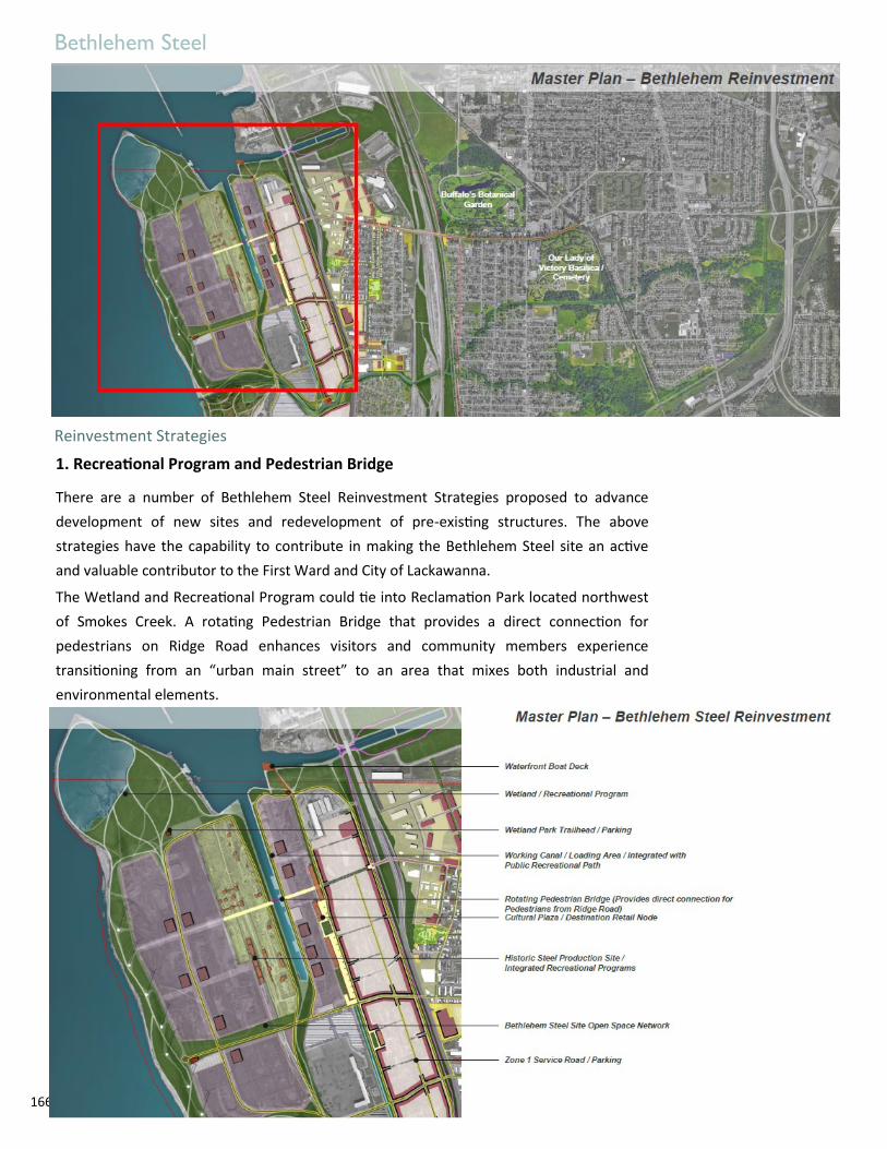
166 C&S Engineers | Joy Keubler Landscape Architects | Sasaki, AKRF, Inc.| Data Validation Services | Nature’s Way Environmental | Paradigm Environmental Services | Panamerican Consultants
Bethlehem Steel
Reinvestment Strategies
There are a number of Bethlehem Steel Reinvestment Strategies proposed to advance
development of new sites and redevelopment of pre-existing structures. The above
strategies have the capability to contribute in making the Bethlehem Steel site an active
and valuable contributor to the First Ward and City of Lackawanna.
The Wetland and Recreational Program could tie into Reclamation Park located northwest
of Smokes Creek. A rotating Pedestrian Bridge that provides a direct connection for
pedestrians on Ridge Road enhances visitors and community members experience
transitioning from an “urban main street” to an area that mixes both industrial and
environmental elements.
1. Recreational Program and Pedestrian Bridge

167 C&S Engineers | Joy Keubler Landscape Architects | Sasaki, AKRF, Inc.| Data Validation Services | Nature’s Way Environmental | Paradigm Environmental Services | Panamerican Consultants
2. Road Network
The proposed strategy for the Bethlehem Steel site road network connects development
program zones. Having connections between the different zones while taking new projects
into consideration is essential for accessibility into the area. Currently, the former Bethlehem
Steel site is not accessible and unfamiliar to much of the surrounding community. A new, easy
to navigate road network clearly separating uses such as industrial, recreational and
commercial will aid in a smoother implementation.
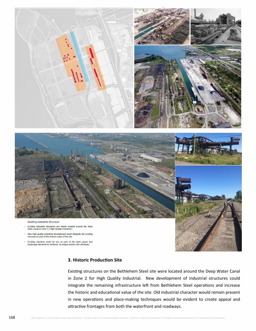
168 C&S Engineers | Joy Keubler Landscape Architects | Sasaki, AKRF, Inc.| Data Validation Services | Nature’s Way Environmental | Paradigm Environmental Services | Panamerican Consultants
Existing structures on the Bethlehem Steel site were located around the Deep Water Canal
in Zone 2 for High Quality Industrial. New development of industrial structures could
integrate the remaining infrastructure left from Bethlehem Steel operations and increase
the historic and educational value of the site. Old industrial character would remain present
in new operations and place-making techniques would be evident to create appeal and
attractive frontages from both the waterfront and roadways.
3. Historic Production Site

169 C&S Engineers | Joy Keubler Landscape Architects | Sasaki, AKRF, Inc.| Data Validation Services | Nature’s Way Environmental | Paradigm Environmental Services | Panamerican Consultants
4. Destination Retail Hub
With the future revitalization of the Bethlehem Steel site
comes the expected drastic influx of people. With a rising
permanent resident or commuter population, implementing a
destination retail hub that fills the gaps in retail supply
throughout the First Ward / City of Lackawanna is crucial to
capture spending in the area and use economic activity to
continue development of the area. To enhance a destination
retail hub it is suggested that an industrial historic plaza
accompany the area and act as a node space for both
shopping and cultural uses. This creates another area for
social capital, community building. The historic structure can
be painted as well as use specialty lighting at night for
wayfinding and act as an attractor to the area off of the
Hamburg Turnpike and Ridge Road.

170 C&S Engineers | Joy Keubler Landscape Architects | Sasaki, AKRF, Inc.| Data Validation Services | Nature’s Way Environmental | Paradigm Environmental Services | Panamerican Consultants
Ridge Road Corridor
Transportation and streetscape enhancements Revamped crosswalks Place-making initiatives Potential designated Historic District
Hamburg Turnpike Corridor Streetscape enhancements Gateway improvements Addition of Shoreline Trail and Trailhead Ridge Road and Hamburg Turnpike underpass upgrade Albright Court redevelopment
First Ward Neighborhood Pocket Parks and new Greenway connections New multi-use soccer field Demolition of hazardous structures Infill housing
Smokes Creek Corridor Multi-use recreational trail with the addition of an
overlook Pedestrian bridge restoration Workforce development center with green
infrastructure
Key Takeaways:
Figure 9.20: City Hall located on Ridge Road
Figure 9.24: Industrial building located within
the Bethlehem Redevelopment Area
Figure 9.22: Demolition of 100 Dona St. Former
Friendship House
Figure 9.23: Smokes Creek
Figure 9.21: Construction on the Shoreline
Trail through the Bethlehem Steel Site
Bethlehem Steel Investment Road networks to connect mixed uses Retail hub for new influx of population Rotating Pedestrian Bridge to continue Ridge Road
main street Include a historic production site using pre-existing
structures emphasizing the history of the area

171 City of Lackawanna First Ward | Brownfield Opportunity Area Step 3 | Draft Implementation Strategy
11.0 Strategic Sites

172 C&S Engineers | Joy Keubler Landscape Architects | Sasaki, AKRF, Inc.| Data Validation Services | Nature’s Way Environmental | Paradigm Environmental Services | Panamerican Consultants
11.0 Strategic Sites During the Step 2 Nomination Document, nine strategic sites were identified. Due to changes in
ownership and use of some parcels, some of these sites have been eliminated as well as added. For
this Implementation Strategy, there are a total of 12 strategic sites in total to spur economic
development within the First Ward BOA (see locations in Figure 10.1) The majority of these sites are
owned by the City of Lackawanna; therefore, site redevelopment is able to be more guided and
controlled.
The identified sites can anchor future development efforts and are the key parcels necessary for the
overall redevelopment plan to be completed efficiently. These sites were identified as focus sites
because they are strategically located, have high capacity for redevelopment, can catalyze additional
economic investment, and have particular historical uses that indicate significant chance of
environmental contamination for future involvement in the NYS BCP.
The following conceptual plans for each of the strategic sites represent potential development plans
that fit into the overall vision for redevelopment. These ideas are not representative of actual
commitment for development; however, showcases the potential for a particular site. Each proposed
plan is subject to further investigation and design based on future market demands.
Figure 10.1: Twelve Strategic Sites that have potential to catalyze development within the First Ward BOA

173 City of Lackawanna First Ward | Brownfield Opportunity Area Step 3 | Draft Implementation Strategy
The following Table summarizes the strategic sites and related information including address, size in acres, ownership
and assessed value:
Site Site Name Address Acres Owner Assessed Value
1 150-170 Ridge Road 150-170 Ridge Road 1.76 City of Lackawanna and Richard A. Root
$ 233,900
2 Steelawanna #2 0 N. Steelawanna Avenue
6.3 City of Lackawanna $ 126,000
3 Former Friendship House - Ridge Road
264 Ridge Road 2.5 City of Lackawanna $ 250,000
4 229-231 Ridge Road 229-231 Ridge Road 1.7 City of Lackawanna $ 10,000
5 303-305 Ridge Road 303-305 Ridge Road 0.15 City of Lackawanna $ 49,100
6 333-335 Ridge Road 333-335 Ridge Road 3.33 Lois Fadale $ 48,700
7 469-477 Ridge Road 469-477 Ridge Road 0.83 City of Lackwanna, Quality Furniture for Less Inc.
$ 70,000
8 Mill Street Property 0 Gates Avenue 4.68 LCDC $ 11,300
9 2290 Hamburg Turn-pike
2290 Hamburg Turnpike
0.46 City of Lackwanna $ 36,400
10 Albright Court Prop-erty
0 Willmuth Rear, 2380-2502 Hamburg Turnpike
13.22 City of Lackawanna, Ellicott Lodging Inc, Lakeview Devel-opment Group Inc, 2424 Hamburg Turnpike LLC, FTS Development LLC
$ 620,800
11 Former Friendship House - Dona Street
100 Dona Street 2.2 City of Lackawanna $ 31,600
12 Alliance Drive 0 Alliance Drive 11 City of Lackawanna $ 455,000
Redevelopment of the strategic sites are expected to spur economic growth and catalyze
future development. A comparative analysis of redevelopment of the highest priority
strategic sites within the First Ward BOA has been conducted. Sites analyzed with a cost-
benefit scenario are expected to create the most catalytic economic benefits within the First
Ward BOA. Based on the future land use plan and information available, specific future
development uses for each strategic site has been identified and is explained in the
subsequent sections.
Preferred Strategic Site Redevelopment
Table 10.1: Strategic Sites within the First Ward BOA to catalyze development

174 C&S Engineers | Joy Keubler Landscape Architects | Sasaki, AKRF, Inc.| Data Validation Services | Nature’s Way Environmental | Paradigm Environmental Services | Panamerican Consultants
Local Supermarket—150-170 Ridge Road
Cost-Benefit Scenario
This site is composed of four parcels along Ridge Road. Based on the economic and market analysis
conducted throughout this study and the existing conditions in the area, this site is an ideal location for a
larger grocery store for the First Ward neighborhood and the City of Lackawanna. There are currently no
large format grocery stores within the City of Lackawanna, other than the specialty Halal Market on
Ridge Road; all other grocery stores are either within the City of Buffalo to the north or the Town of
Hamburg to the south.
The Leakage/Surplus Factor conducted for the City of Lackawanna revealed a gap in the demand and
supply for grocery stores within the area. This means that there is an insufficient supply of grocery stores
within the City of Lackawanna to support resident demand. Currently, residents of the local retail trade
area are buying products outside of the trade area because their demands are not being met by retail
options within the trade area.
According to the National Grocers Association, independent retail supermarkets play a vital role in the
communities they serve and are a major contributor to the economy. In the New York 27th congressional
district there are 42 retail stores that $197.98 million in annual sales, which create 2,243 stable and
reliable jobs. Grocers and wholesalers generate major tax revenues for state and local taxes with $1.46
billion contribution in total taxes.

175 City of Lackawanna First Ward | Brownfield Opportunity Area Step 3 | Draft Implementation Strategy
A 25,000-square foot supermarket will generate approximately 25 to 40 jobs and increase tax revenue for
both the City of Lackawanna and New York State. Supermarket investment on Ridge Road would increase
economic activity in the community, increase access to healthy and higher quality foods, and improve overall
attractiveness of Ridge Road and the First Ward neighborhood. According to a Reinvestment Brief by the TRF
Fund, residents are willing to pay higher real estate taxes for convenient access to supermarkets less than a 10
-minute drive.
The site is well suited for a grocery store due to its location on Ridge road, urban setback from the street with
developed parking behind the building, and concentration of residential neighborhoods within close
proximity. In order to develop this site into a grocery store, either adaptive reuse or demolition of the existing
building will need to take place. The approximate costs of development are described in the table below. The
total costs of site redevelopment would be approximately $4,120,000 (see Figure 10.2).
The site is currently equipped with all necessary infrastructure, including sewer, water, gas and electric, and
there are no expected upgrades necessary for construction. Site access for the grocery store may need to be
enhanced along Ridge Road. Environmental conditions of the site are unknown; however, the site could
undergo a Phase I and Phase II Environmental Site Assessment. Due to the conduction of environmental
assessments within the vicinity of the site, it is assumed that the site could be part of the NYS BCP and receive
tax credits for remediation and development costs.
Table 10.2: Development site characteristics for potential Ridge Road grocery store

176 C&S Engineers | Joy Keubler Landscape Architects | Sasaki, AKRF, Inc.| Data Validation Services | Nature’s Way Environmental | Paradigm Environmental Services | Panamerican Consultants
Actionable Plan for Redevelopment:
Pre-Development:
Attract new buyer for property
Contact potential local business organizations for business tenants
Conduct Phase I and Phase II Environmental Site Assessment to determine potential participation in the NYS BCP
Apply for rezoning of property from Industrial to Neighborhood Residential
Obtain City of Lackawanna Site Plan Approval for development
Refine site plan to development needs, if necessary
Construction:
Arrange financing structure for construction
Construct building
Figure 10.4: Ridge Road grocery store rendering
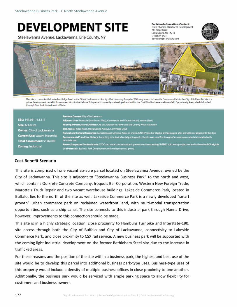
177 City of Lackawanna First Ward | Brownfield Opportunity Area Step 3 | Draft Implementation Strategy
Steelawanna Business Park—0 North Steelawanna Avenue
Cost-Benefit Scenario
This site is comprised of one vacant six-acre parcel located on Steelawanna Avenue, owned by the
City of Lackawanna. This site is adjacent to “Steelawanna Business Park” to the north and west,
which contains Quikrete Concrete Company, Iroquois Bar Corporation, Western New Foreign Trade,
Marotta’s Truck Repair and two vacant warehouse buildings. Lakeside Commerce Park, located in
Buffalo, lies to the north of the site as well. Lakeside Commerce Park is a newly developed “smart
growth” urban commerce park on reclaimed waterfront land, with multi-modal transportation
opportunities, such as a ship canal. The site connects to this industrial park through Hanna Drive;
however, improvements to this connection should be made.
This site is in a highly strategic location, close proximity to Hamburg Turnpike and Interstate-190,
site access through both the City of Buffalo and City of Lackawanna, connectivity to Lakeside
Commerce Park, and close proximity to CSX rail service. A new business park will be supported with
the coming light industrial development on the former Bethlehem Steel site due to the increase in
trafficked areas.
For these reasons and the position of the site within a business park, the highest and best use of the
site would be to develop this parcel into additional business park-type uses. Business-type uses of
this property would include a density of multiple business offices in close proximity to one another.
Additionally, the business park would be serviced with ample parking space to allow flexibility for
customers and business owners.

178 C&S Engineers | Joy Keubler Landscape Architects | Sasaki, AKRF, Inc.| Data Validation Services | Nature’s Way Environmental | Paradigm Environmental Services | Panamerican Consultants
Business parks offer immense benefits and advantages. Some of these include that these types of
facilities can offer accommodation for larger companies, they can be used by customers to do several
related activities (such as file tax returns, conduct real estate transactions, conduct banking, etc), and
provide cheaper rents compared to individually standing businesses.
A Phase I/II ESA was conducted on this site in 2017. During this assessment, it was revealed that the site
contains SVOC and metal contamination above Restricted Residential Use SCOs and Industrial Use SCOs.
Due to the shallow depth of contamination within the fill and SVOC contamination within the surface
soil, exposure to impacted soil is likely if any site improvement is conducted. Since the analytical results
for soil on the site are above NYS SCOs for Industrial Use, the site appears to be eligible for cleanup and
redevelopment under the NYS BCP.
The site is owned by the City of Lackawanna and serviced by the Erie County Water Authority and Erie
County Sewer District 6. Improvements would need to be made to the property including remediation of
the site. It is recommended that the site participate in the NYS BCP to obtain any tax credits for
remediation and tangible development on the property.
The business park will be comprised of three buildings totaling approximately 100,000-square feet,
equipped with parking areas and landscaping (See Figure 10.5).
Figure 10.5: Steelawanna Avenue Business Park rendering

179 City of Lackawanna First Ward | Brownfield Opportunity Area Step 3 | Draft Implementation Strategy
Mixed-Use Community Center—264 Ridge Road
Cost Benefit Scenario
The Former Friendship House was located on Ridge Road, which is one of the most traversed roads in
the City of Lackawanna, and the only east-west corridor that transects the City, making its location
highly accessible to both residents and commuters. Additionally, this parcel of land is in close proximity
to the residential neighborhood of the First Ward, is owned by the City of Lackawanna, and is of ample
parcel size, deeming it ripe for development.
This site was formerly the location of the Friendship House, which closed its doors in 1997. This
community center enhanced the quality of life within the First Ward neighborhood by providing social
services to address the needs of the entire Lackawanna community. Through conversations with the
public, since the closure of the Friendship House, the current residents of the City of Lackawanna have
been experiencing difficulty with obtaining social services and a recreational output for both young and
adolescent children.
There is a heightened need for specialized services within the First Ward neighborhood including
financial literacy classes for primarily foreign-born residents, as well as human services and recreational
options. According to the University at Buffalo Regional Institute and the Mobile Safety-Net Team, gaps
in public services within the First Ward neighborhood include grocery stores, affordable food, and
specialty health services, after-school programs for youth, affordable and flexible transportation, and
effective information channels.
A new community center in conjunction with service stores (such as grocery stores, coffee shops,
barber shops, etc.) will work to narrow the gap in public services within the City of Lackawanna.

180 C&S Engineers | Joy Keubler Landscape Architects | Sasaki, AKRF, Inc.| Data Validation Services | Nature’s Way Environmental | Paradigm Environmental Services | Panamerican Consultants
The community center would be equipped with classrooms for after-school programming for youth, ESL
classes, continued education for adults, financial literacy classes, cultural exchange center, gathering place for
youth, and recreational facility.
This community/retail center would also be supported with the increase of residential units currently under
construction to the adjacent west of 264 Ridge Road. Ridgeway Commons is planned to be a 32-unit apartment
complex on Ridge Road. This complex will increase the residential density and activity along this corridor.
For these reasons, the Former Friendship House is an ideal location for a mixed-use community and retail
center (of up to three outlets). This entirety of the building will be approximately 20,000-square feet; 10,000-
square feet dedicated to the community center and 10,000-square feet dedicated to five retail outlets (about
2,000-square feet each). This center will provide up to 40 jobs within the First Ward neighborhood and enhance
the quality of life by bringing increased vitality to the neighborhood. Residents will be inclined to spend money
at this location due to its convenience and easy accessibility for everyday needs.
This facility will likely remain City owned property and be operated in part by a non-profit entity as well as
private business owners for the individual shops. The table below lays out the approximate costs for
construction and financing of the community/retail center. Overall, this facility would cost approximately
$3,900,000 to construct; however, funding opportunities for assistance with construction and operation costs
are available (See figure 10.6)
Figure 10.6: Development site characteristics for potential Ridge Road community facility

181 City of Lackawanna First Ward | Brownfield Opportunity Area Step 3 | Draft Implementation Strategy
The site is currently equipped with all necessary infrastructure, including sewer,
water, gas and electric, and there are no expected upgrades necessary for
construction.
Actionable Plan for Redevelopment:
Pre-Development:
Contact potential retail outlets/local business organizations for business tenants
Apply for NYS and federal grants for development and operations of center
Obtain Lackawanna Community Development Corporation (as a non-profit entity) to act as the operator of the community/retail center
Refine site plan to development needs, if necessary
Apply for rezoning of property from Industrial to Neighborhood Residential
Obtain City of Lackawanna Site Plan Approval for development
Construction:
Arrange financing structure for construction
Construct Building
Figure 10.7: Ridge Road community facility rendering

182 C&S Engineers | Joy Keubler Landscape Architects | Sasaki, AKRF, Inc.| Data Validation Services | Nature’s Way Environmental | Paradigm Environmental Services | Panamerican Consultants
Mixed-Use Commercial and Residential—229-231 Ridge Road
This site is comprised of two parcels, totaling approximately 1.7 acres, along Ridge Road across
from the former Friendship House. These parcels are owned by the City of Lackawanna and
zoned Mixed Residential. This site has direct access to the Ridge Road Corridor, which makes
this space an ideal location for a mixed-use retail and residential development.
The retail outlets within the City of Lackawanna are few and far between. There are several
local convenience stores and quick-service restaurants. As determined in the economic and
market analysis, there is sufficient demand for locally-service retail uses for services including
laundromats, banks, doctor’s offices, among others. Since a low number of residents have
access to a car for transport, businesses within walking distance of the First Ward
neighborhood would be well supported.
Additionally, second-story apartments will add to the character of the neighborhood as well as
provide First Ward residents with a greater variety of housing options. For residents whom
cannot afford the predominant single-family home in the First Ward but make more income
than allows them to qualify for affordable housing (such as will be provided by Ridgeway
Commons across the street), apartments located on Ridge Road could begin to narrow this
housing gap. Overall, this type of mixed-use development with retail components on the first
floor coupled with apartment dwellings on the second floor would address a multitude of
housing and business issues in the First Ward BOA and would be a catalyst for future
development.

183 City of Lackawanna First Ward | Brownfield Opportunity Area Step 3 | Draft Implementation Strategy
A mixed-use development on Ridge Road on this property would begin to fill in the gaps between
buildings, making Ridge Road more attractive to commercial businesses and pedestrians.
Additionally, this introduction of a mix of uses maximizes the existing infrastructure, reinforces the
pedestrian-scale environment, and supports dense, compact development (See Figure 10.8).
Figure 10.8: Ridge Road mixed-use building rendering
Figure 10.9: Ridge Road mixed-use building rendering

184 C&S Engineers | Joy Keubler Landscape Architects | Sasaki, AKRF, Inc.| Data Validation Services | Nature’s Way Environmental | Paradigm Environmental Services | Panamerican Consultants
Small Scale Retail—303-305 Ridge Road
This site is comprised of two parcels, totaling approximately 0.15 acres, on the corner of Ridge
Road and Ingham Avenue. The site contains one vacant lot in association with a vacant,
derelict building. Since this site lies along Ridge Road in a commercial corridor, the best suited
use for this site would be a small scale retail development to service community needs.
The current building is an eyesore for the community; therefore, every effort to demolish the
building should take place. Restructure of the retail building should be setback to Ridge Road
with a few parking spaces behind. Due to the proximity of the residential neighborhood and
walkability of the area, the retail component would demand few parking spaces. Additionally,
based on the contamination of the properties near this site, the site should undergo
environmental assessment to determine eligibility for the NYS BCP.

185 City of Lackawanna First Ward | Brownfield Opportunity Area Step 3 | Draft Implementation Strategy
Light Industrial—333-335 Ridge Road
This site is currently the location of an automotive repair shop along Ridge Road. This site
is inaccessible to Ridge Road due to the Ridge Road Bridge that begins at the foot of this
property. The site is a tax generator for the City of Lackawanna, but is highly underutilized
and looks as though it is in disrepair and in need of improvements.
This site was historically used as a lumber yard in the 1920s and is currently used for
automobiles. The redevelopment of this property is highly likely given the past use of the
property and the probability of involvement in the NYS BCP. A Phase I and Phase II
Environmental Site Assessment should be conducted on this property to solidify eligibility.
Due to the sites current ownership and use, a specific redevelopment plan has not been
created. However, the location of this site and the proximity of the site to rail will be
extremely important for redevelopment in the future. Future uses best suited for this
property include commercial or light industrial uses compatible with surrounding
residential neighborhoods.
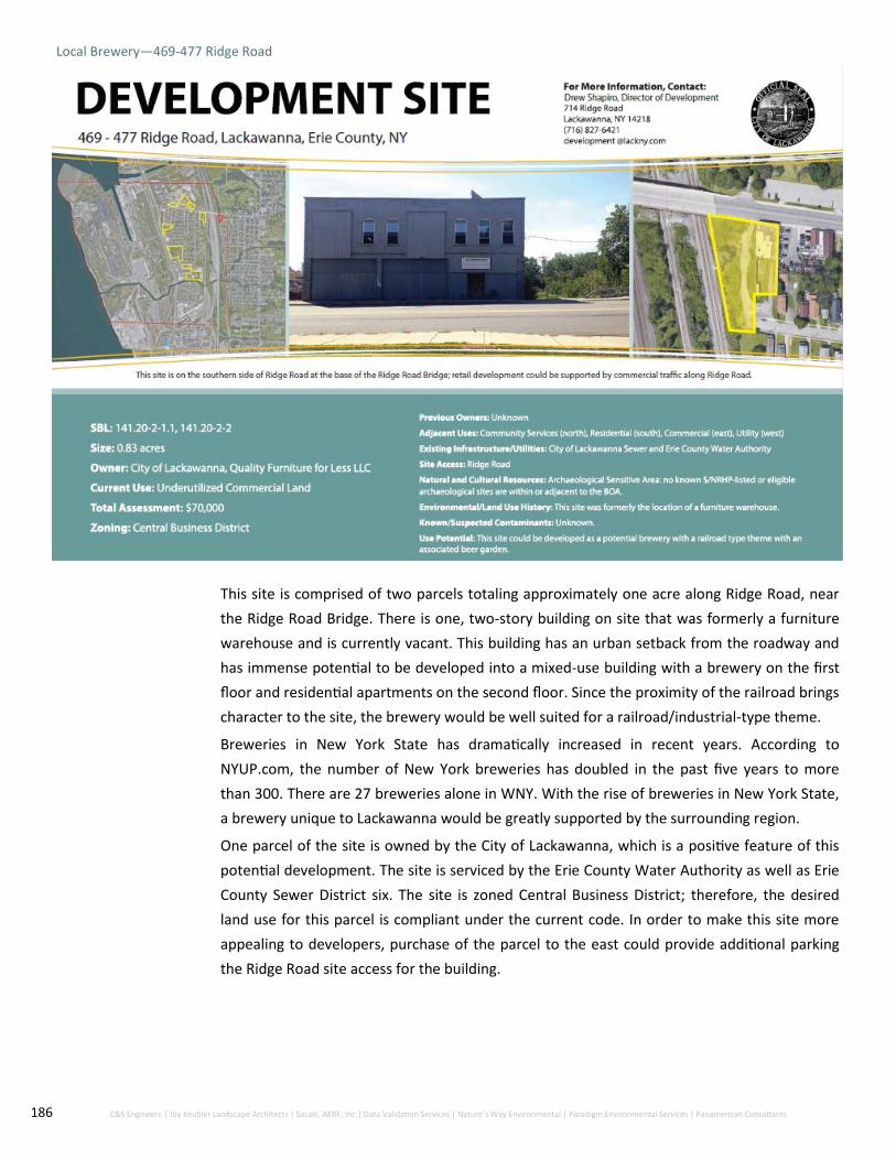
186 C&S Engineers | Joy Keubler Landscape Architects | Sasaki, AKRF, Inc.| Data Validation Services | Nature’s Way Environmental | Paradigm Environmental Services | Panamerican Consultants
Local Brewery—469-477 Ridge Road
This site is comprised of two parcels totaling approximately one acre along Ridge Road, near
the Ridge Road Bridge. There is one, two-story building on site that was formerly a furniture
warehouse and is currently vacant. This building has an urban setback from the roadway and
has immense potential to be developed into a mixed-use building with a brewery on the first
floor and residential apartments on the second floor. Since the proximity of the railroad brings
character to the site, the brewery would be well suited for a railroad/industrial-type theme.
Breweries in New York State has dramatically increased in recent years. According to
NYUP.com, the number of New York breweries has doubled in the past five years to more
than 300. There are 27 breweries alone in WNY. With the rise of breweries in New York State,
a brewery unique to Lackawanna would be greatly supported by the surrounding region.
One parcel of the site is owned by the City of Lackawanna, which is a positive feature of this
potential development. The site is serviced by the Erie County Water Authority as well as Erie
County Sewer District six. The site is zoned Central Business District; therefore, the desired
land use for this parcel is compliant under the current code. In order to make this site more
appealing to developers, purchase of the parcel to the east could provide additional parking
the Ridge Road site access for the building.
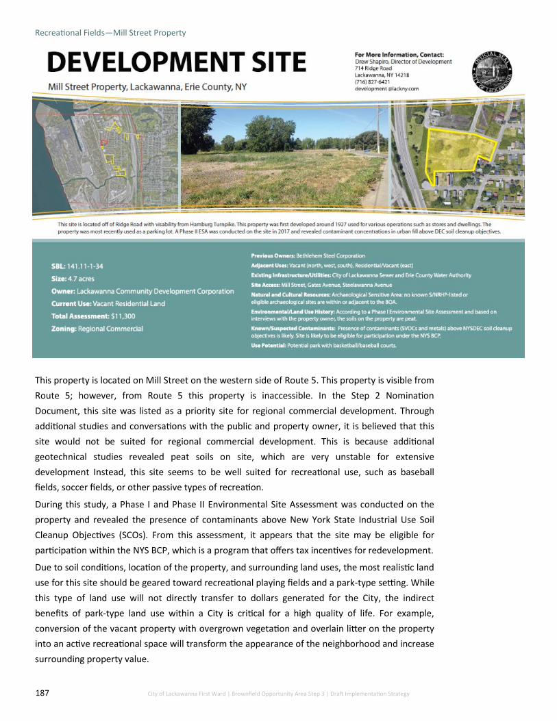
187 City of Lackawanna First Ward | Brownfield Opportunity Area Step 3 | Draft Implementation Strategy
Recreational Fields—Mill Street Property
This property is located on Mill Street on the western side of Route 5. This property is visible from
Route 5; however, from Route 5 this property is inaccessible. In the Step 2 Nomination
Document, this site was listed as a priority site for regional commercial development. Through
additional studies and conversations with the public and property owner, it is believed that this
site would not be suited for regional commercial development. This is because additional
geotechnical studies revealed peat soils on site, which are very unstable for extensive
development Instead, this site seems to be well suited for recreational use, such as baseball
fields, soccer fields, or other passive types of recreation.
During this study, a Phase I and Phase II Environmental Site Assessment was conducted on the
property and revealed the presence of contaminants above New York State Industrial Use Soil
Cleanup Objectives (SCOs). From this assessment, it appears that the site may be eligible for
participation within the NYS BCP, which is a program that offers tax incentives for redevelopment.
Due to soil conditions, location of the property, and surrounding land uses, the most realistic land
use for this site should be geared toward recreational playing fields and a park-type setting. While
this type of land use will not directly transfer to dollars generated for the City, the indirect
benefits of park-type land use within a City is critical for a high quality of life. For example,
conversion of the vacant property with overgrown vegetation and overlain litter on the property
into an active recreational space will transform the appearance of the neighborhood and increase
surrounding property value.

188 C&S Engineers | Joy Keubler Landscape Architects | Sasaki, AKRF, Inc.| Data Validation Services | Nature’s Way Environmental | Paradigm Environmental Services | Panamerican Consultants
Neighborhood Restaurant—2290 Hamburg Turnpike
This site is composed on one vacant parcel, approximately 0.5 acres in size, owned by the
City of Lackawanna. It is currently zoned Regional Commercial and identified as ‘billboard
use’; however, the site is not utilized for any type of advertising.
This site could potentially be developed with a small scale restaurant, similar to Mulberry
Restaurant located in the Bethlehem Park residential neighborhood. This is because the
site is currently City-owned (creating development incentives), visible from Hamburg
Turnpike, and located in a potential historic district. In the Phase IA Archeological Survey
conducted during this project, a potential Kane Street Historic District was identified, which
comprised of several adjacent properties to this site.
The site does not currently have access to Hamburg Turnpike, although it is visible from
this roadway. The NYS DOT owns the property directly to the north of this property, which
extends to Hamburg Turnpike. Additional collaboration with NYS DOT could potentially
allow a curb cut to be constructed, giving Kane Street direct access to Hamburg Turnpike.

189 City of Lackawanna First Ward | Brownfield Opportunity Area Step 3 | Draft Implementation Strategy
Big Box Retail—Albright Court Property
Cost-Benefit Scenario
This property is comprised of six parcels totaling approximately 13 acres along Hamburg
Turnpike and Albright Court. Two parcels along Albright Court are owned by the City of
Lackawanna, while the other four parcels are privately owned. 2424 Hamburg Turnpike, a
parcel that has direct frontage on Hamburg Turnpike, is currently undergoing remediation
under the NYS BCP.
Current uses of the site include vacant parcels toward the east, as well as one inactive gasoline
station, one commercial store and one vacant former automotive repair shop. It is a very
underutilized tract of land on a highly functional commuter corridor and regional connector.
Because of the commuting patterns on Hamburg Turnpike there is a demand for increased
retail services along this roadway. Additionally, within the market and economic analysis of
the First Ward BOA and surrounding region, a demand gap for retail services of $200 million
was identified in the City of Lackawanna; therefore, indicating that the retail market is
underserved and an opportunity to expand destination retail floor space exists. Based on the
assumptions of the analysis, the First Ward BOA could absorb approximately 687,000 square
feet of retail and service industry businesses.

190 C&S Engineers | Joy Keubler Landscape Architects | Sasaki, AKRF, Inc.| Data Validation Services | Nature’s Way Environmental | Paradigm Environmental Services | Panamerican Consultants
For this reason, the preferred redevelopment of the Albright Court Property is a large-format commercial
store of approximately 50,000 square feet along Hamburg Turnpike. This retail service would be branded
as a “big-box” store, which is defined as a physically large retail establishment typically part of a retail
chain and offers a variety of products to its customers. This retail store would be beneficial to the City of
Lackawanna and the surrounding region as a whole due to its accessibility for both residents and
commuters. Additionally, since the frontage portion of the property is currently within the NYS BCP,
tangible tax credits for any hard development costs on the site could be recovered under the program.
Due to the fact that the property contains an inactive gasoline station, the property is likely eligible for
the NYS BCP. A Phase I/II ESA would be required to determine eligibility based on either potential soil
and/or groundwater contamination. If contamination is found, NYS BCP application must be filed and
send to the DEC for review.
Potential difficulty with the fruition of this preferred development is the acquisition and assemblage of
the parcels into one developable property. However, if this obstacle can be overcome, the construction
and operation of the store would be highly successful. The economic impact of this 50,000-square foot
redevelopment will generate significant tax revenue for the City and approximately 100 jobs for the area.
The development cost as described in the table below would be approximately $7,800,000 (See Figure
10.10).
Figure 10.10: Development site characteristics for potential Albright Court Large-Format commercial building

191 City of Lackawanna First Ward | Brownfield Opportunity Area Step 3 | Draft Implementation Strategy
The site is currently equipped with all necessary infrastructure, including sewer, water, gas and
electric, and there are no expected upgrades necessary for construction. The site may need to
be cleared of some trees on the site and regraded.
Actionable Plan for Redevelopment:
Pre-Development:
Contact potential retail outlets/local business organizations for business tenants
Apply for NYS and federal grants for development and operations of center
Obtain operator
Acquire and assemble all five parcels into one lot through the City’s Assessors Office and Council
Obtain tax credits from NYS BCP, if possible
Refine site plan to development needs, if necessary
Obtain City of Lackawanna Site Plan Approval for development
Construction:
Arrange financing structure for construction
Construct building
Figure 10.11: Albright Court large-format commercial building rendering

192 C&S Engineers | Joy Keubler Landscape Architects | Sasaki, AKRF, Inc.| Data Validation Services | Nature’s Way Environmental | Paradigm Environmental Services | Panamerican Consultants
Figure 10.12: Albright Court large-format commercial building rendering

193 City of Lackawanna First Ward | Brownfield Opportunity Area Step 3 | Draft Implementation Strategy
Housing Development—100 Dona Street
Cost-Benefit Scenario
This site located on Dona Street, is located in the First Ward Neighborhood. This 2.2-acre site
was once the location of a school that was later purchased by Friendship House WNY, Inc. and
operated as the Friendship House. The three story structure was vacant and a health hazard
due to the poor structural integrity of the building and the presence of asbestos and lead
within the building.
In 2017, the City secured $500,000 in Restore New York funds and $300,000 in Community
Development Block Grant funds through the Erie County Consortium for asbestos abatement
and demolition of the Former Lincoln School on Dona Street. The abatement and demolition
of the building took place in the summer of 2018 and was completed by September of 2018.
During this project, a Phase I/II ESA was conducted on the property to determine if
contamination exists on the property. During this assessment it was uncovered that the soil
contains varying concentrations of SVOC contamination above DEC standards as well as
groundwater metal contamination above DEC standards. Additionally, visual and olfactory
indications of petroleum impairment were discovered just north of the building. It was
determined that due to the soil and groundwater contamination on site, that the property is
eligible for the NYS BCP. If the site were to be involved in the BCP, a private entity would be
required to acquire the site to obtain remediation and redevelopment tax credits.

194 C&S Engineers | Joy Keubler Landscape Architects | Sasaki, AKRF, Inc.| Data Validation Services | Nature’s Way Environmental | Paradigm Environmental Services | Panamerican Consultants
Based on the characteristics of the First Ward BOA, market and economic analysis, and conversations
with the community, the highest and best use for this site would be the development of
approximately 20 single-family homes (See Figure 10.13) While this redevelopment does not create
jobs, it will increase the density of the area while placing property back on the tax rolls.
An increase in home-ownership is shown to enhance the overall appeal of an area. Home-owners are
more likely to maintain and have pride in their home as well as their front yards. Home-owners and
families within the new infill housing will contribute to the City of Lackawanna’s workforce as well as
increase density within the area.
Figure 10.13: 100 Dona Street infill housing rendering

195 City of Lackawanna First Ward | Brownfield Opportunity Area Step 3 | Draft Implementation Strategy
Light Industrial and Workforce Development Center—Alliance Drive
The property at Alliance drive is composed of seven parcels along Alliance Drive and A Street. The
site is currently undeveloped and surrounds the recently redeveloped Alliance Innovative
Manufacturing, a light manufacturing facility. A portion of this site was formerly involved in the
NYS Environmental Restoration Program (ERP) in 1998; therefore, the parcels along Alliance Drive
are primed for development. The western portion of the property is an unutilized section of 2600
Hamburg Turnpike.
Throughout the BOA process and economic and market analysis, the highest and best use of the
site would be for a combined workforce training center and light industrial use development. This
development would include several separate buildings within the site to support resident
workforce training as well as job creation. The three building development (one workforce
training center and two light industrial/flex space buildings) would total approximately 50,000-
square feet. Parking lots would also be constructed in conjunction with each building.
This development would be highly successful in the City of Lackawanna for several reasons.
Lackawanna has been steadily losing jobs for residents since the closure of the Bethlehem Steel
Company. However, with the recent purchase of a portion of the former Bethlehem Steel site by
Erie County and construction of SolarCity in South Buffalo, light industrial manufacturing is
expected to be developed and provide an uptick in career opportunities for the surrounding
region. A workforce training center located in the First Ward could contribute to the economic
revival of the City if geared toward providing jobs specifically for advanced manufacturing.

196 C&S Engineers | Joy Keubler Landscape Architects | Sasaki, AKRF, Inc.| Data Validation Services | Nature’s Way Environmental | Paradigm Environmental Services | Panamerican Consultants
First Ward residents traditionally employed in manufacturing should be trained to work in advanced
manufacturing. Not only will an advanced manufacturing workforce training center benefit First
Ward residents in terms of increasing their employment opportunities, but it will additionally
benefit incoming firms seeking skilled employees and will attract new firms/companies to the
region. Additionally, advanced manufacturing jobs pay more than the current prevailing industry
sector of retail; making these types of jobs more attractive for job seekers.
In order to develop a workforce training center, the City must partner with a recognized and
established organization or multiple organizations. Teaming up with nearby colleges and universities
such as Erie Community College, Alfred State, Buffalo State College, and the University at Buffalo
will best provide workforce training opportunities to traditionally underserved groups in the
workforce.
New York State recently announced plans to develop a $44 million Western New York Training
Center in South Buffalo to be developed in summer 2018. The City should join forces with this
initiative to develop a branch of this larger facility on this strategic site.
Additionally, since the former Bethlehem Steel site is expected to be redeveloped with light
manufacturing, and potentially retail components, offshoot light manufacturing and assembly
outfits could support larger companies and firms.
This development is expected to both increase career opportunities in the First Ward BOA as well as
generate tax revenue for the City of Lackawanna. This site is currently serviced by the Erie County
Water Authority as well as Erie County Sewer District 6; with sufficient capacity for growth and
development.
The site contains access through A Street and Alliance Drive; however, A Street is technically not a
City right-of-way. Therefore, as part of this project, A Street was professionally surveyed in order to
convert this street into a proper right-of-way for development. An easement would need to be
established on this roadway in order to complete the process. (See Figure 10.14)

197 City of Lackawanna First Ward | Brownfield Opportunity Area Step 3 | Draft Implementation Strategy
Actionable Plan for Redevelopment
Pre-Development:
Create City right-of-way easement on A Street
Market for operator of the site; apply for NYS and federal grants for development and
operations of center
Acquire and assemble all five parcels into one lot through the City’s Assessors Office
and Council
Finalize site plan and architectural designs
Obtain operator
Obtain City of Lackawanna Site Plan Approval for development
Construction:
Arrange financing structure for construction
Construct building
Figure 10.14: Alliance Drive Light Industrial and Workforce Development Center rendering

198 C&S Engineers | Joy Keubler Landscape Architects | Sasaki, AKRF, Inc.| Data Validation Services | Nature’s Way Environmental | Paradigm Environmental Services | Panamerican Consultants
12.0 Implementation Projects

199 City of Lackawanna First Ward | Brownfield Opportunity Area Step 3 | Draft Implementation Strategy
12.0 Implementation Projects
These construction ready projects are anticipated to enhance the economic stability of the
First Ward BOA and significantly advance the redevelopment objectives of this plan. Being
construction ready, these projects can move at a quicker pace and start acting as an asset to
the First Ward and City of Lackawanna.
Potential Redevelopment Projects
1. Steelawanna Business Park – 0 N. Steelawanna Avenue
2. Local Supermarket – 150-170 Ridge Road
3. Recreational Fields – Mill Street Property
4. Big Box Retail – Albright Court Property
5. Housing Redevelopment – 100 Dona Street
6. Light Industrial/Workforce Development Center – Alliance Drive
7. Local Brewery – 469-477 Ridge Road
8. Small Scale Retail - 303-305 Ridge Road
9. Mixed-Use Commercial/Residential – 229-231 Ridge Road
10. Small Scale Restaurant – 2290 Hamburg Turnpike
11. Vacant Church Redevelopment
Transportation Improvement Projects
1. Ridge Road Corridor Streetscape Enhancements (lane reduction/crosswalks)
2. Ridge Road Bridge Reconstruction
3. Lakeside Commerce Park Connector Road
4. Dona Street Extension
5. Hamburg Turnpike Streetscape Enhancements
6. Enhanced Gateway into the City
7. Ridge Road/Hamburg Turnpike Underpass
8. Pedestrian Bridge Restoration
Public Improvement Projects
1. Ridge Road Mixed-Use Community Center – 264 Ridge Road
2. Bethlehem Steel Shoreline Trail/Shoreline Trailhead Enhancement
3. First Ward Pocket Park/Greenway Connections
4. First Ward Soccer Recreational Space
5. Demolition of Hazardous Structures
6. Smokes Creek Multi-Use Trail
7. Smokes Creek Overlook
8. Bethlehem Steel Pedestrian Bridge
9. Wetland and Recreation Program
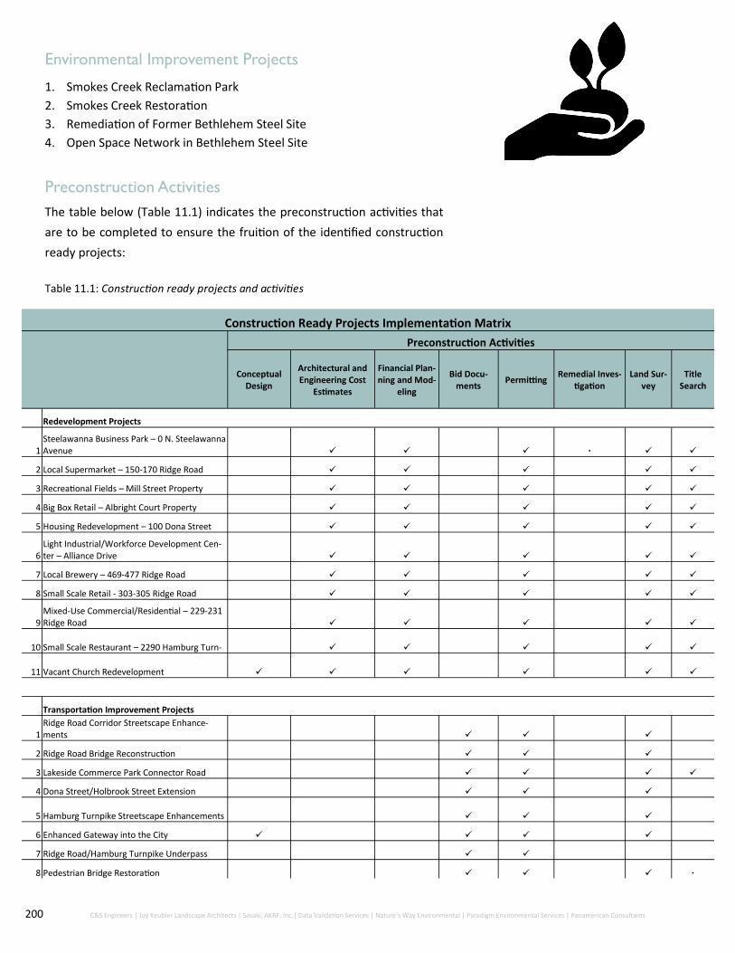
200 C&S Engineers | Joy Keubler Landscape Architects | Sasaki, AKRF, Inc.| Data Validation Services | Nature’s Way Environmental | Paradigm Environmental Services | Panamerican Consultants
Environmental Improvement Projects
1. Smokes Creek Reclamation Park
2. Smokes Creek Restoration
3. Remediation of Former Bethlehem Steel Site
4. Open Space Network in Bethlehem Steel Site
Preconstruction Activities
The table below (Table 11.1) indicates the preconstruction activities that
are to be completed to ensure the fruition of the identified construction
ready projects:
Construction Ready Projects Implementation Matrix
Preconstruction Activities
Conceptual Design
Architectural and Engineering Cost
Estimates
Financial Plan-ning and Mod-
eling
Bid Docu-ments
Permitting Remedial Inves-
tigation Land Sur-
vey Title
Search
Redevelopment Projects
1 Steelawanna Business Park – 0 N. Steelawanna Avenue
2 Local Supermarket – 150-170 Ridge Road
3 Recreational Fields – Mill Street Property
4 Big Box Retail – Albright Court Property
5 Housing Redevelopment – 100 Dona Street
6 Light Industrial/Workforce Development Cen-ter – Alliance Drive
7 Local Brewery – 469-477 Ridge Road
8 Small Scale Retail - 303-305 Ridge Road
9 Mixed-Use Commercial/Residential – 229-231 Ridge Road
10 Small Scale Restaurant – 2290 Hamburg Turn-
11 Vacant Church Redevelopment
Transportation Improvement Projects
1 Ridge Road Corridor Streetscape Enhance-ments
2 Ridge Road Bridge Reconstruction
3 Lakeside Commerce Park Connector Road
4 Dona Street/Holbrook Street Extension
5 Hamburg Turnpike Streetscape Enhancements
6 Enhanced Gateway into the City
7 Ridge Road/Hamburg Turnpike Underpass
8 Pedestrian Bridge Restoration
Table 11.1: Construction ready projects and activities
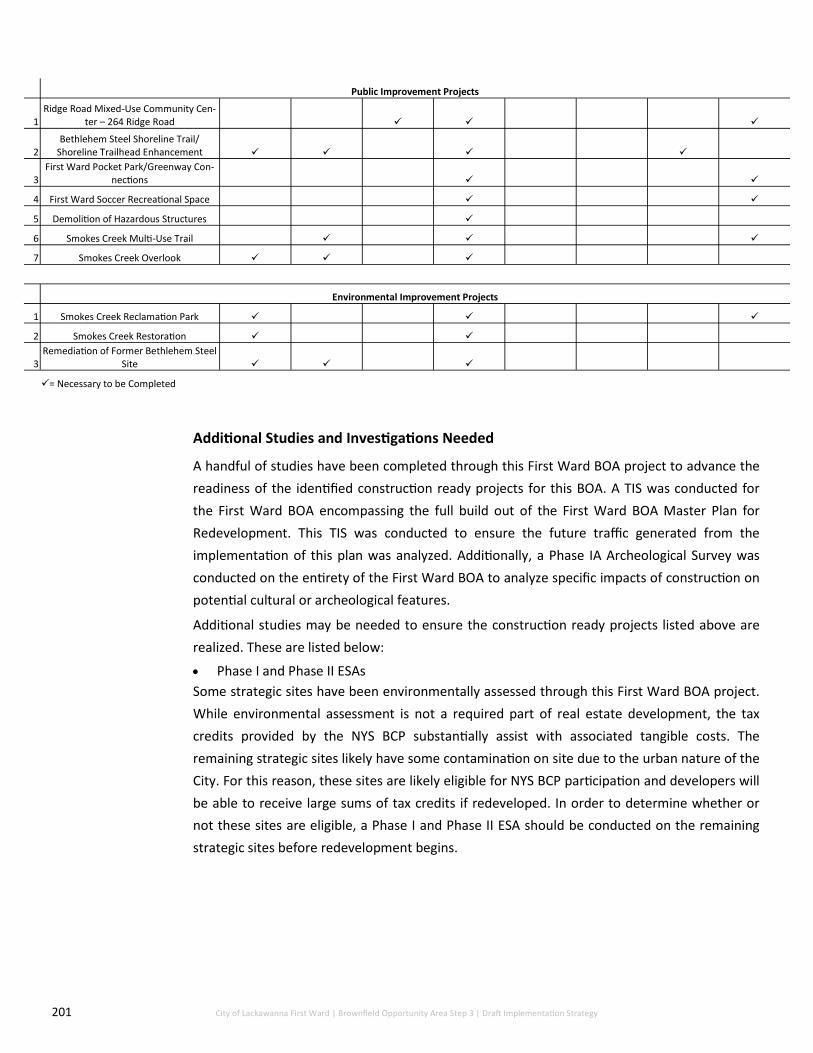
201 City of Lackawanna First Ward | Brownfield Opportunity Area Step 3 | Draft Implementation Strategy
Public Improvement Projects
1 Ridge Road Mixed-Use Community Cen-
ter – 264 Ridge Road
2 Bethlehem Steel Shoreline Trail/
Shoreline Trailhead Enhancement
3 First Ward Pocket Park/Greenway Con-
nections
4 First Ward Soccer Recreational Space
5 Demolition of Hazardous Structures
6 Smokes Creek Multi-Use Trail
7 Smokes Creek Overlook
Environmental Improvement Projects
1 Smokes Creek Reclamation Park
2 Smokes Creek Restoration
3 Remediation of Former Bethlehem Steel
Site
= Necessary to be Completed
Additional Studies and Investigations Needed
A handful of studies have been completed through this First Ward BOA project to advance the
readiness of the identified construction ready projects for this BOA. A TIS was conducted for
the First Ward BOA encompassing the full build out of the First Ward BOA Master Plan for
Redevelopment. This TIS was conducted to ensure the future traffic generated from the
implementation of this plan was analyzed. Additionally, a Phase IA Archeological Survey was
conducted on the entirety of the First Ward BOA to analyze specific impacts of construction on
potential cultural or archeological features.
Additional studies may be needed to ensure the construction ready projects listed above are
realized. These are listed below:
Phase I and Phase II ESAs
Some strategic sites have been environmentally assessed through this First Ward BOA project.
While environmental assessment is not a required part of real estate development, the tax
credits provided by the NYS BCP substantially assist with associated tangible costs. The
remaining strategic sites likely have some contamination on site due to the urban nature of the
City. For this reason, these sites are likely eligible for NYS BCP participation and developers will
be able to receive large sums of tax credits if redeveloped. In order to determine whether or
not these sites are eligible, a Phase I and Phase II ESA should be conducted on the remaining
strategic sites before redevelopment begins.

202 C&S Engineers | Joy Keubler Landscape Architects | Sasaki, AKRF, Inc.| Data Validation Services | Nature’s Way Environmental | Paradigm Environmental Services | Panamerican Consultants
To ensure the redevelopment vision of the First Ward BOA is realized, it is important that these
two entities work collectively in the same direction with a defined focus. Both entities have
collaborative partnerships with varying agencies and organizations and the coordination of these
partnerships is key to success.
Several other municipalities with NYS BOA Designation utilize a management structure through
collaborations with local CDCs or local development corporations (LDC). These include the City of
Kingston, NY and the Town of Babylon, NY. As precedents with successful development in their
respective BOAs, the City of Lackawanna should highly consider the strategic partnership of the
LCDC for BOA management.
Management of the First Ward BOA Plan has a high focus on revitalized, mixed-use spaces that
are highly utilized by both those who already live in the City as well as commuters and visitors to
the western New York region. The plan confronts the issue of existing, vacant, brownfield sites
and the lack of connections as well as the lack of capture within the area. The City of Lackawanna
will have a variety of projects starting at different times while focusing on different outcomes.
Responsibilities are suggested but not limited to:
1. Startup, manage and coordinate redevelopment as a whole. Oversee approval and permitting
for development projects as well as facilitate applications and review projects that fall in line
with the First Ward BOA vision
2. Prepare grant proposals for funding and be able to raise funds in advance and to advance a
variety of projects
3. Offer incentives such as tax exemptions and Payment in Lieu of Taxes to potential investors
to attract both public and private investment within the First Ward and BRA
4. Maintain relationships with local government offices and departments as well as local
agencies that provide policy support and potential funding
5. Maintain relationships with State and Federal agencies
6. Promote and market the First War BOA’s Strategic sites as well as other suggested projects
and properties
7. Promote capital commitments such as parking, maintenance of public streets and sidewalks,
public open space and continued remediation
8. Negotiations with developers and private investors
9. Property acquisition
10. Constant outreach to local residents, businesses and other stakeholder groups that support
and have ideas or opinions that directly relate to positive development

203 City of Lackawanna First Ward | Brownfield Opportunity Area Step 3 | Draft Implementation Strategy
13.0 Advancing Proposed
Development

204 C&S Engineers | Joy Keubler Landscape Architects | Sasaki, AKRF, Inc.| Data Validation Services | Nature’s Way Environmental | Paradigm Environmental Services | Panamerican Consultants
13.0 Advancing Proposed
Redevelopment Steelawanna Business Park Connector Road
Steelawanna Business Park, is located in a highly strategic section of the City, within close proximity
to Hamburg Turnpike and Interstate-190, contains site access through both the City of Buffalo and
City of Lackawanna, has connectivity to Lakeside Commerce Park, and close proximity to CSX rail
service. A new business park will be supported with the coming light industrial development on the
former Bethlehem Steel site due to the increase in trafficked areas.
In order to provide a “gateway” for increased commercial activity to lead into Steelawanna Business
Park as well as Buffalo Lakeside Commerce Park, a “connector road” was identified in the Step 2
Nomination Document. Advancement of this potential project was advanced in this document. This
connector road is planned to begin at Wilksbarre Avenue and extend north to connect to Commerce
Drive. A schematic of the potential connector road is presented below (Figure 12.1).
Figure 12.1: Steelawanna Business Park Connector Road rendering

205 City of Lackawanna First Ward | Brownfield Opportunity Area Step 3 | Draft Implementation Strategy
A Traffic Impact Study was conducted for the First Ward BOA to predict traffic patterns and congestion
from the implementation of the Master Redevelopment Plan. Traffic volumes were estimated based on
no-build conditions and build conditions. Multiple scenarios of commercial traffic patterns are presented
in this TIS, attached as Appendix I.
Based on this TIS, there is insufficient information regarding the future development of Buffalo Lakeside
Commerce Park to analyze how the proposed connector road could change travel patterns within the City
of Lackawanna. However, given the anticipated growth in traffic, it is recommended that the connector
road be designed to discourage cut-through traffic so that it does not serve as a by-pass to avoid delays
on Hamburg Turnpike.
Appendix G details the Project site comprising the Steelawanna Business Park Connector Road, including
presence of natural resources, utility capacity, parcel ownership, and historic and archeological analysis
and connection to Lakeshore Commerce Park.
Bethlehem Steel Shoreline Trail
In March 2016, the Erie County Department of Environment and Planning (DEP) completed the design
phase of the Bethlehem Steel Shoreline Trail on the western side of Hamburg Turnpike. The land the
Bethlehem Steel Shoreline Trail is to be built on is owned by Erie County, New York. This 1.4-mile trail
(shown in yellow in the graphic) will accommodate pedestrian and bicycle use by linking the Union Ship
Canal in the City of Buffalo to the Hamburg Turnpike/Dona Street intersection. Future plans involve the
connection of the trail to Woodlawn Beach State Park, eventually connecting the Town of Hamburg to
Niagara County along multiple multi-use trails in Western New York. Construction started in June of
2018.
Figure 12.2: Bethlehem Steel Shoreline Trail rendering

206 C&S Engineers | Joy Keubler Landscape Architects | Sasaki, AKRF, Inc.| Data Validation Services | Nature’s Way Environmental | Paradigm Environmental Services | Panamerican Consultants
Smokes Creek Corridor Reinvestment
Reinvestment in the Smokes Creek Corridor will lead to the betterment of environmental quality
within the First Ward, increase recreational opportunities for residents and potential visitors, and
connect the Smokes Creek Corridor to the regional trail network. Planned development projects
for the Smokes Creek area was presented in Section 9-Implementation Strategies. This plan is
anticipated to reinvent the Smokes Creek Corridor as a recreational, community and economic
resource to the community and the region. One way to do this is the implementation of a Multi-
use Trail. In order for this multi-use trail to become a reality, necessary steps will need to be acted
upon for ultimate implementation. These are listed below:
Easements / Right-of-Way
Currently, the land on which the proposed multi-use trail lies is owned by multiple entities, both
public and private. Therefore, either public easements or right-of-ways will be instituted for
future implementation of the multi-use trail. Typically, easements can be granted for right-of-way
use for a public entity, such as the City of Lackawanna or Erie County, if “acquired for the benefit
of the public”. This project along with the development of the future Bethlehem Steel Shoreline
Trail is considered a public benefit since it increases recreational opportunities and access.
In order to have a right-of-way granted, a site survey is required to determine exactly what
portions of the land will possess the right-of-way. This survey would be required to demonstrate
the exact location and dimensions of the proposed right-of-way to be enacted in order to be
placed in the property deed. This right-of-way process is being implemented with the Bethlehem
Steel Shoreline Trail and is highly comparable to the future implementation of this multi-use trail.
Mitigation of Potential Physical Obstacles
The plan for the Smokes Creek Multi-Use Trail is to create a continuous trail horizontally through
the First Ward BOA. Since this proposed trail spans across property owned by many different
owners, both public and private entities, physical obstacles exist.
Figure 12.3: Smokes Creek Corridor Aerial
In order to advance the planned development project as part of Smokes Creek Corridor reinvestment strategy, additional analysis of site conditions is presented as Appendix K.

207 C&S Engineers | Joy Keubler Landscape Architects | Sasaki, AKRF, Inc.| Data Validation Services | Nature’s Way Environmental | Paradigm Environmental Services | Panamerican Consultants
14.0 Tools for Advancing
Implementation
208 City of Lackawanna First Ward | Brownfield Opportunity Area Step 3 | Draft Implementation Strategy
14.0 Tools for Advancing
Implementation Zoning Changes
Any new zoning changes the City of Lackawanna makes to advance implementation and develop new
projects within the BOA First Ward community should be consistent with the goals presented in the updated
city Comprehensive Plan from 2016. The City of Lackawanna updated their Plan extensively which included a
layout of multiple policies and goals for growth and strengthening the community as a whole. New zoning
should align with recommended policies to ensure smart growth in appropriate areas that fit community
needs and aid in economic development.
Complete Street Ordinance
Buffalo’s Complete Streets movement began in 2008. Through the creation of a coalition and engaging
partners from multiple sectors within the area, milestones have been reached and Buffalo’s streets are
becoming safer for all modes of transportation. As part of Lackawanna’s Comprehensive Plan update in 2016
there were several goals relating to complete streets encouraging safe pedestrian and bicycle circulation as
well as complete streets having a positive impact on the Aesthetic Resources within the City. Lackawanna
becoming a more pedestrian conscious area with Complete Streets aids in a regional transformation and
allows the municipality to act as a bridge connecting the City of Buffalo to the South Towns including
municipalities such as Hamburg, Eden, Evans and West Seneca. The following are recommendations for
advancement in this sector:
Work with GObike Buffalo as well as continued efforts with NYSDOT and Erie County.
Adoption of a complete streets law leading to a positive influence on transportation and the functional
capacity / quality of local roadways
Have performance measures and reporting including total miles of bike lanes, linear feet of new
pedestrian accommodation, number of new curb ramps, total crosswalk and intersection improvements
Include educational components to ensure all users of the transportation system both understand and
utilize new project elements
Create a task force
Design Standards and Guidelines
Vision The City of Lackawanna First Ward Brownfield Opportunity Area (BOA) – Step 3 Implementation Framework
Plan seeks to re-establish the preeminence of this part of the city as both an important neighborhood and
commercial district, and to leverage its physical position as the physical gateway to Lackawanna from the
Hamburg Pike near the city’s western edge.
The transformation of Lackawanna’s First Ward is an essential component of the city’s future success, for a
number of reasons. The BOA Area:
Sits geographically between the “town center” (focused along Ridge Road east of the railway line, and
around the intersection of Ridge Road and South Park Avenue) and the Lake Erie waterfront area;

209 C&S Engineers | Joy Keubler Landscape Architects | Sasaki, AKRF, Inc.| Data Validation Services | Nature’s Way Environmental | Paradigm Environmental Services | Panamerican Consultants
Encompasses a historic residential neighborhood whose fortunes rose and fell with those of the
Bethlehem Steel Plant. This neighborhood is historic because it was home to workers at Bethlehem
Steel and while it lost much of its prior vitality with the closure of Bethlehem Steel, is still home to
many families. It is additionally important because it defines Lackawanna’s approaches from the
Hamburg Pike;
Comprises the former Bethlehem Steel plant site, a major piece of former lakefront industrial land
that includes a deep water ship channel. With the County’s purchase of many acres of the site,
successful incorporation of the purchased lands into the daily life of Lackawanna becomes important
and highly desirable;
Forms the major part of Lackawanna’s shoreline on Lake Erie. As such, there are opportunities for
shoreline uses (some already exploited for placement of wind turbines) and for civic access.
Is a major link on an in-progress bicycle trail system extending from Buffalo southwards.
Purpose of Design Standards
These Design Standards describe intended physical outcomes for Lackawanna’s First Ward BOA. As such,
they provide prescriptions and recommendations for achieving the vision for the BOA nomination study
area. The purpose of the Design Standards is as follows:
Ensure that future development of the BOA study area is consistent with the City’s goals for the
zone, in accordance with the Framework Plan, and ensure that future development of public and
private initiatives are consistent with the general improvement and regeneration of the First Ward
BOA.
Create a high-quality public realm within the First Ward BOA (ie. elements specifically focusing on
items and elements that will be implemented by public authorities). This is to include public parks
and plazas, as well as streetscapes and pedestrian zones.
Provide design guidance to private entities and interests seeking to locate new or alter existing
premises within the First Ward BOA (eg. Institutions, commercial developers, residential
developers).
Establish design criteria that will be utilized by the relevant City and other authorities to evaluate
proposed private development as well as initiatives within the public realm.
Reviewing Authority and Approvals Review
These standards will be administered by the City of Lackawanna, which will be the final arbiter – through
existing planning approval mechanisms and through the guidelines and requirements – on the suitability
of private sector initiatives within the First Ward BOA. In addition, County and State objectives and
requirements shall be met by private sector initiatives. Public entities shall use the Design Standards as a
guideline, and will endeavor to adhere to both their spirit and their specific content wherever feasible
within the context of strategic and operational considerations.
A design submission package shall be submitted to the reviewing authority at Concept Design phase,
including plans, elevations and renderings utilizing color and indicating material, heights, signage, and
landscape elements. An additional submission package following creation of a construction
documentation set shall be submitted to demonstrate fidelity with the original, approved design intent.
Resubmissions with amendments of both submission sets may be requested by the reviewing authority
until they are satisfied that the goals for the BOA study area are being met.
210 C&S Engineers | Joy Keubler Landscape Architects | Sasaki, AKRF, Inc.| Data Validation Services | Nature’s Way Environmental | Paradigm Environmental Services | Panamerican Consultants
Structure of the Design Standards The Design Standards include a number of elements that are common to all zones within the First Ward BOA
area. These are described in general terms and are intended to create the conditions for coordination of
efforts within the various BOA subzones. The Overview and Objectives elements are: Regeneration and
Development Principles, Framework Plan description, Public Realm Plan description. Beyond the broader
Overview and Objectives, the more detailed information for the BOA’s subzones is designed to be read
subzone by subzone within the First Ward BOA, with all information relevant to each subzone being included
in each section. Subzones are: First Ward Residential Neighborhood, Ridge Road, Hamburg Pike Corridor,
Bethlehem Steel Site.
Regeneration and Development Principles
5.1.1. Cohesive Physical Form: Create a physical form for the First Ward BOA that contributes to an overall sense of cohesion and vitality. Fill in vacant lots wherever possible where these lots originally housed buildings and where the presence of buildings would clearly contribute to continuity of the urban fabric. This is particularly important along Ridge Road, but will also be important along both sides of the Hamburg Pike. Remove or refurbish derelict buildings. If removed, replace them with high quality new buildings or public realm. If refurbished, respect their historic character where applicable, and select uses compatible with the area surrounding them. 5.1.2. Vibrant Public Realm: Create conditions for a public realm that is welcoming to residents, workers and visitors alike, and that provides a coherent network of elements that are interconnected. “Connecting the dots” will be one of the primary means by which public realm vitality can be attained. The extension southward of the Shoreline Trail as well as improving connectivity to/from neighborhood parks will be essential to success. 5.1.3. Integrated Street Network: Extending and connecting streets where desirable and feasible will insure connectivity, which will in turn contribute to dynamism. This will be particularly important for the detailed planning of Erie County’s land acquisitions from Bethlehem Steel/Tecumseh Redevelopment along the western edge of Hamburg Pike. The extension of Dona Street and Ridge Road into these areas will provide convenience and a sense of interconnectedness. 5.1.4. Flexible Development Framework: Insure that the framework of streets, open spaces, trails and other civic elements allows for flexibility in future development of individual parcels as these are developed and redeveloped.
Framework Plan
The grid system of the First Ward was soundly established when the neighborhood was laid out in the early
20th Century. It is more than serviceable as an armature for the future of the community. The great void space
in the First Ward BOA area is the former Bethlehem Steel site, which is also a site of great opportunity for
strengthening the west for focus and activity. The physical framework for the BOA area seeks to achieve the
following:
Create strong east-west connections across the Hamburg Pike – roadways incorporating vehicles, bicycles,
pedestrians – into the heart of the former Bethlehem Steel property, with main crossing points at Ridge
Road, Odell Street, and Dona Street. The importance of these connections cannot be overstated. With
heavy industrial uses removed from the former Bethlehem Steel site, the need for fencing off of this land is
removed (once remediation is completed), and it will strengthen the Lackawanna community overall if
people are able to cross freely in an east-west direction. These intersections should be signalized.
Create a road network within the former Bethlehem Steel site that responds to the main signalized
intersections at Hamburg Pike, and that effectively create a clear and logical grid network of roads at a
scale appropriate to the larger-scale clean manufacturing and warehousing activities envisioned for the
lands west of the Hamburg Pike.

211 City of Lackawanna First Ward | Brownfield Opportunity Area Step 3 | Draft Implementation Strategy
Beginning at the rail road tracks on the eastern side of the BOA, there exists a gravel path that has been
designated as the future multi-use trail. Traveling west, the first major obstacle is the Hamburg Turnpike.
This six-lane roadway is highly traversed causing major safety issues for potential multi-use trail
operators. Many options can be instituted to mitigate this situation including the placement of a
signalized light at this intersection, a high visibility crosswalk, or a potential pedestrian/bicycle bridge.
The second major obstacle is the rail road tracks traveling in the north-south directional west of the
Hamburg Turnpike. With Erie County’s purchase of the 148 acres on the Bethlehem Steel Site, these rail
road tracks are anticipated to be relocated; therefore, mitigating this obstacle.
Additionally, along Smokes Creek, there are two other locations where the trail meets rail road tracks.
This acts as a potential obstacle. These obstacles may not be able to be relocated in the near future,
making this a potential hindrance in the development of a continuous trail.
Trail Configuration
The proposed multi-use trail generally follows Smokes Creek and the existing access roads that exist
within the former Bethlehem Steel Site. Based on the future development of the site, the multi-use trail
could be configured on these existing roadways, creating a streamlined process for the development of
this recreational amenity. Additionally, since these access roads already exist, any public safety or
emergency vehicle access routes have already been established, eliminating this need for project
development.
Redevelopment of Acid Tar Pits
Currently, the southern portion of the Lake Erie waterfront on the former Bethlehem Steel Site is
occupied with what is referred to as an Acid Tar Pit (ATP). These ATPs were constructed to contain the
observed contaminants on this portion of the property. These confined containment systems are
composed of a slurry wall, groundwater collection and pre-treatment system, and geo-composite cover
system to mitigate the migration of contaminants to Smokes Creek and the surrounding environment.
These systems mitigate the migration of these contaminants through the adjacent subsurface soil and
groundwater into Smokes Creek, thus reducing the groundwater contamination load to Smokes Creek
and Lake Erie.
The remediation and containment of contaminants on this portion of the former Bethlehem Steel Site
offers renewed opportunity site reuse along Smokes Creek and Lake Erie. Interest in increased
opportunities for recreational amenities, such as walking paths, could be instituted.
An example of the redevelopment of a formerly contaminated site into recreational access includes the
former Sinclair Refinery Site, located in Wellsville, New York. This 100-acre site is situated between the
Genesee River and South Brooklyn Avenue. During the operating history of the refinery, the Sinclair
Refining Company manufactured products, which contaminated the site with heavy metals, pesticides,
waste oil, acids, and sludges.
Remediation of the site included a combination of soil excavation, soil capping, and groundwater
remediation, which was completed in 2011. EPA confirmed that all systems were operating as designed
and protective of human health and the environment.
Since this time, post-construction restoration work of the site involved the restoration of a public
recreational trail on the western bank of the river, completed in 2012. This trail, known as the WAG Trail,
In order to advance the planned development project as part of Smokes Creek Corridor reinvestment strategy, additional analysis of site conditions is presented as Appendix K.

212 C&S Engineers | Joy Keubler Landscape Architects | Sasaki, AKRF, Inc.| Data Validation Services | Nature’s Way Environmental | Paradigm Environmental Services | Panamerican Consultants
Immediately on the western side of the Hamburg Pike, create a commercial zone that leverages frontage to
the Pike. Relocate railway lines close to the Pike’s western edge to allow for commercial development in
this zone.
Infill the Steelawanna Business Park area to create a complete small-scale business park.
Invigorate Ridge Road to enable it to function as the east-west “connecting thread” between the lakefront
and the Lackawanna city center, and so that it functions optimally as the First Ward neighborhood’s “village
high street”.
Public Realm Plan
The Public Realm Plan for the BOA study area seeks to achieve two primary goals, in addition to traditional
public realm objectives. The first of these primary goals involves the infilling and reframing of excessive open
space, rather than the creation of additional open space. The last quarter of the 20th Century saw the creation of
an excess of open space within the community with the demolition of derelict residential properties. A large
part of the goal for the BOA area is to re-create a sense of vitality stemming from urbanity. Open space in that
future would be a special element, rather than the signifier of loss and decay. The second of the primary goals is
to make strong connections beyond the confines of the BOA area. Connecting to the Buffalo and Erie County
Botanical Gardens as well as to Smoke Creek and to the large cemeteries in Lackawanna is desirable. Similarly,
incorporating a shoreline park as part of the western edge of the BOA is a natural step. Beyond these primary
goals, the Public Realm Plan seeks to achieve the following:
Widespread planting of street trees, particularly on existing residential streets.
Rehabilitation of the parks and playgrounds of Lackawanna, and the creation of select new small parks as
described herein.
Creation of the “Bethlehem Steel Shoreline Trail”, connecting to the South Buffalo bicycle path (to the north
of Lackawanna) and ultimately to Woodlawn Park (to the south).
Reopening of the pedestrian bridge across Smoke Creek at the southern end of the BOA study area.
BOA Sub-Zones 8.1 First Ward Neighborhood
8.1.1. Overview and Objectives
8.1.1.1.The First Ward neighborhood is unique within the City of Lackawanna, being physically separated
from the bulk of Lackawanna’s residential neighborhoods by the north-south CSX railway lines
linking Buffalo with points south along the southern shoreline of Lake Erie. The neighborhood was
historically closely bound with the fortunes of the Bethlehem Steel Company, with many of its
residents working for the company, and had an established core of African-American
homeowners and residents. The neighborhood has suffered departures and corresponding
neglect over the past decades due to the steel plant’s closure. This decline in fortunes has,
however, also enabled it – from a cost-of-living point of view – to be a landing point for new
immigrants to the region, and as such it continues to be an ethnically diverse neighborhood
within the Greater Buffalo area, serving an important social role within the broader community.
8.1.1.2.The First Ward neighborhood is additionally important to Lackawanna’s future as it forms the
city’s “front door” from the increasingly important Hamburg Pike.
8.1.1.3.The primary urban design objective for the First Ward neighborhood is to mitigate its physical
and social isolation from other areas of Lackawanna, and to leverage its physical location so that
it can function as the “front door” of the city along Hamburg Pike.

213 C&S Engineers | Joy Keubler Landscape Architects | Sasaki, AKRF, Inc.| Data Validation Services | Nature’s Way Environmental | Paradigm Environmental Services | Panamerican Consultants
8.1.2. Existing Conditions
8.1.2.1.The First Ward residential neighborhood has suffered from nearly forty years of decline due to
closure of the majority of the adjacent Bethlehem Steel plant’s operations in 1982. At present the
City is making efforts to demolish derelict buildings and to build infill housing where feasible.
8.1.2.2.Brick buildings within the neighborhood have naturally fared better than wood-framed
structures, but with many of the more decayed examples of the latter having been removed, the
existing stock at this time is in fair condition overall. There are numerous opportunities for
refurbishment of residential buildings, which would contribute greatly to the overall look and feel
of the neighborhood.
8.1.2.3.There are some examples of small-scale clean manufacturing enterprises within the First Ward
Neighborhood, particularly towards its southern end.
8.1.2.4.There are existing neighborhood retail establishments, some functional and others shuttered.
8.1.2.5.Some workshop-type uses (car repair, etc.) have been implemented in the residential
neighborhood
8.1.3. Urban Form
8.1.3.1.The existing urban form of the First Ward neighborhood is a mix of single and multi-family
housing of relatively low density accessed via gridded streets typical of early Twentieth century
block layouts. The structure of the neighborhood is sound, in terms of parcel sizes and widths of
rights of way, notwithstanding the negative physical effects over the past decades of deferred
maintenance stemming from the economic impacts of the Bethlehem Steel plant closure.
8.1.3.2.Urban form should be reinforced through the infilling of replacements of residential structures
that were previously removed. On sites where other derelict uses are or have been removed,
either single or multi-family residential should be implemented as market conditions or financing
streams permit. Stick-built multi-story multi-family residential would represent an ideal reuse for
certain larger sites where economies of scale are possible, and where such developments would
create new housing types in the market and inject more residents into the neighborhood.
8.1.3.3.Infill housing should be of height, site coverage and setback that accords with Lackawanna
requirements, and with existing neighborhood buildings. In general, these guidelines do not seek
to restrict aesthetic decisions relating to private dwellings (other than discouraging the use of
certain materials).
8.1.4. Streetscapes
8.1.4.1.As mentioned elsewhere in this document, the physical structure of the First Ward neighborhood
(roads, sidewalks, parks, etc.) is sound in terms of its layout and arrangement. Augmentation of
this structure with additional elements as follows would be highly beneficial:
8.1.4.1.1.Plant street trees at approximate 30’ intervals where feasible. This will improve the overall look
of the streetscape, as well as amenity for pedestrians and homeowners. There are numerous
urban community examples in the USA where street trees are being installed retroactively
through careful saw-cutting of existing sidewalks and the placement of trees and grates. Street
trees will be the single-largest contributor to upliftment of overall look and feel of residential
neighborhood streets.

214 C&S Engineers | Joy Keubler Landscape Architects | Sasaki, AKRF, Inc.| Data Validation Services | Nature’s Way Environmental | Paradigm Environmental Services | Panamerican Consultants
8.1.4.1.2.Provide street lighting that is coordinated visually (type, height, spacing), and
that provides lighting levels that allow facial recognition and an overall sense of
safety.
8.1.4.1.3.Create curb cuts and crosswalks at intersections in a manner that increases
safety and usability for all users.
8.1.4.1.4.Carry out repairs to degraded public areas such as sidewalks and parks.
8.1.4.1.5.Increase regime of street sweeping and loose trash pickup from public rights of
way and the grounds of public spaces.
8.1.5. Open Space Network
8.1.5.1.As with the street grid, the open space network of the First Ward residential
neighborhood was originally well established around the First Ward Neighborhood
Park bordered by Wilmuth Avenue and Wilson and Odell Streets. Primary efforts can
therefore be focused on revitalization of this park, as well as creation of some
supporting community open spaces. Due to demolitions of derelict buildings over the
past decades, there is at present an excess of open space overall in the
neighborhood. Although much of this is private land, the overall perception is of too
much openness. This can be particularly severe in the winter months. Therefore, as
recommended under Urban Form, general infilling of private open spaces should be
carried out. This will accentuate and support the public open spaces that do exist and
that are recommended for addition herein. Measures recommended are as follows:
8.1.5.1.1.Restructure the existing First Ward Neighborhood Park, including expanded
playground elements, increased tree planting, and, critically, inclusion of
sidewalks around the perimeter of the park.
8.1.5.1.2.Create a new Dona Street Neighborhood Park in the immediate vicinity of the
intersection of Dona Street and Ingham Avenue. This park could abut Wilmuth
Avenue, which would provide a direct line-of-connection to the First Ward
Neighborhood Park, and/or it could include part of the Friendship House site,
interacting with future built-form uses of that site. Overall, a park in this
location would contribute strongly to the revitalization of the southern part of
the neighborhood. The block bounded by Wilmuth and Ingham Avenues, and
Dona and School Streets is ideally suited to function in this role, given the
historical buildings at the blocks southeast corner (See also “Additional
Recommendations”)
8.1.5.1.3.Create pocket parks and playgrounds as possible, particularly in the northern
part of the neighborhood (See also “Ridge Road Corridor”).
8.1.5.1.4.Early primary streetscape improvements should be focused in a manner that
connects these parks from south to north in the neighborhood (ie. planting of
street trees, improved pedestrian crossings and sidewalks, lighting, etc.).
8.1.1.1.5.Additional primary streetscape improvements should focus on east-west
connections to and past the parks, and across Hamburg Pike (see also
“Framework Plan”).

215 C&S Engineers | Joy Keubler Landscape Architects | Sasaki, AKRF, Inc.| Data Validation Services | Nature’s Way Environmental | Paradigm Environmental Services | Panamerican Consultants
8.1.6. Additional Recommendations
8.1.6.1.Re-open and refurbish the pedestrian bridge connection across Smoke Creek to the
neighborhood to the south of the creek.
8.1.6.2.Create a community lookout point where Smoke Creek crosses the CSX railway line.
8.1.6.3.Create a trail westward along the northern edge of Smoke Creek, connecting to the
Lake Erie shorefront.
8.1.6.4.Small scale clean manufacturing premises already existing in the southern and
eastern portions of the BOA are a valuable asset. Steps should be taken to encourage
additional enterprises of this nature to locate within the neighborhood, and steps
should be taken to integrate them primarily through low-cost building and site design
measures that position loading docks away from residences, and that create a green
presence for these buildings along the roadways they abut.
8.1.6.5.The three clustered brick buildings in the southern part of the neighborhood, close to
Smoke Creek, between the Friendship House site and the corner of Dona Street and
Ingham Avenue; two former stores with residential above, bracketing the former St.
Mark Zion AME Church. These buildings are of architectural merit and should be
retained, restored, and ultimately put to use as a “neighborhood node”, with the
church possibly housing a community center, and the two stores once again providing
neighborhood retail.
8.1.6.6.Other scattered examples of neighborhood convenience retail should be retained
wherever possible.
8.1.6.7.Non-conforming uses such as car repair shops or informal light-industrial should be
encouraged to eventually move to other sites within the commercial portions of the
BOA, so that the residential character of the neighborhood can be maintained, with
adjacent and nearby properties not suffering loss in value due to being impacted by
these uses.
First Ward Neighborhood: Precedents
The addition of street trees to residential
streets is perhaps the single-largest
contributor to a good look and feel.
Former retail/community nodes within
neighborhoods (such as the one at St. Paul’s
Baptist Church in Lackawanna) can be
revitalized as community hubs or centers.

216 C&S Engineers | Joy Keubler Landscape Architects | Sasaki, AKRF, Inc.| Data Validation Services | Nature’s Way Environmental | Paradigm Environmental Services | Panamerican Consultants
Small scale engineering and clean manufacturing
premises can be incorporated alongside
residential uses.
Colored paving combined with planting is a cost-
effective way of enlivening public spaces.
Splash pads provide great community amenity
and gathering space in summer.
Incorporation of low-scaled lighting provides
safety and amenity within neighborhoods and
neighborhood public places.
8.2. Ridge Road Corridor
8.2.1.Overview and Objectives
If the Hamburg Pike is the “front door” of Lackawanna along the Lake Erie shoreline, then Ridge Road
is the “front hall”, linking the city east-west from the former Bethlehem Steel Site and
Hamburg Pike, to the west, to the heart of Lackawanna, and I-90, to the east. Ridge Road also
importantly forms, along with South Park Avenue, Lackawanna’s main road intersection (from
a civic identity point of view, being anchored by Our Lady of Victory Basilica, City Hall, and
town center type retail). While this town center is not within the BOA boundaries, it is
significant that Ridge Road is the only east-west link across the main railway reserve within
the BOA area (the next link across to the south is Lake Avenue, south of the Republic Steel
site).
Existing Conditions
As with the First Ward neighborhood, Ridge Road east of the CSX rail lines, in the BOA area, has seen
its fortunes fall with the closure of the Bethlehem Steel plant. Being physically distanced from
the stretch of Ridge Road to the west of the CSX tracks by the large cambered bridge across
the railway lines, the western portion of Ridge Road feels entirely distinct. It is bracketed by
the railroad bridge to the east, and Hamburg Pike to the west. The character of its junction in
the west with Hamburg Pike is determined strongly by an underpass below the Pike, beyond
which Ridge Road terminates at the edge of the former Bethlehem Steel site.

217 C&S Engineers | Joy Keubler Landscape Architects | Sasaki, AKRF, Inc.| Data Validation Services | Nature’s Way Environmental | Paradigm Environmental Services | Panamerican Consultants
Several projects are already either underway or are in advance planning for the stretch of
Ridge Road that passes through the BOA area. These should serve to revitalize the
street and to reinforce its role as the “village high street” for the First Ward
residential neighborhood.
8.2.3. Urban Form
8.2.3.1.The urban form of Ridge Road is diverse in terms of massing, and this is a part of the
road’s character. The issues that require addressing are infilling of the open sites
along the road and rehabilitation of buildings that are degraded.
8.2.3.2.The urban form should ultimately support a vehicular experience and, above all, a
pedestrian and bicycle experience, that is inviting and pleasant. Activated ground
floors will do much to achieve this, as will the removal of tracts of open land. Specific
urban form items are as follows:
8.2.3.2.1.Former retail buildings with storefronts should be refurbished and the
storefronts retained (even if the use behind them is not retail).
8.2.3.2.2.Maximum FAR for buildings fronting Ridge Road should be 4.0, with 0’ setback
requirements on front and sides at first floor, and 10’ at upper floors, with
minimum 10’ setback on the rear at all floors. Maximum height should be 60’
above sidewalk elevation.
8.2.3.2.3.Retail ground floors should be encouraged in new developments where
feasible. These should have a floor-to-floor height of 15’ or greater.
8.2.3.2.4.Where retail is not feasible, ground floors of new buildings should be planned
to put public functions of the buildings facing towards the Ridge Road edge, to
activate the street. These uses could include lobbies and communal functions in
residential buildings, or front-office and main entries in commercial buildings.
8.2.3.2.5.Loading docks and parking lots should under no circumstances be located in
the zone between new buildings along Ridge Road and the Ridge Road edge.
8.2.3.2.6.“Hero” buildings such as churches with steeples should be retained and
refurbished, irrespective of their current or future uses, and celebrated as
8.2.4. Streetscapes
8.2.4.1.In support of infilling of “missing” buildings and activation of storefronts to complete
the urban form, several items should be addressed to improve the streetscape, as
follows:
8.2.4.1.1.Retain parallel parking on both sides of the street, for convenience stopping at
retail establishments and to slow through traffic overall. Consider instituting
bump-outs at corners when this is done, to provide added sense of protection
and a shorter distance for pedestrians to cross Ridge Road.
8.2.4.1.2.Plant street trees at regular spacing of approximately 30’, in quality tree
grates. Species should be selected for longevity and elegant canopy form.
8.2.4.1.3.Implement bicycle lanes on either side of the street, clearly demarcated.

218 C&S Engineers | Joy Keubler Landscape Architects | Sasaki, AKRF, Inc.| Data Validation Services | Nature’s Way Environmental | Paradigm Environmental Services | Panamerican Consultants
8.2.4.1.4.Curb cuts, indicator strips, and crosswalks should be implemented throughout to insure accessibility. Crosswalks should be situated at strategic locations to insure connectivity across Ridge Road from the neighborhood and work areas to either side. Specifically, crosswalks with on-demand flashing amber lights should be installed at the intersections of Ridge Road and Wilkes-Barre, Holland and Ingham Avenues, to complete “line of desire” connections (described also under First Ward Residential Neighborhood).
8.2.4.1.5.Front-of-building parking with strip-mall like retail or other uses behind is strongly discouraged. Parking should be either on-street parallel, or should be behind buildings fronting onto Ridge Road. Existing uses that employ parking in front should be incentivized to ultimately relocate parking. Where this is not feasible (eg. Gas station forecourt), additional care should be taken with sidewalk design and implementation, to insure safe, comfortable continuity of the pedestrian experience.
8.2.5. Open Space Network
8.2.5.1.Given that Urban Form recommendations in this document are for infilling as much of the open
space along Ridge Road as possible, there is no requirement for an extensive open space
network along Ridge Road. The environment of this street will benefit from the absence of
excessive open space, and the focus of the City on creating an excellent streetscape along Ridge
Road. It may be desirable, however, to convert some empty lots into pocket parks and
playgrounds, subject to their suitability (absence or remediation of ground contamination,
ownership, etc.). The City should devise a strategy for creating such pocket parks. These parks
should be fenced with low, high-quality fencing with self-closing gates for user safety
(preventing children from running from park to roadway while playing).
8.2.6. Materials
8.2.6.1.Given the number of red-brick buildings in Lackawanna, use of this material in future is
encouraged for cladding of solid surfaces, particularly near ground level, due to its robustness.
Overall, materials such as brick, wood cladding, metal panel, and fibercement are encouraged.
Vinyl siding is heavily discouraged.
8.2.6.2.Large glass storefronts or large windows at ground level should be utilized wherever possible to
underscore Ridge Road’s role as a public thoroughfare.
8.2.7. Furnishings
8.2.7.1.Street furniture should be of high quality, incorporating powdercoated steel benches with
wood accents, powdercoated lampposts (preferably with LED lighting) that maintain lighting
levels at night to a level that is commensurate with facial recognition and overall sense of
safety, and quality trash and recycling cans.
8.2.7.2.Street furniture should be standardized and coordinated along the length of Ridge Road
through the BOA area, and ideally along its entire length through Lackawanna.
Signage and Lighting
Given that Ridge Road is a village high street, its signage should be diverse without being unregulated.
Billboards should generally be avoided, unless these take the form of painted advertisements on
the blank walls of buildings, as these can often add considerable character.
General signage may be illuminated, pylon type, or simple lettering on a background. All signage should
conform to City ordinances.

219 C&S Engineers | Joy Keubler Landscape Architects | Sasaki, AKRF, Inc.| Data Validation Services | Nature’s Way Environmental | Paradigm Environmental Services | Panamerican Consultants
Ridge Road Corridor: Precedents
Mature street trees create amenity, visual
richness, and work with awning, signage and
street parking to provide a sense of vibrancy on a
main shopping street.
Bold signature signage announces a special
district or stretch of street, in combination with a
plinth wall and planting.
Infill buildings can incorporate color and
inexpensive cladding materials smartly, in
combination with active ground floor uses and
sidewalk plantings.
Artfully conceived and executed murals can
provide color, vibrancy, and a sense of
community ownership, especially when these
incorporate local themes.
Playful and tasteful signage is incorporated in a
band above retail entries, creating uniformity and
allowing for innovation.
Neighborhood “pocket park” enlivens a built-up
area (Lawn on D. Boston)

220 C&S Engineers | Joy Keubler Landscape Architects | Sasaki, AKRF, Inc.| Data Validation Services | Nature’s Way Environmental | Paradigm Environmental Services | Panamerican Consultants
9. Former Bethlehem Steel Site 9.1. Overview and Objectives
9.1.1.This portion of the BOA area has the largest number of unknown outcomes relating to its future
physical form and uses, given that control of the land, as well as conditions of remediation, are
highly varied. The Implementation Framework Plan therefore takes the view that whatever
future outcomes may be, certain framework elements are desirable under any circumstances.
There is significant latent opportunity on this large piece of land, notwithstanding the various
challenges (remediation, ownership, access, etc.) to making it fully usable. The vision for the
land overall is commercial uses, ranging from large warehousing, clean manufacturing and
logistics uses around the ship channel to medium size elements on the immediate western edge
of the Hamburg Pike, such as office uses and hotels. As indicated in “Framework Plan,” a clear
and rational parcelization of this land is essential, supported by a clear and easy-to-navigate
road network. The last decades have been characterized by interim and opportunistic uses of
the land, in keeping with its partially-available condition (with remediation work having been
ongoing). But, looking forwards, the land should form a cohesive commercial district overall,
irrespective of ownership demarcations. This will be to the benefit of any and all landowners.
9.1.2.For the purposes of these Design Standards, the land is broadly divided into the Industrial Park
and the Hamburg Pike West Edge. Industrial sites consist of all land from the Lake Erie edge up
to the ship channel, and in a north south band of approximately 800’ width on the eastern side
of the ship channel. Hamburg Pike West Edge sites run in a north-south band from the western
edge of the Pike, and up to within approximately 800’ of the eastern edge of the ship channel.
9.2. Existing Conditions
9.2.1.Existing uses are characterized by opportunistic uses on portions of the site that have been
remediated sufficiently to make them usable. Roadways into and out of the site are generally
unimproved gravel base driveways.
9.3. Urban Form – Industrial Park
9.3.1.The envisioned urban form for the Industrial Park portion of the district is one of large, neatly
arrayed development parcels housing diverse buildings supported by well-positioned loading
and logistics/parking arrangements. Guidelines are as follows:
9.3.1.1.100’ front building setback from property line, minimum 50’ side and rear setbacks. Note
that this is a required minimum but also a maximum setback.
9.3.1.2.Front office type accommodation should front the building and should be architecturally
distinct from attached large warehouse components, Visitor and staff parking of limited
size may be accommodated on the front of the building(s), but the building(s) may not be
set behind a “sea” of parking. Front parking may be a maximum of 1 space per 2000 square
feet of indoor space. Any remaining parking should be at side or rear.
9.3.1.3.Logistics aprons, loading and turning areas should only be sited on the rear of buildings, or
if that is absolutely not possible, on the side. These elements are not permitted on primary
street frontages.
9.3.1.4.Building vertical dimensions to be reflective of the minimum heights required for the uses
contemplated within.

221 C&S Engineers | Joy Keubler Landscape Architects | Sasaki, AKRF, Inc.| Data Validation Services | Nature’s Way Environmental | Paradigm Environmental Services | Panamerican Consultants
9.4. Urban Form – Hamburg Pike West Edge
9.4.1.Buildings should not exceed 6 stories in height except by special consideration by the City.
9.4.2.First floors of buildings shall be activated to the greatest extent possible with common
amenities, retail, and office space (where applicable). Road-facing facades shall not
incorporate large louvered surfaces relating to mechanical equipment, nor shall such
equipment be sited at or near the front of buildings. Minimum floor-to-floor heights of first
floors shall be 15’ above adjacent grade (with the highest adjacent grade setting the datum
for measurement).
9.4.3.All building facades shall have a minimum of 20% fenestration, with a minimum of 75% at
first floors.
9.4.4.Rooftop mechanical equipment shall be screened from direct view using appropriate
screening compatible with the design of the building.
9.4.5.Permitted uses shall include hotels, office buildings, and retail. Non-permitted uses shall
include gas stations, car dealerships, warehouses (other than high-quality manufacturing
and distribution premises as may be deemed acceptable by the City). Single-story uses are
generally to be avoided, so that a strong street presence on the western side of the
Hamburg Pike can be established.
9.5. Streetscapes
9.5.1.A landscaped buffer zone is required on all street frontages. The buffer zone shall be a
minimum of 30’ wide from the property line. Storm water management features other than
detention basins may be incorporated into this zone.
9.5.2.A clear pedestrian path from sidewalk to the building’s main entrance is a requirement,
with pathway lighting provided such that facial recognition shall be possible at night.
9.5.3.Public rights of way should incorporate street trees spaced at 30-50’ apart, with sidewalks
on both sides of the ROW.
9.5.4.Parking provisions shall generally be accommodated to the side or rear of buildings, with
only a small amount of drop-off and convenience parking in front. The intent is to prevent
an appearance of strip mall type development behind a large layout of parking.
9.5.5.Billboards shall not be permitted on or adjacent to buildings along the Hamburg Pike
corridor through the BOA study area.
9.7. Open Space Network – Hamburg Pike West Edge

222 C&S Engineers | Joy Keubler Landscape Architects | Sasaki, AKRF, Inc.| Data Validation Services | Nature’s Way Environmental | Paradigm Environmental Services | Panamerican Consultants
9.6. Open Space Network – Industrial Park
9.6.1.The primary opportunity for open spaces in the Industrial Park portion of the former
Bethlehem Steel property is the inclusion of “green corridors” running in an east-west
direction – as indicated in the Framework Diagram herein – facilitating connection of the
First Ward neighborhood with the Lake Erie shorefront. As such, the Industrial Park’s open
spaces will be a vital component in providing that shoreline access. These “green corridors”
should be designed to incorporate pedestrian and bicycle pathways, safety and amenity
lighting, and opportunities for rest and play along their routes.
9.6.2.To the extent possible, open space should be preserved at and around the ship channel, as
an amenity for the public and for those working in adjacent buildings.
9.7. Open Space Network – Hamburg Pike West Edge
9.7.1.The primary opportunities for open spaces along the Hamburg Pike’s western edge
portion of the former Bethlehem Steel property are 1) the extension of the South
Buffalo bicycle path further southwards to Woodlawn Park, and 2) the creation of
east-west “green corridors” (per “Open Space Network – Industrial Park,” above) to
facilitate connection to and from a lakefront park and the First Ward.
9.8. Materials – Industrial Park
9.8.1.In the industrial park materials shall be compatible with large-scale commercial and light
industrial buildings. Corrugated or U-Channel metal cladding systems shall be permitted but
must terminate not less than 3’ above exterior ground level, transitioning to a more
weather and impact-resistant material at ground level. Fibercement materials shall similarly
transition at least 3’ above exterior ground level to more impact-resistant material.
9.8.2.Design of large wall surfaces should be punctuated by changes in material, including the use
of material accents.
9.8.3.Expression of office components is encouraged, with high-quality materials (ground-face
CMU, brick, etc.) and larger amounts of fenestration on these elements.

223 C&S Engineers | Joy Keubler Landscape Architects | Sasaki, AKRF, Inc.| Data Validation Services | Nature’s Way Environmental | Paradigm Environmental Services | Panamerican Consultants
9.9. Materials – Hamburg Pike West Edge
9.9.1.The public-fronting nature of buildings along this edge suggests that high-quality materials
should be utilized. Brick, ground-face CMU, fibercement, insulated metal panels, etc. are
encouraged, with accents in wood or other high-quality materials. Corrugated or box-rib
metal claddings shall not generally be permitted in this subzone, other than by special
exception where the designer considers such to be an integral feature to a high-quality
building design.
9.9.2.Impact sensitive materials (fibercement, metal panels, etc.) are to be terminated several
feet above ground level, replaced below a datum height with a high-durability material
(such as brick or ground-face CMU).
9.10. Lighting
9.10.1.Lighting throughout the former Bethlehem Steel property shall be consistent with
citywide goals for safety and amenity. In both the Industrial Park and Hamburg Pike West
Edge portions of the site lighting shall be designed by lighting design professionals to
insure a high degree of utility and elegance.
9.11. Signage: Industrial Park
9.11.1.A single rectangular sign on the main façade not to exceed 30 square feet total shall be
permitted. On corner lots, such signs of the same size and design may be placed on two
facades at the same height.
9.11.2.Illuminated box signage is not permitted, but rear illumination of individual letters on a
rectangular background shall be permitted, or directly pin-affixed to the backing wall.
9.11.3.Large scale signage painted directly onto facades or roofs shall not be permitted.
9.12. Signage: Hamburg Pike West Edge
9.12.1.Given the “highway edge” nature of this land, owners and tenants should be able to
capitalize on exposure to vehicular traffic on the Pike. This must, however, must be done
in such a way as to prevent the development of a chaotic and inelegant condition. As such,
the following guidelines shall be followed:
9.12.1.1.Only the anchor tenant in a particular building shall have rights to signage affixed
to the façade/parapet of the building. This signage shall not exceed 20 square feet
on a single façade. Rear illuminated signage boxes are not permitted, but individual
letters and logos may be rear illuminated. Corner buildings may have one such sign
on each façade.

224 C&S Engineers | Joy Keubler Landscape Architects | Sasaki, AKRF, Inc.| Data Validation Services | Nature’s Way Environmental | Paradigm Environmental Services | Panamerican Consultants
9.12.1.2.Additional tenants shall be named on pillar signs at or near the main property entry.
9.12.1.3.Retail tenants may utilize signage at first floor level in the buildings they occupy. Such
signage will form part of the submission package to the reviewing authority at the time of
the building’s design. In general, this signage, including any awnings, shall be incorpo-
rated at or below the 15’ datum height for first floor retail and commercial uses.
9.12.1.4.For buildings with second floor retail (health clubs, specialty retail, etc.) signage for
these uses may be approved on a case-by-case basis by the reviewing authority, and shall
be included in the submission package for each project.
9.13. Additional Recommendations
9.13.1.Solar panels should be incorporated wherever possible at roof level, but shall not be installed
directly at ground level. Solar panels forming canopies above parking areas or garages are
strongly encouraged as long as these conform to structural code and life safety requirements
and do not interfere with vehicle or pedestrian activity.
9.13.2.Wherever possible, measures should be adopted to avoid large asphalted areas. Where this is
not possible (truck loading areas, etc.) measures to decrease the impacts of large impermeable
surfaces should be incorporated, such as swales and French drains. Surface basins should be
avoided where possible, other than those designed to temporarily accommodate surcharging.
The goal should be to detain and infiltrate the majority of storm water as close as possible to
its source through the use of Low Impact Design (LID) features. New York State environmental
requirements shall be met or exceeded.
9.13.3.Plant species utilized in landscaping should be native species capable of existing without
installed irrigation. Grass surfaces should be irrigated to maintain appearance in hot summer
months, with irrigation timers and rain-sensors in place to minimize unnecessary watering.
9.13.4.Rolled curbs or on roadways and driveways shall not be permitted. Asphalt curbs shall not be
permitted on roadways or primary driveways.
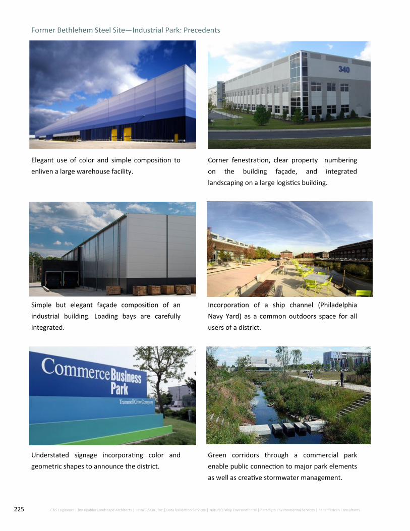
225 C&S Engineers | Joy Keubler Landscape Architects | Sasaki, AKRF, Inc.| Data Validation Services | Nature’s Way Environmental | Paradigm Environmental Services | Panamerican Consultants
Former Bethlehem Steel Site—Industrial Park: Precedents
Elegant use of color and simple composition to
enliven a large warehouse facility.
Corner fenestration, clear property numbering
on the building façade, and integrated
landscaping on a large logistics building.
Simple but elegant façade composition of an
industrial building. Loading bays are carefully
integrated.
Incorporation of a ship channel (Philadelphia
Navy Yard) as a common outdoors space for all
users of a district.
Understated signage incorporating color and
geometric shapes to announce the district.
Green corridors through a commercial park
enable public connection to major park elements
as well as creative stormwater management.

226 C&S Engineers | Joy Keubler Landscape Architects | Sasaki, AKRF, Inc.| Data Validation Services | Nature’s Way Environmental | Paradigm Environmental Services | Panamerican Consultants
Former Bethlehem Steel Site—Hamburg Pike West Edge Precendents
A mid-scale hotel with parking carefully
integrated.
A larger hotel property with all parking concealed
at the rear. The front is landscaped with mature
trees and other vegetation.
Use of lighting and a clear-glass first floor create
a welcoming building day and night, as well as
serving as a “billboard” along a major roadway.
Strong outdoor spaces with bicycle and
pedestrian paths adjacent to areas of native
planting in a commercial office zone.
Interesting materials and elegant signage enliven
a main-road focused medical office building.
An urban trail along the edge of an industrial
commercial park provides a strong community
amenity and enlivens the street edge.

227 C&S Engineers | Joy Keubler Landscape Architects | Sasaki, AKRF, Inc.| Data Validation Services | Nature’s Way Environmental | Paradigm Environmental Services | Panamerican Consultants
10.1.1. Overview and Objectives
10.1.1.1.Since the Steelawanna Business Park is an already-established small and medium business zone
(manufacturing, warehousing) close to Ridge Road, it will provide many potential opportunities
for the City upon full build-out. These include:
Best utilization of land in a zone already established as a business park.
Concentration of additional workforce close to Ridge Road (thus providing support to further development of a
Ridge Road “village high street”
Steelawanna Business Park
10.1.2.Existing Conditions
10.1.2.1.The Steelawanna Business Park is largely built-out and occupied along its edges. It is at the
heart of this zone where opportunities exist for further infilling, particularly along Steelawanna
Avenue.
10.1.3. Urban Form
10.1.3.1.The urban form of the business park is, as might be expected, diverse, ranging from the larger
Certainteed premises in the northeast corner to smaller premises along the eastern edge of
Hamburg Pike. This diversity of form is reflective of a diversity of uses, which should be continued
into the future.
10.1.3.2.The main objective for the Steelawanna Business Park should be to ultimately remove, to the
greatest extent possible, the sense that the interior of the business park is a “back lot” for back of
house industrial uses. Ultimately, the entire Steelawanna park should be a clean manufacturing
and warehousing zone of small to medium scale, with the sites of all businesses being well kept
on all sides of each property.
10.1.4. Streetscapes
10.1.4.1.In support of attaining the look and feel of a small and medium scale clean manufacturing and
warehousing business park, the streetscapes within the area, particularly Steelawanna Avenue,
should receive street trees, sidewalks, and uniform street lighting on all roads.
10.1.5. Open Space Network
10.1.5.1. Within the business park, the primary open spaces will be the streetscapes, which should be
brought by the City to a level of uniform quality. With that said, individual plot owners should
coordinate their onsite landscaping efforts to create amenity for workers and “line of desire”
walking routes across properties to and from Ridge Road businesses.
10.1.6. Materials
10.1.6.1. Materials should be consistent with light manufacturing premises (corrugated metal) and front
office applications (brick, metal panel, with fenestration).
10.1.7. Additional Recommendations:
10.1.7.1. A land swap for Quikrete to the Bethlehem Steel Industrial Park should be considered, to
enable the Lackawanna Business Park to ultimately transform its center into a true business park.

228 C&S Engineers | Joy Keubler Landscape Architects | Sasaki, AKRF, Inc.| Data Validation Services | Nature’s Way Environmental | Paradigm Environmental Services | Panamerican Consultants
Lackawanna Business Park: Precedents
Small to mid-scale clean manufacturing,
warehousing and office with parking at side or
rear and a landscaped front edge facing the road.
A neat streetscape of low-rise small
manufacturing and distribution businesses, set
back evenly, with street trees, sidewalk, and
frontage plantings.
Neat and compact overall layout with parking
contained at the center of each plot,
predominately away from road edges.
Relief of parking areas with plantings, including
trees that can attain medium size.
Signage and landscaping create a sense of
community, increasing property values and user
experience.
The Ridge Road—Steelawanna Avenue
intersection should be treated a major
community crossroad.

229 City of Lackawanna First Ward | Brownfield Opportunity Area Step 3 | Draft Implementation Strategy
Laws and Regulations
The City of Lackawanna has a number of established public regulations as well as actively practices
code enforcement to ensure preservation and help improve the quality of life and safety for all
within the community. Code enforcement plays an important role in home maintenance as well as
zoning. The City of Lackawanna’s code enforcement also serves the Building Department which has
major impacts on new construction, demolition and storm water / floodplain regulations.
Established laws and regulations such as:
Cluster development
Building siting
Construction standards
Corner visibility
Erosion and sedimentation
Fencing
Landscaping
Lighting
Parking
Roadway Design
Screening
Signs
All regulations within the code actively contribute to advancing proper implementation of current
and potential development.
230 C&S Engineers | Joy Keubler Landscape Architects | Sasaki, AKRF, Inc.| Data Validation Services | Nature’s Way Environmental | Paradigm Environmental Services | Panamerican Consultants
Other Recommendations
Improve review process for Site Plan Applications
Alignment with the City of Buffalo’s Green Code ordinance
Project Phasing and Strategies Having a phasing timeline for redevelopment throughout the City of Lackawanna is a helpful tool
to stay on track and implement new major projects or improvements at an appropriate speed.
The City of Lackawanna is deeply rooted in its industrial past and ties to Bethlehem Steel which
provided an ample number of jobs as well as allowed the area to flourish economically. After the
closing of Bethlehem Steel and the vacancies that resulted in it, certain parts of the City of
Lackawanna - especially the First Ward, had to move forward without a redevelopment plan.
The proposed phasing outlines a 20+ year plan starting with small development first and
eventually leading to sustainable, equitable development projects for all involved. Leveraging
Lackawanna’s industrial potential with high level of commuters as well as improving the First
Ward Neighborhood both have quick wins and long term goals that may happen before or after
suggest phasing. The strategy provided has four phases:
Phase 1 (year 0-5) - Laying the groundwork
Phase 2 (year 5-10) - Creating connections
Phase 3 (year 10-20) - Maintaining momentum
Phase 4 (20 to 30 years) - Thinking long-term
Current State of the First Ward and it’s Major Thoroughfares
The First Ward BOA and the major thoroughfares that run through it are currently highly travelled
yet there isn’t much capture. People mainly utilize Lackawanna’s Ridge Road and Hamburg
Turnpike as a means to commute into the City of Buffalo or Lackawanna from the surrounding
suburbs. The Hamburg Turnpike currently offers very little retail opportunity so most is
concentrated on Ridge Road near local shops, restaurants, City Hall and the Basilica. Recreation on
the Hamburg Turnpike is expected to increase exponentially due to the new Shoreline Trail being
constructed by Erie County and potential new retail on the East Side of the road to cater to
existing residents and those driving to and from work. Luckily, there is a high amount of
opportunity for infill and redevelopment throughout the First Ward BOA in order to create new
and sustainable development utilized by all.

231 City of Lackawanna First Ward | Brownfield Opportunity Area Step 3 | Draft Implementation Strategy
Phase 1 (0-5 years) - Laying the Groundwork
Laying the groundwork with new projects and initiatives sets the overall tone for the
remainder of development. Initiatives should be recognizable and highly utilized by the public
as well as be both easily attainable, otherwise known as “quick wins”. These act as leveraging
points for future projects and gain community support by being both beneficial for economic
and social development. Quick wins can be creative, low-cost options that continue to use
branding efforts and make the implementation of suggested Step 3 projects possible by gaining
community support.
Completion of Bethlehem Steel Shoreline Trail along the Hamburg Turnpike
Continue to use Lackawanna’s About FACE marketing strategy
Implementation of new pocket parks
Passing of Complete Streets Ordinance and implementation of new Design Standards and Guidelines
Crosswalk improvements along major thoroughfares to allow walkability
Start redevelopment of Gateway into the City and First Ward
Farmers Markets and other festivals along Ridge Road
Beginning of Smokes Creek Investment to increase recreational tourism
Demolition of hazardous buildings within the First Ward

232 C&S Engineers | Joy Keubler Landscape Architects | Sasaki, AKRF, Inc.| Data Validation Services | Nature’s Way Environmental | Paradigm Environmental Services | Panamerican Consultants
Phase 2 (5-10 Years) - Creating Connections
After laying the groundwork and gaining community support through
providing services and increasing social capital within the area – the next step
is to start implementation on larger projects that will be catalytic in the
process. Catalytic projects not only draw more people into the area but also
increase local tourism as well as create more necessary development as a
result. There are a number of catalytic projects and strategic sites within the
First Ward BOA to aid in creating connections not only within the City of
Lackawanna but also between its community members and to other areas
within the region. While most of these catalytic projects are commercial there
are residential and recreational opportunities as well to serve populations in
need.
“Big Box” development at Albright Court location
Ridge Road infill development
Finish Smokes Creek recreational areas
Continue industrial development within the BRA
Start construction of new community center
Begin work on First Ward community soccer field on Ingham Avenue
Streetscaping along major thoroughfares
Property Buildout (acres)
Current zoning
Albright Court 13.22 Regional Commercial
Ridge Road supermarket 1.7 Industrial
Ridge Road small retail spaces
0.15 Neighborhood Commercial
Ridge Road mixed-use building
1.7 Commercial
Ridge Road brewery 0.8 Neighborhood Commercial
Ridge Road community center
5.1 Industrial
First Ward Soccer field 5.9 Regional Commercial
Total Buildout 28.6
Table 13.1: Acreage for buildout and zoning of properties for Phase 2

233 C&S Engineers | Joy Keubler Landscape Architects | Sasaki, AKRF, Inc.| Data Validation Services | Nature’s Way Environmental | Paradigm Environmental Services | Panamerican Consultants
Phase 3 (10-20 Years) - Maintaining Momentum
Once major projects are approved and initiated, it’s important to maintain the same momentum
as the beginning of implementation. Without momentum and the continuation of developing or
redeveloping focus areas, projects may fall flat and the community itself feels the blow.
Capitalizing on demand for new markets such as housing and more jobs will seamlessly connect
the influx of a new population with the need of where they will both work and more importantly
live. The First Ward neighborhood provides solutions for both of those “problems” that should be
seen as opportunity for the area.
Infill housing within the First Ward neighborhood (formerly 100 Dona St) New Light Industrial Workforce and Development Center Steelawanna Business Park New recreational fields at 0 Gates Avenue Finish Dona Street Extension New retail and restaurants on the eastern portion of Hamburg Turnpike
Property Buildout (acres)
Zoning
First Ward Infill Housing 2.2 Residential
Light Industrial Workforce and Development Center
11 Regional Commercial
Steelawanna Business Park 6.2 Industrial
Recreational fields 4.6 Regional Commercial
Hamburg Turnpike development 0.5 Regional Commercial
Total Buildout 24.5
Table 13.2: Acreage buildout and zoning for properties in Phase 3

234 C&S Engineers | Joy Keubler Landscape Architects | Sasaki, AKRF, Inc.| Data Validation Services | Nature’s Way Environmental | Paradigm Environmental Services | Panamerican Consultants
Phase 4 (20+ Years) Thinking Long-term
When most projects are wrapping up and the community has grown in multiple facets,
there are still long-term goals to be focused on to ensure Lackawanna and the First
Ward stay sustainable and remain a destination.
Continue using updated About FACE branding Uphold complete streets ordinance and design guidelines for consistent new
development that fits in with the community Constantly involve community members and stakeholders within the First Ward
BOA economy in discussion surrounding how to continue improvements throughout the area
Although the above phasing has been strategically and deliberately planned to
maximize supply and demand within the First Ward BOA, implementation of new
projects may change at any time due to investors wanting to begin or hold off on a
particular site for funding and financial reasons.
Total possible infrastructure buildout: 53.1 acres

235 City of Lackawanna First Ward | Brownfield Opportunity Area Step 3 | Draft Implementation Strategy
Funding Sources and Grant Opportunities In order to successfully implement new projects, spur development and start redevelopment a funding
source becomes necessary. Without financial resources, catalytic initiatives or even simple place making
techniques may not be possible. Networking and partnering with local, regional or state agencies,
nonprofits and stakeholders is crucial for continuing implementation within areas that need it most. The
following section depicts possible funding avenues for the First Ward and City of Lackawanna to utilize in
order to carry out the suggested implementation projects.
In 2011, Governor Andrew Cuomo created ten different Regional Economic Development Councils (REDC)
and the Consolidated Funding Application (CFA) as a way to improve New York State’s business climate
and thus improve communities by working on local solutions for designed for certain areas (10 across the
state). Strategic plans are developed yearly using stakeholders from different sectors such as academia,
local government and nonprofits within public-private partnerships. As a result, thousands of projects
have been approved creating almost a quarter or a million jobs.
The Western New York Regional Economic Development Council accepts letters of interest, works with
Downtown Revitalization Initiatives, contributes to the WNY Smart Growth Community Fund and works
alongside the Buffalo Billion which aims to invest $1 billion in the Buffalo, New York area economy. The
City of Lackawanna was chosen to receive up to $2.5 million for projects throughout all four Wards
involving vacant parcel development, park enhancements and improvements to connectivity between
community assets.
New York State also participates in the Federal Opportunity Zone Program through the Tax Cuts and Job
Acts of 2017. The program encourages private investment in low-income urban and rural communities
that are at poverty rates of at least 20% and a median family income no greater than 80% compared to
the surrounding area. 514 tracts were approved and designated as Opportunity Zones within New York
State, three of them being within the City of Lackawanna and completely encompassing the First Ward
BOA (see Figure 13.1)

236 C&S Engineers | Joy Keubler Landscape Architects | Sasaki, AKRF, Inc.| Data Validation Services | Nature’s Way Environmental | Paradigm Environmental Services | Panamerican Consultants
The City of Lackawanna and the First Ward BOA being both a ‘Suggested Census Tract’ as well as a
Low Income Community (LIC) leverages that area to be available for tax benefits in return for
development that positively impacts the community. Utilizing the status of being a qualified census
tract as a way to gain momentum in spurring development will help the City of Lackawanna and
more importantly, the First Ward BOA on its journey to revitalization. It should also be noted that
previously mentioned surrounding Brownfield Opportunity Areas such as South Buffalo BOA, the
Buffalo River Corridor BOA and the Buffalo Harbor BOA.
A funding spreadsheet has been created as a source for the City of Lackawanna to be able to
streamline the grant process and potentially use multiple sources of revenue in order to make
projects possible. Eligibility and potential funding for any project varies based on investors,
applicants, availability of funds and time of year. The City of Lackawanna should use the following
table as a guide but be flexible with their options and utilization of partnerships.
Figure 13.1 : Low Income Communities, Eligible Non-LIC and Suggested Census Tracts for the Federal
Opportunity Zone Program
Source: Empire State Development, 2018
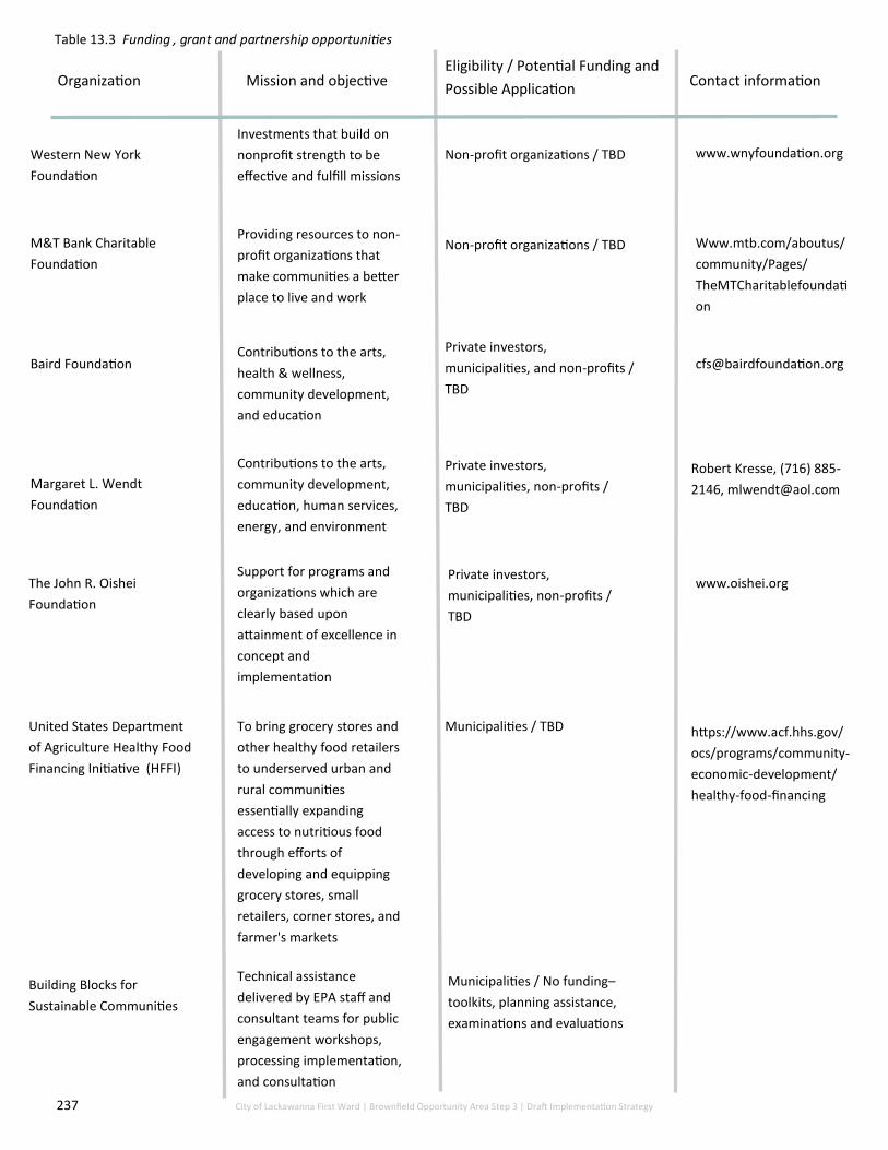
237 City of Lackawanna First Ward | Brownfield Opportunity Area Step 3 | Draft Implementation Strategy
Organization Mission and objective Eligibility / Potential Funding and
Possible Application Contact information
Western New York
Foundation
Investments that build on
nonprofit strength to be
effective and fulfill missions
Non-profit organizations / TBD www.wnyfoundation.org
M&T Bank Charitable
Foundation
Providing resources to non-
profit organizations that
make communities a better
place to live and work
Non-profit organizations / TBD Www.mtb.com/aboutus/
community/Pages/
TheMTCharitablefoundati
on
Contributions to the arts,
community development,
education, human services,
energy, and environment
Private investors,
municipalities, and non-profits /
TBD
Margaret L. Wendt
Foundation
Contributions to the arts,
health & wellness,
community development,
and education
Private investors,
municipalities, non-profits /
TBD
Robert Kresse, (716) 885-
2146, [email protected]
The John R. Oishei
Foundation
Support for programs and
organizations which are
clearly based upon
attainment of excellence in
concept and
implementation
Private investors,
municipalities, non-profits /
TBD
United States Department
of Agriculture Healthy Food
Financing Initiative (HFFI)
Baird Foundation
To bring grocery stores and
other healthy food retailers
to underserved urban and
rural communities
essentially expanding
access to nutritious food
through efforts of
developing and equipping
grocery stores, small
retailers, corner stores, and
farmer's markets
Municipalities / TBD https://www.acf.hhs.gov/
ocs/programs/community-
economic-development/
healthy-food-financing
www.oishei.org
Technical assistance
delivered by EPA staff and
consultant teams for public
engagement workshops,
processing implementation,
and consultation
Building Blocks for
Sustainable Communities
Municipalities / No funding–
toolkits, planning assistance,
examinations and evaluations
Table 13.3 Funding , grant and partnership opportunities

238 C&S Engineers | Joy Keubler Landscape Architects | Sasaki, AKRF, Inc.| Data Validation Services | Nature’s Way Environmental | Paradigm Environmental Services | Panamerican Consultants
Organization Mission and objective Eligibility / Potential Funding and
Possible Application Contact information
Brownfield Economic
Development Initiative (BEDI)
To promote economic and
community development to
redevelop abandoned or
underused industrial and
commercial facilities
Municipalities / TBD https://
www.hudexchange.info/
programs/bedi/
Payment in Lieu of Taxes Payments that assist local
governments carry out
services such as firefighting
and police operations
Private owners and investors / TBD https://www.doi.gov/pilt
Private investors, municipalities,
and non-profits / 20% of income
tax credit
https://www.nps.gov/tps/
tax-incentives.htm
U.S. Department of Housing
and Urban Development: Low
Income Housing Tax Credits
Provides investors a tax
credit that can be claimed for
the year in which the
renovated building is put into
service. A certified historic
structure is defined as a
building that is on the
Register of Historic Places.
Rehabilitation of income
producing certified historic
structures qualifies for a
credit equal to 20% of the
cost of work
New York State Rehabilitation
Tax Credit Program
Historic Rehabilitation Tax
Credits (HRTC)
Provides funding for affordable
housing by allowing the taxpayer
to claim federal tax credits for
costs incurred during
development of affordable units
in a rental housing project
For profit and non-profit developers
with at least 20% of its units rented to
households that are at or below 50%
of the area median income
Portal.hud.gov/hudportal
Used in conjunction the Federal
Historic Preservation Tax Incen-
tive Program. Owners can use
credits on both state and federal
income taxes which provide 20%
each for Qualified Rehabilitation
Expenditures amounting to 40%
total
Any person, firm, partnership or
limited liability corporation or other
business entity that owns a historic
commercial building / Up to 40% or a
$5 million cap
https://parks.ny.gov/shpo/tax
-credit-programs/
Buffalo Erie Niagara Land
Improvement Corporation
(BENLIC)
Acquires tax-delinquent and
abandoned properties to
repurpose for future use (mostly
residential but not limitied)
Municipalities
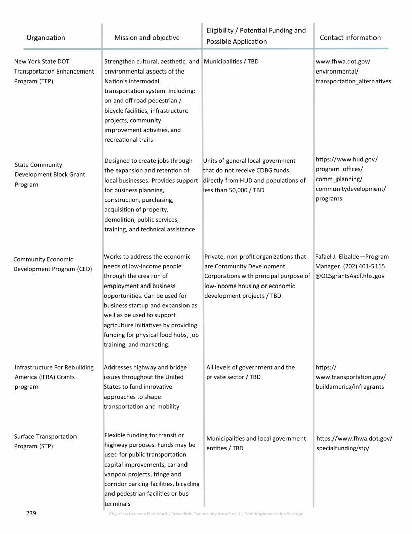
239 City of Lackawanna First Ward | Brownfield Opportunity Area Step 3 | Draft Implementation Strategy
New York State DOT
Transportation Enhancement
Program (TEP)
Community Economic
Development Program (CED)
Organization Mission and objective Eligibility / Potential Funding and
Possible Application Contact information
State Community
Development Block Grant
Program
Infrastructure For Rebuilding
America (IFRA) Grants
program
Surface Transportation
Program (STP)
Strengthen cultural, aesthetic, and
environmental aspects of the
Nation’s intermodal
transportation system. Including:
on and off road pedestrian /
bicycle facilities, infrastructure
projects, community
improvement activities, and
recreational trails
Municipalities / TBD www.fhwa.dot.gov/
environmental/
transportation_alternatives
Designed to create jobs through
the expansion and retention of
local businesses. Provides support
for business planning,
construction, purchasing,
acquisition of property,
demolition, public services,
training, and technical assistance
Units of general local government
that do not receive CDBG funds
directly from HUD and populations of
less than 50,000 / TBD
https://www.hud.gov/
program_offices/
comm_planning/
communitydevelopment/
programs
Works to address the economic
needs of low-income people
through the creation of
employment and business
opportunities. Can be used for
business startup and expansion as
well as be used to support
agriculture initiatives by providing
funding for physical food hubs, job
training, and marketing.
Private, non-profit organizations that
are Community Development
Corporations with principal purpose of
low-income housing or economic
development projects / TBD
Fafael J. Elizalde—Program
Manager. (202) 401-5115.
@OCSgrantsAacf.hhs.gov
Addresses highway and bridge
issues throughout the United
States to fund innovative
approaches to shape
transportation and mobility
All levels of government and the
private sector / TBD
https://
www.transportation.gov/
buildamerica/infragrants
Flexible funding for transit or
highway purposes. Funds may be
used for public transportation
capital improvements, car and
vanpool projects, fringe and
corridor parking facilities, bicycling
and pedestrian facilities or bus
terminals
Municipalities and local government
entities / TBD
https://www.fhwa.dot.gov/
specialfunding/stp/

240 C&S Engineers | Joy Keubler Landscape Architects | Sasaki, AKRF, Inc.| Data Validation Services | Nature’s Way Environmental | Paradigm Environmental Services | Panamerican Consultants
United States Department of
Agriculture (USDA) Community
Facilities Direct Loan & Grant
Program
Organization Mission and objective Eligibility / Potential Funding and
Possible Application Contact information
Empire State Development—
Empire Zones
Provides funding for essential
community facilities in
communities with no more than
20,000 residents
Municipalities, TBD, Community
Center on Ridge Road
https://www.rd.usda.gov/
programs-services/
community-facilities-direct-
loan-grant-program
Creation of an Empire Zone that
comes with a bundle of tax
credits, that can be granted to
businesses that applied to the
program
Businesses, TBD, Business Attraction
on Hamburg Turnpike and Ridge Road
https://esd.ny.gov/empire-
zones-program.
(518) 457-6150
Western New York Regional
Economic Development
Council
Strategic advisory board for the
WNY region. Administer
consolidated Funding
Applications (CFA) funds that
allow for BOA projects to receive
higher priority
Municipalities, private and public
agencies, TBD,
Buffalo and Erie Greenway
Fund
$2 million Annual Fund
distributed to local groups to
expand, improve, and create
new greenway features
Municipalities, private and public
agencies, TBD
(716) 838-1249, ext. 10.
Empire State Development—
Workforce Development
Challenge
$10 million available that aims
to ensure that WNY’s regional
workforce pipeline is being
responsive to industry
demands. Designed to
promote and invest in
innovation and underserved
populations
Non-profits, at least $250,000,
workforce development training
center on Alliance Drive
Pamm Lent,
(716) 846-8309

241 C&S Engineers | Joy Keubler Landscape Architects | Sasaki, AKRF, Inc.| Data Validation Services | Nature’s Way Environmental | Paradigm Environmental Services | Panamerican Consultants
Local Management Structure to Implement the Step 3
BOA
The management of the First Ward BOA will no doubt be a large undertaking with a variety of
actors and the maintenance of preexisting relationships and creation of new partnerships. The
multitude of differing types of projects to be implemented over a 20-year span will require
substantive attentiveness for successful implementation.
It is recommended that this First Ward BOA plan be implemented as a joint venture between the
City of Lackawanna Department of Development and the Lackawanna Community Development
Corporation (LCDC).
Lackawanna is fortunate to have a community development corporation (CDC) already
established. Many cities and municipalities do not have an already formed CDC and thus may have
to take the extra step to form one in order to move forward with major projects.
As a CDC, the LCDC, has the ability to advance economic development goals that a municipality
may have limitations on. The municipal use of a local development corporation is extremely
beneficial to the City for several reasons. Benefits of CDC’s include:
Not being subject to certain public procurement laws; Ability to control and manage property through legal agreements; Financial assistance in construction, acquisition, rehabilitation or improvements; Authorization to buy/lease property from a municipality without appraisal, public notice, or
public bidding; Income/operations of CDC’s are exempt from taxation; Provide grant funding for infrastructure development.
The partnership between the municipal government and the LCDC will ensure that the large
pieces of the redevelopment plan will be realized. For example, the LCDC, unlike the City of
Lackawanna, would be able to assist with the remediation of listed sites under the NYS BCP (since
they are a private corporation). A continued relationship with the LCDC to assist with
remediation, development and funding will be highly beneficial.
It is also recommended that the City of Lackawanna continue their partnership and work with the
Buffalo Erie Niagara Land Improvement Corporation to ensure homes and properties that are put
up for auction within the area are resold to the municipality so redevelopment can happen in
both a safe and proper way.

242 C&S Engineers | Joy Keubler Landscape Architects | Sasaki, AKRF, Inc.| Data Validation Services | Nature’s Way Environmental | Paradigm Environmental Services | Panamerican Consultants
BOA Market Study Implementation Strategy This Implementation Plan provides recommendations, based on the results of the “Lackawanna BOA
Market Study” for the elements that must be in place to achieve the development goals for the City
of Lackawanna. The Market Study identified two main areas for development, and the
implementation strategy will focus on them: the Bethlehem Steel site on Hamburg Turnpike and the
First Ward Residential Neighborhood including the Ridge Road corridor. Two additional strategic
development sites were also singled out as good candidates for redevelopment. They are of smaller
scale and are the 100 Dona Street site and the Alliance Drive site; both are located in the First Ward
neighborhood.
The redevelopment of the Bethlehem Steel site and the strategic development sites in the First
Ward can be tackled together. Indeed, the hope is that redevelopment efforts would be pursued
concurrently so as to set in motion a comprehensive, interconnected revitalization effort that sets
the area up with the momentum for further economic investment.
For example, the workforce training center recommended for the Alliance Drive site in the First
Ward would in the best-case scenario support the businesses already located on or considering
locating on the Bethlehem Steel site. The training center could tap into the existing labor force in the
First Ward to ensure that an adequate labor pool is available for current and future employers.
Businesses also have the opportunity to shape the curriculum based on their needs and workforce
demands if they choose to work with the new training facility.
All redevelopment recommendations herein are considered high priority; however, the timing of
each will depend on various factors such as site control; cooperation and coordination with
government agencies and authorities at the county, state and federal level; and availability of
funding sources.
Bethlehem Steel Site
The Bethlehem Steel site has been a challenge facing Lackawanna for decades. Its redevelopment is
seen as vital to the success of the City as a whole. Reclaiming the site for new businesses will take
cooperation from all levels of government and the private sector. The County and City have
increased their efforts to move the site closer toward redevelopment as exhibited in the final stages
of the BOA Step 2 Nomination Study. To this end, the City of Lackawanna has adopted a new zoning
code for the former Bethlehem Steel site, the Erie County Industrial Development Agency (ECIDA)
recently acquired a large portion of the Bethlehem Steel site with intention to speed the process,
and a consultant team was selected to draft a redevelopment master plan for the entire site.

243 C&S Engineers | Joy Keubler Landscape Architects | Sasaki, AKRF, Inc.| Data Validation Services | Nature’s Way Environmental | Paradigm Environmental Services | Panamerican Consultants
A number of major factors must be in place to encourage sustainable development on the site.
Described separately below, they are however all interconnected and must be enacted together.
For example, whereas a comprehensive site plan typically addresses potential contamination and
infrastructure needs to attract more businesses to the site, contamination and infrastructure
needs need to be addressed before any businesses can settle in. This section will attempt to break
down the process into its smaller, more manageable parts. The key elements addressed in this
section are (1) developing a comprehensive site plan; (2) mitigating existing contamination; (3)
addressing infrastructure needs; and (4) attracting and retaining new businesses.
Developing a Comprehensive Master Plan
Developing a comprehensive master plan is the backbone of any redevelopment initiative. Such a
plan provides the development framework needed to jump start redevelopment on an area the
size of the Bethlehem Steel site. Key tasks of the comprehensive master plan should be:
Creating a unified vision for the entire site
A comprehensive site plan that provides a unified vision for the entire site will ideally incorporate
uses that complement and strengthen each other. For example, if the plan advocates providing
space for uses that comprise various components of a particular supply chain, (energy production
and storage, for example), this can encourage synergies and create an environment where inno-
vation and collaboration flourish. Treating the entire site in a holistic way is also necessary to un-
derstand the phasing plan that needs to be followed so that growth can be coordinated as the site
reaches toward its highest potential. A sitewide vision, therefore, matches demand conditions
with the most suitable areas and provides flexibility to react to changing market conditions.
Thoroughly assess existing conditions
Overall, a comprehensive master plan creates a solid foundation and recommendations based on
a 360 degree analysis of key characteristics, including economic, physical, and environmental con-
ditions, as well as the community and social characteristics and needs of the surrounding neigh-
borhoods. The findings of the analysis will point toward the area’s strengths and limitations, both
of which will affect the development strategy for the site. In addition, input gathered during the
assessment can provide valuable information when it is time to obtain funding and/or market the
site.
Critical Elements for Redevelopment

244 C&S Engineers | Joy Keubler Landscape Architects | Sasaki, AKRF, Inc.| Data Validation Services | Nature’s Way Environmental | Paradigm Environmental Services | Panamerican Consultants
Develop a realistic, market-based outlook
It will be critical to use the market and community assessment findings as the foundation for
developing a realistic development outlook and a framework that can best accommodate future
growth. In particular, the comprehensive plan must be rooted in market realities with a strong focus
on the types of uses for which demand exists. Redevelopment based on the highest-and-best uses
will ensure sustainable market-based growth. In addition to local market conditions, a future site plan
needs to incorporate any existing county and/or regional planning activities to avoid duplication and
create synergies between the various efforts.
Provide a solid foundation for policy development and implementation
One of the most valuable outcomes of a comprehensive master plan is the facilitation of
communication between stakeholders. To do this, the plan must provide a publically and legally
defensible framework that empowers local officials to make decisions when guiding sustainable
growth and development. It will also identify specific actions to take for implementation and will link
these actions to possible sources of funding and any potential public/private partnerships. A
comprehensive plan also conveys predictability and certainty to private investors; these are key when
trying to attract capital and continuous support.
The comprehensive planning process can also provide legitimation for the project, so that a public or
quasi-public entity would be more likely to step in as a master developer for the site. Having a master
developer in place helps to more efficiently coordinate, negotiate, and execute activities related to
development of the site.
The market assessment identified demand for a range of uses that would be suitable for location on
the Bethlehem Steel site. These include limited, niche-destination retail options; light industrial and
warehousing uses, and other industrial uses. In general, the suitability characteristics of the site
change from its eastern border to its western. For example, while the eastern portion has easy access
and great exposure to the high-traffic Route 5, the far western portion consist is more difficult to
reach. The three zones identified on the following page should function as a guideline when creating
a more detailed development framework for the site.
Of the 34 sites currently under the BCP, approximately 11 parcels have been sold to individual
businesses who in many instances continue to remediate their properties often by utilizing the State’s
BCP program (e.g., Welded Tube USA). Fifteen of the initial 34 sites (approximately 150 acres) were
sold to the ECIDA and 8 of those 15 sites will be covered and ready for redevelopment. ECIDA is in the
process of purchasing 80 more acres.

245 C&S Engineers | Joy Keubler Landscape Architects | Sasaki, AKRF, Inc.| Data Validation Services | Nature’s Way Environmental | Paradigm Environmental Services | Panamerican Consultants
Zone 1 – This is the area on the eastern portion of the site that abuts Hamburg Turnpike. Zone 1 is
best suited to house between 700,000 to 900,000 gross square feet (gsf) of large-scale commercial
and/or industrial development, industries that would benefit from exposure to the high-traffic
corridor. The top industry categories where demand exceeds supply in the study area include
furniture and home furnishings stores; building materials and suppliers dealers and other light
industrial uses.
Zone 2 – This area would be best suited for 200,000 to 300,000 gsf of high-quality industrial and
advanced manufacturing uses. Existing uses in this zone include a lumber transfer facility and a metal
tubing manufacturer. The lumber transfer facility is noisy, stores and transfers lumber to different
transportation modes, and does not require a location close to Route 5. The metal tubing
manufacturer, in business since 2013 and with plans for expansion, applies innovative and advanced
manufacturing practices with no need for a high-traffic location. Establishment of solar fields would
also be a good fit for Zone 2. In addition, warehousing would be a good choice for this zone since
many industrial and commercial users are located nearby and typically need warehousing. The
existing transportation infrastructure (rail, seaport, highways, at the Canadian border) would be an
attractive asset.
Zone 3 – This is the area on the westernmost portion of the site, farthest from busy Route 5. It is
best suited for 300,000 gsf of uses more characteristic of the previous ones on the site, i.e., heavy
manufacturing and/or energy generation and storage. Heavy manufacturers typically produce noise
and are considered less visually attractive and should be located away from the commercial areas or
publicly accessible roads.
Solar fields are passive uses and, similar to wind turbines, already exist in the western portion of the
site. This is a good fit for Zone 3. One point to consider is that solar fields and wind turbines do not
require buildings, and so do not generate high levels of property tax. Solar fields would, however,
integrate well with any of the potential advanced energy manufacturers in Zones 1 and 2.
246 C&S Engineers | Joy Keubler Landscape Architects | Sasaki, AKRF, Inc.| Data Validation Services | Nature’s Way Environmental | Paradigm Environmental Services | Panamerican Consultants
Contamination and Mitigation
In light of its previous use as steel production facility, contamination and the mitigation of po-
tentially contaminated areas is at the core of any redevelopment effort. For decades, the City
and County have struggled to begin the remediation process. While large portions of the site
(over 150 acres) have been remediated by private sector businesses, the owner of the Bethle-
hem Steel site, and the ECIDA, but a large area still awaits remediation. Remediation is critical
for the sale and therefore for the redevelopment of individual sites, since it provides legal cer-
tainty for the owner and/or purchaser, limits liability, and alleviates potential health and envi-
ronmental concerns.
A review of the current status of site remediation will inform how remediation of the remainder
of the site can move forward. As one example of the slow-going nature of site clean-ups, it took
the ECIDA and the current property owner more than five years to negotiate the remediation of
over 200 acres of the site. The property under remediation is adjacent to Hamburg Turnpike and
is largely congruent with the area covered by Zones 1 and 2, described above.
Under the Brownfield Cleanup Program (BCP), the 200 acres under remediation were divided
into 34 smaller parcels ranging in size from 1.4 acres to 16.19 acres. Each parcel is covered by a
decision document, or mandatory plan for remediation. Once a decision document is issued, an
owner may start the cleanup action to address contamination. NYS DEC determines and certifies
the completion of the remediation process via a Certificate of Completion (COC), which allows
the sale and redevelopment of the property based on the terms and conditions of the BCP.
The remainder of the Bethlehem Steel site has not been entered into the BCP program and a
remediation plan has not been developed. It will be crucial to continue remediation efforts of
the remainder of the site to ensure redevelopment.
Infrastructure Needs
Apart from remediation, creating the physical infrastructure to accommodate new businesses is
another critical issue. Conversations with developers and economic development professionals
have revealed that infrastructure concerns are front and center when discussing redevelopment
of the area. Infrastructure concerns are twofold, and hinge on (1) removal of existing infrastruc-
ture, including rail spurs and building foundations and (2) the need for development of new in-
frastructure elements, such as utility lines and roads. The added cost of removing and providing
new infrastructure in addition to any likely remediation costs that each site will require repre-
sents an added obstacle to the redevelopment of the Bethlehem Steel site. Resources being
scarce, investments in infrastructure are only feasible for sites that will soon enter redevelop-
ment. This requires a site or a cluster of sites to be in remediation before the required sup-
porting infrastructure will be developed.

247 C&S Engineers | Joy Keubler Landscape Architects | Sasaki, AKRF, Inc.| Data Validation Services | Nature’s Way Environmental | Paradigm Environmental Services | Panamerican Consultants
Erie County has currently set $6 to 8 million aside for the extension of Dona Street onto the
Bethlehem Steel site. This extension would include installing any associated utilities, such as
electricity and water. The extension would primarily involve those parcels recently acquire
by the ECIDA, but as parcels continue to be sold to individual users, infrastructure
development must be coordinated and extended to more of the site. As the master
developer of the initial 150 acres, ECIDA has significant control over the redevelopment
process. Not only can it approve individual buyer but it can also direct and guide future
infrastructure development and so determine which areas are prioritized for
redevelopment.
Funding infrastructure for a site of the size and history of the Bethlehem Steel site can
therefore be challenging. However, there are some tools publicly available that can help.
Public-Private-Partnership (P3) concepts can help share the burden of developing the site’s
infrastructure. In particular, Tax Increment Financing (TIF) and Pilot Increment Financing
(PIF) have become proven approaches to incentive private investment and should be
incorporated when planning for the site’s infrastructure.
Eventually, an industrial business improvement district (BID) could be an option to help
maintain the infrastructure.
Business Attraction and Retention
Once a comprehensive plan and vision for the site has been created, development sites
should be strategically marketed to attract the types of business identified as suitable
users. In particular, businesses that are part of the alternative energy generation and
storage sector should be targeted as part of this effort since businesses in this sector would
complement other uses in the region and could take advantage of the developing network
of suppliers and innovators. The network includes neighboring SolarCity, the wind and solar
farms already on site, and the nation’s first net zero commercial building. These represent
some of the ingredients that could create a prospering cluster.
It is important to point out that there is a market for the finished product. The National
Renewable Energy Laboratory ranked the Buffalo Niagara region as fourth among U.S. cities
with the highest potential to meet its electricity demand with rooftop solar systems. The
value of the redevelopment of the Bethlehem Steel site, as envisioned here, would mean
that the cluster of aligned businesses would grow.
The large-scale manufacturing space recommended for Zone 1 could be occupied by
engineering and advanced manufacturing firms developing and prototyping new
technologies. Light manufacturers and warehousing facilities in Zone 2 would become part
of the larger supply chain, designing, testing, and delivering new products, while Zone 3
would be where heavy manufacturers of solar panel or wind turbine parts or finished
products locate.
First Ward BOA Residential Neighborhood and Ridge Road Corridor
The First Ward BOA Residential Neighborhood and Ridge Road Corridor will require proper
land use zoning, site preparation and marketing, and requests for proposals for
redevelopment. The Market Study recommended specific land uses and developments for
strategic areas and sites.

248 C&S Engineers | Joy Keubler Landscape Architects | Sasaki, AKRF, Inc.| Data Validation Services | Nature’s Way Environmental | Paradigm Environmental Services | Panamerican Consultants
The market research recommended destination retail be located along Hamburg Turnpike, locally
serving retail along Ridge Road, a community facility on the eastern portion of the former Friendship
House Site, a mixed-use building on Ridge Road, a job training facility on Alliance Drive, and single-
family rent-to-own homes on Dona Street.
Challenges Facing the First Ward
The City faces two main challenges when it comes to redeveloping the First Ward
High Vacancy Rate and Non-Productive Land Uses
Non-productive land, for the purposes of this analysis, is land that does not provide any public bene-
fit from tax revenue or active use as a residence or commercial site. The City of Lackawanna owns
many parcels in the First Ward. City ownership means that the city is not benefitting from property
taxes that would be paid by a private owner. Many sites, city-owned and privately owned, sit vacant
or are occupied by degraded buildings. Similar to the idea of the broken window theory, widespread
vacancy in the First Ward gives the impression that there is disorder, a lack of investment, and a lack
of community. Commercial offerings are concentrated east of the tracks. Redevelopment of strategic
sites throughout the First Ward would catalyze further redevelopment of these non-productive land
parcels in the neighborhood. A marketing strategy focused on business attraction and coordinated
policy efforts to reduce vacancy and blight will attract new investment to the First Ward.
Lack of Community Services
Since the closure of the Friendship House site, the residents of the First Ward have felt neglected.
Most of the public services offered by the City are east of the CSX railroad tracks and outside of the
First Ward. These include the public library; city court and other city department buildings; public,
parochial, and charter schools; senior center; baseball diamonds; and streetscaping. The surplus of
vacant buildings combined with the severe lack of community services represent a lower quality of
life for the residents of the First Ward who as a result feel neglected. Investments in streetscape im-
provements, a new community center, and a job training facility will help to meet the needs of the
First Ward residents and support the economic revitalization of the area.

249 C&S Engineers | Joy Keubler Landscape Architects | Sasaki, AKRF, Inc.| Data Validation Services | Nature’s Way Environmental | Paradigm Environmental Services | Panamerican Consultants
Strategies for Redevelopment of the First Ward
Use Zoning to Facilitate Redevelopment
Destination Retail on Hamburg Turnpike: The First Ward portion of Hamburg Turnpike should be
zoned to encourage large-scale commercial development. The existing large lot sizes on the east of
Hamburg Turnpike are ideal for destination retail; daily car volumes are high enough to support it.
Zoning along Hamburg Turnpike should accommodate large (greater than 25,000 gsf) commercial
businesses and require parking for customers commuting on the Turnpike. In contrast to the uses
envisioned for Ridge Road, which are recommended to be locally serving and of smaller format,
the uses along Hamburg Turnpike would be regionally serving, larger in format, and more similar to
shopping centers than a typical “Main Street.” Maintaining a strict contrast between uses
permitted along Ridge Road and those permitted along Hamburg Turnpike will ensure businesses
will not compete with each other.
Ridge Road: The First Ward portion of Ridge Road should be zoned to create a Main Street
character. The City should use zoning to control location and type of development. For example,
the existing small lot sizes on the south side of Ridge Road are ideal for locally serving retail that is
smaller in size than destination retail. Zoning on the south side of Ridge Road and portions of the
north side of the road could accommodate small (less than 25,000 gsf) commercial businesses.
Locally serving retail would not be in competition with the destination retail recommended for
Hamburg Turnpike.
Governor Andrew Cuomo has invested over $700 million in Elon Musk’s SolarCity solar panel manufacturing company located outside of Buffalo, and another $44 million to the Western
New York Workforce Training Center in Buffalo, which focuses primarily on training for careers in advanced manufacturing and energy sectors.
Second-story residential dwelling units on Ridge Road should be permitted and incentivized with
increased development rights. Having residential units on Ridge Road will increase activity on the
street, encourage local shopping, and give Ridge Road the Main Street feel that residents want.
Additional land use controls should include a setback of less than 10 feet from the street, no re-
quired parking, and no parking permitted in the front yard. Short setbacks and rear parking will
encourage people to walk on the sidewalks from store to store, window shop, and enter stores
easily. No required parking is in line with the demand for alternative modes of transportation and
existing adequate parking in the First Ward BOA (also, most First Ward residents do not own cars).
Invest in Infrastructure
Once zoning is in place, the City should consider the streetway improvements recommended in
Step 2 and begin the RFP process. The streetway improvements as recommended in Step 2 include
improving sidewalks, providing street lighting and street trees, and adding crosswalks. Streetway
improvements will draw residents, non-local customers, and businesses alike to Ridge Road. Im-
provements such as crosswalks, street trees, and sidewalks are a sign that the City and the resi-
dents are invested in the sustainability of the road’s businesses.
250 C&S Engineers | Joy Keubler Landscape Architects | Sasaki, AKRF, Inc.| Data Validation Services | Nature’s Way Environmental | Paradigm Environmental Services | Panamerican Consultants
Create a Marketing Strategy for Business Attraction and Retention
An economic development marketing strategy should create an identity for Lackawanna as an
attractive place to start, expand, or relocate a business. The City should use the data included
in the market study (daily trip counts, retail gap, land cost incentives for city-owned land, pro-
formas) to develop marketing materials to present to prospective destination retailers and
other developers.
The City can market specific sites and publish RFPs for redevelopment of strategic sites. Many
of the sites on Ridge Road are already city-owned, so low land costs or subsidized land costs
represent an incentive opportunity for the City. Using the market study, the City can target
specific businesses to attract depending on the industry gap analysis.
Two census tracts in Lackawanna are approved and designated Opportunity Zones: Census
Tract 174 (the First Ward BOA) and Census Tract 123, which is adjacent to the First Ward BOA.
The Opportunity Zone Program is a federal initiative designed to encourage investment in low
income areas. Because the First Ward is a designated Opportunity Zone, it can receive funds
from Opportunity Funds. An Opportunity Fund is a corporation or partnership which holds at
least 90 percent of its assets in property in Opportunity Zones. As an incentive to invest,
investors can defer or exclude capital gains that are reinvested in Opportunity Funds from
their taxable income. The First Ward’s status as an Opportunity Zone should therefore be used
to attract new investors. The U.S. Treasury has not yet released final guidelines for creating
Opportunity Funds, but Lackawanna should begin the process of researching the program and
preparing for new investment.
Redevelop Strategic Sites
The market study identified strategic redevelopment sites and identified demand for
commercial and community facility land uses. The order in which these properties are
developed is not as important as simply beginning the process of redeveloping underutilized
sites. The sites themselves are in strategic locations such that their redevelopment will
catalyze development on other surrounding non-productive sites.
Hamburg Turnpike: The market study proposes to redevelop the Albright Court property (1
Albright Court) as a large-format retail store, an action that will provide local and regional
benefits. The Albright Court property is city-owned and largely vacant. The portion of this
strategic site directly abutting Hamburg Turnpike contains a vacant building and an adult
entertainment store.
The north side of Ridge Road has existing industrial land uses and should be zoned to maintain those uses. The Steelawanna Industrial Park on Ridge Road provides jobs and tax revenues
for the City; its growth should be encouraged. The portions of Ridge Road that are not currently serving active industrial uses should be zoned for commercial uses.
A large-format retail store would enliven the area, provide opportunities for employment,
take the property off the City’s bankroll, and would fill the existing gap in demand for goods
versus the availability of goods within the neighborhood. Development at 1 Albright Court
would complement the redevelopment of the Bethlehem Steel site located directly across
Hamburg Turnpike.
Ridge Road: A mixed-use building, community center, and grocery store are recommended
for the three strategic sites located on Ridge Road.

251 C&S Engineers | Joy Keubler Landscape Architects | Sasaki, AKRF, Inc.| Data Validation Services | Nature’s Way Environmental | Paradigm Environmental Services | Panamerican Consultants
The strategic site for the mixed-use building (located at 229, 231, and 233 Ridge Road) is
currently vacant. The site is located across the street from the recently developed apartment
complex, Ridgeway Commons. Having active uses along the north and south sides of Ridge
Road will give the feeling of greater density. The mixed-use building is recommended to have a
small (approximately 5,000 gsf) office space on the ground floor, which is ideal for the kind of
services, including medical offices, which are currently in demand in this part of the City.
Residential apartments on the second floor will provide a greater range of housing options, and
will activate the street during the nighttime when stores are typically closed.
The strategic site for the community center (264 Ridge Road) is the location of the former
Friendship House site, on the north side of Ridge Road and directly adjacent to Ridgeway
Commons. As described in the previous section, since the closing and demolition of Friendship
Houses over a decade ago, the First Ward community has experienced a gap in city-provided
services. There is high demand for city services on the west side of the CSX railroad track. The
majority of city services and buildings are currently east of the tracks; given the demand and
need for them on the west of the tracks, it is imperative that the First Ward be the location of a
new community center. The community center will encourage all Lackawannans to go to the
First Ward, whether it be for an event at the community center or for shopping at the retail
along Ridge Road.
The strategic site for the grocery store (150 and 156 Ridge Road) is on the north side of Ridge
Road. Currently, the site houses GM Root, a business that manufactures products used in tire
manufacturing. An important business to retain in Lackawanna, the manufacturer is not the
highest and best use of a site located on a high-volume commercial corridor. GM Root could
potentially be relocated to the new light industrial zone at the Bethlehem Steel Site.
As identified in the market study, there would be few competing grocery stores for the
approximately 15,000 to 20,000 gsf store at 150 and 156 Ridge Road. The market study also
identified an unmet demand for grocery, food and beverage, and health and personal care
stores. Since few First Warders have access to a car, and in light of the current public
transportation situation that has much to be desired, residents need a grocery store within
walking distance. Beyond the most local of residents, customers would be likely to include
other City of Lackawanna residents and commuters driving along Hamburg Turnpike. A grocery
store combined with the appeal of a community center and a mixed-used building would
entice residents and visitors alike to Ridge Road, and would in turn create a more active
commercial corridor that would provide positive benefits to safety and sustainable economic
development of the City.
In addition to the three strategic sites along Hamburg Turnpike and Ridge Road, there are two
strategic sites in the southern portion of the First Ward, on Alliance Drive and Dona Street,
respectively. The city-owned parcel at approximately 100 Dona Street, once occupied by a
vacant school building, is now vacant land and is in the process of remediation. Once
remediated, the site will become available for redevelopment, and since surrounding land uses
are single-family residential, single-family homes in a rent-to-own program would be the
highest and best use for this site. The City of Lackawanna has participated in a rent-to-own
program in the past decade with great success, and should continue the process on Dona
Street.

252 C&S Engineers | Joy Keubler Landscape Architects | Sasaki, AKRF, Inc.| Data Validation Services | Nature’s Way Environmental | Paradigm Environmental Services | Panamerican Consultants
The Alliance Drive strategic site abuts the existing industrial business Solar by CIR and Alliance
Innovative Manufacturing. The site is city-owned and currently vacant and ready for
redevelopment. The site, much like the other strategic sites discussed above, are not producing
property or income taxes for the City of Lackawanna and are therefore a drain on the City’s
resources. As discussed above, more advanced manufacturing, light and heavy industrial
businesses are being targeted to locate on the Bethlehem Steel site. As a means to attract
those businesses and to provide a skilled and educated workforce for those businesses, a
workforce development center should be developed on Alliance Drive. The center should be a
development based on joint ventures between the City, the ECIDA, and the business
community. Development of the parcel as a job training center would benefit the City by
training the workforce to get skilled and high-paying jobs, which would result in income taxes
and higher spending capabilities, and would attract and retain businesses to the City of
Lackawanna.
Redevelopment of the strategic sites will make land uses productive and will enhance the
quality of life of residents of the First Ward and the City of Lackawanna as a whole. Quality of
life is the general well-being of individuals and communities. It includes life satisfaction,
physical health, family, education, employment, wealth, finance, and the environment. A
community with a high quality of life will attract and retain residents. Each of the
recommended land uses for the strategic sites will result in enhanced quality of life for
residents.
Commercial uses on Hamburg Turnpike and Ridge Road will give residents shopping
opportunities and potentially a place of employment. The market study recommended a 15,000
to 20,000 gsf grocery store on the north side of Ridge Road and larger-format commercial,
potentially a furniture store, on the east side of Hamburg Turnpike. There are no major grocery
stores within Lackawanna. While there are several corner stores in the First Ward, corner stores
are often more expensive than typical grocery stores and do not carry fresh foods. Ease of
access to fresh and healthy food encourages healthier eating habits. Increasing commercial
opportunities in Lackawanna will enhance the quality of life of residents by providing greater
food choices, a marginal increase in local jobs, and shopping within the community.

253 C&S Engineers | Joy Keubler Landscape Architects | Sasaki, AKRF, Inc.| Data Validation Services | Nature’s Way Environmental | Paradigm Environmental Services | Panamerican Consultants
Develop a Robust and Well-Educated Workforce
Job Training Facility on Alliance Drive
A trained and skilled workforce attracts and retains businesses. As such and as
previously stated, it is recommended that a job training facility should be
developed on Alliance Drive. Similar to the redevelopment strategy for the
Bethlehem Steel site, the job training facility should focus on a niche group of
trades and industry sectors. The job training facility, much like the redevelopment
plan for the Bethlehem Steel site, would affect change on a regional level and
require regional cooperation.
Workforce development programming should be strategically aligned with industry
needs and economic development goals. As recommended, advanced
manufacturing, specifically the green energy industry sector, shows great potential
for success in Lackawanna. Skills that would be in demand for the green energy
sector include mechanics, solar panel installation, and construction skills. Training
in energy efficiency will also be necessary to provide a basis of understanding.
The City will have to develop partnerships between local businesses and non-
profits, universities, and the IDA. Public institutions, community colleges, and
private businesses could provide a variety of instructors. Nearby city and county
departments could commit to hire graduates into short-term job assignments post-
grad. Workforce Buffalo is a network of career service providers with “one-stop”
career centers located throughout Erie County. The closest career center to
Lackawanna is at SUNY Erie Community College South Campus in Hamburg where
Workforce Buffalo provides job placement assistance and career coaching.
Workforce Buffalo would be a good partner for the job training facility.
Federal, state, and regional agencies and non-profits provide a variety of funding
opportunities for workforce development programs. The Empire State Develop-
ment Western New York Workforce Development Challenge (WDC) is a $10 million
initiative of the Buffalo Billion program. WDC provides grant funding for not-for-
profit corporations (501(c) (3)) with a demonstrated history of workforce develop-
ment work. Funds go toward fostering workforce development work in target in-
dustries including advanced manufacturing and energy through programs, projects
or capital improvements. Lackawanna could partner with an established not-for-
profit to access WDC funds for the job training center. See Appendix A for a full list
of possible funding sources.

254 C&S Engineers | Joy Keubler Landscape Architects | Sasaki, AKRF, Inc.| Data Validation Services | Nature’s Way Environmental | Paradigm Environmental Services | Panamerican Consultants
Invest in Community Facilities
Community Center
As previously stated, a replacement community center should be developed on Ridge Road on
the eastern portion of the site where the old Friendship House was once located. Unless the
City feels they have the capacity to own and manage a community facility, a non-profit should
be formed to run the community center or a group of local non-profits could collectively
manage the center. A non-profit may have greater capacity for community organizing and
developing a program for the community center. Once an organization has been decided on,
the next step would be to put together financing for the development. Established non-profits
may be more attuned to financing opportunities available to them. Step 2 of the BOA Process
listed a number of different county, state, and federal sources of funding that could be applied
to the community center’s development. Appendix A also includes a list of financing
opportunities.
Building a community center in the First Ward will provide people a free place to congregate
that is within walking distance for frequent visiting. In addition, the school district has cut
funding to after-school programs such as sports, recreation, and other activities. The
community center will provide programing to continue the education and entertainment of
youth in the community. Ease of access to community services will greatly increase the quality
of life of residents.
Create a Comprehensive Strategy to Combat Vacancy and Blight
Lackawanna’s local leadership has already made great strides toward fighting vacancy and
blight. The following recommendations are site specific and general policy options to
complement and strengthen Lackawanna’s existing efforts in this area.
Facilitate Homeownership: Single-Family Housing on Dona Street, Rent-to-Own Program
Only 47 percent of housing units in Lackawanna are owner-occupied. Increasing levels of
homeownership is beneficial to Lackawanna residents individually and to the community as a
whole. Homeownership is associated with better educational and health outcomes, greater
civic participation, better property maintenance, and lower crime rates. It also allows
homeowners to build wealth and creates economic and fiscal benefits for Lackawanna.
The site at 100 Dona Street, which is in the process of remediation, should be developed with
approximately 20 single-family rent-to-own homes. Infill development on this site will bring
activity and vibrancy to this long-vacant site and reinforce the residential character of this
portion of the First Ward. Single-family rent-to-own homes will provide home ownership
opportunities and stability to families who otherwise would not be able to afford buying a
home. The property is currently owned by the City of Lackawanna, which is financing the over
$1 million site remediation. Once remediation is complete, the City should release a request
for proposals for a developer to construct homes for a rent-to-own program.
U.S. Census Bureau, 2012-2016 American Community Survey
Yun, Lawrence; Evangelou, Nadia. (2017). Social Benefits of Homeownership and Stable Housing. The Journal of the Center for Real Estate Studies. Vol. 5, No.1 October, 2017. https://realtoru.edu/wp-content/uploads/2017/09/NAR_RU_JCRES_Vol5No1_WEB.pdf

255 C&S Engineers | Joy Keubler Landscape Architects | Sasaki, AKRF, Inc.| Data Validation Services | Nature’s Way Environmental | Paradigm Environmental Services | Panamerican Consultants
Land Banking
Land banks are governmental or quasi-governmental entities that buy vacant land and blighted
properties with the aim of quickly converting them to productive use. Because land banks are
government entities, they have the power to hold property without paying taxes and clear titles
and back taxes. Land banks will maintain properties while vacant to prevent blight and
remediate contaminated properties to prepare them for sale. The aim of land banking is to
prevent vacancy and blight and strategically resell properties for productive uses that align with
land use and economic development goals. Land banking removes barriers to redevelopment
and gives local municipalities more control over how these properties will be redeveloped.
Buffalo Erie Niagara Land Improvement Corporation (BENLIC) is the land bank for Erie County
under the New York State Land Bank Program. BENLIC currently holds the title for 63 properties
for various municipalities throughout Erie County and seeks to dispose of these properties for
productive use in accordance with local development goals. Only one of their 63 properties is
located in Lackawanna. Lackawanna currently partners with BENLIC to redevelop foreclosure
properties. Continuation of this partnership will assist with the City’s goals.
Vacant Property Registry / Property Information Systems Ordinance
Vacant property registry ordinances (VPROs) require owners of vacant properties to register
their properties as vacant with the local government. Vacant property registries allow
municipalities to better track vacancies and ensure that property owners can be contacted for
issues of code enforcement. Municipalities can elect to enact vacant property fees that would
be collected each year when a vacant property is registered. Fees serve to incentivize property
owners to convert their properties to active use and can help fund code enforcement
programs.
Code Enforcement
Code enforcement is an essential tool of local governments to incentivize property owners to
maintain their properties, keep properties in active use, and make their municipality attractive
to new businesses and residents. Blight begets blight, as vacant properties or properties in
disrepair attract vandalism and dumping. Innovative code enforcement strategies can help
cities achieve code compliance without large investments. Educating the public on building
codes, building permits and resources for building repair is an essential first step. The City can
assist property owners in applying to Erie County’s Housing and Rental Rehabilitation Programs
or the Lackawanna Housing Development Corporation (LHDC) to fund required repairs to their
properties.
U.S. Census Bureau, 2012-2016 American Community Survey Yun, Lawrence; Evangelou, Nadia. (2017). Social Benefits of Homeownership and Stable Housing. The Journal of the Center for Real Estate Studies. Vol. 5, No.1 October, 2017. https://realtoru.edu/wp-content/uploads/2017/09/NAR_RU_JCRES_Vol5No1_WEB.pdf 2012 Burlington Associates in Community Development LLC, http://www.burlingtonassociates.com/files/8513/4463/0249/1-Land_Banking_vs._Land_Trusting.pdf

256 City of Lackawanna First Ward | Brownfield Opportunity Area Step 3 | Draft Implementation Strategy
15.0 State Environmental Quality
Review Compliance

257 C&S Engineers | Joy Keubler Landscape Architects | Sasaki, AKRF, Inc.| Data Validation Services | Nature’s Way Environmental | Paradigm Environmental Services | Panamerican Consultants
15.0 State Environmental Quality
Review Compliance In accordance with the BOA Program and the City of Lackawanna First Ward Step 3 Implementation
Strategy, a Draft Generic Environmental Impact Statement (DGEIS) is to be incorporated into the body of
the BOA plan so that it comprises one unified document. This section provides a description of how the
requirements of the State Environmental Quality Review Act (SEQR) have been met, and identifies any
conditions or mitigations required for future actions and when subsequent SEQR compliance is
necessary. The adoption and implementation of this BOA plan constitutes the “action” subject to SEQR.
The environmental assessment herein has been prepared in accordance with 6 NYCRR 617.10 (Generic
Environmental Impact Statements), and as such, will present a more general set of existing conditions
and analyses than a conventional or project specific Draft EIS. The analyses are based on conceptual
plans and available information. Where no detail is available, qualitative estimations of impacts are
provided, and where appropriate analyses are identified that should be required when future individual
projects are proposed.
Certain elements in other sections of the BOA meet minimum DGEIS requirements (See Table 14.1). This
section relies heavily on the inventory and analysis prepared in Step 2 Nomination Study and is
supplemented by information obtained during the preparation of the Step 3 Implementation Strategy.
The general framework of this section provides content requirements in the below table:
Table 14.1: DGEIS Content Requirements
DGEIS Topic Document Section(s) or Map Page(s)
Description of Project (Action)
Step 2 Nomination Study
Step 3 Implementation Strate-gy
Step 2:
Section 2.0—Project Description and Bounda-ry
Step 3: Section 9-Implementation Strategies, Section 10.0-Stategic Sites, Section 11.0-Implementation Projects, Section 12.0-Advancing Proposed Redevelopment, Section 13.0– Tools for Advancing Implementation
115-158
159-185
186-190
191-194
195-235
SEQRA Public Hearing Step 3 Implementation Strate- Section 14.0-Scoping 236-245
Description of Envi-ronmental Setting
Step 2 Nomination Study
Step 3 Implementation Strate-gy
Step 2: Section 4.0-Analysis of the Brownfield Opportunity Area, Figure 3A through Figure 11
Step 3: Section 3.0-Environmental Setting
18-36
Impact Assessment/Mitigation Measures/Thresholds
Step 3 Implementation Strate-gy
Section 14.0-Impact Assessment and Mitiga-tion Measures
236-245
Alternatives to the Proposed Action
Step 3 Implementation Strate-gy
Section 15.0-Alternatives Analysis 246-248
Consistency with NYS CMP Coastal Policies/NY Heritage Area
Step 3 Implementation Strate-gy
Section 15.0-Consistency with NYS Policies and Strategy Compliance
246-248

258 City of Lackawanna First Ward | Brownfield Opportunity Area Step 3 | Draft Implementation Strategy
SEQRA Process
Prior to commencing a review of environmental impacts, the City conducted a series of procedural
steps in accordance with SEQR. While developing the Step 2 Nomination and Step 3
Implementation Strategy, a Full Environmental Assessment Form (FEAF) was completed, followed
by Coordinated Review / Lead Agency Designation.
Environmental Assessment Form
In 2012, Part 1 of the Full Environmental Assessment Form (EAF) was completed as part of the Step
2 Nomination Document. The Project was classified as a Type 1 Action under SEQRA. The Project is
considered a Type I action because it is anticipated to:
* Include adoption of a municipality’s land use plan, the adoption by any agency of comprehensive
resource management plan or the initial adoption of a municipality’s comprehensive zoning
regulations;
* Include the adoption of changes in the allowable uses within any zoning district, affecting 25 or
more acres; and
* A project or action that involves the physical alteration of 10 acres.
Involve Unlisted Actions within an area substantially contiguous to a National Register –listed
historic resource.
Part 2 and 3 of the Full EAF were completed and included in this Step 3 Implementation Strategy.
Coordinated Review / Lead Agency Designation / Positive Declaration
In the Step 2 Nomination Document, the City of Lackawanna Common Council was designated as
SEQRA Lead Agency, receiving no objections from involved agencies included in the Coordinated
Review. The City then determined that a DGEIS would be prepared. A notice for a public scoping
comment period was distributed to involved agencies, published in the Environmental Notice
Bulletin (ENB) and at City Hall and the City of Lackawanna Library.

259 C&S Engineers | Joy Keubler Landscape Architects | Sasaki, AKRF, Inc.| Data Validation Services | Nature’s Way Environmental | Paradigm Environmental Services | Panamerican Consultants
In conjunction with the First Ward BOA kick-off meeting in February 2016, environmental scoping
on the project was discussed together with input on visioning for the redevelopment of the First
Ward BOA. Public comments provided during this meeting as well as subsequent input from the
project steering committee were summarized a
A 30-day public comment period on the Draft Scope Document ended on December 30, 2017. The
Final Scoping Document was finalized in January 2017 and included the following anticipated
content to be incorporated throughout the BOA plan:
* Description of Proposed Action
* Community Participation
* Environmental Setting
Potential Significant Impacts
Land Use and Zoning
Historic and Cultural Resources
Transportation Impacts
Contamination Impacts / Hazardous Materials
* Cumulative Impacts
* Unavoidable Adverse Environmental Impacts
* Irreversible and Irretrievable Commitment of Resources
* Mitigation Measures
* Alternatives to Proposed Action
Scoping
Rationale for DGEIS
The City determined that a DGEIS rather than a project-specific or conventional EIS is particularly
well suited for the Project because the BOA Plan:
* Represents a number of separate actions within the First Ward BOA that when considered
together may have significant impacts; and
* Is an entire program or plan having wide application that may have new or significant changes to
future policies, projects and changes to land use, zoning or development plans.
An advantage of a DGEIS under these circumstances, is that it has the ability to set forth specific
conditions when future projects are proposed. This may include recommendations for
Supplemental EIS(s) to reflect site-specific impacts that cannot be adequately addressed in the
DGEIS at this time.

260 C&S Engineers | Joy Keubler Landscape Architects | Sasaki, AKRF, Inc.| Data Validation Services | Nature’s Way Environmental | Paradigm Environmental Services | Panamerican Consultants
Impact Assessment Mitigation Measures
This section assesses potential significant environmental impacts anticipated to occur upon
implementation of the Step 3 Implementation Strategy, based on information known at this time. This
section also discusses potential mitigation measures for those impacts if considered significant and
adverse.
Land Use and Zoning
Impacts
A future land use plan was described in the Step 2 Nomination Study (Section 7.0) and updated in this
document in Section 9 – Implementation Strategies. Implementation of this BOA Plan will result in
minor changes to the existing land use patterns, since the majority of the First Ward contains past
development. In general, the existing land use pattern throughout the First Ward BOA will remain a
mix of uses, including commercial, residential, industrial use.
Implementation of the Plan will result in additional commercial, residential and community services
throughout the First Ward BOA. The plan represents a positive change in that proposed uses are
consistent with the City’s Comprehensive Plan. The BOA Plan is consistent and progresses all goals
identified in the Comprehensive Plan. Most development in the First Ward BOA occurs on previously
developed land and is considered infill development, since there are few “greenfields” available for
new development.
Much of the proposed redevelopment projects are identified on currently City-owned land; therefore,
it is anticipated that this land be privately purchased and redeveloped. This would be a benefit for the
City since most of the identified redevelopment projects will place property back on the tax rolls and
contribute to the City budget.
In addition to proposed redevelopment on identified strategic sites, the redevelopment of the former
Bethlehem Steel Site is proposed. While much of this land was once previously developed, a large
percentage of the land is underutilized. The full build out of this proposed redevelopment substantially
increases the active land use of the City, which will involve the need for increased infrastructure such
as water, sewer and electric expansion.
Mitigation Measures
Remediation and redevelopment within the First Ward BOA is generally consistent with current land
use patterns. Future projects are proposed to ensure land use and zoning ordinances are maintained
and enhanced to improve the aesthetics and vitality of the area.
Thresholds
The BOA Plan established preferred land use patterns that generally fit into existing zoning, current
land use, and the City’s Comprehensive Plan. If future proposed projects within the First Ward BOA
exceed the preferred land use plan, then the proposed development may not be adequately
considered in this DGEIS. If this is the circumstance, it is recommended that a new project-specific
SEQR assessment be undertaken.
Additionally, while this BOA Plan includes recommended uses for the former Bethlehem Steel Site, this
development would be of massive scale. As master planning for this site progresses in the future,
additional studies will be needed to determine the impacts on infrastructure and the need for
expansion of water, sewer, and electric.

261 City of Lackawanna First Ward | Brownfield Opportunity Area Step 3 | Draft Implementation Strategy
Impacts on Historic and Cultural Resources
During this project, a Phase IA Cultural Resources Investigation was conducted for the entire First
Ward BOA, which is attached as L. The purpose of this Phase IA was to identify previously recorded
cultural resources that may be impacted by any proposed development activities within the First
Ward BOA, assess the likelihood that unrecorded resources may be present, and identify the
presence of historic properties.
This investigation provides an in-depth settlement and history of the First Ward BOA and City of
Lackawanna. The methodology for this investigation involved background data as well as a field
survey. Significant in-depth cultural background is provided in this investigation report. The entirety
of the First Ward BOA was previously disturbed and significant land area, now considered a portion of
the former Bethlehem Steel Site, is man-made land.
Five archeological sites were identified within or immediately adjacent to the First Ward BOA. None
of these sites have been determined eligible for listing on the NHRP, due to previous disturbance of
the area.
Potential historic districts were identified within the First Ward BOA; Ridge Road Historic District and
Kane Street Historic District. The potential Ridge Road Historic District is comprised of a 0.24-mile
stretch along Ridge Road containing 16 buildings and seven undeveloped lots. The buildings from
Wilkesbarre Street to Ingham Avenue represent a cohesive collection of buildings along this roadway.
Additionally, the potential Kane Street Historic District is comprised of a cluster of five early 20th
century commercial buildings that, collectively, retain sufficient integrity to convey their association
and use as former support for the large Bethlehem Steel Plant workforce.
The identified buildings in the potential Kane Street Historic District were determined to not be
eligible for registry individually; however, if grouped together into a historic district, they could be
considered “contributing” to the historic district. Further investigation of these areas as potential
historic districts is required to obtain sufficient information for SHPO to convey official determination
eligibility.
Impacts
Mitigation Measures
Measures will be taken to avoid, to the greatest extent possible, or minimize impacts to historic and
archeological resources in the First Ward BOA. There are no historic districts currently in the First
Ward BOA; therefore, as the City stands today, no buildings are eligible for New York State Historic
Tax Credits.
Thresholds
If future projects in the First Ward BOA utilize federal funding, a Phase IB Cultural Resource Survey
may need to be conducted (depending on the funding requirements). Additionally, if future projects
are progressed on any buildings identified as potential individual NHRP-eligible, consultation with
SHPO is proposed to begin as soon as possible in the planning process, at least before construction.

262 C&S Engineers | Joy Keubler Landscape Architects | Sasaki, AKRF, Inc.| Data Validation Services | Nature’s Way Environmental | Paradigm Environmental Services | Panamerican Consultants
Impacts on Transportation
Impacts
During this Step 3 Implementation Strategy, a TIS was conducted for the proposed developments as part of the
First Ward BOA Plan. The study indicates that existing traffic volumes on Route 5 and Ridge Road are
approaching the capacity of the existing transportation infrastructure. There is insufficient reserve capacity to
be able to accommodate the traffic anticipated to be generated by the projected redevelopment. While the
proposed transportation modifications meet project objectives to accommodate alternative modes of
transportation and increase connectivity between neighborhoods, the lane reductions exacerbate the already
poor operating conditions. In particular, existing and projected traffic volumes render the proposed installation
of a roundabout at the interchange of Route 5 and Ridge Road, and the proposed road diet on Ridge Road
infeasible.
This conclusion is derived from the magnitude of the projected development for the former Bethlehem Steel
Site. If the development of this site is less than projected, the road capacity of Route 5 and Ridge Road should be
able to accommodate traffic anticipated from strategic site redevelopment.
Mitigation Measures
With proposed development comes anticipated traffic increases. The First Ward BOA Master Redevelopment
Plan encourages the implementation of complete streets and urban traffic development methods to curtail
traffic generation as much as possible. By introducing infrastructure that encourages multi-modal transportation
options, mitigation of trip generation is achieved.
Thresholds
As future planning for the First Ward BOA advances and specific development proposals are identified and
further refined, a more detailed traffic impact study is recommended to evaluate different scenarios to reduce
the existing commuter volumes on Route 5 as well as mitigation necessary to accommodate the phased
implementation of the proposed BOA development.
This study should use the GBNRTC’s regional model to evaluate how the proposed new links in the
transportation system and anticipated increased traffic volume may influence the potential redistribution of
commuter trips from Route 5 to alternative routes. The model should also be used to inform the need for
Transportation Demand Management (TDM)and specific mode share targets to reduce single occupant vehicles
(SOVs) from the Southtowns to downtown Buffalo. As specific programs are identified for development sites,
consideration should be given to multi-use development that encourage internal and pass-by trips and that are
of sufficient scale to implement TDM programs. Consideration should also be given to the development of a
Transportation Management Association (TMA) for the First Ward BOA or even greater Southtowns area. While
road diets of Route 5 and Ridge Road may not be feasible with the anticipated development, the TIS should
explore the potential for improved bicycle and pedestrian accommodations within the study area, e.g.
signalizations of intersections on Ridge Road, providing a pedestrian refuge island on Route 5 or the
development of a cycle track, multi-use trail or bike boulevard parallel to these routes.
Visual and Aesthetic Impacts
Impacts Implementation of the BOA Plan may result in significant changes in the visible landscape. These changes are
expected to be positive changes since many of the redevelopment recommendations convert underutilized,
abandoned and vacant land into new, productive uses. The building designs for each strategic site will be
consistent with current uses and add to the vibrancy of the area.

263 C&S Engineers | Joy Keubler Landscape Architects | Sasaki, AKRF, Inc.| Data Validation Services | Nature’s Way Environmental | Paradigm Environmental Services | Panamerican Consultants
Additionally, proposed redevelopment in the First Ward BOA has been developed to maintain the existing
streetscape and urban characteristics of the relative reinvestment area; Ridge Road Corridor, Hamburg
Turnpike Corridor, Smokes Creek Corridor and First Ward Neighborhood. Specifically, for the Ridge Road
Corridor and the Hamburg Turnpike Corridor, specific design guidelines and standards have been created to
guide future development to conform to the existing landscape and ensure quality.
A NYS-identified “scenic vista” in the First Ward BOA includes the Great Lakes-Seaways Trail, which follows
the path of Hamburg Turnpike through the City. The current landscape of the land surrounding this trail is
underutilized and derelict. The implementation of the Master Redevelopment Plan will significantly enhance
the aesthetics of this corridor.
Mitigation Measures
No mitigation measures are proposed for visual and aesthetic resources since development guidelines and
standards were created to ensure quality and consistent development in the First Ward BOA.
Thresholds
Once project-specific designs are proposed, an assessment of potential visual impacts should be required
for each project proposing structures over 2 stories. The visual impact assessment may include viewshed
analysis to determine where the new development will be visible from and line-of-sight diagrams to
facilitate an assessment of their level of impact.
Contamination and Hazardous Materials Impacts
Through the analysis and environmental assessments completed in both the Step 2 Nomination Study and
the Step 3 Implementation Strategy, there is both known and suspected contamination within the First
Ward BOA. There are potential impacts resulting from the proximity to, or the disturbance of, known
existing contaminated sites near residential neighborhoods. Generally, the level of remediation completed
on these sites is dictated by the redevelopment use. For example, residential use standards are more
restrictive than industrial use standards.
Much of the known contamination in the First Ward BOA, especially on the former Bethlehem Steel Site, is
controlled, managed or has oversight by the DEC. Therefore, any activity on the former Bethlehem Steel
Site is subjected to approvals from the DEC.
Certain strategic sites through this Step 3 Implementation Strategy have identified known contamination on
site. These sites have a high likelihood of participating in the NYS BCP and can receive tax credits and
incentives for both remediation and redevelopment. It is recommended that these sites enter the NYS BCP
in order to receive these incentives, increase environmental quality, and improve health, safety, and
welfare of the First Ward residents.
Impacts
Mitigation Measures
In order to determine whether or not strategic sites in the BOA, not assessed through this Implementation
Strategy, are eligible for the Brownfield Cleanup Program (BCP) and therefore BCP tax credits, Phase I and
Phase II ESA’s are recommended.

264 C&S Engineers | Joy Keubler Landscape Architects | Sasaki, AKRF, Inc.| Data Validation Services | Nature’s Way Environmental | Paradigm Environmental Services | Panamerican Consultants
Thresholds
There are no thresholds required for this impact. New York State provides guidance on the level of
contamination allowed by proposed property use. If additional investigation such as Phase I and II ESAs are
conducted, these would be completed as described above, and are not subject to further SEQR review.
Additionally, if additional sites not identified in this plan are determined to be needing remediation, additional
SEQR review is not required. NYSDEC provides all necessary standards and guidance regarding this impact.
Temporary and Short-Term Impacts
Implementation of the BOA Plan will result in possible temporary and short-term impacts stemming from
potential construction activities. These may include temporary impacts from to site runoff in stormwater,
noise, dust and odor and during remediation of contamination.
Stormwater
During construction of individual projects, there is a potential for uncontrolled runoff into Smokes Creek and
Lake Erie. Individual Stormwater Pollution Prevention Plans (SWPPPs) will be required for coverage under the
DEC State Pollutant Discharge Elimination System (SPDES) General Permit for Stormwater Discharges from
Construction Activity (GP-0-15-002) for the treatment and
management of stormwater discharges from construction activities associated with projects that disturb at
least one acre. SWPPPs for each project will outline temporary erosion and sedimentation control measures, as
well as permanent stormwater management practices for runoff reduction, water quality treatment and
regulation of discharge rate and volume.
Mitigation measures identified in the SPDES SWPPP guidance include but are not limited to the following
temporary and permanent erosion control/slope stabilization practices:
* Silt fence;
* Stabilized Construction Entrance;
* Check Dams;
* Temporary stockpiling of topsoil, gravel, backfill, etc.;
* Initiating soil stabilization measures as soon as practical, and
* Best Management Practices (BMPs) for spill prevention and solid waste management.
Noise
The City of Lackawanna is considered an urban setting with background ambient noise. Impacts of the BOA in
terms of noise are expected to be short-term construction related noise. Remediation and redevelopment
activities at the Strategic Sites may result in temporary and short term increases in noise levels associated with
construction equipment such as backhoes, compactors, bulldozers and trucks. Noise produced by heavy
equipment will vary throughout the day and during the entire construction period. During a typical work shift,
construction equipment may be idling while preparing to perform a task or operating at maximum capacity. As
a result, construction, operation, and hauling vehicle sound levels will vary. Average construction sound levels
over a full construction work shift are expected to be considerably lower than peak levels. Once construction is
complete, there would be an increase in noise levels from vehicular traffic and building operations associated
with new facilities on the property.
Mitigation measures for noise include the enforcement of the City’s noise ordinance, which specifies that
construction-related activities are to occur between the hours of 8:00 AM and 9:00 PM. Additionally, through
site plan review, the City of Lackawanna can ensure adequate distances and landscaping between property
lines to ensure noise buffers.

265 C&S Engineers | Joy Keubler Landscape Architects | Sasaki, AKRF, Inc.| Data Validation Services | Nature’s Way Environmental | Paradigm Environmental Services | Panamerican Consultants
Odors Temporary impacts from odors resulting from clean-up of contaminated soils or groundwater in the First Ward
BOA may occur during the implementation of this plan. The nature and intensity of odors will depend on the
type and amount of contamination documented in future investigations. Therefore, mitigation of odor impacts
will be addressed in the site-specific remedial action work plan that must be prepared for each site prior to
clean-up activities.
Cumulative Impacts
A number of impacts have been identified as a result of implementation of BOA development or
redevelopment. The previous section provided a summary of potential short and long term environmental
impacts that may occur. This section examines the potential cumulative impacts that may result from the
implementation of this BOA plan. A cumulative impact is the effect on the environment that could result from
the incremental impact of the proposed actions when added to other past, present, or reasonably foreseeable
future action. Cumulative Impacts can result from individually minor but collectively significant actions that take
place over time.
An assessment of these probable impacts is necessary because development of multiple chosen strategic sites
may take place simultaneously under the City of Lackawanna Step 3 BOA Implementation Strategy. The study
area for this cumulative impact analysis is the limits of the BOA.
Within this study area, future development of the area is expected and anticipated. This future development
may be currently in progress, or spurred by BOA Program benefits. The following reasonably foreseeable non-
project actions are occurring or may occur in the study area:
* Net Zero Energy Building at Bethlehem Redevelopment Area
* Erie County Shoreline Trail along Route 5 in the Bethlehem Redevelopment Area
* Any non-project actions listed in Section 7.0 Development following Step 2 Nomination
No long term, significant adverse cumulative impacts are expected from the implementation of this BOA
Implementation Strategy along with other reasonably foreseeable projects. Minor traffic, parking and noise
impacts would be expected due to the construction of any of these projects if occurring alone or simultaneously
with any strategic sites. Construction impacts could include localized and temporary impacts to sound levels, air
quality, parking, traffic and visual impacts. Short-term noise impacts associated with construction would be
regulated by local and state regulations and standards. Air quality impacts would be limited to short-term
increases in fugitive dust, and mobile emissions sources from construction equipment. Any of these
construction impacts would be classified as short term cumulative impacts.
Unavoidable Adverse Environmental Impacts The BOA Plan is designed to properly guide redevelopment in a manner that lessens the potential negative
impacts resulting from land use changes and development activities. The First Ward BOA Master Redevelopment
Plan provides the City an opportunity to plan adequately and provide the proper tools to manage the preferred
growth and redevelopment in the BOA, which reduces the likelihood of potentially significant adverse
environmental impacts
The majority of the identified impacts from the BOA Plan will be sufficiently minimized and where appropriate,
will be mitigated. It is not anticipated that implementation of the Master Redevelopment Plan will result in
significantly adverse impacts that cannot be mitigated. All development actions taking place after the adoption of
this BOA Plan and DGEIS will still be subject to the SEQR process on a site specific basis. Nothing contained in this
document supplants the necessity of adequate environmental review of future actions. However, this BOA Plan
will be a resource that can be used to facilitate the review under SEQR of future development actions

266 C&S Engineers | Joy Keubler Landscape Architects | Sasaki, AKRF, Inc.| Data Validation Services | Nature’s Way Environmental | Paradigm Environmental Services | Panamerican Consultants
Irreversible and Irretrievable Commitment of Resources
This section identifies the unavoidable impacts that will irreversibly curtail the range of potential
uses of the environment or result in the commitment of resources that are neither renewable nor
recoverable. An irreversible commitment results in environmental changes that cannot, at a
future date, be altered to restore the environment to its pre-construction state. Resources
include not only the commitment of labor, fiscal resources and materials, but also natural and
cultural resources committed as a result of Project construction, operation and maintenance.
Construction of the BOA plan will result in the short- and long-term commitment of natural
resources, including structural steel, gravel, concrete and wood. The long-term commitment of
these resources will limit their availability for other projects. However, the amount of materials
required will comprise a very small percentage of the U.S. and world production of these
materials. Some of the materials, including steel, may be reclaimed and recycled. Therefore,
although there will be an
irretrievable commitment of some natural resources, this will not a significant impact on the
availability of these materials.
The construction, operation and maintenance of the BOA plan will require the irreversible
commitment of human and fiscal resources to design, build, operate and maintain the
facilities. Human resources will also be committed by governments during the planning,
environmental reviews and permitting associated with development. The commitment of human
resources will not strain local resources.
BOA plan construction, operation and maintenance will require the irretrievable commitment of
energy resources, including those derived from petroleum products. Energy will also be
committed to the manufacture and transport of materials to implement and construct the
recommended projects. Fuel will be consumed by workers commuting to the redevelopment sites
during construction and operation, as well as by construction equipment. Additionally, energy and
fuel will be used by the redevelopment sites and the occupants during the life of the Master
Redevelopment Plan. Although this will be an irretrievable commitment of resources it will not be
a significant amount and will not impact the local energy supply.

267 City of Lackawanna First Ward | Brownfield Opportunity Area Step 3 | Draft Implementation Strategy
16.0 Alternatives Analysis

268 C&S Engineers | Joy Keubler Landscape Architects | Sasaki, AKRF, Inc.| Data Validation Services | Nature’s Way Environmental | Paradigm Environmental Services | Panamerican Consultants
16. 0 Alternatives Analysis As required by 6 NYCRR § 617.9, alternatives to the Project “that are feasible, considering the objectives
and capabilities of the Project sponsor” will be evaluated; the specific alternatives that will be analyzed
are:
Reasonable Alternative Redevelopment Scenarios
The actions of the First Ward BOA Master Redevelopment Plan are not set in stone. They are guided
recommendations formulated by several planning and urban design consultants, City of Lackawanna
officials, state representatives, and public interests. For this reason, there are alternative developments
that could be implemented on identified strategic sites.
Alternate uses on strategic sites would be controlled by the City’s zoning ordinance and comprehensive
plan. This First Ward BOA Plan does not recommend that developed land uses be significantly different
than those uses permitted by the zoning ordinance. Therefore, the buildout of the First Ward BOA if
without a Implementation Strategy is likely to result in similar development, if proposals come forward.
However, incentives for these developments will not be established.
As the buildout would be similar, impacts to land use and zoning, historic and cultural resources,
transportation, visual and aesthetic resources, and contamination and hazardous materials would also be
similar. Without the guided recommendations of the Implementation Strategy, impacts may be slightly
worse than the preferred alternative (this Implementation Strategy).
No-Action Alternative
Consideration of the No-Action Alternative establishes a baseline for assessing relative impacts and
benefits of the proposed action. This discussion is intended to evaluate the adverse and/or beneficial
impacts that are likely to occur if the First Ward BOA Master Redevelopment Plan was not implemented.
Under the No-Action Alternative, the First Ward BOA will remain the same, with no additional
redevelopment projects. The strategic sites would likely remain underutilized and vacant with known
contamination on site, the visual aesthetics of the First Ward BOA would not be enhanced and the First
Ward BOA and City of Lackawanna would not reap the potential economic benefits anticipated from the
proposed redevelopment.
Since the No-Action Alternative would have adverse impacts without any offsetting positive impacts, it is
not selected as the preferred alternative.
Consistency with NYS Policies and Strategy Compliance
The First Ward BOA Step 3 Redevelopment Plan will be truly successful when compliance happens with
other established plans for the area. The City of Lackawanna Local Waterfront Revitalization Program
(LWRP) and the Heritage Area Management Plan are two initiatives made possible by other consultants
and the City itself to move progressively forward in terms of environmental and social factors.
City of Lackawanna Local Waterfront Revitalization Program
This BOA plan is consistent with all policies set forth by the City of Lackawanna LWRP. This waterfront plan
includes policies directed at:

269 C&S Engineers | Joy Keubler Landscape Architects | Sasaki, AKRF, Inc.| Data Validation Services | Nature’s Way Environmental | Paradigm Environmental Services | Panamerican Consultants
* Waterfront
* Fish and Wildlife
* Flooding and Erosion Hazard
* Generalities
* Public Access
* Recreation
* Historic and Scenic Resources
* Agricultural Lands
* Energy and Ice Management
* Water and Air Resources
* Wetlands
The BOA plan encourages the development of the former Bethlehem Steel Site for light industrial use,
encourages the enhancement of the Port of Buffalo, plans to reduce flooding and erosion of Smokes Creek,
states the protection of Smokes Creek and habitat, encourages recreational development of the Smokes
Creek/Lake Erie area, safeguard environmental/social/economic interests of the public, protection of scenic
resources, enhance quality of Route 5 and Ridge Road, utilization of Ridge Road/Route 5 intersection as a
gateway to Lackawanna, among others. Generally, this plan upholds the policies of the LWRP.
Through development policies, the LWRP assists in multiple facets of waterfront revitalization to ensure
comprehensive and responsible planning for both community members and industries alike. This drastically
aligns with the First Ward BOA goals of ensuring community and economic wellness throughout the area and
region.
Western Erie Canal Heritage Area Management Plan
The Western Erie Canal Heritage Area Management Plan created by the Western Erie Canal Heritage Corridor
Commission in 2004 outlines the programs necessary to ensure development within this
area showcases the historic nature and significance of the Western Erie Canal. The objectives of this
management plan include a vibrant regional economy, an enhanced regional quality of life, resource
conservation, and increased appreciation of natural and cultural heritage resources. The BOA plan is
consistent with all of the objectives set forth by this management plan and has the goal and intent to align
on new strategic sites and proposed development with the Western Erie Canal Heritage Area Management
Plan objectives.
DGEIS References and Underlying Studies
* Brownfield Opportunity Areas Program – Guidance for Applicants, New York State Department of State and
New York State Department of Environmental Conservation, October 2008.
* City of Lackawanna Comprehensive Plan Update, City of Lackawanna, July 6, 2016.
* Phase IA Cultural Resources Investigation, Panamerican Consultants, Inc., July 2017.
* State Environmental Quality Review Act, Final Scoping Document for the Preparation of a Generic
Environmental Impact Statement, C&S Engineers, Inc., January 2017.
* Traffic Analysis, Lackawanna Step 3 BOA, C&S Engineers, Inc., August 2017.
* Western Erie Canal Heritage Area Management Plan, Western Erie Canal Heritage Corridor Commission,
2004.
* City of Lackawanna Local Waterfront Revitalization Program, City of Lackawanna, June 1989.

270 City of Lackawanna First Ward | Brownfield Opportunity Area Step 3 | Draft Implementation Strategy
Appendix

271 C&S Engineers | Joy Keubler Landscape Architects | Sasaki, AKRF, Inc.| Data Validation Services | Nature’s Way Environmental | Paradigm Environmental Services | Panamerican Consultants
Appendices A. Phase 1 Archeological Survey
B. Community Participation Plan (CPP)
C. Meeting Minutes
D. Visioning Activity Workbooks
E. Economic and Market Demand Analysis
F. Full assessment package for environmental sites
G. Lakeshore Commerce Park Connector Road materials
H. Probable Construction Costs—Lackawanna First Ward Soccer Field
I. Commercial Traffic Volume Scenarios
J. Bethlehem Steel Shoreline Trail materials
K. Smokes Creek Corridor Site Conditions analysis