Lower Thames Crossing - Ward impact summaries
330
June 2021 Ward impact summaries north of the river - part 2 Lower Thames Crossing July 2021 Community impacts consultation
-
Upload
khangminh22 -
Category
Documents
-
view
0 -
download
0
Transcript of Lower Thames Crossing - Ward impact summaries

If you need help accessing this or any other Highways England information,please call 0300 123 5000 and we will help you.
June 2021
Ward impact summaries north of the river - part 2
Lower Thames Crossing
© Crown copyright 2021.
You may re-use this information (not including logos) free of charge in any format or medium, under the terms of the Open Government Licence. To view this licence:
visit www.nationalarchives.gov.uk/doc/open-government-licence/
write to the Information Policy Team, The National Archives, Kew, London TW9 4DU,or email [email protected].
Mapping (where present): © Crown copyright and databaserights 2019 OS 100030649. You are permitted to use thisdata solely to enable you to respond to, or interact with, theorganisation that provided you with the data. You are notpermitted to copy, sub-license, distribute or sell any of thisdata to third parties in any form.
This document is also available on our website at www.highwaysengland.co.uk
For an accessible version of this publication please call 0300 123 5000 and we will help you.
If you have any enquiries about this publicationemail [email protected] call 0300 123 5000*. Please quote the Highways England publications code PR92/21
Highways England creative job number BED21_0066
*Calls to 03 numbers cost no more than a national rate call to an 01 or 02 number and must count towards any inclusive minutes in the same way as 01 and 02 calls.
These rules apply to calls from any type of line including mobile, BT, other fixed line or payphone. Calls may be recorded or monitored.
Printed on paper from well-managed forests and other controlled sources when issued directly by Highways England.
Registered office Bridge House, 1 Walnut Tree Close, Guildford GU1 4LZ
Highways England Company Limited registered in England and Wales number 09346363
July 2021 Community impacts consultation
The wards covered in this summary are:
OckendonUpminsterCranham, Harold WoodWarley, South Weald
If you need help accessing this or any other Highways England information,please call 0300 123 5000 and we will help you.
Lower Tham
es Crossing - W
ard im
pact su
mm
aries no
rth of th
e river - part 2
July2021

1Lower Thames Crossing Ward impact summaries 2021
North of the Thames part 2To make the Ward impact summaries more user-friendly, we have split the document into three sections. The first covers all wards south of the River Thames. The second and third sections cover the wards impacted by the Lower Thames Crossing north of the Thames. All three sections include the same introductory chapter, which explains more about the document and the assessments that we have carried out.
Contents
Chapter 1: Introduction 2
Chapter 20: Ockendon ward 22
Chapter 21: Upminster ward 98
Chapter 22: Cranham and Harold Wood wards 180
Chapter 23: Warley and South Weald wards 250
How to have your say 318
Glossary 322

2 Lower Thames Crossing Ward impact summaries 2021
Chapter 1: Introduction
1.1 About this consultationThe Ward impact summaries are among the documents produced for our community impacts consultation. The consultation materials also include:
� Guide to community impacts consultationAn overview of the information included in our consultationmaterials and directions on where to find out more detail in thetechnical documents.
� Construction updateAn overview of the principles and methods that would be usedto build the new road and tunnel, and changes to existingutilities infrastructure. It also details the measures proposed tomitigate potential adverse effects.
� Operations updateInformation on the new road, junctions, the tunnel, utilities,environmental design and green infrastructure. It also includeschanges we’ve made since the last consultation, someupdates to our traffic forecasts and how the new road wouldimpact the environment.
� You said, we didA summary of responses received during our three previousconsultations and how these have been used to further refinethe project’s design.
In addition to the documents listed above, we are also consulting on draft versions of a number of control documents. These are technical documents that set out how our proposed measures would reduce the potential adverse impacts of the construction and operation of the new road. For more information about these documents, see chapter 1 of the Construction update.
1

3Lower Thames Crossing Ward impact summaries 2021
To make the Ward impact summaries more user-friendly, we have split the printed document into three sections. The first covers all wards south of the River Thames. The second and third sections cover the wards impacted north of the Thames. All three sections include the same introductory chapter, which explains more about the document and the assessments that we have carried out.
Each chapter within the Ward impact summaries includes numerous ward-specific maps showing information about different topic areas. As well as referring to those maps, we recommend that you also visit the online GIS map-viewer on our consultation website and look at the three A3 map books that are included as part of this consultation (see below). In some instances, the GIS viewer and the map books will provide similar information at a larger scale or additional information about the project that may be of interest to you. We also recommend you refer to the other consultation documents described above, which are referenced through the Ward impact summaries.
Map Book 1: General ArrangementsThe General Arrangements show the proposed layout details of the project including: permanent works; new roads, earthworks and roadside features; construction compounds; environmental mitigation; landscaping and tree planting; utilities diversions; Order Limits (previously known as the ‘development boundary’); and open space and replacement land.
Map Book 2: Land Use PlansThe land use plans show the areas where we are seeking powers to compulsorily acquire land or permanent rights. They also show the land we require temporary rights to use in order to construct and operate the project. Areas we may need to purchase include the land required for the permanent works, temporary works and compensation land.

4 Lower Thames Crossing Ward impact summaries 2021
Map Book 3: Engineering PlansThe engineering plans show plan and profile drawings which detail the vertical and horizontal road alignment. They also include junction arrangements showing the proposed layout and cross-sections throughout the route showing the lanes and earthworks.
Overview of the Ward impact summariesThese Ward impact summaries provide an overview of the proposals for the project and the associated impacts the project would have in nearby wards, should we be granted development consent. We also explain the measures that we would take to reduce the impacts on local communities. We intend to provide you with information that is relevant to your area, so you can take an informed view of how the project might affect you during construction and operation.
Once appointed, our contractors would further develop our construction plans for the Lower Thames Crossing and, as a result, some of the construction methods and timing may differ from those included in this document. For example, utility diversions are subject to agreement on timing with the relevant companies, which work to ensure supply is maintained to all customers and disruption is minimised across areas far greater than the project footprint. In the event that consent is granted for the project, the contractors would need to confirm that any changes to construction methods or timings would not result in an environmental impact that is materially different from that presented in our application.
To make sure people are aware of any anticipated disruption and can plan ahead, we would share more information during construction. If parts of the project are finished before the main route is open, such as the upgrades to the Gravesend East junction, we would inform local communities and road users so they can make use of the upgrades.
Our target date for the road opening is 2029/30, but for the purposes of construction and traffic modelling the opening date is assumed to be 2029 throughout this consultation.

5Lower Thames Crossing Ward impact summaries 2021
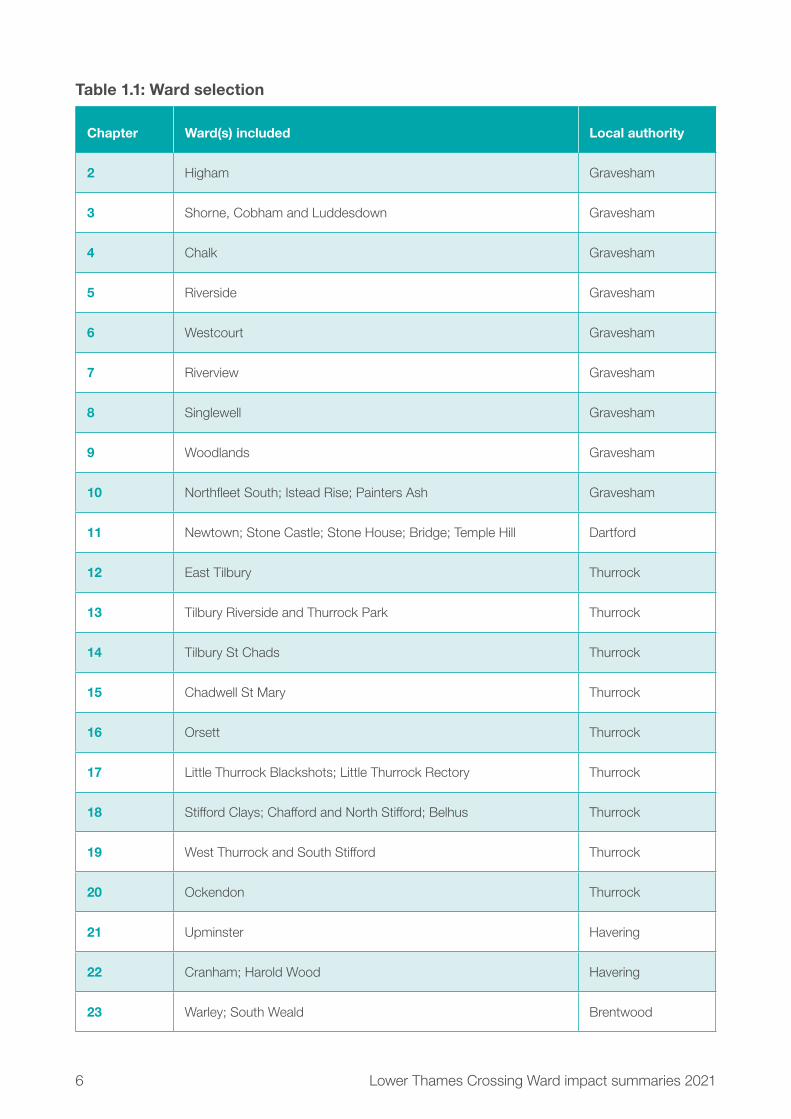
1.2 Ward selectionFor the purposes of describing the impacts of the project, we have divided the project up using the existing local authority electoral wards. The wards included are those that are directly affected by the project, in that part of the Order Limits falls within those wards. The Order Limits (also known as the ‘development boundary’) is the area required to build and operate the new road.
We have also included two chapters covering wards immediately north and south of the Dartford Crossing, even though these are not directly affected by the Order Limits. This is because it is the existing situation at Dartford that underpins the need for the Lower Thames Crossing. Table 1.1 below presents a list of chapters, including the wards in each and the associated local authority, while figure 1.1 maps all the included wards.
The wards in this document are presented from south to the north of the project. In some chapters, two or more wards are presented together because they are impacted in similar ways.
6 Lower Thames Crossing Ward impact summaries 2021
Table 1.1: Ward selection
Chapter Ward(s) included Local authority
2 Higham Gravesham
3 Shorne, Cobham and Luddesdown Gravesham
4 Chalk Gravesham
5 Riverside Gravesham
6 Westcourt Gravesham
7 Riverview Gravesham
8 Singlewell Gravesham
9 Woodlands Gravesham
10 Northfleet South; Istead Rise; Painters Ash Gravesham
11 Newtown; Stone Castle; Stone House; Bridge; Temple Hill Dartford
12 East Tilbury Thurrock
13 Tilbury Riverside and Thurrock Park Thurrock
14 Tilbury St Chads Thurrock
15 Chadwell St Mary Thurrock
16 Orsett Thurrock
17 Little Thurrock Blackshots; Little Thurrock Rectory Thurrock
18 Stifford Clays; Chafford and North Stifford; Belhus Thurrock
19 West Thurrock and South Stifford Thurrock
20 Ockendon Thurrock
21 Upminster Havering
22 Cranham; Harold Wood Havering
23 Warley; South Weald Brentwood

7Lower Thames Crossing Ward impact summaries 2021
Ward map
Cranham
Ockendon
Belhus
Bridge
Temple Hill
Chafford & North Stifford
West Thurrock & South Stifford
Little Thurrock Rectory
Harold Wood
Stone House
Newtown
Singlewell
Istead Rise
Riverside
Westcourt
Riverview
Shorne, Cobham & Luddesdown
Little Thurrock Blackshots
Stifford Clays
Higham
Chadwell St Mary
East Tilbury
Tilbury St Chads
Chalk
Stone Castle
Tilbury Riverside & Thurrock Park
Woodlands
Northfleet South
Painters Ash
Upminster
Warley
South Weald
Orsett
0 1 2 3 4km
Key
Route alignment
Order Limits
Boundary of ward(s)
Figure 1.1: Map of the wards featured in this document
8 Lower Thames Crossing Ward impact summaries 2021
1.3 Topics covered in each chapterWe’ve divided each chapter into 12 sections (listed in table 1.2). In each one, we summarise the existing situation and explain how construction and operation would have effects within the ward(s). We set out what the impacts could be and the measures we would use to reduce them. Where there are no significant impacts, this is highlighted.
Landscape, climate, geology and soils, archaeology and water management are predominantly dealt with at a project-wide level in the Construction and Operations updates, with additional maps and information. Following engagement with local authorities, it was determined that these impacts were more appropriately dealt with on a project-wide level. Traffic impacts are covered both at a ward and project level.

9Lower Thames Crossing Ward impact summaries 2021
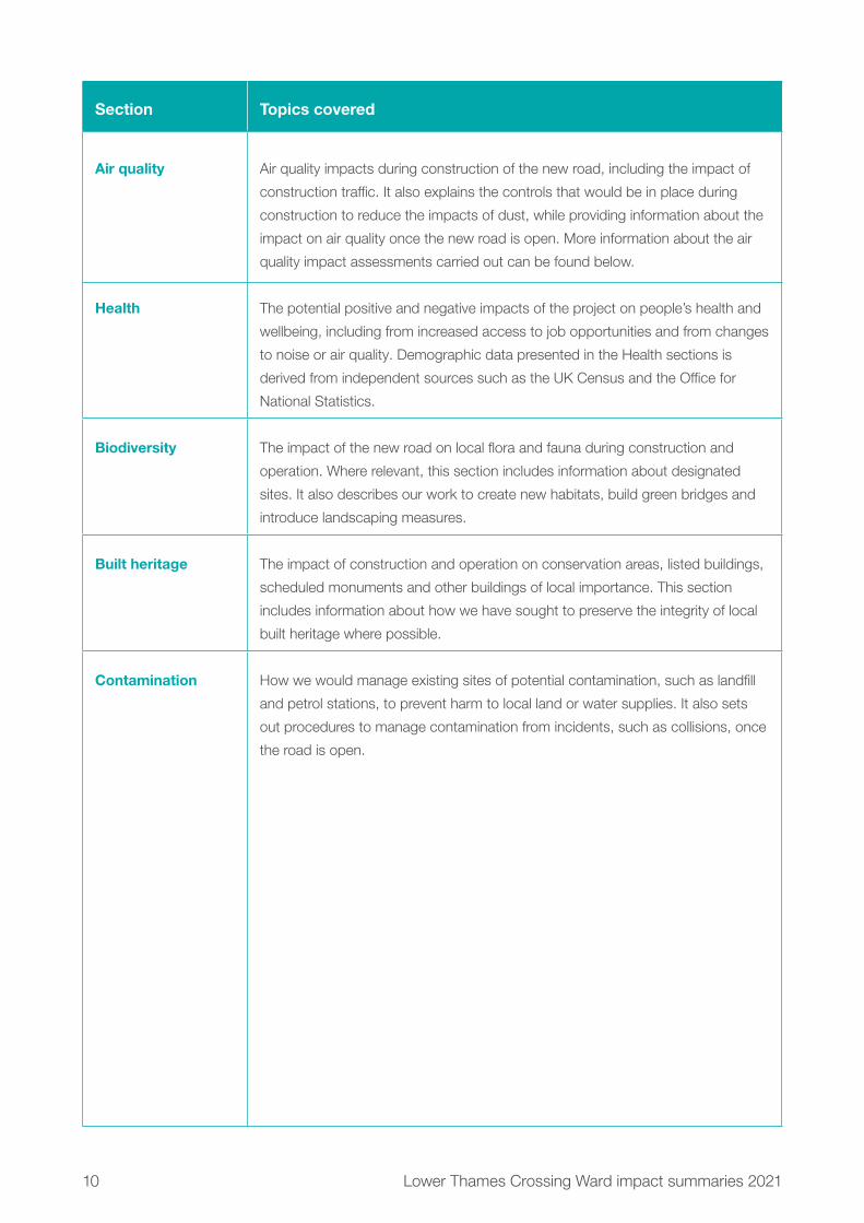
Table 1.2: Topics in each ward impact summary
Section Topics covered
Overview Information about the ward, including area, population and significant features,
such as population centres and transport links. This section also includes a table
summarising the impacts and mitigation expected in this ward.
Project description The construction activities required to build the project in this ward, including
information about traffic management measures associated with construction.
It also includes information about the elements of the new road that would be
in this ward once the project is open, information about the impacts on open
space and recreational land, and changes to the Order Limits since our design
refinement consultation in 2020.
Traffic Descriptions of the impacts of construction on local roads, including HGV and
project workforce movements. It also includes information about traffic flows on
roads in the ward once the project is open, and information about how the new
road would affect journey times and the availability of job opportunities for people
within the ward.
Public transport The impact on bus and rail services during construction, including any closures or
diversions required. It also sets out the impacts on bus and rail services once the
new road is open, with the latter including information about journey times by car
to nearby stations.
Footpaths,
bridleways and
cycle routes
The impacts of the project on footpaths, bridleways and cycle routes during
construction, including any proposed diversions. It also includes information
about new and upgraded routes once the new road is operational.
Visual The visual impacts of the construction and operation of the Lower Thames
Crossing, as well as information about how we have sought to reduce these
through measures such as landscaping and good design.
Noise and vibration Daytime noise impacts from construction sites, information about traffic noise for
each year of construction, and a summary of areas likely to experience 24-hour/
seven-day working. This section also explains the anticipated noise and vibration
impacts of the new road once it is operational. It also includes information
about the measures put in place to reduce noise and vibration impacts during
construction and operation. More information about the noise and vibration
assessments carried out can be found below.
10 Lower Thames Crossing Ward impact summaries 2021
Section Topics covered
Air quality Air quality impacts during construction of the new road, including the impact of
construction traffic. It also explains the controls that would be in place during
construction to reduce the impacts of dust, while providing information about the
impact on air quality once the new road is open. More information about the air
quality impact assessments carried out can be found below.
Health The potential positive and negative impacts of the project on people’s health and
wellbeing, including from increased access to job opportunities and from changes
to noise or air quality. Demographic data presented in the Health sections is
derived from independent sources such as the UK Census and the Office for
National Statistics.
Biodiversity The impact of the new road on local flora and fauna during construction and
operation. Where relevant, this section includes information about designated
sites. It also describes our work to create new habitats, build green bridges and
introduce landscaping measures.
Built heritage The impact of construction and operation on conservation areas, listed buildings,
scheduled monuments and other buildings of local importance. This section
includes information about how we have sought to preserve the integrity of local
built heritage where possible.
Contamination How we would manage existing sites of potential contamination, such as landfill
and petrol stations, to prevent harm to local land or water supplies. It also sets
out procedures to manage contamination from incidents, such as collisions, once
the road is open.

11Lower Thames Crossing Ward impact summaries 2021
1.4 Transport
1.4.1 Construction trafficThere would be more traffic on the roads in the vicinity of the project due to people travelling to the construction sites and the delivery of materials. The location of the construction activities and traffic management measures within each ward are discussed in the Project description section of each chapter, along with information about the expected daily number of construction vehicles travelling to and from each site.
Traffic management measures would be required on the road network at different locations and for varying lengths of time during construction to maintain safety for all road users and the project workforce. A list of all currently proposed measures is presented in the Outline Traffic Management Plan for Construction (OTMPfC), which is one of the technical documents included in this consultation.
Local diversions during construction may be required for some bus routes and these are reported in the relevant ward chapters. Information is also provided about likely disruptions to rail services that serve each ward.
Information about closures and realignments of existing footpaths, bridleways and cycle routes is presented for each ward.

12 Lower Thames Crossing Ward impact summaries 2021
1.4.2 Operational trafficWe have used traffic modelling to forecast what the conditions on the road network are predicted to be in the project’s opening year, 2029, both with and without the project. Maps showing data for current and predicted traffic flows and road capacity for the wider area can be found in the Operations update, which also includes information about how we carried out our modelling.
For this consultation, local adjustments were made to our modelling to update the geographic information, such as the location of new housing, retail and leisure sites, and the trips associated with them. We have included the main future development areas that are either under construction or already within the planning process, based on local authority information made available at the end of June 2020. More information about how we carried out our operational traffic modelling can be found in chapter 4 of the Operations update.
In each chapter of this document, we also explain the predicted change in conditions on the road network within each ward for three different time periods: the morning peak hour (7-8am), the interpeak period (a typical hour between 9am-3pm) and the evening peak hour (5-6pm). For each time period, we provide a map showing the changes in traffic flows measured in Passenger Car Units (PCUs), where one PCU is equivalent to a car and 2.5 PCUs is equivalent to an HGV. For each time period, we also show the changes in traffic flow as a percentage of the existing traffic flow on that road. On each set of maps, we have not highlighted roads where the change in flow on that road is predicted to be between -49 PCUs and +50 PCUs in each of the modelled time periods.
We have also included maps that show predicted changes in the distance that people within each ward would be able to travel within either a 30 to 60-minute drive once the new road is open.
Information is also provided on any changes to local bus routes and journey times (greater than one minute) within each ward, as well as information about impacts on rail services, including journey times to stations within or near each ward.

13Lower Thames Crossing Ward impact summaries 2021
1.5 Environmental Impact AssessmentThe type and scale of the project means that it automatically requires an Environmental Impact Assessment (EIA) to meet the requirements of legislation and policy. The results of the EIA process is being documented in an Environmental Statement (ES), which will be submitted with our application for development consent.
The EIA follows industry-standard methods as set out in Highways England’s Design Manual for Roads and Bridges, along with other topic-specific methods and guidance. Each topic chapter of the ES will be completed by competent experts.
Within the ES, all effects will be reported according to their significance (very large, large, moderate, slight or neutral). These categories are determined by understanding how sensitive a ‘receptor’ might be (where a receptor is something that can experience an impact, such as a person, property or animal), as well as the size of an impact, which could be classed as major, moderate, minor, negligible or no change. These are understood using a matrix to determine the overall significance of an impact. See table 1.3
Table 1.3: How the size of an impact and the sensitivity of a receptor combine to establish the significance of an effect
Size of impact (degree of change)
No change Negligible Minor Moderate Major
Environmental
value
(sensitivity)
Very high Neutral Slight Moderate
or large
Large or
very large
Very large
High Neutral Slight Slight or
moderate
Moderate
or large
Large or
very large
Medium Neutral Neutral or
slight
Slight Moderate Moderate
or large
Low Neutral Neutral or
slight
Neutral or
slight
Slight Slight or
moderate
Negligible Neutral Neutral Neutral or
slight
Neutral or
slight
Slight

14 Lower Thames Crossing Ward impact summaries 2021
For example, if a major impact affects a ‘sensitive receptor’ (such as a local community), then the level of environmental effect would be ‘very large’. The matrix shows the magnitude of effects possible with different degrees of sensitivity and sizes of impacts. It is shown here to provide the context of the assessment presented in the ward summaries.
The typical methodology used for producing an EIA is not designed to be reported at ward level, so in some cases it can be hard to interpret at that scale. However, the effects have been presented for visual, noise, air quality, health, biodiversity (ecology) and built heritage to help show how communities would be affected by the project. The typical language used in an EIA as shown in table 1.3 has not been used in the ward summaries. However, this is how effects will be presented in the Environmental Statement.
Other topics such as climate, road drainage and the water environment, and geology and soils are presented in chapter 7 of the Construction update and chapter 5 of the Operations update. These chapters also include information about noise and vibration and air quality impacts, presented from a project-wide perspective.
The EIA process follows a series of key steps:
1. Identification of the study area and the receptors to be assessed. Receptors can include people, properties, flora and fauna, and the surrounding environment and its resources.
2. Information on the existing environment is collected through surveys, desk-based studies, and consultation with environmental groups and the public.
3. A Scoping Report was produced to request a Scoping Opinion from the Planning Inspectorate (the government body that oversees our application for development consent). The scoping process identifies the key environmental issues relevant to the project and determines which environmental topics and elements of these topics are to be assessed. This step was completed in 2017.
4. A Scoping Opinion was received from the Planning Inspectorate on 13 December 2017.
5. Environmental assessment of the project to identify any potential significant effects on what is a reasonable worst-case scenario for both construction and operation of the project.

15Lower Thames Crossing Ward impact summaries 2021
6. Mitigation measures are set out that seek to avoid, reduce or offset potential adverse impacts.
7. Likely significant environmental effects are identified, considering whether effects would be beneficial or adverse, permanent or temporary, while taking proposed mitigation measures into account.
Measures to reduce impacts To avoid or reduce potentially significant effects on the environment we would use the following:
� Embedded mitigation: Such as the use of cuttings to hide roads or green bridges to link footpaths, bridleways and ecological habitats.
� Good practice: These are standard approaches and actions, for example, supressing dust to reduce air quality impacts during construction and measures to reduce the risk of pollution.
� Essential mitigation: These are specific measures to avoid or reduce localised environmental effects. They include monitoring protected ecological species during construction or building earth walls (bunds) alongside construction compounds to reduce noise.
More information can be found in the following control documents:
� Design principles: Embedded mitigation would be committed to within this document.
� Register of Environmental Actions and Commitments (REAC): Presents good practice measures and essential mitigation to be carried out during construction and operation of the project.
� Code of Construction Practice (CoCP): Provides a framework to manage construction activities and will accompany the ES when we submit our application for development consent. It aims to make sure environmental mitigation commitments are met and that any necessary consents and licences are obtained.
Throughout this document we have signposted to the above where relevant, while also referring to the Construction update and Operations update.
A Habitat Regulations Assessment is also being prepared and will be submitted with the application for development consent. This is required due to the proximity of the project to internationally designated sites including Thames Estuary and Marshes Special Protection Area and Ramsar site.

16 Lower Thames Crossing Ward impact summaries 2021
1.6 Air quality and noise assessmentsThe effects reported in the ward summaries are representative of a reasonable worst-case scenario, which is the basis for carrying out environmental assessments. This is assessed for the construction and operation of the project and takes account of mitigation which we have proposed to avoid, reduce or offset the effects. As a reasonable worst-case scenario has been considered, the actual impact of the project on air quality once constructed may well be less than we have assessed.
Although the impacts set out in the ward summaries provide a reasonable representation of the likely effects from our proposals in this consultation, the air quality and noise assessments are based on earlier versions of the project. The information provided about air quality and noise when the road opens is based on traffic data from an earlier opening year than is now planned for and the construction traffic air quality and noise information does not include all of the traffic management measures that we have developed subsequently.
The chapters in this document present an indicative summary of the likely effects of the project for each ward or group of wards, although further modelling will be required. For consultation, more information is described in relation to construction compounds and activities than has been included within air and noise predictions that are presented.
Air quality assessmentWhen a project leads to traffic changes, an air quality assessment is carried out. Roads that are modelled as part of the traffic assessment are included within the air quality assessment. These roads are collectively called the ‘affected road network’.
Nitrogen dioxide (NO2) is one of a group of gases called nitrogen oxides, which are generated by road traffic (among other things). There is evidence that high levels are harmful to health, causing symptoms such as shortness of breath and coughing. The health effects are likely to be more pronounced in people with pre-existing conditions like asthma. PM10 is a type of particulate matter (fine particles of dust) that is also generated by road traffic and high levels can cause similar health issues.

17Lower Thames Crossing Ward impact summaries 2021
Before an air quality assessment can be made, it is important we understand what the current air quality is like in the area. We have sourced air quality data from local authorities and the Department for Transport, used existing Highways England data, and collected our own project data. Background air quality is measured by placing diffusion tubes (a type of monitoring equipment) at the roadside, for example, attached to a lamp post for weeks at a time. These tubes are changed intermittently and sent to a laboratory, where they are analysed and the results collated. There are also automatic monitoring stations that continuously measure both NO2
and PM10 concentrations and collect annual averages. Collectively, these results provide us with a good picture of existing levels of NO2.
Next, the area is analysed for ‘sensitive receptors’. These can be human or natural, so residential properties are included, as well as locations that have an ecological interest, such as Sites of Special Scientific Interest (SSSIs). In line with standards and guidance, only those receptors that fall within 200 metres of an affected road are included in the analysis because air quality impacts tend to decrease beyond this distance.
Following this, we carry out dispersion modelling, which predicts future NO2 and PM10 concentrations, for scenarios with the new road and without it.
In some ward impact summaries, we explain that we expect local increases and exceedances in pollutants and in others there would be an improvement in air quality. To derive the significance of the effect of the project on air quality best-practice guidance has been followed (in the Design Manual for Roads and Bridges) to establish if the project overall has a significant effect. The conclusion of this assessment of significance is presented in the construction and operation summary documents. Localised increases and decreases in air quality do not necessarily result in a ‘likely significant effect’, for air quality for the project overall.

18 Lower Thames Crossing Ward impact summaries 2021
Glossary of air quality termsAir Quality StandardsThe project must comply with UK air quality objectives and the relevant Air Quality Regulations, which apply to the UK following withdrawal from the EU and which reflect the limit and target values contained in the EU Air Quality Directive.
Air Quality Standards (AQS) are concentrations recorded over a given time. They take into account what is known about the effects of pollutants on health and on the environment, and can be used as a benchmark to show whether air quality is getting better or worse. AQS have set objectives for two important air pollutants: NO2 and PM10.
An exceedance is a period of time (defined for each standard) during which the concentration is higher than that set out in the standard.
The parameters set out in the Air Quality Regulations are legally binding and must not be exceeded.
Air Quality Management Areas Since December 1997, each local authority in the UK has been carrying out reviews and assessments of air quality within its area. This involves measuring air pollution and trying to predict how it will change over the next few years. The aim of the reviews is to make sure the national air quality objectives will be achieved throughout the UK by the relevant deadlines. These objectives have been put in place to protect people’s health and the environment.
In addition to the baseline monitoring that we have carried out, we have established which AQMAs are within the vicinity of the project, which helps us understand what the existing air quality is like and where there are areas already impacted by poor air quality. We have used this knowledge to help predict how air quality may change during both the construction of the project as well as after it is built and open to traffic.1
1 (Source: https://uk-air.defra.gov.uk/aqma).

19Lower Thames Crossing Ward impact summaries 2021
Glossary of noise terms DecibelsDecibels (dB) is the unit used to measure noise. The typical level ranges from 30 dB(A)2, which is a quiet night-time level in a bedroom, to 90 dB(A), which would be kerbside by a busy road.
When we report noise levels and thresholds within the ward summaries, we use the label ‘LAeq’. The ‘A’ refers to a standard weighting that is applied to noise to represent the range of noise that people can hear. The ‘eq’ stands for ‘equivalent’ and means the average noise over an amount of time. The amount of time would then be written after the label, with the most-used time period presented in the ward summaries being 12 hours, which is expressed as ‘LAeq12hour’. L stands for level.
Noise impacts are described as being negligible, minor, moderate, or major. These levels of change are associated with an increase in decibels of less than 1.0 dB(A) to greater than 5.0 dB(A), as shown in table 1.4.
Table 1.4: Terms used to describe noise impacts
Noise increase In decibels Meaning
Negligible Less than 1.0 dB(A) Change in noise is not noticeable
Minor Greater than or equal to 1.0 and less
than 3.0 dB(A)
Change in noise is barely noticeable
Moderate Greater than or equal to 3.0 and less
than 5.0 dB(A)
Change in noise is noticeable (requires
concentration to hear)
Major Greater or equal to 5.0 dB(A) Change in noise is apparent (can be
heard easily)
2 (A) shown after dB refers to weighting applied to sound levels to mimic the human hearing range.

20 Lower Thames Crossing Ward impact summaries 2021
Noise assessmentAs the area surrounding the project has the potential to be affected by noise caused by construction or operation of the project, a noise assessment is being carried out for both the construction and operational phases. This would predict the likely noise levels from construction traffic and equipment, as well as changes in road noise once the new road is open.
First, we establish existing background noise levels by surveying locations agreed by the Local Planning Authority. These are recorded using sound level meters over a set timeframe, to provide day and night-time averages in decibels.
Noise hotspotsNoise Important Areas are ‘hotspots’ where the highest 1% of noise levels at residential locations can be found and are defined by DEFRA. These areas provide a framework for further investigation and are used to produce action plans to manage environmental noise and its effects.
British Standard (BS) 5228We refer to BS 5228 in the noise sections of the ward summaries. This is a British Standard for conducting noise modelling. It provides the methodology for assessing changes in noise and tells us how we determine the significance of a change. The guidance provides threshold levels for noise during the day, the evening, at weekends and at night. If these thresholds are exceeded mitigation is needed.
Where we present a threshold based on BS 5228 this is done over an average time period. Where we predict that noise levels would be below a threshold this is the average noise level rather than the peak noise level. For example, over the course of a day the average noise level may remain well below the baseline noise levels but individual short-term activities might cause noise levels which peak above the threshold.

21Lower Thames Crossing Ward impact summaries 2021
Fireworks 140 dB
Jet engine 130 dB
Police siren 120 dB
Trombone 110 dB
Helicopter 100 dB
Hairdryer 90 dB
Truck 80 dB
Car, City traffic 70 dB
Conversation 60 dB
Moderate Rainfall 50 dB
Refrigerator 40 dB
Whisper 30 dB
Rustling leaves 20 dB
Breathing 10 dB
Weakest sound 0 dB
decibel Scale (dB)An explanation of the decibel scale and related units for measuring sound and loudness. How noise levels measured in decibels might sound.
Figure 1.2: Noise impacts, decibel changes and how these might be perceived

22 Lower Thames Crossing Ward impact summaries 2021
20Chapter 20: Ockendon wardThis chapter summarises the activities in Ockendon ward relating to the project’s construction and its operational phase (when the new road is open). It also explains the measures intended to reduce the project’s impacts on local communities. For more information about the assessments in this chapter and other information available during this consultation, see chapter 1, which also includes a map showing all the wards described in this document.
Within this document, we sometimes advise where additional information can be found in other consultation documents, including the Construction update, Operations update, You said, we did, Register of Environmental Actions and Commitments (REAC), Code of Construction Practice (CoCP), Outline Traffic Management Plan for Construction (OTMPfC) and Design principles. To find out more about these documents, see chapter 1. References to these documents provide an indication as to how our proposals to reduce the project’s impacts will be secured within our application for development consent.

23Low
er Thames C
rossing Ward im
pact summ
aries 2021 Ockendon
0 0.15 0.3 0.45 0.6km
LegendBoundary of Ward(s)
Contains Ordnance Survey data. © Crown copyright and database rights 2021. Ordnance Survey 100030649
Figure 20.1: Ward boundary map for Ockendon ward

24 Lower Thames Crossing Ward impact summaries 2021
20.1 Overview
20.1.1 About this wardOckendon ward is located north of Belhus and west of Orsett. The ward has an area of around 11.5km2 hectares and an estimated population of 11,4671. The ward is residential in the south, and is predominantly agricultural, with the M25 running north-south in the west. The Upminster to Grays railway line runs through the centre of the ward north to south. Ockendon station is located to the west of Tamarisk Road. South Ockendon Quarry is sited in the east of the ward with an approved planning application to build a solar farm and associated infrastructure. There is a high-voltage overhead power line in the east of the ward, which is crossed by the proposed new road.
1 Office for National Statistics, 2018 ward-level population estimate.

25Lower Thames Crossing Ward impact summaries 2021
20.1.2 Summary of impactsTable 20.1: Summary of impacts during the project’s construction and operation
Topic Construction Operations
Traffic Impacts
It is predicted that the traffic impacts
in the ward during the construction
period will be in areas where there
are traffic management measures.
There may, however, be additional
construction traffic on the roads for
the first 12 months of construction.
Mitigation
There are several mitigation
measures to reduce the impact of
the construction process on local
residents, including reducing the use
of local roads by construction vehicles.
Further details on the mitigation
measures can be found in the Traffic
section of this chapter.
Impacts
It is predicted that there will be minor
changes to traffic flows within the ward
once the project is operational. Only
South Road and a small section of the
M25 is predicted to see any changes.
Further details can be found in the
Traffic section of this chapter.
Mitigation
Regular monitoring would take place
once the project is operational. Further
details about the mitigation measures
for Ockendon ward can be found in
the Traffic section of this chapter.
Public transport Buses
There would be increases to journey
times for some local buses within
the ward, associated with the traffic
management works and, in the early
stages of the project construction, with
additional traffic on the local roads.
While Ockendon Road is closed, the
370 bus would have to be diverted.
Rail
There may be some increases in
journey times to Ockendon station,
also associated with increased
traffic through the area and traffic
management on the local roads.
Buses
Bus journeys would not be affected.
Rail
There would be no discernible
changes to access times to local train
stations, nor to rail services from
these stations.

26 Lower Thames Crossing Ward impact summaries 2021
Topic Construction Operations
Footpaths,
bridleways and
cycle routes
Impacts
Four footpaths and two bridleways
would need to be closed for between
five months and five-and-a-half years
to allow for utilities works, main
works alignment and for the M25
construction compound.
Mitigation
Where closures of footpaths and
bridleways are necessary to allow for
construction works, these closures will
be reduced as much as possible, and
in one case diverted while closed.
Impacts
Footpaths affected during construction
would be resurfaced and upgraded
to bridleways once the project is
operational and diverted along new
alignments into the existing public
right of way network, opening up new
local connections. The one existing
bridleway affected would be upgraded
and resurfaced via a new route and
bridge prior to reopening.
Mitigation
Where footpaths or bridleways need
to be diverted permanently, these
new alignments would be as close to
the existing routes as practicable and
would open up new local connections
in the existing public rights of
way network.

27Lower Thames Crossing Ward impact summaries 2021
Topic Construction Operations
Visual Impacts
Views towards construction activities
from residential properties on the
northern edge of South Ockendon
and Cheelson Road are likely to
include the excavation of the cutting
for the new road, construction of
the false cutting and North Road
green bridge. From footpaths on
the north-east outskirts of South
Ockendon, views across arable fields
are likely to include road and bridge
construction. From the east-west
aligned footpath, there would be views
of Medebridge Compound, and road
and bridge construction to the south.
The overhead line diversion east
of Footpath 136 overbridge would
be visible from the footpath which
connects to the Mardyke Way, as well
the associated Utility Logistics Hub
and road construction.
Mitigation
The visual impacts would be controlled
through the good practice measures
set out in the CoCP and REAC.
Impacts
The North Road green bridge, the new
road and traffic would be visible from
residential properties on the northern
edge of South Ockendon. The new
road would visible where it emerges
from cutting approaching the Footpath
136 overbridge. The new road and
associated traffic would be visible
from the footpath connecting to the
Mardyke Way. The diverted overhead
line would not be noticeably different
to the existing overhead line.
Mitigation
False cuttings and landscape planting
along the new road corridor would
help to screen views of the new
road and traffic. The North Road
green bridge would visually link the
landscape north and south of the
new road.

28 Lower Thames Crossing Ward impact summaries 2021
Topic Construction Operations
Noise and vibration Impacts
The construction activity associated
with the M25 upgrade works, the
project entrance/exit slips on to the
M25 and the new road and utilities
works is expected to create noise
in this ward. There would also be
two main work compounds and one
Utility Logistics Hub within this ward.
There would also be 24-hour, seven-
day construction working in some
locations. There would be negligible
changes in noise from road traffic for
a majority of roads within this ward
during the construction period, except
along Dennis Road and the Veolia
Track access where increases in road
traffic noise are predicted.
There is one proposed structure
expected to be constructed using
vibratory or percussive piling, however
these works are not within 100 metres
of any sensitive receptors, so no
vibration impacts are expected.
Mitigation
Construction noise levels would be
controlled through the mitigation
measures set out in the REAC.
There are also measures presented
in the CoCP.
Impacts
Once the project is built, there would
be direct noise impacts from the new
road and the proposed improvements
to the M25 in the west of this ward.
There would be an indirect noise
impact from the changes in traffic
flow and speed on the existing
road network.
Mitigation
Low-noise road surfaces would be
installed on all new and resurfaced
roads, and noise barriers would
be installed.
29Lower Thames Crossing Ward impact summaries 2021
Topic Construction Operations
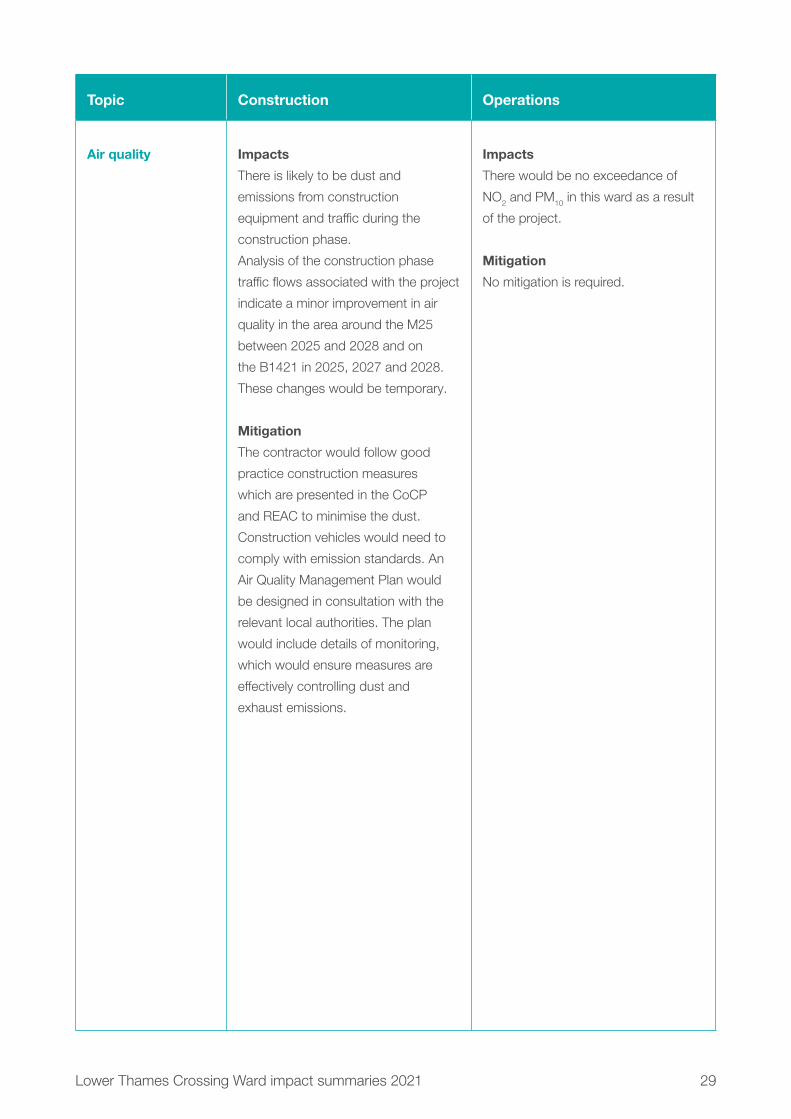
Air quality Impacts
There is likely to be dust and
emissions from construction
equipment and traffic during the
construction phase.
Analysis of the construction phase
traffic flows associated with the project
indicate a minor improvement in air
quality in the area around the M25
between 2025 and 2028 and on
the B1421 in 2025, 2027 and 2028.
These changes would be temporary.
Mitigation
The contractor would follow good
practice construction measures
which are presented in the CoCP
and REAC to minimise the dust.
Construction vehicles would need to
comply with emission standards. An
Air Quality Management Plan would
be designed in consultation with the
relevant local authorities. The plan
would include details of monitoring,
which would ensure measures are
effectively controlling dust and
exhaust emissions.
Impacts
There would be no exceedance of
NO2 and PM10 in this ward as a result
of the project.
Mitigation
No mitigation is required.
30 Lower Thames Crossing Ward impact summaries 2021
Topic Construction Operations
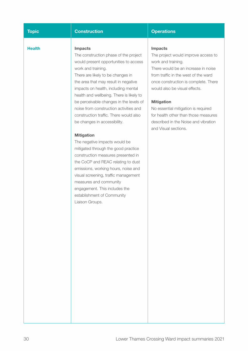
Health Impacts
The construction phase of the project
would present opportunities to access
work and training.
There are likely to be changes in
the area that may result in negative
impacts on health, including mental
health and wellbeing. There is likely to
be perceivable changes in the levels of
noise from construction activities and
construction traffic. There would also
be changes in accessibility.
Mitigation
The negative impacts would be
mitigated through the good practice
construction measures presented in
the CoCP and REAC relating to dust
emissions, working hours, noise and
visual screening, traffic management
measures and community
engagement. This includes the
establishment of Community
Liaison Groups.
Impacts
The project would improve access to
work and training.
There would be an increase in noise
from traffic in the west of the ward
once construction is complete. There
would also be visual effects.
Mitigation
No essential mitigation is required
for health other than those measures
described in the Noise and vibration
and Visual sections.

31Lower Thames Crossing Ward impact summaries 2021
Topic Construction Operations
Biodiversity Impacts
The construction of the project would
involve the removal of areas of habitat,
both temporarily and permanently for
the new road.
This includes arable fields, scrub,
rough grassland and woodland.
Species within these habitats would
be disturbed through habitat loss and
fragmentation.
Mitigation
Vegetation clearance would be carried
out in winter to avoid impacting
breeding birds. Protected species
would be relocated, carried out under
a Natural England licence. Boxes
to support bats, birds and barn
owls would be erected. Habitat lost
temporarily for construction works
would be reinstated.
A green bridge would be built over
North Road to provide habitat
connectivity. New areas of grassland,
scrub and bare earth habitats would
be created as well as new ponds.
Impacts would also be controlled
through the range of good practice
measures set out in the CoCP
and REAC.
Impacts
There is the potential to cause
mortality of species by encountering
road traffic as well as habitat
fragmentation and disturbance
from traffic.
Mitigation
Landscape planting has been
designed to enable animals to move
to forage, and guide them to safe
crossing points over the new road.
Newly created areas of habitat would
be managed to ensure they provide
high-quality habitat to support a broad
range of plant and animal species.
Impacts would also be managed
through the range of good practice
measures set out in the CoCP
and REAC.

32 Lower Thames Crossing Ward impact summaries 2021
Topic Construction Operations
Built heritage Impacts
There would be no direct impact to
built heritage assets. Grade II listed
Former Gateway at Groves Barns
would experience temporary changes
to its setting through the noise, lighting
and visible construction machinery.
Grade II listed Kemps and Kemps
Cottage would experience a slight
temporary impact to their setting as
a result of construction activity along
the M25.
Mitigation
The design and layout of Medebridge
and M25 Compounds would seek to
avoid or minimise light pollution during
night-time construction. Good
practice measures are detailed within
the REAC, refer to the Air quality,
Noise and Heritage sections.
Impacts
Grade II listed Kemps and Kemps
Cottage would experience slight
impacts to their setting due to the
likely increase of noise along the M25
once the new road opens.
Mitigation
Road lighting would be minimised
where it is safe and practical to do so.
Medebridge and M25 Compounds
would be reinstated on completion
of construction to reflect the existing
field patterns and surrounding
landscape character.
Contamination Impacts
There is one potential source of
contamination, Ockenden Grays Areas
II & III landfill within this ward.
During construction, there is a risk
that existing contamination could
be mobilised. There is also a risk of
accidental spills of oil, cement or fuel.
Mitigation
Contamination would be controlled
through a range of good practice
measures that are detailed within
the REAC.
Impacts
None identified.
Mitigation
During the operation of the road,
should an incident occur for example,
a traffic accident resulting in localised
contamination, significantly affected
soils would be assessed and if
necessary removed to reduce the risk
of contamination migrating across
a wider area or entering controlled
waters. For more information on these
controls, see the REAC.

33Lower Thames Crossing Ward impact summaries 2021
20.2 Project description
20.2.1 Construction Construction activitiesMore information about how the area would look during construction, including visualisations, can be found in the Construction update.
Ockendon ward would contain a substantial section of the finished road, including the section over the Mardyke Viaduct. East of the M25, the new Mardyke Viaduct would take the Lower Thames Crossing over the Mardyke River southwards towards Green Lane. All works would take place away from public roads and are expected to take approximately three years. Major earthworks would involve taking excavated material from the west of the M25 to the east of the motorway to create the embankments that support the viaduct. A haul road would be built to transport the excavated material.
The haul road would be built early on in the construction period between Green Lane, near Orsett and the London, Tilbury and Southend railway line in Upminster ward. Once in place, the haul road would allow heavy machinery, equipment and other materials to be transported around the worksite away from public roads. This would reduce the number of HGV journeys and lessen the impact on road users and local communities. The haul road would cross North Road and traffic management would be necessary to manage the construction traffic at this point.
Ockendon Road would be closed for 19 months to facilitate the construction of the new Ockendon Road bridge, during which time we would create the connection from the west of the M25 to the east of the motorway so excavated material could be moved efficiently. The road closure would also allow the construction of major structures around the M25 and facilitate utility diversions in this area. The closure would affect local communities, including bus routes, and a suggested diversion is shown below via Dennis Road. Diverted traffic using Dennis Lane or St Mary’s Lane to cross the M25 would experience an increase in journey length of around 10km.

34Low
er Thames C
rossing Ward im
pact summ
aries 2021
Figure 20.2: Main construction areas in Ockendon ward

35Lower Thames Crossing Ward impact summaries 2021
Ockendon Road closure diversion
M25
Ockendon Road
Dennises Lane
West Road
B18
6 N
orth
Roa
d
Stubbers Lane
B186 O
ckendon Road
SouthOckendon
Temporary road closure
Suggested traffic diversion
Legend
Figure 20.3: Proposed diversion for traffic during temporary Ockendon Road closure

36 Lower Thames Crossing Ward impact summaries 2021
Works to construct a new bridge to carry North Road over the new road would largely take place without affecting the road network, taking around 18 to 22 months to complete. North Road would remain open for most of the works, although some short-term overnight or weekend closures would be necessary to join the new bridge to the existing road network. Any road closures would be agreed with local authorities and suitable diversions would be put in place.
Construction compoundsConstruction compounds are fenced-off areas, accessible to construction traffic, which provide facilities to allow the project to be built efficiently. For example, compounds would provide parking, storage for machinery and materials, offices, welfare facilities, refuelling, and vehicle and wheel-washing facilities. These would make sure vehicles leaving the compound do not dirty local roads.
In Ockendon, the Medebridge Compound would be located close to Fen Lane and North Road. It would be used for the construction of the new road between the proposed Mardyke Viaduct and the M25. Access to this site would be mainly via the haul road, away from public roads. The initial access, while the haul road is being constructed, would be via the A127 on to the B186 (Warley Street, Clay Tye Road and North Road), and then via a private access track close to the proposed route of the Lower Thames Crossing. Medebridge Compound and Medebridge ULH would use the same access on public roads. Construction traffic movements for both can be found in table 20.2.
On the northern boundary of Ockendon ward, the M25 Compound would be located to the east of North Road, mostly in Upminster ward. More information about construction can be found in chapter 6 of the Construction update.
The daily average number of vehicles going to the Medebridge, M25 and Ockendon Road Compounds are shown in Table 20.2. Less than 20 HGVs a day are expected at the hub when it is being used. The table shows the number of vehicles going to each compound and there would be the same number of vehicles, on an average weekday, leaving each compound.

37Lower Thames Crossing Ward impact summaries 2021
Time period
Medebridge Compound and Medebridge ULH
M25 Compound
Ockendon Road Compound
HGVs Cars HGVs Cars HGVs Cars
January to
August 2024
30 60 42 138 0 32
September 2024
to February 2025
23 111 41 201 60 52
March to May 2025 30 137 51 241 65 59
June to October
2025
32 137 54 254 180 42
November 2025
to March 2026
23 137 42 240 213 33
April to August 2026 34 136 58 240 219 44
September 2026
to March 2027
25 132 44 240 219 44
April to November
2027
41 126 74 217 35 38
December 2027
to March 2028
41 126 73 180 32 16
April to July 2028 32 82 58 150 0 0
August 2028
to December 2029
9 55 10 108 0 0
Table 20.2: A daily average number of vehicles going to Medebridge, the M25 and Ockendon Road Compounds and the Medebridge ULH

38 Lower Thames Crossing Ward impact summaries 2021
The access route for HGVs and most staff vehicles to the Medebridge Compound would be via the A127, Warley Street (B186), St Mary Lane (B187), Clay Tye Road (B186) and North Road (B186) for the first 9 to 12 months of the construction programme. For the remainder of the time, the access to the Medebridge Compounds, M25 and Ockendon Road Compounds would be via haul roads constructed from the A13 and the M25 instead of these public roads.
UtilitiesThe Medebridge Utility Logistics Hub would be located in the east of Ockendon ward, required for the realignment of the overhead power lines running north-south. The modifications to the existing overhead power lines include removal of one pylon and its replacement with one around 16 metres taller. A temporary overhead line diversion would be needed, along with the associated re-stringing works. This ULH shares an access route with Medebridge Compound.
There would other significant utility works within this ward, including the diversion of gas pipelines along the alignment of the new road. We would also divert or seal off the existing high-pressure gas pipeline that was used for the operation of Barking Power Station. There would be diversions of multiple utility networks along the B186 North Road, including gas, water, power and communications. Installation of temporary utilities (water, waste, communications and power) for the Medebridge and M25 Compounds would also take place within Ockendon ward.
Chapter 2 of the Construction update provides an overview of how the existing utilities would be affected by our plans to build the new road, with further detail including maps in chapter 6. Chapter 2 of the Operations update also describes the project’s impacts on utilities, including a map showing the utilities that would be repositioned to accommodate the new road.

39Lower Thames Crossing Ward impact summaries 2021
Construction routes on public roadsWe would use Medebridge Road and Mollands Lane for construction traffic. Where these roads are currently part of the public road network, they would remain open to traffic, except at specific times when we would put traffic management measures in place (see chapter 18). A substantial section of Medebridge Road is privately owned. The B186 North Road would also be used for construction traffic.
Construction schedule Construction of the whole project is scheduled to last for six years from 2024 to 2029. To deliver the construction programme efficiently, we would divide activities into packages of work, delivered in a coordinated way. Maps and programmes for our work packages can be found in chapter 6 of the Construction update.
Construction working hoursMost construction activities in this ward would take place during core hours, from 7am to 7pm on weekdays and 7am to 4pm on Saturdays. However, there would be circumstances when our working hours would need to be extended. For example, diverting overhead power lines, works near railway lines, and connecting new roads to existing ones would be carried out when there is less traffic, so it is safer for both construction workers and road users. Working outside of the core hours can also benefit road users by reducing the need for traffic management measures during peak times. More information about working hours is set out in the Noise and vibration section below and in the CoCP.
Traffic managementThe main traffic management measures for Ockendon ward are listed below.

40 Lower Thames Crossing Ward impact summaries 2021
Table 20.3: Main traffic management measures in Ockendon ward
Road(s) affected Traffic management Purpose Duration
B186 North Road Lane closure and traffic
lights
Access works, utility
diversions, and
construction of utility
connections for the
M25 and Medebridge
Compounds
4 weeks between
January and August
2024
B186 North Road Closure Bridge works, utility
diversions, and
construction of utility
connections for the
M25 and Medebridge
Compounds
Occasional nights and
weekends for specific
construction tasks
B186 North Road Traffic lights To allow construction
vehicles to cross
Until access under
overbridge between
January 2024 and
November 2027
B186 North Road Closure Creating a temporary
bridge alignment
Weekend only
B186 North Road Closure Connecting existing
roads to the new bridge
permanently
Weekend only

41Lower Thames Crossing Ward impact summaries 2021
There would be contraflow traffic management on the B186 during the early stages of the construction programme to carry out construction access works, modifications to local utility networks, and installation of temporary connections to the Medebridge Compound and the M25 Compound. The works would take around 12 months to complete. Two kilometres of the road will be affected but the contraflow in place would only cover 300 metres at any one time.
A new bridge is proposed for the B186 North Road, which would cross over the new project alignment. This new bridge would largely be constructed offline without disrupting the existing road. During its construction, a temporary localised realignment of North Road would be required to facilitate the completion of the bridge and associated embankment.
Before the opening of the overbridge, a crossing point of North Road would be required to allow construction vehicles to travel along the alignment. Traffic signals or similar would be required to manage the construction traffic crossing the alignment prior to completion and opening of the overbridge. Once the overbridge is complete and open, construction traffic would pass under it and the temporary traffic signals could be removed.
There would be night-time and weekend temporary closures on the B186 for bridge works, modifications to local utility networks, and the installation of temporary connections to the Medebridge Compound and the M25 Compound.
A switchover to new permanent alignment on the B186 is planned for June 2027. The works would take place over a weekend.
A short section of Ockendon Road approximately between the rail bridge and the existing properties, as shown in red in figure 20.3 above, would be required to be closed for approximately 19 months. The closure is needed to allow for the construction of the new Ockendon Road bridge and for the safe management of significant earthworks in the area. The diversionary route would be via the B186, West Road, Dennis Road, Dennises Lane and Stubbers Lane.

42 Lower Thames Crossing Ward impact summaries 2021
Measures required across the project would include narrow lanes, reduced speed limits, lane closures and temporary traffic lights. We have sought to minimise traffic management measures wherever practical. However, they would be necessary in some places to allow construction traffic and local communities to travel safely, while providing construction workers with sufficient space to operate.
An overview of the traffic management required across the project can be found in the Outline Traffic Management Plan for Construction (OTMPfC). All traffic management measures are based on an indicative construction programme, which would be finalised by the appointed contractor. The contractor’s final traffic management plans would be subject to final approval by the Secretary of State for Transport, following consultation with the local highways authority.

43Lower Thames Crossing Ward impact summaries 2021
20.2.2 OperationsThe completed projectFor more information about the completed project, see the Operations update, as well as the figures in Map Book 1: General Arrangements. Below, we outline the main features of the project in Ockendon ward once the new road opens:
� The Lower Thames Crossing would pass through the ward, passing over the Mardyke Valley on two viaducts.
� A new green bridge, which includes walking, cycling and horse-riding provision, would carry North Road over the new road, linking South Ockendon to North Ockendon.
� Two flood mitigation ponds would be dug west of South Ockendon parallel to the northbound carriageway. A watercourse would be diverted parallel to the northbound carriageway, running under the North Road green bridge before joining up with the existing watercourse running to the north-west of South Ockendon.
� Some footpaths and bridleways would be rerouted permanently. For more information, please see the Footpaths, bridleways and cycle routes section below.
� New grassland area would be planted to host species moved as part of the project’s environmental mitigation.

44 Lower Thames Crossing Ward impact summaries 2021
Changes to the project since our Design Refinement ConsultationAs part of our continuing design development and discussions with utility companies, we have made the following changes to the project and its Order Limits, (the area of land required to construct and operate the project, formerly known as the development boundary), within Ockendon since our Design Refinement Consultation in July 2020. More information about our proposed changes, including maps showing changes to the Order Limits, can be found in chapter 3 of the Operations update:
� Following discussions with the utility companies, we have removed the following land from the Order Limits as it is no longer needed for utility diversions. � Two areas of land west of Mardyke River and north-east of
South Ockendon � An area of land north of Redcroft Forge
� A previously proposed construction compound north-west of South Ockendon is no longer necessary.
Impacts on open space and common landWithin Ockendon ward, there are no proposals to remove or replace open space land. More information about our proposals for compensating for impacts on open space land (which includes special category and recreational land), including proposals we have consulted on previously, can be found in chapter 3 of our Operations update.
Impacts on private recreational facilitiesWithin Ockendon ward, it is proposed to use part of the Top Meadow Golf Club for access to carry out works on the existing overhead electricity pylon and cables above the golf course. Permanent rights would be acquired for the operation and maintenance of those cables. We do not expect these works to impact the use of the golf club.
More information on how the project impacts private recreational facilities can be found in chapter 3 of our Operations update.

45Low
er Thames C
rossing Ward im
pact summ
aries 2021
Figure 20.4: The main features of the project in Ockendon ward once the new road opens

46 Lower Thames Crossing Ward impact summaries 2021
20.3 TrafficWe carried out traffic assessments to understand how construction and operation would affect nearby roads, compared with the situation if the project was not implemented. For more information, see chapter 4 of the Operations update.
20.3.1 ConstructionThe traffic impacts in the ward would be restricted to the sections of road where there are traffic management measures. There would be some additional construction traffic on the roads, mainly in the very north of the ward for the first 12 months, until the haul road from the A13 is available for use.

47Lower Thames Crossing Ward impact summaries 2021
Measures to reduce construction traffic impacts Our approach to construction has been refined after further investigations and feedback. A summary of our proposed measures to reduce the amount of construction materials transported by road can be found in chapter 2 of the Construction update. The following measures are proposed to reduce construction traffic impacts on local communities:
� Minimise the use of the local road network, as far as reasonably practicable, through the construction of temporary slip roads from the M25, to provide direct access between the construction site and strategic road network. To maximise the benefit, we would construct these temporary slip roads at the earliest opportunity.
� Our proposals allow for re-use of excavated materials, and would substantially reduce the need to dispose of excavated material via the road network, thereby reducing the number of HGV movements from the public road network during the construction phase.
� Construction of temporary haul roads within the Order Limits, at the earliest opportunity, to provide improved access to the strategic road network for construction traffic and allow materials to be moved offline.
� The use of design options, construction methods and construction phasing to allow a larger proportion of the M25 capacity improvement works to be constructed either without or with less disruptive traffic management measures.
� Where practical, new bridge structures have been designed so that they can be built offline to avoid the need to close local roads for extended periods. Where offline construction is not possible and space is available to do so, the existing road would be temporarily realigned to allow construction of new bridges.
� Stockpiling of material within the Order Limits to allow material to be managed on-site, reducing the number of HGV journeys to move materials around.

48 Lower Thames Crossing Ward impact summaries 2021
20.3.2 OperationsOperational impactsTraffic modelling has been carried out to predict the change in traffic flows on roads in the area, including those within or on the boundary with this ward for the first year of operation (2029).
Figures 20.6, 20.8 and 20.10 below show the predicted changes in traffic in the morning peak (7am to 8am), interpeak (an average hour between 9am and 3pm) and evening peak (5pm to 6pm) measured in Passenger Car Units (PCUs per hour), where 1 PCU is equivalent to a car, and 2.5 PCUs is equivalent to an HGV. Figures 20.7, 20.9 and 20.11 show the predicted percentage changes in traffic flow during the morning, interpeak and evening peak. For information about how we assessed operational traffic impacts, see chapter 1. For more information about how we carried out our traffic modelling, see chapter 4 of the Operations update.
In Ockendon, there would only be a very slight change in traffic flows on the local road network as a result of the new road opening. Only on South Road, south of the junction with West Road is the change greater than 50 PCUs an hour. Here, there is decrease in traffic of between 50 and PCUs northbound in the morning peak hour. This is a decrease of between 10% and 20%.

49Lower Thames Crossing Ward impact summaries 2021
On the M25 north of junction 30, the decrease in flows northbound would be over 1,000 PCUs per hour in the morning peak period, the interpeak hours and the evening peak hour. In the morning peak period and an average interpeak hour, this is a decrease of between 20% and 40%. In the evening peak hour, the decrease is between 10% and 20%. Southbound, the decrease in traffic flows would be between 500 and 1,000 PCUs (between 10% and 20%) in the morning peak hour and a decrease of over 1,000 PCUs (between 20% and 40%) in each average interpeak hour and in the evening peak hour.
Traffic flows on the project northbound are predicted to be 4,000 PCUs in the morning peak hour, 2,700 PCUs per hour in the interpeak period, and 2,500 PCUs in the evening peak hour. Southbound, the traffic flow would be 2,200 PCUs in the morning peak hour, 2,100 PCUs per hour in the interpeak period, and 2,700 PCUs in the evening peak hour.

50Low
er Thames C
rossing Ward im
pact summ
aries 2021
0 0.15 0.3 0.45 0.6km
Contains Ordnance Survey data. © Crown copyright and database rights 2021. Ordnance Survey 100030649
LegendBoundary ofWard(s)Below -1000-999 to -500-499 to -250-249 to -50-49 to +50+51 to +250+251 to +500+501 to +1000Over +1001The Project
Figure 20.5: Predicted change in traffic flows (PCUs) with the new road during the morning peak in 2029

51Low
er Thames C
rossing Ward im
pact summ
aries 2021
0 0.15 0.3 0.45 0.6km
LegendBoundary ofWard(s)Below -40%-40% to -20%-20% to -10%-10% to +10%(or change lessthan 50 PCUs)+10% to +20%+20% to +40%Over +40%The Project
Contains Ordnance Survey data. © Crown copyright and database rights 2021. Ordnance Survey 100030649
Figure 20.6: Predicted percentage change in traffic flows with the new road during the morning peak in 2029

52Low
er Thames C
rossing Ward im
pact summ
aries 2021
0 0.15 0.3 0.45 0.6km
LegendBoundary of Ward(s)Below -1000-999 to -500-499 to -250-249 to -50-49 to +50+51 to +250+251 to +500+501 to +1000Over +1001The Project
Contains Ordnance Survey data. © Crown copyright and database rights 2021. Ordnance Survey 100030649
Figure 20.7: Predicted change in traffic flows (PCUs) with the new road during the interpeak in 2029

53Low
er Thames C
rossing Ward im
pact summ
aries 2021
0 0.15 0.3 0.45 0.6km
LegendBoundary ofWard(s)Below -40%-40% to -20%-20% to -10%-10% to +10%(or change lessthan 50 PCUs)+10% to +20%+20% to +40%Over +40%The Project
Contains Ordnance Survey data. © Crown copyright and database rights 2021. Ordnance Survey 100030649
Figure 20.8: Predicted percentage change in traffic flows with the new road during the interpeak in 2029

54Low
er Thames C
rossing Ward im
pact summ
aries 2021
0 0.15 0.3 0.45 0.6km
LegendBoundary of Ward(s)Below -1000-999 to -500-499 to -250-249 to -50-49 to +50+51 to +250+251 to +500+501 to +1000Over +1001The Project
Contains Ordnance Survey data. © Crown copyright and database rights 2021. Ordnance Survey 100030649
Figure 20.9: Predicted change in traffic flows (PCUs) with the new road during the evening peak in 2029

55Low
er Thames C
rossing Ward im
pact summ
aries 2021
0 0.15 0.3 0.45 0.6km
LegendBoundary ofWard(s)Below -40%-40% to -20%-20% to -10%-10% to +10%(or change lessthan 50 PCUs)+10% to +20%+20% to +40%Over +40%The Project
Contains Ordnance Survey data. © Crown copyright and database rights 2021. Ordnance Survey 100030649
Figure 20.10: Predicted percentage change in traffic flows with the new road during the evening peak in 2029

56 Lower Thames Crossing Ward impact summaries 2021
Changes to journey times Figure 20.11 below shows the change in the area that could be reached within a 30-minute drive from the centre of the ward both with and without the project. Figure 20.12 shows the change in area that can be reached within a 60-minute drive. The areas have been calculated for the morning peak hour (7am-8am). The number of jobs within a 30-minute catchment area would increase by 50% with the project, providing access to an additional 43,200 jobs. The number within a 60-minute drive would increase by 22%, providing access to an additional 550,000 jobs.
In addition, despite the project providing a net gain in access for motorists within Ockendon ward, there are areas (shown in orange) that would no longer be accessible by car within 30 or 60 minutes because of changes to traffic flows on the wider road network.
0 1.5 3 4.5 6km
LegendBoundary of Ward(s)Less than 30 mins with andwithout projectLess than 30 mins withproject and more than 30mins withoutLess than 30 mins withoutproject and more than 30mins with
Contains Ordnance Survey data. © Crown copyright and database rights 2021. Ordnance Survey 100030649
Figure 20.11: Change in the area that motorists could drive to within 30 minutes from Ockendon ward

57Lower Thames Crossing Ward impact summaries 2021
0 4.5 9 13.5 18km
LegendBoundary of Ward(s)Less than 60 mins withand without projectLess than 60 mins withproject and more than 60mins withoutLess than 60 mins withoutproject and more than 60mins with
Contains Ordnance Survey data. © Crown copyright and database rights 2021. Ordnance Survey 100030649
Figure 20.12: Change in the area that motorists could drive to within 60 minutes from Ockendon ward
Operational traffic flowsOnce the project is operational, traffic impacts on the affected road network would be monitored, including local roads. Where appropriate, we would work with the relevant highway authority to seek funding from the Department for Transport for further interventions.

58 Lower Thames Crossing Ward impact summaries 2021
20.4 Public transport
Existing situationThe London, Tilbury and Southend railway line runs north-south through Ockendon ward, with Ockendon station location roughly centrally within the ward.
The ward is served by several bus routes including: 11, 22, 269, 347, 370, 77, 77A, and the Z1.
20.4.1 ConstructionBusesThere would be increases to journey times for some local buses within the ward, including the 269, 347 and the 370. This would be associated with the traffic management works and, in the early stages of the project construction, with additional traffic on the local roads.
While the Ockendon Road is closed in the adjacent Upminister ward, the 370 bus would have to be diverted. The diversion would be agreed with the bus operator.
RailThere would be a night-time rail closures of the London, Tilbury and Southend railway while a new footbridge is constructed. This closure would be agreed with the network operator. It is intended that the works will take place outside train operational times, and so services would not be disrupted.
There may be some increases in journey times to Ockendon station in the early stages of project construction, associated with increased traffic through the area and traffic management on the local roads.
20.4.2 OperationalBusesThere would be no changes to bus routes through the ward once the new road opens and no discernible change to bus journey times.
Rail There would be no discernible change in local access times to Ockendon station and no change to the rail services at that station.

59Lower Thames Crossing Ward impact summaries 2021
20.5 Footpaths, bridleways and cycle routes Existing situationOckendon ward is a part-suburban, part-rural ward with a network of footpaths connecting to Chafford Hundred, South Ockendon, North Ockendon and Bulphan. The following sections set out how these routes would be affected by the project’s construction and the routes that would be in place once the new road is completed. For other potential impacts, see the other sections in this chapter, such as Visual, and Noise and vibration.
20.5.1 ConstructionConstruction impacts Due to the project route running through Ockendon ward, there would be a number of closures during construction. More information about the proposed network of footpaths, bridleways and cycle routes after completion of the project can be found in the Operational impacts section.
� Footpath FP135 would need to be closed for nine months to allow for utilities works.
� The section of FP136 within the Order Limits would need to be closed initially for five months for utility works. Later in the construction period, this footpath would need to be closed for an additional two and half years to allow the new road and a footbridge to be built.
� Footpath FP151 crosses the proposed location of the M25 Compound and would need to be closed for five-and-a-half years for the duration of compound operations.
� Footpath FP252 would need to be closed for three years for main works construction and the construction of a new footbridge over the Upminster to Grays railway line.
� Footpath FP254 crosses the proposed location of the M25 Compound and would need to be closed for five and a half years while the compound is used for construction of the new road.
� A section of Bridleway BR219 within the Order Limits (north-west of Orsett Fen) would need to be closed for five years to allow utilities works and construction of the Mardyke Viaduct.

60Low
er Thames C
rossing Ward im
pact summ
aries 2021
Figure 20.13: Existing footpaths, bridleways and cycle routes near the project in Ockendon ward

61Low
er Thames C
rossing Ward im
pact summ
aries 2021
Figure 20.14: Proposed footpaths, bridleways and cycle routes

62 Lower Thames Crossing Ward impact summaries 2021
20.5.2 Operations Operational impacts Overall, the proposals for walkers, cyclists, and horse riders include more than 46km of new, diverted, extended or upgraded footpaths, bridleways and cycleways. These would provide much improved connectivity. The proposals were developed following consultation with local communities and stakeholders. For an overview of the proposed improvements to footpaths and bridleways across the project, see chapter 2 of the Operations update.
� A section of FP135 would be upgraded to bridleway. There would also be a new bridleway connection between the upgraded FP135 and FP136.
� A section of FP136 would be upgraded to bridleway, including a new footbridge suitable for walkers, cyclists and horse-riders carrying the route over the new road.
� Footpath FP151 would be resurfaced and redesignated as a bridleway.
� Footpath FP252 would be realigned to cross the rail line and the new road further south via new equestrian standard bridges and would be redesignated as a bridleway.
� Footpath FP254 would be resurfaced and redesignated as a bridleway.
� A section of bridleway BR219 would be upgraded and resurfaced. The bridleway would include a new bridge over the Mardyke River suitable for walking, cycling and horse-riding. To the north, it would connect to a new bridleway linking to FP136 (a section of which would upgraded to bridleway). To the south, the upgraded section of BR219 would link to Green Lane and Stifford Clays Road.
� There would be a new roadside walking, cycling and horse-riding route parallel to Dennis Lane from the junction with Pea Lane to South Ockendon.
� There would be a new roadside walking, cycling and horse-riding route from the junction of footpath FP151 and North Road, connecting to the upgraded footpath FP135 and continuing over a new green bridge carrying North Road over the new road. The green bridge would include walking, cycling and horse-riding provision. The new route would continue south as far as the junction of North Road and Wilsman Road.

63Lower Thames Crossing Ward impact summaries 2021
20.6 Visual Existing situation More information about how the area would look during construction, including visualisations, can be found in the Construction update.
Of the main populated areas, only the northern edge of South Ockendon would have views towards the land on which the project would be built. Other views would come from the local footpath network to the north-east of South Ockendon and in the northern part of the ward.
Existing views from homes on the northern edge of South Ockendon are limited by vegetation and adjoining fields, including woodland blocks and tree belts. However, properties on the north side of Cheelson Road have relatively open northward views over the flat arable landscape towards the project.
Views towards the land on which the project would be built from public rights of way on the northern outskirts of South Ockendon overlook flat arable landscape, interspersed with woodland blocks and tree belts, limiting views. From the east-west aligned footpath, skirting The Wilderness woodland to the north, there are views south towards the project over open arable land. There are also southerly views from the footpath connecting to Mardyke Way in the north-east part of the ward. From this footpath, there is a stretch of open view over flat arable land towards the new road. Views from the Mardyke Way, the route of which falls along the eastern boundary of the ward, are described within the Stifford Clays ward summary, chapter 18.

64 Lower Thames Crossing Ward impact summaries 2021
20.6.1 Construction The main construction activities likely to be seen from this ward are:
� Establishing and operating the Medebridge Compound and M25 Compound.
� Establishing and operating the Medebridge Utility Logistics Hub. � Utilities diversions, including overhead power lines. � Road construction and construction of associated overbridges.
More information about construction activities can be found in the Project description of this ward summary and the adjacent Orsett ward summary.
Construction impactsViews of construction activities from homes on the northern edge of South Ockendon, on Cheelson Road, are likely to include the excavation of the cutting for the project route, and construction of the associated false cutting and North Road green bridge. There may also be distant glimpsed views towards the project from first-floor windows of some homes on the northern edge of the ward, through gaps in intervening buildings and vegetation.
Views from public rights of way on the north-east outskirts of South Ockendon are likely to include road and bridge construction seen across arable fields. Views from the east-west aligned footpath, skirting The Wilderness to the north, would include views of the Medebridge Compound, as well as road and bridge construction to the south. From the footpath connecting with Mardyke Way, there would be views of overhead line diversion east of Footpath 136 overbridge and the associated Medebridge Utility Logistics Hub, as well as road construction.
Measures to reduce visual impacts during constructionNo specific mitigation measures are proposed for this ward. The visual impacts of the project would be controlled through good practice measures set out in the CoCP and the REAC. See chapter 1 of the Construction update for more information about this and the project’s other control documents.

65Lower Thames Crossing Ward impact summaries 2021
20.6.2 Operations Once the project is complete, former construction compounds, outside the boundary of the new road, and Utility Logistics Hubs would be restored to agricultural use or returned to the landowner. Part of the M25 Compound would be restored to woodland.
Further information about the completed project is provided in the Project descripton section above.
Operational impacts The visual impacts from homes on the northern edge of South Ockendon are likely to include views towards North Road green bridge, with views of the Lower Thames Crossing and traffic screened by a combination of false cutting and woodland planting.
From footpaths on the north-east outskirts of South Ockendon, views of the project and associated traffic would be largely screened by a combination of cutting and planting. In southerly views from footpaths, the deep cutting and a grassed false cutting east of The Wilderness would prevent views of traffic using the Lower Thames Crossing. However, where the new road emerges from cutting approaching the Footpath 136 overbridge, the road would become visible together with the prominent footbridge structure. Beyond the Footpath 136 overbridge, views of the road and associated traffic on an embankment would be clearly visible from the footpath connecting with Mardyke Way. The short section of diverted overhead line, including a new marginally taller pylon, would not appear noticeably different to the existing alignment.
Measures to reduce visual impacts during operation Our primary mitigation in this ward would be false cuttings and landscape treatment along the Lower Thames Crossing corridor. This would help to screen views of the new road and traffic and integrate it into the surrounding landscape. The North Road green bridge would help visually link the landscape north and south of the route.

66 Lower Thames Crossing Ward impact summaries 2021
20.7 Noise and vibration We have carried out noise and vibration assessments for both the construction and operational phases of the project. As explained in chapter 1, some of the assessments set out below are based on earlier versions of the project. The information provided still presents a reasonable representation of the likely effects from the proposals presented during this consultation.
Existing situationThe existing noise environment in Ockendon is mainly traffic noise from the M25 in the east of the ward, coupled with the B186 running centrally through the ward. There is also noise from other roads, railways and human activity.
As part of our environmental assessment process, we carried out surveys of existing background noise at four locations in the ward, which were agreed with the local authority. The levels monitored at these locations recorded average existing noise levels in the range of 50 to 60dB(A)2 during the day and 50 to 51 dB(A) during the night.
To understand how noise levels would vary with and without the project, we use noise modelling to predict what noise levels would be like in the project’s proposed opening year if the project was not built. We model this because we cannot assume that noise levels when the project opens would be the same as they are now. For example, our assessment of the opening year noise levels take into account predicted changes in traffic levels.
We also model the predicted noise levels for the opening year with the project in place. This provides a useful comparison as to how the new road would change the noise levels in the project’s opening year if it were implemented.
2 Decibel (dB) is the unit used to measure noise levels, with dB(A) being a standardised way of averaging noise levels that accounts for how humans hear sounds. The typical level of sounds in the environment ranges from 30 dB(A), which is a quiet night-time level in a bedroom, to 90 dB(A), which is how it would sound by a busy road. See chapter 1 for more information about what decibel levels mean.

67Lower Thames Crossing Ward impact summaries 2021
In the opening year, noise levels without the project are predicted to range, on average, from 39 to 78 dB(A) during the day and from 28 to 64 dB(A) during the night at the identified locations within the ward. As such, our noise assessments predict that by opening year, noise levels would increase compared with the existing situation even if the road is not built. Information about noise levels with the project, during its construction and operation, are below.
20.7.1 ConstructionDaytime construction noise impacts The main construction activities expected to make noise and vibration in this ward are those associated with M25 upgrade works, project entrance/exit slips on to the M25, project main route works and utilities works.
There are two main works compounds and one Utility Logistics Hub proposed to be located in Ockendon. These are described in the Project description section above.
There would also be haul roads built and used during the construction period, these are presented in the Project description.
Within the ward, there is one proposed structure expected to be constructed using vibratory or percussive piling, but these works would not be within 100 metres of any sensitive receptor, and so no vibration impacts during the construction works are predicted.

68Low
er Thames C
rossing Ward im
pact summ
aries 2021
Figure 20.15: Construction noise assessment locations in Ockendon ward

69Lower Thames Crossing Ward impact summaries 2021
Construction noise levels have been predicted at six locations across the ward, chosen to provide a representation of the level of noise communities are expected to experience during construction. For more information about how we carried out these assessments, see chapter 1.
Noise levels are shown using the standard units for major projects, dB LAeq (12-hour), which represent the average noise level for the assessed 12-hour daytime period. While there might be short-term noises that are louder than the noise level shown during the assessed period, the averaged figure provides a fair representation of what the overall noise impacts would be. Figure 20.15 above shows the locations at which we have predicted the daytime construction noise levels.
Each vertical bar in figures 20.16 and 20.17 shows the predicted noise levels for that month of the construction period (months 1 to 72). The horizontal green line in each chart represents the existing background noise level at each assessment point without the project. The horizontal red line shows the level at which construction noise would exceed acceptable thresholds (see chapter 1 for more information about these thresholds). If noise is predicted to exceed acceptable levels, then specific measures would be implemented to reduce the noise.
The predicted construction noise levels show that higher noise levels and disturbance would be experienced closer to construction activity. Levels gradually diminish as a result of increased distance and additional buildings and other features screening the noise from more-distant residential areas.
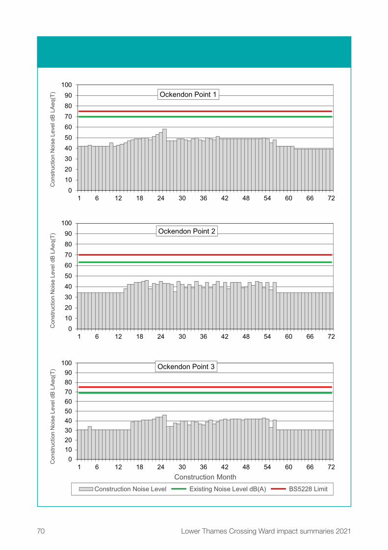
70 Lower Thames Crossing Ward impact summaries 2021
Figure 20.16: Construction noise by month for points 1-3 in Ockendon ward
0102030405060708090
100
1 6 12 18 24 30 36 42 48 54 60 66 72
0102030405060708090
100
1 6 12 18 24 30 36 42 48 54 60 66 72
Con
stru
ctio
n N
oise
Lev
el d
B L
Aeq
(T) Ockendon Point 2
Con
stru
ctio
n N
oise
Lev
el d
B L
Aeq
(T) Ockendon Point 1
0102030405060708090
100
1 6 12 18 24 30 36 42 48 54 60 66 72
Con
stru
ctio
n N
oise
Lev
el d
B L
Aeq
(T)
Construction Month
Ockendon Point 3
Construction Noise Level Existing Noise Level dB(A) BS5228 Limit

71Lower Thames Crossing Ward impact summaries 2021
With reference to figure 20.16 the following summarises the noise level changes over the construction period for points 1 to 3:
� At point 1, construction noise levels are predicted to range from 39 to 58dB LAeq (12-hour) during the six-year construction.Construction noise levels are not expected to exceed the existing background noise levels.
� At point 2, construction noise levels are predicted to range from 34 to 46dB LAeq (12-hour) during the six-year construction programme. Construction noise levels are not expected to exceed the existing background noise levels.
� At point 3, construction noise levels are predicted to range from 31 to 46dB LAeq (12-hour) during the six-year construction programme. Construction noise levels are not expected to exceed the existing background noise levels.
72 Lower Thames Crossing Ward impact summaries 2021
With reference to figure 20.17. on the right, the following summarises the noise level changes over the construction period for points 4 to 6:
� At point 4, construction noise levels are predicted to range from 42 to 54dB LAeq (12-hour) during the six-year construction programme. Construction noise levels are not expected to exceed the existing background noise levels.
� At point 5, construction noise levels are predicted to range from 48 to 57dB LAeq (12-hour) during the six-year construction programme. Construction noise levels are not expected to exceed the existing background noise levels.
� At point 6, construction noise levels are predicted to range from 42 to 55dB LAeq (12-hour) during the six-year construction programme. Construction noise levels are not expected to exceed the existing background noise levels.

73Lower Thames Crossing Ward impact summaries 2021
Figure 20.17: Construction noise by month for points 4-6 in Ockendon ward
0102030405060708090
100
0102030405060708090
100
1 6 12 18 24 30 36 42 48 54 60 66 72
Con
stru
ctio
n N
oise
Lev
el d
B L
Aeq
(T)
Construction Month
Ockendon Point 6
Construction Noise Level Existing Noise Level dB(A) BS5228 Limit
1 6 12 18 24 30 36 42 48 54 60 66 72
Con
stru
ctio
n N
oise
Lev
el d
B L
Aeq
(T) Ockendon Point 4
0102030405060708090
100
1 6 12 18 24 30 36 42 48 54 60 66 72
Con
stru
ctio
n N
oise
Lev
el d
B L
Aeq
(T) Ockendon Point 5

74 Lower Thames Crossing Ward impact summaries 2021
24/7 construction workingIn addition to the changes to the daytime noise impacts presented in the section above, 24-hour, seven-day construction working is proposed at the locations shown in figure 20.18 below.
These locations are where works may need to be carried out at night to maintain safety and reduce disruption to road and utility networks. The works in this area are expected to be night-time or weekend highways works. These works could have an impact on local communities, and we would work with the local authority to manage these impacts.
Construction traffic noise impactsMaps showing the predicted change in road traffic noise on roads within Ockendon ward during each year of the construction can be found in chapter 7 of the Construction update. Based on the currently available traffic data (which offers a representative picture of what receptors within the ward are likely to experience), during the construction period there would be negligible changes in road traffic noise (less than 1dB change in noise levels) during all construction years, except along the roads where increases in noise levels been predicted (see table below). For more information about how we define noise impacts such as negligible, minor, moderate and major, see chapter 1.
Table 20.4: Construction traffic noise impacts in Ockendon ward
Affected road(s) Predicted noise impact Construction year(s)
Dennis Road Moderate increase in noise levels 2
Veolia Track access
track
Moderate increase in noise levels 1
Veolia Track access
track
Major increase in noise levels 2, 3, 4, 5 and 6

75Low
er Thames C
rossing Ward im
pact summ
aries 2021
Figure 20.18: Newly proposed and tunnel 24/7 working locations in Ockendon ward

76 Lower Thames Crossing Ward impact summaries 2021
Measures to reduce construction noise and vibrationConstruction noise levels would be controlled by using Best Available Techniques (BAT), with specific measures used at certain locations such as:
� Installing and maintaining hoarding around the construction compounds.
� Installing temporary acoustic screening around the construction areas likely to generate noise.
� Keeping site access routes in good condition with condition assessments onsite to inspect for defects such as potholes.
� Turning off plant and machinery when not in use. � Maintaining all vehicles and mobile plant so that loose body
fittings or exhausts do not rattle or vibrate. � Using silenced equipment where available, in particular power
generators and pumps. � No music or radios would be played for entertainment
purposes outdoors onsite. � Site layout would be planned to ensure that reversing is kept to
a practicable minimum. Required reversing manoeuvres would be managed by a trained banksman/vehicle marshal to ensure they are conducted safely and concluded quickly to reduce the noise from vehicle reversing warnings.
� Non-percussive demolition techniques would be adopted where reasonably practicable to reduce noise and vibration impact.
� Careful consideration of the location and layout of compounds to separate noise-generating equipment from sensitive receptors, and the use of mains electricity as opposed to generators, where possible.
� Minimisation of construction vehicle traffic by, where practicable, selection of local suppliers along the project route, using local workforces and by minimising material transportation for earthworks construction along the project.
All control measures, including those above, fall under the principles of BAT and are outlined in the REAC. For more information, see the sections NV001 to NV010, which set out how we would work under the supervision of the relevant local authorities to implement noise-reduction measures where appropriate.
The CoCP details additional measures that would be implemented to reduce noise and vibration during the construction period.

77Low
er Thames C
rossing Ward im
pact summ
aries 2021
Figure 20.19: Noise impacts during operation in Ockendon ward

78 Lower Thames Crossing Ward impact summaries 2021
20.7.2 OperationsOperational noise impactsThe main project route runs across the north-east of the ward, and the proposed improvements to the existing M25 are located on the western side of Ockendon.
Direct noise from the route and the proposed improvements to the M25 would be experienced in the western section of the ward. There would also be indirect noise as a result of changes in traffic flow and speed on the existing road network in the ward.
Figure 20.19 above shows the predicted changes in traffic noise in the opening year of the project. Within the ward, changes in road traffic noise at identified noise sensitive locations (such as nearby properties) are predicted to range from a moderate decrease in noise levels of between 3.0 and 4.9dB to a major increase in noise levels of greater than 5dB. For more information about how we define noise impacts (negligible, minor, moderate and major), see chapter 1.
Measures to reduce traffic noise and vibration during operationThe main methods of controlling noise would be, where practical, to design the road within landscaped features such as cuttings and bunds (walls of earth). The use of low-noise surfacing would also reduce the traffic noise once the road is in use.
For more information about the proposed measures to reduce operational noise, see the REAC (including references NV011 and NV013).

79Lower Thames Crossing Ward impact summaries 2021
20.8 Air qualityWe have carried out air quality assessments for both the construction and operational phases of the project. As explained in chapter 1, some of the assessments set out here are based on earlier versions of the project. The information provided here still presents a reasonable representation of the likely effects from the proposals presented during this consultation.
Existing situationOckendon ward, is not located within an Air Quality Management Area (AQMA). AQMAs are areas that have been identified by local authorities as areas of poor air quality that require additional monitoring and controls.
20.8.1 Construction Construction impacts Construction activities have the potential to affect nearby air quality through the release of dust and emissions from construction equipment and traffic. The areas most likely to be affected are those close to haul roads, compounds and soil storage areas.
Properties more than 200 metres from the worksite, which is the majority of properties within this ward, are outside the area likely to be affected by construction dust or emissions from the worksite. In this ward, there are only a few properties within 200 metres of the worksite, the north of the ward on North Road and Dennis Road. Air quality impacts on these properties during construction would be temporary and we would put in place measures to minimise the dust impacts (see below). The proposed measures to reduce dust and emissions are ones that have been proven to be effective when used on similar construction projects in the past. The change in air quality during the construction phase would be negligible, and there would be no discernible effect on health.
Our analysis of construction traffic predicts that the impact on most roads in this ward would be negligible, although there would be a temporary minor improvement in air quality in the area around the M25 (from 2025 to 2028) and on the B1421 (2025, 2027 and 2028) as a result of traffic management in place. More information about construction traffic impacts on air quality can be found in chapter 7 of the Construction update.

80Low
er Thames C
rossing Ward im
pact summ
aries 2021
Figure 20.20: Predicted changes in NO2 levels within Ockendon ward once the new road is open

81Lower Thames Crossing Ward impact summaries 2021
Measures to reduce air quality impacts during constructionThe impact of construction machinery and traffic on air quality would be controlled through the range of good practice measures set out in the CoCP and the REAC. For example, there would be measures to suppress dust, such as damping down dry haul roads and spoil heaps, as well as the use of low-emission machinery and vehicles. We would put in place an Air Quality Management Plan to ensure the measures set out in the CoCP and the REAC would effectively monitor and control dust and exhaust emissions. The location and type of monitoring would be submitted in advance to Thurrock Council for consultation (see REAC entry AQ006).
20.8.2 OperationsOperational impactsWe have carried out an assessment of the operational impacts of the new road on air quality. The assessment area includes a 200-metre buffer around the roads within the affected road network, with this area being the most likely to experience changes to air quality as a result of the new road. More information about air quality impacts once the road is open can be found in chapter 5 of the Operations update.
There are receptors (properties or habitats that are sensitive to changes in air quality) within the ward, close to the east of the M25 that are predicted to experience a minor improvement in the air quality for nitrogen dioxide (NO2), the main traffic-related pollutant3. The highest modelled yearly average NO2 concentration within this ward is 23.8 µg/m³, which is well below the yearly average threshold of 40µg/m³. Our assessment is based on our opening year model, which represents a worst-case scenario, without accounting for the increase in less-polluting vehicles on our roads over time.
Measures to reduce air quality impacts during operation. The assessed air quality impacts in this area as a result of the project would not trigger the need for additional monitoring or other mitigation measures once the road is open.
3 NO2 levels are measured in ‘micrograms per cubic metre’, or µg/m³, where a microgram is one millionth of a gram.

82 Lower Thames Crossing Ward impact summaries 2021
20.9 HealthExisting situation A range of personal, social, economic and environmental factors influence our health, and different groups may be more sensitive to these – for example, children, older people or those with pre-existing health conditions.
Ockendon has a younger population than Thurrock as a whole and nationally, with a higher proportion of children aged under 16 (24.8% compared with 24.2% for Thurrock and 20.3% for England). Ockendon has a high BAME population, with a high proportion of black and Asian residents, 7.8% and 3.8% respectively.
Rates of deprivation vary significantly across Ockendon. For example, an area to the south of the ward is in the top 20% most deprived across England, while an area to the east is in the bottom 30% most deprived across England. Economic activity rates are relatively low in Ockendon compared with Thurrock as a whole – 71.9% and 79.1% respectively. In addition, the number of people claiming benefits is slightly higher compared with Thurrock and England as a whole, 3.2%, 3.0% and 2.7% respectively. Ockendon has a slightly lower proportion of residents in social grade AB (13.5%) than Thurrock as a whole (15.0%). The area has a significantly lower proportion of households owned outright, compared with Thurrock and England as a whole, 61.1% and 63.3% respectively. Ockendon has a relatively high proportion of households with no car or van in a household, compared with Thurrock as a whole, 24.2% and 20.1% respectively.
Ockendon residents generally have lower rates of self-reported very good health compared with Thurrock and England as a whole, 45.5%, 48.2% and 47.2% respectively. In addition, Ockendon has a relatively high proportion of residents who report that their day-to-day activities are ‘limited a lot’ compared with Thurrock as a whole – 9.1% and 7.2% respectively.
Regarding life expectancy and causes of death, with the exception of deaths from all cancer and coronary heart disease, Ockendon performs significantly better than Thurrock across a range of measures, including life expectancy at birth for both males and females, deaths from all causes and deaths from respiratory diseases.

83Lower Thames Crossing Ward impact summaries 2021
20.9.1 ConstructionConstruction impactsConstruction activities affecting Ockendon are presented in the Project description section, and primarily relate to:
� construction of the Mardyke Viaduct � north road bridge � temporary construction of haul roads � Medebridge Compound � construction routes on public roads
Elements of these activities have the potential to impact human health (including mental health and wellbeing), whether this is through noise associated with construction activities or construction traffic, air quality (as a result of dust emissions), severance caused by construction traffic, or road or footpath closures.
There could be both positive and negative potential impacts on people’s health and wellbeing. With good communication and engagement, any stress or anxiety caused by construction would be reduced. Equally, some residents would see health and wellbeing benefits from improved access to work and training opportunities (see the Traffic section). The relationship between mental health and unemployment is two-way. Good mental health is a key influence on employability and finding and keeping a job. Unemployment causes stress, which ultimately has long-term physiological effects and can lead to depression, anxiety and lower self-esteem.
As highlighted at the start of this section, different groups of people may be more sensitive to factors that potentially affect their health. Some of the impacts of our construction activities may, therefore, only affect a small proportion of the population. Potential impacts may include:
� Temporary adverse effects from construction traffic noise are predicted to occur in Ockendon, particularly along North Road.
� Temporary adverse noise effects have been identified as a result of construction activities, including from construction noise, construction traffic and percussive piling activities. Ockendon has slightly higher proportions of people with disabilities/life-limiting conditions, groups who are likely to be more susceptible to increases in noise levels.

84 Lower Thames Crossing Ward impact summaries 2021
� There are few properties in the Ockenden ward within 200 metres of the project and they are therefore unlikely to be affected by dust or emissions from construction. Those that are within 200 metres could experience air quality impacts from increased dust and emissions from nearby construction activities. Analysis of the construction phase traffic flows on the existing road network associated with the build-out of the Lower Thames Crossing indicates the change in flow and emissions between 2025 and 2028 along the M25 corridor could lead to a temporary beneficial impact on air quality at those receptors located closest to the M25 in western Ockenden.
� The local community would be impacted by construction activities – noise, dust, vibration and severance during the proposed closure of Ockendon Road. Diverted traffic would use Dennis Lane or St Mary’s Lane to cross the M25, representing a change in journey length of nearly 10km.
� Bus routes would be impacted during construction. Traffic management measures implemented during the construction works are likely to result in significant journey time delays for those services, which may continue for more than two years.
� Potential impacts during construction relate to the loss of private property and the change of social capital or sense of community associated with this loss. This would affect 10 properties clustered along Ockendon Road immediately adjacent to the M25. Relocation of people as a result of the project causes disturbance to people’s lives, which can create stress and anxiety.
� People who live in rural areas such as Ockendon are likely to be part of long-standing and well-established community networks. As such, given these networks, relocation may have a disproportionately negative impact on such communities, given the relatively high rates of social cohesion. In addition, negative effects are likely to be heightened by uncertainty.
� Residential areas on the north and east edges of South Ockendon are likely to see the construction activities. Individual properties along the B186 and the local footpath network in the east of the ward would also have views of the project. Temporary significant adverse visual effects have been identified in Ockendon.

85Lower Thames Crossing Ward impact summaries 2021
The main construction activities expected to cause noise and vibration impacts in this ward are:
� Works during core daytime hours to establish the construction of the project alignment and utilities works.
� Core hours impacts from activities in the Medebridge Compound.
� Use of construction machinery to construct the new road and the Mardyke Viaduct. These works would be limited to daytime core construction hours, outside of emergency works.
Most of the existing road traffic links in this ward would experience negligible noise level changes of less than 1dB(A). The exception would be Dennis Road, which would experience an increase in road traffic noise during the construction phase. There are likely to be mental health and wellbeing impacts associated with stress and anxiety relating to construction.
Negative health outcomes may be experienced by some groups as a result of changes to:
� accessibility (for example, people who are more dependent on public transport and have less choice about how they travel and the route they take)
� severance (where road and footpath closures may affect some people’s ability to access services or facilities)
� access to open space (people without access to private cars may have fewer alternatives within a reasonable travel time)
� the noise environment Measures to reduce construction health impacts Proposed measures relating to health and wellbeing (including good practice for dust emissions, hours of working and visual screening) are described in the Visual, Noise and vibration and Air quality sections. Further information relating to mitigation measures for these areas is set out in the CoCP and REAC and the package of traffic management plans. The commitments in the REAC include adhering to Best Practicable Means to reduce noise impacts (see NV007 in the REAC) and dust-management good practice (see AQ005 in the REAC). For more information about these documents, see chapter 1 of the Construction update.

86 Lower Thames Crossing Ward impact summaries 2021
Engagement and effective two-way communication with communities before and during construction, including sharing information about the programme and impact of works, is important to reduce mental health and wellbeing impacts associated with uncertainty, stress and anxiety. The CoCP sets out proposals for how we would make sure communities, stakeholders and any affected parties are updated about the construction works, their progress and the associated programme of works.
20.9.2 OperationsOperational impactsInformation about the operations in this ward can be found in the Project description.
Both positive and negative health outcomes may be experienced by residents of Ockendon:
� Ockendon is predicted to experience increases in access to employment as a result of the project, with the number of jobs within a 30-minute catchment area up by 50% and within a 60-minute drive up by 22%.
� In terms of active travel, all minor roads within this ward that would be severed during construction would be relinked once the project is complete, either along their original alignment or with very little deviation from it. There would, however, be a slight increase in road length (less than 50 metres). There would be an increase in journey time for pedestrians as a result of minor changes to the alignment of Ockendon Road.
� Once the new road opens, our forecasts show that Ockendon would be subject to increase in noise levels greater than 3dB. Increases can result in adverse health effects within the population, ranging from annoyance and sleep disturbance to more serious effects.
� Temporary significant adverse visual effects have been identified in Ockendon.
� Those properties modelled in the Ockendon ward are predicted to be well below the air quality thresholds for nitrogen dioxide and particulate matter, the key traffic-related pollutants.
� Incorporating noise-mitigation measures (such as earthworks, noise barriers and low-noise surfacing) into our project design in Ockendon would reduce adverse health outcomes associated with increased noise levels.

87Lower Thames Crossing Ward impact summaries 2021
Measures to reduce operational health impacts False cutting and landscape treatment along the project’s main route would be the primary mitigation measures. They would help to screen views of the new road and traffic and would integrate the Lower Thames Crossing into the surrounding landscape. The North Road green bridge would also help to visually link the landscape north and south of the route.

88 Lower Thames Crossing Ward impact summaries 2021
20.10 BiodiversityExisting situationThe main habitats within the Order Limits in the Ockendon ward are areas of arable, with some areas of rough grassland, which contain a number of watercourses. In addition, there are areas of pasture, scrub and woodland.
There are no designated sites within 2km of the Order Limits in the Ockendon ward. However, there are non-designated sites within 500 metres of the Order Limits including St Nicholas Church Local Wildlife Site (LWS), West of Arisdale Avenue LWS, Belhus Lakes, Belhus Wood Country Park LWS and North Ockendon Pit Site of Importance for Nature Conservation.
We carried out surveys across the project to set a baseline for assessment, and these identified the presence of a range of protected and notable species. These included bats, badgers, water voles, otters, terrestrial invertebrate species, great crested newts, barn owls and reptiles.

89Low
er Thames C
rossing Ward im
pact summ
aries 2021
Figure 20.21: Designated and non-designated biodiversity sites in Ockendon ward

90 Lower Thames Crossing Ward impact summaries 2021
20.10.1 ConstructionConstruction impacts We would need to remove areas of habitat both temporarily and permanently, from the route alignment. This habitat would include arable fields, scrub, rough grassland and woodland which support a range species. These would be disturbed by habitat loss and fragmentation.
Measures to reduce biodiversity impacts during construction Vegetation clearance would be cleared during the winter where possible to avoid any impact on breeding birds. Where this is not practicable, clearance would be supervised to ensure no nests are disturbed or destroyed. Where protected species are present, they would be moved from the site before any construction activities take place, either through habitat manipulation (for example, strimming to reduce the height of vegetation and displace reptiles), or translocation. Where required, works affecting protected species would be carried out under a Natural England licence. Boxes to support bats, birds and barn owls would be installed within retained habitat.
We would create areas of open mosaic habitat consisting of grassland, scrub and bare earth, and larger areas of species-rich grassland to provide good quality habitat for a number of species, particularly invertebrates, reptiles and amphibians including great crested newts. This habitat would also be suitable for the breeding birds in this area. Ponds would be included to further diversify the habitats and provide areas for breeding great crested newts. These are shown in Map Book 1: General Arrangements.
To provide habitat connectivity within this area, we would build a green bridge over North Road. In addition, the new road would be on a viaduct over the Mardyke Valley to allow movement of species under the route alignment. For more information about green bridges, see the chapter 2 of the Operational update.
The impact of construction on biodiversity would be controlled through the range of good practice measures set out in the CoCP and REAC. See chapter 1 of the Construction update for more information about this and the project’s other control documents.

91Lower Thames Crossing Ward impact summaries 2021
20.10.2 OperationsOperational impacts The project’s operation has the potential to cause species mortality through breakup of habitats as well as exposure to, and noise disturbance from, road traffic.
Measures to reduce biodiversity impacts during operationLandscape planting has been designed to allow animals to move and forage and would guide them to safe crossing points over the new road, specifically the green bridge and viaduct. To mitigate traffic disturbance, the new road would be in a cutting east of North Road, reducing noise and visual impacts.
We would manage newly created areas to make sure that they provide high-quality habitats to support a broad range of different plant and animal species.
The impact of operation on biodiversity would be controlled through good practice measures set out in the CoCP and REAC. See chapter 1 of the Construction update for more information about this and the project’s other control documents.

92 Lower Thames Crossing Ward impact summaries 2021
20.11 Built heritagePlease refer to the Cultural heritage section of the project-wide summary for information about impacts on archaeology.
Existing situation Two scheduled monuments and 10 listed buildings have been identified in Ockendon ward in relation to the project. Of the listed buildings, one is Grade I listed, two are Grade II* listed, and seven are Grade II listed.
Scheduled monuments � Gatehouse and Moat of South Ockendon Hall is a scheduled
monument of high heritage value. It is located to the east of Hall Lane and in an area of construction activity associated with the Ockendon link section of the project. The monument includes a listed gatehouse and bridge, earthwork remains of medieval fish/mill ponds and moat, as well as below-ground archaeological remains. A large part of the moat is still water-filled today.
� Roman barrow 260 metres north-east of South Ockendon Hall is a scheduled monument of high heritage value and located around 130 metres north of the project activities. The monument is a second century AD Roman burial mound. It is oval in shape with a flat top and stands about five metres tall. The mound is surrounded by a ditch which is now mostly buried. It was originally one of three burial mounds but the other two have been destroyed.

93Low
er Thames C
rossing Ward im
pact summ
aries 2021
Figure 20.22: Built heritage in Ockendon ward

94 Lower Thames Crossing Ward impact summaries 2021
Listed buildings � Church of St Nicholas (Grade I) is of high heritage value. It is
located to the south of The Green, about 390 metres south from the project. The church originally dates to the 15th century with some earlier 12th and 13th century features remaining, as well as later 19th century restorations.
� Little Belhus (Grade II*) including Garden Walls and Gateway (Grade II*) are of high heritage value. These listed buildings are located on Little Belhus Close, around 700 metres south from the project. Little Belhus is a mid-16th century house and retains several notable original features including a central belfry tower. The house is thought to be of high status based on these features. The garden walls and gateway are the same age as the house and are also listed.
� Quince Tree Farmhouse (Grade II) � Street Farmhouse (Grade II) � Kemps (Grade II) � Kemps Cottage (Grade II) � Moat Bridge and Gatehouse at South Ockendon Hall (Grade II) � Royal Oak Inn (Grade II) � Former Gateway at Groves Barns (Grade II)
20.11.1 Construction Construction activities affecting the ward relate to establishment of the main project route and the Ockendon link section of the project. Activities would also include establishing and operating the Medebridge Compound and M25 Compound, and creating construction access routes along Mollands Lane and the M25.
Construction impactsThere are no physical construction impacts to the listed building and scheduled monument at South Ockendon Hall. Major construction activity would be more than 600 metres away from these structures and some distance from the earthwork remains. Construction activities would not impact the setting (the surroundings in which heritage assets are ‘located’) of the scheduled monument or listed building. However, due to its close proximity to the main project route, the Former Gateway at Groves Barns would experience temporary changes to its setting through additional noise, lighting and visible construction machinery, although this would be separated from the listed building by the retained area of woodland in The Wilderness. Kemps and Kemps Cottage would also experience a slight impact to their setting as a result of construction activity along the M25.

95Lower Thames Crossing Ward impact summaries 2021
Measures to reduce impacts during construction Our design and layout of Medebridge Compound and M25 Compound would take into account the setting of heritage assets, and we would seek to avoid or/minimise light glare, light spill and light pollution during night-time construction. More information can be found in the Design principles (section S326). Good practice measures including dust and noise reduction are also relevant in mitigating the setting of heritage assets. Please refer to Air quality, Noise and vibration and Heritage sections of the REAC.
20.11.2 Operations Refer to the Project description section of this chapter for more information.
Operational impactsKemps and Kemps Cottage would experience a slight impact to their setting as a result of increased traffic noise along the M25 once the Lower Thames Crossing opens. There are no other operational impacts to built heritage in this ward.
Measures to reduce the impacts during operation Our engineering and landscape design seeks to avoid or reduce negative impacts to heritage assets. These can be physical or result from changes in their surroundings, which also contribute to the value of the heritage asset. To preserve the rural and historic character of the landscape, we would minimise road lighting where it is safe and practical to do so, and remain in accordance with relevant standards (see the Design principles, sections LST.02 and LST.03). We would make sure that Medebridge Compound and M25 Compound are reinstated after construction to reflect existing field patterns and the surrounding landscape character as outlined in the Design principles, section S3.05.
96 Lower Thames Crossing Ward impact summaries 2021
20.12 ContaminationExisting situation There is one potential source of contamination identified based on land uses from a desk-based review of historical maps and environmental data:
� Ockendon Grays Areas II & III landfill, an active Veolia non-hazardous and inert landfill (filled 1974 to present)
The overall impact from these contamination sources is considered to be low, given the mitigation proposed.
20.12.1 Construction Construction activities in this ward could include utility diversions, topsoil stripping, earthworks movements and excavations, which could cause the mobilisation of contamination if present.
There are a number of construction compounds within the ward and stockpiling of soils may occur, as well as storage of materials/chemicals within compounds.
Construction impactsDuring construction, there is the possibility for existing contamination within the ground to become mobilised. There is also a potential risk of accidental oil, cement and fuel spills from construction traffic and the storage of materials. Utility diversions are taking place and some are in close proximity to areas identified as potential sources of contamination. The utility trenches may create preferential pathways for existing contamination to migrate into the wider area.

97Lower Thames Crossing Ward impact summaries 2021
Measures to reduce contamination riskTo reduce the impact to an acceptable level, good practice measures include appropriate storing of equipment, clear soil handling and storage of chemicals. Re-use guidance would be followed during construction to reduce the risk of spreading contamination and spillage or pollution.
To reduce the risk of accidental spillages, procedures would be in place, such as designated areas to re-fuel plant. Tanks would be bunded, spill kits would be available and incidents would be recorded and managed, with impacted soils being assessed and removed if necessary.
Essential mitigation, such as the development of site-specific remediation where contamination was identified during ground investigation work, would be carried out following consultation with the local authority. During the earthworks, workers would remain vigilant and any suspected contamination would be recorded and assessed accordingly via a watching brief protocol. To reduce the risk of existing contaminant migration, the design of utility works would use the findings of the ground investigation data to guide any specific remediation.
Contamination would be controlled through the range of good practice measures set out in the CoCP and REAC. See chapter 1 of the Construction update for more information about this and the project’s other control documents.
20.12.2 Operations Verification reports would be prepared for the remediation carried out in site-specific areas and this would be provided to the local authority. During the operation of the road, should an incident occur, for example, a traffic accident resulting in localised contamination, significantly affected soils would be assessed and if necessary removed to reduce the risk of contamination migrating across a wider area or entering controlled waters. For more information on these controls, see the REAC.

98 Lower Thames Crossing Ward impact summaries 2021
21Chapter 21: Upminster wardThis chapter summarises the activities in Upminster ward relating to the project’s construction and its operational phase (when the new road is open). It also explains the measures intended to reduce the project’s impacts on the local area. For more information about the assessments in this chapter and other information available during this consultation, see chapter 1, which also includes a map showing all the wards described in this document.

99Lower Thames Crossing Ward impact summaries 2021
Within this document, we sometimes advise where additional information can be found in other consultation documents, including the Construction update, Operations update, You said, we did, Register of Environmental Actions and Commitments (REAC), Code of Construction Practice (CoCP), Outline Traffic Management Plan for Construction (OTMPfC) and the Design principles. To find out more about these documents, see chapter 1. References to these documents provide an indication as to how our proposals to reduce the project’s impacts will be secured within our application for development consent.

100 Lower Thames Crossing Ward impact summaries 2021
21.1 Overview
21.1.1 About this wardUpminster ward is north of Ockendon ward and south of Cranham ward, in the London Borough of Havering. The ward has an area of around 23km2 and an estimated population of 13,1541. The ward is predominantly farmland in the east, with the large residential area of Corbets Tey in the west, along with areas of open space and recreational land including Thames Chase Community Forest and Cranham Golf Course. The M25 runs roughly through the centre of the ward north-south, as does the London, Tilbury and Southend railway line, with the two intersecting in the south of the ward. Upminster Underground station is on the northern boundary with Cranham ward, while the nearest overground station is Ockendon in Ockendon ward to the south-east.
1 Office for National Statistics, 2018 ward-level population estimate

101Low
er Thames C
rossing Ward im
pact summ
aries 2021
Upminster
0 0.25 0.5 0.75 1km
LegendBoundary of Ward(s)
Contains Ordnance Survey data. © Crown copyright and database rights 2021. Ordnance Survey 100030649
Figure 21.1: Ward boundary map for Upminster ward

102 Lower Thames Crossing Ward impact summaries 2021
21.1.2 Summary of impactsTable 21.1: Summary of impacts during the project’s construction and operation
Topic Construction Operations
Traffic Impacts
Increases to journey times are
predicted on Ockendon Road, St
Mary’s Lane and the M25. Further
details about the impacts of the
construction process on traffic flows
can be found in the Traffic section of
this chapter.
Mitigation
There are several mitigation measures
to reduce the impact of construction
on local residents including reducing
the use of local roads by construction
vehicles. Further details on the
mitigation measures can be found in
the Traffic section of this chapter.
Impacts
Minor changes are predicted in traffic
flows once the project is operational.
Further details about the impact of the
project once operational can be found
in the Traffic section of this chapter.
Mitigation
Regular reporting would take place
once the project is operational. Further
details about the mitigation measures
for Upminster ward can be found in
the Traffic section of this chapter.

103Lower Thames Crossing Ward impact summaries 2021
Topic Construction Operations
Public transport Buses
There would be increases to journey
times for some local buses within
the ward, associated with the traffic
management works and, in the early
stages of the project construction, with
additional traffic on the local roads.
While Ockendon Road is closed the
370 bus would have to be diverted.
There may be increases to journey
times for regional coach services using
the M25 between junctions 29 and 30.
Rail
There would be a night-time rail
closure of the London, Tilbury
and Southend railway while a new
footbridge is constructed. Services
would not be disrupted. No impacts
on journey times to Upminster station
are expected during construction.
Buses
In addition, there would be no
changes to bus routes through the
ward nor any discernible changes
to journey times once the project is
operational.
Rail
There would be no discernible
changes in access times to Upminster
station and no predicted changes
to rail services once the project is
operational.

104 Lower Thames Crossing Ward impact summaries 2021
Topic Construction Operations
Footpaths,
bridleways and
cycle routes
Impact
Five footpaths and one track (not
a current public right of way) in
Upminster ward would be impacted
during the construction of the project.
Closures of the footpaths would be
between one and five and a half years
to allow for utilities diversions, main
works construction, the construction
of a new footbridge over the
Upminster to Grays railway line and
for a construction compound. The
track (not a current public right of way)
would be permanently closed.
Mitigation
Closures of footpaths would be as
short as possible to reduce the
impact on the existing public right of
way network.
Impact
Two footpaths would be permanently
diverted and one realigned to form
part of a new route that would cross
the M25 and link to the Ockendon
Road. One footpath would have a
section permanently closed west
of the M25. An existing track (not
a current public right of way) that
would be permanently closed during
construction would be diverted and
connect to the local public right of
way network.
Mitigation
Footpaths that are permanently
diverted or realigned would be
as close to the existing routes as
practicable and would open up new
local connections in the existing
public right of way network. Three
of the footpaths impacted during
construction would be upgraded
to bridleways. A new bridleway
connection would also open in this
ward.

105Lower Thames Crossing Ward impact summaries 2021
Topic Construction Operations
Visual Impacts
Views towards construction activities
from residential properties on the
western edge of North Ockendon
would include the construction of the
M25 slip road and new views of traffic
on the M25. The M25 Compound
would be a prominent feature in
the views from footpaths on the
southern outskirts of North Ockendon.
Construction work to build the M25
slip roads on embankments and
cuttings would be prominent in views
from the Thames Chase Forest Centre.
Mitigation
The taller facilities within the M25
Compound would be situated as far
west as possible. Earth bunds would be
created to provide visual screening.
The visual impact of the project would
be controlled through a range of good
practice measures set out in the CoCP
and REAC.
Impacts
New lighting and parts of Ockendon
Road overbridge would be visual from
residential properties and footpaths on
the western edge of North Ockendon.
The tops of new lighting columns
would remain visible from Thames
Chase Forest Centre.
Mitigation
False cuttings and landscaping would
be used to screen views of traffic
and integrate the new road in to the
surrounding landscape.

106 Lower Thames Crossing Ward impact summaries 2021
Topic Construction Operations
Noise and vibration Impacts
The construction activity associated
with the M25 upgrade, the works
entrance and exit slips on to the
M25, the new road and utility works
are expected to create noise in this
ward. There would also be 24-hour,
seven-day working in some locations.
There would be negligible changes in
noise from road traffic for a majority
of roads within this ward during
the construction period, except for
Stubbers Lane, Dennis Road, Pike
Lane and Pea Lane where increases in
noise levels have been predicted.
Mitigation
Construction noise levels would be
controlled through the mitigation
measures set out in the REAC. There are
also measures presented in the CoCP.
Impacts
Once the project is built, communities
living in the centre of the ward would
experience direct noise impacts
from the route and the proposed
upgrades. There would also be
indirect noise impacts from the
changes in traffic flow and speed on
the existing road network.
Mitigation
Low-noise road surfaces would be
installed on all new and affected
resurfaced roads, and noise barriers
would be installed.

107Lower Thames Crossing Ward impact summaries 2021
Topic Construction Operations
Air quality Impacts
As the majority of properties are more
than 200 metres, they are unlikely
to be affected by dust or emissions
during construction activities. Those
near Ockendon Road and Clay Tye
Road, are within 200 metres and may
be affected by dust or emissions.
Analysis of the construction phase
traffic flows associated with the
project indicate a temporary minor
improvement in air quality around the
M25 from 2025 to 2028, and on the
B1421 in 2025, 2027 and 2028. There
would be temporary worsening in air
quality in the area around Pea Lane,
Dennises Lane and Dennis Road as a
result of traffic increase during 2025.
Mitigation
The contractor would follow good
practice construction measures which
are presented in the CoCP and REAC
to minimise the dust. Construction
vehicles would need to comply with
emission standards. An Air Quality
Management Plan would be designed
in consultation with the relevant local
authorities. The plan would include
details of monitoring which would
ensure measures are effectively
controlling dust and exhaust emissions.
Impacts
There would be no exceedance of NO2
and PM10.
Mitigation
No mitigation is required.

108 Lower Thames Crossing Ward impact summaries 2021
Topic Construction Operations
Health Impacts
There are likely to be health benefits as
a result of access to work and training
opportunities. There are also likely to be
changes in the area that may result in
negative impacts on health, including
mental health and wellbeing. There
could also be perceivable changes in
the levels of noise from the construction
of the new road and construction
traffic. There would also be temporary
air quality and visual impacts.
Mitigation
The negative impacts would be
mitigated through the good practice
construction measures presented in
the CoCP and REAC relating to dust
emissions, working hours, noise and
visual screening, traffic management
measures and community
engagement. This includes the
establishment of Community Liaison
Groups.
Impacts
There would be positive health benefits
associated with reductions in noise
levels, and the visual impact would be
minimal.
Mitigation
No essential mitigation is required
for health other than those measures
described in the noise mitigation and
visual sections.

109Lower Thames Crossing Ward impact summaries 2021
Topic Construction Operations
Biodiversity Impacts
The construction of the project would
involve the removal of areas of habitats,
including woodland, both temporarily
and permanently for the new road.
The removal of these habitats would
affect protected and notable species
including badgers, bats, water voles,
reptiles, great crested newts, breeding
birds and invertebrates.
Mitigation
Vegetation clearance would be
undertaken in winter to avoid
disturbing breeding birds. Protected
species would be relocated, carried
out under a Natural England licence.
Boxes to support bats, birds and
barn owls would be erected. A green
bridge would be built over North Road
to connect habitats. New areas of
grassland, scrub and bare earth would
be created to provide homes for a
number of species. Woodland would
be created to the south of the Thames
Chase woodland to compensate for
the loss of wooded areas. Impacts
would also be controlled through a
range of good practice measures set
out in our CoCP and REAC.
Impacts
There is the potential to cause mortality
of species by encountering road traffic
as well as habitat fragmentation and
disturbance from traffic.
Mitigation
Newly created areas of habitat would
be managed to ensure they provide
high-quality environments to support
a broad range of plant and animal
species. Impacts would also be
managed through the range of good
practice measures set out in the
CoCP and REAC.

110 Lower Thames Crossing Ward impact summaries 2021
Topic Construction Operations
Built heritage Impacts
There would be no direct impact to
built heritage assets but there would
be temporary additional noise, lighting
and visible construction activity.
Mitigation
The design and layout of the M25 and
Ockendon Road Compounds would
aim to avoid or minimise light pollution
during night-time construction. Good
practice measures associated with air
quality, noise and heritage are set out
in the CoCP and REAC.
Impacts
Grade I listed Church of St Mary
Magdalene and Grade II listed Franks
Farmhouse and Barn and Stable Block
to the north of Broadfields Farmhouse
would likely experience a slight impact
through increased traffic noise along
the M25.
Mitigation
Road lighting would be minimised
where it is safe and practical to do so.
The proposed landscaping and tree
planting aims to reduce the impact on
these buildings.
Contamination Impacts
None identified.
Mitigation
No mitigation would be required.
Impacts
None identified.
Mitigation
During the operation of the road,
should an incident occur, for example,
a traffic accident resulting in localised
contamination, significantly affected
soils would be assessed and, if
necessary, removed to reduce the
risk of contamination migrating across
a wider area or entering controlled
waters. For more information on these
controls, see the REAC.

111Lower Thames Crossing Ward impact summaries 2021
21.2 Project description
21.2.1 Construction Construction activitiesMore information about how the area would look during construction, including visualisations, can be found in the Construction update.
There would be major works in this ward to build the proposed junction between the new road and the M25, along with works to widen the M25 north of the new junction and to move the existing offslip from the M25 northbound towards junction 29. Figure 21.1 shows the proposed Order Limits (the area of land required to construct and operate the project, formerly known as the development boundary) and construction areas within Upminster ward. These works would require the widening of St Mary’s Lane bridge and the Shoeburyness railway line bridge. Ockendon Road would be closed to allow the construction of the new overbridge to carry Ockendon Road over the project’s route.

112Low
er Thames C
rossing Ward im
pact summ
aries 2021
Figure 21.2: Main construction areas in Upminster ward

113Lower Thames Crossing Ward impact summaries 2021
Widening of the M25 is expected to take two to three years. We would introduce temporary traffic management on the M25, including lane reductions to 60mph speed limit, with these implemented in sections to reduce the impact on traffic. To allow for widening works between the Shoeburyness railway line and St Mary’s Lane, we would add two crossing points for construction vehicles on St Mary’s Lane either side of the M25. Pedestrian access would be maintained, although traffic management would be required to manage construction traffic.
Works on the Shoeburyness railway line bridge would be carried out in agreement with Network Rail and would likely take place towards the end of the construction programme for around 12 to 14 months. Works on St Mary’s Lane would also take about 12 to 14 months, with most taking place without closing the road because construction vehicles would use haul routes running alongside the M25. Specific works would need short-term overnight or weekend closures of St Mary’s Lane.
Ockendon Road would be closed for around 18 to 24 months to allow construction of a new overbridge to carry Ockendon Road over the Lower Thames Crossing northbound carriageway. During the period of the closure, necessary to construct the new bridge, we would use a short section of Ockendon Road to allow construction vehicles to cross over the M25.
Works to move the M25 northbound offslip towards junction 29 would take place offline, which would avoid disrupting traffic flow. The onslip from the Lower Thames Crossing to the M25 would be built at the same time. Works to connect the new slip roads to the existing road network would take place towards the end of the construction programme and would require overnight or weekend lane closures on the M25.
As part of the works to build the M25 northbound slip-road and to carry out utility diversions, we propose permanently acquiring part of the Thames Chase Community Forest. We would acquire replacement land to the north and south of Thames Chase Community Forest, which we would landscape to blend in with the current site, with connections to the existing network of footpaths and bridleways. To improve connectivity between sections of the forest east and west of the M25, we would build a new bridge over the M25, suitable for walking, cycling and horse-riding. More information can be found in the section on open space land below.

114 Lower Thames Crossing Ward impact summaries 2021
Construction compoundsConstruction compounds are fenced-off areas, accessible to construction traffic, which provide the facilities for our project to be built efficiently. For example, compounds would provide parking, storage for machinery and materials, offices, welfare facilities, refuelling, and vehicle and wheel-washing facilities to make sure vehicles leaving the compound do not dirty local roads.
The M25 Compound and Ockendon Road Compound would be located in Upminster ward. The M25 Compound would be located to the west of North Road and would be the main compound for this section of the project. It would support construction of the M25 widening and the underpass that takes the new northbound slip road beneath the M25. Initially, construction vehicles would use Clay Tye Road to access this compound and the nearby Ockendon Road Compound, which would be built east of Pike Lane. We would build an access road directly from the M25, near Ockendon Road, to allow construction vehicles to access the project worksite without using local roads, this would be done early in the programme. Once complete, Clay Tye Road would no longer be used by HGVs. Smaller workforce vehicles would continue to use Clay Tye Road throughout the construction period.
The Ockendon Road Compound would be located east of Pike Lane, to the north of Ockendon Road. It would support the construction of the new Ockendon Bridge over the new road. We would use Ockendon Road to allow work vehicles to cross over the M25 and access the sites either side of the motorway.
The daily average number of vehicles going to the M25 and Ockendon Road Compounds are shown in table 21.2. These are the number of vehicles going to each compound and there would be the same number of vehicles, on an average weekday, leaving each compound.

115Lower Thames Crossing Ward impact summaries 2021
Table 21.2: Daily average number of vehicles going to the M25 and Ockendon Road Compounds
Time period
M25 CompoundOckendon Road Compound
HGVs Cars HGVs Cars
January to August 2024 42 138 0 32
September 2024 to February 2025
41 201 60 52
March to May 2025 51 241 65 59
June to October 2025 54 254 180 42
November 2025 to March 2026 42 240 213 33
April to August 2026 58 240 219 44
September 2026 to March 2027
44 240 219 44
April to November 2027 74 217 35 38
December 2027 to March 2028 73 180 32 16
April to July 2028 58 150 0 0
August 2028 to December 2029
10 108 0 0

116 Lower Thames Crossing Ward impact summaries 2021
UtilitiesNo Utility Logistics Hubs are currently proposed in Upminster ward. Utilities works proposed includes 2km of temporary foul water pipeline to be installed in the B186 North Road, of which 1.6km is in this ward. Traffic management would be required as set out in table 21.3 and in the OTMPfC.
Re-stringing of the existing overhead power lines in the east of the ward is required to complete works associated with crossing the project’s main route.
A 3km water main from St Mary’s Lane to the south of Ockenden Road would be installed, including a trenchless crossing of the M25 and the London, Tilbury and Southend railway line with works located largely through Thames Chase Community Forest on the western side of the M25.
Multiple trenchless crossings of the M25 are required at St Mary’s Lane to divert assets within the vicinity of the M25 widening proposals.
Existing utilities along Ockenden Road would be temporarily diverted south of the works area to complete the construction of the Ockenden Road new bridge and then located into the bridge structure.
Chapter 2 of the Construction update provides an overview of how existing utilities would be affected by our plans to build the new road, with further detail including maps in chapter 6. Chapter 2 of the Operations update also describes the project’s impacts on utilities, including a map showing the utilities that would be repositioned to accommodate the new road.
Construction schedule Construction of the entire project is scheduled to last for six years from 2024 to 2029. To deliver an efficient and coordinated construction programme, we would divide activities into packages of work. Maps and programmes for the work packages including those for the proposed M25 junction and the M25 widening works can be found in chapters 5 and 6 of the Construction update.

117Lower Thames Crossing Ward impact summaries 2021
Construction working hoursMost construction work would take place during the core construction hours, 7am to 7pm on weekdays, and 7am to 4pm on Saturdays. Additional repair and maintenance periods (if required) would be 8am to 5pm on Sundays. Noise-generating works would not be carried out outside core hours wherever practicable. However, there would be circumstances when hours may be extended. Typically, this would be to reduce inconvenience to road users by working at night or at weekends when there is less traffic. Activities that would involve works outside core hours within this ward include implementing traffic management measures, joining new roads to existing ones, resurfacing existing carriageways, demolition of structures, and removal or re-stringing of overhead power lines over roads. For safety reasons it would be necessary to carry out work close to railway lines outside core hours when trains are not in service. There may be extended working hours for earth works when days are longer (spring to autumn) and during periods of fine weather. More information about working hours is set out in the Noise and vibration section below and in the Code of Construction Practice (CoCP).
Traffic management
The main traffic management measures in Upminster ward are presented below.

118 Lower Thames Crossing Ward impact summaries 2021
Table 21.3: Main traffic management measures in Upminster ward
Road(s) affected
Proposed traffic management Purpose Duration
M25 Closure To connect the temporary
access roads to the M25
and complete removal of the
overhead power lines
Night-time closures over
short periods associated with
specific works activities
M25 southbound
Narrow lanes To allow construction access
works
7 months between March 2025
and October 2025
M25 northbound
Narrow lanes To allow construction access
works
7 months between March 2025
and October 2025
M25 southbound
Narrow Lanes and
reduced speed limits
To carry out nearby works 38 months between June 2025
and July 2028
M25 northbound
Narrow Lanes and
reduced speed limits
To carry out nearby works 28 months between November
2025 and July 2028
Ockendon Road
Lane closures and
traffic lights
To build a temporary
200-metre water connection
linking the Ockendon Road
Compound to a supply on
Ockendon Road
2 weeks between January and
August 2024
Ockendon Road
Full closure To allow construction of new
Ockendon Road overbridge
19 months between June 2025
and March 2027
Ockendon Road
Crossing point To allow construction vehicles
to cross
Full construction period (January
2024 to December 2029)
Ockendon Road
Lane closures and
traffic lights
To allow modifications to local
utility networks and installation
of temporary Ockendon Road
Compound connections
2 sets of works lasting 6
months each (January to
August 2024 and April to
August 2026)
Ockendon Road
Closure To allow for new road
alignment to be connected
1 weekend between September
2026 and March 2027
St Mary’s Lane
Crossing point To allow construction vehicles
to cross the road
Full construction period
(January 2024 to December
2029)
St Mary’s Lane
Traffic lights and
lane closures
To carry out nearby works
and modifications to local
utility networks
9 months between September
2024 and May 2025
St Mary’s Lane
Closure To allow for bridge works and
modifications to local utility
networks
Occasional nights and
weekends for specific tasks
during the construction period

119Lower Thames Crossing Ward impact summaries 2021
M25There would be construction works near the M25 that will require the implementation of narrow lanes and a reduction in the speed limit on the M25 in both directions. The timings of these traffic management measures are:
� M25 northbound, 5.1km in length starting south of junction 29 and running through junction 29 to finish before junction 28, over 28 months from January 2026 to May 2028
� M25 southbound, 5.8km in length, between south of junction 29, through junction 29 and finishing before junction 30, over 38 months from April 2026 to July 2028
� M25 northbound, 0.4km in length, over 7 months from February 2025 to August 2025
� M25 southbound, 0.4km in length, over 7 months from February 2025 to August 2025
� There will be a night-time temporary road closure on the M25 for bridge works, and removal of overhead line equipment.
Ockendon RoadThere will be a 19-month road closure on Ockenden Road for bridge works, earthworks and modifications to the local utility networks. The section of Ockendon Road approximately between the rail bridge and the existing properties would be closed for approximately 19 months. This is needed to ensure safe management of significant earthworks in the area and for the construction of elements of the project.
The proposed diversion route, as shown in figure 21.3 below, would be via B186 North Road, West Road, Dennis Road, Dennises Lane and Stubbers Lane.
Outside of the closure period there may also be contraflow on the Ockendon Road. A switchover to new permanent alignment on Ockendon Road is planned for March 2027. The works will occur over a weekend.

120Low
er Thames C
rossing Ward im
pact summ
aries 2021
Ockendon Road closure diversion
M25
Ockendon Road
Dennises Lane
West Road
B18
6 N
orth
Roa
dS
tubbers Lane
B186 O
ckendon Road
SouthOckendon
Temporary road closure
Suggested traffic diversion
Legend
Figure 21.3: Suggested diversion during temporary closure of Ockendon Road

121Lower Thames Crossing Ward impact summaries 2021
St Mary’s LaneIt is intended that the underpass under the M25 on St Mary’s Lane would be used by appropriately sized construction vehicles to enable access to the east side of the M25. In order to facilitate the construction vehicle movements using the underpass, the pavement may be narrowed or closed, however pedestrian access would remain open in some form. Traffic signals or similar would be used to manage the public and construction traffic in this short stretch of St Mary’s Lane, which is around 120 metres long under the M25.
There would also be works on St Mary’s Lane for bridge works and modifications to local utility networks. There would be a contraflow in place, in 300-metre sections, while work is carried out on a 2km section of road. The works are to divert utility assets affected by the project which are currently located adjacent to and within the carriageway. The works are scheduled for years 1 and 2 of the construction programme and would take approximately nine months to complete. There would also be a crossing point on St Mary’s Lane by construction vehicles on the western side of the M25 as they travel alongside the M25 in a north-south direction.
There would be occasional night-time and weekend temporary closures of St Mary’s Lane.
Measures required across the project would include narrow lanes, reduced speed limits, lane closures and temporary traffic lights. We have sought to minimise traffic management measures wherever practical. However, they would be necessary in some places to allow construction traffic and local communities to travel safely, while providing construction workers with sufficient space to operate. An overview of the traffic management required across the project can be found in the Outline Traffic Management Plan for Construction. All traffic management measures are based on an indicative construction programme, which would be finalised by the appointed contractor. The contractor’s final traffic management plans will be subject to final approval by the Secretary of State for Transport, following consultation with the local highways authority.

122 Lower Thames Crossing Ward impact summaries 2021
21.2.2 OperationsThe completed projectFor more information about the completed project, see the Operations update, as well as the large-scale figures in Map Book 1: General Arrangements. Here, we set out the main features of the new road that would be within Upminster ward once it opens (see figure 21.4).

123Low
er Thames C
rossing Ward im
pact summ
aries 2021
Figure 21.4: Main features of the completed project in Upminster ward

124 Lower Thames Crossing Ward impact summaries 2021
The route would connect to the M25 between junctions 29 and 30 via a new junction. A two-lane parallel link road would run to the west of the M25 connecting to junction 29 and the A127. We would carry out improvement works and widen along this stretch of the M25, up to and including junction 29.
� We would carry out modification works on the M25 between its junction with the new road and to the north of junction 29. A northbound one-way two-lane parallel link road would connect to the junction 29 northbound offslip road. In the southbound direction, we would widen the M25 from four lanes with a hard shoulder to five lanes with an intermittent hard shoulder between the junction 29 southbound onslip and the new road’s southbound offslip.
� The new route would pass under the M25 through an underpass then remain in a deep cutting under the realigned Ockendon Road bridge. Around 500 metres north of the Ockendon Road, the northbound slip road would divide with two lanes continuing to connect to the M25 northbound and the third lane linking to J29 and merging with the parallel link road.
� Where the project link road would pass through the Thames Chase Forest, we would build a new footbridge to provide access to the east and west of the woodland.
� Approaching the M25 from the east, the new road would be in a cutting, and to the west of North Road, the northbound and southbound carriageways would divide. The northbound carriageway would descend into a deeper cutting passing under the M25 just to the north of its crossing of the Upminster and Grays branch railway. East of the railway it would remain in cutting to pass under Ockendon Road.
� We would create flood mitigation ponds between the north and southbound connecting slip roads, parallel to the Thames Chase Forest on the southbound side of the M25, and parallel to Cranham Golf Course on the southbound side of the M25.
� A number of public rights of way would be affected by construction and in some cases would be rerouted permanently once the new road opens. For more information, please see the Footpaths and bridleways section.

125Lower Thames Crossing Ward impact summaries 2021
Changes to the project since our design refinement consultationAs part of our continuing design development and discussions with utility companies, we have made several changes to the project and its Order Limits within Upminster ward since our design refinement consultation in July 2020. More information about these proposed changes, including maps showing changes to the Order Limits, can be found in chapter 3 of the Operations update.
� In an earlier version of the project, land to the north of Ockendon Road across the railway corridor was included in the Order Limits. However, after further investigations, we now propose using land to the south instead, so the land to the north has been removed. Following ongoing discussions with Network Rail and utility companies, we have also removed a vegetated area of land to the west of Pea Lane from our Order Limits.
� Following feedback from residents and further work with the utility provider, we have been able to remove Church Lane, North Ockendon and some additional land from the Order Limits.
� We have changed our design downstream of the culvert carrying the Mardyke West under the M25 by Puddleduck Farm Fishery, reducing the size of compensatory flood storage.
� Our discussions with utility companies have enabled us to remove the following areas of land from the Order Limits as they are no longer required for utility diversions: � The parcel of land between Cranham Golf Course and
the M25 � The parcel of land parallel to the M25 southbound and
Thames Chase Community Forest � We are proposing some additional land to connect to an
existing substation at St Mary’s Lane, which requires an extension to the Order Limits.

126 Lower Thames Crossing Ward impact summaries 2021
Impacts on open space and common landWithin Upminster ward, we propose to permanently acquire part of the Thames Chase Community Forest for the new road and earthworks. Permanent rights would also be required for the diversion of utilities. We plan to acquire replacement land to the north and south of Thames Chase Forest Centre, which would be landscaped to complement the current site and connect to existing paths in the area. To further improve connectivity in the area, we are proposing a new bridge over the M25 suitable for walkers, cyclists and horse-riding, better linking the western and eastern sections of the Thames Chase Community Forest.
Since our design refinement consultation, we have reduced the amount of replacement open space land, removing a previously proposed area of land on the eastern side of the M25. Now, all the proposed replacement land would be on the western side of the M25, situated north and south of the existing Thames Chase Community Forest. More information about our proposals for open space can be found in chapter 3 of the Operations update.
Impacts on private recreational facilitiesWithin Upminster ward, we have removed a small area to the north-east of the Cranham Golf Course site from the Order Limits since our design refinement consultation. Another small area of land owned by the club remains in the Order Limits, along an existing water course. This is required for flood mitigation works and would not impact the operation of the golf course following construction.
The Order Limits have been reduced since our last consultation and we have now removed any direct impacts on Cranham Golf Course. More information about our proposal’s impact on private recreational facilities can be found in chapter 3 of our Operations update.

127Lower Thames Crossing Ward impact summaries 2021
21.3 TrafficWe carried out traffic assessments to understand how construction and operation would affect nearby roads, compared with the situation if the project was not implemented. For more information, see chapter 4 of the Operations update.
21.3.1 ConstructionConstruction impactsInformation about construction activities in this ward, including construction routes on public roads, can be found in the Project description section above, with table 21.3 setting out the proposed construction traffic management.
Journey times would be longer along the M25 between junctions 30 and 28 due to the narrow lane and the reduced speed limit.
The users of Ockendon Road would have a longer journey time when the road is closed and at other times they may experience some delay when there are temporary lane closures and traffic lights in place. Existing traffic on the diversion route, North Road, West Road, Dennis Road, Dennises Lane and Stubbers Lane may have a delay to their journeys because of the diverted traffic, with the impact being greatest at the junctions along the route.
Users of St Mary’s Lane may also have a longer journey time if they are required to stop at the traffic lights managing traffic at the lane closure. On the few occasions when the road is closed at night, then their journey would take noticeably longer as they take an alternative route.
Measures to reduce construction traffic impacts Our approach to construction has been refined after further investigations and feedback. A summary of the proposed measures introduced to reduce the volume of construction materials transported in and out by road can be found in chapter 2 of the Construction update. To reduce the construction traffic impacts in Upminster ward, we would carry out measures such as the following:
� Minimise use of the local road network as far as practicable through construction of temporary offline haul routes directly from the strategic road network.

128 Lower Thames Crossing Ward impact summaries 2021
� Our proposals allow for re-use of excavated materials, and would substantially reduce the need to dispose of excavated material via the road network, thereby reducing the number of HGV movements from the public road network during the construction phase.
� Where practicable, new bridge structures have been designed so that they can be built offline to avoid the need to close local roads for extended periods. Where offline construction is not possible and space is available to do so, the existing road would be temporarily realigned to facilitate construction of new bridges.
� Following discussion with key stakeholders and where possible, HGVs associated with construction of the project would be banned from using some local roads.
� Stockpile material within the Order Limits to allow material to be managed on-site rather than offsite, reducing the number of HGVs journeys needed.
21.3.2 OperationsOperational impactsWe have carried out traffic modelling in the wards to predict changes in traffic on the roads, including those within or on the boundary with these wards for the first year of the project’s operation, 2029.
Figures 21.5, 21.7 and 21.9 below show the predicted changes in traffic in the morning peak (7am to 8am), interpeak (an average hour between 9am and 3pm) and evening peak (5pm to 6pm) measured in Passenger Car Units (PCUs per hour), where 1 PCU is equivalent to a car, and 2.5 PCUs is equivalent to an HGV. Figures 21.6, 21.8 and 21.10 below show the predicted percentage changes in traffic flow during the morning, interpeak and evening peak. For information about how we assessed operational traffic impacts, see chapter 1. For more information about how we carried out our traffic modelling, see chapter 4 of the Operations update.

129Lower Thames Crossing Ward impact summaries 2021
Traffic flows on project and change on M25On the M25 north of junction 30, the decrease in flows northbound would be over 1,000 PCUs per hour in the morning peak period, the interpeak hours and the evening peak hour. In the morning peak period and the interpeak period this is a decrease of between 20% and 40%. In the evening peak hour, the decrease is between 10% and 20%. Southbound, the decrease in traffic flows would be between 500 and 1,000 PCUs, which is between 10% and 20% in the morning peak hour, and a decrease of over 1,000 PCUs (between 20% and 40%) in each average interpeak hour and in the evening peak hour.
St Mary’s Lane runs across the north of the Upminster ward. Starting in the west of the ward there is a decrease of between 50 and 250 PCUs (a decrease of between 10% and 20%) westbound on St Mary’s Lane west of Corbets Tey Road in the morning peak hour. There is a similar decrease in traffic flows on St Mary’s Lane east of Corbets Tey Road. This decrease in traffic extends along the St Mary’s Lane as it passes under the M25. In all other time periods and in the eastbound direction the change in traffic flows is less than 50 PCUs an hour.
On St Mary’s Lane east of the M25 between the junctions with Clay Tye Road and Warley Road, as well as this decrease in traffic westbound in the morning peak hour there would also be a decrease eastbound in an average interpeak hour of between 50 and 250 PCUs (a decrease of less than 20%). East of the junction with Warley Road, the decrease in traffic on St Mary’s Lane westbound occurs in the morning and evening peak hours. In both time periods, the decrease in traffic flows is between 50 and 250 PCUs an hour, which is a decrease of between 20% and 40% in the morning peak hour and between 10% and 20% in the evening peak hour. Eastbound there would be a decrease in all modelled time periods of between 50 and 250 PCUs, which is a decrease of between 20% and 40% in the morning peak hour and between 10% and 20% in the interpeak and evening peak hours.
Two other roads would also have a decrease in traffic flows in the morning peak hour. The decrease between 50 and 250 PCUs in the morning peak hour on Clay Tye Road northbound is a decrease of between 0% and 10%. The decrease between 50 and 250 PCUs in the morning hour on Ockendon Road westbound between Corbets Tey Road and Stubbers Lane is a decrease of between 20 and 40%.

130Low
er Thames C
rossing Ward im
pact summ
aries 2021
0 0.2 0.4 0.6 0.8km
Contains Ordnance Survey data. © Crown copyright and database rights 2021. Ordnance Survey 100030649
LegendBoundary ofWard(s)Below -1000-999 to -500-499 to -250-249 to -50-49 to +50+51 to +250+251 to +500+501 to +1000Over +1001The Project
Figure 21.5: Predicted change in traffic flows (PCUs) with the project during the morning peak in 2029

131Low
er Thames C
rossing Ward im
pact summ
aries 2021
0 0.25 0.5 0.75 1km
LegendBoundary ofWard(s)Below -40%-40% to -20%-20% to -10%-10% to +10%(or change lessthan 50 PCUs)+10% to +20%+20% to +40%Over +40%The Project
Contains Ordnance Survey data. © Crown copyright and database rights 2021. Ordnance Survey 100030649
Figure 21.6: Predicted percentage change in traffic flows with the project during the morning peak in 2029

132Low
er Thames C
rossing Ward im
pact summ
aries 2021
0 0.25 0.5 0.75 1km
LegendBoundary of Ward(s)Below -1000-999 to -500-499 to -250-249 to -50-49 to +50+51 to +250+251 to +500+501 to +1000Over +1001The Project
Contains Ordnance Survey data. © Crown copyright and database rights 2021. Ordnance Survey 100030649
Figure 21.7: Predicted change in traffic flows (PCUs) with the project during the interpeak period in 2029

133Low
er Thames C
rossing Ward im
pact summ
aries 2021
0 0.25 0.5 0.75 1km
LegendBoundary ofWard(s)Below -40%-40% to -20%-20% to -10%-10% to +10%(or change lessthan 50 PCUs)+10% to +20%+20% to +40%Over +40%The Project
Contains Ordnance Survey data. © Crown copyright and database rights 2021. Ordnance Survey 100030649
Figure 21.8: Predicted percentage change in traffic flows with the project during the interpeak period in 2029

134Low
er Thames C
rossing Ward im
pact summ
aries 2021
0 0.25 0.5 0.75 1km
LegendBoundary of Ward(s)Below -1000-999 to -500-499 to -250-249 to -50-49 to +50+51 to +250+251 to +500+501 to +1000Over +1001The Project
Contains Ordnance Survey data. © Crown copyright and database rights 2021. Ordnance Survey 100030649
Figure 21.9: Predicted change in traffic flows (PCUs) with the project during the evening peak in 2029

135Low
er Thames C
rossing Ward im
pact summ
aries 2021
0 0.25 0.5 0.75 1km
LegendBoundary ofWard(s)Below -40%-40% to -20%-20% to -10%-10% to +10%(or change lessthan 50 PCUs)+10% to +20%+20% to +40%Over +40%The Project
Contains Ordnance Survey data. © Crown copyright and database rights 2021. Ordnance Survey 100030649
Figure 21.10: Predicted percentage change in traffic flows with the project during the evening peak in 2029

136 Lower Thames Crossing Ward impact summaries 2021
Changes to journey times Figure 21.11 shows the change in the area that could be reached within a 30-minute drive from the centre of the ward both without the project and with the project. Figure 21.12 shows the change in areas that could be reached within a 60-minute drive. The areas have been calculated for the morning peak hour (7am-8am). The number of jobs within a 30-minute drive with the project in place would increase by 17% which would mean access to an additional 88,300 jobs with the project. Within a 60-minute drive, the number would increase by 5%, which would mean access to an additional 165,000 jobs. Despite the project providing a substantial net gain in access for motorists within Upminster ward, there is an area (shown in orange) that would no longer be accessible by car within 60 minutes because of changes to traffic flows on the wider road network.
0 1.5 3 4.5 6km
LegendBoundary of Ward(s)Less than 30 mins with andwithout projectLess than 30 mins withproject and more than 30mins withoutLess than 30 mins withoutproject and more than 30mins with
Contains Ordnance Survey data. © Crown copyright and database rights 2021. Ordnance Survey 100030649
Figure 21.11: Change in area that motorists could drive to within 30 minutes from Upminster ward

137Lower Thames Crossing Ward impact summaries 2021
Operational traffic flowsOnce the project is operational, traffic impacts on the affected road network would be monitored, including local roads. Where appropriate, we would work with the relevant highway authority to seek funding from the Department for Transport for further interventions.
0 4.5 9 13.5 18km
LegendBoundary of Ward(s)Less than 60 mins withand without projectLess than 60 mins withproject and more than 60mins withoutLess than 60 mins withoutproject and more than 60mins with
Contains Ordnance Survey data. © Crown copyright and database rights 2021. Ordnance Survey 100030649
Figure 21.12: Change in area that motorists could drive to within 60 minutes from Upminster ward

138 Lower Thames Crossing Ward impact summaries 2021
21.4 Public transport Existing situationUpminster station is on the London, Tilbury and Southend railway line which is served by c2c. It is also the eastern terminus for the London Underground District line and the eastern terminus of the London Overground Romford to Upminster line.
The ward is served by several bus routes including the 24, 248, 346, 646, 648, 652, 269, 347, and the 370. The M25 is used by regional coach services.
21.4.1 Construction impactsBusesThere would be increases to journey times for some local buses within the ward, including the 269, 347 and the 370. This would be associated with the traffic management works and, in the early stages of the project construction, with additional traffic on the local roads.
While Ockendon Road is closed the 370 bus would have to be diverted. The diversion would be agreed with the bus operator.
There may also be increases to journey times for regional coach services using the M25 between junctions 29 and 30.
RailThere would be a night-time rail closure of the London, Tilbury and Southend railway while a new footbridge is constructed. This closure would be agreed with the network operator. It is intended that the works will take place outside train operational times, and so services would not be disrupted.
No impacts on journey times to Upminster station are anticipated during construction.

139Lower Thames Crossing Ward impact summaries 2021
21.4.2 Operational impactsBusesThere would be no changes to bus routes through the ward once the project opens and no discernible change to bus journey times.
Rail There would be no discernible change in local access times to Upminster or Ockendon stations and no change to the services at these stations. It would be quicker to access HS1 at Ebbsfleet International station, with the journey time to that station decreasing by around five minutes in the morning peak hour and four minutes in the evening peak hour.

140 Lower Thames Crossing Ward impact summaries 2021
21.5 Footpaths, bridleways and cycle routes Existing situation Upminster ward is a largely rural ward divided by the M25, with a suburban area in the north-east of the ward and a network of footpaths connecting to North Ockendon. For other potential impacts, see the other topic areas in this chapter, such as Visual and Noise and vibration.
21.5.1 ConstructionConstruction impacts Due to the project route joining with the M25 in Upminster ward, there would be a number of closures during construction. More information about the proposed network of footpaths, bridleways and cycle routes after completion of the project can be found in the Operational impacts section.
� Footpath FP230 would be closed for three years while it is realigned, upgraded to a bridleway, and a new bridge is built to carry it over the M25 and the new road.
� Footpath FP231 would be closed for one year to allow utilities diversion works and main works construction, due to the interface with haul routes, including closure of the Ockendon Road bridge and M25 temporary access roads.
� The section of footpath FP251 between the M25 and the Upminster and Grays railway line would close permanently. The section on the east side of the M25 would close for three years due to construction of the new road.
� Footpath FP252 would need to be closed for three years to allow main works construction of the new footbridge over the Upminster to Grays railway line and new road.
� Footpath FP254 crosses the proposed location of M25 Compound and would require a closure of five and a half years while the compound is used to build the new road.
� The unnamed track (not currently a public right of way) from the Thames Chase Community Forest that connects with bridleway BR289 would be closed permanently, with a replacement built parallel to it to the west.
� The existing culvert under the M25 at the north of the Thames Chase Community Forest would be closed for five years during construction. We are currently working on a potential temporary diversion for this route, so that some or all of the amenity currently provided would be retained during the construction period.

141Low
er Thames C
rossing Ward im
pact summ
aries 2021
Figure 21.13: Existing footpaths, bridleways and cycle routes in the vicinity of the project in Upminster ward

142 Lower Thames Crossing Ward impact summaries 2021
21.5.2 Operations Operational impacts Overall, the proposals for walking, cycling, and horse riding include more than 46km of new, diverted, extended or upgraded footpaths, bridleways and cycle routes. These would provide much improved connectivity across the area. The proposals were developed after consultation and engagement with local communities and stakeholders. For an overview of the proposed improvements to footpaths and bridleways across the project, see chapter 2 of the Operations update.
� Footpath FP230 would be upgraded to a bridleway and realigned, forming part of a new route linking the eastern and western sections of Thames Chase Community Forest via a bridge suitable for walkers, cyclists and horse-riders. The new bridleway would continue southwards as far as Ockendon Road.
� Footpath FP231 would be realigned to accommodate the new road.
� The section of footpath FP252 between the new road and the M25 would be permanently realigned.
� Footpath FP252 would be upgraded to a bridleway and realigned to connect to footpath FP151, which would also be upgraded to a bridleway.
� Footpath FP254 would be resurfaced and redesignated as a bridleway.
� A new bridleway connection along a field edge has been designed to connect FP230 through the eastern side of Thames Chase Community Forest to Clay Tye Road, joining approximately 100 metres from the western end of FP232. Clay Tye Road has an existing footway along this stretch, which allows for a new connection between Thames Chase Community Forest and the existing public right of way network. The unnamed track that links bridleway BR289 with the northern edge of Thames Chase Community Forest would be diverted to connect footpath FP230 to BR289 and designated a public right of way.

143Low
er Thames C
rossing Ward im
pact summ
aries 2021
Figure 21.14: Proposed footpaths, bridleways and cycle routes in Upminster ward

144 Lower Thames Crossing Ward impact summaries 2021
21.6 Visual Existing situation Views from the main populated area towards the land on which the project would be built are mainly limited to the western edge of North Ockendon and nearby homes along the B1421, Ockendon Road. There are also views from the static caravan park, located off the B1421, Ockendon Road, west of the M25. Most views from the local footpath network are experienced east of the M25, within the Thames Chase Community Forest.
Current views from the homes on the western edge of North Ockendon are of agricultural land, bounded by roadside planting along the M25 corridor. These views are filtered by garden vegetation or vegetation along Church Lane. From homes along the B1421 Ockendon Road, there are glimpses over agricultural land of M25 signage, densely filtered by roadside vegetation. Views from the static caravan park, located off the B1421, Ockendon Road are of adjacent agricultural land, filtered to the east by a line of trees.
From footpaths to the south of North Ockendon, there are views of the M25 and its embankment and associated traffic, partially filtered by vegetation. From footpaths on the western edge of North Ockendon, roadside planting along the M25 corridor screens views of the motorway and curtails views beyond the large arable field visible in the foreground. Views from the Thames Chase Forest Centre comprise open space enclosed by woodland, with M25 signage just visible among roadside tree planting.
21.6.1 Construction More information about how the area would look during construction, including visualisations, can be found in the Construction update.
The main construction activities likely to be seen from this ward are:
� Establishment and operation of the M25 and Ockendon Road Compounds.
� Construction of the main route and the M25 junction.More information about construction activities can be found in the earlier Project description section above.

145Lower Thames Crossing Ward impact summaries 2021
Construction impacts Views of construction activities from some homes on the western edge of North Ockendon, including those along the B1421 Ockendon Road, would be the building of the M25 slip road and new views of traffic on the M25, opened up by the removal of vegetation to enable the works. Similar views would be experienced from footpaths on the western edge of North Ockendon.
There would be filtered views of the Ockendon Road Compound from the static caravan park, located off the B1421. The M25 Compound would be a prominent feature in views from footpaths on the southern outskirts of North Ockendon. Road construction, including the new access track bridge, is also likely to be visible from these footpaths. From the Thames Chase Forest Centre, work to build the M25 slip roads on embankments and cuttings would be prominent in close range views.
Measures to reduce visual impacts during construction Our mitigation measures would include locating the taller facilities in the M25 Compound as westerly as reasonably possible, and stockpiling excavated soil temporarily onsite in earth bunds on the eastern edge of the compound. This would help to reduce visual effects on North Ockendon.
We would locate any facilities taller than six metres in the Ockendon Road Compound as north-westerly as reasonably practical to reduce visual effects from the static caravan park located off Ockendon Road. Where soil is excavated and retained on site temporarily, it would be stockpiled in earth bunds on the south and west boundaries to provide visual screening.
The visual impacts of the project would be controlled through the range of good practice measures set out in the project’s CoCP and the REAC. See chapter 1 of the Construction update for more information about this and the project’s other control documents.

146 Lower Thames Crossing Ward impact summaries 2021
21.6.2 Operations By the opening year, all construction would be completed and the compounds dismantled. More information about the completed project is provided in the Project description section above.
Operational impacts The visual impacts from homes on the western edge of North Ockendon would be limited to views of new lighting and part of the Ockendon Road overbridge, with other elements screened by proposed planting. Similar views would be experienced from footpaths on the western edge of North Ockendon. The proposed false cutting and associated woodland planting would largely screen views from footpaths on the southern outskirts of North Ockendon. Views from the Thames Chase Forest Centre would be largely screened by proposed planting, however, the tops of new lighting columns would remain visible. There would be no remaining views from the static caravan park, located off the B1421, Ockendon Road, following the dismantling of the construction compound.
Measures to reduce visual impacts during operation The false cutting and landscape treatment along the new road’s corridor are the main mitigation measures in this ward, helping to screen views of the traffic and integrate the road into the surrounding landscape.

147Lower Thames Crossing Ward impact summaries 2021
21.7 Noise and vibrationWe have carried out noise and vibration assessments for both the construction and operational phases of the project. As explained in chapter 1, some of the assessments set out below are based on earlier versions of the project. The information provided still presents a reasonable representation of the likely effects from the proposals presented during this consultation.
Existing situationThe noise within this ward is mainly characterised by road traffic but there is also some noise from the railway. The main sources of traffic noise are from the M25, running through the middle of the ward from north to south, coupled with noise from other main roads, including the A124, B187 and the B186.
As part of our environmental assessment process, we surveyed the existing background noise at six locations in the ward, which were agreed with the local authority. The levels monitored at these sites recorded average existing noise levels in the range of 57 to 65dB(A)2 during the day and 50 to 60dB(A) during the night.
To understand how noise levels would vary with and without the project, we used noise modelling to predict what noise levels would be like in the project’s proposed opening year if the project was not built. We modelled this because we cannot assume that noise levels when the project opens would be the same as they are now. For example, our assessment of the opening year noise levels takes into account predicted changes in traffic levels.
We also modelled the predicted noise levels for the opening year with the project in place. This provides a useful comparison as to how the project would change the noise levels in the project’s opening year if it were implemented.
2 Decibel (dB) is the unit used to measure noise levels, with dB(A) being a standardised way of averaging noise levels that accounts for how humans hear sounds. The typical level of sounds in the environment ranges from 30 dB(A), which is a quiet night-time level in a bedroom, to 90 dB(A), which is how it would sound by a busy road. See chapter 1 for more information about what decibel levels mean.

148 Lower Thames Crossing Ward impact summaries 2021
In the opening year, noise levels without the new road are predicted to range, on average, from 41 to 77dB(A) during the day and from 30 to 63dB(A) during the night at the identified locations within the ward. As such, our noise assessments predict that by opening year noise levels would increase compared to the existing situation even if the road is not built. Information about noise levels with the project, during its construction and operation, are presented below.
21.7.1 ConstructionDaytime construction noise impacts The main construction activities expected to make noise and vibration in this ward are those associated with building the proposed M25 junction, widening the M25, building and operating the compounds and hubs, and carrying out utilities diversions.
Within the ward of Upminster, two main works compounds but no Utility Logistics Hubs would be located. These are described in the Project description section above.
Although not located within the ward, the nearby Warley Street Compound and Warley Street Utility Logistics Hub may contribute to the noise impacts experienced within this ward due to how close they are to the ward.
There would also be haul roads built and used during the construction period, these are presented in the Project description.
Within the ward, there are three proposed structures that would be constructed using vibratory or percussive piling. This would result in potential vibration impacts for up to 16 days if these techniques are used.

149Lower Thames Crossing Ward impact summaries 2021
Construction noise levels have been predicted at nine locations across this ward, chosen to provide a representation of the level of noise communities are expected to experience during construction. For more information about how we carried out these assessments, see chapter 1.
Noise levels are shown using the standard units for major projects, dB LAeq (12 hour), which represent the average noise level for the assessed 12-hour daytime period. While there might be short-term noises that are louder than the noise level shown during the assessed period, the averaged figure provides a fair representation of what the overall noise impacts would be.
Figure 21.15 below shows the locations at which we have predicted the daytime construction noise during the project’s construction period.

150Low
er Thames C
rossing Ward im
pact summ
aries 2021
Figure 21.15: Construction noise assessment locations in Upminster ward

152 Lower Thames Crossing Ward impact summaries 2021
With reference to figure 21.16, the following summarises the noise level changes over the construction period for points 1 to 3:
� At point 1, construction noise levels are predicted to range from 41 to 45dB LAeq (12hour). Construction noise is not expected to exceed the existing background noise levels.
� At point 2, construction noise levels are predicted to range from 31 to 35dB LAeq (12hour). Construction noise is not expected to exceed the existing background noise levels.
� At point 3, construction noise levels are predicted to range from 21 to 25dB LAeq (12hour). Construction noise is not expected to exceed the existing background noise levels.

151Lower Thames Crossing Ward impact summaries 2021
Each vertical bar in figures 21.16, 21.17 and 21.18 show the predicted noise levels for that month of the construction (from month 1 to month 72). The horizontal green line in each chart represents the existing background noise level at each assessment point without the project. The horizontal red line shows the level at which construction noise would exceed acceptable thresholds (see chapter 1 for more information about these thresholds). If noise is predicted to exceed acceptable levels, then specific measures would be implemented to reduce the noise.
The predicted construction noise levels show that higher noise levels and disturbance would be experienced closer to construction activity. Levels gradually diminish as a result of increased distance and additional buildings and other features screening the noise from more distant residential areas.

153Lower Thames Crossing Ward impact summaries 2021
Figure 21.16: Construction noise by month for points 1-3 in Upminster ward
0102030405060708090
100
1 6 12 18 24 30 36 42 48 54 60 66 72
Con
stru
ctio
n N
oise
Lev
el d
B L
Aeq
(T) Upminster Point 1
0102030405060708090
100
1 6 12 18 24 30 36 42 48 54 60 66 72
Con
stru
ctio
n N
oise
Lev
el d
B L
Aeq
(T) Upminster Point 2
0102030405060708090
100
1 6 12 18 24 30 36 42 48 54 60 66 72
Con
stru
ctio
n N
oise
Lev
el d
B L
Aeq
(T)
Construction Month
Upminster Point 3
Construction Noise Level Existing Noise Level dB(A) BS5228 Limit

154 Lower Thames Crossing Ward impact summaries 2021
With reference to figure 21.17, the following summarises the noise level changes over the construction period for points 4 to 6:
� At point 4, construction noise levels are predicted to range from 49 to 53dB LAeq (12hour). Construction noise is not expected to exceed the existing background noise levels.
� At point 5, construction noise levels are predicted to range from 47 to 50dB LAeq (12hour). Construction noise levels would exceed the existing background daytime noise level for around 61 months. However, they would not breach the defined threshold.
� At point 6, construction noise levels are predicted to range from 44 to 47dB LAeq (12hour). Construction noise is not expected to exceed the existing background noise levels.

155Lower Thames Crossing Ward impact summaries 2021
Figure 21.17: Construction noise by month for points 4-6 in Upminster ward
0102030405060708090
100
1 6 12 18 24 30 36 42 48 54 60 66 72
Con
stru
ctio
n N
oise
Lev
el d
B L
Aeq
(T) Upminster Point 4
0102030405060708090
100
1 6 12 18 24 30 36 42 48 54 60 66 72
Con
stru
ctio
n N
oise
Lev
el d
B L
Aeq
(T) Upminster Point 5
0102030405060708090
100
1 6 12 18 24 30 36 42 48 54 60 66 72
Con
stru
ctio
n N
oise
Lev
el d
B L
Aeq
(T)
Construction Month
Upminster Point 6
Construction Noise Level Existing Noise Level dB(A) BS5228 Limit

156 Lower Thames Crossing Ward impact summaries 2021
With reference to figure 21.18, the following summarises the noise level changes over the construction period for points 7 to 9:
� At point 7, construction noise levels are predicted to range from 49 to 53dB LAeq (12hour). Construction noise is not expected to exceed the existing background noise levels.
� At point 8, construction noise levels are predicted to range from 46 to 49dB LAeq (12hour). Construction noise is not expected to exceed the existing background noise levels.
� At point 9, construction noise levels are predicted to range from 44 to 47dB LAeq (12hour). Construction noise is not expected to exceed the existing background noise levels.

157Lower Thames Crossing Ward impact summaries 2021
Figure 21.18: Construction noise by month for points 7-9 in Upminster ward
0102030405060708090
100
1 6 12 18 24 30 36 42 48 54 60 66 72
Con
stru
ctio
n N
oise
Lev
el d
B L
Aeq
(T) Upminster Point 7
0102030405060708090
100
1 6 12 18 24 30 36 42 48 54 60 66 72
Con
stru
ctio
n N
oise
Lev
el d
B L
Aeq
(T) Upminster Point 8
0102030405060708090
100
1 6 12 18 24 30 36 42 48 54 60 66 72
Con
stru
ctio
n N
oise
Lev
el d
B L
Aeq
(T)
Construction Month
Upminster Point 9
Construction Noise Level Existing Noise Level dB(A) BS5228 Limit

158 Lower Thames Crossing Ward impact summaries 2021
24/7 construction workingIn addition to the changes to daytime noise presented in the section above, 24-hour, seven-day construction working is proposed at the locations shown in figure 21.19.
These locations are where works may need to be carried out at night to maintain safety and reduce disruption to road and utility networks. Night-time utility works within this area are expected to last around six months. These works could have an impact on local communities, and we would work with the local authority to manage these impacts.

159Low
er Thames C
rossing Ward im
pact summ
aries 2021
Figure 21.19: Newly proposed and tunnel 24/7 working locations in Upminster ward

160 Lower Thames Crossing Ward impact summaries 2021
Construction traffic noise impactsMaps showing the predicted change in road traffic noise on roads within Upminister ward during each year of the construction can be found in chapter 7 of the Construction update. Based on the currently available traffic data (which offers a representative picture of what receptors within the ward are likely to experience), during the construction period there would be negligible changes in road traffic noise (less than 1dB change in noise levels) during all construction years, except along the roads where increases in noise levels have been predicted (see table below). For more information about how we define noise impacts (negligible, minor, moderate and major) see chapter 1.
Table 21.4: Construction traffic noise impacts in Upminster ward
Affected road(s) Predicted noise impact Construction year(s)
Stubbers Lane Minor increase in noise levels 2 and 3
Stubbers Lane Major increase in noise levels 4 and 5
Dennis Road Minor increase in noise levels 2
Pike Lane Minor increase in noise levels 2, 4 and 5
Pea Lane Minor increase in noise levels 2

161Lower Thames Crossing Ward impact summaries 2021
Measures to reduce construction noise and vibrationConstruction noise levels would be controlled by using Best Available Techniques (BAT), with specific measures used at certain locations such as:
� Installing and maintaining hoarding around the construction compounds.
� Installing temporary acoustic screening around the construction areas likely to generate noise.
� Keeping site access routes in good condition with condition assessments onsite to inspect for defects such as potholes.
� Turning off plant and machinery when not in use. � Maintaining all vehicles and mobile plant so loose body fittings
or exhausts do not rattle or vibrate. � Using silenced equipment where available, in particular
silenced power generators and pumps. � No music or radios would be played outdoors onsite for
entertainment purposes. � Site layout would be planned to ensure that reversing is kept to
a practicable minimum. Required reversing manoeuvres would be managed by a trained banksman/vehicle marshal to ensure they are conducted safely and concluded quickly to reduce the noise from vehicle reversing warnings.
� Non-percussive demolition techniques would be adopted where reasonably practicable to reduce noise and vibration impact.
� Careful consideration of the location and layout of compounds to separate noise-generating equipment from sensitive receptors, and the use of mains electricity rather than generators, where possible.
� Minimisation of construction vehicle traffic by, where practicable, selection of local suppliers along the project route, using local workforces and by minimising material transportation for earthworks construction along the project.
All control measures, including those above, fall under the principles of BAT and are secured in the REAC. For more information, see the sections NV001 to NV010, which set out how we would work under the supervision of the relevant local authorities to implement noise-reduction measures where appropriate.
The CoCP sets out additional measures that would be implemented to reduce noise and vibration during the construction period.

162 Lower Thames Crossing Ward impact summaries 2021
21.7.2 OperationsOperational impactsWithin this ward, the project route (see the Project description above) runs through the middle of the ward, with traffic joining the new road at its proposed junction with the M25. There would also be changes to the existing M25 to accommodate the predicted changes in traffic flow.
Direct noise impacts from the new road, the proposed M25 junction and widening of the existing M25 would be experienced in the middle of the ward. There would also be indirect noise impacts as a result of changes in traffic flow, the number of HGVs, and traffic speeds on the existing road network within the ward.
Figure 21.20 shows the predicted changes in traffic noise in the opening year of the project. Within the ward, changes in road traffic noise at identified noise sensitive locations (such as nearby properties) are predicted to range from major decreases in noise levels of greater than 5.0dB to a major increase in noise levels of greater than 5.0dB. For more information about how we define noise impacts (negligible, minor, moderate and major), see chapter 1.
Measures to reduce traffic noise and vibration during operationThe main methods of controlling noise would be, where practicable, to design the road within landscaped features such as cuttings and bunds (walls of earth). However, where noise impacts are greatest, we would install noise barriers (typically, wooden fences) in addition to these earthworks features. The use of low-noise surfacing would also reduce the traffic noise once the road is in use.
For more information about the proposed measures to reduce operational noise, see the REAC (including references NV011 and NV013).

163Low
er Thames C
rossing Ward im
pact summ
aries 2021
Figure 21.20: Noise impacts during operation in Upminster ward

164 Lower Thames Crossing Ward impact summaries 2021
21.8 Air qualityWe have carried out air quality assessments for both the construction and operational phases of the project. As explained in chapter 1, some of the assessments set out here are based on earlier versions of the project. The information provided here still presents a reasonable representation of the likely effects from the proposals presented during this consultation.
Existing situation Upminster ward is within the London Borough of Havering, the entire area has been declared an Air Quality Management Area due to yearly levels of air borne pollution rising above accepted standards. These areas have been identified by local authorities as a way of monitoring and controlling areas of poor air quality.
21.8.1 Construction Construction impactsConstruction activities have the potential to affect nearby air quality through the release of dust and emissions from construction equipment and traffic. The areas most likely to be affected are those close to haul roads, compounds and soil storage areas.
Properties more than 200 metres from the worksite, which is the majority of properties within this ward, are outside the area likely to be affected by construction dust or emissions from the worksite. In this ward, there are only a few properties within 200 metres of the worksite, including those near Ockendon Road and Clay Tye Road. Air quality impacts on these properties during construction would be temporary and we would put in place measures to minimise the dust impacts (see below). The proposed measures to reduce dust and emissions are ones that have been proven to be effective when used on similar construction projects in the past. The change in air quality during the construction phase would be negligible, and there would be no discernible effect on health.

165Lower Thames Crossing Ward impact summaries 2021
Our analysis of construction traffic predicts that the impact on most roads in this ward would be negligible, although there would be a temporary minor improvement in air quality in the area around the M25 (from 2025 to 2028) and on the B1421 (2025, 2027 and 2028) as a result of traffic management in place. Also, there would be a temporary minor worsening in air quality in the area on Pea Lane, Dennises Lane and Dennis Road as a result of traffic management in place in 2025. More information about construction traffic impacts on air quality can be found in chapter 7 of the Construction update.
Measures to reduce air quality impacts during constructionThe impact of construction machinery and traffic on air quality would be controlled through the range of good practice measures set out in the CoCP and the REAC. For example, there would be measures to suppress dust, such as damping down dry haul roads and spoil heaps, as well as the use of low-emission machinery and vehicles. We would put in place an Air Quality Management Plan to ensure the measures set out in the CoCP and the REAC would effectively monitor and control dust and exhaust emissions. The location and type of monitoring would be submitted in advance to London Borough of Havering for consultation (see REAC entry AQ006).
166 Lower Thames Crossing Ward impact summaries 2021
21.8.2 OperationsOperational impactsWe have carried out an assessment of the operational impacts of the new road on air quality. The assessment area includes a 200-metre buffer around the roads within the affected road network, with this area being the most likely to experience changes to air quality as a result of the new road. More information about air quality impacts once the road is open can be found in chapter 5 of the Operations update.
There are receptors (properties or habitats that are sensitive to changes in air quality) within the ward, close to the M25 junction off Ockendon Road and along St. Mary’s Lane, that are predicted to experience a minor worsening in the air quality for nitrogen dioxide (NO2), the main traffic-related pollutant3. The highest modelled yearly average NO2 concentration within this ward is 27.8 µg/m³, which is below the yearly average threshold of 40µg/m³. Our assessment is based on our opening year model, which represents a worst-case scenario, without accounting for the increase in less-polluting vehicles on our roads over time.
Furthermore, local air quality data shows an overall downward trend in NO2 over recent years, which means that future air quality improvements at this location are likely (for example, through increased adoption of electric vehicles and a reduction in exhaust emissions).
In addition to our assessment of NO2, our assessment predicts that PM10 levels (small particles of dust, mainly from vehicle exhausts and brakes) are unlikely to exceed threshold levels across the assessed area.
Measures to reduce air quality impacts during operation The assessed air quality impacts in this area as a result of the project would not trigger the need for additional monitoring or other mitigation measures once the road is open.
3 NO2 levels are measured in ‘micrograms per cubic metre’, or µg/m³, where a microgram is one millionth of a gram.

167Low
er Thames C
rossing Ward im
pact summ
aries 2021
Figure 21.21: Predicted changes in NO2 levels within Upminster ward once the new road is open

168 Lower Thames Crossing Ward impact summaries 2021
21.9 HealthExisting situation A range of personal, social, economic and environmental factors influence our health. Different groups within the population may be more sensitive to these factors than others – for example, children, older people or those with pre-existing health conditions.
Upminster is characterised by an older population, with a higher proportion of people aged 60 and over (30.8% compared with 23.3% for Havering). Upminster has a lower proportion of young people living in the ward, when compared with Havering as a whole, 18.0% and 21.2% respectively. Upminster has a significantly higher proportion of white residents when compared to Havering as a whole, 95.2% and 87.7% respectively.
According to the English Index of Multiple Deprivation, rates of deprivation are very low across Upminster. Economic activity rates are relatively low in the ward when compared with Havering as a whole. However, benefit claimant counts are lower in Upminster than for Havering as a whole, which reflects the relative older population living in Upminster compared with Havering. Upminster has a significantly higher proportion of residents in social grade AB (32.7%) than is the case for Havering as a whole (19.1%). The area has a significantly higher proportion of households which are owned outright when compared to Havering and England as a whole, 89.3%, 73.8% and 63.3% respectively. In respect of car or van availability for households, Upminster has a relatively low proportion of households with no car or van, when compared with Havering, 13.5% and 23.0% respectively.
Upminster residents generally have higher rates of self-reported very good health when compared with Havering and England as a whole, 49.0%, 46.0% and 47.2% respectively.
In looking at life expectancy and causes of death, except for deaths from all causes, Upminster performs significantly better than Havering across a range of measures, including male life expectancy at birth for both males and females, deaths from respiratory and coronary heart diseases, and deaths from all cancer.

169Lower Thames Crossing Ward impact summaries 2021
21.9.1 ConstructionConstruction impacts Construction activities affecting Upminster are presented in the Overview section and mainly relate to widening of the M25 and connecting works, the M25 Construction Compound and the Ockendon Road Compound. Elements of these activities have the potential to affect people’s health, whether through noise associated with construction activities or traffic, air quality (as a result of dust emissions), severance of communities caused by construction traffic, road or footpath closures, or through impacts on mental health and wellbeing.
There are potentially both positive and negative effects on people’s health and wellbeing as a result of construction. Good communication and engagement of our proposals with the community would help to reduce stress and anxiety related to the construction of the project. Equally, some residents would see health and wellbeing benefits from improved access to work and training opportunities presented by construction activities. More information can be found in the Traffic impacts section. There is a two-way relationship between mental health and unemployment. Good mental health affects a person’s ability to find a job and remain in it, while unemployment causes stress, which ultimately has long-term physiological health effects and can have negative consequences for people’s mental health, including depression, anxiety and lower self-esteem.
We highlighted earlier that different groups of people may be more sensitive to factors that potentially affect their health than others. Some of the changes identified as a result of construction activities may therefore only affect a small proportion of the population. These impacts may include:
� Positive health benefits as a result of access to work and training opportunities presented by construction activities.
� Views of construction activities from the Thames Chase Community Forest and the local footpath network on both sides of the M25. To the west of the M25 this would include views from residential properties along the B187 and located off the B1421. To the east of the M25, views of construction activities would include those from residential properties in North Ockendon and along the B186.

170 Lower Thames Crossing Ward impact summaries 2021
� Views of construction activities from some residential properties on the western edge of North Ockendon. These would include those along the B1421 Ockendon Road and construction of the M25 slip road, and new views of traffic on the M25, visible with the removal of vegetation to enable the works. Similar views would be experienced from footpaths on the western edge of North Ockendon.
� Filtered views of Ockendon Road Compound from the static caravan park, located off the B1421, Ockendon Road. The M25 Compound would be a prominent feature in views from footpaths on the southern outskirts of North Ockendon. Road construction is also likely to be visible from these footpaths. From the Thames Chase Forest Centre, construction of the M25 slip roads would be prominent in close range views.
� Properties within 200 metres of construction activity may experience poorer air quality through increased dust and emissions from nearby construction activities. Analysis of traffic during construction indicates the change in traffic and emissions between 2025-2028 along the M25 corridor could lead to a temporary beneficial impact on air quality at nearby receptors.
� Noise and vibration from main construction activities and from the M25 and Ockendon Road Construction Compounds.
� Perceptible increases in road traffic noise predicted along Stubbers Lane, Ockendon Road, Pea Lane, Dennis Road and Pike Lane.
� Stress and anxiety relating to construction. � Increases in road traffic noise on the existing road network
during the construction phase are predicted to be less than 1dB(A) on all road traffic links within this ward.
Measures to reduce construction health impacts Proposed measures relating to health and wellbeing (including good practice for dust emissions, hours of working and visual screening) are described previously in the Visual, Noise and vibration, and Air quality sections. Further information relating to mitigation measures for these areas is set out in the CoCP, the REAC and the package of traffic management plans. The commitments in the REAC include adhering to Best Practicable Means (BPM) to reduce noise impacts (see NV007 in the REAC) and dust-management good practice (see AQ005 in the REAC). For more information about these documents, see chapter 1 of the Construction update.

171Lower Thames Crossing Ward impact summaries 2021
Effective two-way engagement with communities about how we would work and how we would minimise its impact is important. This helps to reduce problems with mental health and wellbeing associated with uncertainty, stress and anxiety. The CoCP sets out proposals for engagement, including how we would make efforts to inform communities, stakeholders and any affected parties of the construction works, their progress and associated activities.
21.9.2 OperationsOperational health impacts Information about how the new road would impact the ward once open can be found earlier in the Project description.
Both positive and negative health outcomes may be experienced by residents in Upminster:
� Positive health benefits associated with reductions in noise levels.
� Forecast levels of traffic related pollutants – nitrogen dioxide and particulate matter are below the required air quality thresholds.
� The views for residential properties on the western edge of North Ockendon would be limited to new lighting and part of the Ockendon Road overbridge. Other elements of the road would be screened by planting. Similar views would be experienced from footpaths on the western edge of North Ockendon. The proposed false cutting and associated woodland planting would largely block views of the new road from footpaths on the southern outskirts of North Ockendon. Views from the Thames Chase Forest Centre would be largely screened by proposed planting, however, the tops of new lighting columns would remain visible. There would be no remaining views from the static caravan park, off the B1421, Ockendon Road, following dismantling of the construction compound.
Measures to reduce operational health impacts The false cutting and landscaping along the new road are the main measures in place to screen views of traffic and to integrate the road into the surrounding landscape.

172 Lower Thames Crossing Ward impact summaries 2021
21.10 BiodiversityExisting situationOf the habitats present within the Order Limits in Upminster ward, the main areas are arable land, with some areas of rough grassland that contain a number of watercourses. In addition, there are areas of pasture, scrub, woodland and community woodland.
There is one designated site within 2km of the Order Limits in Upminster ward, Cranham Marsh Local Nature Reserve. Within 500 metres of the Order Limits, the non-designated sites are Hall Farm moat, paddock and the following Sites of Importance for Nature Conservation (SINCs):
� St Mary Magdalene Churchyard � Stubbers Adventure Centre � Fields South of Cranham Marsh � Fairplay Farm � Thames Chase Forest Centre � Puddledock Farm Fisheries � Cranham Hall Shaws and Pasture � Ockendon Railsides and North Ockendon Pit � Clay Tye Wood and Ancient Woodland � Franks Wood � Cranham Brickfields and Ancient Woodland.
We carried out surveys across the project to set a baseline for assessment, and these identified the presence of a range of protected and notable species. These included bats, badgers, water vole, otter, terrestrial invertebrate species, great crested newt, barn owl and reptiles.

173Low
er Thames C
rossing Ward im
pact summ
aries 2021
Figure 21.22: Designated and non-designated biodiversity sites in Upminster ward

174 Lower Thames Crossing Ward impact summaries 2021
21.10.1 ConstructionConstruction impacts Our construction work would require us to remove areas of habitat, both temporarily and permanently, from along the length of the route. These include areas of arable fields, scrub, rough grassland and woodland that support a range of protected and notable species that would be affected through direct habitat loss. This would include badger setts, bat roosts, water vole, reptile, great crested newts, breeding bird (including barn owl roosts) and invertebrate habitat; breakup of habitat; and disturbance to retained habitat.
Measures to reduce biodiversity impacts during construction Where possible, we would clear vegetation during the winter to avoid any impacts on breeding birds. Where this is not possible, an Ecological Clerk of Works (ECoW) would supervise clearance to make sure we do not disturb or destroy any nests. Where protected species are found, we would move these from the site before any construction activities, either through habitat manipulation (for example strimming to reduce the height of vegetation and displace reptiles), or translocation. Where required, we would carry out works that affect protected species under a Natural England licence. We would also set up boxes within retained habitat to support bats, birds and barn owls.
We would create areas of open mosaic habitat consisting of grassland, scrub and bare earth, and larger areas of species-rich grassland to provide good quality homes for a number of species, particularly invertebrates, reptiles and amphibians, including great crested newts. This habitat would also be suitable for groups of breeding birds. We would also create a woodland to the south of Thames Chase woodland to compensate for the loss of wooded areas during construction, which would include ponds to further diversify the habitats for breeding great crested newts. These are shown in Map Book 1: General Arrangements.
To connect habitats, we would create a green bridge over North Road, to the south of the ward.
The impact of construction on biodiversity would be controlled through the range of good practice measures set out in the CoCP and the REAC. See chapter 1 of the Construction update for more information about this and other relevant documents.

175Lower Thames Crossing Ward impact summaries 2021
21.10.2 OperationsOperational impacts The opening of the road has the potential to cause species mortality through contact with road traffic, habitat fragmentation and noise disturbance.
Measures to reduce biodiversity impacts during operationWe have designed landscape planting in a way that provides strong links for animals to move and forage along, guiding them to safe crossing points over the new road, such as the green bridge.
We would manage newly created habitat, including habitat created to support animals moved from the construction area, to ensure that they provide high-quality environments to support a broad range of different plant and animal species.
The road’s impact on biodiversity would be controlled through the range of good practice measures set out in the CoCP and the REAC. See chapter 1 of the Construction update for more information about this and other relevant documents.
176 Lower Thames Crossing Ward impact summaries 2021
21.11 Built heritageExisting situation There are 17 buildings or structures of historic relevance identified within the Upminster ward in relation to the new road. The baseline has identified one Grade I listed building, with the rest Grade II. There are also two Conservation Areas: North Ockendon and Cranham.
� Grade II - Kilbro, Russell Cottage, The Forge, Castle Cottages, Garden Walls Entrance Gate and Brick Piers to Former Stubbers House, Franks Farmhouse, Church of All Saints, The Rectory, Bullens and Herds, Garden Walls at Cranham Hall, Farmyard Wall to Former North Ockendon Hall, Garden Walls of the Former Ockendon Hall, Cranham Hall, Railed Tomb to west of the Church of All Saints, Bury Farmhouse, Barn and Stable Block to the north of Broadfields Farmhouse.
� Grade I - Church of St Mary Magdalene
21.11.1 Construction Construction impactsConstruction activities affecting Upminster ward relate to the building of the main route, the setting up and operations of the M25 Compound and Ockendon Road Compound. Further details of construction activities in this ward can be found in the Project description section.
Our construction activity would not result in physical damage to listed buildings, but it would temporarily introduce additional noise, lighting and visible construction activity and machinery near the M25 and Ockendon Road Compounds. It would also increase noise and traffic along construction access routes.
Measures to reduce impacts during construction The design and layout of the M25 and Ockendon Road Compounds would take account of the location of heritage buildings, and aim to avoid or minimise light glare, light spill and light pollution during night-time construction. More information can be found under Design principle (S326). Good practice measures, including reducing dust and noise, are also relevant mitigating impacts in the vicinity of heritage assets. Please refer to Air quality, Noise and vibration and Heritage sections of the REAC measures.

177Low
er Thames C
rossing Ward im
pact summ
aries 2021
Figure 21.23: Built heritage in Upminster ward

178 Lower Thames Crossing Ward impact summaries 2021
21.11.2 Operations Further details about our operations activities can be found in the Project description section.
Operational impactsThe Church of St Mary Magdalene, Franks Farmhouse and Barn and Stable Block to the north of Broadfields Farmhouse would experience a slight impact through increased traffic noise along the M25 once the road opens.
Measures to reduce impacts during operation The engineering and landscape design of the road aims to avoid or reduce negative impacts that could affect the significance of heritage assets and their surroundings. To preserve the rural and historic character of the landscape, we would minimise road lighting where it is safe and practical, but remain in accordance with relevant standards (Design principle LST.02 and LST.03). We would plant trees or landscape to reduce impacts to the buildings. The M25 and Ockendon Road Compounds would be dismantled after construction to reflect current field patterns and the surrounding landscape character as outlined under Design principle S3.05.

179Lower Thames Crossing Ward impact summaries 2021
21.12 ContaminationExisting situation We have reviewed historical maps and environmental data and found no known medium or high-risk sources of contamination that could potentially be disturbed during construction or after the road opens within the Upminster ward.
21.12.1 Construction By following a construction management plan and ensuring that, where potential sources of contamination are used (oils, lubricants, mechanical plant), that appropriate spill containment and emergency response procedures are in place to prevent adverse environmental impacts from occurring.
21.12.2 OperationsDuring the operation of the road, should an incident occur, for example, a traffic collision resulting in localised contamination, significantly affected soils would be assessed and if necessary removed to reduce the risk of contamination migrating across a wider area or entering controlled waters. For more information on these controls, see the REAC.

180 Lower Thames Crossing Ward impact summaries 2021
22
Chapter 22: Cranham and Harold Wood wards This chapter summarises the activities in both Cranham and Harold Wood wards relating to the project’s construction and its operational phase (when the new road is open). It also explains the measures we propose to reduce the new road’s impacts on the local area. For more information about the assessments in this chapter and other information available during this consultation, see chapter 1 which also includes a map showing all the wards described in this document.
The activities within and impacts on these two wards are presented together in one chapter because they are both on the fringes of the area directly affected by the project and the impacts on the wards are similar.
Within this document, we sometimes advise where additional information can be found in other consultation documents, including the Construction update, Operations update, You said, we did, Register of Environmental Actions and Commitments (REAC), Code of Construction Practice (CoCP), Outline Traffic Management Plan for Construction (OTMPfC) and Design principles. To find out more about these documents, see chapter 1. References to these documents provide an indication as to how our proposals to reduce the project’s impacts will be secured within our application for development consent.

181Lower Thames Crossing Ward impact summaries 2021
Cranham
Harold Wood
0 0.15 0.3 0.45 0.6km
Contains Ordnance Survey data. © Crown copyright and database rights 2021. Ordnance Survey 100030649
LegendBoundary of Ward(s)Additional ward boundary
Figure 22.1: Ward boundary map for Cranham and Harold Wood wards

182 Lower Thames Crossing Ward impact summaries 2021
22.1 Overview
22.1.1 About these wardsCranham ward is located in the London Borough of Havering, to the north of Upminster ward and west of Warley ward. The ward has an area of around 66km2 and an estimated population of 12,8621. The ward is mostly residential with some open space and agricultural land to the north and east, with Upminster Golf Club to the west. The M25 runs along the eastern ward boundary and the A127 runs east-west through the ward. Upminster Depot is located to the south, off Deyncourt Gardens, and the London, Tilbury and Southend railway line runs along the ward’s southern boundary.
Harold Wood ward is also in the London Borough of Havering, to the north of Cranham ward and west of Warley ward. This ward has an area of approximately 76km2 and a population of around 14,9082. Harold Wood is residential to the north-west, otherwise it is predominantly open space, woodland and farmland. The Great Eastern Main Line railway runs through the ward from the south-west to the north-east, with Harold Wood station off Station Road. The M25, A12 and A127 run through the ward.
1, 2 Office for National Statistics, 2018 ward-level population estimate

183Lower Thames Crossing Ward impact summaries 2021
22.1.2 Summary of impactsTable 22.1: Summary of impacts during the project’s construction and operation
Topic Construction Operations
Traffic Impacts
It is predicted that the traffic
management measures on the M25
and on the A127 will add to the
journey times for vehicles travelling
along these roads.
Mitigation
Several mitigation methods, including
minimising the use of local roads
where possible, would be used
throughout the construction process
to reduce the impact on local
residents. Further details about the
mitigation measures can be found in
the Traffic section of this chapter.
Impacts
Most roads within the wards are not
predicted to see changes to traffic
flows once the project is operational,
except for the A12, A127 and Front
Lane. Further details about predicted
changes to traffic flows can be found
in the Traffic section of this chapter.
Mitigation
Once the project is operational,
traffic impacts on the affected road
network, including local roads, would
be monitored. Further details on
proposed mitigation can be found in
the Traffic section of this chapter.
Public transport Buses
Local bus routes in these wards
would not be affected. Journey times
may increase on regional coach
services using the M25 while traffic
management is in place.
Rail
There would be no impact on rail
services within either Cranham
or Harold Wood wards during
construction.
Buses
There would be no changes to bus
routes through the wards once the
project opens and no discernible
change to bus journey times.
Rail
There would be no noticeable changes
to journey times or station access
times expected once the project is
operational.

184 Lower Thames Crossing Ward impact summaries 2021
Topic Construction Operations
Footpaths,
bridleways and
cycle routes
Impacts
Two footpaths would be impacted
during the construction of the project
in Cranham and Harold Wood wards.
Closures of these paths would be
eight months to allow utilities diversion
works and three years to allow utilities
diversion works and main work
construction. A bridleway would also
be affected.
Mitigation
Closures of these two footpaths would
be as short as possible to reduce the
impact on the existing public right of
way network.
Impacts
A cycle route would be impacted once
the project is operational, changing
the way M25 junction 29 is crossed.
Mitigation
Improvements to the crossing at M25
junction 29 would be made once the
project is operational.
Visual Impacts
Views of construction activities from a
small number of residential properties
on the eastern edge of Cranham
are unlikely to be noticeable. There
are likely to be close range views of
construction activity, M25 widening
works and views of the taller structures
in the Warley Street Compound from
the nearby footpath.
Views of construction activities from
Harold Wood are likely to be limited
to views from Tylers Wood open
access land.
Mitigation
Visual impacts would be controlled
through the range of measures within
the CoCP and the REAC
Impacts
There would be no visual impacts from
the project following the establishment
of new planting along the M25
corridor.
Mitigation
The landscaping along the M25
corridor would help to integrate
the motorway into the adjoining
landscape.

185Lower Thames Crossing Ward impact summaries 2021
Topic Construction Operations
Noise and vibration Impacts
The construction activity associated
with the M25 upgrade and utilities
works is expected to create noise in
these wards. There would also be
24-hour, seven day construction
working in some locations. There
would be negligible changes in noise
from road traffic for a majority of
roads within this ward during the
construction period, except for the
northbound entrance slip-road on
to the M25 at junction 29 and the
northbound exit slip road off the M25
at junction 29, where increases in
noise levels have been predicted.
There are no percussive or vibratory
works proposed in these wards.
Mitigation
Construction noise levels would be
controlled through the mitigation
measures set out in the REAC. There
are also measures presented in
the CoCP.
Impacts
Once the project is built, there would
be direct noise impacts in the eastern
sections of the wards from the new
road and upgrades to the existing
M25. There would be an indirect noise
impact as a result of changes in traffic
flow, vehicle composition and speed
on existing roads in the wards.
Mitigation
Low-noise road surfaces would be
installed on new and resurfaced roads.

186 Lower Thames Crossing Ward impact summaries 2021
Topic Construction Operations
Air quality Impacts
There is likely to be dust and
emissions from construction
equipment and traffic during the
construction phase.
Analysis of the construction phase
traffic flows show that the impacts
on most roads in this ward would be
negligible. There would be a minor
improvement in air quality close to the
M25 between 2026 to 2028.
Mitigation
The contractor would follow good
practice construction measures
which are presented in the CoCP
and the REAC to minimise the dust.
Construction vehicles would need to
comply with emission standards. An
Air Quality Management Plan would
be designed in consultation with the
relevant local authorities. The plan
would include details of monitoring
which would ensure measures
are effectively controlling dust and
exhaust emissions.
Impacts
There are no exceedance of NO2 and
PM10 predicted in these wards.
Mitigation
No mitigation is required.

187Lower Thames Crossing Ward impact summaries 2021
Topic Construction Operations
Health Impacts
In both wards, the construction phase of
the project would present opportunities
to access work and training.
In Cranham, there are likely to be
changes in the area that may result in
negative impacts on health, including
mental health and wellbeing. These
include perceivable changes in the
levels of noise from the construction
works. There would also be
temporary visual impacts as set out in
this table above.
Mitigation
The negative impacts would
be mitigated through the good
practice construction measures
presented in the CoCP and REAC
relating to working hours, noise and
visual screening and community
engagement.
Impacts
In Cranham, once planting has
established, there would be no visual
impacts from residential properties on
the eastern edge of the ward, or the
nearby footpath parallel with the M25.
Mitigation
The landscaping along the M25
corridor is the primary mitigation
measure in Cranham. No essential
mitigation is required for health.
188 Lower Thames Crossing Ward impact summaries 2021
Topic Construction Operations
Biodiversity Impacts
The construction of the project
would involve the removal of areas
of habitat in the Cranham ward, both
temporarily and permanently, for
the new road. This habitat supports
a range of protected and notable
species (great crested newts, reptiles
and potential bat roosts).
In Harold Wood ward, a small area
of woodland and scrub would be
removed next to the M25.
Mitigation
Vegetation would be cleared during
the winter where possible to avoid any
impact on breeding birds. Protected
species would be relocated, carried
out under a Natural England licence.
Boxes to support bats and birds would
be erected. Habitat lost temporarily
(including the scrub) for construction
works would be reinstated. Woodland
planting would be carried out within
Cranham to offset woodland habitat
loss around the M25.
Impacts
There is the potential to cause
mortality of species by encountering
road traffic as well as habitat
fragmentation and disturbance
from traffic.
Mitigation
Newly created habitats would be
managed to ensure they provide high
quality habitat to support a broad range
of plant and animal species. Impacts
would also be managed through the
range of good practice measures set
out in the CoCP and REAC.
Built heritage Impacts
None identified.
Mitigation
None identified.
Impacts
None identified.
Mitigation
None required.
Contamination Impacts
None identified.
Mitigation
None required.
Impacts
None identified.
Mitigation
None required.

189Lower Thames Crossing Ward impact summaries 2021
22.2 Project description
22.2.1 Construction Construction activitiesMore information about how the area would look during construction, including visualisations, can be found in the Construction update.
The main construction activities in these wards are the widening of the M25 north and south of junction 29. We would also build new slip roads linking the M25 and the project to junction 29. To accommodate these new carriageways, we would need to divert existing utilities and widen the railway bridge south of junction 29.
Works between the project’s proposed M25 junction and junction 29 would take up to four and a half years. Traffic management measures on the M25 would be necessary for most of this time, including lane reductions and reduced speed limits.

190 Lower Thames Crossing Ward impact summaries 2021
Works to widen the Shoeburyness railway line bridge would be carried out in agreement with Network Rail towards the end of our construction programme, and would take around 12 to 14 months. Most works would take place offline, away from the railway line. Works to connect the new and existing structures would take place at night and at weekends to minimise impacts on rail passengers.
At junction 29, the M25 main carriageway would be increased from three lanes to four lanes in each direction to accommodate predicted increases in traffic flows. The existing junction 29 roundabout would be increased to three lanes to allow it to accommodate the larger predicted traffic flows associated with the project. We would modify the slip-roads north of junction 29 and construct a new northbound slip road from the proposed M25 junction linking directly to junction 29. These works would take around two to three years.

191Lower Thames Crossing Ward impact summaries 2021
Figure 22.2: Main construction areas in Cranham and Harold Wood wards

192 Lower Thames Crossing Ward impact summaries 2021
Site access points located within these wards to link the project worksite with the road network include a new slip-road on the M25 northbound carriageway between the Shoeburyness railway and junction 29, along with temporary access routes from the A127 and junction 29 roundabout. We would need temporary traffic management in the form of narrow lanes to connect the proposed access routes to these existing roads (see the Traffic management section below).
Folkes Lane Woodland consists of open fields, walking tracks and a mix of vegetation. We propose to permanently acquire rights for the diversion of a high-pressure gas pipeline around 700 metres in length, which may limit public use of the area. To offset this, we would provide replacement land adjacent to the existing woodland with landscaping to match the existing site and use, and to allow the spaces to link together. Further information on our proposed measures is provided in the Operations section below.
Construction compounds Construction compounds are fenced-off areas, accessible to construction traffic, which provide the facilities for our project to be built efficiently. For example, compounds would provide parking, storage for machinery and materials, offices, welfare facilities, refuelling, and vehicle and wheel-washing facilities to make sure that vehicles leaving the compound do not dirty local roads.
Part of the Warley Street Compound would be in the Cranham ward on the western side of the M25. There are no other construction compounds located within this ward or within the Harold Wood ward. For more information about this, see chapter 23.
Table 22.2 shows the daily average number of vehicles going to the Warley Street Compound. They would not all be going to the part of the compound that is located to the west of the M25. These are the number of vehicles going to each compound and there would be the same number of vehicles, on an average weekday, leaving each compound.

193Lower Thames Crossing Ward impact summaries 2021
Table 22.2: Daily average number of vehicles going to the Warley Street Compound
Warley Street Compound
Time period HGVs Cars
January to August 2024 8 27
September 2024 to
February 2025 9 30
March to May 2025 12 103
June to October 2025 18 107
November 2025 to
March 2026 15 107
April to August 2026 19 107
September 2026 to
March 2027 16 107
April to November 2027 11 80
December 2027 to
March 2028 2 53
April to July 2028 0 0
August 2028 to
December 2029 0 0
There would be no more than four staff vehicles a day (on average) based at the Folkes Lane Utility Logistics Hub between April 2026 and November 2027. Less than 20 HGVs a day would be going to this hub, mainly between April 2026 to November 2027.

194 Lower Thames Crossing Ward impact summaries 2021
Utility Logistics HubThe Folkes Lane Utility Logistics Hub would be located within Cranham ward, close to the M25. This would be used to support utility diversions. Access for utility companies would be along Folkes Lane. An additional Utility Logistics Hub, Beredens Lane ULH, would be required east of the M25 in Warley ward (see chapter 23).
Utility works include the 0.63km diversion of a high-pressure gas pipeline under the M25 north of Folkes Lane. Diversions also include electrical networks along the M25 to accommodate the carriageway widening and gas pipelines and communication networks in the junction 29 roundabout area to accommodate the Codham Hall structure works.
Construction routes on public roadsThe M25 and A127 would be used as construction routes, with direct access to compounds and worksites via dedicated haul roads built off the M25. This would reduce the amount of construction traffic on local roads. Utility companies would use Folkes Lane to access the Utility Logistics Hub.
Construction phasing Construction of the whole project is scheduled to last for six years from 2024 to 2029. To deliver our construction programme efficiently, we would divide activities into packages of work, delivered in a coordinated way. Maps and programmes for the work packages in this area can be found in chapter 6 of the Construction update.

195Lower Thames Crossing Ward impact summaries 2021
Construction working hoursMost construction work would take place during the core construction hours, 7am to 7pm on weekdays, and 7am to 4pm on Saturdays. Additional repair and maintenance periods (if required) would be 8am to 5pm on Sundays. Noise-generating works would not be carried out outside core hours wherever practicable. However, there would be circumstances when hours may be extended. Typically, this would be to reduce inconvenience to road users by working at night or at weekends when there is less traffic. Activities involving works outside core hours within these wards would include implementing traffic management measures, joining new roads to existing ones, resurfacing existing carriageways, demolition of structures, and removal or re-stringing of overhead power lines over roads. For safety reasons it would be necessary to carry out work close to railway lines outside core hours when trains are not in service. There may be extended working hours for earth works when days are longer (spring to autumn) and during periods of fine weather. More information about working hours is set out in the Noise and vibration section below and in the CoCP.

196 Lower Thames Crossing Ward impact summaries 2021
Traffic managementThe main traffic management measures for Cranham and Harold Wood wards are listed below.
Table 22.3: Main traffic management measures in Cranham and Harold Wood wards
Road(s) affected
Proposed traffic management Purpose Duration
M25
southbound
Narrow lanes and 60mph speed limit
Carry out nearby works on the M25
38 months between June 2025 and July 2028
M25
northbound
Narrow lanes and 60mph speed limit
Carry out nearby works on the M25
28 months between November 2025 and July 2028
M25 and
A127
Narrow lanes or short-term lane closures
Connect the new lanes to the existing road
Nights and weekends over short periods associated with specific works activities
M25
southbound
onslip and
northbound
offslip
Closure Carry out nearby works
Nights and weekends over short periods associated with specific works activities
A127
westbound
offslip
Closure Carry out nearby works on the A127 slip-roads.
Nights and weekends over short periods associated with specific works activities
A127 Narrow lanes and 50mph speed limit
Carry out nearby and modifications to local utilities
27 months between June 2025 and November 2028
A127 Closure Bridge works and modifications to local utilities
Nights and weekends over short periods associated with specific works activities

197Lower Thames Crossing Ward impact summaries 2021
There will be construction works near the M25 in Cranham that will require the implementation of narrow lanes and a reduction in the speed limit to 60mph on the M25 in both directions. The timings of these traffic management measures are:
� M25 northbound, 5.1km in length, over 28 months from November 2025 and July 2028.
� M25 southbound, 5.8km in length, over 38 months from April 2025 to July 2028.
There will be construction works and modifications to the local utility networks near the A127 in Cranham that will require the implementation of narrow lanes and a reduction in the speed limit to 50mph on the A127 in both directions. The narrow lanes will be implemented over a 400-metre section of the A127 and will be in place for 27 months from May 2026 to July 2028.
There will be some night-time/weekend temporary road closure on the M25 junction 29 southbound onslip, the M25 J29 northbound offslip and the A127 westbound offslip to carry out construction works close to these roads.
There will be occasional night-time/weekend temporary road closure of the A127 for bridge works and modifications to local utility networks.
There are no traffic management measures planned within Harold Wood ward.
Measures required across the project would include narrow lanes, reduced speed limits, lane closures and temporary traffic lights. We have sought to minimise traffic management measures wherever practical. However, they would be necessary in some places to allow construction traffic and local communities to travel safely, while providing construction workers with sufficient space to operate. An overview of the traffic management required across the project can be found in the Outline Traffic Management Plan for Construction document. All traffic management measures are based on an indicative construction programme, which would be finalised by the appointed contractor. The contractor’s traffic management plans will be subject to final approval by the Secretary of State for Transport, following consultation with the local highways authority.

198 Lower Thames Crossing Ward impact summaries 2021
22.2.2 OperationsThe completed projectFor more information about the completed project, see the Operations update, and the large-scale figures in Map Book 1: General Arrangements. Below, we set out the main features of the new road in Cranham and Harold Wood wards once it is open.
The main feature of the project in these wards would be the widened M25 to accommodate increased traffic flow and the upgrades to the existing junction 29, including new slip roads and increased capacity on the roundabout. We would also build a dedicated slip road from the project’s proposed M25 junction to link with the relocated offslip for northbound traffic on the M25 to connect to junction 29. This arrangement would improve safety while maintaining traffic flow. The slip roads north of junction 29 would also be lengthened to improve traffic flow.
On land between the M25, Folkes Lane, the A127 and Woodlands Farm we would introduce new woodland planting to offset the loss of Ancient Woodland. A second area would also be planted with woodland in the northern third of the land at Beredens Farm, between the two forks of Folkes Lane to the west of the M25.
A number of public rights of way would be affected by construction and some would be rerouted permanently once the new road is open. For more information, please see the Footpaths, bridleways and cycle routes section below.
Changes to the project since our Design Refinement ConsultationAs part of our ongoing design development and discussions with utility companies, we have made two changes to the project and its Order Limits, (the area of land required to construct and operate the project, formerly known as the development boundary) in Cranham and Harold Wood wards since our Design Refinement Consultation in July 2020. More information about these changes, including maps showing changes to the Order Limits, can be found in chapter 3 of the Operations update.
Utilities access south-west of junction 29 is currently in Ancient Woodland. A new access route would be provided off the M25 collector road further south to avoid disturbing this woodland area and Laburnham Gardens.

199Lower Thames Crossing Ward impact summaries 2021
Figure 22.3: The main features of the completed project in Cranham and Harold Wood wards

200 Lower Thames Crossing Ward impact summaries 2021
To reduce impacts on a local business, we have changed the woodland planting and environmental mitigation proposals in the area around Folkes Lane Woodland. We now propose woodland planting on the east of the M25. This would be more than three times the size of our earlier proposal, and includes replacement open space connected to Folkes Lane Woodland by the existing M25 footbridge. We have also arranged an alternative area for great crested newts to the north of the Folkes Lane Woodland car park.
Impacts on open space and common landWe are proposing to permanently acquire rights within Folkes Lane Woodland for the diversion of a gas pipeline which may impact the area above the diversion. We are proposing to provide replacement open space land on the eastern side of the M25 within a new area of woodland planting as part of Hole Farm (within the Warley and South Weald wards). This replacement land would be linked to the current area by the existing over bridge over the M25. Landscaping would complement the existing site and allow the spaces to link together.
Within these wards, the only change from proposals we have consulted on previously are that we have provided open space replacement land to the east of the M25, within Warley and South Weald wards, whereas during our Design Refinement Consultation we consulted on using land to the west of the M25. The replacement land would be connected to Folkes Lane Woodland by the existing footbridge over the M25. This replacement land would be part of Hole Farm and connect to the proposed compensatory Ancient Woodland planting. We have recently purchased Hole Farm for our organisation’s wider sustainability and legacy aspirations to build a community forest in collaboration with Forestry England.

201Lower Thames Crossing Ward impact summaries 2021
22.3 TrafficWe carried out traffic assessments to understand how construction and operation would affect nearby roads, compared with the situation if the project was not implemented. For more information, see chapter 4 of the Operations update.
22.3.1 ConstructionConstruction impactsInformation about construction activities in these wards, including construction routes on public roads, can be found in the Project description section above, with table 22.3 setting out the proposed construction traffic management.
The narrow lanes on the M25 and on the A127 through the M25 junction 29 will increase journey times for vehicles travelling along these roads. The narrow lanes on the M25 are designed to a standard that will permit the speed limit to be reduced to 60mph, rather than the 50mph limit more commonly used. This will serve to reduce the impact on the vehicles using this section of the M25.
Measures to reduce construction traffic impacts Our approach to construction has been refined after further investigations and feedback. A summary of the proposed measures introduced to reduce the volume of construction materials transported in and out by road can be found in chapter 2 of the Construction update. To reduce the construction traffic impacts in Cranham and Harold Wood wards, we would carry out measures such as the following:
� Minimise use of the local road network as far as practicable through construction of temporary offline haul routes directly from the strategic road network.
� Our proposals allow for re-use of excavated materials, and would substantially reduce the need to dispose of excavated material via the road network, thereby reducing the number of HGV movements from the public road network during the construction phase.
� Where practicable, new bridge structures have been designed so that they can be built offline to avoid the need to close local roads for extended periods. Where offline construction is not possible, and space is available to do so, the existing road would be temporarily realigned to facilitate the construction of new bridges.

202 Lower Thames Crossing Ward impact summaries 2021
� Following discussion with key stakeholders and where possible, HGVs associated with construction of the project would be banned from using some local roads.
� We would stockpile material within the Order Limits, to allow material to be managed on-site rather than offsite, thereby reducing the number of HGVs journeys needed.
22.3.2 OperationsOperational impactsWe have carried out traffic modelling in the wards to predict changes in traffic on the roads, including those within or on the boundary with these wards for the first year of the project’s operation, 2029.
Figures 22.4, 22.6 and 22.8 show the predicted changes in traffic during the morning peak (7am to 8am), interpeak (an averaged hour between 9am and 3pm) and evening peak (5pm to 6pm) measured in passenger car units (PCUs), where 1 PCU is equivalent to a car, and 2.5 PCUs is equivalent to an HGV. For information about how we assessed operational traffic impacts, see chapter 1. For more information about how we carried out our traffic modelling, see chapter 4 of the Operations update.
Along the A12 Colchester Road west of the M25, there would be a decrease in traffic flows westbound and an increase eastbound of between 50 and 250 PCUs in the morning peak hour (less than a 10% increase). The change in flows is less than 50 PCUs in both directions for the other modelled time periods.

203Lower Thames Crossing Ward impact summaries 2021
On the M25 between junction 28 and 29 on the eastern boundary of the Harold Wood and Cranham wards there would be an increase in traffic flow northbound of between 500 and 1,000 PCUs in each of the modelled time periods. This would be an increase of between 10% and 20% in the morning and evening peak hours and between 0% and 10% in an average interpeak hour. Southbound, the traffic flows also increase by between 250 and 500 PCUs in each modelled time period, an increase of between 0% and 10%.
On the A127 Southend Arterial Road, to the west of M25 junction 29, there would be an increase in traffic flows westbound of between 500 and 1,000 PCUs (between 20% and 40%) in the morning peak hour. In the other modelled time periods, the increase in flows is between 50 and 250 PCUs, an increase of less than 10%. There would also be an increase in traffic eastbound of between 250 and 500 PCUs in the morning peak hour, an increase of between 10% and 20%. In an average interpeak hour and in the evening peak, the increase in traffic flows would be between 50 and 250 PCUs, which is less than 10% of the current flow.
There is predicted to be an increase in traffic flows on the northern section of Front Lane in the southbound direction in the morning peak hour. The increase in traffic is between 50 and 250 PCUs, which represents an increase in traffic of between 20% and 40%. On the northern section of Hall Lane, the traffic flows increase in the northbound direction in the morning peak hour, with an increase of between 50 and 250 PCUs, which is an increase of between 10% and 20% in flow compared to the traffic levels expected without the project.

204 Lower Thames Crossing Ward impact summaries 2021
0 0.15 0.3 0.45 0.6km
Contains Ordnance Survey data. © Crown copyright and database rights 2021. Ordnance Survey 100030649
LegendBoundary ofWard(s)Additional wardboundaryBelow -1000-999 to -500-499 to -250-249 to -50-49 to +50+51 to +250+251 to +500+501 to +1000Over +1001The Project
Figure 22.4: Predicted change in traffic flows (PCUs) with the project during the morning peak in 2029

205Lower Thames Crossing Ward impact summaries 2021
0 0.15 0.3 0.45 0.6km
Contains Ordnance Survey data. © Crown copyright and database rights 2021. Ordnance Survey 100030649
LegendBoundary ofWard(s)Additional wardboundaryBelow -40%-40% to -20%-20% to -10%-10% to +10%(or change lessthan 50 PCUs)+10% to +20%+20% to +40%Over +40%The Project
Figure 22.5: Predicted percentage change in traffic flows with the project during the morning peak in 2029

206 Lower Thames Crossing Ward impact summaries 2021
0 0.15 0.3 0.45 0.6km
Contains Ordnance Survey data. © Crown copyright and database rights 2021. Ordnance Survey 100030649
LegendBoundary ofWard(s)Additional wardboundaryBelow -1000-999 to -500-499 to -250-249 to -50-49 to +50+51 to +250+251 to +500+501 to +1000Over +1001The Project
Figure 22.6: Predicted change in traffic flows (PCUs) with the project during the interpeak period in 2029

207Lower Thames Crossing Ward impact summaries 2021
0 0.15 0.3 0.45 0.6km
Contains Ordnance Survey data. © Crown copyright and database rights 2021. Ordnance Survey 100030649
LegendBoundary ofWard(s)Additional wardboundaryBelow -40%-40% to -20%-20% to -10%-10% to +10%(or change lessthan 50 PCUs)+10% to +20%+20% to +40%Over +40%The Project
Figure 22.7: Predicted percentage change in traffic flows with the project during the interpeak period in 2029

208 Lower Thames Crossing Ward impact summaries 2021
0 0.15 0.3 0.45 0.6km
Contains Ordnance Survey data. © Crown copyright and database rights 2021. Ordnance Survey 100030649
LegendAdditional wardboundaryBoundary ofWard(s)Below -1000-999 to -500-499 to -250-249 to -50-49 to +50+51 to +250+251 to +500+501 to +1000Over +1001The Project
Figure 22.8: Predicted change in traffic flows (PCUs) with the project during the evening peak in 2029

209Lower Thames Crossing Ward impact summaries 2021
0 0.15 0.3 0.45 0.6km
Contains Ordnance Survey data. © Crown copyright and database rights 2021. Ordnance Survey 100030649
LegendBoundary ofWard(s)Additional wardboundaryBelow -40%-40% to -20%-20% to -10%-10% to +10%(or change lessthan 50 PCUs)+10% to +20%+20% to +40%Over +40%The Project
Figure 22.9: Predicted percentage change in traffic flows with the project during the evening peak in 2029

210 Lower Thames Crossing Ward impact summaries 2021
Changes to journey times Figure 22.10 shows the change in the area that could be reached within a 30-minute drive from the centre of the wards both without the project and with the project. Figure 22.11 shows the change in areas within a 60-minute drive. The areas have been calculated for the morning peak hour (7am-8am). The number of jobs within a 30-minute drive would increase by 13%, which provides access to an additional 64,400 jobs. Within a 60-minute drive the number would increase by 7%, which provides access to an additional 205,000 jobs. Despite the project providing a substantial net gain in access for motorists within Cranham and Harold Wood wards, there are areas (shown in orange on the maps below) that would no longer be accessible by car within 30 or 60 minutes because of changes to traffic flows on the wider road network.
0 1.5 3 4.5 6km
LegendBoundary of Ward(s)Less than 30 mins with andwithout projectLess than 30 mins withproject and more than 30mins withoutLess than 30 mins withoutproject and more than 30mins with
Contains Ordnance Survey data. © Crown copyright and database rights 2021. Ordnance Survey 100030649
Figure 22.10: Change in area that motorists could drive to within 30 minutes from Cranham and Harold Wood wards

211Lower Thames Crossing Ward impact summaries 2021
Operational traffic flowsThe project road and connections have been designed to maintain traffic flows on local roads, wherever possible. The relocated off-slip for northbound M25 traffic connecting to junction 29 would help traffic merge safely with northbound traffic from the Lower Thames Crossing, reducing the likelihood of high-speed collisions. Collisions are a major cause of congestion on the strategic road network.
Widening the M25 north and south of junction 29, along with the provision of longer slip roads would increase the capacity of the M25 to help maintain traffic flow. An additional lane on the roundabout at junction 29 would increase capacity, although the roundabout would require additional traffic lights to operate safely.
Once the project is operational, traffic impacts on the affected road network would be monitored, including local roads. Where appropriate, we would work with the relevant highway authority to seek funding from the Department for Transport for further interventions.
0 4.5 9 13.5 18km
LegendBoundary of Ward(s)Less than 60 mins withand without projectLess than 60 mins withproject and more than 60mins withoutLess than 60 mins withoutproject and more than 60mins with
Contains Ordnance Survey data. © Crown copyright and database rights 2021. Ordnance Survey 100030649
Figure 22.11: Change in area that motorists could drive to within 60 minutes from Cranham and Harold Wood wards

212 Lower Thames Crossing Ward impact summaries 2021
22.4 Public transport Existing situationHarold Wood station is situated within Harold Wood ward and is serviced by the Great Eastern Main Line railway, managed by Transport for London. Upminster Underground station is on the boundary of Cranham and Upminster wards.
A number of buses run through the ward including: 174, 498, 608, 193, 248, 256, 294, 346, 496, 497, 499, 646, 648, 656, 347 and regional coach services use the M25.
22.4.1 ConstructionBusesLocal bus routes within the ward would not be impacted during construction.
RailThere will be no impact on rail services within either Harold Wood or Cranham wards during construction.
22.4.2 OperationsBuses There would be no changes to bus routes through the ward once the project opens and no discernible change to bus journey times.
Rail There would be no discernible change in local access times to Harold Wood station or Upminster Underground station and no change to the services at these stations when the project is operational. It would be quicker for residents in these two wards to access HS1 services at Ebbsfleet International station, with the journey time to that station decreasing by around six minutes in the morning peak hour and four minutes in the evening peak hour.

213Lower Thames Crossing Ward impact summaries 2021
22.5 Footpaths, bridleways and cycle routes Existing situation Cranham and Harold Wood wards are suburban and rural wards bordered to the east by the M25, with a network of footpaths that connect to the other side of the M25. For other potential impacts, see the other topic areas in this chapter, such as Visual and Noise and vibration.
22.5.1 Construction Construction impacts
� The section of footpath FP176 south-west of M25 junction 29 would need to be closed for four to five years to allow works to take place, including utility diversions and construction of an access track.
� A section of bridleway BR183 (on the boundary with neighbouring Warley ward) that runs parallel to the M25 from just south of junction 29, to the crossing that links the bridleway for FP176, would need to be closed for four to five years for utility diversion works and as part of the works for the Warley Street Compound.
22.5.2 Operations Operational impacts Overall, the proposals for walkers, cyclists, and horse-riders include more than 46km of new, diverted, extended or upgraded footpaths, bridleways and cycleways. These would provide much improved connectivity across the project. The proposals were developed following consultation and engagement with local communities and stakeholders. For an overview of the proposed improvements to footpaths and bridleways across the project, see chapter 2 of the Operations update.
� There would be changes at the north side of the M25 junction 29 roundabout to facilitate east-west walking-cycling journeys along the A127. We would also build a new walking-cycling bridge over the A127, linking the north and south sides to allow east-west journeys. We would also widen a section of the existing walking-cycling route east of the new bridge (see chapter 23).
� Bridleway BR183 would have surface upgrades and some small diversions around the upgraded junction 29.

214 Lower Thames Crossing Ward impact summaries 2021
Figure 22.12: Existing footpaths, bridleways and cycle routes near the project in Cranham and Harold Wood wards

215Lower Thames Crossing Ward impact summaries 2021
Figure 22.13: Proposed footpaths, bridleways and cycle routes in Cranham and Harold Wood wards

216 Lower Thames Crossing Ward impact summaries 2021
22.6 Visual Existing situation Of the main populated areas in Cranham, only a small number of homes on its eastern edge would have views towards the land on which the project would be built. To the south of the A127, other views of the project would come from a footpath between Cranham and the M25.
Current views from homes on the eastern edge of Cranham are mostly screened by existing vegetation. A small number of properties on Laburnham Gardens and Laburnham Close have densely filtered views towards the M25 corridor over Cranham Brickfields Open Space. East of this open space, a footpath running parallel with the M25, before turning east to follow the railway line in the direction of the motorway, provides open views over arable land towards the M25 on an embankment.
In Harold Wood, only recreational users of Tylers Wood open access land and associated footpaths would have views towards the land on which the project would be built. Current views from Tylers Wood are generally screened by tree-planting within the open access land and by roadside planting along the M25 corridor. However, there are glimpsed views towards the project through gaps in the vegetation.
22.6.1 Construction Construction impactsMore information about how the area would look during construction, including visualisations, can be found in the Construction update. The main construction activities likely to be seen in these wards are:
� M25 widening works � M25 junction 29 improvements � Constructing a new bridge across the Shoeburyness railway � Establishing and operating Warley Street Compound
More information about construction activities is provided in the Project description section above.

217Lower Thames Crossing Ward impact summaries 2021
Views of our construction activities from the small number of homes on the eastern edge of Cranham would be densely filtered, and therefore unlikely to noticeably alter the existing view. However, from the nearby footpath parallel with the M25, there would be close-range views of construction activity, M25 widening works and possibly views of taller structures in the Warley Street Compound on the other side of the motorway.
From Harold Wood ward, views of construction activities would be limited to potential glimpsed views from Tylers Wood open access land, seen through gaps in existing vegetation.
Measures to reduce visual impacts during construction Given the limited views of the project from these wards, no specific mitigation measures are considered necessary. The visual impacts of the project would be controlled through the range of good practice measures set out in the project’s CoCP and the REAC. See chapter 1 of the Construction update for more information about this and the project’s other control documents.
22.6.2 Operations Operational impacts By year of opening, road widening would be complete and the Warley Street Compound in the adjacent Warley ward would have been restored. Further information about the completed project is provided in the Project description section above.
Following the establishment of new planting along the M25 corridor, residential properties on the eastern edge of Cranham and the nearby footpath parallel with the M25 would have no visual impacts from the project.
There would be no visual impacts from Tylers Wood open access land.
Measures to reduce visual impacts during operation Our landscape treatment along the M25 corridor would be among the measures to help integrate the motorway into the adjoining landscape.

218 Lower Thames Crossing Ward impact summaries 2021
22.7 Noise and vibration We have carried out noise and vibration assessments for both the construction and operational phases of the project. As explained in chapter 1, some of the assessments set out below are based on earlier versions of the project. The information provided is still a reasonable representation of the likely effects from the proposals presented during this consultation.
Existing situationThe existing noise environment in these wards is mainly from traffic where the M25 runs south to north on the eastern boundary. There is also noise from the A127, A12 and the A1023 roads.
As part of our environmental assessment process, we carried out surveys of existing background noise at one location in the wards, which was agreed with the local authority. The levels monitored at this location recorded an average existing noise level of 60dB(A)2 during the day.
2 Decibel (dB) is the unit used to measure noise levels, with dB(A) being a standardised way of averaging noise levels that accounts for how humans hear sounds. The typical level of sounds in the environment ranges from 30 dB(A), which is a quiet night-time level in a bedroom, to 90 dB(A), which is how it would sound by a busy road. See chapter 1 for more information about what decibel levels mean.

219Lower Thames Crossing Ward impact summaries 2021
To understand how noise levels would vary with and without the project, we use noise modelling to predict what noise levels would be like in the project’s proposed opening year if the project was not built. We model this because we cannot assume that noise levels when the project opens would be the same as they are now. For example, our assessment of the opening year noise levels take into account predicted changes in traffic levels.
We also model the predicted noise levels for the opening year with the project in place. This provides a useful comparison as to how the project would change the noise levels in the project’s opening year if it were implemented.
In the opening year, noise levels without the project are predicted to range, on average, from 51 to 75 dB(A) during the day and from 36 to 61 dB(A) during the night at the identified locations in the wards. As such, our noise assessments predict that by opening year, noise levels would increase compared to the existing situation even if the road is not built. Information about noise levels with the project, during its construction and operation, are presented below.

220 Lower Thames Crossing Ward impact summaries 2021
Figure 22.14: Construction noise assessment locations in Cranham ward

221Lower Thames Crossing Ward impact summaries 2021
22.7.1 ConstructionDaytime construction noise impacts The main construction activities expected to make noise and vibration in these wards are those associated with the M25 upgrade and utilities works.
There are no main works compounds and only one Utility Logistics Hub within the Cranham and Harold Wood wards. These are described in the Project description section above.
Although not located in these wards, Warley Street Compound and Beredens Lane and Folkes Lane Utility Logistics Hubs (see chapter 9) may contribute to the noise impacts experienced within these wards due to how close they are to the ward boundary.
There are no percussive or vibratory works proposed within this ward.
There would also be haul roads built and used during construction period, and these are presented in the Project description.
Construction noise levels have been predicted at three locations across Cranham ward, chosen to provide a representation of the level of noise communities are expected to experience during construction. For more information about how we carried out these assessments, see chapter 1.
Noise levels are shown using the standard units for major projects, dB LAeq(12 hour), which represent the average noise level for the assessed 12-hour daytime period. While there might be short-term noises that are louder than the noise level shown during the assessed period, the averaged figure provides a fair representation of what the overall noise impacts would be.
Figure 22.15 below shows the locations at which we have predicted the daytime construction noise during the project’s construction period.
The horizontal green line in each chart shows the existing background noise level at each assessment point without the project. The horizontal red line shows the level at which construction noise would exceed acceptable thresholds (see chapter 1 for more information about these thresholds). If noise is predicted to exceed acceptable levels, then specific measures would be implemented to reduce the noise.

222 Lower Thames Crossing Ward impact summaries 2021
The predicted construction noise levels represents that higher noise levels and disturbance would be experienced closer to construction activity. Levels gradually diminish as a result of increased distance and additional buildings and other features screening the noise from more distant residential areas.
With reference to figure 22.15 the following summarises the noise level changes over the construction period for points 1 to 3:
� At point 1, construction noise levels are predicted to range from 34 to 47dB LAeq (12hour). Construction noise is not expected to exceed the existing background noise levels.
� At point 2, construction noise levels are predicted to range from 10 to 40dB LAeq (12hour). Construction noise is not expected to exceed the existing background noise levels.
� At point 3, construction noise levels are predicted to range from 10 to 33dB LAeq (12hour). Construction noise is not expected to exceed the existing background noise levels.

223Lower Thames Crossing Ward impact summaries 2021
0102030405060708090
100
1 6 12 18 24 30 36 42 48 54 60 66 72
Con
stru
ctio
n N
oise
Lev
el d
B L
Aeq
(T) Cranham Point 1
0102030405060708090
100
1 6 12 18 24 30 36 42 48 54 60 66 72
Con
stru
ctio
n N
oise
Lev
el d
B L
Aeq
(T) Cranham Point 2
0102030405060708090
100
1 6 12 18 24 30 36 42 48 54 60 66 72
Con
stru
ctio
n N
oise
Lev
el d
B L
Aeq
(T)
Construction Month
Cranham Point 3
Construction Noise Level Existing Noise Level dB(A) BS5228 Limit
Figure 22.15: Construction noise by month for points 1, 2 and 3 in Cranham ward

224 Lower Thames Crossing Ward impact summaries 2021
24/7 Construction workingIn addition to the changes to the daytime noise impacts presented in the section above, 24-hour, seven-day construction working is proposed at the locations shown in figure 22.16.
These locations are where works may need to be carried out at night to maintain safety and reduce disruption to road and utility networks. The works in this area are expected to be night-time or weekend highways works. These works could have an impact on local communities, and we would work with the local authority to manage these impacts.

225Lower Thames Crossing Ward impact summaries 2021
Figure 22.16: Newly proposed and tunnel 24/7 working locations in Cranham and Harold Wood wards

226 Lower Thames Crossing Ward impact summaries 2021
Construction traffic noise impactsMaps showing the predicted changes in road traffic noise within these wards during each year of construction can be found in chapter 7 of the Construction update. Based on the currently available traffic data (which offers a representative picture of what receptors within the ward are likely to experience), during the construction period there would be negligible changes in road traffic noise (less than 1dB change in noise levels) during all construction years, except along the roads where increases in noise levels have been predicted (see table below). For more information about how we define noise impacts (negligible, minor, moderate and major, see chapter 1).
Table 22.4: Construction traffic noise impacts in Cranham and Harold Wood wards
Affected road(s) Predicted noise impact Construction year(s)
Northbound entrance slip
road on to M25 at junction 29
Moderate increase in noise levels 2
Northbound entrance slip
road on to M25 at junction 29
Major increase in noise levels 3, 4 and 5
Northbound exit slip road off
the M25 at junction 29
Minor increase in noise levels 1
Measures to reduce construction noise and vibrationConstruction noise levels would be controlled by using Best Available Techniques (BAT), with specific measures used at certain locations such as:
� Installing and maintaining hoarding around the construction compounds.
� Installing temporary acoustic screening around the construction areas likely to generate noise.
� Keeping site access routes in good condition with assessments on site to inspect for defects such as potholes.
� Turning off plant and machinery when not in use. � Maintaining all vehicles and mobile plant so that loose body
fittings or exhausts do not rattle or vibrate. � Using silenced equipment where available, in particular power
generators and pumps. � No music or radios would be played for entertainment
purposes outdoors onsite.

227Lower Thames Crossing Ward impact summaries 2021
� Site layout would be planned to ensure that reversing is kept to a practicable minimum. Required reversing manoeuvres would be managed by a trained banksman/vehicle marshal to ensure they are conducted safely and concluded quickly to reduce the noise from vehicle reversing warnings.
� Non-percussive demolition techniques would be adopted where reasonably practicable to reduce noise and vibration impact.
� Careful consideration of the location and layout of compounds to separate noise-generating equipment from sensitive receptors, and the use of mains electricity rather than to generators, where possible.
� Minimisation of construction vehicle traffic by, where practicable, selection of local suppliers along the project route, using local workforces, and by minimising material transportation for earthworks construction along the project.
All control measures, including those above, fall under the principles of BAT and are secured in the REAC. For more information, see the sections NV001 to NV010, which set out how we would work under the supervision of the relevant local authorities to implement noise-reduction measures where appropriate.
The CoCP sets out additional measures that would be implemented to reduce noise and vibration during the construction period.
228 Lower Thames Crossing Ward impact summaries 2021
22.7.2 Operations Operational noise impactsIn Cranham and Harold Wood wards, the upgraded M25, including the new slip roads, would pass through the eastern part of these wards.
The eastern section of the wards would experience noise from the route and the proposed upgrades of the existing M25. There would also be noise impacts as a result of changes in traffic flow, composition and speed on existing roads in the wards.
Noise impacts within these wards would be as a result of changes in traffic flow, the number of HGVs, and traffic speeds on the existing road network within the wards and because of changes to the M25 in the eastern section of the wards.
Figure 22.17 shows the predicted changes in traffic noise in the opening year of the project. Within the wards, changes in road traffic noise at identified noise sensitive locations (such as nearby properties) are predicted to range from a moderate decrease in levels of between 3.0 and 4.9dB to a negligible increase of less than 1.0dB. For more information about how we define noise impacts (negligible, minor, moderate and major), see chapter 1.
Measures to reduce traffic noise and vibration during operationThe main methods of controlling noise would be, where practicable, to design the road within landscaped features such as cuttings and bunds (walls of earth). However, where noise impacts are greatest, we would install noise barriers (typically, wooden fences) in addition to these earthworks features. The use of low-noise surfacing would also reduce the traffic noise once the road is in use.
For more information about the proposed measures to reduce operational noise, see the REAC (including references NV011 and NV013).

229Lower Thames Crossing Ward impact summaries 2021
Figure 22.17: Noise impacts during operation in Cranham and Harold Wood wards

230 Lower Thames Crossing Ward impact summaries 2021
22.8 Air QualityWe have carried out air quality assessments for both the construction and operational phases of the project. As explained in chapter 1, some of the assessments set out here are based on earlier versions of the project. The information provided here still presents a reasonable representation of the likely effects from the proposals presented during this consultation.
Existing situation Cranham and Harold Wood wards are within the London Borough of Havering and the entire area has been declared an Air Quality Management Area due to yearly levels of air borne pollution rising above accepted standards. These areas have been identified by local authorities as a way of monitoring and controlling areas of poor air quality.
22.8.1 ConstructionConstruction impactConstruction activities have the potential to affect nearby air quality through the release of dust and emissions from construction equipment and traffic. The areas most likely to be affected are those close to haul roads, compounds and soil storage areas.
Properties more than 200 metres from the worksite, which are the majority of properties within these wards, are outside the area likely to be affected by construction dust or emissions from the worksite. In these wards, there are only a few properties within 200 metres of the worksite, including north of Cranham near the A127 Southend Arterial Road. Air quality impacts on these properties during construction would be temporary and we would put measures in place to minimise the dust impacts (see below). The proposed measures to reduce dust and emissions are ones that have been proven to be effective when used on similar construction projects in the past. The change in air quality during the construction phase would be negligible, and there would be no discernible effect on health.
Our analysis of construction traffic predicts that the impact on most roads in these wards would be negligible, although there would be a minor improvement in air quality in the area around close to the M25 as a result of the traffic management in place from 2025 to 2028. More information about construction traffic impacts on air quality can be found in chapter 7 of the Construction update.

231Lower Thames Crossing Ward impact summaries 2021
Measures to reduce air quality impacts during constructionThe impact of construction machinery and traffic on air quality would be controlled through the range of good practice measures set out in the CoCP and the REAC. For example, there would be measures to suppress dust, such as damping down dry haul roads and spoil heaps, as well as the use of low-emission machinery and vehicles. We would put an Air Quality Management Plan in place to ensure that the measures set out in the CoCP and the REAC would effectively monitor and control dust and exhaust emissions. The location and type of monitoring would be submitted in advance to London Borough of Havering for consultation (see REAC reference AQ006).
22.8.2 OperationsOperational impactsWe have carried out an assessment of the operational impacts of the new road on air quality. The assessment area includes a 200-metre buffer around the roads within the affected road network, with this area being the most likely to experience changes to air quality as a result of the new road. More information about air quality impacts once the road is open can be found in chapter 5 of the Operations update.
No receptors (properties or habitats that are sensitive to changes in air quality) were modelled in Harold Wood ward. However, there are receptors within Cranham ward, close to the A127 Southend Arterial Road junction and the north part of the Front Lane, that are predicted to experience a minor worsening in the air quality for nitrogen dioxide (NO2), the main traffic-related pollutant3. The highest modelled yearly average NO2 concentration within this ward is 37.4 µg/m³, which is below the yearly average threshold of 40µg/m³. Our assessment is based on our opening year model, which represents a worst-case scenario, without accounting for the increase in less-polluting vehicles on our roads over time.
3 NO2 levels are measured in ‘micrograms per cubic metre’, or µg/m³, where a microgram is one millionth of a gram.

232 Lower Thames Crossing Ward impact summaries 2021
Furthermore, local air quality data shows an overall downward trend in NO2 over recent years, which means that future air quality improvements at this location are likely (for example, through increased adoption of electric vehicles meaning a reduction in exhaust emissions).
In addition to our assessment of NO2, our assessment predicts that PM10 levels (small particles of dust, mainly from vehicle exhausts and brakes) are unlikely to exceed threshold levels across the assessed area.
Measures to reduce air quality impacts during operation The assessed air quality impacts in this area, as a result of the project, would not trigger the need for additional monitoring or other mitigation measures once the road is open.

233Lower Thames Crossing Ward impact summaries 2021
Figure 22.18: Predicted changes in nitrogen dioxide levels within Cranham and Harold Wood wards once the new road is open

234 Lower Thames Crossing Ward impact summaries 2021
22.9 HealthExisting situation A range of personal, social, economic and environmental factors influence our health, and different groups within the population may be more sensitive to these – for example, children, older people or those with pre-existing health conditions.
CranhamWhen compared to Havering as a whole, Cranham ward has:
� A higher proportion of people aged 60 and over (29.4% compared with 23.3% for Havering).
� A lower proportion of young people living in the ward (18.0% and 21.2% respectively).
� A significantly higher proportion of white residents (94.2% and 87.7% respectively).
As a whole, rates of deprivation across Cranham are very low with areas ranked in the least deprived 10% across England according to the English Indices of Deprivation. A high proportion of residents own their home outright.
Residents here generally have higher rates of self-reported very good health compared to Havering as whole, 47.5% and 46% respectively. In addition, a higher proportion of Cranham residents report their day-to-day activities are not limited compared to Havering as a whole, 7.6% and 8.2% respectively.
Regarding male and female life expectancy, death from causes including, respiratory diseases, coronary, coronary heart disease and all cancers, Cranham performs significantly better across each measure compared with Havering. In fact, the ward performs better than England for a number of listed measures.
Harold WoodWhen compared to Havering as a whole, Harold Wood has:
� A slightly lower proportion of people aged 60 and over (22.2% and 23.3% respectively).
� A slightly lower proportion of younger people living in the ward (20.1% and 21.2% respectively).

235Lower Thames Crossing Ward impact summaries 2021
As a whole, rates of deprivation in Harold Wood area are low. However, one area is found to be in the top 20% most deprived in the whole of England according to the English Indices of Deprivation. When compared to other wards found throughout Havering, a low proportion of residents own their own home, with a significantly higher proportion socially rented.
Residents generally have lower rates of self-reported very good health compared to Havering as a whole, 45.5% and 46% respectively. In addition, a higher proportion of Harold Wood residents report their day-to-day activities are limited compared to Havering as a whole, 8.4% and 8.2% respectively.
Life expectancy at birth for men and women is better in Harold Wood than is the case for Havering as a whole. Rates are similar to that for Havering for deaths from all causes (these are causes where all or most deaths could potentially be prevented by public health interventions in the broadest sense), as well as respiratory diseases, coronary heart diseases and cancer.
22.9.1 ConstructionConstruction health impacts Construction activities affecting Cranham and Harold Wood are presented in the Project description section. Primarily, they relate to:
� Widening of the M25 and tie-in works. � Warley Street Compound (located in neighbouring Warley) � Establishing a Utility Logistics Hub (ULH) near the top of
Folkes Lane. � Construction routes on public roads (M25 and A127).
Elements of these activities have the potential to impact human health (including mental health and wellbeing), whether this is through noise associated with construction activities or construction traffic, air quality (as a result of dust emissions), severance caused by construction traffic, or road and footpath closures.
There could be both positive and negative potential impacts on people’s health and wellbeing. With good communication and engagement, any stress or anxiety caused by construction would be reduced. Equally, some residents would see health and wellbeing benefits from improved access to work and training opportunities (see the Traffic impacts section).

236 Lower Thames Crossing Ward impact summaries 2021
The relationship between mental health and unemployment is two-way. Good mental health is a key influence on employability and finding and keeping a job. Unemployment causes stress, which ultimately has long-term physiological effects and can lead to depression, anxiety and lower self-esteem.
A range of personal, social, economic and environmental factors influence our health and these are known as health determinants. They include the physical environment, income levels, employment, education, social support and housing. Different groups within the population may be more sensitive to these health determinants than others – for example, children, older people or those with pre-existing health conditions.
Negative health outcomes may be experienced by some groups in Cranham, these include:
� Temporary adverse visual effects. � Mental health and wellbeing impacts associated with stress
and anxiety relating to construction of the project. � Conversely, positive health outcomes may be experienced
by residents as a result of access to work and training opportunities presented by our construction activities.
� There are few properties in Cranham ward within 200 metres from the Order Limits and are therefore unlikely to be affected by dust or emissions from construction. Those properties within 200 metres could experience air quality changes as a result of increased dust and emissions. Analysis of project-related traffic flows indicate that changes in flow and emissions between 2025-2028 along the M25 corridor south of junction 28, could lead to a temporary improvement in air quality at nearby receptors.
� Views of construction activities to the south of the A127 are likely from a small number of residential properties on the eastern edge of Cranham, and from a local footpath and public open space east of the ward boundary.
� To the north of the A127, construction activities would be visible from commercial properties off Folkes Lane, and the local footpath network.
� The main construction activities expected to create noise impacts in this ward during core daytime hours would relate to the M25 and utilities works.

237Lower Thames Crossing Ward impact summaries 2021
� There are no construction compounds located in the ward. Core daytime working hours are unlikely to create additional impacts in the ward over and above the works on the existing M25, and the present levels of noise in an area dominated by the M25.
� Based on the currently available traffic data (which offers a representative picture of what receptors within the are ward likely to experience), during the construction period there would be negligible changes in road traffic noise (less than 1dB change in noise levels) during all construction years, except along the roads where increases in noise levels have been predicted. Affected roads include the northbound entrance and exit slip road on junction 29 of the M25.
� In addition to the changes to the daytime noise impacts presented in the section above, 24-hour, seven-day construction working is proposed. These locations are where works may need to be carried out at night to maintain safety and reduce disruption to road and utility networks. The works in this area are expected to be night-time or weekend highways works. These works could have an impact on local communities.
Potential impacts in Harold Wood ward include: � There are only a few properties in Harold Wood ward within
200 metres of the Order Limits, which reduces the impact on air quality of increased dust or emissions from construction. However, those properties that are within 200 metres could be affected.
� There are likely to be health benefits as a result of access to work and training opportunities.
� Views of construction activities would be limited to a small area on the eastern edge of the ward. Construction activities would also be visible from the local footpath network, and by recreational users of Tylers Wood, in places where the views are not restricted by intervening woodland and roadside vegetation along the M25.
� The main construction activities expected to create noise and vibration impacts on this ward are associated with core daytime hours works to the existing M25 and utilities works.
� There are no construction compounds located in the ward. Core daytime working hours are unlikely to create additional impacts here over and above the works on the M25, and present levels of noise in an area dominated by the M25.

238 Lower Thames Crossing Ward impact summaries 2021
� Based on the currently available traffic data (which offers a representative picture of what receptors within the are ward likely to experience), during the construction period there would be negligible changes in road traffic noise (less than 1dB change in noise levels) during all construction years.
� In addition to the changes to the daytime noise impacts presented in the section above, 24-hour, seven-day construction working is proposed. These locations are where works may need to be carried out outside of core hours to maintain safety and reduce disruption to road and utility networks. The works in this area are expected to be night-time or weekend highways works. These works could have an impact on local communities.
Negative health outcomes may be experienced by some groups as a result of changes to:
� Accessibility (for example, people who are more dependent on public transport and have less choice about how they travel and the route they take).
� Severance (where road and footpath closures may affect some people’s ability to access services or facilities).
� Access to open space (people without access to private cars may have fewer alternatives within a reasonable travel time).
� The noise environment.
Measures to reduce construction health impacts Proposed measures relating to health and wellbeing (including good practice for dust emissions, hours of working and visual screening) are described in the Visual impacts, Noise and vibration impacts, and Air quality sections. Further information relating to mitigation measures for these areas is set out in the CoCP, the REAC and the package of traffic management plans. The commitments in the REAC include adhering to Best Practicable Means to reduce noise impacts (see NV007 in the REAC) and dust-management good practice (see AQ005 in the REAC). See chapter 1 of the Construction update for more information about this and the project’s other control documents.

239Lower Thames Crossing Ward impact summaries 2021
Engagement and effective two-way communication with communities before and during construction, including sharing information about the programme and impact of works, is important to reduce mental health and wellbeing impacts associated with uncertainty, stress and anxiety. The CoCP sets out proposals for how we would provide communities, stakeholders and any other affected parties with updates about the construction works, their progress and the associated programme.
21.9.2 OperationsOperational impactsInformation about the operational project in these wards can be found in the Project description section:
Both positive and negative health outcomes may be experienced by residents of Cranham ward:
� The operation assessment study area includes a 200-metre buffer from roads within the affected road network. Air quality modelling results indicate deteriorations and improvements in local air quality as a result of the new road and changes in traffic flows.
� The properties modelled in Cranham are predicted to be well below the air quality thresholds for the traffic-related pollutants nitrogen dioxide and particulate matter. The highest modelled annual mean NO2 concentration at identified locations, based on a 2027 opening year (which is currently being updated to 2029), is 37.4 µg/m³, below the annual mean threshold of 40µg/m³. Our air quality assessment indicates that the new road is unlikely to result in significant air quality changes. This will be confirmed in the Environmental Statement following an assessment based on updated traffic data for a 2029 opening year.
� Once new planting is established along the M25 corridor, there would be no visual impacts from residential properties on the eastern edge of Cranham, or the nearby footpath parallel with the M25.

240 Lower Thames Crossing Ward impact summaries 2021
The following health outcomes may be experienced by residents in Harold Wood:
� Air quality assessments indicated no deterioration in air quality in Harold Wood. However, the annual mean NO2 concentration at an identified location close to the ward, based on a 2027 opening year (which is currently being updated to 2029) is 37.4 µg/m³, below the annual mean threshold of 40µg/m³.
� The conclusion of the air quality assessment is that the new road is unlikely to result in significant air quality changes.
Measures to reduce operational health impactsThe landscape treatment along the M25 corridor would be the primary mitigation measure in Cranham and Harold Wood, and intended to integrate the motorway into the adjoining landscape.

241Lower Thames Crossing Ward impact summaries 2021
22.10 BiodiversityExisting situationThe main habitats within the Order Limits in Cranham ward are areas of arable land, with some rough grassland and a number of watercourses. There are also areas of pasture, scrub, woodland and community woodland.
Within 2km of the Order Limits, in Cranham ward, there is one designated site: Cranham Brickfields Local Nature Reserve. Within 500 metres of the Order Limits, the non-designated sites include:
� Franks Wood � Cranham Brickfields Site of Importance for Nature
Conservation (SINC) and Ancient Woodland � Pot Kiln Wood � Sickle Wood SINC � Hillview SINC � Tomkyns East Pastures SINC � Foxburrow Wood SINC and Ancient Woodland � Cobham Hall Wood Local Wildlife Site (LWS) and
Ancient Woodland � Hobbs Hole LWS � Coombe Green Wood Ancient Woodland and M25 junction 29
Ancient Woodland

242 Lower Thames Crossing Ward impact summaries 2021
Following surveys to establish a baseline for assessment within the Order Limits and relevant buffer zones, we identified a range of protected and notable species. These included bats, terrestrial invertebrate species, great crested newts and reptiles in Cranham ward.
Only a small part of Harold Wood ward falls within the Order Limits, and this is restricted to a small area of vegetation alongside the M25. The ward contains no designated sites within 2km of the Order Limits. Within 500 metres of the Order Limits in the Harold Wood, the non-designated sites are the following Sites of Importance for Nature Conservation (SINC):
� Foxburrow Wood and Ancient Woodland � Tomkyns East Pastures � Tylers Common � Jermains Wood � Tylers Hall Pond � Ingrebourne Valley
Following surveys carried out across the project to set a baseline for assessment, we recorded no protected and notable species in Harold Wood ward.
22.10.1 ConstructionConstruction impacts Construction of the new road would require the removal of some habitat in Cranham ward, both temporarily and permanently from the route alignment. This habitat consists of arable fields, scrub, rough grassland and woodland. A range of protected and notable species would be affected by construction in terms of direct habitat loss (the loss of bat roosts, reptile, great crested newt and invertebrate habitat), fragmentation of habitat, and disturbance to retained habitat.
We would need to remove a small area of woodland and scrub adjacent to the M25, including a small area of Ancient Woodland in Harold Wood ward.

243Lower Thames Crossing Ward impact summaries 2021
Figure 22.19: Designated and non-designated biodiversity sites in Cranham and Harold Wood wards

244 Lower Thames Crossing Ward impact summaries 2021
Measures to reduce biodiversity impacts during construction Vegetation clearance would take place during the winter to avoid disturbing breeding birds. Where this is not possible, clearance would be supervised by an ecological clerk of works to make sure that no nests are disturbed or destroyed. Where protected species are present, these would be moved away from the site before construction, either through habitat manipulation (for example, strimming to reduce the height of vegetation and displace reptiles), or translocation. Where necessary, works affecting protected species would be carried out under a Natural England licence. Boxes to support bats and birds would be set up in retained habitat. The scrub removed would be reinstated during the construction process within the Harold Wood ward.
We would also create areas of open mosaic habitat consisting of grassland, scrub and bare earth, and larger areas of species-rich grassland to provide good quality habitat for a number of species, particularly invertebrates, reptiles and amphibians including great crested newts in Cranham. This habitat would also be suitable for the breeding bird assemblage in this area. We would include ponds in these areas to further diversify the habitats and provide areas for breeding great crested newts. These are shown in a map in the general arrangement drawings.
In addition, we would carry out areas of woodland planting in Cranham to offset woodland habitat being lost adjacent to the Ancient Woodland around the M25 junction 29 and outside of the Harold Wood ward.
The impact of construction on biodiversity would be controlled through the range of good practice measures set out in the project’s CoCP and the REAC. See chapter 1 of the Construction update for more information about this and the project’s other control documents.

245Lower Thames Crossing Ward impact summaries 2021
22.10.2 OperationsOperational impacts The project’s operation has the potential to cause species mortality through habitat fragmentation as well as exposure to, and noise disturbance from, road traffic. It should be noted that these impacts are already present in Cranham and Harold Wood as the M25 is nearby, and it is not anticipated that the project would add to this.
Measures to reduce biodiversity impacts during operationNewly created habitat including habitat created to support animals moved from the construction area, would be managed to ensure that they provide high-quality environments to support a broad range of different plant and animal species.
The impact of operation of the project on biodiversity in these wards would be controlled through good practice measures set out in the CoCP and the REAC. See chapter 1 of the Construction update for more information about this and the project’s other control documents.

246 Lower Thames Crossing Ward impact summaries 2021
22.11 Built heritageExisting situation We have identified four listed buildings in Harold Wood ward in relation to the project. Two of these listed buildings are Grade II* listed and two are Grade II listed.
No buildings of historic relevance have been identified in Cranham in relation to the project.
Listed buildings
� Great Tomkyns and the Barn to the north-east of Great Tomkyns are both Grade II* listed and of high heritage value. Both buildings are located on Tomkyns Lane to the west of the M25 and around 800 metres from the project. Great Tomkyns is a 15th-17th century hall house with a full-height hall. It stands within a rectangular moated enclosure which is probably medieval. Part of the moat survives to the north and east of the house. The listed barn, to the south-west of the house, probably dates from the late 13th or 14th century and was repaired and extended around 1727.
� Tylers Hall Farmhouse and timber framed range of weatherboarded outbuildings to Tylers Hall Farmhouse are both Grade II listed and of high heritage value. Both buildings are located around 480 metres west of the M25 and the project.

247Lower Thames Crossing Ward impact summaries 2021
Figure 22.20: Built heritage in Cranham and Harold Wood wards

248 Lower Thames Crossing Ward impact summaries 2021
22.11.1 Construction Construction activities Construction activities affecting Cranham ward relate to establishing the main project route and construction access along the A127 and M25 junction. The construction of Warley Street Compound lies just outside the ward, east of the M25. However, activities relating to establishing and operating it would apply. Further information on the construction activities in this ward are provided in the Project description section.
Construction activities affecting Harold Wood ward relate to establishing the main project route and construction access along the M25. This is likely to result in increased traffic, noise and dust. Further information on the construction activities in this ward are provided in the Project description section.
Listed buildings would not be impacted by the project.
Measures to reduce impacts during construction Construction mitigation is not required as there would be no impact on built heritage. For general information about heritage mitigation measures, refer to the Design principles (section S326), the CoCP, and the Air quality, Noise and vibration, and Cultural heritage sections of the REAC.
22.11.2 Operations For more information about the completed project, see the Project description section above.
Operational impactsThere are no anticipated effects on built heritage in these wards once the project is operational.
Measures to reduce the impacts during operation Mitigation is not required as no built heritage would be affected by the project once operational.
249Lower Thames Crossing Ward impact summaries 2021
22.12 Contamination Existing situation From a desk-based review of historical maps and environmental data, there are no known medium or high-risk sources of contamination that could be at risk of disturbance during construction or operation of the project within Cranham and Harold Wood wards.
22.12.1 Construction By following a construction management plan and ensuring that, where potential sources of contamination are used (for example. oils, lubes, mechanical plant), an appropriate spill containment and emergency response procedure is in place to prevent adverse environmental impacts from occurring.
22.12.2 OperationsDuring the operation of the road, should an incident occur for example a traffic collision) resulting in localised contamination, significantly affected soils would be assessed and if necessary removed to reduce the risk of contamination migrating across a wider area or entering controlled waters. For more information on these controls, see the REAC.

250 Lower Thames Crossing Ward impact summaries 2021
23
Chapter 23: Warley and South Weald wardsThis chapter summarises the activities in Warley and South Weald wards relating to the project’s construction and its operational phase (when the new road is open). It also explains the measures intended to reduce the project’s impacts on the local area. For more information about the assessments in this chapter and other information available during this consultation, see chapter 1, which also includes a map showing all the wards described in this document. The activities and impacts in these two wards are similar, which is why we have presented them in the same chapter.
Within this document, we sometimes advise where additional information can be found in other consultation documents, including the Construction update, Operations update, You said, we did, Register of Environmental Actions and Commitments (REAC), Code of Construction Practice (CoCP), Outline Traffic Management Plan for Construction (OTMPfC) and Design principles. To find out more about these documents, see chapter 1. References to these documents provide an indication as to how our proposals to reduce the project’s impacts will be secured in our application for development consent.

251Low
er Thames C
rossing Ward im
pact summ
aries 2021
Figure 23.1: Ward boundary map for Warley and South Weald wards
Warley
South Weald
0 0.45 0.9 1.35 1.8km
LegendBoundary of Ward(s)Additional ward boundary
Contains Ordnance Survey data. © Crown copyright and database rights 2021. Ordnance Survey 100030649

252 Lower Thames Crossing Ward impact summaries 2021
23.1 Overview
23.1.1 About these wardsWarley is north of Upminster ward and east of Cranham ward, in the borough of Brentwood. It covers an area of around 18km2 and has an estimated population of 6,3991. The ward is predominantly farmland, woodland and open space, with the residential area of Warley in the north. Childerditch Industrial Park and Warley Park Golf Club are in the south of the ward. The Great Eastern Main Line railway runs along the northern boundary of the ward. The M25 is on the western boundary, with suburbs of Brentwood town to the north.
South Weald is located to the north of Warley in the borough of Brentwood. The ward covers an area of approximately 12km2 of mainly of farmland, woodland and open space, with an estimated population of 1,9202. There are some isolated residential properties throughout the ward. The M25 runs along the western boundary, with the A12 and A1023 perpendicular to this. A high-pressure gas pipeline runs north-to-south in the west of the ward.
1, 2 Office for National Statistics, 2018 ward-level population estimate

253Lower Thames Crossing Ward impact summaries 2021
23.1.2 Summary of impactsTable 23.1: Summary of impacts during the project’s construction and operation
Topic Construction Operations
Traffic Impacts
It is predicted that there would be
an increase in journey times on the
A127 and Warley Street while traffic
management measures are in place.
Further details can be found in the
traffic section of this chapter.
Mitigation
Construct haul roads off the public
highway at the earliest opportunity,
so that construction traffic can
operate away from public roads. Ban
construction traffic from using some
local roads.
Impacts
Within Warley the changes in traffic
flows would be on the M25 and
the A127. In South Weald ward
the change in flows would be on
Brentwood Road and Brook Street.
Further details of the predicted
impacts to traffic flows during the
operational phase can be found in the
traffic section of this chapter.
Mitigation
Once the project is operational,
traffic impacts on the affected road
network would be monitored, including
local roads.
Public transport Buses
While traffic management measures
are in place, there may be an increase
in journey times on the 269 bus route.
Rail
There would be no discernible change
in local access times to Harold Wood
station and no change to the rail
services at this station.
Buses
There would be no changes required
to bus routes through the ward,
nor any discernible changes to bus
journey times.
Rail
There would be no discernible
change in local access times to
Harold Wood station during the
construction period and no change to
rail services at this station.

254 Lower Thames Crossing Ward impact summaries 2021
Topic Construction Operations
Footpaths,
bridleways and
cycle routes
Impact
Two footpaths, one bridleway and
one pedestrian-cycle track would
be impacted during construction to
allow utilities diversion works, the
Warley Street Compound, and the
construction of new slip roads to the
M25 junction 29.
Mitigation
Closures of these two footpaths,
bridleway and pedestrian-cycle track
would be as short as possible to
reduce the impact on the existing
public right of way network. The DCO
will require Highways England to
provide reasonable access for walkers,
cyclists and horse riders affected by
the temporary closure, alteration,
diversion or restriction.
Impact
The bridleway affected by
construction would reopen with
surface upgrades and a small
realignment around the upgraded
M25 junction 29. The pedestrian-
cycle track would be severed by new
slip roads, utilities diversion works
and a construction compound.
Mitigation
The A127 pedestrian-cycle track
would cross the route via a new
bridge to the east of the M25 junction
29 roundabout where crossing
improvements would be provided. The
pedestrian-cycle track to the east of
the new bridge on the south side of
the A127 would be widened.

255Lower Thames Crossing Ward impact summaries 2021
Topic Construction Operations
Visual Impacts
Views towards construction activities
from local footpaths north and south
of the A127 would be of the M25
widening construction works and
close-range views of the Warley Street
Compound and Utility Logistics Hub.
The footpath south of Coombe Wood
would pass Beredens Lane Utility
Logistics Hub.
Mitigation
None identified.
Impacts
None identified.
Mitigation
None identified.

256 Lower Thames Crossing Ward impact summaries 2021
Topic Construction Operations
Noise and vibration Impacts
The construction activity associated
with M25 upgrade works and
utility works is expected to create
noise in this ward. There would be
no percussive or vibratory works
proposed. There would also be 24-
hour, seven-day construction working
in some locations. There would be
negligible changes in noise from road
traffic for a majority of roads within
this ward during the construction
period, except for the southbound
M25 carriageway south of junction 28,
where a minor increase in noise level
has been predicted.
Mitigation
Construction noise levels would be
controlled through the mitigation
measures set out in the REAC. There are
also measures presented in the CoCP.
Impacts
Once the project is built, there would
be direct noise impacts on the western
section of Warley ward from the
upgrade works on the existing M25/
A127 junction and M25. There would
be indirect noise impacts in both wards
from the changes in the traffic flow and
speed on the existing road network.
Mitigation
Low-noise road surfaces would be
installed on new and resurfaced roads,
and noise barriers would be installed.

257Lower Thames Crossing Ward impact summaries 2021
Topic Construction Operations
Air quality Impacts
There are a few properties within
Warley and South Weald that may
experience dust and emissions from
construction equipment and traffic
during the construction phase. Analysis
of the construction phase traffic flows
show that there would be a minor
improvement in air quality in the area
around the M25 from 2025 to 2028.
Mitigation
The contractor would follow good
practice construction measures which
are presented in the CoCP and REAC
to minimise the dust. Construction
vehicles would need to comply with
emission standards. An air quality
management plan would be designed
in consultation with the relevant local
authorities. The plan would include
details of monitoring which would
ensure measures are effectively
controlling dust and exhaust emissions.
Impacts
There would be no exceedances of
NO2 or PM10 threshold levels predicted
in this ward as a result of the project.
Mitigation
None required.

258 Lower Thames Crossing Ward impact summaries 2021
Topic Construction Operations
Health Impacts
In Warley and South Weald, there
are likely to be health benefits as a
result of access to work and training
opportunities. There would also be a
minor improvement in air quality in the
area around the M25 between 2025
to 2028.
Changes in the area may result in
negative impacts on health,
including mental health and wellbeing.
There are also likely to be temporary,
but negligible, increases in road
traffic noise.
Mitigation
The negative impacts would be
mitigated through the good practice
construction measures presented in
the CoCP and REAC relating to noise
and community engagement.
Impacts
There would be positive health
benefits, including improvements in
accessibility to open space. In Warley,
there would be beneficial changes in
road traffic noise.
In Warley, there would be direct noise
impacts experienced in the western
part of the ward from the new road
and the upgraded M25/A127 junction
and M25.
In South Weald, there would be
indirect noise impacts as a result of
changes in traffic flow, the number
of HGVs, and traffic speeds on the
existing road network.
Mitigation
None required beyond those relating
to noise impacts described above.

259Lower Thames Crossing Ward impact summaries 2021
Topic Construction Operations
Biodiversity Impacts
The construction of the project would
involve the removal of habitat both
temporarily and permanently for the
new road. This habitat consists of
landscape planting and grassland
which supports protected and notable
species including reptiles.
Mitigation
Vegetation clearance would be
undertaken in winter to avoid affecting
breeding birds. Protected species
would be relocated. Boxes to support
bats and birds would be erected.
Areas of woodland planting are
proposed within Warley ward to offset
woodland lost.
Impacts
There is the potential to cause
mortality of species by encountering
road traffic as well as habitat
fragmentation and disturbance
from traffic.
Mitigation
In Warley, screening vegetation would
be planted alongside the M25 to
reduce disturbance. In South Weald,
landscaping planting would screen the
road from existing and newly created
habitat. All newly created habitat
would be managed to ensure they
provide high-quality environments
to support a broad range of plants
and animals. Refer to good practice
measures set out in the CoCP
and REAC.
Built heritage Impacts
None identified.
Mitigation
None identified.
Impacts
None identified.
Mitigation
None identified.
Contamination Impacts
None identified.
Mitigation
None identified.
Impacts
None identified.
Mitigation
None identified.

260 Lower Thames Crossing Ward impact summaries 2021
23.2 Project description
23.2.1 Construction Construction activitiesMore information about how the area would look during construction, including construction visualisations, can be found in the Construction update.
There would be a large amount of construction activity on the western side of Warley ward and at the southern end of South Weald ward as part of the M25 widening works, upgrades to junction 29 and utility diversions.
Works to widen the M25 would take up to three years. Some traffic management would be necessary, including lane reductions and reduced speed limits. These would be phased to reduce the impacts to traffic.
At junction 29, the M25 main carriageway would be increased to four lanes in each direction. This would involve widening the existing viaduct over the roundabout and the A127, and modifying connections north and south of junction 29. The M25 in this ward, including junction 29, would remain open throughout the works. In adjacent wards to the south, there would likely be occasional night-time closures of the M25 for specific works, such as connecting new to existing carriageways and installing a new footbridge.
Construction access to the Warley Street Compound and the area east of the M25 would be provided via Warley Street. Access to the area west of the M25 would be provided by a new slip-road located between the Shoeburyness railway line and M25 junction 29. The new slip-road would be constructed early in the construction period and would provide direct access between the worksite and the M25 northbound allowing HGVs to access this part of the project without using local roads. Short-term traffic management measures would be required for the construction of both the Warley Street access and M25 slip-road.

261Low
er Thames C
rossing Ward im
pact summ
aries 2021
Figure 23.2: Main construction areas in Warley and South Weald wards

262 Lower Thames Crossing Ward impact summaries 2021
Construction compoundsConstruction compounds are fenced-off areas, accessible to construction traffic, which provide facilities to allow the project to be built efficiently. For example, compounds would provide parking, storage for machinery and materials, offices, welfare facilities, refuelling, and vehicle and wheel-washing facilities (to make sure vehicles leaving the compound do not dirty local roads).
In Warley ward, the Warley Street Compound would be located north of the Shoeburyness railway and east of the M25. This compound would support the M25 widening works, particularly around junction 29. Access would be primarily offline from Warley Street along temporary haul roads. More information about works in this area is provided in chapter 6 of the Construction update. Table 23.2 below shows the daily average number of vehicles going to the Warley Street Compound and the Warley Street Utility Logistics Hub, which shares an access route on public roads. These are the number of vehicles going to each compound and there would be the same number of vehicles, on an average weekday, leaving each compound.

263Lower Thames Crossing Ward impact summaries 2021
Table 23.2: Daily average number of construction vehicles going to the Warley Street Compound and the Warley Street ULH
Warley Street Compound and Warley Street ULH
Time period HGVs Cars
January to August 2024 8 27
September 2024 to
February 2025 9 30
March to May 2025 12 103
June to October 2025 18 107
November 2025 to
March 2026 15 107
April to August 2026 19 107
September 2026 to
March 2027 16 107
April to November 2027 11 80
December 2027 to
March 2028 2 53
April to July 2028 0 0
August 2028 to
December 2029 0 0
UtilitiesTwo Utility Logistics Hubs (ULHs) are proposed in Warley ward. Beredens Lane ULH would be east of the M25 and north of junction 29. Initially, access would be along Beredens Lane until a haul road could be built. In addition, the Warley Street ULH would be east of the Warley Street Compound and accessed via Warley Street.

264 Lower Thames Crossing Ward impact summaries 2021
At the Beredens Lane ULH, there are expected to be less than 30 daily trips by staff to the hub during the period from April 2026 to March 2027, and 15 staff vehicles per day during the period April to November 2027. There would be no staff based at this ULH at other times. There would be no more than 20 HGVs on average per working day going to the ULHs and they would not be in continual use throughout the construction period.
Chapter 2 of the Construction update provides an overview of how existing utilities would be affected by our plans to build the new road, with further detail including maps in chapter 6. Chapter 2 of the Operations update also describes the project’s impacts on utilities, including a map showing the utilities that would be repositioned to accommodate the new road.
Utility works in these wards would include:
� Diversion of 0.67km of high-pressure gas pipeline in the field south-east of junction 29.
� Diversion of 0.63km of high-pressure gas pipeline north of junction 29, requiring a trenchless crossing of the M25. For more information about trenchless construction techniques, see chapter 2 of the Construction update.
� Diversion of utility networks along the A127 and at junction 29 to accommodate proposed new structures. The junction works required would also use trenchless construction methods.
Construction routes on public roadsThe M25 and Warley Street would be designated as construction routes, with Beredens Lane used for utility traffic for an initial period.
Construction schedule Construction of the entire project is scheduled to last for six years from 2024 to 2029. To deliver the construction programme efficiently, activities would be divided into packages of work and delivered in a coordinated way. Maps and programmes for the work packages in this area can be found in chapter 6 of the Construction update.
Construction working hoursMost construction activities in this ward would be carried out during core hours, from 7am to 7pm on weekdays and 7am to 4pm on Saturdays. However, there would be circumstances when our working hours need to be extended. For example, widening existing roads and connecting new roads to existing ones would

265Lower Thames Crossing Ward impact summaries 2021
need to be carried out when the road is less busy to create safer conditions for roads users and construction workers. Working outside core hours would also benefit road users by reducing the need for traffic management measures during peak times. More information about working hours is set out in the Noise and vibration section below and in the CoCP.
Traffic managementThe main traffic management measures for Warley and South Weald wards are listed below.
Table 23.3: Main traffic management measures in Warley and South Weald wards
Road(s) affected
Proposed traffic management Purpose Duration
B186 Temporary contraflow
For construction access and utility modifications
Four weeks between January and August 2024
A127
westbound
offslip
Closure To carry out nearby works
Nights and weekends for specific activities
A127 Long-term narrow lanes and 50mph speed limits
To carry out nearby works and utility modifications
27 months between June 2025 and November 2027
A127 Closure To carry out bridge works and utility modifications
Some nights and weekends
M25
northbound
Narrow lanes To carry out nearby works to widen the M25
7 months between March and October 2025
M25
southbound
Narrow lanes To carry out nearby works to widen the M25
7 months between March and October 2025

266 Lower Thames Crossing Ward impact summaries 2021
There would be construction works at the M25 junction 29 and modifications to the local utility networks near the A127 in Warley. This would require introducing narrow lanes and a reduction in the speed limit to 50mph on the A127 in both directions through the junction with the M25. The narrow lanes would be implemented over a 400-metre section on each side of the A127, and would be in place for 27 months from May 2026 to July 2028.
Contraflow traffic management would be used on the Warley Street, B186, to allow the construction of the access to Warley Street Compound and modifications to local utility networks. The contraflow would be in place over a four-week period at the start of the construction programme.
A night/weekend temporary road closure of the A127 would be necessary for bridge works and modifications to local utility networks.
The access route to the Warley Street Compound would be from the A127 and then Warley Street. The access would be on the B186 Warley Street and traffic signals, or similar, may be required to manage construction vehicles turning off and on Warley Street from the construction site.
There are no traffic management measures planned in South Weald ward.
Traffic management measures required across the project would include narrow lanes, reduced speed limits, contraflows and temporary traffic lights. We have tried to minimise traffic management measures wherever possible, but these would be necessary in some locations to allow construction traffic and local communities to move around safely, while providing construction workers with space to operate. An overview of the traffic management required across the project can be found in chapter 1. All traffic management measures are based on an indicative construction programme, which would be finalised by our appointed contractor. An overview of the traffic management required across the project can be found in the Outline Traffic Management Plan for Construction. Our contractor’s final traffic management plans would be subject to final approval by the Secretary of State for Transport, following consultation with the local highways authority.

267Lower Thames Crossing Ward impact summaries 2021
23.2.2 OperationsThe completed project For more information about the completed project, see the Operations update, as well as the figures in Map Book 1: General Arrangements. The main features of the new road in Warley and South Weald wards once it is operational are listed below:
� Part of BR183 bridleway would be rerouted permanently. For more information, see the Footpaths, bridleways and cycle routes section below.
� Open space replacement land would be connected to Folkes Lane Woodland by the existing footbridge over the M25. This replacement land would be part of Hole Farm and would connect to the proposed compensatory Ancient Woodland planting.
Changes to the project since our design refinement consultationAs part of our design development and discussions with utility companies, we have made two changes to the project and its Order Limits (the area of land required to construct and operate the project, formerly known as the development boundary), within Warley and South Weald wards since our design refinement consultation in July 2020. More information about these proposed changes, including maps showing changes to the Order Limits, can be found in chapter 3 of the Operations update.
� To avoid impacting a local business, the woodland planting and environmental mitigation proposals in the area around Folkes Lane Woodland have changed. Woodland planting is now proposed on the east of the M25 which is more than three times the size of our previously proposed area. This would include replacement open space connected to Folkes Lane Woodland by the existing M25 footbridge. An alternative area for great crested newt mitigation has also been proposed to the north of the Folkes Lane Woodland car park.
� South-east of M25 junction 29, the Order Limits have been increased slightly to allow better access to the construction compound.

268 Lower Thames Crossing Ward impact summaries 2021
Impacts on open space and common landWithin Warley and South Weald wards, we propose providing replacement open space land on the eastern side of the M25 within a new area of woodland planting as part of Hole Farm.
This would be to replace land within Cranham ward that is being permanently acquired within Folkes Lane Woodland for the diversion of a gas pipeline. This may limit public use of the area above the diverted pipeline. Replacement land would be linked to the current area by the existing bridge over the M25. New landscaping would complement the existing site, linking the two.
More information about our proposals to compensate for impacts on open space land (which includes special category and recreational land), including proposals we have consulted on previously, can be found in chapter 3 of our Operations update.
Did you know?
Highways England recently purchased Hole Farm for our wider sustainability and legacy aspirations, and we intend to plant a community forest in collaboration with Forestry England.

269Low
er Thames C
rossing Ward im
pact summ
aries 2021
Figure 23.3: Main features of the completed project in Warley and South Weald wards

270 Lower Thames Crossing Ward impact summaries 2021
23.3 TrafficWe carried out traffic assessments to understand how roads in the vicinity of the project would be affected during the new road’s construction and once it is operational, compared with the situation if the new road was not built. Information about how we carried out these assessments can be found in chapter 4 of the Operations update.
23.3.1 ConstructionConstruction impactsInformation about construction activities in these wards, including construction routes on public roads, can be found in the Project description section above, with table 23.3 setting out our proposed construction traffic management.
The narrow lanes on the A127, together with the reduced speed limit would result in longer journey times on this section.
There would be some delay to traffic using Warley Street when the lane reductions and traffic lights are in place.
Access is required for around one year along Beredens Lane to allow construction traffic to enter the Utility Logistics Hub located along Beredens Lane, in Warley ward. Occasionally, there would be escorted large vehicles and manually operated ‘stop and go’ boards to manage the traffic on the road. This would provide some delay to the affected traffic.

271Lower Thames Crossing Ward impact summaries 2021
Measures to reduce construction traffic impacts To reduce the construction traffic impacts in Warley and South Weald, we would carry out the following measures:
� Minimise the use of the local road network, as far as reasonably practicable, through the construction of temporary slip roads from the M25 to provide direct access between the construction site and strategic road network. These temporary slip roads would be constructed at the earliest opportunity to maximise the benefit.
� Include extensive landscaping, such as false cuttings, to allow material excavated as part of the construction works to be re-used onsite. The result would be a significant reduction in the disposal of excess material offsite, removing thousands of HGV journeys from the public road network during the construction phase.
� Construct temporary haul roads within the Order Limits, at the earliest opportunity, to provide improved access to the strategic road network for construction traffic and allow materials to be moved offline.
� Following discussion with key stakeholders, and where possible, HGVs associated with construction of the project would be banned from using some local roads.
� The use of design options, construction methods and construction phasing to allow a larger proportion of the M25 capacity improvement works to be constructed either without or with less-disruptive traffic management measures.
� Where practicable, new bridge structures would be designed to be built offline to avoid closing local roads for extended periods. Where offline construction is not possible and space is available, the existing road would be temporarily realigned to allow the construction of new bridges.
� Stockpile material within the Order Limits to allow material to be managed on-site rather than offsite, reducing the number of HGV journeys needed.

272 Lower Thames Crossing Ward impact summaries 2021
23.3.2 OperationsOperational impactsFigures 23.4, 23.6 and 23.8 show the predicted changes in traffic in the morning peak (7am to 8am), interpeak (an average hour between 9am and 3pm) and evening peak (5pm to 6pm) measured in Passenger Car Units (PCUs per hour), where 1 PCU is equivalent to a car, and 2.5 PCUs is equivalent to an HGV. Figures 23.5, 23.7 and 23.9 show the predicted percentage changes in traffic flow during the morning, interpeak and evening peak. For information about how we assessed operational traffic impacts, see chapter 1. For more about how we carried out our traffic modelling, see chapter 4 of the Operations update.
On the M25 between junction 29 and junction 28, there would be an increase in traffic flows northbound of between 500 and 1,000 PCUs an hour during each of the modelled time periods which cover the morning peak hours, the interpeak period and the evening peak hour. This is an increase of between 10% and 20% in the morning and evening peak hours, and between 0% and 10% in an average interpeak hour. Southbound, the increase in traffic flows would be between 250 and 500 PCUs an hour in each of the modelled time periods. This represents an increase of between 0% and 10%.

273Lower Thames Crossing Ward impact summaries 2021
On the M25 between junction 28 and junction 27 northbound, the increase in traffic flows would be between 500 and 1,000 PCUs in each modelled hour. This is an increase of between 0% and 10%. Southbound the increase in traffic flows would be between 50 and 250 PCUs in the morning peak hour and an average interpeak hour. In the evening peak hour, the increase in flows would be between 250 and 500 PCUs. In each time period, this is an increase in flows of between 0% and 10%.
In South Weald ward, just to the east of M25 junction 28, the change in flows on the A12 Brentwood Road would decrease between 50 and 250 PCUs an hour in an average interpeak hour both westbound and eastbound. This is a decrease of between 0% and 10%.
Through Brook Street on the A1023, between the junctions with Wigley Bush Lane and Mascalls Lane, there would be a decrease in traffic of between 50 and 250 PCUs eastbound in the morning peak hour. This is a decrease of between 20% and 40%.
In Warley ward, flows on the A127 to the east of the M25 and east of the junction with Great Warley Street would decrease westbound by between 250 and 500 PCUs in the morning peak hour (between 10% and 20%) and by between 50 and 250 PCUs in the interpeak and evening peak hour (a decrease of between 0% and 10%). Eastbound, the decrease in traffic flows would be between 50 and 250 PCUs, a decrease of between 0% and 10% in the morning peak, interpeak and evening peak hours.

274Low
er Thames C
rossing Ward im
pact summ
aries 2021
0 0.4 0.8 1.2 1.6km
Contains Ordnance Survey data. © Crown copyright and database rights 2021. Ordnance Survey 100030649
LegendBoundary ofWard(s)Below -1000-999 to -500-499 to -250-249 to -50-49 to +50+51 to +250+251 to +500+501 to +1000Over +1001The Project
Figure 23.4: Predicted change in traffic flows (PCUs) with the project during the morning peak in 2029

275Low
er Thames C
rossing Ward im
pact summ
aries 2021
0 0.45 0.9 1.35 1.8km
LegendBoundary ofWard(s)Below -40%-40% to -20%-20% to -10%-10% to +10%(or change lessthan 50 PCUs)+10% to +20%+20% to +40%Over +40%The Project
Contains Ordnance Survey data. © Crown copyright and database rights 2021. Ordnance Survey 100030649
Figure 23.5: Predicted percentage change in traffic flows with the project during the morning peak in 2029

276Low
er Thames C
rossing Ward im
pact summ
aries 2021
0 0.45 0.9 1.35 1.8km
LegendBoundary of Ward(s)Additional ward boundaryBelow -1000-999 to -500-499 to -250-249 to -50-49 to +50+51 to +250+251 to +500+501 to +1000Over +1001The Project
Contains Ordnance Survey data. © Crown copyright and database rights 2021. Ordnance Survey 100030649
Figure 23.6: Predicted change in traffic flows (PCUs) with the project during the interpeak period in 2029

277Low
er Thames C
rossing Ward im
pact summ
aries 2021
0 0.45 0.9 1.35 1.8km
LegendBoundary ofWard(s)Additional wardboundaryBelow -40%-40% to -20%-20% to -10%-10% to +10%(or change lessthan 50 PCUs)+10% to +20%+20% to +40%Over +40%The Project
Contains Ordnance Survey data. © Crown copyright and database rights 2021. Ordnance Survey 100030649
Figure 23.7: Predicted percentage change in traffic flows with the project during the interpeak period in 2029

278Low
er Thames C
rossing Ward im
pact summ
aries 2021
0 0.45 0.9 1.35 1.8km
LegendBoundary of Ward(s)Additional ward boundaryBelow -1000-999 to -500-499 to -250-249 to -50-49 to +50+51 to +250+251 to +500+501 to +1000Over +1001The Project
Contains Ordnance Survey data. © Crown copyright and database rights 2021. Ordnance Survey 100030649
Figure 23.8: Predicted change in traffic flows (PCUs) with the project during the evening peak in 2029

279Low
er Thames C
rossing Ward im
pact summ
aries 2021
0 0.4 0.8 1.2 1.6km
Contains Ordnance Survey data. © Crown copyright and database rights 2021. Ordnance Survey 100030649
LegendBoundary ofWard(s)Additional wardboundaryBelow -40%-40% to -20%-20% to -10%-10% to +10%(or change lessthan 50 PCUs)+10% to +20%+20% to +40%Over +40%The Project
Figure 23.9: Predicted percentage change in traffic flows with the project during the evening peak in 2029

280 Lower Thames Crossing Ward impact summaries 2021
Changes to journey times Figure 23.10 shows the change in the area that could be reached within a 30-minute drive from the centre of the ward without the new road and with it. Figure 23.11 shows the change in areas within a 60-minute drive. The drive times have been calculated for the morning peak (7am-8am). The number of jobs within a 30-minute drive would increase by 11%, an increase of 52,200. Within a 60-minute drive, there would be a less than 1% increase, with an additional 1,000 jobs. Despite the new road providing a substantial net gain in access for motorists within Warley and South Weald wards, there is an area (shown in orange on the map below) that would no longer be accessible by car within 60 minutes because of changes to traffic flows on the wider road network.
0 1.5 3 4.5 6km
LegendBoundary of Ward(s)Less than 30 mins with andwithout projectLess than 30 mins withproject and more than 30mins withoutLess than 30 mins withoutproject and more than 30mins with
Contains Ordnance Survey data. © Crown copyright and database rights 2021. Ordnance Survey 100030649
Figure 23.10: Change in area that motorists could drive to within 30 minutes from Warley and South Weald wards

281Lower Thames Crossing Ward impact summaries 2021
0 4.5 9 13.5 18km
LegendBoundary of Ward(s)Less than 60 mins withand without projectLess than 60 mins withproject and more than 60mins withoutLess than 60 mins withoutproject and more than 60mins with
Contains Ordnance Survey data. © Crown copyright and database rights 2021. Ordnance Survey 100030649
Figure 23.11: Change in area that motorists could drive to within 60 minutes from Warley and South Weald wards
Operational traffic flows Once the project is operational, traffic impacts on the affected road network would be monitored, including local roads. Where appropriate, we would work with the relevant highway authority to seek funding from the Department for Transport for further interventions.

282 Lower Thames Crossing Ward impact summaries 2021
23.4 Public transport Existing situationThere are no train stations within these wards but Harold Wood station is nearby in Harold Wood ward. Both wards are served by several bus routes, including: the 21; 37; 71; 71C; 72; 82; 269; 339, 351, 434, 473, 474, 483, 484, 498, 808; and the Z69.
23.4.1 Construction impactsBusesWhile traffic management measures are in place, there may be an increase in journey times on the 269 bus route.
RailThere would be no discernible change in local access times to Harold Wood station and no change to the rail services at this station.
23.4.2. Operational impactsBusesThere would be no changes to bus routes through the wards once the new road opens and no discernible change to bus journey times.
Rail There would be no noticeable change in local access times to Harold Wood station and no change to the rail services at the station. Accessing HS1 services at Ebbsfleet International station would be quicker, with a decrease in journey time of around five minutes in the morning peak hour and four minutes in the evening peak hour.

283Lower Thames Crossing Ward impact summaries 2021
23.5 Footpaths, bridleways and cycle routesExisting situation Warley and South Weald are largely rural wards with suburban areas towards the centre of Brentwood connected by a large network of footpaths and bridleways. The wards are bordered by the M25, which runs through part of this area for a short section. For potential additional impacts, see the other topic areas in this chapter, such as Visual and Noise and vibration.
23.5.1 ConstructionConstruction impacts
� Footpath FP179 would need to be closed for four to five years to allow utilities diversion works, main works construction, and as part of the works for the Warley Street Compound.
� Footpath FP180 would need to be closed for four to five years to allow utilities diversion works, main works construction and as part of the works for the Warley Street Compound.
� A section of bridleway BR183 that runs parallel to the M25 from just south of junction 29 to the crossing that links the bridleway to FP176 would need to be closed for four to five years for utility diversion works and as part of the works for the Warley Street Compound. The DCO will require Highways England to provide reasonable access for walkers, cyclists and horse riders affected by the temporary closure, alteration, diversion or restriction.
� The A127 walking-cycling track would need to be closed for five years where it crosses the M25. A section along the southern side of the A127, east of the M25, would also be closed due to the construction of new slip-roads and utility works.

284 Lower Thames Crossing Ward impact summaries 2021
23.5.2 OperationsOperational impacts Overall, the proposals for walking, cycling, and horse riding include more than 46km of new, diverted, extended or upgraded footpaths, bridleways and cycle routes. These would provide greatly improved connections across the project. We developed our proposals after consultation and engagement with local communities and stakeholders. For an overview of the proposed improvements to footpaths and bridleways across the Lower Thames Crossing, see chapter 2 of the Operations update.
� We would build a new walking-cycling bridge over the A127 east of junction 29 to maintain connectivity for the A127 east-west walking-cycling route. The bridge would allow walkers and cyclists to cross between the south and north side of the A127. Crossing improvements on the north side of the junction 29 roundabout would facilitate east-west journeys. In addition, a section of the existing walking-cycling track on the south side of the A127, east of the new walking-cycling bridge, would be widened. Walkers and cyclists would cross back to the south side of the A127 west of junction 29 using an existing crossing near the junction with Front Lane and Folkes Lane.
� The section of bridleway BR183 closed during construction would reopen after three years with surface upgrades and some minor realignments around the upgraded junction 29.

285Low
er Thames C
rossing Ward im
pact summ
aries 2021
Figure 23.12: Footpaths, bridleways and cycle routes in the vicinity of the project in Warley and South Weald wards

286Low
er Thames C
rossing Ward im
pact summ
aries 2021
Figure 23.13: Proposed footpaths, bridleways and cycle routes in Warley and South Weald wards

287Lower Thames Crossing Ward impact summaries 2021
23.6 VisualExisting situationIn Warley ward, views towards the land on which the project would be built are principally limited to local footpaths. Current views from footpaths south of the A127 are of large-scale open arable land, with the M25 and associated traffic clearly visible on an embankment. North of the A127, views of the M25 within the gently sloping arable landscape are partially screened by landform, cutting or roadside planting. However, north of Warley Road views of the motorway from the few footpaths in the vicinity of the M25 are typically screened by a combination of cutting and intervening woodland.
There are no views towards the land on which the project would be built from publicly accessible locations in the South Weald ward. Views from nearby homes along Nag’s Head Lane are screened by a combination of motorway cutting, roadside planting and close-boarded fencing, as well as by garden vegetation.
There would therefore be no visual effects experienced from South Weald ward.
23.6.1 Construction Construction impacts For more information refer to the construction visualisations in the Construction update. The main construction activities likely to be seen from these wards are:
� M25 widening works, including junction 29 improvements. � Establishment and operation of the Warley Street
Compound and the Beredens Lane and Warley Street Utility Logistics Hubs.
Views of construction activities from local footpaths south of the A127 would encompass M25 widening works and close-range views of the Warley Street Compound and Warley Street Utilities Logistics Hub. North of the A127, M25 widening works would also be visible from local footpaths, and the footpath south of Coombe Wood would pass Beredens Lane Utilities Logistics Hub.

288 Lower Thames Crossing Ward impact summaries 2021
Measures to reduce visual impacts during constructionGiven the relatively limited views of the project from this ward and effect of the existing motorway on views, no specific mitigation measures are considered necessary.
23.6.2 OperationsOperational impactsBy year of opening, road widening would be complete and the sites of the former construction compound and two Utility Logistics Hubs would have been restored.
There would be no visual impacts from local footpaths following completion of the M25 widening works and associated landscape treatment.
Measures to reduce visual impacts during operationThe proposed landscape treatment along the M25 corridor represents the main measures in these wards to help integrate the motorway widening into the adjoining landscape.

289Lower Thames Crossing Ward impact summaries 2021
23.7 Noise and vibration We have carried out noise and vibration assessments for both the construction and operational phases of the project. As explained in chapter 1, some of the assessments set out below are based on earlier versions of the project. The information provided still presents a reasonable representation of the likely effects from our proposals presented during this consultation.
Existing situationThe existing noise environment in South Weald and Warley wards is mostly from traffic noise, with a contribution from railway noise. The main sources of road traffic noise in these wards are from the M25, A12, A128, A127 and the A1023.
As part of our environmental assessment process, we carried out surveys of existing background noise at five locations in the wards, which were agreed with the local authority. The levels monitored at these locations recorded average existing noise levels in the range of 50 to 60dB(A)2 during the day and 51 to 56dB(A) during the night.
To understand how noise levels would vary with and without the project, we used noise modelling to predict what noise levels would be like in the project’s proposed opening year if it was not built. We modelled this because we cannot assume that noise levels when the project opens would be the same as they are now. For example, our assessment of the opening year noise levels takes into account predicted changes in traffic levels.
We also modelled the predicted noise levels for the opening year of the new road. This provides a useful comparison as to how the new road would change the noise levels in its opening year if it were built.
2 Decibel (dB) is the unit used to measure noise levels, with dB(A) being a standardised way of averaging noise levels that account for how humans hear sounds. The typical level of sounds in the environment ranges from 30 dB(A), which is a quiet night-time level in a bedroom, to 90 dB(A), which is how it would sound by a busy road. See chapter 1 for more information about what decibel levels mean.

290 Lower Thames Crossing Ward impact summaries 2021
In the opening year, noise levels without the project are predicted to range, on average, from 42 to 69dB(A) during the day and from 31 to 55dB(A) during the night at the identified locations within the wards. As such, our noise assessments predict that by opening year noise levels would increase compared to the existing situation even if the road is not built. Information about noise levels with the project, during its construction and its operation, are presented below.
23.7.1 ConstructionDaytime construction noise impactsThe main construction activities that would be expected to make noise and vibration in these wards are those associated with M25 upgrade works and utilities works.
One main works compound and two Utility Logistics Hubs would be located in Warley and South Weald. These are described in the Project description section above.
Although not located in the wards, the Folkes Lane Utility Logistics Hub (see chapter 22) may contribute to the noise experienced due to how close it is to the wards’ boundary.
There would also be haul roads built and used during the construction period, these are presented in the Project description.
There would be no percussive or vibratory works proposed in these wards.
Construction noise levels have been predicted at three locations across the wards, chosen to provide a representative level of noise communities would be expected to hear during construction. For more information about how we carried out these assessments, see chapter 1.
Noise levels are shown using the standard units for major projects, dB LAeq (12hour), which represent the average noise level for the assessed 12-hour daytime period. While there might be short-term noises that are louder than the noise level shown during the assessed period, the averaged figure provides a fair representation of what the overall noise impacts would be.
Figure 23.14 shows the locations at which we have predicted the daytime construction noise.

291Low
er Thames C
rossing Ward im
pact summ
aries 2021
Figure 23.14: Construction noise assessment locations in Warley ward

292 Lower Thames Crossing Ward impact summaries 2021
Each vertical bar in figure 23.15 shows the predicted noise levels for that month of the construction period (from months 1 to 72). The horizontal green line in each chart represents the existing background noise level at each assessment point without the project. The horizontal red line shows the level at which construction noise would exceed acceptable thresholds (see chapter 1 for more information about these thresholds). If noise is predicted to exceed acceptable levels, then we would implement specific measures to reduce it.
The predicted construction noise levels show that higher noise levels and disturbance would be experienced closer to construction activity. Levels gradually diminish as a result of increased distance, with additional buildings and other features screening the noise from more distant residential areas.
With reference to figure 23.15 the following summarises the noise level changes over the construction period for points 1 to 3:
� At point 1, construction noise levels are predicted to range from 37 to 37dB LAeq (12hour). Construction noise is not expected to exceed the existing background noise levels.
� At point 2, construction noise levels are predicted to range from 38 to 38dB LAeq (12hour). Construction noise is not expected to exceed the existing background noise levels.
� At point 3, construction noise levels are predicted to range from 36 to 36dB LAeq (12hour). Construction noise is not expected to exceed the existing background noise levels.

293Lower Thames Crossing Ward impact summaries 2021
Figure 23.15: Construction noise by month for points 1, 2 and 3 in Warley ward
0102030405060708090
100
1 6 12 18 24 30 36 42 48 54 60 66 72
Con
stru
ctio
n N
oise
Lev
el d
B L
Aeq
(T) Warley Point 1
0102030405060708090
100
1 6 12 18 24 30 36 42 48 54 60 66 72
Con
stru
ctio
n N
oise
Lev
el d
B L
Aeq
(T) Warley Point 2
0102030405060708090
100
1 6 12 18 24 30 36 42 48 54 60 66 72
Con
stru
ctio
n N
oise
Lev
el d
B L
Aeq
(T)
Construction Month
Warley Point 3
Construction Noise Level Existing Noise Level dB(A) BS5228 Limit

294 Lower Thames Crossing Ward impact summaries 2021
24/7 construction workingIn addition to the changes to the daytime noise impacts presented in the section above, 24-hour, seven-day construction working is proposed at the locations shown in figure 23.16.
These locations are where works may need to be carried out at night to maintain safety and reduce disruption to road and utility networks. The works in this area are likely to be night-time or weekend highways works and could affect local communities. We would work with the local authority to manage these impacts.
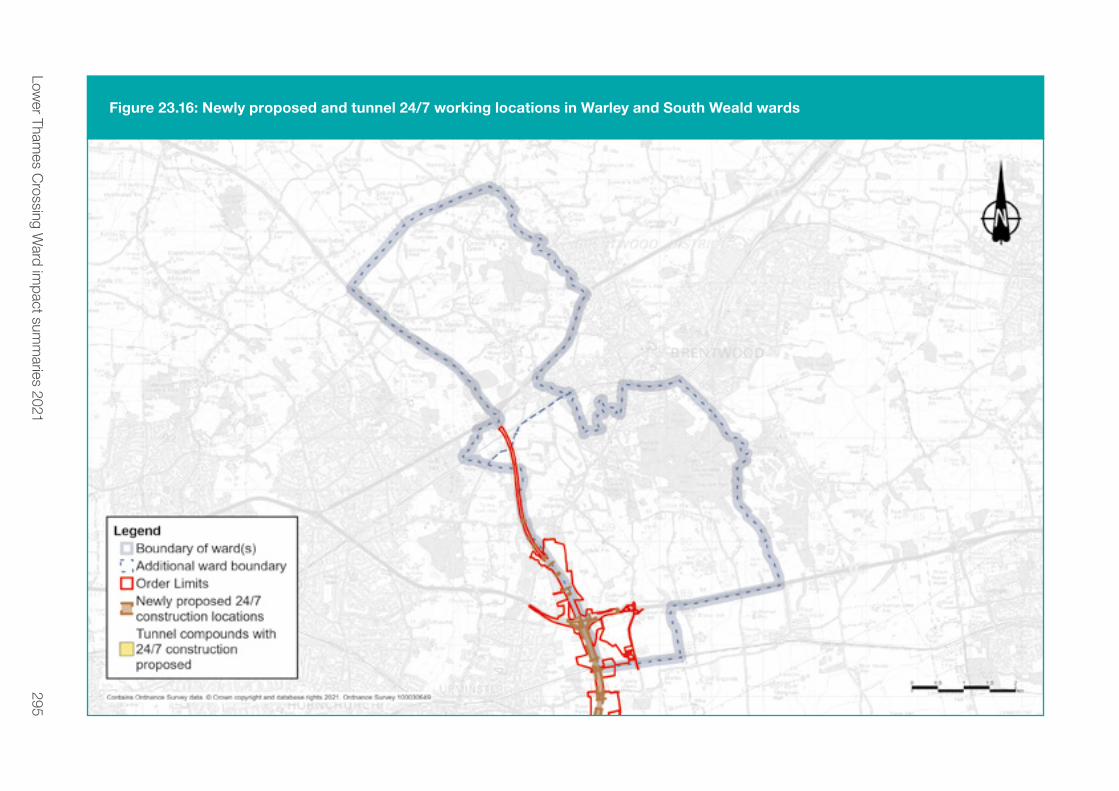
295Low
er Thames C
rossing Ward im
pact summ
aries 2021
Figure 23.16: Newly proposed and tunnel 24/7 working locations in Warley and South Weald wards

296 Lower Thames Crossing Ward impact summaries 2021
Construction traffic noise impactsMaps showing the predicted change in road traffic noise on roads in Warley and South Weald wards during each year of the construction can be found in chapter 7 of the Construction update. Based on the currently available traffic data (which offers a representative picture of what receptors in the wards are likely to experience), during the construction period there would be negligible changes in road traffic noise (less than 1dB change in noise levels) during all construction years, except along the roads where increases in noise levels have been predicted (see table below). For more information about how we define noise impacts (negligible, minor, moderate and major), see chapter 1.
Table 23.4: Construction traffic noise impacts in Warley and South Weald wards
Affected road(s) Predicted noise impact Construction year(s)
The southbound M25
carriageway, south of
junction 28
Minor increase in noise levels 4
Measures to reduce construction noise levelsConstruction noise levels would be controlled using Best Available Techniques (BAT), with specific measures used at certain locations such as:
� Installing and maintaining hoarding around the construction compounds.
� Installing temporary acoustic screening around construction areas likely to generate noise.
� Keeping site access routes in good condition with onsite condition assessments to inspect for defects such as potholes.
� Turning off plant and machinery when not in use. � Maintaining all vehicles and mobile plant so loose body fittings
or exhausts do not rattle or vibrate. � Using silenced equipment where available, specifically silenced
generators and pumps. � No music or radios would be played outdoors onsite for
entertainment purposes.

297Lower Thames Crossing Ward impact summaries 2021
� Site layout would be planned to make sure reversing is kept to a minimum. Reversing manoeuvres would be managed by a trained banksman/vehicle marshal to ensure they are conducted safely and quickly to reduce noise from vehicle reversing warnings.
� Non-percussive demolition techniques would be used, where possible, to reduce noise and vibration impact.
� Careful consideration of compound location and layout to separate noise-generating equipment from sensitive receptors, and the use of mains electricity rather than generators, where possible.
� Minimisation of construction vehicle traffic, where possible, by selecting local suppliers along the project route, using local workforces and reducing the transport of material for earthworks construction.
All control measures, including those above, fall under the principles of BAT and are secured in the REAC. For more information, see sections NV001 to NV010, which set out how we would work under the supervision of the relevant local authorities to implement noise-reduction measures where necessary.
The CoCP sets out additional measures that would be used to reduce noise and vibration during the construction period.
23.7.2 OperationsOperational impactsIn Warley, the project route (see the Project description above) runs through the western part of the ward, with traffic joining the new road at its existing junction with the M25/A127. There would also be changes to the existing M25 to accommodate the predicted changes in traffic flow.
Direct noise impacts from the route, and the upgrade works on the existing M25/A127 junction and M25, would be heard in the western part of the ward.
South Weald is located approximately 1.5km to the north of the main project route and, as such, would experience no direct noise from the project in the ward.
There would be indirect noise impact as a result of changes in traffic flow, traffic composition, and traffic speed on the existing road network in Warley and South Weald.

298 Lower Thames Crossing Ward impact summaries 2021
Figure 23.17 shows the predicted changes in traffic noise in the opening year of the project. In these wards, changes in road traffic noise at identified noise sensitive locations (such as nearby properties) are predicted to range from a moderate decrease in noise levels of between 3.0 to 4.9dB to a minor increase in noise levels of between 1.0 to 2.9dB (close to the Childerditch Lane). For more information about how we define noise impacts (negligible, minor, moderate and major), see chapter 1.
Measures to reduce traffic noise during operationThe main methods of controlling noise across the project would be, where possible, to design the new road within landscaped features such as cuttings and bunds (walls of earth). However, where noise impacts are greatest, we would install noise barriers (typically, wooden fences) in addition to these earthworks features. The use of low-noise surfacing on new and resurfaced roads would also reduce the traffic noise once the road is in use. For more information about the proposed measures to reduce operational noise, see the REAC (including references NV011 and NV013).

299Low
er Thames C
rossing Ward im
pact summ
aries 2021
Figure 23.17: Noise impacts during operation in Warley and South Weald wards

300 Lower Thames Crossing Ward impact summaries 2021
23.8 Air qualityWe have carried out air quality assessments for both the construction and operational phases of the project. As explained in chapter 1, some of the assessments set out here are based on earlier versions of the project. The information provided still presents a reasonable representation of the likely effects from the proposals put forward during this consultation.
Existing situation In Warley ward, there are no declared Air Quality Management Areas (AQMAs). These are areas that have been identified by local authorities as areas of poor air quality that require monitoring and controls.
In South Weald, the M25/A12 Brook Street junction has been declared an AQMA due to yearly levels of airborne pollution being above accepted standards. No other areas within the ward have been identified as AQMA.
23.8.1 ConstructionConstruction impactsConstruction activities have the potential to affect nearby air quality through the release of dust and emissions from construction equipment and traffic. The areas most likely to be affected are those close to haul roads, compounds and soil storage areas.
Properties more than 200 metres from the worksite, which are the majority of properties within these wards, are outside the area likely to be affected by construction dust or emissions from the worksite. In Warley, there are only a few properties within 200 metres of the worksite, including those around the A127 Southend Arterial Road. Again, in South Weald, there are only a few properties within 200 metres, namely those near Nags Head Lane. Air quality impacts on these properties during construction would be temporary and we would put in place measures to minimise the dust impacts (see below). Our proposed measures to reduce dust and emissions are ones that have proven to be effective when used on similar construction projects in the past. The change in air quality during the construction phase would be negligible, and there would be no discernible effect on health.

301Lower Thames Crossing Ward impact summaries 2021
Our analysis of construction traffic predicts that the impact on most roads in these wards would be negligible. However, there would be a minor improvement in air quality in the area around the M25 as a result of the traffic management in place from 2025 to 2028. More information about construction traffic impacts on air quality can be found in chapter 7 of the Construction update.
Measures to reduce air quality impacts during constructionThe impact of construction machinery and traffic on air quality would be controlled through the range of good practice measures set out in the CoCP and the REAC. For example, there would be measures to suppress dust, such as damping down dry haul roads and spoil heaps, as well as the use of low-emission machinery and vehicles. We would put an Air Quality Management Plan in place to make sure the measures set out in the CoCP and the REAC would effectively monitor and control dust and exhaust emissions. The location and type of monitoring would be submitted in advance to Brentwood Borough Council for consultation (see REAC entry AQ006).
23.8.2 OperationsOperational impactsWe have carried out an assessment of the operational impacts of the new road on air quality. The assessment area includes a 200-metre buffer around the affected road network, with this area being the most likely to experience changes to air quality as a result of the new road. More information about air quality impacts once the new road is open can be found in chapter 5 of the Operations update.
At all locations in South Weald and Warley wards, there are no predicted exceedances of air quality thresholds.
However, there are receptors (properties or habitats that are sensitive to changes in air quality) in Warley ward, close to the west of the M25 that are predicted to experience a negligible change in air quality for nitrogen dioxide (NO2), the main traffic-related pollutant3. The highest modelled yearly average NO2 concentration in this ward is 23.9 µg/m³, which is below the yearly average threshold of 40µg/m³.
3 NO2 levels are measured in ‘micrograms per cubic metre’, or µg/m³, where a microgram is one millionth of a gram.

302 Lower Thames Crossing Ward impact summaries 2021
There are receptors in South Weald ward, close to the east of the M25 that are predicted to experience a minor worsening in air quality for nitrogen dioxide. The highest modelled yearly average NO2 concentration within this ward is 39.5 µg/m³, which is below the yearly average threshold of 40µg/m³. Our assessment is based on our opening year model, which represents a worst-case scenario, without accounting for the increase in less-polluting vehicles on our roads over time.
Although the modelled yearly average NO2 concentration within these wards is close to the air quality threshold, local air quality data shows an overall downward trend in NO2 over recent years, which means that future air quality improvements at this location are likely (for example, through increased adoption of electric vehicles leading to a reduction in exhaust emissions).
In addition to our assessment of NO2, our assessment predicts that PM10 levels (small particles of dust, mainly from vehicle exhausts and brakes) are unlikely to exceed threshold levels across the assessed area.
Measures to reduce air quality impacts during operation. The assessed air quality impacts in this area as a result of the new road would not trigger the need for additional monitoring or other mitigation measures once it is open.

303Low
er Thames C
rossing Ward im
pact summ
aries 2021
Figure 23.18: Predicted changes in NO2 levels within Warley and South Weald wards once the new road is open

304 Lower Thames Crossing Ward impact summaries 2021
23.9 HealthExisting situation A range of personal, social, economic and environmental factors influence our health. Different groups within the population may be more sensitive to these factors than others – for example, children, older people or those with pre-existing health conditions.
WarleyThe ward is characterised by a younger population, with the proportion of people under the age of 16 (19.4%) similar to Brentwood as a whole. Warley has a slightly lower proportion of elderly residents aged 60+, when compared with Brentwood as a whole (23.5% and 25.9% respectively). The ethnic diversity of its population is higher, with 4.9% of residents having an Asian background compared with 3.2% for Brentwood.
According to the English Index of Multiple Deprivation, Warley suffers from very low rates of deprivation. Economic activity is similar to that of Brentwood. Home ownership levels are slightly lower than for Brentwood (73.2% and 75.1% respectively), with the majority of the remainder in private and social rented housing (15% and 10.4% respectively).
Self-reported health status is generally good, with more than 83% of residents reporting their health to be very good or good – slightly lower than Brentwood as a whole. A higher proportion of residents (16.4%) report that their day-to-day activities are limited a lot or a little as a result of long-term health problems or disability compared with Brentwood (15.5%). Life expectancy at birth for residents of Warley is 79.4 for males and 82.1 for females, which is lower than for Brentwood as a whole. Rates are also worse in Warley than Brentwood for a number of other health-related measures such as deaths from all causes (these are causes where all or most deaths could potentially be prevented by public health interventions in the broadest sense), respiratory diseases, coronary heart diseases and cancer.
South WealdThe ward is characterised by a younger population, with the proportion of people under the age of 16 in South Weald (19.3%) similar to Brentwood as a whole. South Weald has the same proportion of elderly residents aged 60+ when compared with Brentwood as a whole (25.9%).

305Lower Thames Crossing Ward impact summaries 2021
Home ownership levels are slightly lower than for Brentwood (73.2% and 75.1% respectively), with the majority of the remainder in private and social rented housing (15.0% and 10.4% respectively).
Self-reported health status is very good, with more than 85% of residents reporting very good or good health. A lower proportion of residents (12.8%) report that their day-to-day activities are limited a lot or a little as a result of long-term health problems or disability compared with Brentwood (15.5%). Rates are similar in South Weald and Brentwood for a number of health-related measures such as deaths from all causes (these are causes where all or most deaths could potentially be prevented by public health interventions in the broadest sense), respiratory diseases, coronary heart diseases and cancer.
23.9.1 ConstructionWarley
� Properties more than 200 metres from the worksite, which is the majority of properties in this ward, are outside the area likely to be affected by construction dust or emissions from the worksite. In Warley, there are only a few properties within 200 metres of the worksite, including those around the A127 Southend Arterial Road. Air quality impacts on these properties during construction would be temporary.
� Our analysis of construction traffic predicts that the impact on most roads in this ward would be negligible. However, there would be a minor improvement in air quality in the area around the M25 as a result of the traffic management in place from 2025 to 2028.
� There are no main construction works or activities that are expected to give rise to construction noise and vibration impacts.
� Increases in road traffic noise during the construction phase are predicted to be less than 1dB(A) on all road traffic links in this ward.
� There may be changes in accessibility for people who are more dependent on public transport and have less choice about method and route travelled.
� In this ward, there may be mental health and wellbeing impacts associated with stress and anxiety relating to construction of the project.
� Conversely, positive health outcomes may be experienced by residents as a result of access to work and training opportunities presented by construction activities.

306 Lower Thames Crossing Ward impact summaries 2021
South Weald � Properties more than 200 metres from the worksite, which
is the majority of properties in this ward, are outside the area likely to be affected by construction dust or emissions from the worksite. In South Weald, there are only a few properties within 200 metres of the worksite, including those near Nags Head Lane. Air quality impacts on these properties during construction would be temporary.
� There would be no views of Lower Thames Crossing construction activities from South Weald.
� Our analysis of construction traffic predicts that the impact on most roads in this ward would be negligible, although there would be a minor improvement in air quality in the area around the M25 as a result of the traffic management in place from 2025 to 2028.
23.9.2 OperationsOperational health impacts Positive and negative health outcomes may be experienced by residents in Warley ward:
� Warley residents are predicted to experience improvements in accessibility, including accessibility to open space.
� We have carried out an assessment of the operational impacts of the new road on air quality. The assessment area includes a 200-metre buffer around the affected road network, with this area being the most likely to experience changes to air quality as a result of the new road. More information about air quality impacts once the new road is open can be found in chapter 5 of the Operations update.
� At all locations in the South Weald and Warley wards, there are no predicted exceedances of air quality thresholds.
� There are receptors (properties or habitats that are sensitive to changes in air quality) in Warley, close to the west of the M25 that are predicted to experience a negligible change in the air quality for nitrogen dioxide (NO2), the main traffic- related pollutant.
� In Warley ward, the project route (see the Project description above) runs through the western part of the ward, with traffic joining the new road at its existing junction with the M25/A127. There would also be changes to the existing M25 to accommodate the predicted changes in traffic flow.

307Lower Thames Crossing Ward impact summaries 2021
� Direct noise impacts from the route, and the upgrade works on the existing M25/A127 junction and M25, would be experienced in the western part of the ward.
� Warley residents are predicted to experience beneficial changes in road traffic noise levels.
� Indirect noise impacts in Warley would be as a result of changes in traffic flow, the number of HGVs, and traffic speeds on the existing road network in the ward.
� There would be no visual impacts from local footpaths following completion of the M25 widening works and associated landscape treatment.
Positive and negative health outcomes may be experienced by residents in South Weald:
� South Weald residents are predicted to experience improvements in accessibility, including accessibility to open space.
� We have carried out an assessment of the operational impacts of the new road on air quality. The assessment area includes a 200-metre buffer around the affected road network, with this area being the most likely to experience changes to air quality as a result of the new road. More information about air quality impacts once the road is open can be found in chapter 5 of the Operations update.
� There are receptors in South Weald, close to the east of the M25, that are predicted to experience a minor worsening in the air quality for nitrogen dioxide, the main traffic-related pollutant.
� South Weald is approximately 1.5km to the north of the main project route and, as such, there would be no direct noise impacts from the project in the ward.
� Indirect noise impacts in South Weald would be as a result of changes in traffic flow, the number of HGVs, and traffic speeds on the existing road network in the ward.
� There would be no visual impacts from local footpaths following completion of the M25 widening works and associated landscape treatment.
Measures to reduce health impacts during operationNo essential measures to specifically address health impacts have been identified in these wards beyond those relating to noise and visual impacts described elsewhere.

308 Lower Thames Crossing Ward impact summaries 2021
23.10 BiodiversityExisting situationThe main habitat in Warley ward is arable fields. In addition, there are areas of rough grassland, scrub and woodland with some watercourses. Warley contains no designated habitat within 2km of the Order Limits. Within 500 metres of the Order Limits, the non-designated sites are: Codham Hall Wood Local Wildlife Site (LWS) and Ancient Woodland, Coombe Wood LWS, Jackson’s Wood LWS and Ancient Woodland and Coombegreen Ancient Woodland.
We carried out surveys across the Lower Thames Crossing to set a baseline for assessment, and these identified the presence of a range of protected and notable species, including bats, badgers, terrestrial invertebrates and reptiles in Warley ward.
Only a small area of South Weald ward falls within the Order Limits, and this is restricted to the soft estate (border habitat) alongside the M25. The only habitat present within the Order Limits is some landscape planting and grassland. South Weald contains one designated site within 2km of the Order Limits: The Manor Local Nature Reserve (LNR). Within 500 metres of the Order limits there is one non-designated site: Ingrebourne Valley Site of Importance for Nature Conservation.
We carried out surveys across the project to set a baseline for assessment, and these identified the presence of reptiles within the landscape planting and grassland along the M25, in South Weald ward.

309Low
er Thames C
rossing Ward im
pact summ
aries 2021
Figure 23.19: Designated and non-designated biodiversity sites in Warley and South Weald wards

310 Lower Thames Crossing Ward impact summaries 2021
23.10.1 ConstructionConstruction impacts Construction of the project would require the removal of areas of habitat, both temporarily and permanently from the route alignment. This habitat, consisting of areas of landscape planting and grassland, supports protected and notable species which would be affected by construction in terms of direct reptile habitat loss and disturbance to retained habitat.
Measures to reduce biodiversity impacts during construction Vegetation clearance would take place during the winter, where possible, to avoid disturbing breeding birds. Where this is not practical, clearance would be supervised by an ecological clerk of works to make sure no nests are disturbed or destroyed. Where protected species are present, these would be moved away from the site before any construction activities, either through habitat manipulation (for example, strimming to reduce the height of vegetation and displace reptiles) or translocation. Habitat removed for temporary construction would be reinstated during the construction process.
Where required, works affecting protected species would be carried out under a Natural England licence. Boxes to support birds and bats would be erected within retained habitat. We would carry out significant areas of woodland planting to offset lost woodland habitat in Warley ward. This would not only increase the overall extent of woodland in the area, but also provide strong connections between existing woodland habitats such as Codham Hall Wood and Coombegreen Wood. These are shown in a map in the General Arrangements drawings.
The impact of construction on biodiversity would be controlled through the range of good practice measures set out in the CoCP and REAC. See chapter 1 of the Construction update for more information about this and the project’s other control documents.

311Lower Thames Crossing Ward impact summaries 2021
23.10.2 OperationsOperational impacts The new road has the potential to cause mortality for species that encounter road traffic in addition to noise disturbance from traffic, as already occurs with the M25.
Measures to reduce biodiversity impacts during operationTo mitigate the impacts of disturbance in Warley, screening vegetation would be planted alongside the M25 to reduce disturbance to existing habitat and the newly created woodland habitat. New habitat would be managed to ensure it provides a high quality environment to support a broad range of different plant and animal species.
To mitigate impacts in South Weald, landscape planting would screen the road from the surrounding habitats and newly created habitat would be managed to ensure it provides a high quality environment to support a broad range of different plant and animal species.
The impact of operation on biodiversity would be controlled through the range of good practice measures set out in the project’s CoCP and REAC. See chapter 1 of the Construction update for more information about this and the project’s other control documents.

312 Lower Thames Crossing Ward impact summaries 2021
23.11 Built heritageExisting situationRegistered park and gardens and conservation areasA registered park and garden, two conservation areas, and 25 listed buildings have been identified in Warley ward in relation to the new road. Warley Place is a Grade II registered park and garden and conservation area around 870 metres east of the M25 and the project, in Great Warley. The park and garden were originally part of much larger landholdings dating back to the 16th century and historically associated with the Dissolution of the Monasteries. The park and conservation area are located north of Great Warley village. They are bounded by Warley Road to the east, Dark Lane to the west, and Green Lane to the north.
The Great Warley conservation area includes several listed buildings and a protected lane, Dark Lane. The conservation area encompasses most of the traditional rural settlement of Great Warley. The village is focused along two main roads, Warley Road, running south-west to north-east, and Great Warley Street, running away from the village to the south-east. Almost all the buildings in the conservation area are along these two roads, which join at the northern end of the area, around the village green.
Grade I listed buildingsChurch of St Mary the Virgin is a Grade I listed church of high heritage value. It is located around 730 metres east from the M25 and the project, in Great Warley. The church was built in 1902-1904 and the exterior was designed by the renowned architect Charles Harrison Townsend. The interior decoration and fittings were designed by Sir William Reynolds-Stephens.

313Low
er Thames C
rossing Ward im
pact summ
aries 2021
Figure 23.20 Built heritage in Warley and South Weald wards

314 Lower Thames Crossing Ward impact summaries 2021
Grade II* listed buildings � Lych Gate at Church of St Mary The Virgin � Two Door Cottage
Grade II listed buildings
� Hulmers � Brick House Hotel � Boyles Court � Boyles Court Cottages � Stables at Boyles Court Farm � Barn at Boyles Court Farm � Walletts � Mascalls � Stable Block eight metres north of Mascalls � Blake House � The Red House � South Lodge to Warley Place � Thatched Cottage � Oak Beam Cottage and Warley Green Cottage � Thatchers Arms Inn � The Squirrels � Hole Farmhouse � Post Office � K6 Telephone Kiosk Adjacent to Post Office � Stony Hills Farm � Fairstead � Warley Elms

315Lower Thames Crossing Ward impact summaries 2021
In South Weald, a registered park and garden, conservation area, and three listed buildings have been identified in relation to the project. All three listed buildings are Grade II listed.
Registered park and gardens and conservation areaWeald Park is a Grade II registered park and garden and a conservation area on the south-western edge of Brentwood, around 970 metres north from the project. It is bounded by farmland to the north and west and South Weald village to the south-east. The park and area cover approximately 23 ha and include several listed buildings, formal gardens, pleasure grounds, parkland and woodland. The park and gardens are part of a former estate which dates back to the 11th century. Weald Hall was originally built in the 16th Century and once stood in the south-west corner of the park but was demolished in the 20th century. However, buildings associated with the former hall remain, including the listed chapel, granary and farmhouse. The park and area was designated in July 1987.
Listed buildings � Nag’s Head Inn � 17, 19 and 21 Brook Street � The Bull Inn

316 Lower Thames Crossing Ward impact summaries 2021
23.11.1 Construction Construction impactsConstruction activities include the establishment and operation of Warley Street Compound, along with works to the existing M25 and utilities works. Further details of construction activities affecting these wards are provided in the Project description section. Built heritage would not be impacted by the project.
Measures to reduce impacts during construction Mitigation is not required as no built heritage is affected.
23.11.2 Operations Operational impactsPlease refer to the Project description, Operation section of this chapter. There are not anticipated to be any effects on built heritage in these wards once the project is operational.
Measures to reduce the impacts during operation Mitigation is not required as no built heritage is affected once the project is operational.

317Lower Thames Crossing Ward impact summaries 2021
23.12 Contamination Existing situationFrom a desk-based review of sources (historical maps and environmental data), there are no known medium- or high-risk sources of contamination that risk being disturbed during construction or operation of the project in Warley and South Weald.
23.12.1 Construction By following a construction management plan, we would make sure that, where potential sources of contamination are used (for example, oils, lubricants, mechanical plant), appropriate spill containment and emergency response procedures are in place to prevent adverse environmental impacts from happening.
23.12.2 OperationsDuring the operation of the road, should an incident occur, such as a traffic accident resulting in localised contamination, significantly affected soils would be assessed and if necessary removed to reduce the risk of contamination migrating across a wider area or entering controlled waters. For more information on these controls, see the REAC.

318 Lower Thames Crossing Ward impact summaries 2021
How to have your sayPlease let us know your views on our community impacts consultation. All the information, including the response form, is available at www.highwaysengland.co.uk/ltcconsultation
The easiest way to comment is by filling out our online consultation response form, but you can submit a response by using any of the methods listed below. Please note, we cannot guarantee that responses sent to any other address will be considered. Responses will be accepted until 23.59 on 8 September 2021.
If you would like to comment on aspects of our proposals from earlier consultations, please use the ‘Other comments’ section on the response form.
OnlineFill in the survey at www.highwaysengland.co.uk/ltcconsultation
PostSend your response form, or comments, to FREEPOST LTC CONSULTATION
The Freepost address is the only text needed on the envelope, and you don’t need a stamp.
EmailSend your comments to [email protected]
319Lower Thames Crossing Ward impact summaries 2021
Telephone surgeryYou can book a call back from a member of the project team to discuss any questions or provide comments on the proposal. From 14 July 2021, call us on 0300 123 5000 (weekdays between 9am and 5pm) to book an appointment
Home delivery
If you do not have access to the internet, from 14 July 2021 you can order printed copies of this guide to consultation, a feedback form and Freepost return envelope, maps and other documents. Please call us on 0300 123 5000 to request a consultation pack. These will be delivered free of charge – there is a limit of one pack per household.
Data privacy noticeWe are committed to protecting your personal information. Whenever you provide this information, we are legally obliged to use it in line with all applicable laws concerning the protection of personal data, including the General Data Protection Regulation (GDPR).

320 Lower Thames Crossing Ward impact summaries 2021
How will Highways England use the information we collect about you?We will use your personal data collected via this consultation to:
� analyse your feedback to the consultation � produce a summary report, based on our analysis
of responses (individuals will not be identified in our Consultation Report)
� write to you with updates about the results of the consultation and other developments
� keep up-to-date records of our communications with individuals and organisations
Any personal information you include in this form will be available to, or used by:
� Highways England � Traverse (an independent company we are using to analyse
feedback to the consultation) � the Planning Inspectorate (the Government agency that will
consider our application for permission to build the Lower Thames Crossing)
� the Secretary of State for Transport (who will decide on our application)
� our legal advisers � consultants working on the Lower Thames Crossing project

321Lower Thames Crossing Ward impact summaries 2021
It is also possible that trusted third-party providers, for example construction companies, may later use your contact details to communicate with you about this project.
Under the terms of the GDPR, you have certain rights over how your personal data is retained and used by Highways England. For more information, see our full data privacy statement at www.highwaysengland.co.uk/our-work/lower-thames-crossing/privacy-notice/

566 Lower Thames Crossing Ward impact summaries 2021
GlossaryTerm Explanation
2029 Opening year A modelled year in the LTC traffic model in which flows are estimated for each option
2044 Design yearA modelled year in the LTC traffic model. The design year is typically 15 years after opening - for LTC the design year is 2044.
AADT Average Annual Daily Traffic
Affected Road Network
This comprises the area within which roads could be considered within the air quality model (selection of the roads within the model depends upon a number of criteria such as changes in Heavy Duty Vehicle flows).
AlignmentThe alignment is the horizontal and vertical route of a road, defined as a series of horizontal tangents and curves or vertical crest and sag curves, and the gradients connecting them.
AM 07:00 to 10:00
AODAbove ordnance datum, vertical datum used by an ordnance survey as the basis for delivering altitudes on maps.
AONBArea of Outstanding Natural Beauty: Statutory designation intended to conserve and enhance the ecology, natural heritage and landscape value of an area of countryside.
APTR All-purpose trunk road
AQMA Air Quality Management Area: an area, declared by a local authority, where air quality monitoring does not meet Defra’s national air quality objectives.
AQSO
Air Quality Strategy Objective: Objective set by the Air Quality Strategy for England, Scotland, Wales and Northern Ireland to improve air quality in the UK in the medium term. Objectives are focused on the main air pollutants to protect health.
BATBest Available Techniques used for controlling construction noise levels
Best Practicable Means
Practicable relates to local conditions, circumstances, the current knowledge and understanding of technical aspects with consideration to financial implications. The means to be employed (“Means”) include the design, installation, maintenance, and manner and periods of operation of plant and machinery.
Bluewater Bluewater Shopping Centre, an out of town shopping centre in Stone, Kent
Chart Datum The level of water from which charted depths displayed on a nautical chart are measured.

567Lower Thames Crossing Ward impact summaries 2021
Term Explanation
CoCPCode of Construction Practice - provides a framework to manage construction and operational activities so that environmental mitigation commitments are met.
Dart Charge The Dartford Crossing free-flow electronic number plate recognition charging system (operates between 0600 and 2200).
DCO Development Consent Order
Defra
Department for Environment, Food and Rural Affairs: the government department responsible for environmental protection, food production and standards, agriculture, fisheries and rural communities in the United Kingdom of Great Britain and Northern Ireland.
Design principlesGuidance that underpins the design measures that integrate the new road into the local landscape and establishes parameters that must be met in the final design of the road.
DfT
Department for Transport: the government department responsible for the English transport network and a limited number of transport matters in Scotland, Wales and Northern Ireland that have not been devolved.
Disbenefit A disadvantage or loss resulting from something.
DMRB
Design Manual for Roads and Bridges: A comprehensive manual (comprising 15 volumes) which contains requirements, advice and other published documents relating to works on motorway and all-purpose trunk roads for which one of the Overseeing Organisations (Highways England, Transport Scotland, The Welsh Government or the Department for Regional Development (Northern Ireland)) is highway authority. The DMRB has been developed as a series of documents published by the Overseeing Organisations of England, Scotland, Wales and Northern Ireland. For the Lower Thames Crossing the Overseeing Organisation is Highways England.
EA
Environment Agency: The Environment Agency was established under the Environment Act 1995, and is a Non-Departmental Public Body of Defra. The Environment Agency is the leading public body for protecting and improving the environment in England and Wales. The organisation is responsible for wide-ranging matters, including the management of all forms of flood risk, water resources, water quality, waste regulation, pollution control, inland fisheries, recreation, conservation and navigation of inland waterways.

568 Lower Thames Crossing Ward impact summaries 2021
Term Explanation
Ecological Clerk of Works
This person(s) would provide advice about ecological and environmental issues during the construction period, monitor the work to ensure site-based construction activities are delivered in accordance with wildlife law and ensure that any necessary permits or licensing is acquired.
EIA Environmental Impact Assessment
ES Environmental Statement
ESL – Eastern Southern Link
The Eastern Southern Link (ESL) is an alternative for shortlist Routes 2, 3 and 4 to the south of the River Thames. The route would connect into Junction 1 of the M2 and would pass to the east of Shorne and then northwest towards Church Lane and Lower Higham Road. This route could connect into any of the Routes 2, 3 and 4 north of the river utilising all of the crossing options for these route options.
Fastrack A bus rapid transit scheme operating in the Thames Gateway area of Kent, operated by Arriva Southern Counties.
FCTP
Framework Construction Travel Plan - sets out a framework to reduce the impact of the project’s construction workforce on the road network as a result of travel to and from construction areas and compounds.
GHGGreenhouse gas emissions are emissions of greenhouse gases that cause climate change by creating a greenhouse effect in the earth's atmosphere.
GIS
Geographic information system: an integrated collection of computer software and data used to view and manage information about geographic places, analyse spatial relationships, and model spatial processes.
HGV Heavy Goods Vehicle
HRA
Habitats Regulations Assessment: A tool developed by the European Commission to help competent authorities (as defined in the Habitats Regulations) to carry out assessment to ensure that a project, plan or policy will not have an adverse effect on the integrity of any Natura 2000 or European sites (Special Areas of Conservation, Special Protection Areas and Ramsar sites), (either in isolation or in combination with other plans and projects), and to begin to identify appropriate mitigation strategies where such effects were identified.
HS1 High Speed 1 rail line (formerly Channel Tunnel Rail Link (CTRL))
Inter-peak 10:00 to 16:00

569Lower Thames Crossing Ward impact summaries 2021
Term Explanation
Jacked box tunnelling
Jacked box tunnelling is a method of construction that enables engineers to create underground space at shallow depth in a manner that avoids disruption of valuable infrastructure and reduces impact on the human environment.
Lakeside
Lakeside Shopping Centre, branded as Intu Lakeside, is a large out-of-town shopping centre located in West Thurrock, in the borough of Thurrock, Essex just beyond the eastern boundary of Greater London.
Location A The location for LTC route options close to the existing Dartford crossing.
Location C The location for LTC route options connecting the A2/ M2 east of Gravesend with the A13 and M25 (between Junctions 29 and 30) north of the River Thames.
London Gateway
A new deep-water port, able to handle the biggest container ships in the world, and part the London Gateway development on the north bank of the River Thames in Thurrock, Essex, 20 miles (32 km) east of central London.
London Resort
A proposed theme park and entertainment precinct on the Swanscombe peninsula, Kent, being developed by London Resort Company Holdings. Construction could begin in 2022 with the opening estimated for 2024.
LTC Lower Thames Crossing: a proposed new crossing of the Thames estuary linking the county of Kent with the county of Essex, at or east of the existing Dartford Crossing.
LWS Local wildlife site
Mainline The through carriageway of a road as opposed to a slip road or a link road at a junction Mardyke A small river, mainly in Thurrock, that flows into the River Thames at Purfleet, close to the QEII Bridge.
NCR National Cycle Route: a cycle route part of the National Cycle Network created by Sustrans to encourage cycling throughout Britain.
NMU Non-motorised user, e.g. pedestrians, cyclists, equestrians.
NO2 Nitrogen dioxide.
NPSNN
National Policy Statement for National Networks: The NPSNN sets out the need for, and Government’s policies to deliver, development of nationally significant infrastructure projects on the national road and rail networks in England. It provides planning guidance for promoters of nationally significant infrastructure projects on the road and rail networks, and the basis for the examination by the Examining Authority and decisions by the Secretary of State.

570 Lower Thames Crossing Ward impact summaries 2021
Term Explanation
NSIP
Nationally significant infrastructure project: major infrastructure developments in England and Wales, such as proposals for power plants, large renewable energy projects, new airports and airport extensions, major road projects etc.
OLEMP
Outline Landscape and Ecology Management Plan - sets out the management regimes, management expectations and monitoring requirements for parcels of land that perform specific landscape and ecological mitigation functions for the project, such as habitat creation or visual screening.
oMHPOutline Materials Handling Plan - sets out the approach and high-level principles for handling construction materials and waste.
ONS Office for National Statistics: the executive office of the UK Statistics Authority, a non-ministerial department which reports directly to the UK Parliament.
oSWMP Outline Site Waste Management Plan - sets out the overarching principles and procedures that would be applied for the management of waste during the construction of the project.
oTMPfc
Outline Traffic Management Plan for construction - outlines the approach to carrying out temporary traffic management for the safe construction of the project and the management measures to reduce the impact on local communities.
pcu
passenger car units. This is a metric to allow different vehicle types within traffic flows in a traffic model to be assessed in a consistent manner. Typical pcu factors are: 1 for a car or light goods vehicle; 2 for a bus of heavy goods vehicle; 0.4 for a motorcycle; and 0.2 for a pedal cycle.
PEIR Preliminary Environmental Information Report
PLA
Port of London Authority: a self-funding public trust established by The Port of London Act 1908 to govern the Port of London. Its responsibility extends over the Tideway of the River Thames and its continuation (the Kent/ Essex strait). It maintains and supervises navigation and protects the river's environment.
PM 16:00 to 19:00
PM10
Particulate matter (in this example, particulates smaller than 10μm that can cause health problems).
PoTLL Port of Tilbury London Limited, operator of the Port of Tilbury

571Lower Thames Crossing Ward impact summaries 2021
Term Explanation
PRoW
Public Right of Way: A right possessed by the public, to pass along routes over land at all times. Although the land may be owned by a private individual, the public may still gain access across that land along a specific route. The mode of transport allowed differs according to the type of public right of way which consist of footpaths, bridleways and open and restricted byways.
Ramsar A wetland of international importance, designated under the Ramsar convention.
REACRegister of Environmental Actions and Commitments - identifies good practice and essential mitigation that will be adopted during the construction and operation of the project.
RSPB
Royal Society for the Protection of Birds: A charitable organisation that works to promote conservation and protection of birds and the wider environment through public awareness campaigns, petitions and through the operation of nature reserves throughout the United Kingdom.
SAC
Special Area of Conservation: defined in the European Union's Habitats Directive (92/43/EEC), also known as the Directive on the Conservation of Natural Habitats and of Wild Fauna and Flora. SACs are to protect the 220 habitats and approximately 1000 species listed in annex I and II of the directive which are considered to be of European interest following criteria given in the directive.
Setting
This is defined in the National Planning Policy Framework as ‘The surroundings in which a heritage asset is experienced. Its extent is not fixed and may change as the asset and its surroundings evolve. Elements of a setting may make a positive or negative contribution to the significance of the asset, may affect the ability to appreciate that significance or may be neutral.’
SPA Special Protection Area: A designation under the European Union Directive on the Conservation of Wild Birds.
SPZ
Source protection zone: EA-defined groundwater sources (2000) such as wells, boreholes and springs used for public drinking water supply. These zones show the risk of contamination from any activities that might cause pollution in the area.
SRN Strategic Road Network, the core road network, managed in England by Highways England.
SSSI Site of Special Scientific Interest: A conservation designation denoting an area of particular ecological or geological importance.
SuDS A sustainable drainage system designed to reduce the potential impact of new and existing developments with respect to surface water drainage discharges.

572 Lower Thames Crossing Ward impact summaries 2021
Term Explanation
TAG Transport Analysis Guidance: national guidance document produced by the Department for Transport.
TBM Tunnel boring machine, machine used to excavate tunnels with a circular cross section.
tCO2e
Tonnes of carbon dioxide equivalent; a standard unit for measuring carbon footprints. The idea is to express the impact of each different greenhouse gas in terms of the amount of CO2 that would create the same amount of warming.
TfL Transport for London: created in 2000, the integrated body responsible for London’s transport system.
ULH Utilities Logistics Hubs
V/C Volume over Capacity (volume/capacity)
VMS Variable Message Sign, typically mounted on a portal gantry.
WNIMMP
Wider Network Impacts Management and Monitoring Plan - summarises the work undertaken to date to identify and assess areas of the road network where monitoring and potential interventions may be necessary to better manage additional traffic as a result of the project.
WSL - Western Southern Link
The Western Southern Link (WSL) is an alternative for shortlist Routes 2, 3 and 4 to the south of the River Thames. The route would connect into the A2 to the east of Gravesend and would go to the west of Thong and Shorne and east of Chalk towards Church Lane and Lower Higham Road. This route could connect into any of the Routes 2, 3 and 4 north of the river utilising all of the crossing options for these route options.

If you need help accessing this or any other Highways England information,please call 0300 123 5000 and we will help you.
June 2021
Ward impact summaries north of the river - part 2
Lower Thames Crossing
© Crown copyright 2021.
You may re-use this information (not including logos) free of charge in any format or medium, under the terms of the Open Government Licence. To view this licence:
visit www.nationalarchives.gov.uk/doc/open-government-licence/
write to the Information Policy Team, The National Archives, Kew, London TW9 4DU,or email [email protected].
Mapping (where present): © Crown copyright and databaserights 2019 OS 100030649. You are permitted to use thisdata solely to enable you to respond to, or interact with, theorganisation that provided you with the data. You are notpermitted to copy, sub-license, distribute or sell any of thisdata to third parties in any form.
This document is also available on our website at www.highwaysengland.co.uk
For an accessible version of this publication please call 0300 123 5000 and we will help you.
If you have any enquiries about this publicationemail [email protected] call 0300 123 5000*. Please quote the Highways England publications code PR92/21
Highways England creative job number BED21_0066
*Calls to 03 numbers cost no more than a national rate call to an 01 or 02 number and must count towards any inclusive minutes in the same way as 01 and 02 calls.
These rules apply to calls from any type of line including mobile, BT, other fixed line or payphone. Calls may be recorded or monitored.
Printed on paper from well-managed forests and other controlled sources when issued directly by Highways England.
Registered office Bridge House, 1 Walnut Tree Close, Guildford GU1 4LZ
Highways England Company Limited registered in England and Wales number 09346363
July 2021 Community impacts consultation
The wards covered in this summary are:
OckendonUpminsterCranham, Harold WoodWarley, South Weald
If you need help accessing this or any other Highways England information,please call 0300 123 5000 and we will help you.
Lower Tham
es Crossing - W
ard im
pact su
mm
aries no
rth of th
e river - part 2
July2021
If you need help accessing this or any other Highways England information,please call 0300 123 5000 and we will help you.
June 2021
Ward impact summaries north of the river - part 2
Lower Thames Crossing
© Crown copyright 2021.
You may re-use this information (not including logos) free of charge in any format or medium, under the terms of the Open Government Licence. To view this licence:
visit www.nationalarchives.gov.uk/doc/open-government-licence/
write to the Information Policy Team, The National Archives, Kew, London TW9 4DU, or email [email protected].
Mapping (where present): © Crown copyright and database rights 2019 OS 100030649. You are permitted to use this data solely to enable you to respond to, or interact with, the organisation that provided you with the data. You are not permitted to copy, sub-license, distribute or sell any of this data to third parties in any form.
This document is also available on our website at www.highwaysengland.co.uk
For an accessible version of this publication please call 0300 123 5000 and we will help you.
If you have any enquiries about this publication email [email protected] or call 0300 123 5000*. Please quote the Highways England publications code PR92/21
Highways England creative job number BED21_0066
*Calls to 03 numbers cost no more than a national rate call to an 01 or 02 number and must count towards any inclusive minutes in the same way as 01 and 02 calls.
These rules apply to calls from any type of line including mobile, BT, other fixed line or payphone. Calls may be recorded or monitored.
Printed on paper from well-managed forests and other controlled sources when issued directly by Highways England.
Registered office Bridge House, 1 Walnut Tree Close, Guildford GU1 4LZ
Highways England Company Limited registered in England and Wales number 09346363
July 2021Community impacts consultation
The wards covered in this summary are:
Ockendon Upminster Cranham, Harold WoodWarley, South Weald
If you need help accessing this or any other Highways England information, please call 0300 123 5000 and we will help you.
Lower Tham
es Crossing - W
ard im
pact su
mm
aries no
rth of th
e river - part 2
July2021