First evidence of an epipalaeolithic hunter-fisher-gatherer settlement at Körtik Tepe
19
Click to buy NOW! P D F - X C h a n g e V i e w e r w w w . d o c u - t ra c k . c o m Click to buy NOW! P D F - X C h a n g e V i e w e r w w w . d o c u - t ra c k . c o m
Transcript of First evidence of an epipalaeolithic hunter-fisher-gatherer settlement at Körtik Tepe

Click t
o buy N
OW!PD
F-XChange Viewer
ww
w.docu-track.com Clic
k to b
uy NOW
!PD
F-XChange Viewer
ww
w.docu-track.c
om

T.C.KÜLTÜR VE TURİZM BAKANLIĞI
Kültür Varlıkları ve Müzeler Genel Müdürlüğü
34.KAZI
SONUÇLARITOPLANTISI
1. CİLT
28 MAYIS - 1 HAZİRAN 2012ÇORUM
Click t
o buy N
OW!PD
F-XChange Viewer
ww
w.docu-track.com Clic
k to b
uy NOW
!PD
F-XChange Viewer
ww
w.docu-track.c
om

T.C. Kültür ve Turizm Bakanlığı
Kültür Varlıkları ve Müzeler Genel Müdürlüğü Yayın No:159-1
YAYINA HAZIRLAYAN Dr.Haydar DÖNMEZ
Kapak Fotoğrafı: Sait BAŞARAN “Enez (Ainos) 2011 Yılı Arkeoloji Kazısı”
ISSN:1017-7655
Pegasus Görsel İletişim Hizmetleri
ÇORUM-2013
28.05.2012 - 01.06.2012 tarihlerinde gerçekleştirilen 34. Uluslararası Kazı, Araştırma ve Arkeometri Sempozyumu, Hitit Üniversitesi ile Çorum Valiliği’nin katkılarıyla gerçekleştirilmiştir.
Sempozyum bildiri kitapları ise Hitit Üniversitesi’nin katkılarıyla basılmıştır.
TÜRKİYE CUMHURİYETİ
ÇORUM VALİLİĞİ
Not: Kazı raporları, dil ve yazım açısından Klâsik Filolog Dr. Haydar DÖNMEZ tarafından denetlenmiştir. Yayımlanan yazıların içeriğinden yazarları sorumludur.
Click t
o buy N
OW!PD
F-XChange Viewer
ww
w.docu-track.com Clic
k to b
uy NOW
!PD
F-XChange Viewer
ww
w.docu-track.c
om

İÇİNDEKİLERIşın YALÇINKAYA, Harun TAŞKIRAN, Metin KARTAL, Kadriye ÖZÇELİK, M. Beray KÖSEM, Gizem KARTAL2011 Yılı Karain Mağarası Kazıları
Harun TAŞKIRAN, M. Beray KÖSEM, Kadriye ÖZÇELİK, İ. Deniz YAMAN2011 Yılı Suluin Mağarası Kazısı
Ersin GÜLEÇ, İsmail ÖZER, Mehmet SAĞIR, İsmail BAYKARA, Serkan ŞAHİN, Ahmet Cem ERKMAN2011 Yılı Üçağızlı Mağarası Kazısı
Ayla SEVİM EROL, Ayhan YİĞİT, Serpil ÖZDEMİR, Pınar GÖZLÜK KIRMIZIOĞLU, Alper Yener YAVUZ2011 Yılı Çankırı Çorakyerler Kazısı
Marion BENZ, Aytaç COŞKUN, Corinna RÖSSNER, Katleen DECKERS, Simone RIEEHL, Kurt W. ALT, Vecihi ÖZKAYAFirs Evidence of an Epipaleolithic Hunter-Fisher-Gatherer Settlement at Körtik Tepe
Klaus SCHMIDTGöbekli Tepe Kazısı 2011 Yılı Raporu
Ian Hodder, Serap ÖZDÖL2011 Çatalhöyük Kazıları
S. GÜLÇUR, P. ÇAYLI, I. DEMİRTAŞGüvercinkayası 2011 Kazısı Ön Rapor
Zafer DERİN, Tayfun CAYMAZİzmir-Yeşilova Höyüğü 2011 Yılı Çalışmaları
Özlem ÇEVİKUlucak Höyük 2009-2011 Yılı Kazı Çalışmaları
Rana ÖZBAL, Fokke GERRITSEN2011 Yılı Barcın Höyük Kazıları
Halime HÜRYILMAZGökçeada-Yenibademli Höyük 2011 Yılı Kazıları
Burçin ERDOĞU, Nejat YÜCELGökçeada Uğurlu-Zeytinlik Kazısı 2011 Yılı Çalışmaları
Turan EFE, Erkan FİDAN, Deniz SARI, Murat TÜRKTEKİKüllüoba 2011 Yılı Kazı Çalışmaları
A. Nejat BİLGEN, Gökhan COŞKUN, Zeynep BİLGEN, Nazan ÜNAN, Sevcan SİLEK, Semra ÇIRAKOĞLU, F. Çağım ÖZCAN, Asuman KURU, Zerrin KUZUSeyitömer Höyük 2011 Yılı Kazısı
Eşref ABAY, Fulya DEDEOĞLUBeycesultan 2011 Yılı Kazı Çalışmaları Raporu
5
23
39
49
65
79
91
101
119
143
159
169
187
195
201
217
Click t
o buy N
OW!PD
F-XChange Viewer
ww
w.docu-track.com Clic
k to b
uy NOW
!PD
F-XChange Viewer
ww
w.docu-track.c
om

Elif GENÇKuriki Höyük 2011 Yılı Kazısı
Timothy MATNEY, John MACGINNIS, Dirk WICKE, Kemalettin KÖROĞLUFourteenth Preliminary Report On Excavations at Ziyaret Tepe (Diyarbakır Province), 2011 Season
Nicola LANERİHirbemerdon Tepe Arkeoloji Projesi
Haluk SAĞLAMTİMUR, Ali OZANSiirt-Başur Höyük 2011 Yılı Çalışmaları
Aliye ÖZTAN, Benjamin S. ARBUCKLE2011 Yılı Acemhöyük Kazıları ve Sonuçları
Andreas SCHACHNER2011 Yılı Boğazköy-Hattuşa Kazıları ve Restorasyon Çalışmaları
Masako OMURAYassıhöyük Kazıları 2011
Engin ÖZGEN, Atilla ENGİN, Bora UYSAL, H. Kübra ENSERT, Filiz AY ŞAFAK, Aydoğan BOZKURTOylum Höyük, 2011
K. Aslıhan YENER, Murat AKAR2011 Yılı Aççana Höyük, Antik Alalakh Kenti Kazı Çalışmaları
Nicolo MARCHETTIThe 2011 Joint Turco-Italian Excavations at Karkemish
A. Tuba ÖKSE, Ahmet GÖRMÜŞ, Tatsundo KOIZUMI, Deniz YAŞİN MEIER,Nevin SOYUKAYAIlısu Barajı-Salat Tepe 2011 Kazısı
Sevinç GÜNELÇine-Tepecik 2011 Yılı Kazıları
Lorenzo D’ALFONSOExcavations at Kınık Höyük: A Preliminary Report on the First Camping(Aug.-Oct. 2011)
Kimiyoshi MATSUMURABüklükale Kazısı 2011
Mirko NOVáK, Ekin KOZALSirkeli Höyük 2011 Yılı Çalışmaları
229
241
253
261
275
295
313
323
335
349
365
377
387
399
413
Click t
o buy N
OW!PD
F-XChange Viewer
ww
w.docu-track.com Clic
k to b
uy NOW
!PD
F-XChange Viewer
ww
w.docu-track.c
om

65
FIRST EVIDENCE OF AN EPIPALEOLITHIC HUNTER –FISHER–GATHERER SETTLEMENT AT KÖRTİK
TEPE
Marion BENZ*Aytaç COŞKUN
Corinna RÖSSNERKatleen DECKERS
Simone RIEHLKurt W. ALT
Vecihi ÖZKAYA
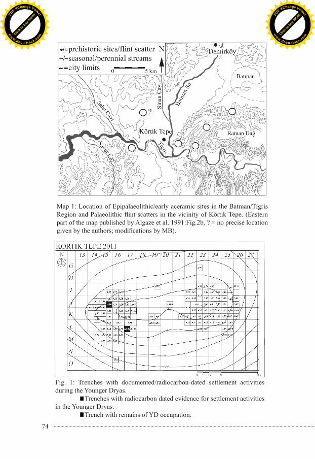
Evidence for Epipaleolithic1 settlements in southeastern Turkey is rare. Most findings come from surveys or small test excavations dated by typology. Well stratified sites – like e.g. Öküzini or Karain Cave in the southwestern Taurus Mountains – are missing (Algaze et al. 1991, 1994, Rosenberg & Togul 1991, Kartal 2003, Garrard et al. 2004, Atıcı 2011, Hauptmann 2011). In the vicinity of Körtik Tepe, especially on the ridges that overlook the Upper Tigris and the Batman Çayı, flint scatters of a Palaeolithic character were identified, but none of them has been recognized as Epipalaeolithic (Map 1). In the cave of Malaliki farther up the Batman Çayı, Epipalaeolithic material has been discovered, but no excavations have yet been undertaken (Algaze et al. 1991:184-186; Rosenberg, Togul 1991:243). The site of Hallan Çemi, located about 15 km farther northeast on the western border of the Sason Çayı, has been dated to the Younger Dryas, but new AMS data from that site are almost exclusively of the earliest Holocene (Rosenberg 1994; 2011).2 Thus the remains of a multi-layered Epipalaeolithic building and two Epipalaeolithic pits
Dr. Marion BENZ, Department of Near Eastern Archaeology, Albert-Ludwigs-University, 79085 Freiburg/GERMANY. e-mail: [email protected],Dr. Aytaç COŞKUN, Dicle Üniversitesi, Edebiyat Fakültesi, Arkeoloji Bölümü, 21280 Diyarbakır/TÜRKİYE.Corinna RÖSSNER, Department of Archaeobotany, Eberhard-Karls-University, 72070 Tübingen / GERMANY.Dr. Katleen DECKERS, Department of Archaeobotany, Eberhard-Karls-University, 72070 Tübingen / GERMANY.Dr. Simone RIEHL, Department of Archaeobotany, Eberhard-Karls-University, 72070 Tübingen/GERMANY.Prof. Dr. Kurt ALT, Institute of Anthropology, Johannes-Gutenberg-University, 55099 Maine/GERMANY.Prof. Dr. Vecihi ÖZKAYA, Dicle Üniversitesi, Edebiyat Fakültesi, Arkeoloji Bölümü, 21280 Diyarbakır/ TÜRKİYE.1 For the sake of convenience we here use the term “Epipalaeolithic,” though we are aware of the socio-cultural implications of that term and the lack of a clear definition of the nature of Epipalaeolithic cultures in that region. According Metin Kartal (pers. communication May, 2012), the typology of the obsidian and flintstone tools of the lower layers from Körtik Tepe differs from that of other so-called Epipalaeoltihic cultures in the Near East.2 Radiocarbon data from Hallan Çemi and Körtik Tepe are given in the open access data base PPND (Coşkun, et al. 2010).
Click t
o buy N
OW!PD
F-XChange Viewer
ww
w.docu-track.com Clic
k to b
uy NOW
!PD
F-XChange Viewer
ww
w.docu-track.c
om

66
excavated at Körtik Tepe in 2011 are of major importance.3 A sequence of four radiocarbon samples date this occupation to the second half of the 11th and the first half of the 10th millennia cal BC.4 These data corroborate earlier observations in the deep cut of Trench A80 (Özkaya et al. 2011), where remains of the earliest settlement phase (Phase VIII) were documented in 2010. Phase VIII has recently also been dated to the first half of the 10th millennium cal BC.
The Epipalaeolithic occupation in Trench A104Trench A104 is located in the southwestern part of the tell, 20 m southeast of the
deep cut in Trench A80 (Fig. 1). In the deep cut of Trench A104 we excavated a surface of about 1.50 x 4 m (Squares D and E 1-5) in natural layers from -4.50/-4.60 m down to the undisturbed soil. Botanical samples were taken from all layers, but only those from Locus 1 were exported because the others were still too wet for shipment. The latter will be analyzed after the next campaign.
The following description of the archaeological results will proceed from Locus 1 to Locus 5, concluding with the stratigraphy and radiocarbon data of Locus 5.
Locus 1Locus 1 is a large pit, of which the southwestern quadrant was excavated in Square
D4 (Drawing 1 a-c). If it is circular, its full diameter is about 180-200 cm. It probably was dug from level -4.45 m down to -5.51 m into the natural soil and therefore was originally about 1 m deep. In shape it resembles an inverted bell. A similar bell-shaped structure, also dug down into the natural soil, was observed at Demirköy5 (Algaze et al. 1991:181).
Two fireplaces were in the uppermost filling layer of Locus 1, one in the northeastern corner of D4 and another, Locus 3, in D5. They probably belong to a later use of this space after Locus 1 had been filled and the fill settled.
An animal jaw the size of those of sheep and goats was found lying under each fireplace. The jaw in D4 was lying on its lingual surface outside the stones on a patch of chamois-coloured sand/silt (cf. Loci 3 and 4).
There were many scattered flints and some obsidian artifacts, including an obsidian lunate [MSU] (Drawing 1a), found in Locus 1. The flints were mostly medium to large flakes; very few microliths were found. Besides the animal jaw, the ashy remains in Locus 1 contained some animal bones, mostly of smaller species, a shell, and many fish bones. The latter were very tiny and, because of the wet soil, so fragile that it was difficult to extract them. In a slightly deeper layer south of that fireplace one small anthracite-coloured and two mother-of-pearl ring beads were found (Drawing 1b, [MTD]). A single teardrop-shaped black stone pendant was also found nearby.
The remnants of another fireplace were just below these remains at about -4.72 m and sloping slightly downwards to the north.
Down to about -4.85 m was a quite sterile stratum containing only a few bones
3 We are grateful to Vecihi Özkaya and his team for their cooperation and support and to Nevin Soyukaya for her confidence and valuable help. Analysis of seed remains, isotopes and the chronological analysis were financed by the German Research Foundation (BE 4218/2-2; AL 287/9-2), to whom we offer our thanks. Katleen Decker‘s research was possible thanks to a Margarethe-von-Wrangell habilitation fellowship funded by the European Social Fund in Baden-Württemberg.4 The samples were analysed by Dr. Irka Hajdas of the ETH Laboratory of Ion Beam Physics, Zürich.5 In that publication the site is referred to as “Demirci Höyük”.
Click t
o buy N
OW!PD
F-XChange Viewer
ww
w.docu-track.com Clic
k to b
uy NOW
!PD
F-XChange Viewer
ww
w.docu-track.c
om

67
and flints. Beneath this, down to about -5.05 m, the frequency of flints, fish bones, animal bones, and obsidian again increased. Some lumps of compact clay were mixed with the cultural debris, but no structure could be distinguished. Mixed in with the filling were some scattered stones, most of which showed traces of heavy burning or which had been fractured by heat.
Between -4.90 m and -5.01 m in the southern profile of Square D4 a large obsidian nodule and several small obsidian flakes were discovered (Planum 3, Drawing 1c). At about -5.10/-5.15 m in the southwestern part of Locus 1 the clay wall starts to bend slightly inwards.
Between -5.07 m and -5.35 m, many, mostly large, river pebbles appeared in the western part of the structure. Between -5.26 m and -5.30 m three very large black river stones and some smaller pebbles formed a quarter circle within which animal and fish bones were found. The lowest part of Locus 1 (-5.35/ -5.51 m) was lined with large black river stones, beneath which two flint artifacts, an obsidian tool, and the remains of a large animal scapula were found. In the center the pit narrowed and bottomed out at -5.51 m.
The fact that Locus 1 did not have straight walls and narrowed towards its bottom makes it unlikely that it was a habitation. More likely it was used for storage, though its large diameter makes it a rather large structure for such a function.
Locus 2South of Locus 1 was excavated a fireplace with numerous flints and many remains
of fish. It had been sunk into the natural soil for at least 15 cm down to -4.67 m and -4.70 m. The natural soil began in the western part of Square E5 at -4.55 m. The stones within the fireplace were cracked and blackened. In a cultural layer between Loci 2 and 3 in Square D5 some flints with fish and animal bones were found.
Locus 3This fireplace located in the eastern part of Locus 1 was probably later than the pit
itself (Drawing 1a). It has at least two clearly distinguishable phases. Again numerous fish remains as well as flints, burnt pieces of clay, and charcoal were found, but few animal bones. Found beneath Locus 3, as in D4 beneath Locus 1, were two animal jaws, probably the right and left sides of the same jaw. In both cases the jaws lay beneath pebbles and were surrounded by some silt/decayed limestone. Near the jaws were found a small, white, oval-shaped pebble with the beginnings of a hole and a red stone which probably was the raw material for red ring-beads. Another animal jaw with sharp teeth and therefore probably from a canidae or felidae was discovered a little to the south.
Locus 4Locus 4 (Drawing 1 a-b) is a round structure with a diameter of about 80 cm. It had
been dug into the natural soil down to -4.76 m, but because of later (Neolithic) destruction it is not possible to determine its original height. To its west and southwest it is lined by some small postholes [PL 6-10], possibly to separate it from Locus 5. A large posthole [PL2] could be observed in the northern profile, but further stratigraphic information is necessary to clarify whether it belonged to Locus 1 or to Locus 4. Locus 4 was mostly devoid of findings. However, between Loci 4 and 5 another animal jaw with sharp teeth, again probably from a canidae or felidae, was discovered.
Click t
o buy N
OW!PD
F-XChange Viewer
ww
w.docu-track.com Clic
k to b
uy NOW
!PD
F-XChange Viewer
ww
w.docu-track.c
om

68
Locus 5Locus 5 extends from Squares D1-2 to E1-3 in a quarter of a circle. It has been
excavated for 2.40 m E-W and 1.40 m N-S, but it should continue N- S for at least another 1.40 m if it was oval, or 3 m if it was a round structure with a diameter of 4.40 m.
In the following section we will describe the stratigraphic sequence (Drawing 2) starting with the oldest structure in this area, Loc. 5_2.
Locus 5_2Locus 5_2 is a pit narrowing from about 1.40 m wide east-west on the top to 1.30 m
wide on the bottom (Drawings 1c, 2). Its north-south extent cannot as yet be determined. It had been dug about 60 cm down into the natural soil with its eastern side straight and its western side slightly inclined. On its eastern side there was a small podium which could have served as an emplacement for some kind of wooden support. Later (cf. Locus 5) a posthole [PL 4] was at that location.
By contrast, the western side of Locus 5_2 is slightly inclined with some accumulated sediment, which can be distinguished from the loamy natural soil by its more sandy character. A fire must have destroyed the organic superstructure, which fell into the pit from the east. Three flints and some fish and animal bones discovered among the burnt material proved this to be a cultural layer. Two charcoal samples (Figs. 2-3; CH 96= ETH-45335; CH97= ETH-45336) of this earliest occupation have been dated.
After the fire, the pit had been completely filled in by a sediment hardly distinguishable from the natural soil. After Locus 5_2 was filled, the structure was expanded to the west and clearly used as a habitation.
Loc. 5/Loc. 5_1Locus 5 (Drawing 1a-b) is a large round or oval structure which had been dug
down 40 cm into the natural soil. The time interval between the earliest and this more recent occupation was probably not very long because the filling of Locus 5_2 was very homogeneous (Drawing 2).
A square posthole [PL 3] measuring 20 cm on a side was documented on the northern border of Locus 5. About 50 cm to the west was a rectangular (20x25 cm) clay post with a slight depression on its top. Perhaps, these two features mark the entrance, though 50 cm would seem to be rather narrow for a doorway. To the east and west of these two features were curving depressions bending to the southeast and west, respectively, possibly the remains of a wooden wall which continued along the postholes [PL 6-10] in Square D3. On the eastern border of Locus 5 there was another large posthole [PL 4] right above the earlier-mentioned podium in Locus 5_2. To the east of this pit a thin living floor was documented containing a dark brown sediment, charcoal, and some small pieces of burnt clay. Next to it, in Squares E2/E1, a hearth, Locus 5_1, had been dug into the natural soil for about 15 cm (from -4.78 to -4.92 m). It was 30 cm wide and extended 20 cm from the southern profile: if it is roundish, its maximum length should not be larger than 40 cm. The bottom and walls of this pit were completely covered with flat river pebbles blackened from fire.6 The traces of fire extended to the east of the pit, where the clay was strongly burnt. Above this cultural layer is the first filling, which is sandy and rather sterile. It slopes from -4.54 m in E3 down to -4.80 m in E2, where it ends at a lump of clay. Above
6 A similar construction appeared in the lowest layer of Trench A102.
Click t
o buy N
OW!PD
F-XChange Viewer
ww
w.docu-track.com Clic
k to b
uy NOW
!PD
F-XChange Viewer
ww
w.docu-track.c
om

69
this quite sterile filling, separated from it by a rather thick layer of charcoal, is a cultural layer with heavy traces of burning. This upper cultural layer is full of fish and other burnt remains (probably of plants).
Except on its southeast, this cultural layer (Planum 2; Drawing 1b) was thickly strewn with flint flakes, cores, and some tools. Also found were a bone point [ORB], another unidentified piece of bone (probably from a rib), and a bird wing with its bones still in correct anatomical relationship. A large flint nodule [OPY] was lying in the southeastern corner of Square D1. To the southwest of it the jaw of a small ruminant was discovered. In the westernmost part of D1 the surface was covered with stones.
A charcoal sample (Tab.1; CH 92=ETH 45334) was taken from the upper part of that layer, just above Locus 5_1.
Above this burnt layer on the east is a layer of mostly sterile sandy filling, which on the west is mixed with some charcoal. This sandy layer yielded only a few finds (a vertebra of a large animal, an obsidian scraper [?] and a large stone bead [OGD]). This almost sterile layer slopes in the same direction as the lower cultural stratum. Above it, documented on the surface only in the western part of Planum 1 (Drawings 1a, 2), is another cultural layer, which contained clay and stone remains, stone tools [OFT, OFU] and flints, animal bones, and many fish and the remains of a turtle shell. A charcoal sample from this layer (Fig. 3; CH 85=ETH 45333) has been dated.
The fact that in D1 and E1 of this younger layer an accumulation of stones was also observed implies a prolonged tradition in how the space within this habitation was used.
In conclusion, it seems clear that Locus 5 was used for living purposes, either for an extended period or repeatedly. Though there must have been a strong fire that destroyed the first structure, it was restored and continued in use for at least two more phases. Flint napping activities and cooking/heating are attested within the structure. A probable entrance was identified in the northern part. The construction of Locus 5 confirms the changes in building traditions (from clay and wood in the lower layers to stone in the upper layers) which had been observed in Trench A80 (Özkaya et al. 2011). In that trench, too, was found a structure with postholes that was probably round to oval and had been cut into the natural soil.
For further interpretation of the findings we must await the analysis of the animal bones, fish, and other botanical remains that were recovered and the study of the large number of flints that were found.
Stratigraphic ObservationsLocus 3 is definitely the most recent feature. It is on top of the filling of Locus 1.
Locus 1 had probably been dug down from a layer above Locus 4 and thus should be more recent than Loci 4 and 5; but further stratigraphic documentation is necessary to confirm this. Because Locus 5 ends south of the northern profile, it is not yet possible to determine its stratigraphic relationship to Locus 4. Though Loci 2, 4, and 5 had all been dug into the natural soil, it is not yet certain that they were all exactly contemporary.
Locus 5_1, the stone-lined hearth, belongs to the first occupational phase of Locus 5. Locus 5_2 represents the earliest occupation of this trench.
Radiocarbon Data of Trenches A104 and A80Changes in building traditions in Trench A80 and radiocarbon data from the upper
layers suggest that occupation began at the site during the Younger Dryas (Benz et al.
Click t
o buy N
OW!PD
F-XChange Viewer
ww
w.docu-track.com Clic
k to b
uy NOW
!PD
F-XChange Viewer
ww
w.docu-track.c
om

70
2010). Radiocarbon dated rye seeds7 of Phase VI from Trench A84 (Özkaya, Coşkun 2011) and the new radiocarbon data of Phase VIII in Trenches A104 and A80 confirm this suggestion (Fig. 3). It seems occupation started in the southern area and later expanded northwards. However, the ranges of both data sequences overlap and therefore it is also possible that both areas were occupied at the same time. To determine the site’s extension to the east, we must await further excavations in that area of the tell.
If the results of radiocarbon data in Trench A104 were sequenced, they would range between 10190 cal BC to 9800 cal BC (68.2%) (Fig. 2). Without sequencing, the date for the earliest occupation of the site would be extended back to 10400 cal BC.
Ecology and SubsistenceThe results of studies on the ecology and subsistence must be considered
preliminary because not all botanical samples of the deep cut could be exported in 2011 and the analysis is still on-going. All studied samples come from the pit (Loc.1) and from fireplaces just above and close by it (Loc. 2 and 3). Because of the stratigraphic relation of Locus 1 to Locus 5, which was dated to the Younger Dryas, it is very probable that Loci 1-3 date to the second half of the Younger Dryas.
Preliminary Results of Archaeobotanical Analyses855 plant remains of 13 different plant families were identified. Two families are
particularly prominent: cruciferous plants (Brassicaceae), including greens such as wild cabbage, turnips, and others, which constitute more than a third of all the seeds (Fig. 4); and grasses (Poaceae), which represent nearly 30% of the seeds and are the progenitors of our modern cultivated cereals.
The goosefoot (Chenopodiacae) and knotweed (Polygonaceae) families are also relatively frequent. Goosefoot is ubiquitous (100%) and has a very high percentage within the Chenopodiaceae family. Poppy seeds were also relatively frequent.
In modern classifications many of the identified plants are considered typical ruderals or weeds. However many of them are edible. For example buckwheat (Fagopyrum sp.) is cultivated for its seeds in many countries even today; and the green parts of dock or chenopods might have been used as salads or their grains as flour for mash. Poppy seeds are oily and calorie-rich.
A few grains of rye, einkorn, and barley were identified (Fig. 5); but compared to the seed finds in the early Holocene levels (Riehl et al. 2012), wheat is much less frequent. None of these cereals, because of the size of the grains and in particular the lack of accompanying remains of chaff, can be certainly regarded as domesticated. Thus is it still open to question whether or not these grains were cultivated and how they were processed for food.
In general, the seed assemblage indicates that during the Younger Dryas the vegetation was predominantly that of steppes and riverine woodlands. Grasses, kale, sorrel, and poppy need a great deal of light. Goosefoot favors open areas, too. These observations corroborate the results of the charcoal analysis (Fig. 6). Deciduous Oak (Quercus) is absent from the sample of the deep cut, but present in the layers of the early
7 Rye seeds were identified and sampled by Simone Riehl, University of Tuebingen. The samples were dated at the Radiocarbon Laboratory of Kiel: KIA 44864: 10252± 60 BP; 10170-9877 (68.2%); 10405-9804 (95.4%) cal BC.
Click t
o buy N
OW!PD
F-XChange Viewer
ww
w.docu-track.com Clic
k to b
uy NOW
!PD
F-XChange Viewer
ww
w.docu-track.c
om

71
Holocene. Similarly, Pistacia sp. (pistachio), Celtis sp. (hackberry), Rhamnus (buckthorn), Ficus sp. (fig), and Alnus sp. (alder) only appear within the Holocene levels and charcoals of Amygdalus (almond), Fraxinus sp. (ash) and acer sp. (maple) clearly increase. In contrast, riverine trees or shrubs such as tamarisk and poplar/willow were present in both the Younger Dryas and the early Holocene. The impact of the Younger Dryas thus seems likely8: while the Poaceae and arboreal species were relatively rare during the Younger Dryas, Körtik Tepe may have belonged to the open woodland zone during the early Holocene, with a higher density of Poaceae species (Hillman 1996). The current state of our archaeobotanical research, however, does not allow any conclusion about whether or not some of the wild plants were already being cultivated.
DiscussionOur results provide strong evidence for a local origin of early Holocene cultures,
as was suggested a long time ago during the first excavations at Hallan Çemi (Rosenberg 1994, 2011, Hauptmann 2011, cf. Cauvin 1997). Renovations and continuity in the activity zones at Körtik Tepe suggest a repeated, perhaps permanent, use of the same locations. The steppe and riverine environments of the Younger Dryas had a wide spectrum of use by the hunter-fisher-gatherer community. Consumption of fishes is documented by the abundant fish remains. First results of isotope analyses from human remains of the Early Holocene layers hint at a mixed diet with meat and predominantly C-3 plants (Siebert in prep.). These results correspond well with the broad spectrum of animals used at Körtik Tepe (Özkaya et al. 2011) and with the results from other permanent sites of hunter-gatherer communities (e.g. Rosenberg et al. 1995; Savard et al. 2006; Baird 2012:196). However, further zoological and isotope analyses must be awaited in order to reconstruct the complete nutritional spectrum.
ConclusionsWe thus can conclude that the occupation of Körtik Tepe definitely started during
the Younger Dryas in the second half of the 11th millennium BC cal and that it continued into the early Holocene. Despite the pronounced changes in ecology with the advent of the Holocene, which can be observed in the archaeobotanical remains, the inhabitants of Körtik Tepe stayed at that location and adapted to their new environment.
The “Epipalaeolithic” assemblages of Körtik Tepe thus not only give a basis for reviewing the so-called Palaeolithic flint scatterings in the Batman Region (Algaze et al. 1991:185, Fig. 2b), but it is also evident that the process of the neolithisiation of that region should be reconsidered, too.
REFERENCESALGAZE, G., BREUNINGER, R., LIGHTFOOT, C.H., ROSENBERG, M. 1991. The
Tigris-Euphrates Archaeological Reconnaissance Project: A preliminary report of the 1989-1990 seasons. anatolica 17: 173-211.
ALGAZE, G., BREUNINGER, R. KNUDSTAD, J. 1994. “The Tigirs-Euphrates Archaeological Reconnaissance Project: Final report of the Birecik and Carchemish Dam survey areas”. anatolica 20: 1-96.
8 A similar impact of the Younger Dryas and a delay in reforestation was observed in the Van Sea Pollen Score (Litt et al. 2009).
Click t
o buy N
OW!PD
F-XChange Viewer
ww
w.docu-track.com Clic
k to b
uy NOW
!PD
F-XChange Viewer
ww
w.docu-track.c
om

72
ATICI, L.A. 2011. Epipaleolithic Archaeology in Turkey. In: TAŞKIRAN, H., KARTAL, M., OZÇELİK, K., KÖSEM, M.B., KARTAL, G. (eds.) Studies in Honor of Işın Yalçınkaya. 27-41, Bilgin Kültür Sanat Yayınları, Ankara.
CAUVIN, J. 1997. Naissance des divinités – Naissance de l’agriculture. La révolution des symboles au Néolithique. CNRS editions, Paris.
BAIRD, D. 2012. Pinarbaşı. In: ÖZDOĞAN, M., BAŞGELEN, N., KUNIHOLM, P. (eds.) The Neolithic of Turkey, Vol.3. 181-218, Archeology and Art Publications, Istanbul.
BENZ, M., COŞKUN, A., WENINGER, B., ALT, K.W., ÖZKAYA, V. 2010. “Stratigraphy and Radiocarbon Dates of the PPNA Site of Körtik Tepe, Diyarbakır”. Arkeometri Sonuçları Toplantısı 26: 81-100.
COŞKUN, A., BENZ, M., ÖZKAYA, V. 2010. Körtik Tepe, PPND-Platform for the Publication of Neolithic Radiocarbon Dates. https://www.exoriente.org/associated_projects/ppnd_site.php?s=81, accessed 20.6.2012.
HAUPTMANN, H. The Urfa Region. In: ÖZDOĞAN, M., BAŞGELEN,N.,KUNIHOLM, P. (eds.) The Neolithic of Turkey, Vol.1. 85-138, Archeology and Art
Publications, Istanbul.HILLMAN, G.C. 1996. Pleistocene changes in wild plant-foods available to hunter-
gatherers of the northern fertile Crescent: possible preludes to cereal cultivation. In: HARRIS, D.R. (ed.) The origins and spread of agriculture and pastoralism in Eurasia. 159-203, UCL Press, London.
GARRARD, A., CONOLLY, J., McNABB, J., MOLONEY, N. 2004. Palaeolithic-Neolithic survey in the Sakçagözü region of the north Levantine rift valley. In: AURENCHE, O., LE MIÈRE, M., SANLAVILLE, P. (eds.) From the river to the sea. Studies in honour of Lorraine Copeland. BAR International Series 1263. 145-164, Archaeopress, Oxford.
KARTAL, M. 2003. “Anatolian Epi-Paleolithic Period Assemblages: Problems, Suggestions, Evaluations and Various Approaches”. anadolu (anatolia) 24: 35-61.
LITT, T., KRASTEL, S., STURM, M., KIPFER, R., ÖRÇEN, S., HEUMANN, G. et al. 2009. Lake Van Drilling Project ‘PALEOVAN’, International Continental Scientific Drilling Program (ICDP): Results of a recent pre-site survey and perspectives. Quaternary Science Reviews 28, 15: 1555-1567.
ÖZKAYA, V., COŞKUN, A. 2011. Körtik Tepe. In: ÖZDOĞAN, M., BAŞGELEN, N., KUNİHOLM, P. (eds.) The Neolithic of Turkey, Vol.1. 89-127, Archeology and Art Publications, Istanbul.
ÖZKAYA, V., COŞKUN, A., BENZ, M., ERDAL, Y.S., ATICI, L., ŞAHİN, F.S. 2011. “Körtik Tepe 2010 Yılı Kazısı”. Kazı Sonuçuları Toplantısı 33,1: 315-338.
RIEHL, S., DECKERS, K., ZEIDI, M., CONARD, N., BENZ, M., FAZELİ, H., DARABİ, H. 2012. “The modalities of plant use in three PPN sites of the northern and eastern Fertile Crescent – A preliminary report”. Vegetation History and archaeobotany 21, 2: 95-106.
ROSENBERG, M. 1994. “Hallan Çemi Tepesi: Some further observations concerning stratigraphy and material culture”. anatolica 20: 121-140.
Click t
o buy N
OW!PD
F-XChange Viewer
ww
w.docu-track.com Clic
k to b
uy NOW
!PD
F-XChange Viewer
ww
w.docu-track.c
om

73
ROSENBERG M. 2011. Hallan Çemi. In: ÖZDOĞAN, M., BAŞGELEN, N., KUNIHOLM, P. (eds.) The Neolithic of Turkey, Vol. 1. 61-78, Archeology and Art Publications, Istanbul.
ROSENBERG, M., TOGUL, H.1991. “The Batman River Archaeological Site Survey, 1990”. anatolica 17: 241-251.
ROSENBERG, M., NESBITT, R.M., REDDING, R.W., STRASSER, T.F. 1995. “Hallan Çemi Tepesi: Some Preliminary Observations Concerning Early Neolithic Subsistence Behaviors in Eastern Anatolia”. anatolica 21: 1-12.
SAVARD, M., NESBITT, M., JONES, M. 2006. “The role of wild grasses in subsistence and sedentism: new evidence from the northern Fertile Crescent”. World Archaeology 38, 2: 179-196.
SIEBERT, A. et al. in prep. Living on the edge in Körtik Tepe - insights on mobility and dietary habits of a PPNA-population on its way to sedentism. (working title).
Click t
o buy N
OW!PD
F-XChange Viewer
ww
w.docu-track.com Clic
k to b
uy NOW
!PD
F-XChange Viewer
ww
w.docu-track.c
om
74
Map 1: Location of Epipalaeolithic/early aceramic sites in the Batman/Tigris Region and Palaeolithic flint scatters in the vicinity of Körtik Tepe. (Eastern part of the map published by Algaze et al. 1991:Fig.2b, ? = no precise location given by the authors; modifications by MB).
Fig. 1: Trenches with documented/radiocarbon-dated settlement activities during the Younger Dryas. Trenches with radiocarbon dated evidence for settlement activities in the Younger Dryas. Trench with remains of YD occupation.
Click t
o buy N
OW!PD
F-XChange Viewer
ww
w.docu-track.com Clic
k to b
uy NOW
!PD
F-XChange Viewer
ww
w.docu-track.c
om

75
Fig. 2: Sequence of radiocarbon data of the earliest occupation in Trench A104. Note that ETH 45335 and 45336 were combined because they come from the same cultural layer. Graphs in dark gray indicate the modeled range.
Fig. 3: Radiocarbon data of the deep cuts in Trenches A80 and A104. ETH 45336 and ETH 45335 (Trench A104) date the same cultural layer. The same holds true for ETH 45340 and ETH 45344. *1) Sequencing in Trench A80 does not enhance the accuracy of the data for Phase VIII because Phase VII could not be dated. The data of Phase VIII would thus be biased to a more recent age.
Fig. 4: Distribution of plant remains per plant family in %; crucifer and grasses are the most prominent (graph by CR).
Click t
o buy N
OW!PD
F-XChange Viewer
ww
w.docu-track.com Clic
k to b
uy NOW
!PD
F-XChange Viewer
ww
w.docu-track.c
om

76
Fig. 6: Fragment percentages of taxa from Younger Dryas (Epipal.) and early Holocene samples (PPNA) (graph by KD).
Fig. 5: Distribution of potentially cultivated plants with family, taxa, and number of identified remains.
Click t
o buy N
OW!PD
F-XChange Viewer
ww
w.docu-track.com Clic
k to b
uy NOW
!PD
F-XChange Viewer
ww
w.docu-track.c
om

77
Drawing 1. a-c: Plana 1-3 of Squares E-D 1-5 of Trench A104 (all drawings by M.B.).
Click t
o buy N
OW!PD
F-XChange Viewer
ww
w.docu-track.com Clic
k to b
uy NOW
!PD
F-XChange Viewer
ww
w.docu-track.c
om

78
Drawing 2: Southern profile of Squares E1-3, Trench A104.
Click t
o buy N
OW!PD
F-XChange Viewer
ww
w.docu-track.com Clic
k to b
uy NOW
!PD
F-XChange Viewer
ww
w.docu-track.c
om