Finding of No Significant Impact, Draft Environmental ...
105
Finding of No Significant Impact, Draft Environmental Assessment, Record of Non-Applicability (RONA) and 404(b)(1) Guidelines Section 14 Emergency Shoreline Protection Enders Island Stonington, Connecticut February 2017 U. S. Army Corps of Engineers New England District Environmental Resources Section 696 Virginia Road Concord, MA 01742
-
Upload
khangminh22 -
Category
Documents
-
view
1 -
download
0
Transcript of Finding of No Significant Impact, Draft Environmental ...

Finding of No Significant Impact, Draft Environmental Assessment,
Record of Non-Applicability (RONA) and 404(b)(1) Guidelines
Section 14 Emergency Shoreline Protection
Enders Island Stonington, Connecticut
February 2017
U. S. Army Corps of Engineers New England District
Environmental Resources Section 696 Virginia Road
Concord, MA 01742
i
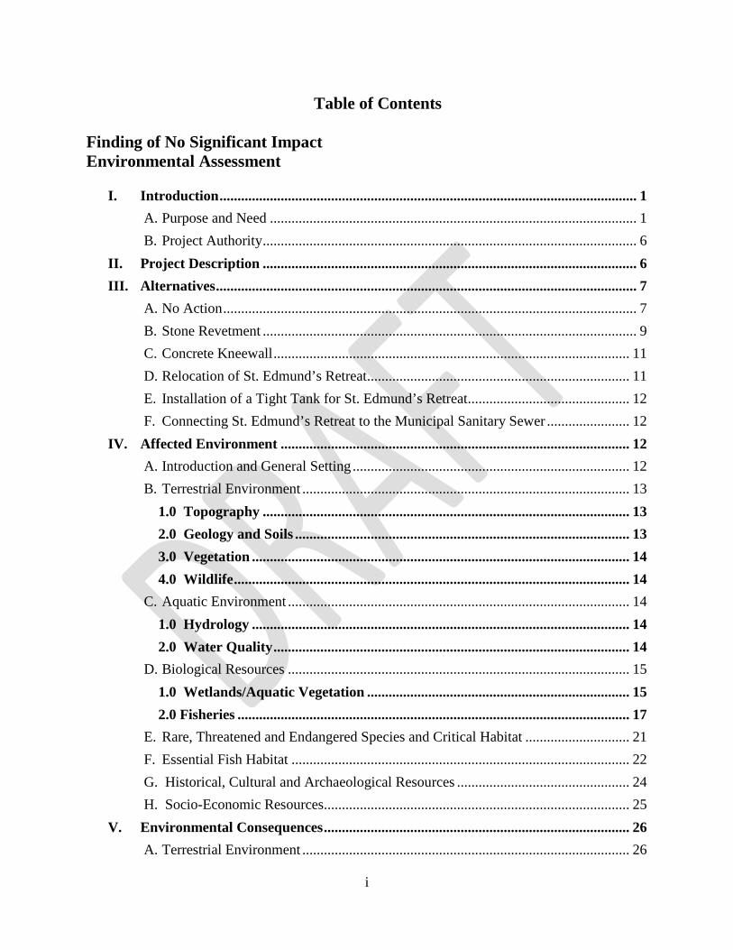
Table of Contents Finding of No Significant Impact Environmental Assessment
I. Introduction .................................................................................................................... 1
A. Purpose and Need ...................................................................................................... 1
B. Project Authority ........................................................................................................ 6
II. Project Description ........................................................................................................ 6
III. Alternatives ..................................................................................................................... 7
A. No Action ................................................................................................................... 7
B. Stone Revetment ........................................................................................................ 9
C. Concrete Kneewall ................................................................................................... 11
D. Relocation of St. Edmund’s Retreat......................................................................... 11
E. Installation of a Tight Tank for St. Edmund’s Retreat............................................. 12
F. Connecting St. Edmund’s Retreat to the Municipal Sanitary Sewer ....................... 12
IV. Affected Environment ................................................................................................. 12
A. Introduction and General Setting ............................................................................. 12
B. Terrestrial Environment ........................................................................................... 13
1.0 Topography ...................................................................................................... 13
2.0 Geology and Soils ............................................................................................. 13
3.0 Vegetation ......................................................................................................... 14
4.0 Wildlife .............................................................................................................. 14
C. Aquatic Environment ............................................................................................... 14
1.0 Hydrology ......................................................................................................... 14
2.0 Water Quality ................................................................................................... 14
D. Biological Resources ............................................................................................... 15
1.0 Wetlands/Aquatic Vegetation ......................................................................... 15
2.0 Fisheries ............................................................................................................. 17
E. Rare, Threatened and Endangered Species and Critical Habitat ............................. 21
F. Essential Fish Habitat .............................................................................................. 22
G. Historical, Cultural and Archaeological Resources ................................................ 24
H. Socio-Economic Resources..................................................................................... 25
V. Environmental Consequences ..................................................................................... 26
A. Terrestrial Environment ........................................................................................... 26
ii
1.0 Topography ...................................................................................................... 26
2.0 Geology and Soils ............................................................................................. 26
3.0 Vegetation ......................................................................................................... 26
4.0 Wildlife .............................................................................................................. 26
B. Aquatic Environment ............................................................................................... 27
1.0 Hydrology ......................................................................................................... 27
2.0 Water Quality ................................................................................................... 27
C. Biological Resources ............................................................................................... 27
1.0 Wetlands/Aquatic Vegetation ......................................................................... 27
2.0 Fisheries ............................................................................................................ 28
3.0 Shellfish ............................................................................................................. 30
D. Rare, Threatened and Endangered Species and Critical Habitat ............................. 30
E. Essential Fish Habitat .............................................................................................. 30
F. Historical, Cultural and Archaeological Resources ................................................. 31
G. Socio-Economic Resources ..................................................................................... 32
VI. Other Environmental Compliance Requirements .................................................... 33
A. Environmental Justice .............................................................................................. 33
B. Protection of Children .............................................................................................. 34
C. Air Quality Federal Conformity Requirements ....................................................... 34
1.0 Introduction ...................................................................................................... 34
2.0 Construction and Operation ........................................................................... 36
3.0 General Conformity ......................................................................................... 36
4.0 Greenhouse Gases (GHG) ............................................................................... 38
VII. Summary of Anticipated Impacts and Actions to Minimize .................................... 38
A. Summary of Direct and Indirect Impacts ................................................................. 38
B. Cumulative Impacts ................................................................................................. 39
C. Actions Taken to Minimize Impacts ........................................................................ 40
1.0 Timing of Construction ................................................................................... 40
2.0 Essential Fish Habitat Conservation Recommendations ............................. 40
VIII. Coordination ................................................................................................................. 41
A. Correspondence........................................................................................................ 41
B. Public Notice ............................................................................................................ 41
C. Comments Received ................................................................................................ 41
IX. Literature Cited ........................................................................................................... 41
iii
X. Compliance with Environmental Statutes and Executive Orders ........................... 44
A. Federal Statutes ....................................................................................................... 44
B. Executive Orders ...................................................................................................... 46
C. Executive Memoranda ............................................................................................. 47
SECTION 404 (b)(1) EVALUATION ................................................................................. 48
CLEAN AIR ACT - RECORD OF NON-APPLICABILITY (RONA) ........................... 53
List of Tables
Table 1. Water Elevations at Watch Hill Point, Rhode Island...................................................... 14 Table 2. Finfish Encountered in Seine Surveys 1988-2010 in Long Island Sound. ..................... 18 Table 3. Finfish Encountered in 2010 Trawl Survey in Long Island Sound. ............................... 19
List of Figures
Figure 1. Site Locus ........................................................................................................................ 2 Figure 2. Problem Summary ........................................................................................................... 3 Figure 3. Existing and Proposed Sewer System ............................................................................. 4 Figure 4. Predicted Hurricane Storm Surge at Enders Island ......................................................... 5 Figure 5. Additional Photographs ................................................................................................... 8 Figure 6. June 2013 USACE Eelgrass Survey and CT DEEP 2009 Eelgrass Beds ..................... 16 Figure 8. CT DEEP Shellfish Areas ............................................................................................. 20 Figure 9. Enders Island Natural Diversity and Critical Habitat Areas ......................................... 23 Figure 10. Potential Impacts to Eelgrass....................................................................................... 29
Appendices
Appendix A – Revetment Design Appendix B – Correspondence Appendix C – Clean Air Act General Conformity Review Air Emissions Calculations Appendix D – Essential Fish Habitat Assessment Appendix E – June 2013 Eelgrass Survey
Finding of No Significant Impact
The proposed Enders Island Emergency Shoreline Protection Project is intended to provide wave force protection and erosion prevention of Enders Island in Stonington, Connecticut. The existing seawall surrounding much of the Island is severely damaged and unable to withstand storm forces. Even with repairs, the existing wall could not adequately protect the island and structures supporting St. Edmund’s Retreat. The screening of several alternatives resulted in the selection of an action plan to protect the seawall consisting of a stone revetment approximately 30± feet wide (including toe), 8± feet tall and extending approximately 700± linear feet along the east and southern portion of the seawall. The construction of a rock revetment adjacent to the existing seawall will displace approximately 23,000 square feet of intertidal cobble and boulder habitat and potentially 260 square feet of sparse eelgrass growing between boulders in sheltered areas.
Work is authorized under the continuing authority Section 14 of the 1946 Flood Control Act (as amended). The proposed project will protect the existing seawall, prevent backland erosion and protect the integrity of the on-site sanitary waste water system. My determination of a Finding of No Significant Impact is based on the evaluation of the potential effects described in the Environmental Assessment (EA). I have determined that the Emergency Shoreline Protection Project at Enders Island in Stonington, Connecticut is not a major Federal action significantly affecting the quality of the human environment based on the information contained in the EA. Under the Council on Environmental Quality (“CEQ”) National Environmental Policy Act (NEPA) regulations, “NEPA significance” is a concept dependent upon context and intensity (40 C.F.R. § 1508.27). When considering a site-specific action like the proposed shoreline protection project, significance is measured by the impacts felt at a local scale, as opposed to a regional or nationwide context. Thus, the intensity of the impacts is measured here in the local context of the Stonington, Connecticut area. The CEQ regulations identify a number of factors to measure the intensity of impact. These factors are discussed below, and none are implicated here to warrant a finding of NEPA significance. A review of these NEPA “intensity” factors reveals that the proposed action would not result in a significant impact—neither beneficial nor detrimental--to the human environment.
Impacts on public health or safety: The project is expected to have no effect on public health and safety. Although there will be increased truck traffic through Mason Island, it will be on existing roadways primarily during daylight hours, will occur for approximately 4-6 months and will cease upon project completion. The construction work areas will be fenced off to prevent public access.
Unique characteristics: The project is located along a typical New England high-energy coastal shoreline. The unique characteristics of the upland portion of island and St Edmunds Retreat will be protected by the project. There are no known cultural or historic resources, designated parklands, wild and scenic rivers, or prime farmlands impacted.
Controversy: The concept of "controversy" in NEPA significance analysis is not simply whether there is opposition to the proposal, but whether there is a substantial technical or

scientific dispute over the degree of the effects on the human environment. Although impacts to the existing intertidal habitat are expected, these will be offset by preventing the erosive forces and collapse of the seawall. Erosion and wall collapse would also impact intertidal habitat. The Corps coordinated with Federal and state agencies. Their comments were incorporated into the design where practicable. The proposed project is not controversial.
Uncertain impacts: The impacts of the proposed project are not uncertain, they are readily understood based on past experiences the Corps has had with the use of stone revetments.
Precedent for future actions: The proposed project is authorized under an existing federal law. The EA was prepared pursuant to the requirements contained in ER-200-2 Procedures for Implementing NEPA. This decision was based upon the merits and facts of this specific project and will not create a precedent for future actions.
Cumulative significance: As discussed in the EA, to the extent that other actions are expected to be related to the project as proposed, these actions will provide little measurable cumulative impact.
Historic resources: The Connecticut State Historic Preservation Officer has concurred that the project poses no impacts to historic or archaeological resources.
Endangered species: The project will have no known positive or negative impacts on any state or federal threatened or endangered species. Coordination with National Marine Fisheries Service (NMFS) concurred that the project will pose no direct or indirect effects to species under their jurisdiction. They provided recommendations to “minimize the level of impact to eelgrass beds and intertidal cobble.” The impacts to essential fish habitat (EFH) in the project area were minimized to the maximum extent practicable through the planning and design process. Multiple alternatives and design iterations were considered to minimize the project footprint. In a response letter to the NMFS dated 4 June 2014, the New England District agreed to conduct an additional eelgrass survey in the growing season of May l5th through August 30th, prior to construction. The purpose of this survey is to delineate the extent of eelgrass within the proposed project footprint, if any. The results of the survey will be provided to the NMFS for review and further recommendations, if needed.
Potential violation of state or federal law: This action will not violate federal law. The local sponsor will be responsible for obtaining necessary state and local permits.
Based on my review and evaluation of the environmental effects as presented in the EA, I have determined that implementation of the proposed Enders Island Emergency Shoreline Protection Project will have no significant direct, indirect, or cumulative impacts on the quality of the human or natural environment. Because no significant environmental impacts will result, this project is exempt from requirements to prepare an Environmental Impact Statement.

__________________ _______________________ DATE Christopher J. Barron Colonel, Corps of Engineers District Engineer

1
I. Introduction
A. Purpose and Need This report provides an assessment of the environmental effects of an emergency
shoreline protection project designed to stabilize approximately 700± feet (ft) of seawall along the perimeter of Enders Island in Stonington, Connecticut (Figure 1 – Site Locus). Enders Island is located off of Mason Island in Fishers Island Sound. Enders Island is connected to Mason Island by a causeway. The project is located along the east and southeast shore of Enders Island. The purpose of the project is to stabilize the existing seawall and prevent further erosion of the island behind the seawall. Waves have damaged the existing seawall during storm events and overtopped the wall causing erosion on the landward side. The erosion threatens the stability of the wall and function of the septic system serving St. Edmund’s Retreat.
The Catholic Church’s Archdiocese of Connecticut owns and operates the Enders Island
facility and associated property. It is used by many church and non-church related groups as a retreat center. In addition to the retreat center, many community groups host events at Enders Island such as, luncheons, receptions, anniversaries, reunions, lectures, recovery and leadership programs, workshops, annual and planning meetings, training, conferences, etc. The facility also provides a place to perform community service, including high school and Eagle Scout community service and projects. It is open to the public on an equal basis regardless of religion. Over 17,000 visitors come to the island from as far away as Florida, Louisiana and Illinois. The property is accessible via a causeway and provides free public parking on the island. The grounds are open to the public free of charge and are used by walkers, bicyclists, swimmers, picnickers and anglers. A masonry seawall protects the property and facilities from storms, but the wall is currently in poor condition especially on the southeast side (Figure 2 – Problem Summary).
Without permanent protection of the seawall, the landward property will continue to
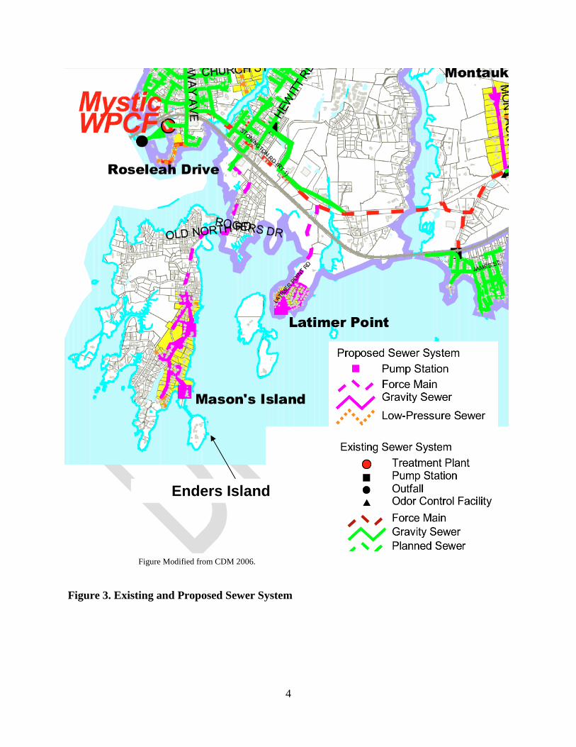
erode, the septic system will cease to function properly and the wall will collapse. When the septic system fails, the facility would be forced to connect to the municipal sanitary sewer system. The closest connection to an existing sewer line is over two miles from the island (Figure 3 - Existing and Proposed Sewer System) and would require above ground piping along the causeway and below ground through the residential area on Mason Island. The sewer system expansion to Mason Island is discussed in the Town of Stonington Water Pollution Control Authority Wastewater Facilities Plan (CDM 2006). However this expansion is listed as a moderate priority and is not recommended for action within the next 20 years.
Once the wall collapses, the entire island will be exposed to eroding wave energy and
will cease to function as a retreat and public passive recreation area. Figure 4 shows the predicted storm surge inundation area based on hurricane classification. Much of the island would be inundated with Category 1 & 2 storms and 80% of the island inundated with a Category 3 storm. There were 19 named storms, ten hurricanes, and one major hurricane in the North Atlantic during 2012 (NOAA 2013).
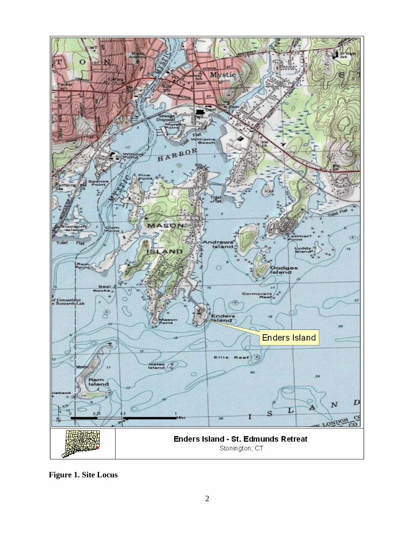
2
Figure 1. Site Locus
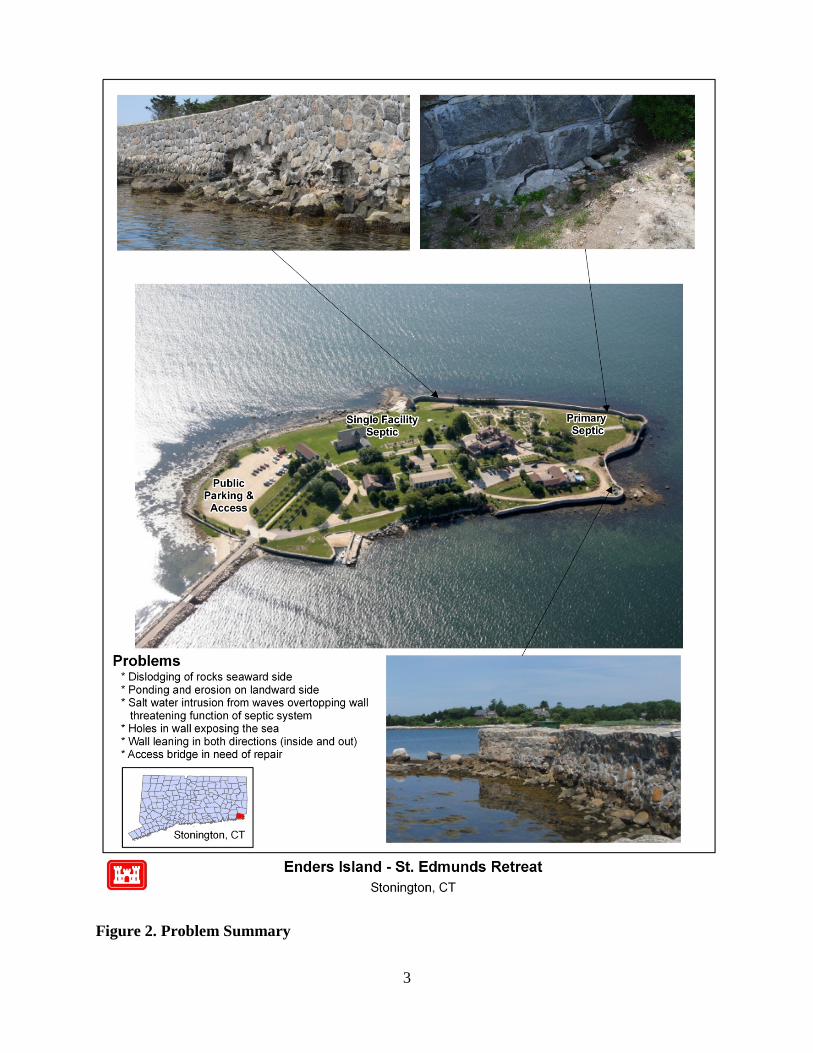
3
Figure 2. Problem Summary
4
Figure 3. Existing and Proposed Sewer System
Figure Modified from CDM 2006.
Enders Island

5
Figure 4. Predicted Hurricane Storm Surge at Enders Island

6
The proposed project is designed to protect 700± linear feet of the existing 1270± linear foot seawall against 10-20 year storms. Repair of the existing wall is required prior to or during the construction of the protection feature in order for the project to be considered complete and effective. The wall protection will preserve the integrity and function of the wall and septic field from the majority of storm events.
B. Project Authority This study was authorized under the continuing authority contained in Section 103
Hurricane and Storm Damage Reduction of the 1946 Flood Control Act (as amended). The New England District is seeking approval under Section 14 Emergency Streambank and Shoreline Protection for implementation. This project is relatively small, localized and in need of immediate protection. The Section 14 authority allows the U.S. Army Corps of Engineers (USACE) to participate in the planning and construction of shoreline erosion protection projects in situations where public facilities (and facilities owned by non-profit organizations that are used to provide public services that are open to all on equal terms) are in imminent threat of damage or failure by natural erosion processes on shorelines, and are essential enough to merit Federal participation in their protection. These projects are implemented in partnership with a local non-Federal sponsor, and when completed, are turned over to the non-Federal sponsor. In recognition of the urgency of addressing such emergency erosion protection projects, there is a streamlined formulation and justification process. The USACE objective is to determine the appropriate level of detailed analysis required to produce a quality project in a reasonable time and at a reasonable cost. Alternative plans are developed to a level of detail necessary to select a justified, acceptable and implementable plan that is consistent with Federal law and policy and meets the goals of the project.
The following Environmental Assessment (EA) evaluates the impacts of constructing emergency shoreline protection along the Enders Island seawall in Stonington, Connecticut in accordance with the National Environmental Policy Act of 1969 (NEPA).
II. Project Description The plan selected for the shore protection for Enders Island is a stone revetment
approximately 30± feet wide (including toe), 8± feet tall and extending approximately 700± linear feet along the east and southern portion of the seawall. The revetment along the toe of the existing wall will consist of two benches, an upper 10± foot wide bench with a top elevation of 8.0± feet above mean low water (MLW) and lower 6± foot wide bench at elevation
2.3± feet MLW. This tiered revetment will require approximately 260 cubic yards (cy) of
crushed stone and 4,400 cy of 2,000-3,000 pound (lb) armor stone. Armor stone will be graded riprap and will not be a smooth uniform stone. The revetment will follow the course of the existing wall beginning on the northern end at the Chapel and terminating around the southeasterly bend.
The lower bench of the revetment is designed with a dual purpose:1) to provide support
for the taller portion of the 8 foot revetment adjacent to the existing wall; much of the site is ledge and the revetment toe cannot be buried below existing grade, and 2) to function as a work
7
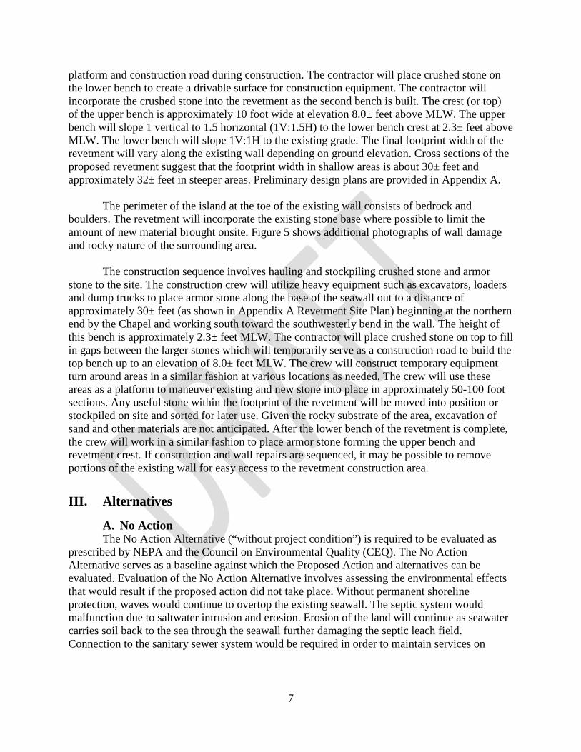
platform and construction road during construction. The contractor will place crushed stone on the lower bench to create a drivable surface for construction equipment. The contractor will incorporate the crushed stone into the revetment as the second bench is built. The crest (or top) of the upper bench is approximately 10 foot wide at elevation 8.0± feet above MLW. The upper bench will slope 1 vertical to 1.5 horizontal (1V:1.5H) to the lower bench crest at 2.3± feet above MLW. The lower bench will slope 1V:1H to the existing grade. The final footprint width of the revetment will vary along the existing wall depending on ground elevation. Cross sections of the proposed revetment suggest that the footprint width in shallow areas is about 30± feet and approximately 32± feet in steeper areas. Preliminary design plans are provided in Appendix A.
The perimeter of the island at the toe of the existing wall consists of bedrock and
boulders. The revetment will incorporate the existing stone base where possible to limit the amount of new material brought onsite. Figure 5 shows additional photographs of wall damage and rocky nature of the surrounding area.
The construction sequence involves hauling and stockpiling crushed stone and armor
stone to the site. The construction crew will utilize heavy equipment such as excavators, loaders and dump trucks to place armor stone along the base of the seawall out to a distance of approximately 30± feet (as shown in Appendix A Revetment Site Plan) beginning at the northern end by the Chapel and working south toward the southwesterly bend in the wall. The height of this bench is approximately 2.3± feet MLW. The contractor will place crushed stone on top to fill in gaps between the larger stones which will temporarily serve as a construction road to build the top bench up to an elevation of 8.0± feet MLW. The crew will construct temporary equipment turn around areas in a similar fashion at various locations as needed. The crew will use these areas as a platform to maneuver existing and new stone into place in approximately 50-100 foot sections. Any useful stone within the footprint of the revetment will be moved into position or stockpiled on site and sorted for later use. Given the rocky substrate of the area, excavation of sand and other materials are not anticipated. After the lower bench of the revetment is complete, the crew will work in a similar fashion to place armor stone forming the upper bench and revetment crest. If construction and wall repairs are sequenced, it may be possible to remove portions of the existing wall for easy access to the revetment construction area.
III. Alternatives
A. No Action The No Action Alternative (“without project condition”) is required to be evaluated as
prescribed by NEPA and the Council on Environmental Quality (CEQ). The No Action Alternative serves as a baseline against which the Proposed Action and alternatives can be evaluated. Evaluation of the No Action Alternative involves assessing the environmental effects that would result if the proposed action did not take place. Without permanent shoreline protection, waves would continue to overtop the existing seawall. The septic system would malfunction due to saltwater intrusion and erosion. Erosion of the land will continue as seawater carries soil back to the sea through the seawall further damaging the septic leach field. Connection to the sanitary sewer system would be required in order to maintain services on

8
Figure 5. Additional Photographs

9
Enders Island. The Town of Stonington does not have any plans to provide sewer service to Mason Island in the next 20 years, and is unlikely in 50 years. The current estimate to sewer Mason Island is over $4.2 million.
The seawall itself will continue to sustain damage. Existing holes and cracks will expand
until the seawall collapses. Upon collapse the rate of erosion on the island will greatly increase. The storm inundation estimates show that even Category 1 storms are a great threat to the island. Erosion will carry fine sands from the island which may impact nearby shell fishing and eelgrass habitats. The services and passive recreation features provided by Enders Island and St. Edmunds Retreat would be lost. The No Action Alternative was not considered to be an acceptable alternative.
B. Stone Revetment Four iterations of a stone revetment were considered:
1. A six foot high stone revetment with a single bench and excavation at the toe with a 1V:2H slope and underlayer material to serve as a construction road;
2. A six foot high stone revetment with a single bench and excavation at the toe with a 1V:1.5H slope underlayer material to serve as a construction road;
3. An eight foot high stone revetment with two benches, no excavation with 1V:1.5H slopes with underlayer material to serve as a construction road; and
4. An eight foot high stone revetment with two benches, no excavation with steepest slopes practical 1V:1.5H upper bench and 1V:1H lower bench (Recommended Plan)
The four stone revetment iterations primarily varied in height and width depending on
sloping (the length was not varied). Early in plan formulation, a six foot high revetment was considered (iterations 1and 2) which included the construction of an underlayer composed of gravel and finer sands to serve as a construction road ten feet wide. Using the underlayer as a construction road eliminates the need to place heavy equipment in the water thereby reducing the potential impact to intertidal and subtidal habitat. Following recent storms (Hurricanes Irene and Sandy), two additional iteration were considered as a result of additional damage to the wall. After evaluating recent damage, it was determined that a six foot high wall would not provide a substantial level of protection against storms of this magnitude. The project team therefore recommended an 8.0 foot high revetment for additional protection and eliminated the six foot revetment from further evaluation.
The project team also determined that it was not feasible to excavate and bury the
revetment toe because Enders Island is primarily surrounded by ledge. A two tiered revetment, where the bottom bench is supporting the upper higher bench (iterations 3 and 4), was designed to address stability without excavation. The stone revetment iteration 3 included the construction of the underlayer as described above. The slope for both benches in iteration 3 was 1V:1.5H.
In an effort to further avoid environmental impacts, the project team steepened the slope
of the lower bench and also considered eliminating the underlayer in iteration 4. It was determined that gravel/crushed stone could be placed along the top of the first bench which eliminated the construction of an underlayer with gravel and fines. While this will result in a
10
rougher surface than the underlayer, the surface should be adequate (not ideal) for the construction equipment envisioned to complete the project. By reducing the slopes and eliminating the underlayer, the project footprint was reduced to the maximum amount practicable which minimized potential environmental impact to eelgrass at the southern tip of the island (iteration 4).
Other Design Options Considered: In addition to the design iterations, as described above, several other design options were
considered during plan formulation in an effort to reduce the size of the revetment footprint. These design options included a reduced crest width and construction of a cutoff wall at the toe of the revetment using a reinforced concrete wall as described below.
The first design option was to reduce the crest width of the revetment. This was determined to not be viable since it would impact constructability; the crest will be used as a construction platform, and the crest needs to be wide enough to provide adequate structure stability. A crest that is too narrow will be more susceptible to stone instability during storms and therefore damage. Increased damage rate would require an increased operation, maintenance and repair. The second design option considered was constructing a cutoff wall at the toe of the revetment using a reinforced concrete wall. This wall would be submerged and would essentially act as a retaining wall for the revetment's seaward edge. This wall would cut off the horizontal seaward edge of the revetment. The wall was determined not to be feasible since it would be challenging to construct and would be very costly. Construction would require dewatering the area where the wall would be constructed which would be difficult given the rocky bottom and the presence of bedrock. Driving sheetpile into this bottom would not be possible and constructing another type of cofferdam on the irregular bottom would also be extremely difficult. If dewatering was somehow possible, trenching into the existing bottom to place a proper footing or if bedrock is present installing dowels into the bedrock would be the next task. Once the foundation condition was set, concrete forms would be placed followed by the installation of rebar and then the concrete would be poured. Another possible method would be to perform the construction without dewatering, but this would then require the extensive use of commercial divers. Diving is an inherently dangerous method of work and by USACE safety regulations, diving should be avoided whenever possible or practical. For the multiple reasons stated, the concrete cut off wall was determined not to be feasible.
In the evaluation of biological resources within the project area, eelgrass (Zostera
marina) was determined to be the most significant. Based upon an underwater survey conducted by the USACE in July 2013, eelgrass was observed proximal to the existing seawall. The survey crew was not able to evaluate all areas within the proposed project footprint due to water levels and safety concerns with waves and rocky areas with the boat. However, the project team is assuming that eelgrass is present in the project footprint at the southern tip of the island, although the density is expected to be low (see Section IV. D. and Section V. D. for further discussion of eelgrass). The potential impact to eelgrass is 260 square feet (ft2) for the recommended plan

11
(stone revetment iteration 4). This impact was reduced from an estimated 580 ft2 with stone revetment iteration 3 by eliminating the underlayer and reducing slopes. The potential to impact eelgrass will be re-examined during the final design phase.
C. Concrete Kneewall In this alternative, a construction crew would pour a 700 linear foot concrete kneewall
along a portion of the 1270 foot existing seawall. The wall would be trenched in at the existing seawall toe or be dowelled into the bedrock ledge. The wall would extend to elevation 6.0 feet above MLW. The wall would extend approximately 3 feet from the existing seawall. A taller (8.0 foot MLW) was also considered but raising the wall would increase the project footprint and require additional support.
Although the kneewall alternative requires a smaller footprint on the seafloor (in both the
6.0 and 8.0 foot stone revetment iterations), the kneewall is not expected to last and requires continual maintenance. The flat surface of the concrete structure cannot withstand the same wave force a stone revetment can handle. More of the wave energy will reach the existing wall than a roughed stone structure. Addition seepage holes would likely be required for the kneewall, further transferring energy to the existing wall reducing its efficacy. The concrete will also erode and break apart with seawater. Water will infiltrate between the kneewall and the existing seawall structure. The water will undergo freezing and thawing, pushing the kneewall away from and damaging the existing seawall. Maintenance of the poured structure would likely require in water work with heavy equipment, disturbing areas outside the structure footprint. Continual maintenance of the structure may require dewatering or divers.
Construction of the kneewall will likely require dewatering. Dewatering would be
difficult given the rocky bottom and the presence of bedrock. Driving sheetpile into this bottom would not be possible and constructing another type of cofferdam on the irregular bottom would also be extremely difficult. If dewatering was somehow possible, trenching into the existing bottom to place a proper footing is needed, or if bedrock is present (as expected), installing dowels into the bedrock would be required. Once the foundation condition was set, concrete forms would be placed followed by the installation of rebar and then the concrete would be poured.
The smaller footprint of this alternative would impact a smaller benthic habitat footprint
(and potentially eelgrass) in the near term than the stone revetment, but the required maintenance of the structure would result in more frequent disturbance of the area and potentially result in a greater impact over time. While the revetment is preferred given the conditions mentioned above, the project team provided a discussion of the environmental consequences for both the kneewall and stone revetment alternatives for comparison. The environmental impacts, engineering and safety concerns with dewatering and divers are described in Section V. Environmental Consequences.
D. Relocation of St. Edmund’s Retreat In this alternative, St. Edmund’s Retreat would be relocated. One of the many draws of
this property is the coastal location and serenity it provides. There are very few properties available like this within the State of Connecticut and essentially none available in the
12
Mystic/Stonington immediate area. Relocation is not considered to be a viable alternative. In addition, relocating the facility would not stop the erosion which would continue to threaten Mason Island.
E. Installation of a Tight Tank for St. Edmund’s Retreat In this alternative, the septic system at St. Edmund’s Retreat would be replaced with a
tight tank. Although this would eliminate the threat to the existing on-site waste water system, continual pumping and trucking of waste is expensive, resource consuming and would result in additional wear on Mason Island roads. The island would continue to erode and eventually the tight tank would be threatened. For these reasons, installation of a tight tank is not recommended.
F. Connecting St. Edmund’s Retreat to the Municipal Sanitary Sewer In this alternative, St. Edmund’s Retreat would connect their waste system to the
municipal sanitary sewer. This would require significant infrastructure improvements including above ground pipes along the causeway, underground piping and a possible pump station on Mason Island, piping beneath a rail line with a connection to the existing sewer line beneath Route 1 (Figure 3 - Existing and Proposed Sewer System). This line is the closest to the island and would require over two miles of pumping. The Town of Stonington does not have any short or long term plan to provide a sanitary drainage to Enders or Mason Islands. It was estimated that cost to bring municipal sanitary drainage to Mason Island would cost over $4.2 million and was categorized as only a moderate priority and not recommended in the most recent 20-year plan prepared in 2006. Although this eliminate the threat to the existing on-site waste water system, the cost and local disruption of installing underground lines and a pump station makes this alternative undesirable. The island would continue to erode and eventually the underground municipal sanitary line would be threatened. For these reasons, connecting to the municipal sanitary sewer system is not recommended.
IV. Affected Environment
A. Introduction and General Setting Stonington is located along the southern corner of the State of Connecticut in New
London County and includes the eastern half of the well known tourist location of Mystic and Old Mystic (villages of Stonington and Groton). Enders Island is located on the southwestern portion of Stonington. It is connected to Mason Island via a causeway. Mason Island is also connected via a causeway to the mainland. Both Islands are surrounded by Fishers Island Sound which is shared with New York and Rhode Island.
Enders Island was named after Dr. Thomas B. Enders. Dr. Enders’ private estate was
donated to the Society of St. Edmund in 1954. The island was used as a retreat since the 1970’s for lay, religious, and clerical individuals and groups. In 2003, St. Edmund’s Retreat became an independent ministry and welcomes all faiths to participate equally at the retreat center. The non-profit 501(c) 3 organization property is open to the public. This is a popular location to launch kayaks, fish, and bird watching or to enjoy the beautiful landscaped grounds of the island. Parking is free and available on the island.

13
A masonry seawall was built in 1922 to surround the majority of the rocky island for protection against eroding waves. The first wall was composed of loosely laid native stone of various sizes. This wall was severely damaged during the 1938 hurricane. The stones were replaced and cemented in place to form the existing wall. Docko, Inc, a private engineering firm, evaluated the wall in 2008 at the request of the Retreat. Docko concluded that “…cracking and erosion of concrete has increased wall permeability to a point sufficient in some areas to compromise stability. The observed deterioration of the wall appears to be primarily the result of direct wave impacts and the subsequent drainage of overtopped waters acting on a tall relatively free standing structure with minimal attachment to the underlying bedrock. Freezing and spalling appear to be secondary factors.” They concluded that a wedge with a 2-3H:1V slope, with a base of 18 and 27 feet and height of ½ the seawall, would be required to protect against annual tidal surge and storms with 50 mile per hour winds. A larger structure with a base of 30-50 feet and height at the crest of the wall would be required for 5-25 year storms.
B. Terrestrial Environment
1.0 Topography Elevations on Enders Island range from sea level to 20 feet (NAVD88) above mean sea
level (MSL). This island topography is characterized by a gentle slope upward toward the center of the island which is generally 18 feet with two small locations at 20 feet. The causeway connecting Enders Island to Mason Island is two to four feet above MSL. The elevation of Mason Island ranges from sea level to 46 feet. This island is much larger and contains several small hills. The causeway from Mason Island to the mainland is also only two to four feet above MSL.
2.0 Geology and Soils Geology – Enders Islands’ geology is composed of Rope Ferry Gneiss. Rope Ferry
Gneiss is described by Skehan and Rast (1990) as: Interlayered (but layers commonly lenticular to indistinct) light- to dark-gray, fine- to medium-grained gneiss, composed of plagioclase, quartz, and biotite, with hornblende in some layers and microcline in others; local layers of amphibolite. Rope Ferry described as locally massive, gray-colored, lenticularly layered hornblende-biotite-quartz-plagioclase gneiss. Soils – Soils on both Mason and Enders Island are described as Charlton-Chatfield
complex with 3-15 slopes and are very rocky. The soil parent material is melt-out till and bedrock and is well drained. There are no known hazardous, toxic and radioactive waste (HTRW) or other sites of concern in the project area.
Prime Farmland Soils – The Federal Farmland Protection Policy Act (FPPA) of 1981
was enacted to minimize the extent to which federal programs contribute to the irreversible conversion of farmland to nonagricultural uses. The Act applies to farmland with soil types classified as prime, unique, or of statewide or local importance, but not to farmland already in or committed to urban development or water storage. Enders Island was developed as a private estate in the early 1900’s prior to the FPPA, so the act would not apply in this case. In addition, the existing soils would not be suitable for farmland soils given the rockiness.

14
3.0 Vegetation Vegetation on Enders Island consists of mowed grass and well manicured landscaped
flower gardens. The grass is regularly mowed. Bushes, shrubs and trees are pruned and maintained. The banks of the island are sparsely vegetated in some areas and unvegetated in other areas due to rock/boulder substrate and the seawall.
4.0 Wildlife Enders Island is developed and also connected to the mainland via two causeways which
limits the types and numbers of terrestrial wildlife species that can exist in close proximity to areas of human population. These can include smaller mammals such as gray squirrel, eastern chipmunk, eastern cottontail, woodchuck, porcupine, striped skunk, opossum, and raccoon. The island is small and appears to provide limited habitat for small mammals and birds. There are no significant terrestrial wildlife habitats in the vicinity of the proposed revetment.
C. Aquatic Environment
1.0 Hydrology There are no rivers or streams on Enders Island. Precipitation drains directly to Fishers
Island Sound via sheet flow or infiltrates and drains to the sound as groundwater. The island receives about 49 inches of precipitation per year. Fresh groundwater is limited to surface water that infiltrates from the surface. Any standing groundwater is likely to be saline or brackish. Depth to groundwater is unknown.
Elevations of Tidal Datums referenced to Mean Low Water (MLW) in feet at Watch Hill
Point, Rhode Island are as follows:
Table 1. Water Elevations at Watch Hill Point, Rhode Island
Datum Abbreviation Elevation Relative to MLW
Mean Higher High Water MHHW 2.85 Mean High Water MHW 2.58 North American Vertical Datum NAVD88 1.66 Mean Sea Level MSL 1.35 Mean Tide Level MTL 1.29 Mean Low Water MLW 0.00 Mean Lower Low Water MLLW -0.15
2.0 Water Quality The Connecticut Department of Energy and Environmental Protection (CT DEEP) has
classified the water surrounding Enders Island as SA. SA waters are the highest water quality class for coastal/marine surface waters. They are described as of natural quality ranging from good to excellent. The designated uses for these waters include fishing, swimming & recreation, marine habitat, direct shellfish consumption, suitable for industrial supply and navigation. No wastewater discharges are allowed except for clean water, drinking water treatment, dredging and dewatering. The Connecticut Water Quality Assessment Status for Reporting Year 2010 lists

15
this area as not supporting shellfish harvesting for direct consumption due to high fecal coliform counts but fully supports fish consumption. The 2010 report reported the probable sources of bacteria as marina/boating sanitary on-vessel discharges, on-site treatment systems, urban-related runoff/stormwater and waterfowl (CT DEEP 2010). There are no known hazardous, toxic and radioactive waste (HTRW) or other sites of concern in the project area.
D. Biological Resources
1.0 Wetlands/Aquatic Vegetation There are no vegetated wetlands on the island proper. There is a small salt marsh,
composed of smooth cordgrass (Spartina alterniflora), which is established in a shallow sandy area along the northern portion of the island. This area of low salt marsh is beyond the footprint of the proposed revetment.
The near shore rocky area along most of the island is dominated by a brown alga
commonly known as rockweed or knotted kelp (Ascophyllum nodosum) based on field reconnaissance observations. This alga anchors to hard substrates like boulders and bedrock. It is found at mid to upper tide heights and in all areas of wave action: low, moderate and high. Other macroalgae expected in the rocky area surrounding the island include Fucus, Condrus and Ulva.
The 2009 CT DEEP Geographic Information Systems datalayer identifies three eelgrass (Zostera marina) beds in the general vicinity of the project area (see Figure 6 - June 2013 USACE Eelgrass Survey and CT DEEP 2009 Eelgrass Beds). Eelgrass is a grass-like flowering plant that propagates both by vegetative growth (spreading rhizomes), and by seed germination. Primarily a perennial plant, eelgrass may grow as an annual in areas of high scour, freezing and other stressful conditions (USEPA 2003). Eelgrass characteristics are as follows; a high rate of leaf growth; the leaves of which support large numbers of ephiphytes, which are grazed extensively upon and may be of comparable biomass to the leaves themselves; leaves which produce large quantities of organic material (detritus) for export and shoots that retard or slow currents which enhance sediment stability and increase the accumulation of organic and inorganic material; roots that bind sediment, reduce erosion and preserve sediment microflora; plants and detritus production that influence nutrient cycling between sediments and overlying waters which stabilize intertidal and subtidal habitat, thereby decreasing shoreline erosion and cycle essential nutrients (Thayer, et al., 1984). Eelgrass blades die in the fall however, the roots and rhizomes remain dormant through the winter. The diversity of organisms and overall abundance of both species and individuals is higher in eelgrass meadows than in adjacent unvegetated areas (Thayer, et al., 1984; Heck, et al., 1989; Hughes, et al., 2000). Eelgrass can successfully dominate areas that have sediments ranging from soft mud to coarse sand with average salinities of 10 to 30 parts per thousand (ppt) (Thayer, et al., 1984). Light availability is a primary factor limiting both depth and upstream estuary penetration of eelgrass within its temperature and salinity ranges (Thayer, et al., 1984). Eelgrass beds are highly productive components of the marine/estuarine environment and as such, the U.S. Army Corps of Engineers (USACE) conducted an underwater video survey on June 21, 2013 to characterize submerged aquatic vegetation (SAV) in the project vicinity. The objective of this effort was to document the location and relative density of eelgrass, if present,

16
Figure 6. June 2013 USACE Eelgrass Survey and CT DEEP 2009 Eelgrass Beds

17
in the project area in order to minimize any detrimental effects to the beds from the selected project design. A total of 14 video transects were successfully run covering a total of 7,250 linear feet within an 8 acre survey area in the project vicinity (see Figure 6 - June 2013 USACE Eelgrass Survey and CT DEEP 2009 Eelgrass Beds and Appendix E - June 2013 Eelgrass Survey for the report in its entirety).
The June 2013 SAV survey shows the portion of the video transects furthest to the east to be consisting of sand and gravel with numerous whole shells and shell fragments. This bottom type transitioned rapidly to boulder and cobble with mixed species of macroalgae with proximity to the seawall. The boulders were typically covered with Fucus or other algal species such as Chondrus and Ascophyllum. Eelgrass was observed to be growing as individual shoots or small clumps of shoots amongst large boulders in areas as shown on Figure 6. The area inshore of the eelgrass delineated on Figure 6 appeared to be covered with small boulders consistent with those used in the construction of the seawall. In the inshore area, floating eelgrass shoots or wrack was observed in this area but no eelgrass was found to be growing. The SAV survey crew was not able to evaluate in detail all areas within the proposed project footprint due to water levels and safety concerns with waves and rocky areas with the boat. However, the project team is assuming that eelgrass is present in the project footprint at the southern tip of the island, although the density is expected to be very low.
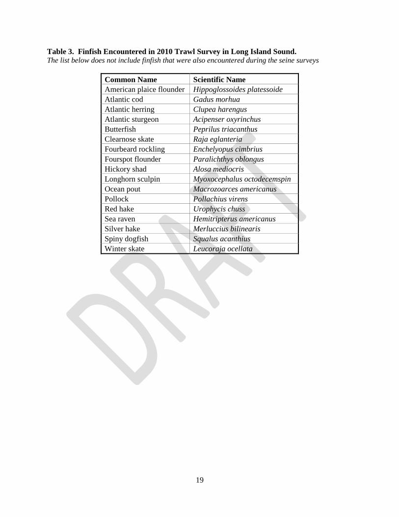
2.0 Fisheries The State of Connecticut Department of Environmental Protection conducted “A Study of Marine Recreational Fisheries in Connecticut” in 2010 (CT DEPa 2011). During the study, scientists conducted seine surveys at eight sites along the Connecticut Long Island Sound shoreline in September. The Groton location was the closest station to Enders Island. Finfish and invertebrates were collected, identified and enumerated. These data were compared to prior surveys dating back to 1988. Finfish encountered at all eight sites are listed in Table 2; the most commonly encountered finfish are in bold. The study also included trawl surveys but trawls were conducted further west of Enders Island; the eastern most sites were near the mouth of Thames River. Scientists identified 99 species of finfish since 1984 during trawl surveys. Finfish encountered during the 2010 trawl surveys that were not encountered during the seine surveys are provided in Table 3.
3.0 Shellfish The CT DEEP Geographic Information Systems Shellfish datalayer (published in 1997)
depicts the approximate location of shellfish beds (hardclam, softclam and oysters) along the Connecticut coast (see Figure 7 - CT DEEP Shellfish Areas). The intertidal and subtidal areas in the immediate project vicinity around Enders Island were not identified as shellfish beds (the closest area was approximately 700 feet to the south of Enders Island). However, it is recommended by the CT DEEP that these maps be used as a general means of identifying a resource area.
During the June 2013 SAV survey it was noted that the substrate in the eastern portion
consisted of sand and gravel with numerous whole shells and shell fragments. This bottom type transitioned rapidly to boulder and cobble with mixed species of macroalgae within the proximity of the seawall. This type of substrate, typical of a high energy environment, is less

18
optimal habitat for clams and oysters. Mobile species that were not observed during the survey but may also be in the project vicinity include shrimp, lobster and crab.
Table 2. Finfish Encountered in Seine Surveys 1988-2010 in Long Island Sound.
Common Name Scientific Name Common Name Scientific Name Alewife Alosa pseudoharengus Northern seahorse Hippocampus erectus American eel Anguilla rostrata Northern searobin Prionotus carolinus American sand lace Ammodytes americanus Northern sennet Sphyraena borealis American shad Alosa sapidissima Northern stargazer Astroscopus guttatus Atlantic needlefish Strongylura marina Pumpkinseed Lepomis gibbosus Atlantic silverside Menidia menidia Rainbow smelt Osmerus mordax Atlantic tomcod Microgadus tomcod Rainwater killifish Lucania parva Banded gunnel Pholis fasciata Rock gunnel Pholis gunnellus Banded rudderfish Seriola zonata Scup Stenotomus chrysops Bay anchovy Anchoa mitchilli Sheepshead minnow Cyprinodon variegatus Black sea bass Centropristis striata Smallmouth flounder Etropus microstomus
Black-spot stickleback Gasterosteus wheatlandi
Smooth dogfish Mustelus canis
Blue spotted coronetfish Fistularia tabacaria
Spotted hake Urophycis regius
Blueback herring Alosa aestivalis Striped anchovy Anchoa hepsetus Bluefish (snapper) Pomatomus saltatrix Striped bass Morone saxatilis Crevalle jack Caranx hippos Striped burrfish Chilomycterus schoepfi
Cunner Tautogolabrus adspersus
Striped killifish Fundulus majalis
Fluke Paralichthys dentatus Striped searobin Prionotus evolans Flying Gurnard Dactylopterus volitans Tautog Tautoga onitis Four-spine stickleback Apeltes quadracus Three-spine stickleback Gasterosteus aculeatus Gray snapper Lutjanus griseus Toadfish Ospsanus tau
Grubby Myoxocephalus aeneus aeneus
Weakfish Cynoscion regalis
Hogchoker Trinectes maculatus
Web Burrfish Chilomycterus antillarum
Inshore lizardfish Synodens foetens White mullet Mugil curema Little skate Raja erinacea Windowpane flounder Scopthalmus aquosus
Menhaden Brevoortia tyrannus
Winter flounder Pseudopleuronectes americanus
Mummichog Fundulus heteroclitus Yellow jack Caranx bartholomaei Naked goby Gobiosoma bosci Nine-spine stickleback Pungitius pungitius Northern kingfish Menticirrhus saxatilis Northern pipefish Syngnathus fuscus Northern puffer Sphaeroides maculatus
19
Table 3. Finfish Encountered in 2010 Trawl Survey in Long Island Sound. The list below does not include finfish that were also encountered during the seine surveys
Common Name Scientific Name American plaice flounder Hippoglossoides platessoide Atlantic cod Gadus morhua Atlantic herring Clupea harengus Atlantic sturgeon Acipenser oxyrinchus Butterfish Peprilus triacanthus Clearnose skate Raja eglanteria Fourbeard rockling Enchelyopus cimbrius Fourspot flounder Paralichthys oblongus Hickory shad Alosa mediocris Longhorn sculpin Myoxocephalus octodecemspin Ocean pout Macrozoarces americanus Pollock Pollachius virens Red hake Urophycis chuss Sea raven Hemitripterus americanus Silver hake Merluccius bilinearis Spiny dogfish Squalus acanthius Winter skate Leucoraja ocellata

20
Figure 7. CT DEEP Shellfish Areas
21
E. Rare, Threatened and Endangered Species and Critical Habitat The U.S. Fish and Wildlife Service Information, Planning and Conservation System
(IPaC) website identified the Roseate Tern (Sterna dougallii dougallii) (northeastern population) as possibly being present along coastal beaches in two counties; New Haven and New London (Stonington is located in New London county). The northeastern population of the Roseate Tern was designated as federally endangered species on 2 November 1987 by the U.S. Fish and Wildlife Service. The Endangered Species Act of 1973 defines a “federally endangered species” as a species that is in danger of extinction throughout all or a significant portion of its range.
Approximately 94% of the northeast population of Roseate Tern was concentrated at just
three colonies: Great Gull Island, New York (NY) (1,524 pairs); Bird Island, Marion, Massachusetts (MA) (782); and Ram Island, Mattapoisett, MA (645) based upon total season estimates of roseate tern pairs in 2009 (USFWS 2010). Roseate Terns generally nest on sandy, gravelly, or rocky islands and are always found nesting in close association with the Common Tern (S. hirundo). Roseate Terns, being less aggressive than Common Terns, seem to rely on the aggressive tendencies of Common Terns to protect their nests. Terns start arriving at nesting islands in late-April, lay eggs and raise young during the months of May, June and July. Most terns begin moving in July to pre-migration staging areas in late-July and August and concentrate in “staging areas” before departure for wintering grounds in September.
Roseate Terns feed almost exclusively on small and/or juvenile fish; occasionally
including crustaceans and insects in their diet. Roseate Terns feed in bays, tidal inlets, or between islands; foraging in highly specialized situations such as shallow sand bars (less than 3 meters (m) deep) or rip tides where prey fish are swept close to the surface. They will also feed in shallow water (less than 2 m deep) where prey fish cannot stay below the plunge depth. Roseate terns will also take advantage of school feeding of predatory fish or feeding close to double-crested cormorants when smaller fish are driven to the surface.
In addition, as designated on the National Marine Fisheries Service (NMFS) species
distribution maps website the proposed project location overlaps with areas of potential distribution for Atlantic sturgeon (Acipenser oxyrinchus); sea turtles of the New England region including the threatened Atlantic loggerhead (Caretta caretta) and green sea turtle (Chelonia mydas) and endangered Atlantic leatherback (Dermochelys coriacea) and Atlantic Kemp's ridley (Lepidochelys kempi); as well as large Atlantic whales including the endangered humpback (Megaptera novaeangliae), right (Eubalaena glacialis), and fin (Balaenoptera physalus) whales. (Website: http://www.nero.noaa.gov/protected/section7/guidence/maps/index.html)
Atlantic sturgeon, from any of the five Distinct Population Segments (DPS), (Gulf of
Maine DPS is listed as threatened other four DPSs are listed as endangered), may be present in the project area. After emigration from the natal estuary, subadult and adult Atlantic sturgeon forage within the marine environment, typically in waters less than 50 meters depth (ASSRT, 2007). Atlantic sturgeons foraging for benthic invertebrates and small fish such as sand lance while making coastal migrations. In bays and harbors foraging often occurs at or near areas with submerged vegetation or shellfish resources. The project area does not provide suitable habitat for overwintering; so the presence of Atlantic sturgeon is likely limited to the warmer months. The nearest spawning rivers are the Kennebec River, Maine and the Hudson River, New York,
22
so no eggs, larvae or juvenile Atlantic sturgeon are likely to occur in the project area. Federally endangered Shortnose sturgeon (Acipenser brevirostrum) may also be found in the project area (http://www.nmfs.noaa.gov/pr/species/fish/shortnosesturgeon.htm#distribution); preferring the nearshore marine, estuarine, and riverine habitat of large river systems. Adult shortnose sturgeon primarily eats mollusks and large crustaceans.
These endangered and threatened species described below are seasonal or occasional
visitors to the offshore environments of Fishers Island Sound. Sea turtles may be present from June through November; the loggerhead, Kemp's ridley and green sea turtles are mostly juvenile and subadult individuals foraging in nearshore coastal waters. The Kemp's ridley appears to prefer estuarine areas where green crabs and mussels are found. Loggerheads feed on benthic organisms found in large bay systems and leatherbacks forage in the open waters in search of jellyfish. Several whale species including the humpback, finback, and right whale can be found transiting through the Sound. The whales are unlikely to occur within the shallow depths of the proposed project revetment. Project activities should not adversely impact any Federally-listed threatened or endangered species.
The Department of Energy and Environmental Protection (DEEP) Bureau of Natural Resources Natural Diversity Data Base (NDDB) Natural Diversity Data Base map shows the general locations of State Listed Species and Significant Natural Communities. There are no state endangered, threatened, or special concern species in the proposed revetment area according to the NDDB map (Figure 8 - Enders Island Natural Diversity and Critical Habitat Areas) (CT DEP 2013). There are no further requirements for projects that do not intersect an NDDB area.
F. Essential Fish Habitat The 1996 amendments to the Magnunson-Stevens Fishery Conservation Management Act strengthen the ability of the National Marine Fisheries Service and the New England Fishery Management Council to protect and conserve the habitat of marine, estuarine, and anadromous finfish, mollusks, and crustaceans. This habitat is termed "essential fish habitat" and is broadly defined to include "those waters and substrate necessary to fish for spawning, breeding, feeding, or growth to maturity." The project area Essential Fish Habitat (EFH) Designation is included within the 10’ x 10’ square coordinates 41020.0’North, 710 50.0’East, 41010.0’South and 720
00.0’West. The waters within the square encompass the following: from just east of Watch Hill R. I., to Noank CT., including waters affecting Little Narragansett Bay, Fishers Island Sound, the eastern 2/3 of Fishers I., the southern half of Mason I., Pawcatuck Point in R. I., Ram I., Napatree Point, and the tip of Wamphassuck Point. These waters also affect the following: the southern part of Stonington, CT., Wicopesset PT., East Pt. on Fishers I., East Harbor, eastern West Harbor, south of Mystic and West Mystic, CT., along with the Mystic River and Pawcatuck River Inlets. Also affected are: Cerberus Shoal, Watch Hill Rock, Catumb Rock, Dodges I., Libby I. (NMFS 2013).
The National Marine Fisheries Service (NMFS) source documents (NMFS 2013), list ten federally managed species as having the potential to occur within the project area. The species listed for the project area include Atlantic cod (Gadus morhua)(adult), Atlantic sea herring

23
Figure 8. Enders Island Natural Diversity and Critical Habitat Areas

24
(Clupea harengus)(adult), bluefish (Pomatomus saltatrix)(juveniles and adults), king mackerel (Scomberomorus cavalla) (eggs, larvae, juveniles, adults); Spanish mackerel (Scomberomorus maculatus) (eggs, larvae, juveniles, adults); cobia (Rachycentron canadum) (eggs, larvae, juveniles, adults); sand tiger shark (Carcharias taurus)(larvae); blue shark (Prionace glauca)(larvae, adults); dusky shark (Carcharhinus obscurus)(juveniles); and bluefin tuna (Thunnus thynnus)(adults). Information and detailed descriptions of the life history requirements of these species was derived from the National Marine Fisheries Service (NMFS) “Guide to EFH Species Designations” located at http://www.nero.noaa.gov/hcd/list.htm and provided in Appendix D – Essential Fish Habitat Assessment.
G. Historical, Cultural and Archaeological Resources Enders Island is located at the tip of Mason’s Island in Fisher’s Island Sound, at the
mouth of the Mystic River. According to the St. Edmund’s Enders Island website (http://www.endersisland.com/about-us), the 11-acre island has been known through the years as Barker’s Island, Dodge’s Island, and Keeland’s Island. Early surveys do not mention the name of Enders Island throughout the mid 19th-Century. It is variously depicted as part of adjoining Mason’s Island.
Major John Mason leading a group of English colonists, Narragansetts, and a small
number of Mohegans attacked the Pequot fort at Mystic is what is now known as the Pequot War of 1637. After destroying the fort and conquering the Pequots, this area was later claimed by both Connecticut and Massachusetts. In 1651, in recognition of his accomplishments, John Mason was given the island known as Chippachauge in Mystic Bay consisting of about 100 acres of upland and ten acres of meadow. This island became known as Mason’s Island (http://www.masonsisland.com/mason_island_history.htm).
The area was populated by the Pequots whose territory extended from the Connecticut
River to Weekapaug Creek and including Pequot Hill in Mystic and Fort Hill in Groton. The Niantics were located around the mouth of the Pawcatuck River at Niantic. Both the Niantics and the Mohegans are considered the original occupants along the coast with the Pequots coming to the area later. According to early accounts, Native peoples primarily used the surrounding islands for fishing (http://www/masonsisland.com/mason_island_history.htm).
Dr. Thomas B. Enders acquired the southern portion of Mason’s Island, a then-
uninhabited island now recognized as Enders Island, from the Sisters of Charity to develop his private estate in 1918. Enders attended Yale University and received his medical degree from the College of Physicians and Surgeons in New York in 1892. An Arts and Crafts style mansion home is one of the prominent buildings on the estate.
Enders’s wife, Alys, prior to her death in 1954 decided to give Enders Island to the
Church. It was originally used by the Society of St. Edmund, an order of priests and brothers, as their novitiate. By the 1970’s, the Edmunities used the Island for retreats for those in recovery and for other priests and religious functionaries. It was this ministry that developed into present-day St. Edmund’s Retreat where programs for lay, religious, and clerical individuals and groups were established. In 2003, the Retreat became an independent ministry, though still strongly influenced by the traditions of the Society of St. Edmund. Currently, the facilities on the Island

25
include the early 20th-Century Enders mansion, several meeting rooms, overnight accommodations and a new chapel (http://www.endersisland.com/about-us).
The Catholic Church’s Archdiocese of Connecticut owns and operates the Enders Island
facility and associated property. It is used by many church and non-church related groups as a retreat center. In addition to the retreat center, many community groups host events at Enders Island such as, luncheons, receptions, anniversaries, reunions, lectures, recovery and leadership programs, workshops, annual and planning meetings, training, conferences, etc. The facility also provides a place to perform community service, including court mandated, high school and Eagle Scout community service and projects. It is open to the public on an equal basis regardless of religion. Over 17,000 visitors come to the island from as far away as Florida, Louisiana and Illinois. The property is accessible via a causeway and provides free public parking on the island. The grounds are open to the public free of charge and are used by walkers, bicyclists, swimmers, picnickers and anglers. A masonry seawall protects the property and facilities from storms, but the wall is currently in poor condition especially on the southeast side.
The original seawall surrounding the property was built in the early 1920’s and expanded
shortly after the 1938 Hurricane. Over time, the island was built up with evidence of fill on-site. Sections of the wall collapsed after nor’easters in 2008 and rock continue to become dislodged each winter. The existing wall is impacted from the top by rainwater, on the landward side from septic, stormwater drainage and seawater, and from direct wave action. The impact on the island’s septic systems from salt water intrusion during heavy rains is a concern.
There are no known archaeological sites recorded for Enders Island. According to Jeffrey
Anderson, Executive Vice President for Operations, Saint Edmund’s Retreat (personal communication, November 6, 2013), there have been no historic or archaeological studies conducted on Enders Island. The Arts and Craft-style Enders mansion is potentially eligible for listing on the National Register of Historic Places. According to Dr. Nick Bellantoni, there are only two reported shipwrecks for Stonington, the schooner James sank in 1889, location unknown, and the schooner Jessie F., sank in 1895 in Stonington Harbor. There are no recorded shipwrecks or obstructions in the vicinity of Enders Island in the NOAA Automated Wreck and Obstruction Information System (AWOIS).
H. Socio-Economic Resources Settled in 1649, the Town of Stonington began as a trading post on the Pawcatuck River. The town was claimed by Massachusetts and then in 1662, the Connecticut Governor John Winthrop, Jr. obtained the charter from England to set the town boundaries. The Town of Stonington comprises a number of villages including Pawcatuck, Stonington Borough, Lords Point, Wequetequock and the eastern halves of Mystic and Old Mystic. The town includes 42.7 square miles in New London County comprised of a mixture of business/industrial complexes and semi-rural residential communities (Town of Stonington 2013).
The town of Stonington has a population of 18, 545. The community race composition is 94.2% White, 1.9% Asian 0.9%, Black and 2.4% Hispanic. In 2010, the median household income of Stonington residents was $75,972. However, 4.9% of Stonington residents live in poverty (U.S. Census Bureau 2010).

26
Stonington businesses draw on New London County’s diverse manpower pool of around 140,000 employees with a high concentration of skilled professionals, scientists, engineers, and craftsmen. The economic viability of the town is realized through a mixture of recreation, tourism, manufacturing and technology. With its seaside location and rich wildlife diversity, tourism is the area’s fastest growing industry. There are also a variety of technical corporations and manufacturing facilities in the town. Also, within a short distance are continuing and advanced educational opportunities such as the University of Connecticut (UCONN) at Avery Point, Connecticut College, and Mitchell College, to mention a few (Town of Stonington 2013).
V. Environmental Consequences
A. Terrestrial Environment
1.0 Topography Protecting the existing seawall with a stone revetment (Alternative B) or concrete
kneewall (Alternative C) would not alter the topography of the upland areas. There are no anticipated direct or indirect effects to topo
2.0 Geology and Soils Alternatives B and C are not expected to have any long term negative effect on the
geology and soils on Enders Island. During kneewall maintenance activities (work by others), soils and other materials will be brought onsite and used to backfill eroded areas.
Prime Farmland Soils- The FPPA applies to farmland with soil types as prime, unique, or
of statewide or local importance, but not to farmland already in or committed to urban development or water storage. As noted previously, the proposed project area was privately owned and developed in the early 1900’s. Therefore, even if soils classified as prime unique or of statewide and/or local importance are located in the area, the act would not be applicable in this situation.
3.0 Vegetation The proposed shoreline protection project (either Alternatives B or C) may require the
removal of some of the shrubs and landscape features on the island if materials are brought over the existing wall (or portions of the wall are removed during construction). These areas will be replanted and landscaped. Shrubs used to re-landscape will be native species.
4.0 Wildlife Enders Island has been developed and is connected to the mainland by two causeways
through developed areas which limits the types and number of terrestrial wildlife species on the island to those that can exist in close proximity to human populations. During the construction, it is expected that any mammalian species would avoid the areas of active construction. Avian species would be temporarily displaced from construction areas as well. The proposed shoreline protection project (either Alternatives B or C) is not expected to have any long term negative effects on the terrestrial wildlife community on Enders Island.

27
B. Aquatic Environment
1.0 Hydrology Alternatives B or C are not expected to have any long term negative effects on surface or
groundwater of Enders Island. The project is designed to stabilize the existing seawall and to prevent further erosion on the island. The revetment or concrete kneewall will limit overtopping and prevent erosion on the landside of the seawall. The repaired wall will include seepage holes allowing any accumulated surface water to escape. The revetment is a permeable structure and will allow water behind the seawall to drain to the sea.
Construction of the concrete kneewall may require dewatering which would be difficult
given the rocky bottom and the presence of bedrock. Driving sheetpile into this bottom or construction of another type of cofferdam would temporarily interrupt tidal inundation within the dewatered area during construction. Construction of a stone revetment would not require dewatering. The initial course of stones would be placed during low tide. Construction equipment would then use this layer as a road or platform to perform the remaining work.
2.0 Water Quality Alternatives B or C are not be expected to have any long term negative effects on the
water quality of Fisher Island Sound in the vicinity of the project area. The area of the project is extremely rocky and the amount of fine materials transported from the site during construction is expected to be limited, if any at all. Any increase in turbidity that may result from the actual placement of armor stone or pouring concrete is expected to be short term and temporary. The temporary impacts associated with the concrete kneewall result from cofferdam installation for dewatering and dowelling supports for the concrete wall. The concrete kneewall will also require more maintenance which will likely require in water work. Maintenance activities may also result in short term increases in turbidity.
C. Biological Resources
1.0 Wetlands/Aquatic Vegetation Vegetation in the proposed project area is generally limited to species that can withstand
moderate to high wave action and are attached to a solid base like boulders and bedrock. Eelgrass was observed to be growing as individual shoots or small clumps of shoots amongst large boulders in the area as designated in Figure 6 - June 2013 USACE Eelgrass Survey and CT DEEP 2009 Eelgrass Bed.
The concrete kneewall (Alternative C) would result in negative impacts to eelgrass both
on a temporary basis and long term. The footprint of the concrete kneewall is not expected to reside in a location containing eel grass; however, installation of the kneewall will likely require work in the water and disturbance of an assumed eel grass location. The dewatering cofferdam would likely be placed about the same location as the toe of the stone revetment along the southern tip of the island. Eelgrass is presumed in this area but the lateral extent of its growth toward the existing wall is unclear. Placement of the cofferdam may have direct, but temporary burial effect on the eelgrass. The continual maintenance of the kneewall may also result in temporary, but repeated impacts to this location as equipment and workers would require access
28
to the seaward side of the kneewall for patching and repairs. The presence of a solid, flat surface kneewall would reflect wave energy (its design purpose) and may cause scour and disturbance of eel grass beds nearby, but the extent of this type of impact is unclear and was not evaluated.
The stone revetment (Alternative B) would result in a direct burial impact to a small
portion of a presumed eel grass bed at the southern tip. The footprint of the stone revetment (all iterations) overlaps with an area expected to contain eelgrass based on extrapolation of plant survey data at a nearby sample location. The stone revetment would not require as much maintenance as the kneewall and although it will reflect wave energy like the kneewall, much of this energy will be dissipated by the rough surface of the rock and the porosity of the structure before reflected.
Avoidance of eelgrass beds, a highly productive habitat, was an important consideration
in the selection of the proposed project design. In addition to the design iterations (1 through 4) which involved variable of revetment height and slope, several design options; a reduced crest width and construction of a cutoff wall at the toe of the revetment, were also considered to reduce the size of the revetment footprint and avoid/minimize direct impacts to eelgrass (as described in Section III. Alternatives B. Stone Revetment). The project team concluded that stone revetment iterations 1 through 3 and further design options were not practical; the stone revetment iteration 4 was determined to be the recommended alternative and that impacts to a small portion of a presumed eelgrass bed in the southern-most portion of the site are unavoidable. Initially, the footprint of the revetment was estimated to directly impact 580 square feet of the potential eelgrass area (the boundaries of which were extrapolated from the 2013 plant survey data) which was reduced to 260 square feet with the selection of the stone revetment iteration 4 as shown on the Figure 9 – Potential Impacts to Eelgrass. This alternative is expected to provide wall and land erosion protection for New England 10-20 year storms for an extended period and requires little maintenance. This iteration of the stone revetment minimizes and avoids impacts to eelgrass to the greatest extent practical.
2.0 Fisheries Typical environmental concerns relative to fisheries resources in the project area during
construction activities include: loss of existing intertidal habitat, loss of existing eelgrass beds, increased suspended solids, and sedimentation. The revetment footprint will displace approximately 0.5 acres (23,000 ft2) of intertidal cobble and boulder habitat and 260 square feet of sparse eelgrass growing between boulders in sheltered areas. Benthic organisms inhabiting the revetment footprint area would be destroyed during the construction. Some of the functions and values of the intertidal habitat will be regained, as colonization of the aquatic invertebrates will occur on the revetment over time and as such, the loss of forage is expected to be localized and temporary. The footprint of the kneewall is much less than the stone revetment but there is no opportunity to regain any of the function and values within the kneewall footprint. As well, the kneewall was expected to require regular maintenance which may be disruptive to the aquatic environment. Fish are sufficiently mobile to avoid the area during construction and will typically return to areas of disturbance following the cessation of activity. The proposed shoreline protection project is not expected to have any significant long term effects on the fish inhabiting or migrating through Fishers Island Sound proximal to Enders Island.

29
Figure 9. Potential Impacts to Eelgrass

30
3.0 Shellfish The near shore area along most of the island is characterized by cobbles, boulders and
bedrock indicative of a high energy environment. Although there were some shellfish observed east of the project area, the substrate found in the nearshore area (directly impacted by the footprint of the revetment and kneewall) is not optimal habitat for clams and oysters. There may be some impacts to sessile species associated with cobble substrates and hard structures such as blue mussel; however, the revetment would provide structure to support the reestablishment of sessile species; the kneewall would not provide any habitat for these species. Mobile species that may be in the area such as shrimp, lobster and crab, would avoid areas of disturbance during construction. Therefore, no significant impacts to shellfish would be expected from the proposed project.
D. Rare, Threatened and Endangered Species and Critical Habitat Enders Island is currently developed and therefore, does not provide suitable habitat for
Roseate Tern nesting. Foraging in the vicinity of Enders Island is expected to be limited to occasional or transient roseate terns and therefore, the proposed Enders Island project will have no effect on foraging roseate tern or foraging habitat. In addition, no critical habitat has been designated for the roseate tern (USFWS 2010). Prior to this submittal, email coordination with Susi VonOettingen of the U.S. Fish and Wildlife Service on May 13, 2013 determined there would be no effect to roseate tern as a result of the project (USFWS 2013). As follow-up, a U.S. Fish and Wildlife Service Information, Planning and Conservation System (IPaC) Species Summary Table for the New England Field Office Field Review was submitted on 15 May 2013 for the Enders Island project with a “no effect” determination for the record.
This project is anticipated to have no adverse impacts on any Federally-listed threatened
or endangered species under the jurisdiction of the National Marine Fisheries Service (NMFS). Sea turtles may occur near the project area during the summer and fall however, it would be expected that these mobile species would avoid the construction area. The NMFS determined in a letter dated 13 May 2014 that, although Endangered Species Act (ESA) listed species may be present, no species listed under the jurisdiction of the NMFS will be exposed to any direct or indirect effect of the proposed project due to the small footprint and limited amount of in-water work associated with the project (see Appendix B – Correspondence).
There are no State endangered, threatened, or special concern species in the proposed
revetment area according the Department of Energy and Environmental Protection (DEEP) Bureau of Natural Resources Natural Diversity Data Base (NDDB).
E. Essential Fish Habitat The essential fish habitats of concern include the waters, salt marsh, eelgrass and mudflat
resources of the near project area, which are necessary for fish spawning, breeding, feeding, or growth to maturity. Salt marshes, eelgrass beds, and intertidal/subtidal areas are extremely valuable habitats for marine fish and shellfish for many reasons. Salt marshes export organic matter (detritus) which enriches coastal waters and serves as a microbial food source in estuarine and near shore marine ecosystems. Salt marshes also harbor several species of minnows such as mummichog (Fundulus heteroclitus) and Atlantic silversides (Menidia menidia), which are food sources to larger fish and serve as nurseries/refuges for young fish and important commercial species such as winter flounder. Eelgrass beds are highly productive components for forage and

31
nursery habitat in the marine environment. Intertidal/subtidal areas typically support diverse biotic assemblages of shellfish and marine invertebrates, which also serve as a food resource for a variety of migratory finfish.
An Essential Fish Habitat (EFH) assessment on the potential effects of the proposed
project on designated species and their habitat, the eelgrass and intertidal areas around Enders Island is presented in Appendix D - Essential Fish Habitat Assessment. In general, impacts to essential fish habitat in the project area were avoided or minimized to the maximum extent practicable through the planning and design process as described in the Environmental Assessment. The permanent impacts to intertidal habitat will not significantly affect foraging or nursery areas for EFH species. Environmentally sound engineering and erosion control practices adequately protect those species listed under the Magnuson-Stevens Fisheries Conservation Act for EFH in the project area. A survey would be conducted prior to construction to document eelgrass in the revetment footprint and near vicinity. If eelgrass is found, further coordination would be conducted with the National Marine Fisheries Service.
The NMFS provided general comments and Essential Fish Habitat recommendations on
the Enders Island project in a letter dated 13 May 2014. In a response letter to the NMFS dated 4 June 2014, the USACE New England District agreed to conduct an updated eelgrass survey in the growing season of May l5th through August 30th prior to construction to determine if eelgrass is within the proposed project footprint. The results of the survey will be provided to the NMFS for review and further recommendations, if needed. The USACE response also provided, as requested by the NMFS, an overview of alternatives that were considered to avoid and minimize impacts to important intertidal cobble resources in the project area (see Appendix B – Correspondence).
F. Historical, Cultural and Archaeological Resources The original Enders Arts and Crafts-style mansion (Enders house) is still intact and
remains one of the focal points of the island. Care has been taken over the years to preserve its character and maintain many of its original elements while upgrading the infrastructure current heating and electrical needs. The house contains original light fixtures, wood, and tile in most of the rooms. In the cupola there is still the original painting by the Enders of the sky, land, sea and all the creatures who live in the air, land, and water. Saint Edmund’s Retreat has no intention of listing the house in the National Register of Historic Places (Jeffrey Anderson, personal communication).
All of the buildings on Enders Island with the exception of the Chapel (2003) and St.
Michael's Hall (1957) are original buildings built by the Enders. Most have been repurposed over the years but they remain intact. St. Mary's now has eight guest rooms and four bathrooms. It originally was the milking barn. St. Joseph's is storage; it originally was a barn. St. Edmund's, the program office, originally was the Enders art studio. In 1955 it was converted into a chapel and used as a chapel until 2002 (Jeffrey Anderson, personal communication).
Although portions of the original Enders Island seawall are more than 50 years old, they
do not exhibit characteristics of exceptional engineering significance that would constitute potential eligibility for listing on the National Register of Historic Places. Local anecdotal information suggests that teams of horses were used to handle the large stones and put them into

32
place. It is thought that the original sea wall was four to six feet lower than its present height. The original revetment was razed following the 1938 Hurricane and replaced with its height raised to the current level (Jeffrey Anderson, personal communication).
Over time, the island was built up with evidence of fill on-site. When the Enders
purchased the property, they brought in a great deal of fill prior to construction as the island was primarily composed of bedrock (Jeffrey Anderson, personal communication). Sections of the wall collapsed after nor’easters in 2008 and rock continue to become dislodged each winter. The existing wall is impacted from the top by rainwater, on the landward side from septic, stormwater drainage and seawater, and from direct wave action. Constructing a stone revetment behind portions of the existing seawall will not impact significant historic properties.
A review of the NOAA Automated Wreck and Obstruction Information System
(AWOIS) did not identify any potential shipwrecks in the vicinity of Enders Island. Impacts to significant historic properties are not expected. If, during implementation, historic properties are encountered, we will implement the provisions for post- review discoveries as stipulated in the Advisory Council on Historic Preservation’s implementing regulations (36 CFR 800.13).
Therefore, we feel that the proposed hurricane and storm damage reduction measures
proposed for portions of the Enders Island seawall will result in a “no effect” determination upon significant historic properties. Without repairs to the existing seawall, the landward property will continue to erode, the septic system will cease to function properly and the wall will collapse. When the septic system fails, the facility would be forced to connect to the municipal sanitary sewer system which is over two miles from the island. The Connecticut State Historic Preservation Officer has concurred with this determination in accordance with Section 106 of the National Historic Preservation Act and implementing regulations 36 CFR 800. Consultation with both the Mashantucket Pequot and Mohegan Tribes of Connecticut indicated that there were no concerns within the area of potential effect.
It should be noted that if failure of the septic system becomes a reality and the
community is required to connect to the municipal sewer system, this would require above ground piping along the causeway and through the residential area below ground through Mason’s Island. The Mashantucket Pequot Tribal Historic Preservation Officer (THPO) indicated that Masons Island is culturally significant to the Mashantucket Pequot Tribe. Even though “this is only listed as a moderate priority for the Town & is not recommended for action within the next 20 years,” if this part of the project moves forward, the Mashantucket Pequot Tribe THPO should be consulted early in the process before any work begins (Kathleen Knowles, personal communication July, 9, 2014).
G. Socio-Economic Resources The proposed shoreline protection project at Enders Island is expected to have an overall
positive effect on the economic resources for Stonington by preserving the island and retreat facilities that are used by the public. As noted, deterioration of the seawall would ultimately result in the loss of the septic system serving the facility making the retreat and buildings unaccommodating in the without project condition (No Action Alternative). The island itself would be exposed to significant storm surge and erode. Enders Island provides storm protection
33
for the Mason Island, which is home to many residents and contains a yacht club and marina. Loss of Enders Island would potentially result in increased erosion of Mason Island further reducing the economic resources.
Economic benefits to a shoreline stabilization project are estimated by comparing the
without project to the with-project conditions. In this analysis, the without project condition is the same as the no action condition. Without a project, no steps will be taken to stop or slow the damage to the existing seawall along Enders Island which would eventually result in damage to the septic system. The Retreat would require connection to the sanitary sewer system located over two miles away which would disrupt the Mason Island community. However, erosion or damage to the seawall would continue and eventually, the existing seawall would collapse; the island would be subject to additional erosion. With a shoreline protection project, the damage to the seawall during 10-20 year storms would be mitigated. With a shoreline protection project, the Retreat center would not need to find a substitute wastewater treatment system and the costs and disruption to the neighboring community would be prevented.
The short term benefits of a shoreline protection project are thus derived from the
estimated cost of providing an alternative wastewater treatment to the retreat. A cost estimate to connect Mason Island to the municipal sanitary sewer system was over $4.2 million. This was an estimate prepared for the Town of Stonington in 2006. Cost to connect the retreat would be greater due to distance and traversing another causeway. Once connected, the retreat would be required to pay any fees associated with the connection and use of the sanitary sewer system. The long term benefits from the proposed project were not estimated but would include the cost to relocate the retreat and all facilities as well any benefits derived from storm damage protection to Mason Island. These may include personal property damage, loss of yacht club and marina.
With the proposed shoreline protection project in-place, the Retreat can continue to
operate and service the public. It is estimated that the total economic benefits of the project would be approximately $3 million dollars savings based on the cost to connect to the sanitary sewer system alone. All local economic benefits associated with the Retreat would be lost if the facility relocated.
VI. Other Environmental Compliance Requirements
A. Environmental Justice Executive Order 12898 “Federal Actions to Address Environmental Justice in Minority
Populations and Low-Income Populations” requires federal agencies to examine proposed actions to determine whether they will have disproportionately high and adverse human health or environmental effects on minority or low income populations. The State of Connecticut Environmental Justice Policy states that “no segment of the population should, because of its racial or economic makeup, bear a disproportionate share of the risks and consequences of environmental pollution or be denied equal access to environmental benefits” and defines Environmental Justice communities as A; a United States census block group, as determined in accordance with the most recent United States census, for which 30 percent or more of the population consists of low income persons who are not institutionalized and have an income below 200 percent of the federal poverty level, or B; a distressed municipality. The Town of
34
Stonington is not an affected community. (http://www.ct.gov/dep/cwp/view.asp?a=2688&q=322380&depNav_GID=1511. Website Accessed 3/27/2013).
B. Protection of Children Executive Order 13045 “Protection of Children from Environmental Health Risks and
Safety Risks” sees to protect children from disproportionately incurring environmental health risks or safety risks that might arise as a result of Federal policies, programs, activities and standards. Environmental health risks and safety risks include risks to health and safety attributable to products or substances that a child is likely to come in contact with or ingest.
The proposed project involves the protection of an existing seawall to prevent further
deterioration of the wall, saltwater intrusion of the septic system and land erosion on Enders Island. There are no schools or playgrounds located in the immediate vicinity of the proposed project. Public access to the project is not expected to disproportionately impact children, since the construction site will be fenced off to prevent unauthorized personnel from entering the work area (including children). During the construction phase of the proposed project, heavy construction equipment and vehicles will be transported to the site. It is expected that there will be a temporary increase in truck traffic transporting materials to and from the site. These trucks will be limited to the public roadways, and the existing project access road (right of way), and are therefore not expected to cause any disproportionate direct, indirect or cumulative impact to children associated with environmental health or safety risks. Construction itself is expected to last for approximately four months. Therefore, this increased traffic will be for a short duration and temporary.
C. Air Quality Federal Conformity Requirements
1.0 Introduction Ambient air quality is protected by Federal and state regulations. The U.S. Environmental
Protection Agency (EPA) has developed National Ambient Air Quality Standards (NAAQS) for certain air pollutants, with the NAAQS setting concentration limits that determine the attainment status for each criteria pollutant. The six criteria air pollutants are ozone, carbon monoxide, nitrogen dioxide, sulfur dioxide, particulate matter, and lead. Stonington is located in New London County and is in attainment of all criteria pollutants with the exception of ozone.
In 1997, the EPA established a new 8-hour ozone standard which was implemented in
April, 2004. With the implementation of this 8-hour ozone standard, in September 2005, the EPA revoked the previous 1-hour non- attainment ozone standard for most of the United States. Connecticut has been divided into two non-attainment areas for ozone; the Greater Connecticut 8-hr Non-Attainment Area, and the New York, New Jersey, Connecticut (NY-NJ-CT) 8-hour Non-Attainment Area. Stonington is located in New London County, and lies within the Greater Connecticut 8-hr Ozone Non-Attainment Area. Currently, the Greater Connecticut 8-hr Non-Attainment Area is listed as “Marginal” for non-attainment of the ozone standard (USEPA 2013a).
In July of 2009, the State of Connecticut requested that the EPA not finalize the decision
to disapprove, and provided additional data in support of its demonstration of attainment of the
35
8-hour ozone standard. On September 20, 2010, the EPA approved and promulgated the Air Quality Implementation Plans for Connecticut, Massachusetts and Rhode Island’s Reasonable Further Progress Plans and Base Year Emission Inventories, however at this time there has not been any further action on the State of Connecticut’s demonstration of attainment of the 8-hour ozone standard. Therefore the region is still considered to be in non-attainment under the 8-hour ozone standard.
In 2008, the EPA revised the primary 8-hour ozone standard down from 0.08 parts per million (ppm) to 0.075 ppm, and strengthened the secondary ozone standard making it identical to the primary standard (0.075 ppm). (The Clean Air Act identifies two types of national ambient air quality standards; “Primary standards” which provides public health protection and “Secondary standards” which provides public welfare protection such as decreased visibility and damage to animals, crops, vegetation, and buildings.). The rule became effective on March 12, 2008. In September 2009, the EPA announced that it would reconsider the 2008 standards, due to the fact that they may not have been as protective of public health as previously believed. In January 2010, the EPA proposed to strengthen the national ambient air quality standards (NAAQS) for ground-level ozone, the main component of smog, by revising the 8-hour primary ozone standard designed to protect public health to a level within the range of 0.060-0.070 ppm. The proposed rule was published in the Federal Register on January 19, 2010 and the EPA is currently going through interagency review of the new standard (USEPA, 2013b).
The State of Connecticut is authorized by the EPA to administer its own air emissions permit program, which is shaped by its State Implementation Plan (SIP). The SIP sets the basic strategies for implementation, maintenance, and enforcement of the National Ambient Air Quality Standards (NAAQS). The SIP is the federally enforceable plan that identifies how that state will attain and/or maintain the primary and secondary National Ambient Air Quality Standards (NAAQS) established by the EPA. In Connecticut, Federal actions must conform to the Connecticut state implementation plan or Federal implementation plan. The Corps must evaluate and determine if the proposed action (construction and operation) will generate air pollution emissions that aggravate a non-attainment problem or jeopardize the maintenance status of the area for ozone.
U.S. Army Corps of Engineers guidance on air quality compliance is summarized in
Appendix C of the Corps Planning Guidance Notebook (ER1105-2-100, Appendix C, Section C-7, pg. C-47). Section 176 (c) of the Clean Air Act (CAA) requires that Federal agencies assure that their activities are in conformance with Federally-approved CAA state implementation plans for geographic areas designated as non-attainment and maintenance areas under the CAA. The EPA General Conformity Rule to implement Section 176 (c) is found at 40 CFR Part 93.
Clean Air Act compliance, specifically with EPA’s General Conformity Rule, requires
that all Federal agencies, including Department of the Army, to review new actions and decide whether the actions would worsen an existing NAAQS violation, cause a new NAAQS violation, delay the SIP attainment schedule of the NAAQS, or otherwise contradict the State’s SIP. When the total direct and indirect emissions caused by the operation of the Federal action/facility are less than threshold levels established in the rule (40 C.F.R. § 93.153), a Record of Non-applicability (RONA) is prepared and signed by the facility environmental coordinator.
36
2.0 Construction and Operation Construction would occur over a total period of about four months, with work being done
in one season. Construction activity at the proposed project site would require cranes, bulldozers, dump trucks, pick-up trucks, front-end loaders, an excavator and other miscellaneous construction equipment.
During construction, equipment operating on Enders Island would emit pollutants
including nitrogen oxides that can lead to the formation of ground level ozone. The construction of approximately 700 linear feet of armor stone rip rap revetment would involve vehicles transporting gravel and stone (dump trucks) and other construction equipment to and from the site. These vehicles will be in compliance with the state’s vehicle emission program. Equipment operating on the construction site (non-road construction equipment) will emit pollutants that contribute to increased levels of criteria pollutants such as carbon monoxide, nitrogen oxides, and ozone. The emissions for construction vehicles and related equipment will have an insignificant impact to local air quality.
In order to minimize air quality effects during construction, all construction operations
would comply with applicable provisions of the State of Connecticut air quality control regulations pertaining to dust, odors, construction, noise, and motor vehicle emissions. No direct or indirect increases or other changes in local or regional air quality are likely to occur with the construction and operation of the proposed project.
3.0 General Conformity The general conformity rule was designed to ensure that Federal actions do not impede
local efforts to control air pollution. It is called a conformity rule because Federal agencies are required to demonstrate that their actions "conform with" (i.e., do not undermine) the approved SIP for their geographic area. Federal agencies make this demonstration by performing a conformity review. The conformity review is the process used to evaluate and document project-related air pollutant emissions, local air quality impacts and the potential need for emission mitigation (Polyak and Webber 2002). A conformity review must be performed when a Federal action generates air pollutants in a region that has been designated a non-attainment or maintenance area for one or more NAAQS. Non-attainment areas are geographic regions where the air quality fails to meet the NAAQS.
The project is located in New London County, Connecticut. New London County is considered to be non-attainment for ozone, having a “Marginal” classification under the 2008 8-hour ozone air quality classification (USEPA 2013a). The General Conformity thresholds for ozone in a “Marginal” Non-Attainment area have an emission rate threshold of 100 tons per year (tons/year) of NOx (nitrogen oxides) and 50 tons/year of VOC (volatile organic compound) (US Army Environmental Center 2002) (40 CFR 51.853, 7-1-04). (The Clean Air Act (CAA) sets out specific requirements for a group of northeast states that make up the Ozone Transport Region (OTR). These emission rate thresholds are for states designated by the Clean Air Act as be within in the Ozone Transport Region. Connection is located within the OTR which also includes Maine, New Hampshire, Vermont, Massachusetts, Rhode Island, New York, New Jersey, Pennsylvania, Delaware, Maryland, and the Washington, D.C. Metropolitan Statistical Area, including the northern Virginia suburbs.)

37
To conduct a general conformity review and emission inventory for the proposed shoreline protection on Enders Island, a list of construction equipment was identified using the project construction cost estimate. The first column of the emissions calculations table (Appendix C) provides a summary equipment list. The New England District prepared calculations of the worst case project specific emissions of NOx and VOCs to determine whether project emissions would be under the General Conformity Trigger Levels. Because of the small scale of the project, several simplifying assumptions were applied in performing the calculations to prepare a worst case analysis. The actual emissions would most likely be much lower, but in no case above the calculated values. For instance, the load factor is the average percentage of rated horsepower used during a source’s operational profile. To simplify the calculations, we used a worst-case estimate of 1.0, or 100 percent, for all equipment. We used 12 hours per day as worst-case hours of operation for most equipment. We used the total construction duration minus non-work days (i.e. holidays, weekends, and weather days) to estimate days of operation, rather than the specific days of operation for each piece of equipment. Based on these calculations, the worst case NOx emissions were 18.86 tons and the worst case VOC emissions were 2.38 tons. In both cases, the total construction emissions were below the General Conformity Trigger Levels. Appendix C contains the equipment list for the Enders Island revetment project, and the calculations and listing of equipment for it.
The total estimated direct and indirect emissions that would result from the protection of
approximately 700 linear feet of seawall on Enders Island are below the General Conformity trigger levels of 100 tons/year threshold for NOx and the 50 tons/year threshold for VOCs. General Conformity under the Clean Air Act, Section 176 has been evaluated for the project according to the requirements of 40 CFR 93, Subpart B. The requirements of this rule are not applicable to this project because the total direct and indirect emissions from the project are below the conformity threshold values established at 40 CFR 93. 153 (b) for ozone (VOCs and NOx) in a “Marginal” Non-Attainment area.
The determination of whether or not a project is regionally significant is if its emissions exceed 10% of the state’s total emissions budget for the criteria pollutants (40 CFR 93.153 (i)). Table 2b from the EPA’s Approval and Promulgation of Air Quality Implementation Plans; Connecticut, Massachusetts, and Rhode Island; Reasonable Further Progress Plans and 2002 Base Year Emission Inventories (EPA 2012) lists the total emissions inventories for emissions sources for the Greater Connecticut area for the Base year of 2002 (the year for which the State Implementation Plan is based upon) from all sources. These inventories are calculated as tons per day and show values of 450.3 tons/day for NOx and 146.8 tons /day for VOCs. As noted, the emissions for the Enders Island project are estimated to be 16.86 and 2.38 tons per year for both NOx and VOCs respectively. These values show that in one day, emissions from all sources within the Greater Connecticut area for the base year of 2002 exceed the yearly estimated emissions of NOx from construction activities at Enders Island by more than 25 times, and the yearly estimated emissions of VOC by more than 60 times. Therefore the estimated emissions for the proposed project are below 10% of the total emissions inventory for the Greater Connecticut Non-Attainment Area. The Army activity does not reach the threshold levels established by the EPA rule, and is not regionally significant, and therefore the conformity rule is inapplicable here.

38
4.0 Greenhouse Gases (GHG) No Action Alternative: The project area will continue to be impacted by coastal storm
events over the life of the project. It would be expected that maintenance and repair project would need to be undertaken however, a significant increase in the amount Green House Gases (GHGs), as a result of the use of diesel-fueled engines (which emits CO2), is not expected under the No Action Alternative. Proposed Shoreline Protection Project: The primary GHG emitted by diesel-fueled engines is CO2. The project is estimated to generate a total of 531.2 tons of CO2 based upon a worst case analysis using the type of equipment and duration of construction. This estimated amount of CO2 is equivalent to approximately 102 passenger vehicles driven for one year (see EPA Greenhouse Gas Equivalent Calculator, www2.epa.gov/energy/greenhouse-gas-equivalencies-calculator, website accessed May 16, 2017). CO2 emissions have been estimated to be 473,849.2 tons per year in Connecticut (CT DEEP 2011b) and there were 1,385,867 motor vehicles (private, commercial and publicly owned) registered in the state in 2015 (USDOT 2015). GHG emissions for the Enders Island project are temporary and when compared to annual GHG emissions and the registered cars in Connecticut, we considered to be insignificant.
VII. Summary of Anticipated Impacts and Actions to Minimize
A. Summary of Direct and Indirect Impacts No Action – under the no action condition, a seawall protection structure would not be
constructed. Existing wall maintenance performed by St. Edmund’s Retreat would not keep pace with the destructive forces of waves. The wall would collapse causing a direct impact to the intertidal area by covering the existing benthic habitat with rock and debris from the seawall. Further erosion of the island would result in additional accretion of sand and soil on the existing intertidal habitat. Indirect impacts from saltwater intrusion and erosion to on-site septic system servicing facilities on the island would cause the system to malfunction. Connection to the municipal sanitary waste system would be required and would result in greater impacts to Enders Island and Mason Island (a culturally significant resource).
Proposed Shoreline Protection Project – The construction of a stone revetment would
result in unavoidable adverse impacts on the environmental resources located within the project area. Temporary direct impacts during construction include: an increase in traffic, an increase in noise levels due to construction activities, an increase in turbidity and sedimentation into the adjacent water column during construction, loss benthic organisms within the project footprint, potential loss of eelgrass, and disruption of the aesthetic, visual and recreational resources. The revetment would permanently alter the existing substrate within the project footprint. The proposed project is not expected to induce any permanent indirect impacts to the benthic community structure such as changes to population density, growth rate, species diversity or predator prey relationships. No direct or indirect permanent alternation to existing land use or impacts to air quality are expected.
Implementation of the shoreline protection project is expected to generate numerous
long-term beneficial impacts that will offset adverse impacts. These benefits include protection of community resources on the island (St Edmund’s Retreat) and access to water dependent uses

39
such as fishing. The project would provide long-term protection to the socioeconomics of the area through preservation of community based services provided by the Retreat and the aesthetic and visual appeal to tourist and local community. The project would offset direct impacts to the intertidal area by providing some interstitial habitat between stones for bait and juvenile fish and benthic species. The project would reduce the probability of seawall failure and prevent indirect impacts, such as island erosion which would threaten nearby shellfish and eelgrass habitat through increased sedimentation.
B. Cumulative Impacts The Council on Environmental Quality (CEQ) definition of cumulative impacts as found
in 40 Code of Federal Regulation (CFR) Section 1508.7 is as follows: "Cumulative Impact is the impact on the environment which results from the incremental impact of the action when added to other past, present and reasonably foreseeable future actions regardless of what agency (Federal or nonfederal) or persons undertakes such other acts." The following section describes past, present and future federal, state and local projects in the project area and near vicinity.
Coastal communities in Connecticut have an abundance of infrastructure constructed in the past as storm protection measures (e.g., beach nourishment, revetments, groins, etc.) and for commerce and recreation (marinas, docks, piers, etc.). Specific examples in the town of Guildford include a 300-foot long groin constructed in 1956 at the east end of the Guilford Point Beach (at the mouth of the East River). The project also included widening approximately 400 feet of beach to 125 feet through placement of sand. More recently, maintenance dredging was conducted in 2014 in Guildford Harbor. The USACE dredged sandy and fine-grained material from the Federal Navigation Project (FNP) to return the project to its authorized dimensions including the East River, approximately 100 feet by 1,500 feet, and the 55-foot wide, 800-foot long Sluice Creek Chanel which connects the Guilford marina to the main federal navigation channel.
Other past actions include maintenance projects conducted at the St. Edmund’s Retreat.
The original seawall wall was constructed in 1922. It was composed of loosely laid native stone of various sizes surrounding the majority of the rocky island for protection against eroding waves. This wall was severely damaged during the 1938 hurricane. Stones were replaced and cemented in place to form the existing wall. The seawall has required on-going periodic maintenance to maintain its integrity. The USACE granted General Permits pursuant to Section 404 of the Clean Water Act to St. Edmund’s Retreat for the following actions: Repairs to seawall - General Permit issued 26 June 2007; Seawall extension and dredging - General Permit issued 28 December 2008; and Repairs to seawall and dredging – General Permit issues 8 June 2012. There are no current USACE coastal storm risk management projects (CSRM) or state or local projects being constructed in the project area or within the general vicinity. Future anticipated cumulative activities include periodic maintenance of existing coastal structures, dredging of the FNP in Guildford Harbor. In addition, it is anticipated that the 700 foot masonry seawall at the St. Edmund’s Retreat, which is currently in poor condition, would

40
need to be repaired (by the Retreat) prior to the installation of the proposed stone revetment (which is designed to protect the existing masonry seawall). The Catholic Church’s Archdiocese of Connecticut owns and operates the Enders Island facility and associated property. Without permanent protection of the existing seawall which protects the island from waves, the landward property will continue to erode, the septic system will cease to function properly and the wall will collapse. When the septic system fails, the facility would be forced to connect to the municipal sanitary sewer system. The closest connection to an existing sewer line is over two miles.
The proposed revetment footprint will displace approximately 0.5 acres (23,000 ft2) of intertidal cobble and boulder habitat and 260 square feet of sparse eelgrass growing between boulders in sheltered areas. There are potential short-term negative impacts to the benthic community resulting from the construction of the revetment. Some of the functions and values of the intertidal habitat will be regained, as colonization of the aquatic invertebrates will occur on the revetment over time. Although the construction of a stone revetment will permanently impact intertidal/subtidal habitats within the footprint of the project, these impacts are not considered to be cumulatively significant when compare to past, current and future projects in the area. The construction of the stone revetment avoids more frequent and cumulative maintenance requirements or avoids the necessity of other larger infrastructure projects needed to address failure of the Retreat’s septic system. There are no anticipated cumulative impacts to fish and wildlife, or Federal and/or state threatened and endangered species. Socioeconomics of the area would benefit from the construction of the project as proposed. Specifically, construction would have a positive benefit by reducing costs resulting from storm and water damage. No additional cumulative impacts are anticipated in the reasonably foreseeable future as the project lifespan is estimated to be approximately 50 years aside from normal maintenance activities.
C. Actions Taken to Minimize Impacts
1.0 Timing of Construction Work will be timed to maximize the work day hours within the tide cycle to avoid high
tide as much as possible. This will minimize erosion possibility of the constructed underlay and turbidity caused by its placement or excavation of the toe, which can adversely affect aquatic resources.
2.0 Essential Fish Habitat Conservation Recommendations As noted in the Section V. Environmental Consequences subsection E. Essential Fish
Habitat of this EA, a preconstruction survey will be conducted in the area of the proposed revetment footprint and near vicinity. If eelgrass is found, additional coordination will be conducted with the National Marine Fisheries Service.

41
VIII. Coordination
A. Correspondence Project coordination letters were mailed to the following Federal, State and local agencies
or individuals with interest in the project during the preparation of this report:
Federal: Fish and Wildlife Service National Marine Fisheries Service Protected Resources Division Habitat Conservation Division Environmental Protection Agency State: Department of Energy and Environmental Protection (DEEP) Bureau of Water Protection and Land Reuse Eastern District Staff Bureau of Natural Resources Marine Fisheries Wildlife Division State Historic Preservation Office Office of Connecticut State Archaeology Tribes: Mashantucket Pequot Museum & Research Center Mohegan Tribe Cultural Department Local: Stonington Conservation Commission Stonington Board of Selectman St. Edmunds Retreat Bocchino Consulting
B. Public Notice A public notice describing the project was released on July 5, 2017
C. Comments Received Public/Agency letters received can also be found in Appendix B.
IX. Literature Cited Atlantic States Marine Fisheries Commission (ASMFC). 2002 Beach Nourishment: A review of
the Biological and Physical Impacts. ASMFC Habitat Management Series # 7. November 2002. pp.174.

42
CDM 2006. Town of Stonington Water Pollution Control Authority Wastewater Facilities Plan.
CDM Smith. Report available at http://www.stonington-ct.gov/Pages/StoningtonCT_WPCA/wpca_plan/plan CT DEEP 2013. Connecticut Department of Energy and Environmental Protection. Geographic Information Systems. Datalayers downloaded March 2013.
Connecticut Eelgrass Beds 2002, 2006 & 2009 Field Data, Historic Eelgrass Beds, Migratory Waterfowl, Shellfish, Natural Diversity Database Areas December 2012, Critical Habitats July 2009, Shellfish Area Classification, Connecticut 305B Assessed 2010, DEEP Fisheries Management, Sewer Service Area, Connecticut Bedrock Geology, Connecticut Quaternary Geology and Surficial Materials, Soil Survey Geographic (SSURGO). Available at
http://www.ct.gov/deep/cwp/view.asp?a=2698&q=322898&deepNav_GID=1707
CT DEEP 2011a A Study of Marine Recreational Fisheries in Connecticut. Connecticut Department of Energy and Environmental Protection. Available at http://www.ct.gov/deep/cwp/view.asp?a=2696&q=322718
CT DEEP 2011b Connecticut’s 2011 Periodic Emissions Inventory. Connecticut Department of
Energy and Environmental Protection. Available at http://www.ct.gov/deep/lib/deep/air/inven/pei2011final.pdf
CT DEEP 2010. State of Connecticut, Integrated Water Quality Report. Connecticut Department
of Environmental Protection. Available at http://www.ct.gov/deep/cwp/view.asp?a=2719&q=325610&deepNav_GID=1654%20
Heck, K. L., K. W. Able, C. T. Rowan, and M. P. Fahay. 1995. Composition, Abundance,
Biomass and Production of Macrofauna in a New England Estuary: Comparisons Among Eelgrass Meadows and Other Nursery Habitats. Estuaries 18:379-389.
Hughes, J., L. Deegan, J. Wyda, M. Weaver and A. Wright. 2000. Loss of Eelgrass Habitat and
Effects on Fish Communities of Southeastern Massachusetts. Southern New England Chapter, American Fisheries Society, 2000 Summer Meeting, Programs and Abstracts.
NMFS 2013. National Marine Fisheries Service. Northeast Regional Office, Habitat Conservation Division. http://www.nero.noaa.gov/hcd/
NOAA 2013. National Climatic Data Center, State of the Climate: Hurricanes & Tropical Storms for Annual 2012. National Oceanic Atmospheric Administration, published online December 2012, retrieved on March 18, 2013 from http://www.ncdc.noaa.gov/sotc/tropical-cyclones/
Polyak, L. and Webber, L.L. 2002. Technical Guide for Compliance with the General
Conformity Rule. U.S. Army Publication.
43
US Army Environmental Center. 2002. Technical Guide for Compliance with the General Conformity Rule. Prepared by Lisa M. Polyak, U.S. Army Center for Health Promotion and Preventative Medicine, Directorate of Environmental Health Engineering, Air Quality Surveillance Program and Lawrence L. Webber. U.S. Army Environmental Center, Environmental Quality Division, Compliance Branch.
US Census Bureau. 2010. http://factfinder2.census.gov/faces/nav/jsf/pages/community_facts.xhtml
USEPA 2012. Federal Register /Vol. 77, No. 163 /Wednesday, August 22, 2012 /Rules and Regulations (50595) ENVIRONMENTAL PROTECTION AGENCY 40 CFR Part 52
[EPA–RO1–OAR–2008–0117; EPA–RO1–OAR–2008–0107; EPA–RO1–OAR–2008– 0445; FRL–9672–5] Approval and Promulgation of Air Quality Implementation Plans; Connecticut, Massachusetts, and Rhode Island; Reasonable Further Progress Plans and
2002 Base Year Emission Inventories. http://www.gpo.gov/fdsys/pkg/FR-2012-08-22/pdf/2012-20390.pdf USEPA 2013a. United States Environmental Protection Agency. Classifications of 8-Hour
Ozone (2008) Nonattainment Areas website. http://epa.gov/airquality/greenbk/hnc.html USEPA 2013b. United States Environmental Protection Agency. Regulatory Actions website
http://www.epa.gov/air/ozonepollution/actions.html#stand Skehan, J.W. and Rast, Nicholas, 1990, Pre-Mesozoic evolution of Avalon terranes of southern
New England, IN Socci, A.D., Skehan, J.W., and Smith, G.W., eds., Geology of the composite Avalon terrane of southern New England: Geological Society of America Special Paper, 245, p. 13-53.
Stonington, Town of. 2013. Website. http://www.stonington-ct.gov/Pages/index
Thayer, G.W., W.J. Kenworthy, and M.S. Fonseca. 1984. The Ecology of Eelgrass Meadows of the Atlantic Coast: A Community Profile. U.S. Fish Wildl. Serv. FWS/OBS-84/02. 147 pp. Reprinted September 1985.
U.S. Department of Transportation (USDOT). 2015. Federal Highway Administration, Office of
Highway Policy Information. https://www.fhwa.dot.gov/policyinformation/statistics/2015/mv1.cfm (Website accessed May 16, 2017)
U.S. Environmental Protection Agency (USEPA). 2003. Long Island Sound Habitat Restoration
Initiative. Habitat Restoration Manual. Section 3: Submerged Aquatic Vegetation. EPA Long Island Sound Office, Stamford, CT. November 2003
USFWS 2010. U.S. Fish and Wildlife Service (USFWS). 2010. Caribbean Roseate Tern and
North Atlantic Roseate Tern (Sterna dougallii dougallii) 5-Year Review: Summary and
44
Evaluation. U.S. Fish and Wildlife Service, Southeast Region, Boquerón, Puerto Rico and Northeast Region, Concord, New Hampshire.
USFWS 2013. U.S. Fish and Wildlife Service (USFWS). 2013. Endangered Species Act
coordination with Susi VonOettingen of the U.S. Fish and Wildlife Service on May 13, 2013.
X. Compliance with Environmental Statutes and Executive Orders
A. Federal Statutes 1. Archaeological Resources Protection Act of 1979, as amended, 16 USC 470 et seq. Compliance: Not Applicable as issuance of a permit from the Federal land manager to excavate or remove archaeological resources located on public or Indian is not required. 2. Preservation of Historic and Archeological Data Act of 1974, as amended, 16 U.S.C. 469 et seq. Compliance: Project is being coordinated with the State Historic Preservation officer. Impacts to archaeological resources, if applicable, will be mitigated.
3. American Indian Religious Freedom Act of 1978, 42 U.S.C. 1996. Compliance: Must ensure access by Native Americans to sacred sites, possession of sacred objects, and the freedom to worship through ceremonials and traditional rites. Coordination with the CT SHPO and interested American Indians is being conducted. 4. Clean Air Act, as amended, 42 U.S.C. 7401 et seq. Compliance: Public notice of the availability of this report to the Environmental Protection Agency is required for compliance pursuant to Sections 176c and 309 of the Clean Air Act. A Record of Non-Applicability (RONA) is attached to this report. 5. Clean Water Act of 1977 (Federal Water Pollution Control Act Amendments of 1972) 33 U.S.C. 1251 et seq. Compliance: A Section 404(b)(1) Evaluation and Compliance Review is incorporated into the project report. An application shall be filed for State Water Quality Certification pursuant to Section 401 of the Clean Water Act. 6. Coastal Zone Management Act of 1972, as amended, 16 U.S.C. 1451 et seq.
Compliance: In an email dated 5 August 2016 (see Appendix B), the CT Department of Environmental Protection-Office of Long Island Sound Programs (CTDEEP-OLISP) proved a ‘conceptual’ concurrence based upon a review of the design for the proposed Shoreline Erosion Protection Project on Enders Island in Stonington, CT. NAE will request final determination

45
from the State based on review and concurrence during the Preconstruction Engineering and Design Phase. 7. Endangered Species Act of 1973, as amended, 16 U.S.C. 1531 et seq. Compliance: Coordination with the U.S. Fish and Wildlife Service (FWS) and National Marine Fisheries Service (NMFS) determined that no further consultation under Section 7 of the Endangered Species was required as per correspondence received from the FWS and NMFS dated 6 June 2014 and 13 May 2014, respectively. 8. Estuarine Areas Act, 16 U.S.C. 1221 et seq. Compliance: Not applicable; this report is not being submitted to Congress. 9. Federal Water Project Recreation Act, as amended, 16 U.S.C. 4601-12 et seq. Compliance: Public notice of availability of the project report to the National Park Service (NPS) and Office of Statewide Planning relative to the Federal and State comprehensive outdoor recreation plans signifies compliance with this Act. 10. Fish and Wildlife Coordination Act, as amended, 16 U.S.C. 661 et seq. Compliance: Coordination with the FWS, NMFS, and State fish and wildlife agencies signifies compliance with the Fish and Wildlife Coordination Act. 11. Land and Water Conservation Fund Act of 1965, as amended, 16 U.S.C. 4601-4 et seq. Compliance: Public notice of the availability of this report to the National Park Service (NPS) and the Office of Statewide Planning relative to the Federal and State comprehensive outdoor recreation plans signifies compliance with this Act. 12. Marine Protection, Research, and Sanctuaries Act of 1971, as amended, 33 U.S.C. 1401 et seq. Compliance: Not applicable; the project does not involve the transportation or disposal of dredged material in ocean waters pursuant to Sections 102 and 103 of the Act, respectively. 13. National Historic Preservation Act of 1966, as amended, 16 U.S.C. 470 et seq. Compliance: Coordination with the State Historic Preservation Office signifies compliance. 14. Native American Graves Protection and Repatriation Act (NAGPRA), 25 U.S.C. 3000-3013, 18 U.S.C. 1170 Compliance: Regulations implementing NAGPRA will be followed if discovery of human remains and/or funerary items occur during implementation of this project. 15. National Environmental Policy Act of 1969, as amended, 42 U.S.C 4321 et seq.

46
Compliance: Preparation of an Environmental Assessment signifies partial compliance with NEPA. Full compliance shall be noted at the time the Finding of No Significant Impact is signed. 16. Rivers and Harbors Act of 1899, as amended, 33 U.S.C. 401 et seq. Compliance: Not Applicable. No requirements for projects or programs authorized by Congress. The proposed protection project is being conducted pursuant to the Congressionally-approved authority.
17. Watershed Protection and Flood Prevention Act as amended, 16 U.S.C 1001 et seq.
Compliance: Floodplain impacts were considered in project planning.
18. Wild and Scenic Rivers Act, as amended, 16 U.S.C 1271 et seq.
Compliance: Not Applicable. The project does not impact a designated Wild and Scenic River. 19. Magnuson-Stevens Act, as amended, 16 U.S.C. 1801 et seq.
Compliance: Consultation with the National Marine Fisheries Service is being conducted and preparation of an Essential Fish Habitat (EFH) Assessment signifies compliance with the EFH provisions of the Magnuson-Stevens Act.
B. Executive Orders
1. Executive Order 11593, Protection and Enhancement of the Cultural Environment, 13 May 1971. Compliance: Coordination with the State Historic Preservation Officer signifies compliance. 2. Executive Order 11988, Floodplain Management, 24 May 1977 amended by Executive Order 12148, 20 July 1979. Compliance: Public notice of the availability of this report or public review fulfills the requirements of Executive Order 11988, Section 2(a) (2). 3. Executive Order 11990, Protection of Wetlands, 24 May 1977. Compliance: Public notice of the availability of this report for public review fulfills the requirements of Executive Order 11990, Section 2 (b). 4. Executive Order 12114, Environmental Effects Abroad of Major Federal Actions, 4 January 1979. Compliance: Not applicable to projects located within the United States.
47
5. Executive Order 12898, Environmental Justice, 11 February 1994. Compliance: The project is not expected to have a significant impact on minority or low-income population, or any other population in the project area. 6. Executive Order 13007, Accommodation of Sacred Sites, 24 May 1996. Compliance: Not applicable, the project is not located on Federal Lands. 7. Executive Order 13045, Protection of Children from Environmental Health Risks and Safety Risks. 21 April 1997. Compliance: The project would not create a disproportionate environmental health or safety risk for children. 8. Executive Order 13175, Consultation and Coordination with Indian Tribal Governments, 6 November 2000. Compliance: Consultation with Indian Tribal Governments, where applicable, and consistent with executive memoranda, DoD Indian policy, and USACE Tribal Policy Principles signifies compliance. 9. Executive Order 13693, Planning for Federal Sustainability in the Next Decade, dated 19 March 2015. Compliance: Greenhouse emissions were calculated for the proposed shoreline protection project and were found to be insignificant.
C. Executive Memoranda Analysis of Impacts on Prime or Unique Agricultural Lands in Implementing NEPA, 11 August 1980. Compliance: Not applicable, the project does not involve or impact agricultural lands. White House Memorandum, Government-to-Government Relations with Indian Tribes, 29 April 1994. Compliance: Consultation with Federally Recognized Indian Tribes, where appropriate, signifies compliance.

48
SECTION 404 (b)(1) EVALUATION
NEW ENGLAND DISTRICT U.S. ARMY CORPS OF ENGINEERS, CONCORD, MA
CLEAN WATER ACT
PROJECT: Emergency Shoreline Protection of Enders Island, Stonington, Connecticut. PROJECT MANAGER: Wendy Gendron EXT. 978-318-8603 FORM COMPLETED BY: Judith Johnson EXT. 978-318-8138 PROJECT DESCRIPTION: The purpose of the project is to stabilize the existing seawall
and prevent further erosion of the island behind the seawall. During large storms, waves overtop the wall causing erosion on the landward side and damage to the seawall. The erosion threatens the stability of the wall and function of the septic system serving St. Edmund’s Retreat.
The plan selected for the shore protection for Enders Island is a stone revetment
approximately 30± feet wide (including toe), 8± feet tall and extending approximately 700± linear feet along the east and southern portion of the seawall. The revetment along the toe of the existing wall will consist of two benches, a 12± foot wide bench (including sloped section) with a height of approximately 2.3 feet mean low water (MLW) with a 6 foot wide crest, and a 17± foot wide upper bench forming the top of the revetment at approximately 8 feet MLW with a 10 foot wide crest. This tiered revetment will require approximately 260 cubic yards (cy) of crushed stone and 4,400 cy of 2,000-3,000 pound (lb) armor stone. Armor stone will be graded riprap and will not be a smooth uniform stone. The revetment will follow the course of the existing wall beginning on the northern end at the Chapel and terminating around the southeasterly bend.
The lower bench of the revetment is designed with a dual purpose:1) to provide support
of the taller portion of the 8 foot revetment adjacent to the existing wall; much of the site is ledge and the revetment toe cannot be buried below existing grade, and 2) to function as a work platform and construction road during construction. The contractor will place crushed stone on the lower bench to create a drivable surface for construction equipment. The contractor will incorporate the crushed stone into the revetment as the second bench is built. The crest (or top) of the upper bench is approximately 10 foot wide at elevation 8.0± feet above MLW or 5.4 feet above MHW. The lower bench will have a 1 Vertical (V) to 1 Horizontal (H) slope; the upper bench will have a 1V:1.5H slope. The final footprint width of the revetment will vary along the existing wall depending on ground elevation. Cross sections of the proposed revetment suggest that the footprint width in shallow areas is about 30± feet and approximately 32± feet in steeper areas.

49
1. Review of Compliance (Section 230.10(a)-(d)).
YES NO a. The discharge represents the least environmentally damaging
practicable alternative and if in a special aquatic site, the activity associated with the discharge must have direct access or proximity to, or be located in the aquatic ecosystem to fulfill its basic purpose.
X
b. The activity does not appear to: 1) violate applicable state water quality standards or effluent standards prohibited under Section 307 of the CWA; 2) jeopardize the existence of Federally listed threatened and endangered species or their habitat; and 3) violate requirements of any Federally designated marine sanctuary.
X
c. The activity will not cause or contribute to significant degradation of waters of the U.S. including adverse effects on human health, life stages of organisms dependent on the aquatic ecosystem, ecosystem diversity, productivity and stability, and recreational, aesthetic, and economic values.
X
d. Appropriate and practicable steps have been taken to minimize potential adverse impacts of the discharge on the aquatic ecosystem.
X
2. Technical Evaluation Factors (Subparts C-F).
N/A Not Significant
Significant
a. Potential Impacts on Physical and Chemical Characteristics of the Aquatic Ecosystem (Subpart C)
1) Substrate X 2) Suspended particulates/turbidity X 3) Water column impacts X 4) Current patterns and water circulation X 5) Normal water fluctuations X 6) Salinity gradients X
b. Potential Impacts on Biological Characteristics of the Aquatic Ecosystem (Subpart D) 1) Threatened and endangered species X 2) Fish, crustaceans, mollusks, and other organisms in the aquatic food web
X
3) Other wildlife (mammals, birds, reptiles, and amphibians)
X

50
c. Potential Impacts on Special Aquatic Sites (Subpart E). 1) Sanctuaries and refuges X 2) Wetlands X 3) Mud flats X 4) Vegetated shallows X 5) Coral reefs X 6) Riffle and pool complexes X
d. Potential Effects on Human Use Characteristics (Subpart F). 1) Municipal and private water supplies X 2) Recreational and commercial fisheries X 3) Water-related recreation X 4) Aesthetics impacts X 5) Parks, national and historic
monuments, national seashores, wilderness areas, research sites and similar preserves
X
3. Evaluation and Testing (Subpart G).
a. The following information has been considered in evaluating the biological availability of possible contaminants in dredged or fill material. (Check only those appropriate.)
1) Physical characteristics X 2) Hydrography in relation to known or anticipated sources of
contaminants X
3) Results from previous testing of the material or similar material in the vicinity of the project
X
4) Known, significant sources of persistent pesticides from land runoff or percolation
5) Spill records for petroleum products or designated hazardous substances (Section 311 of CWA)
X
6) Public records of significant introduction of contaminants from industries, municipalities, or other sources.
7) Known existence of substantial material deposits of substances which could be released in harmful quantities to the aquatic environment by man-induced discharge activities
8) Other sources (specify) List appropriate references. .
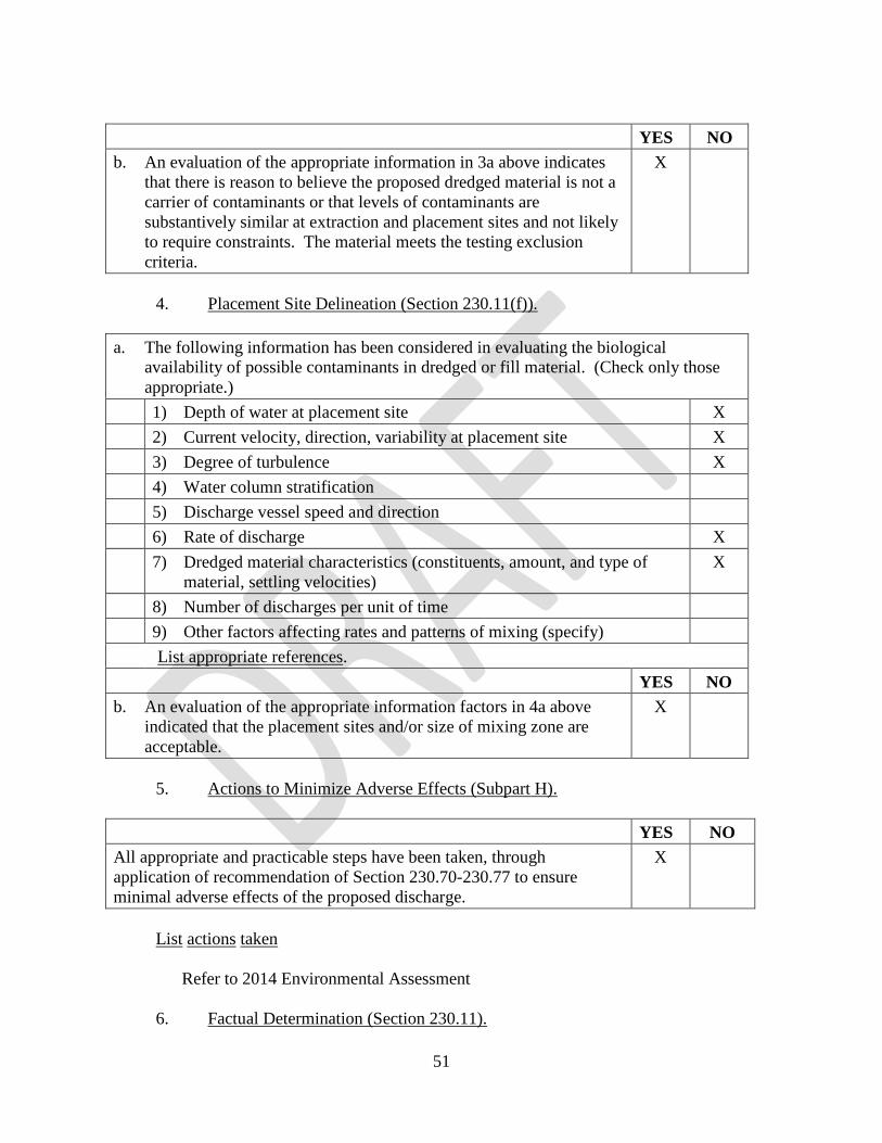
51
YES NO
b. An evaluation of the appropriate information in 3a above indicates that there is reason to believe the proposed dredged material is not a carrier of contaminants or that levels of contaminants are substantively similar at extraction and placement sites and not likely to require constraints. The material meets the testing exclusion criteria.
X
4. Placement Site Delineation (Section 230.11(f)).
a. The following information has been considered in evaluating the biological availability of possible contaminants in dredged or fill material. (Check only those appropriate.)
1) Depth of water at placement site X 2) Current velocity, direction, variability at placement site X 3) Degree of turbulence X 4) Water column stratification 5) Discharge vessel speed and direction 6) Rate of discharge X 7) Dredged material characteristics (constituents, amount, and type of
material, settling velocities) X
8) Number of discharges per unit of time 9) Other factors affecting rates and patterns of mixing (specify) List appropriate references. YES NO
b. An evaluation of the appropriate information factors in 4a above indicated that the placement sites and/or size of mixing zone are acceptable.
X
5. Actions to Minimize Adverse Effects (Subpart H).
YES NO All appropriate and practicable steps have been taken, through application of recommendation of Section 230.70-230.77 to ensure minimal adverse effects of the proposed discharge.
X
List actions taken
Refer to 2014 Environmental Assessment
6. Factual Determination (Section 230.11).
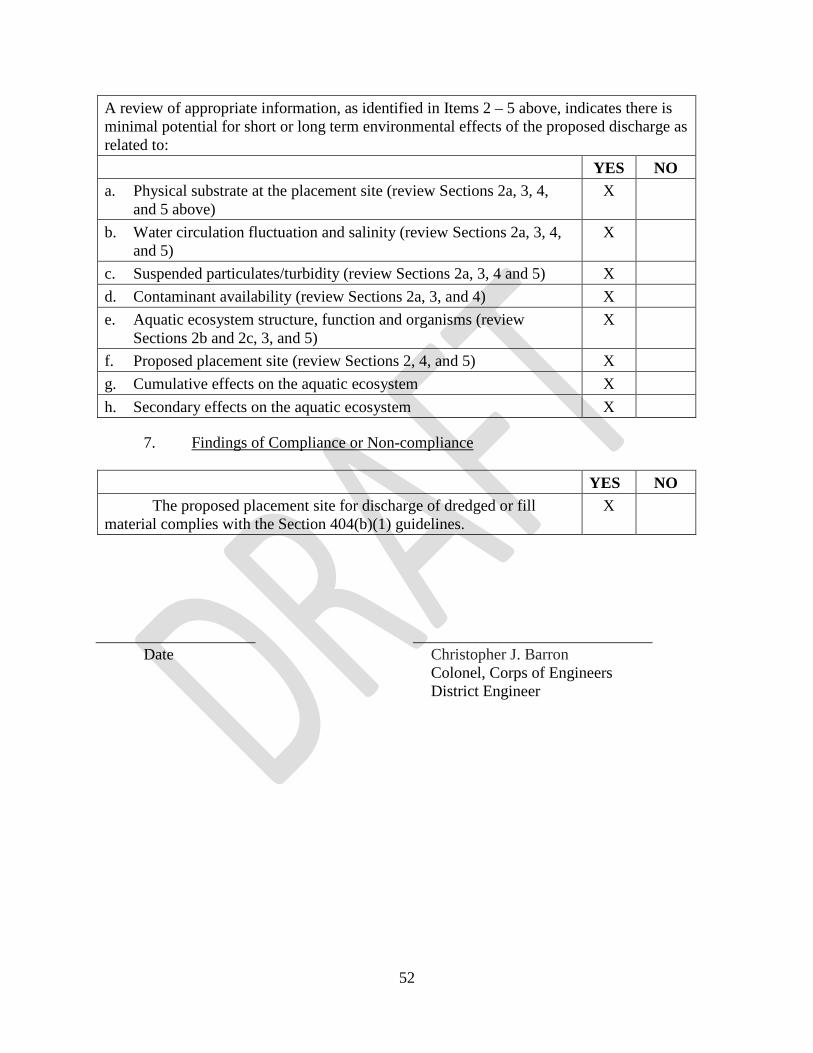
52
A review of appropriate information, as identified in Items 2 – 5 above, indicates there is minimal potential for short or long term environmental effects of the proposed discharge as related to: YES NO a. Physical substrate at the placement site (review Sections 2a, 3, 4,
and 5 above) X
b. Water circulation fluctuation and salinity (review Sections 2a, 3, 4, and 5)
X
c. Suspended particulates/turbidity (review Sections 2a, 3, 4 and 5) X d. Contaminant availability (review Sections 2a, 3, and 4) X e. Aquatic ecosystem structure, function and organisms (review
Sections 2b and 2c, 3, and 5) X
f. Proposed placement site (review Sections 2, 4, and 5) X g. Cumulative effects on the aquatic ecosystem X h. Secondary effects on the aquatic ecosystem X
7. Findings of Compliance or Non-compliance
YES NO The proposed placement site for discharge of dredged or fill
material complies with the Section 404(b)(1) guidelines. X
____________________ ______________________________
Date Christopher J. Barron Colonel, Corps of Engineers District Engineer
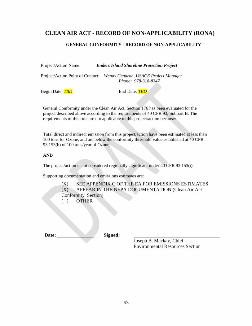
53
CLEAN AIR ACT - RECORD OF NON-APPLICABILITY (RONA)
GENERAL CONFORMITY - RECORD OF NON-APPLICABILITY
Project/Action Name: Enders Island Shoreline Protection Project Project/Action Point of Contact: Wendy Gendron, USACE Project Manager Phone: 978-318-8347 Begin Date: TBD End Date: TBD
General Conformity under the Clean Air Act, Section 176 has been evaluated for the project described above according to the requirements of 40 CFR 93, Subpart B. The requirements of this rule are not applicable to this project/action because: Total direct and indirect emission from this project/action have been estimated at less than 100 tons for Ozone, and are below the conformity threshold value established at 40 CFR 93.153(b) of 100 tons/year of Ozone; AND The project/action is not considered regionally significant under 40 CFR 93.153(i). Supporting documentation and emissions estimates are:
(X) SEE APPENDIX C OF THE EA FOR EMISSIONS ESTIMATES (X) APPEAR IN THE NEPA DOCUMENTATION (Clean Air Act Conformity Section) ( ) OTHER
Date: _______________ Signed: ___________________________________ Joseph B. Mackay, Chief Environmental Resources Section

A
A – Revetment Design

A

B
B- Correspondence

B
B

B
B
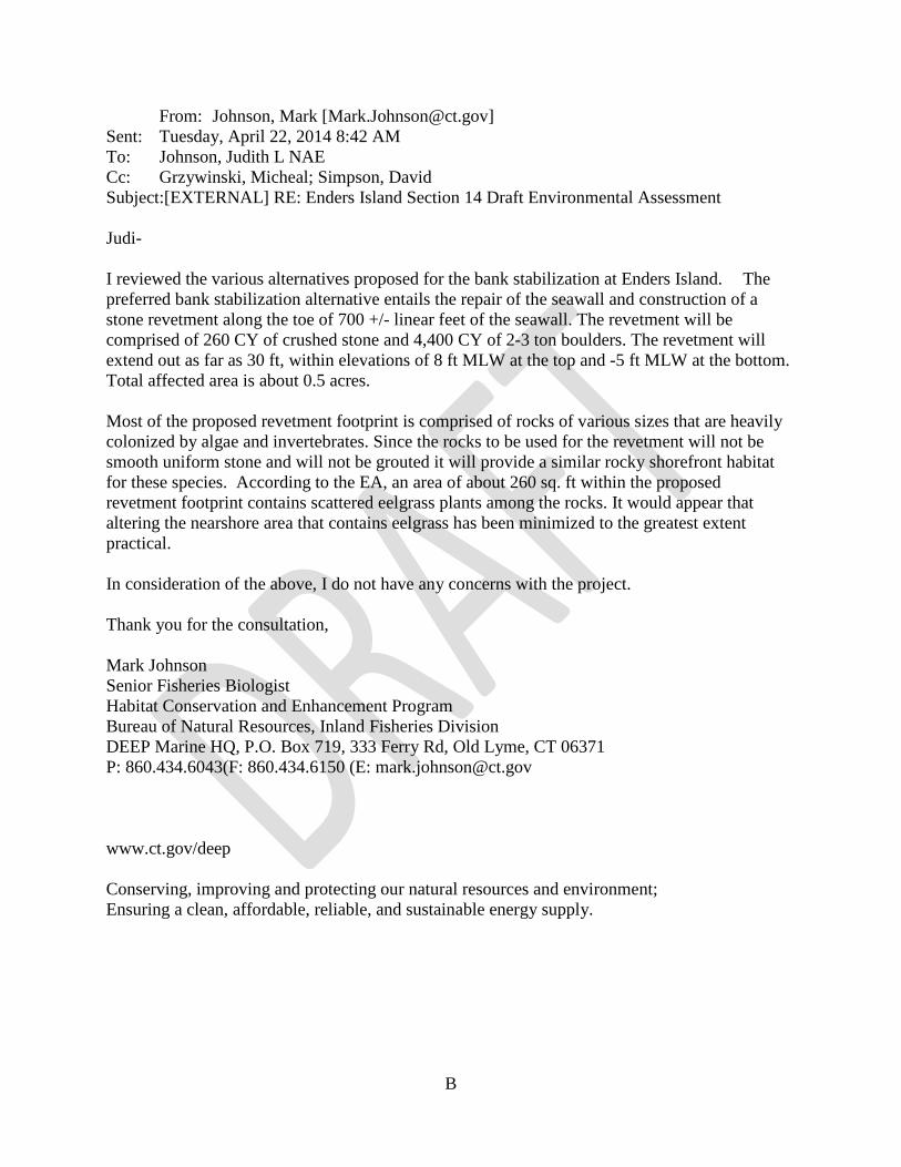
B
From: Johnson, Mark [[email protected]] Sent: Tuesday, April 22, 2014 8:42 AM To: Johnson, Judith L NAE Cc: Grzywinski, Micheal; Simpson, David Subject:[EXTERNAL] RE: Enders Island Section 14 Draft Environmental Assessment Judi- I reviewed the various alternatives proposed for the bank stabilization at Enders Island. The preferred bank stabilization alternative entails the repair of the seawall and construction of a stone revetment along the toe of 700 +/- linear feet of the seawall. The revetment will be comprised of 260 CY of crushed stone and 4,400 CY of 2-3 ton boulders. The revetment will extend out as far as 30 ft, within elevations of 8 ft MLW at the top and -5 ft MLW at the bottom. Total affected area is about 0.5 acres. Most of the proposed revetment footprint is comprised of rocks of various sizes that are heavily colonized by algae and invertebrates. Since the rocks to be used for the revetment will not be smooth uniform stone and will not be grouted it will provide a similar rocky shorefront habitat for these species. According to the EA, an area of about 260 sq. ft within the proposed revetment footprint contains scattered eelgrass plants among the rocks. It would appear that altering the nearshore area that contains eelgrass has been minimized to the greatest extent practical. In consideration of the above, I do not have any concerns with the project. Thank you for the consultation, Mark Johnson Senior Fisheries Biologist Habitat Conservation and Enhancement Program Bureau of Natural Resources, Inland Fisheries Division DEEP Marine HQ, P.O. Box 719, 333 Ferry Rd, Old Lyme, CT 06371 P: 860.434.6043(F: 860.434.6150 (E: [email protected] www.ct.gov/deep Conserving, improving and protecting our natural resources and environment; Ensuring a clean, affordable, reliable, and sustainable energy supply.
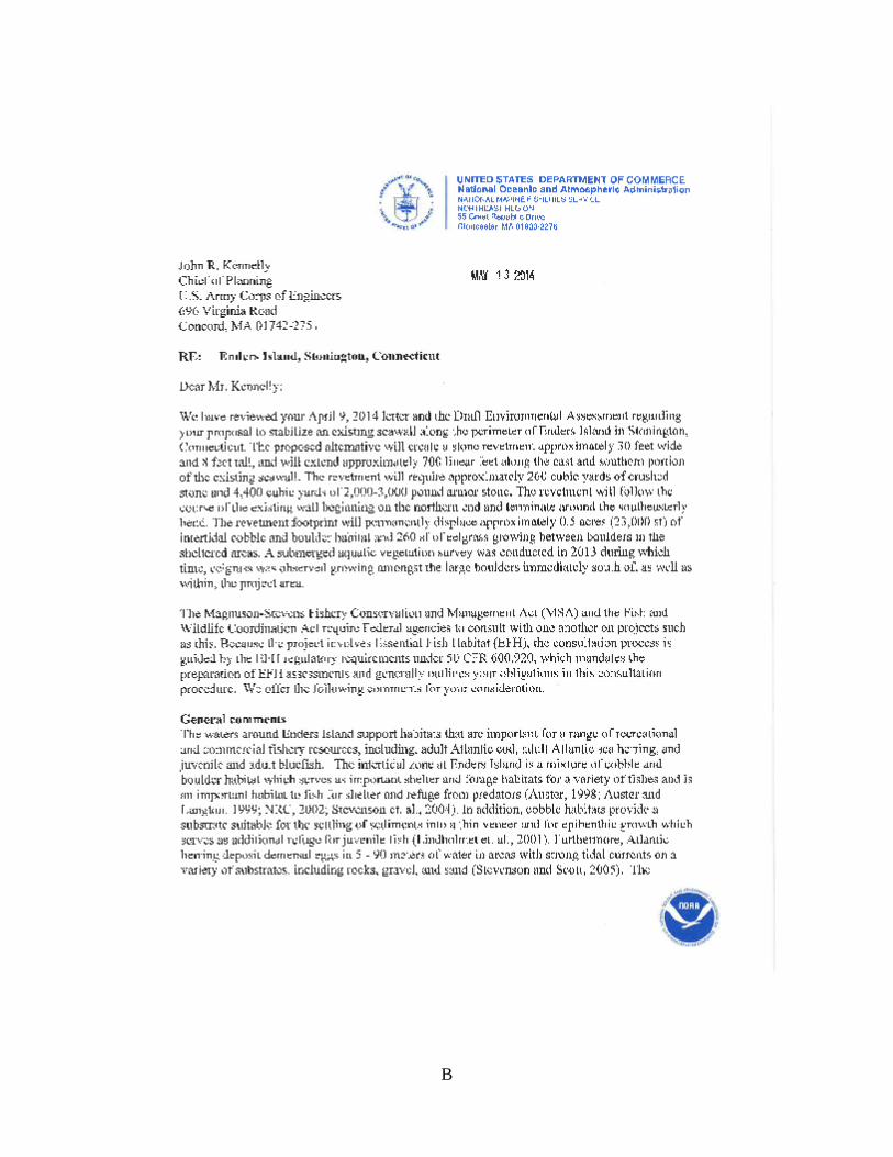
B

B

B
B
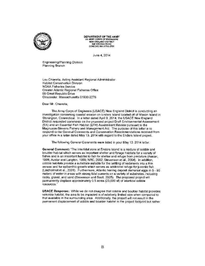
B
B

B

B

B

B

B

B

B
B

B
B
-----Original Message----- From: James Quinn [mailto:[email protected]] Sent: Monday, July 07, 2014 10:12 AM To: Paiva, Marcos A NAE Cc: Susan Kobyluck Subject: [EXTERNAL] Enders Island Hello Marc, I hope you had a nice holiday weekend. I am emailing you in regard to the above referenced project. I recently received a project review for proposed work to repair the sea wall that was damaged as a result of severe storms. I also visited the site in 2013 when the project was in the initial design phase. It is my opinion that no properties of cultural, religious or historic signfiance to the Mohegan Tribe of Indians of Connecticut will be adversely affected by this project as it proposed. Since I did not have an email contact for the project and you were listed as a contact via phone, I thought I would send you my comments in hopes that you could pass them along to whomever the proper person may be. If you have any questions please feel free to give me a call. Best regards, James James Quinn The Mohegan Tribe Mohegan Tribal Historic Preservation Officer/Archaeology Department Manager 13 Crow Hill Rd. Uncasville, CT Office: 860-862-6893 Cell: 860-367-1573

B
From: Knowles, Kathleen [[email protected]] Sent: Wednesday, July 09, 2014 3:07 PM To: Paiva, Marcos A NAE Cc: Stevens, Sue Subject: [EXTERNAL] PROPOSED SECTION 14 EMERGENCY SHORELINE EROSION PROTECTION PROJECT AT ENDERS ISLAND, CT Re: PROPOSED SECTION 14 EMERGENCY SHORELINE EROSION PROTECTION PROJECT ENDERS ISLAND, CT Based on a review of the information provided regarding this specific project, there does not appear to be any impact to potentially significant religious and cultural resources for the Mashantucket Pequot Tribe. Please keep me informed of any further developments with respect to this project. The 4th paragraph of your letter regarding failure of the septic system mentions “The closest connection to an existing sewer line is over two miles from the island & would require above ground piping along the causeway and through the residential area below ground through Mason’s Island.” Masons Island is culturally significant to the Mashantucket Pequot Tribe. Even though “this is only listed as a moderate priority for the Town & is not recommended for action within the next 20 years,” if this part of the project moves forward, please contact the Mashantucket Pequot Tribe THPO early in the process before any work begins. The Mashantucket Pequot Tribe appreciates the opportunity to review and comment on this proposed project. Description: Description: Description: Description: Description: Description: Description: Description: image003Kathleen Knowles Tribal Historic Preservation Officer Natural Resources Protection & Regulatory Affairs Mashantucket Pequot Tribal Nation 550 Trolley Line Blvd., P.O. Box 3202, Mashantucket, CT 06338-3202 TEL: 860-396-6887 FAX: 860-396-6914 [email protected]

B

C
Appendix C- Clean Air Act General Conformity Review Air Emissions Calculatio
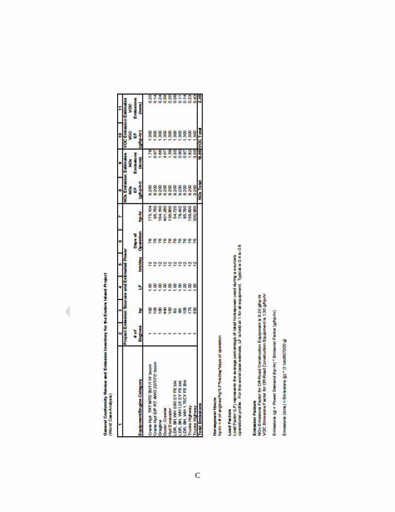
C
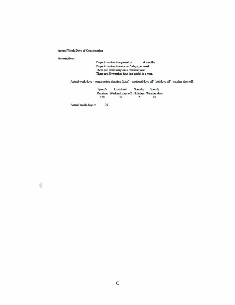
C

C

D
Appendix D- Essential Fish Habitat Assessment
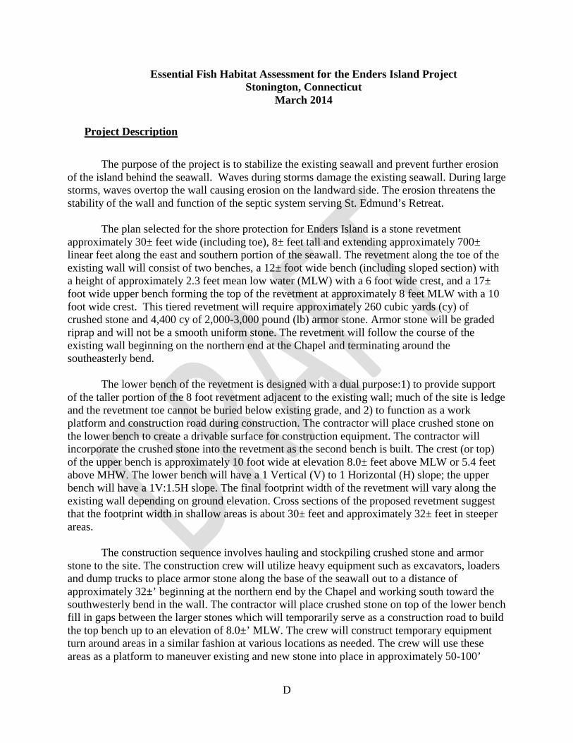
D
Essential Fish Habitat Assessment for the Enders Island Project Stonington, Connecticut
March 2014
Project Description
The purpose of the project is to stabilize the existing seawall and prevent further erosion of the island behind the seawall. Waves during storms damage the existing seawall. During large storms, waves overtop the wall causing erosion on the landward side. The erosion threatens the stability of the wall and function of the septic system serving St. Edmund’s Retreat.
The plan selected for the shore protection for Enders Island is a stone revetment
approximately 30± feet wide (including toe), 8± feet tall and extending approximately 700± linear feet along the east and southern portion of the seawall. The revetment along the toe of the existing wall will consist of two benches, a 12± foot wide bench (including sloped section) with a height of approximately 2.3 feet mean low water (MLW) with a 6 foot wide crest, and a 17± foot wide upper bench forming the top of the revetment at approximately 8 feet MLW with a 10 foot wide crest. This tiered revetment will require approximately 260 cubic yards (cy) of crushed stone and 4,400 cy of 2,000-3,000 pound (lb) armor stone. Armor stone will be graded riprap and will not be a smooth uniform stone. The revetment will follow the course of the existing wall beginning on the northern end at the Chapel and terminating around the southeasterly bend.
The lower bench of the revetment is designed with a dual purpose:1) to provide support
of the taller portion of the 8 foot revetment adjacent to the existing wall; much of the site is ledge and the revetment toe cannot be buried below existing grade, and 2) to function as a work platform and construction road during construction. The contractor will place crushed stone on the lower bench to create a drivable surface for construction equipment. The contractor will incorporate the crushed stone into the revetment as the second bench is built. The crest (or top) of the upper bench is approximately 10 foot wide at elevation 8.0± feet above MLW or 5.4 feet above MHW. The lower bench will have a 1 Vertical (V) to 1 Horizontal (H) slope; the upper bench will have a 1V:1.5H slope. The final footprint width of the revetment will vary along the existing wall depending on ground elevation. Cross sections of the proposed revetment suggest that the footprint width in shallow areas is about 30± feet and approximately 32± feet in steeper areas.
The construction sequence involves hauling and stockpiling crushed stone and armor
stone to the site. The construction crew will utilize heavy equipment such as excavators, loaders and dump trucks to place armor stone along the base of the seawall out to a distance of approximately 32±’ beginning at the northern end by the Chapel and working south toward the southwesterly bend in the wall. The contractor will place crushed stone on top of the lower bench fill in gaps between the larger stones which will temporarily serve as a construction road to build the top bench up to an elevation of 8.0±’ MLW. The crew will construct temporary equipment turn around areas in a similar fashion at various locations as needed. The crew will use these areas as a platform to maneuver existing and new stone into place in approximately 50-100’

D
sections. Any useful stone within the footprint of the revetment will be moved into position or stockpiled on site and sorted for later use. Given the rocky substrate of the area, excavation of sand and other materials are not anticipated. After the lower bench of the revetment is complete, the crew will work in a similar fashion to place armor stone forming the upper bench and revetment crest. The work will take place over a four month period in the years in which funds become available.
EFH Assessment
Pursuant to the Magnuson-Stevens Fishery Conservation and Management Act and amended by the Sustainable Fisheries Act of 1996, an Essential Fish Habitat (EFH) consultation is necessary for this project. EFH is broadly defined as “those waters and substrates necessary to fish for spawning, breeding, feeding, or growth to maturity.” That includes the eelgrass beds, subtidal and intertidal habitat around Enders Island.
The construction of the revetment at Enders Island will have minimal effects on designated Essential Fish Habitat (EFH). The work includes the construction of a rock revetment in an area of boulder/cobble habitat, some of which is composed of rocks that have become detached from the wall and fallen into the intertidal area. Although the revetment footprint will permanently displace approximately 0.5 acres (23,000 ft2) of intertidal cobble, the revetment rock will provide a suitable substrate for the attachment and growth of similar types of macroalgae and benthic organisms. Impacts to EFH will also include minimal elevations in turbidity in the intertidal/subtidal areas surrounding Enders Island as material is placed during the construction of the revetment will consist of large rock and gravel with minimal fine particles. Elevated turbidity impacts are anticipated to be highly localized and short-term in duration.
The Connecticut Department of Energy and Environmental Protection (CTDEEP) Geographic Information System mapping delineates Submerged Aquatic Vegetation (SAV) beds approximately 500 feet to the north, 1,250 feet to the west and 1,250 feet to the east of the project area. SAV was also identified immediately south of the project area in an underwater video survey conducted by the U.S. Army Corps of Engineers (USACE) on June 21, 2013 (see Attachment 1 - June 2013 USACE Eelgrass Survey and CT DEEP 2009 Eelgrass Bed). Eelgrass was observed to be growing as individual shoots or small clumps of shoots amongst large boulders in this area. Other vegetation observed in the project area various species of macroalgae typical of moderate to high wave action.
Avoidance of eelgrass beds, a highly productive habitat, was an important consideration
in the selection of the proposed project design. Four revetment design iterations, which involved different height and slope variables, were evaluated. In addition to design iterations, several design options; a reduced crest width and construction of a cutoff wall at the toe of the revetment, were also considered to reduce the size of the revetment footprint and avoid/minimize direct impacts to eelgrass. The project team concluded that stone revetment iterations 1 through 3 and additional design options were not practical.
Iteration 4 of the stone revetment was determined to be the recommended plan. The
footprint of the revetment was further reduced steepening slopes of the lower bench and construction of an underlayer with gravel and fines was also eliminated. While this will result in

D
a rougher surface than the underlayer, the surface should be adequate (not ideal) for the construction equipment envisioned to complete the project. By reducing the slopes and eliminating the underlayer, the project footprint and potential impact to eelgrass at the southern tip of the island was reduced from 580 to 260 square feet (see Attachment 2 – Potential Impact to Eelgrass).
This alternative is expected to provide seawall and land erosion protection for New
England 10-20 year storms for an extended period and requires little maintenance. This iteration of the stone revetment minimizes and avoids impacts to eelgrass to the greatest extent practical. The SAV survey crew was not able to evaluate in detail all areas within the proposed project footprint due to water levels and safety concerns with waves and rocky areas with the boat in the 2013 survey. However, the project team is assuming that eelgrass is present in the project footprint at the southern tip of the island, although the density is expected to be low. To address these potential impacts to eelgrass, a preconstruction survey will be conducted to document eelgrass in the footprint of the revetment. If eelgrass is identified, further coordination will be conducted with the National Marine Fisheries Service. Minor noise impacts from the construction equipment will occur during the project. However, noise impacts will be localized and short-term. Therefore, impacts to EFH as a result of this project are expected to be minimal.
As stated in National Oceanic and Atmospheric Administration (NOAA), National Marine Fisheries Service (NMFS) source documents (NOAA 2013), ten federally managed species have the potential to occur within the project area. The species listed for the project area include Atlantic cod (Gadus morhua)(adult), Atlantic sea herring (Clupea harengus)(adult), bluefish (Pomatomus saltatrix)(juveniles and adults), king mackerel (Scomberomorus cavalla) (eggs, larvae, juveniles, adults); Spanish mackerel (Scomberomorus maculatus) (eggs, larvae, juveniles, adults); cobia (Rachycentron canadum) (eggs, larvae, juveniles, adults); sand tiger shark (Carcharias taurus)(larvae); blue shark (Prionace glauca)(larvae, adults); dusky shark (Carcharhinus obscurus)(juveniles); and bluefin tuna (Thunnus thynnus)(adults). Information and detailed descriptions of the life history requirements of these species was derived from the National Marine Fisheries Service (NMFS) “Guide to EFH Species Designations” located at http://www.nero.noaa.gov/hcd/list.htm.
The following paragraphs detail the effect of the project on each managed species in the project area:
EFH for adult Atlantic cod (Gadus morhua) is designated within the project area. Adult cod are generally found in deeper waters than those found in the areas around Enders Island. Therefore, no impacts to cod EFH are anticipated.
EFH is designated within the project area for adult Atlantic sea herring (Clupea
harengus). Adult sea herring are typically found in depths of 20 to 130 meters, depths that are generally deeper than those found around Enders Island. Therefore, no impacts are expected to occur to Atlantic sea herring EFH.

D
EFH is designated within the project area for juvenile and adult life stages of bluefish (Pomatomus saltatrix). Impacts to bluefish EFH are anticipated to be minimal as the area of impact will be localized and any impacts will be short-term. Additionally, juvenile and adult bluefish are highly mobile and would be able to avoid construction activities should they be present. Therefore, no more than minimal impacts to bluefish EFH are anticipated.
EFH is designated within the project area for all life stages of king mackerel
(Scomberomorus cavalla). Impacts to mackerel EFH are anticipated to be minimal as the area of impact will be localized and any impacts will be short-term. Additionally, mackerel are highly mobile and would be able to avoid construction activities should they be present. Therefore, no more than minimal impacts to mackerel EFH are anticipated.
EFH is designated within the project area for all life stages of Spanish mackerel
(Scomberomorus maculatus). Impacts to mackerel EFH are anticipated to be minimal as the area of impact will be localized and any impacts will be short-term. Additionally, mackerel are highly mobile and would be able to avoid construction activities should they be present. Therefore, no more than minimal impacts to mackerel EFH are anticipated.
EFH is designated within the project area for all life stages of cobia (Rachycentron
canadum). Impacts to cobia EFH are anticipated to be minimal as the area of impact will be localized and any impacts will be short-term. Additionally, cobia are a highly mobile species and would be able to avoid construction activities should they be present. Therefore, no more than minimal impacts to cobia EFH are anticipated.
EFH is designated within the project area for larval sand tiger sharks (Carcharias taurus).
Larval sand tiger sharks are generally found in deeper waters than those found in the areas around Enders Island. Therefore, no impacts to sand tiger shark EFH are anticipated.
EFH is designated within the project area for larval and adult Blue shark (Prionace
glauca). Larval and juvenile blue sharks are generally found in deeper waters than those found in the areas around Enders Island. Therefore, no impacts to blue shark EFH are anticipated.
EFH is designated in the project area for juvenile dusky shark (Carcharhinus obscures).
Juvenile dusky sharks are generally found in deeper waters than those found in the areas around Enders Island. Therefore, no impacts to dusky shark EFH are anticipated.
EFH for the highly migratory adult bluefin tuna (Thunnus thynnus) is designated in the
project area. However, tuna are highly mobile and should be able to avoid construction activities if present. Therefore, no impacts to tuna EFH are anticipated.

D
Attachment 1 - June 2013 USACE Eelgrass Survey and 2009 CT DEEP Eelgrass Beds

D
Attachment 2 – Potential Impact to Eelgrass

E
Appendix E – June 2013 Eelgrass Survey
E
E

E
E

E
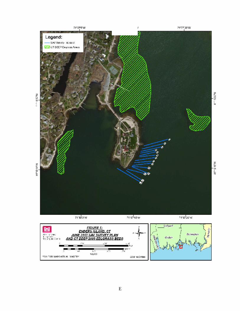
E

E