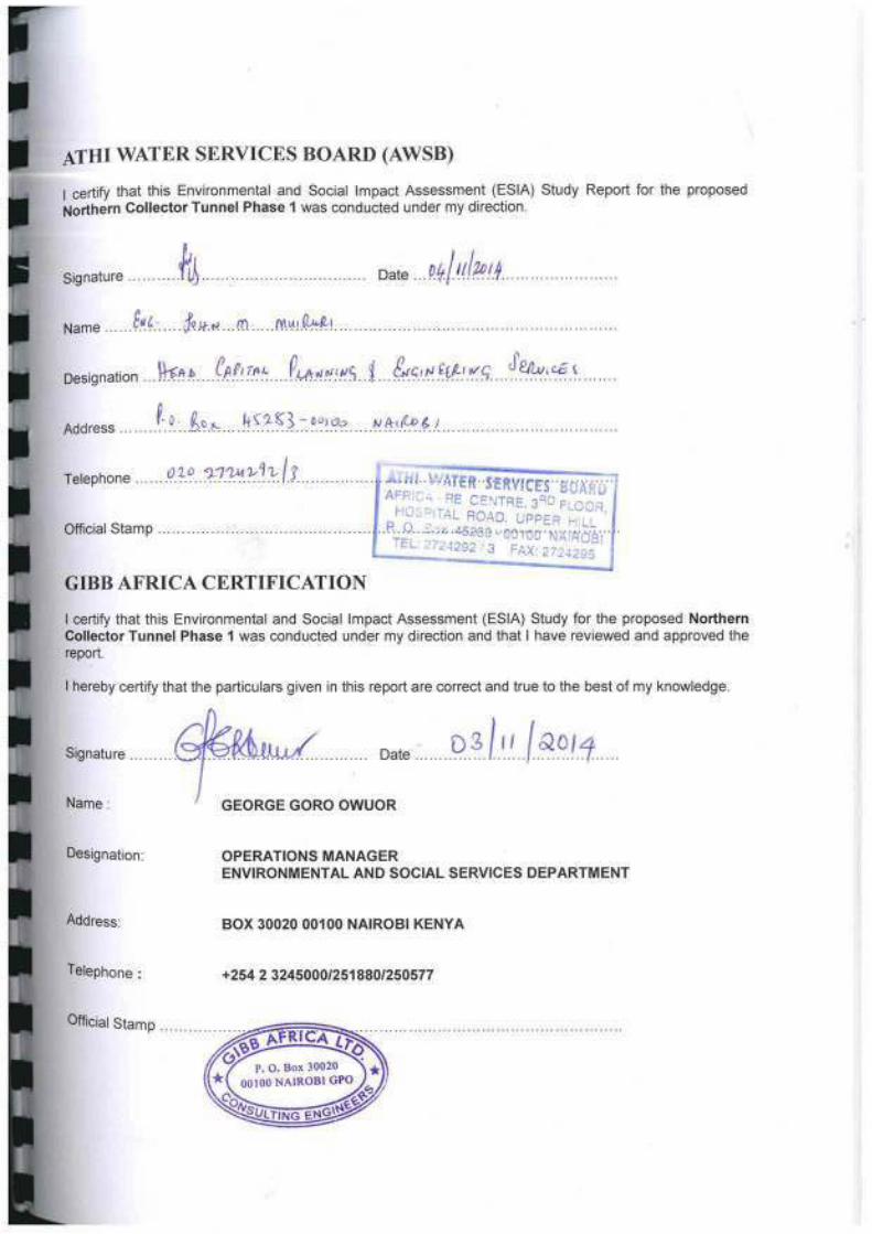
FINAL STUDY REPORT - National Environment Management ...
394
FINAL STUDY REPORT FINAL STUDY REPORT OCTOBER 2014 000987
-
Upload
khangminh22 -
Category
Documents
-
view
0 -
download
0
Transcript of FINAL STUDY REPORT - National Environment Management ...

FINAL STUDY REPORTFINAL STUDY REPORT
OCTOBER 2014000987

ESIA STUDY REPORT NCT PHASE 1 ii Issue 1.0 / October 2014
ENVIRONMENT AND SOCIAL IMPACT ASSESSMENT STUDY REPORT
CONTENTS
Chapter Description Page
EXECUTIVE SUMMARY xiv
1 INTRODUCTION 1-1
1.1 Project Background and rationale 1-1
1.2 Project Location 1-2
1.3 Objectives of the ESIA study 1-5
1.4 Methodology 1-61.4.1 Screening Visit 1-61.4.2 Project Report and Scoping 1-61.4.3 Desk Study 1-61.4.4 ESIA Study 1-71.4.5 Ecological Surveys 1-7
(a) Qualitative method- Desk stop study and indigenous knowledge on aquatic fauna of the study area 1-7(b) Quantitative methods 1-7(i) Field sampling design 1-7(ii) Aquatic fauna sampling techniques 1-8(iii) Fish sampling techniques 1-8(iv) Macro-invertebrates sampling methods 1-9(v) Water quality parameters 1-10(vi) Others- Small mammals, amphibians and reptiles 1-10(vii) Fish and invertebrates identification 1-10(c) Other fauna 1-11(d) Plants 1-11
1.4.6 Impacts on biodiversity 1-111.4.7 Hydrology 1-111.4.8 Mapping of Baseline Environment 1-121.4.9 Socioeconomic Survey 1-141.4.10 Public Consultations 1-14
(a) Project Report Stage 1-14(b) ESIA Study Stage 1-14(i) Public meetings 1-15(ii) Key Informant Interviews 1-15(c) Incorporating public views into the ESIA report 1-15(d) Public disclosure 1-15
1.5 Study Limitations 1-16
1.6 ESIA Study Team 1-16
1.7 Structure of the Report 1-16
2 POLICY, LEGAL AND REGULATORY FRAMEWORK 2-1
2.1 Background 2-1

ESIA STUDY REPORT NCT PHASE 1 iii Issue 1.0 / October 2014
2.2 Policy Framework 2-12.2.1 Environmental Policy 2-12.2.2 Kenya’s Vision 2030 2-12.2.3 Land Policy 2-22.2.4 National Water Policy 2-22.2.5 Millennium Development Goals (MDGs) 2-3
2.3 Legal Framework 2-32.3.1 Constitution of Kenya 2-32.3.2 The Environment Management and Coordination Act, 1999 2-4
(a) Environmental Impact Assessment and Audit Regulations 2003 2-4(b) The Environmental Management and Co-ordination Act (Water Quality) Regulations, 2006) 2-5(c) The Environmental Management and Co-ordination (Waste Management) Regulations, 2006 2-6(d) The Environmental Management and Coordination Act (Noise and Excessive Vibration Pollution) (Control) Regulations, 2009 2-6(e) The Environmental Management and Coordination (Wetlands, River Banks, Lake Shores and Sea Shore Management) Regulations, 2009 2-7(f) The Environmental Management and Coordination (Conservation of Biological Diversity and Resources, Access to Genetic Resources and Benefit Sharing) Regulations, 2006 2-7(g) Environmental Management and Coordination (Fossil Fuel Emission Control) Regulations 2006 2-7
2.3.3 The Water Act, 2002 2-8(a) The Water Resources Management Rules, 2007 2-8
2.3.4 The Public Health Act (Cap. 242) 2-9(a) The Public Health (Drainage and Latrine) Rules 2-9
2.3.5 Malaria Prevention Act Cap 246 2-92.3.6 Occupational Safety and Health Act, 2007 2-102.3.7 Work Injury Benefits Act (WIBA), 2007 2-102.3.8 The Wildlife Conservation and Management Act, 2013 2-102.3.9 The Kenya Roads Board Act, Cap 408 of 1999 2-112.3.10 Public Roads and Road of Access Act (Cap 399) 2-112.3.11 The Kenya Roads Act of 2007 2-112.3.12 Acts Related to Land 2-122.3.13 The Physical Planning Act, 1996 2-162.3.14 Mining Act, Cap 306 2-172.3.15 Explosives Act, Cap 115 2-182.3.16 The Penal Code (Cap. 63) 2-18
2.4 World Bank Safeguard policies 2-192.4.1 World Bank policy OP 4.01 Environmental Assessment 2-192.4.2 World Bank policy OP 4.04 Natural Habitats 2-192.4.3 World Bank policy OP 4.11 Physical Cultural Resources 2-192.4.4 World Bank Operational Policy 4:12 Involuntary Resettlement 2-202.4.5 World Bank Operational Policy 4:37 Safety of Dams 2-20
2.5 AFD Policy on Environmental and Social Risk Management 2-212.5.1 Policy 2-212.5.2 Environmental and Social Risks 2-212.5.3 Reference Standards 2-21
2.6 Institutional Framework 2-222.6.1 Ministry of Environment, Water and Natural Resources 2-222.6.2 Athi Water Services Board 2-222.6.3 Nairobi City Water and Sewerage Company (NCWSC) 2-232.6.4 The National Environment Management Authority (NEMA) 2-23
(a) Standards and Enforcement Review Committee (SERC) 2-23(b) Public Complaints Committee 2-23

ESIA STUDY REPORT NCT PHASE 1 iv Issue 1.0 / October 2014
(c) County Environmental Offices 2-232.6.5 Water Resource Management Authority (WRMA) 2-232.6.6 Water Services Regulatory Board 2-242.6.7 Ministry of Agriculture, Livestock and Fisheries 2-242.6.8 Kenya Forest Service 2-242.6.9 Kenya Wildlife Service 2-242.6.10 Directorate of Occupational Safety and Health 2-242.6.11 County Government of Murang’a 2-25
2.7 International Conventions 2-252.7.1 Convention on Biological Diversity 2-252.7.2 The Ramsar Convention 2-252.7.3 African Convention on the Conservation of Nature and Natural Resources 2-262.7.4 Kyoto Protocol to the United Nations Framework Convention on Climate Change 2-262.7.5 The 1992 United Nations Framework Convention on Climate Change (UNFCCC); 2-262.7.6 Vienna Convention for the Protection of the Ozone Layer 2-26
3 BASELINE ENVIRONMENTAL SETTING 3-1
3.1 Physical environment 3-13.1.1 Climate 3-1
(a) Rainfall 3-1(b) Temperature and humidity 3-2(c) Sunshine hours 3-2(d) Evaporation 3-2(e) Winds 3-2
3.1.2 Topography and Drainage 3-23.1.3 Geology 3-33.1.4 Landslide hazards 3-73.1.5 Soils 3-73.1.6 Hydrology and drainage 3-73.1.7 Water Resources and key uses 3-11
(a) Surface water resources 3-11(b) Underground water resources 3-12
3.1.8 Air Quality 3-123.1.9 Noise 3-12
3.2 Biological Environment 3-153.2.1 Fauna 3-15
(a) Aquatic fauna of conservation significance 3-18(b) Birds 3-19(c) Other fauna 3-19(i) Native species: 3-19(ii) Introduced species: 3-19
3.2.2 Flora 3-19(a) Floristic composition 3-19
Figure 3-10 Life form spectrum of species 3-21(b) Floral Species diversity 3-21(c) Botanical uniqueness 3-21(d) Algae 3-22(e) Threats to Plants and Existing Ecologically Sensitive Areas 3-23
3.3 Social Characteristics 3-243.3.1 Population size and composition 3-243.3.2 Household Headship 3-253.3.3 Religion 3-253.3.4 Education 3-25

ESIA STUDY REPORT NCT PHASE 1 v Issue 1.0 / October 2014
(a) Population currently in school 3-25(b) Education level for HH heads and spouses 3-26
3.3.5 Housing conditions 3-263.3.6 Access to water 3-273.3.7 Water treatment and sanitation 3-283.3.8 Health conditions 3-283.3.9 Medical facilities 3-293.3.10 Gender issues 3-303.3.11 Community problems 3-31
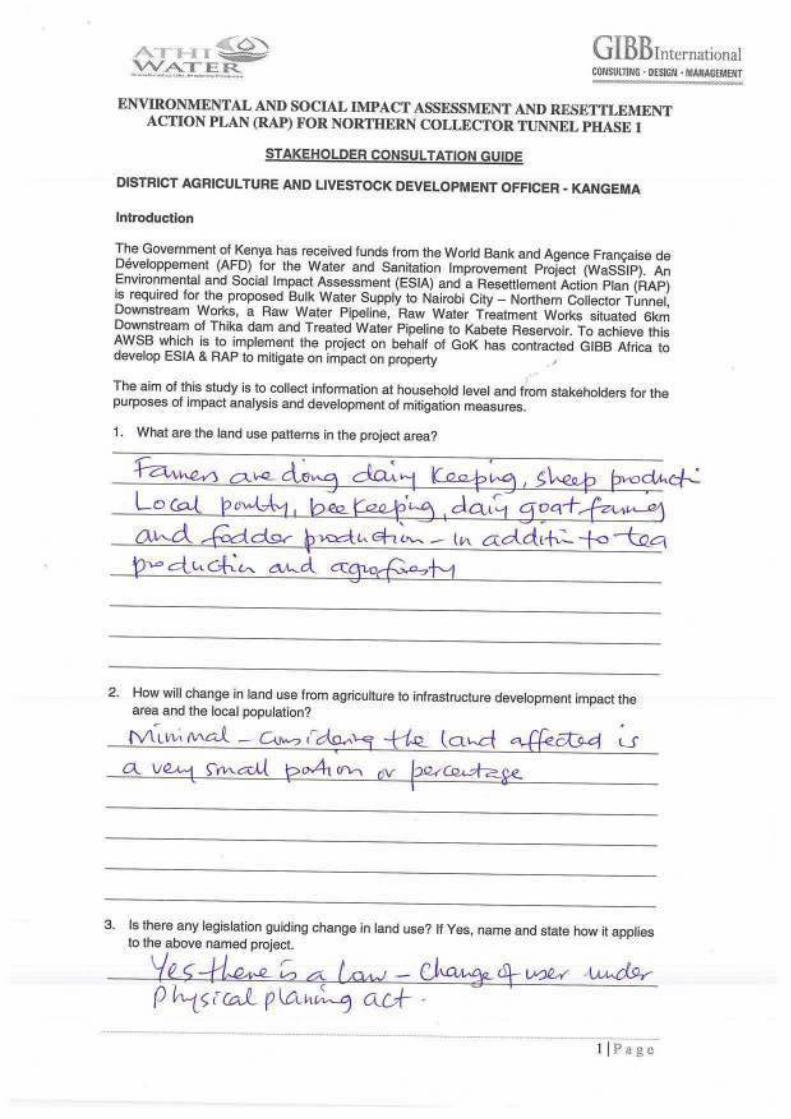
3.4 Economic Characteristics 3-313.4.1 Employment status of persons living in the project area 3-313.4.2 Income sources 3-313.4.3 Land tenure and ownership 3-323.4.4 Land use potential and agricultural activities 3-323.4.5 Energy sources 3-333.4.6 Roads access 3-34
4 PROJECT DESCRIPTION 4-1
4.1 Introduction 4-14.1.1 River Diversion Weir and Intake Structures 4-1
(a) River Diversion Weirs 4-2(b) Intake 4-3(c) Desilting Basin 4-3(d) Tunnel Inlet Well Drop Structure 4-4(e) Irati Drop Shaft 4-4(f) Compensation Channels for In-stream Flow Requirements (IFR) 4-4(i) Design features 4-4(ii) Operating principle 4-5
4.1.2 Northern Collector Tunnel 4-54.1.3 Tunnel Outfall Structure 4-74.1.4 Kaanja and Gikigie Adits 4-84.1.5 Tunnel portals 4-8
4.2 Fish Passes 4-9
4.3 Tunnel Excavation Methods 4-114.3.1 Conventional Tunnelling Construction 4-114.3.2 Excavation by Tunnelling Boring Machine (TBM) 4-11
4.4 Material Sources and Spoil Sites 4-124.4.1 Material Sources 4-124.4.2 Spoil sites 4-12
4.5 Project Inspection and Maintenance 4-13
4.6 Safety in Design 4-14
4.7 Temporary and enabling works 4-14
4.8 Construction Inputs and activities 4-154.8.1 Construction materials 4-154.8.2 Construction equipment 4-154.8.3 Labour 4-154.8.4 Construction activities (summary) 4-15
(a) For the intakes and outfall 4-16(b) For the tunnels and adits 4-16
4.9 Project Cost and Duration 4-16
ESIA STUDY REPORT NCT PHASE 1 vi Issue 1.0 / October 2014
4.10 Community Support Projects 4-164.10.1 Community water projects 4-164.10.2 Corporate Social Responsibility 4-17
5 PROJECT ALTERNATIVES 5-1
5.1 No Project Alternative 5-1
5.2 Construction of Maragua Dam 5-1
5.3 Tunnel Construction Options 5-25.3.1 Conventional Tunneling construction 5-25.3.2 Excavation by Tunnel Boring Machine (TBM) 5-2
6 PUBLIC CONSULTATIONS AND DISCLOSURE 6-1
6.1 General 6-16.1.1 Objectives of the Public consultation 6-1
6.2 Previous Consultations 6-26.2.1 Stakeholder Consultations at Scoping Stage 6-26.2.2 Summary of issues rose 6-2
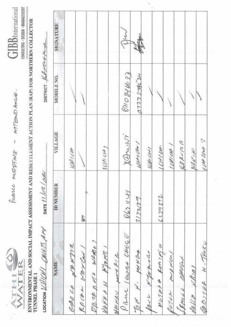
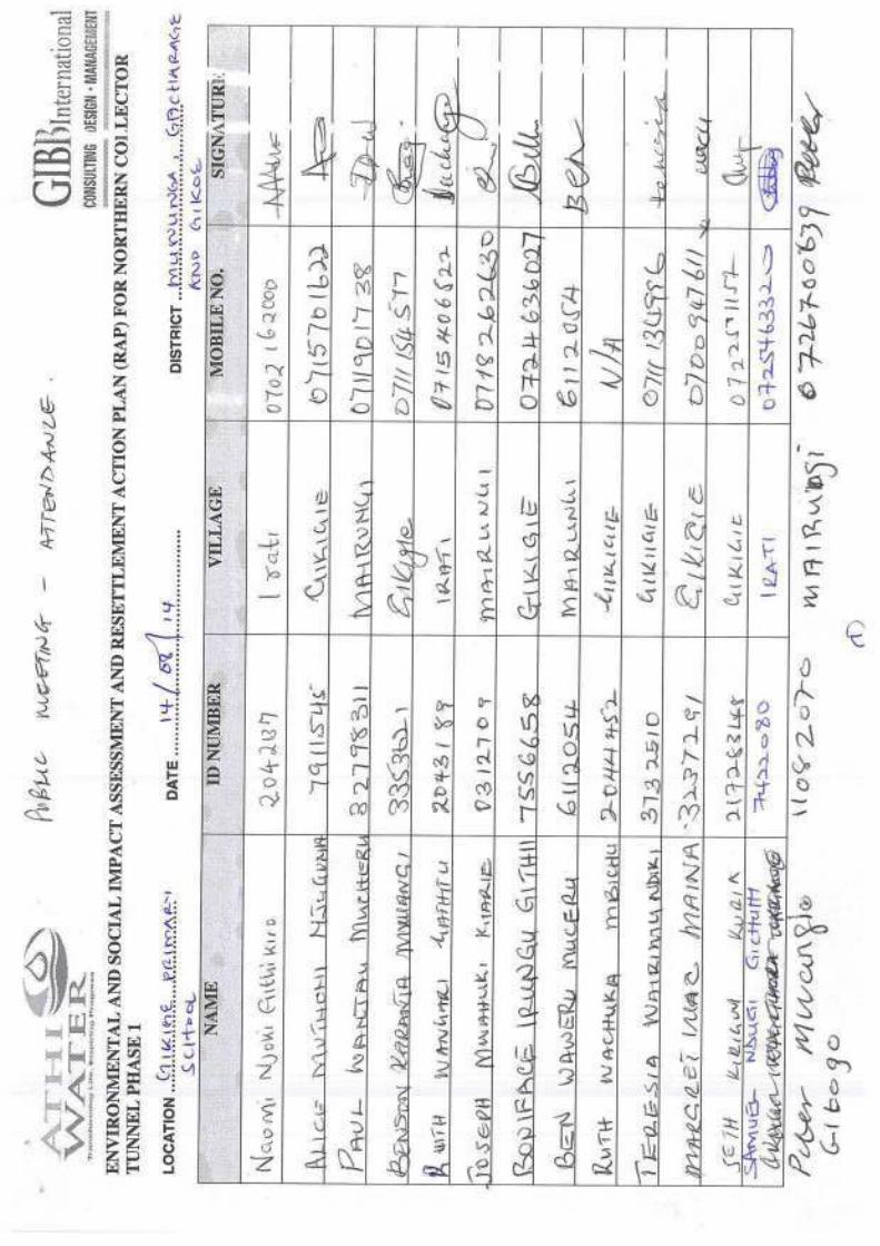
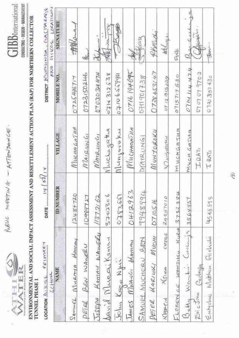
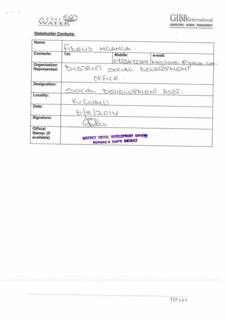
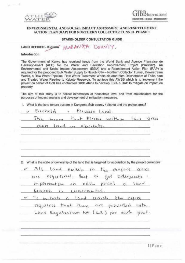
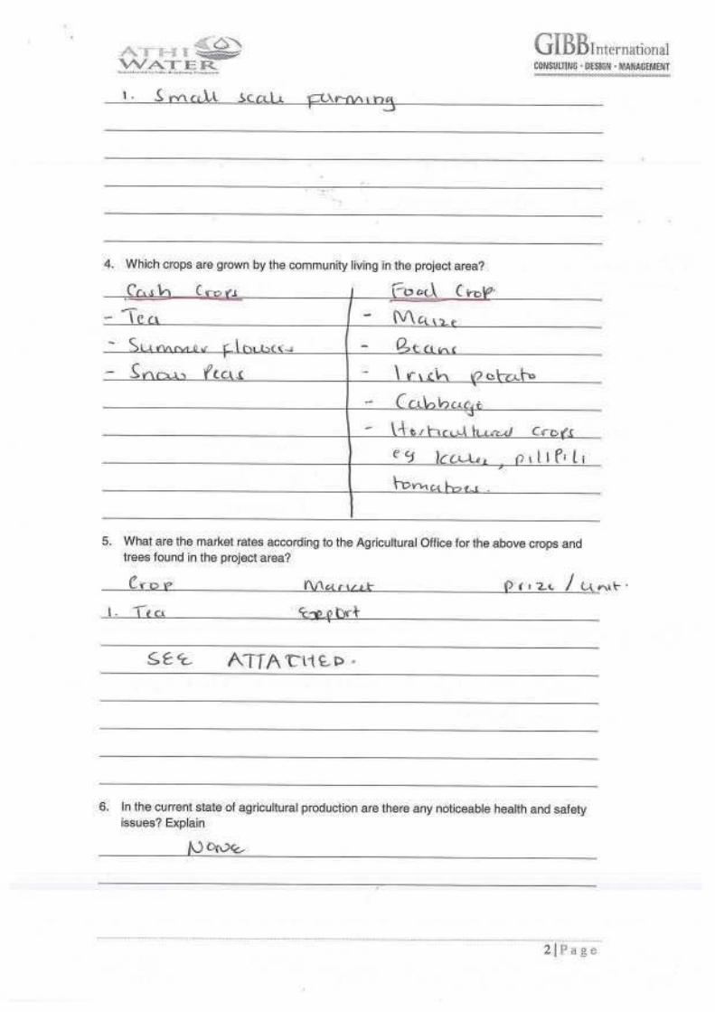
6.3 Stakeholder Consultations during ESIA and RAP 6-56.3.1 Consultations during the ESIA and RAP Study 6-56.3.2 Stakeholder identification 6-66.3.3 Approach and implementation of public consultations 6-6
6.4 Summary of Stakeholders Comments 6-8
6.5 Consultations with Project Beneficiaries 6-16
6.6 Focus Group Discussions Meetings 6-226.6.1 Employment Opportunities 6-226.6.2 Alcoholism among the youth 6-226.6.3 Road networks in the project area 6-226.6.4 Land Ownership in the area 6-226.6.5 Social impacts of compensation 6-236.6.6 Youth Groups in the project area 6-246.6.7 Intrusion of new people in the area 6-246.6.8 Lack of Health Facilities 6-256.6.9 Education institutions in the project area 6-256.6.10 Communication network in the area 6-256.6.11 Community roles 6-256.6.12 Community perception of economic ability 6-256.6.13 Grave sites 6-266.6.14 Cultural sites in the area 6-26
6.7 Public Meeting Consultations 6-276.7.1 Objective of Public Consultation Meetings 6-276.7.2 Comments from the Consultations 6-27
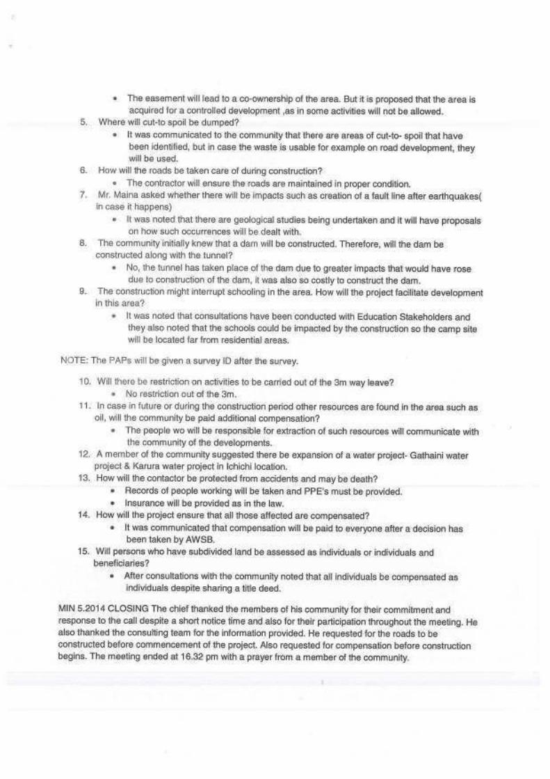
(a) Abstracting water used by community 6-28(b) Social impacts of alien persons in the area 6-28(c) Grievance mechanisms during and after Compensation 6-28(d) Waste management 6-28(e) Road destruction due to heavy equipment 6-28(f) Possible earth movement and faults 6-29(g) Interruption of school activities 6-29(h) Possible minerals underground 6-29(i) Relocation 6-29

ESIA STUDY REPORT NCT PHASE 1 vii Issue 1.0 / October 2014
(j) Mediators and crooks during the Compensation process 6-29(k) Absentee PAPs 6-30(l) Possible flooding/ damage due to excess water 6-30(m) Land use and acquisition of the wayleave above the Tunnel 6-30(n) Cut- Off dates 6-30(o) Direct benefits from the NCT-Phase 1 6-31(p) Health and Safety concerns during construction and operation 6-31(q) Community Conserving the Aberdare Forest 6-31
6.8 Public Disclosure 6-326.8.1 Stakeholders Represented at the Workshop 6-326.8.2 Comments from the Opening and Closing Sessions 6-336.8.3 Comments from the stakeholders after the Plenary Session 6-37
6.9 Project Awareness and support 6-396.9.1 Project support 6-40
7 IMPACTS ASSESSMENT AND PROPOSED MITIGATIONS 7-1
7.1 Introduction 7-17.1.1 Impact Assessment Scoring 7-1
7.2 Positive Construction Impacts 7-27.2.1 Employment and economic opportunities 7-27.2.2 Improved infrastructure 7-37.2.3 Development of marketing opportunities 7-47.2.4 Desirable Social Change 7-47.2.5 Knowledge Transfer 7-57.2.6 Income Generating Opportunities for Women 7-5
7.3 Negative Construction Impacts 7-77.3.1 Loss of land and resettlement 7-77.3.2 Geological and seismic hazards 7-87.3.3 Impacts on Soils 7-10
(a) Soil erosion and increased sedimentation 7-10(b) Soil pollution 7-10(c) Soil compaction 7-11
7.3.4 Pollution of (surface and ground) water resources 7-117.3.5 Changes in groundwater levels and flow 7-127.3.6 Impacts from Construction camp 7-137.3.7 Oil spills 7-137.3.8 Shifting of unskilled labour force from agriculture to construction 7-147.3.9 Impacts on Aquatic Fauna 7-14
(a) Sedimentation of stream water 7-14(b) Interference with fish movement/passage 7-15(c) Reduced water flow 7-16(d) Water contamination from Oil Spills and Leaks 7-16(e) Modification of stream habitats 7-17
7.3.10 Loss of vegetation cover 7-177.3.11 Spoil 7-187.3.12 Waste Generation 7-197.3.13 Air pollution 7-197.3.14 Noise and vibration 7-207.3.15 Cultural and archaeological sites 7-207.3.16 Immigration and settlement 7-217.3.17 Social delinquency, HIV/AIDS and other sexually transmitted infections 7-217.3.18 Impacts on traffic volumes and tonnage 7-227.3.19 Occupational and General public Safety and Health Hazards 7-237.3.20 Spread of communicable diseases 7-247.3.21 Growth of unplanned settlements 7-25

ESIA STUDY REPORT NCT PHASE 1 viii Issue 1.0 / October 2014
7.3.22 Disturbance to neighbouring land owners 7-257.3.23 Increased demand on utility supplies and Disruption services 7-267.3.24 Visual impacts 7-26
7.4 Positive Operation Impacts 7-277.4.1 Improved City water supply 7-277.4.2 Employment opportunities 7-287.4.3 Benefits in Public Health 7-287.4.4 Community support schemes 7-28
7.5 Negative Operation Impacts 7-307.5.1 Hydrological Impacts 7-30
(a) Hydrological Impacts of Reduced Flows 7-30(i) Hydrological and geomorphological changes 7-30(ii) Temperature changes 7-30(iii) Water quality changes 7-30(iv) Sediment deposition 7-30(b) Impacts of Increased Flows (receiving rivers) 7-31(i) Hydrological and Geomorphological impacts 7-31(ii) Temperature changes 7-31(iii) Water quality changes 7-31
7.5.2 Impacts on Aquatic Fauna 7-32(a) Impacts of low water discharge 7-32(b) Changes in food availability 7-32(c) Changes in water velocity 7-32(d) Interference with fish movement/passage 7-32(e) Overall impact 7-33(i) Setting the minimum environmental flow requirements 7-33(ii) Computation of the threshold Environmental flow based on the Rainbow trout fish species 7-33
7.5.3 Impacts of receding water depth on Flora 7-357.5.4 Community Safety and Health Concerns 7-367.5.5 Seismic risks 7-377.5.6 Tunnel leaks 7-37
7.6 Cumulative Impacts 7-387.6.1 Cumulative Impacts on downstream hydrology 7-387.6.2 Changes in flows in Maragua River at RGS: 4BE01 and Hydropower production 7-387.6.3 Increased pressure on city drainage and sewer systems 7-42
8 ENVIRONMENTAL AND SOCIAL MANAGEMENT PLAN 8-1
8.1 Introduction 8-1
8.2 Responsibilities of the ESMP 8-1(a) AWSB / Project Implementation Unit (PIU) 8-1(b) Project Contractor (s) 8-1(c) Ministry of Environment, Water and Natural Resources 8-2(d) Water Resources Management Authority (WRMA) 8-2(e) NEMA 8-2(f) Directorate of Occupational Safety and Health 8-2(g) Department of Mines and Geology 8-2(h) KFS and KWS 8-2(i) County Government of Murang’a 8-2(j) The Local Administration 8-2
8.3 Environmental and Social Management 8-38.3.1 Method statements 8-38.3.2 Control of construction processes 8-3

ESIA STUDY REPORT NCT PHASE 1 ix Issue 1.0 / October 2014
(a) Supervision of construction activities 8-3(b) Environmental inspection and reporting 8-4
8.3.3 Environmental and social due diligence during construction 8-48.3.4 Construction Environmental and Social Management Plan 8-58.3.5 Operation Environmental and Social Management Plan 8-16
8.4 Environmental and Social Monitoring 8-198.4.1 Internal monitoring 8-198.4.2 External monitoring and evaluation 8-19
9 CONCLUSION AND RECOMMENDATIONS 9-1
9.1 Conclusions 9-1
9.2 Recommendations 9-2
10 BIBLIOGRAPHY 10-1
APPENDICES 10-2

ESIA STUDY REPORT NCT PHASE 1 x Issue 1.0 / October 2014
LIST OF TABLES
Table Description Page
Table 1-1: Administrative units covered by the project ............................................................... 1-2Table 1-2: Sampled Households by village .............................................................................. 1-14Table 2-1: EMCA standards for sources of domestic water ....................................................... 2-5Table 3-1: Percentage occurrence of rock grades, in boreholes and along tunnel alignment .... 3-3Table 3-2: Rock Units ................................................................................................................ 3-4Table 3-3: Estimated river lengths between intakes and confluences ........................................ 3-8Table 3-4: Mean monthly naturalized flow (m3/s) statistics for Irati River at the proposed intake 3-8Table 3-5: Mean monthly (naturalized) flow (m3/s) statistics for Gikigie River at proposed intake 3-8Table 3-6: Mean monthly (naturalized) flow (m3/s) statistics for Marugua River at 4BE01 ......... 3-8Table 3-7: Thika Dam Characteristics ........................................................................................ 3-9Table 3-8: Existing licensed and actual water abstractions on the project river basins ............ 3-11Table 3-9: Hydro power stations in the Maragua basin ............................................................ 3-11Table 3-10: Existing noise levels at potential receptors closest to project’s noise sources ........ 3-13Table 3-11: Species diversity index of fish and aquatic-macro invertebrates of NCT1 ............... 3-16Table 3-12: List of unique species encountered per site during the study .................................. 3-18Table 3-13: List of birds spotted on site ..................................................................................... 3-19Table 3-14 Plant diversity and evenness indices within sampled sites ..................................... 3-21Table 3-15 Plant Species of Conservation Interest ................................................................... 3-22Table 3-16: Population distribution (%) according to Sex .......................................................... 3-24Table 3-17: Population density and distribution ......................................................................... 3-25Table 3-18: Religious affiliations ................................................................................................ 3-25Table 3-19: Population (%) currently in school .......................................................................... 3-26Table 3-20: Level of education for the household head ............................................................. 3-26Table 3-21 Housing quality ....................................................................................................... 3-27Table 3-22: Water Sources ........................................................................................................ 3-27Table 3-23: Water treatment methods ....................................................................................... 3-28Table 3-24: Disease prevalence according to PHO records ...................................................... 3-28Table 3-25: Health problem cases ............................................................................................. 3-29Table 3-26: Gender roles ........................................................................................................... 3-30Table 3-27: Resource control by gender .................................................................................... 3-30Table 3-28: Community problems .............................................................................................. 3-31Table 3-29: Income sources ...................................................................................................... 3-32Table 3-30: Land tenure system ................................................................................................ 3-32Table 3-31: Land ownership status ............................................................................................ 3-32Table 3-32: Land use potential .................................................................................................. 3-32Table 3-33: Cooking energy ...................................................................................................... 3-33Table 4-1: Summary of weir height (P), discharge head (Hd) and weir length ........................... 4-2Table 4-2: Dimensions of intake trashrack ................................................................................. 4-3Table 4-3: Dimensions of approach channels to desilting basins ............................................... 4-3Table 4-4: Dimensions of desilting basins.................................................................................. 4-4Table 4-5: Design Features of Well Drop Structure ................................................................... 4-4Table 4-6: Design calculations for Irati drop shaft inlet structure ................................................ 4-4Table 4-7: Design Features of Compensation Channel ............................................................. 4-5Table 4-8: Tunnel design flows (m3/s) ........................................................................................ 4-6Table 4-9: Tunnel Slopes ........................................................................................................... 4-6Table 4-10: Types of Stilling Basin .............................................................................................. 4-7Table 4-11: Summary of fish passes hydraulic design features ................................................... 4-9Table 4-12: Details of proposed spoil sites ................................................................................ 4-13Table 4-13: Estimated construction duration for various methods ............................................. 4-16Table 4-14: Water projects to be supported by AWSB ............................................................... 4-17Table 5-1: Estimated Construction Cost and Duration for Various Methods .............................. 5-3Table 6-1: Summary of issues rose during the Scoping Stage .................................................. 6-2Table 6-2: Schedule of stakeholders consulted during the ESIA and RAP stage ....................... 6-5
ESIA STUDY REPORT NCT PHASE 1 xi Issue 1.0 / October 2014
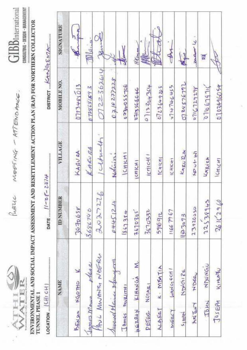
Table 6-3: Photo plates of various Consultative meetings held during the study ....................... 6-7Table 6-4: Summary of the issues rising from the stakeholders consultations ........................... 6-9Table 6-5: Summary of capacities of the different Water Service Providers (Project Beneficiaries) 6-17Table 6-6: Breakdown of Public meetings held during the ESIA and RAP stage ..................... 6-27Table 6-7: Stakeholders represented during the Workshop ..................................................... 6-32Table 6-8: Summary of issues in the opening and Closing Remarks ....................................... 6-33Table 6-9: Summary of comments and responses from the community representatives in the workshop 6-37Table 6-10: Community project awareness ................................................................................ 6-40Table 6-11: Sources of information ............................................................................................ 6-40Table 6-12: Project support and impact ..................................................................................... 6-40Table 7-1: Criteria for assessing significance ............................................................................ 7-1Table 7-2: Significance rating matrix .......................................................................................... 7-2Table 7-3: Mitigation ratings ...................................................................................................... 7-2Table 7-4: Computed flow requirements for the rainbow trout fish species .............................. 7-34Table 7-5: Compensation flows recommended for the design of the weirs vs the rainbow trout fish requirements 7-34Table 7-6: Minimum design flows required to meet calculated habitat needs .......................... 7-34Table 7-7: Average flows into Masinga Reservoir (m3/sec), and potential changes following diversion of water to the Northern Collector Phase 1 ....................................................................... 7-41Table 8-1: Construction Environmental and Social Management Plan ...................................... 8-5Table 8-2: Operation ESMP ..................................................................................................... 8-16Table 8-3: Table 8.3: Monitoring Plan ...................................................................................... 8-20Appendix I: Tunnel drawings ..................................................................................................... 10-1Appendix II: Species checklist of fish and aquatic macro-invertebrates of NCT1 Rivers............. 10-2Appendix III: Species Checklist of Plants of NCT1 ...................................................................... 10-3Appendix IV: Algae species recorded in NCT1 Rivers ................................................................. 10-4Appendix V: Construction Plant and estimated Semi/skilled labour ............................................ 10-5Appendix VI: Public Consultation Records ................................................................................... 10-6Appendix VII: Water Test Results ................................................................................................. 10-7Appendix VIII: Proposed Entilement Matrix ..................................................................................... 10-8

ESIA STUDY REPORT NCT PHASE 1 xii Issue 1.0 / October 2014
LIST OF FIGURES
Figure Description Page
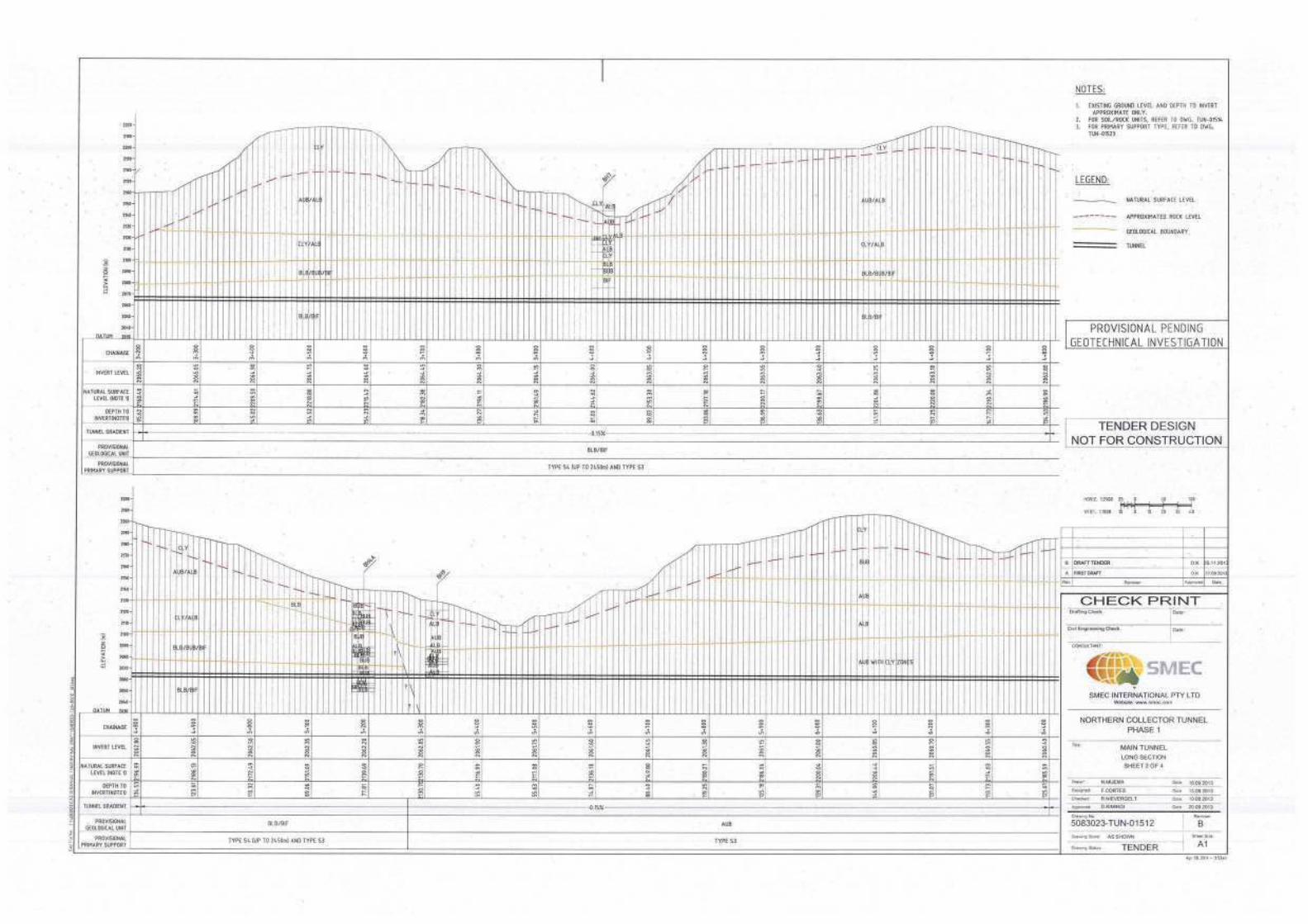
Figure 1-1: Location of the Murang’a County within Kenya ......................................................... 1-3Figure 1-2: Sub counties Covered by the Project ........................................................................ 1-4Figure 1-3: Mountain catfish Amphilius uranoscopus at R. Githika ............................................. 1-9Figure 1-4: Sampling of aquatic macro-invertebrates at Black fly Simulium sp larvae in riffle rocks R. Maragua 1-9Figure 1-5: Measuring water quality parameters in a pool and sampling of fish using Electrofisher in a riffle 1-10Figure 1-6: Map of Aquatic ecology sampling points ................................................................. 1-13Figure 3-1: Mean monthly rainfall at Gatare forest station .......................................................... 3-1Figure 3-2: Geological map of the study area ............................................................................. 3-4Figure 3-3: Geological section along the tunnel route (Vertical exaggeration=10) ...................... 3-6Figure 3-4: Major rivers in the project area ............................................................................... 3-10Figure 3-5: Map of Baseline noise measurement points ........................................................... 3-14Figure 3-6 Number of species per major Taxa (Order or Class) .............................................. 3-15Figure 3-7: Species composition of fish and aquatic macro-invertebrates of Maragua rivers per site and number of unique species site ............................................................................................ 3-16Figure 3-8 Percent frequency of occurrence Species in all 6 rivers combined ......................... 3-17Figure 3-9 Overall percentage family representation ............................................................... 3-20Figure 3-10 Life form spectrum of species ................................................................................. 3-21Figure 3-11: Species composition of algae in different sites ....................................................... 3-22Figure 4-1: General arrangement of river diversion and intake facilities ...................................... 4-2Figure 4-2: Schematic layout of Northern Collector Tunnel ......................................................... 4-6Figure 4-3: Typical horse-shoe tunnel section ............................................................................ 4-7Figure 4-4: Definition sketch of USBR Type III stilling basin ....................................................... 4-8Figure 4-5: Conventional pool passes (longitudinal section and pool structure) ........................ 4-11Figure 7-1: Land loss and resettlement ....................................................................................... 7-7Figure 7-2: Example of landscape of proposed spoil site viewed from across the Gikigie river. The green cover will be replaced by freshly cut earth materials .............................................................. 7-27Figure 7-3: Flows at Maragua RGS: 4BE1, 2008-2010 (m3/sec), illustrating characteristic seasonal patterns of flow with occasional periods of small floods and large floods (extreme low flows were not recorded during this period). ............................................................................................. 7-39Figure 7-4: Natural Flows at Maragua RGS: 4BE1 during 1991 (m3/sec), illustrating a period with extreme low flow. ............................................................................................................................. 7-40Figure 7-5: Flows at Maragua RGS: 4BE1 (1973-2013). Differences between the average monthly Natural flows and Modified flows with Reserve Flows based on Q95 released at Northern Collector intakes (Irati, Gikigie and Maragua) ................................................................................................. 7-40
LIST OF APPENDICES
Appendix Description
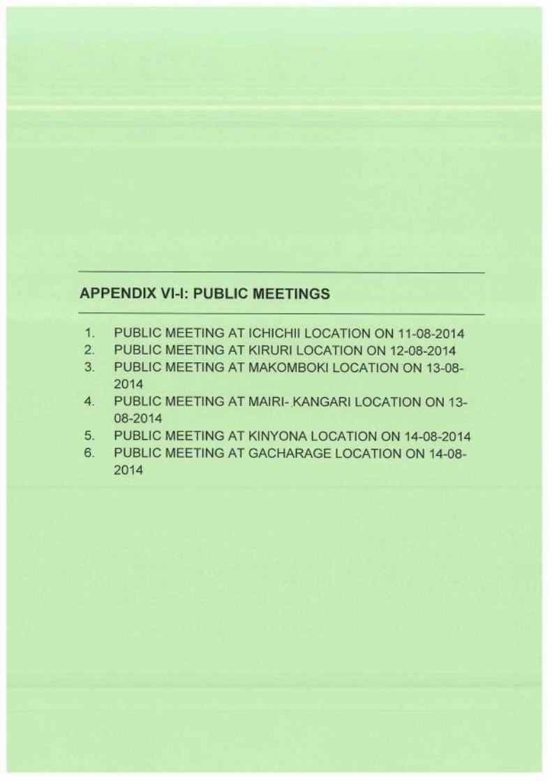
Appendix I: Tunnel drawingsAppendix II: Species checklist of fish and aquatic macro-invertebrates of NCT1 RiversAppendix III: Species Checklist of Plants of NCT1Appendix IV: Algae species recorded in NCT1 RiversAppendix V: Construction Plant and estimated Semi/skilled labourAppendix VI: Public Consultation RecordsAppendix VII: Water Test ResultsAppendix VIII: Proposed Entilement Matrix

ESIA STUDY REPORT NCT PHASE 1 xiii Issue 1.0 / October 2014
LIST OF ACRONYMS
ACC Assistant County Commissioner AFD Agence Française de Développement AIDS Acquired Immunodeficiency Syndrome AWSB Athi Water Services Board BS British Standards CSR Corporate Social Responsibility DCC Deputy County Commissioner DOSH Directorate of Occupational Safety and Health EIA Environmental Impact Assessment EMCA Environmental Management & Coordination Act ESIA Environmental & Social Impact Assessment ha Hectare HEP Hydro Electric Power HIV Human Immunodeficiency Virus ITCZ Inter Tropical Convergence Zone KFS Kenya Forest Service Km Kilometre KTDA Kenya Tea Development Authority KWS Kenya Wildlife Service LH Lower Highlands m Metre Ma Miocene Age maod Metres Above Ordnance Datum MCA Member of County Assembly MDGs Millennium Development Goals mm Milimetre NCT1 Nothern Collector Tunnel Phase 1 NEMA National Environment Management Authority NGO Non-governmental organisation NWL Normal Water Level OP Operational Policy OSHA Occupational Safety and Health Act PPE Personal Protective Equipment Q River discharge (m3/s) Qc Minimum compensation flow Qd Diverted flow/intake diversion capacity RAP Resettlement Action Plan RGS River Gauging Station SAF St. Anthony Falls stilling basin STI Sexually Transmitted Infection TB Tuberculosis TBM Tunnel Boring Machine UH Upper Highland UM Upper Midland URTI Upper Respiratory Tract Infections USBR United States Bureau of Reclamation stilling basin USD United States Dollar VCT Voluntary Counselling and Testing VIP Ventilated Improved Pit Latrines WASREB Water Services Regulatory Board WaSSIP Water and Sanitation Services Improvement Project WB World Bank WRMA Water Resource Management Authority WRUA Water Resource Users Association WSPs Water Services Providers WSTF Water Services Trust Fund

ESIA STUDY REPORT NCT PHASE 1 xiv Issue 1.0 / October 2014
EXECUTIVE SUMMARY
E1 Project background and components
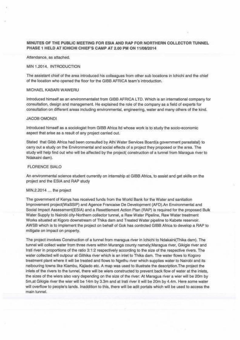
Athi Water Services Board (AWSB) has commissioned GIBB Africa Ltd to prepare an Environmental and Social Impact Assessment (ESIA) and a Resettlement Action Plan (RAP) for the proposed Bulk Water Supply to Nairobi City – Northern Collector Tunnel, a Raw Water Pipeline, and Treated Water Pipeline to Kabete Reservoir.
Following screening and scoping at initial stages, an ESIA Project Report was prepared and submitted to the National Environment Management Authority (NEMA) for review (NEMA Ref: NEMA/PR/5/2/12495). Following the review NEMA recommended wider public consultations and in-depth coverage of the foreseen impacts and proposed mitigation measures. ESIA study TOR were prepared and approved by NEMA in July 2014.This ESIA Study Report covers the ESIA for Northern Collector Tunnel (NCT) Phase 1.
The NCT Phase 1 Project is located in Kangema and Kigumo Sub-Counties of Muranga County. The project is located along the eastern fringe of the Aberdare Conservation Area approximately 60 km north of Nairobi.
The NCT Phase 1 Project consists of a tunnel which will transfer raw water through approximately 11.8 km from intakes at the Maragua, Gikigie and Irati Rivers to an outlet at the Githika River near Makomboki, upstream of the existing Thika Reservoir into which the water will be transferred. The design life of the main tunnel and its associated permanent infrastructure elements will be of 100 years. The principal features of the NCT Phase 1 include the following:
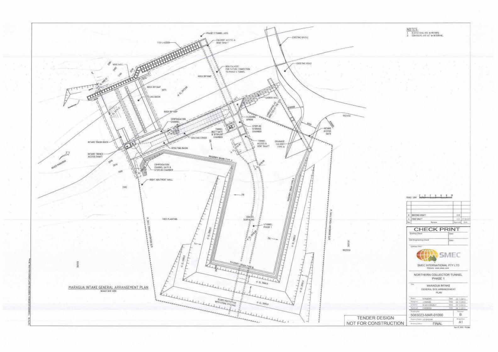
River diversion weir and related intake hydraulic structures at Maragua River including: 20 m wide, 5 m high weir including trench diversion intake 37 m long, 4 m deep de-silting basin Compensation channel
River diversion weir and related intake hydraulic structures at Gikigie River including: 14 m wide, 3.3 m high weir including trench diversion intake 17 m long, 2 m deep de-silting basin Compensation channel
River diversion weir and related intake hydraulic structures at Irati River including: 20 m wide, 4.4 m high weir including trench diversion intake 25 m long, 2 m deep de-silting basin Compensation channel
Drop shaft and connection gallery connecting the Irati intake to the main tunnel River outlet at Githika River including:
Cut and cover portal outlet from the main tunnel 20 m long outfall stilling basin structure
Main Northern Collector Tunnel Phase 1 (main tunnel) including portals, excavation, initial support and permanent concrete lining. The tunnel is approximately 11.8 km long and of 3 m finished internal diameter: Connection adit from Githika tunnel to the main tunnel; Drop Shaft and connection adit at the Irati intake; Access gallery from Kaanja Valley to the main tunnel.
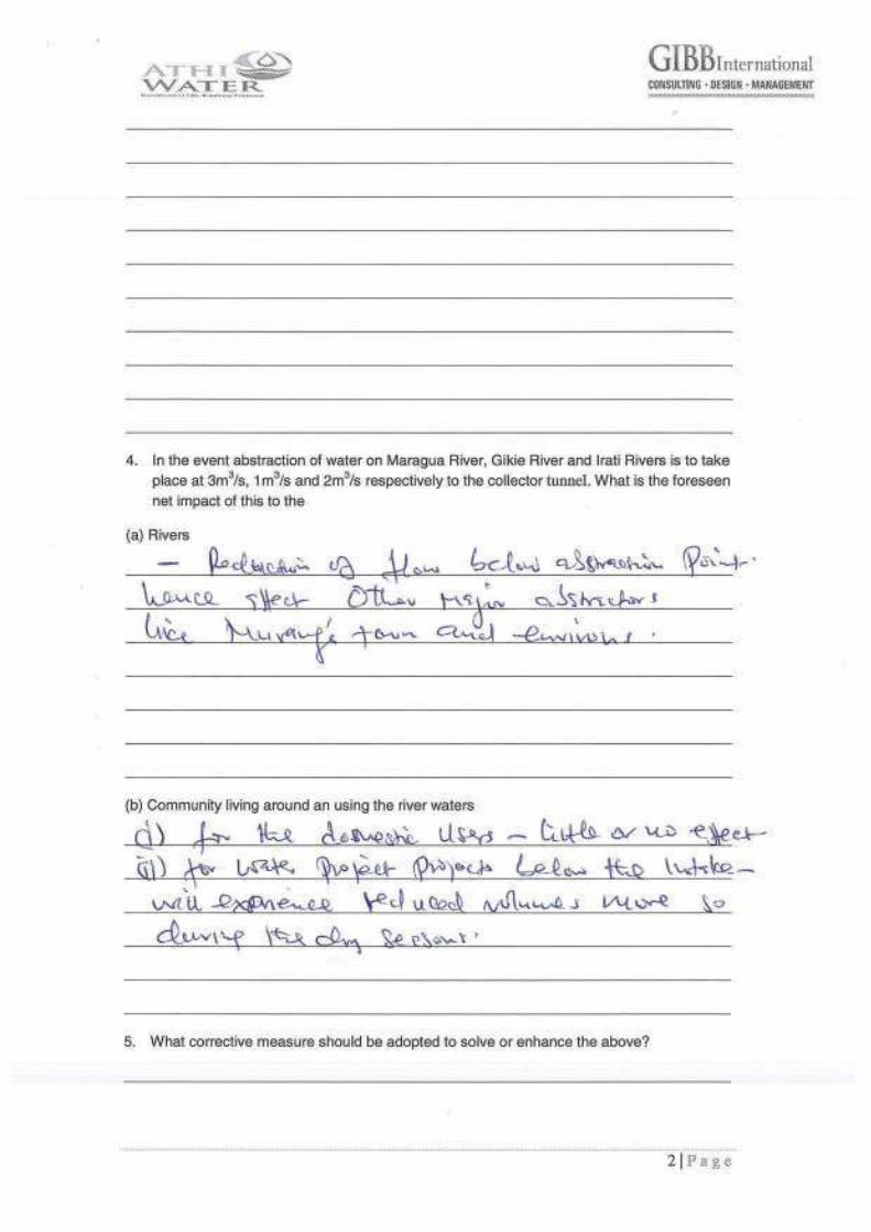
The diversion and intake structures on rivers Maragua, Gikigie and Irati will divert 3m3/s, 1m3/s and 2m3/s respectively to the collector tunnel. The weirs and intakes are designed to harness flood flows and allow for compensation flows equivalent to Q95 flows for both Maragua (Q95=0.481m3/sec) and Gikigie (Q95 = 0.101 m3/sec) rivers. In the case of the Irati River the estimated compensation flow used is 1.4xQ95 (0.645 m3/sec) since Q95 flows alone was deemed inadequate.

ESIA STUDY REPORT NCT PHASE 1 xv Issue 1.0 / October 2014
The operational requirement of the compensation channel is considered in three phases as follows:
At low river flows, i.e. not exceeding the required minimum compensation flow Q<Qc), the compensation channel gate is fully open and all flows are permitted through the compensation channel gate under free flow condition. The low flows are not permitted through the diversion intake until the required minimum compensation flow is satisfied;
At higher river flows, i.e. exceeding required minimum compensation flows but excess not exceeding intake diversion capacity (Q > Qc and Q-Qc < Qd), the compensation channel gate is partially open to only permit the minimum compensation flow (Qc) and divert the excess (Q-Qc) to the tunnel intake. The head of water behind the compensation gate contribute to pressure flow through the gate orifice; and
At river flows exceeding the required minimum compensation plus maximum diversion flows (i.e. Q > Qc + Qd), the compensation channel gate is fully closed. The excess of diverted flow (i.e. Q - Qd) is passed to the downstream through the main overflow weir, and exceeds the required minimum compensation flow.
The project implementation period is estimated to take about 40 months and on completion will deliver on average 120,000 m3/d to existing Thika dam.
E2 Existing Environment
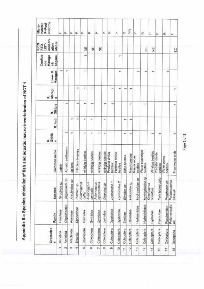
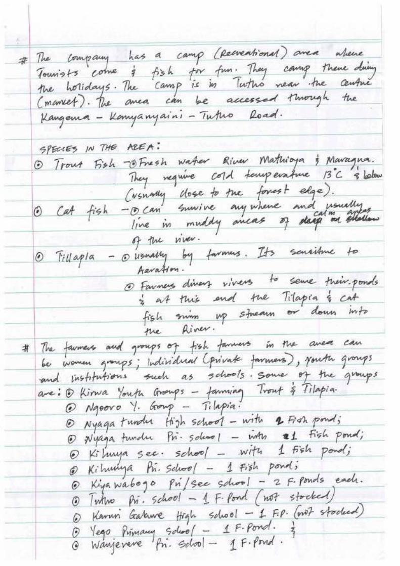
Ecological survey conducted on the rivers established a total of 77 species of aquatic fauna including 7 fish species. The fishes include Stargazer mountain catfish (Amphilius uranoscopus),Pangani Barb fish (Barbus oxyrhynchus), Barb fish (Barbus sp), Barbus paludinosus, Red eye Labeo fish (Labeo cylindricus), Athi tilapia (Oreochromis spirulus) and Dembea stone lapper (Garra dembensis). In addition, some species were not encounetered during the study but secondary sources and local knoledwde confirmed their presence. These include Anguilla bengalensis labiata, Rainbow trout(Oncorhynchus mykiss), Salmon (Salmo gaidneri) and salmon (Salmo trutta). Of particular interest are the Labeo cylindricus, Barbus sp and the eel Anguilla which are migratory species.The Labeo cylindricus and Barbus sp were recorded at lower river Maragua upwards of the Wanjii Reservoir but were not recorded at the confluence of river Maragua and Sagana although it is known to occur in the middle stream reaches of R. Tana. Labeo cylindricusmigrate upstream of rivers to spawn and uses the mouth and pectoral fins to climb barrier rocks and weirs. None of the aquatic species recorded is listed in the IUCN Red-list or the Sixth Schedule (Part D) of the Kenya Wildlife Act, 2003 both of which list threatened species.
Natural vegetation in the project area has been significantly modified by settlements and the small holder tea farms. A botanical survey conducted on the reaches of NCT 1 rivers established 279 plant species within the sample points. Of these, 6 species were found to be of special conservation concern. These include Polyscias kikuyensis, Polystachya sp, Aerangisthomsonii, Prunus africana, Rubus keniensis and Rubus steudneri.
There is no gazetted conservation area within the immediate project area. However, the Aberdare Conservation Area (Aberdare National Park and forest reserve) is about five kilometres upstream of the proposed intakes and is the catchment for the Project Rivers. The project is not likely to have impacts on the forest but the project’s sustainability will depend on continued conservation of the forest.
E3 Feedback from consultation
During the ESIA study consultations were held through: (1) six (6) general public meetings at location levels within the project area; (2) key informant interviews with civil, government agencies and other institutions in the project area, from both Kigumo and Kangema sub counties as well as with various bulk water service providers; (3) household surveys; and (4) a stakeholders’ workshop on 2 October 2014 at Norkas hotel in Murang’a town to disclose findings of ESIA studies. In the workshop, stakeholders’ representation was from the local to the national levels and included international financing agencies. A summary of expected benefits and expressed concerns are given below.

ESIA STUDY REPORT NCT PHASE 1 xvi Issue 1.0 / October 2014
i. The Expected benefits include:
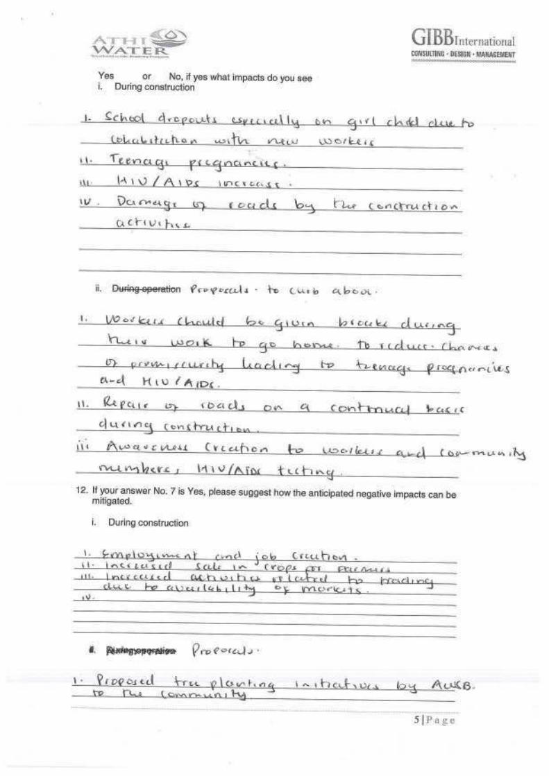
Employment opportunities: community members requested that the proposed project should alleviate unemployment issues by absorbing bulk of the youth in the local area to work in its construction and operation stages;
Increased sale in crop production especially food products from farmers in Kigumo and Kangema Sub County;
Increased activities related to trading due to availability of markets; Increased reliable water supply in the south of Muranga. Proposed kick-back
water supply projects to Muranga; and Additional water to Thika Dam thus boosting water supply to Nairobi City (be
of great value to the growing demand in the areas).
ii. Expected negative impacts include:
Vibrations due to underground work activities during construction; Reduced river flow/ volumes down stream in Maragua, Gikigie and Irati
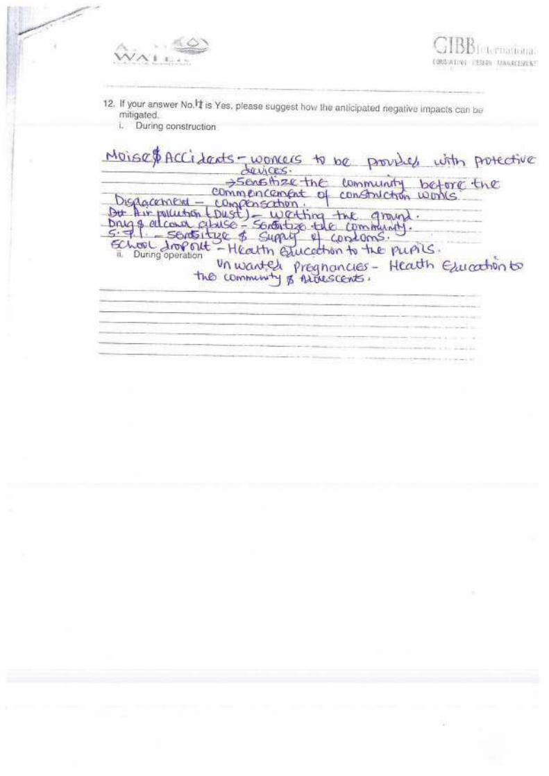
Rivers; Intake structure preventing migratory fish upstream; Damage to roads during construction due to heavy equipment; Rise in cases of accidents and incidents during construction; Community health and increase in disease prevalence and unwanted teenage
pregnancies; Fear of the possible impact on landslides and earth movements; Displacement of farmers paving way for the wayleave for the Tunnel; Interruption of school activities: Concerns were raised over the fact that
construction might interrupt schooling and education activities in the area; Lack of Health Facilities: FDGs raised concerns over the number of health
facilities in the area, noting that in some areas far from town centres, women have to travel long distances up- hill to access health care facilities, especially maternity services; and
Vibrations due to underground work activities during construction.
Through the disclosure workshop, concerns expressed by the participants were addressed by both the consultant and AWSB.
The views of those affected by or interested in the project were also used to inform identification and evaluation of both social and environmental impacts and have been considered in the formulation of mitigation measures and formulation of the environment management plan.
E4 Assessment of Project Impacts
The project will have both positive and negative impacts.
iii. Positive Impacts
The positive impacts include the following:
Improved water supply: Nairobi is experiencing a water crisis with the current demand (750,000m3/day) far much outstripping supply (540, 000m3/day). Most Nairobi residents are therefore accustomed to water rationing. The proposed project will therefore ensure adequate water provision to Nairobi residents and its satellite towns.
Communities in Murang’a County will also benefit through improved waters supply schemes supported by AWSB as part of giving back to the community from where it is drawing its water supplies. AWSB has developed a strategy to complement the efforts of Tana Water Services Board (TWSB) in provision of water to these communities. This will see the Murang’a

ESIA STUDY REPORT NCT PHASE 1 xvii Issue 1.0 / October 2014
communities benefit from development of water projects to the tune of Ksh. 1.270 billion. The key projects to be developed under this arrangement include:
Muranga W/S (augmentation) – KSh. 800 Million; Gatanga W/S (augmentation) - KSh. 300 Million; and Gatango W/S (augmentation) – KSh. 170 Million.
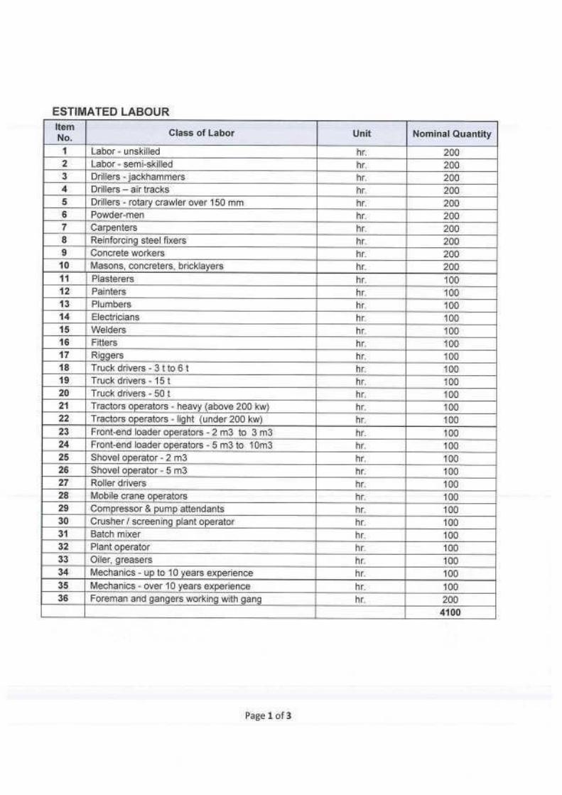
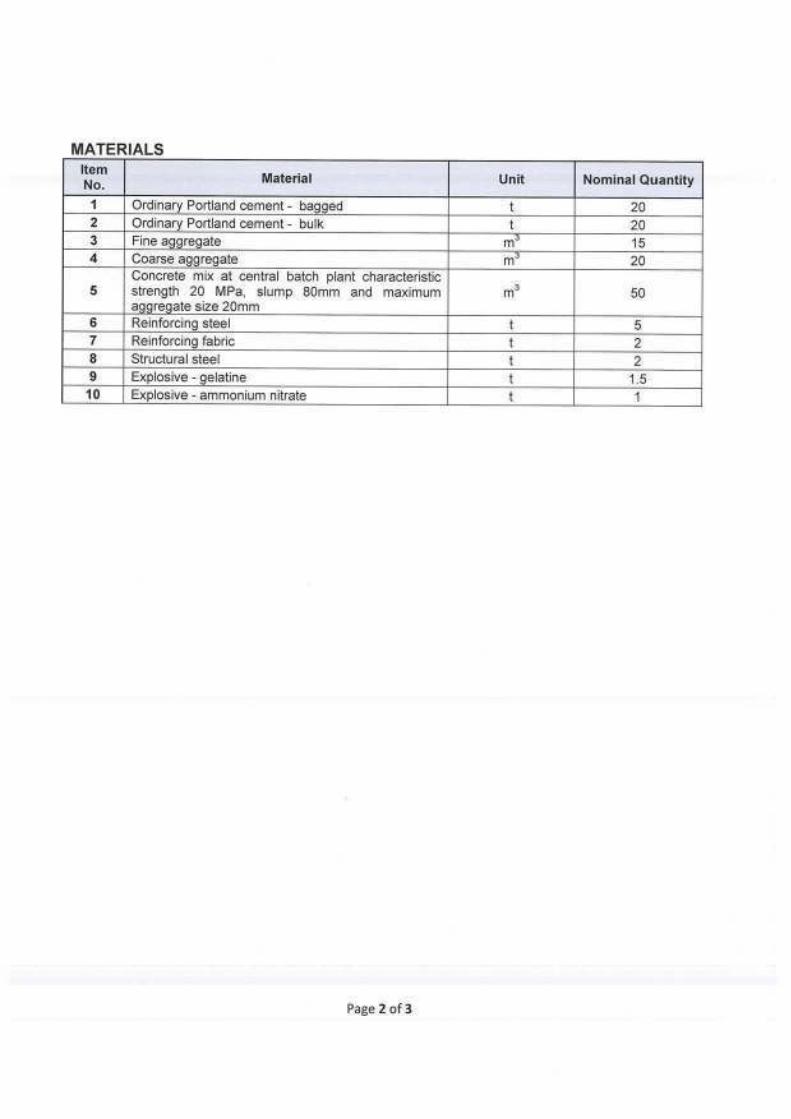
Creation of employment opportunities : The construction of the project is anticipated to create numerous direct and indirect employment and economic opportunities through recruitment of significant numbers of people to work with the contractor (s). This will include both skilled and unskilled labour that will be engaged for about 40 months. Man hours to be provided by non technical staff alone have been estimated at 4,100 hours. Indirect economic opportunities will also be created through persons selling different wares to the construction staff domestic requirements. Limited staff will also be required for routine O&M. These will improve economic situation in the project area and partly reduce unemployment levels.
Improved infrastructure: The NCT Phase 1 project design has proposed improvement of access roads within the proposed project area. This will be an advantage to the locals as they will comfortably transport their tea to the buying centres and also facilitate easy transportation of other farm inputs.
Community benefits: AWSB has proposed financial support to implementation of community water projects in the source basin. This will see increased access to piped water supply in the project area.
Other positive impacts anticipated include creation of market for local suppliers of construction materials, opportunities of income generation activities for women in supplying food to project workers, knowledge transfer during the construction period and desirable social change.
iv. Negative Impacts
On the other hand, the proposed project will be associated with a number of negative impacts are discussed below.
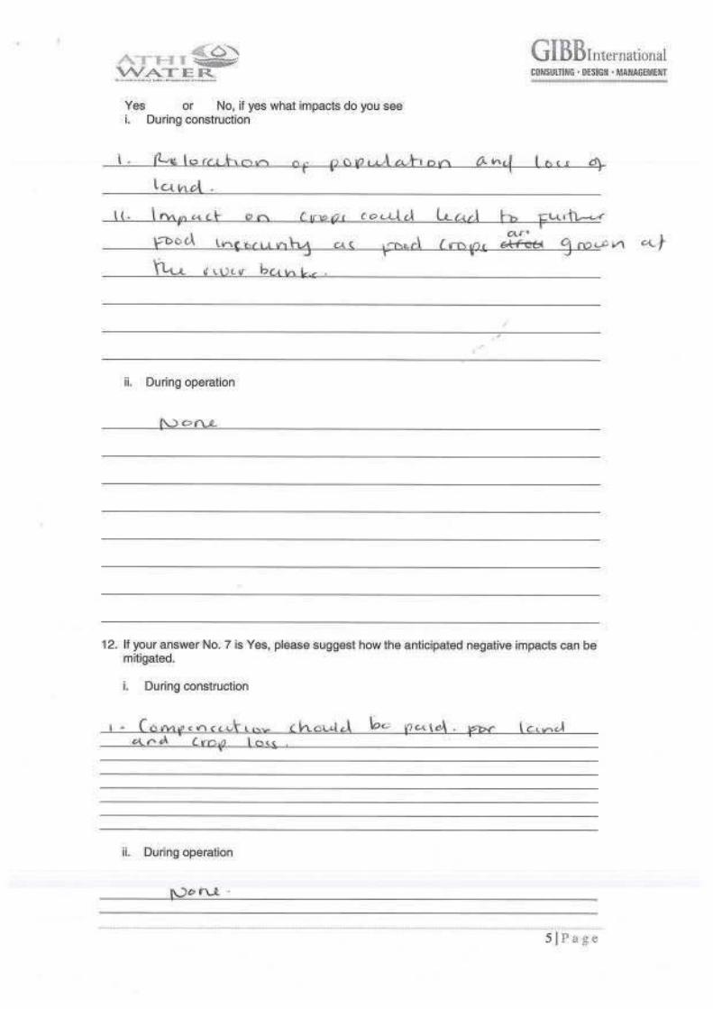
Land take and resettlement : Development of the project's infrastructure – weirs, shafts and inlet/outlet portals, Githika outfall and construction camp will entail permanent land acquisition. In addition, a 3m wide wayleave has been proposed right above the 11.8km long tunnel alignment which once acquired will restrict utilization by the current owners. This will affect 177 households (with 657 persons) and 8 institutions.
Hydrology: Specialist hydrological assessment conducted during the ESIA study concluded that the project is not anticipated to have any significant impacts on hydrology. Since the design is based on flood flow of the rivers, no changes on normal flows are anticipated at all. However, frequencies of flood flows downstream will be reduced. The cumulative impacts of the project on downstream hydropower generation schemes at Masinga has also been established to be marginal with an annual average reduction of inflow of 2.32% to Masinga Reservoir, or a reduction in volume of 2.72 m3/s relative to average inflow of 125.51 m3/s (1995-1997).
Ecology : Ecological assessment of project included analysis of impacts of project-induced hydrological changes on downstream ecology of the affected rivers. Habitat requirements for rainbow trout fish Oncorhynchus mykiss was used as a benchmark given that they are more stringent than for the rest of encountered aquatic species. The assessment established that the proposed flow release for Maragua intake (Q95=0.481m3/sec) will meet the trout fish requirement (0.259m3/sec). However, for Irati and Gikigie rivers, the proposed downstream releases will be lower than the minimum requirements for the trout species. The proposed design for Irati is 1.4Q95=0.645 m3/sec against calculated rainbow trout fish requirement of 0.989 m3/sec while for Gikigie, the proposed design flow is Q95 = 0.101 m3/sec, against rainbow trout requirement computed to be 0.133 m3/sec. In order to meet the calculated rainbow trout fish minimum habitat requirements, hydrological analysis established that the

ESIA STUDY REPORT NCT PHASE 1 xviii Issue 1.0 / October 2014
design flows at Gikigie and Irati intakes would require upward revisions to 1.32xQ95=1.33 m3/sec and 2.15xQ95=0.991 m3/sec respectively. However, it is notable that the calculated minimum requirements for rainbow trout from this study are higher than the naturalised mean monthly flow e.g. for Irati river and cannot be conclusively used to set the minimum ecological flow requirements. This could also mean that the rainbow trouts species is not distributed throughout all the rivers in all seasons hence the need to ensure that any migration is not impeded for continous habitats connectivity. The study therefore recommends the implementation of the compensation flow as designed but with strict enforcement of the proposed weir operating principles.
Since the proposed project abstractions will be based on flood flow and not normal flows, there will be no effect at all on the normal flows. The anticipated reduced frequency of low-flows will be associated with some habitat loss for riverine fishes during periods of low-flows with Irati likely to be the most affected. However, no permanent riverine habitat loss is anticipated and there is no species of conservation significance that will be impacted.
Other negative impacts anticipated from the project implementation include
Loss of vegetation cover; Increased demand on utility supplies and Disruption of services; Impacts on Soils
Soil erosion and increased sedimentation Soil pollution Soil compaction
Occupational and General public Safety and Health Hazards Spread of communicable diseases; Pollution of (surface and ground) water resources; Changes in groundwater levels and flow; Oil spills; Shifting of unskilled labour force from agriculture to construction Waste Generation; Air pollution; Geological and seismic hazards; Impeded migration of migratory fishes; Noise and vibration pollution; Social delinquency, HIV/AIDS and other sexually transmitted infections; Immigration and emergence of unplanned settlements; Impacts of increased traffic volumes and tonnage; and Visual impacts on local landscape
Most adverse impacts associated with the project can be readily managed to acceptable levels with implementation of the recommended mitigation measures and ESMP developed in this report. Project such that the overall benefits from the Project will greatly outweigh the adverse impacts. Further, the requisite conditions for most of the mitigations have been incorporated by the proponent on project bidding documents reviewed by the consultant.
E5 Conclusion and Recommendations
This ESIA Study has been prepared to provide sufficient and relevant information on the proposed Northern Collector Tunnel Phase 1, to enable NEMA establish whether activities of the project are likely to have significant adverse environmental impacts. In addition, the report responds to the environmental assessment requirements set by the project financiers: WB and AfD.
In general, the proposed project will result in appreciable benefits to the city of Nairobi, its satellite towns and Kenya at large and bring opportunities for both social and economic development.

ESIA STUDY REPORT NCT PHASE 1 xix Issue 1.0 / October 2014
It is recommended that the proposed project be implemented in compliance with all the relevant legislation and planning requirements of Kenya at all times. In line with this, the proponent (AWSB) and the contractor (s) must take the legislative framework reviewed in this report into consideration, during and after the implementation of the project, as will be appropriate.
In order to meet the downstream ecological requirements, the following are recommended:
Ensure the proposed abstraction weirs operation principles are met throughout the operation period for all rivers via continuous monitoring. Reduced abstractions during low-flow seasons achieved by this will help sustain riverine habitats during these periods;
Construct fish passes as planned and ensure they are regularly maintained to allow safe passage for all identified migratory species;
Ensure demarcartion and protection of riparian resevers of the affected rivers. This will offer favourable cover and temperatures for the rainbow trout; and
Undertake wet season survey and subsequent annual aquatic fauna surveys for both wet and dry seasons to monitor trends and inform any further management interventions.
Considering the aquatic species documented during this study that is the short distance migratory fish species to feed or spawn such as the Labeo cylindricus, Barbus spp. and other aquatic invertebrates) and the long distance migratory species (that use the river for feeding and spawning purposes such as the eel Anguilla bengalensis, Oncorhynchus mykis, Salmo trutta), the proposed Technical fish pass is deemed adequate for this purpose as it allows possibility of migration at weirs for both strongly swimming fish and for bottom oriented and small fish.
The design should adopt a variable abstraction of water based on seasonality of flows.
The Resettlement Action Plan should be implemented before mobilisation of contractor to site. Any additional land requirements by the contractor not covered under the RAP must also be compensated for in full before actual construction begins.

Draft Final ESIA STUDY REPORT NCT PHASE 1.doc NCT PHASE 1 1-1 Issue 1.0 / October 2014
1 INTRODUCTION
1.1 Project Background and rationale
Athi Water Services Board (AWSB), the Proponent, provides Water and Sewerage services in Nairobi City County and some of its satellite towns, whose water demand is increasing rapidly due to population increase into the City coupled with increased water demands from the industries. Nairobi is the country’s largest economic centre and generates 45% of the country’s GDP, in the process employing 43% of all Kenya’s urban workers (Oxfam, 2009). It is also the largest industrial centre and food, beer, vehicles, soaps, textiles and chemicals are all produced or processed in the city.
The main source of water for Nairobi is the Eastern Aberdare Rivers within the Aberdare Conservation Area (ACA). The ACA includes the Aberdare National Park and the gazetted Forest Reserves that surround the National Park. The areas are all under Government protection through Kenya Wildlife Services (KWS) and Kenya Forest Service (KFS).They are not subject to catchment degradation through settlement and forest clearance, as has been recorded in other national forests, notably the Mau Forest. It can reasonably be assumed that the “protected area” status will not only be maintained by the Government, but will be strengthened; hence the sustainability of the surface water sources arising from the ACA is assured under current Government policy, subject to control of permitted abstraction.
The ground water contribution to Nairobi Water supply (domestic, commercial or industrial purpose) by public, private or individual boreholes is estimated to be approximately 45,000m3/ day.
The present sources of water and their respective yields are as given below:
Thika Dam 329,000 m3/day Sasumua Dam 58,000 m3/day Ruiru 21,700 m3/day (Chania) Ngethu 104,000 m3/day Kikuyu Springs 4,800 m3/day
The combined yield of the developed Water sources for Nairobi Water Supply is about 540,000m3/day against the current demand estimated at about 750,000m3/day (Source: AWSB).
In order to bridge the existing supply gap and meet the projected future demand, a Feasibility Study and Master Plan for Developing New Water Sources for Nairobi and Satellite Towns up to the year 2035 was commissioned by AWSB and concluded in 2012 by Consultant Egis Bceom International in association with Mangat I.B. Patel & Partners.
The project is derived from Nairobi Water Master Plan for Developing New Water Sources for Nairobi and 13 Satellite Towns namely Kikuyu, Ruiru-Juja, Kiambu, Karuri, Githunguri, Mavoko Municipality, Ngong Township, Ongata Rongai, Thika, Gatundu, Limuru, Lari and Tala-Kangundo.
The Northern Collector Phase 1 (the Project) includes the following components:
Transfer of water from Maragua River, Irati River and Gikie River to Thika dam (Ndakaini dam);
Construction of raw water gravity main from Thika dam to the proposed Water Treatment Plant 6km downstream of Thika dam;
ESIA STUDY REPORT NCT PHASE 1 1-2 Issue 1.0 / October 2014
Construction of Water Treatment Plant 6km downstream of the dam; and Construction of 44km Treated Water gravity main up to Kabete reservoirs
(capacity 1.60m3/s) via Ngethu and Gigiri Water Treatment Plants to meet the city’s year 2017 water demand.
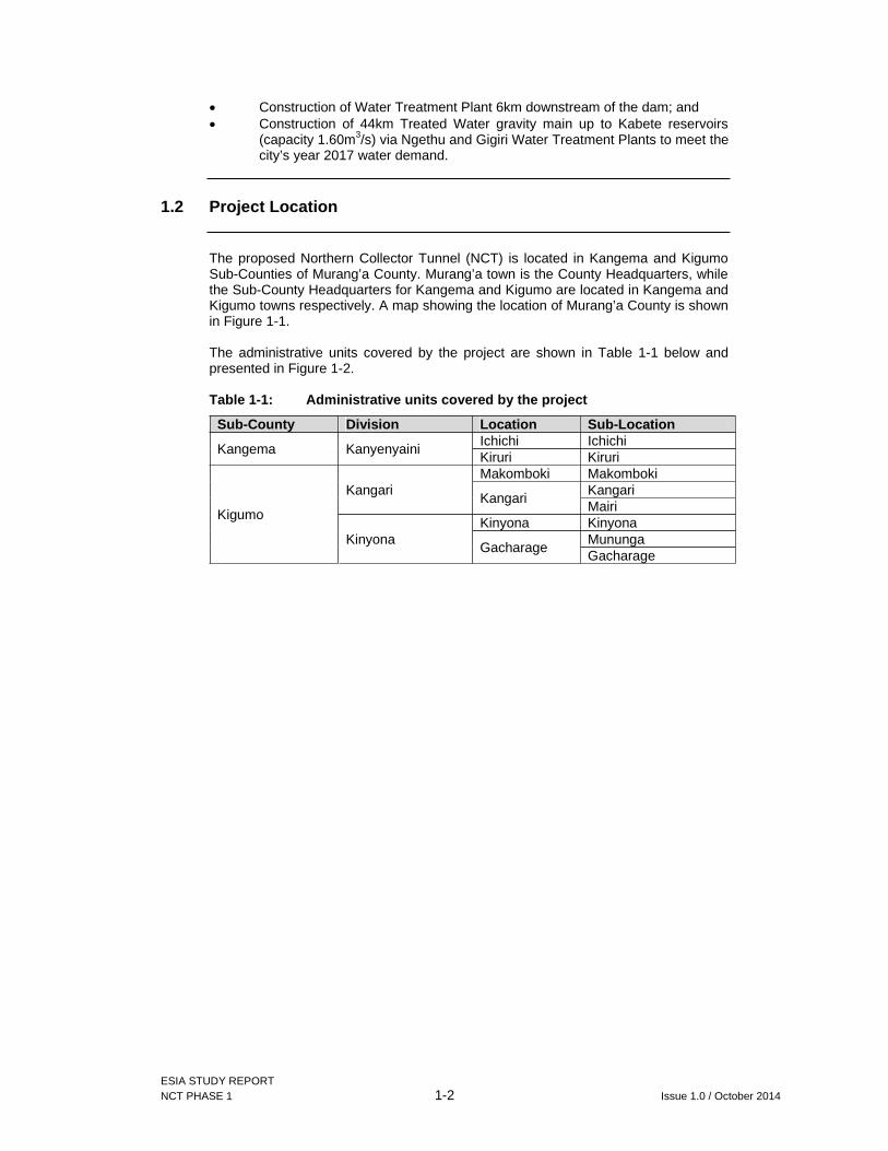
1.2 Project Location
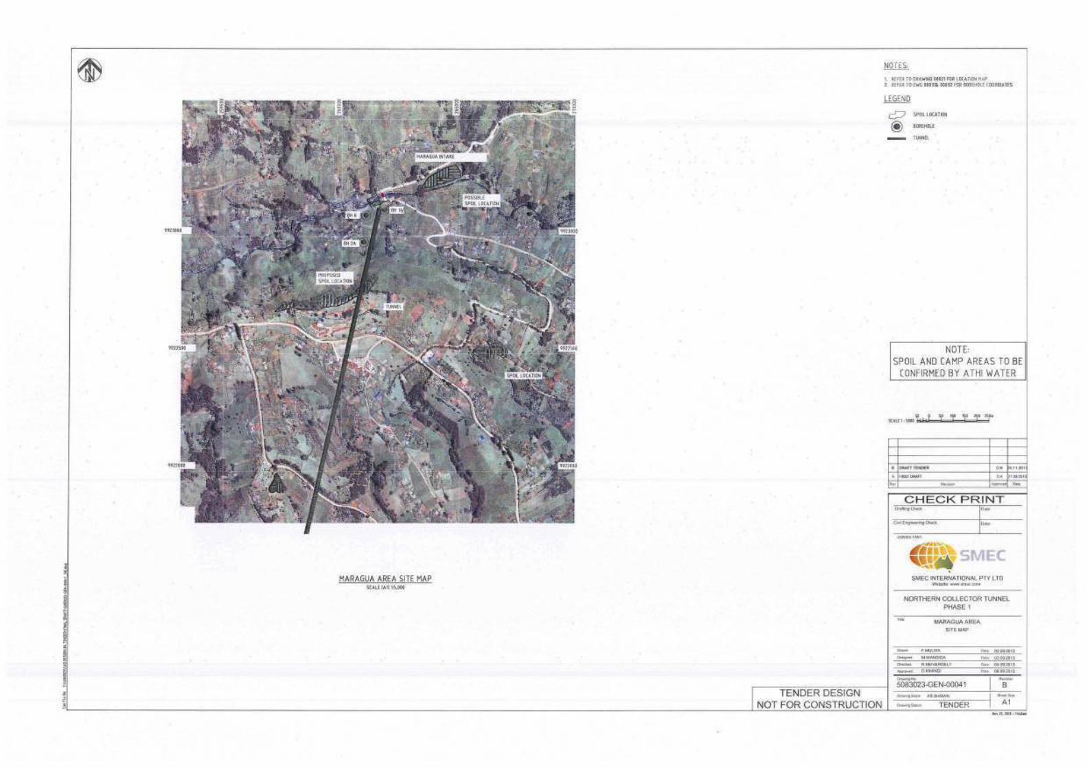
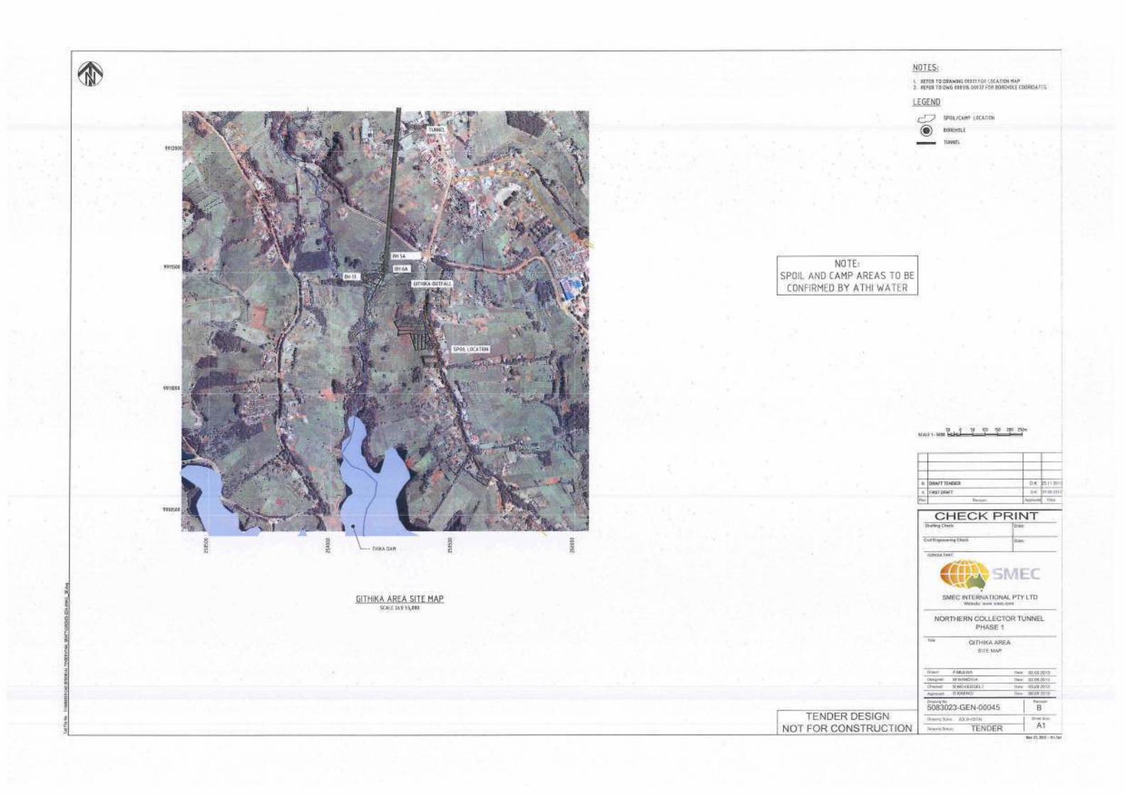
The proposed Northern Collector Tunnel (NCT) is located in Kangema and Kigumo Sub-Counties of Murang’a County. Murang’a town is the County Headquarters, while the Sub-County Headquarters for Kangema and Kigumo are located in Kangema and Kigumo towns respectively. A map showing the location of Murang’a County is shown in Figure 1-1.
The administrative units covered by the project are shown in Table 1-1 below and presented in Figure 1-2.
Table 1-1: Administrative units covered by the project
Sub-County Division Location Sub-Location
Kangema Kanyenyaini Ichichi Ichichi Kiruri Kiruri
Kigumo
Kangari Makomboki Makomboki
Kangari Kangari Mairi
Kinyona Kinyona Kinyona
Gacharage Mununga Gacharage

ESIA STUDY REPORT NCT PHASE 1 1-3 Issue 1.0 / October 2014
Figure 1-1: Location of the Murang’a County within Kenya

Draft Final ESIA STUDY REPORT NCT PHASE 1.doc NCT PHASE 1 1-4 Issue 1.0 / October 2014
Figure 1-2: Sub counties Covered by the Project
Draft Final ESIA STUDY REPORT NCT PHASE 1.doc NCT PHASE 1 1-5 Issue 1.0 / October 2014
1.3 Objectives of the ESIA study
The main objectives of the environmental and social impact study are to:
To comply with the Environmental (Impact Assessment and Audit) Regulations, 2003, Regulations;
Determine the sustainability of the project on environmental and social safeguards;
Provide a baseline description of bio-physical and socio-cultural environment of the project area;
Assess potential impacts of the project on the bio-physical and socio-cultural environment;
Allow for consultations with all interested and affected parties and the relevant authorities; and
Design appropriate cost based mitigation, management and monitoring measures.
ESIA STUDY REPORT NCT PHASE 1 1-6 Issue 1.0 / October 2014
1.4 Methodology
In order to meet the study objectives, the first step was for the key staff to undertake desk study and preliminary site visit. Based on the site visit observations relevant to project and which could influence the Environmental and Social Impact Assessment were identified.
1.4.1 Screening Visit
Screening is the process of assessing the viability of a project for an ESIA and evaluating the extent of assessment required. A site visit to the Project area was undertaken between 10 and 28 April 2014. The following were undertaken:
Site analysis: Reconnaissance of the proposed location of the NCT to develop impression of topography, flora and fauna, economic activities, existing developments and potential project affected persons; and
Meet the Sub-County Administration and the representatives of the Muranga County to allow for smooth information dissemination to the general public.
1.4.2 Project Report and Scoping
From the initial literature review, fieldwork and consultations, a Project Report was prepared and submitted to NEMA as an application for ESIA Study for the proposed project (NEMA Ref: NEMA/PR/5/2/12495). After review of the project report and determination of need for ESIA study by NEMA, TOR for this study were prepared and approved by NEMA in July 2014.
1.4.3 Desk Study
The environmental team reviewed relevant literature including but not limited to the following reports:
Final Design Report for the Northern Collector Tunnel Phase 1; Northern Collector Tunnel (NCT) - Phase 1 Part 2: Works Requirements –
Drawings; Geotechnical reports and data; Feasibility and Master plan reports for developing new water sources for
Nairobi and satellite towns; and Preliminary EIA for the Northern Collector Tunnel Phase 1. Various Policies, Acts and Regulations pertinent to the environmental
assessment of the project. These included but not limited to the following: The Constitution of Kenya, 2010; The Environment Management and Coordination Act, 1999; Wildlife (conservation and Management) Act 2013; The Occupational Safety and Health Act, 2007; Work Injury Benefits Act (WIBA); Employment Act; The County Governments Act 2012; Urban Areas and Cities Act No. 13 of 2011; The Penal Code (Cap. 63); The Public Health Act (Cap. 242); The Water Act 2002; Strategy for Revitalization of Agriculture (SRA 2004-2014); National Environment Action Plan 2009 – 2013; The National Policy of Water, Sessional Paper No. 1 of 1999;

ESIA STUDY REPORT NCT PHASE 1 1-7 Issue 1.0 / October 2014
The National Poverty Eradication Plan (NPEP), 1999 ; Kenya’s Vision 2030; and Millennium Development Goals (MDGs).
A Complete bibliography is presented in chapter ten of this report.
1.4.4 ESIA Study
With all the aforementioned information, a field study was undertaken from August to September 2014 to evaluate the types, mode of action and magnitude of the specific projected effects and impacts, both favourable and detrimental to the environment and natural resources. This encompassed further assessment of proposed water intake points, Outfall area and neighbourhood, hydrological assessment, ecological survey, and detailed socioeconomic survey.
Second round of consultations with stakeholders identified at the screening stage including public meetings was also conducted.
1.4.5 Ecological Surveys
Both quantitative (field sampling) and qualitative (desk-stop literature review) on biodiversity in rivers of the study area methods were employed. Quantitative surveys were conducted from 11 to 15 August 2014 as shown below.
River/section covered Survey date Comments Githika 11 August 2014 Near proposed intake Irati 12 August 2014 Near proposed intake Gikigie 13 August 2014 Near proposed intake Maragua near intake works 14 August 2014 Near proposed intake Maragua and Tana Confluence 15 August 2014 After Tana HEP station Maragua just before Wanjii HEP station 15 August 2014 After confluences with
Irati and Gikigie
(a) Qualitative method- Desk stop study and indigenous knowledge on aquatic fauna of the study area
A detailed literature review on past studies on biodiversity in rivers of the study area was undertaken from published papers, technical reports from Ministry of Fisheries and other Government agencies such as National Museums of Kenya, KWS or Non-Government organizations; and
Open ended questions were used to gain indigenous knowledge on aquatic fauna from the local people. This included interviewing the local people living around each of the rivers as well as fishermen. Other independent sources included some Government officials resident in the area, for example the Ken-Gen staff at Wanjii reservoir.
(b) Quantitative methods
(i) Field sampling design
A reconnaissance survey was initially carried out before commencement of actual fieldwork necessary to determine accessibility in the study area and to locate the exact sampling points.
Stream reaches along the river sites each about 100m long, were established in the 6 sampling sites namely; upstream of the rivers Maragua intake (Site 1), Gikigie (Site 2), Irati (Site 3) and the down stream site of the project area which is river Githika outlet (Site 4),

ESIA STUDY REPORT NCT PHASE 1 1-8 Issue 1.0 / October 2014
Lower R. Marangua (5) and the confluence of Tana river (Site 6) to sample fish and aquatic macro- invertebrates in an upstream direction. 3 stream reaches in each site about 50m apart were randomly selected depending on accessibility, length of river, altitude and ecological settings/biotope types (e.g. riffles and pools sequence, macrophytes or minor river joining main river, etc). Along each reach, at least 4 belt transects/sampling points (riffle-pool) perpendicular to the river channel were randomly selected and 3 scoops (in the left bank, middle and right bank of stream) using pond scoop nets or dip-nets with 0.5mm mesh size) were randomly drawn to sample the aquatic macro-invertebrates.
For fish sampling, at least two transects per reach site were randomly selected and fishing nets (gill nets) and beach seines deployed while backpack electrofisher dipnet/hoop net was deployed in the four transects above for macro-invertebrate sites (riffle-pool sequence) considering the depth of the river.
Water quality parameters that were sampled in each sampling point using an Hydro-lab included Temperature, PH, Dissolved Oxygen (DO), Turbidity, Conductivity, Salinity, Nitrates and Phosphates.
Each sampling site was geo-referenced using a hand-held Geographic Positioning System (GPS) for future repeated monitoring particularly to compare seasonality.
(ii) Aquatic fauna sampling techniques
A combination of different sampling methods/fishing techniques were employed in this study including; fishing nets of different mesh sizes, beach seines, backpack electro-fisher, pond netting or dip-nets and aerial sweep-netting for flying aquatic insects e.g. dragon and damsel flies, mayflies, etc whose larvae are aquatic in all the sites.
(iii) Fish sampling techniques
Fishing nets, beach seines, backpack electro-fisher or fish anglers
Nylon monofilament gillnets of varying mesh sizes ranging from 8-50 mm, Beach seine nets (e.g. 4m long, 0.5m deep), dip-nets (e.g. 60cm x 60cm x 75cm; small dimension 25 cm broad), an electro-fisher or baited fish anglers were used to catch the fish. Electro-fishing is known to be ideal if conductivity > 30 µS/cm; temperature > 4°C at time of sampling; and water visibility > 25 cm. Fish anglers were tried for the rainbow trout. Representative samples and unidentified fish species were collected and recorded, preserved in formalin (10%) for further identification in the laboratory at National Museums of Kenya (NMK) and later preserved in alcohol (70%) as permanent reference collections at NMK. Additional information was obtained from local fishermen on fishes of these rivers.

ESIA STUDY REPORT NCT PHASE 1 1-9 Issue 1.0 / October 2014
Figure 1-3: Mountain catfish Amphilius uranoscopus at R. Githika
(iv) Macro-invertebrates sampling methods
Pond netting for aquatic macro-invertebrates and baited crab traps
A pond net (0.5mm mesh size) was used to scoop the benthic area and all materials were transferred into a sorting tray. Crabs or any other crustacean were removed from the crab traps and voucher specimens taken. From the tray, representative invertebrate samples were collected into specimen vials containing 70% ethanol for further identification in the NMK laboratory.
Figure 1-4: Sampling of aquatic macro-invertebrates at Black fly Simulium sp larvae in riffle rocks R. Maragua

ESIA STUDY REPORT NCT PHASE 1 1-10 Issue 1.0 / October 2014
Aerial Sweep netting
Sweep netting was employed targeting the flying adult aquatic insects e.g. dragon flies, damsel flies, etc and those resting in vegetation. This method entailed trapping flying insects using a sweep net for fixed periods of 1 hour at selected sampling sites and some specimens were identified instantly on site while those that were not identified on site were kept in butterfly envelops awaiting further identification in the laboratory. The collected insects were then preserved in vials containing 70% ethanol.
(v) Water quality parameters
Water quality parameters sampled included water Temperature, Dissolved Oxygen, conductivity, PH, Turbidity, Nitrates, Phosphates, salinity. Also water depth, width of the river and water velocity (and multiplied by 0.8 to provide n estimate of mean velocity; Allan, 1995) were measured.
Figure 1-5: Measuring water quality parameters in a pool and sampling of fish using Electrofisher in a riffle
(vi) Others- Small mammals, amphibians and reptiles
Occurrence of other aquatic fauna including small mammals such as the otters, etc was observed visually or captured and also indigenous knowledge information were sought from the local people. Large reptiles such as monitor lizards were noted while amphibians such frogs were also collected alongside the macro-invertebrates and fish and preserved in formalin for further identification at National Museums of Kenya (NMK) laboratory.
(vii) Fish and invertebrates identification
Most of the collected fish and invertebrates were identified on site to genus level or higher taxa and those that could not be identified to species level were kept in labeled specimen vials and butterfly envelops and later

ESIA STUDY REPORT NCT PHASE 1 1-11 Issue 1.0 / October 2014
transported to NMK for further identification using keys and scientific reference collections.
(c) Other fauna
Other animals like mammals; birds; amphibians; and reptiles were identified or presence confirmed through:
Visual sighting; Spoors; Droppings; Photography; Transects walk; Hairs/feathers; Animal diggings; and Local knowledge.
(d) Plants
Plants were sampled within the river reaches in transects as for fish and aquatic macro-invertebrates above. In each transect a triplicate of sample plots measuring at least 20m x 20m were demarcated depending on the width of the river. Plots were located at least 30m apart to ensure sample independence. Each sampling zones were geo-referenced using GPS and all vegetation occurring within a plot/enclosure was identified and recorded. Samples that could not be identified in the field were pressed for later identification at NMK Herbarium.
1.4.6 Impacts on biodiversity
The biodiversity information generated from the above baseline survey formed the basis for the identification and analysis of potential impacts from the project implementation. This included vital information on the conservation status or endemicity of the identified aquatic animal and plant species in the area which was evaluated for conservation risks according to IUCN Red-list of threatened species or CITES or Wildlife Conservation and Management Act.
Additionally, the information generated on the water quality parameters provided the water requirements/demand of the various aquatic biota species.
1.4.7 Hydrology
Hydrological assessment involved a detailed review of the documentation from the previous hydrological studies done for the project, especially the feasibility studies by Howard and Humphreys (1998) and the Egis and Mangat (2012), and the detailed design reports by SMEC International (2013). This was to note and appreciate what had been done and where necessary get some of the data and equations used for data extension.
River flow data for the years 2011-2013 was collected from WRMA and KenGen for the three rivers Irati, Gikigie and Maragua. The flow data used by Egis and Mangat which had been extended up to the year 2010 was obtained from the reports and the same was extended to cover the years 2011-2014 and used for the analysis.
The River Gauging Stations (RGS) used for the study and their coordinates are as follows;
RGS 4BE01 – Maragua River (Grid Reference BK 960172); RGS BE3 – Irati River (Grid Reference BK785132);

ESIA STUDY REPORT NCT PHASE 1 1-12 Issue 1.0 / October 2014
RGS 4BE8 – Gikigie River (Grid Reference BK598203); RGS 4BE9 – Maragua River (Grid Reference BK 624214)
The data were subjected to analysis including flow naturalisation, dependability analysis for the characterisation of the Project Rivers.
Projection of future downstream water requirements and environmental flow requirements were then determined to facilitate impacts identification and analysis by comparing hydrologic regimes before and after (with the project) the system has been altered.
1.4.8 Mapping of Baseline Environment
Spatial data for mapping was collected through:
Hand-held GPS equipment; and Collection and purchase of base maps.
Using Computer Aided Mapping technologies, graphic presentations were prepared as part of the output on the NCC baseline environment. Data processing invoved:
Raw data conversion, cleaning etc; Digitization of dams and other AOI from scanned topographical maps at
1:50,000 e.g. main rivers, Thika dam, noise and ecological sample points, and Hydro-power stations. major urban centres etc; and
All shape files were projected to UTM zone 37N.
All GIS maps were prepared in ARCGIS10.1 and exported as JPEG for documentation and presentation. The maps unless otherwise stated were generated at the scale of 1:130,000. In some cases however, sections of selected maps were blown out to highlight specific areas of interest.
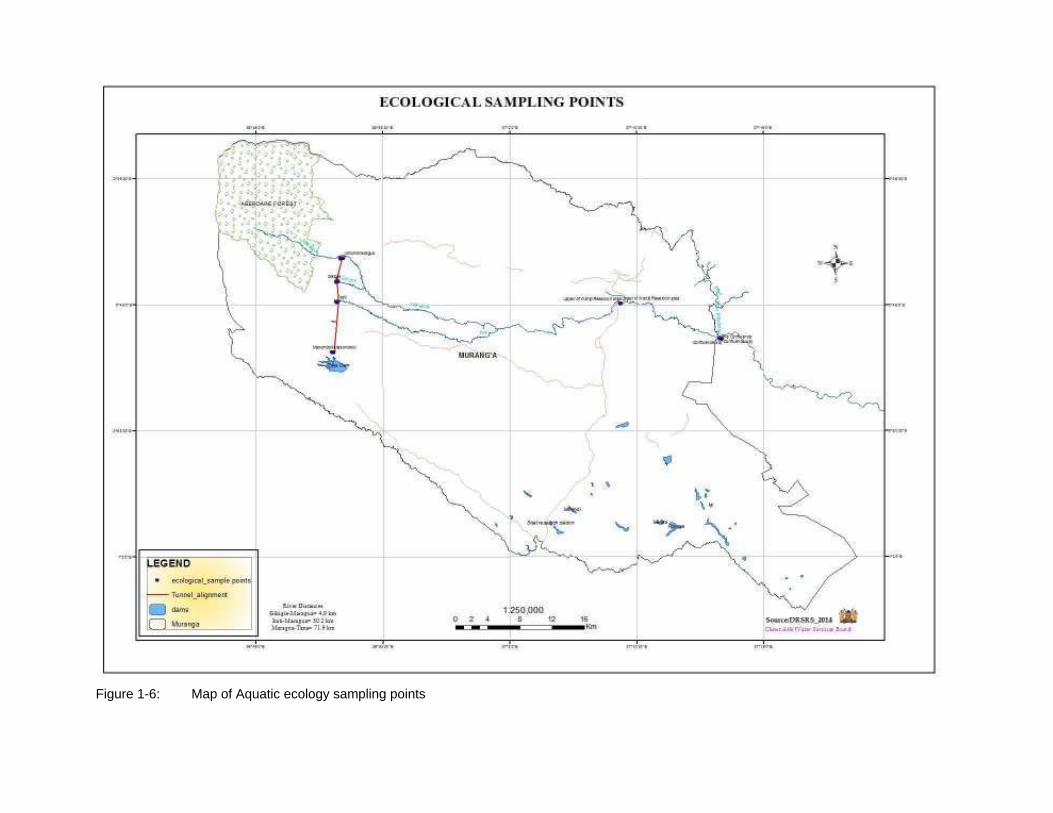
Figure 1-6: Map of Aquatic ecology sampling points

ESIA STUDY REPORT NCT PHASE 1 1-14 Issue 1.0 / October 2014
1.4.9 Socioeconomic Survey
The sampling method employed in this survey was based on the understanding that households are not homogenous particularly in terms of levels of farm utilization, livelihood challenges, socio-economic values attached and development concerns and threats. The main sampling unit of the survey was the household.
The team consulted the area Chiefs, sub-chiefs and village elders to identify the villages and households in the primary project’s primary zone of influence. Cluster sampling strategy was then employed in the selection of the households based on the household listing provided by the chief and village elders. The number of households enumerated per village is as shown in Table 1-2 below.
Table 1-2: Sampled Households by village
Village HHs sampled Village HHs sampled Gathai 2 Karura 1Gathaiti 1 Kiaro 1Gathure 1 Kinyona 2Gikigie 2 Kirangi 1Gikohokoho 2 Magomano 8Gitaigua 13 Mainungi 1Gitoka 3 Mairi 10Gituamba 11 Makomboki 6Ichichi 16 Muchagatha 10Irati 1 Munyoroku 3Kagimbi Ini 2 Ndiriimi 1Kaihuri 6 Ngecha 6Kamunyaka 6 Njikariro 2Kangari 10 Rugongo 2Karuga 1 Rugongo Ruraya 1
Total HHs 132
The response rate was 100%
Additionally, a targeted survey was done for PAPs within the intakes, outfall and the tunnel alignment. A total of 171 households were enumerated. However, since these households were identified purely on the basis of them being affected by the land take, data from these households was not included in the analysis as it would interfere with the distribution.
The resultant data was coded uniformly for data entry purposes. The data was then entered and analyzed using the SPSS program. Quantitative data analyses were carried out using simple and relevant statistical methods such as average, percentage and frequency distribution.
1.4.10 Public Consultations
(a) Project Report Stage
Consultations with the Sub-County administration in Kangema and Kigumo Sub-Counties were done during the preliminary field visits to notify them of the proposed project as well as to aid in further identification of relevant local institutional stakeholders to be consulted during the ESIA study.
(b) ESIA Study Stage
Further public consultations were undertaken during the full environment and social impact assessment study to document the social impacts to the project
ESIA STUDY REPORT NCT PHASE 1 1-15 Issue 1.0 / October 2014
area and general community perceptions on the project based on final project designs.
In general, the following steps were followed in carrying out the entire consutation and public participation process:-
Identification of institutions and individuals interested in the process and compiling a database of the interested and affected parties
Administration of questionnaires to different target groups and local community members within the proposed project site.
Public / Technical Meetings at various levels and with different target groups
The public participation exercise was conducted in four ways, namely;
6 No. General public meetings from 11 to 14 August 2014; Key Informant Interviews and six (6)Focus Group Discussions; Social economic surveys and observations; and Pubic disclosure workshop.
(i) Public meetings
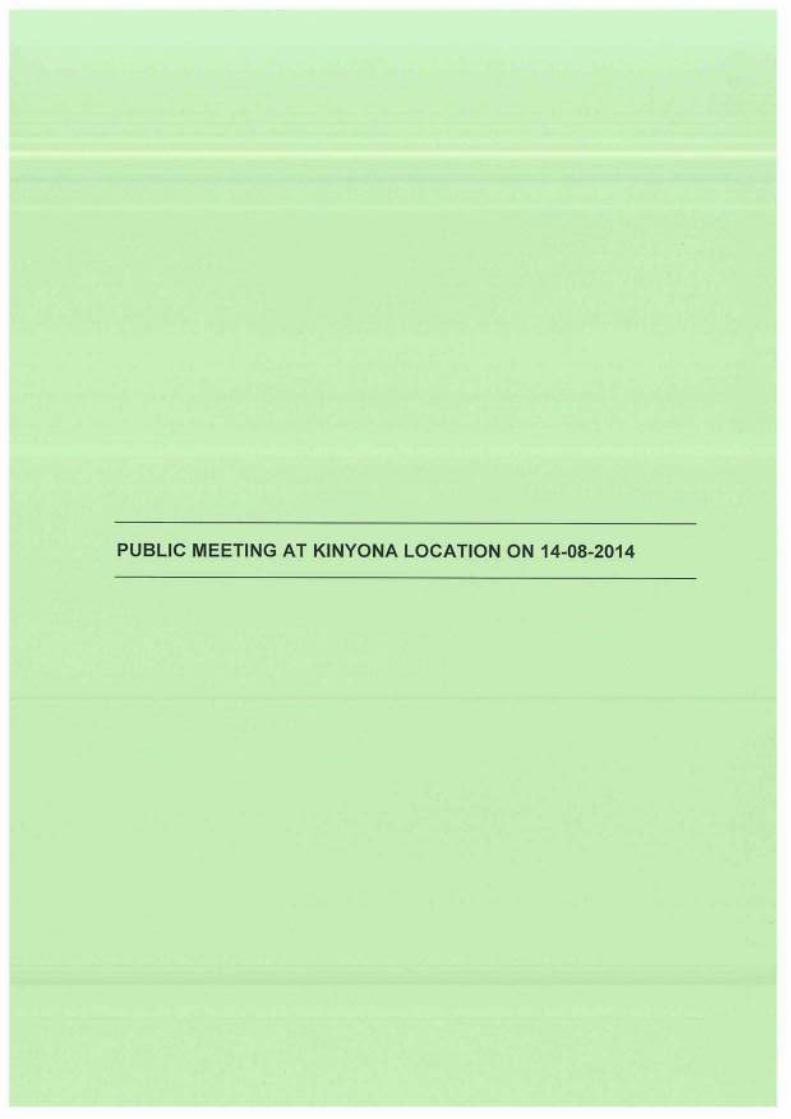
Consultations with the communities were conducted in the project area with the help of the local administration including the Deputy County Commissioners, Assistant County Commissioners, chiefs and assistant chiefs. The discussions during these public meetings were centered on key emerging issues relating to the project as well as the communities. Given the large size of the project area, a total of six (6) meetings were held at location levels within the project area.
(ii) Key Informant Interviews
One-on-one interviews with civil, government agencies and other institutions in the project area, from both Kigumo and Kangema sub counties as well as with various bulk water service providers, were undertaken to assist in analysis of impacts to the community and institutions in the project area. These interviews were conducted to augment and confirm data and information obtained using the other tools and methodologies.
(c) Incorporating public views into the ESIA report
Views of those affected by or interested in the project informed identification and evaluation of both social and environmental impacts and have also been considered in the formulation of mitigation measures and formulation of the environment management plan.
(d) Public disclosure
This involves disclosure of findings, conclusions and recommendations of ESIA report to stakeholders and public. Findings of the ESIA report were disclosed during a stakeholders' workshop held on 2 October 2014 at Nokras hotel in Murang’a town.
The consultations feedback is presented in chapter six and records are provided as Appendix VI.
ESIA STUDY REPORT NCT PHASE 1 1-16 Issue 1.0 / October 2014
1.5 Study Limitations
Due to limited time for the study, primary aquatic ecology data collection only took place during a dry season only. However, inputs from local knowledge were used to corroborate secondary information on species in the area. Dry season survey presents an opportunity to record fauna which are usually available even during low flow conditions. Low flows are stressful for fish and other aquatic life, as habitat availability is reduced, water quality may be changed and food sources may decrease.
1.6 ESIA Study Team
The ESIA team comprised the following:
Eng. Maurice Namiinda Project Director and Water Supply Engineer George G Owuor Team Leader and Lead Environmentalist
Anastasia Ngatti Assistant team leader Aggrey O. Kwadha Environmentalist George Wandera Sociologist
John Kochey Aquatic Ecologist
John Nyangaga Hydrologist Jacob Omondi Assistant sociologist
Michael Kabari Assistant environmentalist
Vincent Imala GIS Expert
1.7 Structure of the Report
This report has been prepared under the following chapters:
Executive summary: This chapter presents a summary of the significant findings and recommended actions, with an emphasis on expected impacts.
Chapter 1: Introduction: This chapter gives description of the project background, location, purpose, objectives, study methodology and the structure of the report.
Chapter 2: Policy , Legal and regulatory framework : This chapter outlines the overview of legislative framework, regulatory, international guidelines and conventions relevant to this project.
Chapter 3: Baseline Environmental setting: This chapter gives description of the pre-project environmental setting of project and surrounding areas, e.g., climate, soils, geology, vegetation, fauna, land use, human populations, socio-economics, cultural heritage.
Chapter 4: Project description: This chapter gives a description of the project details and design and implementation strategies.
Chapter 5: Project alternatives: This chapter gives an analysis of project

ESIA STUDY REPORT NCT PHASE 1 1-17 Issue 1.0 / October 2014
alternatives including the no-project option.
Chapter 6: Public and stakeholder consultation: ’ This chapter gives description of the objectives, methods used and summary of results of the public consultation activities undertaken during the project report stage.
Chapter 7: Impacts Assessment and Mitigations: This chapter presents the analysis of beneficial and adverse impacts of the project on the biophysical and human (social, cultural and economic) environments. The analysis covers anticipated impacts during the construction, operation phases and decommissioning phases and also describes the enhancement and mitigation measures proposed to enhance benefits or prevent, minimize, mitigate or compensate for adverse impacts as well as the estimated cost of mitigation.
Chapter 8: Environmental and Social Management Plan: This chapter gives in details summary of procedures and plans to ensure that the mitigation measures and monitoring requirements approved during the environmental compliance review will actually be carried out in subsequent stages of the project.
Chapter 9: Conclusions and Recommendations: This chapter summarises the consultant’s conclusion and recommendations form the assessment.

ESIA STUDY REPORT NCT PHASE 1 2-1 Issue 1.0 / October 2014
2 POLICY, LEGAL AND REGULATORY FRAMEWORK
2.1 Background
Regulation 18 (1) (b) of the Environmental (Impact Assessment and Audit Regulations) 2003 require an environmental assessment study report to, among others; include a concise description of national environmental legislative and regulatory framework. This chapter presents a review of the current policy, legal and regulatory framework applicable to environmental management of the proposed NCT1 both at local and international levels.
2.2 Policy Framework
2.2.1 Environmental Policy
Sessional Paper No. 6 of 1999 on Environment and Development since adoption by parliament in 1999 has been in use and influenced the formation of EMCA in 1999. However, since it has been surpassed by time it is therefore under revision to comprehensively cover areas that were previously left out to augment it.
The revised draft of the National Environmental Policy, dated April 2012, sets out important provisions relating to the management of ecosystems and the sustainable use of natural resources, and recognizes that natural systems are under intense pressure from human activities particularly for critical ecosystems including forests, grasslands and arid and semi-arid lands. The objectives of the Policy include developing an integrated approach to environmental management, strengthening the legal and institutional framework for effective coordination, promoting environmental management tools, supporting the implementation of the Forests Act 2005, and developing national standards and appropriate forest-based development mechanisms in emerging carbon markets.
Relevance
This ESIA study has developed an ESMP for the project which should be implemented to mitigate the resulting impacts during the construction and implementation phases of the project. This will ensure that the sensitive ecosystems are not destabilised by the subsequent project activities, especially the downstream uses of the rivers.
2.2.2 Kenya’s Vision 2030
Vision 2030 aspires to transform Kenya into a newly industrialized middle-income country by 2030. The blueprint recognizes that Kenya is a water scarce country and further that the economic and social development envisaged in the vision 2030 will require more high quality water supplies. The water and sanitation sector goal in line with the Vision 2030 is “to ensure that improved water and sanitation are available and accessible to all”.
One of the strategies proposed is to construct water and sanitation facilities to support industries and the growing urban population.
Regarding environment, the Vision states that Kenya aims to be a nation living in a clean, secure and sustainable environment by 2030. The goals for 2012 are: (i) to increase forest cover from less than 3% at present to 4%; and (ii) to lessen by half all environment related diseases. Specific strategies involve: promoting environmental conservation for better support to the economic pillar flagship projects and for the purposes of achieving the Millennium Development Goals (MDGs); improving pollution and waste management through the design and application of economic incentives; and the commissioning of Public-Private Partnerships (PPPs) for improved efficiency in water and sanitation delivery.

ESIA STUDY REPORT NCT PHASE 1 2-2 Issue 1.0 / October 2014
Relevance
The NCT project is in line with the vision 2030 and specifically falls under the flagship project of rehabilitating and expanding urban water supply and sanitation in Nairobi and its key satellite towns which have been identified for various economic and social flagship projects.
2.2.3 Land Policy
The National Land Policy in Chapter 3 under section 3.4, Environmental Management Principles, provides for the policy actions for addressing the environmental problems such as the degradation of natural resources, soil erosion, and pollution of air, water and land.
The policy advocates for environmental assessment and audit as a land management tool to ensure environmental impact assessments and audits are carried out on all land developments that may degrade the environment and take appropriate actions to correct the situation. Public participation has also been indicated as key in the monitoring and protection of the environment.
Section 3.4.3.3 advocates for the Implementation of the polluter pays principle which ensures that polluters meet the cost of cleaning up the pollution they cause, and encourage use of cleaner production technologies.
In section 131 (d) the government undertakes to provide mechanisms for resolving grievances arising from human/wildlife conflicts for sustainable management of land based natural resources.
Relevance
The proposed works shall implement the ESMP from this environmental assessment to ensure that all the rivers and streams within the project area are not polluted by the subsequent activities during construction and operational phases.
2.2.4 National Water Policy
The National Water Policy was promulgated in April 1999 as Sessional Paper No. 1 of 1999 and calls for decentralization of operational activities from the central government to other sectors, including local authorities, the private sector and increased involvement of communities in order to improve efficiency in service delivery.
The overall objective of the National Water Policy is to lay the foundation for the rational and efficient framework for meeting the water needs for national economic development, poverty alleviation, environmental protection and social well-being of the people through sustainable water resource management.The policy recognizes importance of Water resources in determining the economic and social development agenda in Kenya and also as a vital element in maintaining the ecosystem, wildlife and recreation, hydropower production, and maritime transportation.
Under the policy objective,�To ensure a comprehensive framework for promoting optimal, sustainable, and equitable development and use of water resources for livelihoods of Kenyans’, the policy encourages enhancement of inter-basin water transfer in Kenya as a strategic intervention for optimized use of water resources. It recognizes that some areas in the country are less endowed with water resources, and accordingly, the Regulatory Authority shall play a major role in the conservation and equitable distribution in national interest and in the realization of the right to water.
Under the policy objective, ‘To progressively achieve universal rights to water supply and sanitation for all by 2030 in the rural and urban areas’, one of the policy statements is to ensure access to water and sanitation according to rights. All relevant public sector institution and each WSP shall progressively enhance the rights to safe, reliable and affordable water and sanitation for all (100% service coverage by 2030)
ESIA STUDY REPORT NCT PHASE 1 2-3 Issue 1.0 / October 2014
Relevance
The proposed project is in line with this sectoral policy as it will involve inter-basin transfer and also serve to increase access to water in be beneficiary urban centres.
2.2.5 Millennium Development Goals (MDGs)
Adopted by world leaders in the year 2000 and set to be achieved by 2015, the Millennium Development Goals (MDGs) provide concrete, numerical benchmarks for tackling extreme poverty in its many dimensions. The MDGs also provide a framework for the entire international community to work together towards a common end making sure that human development reaches everyone, everywhere. If these goals are achieved, world poverty will be cut by half, tens of millions of lives will be saved, and billions more people will have the opportunity to benefit from the global economy.
Goal 7 of the MDGs is on ensuring Environmental Sustainability. It highlights on the following issues that need to be addressed:
Protection of forest ecosystems; Need for reduction in Green House Gases; Reduce overexploitation of marine resources; Promoting Non extinction of some animal species; Improve access and quality of water especially to the poor; and Try and face out the sprawling of urban slums.
Relevance
The proposed project will contribute to alleviating rural poverty while this ESIA study has been done for the proposed project to ensure that it reflects Environmental Sustainability especially during the time of construction and implementation.
2.3 Legal Framework
2.3.1 Constitution of Kenya
In article 69 of the Constitution of Kenya, 2010, the State clearly undertakes to carry out the following:
a) Ensure sustainable exploitation, utilization, management and conservation of the environment and natural resources, and ensure the equitable sharing of the accruing benefits;
b) Work to achieve and maintain a tree cover of at least ten per cent of the land area of Kenya;
c) Protect and enhance intellectual property in, and indigenous knowledge of, biodiversity and the genetic resources of the communities;
d) Encourage public participation in the management, protection and conservation of the environment;
e) Protect genetic resources and biological diversity; f) Establish systems of environmental impact assessment, environmental audit and
monitoring of the environment; g) Eliminate processes and activities that are likely to endanger the environment; and h) Utilise the environment and natural resources for the benefit of the people of Kenya.
Section 42 states that “Every person has the right to a clean and healthy environment, which includes the right:

ESIA STUDY REPORT NCT PHASE 1 2-4 Issue 1.0 / October 2014
a) To have the environment protected for the benefit of present and future generations through legislative and other measures, particularly those contemplated in Article 69; and
b) To have obligations relating to the environment fulfilled under Article 70
The constitution also emphasizes on that:
Land use and management shall by law benefit local communities; Community land is protected from encroachment by State; Law shall protect Rivers, forests and water bodies; Equitable access to land; County governments will manage land in trust of the people in accordance with the
Proposed Constitution.
Relevance
The constitution of Kenya provides for sound environmental management and sustainability and therefore this study provides one of the tools through which this can be achieved within the development.
2.3.2 The Environment Management and Coordination Act, 1999
The Environment Management and Coordination Act (EMCA), 1999 provides for the establishment of an umbrella legal and institutional framework under which the environment in general is to be managed. EMCA is implemented by the guiding principle that every person has a right to a clean and healthy environment and can seek redress through the High court if this right has been, is likely to be or is being contravened.
Section 58 of the Act makes it a mandatory requirement for an EIA study to be carried out by proponents intending to implement projects specified in the second schedule of the Act. Such projects have a potential of causing significant impacts on the environment. Similarly, section 68 of the same Act requires operators of existing projects or undertakings to carry out environmental audits in order to determine the level of conformance with statements made during the EIA study. The proponent is required to submit the EIA and environmental audit reports to NEMA for review and necessary action.
Relevance
Environmental Management and Coordination Act (EMCA), 1999 in its Second Schedule 4 (b) requires river diversions and water transfer between catchments undergo Environmental Impact Assessment (EIA). This report has been compiled to comply with EMCA and the Environmental (Impact Assessment and Audit) Regulations, 2003.
EMCA has provided for the development of several subsidiary legislations and guidelines that govern environmental management which are relevant to the proposed project as reviewed below.
(a) Environmental Impact Assessment and Audit Regulations 2003
The Environmental Impact Assessment and Audit Regulations state in Regulation 3 “the Regulations should apply to all policies, plans, programmes, projects and activities specified in Part IV, Part V, and the Second Schedule of the Act. Part III of the Regulations indicates the procedures to be taken during preparation, submission and approval of the study report (This report).
Regulation 4(1) further states that:
‘‘…no Proponent shall implement a project:
(a) Likely to have a negative environmental impact; or

ESIA STUDY REPORT NCT PHASE 1 2-5 Issue 1.0 / October 2014
(b) For which an environmental impact assessment is required under the Act or these Regulations, unless an environmental impact assessment has been concluded and approved in accordance with these Regulations…’’
Relevance
This ESIA study report has been prepared in response to provisions of these regulations.
(b) The Environmental Management and Co-ordination Act (Water Quality) Regulations, 2006)
These Regulations were published in the Kenya Gazette Supplement No. 68, Legislative Supplement No. 36, and Legal Notice No. 120 of 29 September 2006. The Regulations provide for sustainable management of water resources including prevention of water pollution and protection of water sources (lakes, rivers, streams, springs, wells, and other water sources). It is an offence under Regulation No. 4 (2), for any person to throw or cause to flow into or near a water resource any liquid, solid, or gaseous substance or deposit any such substance in or near it, as to cause pollution.
Regulation No. 11 further makes it an offence for any person to discharge or apply any poison, toxic, noxious or obstructing matter, radioactive waste or other pollutants or permit the dumping or discharge of such matter into the aquatic environment unless such discharge, poison, toxic, noxious or obstructing matter, radioactive waste or pollutant complies with the standards for effluent discharge into the environment as contained in the third schedule to the regulations.
The ninth schedule of the regulations stipulates the standards for sources of irrigation water as presented in Table 2-1 below.
Table 2-1: EMCA standards for sources of domestic water
Parameter Guide Value (Maximum allowable)pH 6.5 – 8.5 Suspended solids 30 (mg/l) Nitrite – NO3 10 (mg/l) Ammonia – NH3 0.5 (mg/l) Nitrate – NO2 3 (mg/l)Total dissolved solids 1200 (mg/l) Ecoli Nil/100ml Fluoride 1.5 (mg/l) Phenols Nil (mg/l) Arsenic 0.01 (mg/l) Cadmium 0.01 (mg/l)Lead 0.05 (mg/l) Selenium 0.01 (mg/l) Copper 0.05 (mg/l) Zinc 1.5 (mg/l) Alkyl benzyl sulphonates 0.5 (mg/l) Permanganate Value (PV) 1.0 (mg/l)
Relevance
During the operation and maintenance phases, the proposed water transfer from the three rivers will require compliance with the standards established under these regulations.
During the studies, water sampled from the proposed intake points were analysed from NMK and University of Nairobi laboratories and found suitable for intended use. Further, the water will be treated after transfer from Thika dam at the proposed Kigoro water treatment plant.

ESIA STUDY REPORT NCT PHASE 1 2-6 Issue 1.0 / October 2014
(c) The Environmental Management and Co-ordination (Waste Management) Regulations, 2006
These Regulations were published in the Kenya Gazette Supplement No. 69, Legislative Supplement No. 37, and Legal Notice No. 121 of 29th September 2006. The regulations provide details on management (handling, storage, transportation, treatment, and disposal) of various waste streams including:
domestic waste; industrial waste; hazardous and toxic waste; pesticides and toxic substances; biomedical wastes; and Radioactive waste.
Regulation No. 4 (1) makes it an offence for any person to dispose of any waste on a public highway, street, road, recreational area or in any public place except in a designated waste receptacle.
Regulation 6 requires waste generators to segregate waste by separating hazardous waste from non-hazardous waste for appropriate disposal. Regulation 17 (1) makes it an offence for any person to engage in any activity likely to generate any hazardous waste without a valid Environmental Impact Assessment license issued by NEMA.
Relevance
The proposed project, during construction, will generate substantial volumes of spoil materials among other wastes which will need to be disposed as per the guidelines in the regulations.
(d) The Environmental Management and Coordination Act (Noise and Excessive Vibration Pollution) (Control) Regulations, 2009
These regulations were published as legal Notice No. 61 being a subsidiary legislation to the Environmental Management and Co-ordination Act, 1999. The regulations provide information on the following:
i. Prohibition of excessive noise and vibration; ii. Provisions relating to noise from certain sources; iii. Provisions relating to licensing procedures for certain activities with a potential of
emitting excessive noise and/or vibrations; and iv. Noise and excessive vibrations mapping.
According to regulation 3 (1), no person shall make or cause to be made any loud, unreasonable, unnecessary or unusual noise which annoys, disturbs, injures or endangers the comfort, repose, health or safety of others and the environment.
Regulation 4 prohibits any person to (a) make or cause to be made excessive vibrations that annoy, disturb, injure, or endanger the comfort, repose, health, or safety of others and the environment; or (b) cause to be made excessive vibrations that exceed 0.5 centimetres per second beyond any source property boundary or 30 metres from any moving source.
Regulation 5 further makes it an offence for any person to make, continue or cause to be made or continued any noise in excess of the noise levels set in the First Schedule to these Regulations, unless such noise is reasonably necessary to the preservation of life, health, safety or property.

ESIA STUDY REPORT NCT PHASE 1 2-7 Issue 1.0 / October 2014
The First and Second schedules of the regulations have set standards for maximum permissible noise levels at construction sites and intrusive noise levels respectively.
Relevance
Various tunnel construction activities will generate noise and vibrations. The contractor will be required to ensure compliance with the above regulations in order to promote a healthy and safe working environment throughout the construction phase. Most settlements in the project lie along the roads some of which will be used to haul the anticipated high volumes of spoil and relevant noise limits will have to be observed.
(e) The Environmental Management and Coordination (Wetlands, River Banks, Lake Shores and Sea Shore Management) Regulations, 2009
This is a supplementary legislation to EMCA with particular emphasis on management of wetland and wetland resources, river banks, lake shores and Sea shores. Sections 4 and 5 of Part II as well as sections 16, 17, 18 of part III of the legislation provide guidelines for conservation and sustainable use and conservation of the said environmental components, and enhance them where necessary when carrying out any activity therein.
Relevance
The NCT will, in operation; continuously abstract water from the three rivers and restructure sections of their banks at particular spots through intake works. It is thus paramount that this legislation be integrated during planning, construction and operation of the project.
(f) The Environmental Management and Coordination (Conservation of Biological Diversity and Resources, Access to Genetic Resources and Benefit Sharing) Regulations, 2006
This regulations aim at enhancing preservation of biodiversity and safeguarding of endangered and rare plant and animal species within any human activity area.
Section 4 of the legislation expressly prohibits any activity which may have adverse effects on any ecosystem, lead to introduction of alien species in a given area or result in unsustainable utilization of available ecosystem resources.
Relevance
A detailed assessment of the likely impacts of the NCT on aquatic biodiversity in the targeted rivers has been conducted to ensure their sustainability.
(g) Environmental Management and Coordination (Fossil Fuel Emission Control) Regulations 2006
These regulations are described Legal Notice No. 131 of the Kenya Gazette Supplement no. 74, October 2006 and apply to all internal combustion engine emission standards, emission inspections, the power of emission inspectors, fuel catalysts, licensing to treat fuel, cost of clearing pollution and partnerships to control fossil fuel emissions. The fossil fuels considered are petrol, diesel, fuel oils and kerosene.
These regulations will be applicable to equipment and machinery used by the contractor during tunnel construction.

ESIA STUDY REPORT NCT PHASE 1 2-8 Issue 1.0 / October 2014
2.3.3 The Water Act, 2002
The Water Act No. 8 of 2002 provides for the management, conservation, use and control of water resources and for acquisition and regulation of rights to use water; to provide for the regulation and management of water supply and sewerage services. Section 18 of this Act provides for national monitoring and information systems on water resources. Following on this, sub-Section 3 mandates the Water Resources Management Authority (WRMA) to demand from any person or institution, specified information, documents, samples or materials on water resources. Under these rules, specific records may require to be kept by a site operator and the information thereof furnished to WRMA.
Section 73 of the Act provides that a person who is licensed to supply water have a responsibility of safeguarding the water sources against degradation. According to section 75 (1) such a person is required to construct and maintain drains, sewers and other works for intercepting, treating or disposing of any foul water arising or flowing upon land for preventing pollution of water sources within his/her jurisdiction.
Section 94 of the Act makes it an offence to throw or convey or cause or permit to be thrown or conveyed, any rubbish, dirt, refuse, effluent, trade waste or other offensive or unwholesome matter or thing into or near to water resource in such a manner as to cause, or be likely to cause, pollution of the water resource.
Relevance
The proponent should ensure that a Water abstraction permit for the project is obtained from WRMA. The proponent will be required to ensure that project activities throughout all phases do not cause pollution of the water resources and also continuously monitor the quantity and quality of water being abstracted from the rivers.
(a) The Water Resources Management Rules, 2007
As a subsidiary to the Act, a legislative supplement, The Water Resources Management Rules, 2007 was gazetted to guide all policies, plans, programmes and activities that are subject to the Water Act, 2002. The Water Resources Management Rules empower Water Resources Management Authority (WRMA) to impose management controls on land use falling under riparian land. It also enables any person with a complaint related to any matter covered by these rules to the appropriate office in WRMA as per the Tenth Schedule which provides a format for report on complaints.
Part A of the Sixth Schedule: Conservation of Riparian and Catchment Areas of the Rules (rule 116) define the riparian land on each side of a watercourse as a minimum of six metres or equal to the full width of the watercourse up to a maximum of thirty metres on either side of the bank. It further provides activities proscribed on riparian land as:
Tillage or cultivation; Clearing of indigenous trees or vegetation; Building of permanent structures; Disposal of any form of waste within the riparian land; Excavation of soil or development of quarries; Planting of exotic species that may have adverse effect to the water resource;
or Any other activity that in the opinion of the Authority and other relevant
stakeholders may degrade the watercourse.
Rule 63 provides for Compensation flow and a permit holder storing or arresting the flow of water by means of a dam or weir located on a body of water or watercourse shall unless otherwise decided by WRMA, provide at a depth measured from the top of the dam or weir and to be specified by WRMA in each particular case, an outlet,
ESIA STUDY REPORT NCT PHASE 1 2-9 Issue 1.0 / October 2014
controlled by a valve, sluice gate or other device, which shall be capable of being operated at all stages of the flow of such body of water or watercourse so that the normal flow, or other flow as required by WRMA, of such body of water or watercourse can be passed through or around such dam or weir at all stages.
Relevance
The project will arrest flows of rivers Gikigie, Maragua and Irati by means of weirs and the design has to allow for adequate compensation flow through the proposed weirs in line with these rules and any other WRMA requirements.
2.3.4 The Public Health Act (Cap. 242)
This is an Act of Parliament to make provision for securing and maintaining health. Section 115 of this act prohibits causing nuisance or other conditions liable to be injurious or dangerous to health. Section 118 provides a list of nuisances that includes any noxious matter, or wastewater, flowing or discharged from any premises, wherever situated, into any public street, or into the gutter or side channel of any watercourse, irrigation channel or bed thereof not approved for the reception of such discharge.
(a) The Public Health (Drainage and Latrine) Rules
Rule 85 provides that every owner or occupier of every workshop, workplace or other premises where persons are employed shall provide proper and sufficient latrines for use by employees. Rule 87 requires every contractor, builder or other person employing workers for the demolition, construction, reconstruction, or alteration of any building or other work in any way connected with building to provide in an approved position sufficient and convenient temporary latrines for use by such workers. Rule 91 provides that no person shall construct a latrine in connection with a building other than a water closet or a urinal, where any part of the site of such building is within 200 feet of a sewer belonging to the local authority that is at a suitable level, and where there is sufficient water supply.
Relevance
The project construction and operation activities are bound to expose both workers and members of the general public to situations injurious to health. All activities of the project are thus expected to abide by this act to ensure a healthy environment.
2.3.5 Malaria Prevention Act Cap 246
This is an act of parliament which enables health authorities to take measures for prevention of Malaria.
Section 5 of the act prohibits operations that obstruct flow of water into or out of any drainage without the approval of the health authorities. It states that
“ No person shall, within an area subject to the control of a health authority, build or maintain a dam or other construction so as to obstruct the flow of water into or out of a drain under the control of the health authority, nor by any means alter the level of any water so as to reduce its flow, nor construct any steps, bridge or platform over a drain under the control of the health authority without the consent in writing of that health authority; and the health authority may cause any such dam or other construction, or any steps, bridge or platform so built or constructed without written consent to be demolished, altered, re-made or otherwise dealt with, as it may think fit, at the expense of the person building or constructing it, and any money becoming due from a person under this section shall be a civil debt recoverable summarily. ”

ESIA STUDY REPORT NCT PHASE 1 2-10 Issue 1.0 / October 2014
Relevance
The proposed NCT will involve impeding drainage on three rivers through weirs with potential of increasing suitable breeding grounds for malaria transmitting mosquitoes. The proponent shall be required to obtain requisite approvals and maintain the drainage system within the project area for removal of water from any land around the project to prevent larvae breeding.
2.3.6 Occupational Safety and Health Act, 2007
Occupational Safety and Health Act (OSHA) is an Act of Parliament that provides for the safety, health and welfare of all workers and all persons lawfully present at workplaces, to provide for the establishment of the National Council for Occupational Safety and Health and for connected purposes.
It applies to all workplaces where any person is at work, whether temporarily or permanently. The purpose of this Act is to:
Secure the safety, health and welfare of persons at work; and Protect persons other than persons at work against safety and health arising out of, or
in connection with the activities of persons at work.
OSHA Kenya Gazette Supplement No. 111 (Acts No.15) dated October 26, 2007 revokes the Factories and Other Places of Work Cap.514. The scope of OSHA 2007 has been expanded to cover all workplaces including offices, schools, academic institutions, factories, and plantations. It establishes codes of practices to be approved and issued by the Directorate of Occupational Safety and Health Services (DOSHS) for practical guidance of the various provisions of the Act.
Relevance
The contractor and AWSB will be required to comply with all the provisions of the Act throughout the project cycle.
2.3.7 Work Injury Benefits Act (WIBA), 2007
It is an act of Parliament (No. 13 of 2007) to provide for compensation to workers for injuries suffered in the course of their employment.
It outlines the following:
Employer’s liability for compensation for death or incapacity resulting from accident; Compensation in fatal cases; Compensation in case of permanent partial incapacity; Compensation in case of temporary incapacity; Persons entitled to compensation and methods of calculating the earnings; No compensation shall be payable under this Act in respect of any incapacity or death
resulting from a deliberate self-injury; and Notice of an accident, causing injury to a workman, of such a nature as would entitle
him for compensation shall be given in the prescribed form to the director.
Relevance
During construction period, the contractor will need to abide by all the provisions of WIBA. Similarly, the same will be required of the proponent during operation phase of the NCT.
2.3.8 The Wildlife Conservation and Management Act, 2013
This Act became operational on 10 January 2014. One of its guiding principles is the devolution of conservation and management of wildlife to landowners and managers in areas where wildlife occurs, through in particular the recognition of wildlife conservation as a form of land-use, better access to benefits from wildlife conservation, and adherence to the principles
ESIA STUDY REPORT NCT PHASE 1 2-11 Issue 1.0 / October 2014
of sustainable utilization. Section 25 of the act provides for compensation for injuries and damages caused by wildlife (species listed in its third schedule) to humans and their properties respectively. Such compensation claims are to be reviewed and awarded by County Wildlife Conservation and Compensation Committees at the ruling market rates: provided that no compensation shall be paid where the owner of the livestock, crops or other property failed to take reasonable measures to protect the properties from damage by wildlife or land use practices are incompatible with the ecosystem-based management plan for the area.
The act in its sixth schedule list various animal and tree species that are nationally considered as critically endangered, vulnerable, nearly threatened and protected. It also lists in its seventh schedule, national invasive species for which control is required.
Section 48 restricts activities involving the above listed species without a permit from KWS. KWS can make recommendations to the responsible cabinet secretary, to prohibit carrying out of any activity which: is of a nature that may negatively impact on the survival of species listed in sixth schedule; or is specified in the notice or prohibit the carrying out of such activity without a permit issued by KWS.
Relevance
Any critically endangered, vulnerable, nearly threatened or protected species found within the project area will have to be managed in line with this Act.
2.3.9 The Kenya Roads Board Act, Cap 408 of 1999
This is the main legal instrument that governs management of road network in the country. The act whose commencement date was 01 July 2000 encourages participation of all stakeholders in the road sector during the planning, design, construction and maintenance.
2.3.10 Public Roads and Road of Access Act (Cap 399)
The Act provides for the following with regard to public roads:
Dedication of line of public travel; Application to construct roads of access; Notice to be served on land owners affected; Granting of leave to construct road of access; Notification of order to be registered; Right of way over road of Access; Power to cancel or alter road of access; and Prohibition of classes of traffic
Relevance
Of relevance with the proposed NCT is the need for consultative cooperation with the Constituency Roads Committee before alteration/upgrade of some registered roads, as well as establishment of new project site (intakes and service) access roads. The tunnel will also be below some roads and provisions of the act will be relevant.
2.3.11 The Kenya Roads Act of 2007
The act stipulates the legal and institutional aspects of the road sub-sector policy. The Act provides for the establishment of three independent Road Authorities, namely:
I. Kenya National Highways Authority (KeNHA), responsible for the administration, control, development and maintenance of all class A, B and C roads in Kenya,
II. Kenya Rural Roads Authority (KeRRA), responsible for rural and small town roads including class D, E roads and Special Purpose Roads; and
III. Kenya Urban Roads Authority (KURA) responsible for all City and Municipal Roads.

ESIA STUDY REPORT NCT PHASE 1 2-12 Issue 1.0 / October 2014
The Authorities fall under the Ministry responsible for infrastructure, which retains the role of policy formulation, and general oversight of public roads including regulatory aspects such as technical standards.
The proponent will require liaison with these institutions in the improvements existing and development of any new roads within the project area.
2.3.12 Acts Related to Land
(a) The Land Act, 2012
This is an Act of Parliament intended to give effect to Article 68 of the Constitution, to revise, consolidate and rationalize land laws; to provide for the sustainable administration and management of land and land based resources, and for connected purposes. Parts 1 and 2 of section 4 of the Act outline the main guiding principles in land management and administration, binding to all land actors including state officers. These principles are to be applied when Enacting, applying or interpreting any provisions of this Act; and when making or implementing public policy decisions.
The act vests management of land on National Land Commission (NLC). In discharging their functions and exercising of their powers under this Act, the Commission and any State officer or public officer shall be guided by the following values and principles;
a) Equitable access to land; b) Security of land rights; c) Sustainable and productive management of land resources; d) Transparent and cost effective administration of land; e) Conservation and protection of ecologically sensitive areas; f) Elimination of gender discrimination in law, customs and practices related to
land and property in land; g) Encouragement of communities to settle land disputes through recognized
local community initiatives; h) Participation, accountability and democratic decision making within
communities, the public and the Government; i) Technical and financial sustainability; j) Affording equal opportunities to members of all ethnic groups; k) Non-discrimination and protection of the marginalized; and l) Democracy, inclusiveness and participation of the people; and m) Alternative dispute resolution mechanisms in land dispute handling and
management.
Acquisition of Private Land for Public Use
Section 110(1) of the Act provides that land may be acquired compulsorily under this if the Commission certifies, in writing, that the land is required for public purposes or in the public interest as related to and necessary for fulfillment of the stated public purpose.
In such an acquisition, this Act, in section 111(1) provides that just compensation shall be paid promptly in full to all persons whose interests in the land have been determined.
The procedure for land acquisition is laid out in Part VIII of the Act.
Elements for consideration under this procedure include the following:
The Act requires that the owners, residents and their spouses should also be notified; as opposed to just the owners;

ESIA STUDY REPORT NCT PHASE 1 2-13 Issue 1.0 / October 2014
The inspector would also have to get the consent of the occupier and give them not less than seven days’ notice to enter the premises;
The Commission shall have the power of a court to summon and examine witnesses and compel the production and delivery to the Commission of documents of title to the land;
Separate award of compensation to every person. An award is final and conclusive evidence of the size of the land, the value in the opinion of the Commission and the amount of compensation payable, whether or not the person attends the inquiry;
Regulations and rules pertaining to this process are yet to be gazetted; Section 107(4) allows for circumstances where the acquiring authority may
proceed with land acquisition at stage 1; The Commission shall make rules to regulate assessment of just
compensation; The Act does not explicitly state when the inspection will be done. Whether it
is before approval of the request for compulsory acquisition or before serving the notice for acquisition.
The Commission may post pone an inquiry or adjourn the hearing of an inquiry from time to time for sufficient cause.
Provisions on Acquisition of wayleave
The Land Act, 2012 provides for mechanisms of wayleave acquisition either as public right of way or communal right of way.
Section 143 of the act empowers NLC to create public rights of way. A public right of way may be: (a) a right of way created for the benefit of the national or county government, a local authority, a public authority or any corporate body to enable all such institutions, organizations, authorities and bodies to carry out their functions, referred to in the Act as a wayleave; or (b) a right of way created for the benefit of the public, referred to in section 145 of this Act as a communal right of way.
A public right of way shall attach to and run with the servient land in respect of which it has been created and shall be binding on all owners from time to time of the servient land, any manner they are occupying the land, whether under a land or a derivative right thereof, or under customary law or as a successor in title to any such owner or as a trespasser.
Section 144 (1) states that an application, for the creation of a wayleave, shall be made by any State department, or the county government, or public authority or corporate body, to the NLC.
In applying for wayleave, section 144(4) requires the applicant to serve a notice on:
a) All persons occupying land over which the proposed wayleave is to be created, including persons occupying land in accordance with customary pastoral rights;
b) The county government in whose area of jurisdiction land over which the proposed wayleave is to be created is located;
c) All persons in actual occupation of land in an urban and per-urban area over which the proposed wayleave is to be created; and
d) Any other interested person.
Subsection (5) requires NLC to publish the application along the route of the proposed wayleave calculated to bring the application clearly and in a comprehensible manner to the notice of all persons using land over which the proposed wayleave is likely to be created.
Section 145 (1) provides that a county government, an association, or any group of persons may make an application to the commission for a communal right of way.
ESIA STUDY REPORT NCT PHASE 1 2-14 Issue 1.0 / October 2014
Once an application has been made to NLC, the determination for creation of a wayleave is conducted as per section 146 of the act and includes:
NLC, after at least ninety days from the date of the serving of notices, considering all the information received and all representations and objections made by any person served with a notice and recommending to the Cabinet Secretary whether to:(i) appoint a public inquiry to give further consideration to the representations and objections; or(ii) refer the application to the County Government for its opinion on whether to approve the application; or (iii) initiate and facilitate negotiations between those persons who have made representations on the application and the applicant with a view to reaching a consensus on that application;
The Cabinet Secretary determining whether or not to create to create a public right of way, after taking account, as the case may be, of:(a) the recommendations of the Commission; or(b) the advice of the county government; or (c) the outcome of any negotiations referred to above;
The Cabinet Secretary creating a public right of way by order in the Gazette. The order comes into force thirty days after its publication in the gazette.
An appeal against an order creating the wayleave is allowed within six weeks after the order has been made. Such appeal is made to the Court on a point of law against an order made by the Cabinet Secretary, but apart from such an appeal, an order of the Cabinet Secretary shall not be questioned by way of judicial review or otherwise in any court.
According to section 148, prompt compensation shall be payable (by the State Department, county government, public authority or corporate body that applied for the public right of way) to any person for the use of land, of which the person is in lawful or actual occupation, as a communal right of way and, with respect to a wayleave, in addition to any compensation for the use of land for any damage suffered in respect of trees crops and buildings as shall, in cases of private land, be based on the value of the land as determined by a qualified valuer.
In case of disagreement or dissatisfaction on amount or method of or time taken to make payment, the affected individual may apply to court for determination and award.
Section 148 (6) stipulates that NLC shall make regulations prescribing the criteria to be applied in the payment of compensation. However, these regulations have not yet been formulated.
(b) The National Land Commissions Act, 2012
This is an Act of Parliament to make further provision as to the functions and powers of the National Land Commission, qualifications and procedures for appointments to the commission; to give effect to the objects and principles of devolved government in land management and administration, and for connected purposes.
The mandate of the Commission, as provided for in the Act, Pursuant to Article 67(2) of the Constitution, shall be:
To manage public land on behalf of the national and county governments; To recommend a national land policy to the national government; To advise the national government on a comprehensive programme for the
registration of Title in land throughout Kenya; To conduct research related to land and the use of natural resources, and
make recommendations to appropriate authorities; To initiate investigations, on its own initiative or on a complaint, into present or
historical land injustices, and recommend appropriate redress;

ESIA STUDY REPORT NCT PHASE 1 2-15 Issue 1.0 / October 2014
To encourage the application of traditional dispute resolution mechanisms in land conflicts;
To assess tax on land and premiums on immovable property in any area designated by law; and
To monitor and have oversight responsibilities over land use planning throughout the country
On behalf of, and with the consent of the national and county governments, alienate public land;
To monitor the registration of all rights and interests in land; To ensure that public land and land under the management of designated
state agencies are sustainably managed for their intended purpose and for future generations;
Develop and maintain an effective land information management system at national and county levels;
Manage and administer all unregistered trust land and unregistered community land on behalf of the county government; and
Develop and encourage alternative dispute resolution mechanisms in land dispute handling and management.
This Commission will be integral in the management of land issues arising from the project implementation, especially as far as portals and pipelines wayleave acquisition is concerned.
(c) The Land Registration Act, Act No. 3 of 2012
This is an Act of Parliament intended to revise, consolidate and rationalize the registration of titles to land, to give effect to the principles and objects of devolved government in land registration, and for connected purposes.
Land Registry
Section 7(1) of the Act provides for establishment of a land registry in each registration unit which shall keep registers of the following regarding land:
A land register, in the form to be determined by the Commission; The cadastral map; Parcel files containing the instruments and documents that support subsisting
entries in the land register. Any plans which shall, after a date appointed by the Commission, be geo-
referenced; The presentation book, in which shall be kept a record of all applications
numbered consecutively in the order in which they are presented to the registry;
An index, in alphabetical order, of the names of the proprietors; and A register and a file of powers of attorney.
Maintenance of documents, including land title deeds
Further, section 9(1) provides that the Registrar shall maintain the register and any document required to be kept under this Act in a secure, accessible and reliable format. These documents include
Publications, or any matter written, expressed, or inscribed on any substance by means of letters, figures or marks, or by more than one of those means, that may be used for the purpose of recording that matter;
Electronic files; and An integrated land resource registers.
ESIA STUDY REPORT NCT PHASE 1 2-16 Issue 1.0 / October 2014
The register, as provided for in part 2 of section 9, shall contain the following particulars;
Name, personal identification number, national identity card number, and address of the proprietor;
In the case of a body corporate, name, postal and physical address, certified copy of certificate of incorporation, personal identification numbers and passport size photographs of persons authorized and where necessary attesting the affixing of the common seal;
Names and addresses of the previous proprietors; Size, location, user and reference number of the parcel; and Any other particulars as the Registrar may, from time to time, determine.
These provisions are essential to any new land acquisition or transaction processes arising from implementation of the NCT project.
(d) The Land and Environment Court Act, 2012
This is an Act of Parliament to give effect to Article 162(2) (b) of the Constitution; to establish a superior court to hear and determine disputes relating to the environment and the use and occupation of, and title to, land, and to make provision for its jurisdiction functions and powers, and for connected purposes. The principal objective of this Act is to enable the Court to facilitate the just, expeditious, proportionate and accessible resolution of disputes governed by this Act.
Section 13 (2) (b) of the Act outlines that in exercise of its jurisdiction under Article 162 (2) (b) of the Constitution, the Court shall have power to hear and determine disputes relating to environment and land, including disputes:
Relating to environmental planning and protection, trade, climate issues, land use planning, title, tenure, boundaries, rates, rents, valuations, mining, minerals and other natural resources;
Relating to compulsory acquisition of land; Relating to land administration and management; Relating to public, private and community land and contracts, chooses in
action or other instruments granting any enforceable interests in land; and Any other dispute relating to environment and land.
Section 24 (2) also states that the Chief Justice shall make rules to regulate the practice and procedure, in tribunals and subordinate courts, for matters relating to land and environment.
Section 30 (1) states that all proceedings relating to the environment or to the use and occupation and title to land pending before any Court or local tribunal of competent jurisdiction shall continue to be heard and determined by the same court until the Environment and Land Court established under this Act comes into operation or as may be directed by the Chief Justice or the Chief Registrar.
Any land or/and environmental cases arising from the project will be handled in accordance with the provisions of this act.
2.3.13 The Physical Planning Act, 1996
The Act provides for the preparation and implementation of physical development plans and for connected purposes. It defined development, in section 3(a), as the making of any material change in the use or density of any buildings or land or the subdivision of any land which for the purposes of this Act classified as Class A development. Class A development constitutes deposition of refuse, scrap or waste materials on land, erection of dwellings and display of advertisements.

ESIA STUDY REPORT NCT PHASE 1 2-17 Issue 1.0 / October 2014
In order to promote health, safety, order, amenity, convenience and general welfare of all its inhabitants as well as efficiency and economy in the process of development and improvement of communications, the Act provides that every local authority must have a physical development plan as.
“...The basis for disposing of land acquired, or to be acquired under the plan by a local authority or relevant authority;
Section 4: The re-planning and reconstruction of the plan area, or any part thereof, including any provisions necessary for……..
Section 4 (e): Effecting such exchanges of land or cancellation of existing sub-divisions as may be necessary or convenient for purposes mentioned above in this paragraph
Section 4 (f): Adjustment of rights between owners or other persons interested in such lands, roads, streets or right of way……….” Section 29 of the Act vests powers in the local authorities to control development in their respective areas of jurisdiction, with legal mandate to vet development applications and approval or disapproval thereof.
In section 30, the legislation declares that any person intending to carry out development within a local authority is required to apply for development permission, forwarded to the clerk of the local authority. Until such permission is granted, no development activity shall be carried out by the proponent.
Relevance
The NCT project is likely to have a variety of additives, construction of storage, processing and housing and sanitation structures just but a few. For each development case, the stipulated procedure laid down by this Act shall be complied with before the activities begin.
It is however notable that this act is under review to align it with the new constitution. Some of its provisions like the local authorities are no longer applicable having been abolished in the new constitution.
2.3.14 Mining Act, Cap 306
Section 4 of the Mining Act vests all unextracted minerals (other than common minerals) under or upon any land in the Government, subject to any rights in respect thereof which, by or under this Act or any other written law, have been or are granted, or recognized as being vested, in any other person.
Section 25 state that when a holder of any exclusive prospecting licence or location discovers on any land comprised in such licence or location any minerals of economic value other than those for which the licence was granted or location was registered, he shall immediately report the discovery thereof to the Commissioner of Mines and Geology.
Mining (Safety) Regulations
These regulations provide guidelines to ensure safety and prevent danger to workers or others persons at mining areas including where works are undertaken underground.
Where necessary, among others it requires the following:
The mouth of every shaft, winze or pit and the entrance to every underground working, whether above or below ground to be fenced;
All parts of every underground working shall be properly and sufficiently ventilated to the satisfaction of an inspector of mines;
Disused workings to be examined before being used. Underground workings, especially shafts, sumps and winzes, which have been in disuse for some time shall be tested with a candle flame by a party of not less than three persons before being used again, in order to ascertain whether or not foul air or other dangerous gases have accumulated there; until such places are fit to work in they shall be fenced or otherwise made inaccessible and no person shall be allowed to enter;
ESIA STUDY REPORT NCT PHASE 1 2-18 Issue 1.0 / October 2014
Provision of sufficient and suitable sanitary conveniences, regard being had to the number of persons employed in the mine for both on the surface, and also in underground workings. Wooden conveniences underground prohibited;
First aid requirements; Procedures in case of accidents; Provides for safe means of handling machinery underground; Safe ways of transporting materials underground.
Relevance
NCT will entail underground tunnelling works and reference to these regulations will be essential in ensuring safety on site. Since the contractor will have no mining rights and any chance find of economic minerals shall be reported to commissioner of mines in line with this Act.
2.3.15 Explosives Act, Cap 115
This is an Act of Parliament that regulates the manufacture, storage, sale, transport, importation, exportation and use of explosives. Some of the key provisions of this act relevant to the project include:
Section 8(1): No person, other than the manufacturer, shall sell, deal in or dispose of any explosive unless he is in possession of a license granted under this Act; Section 9(1): No person shall purchase or otherwise acquire blasting materials except under the authority of, and to the extent authorized in, a written permit issued by an inspector. Section 11 (1): No person shall use, or cause to be used, any blasting materials at a depth of ten meters or more, measured from the surface along or down a shaft, adit, well or tunnel, unless he is in possession of a valid miner's blasting certificate issued to him under the Mining Act, or is under the immediate supervision of the holder of such a certificate; and Section 13(1 : No person shall convey explosives or cause them to be conveyed within Kenya, except under and in accordance with a permit in writing issued by an inspector
Explosives (Blasting Explosives) rules
These rules provide detailed requirements for ensuring safe packaging, licensing and construction of magazines, storage and reporting accidents related to handling explosives.
Relevance
Use of explosives during tunnel construction is envisaged in the project design and the proposed explosives are gelatine and ammonium nitrate. The contractor engaged will have to abide by all relevant provisions of this act and its rules. All licences required for handling, transporting, storage and use of the explosives must be obtained and remain valid throughout the construction period.
2.3.16 The Penal Code (Cap. 63)
Section 191 of the Penal Code makes it an offence for any person or institution that voluntarily corrupts, or foils water for public springs or reservoirs rendering it less fit for its ordinary use. Similarly, section 192 prohibits making the atmosphere in any place noxious to health of persons/institution in dwellings or business premises in the neighbourhood or those passing along a public way.
Relevance
The contractor and proponent will be required to ensure strict adherence to the Environmental Management Plan throughout the project cycle in order to mitigate any possible negative impact associated with dust, noise, and effluent discharge.
ESIA STUDY REPORT NCT PHASE 1 2-19 Issue 1.0 / October 2014
2.4 World Bank Safeguard policies
2.4.1 World Bank policy OP 4.01 Environmental Assessment
World Bank requires environmental assessment for projects proposed for the Bank financing to help ensure that they are environmentally sound and sustainable, and thus improve on decision making. Projects are screened and assigned categories (A, B, C or FI) depending on the type, location, sensitivity, and scale of the project and the nature and magnitude of its potential environmental impacts.
Following screening of the Main project, Water and Sanitation Service Improvement Project - Additional Financing, this project was classified as category A, requiring a full Environmental Assessment (EA). This is because the environmental and social impacts of NCT component were anticipated to be significant.
Based on the review of the major constraints and opportunities facing sustainable development in Africa, and taking into account, key principles underlying environmental sustainability and the overall objectives of the Policy, a number of key environmental issues have been identified. WB’s policy principles relevant to the project include:
Environmental sustainability of project activities; Application of environmental assessment; Potential adverse impact on biodiversity; Improving Urban Environmental Management; Institution and Capacity Building; Increasing Awareness; and Stakeholder Participation.
Relevance
Implementation of NCT is required to take place within WB policy framework on the best practices when it comes to ensuring that the project does not destabilize the riverine aquatic ecosystem, affect downstream users or degrade the environment.
2.4.2 World Bank policy OP 4.04 Natural Habitats
The WB recognises that conservation of natural habitats, like other measures that protect and enhance the environment, is essential for long-term sustainable development. The Bank therefore supports the protection, maintenance, and rehabilitation of natural habitats and their functions in its economic and sector work, project financing, and policy dialogue. The Bank supports, and expects borrowers to apply, a precautionary approach to natural resource management to ensure opportunities for environmentally sustainable development.
Relevance
Although the natural terrestrial vegetation cover in the project area has been significantly altered, NCT will occur on natural rivers dominated by native species. Precaution is thus required in line with OP 4.04 to ensure the riverine resources management are sustainable.
2.4.3 World Bank policy OP 4.11 Physical Cultural Resources
OP 4.11 on Physical Cultural Resources, was revised on April 2013 to takes into account the recommendations in Investment Lending Reform: Modernizing and Consolidating Operational Policies and Procedures, Given that some cultural resources may not be known or visible, it is important that a project’s potential impacts on cultural resources are considered at the earliest possible stages of project processing.

ESIA STUDY REPORT NCT PHASE 1 2-20 Issue 1.0 / October 2014
The assessment of impacts to cultural heritage has been based on identified aboveground features and known sites of archaeological interest, this is because, there is no archaeological cultural and settlement inventory covering the project area throughout the history of human occupation. However, as the policy requires, precaution is necessary in case of chance find.
Relevance
The contractor and AWSB will be required to follow chance find Procedures and contact the National Museums of Kenya (NMK) should any archeological site or artifact encountered during construction.
2.4.4 World Bank Operational Policy 4:12 Involuntary Resettlement
The World Bank safeguard policy on involuntary resettlement, Operational Policy (OP 4.12) establishes guidelines for land acquisition and compensation of people affected by a world bank sponsored project. Key principles and policy objectives of OP 4:12 can be summarised as:
To minimise or avoid involuntary resettlement where feasible and to explore all viable alternative project designs;
To conceive and implement resettlement activities as sustainable development programs where affected people are provided with sufficient investment resources and opportunities to share in project benefits;
Relevance
The project triggers this policy as there were areas where there was no possible project alternative. A RAP study has been carried out to provide guidance on land acquisition and compensation to the affected persons.
The above policy principles have been applied through consulting affected persons and according them opportunities to participate in the planning and execution of resettlement programs. This will assist the Project affected persons (PAPs) where resettlement is necessary, to improve their livelihood and living standards, income earning capacity and production levels, or at least to restore them in a manner that maintains sustainability of resettlement programs. The RAP report has been publicly disclosed in Kenya and in the World Bank InfoShop.
The Compensation framework shall be based on:
For agricultural land, land of equal productive use or potential, prepared to a similar level and located in the vicinity of the affected land;
For residential land, land of equal size and use, with similar infrastructure and services and located in the vicinity of affected land;
For structures, full replacement cost to purchase or build new structures of a similar size and quality to affected houses and other affected structures; and
Subsidies to assist AP with costs associated with the transition period in the resettlement site e.g., moving costs, living allowance, business losses lost production etc.
2.4.5 World Bank Operational Policy 4:37 Safety of Dams
This OP provides guidelines to ensure safety at Bank financed projects involving dams. Safety measures require appropriate plans for:
Construction supervision and quality assurance; Instrumentation plan; Operation and Maintenance (O&M) plan; and Emergency preparedness plan.

ESIA STUDY REPORT NCT PHASE 1 2-21 Issue 1.0 / October 2014
In the case of existing dams, any dam that can influence the performance of a project must be identified and its safety assessed. Necessary dam safety measures or remedial work are implemented. According to the OP, Dams over 15 meters in height are classified as large dams. High hazard dams are those under 15 metres but which are in a zone of high seismicity and /or where foundations and other design features are complex.
Relevance
The NCT1 will on commissioning direct its waters into an existing Thika Dam hence triggering this OP. AWSB will review and update the dam safety and emergency preparedness plan if necessary.
2.5 AFD Policy on Environmental and Social Risk Management
2.5.1 Policy
The environmental and social risk management process (including risks related to climate change) for the operations financed by AfD applies throughout the project life cycle. This risk management mechanism meets the objectives of harmonizing the environmental and social procedures of Official Development Assistance agencies set out in the Paris Declaration on Aid Effectiveness.
2.5.2 Environmental and Social Risks
The policy reconizes that projects can have risks in terms of ecology (adverse effect on natural environments and biodiversity), pollution (water, air, soil) and nuisances (noise, waste…) and natural, technological and health risks. They can also have an impact on the health and safety of communities, natural resources (water resources, soil and underground resources, land resources), on the living conditions of communities, and on the natural, historical and/or cultural heritage. The social risks mainly concern the respect of fundamental human rights for which there are recognized international standards, laws and conventions: human traffic, sex tourism, population displacement, forced labor, working conditions, equity for disadvantaged or excluded social groups (particularly women), non-respect of cultural diversity, adverse effects on the environment, etc.
2.5.3 Reference Standards
All operations financed by AFD Group are required to comply with the national regulations of the country where the operation is implemented, including for environmental and social issues. However, as regulations in the countries where AFD Group operates are sometimes incomplete or being developed, AFD Group uses a number of rules, good practices and directives produced by international standard-setting organizations as a reference.
This mainly concerns:
The UN Principles for Responsible Investment (UNPRI); The World Bank Safeguard Policies for public sector financing; The IFC Performance Standards for private sector financing. These standards are
applied by Proparco for high-risk projects (A and B+); and The “Principles for Responsible Financing”. They are used by all European
Development Finance Institutions (EDFI Group) and are applied by Proparco.
The major international conventions ratified by the countries where AFD operates are also used as references, mainly:
The United Nations Universal Declaration on Human Rights; The ILO fundamental conventions on labor law; The United Nations Convention on the Elimination of All Forms of Discrimination

ESIA STUDY REPORT NCT PHASE 1 2-22 Issue 1.0 / October 2014
against Women; and The OECD guidelines.
AFD promotes inclusion of environmental and social (E&S) clauses in the contracts for goods and services financed by Official Development Assistance to promote a level playing field for international competitive bidding and improve the overall level of E&S requirements.
Relevance
The NCT1 will have to comply with the Kenyan environemental laws (reviewed in section 2.3) as required by this policy and the anticipated risks from its implementation have been assessed based on the relevant World Bank environmental and social safeguards. Kenya has also ratified majority of the international conventions recognised by AFD above e.g. on human rights, Labor laws and the elimination of all forms of discrimination against women and the project is expected to meet their requirements. AWSB shall also include E&S clauses in the NCT1 contract to impose on the project’s contractor E&S performance.
2.6 Institutional Framework
The following are the main institutions that perform regulatory roles and are relevant to the Project.
2.6.1 Ministry of Environment, Water and Natural Resources
The mandate of the Ministry is to protect, conserve and manage the environment and natural resources of Kenya sustainably with a view of supporting socio-economic development, reduce poverty, improve living standards and ensure a clean environment.
The Ministry’s Water Sector has its fundamental goal and purpose as conserving, managing and protecting water resources for socio-economic development. Its aim is to improve the living standards of people by ensuring proper access to available water resources.
Relevance
Water resources, land, flora and fauna and the air are core components of the natural environment. The proposed development project will utilize surface water and all the other resources at one stage or another. Any extractive or depository uses of the resources are guided by the various programmes and regulations under the ministry and consistent consultative partnerships, including adherence to relevant legal provisions will be required in the entire course of the project.
2.6.2 Athi Water Services Board
Athi Water Services Board (AWSB) is the project implementing agency. AWSB is one of the eight Water Boards under the Ministry of Environment, Water and Natural Resources created under Section 51 of the Water Act 2002 to bring about efficiency, economy and sustainability in the provision of water and sewerage services in Kenya.
Core mandates of AWSB include:
Plans and develops National Public Water Works for bulk water supply; Formulates Development and Investment Plans in liaison with county governments; Provides input to the national development and financing plan; and Provides technical assistance to Water Service Providers for county asset
development
AWSB is serving a population of over 4.5 million in Nairobi City County and some of its satellite towns.

ESIA STUDY REPORT NCT PHASE 1 2-23 Issue 1.0 / October 2014
2.6.3 Nairobi City Water and Sewerage Company (NCWSC)
NCWSC is a Water Service Provider formed in line with the water act of 2012 and is charged with the provision of the water and sewerage services in Nairobi. NCWSC has been appointed by the Athi Water Service Board to provide water and sewerage services to the residents of Nairobi and its environs.
NCWSC will be responsible for operation and maintenance (O&M) of the project once commissioned.
2.6.4 The National Environment Management Authority (NEMA)
The responsibility of NEMA is to exercise general supervision and co-ordination over all matters relating to the environment and to be the principal instrument of Government in the implementation of all policies relating to the environment.
Some of the NEMA functions are performed through committees established by EMCA as follows.
(a) Standards and Enforcement Review Committee (SERC)
EMCA provides for the establishment and enforcement of environmental quality standards to be set by a technical committee of NEMA known as the Standards and Enforcement Review Committee (SERC).
(b) Public Complaints Committee
EMCA has also established a Public Complaints Committee, which provides the administrative mechanism for addressing environmental harm. The Committee has the mandate to investigate complaints relating to environmental damage and degradation. The members of the Public Complaints Committee include representatives from the Law Society of Kenya, NGOs and the business community.
(c) County Environmental Offices
NEMA has offices at county levels contributing to decentralised environmental management.
Relevance
The project will have to be licensed by NEMA before construction starts and during operation NEMA will have overall supervision of environmental matters.
2.6.5 Water Resource Management Authority (WRMA)
The water Resource Management Authority is a national organization with the mandate of regulation of water resources issues such as water allocation, source protection and conservation, water quality management and pollution control and international waters. The services provided by WRMA include:
Planning, management, protection and conservation of water resources. Planning, allocations, apportionment assessment and monitoring of water resources. Issuance of water permits. Water rights and enforcement of permit conditions. Regulation of conservation and abstraction structures. Regulation and control of water use. Coordination of the Water resources management plan.
ESIA STUDY REPORT NCT PHASE 1 2-24 Issue 1.0 / October 2014
WRMA sub-regional office at Murang’a and regional office at Embu will be responsible for issuance of water rights and enforcement of any conditions attached.
2.6.6 Water Services Regulatory Board
Water Services Regulatory Board (WSRB) regulates the provision of services by registered Water Services Providers (WSP) through the Water Services Boards (WSB). WSBs have been created for the various regional drainage basins in the country. The proposed NCT1 will be under the jurisdiction of Athi Water Services Board but involving transfer of water from a basin under the jurisdiction of Tana Water Services Board.
2.6.7 Ministry of Agriculture, Livestock and Fisheries
The overall function of the ministry is to enhance production of crops, livestock and fisheries, marketing and processing. The Ministry has also the mandate to provide development and extension services to smallholder farmers through its extension department.
The functions of the ministry are as follows:
Formulate, implement and monitor legislations, regulations and policies; Provide extension services; Support research and promote technology delivery; Facilitate and represent agricultural state corporations in the government; Develop, implement and coordinate programmes in the agricultural sector; Regulation and quality control of inputs, produce and products from the agricultural
sector; Management and control of pests and diseases; Promote management and conservation of the natural resource base for agriculture;
and Collect, maintain and manage information on the agricultural sector.
Relevance
The project area is a tea farming zone with potential for development of other crops under both rain fed and irrigation agriculture. Agricultural practices within the project area will require strict management to conserve its natural resources without harming its water production potentials. Any future irrigation development in the project area is likely to have implications on future water balance and hence sustainability of the project among other heavy water-reliant activities.
2.6.8 Kenya Forest Service
Kenya Forest Service (KFS) is mandated to manage protected forests within the country. Protection of the Aberdare forest will be vital for sustained water supply for the project targeted Rivers.
2.6.9 Kenya Wildlife Service
Kenya Wildlife Service (KWS) is principal institution responsible for implementation of the Wildlife Management Act, 2013. KWS is responsible for protection of all wildlife within the Aberdare forest reserve and thus works jointly with KFS in the forest conservation management program.
2.6.10 Directorate of Occupational Safety and Health
Directorate of Occupational Safety and Health (DOSH) is a government agency responsible for enforcement of Occupational Safety and Health throughout the country for the protection of workers and the general public at all work places in line with OSHA, 2007.
ESIA STUDY REPORT NCT PHASE 1 2-25 Issue 1.0 / October 2014
2.6.11 County Government of Murang’a
Murang’a County is the project host county will have various inputs in the project implementation in line with constitutional functions of county governments. The functions of the county government relevant to the proposed project, as outlined in the Fourth Schedule, Constitution of Kenya 2010 are as follows:
Agriculture and husbandry; Provision of essential services such health services, county transport, education; Control pollution and disasters management; Monitor cultural activities, public entertainment and public amenities; County planning and development; County public works and services; Implementation of specific national government policies on natural resources and
environmental conservation; and Encourage public participation in county governance and development
The county government of Murang’a is thus expected to help in coordinating various project related activities as far as general environmental conservation and public participation are concerned. This will be better achieved through the county ministry of Ministry of Environment, Water and Natural Resources.
2.7 International Conventions
2.7.1 Convention on Biological Diversity
This global convention was held to foster conservation and sustainable use of biological resources, to preserve their diversity for posterity. Kenya is a signatory to this convention, having ratified it in 1994. The provisions of this Convention have since been integrated in the laws of Kenya, climaxed by the development of the Kenya National Biodiversity Strategy and Action Plan in 2000 by the Ministry of Environment and Natural Resources.
Relevance
In line with the spirit of the convention, there is need to integrate biodiversity in water resource planning as the environment has been considered a legitimate user of water thus the project shall consider the volume of water abstracted leaves enough water for the existent ecosystems.
2.7.2 The Ramsar Convention
This is the Convention on Wetlands of International Importance. It was held in Ramsar, in 1971 and came into force in 1975, hence the name Ramsar Convention. The aim of this convention was to raise to global context the value of wetlands in our ecosystem and encourage partner states to develop instruments for conservation and management of wetlands. Kenya ratified the convention in June 1990.
The convention defines “Wise use of wetlands” as "the maintenance of their ecological character, achieved through the implementation of ecosystem approaches, within the context of sustainable development". "Wise use" therefore has at its heart the conservation and sustainable use of wetlands and their resources, for the benefit of humankind.
Under the "three pillars" of the Convention, the Parties have committed themselves to:
Work towards the wise use of all their wetlands through national land-use planning, appropriate policies and legislation, management actions, and public education;

ESIA STUDY REPORT NCT PHASE 1 2-26 Issue 1.0 / October 2014
Designate suitable wetlands for the List of Wetlands of International Importance ("Ramsar List") and ensure their effective management; and
Cooperate internationally concerning transboundary wetlands, shared wetland systems, shared species, and development projects that may affect wetlands.
Relevance
There is no designated Ramsar site within the project area. However, to avoid detrimental effects of water abstraction, hydrological survey has been done to ensure that the development of NCT1 is sustainable by abstracting water in quantities that will have minimal effect on water uses downstream.
2.7.3 African Convention on the Conservation of Nature and Natural Resources
It was held on 15 September, 1968 in Algiers. The convention sought to awaken the continent on the need to preserve natural ecosystems and employ sustainable use of natural resources of economic importance, particularly the soil, water, flora and fauna.
Relevance
Some indigenous trees exist within the project area whose conservation are important. The project shall encourage the planting of indigenous trees to try to restore a balance within the ecosystem.
2.7.4 Kyoto Protocol to the United Nations Framework Convention on Climate Change
The Kyoto Protocol requires signatories to the United Nations Framework Convention on Climate Change to reduce their green house emissions levels to 5% below 1990 levels by the year 2012. The Protocol came into force on 16th February 2005, after it received the pre-requisite signatures. However, major countries like United States, China, India, and Australia are not signatories to the Protocol.
Relevance
Compliance with this convention will largely inform the technical and environmental evaluation of the project if any additional funding may be required in future. There is thus a necessity that proper adherence to minimal carbon emission levels be ensured during the operational phases of the project.
2.7.5 The 1992 United Nations Framework Convention on Climate Change (UNFCCC);
The primary purpose of the convention is to establish methods to minimize global warming and in particular the emission of the greenhouse gases. The UNFCCC was adopted on 9th May 1992 and came into force on 21st March 1994. The Convention has been ratified by 189 states. Kenya ratified the Convention on 30th August 1994.
The project implementation will most certainly be accompanied by use of a variety of hydrocarbon based fuels and other chemical substances. Some of the gases or compounds resulting from consistent use of these substances are real ozone layer threat. The result is increase greenhouse gas emission into the atmosphere. There will thus be need to employ domesticated versions of the agreed carbon-curbing measures to protect the ozone layer from further depletion.
2.7.6 Vienna Convention for the Protection of the Ozone Layer
Intergovernmental negotiations for an international agreement to phase out ozone depleting substances concluded in March 1985 with the adoption of the Vienna Convention for the Protection of the Ozone Layer. This Convention encourages intergovernmental cooperation on research, systematic observation of the ozone layer, monitoring of CFC production, and the exchange of information.

ESIA STUDY REPORT NCT PHASE 1 2-27 Issue 1.0 / October 2014
The Montreal Protocol on Substances that Deplete the Ozone Layer was adopted in September 1987, and was intended to allow the revision of phase out schedules on the basis of periodic scientific and technological assessments. The Protocol was adjusted to accelerate the phase out schedules. It has since been amended to introduce other kinds of control measures and to add new controlled substances to the list.

ESIA STUDY REPORT NCT PHASE 1 3-1 Issue 1.0 / October 2014
3 BASELINE ENVIRONMENTAL SETTING
3.1 Physical environment
3.1.1 Climate
The climatic conditions of both Kangema and Kigumo sub-counties are similar as they are influenced by the Aberdare Ranges. The project area experiences an equatorial type of climate and tropical weather dominated by seasonal monsoons. This climatic condition corresponds to agro-ecological zones 1 and 2 (high potential).
(a) Rainfall
The seasonal distribution of rainfall is dominated by the movement of the Inter Tropical Convergence Zone (ITCZ) which separates the North eastern and south eastern trade wind systems and the belt of maximum rainfall follows the position of the overhead sun with a time lag of about 4 to 6 weeks. The area has two rainy seasons: April-May (long rains); and October-November (short rains). During the intervening dry seasons monsoonal systems bring rather dry air masses. From December to March the persistent North easterly monsoon brings clear sunny weather with only occasional showers. During the period of South easterly monsoon from June to October the weather is duller and cooler with occasional drizzle which is more persistent at higher elevations.
The highest annual rainfall totals of over 2,600 mm occur on the windward side of the summit of the Aberdares. The areas receive an average annual rainfall of between 1400mm and 1600mm. The rainfall is reliable and well distributed throughout the year and is adequate for cultivation as well as rearing livestock.
Mean monthly rainfall at the project area is presented in Figure 3-1 below.
Figure 3-1: Mean monthly rainfall at Gatare forest station
There are many rainfall stations around the study area, but The Gatare Forest rainfall station was selected and used to demonstrate the rainfall patterns in the project, due to its central location within the project area and availability of consistent and long term data.

ESIA STUDY REPORT NCT PHASE 1 3-2 Issue 1.0 / October 2014
(b) Temperature and humidity
The maximum annual temperature range between 26 and 30 degrees Celsius while the mean minimum annual temperature range between 14 and 18 degrees Celsius. In the colder areas, the mean minimum annual temperatures can be as low as 6 degrees Celsius or less.
Mean annual relative humidity values range from 65% at lower elevations to 80% or more above 2,500 metres. Humidity is greatest at dawn and lowest in the early afternoon when the temperature reaches the diurnal maximum.
The average monthly humidity ranges between 45% and 60% during the evening and between 60% and 90% in the morning.
(c) Sunshine hours
Below 1,500 metres the mean daily duration of bright sunshine ranges from 4 hours during July and August to 9 hours during the Northern Monsoon season with an annual mean of 6.8 hours. Sunshine decreases with altitude, with an annual mean of 5 hours at 2,500 metres.
(d) Evaporation
Mean annual free water surface evaporation as calculated by Woodhead ranges from around 1,800 mm in the piedmont zone to less than 1,400 mm in the Aberdare Ranges. Potential evapotranspiration is estimated to be about 75% of free water evaporation in the highlands and 80% or more in dryer areas.
(e) Winds
The wind run measured at Thika and Kimatia shows average monthly values between 35 and 110 miles per day (7.38 Km/hr). Generally, the greatest amount of wind occurs in the dry season, January to February, whilst June to August is calmer.
3.1.2 Topography and Drainage
The land in the project area generally rises gradually from east to west culminating at the slopes of Aberdare Ranges. The Aberdare Ranges highly influences the landscape around the proposed project area. The topography is rugged and the soils are deep making the area favourable for tea growing. The highest land occurs in the Aberdare Mountain Range where elevations of over 3,500 metres are reached within the study area. The Aberdare forest is one of the country’s five water towers and the source of several rivers which include the Maragua, Irati and Gikigie Rivers flowing eastwards to join the Tana River.
There is generally a thick mantle of weathered rock and soil and bedrock is rarely exposed except within the river channels. This weathered mantle and the forest vegetation which covers elevations above 2,200 metres dampen the flood response of the rivers to intense rainfall and also sustain dry weather flows. The rivers emerge from these incised valleys onto a flat piedmont zone at an elevation of approximately 1500 metres, without significant perennial tributaries, and join the main Tana River.
The topography in project area is both an asset and liability to development. The terrain is dissected creating the risks of landslides and gulley erosion. The numerous streams and gulleys necessitate the construction of numerous bridges to connect one ridge to the other making the construction and maintenance of roads in the area difficult and expensive.

ESIA STUDY REPORT NCT PHASE 1 3-3 Issue 1.0 / October 2014
3.1.3 Geology
The dominant geological formation on the eastern slopes of the Aberdares, east of Nyandarua Peak is the Simbara Series. This formation consists of basalts and agglomerates. It is the basal volcanic flow and thus is the most likely to be encountered during boring operations. The Simbara Series is overlain by the Laikipian lavas or pyroclastic rocks; both occur in isolated patches in the area to be traversed by the tunnel.
The geological sequences of relevance to the project are the Simbara Series and the Laikipia Lavas and associated Pyroclastic Rocks which occur along the tunnel alignment (as indicated in Figure 3-1):
Simbara Series comprises basalts, basaltic agglomerates and auto-breccias. These rocks are relatively young, Miocene Age (5 – 20 Ma), and associated with the recent east African rifting. The Simabara series forms the relief topography of the area, and is locally expected to dip at 2 degrees towards the south east. These basalts comprise augite, olivine, plagioclase and feldspar. The rock would thus be dark (grey) and where feldspar contents increase the rock becomes lighter coloured, and where feldspar insets are arranged concentrically around vesicles the rock has appearance of “chopped straw”.
Numerous generally east trending, highly fractured, basaltic narrow (<10m) “dyke-like” intrusions are associated with this series but have only been observed outcropping to the west of the project near the Aberdare Mountains. Locally, if they do occur, they would not be easy to observe due to thick soil cover and vegetation. The simbara series basalt dominates the Ichichi, Gikigie and Kinyona areas.
Laikipia Lava and Pyroclastic Rocks comprises pyroclastic rocks (with a range of clast sizes from the largest agglomerates>65mm, lapilli<65mm, to tuffs<2mm and very fine ashes), with intercalated Laikipian-type basalt. These are young rocks deposited within the last 2- 5Ma, Middle Pleistone to Pliocene Age (the period associated with early humaniods). These were deposited into the very uneven, eroded and dissected landscape on the Simbara Series.
A feature of the Laikipia Lavas rocks are their non-porphyritic structure, they are a fine grained dark basaltic rock with a hackley fracture.
Soft, light-coloured tuffs are the most common pyroclastic rock, and often fill hollows in eroded basaltic agglomerates, many varieties containing pumice, or being described as trachytic pumice tuffs. The pyroclastics mainly outcrop in Makomboki valley.
Other recent pyroclastic rocks and sediments may in places overlie the above series but are not indicated on the mapping.
The Sattima fault is discussed as the major fault in the area, occurring some 15km to the west of the project area trending north-south.
From the design review report five rock types are distinguished. A table summarising the occurrence of rock is given below.
Table 3-1: Percentage occurrence of rock grades, in boreholes and along tunnel alignment
Rock type Description/Comment Basalt (vesicular) this would largely be of the Simbara Series Basalt (non-vesicular) this would presumably be mostly Laikipia Lavas Agglomerate this would be either of the Simbara Series or a recent
pyroclastic deposits Lapilli tuff mostly of recent pyroclastic deposits Clay/ topsoil Residual soils and completely weathered rock

ESIA STUDY REPORT NCT PHASE 1 3-4 Issue 1.0 / October 2014
Due to the limited extent of information available, the rock types were reduce to 3 with upper, intermediate and lower bound conditions (rock class designations), as appropriate, as described in Tables 3-2 below. The geological map of the project area is presented in Figure 3-2 and the geological section along the tunnel route is presented in Figure 3-3.
Table 3-2: Rock Units
Rock type Description/Comment Basalt (vesicular and non-vesicular)
This would combine lava flows of the Simbara Series and mostly Laikipia Lavas. The rock would generally be described as fresh and hard in the upper bound state (BUB) or highly weathered soft rock in the lower bound (BLB) state. An intermediate state of hard but highly fractured rock (BIF) is also recognised.
Agglomerate and Lapilli tuff This would be either of the Simbara Series or recent pyroclastic deposits. The rock would generally be described as soft and largely intact in the upper bound (AUB) and highly fractured in the lower bound state (ALB).
Clay/ topsoil Residual soils and completely weathered rock
Figure 3-2: Geological map of the study area

ESIA STUDY REPORT NCT PHASE 1 3-5 Issue 1.0 / October 2014
Volcanic rocks exposed to tropical weathering generally decompose to give rise to thick profiles of clayey (normally red) residual soils. These clayey soils are typically of low density, moderate to low plasticity and generally more silty than clayey.

ESIA STUDY REPORT NCT PHASE 1 3-6 Issue 1.0 / October 2014
Figure 3-3: Geological section along the tunnel route (Vertical exaggeration=10)

ESIA STUDY REPORT NCT PHASE 1 3-7 Issue 1.0 / October 2014
3.1.4 Landslide hazards
Landslides are described as the downward movement of soil and rocks resulting from naturally occurring vibrations, changes in water content, removal of lateral support, loading with weight and weathering or human manipulation of water courses and the composition of the slope. In Kenya landslides and mudslides occur mostly during the rainy season and are accelerated by flooding.
According to Kenya National Disaster Profile developed by the United Nations Development Program (UNDP), Murang’a County is considered as one of the landslide prone areas in the mountainous region of central Kenya. This has mainly been attributed to deforestation to create way for farmlands. Landslides occur mainly on steep slopes where runoff is not well drained away. Other contributors to landslide in the region are:
Population pressure and settlements built on steep slopes of the Aberdares and Mt. Kenya, softer soils and cliff tops which then succumb to gravity when the soil becomes too wet to hold together;
Settlements built at the base of steep slopes, on mouths of streams from mountain valleys;
Exploitation of the environment for economic reasons; Construction of roads, communication lines in mountain areas; Environmental degradation; Buildings with weak foundations; Buried pipelines and brittle pipes; and Lack of enforcement of the physical planning act allowing people to build in high-risk
areas of the region
Landslides damage infrastructure, cause economic and social losses including displacement of settlements and sometimes loss of lives. In Murang’a there are reports of whole families being buried in the long rains of April and May in 2002 and 2003 (UNDP). During the field studies, a local farmer near Maragua River reported having his farm affected by landslide during the long rains of 2013.
3.1.5 Soils
The predominant soils in Murang’a are the deep and well-drained red/brown soils. They include well drained, extremely deep, dark reddish brown to dark brown, friable and slightly smeary clay loam to clay with acid humic top soil (ando-humic nitisols, and humic andisols).
These soils are loose and combined with the hilly terrain are easily eroded and sometimes are responsible for the landslides which are common in the county. Sometimes pockets of black soils are found around wetlands but these are more common in the low lands where cotton is grown.
Soil erosion is major environmental problem in the county. Most of the land in the district is hilly with sparse vegetation. Rill erosion is very common in cultivated land while gully erosion is found in unprotected drainage channels, footpaths and culvert outlets.
3.1.6 Hydrology and drainage
In terms of drainage, the three rivers under the project falls in Upper Tana River basin and Maragua River (4BE) Maragua and the main rivers are:
Irati River system : The Irati River, whose main tributaries are Kiahungu and Kayahwe Rivers, drains like Gacharage, Mariera, Gachocho and Kinyona and the Irati River discharges its waters into Maragua River. It merges with the Maragua River after flowing for 30.2km from the proposed intake.
Gikigie River system : The Gikigie River has no tributaries and drains areas like, Fort Winchester, Ichichi and Mununga and it discharges its water into Marugua River at Mununga.
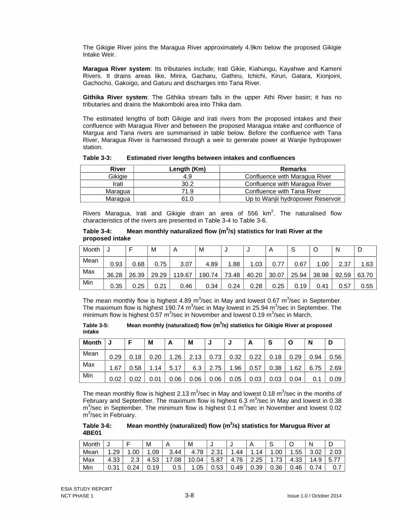
ESIA STUDY REPORT NCT PHASE 1 3-8 Issue 1.0 / October 2014
The Gikigie River joins the Maragua River approximately 4.9km below the proposed Gikigie Intake Weir.
Maragua River system : Its tributaries include; Irati Gikie, Kiahungu, Kayahwe and Kameni Rivers. It drains areas like, Mirira, Gacharu, Gathiru, Ichichi, Kiruri, Gatara, Kionjoini, Gachocho, Gakoigo, and Gaturu and discharges into Tana River.
Githika River system : The Githika stream falls in the upper Athi River basin; it has no tributaries and drains the Makomboki area into Thika dam.
The estimated lengths of both Gikigie and Irati rivers from the proposed intakes and their confluence with Maragua River and between the proposed Maragua intake and confluence of Margua and Tana rivers are summarised in table below. Before the confluence with Tana River, Maragua River is harnessed through a weir to generate power at Wanjie hydropower station.
Table 3-3: Estimated river lengths between intakes and confluences
River Length (Km) Remarks Gikigie 4.9 Confluence with Maragua River
Irati 30.2 Confluence with Maragua River Maragua 71.9 Confluence with Tana River Maragua 61.0 Up to Wanjii hydropower Reservoir
Rivers Maragua, Irati and Gikigie drain an area of 556 km2. The naturalised flow characteristics of the rivers are presented in Table 3-4 to Table 3-6.
Table 3-4: Mean monthly naturalized flow (m 3/s) statistics for Irati River at the proposed intake
Month J F M A M J J A S O N D
Mean 0.93 0.68 0.75 3.07 4.89 1.88 1.03 0.77 0.67 1.00 2.37 1.63
Max 36.28 26.39 29.29 119.67 190.74 73.48 40.20 30.07 25.94 38.98 92.59 63.70Min 0.35 0.25 0.21 0.46 0.34 0.24 0.28 0.25 0.19 0.41 0.57 0.55
The mean monthly flow is highest 4.89 m3/sec in May and lowest 0.67 m3/sec in September. The maximum flow is highest 190.74 m3/sec in May lowest in 25.94 m3/sec in September. The minimum flow is highest 0.57 m3/sec in November and lowest 0.19 m3/sec in March.
Table 3-5: Mean monthly (naturalized) flow (m 3/s) statistics for Gikigie River at proposed intake
Month J F M A M J J A S O N D
Mean 0.29 0.18 0.20 1.26 2.13 0.73 0.32 0.22 0.18 0.29 0.94 0.56
Max 1.67 0.58 1.14 5.17 6.3 2.75 1.96 0.57 0.38 1.62 6.75 2.69Min
0.02 0.02 0.01 0.06 0.06 0.06 0.05 0.03 0.03 0.04 0.1 0.09
The mean monthly flow is highest 2.13 m3/sec in May and lowest 0.18 m3/sec in the months of February and September. The maximum flow is highest 6.3 m3/sec in May and lowest in 0.38 m3/sec in September. The minimum flow is highest 0.1 m3/sec in November and lowest 0.02 m3/sec in February.
Table 3-6: Mean monthly (naturalized) flow (m 3/s) statistics for Marugua River at 4BE01
Month J F M A M J J A S O N D Mean 1.29 1.00 1.09 3.44 4.78 2.31 1.44 1.14 1.00 1.55 3.02 2.03Max 4.33 2.3 4.53 17.08 10.04 5.87 4.76 2.25 1.73 4.33 14.9 5.77 Min 0.31 0.24 0.19 0.5 1.05 0.53 0.49 0.39 0.36 0.46 0.74 0.7

ESIA STUDY REPORT NCT PHASE 1 3-9 Issue 1.0 / October 2014
The mean monthly flow is highest 4.78 m3/sec in May and lowest 1.00 m3/sec in February. The maximum flow is highest 17.08 m3/sec in April and lowest in 2.25 m3/sec in August. The minimum flow is highest 1.05 m3/sec in May and lowest 0.19 m3/sec in the month of March.
Thika Dam : Thika Dam is located about 50 km north of Nairobi, close to Ndakaini village and was constructed between 1989 and 1994 under the Third Nairobi Water Supply Project. It is a river regulating reservoir to augment water supply to Nairobi by ensuring adequate flows at Ngethu Treatment works. It collects water form Thika River and its tributaries. Water from this reservoir is transferred by a series of tunnels into Chania River from which an intake exists for transfer to Ngethu treatments works.
The main characteristics of the reservoir are listed in Table 3-7.
Table 3-7: Thika Dam Characteristics
Dam Component Characteristics Height of the dam 65m Reservoir water surface 2.8 km2
Full Water Supply Level 2041m AOD Spillway Crest length 420m Capacity of reservoir 70 million m3
Catchment area 75 km2
Tunnel length 340m Tunnel diameter 3m Draw-off pipe 1400mm with 6 draw-off valves Spillway characteristics H= 65m, shaft diameter: 5.5m Tunnel Discharge: 390 m3/s, length:
180mEmergency spillway Qmax=120 m3/sThika-Kiama tunnel L= 1km, D= 2.5m, Q= 6 m3/s
Kimakia – Chania tunnel L= 3km, D= 2.5m, Q= 6 m3/s
Source: Feasibility study and master plan for developing new sources of water for Nairobi and satellite towns – Master Plan Report
The intake shaft is located on the southern edge of the reservoir. A discharge valve regulates the outflow to the Thika – Kiama transmission tunnel. The 1,400mm intake has been designed for a maximum flow of 5.7m3/s. A second draw off structure has been constructed to supply irrigation, compensation and demand from a future high-level treatment works.
Figure 3-4 presents the major rivers within the project area.

ESIA STUDY REPORT NCT PHASE 1 3-10 Issue 1.0 / October 2014
Figure 3-4: Major rivers in the project area

ESIA STUDY REPORT NCT PHASE 1 3-11 Issue 1.0 / October 2014
3.1.7 Water Resources and key uses
(a) Surface water resources
Water is used for multiple purposes among them being domestic, livestock, agriculture (irrigation minor) and industry (tea processing). Water has been tapped from the rivers, springs and streams using pipes. Others practise roof harvesting while others source water from shallow wells. Some homesteads get piped water from water service providers within the area while others have laid pipes tapping water from nearby springs. However there are others who rely on water taken directly from the rivers and seasonal streams. The water service providers in the two sub-counties as listed below (with exception of Gatamathi W&S Company) get their major supplies from Irati and Maragua rivers:
Murang’a Water and Sanitation Company; Kahuti Water & Sanitation Company; Gatamathi Water And Sanitation Company; and Murang’a South Water & Sanitation Company
The existing licensed and actual abstraction volumes by the water service providers is presented in Table 3-8.
Table 3-8: Existing licensed and actual water abstractions on the project river basins
Name of WSP Location of Intake Licensed Abstraction (m3/day)
Current Abstraction (m3/day)
Murang’a Water and Sanitation Company
Irati River 26,000 11,000
Murang’a South Water and Sanitation Company
Maragua River Irati River
53,900 30,000
Kahuti Water and Sanitation Company
Maragua River South Mathioya River
9,600 9,600
Murang’a Water and Sanitation Company
Irati River 26,000 11,000
Total 89,500 50,600 Source: Muranga county water office 2014
In addition to the above abstractions, Maragua river (downstream the proposed intakes) is harnessed for non-consumptive hydropower generation by Kengen in three hydropower stations. All of the stations are located downstream of the Maragua confluence with Gikigie and Irati rivers and their capacities and volumes used are shown in Table 3-9.
Table 3-9: Hydro power stations in the Maragua basin
Name of power station
River source Quantity of water used (m 3/day)
Amount of power generated ( KW)
Mesco Maragua 129,600 480 KW Wanjii Maragua 368,181 2 MW Tana Maragua Not available Not available Sagana Not available
Mesco power station is about 4km upstream of Wanjii power station, while Tana power station is about 16 km downstream of Wanjii station. In between Wanjii and Mesco power stations, there is a stream tributary entering Maragua River.
There are many sources of water pollution in the two sub-counties. These include coffee and tea factories, car washing, soil erosion and agrochemicals used in agriculture production. However, within the project area no industrial effluents are discharged into the rivers before or immediately after the proposed river intakes.

ESIA STUDY REPORT NCT PHASE 1 3-12 Issue 1.0 / October 2014
(b) Underground water resources
Available quantitative information on the area’s groundwater reviewed is old (National Environment and Human Settlements Secretariat, 1982) and indicates that most boreholes in Murang’a County are located in the lower altitude areas to the east. The average borehole yields in the area is 7.13m3/hr but ranges from nil to 50m3/hr. the average borehole depth is 117.0m but water is commonly struck at a depth of 84.4m with average water resting level of 42.8m.
According to the Murang’a district environmental action plan 2006-2011, springs, wells and boreholes in the area are safe for consumption and other uses. However, these are currently under-exploited while springs and shallow wells also have a challenge of bacteriological contamination.
3.1.8 Air Quality
Three were no previous air quality studies in the project area available for review. However, given the dominance of agricultural land use with no major industrial establishments, save from few small-scale tea factories, there are currently no concerns of air quality deterioration within the project area. Potential impacts on air quality will depend on how effectively the contractor manages the suppression of dust during the construction phase. The potential impact of the proposed project on local air quality will be much localised and will only pose a risk to immediate neighbours if not handled efficiently. Specialist assessment of the potential impact of dust was not prescribed but the potential impacts have been addressed in the EMP.
3.1.9 Noise
Given the predominantly rural character of the project area, existing noise levels are generally low and are not expected to pose any nuisance. The main background natural noise in the area is from rapids along the rivers perceivable from settlements near them. Notable existing sources of artificial noise are limited to transport-oriented activities including irregular movements of vehicles and motor bikes (boda boda). Noise from these sources is perceivable from settlements which are mainly located along the roads due to hilly terrain. In limited neighbourhoods, tea factories also form a source of noise.
Day-time noise levels at nine potential receptor areas relative to the key project activities are presented in Table 3-10 below.

ESIA STUDY REPORT NCT PHASE 1 3-13 Issue 1.0 / October 2014
Table 3-10: Existing noise levels at potential receptors closest to project’s noise sources
Area Coordinates Noise levels Comments Min. dB (A)
Max. dB (A)
Makomboki Trading Centre
0259365 9911546
37 68 Likely major receptor of noise from activities at the tunnel outfall site (approximately 151m away). Current major sources of noise are matatus and motorbikes stage and their movements, stopping and speeding off after dropping or picking passengers.
Mairi Trading Centre
0258608 9915040
36 54 About 450m from Kaanja adit portal to be used for tunnel construction and maintenance access. Some road rehabilitation works were on-going at the time of the study.
Gitaigua Tea Buying centre
0259605 9917824
31 47 160m from the Irati intake site. The tea buying centre is not continuously occupied as farmers only deliver tea for collection by trucks.
Ruralhomestead
0259685 9920080
27 44 Approximately 120 from Gikigie intake works
Ruralhomestead
0259944 9920124
28 45 Approximately 181m from Gikigie intake works
Ruralhomestead
0259216 9922518
24 41 Near potential spoil area for Maragua intake works and likely to be affected by frequent truck movements during construction.
Ichichi Primary school
0260072 9922610
35 50 At about 501m from the Maragua intake works and 161 from Ichichi trading centre
Ichichi trading centre
0260145 9922466
36 60 Trucks hauling spoil materials are likely to make numerous trips through this centre to and from the potential spoil site. Site is also about 662m direct distance from the intake works.
Maragua Tea Collection centre, church and residential units
0260453 9923006
47 63 This centre is near the proposed Maragua River intake works and lies near one of the other potential spoil site. It is anticipated that those closest to the works area will be resettled to pave way for contractors’ camp and secure the intake.
Source: Gibb Africa studies, 2014
The above reference points area also presented in the project area’s map as shown in
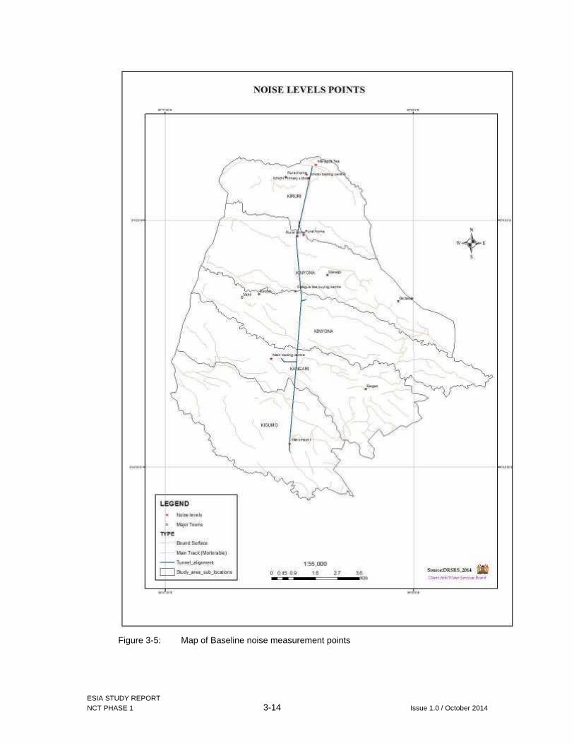
ESIA STUDY REPORT NCT PHASE 1 3-14 Issue 1.0 / October 2014
Figure 3-5: Map of Baseline noise measurement points

ESIA STUDY REPORT NCT PHASE 1 3-15 Issue 1.0 / October 2014
3.2 Biological Environment
Ecological data was collected in the rivers using stream reaches and transects established in 6 sampling sites namely rivers Maragua, Gikigie, Irati, Githika, downstream of the River Maragua where Irati and Gikigie meets R. Maragua and the confluence of Rivers Maragua and Sagana forming the Tana river (see section 1.4.5 and Figure 1-6).
3.2.1 Fauna
The project ecological study yielded a total of 77 species of fish and aquatic macro-invertebrates from different taxa groups including; Arthropods, mollusks, annelids and fish. In terms of species composition and richness by taxa as shown in Figure 3-6 and from highest to lowest in that order; 13 Coleoptera (beetles)), 12 Trichoptera (caddisflies), 11 Odonata (dragon flies and damsel flies), 10 Hemiptera (aquatic bugs) 7 Pisces (fish), 6 Diptera (flies), 5 Ephemeroptera (mayflies), 2 Decapoda (crabs), 2 Annelida (earthworms and leeches) and 1 Mollusca (bivalve), 1 Isopoda (water lice), 1 platyhelminthes (flatworm), 1 Lepidoptera (moth), 1 Plecoptera (stonefly), 1 Amphibian (frog), 1 reptile (snake), 1 Arachnida (Spiders) and 1 Carnivora (otter). The comprehensive list of faunal species is presented in Appendix II.
Of the seven fish species, the mountain catfish Amphilius uranoscopus and Garra dembensiswere recorded only in the four upper streams but not at Lower River Maragua neither at the confluence of Rivers Maragua and Sagana suggesting they require cooler temperatures.
A green non-poisonous snake was spotted in the confluence near Napier grass planted along the river in the furthest stream reach sampled.
Figure 3-6 Number of species per major Taxa (Order or Class)
R. Gikigie recorded the highest species composition (42) and species diversity index H'=3.365 followed by R. Githika and lower R. Maragua at 37 while the confluence of rivers Maragua and Sagana recorded the least species (19) and also the lowest species diversity index H’=2.713. see Figure 3-7 and Table 3 11.

ESIA STUDY REPORT NCT PHASE 1 3-16 Issue 1.0 / October 2014
In terms of unique species per site (Table 3-12), lower R. Maragua recorded the highest number (9), followed by the confluence of Rivers Maragua and Sagana (6) while R. Irati recorded only one unique species.
Figure 3-7: Species composition of fish and aquatic macro-invertebrates of Maragua rivers per site and number of unique species site
Table 3-11: Species diversity index of fish and aquatic-macro invertebrates of NCT1
Site S N d J' H'(Loge)
R. Githika 37 117 7.559573 0.921671 3.32808
R. Irati 36 132 7.168016 0.913999 3.275334
R. Gikigie 42 131 8.409916 0.900327 3.365126
R. Maragua 31 146 6.019737 0.916889 3.148583
Lower R. Maragua 37 93 7.942462 0.932095 3.365717 Confluence of Maragua & Sagana 19 36 5.022996 0.921731 2.71398
Key : H’= Shanon-Wiener diversity index; J’= Pielous evenness index; d= Margalef’s richness index S= Total faunal species
The dominant species by percent occurrence was the black fly larvae Simulium spp.represented 69%, followed by the minnow mayflies Baetidae sp (68%), while among the fishes the most dominant species was the Amphilius uranoscopus (32%) (Figure 3-8).

ESIA STUDY REPORT NCT PHASE 1 3-17 Issue 1.0 / October 2014
Figure 3-8 Percent frequency of occurrence Species in all 6 rivers combined
There was no significant differences in total species number between the riffle and pool sequence between different sites, stream reaches and transects (DF1=119, F2=0.46, P3>0.05) although different species were adapted to either riffle or pool (Table 1-microhabitats collumn). This contradicts other studies where riffles are known to be up to 20 times more productive than pools in the headwaters in natural rivers (e.g. Allan, 1995). This could be due to interference by man on the canopy vegetation which had been cleared before the project screening exercise and replaced with exotic vegetation of Eucalyptus, Clidemia, etc. Owing to the open nature of these rivers the role of Autochthonus primary production by diatoms, filamentous algae and mosses could be the main source of food for first order consumers including also allochthonous organic material from the riparian vegetation in the catchment.
1 DF=Degree of freedom, defines the estimated mean in a group of observations; 2 F= Ration of sample variance, testing if variances of two populations are equal; and 3 P=Significance level, estimated probability of rejecting the results.

ESIA STUDY REPORT NCT PHASE 1 3-18 Issue 1.0 / October 2014
Table 3-12: List of unique species encountered per site during the study
Site No. Species/common name Common name
R. Githika 1 Pantalla flavescens Dragonfly
2 Orectogyrus orientalis whirlgig beetles
3 Yola tuberculata Predator diving beetles
R. Irati 1 Pyralidae sp Aquatic caterpillar Moth
R. Gikigie 1 Garra dembensis Dembea stone lapper fish
2 Micronecta sp aquatic bugs
R. Maragua
1 Brachycentridae sp Caddisfly
2 Sigara sp Water boatman
3 Dytiscidae 2 Predator diving beetles
4 Gomphidae sp Dragonflies
Lower R. Margua
1 Africallagma glaucum Damselfly
2 Barbus sp Barbs fish
3 Hirudinae sp Leeches
4 Hydraenidae sp Minute moss beetles
5 Labeo cylindricus Redeye Labeo fish
6 Laccocoris limigenus Water creeping bugs
7 Platycypha caligata Damselfly
8 Psephenus sp Water penny beetle
9 Sphaerodena nephoides Water bugs
Confluence of Rivers Maragua and Sagana
1 Barbus paludinosus Straightfin Barb fish
2 Geriidae sp Pond skaters
3 Corlubridae sp Non-poisonus green Snake
4 Oreochromis spirulus Athi river tilapia
5 Barbus oxyrhynchus Pangani Barb fish
6 Leptoceridae sp Caddisfly
(a) Aquatic fauna of conservation significance
Of all the encountered 77 aquatic fauna species, none is listed in the IUCN Red-list. However, some of the aquatic species documented above are short distance migratory fish species that move to feed and spawn such as the Labeo cylindricus, Barbus sp, Garra dembensis and other aquatic invertebrates and long distance migratory species for feeding and spawning purposes such as the eel Anguillabengalensis, Oncorhynchus mykis, Salmo trutta.

ESIA STUDY REPORT NCT PHASE 1 3-19 Issue 1.0 / October 2014
(b) Birds
Very few birds were spotted during the field study as tabulated below. All the spotted birds are of least conservation concern.
Table 3-13: List of birds spotted on site
Scientific name Common name
1 Nectarinia sp Eastern double Collared sunbird
2 Pycnonotus barbatus Common bulbul
3 Estrilda astrild Common waxbill
4 Ceryle rudis Pied Kingfisher
5 Bubulcus ibis Cattle egret
6 Ploceus sp Weaver bird
7 Saxicola torquatus Common stonechat bird
8 Alcedo cristata Malachite kingfisher
On the other hand KWS and UNEP (2003) reported 276 bird species occur in the nearby Aberdares which is an Important Bird Area (IBA No 1).
(c) Other fauna
The following fish species which were not recorded during this project’s ecological survey but have been reported in the past in this area by different authors (e.g. Van Someren, 1952; Frost 1955; Boulenger, 1909-1916; (Copley, 1958) and also from indigenous knowledge from fishermen and local people:
(i) Native species :
Anguilla bengalensis- local fishermen and some Ken Gen staff at Wanjii Reservoir reported its occurrence which was reported to be food delicacy and more so the fishermen indicated they used to sale to certain Chinese nationals sometime back.
(ii) Introduced species: 1 Oncorhynchus mykiss (Rainbow trout) upper Tana- Aberdares rivers, 2 Salmo trutta (salmon) upper Tana- Aberdares rivers and 3 Salmo gaidneri (Salmon) upper Tana- Aberdares rivers, 4 Cyprinus carpio (Common carp) middle Tana river
None of these species is listed as of conservation concern in the IUCN red data list and the Kenya wildlife conservation and management Act of 2013.
3.2.2 Flora
Tea plantations have significantly changed the vegetation types in the project area. Only small pockets of natural vegetation still exists in the project area but the tree species dominating the landscape is Eucalyptus (mubau / blue gum).
(a) Floristic composition
A total of 279 species belonging to 89 families and 212 genera were recorded in the entire sampling from 44 sampled points, which were along narrow belts on the stream reaches, hardly exceeding 10 meters from the river. They excluded cultivated crops such as maize, potatoes, bananas and tea. Among the recorded species were six listed as either endemics, threatened or protected under CITES against trade. Some species, mostly the common weeds were considered as indicators of disturbance but presence of invasive species including the notorious Clidemia hirta (Koster’s curse)
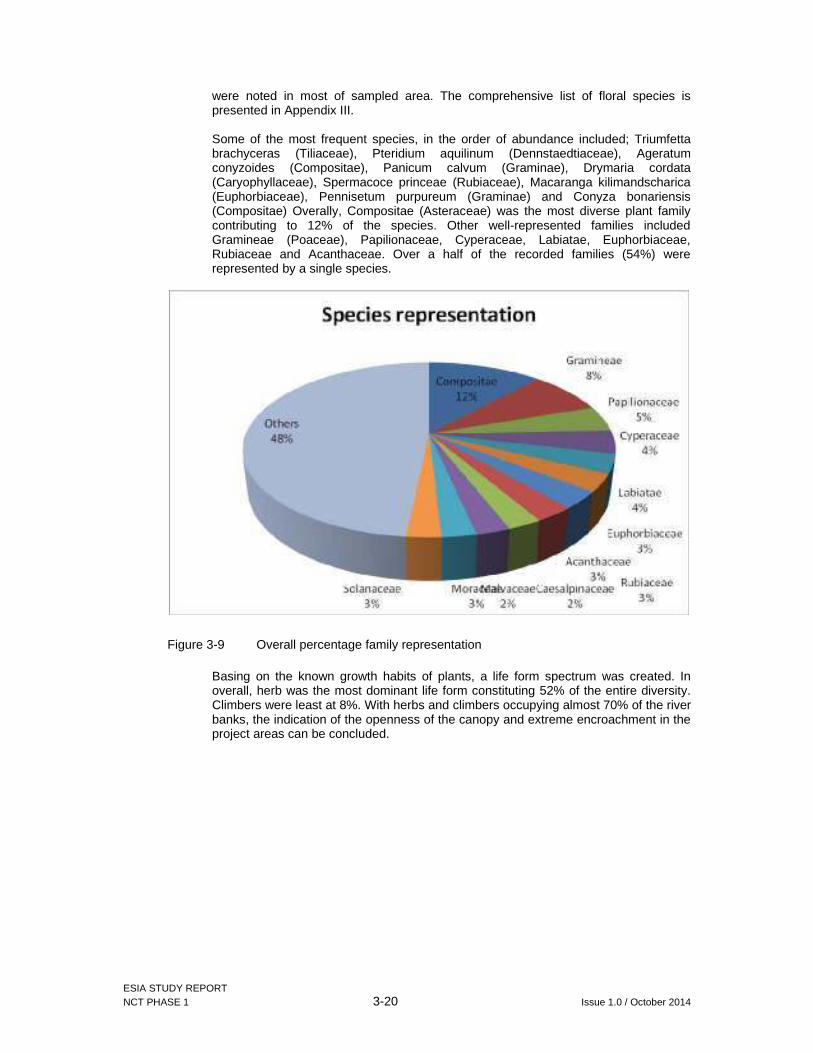
ESIA STUDY REPORT NCT PHASE 1 3-20 Issue 1.0 / October 2014
were noted in most of sampled area. The comprehensive list of floral species is presented in Appendix III.
Some of the most frequent species, in the order of abundance included; Triumfetta brachyceras (Tiliaceae), Pteridium aquilinum (Dennstaedtiaceae), Ageratum conyzoides (Compositae), Panicum calvum (Graminae), Drymaria cordata (Caryophyllaceae), Spermacoce princeae (Rubiaceae), Macaranga kilimandscharica (Euphorbiaceae), Pennisetum purpureum (Graminae) and Conyza bonariensis(Compositae) Overally, Compositae (Asteraceae) was the most diverse plant family contributing to 12% of the species. Other well-represented families included Gramineae (Poaceae), Papilionaceae, Cyperaceae, Labiatae, Euphorbiaceae, Rubiaceae and Acanthaceae. Over a half of the recorded families (54%) were represented by a single species.
Figure 3-9 Overall percentage family representation
Basing on the known growth habits of plants, a life form spectrum was created. In overall, herb was the most dominant life form constituting 52% of the entire diversity. Climbers were least at 8%. With herbs and climbers occupying almost 70% of the river banks, the indication of the openness of the canopy and extreme encroachment in the project areas can be concluded.

ESIA STUDY REPORT NCT PHASE 1 3-21 Issue 1.0 / October 2014
Figure 3-10 Life form spectrum of species
(b) Floral Species diversity
Maragua River was the most diverse of the six sampled sites, with a Shannon-Wiener diversity index of 4.73. It also had the highest species richness. Its species distribution was however not among the most even. Lower Maragua site was the least diverse with an index of 4.13. The site just before the Wanjii Kengen reservoir had increased turbidity and a considerable number of invasive plants. The site is by the main tarmac, has close proximity to Muranga town as well as an existing quarry site and numerous pollution indicators were noted.
Table 3-14 Plant diversity and evenness indices within sampled sites
Gikigie Githika Irati Maragua Lower Maragua Confluenceof Maragua & Sagana rivers
Species No. per site (S) 80 94 103 148 73 81
Diversity H' (Log e) 4.19 4.29 4.38 4.73 4.13 4.26
Richness (d) 14.68 16.50 18.33 24.17 15.04 16.51
Evenness (J') 0.96 0.94 0.95 0.95 0.96 0.97
(c) Botanical uniqueness
Three of the recorded species although not aquatic plants but occur on montane forest valleys are listed by IUCN as vulnerable to various threats. The three were also found to be either Kenyan or regional endemics. All Kenyan native orchids are protected by CITES, therefore the two encountered orchids are of conservation concern. Orchids have high specificity to moist ecosystems, making the rivers in subject important for their continued survival. Rampant trade in the bark of Prunus africana for its medicinal value has enabled it to be restricted by CITES.
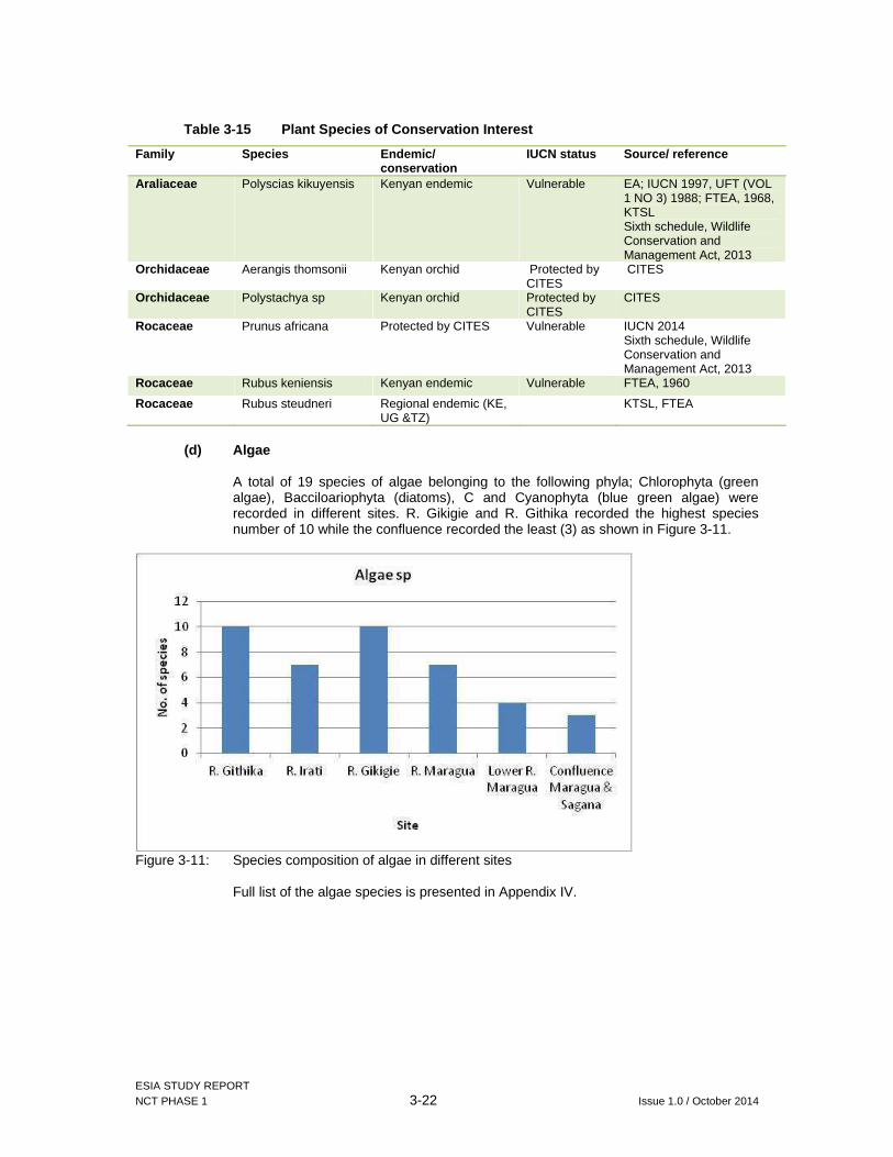
ESIA STUDY REPORT NCT PHASE 1 3-22 Issue 1.0 / October 2014
Table 3-15 Plant Species of Conservation Interest
Family Species Endemic/ conservation
IUCN status Source/ reference
Araliaceae Polyscias kikuyensis Kenyan endemic Vulnerable EA; IUCN 1997, UFT (VOL 1 NO 3) 1988; FTEA, 1968, KTSLSixth schedule, Wildlife Conservation and Management Act, 2013
Orchidaceae Aerangis thomsonii Kenyan orchid Protected by CITES
CITES
Orchidaceae Polystachya sp Kenyan orchid Protected by CITES
CITES
Rocaceae Prunus africana Protected by CITES Vulnerable IUCN 2014 Sixth schedule, Wildlife Conservation and Management Act, 2013
Rocaceae Rubus keniensis Kenyan endemic Vulnerable FTEA, 1960
Rocaceae Rubus steudneri Regional endemic (KE, UG &TZ)
KTSL, FTEA
(d) Algae
A total of 19 species of algae belonging to the following phyla; Chlorophyta (green algae), Bacciloariophyta (diatoms), C and Cyanophyta (blue green algae) were recorded in different sites. R. Gikigie and R. Githika recorded the highest species number of 10 while the confluence recorded the least (3) as shown in Figure 3-11.
Figure 3-11: Species composition of algae in different sites
Full list of the algae species is presented in Appendix IV.

ESIA STUDY REPORT NCT PHASE 1 3-23 Issue 1.0 / October 2014
(e) Threats to Plants and Existing Ecologically Sensitive Areas
An objective categorization of vegetation of wider area surrounding the sample sites on the upper rivers are patchy remnants of upland montane forests of tall trees. Basing on remnant emergent plants in the valleys, the entire area’s vegetation would have resembled the highlands of Aberdare forest, with possible composition of Ocotea-Macaranga-podocarpus-Cassipourea emergents coupled with Xymalos, Maesa, strombosia and Manilkara mid canopy. Development in agriculture is highly attributed to the depletion of the original forest vegetation.
On the lower part of the Maragua River at the confluence with Sagana, dryland forest vegetation was noted. Further from the river, the vegetation type can be described as Combretum collinum- Acacia polyacantha woodland with understory shrub mainly of Acacia brevispica.
The invasive Lantana camara shrub was also noted to be with high densities at area near the confluence. Other invasive species recorded at the upper river sections included the notorious Clidemia hirta (Koster’s curse), a native of the American neotropics, which since introduction to East Africa has colonized massive land areas. Some species recorded that include the common weeds are indicators of disturbance. They constituted approximately 15% of the entire plant list and include Tithonia diversifolia, Achyranthes aspera, Galinsoga parviflora, Ageratum conyzoides, Dichrocephala integrifolia, Senna didymobotrya, Oxygonum sinuatum, Brugmansii suavolens, Solanum Campylacantha, Solanum mauritianum, Lantana camara and Ricinus communis among others. The proportion of weeds was notably high and was considered a clear indication of how human activities have taken toll on the riverine ecosystem. Remnant patches of forests on ridges and along the valley, nearby wetlands and the dry woodlands near the confluence were considered as ecological sensitive areas based on the threats faced and therefore the Maragua and associated rivers play important ecological roles within these habitats. In fact, the entire river stretch may be considered a sensitive area.

ESIA STUDY REPORT NCT PHASE 1 3-24 Issue 1.0 / October 2014
3.3 Social Characteristics
Socio-economic study established the following baseline living and operational conditions of the persons within the projects primary and its secondary zones of impact.
3.3.1 Population size and composition
The Population and Housing Census conducted by the KNBS in 2009 established that Murang’a County has a population of 936,228 of which 451,751 are males and 484,477 females. The projected growth rate for the County was placed at 0.4 percent per annum. This population is projected to rise to 947,530 in 2012; 958,969 in 2015 and 966,672 persons in 2017. The male: female sex ratio for the county is 48:52. The higher female population in relation to male is attributed to high male emigration to other counties and towns in search of employment and business opportunities.
The above was reinforced by the results of the project study conducted in August 2014 by GIBB Africa as reflected in Table 3-16 below. Male population within the age brackets of 10 to 39 years are few in the project area. This category is considered to be comprised of persons of high productivity and make the labour pool which can be sourced to assist in the construction and operation works of the tunnel.
Table 3-16: Population distribution (%) according to Sex
Age in Years Sex
Male (%) Female (%)
0-4 9.26 5.09
5-9 8.95 8.08
10-14 8.02 9.28
15-19 8.64 9.88
20-24 8.95 9.28
25-29 6.17 10.18
30-34 7.72 8.68
35-39 8.95 10.48
40-44 9.26 7.78
45-49 5.86 5.69
50-54 6.48 4.79
55-59 1.85 3.59
60-64 5.86 2.40
65+ 4.01 4.79
Population density and distribution within the sub-counties hosting the project are as reflected in Table 3-17.

ESIA STUDY REPORT NCT PHASE 1 3-25 Issue 1.0 / October 2014
Table 3-17: Population density and distribution
Sub-county
2009 (Census) 2012 (Projections) 2015 (Projections) 2017 (Projections)
Population Density (Km2)
Population Density (Km2)
Population Density (Km2)
Population Density (Km2)
Kangema 76,988 443 77,917 449 78,858 454 79,491 458
Kigumo 123,766 511 125,260 517 126,772 524 127,791 528
Total 942,581 368 953,960 373 965,477 377 973,231 380
Source: Muranga County Development Profile
3.3.2 Household Headship
Majority (68.75%) of the households in the project area are male headed. Approximately 31.25% of the surveyed population from project area noted that their households are female headed.
3.3.3 Religion
In the country, Christianity is the largest religion at 82.5% where 47.4% are Protestants, while 23.3% are Catholics. Muslims form about 11% of the population. From the survey, approximately 79.94% of the project host community are Christians, of which 67.33 are Protestants and 12.61 are Catholics as shown in Table 3-18.
Table 3-18: Religious affiliations
Religion Percentage response
Protestant 67.33
Indigenous Ch.
19.30
Catholic 12.61
None 0.76
Total 100.00
This relative homogeneity in belief systems reflected by the response of a majority of the population will ease the process of resettlement and integration in case there will be need of relocation of the affected population from the proposed wayleave.
3.3.4 Education
Murang’a County has 634 primary schools, 6,324 teachers, total enrolment of 214,986 and a transition rate (proportion of students from the primary level who move to the next level) of 70 percent. Again, at the county, net set secondary school enrolment rate is 71.04% for both boys and girls. On average 70% of the members of the community live between 1.1km and 4.9km to the nearest primary school. This figure tallies with results from the baseline survey study in the project area in which 100% of the surveyed population live less than 5kms from the nearest primary school.
(a) Population currently in school
Majority of the children who are of school going age in the project area are currently in school. Of the surveyed population 48.44% of persons in school accounted for children within the age bracket of 5-14 years as shown in Table 3-19 below.

ESIA STUDY REPORT NCT PHASE 1 3-26 Issue 1.0 / October 2014
Table 3-19: Population (%) currently in school
Age in Years Currently in School
Yes No
0-4 6.22 7.62
5-9 23.56 0.69
10-14 24.89 0.23
15-19 25.78 0.69
20-24 12.89 7.16
25-29 3.56 10.62
30-34 0.00 12.47
35-39 0.44 14.55
40-44 1.33 12.24
45-49 0.89 8.31
50-54 0.00 8.55
55-59 0.44 3.93
60-64 0.00 6.24
65+ 0.00 6.70
Total 100 100
(b) Education level for HH heads and spouses
Majority of the household heads within the project area have attained basic primary education as reflected in the Table 3-20. Only 10% and 9.52% of the household head and their spouses respectively have not attained any basic formal education. The analysis also found out that transition to tertiary education is low with only 3.75% and no spouse transitioned to tertiary level of education.
Table 3-20: Level of education for the household head
Level of education Household Head Population
Spouse of the Household Head
None 10.00 9.52
Primary 36.25 52.38
Secondary 35.00 38.10
Tertiary 15.00 0.00
University 3.75 0.00
Other 0.00 0.00
Total 100 100
To communicate and mobilise the community effectively during implementation of the project, the project implementation team should adopt communication strategies that will be understood by the non-educated and the educated members of the community. These mobilization strategies include, public meetings conducted or translated in the local language, radio adverts in the local language and posters posted in the accessible public places in both Swahili and Local languages.
3.3.5 Housing conditions
Characteristics of housing for the PAPs were assessed in terms of roofing, walls and floor to determine the quality of housing available for the use within the community as shown in Table 3-21.
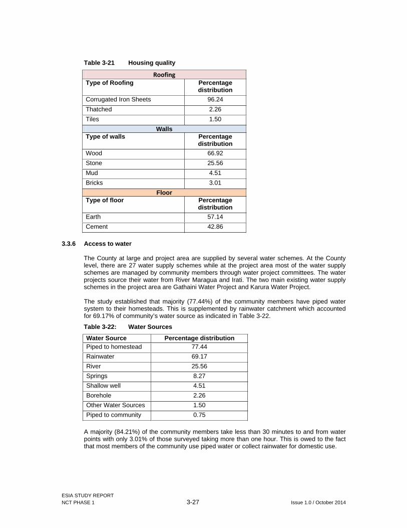
ESIA STUDY REPORT NCT PHASE 1 3-27 Issue 1.0 / October 2014
Table 3-21 Housing quality
Roofing
Type of Roofing Percentage distribution
Corrugated Iron Sheets 96.24
Thatched 2.26
Tiles 1.50
WallsType of walls Percentage
distribution
Wood 66.92
Stone 25.56
Mud 4.51
Bricks 3.01
FloorType of floor Percentage
distribution
Earth 57.14
Cement 42.86
3.3.6 Access to water
The County at large and project area are supplied by several water schemes. At the County level, there are 27 water supply schemes while at the project area most of the water supply schemes are managed by community members through water project committees. The water projects source their water from River Maragua and Irati. The two main existing water supply schemes in the project area are Gathaini Water Project and Karura Water Project.
The study established that majority (77.44%) of the community members have piped water system to their homesteads. This is supplemented by rainwater catchment which accounted for 69.17% of community’s water source as indicated in Table 3-22.
Table 3-22: Water Sources
Water Source Percentage distributionPiped to homestead 77.44
Rainwater 69.17
River 25.56
Springs 8.27
Shallow well 4.51
Borehole 2.26
Other Water Sources 1.50
Piped to community 0.75
A majority (84.21%) of the community members take less than 30 minutes to and from water points with only 3.01% of those surveyed taking more than one hour. This is owed to the fact that most members of the community use piped water or collect rainwater for domestic use.
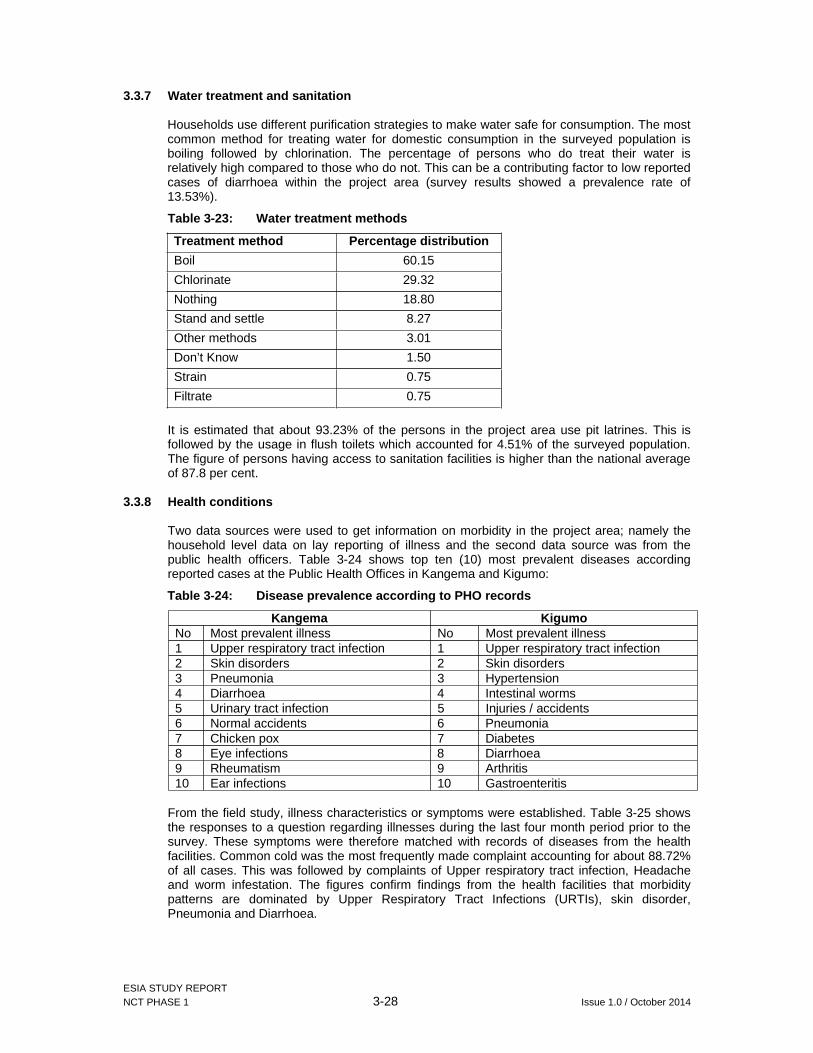
ESIA STUDY REPORT NCT PHASE 1 3-28 Issue 1.0 / October 2014
3.3.7 Water treatment and sanitation
Households use different purification strategies to make water safe for consumption. The most common method for treating water for domestic consumption in the surveyed population is boiling followed by chlorination. The percentage of persons who do treat their water is relatively high compared to those who do not. This can be a contributing factor to low reported cases of diarrhoea within the project area (survey results showed a prevalence rate of 13.53%).
Table 3-23: Water treatment methods
Treatment method Percentage distribution
Boil 60.15
Chlorinate 29.32
Nothing 18.80
Stand and settle 8.27
Other methods 3.01
Don’t Know 1.50
Strain 0.75
Filtrate 0.75
It is estimated that about 93.23% of the persons in the project area use pit latrines. This is followed by the usage in flush toilets which accounted for 4.51% of the surveyed population. The figure of persons having access to sanitation facilities is higher than the national average of 87.8 per cent.
3.3.8 Health conditions
Two data sources were used to get information on morbidity in the project area; namely the household level data on lay reporting of illness and the second data source was from the public health officers. Table 3-24 shows top ten (10) most prevalent diseases according reported cases at the Public Health Offices in Kangema and Kigumo:
Table 3-24: Disease prevalence according to PHO records
Kangema Kigumo No Most prevalent illness No Most prevalent illness 1 Upper respiratory tract infection 1 Upper respiratory tract infection2 Skin disorders 2 Skin disorders 3 Pneumonia 3 Hypertension 4 Diarrhoea 4 Intestinal worms 5 Urinary tract infection 5 Injuries / accidents 6 Normal accidents 6 Pneumonia 7 Chicken pox 7 Diabetes 8 Eye infections 8 Diarrhoea 9 Rheumatism 9 Arthritis 10 Ear infections 10 Gastroenteritis
From the field study, illness characteristics or symptoms were established. Table 3-25 shows the responses to a question regarding illnesses during the last four month period prior to the survey. These symptoms were therefore matched with records of diseases from the health facilities. Common cold was the most frequently made complaint accounting for about 88.72% of all cases. This was followed by complaints of Upper respiratory tract infection, Headache and worm infestation. The figures confirm findings from the health facilities that morbidity patterns are dominated by Upper Respiratory Tract Infections (URTIs), skin disorder, Pneumonia and Diarrhoea.

ESIA STUDY REPORT NCT PHASE 1 3-29 Issue 1.0 / October 2014
Table 3-25: Health problem cases
Illness Percentage distribution
Common cold 88.72
Upper respiratory tract infection
27.07
Headache 19.55
Worms 19.55
Eye infections 15.04
Diarrhea 13.53
Other Illnesses 12.78
Skin infection 10.53
Tuberculosis 0.75
Jigger infestation 0.00
From the consultations it was also noted that the HIV/AIDs prevalence cases in Kigumo and Kangema Sub-Counties covered by the project are 5.2% and 5.6% respectively. The most vulnerable groups within Kigumo were noted to be youth between the ages of 15 to 24 years and persons between the ages of 33 to 44 years. On the other hand, the most vulnerable group to HIV/AIDs in Kangema were noted to be persons within the ages of 12 to 24 years of age. The health offices within the two Sub-counties have put in place the following initiatives to combat medical condition:
Use of community based organizations to support orphan and vulnerable children; Provision of HIV/AIDs counselling and testing services; and Health education to people living with HIV/AIDs
3.3.9 Medical facilities
Information of the available health facilities were obtained from the District Public Health Officers in the two Sub-Counties hosting the project. It was noted that Kangema has 13 healthy facilities categorised as follows:
Sub-District Hospital 1 Health Centres 4 Dispensaries 8
Within the project nucleus in Ichichi location there is only one (1) dispensary. In Kigumo Sub-County there are 18 medical facilities categorised as follows:
Division Category No. Of facilitiesKinyona Health Center 1 Dispensaries 7 Faithbased organization 3 Kigumo Sub-county hospital 1 Health Center 1 Dispensary 1 Muthithi Health Center 1 Dispensary 3 Faith Based Organization 1
The biggest challenge that the sub counties in the project area face with regard to health is shortage of doctors. Within Kangema there are only four (4) doctors serving a total of 76,988 persons according to the 2009 Census. This translates to a doctor patient ratio of 1:19247. While in Kigumo there are only 2 doctors serving a population of 123,766 which translates to a

ESIA STUDY REPORT NCT PHASE 1 3-30 Issue 1.0 / October 2014
doctor patient ratio of 2:61883. The main referral hospital for the two Sub-Counties is Muranga District Hospital.
3.3.10 Gender issues
Table 3-26 below illustrates that the community is largely dominated by males in major household decision making. Gender imbalances still exist in decision making, resource control, and production processes mainly due to very strong traditional/cultural beliefs and practices. For instance, household heads will make decisions on family income, crop and animals to be sold as well as when to take children to school.
Women are usually left out of many development initiatives, and the perception exists that women’s reproductive and domestic responsibilities should be their primary function. Women and girls are not encouraged to access education, by being forced to early marriages. This in term excludes them in decision making and as a result lack of access to income and other means of production as well as being discriminated against in property ownership and inheritance.
From Table 3-26 and Table 3-27 below men own and control all family resources but labour is mostly provided by women and girls except for livestock rearing. Work load in the families within the project area is on women and girls.
Table 3-26: Gender roles
Resources Men Woman Boy Girls
Digging Cooking X XFood collection X XVegetable collection
X X
Fetching water X XWashing utensils X XCollecting firewood X XLooking after animals
X X
Washing clothes X XTotal task 1 9 1 9
Table 3-27 showing access and control of resources in the project area was developed in consultation with the beneficiary community through small group meetings. From the Table, men own and control most of the household resources such as land, livestock, trees and other income generating properties.
Table 3-27: Resource control by gender
Resources Who buys Who owns Who controls Who usesLand M M M M/F Trees and forest
M M M F
Livestock M M M M/F Household property
F F F F
Cars, motorcycle and bicycles
M M M M
Livestock – small e.g. chicken
F F F F
Subsistence crops
M/F M/F F F

ESIA STUDY REPORT NCT PHASE 1 3-31 Issue 1.0 / October 2014
3.3.11 Community problems
From the socioeconomic survey, the biggest problem identified by the community is youth unemployment. During the stakeholder consultations, the community members requested that the proposed project should alleviate unemployment issues by absorbing bulk of the youth in the local area to work in its construction and operation stages. The second issue concern to the community is poor road infrastructure in the area which has caused a hindrance in tea transportation which is a key income generating activity. The community requested during the public consultation meetings that AWSB and the contractor improve the roads before construction works of the tunnel commences.
Projected increase in population in the project area following the commencement of the proposed project could aggravate the problem of lack of sufficient health facilities which was also noted by 42.11% of the population as a problem. This is supported by the notable deficiency in medical facilities presented in Section 3.3.9 of this report.
Table 3-28: Community problems
Community problem Percentage response
Youth unemployment 80.45
Poor Infrastructure 61.65
Lack of health facilities 42.11
Lack of land 33.83
Land slides 28.57
Water scarcity 21.05
Lack schools 14.29
Insecurity 10.53
Floods 6.77
Other unmentioned 3.03
3.4 Economic Characteristics
The main economic activity within the project area is agricultural production. According to the County Development Plan approximately 57% of the population source their livelihood from agriculture. Of the above population, a majority grow cash crops. The major cash crops in the project area include tea and coffee. Horticultural crops which are grow at a small scale include tomatoes, cabbages, kales, spinach and French beans while food crops include maize, beans, bananas, sweet potatoes and cassava.
3.4.1 Employment status of persons living in the project area
A survey conducted by GIBB in October 2014 established that persons who are informally employed accounted for the majority of the surveyed population at 61.70%. Formal employment on the other hand accounted only for 10.30% of the surveyed population. This points to the fact that in case the project implementation team could require persons to be employed on informal wage basis, they will be readily available.
3.4.2 Income sources
The main income source for the community living in the project area is farming (Table 3-29). This accounted for 35.87% of the primary sources of income and 7.14% of the secondary source of income. Agricultural production in the project area is mainly rain fed with most people producing tea.
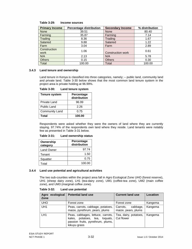
ESIA STUDY REPORT NCT PHASE 1 3-32 Issue 1.0 / October 2014
Table 3-29: Income sources
Primary Income Percentage distribution Secondary Income % distributionNone 39.51 None 80.40 Farming 35.87 Farming 7.14 Trading 8.36 Trading 1.67 Salaried 9.88 Salaried 1.22 Farm 3.04 Farm 2.89 Construction work 1.06 Construction work 0.61
N/A 2.13 N/A 5.78 Others 0.15 Others 0.30 Total 100.00 Total 100.00
3.4.3 Land tenure and ownership
Land tenure in Kenya is classified into three categories, namely; – public land, community land and private land. Table 3-30 below shows that the most common land tenure system in the project area is private holding at 96.99%.
Table 3-30: Land tenure system
Tenure system Percentage distribution
Private Land 96.99
Public Land 2.26
Community Land 0.75
Total 100.00
Respondents were asked whether they were the owners of land where they are currently staying. 97.74% of the respondents own land where they reside. Land tenants were notably few as presented in Table 3-31 below.
Table 3-31: Land ownership status
Ownership category
Percentage distribution
Land Owner 97.74
Tenant 1.50
Squatter 0.75
Total 100.00
3.4.4 Land use potential and agricultural activities
The two sub-counties within the project area fall in Agro Ecological Zone UHO (forest reserve), UH1 (sheep dairy zone), LH1 (tea-dairy zone), UM1 (coffee-tea zone), UM2 (main coffee zone), and UM3 (marginal coffee zone).
Table 3-32: Land use potential
Agro ecological Zone
Potential land use Current land use Location
UHO Forest zone Forest zone Kangema UH1 Peas, carrots, cabbage, potatoes,
maize, pyrethrum, pears, plums Carrots, cabbage, maize, pears, plums
Kangema
LH1 Peas, cabbages, lettuce, carrots, kales, potatoes, tea, loquats, passion fruits, pyrethrum, plums, kikuyu grass
Tea, dairy, potatoes, Cut flower
Kangema
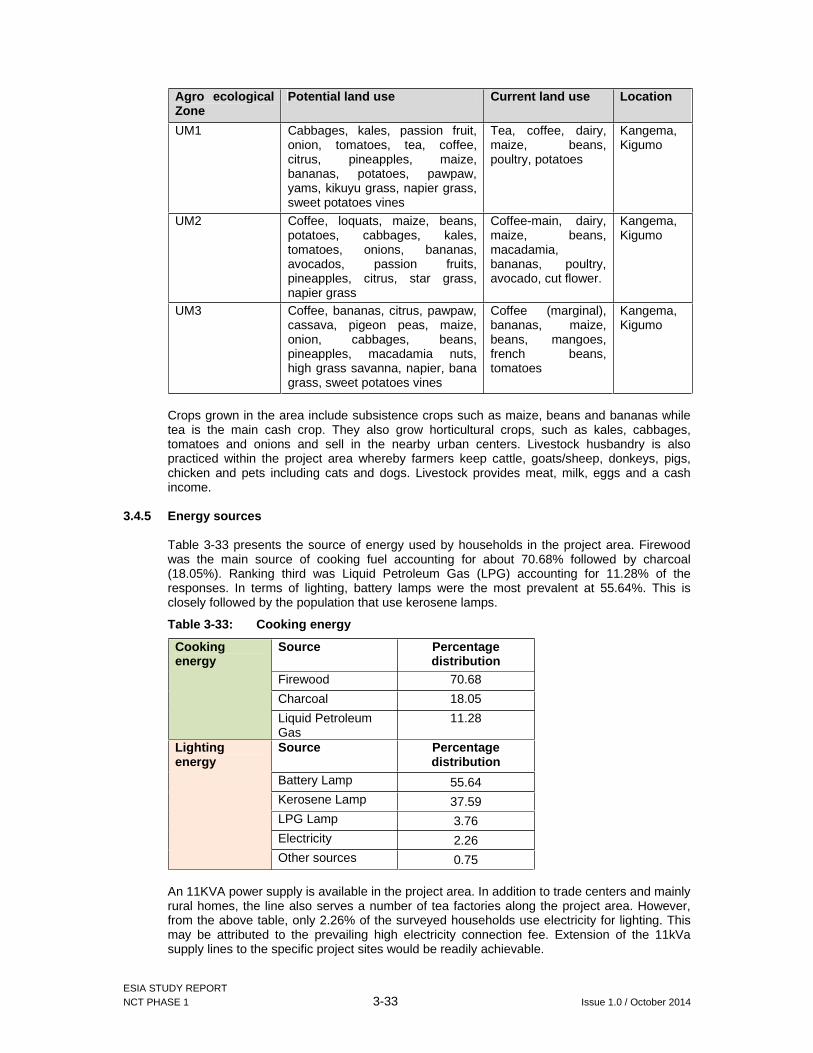
ESIA STUDY REPORT NCT PHASE 1 3-33 Issue 1.0 / October 2014
Agro ecological Zone
Potential land use Current land use Location
UM1 Cabbages, kales, passion fruit, onion, tomatoes, tea, coffee, citrus, pineapples, maize, bananas, potatoes, pawpaw, yams, kikuyu grass, napier grass, sweet potatoes vines
Tea, coffee, dairy, maize, beans, poultry, potatoes
Kangema, Kigumo
UM2 Coffee, loquats, maize, beans, potatoes, cabbages, kales, tomatoes, onions, bananas, avocados, passion fruits, pineapples, citrus, star grass, napier grass
Coffee-main, dairy, maize, beans, macadamia, bananas, poultry, avocado, cut flower.
Kangema, Kigumo
UM3 Coffee, bananas, citrus, pawpaw, cassava, pigeon peas, maize, onion, cabbages, beans, pineapples, macadamia nuts, high grass savanna, napier, bana grass, sweet potatoes vines
Coffee (marginal), bananas, maize, beans, mangoes, french beans, tomatoes
Kangema, Kigumo
Crops grown in the area include subsistence crops such as maize, beans and bananas while tea is the main cash crop. They also grow horticultural crops, such as kales, cabbages, tomatoes and onions and sell in the nearby urban centers. Livestock husbandry is also practiced within the project area whereby farmers keep cattle, goats/sheep, donkeys, pigs, chicken and pets including cats and dogs. Livestock provides meat, milk, eggs and a cash income.
3.4.5 Energy sources
Table 3-33 presents the source of energy used by households in the project area. Firewood was the main source of cooking fuel accounting for about 70.68% followed by charcoal (18.05%). Ranking third was Liquid Petroleum Gas (LPG) accounting for 11.28% of the responses. In terms of lighting, battery lamps were the most prevalent at 55.64%. This is closely followed by the population that use kerosene lamps.
Table 3-33: Cooking energy
Cookingenergy
Source Percentage distribution
Firewood 70.68
Charcoal 18.05
Liquid Petroleum Gas
11.28
Lighting energy
Source Percentage distribution
Battery Lamp 55.64 Kerosene Lamp 37.59 LPG Lamp 3.76 Electricity 2.26 Other sources 0.75
An 11KVA power supply is available in the project area. In addition to trade centers and mainly rural homes, the line also serves a number of tea factories along the project area. However, from the above table, only 2.26% of the surveyed households use electricity for lighting. This may be attributed to the prevailing high electricity connection fee. Extension of the 11kVa supply lines to the specific project sites would be readily achievable.

ESIA STUDY REPORT NCT PHASE 1 3-34 Issue 1.0 / October 2014
3.4.6 Roads access
The proposed project area can be accessed from Gatanga-Ndakaini Dam Road and from Kangema town. Not all the roads are all weather since some sections of the road are tarmacked while others are graded earth roads and have sections in dilapidated conditions. Some sections are very steep but they are regularly maintained to facilitate transport of tea leaves from the buying centres to the tea factories serving the area namely Makomboki tea factory and Gacharage tea factory.
The project contractor will use the existing roads in the project area. However, new but very short access roads (less than 100m) to the proposed intakes, adit/shaft and outfalls will be required by the contractor.

ESIA STUDY REPORT NCT PHASE 1 4-1 Issue 1.0 / October 2014
4 PROJECT DESCRIPTION
4.1 Introduction
The Northern Collector Tunnel (NCT) Phase 1 is a proposed new raw water transfer tunnel along the eastern fringe of the Aberdare Conservation Area approximately 60km north of Nairobi. The tunnel project will transfer raw water through approximately 11.8km from intakes at the Maragua, Gikigie and Irati Rivers to an outlet at the Githika River near Makomboki trading centre, upstream of the existing Thika Reservoir. The intake points on these rivers are about 5km from the eastern edge of the Aberdare Conservation Area (see Figure 1-6). The principal features of the NCT Phase 1 include the following:
River diversion weir and related intake hydraulic structures at Maragua River including: 20m wide, 5m high weir including trench diversion intake 37m long, 4m deep de-silting basin Compensation channel
River diversion weir and related intake hydraulic structures at Gikigie River including: 14m wide, 3.3m high weir including trench diversion intake 17m long, 2m deep de-silting basin Compensation channel
River diversion weir and related intake hydraulic structures at Irati River including: 20m wide, 4.4m high weir including trench diversion intake 25m long, 2m deep de-silting basin Compensation channel
Drop shaft and connection gallery connecting the Irati intake to the main tunnel River outlet at Githika River including:
Cut and cover portal outlet from the main tunnel 20m long outfall stilling basin structure
Main Northern Collector Tunnel Phase 1 (main tunnel) including portals, excavation, initial support and permanent concrete lining. The tunnel is approximately 11.8km long and of 3m finished internal diameter: Connection adit from Githika tunnel to the main tunnel; Drop Shaft and connection adit at the Irati intake; Access gallery from Kaanja Valley to the main tunnel.
The design life specified for infrastructure civil works is typically in the range of 60 to 150 years although provisions for design life established in the British Standards (BS) vary from 60 to 120 years. Cognisant of the importance of the NCT tunnel as a critical element of infrastructure for water supply for the city of Nairobi, it is considered that the general guidance provided in BS 8500-1:2006 with respect to a design life of 100 years is suitable and applicable for the main tunnel and its associated permanent infrastructure elements.
4.1.1 River Diversion Weir and Intake Structures
Diversion and intake structures are to be constructed on three rivers namely Maragua, Gikigie and Irati, to divert 3m3/s, 1m3/s and 2m3/s respectively to the collector tunnel. The pertinent features of the river diversion and intake structures are listed below and presented in Figure 4-1.
1. A river diversion weir; 2. A trench intake with trash rack inlet inbuilt in the diversion weir; 3. A compensation channel for downstream flow; 4. A Desilting basin with hydraulic features for flow control, settling, silt flushing and weir
outlet to the Collector Tunnel;

ESIA STUDY REPORT NCT PHASE 1 4-2 Issue 1.0 / October 2014
5. Pipeline transition to Collector Tunnel for the case of Maragua and Gikigie Intakes or Vertical shaft transition to Collector Tunnel for the case of Irati Intake; and
6. Flushing pipe for silt load deposited in desilting basin.
Figure 4-1: General arrangement of river diversion and intake facilities
(a) River Diversion Weirs
The diversion weirs will be ogee type with trench intake inbuilt in the body. The weir is required to have sufficient hydraulic capacity to release the excess of the diversion and compensation flows, up to the 1 in 100 year flood.
The weir height (P) and design head (Hd) are summarized in Table 2 below:
Table 4-1: Summary of weir height (P), discharge head (Hd) and weir length
Parameter Maragua Weir Gikigie Weir Irati Weir Maximum discharge head over weir during 1 in 100 year flood event, Hm (m)
1.80 1.50 1.80
Design head, Hd based on maximum H/Hd = 1.25, (m)
1.44 1.20 1.44
Weir crest height above river bed level, P (m)
5.0 3.3 4.4
Provided net length, L (m) 20.00 14.000 20.00
River training and bank protection
Training walls are provided on the flanks of the weirs and are extended with gabion walls beyond the flip bucket lip to guide the flow into the river channel and protect the river banks. The desilting basin provides the required training wall on one bank while gabion walls are provided on the opposite river bank.
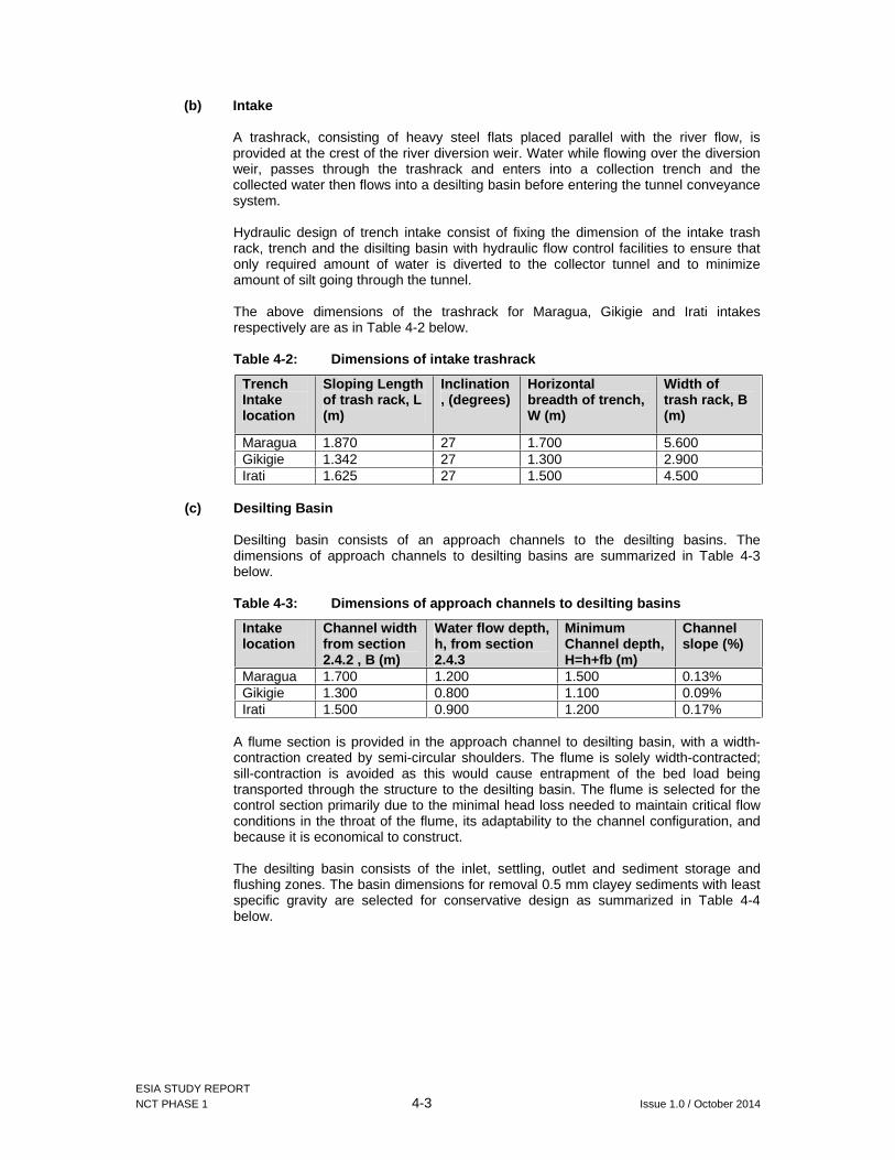
ESIA STUDY REPORT NCT PHASE 1 4-3 Issue 1.0 / October 2014
(b) Intake
A trashrack, consisting of heavy steel flats placed parallel with the river flow, is provided at the crest of the river diversion weir. Water while flowing over the diversion weir, passes through the trashrack and enters into a collection trench and the collected water then flows into a desilting basin before entering the tunnel conveyance system.
Hydraulic design of trench intake consist of fixing the dimension of the intake trash rack, trench and the disilting basin with hydraulic flow control facilities to ensure that only required amount of water is diverted to the collector tunnel and to minimize amount of silt going through the tunnel.
The above dimensions of the trashrack for Maragua, Gikigie and Irati intakes respectively are as in Table 4-2 below.
Table 4-2: Dimensions of intake trashrack
Trench Intake location
Sloping Length of trash rack, L (m)
Inclination, (degrees)
Horizontal breadth of trench, W (m)
Width of trash rack, B (m)
Maragua 1.870 27 1.700 5.600 Gikigie 1.342 27 1.300 2.900 Irati 1.625 27 1.500 4.500
(c) Desilting Basin
Desilting basin consists of an approach channels to the desilting basins. The dimensions of approach channels to desilting basins are summarized in Table 4-3 below.
Table 4-3: Dimensions of approach channels to desilting basins
Intake location
Channel width from section 2.4.2 , B (m)
Water flow depth, h, from section 2.4.3
Minimum Channel depth, H=h+fb (m)
Channel slope (%)
Maragua 1.700 1.200 1.500 0.13% Gikigie 1.300 0.800 1.100 0.09% Irati 1.500 0.900 1.200 0.17%
A flume section is provided in the approach channel to desilting basin, with a width-contraction created by semi-circular shoulders. The flume is solely width-contracted; sill-contraction is avoided as this would cause entrapment of the bed load being transported through the structure to the desilting basin. The flume is selected for the control section primarily due to the minimal head loss needed to maintain critical flow conditions in the throat of the flume, its adaptability to the channel configuration, and because it is economical to construct.
The desilting basin consists of the inlet, settling, outlet and sediment storage and flushing zones. The basin dimensions for removal 0.5 mm clayey sediments with least specific gravity are selected for conservative design as summarized in Table 4-4 below.

ESIA STUDY REPORT NCT PHASE 1 4-4 Issue 1.0 / October 2014
Table 4-4: Dimensions of desilting basins
Intake location
Settling Zone Sediment Storage and Flushing Zone
Length L (m)
WidthB(m)
Depth (m)
Sideslope of hopper section
Depth ofhopper section
Diameter of flushing orifice (m)
Longitudinal slope of flushing channel (m)
Maragua 27.0 2.7 3.3 50% 0.45 0.80 5% Gikigie 16.0 1.5 1.9 50% 0.23 0.50 5% Irati 22.0 2.2 2.2 50% 0.35 0.60 5%
(d) Tunnel Inlet Well Drop Structure
The clarified water from the desilting basin collector channel enters the tunnel through a well drop structure and a transition pipeline whose length depends on the distance to the tunnel portal. The selected dimensions and other key features of the well drop structure are summarized in Table 4-5 below.
Table 4-5: Design Features of Well Drop Structure
Intake location
Inlet Weir Notch Outlet Orifice Plunge pooldepth, dp (m)
Design Discharge, Q (m3/sec)
Lengthof weir B (m)
Headover weir at design discharge h1 (m)
Orifice diameter, D (m)
Head over orifice at design discharge, h2 (m)
Maragua 3 2.0 0.642 1.0 1.935 1.00 Gikigie 1 1.0 0.490 0.7 0.895 0.65 Irati 2 1.75 0.535 0.9 1.310 0.85
A transition pipeline connects the well drop structure to the Tunnel, discharging at the tunnel portal for the case of Maragua and Gikigie intakes and discharging into the drop shaft for the case of Irati Intake.
(e) Irati Drop Shaft
The vortex-flow drop shaft will be used for the project. The main hydraulic components include approach channel, inlet structure, drop shaft, de-aeration chamber and adit (connecting tunnel). The dimensions of the Irati shaft inlet structure is as shown in Table 4-6.
Table 4-6: Design calculations for Irati drop shaft inlet structure
Parameter Formula/assumption Calculation result Minimum dimensions (Hager, 1990): Length, L (m) L = 5.3 ds 5.46 Width, W (m) W = 1.4 ds 1.44 Height, H (m) H = 2.15 ds 2.22
The shaft is designed to be of circular section with 4000mm internal diameter and the total depth is approximately 55 m.
(f) Compensation Channels for In-stream Flow Requirements (IFR)
(i) Design features
The compensation channels are designed to maintain at minimum the in-flow stream requirements. The inlet to compensation channel is provided beside the diversion intake at a lower sill elevation than the sill elevation of the diversion intake. Beyond the

ESIA STUDY REPORT NCT PHASE 1 4-5 Issue 1.0 / October 2014
inlet, the channel crosses above the diversion intake trench then runs beside the desilting basin, sloping down to the downstream river bed level at its outlet which coincides with the flushing end of the disilting basin.
The headworks consist of:
A common inlet trashrack for intake trench and compensation channel is provided to exclude large floating materials, which roll through the slope of the trashrack to the downstream section;
A slide gate to regulate flows above the minimum requirement for compensation flows;
A stoplog gate between the inlet orifice and the slide gate orifice to isolate the slide gate and channel for inspections and maintenance;
A level gauge for compensation flow measurement;
The compensation channel dimensions are summarized in Table 4-7 below.
Table 4-7: Design Features of Compensation Channel
Name of Intake
Required minimum compensation flow, Q (m 3/sec)
Width of channel, Bc (m)
Invert slope of inlet channel, S (%)
Required depth of compensation invert below intake trench invert level, (m)
Maragua 0.645 1.0 0.2% 0.645 Gikigie 0.100 0.6 0.2% 0.273 Irati 0.481 0.8 0.2% 0.481
An IFR of Q95 was adopted for both Maragua and Gikigie rivers. For Irati River, a variation of 1.4Q95 was adopted since Q95 was deemed to be inadequate to meet IFR.
(ii) Operating principle
The operational requirement of the compensation channel is considered in three phases as follows:
At low river flows, i.e. not exceeding the required minimum compensation flow Q<Qc), the compensation channel gate is fully open and all flows are permitted through the compensation channel gate under free flow condition. The low flows are not permitted through the diversion intake until the required minimum compensation flow is satisfied;
At higher river flows, i.e. exceeding required minimum compensation flows but excess not exceeding intake diversion capacity (Q > Qc and Q-Qc < Qd), the compensation channel gate is partially open to only permit the minimum compensation flow (Qc) and divert the excess (Q-Qc) to the tunnel intake. The head of water behind the compensation gate contribute to pressure flow through the gate orifice; and
At river flows exceeding the required minimum compensation plus maximum diversion flows (i.e. Q > Qc + Qd), the compensation channel gate is fully closed. The excess of diverted flow (i.e. Q - Qd) is passed to the downstream through the main overflow weir, and exceeds the required minimum compensation flow.
4.1.2 Northern Collector Tunnel
The water diverted from the intakes is conveyed through the NCT Phase 1 to an outfall on River Githika as per schematic arrangement shown in Figure 4-1 below.

ESIA STUDY REPORT NCT PHASE 1 4-6 Issue 1.0 / October 2014
Figure 4-2: Schematic layout of Northern Collector Tunnel
The design data and assumptions for the tunnel are:
Maximum flow at 0.8 of tunnel depth to maintain steady and uniform open channel flow at hydraulic conditions;
Maximum velocity of 3m/s to minimize scour action; and Design flow =130% of required flow.
The tunnel flow is divided into three sections as summarised in Table 4-8.
Table 4-8: Tunnel design flows (m 3/s)
Tunnel Section Required flow 30% Contingency flow Tunnel Design flow Maragua-Gikigie 9 2.7 11.7 Gikigie-Irati 10 3 13 Irati-Makomboki 12 3.6 15.6
Three lining conditions are considered: Rock, Shotcrete and Concrete. Tunnel invert slopes (Table 4-9) are based on surface elevations at the key points
along the tunnel including Maragua Intake, Gikigie Intake, and Makomboki Outfall.
Table 4-9: Tunnel Slopes Tunnel Section Length
(m) Upstream Invert Level (m.asl)
Downstream Invert Level (m.asl)
Tunnel slope (%)
Maragua Intake to Gikigie Intake
2,946 2070.00 2065.59 0.15%
Gikigie Intake to Irati Intake
2,492 2065.59 2061.86 0.15%
Irati Intake to Makomboki Outfall
6,252 2061.86 2052.50 0.15%
Tunnel shape: Both circular and horse shoe shape are considered for the tunnel section.
Froude number is limited to Fr 0.8 to maintain sub-critical flow conditions in the tunnel and hydraulic grade line (HGL) within the tunnel section.
The minimum tunnel diameter is considered to be 3m from constructability point of view. Based on the hydraulic, constructability and economic considerations, the recommended tunnel diameter of circular tunnel is 3m.
The horse-shoe shape of equivalent crown diameter would however be more preferred due to its higher hydraulic capacity than the circular shape. It also presents the advantage of being motorable for inspection and maintenance purposes, due to flatter and wider invert.

ESIA STUDY REPORT NCT PHASE 1 4-7 Issue 1.0 / October 2014
Figure 4-3: Typical horse-shoe tunnel section
4.1.3 Tunnel Outfall Structure
The outfall structure is located at the discharge end of the northern collector tunnel, where the tunnel flow joins the Githika River en route to Thika Dam. The outfall structure is provided to effectively dissipate the energy from the tunnel flow as the tunnel flow joins Githika River. This is achieved through a stilling basin. The stilling basin section is characterized by some combination of chute blocks, baffle blocks, and sills, designed to trigger a hydraulic jump in combination with a required tailwater condition.
Depending on the specific design, stilling basins operate over a range of approach flow Froude numbers from 1.7 to 17 as summarized in table below.
Table 4-10: Types of Stilling Basin
Stilling Basin Minimum Approach Froude Number
Maximum Approach Froude Number
USBR Type III 4.5 17 USBR Type IV 2.5 4.5 SAF 1.7 17

ESIA STUDY REPORT NCT PHASE 1 4-8 Issue 1.0 / October 2014
Figure 4-4: Definition sketch of USBR Type III stilling basin
4.1.4 Kaanja and Gikigie Adits
The Kaanja and the Gikigie adits provide access to the NCT tunnel alignment in two intermediate locations, allowing the simultaneous excavation of the tunnels in various fronts. The adits are assumed to have the same cross section as of the main tunnel, with the support type varying according to the geological conditions encountered during excavation.
Kaanja access adit consists of temporary 750m long construction access decline at approximately 6.5% gradient (assuming portal at elevation 2116 maod and main tunnel at 2067 maod. Profile is nominally the same as the main collector tunnel to enable use of same support elements. Gikigie adit will transfer water from the Gikigie Intake to the main collector tunnel.
The adits are assumed to be excavated using the Conventional Tunnelling Method (CTM) as described in section 4.3.1 of this report.
4.1.5 Tunnel portals
Two main tunnel portals are considered at the north and south ends of the tunnels, at Maragua and Githika respectively. Tunnel portals will also be required for the Kaanja and Gikigie construction access tunnels.
Portal construction will commence with necessary cuttings and earthworks to form the slopes and provide a suitable worksite area from which the tunnel excavation can proceed.
It is expected that the two main portals will be located within residual soils. Therefore, excavations for portal slope formation are likely to require permanent slope stabilization support before tunnel excavation is achievable. Such portal excavations will be arranged as deepening trench excavations extending into the existing sloping topography allowing easy access to the portals for spoil removal and materials supply. It is expected that slopes will be stabilized by applying sprayed concrete to exposed surfaces. The thickness of sprayed concrete required will be probably between 150 to 200mm. Rock bolts and grouted bars may also need to be considered to achieve the required factor of safety against slope failure.

ESIA STUDY REPORT NCT PHASE 1 4-9 Issue 1.0 / October 2014
The initial tunnel support arrangement at portals will comprise the installation of canopy tubes at the crown, ahead of the excavation, followed by the erection of steel arch sets and shotcrete arch support to form a stiff support structure.
General tunnel drawings including the location, arrangement plan, tunnel adit and setout points, longitudinal section, diversion weir section, intake arrangement plan and site maps are presented in appendix I.
4.2 Fish Passes
Fish passes have been included in the design of weirs to enable upstream migration of Rainbow Trout (Oncorhynchus mykiss) and Brown Trout (Salimo trutta) for spawning purposes. The construction of weirs will impede free longitudinal passage through rivers by these aquatic organisms. The provision of fish passes, that support the interlinking of the river reaches, will make a real contribution towards sounder management of the rivers.
Technical fish passes include the following types: Pool passes, Vertical slot passes, Denil passes (counter flow passes), Eel ladders, Fish locks and Fish lifts. For this project, conventional pool passes have been adopted since their hydraulic and biological effectiveness have been adequately studied. The principle of a pool pass consists in dividing up a channel leading from the headwater to the tailwater by installing cross-walls to form a succession of stepped pools. The discharge is passed through openings in the cross-walls and the potential energy of the water is dissipated, step-by-step, in the pools. Fish migrate from one pool to the next through openings in the cross-walls that are situated at the bottom (submerged orifices) or at the top (notches). The migrating fish encounter high flow velocities only during their passage through the cross-walls, while the pools with their low flow velocities offer shelter and opportunities to rest. The fish pass channels are not covered over in order to allow daylight since diurnal fish avoid swimming into dark channels.
Table 4-11 summarizes the hydraulic design of the fish passes and schematic presentation is given in Figure 4-5.
Table 4-11: Summary of fish passes hydraulic design features
Item Paramete r Maragua Intake Gikigie Intake Irati Intake
1. Weir parametersHighest headwater level, m.asl
2079.67 2075.20 2114.25
Lowest tailwater level, m.asl 2073.50 2071.50 2109.50 Maximum drop height, htot (m) 6.17 3.70 4.75
2. Pool Dimensions and hydraulics Selected pool dimensions for Rainbow trout
Pool width, b (1.6 - 2.0 m) 1.60 1.60 1.60 Minimum water depth, h (0.8 - 1.0 m)
0.8 0.8 0.8
Length of pool, lb(2.5 - 3 m) 2.5 2.5 2.5 Thickness of partition wall, d(m)
0.15 0.15 0.15
The surface of the pool bottoms is roughened using river boulders
The cross-walls are to have bottom orifices, and top notches:
Clear orifice span, bs (0.4 - 0.5 m)
0.50 0.50 0.50

ESIA STUDY REPORT NCT PHASE 1 4-10 Issue 1.0 / October 2014
Item Paramete r Maragua Intake Gikigie Intake Irati Intake
Clear orifice height, hs (0.3 - 0.4m)
0.40 0.40 0.40
Width of notches, ba ( 0.3m)
0.30 0.30 0.30
Height of notches, ha ( 0.3 m)
0.300 0.300 0.300
Water level difference in subsequent pools, h ( hmax= 0.2 m)
0.2 0.2 0.2
Mean water depth, hm= h+ h/2 (m)
0.900 0.900 0.900
Slope for pool pass, I = h/lb (%) 8.0% 8.0% 8.0% Number of pools needed, n=htot/ h-1
30 17 23
Discharge through bottom orifice:
Flow velocity in orifices, Vs= (2g h) (m/s)
1.98 1.98 1.98
Assumed discharge coefficient, (0.65 to 0.85)
0.75 0.75 0.75
Qs= *As*Vs (m3/s) 0.30 0.30 0.30 Discharge through top notch:
Difference in the water level between headwater and tailwater, hweirhead= h (m)
0.20 0.20 0.20
Drowned-flow reduction factor,
1.00 1.00 1.00
Assumed discharge coefficient, µ (0.6)
0.60 0.60 0.60
Qa=2/3*µ* *ba* (2*g)*hweirh
ead^1.5 (m3/s) 0.05 0.05 0.05
Total discharge through pool pass, Q=Qs+Qa (m3/s)
0.34 0.34 0.34
Check: is recommended discharge through fish pass obtained, Qrec (0.2 - 0.5 m3/s)
OK OK OK
Power density, E= *g* h*Q/(b*hm* (lb-d)) (W/m3)
200 200 200
Check: E 200 W/m3? OK OK OK

ESIA STUDY REPORT NCT PHASE 1 4-11 Issue 1.0 / October 2014
Figure 4-5: Conventional pool passes (longitudinal section and pool structure)
4.3 Tunnel Excavation Methods
Given the apparent variability in the ground types as well as the variability in the required rock support and the potential pre-support or pre-treatment of the rock, a combination of two methods of tunnel excavation along the proposed 11.8km tunnel alignment has been proposed. It is envisaged that the majority of the tunnel would be excavated by mechanised techniques (roadheader or excavator-type machines) with only a relatively small section of the tunnel requiring the use of drill-and-blast techniques when the harder basalts are intersected.
4.3.1 Conventional Tunnelling Construction
The Conventional Construction combines mechanized and drill and blast methods which are characterized for the generally shorter time and lower investment cost required for procurement of equipment and mobilization, due to the use of standard specialized equipment(provided that extensive preliminary works are not required). Major limitations are slow advance rates compared to Tunnelling Boring Machine (TBM) and the potentially excessive ground disturbance causing over-break and leading to more onerous temporary support measures required. The following excavation equipment are likely to be used for Conventional Tunnelling in the NCT Phase 1:
Excavators with rock hammers and buckets for completely weathered and highly weathered rock up to around 10 MPa strength;
Roadheader or milling heads on modified excavators for weak to medium strength rock (1 MPa to 30 MPa strength);
Drill and Blast for medium to strong rock (around 15 MPa or more).
Initial support for the excavations would be shotcrete and rockbolts for better rock conditions ranging up to steel rib support for weaker ground. Pre-support of the face with fore-poling and face nailing may be required in the weaker ground types.
4.3.2 Excavation by Tunnelling Boring Machine (TBM)
For this project the use of a TBM will have some inherent advantages over other forms of excavation. The tunnel excavation advance rates are high for this form of tunnelling when compared to other methods of construction. Furthermore, a high quality circular excavated profile can be achieved. Unlike with drill and blast techniques, there is minimal deterioration of the rock mass quality in the tunnel periphery following excavation. Also, when compared with a horseshoe profile, a circular shape is more economical in terms of the production and removal of spoil.

ESIA STUDY REPORT NCT PHASE 1 4-12 Issue 1.0 / October 2014
Concerning tunnel support, a segmental lining can be conveniently erected to provide support to the excavated profile. By using a TBM the segmental lining can be erected behind the TBM in cycles as it advances forward so that the possible need for rock bolting and shotcrete is avoided. Thus eliminating or at least minimising, temporary rock support requirements along the alignment.
The principal disadvantage of the adoption of TBM tunnelling for this project is the time required for the purchase and delivery of equipment. Such delivery time could be between 6 months and a year depending on the availability of used equipment or the purchase of a new machine. Depending on the programming of the tunnel construction, such a delay may not present any problems to overall delivery of the project.
4.4 Material Sources and Spoil Sites
4.4.1 Material Sources
Construction materials such as stone blocks and coarse aggregates are not readily available in the area due to the significant weathering depth in the local volcanic geology. Most rocks are located in the valley bottoms. These valley bottoms are not accessible due to the steep terrains in the region. Small quarries are available near bridges at the river crossings which cannot meet the construction material demand in the region. The bulk of the materials are normally sourced outside the project area. The following construction materials may be locally obtainable:
Building Stone and aggregate: There appears to be ample suitable sources of aggregate for concrete works in Kijabe area (some 35km south west of the project area), and scarce in the Muranga (Fort Hall) and Nyeri areas where overburdens are stated to be very thick (i.e. the sub-counties to the east and north of the project area). Although materials available in the Kijabe and Nyeri areas, it is not easy to travel across the valleys and ridges. The pattern of travel is parallel to the ridges/valleys. Most of the roads are located on the ridge tops which are dictated by the terrain. The bulk of the construction stone blocks and coarse aggregates are sourced from existing/licensed quarries near Thika town and Makuyu, approximately 50 to 100 kilometres from the project location.
Clays are expected to be readily obtainable, volcanic rocks exposed to tropical weathering generally decompose to give rise to thick profiles of clayey (normally red) residual soils. These are not expected to be of much practical use for this project. But have been investigated and used for the clay core of a nearby dam.
Sands are the predominant weathering product from volcanic rocks, it can be expected that sands will be difficult to source in an area characterised exclusively with volcanic deposits. The bulk of the fine aggregates used are sands from rivers in Machakos County which are approximately 100 to 200 kilometres from the project area.
4.4.2 Spoil sites
Some 250,000 cubic meters of material will be excavated from the tunnel. Due to the anticipated weathered nature of the rock to be excavated, much of this may not be suitable. Additionally this material may deteriorate over time. It is important that the materials testing be conducted on the tunnel material in order to determine it suitability for reuse e.g. in the rehabilitation and mmaitenance of roads, and to reduce the land required to dispose of the spoil. It is likely that the spoil from the tunnel may be readily absorbed in the area. Six spoil sites have been proposed by the design consultant and they are as shown in Table 4-12.
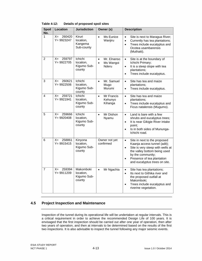
ESIA STUDY REPORT NCT PHASE 1 4-13 Issue 1.0 / October 2014
Table 4-12: Details of proposed spoil sites
Spoil No.
Location Jurisdiction Owner (s) Description
1 X= 260420 Y= 9923247
Kiruri location, Kangema Sub-county
Ms Eunice Wanjiru
Site is next to Maragua River; Currently has tea plantations; Trees include eucalyptus and
Ocotea usambarensis (Muthaiti).
2 X= 259797 Y= 9922705
Ichichi location, Kigumo Sub-county
Mr. Elnanso Ms Wangoi
Nderu
Site is at the boundary of Ichichi Primary;
It is a steep slope with tea plantations;
Trees include eucalyptus.
3 X= 260621 Y= 9922506
Ichichi location, Kigumo Sub-county
Mr. Samuel MugoMurumi
Site has tea and maize plantations;
Trees include eucalyptus.
4 X= 259721 Y= 9921941
Ichichi location, Kigumo Sub-county
Mr Francis Kehunyo Kihanga
Site has tea and maize plantations;
Trees include eucalyptus and Ficus natalensis (Mugumo).
5 X= 259666 Y= 9920408
Ichichi location, Kigumo Sub-county
Mr Dishon Nyamu
Land is bare with a few shrubs and eucalyptus trees;
It is near Gikigie River intake point;
Is in both sides of Mununga-Ichichi road.
6 X= 258861 Y= 9915415
Kinyona location, Kigumo Sub-county
Owner not yet confirmed
Site in next to the proposed Kaanja access tunnel (adit);
Site is very steep with wells at the valley bottom being used by the community;
Presence of tea plantation and eucalyptus trees on site.
7 X= 259394 Y= 9911209
Makomboki location, Kigumo Sub-county
Mr Ngachia Site has tea plantations; Its next to Githika river and
the proposed outfall at Makomboki;
Trees include eucalyptus and riverine vegetation.
4.5 Project Inspection and Maintenance
Inspection of the tunnel during its operational life will be undertaken at regular intervals. This is a critical requirement in order to achieve the recommended Design Life of 100 years. It is envisaged that the first inspection should be carried out after one year of operation, then after two years of operation, and then at intervals to be determined based on the results of the first two inspections. It is also advisable to inspect the tunnel following any major seismic events.

ESIA STUDY REPORT NCT PHASE 1 4-14 Issue 1.0 / October 2014
Operation of the tunnel will need to be stopped during inspection so the works shall be planned to be completed in the minimum possible time, taking into account activities such as system drainage and decontamination times before and after inspection respectively.
Adequate planning of inspection procedures are necessary to minimise the interruption to the water supply. Such planning is more critical in the unlikely event that some repair work is required. Planning of these inspections shall be compatible with the operational requirements of the Thika Reservoir. There should be no attempt to do any required repair work during an inspection.
4.6 Safety in Design
The project design has been developed to ensure a safe operational environment, as well as taking into consideration the safety of personnel and the general public during construction and maintenance of the works.
A summary of the key structural Safety in Design issues relevant to the hydromechanical works relating to inspection and maintenance include the following
Stainless steel and galvanised steel have been used in the design to minimise the maintenance work;
Gratings are fixed so that general public cannot lift them; Grating has been designed only for man access; Access platforms with handrails provided to service gates; Gates are with” Tee-Key” operating gear which will protect against vandalism; and Trash rack and coarse bar screen are fixed and welded so that it can be protected
against vandalism.
4.7 Temporary and enabling works
The project contractor will be expected to undertake design, construction, maintenance and removal upon completion the following temporary and enabling works associated with the above permanent works including but not limited to:
Improvement of local access roads and associated local bridges for the purposes of executing the works;
Establishment of project sites including buildings, short access roads (to camp,adits,intakes and outfall) and services (water, sanitation, communication, power etc.) and security measures, including: Administration site Accommodation Workshops and material storage areas as required to complete the Project
works Concrete and other material production facilities as required to complete the
Project works Construction work sites
The establishment of borrow areas and spoil disposal sites at locations approved by the Owner including sediment control and re-seeding of disposal areas;
Design and construction of required temporary excavations, river diversions and inundation protection (including tunnels);
Infrastructure and equipment required for tunnel and shaft construction including ventilation, lighting, communication, transport and major tunnelling plant to suit the agreed construction methods.

ESIA STUDY REPORT NCT PHASE 1 4-15 Issue 1.0 / October 2014
4.8 Construction Inputs and activities
Numerous construction inputs will be involved in the project. The following provides a summary of key apparent inputs and activities.
4.8.1 Construction materials
Ordinary Portland cement - bagged Ordinary Portland cement - bulk Fine aggregate Coarse aggregate Concrete mix at central batch plant characteristic strength 20 MPa, slump 80mm and
maximum aggregate size 20mm Reinforcing steel Reinforcing fabric Structural steel Explosive - gelatine Explosive - ammonium nitrate
4.8.2 Construction equipment
Equipment Rating Bulldozers 70kw-250kw Hydraulic excavators 10-24t Mobile cranes 30t to 50t max Track type loader 80kw Concrete plant 60t/hr Air compressors 5m3/min Generator 365kwVibrating roller 8 t Tipper trucks 0-25t Vibrating rollers 8 -12 t Three wheel steel roller 10-15t Tandem steel roller 12t Vibrating Plate Compactor 0.4tJack hammer 25kg Pick -up truck 1.7t Crushing plant 150t/hr Concrete mixer 15hp0.5m³ Concrete vibrator 35-63 mm diameter Self-propelled water tanker 6,000lSelf-propelled fuel tanker 6,000l Water pump centrifugal 50 mm diameter
4.8.3 Labour
Both skilled and unskilled labour will have input of substantial man hours in providing technical supervision and mechanical operation. The input for non-technical staff has been estimated at 4,100 man hours.
4.8.4 Construction activities (summary)
The project construction activities are summarised as follows

ESIA STUDY REPORT NCT PHASE 1 4-16 Issue 1.0 / October 2014
(a) For the intakes and outfall
Temporary river diversion, water control and pollution control; Open-cut excavation and earthworks; Protection and support of open-cut excavations; Drainage; Concrete production and construction; Structural steelwork; Miscellenous metalwork; Road and bridgeworks; Hydromechanical works; and Miscellaneous construction.
(b) For the tunnels and adits
Open-cut excavation and earthworks; Protection and support of open-cut excavations; Underground excavation, protection and support of underground excavation; Drilling and grouting in tunnels; Structural steelwork and miscellaneous metalworks; Concrete production and construction, precast concrete and prestressed concrete;
and Instrumentation.
4.9 Project Cost and Duration
The project is expected to cost approximately KES 6.8 Billion. The construction duration for the four options is as detailed in Table 4-13. The preferred option which is option 1 is estimated to take 39 months ± 20%.
Table 4-13: Estimated construction duration for various methods
Option Program Duration Estimate
Option 1 – Conventional tunneling with 6 drives 39 months ±20%
Option 2 – Conventional tunneling with 8 drives 32 months ±20%
Option 3 – TBM Tunnel full length 40 months ±20%
Option 4 – Hybrid 4 conventional drives + TBM 32 months ±20%
4.10 Community Support Projects
4.10.1 Community water projects
As part of giving back to the community from where it is drawing its water supplies, AWSB has strategy to address the water needs of the communities living along and downstream of the proposed Northern Collector Tunnel Phase 1. This will complement the efforts of Tana Water Services Board (TWSB) in provision of water to these communities. This will see the Murang’a communities benefit from development of water projects to the tune of Ksh. 1.270 billion. The key projects to be developed under this arrangement include:
Muranga W/S (augmentation) – KSh. 800 Million;

ESIA STUDY REPORT NCT PHASE 1 4-17 Issue 1.0 / October 2014
Gatanga W/S (augmentation) - KSh. 300 Million; and Gatango W/S (augmentation) – KSh. 170 Million.
Details of the above projects are presented in Table 4-14.
Table 4-14: Water projects to be supported by AWSB
Muranga W/S (augmentation)
Project/component Estimated number of beneficiaries
Area covered
Muruka–Kenol-Makuyu Pipeline – 34Km 124,000 Muruka Location, Kenol, Makuyu Location, Kabati Sub-location, Gitura Sub-location
Mareira-Sabasaba-Muthithi – 16.5Km 46,000 Maragwa Town, Kaharati and Kahumbu locations
Kaharati-Iganjo Pipeline – 6.5Km 5,000 From Kaharati to Kamahuha location
Rwathia - Mukangu pipeline – 27Km Wethaga, Gitie, Kahuti and the surrounding areas
Kayahwe – Kambirwa Pipeline – 12Km 15,000 Kambirwa Market, Itaru-ini area (by Sagana River), Mirira & Muthigiriri Market
Kahuti II Water Treatment Plant – 4,000m3/day
Estimates unavailable
Waithaga, Kianderi, Kahuti and another line to serve Mukangu, Gatheru and Gitige
Kiriciiungu Water Treatment Plant – 4,000m3/day 40,000 Kandara town/ Ruchu location
Gatango Water Supply Project
Gatango intake in the North Mathioya River, laying of 30km of pipelines
Estimates unavailable
Kiru, Kamacharia and Gaturi divisions of Mathioya sub county
Gatanga Water SupplyExtension of 8 km 8’’ pipeline from Karangi to Ndakaini
30,000
Wanduhi, Kiriaini, thare & Mureke
Chomo, Gatura Intakes and Rwagetha Treatment works (3000m3/day)
Kigio, Gakurari, Kirwara, Gatanga, Mabanda and Gatunyu
Treatment works at Karangi (3000m3/day) Mbugiti, Gatura, Chomo, Rwegetha
Muranga Water Supply contract has been awarded while bids for Gatanga Water Supply are being evaluated. The projects construction period for each is 18 months.
4.10.2 Corporate Social Responsibility
As part of CSR, AWSB has implemented the following projects for Gatanga Community Water and Sanitation company area:
Kiama river intake and laying of 5km, 10 inch pipeline to serve Kariara and Kiriani wards
Rehabilitated Kimakia Supply System serving Kariara, Parts of Kiaraini, mugumoini, and Gatanga
Kiunyu Secondary School Borehole serving the school and the surrounding areas (Appr. 300 persons)
AWSB has overseen the implementation of over 20 VIP latrines and Urine Diverting Dry Toilets (UDDTs) in Muranga county under a program financed by WSTF;
AWSB has also drilled and developed 5 boreholes in Ithanga area (Ngelelya, Giathanini, Kinyangi and Greystone) this serves approximately 10,000 persons

ESIA STUDY REPORT NCT PHASE 1 4-18 Issue 1.0 / October 2014
While undertaking the Northern Collector Tunnel project, AWSB will carry out the following CRS activities:
Engage Murang’a University in project activities like geotechnical investigation and supervision of specialized works;
Construct a dispensary for the project which will be available for the community; and Ensure roads are maintained during construction.
ESIA for the community support projects will however be conducted under separate studies and are thus not considered under this study.
ESIA STUDY REPORT NCT PHASE 1 5-1 Issue 1.0 / October 2014
5 PROJECT ALTERNATIVES
An ESIA should identify and assesses alternatives to the proposed project. Only the best alternative should be selected based on less negative impacts and cost-benefit analysis. An important alternative to be analysed is the “no project” alterative. This is a very important analysis because it helps the proponents measure the impacts from the project against those which would have taken place without the project.
5.1 No Project Alternative
The no-action alternative is often defined by the baseline information and is crucial in the assessment of impact because other alternatives are weighed with reference to it. This alternative would mean that the project does not proceed.
Without the project, the environmental situation will neither improve nor can we say that it will necessarily deteriorate. Development of the project on the other hand will ensure adequate water supply to the residents of Nairobi and 13 satellite towns namely Kikuyu, Ruiru-Juja, Kiambu, Karuri, Githunguri, Mavoko Municipality, Ngong Township, Ongata-Rongai, Thika, Gatundu, Limuru, Lari and Tala-Kangundo.
The no-projection option will however mean that the targeted populations will continue to suffer from inadequate and unreliable water supply. This also means that the local communities will potentially miss out on development opportunities that the project could bring including access to water and economic opportunities through project construction and operation including employment and small business opportunities.
This scenario is therefore not acceptable on either social or environmental grounds and not comparable with the project proposal.
5.2 Construction of Maragua Dam
Construction of Maragua dam had been proposed within the NCT study area i.e. at Kangema, Kigumo and Kahuro sub-counties at the confluence of Maragua and Gikigie rivers. The proposed dam was an embankment dam with a maximum height of 100m. The reservoir was projected to cover an area of 4km2 and was to impound 100hm3 at its Normal Water Level (NWL). In addition to storing flood flow from the Maragua and Gikigie Rivers, a transfer tunnel had been proposed to transfer water from South Mathioya River to the dam. The length of this tunnel was to be approximately 3km.
According to ESIA Study report for the proposed Maragua dam finalized in January 2012 by Tertiary Consulting Engineers, the key environmental and socioeconomic impacts included:
Substantial loss of agricultural land to the required reservoir area of 4km2. There was no estimate for the number of households affected but the estimated cost of RAP was Ksh 6.6 billion;
Total exclusion of future land uses in the affected area; Reduction of biodiversity by blocking migration of certain organisms and loss of
habitats. However, no species of conservation significance were highlighted in the report;
Dangers of people drowning either accidentally or intentionally; Spread of water borne diseases; Economically, the dam development required a capital outlay estimated to be about
Kenya Shillings fifty nine billion ninety three million four seventy eight thousand nine

ESIA STUDY REPORT NCT PHASE 1 5-2 Issue 1.0 / October 2014
hundred and sixty six shillings (Kshs. 59,093,478,966.00). The implementation period was to be spread over three calendar years.
This option was hence considered to have greatest socioeconomic impacts from displacement and resettlement of numerous households, substantive acquisition of land and associated infrastructure in addition to the expensive capital outlay (more than eight times the cost of tunnel construction). This was therefore considered expensive and the Northern Collector Tunnel option was preferred.
5.3 Tunnel Construction Options
Alternative tunnel construction methods were made during the design stage. Tunnel construction alternatives that were identified as feasible are summarised below:
Option 1: Conventional Tunnelling with 6 faces (Preliminary Design); Option 2: Conventional Tunnelling with 8 faces (additional access adit and up and
down drives from Irati); Option 3: Single Tunnel Boring Machine (TBM) for complete tunnel; Option 4: Hybrid TBM and Conventional Tunnelling with 4 faces.
5.3.1 Conventional Tunneling construction
The Conventional tunneling Construction combines mechanized and drill and blast methods which are characterized for the generally shorter time and lower investment cost required for procurement of equipment and mobilization, due to the use of standard specialized equipment (provided that extensive preliminary works are not required). Major limitations are slow advance rates (compared to TBM) and the potentially excessive ground disturbance causing over-break and leading to more onerous temporary support measures required.
The following excavation equipment are likely to be used for Conventional Tunnelling in the NCT Phase 1:
Excavators with rock hammers and buckets for completely weathered and highly weathered rock up to around 10 MPa strength;
Roadheader or milling heads on modified excavators for weak to medium strength rock (1 MPa to 30 MPa strength);
Drill and Blast for medium to strong rock (around 15 MPa or more).
Initial support for the excavations would be shotcrete and rockbolts for better rock conditions ranging up to steel rib support for weaker ground. Pre-support of the face with fore-poling and face nailing may be required in the weaker ground types.
Due to the apparently extensive presence of highly fractured medium to weak rocks, it is considered that the majority of the alignment will be excavated using roadheader. Drill and Blast methods would only be applied when hard rock (basalt) is intersected. For the areas close to the portals, where completely weathered rocks and residual soils are present, the use of excavator-type machines will be most suitable.
5.3.2 Excavation by Tunnel Boring Machine (TBM)
For NCT1 the use of a TBM will have some inherent advantages over other forms of excavation. Broadly speaking tunnel excavation advance rates are high for this form of tunnelling when compared to other methods of construction. Furthermore, a high quality circular excavated profile can be achieved. Unlike with drill and blast techniques, there is minimal deterioration of the rock mass quality in the tunnel periphery following excavation. Also, when compared with a horseshoe profile, a circular shape is more economical in terms of the production and removal of spoil.

ESIA STUDY REPORT NCT PHASE 1 5-3 Issue 1.0 / October 2014
Concerning tunnel support, a segmental lining can be conveniently erected to provide support to the excavated profile. By using a TBM the segmental lining can be erected behind the TBM in cycles as it advances forward so that the possible need for rock bolting and shotcrete is avoided. Thus eliminating or at least minimising, temporary rock support requirements along the alignment.
The principal disadvantage of the adoption of TBM tunnelling for this project is the time required for the purchase and delivery of equipment. Such delivery time could be between 6 months and a year depending on the availability of used equipment or the purchase of a new machine. Depending on the programming of the tunnel construction, such a delay may not present any problems to overall delivery of the project.
The following costs and programme outputs were estimated for each option:
Table 5-1: Estimated Construction Cost and Duration for Various Methods
Option Cost Estimate Program Duration EstimateOption 1 – Conventional tunnelling with 6 drives
US$130 Mill ±20% 39 months ±20%
Option 2 – Conventional tunnelling with 8 drives
US$134 Mill ±20% 32 months ±20%
Option 3 – TBM Tunnel full length
US$ 108 Mill ±20% 40 months ±20%
Option 4 – Hybrid 4 conventional drives + TBM
US$ 120 Mill ±20% 32 months ±20%
From the above comparisons and the assessment of project area baseline conditions (it is notable that the project area is landslide prone), tunnelling by TBM will be environmentally preferable due to the lesser ground disturbance causing of over-break.
The design of the main NCT Phase 1 has considered options for both Conventional Tunnelling and TBM tunnel construction. Option 1 has been assumed as the base design with Option 3 considered as an alternative.

ESIA STUDY REPORT NCT PHASE 1 6-1 Issue 1.0 / October 2014
6 PUBLIC CONSULTATIONS AND DISCLOSURE
6.1 General
Public consultation is useful for gathering environmental data, understanding likely impacts, determining community and individual preferences, selecting project alternatives and designing viable and sustainable mitigation and compensation plans.
Public consultation in the ESIA process is undertaken during the project design, implementation and initial operation. The aim is to disseminate information to interested and affected parties (stakeholders), solicit their views and consult on sensitive issues.
Public consultation process for the Northern Collector Tunnel Phase 1 project took place at the scoping stage and the ESIA stage. The main objective for the consultation process was to involve the community at the very early stage of design so as to identify likely negative impacts and find ways to minimise negative impacts and enhance positive impacts of the project within the final design.
Public participation in all stages of the project is likely to contribute to maximisation of expected benefits and minimisation of mitigation costs of expected negative socio-economic impacts on the immediate environment.
6.1.1 Objectives of the Public consultation
An important element in the process of impact assessment is consulting with stakeholders to gather the information needed to complete the assessment.
The overall goal of the consultation process is to disseminate project information and to incorporate the views of the Project Affected Persons (PAPs) in the design of the mitigation measures and a management plan as well as in the preparation of the Resettlement Action Plan for the Northern Collector Tunnel wayleave.
The specific aims of the consultation process during the ESIA study stage were:
To inform the local people, leaders and other stakeholders about the proposed Northern Collector Tunnel- Phase 1 project and its objectives;
Obtain the main concerns and perceptions of the population and their representatives regarding the project;
Obtain opinions and suggestions directly from the affected communities on their preferred mitigation measures;
To find out if there are issues or places of cultural/or religious importance to the local communities that could be negatively impacted upon by the project and its infrastructure;
To Improve project design and, thereby, minimize conflicts and delays in implementation;
To facilitate the development of appropriate and acceptable entitlement options; To increase long term project sustainability and ownership; and To reduce problems of institutional coordination, especially at the different levels of
Government.
The specific aims of the consultation process during the RAP study were to:
Make the resettlement process participatory and transparent; Facilitate the development of appropriate and acceptable entitlement options; Increase the effectiveness and sustainability of income restoration strategies, and
improve coping mechanisms; Provide a platform for future consultation by:
ESIA STUDY REPORT NCT PHASE 1 6-2 Issue 1.0 / October 2014
Reducing conflict through early identification of contentious issues; Improving transparency and accountability of decision making; Facilitating participation to increase public confidence in the RAP process; Identifying local leaders with whom further dialogue can be continued in
subsequent stages of the project. Reduce problems of institutional coordination creating awareness and incorporating
views of all institutional stakeholders; and Increase long term Project sustainability and ownership.
6.2 Previous Consultations
6.2.1 Stakeholder Consultations at Scoping Stage
The study team held introductory meetings with key stakeholders at the scoping stage between 10- 22nd April, 2014. These meetings served as an introduction of the Northern Collector Tunnel- Phase 1 project and set the ground for the ESIA studies ad RAP studies held from the month of August to early October, 2014.
Consultations with the Sub-County administration in Kangema and Kigumo Sub-Counties were done during the preliminary field visits to notify them of the proposed project as well as to aid in identification of relevant institutional stakeholders to be consulted during the ESIA study.
The key stakeholders that were consulted included:
Mr. J.G Kamau- Deputy County Commissioner (DCC) - Kangema Sub County; Mr. Charles Langat- Assistant County Commissioner (ACC) on be half of the DCC -
Kigumo Sub County; Mr. David Gichoni- Sub County Water Officer- Kigumo Sub County; Ms. Faith Mbathi- Service Water Officer (WRMA) – Muranga Sub Region; Hon. Anderson Muchemi Waweru- Member of the County Assembly- Kangari Ward; Hon. Caroline Wairimu Njoroge – Member of the County Assembly- Kigumo Ward; Hon. Charles Mwangi Kirigwi – Member of the County Assembly- Kinyona Ward; Hon. Peter Irungu Kihungi- Member of the County Assembly – Kanayanyaini Ward; Hon. David Muhoro Njeri – Member of the County Assembly – Kariara Ward
The main issues of concern at this stage were identification of crucial issues for further consultations during the full impact assessment study.
6.2.2 Summary of issues rose
Table 6-1 below is a summary of the issues raised by the stakeholders during consultations at the Scoping stage of the studies.
Table 6-1: Summary of issues rose during the Scoping Stage
Date Consultation with
Designation Outcome
17/04/2014 Mr. J. G. Kamau
Deputy County Commissioner (DCC) – Kangema Sub-County
-Supportive of the project; -Said that compensation of affected land owners should be considered because houses should not be built on top of the collector tunnel; -Conservation of the area should be considered.
Mr. Charles Langat
Assistant County Commissioner
-Compensation is always an issue in the area; -The project will result in some social

ESIA STUDY REPORT NCT PHASE 1 6-3 Issue 1.0 / October 2014
Date Consultation with
Designation Outcome
(ACC) – Kigumo Sub-County
impacts such as the influx of people into the area; -They have another water project within the sub-county known as Muranga bulk water project which is meant to distribute water to the entire region.
Mr. David Gichoni
Sub-County Water Officer - Kigumo
The Sub-County Water Officer raised the following concerns: -Interference with the existing infrastructure e.g. water pipes , electricity etc;-Problems with relocation of homes and graves. Negotiating land prices for the wayleaves normally takes a long time and its expensive; -Abstraction point for the Northern Collector Tunnel should be below the existing intake for Muranga Bulk Water Project; -Irati River is of interest to them since the intake of the proposed project will be upstream of their intake at Kewambeu for Muranga Urban Water Supply Project.
22/04/2014 Ms. Faith Mbathi
Service Water Officer – Water Resources Management Authority (WRMA)-Muranga Office
-Water as a resource is not adequate and would have preferred construction of another dam instead of a collector tunnel; -Water conservation is very important and this should be considered before tapping any water; -Currently, they are planting trees at the catchment through the Water Resource Users Associations (WRUAs). They undertake capacity building in order for the WRUAs to take care of the catchment. They have sub-catchment development plans;-Irati River is already tapped. The hydrologist should therefore undertake studies on the rivers to be tapped by the proposed project taking into account the abstractions within the sub-catchment in order to ascertain if the water will be adequate; -The hydrologist should be registered with WRMA;-Permit will be issued from Muranga Office; -The proposed project should take care of the soils so that the soils are not washed into the rivers.
Hon. Anderson Muchemi Waweru
Member of County Assembly (MCA) – Kangari Ward
-Public consultations is key; -Need to know the amount of water to be drawn from each of the three rivers. They consider water as a mineral resource in the County as its becoming scarce; -Project may lead to reduced water levels Hon. Caroline MCA – Kigumo

ESIA STUDY REPORT NCT PHASE 1 6-4 Issue 1.0 / October 2014
Date Consultation with
Designation Outcome
Wairimu Njoroge
Ward in the rivers. Studies should therefore be done during the dry season; -Long-term benefits of the project to the communities should be considered since Ndakaini dam has no returns to the surrounding communities; -Chathanda Water Project is downstream of our proposed intake location at Irati and this might be affected by the proposed project; -The communities upstream of these rivers and who are the owners of this water resource do not have tapped water; -Water demands for mini-hydros for the tea and coffee factories should be taken care of;-Ndakaini dam has changed the micro-climate in the area leading to cold related diseases e.g. Pneumonia and Arthritis. The project should therefore consider Corporate Social Responsibility (CSR) activities such as provision of fully equipped medical facilities; -Roads within the proposed project area should be improved to bitumen standard; -Consider CSR activities such as building of resource centres and classrooms; -Labour should not be imported during construction phase except for skilled labour; -Undertake conservation activities i.e. afforestation; -Limit destructive activities in the Aberdare forest by providing locals with alternative sources of livelihoods which will reduce encroachment of the forest; -Some water should be left for irrigation activities.
Hon. Charles Mwangi Kirigwi
MCA – Kinyona Ward
Hon. Peter Irungu Kihungi
MCA – Kanyenyeini Ward
Hon. David Muhoro Njeri
MCA – Kariara Ward

ESIA STUDY REPORT NCT PHASE 1 6-5 Issue 1.0 / October 2014
6.3 Stakeholder Consultations during ESIA and RAP
6.3.1 Consultations during the ESIA and RAP Study
Second round of stakeholder consultations were held at the full ESIA study and RAP stage with already identified stakeholders at the scoping and ESIA stage. This included the County, Sub County Administrative heads and heads of department in the affected line ministries within Kangema and Kigumo Sub Counties as well as those in Muranga County headquarters. Objectives of these meetings were to:
Introduce the Project to the local area administration; Obtain more information about the project area; Introduce the consultancy team and the scope of work; Obtain views of the local area administration on the project; Collect baseline information from the 2 target Sub Counties i.e. Kangema and Kigumo.
Prior to the study team mobilising to site, a stakeholders schedule was prepared so as to guide the team in the consultation process during the full study stage. Table 6-2 below gives a summary of the stakeholder schedule used.
Table 6-2: Schedule of stakeholders consulted during the ESIA and RAP stage
PROJECT STAKEHOLDERSPrimary Stakeholders No. Name Category 1. Athi Water Services Board (AWSB) Project proponent 2. Population in Ichichii, Kiruri, Makomboki, Kangari,
Gacharage, Kinyona and KamukabiProject Affected Persons
3. Governor Muranga County County Government 4. Governor Nairobi County 5. Members of County Assembly - Muranga 6. County Commissioner Muranga Ministry of Interior and
Coordination of National Government
7. Deputy County Commissioners – Kigumo and Kangema Sub-counties
8. Members of Parliament – Kigumo, Kangema and Gatanga
National Legislature
9. Water Resources Management Authority (WRMA) Water Regulatory Body 10. Nairobi City Water and Sewerage Company Limited Project beneficiaries 11. Ruiru-Juja Water and Sewerage Co Ltd. 12. Kiambu Water and Sewerage Co Ltd. (KIWASCO)13. Karuri Water and Sanitation Co Ltd. (KAWASCO) 14. Mavoko Water & Sewerage Company (MAVWASCO) 15. Oloolaiser Water and Sewerage Company 16. Kikuyu Water Co Ltd. 17. Maragua Water Users Association Water Users of Maragua, Irati
and Gikigie Rivers Secondary Stakeholders1. Tana Water Services Board (TWSB) Water Board 2. Murang’a Water and Sanitation Company; Water Service Providers 3. Kahuti Water & Sanitation Company; 4. Murang’a South Water & Sanitation Company 5. Gatamathi Water And Sanitation Company; 6. Gatanga Community Water Scheme 7. KenGen Bulk Water Consumers/ Users 8. Kenya Tea Development Authority (KTDA) 9. Sub-County Water Officer National Government Line

ESIA STUDY REPORT NCT PHASE 1 6-6 Issue 1.0 / October 2014
PROJECT STAKEHOLDERS10. Physical Planning Office Ministries 11. Public Health Officers 12. NEMA County Officer in Muranga National Government Line
Ministries 13. Department of gender and social development 14. Fisheries Officers 15. Agriculture Officers – District Agriculture Officer and
District Livestock Development Officer 16. Sub-county Lands Officer; 17. Sub-County Development Officer (DDO);
Further from the summary of stakeholders listed before mobilising to site additional stakeholders were identified on site and consulted so as to have wide consultations in the project area and beyond. Contacts of stakeholders consulted during this phase are as presented in Appendix VI.
6.3.2 Stakeholder identification
To enhance maximum participation and achieve a better output, the right stakeholders were taken on board. This was done through stakeholder identification and involvement based on their needs, interests, relative power and potential impact on project outcome.
In this regard, two broad categories of stakeholders were identified. These include:
Primary stakeholders – those who are the beneficiaries of a development intervention or those directly affected (positively or negatively), by the project, commonly referred to as Project Affected Persons (PAPs); Secondary stakeholder- those who influence development or are indirectly affected by the project especially those stakeholders involved in resettlement planning and implementation. These include the implementing agency, relevant government departments, and local administration among others.
6.3.3 Approach and implementation of public consultations
From the environmental baseline described in Chapter 3, it was evident that the project area in both Kangema and Kigumo Sub Counties is a tea planting area, thus the settlements are scattered. In order to reach the PAPs within the affected areas/ within project foot print during the public consultation, the following was done:
Introductory meetings were held with the Deputy County Commissioners (DCC) and Assistant County Commissioner’s of each Sub County to introduce the project and proposed activities. This was aided by the presentation of a letter from AWSB introducing the study team on site (see attached in Appendix VI);
Meetings were set-up with the Assistant County Commissioner’s and the Chiefs of the different Sub Counties to explain the project and activities being carried out at this stage. Subsequently, the Chiefs were taken through the areas where the proposed Northern Collector Tunnel- Phase 1 is to pass for purposes of identification of PAPs to be invited to the public meetings; and
Public meetings were set and held in areas accessible to all PAPs.
Table 6-3 shows the photo plates showing some of the meetings held at the different levels of consultations during the ESIA and RAP studies in Kangema and Kigumo Sub Counties.

ESIA STUDY REPORT NCT PHASE 1 6-7 Issue 1.0 / October 2014
Table 6-3: Photo plates of various Consultative meetings held during the study
Introductory Meetings
Photo 1: Introductory meeting with the Deputy County Commissioner- Kangema Sub County - Mr. J.G. Kamau on 4th August, 2014
Photo 2: Introductory meeting with the Deputy County Commissioner- Kigumo Sub County and the ACC with Chiefs from the affected areas on 4th August, 2014
Stakeholder Consultations/ Interviews
Photo 3: Stakeholder meeting with Department heads of line ministries in Kangema Sub County (Chairing the meeting is Mrs. M. Tilas, ACC Kangema on 5th August, 2014
Photo 4: Stakeholder meeting at the KenGen team- Wanjii HEP Station Offices (Bulk User of Maragua River down stream) on 28th August, 2014
Public Meetings
Photo 5: Public meeting at Ichichii Chief’s Camp. Addressing the community is Jacob-Sociologist, ESIA& RAP study team on 11th August, 2014
Photo 6: Public meeting at Mairi Shopping Centre, Kangari Location. Addressing the meeting is Daniel Mbugua, Community Officer from AWSB who attended the public meetings during the ESIA& RAP studies on 13th August, 2014

ESIA STUDY REPORT NCT PHASE 1 6-8 Issue 1.0 / October 2014
Focus Group Discussions
Photo 7: Focus Group Discussions meeting with Elders from Kangema Sub County at Ichichii Chief’s Camp. Facilitating the discussions is Jacob, ESIA & RAP Study team on 25th August, 2014
Photo 8: Focus Group Discussions meeting with youths from Kigumo Sub County at the Makomboki Chief’s Camp. Facilitating the discussion is Michael- Environmentalist, ESIA & RAP study team on 26th August, 2014
6.4 Summary of Stakeholders Comments
A summary of the issues raised by the consulted stakeholders in interviews, stakeholder forums and meetings are presented in Table 6-4.
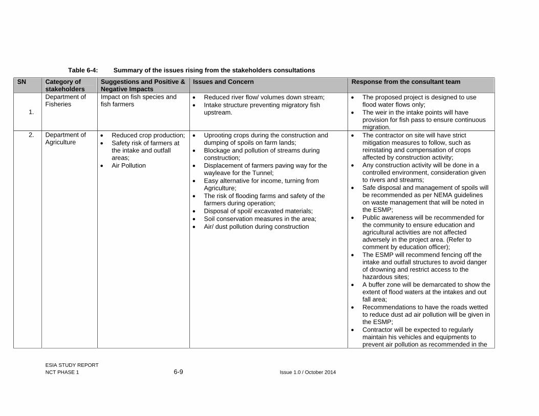
ESIA STUDY REPORT NCT PHASE 1 6-9 Issue 1.0 / October 2014
Table 6-4: Summary of the issues rising from the stakeholders consultations
SN Category of stakeholders
Suggestions and Positive & Negative Impacts
Issues and Concern Response from the consultant team
1.
Department of Fisheries
Impact on fish species and fish farmers
Reduced river flow/ volumes down stream; Intake structure preventing migratory fish
upstream.
The proposed project is designed to use flood water flows only;
The weir in the intake points will have provision for fish pass to ensure continuous migration.
2. Department of Agriculture
Reduced crop production; Safety risk of farmers at
the intake and outfall areas;
Air Pollution
Uprooting crops during the construction and dumping of spoils on farm lands;
Blockage and pollution of streams during construction;
Displacement of farmers paving way for the wayleave for the Tunnel;
Easy alternative for income, turning from Agriculture;
The risk of flooding farms and safety of the farmers during operation;
Disposal of spoil/ excavated materials; Soil conservation measures in the area; Air/ dust pollution during construction
The contractor on site will have strict mitigation measures to follow, such as reinstating and compensation of crops affected by construction activity;
Any construction activity will be done in a controlled environment, consideration given to rivers and streams;
Safe disposal and management of spoils will be recommended as per NEMA guidelines on waste management that will be noted in the ESMP;
Public awareness will be recommended for the community to ensure education and agricultural activities are not affected adversely in the project area. (Refer to comment by education officer);
The ESMP will recommend fencing off the intake and outfall structures to avoid danger of drowning and restrict access to the hazardous sites;
A buffer zone will be demarcated to show the extent of flood waters at the intakes and out fall area;
Recommendations to have the roads wetted to reduce dust ad air pollution will be given in the ESMP;
Contractor will be expected to regularly maintain his vehicles and equipments to prevent air pollution as recommended in the

ESIA STUDY REPORT NCT PHASE 1 6-10 Issue 1.0 / October 2014
SN Category of stakeholders
Suggestions and Positive & Negative Impacts
Issues and Concern Response from the consultant team
ESMP. 3. Department of
Health Increased eye infection
during construction; Increased STDs in the
area; Rise in cases of accidents
and incidents; Pollution of water through
disposal of waste and oil from construction equipment;
Increase in noise pollution at the construction sites;
Increased cases of unwanted pregnancies
Workers and public safety; Water and soil pollution during construction; Community health and increase in disease
prevalence and unwanted teenage pregnancies.
The ESMP will recommend the following as mitigation measures to the foreseen impacts including: Regular wetting of the grounds at the work
place; Contractor to ensure provision of condom
dispensers at the camps and work sites; Provision of PPE to the workers at all
working hours; Adequate installation of safety signage along
the road and work sites (site specific); Oiling and greasing of equipment should be
done far from water bodies in the area; ensure regular maintenance of vehicles and equipment;
Noise levels should be within the legal limits as per OSHA 2007, and NEMA guidelines;
Public awareness will be recommended for the community to ensure control and curbing teenage promiscuity.
4. Department of Social Development
Employment opportunities and job creation;
Increased sale in crop production especially food products from farmers;
Increased activities related to trading due to availability of markets;
Increased school drop outs;
Teenage pregnancies; HIV/ AIDS increase; Damage to roads during
construction; Relocation of population
Impacts on education and the school system; Community/ public health; Community development- infrastructure; Conservation and tree planting in the area; Loss of land and assets
Recommendations taken into consideration from consultations are as follows: Public awareness will be done on risks of
STIS andHIV/AIDs; Information, Education and Communication
campaigns will be conducted by the contractors for constractors’ personnel and local communities;
The contractor should be discouraged and warned of any cases of child labour;
There will be training and sanctions for contractors to prevent illicit behaviour by workers;
All damaged roads will be reinstated during and after construction;

ESIA STUDY REPORT NCT PHASE 1 6-11 Issue 1.0 / October 2014
SN Category of stakeholders
Suggestions and Positive & Negative Impacts
Issues and Concern Response from the consultant team
and loss of land Alternative traffic arrangements will be set up where necessary to avoid accidents and reduce disruption of access for communities.
Proposed tree planting by AWSB should be done as a measure to sustain the environment;
The proposed NCT wayleave will be a controlled area that will have an aspect of co-ownership with the farmer, thus no relocation, houses and structures on ground within the wayleave will be compensated.
5. Deputy County Commissioner
Increased reliable water supply in the south of Muranga;
Damage to roads in the area.
Water supply to Muranga County; Road network- the contractor should signs an
agreement with the community to ensure that roads will be reinstated.
The recommendation given to have the contractor signs an agreement with the community to ensure that roads will be reinstated and or improved will be considered in the ESMP.
6. Forestry Department
Impact of felled exotic species in the project area
Reduced forest cover; and Loss of fuel wood used for economic importance
of the exotic tree species for fuel wood- Tea factories;
Loss of productivity land
All trees affected in the project area will be compensated as per the economic value of the tree products;
Ensure compensation for land is done correctly and fairly; involve local leaders in the exercise to ensure transparency and reduced conflicts.
7. Water Department
Reduced water flows down stream;
Disruption of ground water systems;
Vibrations due to underground work activities
Reduction of flows below the abstraction points in the three rivers hence affects other major abstractors down stream;
Disruption of ground water down stream affecting the lower sections of Muranga County;
Sound vibrations will affect human and livestock daily operations;
The proposed NCT will abstract the flood flow only and not the normal flows;
The proposed kick-back projects aim to mitigate the impact to the lower sections of the County;
The contractor implementing the proposed project will have technical engineers and equipment monitoring noise and vibration levels during construction.
8. Water Resources Management (WRMA)
Reduced water levels down stream that may lead to water conflicts between down stream
The current water flows during the dry season is below the proposed abstraction from the three rivers;
The source of livelihood will be affected due to
The proposed NCT will abstract the flood flow only and not the normal flows;
Recommendation taken into consideration are:

ESIA STUDY REPORT NCT PHASE 1 6-12 Issue 1.0 / October 2014
SN Category of stakeholders
Suggestions and Positive & Negative Impacts
Issues and Concern Response from the consultant team
users; Interference with the
ecological system; Catchment degradation
during construction- siltation down stream.
reduced water levels down stream; Introduce alternative water sourcing by the
community- such as rainwater harvesting; Siltation and turbidity increase due to
construction activities upstream; From the spot gauging equipment the three rivers
are below the proposed water levels to abstract at the moment (dry season);
AWSB could assist in conducting a Water Abstraction Survey to identify all abstractors along the Maragua River system.
Collaborate with the stakeholders in Water resource management such as WRMA, NEMA, WSPs, County Government, Min of Agriculture, Fisheries, Livestock and the community;
Control surface run off during construction; GIBB study team has had various
consultative forums with the departments to discuss the likely impacts and mitigation measures;
Ensure an ESIA is done pointing out all the ecological and environmental/ social impacts with mitigation measures given;
Put in infrastructure in place to reserve the flood water to use during dry spell (July- Sep and Dec- March);
Construction activities at the river intakes will have silt traps and sedimentation barriers- infrastructure that will arrest any silt down stream.
9. Department of Land
Increased land conflicts due to increased demand of land
Land disputes Recommendation on the land issues to be considered are: Boundary disputes are usually handled at the
Sub County Land Registrar office; Other land disputes will usually be
recommended to Court; Ensure that the land rates used in valuation
are up to date with the values on ground to ensure fairness in compensation.
10. Physical Planning Department
Future land/ wayleave conflicts in land use
Easement of the controlled land use area Recommendations considered from the consultations are: Ensure that the easement compensation
covers all the affected land parcels to ensure all people along the tunnel are aware of the limitations of controlled land use;
Ensure the proponent places permanent
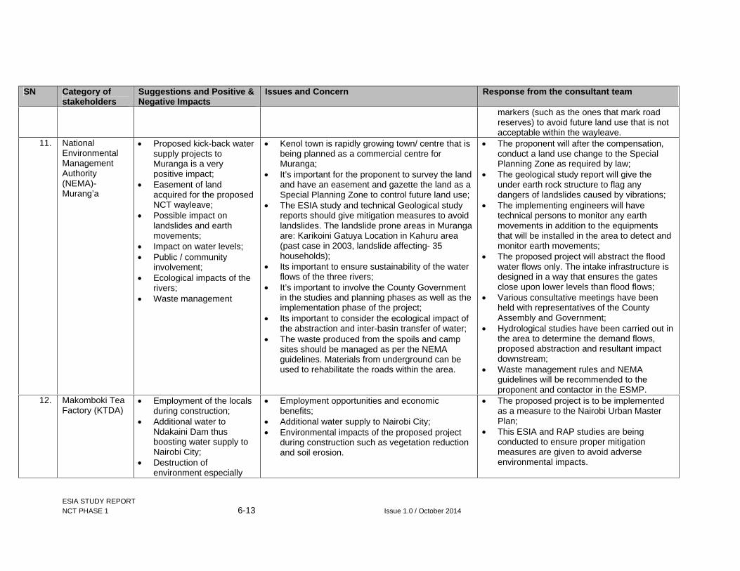
ESIA STUDY REPORT NCT PHASE 1 6-13 Issue 1.0 / October 2014
SN Category of stakeholders
Suggestions and Positive & Negative Impacts
Issues and Concern Response from the consultant team
markers (such as the ones that mark road reserves) to avoid future land use that is not acceptable within the wayleave.
11. National Environmental Management Authority (NEMA)-Murang’a
Proposed kick-back water supply projects to Muranga is a very positive impact;
Easement of land acquired for the proposed NCT wayleave;
Possible impact on landslides and earth movements;
Impact on water levels; Public / community
involvement; Ecological impacts of the
rivers; Waste management
Kenol town is rapidly growing town/ centre that is being planned as a commercial centre for Muranga;
It’s important for the proponent to survey the land and have an easement and gazette the land as a Special Planning Zone to control future land use;
The ESIA study and technical Geological study reports should give mitigation measures to avoid landslides. The landslide prone areas in Muranga are: Karikoini Gatuya Location in Kahuru area (past case in 2003, landslide affecting- 35 households);
Its important to ensure sustainability of the water flows of the three rivers;
It’s important to involve the County Government in the studies and planning phases as well as the implementation phase of the project;
Its important to consider the ecological impact of the abstraction and inter-basin transfer of water;
The waste produced from the spoils and camp sites should be managed as per the NEMA guidelines. Materials from underground can be used to rehabilitate the roads within the area.
The proponent will after the compensation, conduct a land use change to the Special Planning Zone as required by law;
The geological study report will give the under earth rock structure to flag any dangers of landslides caused by vibrations;
The implementing engineers will have technical persons to monitor any earth movements in addition to the equipments that will be installed in the area to detect and monitor earth movements;
The proposed project will abstract the flood water flows only. The intake infrastructure is designed in a way that ensures the gates close upon lower levels than flood flows;
Various consultative meetings have been held with representatives of the County Assembly and Government;
Hydrological studies have been carried out in the area to determine the demand flows, proposed abstraction and resultant impact downstream;
Waste management rules and NEMA guidelines will be recommended to the proponent and contactor in the ESMP.
12. Makomboki Tea Factory (KTDA)
Employment of the locals during construction;
Additional water to Ndakaini Dam thus boosting water supply to Nairobi City;
Destruction of environment especially
Employment opportunities and economic benefits;
Additional water supply to Nairobi City; Environmental impacts of the proposed project
during construction such as vegetation reduction and soil erosion.
The proposed project is to be implemented as a measure to the Nairobi Urban Master Plan;
This ESIA and RAP studies are being conducted to ensure proper mitigation measures are given to avoid adverse environmental impacts.

ESIA STUDY REPORT NCT PHASE 1 6-14 Issue 1.0 / October 2014
SN Category of stakeholders
Suggestions and Positive & Negative Impacts
Issues and Concern Response from the consultant team
trees in the area 13. Muranga Water
and Sanitation Company (MUWASCo)
Employment of the youth; Improvements of roads in
the area;
The youth of the area will have employment opportunities that will come with the proposed project;
Infrastructure improvement
Comments were noted
14. Gatamathi/ Kahuti Water and Sanitation Company
Employment of the youth The youth of the area will have employment opportunities that will come with the proposed project
Comments noted
15. Maragua Water Users Association
Employment opportunities;
The flow of water to users downstream will reduce.
Increase of employment of the community members;
Business will increase in the centres around the areas in Kangema and Kigumo Sub Counties;
Reduced water levels downstream. Ensure the water levels are maintained so as not to affect the downstream users;
The current flows fort the three rivers is okay at the moment.
The proposed project will abstract the flood water flows only. The intake infrastructure is designed in a way that ensures the gates close upon lower levels than flood flows;
16. KenGen Effect of abstraction upstream on Wanjii and Mesco HEP stations;
Reduced water levels and impact on the cascades downstream in Tana River;
Impact of fish species upstream
Impact of over abstraction as observed in Thika (Ndula Hydro- Power Station), were the station had to be closed down due to over abstraction;
Concern is the sustainability aspect of the proposed development in the entire region as more developments are planned along the Maragua river system;
Impact of migratory aquatic species upstream with the intake infrastructure in place;
KenGen has plans to raise the Masinga Dam by 1.5m, thus adding storage, the preferred option of the Maragua project would be the dam to ensure storage of flood water during high rainfall season;
The proposed NCT will be abstracting flood flow water in the three rivers, therefore the normal base flow will continue down stream;
The intake infrastructure is designed in a way that ensures the gates close upon lower levels than flood flows ;
Its important to involve all stakeholders in the planning of any water use development in the region, that will inform such stakeholders as KenGen on the sustainability of their operations;
The proposed designs of the intake structures has a provision of ‘fish ladders’ that allow fish to migrate upwards and down stream
17. Tana Water Services Board
Water conflicts due to decreased water levels;
Issues of water rights and usage between Nairobi and Muranga. It is important to limit conflicts
The proposed NCT will be abstracting flood flow water in the three rivers, therefore the

ESIA STUDY REPORT NCT PHASE 1 6-15 Issue 1.0 / October 2014
SN Category of stakeholders
Suggestions and Positive & Negative Impacts
Issues and Concern Response from the consultant team
Catchment protection and conservation;
Impact of blasting and excavation underground;
Dumping of spoils on farms;
Social impact s during construction
between the two Counties by ensuring that water is abstracted during the wet season (flood flow) and ensure that the abstraction is automated;
Propose a joint operation of the NCT with local water service providers to supply water and ensure water supply to the upper catchment community;
The possibility of increased sexual activities that are illegal in the area
normal base flow will continue down stream; The intake infrastructure is designed in a way
that ensures the gates close upon lower levels than flood flows;
Catchment management by AWSB will be highly recommended during the construction and operation phases of the proposed project;
All construction activities will be under controlled environment to avoid impacts of blasting and irregular excavation vibrations;
Spoil sites have been identified and will be compensated accordingly for use during construction;
Public sensitization will be recommended to be done in the area y the proponent and the contractor both at the Contractors camp and local shopping centres;

ESIA STUDY REPORT NCT PHASE 1 6-16 Issue 1.0 / October 2014
6.5 Consultations with Project Beneficiaries
The ESIA study team held consultative meetings with the project beneficiaries of the Northern Collector Tunnel- Phase 1 during the full study stage.
The aims and objectives of consultation at this level were to inform, collect data on capacity analysis and comments on the project proposed by AWSB. These Water Service Providers include the following:
Mavoko Water and Sewerage Company; Kiambu Water and Sewerage Company; Ruiru- Juja Water and Sewerage Company; Karuri Water and Sanitation Company; Kikuyu Water Company; Oloolaiser Water and Sewerage Company; and Nairobi Water and Sewerage Company
The out put of the consultations are given in Table 6-5 below:

ESIA STUDY REPORT NCT PHASE 1 6-17 Issue 1.0 / October 2014
Table 6-5: Summary of capacities of the different Water Service Prov iders (Project Beneficiaries)
No. Bulk Water Service Provider
Area of Coverage Main Sources of Water Capacity (Supply and Demand Volumes)
Remark/ Comments
1. Nairobi Water and Sewerage Company (NCW&SC)
Nairobi City County
NCW&SC is also responsible for the operation of Thika dam and the existing Ngethu-Gigiri-Kabete lines and associated water works
Thika dam Sasumua dam and Kikuyu springs
The current supply capacity is about 540,000m3/d against a demand of about 650,000m3/d. the demand is projected to increase to 790,000m3/d by the year 2019 (excluding demand by Mavoko W&S company).
Areas that are served from Kabete reservoir and which are likely to benefit from the increased supply include Kabete, Westlands, State House road, Ngong road, Karen Dagoretti, Eastleigh, Ngara and Parklands. Supply to these areas is currently rationed to a serious extent.
The project is in line with the country’s vision 2030 and will partly contribute to poverty eradication and improved sanitation standards from enhanced water supplies
Without commensurate development of trunk sewer infrastructure in the city, incidences of sewer bursts and overflows will increase affecting the environment negatively.
Project may lure students out of school threby affecting local area education
Experience with Thika Dam shows the need to have some real benefits for the local community in the immediate vicinity of the project area even after payments for compensation. This was

ESIA STUDY REPORT NCT PHASE 1 6-18 Issue 1.0 / October 2014
No. Bulk Water Service Provider
Area of Coverage Main Sources of Water Capacity (Supply and Demand Volumes)
Remark/ Comments
lacking in Thika dam and up to date, the immediate community feel cheated.
2. Mavoko Water and Sewerage Company (MAVWASCo)
This WSP supplies a total area of 697 square kilometres, including:
Utawala area; Syokimau; Githunguri- Utawala; Joska area; Mlologno; Lukenya; Athi River Town; Nzoiani; Kyumbi; Konza and Kapiti area; Kitengela
The main sources of water are:
Nairobi Bulk Water supply (60%); Portland dam (35%); Boreholes (5%).
The current capacities and supply volumes are:
Supply: -6000m3
per day; Demand: -
25000m3 per day; Projected demand
in 5 years: - 70000m3 per day due to upcoming estates, learning institutions and industries.
The proposed project will therefore be of great value to the growing demand in the area. With the increase in water supply, there is need to develop and upgrade the sewer system of towns surrounding the City of Nairobi.
3. Kiambu Water and Sewerage Company (KIWASCo)
The Areas covered by the WSP in Kiambu are:
Kamiti area; Ting’ang’a areas; Kiambu Town; Kiambu Institute of
Science and Technology (KIST);
Kanunga; Thindigwa; and Kiamundi
The main sources of water are Nairobi bulk water supply and 12 boreholes in the following areas:
Four (4) yield being 20 - 25m3/ hour covering:
Kiambu Town; Thathini Estate; Kangoya Estate.
Four (4) yield 5- 10m3/ hour, covering:
Satelite area; Kangoya (upper) Primary;
The total bulk supply of the Nairobi Water is 3000m3 per day.
The total yield of the boreholes is 1500m3 per day.
Total supply is 4500m3 per day.
The current demand is 13000 m3 per day.
The mitigation measure in place to share the limited water supply is through rationing (one and three week schedules depending on the area);
Biggest challenge in operation is the cost of energy in the pumping of water.
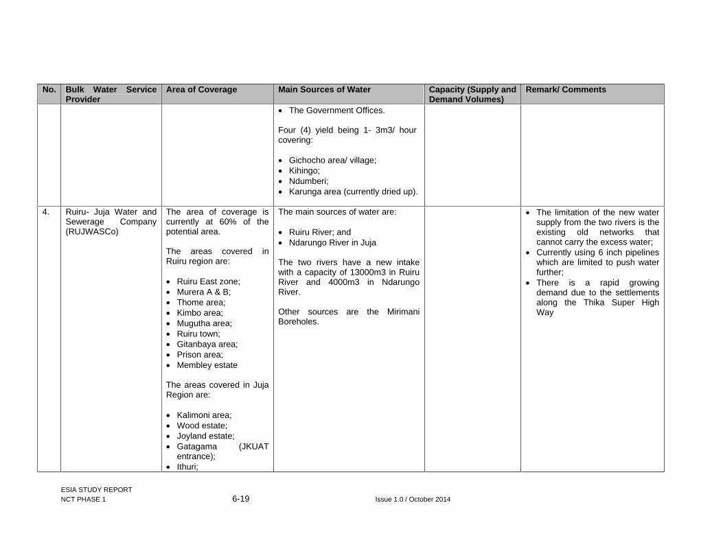
ESIA STUDY REPORT NCT PHASE 1 6-19 Issue 1.0 / October 2014
No. Bulk Water Service Provider
Area of Coverage Main Sources of Water Capacity (Supply and Demand Volumes)
Remark/ Comments
The Government Offices.
Four (4) yield being 1- 3m3/ hour covering:
Gichocho area/ village; Kihingo; Ndumberi; Karunga area (currently dried up).
4. Ruiru- Juja Water and Sewerage Company (RUJWASCo)
The area of coverage is currently at 60% of the potential area.
The areas covered in Ruiru region are:
Ruiru East zone; Murera A & B; Thome area; Kimbo area; Mugutha area; Ruiru town; Gitanbaya area; Prison area; Membley estate
The areas covered in Juja Region are:
Kalimoni area; Wood estate; Joyland estate; Gatagama (JKUAT
entrance); Ithuri;
The main sources of water are:
Ruiru River; and Ndarungo River in Juja
The two rivers have a new intake with a capacity of 13000m3 in Ruiru River and 4000m3 in Ndarungo River.
Other sources are the Mirimani Boreholes.
The limitation of the new water supply from the two rivers is the existing old networks that cannot carry the excess water;
Currently using 6 inch pipelines which are limited to push water further;
There is a rapid growing demand due to the settlements along the Thika Super High Way

ESIA STUDY REPORT NCT PHASE 1 6-20 Issue 1.0 / October 2014
No. Bulk Water Service Provider
Area of Coverage Main Sources of Water Capacity (Supply and Demand Volumes)
Remark/ Comments
High point; Gachororo; Kenyatta Road A &B; Kanini estate; Greenfield estate; and Milimani borehole
(beyond JKUAT).
5. Karuri Water and Sewerage Company (KAWASCo)
The WSP covers areas in the formerly known areas in Karuri Town Council, including:
Karuri Ward; Muchata Ward; Ndenderu Ward; Kihara Ward; Cianda Ward.
The main sources of water are boreholes and bulk water supply off-takes from the Sasumua lines to Nairobi.
The boreholes are located in different areas in Kiambaa Sub- County, Kiambu County, supplying areas including:
1no in Wagutho Location; 1no in Kimuga Location; 2no in Karura Location; 2no in Karuri Location; 1no in Ruaka Sub Location; 1no in Gacharage Sub Location; 1no in Ndenderu Sub Location.
Other main sources are off-takes from the Sasumua line including the following connections:
1no Ruaka connection (bulk); 1no Muchatha connection (bulk); 1no Wagutho off- take (bulk); 1no Gachie off-take (bulk); and 1no Njoro off-take (bulk).
The volumes produced in average from the two sources are:
Boreholes- 35611m3/ month;
Bulk off-takes- 54494m3/ month
Total supply is 90105m3 per month or 3000m3 per day.
The current demand in the area of coverage is 11000m3 per day.
Largest demand areas are: Karuri, Muchatha, Ndenderu and Ruaka areas.
The major challenge in operations is the cost of pumping water from boreholes in to storage tanks.
The NCT water supply project is very much welcome and are eager to get additional allocations due to the capacity gap.
6. Kikuyu Water Company Areas of coverage Main sources are 13 boreholes The current capacities The proposed NCT will increase

ESIA STUDY REPORT NCT PHASE 1 6-21 Issue 1.0 / October 2014
No. Bulk Water Service Provider
Area of Coverage Main Sources of Water Capacity (Supply and Demand Volumes)
Remark/ Comments
includes areas in Kikuyu and Kabete Sub Counties
of the boreholes are 4500m3 per day
The current demand is at 27000m3 per day.
water supply to Nairobi but not to Kikuyu which is in dire need of gravity water. The cost of pumping water to Kikuyu town is a burden to operations. The additional water supply should be followed by improvement of Waste water management system. The contractor should reinstate the environment in Kangema and Kigumo after construction completion.
7. Oloosaiser Water and Sewerage Company
The areas of coverage is within the greater Kajiado North Sub County, covering areas 716 km2, including areas such as:
Ngong and Ol’ Rongai areas, including:
Kiserian; Lemelepo; Ngong; Nkaimurunya; Olchooronyore; Olkari; Oloolua; and Ongata Rongai
Locaitons.
The main sources of water are Kiserian dam, Mbagathi River intake and several boreholes.
The company has three independent schemes, including:
Ongata Rongai served by River Mbagathi intake;
Kiserian and parts of Rongai served by 5no boreholes and springs;
Ngong town served by 8no boreholes and 1no spring;
Kiserian served by Kiserian Dam
The current capacities in the area are:
Supply service capacity on average is 6500m3 per day;
Projected demand is 26418m3 per day
Increased assured supply of quality and quantities to meet the current demands; The supply from the NCT will bridge the water supply/ demand deficit;

ESIA STUDY REPORT NCT PHASE 1 6-22 Issue 1.0 / October 2014
6.6 Focus Group Discussions Meetings
A total of five (5) Focus Group Community meetings were conducted with the Project Affected Persons (PAPs) in Kangema and Kigumo Sub Counties, three in each Sub County. The objectives of these meetings were to:
Understand how land is managed within the community; Understand the roles of the different community levels (Elders, Women and Youth
groups); and to understand how Culture and natural resources seen as of importance to the community
The venues of the meetings for discussions were in Ichichii Chief’s Camp and Makomboki Chief’s Camp in Kangema and Kigumo Sub Counties respectively.
The following sections give a summary of the issues raised in the meetings.
6.6.1 Employment Opportunities
Youths from the project area complained of lack of employment. They lamented that the government lacked proper plans to involve the youths. They complained that there were some youth who had university degrees and without jobs in the area. They blamed the lack of jobs to lack of skills being matched to the job market.
The youth wanted to know if employees would be sourced from outside the catchment area whereas there were youth who were capable of doing the work. They suggested that the youth coming from the area be given first priority in all the available opportunities.
Members of the discussion meeting from the FDG- Youth wanted to know the conditions for employment and if the workers would receive an insurance policy.
The study team responded by informing that insurance cover for all workers was provided for under the occupational health and safety act and thus all he workers were entitled to one. The terms and conditions of work however were dependent on the contract that the workers would sign with the contractors.
6.6.2 Alcoholism among the youth
Alcoholism among the youth was also cited as a challenge in the area. The vice has caused destruction of the social structure through disruption of families in the area. Although alcoholism is the major form of drug abuse other forms exist but in isolation. This is for example the abuse of bhang.
6.6.3 Road networks in the project area
Roads in the area are not in the best condition at present, the youth were concerned that further destruction would occur during construction of the tunnel. The youth are said to be the main road users especially because of the ‘bodaboda’ transport business and would therefore be most affected in the event the roads were destroyed.
6.6.4 Land Ownership in the area
Elders from the project area informed the FDG discussions that there are two main ways of land ownership. These are:
Freehold-Mainly inherited from ancestors; and Tea plots- Owned by the County Government
ESIA STUDY REPORT NCT PHASE 1 6-23 Issue 1.0 / October 2014
Discussions from the Elders brought out issues of ownership, noting that succession was not a major occurrence in the area. Most of the land was still in the name of their forefathers. However land transfers were common especially when land was sold.
The elders noted that it is important for the valuer to categorise the assets on the ground as they may be owned by someone different from the title holder (land owner).
Members from Elders- FDGs wanted the compensation to focus on both the property owner and the affected parcel of land. Some members suggested on listing all the beneficiaries of compensation especially those that were of legal age to avoid family feuds over compensation.
The Study team explained that GIBB Africa would take the records of all the project affected persons, however the issue on compensation would have to be solved by individual families in conjunction with the local administration.
Family issues pertaining to land ownership also plagues the youth. Most of them complained that their parents had not given them a way forward with regards to land succession. They therefore wanted to know how the compensation will be done to avoid feuds.
The study team noted the concerns and informed the youth FDG of the need to have a family consensus during compensation administration to avoid the problems that may arise due to compensation.
During the Women FDGs in the area, the study team probed on the entitlement of women to land succession in the community. It was established from the meeting that culturally women were not entitled to land succession with the exception of women who were not married or in instances where the father wished to share his land to his daughters.
6.6.5 Social impacts of compensation
During the Elders FDGs, the study team probed on the appropriate proposals to compensation to avoid the occurrence of the noted problems during compensation, such as family feuds and conflict. Members agreed that the most appropriate method would be to go through the local administration in case the issue was not solved at family level. The chief was given the responsibility of summoning members with disputes and solving problems arising from compensation.
The organization structure for conflict resolution that was agreed upon by the members is as follows.
The chief will receive the cheques of all members to be compensated at his office. Family members who have agreed among themselves on how to divide the compensation will be given the cheques by the chief.
If there is a problem on division of money between family members the chief will withhold the cheque. The chief will act as a mediator to solve the conflict.
Depending on the agreement and solution reached upon by the conflicting family, the chief will write to the bank to advice on how to divide the money among the beneficiaries.
Concerns were raised over the historical social impacts during the compensation for land during the development of the Ndakaini/ Thika Dam. The youth of the area felt that with the older generation holding on to land documents and not carrying on with succession, the youth will be left without land or control of development on it after compensation of the NCT. This is in connection to the compensation process during the construction of the Dam that led many youths without land, prior to succession.
The study team responded to the concern, noting that the family should discuss any land ownership and compensation issues before administering the compensation. The youths

ESIA STUDY REPORT NCT PHASE 1 6-24 Issue 1.0 / October 2014
suggested that it is important to hold civil education events to inform the community of the expectations during the compensation process and after, i.e. from one village to another.
The elders’ discussions noted that it is important for the proponent to disclose the compensation/ valuation roll to the property owners before any development on the wayleave. It is best to communicate this through the local administration (Chiefs and Ass. Chiefs before going to the public, adding that the administration are trusted and well representative of the community in all affected locations.
From elder’s discussions it was noted that conflicts may occur during the period of compensation. Suggestions were given in that grievance mechanism should be through the local administration, PAPs representatives from all locations affected and professionals, both local and outside the area.
In general, the participants were informed that the study team was also undertaking a specific study on RAP in line with WB guidelines. The RAP includes census of PAPs, entitlement matrix, summary of consultations, identification of grivience resolution mechanism and disclusres of RAP findings and implementation plan.
6.6.6 Youth Groups in the project area
In Ichichii and Makomboki Locations, the youth members of the community informed the FDG meeting of several youth groups that are in existence in the area. These include:
Youth Group Function1. Abadere youth group Cares for the disabled and does livestock
keeping. 2. Makomboki United Football Youth
Group Raises conservation awareness through
sports 3. Ichichi Youth bunge Transport 4. Digital youth group Livestock keeping5. Rumathi Self Help Group in Gatura
Village, Makomboki Location Livestock keeping for milk production
6. Duika focus for youth development Self-help group 7. Ichichi FC Raises awareness through sports 8. Umoja self-help group Rabbit keeping 9. Joy farmers youth group Planting fruit and tree seedlings, raising
awareness on environmental issues 10. Mercy corp Financial support through loans 11. Gabu foundation Supports community projects 12. Ahadi Kenya Anti-jiggers campaign
The youth of Ichichii gave proposals for support to boost their functions and develop their mandate in the community. The study team informed the members that youth groups are important as they provide an easy avenue for contact and involvement. He therefore encouraged the youth to join youth groups. The proponent will be given the community needs and suggestions given so as to have means of interaction with the community.
6.6.7 Intrusion of new people in the area
Some members of the various FDGs felt that insecurity would deteriorate as a result of the development and construction of the Northern Collector Tunnel. The influx of new people would have different social impacts such as mixture of culture, increase in insecurity cases and school dropouts increasing due to easy money.
The ESMP in the ESIA and RAP study reports have mitigation measures that have to be followed by the identified Contractor as well as the Proponent to adhere to.

ESIA STUDY REPORT NCT PHASE 1 6-25 Issue 1.0 / October 2014
6.6.8 Lack of Health Facilities
Discussions from the Women FDGs raised concerns over the number of health facilities in the area, noting that in some areas far from town centres, women have to travel long distances up- hill to access health care facilities, especially maternity services. The women of Ichichii and Makomboki proposed for the health facility to be better equipped.
The project contractor will construct a clinic with at least three female wards and provide at least two ambulances within the project area. This will not only serve the workers but also the local community and will be run for the benefit of the locals after the construction of the project is completed.
6.6.9 Education institutions in the project area
Discussions from various FDGs (Elders, Women and Youuth) raised concerns over the distances covered by pupils and students in the area. The home to school distance remains far for most pupils. Some pupils travel as far as 3 km to school. This makes the students tired and lack concentration in class.
6.6.10 Communication network in the area
Concerns over the network jamming in the area due to limited telecommunication infrastructure were raised in the various FDGs across the community. Communication is poor in the area, especially Safaricom network due to the limited boosters in the area. The youth, especially, want communication improved.
6.6.11 Community roles
From the various FDGs in the project area, it was noted that in the community the roles of men and women are distinct. They each have the following functions. The summary of roles is as given below:
Men Women Head of the family Cooking for the family Provides security for the family Milking cows Tea farming Preparing kids for school Dairy Farming Transporting milk to the dairy Pruning Tea Farming
Washing cloths Looking for firewood
From the Elder’s FDGs, it was also noted that according to the Agikuyu culture women are supposed to be hardworking and active in the shamba. It was considered against the norm for a woman who is not involved with activities in the shamba.
6.6.12 Community perception of economic ability
During the Elder’s and Women FDGs the study team probed on the factors that the community used as indicators of economic ability. The members gave the following factors
The size of the shamba; The number of livestock; The number of women one has; The produce (vegetation) that one has from their shamba; and The type of houses one has i.e. what materials have been used to make the house.

ESIA STUDY REPORT NCT PHASE 1 6-26 Issue 1.0 / October 2014
6.6.13 Grave sites
The study team probed on to understanding how the community bury their dead culturally. Members from the Elders’ FDGs noted that most people buried their dead in homesteads. It was noted that there was a grave site that belonged to the county council in the area but people seldom buried their dead there. This was mainly due to the cultural beliefs carried by the community.
The study team probed on to understand; in the unfortunate occurrence that during construction some grave sites happened to be affected. Members responded that culturally death was a feared subject and in some instances regarded as a taboo to talk about it. They said that relocation of burial sites was a thing that was unheard of and suggested that incase the construction of the tunnel affected a grave site then the design of the tunnel should be changed to avoid it.
Members from the FDGs suggested that in a case of an affected grave site, the affected families should be approached on a case by case scenario and a favourable decision arrived upon consultatively, among the family or clan. Howewever, the study team noted that since the tunnel will be between 15 to 215m underground, no impacts on graves are anticipated. Further, shallow earthworks are planned at/near rivers where chances of encountering graves are very slim.
6.6.14 Cultural sites in the area
The study team probed the various FDGs on the locations or presence of various Cultural sites in the area within Kangema and Kigumo. The members of the discussions noted that most of the cultural sites are close to or inside to forest, such sites are:
Karia ka mbari ya hiti: - which is a crator lake believed to have been created by a bomb in the First World War in the 20th Century. The lake/ water body was used for cultural events, located in Tutho. The lake is a preserved heritage site;Catholic Shrine in Tutho: - This is a shrine built by the Catholics in start of the 18th
Century (1700s).
However, neither of the two cultural sites will be affected by the NCT1 but may be affected by future tunnel developments to north Mathioya River.
The community was emphatic that any foreigner coming to the area with relation to the proposed NCT1 should respect the cultural significant sites in the area, including the Mugumo trees which are present in the project area in Kangema and Kigumo Sub Counties.
Ecological survey also established presence of Mugumo tree, Ficus thoningii in the project area. Plants of conservation significance on site will be identified by site environmentalist with assistance of locals and when encountered, these will be avoided as far as feasible as recommended in the ESMP.

ESIA STUDY REPORT NCT PHASE 1 6-27 Issue 1.0 / October 2014
6.7 Public Meeting Consultations
A total of 6 public community meetings were held along the project area in Kangema to Kigumo Sub Counties, with the help of the local administration. The breakdown of the meetings held is as shown in Table 6-6.
Table 6-6: Breakdown of Public meetings held during the ESIA and RAP stage
No. Location Date Time Venue Kangema Sub County 1. Ichichii and Karura Monday, 11th August, 2014 2.00 PM Ichichii Chief’s
Camp 2. Kiruri Tuesday, 12th August, 2014 2.00 PM Kiruri Chief’s
Camp Kigumo Sub County 3. Makomboki/
Kandenderu Wednesday, 13th August, 2014
10.00 AM Makomboki Chief’s Camp
4. Kangari/ Mairi Wednesday, 13th August, 2014
2.00 PM Mairi Shopping Centre
5. Kinyona Thursday, 14th August, 2014 10.00 AM AP- Line/ Kinyona Dispensary
6. Gacharage Thursday, 14th August, 2014 2.00 PM Gikigie Primary School
6.7.1 Objective of Public Consultation Meetings
Public consultative meetings were held in the six locations, listed above, along the project area. The objectives of these meetings were as follows:
Awareness creation about the project to the community with respect to scope of the project; stakeholders of the project; development approach to be employed in the project; roles and responsibilities of the community and other stakeholders and role of GIBB Africa Ltd. in the project;
Informing the community about the anticipated project management structure in relation to effective project operation;
Setting and agreeing on the Cut- Off dates for the Resettlement Action Planning; Describing the Project foot- print from intake in Kiruri Location to the outfall in
Makomboki Location in Kangema and Kigumo Sub County respectively; Explaining to the community on the different activities the study team will be
undertaking in the RAP studies and further; explaining the communities role in the exercises thereof including the documentation required during the census and valuation activities;
Informing the community on the environmental and social impacts of the project will be addressed;
Getting feedback from the communities on their views on the project and issues of concern;
Inclusion of the community in the development of the project at the planning stage;
6.7.2 Comments from the Consultations
A summary of the comments on the Northern Collector Tunnel- Phase 1 project raised from the public meeting is presented in the following sections. Minutes for the public meetings are presented in Appendix VI of this report.

ESIA STUDY REPORT NCT PHASE 1 6-28 Issue 1.0 / October 2014
(a) Abstracting water used by community
The community raised concerns over the abstraction of water from their area to serve people in Nairobi. They noted that several water users of the river who might be impacted. The study team informed the meetings, noting that hydrological study, currently being undertaken to determine water usage, demand and current flows in relation to what is to be proposed to be abstracted.
The study team further noted that the proposed water to be abstracted from the three rivers was flood flow only and not the normal or low flows. These intakes are designed in a manner to automatically shut/ close when acceptable flows are reached. This will ensure that the downstream users continue with using the water from the three rivers.
The community was also taken through the water projects that Athi Water Services Board (AWSB) has proposed for the project area especially the downstream areas such as: Kiharu, Kenol and Kandara.
(b) Social impacts of alien persons in the area
The community noted that previous Contractors who were undertaking constructions did a lot of social evils in the area as a result of them interacting with the locals, they were keen to know how this proposed project will ensure this will not happen again.
Response to this concern was that the Environmental and Social Monitoring and Management Plan (ESMMP) will be developed to act as a check for the required best practice and this will propose for a monitoring plan that will have to be strictly adhered to.
(c) Grievance mechanisms during and after Compensation
The community raised concerns over the conflicts over the transactions during the compensation period noting that it is important to create a committee from the community to settle any issues that would arise in the process of compensation.
The study team noted that after the studies will have been done, a committee for grievance solutions and implementation will be formed in close consultation with the local administration and Project Affected Persons (PAPs).
(d) Waste management
The community raised concerns over the management of the Cut-to-spoil that will come from the rock beneath. The asked on whether the marram could be used on the feeder roads to improve the road network. They noted that it is important not to dump the spoils in people’s shambas.
It was communicated to the community that there are areas of cut-to- spoil that have been identified, but in case the waste is usable for example on road development, they will be used
(e) Road destruction due to heavy equipment
The community raised issues on the impact of heavy trucks and equipments being carried on the existing road network in Kangema and Kigumo within the project area during construction. They noted that the roads are very important to the community as they use them to transport their tea.
The contractor will ensure the roads are maintained in proper condition and alternative traffic arrangements are made when necessary.

ESIA STUDY REPORT NCT PHASE 1 6-29 Issue 1.0 / October 2014
(f) Possible earth movement and faults
The community raised concerns over underground activities and impacts such as creation of a fault line after earthquakes (in case it happens). Muranga is a highly land slide prone area. the community had concerns over the vibration under the earth (soil layer) and the impact on the steep slopes of Kangema and Kigumo along the Tea belt.
A geological study, still under way, will determine the underlying rock structure and the possibility of a landslide due to vibration or cracks/ fault lines within the area. this will be communicated to the residence of the near by areas for safety purposes. In addition, the construction team will have a technical geologist to monitor the movements of the earth. The proponent will install monitoring equipment on the ground, sensitive to the movement of the earth so as to monitor the possibility of landslides or faults/ cracks.
(g) Interruption of school activities
Concerns were raised over the fact that construction might interrupt schooling and education activities in the area.
It was noted that consultations have been conducted with Education Stakeholders and they also noted that the schools could be impacted by the construction so the camp site will be located far from residential areas.
(h) Possible minerals underground
The community raised concerns over the possibility of the proponent finding or discovering Oil or such important minerals underneath a farmer’s land. They asked on whether the farmer will be paid for the resources underground and whether the co-ownership will restrict him being paid compensation by the extractors of the oil.
The study team noted that in such a case, the people who will be responsible for extraction of such resources will communicate with the community of the developments and intended plans. The proponent of the NCT is interested in the construction and operation of the tunnel.
(i) Relocation
The community raised the issue of forceful relocation from the top of the Tunnel. The Study team responded by informing the meetings that the project follows World Bank standards as well as the letter of the Law of the Land. Forceful relocation cannot be considered at this project, the reason we are conducting the RAP is to identify, inform and collect concerns from those affected.
The proposed tunnel may cross through Makomboki Secondary Schools in Makomboki Location according to the initial walk through by the study team; will that lead to the relocation of the education institution?
In case of any resettlement whatsoever, the right and legal procedure will be adhered to for the same. There will be proper communication on the specific affected parcels after the survey. The full details of resettlement and compensation is defined in the RAP reports.
(j) Mediators and crooks during the Compensation process
It is important that the proponent (AWSB) to ensure that all payments or transactions on the given parcels to be done directly to the owner and/ or the administrator of the land at the time of compensation. The community does not want any crooks that will come in the name of broking or mediating between AWSB and the land owner.
No mediators will be given the authority by the client to conduct any activity for either the compensation or other processes during the project. To ensure transparency during the
ESIA STUDY REPORT NCT PHASE 1 6-30 Issue 1.0 / October 2014
process, identification documents will be taken and given to the PAPs in the affected land parcels.
Only the names on the list to be generated after the survey will be compensated, depending on the calculated costs. The community leaders including chiefs, elders, and headmen will accompany the enumerators for order of work. The mechanism of compensation and entitlement matrix will be publicly disclosed.
(k) Absentee PAPs
The community requested to know how those members of the public whose land or property is within the proposed wayleave for acquisition will be reached for details.
The relatives, community and the local administration were requested to pass information to the persons who they know have been affected to be available on their property on the day of assessment. The community requested that absentee farmers be represented by their family members, neighbours or the village elder who have to sign an agreement on the administration of the compensation payment.
(l) Possible flooding/ damage due to excess water
The community raised concerns of the possibility of flooding at the Githika River due to the excess water added by the Tunnel. The excess water may cause damage to crops and possibly cause injury or fatality in the case of children in the area.
The hydrologist did a study at the proposed outfall site and the land parcels likely to be affected by the overflowing water will hence be compensated for i.e. a buffer zone will be identified and safety precaution taken into account.
The community also raised the concern of whether the proponent will build/ construct a wall to prevent the back flow of water at the outfall as it enters the Thika Dam.
No wall will be constructed or erected; there will be proper construction of weir at the outfall area. To prevent soil erosion, gabions will be constructed.
(m) Land use and acquisition of the wayleave above the Tunnel
The community raised the issue of future land use on top of the NCT; noting that the tunnel may require a controlled land use. They were particularly concerned with the restrictions of the type of land use activity and structures, asking whether the wayleave will restrict farming activities.
Can the proponent develop a map showing the tunnel and the affected parcels in the area, from the beginning to the end? The study team will give the maps once the parcels are identified and super imposed on the land parcels from the beginning to the end of the tunnel.
The compensation makes the land parcels to be co-owned by the client and the owner thus any restrictions on the land use will be clarified by the client only after the study but farming is not one of the activities that are likely to be restricted in the area identified.
The community also raised clarification on the width of the Tunnel and the wayleave on the surface. The study team clarified the concern noting that the width is 3m along the tunnel. The proponent is considering co-ownership with the farmer/ land owner, therefore the co-owner can use the land, but in a controlled manner.
(n) Cut- Off dates
The community asked the study team of the intention of the cut- off dates and asked whether only the enumerated and valued structures as well as parcels affected will be compensated after the cut- off dates.

ESIA STUDY REPORT NCT PHASE 1 6-31 Issue 1.0 / October 2014
The cut-off date is the determinant of the assets and crops or trees to be compensated. The intention of the cut off dates is to limit the continued development of the land parcels affected by the Tunnel. The Valuer will only value the assets on the ground in between the dates agreed upon at the public meeting.
(o) Direct benefits from the NCT-Phase 1
The community raised the proposal that the areas between Kiruri and Makomboki should gain in one way or the other during construction and operation phases of the Tunnel. Some of the benefits proposed are:
Improvement of education facilities in the area; Improvement on the roads; especially after the construction period is over by
reinstating and improving on the existing situation. Examples given were: the bridge at Kiarurumo- Ichichii Road, connecting roads of Kangari- Kinyona, Kinyona- Njambini Road (19km) that would open the area to Nyahururu areas;
Providing employment opportunities at the construction and operation phases to the locals of the area;
Supporting the proposed water supply project development to Kiruri Location (Gatagwagwo Water Project) from the Ciainya River;
To assist in building the Wangii Tea buying Center in Kiruri Location; Improving the health centre at Kinyona with clinical supplies and equipment; Assistance in finishing construction of the Bishop Gatimu Girls Secondary School in
Kinyona; and the Improvement of the electricity coverage in the area.
The proposed support projects to the community in the project area were noted and were given to the proponent. It was noted that the road networks in the area is directly correlated with the livelihoods of the community in the area; this is because they use the roads to deliver tea, which is a major cash crop in the area. Priority should be placed on the improvement of roads.
(p) Health and Safety concerns during construction and operation
The community raised the issues of health risks of the persons/ workers working inside the Tunnel during construction. The safety of our youths is key and we would like an assurance of not being in danger while working under in the tunnel.
The contractor given the work to implement will have stringent Health and Safety rules to adhere to as a work place, both at the Contractor’s camp and inside the tunnel as well as any other facility being built in the area. The proponent (AWSB) will have the responsibility to monitor and evaluate the activities of the contractor during construction. This will be to mitigate the risks identified by the ESMP in the ESIA and RAP study.
(q) Community Conserving the Aberdare Forest
The community noted that the people settled in the upper zone, at the base of the forest, are important to the conservation of the catchment. The community requested the proponent (AWSB) to support the community initiatives and cooperation during the operation of the NCT so as to ensure sustainability of the supply of water from the water tower.
The study team as well as the client representatives in the public meetings responded to the request. The community conserving the forest along the edge of the forest are indeed important as they play a crucial role to the sustainability of the hydrological system that affects many people all over the Country. Proposals to cooperate and support the community activities will be considered.

ESIA STUDY REPORT NCT PHASE 1 6-32 Issue 1.0 / October 2014
6.8 Public Disclosure
A stakeholders’ workshop was held on Thursday, 2 October, 2014 at Nokras Hotel, Murang’a Town. During this workshop, findings, conclusions and recommendations of ESIA report and findings of RAP socioeconomic survey were disclosed to stakeholders and the public and their comments received. Representation at the workshop and proceedings are discussed as follows.
6.8.1 Stakeholders Represented at the Workshop
Stakeholders represented in the workshop included, but not limited to the following.
Table 6-7: Stakeholders represented during the Workshop
No. Stakeholder Representatives1. Ministry of Water, Environment
and Natural Resources Rep of Permanent Secretary- Ministry
2. Water Service Regulatory Board Chief Executive Officer 3. Athi Water Services Board Chairman;
Chief Executive Officer; Technical Managers; Senior Project Engineers; Environmentalist.
4. Tana Water Services Board Technical Manager (PSM). 5. Water Resources Management
Authority Sub Regional Manager; Service Water Officers (Monitoring and
Water Rights). 6. Nairobi City County Government Chief Officer Water, Energy and Natural
Resources 7. Development Partners Senior Water Resource Specialist- World
Bank Environmental Specialist- World Bank; Senior Specialist -Agence Francais de
Development (AfD) 8. Member of Parliament Personal Assistant to the MP Hon. Kangata
Personal Assistant to the MP Hon. Kariuki 9. Vision 2030 Secretariat Director 10. County Government of Muranga Members of the County Assembly (Kinyona
and Kanyanyaini Wards; C.E.C Infrastructure; C.E.C Water Environment and Natural
Resources and Tourism. 11. Ministry of Interior and
Coordination of National Government
County Commissioner- Muranga; Deputy County Commissioners- Muranga; Assistant County Commissioner- Kangari; Assistant County Commissioner- Kigumo; Chiefs and Ass. Chiefs from Kiruri, Ichichii,
Gacharage, Kinyona, Mairi, Kangari, Makomoki Locations
12. Water Services Providers Muranga South Water and Sanitation Company;
Muranga Water and Sanitation Company; Kahuti Water & Sanitation Company; Gatamathi Water And Sanitation Company; Gatanga Community Water Scheme

ESIA STUDY REPORT NCT PHASE 1 6-33 Issue 1.0 / October 2014
No. Stakeholder Representatives Nairobi City Water and Sewerage Company
Limited; Ruiru-Juja Water and Sewerage Co Ltd.; Kiambu Water and Sewerage Co Ltd.
(KIWASCO); Karuri Water and Sanitation Co Ltd.
(KAWASCO); Mavoko Water & Sewerage Company
(MAVWASCO); Oloolaiser Water and Sewerage Company; Kikuyu Water Co Ltd.
13. Project Affected Persons (Community Representatives)
Community members from Kiruri, Ichichii, Gacharage, Kinyona, Mairi, Kangari, Makomoki Locations
14. Project Design Engineer SMEC Consultants 15. Project Environmental Study Team GIBB Africa 16. Church Representatives Reverend from ACC&S Churches 17. Kenya Tea Development Authority Officers from Makomboki and Gacharage
Tea Factory 18. Ministry Departmental
Representatives Department Heads of key ministries in
Muranga County 19. Kenya Rural Roads Authority
(KeRRA) Representative Officers
Register of the stakeholders represented in the workshop are attached in Appendix VI of this report.
6.8.2 Comments from the Opening and Closing Sessions
The disclosure workshop was programmed in a manner to inform the participants of the study findings from the Environment and Social Impact Assessment (ESIA) Study. Various speeches were read as an introduction. Table 6-8 gives the summary of issues brought out by the different speakers in the opening and closing sessions from the different speakers.
Table 6-8: Summary of issues in the opening and Closing Remarks
No. Stakeholder Remark1. ENG MALAQUEN MILGO: -Chief
Executive Officer Athi Water Services Board
Described the Project components and its location;
AWSB’s commitment to environmental and social management of the impacts of NCT including:
o Compliance with the provisions of EMCA 1999 as well as World Bank’s environmental and social safeguards;
o Partnership with relevant agencies for catchment protection;
o Local community benefits including hand-over of infrastructure at the end of the project and development of a community water project in the project area;
o Management of resettlement impacts through a resettlement action plan (RAP)4;
o Recognition of the importance of the

ESIA STUDY REPORT NCT PHASE 1 6-34 Issue 1.0 / October 2014
No. Stakeholder Remarkdisclosure workshop as a platform for the team to receive feedback from the affected community and stakeholders;
o Appreciation of support from development partners and Murang’a County Government and the participation of stakeholders in general.
2. Eng. Robert Gakubia: - Chief Executive officer, Water Services Regulatory Board (WASREB)
Environmental issues take a long time to manifest hence it is important to conduct ESIA so as to identify the impacts early enough and plan to manage them;
He recognized AWSB’s commitment to stakeholder engagement. He urged Athi Water to adequately consult the County Government of Muranga to ensure smooth handover of the proposed facilities to the County Government.
3. Eng. Michael Ngari: -Chief Officer Water, Energy and Natural Resources; Nairobi City County Government
The Project was not just for Nairobi but for the good of the people in Murang’a;
Its important to remember the lessons learnt from Ndakaini Dam which led to the need for development of a community water supply for Murang’a.
4. Dr. Rafik Hirji: -World Bank The NCT project is important for Kenya, Nairobi and 13 Satellite towns, and local communities who will all benefit from new additional water supplies and related benefits;
The ESIA is important to provide data, information and knowledge for informed decision making on the design and operations and environmental management of the project;
It is intended to open up the project planning and design decision making process;
Preliminary environmental issues were reviewed at the Master Plan Level but the ESIA is expected to provide details on these issues;
The project aims to benefit not only the end users of water, but also more importantly, the communities around the project site.
5. Mr. Remy Fritsch: -Agence Francais de Development (AfD)
AfD has been investing in the existing water system in Nairobi;
It is important to minimize the impacts of the project on the environment.
6. Peter Kungu: -Chairman AWSB Board
Water sources for Nairobi are in Murang’a, Nyandarua and Kiambu Counties hence the need for collaboration with the National Government to protect these sources;
AWSB is committed to dialogue for healthy discussions and feedback to inspire progress for the good of all stakeholders.
7. Eng. Kuria Gatere: -Representing Principal Secretary (PS), Ministry of Environment, Water and Natural
The Ministry has a mandate to develop water resources in a sustainable manner;
The Ministry has put the necessary

ESIA STUDY REPORT NCT PHASE 1 6-35 Issue 1.0 / October 2014
No. Stakeholder RemarkResources mechanisms to monitor the implementation
of this project 8. Hon. Charles Mwangi: -MCA
Kinyona Ward, Murang’a County Article 43 of the Constitution gives everyone
the right to water; he therefore stated that the people of Murang’a cannot deny any citizen of the country water.
He informed the meeting that there are issues that the County representatives have identified including:
(1) Potential increase in production of tea, which can be addressed by partnership of the county with the tea factories to produce electricity through Ndakaini Dam;
(2) Request to include the road network in the area (28km) into the project for improvements; (3) re-assurance from WRMA (chairman trade and industries Muranga County Assembly) that the project will not affect the proposed County bulk company: irrigation, domestic and export to Machakos;
(4) Domestic water supply in muranga county is only 33%, expect increase to 70% from the project as informed by AWSB. However, this percentage does not cover people of upper Kangema, Kigumo and Gatanga (communities adjacent to the weirs and upstream that do not have water).
(5) Consider people from these 4-5 wards for employment by the project, including capacity building and technical education; It is important to have capacity building programmes for PAPs to educate the community of the financial impacts of compensation and effect on livelihood; this was in reference to cases in Guchugu and Ndakaini,in terms of financial literacy. (6) expressed county’s commitment of planting over 20million trees to the 4 areas upstream with socio-economic benefits e.g. fruit trees: avocado, macadamia; the proponent should look at supporting the communities on the upper areas of Kangema, Kigumo and Gatanga who protect and conserve the water catchment areas. Currently water supply to the area is limited due to intakes being built at lower levels in altitude, limiting the gravitation of water supply.. He also informed the meeting that WRUAs and schools can assist in these projects.
9. Ms. Kula Hache: -County Commissioner, Muranga County
AWSB to extend benefits to the local community;
Youth and women should be empowered so that they can conserve catchment areas and the forests which will keep them busy and reduce crime.
The ESIA team engaged stakeholder to the grassroots level and hopes that the feedback from these groups was taken seriously, adding that she urges attendees to

ESIA STUDY REPORT NCT PHASE 1 6-36 Issue 1.0 / October 2014
No. Stakeholder Remarkparticipate actively;
10. Hon. Peter Kirungi– MCA, Kanyenyaini Ward and Leader of Majority in Muranga County Assembly
He recognized that they are proud that Muranga is a custodian of one of the biggest resources– the water tower;
It is very important to support Nairobi, it is equally important that water as a resource should benefit the local community;
People at the source live at the highest point thus unable to access water; therefore there is a need for another project in the upper reaches of the project area to supply water to these communities;
There is need to maintain the forest, by planting indigenous trees inside the forest. The project should provide support to the community next to the forest to facilitate catchment management.
11. Eng. Amos Njoroge, C.E.C Infrastructure, Murang’a County Government
Murang’a has one million people within the sub-counties and five water companies. The correct position is 38% coverage of water supply in Murang’a County.
He appreciated the proposals of water projects to the County in Murang’a and Gatanga Water Supply Projects coming to about one billion shillings;
There is a need for AWSB to meet at the County Offices to ensure that the coverage is good;
He requested that riparian rights for people downstream also be considered and Q95 to be confirmed by the team to avoid pressures on the scarce resource;
Environmental conservation is also paramount to ensure that programs are set up and run for sustainability for resource use;
Waste (spoils) from the tunnel excavation be given to the County to be used in upgrading the roads in Murang’a;
The issue of abstraction rights was well articulated. However, on development of infrastructure he wished that more specific information is provided to avoid duplication of allocation of funds for their development by the County Government;
Compensation is a critical issue and has also been well articulated; he noted that the findings from the RAP are disclosed at community level to avoid protracted grievances after compensation in the event of accidental damage.
12. Hon. Muiruri Maina, C.E.C Water Environment and Natural Resources and Tourism, Muranga County Government
Gave apologies from the Governor, noting that he felt that the two Executives can handle the matters arising and can represent him accordingly;
He urged the project to take into account all the issues that are raised with honesty; the RAP implementation process should

ESIA STUDY REPORT NCT PHASE 1 6-37 Issue 1.0 / October 2014
No. Stakeholder Remarktherefore be handled in a transparent manner;
There is need for environmental management programs including tree planting, improvements to sewerage and solid waste management.
6.8.3 Comments from the stakeholders after the Plenary Session
Following the plenary session, with the different presentations from various study team members, the following is a summary of comments and responses from the community representatives in the workshop.
Table 6-9: Summary of comments and responses from the community representatives in the workshop
No. Question/ Comments Response1. Daniel Githu Mboi from Ichichii Location: (PAP).
Lives in Kikuyu but the land identified as a spoil site belongs to him. The piece of land you saw is mine. If it is used negatively it should be returned in its original state. Land rates should be based on demand and supply. What is the compensation formula? Has it been discussed with the people concerned?
Anastasia Ngatti: The compensation will be conducted at full replacement cost based on market rates. The Resettlement Action Plan (not discussed during this consultative session) contains the full details on compensation, eligibility and schedule.
2. Josephat Rukenya (Kinyona Location).
This is a wonderful project as the people in Nairobi are our brothers and sisters. The meeting has been informed that they will take flood flow. However, the flood flow is not enough as it is required here in Muranga. The intake for a proposed 149m/s downstream of the project area. There is also another project which will rely on the same flood flow. There are also some operational projects that require water. There is a fear that there will not be any flood flow for irrigation in the County for the projects in the pipeline.
He has been to Lesotho where people have harvested water from the mountains and are selling it to South Africa. He proposes that AWSB consider damming at the Aberdares for water supply so that the water can be released during the flood.
Dr Nyanganga: The project is not taking all the flood flow as the project will leave other levels of flood from the river. He assured the meeting that compared to the maximum flood levels what the project is taking is negligible.
G Owuor: the study also proposed more stringent ecological requirements to ensure that water is not only available for human environment but also for aquatic life.
Eng. Muiruri called the attention of the meeting to the high levels of awareness on this project. This was because of the depth of consultations that started with the feasibility studies of Maragua dam. The decision making process was therefore long before they could get to this alternative of the tunnel. He assured the meeting that the project is not expected to have any long term impacts on the project area. The mandate of AWSB will also include Gaturi in terms of water supply hence
3. Rose Njine -Gaturi Ward Representative
She stated that Muranga County is in dire need of water and was worried that diversion of water by the project would result in loss of water supply for future needs. She inquired on the feasibility study findings and whether it confirmed that there would be no significant impact on downstream users. She inquired whether AWSB could tap water instead of drilling as this could lead to drying of wells. She proposed alternatives water sources such as rain water harvesting. She
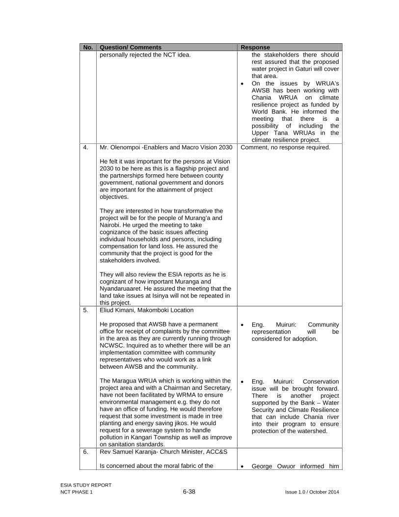
ESIA STUDY REPORT NCT PHASE 1 6-38 Issue 1.0 / October 2014
No. Question/ Comments Responsepersonally rejected the NCT idea. the stakeholders there should
rest assured that the proposed water project in Gaturi will cover that area.
On the issues by WRUA’s AWSB has been working with Chania WRUA on climate resilience project as funded by World Bank. He informed the meeting that there is a possibility of including the Upper Tana WRUAs in the climate resilience project.
4. Mr. Olenompoi -Enablers and Macro Vision 2030
He felt it was important for the persons at Vision 2030 to be here as this is a flagship project and the partnerships formed here between county government, national government and donors are important for the attainment of project objectives.
They are interested in how transformative the project will be for the people of Murang’a and Nairobi. He urged the meeting to take cognizance of the basic issues affecting individual households and persons, including compensation for land loss. He assured the community that the project is good for the stakeholders involved.
They will also review the ESIA reports as he is cognizant of how important Muranga and Nyandaruaaret. He assured the meeting that the land take issues at Isinya will not be repeated in this project.
Comment, no response required.
5. Eliud Kimani, Makomboki Location
He proposed that AWSB have a permanent office for receipt of complaints by the committee in the area as they are currently running through NCWSC. Inquired as to whether there will be an implementation committee with community representatives who would work as a link between AWSB and the community.
The Maragua WRUA which is working within the project area and with a Chairman and Secretary, have not been facilitated by WRMA to ensure environmental management e.g. they do not have an office of funding. He would therefore request that some investment is made in tree planting and energy saving jikos. He would request for a sewerage system to handle pollution in Kangari Township as well as improve on sanitation standards.
Eng. Muiruri: Community representation will be considered for adoption.
Eng. Muiruri: Conservation issue will be brought forward. There is another project supported by the Bank – Water Security and Climate Resilience that can include Chania river into their program to ensure protection of the watershed.
6. Rev Samuel Karanja- Church Minister, ACC&S
Is concerned about the moral fabric of the George Owuor informed him

ESIA STUDY REPORT NCT PHASE 1 6-39 Issue 1.0 / October 2014
No. Question/ Comments Responsecommunity therefore he proposes that the churches and NGOs be involved in managing that. He also proposed that the church be involved in dissemination of information in the community as they have a wider reach.
As the chairman of the education committee in the area, he proposes that criteria be put in place to ensure that school going children do not drop out of school in search of employment.. They have a population of students beyond 18 who may drop out to work since they have IDs.
He urged that the project should start planting trees the earliest time probable since trees takes a lot of time to mature.
He proposed construction of roads that would last longer as in the past; they wore out once the construction teams left the area.
that his request was noted and will be adopted. He said he will include in the report the recommendations that the church also be involved in the dissemination of information to the community.
George Owuor further informed him that the hiring criteria will be established to avoid distracting students from the ongoing studies and labour laws will be applied during construction phase.
George Owuor requested the Engineers present to listen to questions being raised on the quality of the roads and ensure during this project the poor quality will not be repeated.
7. Daniel Githu Mboi
Is there any likelihood of tapping from Kihotie River next to Gikigie River?
George Owuor: The proposed project is abstracting from Gikigie River in that area.
8. Peter Kariuki Njogu (County representative for people with disabilities)
Will most of the water go to Nairobi and other areas or it will also be used by the people of muranga?
As you involve other stakeholders, don’t forget people with disability.
Icharati ward has no water.
George Owuor: The abstracted water will be channelled to Kabete Reservoirs to serve Nairobi and the satellite towns due to the growing population and demand for water.
This was noted. GIBB collected contact information from Mr. Kariuki for further follow up.
To be covered under the community projects.
Detailed minutes of the workshop are attached in Appendix VI of this report.
6.9 Project Awareness and support
The implementation of the tunnel development will have a far reaching effect on the social life of the people living within and around the project area. The socio-economic study conducted before the stakeholders’ workshop assessed community perceptions and their views on the proposed project as expressed by the respondents.
In assessing the community’s awareness of the proposed project, a majority of the persons within the project area noted that they were aware of it. This category of persons accounted for 81.95% of the surveyed population as shown in Table 6-10 below.

ESIA STUDY REPORT NCT PHASE 1 6-40 Issue 1.0 / October 2014
Table 6-10: Community project awareness
Aware of project Percentage response
Yes 81.95
No 18.05
Total 100.00
Of the surveyed population who noted that they were aware of the project, 40.60% got the information from their friends and neighbours. Another 26.32% got their information from government officials as presented in Table 6-11 below.
Table 6-11: Sources of information
Source of information Percentage response
Friends / Neighbours 40.60
Government officials 26.32
No answer 16.54
ESIA / RAP study 15.79
Media 0.75
Total 100.00
6.9.1 Project support
94.74% of members of the community support the project while only 5.26% of the community does not support the project as illustrated in Table 6-12. More than half of the surveyed population noted that the project will affect their operations as shown below.
Table 6-12: Project support and impact
Project support Project impact
Support Project Percentage response
Impact on current operations
Percentage response
Yes 94.74 No 69.92
No 5.26 Yes 30.08
Total 100.00 Total 100.00
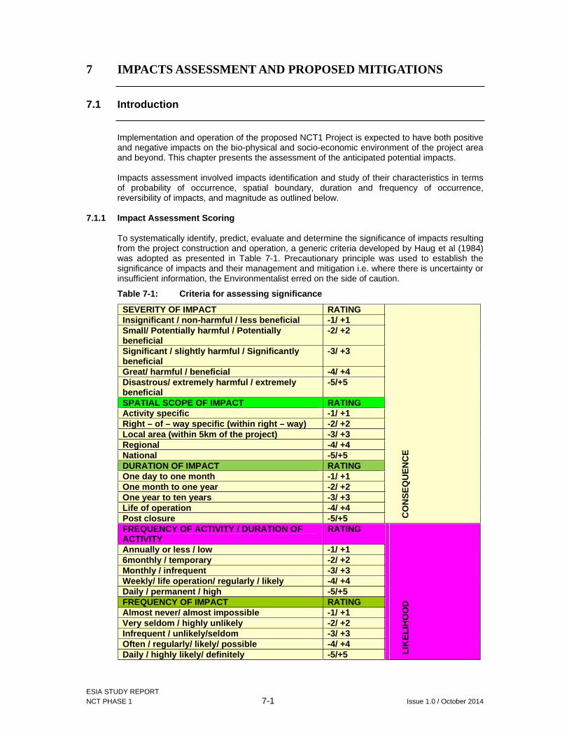
ESIA STUDY REPORT NCT PHASE 1 7-1 Issue 1.0 / October 2014
7 IMPACTS ASSESSMENT AND PROPOSED MITIGATIONS
7.1 Introduction
Implementation and operation of the proposed NCT1 Project is expected to have both positive and negative impacts on the bio-physical and socio-economic environment of the project area and beyond. This chapter presents the assessment of the anticipated potential impacts.
Impacts assessment involved impacts identification and study of their characteristics in terms of probability of occurrence, spatial boundary, duration and frequency of occurrence, reversibility of impacts, and magnitude as outlined below.
7.1.1 Impact Assessment Scoring
To systematically identify, predict, evaluate and determine the significance of impacts resulting from the project construction and operation, a generic criteria developed by Haug et al (1984) was adopted as presented in Table 7-1. Precautionary principle was used to establish the significance of impacts and their management and mitigation i.e. where there is uncertainty or insufficient information, the Environmentalist erred on the side of caution.
Table 7-1: Criteria for assessing significance
SEVERITY OF IMPACT RATING
CO
NS
EQ
UE
NC
E
Insignificant / non-harmful / less beneficial -1/ +1Small/ Potentially harmful / Potentially beneficial
-2/ +2
Significant / slightly harmful / Significantly beneficial
-3/ +3
Great/ harmful / beneficial -4/ +4Disastrous/ extremely harmful / extremely beneficial
-5/+5
SPATIAL SCOPE OF IMPACT RATINGActivity specific -1/ +1Right – of – way specific (within right – way) -2/ +2Local area (within 5km of the project) -3/ +3Regional -4/ +4National -5/+5DURATION OF IMPACT RATINGOne day to one month -1/ +1One month to one year -2/ +2One year to ten years -3/ +3Life of operation -4/ +4Post closure -5/+5FREQUENCY OF ACTIVITY / DURATION OF ACTIVITY
RATING
LIK
ELI
HO
OD
Annually or less / low -1/ +16monthly / temporary -2/ +2Monthly / infrequent -3/ +3Weekly/ life operation/ regularly / likely -4/ +4Daily / permanent / high -5/+5FREQUENCY OF IMPACT RATINGAlmost never/ almost impossible -1/ +1Very seldom / highly unlikely -2/ +2Infrequent / unlikely/seldom -3/ +3Often / regularly/ likely/ possible -4/ +4Daily / highly likely/ definitely -5/+5

ESIA STUDY REPORT NCT PHASE 1 7-2 Issue 1.0 / October 2014
Table 7-2: Significance rating matrix
CONSEQUENCE (Severity+ Spatial Scope + Duration)
LIK
ELI
HO
OD
(Fre
quen
cy o
f act
ivity
+
Fre
quen
cy o
f im
pac
t)
1 2 3 4 5 6 7 8 9 10 11 12 13 14 15 2 4 6 8 10 12 14 16 18 20 22 24 26 28 30 3 6 9 12 15 18 21 24 27 30 33 36 39 42 45 4 8 12 16 20 24 28 32 36 40 44 48 52 56 60 5 10 15 20 25 30 35 40 45 50 55 60 65 70 75 6 12 18 24 30 36 42 48 54 60 66 72 78 84 90 7 14 21 28 35 42 49 56 63 70 77 84 91 98 105 8 16 24 32 40 48 56 64 72 80 88 96 104 112 120 9 18 27 36 45 54 63 72 81 90 99 108 117 126 135 10 20 30 40 50 60 70 80 90 100 110 120 130 140 150
Table 7-3: Mitigation ratings
Significance Ratings
Value Negative Impact Management Recommendation
Positive Impact Management Recommendation
Very High 126-150 Improve proposed management Maintain proposed management High 101-125 Improve proposed management Maintain proposed management Medium - High 76-100 Improve proposed management Maintain proposed management Low - Medium 51-75 Maintain proposed management Improve proposed management Low 26-50 Maintain proposed management Improve proposed managementVery low 1-25 Maintain proposed management Improve proposed management
The following is a detailed assessment of impacts anticipated to stem from implementation of Project. The proposed NCT Phase 1 is expected to have significant positive and negative impacts on the bio-physical and socio-economic environment of the project area. Below is a discussion of some of the potential impacts that will emanate from implementation of the NCT Phase 1 Project.
7.2 Positive Construction Impacts
Anticipated positive impacts from implementation of the NCT1 project will include but not limited to:
7.2.1 Employment and economic opportunities
The construction phase of NCT1 will require direct recruitment of significant numbers of people to work with the contractor (s). This will include both skilled and unskilled labour that will be engaged for about 40 months. Man hours to be provided by non technical staff alone have been estimated at 4,100 hours. Indirect economic opportunities will also be created through persons selling different wares to the construction staff domestic requirements. These will improve economic situation in the project area and temporarily reduce unemployment levels.
It is projected that there will also be an influx of new people into the project area in search for employment. An increase in population of this magnitude will create a corresponding increase in demand for goods and services such as food for construction workers, housing, healthcare and need for transport. These needs will be satisfied by people living within the project area where local women will provide food vending services, homes will rent out accommodation spaces for the new population and shops will also benefit from increase of sales. All these avenues are bound to create new employment opportunities.

ESIA STUDY REPORT NCT PHASE 1 7-3 Issue 1.0 / October 2014
Impact Analysis Matrix
Impact without Mitigation Severity of impact +4Spatial scope of impact +5Duration of impact +4Frequency of activity / duration of activity +5Frequency of impact +5Result +130 Very High
The proponent should emphasize the use of local unskilled labour by any engaged contractor as far as feasible to enhance benefits for the local population.
Recommendations
All construction workers should be employed and remunerated in accordance with the provisions of Kenyan labour laws and best international practices as contained in ILO and IFC Performance Standard 2: Labour and Working Conditions;
Capacity building and training of men, women and youth on specialised labour that will be required during construction;
Gender mainstreaming should be implemented during the recruitment process of workers to work in the construction process;
Spreading projects administrative units such as Contractors and Resident Engineers camps to areas that are not going to benefit directly from the construction works so as to facilitate distribution of economic activities;
Inclusion of availability of jobs for the project and process for recruitment into the communications plan; and
Establishment of a strong quota system of allocation of jobs for persons living in the projects primary zone of impact, secondary zone of impacts and other immigrant workers.
7.2.2 Improved infrastructure
NCT1 project design has proposed improvement of local access roads, associated bridges and new short roads to project work areas as part of enabling works for the purposes of executing the project. These will be an advantage to the locals as they will have improved transport and communication networks. Transportation of tea from the farms to the tea buying centres and factories will especially benefit and KTDA will for sometime incur lower cost in maintenance of roads in the project area. Transportation of timber from the project area will also be made easier with access to heavier trucks to the area made possible with improved roads.
Impact Analysis Matrix
Impact without Mitigation Severity of impact +3Spatial scope of impact +3Duration of impact +3Frequency of activity / duration of activity +3Frequency of impact +5Result + 72 Low - Medium
Recommendation
Over and above the above noted benefits it is proposed that the contractor in liaison with the Chiefs and KTDA management in the project area identify roads that require upgrading and then embark on the exercise of their improvement where feasible;
Where necessary, traffic management plan should be developed together with alternative arrangements / divesions; and

ESIA STUDY REPORT NCT PHASE 1 7-4 Issue 1.0 / October 2014
AWSB should ensure that the concerned roads are also maintained throughout the construction period and any damages are made good before the contractor demobilises from site.
7.2.3 Development of marketing opportunities
Implementing the project will create increased demand for various construction equipment/plants and materials input including cement, reinforcement iron bars, fine and course aggregates etc. These will translate into expanded market for suppliers of the inputs at national and international levels. Though limited to construction period, the expanded market will have increased economic benefits to participating traders and associated government tax revenues.
Additionally, the development of a camp site by the contractor for the resident engineer, his workers and himself will increase population and settlement within these sites thus facilitating growth of urban centres. This will benefit the local community in the following ways:
Development and increase in food market. The campers in the above mentioned sites will require supply of food making accessories and food, which will need to be supplied by the local residents;
Increase requirement for construction materials which the contractor might source from the local hardware’s;
Develop the real estate market as the workers working at the construction site will need accommodation that will have to be provided by the local community;
Impact Analysis Matrix
Impact without Mitigation Severity of impact +4Spatial scope of impact +5Duration of impact +2Frequency of activity / duration of activity +4Frequency of impact +4Result +88 Medium - High
Recommendations
To facilitate growth of existing urban centres the camp site will need to be located at a considerable distance far away from them in order to spur growth; and
AWSB in collaboration with the local administration can facilitate the development of a police post next to the outposts to increase security thus encouraging investments and settlements.
7.2.4 Desirable Social Change
During construction phase it is anticipated that influx of some immigrants from diverse cultures into the project area will occur for the new employment and trade opportunities created. It is anticipated that there will be cultural exchange which will lead to adoption of new ways of life, such as: changes in ways of clothing; social interactions between the new members and members of the community; and introduction of new beneficial ideas. The construction camp will also be transferred to the community after the end of the construction period.
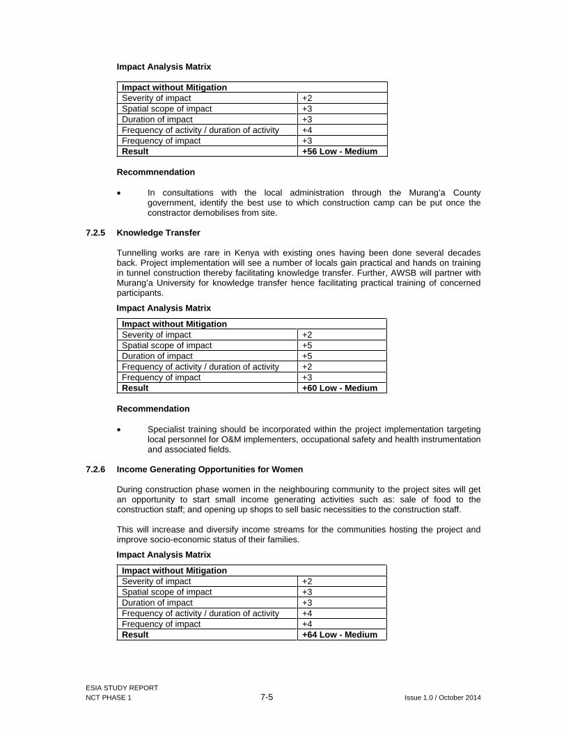
ESIA STUDY REPORT NCT PHASE 1 7-5 Issue 1.0 / October 2014
Impact Analysis Matrix
Impact without Mitigation Severity of impact +2Spatial scope of impact +3Duration of impact +3Frequency of activity / duration of activity +4Frequency of impact +3Result +56 Low - Medium
Recommnendation
In consultations with the local administration through the Murang’a County government, identify the best use to which construction camp can be put once the constractor demobilises from site.
7.2.5 Knowledge Transfer
Tunnelling works are rare in Kenya with existing ones having been done several decades back. Project implementation will see a number of locals gain practical and hands on training in tunnel construction thereby facilitating knowledge transfer. Further, AWSB will partner with Murang’a University for knowledge transfer hence facilitating practical training of concerned participants.
Impact Analysis Matrix
Impact without Mitigation Severity of impact +2Spatial scope of impact +5Duration of impact +5Frequency of activity / duration of activity +2Frequency of impact +3Result +60 Low - Medium
Recommendation
Specialist training should be incorporated within the project implementation targeting local personnel for O&M implementers, occupational safety and health instrumentation and associated fields.
7.2.6 Income Generating Opportunities for Women
During construction phase women in the neighbouring community to the project sites will get an opportunity to start small income generating activities such as: sale of food to the construction staff; and opening up shops to sell basic necessities to the construction staff.
This will increase and diversify income streams for the communities hosting the project and improve socio-economic status of their families.
Impact Analysis Matrix
Impact without Mitigation Severity of impact +2Spatial scope of impact +3Duration of impact +3Frequency of activity / duration of activity +4Frequency of impact +4Result +64 Low - Medium

ESIA STUDY REPORT NCT PHASE 1 7-6 Issue 1.0 / October 2014
Recommendations
It is recommended that the Contactor in each site develop catering services premises with cooking allocation and dining area for use by the service women mentioned above and their staff. The site will be dependent on the number of workers each construction site has;
It is proposed that potable water should be provided at the catering area through a Water Tank or stand pipe for sanitary purposes;
Women who want to participate be advised to get clearance from local Public Health offices; and
Sensitize participating women on sustainable use of firewood/charcoal undertake monitoring to avoid excessive tree cutting.

ESIA STUDY REPORT NCT PHASE 1 7-7 Issue 1.0 / October 2014
7.3 Negative Construction Impacts
The proposed project will be associated with a number of negative impacts including the following:
7.3.1 Loss of land and resettlement
The project will require land for construction of the wiers, shafts, inlet and outlet portals as well as the outfall. In addition to this, to maintain the integrity of the tunnel structure, any land uses likely to negatively impact the tunnel are prohibited. From discussions with the design engineer, these activities include sinking of boreholes, blasting and quarrying. To ensure that AWSB has total control of land uses above the proposed 11.8km tunnel, this report also proposes acquisition of a 3m wayleave above the tunnel alignment.
The total land take will translate to approximately 18.366 acres of which approximately 97.4% is private land under freehold tenure. As a result of this, a total of 177 households corresponding to 657 persons will be directly affected by the land take at household level while a total of 8 public facilities corresponding to 8 public institutions.
Ichichi Secondary School Dormitory building on top of the proposed section for the tunnel
Affected owner of a parcel of land next to Gikigie intake
Figure 7-1: Land loss and resettlement
The 177 households include 174 land and asset owners and 3 tenants while the affected institutions are:
Ichichi Secondary School; Ichichi community’s football pitch; Ichichi Primary School; Gikigie Primary School; Ngecha Tea Buying Centre; Makomboki Primary School; Makomboki Secondary School; and Bible Fellowship Church.
Land is a fundamental factor for production for the PAPs as majority (over 70%) identified in farming as their primary source of income. The land uses that directly support livelihood streams among the PAPs are:
Cultivation of cash crops such as tea and coffee; Cultivation of food crops for subsistence purposes;

ESIA STUDY REPORT NCT PHASE 1 7-8 Issue 1.0 / October 2014
Planting of exotic trees, including woodlots for sale of fuel to tea factories and / or timber for construction in Murang’a Town and Nairobi City.
One (1 no) business structure will also be affected by the land take for the project. This structure houses 2 businesses namely a small hotel and a retail shop, which form the primary source of income for these tenant households.
The housing structures affected by the land take for the project include permanent (29%) and semi-permanent (71%) structures. Prompt payment of compensation to these PAP Units is therefore critical to ensure restoration of housing conditions.
The key public assets affected include a dormitory, sanitation facilities and land set aside for future development of facilities. Majority of these institutions requested for in-kind compensation which would greatly assist in securing continued service provision by these institutions
Impact Analysis Matrix
Impact without Mitigation Severity of impact -4Spatial scope of impact -2Duration of impact -5Frequency of activity / duration of activity -5Frequency of impact -5Result -110 High
A Resettlement Action Plan Study was conducted for the project with active participation by the PAPs at household level and key stakeholders at county level. An extract of the proposed entitlement matrix developed under the RAP Report is presented in Appendix VIII of this report.
Recommendation
Implement the RAP to enable compensation payment and resettlement of PAPs prior to the contractor taking possession of any construction site.
7.3.2 Geological and seismic hazards
From reviews of baseline environment, the general project area is known for landslides. It is predisposed by its steep terrain, soil types and high rainfall. Construction activities especially portal earthworks and underground tunnelling which may at times deploy explosives may aggravate landslide hazards and also expose the project area to seismic hazards like tremors. Landslides may not only affect settlements and farms but may also affect the tunnel during the operation phase. Some severe damages including collapse of tunnel structures may occur in adverse situations.
However, from review of specialist geotechnical analysis conducted on the project area and application of best tunnel design standards, the project’s implementation is not anticipated to aggravate these hazards and the predicted impacts are hence rated as moderate.
In addition, Geotechnical monitoring will be undertaken through Excavation Performance Review (EPR) system to continuously monitor the Geotechnical stability during the construction phase using appropriate instrumentation. Monitoring instruments will be installed within the excavation and on structures in order that the design assumptions and design models can be verified. The monitoring system and the results obtained from it will provide an early indication if encountered conditions are more adverse than those assumed in the design. This will allow timely and appropriate modification of the construction method or proposed support system to be implemented.

ESIA STUDY REPORT NCT PHASE 1 7-9 Issue 1.0 / October 2014
The purpose of the EPR is to define any requirement for the implementation of a revised support arrangement for the underground works that is designed to prevent ongoing deformation. Three Trigger Levels shall apply during the tunnel excavation as follows:
Alert; Alarm; and Action.
The limiting measured rock displacements for each Trigger Level and each Excavation Class have been estimated within the design and the EPR procedure is summarised below.
EPR criteria Required actionTrigger level for instrumentation reached
When the recorded movements obtained from the deformation monitoring system reach the assigned trigger levels the EPR commences: 1. The Engineer shall be informed immediately; 2. The magnitude of observed deformation shall be checked; 3. The frequency of monitoring shall be increased as required; 4. An assessment/investigation of possible causes of exceedance undertaken; 5. Engineer and Contractor decide on the need for and extent of any modifications or action required; and 6. Ongoing review of excavation performance during and following implementation of any modifications and actions to confirm effectiveness.
Impact Analysis Matrix
Impact without Mitigation Severity of impact -5Spatial scope of impact -4Duration of impact -2Frequency of activity / duration of activity -1Frequency of impact -2Result -33 Low
Recommendations
In addition to the above measures, formulate an emergency communication plan for alerting the local community where the need arises. The plan should include community emergency trigger thresholds, clear protocol and roles for notification and follow-up actions.

ESIA STUDY REPORT NCT PHASE 1 7-10 Issue 1.0 / October 2014
7.3.3 Impacts on Soils
(a) Soil erosion and increased sedimentation
The hilly terrain and heavily weathered volcanic soils in the project area predisposes it to soils erosion. Major earthworks will take place before and during construction including: cutting new roads, repairs to existing roads; works at the intakes, outfall, adits and tunnel construction during the. Spoil materials from these activities will also be stockpiled in the locality either on hilltops or on their slopes. These are bound to result in significant amounts of loose soil materials prone to erosion through surface runoff, especially during rainy seasons.
The eroded materials and sediments from earthworks and stockpiled spoil may readily find their way into the numerous streams through surface run-off if not properly controlled. Unprecedented increase in sediment loads in the rivers can affect both riverine aquatic life and other uses (including downstream domestic usage and livestock watering) downstream the intake works areas. Though limited to construction period, the impacts could be amplified and recur even in post-construction period if new erosion susceptible areas are opened up.
Impact Analysis Matrix
Impact without Mitigation Severity of impact -3Spatial scope of impact -3Duration of impact -2Frequency of activity / duration of activity -2Frequency of impact -3Result -40 Low
Mitigation
Contractor must ensure clear delineation of construction work areas to avoid unnecessary vegetation clearance and soil loosening;
The contractor must implement planned erosion control measures to avoid erosion in areas that are prone to erosion, e.g. steep slopes and drainage lines;
Topsoil stockpiles will be vegetated to prevent erosion; No topsoil to be utilized during any construction activity; Implement soil conservation measures at stockpiled sites; Where feasible, topsoil must be reinstated and rehabilitated on top of sub soil; All excavation works must be properly backfilled and compacted; Ensure downstream water users are informed about any unprecedented
release of heavily silted water into the river; Where possible, construction activities should be scheduled to occur outside
of the rainy season, to reduce the anticipated volume of runoff during construction; and
Sediment traps and barriers must be employed due to steep terrain.
(b) Soil pollution
Construction will involve use of large fleet of machinery powered by fossil fuels and requiring regular maintenance with other hydrocarbon-based substances like oil, grease etc. Improper handling or accidental spillage of these is likely to result in pollution of any receiving soils. This will affect both biophysical and chemical properties of the soils rendering them unsuitable for agricultural production as currently practised.

ESIA STUDY REPORT NCT PHASE 1 7-11 Issue 1.0 / October 2014
Impact Analysis Matrix
Impact without Mitigation Severity of impact -3Spatial scope of impact -2Duration of impact -3Frequency of activity / duration of activity -4Frequency of impact -3Result -56 Low-Medium
Mitigation
No vehicle/plant maintenance shall take place on undesignated site. In case of emergency, a drip tray shall be used to avoid diesel and / or oil spills;
Concrete mixing shall not be done on bare soil. Concrete must be mixed on mortarboards, a large metal sheet or concrete slab. The slabs for concrete mixing shall be removed on completion of construction works;
Excavated material shall be stockpiled at a demarcated site, within the construction zone;
Once the construction activities have terminated, rehabilitation
(c) Soil compaction
Project construction activities like adits, intake works and portal earthworks, associated traffic especially the heavy trucks and earth movers within the project area will lead to compaction of the soil structure. The net result would be reduced percolative and infiltrative capacity of the soil leading to reduced soil-water balance in the affected soils. However, this is anticipated to affect mainly the intakes and outafall area and areas near adit locations.
Impact Analysis Matrix
Impact without Mitigation Severity of impact -2Spatial scope of impact -2Duration of impact -3Frequency of activity / duration of activity -3Frequency of impact -4Result -49 Low
Mitigation
Vehicles must be kept on existing/designated roads/tracks where possible; Minimize compaction during stockpiling by working the soil in the dry state; Rip compacted areas to reduce runoff and re-vegetate where required; All topsoil and other soil profiles must be managed strictly.
7.3.4 Pollution of (surface and ground) water resources
Apart from the project Target Rivers, many other small streams exist in the project area. During the construction, sediment from the earthworks, wet cement, detergents, paints and other chemicals, accidental oils and fuels spills and leaks from deployed equipment may find their way into the river through surface run-off if not properly controlled. This will contribute to degradation of the river water quality and may affect the downstream users negatively. At worst, most aquatic organisms may be affected.

ESIA STUDY REPORT NCT PHASE 1 7-12 Issue 1.0 / October 2014
Impact Analysis Matrix
Impact without Mitigation Severity of impact -4Spatial scope of impact -4Duration of impact -2Frequency of activity / duration of activity -3Frequency of impact -3Result -60 Low - Medium
Mitigation:
Implement Standard Operating Procedures (SOPs) for working in water, including checks on equipment condition (especially leaks of oils, fuel, hydraulics), refuelling protocols (at safe location away from water, availability of spill kits and knowledge of their use, and emergency spill procedures);
Any on site/camp storage areas for fuels, oils or other liquid chemicals would be sited away from surface water drains. They must have an impermeable base and bund with a capacity of 110% and would not drain directly into the surface water drains. Where practicable, drainage from storage compounds would be passed through oil interceptors prior to discharge;
Apply standard best practice site sediment control procedures (e.g. settling ponds and silt barriers) to minimise sediment in site drainage waters returning to the river;
Ensure all staff and workers are fully aware of the limits to the site for each activity, SOPs, and emergency procedures;
Ensure that all construction equipment and vehicles are serviced off site at licensed garages;
Any contaminated soil should be handled properly as hazardous waste and removed form site for safe disposal; and
Careful management of the sites and education of all construction staff would curtail the risk of pollution spills.
7.3.5 Changes in groundwater levels and flow
Tunnelling activities may lead to alterations of underground drainage and fracture flow. During the drilling, water inrushes may occur at fracture zones. Studies have shown that tunnels can lead to drying up of springs and streams leading to severe socio-economic and ecological effects such as the total disappearance of fish, amphibians and aquatic invertebrates in the dry stream sections. Several streams and rivers will be crossed by the tunnel (see section 3.1.4). However, no major fractures are anticipated and underground water is also not a major source of community water supply (only accounts for 2.26%).
Impact Analysis Matrix
Impact without Mitigation Severity of impact -2Spatial scope of impact -3Duration of impact -2Frequency of activity / duration of activity -2Frequency of impact -3Result -35 Low
Mitigation:
Any shallow wells and boreholes affected by the project will need to be re-established during the project operation; and
AWSB has proposed projects to supply piped water to the area covered by the project (see section 4.10).

ESIA STUDY REPORT NCT PHASE 1 7-13 Issue 1.0 / October 2014
7.3.6 Impacts from Construction camp
A construction camp for NCT Phase 1 has been proposed near Irati River intake at coordinates X= 259955, Y= 9917739 in Kinyona location, Kigumo sub-county. The land belongs to Mr. Matthew Gichuhi and is currently under tea plantation. The construction camp will consist of site offices, workshops, stores, vehicle parking, and staff accommodation. The camp site is bound to have high human activity posing the problem of hygienic disposal of sewage, household waste and refuse as well as general insecurity challenges. Others include waste from construction material areas and fuelling stations. All these are potential pollution agents for surface and underground water and soils and need adequate management.
Impact Analysis Matrix
Impact without Mitigation Severity of impact -3Spatial scope of impact -3Duration of impact -3Frequency of activity / duration of activity -4Frequency of impact -4Result -72 Low-Medium
Mitigation:
Careful planning of construction camp; Any contractor’s camp should have a comprehensive waste management and
sanitation plan and facilities commensurate with population of workers and activities in the camps;
Any storage tanks and equipment should have correct labels and Material Safety Data Sheets;
Adequate Emergency Response Plan should be in place in the camps; The contractor should employ best practice management "housekeeping" (site
cleanliness, waste disposal etc.) at all times; The contractor's facilities should be completely removed from site after use and the
land restored to its previous condition or better; Ensure full compliance with the EMCA waste management (2006) and Wetlands,
River Banks, Lake Shores and Sea Shore Management regulations (2009) and compliance with relevant ESMP items; and
AWSB in collaboration with the local administration can facilitate the development of a police post next to the camp area to increase security.
7.3.7 Oil spills
There may be accidental oil spills from construction machinery and vehicles through refuelling and also the construction of permanent and temporary fuel storage facilities. The most likely impact will be contamination of soil and surface waters. Contaminated soil is injurious to plant growth and must be removed. Contamination of water is potentially more serious since pollutants may move fast destroying aquatic life and rendering water unsafe for domestic and livestock use.
Impact Analysis Matrix
Impact without Mitigation Severity of impact -5Spatial scope of impact -4Duration of impact -3Frequency of activity / duration of activity -2Frequency of impact -3Result -60 Low - Medium

ESIA STUDY REPORT NCT PHASE 1 7-14 Issue 1.0 / October 2014
Mitigation:
Vehicle maintenance should be done on purpose-built impervious concrete platforms with oil and grease traps;
Any on site oil and fuel storage must be well bunded and located away from natural drainage and stormwater channels;
Ensure that all equipment are in good condition, clean and free from leaks; Oil spill containment and cleanup equipment should be kept at the contractor's camp.
The Contractor shall construct oil skimming tanks at the locations directed and in accordance with details approved by the Engineer. Oil recovered from the skimming tanks shall be stored in drums and removed from the site for safe disposal.
Contractor shall monitor effluent discharge from the oil skimming tanks. Effluent discharge shall not exceed 25 mg/litre or the limit specified by the NEMA.
7.3.8 Shifting of unskilled labour force from agriculture to construction
Implementation of the project will create a huge demand for unskilled labour lasting about 40 months. When wages offered are considerably higher than prevailing rates, this can result in significant shift of the unskilled labour currently engaged in tea picking to tunnel construction activities. Tea farming is the main economic activity in the project area and such shifting can result in reduced tea picking of ready tea leaves and delivery of fresh tea leaves to local factories leading to reduced output and associated losses to farmers and in export revenues. Similar impacts have been experienced in the area before e.g. during the construction of Thika dam as was also reminisced by some stakeholders consulted. However, Hiring at the local level is not expected to cause any overheating in the local labour market or to significantly affect the availability of casual workers to serve the tea plantations and other businesses in the Kangema and Kigumo.
Additionally, wages offered at the construction sites may lure some in the school-going age-groups who may then opt to drop out of school to gain from the project. When employment is granted by the contractor, this can lead to temporay increase in school drop-outs in the project area over the construction period lasting about three years.
Impact Analysis Matrix
Impact without Mitigation Severity of impact -2Spatial scope of impact -3Duration of impact -2Frequency of activity / duration of activity -4Frequency of impact -3Result -49 Low
Mitigation:
The contractor should be encouraged to offer wages within the prevailing market rates; and
Contractor must abide by local labour laws international best practice and avoid any employment of undergage individuals.
7.3.9 Impacts on Aquatic Fauna
(a) Sedimentation of stream water
During constructions of intakes, weirs and fish passes, adits and outfall the removal of bank/instream soil and vegetation clearing will cause sedimentation affecting fish and aquatic invertebrates sensitive to changes in the water quality parameters such as, increased turbidity, changes in temperature etc. Fresh water fish and some other aquatic organisms are unlikely to live and breed well in such modified areas. In
ESIA STUDY REPORT NCT PHASE 1 7-15 Issue 1.0 / October 2014
addition, sediment eroded from stream banks may be carried further downstream where it is deposited, smothering eggs and invertebrates.
Moreover, extreme (too high) flow variations will increase sediment load from the project site, which inhibits percolation and lowers available oxygen. Sediment in the flow scours spawning beds for breeding species.
Fish species such as the mountain catfish Amphilius uranoscopus, caddisflies such as the Hydropsyche sp, the aquatic beetles that rely on vision to obtain food would be adversely affected as a result of sedimentation.
Poor visibility due to sedimentation of stream water (by construction activities) may affect hunting efficiency of otters who feed on fish and crabs.
Increased sediment load caused by eroded stockpiles may also occur during tunnel construction.
Impact Analysis Matrix
Impact without Mitigation Severity of impact -2Spatial scope of impact -3Duration of impact -2Frequency of activity / duration of activity -3Frequency of impact -4Result -49 Low
Mitigation
Monitor water flow during construction and maintain the minimum ecological requirement for all rivers to ensure water is available downstream all the time. Observe the minimum ecological flow after intake for R. Maragua and R. Gikigie to maintain the desired hydrological connectivity in the system (upstream-downstream), inundates critical habitats (e.g. riffles) and maintain low water temperature necessary for survival of the moderately flow-sensitive species found at this site;
Ensure riverine protection through observing the 6-30m (Water Resources Management Rules, 2007) away from the river banks and planting of indigenous riparian trees to reduce sedimentation in particular of acidic Tea soils that will lower water pH; and
Provide compensation and sediment channels in the weir as well as physical removal of sediment.
(b) Interference with fish movement/passage
During construction diversion weirs and water tunnels may create temporary barriers to highly mobile aquatic fauna unfamiliar with new surrounding until they adapt navigating across them. Long distant migratory fish such as Anguilla bengalensis, Oncorhynchus mykis, Salmo trutta etc. may experience delays due to blocked passages, which depletes energy reserves and increases stress.

ESIA STUDY REPORT NCT PHASE 1 7-16 Issue 1.0 / October 2014
Impact Analysis Matrix
Impact without Mitigation Severity of impact -2Spatial scope of impact -2Duration of impact -2Frequency of activity / duration of activity -3Frequency of impact -2Result -30 Low
Mitigation
Minimize activities to areas of construction and initiate habitat restoration immediately after construction works are through; and
Restore disturbed areas to near-to-nature to blend with the immediate environment.
(c) Reduced water flow
Instances of reduced stream are anticipated from diversions and retention at points during construction. These may destroy delicate microhabitats within the river and may result in loss of aquatic fauna particularly during the dry season. For example, the loss of stream riffles when there is no water flowing hence species adapted to riffle micro-habitats such as mountain catfish Amphilius uranoscopus, Simulium spp. are lost or forced to the pool areas. Also the flatheaded mayfly larvae Afronurus harrisonii,the stonefly larvae Neoperla spp., the marsh beetle Helodidae spp. which are excellent indicators of good water quality.
Imotile bivalve mollusks such Pisidium spp. which burry in sandy sediments will be highly affected since they cannot move to the new reduced water levels and have to adapt or wait heavy rains or become locally extinct. Howver, the impacts will be localised only affected minor stretches of rivers.
Impact Analysis Matrix
Impact without Mitigation Severity of impact -3Spatial scope of impact -2Duration of impact -2Frequency of activity / duration of activity -3Frequency of impact -3Result -42 Low
Mitigation
Shorten the periods of temporary river diversions as far as feasible; and Ensure sufficient compensation flow.
(d) Water contamination from Oil Spills and Leaks
To some extent discharge of toxic substances such as oil in the project construction site and their condensation in food chain may affect sensitive animals immediately; all living organisms may expire when the stream becomes unable to recover itself.

ESIA STUDY REPORT NCT PHASE 1 7-17 Issue 1.0 / October 2014
Impact Analysis Matrix
Impact without Mitigation Severity of impact -4Spatial scope of impact -3Duration of impact -3Frequency of activity / duration of activity -3Frequency of impact -3Result -60 Low-Medium
Mitigation
Ensure adequate waste management plan is in place and in use from the onset of construction; and
Oil spill containment and clean-up equipment should always be available at the construction site with trained response team.
(e) Modification of stream habitats
Some loss of breeding and nursery grounds for fishes and invertebrates (such as the freshwater crabs Potamonautes spp whose juveniles were recorded near macrophytes such as the Cyperus spp., Polygonum spp., etc) may occur. The area being considered for the project covers some potential breeding and nursery grounds for migratory fish e.g. gravel, boulders, macrophytes which are ideal breeding grounds for the Barbus spp. The potential loss of these grounds may be detrimental to the enhancement of the lower Tana River fisheries.
Otter dens in the bushes may be lost during land clearing for contruction of fish passes and water tunnel. These prolonged disturbances may cause stress to the animals.
Impact Analysis Matrix
Impact without Mitigation Severity of impact -3Spatial scope of impact -2Duration of impact -2Frequency of activity / duration of activity -3Frequency of impact -3Result -42 Low
Mitigation Measures
Systematic search, capture and safe release of otters inhabiting the right of way (for the weir structures) and fish pass (involve mammal experts e.g KWS, NMK). Selective clearing and restoration of vegetation after construction
7.3.10 Loss of vegetation cover
Clearing of vegetation to allow for intake works, outfall and adit/portals will be inevitable. This will especially affect tea bushes and eucalyptus woodlots. Spoil locations have also been proposed in areas with common bushes and trees in attempt to avoid tea bushes wherever feasible. These will reduce area under vegetation cover. In the process, some isolated species of conservation significance (see Table 3-15) may also be impacted.
Further, the construction workforce and transport activities may also lure illegal logging of the identified plant species of conservation significance, some of which are highly valued for their hardwood. FGD also established that one of the identified species, Ficus thoningii, locally known as Mugumo tree is scacred is cutting it is culturally abhorred.

ESIA STUDY REPORT NCT PHASE 1 7-18 Issue 1.0 / October 2014
Impact Analysis Matrix
Impact without Mitigation Severity of impact -2Spatial scope of impact -2Duration of impact -3Frequency of activity / duration of activity -2Frequency of impact -3Result -35 Low
Mitigation:
Clearing of vegetation and trees should be strictly controlled and only done if its absolutely necessary through clear delineation of works areas;
Sensitize workers on culturally significant Mugumo tree,Ficus thoningii and the need for its preservation;
Compensate for affected tea bushes and tree/woodlots before construction works begin and allow for salvage of affected timber;
Disturbed areas should be re-vegetated with locally occurring grasses, shrubs and indigenous trees soon after completion of each section;
Where encountered, plants of conservation or cultural importance should be avoided as feasible;
Contractor should establish and enforce code of conduct for its employees which must among others abhor illegal logging even from chance encounters of protected tree species within the project area; and
The contractor must ensure compliance with Wildlife (Conservation and Management) Act, 2013 and sensitize employees on the same.
7.3.11 Spoil
Some 250,000 cubic meters of material will be excavated from the tunnel. These large quantities of soil may affect the surrounding environment if not adequately disposed. The excavated material is prone to erosion through surface water runoff, especially during rainy seasons and may even impede rivers meant for water supply. Spoil dumps left bare for long may be colonised by plants including invasive species.
Impact Analysis Matrix
Impact without Mitigation Severity of impact -4Spatial scope of impact -3Duration of impact -3Frequency of activity / duration of activity -3Frequency of impact -4Result -70 Low - Medium
Mitigation:
Maximise the re-use of excavated materials in the works as far as feasible to ensure that no permanent spoil dumps are created;
Investigate opportunities to set up MOU for use of spoil material elsewhere by the county government (e.g. for road construction and rehabilitation);
Properly dispose off the spoil in the identified by the design team and approved by the confirmed land owners;
Care should be taken to avoid spoil location in land that could otherwise be used for productive purposes;
Ensure the contractor formulate and implement erosion and siltation management measures at chosen spoil locations; and
Collaborate with Murang’a County government to utilize some of the spoil materials e.g. in rehabilitation of local roads.

ESIA STUDY REPORT NCT PHASE 1 7-19 Issue 1.0 / October 2014
7.3.12 Waste Generation
Solid waste will be generated from various construction activities. These will include among others waste metals, packaging for construction materials, office wastes and disused materials. Liquid wastes may include runoff water contaminated with spilled oils from construction equipment and other construction processes. All these waste will need to be properly managed and disposed discretely so as not to pollute the environment.
Impact Analysis Matrix
Impact without Mitigation Severity of impact -3Spatial scope of impact -3Duration of impact -3Frequency of activity / duration of activity -4Frequency of impact -4Result -72 Low - Medium
Mitigation:
The contractor shall formulate and implement suitable Waste Management Plan in line with Waste Management Regulations, 2006. The plan must cover both hazardous and non-harzoudous wastes;
For waste handling the contractor should provide litter collection facilities such as bins; Final disposal of the site waste should be done at a location that shall be approved by
Resident Engineer in accordance with the Waste Management Plan after consultation with the relevant stakeholders, including the County Administration and local community;
Contractor must ensure that all grey water runoff or uncontrolled discharges from the site/working areas (including washdown areas) to water courses should be contained and properly channelled;
Any hazardous wastes generated must be hanldled appropriately and disposed of only by licensed hazardous wastes handlers only; and
Enure full compliance with the waste Management Regulations, 2006.
7.3.13 Air pollution
The principal air quality concern during construction will be dust. Dust will be generated during excavation works, batching plant operations and possibly from project borrow pits and quarries and during haulage of construction materials over distances. Airborne emissions will also be generated by combustion of fuel in vehicle and equipment engines.
The dust may cause respiratory complications to workers and nearby settlements. Fumes and carbon compounds from the equipment and machines inhibit visibility and form deadly compounds in the air. If inhaled, severe respiratory complications are imminent.
Impact Analysis Matrix
Impact without Mitigation Severity of impact -3Spatial scope of impact -2Duration of impact -3Frequency of activity / duration of activity -5Frequency of impact -3Result -64 Low - Medium
Mitigation:
Construction materials and excavated soils should be covered during transport and storage;

ESIA STUDY REPORT NCT PHASE 1 7-20 Issue 1.0 / October 2014
Water spraying should be done around the construction sites and routes during dry seasons;
The contractor should conduct workers training on management of air pollution from vehicles and machinery;
All construction machinery should be maintained and serviced in accordance with the manufacturers specifications;
Exhausts and ductwork from plant/equipment must be located away from air intakes, windows, enclosed areas and public areas;
The contractor should conduct workers training on dust minimisation techniques; and Dust generating activities should not be carried out during times of strong winds.
7.3.14 Noise and vibration
Noise and vibrations will emanate from construction traffic, machinery, and tunnelling activities. This will affect those living within the vicinity of the project area (identified in the baseline information) and workers at the project site. Traffic noise also anticipated from materials and spoils haulage trucks especially along the used routes (note that many settlements are along the roads). Some materials like sand and ballast are not readily available in the area and will be sourced from distant locations about 100km away thereby spreading the likely impacts.
Tunneling will also give rise to a form of impact similar to vibration known as ground borne noise. This is low frequency noise which can be perceived in buildings above a tunnel in a manner similar to vibration. The land sections above which the tunnel are located mostly under agriculture or small trade centers and there are no sensitive sites exist above the tunnel alignment route. Some impacts from this source may however affect Ichichi primary school which is close to the Maragua intake works.
Impact Analysis Matrix
Impact without Mitigation Severity of impact -4Spatial scope of impact -3Duration of impact -4Frequency of activity / duration of activity -4Frequency of impact -4Result -88 Medium-High
Mitigation:
Noise levels shall be kept within acceptable limits preferably as stipulated within the Environmental Management and Coordination (Noise and Excessive Vibration Pollution) Control Regulations, 2009 and construction activities shall, where possible, be limited to normal working hours;
Contractor must be required to monitor noise and vibration in sensitive locations above the tunnel (hospitals, teaching facilities, churches) and along the haulage routes to ensure the NEMA requirements regarding noise and vibration are met and if the standards are exceeded measures must be taken to reduce noise and vibration;
Equipment should be maintained regularly to reduce noise resulting from friction; Workers exposed to high-level noise must wear personal protective equipment (PPE); Use of silencers on the construction plant, where applicable, should be encouraged; Residents in close proximity should be given at least 24 hours notification of any
abnormal noise source e.g. planned blasting; and Institute a community complaints/redress mechanism to identify and respond to any
unanticipated noise/vibration related complaints.
7.3.15 Cultural and archaeological sites
Presence of any physical cultural and historical sites within the project area was not established during socio-economic survey. However, presence of sacred Mugumo trees was

ESIA STUDY REPORT NCT PHASE 1 7-21 Issue 1.0 / October 2014
confirmed by ecological surveys and whenever encountered, these will have to be avoided as far as feasible. Chance finds of physical cultural and historical sites may occur during construction of the tunnel and such sites may be damaged by excavation activities.
Impact Analysis Matrix
Impact without Mitigation Severity of impact -2Spatial scope of impact -2Duration of impact -2Frequency of activity / duration of activity -3Frequency of impact -3Result -36 Low
Mitigation
Sacred mugumo trees encountered within the project area should be avoided wherever feasible. These should be identified by the contractors’ environmentalist;
Contractor should sensitize all staff on local cultures and discuss with local community whenever a mugumo tree has to be cut; and
The constractor should develop and implement a chance find procedure in case archaeological sites are found during the construction process. Such procedure must incorporate liaison with the National Museum of Kenya.
7.3.16 Immigration and settlement
The promise of monetary reward during the construction phase of the project is going to attract immigrants to the project area. The projected increase in population will create more pressure on the existing social utilities such as medical centres in the project area. The new immigrants with diverse cultures will also expose the area to different Kenyan cultures; the project are is mainly inhabited by members of the Kikuyu community.
Impact Analysis Matrix
Impact without Mitigation Severity of impact -2Spatial scope of impact -3Duration of impact -3Frequency of activity / duration of activity -2Frequency of impact -4Result -48 Low
Mitigation:
Monitor the trend of migration during the project implementation and adjust the required utilities accordingly.
Engage a community liaison officer to facilitate smooth transition between cultures by sensitising workers on local cultures.
7.3.17 Social delinquency, HIV/AIDS and other sexually transmitted infections
From the consultations it was also noted that the HIV/AIDs prevalence cases in Kigumo and Kangema Sub-Counties are 5.2% and 5.6% respectively. During construction, the project is likely to bring in a significant population of new people in the project area. With this, chances are high that social delinquency and STI rates will increase. This is due to the fact that the workers and traders will have money to spend and some may use it to attract women from the project area in a bid to solicit for sex, thereby creating avenues for spread of HIV/AIDS and STIs. However, the proponent has incorporated the following as part of contract conditions to a successful contractor, thereby significantly reducing any likely impacts.

ESIA STUDY REPORT NCT PHASE 1 7-22 Issue 1.0 / October 2014
HIV-AIDS Prevention : The Contractor shall conduct an HIV-AIDS awareness programme via an approved service provider, and shall undertake such other measures as are specified in this Contract to reduce the risk of the transfer of the HIV virus between and among the Contractor’s Personnel and the local community, to promote early diagnosis and to assist affected individuals; Information, Education and Communication (IEC) campaigns by the contractor, at least every other month, addressed to all the Site staff and labour (including all the Contractor's employees, all Subcontractors and any other Contractor’s or Employer’s personnel employees, and all truck drivers and crew making deliveries to Site for construction activities) and to the immediate local communities, concerning the risks, dangers and impact, and appropriate avoidance behavior with respect to, of Sexually Transmitted Diseases (STD) - or Sexually Transmitted Infections (STI) in general and HIV/AIDS in particular; Provision of Male Or Female Condoms for all Site staff and labour as appropriate; andProvision for STI and HIV/AIDS screening, diagnosis, counselling and referral to a dedicated national STI and HIV/AIDS programme, (unless otherwise agreed) of all Site staff and labour.
Impact Analysis Matrix
Impact without Mitigation Severity of impact -4Spatial scope of impact -3Duration of impact -3Frequency of activity / duration of activity -5Frequency of impact -4Result -90 Medium-High
Recommendations
Ensure the contractor liaises with local public health officials and licensed NGO’s within the project area in educating the community;
Select appropriate construction camps locations away from concentration of schools and human settlements;
Formation of peer groups from among the project staff to ensure continuity in training and awareness raising; and
The contractor should ensure that the project workers are sensitised on the local culture.
7.3.18 Impacts on traffic volumes and tonnage
Project construction will elevate traffic frequency and volumes (over 600) of both light and fast moving and heavy and slower vehicle categories (see Appendix V for nominal numbers of vehicles involved) in the project area. These will cause some traffic inconvenience to the locals (mainly tea delivery trucks and matatus plying the area) and will also increase risks of traffic accidents given the numerous meanders and narrow roads. Some of the existing bridges may not be capable of handling the anticipated heavy trucks as their design might have not anticipated traffic of that nature and are thus bound to be dilapidated within a short duration.
It is notable that the proponent has incorporated improvements of the local roads as one of the preparatory activities before actual project works can begin. This will hence reduce the anticipated adverse impacts on local traffic.

ESIA STUDY REPORT NCT PHASE 1 7-23 Issue 1.0 / October 2014
Impact Analysis Matrix
Impact without Mitigation Severity of impact -3Spatial scope of impact -4Duration of impact -3Frequency of activity / duration of activity -5Frequency of impact -4Result -90 Medium-High
Mitigation:
Ensure the local roads and bridges to be used by the project are improved before construction works start;
Ensure that all regulations relating to traffic management are observed and notify the local traffic officials and KTDA of the construction traffic plan and activities;
Where necessary, traffic management plan should be developed together with alternative arrangements / diversions. The plan should define the construction routes and speed limits; and
Install adequate and appropriate traffic warning signage and associated road furniture as well as enforcing speed limits for construction vehicles on the project affected roads.
7.3.19 Occupational and General public Safety and Health Hazards
While undertaking construction activities, the workers in the project will be exposed to various health risks including but not limited to the following:
Operating machineries, equipment and materials that will be used during the construction phase. Some of general ones will include various handheld tools, concrete mixers, cutting/welding machines etc;
Working in cold waters for long period; Extremely dusty, noisy and or vibrating working environments; Falling into deep adits/shafts under construction; Handling of blasting explosives; Confined spaces in tunnels, tunnel support structural failure and poorly ventilated and
lit conditions as well as encountering dangerous gases during tunnelling; Hot and dangerous chemicals like cement mixtures, paints etc.; and Accidents with construction vehicles
Research has shown that respiratory diseases are frequent in tunnel construction workers and this is worsened by cold conditions (Arcangeli et al, 2004).
The general public may also be exposed to dangers like falling into uncovered trenches/adits/shafts, drowning in unprotected river banks and accidents involving construction vehicles. Many settlements in the project area are sited along the roads and most locals will be exposed to speeding construction vehicles.
AWSB has incorporated as contract condition, a requirement that the Contractor shall appoint an accident prevention officer at the Site, responsible for maintaining safety and protection against accidents. This person shall be qualified for this responsibility, and shall have the authority to issue instructions and take protective measures to prevent accidents. Additionally, the proponent has made it a requirement for bidding contractors to include in their bidding documents, provision of:
A medical clinic with wards (3 each for males and females); At least two ambulances; First aid huts/stations; and Trained first aiders, 1 for every gang.

ESIA STUDY REPORT NCT PHASE 1 7-24 Issue 1.0 / October 2014
Impact Analysis Matrix
Impact without Mitigation Severity of impact -5Spatial scope of impact -3Duration of impact -3Frequency of activity / duration of activity -4Frequency of impact -4Result -88 Medium-High
Mitigation:
Contractor must develop Construction Safety and Health Policy in compliance with OSHA, World Bank and international best practice e.g. IFCs Environmental, Health and Safety Guidelines. The policy should be approved by Environment, Health and Occupation Officer from AWSB and DOSH;
Include a specific and independent task in the supervision contract concerning H&S supervision and compliance, together with the staff resources to carry this out;
Establish and enforce a strict code of conduct for all project drivers including outside suppliers delivering materials. The code should focus on safety, especially speed, and loading, especially banning all carriage of staff, workers and passengers except in seats;
Implement the specified H&S programme throughout the construction period; The contractor should establish an emergency response procedure and display on all
work areas during construction activities; Contractor must secure licenses and adhere to their requirements for handling
explosives by the Department of Mines and Geology; Construction sites should be adequately barricaded from the general public and
conspicuous warnings posted in national and local languages; and The contractor should ensure compliance with all standards and legally required
health and safety procedures in line with OSHA, 2007, Mining safety rules, explosives act and their associated rules and regulations.
7.3.20 Spread of communicable diseases
During the construction phase there is a risk of spread of communicable diseases such as tuberculosis, diarrhoea, Upper respiratory tract infections and pulmonary infections. Aspects of the physical environment that promote transmission of diseases include: inadequate housing, disposal of wastes and ventilation which are likely to occur during the construction phase of the project.
In addition to the above, most parts of the project area and neighbouring villages do have proper sanitation facilities but require improvement. The baseline survey found that a majority, that is 93.23% of the population in the project area use simple pit latrines. Despite the high number of usage of sanitation facilities, an increase in unplanned for population could trigger a deficiency in toilet facilities. This could aggravate cases of diarrhoea which according to the District Public Health Officers ranks 4th of the most prevalent diseases in Kangema and 8th the most prevalent diseases in Kigumo.
The influx of people could also increase the likelihood of increase in diseases such as typhoid, tuberculosis, diarrhoeal diseases, malaria, respiratory diseases, dysentery and cholera. The project area of influence is already affected by these pandemic diseases.

ESIA STUDY REPORT NCT PHASE 1 7-25 Issue 1.0 / October 2014
Impact Analysis Matrix
Impact without Mitigation Severity of impact -4Spatial scope of impact -3Duration of impact -2Frequency of activity / duration of activity -3Frequency of impact -3Result -54 Low - Medium
Recommendations
The Community Liaison Office should organize for community and workers training programs in conjunction with the Sub-County Public Health Officer. This will facilitate development of more sanitation facilities within the community and also increase usage;
Covering and / rehabilitation of borrow pits to prevent breeding of mosquitoes that spread malaria;
Dust proofing of earth roads within the construction site through three (3) times watering a day. This can be done in the Morning, Noon and Afternoon or through powering of gravel.
7.3.21 Growth of unplanned settlements
The influx of immigrant workers will strain local resources especially accommodation and may lead to emergence of unplanned settlements.
Impact Analysis Matrix
Impact without Mitigation Severity of impact -2Spatial scope of impact -2Duration of impact -3Frequency of activity / duration of activity -2Frequency of impact -4Result -42 Low
Mitigation:
As much as feasible, the unskilled labour should be obtained from amongst the locals; Liaise with Murang’a county government to control developments in the area and
ensure provision of adequate services
7.3.22 Disturbance to neighbouring land owners
Construction activities and construction personnel on site, as well as construction vehicles moving to and from site would cause some disturbance to landowners adjacent to the various sites including destruction of uncompensated for crops and trees. However, the existing low residential densities limit the significance of any impact on surrounding landowners.
Impact Analysis Matrix
Impact without Mitigation Severity of impact -2Spatial scope of impact -2Duration of impact -1Frequency of activity / duration of activity -2Frequency of impact -3Result -25 Very Low

ESIA STUDY REPORT NCT PHASE 1 7-26 Issue 1.0 / October 2014
Mitigation
Adjacent landowners must be informed of the commencement of construction activities;
A Community Liaison Officer (CLO) shall be appointed to be an intermediate between the project team and the surrounding community; and
No venturing into the surrounding communities by construction workers shall be allowed.
7.3.23 Increased demand on utility supplies and Disruption services
NTC1 implementation will create pressure on existing local utility services including water and electricity supplies. For instance, the estimate construction electricity demands for the various components from 2.5 to 4.9 MVa. Even though water resources may be readily available in the clean rivers in the area, electricity supply may require upgrade on the existing local network to match project demands lest it creates a lot of interruptions including the operations in tea factories and trading centres. Other existing utility services likely to be interrupted by the project construction activities include:
Community Water pipeline alongside the Irati Bridge; Irati Nginda intake for Muranga South W&S Company located downstream the
proposed Irati intake works; Gacharage tea factory water intake works on Gitaigua stream just before joining Irati
near the proposed Irati intake whose disruption may affect factory operations; Road bridges near all the proposed intake points, the outfall and Kaanja adit; Power supply during project connections to the grid.
Impact Analysis Matrix
Impact without Mitigation Severity of impact -3Spatial scope of impact -3Duration of impact -3Frequency of activity / duration of activity -5Frequency of impact -4Result -81 Medium-High
Mitigation
Ensure any power demand beyond the existing capacity is installed before construction begins;
Liaise with relevant utility service providers and roads authorities to minimize any service disruptions;
Ensure advance notice to all stakeholders including water service providers and KTDA of any planned disruptions
7.3.24 Visual impacts
Portals excavations and tunnelling activities will generate a lot of spoil. It is proposed that these will be stored within the project area at selected points to be acquired from willing land owners. Accumulated spoils will change the current green (dominated by tea bushes) landscape with bare earth-like materials conspicuously visible from any locations across the valleys. Similarly, portal structures at the intakes, adits and outfall will also create conspectus artificial surfaces on the dominantly green area. However, given the hilly nature of area landscape, the resultant visual impacts will only be noticeable form limited locations directly facing the affected area. The impacts can thus be rated as insignificant with implementation of the proposed mitigations.

ESIA STUDY REPORT NCT PHASE 1 7-27 Issue 1.0 / October 2014
Figure 7-2: Example of landscape of proposed spoil site viewed from across the Gikigie river. The green cover will be replaced by freshly cut earth materials
Impact Analysis Matrix
Impact without Mitigation Severity of impact -2Spatial scope of impact -3Duration of impact -3Frequency of activity / duration of activity -4Frequency of impact -5Result -72 Low - Medium
Mitigation
Encourage reuse of spoil materials e.g. in roads construction and maintenance, as far a feasible to reduce land area used for spoil storage; and
Incorporate landscaping at adits and portals to camouflage the introduced concrete surfaces
7.4 Positive Operation Impacts
7.4.1 Improved City water supply
Enhanced water supply to Nairobi City County is the main aim of the project. Nairobi is experiencing a water crisis with the current demand (750,000m3/day) far much outstripping supply (540, 000m3/day). Most Nairobi residents are therefore accustomed to water rationing. The proposed project will therefore ensure improved water provision to Nairobi residents and its satellite towns after full implementation of all its components including the new treatment works and pipelines.
Impact Analysis Matrix

ESIA STUDY REPORT NCT PHASE 1 7-28 Issue 1.0 / October 2014
Impact without Mitigation Severity of impact +5Spatial scope of impact +5Duration of impact +4Frequency of activity / duration of activity +5Frequency of impact +5Result +140 Very High
7.4.2 Employment opportunities
During operation phase, the project will offer direct employment to persons who will be in charge of Operation and Maintenance (O&M) of the tunnel. This will likely require expertise that is not currently available with NCW&SC, the final operator of the scheme, hence the required personnel will also benefit from further training. The additional income will uplift the living standards of the beneficiaries, their families and local communities.
Impact Analysis Matrix
Impact without Mitigation Severity of impact +5Spatial scope of impact +5Duration of impact +4Frequency of activity / duration of activity +4Frequency of impact +5Result +126 Very High
AWSB should emphasize the use of local labour in tunnel O&M as far as feasible to enhance benefits for the local population and develop national capacity.
7.4.3 Benefits in Public Health
Increased water supply to the city and its satellite owns will reduce water rationing currently experienced in many parts of the city. This will in turn realise some improvements in public sanitation and hence general public health as more households gain regular access to potable water. On the other hand, a medical clinic and at least two abulances are proposed under the project within the project area in Kigumo and Kengema sub-counties. These will see increased access to health services by the local communities beyond the project implementation period.
Impact Analysis Matrix
Impact without Mitigation Severity of impact +4Spatial scope of impact +4Duration of impact +4Frequency of activity / duration of activity +4Frequency of impact +4Result +96 High
7.4.4 Community support schemes
As part of giving back to the community from where it is drawing its water supplies, AWSB has strategy to address the water needs of the communities living along and downstream of the proposed Northern Collector Tunnel Phase 1. This will complement the efforts of Tana Water Services Board (TWSB) in provision of water to these communities. This will see the Murang’a communities benefit from development of water projects to the tune of Ksh. 1.270 billion. The key projects to be developed under this arrangement include:
Muranga W/S (augmentation) – KSh. 800 Million; Gatanga W/S (augmentation) - KSh. 300 Million; and Gatango W/S (augmentation) – KSh. 170 Million.

ESIA STUDY REPORT NCT PHASE 1 7-29 Issue 1.0 / October 2014
Impact Analysis Matrix
Impact without Mitigation Severity of impact +4Spatial scope of impact +3Duration of impact +4Frequency of activity / duration of activity +4Frequency of impact +5Result +99 Medium-High

ESIA STUDY REPORT NCT PHASE 1 7-30 Issue 1.0 / October 2014
7.5 Negative Operation Impacts
7.5.1 Hydrological Impacts
River flows are a critical factor for the creation and maintenance of river and floodplain morphology and their associated fauna, flora and ecosystem services. The hydrological impact of the proposed project is twofold; on the source rivers (Irati, Gikigie and Maragua) due to reduced flows, and on receiving rivers/waters (Githika river and Thika dam) due to increased flows. A major consequence of Phase 1 will be a substantial reduction in flow and changes to the natural flow regimes of the donor and receiving rivers.
The hydrological impacts can be divided into three categories:
Geomorphologic (rates of sedimentation, and channel width, depth, cross-section and profile);
Water quality ( physical and chemical quality); and Hydrological ( water level and discharge volumes)
(a) Hydrological Impacts of Reduced Flows
Reduced flows will be experienced in Maragua, Gikigie and Irati rivers
(i) Hydrological and geomorphological changes
The diversions from the three Rivers; Maragua, Irati and Gikigie will reduce the river flows after the intake points and the reduction in discharge will alter the width, depths, velocity patterns and shear stresses within the river channels. This will substantially change the natural flow variability, like annual flow magnitudes; mean flows, median flows, low flows, medium, high flows, and increased inter-annual variability. This situation can modify the distribution and availability of in-stream habitats and altered flow regimes have also been linked to invasion of non-native species.
(ii) Temperature changes
Artificially low flows may increase water temperatures by increasing the area of air-water interface per unit volume of water. Increases in water temperature will affect the river fauna and flora in the affected rivers.
(iii) Water quality changes
An artificial reduction in flow reduces dilution of effluent which is returned to increasing the concentration of pollutants already within and newly entering the watercourse. This is however not expected within the current set up as no industries currently release their effluent into the Project Rivers.
(iv) Sediment deposition
Periodic high flows (spates or freshets) are important for maintaining in-stream habitats by flushing fine sediment out. The highest flows also play a role in maintaining channel carrying capacity and structure. Similarly, artificially low flows can result in fine sediment being deposited in the channel. This can clog interstitial spaces in the substrate, thus reducing available habitat

ESIA STUDY REPORT NCT PHASE 1 7-31 Issue 1.0 / October 2014
(b) Impacts of Increased Flows (receiving rivers)
The increased flows will be experienced in the Githika River:
(i) Hydrological and Geomorphological impacts
The artificial increase in the River flow will increase the river flows at the and after the tunnel outfall at Githika River and Thika dam. The increased discharge will alter the width, depths, velocity patterns and shear stresses within the river channel. This will substantially change the natural flow variability, like annual flow magnitudes; mean flows, median flows, low flows, medium, and increased inter-annual variability. However no more riparian land will become inundated during high flow because from the design operating principle, the tunnel is designed to close during the high flows, hence no more water will reach the Githika River and the Thika dam. There will be an increase in the wetted perimeter and this may modify the distribution and availability of in-stream habitat.
(ii) Temperature changes
Artificially high flows may reduce water temperatures by reducing the area of air-water interface per unit volume of water. Reduced water temperature will affect the river fauna and flora in the affected rivers in various ways.
(iii) Water quality changes
An artificial increase in flow increases dilution of effluent which in turn reduces the concentration of pollutants already within and any new ones entering the watercourse.
In Thika reservoir, water spill will occur during wet and average years due to overwhelming inflows from increased flows in the Thika River that usually feeds the dam and combined inflow from the northern collector rivers.
From hydrological assessment, it was established that since the project abstraction will be based on flood flow and not Normal River flows, there will be minimal effect on the normal flows.
Impact Analysis Matrix
Impact without Mitigation Severity of impact -3Spatial scope of impact -4Duration of impact -4Frequency of activity / duration of activity -5Frequency of impact -4Result -99 Medium-High
Mitigation Measures
For the increased inflow into Thika reservoir, ensure that the new off take is continuously operational at optimal levels to evacuate the increased volumes;
For possible increased inundation of the riverine areas, installation of a gauging station after outfall, will help monitor the water levels changes, so as appropriate measures can be taken;
The Aberdare catchment conservation efforts should be enhanced to reduce possible sedimentation in to northern collector rivers, which may end up in the Thika reservoir, causing sedimentation of the reservoir;
Conduct regular water sampling and laboratory analysis to monitor the water quality variations;
Encourage local communities to plant indigenous trees on the riparian lands to ensure water temperatures are not increased;

ESIA STUDY REPORT NCT PHASE 1 7-32 Issue 1.0 / October 2014
Deliberate, compensation release of adequate amount of water downstream to mitigate alteration of the river ecosystem;
WRMA should conduct routine In-stream Flow Release compliance audit/monitoring once operation commences and use gathered information to guide management interventions; and
The design should adopt a variable abstraction of water based on seasonality of flows.
7.5.2 Impacts on Aquatic Fauna
(a) Impacts of low water discharge
Water abstraction from the three rivers will reduce the flow speed, particularly in the dry season. This will partly lead to increased water temperatures and decreased dissolved oxygen which will affect aquatic life. Low water flow may cause spawning areas to dry or access may be reduced. Loss of spawning areas not only limits space required for egg deposition but also reduces spawning efficiency causing stress due to increased density of spawners.
Mitigation
Ensure the adequate release of water during the dry season.
(b) Changes in food availability
Fish food organisms (macro-invertebrates) including mayflies, stone flies, caddis flies as documented in the present study will be highly affected by reduced flow rates and new species will invade areas with a slow current for example the riffle species such as the blackfly Simulium sp, riffle beetles Elmidae spp., flatheaded mayfly Afronurus harrisonii etc.
Mitigation
Ensure the minimum ecological flow required for all affected rivers is observed
(c) Changes in water velocity
Riverine fishes adapted to fast current (riffles) such as the mountain catfish Amphilius uranoscopus and Dembea stone lapper Garra dembensis may be lost. Some of these fish take advantage of the high speed flows over riffles which drift invertebrates which form part of their diet.
Any insects adapted to clinging on high water currents may also be lost or forced to swim during periods of stagnant or low speeds.
Mitigation Measures
Ensure the minimum ecological flow required for the other rivers is observed
(d) Interference with fish movement/passage
Weirs will create permanent barriers to natural migratory paths to fish such as Anguillabengalensis, Oncorhynchus mykis, Salmo trutta etc. However, the project design has incorporated fish passes which have been assessed by ecologist as adequate for the existing species.
Recommendation
Fish pass should be tested during the first few years of operation to confirm it meets flow velocity requirements and allows safe passage for all documented species.

ESIA STUDY REPORT NCT PHASE 1 7-33 Issue 1.0 / October 2014
(e) Overall impact
(i) Setting the minimum environmental flow requirements
To evaluate the overall ecological impact of the project operation on the three rivers, minimum ecological flow requirements should be established. Studies on fish life and the related habitat parameters (habitat requirements) have made it possible to determine criteria for habitat requirements for use in low flow. For instance, Neuman and Newcombe (1977) have detailed criterion of measurable characteristics of fish habitat that will influence fish (in particular salmonids) during low flow. In addition, the Authors assess any potential effects of low flow on the life span of the fish including spawning and maturity stages.
Habitat requirements for both aquatic fauna encountered during the project ecological survey and the two species (Oncorhynchus mykiss (Rainbow trout) and Salmo trutta(Brown trout)) whose presence was indicated by secondary literature and local knowledge were considered in this assessment.
Thompson, (1972); Bell (1986) and Jowett et al. (2008) reported that the rainbow trout has higher flow requirements (e.g. Minimum Depth=0.18m, Minimum velocity=0.3-3 m/s) than other native fish. Given the angling use of these rivers, the habitat for rainbow trout was adopted for use to set the minimum ecological flow requirements to retain adequate water depths and velocities in streams so that provision of habitat for rainbow trout will also provide habitat for native shallow water flow sensitive species such as the mountainous catfish Amphilius uranoscopus that occur in riffles with shallow depths of less than 0.18cm. The rainbow trout is an introduced species in Kenya (1910) which has become naturalized (Hickley et al., 2008) and has been widely studied worldwide and its flow requirements were long established (Thompson, 1972).
Eels are known to be relatively flexible and can exist in a wide range of stream conditions. The use of the trout to set minimum flows is an example of a Regional method for in-stream flow assessment to set minimum flow which would apply just as has been used in the areas where it was introduced from rivers that have similar hydrological conditions (Jowett et al., 2008). Small fish have lower swimming speed and prefer low velocities and depth than large fish. Adult salmonids usually move upstream or into tributaries to spawn and the juveniles rear in these upstream areas and the adults move back downstream in deeper waters. The effect of an abstraction is usually greatest immediately below the abstraction site, but diminishes as the river flow is supplemented by contributions from tributaries and the proportion change in flow reduces.
(ii) Computation of the threshold Environmental flow based on the Rainbow trout fish species
The depth requirement for the trout was converted into discharge at the gauging stations; using River flow rating curves for the three Rivers. The results were then transposed to the intake sites using the area proportioning method to get trout requirements on the project rivers as presented in Table 7-4.
Comparison of the rainbow trout water requirements and the flows recommended for the design of weirs is shown in Table 7-5.

ESIA STUDY REPORT NCT PHASE 1 7-34 Issue 1.0 / October 2014
Table 7-4: Computed flow requirements for the rainbow trout fish species
River Station Effective area ( km2)
Intake area (km2)
Ratio Depth ( m)
Q m3/sec Q m3/sec (Intake)
Maragua 4BE01 414 36.4 0.09 0.18 0.259 0.259 4BE09 43.0 36.4 0.85 0.18 0.126 0.126
Gikigie 4BE08 15.0 14.4 0.96 0.18 0.239 0.133 Irati 4BE03 102 35.2 0.35 0.18 0.989 0.989
Table 7-5: Compensation flows recommended for the design of the weirs vs the rainbow trout fish requirements
River Lowest naturalised mean monthly flow (m3/sec)
Threshold at intake Q m3/sec Rainbow trout
needs (m3/sec) Maragua 1.00 Q95 0.481 0.259 Gikigie 0.18 Q95 0.10 0.133
Irati 0.67 1.4Q95 0.645 0.989 Q95 0.461
From Table 7-5 it is evident that, the proposed flow release for Maragua intake (0.481m3/sec) meets the calculated minimum trout fish requirement (0.259m3/sec). However, for both Irati and Gikigie rivers, the proposed flow releases are lower than the calculated minimum rainbow trout fish requirements.
In order to meet the calculated rainbow trout flow requirements, the design flows at Gikigie and Irati intakes would require upward revisions as shown in table below.
Table 7-6: Minimum design flows required to meet calculated habitat needs
River Threshold at intake Q m3/sec Rainbow trout needs ( m3/sec)
Gikigie 1.32Q95 0.133 0.133 Irati 2.15Q95 0.991 0.989
However, it is notable that the calculated minimum requirements for rainbow trout from this study are higher than the naturalised mean monthly flow e.g. for Irati river and cannot be conclusively used to set the minimum ecological flow requirements. This coud also mean that the rainbow trouts species is not distributed throughout all the rivers in all seasons hence the need to ensure that any migration is not impeded for conitnous habitats connectivity. The study therefore recommends the implementation of the compensation flow as designed but with strict enforcement of the proposed weir operating principles.
According to FAO, 1995, large changes to low flows (±20%) will alter micro-habitats. If water withdrawals were to cause consistent, drought-like conditions, fish populations could be affected all year round and it is uncertain how well the aquatic community in the project area would recover. Since the proposed project abstractions will be based on flood flow and not normal flows, there will be no effect at all on the normal flows. The anticipated reduced frequency of low-flows will be associated with some habitat loss for riverine fishes during periods of low-flows with Irati likely to be the most affected. However, no permanent riverine habitat loss is anticipated and there is no species of conservation significance that will be impacted.

ESIA STUDY REPORT NCT PHASE 1 7-35 Issue 1.0 / October 2014
Impact Analysis Matrix
Impact without Mitigation Severity of impact -4Spatial scope of impact -3Duration of impact -4Frequency of activity / duration of activity -4Frequency of impact -4Result -88 Medium-High
Mitigation
Ensure the proposed abstraction weirs operation principles are met throughout the operation period for all rivers via continuous monitoring. Reduced abstractions durign low-flow seasons achieved by this will help sustain riverine habitats during these periods;
Construct fish passes as planned and ensure they are regularly maitanined to allow safe passage for all identified migratory species;
Ensure demarcartion and protection of riparian resevers of the affected rivers. This will offer favourable cover and temperatures for the rainbow trout;
Undertake wet season survey and subsequent annual aquatic fauna surveys for both wet and dry seasons to monitor trends and inform any further management interventions; and
AWSB in liaison with other agencies must sustain conservation efforts for Aberdare Forest Reserve.
7.5.3 Impacts of receding water depth on Flora
Reduced water levels anticipated downstream the proposed intake works on rivers Maragua, Gikigie and Irati are likely to have the following impacts on riparian vegetation:
Rooted plants will grow in the riverbed due to the decrease in water volume for example the Ficus sp, Cycamore spp., Psidium spp., Maesa lanceolata, etc.; and
Changes to riverine flora may occur.
The survival of high water specific species may be affected by alteration of water levels and flow but self-mitigating adaptations may maintain their existence, though in predictable low populations. In a speculative evaluation of water diversion consequences, survival measures may include shift in habitats towards shrinking banks and the potentially shallow or dry river beds. Consequential succession effects will also affect post bank vegetation. There will be a possibility of development of new species associations, composition or colonization of more adaptive plants currently in the sites or even by new species to the sites, especially from farmlands. Among the species whose populations are expected to diminish include; Alternanthera sessilis, Colocasia esculenta, Begonia meyeri-johannis, Sphaeranthus suaveolens, Spermacoce princeae, Hydrocotyle sibthorpioides, Centella asiatica, Embelia schimperi and Kyllinga comosipes. Some of the species that has even a higher degree of river affinity and will have reduced chances of survival include; Cyperus schimperianus, Fimbristylis complanata, Ludwigia abyssinica, Ludwigia stenorraphe, Echinochloa colona, Mikania chenopodiifolia, Breonadia microcephala and Polygonum setosulum. Extreme low river flow may therefore have the potential to affect seed dispersal and hence future distribution and density of certain plant species. However, none of these species are listed as endangered under the Wildlife Conservation and Management Act, 2013 and the IUCN red data list and considering that occasional rains will keep river levels near normal within the year, worrying vegetation disruption may not be expected.
ESIA STUDY REPORT NCT PHASE 1 7-36 Issue 1.0 / October 2014
Impact Analysis Matrix
Impact without Mitigation Severity of impact -4Spatial scope of impact -3Duration of impact -4Frequency of activity / duration of activity -4Frequency of impact -5Result -99 Medium-High
Mitigation
Ensure the requisite compensation flow is available downstream at all the time; Support local communities to plant indigenous trees along the rivers and not the exotic
Eucalyptus trees as is the present case. Awareness on the same should be enhanced; The riparian extent of the project affected rivers should be defined by WRMA (based
on the 6-30m rule from river banks) and be enforced by WRMA and NEMA among other stakeholders to prevent people farming up to the river banks to reduce siltation; and
Undertake continuous ecological monitoring of hydrophytes and high water specific species to track and mitigate any emerging impacts of the project on the plants.
7.5.4 Community Safety and Health Concerns
Safety concerns during operation are at two levels, for the tunnel O&M and due to increased supply to the existing Thika dam
During the operation phase, O&M workers will be exposed to various risks from working/servicing the underground tunnel. Some of these risks include:
Working in confined spaces with poor lighting and ventilation; Drowning in tunnel water; Encountering toxic gases like hydrogen sulphide and explosive gases; tunnel failure; and Communication/equipment failure while underground.
Additionally, the increased water supply to Thika dam will increase its volumes with increased risks to safety nearby community in case of any operational failure. This was a concern identified by many public members contacted during the consultation exercise. However, the dam has the capacity to handle the additional volumes which will also be evacuated directly to the new treatment works in Kigoro.
Impact Analysis Matrix
Impact without Mitigation Severity of impact -5Spatial scope of impact -1Duration of impact -4Frequency of activity / duration of activity -3Frequency of impact -3Result -60 Low-Medium
Mitigation:
AWSB should establish and implement NCT1 tunnel specific comprehensive O&M Safety and Health Management Plan within which it ensures that: All potential hazards are identified and appropriate mitigations put in place; Pre-entry activities are defined including the method statements, hazards
assessment, incident action plan, communication plan, personnel
ESIA STUDY REPORT NCT PHASE 1 7-37 Issue 1.0 / October 2014
accountability plan, personal protective equipment list, and atmospheric monitoring equipment list;
Appropriate PPE for O&M staff are available throughout; Requisite instrumentation and available and operable;
AWSB in liaison with the Ministry of Health should ensure the clinic and ambulances to be built/acquired under the project remain operational in the project area throughout the operational life; and
AWSB should review and update the existing Safety and Emergency Plan for Thika dam.
7.5.5 Seismic risks
Apart from landslides which are known to be common in the area, no other records on seismic risks of the area are available. From review of project geotechnical report, the nearest faultlines, Sattima fault line, is about 15 km to the west of the tunnel alignment. Landslide and earth movements may cause operational failures from blocking or causing cracks in the tunnel. In the final design report, modelling of likely ground movements was done using finite emelement analysis for sections of the tunnel through soft rocks and residual soils considered to be of relatively low strength of the ground compared to other sections of the alignment. The modeling was to inform the design of support during construction and consider the effectiveness of primary support proposed. The maximum deformation anticipated (considering excavated tunnel with primary support) at caverns from the modeling was evaluated as approximately 5mm for Kaanja and 10mm for Gikigie
The Project has been designed and will be constructed and operated in accordance with best international standards for protection against seismic activity. As a result, seismic risks should be as low as technically and financially feasible. Further, regular monitoring will be carried out through appropriate instrumentation in the tunnel and tunnel inspection carried out soon after any seismic event.
7.5.6 Tunnel leaks
Leaks may occur along the tunnel during the operation phase due to cracks in the concrete lined system leading to water losses.
Mitigation:
Monitoring of volumes at intakes and discharge at outfall to allow loss detection; and Ensure regular inspection and maintenance of the tunnel.

ESIA STUDY REPORT NCT PHASE 1 7-38 Issue 1.0 / October 2014
7.6 Cumulative Impacts
Cumulative impacts relate to the aggregate of past, present and future actions, and may also arise from additional factors or developments not directly related to the upstream diversion of water via the Northern Collector tunnel to Thika Reservoir. Effects from different activities may also interact to cause additional effects not initially apparent when considering the individual developments or changes, and there may also be synergistic interaction between different factors. The following cumulative impacts are anticipated from implementation of NCT1.
7.6.1 Cumulative Impacts on downstream hydrology
The Gikigie River joins the Maragua River approximately 4.8km below the proposed Gikigie Intake Weir. Further downstream, the Irati subsequently merges with the Maragua River after flowing for 29km. Below these junctions, impacts from reduced flows released at the Intake Weirs will be related to the combined releases from each weir. Records from the river gauge at Maragua (RGS: 4B01) represent flows below the junction of all the three rivers and allows an assessment of the changes in flow at this point to be estimated. RGS: 4BE01 lies approximately 22 km along the course of the Maragua River below the junction with the Irati. Flows at this point include flows from a larger catchment that includes additional tributaries originating from below the Aberdare Forest boundary. However, the Aberdare Forest catchments provide important dry season flow.
The cumulative impacts at Maragua 4BE01 are expected to include the following:
Reduced flows as a result of diversion of a majority of the flows originating from the Aberdares at Irati, Gikigie and Maragua intakes to the Northern Collector, resulting in: Reduction in the flow reaching Masinga Reservoir and therefore a reduced
flow available for hydroelectric power generation; Some short periods or single days with potentially zero flow or near-zero flow.
These periods will normally be preceded and/or followed by further periods with extreme low flow;
Less flow available for use in existing and future domestic and agricultural activities (e.g. irrigation) in downstream areas.
Potential factors that may ultimately interact with impacts from changed downstream flows on the Irati and Maragua Rivers include the requirements for increased food resources for an increased population in Nairobi, some of which may require increased use of irrigation. Siltation of Masinga reservoir is also a factor that is likely to interact with the changes in flow. Reduction of reservoir capacity by 30% by 2050 due to siltation is considered likely.
Potential factors also include the longer term impacts of climate change as well as the potential changes that are likely to be brought on by “Peak Oil” and the inevitable increase in international oil prices. The increase in international oil price, coupled with the reduced availability of oil, will impact on consumers and is likely to result in less daily movement between Nairobi and adjacent areas, and a resulting shift in demand for water from Nairobi to the adjacent areas. Increased oil prices may also put increased pressure for development of hydropower, including mini-hydro.
7.6.2 Changes in flows in Maragua River at RGS: 4BE01 and Hydropower production
There are three small hydropower generation stations along the Maragua river basin. All of the stations are at the downstream of the Maragua confluence with Gikigie and Irati rivers and include Wanjii, Mesco and Tana.
From hydrological assessment, the established Natural flows at Maragua RGS: 4BE01 are illustrated by the flow patterns shown in Figure 7-3. The differences between the average

ESIA STUDY REPORT NCT PHASE 1 7-39 Issue 1.0 / October 2014
monthly natural and modified flows with release of reserve Flows based on Q95 are shown by Figure 7-5.
The possibility of upstream abstraction resulting in short periods, or single days with zero flow downstream can be illustrated by recorded natural flows during 1991 and estimates of modified flows. For example, in 1991, a period of 27 days with extreme low flows under natural flows (see Figure 7-4) results in, following upstream abstraction and release of Q95 based Reserve Flows, a period of 8 days with zero flow and a further 13 days with flows of less than 0.8 m3/sec. Modelling changes in flow using the 1973-2010 time series results in 0.2% of daily flows equal to zero (in 15 separate occasions), and 0.75% of daily flows of less than 1.0 m3/sec. The extreme low flow threshold for natural flows at 4BE1 is 2.2 m3/sec. These zero flow periods can be mitigated by the release of greater flow volumes from the Northern Collector intake sites at those times when these zero flows or very low downstream flows are considered likely.
Figure 7-3: Flows at Maragua RGS: 4BE1, 2008-2010 (m3/sec), illustrating characteristic seasonal patterns of flow with occasional periods of small floods and large floods (extreme low flows were not recorded during this period).
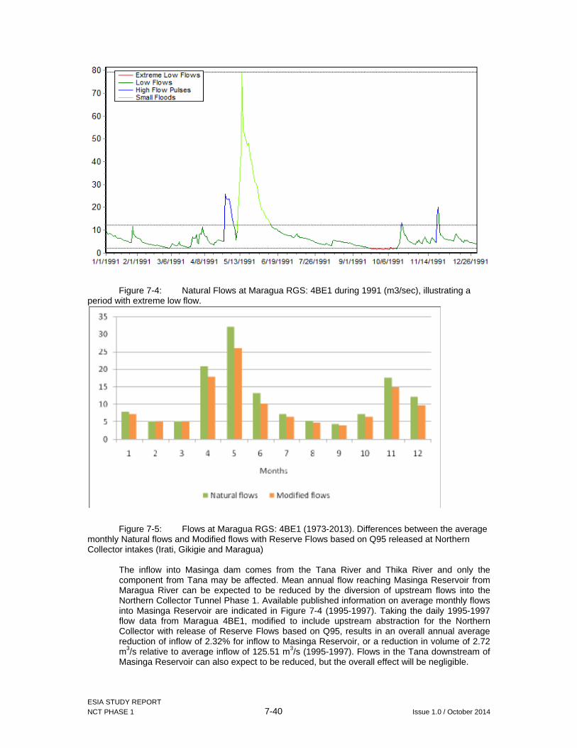
ESIA STUDY REPORT NCT PHASE 1 7-40 Issue 1.0 / October 2014
Figure 7-4: Natural Flows at Maragua RGS: 4BE1 during 1991 (m3/sec), illustrating a period with extreme low flow.
Figure 7-5: Flows at Maragua RGS: 4BE1 (1973-2013). Differences between the average monthly Natural flows and Modified flows with Reserve Flows based on Q95 released at Northern Collector intakes (Irati, Gikigie and Maragua)
The inflow into Masinga dam comes from the Tana River and Thika River and only the component from Tana may be affected. Mean annual flow reaching Masinga Reservoir from Maragua River can be expected to be reduced by the diversion of upstream flows into the Northern Collector Tunnel Phase 1. Available published information on average monthly flows into Masinga Reservoir are indicated in Figure 7-4 (1995-1997). Taking the daily 1995-1997 flow data from Maragua 4BE1, modified to include upstream abstraction for the Northern Collector with release of Reserve Flows based on Q95, results in an overall annual average reduction of inflow of 2.32% for inflow to Masinga Reservoir, or a reduction in volume of 2.72 m3/s relative to average inflow of 125.51 m3/s (1995-1997). Flows in the Tana downstream of Masinga Reservoir can also expect to be reduced, but the overall effect will be negligible.

ESIA STUDY REPORT NCT PHASE 1 7-41 Issue 1.0 / October 2014
Table 7-7: Average flows into Masinga Reservoir (m 3/sec), and potential changes following diversion of water to the Northern Collector Phase 1
Masinga 1995
Masinga 1996
Masinga 1997
Masinga Average1995-97
Maragua 4BE1
natural
Maragua 4BE1
modified
Masinga with
modified 4BE1
%change
January 103.3 21.83 62.57 4.42 3.17 61.32 2.00%
February 10.05 86.71 13.59 36.78 5.06 4.22 35.94 2.28%
March 49.32 57.35 16.08 40.92 5.08 4.06 39.9 2.49%
April 679 36.47 169 294.82 14.53 11.29 291.58 1.10%
May 289.8 70.27 363.9 241.32 28.46 22.93 235.79 2.29%
June 253.7 119.7 287 220.13 12.68 8.82 216.27 1.75%
July 170.8 122.8 187.5 160.37 7.87 5.52 158.02 1.47%
August 99.25 82.22 83.38 88.28 6.04 4.21 86.45 2.07%
September 61.01 41.61 26.59 43.07 4.86 3.60 41.81 2.93%
October 39.06 15.39 175.9 76.78 14.35 11.63 74.81 3.54%
November 26.77 25.24 255.7 102.57 37.74 33.02 97.85 4.60%
December 86.91 27.64 300.9 138.48 16.48 12.45 134.45 2.91%
Average 152.74 69.19 145.50 125.51 13.13 10.41 122.79 2.32%
Source: van Loon, A. and Droogers, P. (2006). Water Evaluation and Planning System, Kitui - Kenya. WatManSup project. WatManSup Research Report No 2.
In areas adjacent to the Northern Collector intakes agricultural activities are predominantly tea plantation. The small areas under food crops are for subsistence farming are not for sale to Nairobi. At lower elevations below the tea zone, the predominant agriculture is commercial coffee. The agricultural potential in Muranga District generally decreases from northwest to southeast, mainly because of decreasing rainfall and soil fertility. In areas with less rainfall, and with a reduced proportion of commercial tea and coffee, an increasing demand for food crops required by the increasing population of Nairobi is likely to lead to an increased demand for irrigation. For example, in July 2010, it was reported that farmers in Muranga District would benefit from KSh50 million to help them invest in irrigation schemes (Daily Nation, 10 July 2010) and that 17 schemes would use sprinkler, hose, and drip methods of irrigation. With an increase in the local population in areas downstream of the Northern Collector intakes, coupled with an increase in demand for food from a greater population in Nairobi, it is considered likely that there will be increased pressure for use of available resources for irrigation in suitable sites within relatively easy transport distance from Nairobi.
With an increase in the local population in the Muranga area, and an increase in demand for food from greater populations in Nairobi and satellite towns, it is considered likely that there will be increased pressure for use of available resources for irrigation and improved soil water management. However, the estimated decrease in flow at Maragua RGS: 4BE1 does indicate that the overall impact of abstraction for the Northern Collector is relatively small.
The National Water Resources Management Strategy acknowledges the issue of agricultural requirements for water:
Since the agricultural sector accounts for a large proportion of water use in Kenya, introduction of water demand management in this sector is imperative. More efficient irrigation approaches and technologies also need to be adopted. These include:
i. Assessing the irrigation potential of soils in terms of water loss. This includes determining soil texture, moisture retention properties and the slope and then choosing the mare water efficient soils
ii. Identifying the suitable water saving technology and the efficient production level.'
ESIA STUDY REPORT NCT PHASE 1 7-42 Issue 1.0 / October 2014
This will, however, require funding to promote appropriate technologies and enable their wider adoption and use. It is suggested that part of the mitigation of impacts caused by the upstream abstraction of water in the Irati, Gikigie and Maragua Rivers should include funding to assist with the adoption of appropriate technologies.
There is hence need for assessment of the abstractions by downstream water users (both licensed and unlicensed) on a regular basis, including monthly or seasonal abstraction requirements. Based on the assessment of downstream water use requirements, the provision of Reserve Flows can be adjusted to ensure adequate provision of water resources for all downstream users, whilst at the same time maintaining adequate environmental flows.
7.6.3 Increased pressure on city drainage and sewer systems
Completion of the tunnel works and the associated new pipelines for raw water (Thika dam to Kigoro treatment works) treated water (Kigoro Treatment Works to Kabete Reservoir) will eventually result in increased water supplies to the city. This will directly increase waste water generation (it is estimated that 75% of supplied water comes out as waste). Without equivalent improvement of the existing sewer networks and waste water treatment works, this will lead to increased sewer bursts and release of improperly treated waste waters into he receiving rivers of the Athi river basin. This will not only adversely impact on the ecology of the rivers but also deny their downstream users (mainly in arid and semi arid lands) access to good quality water.
Given the arid and semi-arid nature of downstream areas on Athi River, the impacts on rural domestic water users and on irrigated agriculture (both existing and planned) that depend on direct abstraction from Athi River may be significant.
Recommendation
Ensure timely improvement on existing trunk sewer networks and waste water treatment works in the city of Nairobi and where necessary, development of new ones to manage anticipated increased waste volumes; and
AWSB should continously monitor waste water volumes and qualities into and out of the existing waste treatment plants. Sunch monitoring should also incoroporate incedeces trunk sewewrs bursts. Whenever waste waters qualities from the treatment works exceed the thresholds provided in water quality regulations, 2006, appropriate interventions must be initiated on time.

ESIA STUDY REPORT NCT PHASE 1 8-1 Issue 1.0 / October 2014
8 ENVIRONMENTAL AND SOCIAL MANAGEMENT PLAN
8.1 Introduction
This chapter presents Environmental and Social Management (ESMP) Plan prepared to show how site specific concerns and mitigation measures are addressed through the engineering, procurement, construction and operation phases of the NCT1 project. The ESMP provides a link between the impacts of project activities and the mitigation measures and responsibilities proposed to minimize these impacts and enhance the positive impacts.
At completion of construction, ownership of the project will be transferred to AWSB who will be responsible to implement environmental management measures associated with operation of the irrigation project.
8.2 Responsibilities of the ESMP
In order to ensure sound development and effective implementation of the ESMP, it is necessary to identify and define the responsibilities and authority of the various persons and organisations that will be involved in the project. Entities that should be involved in the implementation of this ESMP include but are not limited to the following:
AWB; NCW&SC; Contractor (s); Ministry of Environment, Water and Natural; resources; NEMA; WRMA; Directorate of Occupational Safety and Health; Department of Mines and Geology; KFS and KWS; County government of Murang’a; and Local administration.
(a) AWSB / Project Implementation Unit (PIU)
The project implementing agency is AWSB under the Ministry of Environment, Water and Natural Resources. AWSB has set up a Project Implementation Unit (PIU), with a Technical Manager.
AWSB should co-ordinate all aspects of the environment during project implementation and operations (with involvement of NCWSC). This should include following the construction to monitor, review and verify the implementation of the project’s ESMP.
(b) Project Contractor (s)
A project contractor will be appointed by AWSB. The contractor must be required to comply with the requirements of the ESIA, the ESMP within this report, any ESIA licences conditions as may be issued with NEMA as well as all relevant legislations.

ESIA STUDY REPORT NCT PHASE 1 8-2 Issue 1.0 / October 2014
(c) Ministry of Environment, Water and Natural Resources
All key government environmental and water management and conservation agencies are under the Ministry of Environment, Water and Natural Resources. The ministry is responsible for overall policy direction and is hence better placed to ensure coordination of the said agencies for the conservation and management of the available natural resources within the Aberdare water tower and ensure that a clean environment is sustained throughout the project life.
(d) Water Resources Management Authority (WRMA)
WRMA’s regional office in Nyeri and the sub regional office in Murang’a will be involved in the project through its issuance of project water rights and regulations of water abstraction, study for water resources development and coordination of water use within the Upper Tana catchment area.
(e) NEMA
The responsibility of the National Environment Management Authority (NEMA) is to exercise general supervision and co-ordination over all matters relating to the environment and to be the principal instrument of government in the implementation of all policies relating to the environment.
Apart from the national office in Nairobi, NEMA has local offices in the project area at Murang’a town through which environmental supervision of the project will be conducted.
(f) Directorate of Occupational Safety and Health
Directorate of Occupational Safety and Health (DOSH) will be responsible for registering the project site as a work station and subsequent enforcement of relevant provisions in occupational safety and health in line with occupational safety and Health Act, 2007.
(g) Department of Mines and Geology
Licensing of any explosives and ensuring safe handling and use
(h) KFS and KWS
Conservation and management of wild fauna and protected forest within the Aberdare water tower
(i) County Government of Murang’a
Murang’a County government is responsible for various environment and public health management issues as iterated in section 2.5.11 and should be incorporated to help enforcement of proposed mitigation and monitoring activities within the project.
In addition, the county government is better placed in dissemination of project information to the local levels through the members of county assembly and ward administrators. Continous liaison between AWSB and the county government is thus recommended.
(j) The Local Administration
The relevant local administrators should be called upon where necessary during project implementation to provide the necessary advisory services and support to the project implementers.

ESIA STUDY REPORT NCT PHASE 1 8-3 Issue 1.0 / October 2014
8.3 Environmental and Social Management
An Environmental and Social Management Plan has been prepared to identify and sequence environmental activities that are needed in order to complete a required construction process.
Prior to commencement the Contractor will be required to prepare own Environmental and Social Management Plan that is in line with the project ESIA and also meets all ESIA license conditions.
8.3.1 Method statements
Method statements would be completed on behalf of the Main Contractor or Sub Contractor by an Occupational Safety and Health Officer and qualified Environmentalist or other appropriate experienced personnel, in consultation with AWSB environmental staff and, where necessary, environmental consultants. Their production would include a review of the environmental and safety and health risks and commitments, as identified in the ESMP and risk assessment, so that appropriate control measures are developed and included within the construction process.
Method statements would be reviewed by PIU, the Main or Sub Contractor’s appointed environmental manager and, where necessary, by an appropriate environmental specialist. Where necessary, all method statements would be submitted to the enforcement agencies as appropriate. Method statements would contain as a minimum:
Location of the activity and access/egress arrangements; Works to be undertaken and methods of construction; Equipment including any machinery and materials to be used; Labour and supervision requirements; Safety ,Health and environmental considerations; and Any permit or consent requirements including registration of the work place and
approval of deployed equipment where required e.g. of cranes.
8.3.2 Control of construction processes
(a) Supervision of construction activities
All construction activities including those carried out by subcontractors and suppliers would be supervised, or regularly checked through the completion of site inspections by the Contractors Environmental Manager, to ensure that requirements identified in risk assessments or method statements have been implemented. The frequency and extent of this supervision would vary according to the degree of competence displayed by the workforce and the level of risk to the environment.
Environmental deliverables required by the CEMP would be subject to regular independent supervision by either the Environmental Manager or the relevant environmental specialists. These inspections would be used to confirm that:
Construction works are progressing in accordance with the agreed method statements’;
Agreed protection or mitigation measures are in place, prior to or during the implementation of construction activities;
Construction works have been completed in accordance with the design and commitments made during the statutory approval process.

ESIA STUDY REPORT NCT PHASE 1 8-4 Issue 1.0 / October 2014
(b) Environmental inspection and reporting
The Contractors Environmental Manager would carry out an assessment of the project’s environmental performance, based upon the reports from the environmental management representatives during the period, reports from the environmental specialists and from his own site inspections. This would be carried out at a frequency at no greater than monthly intervals but could be held more regularly depending on the nature of the construction activity. An assessment of the performance over the month would be made and quantified. A monthly report detailing performance for the period would be provided to the AWSB and would include a summary of environmental inspections completed, audits undertaken, complaints and incidents.
The monthly environmental report would:
Consider past performance from inspections, audit reports and monitoring data;
Plan actions required to mitigate forthcoming risks; and Disseminate best practice.
8.3.3 Environmental and social due diligence during construction
During the construction phase, environmental due diligence will be incorporated into the Project implementation mainly to:
Control the residual risk of accidental environmental damage; and Prevent the negative environmental impacts during construction.
The contractor and supervising engineer will have the primary responsibility for the due diligence. The supervising Engineer MUST be required to include environmental considerations in the monthly progress reports and indicate progress in the implementation of mitigation measures as outlined in the ESMP.
The Construction risks to be monitored will include, but not be limited to the following issues:
Handling of any hazardous materials including hydrocarbons as part of construction activities;
Movement of machinery; Management of borrow and spoil areas including soil erosion; Sedimentation of watercourses; Collection and disposal of wastes; Management of pollution incidents; Safety and health management at construction sites; and Addressing local community concerns on the project implementation activities.
The Table 8-1 and 8-2 give a summary of the Environmental and Social Management Plan during Construction and operation phases of the project.
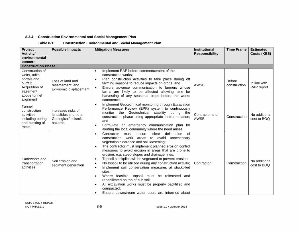
ESIA STUDY REPORT NCT PHASE 1 8-5 Issue 1.0 / October 2014
8.3.4 Construction Environmental and Social Management Plan
Table 8-1: Construction Environmental and Social Management Plan
Project Activity/ environmental concern
Possible Impacts Mitigation Measures Institutional Responsibility
Time Frame Estimated Costs (KES)
Construction Phase Construction of weirs, adits, portals and outfall; Acquisition of easement above tunnel alignment
Loss of land and resettlement; and Economic displacement
Implement RAP before commencement of the construction works;
Plan construction activities to take place during off farming seasons to reduce impacts on crops; and
Ensure advance communication to farmers whose farms are likely to be affected allowing time for harvesting of any seasonal crops before the works commence.
AWSB Before construction In line with
RAP report
Tunnel construction activities including boring and blasting of rocks
increased risks of landslides and other Geological/ seismic hazards
Implement Geotechnical monitoring through Excavation Performance Review (EPR) system to continuously monitor the Geotechnical stability during the construction phase using appropriate instrumentation; and
Formulate an emergency communication plan for alerting the local community where the need arises
Contractor and AWSB Construction
No additional cost to BOQ
Earthworks and transportation activities
Soil erosion and sediment generation
Contractor must ensure clear delineation of construction work areas to avoid unnecessary vegetation clearance and soil loosening;
The contractor must implement planned erosion control measures to avoid erosion in areas that are prone to erosion, e.g. steep slopes and drainage lines;
Topsoil stockpiles will be vegetated to prevent erosion; No topsoil to be utilized during any construction activity; Implement soil conservation measures at stockpiled
sites; Where feasible, topsoil must be reinstated and
rehabilitated on top of sub soil; All excavation works must be properly backfilled and
compacted; Ensure downstream water users are informed about
Contractor Construction No additional cost to BOQ
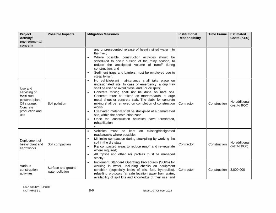
ESIA STUDY REPORT NCT PHASE 1 8-6 Issue 1.0 / October 2014
Project Activity/ environmental concern
Possible Impacts Mitigation Measures Institutional Responsibility
Time Frame Estimated Costs (KES)
any unprecedented release of heavily silted water into the river;
Where possible, construction activities should be scheduled to occur outside of the rainy season, to reduce the anticipated volume of runoff during construction; and
Sediment traps and barriers must be employed due to steep terrain.
Use and servicing of fossil fuel powered plant; Oil storage; Concrete production and use
Soil pollution
No vehicle/plant maintenance shall take place on undesignated site. In case of emergency, a drip tray shall be used to avoid diesel and / or oil spills;
Concrete mixing shall not be done on bare soil. Concrete must be mixed on mortarboards, a large metal sheet or concrete slab. The slabs for concrete mixing shall be removed on completion of construction works;
Excavated material shall be stockpiled at a demarcated site, within the construction zone;
Once the construction activities have terminated, rehabilitation
Contractor Construction No additional cost to BOQ
Deployment of heavy plant and earthworks
Soil compaction
Vehicles must be kept on existing/designated roads/tracks where possible;
Minimize compaction during stockpiling by working the soil in the dry state;
Rip compacted areas to reduce runoff and re-vegetate where required;
All topsoil and other soil profiles must be managed strictly.
Contractor Construction No additional cost to BOQ
Variousconstruction activities
Surface and ground water pollution
Implement Standard Operating Procedures (SOPs) for working in water, including checks on equipment condition (especially leaks of oils, fuel, hydraulics), refuelling protocols (at safe location away from water, availability of spill kits and knowledge of their use, and
Contractor Construction 3,000,000

ESIA STUDY REPORT NCT PHASE 1 8-7 Issue 1.0 / October 2014
Project Activity/ environmental concern
Possible Impacts Mitigation Measures Institutional Responsibility
Time Frame Estimated Costs (KES)
emergency spill procedures); Any on site/camp storage areas for fuels, oils or other
liquid chemicals would be sited away from surface water drains. They must have an impermeable base and bund with a capacity of 110% and would not drain directly into the surface water drains. Where practicable, drainage from storage compounds would be passed through oil interceptors prior to discharge;
Apply standard best practice site sediment control procedures (e.g. settling ponds) to minimise sediment in site drainage waters returning to the river;
Ensure all staff and workers are fully aware of the limits to the site for each activity, SOPs, and emergency procedures;
Ensure that all construction equipment and vehicles are serviced off site at licensed garages;
Any contaminated soil should be handled properly as hazardous waste and removed form site for safe disposal; and
Careful management of the sites and education of all construction staff would curtail the risk of pollution spills.
Construction camps
Overstretching local utilities; and incidences of insecurity
Careful planning of construction camp; Any contractor’s camp should have a comprehensive
waste management and sanitation plan and facilities commensurate with population of workers and activities in the camps;
Any storage tanks and equipment should have correct labels and Material Safety Data Sheets;
Adequate Emergency Response Plan should be in place in the camps;
The contractor should employ best practice management "housekeeping" (site cleanliness, waste disposal etc.) at all times;
Contractor Construction 2,000,000

ESIA STUDY REPORT NCT PHASE 1 8-8 Issue 1.0 / October 2014
Project Activity/ environmental concern
Possible Impacts Mitigation Measures Institutional Responsibility
Time Frame Estimated Costs (KES)
The contractor's facilities should be completely removed from site after use and the land restored to its previous condition or better;
AWSB in collaboration with the local administration can facilitate the development of a police post next to the camp area to increase security.
Handling hydrocarbons on site
Oil spills
Vehicle maintenance should be done on purpose-built impervious concrete platforms with oil and grease traps;
Ensure that all equipment are in good condition, clean and free from leaks;
Oil spill containment and cleanup equipment should be kept at the contractor's camp. Construct oil skimming tanks at the locations directed and in accordance with details approved by the Engineer. Oil recovered from the skimming tanks shall be stored in drums and removed from the site for safe disposal;
Monitor effluent discharge from the oil skimming tanks. Effluent discharge shall not exceed 25 mg/litre or the limit specified by the NEMA.
Contractor Construction 2,500,000
Employment of locals
Shifting of labour from tea picking to construction; Increased school drop-outs as school going age-group seek to work on the project
The contractor should be encouraged to offer wages within the prevailing rates;
Where feasible, labour intensive tunnel construction activities should be planned to occur during off-peak periods for tea picking; and
Contractor must abide by labour laws and avoid any employment of children.
Contractor Construction No addition cost to BOQ
Diversion weirs and associated weir construction works
Interference with migratory fishes
Minimize activities to areas of construction and initiate habitat restoration immediately after construction works are through;
Ensure sufficient compensation flow; and Restore disturbed areas to near-to-nature to blend with
the immediate environment.
Contractor Construction 800,000

ESIA STUDY REPORT NCT PHASE 1 8-9 Issue 1.0 / October 2014
Project Activity/ environmental concern
Possible Impacts Mitigation Measures Institutional Responsibility
Time Frame Estimated Costs (KES)
Oil spills and sediments releases
Riverine microhabitat alterations; Loss of otter dens; and Loss of breeding and nursery grounds for fishes and invertebrates such as the freshwater crabs Potamonautes spp
Ensure adequate waste management plan is in place and in use from the onset of construction; and
Oil spill containment and clean-up equipment should always be available at the construction site with trained response team;
Implement erosion and sediment management plan; Systematic search, capture and safe release of otters
inhabiting the right of way (for the weir structures) and fish pass); and
Selective clearing and restoration of vegetation after construction
Contractor and KWS
Construction 2,000,000
Site clearance and earthworks
Loss of vegetation cover and Illegal logging of trees of conservation significance
Strictly control vegetation clearance and ensure it is only done when absolutely necessary through delineation of works areas;
Compensate for affected tea bushes and tree/woodlots before construction works begin and allow for salvage of affected timber;
Re-vegetate disturbed areas with locally occurring grasses, shrubs and indigenous trees soon after completion of each section;
Where encountered, plants of conservation importance should be avoided as feasible;
Establish and enforce code of conduct for its employees which must among others abhor illegal logging even from chance encounters of protected tree species within the project area; and
Ensure compliance with Wildlife (Conservation and Management) Act, 2013 and sensitize employees on the same.
Contractor Construction 1,800,000
Tunnel construction
Spoil generation
Maximise the re-use of excavated materials in the works as far as feasible;
Investigate opportunities to set up MOU for use of spoil material elsewhere by the county government (e.g. for road construction and rehabilitation).

ESIA STUDY REPORT NCT PHASE 1 8-10 Issue 1.0 / October 2014
Project Activity/ environmental concern
Possible Impacts Mitigation Measures Institutional Responsibility
Time Frame Estimated Costs (KES)
Properly dispose off the spoil in the approved spoil sites identified by the design team; and
Implement erosion and siltation management plan.
Solid Waste generation
Waste handling challenges
The contractor should enforce the appropriate management methods based on the three Rs (Reduce, Reuse, and Recycle).
For waste handling the contractor should provide litter collection facilities such as bins;
Final disposal of the site waste should be done at a location that shall be approved by Resident Engineer in accordance with the Waste Management Plan after consultation with the relevant stakeholders, including the County Administration and local community;
The disposal site need to be more than 100 meters from watercourses and in a position that will facilitate the prevention of storm-water runoff from the site from entering the watercourse;
The tender documents should specify proper solid waste handling as provided in the waste management plan during site preparation phase of construction prior to project works commencing in identifying optimal waste re-use options and licensed disposal areas. This should strictly be adhered to by the Contractor;
The Contractor should not burn chemical or hazardous wastes on site or dump in open pits; and
Maximise the re-use of all excavated materials in the works
Contractor Construction 1,500,000
Generation of construction wastes
Liquid waste pollution
All grey water runoff or uncontrolled discharges from the site/working areas (including wash-down areas) to water courses should be contained and properly channelled;
Water containing such pollutants as cements, concrete, lime, chemicals and fuels shall be discharged into a
Contractor Construction 1,300,000

ESIA STUDY REPORT NCT PHASE 1 8-11 Issue 1.0 / October 2014
Project Activity/ environmental concern
Possible Impacts Mitigation Measures Institutional Responsibility
Time Frame Estimated Costs (KES)
conservancy tank for removal from site; Potential pollutants of any kind and in any form shall be
kept, stored and used in such a manner that any escape can be contained and the water table not endangered;
Wash areas shall be placed and constructed in such a manner so as to ensure that the surrounding areas (including groundwater) are not polluted; and
Act promptly on any pollution incidents on site.
Air quality and dust emissions
Dust nuisance and toxic emissions with respiratory health problems
Sensitize workers on management of air pollution from vehicles and machinery;
Vehicles delivering soil materials should be covered to reduce dust emissions;
Activities generating dust (excavation, handling and transport of soils) to be carried out in calm weather. The Resident Engineer shall suspend earthworks operations wherever visible dust is affecting properties adjoining the work site;
Consider watering of the access roads during dry season to supress dust;
Provide dust masks to all personnel on dust-prone work sites;
Records of related complaints should be kept by the contractor and communicated to the Resident Engineer;
All construction machinery should be maintained and serviced in accordance with the equipment specifications and manufacturer’s standards; and
The removal of vegetation shall be avoided until such time as clearance is required and exposed surfaces shall be re-vegetated or stabilised as soon as practically possible.
PIU and Contractor
Construction 600,000

ESIA STUDY REPORT NCT PHASE 1 8-12 Issue 1.0 / October 2014
Project Activity/ environmental concern
Possible Impacts Mitigation Measures Institutional Responsibility
Time Frame Estimated Costs (KES)
Noise generation by construction activities
Noise nuisance and related health problems
Noise levels shall be kept within acceptable limits preferably as stipulated within the Environmental Management and Coordination (Noise and Excessive Vibration Pollution) Control Regulations, 2009 and construction activities shall, where possible, be limited to normal working hours;
Monitor noise and vibration in sensitive locations above the tunnel (hospitals, teaching facilities, churches) and along the haulage routes to ensure the NEMA requirements regarding noise and vibration are met and if the standards are exceeded measures must be taken to reduce noise and vibration;
Equipment should be maintained regularly to reduce noise resulting from friction;
Workers exposed to high-level noise must wear personal protective equipment (PPE);
Use of silencers on the construction plant, where applicable, should be encouraged;
Residents in close proximity should be given at least 24 hours notification of any abnormal noise source e.g. planned blasting; and
Institute a community complaints/redress mechanism to identify and respond to any unanticipated noise/vibration related complaints.
Contractor Construction 1,600,000
Use fossil fuels andAir conditioners in camps
Generation Ozone depleting gases
Ensure use of approved fuels from licensed suppliers only;
Regular maintenance of machinery to manufactures’ specifications;
Ensure that any cooling units installed at the camps only use ozone friendly coolants in compliance with NEMA guidelines.
Contractor Construction No addition to BOQ
Influx of immigrant workers
Social delinquency and spread of STIs including HIV/AIDS
Ensure the contractor liaises with local public health officials and NGO’s within the project area in educating the community;
Contractor Construction No addition to BOQ
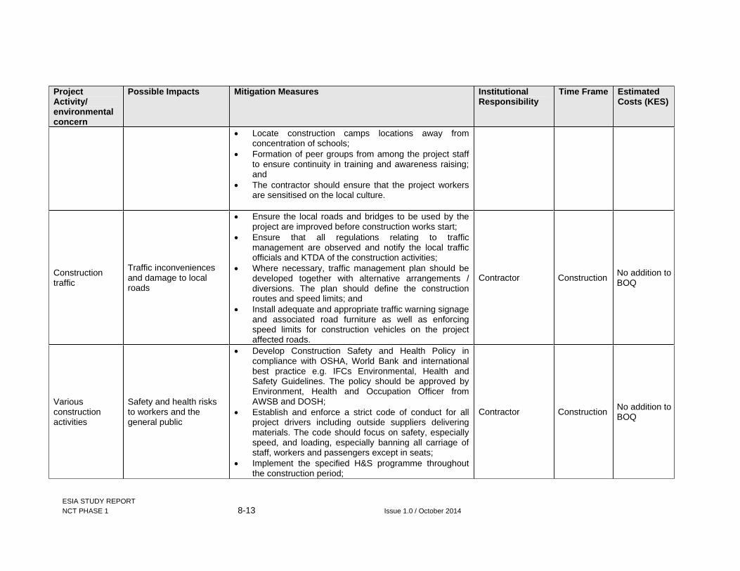
ESIA STUDY REPORT NCT PHASE 1 8-13 Issue 1.0 / October 2014
Project Activity/ environmental concern
Possible Impacts Mitigation Measures Institutional Responsibility
Time Frame Estimated Costs (KES)
Locate construction camps locations away from concentration of schools;
Formation of peer groups from among the project staff to ensure continuity in training and awareness raising; and
The contractor should ensure that the project workers are sensitised on the local culture.
Construction traffic
Traffic inconveniences and damage to local roads
Ensure the local roads and bridges to be used by the project are improved before construction works start;
Ensure that all regulations relating to traffic management are observed and notify the local traffic officials and KTDA of the construction activities;
Where necessary, traffic management plan should be developed together with alternative arrangements / diversions. The plan should define the construction routes and speed limits; and
Install adequate and appropriate traffic warning signage and associated road furniture as well as enforcing speed limits for construction vehicles on the project affected roads.
Contractor Construction No addition to BOQ
Variousconstruction activities
Safety and health risks to workers and the general public
Develop Construction Safety and Health Policy in compliance with OSHA, World Bank and international best practice e.g. IFCs Environmental, Health and Safety Guidelines. The policy should be approved by Environment, Health and Occupation Officer from AWSB and DOSH;
Establish and enforce a strict code of conduct for all project drivers including outside suppliers delivering materials. The code should focus on safety, especially speed, and loading, especially banning all carriage of staff, workers and passengers except in seats;
Implement the specified H&S programme throughout the construction period;
Contractor Construction No addition to BOQ

ESIA STUDY REPORT NCT PHASE 1 8-14 Issue 1.0 / October 2014
Project Activity/ environmental concern
Possible Impacts Mitigation Measures Institutional Responsibility
Time Frame Estimated Costs (KES)
The contractor should establish an emergency response procedure and display on all work areas during construction activities;
Construction sites should be adequately barricaded from the general public and conspicuous warnings posted in national and local languages; and
The contractor should ensure compliance with all standards and legally required health and safety procedures in line with OSHA, 2007 and associated rules and regulations.
Include a specific and independent task in the supervision contract concerning H&S supervision and compliance, together with the staff resources to carry this out.
AWSB Before construction 2,000,000
Camp and plant installation
Pressure on and disruption of utility services
Ensure any power demand beyond the existing capacity is installed before construction begins;
Liaise with relevant utility service providers and roads authorities to minimize any service disruptions;
Ensure advance notice to all stakeholders including water service providers and KTDA of any planned disruptions
Contractor Construction No addition to BOQ
Earthworks and spoil stockpiling
Modification of landscape
Encourage reuse of spoil materials e.g. in roads construction and maintenance, as far a feasible to reduce land area used for spoil storage; and
Incorporate landscaping at adits and portals to camouflage the introduced concrete surfaces.
Contractor Construction 2,000,000

ESIA STUDY REPORT NCT PHASE 1 8-15 Issue 1.0 / October 2014
Project Activity/ environmental concern
Possible Impacts Mitigation Measures Institutional Responsibility
Time Frame Estimated Costs (KES)
Influx of immigrant workers
Growth of unplanned settlements
As much as feasible, the unskilled labour should be obtained from amongst the locals;
Provide adequate accommodation for non-local workforce; and
Liaise with Murang’a county government to control developments in the area and ensure provision of adequate services
Contractor Construction No addition to BOQ
Tunnelling works
Destruction of previously unidentified physical cultural resources
Formulate a chance-find procedure for implementation whenever any archaeological sites are encountered
Contractor Construction 500,000

ESIA STUDY REPORT NCT PHASE 1 8-16 Issue 1.0 / October 2014
8.3.5 Operation Environmental and Social Management Plan
Table 8-2: Operation ESMP
Project Activity/ environmental concern
Possible Impacts Mitigation Measures Institutional Responsibility
Time Frame Estimated Costs (KES)
Water diversion into the tunnel
Reduced downstream flow (affecting both domestic and ecological needs)
Ensure strict adherence to the proposed abstraction weirs operation principles;
Construct fish passes as planned and ensure they are regularly maitanined to allow safe passage for all identified migratory species;
Deliberate, compensation release of adequate amount of water downstream to mitigate alteration of the river ecosystem
AWSB and NCW&SC Operation No additional
cost
Undertake wet season survey and subsequent annual aquatic fauna surveys for both wet and dry seasons to monitor trends and inform any further management interventions
AWSB Operation 10,000,000
The Aberdare catchment conservation efforts should be enhanced to reduce possible sedimentation in to northern collector rivers, which may end up in the Thika reservoir, causing sedimentation of the reservoir
Ensure demarcartion and protection of riparian resevers of the affected rivers. This will offer favourable cover and temperatures for the rainbow trout
KFS KWS WRMAAWSB
Operation
Conduct routine In-stream Flow Release compliance audit/monitoring once operation commences and use gathered information to guide management interventions.
WRMA Operation 10,000,000 (annually)
Reduced water temperatures downstream
Encourage local communities to plant indigenous trees on the riparian lands to ensure water temperatures are not increased;
AWSB, NEMA and WRMA
Operation
Deterioration of downstream water quality
Conduct regular water sampling and laboratory analysis to monitor the water quality variations
WRMA Operation

ESIA STUDY REPORT NCT PHASE 1 8-17 Issue 1.0 / October 2014
Project Activity/ environmental concern
Possible Impacts Mitigation Measures Institutional Responsibility
Time Frame Estimated Costs (KES)
Increased inflow into Githika river and Thika reservoir
For possible increased inundation of the riverine areas, stream channel expansion from the outfall may help to counter the increased flow. Installation of a gauging station after outfall, will help monitor the water levels changes, so as appropriate measures can be taken; and
Ensure that the new off take is continuously operational at optimal levels to evacuate the increased volumes;
AWSB Operation
No additional cost after implementation of pipeline component
Changes in riverine and riparian floral compositions
Observe the minimum ecological flow after intake for R. Maragua, R. Irati and R. Gikigie;
Support local communities to plant indigenous trees along the rivers and not the exotic Eucalyptus trees as is the present case. Awareness on the same should be enhanced;
Undertake continuous ecological monitoring of hydrophytes and high water specific species to track and mitigate any emerging impacts of the project on the plants.
AWSB Operation 6,000,000
Water diversion into the tunnel
Changes in riverine and riparian floral compositions
The riparian extent of the project affected rivers should be defined by WRMA (based on the 6-30m rule from river banks) and be enforced to prevent people farming up to the river banks to reduce siltation
NEMA and WRMA Operation
No additional cost
Tunnel O&M activities
Safety risks during tunnel maintenance operations
AWSB should establish and implement NCT1 tunnel specific comprehensive O&M Safety and Health Management Plan within which it ensures that: All potential hazards are identified and appropriate
mitigations put in place; Pre-entry activities are defined including the
method statements, hazards assessment, incident action plan, communication plan, personnel accountability plan, personal protective equipment list, and atmospheric monitoring equipment list;
AWSB Operation

ESIA STUDY REPORT NCT PHASE 1 8-18 Issue 1.0 / October 2014
Project Activity/ environmental concern
Possible Impacts Mitigation Measures Institutional Responsibility
Time Frame Estimated Costs (KES)
Appropriate PPE for O&M staff are available throughout;
Requisite instrumentation and available and operable;
Liaise with the Ministry of Health should to ensure clinic and ambulances to be built/acquired under the project remain operational in the project area throughout the operational life
Increased inflow into Thika dam Concerns of dam safety
Review and update the existing safety and Emergency Plan for Thika dam. AWSB Before
commissioning
To be determined by AWSB
Tunnel leaks Loss of water
Monitor volumes at intakes and outfall to allow loss detection; and
Ensure regular inspection and maintenance of the tunnel.
AWSB and NCW&SC Operation No additional
cost
Fish pass failure Impeded migration of fish
Test and evaluate efficacy of fish passes within the first two years of commissioning
AWSB and NCW&SC
Operation Operation and Maitenance

ESIA STUDY REPORT NCT PHASE 1 8-19 Issue 1.0 / October 2014
8.4 Environmental and Social Monitoring
The overall objective of environmental and social monitoring is to ensure that mitigation measures are implemented and that they are effective. Environmental and social monitoring will also enable response to new and developing issues of concern. The activities and indicators that have been recommended for monitoring are presented in the ESMP.
Environmental monitoring is also carried out to ensure that all construction and operation activities comply and adhere to environmental provisions and standard specifications, so that all mitigation measures are implemented. The contractor shall employ an officer responsible for implementation of social/environmental requirements. This person will maintain regular contact with PIU and the respective County Environmental Officers. The contractor and PIU have responsibility to ensure that the proposed mitigation measures are properly implemented during the construction phase.
The environmental monitoring program will operate through the construction, and operation phases. It will consist of a number of activities, each with a specific purpose with key indicators and criteria for significance assessment.
Monitoring includes:
Selection of environmental parameters; Visual observations; and Regular sampling and test measurements of these parameters.
Periodic ongoing monitoring will be required during the life of the Project and the level can be determined once the Project is operational.
Monitoring will be done in three fronts:
Physical monitoring; Biological monitoring; and Social monitoring.
8.4.1 Internal monitoring
It is the responsibility of the proponent, AWSB through the PIU , to conduct regular internal monitoring of the project to verify the results of the Contractor and to audit direct implementation of environmental mitigation measures contained in the ESMP and construction contract clauses for the Project.
The monitoring should be a systematic evaluation of the activities of the operation in relation to the specified criteria of the condition of approval.
The objective of internal monitoring and audit will be:
To find out any significant environmental and safety and health hazards and their existing control systems in force; and
Meeting the legal requirements as stipulated in the Environmental Management & Coordination Act, EMCA-1999 and OSHA, 2007.
8.4.2 External monitoring and evaluation
It is recommended that a consultant be hired to carry out Annual Environmental Audits in line with NEMA requirements. NEMA has the overall responsibility for issuing approval for the Project and ensuring that their environmental guidelines are followed during Project

ESIA STUDY REPORT NCT PHASE 1 8-20 Issue 1.0 / October 2014
implementation. Its role therefore is to review environmental monitoring and environmental compliance documentation submitted by the implementing authorities and they would not normally be directly involved in monitoring the Project unless some specific major environmental issue arose.
AWSB through the consultant will therefore provide NEMA with reports on environmental compliance during implementation as part of their progress reports and annual environmental auditing reports. Depending on the implementation status of environmentally sensitive project activities, NEMA may perform annual environmental reviews in which environmental concerns raised by the project will be reviewed alongside project implementation.
Table 8-3: Table 8.3: Monitoring Plan
Environmental Component
Parameter Standard Location Frequency Implementation Supervision
Land take and resettlement
Signed consent forms and compensation paid as per land and crop valuation
Valuation roll
Conveyance line
Monthly until construction is complete
AWSB Supervision Consultant
Noise levels Complaints; and Noise levels on dB (A) scale
EMCA guidelines on Noise
SelectedSites
As directed by the supervision consultant
Contractor Supervision Consultant
Air Quality Total suspended particles , H2S,CO2, CH4
EMCA and WHO guidelines
Populated areas
Monthly Contractor. AWSB
Soil Quality
pHECe Exchangeable sodium percentage (ESP)Sodium adsorption ratio (SAR) Organic matter Cation Exchange Capacity (CEC) Nitrates P, K, Ca status
FAO and Soils Report
Composite samples from mineral soil at 5-30 cm depth, each sample to represent ~16 ha
Quarterly : Contractor AWSB
Groundwater depth
Depth to groundwater
WRMA Guidelines
Existing boreholes and wells
Monthly :O&M Contractor AWSB and WRMA
Groundwater quality
pHSalinity (EC) Nitrates Phosphorous Pesticide residues
WRMA Guidelines
Existing boreholes and wells
Monthly Monthly 6 months 6 months if indicated by drainage or surface water tests
:O&M Contractor AWSB and WRMA
Surface water quality – intakes and receiving waters
pHSalinity (EC) Nitrates Phosphorous Pesticide residues Coliforms BODCOD
EMCA Guidelines
Intake points and selected points downstream of irrigation areas
Monthly Monthly 6 months 6 months Monthly Monthly Monthly Monthly
:O&M Contractor AWSB
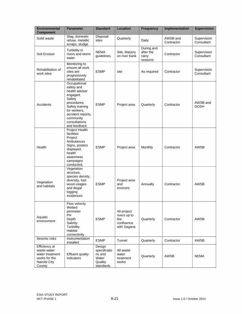
ESIA STUDY REPORT NCT PHASE 1 8-21 Issue 1.0 / October 2014
Environmental Component
Parameter Standard Location Frequency Implementation Supervision
Solid waste Slag, domestic refuse, metallic scraps, sludge
Disposalsites Quarterly Daily AWSB and
Contractor. Supervision Consultant
Soil Erosion Turbidity in rivers and storm water
NEMA guidelines
Site, Marjory on river bank
During and after the rainy seasons
Contractor Supervision Consultant
Rehabilitation of work sites
Monitoring to ensure all work sites are progressively rehabilitated
ESMP site As required Contractor Supervision Consultant
Accidents
Occupational safety and health adviser engaged; Safety procedures; Safety training for workers, accident reports, community consultations and feedback
ESMP Project area Quarterly Contractor AWSB and DOSH
Health
Project Health facilities Project Ambulances Signs, posters displayed, health awareness campaigns conducted,
ESMP Project area Monthly Contractor AWSB
Vegetation and habitats
Vegetation structure, species density, diversity, fuel wood usages and illegal logging incidences
ESMP Project area and environs
Annually Contractor AWSB
Aquatic environment
Flow velocity Wetted perimeter PH Depth Salinity Turbidity Habitat connectivity
ESMP
All project rivers up to the confluence with Sagana
Quarterly Contractor AWSB
Seismic risks Instrumentation installed ESMP Tunnel Quarterly Contractor AWSB
Efficiency at waste water water treatment works for the Nairobi City County
Effluent quality indicators
Deisgn speciifcations and Water Quality standards
All waste water treatment works
Quarterly AWSB NEMA
Responsibilit y

ESIA STUDY REPORT NCT PHASE 1 9-1 Issue 1.0 / October 2014
9 CONCLUSION AND RECOMMENDATIONS
9.1 Conclusions
This ESIA Study has been prepared to provide sufficient and relevant information on the proposed Northern Collector Tunnel Phase 1, to enable NEMA establish whether activities of the project are likely to have significant adverse environmental impacts.
Generally, the proposed project will result in appreciable benefits to the city of Nairobi, its satellite towns and Kenya at large and bring opportunities for both social and economic development.
The main social impact management issues on the project revolve around relocation of people within the project area and acquisition of land for development of weirs, adits/portals and outfall as well as restriction of use of land (11.8 x 3m) above the tunnel alignment. These will result in loss of approximately 18.87 acres of land and displacement of 161 persons and 7 institutions.
From hydrological analysis, the project is not anticipated to have any significant impacts on hydrology. Since the project design is based on flood flow of the rivers, no changes on normal flows are anticipated at all. However, frequencies of flood flows downstream will be reduced. The cumulative impacts of the project on downstream hydropower generation schemes at Masinga has also been established to be marginal with an annual average reduction of inflow of 2.32% to Masinga Reservoir, or a reduction in volume of 2.72 m3/s relative to average inflow of 125.51 m3/s (1995-1997).
On ecology, assessment of the project induced hydrological changes against habitat requirements for rainbow trout fish, Onchorynchus mykiss which was found to have the stringest flow requirements among documented species. The study established that the proposed flow release for Maragua intake (Q95=0.481 m3/sec) will meet the trout fish requirement (0.259 m3/sec). However, for Irati and Gikigie rivers, the proposed downstream releases will be lower than the calculated minimum requirements for the trout species. The proposed design for Irati is 1.4Q95=0.645 m3/sec against calculated rainbow trout fish requirement of 0.989 m3/sec while for Gikigie, the proposed design flow is Q95 = 0.101 m3/sec, against rainbow trout requirement computed to be 0.133 m3/sec. In order to meet the calculated rainbow trout fish minimum habitat requirements, hydrological analysis established that the design flows at Gikigie and Irati intakes would require upward revisions to 1.32xQ95=1.33 m3/sec and 2.15xQ95=0.991 m3/sec respectively.
It is notable that the calculated minimum requirements for rainbow trout from this study are higher than the naturalised mean monthly flow e.g. for Irati river and cannot be therefore used to set the minimum ecological flow requirements. This coud also mean that the rainbow trouts species is not distributed throughout all the rivers in all seasons hence the need to ensure that any migration is not impeded for conitnous habitats connectivity. The study therefore recommends the implementation of the compensation flow as designed but with strict enforcement of the peoposed operating principles.
Since the proposed project abstractions will be based on flood flow and not normal flows, there will be no effect at all on the normal flows. The anticipated reduced frequency of low-flows will be associated with some habitat loss for riverine fishes during periods of low-flows with Irati likely to be the most affected. However, no permanent riverine habitat loss is anticipated and there is no species of conservation significance that will be impacted.
The consultant wishes to state that most adverse impacts associated with the project can be readily managed to acceptable levels with implementation of the recommended mitigation measures for the Project such that the overall benefits from the Project will greatly outweigh

ESIA STUDY REPORT NCT PHASE 1 9-2 Issue 1.0 / October 2014
the adverse impacts. Further, the requisite conditions for most of the mitigations have been incorporated by the proponent on project bidding documents reviewed by the consultant.
9.2 Recommendations
Implementation: It is recommended that the proposed project be implemented in compliance with all the relevant legislation and planning requirements of Kenya at all times. In line with this, the proponent (AWSB) and the contractor (s) must take the legislative framework reviewed in this report into consideration, during and after the implementation of the project, as will be appropriate.
Downstream ecology: In order to meet the downstream ecological requirements, the following are recommended:
Ensure the proposed abstraction weirs operation principles are met throughout the operation period for all rivers via continuous monitoring. Reduced abstractions during low-flow seasons achieved by this will help sustain riverine habitats during these periods;
Construct fish passes as planned and ensure they are regularly maitanined to allow safe passage for all identified migratory species;
Ensure demarcartion and protection of riparian resevers of the affected rivers. This will offer favourable cover and temperatures for the rainbow trout; and
Undertake wet season survey and subsequent annual aquatic fauna surveys for both wet and dry seasons to monitor trends and inform any further management interventions.
Adherence to ESMP : In addressing the environmental issues, the contractor and/or AWSB must follow the mitigation guidelines provided under ESMP. This will ensure the safety of operators and the neighbouring communities. It is also recommended that an independent and qualified safety and health adviser be incorporated in the proposed project management, during the entire construction phase. The safety officer will make sure that all the workers follow the safety rules.
Resettlement Action Plan : GIBB Africa recommends that a Resettlement Action Plan prepared alongside this ESIA study report be implemented before mobilisation of contractor to site and any additional land requirements by the contractor not covered under the RAP are included in the updated version of the document, consultations made with appropriate PAPs and stakeholders and implemented before actual construction begins.
Annual Environmental and Occupational Safety and Health Audits : AWSB should undertake separate Environmental Audit (EA) and Annual Occupational Safety and Health audits of the project, as required by the NEMA Regulations twelve (12) months after completion and OSHA, 2007 respectively. These can be done by seeking the services of an Consultants who should be Lead Agents registered by NEMA and advisers registered by DOSH. The team should consist of the following experts as a minimum:
Lead Environmental Consultant (Senior Environmentalist/Team leader); Sociologist; and Occupational safety and health advisor.
Aberdare Watershed Management: It is notable that the Aberdare catchment is not only the lifeline for the project but also to the other major sources of water already developed by the proponent as presented in section 1.1 of this report. In overall, it is recommended that the proponent should actively participate in general Watershed Management for the Aberdare Catchment Area in collaboration with other identified institutions. Such participation should specifically focus on components on re/afforesting the forest and riparian areas of project rivers with indigenous species and sensitization of the local communities on the same. This

ESIA STUDY REPORT NCT PHASE 1 9-3 Issue 1.0 / October 2014
will not only help to mitigate any negative impacts that may arise from the current project such as reduced flows and soil erosion within the area but also realize general improvements on the catchment capacity to offer ecological and water production services.

ESIA STUDY REPORT NCT PHASE 1 10-1 Issue 1.0 / October 2014
10 BIBLIOGRAPHY
Arcangeli G, Cupelli V, Montalti M, Pristera M, Baldasseroni A, Giuliano G.(2004). Respiratory risks in tunnel construction workers. In International journal of Immunopathol Pharmacol. 2004 May-Aug; 17(2 Suppl):91-6.
AWSB, 2014. Water supply interventions in Murang’a County. A presentation by Rose Nyaga, Ag. CEO dated July, 2014
ESIA Study report for the proposed Maragua dam, Murang’a County-January 2012, prepared by Tertiary Consulting Engineers
FAO, 1995. Environemntal Impact Assessment of irrigation and drainage projects. Accesse via http://www.fao.org/docrep/v8350e/v8350e09.htm#hydrology
GoK 1999: Environmental Management and Coordination Act, 1999 (EMCA) GoK 2002: Water Act Laws of Kenya. Kenya Gazette Supplement No. 107 (Acts No.9),
Nairobi, 24th Oct, 2002 14. GoK 2003: The Environmental (Impact Assessment and Audit) Regulations. Kenya
Gazette Supplement No. 75 of 14th Sep, 2003 GoK and IFAD, 2012. Upper Tana Natural Resources Management Project (UTaNRMP)-
Draft Report Strategic Environmental Assessment http://kenyalaw.org/kenyalaw/klr_app/frames.php http://www.afd.fr/lang/en/home/AFD/developpement-durable/DD-et-operations/maitrise-
risques http://www.iucnredlist.org/ http://www.kenyaforestservice.org KFS. Strategic plan 2009/10-2013/14 National environment and Human settlements secretariat, Ministry of Environment and
Natural Resources, 1982. Murang’a District Environmental Assessment Report. NEMA(2003). State of the Environment Report for Kenya. National Environmental
Management Authority. NEMA,_District Environmental Action Plan 2006 – 2011, Murang’a district Oxfam (2009) Urban Poverty and Vulnerability in Kenya. Background Analysis for the
Preparation of an Oxfam GB Urban Programme Focused on Nairobi. Physical Planning Act CAP 286 (2012). Laws of Kenya. Published by National Council for
Law Reporting. Public Health Act CAP 242 (2012). Laws of Kenya. Published by National Council for Law
Reporting UNDP_, Kenya National Disaster Profile UN-HABITAT, 2006. Nairobi Urban Sector profile World Bank, 2012. Water and Sanitation Service Improvement Project -Additional
Financing. Integrated Safeguards Datasheet Appraisal Stage Report No.: AC6560