Final Report on the Burial and Archaeological Data Recovery Program Conducted on a Portion of a...
474
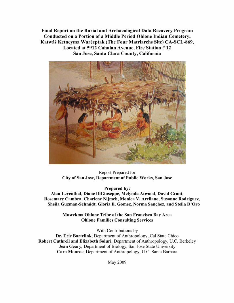
Final Report on the Burial and Archaeological Data Recovery Program Conducted on a Portion of a Middle Period Ohlone Indian Cemetery, Katwáš Ketneyma Waréeptak (The Four Matriarchs Site) CA-SCL-869, Located at 5912 Cahalan Avenue, Fire Station # 12 San Jose, Santa Clara County, California Report Prepared for City of San Jose, Department of Public Works, San Jose Prepared by: Alan Leventhal, Diane DiGiuseppe, Melynda Atwood, David Grant, Rosemary Cambra, Charlene Nijmeh, Monica V. Arellano, Susanne Rodriguez, Sheila Guzman-Schmidt, Gloria E. Gomez, Norma Sanchez, and Stella D’Oro Muwekma Ohlone Tribe of the San Francisco Bay Area Ohlone Families Consulting Services With Contributions by Dr. Eric Bartelink, Department of Anthropology, Cal State Chico Robert Cuthrell and Elizabeth Soluri, Department of Anthropology, U.C. Berkeley Jean Geary, Department of Biology, San Jose State University Cara Monroe, Department of Anthropology, U.C. Santa Barbara May 2009
Transcript of Final Report on the Burial and Archaeological Data Recovery Program Conducted on a Portion of a...
Final Report on the Burial and Archaeological Data Recovery Program Conducted on a Portion of a Middle Period Ohlone Indian Cemetery,
Katwáš Ketneyma Waréeptak (The Four Matriarchs Site) CA-SCL-869, Located at 5912 Cahalan Avenue, Fire Station # 12
San Jose, Santa Clara County, California
Report Prepared for City of San Jose, Department of Public Works, San Jose
Prepared by:
Alan Leventhal, Diane DiGiuseppe, Melynda Atwood, David Grant, Rosemary Cambra, Charlene Nijmeh, Monica V. Arellano, Susanne Rodriguez,
Sheila Guzman-Schmidt, Gloria E. Gomez, Norma Sanchez, and Stella D’Oro
Muwekma Ohlone Tribe of the San Francisco Bay Area Ohlone Families Consulting Services
With Contributions by
Dr. Eric Bartelink, Department of Anthropology, Cal State Chico Robert Cuthrell and Elizabeth Soluri, Department of Anthropology, U.C. Berkeley
Jean Geary, Department of Biology, San Jose State University Cara Monroe, Department of Anthropology, U.C. Santa Barbara
May 2009

i
Table of Contents Chapter Page No. Table of Contents…………………………………………………………….. i List of Figures………………………………………………………………… iii List of Maps…………………………………………………………………… xi List of Tables…………………………………………………………………. xii Acknowledgments…………………………………………………………….. xiii Dedication of the Katwáš Ketneyma Waréeptak (Four Matriarchs) Site Report: To Muwekma Tribal Member Susanne Rodriguez (March 14, 1957 - May 15, 2009)……………………………..………………. xvii To US Navy Veteran/Mining Engineer/Archaeologist/SJSU Alumnus Glen Bayha Wilson (December 9, 1914 – February 10, 2009) .............................xxi Chapter 1: Introduction: Project Overview…………………………............ 1-1 (Alan Leventhal, Rosemary Cambra, Norma Sanchez, and Diane DiGiuseppe)
Chapter 2: Archival Literature Search from the
Northwest Information Center…………………………………… 2-1 (A. Leventhal, Diane DiGiuseppe and Rosemary Cambra) Chapter 3: Mitigation Program: Field Phases 1, 2, 3, and 4: Burial Recovery, Archaeological Testing and Site Monitoring………………….3-1 (A. Leventhal, Diane DiGiuseppe, Charlene Nijmeh, Rosemary Cambra Norma Sanchez) Chapter 4: Burial Descriptions and Skeletal Biology: Inventory and Analysis. 4-1 (Melynda Atwood, Diane DiGiuseppe, Dave Grant and Alan Leventhal) Chapter 5: Preliminary Report on the Extraction of DNA from Site CA-SCL-869 Burial #1……... .................................................................................5-1 (Cara Monroe, PhD Candidate, Department of Anthropology, U.C. Santa Barbara) Chapter 6: Environmental Setting: CA-SCL-869 And Adjacent Canoas Marsh………….... ..............................................................6-1 (Alan Leventhal) Chapter 7: Paleo-Ecological Reconstruction and Catchment Analysis……… 7-1 (Alan Leventhal and Stella D’Oro) Chapter 8: Faunal Analysis from CA-SCL 869……………….. ..........................8-1 (Jean Geary, Department of Biology, San Jose State University and Alan Leventhal)
ii
Table of Contents Chapter Page No. Chapter 9: Paleo-Dietary Reconstruction at CA-SCL-869: Stable Carbon and Nitrogen Isotope Analysis of Four Human Burials ……………… ..............9-1 (Eric J. Bartelink, Department of Anthropology, California State University, Chico) Chapter 10: Macrobotanical and Microbotanical Analysis of Mortars from CA-SCL-869……………… ............................................................................10-1 (Rob Q. Cuthrell and K. Elizabeth Soluri Department of Anthropology, University of California, Berkeley) Chapter 11: Analysis of the Stone, Bone and Shell Artifacts from CA-SCL-869………………. ...........................................................................11-1 (Alan Leventhal and Diane DiGiuseppe) Chapter 12: The Dating and Chronological Placement of the Katwáš Ketneyma Waréeptak Site……………….. ...............................................12-1 (Alan Leventhal and Rosemary Cambra) Chapter 13: An Ethnohistory of Santa Clara Valley and Adjacent Regions; Historic Ties of the Muwekma Ohlone Tribe of the San Francisco Bay Area and Tribal Oversight of the Katwáš Ketneyma Waréeptak (Four Matriarchs) Site, CA-SCL-869 Burial Recovery Mitigation Program ....13-1 (Rosemary Cambra, Alan Leventhal, Monica V. Arellano, Susanne Rodriguez, Shelia Guzman Schmidt, and Gloria Arellano Gomez) Chapter 14: Reburial of the Muwekma Ohlone Tribe’s Ancestral Remains at Fire Station #12: Katwáš Ketneyma Waréeptak (Four Matriarchs) Site, CA-SCL-869 and Final Site Management Recommendations……….........……..14-1 (R. Cambra, A. Leventhal, C. Nijmeh, N. Sanchez, and D. DiGiuseppe) References Cited Appendix A - Artifact Record Catalog Appendix B - Skeletal Inventory Sheets Appendix C - Dentition Appendix D – Distribution of Aves and Fauna by Recovery Context Appendix E – Result from the AMS Dating Beta Analytic Laboratory Appendix F – Result from Obsidian Hydration and XRF Sourcing Appendix G – Reburial Forms

iii
List of Figures
Figure No. Page No. Figure 1-1: Archaeological Primary Site Record Form for CA-SCL-869 1-3 Figure 1-2: Project Location Fire Station 12 - Santa Teresa 7.5’ Quad 1-4 Figure 1-3: Site Map Showing Location of Phase 1 Test Trench Excavations 1-5 Figure 3-1: Mortar (B. #1) 3-1 Figure 3-2: Backhoe Excavating Test Trench #1 3-1 Figure 3-3: Fragments of Upper Limb from Burial 1 at 64 cm BS 3-2 Figure 3-4: OFCS Archaeologist Dave Grant Monitoring Test Trench #1 3-5 Figure 3-5: Measuring the Depth of Test Trench #1 3-6 Figure 3-6: Test Trenches #1 – 5 and Building Pad 3-6 Figure 3-7: Chairwoman Rosemary Cambra and OFCS Field Archaeologist Diane DiGiuseppe Monitoring Test Trenches #1 – 5 3-7 Figure 3-8: Exposure of the Stratigraphic Soil Profile (East Wall of Test Trench #1) 3-8 Figure 3-9 Stratigraphic Profile of East Wall of Test Trench #1 3-9 Figure 3-10: Ilium (Pelvis/Innominate) Fragment from Burial #1 (Test Trench #3) 3-10 Figure 3-11: Muwekma Tribal Member and OFCS Field Crew 3-12 Figure 3-12: 0-20 cm BS; Disturbed Level Containing Cultural Materials 3-13 Figure 3-13: Feature #1, 40-60 cm BS 3-14 Figure 3-14: Left Femur, Left Tibia and Right Humerus from Burial #1 3-16 Figure 3-15: Exposure of Burial #2 Adjacent to Utility Trench 3-17 Figure 3-16: Exposure of Burial #2 Close up of the Flexure of the Arm and Leg 3-18

iv
List of Figures (continued)
Figure No. Page No. Figure 3-17: Burial #2 – Close up of the Skull Prior to Removal to the Lab 3-18 Figure 3-18: Mortar #2 from Transformer Pad Trench 3-21 Figure 3-19: Burial #3 Discovered During Monitoring of Utility Trenching 3-22 Figure 3-20: Utility Trenching Operation in the Vicinity of Burial #4 3-23 Figure 3-21: Skull of B. 4 Discovered in Backhoe Trench 3-24 Figure 3-22: Mortar #3 Associated with Burial #4 3-24 Figure 3-23: OFCS Staff Osteologist Melynda Atwood Exposing Burial #4 3-25 Figure 3-24: Burial #4 Recovery into Utility Trench Sidewall 3-25 Figure 3-25: Muwekma Tribal Member Anthony Acosta Working on the Burial Recovery 3-26 Figure 3-26: MLD and Chairwoman R. Cambra Screening during Burial Recovery 3-26 Figure 4-1: Skeletal Schematic of Bones Recovered from Burial #1 4-3 Figure 4-2: Burial 1 – Ilium Portion of the Innominate (Pelvis) 4-5 Figure 4-3: Burial 1 - Long Bones Uncovered by Construction Crew 4-5 Figure 4-4: Skeletal Schematic of Bones Recovered from Burial #2 4-6 Figure 4-5: Burial #2 Anatomical Position of Skeletal Elements 4-7 Figure 4-6: Exposure of Burial #2 4-9 Figure 4-7: Skull (Burial 2) 4-9 Figure 4-8: Skeletal Schematic of Bones Recovered from Burial #3 4-11 Figure 4-9: Burial #3 Anatomical Placement of Skeletal Elements 4-12 Figure 4-10: Exposure of Burial 3 due to Utility Trenching 4-13
v
List of Figures (continued)
Figure No. Page No. Figure 4-11: Close-up of Burial #3 during Exposure 4-13 Figure 4-12: Close-up of Affect Nasal Area 4-16 Figure 4-13: X-Ray Close-up of Affect Nasal Area 4-17 Figure 4-14: Nasal Passage Comparison between Burial #3 and Lab Specimen 4-19 Figure 4-15: Skeletal Schematic of Bones Recovered from Burial #4 4-20 Figure 4-16: Burial #4 Anatomical Placement of Skeletal Elements 4-21 Figure 4-15: Preliminary Exposure of Burial #4 4-22 Figure 8-1: Red-Shouldered Hawk 8-4 Figure 8-2: American Coot 8-4 Figure 8-3: Brant’s Cormorant 8-5 Figure 8-4: Wilson’s Phalarope 8-5 Figure 8-5: Great Horned Owl 8-6 Figure 8-6: Bald Eagle 8-6 Figure 8-7: Brush Rabbit 8-6 Figure 8-8: Black-Tailed Hare 8-7 Figure 8-9: Mule Deer/California Black-Tailed Deer 8-7 Figure 8-10: Tule Elk 8-8 Figure 8-11: Faunal Remain of Elk and Deer from Test Unit #1 8-9 Figure 8-12: North American/Roosevelt Elk 8-9 Figure 8-13: Wolf (Canis lupus) 8-10 Figure 8-14: Native American Dog (Canis domesticus) 8-10

vi
List of Figures (continued)
Figure No. Page No. Figure 8-15: Coyote (Canis latrans) 8-10 Figure 9-1: Reconstructed Carbon and Nitrogen Dietary Signatures for Potential Food Resources in Prehistoric Central California 9-4 Figure 9-2: Stable Carbon and Nitrogen Isotope Data for CA-SCL-869 Burials Compared with other Prehistoric Populations from Central California 9-5 Figure 10-1: Counts of Botanical Remains Recovered from the Light Fraction from Mortar #2. Normalized to 1L of Soil 10-5 Figure 10-2: Counts of Botanical Remains Recovered from the Light Fraction from Mortar #3. Normalized to 1L of Soil 10-5 Figure 10-3: Faunal Remains Recovered from the Light and Heavy Fractions from Mortars #2 and #3 10-6 Figure 10-4: Comparison of Starch Grain Width Distributions of Aesculus californica (buckeye), Lithocarpus densiflorus (tanoak), Quercus agrifolia (coast live oak), and Quercus kelloggii (black oak) 10-6 Figure 10-5: Comparison of Starch Grain Length Distributions of Aesculus californica (buckeye), Lithocarpus densiflorus (tanoak), Quercus agrifolia (coast live oak), and Quercus kelloggii (black oak) 10-7 Figure 10-6: Mortar #2 before 10% HCl acid wash (top) and after 10% HCl acid wash (bottom) 10-9 Figure 10-7: Mortar #3 before 10% HCl acid wash (top) and after 10% HCl acid wash (bottom) 10-10 Figure 10-8: Starch Grains of Aesculus californica (buckeye) Nutmeat 10-19 Figure 10-9: Starch Grains of Arctostaphylos manzanita (common manzanita) Berries/Seeds 10-20 Figure 10-10: Starch Grains of Calandrinia ciliata (red maids) Seeds 10-21 Figure 10-11: Starch Grains of Leymus triticoides (wild rye) Seeds 10-22 Figure 10-12: Starch Grains of Lithocarpus densiflorus (tanoak) Nutmeat 10-23
vii
List of Figures (continued)
Figure No. Page No. Figure 10-13: Starch Grains of Madia sp. (tarweed) Seeds 10-24 Figure 10-14: Starch Grains of Quercus agrifolia (coast live oak) Nutmeat 10-25 Figure 10-15: Starch Grains of Quercus kelloggii (black oak) Nutmeat 10-26 Figure 10-16: Unidentified “angular” or “faceted” Starch Grains Recovered from the Grinding Surface of Mortar 2 (sample M2-E1) 10-27 Figure 10-17: Comparison of Width and Length Distributions of Starch Grains from Soil Inside Mortar #2 (sample M2-A1) and the Grinding Surface of Mortar #2 (sample M2-E1) 10-28 Figure 10-18: Unidentified Well-Preserved Starch Grains from Soil Inside Mortar 2 (sample M2-A1) 10-29 Figure 10-19: Starch Grains from the Soil in Mortar #2 (sample M2-A1) similar to starch grains of Madia sp. (tarweed) 10-30 Figure 10-20: Unidentified Well-Preserved Starch Grains Recovered from the Grinding Surface of Mortar #2 (sample M2-E1) 10-31 Figure 10-21: Unidentified Red-Colored Starch Grain Specimen #10 with Distinct Lamination Recovered from the Grinding Surface of Mortar #2 (sample M2-E1) 10-32 Figure 11-1: Examples of Exhausted and Bipolar Cores 11-9 Figure 11-2: Examples of a Secondary Core, Hammerstone, and Cobble Core 11-10 Figure 11-3: Obsidian Flakes and Point Midsection from CA-SCL-869 11-16 Figure 11-4: Mortar #1 Associated with Burial #1 (side view) 11-18 Figure 11-5: Mortar #1 Associated with Burial #1 (top view) 11-18 Figure 11-6: Mortar #3 Associated with Burial #4 (side view) 11-19 Figure 11-7: Mortar #3 Associated with Burial #4 (top view) 11-19 Figure 11-8: Mortar #2 (side view) 11-20
viii
List of Figures (continued)
Figure No. Page No. Figure 11-9: Mortar #2 (top view) 11-20 Figure 11-10: Unifacial Mano Fragment and Distal End of a Shaped Pestle 11-21 Figure 11-11: Drawing of Unifacial Mano Fragment and Distal End of a Shaped Pestle 11-22 Figure 11-12: Proto Pestle 11-23 Figure 11-13: Drawing of Proto Pestle 11-23 Figure 11-14: Drawing of Intact Unifacial Mano 11-24 Figure 11-15: Intact Unifacial Mano 11-25 Figure 11-16: Drawing of Unifacially Pecked Cobble 11-26 Figure 11-17: Unifacially Pecked Cobble 11-26 Figure 11-18: Bone Awls and Type C2 Split Drill Olivella Bead (Burial #2) 11-29 Figure 11-19: Type C2 Split Drilled Bead Interior View (Burial #2) 11-30 Figure 11-20: Type C2 Split Drilled Bead Exterior View (Burial #2) 11-31 Figure 12-1: Temporal Dating Schemes Based on Bennyhoff and Hughes (1987) Scheme B1; Hughes and Milliken (2007) Scheme D 12-8 Figure 13-1: Indians at Mission Dolores in 1816 Drawn by Louis Choris 13-14 Figure 13-2: Eighteen Unratified Treaties of California 13-33 Figure 13-3: Muwekma Indians at the Niles and Pleasanton Rancherias 13-41 Figure 13-4: 1900 Indian Population Census, Niles, Washington Township 13-43 Figure 13-5: Indian Agent Kelsey’s Map of Indian Rancherias, Verona Band 13-46 Figure 13-6: Grave Sites, Joseph Aleas, Fred Guzman and Toney J. Guzman 13-53
ix
List of Figures (continued)
Figure No. Page No. Figure 13-7: Lucas Marine BIA Application # 10298 13-54 Figure 13-8: Lucas Marine BIA Application Identifying His Tribe Ohlones 13-55 Figure 13-9: Francisca Guzman and Family BIA Application # 10293 13-56 Figure 13-10: Phoebe Alaniz BIA Application # 10301 13-57 Figure 13-11: Magdalena Thompson BIA Application # 10296 13-58 Figure 13-12: J. P. Harrington, Muwekma Elders Jose Guzman and Angela Colos 13-60 Figure 13-13: Some of the Muwekma Men Who Served During WW II 13-71 Figure 13-14: Muwekma Men Who Served During World War II 13-72 Figure 13-15: Lillian Massiatt, Ramona and Michael Galvan at Ohlone Cemetery 13-74 Figure 13-16: Muwekma Elders Maggie Juarez and Erolinda Santos Juarez Corral 13-75 Figure 13-17: Muwekma Ohlone Tribe Campout and Big Feast 2001 13-87 Figure 13-18: Muwekma Christmas Choir in Front of Mission San Jose 13-88 Figure 13-19: Muwekma Christmas Gathering at Stanford University 13-89 Figure 14-1: SJSU Students Preparing Burials for Reburial 14-2 Figure 14-2: Fire Station # 12 Sign 14-2 Figure 14-3: Front of Fire Station # 12 (5912Cahalan Avenue) 14-3 Figure 14-4: Fire Personnel Fire Station # 12 Observing Reburial and Honoring the Muwekma Ohlone Tribe and their Ancestors 14-3 Figure 14-5: Chairwoman Rosemary and Tribal Member Charlene Nijmeh 14-4 Figure 14-6: Tribal Administrator Norma Sanchez Purifying Chairwoman Cambra and Alan Leventhal with Sage and Estafiate 14-4

x
List of Figures (continued)
Figure No. Page No. Figure 14-7: Alan Leventhal Purifying Fire Personnel Prior to Reburial 14-5 Figure 14-8: Norma Sanchez and Rosemary Cambra Purifying Burial Boxes 14-5 Figure 14-9: Requested to Cleanse the Reburial Pit 14-6 Figure 14-10: Placement of Sage and Estafiate in the Four Corners of Pit 14-6 Figure 14-11: Placement of Burial Boxes within Reburial Pit 14-7 Figure 14-12: Rosemary Cambra, Norma Sanchez and Alan Leventhal Washing with Water after Placing Burial Boxes in the Reburial Area 14-7 Figure 14-13: Chairwoman Cambra Sprinkling Water 14-8 Figure 14-14: Alignment of the Burial Boxes of the Seven Individuals from Katwáš Ketneyma Waréeptak (The Four Matriarchs Site) CA-SCL-869 14-8 Figure 14-15: Honoring all the Men and Women who Serve in the City of San Jose Fire Department 14-9
xi
List of Maps
Map No. Page No. Map 1-1: Project Location Map: Site CA-SCL-869 1-8 Map 2-1: Project Location 1876 Thompson and West: Santa Clara County 2-8 Map 3-1: Site Project Map of CA-SCL-869 3-3 Map 3-2: Location of Burials, Surface Finds and Excavation Trenches and Units 3-4 Map 4-1: Site Map CA-SCL-869 Showing Burial Locations 4-2 Map 5-1: Distribution of and Percentages of Representative Haplogroups from California Indian Populations and Prehistoric Sites 5-6 Map 5-2: Site Location of the Cecil Site CA-SJO-112 5-7 Map 6-1: Map Showing the Two Ecological Divisions as Defined by Roop et al. 6-7 Map 7-1: Location of Site CA-SCL-869 7-2 Map 7-2: Reconstructed Paleo-Ecological Catchment Surrounding CA-SCL-869 7-10 Map 12-1: Location of Obsidian Sources in Central California 12-5 Map 13-1: Distribution of Ohlone Tribal Groups and Tribal Districts in the Santa Clara Valley 13-11 Map 13-2: Distribution of Ohlone Tribal Groups Surrounding the Tamien Region 13-12 Map 13-3: Distribution of Tribal Groups in the East Bay 13-13

xii
List of Tables
Table No. Page No. Table 5-1: Primers Used in this Study 5-4 Table 5-2: Comparison of the CA-SCL-869 Burial #1 Hypervariable Region I Sequence to Published Sequences 5-5 Table 8-1: Taxonomic List of Recovered Faunal Species from CA-SCL-869 8-2 Table 8-2 Comparative Faunal Assemblages from CA-SCL-869 and CA-SCL-478 8-11 Table 9-1: Stable Isotope Values and Radiocarbon Dates for Burials from CA-SCL-869 9-5 Table 10-1: Description of Microbotanical Samples Recovered from Mortars #1, #2, and #3 10-4 Table 10-2: Comparison of mean Widths and Lengths of Starch Grains 10-4 Table 10-3: Botanical Remains Recovered from Mortar #2 10-17 Table 10-4: Botanical Remains Recovered from Mortar #3 10-18 Table 11-1: Distribution of Core Types 11-8 Table 11-2: Modified Flake Metrics 11-13 Table 12-1: Results of AMS Dating on Burials #1, #2, #3, #4 and Feature #1 12-2 Table 12-2: Comparative Dates from San Francisco Bay Area Sites 12-2 Table 12-3: Obsidian Hydration Values and XRF Sourcing Results 12-3 Table 12-4: Calendar Conversion Formulae for Selected Obsidian Sources 12-4 Table 12-5: Conversion Dates on the Mean Hydration Values from CA-SCL-869 12-5
xiii
Acknowledgments
The Muwekma Ohlone Tribe of the San Francisco Bay Area and its cultural resource management firm Ohlone Families Consulting Services would like to thank the following people from the City of San Jose and the San Jose Fire Department and specifically the from Fire Station #12, the participating Muwekma Tribal members and OFCS staff and the contributing scholars who helped to facilitate all of phases of burial and archaeological data recovery field work and the ensuing lab analyses that contributed to the completion of this Final Report. We wish to thank the staff and personnel of City of San Jose, specifically Mr. David O’Neill Printy (Senior Architect, Public Safety CSA Team), Ms. Laura Wada (Project Architect), and Ms. Susan Lacy (City Inspector), for their assistance in providing funding for the burial and archaeological data recovery program and analysis conducted on the Katwáš Ketneyma Waréeptak (CA-SCL-869) site. We also would like to thank Project Supervisors Mr. William Canevari and Mr. Mark Klaiber from Falk Construction Inc. for helping to schedule the field work and monitoring of the backhoe excavations. Special thanks goes to Ms. Lauren Bobadilla from VTA of Santa Clara County for providing us a copy of the Prehistoric Archaeological Survey Report, Guadalupe Corridor, Santa Clara County, California by Roop et al. (1982). We also to thank the men and women of the San Jose Fire Department, especially those personnel that are serving at the newly constructed Fire Station # 12 for participating in the honoring ceremony for the reburial Muwekma Ohlone Tribe’s ancestors who were recovered from the Katwáš Ketneyma Waréeptak (CA-SCL-869) site. The following Fire Department personnel attending this ceremony on October 25, 2008: Fire Capt. J. P. Santos, Fire Capt. Robert “Buck” Martone; Fire Capt. Steve Bennett, Fire Capt. Mike Kahn, F/E Rob Cone, F/E Craig Black, F/E Rick Bygdnes, F/E Greg Alameda, F/E Scott Walker, F/E Paul Stamm, F/F Betsy Toffey, F/F Tom Newland, F/F Kevin Stidham.
xiv
The field crew consisted of Chairwoman Rosemary Cambra, Norma Sanchez, Muwekma Tribal members Charlene Nijmeh, Ken Nijmeh, Anthony Acosta, OFCS Senior Staff Archaeologist Alan Leventhal, Staff Archaeologists/Osteologists Melynda Atwood, Diane DiGiuseppe, Dave Grant, and OFCS archaeological field excavator Sarah Johnson. OFCS staff osteologists, Melynda Atwood, Diane DiGiuseppe, and Dave Grant labored many hours in both the field and in the lab in order to maximize on the recovery of the four primary burials and in the lab they carefully cleaned the bones and teeth and separated the soil matrix from the bones for maximum preservation. This team analyzed the human remains and wrote the Skeletal Analysis report in conjunction with Alan Leventhal (see Chapter 4 and Appendix B) The preliminary results from the mitochondrial DNA derived from Burial #1 from CA-SCL-869 was reported upon by Cara Monroe, PhD. Candidate, Department of Anthropology, University of California Santa Barbara and under the directorship of Dr. Brian Kemp, Department of Anthropology, Washington State University (Chapter 5). Alan Leventhal worked on the Environmental Setting: CA-SCL-869 and the Adjacent Canoas Marsh (Chapter 6) and the Paleo-Ecological Reconstruction and Catchment Analysis (Chapter 7) with Stella D’Oro, MA Candidate, Department of Anthropology, San Jose State University. The Maps and some of the graphics were also drawn by Stella D’Oro. The faunal remains were analyzed by Jean Geary, Department of Biology, San Jose State University (see Chapter 8). The Accelerator Mass Spectrometry dating was conducted at Beta Analytic Labs and provided the results from the radiometric assays and stable isotope. Dr. Eric Bartelink (Anthropology Department, California State University at Chico) analyzed the Beta Analytic Stable Carbon and Nitrogen Isotope results and summarized these data in his interpretative report (Chapter 9). The macrobotanical and microbotanical analysis of three mortars recovered from CA-SCL-869 was conducted by Rob Q. Cuthrell and K. Elizabeth Soluri, PhD. Candidates from the Department of Anthropology, University of California, Berkeley (Chapter 10). Diane DiGiuseppe and Alan Leventhal catalogued all of the recovered materials and conducted the analyses on the Stone, Bone and Shell artifacts (see Chapter 11 and Appendix A). We want to thank Dr. Randall Milliken, who took the time to review and measure with us the single Type C2 Split Drilled Olivella bead that was associated with Burial #2. The artifact illustrations were drawn by Deniz Enverova, BA, Anthropology, San Jose State University. The Obsidian hydration study was conducted by Mr. Tom Origer of Origer’s Obsidian Laboratory and the obsidian XRF was conducted by Dr. Richard Hughes of Geothermal Research Laboratory and these results were reported upon by Alan Leventhal and Rosemary Cambra (see Chapters 11 and 12 and Appendix F).

xv
The “Ethnohistoric” section on the aboriginal tribal groups of the Santa Clara Valley and on the history and heritage of the Muwekma Ohlone Tribe of the San Francisco Bay Area, provides vital linkages between the Muwekma’s pre-Columbian past, its contact history with the expanding Hispanic Empire, and the resultant devastation to the Muwekma and neighboring tribal peoples. This section speaks to the survival strategies deployed by the Muwekmas during the 19th and early 20th centuries, encompassing the American Conquest Period, the Gold Rush, the disenfranchisement of the Tribe and other California tribal groups and communities, up to the “discovery” of the 18 unratified California Treaties of 1851-1852. We trace the Muwekma’s through historic documents (e.g., the Federal Indian Population Censuses and action by the Bureau of Indian Affairs) and through the anthropological and linguistic studies conducted by scholars and other people during the 20th century. We present information in great detail about the service in the United States Armed forces by Muwekma men and women who served overseas in WW I, WW II, Korea, Viet Nam, Desert Storm to the present-day conflict in Iraq. The Muwekma is particularly proud of this record. This chapter also presents the most current information about the Tribe’s efforts to regain its Federally Acknowledged statue which it first obtained through the Acts of Congress beginning in 1906, 1908 and later years. Particularly troubling is the fact that after submitted six linear feet of documentation the BIA hinted that it would take approximately 24 years before it could review the Tribe’s documents, this even more compounded when the Muwekma’s were accorded a formal determination of Previous Unambiguous Federal Recognition by the BIA on May 24, 1996 and furthermore, the BIA agreeing that the Tribe was never “terminated” by Act of the US Congress, Executive action or Court Order. The section was co-authored by Tribal Chairwoman Rosemary Cambra, Tribal Ethnohistorian Alan Leventhal, Monica V. Arellano Vice-Chairwoman and Co-Chair of the Muwekma Language Committee, Susanne Rodriguez Ex-Councilwoman and Tribal member, Shelia Guzman Schmidt Councilwoman and Co-Chair of the Muwekma Language Committee, and Gloria Arellano Gomez Councilwoman and Muwekma Language Committee member (see Chapter 13) The authors would also like to offer our thanks to Dr. George Yellich, maxillo-facial surgeon, who took the time to review, evaluate and comment upon the facial pathologies, observed on Burial 3. We also want to thank Dr. Lorna Pierce, Forensic Anthropologist, Santa Clara Coroner’s Office/Department of Anthropology faculty member at San Jose State University and Ms. Irina Nechayev, MA, Interdisciplinary Studies/Anthropology who joined and collaborated with Melynda Atwood during Dr. Yellich’s observations on Burial 3 facial condition. We also want to thank the Dean’s Office, College of Social Sciences, Department of Anthropology, and Department of Biology, Bird and Mammal Museum at San Jose State University for the use of their comparative collections and support.

xvi
The team wants to thank Dr. Roger Razzari Elrod, Director and Ms. Nadia Dhillon, Radiology Technician from the SJSU Student Health Center, Division of Student Affairs for X-Raying the various skeletal elements that needed to be subjected to radiographic analysis. The image of the Ohlone Indian women on the front “Title” cover page of this report is reproduced courtesy of Santa Clara County Parks and Recreation Chitactac-Adams County Park and Interpretive Center. Tribal members from the Muwekma Ohlone Tribe, Amah-Mutsun Tribal Band and archaeological staff from OFCS worked on both the Interpretive Center and the excavations and burial recovery from the parking lot area from 1989 until its completion in the mid 1990s. Although the Chitactac Heritage Park and archaeological locality is located within the northern Amah-Mutsun Tribal territory, approximately 13 miles to the south of CA-SCL-869, its location to fresh water drainages and marsh represents an analogous adaptive strategy.

xvii
Dedication of this Katwáš Ketneyma Waréeptak (Four Matriarchs) Site Report: To Muwekma Tribal Member and Council Member Susanne Rodriguez
March 14, 1957 - May 15, 2009 and
To US Navy Veteran/Mining Engineer/Archaeologist/SJSU Alumnus Glen Bayha Wilson (December 9, 1914 – February 10, 2009)
. This Final Report is dedicated to Muwekma Tribal member and previous Tribal Council woman Susanne Rodriguez who spent the past 25 years working and representing the Tribe on many archaeological projects. Susie was the Tribal archaeological liaison with Stanford University, and she also had contributed to many of the ethnographic sections about the Muwekma Tribe’s history and heritage as a co-author, including Chapter 13 contained within this volume. May 15 was both a very sad day and also a day to look up at the sky and breath deep and celebrate life as Muwekma Tribal Member Susanne “Susie” Rodriguez did. Over the years Susie has worked with her fellow Tribal council members in educating the general public and politicians about the history and heritage of the Muwekma Ohlone Tribe. She had also worked tireless as an advocate for meaningful scientific research on her Tribe’s ancestral heritage. Susie also worked for many years along with her mother Concha Rodriguez and the Tribal leadership on their reaffirmation as a Federally Recognized Tribe. On May 15th, Susie suffering from the advanced stages of diabetes succumbed to the adverse effects from this disease. Although her body was weakened, her heart, mind and soul were still strong. She will always live and breath “Muwekma” in this world and in the spirit world. Susie was one of those remarkable people that everyone just loved. She was the embodiment of all of nature’s elements. Susie was a flame, a person of immense warmth and love, and she was a guiding light as a Muwekma Tribal Council woman, Tribal member and Tribal archaeologist. Susie was a rock, she was strong and steadfast, and she understood the earth and all the goodness that it brings. Susie was air the enjoyment of being in Susie’s company was like breathing in a fresh breath of air after a warm Spring rain. Susie was the sky she dreamed that great things would eventually come to her tribe. Susie was the incarnation of love, beauty and nurturing. She was the embodiment of what people hope their children strive to be … a genuinely good and loving person. Born into this world on March 14, 1957 in Tranquility, California, Susie was the eldest daughter of Concepcion “Concha” Martinez and Jose Rodriguez. On May 15, 2009, Muwekma Tribal Council woman Susie Rodriguez, passed away at the age of 52. Susie was a loving daughter, sister, aunt, cousin and Muwekma Tribal member.

xviii
Susie became an active member and Tribal Council women during the formative years of her Tribe, the Muwekma Ohlone Tribe of the San Francisco Bay Area. She was actively involved in the protection of the Tribe’s ancestral village and cemetery sites and when necessary was on of the leading tribal members who served as a steward of the Tribe’s ancestral heritage. Susie worked for many years as the Tribe’s archaeological liaison to Stanford University. She worked alongside with her family and fellow tribal members at the Three Wolves Site (Kaphan Húunikma) CA-SCL-732 in south San Jose, at the Yukisma Site (CA-SCL-38) in Milpitas, as well as other ancestral Muwekma heritage sites. Susie was a star in the film “Back From Extinction: The Muwekma Ohlone Tribe of the San Francisco Bay Area” in 1995 which featured major issues that the Tribe was confronted with ranging from regaining back its Federally Acknowledged status to addressing the difficult decision to remove the Tribe’s ancestral remains during a highway construction project. Susie also co-authored various ethnohistoric studies on her Tribe which were published in Final Archaeological reports that the Tribe had over sight over. The last study was completed this past April 2009 which was entitled “An Ethnohistory of Santa Clara Valley and Adjacent Regions; Historic Ties of the Muwekma Ohlone Tribe of the San Francisco Bay Area and Tribal Oversight of the Katwáš Ketneyma Waréeptak (Four Matriarchs) Site, CA-SCL-869,” a Muwekma heritage site located in South San Jose during the construction of Fire Station #12. This study was co-authored with Susie’s aunt, cousins, fellow Tribal members Rosemary Cambra, Monica V. Arellano, Susanne Rodriguez, Shelia Guzman Schmidt, and Gloria Arellano Gomez and her buddy, Tribal Ethnohistorian, Alan Leventhal. Susie was also a mainstay along with her mother, Concha, when it came to feeding the Tribe, the archaeological crews and students, especially those attending Stanford University. Susie and her mom were two of the prime preparers and cooks for the many Muwekma sponsored feasts, especially dinners held at Stanford University’s Native American theme house/dormitory Muwekma-Tah-Ruk (House of the People). Recently Susie’s Aunt Rosemary Cambra had her mitochondrial DNA sequenced and analyzed at Washington State University. The mitochondrial DNA traces the X chromosome through the maternal side of the family, meaning through the mother’s, mother’s, mother’s, mother’s (and on) DNA. Susie’s mother Concha was the older sister on Rosemary and therefore, Susie’s mitochondrial DNA is the same as Rosemary’s. What was reported back to Rosemary and the Marine-Sanchez-Martinez family and the Tribe, was that Susie’s and Rosemary’s DNA was matched to one of the founding Native American Haplogroups in North America. On June 22, 2008 Dr. Brian Kemp from the Department of Anthropology at Washington State University at Pullman wrote to Rosemary with the following results:

xix
“I just got your mitochondrial DNA sequence completed. From your sequence I have determined that you belong to Native American mitochondrial haplogroup “B2”… This pattern of mutations is very common in Native American populations because it is a very old type. … You carry one the types of mitochondrial DNA that we believe was carried over from Asia approximately 15,000 years ago. In other words, in the region of the genome that I sequenced, no mutations have occurred on your direct maternal line.”
Susie was ecstatic when she learned that her mother’s and her grandmother’s DNA reached back so far in time. In following the footsteps of her maternal ancestors Susie represented the seventh generation of a continuous line of Ohlone Indian women whose lives were ultimately disrupted by the expanding Hispanic Empire and the ensuing American Conquest of California. All of Susie’s mother’s maternal Ohlone ancestors were baptized at the Mission San Jose. Susie’s maternal lineage is descended from Efrena Quennatole who was born in 1797 and was of the Napian Patwin-speaking/Karkin Ohlone-speaking Tribal groups of the North Bay and her husband Liberato Culpecse who was born in 1787 of the Jalquin Ohlone-speaking/Saclan Bay Miwok-speaking Tribal groups of the East Bay and who was baptized at Mission Dolores in 1801. Efrena and Liberato’s only daughter, was Maria Efrena Yakilamne. She born in 1832 and was baptized at Mission San Jose and she was buried at the Ohlone Indian Cemetery. Maria Efrena and her husband Panfilio Yakilamne’s daughter was Avelina Cornates Marine who was born in 1863 and she too was baptized at Mission San Jose and was also buried at the Ohlone Indian Cemetery in 1904. Avelina had married Raphael Marine and one of their middle daughters was Ramona Marine Sanchez who was born in 1893 on the Pleasanton Alisal Rancheria and was baptized at Mission San Jose and she too was buried at the Ohlone Indian Cemetery in 1921. Ramona marine had married Porfirio Sanchez and their eldest daughter was Muwekma Tribal Elder Dolores Sanchez Martinez who was born in 1911 at the Sunol Rancheria and she too was baptized at Mission San Jose and she passed away in San Jose in 1996. Dolores Sanchez had married Manuel Martinez and their eldest daughter was Muwekma Tribal Council woman and Tribal Elder Concha Martinez Rodriguez who was born in 1930 and she passed away in San Jose in 2002. Following in the footsteps of her mother, grandmother, great-grandmother and her Ohlone Indian ancestors, Susie carried herself with a great deal of love, dignity and strength and foremost, she carried her Muwekma Ohlone Indian identity.

xx
Susie was loved by everyone. Her passing leaves a major gulf in the lives of many both within the Muwekma Tribe and the larger community. Susie Rodriguez is survived by her loving family, her father Joe Rodriguez; her sister Carol Veikune, her two beautiful nieces Nicole and Jessica Veikune, and her brother Lawrence Rodriguez. She is also survived by all of her relations of the Marine-related families and lineage and by her fellow Tribal members from the other lineages enrolled in the Muwekma Ohlone Tribe. Go walk on the pathway that bridges the earth to the heavens and that which bridges your Ohlone Indian ancestors to the present-day generations of the Muwekma Tribe. You have been and always will be a Star in the Sky. Aho!.
Susie Working on Measuring Artifacts from CA-SCL-732 (The Three Wolves Site)

xxi
This Final Report is also dedicated to the memory of Mr. Glen Wilson, a wonderful man who was a mining engineer who had worked for over the past 20 years as an archaeologist with the Muwekma Ohlone Tribe/OFCS and the scientific community. Sadly, Glen had passed away on February 10, 2009 at the age of 94. His strong interest in doing field work alongside Tribal members and conducting faunal analysis and obsidian sourcing and hydrations studies made important contributions to the final archaeological reports produced by Ohlone Families Consulting Services and for other archaeological firms. He was one “A Hell of an Engineer!” and he will be missed.
AHo!

1-1
Final Report on the Burial and Archaeological Data Recovery Program Conducted on a Portion of a Middle Period Ohlone Indian Cemetery,
Katwáš Ketneyma Waréeptak (The Four Matriarchs Site) CA-SCL-869, Located at 5912 Cahalan Avenue, Fire Station # 12
San Jose, Santa Clara County, California
Chapter 1: Introduction: Project Overview
Alan Leventhal, Rosemary Cambra, Norma Sanchez, and Diane DiGiuseppe Introduction The following archaeological report was prepared for the Department of Public Works, City of San Jose by Ohlone Family Consulting Services. The principal contact person and coordinator for the City was Mr. David O’Neil Printy, Senior Architect – Public Safety CSA Team, City of San Jose, Department of Public Works, City Facilities Architectural Services Division, 200 E. Santa Clara Street, 6th Floor, San Jose, Ca. 95113. This report summarizes the results of the archaeological and burial recovery program conducted on a portion of a pre-contact Ohlone Indian cemetery discovered at site, CA-SCL-869 Katwáš Ketneyma Waréeptak (The Four Matriarchs) Site, located at 5912 Cahalan Avenue, San Jose, Santa Clara County, California. The remains of an ancestral Ohlone Indian burial along with a sandstone boulder mortar were inadvertently discovered on May 16, 2007 by Stitch Construction workers during the excavation of the handicapped parking area adjacent to the Fire Station. The skeletal remains were discovered when the Stitch Construction backhoe operator and construction crew noticed the presence of bones during earthmoving excavation. All work was immediately halted at the construction site and the Santa Clara Coroner’s office was immediately notified. Dr. Lorna Pierce from the Santa Clara County Coroner’s office made the determination that the remains were Native American and the Native American Heritage Commission (NAHC) was contacted by both the Coroner’s office and the City of San Jose about the discovery. The Coroner’s office issued the following case number 07-02033 as reference to the discovery. On May 23, 2007 Ms. Debbie Pilas-Treadway from the NAHC contacted Rosemary Cambra, Chairwoman of the Muwekma Ohlone Tribe for the San Francisco Bay Area, and informed her that the NAHC had identified her as the “Most Likely Descendant” (MLD) for this project. After the NAHC contacted Rosemary Cambra as the MLD for this project, she along with Tribal Administrator Norma Sanchez and Tribal Archaeologist Alan Leventhal went to meet with City of San Jose and Fire officials at the Fire Station #12 construction site in order to assess the circumstances of the discovery of the burial and to make recommendations regarding the treatment and disposition of the human remains as prescribed under Public Resources Code 5097.98 of the Native American Historic Resource Protection Act California.

1-2
After meeting at the project location, it was determined that, when Burial #1 was initially discovered by the construction crew all excavation work had stopped as prescribed by law. Afterwards it was pointed out that not all of the remains had been collected or recovered by the construction crew from the area where the burial was dislocated. It was also noted that the remains were placed in the safe keeping of Dr. Lorna Pierce from the Coroner’s Office until recommendations could be made by the MLD. Based upon a long working relationship with the City of San Jose, a decision was made by City officials to hire the Muwekma Ohlone Tribe’s cultural resource management firm Ohlone Family Consulting Services to prepare a burial and archaeological data recovery and monitoring mitigation program in case there were additional burials encountered during construction in conformance with the CEQA Regulatory Guidelines and Compliance (see below). As a result OFCS prepared an Archaeological Primary Site Record form (Figs. 1-1 to 1-3) as well as a request for a site Primary Number, a Trinomial and an archival literature search from the Northwest Information Center (NWIC), Sonoma State University in order to determine if any sites were located within the parcel project area as well as within a 1 to 2 mile radius around the site (See Chapter 2). The NWIC issued P-43-001843 as the Primary Number and CA-SCL-869 as the Trinomial for this site. OFCS also prepared a multi-phased burial, archaeological data and monitoring mitigation program. Phase 1 of the mitigation program entailed the recovery of the rest of Burial #1 from within the proposed Handicapped Parking area of the parcel. This phase of work also included a complete site inspection and walk-over and collection of any isolated cultural materials and human remains that were identified. It also called for the establishment of a hand-controlled archaeological test unit in an area that was deemed intact enough to help determine whether or not the remaining portion of the site still had any archaeological integrity. In consultation with the field crews and site foreman led to an area located on the eastern portion of the project to the east/southeast of the Burial #1 locus, for the placement of Test Unit #1. The excavation results from this test unit produced a feature (Feature #1) that yielded a plethora of faunal remains, lithics and four human skeletal elements which were assigned to Burials 5 and 6. The ensuing mitigation phases of field work were to be predicated upon the discovery of additional human burials. Phase 2 of the mitigation program was conducted in conjunction with the discovery of Burial #2. Likewise, Phase 3 and Phase 4 of the mitigation work was implemented when Burials 3 and 4 were discovered during the monitoring of utility trenches. (See Chapter 3 for more details on Mitigation Phases of work). At the completion of this project, the skeletal inventory analysis which is presented in Chapter 4, produced evidence of a minimum of seven individuals consisting of the four in situ adult female burials (Burials #s 1 through 4), as well as additional human skeletal elements that were recovered from other areas within the site that represent at least two other adults (Burial #s 5 and 7) and one subadult/child (Burial #6).

1-3
Figure 1-1: Archaeological Primary Site Record Form for CA-SCL-869

1-4
Figure 1-2: Project Location Fire Station 12 - Santa Teresa 7.5’ Quad

1-5
Figure 1-3: Site Map Showing Location of Phase 1 Test Trench Excavations
1-6
This final report presents information on the results of the Archival Literature Search and Previous Archaeological Work in Chapter 2; discussion of the Four Phases of the Mitigation – Burial and Archaeological Data Recovery Program in Chapter 3; Burial Descriptions and Skeletal Biology in Chapter 4; Environmental Setting surrounding CA-SCL-869 and the Adjacent Canoas Marsh in Chapter 5; Paleo-Ecological Reconstruction and Catchment Analysis in Chapter 6; Faunal Analysis in Chapter 7; Paleo-Dietary Reconstruction at CA-SCL-869: Stable Carbon and Nitrogen Isotope Analysis of Four Human Burials in Chapter 8; Macrobotanical and Microbotanical Analysis from the three Mortars recovered from CA-SCL-869 in Chapter 9; Analysis of the Flaked Stone and Ground and Battered Stone Assemblages and other Artifacts from CA-SCL-869 in Chapter 10; Site Chronology in Chapter 11; An Ethnohistory of Santa Clara Valley and Adjacent Regions; Historic Ties of The Muwekma Ohlone Tribe of the San Francisco Bay Area and Tribal Involvement with the Four Matriarchs Site Burial Recovery Program in Chapter 12; and Reburial of the Tribe’s Ancestral Remains on October 25, 2008 in Chapter 13.. Funding from the City of San Jose for this project was directed to cover the four mitigation phases of field work, which included the burial recovery, limited archaeological data recovery and the monitoring programs. The archaeological budget also provided for the five Accelerator Mass Spectrometry (AMS) dates, the obsidian hydration and sourcing studies on the recovered five specimens, the skeletal analysis and inventory, description of cultural materials recovered from the archaeological data recovery program and for the final report. The Muwekma Ohlone Tribe, which is very interested in learning about its ancestral past supported the various studies presented in Chapters 4, 5, 6, 7, 8, and 11. The Tribe also requested of Dr. Brian Kemp from Washington State University to take samples from the four primary burials in order to conduct studies on the ancient DNA of the four elderly females recovered from this site. CEQA Regulatory Guidelines and Compliance This archaeological and burial recovery program conforms to the cultural resources requirements of the California Environmental Quality Act (CEQA) and City of San Jose procedures and regulations. Under the cultural resources guidelines presented in Appendices G and K of CEQA, the permit granting lead agency is responsible for determining whether or not a particular project would have an adverse impact on significant cultural resources. When the first burial was encountered the City of San Jose retained the services of Ohlone Families Consulting Services in order to implement the CEQA compliance process through a controlled archaeological testing and burial recovery mitigation treatment plan. CEQA (Appendix G) lists "significant effects" criteria that are also applicable to the proposed project. A significant effect on cultural resources was defined if the project would:

1-7
A. Disrupt or adversely affect a prehistoric or historic archaeological site or a property of historic or cultural significance to a community or ethnic or social group, or a paleontological site except as part of a scientific study; or
B. Conflict with established recreational, educational, religious, or scientific uses of the area. Native Americans are considered an ethnic and social group under Criterion A. Contemporary Native Americans (specifically in this case the Muwekma Ohlone Tribe of the San Francisco Bay Area) consider that disturbances to prehistoric archaeological sites adversely impact their cultural and heritage values. Although all sites are important, villages and cemetery sites are generally considered the most sensitive heritage resources.
Project Location The specific address of CA-SCL-869 (Fire Station #12) is 5912 Cahalan Avenue. The subject parcel is located on the southeast corner of the intersection of Cahalan and Calero Avenues, City of San Jose, Santa Clara County, California. CA-SCL-869 is located within unsectioned lands within the northwestern corner of the Santa Teresa Hills 7.5’ Quadrangle (Photo Revised 1968), T8S, R1E, UTM Zone 10, 602190mE / 4122220mN [near Bench Mark (BM) 204]. (Map 1-1) The nearest fresh water drainage is the channelized present-day Canoas Creek drainage which is located approximately ¼ mile (0.4 km) to the east of the site. Alamitos Creek drainage flows approximately 1¼ miles to the south and west/south, and the Guadalupe River is located approximately 1¼ miles to the west/northwest of the site. The elevation of the site is approximately 165 feet above mean sea level. CA-SCL-869 is situated on the flood plain of Canoas Creek in an area that also contained the fresh water Canoas Marsh. Willow groves were part of the plant community which grew within this riparian/marsh wetland. Prehistorically this habitat provided fresh water, food resources and sheltered areas for village settlements and for adjacent cemeteries. Some of the early Spanish expeditions left a rich record describing their first-hand encounters during their explorations through the south Bay area which describe such conditions (see the Chapter 12). The Fire Station #12 parcel was originally part of the larger church property comprising Santa Teresa Catholic Church located at 794 Calero Avenue. Some years ago this corner parcel was sub-divided and purchased by the City of San Jose from the Diocese of San Jose. The Santa Teresa Catholic Church was built around 1967 and the residential community was developed sometime around 1968 which were orchard lands.

1-8
Map 1-1: Project Location Map: Site CA-SCL-869

1-9
Given the limitations placed upon the archaeological data and burial recovery program due to significant impacts to the site by the construction activities prior to the discovery of Burial #1, only a limited range of research questions can be raised. The following represents five research questions and the types of analyzes needed to answer such questions. Research Questions Given the fact that the majority of the northern half of the parcel had already been almost completely excavated and recompacted in the area of the building pad for Fire Station #12, and the construction crew began excavating the area south of the building pad in the planned handicapped parking area when they unexpectedly dislocated several of the long bones from Burial #1 along with the large sandstone boulder mortar, this circumstance allowed for only a limited burial and archaeological data recovery program. Given these limitations and scope of work, several research questions were developed and specialized analyzes were proposed in order to address these questions. The following research questions and analyzes were put forward some which were pursued outside the funding of the mitigation work. Research Question # 1: What are the temporal components represented at the site? Analysis: - The proposed analysis needed to address this question included: 1) AMS dating (Beta Labs) of a small quantity of human bone from each of the four primary inhumations; 2) AMS dating of faunal remains from the adjacent Feature #1 encountered within Test Unit #1; 3) Obsidian hydration studies (Tom Origer and Associates) conducted on the obsidian lithics recovered from the site; and 4) measurement and typology of the cut Olivella bead associated with Burial #2 (based on Bennyhoff and Hughes 1987 –Scheme B1, and the proposed dating Scheme D by Groza 2002 and refined by Hughes and Milliken 2007). [See Chapter 12 for Site Chronology] Research Question # 2: Based upon the archaeological data recovery program what types of economic-related activities can be inferred that were carried on by the ancestral Ohlone Indians at this site? Analysis: 1) Detailed description of cultural and ecofactual materials recovered from the Features (Chapters 3 and 8); 2) analysis of the faunal and shellfish remains (Chapter 8 – Jean Geary); 3) analysis of the flaked stones, ground stone, and bone tools (Chapter 11 – Alan Leventhal and Diane DiGiuseppe); 4) source analysis of the obsidian artifacts (Chapters 11 and 12 and Appendix F) - Richard Hughes, Geothermal Research Laboratory) and other exotic materials; and 5) macrobotanical and microbotanical analysis of the phytoliths and starches recovered from the three mortars (Chapter 10 - Rob Q. Cuthrell and Elizabeth Soluri, University of California, Berkeley Archaeological Research Facility)

1-10
Research Question # 3. Based upon the archaeological data recovery program what sociological-related activities can be inferred that were carried on by the ancestral Ohlone Indians at this site? Analysis: 1) Skeletal analysis of the burials, age, sexing, and review of pathologies (Chapter 4 and Appendix B); and 2) paleo-dietary reconstruction (Chapter 9 on Stable Isotope results). Research Question # 4: Based upon the archaeological data recovery program what ceremonial-related activities can be inferred that were carried on by the ancestral Ohlone Indians at this site? Analysis: 1) Analysis of the burial features and grave associations; 2) review of ethnographic and ethnohistoric sources on California Indian belief systems and rules for treatment of the dead; 3) analysis of non-burial-related features (Chapters 3, 11 and 13). Research Question # 5: What subsistence resources were available and being exploited? Analysis: 1) Review and discussion of the Environmental Setting of CA-SCL-869 and the adjacent Canoas Marsh (Chapter 6); 2) paleo-ecological reconstruction and catchment analysis of the greater CA-SCL-869 and Canoas Creek region (Chapter 7); and 3) analysis of the recovered faunal remains (Chapter 8).

2-1
Chapter 2: Archival Literature Search from the Northwest Information Center
Alan Leventhal, Diane DiGiuseppe and Rosemary Cambra Request for Archival Literature Search Shortly after the discovery of the human remains (Burial #1), on May 29, 2007, OFCS Senior Staff Archaeologist Alan Leventhal sent in a request to the Northwest Information Center (NWIC) at Sonoma State University for an archival/literature search in order to obtain information about any previously recorded prehistoric and/or significant historic archaeological sites located either on or near (within a ½ to 2 mile radius) the project area. Ms. Lisa Hagel from the Northwest Information Center conducted a comprehensive archival/literature search and reported that at least 37 previously recorded prehistoric archaeological sites were located within a 1 to 2 mile radius of the project area and the search result was issued NWIC File # 06-1888. The NWIC plotted these thirty-seven sites on a two contiguous USGS maps and included them as part of the literature search. The NWIC provided copies of site record forms containing information about the sites located within the ½ to 2 mile radius from the subject property. The NWIC also included a cultural resources evaluation report written by Miley Holman (Holman and Associates) on the results on his on-site investigation of the Fire Station #12 construction site. Previous Field Work - Cultural Resources Evaluation by Holman and Associates The NWIC archival literature search produced a Cultural Resource Management (CRM) report indicating that the subject parcel had been previously surveyed by Mr. Miley Holman from Holman and Associates at the request of the City of San Jose (Holman 2005). In 2004, Holman had requested an archival literature search from the NWIC as part of the cultural resources evaluation for this parcel. Holman reported that:
There are no recorded archaeological sites recorded inside the project area or within a quarter mile of it, and there have been no previous archaeological field studies done on the project area or anything within a quarter mile of it. Numerous historic and/or prehistoric archaeological sites have been recorded at the foot of the hills and extending up to them to the south of the project area, where a combination of environmental factors favored the establishment of seasonal camp and village sites. … The lack of recorded archaeological sites for the lands north of the hills may simply be the result of the early residential development of this area during a period when cultural resource studies were not required.

2-2
Holman also described the limitation of his field inspection:
… The visual inspection was limited to those portions of the project area which are presently landscaped; the soils visible here appear to have been imported and are raised above the surrounding ground levels which probably represent the native ground level before development of the general area. No evidence of cultural resources were found inside the landscaping area.
In his “Findings/Recommendations” section Holman concluded:
No evidence of cultural resources was found during the course of either the archival study or the field inspection. Since it appears that little to no portion of the native ground surface is visible inside the project boarders, the issue of archaeological sensitivity remains – will future ground disturbing activities uncover buried archaeological resources? It is the opinion of this author that there is at best a moderate potential that future development of the parcel will uncover buried archaeological resources, based upon the lack of prehistoric sites in the general vicinity north of the hills. While there have been very few archaeological studies done for the general vicinity north of the hills, informal archaeological research done by both professional and avocational groups have failed to record archaeological sites during the recent development of the area for residential purposes. This report concludes that future development of the Fire Station #12 project should have no effect on buried archaeological resources. This report does not recommend that a program of archaeological monitoring of future earth disturbing activities. Construction crews involved with the clearing of the site and initial grading should be warned however that this is a potential for the discovery of buried archaeological resources and they should be instructed to stop work within 20 feet of the discovery of any of the materials listed below until a qualified archaeologist has been retained to inspect the discovery. In the event that it is determined that a potentially significant archaeological resource has been uncovered, it will be the responsibility of the project sponsor to submit a plan to the San Jose Planning Department for the evaluation of the resource for significance as defined under current CEQA guidelines. In the event that text (sic) excavations demonstrate that a significant cultural resource will be impacted, the project sponsor should submit a plan for the mitigation of impacts to that resource to the San Jose Planning Department for approval before work is allowed to recommence in the area defined as culturally significant.

2-3
Indicators of archaeological resources for this area include but are not limited to the following: darker than surrounding soils containing visible amounts of stone, bone or shellfish, artifacts of these materials, evidence of fires (ash charcoal, fire affected rock or earth) and of course, burials, either animal or human (Holman 2005:1-3).
Prehistoric Sites Previously Recorded Within a Two Mile Radius of CA-SCL-869 The results of the NWIC archival literature search concluded that no recorded prehistoric and/or historic archaeological sites were identified within ¼ mile of the immediate study area. However, there were recorded sites located up to two miles away from CA-SCL-869. The following summarizes the location and provides limited information about the character of these previously recorded sites. Information not provided by the NWIC was supplemented by information contained in various available reports and studies, as well as from the archaeological sites archives on file at San Jose State University. - CA-SCL-64 is located approximately 2 miles south of the study area. The site was also designated as WVC #1 (West Valley College). CA-SCL-64 was first recorded by J. Whitlow, B. Anderson and D. Casell on September 12, 1973, however Chester King documented several burials and 14 possible cooking features when PG&E began trenching in December 1972. These investigators described the site as having “scattered human remains in trenches of PG&E and Camden Ave. construction. Four salvaged by West Valley College … . Surface collected taken in disturbed areas by WVC includes flake tools, core tools, charm stone, beads, ornaments, metate.” Jackie Remus in 1974 recorded the site and described it as “major flake scatter with associated fire-cracked rock and ground stone artifacts earlier reported by WVC …” - CA-SCL-68 is located approximately 2 miles north/northwest of the site. Early investigations were conducted by Anderson et al. in 1973, followed by “Archaeological Consulting and Research Services in 1974, Edwards in 1978, Chavez in 1980, Roop et al. 1982, Fong in 1988-1989, and Cartier et al. in 1991-1992” (Cartier et al., 1993). Excavations during the construction phase of the “Guadalupe Project” recovered 39 burials (Cartier et al., 1993). - CA-SCL-129 is located approximately a little less than 1½ miles southeast from the study area. - CA-SCL-130 which was previously designated as WVC-8 (West Valley College) and “Dick’s Supermarket Site” is located approximately ½ mile north of CA-SCL-869 at the intersection of Blossom Hill Road and Cahalan Ave. The site was originally recorded in 1973 by Robert Anderson who described it as being on a “natural mound on old shore line of extinct marshy lake near present Canoas Creek.” CA-SCL-130 was also described as having “black/grey adobe midden” soils and that several burials were “destroyed

2-4
during parking lot construction.” Other cultural materials observed at this site were “burnt rock, chert flakes, pestle fragments, china bowl sherds.” The Archaeological Site Record site map notes that Phil Roehr conducted archaeological excavations (in 1974?) on two burials within locus “A” that had “Olivella “ring” saucers” and “Large Oval Saddles” associated with them. At locus “B” located to the north of locus “A” on the site map there was another “Burial with Bear skull, claws, human skull and bones taken by the construction foreman during construction of parking lot.” Winter (1974) also noted that the midden constituents also included: charcoal, burnt bone, fire-crack rock, lithic scatter (chert), obsidian point, shell, pestle frags., Olivella beads (ring saucer, large oval saddle) [Robert J. Anderson, 1973; Joseph Winter 1974]. - CA-SCL-132 – is located 1¼ miles southwest of the study area. The CA-SCL-132 is also known as the Mazzone Site and also designated WVC-25 site. When the site was first recorded by James Delgado in 1974 it was described as “1 rock covered with BRMs (Bed Rock Mortars) under an elderberry tree on the re-excavated banks of the Alamitos Creek and 1 small rock with one mortar.” The “rock” is actually a large outcropping of sandstone which has around 18 plus mortar features and 100 + cupules. - CA-SCL-137 which was also designated as WVC-20 is located approximately 1 mile east/northeast of CA-SCL-869 on Snell Road just south of Blossom Hill Road. CA-SCL-137 was described as a “Habitation Site, Permanent Occupation” by Chester King, James Delgado and Phil Roehr in 1974. They noted on the archaeological site record form the presence of four burials, “clam disc, steatite and Olivella beads, abalone shell ornaments, bone awl, obsidian drill, charmstone, ground stone, chipped stone tools” (Chester King, James Delgado and Phil Roehr 1974; Steve Dietz (ACRS) 1974; L. Weigel 1984). In 1988, Basin Research Associates recovered nine grave lots from this site, and between 1989 and 1990 Archaeological Resource Management recovered an additional sixty-nine field designated burials (Jurmain 1992). Cartier et al. (1993) reported on seven uncorrected C14 dates derived from different dated materials from this site. These uncorrected dates range in age from 2000 ± 80 to 2800 ± 120. The 2000 ± 80 date derived from unreported material came from the 90-100 cm level of a test unit and the 2800 ± 120 was derived from a charcoal sample associated with Burial # 59-90). - CA-SCL-148 is located a little less than 1½ miles south from the study area. CA-SCL-148 was recorded by Del Cioppo in 1974 and the site was described as a “historic dump area as well as reportedly a bedrock mortar site on the adjacent creek bank (reported by C. King – West Valley College).” K. Flynn described it as a “minor flake scatter” in 1975. J. Winter (1977) placed two test units in the site and recovered “seven stone flakes and a few chips of animal bones were found in the upper 30 cm in one of the pits (Winter 1977:12).

2-5
- CA-SCL-149 is located a little less than 1¼ miles southwest from the study area. CA-SCL-149 was recorded by Remus in 1974 and the site was described as “1 flake site south of old bridge on Alamitos Creek (north bank) – artifact found only on north bank.” Also noted was a “possible worked core.” - CA-SCL-181 is located a little less than 1¾ miles west/southwest from the study area. CA-SCL-181 was recorded by K. Flynn in 1974 and the site was described as a “flake scatter along road and in right of way along power lines.” - CA-SCL-182 is located approximately 1¾ miles west/southwest from the study area. CA-SCL-182 was recorded by K. Flynn in 1974 and the site was described as a “flake scatter along south margin of power lines.” - CA-SCL-183 is located a little more than 1¾ miles west/southwest from the study area. CA-SCL-183 was recorded by K. Flynn in 1974 and the site was described as a “foot path flake scatter – very little field stone … flakes.” - CA-SCL-184 is located a little more than 1¾ miles west/southwest from the study area. CA-SCL-184 was recorded by K. Flynn in 1974 and the site was described as a “one mortar (children’s) found within fenced in area surrounding power lines.” - CA-SCL-185 is located approximately 2 miles west/southwest from the study area. CA-SCL-185 was recorded by K. Flynn in 1974 and the site was described as a “flake scatter along small foot path along right of way adjacent to fenced in area enclosing power lines-parallel to orchard.” - CA-SCL-186 is located approximately 1½ miles west from the study area. CA-SCL-186 was recorded by R. Jackson in 1974 and the site was described as a “Franciscan flake 1 found just above creek bed in open area.” - CA-SCL-187 is located approximately 1¾ miles west from the study area. CA-SCL-187 was recorded by J. Whitlow in 1974 and the site was described as a “1 oyster shell found near levees and percolation pond.” - CA-SCL-195 is located approximately ½ mile south of the study area. CA-SCL-195 was recorded as a “Flake Scatter” by B. Roop and Remus in 1974. - CA-SCL-196 is located approximately 1½ miles southeast of the study area. CA-SCL-196 was recorded by K. Flynn in 1974 and was describes as a “flake scatter – no midden.” One hammerstone was also noted. - CA-SCL-199 is located 1½ miles southwest from the site. CA-SCL-199 was recorded by K. Flynn in 1974 as having “flakes along the field margin within the right of way alongside power lines (fenced in). - CA-SCL-269 is located a little less that than 1½ miles south from the site.

2-6
- CA-SCL-277 is located a little more that than 1½ miles south from the site. - CA-SCL-278 is located approximately 1¼ miles south from the site. - CA-SCL-295 is located approximately a little more than ¾ of a mile north of the study area. CA-SCL-295 was characterized by Steve Dietz (ARCS) as having “light brown clayey” soil containing a “thin scatter of thermally fractured rock and Franciscan chert.” Also noted was a “medial fragment of Franciscan chert projectile point (not collected) probably from a leaf shaped bipoint.” (Dietz 1974). The site dimensions were revised by Larry Weigel from Caltrans as part of the Guadalupe Corridor (Highway 85) project. Weigel updated the site record form and described the site as “a scatter of Franciscan and Monterey Chert flakes, thermally fractured rock and groundstone.” He also noted that the site contained “housepits material concentrations associated features/petroglyphs.” Other artifacts included “3 pestle fragments, 1 obsidian flake, 1 fragment of bone (possibly human), 1 elongated mano, 1 chert projectile point, 1 chert biface fragment.” (Weigel 1984). - CA-SCL-299 is located a little less than 1½ miles to the south of the site. - CA-SCL-316 is located a little less than 1½ miles to the south of the site. - CA-SCL-337 is located approximately 1½ miles to the south/southeast of the site. - CA-SCL-406 is and very large site and is located approximately 1½ - 2 miles to the west/southwest of the site. - CA-SCL-415 is located approximately 2 miles to the southeast of the site. - CA-SCL-446 is located a little less than 2 miles to the north of the site. - CA-SCL-628 is located a little less than 1½ miles to the southeast of the site. There were also a cluster of sites located approximately 1 mile to the Southwest around the historic Sunset Quarry. These sites were designated as Boulder Ridge Project sites: - CA-SCL-733 was designated Boulder Ridge1 Site and was recorded by A. Pastron and J. Abell in 1992. These surveyors observed “small quantities of lithics: 2 basalt scrapers, 2 chert scrapers, 1 crude quartzite biface, 1 volcanic chopper, 2 chert cores, 14 chert flakes, 1 basalt flake. - CA-SCL-734 was designated Boulder Ridge 2 Site and was recorded by Archaeo-Tec in 1992 and re-recorded in 1996 by Pastron and Ruskin. Archaeo-Tec described this site as consisting “of three small rockshelters existing within a single massive sandstone boulder. Each small rockshelter contains one or more bedrock mortar cups on the cave floor.”

2-7
- CA-SCL-735 was designated Boulder Ridge 3 Site and was recorded by Pastron, Abell and Clewlow in 1992. They described this site as a “Free-standing oval cave with pictographs on walls and ceiling, mortar cups and cupules on floor.” These surveyors also stated that there were “Aboriginal pictographs on cave walls and ceiling, 24 mortars, cups and cupules on cave floor.” - CA-SCL-792 was designated Boulder Ridge 5 Site and was recorded by A. Pastron and D. Ruskin in 1996. These surveyors observed that the site consisted of “a bedrock milling station composed of a group of surface bedrock mortar features. In total, 34 mortar cups, grinding surfaces and problematic depressions were recorded on eight closely situated sandstone boulders.” - CA-SCL-793 was designated Boulder Ridge 6 Site and was recorded by A. Pastron and D. Ruskin in 1996. These surveyors described the site as “a bedrock milling station consisting of a group of surface bedrock mortar features. In total, ten bedrock mortar cups were recorded on three closely situated sandstone boulders.” - CA-SCL-794 was designated Boulder Ridge 7 Site and was recorded by A. Pastron and D. Ruskin in 1996. Pastron and Ruskin observed that the site consisted of “a bedrock milling station consisting of a single sandstone boulder with five mortar cups and a single depression of apparently natural origin.” - CA-SCL-795 was designated Boulder Ridge 8 Site and was recorded by A. Pastron and D. Ruskin in 1996. Pastron and Ruskin observed that the site consisted of “a bedrock milling station consisting of a group of surface bedrock mortar features. In total, twelve bedrock mortar cups were recorded on five closely situated sandstone boulders.” - CA-SCL-796 was designated Boulder Ridge 9 Site and was recorded by A. Pastron and D. Ruskin in 1996. Pastron and Ruskin observed that the site consisted of “a bedrock milling station consisting of a group of closely situated sandstone boulders with bedrock mortar cups. In total, 4 mortar cups were recorded on three sandstone boulders.” - CA-SCL-797 was designated Boulder Ridge 10 Site and was recorded by A. Pastron and D. Ruskin in 1996. Pastron and Ruskin observed that the site consisted of “a bedrock milling station composed of a group of surface bedrock mortar features. In total, 45 mortar cups and grinding surfaces were recorded on seven closely situated sandstone boulders.” Other Information Provided by the Northwest Information Center The Northwest Information Center’s literature search also included a copy of the 1876 Thompson and West, Historical Atlas Map of Santa Clara County, California which did not identify the location of either the Canoas Creek drainage or Canoas Creek Marsh. At the time when the 1876 Thompson & West map was published, the CA-SCL-869 locality was situated on the undeveloped and perhaps uncultivated lands belonging to a Mr. M. Cahiulan. Cahiulan seems to be the original spelling of Cahalan. (Map 2-1).

2-8
Map 2-1: Project Location 1876 Thompson and West: Santa Clara County

2-9
The Northwest Information Center also consulted the Office of Historic Preservation Historic Property Directory where they noted that site CA-SCL-706 was the only recorded site identified on that list, however, no additional information was provided.
3-1
Chapter 3: Mitigation Program: Field Phases 1, 2, 3 and 4: Burial Recovery, Archaeological Testing, Archaeological Data Recovery and Site Monitoring
Alan Leventhal, Diane DiGiuseppe, Charlene Nijmeh, R. Cambra, and Norma Sanchez
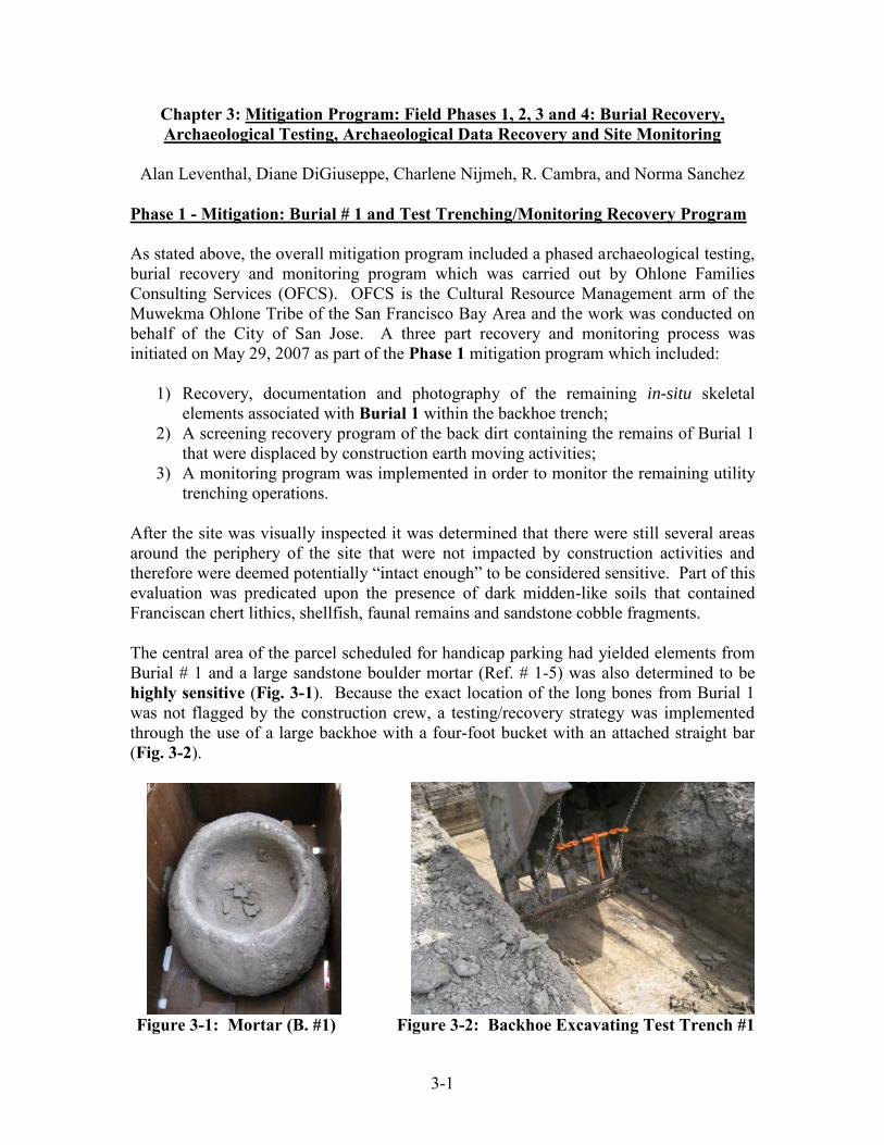
Phase 1 - Mitigation: Burial # 1 and Test Trenching/Monitoring Recovery Program As stated above, the overall mitigation program included a phased archaeological testing, burial recovery and monitoring program which was carried out by Ohlone Families Consulting Services (OFCS). OFCS is the Cultural Resource Management arm of the Muwekma Ohlone Tribe of the San Francisco Bay Area and the work was conducted on behalf of the City of San Jose. A three part recovery and monitoring process was initiated on May 29, 2007 as part of the Phase 1 mitigation program which included:
1) Recovery, documentation and photography of the remaining in-situ skeletal elements associated with Burial 1 within the backhoe trench;
2) A screening recovery program of the back dirt containing the remains of Burial 1 that were displaced by construction earth moving activities;
3) A monitoring program was implemented in order to monitor the remaining utility trenching operations.
After the site was visually inspected it was determined that there were still several areas around the periphery of the site that were not impacted by construction activities and therefore were deemed potentially “intact enough” to be considered sensitive. Part of this evaluation was predicated upon the presence of dark midden-like soils that contained Franciscan chert lithics, shellfish, faunal remains and sandstone cobble fragments. The central area of the parcel scheduled for handicap parking had yielded elements from Burial # 1 and a large sandstone boulder mortar (Ref. # 1-5) was also determined to be highly sensitive (Fig. 3-1). Because the exact location of the long bones from Burial 1 was not flagged by the construction crew, a testing/recovery strategy was implemented through the use of a large backhoe with a four-foot bucket with an attached straight bar (Fig. 3-2).
Figure 3-1: Mortar (B. #1) Figure 3-2: Backhoe Excavating Test Trench #1

3-2
The handicap parking area that included the Burial 1 locus was divided up into five parallel 5 foot-wide Test Trenches which were generally oriented north-south. The easternmost test trench was designated Test Trench #1 and the other four (Test Trenches 2 through 5) continued to the west. Because the handicap parking area had already been impacted and partially graded (sloping north to south) by earlier construction excavations, the highest (northernmost) portion of the area of each trench was excavated to a depth of 140 cm Below Surface (BS) and the trench excavations were extended to a length of 20-25 feet south of the north end. Based upon the recollection of the construction crew, the Burial 1 locus was estimated to be located within the north-central area of Test Trenches #s 1 through 3 (Fig. 3-3). All of the Test Trenches were excavated slowly in 2 to 3 inch (<8 cm) incremental levels (See Maps 3-1 and 3-2). A Main Site Datum with an elevation of 163.60’ (above mean sea level) was established on the top of the metal grate of Main Storm Drain # 1 on the east side of the parcel. This elevation was surveyed in on the construction plans.
Figure 3-3: Fragments of Upper Limb from Burial 1 at 64 cm BS (Test Trench 3)

3-3
Map 3-1: Site Project Map of CA-SCL-869

3-4
Map 3-2: Location of Burials, Surface Finds and Excavation Trenches and Units

3-5
All cultural materials such as flaked stone, cobble stone tools, faunal and shell fish remains and other artifacts, derived from in situ, screening and disturbed contexts, were placed in labeled unit level bags and later were assigned catalogue reference number and specimen number during lab processing and analysis. Results from the Test Trenches 1 - 5 Recovery Program Test Trench # 1 was excavated to a depth of 140 cm BS. An ulna and ribs belonging to Burial 1 were encountered at a depth of 53 cm BS. A surface containing a fairly dense cluster of rounded whole and fragmented fist-sized sandstone cobbles was also encountered at 67.5 cm BS. This clustered area of sandstones cobbles was located approximately 134 cm from the north wall of the trench and none of them exhibited any evidence of thermal alteration (therefore they were not fire cracked rocks [FCR]). Faunal remains were encountered in the south-central portion of the test trench at 85 cm BS. Approximately five feet to the south of the north wall of Test Trench #1 the backhoe excavation encountered a large historic pit containing asphalt chunks, glass, metal and other debris (Fig. 3-4). This historic pit continued several feet further to the south and spanned the entire width of Test Trench #1. The age of the historic materials seemed to be more recent, perhaps dating back to the 1960s or 70s, and therefore was not deemed significant. The pit bottomed out at approximately 134 cm BS. Test Trench #1 was excavated down to sterile which began at approximately 100 cm BS (Fig. 3-5 to 3-7).
Figure 3-4: OFCS Archaeologist Dave Grant Monitoring Test Trench #1 (View: Looking South)

3-6
Figure 3-5: Measuring the Depth of Test Trench #1 (View Looking Northeast)
Figure 3-6: Test Trenches #1 – 5 and Building Pad (View Looking Northeast)

3-7
Figure 3-7: Chairwoman Rosemary Cambra and OFCS Field Archaeologist Diane DiGiuseppe Monitoring Test Trenches #1 – 5 (View: Looking West)
Stratigraphic Descriptions: Test Trench #1 East Wall Profile After the excavation of the Test Trenches was completed, the only trench wall deemed suitable to profile was the East Wall of Trench # 1. After carefully reviewing the soils, five distinct strata were discerned and described (Figs. 3-8 and 3-9). The soil profile descriptions were determined by employing the Munsell Soils Color Chart and the definitions contained in the “Profile Description” derived from the Supplement to Agriculture Handbook No. 18 (no date). Starting from the surface (uppermost stratum) and then working down the following strata were defined in the East Wall Profile (Fig. 3-9): Stratum V – Color: 10YR 3/1 Very Dark Gray (moist); Texture: (sil) silt loam; Structure/Grade: (0) structureless to (1) weak; Structure/Size: (vf) very fine; Moist Consistence: (mfr) friable to (mfi) firm; Wet Consistence: (wso) non-sticky; Plasticity: (wps) slightly plastic; wire forms, but soil mass easily deformed. Stratum IV – Color: 10YR 3/3 Dark Brown (moist); Texture: (sil) silt loam; Structure/Grade: (1) weak; Structure/Size: (vf) very fine; Moist Consistence: (mfi) firm; Wet Consistence: (wss) slightly sticky; Plasticity: (wps) slightly plastic; wire forms, but soil mass easily deformed.

3-8
Stratum III – Color: 10YR 4/2 Dark Grayish Brown (moist); Texture: (l) loam; Structure/Grade: (1) weak; Structure/Size: (vf) very fine; Moist Consistence: (mvfi) very firm; Wet Consistence: (wss) slightly sticky; Plasticity: (wps) slightly plastic; wire forms, but soil mass easily deformed. Stratum II – Color: 10YR 4/3 Brown/Dark Brown (moist); Texture: (sil) silt loam; Structure/Grade: (1) weak; Structure/Size: (vf) very fine; Moist Consistence: (mfr) friable to (mfi) firm; Wet Consistence: (wso) non-sticky; Plasticity: (wpo) non-plastic to (wps) slightly plastic; wire forms, but soil mass easily deformed. Stratum I – Color: 10YR 4/3 Brown/Dark Brown (moist); Texture: (sl) sandy loam; Structure/Grade: (0) structureless; Structure/Size: (vf) very fine; Moist Consistence: (mlo) loose to (mvfr) very friable; Wet Consistence: (wso) non-sticky; Plasticity: (wpo) non-plastic.
Figure 3-8: Exposure of the Stratigraphic Soil Profile (East Wall of Test Trench #1)

3-9
Figure 3-9 Stratigraphic Profile of East Wall of Test Trench #1

3-10
Summary of the Areal Excavation and Recovery from Test Trenches 2 - 5 Test Trench #2 yielded some additional elements belonging to Burial # 1. A lumbar fragment was dislodged and recovered by screening the back dirt. The same area also produced a portion of the cranium (i.e., six teeth and a portion of the maxilla and mandible). The depth of these elements was approximately at 61.5 cm BS and located adjacent to the western edge of Test Trench #1. Shellfish, faunal remains and flaked stone artifacts of Franciscan chert were also recovered at a depth of 40 – 65 cm BS. The last historic trash pit encountered in Test Trench # 1 continued to be identified in this trench but was less pronounced. Test Trench #2 was excavated down to approximately 140 cm BS. Test Trench # 3 also produced elements affiliated with Burial #1. A portion of the pelvis (ilium portion of the /innominate/os coxa) was recovered at a depth of 64 cm BS and 92 cm (3 feet) from the north wall (Fig. 3-10). Other miscellaneous human bone (rib) fragments associated with Burial 1 were recovered nearby at a depth of 62 cm BS and 128 cm from the north wall. A remnant of the historic pit encountered in Test Trenches 1 and 2 continued in this trench. Test Trench 3 was excavated to the depth of 140 plus cm BS.
Figure 3-10: Ilium (Pelvis/Innominate) Fragment from Burial #1 (Test Trench #3)

3-11
Test Trench # 4 yielded some faunal remains at a depth ranging from 38 – 40 cm BS as well as non-thermally affected fist-sized sandstone cobbles. No human elements were recovered. Test Trench #4 was excavated to the depth of 140 plus cm BS. Test Trench # 5 yielded a loose cluster of thermally affected rounded fist-sized sandstone cobbles and cobble fragments were encountered at a depth ranging from 64 - 70 cm BS which probably represents a buried cultural surface. These cobbles were washed in the field and none exhibited any use-wear patterns. Test Trench # 5 was excavated to the depth of 140 plus cm BS. Test Trench #6: Test Trenching and Areal Excavation of the Transformer Pad Area After the completion of the areal excavations of the handicap parking area (Test Trenches 1 – 5), a decision was made to conduct an areal exposure on the eastern side of the parcel perpendicular to the five Test Trenches. This was in an area which was partially impacted by the earlier sub-surface construction work conducted within the handicap parking area. Test Trench # 6 was established just south of the proposed “Transformer Pad” area and the trench was aligned east to west terminating on the eastern end. It was thought, based upon conversations with the construction crew and site foreman, that this area was not previously excavated and therefore, OFCS deemed it “archaeologically sensitive”. Test Trench # 6 was mechanically excavated in 3” – 4” (10 cm) increments to a depth of approximately 140 cm BS. All flaked stone materials, cobbles, bones and/or shells that were encountered were collected and their location was mapped. When archaeological materials were encountered, the surrounding soils were screened for maximum recovery. Test Trench # 6 produced very little cultural material due to the fact that much of the area within the trench had been previously impacted and refilled by the earlier construction-related earth moving activities. The following materials were recovered from this Trench # 6: From the 0 – 40 cm Below Surface (BS) level the following artifacts were recovered: 1 Red Franciscan chert (RFC) Exhausted pebble core; 1 obsidian biface/dart point mid-section; 1 RFC Bipolar cobble core; 1 Green Franciscan chert (GFC) and 1 RFC Bipolar flakes, 2 GFC Primary flakes, 1 RFC Thinning Flake; several fragments of vitrified clay; 1 artiodactyl (probably deer) long bone fragment; and 1 femur from a ground squirrel. (See Catalog Reference # 50) From the 40 – 60 cm BS level: a small intact sandstone mortar (Mortar #2); 1 Unifacially pecked oval flat sandstone cobble; 1 carpal (manus) from a tule elk; 7 bone fragments from an artiodactyl; 16 unburnt small mammal bones; 1 calcined (from exposure to intense fire) bone fragment were recovered. (See Catalog Reference # 51) From the 60 – 100 cm BS levels nothing was recovered. (No Catalog Reference # assigned).

3-12
At the eastern terminus of Test Trench # 6, as stated above, the soils appeared to be a black ashy midden and undisturbed. A decision was made to establish a controlled test unit within this area to determine if this portion of the site had any integrity left to it. Test Unit # 1 was established measuring 1.5 meters (oriented North/South) by 1 meter (oriented East/West) and was excavated in arbitrary 20 cm levels. All of the excavated soil was passed through 1/4” and 1/8” mesh screens (Fig. 3-11). (For a more detailed analysis of recovered materials see following chapters in this report and Appendix A - Artifact Record Catalog).
Figure 3-11: Muwekma Tribal Member and OFCS Field Crew Charlene Nijmeh Screening at Test Unit 1
Summary of Recovered Materials from Test Unit #1 and Feature #1 After the excavation of Test Trench # 6 was complete a decision was made to place a 1.5 meter by 1 meter control test unit at the eastern terminus end of Trench 6 in an area that was still considered “Archaeologically Sensitive” and potentially undisturbed. Test Unit # 1 was excavated in 20 cm. levels. Around 35 – 40 cm BS the field crew encountered rounded sandstone cobbles and faunal remains. - 0-20 cm level BS was somewhat disturbed and it yielded only construction related debris and materials (e.g., nails, screws and etc.) [Fig. 3-12].

3-13
Figure 3-12: 0-20 cm BS; Disturbed Level Containing Cultural Materials The upper 0 – 20 cm level comprised a disturbed/mixed zone of recent historic materials (glass, nails, screws and etc.), however, the level did yield the following lithic, shellfish and faunal materials. Lithics: 1 utilized flake Red Franciscan chert (RFC); 5 flakes (RFC); 2 flakes Green Franciscan chert (GFC); 1 borer Green/Red mottled Franciscan chert (GRFC ); 3 flakes (GRFC); 1 angular cortical fragment Basalt (BA); Shellfish: 3 fragments Tegula funebralis (black turban snail); 4 fragments Mytilus edulis (bay mussel); 2 fragments Saxidomus sp?(Butter clam). (See Catalog Reference # 7) - 20-40 cm BS level yielded in situ faunal remains (canid mandible) and an adjacent sandstone cobble at 31 cm below surface (bs). A buried surface with many sandstone cobbles and fragments appeared at the 35-40 cm level. Fist sized rounded cobbles of sandstone, chert flakes, a possible hammerstone and an obsidian flake were recovered. We identified these materials as part of Feature #1. The 20 – 40 cm level yielded the following lithic, shellfish, and faunal materials: Lithics: 1 obsidian (Obs) pressure flake sourced to Casa Diablo in the eastern Sierra; 1 secondary core of red Franciscan chert (RFC); 12 flakes (RFC); 5 flakes green Franciscan chert (GFC); 1 Rhyolite flake (Rhy); 1 utilized flake (spokeshave) Andesite (And); Faunal - Mammals: 2 unidentified long bone fragments from a large mammal, one of these is burnt; left mandible with two teeth Canis domesticus(?); 5 elements from Sciurus niger (fox squirrel); 3 elements from Otospermephilus beecheyi (California ground squirrel); 2 elements from Thomomys bottae (pocket gopher); Birds: 1 bird talon; a distal tibia from (possibly) Steganopus tricolor (similar to Wilson's Phalarope); Shellfish: 1 Tegula
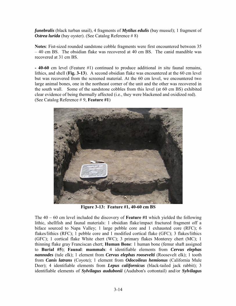
3-14
funebralis (black turban snail), 4 fragments of Mytilus edulis (bay mussel); 1 fragment of Ostrea lurida (bay oyster). (See Catalog Reference # 8) Notes: Fist-sized rounded sandstone cobble fragments were first encountered between 35 – 40 cm BS. The obsidian flake was recovered at 40 cm BS. The canid mandible was recovered at 31 cm BS. - 40-60 cm level (Feature #1) continued to produce additional in situ faunal remains, lithics, and shell (Fig. 3-13). A second obsidian flake was encountered at the 60 cm level but was recovered from the screened material. At the 60 cm level, we encountered two large animal bones, one in the northeast corner of the unit and the other was recovered in the south wall. Some of the sandstone cobbles from this level (at 60 cm BS) exhibited clear evidence of being thermally affected (i.e., they were blackened and oxidized red). (See Catalog Reference # 9, Feature #1)
Figure 3-13: Feature #1, 40-60 cm BS
The 40 – 60 cm level included the discovery of Feature #1 which yielded the following lithic, shellfish and faunal materials: 1 obsidian flake/impact fractured fragment off a biface sourced to Napa Valley; 1 large pebble core and 1 exhausted core (RFC); 6 flakes/lithics (RFC); 1 pebble core and 1 modified cortical flake (GFC); 3 flakes/lithics (GFC); 1 cortical flake White chert (WC); 3 primary flakes Monterey chert (MC); 1 thinning flake gray Franciscan chert; Human Bone: 1 human bone (femur shaft assigned to Burial #5); Faunal: mammals: 4 identifiable elements from Cervus elephas
nannodes (tule elk); 1 element from Cervus elephas roosevelti (Roosevelt elk); 1 tooth from Canis latrans (Coyote); 1 element from Odocoileus hemionus (California Mule Deer); 4 identifiable elements from Lepus californicus (black-tailed jack rabbit); 3 identifiable elements of Sylvilagus audubonii (Audubon's cottontail) and/or Sylvilagus

3-15
bachmanii (brush rabbit); 7 identifiable elements from Sciurus griseus (Western gray squirrel) and 1 from Sciurus niger (fox squirrel); 7 identifiable elements from Otospermophilus beecheyi (California ground squirrel); 12 identifiable elements from Thomomys bottae (pocket gopher); 3 unidentified mid-to-large mammal bones (calcined and burned); 4 unidentified faunal fragments (unburnt); Birds: 1 identified element from Phalacrocorax penicillatus (Brandt’s cormorant); 1 element from Bubo virginianus (Great Horned Owl); 1 element from Fulica americana (Merican coot); Shellfish: 2 Cerithidea californica (California horn snail); 12 fragments of Mytilus edulis (Bay mussel); 1 crab claw (Cancer sp?). Notes: An elk scapula was encountered at 60 cm BS in the northeast corner of the unit which protruded into the next level. An elk vertebra was identified near the southwest corner of the unit at 60 cm BS. The obsidian impact fractured biface fragment was recovered at 60 cm BS. Approximately 20+ fist-sized rounded sandstone cobble and cobble fragments were encountered at the 60 cm level along with many of the recovered mammal bones. - 60 -80 cm BS level (Feature #1) continued yielding additional large mammal bones, shell, lithics and another obsidian flake. At 60+ cm we discovered a sandstone mano in the southeast corner of the unit. A Franciscan chert flake was encountered adjacent to some oxidized soils that began to appear in the western portion of the unit at 65 cm BS, but became fully apparent between the 73 – 81 cm BS level. A large long bone fragment of a mammal was also mapped in at 69 cm BS. (See Catalog Ref. # 10) The 60 – 80 cm level consisted of the continuation of Feature # 1 and yielded the following lithic, shellfish and faunal materials: Lithics: 1 primary flake obsidian sourced to Napa Valley; 16 flakes (RFC); 2 flakes (GFC); 1 flake gray Franciscan chert (GrFC); 1 cortical shatter chalcedony (CHL); 1 flake high grade serpentine (SRP); Groundstones: 1 unifacial unshaped sandstone mano; Cobblestones: 1 flat sandstone cobble fragment, blackened (recovered next to oxidized soils) a possible griddle stone; 1 unmodified sandstone cobble (sample); Faunal: 1 identified element possibly Cervus e. roosevelti (Roosevelt elk); 4 identified elements Odocoileus hemionus (California mule deer); 3 unidentified unburnt fragments from large-to-medium sized mammals; 1 unidentified burnt fragment large mammal; Shellfish: 2 fragments of Mytilus edulis (bay mussel). Notes: Below the cobbles was an area of orange and blackened oxidized soil measuring 59 cm x 42 cm which was encountered at 73 cm BS. The unifacial mano was recovered from the southeast corner of the unit at 65 cm BS. The high grade serpentine flake was found next to one of the deer skull fragments in the south wall at 69 cm BS. A large primary flake of red Franciscan chert was recovered between the southwest corner of the unit and the oxidized soils at 65 cm BS. The skull fragments from a deer were recovered from the south wall and north wall of the unit at 69 – 70 cm BS. -80-100 cm level Feature #1 ended around 81-82 cm Below Surface. There was a soil change to a light brown sandy loam and the test unit became sterile. (see Catalog Reference # 11) [Feature #1, 81-82 cm BS.]
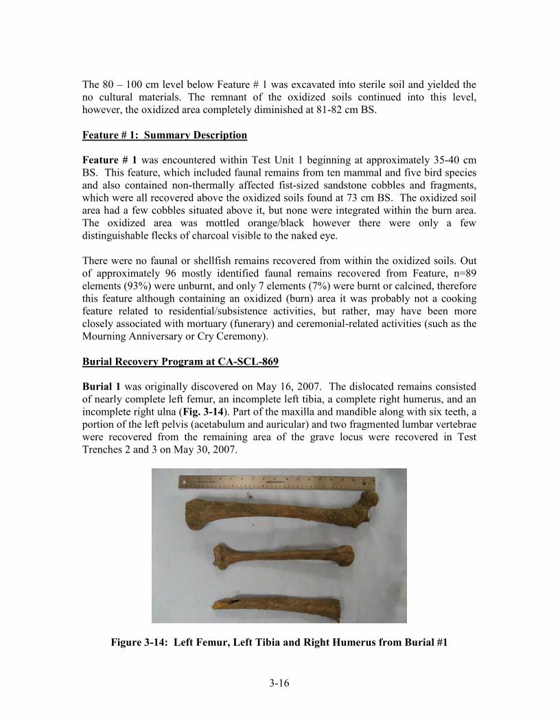
3-16
The 80 – 100 cm level below Feature # 1 was excavated into sterile soil and yielded the no cultural materials. The remnant of the oxidized soils continued into this level, however, the oxidized area completely diminished at 81-82 cm BS. Feature # 1: Summary Description Feature # 1 was encountered within Test Unit 1 beginning at approximately 35-40 cm BS. This feature, which included faunal remains from ten mammal and five bird species and also contained non-thermally affected fist-sized sandstone cobbles and fragments, which were all recovered above the oxidized soils found at 73 cm BS. The oxidized soil area had a few cobbles situated above it, but none were integrated within the burn area. The oxidized area was mottled orange/black however there were only a few distinguishable flecks of charcoal visible to the naked eye. There were no faunal or shellfish remains recovered from within the oxidized soils. Out of approximately 96 mostly identified faunal remains recovered from Feature, n=89 elements (93%) were unburnt, and only 7 elements (7%) were burnt or calcined, therefore this feature although containing an oxidized (burn) area it was probably not a cooking feature related to residential/subsistence activities, but rather, may have been more closely associated with mortuary (funerary) and ceremonial-related activities (such as the Mourning Anniversary or Cry Ceremony). Burial Recovery Program at CA-SCL-869 Burial 1 was originally discovered on May 16, 2007. The dislocated remains consisted of nearly complete left femur, an incomplete left tibia, a complete right humerus, and an incomplete right ulna (Fig. 3-14). Part of the maxilla and mandible along with six teeth, a portion of the left pelvis (acetabulum and auricular) and two fragmented lumbar vertebrae were recovered from the remaining area of the grave locus were recovered in Test Trenches 2 and 3 on May 30, 2007.
Figure 3-14: Left Femur, Left Tibia and Right Humerus from Burial #1
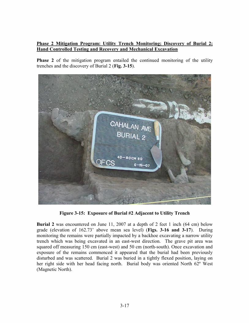
3-17
Phase 2 Mitigation Program: Utility Trench Monitoring; Discovery of Burial 2; Hand Controlled Testing and Recovery and Mechanical Excavation Phase 2 of the mitigation program entailed the continued monitoring of the utility trenches and the discovery of Burial 2 (Fig. 3-15).
Figure 3-15: Exposure of Burial #2 Adjacent to Utility Trench Burial 2 was encountered on June 11, 2007 at a depth of 2 feet 1 inch (64 cm) below grade (elevation of 162.73’ above mean sea level) (Figs. 3-16 and 3-17). During monitoring the remains were partially impacted by a backhoe excavating a narrow utility trench which was being excavated in an east-west direction. The grave pit area was squared off measuring 150 cm (east-west) and 50 cm (north-south). Once excavation and exposure of the remains commenced it appeared that the burial had been previously disturbed and was scattered. Burial 2 was buried in a tightly flexed position, laying on her right side with her head facing north. Burial body was oriented North 62º West (Magnetic North).

3-18
Figure 3-16: Exposure of Burial #2 – Close up of the Flexure of the Arm and Leg
Figure 3-17: Burial #2 – Close up of the Skull Prior to Removal to the Lab

3-19
As a result of previous impacts to this burial by historic farming/orchard activities as well as by the recent backhoe trenching operations, a screen recovery program was implemented in order to recover any of the remains that were inadvertently dislocated. A decision was made to establish additional controlled recovery test units (Test Units 2 through 5) surrounding the Burial 2 locus in order to maximize on the recovery of the skeletal remains and any associated grave regalia that may have been dislocated by the backhoe trenching operations and/or previous farming/orchard activities. Test Unit 2 - was established on the north side of Burial 2/utility trench immediately adjacent to the burial. Test Unit 2 measured 150 cm x 100 cm and was excavated in 20 cm levels down to 60 cm BS (to the level of Burial 2). In addition to recovering fragmented skeletal elements from Burial 2, a C2 Split Drilled Olivella bead was also found in association with this person (Bennyhoff and Hughes 1987). Results from Test Unit 2 Recovery Program (associated with Burial #2): - 0-20 cm BS level (nothing recovered) - 20-40 cm BS level: 32 bones from Otospermophilus beecheyi (California ground squirrel); 1 bone from Peromyscus californicus (California mouse); 1 bone and 1 antler fragment from Cervus elephas roosevelti (Roosevelt elk); 1 humerus from a robin-sized to small hawk bird; 39 unidentified faunal (large and small mammals, unburnt); 11 Red Franciscan chert RFC) flakes; 1 RFC bipolar core; 2 Green Franciscan chert (GFC) flakes; and 1 flake of high grade serpentine. - 40-60 cm BS level: 22 bones from Otospermophilus beecheyi (California ground squirrel); 4 bones from Thomomys bottae (pocket gopher); 3 bones from Sciurus niger (Fox squirrel); 7 unidentified bone fragments (large and medium-sized mammals, unburnt)’ 1 skull fragment of a unidentified fish; 1 primary flake of Napa Valley obsidian; 1 GFC modified bipolar flake; 1 RFC flake; 1 RFC bipolar core and a C2 Split Drilled Olivella bead. (see Discussion on Shell Artifacts in Chapters 11 and 12). - 60-80 cm BS level: (partially excavated, nothing found, sterile) Test Unit 3 – Due to the impacts to Burial 2 it was decided to add additional hand-controlled test excavation units as part of the recovery program. Test Unit 3 was established immediately to the west of Test Unit 2. This excavation unit measured 1.5 m x 1 m and was excavated down to the 60 cm BS level. Results from Test Unit 3 Recovery Program (associated with Burial #2): - 0-20 cm BS level: (nothing recovered) - 20-40 cm BS level: four fragments of shatter from a core of Red Franciscan Chert.
3-20
- 40-60 cm BS level: 3 RFC primary flakes; 1 GFC primary flake; 2 high grade serpentine primary flakes; 1 burnt bone (faunal); many fragments of an artiodactyl atlas vertebra; 1 tibia fragment of a brush rabbit; and 26 unburnt and unidentified bone fragments from large and medium sized mammals. Test Unit 4 – Was established immediately north of Test Unit 2 and east of Test Unit 3. This unit measured 1.5 m x 1.5 m. Due to the lack of cultural materials in the upper 20 cm, a decision was made to sub-divide this unit into three sub-units with two quadrants (northwest and northeast) measuring 75 cm x 75 cm each and the southern half measuring 1.5 m x 75 cm. The southern half of the unit abutting TU 2 and TU 3 was excavated down to 80 cm BS. The northwest quadrant was excavated to the 20 cm level and the northeast quadrant was excavated to 40 cm BS. Results from Test Unit 4 Recovery Program (associated with Burial #2): - 0-20 cm BS level: (nothing recovered) - 20-40 cm BS level: (not excavated) Test Unit 5 – The controlled test unit was established to the east of Test Unit 2 and northeast of the Burial 2 locus. Test Unit 5 measured 1 m x 1.5 m and was excavated down to the 40 cm level. Results from Test Unit 5 Recovery Program (associated with Burial #2): - 0-20 cm BS level: 1 GFC angular (bipolar) pebble core; 1 RFC exhausted core; 1 RFC shattered fragment; and 6 unidentified and unburnt bones of large mammals. - 20-40 cm BS level: 1 GFC pebble core; 3 RFC primary flakes; 2 bones from a Beechey ground squirrel; 4 bones from a Fox squirrel; mandible, maxilla and teeth from a pocket gopher; 1 bone and two teeth from a California deer; several fragments from bay mussel shell. - 40-60 cm BS level: 1 RFC assayed pebble; 6 RFC primary flakes; 4 GFC primary flakes; and 1 unburnt faunal bone. Transformer Pad Areal Excavation On July 12, 2007 a decision was made to mechanically excavate the area designated for the placement of the Transformer Pad located east of the Handicapped Parking area, south of the Burial 2 locus and Test Trench # 6. This area was considered potentially sensitive, however, a portion had been previously excavated and the soils re-compacted. The area measured 20 ft. x 12 ft. The entire area was excavated using a backhoe with an attached 3 foot bucket and the excavation occurred in 2 – 3 inch increments. The entire Transformer Pad area was excavated down to the 100 cm level and transitioned into a lighter brown culturally sterile soil.

3-21
Although no features were encountered during the excavation of the Transformer Pad area, the following cultural materials were recovered: - 0 – 40 cm level (Catalogue Reference # 50): 1 exhausted pebble core red Franciscan
chert; 1 bipolar cobble core red Franciscan chert; 1 biface/dart point mid-section Annadel obsidian; 1 bipolar flake red Franciscan chert; 1 bipolar flake green Franciscan chert; 2 primary flakes green Franciscan chert; 1 thinning flake red Franciscan chert; several vitrified (extremely burnt) clay fragments, 1 artiodactyl long-bone fragment and a femur from a squirrel.
- 40 - 60 cm level (Catalogue Reference # 51): 1 small intact sandstone mortar (Mortar # 2; Ref. # 51-1) (Fig. 3-18), 1 intact unmodified flat sandstone cobble; right manus(carpal) Cervus nannodes; 3 artiodactyl long bone fragments; 16 unburnt small mammal fragments; and 1 unidentified calcined bone fragment.
Figure 3-18: Mortar #2 from Transformer Pad Trench (Unwashed) - 60 – 80 and 80 – 100 cm levels: nothing recovered. Phase 3 of the Mitigation Program: Continued Monitoring; Discovery of Burial 3; Hand Controlled Archaeological Test Excavation and Recovery Phase 3 of the mitigation program entailed the continued monitoring of the utility trenches and the discovery of Burial 3. Burial 3 was discovered on July 20, 2007 on the west site of the construction site during utility trenching operations for the fire line trench. After excavating through the upper 30 cm of historic mixed gravel and rock debris, the backhoe encountered a soil transition to a dark brown silt loam at around 40 cm BS. A red Franciscan chert flake was recovered at the 40 cm level and later on a gopher’s tooth was recovered at the 70 cm BS level. As the backhoe moved to excavate the next section of the trench, human bone was encountered at approximately 70 cm BS.

3-22
Burial 3 was located approximately 5 meters east of the side walk’s edge (Cahalan Avenue) and 19.9 meters west from the main site datum (Storm Drain). Dislocated elements were recovered from the backdirt pile’s screen soil. The in situ elements included the cranium, ascending ramus of the mandible, upper limbs (radius, ulna, humerus, hand, phalanx) and lower limbs (femur and tibia) [Fig. 3-19]. Burial 3 was determined to be female, tightly flexed, lying on her left side, and facing north/northeast. She was oriented South 30º West (MN) and buried with her cranium oriented to the southwest at a depth of 63 cm BS. The lower limbs were flexed to the east at a depth of 80 cm BS. The grave pit measured 58 cm x 58 cm. Due to the compaction of the soil and the fragility of the remains, a decision was made after photographic documentation to leave this burial within the soil matrix and transport it to the lab for later extraction.
Figure 3-19: Burial #3 Discovered During Monitoring of Utility Trenching

3-23
Phase 4 of the Mitigation Program: Continued Monitoring; Discovery of Burial 4; Hand Controlled Archaeological Test Excavation and Recovery
Phase 4 of the mitigation program entailed the continued monitoring of the utility trenches and the discovery of Burial 4. Burial 4 was encountered on August 20, 2007 during trenching operations for an electrical utility trench (Fig 3-20). Cranial elements and an upside down sandstone boulder mortar (located just to the east of the cranium) were uncovered by the backhoe (Fig. 3-21). The boulder mortar (Ref. # 4-7) with soil left in the bowl was immediately bagged and sealed in plastic bags for later micro and macro-botanical analysis (see Chapter 9). The inverted rim of the mortar measured down to 81 cm BS (Fig. 3-22). After removal of the mortar, the burial was exposed with the lowest portion of the cranium measuring to a depth of 86 cm BS (Figs. 3-23 and 3-24).
Figure 3-20: Utility Trenching Operation in the Vicinity of Burial #4

3-24
Figure 3-21: Skull of B. 4 Discovered in Backhoe Trench; Mortar to the Right
Figure 3-22: Mortar #3 Associated with Burial #4 (Unwashed)

3-25
Figure 3-23: OFCS Staff Osteologist Melynda Atwood Exposing Burial #4
Figure 3-24: Burial #4 Recovery into Utility Trench Sidewall Burial 4 was determined to be a female and she was buried on her right side with her head oriented south and her face facing to the northeast. She was oriented South 5º West (MN). The in situ elements included cranium, ribs vertebrae, and lower limbs which extended entirely into the side wall of the utility trench. Because of the narrowness of the trench, compaction of the soil, and fragility of the skeletal elements, a decision was made to remove Burial 4 in blocks of soil matrix, so the burial could be carefully extracted in the lab. Once Burial 4 was removed, the surrounding soils were screened to ensure maximum retrieval of all skeletal elements (Figs. 3-25 and 3-26).

3-26
The remains of all the four burials that were encountered ranged in depth from approximately 60 to 86 cm BS and the original grave pits were clearly situated in undisturbed native soils.
Figure 3-25: Muwekma Tribal Member Anthony Acosta Working on the Burial Recovery
Figure 3-26: MLD and Chairwoman R. Cambra Screening during Burial Recovery

4-1
Chapter 4: Burial Descriptions and Skeletal Biology: Inventory and Analysis
Melynda Atwood, Diane DiGiuseppe, Dave Grant and Alan Leventhal A total of four elderly female burials (primary inhumations) were found in situ at the site. These burials were assigned as Burials #1, #2, #3 and #4. Four additional human skeletal elements were recovered from Feature #1, within Test Unit #1, that were determined to be not associated with the four primary inhumations. These additional elements were subsequently assigned as Burial #5 and Burial #6. Besides the skeletal elements represented by Burials 5 and 6, three other isolated human remains were collected from disturbed surface contexts during the field phases of monitoring and burial recovery. Based upon coloration, overall age morphology and the location of two of these cranial surface finds, they were considered to be part of the impacted Burial #1. Another isolated molar from an adult individual was collected from the surface in another area of the site and it was assigned as Burial #7, thus indicating that there was a possible minimum of seven (7) individuals that were recovered from CA-SCL-869. (See Site Map 4-1 for the location of Burials #1 through #4 and the isolated finds). Methods: Skeletal analyses of all four burials were conducted by Melynda Atwood, Diane DiGiuseppe, Dave Grant, and Alan Leventhal. The skeletons were laid out in anatomical position and the elements were recorded on OFCS Skeletal Inventory Sheets (Appendix B). Sexing and aging criteria used for these individuals followed the 1994 Standards edited by Buikstra and Ubelaker, and also Bass (1995), Smith (1984) and Scott (1979). Stature was determined using Genoves (1967), which includes a differentiation between males and females to determine height. Burial Descriptions Burial 1 represents the remains of an adult female individual whose age was determined to be 40+. This burial was impacted by heavy construction equipment which dislocated the majority of the skeletal elements. The initial collection of the dislocated remains was done by construction crewmen. Later, the general burial locus was identified through mechanical excavation and additional elements associated with Burial 1 were recovered. Burial: 1 Sex: Female Age: 40-50 (Fig. 4-1) The sexing of this individual included the employment of the greater sciatic notch on the pelvis as well as metric measurements of the femoral and humeral heads. The greater sciatic notch on Burial 1 is wide. The vertical diameter of the humeral head measured 42.1 mm with the femoral head diameter equaling 41.7 mm (Buikstra and Ubelaker 1994, Bass 1995). Based upon these criteria it was determined that this individual was an adult female.

4-2
Map 4-1: Site Map CA-SCL-869 Showing Burial Locations
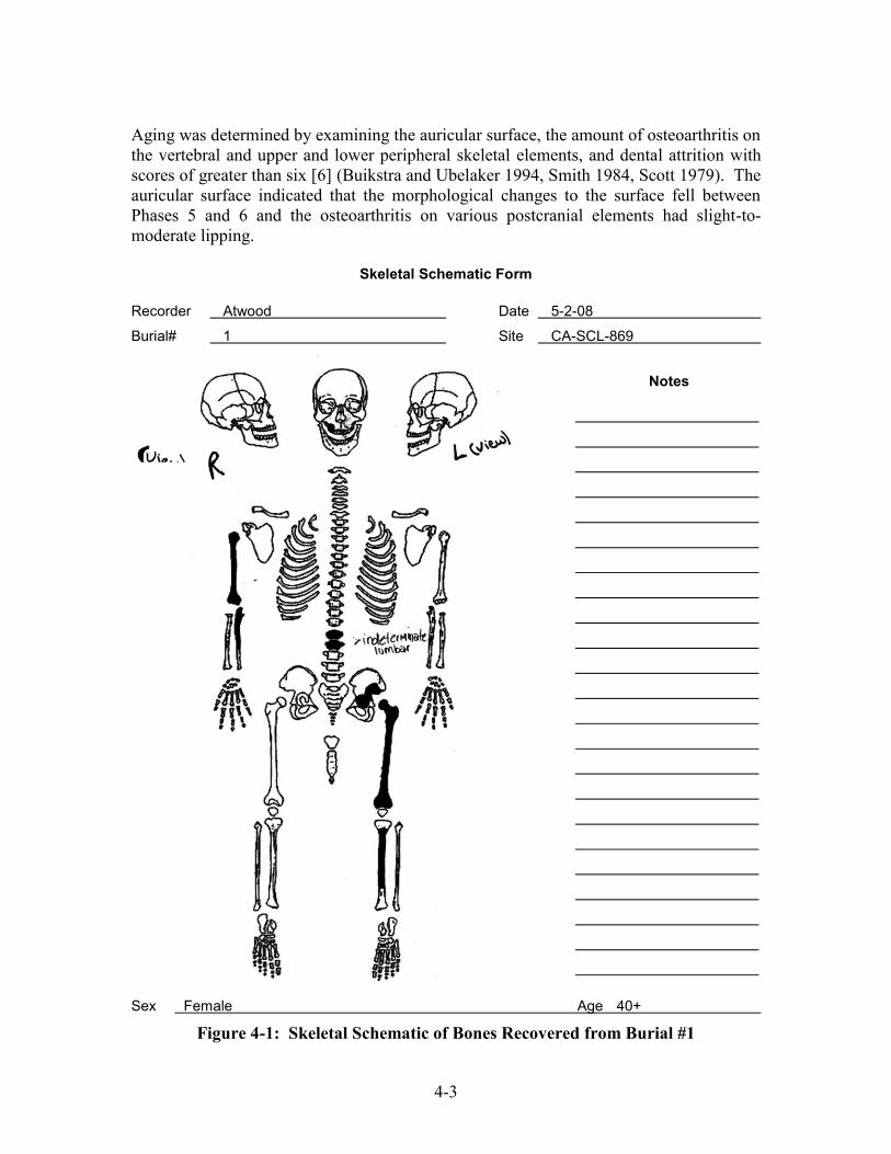
4-3
Aging was determined by examining the auricular surface, the amount of osteoarthritis on the vertebral and upper and lower peripheral skeletal elements, and dental attrition with scores of greater than six [6] (Buikstra and Ubelaker 1994, Smith 1984, Scott 1979). The auricular surface indicated that the morphological changes to the surface fell between Phases 5 and 6 and the osteoarthritis on various postcranial elements had slight-to-moderate lipping.
Skeletal Schematic Form
Recorder Atwood Date 5-2-08
Burial# 1 Site CA-SCL-869
Sex Female Age 40+
Figure 4-1: Skeletal Schematic of Bones Recovered from Burial #1
Notes

4-4
Cranium and Mandible: The cranium is fragmentary, with two maxillary fragments containing teeth in situ, and one mandibular fragment with one tooth in situ. The teeth show severe attrition with scores of >6 (Appendix C). Axial Skeleton: The clavicles, scapulae, sternum, ribs, and sacrum are absent and only two lumbar vertebrae are present (determination of specific lumbar numbers is impossible due to fragmentation). Of the os coxae (pelvis), only four fragments of the left ilium are present. Upper Appendicular Skeleton: only the right arm is present and it is comprised of a complete humerus and an incomplete ulna. The hands are absent. Lower Appendicular Skeleton: only the left leg is present and it is comprised of a complete femur and an incomplete tibia. Both patellae and feet are absent. Pathologies: Age-Related Disease:
Mild osteoarthritis (oa) is present on the inferior femoral head margins, right humeral head and capitulum, and the anterior proximal ulna. Mild to moderate osteoarthritis (oa) is seen on the left acetabulum and left auricular surface edges, as well as the lumbar body and apophyseal facet fragments (Fig. 4-2).
There is evidence of possible osteoporosis in the right humerus, as it is light in weight (due to bone loss), however, all elements present are fragmented and primarily incomplete from burial processes, as well as excavation, and a definitive diagnosis is impossible.
Dental Disease:
Two maxillary fragments contain M2 and M3 in situ. As well as one M1, of indeterminate side, found in a mandibular bone fragment. All teeth, including three loose teeth, showed severe attrition [scores of 7 and 8 on a scale of 0-8] (Molnar 1972).
Due to postmortem damage, the absence of the mandible, and the dearth of cranial fragments, periodontitis could not be ascertained. (See Appendix C)
Pathology - Location and Description:
Left tibia lateral diaphysis has a patch of periosteal reaction on the diaphysis lateral to the tibial crest and just below the inferior margin of the medial periosteal patch. It measures 28.9 mm in length and 20.5 mm in width. The periosteal reaction was active at the time of this individual’s death and was probably injury- related due to its location on the element. This was probably the location of the initial injury due to the amount of reactive bone and level of reaction.
Left tibia medio-distal diaphysis has a long, thin line of periosteal reaction, on the medical aspect of the tibial crest. The patch is 23.4 mm in length and 4.8 mm in width. The periosteal reaction was active at the time of death, with rough, vertical lines of bone growth, which had just begun at the time of this individual’s death. This is probably a secondary infection of the periosteal reaction seen on the lateral mid-diaphysis.

4-5
Left tibia antero-lateral, proximal diaphysis has a patch of what is possibly a periosteal reaction that would have been active at the time of this individual’s death. The severe post-mortem damage to this portion of the element makes a definitive diagnosis impossible.
Stature:
This adult female was approximately 156.00 to 158.00 cm (approximately 5’1 to 5’3 feet) in height, using Genoves’ research on Mesoamerican populations, specific to females (1967:75). The complete left femur and right humerus were the elements used to calculate this individual’s height (Fig. 4-3).
Cranial Measurements: None possible due to fragmentary state of cranial remains. Postcranial Measurements: Left femur maximum length…………….…………………………… 427.0 mm Left femur A/P subtrochanteric diameter……………………………. 24.1 mm Left femur A/P midshaft diameter…………………………………… 26.4 mm Left femur M/L midshaft diameter………………………………… 27.0 mm Left femur maximum head diameter (approx.)...……………………. 41.7 mm Left tibia maximum diameter at nutrient foramen…………………… 33.2 mm Left tibia transverse diameter at nutrient foramen…………………… 22.3 mm Right humerus maximum length……………………………………… 311.0 mm Right humerus epicondylar breadth…………………………………… 54.0 mm Right humerus vertical diameter of head……………………………… 42.1 mm Right humerus maximum diameter of midshaft……………………… 22.7 mm Right humerus minimum diameter of midshaft……………………… 15.2 mm Right humerus articular width………………………………………… 39.2 mm
Figure 4-2: Burial 1 – Ilium Portion Figure 4-3: Burial 1 - Long Bones of the Innominate (Pelvis) Uncovered by Construction Crew
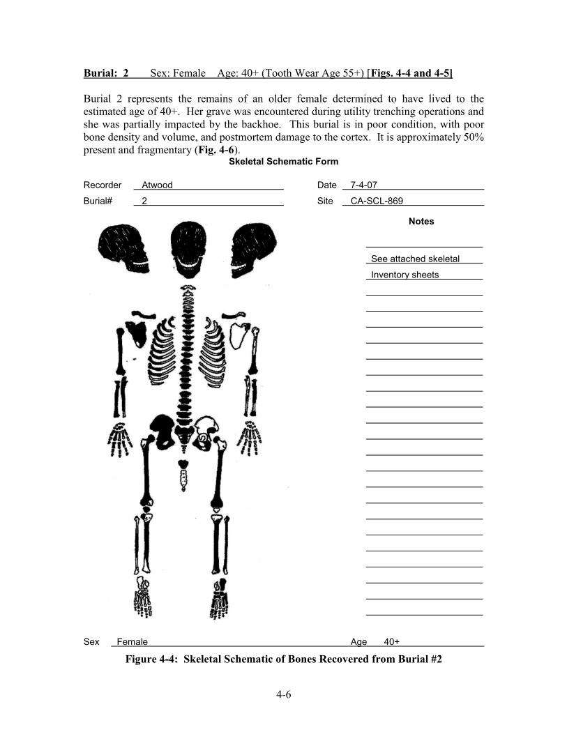
4-6
Burial: 2 Sex: Female Age: 40+ (Tooth Wear Age 55+) [Figs. 4-4 and 4-5] Burial 2 represents the remains of an older female determined to have lived to the estimated age of 40+. Her grave was encountered during utility trenching operations and she was partially impacted by the backhoe. This burial is in poor condition, with poor bone density and volume, and postmortem damage to the cortex. It is approximately 50% present and fragmentary (Fig. 4-6).
Skeletal Schematic Form
Recorder Atwood Date 7-4-07
Burial# 2 Site CA-SCL-869
Sex Female Age 40+
Figure 4-4: Skeletal Schematic of Bones Recovered from Burial #2
Notes
See attached skeletal
Inventory sheets

4-7
Figure 4-5: Burial #2 Anatomical Position of Skeletal Elements

4-8
Sexing of this individual was completed by examining morphological changes to the os coxae, cranium, and metric measurements of the femoral and humeral heads (Buikstra and Ubelaker 1994; Bass 1995). For the os coxae, the greater sciatic notch is wide, the sub-pubic angel is wide, the pubis shape is rectangular, and the acetabulum is small. The cranium has a small mastoid process and sharp supraorbital margin. The metric measurements for the right femoral head maximum diameter is ~35.2 mm and the right humeral head is 34.4 mm (Bass 1995). Based on an aggregation of all sexing indicators, this individual is female. Aging of this skeleton was based on several factors. First, examination of the pubic symphysis following Suchey-Brooks criteria (Suchey et al 1988) indicates that individual has a Phase V pubis with age range of 25-83 years old. Examination of the auricular surface, following Lovejoy et al. criteria (1985), indicates a Phase 5 with an age range of 40-44 years. Based on the amount of attrition following Griffin’s criteria (2007), teeth with scores between 6 and 8, indicates this person’s age range is 40-50. Upon aggregation, this individual appears to be between 40-50 years old. It is noted that post mortem erosion through taphonomic pressures may interfere with the accuracy of assessment to the pubic symphysis and auricular surface, but the estimated age of this individual is 40+. Cranium and Mandible: The cranium is complete, but in many fragments (Fig. 4-7). The mandible is complete and in three pieces. Many teeth are in situ in both the maxilla and mandible: RP2, RC*, RI2, RI1, LI1, LC*, LP2, LP1, LC*, LI2, RC*, RP1; they show moderate and severe attrition (Appendix C). Axial Skeleton: The sternum is fragmentary and in two pieces. Of the cervical vertebrae, only the sixth and seventh are present, while all twelve thoracic and five lumbar are present. All are complete except for an incomplete T2 and T3. The sacrum is also complete, but in three pieces, with the coccygeal vertebrae present. There are five complete left and eleven complete right ribs. Of the os coxae, the left is fragmentary and the right is complete, but in two pieces. Upper Appendicular Skeleton: Both clavicles are present, but the left clavicle is incomplete, in two pieces, while the right is complete and in one piece. Only the right scapula is complete, while the left scapula is represented by only one fragment. The left arm is present and comprised of one humerus fragment, the complete radius and one ulna fragment. The right arm is also present and complete, comprised of a complete humerus, radius and ulna. The hands are primarily absent, with only one complete pisiform of indeterminate side, a complete first and second metacarpal, three complete proximal hand phalanges, one complete middle hand phalanx, and three terminal phalanges present. Lower Appendicular Skeleton: The left leg is present and comprised of a complete femur (three pieces), incomplete tibia, and a complete fibula. The left patella is absent. The right leg is present and comprised of a complete femur (seven pieces), two tibia fragments, and one fibula fragment. There is one indeterminate femur fragment also present. The right patella is complete and in one piece. The left foot is primarily

4-9
present: complete calcaneus, cuboid, navicular, first, second, and third cuneiforms, first, fourth, and fifth metatarsals, and two complete proximal phalanges. The right foot is absent.
Figure 4-6: Exposure of Burial #2 Figure 4-7: Skull (Burial 2) Pathologies: Age-Related Disease:
There is slight osteoarthritis in the right shoulder, elbow, hand and left wrist, as well as moderate osteoarthritis in the right hip. All spinal vertebrae show little osteoarthritis, except T9, T11, T12, L2, and L5, which show moderate to severe involvement.
There is evidence of possible osteoporosis, however, all elements present are fragmented from burial processes, as well as excavation, and a definitive diagnosis is impossible.
Dental Disease:
Six teeth were lost postmortem: RI2, RI1, LI1, LM1, LM2, and LM3. Both left and right maxilla was broken off postmortem, at the sites of RM2 and LM2, consequently, it can not be determined if these teeth were present at the individual’s time of death or lost antemortem (See Appendix C).
There are eight teeth that were lost antemortem: seven evince advanced healing (LP1, LP2, LM1, RM3, RM2, RM1, RP2) and one (RP1) is completely healed.
No caries observed Dental calculi present. Advanced periodontitis is seen throughout the maxilla and mandible.
Stature:
This adult female was approximately 140.5 to 145.00 cm (approximately 4’6” to 4’9” feet) in height, using Genoves’ research on Mesoamerican populations, specific to female individuals (1967:74-75). The complete right humerus and radius were the elements used to calculate this individual’s height.

4-10
Cranial Measurements: Intraorbital breadth…………………………………………………….. 15.6 mm Orbital breadth…………………………………………………………. 37.2 mm Orbital height…………………………………………………………… 31.1 mm
Postcranial Measurements: Right clavicle maximum length……………………………………..… 111.0 mm Right clavicle sagittal diameter at midshaft………………………..… 9.8 mm Right clavicle vertical diameter at midshaft……………………..….… 7.4 mm Right humerus maximum length……………………………………… 261.0 mm Right humerus epicondylar breadth………………………………….. 51.0 mm Right humerus vertical diameter of head…………………………….. 34.3 mm Right humerus maximum diameter of midshaft……………………… 17.1 mm Right humerus minimum diameter of midshaft……………………… 16.4 mm Right radius maximum length…………………..……………………... 198.0 mm Burial: 3 Sex: Female Age: 40+ (Tooth Wear Age 55+) [Figs. 4-8 and 4-9] Burial 3 is an older female, age 40+, who was discovered during utility trench monitoring. She, too, was impacted by the heavy excavation equipment (Figs. 4-10 and 4-11). This burial is in poor condition, with poor bone density and volume and postmortem damage to the cortex. It is approximately 70% present, but fragmentary. The hands and feet are primarily absent. Sexing for this skeleton was completed by examining morphological changes to the os coxae and cranium (Buikstra and Ubelaker 1994). The os coxae has a wide greater sciatic notch and a preauricular sulcus is present. The cranium has a small mastoid process, sharp supraorbital margin, and is lacking a supraorbital ridge and mental eminence projection. Based on the aggregation of all sexing indicators, this individual is female. Aging of this skeleton was determined by examining the auricular surface (Lovejoy et al. 1985), which indicates a Phase greater than 5 for an age estimation of 40+. Additionally, the evidence of moderate to severe osteoarthritis in the thoracic vertebrae and the second cervical dens process supports this determination Cranium and Mandible: The cranium is complete. The mandible is complete and in three pieces. There are only a few teeth in situ in both the maxilla (LP1, LM1, LM2) and mandible (LP2, LM3), and all show moderate to severe attrition (Appendix C). Axial Skeleton: The sternum is complete and in three pieces. All seven cervical, twelve thoracic, and five lumbar vertebrae are present; all are complete except for an incomplete T5 and fragmentary L4. The sacrum is present in the form of one fragment, comprising S1 with the left wing. The coccygeal vertebrae are also present. There are eleven complete left and ten complete right ribs. Of the os coxae, only an incomplete left ilium and ischium are present.

4-11
Skeletal Schematic Form
Recorder Atwood Date 8-19-07
Burial# 3 Site CA-SCL-869
Sex Female Age 40+
Figure 4-8: Skeletal Schematic of Bones Recovered from Burial #3
Notes
Cranium in 61 fragments
Mostly complete
Vertebrae:
Mostly complete
Ribs:
11 complete left
10 complete right
79 fragments

4-12
Upper Appendicular Skeleton: Both the left and right clavicles are each in one piece but, while the left clavicle is complete, the right clavicle is incomplete. Only the left scapula is present; it is fragmentary and in two pieces, with an additional two indeterminate scapular fragments. The left arm is present and comprised of a complete humerus and an incomplete radius. The right arm is also present and primarily complete: incomplete humerus and complete radius and ulna. The hands are primarily absent, with only an indeterminate pisiform, one complete proximal hand phalanx, and two complete middle hand phalanges present.
Figure 4-9: Burial #3 Anatomical Placement of Skeletal Elements

4-13
Figure 4-10: Exposure of Burial 3 due to Utility Trenching
Figure 4-11: Close-up of Burial #3 during Exposure

4-14
Lower Appendicular Skeleton: The left leg is present and comprised of an incomplete femur, a fragmentary tibia (three fragments), and one fibular fragment. The right leg is present and comprised of an incomplete, fragmentary femur, complete tibia, and incomplete fibula. There is one indeterminate femur and one indeterminate fibula fragment also present. Both patellae are absent. The feet are primarily absent, with only a complete right first metatarsal present. Pathologies: Age-Related Disease:
There is moderate osteoarthritis in the right wrist and left temporomandibular joint and moderate-to-severe osteoarthritis in the left hip and throughout the cervical and thoracic spinal vertebrae. The lumbar region shows the least involvement, with mild to moderate osteoarthritis.
There is evidence of possible osteoporosis, however, all elements present are fragmented from burial processes, as well as excavation, and a definitive diagnosis is impossible.
Dental Disease:
The right side of both the maxilla and mandible are absent due to postmortem damage. Twelve teeth were lost postmortem: RC*, RI1, LI1, LC*, LP2, RP1, RC*, RI2, LI2, LC*, LP1, LM1 (See Appendix C).
LM1 has cavities seen entering the roots of the tooth. There are six teeth that were lost antemortem: three were well-healed (LI2, RI1,
LI1), two with evidence of advanced healing (LM3 & LM2), and one with signs of active healing (RI2). Advanced periodontitis is seen throughout the maxilla and mandible.
Pathology Location and Description:
Left acetabulum: lytic lesion present, measuring approximately 36.12 mm in length and 17.23 mm in width. The central portion of the acetabulum has been broken off postmortem, impeding the ability to ascertain the exact measurements of the whole lesion. The left femoral head is unaffected. Differential diagnosis indicates probable trauma etiology due to the location of the lesion within the acetabulum.
T7-T8: fused along the anterior edge of the vertebral bodies. Severe osteoarthritis is also seen along the superior body of T7 and the inferior body of T8. The left superior apophyseal facet is not fused to the inferior T7 apophyseal facet, but the facets on the right do appear fused (matrix encrustation makes it difficult to determine), indicating a possible blow to the right of the individual. Differential diagnosis indicates probable trauma etiology due to the restriction of the affected area. The fusion is localized to these two vertebrae, although surrounding thoracic vertebrae do evince increased osteoarthritis when compared to cervical and even the lumbar vertebrae.
T5 inferior apophyseal facet: lytic lesion seen on medial portion (lateral portion broken off postmortem). The lesion measures 11.1 mm in length and 6.7 mm in width. Bony reaction is still evident and in process at time of death. The margins
4-15
of the facet have been obliterated and the bone is still coarse with bony spicules. Differential diagnosis indicates possible trauma etiology (see differential diagnosis description for T7-T8 fusion).
Possible conclusion from above-listed vertebral pathologies indicates trauma to that spinal cord may have caused this person to be unable to ambulate. Paraplegia or perhaps just difficulty in ambulation may be a possibility: as well as evidence of spinal trauma (fusion), the femoral muscle markers (linea aspera) are small and gracile and the lumbar vertebrae do not evince the same high rates of osteoarthritis as the thoracic and cervical vertebrae. However, this is an elderly, small female, which may account for the small femoral muscle markers. And, the decreased osteoarthritis in the lumbar vertebrae may be merely due to activity patterns experienced by this individual in life.
For review of facial pathologies, see Dr. George Yellich’s (maxillo-facial
surgeon) review and assessment. Stature:
This adult female was approximately 150.50 to 155.00 cm (approximately 4’11 to 5’1 feet) in height, using Genoves’ research on Mesoamerican populations specific to female individuals (1967:75). The reconstructed, complete left humerus, complete right ulna, and complete right radius were the elements used to calculate this individual’s height.
Cranial Measurements: Measurements of the skull were impossible to collect due to the fragmentary nature of the cranium and mandible. Postcranial Measurements: Left humerus…………………………………………… 294 mm maximum length (approximate measurement, there is postmortem damage and the element is fragmented) Right ulna……………………………………………… 231 mm maximum length Right radius……………………………………………. 213 mm maximum length Facial Pathologies: Consultation with Dr. George Yellich of Burial 3 On October 2, 2007, OFCS staff osteologists Melynda Atwood and Irina Nechayev met with Dr. George Yellich, a maxillo-facial surgeon, in order for him to review and evaluate the facial pathologies observed on Burial 3 (Figs. 4-12, 4-13, and 4-14). Dr. Yellich’s observations and assessment was recorded by Melynda Atwood and her transcription from that interview follows below:
Nasal bone: 1) Extensive bone growth in nasal aperture is probably not due to trauma:
trauma cases to this area do not show this pattern of bone growth, especially the extensive bone growth seen within the nasal aperture. There is also bony erosion seen in the floor of the nasal aperture, as

4-16
well as the anterior aspect of the maxilla superior to and between each canine jugum. This may be a developmental issue that caused both excess bone growth and bony erosion at different areas at the site.
2) One possibility is choanal atresia**, which may have led to the
extensive bony growth seen in the nasal aperture. The nasal bone of B# 3 with its presentation of additional bone, with more of the excess bony growth on one side (the right), but with both sides severely affected, is consistent with this diagnosis. There may have been mandibular changes associated with mouth breathing from early childhood, but the postmortem breakage seen in the mandible and maxilla makes this difficult to definitively ascertain.
3) Bone growth could also be due to a slow-growing cyst(s) or
neoplasm(s) that was (were) located within the nose. The slow growth of the cyst/neoplasm may have caused the creation of extra bone around the cyst/neoplasm, creating the dense and lattice-appearance of the extra bone in the nasal aperture.
Figure 4-12: Close-up of Affect Nasal Area

4-17
Palate: 4) The extensive periosteal reaction seen in the entire palate and the
circular lytic lesion in the middle of the right palate may all be due to infection. An abscess may have created the lytic lesion, enlarged incisive foramen, also known as the nasal palatine canal, as well as all of the bony defects involving the entire palate.
5) The palatal periosteal reaction could also be due to slow growing
cysts/neoplasms. The slow growth of the cyst/neoplasm may have caused the creation of extra bone around the cyst/neoplasm, creating the circular lytic lesion seen.
Figure 4-13: X-Ray Close-up of Affect Nasal Area

4-18
Additional Notes from Dr. George Yellich’s Interview: Choanal atresia: congenital condition that is defined as a narrowing or blockage of the nasal airway by tissue. While the etiology of choanal atresia is unknown, it is thought to occur when the thin tissue separating the nasal and oral spaces during fetal development persists. The condition is the most common nasal abnormality seen in the newborn infant, affecting about 1 in 7,000 live births. Newborns with this condition are known as an "obligate nose breathers." This means the baby must breathe through its nose because the oral airway is not yet developed enough to allow for frequent mouth breathing. In fact, almost the only time an infant does not breathe through its nose is when crying. Choanal atresia may affect one or both sides of the nasal airway. It is often associated with other congenital problems. Choanal atresia blocking both sides (bilateral) of the nose causes acute breathing problems, cyanosis, and breathing failure. Infants with bilateral choanal atresia may need resuscitation at delivery. Blockage on only one side causes less severe problems. Choanal atresia is generally recognized shortly after birth while the infant is still in the hospital. Symptoms include: difficulty breathing following birth, which may result in cyanosis (bluish discoloration), unless the infant is crying, an inability to nurse and breathe at same time, chest retraction unless breathing through mouth or crying, an inability to pass a catheter through each side of the nose into the throat, persistent one-sided nasal blockage or discharge. … An airway may need to be placed so that the infant can breathe. In some cases, intubation or tracheostomy may be needed. Treatments: an infant can learn to mouth breathe, which can delay the need for immediate surgery. Surgery to remove the obstruction cures the problem. It may be delayed if the infant can tolerate mouth breathing. Possible complications include 1) aspiration while feeding and attempting to breathe through the mouth and 2) respiratory arrest (the infant stops breathing altogether). Cited: MedlinePlus Medical Encyclopedia, 2007

4-19
Figure 4-14: Nasal Passage Comparison between Burial #3 and Lab Specimen
Burial: 4 Sex: Female Age: 50-59 (Tooth Wear Age 55+) [Figs. 4-15 and 4-16] Burial 4 is an elderly female individual whose age was assessed at 50-59 years old. This burial is in fair condition, with poor bone density and volume and post-mortem damage to the cortex (Fig.4-17). It is approximately 60% present, but fragmentary. 10% of the hand elements and 40% of the foot elements are present. Sexing of this individual was completed by examining morphological changes to the os coxae, cranium, and metric measurement of the humeral head (Buikstra and Ubelaker 1994; Bass 1995). The os coxae has a wide greater sciatic notch and a preauricular sulcus is present. The cranium has a small mastoid process, slightly robust nuchal crest, sharp supraorbital margin, and small mental eminence projection. The metric measurement for the right humeral head vertical diameter is 39.2 mm (Bass 1995). Based on an aggregation of all sexing indicators, this individual is female. Aging of this skeleton was based on examination of the auricular surface following Lovejoy’s criteria (1985), which indicates a Phase 7 surface, with an age range of 50+ years old. Following Griffin’s criteria (2007), the dental attrition scores were between 7 and 8, indicating an age range of 45-50 years old. Upon aggregation of aging criteria, this individual appears to be 45+ years old. Additionally, the evidence of moderate to severe osteoarthritis in the thoracic and lumbar vertebrae supports this determination.

4-20
Skeletal Schematic Form
Recorder DiGiuseppe Date 10-23-07
Burial# 4 Site CA-SCL-869
Sex Female Age 50-59
Figure 4-15: Skeletal Schematic of Bones Recovered from Burial #4
Notes
Cranium:
Mostly complete
Vertebrae:
2 cervical
9 thoracic
3 lumbar
6 sacral fragments
Ribs:
Left = 10 ventral
2 sternal
Right = 4 ventral
44 fragments
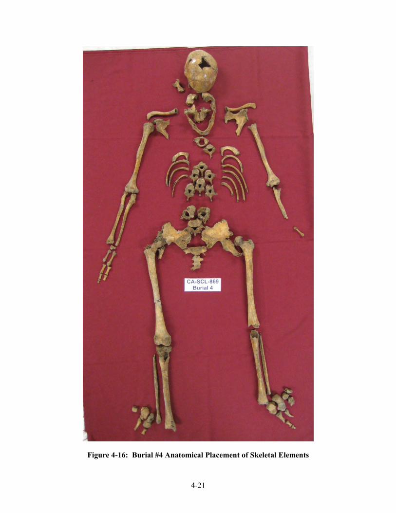
4-21
Figure 4-16: Burial #4 Anatomical Placement of Skeletal Elements

4-22
Figure 4-15: Preliminary Exposure of Burial #4
Cranium and Mandible: The reconstructed cranium is complete, but in 29+ fragments. The mandible is complete and in three pieces. There are only three teeth in situ in both the maxilla and mandible (RC*, RP1, RP2, RM3, LC*, LP1) and all show severe attrition (Appendix C). Axial Skeleton: The sternum and hyoid are absent. Representing the spine, only two cervical, ten thoracic, and three lumbar vertebrae were excavated. The sacrum is present in the form of one fragment, the S1 body, and the ribs are present, with ten left and four right ribs identifiable, with 40+ fragments. The pelvis is represented by incomplete right and left os coxae. Upper Appendicular Skeleton: Both the left and right clavicles are complete and in one piece. The left and right scapulae are incomplete with an additional five indeterminate scapulae fragments. The left arm is present, with the humerus, radius, and ulna all complete and in three pieces each. The right arm is also present: the complete humerus, the complete radius (two pieces), and a complete ulna (four fragments). The hands are primarily absent, with only a complete right navicular, complete right hamate, complete left MC1, MC2, MC3, MC5, and complete right MC5. The fingers are present with four complete proximal-, two complete middle-, and two distal-hand phalanges present.

4-23
Lower Appendicular Skeleton: The left leg is present and complete (femur, tibia, fibula) and the right leg is also present and complete (femur and tibia), with an incomplete fibula. Both patellae are absent. The feet are represented by the following elements. Left foot: complete calcaneus, talus, cuboid, first cuneiform, and first metatarsal, with an incomplete navicular and third metatarsal. Right foot: complete talus and fifth metatarsal, incomplete calcaneus, and navicular fragment. Pathologies: Only age-related pathologies seen (e.g. osteoporosis, osteoarthritis) Age-Related:
There is also mild to moderate osteoarthritis in both left and right wrists, hands, ankles, and feet. There is moderate osteoarthritis in the left and right shoulders and elbows, as well as the right knee and hip. The left knee and hip have sustained postmortem damage that disallows an assessment. There is severe arthritis seen in the cervical vertebrae, with moderate to severe osteoarthritis seen throughout the thoracic and lumbar vertebrae. The lumbar region, as well as the C1, shows the most involvement, with severe osteoarthritis.
There is evidence of possible osteoporosis, however, all elements present are fragmented from burial processes, as well as excavation, and a definitive diagnosis is impossible.
Dental Disease: (See Appendix C)
There is an open canal seen entering the roots of RM2. LM3 has a cavity on the bucco-occlusal surface and LP2 has evidence of an abscess on the buccal side of the tooth.
There are sixteen teeth that were lost antemortem: (RM3, RM2, RM1, LP2, LM2, LM3, RM1, RP2, RP1, RC*, RI2, RI1, LI1, LI2, LM1, and LM2). The mandible and maxilla both show advanced healing in the areas of antemortem tooth loss.
Pathology Location and Description:
Right femur: Severe lipping around the fovea capitis of the femoral head; a probable indication of muscle pull since there is no evidence of direct trauma or fracture at the site.
Right second metacarpal: possible healed or healing fracture on the medio-lateral, proximal diaphysis. Cortex is dense and bone appears to have been sheared as it has been “pushed up” onto the anterior surface.
Stature:
This adult female was approximately 152.00 to 152.50 cm (approximately 4’11 to 5’1 feet) in height, using Genoves’ research on Mesoamerican populations specific to female individuals (1967:75). The complete right humerus was the only element used to calculate this individual’s height, as all other elements were incomplete or too fragmentary.

4-24
Cranial Measurements None possible, cranium too fragmented. Postcranial Measurements: Right vertical humeral head…………………………………………………. 39.2 mm Right humeral maximum length…………………………………………….. 288.0 mm Burials 5 and 6: Four skeletal elements representing at least two additional individuals were also recovered from (disturbed) burial contexts within Feature #1 from Test Unit #1. One element is a portion of an adult right femur, while the other three (two cranial fragments and a metatarsal) represent the remains of a subadult. An attempt to determine if the femur was associated with any of the four female burials was negative and it was determined that this element was from another individual. These two individuals were subsequently assigned as Burial 5 and Burial 6, respectively. Burial: 5 Sex: Indeterminate Age: Adult This burial is comprised of a portion of a right femur (Ref. # 10-19), which measures 150 mm in length. This element was recovered from Feature #1 in Test Unit #1 at approximately 65 cm BS. The element consists of the mid- and upper-diaphyseal shaft, with the superior margin just inferior to the absent greater and lesser trochanters. The increased bone density and volume in this element, especially when compared to the elderly females of Burials 1, 2, 3, and 4, appears to be that of a much younger adult. Sex and a more specific age are impossible to determine given how little of this element was recovered as well as the non-diagnostic aspects of this femoral section. Burial: 6 Sex: Indeterminate Age: Subadult This burial is comprised of two subadult cranial fragments (Ref. # 7-12 was recovered at 20cm BS; and Ref. # 9-22 was recovered at 43 cm BS) and a subadult first metacarpal (Ref. # 9-15 recovered at 47 cm BS) of indeterminate side. These elements may possibly represent two subadult individuals (children). All three elements were recovered from within Feature #1 in Test Unit #1. The cranial fragments appear to be possibly temporal bones in origin due to the thinness of the diploe at the margins of the fragments. The subadult first metatarsal is unfused at both epiphyses and measures 29.1 mm in maximum length. Sex and age are impossible to determine due to the age of the individual and the lack of “age versus metatarsal” metric measurement research available, respectively. However, this subadult must be under the age of eight years old at the time of death, since the distal epiphysis of the first metatarsal usually begins to fuse by that age and this metatarsal shows no fusion at either the distal or proximal end of the element. Unfortunately, these are the only subadult skeletal elements found and very little information was able to be ascertained from them.

4-25
Additional Isolated Surface Finds of Human Bone Three additional human bone fragments were collected as isolates from disturbed surface contexts during the field phases of work. Two of these remains were most likely associated with Burial #1). One of these skeletal elements is a zygomatic fragment from an adult (Ref. #70-1). It was collected on the very south side of the parcel, shortly after the Phase 1 of the mitigation program commenced. It was compared to the remains of Burial #1 and is likely associated with this individual. The second skeletal specimen consists of a small cranial fragment (Ref. # 70-2) of an adult person that was surface-collected approximately 14 feet north of the zygomatic fragment within the southern parking lot area off of Cahalan Avenue. This cranial fragment was also believed to have been part of Burial #1. The third isolated find was assigned as Burial #7, which is represented by a single adult molar (tooth) [Ref. # 70-3]. This was collected on the eastern side of the property, near the fence line adjacent to the Fire Station building pad. (See Site Map 4-1 above) Conclusion Based upon the results from conducting the skeletal biology of the four elderly females recovered from Katwáš Ketneyma Waréeptak, it appears that although their passing, no doubt, represented a tragedy in the lives of this ancestral Ohlone Indian community, it appears that these women had lived to a relatively senior age, 40s to over 55, given the overall mortality rates for Middle Period populations. This implies, especially in the case of Burial #3, that, regardless of the physical conditions possibly afflicting these women, they were well cared-for by their immediate/extended families or the village community until their passing and ultimate burial at CA-SCL-869, between approximately 1663 to 1765 years ago (AD 244 to AD 346). The longevity and care of these women offers insight into the nature of Middle Period ancestral Ohlone societies: elderly people and, specifically in this case, elderly women, were not discarded or considered a burden upon the community. The evidence from this site indicates that elderly women were respected and well cared for over a period of many years (as seen in the case of Burial #3). Furthermore, it may be speculated that women by the upper Middle Period had achieved some relative elite status, as can be determined by the placement of large intact mortars and other items within the graves of these women. This is further supported by evidence of shell beads, abalone ornaments, and other objects of wealth found in association with females at other Middle Period cemetery sites throughout the greater San Francisco Bay Area (Luby 1992; Leventhal 1993; Bellifemine 1997; Luby and Gruber 1999; Pastron 1999; Milliken et al 2007).

4-26
Milliken (2008) in his recent study entitled Native Americans at Mission San Jose provided the following ethnographic and ethnohistoric information about the roles and responsibilities of male capitáns and authority of elite women under the subheading “Political Leadership”:
Early Spanish explorers and missionaries occasionally identified male village or local tribe leaders, bestowing upon them the title “capitán.” Such local tribal captains had obligations and rights to the community as controllers of group surpluses. They were responsible for feeding visitors and community members who could not take care of themselves (Bean 1978:678).
… The extent of women’s power in tribal affairs was not documented by the male Spanish writers. Spanish explorers of the contact period mentioned being met by old women upon their entry into some villages, but only one later Spanish ethnographic overview even hinted at the leadership role for women in the native society. Isabel Kelly, however, obtained data about the late nineteenth-century post-mission female leaders on the Marin Peninsula from native scholar Tom Smith in 1932:
There were two important female leaders. One (hóypuh
kulé(·)yih or hóypuh kul(·)éy·ih [“woman chief”]) probably was more significant than data indicate. She handled the Acorn Dance, dominated the sünwele Dance, and was deeply involved in the Bird Cult. The second female leader (máien) was a genuinely key person: “máien bosses everyone, even hóypuh.” Theoretically, she was head of the women’s ceremonial house and hóypuh was head of the mixed dance house, “but máien did all the work.” She bossed construction of a new dance house, had wood hauled for festivals, superintended preparation of fiesta food, sent out invitation sticks for dances, and, in some cases, selected the performers [Kelly 1978:419] (Milliken 2008: 17-18).
Although Milliken’s information is derived from contact period and post-missionization recollections of a neighboring Marin County Coast Miwok man, this documented information helps highlight and bring into focus aspects of important ceremonial and political roles that high status women played during these periods of time. From these as well as other documented ethnohistoric and ethnographic accounts, we have attempted to employ this information as ethnographic analogues to the archaeological record.

5-1
Chapter 5: Preliminary Report on the Extraction of DNA from Site CA-SCL-869 Burial #1
Cara Monroe, Department of Anthropology, U.C. Santa Barbara
Background: Mitochondrial DNA (mtDNA) Properties and Native American mtDNA Variation Mitochondrial DNA (MtDNA) is an extra-nuclear genome found in the mitochondria of cells. Each mitochondrion contains one or two copies of the genome and each cell contains approximately 700 mitochondria (resulting in estimates of 1000-1500 copies of the genome per cell versus nuclear genes that are only found in two copies per cell). The high copy number of the mtDNA genome partial compensates for the fact that DNA degrades with time, and has become the choice genetic marker for the investigation of DNA from skeletal remains. Other unique characteristics of the genome further illustrate its utility in studies of biological relationships. Human mtDNA is strictly maternally inherited (Giles et al., 1980), reflecting only female movement/history, and is particularly useful in discerning ancestor-descendant relationships because it does not recombine during meiosis (Merriwether et al., 1991; Schurr et al., 1990). Rapid evolution of the mitochondrial genome (Brown et al., 1979) allows one to use this molecule in studies of populations that share recent common ancestry, such as the Native Americans. Lastly, the genome has been fully sequenced (Anderson et al., 1981) and its variation investigated in world-wide populations, having resulted in a large comparative database. Mitochondrial DNA has been instrumental to the investigation of relatedness among and between Native American tribal groups (while not near a complete list, see Barrantes et al., 1990; Bolnick and Smith, 2003; Eshleman et al., 2004; Kolman and Bermingham, 1997; Kolman et al., 1995; Malhi, 2001; Malhi et al., 2004; Malhi et al., 2003; Torroni et al., 1994; Torroni et al., 1992; Weiss, 2001), migrations into the New World (Horai et al., 1993; Lorenz and Smith, 1997; Malhi et al., 2002; Merriwether and Ferrell, 1996), and ancient DNA (aDNA) in the Americas (Carlyle et al., 2000; Eshleman, 2002; Gonzalez-Oliver et al., 2001; Kaestle and Smith, 2001; Kemp et al., forthcoming; Lalueza-Fox 1996; Lalueza-Fox et al., 2003; Lalueza-Fox et al., 2001; Malhi, 2001; Parr et al., 1996; Schultz et al., 2001; Stone and Stoneking, 1996; Stone and Stoneking, 1998). Studies of this genetic marker among New World populations have revealed that the mtDNA of most Native Americans belong to one of five maternal macro-lineages, or haplogroups A, B, C, D, and X (Brown et al., 1998; Forster et al., 1996; Schurr et al., 1990; Smith et al., 1999). The distribution of haplogroup frequencies across North America is non-random and is attributable to geographic distance and/or linguistic boundaries (Lorenz and Smith, 1996). This patterning has also been revealed in the overall structure of mtDNA diversity in North America (Malhi et al., 2002). Each haplogroup can be further sub-divided by genetic differences found in the control region (the hypervariable regions) of the molecule. Some of these sub-lineages (haplotypes) have been found to be tribal (Malhi et al., 2002; Torroni et al., 1993) or language family specific (Derbeneva et al., 2002).
5-2
Therefore, mtDNA may be used to characterize populations and, thus, be used to assess biological relationships. Recent review papers provide a more thorough understanding of the use of mtDNA in addressing New World prehistory (Eshleman et al., 2003; Schurr, 2004). Contamination Control As DNA extracted from ancient remains tends to be in low copy number and is highly degraded (Lindahl, 1993; Pääbo, 1990), aDNA extractions are highly susceptible to contamination originating from modern sources. Modern contaminating DNA can be in higher copy number and more fully intact than the endogenous aDNA and, thus, can compete with aDNA during polymerase chain reaction (PCR) amplification. Ancient DNA extractions can become contaminated via two sources: surface contamination of the bone or tooth from handling the material or later in DNA laboratory, during DNA extraction and analysis. The former source of contamination can originate at any step of an aDNA study from the time of excavation of the remains to the time of DNA extraction. Modern contamination of the bone or tooth surface can arise from anyone who has had direct contact with the material, including the archaeologist that excavated the remains, any archaeological researchers that analyzed (e.g. cataloging, measuring) the remains, as well DNA laboratory personnel. That a skeletal or tooth surface can become contaminated, it is particularly important to successfully remove the contamination before DNA extraction begins. To accomplish this goal, the remains were treated with a bleach solution to remove surface contamination (Kemp and Smith, Forthcoming). The latter source can originate from reagents, labware, PCR carryover, or DNA lab personnel. As such, procedures that reduce contamination were implemented, including: the use of DNA free lab-ware and reagents, all processing of ancient materials was performed in a laboratory physically separated from the one in which modern DNA is examined, and the use of negative controls in both DNA extraction and amplification to monitor contamination, if present (following the advice of Kelman and Kelman, 1999). DNA Extraction In the extraction 0.23 g of bone was removed from a tibia fragment of Burial #1 (see Chapter 4 – Burial Descriptions for more information). The sample was submerged in 6% sodium hypochlorite (bleach) for 15 min (Kemp and Smith, Forthcoming). The bleach was removed by rinsing the sample with DNA free water (Gibco). The sample was then submerged in 2 mL of molecular grade (DNA free) 0.5 M EDTA, pH 8.0 (Gibco) for 9 days. An extraction control, to which no bone was added, accompanied the extraction and was subject to all of the steps that follow. To the samples 3 mg of Proteinase K was added, and then was incubated at 65O C for 11 hours. DNA was extracted from the digested sample using a three-step phenol/chloroform method: two extractions adding an equal volume of phenol:chloroform:isoamyl alcohol

5-3
(25:24:1) to the EDTA, followed by one extraction with an equal volume of chloroform:isoamyl alcohol (24:1). To aid in the removal of co-extracted polymerase chain reaction (PCR) inhibitors, DNA was precipitated out of solution with isopropanol (Hanni et al., 1995). This was performed by adding one half volume of room temperature 5 M ammonium acetate and, to this combined volume, one volume of room temperature absolute isopropanol, then storing the solution overnight at room temperature. The tube was centrifuged for 30 min at 3100 rpm to pellet the DNA. The liquid was discarded and the tube was air-dried for 15 minutes. The pelleted DNA was washed with 1 mL of 80% ethanol by vortexing for about 30 seconds (making sure to dislodge the pellet from the side of the tube). Centrifuging the tube for 30 min at 3100 again pelleted the DNA. The ethanol was poured off and the tubes air-dried for 15 min. To further remove co-extracted PCR inhibitors, the pelleted DNA was re-suspended in 300 L of DNA-free ddH2O and silica extracted (Höss and Pääbo, 1993) using the Wizard PCR Preps DNA Purification System (Promega), following the manufacturer’s instructions (except that the DNA was finally eluted with 100 L of ddH2O). The final solution was stored at -20OC. PCR Amplification and Genetic Screening of Burial #1 from Site CA-SCL-869 The sample was first screened for the polymorphisms that define haplogroups A, B, C, and D. The sample was not tested for markers characterizing haplogroup X. To accomplish this screening, PCR is used to amplify small regions of the mtDNA genome that contain the known polymorphisms that define the haplogroups. The defining polymorphisms for the New World haplogroups are as follow: haplogroup A is defined by the HaeIII restriction enzyme site gain at nucleotide position (np) 663 (this number refers to the position in the mtDNA genome, at which the polymorphism is found), haplogroup B by a 9-base pair (bp) intergenic deletion in region V of the mtDNA genome, haplogroup C by the HincII site loss at np 13,259 and an AluI site gain at np 13,262, haplogroup D by the AluI site loss at np 5176 (Forster et al., 1996; Schurr et al., 1990). PCR amplification reactions contained 8.76 L of DNA-free ddH2O (Gibco), 2.4 L of 2 mM dNTPs, 1.5 L of 10X PCR Buffer, 0.45 L MgCl2 (50mM), 1.8 L of each primer (20 M), 0.06 L of Platinum Taq (Invitrogen), and 1.5 L DNA template. Negative controls (PCR reactions to which no DNA template was added) accompanied every set of PCR reactions to monitor the presence of contaminating DNA. Coordinates, numbered according to the Cambridge Reference Sequence (Anderson et al., 1981), for primers used are found in Table 5-1. PCR conditions were as follows: 94O C for 3 min, 40 cycles of 15 second holds at 94O C, 55O C, and 72O C, followed by a final three minute extension period at 74O C. 5-6 L of the amplicon was electrophoresed on a 6% polyacrylamide gel. The gel was stained with ethidium bromide and visualized under UV light, either confirming the successful

5-4
amplification of the amplicon, for later restriction enzyme analysis, or to score the presence or absence of the 9-bp deletion.
Table 5-1: Primers Used in this Study
Target Region Primer Coordinates* Annealing Temperature
Citation
A 611F 00591-00611 55O C (Stone and Stoneking, 1993) 743R 00765-00743
B 8215F 08195-08215 55O C (Wrischnik et al., 1987) 8297R 08316-08297
C 13256F 13237-13256 55O C (Parr et al., 1996) 13397R 13419-13397
D 5120F 05099-05120 55O C (Parr et al., 1996) 5190F 05190-05211
HVI-1 15986F 15986-16010 62O C# This Study 16153R 16132-16153
HVI-2 16106F 16106-16126 62O C# This Study 16251R 16230-16251
HVI-3 16190F 16190-16209 58O C# This Study 16355R 16331-16355
HVI-4 16232F 16232-16249 58O C# This Study 16404R 16383-16404
* Coordinates, numbered according to the Cambridge Reference Sequence (Anderson et al., 1981). # Touch-down PCR used, decreasing the annealing temperature 0.1O C after each cycle. The sample was not screened for haplogroup X markers. However, for reference haplogroup X is defined by the DdeI site loss at nt 1715 and nt 10,394 and the AccI site gain at nt 14,465 (Brown et al., 1998; Forster et al., 1996; Smith et al., 1999). Results Burial #1 from CA-SCL-869 exhibits the AluI site gain at np 13,262 and, therefore belongs to haplogroup C. Sequencing Hypervariable Region I The sequencing PCR reactions differ from the ones used to amplify the regions containing the haplogroup-defining polymorphisms. PCR amplification reactions contained 17.52 L of DNA-free ddH2O (Gibco), 4.8 L of 2 mM dNTPs, 3.0 L of 10X PCR Buffer, 0.9 L MgCl2, 3.6 L of each primer (20 M), 0.06 L of Platinum Taq (Invitrogen), and 3.0 L of DNA template. The primers used are listed in Table 5-1 above. For the amplification of sequencing products “touchdown” PCR was utilized (Don et al., 1991). The PCR conditions were as follows: 5 min hold 94O C, 60 cycles of

5-5
15 second holds 94O C, the annealing temperature (which was decreased 0.1O C after each successive round of amplification), and 72O C, followed by a final three minute extension period at 74O C. The starting annealing temperatures are listed in Table 5-1. About 3-4
L of the amplicons were run on 6% polyacrylamide gels, stained with ethidium bromide and visualized with UV, as described above, to confirm success in amplification. The remaining PCR product was ExoI digested by added to the amplified product 60 Lof ddH2O, 2 L of the ExoI buffer, and 0.2 L of the ExoI enzyme. This reaction was incubated at 37O C for 90 min and then at 80O C for 20 min to denature the ExoI. The ExoI digested DNA was filtered through a Millipore plate, and re-suspended in 25 L ddH2O. This product was submitted for direct sequencing to the Davis Division of Biological Sciences (DBS) Automated DNA Sequencing Facility, at the University of California, Davis. Sequencing was performed in both directions to preclude sequencing errors. Results of Sequencing Hypervariable Region I The hypervariable region I sequence obtained from the from Burial #1 from CA-SCL-869 extraction spans from np 16011-16382, and exhibits the following polymorphisms, relative to the Cambridge Reference Sequence (Anderson et al., 1981): 16093(C), 16223(T), 16264(T), 16298(C), 16311(C), 16325 (C), and16327(T). This sequence confirms the haplogroup C assignment. Relationship of Burial #1 from CA-SCL-869 Sequence to Published Native American Sequences The first hypervariable region sequence of Burial #1 from CA-SCL-869 was compared to published Native American sequences (Table 5-2). It does not match exactly any individual in the database. However, the closest genetic match to this sample is an individual (Burial #29) from the Cecil Site (CA-SJO-112) which is one mutational step away (Eshleman, 2002). The mutation at 16093 makes this individual particularly unique. The mutation at 16264 and 16311 are also a unique combination and appear to be only found in the ancient sample described above from a prehistoric Central Californian population (see Map 5-1).
Table 5-2: Comparison of the CA-SCL-869 Burial #1 Hypervariable Region I Sequence to Published Sequences
Population
N
16093
16223
16264
16298
16311
16325
16327
Origin
Citation
CRS* T C C T T T C Burial-1 1 C T T C C C T CA-SCL-869 Cecil site 1 T T T C C C T CA-SJO-112 Eshleman, 2004
*CRS=Cambridge Reference Sequence ?=missing data

5-6
Map 5-1: Distribution of and Percentages of Representative Haplogroups from
California Indian Populations and Prehistoric Sites (Monroe et al. 2009)
Background Information on Site CA-SJO-112 and Burial # 29 The Cecil Site (CA-SJO-112) is also known as the Bear Creek Site (Map 5-2). In 1958 a field crew under the direction of William Olsen from the California State Indian Museum in Sacramento, salvaged thirty-six burials from the remaining portion of the site (Olsen and Wilson 1964). CA-SJO-112 is located 4½ miles north of the City of Stockton and is situated on the north bank of Bear Creek. Olsen and Wilson suggest that this site “was attributable to the Central California Early Horizon; however, subsequent analysis of the 36 recovered burials indicates that certain Central California Middle Horizon traits are present” (1964:1). The authors further note that “(a)lthough some disassociated artifacts were recovered along with other evidence of occupation, it would appear that the site was primarily a cemetery” (1964:4).

5-7
Map 5-2: Site Location of the Cecil Site CA-SJO-112 (Olsen and Wilson 1964)

5-8
Based upon comparative typologies from dated sites such as CA-SJO-68 (Blossom Mound) [Heizer 1958] and CA-SMA-77 (University Village) [Gerow 1968], Olsen and Wilson suggested that CA-SJO-112 “must date prior to 1000 BC (1964:28). The authors go on to state that “(o)n typological grounds, it is felt that the site was occupied between 1500 and 2000 BC” (Ibid). Between 1975 and 1981 a total of eight bone samples from several burials were submitted for C14 dating (Breschini, et al. 1984). The resultant uncorrected C14 dates range from 1080 ± 100 (AD 870) to 3200 ± 150 (1250 BC on bone from Burial 34). These uncorrected C14 dates tend to support the temporal placement of this site within the late Windmiller Period from the Central Valley. The burial from CA-SJO-112 is designated Burial 29 in Eschleman’s 2002 doctoral dissertation. Burial 29 has been described by UC Davis NAGPRA Report for CA-SJO-112 (Accession # 184) as follows:
“Description of Human Remains: The skeleton (nearly 75% complete) of a 17-25 year old female found lying face down and oriented west was located at a depth of 20 inches. The cranium and face are preserved as well as fragments of the post crania. Description of Exhumation: During the excavation of Trench B-3 and Trench C-3, skeletal remains were encountered and recovered to a depth of 20 inches. The lower limbs of Burial 29 extended into Burial 23” (On-line Internet Source on Cecil Site, UC Davis).
Conclusions 1. Burial-1 from CA-SCL-869 yielded well preserved mtDNA, which was determined to
belong to Native American haplogroup C. The first hypervariable region sequence exhibits polymorphisms at 16093(C), 16223(T), 16264(T), 16298(C), 16311(C), 16325 (C), and 16327(T).
2. The bone from Burial #1 from CA-SCL-869 hypervariable region I sequences does
not match exactly any individual when reviewed against published and available data. However, the closest genetic match to this sample is an individual from the Cecil Site (CA-SJO-112) which is one mutational step away (Eshleman, 2002).

6-1
Chapter 6: Environmental Setting: CA-SCL-869 and the Adjacent Canoas Marsh
Alan Leventhal Description of Local Soils within the Greater Region Surrounding CA-SCL-869 Based upon a review of the Soil Survey: Santa Clara Area California (1958) and the accompanying Soil Map (Southern Sheet), CA-SCL-869 is located within an area containing Sunnyvale Clay (Sx) soils. Immediately adjacent and to the west of the site (across the street on Cahalan Avenue?) is a soils boundary whereby Yolo Clay loam (Ya) is found. The area to the east of the site that includes a portion of the Canoas Creek drainage and adjacent flood plain that would have included Canoas Marsh contains Alamitos Clay (Aa) soils. The soils map identifies Canoas Creek as “Cincas Creek” which also appears on the earlier 1947 Soils of Santa Clara County, California Map (Wier and Storie 1947:44 [Edenvale Sheet 14]). All three soil types are classified as being found in “Soils of the Basins” context and defined as “medium and fine-textured soils commonly free of salts and alkali” (Color Grouping Soil Map, U.S. Department of Agriculture Soil Conservation Service). The Soil Survey: Santa Clara Area California manual describes the Sunnyvale Clay as:
This soil has a black calcareous clay surface soil to depths of 10 to 15 inches. The soil is fairly easily worked in spite of the fine texture, because of its relatively high content of lime. … The lower subsoil, at depths of 40 to 60 inches, grades into a light brownish-gray, rust-brown mottled, calcareous, moderately permeable clay loam. … Sunnyvale Clay is one of the most extensive soils in the Area, and it is the most typical of the Sunnyvale series (1958:124).
The “relatively high content of lime” found within the Sunnyvale Clay explains why many of the artifacts were covered with a rind of caliche (calcium carbonate). For the adjacent named Yolo Series soils the Soil Survey Manual notes:
… The original vegetation was mainly grasses and scattered oaks, but all areas have been cleared and cultivated for years. The soils occur on well-drained very gentle sloping alluvial fans where material has recently been deposited by creeks heading in sandstone and shale formations (1958:127).
For the Alamitos Series soils the Soil Survey Manual notes:
The soils of the Alamitos series developed in very poorly drained basin positions under an average annual rainfall of about 15 inches. The soils
6-2
occur most typically in basin areas south of the Lick Hills. These areas originally were fresh-water tule marshes. … The surface soil is black, noncalcareous, neutral or slightly basic firm clay that varies in depth from 11 to 17 inches (1958:56-57).
Background Information: on the Canoas Creek and Canoas Marsh Based upon sketchy paleo-environmental information derived from the literature search for prehistoric site CA-SCL-130 which is located approximately ½ mile north of CA-SCL-869 at the intersection of Blossom Hill Road and Cahalan Avenue, it appears that adjacent to the Canoas Creek drainage there existed, at times, a fairly substantial marsh complex which was called Canoas Creek Marsh. After attempting to obtain more detailed information about the location and historic extent of the Canoas Creek Marsh, although somewhat elusive, some information was obtained through both archival and internet sources, thus supporting several independent lines of evidence suggesting that site CA-SCL-869 was indeed located near the now extinct Canoas Creek Marsh. Although several maps of the Santa Teresa Hills area dating back to the 1860s were reviewed in the California Room at the San Jose State University’s King Library, it appears that after 1866 and later (see Thompson and West, 1876: Map Number 8) Canoas Creek Marsh was either no longer in existence or considered viable enough to map. Nonetheless, there are a multitude of sources that suggest that Canoas Creek Marsh was at times fairly extensive, deepish and navigable. The following sources provide some historical information on both Canoas Creek and Canoas Marsh: - In his History of Santa Clara County, Sawyer (1922) provided the translation of Spanish named “Natural Objects” within Santa Clara County. One of the “Natural Objects” he translated is “El Arroyo Tulares de los Canoas”:
El Arroyo Tulares de los Canoas is the recognized name of a stream which runs along the west side of Monterey road to the corner of Almaden Avenue and South First Street and then turns to the west and angles across the Fourth Ward of San Jose to discharge into the Guadalupe River. The literal English equivalent of the name is the riverlet of the tules for canoes. In use the name is reduced to Canoas Creek, which means a creek for canoes” (Sawyer 1922:267).
Internet Sources Other sources of information about Canoas Creek Marsh was obtained via the internet:
Creeks like the Arroyo Tulares de los Canoas at the foot of Dairy Hill were especially important to the Tamien. These waterways provided the tule reeds with which they built their homes and canoes. Villages were often located near the larger creeks, and because the Arroyo Tulares rarely

6-3
ran dry, it likely provided a good summer home site. Creek beds served as easy trails to follow from bayside to the hills. Archaeological digs along the north edge of Dairy Hill in the 1970s revealed some Tamien burial sites and tools associated with village life, but the extent of Tamien residence on the land is not clear.
Arroyo Tulares de las Canoas The Spanish name for the creek at the foot of Dairy Hill, meaning “Tulares Creek of the Canoes.” Today it is called Canoas Creek. (Source: www.historysanjose.org in association with Historical Museums of San Jose).
- From an unidentified EIR study containing information on the biological/cultural resources found on the internet which was conducted on behalf of or in conjunction with the Army Corps of Engineers for the Guadalupe River provides some useful background information about this region in general and Canoas Creek drainage specifically:
“4.10 CULTURAL RESOURCES Paleoenvironmental Conditions
The prehistoric and historic hydrological conditions of the Guadalupe River, Coyote Creek, and major tributary creeks in the region had a significant influence on the distribution and settlement of people in the Santa Clara Valley. Prior to flood control efforts on the Guadalupe River, sheetflooding in the Willow Glen area (Reach 8) was common during the winter months since the river channel was shallow and frequently overtopped. The flooding created a freshwater marsh in this area that consequentially buried many prehistoric archaeological features under several feet of soil. The marsh also restricted early historic development in this part of the project study area. The upper reaches of the river were confined within a channel that stayed within its banks more consistently and afforded opportunities for some development near and along the river. Also prior to channelization, Canoas Creek flowed through several shallow marshy areas and it did not join the Guadalupe River until the two streams had reached the area that is now downtown San Jose. [emphasis added] Canoas Creek … FRESHWATER MARSH. The freshwater marsh community occurs sporadically on wet soils and shallow waters in the channels of the Guadalupe River, Ross Creek, and Canoas Creek. The marshes are dominated by cattail (Typha sp.), California bulrush or tule (Scirpus californicus), curly dock (Rumex crispus), sedges (Cyperus spp. and Carex spp.), bur-reed (Sparganium eurycarpum), and creeping water-primrose. (Ludwigia peploides), and other herb and grass species. Occasionally, cottonwoods and willows are found growing in among the marshes” [source: www.spn.usace.army.mil/guadalupe/4-10.pdf].

6-4
Additional Environmental Information Derived from Previous Archaeological Investigations about Canoas Creek and Canoas Marsh - As described above, prehistoric site CA-SCL-130 (aka WVC-8 or Dick’s Supermarket Site) is located approximately ½ mile north of CA-SCL-869. This site was originally recorded in 1973 by Robert Anderson who described it as being on a “natural mound on old shore line of extinct marshy lake near present Canoas Creek.” (Anderson 1973 - Archaeological Site Record Form NWIC) - Bergthold (1982) conducted a subsistence-settlement pattern study as part of her master’s thesis entitled Prehistoric Settlement and Trade Models in the Santa Clara Valley, California that included major drainages within south/central Santa Clara County. Bergthold’s study was reliant upon from information derived from Archaeological Site Survey forms and a few available archaeological reports. For the “Canoas Creek Drainage and Surrounding Area” section of her study she quotes information derived from Roop (1979) about the Canoas Creek environment. Roop suggested that:
Much of this area was marshy at least some portions of the year. In late prehistoric and early historic times Canoas Creek drained a large freshwater marsh which extended from the base of the Santa Teresa Hills, north to approximately the base of the Hillsdale Hills. The Canoas Marsh was partially seasonal and its extent varied with the precipitation cycle. The marsh was somewhat lineal, following the branches of the creek, but expanded greatly in the rainy season. During some years the marsh may have dried up completely in the summer months. The maximum extent of the marsh probably included all land up to approximately the 160 foot contour within the drainage basin (quoted from Bergthold 1982:72).
While reviewing Elsasser’s 1986 Part I: Review of the Prehistory of the Santa Clara Valley Region, California, it was noted that he made positive implications about the ecological perspective taken by Roop et al. (1981; 1982) in their cultural resource evaluation of certain sites located with the Guadalupe Corridor. Elsasser commented that:
One of the more positive aspects of the recent investigations is that additional ecological data have been gathered. It is not unreasonable to predict that these data may be synthesized in the future so that a significant processual picture can take shape. … Probably the most cogent research which has been initiated recently in the northern Santa Clara Valley has focused on prehistoric and protohistoric adaptation to the so-called marsh/wetland occupation of salt marshes of southern San Francisco Bay, associated with the large shellmounds after 1000 B.C., has received heretofore more attention than that of the fresh water marshes. The latter are best represented by a large, now extinct, marsh thought to have been located in the area of the confluence of Los
6-5
Gatos Creek and the Guadalupe River, and Canoas Marsh, also extinct, to the south. Here Roop et al. (1981:passim; 1982:42) have found much preliminary evidence of fresh water marsh adaptation. Increasing siltation is thought to have caused abandonment or relocation ca AD 500 of numbers of sites in this low-lying region. Such sites are often found today with heavy alluvial overburden and are discovered during construction projects or augering/coring tests in suspected locations. In these sites, archaeology can assist in dating local ancient silting patterns in northern Santa Clara Valley. Of more importance is the potential in this marsh/wetland research for elucidation of a major aspect of specialized occupation and adaptation in the southern San Francisco Bay region (Elsasser 1986:39).
Cartier et al. (1993) in summarizing their work along the Guadalupe Corridor for Santa Clara Transportation Agency also relied upon information derived from Roop et al’s. 1982 study. While presenting information on theoretical archaeological models developed for the Santa Clara Valley, Cartier wrote:
Roop and others (1982) prepared a theoretical model which is directly relative to the archaeology of the Guadalupe Corridor. In a study specifically written for the Guadalupe Corridor Project, Roop et al. (ibid) analyzed the environment of the region and divided it into two zones, the Guadalupe Division in the north and the Santa Teresa Division in the south. They predicted that the inhabitants of these two zones would have differential access to resources, especially the resources of the San Francisco Bay. Roop et al.’s hypotheses are discussed in detail in the environment and ecology section (Cartier 1993:2).
Cartier et al. also added the following background information derived from Roop et al’s. 1982 report:
In addition to reconstructions of the prehistoric environment, consideration of the resources available in the present-day Santa Clara Valley can go a long way towards placing the prehistoric societies in a meaningful context. To this end Roop et al. prepared a report on the general background and ecology of the Guadalupe Corridor in 1982. In this report, Roop and his co-authors subdivided the area into two parts: one in the north, which he called the Guadalupe Division as ranging from Alviso to the Hillsdale Hills, whereas the Santa Teresa Division spans the area of the Hillsdale Hills to the base of the Santa Teresa Hills and beyond to the Coyote narrows (Roop et al. 1982:5). In addition to defining these two main areas, Roop et al. made some predictions about the possible differences in subsistence strategies that prehistoric occupants might have employed.

6-6
… In addition, Roop et al. described the basic environmental differences between the two divisions. The northern Guadalupe Division consisted primarily of salt marshes and grasslands with some interspersed freshwater marshes. The central feature of the southern Santa Teresa Division, on the other hand, was the freshwater Canoas Marsh (Roop et al. 1982:5).
While defining the Santa Teresa Division locality Cartier et al. wrote:
Located to the south of the Guadalupe Division and thus farther away from the bay, the Santa Teresa Division lacks salt water marshes and instead is dominated by the fresh water Canoas Marsh. This marsh was surrounded by seasonal wetlands and grasslands, with oak savanna and chaparral near the hills of the region’s boarders (Roop et al. 1982). Excavated sites within this region include SCL-68 and SCL-137. Roop’s preliminary investigation indicated that the prehistoric inhabitants of the region focused primarily on the resources of the freshwater wetlands (ibid:5). He postulated that any saltwater resources utilized by the inhabitants of the Santa Teresa Division may have been acquired only through trade with the inhabitants of the Guadalupe Division (Cartier et al. 1993:6).
Roop et al. did not include any maps in their 1982 report showing either the location of the sites under study within the Guadalupe Transportation Corridor or the proposed ecological divisions. Cartier et al., did however, generate such a map for inclusion in their 1993 study (Map 6-1). South Bay Sub-Area Ecological Information Derived from Roop et al.’s (1982) “Prehistoric Archaeological Survey Report, Guadalupe Corridor, Santa Clara County, California” The report written by Roop et al. (1982) was not included in the Northwest Information Center’s archival literature search, however, while conducting background research on previous archaeological work conducted within this general area, the authors became aware of the report via its citation in the two aforementioned studies by Elssaser (1986) and Cartier (1993). In their study Roop et al. laid out a generalized ecological framework and exploitation strategies within the two defined regional divisions under study:
The project area can be divided into two convenient subareas: the northern, or Guadalupe, division between Alviso and the Hillsdale Hills; and the southern, or Santa Teresa, division, south of the Hillsdale Hills to the base of the Santa Teresa Hills, and south to Coyote Narrows. The Guadalupe Division is drained by Coyote Creek and the Guadalupe River as they flow

6-7
Map 6-1: Map Showing the Two Ecological Divisions as Defined by Roop et al.

6-8
across a broad plain and debouche into San Francisco Bay. Adjacent to the bay, and inland to about the present location of State Highway 237, the terrain was dominated by salt marsh laced with estuaries and sloughs. Above the salt marsh the land is drier and dominated by grasslands. Within the grasslands, seasonal wetlands such as vernal pools developed in response to rainfall patterns and topography. The grassland band varies from under two miles in width near Palo Alto, to greater than ten miles near Mission San Jose (Cooper 1924). The upper boundary of the grasslands was marked by large, well developed fresh water marshes that varied in size seasonally. A few permanent freshwater marshes also occurred within the grasslands near drainage confluences. Above the grasslands and covering many of the upper regions of alluvial fans around the valley were large tracts of oak savanna and chaparral. All of these plant communities were divided by riparian woodlands that flanked major drainages and their tributaries (Cooper 1924; Mayfield 1980). The Guadalupe Division was, then, dominated by salt marshes and grasslands and contained some freshwater marshes. The largest freshwater marsh in the Guadalupe Division lay primarily on the west side of the Guadalupe River at the confluence with Los Gatos Creek. This lies directly west of SC1-128. The Santa Teresa Division was dominated by the freshwater Canoas Marsh. The Canoas Marsh was surrounded by grasslands containing numerous smaller marshes and seasonal wetlands, and this in turn was bordered by oak savanna and chaparral near the hills (Mayfield 1980).
The present topographic situation within the Santa Clara Valley is a direct result of natural and cultural processes over many millennia, modified by two hundred years of extremely intensive agricultural activities and urban growth. Prior to the settlement of San Jose, the plain between the Bay plain and the Hillsdale Hills was marked by the low, natural levees that bordered many streams and supported the Riparian woodland community. Between these levees, vernal pools occupied areas of mima mound topography and hogwallow hills, while freshwater marshes filled oxbows and low areas where permanent water occurred.
Prehistoric sites in the Guadalupe Division contain artifacts and features indicative of an economic focus primarily on the salt marshes of San Francisco Bay, freshwater marshes and other forms of wetland, with a secondary focus on terrestrial resources. Salt marsh exploitation appears to have been the dominant economic activity of the prehistoric populations within the Guadalupe Division.
Settlements within the Santa Teresa Division contain artifacts and features indicative of an economic focus primarily on freshwater wetlands, with a secondary focus on terrestrial resources, and a minimal representation of salt marsh exploitation. The people who occupied the Santa Teresa Division may have received salt marsh products only through contact with people of

6-9
the Guadalupe Division. Such contact could have been gained through direct trade for products, by purchase, or through negotiation for collection privileges.
The progression of occupation and abandonment of sites corresponding to the evolution of the salt marsh and bayshore wetlands within the Guadalupe Division, and the economic differences between the Guadalupe and Santa Teresa Divisions, presents an excellent data base for a broad range of research questions with implications to our understanding of the development of social structures in the Santa Clara Valley, and the development of regional patterns in the San Francisco Bay region. The detailed data on adaptive response to wetland encroachment that can be gathered from these sites constitutes an extremely important body of information. This information is not available from any other series of sites, and constitutes a unique assemblage (Roop et al 1982: 4-6).
Roop et al. also provided detailed cultural resource evaluations for each of the sites under study within the Guadalupe Transportation Corridor. Several of these sites are located within several miles of CA-SCL-869. Three of these sites are CA-SCL-137, CA-SCL-295 and CA-SCL-296. Roop et al. provided the following background information and assessment for CA-SCL-137 which is located within the Santa Teresa Division area:
SC1-137 lies about 1.25 miles north of the Santa Teresa Hills within the drainage of Canoas Creek. Canoas Creek has been channelized, and the natural setting of SC1-137 is no longer evident. Previous archaeological studies have been conducted within SC1-137 on both sides of the Guadalupe Corridor, but no subsurface studies have been conducted within that portion of SC1-137 within the designated Guadalupe Corridor. (Roop et al 1982:37)
SC1-137 is apparent as a concentration of burned rock, dark, greasy soil, Franciscan and Monterey cherts; ground stone tools; numerous shellfish remains; and occasional obsidian tools and debitage. The prehistoric deposit occupies a distinct mound that was once a seasonally isolated island within the Canoas Marsh. (Roop et al 1982:38)
At the time this cultural resource was first recorded (King and Delgado 1974), the site was described as an ashy midden with fire cracked rock artifacts and reported burials. Artifacts identified included a chert core and a mortar fragment, and it was noted that P. Roehr also found manos, pestles, Haliotis ornaments, as well as beads. Roehr considered the site to be: one of at least three important sites which are on the edge of what was once a slough or lake now channelized in Canoas Creek". Roehr had also found three burials in close proximity and an isolated one. King and Delgado identified ornaments found with a burials (sic) as being Late Phase 2b of the Late Period. Also identified were bones, beads, and a projectile point, a drill, and a midsection fragment—all of obsidian.
6-10
ACRS in 1975 conducted a surface reconnaissance of the Lands of Labrucherie, and the southern boundary of the site was approximately located as a result of the subsequent excavation. At that time, the cultural resource did not have an official trinomial designation and was known as WVC-20. ACRS (1975b) concluded that:
"... This activity, including the leveling of the site, WVC-20, has resulted in the wide dispersal of prehistoric and historic artifactual material well beyond the original cultural features which once contained them. These tools recovered... are clearly out of cultural context and are not co-associated with any definable cultural features (such as housefloors, ash lenses, caches of various sorts, human remains, etc.) informant information and the results of... excavation clearly indicate that the project area was once inundated and was, even within living memory, an intact "slough" or marsh area" (ACRS 1975b). (Roop et al 1982:29)
For sites CA-SCL-295 and CA-SCL-296 which are located close to each other and to the north of CA-SCL-137 and fall within the southern edge of the Guadalupe Division area, the authors commented that:
SCl-295 lies partially within the Guadalupe Corridor, near the end of Gaundabert Road. …
… The eastern edge of the site is defined by a sharp vertical drop of about 18 inches. This vertical drop is coincident with a stout chain link fence surrounding a levelled (sic) agricultural field. The vertical drop is apparently artificial, although a more gradual slope in the same location would not be unexpected. The vertical drop corresponds roughly to the high water edge of the extinct Canoas Marsh, and thus may be the effective eastern edge of SCl-295.
The land within the corn field and further west generally trends towards a gradual increase in elevation for several hundred meters. This difference in elevations points to the location of SCl-295 as a prime location for exploitation of the marsh environment to the east while residing in a dry location. (Roop et al 1982:37) … The location of SC1-296 in the upper margin of the draw above the old shoreline of the Canoas Marsh, plus the readily available lithic source in the Franciscan formation deposits of the Hillsdale Hills, would tend to have made this area particularly attractive to prehistoric populations exploiting the marsh habitat. The characteristically rock-poor marsh area would have been the focus of food gathering and processing activities, while the considerably more rocky upland areas would be the focus of quarrying and tool manufacturing activities. The close juncture of the marsh and rockier upland along the southern boarder of the Hillsdale Hills would make this
6-11
area extremely attractive to prehistoric hunters and gatherers (Roop et al 1982:46.
In their concluding chapter the authors suggest that:
The residents of the Santa Teresa Division would have occupied a rich and varied environment. Over an annual cycle a wide variety of foods and raw materials were consumed. During part of the year the majority of those resources were gathered from the marshlands. During the summer months, the first part of fall, and late spring, resource areas other than the marshes would be most heavily exploited. During the period from late fall (after the first major rainstorm) through mid-spring, the major resource base would lie within the marsh. The exploitation of the marshland would include gathering plant materials for basketry, collecting raw materials for other crafts such as tule balsa manufacture, gathering plant foods, trapping migratory waterfowl, fishing (including gathering shellfish and crustaceans), and harvesting other marsh associated plants and animals such as deer, elk, and pronghorn antelope would have been attributed to the abundant forage and fresh water (Roop et al 1982:60-61).
Roop et al’s 1982 study as well as the other cited reports helps set the stage for a discussion in the following chapter on Paleo-Ecological Reconstruction and Catchment Analysis within the greater CA-SCL-869/Santa Teresa Hills region.

7-1
Chapter 7: Paleo-Ecological Reconstruction and Catchment Analysis
Alan Leventhal and Stella D‟Oro Scope of this Study Although this study was not funded by the mitigation contract and therefore is beyond the scope of the present requirements of this study, the Muwekma Tribe and the authors decided to attempt a paleoecological catchment analysis based upon the general methodological principles employed by Hildebrandt and Swenson (1983) on the nearby Caltrans “Blood Alley” Highway 101 Bypass Project” which was conducted for sites CA-SCL-54, CA-SCL-163, CA-SCL-178, CA-SCL-237, and CA-SCL-241; and the study conducted by Hammett in 1996 for the nearby CA-SCL-732 (Three Wolves Site) [see Cambra et al. 1996]. This study also heavily relied upon the descriptions of California plant communities published by Kuchler in 1977. The goal of this chapter is to present a generalized paleoecological reconstruction of those major plant communities at the time of Spanish contact which surrounded the greater CA-SCL-869 area. Another goal was to include an attempt to geographically define the approximate location of the now extinct Canoas Marsh and Canoas Creek drainage which served as important resource habitats for the ancestral Ohlone tribal groups in the area. In accomplishing this task the authors superimposed onto the USGS composite quad maps (Santa Teresa Hills and San Jose East 7.5‟ Quadrangles) a one-mile radius (two miles diameter) catchment surrounding the CA-SCL-869 study area. (See Map 7-1). Four major plant communities were identified and these plant communities were then projected onto the larger composite USGS Santa Teresa Hills and San Jose East 7.5‟ Quad maps. Their placement was based upon general topography, elevation, slope, drainage and other variables supported by information derived from the previous aforementioned archaeological studies that were conducted in this region (see Kuchler 1977; Hildebrandt and Swenson 1983 in Hildebrandt 1983; and Hammett 1996 in Cambra et al. 1996). After the catchment area was projected onto the two USGS 7.5‟ quads using the ArcMap Program, the program‟s “area tool” was then employed to trace each of the identified major plant communities/habitats in order to determine the square footage for each zone. Once the area for each of the habitats was determined, a calculator was used to calculate the relative percentage for each of the four plant communities plotted within the catchment area. As mentioned above, there were four major plant communities/habitats identified within this catchment area and these communities were principally defined based upon Kuchler‟s (1977) study “The Map of the Natural Vegetation of California”. For purposes of this catchment analysis two defined plant communities have been merged or combined with two other plant communities in order to facilitate general placement and to calculate relative percentage of area represented. These four plant communities are as follows:
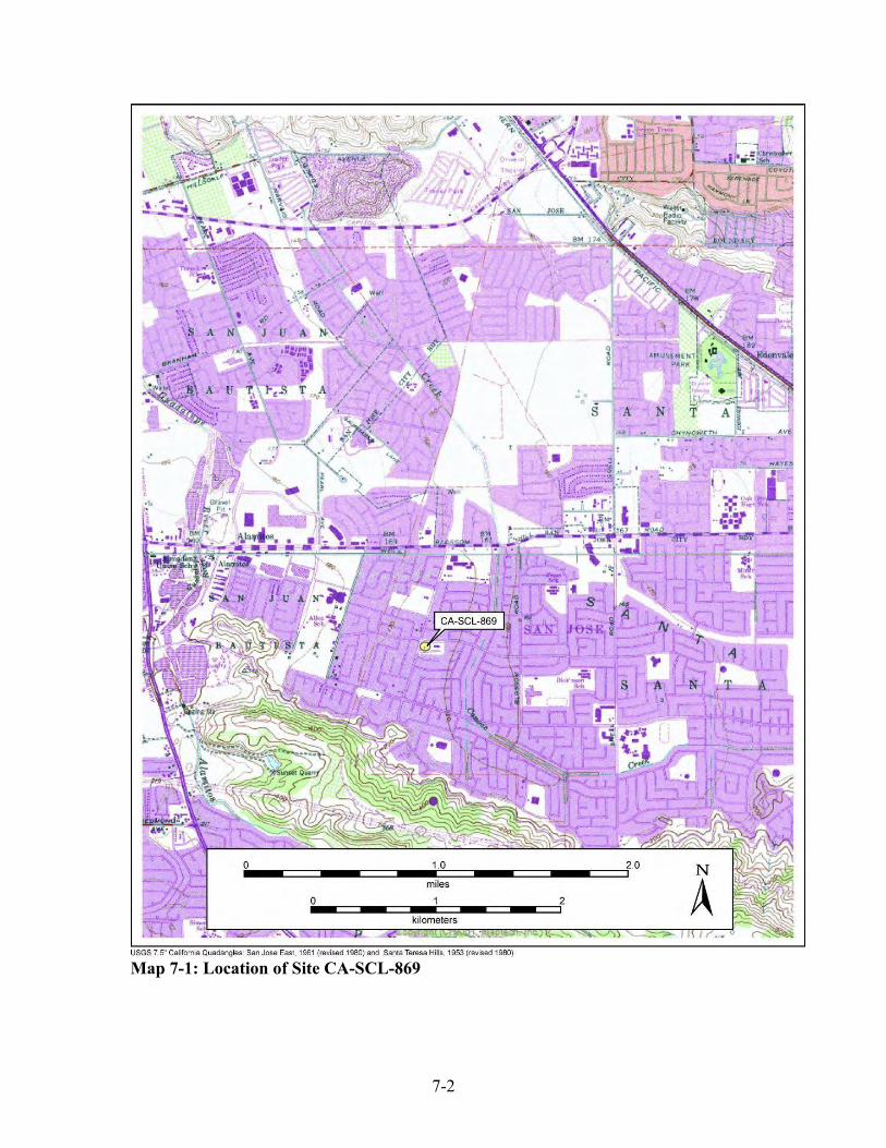
7-2
Map 7-1: Location of Site CA-SCL-869

7-3
1) Riparian (Canoas Creek); 2) Tule Marsh (Canoas Marsh); 3) Valley Oak Savanna/California Prairie; and 4) Chaparral/Mixed Hardwood Forest
Definitions of Major Plant Communities and Previous Paleoecological Studies In his 1977 study, Kuchler provided the following descriptions for each of the four major plant communities identified for inclusion in the present paleo-environmental reconstruction. Also relying upon Kuchler‟s 1977 plant community information, Hildebrandt and Swenson (1983) in their study of the catchment analysis of the neighboring five Highway 101 Bypass archaeological sites had identified the following “common component” species found within each of these four communities: 1) Riparian Forest, 2) Tule Marsh, 3) Valley Oak Savanna/California Prairie, and 4) Mixed Hardwood Forest/Chaparral. 1. Riparian Forest:
“The structure of this riverine forest is medium tall to tall, broad-leaved deciduous trees. It is cottonwood (Populus fremontii) with the other characteristic components listed below. Box elder (Acer negundo) White alder (Alnus rhombifolia) Mule fat (Baccharis viminea) Button bush (Cephalanthus occidentalis) Virgin‟s bower (Clematis ligusticifolia) Sycamore (Platanus racemosa) Valley oak (Quercus lobata) Blackberry (Rubus vitifolius) Willow (Salix spp.) Nettle (Urtica holosericea) Wild grape (Vitis californica)” [Hildebrandt and Swenson 1983:1-42; cf. Kuchler 1977:20]
2. Tule Marsh [Canoas Creek Marsh]
“Tule Marsh (Scirpus-Typha) [common tule-cattail]. Structure: Tall dense graminoid plant communities, occasionally interrupted by open water” (Kuchler 1977:24).
Hildebrandt and Swenson noted in their study that the:
Dominant species are common tule (Scirpus acutus) and cattail (Typha
latifolia). Other common components are listed below:

7-4
Sedge (Carex spp.) Spike rush (Eleocharis spp.) Wire grass (Juncus spp.) Three square (Scirpus americanus) Bulrush (Scirpus californicus) [Hildebrandt and Swenson 1983:1-43]
They also commented that:
In the Santa Clara Valley today, tule marsh has virtually vanished. Factors accounting for the demise of this habitat are much the same as those discussed under riparian forest. In the past, the seasonal fluctuation in streamflow and most importantly marshlands, the stream overflow, would have provided sufficient water to support freshwater marshes. This community is dependent on a high water table.
La Laguna Seca was the probable site of freshwater marsh habitat in the study area. Marshes are also often associated with the riparian communities (referenced from Kuchler 1977). … Thus, La Laguna Seca is located with the caution that marsh areas not only fluctuated seasonally but from year to year as well due to variable amounts of rainfall. … In 1772 Crespi joined Fages in further exploration of the Bay Area. The expedition followed the inland route. Crespi described the area from San Martin to the narrows at Coyote Creek:
„…we continued along the same valley, all of level land, and much of it well grown with oaks and live oaks… the greater part of it is of good land with plenty of pasture…The valley now grows narrow. We halted on the bank of a running stream, which seemed to us not to be permanent, but to flow only in the rainy season. But near the arroyo we saw a lagoon of fresh and permanent water…‟ (cited from Bolton 1927:284-285)
… The expedition was not at the narrows near the present town of Coyote. Palou‟s narrative continues:
„After we had passed through the grove, the valley widened out again, with good lands and likewise grown with oaks. At twelve o‟clock we came to a range of hills of medium height, of pure earth and grass covered.

7-5
These hills were located just south of the Oak Hill Cemetery in San Jose (also called the Lick Hills according to Brown 1962).The narrative continues until the group reaches that day‟s camp somewhere to the north of the cemetery:
„We then followed the spacious plain toward the west by northwest…finding that the valley continues of good land with much pasturage and very thickly grown with oaks.‟” [Hildebrandt and Swenson 1983:1-43 – 1-45]
3. Valley Oak Savanna/California Prairie For purposes of the present study the California Prairie plant community will be considered intermixed with the Valley Oak Savanna community. Kuchler 1977 provided the following description of both the Valley Oak Savanna and California Prairie communities in his study:
Valley Oak Savanna (Quercus-Stipa) [Valley Oak-California Prairie] Structure: Savanna of tall, broad-leaved deciduous trees, widely spaced and stately. Woody undergrowth is insignificant. Broad-leaved evergreens and/or needle-leaved evergreen trees occur occasionally. Density increases where merging with riparian forest. The California prairie (36) covers the ground”. (Kuchler 1977:22)
California Prairie (Stipa spp.) Structure: Dense to somewhat open, medium tall bunchgrass community with many forbs. Height and seasonal aspects of this prairie can vary greatly. Dominants: Needlegrass (Stipa cernus), speargrass (Stipa
pulcha). (ibid: 23). Hildebrandt and Swenson identified the following major food resource plants found within the California Prairie community in their 1983 study:
California Prairie: The following is a list of the economically significant plants. Plant Product Season of Harvest Wild rye Seed/pinole Summer (Chestnut 1902; Barrett and Gifford 1933) Lupine Greens Spring (Chestnut 1902) Soap root Greens/bulb March (Chestnut 1902; Barrett and Gifford 1933;
Chestnut is uncertain if the bulb was eaten.) Gilia Flowers Summer (Chestnut 1902) Wild onion Bulb Spring/summer (Chestnut 1902; Barrett and Gifford 1933) Indian Potato Bulb Spring/summer (Chestnut 1902; Barrett and Gifford 1933) Red maids Seed/pinole May (Chestnut 1902; Barrett and Gifford 1933) Buttercup Seed/pinole May (Chestnut 1902; Barrett and Gifford 1933) Clover Greens Spring (Chestnut 1902) “ Seed/pinole Summer (Chestnut 1902)

7-6
Wyethia Greens Spring (Chestnut 1902) “ Seed/pinole Summer (Chestnut 1902)” [Hildebrandt and Swenson 1983:1-48 – 1-49]
4. Mixed Hardwood Forest/Chaparral Also for purposes of the present study the Mixed Hardwood Forest plant community is combined with the Chaparral community. Kuchler described the Hardwood Forest plant community as follows:
Mixed Hardwood Forest (Arbutus-Quercus) [madrone-oak] Structure: Low to medium tall, broad leaved evergreen forest with an admixture of broad-leaved deciduous and needle-leaved evergreen trees; the later may be towering above the canopy. The forest is more or less dense, and in higher elevations, its height may be so low as to make the forest appear shrubby. Inclusions of chaparral (29) are common. (Kuchler 1977:18)
In their study Hildebrandt and Swenson identified the following “dominant plants” and “common components” within the Mixed Hardwood Forest:
Dominant plants are: Madrone (Arbutus menziesii) Canyon live oak (Quercus chrysolepis; high elevations) Coast live oak (Quercus agrifolia); low elevations) Common components: Buckeye (Aesculus californica) Coyote Brush (Baccharis pilularis) Toyon (Heteromeles arbutifolia) Tan oak (Lithocarpus densiflora) Coulter pine (Pinus coulteri) Douglas fir (Pinus menziesii) Poison oak (Rhus diversiloba) Black oak (Quercus keloggii) Interior live oak (Quercus wislizenii) [Hildebrandt and Swenson 1983:1-38 – 1-39]
Hildebrandt and Swenson had also independently conducted a field survey examining the extant species within the Santa Teresa County Park/San Felipe Road are as part of their paleo-environmental study. They noted that:
The mixed hardwood forest within the study area was field checked in Santa Teresa County Park and along San Felipe Road. Variations from the community species listed above were evident. In Santa Teresa County Park, the dominant species are coast live oak, canyon live oak, and valley oak (Quercus lobata) with Buckeye common. In the drainages bay

7-7
(Umbelluaria californica) and alder (Alnus rhombifolia) are present. There is an admixture of grasses and annuals (species noted in the California prairie section) as well as shrubby species (coyote brush, toyon, and thistles (Cirsium spp.). [Hildebrandt and Swenson 1983:1-38 – 1-39]
Hildebrandt and Swenson identified those economically significant species that are found within the Mixed Hardwood community and what time of year they were exploited:
Plant Product Season of Harvest Bay Peppercorn Autumn (Sudworth 1908) Buckeye Nut Autumn (Chestnut 1902) Toyon Berry Late autumn (Chestnut 1902) Coast live oak Acorn Autumn (Sudworth 1908) Valley oak Acorn Autumn (Chief acorn supply; Chestnut 1902) Blue oak Acorn Autumn (Chestnut 1902; Barrett & Gifford 1933) Interior live oak Acorn Autumn (Barrett and Gifford1933)” [Hildebrandt and Swenson 1983:1-47]
Kuchler offered the following description for the Chaparral plant community:
Chaparral (Adenostoma-Arctostaphyloa-Ceanothus) [Chamise-manzanita-California lilac]. Structure: Dense communities of needle-leaved and broad-leaved evergreen sclerophyll shrubs, varying in height from 1-3 meters, rarely to 5 meters. An understory is usually lacking. (1977:20).
Hildebrandt and Swenson also provided the identification of the following dominant species and common components found within the Chaparral plant community:
The Dominant species are: Chamise (Adenostoma fasciculatum) Manzanita of many types (Arctostaphylos spp.) California lilac of many types (Ceanothus spp.) Other common components of this community are as follows: Mountain mahogany (Cercocarpus betuloides) Flowering ash (Fraxinus dipetala) California buckwheat (Eriogonum fasciculatum) Toyon (Heteromeles arbutifolia) Honeysuckle (Lonicera spp.) Scrub oak (Quercus dumosa) Interior live oak (Quercus wislizenii) Buckthorn (Rhamnus spp.) Currant; Gooseberry (Ribes spp.) Sage; chia (Salvia spp.) [Hildebrandt and Swenson 1983:1-39]

7-8
The following information about some of the major food resources found within the Chaparral community and at what time of year they would have been available to harvest was identified by Hildebrandt and Swenson in their study:
Chaparral: Economically important plants of this community are listed below. Plant Product Season of Harvest Toyon Berry Autumn (Chestnut 1902) California lilac Seed/pinole Midsummer to early autumn (Sudworth 1908) Elderberry Berry Early autumn (Clarke 1977) Manzanita Berry July to August (Chestnut 1902; Barrett & Gifford 1933) Hollyleaf cherry Berry Summer-autumn (Chestnut 1902; Barrett Gifford 1933) Interior live oak Acorn Autumn (Chestnut 1902) Animal species found within the Chaparral of economic importance are as follows: Black-tail deer (Odocoileus hemionus), Jack rabbit (Lepus californicus), Brush rabbit (Sylvilagus bachmanii), Wood rat (Neotoma fuscipes), Pocket gopher (Thomomys
spp.), Mountain lion (Felis concolor), Bobcat (Lynx rufus). [Hildebrandt and Swenson 1983:1-48]
Interestingly, all of the above “animal species” were recovered from the archaeological excavations at CA-SCL-732 and the adjoining CA-SCL-200 (Cartier 1991) sites as faunal remains and in some cases directly associated with the burials at the Three Wolves Site (Cambra et al 1996:9.8; Tables: 9.4 and 9.5). Result from the Mapping the Four Major Plant Communities Canoas Creek and Canoas Marsh The ecological information derived from Kuchler‟s 1977 study (and others) helped set the stage for the environmental and site catchment analysis that was conducted by Hildebrandt and Swenson in 1983. Their studies then contributed to the paleoecological model, paleoethnobotany and paleolandscape studies conducted by Hammett 1996 for the Three Wolves Site, CA-SCL-732 (Cambra et al. 1996) which is also located within the greater study area that includes the five Caltrans sites (Hildebrandt 1983) and CA-SCL-869. Furthermore, it was noted from their study that the northwestern section of Hildebrandt and Swenson‟s 1983 catchment analysis included that area surrounding site CA-SCL-869. Within this location Hildebrandt and Swenson had mapped the presence of the Valley Oak Savanna plant community. Based upon the identification of the four major plant communities 1. Riparian (Canoas Creek), 2. Tule Marsh (Canoas Marsh), 3. Valley Oak Savanna/California Prairie, and 4. Chaparral/Mixed Hardwood Forest) discussed above, the present authors

7-9
determined that these communities are also present within the one mile radius catchment area surrounding CA-SCL-869. As mentioned above, these four plant communities were then plotted onto the combined USGS topographic maps. By employing the 160‟ foot contour as proposed by Roop (1979) as a boundary guide, the present authors have, perhaps for the first time, potentially defined the “basin” of the Canoas Marsh. After its location had been plotted, it appears that the Canoas Marsh did indeed serve as an important habitat/subsistence resource for the ancestral Ohlone people living within the two-mile catchment area surrounding CA-SCL-869 as well as for the larger surrounding area. Furthermore, based upon the reconstructed location of the Canoas Marsh, it appears to have been located approximately ¼ mile to the east of CA-SCL-869. (See Map 7-2 below) Based upon our calculation the relative percentage for each of the plotted plant communities are as follows:
1. Riparian (Canoas Creek) [4%] 2. Tule Marsh (Canoas Marsh) [15%] 3. Valley Oak Savanna/California Prairie [62%] 4. Chaparral/Mixed Hardwood Forest [19%]
Discussion of Other Plants Materials Used by Central California and Ohlone Indians that May were Potentially Harvested in this Area for Basketry In their comprehensive study entitled Indian Baskets of Central California: Art, Culture and History (2006), authors Shanks and Shanks present information on the principal plants that were used in the weaving of the different types of baskets made by California Indians. Some of these materials would have been found within the catchment area surrounding CA-SCL-869. Shanks and Shanks provide identification and information on the following plant species:
Bound Weave Baskets … In North Central California these elements are made of string. Bound weaves of string were used in Pomo, Wappo and Lake Miwok cradles to secure the willow, hazel or dogwood warps that make up the body of the cradle. Either Native or commercial string might be used in bound weaves.
…
Materials Most tribes used less than ten basketry materials (Merrill 1923, 216). If we look at the truly common materials, the number is even fewer. The following are all major materials. …

7-10
Map 7-2: Reconstructed Paleo-Ecological Catchment Surrounding CA-SCL-869

7-11
Beargrass (Xerophyllum tenax) is used primarily as an overlay material in Northwestern and Northeastern California. Beargrass was used in both regions for designs, but in Northeastern California it was also used as a background material. … Bracken fern root (Pteridium) was used for black designs. Light brown in color when gathered, it is commonly boiled for a short time when dying it to produce a black color. Sometimes the bracken fern still retains brown shades with the black (Barrett 1996, 139). Bracken fern root was an especially popular black weft material among the Western Mono and Yokuts, but was also often used by the Maidu, Sierra Miwok and Coastal Pomo in North Central California. ...
Bulrush Root (Scirpus) is a common material used for black designs among the Pomo, Patwin, Wappo, Lake Miwok and others. Bulrush root is pink before it is dyed black. … Bulrush root also tends to be used as very narrow wefts. …
Cattail (Typha) is lighter colored than tule. Cattail tends to be off-white or very light brown. Cattail was used for wefts. Tule (Scirpus) was used for wefts, warps and cordage warps. … Tule was used in Central California for utility baskets. Finely made cattail and tule weft baskets were made by the Klamath, Modoc and others using tule cordage wefts. Both tule and cattails are rushes.
Conifer Roots from trees such as pine (Pinus), redwood (Sequoia) and spruce (Picea) were made into thin, pliable weft strands. ... In North Central California the Pomo, Yuki, Mountain Maidu and Sierra Miwok also used conifer root wefts in certain types of twined baskets. …
Deergrass (Muhlenbergia rigens) served as the main foundation material for coiled baskets among the Yokuts, Western Mono and many Southern California cultures. … In North Central California, the Sierra Miwok often used it for foundations in their winnowers.
Devil's Claw pods (Proboscidea) were used for black designs in Southeastern California. … The pods were split into thin strips for use as wefts. … The Chemehuevi and other Southeastern California desert cultures used devil's claw for their black designs.
Hazel (Corylus) shoots serve as warps in Northern California twining. … Hazel provides thin, strong warps useful in making fine twined baskets.
7-12
Joshua Tree Root (Yucca brevifolia) is identified by its orange-red color. It is much more orange-red, or at least a lighter red, than redbud. … Southern California desert cultures such as the Kawaiisu, Tubatulabal, Panamint and others used it often in their coiled baskets. Other species of yucca were occasionally used as well.
Juncus (Juncus) is a rush used for wefts and warps over much of coastal Southern California inland to the desert. … The Chumash, Gabrielino and the Southwestern Californians used juncus extensively for both coiling and twining. Juncus was also used in north central Oregon by the Kalapuya and Upper Umpqua.
Maidenhair fern (Adiantum) stems are a shiny, rich black color. Maidenhair fern stems were most often used for black overlay designs in Northwestern California, Northeastern California and Southwestern Oregon.
Redbud (Cercis occidentalis) bark of young redbud shoots is a rich, dark red. … Redbud was used over most of Central California and Northeastern California for wefts. … Sometimes the bark was peeled and used for background wefts, as among the Yuki and Cahto. …
Sedge Root (Carex) has subtly rounded edges. It is white when new but darkens to a rich buff color with age. Sedge root wefts often have a slightly dusty look, when viewed very closely. The Porno, Patwin, Valley Maidu, Wappo, Ohlone (Costanoan), Coast Miwok, Yokuts, Western Mono and others commonly used sedge root for coiled background wefts. …
Sumac or Sourberry (Rhus trilobata) is a rugged material very useful for wefts where durability is important. It was common in the coiled baskets of the Chumash, Gabrielino, Southwestern California and others. …
Willow (Salix) was one of the most widely used materials in California. … Willow served as wefts and warps and in both twining and coiling. It was a very common foundation material among Central California coiled baskets. Willow was very often used to make openwork utility baskets. …
Woodwardia Fern or Giant Chain Fern (Woodwardia) stems contain strong inner fibers useful as weft strands. The natural color of these strands is white, but in Northwestern California and among the Wintu they were dyed an orangey-red using alder bark (Alnus). … Woodwardia was used only in the northern part of California (Shanks and Shanks 2006:21-23).
Of the plant materials used by California Indians cited above, Shanks and Shanks note specifically for the Costanoan/Ohlone linguistic region at least 14 plant species that were associated with or identified on Ohlone baskets:
7-13
Materials Coiled Ohlone baskets had foundations of peeled shoots, probably willow and hazel (Mathewson 1998, 148). Wefts were made of sedge root (Carex). Black designs were of dyed bulrush root (Scripus) and occasionally bracken fern root (Pteridium) (Bocek 1984, 247; Dawson p.c.). … (Ibid:30) Ohlone Twining Materials Sedge root was the most important Ohlone basketry weft material (Merriam 1967, 381). For warps, the preferred materials were willow and hazel (Mathewson 1998, 148. 167, 179). Dogwood (Corylus) and chamise (Adenostoma fasciiculatum) were also said to have been used as warp materials (Bocek 1984, 252, 249). As mentioned, horsetail and Indian scouring rush (Equisetum) were apparently used for black designs in twined baskets. Juncus rush (Juncus) was used on one winnowing basket for designs. (Ibid:33) Berry Basket … It was made of tule and lined with sycamore leaves (Platanus racemosa) to prevent the berries from falling between the warps. (ibid:34) Acorn Storage Baskets … These were made of peeled willow warps and were coarse utilitarian baskets wrapped with willow bark. The bottom was covered with cattail (Typha) leaves and the top with madrone (Arbutus menziesii) leaves. (Ibid 35)
Of these 14 species of plants the following could be harvested in (meadows and wetland environments) riparian and fresh water Tule Marsh communities: 1) bulrush (Scripus californicus), 2) cattail (probably Typha latifolia), 3) tule (Scirpus
acutus), 4) sedge (Carex densa), 5) Juncus [common rush] (Juncus patens) 6) horsetail rush (Equisetum laevigatum), 7) Indian Scouring ‘Horsetail’ Rush (Equisetum
hyemele), 8) willow (probably Salix lasiolepis or Salix scouleriana) and 9) Sycamore (Platanus racemosa).
Plants found within the California Prairie/Oak Savanna communities include: 10) bracken fern (Pteridium aquilinum pubescens),
Plants found within the Chaparral/Mixed Hard Wood Forest communities include: 11) Chamise (Adenostoma fasciculatum), 12) Pacific Madrone (Arbutus menziesii), 13) California Hazel (Corylus californica) and 14) Pacific or Western Dogwood (Cornus
nuttallii). In conclusion, from this paleoecological study we can now visualize the proximity of CA-SCL-869 and the other previously recorded sites CA-SCL-295, CA-SCL-130, CA-SCL-137, and CA-SCL-195 located within this catchment area and their relationship to the Canoas Creek and Canoas Marsh freshwater resources and plant communities.

7-14
Furthermore, we can also ascertain from the location of those sites located outside the immediate catchment area that the ancestral Ohlone Indians residing there were close enough to Canoas Marsh to harvest the diversity of plants, birds, mammals, and fish as food and as resource material.

8-1
Chapter 8: Faunal Analysis from CA-SCL 869
Jean Geary and Alan Leventhal Introduction Prehistoric site CA-SCL 869 contained only a small assemblage of vertebrate faunal remains and because of the small recovered sample it is not suitable for any meaningful statistical analysis. However, the site did provide some species of significance in determining aspects of the local paleoenvironment. The faunal remains were derived from four different contexts: 1) controlled excavation test units, 2) burial/grave locus, 3) monitoring of backhoe trench excavations, and 4) isolates (isolated finds from disturbed context). Methods Faunal remains were recovered using ¼ inch and at times 1/8” mesh screens. The remains were carefully bagged by location and level in the field and later washed, and placed in labeled baggies at the San Jose State University Anthropology Lab. Each unit, level, trench and other discrete context recovered element, and each identifiable element was issued a catalogue reference and specimen number (e.g. Burial 1 Reference #1-1, 1-2, 1-3 and etc.). All faunal remains were compared with the comparative mammalian and avian osteological collection curated at the Museum of Birds and Mammals, Department of Biological Science at San Jose State University. Faunal material was identified as it was received from the field; the first remains were from the test units with special attention to Test Unit #1 (Feature #1). Initially the larger bones were sorted for identification, the rebagged and issued a catalog number. The identifiable element, and if fragmented, its portion, along with observations such as “juvenile”, “burnt” or “unburnt,” “cut marks” and etc. were recorded on faunal record catalog sheets, as well as the bag. Fragments that fitted together were considered one specimen and the number of pieces was recorded under remarks on the catalog sheet. The species identification was added to the bag and catalog sheet upon completion, as well as any additional information such as side or which vertebrae. Notes were kept separately regarding criteria used to determine between two similar species. Birds and mammals were sorted into respective taxa. Bones with distinct features that could not be identified to species were identified as far as possible. Highly fragmented bone was considered “unidentifiable” given the time factor needed for specific identification. Small bones were compared to the reference material using a stereo dissecting scope and any marks that could be considered cut marks were also examined under the dissecting scope.
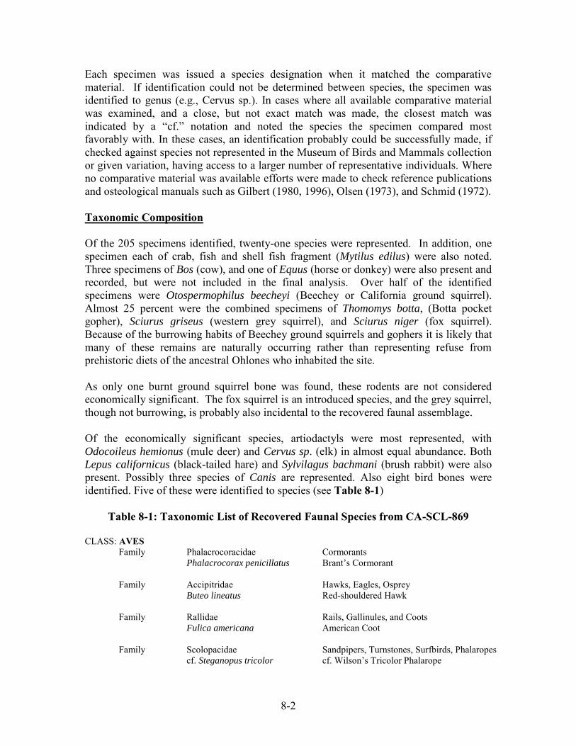
8-2
Each specimen was issued a species designation when it matched the comparative material. If identification could not be determined between species, the specimen was identified to genus (e.g., Cervus sp.). In cases where all available comparative material was examined, and a close, but not exact match was made, the closest match was indicated by a “cf.” notation and noted the species the specimen compared most favorably with. In these cases, an identification probably could be successfully made, if checked against species not represented in the Museum of Birds and Mammals collection or given variation, having access to a larger number of representative individuals. Where no comparative material was available efforts were made to check reference publications and osteological manuals such as Gilbert (1980, 1996), Olsen (1973), and Schmid (1972). Taxonomic Composition Of the 205 specimens identified, twenty-one species were represented. In addition, one specimen each of crab, fish and shell fish fragment (Mytilus edilus) were also noted. Three specimens of Bos (cow), and one of Equus (horse or donkey) were also present and recorded, but were not included in the final analysis. Over half of the identified specimens were Otospermophilus beecheyi (Beechey or California ground squirrel). Almost 25 percent were the combined specimens of Thomomys botta, (Botta pocket gopher), Sciurus griseus (western grey squirrel), and Sciurus niger (fox squirrel). Because of the burrowing habits of Beechey ground squirrels and gophers it is likely that many of these remains are naturally occurring rather than representing refuse from prehistoric diets of the ancestral Ohlones who inhabited the site. As only one burnt ground squirrel bone was found, these rodents are not considered economically significant. The fox squirrel is an introduced species, and the grey squirrel, though not burrowing, is probably also incidental to the recovered faunal assemblage. Of the economically significant species, artiodactyls were most represented, with Odocoileus hemionus (mule deer) and Cervus sp. (elk) in almost equal abundance. Both
Lepus californicus (black-tailed hare) and Sylvilagus bachmani (brush rabbit) were also present. Possibly three species of Canis are represented. Also eight bird bones were identified. Five of these were identified to species (see Table 8-1)
Table 8-1: Taxonomic List of Recovered Faunal Species from CA-SCL-869 CLASS: AVES Family Phalacrocoracidae Cormorants Phalacrocorax penicillatus Brant’s Cormorant
Family Accipitridae Hawks, Eagles, Osprey Buteo lineatus Red-shouldered Hawk Family Rallidae Rails, Gallinules, and Coots Fulica americana American Coot Family Scolopacidae Sandpipers, Turnstones, Surfbirds, Phalaropes cf. Steganopus tricolor cf. Wilson’s Tricolor Phalarope
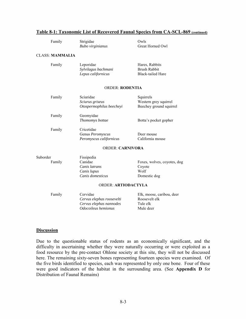
8-3
Table 8-1: Taxonomic List of Recovered Faunal Species from CA-SCL-869 (continued) Family Strigidae Owls
Bubo virginianus Great Horned Owl CLASS: MAMMALIA Family Leporidae Hares, Rabbits Sylvilagus bachmani Brush Rabbit Lepus californicus Black-tailed Hare
ORDER: RODENTIA Family Sciuridae Squirrels Sciurus griseus Western grey squirrel Otospermophilus beecheyi Beechey ground squirrel Family Geomyidae Thomomys bottae Botta’s pocket gopher Family Cricetidae Genus Peromyscus Deer mouse Peromyscus californicus California mouse
ORDER: CARNIVORA Suborder Fissipedia Family Canidae Foxes, wolves, coyotes, dog Canis latrans Coyote Canis lupus Wolf Canis domesticus Domestic dog
ORDER: ARTIODACTYLA Family Cervidae Elk, moose, caribou, deer Cervus elephas roosevelti Roosevelt elk Cervus elephas nannodes Tule elk
Odocoileus hemionus Mule deer Discussion Due to the questionable status of rodents as an economically significant, and the difficulty in ascertaining whether they were naturally occurring or were exploited as a food resource by the pre-contact Ohlone society at this site, they will not be discussed here. The remaining sixty-seven bones representing fourteen species were examined. Of the five birds identified to species, each was represented by only one bone. Four of these were good indicators of the habitat in the surrounding area. (See Appendix D for Distribution of Faunal Remains)

8-4
Birds Buteo lineatus, the red-shouldered hawk, prefers wet woodlands and can often be found near water and swamps (Riparian, Tule Marsh and Valley Oak Savanna communities). They hunt from perches and feed on small rodents, reptiles, amphibians, large insects, snails, earthworms and birds (see Alsop 2002, Robbins et al. 1983). One femur fragment (right, proximal) was recovered. (Specimen # 48-7, Test Trench 6, 40-60 cm) [Fig. 8-1]
Figure 8-1: Red-Shouldered Hawk
Fulica americana, the American coot, was represented by one humerus (left) fragment (Specimen # 9-63 from Test Unit 1, 40-60cm). Coots like open water and can be found on ponds, rivers, marshes and swamps (Riparian and Tule Marsh communities). They nest in fresh water and build floating nests. They occur in flocks, and in the winter they can be found in both salt and fresh water (Alsop 2002, Robbins et al. 1983). [Fig. 8-2]
Figure 8-2: American Coot
Brant’s Cormorant, Phalacrocorax penicillatus, nest on sea cliffs and offshore rocky islands. They can be found around rivers, lakes, ponds (Tule Marsh community) and mudflats as well as sandy and rocky seashores. They dive from the surface of the water and chase their prey underwater (www.birds.cornell.edu/AllAboutBirds/BirdGuide/ Brant's _Cormorant_.html). Large in size, weighing around 4.5 lbs, they might make a good size meal, but their diet of fish, crabs and shrimp give their flesh a very potent fishy

8-5
smell. Represented by only the distal end of a rib (Specimen # 9-58), this element was recovered from Test Unit #1 at the 40-60 cm level in conjunction with the widest array of faunal species in the site (Alsop 2002, Robbins et al. 1983). [Fig. 8-3]
Figure 8-3: Brant’s Cormorant
A right distal phalarope tibia, (Specimen # 8-24) most like a Steganopus tricolor, [Wilson’s phalarope - a shorebird], in size and general features but is not a match, was recovered at the 20-40 cm level (Test Unit 1) above the cormorant. Phalaropes are small birds, weighing only about 2.5 oz. They feed on plankton, insects and their larvae, crustaceans and marsh plant seeds. Female phalaropes court the males, and the males develop brood patches and incubate the eggs. This species is an inland species and probes mud in shallow water (Riparian and Tule Marsh communities) (Alsop 2002, Robbins et all. 1983). [Fig. 8-4]
Figure 8-4: Wilson’s Phalarope
A complete left ulna (Specimen # 9-32) of Bubo virginianus, great horned owl, was recovered from the 40-60 cm level of Test Unit 1. Great horned owls occupy a variety of habitats from coniferous and broadleaf forests, to open landscapes of grasslands and salt, brackish and freshwater marshes, as well as around lakes, rivers and ponds (Riparian, Tule Marsh and Valley Oak Savanna communities) (Alsop 2002, Robbins et all. 1983). [Fig. 8-5]

8-6
Figure 8-5: Great Horned Owl
Also recovered from the 40-60cm level of Test Unit 1 was a very well defined portion of a distal, lateral left tarsometatarsus (Specimen # 9-43). This element is from a large bird, and has characteristics of a raptor. It is, as yet, unidentified, awaiting comparison with specimens of a bald eagle, as other similarly sized species have been examined (Riparian and Tule Marsh communities). [Fig. 8-6]
Figure 8-6: Bald Eagle
In other contexts, an unidentified bird nestling (juvenile) tarsometatarsus (Specimen # 2-17) was found in association with Burial #2. One other bird element (Specimen #14-36) was found in Test Unit 2, 20-40 cm. This element is possibly a fragment of a humerus of a robin to small hawk–sized bird. Small Mammal The brush rabbit, Sylvilagus bachmani was represented by two bones: a right mandible (Specimen # 9-61) and a right femur mid-shaft (Specimen # 9-66), which were recovered from the 40-60 cm level of Test Unit 1. Brush rabbits are found in dense brushy areas and they weigh about 2 lbs (Valley Oak Savanna and Chaparral communities). [Fig. 8-7]
Figure 8-7: Brush Rabbit

8-7
Four Lepus californicus (black-tailed hare) bones were found in the same provenience as the brush rabbit from Test Unit 1, 40-60 cm. This animal prefers open areas and broken chaparral and avoids dense brush Valley Oak Savanna/California Prairie and Chaparral communities. A right tibia (Specimen # 9-59), left ulna midshaft (Specimen # 9-70), and 1 L4 and 1 caudal vertebrae (Specimen #’s 9-71 and 9-45) were recovered. [Fig. 8-8]
Figure 8-8: Black-Tailed Hare
Large Mammals/Artiodactyl Odocoileus hemionus (mule deer/California black-tailed deer) remains were found in six different areas within the site, totaling ten bones, but were probably more highly represented at this site due to the fragments that could only be identified to artiodactyl. Of the identified elements (Specimen #’s 7-13 (T.U. 1, 0-20 cm), 9-29 (T.U. 1, 40-60 cm), 10-21, 10-22, 10-23, and 10-25 (T.U. 1, 60-80 cm), 32-9 and 32-10 (T.U. 5, 20-40 cm), 48-3, 48-5 and 48-6 (Test Trench 6, 40-60 cm), 110-2 and 110-7, (Surface Isolates), most were skull fragments, with one each of a tibia, an innominate and an awl made from a metatarsal bone (canonbone) (Specimen # 2-13 associated with Burial 2) A fragment of a worked bone awl (midsection) with striations (Specimen # 48-3), most likely Odocoileus canonbone, was recovered from Trench 6, 40-60 cm). Most unidentified artiodactyl material is highly fragmented long bones. Mule deer are widespread, inhabiting forest edges, open woodland and brushy chaparral covered areas (Valley Oak Savanna and Chaparral communities). In this region mule deep are generally smaller and weigh between 70-140 lbs. (Matthiesen, Guruswami-Naidu 1979). [See Figure 8-9]
Figure 8-9: Mule Deer/California Black-Tailed Deer
It was not surprising to find Tule elk, Cervus nannodes at this site [Fig. 8-10], but of the eighteen Cervus elements identified, seven of these Specimen #s 9-42 (T.U. 1, 40-60 cm), 10-24 (T.U. 1, 60-80 cm), 14-2 (T.U. 2, 20-40 cm), 44-5 (Test Trench #2, 60-80 cm),

8-8
Figure 8-10: Tule Elk
110-1 (Surface Isolates), 138-9 and 138-10 (Electrical Utility Trench) were consistent with Cervus elephas roosevelti, which is a more northern subspecies of elk. The following eighteen elements were found in the following contexts: Specimen #’s 9-28, 9-30, 9-31, 9-42, and 9-64 (Test Unit 1, Feature # 1, 40-60 cm), 10-24 (T.U. 1, 60-80 cm), 14-1 and 14-2 (T.U. 2, 20-40 cm), 25-4, probably Cervus (T.U. 4, 0-20 cm), 44-5 and 44-6 (Test Trench #2, 60-80 cm), 51-3 (Transformer Pad, 40-60 cm), 110-1 and 110-4 (Surface Isolates), 135-2 (North Wall Sewer Trench), 138-8, 138-9 and 138-10 (Electrical Utility Trench). Schonewald et al. (1985) studied the cranial morphology of Pacific coast elk from four geographic locations and could separate the population on the basis of skull measurements. They found that the northern California Roosevelt elk differed as much from Washington elk as they did from northern California Tule elk. They also discovered that the amount of sexual dimorphism in size and shape differed between groups. These authors also noted that Tule elk can display very different appearances when subjected to different diets and climates. Therefore, although several specimens were identified as Cervus elephas roosevelti on the basis of their similarity (in some cases overwhelmingly exact) to the reference skeletons of that subspecies, given the potential of variation among and perhaps even within populations, there is hesitancy to declare both subspecies were present within this area. It would be prudent to examine a larger number of reference specimens to be assured that the criteria used for identification was consistent between subspecies and not subject to individual variation. (Figs. 8-11 and 8-12)

8-9
Figure 8-11: Faunal Remain of Elk and Deer from Test Unit #1
Figure 8-12: North American/Roosevelt Elk
The tule elk (Cervus elephas nannodes) is a subspecies of North American elk that occurs only in California. For thousands of years, vast numbers of tule elk thrived in the grasslands of central and coastal California. Throughout their range, elk live in forest and in forest edge habitats, similar to other deer species and are found in Valley Oak Savanna, Chaparral/Mixed Hardwood and Tule Marsh communities.

8-10
Canids Burial # 2 contained a portion of a 3rd metatarsal (Specimen # 2-1) that was most similar to Canis domesticus, dog and a probable Canis lupus (wolf) incisor (Specimen # 2-14). [Fig. 8-13]
Figure 8-13: Wolf (Canis lupus)
A portion of a left mandible (Specimen # 8-18), also most likely dog (Canis domesticus), was found in Test Unit 1 at 20-40 cm. [Fig. 8-14]
Figure 8-14: Native American Dog (Canis domesticus)
One Canis latrans (coyote) left upper 2nd molar (Specimen # 9-57) was found in Test Unit 1, Feature 1, 40-60 cm. [Fig. 8-15]
Figure 8-15: Coyote (Canis latrans)

8-11
Conclusions Based upon the identification of the birds and mammals recovered from prehistoric site CA-SCL-869 and noting their respective preferred habitats, it seems reasonable to speculate that this site was situated in close proximity to the large fresh water Canoas Marsh and Canoas Creek riparian communities that at times during certain seasons of year the Marsh was reasonably deep. Also, based on this faunal analysis, it can be surmised that this locality was most likely situated within Valley Oak Savanna/California Prairie community at the time when CA-SCL-869 was settled. Due to the serpentine make up of the nearby small hills, it is likely that the vegetation in the past was much like what is found there today, which is chaparral . The serpentine soil limits what will grow, and the allopathic agents secreted from many of the chaparral plants prevents encroachment of new species of plants. (Per. communication, Dr. Shannon Bros, 2/20/08). Some Comparative Archeo-Faunal Assemblages of South Bay Sites Valente (2002) reported on the following faunal assemblage recovered from an Early Middle- Period site CA-SCL-478 located north of CA-SCL-869 within the “Guadalupe Division” as defined by Roop et al. (1982). Although dating approximately 200 to 700 years earlier than CA-SCL-869, CA-SCL-478 does provide some comparative data:
Table 8-2 Comparative Faunal Assemblages from CA-SCL-869 and CA-SCL-478 CA-SCL-869 CA-SCL-478 Aves # Elements # Elements Buteo 1 Buteo jamaicensis (Red tail hawk) 3 Bubo virginianus 1 Bubo virginianus (Great Horned Owl) 1 Mammalia Lepus 5 Lepus 3 Sylvilagus 2 Sylvilagus 31 Canis 4 Canis 16 Cervus spp. 17 Cervus nannodes 16 Odocoileus hemionus 14 Odocoileus hemionus 20 From the neighboring site CA-SCL-137 located within the catchment area surrounding CA-SCL-869 approximately 1 mile east/northeast on Snell Road in San Jose, yielded the following identified faunal species:
Mammals Mule deer (Odocoileus hemionus) Brown Bear (Grizzly) (Ursus arctos) California Ground Squirrel (Otospermophilus beecheyi) Botta’s Pocket Gopher (Thomomys bottae) Pocket Mouse (Perognathus californica)

8-12
Finally, the faunal remains recovered from the CA-SCL-200/CA-SCL-732 (The Three Wolves Site) locality located 2¾ miles due East of CA-SCL-869 lend additional paleo ecological information for this region. It is also of interest to note that the upper Middle Period burial component from CA-SCL-732 dates to the same time period as the burial component of CA-SCL-869 as well.
Mammals Odocoileus hemionus (mule deer/California black-tailed deer Cervus nannodes (Tule elk) Ursus Arctos/horribilis (brown or grizzly bear) Canis sp. (dog/coyote) Canis lupus (wolf) Urocyon cinereoargenteus (grey fox) Felis concolor (mountain lion) Lynx rufus (bobcat) Vulpes fulva (red fox) Taxidea taxus (badger) Mephitis mephitis (striped skunk) Sylvilagus bachmani (bush rabbit) Lepus californicus (black tailed hare)
Aves Bubo virginianus (great horned owl) Buteo jamaicensis (red tailed hawk) Chen Caerulescens (blue goose) Anas crecca (green winged teal) Ardea herodias (great blue heron) Fulica americana (American coot) Anatidae (ducks and geese)
Shellfish Remains: Ocean and Bay Marine Shellfish Species from CA-SCL-869 The remains from several species of Bay and Marine shellfish were identified and collected from the several archaeological recovery contexts at CA-SCL-869. All of the following species are considered as a food resource with the exception of the Olivella bead which probably was used first as 1) a food resource, and then, 2) as a modified/decorative shell bead or ornament. The Pismo clam may also have been used for dual purposes as well. The following shellfish remains were collected as representative species from the site: Burial #2: 1 Tegula funebralis (Black Turban Snail); 4 Mytilus edulis (Bay mussel)’ and 1 Olivella biplicata (Purple olive shell) C2 split drilled bead. Burial #3: 10 Mytilus edulis shell fragments; and 1 Tivela stultorum (Pismo clam) shell fragment.

8-13
Test Unit #1, 0-20 cm BS: 3 Tegula funebralis; 4 Mytilus edulis shell fragments; and 2 Tivela stultorum (Pismo clam) shell fragments. Test Unit #1, 20-40 (Feature #1) cm BS: 1 Tegula funebralis; 4 Mytilus edulis shell fragments; and1 Ostrea lurida (Bay oyster) shell fragment. Test Unit #1, 40-60 (Feature #1) cm BS: 2 Cerithidea californica (California Horn Snail) shells; 12 Mytilus edulis shell fragments; and 1 Cancer sp? (Crab claw). Test Unit #1, 40-60 (Feature #1) cm BS: 2 Mytilus edulis shell fragments. Test Unit #5, 20-40 cm BS: 1 Mytilus edulis shell fragment. Test Trench #2, 60-80 cm BS: 1 Mytilus edulis shell fragment. Test Trench #3, 40-60 cm BS: 3 Mytilus edulis shell fragments. Test Trench #6 (Transformer Pad), 40-60 cm BS: 1 large Tivela stultorum (Pismo clam) shell fragment. Isolates: 3 whole Tegula funebralis; and 3 Mytilus edulis shell fragments. Monitored Electrical Utility Trench: yielded 1 Ostrea lurida shell (recovered near Burial #4) Of these recovered shellfish species four of these 1) Mytilus edulis (Bay mussel), 2) Ostrea lurida (Bay oyster), 3) Cerithidea californica (California Horn Snail) and most likely 4) the crab were harvested from the San Francisco Bay waters and surrounding wetlands. The three other identified species: 1) Tegula funebralis (Black Turban Snail); 2) Olivella biplicata (Purple olive shell), and 3) the Tivela stultorum (Pismo clam) were most likely traded in from the Pacific Coast. For comparative purposes, the following shellfish were recovered from the neighboring CA-SCL-137 which as mentioned elsewhere falls within the reconstructed catchment area surrounding CA-SCL-869: Mytilus edulis (Bay mussel) Mytilus californianus (California mussel) Saxidomus nuttalli (Butternut clam) Tivela stultorum (Pismo clam) Clinocardium nuttalli (Basket cockle) Haliotis sp. (Abalone) Cerithidea californica (California horn snail) Fresh water clam (sp?) Cancer sp. (crab) (From Bergthold 1982:78-81; Winter 1977; Roop 1979)
8-14
Fish Remains The remains of an unidentified fish skull (Ref. # 15-22) was recovered from the 40-60 cm BS level from Test Unit #2 located adjacent to Burial #2.

9-1
Chapter 9: Paleo-Dietary Reconstruction at CA-SCL-869: Stable Carbon and Nitrogen Isotope Analysis of Four Human Burials
Eric J. Bartelink
Department of Anthropology, California State University, Chico. Introduction Since the late 1970s, stable isotope analysis has been used by physical anthropologists and archaeologists to provide a more comprehensive understanding of past lifeways, including the reconstruction of ancient diets, human migration patterns, infant weaning practices, and prehistoric trade networks. The statement “you are what you eat” forms the basis for all applications using stable isotopes for dietary reconstruction and refers to the relationship between the isotopic composition of an animal’s tissues and its diet (DeNiro and Epstein 1978; Fry 2006). Thus, isotopic analyses of bones and teeth provide a record of food consumption practices during the last 10-15 years of life of the individual. Paleodietary studies usually focus on carbon (13C/12C) and nitrogen (15N/14N) isotopes, and have provided baseline data on different societies that consumed isotopically distinct food resources. In this chapter, I review the theoretical basis of stable isotope analysis and provide parameters for prehistoric diets using isotopic values of flora and fauna from central California. Finally, I provide a dietary reconstruction of four Late Middle Period (AMS dating AD 244 to AD 346) adult females from CA-SCL-869 using stable carbon and nitrogen isotope analysis of bone collagen. Stable Isotopes Stable isotopes are atoms of the same element that have the same number of protons but a different number of neutrons. Because the stable forms of isotopes do not undergo radioactive decay, they provide a record of chemical signatures of biological and geological processes in nature. Although chemically similar, isotopes of the same element react at different rates in chemical reactions due to a slight difference in atomic mass. This difference results in the disproportionate enrichment of one isotope over another, a process known as isotopic fractionation (Fry 2006). Stable isotope values are expressed as the ratio of the “rare” isotope to the “abundant” isotope (e.g., 13C/12C) compared to a known standard and are expressed in permil (‰), or parts per thousand relative to the standard (Schoeller 1999). International laboratory standards for stable isotope research are provided by the National Bureau of Standards and the International Atomic Energy Agency in Vienna. The delta notation symbol ( ) is used to express the isotopic ratio of a sample relative to the standard. Isotope values are calculated as follows:
= (R sample – R standard)/ R (standard) x 1000
Where R is equal to the ratio of the rare to the abundant isotope in the sample compared with that of the standard.
9-2
Stable carbon isotopes are expressed relative to the PDB standard, a Cretaceous belemnite fossil from the Peedee formation in South Carolina. PDB is assigned a value of 0‰ and is enriched in 13C relative to organic carbon and most terrestrial carbonate materials. Hence, 13C values for most living things are negative relative to the standard. Stable isotopes of nitrogen are expressed by the ratio of 15N/14N relative to the standard of atmospheric N2 (AIR). Because air is more depleted in 15N than most living things,
15N values in most living things are usually positive relative to the standard (0‰). Substances that are enriched in the “heavy” isotope of carbon or nitrogen have higher delta ( ) values (Fry 2006). Stable Carbon and Nitrogen Isotope Analysis Carbon isotopes (13C/12C) in bone reflect the consumption of C4, C3, and CAM plants and the animals that eat these plants. C4 plants include tropical grasses such as maize, millet, and sorghum that are typical of hot and arid climates. C4 plants use a 4-carbon molecule (Hatch-Slack photosynthesis) that discriminates less against the isotopically heavier 13C than C3 plants when incorporating atmospheric CO2. C3 plants include most trees, shrubs, legumes, and tubers that are typical of temperate regions. These plants use a 3-carbon molecule (Calvin-Benson photosynthesis) that discriminates more against the isotopically heavier 13C when incorporating atmospheric CO2. Due to these differences, C4 plants average –12.5‰, while C3 plants average –26.5‰ (Schwarcz and Schoeninger 1991). CAM plants include succulents and cacti, and fall between the range of C3 and C4 plants. In marine environments, carbon is derived from dissolved bicarbonate, C3 and C4 plants, and photosynthesizing phytoplankton. This results in isotope values in organisms similar to C4 plants, thus permitting discrimination of marine versus terrestrial diets in a consumer’s tissues (Schoeninger et al. 1983; Schwarcz and Schoeninger 1991). Controlled feeding experiments using rats and mice fed a pure C3, C4, or a mixed diet demonstrate that most carbon molecules from dietary protein are preferentially routed to bone collagen, while carbon molecules in bone apatite are derived from bicarbonate dissolved in the blood and reflect the isotopic composition of the whole diet (Ambrose and Norr, 1993; Tieszen and Fagre, 1993). Thus, the use of carbon isotopes of both collagen and apatite permits greater discrimination of the contributions of different dietary macronutrients (Kellner and Schoeninger 2008). Nitrogen has two stable isotopes, 15N and 14N, which are incorporated into plants from N2 in the atmosphere and ocean water. Marine plants typically have more positive isotopic values than terrestrial plants and these differences are reflected in animal consumers. Unlike carbon, nitrogen isotopes shows a trophic level effect, with the tissues of its consumers enriched ~3‰ over food values at each level in the foodweb (Schwarcz and Schoeninger 1991). Nitrogen isotope values are typically higher in marine ecosystems than in terrestrial ecosystems due to longer food chains.
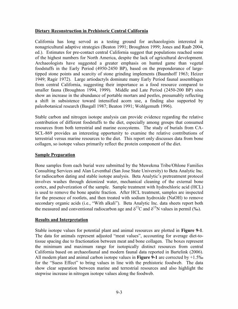
9-3
Dietary Reconstruction in Prehistoric Central California California has long served as a testing ground for archaeologists interested in nonagricultural adaptive strategies (Beaton 1991; Broughton 1999; Jones and Raab 2004, ed.). Estimates for pre-contact central California suggest that populations reached some of the highest numbers for North America, despite the lack of agricultural development. Archaeologists have suggested a greater emphasis on hunted game than vegetal foodstuffs in the Early Period (4950-2450 BP), based on the preponderance of large-tipped stone points and scarcity of stone grinding implements (Baumhoff 1963; Heizer 1949; Ragir 1972). Large artiodactyls dominate many Early Period faunal assemblages from central California, suggesting their importance as a food resource compared to smaller fauna (Broughton 1994, 1999). Middle and Late Period (2450-200 BP) sites show an increase in the abundance of portable mortars and pestles, presumably reflecting a shift in subsistence toward intensified acorn use, a finding also supported by paleobotanical research (Basgall 1987; Beaton 1991; Wohlgemuth 1996). Stable carbon and nitrogen isotope analysis can provide evidence regarding the relative contribution of different foodstuffs to the diet, especially among groups that consumed resources from both terrestrial and marine ecosystems. The study of burials from CA-SCL-869 provides an interesting opportunity to examine the relative contributions of terrestrial versus marine resources to the diet. This report only discusses data from bone collagen, so isotope values primarily reflect the protein component of the diet. Sample Preparation Bone samples from each burial were submitted by the Muwekma Tribe/Ohlone Families Consulting Services and Alan Leventhal (San Jose State University) to Beta Analytic Inc. for radiocarbon dating and stable isotope analysis. Beta Analytic’s pretreatment protocol involves washes through deionized water, mechanical cleaning of the external bone cortex, and pulverization of the sample. Sample treatment with hydrochloric acid (HCL) is used to remove the bone apatite fraction. After HCL treatment, samples are inspected for the presence of rootlets, and then treated with sodium hydroxide (NaOH) to remove secondary organic acids (i.e., “With alkali”). Beta Analytic Inc. data sheets report both the measured and conventional radiocarbon age and 13C and 15N values in permil (‰). Results and Interpretation Stable isotope values for potential plant and animal resources are plotted in Figure 9-1. The data for animals represent adjusted “meat values”, accounting for average diet-to-tissue spacing due to fractionation between meat and bone collagen. The boxes represent the minimum and maximum range for isotopically distinct resources from central California based on archaeofaunal and modern faunal data reported in Bartelink (2006). All modern plant and animal carbon isotope values in Figure 9-1 are corrected by +1.5‰ for the “Suess Effect” to bring values in line with the prehistoric foodweb. The data show clear separation between marine and terrestrial resources and also highlight the stepwise increase in nitrogen isotope values along the foodweb.

9-4
“
Mea
t”
15N
(AIR
)
“Meat” 13C (PDB)
Figure 9-1: Reconstructed Carbon and Nitrogen Dietary Signatures for Potential Food Resources in Prehistoric Central California (from Bartelink 2006). Note: The red dot represents the mean carbon and nitrogen isotope values for the four burials from CA-SCL-869.
Stable carbon and nitrogen isotope values and radiocarbon dates for the four female burials from CA-SCL-869 are reported in Table 9-1. The 13C values range from -20.5 to -19.4‰ (mean = -20.2‰), which is consistent with a diet primarily composed of C3 terrestrial plant and animal protein. The 15N values range from 4.3 to 6.1‰ (mean = 5.3‰), which is also consistent with heavy consumption of C3 terrestrial protein, especially plants. For carbon isotope values, +5‰ can be added to adjust for the spacing due to fractionation between diet and bone collagen. These adjusted values plot with terrestrial C3 proteins (see Figure 9-1). For nitrogen isotopes, +3‰ can be added to adjust for the trophic level effect. The very low 15N values for the CA-SCL-869 burials indicates that most of their dietary protein is derived from plants, with only a small amount coming from terrestrial animal meat and possibly shellfish.
FreshwaterFish
MarineMammals
Marine Fish
TerrestrialHerbivore
FreshwaterMussel
BayShellfish Terrestrial
Carnivores
C Terrestrial and Marsh
Plants
3

9-5
Table 9-1: Stable Isotope Values and Radiocarbon Dates for Burials from CA-SCL-869 Burial No.
13C (‰)
15N (‰)
Measured Radiocarbon Age
Conventional Age
5.0.1 Calib Corrected
Burial 1 -20.5 5.1 1600 ±40 BP 1670 ±40 BP AD 346 Burial 2 -20.8 4.3 1700 ±40 BP 1770 ±40 BP AD 244 Burial 3 -20.1 5.8 1650 ±40 BP 1730 ±40 BP AD 318 Burial 4 -19.4 6.1 1610 ±40 BP 1700 ±40 BP AD 333
Figure 9-2 below plots the carbon and nitrogen isotope values on the x and y-axis respectively. The four burials from CA-SCL-869 are compared to late Holocene humans from San Francisco Bay and the lower Sacramento Valley reported in Bartelink (2006).
Delta 13C (collagen)-12.50-15.00-17.50-20.00-22.50
Del
ta 1
5N (c
olla
genl
)
20.00
15.00
10.00
5.00
0.00
Scl-869Ala-329Ala-328Ala-309Ala-307Sac-06Sac-60Sac-43Sjo-154Sjo-142Sjo-68
Site trinomial
Figure 9-2: Stable Carbon and Nitrogen Isotope Data for CA-SCL-869 Burials Compared with other Prehistoric Populations from Central California (Bartelink 2006). The plot shows distinct dietary differences between the CA-SCL-869 burials and burials from sites along the eastern shore of San Francisco Bay and the lower Sacramento Valley. The linear correlation of 13C and 15N values for Bay Area sites indicates a high level of variability in marine versus terrestrial resource consumption in the region. Burials from CA-SCL-869 fall along the line but show both very low carbon and nitrogen isotope values. This indicates that the primary source of dietary protein comes from terrestrial resources, with possibly only a very small amount of low trophic level marine resources (e.g., shellfish). Stable isotope values for the CA-SCL-869 burials are among the lowest reported in central California, which indicates a different dietary emphasis than San Francisco Bay and the lower Sacramento Valley. It is possible that the four
San Francisco Bay
Sacramento Valley
CA-SCL-869
9-6
older females from CA-SCL-869 consumed different food resources later in life, and thus, may not be representative of the population. Summary Although it is difficult to make generalizations based on small sample sizes, the four female burials from CA-SCL-869 have similar carbon and nitrogen isotope values, suggesting similar food consumption practices. The isotope values are distinct from those reported in earlier research in both the San Francisco Bay and the lower Sacramento Valley. The data from CA-SCL-869 indicate that these individuals derived almost all of their dietary protein from C3 plants, with only a small contribution from animal meat. Since isotope signatures represent “bulk averages” of the last 10-15 years of life, it is possible that these older females consumed different resources than individuals of a younger age from the population. Additional data on males and females of different age groups would shed more light on the dietary emphasis of populations from the Santa Clara Valley. (See Appendix C for the extreme dental tooth wear).

10-1
Chapter 10: Macrobotanical and Microbotanical Analysis of Mortars from CA-SCL-869
Rob Q. Cuthrell and K. Elizabeth Soluri Department of Anthropology, University of California, Berkeley
Introduction Paleoethnobotany is the study of the relationship between people and plants in the past. This area of research utilizes two major categories of archaeological plant remains –macroremains (remains requiring only low-powered magnification of 10-100x for identification) and microremains (remains requiring high-powered magnification of 100-1000x for identification). In the course of archaeological investigations at CA-SCL-869, the perfect opportunity arose for studying both of these types of plant remains. Three groundstone mortars were recovered from CA-SCL-869. Mortar #1 (Ref. # 1-5) was associated with Burial #1, Mortar #2 (Ref. # 51-1) was recovered close to, but not directly associated with Burial #2, and Mortar #3 (Ref. # 4-7) was found in direct association with Burial #4. With an eye toward further paleoethnobotanical analysis, these were removed with their interior soil intact. Mortars #2 and #3 were removed from the surrounding soil and bagged with their internal soil matrix intact. Internal soil was removed from Mortar #1; it was sampled for microbotanical remains only. Mortars #1, #2, and #3 were brought to the University of California, Berkeley for paleoethnobotanical analysis. Research Questions Several research questions guided our analysis:
1. Can useful paleoethnobotanical data be obtained from mortars sampled in this way, including both macroremains and microremains?
2. Do the data recovered from the internal soil and surfaces of the mortars reflect the specific function of the mortars or the general context in which the mortars were deposited?
3. Are the data from macroremains similar to the data from microremains, providing greater evidentiary support for one another, or are the data from the two sources so dissimilar as to suggest the macroremains are not as clearly associated with the mortars’ function as the microremains from the surface of the mortars?
4. Do the mortars contain evidence for a function of food processing, potentially suggested by nutshell fragments, small grasses and other seeds, and starch residues?
5. Do the mortars contain evidence for a function of more ritual or specialized practices, potentially suggested by the presence of unusual or rare plant types in the macro- and microremains?

10-2
Recovery of Macrobotanical Remains
Mortars #2 and #3 were brought to the University of California, Berkeley (UCB) Archaeological Research Facility. Soil was carefully removed from inside each mortar, the soil volume recorded, and the soil samples catalogued. Each sample was processed separately using manual flotation.
A basin was filled with water and the soil sample was placed inside the basin. The water was agitated, causing the heavier materials to sink to the bottom of the basin, while lighter materials and water floated to the top of the basin. The floating material was carefully poured off over the lip of the main basin into a second basin lined with fine-meshed chiffon fabric. The chiffon trapped the floating macroremains from the soil sample and allowed fine sediments and water to pass through. Periodically, as the water level decreased, more water was added to the main basin and agitation continued. Each sample was processed for ten to fifteen minutes until the water poured over the main basin lip ran clear. The heavy material lying at the bottom of the main basin comprised the “heavy fraction” (HF) of the floated sample, and the light material caught in the chiffon of the second basin, including charred plant remains, comprised the “light fraction” (LF). The heavy and light fractions were dried before further laboratory analysis was conducted.
Laboratory Methods for Macrobotanical Remains After the heavy and light fractions were dry, they were each passed separately through a series of nested brass geological sieves (2.0mm, 1.0mm, and 0.5mm) to facilitate sorting and identification. This was done for the heavy fractions from both Mortars #2 and #3 and for the light fraction from Mortar #3. The light fraction from Mortar #2 was so small it did not warrant this type of division into separate size grades. For Mortar #2, the 2.0mm, 1.0mm, and 0.5mm size grades from the heavy fraction were all sorted and the materials identified separately using low powered magnification. The smallest size grade (that from the pan that collected material less than 0.5mm) was scanned under low powered magnification. All of the identified remains were placed in separate gel caps with labels for each taxon in each size grade. These gel caps were then bagged along with individual bags of residues from each size grade and placed in a larger labeled bag. As noted above, the light fraction from Mortar #2 was very small, and thus was sorted as a whole, rather than by size grades, using low powered magnification. Again, the identified remains were put in gel caps with labels, and the gel caps and residue were bagged together in a larger labeled bag. The heavy fraction of Mortar #3 was processed similarly to that of Mortar #2, with the 2.0mm, 1.0mm, and 0.5mm sizes fully sorted and the pan scanned. Identified remains were again placed in gel caps with labels and bagged with the residues from each size grade. The light fraction from Mortar #3 was large enough that it was processed through

10-3
the nested sieves to create 2.0mm, 1.0mm, 0.5mm, and pan size grades. These were then examined under low powered magnification, and identified materials were placed in gel caps with labels. These were then bagged with the residues from each size grade. While the focus of this study was largely paleoethnobotanical, bone was collected from the 2.0mm, 1.0mm, and 0.5mm size grades of the heavy and light fractions from both Mortar #2 and Mortar #3. Shell was pulled from the 2.0mm and 1.0mm size grades of the heavy fractions from both mortars as well. Any shell present in the 0.5mm or pan size grades was left in the residues of the samples for future study. However, lithic material was not pulled from the light or heavy fraction of Mortar #2 or Mortar #3. Lithic material present in the samples remains in the bagged residues and may warrant future study. Macrobotanical Results The total soil volume for Mortar #2 was 200ml, and the total soil volume for Mortar #3 was 2L. Due to this dramatic difference in size, data for the mortars were normalized to 1L. By adjusting the data from true numbers to numbers per liter, we were better able to compare the samples despite their size difference. The results discussed here will use only these “Counts per Liter” data to facilitate the discussion. However, the full data set, with both the true numbers and the normalized numbers, can be seen in the two tables below (Table 10-1 and 10-2). Mortar #2 is characterized by high quantities of wood, Poaceae (grass seeds), and bone. Though a smaller sample, Mortar #2 has higher quantities of all three of these taxa per liter than does Mortar #3 (Figures 10-1 to 10-3). Mortar #2 is unique in that it also has a high quantity of parenchyma (unidentified plant storage tissue) per liter while parenchyma is notably absent from Mortar #3 (Figures 10-2 and 10-3). At the same time, Mortar #3 is unique in that it has small quantities of nutshell, though nutshell is absent from Mortar #2 (Figures 10-2 and 10-3). Also, while Mortar #3 has less bone per liter than Mortar #2, it does have shell, which is absent from Mortar #2 (see Figure 10-3). Of note, Mortar #3 represents a greater diversity of taxa than Mortar #2 in both the heavy and light fractions (see Tables 10-3 and 10-4).

10-4
Table 10-1: Description of Microbotanical Samples Recovered from Mortars #1, #2, and #3
Mortar # Sample # Type Soil vol. (ml) Analyzed? Description 1 M1-A1 manual wash 2.5 Y soil adhering to mortar interior, semi-friable 1 M1-B1 residue 5.0 Y non-friable residue removed with 10% HCl 2 M2-A1 soil sample 6.0 Y soil inside mortar top, friable 2 M2-B1 soil sample 6.0 N soil inside mortar bottom, friable 2 M2-C1 manual wash 2.0 N soil adhering to mortar interior top, semi-friable 2 M2-D1 manual wash 0.5 N soil adhering to mortar interior bot., semi-friable 2 M2-E1 residue 1.0 Y non-friable residue removed with 10% HCl 3 M3-A1 soil sample 6.0 Y soil inside mortar bottom, friable 3 M3-B1 soil sample 5.0 N soil inside mortar bottom, friable 3 M3-C1 manual wash 0.5 N Soil adhering to mortar bottom, semi-friable 3 M3-D1 residue 0.5 Y non-friable residue removed with 10% HCl
Table 10-2: Comparison of mean Widths and Lengths of Starch Grains Species n Mean width (μm) Levels Mean length (μm) Levels Mortar 2 grinding surface 30 8.6 A 11.3 A Quercus agrifolia 52 7.6 A 10.5 A Aesculus californica 52 6.2 B 7.8 B Lithocarpus densiflorus 61 5.0 C 6.0 C Quercus kelloggii 58 4.3 C 5.4 C Mortar 2 interior soil 30 4.0 C 5.4 C
Aesculus californica (buckeye), Lithocarpus densiflorus (tanoak), Quercus agrifolia (coast live oak), and Quercus kelloggii (black oak) compared to starch grains recovered from soil inside Mortar 2 (sample M2-A1) and Mortar 2 grinding surface (sample M2-E1). Levels unconnected by the same letter are significantly different at α=0.05. Compare to Figures 10-4 and 10-5.

10-5
CA-SCL-869 Mortar 2 LF Plant Counts (Normalized to 1 Liter)
80
10
105
0
20
40
60
80
100
120
Wood Poaceae Parenchyma
Taxon
Tota
l Pla
nt C
ount
s pe
r Li
ter
Figure 10-1: Counts of Botanical Remains Recovered from the Light Fraction from Mortar #2. Normalized to 1L of Soil
CA-SCL-869 Mortar 3 LF Plant Counts (Normalized to 1 Liter)
33.5
3.51
0
5
10
15
20
25
30
35
40
Wood Poaceae Nutshell
Taxon
Tota
l Pla
nt C
ount
s pe
r Lite
r
Figure 10-2: Counts of Botanical Remains Recovered from the Light Fraction from Mortar #3. Normalized to 1L of Soil

10-6
CA-SCL-869 Mortars 2 and 3 LF and HF Faunal Counts(Normalized to 1 Liter)
100
74.5
15
0
20
40
60
80
100
120
Bone (Mort ar 2 HF) Bone (Mort ar 3 LF and HF) Shell (Mort ar 3 HF)
Taxon
To
tal F
aun
al C
ou
nts
per
Lit
er
Figure 10-3: Faunal Remains Recovered from the Light and Heavy Fractions
from Mortars #2 and #3
Wid
th (
micr
ons)
0
1
2
3
4
5
6
7
8
9
10
11
12
13
14
15
Aesculus californica Lithocarpus densif lorus Quercus agrifolia Quercus kelloggii
Species
Each PairStudent's t 0.05
Figure 10-4: Comparison of Starch Grain Width Distributions of Aesculus
californica (buckeye), Lithocarpus densiflorus (tanoak), Quercus agrifolia (coast live oak), and Quercus kelloggii (black oak)

10-7
Leng
th (m
icro
ns)
0
10
20
Aesculus californica Lithocarpus densif lorus Quercus agrifolia Quercus kelloggii
Species
Each PairStudent's t 0.05
Figure 10-5: Comparison of Starch Grain Length Distributions of Aesculus
californica (buckeye), Lithocarpus densiflorus (tanoak), Quercus agrifolia (coast live oak), and Quercus kelloggii (black oak) Recovery of Microbotanical Remains Our microbotanical sampling procedure was based on a hypothetical model of microbotanical deposition and preservation on the surface of ground stone tools. In this model, starches and phytoliths from plants are deposited in microscopic interstitial spaces of the stone matrix as well as on the smoothed surface of the tool. Postdepositional bioturbation tends to contaminate and decompose microbotanical residues resting on the tool surface, while microbotanical remains in interstitial spaces are relatively protected from taphonomic processes. In this case, all microbotanical remains recovered from loose soil associated with the tools (either inside the tool or adhering to the surface) are assumed to be “contaminants” – unassociated with the uselife of the tool or cultural activities. Microbotanical remains recovered from the surface of the tool after loosely adhering soils have been removed or from the interstices of stone tools are hypothetically artifactual, representing human activities. To argue that microbotanical remains recovered from a tool’s surface represent cultural rather than natural processes, the population of microbotanical remains from each sample type must be compared. Artifactual microbotanical samples may be distinguished from contaminated samples based on either the inclusion of diagnostic morphological types not present in contaminant samples or, if this is not possible, on statistically significant differences in metric characteristics of the sample populations.
10-8
The assumption that populations of microbotanical remains recovered from soils associated with ground stone tools represent “contaminants” is intentionally pessimistic, but this condition may be mediated by better sampling. Ideally, several “off-site” soil samples would be collected to create a profile of naturally occurring microbotanical remains for an area. By comparing populations of microbotanicals from off-site areas to those in cultural deposits and recovered from the surface of artifacts, distinct “natural,” “cultural,” and “artifactual” microbotanical profiles could be created. The microbotanical samples we collected may contain both silica phytoliths and starch grains. Due to time constraints and the widespread ethnographic use of mortars for grinding starchy foods (such as nuts and seeds), this study focused on the recovery and analysis of starch grains. Adding phytolith data to the current study could be a productive direction for future research, once a more robust phytolith reference collection for California plant taxa has been created.
Soil samples (10g, 6ml) were collected for microbotanical extraction from Mortars #2 and #3. These consisted of friable soil inside the mortars and were collected with a metal scoopula. The interiors of both mortars were then scrubbed with a toothbrush and distilled water to remove friable soil. Portions of the soil removed in this “manual wash” were collected for microbotanical sampling. After removing soil from Mortars #2 and #3, we noticed the interior bottoms of the mortars were not in contact with interior soil due to the inverted placement of the mortars in the ground. In the interior bottom of these mortars, a non-friable calcified layer that could not be removed with a toothbrush had formed hypothetically sealing residues containing macrobotanical remains beneath (Figures 10-6 and 10-7). While manually washing Mortars #2 and #3, we were careful not to allow friable soil to wash into the bottom interior of the mortars, possibly contaminating this “sealed” area. A 10% hydrochloric acid (HCl) solution was added to the bottom interior of each mortar to dissolve the calcified layer. The area containing the calcified layer was also scrubbed with a toothbrush to facilitate removal. Although strong acid solutions may destroy starch grains, it is not uncommon to use a 10% HCl solution in extractions (Torrence and Barton 2006). Material removed in the 10% HCl wash will be referred to as “residue,” and is most likely to represent cultural use of the artifact. Mortar #1 contained no interior soil, but a thick (3-5mm) calcified layer covered the entire interior portion of the mortar. Mortar #1 was manually washed with distilled water and a toothbrush to remove friable soil, followed by a 10% HCl wash similar to Mortars #2 and #3. See Table 10-1 for a summary of collected samples.
Laboratory Methods for Microbotanical Remains To remove clays and other small particles that would cloud microscope slides, microbotanical soil samples and “manual wash” samples (see Table 10-1) were placed in a 1L beaker and 12cm of distilled water was added. Samples were agitated and allowed to settle for one hour, then the top 10cm of distilled water was siphoned off and discarded. This process was repeated 2-3 times until the water column was clear after settling for one hour. Samples were then transferred into 250ml beakers and allowed to settle for another hour, then all but the bottom 2cm of water was siphoned off, leaving

10-9
about 50ml of solution in the beaker. Solution was poured into 15ml polypropylene centrifuge tubes until full and these were centrifuged for 5 minutes at 3000rpm. Supernatant was discarded, and additional solution was added to the 15ml tubes. This process was repeated until all material was concentrated into the tubes.
Figure 10-6: Mortar #2 before 10% HCl acid wash (top) and after 10%HCl acid wash (bottom). [Internal volume ca. 200ml. Top picture shows non-friable calcified layer adhering to bottom of interior portion of mortar].

10-10
Figure 10-7: Mortar #3 before 10% HCl acid wash (top) and after 10%HCl acid wash (bottom). [Internal volume ca. 2L. Top picture shows non-friable calcified layer adhering to bottom of interior portion of mortar]. To isolate starch grains, 5ml of sodium polytungstate at a specific gravity of 2.0g/ml was added to each 15ml tube. Tube contents were then mixed with a glass rod and agitated in a mixer until homogenized. Tubes were then centrifuged for 5 minutes at 3000rpm, forcing all solution components greater than 2.0g/ml to the bottom and all components less than 2.0g/ml to the top. The top 1ml of supernatant was pipetted off and transferred to a separate 15ml centrifuge tube. Distilled water was added to the original set of 15ml tubes (those containing the “heavy fraction”), then these were mixed and centrifuged again for 5 minutes at 3000rpm to rinse any remaining sodium polytungstate from the samples. Supernatant containing sodium polytungstate was collected for recycling, and the tubes sealed for storage. Tubes containing the “light fraction” (starches) were filled with distilled water, mixed, and centrifuged for 5 minutes at 3000rpm to dilute and rinse. Supernatant was collected for recycling, and a second rinse was conducted in the same manner. The microbotanical extract was at thus concentrated into a “pellet’ at the bottom of the 15ml tubes.
10-11
To prevent flocculation of charged particles, which causes clumps to form on microscope slides, the tubes were filled with a saturated solution of distilled water and sodium bicarbonate and again mixed, centrifuged for 5 minutes at 3000rpm, and poured off. Samples were again rinsed and centrifuged as above. The remaining pellet was pipetted into 2.5ml polypropylene tubes and dried at 40° Celsius overnight. Starches tend to gelatinize between 50-70° Celsius, so temperatures in this range should be avoided during extractions (Torrence and Barton 2006). For preservation and storage, 1.0ml of ethanol was added to each 2.5ml tube.
The procedure to extract microbotanical remains from 10% HCl wash “residue” samples (see Table 10-1) was identical to the above, except the first step in which clays are removed through water column settling was eliminated. Because these samples were very small, we did not think that the presence of clay particles would be a problem and we were afraid that this step would eliminate too many microbotanicals. In this case, eliminating this step did not have any noticeable effect on microscope slide visibility.
To mount microbotanical samples, a pipette was used to mix solution in each 2.5ml tube, one drop of solution was transferred from the 2.5ml tube to the microscope slide, and the ethanol was allowed to evaporate leaving only the microbotanical extract. This process was repeated one drop at a time until enough extract for analysis remained on the slide. It was sometimes necessary to mount a second slide of the same sample, increasing the amount of extract to include more microbotanical specimens or decreasing the amount of extract to improve visibility. In this case, between one and ten drops were used per slide. After the ethanol evaporated, ca. 1.5 drops of distilled water were added to the slide and the solution was mixed to homogeneity with a pipette tip. A 22x30mm cover slip was placed over the solution. If done properly, surface tension should confine all solution underneath the cover slip. Any solution escaping the cover slip was removed with Kim wipes. The edges of the cover slip were completely sealed using clear nail polish to prevent evaporation.
Slides were scanned with an Olympus BX-51 optical microscope with a camera attachment using transmitted light at magnifications of 100x, 200x, and 400x. All photographs included in this report were taken at 400x magnification. Starch grains exhibit a distinctive “extinction cross” when viewed under fully cross-polarized light; this trait was used to distinguish starch grains from other morphologically similar particles (Torrence and Barton 2006).
Starch Reference Collection In order to identify starches recovered from archaeological samples, a reference collection of known taxa is required. A comprehensive starch reference collection does not exist for California plant taxa. Due to time constraints, the reference collection assembled for this study was limited to plant taxa likely to have been processed using ground stone (from Anderson 2005). Starches may be identified based on a combination of diagnostic characteristics such as shape, hilum location, and morphology of the

10-12
extinction cross; see Torrence and Barton (2006) for a more detailed treatment. Starch reference samples were collected by placing starch producing portions of a plant (e.g. nutmeats, seeds) into a mortar with distilled water and grinding until a homogenous solution was created. These were mounted on microscope slides in a manner similar to that used for microbotanical extracts (see above). Ideally, starch reference collections should include samples from several different individuals within each taxon, but this was not possible for this study. In descriptions below, “length” is the largest metric dimension of the starch grain and “width” is the largest metric dimension perpendicular to length. Aesculus californica (California buckeye). Figure 10-8. Starch grains are egg-shaped and generally range from 4-8μm in width and 4-10μm in length, with the hilum located at the wide end of the grain. In many cases, a small indentation appears at the narrow end of the grain. This seems to be a relatively diagnostic morphology. Arctostaphylos manzanita (common manzanita). Figure 10-9. This taxon does not appear to contain individual starch grains, but rather agglomerations of starchy material exhibiting apparent extinction crosses contained in a cellular matrix. The cellular matrix is not morphologically consistent and may range in size from ca. 50-400μm. The cellular matrix shines brightly under cross-polarized light. The diagnosticity of this configuration is unknown. Calandrinia ciliata (red maids). Figure 10-10. Starch grains are inconsistently globular and range in size from ca. 0.5-5.0μm. Due to small size, hilum placement is indeterminate. This is not a diagnostic configuration. Leymus triticoides (wild rye). Figure 10-11. Starch grains are generally discoid in shape and may be round, oval, or slightly irregular in their two largest dimensions. The largest dimension generally ranges between 5-30μm and size is variable. Hilum is central and surrounded by distinct laminations. The extinction cross is expressed weakly. This configuration may be relatively diagnostic, but more samples from related genera are needed. Lithocarpus densiflorus (tanoak). Figure 10-12. Starch grains are consistently globular to ovular, generally 3-6μm in width and 4-8μm in length. The hilum is generally central to slightly off-center, lamination is indistinct, and the extinction cross is strongly expressed and more or less perpendicular. This does not seem to be a diagnostic configuration. Madia sp. (tarweed). Figure 10-13. Starch grains are consistently globular, ranging from 5-8μm in diameter. Specimens are often “decorated” with sub-surficial irregularities. The hilum is central, and the extinction cross is very weakly expressed, usually only visible at the edges of the grain. Due to the high level of morphological consistency, this may be a relatively diagnostic configuration.
10-13
Quercus agrifolia (coast live oak). Figure 10-14. Starch grains are variable in morphology, including globular, ovular, and slightly irregular forms. Widths generally range from 5-10μm and lengths from 7-13μm in size. Hilum scars are apparent and hilum placement ranges from central to very eccentric. Extinction crosses are variable. This configuration is not diagnostic. Quercus kelloggii (black oak). Figure 10-15. Starch grains are generally globular to ovular with few irregular forms. Widths generally range from 3-5μm and lengths from 4-7μm in size. Hilum scars are usually visible and central to slightly eccentric. The extinction cross is variable. Starch grains will sometimes have a small indentation on one edge. The configuration does not appear to be very diagnostic. Starch samples were also collected from the seeds of Festuca californica (California fescue), Phalaris californica (California canarygrass), and Chenopodium californicum (California goosefoot). Similar to Calandrinia ciliata (red maids), these species all produce starches too small for accurate morphological analysis, generally between 0.5-4.0μm in size. The relative lack of diagnosticity among species of oak (Quercus sp. and Lithocarpus sp.) may be due in part to high rates of hybridization in these species. To determine whether these species could be differentiated on the basis of metric characteristics (rather than morphological characteristics), a statistical comparison of the lengths and widths of Quercus agrifolia, Quercus kelloggii, Lithocarpus densiflorus, and Aesculus californica was conducted (Figures 10-4 and 10-5). The results show that Lithocarpus densiflorus
cannot be differentiated from Quercus kelloggii statistically on the basis of these metric characteristics, but each other species is differentiable – these results are summarized in Table 10-2. By utilizing a larger set of more complex quantitative variables (e.g. measures of roundness, hilum eccentricity, and shape consistency) it may be possible to differentiate these species, but this approach is of questionable utility in diagnosing archaeological specimens unless a large sample population is available. Microbotanical Results Mortar #1. Microbotanical samples from Mortar #1 produced very few starch grains, most of which were partially gelatinized, deformed, or otherwise damaged. Analysis did not yield enough specimens to perform statistical operations. Mortar #3. Similar to Mortar 1, few starch grains were recovered, and most were damaged. The best-preserved specimen recovered from Mortar #3 was from sample M3-D1 (residue), and resembled the “angular” or “faceted” starch grains in Figure 10-16. However, there were more well-preserved specimens from Mortar #3 than Mortar #1, and additional analysis could improve the recovered sample. At this time, analysis has not yielded enough specimens to perform statistical operations.

10-14
Mortar #2. Compared to Mortars #1 and #3, Mortar #2 yielded a large and well-preserved set of starch grains both from interior soil (sample M2-A1) and residue (sample M2-E1). Since most starches recovered were partially damaged (such that diagnostic characteristics were obscured), a statistical metric comparison was conducted on the widths and lengths of starch grains from the interior soil to those from the residue. Comparison of 30 specimens from each sample showed that starch populations are differentiable with regards to width and length at a statistical significance above 99% (see Figure 10-17). Based on metric characteristics alone, starches from soil inside Mortar #2 are most consistent with starch grains of Lithocarpus densiflorus (tanoak) and Quercus kelloggii (black oak), while starches from the residue are most consistent with starch grains from Quercus agrifolia (coast live oak) (Table 10-2). This is a very tentative characterization, and without a combination of morphological and metric characteristics it is impossible to assign any certain identification to the recovered sample populations. Thus, while these sample populations are consistent in aggregate with populations of starches from these oak species, we cannot conclude that the sample populations are comprised of starches from these oak taxa. Well-preserved starch specimens recovered from Mortar #2 were photographed and are displayed in Figure 10-18 and Figure 10-19. Morphological characteristics of these specimens are intact, thus it is possible to discuss their similarity to referenced taxa with more certainty. Figure 10-18 shows specimens from soil inside Mortar #2 that are not morphologically similar to any taxon in the current reference collection. Due to its size, shape, and weak extinction cross, the specimen in the second row appears similar to starch grains of Leymus triticoides (wild rye), however the surficial damage to the specimen prevents further characterization. Figure 10-19 shows four specimens recovered from the soil inside Mortar #2 that appear morphologically similar to starch grains of Madia sp. (tarweed), exhibiting consistency in size and shape as well as a weak extinction cross.
Figure 10-16 shows “angular” or “faceted” starch grains recovered from the residue of Mortar #2. These specimens exhibit a morphology unlike any starch grains in the current reference sample. While this distinct morphology could be due to damage, this seems unlikely as the extinction cross of each specimen is expressed strongly and they are generally consistent in overall size. Expansion of the reference collection is needed to determine whether these can be identified to genus. Figure 10-20 shows specimens of various morphology from residue inside Mortar #2. The specimen in the second row shares similar characteristics with starch grains from Quercus agrifolia (coast live oak), with a very distinct hilum and irregular shape, but is outside of the normal size range for starches of this taxon; it could represent another species of oak. The specimen in the fourth row is very morphologically similar to starch grains of Leymus triticoides (wild rye), exhibiting a discoid shape, apparent lamination, central hilum, and a size that falls within the range of starches of
10-15
this taxon. Figure 10-21 shows an unusual red-colored starch grain recovered from the residue of Mortar #2. All starch grains we have observed in reference collections from other parts of the world are clear under nonpolarized light and white under fully cross-polarized light, thus this starch type (if always red-colored) should be very diagnostic of genus. This specimen also exhibits very strong lamination with a differentiated interior, increasing potential diagnosticity. More work is needed to identify this and other recovered starch specimens. Discussion Successful recovery of macroremains from both mortars suggests internal soils, even from small mortars, do yield useful botanical and faunal data. This suggests that, when possible, mortars should continue to be excavated with their internal soil left intact for controlled laboratory processing. We found that in some circumstances it is possible to recover a relatively large population of microbotanical specimens from soils associated with mortars as well as from botanical residues adhering to mortars. Furthermore, the highly statistically significant metric differentiation between populations of microbotanical remains recovered from Mortar #2 suggests that taphonomic processes do not completely homogenize or destroy microbotanical remains associated with artifacts. The presence of well-preserved starch grains with intact morphological characteristics in these populations may lead to genus- or species-level identifications of utilized plants once a more complete starch reference collection has been assembled. In determining whether the botanical data from the mortars reflects daily use or depositional context, it is necessary to examine the archaeological context in which the mortars were found. Based on the mortar soil data itself, it appears that Mortar #3, with a greater diversity of taxa, may reflect a mixed depositional context rather than a specific function. Conversely, Mortar #2, with lower taxa diversity, could reflect the specific function of the mortar itself rather than its surrounding depositional matrix. However, this interpretation is mediated by the relatively small sample size of soil from Mortar #2. It is possible that the lower mean widths and lengths of starch specimens from the soil inside Mortar #2 could be due to the presence of many small starch grains such as those in weedy taxa such as Madia sp., Calandrinia ciliata, Phalaris californica, etc. If this is the case, the presence of these weedy, widespread taxa could be interpreted as incidental, while the larger starches recovered from Mortar #2 residue may better reflect cultural uses of the tool. However, the presence of a starch grain very similar to those of Leymus
triticoides in the residue would argue against this interpretation. Conclusions based on microbotanical research are thus equivocal in this case, pending the expansion of our starch reference, inclusion of evidence from silica phytoliths, and more rigorous quantitative analysis of starch specimens from these samples. Additionally, a lack of off-site soil samples prevents us from determining the extent to which microbotanicals in these samples are natural or cultural in origin. Finally, it is not clear why Mortars #1 and #3 contained much fewer starch grains than Mortar #2, however this may have been due to localized variations in pedological conditions.

10-16
As previously noted, Mortar #2 may provide a better reflection of specific mortar use than Mortar #3. With this in mind, can we determine whether Mortar #2 is more closely associated with everyday food practices or ritual practices? The high quantities of parenchyma in Mortar #2 suggest it may have been used for processing starchy plant parts. The higher incidence of starch grains recovered from Mortar #2 supports this conclusion. The association of grass seeds with this mortar also supports the possibility of hard seed processing, since grasses and other seeds could be ground in mortars to make seed meals. Similarly, the high quantities of bone found in this mortar may also be evidence of its use for food processing, e.g. if small animals were ground and added to stews. No rare or unusual botanical remains were recovered from Mortar #2 that would suggest its use in ritual practices. However, the observation that Mortar #2 contains charred materials and wood could be interpreted as evidence of an intentional deposition event, since such materials would probably not be associated with mortars in daily use.

10-17
Table 10-3: Botanical Remains Recovered from Mortar #2 CA-SCL-869 Mortar 2 LF: CA-SCL-869 Mortar 2 HF:
TAXON >2.0mm Count
>2.0mm Weight (g)
>1.0mm Count
>1.0mm Weight (g)
>0.5mm Count
>0.5mm Weight (g)
Pan Count
Pan Weight (g)
TOTAL Count
TOTAL Weight (g)
TOTAL Count per liter
TOTAL Weight per liter (g)
COMMENTS
Wood 16 0.0198 80 0.099
Poaceae 2 0.0138 10 0.069
Parenchyma 21 0.0184 105 0.092 Unidentifiable Fragment 1 0.0139 5 0.0695 Pitch-like Material 1 0.0143 5 0.0715 Termite Fecal Pellets (TFP) 8 0.0144 40 0.072
TAXON >2.0mm Count
>2.0mm Weight (g)
>1.0mm Count
>1.0mm Weight (g)
>0.5mm Count
>0.5mm Weight (g)
Pan Count
Pan Weight (g)
TOTAL Count
TOTAL Weight (g)
TOTAL Count per liter
TOTAL Weight per liter
COMMENTS
Mandible?/Claw? 1 0.0138 1 0.0138 5 0.069 insect?
Bone 2 0.0302 3 0.0197 15 0.0051 20 0.055 100 0.275 Other Plant Reproductive Part 2 0.0138 2 0.0138 10 0.069 Termite Fecal Pellets (FP) 1 0.0139 1 0.0139 5 0.0695
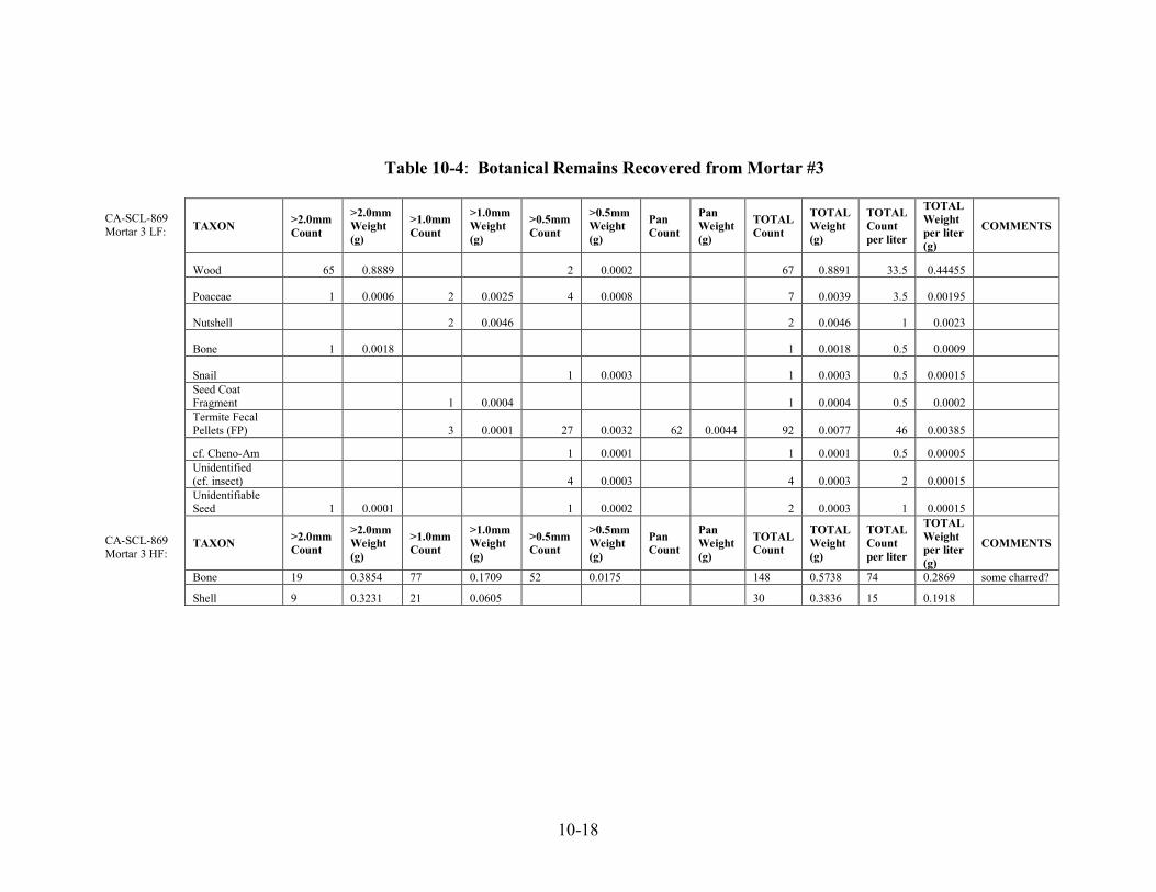
10-18
Table 10-4: Botanical Remains Recovered from Mortar #3 CA-SCL-869 Mortar 3 LF: CA-SCL-869 Mortar 3 HF:
TAXON >2.0mm Count
>2.0mm Weight (g)
>1.0mm Count
>1.0mm Weight (g)
>0.5mm Count
>0.5mm Weight (g)
Pan Count
Pan Weight (g)
TOTAL Count
TOTAL Weight (g)
TOTAL Count per liter
TOTAL Weight per liter (g)
COMMENTS
Wood 65 0.8889 2 0.0002 67 0.8891 33.5 0.44455
Poaceae 1 0.0006 2 0.0025 4 0.0008 7 0.0039 3.5 0.00195
Nutshell 2 0.0046 2 0.0046 1 0.0023
Bone 1 0.0018 1 0.0018 0.5 0.0009
Snail 1 0.0003 1 0.0003 0.5 0.00015 Seed Coat Fragment 1 0.0004 1 0.0004 0.5 0.0002 Termite Fecal Pellets (FP) 3 0.0001 27 0.0032 62 0.0044 92 0.0077 46 0.00385
cf. Cheno-Am 1 0.0001 1 0.0001 0.5 0.00005 Unidentified (cf. insect) 4 0.0003 4 0.0003 2 0.00015 Unidentifiable Seed 1 0.0001 1 0.0002 2 0.0003 1 0.00015
TAXON >2.0mm Count
>2.0mm Weight (g)
>1.0mm Count
>1.0mm Weight (g)
>0.5mm Count
>0.5mm Weight (g)
Pan Count
Pan Weight (g)
TOTAL Count
TOTAL Weight (g)
TOTAL Count per liter
TOTAL Weight per liter (g)
COMMENTS
Bone 19 0.3854 77 0.1709 52 0.0175 148 0.5738 74 0.2869 some charred?
Shell 9 0.3231 21 0.0605 30 0.3836 15 0.1918
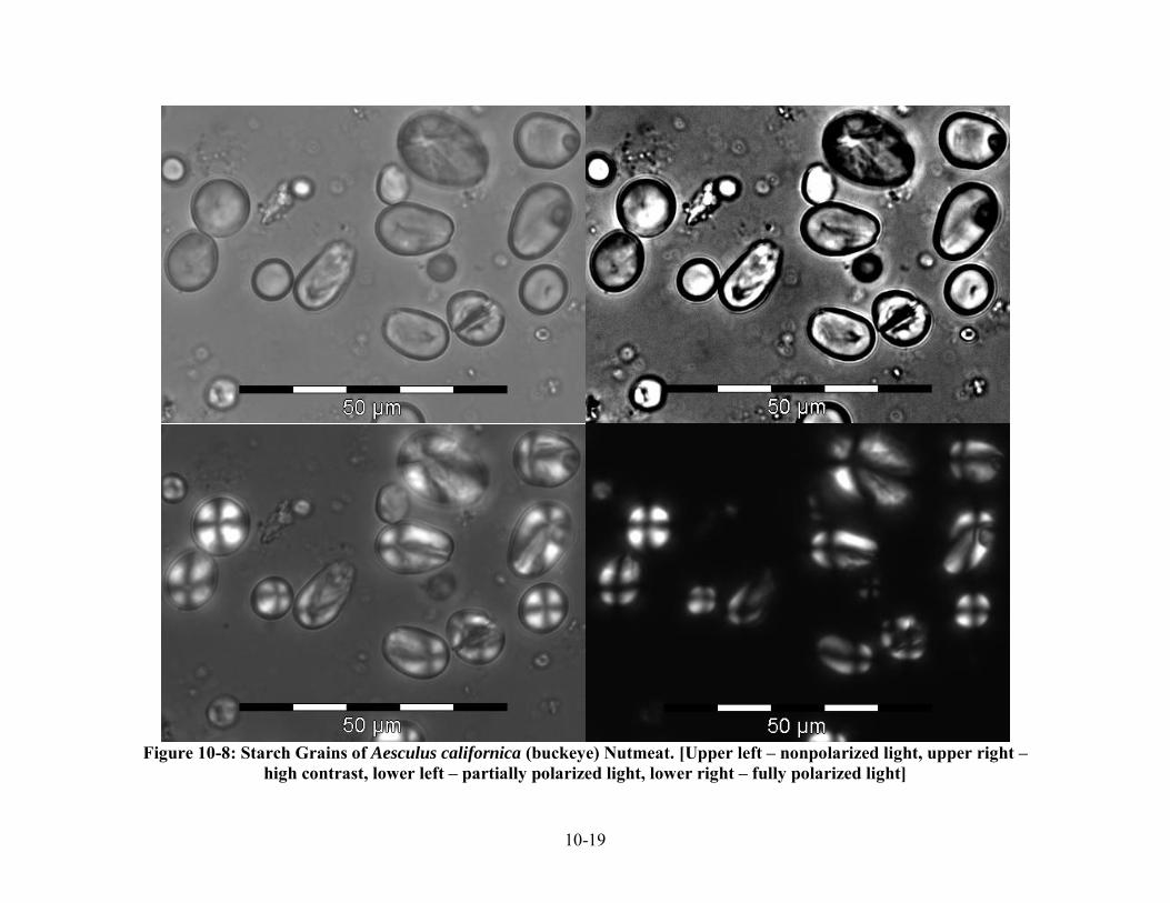
10-19
Figure 10-8: Starch Grains of Aesculus californica (buckeye) Nutmeat. [Upper left – nonpolarized light, upper right –
high contrast, lower left – partially polarized light, lower right – fully polarized light]
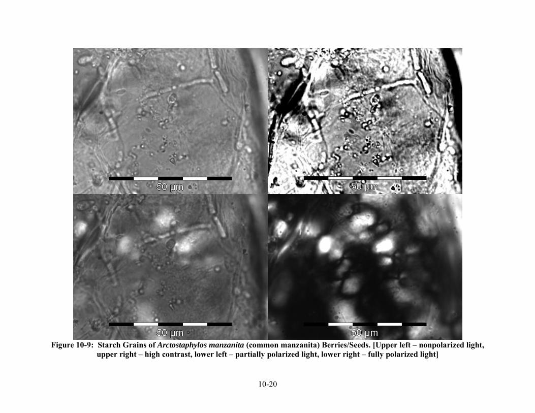
10-20
Figure 10-9: Starch Grains of Arctostaphylos manzanita (common manzanita) Berries/Seeds. [Upper left – nonpolarized light,
upper right – high contrast, lower left – partially polarized light, lower right – fully polarized light]

10-21
Figure 10-10: Starch Grains of Calandrinia ciliata (red maids) Seeds. [Upper left – nonpolarized light, upper right –
high contrast, lower left – partially polarized light, lower right – fully polarized light]

10-22
Figure 10-11: Starch Grains of Leymus triticoides (wild rye) Seeds. [Upper left – nonpolarized light, upper right –
high contrast, lower left – partially polarized light, lower right – fully polarized light]

10-23
Figure 10-12: Starch Grains of Lithocarpus densiflorus (tanoak) Nutmeat. [Upper left – nonpolarized light, upper right –
high contrast, lower left – partially polarized light, lower right – fully polarized light]

10-24
Figure 10-13: Starch Grains of Madia sp. (tarweed) Seeds. [Upper two rows: Specimen #1 under nonpolarized light (top left), high contrast (top right), partially polarized light (lower left), and fully polarized light (lower right). Lower two rows: Specimen #2 under nonpolarized light (top left), high contrast (top right), partially polarized light (lower left), and fully polarized light (lower right)]

10-25
Figure 10-14: Starch Grains of Quercus agrifolia (coast live oak) Nutmeat. [Upper left – nonpolarized light, upper right –
high contrast, lower left – partially polarized light, lower right – fully polarized light]
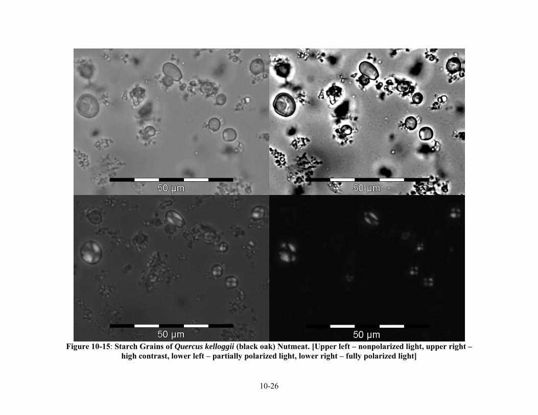
10-26
Figure 10-15: Starch Grains of Quercus kelloggii (black oak) Nutmeat. [Upper left – nonpolarized light, upper right –
high contrast, lower left – partially polarized light, lower right – fully polarized light]

10-27
Figure 10-16: Unidentified “angular” or “faceted” Starch Grains Recovered from the Grinding Surface of Mortar 2 (sample M2-E1). [Possibly damaged. First row – specimen #1; second row – specimen #2; third row – specimen #9; fourth row – specimen #11. Left column – starches under partially polarized light; right column – starches under fully polarized light]

10-28
Wid
th (
mic
rons
)
0
5
10
15
20
25
M2-A1 M2-E1
Sampl e
Each PairStudent's t 0.01
Leng
th (m
icro
ns)
0
5
10
15
20
25
30
M2-A1 M2-E1
Sample
Each PairStudent's t 0.01
Figure 10-17: Comparison of Width and Length Distributions of Starch Grains from Soil Inside Mortar #2 (sample M2-A1) and the Grinding Surface of Mortar #2 (sample M2-E1). [Means are significantly different at α=0.01]

10-29
Figure 10-18: Unidentified Well-Preserved Starch Grains from Soil Inside Mortar 2 (sample M2-A1). [First row – specimen #3; second row – specimen #7; third row – specimen #9. Left column – specimens under partially polarized light; right column – specimens under fully polarized light]

10-30
Figure 10-19: Starch Grains from the Soil in Mortar #2 (sample M2-A1) similar to starch grains of Madia sp. (tarweed), compare with Figure 10-12. [First row – specimen #1; second row – specimen #11; third row – specimen #8; fourth row – specimen #5. Left column – specimens under partially polarized light; right column – specimens under fully polarized light]

10-31
Figure 10-20: Unidentified Well-Preserved Starch Grains Recovered from the Grinding Surface of Mortar #2 (sample M2-E1). [Compare specimen #14 with starches of Leymus
triticoides (wild rye), Figure 10-10. First row – specimen #5; second row – specimen #6; third row – specimen #8; fourth row – specimen #14. Left column – starches under partially polarized light; right column – starches under fully polarized light]

10-32
Figure 10-21: Unidentified Red-Colored Starch Grain Specimen #10 with Distinct Lamination Recovered from the Grinding Surface of Mortar #2 (sample M2-E1). [Upper row – black and white photos of specimen #10 under partially polarized light. Lower row – color photos of specimen #10 under partially polarized (left) and fully polarized (right) light]

11-1
Chapter 11: Analysis of the Stone, Bone and Shell Artifacts from CA-SCL-869
Alan Leventhal and Diane DiGiuseppe Introduction: Research Orientation This chapter reports on the analysis of the flaked stone and ground and battered stone tool assemblage recovered from site CA-SCL-869. Prior to conducting this analysis, it became clear that the archaeological deposit under investigation contained a cemetery component. Furthermore, the majority of the site as well as the upper 20-30 cm of the visible deposit was highly disturbed by the incipient construction of the Fire Station 12 building pad, as well as, by earlier late 19th century farming/orchard activities which continued up until the 1960s. Even though, there were substantial subsurface impacts to the archaeological site, four in situ primary inhumations/burials and one partially defined subsurface feature were discovered during the test excavations and monitoring of construction-related activities. One of the indicators of the archaeological deposit included the presence of a blackish and ashy midden soil which was identified within the upper 20-25 cm. Archaeologists have usually associated the presence of this type of middeny soil with "village" or "habitation sites." The subsurface soils (below 25 cm) on the other hand, which contained the burials, appeared to be rather inorganic, ranging in color from brown to a lighter brown, but lacking the distinctive black ashy quality of habitation-related midden soils (see Chapter 3 for more details on soil descriptions from this site). Similar light colored non-midden inorganic soils have been encountered elsewhere in northern San Jose and in the East Bay and were associated with pure cemeteries without habitation-related features. Some of these cemetery sites include: CA-ALA-479, CA-SCL-38, CA-SCL-343, CA-SCL-581, and CA-SCL-674 (Leventhal, et al. 1987, 1988, 1989; Bellifemine 1997; Pastron and Bellifemine 2007). As a result of the limitations placed on the archaeological data recovery program conducted at CA-SCL-869, the orientation of this study is focused on analyzing the flaked stone and ground stone assemblages as behavioral by-products resulting from several possible ancestral Ohlone/Costanoan cultural systems, that may also hypothetically represent two distinct, but interrelated cultural systems:
1) an ideological (ideotechnic) system as a consequence of ceremonial/religious-related behaviors associated with funerary activities and possibly annual mourning ceremonies); and/or
2) a subsistence/residential (technomic) system as a consequence of habitation and economic-related activities such as acquisition of raw materials, flaked stone tool manufacturing and maintenance, subsistence/hunting and on-site butchering, food preparation and processing through the use of ground stone tools such as mortars and pestles. (See Binford 1962; Blackburn 1976; Leventhal 1993).

11-2
As a result of postulating these two interrelated interpretive perspectives, further consideration was then focused on evidence of (technomic) habitation/economic/subsistence-related activities, by posing the following research question. Can we identify and distinguish between those assemblages associated with village/habitation/subsistence-related activities from those assemblages and artifacts that are reflective of group activities representing intensive, single event (one day to multi-day) funerals and/or annual mourning ceremonies at this site? In order to further advance an explanatory model that addresses the above research question, two objectives needed to be achieved:
1) a detailed analysis of the flaked stone and ground stone tool assemblages derived from the different recovery areas within CA-SCL-869; and
2) conducting a brief ethnographic, ethnohistoric and archaeological overview focusing of the "treatment of the dead" within the greater Central California culture region, with an emphasis on the Ohlone/Costanoan area and their immediate linguistic neighbors.
A Brief Overview on the Relationship of Cemeteries to Village Sites within Ohlone/Costanoan Territory and Adjacent Tribal Areas in Central California Within aboriginal Central California, two of the most significant and intensive ceremonial/religious events were centered around Funerary rituals (which involves prescribed rules for disposal and treatment of the dead) and the ensuing annual Mourning Anniversary (see Gifford 1926, 1927, 1955; Blackburn 1976; Leventhal 1993; Luby and Grubber 1999). Kroeber in his monumental study on California Indians early on noted that:
The anniversary or annual ceremony in memory of the dead bulks so large in the life of many California tribes as to produce a first impression of being one of the most typical phases of California culture (1925:859-860).
As a result of archaeological investigations over the past 100 years in California, it is generally acknowledged that large populations of California Indians occupied the San Francisco Bay region prior to European Contact in 1769 (Cook 1943, Kroeber 1925, Dobyns 1966, Milliken 1983, 1995 and others). Historical first-hand accounts from the early Spanish colonial expeditions documenting their encounters with various Ohlone/Costanoan tribal groups are relevant to this discussion. During the Anza-Font expedition, March 9 - April 14, 1776, while traveling between the present-day towns of Hollister and Gilroy, the group came upon a cemetery in the vicinity of a village located just south of Gilroy. Fray Font observed:
On passing near the village which I mentioned on the road, we saw on the edge of it something like a cemetery. It was made of several small poles, although it was not like the cemeteries which we saw on the Channel. On the poles were hung some things like snails and some tule skirts which the women wear. Some arrows were stuck in the ground, and there were some feathers which perhaps were treasures for the persons buried there (Bolton 1930:322).

11-3
Another independent account identifying the location of contact-era (ca. 1769-1800) Native cemeteries relative to their villages was recorded by Fray Palou two years earlier along the Pacific side of the San Mateo Peninsula. Members of the Rivera-Palou expedition, November 23 - December 13, 1774, traveling south toward Año Nuevo on two consecutive days (December 8 and 9) observed the location of cemeteries near villages by fresh water drainages:
Near the two large arroyos we found vestiges of villages, with a cemetery, in which were planted two slender poles, straight and very high. From the point of each one hung a small cape made of grass of the sort used by the heathen, doubtless belonged to those who were buried there, as is their custom. ...
On its banks we found vestiges of a deserted village, with cemetery, in which they planted a high pole, this being the monument used by the heathen for the sepulchers of the chief men of the village" (Bolton 1926:293-295).
Pedro Fages also commented briefly about Ohlone/Costanoan cemeteries and aspects of their religious world view:
They believe in the transmigration of souls, asserting that those of the dead go to live in a certain island of the sea, from whence they come to enter the bodies of those who are born. Their dead they inter in a place like regular cemeteries ... (1937:70).
Archaeologist Chester King was one of the first researchers to consider this cemetery-related ethnohistoric data and veered away from the traditional Bay Area archaeological interpretation that pre-contact Ohlones principally buried their dead in their village/habitation sites. In his “Matalan Ethnohistory,” King was the first to classify cemeteries as ceremonial sites. He wrote:
Historic data provides us with the description of several types of cultural sites which occur away from habitation. The presence of these types of sites possibly cannot be determined using the procedures most archaeologists have used in locating occupation areas. The following information is presented to enable archaeologists to anticipate the presence of the site types. At what was probably the village of Thithirii (Carnadero), just south of Gilroy, Pedro Font observed in 1776: some thing like a cemetery. ... Probably at least all of the large village sites in the Coyote Valley had similar cemeteries adjacent to them (1977:44).
Leventhal (1993) in his comprehensive study on the analysis of the assemblages recovered from CA-ALA-329, the Ryan Mound located in the Coyote Hills region near the East Bay town of Newark, demonstrated that the site was more of an earth mound, rather than a shellmound and that the overwhelmingly majority of the archaeological features identified in both the Stanford and San Jose State University excavations were the recovery of over 420 burials (and cremations) with

11-4
almost no clear evidence of village/habitation features such as house floors and fire hearths. Leventhal also postulated that the presence of shell fish remains in this mortuary mound was more probably a result of Funeral-related activities and Mourning Anniversary feasts rather than the result of normative village/subsistence-related activities. Luby and Grubber (1999) also further elaborated on the model originally proposed by Leventhal (1993), in their article entitled “The Dead Must be Fed: Symbolic Meanings of the Shellmounds of the San Francisco Bay Area”. From the neighboring linguistic/tribal territories (i.e., Bay, Coast, Plains Miwok, Yokuts, Maidu, Patwin, and Nomlaki) we find additional evidence that cemeteries were also located outside of or adjacent to village/habitation sites (Powers 1877, Dixon 1905, Kroeber 1925, Gayton 1936, 1948, Goldschmidt 1951, Gifford 1955, Heizer 1978, and others). Other Supporting Archaeological Information from Central California Recent archaeological evidence derived from two other areas of Central California also supports the contention that cemeteries were established outside of village/habitation areas. For instance, Chartkoff and Chartkoff reported on the excavation of a large late period village earth mound site (CA-BUT-1), located within Konkow (Maidu) territory south of the present-day town of Chico. From their site report they state that this site contained up to 90 house features and the remains of only one intrusive burial which was buried in the site after the village was abandoned (Chartkoff and Chartkoff 1983 and 1984). To the south of Ohlone/Costanoan territory, within the ethnographic Chumash region, Linda King, presented information on the Medea Creek Cemetery. Her doctoral study included the analysis of 397 human remains from this late period cemetery and she informs us that "Medea Creek village (CA-LAN-243), which lies ca. 300 meters south of the cemetery, was the main village ..." (L. King 1982:11). In summation, there appears to be a growing amount of ethnohistoric and archaeological evidence that indicates that Central California Indian communities did not deliberately live on top of their dead (or bury their dead within their villages). Therefore, based upon this growing evidence it appears that we may have to rethink our long held assumptions about the presence of midden-like soils at cemetery sites and develop models and alternative explanations about site formation processes. This above perspectives has greatly influenced the research orientation and direction of the analysis of the flaked stone assemblages that were recovered from CA-SCL-869. Some Possible Research Oriented Postulates With this hypothetical cemetery site perspective in place, two potentially testable postulates have been generated: 1. If CA-SCL-869 is a postulated cemetery site, then there should be a limited range of stone tool artifact types that are associated with three discreet activity sets:
a) placement of lithic materials as grave offerings (directly associated with and/or above burials);

11-5
b) placement of lithic materials, in the form of finished products that may have been attached to commemorative/grave marker poles; and,
c) stone tools and lithic debris associated with the hosting of several day periodic, but intensive single event funerals and/or mourning ceremonies (therefore some evidence of localized hunting, butchering food processing, cooking, and manufacture of temporary shelter activities may have been conducted on-site or adjacent to the cemetery proper in order to host such ceremonies).
2. If CA-SCL-869 is a multi-use and/or multi-component site (i.e., a village/habitation site with a
cemetery component), then there should be a full range of activities represented (e.g., stages of manufacturing [trajectories] in the form of debris and failures of bone, stone and possibly shell artifacts). In addition there should be distinctly identifiable habitation-related activity areas (e.g., hearths, house floors, concentrations of refuse) representing a patterning that is distinguishable from cemetery activity areas and patterning (e.g., burials, mortuary offering features, animal burials, and etc.).
Limitations of the Present Study Due to the impacts to the archaeological site resulting from the construction of Fire Station 12, only a limited sample of flaked stone and ground stone materials were recovered from the site which were derived from five distinct contexts: 1) burial associated, 2) six controlled hand-excavated Test Units and screen recovery, 3) controlled mechanically excavated Test Trenches and screen recovery, 4) monitored utility trench excavations, and 5) non-provenience surface finds and isolates from disturbed areas. Analysis of the Flaked Stone and Ground and Battered Stone Assemblages Flaked Stone – Methodology: As a result of the imposed limited archaeological data recovery program, a total of 250 flaked stone elements were recovered from all five contexts: Burials associated n = 26, Test Units n = 158 Test Trenches n = 12, monitored utility trenches n = 37, and Isolates n = 17. All of the recovered flaked stone lithic materials were placed in labeled unit level bags thus maintaining their proveniences. After being transported from the site to the lab all the flaked stone materials were washed and placed onto sorting trays. These materials were then examined and sorted by material type, state of completeness, stage of reduction and modification, and overall form. For purposes of this analysis, all flaked stone materials were individually reviewed under a Bausch and Lomb 10.5x - 45x variable stereoscopic microscope and a 150 watt incandescent lamp for any evidence of use/wear patterns and retouch modification. All materials were then weighed on an Ohaus triple beam balance scale and measured with a Mitutoyo Digimatic metric caliper. All damaged and pristine edge angles were determined by using a Ward's Contact Goniometer.

11-6
For classifying formed tools, informal tools, and debitage, the following attributes were used:
1. Material type
2. Type of flake (flaking debris) based on the following criteria: (a) Probable mode of production (e.g., bipolar, freehand hard hammer, soft hammer, or
pressure flaking) (b) Condition of flake (e.g., complete, fragmented, shattered, thermally spalled & etc.) (c) Size and shape (orientation of the platform and bulb of percussion, expanding, &
etc.) (d) Overall condition and thickness of flake (e) Presence, absence and percentage of cortex present on the dorsal and/or platform
3. Informal tools (e.g., utilized flakes, modified flakes), based on:
(a) Degree of edge modification (b) Observed type of use/wear patterns and edge damage (c) Location and number of Edge Units (E.U.'s) exhibiting modification and/or use/wear
edge damage (d) Two angles are measured on the Edge Units: Pristine Edge Angle (PEA) which
calculates the angle or angle range of the edge of the tools before use and the Damaged Edge Angle (DEA) which measures the angle or angle range of the employed edge after use.
4. Formed (formally flaked) tools, based on:
(a) Overall morphology and degree of modification (b) Presence of use/wear patterns or edge damage (e.g., polish, nibbling, nicking, gloss,
impact fractures) (c) Evidence of reworking and reuse
Based on the above attributes, there were total of six (6) formed (formal) and informal tools as well as fifteen (15) debitage/waste flake categories that have been identified which are listed below: Formed (Formal) and Informal Tools
1. Cores, Core Fragments, and Assayed Cobbles and Pebbles: (8 sub-types) 2. Projectile Points 3. Bifaces 4. Drill/Borer 5. Utilized Flakes 6. Modified Flakes
Debitage/Waste Flakes
1. Cortical Flakes 9. Shatter 2. Primary Flakes 10. Cortical Shatter 3. Thinning Flakes 11. Bipolar Shatter 4. Pressure Flakes 12. Bipolar Cortical Shatter 5. Bipolar Cortical Flakes 13. Flake Fragment
11-7
Debitage/Waste Flakes (continued) 6. Bipolar Flakes 14. Impact Spall 7. Orange Wedges 15. Thermal Spall 8. Core Rejuvenation Flakes
These formed (formal) and informal tools along with the fifteen (15) flaked stone debitage classes fall into one of fifteen (15) identified material types which are: 1. Red Franciscan Chert (RFC) 9. Chalcedony (Chal) 2. Green Franciscan Chert (GFC) 10. Obsidian (Obs) 3. Green/Red Franciscan Chert (GrRFC) 11. Andesite (And) 4. Yellow Franciscan Chert (YFC) 12. Rhyolite (Rhy) 5. Gray Franciscan Chert (GrFC) 13. Basalt/Green Stone (Ba) 6. White Chert (WC) 14. Serpentine (Spt) 7. Black Chert (BC) 15. Siltstone (Slt) 8. Monterey Chert (MC) Flaked Stone Artifact Descriptions Cores, Core Fragments, Assayed Cobbles and Assayed Pebbles: Cores are made on pebbles, cobbles, nodules and/or quarried raw and/or heat treated knappable stone materials which are usually modified through either a hard or soft hammer percussion or a pressure flaking techniques to create two general lithic elements: 1) products (cores, bifaces, primary flake blanks, and etc.) and 2) by-products (flakes, blades and debitage). Cores from this collection fall into seven types:
Type 1 - Cobble cores (1 specimen) Type 2 - Pebble cores (4 specimens) Type 3 – Exhausted cores (6 specimens) Type 4 - Secondary cores (2 specimens) Type 5 - Bipolar pebble/cobble cores (4 specimens) Type 6 – Core fragments ((2 specimens) Type 7 - Assayed pebble/cobbles (5 specimens)
A total of 26 specimens were classified as cores or assayed pebbles/cobbles in this study (Table 11-1). Type 1 - (1 specimen) Cobble cores are generally made on fist size rounded cobbles (originally larger than 3” (76 mm) of various lithic materials. They generally retain much of their original cortex and size; thus distinguishing them from the smaller pebble cores as well as the other types.
- Ref. # 100-11 Red Franciscan chert. Maximum length = 100.1 x 89.0 x 61.7 mm. Wt. 668.3 g. One edge appears to have been employed as Chopper exhibiting crushing and rounding on the utilized edge. Utilized Edge length = 46.5 mm.
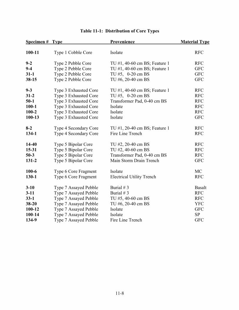
11-8
Table 11-1: Distribution of Core Types
Specimen # Type Provenience Material Type 100-11 Type 1 Cobble Core Isolate RFC 9-2 Type 2 Pebble Core TU #1, 40-60 cm BS; Feature 1 RFC 9-4 Type 2 Pebble Core TU #1, 40-60 cm BS; Feature 1 GFC 31-1 Type 2 Pebble Core TU #5, 0-20 cm BS GFC 38-15 Type 2 Pebble Core TU #6, 20-40 cm BS GFC 9-3 Type 3 Exhausted Core TU #1, 40-60 cm BS; Feature 1 RFC 31-2 Type 3 Exhausted Core TU #5, 0-20 cm BS RFC 50-1 Type 3 Exhausted Core Transformer Pad, 0-40 cm BS RFC 100-1 Type 3 Exhausted Core Isolate RFC 100-2 Type 3 Exhausted Core Isolate RFC 100-13 Type 3 Exhausted Core Isolate GFC 8-2 Type 4 Secondary Core TU #1, 20-40 cm BS; Feature 1 RFC 134-1 Type 4 Secondary Core Fire Line Trench RFC 14-40 Type 5 Bipolar Core TU #2, 20-40 cm BS RFC 15-31 Type 5 Bipolar Core TU #2, 40-60 cm BS RFC 50-3 Type 5 Bipolar Core Transformer Pad, 0-40 cm BS RFC 131-2 Type 5 Bipolar Core Main Storm Drain Trench GFC 100-6 Type 6 Core Fragment Isolate MC 130-1 Type 6 Core Fragment Electrical Utility Trench RFC 3-10 Type 7 Assayed Pebble Burial # 3 Basalt 3-11 Type 7 Assayed Pebble Burial # 3 RFC 33-1 Type 7 Assayed Pebble TU #5, 40-60 cm BS RFC 38-20 Type 7 Assayed Pebble TU #6, 20-40 cm BS YFC 100-12 Type 7 Assayed Pebble Isolate GFC 100-14 Type 7 Assayed Pebble Isolate SP 134-9 Type 7 Assayed Pebble Fire Line Trench GFC

11-9
Type 2 - (4 specimens) Pebble cores share the same basic characteristics as cobble cores, except that they tend to be less than 3" (76mm) in original overall maximum length.
- Ref. # 9-2 Red Franciscan chert. Max. length = 56.1 x 45.8 x 36.5 mm. Wt.136.5 g. - Ref. # 9-4 Green Franciscan chert. Max. length = 44.4 x 38.3 x 24.2 mm. Wt. 65.1 g. - Ref. # 31-1 Green Franciscan chert. Max. length = 45.0 x 33.6 x 19.5 mm. Wt. 35.4 g. - Ref. # 38-15 Green Franciscan chert. Max. length = 49.8 x 42.2 x 26.7 mm. Wt. 60.0 g.
Type 3 - (6 specimens) Exhausted cores tend to be either too small or difficult for further reduction and for flake production, hence the usefulness has become "exhausted" (Figure 11-1).
- Ref. # 9-3 Red Franciscan chert. Max. length = 37.1 x 19.7 x 17.1 mm. Wt. 11.4 g. - Ref. # 31-2 Red Franciscan chert. Max. length = 29.8 x 23.0 x 18.8 mm. Wt. 10.2 g. - Ref. # 50-1 Red Franciscan chert. Max. length = 39.9 x 34.1 x 28.6 mm. Wt. 48.4 g. - Ref. # 100-1 Red Franciscan chert. Max. length = 26.5 x 24.2 x 17.1 mm. Wt. 11.8 g. - Ref. # 100-2 Red Franciscan chert. Max. length = 25.0 x 24.8 x 19.5 mm. Wt. 9.3 g. - Ref. # 100-13 Green Franciscan chert. Max. length = 41.4 x 32.2 x 27.7 mm. Wt. 45.6 g.
Figure 11-1: Examples of Exhausted and Bipolar Cores
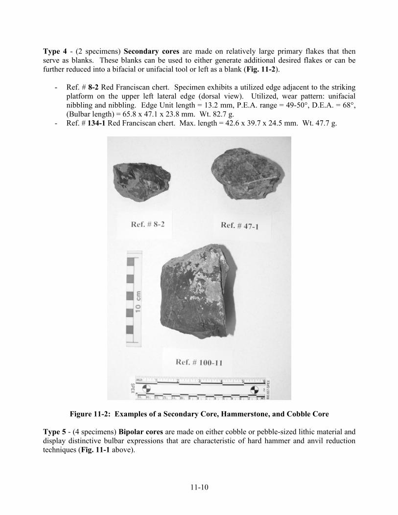
11-10
Type 4 - (2 specimens) Secondary cores are made on relatively large primary flakes that then serve as blanks. These blanks can be used to either generate additional desired flakes or can be further reduced into a bifacial or unifacial tool or left as a blank (Fig. 11-2).
- Ref. # 8-2 Red Franciscan chert. Specimen exhibits a utilized edge adjacent to the striking platform on the upper left lateral edge (dorsal view). Utilized, wear pattern: unifacial nibbling and nibbling. Edge Unit length = 13.2 mm, P.E.A. range = 49-50°, D.E.A. = 68°, (Bulbar length) = 65.8 x 47.1 x 23.8 mm. Wt. 82.7 g.
- Ref. # 134-1 Red Franciscan chert. Max. length = 42.6 x 39.7 x 24.5 mm. Wt. 47.7 g.
Figure 11-2: Examples of a Secondary Core, Hammerstone, and Cobble Core Type 5 - (4 specimens) Bipolar cores are made on either cobble or pebble-sized lithic material and display distinctive bulbar expressions that are characteristic of hard hammer and anvil reduction techniques (Fig. 11-1 above).

11-11
- Ref. # 14-40 Red Franciscan chert. Max. length = 39.5 x 31.4 x 22.2 mm. Wt. 26.9 g. - Ref. # 15-31 Red Franciscan chert. Max. length = 49.8 x 29.8 x 28.3 mm. Wt. 44.0 g. - Ref. # 50-3 Red Franciscan chert. Max length = 46.7 x 46.4 x 35.6 mm. Wt. 92.5 g. - Ref. # 131-2 Green Franciscan chert. (No measurement taken) Wt.13.0 g.
Type 6 - (2 specimens) Core fragments are fragments of cores that still retain a portion of their original flake scar detachment and striking platforms, but were either shattered or fragmented during the reduction process. These artifacts are placed within this category regardless of inferred original type of core.
- Ref. # 100-6 Monterey chert. Maximum length = 37.6 x 28.7 x 18.3 mm Wt. 21.4 g. - Ref. # 130-1 Red Franciscan chert. Maximum length = 56.6 x 43.2 x 24.6 mm. Wt. 74.7 g.
Type 7 - (7 specimens) Assayed pebbles/cobble/angular chunks are different from cores in that they exhibit only one or possibly, at most, two detached flake scars. Although the raw materials may be of knappable quality, they tend to have been struck once, evaluated or "assayed,” then discarded for some unknown reason.
- Ref # 3-10 Basalt Max. length = 63.0 x 59.7 x 35.5 mm. Wt. 202.4g - Ref # 3-11 RFC Max. length = 69.3 x 32.1 x 17.1 mm. Wt. 40.0g - Ref. # 33-1 Red Franciscan chert. Max. length = 29.8 x 25.5 x 18.1 mm. Wt.18.6 g. - Ref. # 38-20 Yellow Franciscan chert. Max. length = 46.2 x 25.7 x 19.0 mm. Wt. 23.8 g. - Ref. # 100-12 Green Franciscan chert. Max. length = 73.0 x 54.2 x 29.1 mm. Wt.125.7 g. - Ref. # 100-14 High grade Serpentine. Max. length = 95.7 x 54.1 x 42.0 mm. Wt. 154.5 g. - Ref. # 134-9 Green Franciscan chert. Max. length = 62.1 x 45.0 x 30.1 mm. Wt. 83.5 g.
Projectile Points/Bifaces: Projectile points are usually bifacially flaked tools with piercing tips that are attached to the ends of lances, spears, darts or arrows for purposes of hunting game and warfare. Darts were used in conjunction with the atlatl or throwing stick which served as an extension of the arm for obtaining a thrust of greater velocity for killing. A total of two specimens have been recovered from this site. These projectile points usually fall into one of three categories: 1) large projectiles/bifaces weighing more than 3.0 grams and intuitively considered to have tipped darts or spears, 2) small serrated projectiles weighing less than 3.0 grams and usually considered to be one of several varieties of the Stockton Serrated arrow point, and 3) those that are too fragmented to clearly classify. Of the specimens recovered, there were no distinctive attributes to measure based upon Thomas’s (1970) projectile point attributes. Large Projectiles/Dart Points/Biface (1 Specimen)
- Ref. # 50-2 is a mid-section of an obsidian biface/dart point, which was recovered at the depth of 36 cm BS within the Transformer Pad area of the site. This specimen was sourced using XRF and identified as Annadel Obsidian, with a hydration measurement of 2.2 microns. Axial length = 21.4 x 28.3 x 9.8 mm. Wt. 6.7 gr.

11-12
Projectile Point Fragments (1 Specimen)
- Ref. # 9-1 appears to be an impact fractured spall off of a biface/point. This point fragment was recovered from Test Unit #1 within Feature #1 from the 40-60 cm BS level. This specimen was sourced using XRF as Napa Valley Obsidian, with a hydration measurement value of 4.4 microns. (Bulbar length) = 14.6 x 9.1 x 4.6 mm. Wt. 0.7 gr. This specimen will also be included in the debitage/waste flake analysis below.
Drills/Borers (1 Specimen) This class of artifact exhibits projections or bits that were used for boring or drilling. Drills are used to bore holes into wood, bone, stone, or shell. As a result, drill bits tend to exhibit any of the following or combination of wear patterns: polish, striations, crushing, and stepped fractures perpendicular to the bit as well as rounding on the edges and tip.
- Ref. # 7-4 is made on a thermally annealed triangular (cross-section) flake of mottled Green/Red Franciscan chert (Gr/RFC) and was recovered from Test Unit (TU) #1 from the 0-20 cm BS level. The utilized projection on this tool exhibits crushing, stepped fractures and gloss on three of the edges comprising the bit. Max. length = 37.9 x 20.2 x 14.5 mm. Max. length of the bit = 16.0 mm. Wt. 9.4 gr.
Utilized Flakes (3 Specimens) Utilized flakes are informal or generalized tools; they have been employed for tasks involving cutting, shaving, whittling, and scraping, and then usually discarded. Consequently, these flakes show little or no purposeful post detachment modification other than that caused by the work they have performed. In order for a flake to be classified as utilized, a flake must have one or more edges or Edge Units (E.U.s) exhibiting evidence of use/wear patterns. Two edge angle measurements are included within this study: Pristine Edge Angle (PEA) and Damaged Edge Angle (DEA). Pristine Edge Angles are the reconstructed angles of the edge prior to utilization. Damage Edge Angles are the actual measured range of the angle of the employed edge. All edge angles were determined by using a Ward's Contact Goniometer.
- Ref. # 7-3 is a utilized flake made on a primary expanding flake of Red Franciscan chert. This tool was recovered from TU 1, 0-20 cm (BS). The observed use/wear patterns include unifacial nibbling on the distal edge (ventral view). The Edge Unit (EU) length is 9.9 mm and the PEA = 28º and the DEA = 41º. Bulbar length = 16.7 x 19.4 x 5.5 mm. Wt. 1.6g.
- Ref. # 8-10 is a utilized flake made on a large expanding primary flake of Andesite. This specimen appears to have been employed as a spokeshave-like tool that was probably used to work (shave) wooden shafts. This tool was recovered from TU 1, 20-40 cm BS. The employed edge displays unidirectional striations, with rounding and slight polish on the left distal edge (ventral view). The Edge Unit length is 14.3 mm and the PEA = 42º and the DEA range =56-59º. Bulbar length = 47.1 x 72.2 x 14.2 mm. Wt. 44.3g.

11-13
- Ref. # 44-1 is made on a triangular flake of Red Franciscan chert that is somewhat resembling a borer in cross-section. This tool has three modified edges and one utilized edge and it was recovered from Test Trench #2, 60-80 cm BS. The utilized edge is located on the lower right lateral edge (dorsal view) and displays unifacial stepped-fractures and crushing. The EU length measures 10.5 mm and the PEA=59º and the DEA=71º. Max. length = 36.0 x 14.3 x 11.1 mm. Wt. 5.1 g.
Modified Flakes (4 Specimens) Modified flakes are considered informal tools (Table 11-2). Some Modified flakes were selected as primary flake blanks by the tool maker for the purpose of further reduction and shaping. Other specimens may exhibit limited edge modification without evidence of use. This class of artifact is usually modified by either soft hammer percussion and/or pressure flaking techniques and for some reason abandoned. Modified flakes may also, in some cases, represent resharpened tools such as utilized flakes that were not redeployed again after modification. In other words the modification process eliminated any previous evidence of use/wear on previously utilized flakes.
Table: 11-2 Modified Flake Metrics
Spec. # Unit Material Description Metrics Wt. 9-5 TU1, 40-60 GFC Cortical Flake 43.0 x 35.0 x 19.8 mm 27.8g 15-33 TU2, 40-60 GFC Bipolar Flake 27.4 x 17.8 x 8.9 mm 4.0g 37-4 TU6, 0-20 GFC Orange Wedge 37.1 x 29.2 x 18.6 mm 14.4g 131-1 Main Storm MC Primary Flake 30.1 x 26.5 x 13.4 mm 12.5g Debitage/Waste Flakes A total of 214 flaked stone elements have been classified as “Debitage/Waste Flakes”. The distribution and context from which these debitage/waste flakes were recovered are as follows:
- 24 lithics were recovered from the four primary inhumations (Burials 1 through 4); - 141 specimens were recovered from the hand-controlled excavation test units (Test Units 1
through 6); - 9 specimens were recovered from the mechanically-controlled excavated test trenches (Test
Trenches 1 through 6 including Transformer Pad area); - 31 specimens were recovered from eight Monitored Utility Trench excavations; and, - 9 specimens were collected from non-provenience Surface and/or as Isolated Finds.
Debitage consists of the flaking debris produced during stone tool manufacture and by other means. The debitage and waste flakes from this assemblage were classified based on the probable mode of production or causality of breakage. Fifteen (15) debitage/waste flake categories have been identified from this collection:

11-14
Cortical flakes are usually produced by freehand hard hammer and/or soft hammer percussion techniques. Cortical flakes represent the first in a series of flake detachments from a nodule forming a core and these flakes retain at least 50% or more of their cortex or patina.
1. Primary flakes are removed from a core or quarry blank by either hard hammer percussion, or if from a primary flake blank, by both hard hammer and/or soft hammer percussion techniques. Primary flakes, as opposed to cortical flakes, retain less than 50% of the cortex. Cortex, however, may still be present on the striking platform. If these flakes were derived from a primary flake blank, neither cortex or previous flake scars would necessarily be present on the dorsal face.
2. Thinning (Secondary) flakes are usually produced by soft hammer or antler baton
percussion. These flakes tend to be much thinner than primary flakes, with smaller striking platforms and less pronounced bulbs of percussion, and usually retain two or more previously detached flake scars on their dorsal surfaces. These flakes often appear to be by-products of the production of formed tools, such as bifaces and/or projectiles points (and others), rather than as the result of initial core reduction. Some thinning flakes are typically longer than they are wide (sometimes referred to as bladelets). These thinning flakes are distinctive and are the result of the last stages of preform/bifacial tool production.
3. Pressure flakes are usually derived from pressing an antler tine, a sharpened bone, or
hafted tooth against the edge of a flake or stone tool, resulting in this distinctively tiny flake. These flakes are usually representative of the very last stages of tool manufacture. The process is also referred to as final edge treatment. Pressure flakes may also be produced as a result of resharpening the edge of a worn tool.
4. Bipolar cortical flakes are produced by an anvil and hard hammer reduction technique
rather than by freehand hard hammer. These flakes are distinguished by three bulbar types: a) flat or sheared, b) salient, and c) diffused (Kobayashi 1975). They retain cortex on their dorsal surfaces.
5. Bipolar (primary) flakes are produced in the same manner as bipolar cortical flakes, but
retain less than 50% of the cortex.
6. Orange wedges (or bipolar wedges) have "cortex running from proximal to distal end along one dorsal margin. The dorsal margin, the thickest portion, tapers into the opposing ventral margins, hence the orange wedge appearance" (Dondero 1984). These bipolar wedge-shaped flakes are usually produced on small rounded cobble and pebble cores. In some cases, however, some wedges do have cortex present on the dorsal margins.
7. Core rejuvenation flakes are really a rarer form of primary flakes. These flakes were
deliberately removed as a large flake that usually retains part of the original crushed or damaged striking platform area of the core, thus classifying these large flakes as neither a core or core fragment.

11-15
8. Shatter refers to usually angular, irregular-shaped detritus that are most probably flake fragments and/or failed “shattered” material derived from assayed cobbles, cores and/or tools. Since these specimens have lost almost all of their flake attributes and characteristics and therefore cannot reliably be placed in any of the other lithic classes.
9. Cortical shatter is the same as the “Shatter” class of debitage, except these fragments
retain 50% or more cortex.
10. Bipolar shatter is the same as the “Shatter” class of debitage except that these fragments based upon remnant attributes, were more than likely, produced as a result of a bi-polar hard hammer and anvil technique.
11. Bipolar cortical shatter is the same as the “Bipolar Shatter” class of debitage except that
these fragments retain 50% or more cortex.
12. Flake fragments - are similar to “Shatter” however these specimens, although broken, still retain some aspects of flake attributes such as having distinctive ventral and dorsal surfaces.
13. Impact spalls are usually the result of a dart or arrow projectile point striking a resistant
object and thus breaking a portion of the tool in such a way to suggest that the fragment was produced as a by-product of an “impact” rather than as a result of a deliberate reduction flake.
14. Thermal spalls and pot lids fall into a separate category because they are unintentional by-
products due to exposure to intense heat. Material Summary: As mentioned above, a total of 214 flaked stone artifacts were classified under the debitage/waste flake category. Franciscan cherts of all colors combined represents the most predominant material type in this assemblage accounting for 90% (n = 193) of all the debitage/waste flakes recovered from the site. This is not surprising since the Franciscan chert formations are located to the east of the site in the Diablo/Hamilton Range, in fresh water drainages and most likely in the Santa Teresa Hills to the south of the site. During this analysis, the Franciscan cherts were sub-divided into seven sub-color categories. In order of dominance, they are as follows:
1) Red (n = 135 or 63%), 2) Green (n = 49 or 23%), 3) Gray (n = 3 or 1%), 4) Green/Red (n = 3 or 1%), 5) White (n = 1 or .5%), 6) Black (n = 1 or .5%), and 7) Yellow (n = 1 or .5%).
Monterey chert was the next abundant material type along with high-grade Serpentine (see below) accounting for 5 lithic elements or 2% of the total. Monterey chert is an exotic import that has its origins to the west of the San Andreas fault. Known available sources for Monterey chert occur north along the Santa Cruz coast especially at Point Año Nuevo. At Año Nuevo, Monterey chert is found in the form of water worn rounded and tabular-shaped cobbles on the beach. The source of these cobbles is from an offshore submerged marine Miocene-age formation (Clark, 1970).

11-16
High-grade Serpentine was recovered at this site and due to its chert-like quality and flaking knappability five specimens were included in this study. Serpentine is a metamorphic rock usually found along earthquake faults. This rock-type is usually not considered a suitable material to knap into stone tools. However, the five (5) serpentine specimens included into this study were almost indistinguishable from Monterey chert, except for still retaining a somewhat waxy quality. Nonetheless, these specimens retained distinctive flake morphology, to the degree that they appeared to have been deliberately knapped rather than randomly broken. As stated above a total of 5 lithic specimens were recovered representing 2% of this class of flaked stone. Obsidian was the third most abundant material represented at this site. A total of 4 specimens (2%) were recovered as flakes/debitage. Two of these were classified as primary flakes, one was a pressure flake and the fourth was an impact fracture from a projectile point. Based upon XRF studies the pressure flake (Ref. # 8-1) was identified as Casa Diablo, while the impact fracture (Ref. # 9-1) and the two primary flakes (Ref. #s 10-1 and 15-30) were sourced as Napa Valley obsidian (Fig. 11-3). For more information chronological dating in Chapter 12 and Appendices E and F. The remaining five other material types have only one or two specimens represented. In order of prevalence they are: Rhyolite (n = 2 or 1%), Basalt (n = 2 or 1%), Siltstone (n = 2 or 1%), Andesite (n = 1 or .5%), and Chalcedony (n = 1 or .5%). The Rhyolite, Andesite, and Basalt are volcanic materials that are probably derived from the Salinan Block which is located west of the San Andreas fault line.
Figure 11-3: Obsidian Flakes and Point Midsection from CA-SCL-869

11-17
Analysis of Ground and Battered Stone Tools: A total of eight (9) ground stone, battered stone and pecked stone tools were recovered from CA-SCL-869. These tools fall into several categories: 1) mortars, 2) pestles, 3) manos (handstones), 4) pecked cobbles, and 5) battered stones/hammer stones. Mortars (3 specimens) Mortars or stone bowls are used in conjunction with stone pestle. These distinctive tools serve as a stone “Cuisine Art” container for processing many different kinds of foods.
- Ref. # 1-5 (Mortar #1) is a large egg-shaped boulder mortar of indurated sandstone that was recovered along with part of Burial # 1 by the construction crew in the area of the handicapped parking lot located to the south of Fire Station 12. The mortar had been partially washed and cleaned prior to it being turned over to OFCS field archaeologists and the leadership of the Muwekma Ohlone Tribe (Figures 11-4 and 11-45).
Based upon the presence of a fairly large mechanically derived tooth scar on the very bottom of the mortar, it is speculated that this specimen may have been buried upside down, most likely adjacent to Burial #1. There is an area of blackening also present on the very bottom of the mortar, possibly due to a fire sometime before or during the funeral and placement of this mortar with Burial #1. The interior and exterior of the mortar is covered with a veneer of caliche and after partially cleaning, it appears that the exterior may have been subjected to deliberate polishing. The rim around the bowl is beveled as a result of pestle wear.
Max. exterior diameter = 35.1 x 28.6 x 18.6 cm. Max. diameter of the rim = 22.6 x 20.3 cm. Interior diameter of the rim/bowl = 18.5 x 17.1 cm. Depth of the bowl (chord) = 12.1 cm. Weight = 45 lbs (20.4 kg).
- Ref. # 4-7 (Mortar #3) is an intact “shaped” mortar made on a large sub-rounded boulder
of sandstone that was directly associated with Burial # 4. The mortar was recovered immediately to the north of the burial’s flexed legs and its based was resting at a depth of approximately 70 cm BS. The exterior of the mortar is covered with a thin layer of caliche. The overall exterior exhibits pecking and polish as part of the manufacturing process. The entire rim area has been deliberately shaped and flattened by non-use grinding and polishing. The rim by the edge of the bowl has been beveled by pestle wear (Figures 11-6 and 11-7).
Max. exterior diameter = 30.4 x 27.2 x 21.3 cm. Max. diameter of the rim = 27.3 x 25.1 cm. Interior diameter of the rim/bowl = 20.3 x 18.1 cm. Depth of the bowl (chord) = 14.5 cm. Weight = 43 lbs (19.5 kg).

11-18
Figure 11-4: Mortar #1 Associated with Burial #1 (side view)
Figure 11-5: Mortar #1 Associated with Burial #1 (top view)

11-19
Figure 11-6: Mortar #3 Associated with Burial #4 (side view)
Figure 11-7: Mortar #3 Associated with Burial #4 (top view)

11-20
- Ref. # 51-1 (Mortar #2) is an intact cobble sandstone mortar which was encounter at 46-50 cm BS within the Transformer Pad Area Test Trench. There is a layer of caliche on the exterior body and interior bowl. This relatively small mortar was recovered approximately 12 feet to the south of Burial #2. (Figures 11-8 and 11-9)
Maximum exterior diameter = 16.8 x 15.2 x 9.4 cm. Maximum diameter of the rim = 11.2 x 11.2 cm. Interior diameter of the rim/bowl = 10.0 x 9.9 cm. Depth of the bowl (chord) = 6.2 cm. Wt. 2710 g.
Figure 11-8: Mortar #2 (side view)
Figure 11-9: Mortar #2 (top view)
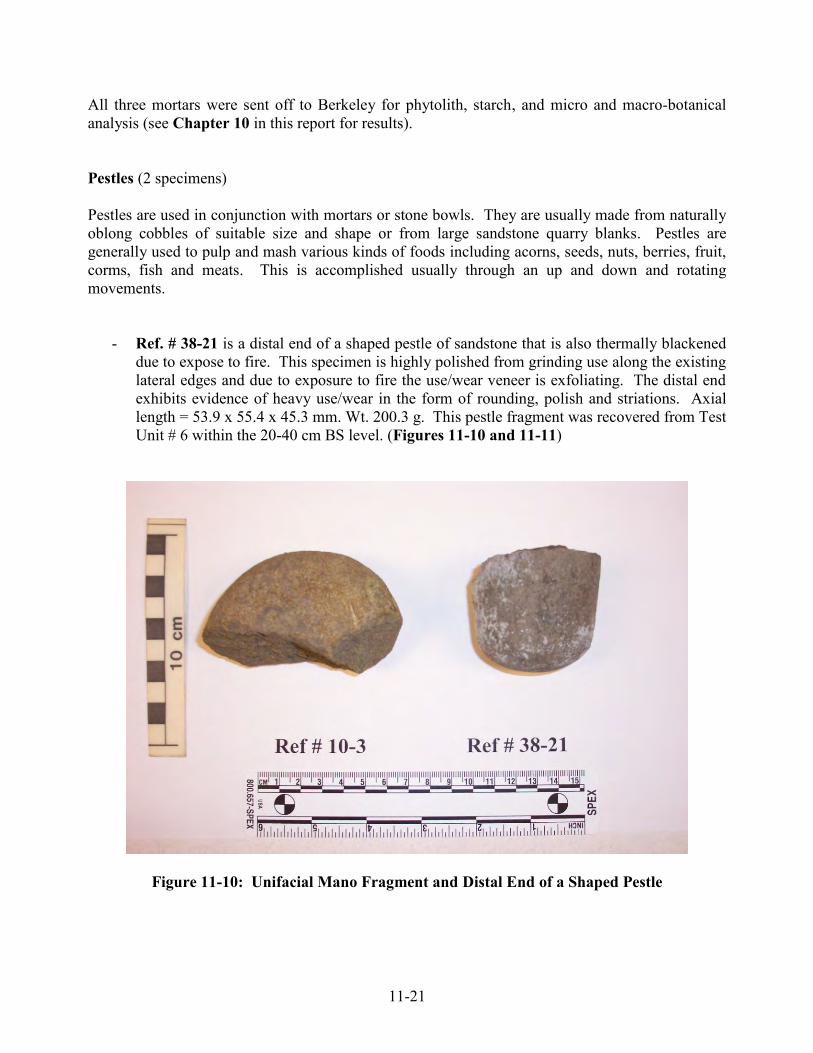
11-21
All three mortars were sent off to Berkeley for phytolith, starch, and micro and macro-botanical analysis (see Chapter 10 in this report for results). Pestles (2 specimens) Pestles are used in conjunction with mortars or stone bowls. They are usually made from naturally oblong cobbles of suitable size and shape or from large sandstone quarry blanks. Pestles are generally used to pulp and mash various kinds of foods including acorns, seeds, nuts, berries, fruit, corms, fish and meats. This is accomplished usually through an up and down and rotating movements.
- Ref. # 38-21 is a distal end of a shaped pestle of sandstone that is also thermally blackened due to expose to fire. This specimen is highly polished from grinding use along the existing lateral edges and due to exposure to fire the use/wear veneer is exfoliating. The distal end exhibits evidence of heavy use/wear in the form of rounding, polish and striations. Axial length = 53.9 x 55.4 x 45.3 mm. Wt. 200.3 g. This pestle fragment was recovered from Test Unit # 6 within the 20-40 cm BS level. (Figures 11-10 and 11-11)
Figure 11-10: Unifacial Mano Fragment and Distal End of a Shaped Pestle

11-22
Figure 11-11: Drawing of Unifacial Mano Fragment and Distal End of a Shaped Pestle
- Ref. # 136-3 is an intact “proto” pestle or pestle blank made on an oblong river cobble of greywacke sandstone. This specimen displays evidence of being in the beginning stages of manufacture. The worked area on the body exhibits various degrees of pecking for purposes of shaping the tool along the medial to distal lateral edges on the body. No use/wear is visible anywhere on this tool, thus suggesting that is was never completed and either abandoned or placed at the edge of the cemetery as a potential mortuary-related offering. Max. length = 231.6 x 105.5 x 76.2 mm. Wt. 2220 g. (Figures 11-12 and 11-13)

11-23
Figure 11-12: Proto Pestle
Figure 11-13: Drawing of Proto Pestle

11-24
Manos (Handstones) (2 specimens) Manos or handstones were used in conjunction with either flat boulder or basin grinding slabs usually made out of sandstone. Grinding slabs are also called metates in the archaeological literature. Manos (Spanish for hand) were employed as a hand held tool that was used to pound and grind seeds into a flour meal. They are found as several types: 1) unshaped unifacial; 2) unshaped bifacial; 3) shaped unifacial and 4) shaped bifacial. Sometimes they are also found as multifacial and multifaceted tools. The manos in this assemblage are unshaped unifacial tools. No metates were recovered from this site.
- Ref. # 10-3 is a fragment of an unshaped unifacial mano made on a sandstone cobble. The ground (utilized) face displays flattening and a slightly polished ground surface on the higher facets. Max. length = 86.1 x 50.7 x 47.1 mm. Wt. 266.3 g. This mano fragment was recovered in Test Unit #1, within Feature # 1, at 60 – 80 cm BS. (Figures 11-10 and 11-11 above).
- Ref. # 131-6 is an intact unifacial mano made on a cobble of sandstone. Only one face was observed as having evidence of use/wear. The utilized face was heavily covered with caliche (a calcium carbonate precipitate) which was subjected to cleaning with a commercial bottle of CLR. Once sufficiently cleaned the utilized face exhibited evidence of grinding and beveling at one end of the tool. Max. length = 101.8 x 91.8 x 70.9 mm. Wt. 897.7 g. This mano was recovered during monitoring of the Main Storm Trench at approximately 60 cm BS (Figures 11-14 and 11-15).
Figure 11-14: Drawing of Intact Unifacial Mano

11-25
Figure 11-15: Intact Unifacial Mano
Pecked cobbles (1 specimen) Pecked cobbles have been found at many archaeological sites within the greater San Francisco/Monterey Bay region. They tend to be an informal tool that may have been intended for a variety of purposes such as serving as an anvil stone, nutting stone, or perhaps intended to be employed as an abrader.
- Ref. # 51-2 is a flat oval sandstone cobble that exhibits unifacial pecking on one of its surfaces. Upon careful inspection it appears that this specimen was never employed as a mano for grinding seeds. The pecked surface does not appear to be an attempt at rejuvenating a polished ground surface, but rather the pecking seems to represent the first round of modifying the surface of the cobble. This specimen was also covered with caliche and was cleaned by using CLR. This cobble was recovered from the Transformer Pad Area Test Trench at the 40-60 cm. BS level. Axial length = 151.0 x 133.1 x 41.6 mm. Wt. 1150.5g (Figures 11-16 and 11-17).

11-26
Figure 11-16: Drawing of Unifacially Pecked Cobble
Figure 11-17: Unifacially Pecked Cobble

11-27
Hammerstones (Battered stones) (1 specimen) Hammerstones were used in a variety of ways. Based upon the observed battered use/wear and spalling patterns certain activities can be inferred. Some hammer stones were used for the manufacturing and shaping of mortars and basin grinding slabs. Other specimens were employed in the manufacture of flaked stone tools as hard hammer percussion tools.
- Ref. # 47-1 is an intact hammerstone of Red Franciscan chert. This specimen exhibits evidence of end battering suggestive of use as a hard hammer for flaked stone tool manufacturing. Max. length = 77.1 x 66.1 x 48.1 mm. Wt. 269.2 g. This hammerstone was recovered from Test Trench # 5 to the west of Burial # 1 within the 60-80 cm BS level (Figure 11-2 above)
Miscellaneous Manuports: Cobbles, Pebbles and Vitrified Clay Manuports are usually unmodified or raw materials (e.g., rocks) that were carried onto an archaeological site by people. A total of 10 manuport cobbles, pebbles and vitrified clay fragments were retained for cleaning and description. These specimens do not fall into a tool category but instead represent inferred behaviors by their presence at the site. These specimens are also considered as manuports meaning that they were brought onto the site by the ancestral Ohlone people. The vitrified clay on the other hand represented remnants of intensive fires reaching approximately 1200º C that transformed clays into vitrified slag. During excavations the field crew encountered multiple fragments of sandstone cobbles and pebbles. The majority of which did not display any evidence of being exposed to fire (thermally affected). Archaeologists have referred to thermally affected cobbles as “fire cracked rocks” or FCR. Usually thermally affected rocks display either oxidation reddening and/or blackening. In this case the majority of the cobbles encountered during monitoring and excavations can not be classified as “fire cracked rocks” due to lack of evidence. Within Feature # 1 however, the field crew did encounter cobble and cobble fragments that were indeed subjected to fire. Below is a list of specimens from the site that were identified as examples and samples:
- Ref. # 4-4 represent two pieces of vitrified clay or burnt siltstone recovered from Burial # 4’s grave pit. These burnt specimens may represent some evidence of a very hot pre-interment pit fire or cleansing or offering. The burial itself did not exhibit any evidence of being exposed to fire. Wt. 11.6g.
- Ref. # 4-5 includes four thermally affected sandstone cobble fragments also associate with Burial 4’s grave pit soil matrix. All the specimens display characteristic blackening and reddening. Wt. 101.7 g.
- Ref. # 10-4 is an intact unmodified sandstone cobble encountered in the southeast quadrant of Test Unit #1, Feature #1 at 60 cm BS. Wt. 334.4 g.
- Ref. # 10-5 is a flat unmodified sandstone cobble fragment with blackening on the exterior surfaces suggesting that it may have been employed as a griddle stone for cooking or burning offerings. This specimen was found immediately adjacent to the burn feature comprising Feature # 1 within Test Unit #1 at 65 cm BS. Wt. 909.6 g.

11-28
- Ref. # 47-3 includes two bright red ochre-like pebbles, possibly of cinnabar which were recovered in Test Trench # 5 at the 60-80 cm BS level to the west of Burial # 1. If these pebbles are indeed cinnabar (mercury sulfide) then the likely source is from the New Almaden Mines area located approximately 3 miles to the south/southwest of the site.
- Ref. # 48-1 is a manuport represented by an unmodified quartzite cobble which was recovered from Test Trench # 6 at the 40-60 cm BS level. Wt. 438.5g.
- Ref. # 48-2 is a flat sandstone cobble fragment that exhibit blackening due to exposure to fire and may represent a fragment of a griddle stone recovered from Test Trench # 6 at 40 cm BS. Wt. 586.3g.
- Ref. # 50-8 are fragments of vitrified clay recovered from the Transformer Pad Area Test Trench within the 0 – 40 cm level BS. Wt. 13.0g.
- Ref. # 130-3 is a thermally affected cobble of sandstone possibly used as a cooking stone. It was recovered during monitoring of the Electrical Utility Trench at approximately 37 cm BS to the north of Burial # 4. Wt. 241.1g.
- Ref. # 136-1 is a thermally affected sandstone cobble that was recovered on the north side of the site by the redwood trees (Calero Ave.) within the Comcast Trench. This cobble may have been used as a cooking stone. Wt. 436.4g.
Bone Artifacts (2 Specimens) Bone Awls Bone awls are usually specialized tools made of bone with pointed tips. These tools are usually associated with the art of basket weaving however these tools were also employed in other tasks other than the manufacture of baskets. Such tasks may have included the weaving of mats, netting, woven traps, and as punches for perforating animal hides. Two bone awl specimens were recovered from the site: Awls are generally made on either modified long bones and/or calcanei (foot bone) from animals such as deer (Figure 11 -18).
- Ref. # 2-13 is a mostly intact bone awl made on a metatarsal (canon bone) a deer (artiodactyl). The very tip has been reworked exhibiting either rodent gnawing or cut marks on one face near the tip. The tip itself has a flat edged screwdriver finish to it, perhaps deliberately shaped for a specific task. This bone awl was recovered just above the cranium of Burial #2. The specimen measures 143.9 x 20.6 x 12.3 mm and weighs 19.4 g.

11-29
Figure 11-18: Bone Awls and Type C2 Split Drill Olivella Bead (Burial #2) This bone awl is similar to the Type A1cI classified by Gifford (1940:168). A1cI type of awl is described as a “Canon bone (distal end as handle)” with three specimens known from the Bay Region (BR); two from CA-ALA-309 (Emeryville Mound) and one from CA-CCo-295 (Ellis Landing Mound)”.
- Ref. # 48-3 consists of a mid shaft of a bone awl made on a split long bone of an artiodactyl. Bone ends display recent breakage most likely due to backhoe excavation. This specimen was recovered at 61 cm BS in Test Trench #6 within the Transformer Pad area. Max. length = 29.6 x 12.7 x 4.8 mm. Wt. = 1.8g

11-30
Shell Artifacts (1 Specimen) Olivella Shell Beads Only one Olivella cut shell bead (Ref. # 2-15) was recovered from this site. It was recovered in association with Burial #2 from the adjacent recovery Test Unit #2 within the 40-60 cm BS level. This cut bead was shown to bead specialist Randall Milliken and measurements were taken on December 21, 2007. Based upon the over morphology of the bead and the measurements, Milliken typed it as a C2 Split Drilled bead. Length/width = 9.9 x 9.1 mm; Curvature = 3.2 mm; Perforation diameter = 1.6 mm; biconically drilled. The edges are ground and part of the shelf is present on the upper interior portion of the bead (Figures 11-18, 11-19 and 11-20).
Figure 11-19: Type C2 Split Drilled Bead Interior View (Burial #2)
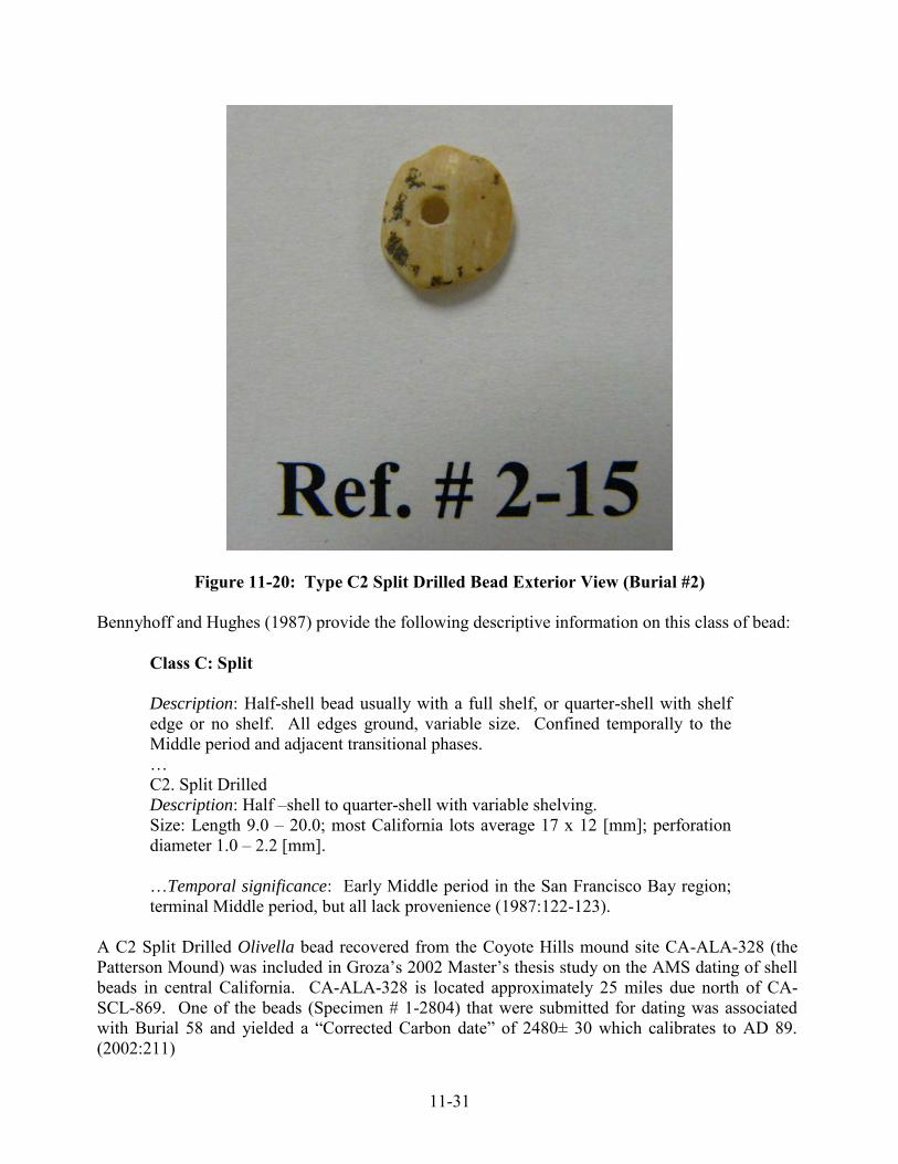
11-31
Figure 11-20: Type C2 Split Drilled Bead Exterior View (Burial #2)
Bennyhoff and Hughes (1987) provide the following descriptive information on this class of bead:
Class C: Split Description: Half-shell bead usually with a full shelf, or quarter-shell with shelf edge or no shelf. All edges ground, variable size. Confined temporally to the Middle period and adjacent transitional phases. … C2. Split Drilled Description: Half –shell to quarter-shell with variable shelving. Size: Length 9.0 – 20.0; most California lots average 17 x 12 [mm]; perforation diameter 1.0 – 2.2 [mm]. …Temporal significance: Early Middle period in the San Francisco Bay region; terminal Middle period, but all lack provenience (1987:122-123).
A C2 Split Drilled Olivella bead recovered from the Coyote Hills mound site CA-ALA-328 (the Patterson Mound) was included in Groza’s 2002 Master’s thesis study on the AMS dating of shell beads in central California. CA-ALA-328 is located approximately 25 miles due north of CA-SCL-869. One of the beads (Specimen # 1-2804) that were submitted for dating was associated with Burial 58 and yielded a “Corrected Carbon date” of 2480± 30 which calibrates to AD 89. (2002:211)

11-32
The other C2 Split Drilled Olivella bead (Specimen # 37-5670) was recovered from CA-Yol-13 (Yolo County) and was associated with Burial #3. The result from the AMS dating yielded a “Corrected Carbon date” of 1395± 30 which is calibrated to AD 1251 (2002:238). Groza’s AMS dating result from the CA-ALA-328 associated C2 Split Drilled bead more closely approximates the AMS date obtained on Burial #2 which dates to AD 244. Groza had noted that the CA-ALA-328 bead assemblage associated with Burial 58 included 11 C3 Split oval, 2 C2 Split Drilled and 406 G2a small saucers. She also suggested that Bennyhoff and Hughes had temporally placed these beads as follows:
C3 split oval beads indicate the Middle/Late Transition [700-900 AD] but C2 are Early Middle period (200 BC – 100 AD). G2a small saucers also date the Early Middle period (Groza 2002:211).
Discussions and Interpretations Based upon the results from the analysis of the flaked stone, ground stone and battered stone tools recovered from CA-SCL-869, a limited range of activity sets may be inferred from these data. While these inferred activities may not represent the entire universe of precontact Ohlone behavior that occurred at this site, the patterning and interpretations derived from this representative sample does help shed light on understanding some aspects of the nature of the site and the site formation processes occurring there. Discussion of the Mortuary Complex and Grave Associations The recovery of four primary inhumations as well as at least two other individuals (MNI = 6) from Feature #1 supports part of the interpretive argument that the sampled portion of CA-SCL-869 was indeed a cemetery site. AMS dating of the four burials and the adjacent Feature #1 places this cemetery site within the Late Middle Period [ca. AD 200 – AD 500] (Bennyhoff and Hughes1987 Scheme B1). This cemetery complex most likely developed as a consequence of the establishment of an adjacent village which was strategically located relative to Canoas Creek and Canoas Marsh as sources of fresh water and food resources. This area was then set aside by the residents of this village for purposes of burying their dead according to the customs of the time. Historic and presumably ancestral Ohlone mortuary-related activities were tied to two significant ceremonies: the Funeral and the commemorative Mourning Anniversary. Clearly, some aspects of these ceremonial expressions can be discerned by the deliberate placement of grave offerings such as deer and wolf remains, lithics, and large intact boulder mortars as symbols of both the real and cosmological worlds. As mentioned above, a total of 26 flaked stone tools and debitage/waste flakes were recovered with all four burials as grave associations. Twenty-three of the twenty-four lithics were of Franciscan chert and one Assayed Cobble was of basalt. Why these lithic materials were placed with these

11-33
four women, obviously will never know, but no doubt they were placed for symbolic reasons, presumably to take with them and use in the afterlife. The two intact boulder mortars were deliberately placed along side two of the deceased women Burials 1 and 4. Based upon the AMS dating these two women died within approximately 13 years of each other. Burial 1 dated to AD 346 and Burial 4 dated to AD 333. It is surmised that these mortars belonged to these two women. Furthermore, prestige may also be inferred by the fact that these two mortars exhibited deliberate shaping and were manufactured on large sandstone boulders not available within the immediate area. Therefore, it is surmised that the raw boulder material and the manufacture of these mortars had taken place some distance away from the site. In addition to interpreting these associated mortars as basic Technomic (utilitarian tools), perhaps it may also be inferred that they represent Sociotechnic symbols of wealth and status) that came into their possession as prestigious imported trade items (Leventhal, 1993; Leventhal and Seitz, 1989). Independent of the four burial loci was Feature #1 which was located to the east of Burial 1 along the eastern boundary of the parcel. This feature was encountered within Test Unit #1 to depth of 80+ cm BS. A total of 63 (29%) of all the debitage/waste flakes were derived from this test unit (Feature 1). Three of these were flakes of obsidian. In addition to these 63 debitage specimens, four cores, two utilized flakes, a borer, and one modified flake were also recovered making a total of 71 (33%) flaked stone elements. Furthermore, Feature 1 also yielded a unifacial mano fragment, faunal remains including skeletal elements from eagle, owl, coot, tule elk, deer, and coyote (as well as other animals). Feature 1 also contained several human elements designated as belonging to Burial 5 and Burial 6. It is therefore difficult to interpret Feature 1 as a residential/habitation-related feature rather than a mortuary-related feature because of the presence of human remains as well as the presence of a concentration of various animal parts. Therefore, it is postulated that this feature was most likely associated more with mortuary-related activities rather than residential-related activities (see Leventhal 1993, Luby 1991, Luby and Gruber 1999). As stated above, a small cobble mortar of sandstone (Ref. # 51-1) was recovered from the Transformer Pad Area Test Trench which was located approximately equidistant between TU 1/Feature 1 and Burial 1. Based upon the results from the mortar macro and microbotanical constituent analysis conducted by Cuthrell and Soluri (see Chapter 10), it appears that this small mortar was probably not used for processing the same food or plants as the two larger boulder mortars. Mortar #2 was probably used for herbal and possibly some food processing, however, giving its small size, it was probably a specialized mortar that also may have been employed for ceremonial/mortuary-related purposes. Possible Inferred Evidence of Technomic (Economic-Related) Activity Sets As discussed above there were 3 utilized flakes recovered from this site, two of which were recovered from Test Unit 1/Feature 1. These informal tools apparently were at some point involved in various cutting, scraping, whittling and shaving activities. Although they can be classified as “technomic” artifacts, because they were recovered from within the cemetery site, they should be considered as transformed into symbolic “ideotechnic” objects. Likewise, prior to placement of the two large boulder mortars as grave associations, these mortars were employed in normative food processing activities. However, placement within the cemetery with their owners, transformed

11-34
them from “technomic” tools to either “sociotechnic” or “ideotechnic” symbols (after Binford 1962). In conclusion, it may be suggested that many of the unassociated lithic tools and debitage are indeed the result of nearby habitation-related activities. However, based upon the limited scope of this analysis two distinct activity sets may be forwarded that may explain the distribution of these materials.
1. Some of the lithic tools and debitage could be associated with resource exploitation of the riverine/marshland environment either prior to or after the establishment of the mortuary component of this site. Hunting is also an inferred activity indicated by the presence of the mid-section of the obsidian dart point, faunal remains, and tool manufacture/maintenance in the form of flakes and debitage/waste which was probably taking place during this period of time.
2. Some time during the late Middle Period, this area was identified as suitable to establish a
semi-sedentary residential settlement which when people living there died produced a burial ground. This cemetery was established in an area presumably outside or adjacent to the village. The distribution of both lithic as well as other non-grave associated materials may well indeed be associated with the various funerary and annual Cry or Mourning ceremonies that may have been held on the cemetery or in close proximity to the village living area. If this hypothesis is correct, then in order to host. obtain and prepare food to feed large groups of people over a period of several days, then we would expect to find evidence of short term, intensive, single event activities in the form of discarded tools and fauna (mammal, bird and shell fish) remains. Obviously, this hypothesis must be independently tested with other sets of data in order to reconstruct socio-cultural and ceremonial activities at the CA-SCL-869 site.
To summarize, based upon the data presented above, it may be stated that these pre-contact Ohlone people exploited a localized lithic catchment for most of their stone tools. It appears that it was important to place a variety of lithics with deceased individuals, ranging from formed "finished tools" to various debitage elements. If we consider Monterey chert, obsidian and the eight other lithic classes as exotics, then only a total of 42 specimens or 9% of the grave assemblage, should be considered as possibly "wealth" associations. Further compounding this perspective is the possibility that the projectile points associated with these burials may not constitute formal grave offering, but rather as presented elsewhere, served as agents of death for these people. Discussion of Our Primary Research Question: Ceremonial Perspective Can we identify and distinguish between those assemblages associated with normative village/habitation site-related activities from those assemblages derived from hosting groups of people attending intensive, single event (presumably multi-day) Funeral and/or annual Mourning anniversary-related ceremonies at adjacent cemetery sites?
11-35
Based upon the analytical results from this flaked stone and ground stone study, we have very little evidence that supports the presence of a village site within the confines of the archaeological deposit identified within this parcel area. This is supported by the fact that this sample comprises a total of 24 lithic elements which were derived from the four primary inhumations and 248 from the other four contexts. Based upon this, we calculated that this assemblage averages approximately 35 lithics per cubic meter, and further assuming a temporal "occupational" span of 300 years, we discover that approximately 8.5 lithics were deposited on site per year. As a result, this patterning does not support evidence for a semi-sedentary (collector/harvester) village. On the other hand however, we do have evidence of stone tool manufacturing. Clearly, this indicates that some technomic related activity sets were carried on site. We can only hypothesize, that if the non-grave associated lithic assemblages were indeed associated with the technomic related activities (e.g., the acquisition and preparation of mammal, bird, shellfish and plant foods) in order to host large groups of people for a one-to-four day funeral or mourning ceremonial event, we should then find evidence of these tools and their associated manufacturing debris, especially over a 300 year period. In addition, support for this position, several ethnohistoric accounts were selected from central California, so this could be visualized. Blackburn citing Gayton's 1936 study on the Yokuts in the San Joaquin Valley offers this contact period account of a mourning ceremony:
In 1819, Estudillo estimated the number of people participating in a mourning anniversary at Chischa to be somewhere between 2500 and 3000. (Blackburn 1976:231)
Still later, in the early 1870s, Steven Powers provided a first hand account of a Yokut's "dance for the dead":
While in Course Gold Gulch, it was my good fortune to witness the great dance for the dead (ko-ti'-wa-chil) which was one of the most extraordinary human spectacles I ever beheld. First, it will be well to explain that among the Yokuts the dance for the dead is protracted nearly a week. ... We found about three hundred Indians assembled... Glittering necklaces of Haliotis and other rare marine shells; ...baskets of the finest workmanship, on which they had toiled for months, perhaps years, circled and furred with hundreds of little quail-plumes, bespangled, scalloped, festooned, and embroidered with beadery until there was scarcely place for the handling; plumes, shawls, etc. (1877:384-385,388).
Again Powers offered a detailed description for the Konkow (Konkau) anniversary:
The dance for the dead (tsi'-pi ka-mi'-ni, "the weeping dance")... They bring together a great quantity of food, clothing, baskets, and whatever other things they believe the dead require in the other world. ... the ornaments are the best they can
11-36
procure. These are hung on a semicircle of boughs or small trees, cut and set in the ground leafless... . In the center burns a great fire, and hard by are the graves. ... They seat themselves on the graves, men, women and squaws together, as the twilight closes in around them, and begin a mournful wailing, crying, and ululation for the dead of the year. (1877:437-438).
This aforementioned description of the poles with offerings is very similar to the early Spanish accounts describing the cemeteries in Ohlone territory. Although these ethnographic examples are from adjacent tribal territories and also are post-contact, they, nonetheless potentially serve as ethnographic analogs for the archaeological record within the Ohlone region. Furthermore, we know that the Ohlones had a reciprocal moiety system (Deer/Bear) much like the Miwok (Land/Water), Coast Miwok (Land/Water), Yokuts (Downstream/Upstream) and Salinan (Deer/Bear) that presumably functioned in an analogous fashion, especially during ritual obligation (Gifford 1916:140; Harrington 1942:32; Hester 1978; Kelley 1978; Mason 1912; Spier 1978). During a funeral or mourning ceremony, the members of these moieties functioned as ritual washers for members of the opposite moiety (Blackburn 1976). Gifford (1955) informs us that the "Cry" ceremony of the Miwok occurred approximately one year after death. It lasted from one to six nights with four being the average number of days. Furthermore, Gifford states that "(a)n assemblage of three to four hundred people for a cry is not unusual" (Ibid:313). After the "Cry" ceremony everyone was washed with mugwort (estafiate) by the opposite moiety's members (Gifford 1955:315). Presumably the act of reciprocal washing has also something to do with ritual purification in order to avert sickness and death. Apparently ritual washing was performed after both the mourning anniversary and the funeral. Gifford provided additional information about Miwok ritual behavior:
In the old days after a cremation, and nowadays after a burial, the ceremony of epetu is performed. Each of the chief mourners lies face down on the grave and his back is pressed from head to foot by people of the opposite moiety. The purpose of epetu is to ward off illness from the mourners (1955:312).
To summarize, we find that in central California there are prescribed rules for the proper disposal of the dead and for conducting mourning ceremonies. Cemeteries are areas distinctively set-aside from village living areas. Due to the development of complex ceremonial behaviors, which specifically centers around funerals and mourning ceremonies and focuses on purification rituals due to "ritual pollution" (e.g., handling of a corpse, being a chief mourner, etc.), we find it difficult to accept the view that pre-contact Ohlone people would deliberately live on top of their dead. In fact when we reviewed the larger ethnographic record for North American Indians (Driver 1969) as well as other world wide hunting and gathering populations (Coon 1971; Service 1978; Fried and Fried 1980), we found no evidence of any group living on top of their dead. Therefore based upon the meager tool assemblages and debitage recovered from CA-SCL-869, taken in conjunction with the ethnographic information discussed above, it is our conclusion that this site constitutes a cemetery site and that the presence of the lithic assemblages are most likely a consequence of ceremonial and funerary-related activities conducted at this location.
12-1
Chapter 12:
The Dating and Chronological Placement of the Katwáš Ketneyma Waréeptak Site
Alan Leventhal and Rosemary Cambra
AMS Dating of the Four Burials and Deer Bone Recovered from Feature #1 During the course of conducting the Burial and Archaeological Data Recovery Program, at CA-SCL-869 it became apparent that there was not a sufficient amount charcoal associated with the four in situ burials to submit for radiometric assay (dating). Furthermore, although tiny charcoal flecks were present throughout the soil matrix within Feature #1, a decision was made by the Muwekma Ohlone Tribal leadership to allow for the submittal of a small amount of human bone from the four burials and a sample of animal bone from Feature #1 for Accelerator Mass Spectrometry (AMS) dating in order to obtain chronological information on the temporal components represented at this site. On July 8, 2007, a small sample of bone was packaged up and sent to Beta Analytic Inc. for AMS dating and for 15N/14N Stable Isotope analysis (indicating dietary health) from Burial #1, Burial #2 and a deer cranium from Feature #1 (Test Unit #1). Based upon the large associated sandstone mortar associated with Burial #1 as well as overall depth of the burials and the deer cranium from Feature #1 and state of preservation, OFCS staff predicted a date ranging from AD 1 to AD 500 for Burial #1. The results from Beta Analytic were obtained on August 17, 2007. After reviewing these dating results, OFCS staff and Muwekma were pleased to see that two burials and adjacent Feature #1 dated to the Intermediate (AD 100 – 300) and Late (AD 300 – 500) Middle Period based upon Bennyhoff and Hughes (1987) Dating Scheme B. Furthermore, these dates fell within the estimated age prediction of the site which made prior to submitting the samples for dating. On August 17, 2007, after the discovery of Burial #3 OFCS staff sent a small sample from this burial to Beta Analytic and the result was that it too dated to the Late Middle Period (AD 300 – 500). Almost a month later, after the discovery of Burial #4, OFCS staff submitted a sample of bone from this burial on September 11, 2007 to Beta Analytic for AMS dating. The AMS dating resulted in a date that was within 10 years of Burial #3. Burial # 4 also dated to the Late Middle Period (AD 300 – 500). The calendar date was calibrated based upon Beta’s correction of the Radiocarbon Age of the sample. The intercept was determined as the midpoint of the corrected (Conventional) date at the 2 sigma level thus providing a calibrated date when these people died (See Table 12-1 for results below; also see Appendix E).

12-2
Table 12-1: Results of AMS Dating on Burials #1, #2, #3, #4 and Feature #1 Beta Lab # Feature # Radiocarbon Age Conventional Age Calendar Date Corrected (2 Sigma) (Intercept) 232703 Burial #1 1640 ± 40 BP 1670 ± 40 BP AD 345 232704 Burial #2 1700 ± 40 BP 1770 ± 40 BP AD 260 232705 Feature #1 1540 ± 40 BP 1610 ± 40 BP AD 465 234069 Burial #3 1650 ± 40 BP 1730 ± 40 BP AD 320 235022 Burial #4 1610 ± 40 BP 1700 ± 40 BP AD 330 Independently, Leventhal ran the online Cologne Radiocarbon Calibration and Paleoclimate Research Package (CalPal) which yield comparable corrected dates for Burial #1 - AD 346 +/- 40; Burial #2 - AD 244 +/- 40; Feature #1 – AD 463 +/- 40; Burial #3 - AD 318 +/- 40; and Burial #4 - AD 333 +/- 40 which places all of the dates very close to the midpoint result obtained by Beta Analytic. If we accept the corrected calendar dates which range from AD 260 to AD 465 and place these dates within the Bennyhoff and Hughes (1987) Temporal Scheme B, then as stated above these individuals died during the Intermediate and Late Middle Period. (See Figure 12-1). If these dates are placed within the newly proposed Temporal Scheme D as initially proposed by Groza (2002) and refined by Hughes and Milliken (2007), then these individuals died during the upper Early Middle Period or M1 Bead Horizon (200 BC – AD 450) and the deer recovered in Feature #1 died a little more than one hundred years later during the M2 Bead Horizon of the Middle Period that spanned from AD 450 to AD 600. (See Figure 12-1: Temporal Schemes B and D below). Regardless of which Temporal Scheme we employ, it is clear that these four elderly ancestral Ohlone women from the Katwáš Ketneyma Waréeptak Site died during the Middle Period within 85 years of each other, between AD 260 and AD345. Based upon a review of available C14 dates from other sites within the San Francisco Bay region (Table 12-2), these four women from the Katwáš Ketneyma Waréeptak Site were probably living around the same time when these other sites were also either “occupied” or specifically used as cemeteries:
Table 12-2: Comparative Dates from San Francisco Bay Area Sites Site Number Calendrical Date Material Dated Source CA-ALA-413 AD 388 (corrected) G2b Olivella Bead (Groza 2002:158) CA-ALA-328 AD 338 (corrected) C3 Olivella Bead (Groza 2002:210) CA-ALA-328 AD 332 (corrected) F2b Olivella Bead (Groza 2002:221) CA-ALA-328 AD 251 (corrected G3b Olivella Bead (Groza 2002:219) CA-ALA-329 AD 340 (corrected) Human Collagen (Leventhal 1993)
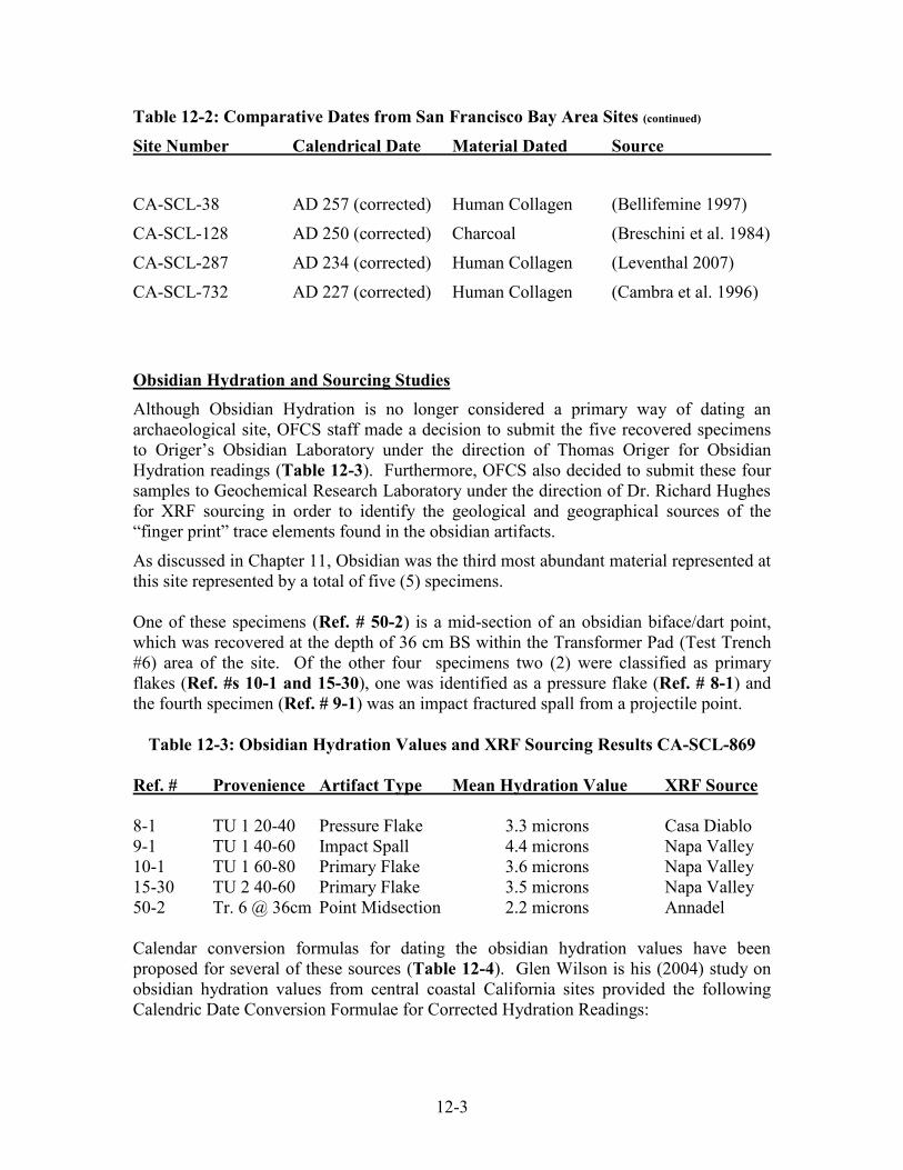
12-3
Table 12-2: Comparative Dates from San Francisco Bay Area Sites (continued)
Site Number Calendrical Date Material Dated Source CA-SCL-38 AD 257 (corrected) Human Collagen (Bellifemine 1997) CA-SCL-128 AD 250 (corrected) Charcoal (Breschini et al. 1984) CA-SCL-287 AD 234 (corrected) Human Collagen (Leventhal 2007) CA-SCL-732 AD 227 (corrected) Human Collagen (Cambra et al. 1996)
Obsidian Hydration and Sourcing Studies Although Obsidian Hydration is no longer considered a primary way of dating an archaeological site, OFCS staff made a decision to submit the five recovered specimens to Origer’s Obsidian Laboratory under the direction of Thomas Origer for Obsidian Hydration readings (Table 12-3). Furthermore, OFCS also decided to submit these four samples to Geochemical Research Laboratory under the direction of Dr. Richard Hughes for XRF sourcing in order to identify the geological and geographical sources of the “finger print” trace elements found in the obsidian artifacts. As discussed in Chapter 11, Obsidian was the third most abundant material represented at this site represented by a total of five (5) specimens. One of these specimens (Ref. # 50-2) is a mid-section of an obsidian biface/dart point, which was recovered at the depth of 36 cm BS within the Transformer Pad (Test Trench #6) area of the site. Of the other four specimens two (2) were classified as primary flakes (Ref. #s 10-1 and 15-30), one was identified as a pressure flake (Ref. # 8-1) and the fourth specimen (Ref. # 9-1) was an impact fractured spall from a projectile point.
Table 12-3: Obsidian Hydration Values and XRF Sourcing Results CA-SCL-869 Ref. # Provenience Artifact Type Mean Hydration Value XRF Source 8-1 TU 1 20-40 Pressure Flake 3.3 microns Casa Diablo 9-1 TU 1 40-60 Impact Spall 4.4 microns Napa Valley 10-1 TU 1 60-80 Primary Flake 3.6 microns Napa Valley 15-30 TU 2 40-60 Primary Flake 3.5 microns Napa Valley 50-2 Tr. 6 @ 36cm Point Midsection 2.2 microns Annadel Calendar conversion formulas for dating the obsidian hydration values have been proposed for several of these sources (Table 12-4). Glen Wilson is his (2004) study on obsidian hydration values from central coastal California sites provided the following Calendric Date Conversion Formulae for Corrected Hydration Readings:

12-4
Table 12-4: Calendar Conversion Formulae for Selected Obsidian Sources
Source Rate Reference Casa Diablo y = 129.626 x² Hall (1984) Bodie y = 129.626 x² Tremaine (1990) Coso y = 31.62 x² Basgall (1990) Napa y = 153.4 x² Origer (1982, 1989) Annadel y = 184.6 x² Origer (1982, 1989) [Wilson 2004:6]
Therefore, if the Napa Valley formula is applied to the mean hydration micron values obtained by Origer on the three specimens from CA-SCL-869 the conversion dates are calculated as follows with the value y = date and x = mean micron hydration value: Example: Ref.# 8-1: Napa Valley [date = 153.4 x 3.3²] = 1671 years ago or AD 336
Table 12-5: Conversion Dates on the Mean Hydration Values from CA-SCL-869 Ref. # Date Artifact Type Mean Hydration Value XRF Source 8-1 AD 595 Pressure Flake 3.3 microns Casa Diablo 9-1 BC 963 Impact Spall 4.4 microns Napa Valley 10-1 AD 19 Primary Flake 3.6 microns Napa Valley 15-30 AD 128 Primary Flake 3.5 microns Napa Valley 50-2 AD 1114 Point Midsection 2.2 microns Annadel Discussion of the Implications of Employing the Calendar Conversion Formulas As can be ascertained from the results of applying the calendar conversion formulas to the sourced obsidian artifacts recovered from CA-SCL-869, we find that the resultant temporal range spans from 963 BC to AD 1114. While these conversion results are indeed impressive, we do not have other independent evidence (e.g., Early or Late Period Olivella bead types or projectile points and etc.) to support either older or younger antiquity beyond the temporal range provided by the AMS C14 dates from this site. Three of the above specimens: Ref #8-1 (sourced to Casa Diablo), Ref. #10-1 (sourced to Napa Valley), and Ref. #15-30 (also sourced to Napa Valley) do fall within close range of the AD 260 to AD 465 AMS dating results, which although is of interest, nonetheless, these five obsidian hydration conversion dates are to be considered much less precise than the results from the AMS C14 dating technique.

12-5
Map 12-1: Location of Obsidian Sources in Central California

12-6
Inferred Trade Networks Indication of prehistoric far flung prehistoric Trade Networks is supported by the presence of exotic lithic materials. These lithic materials include the obsidian specimens sourced to the eastern Sierra from the Casa Diablo obsidian quarry located approximately 160 miles as-the-crow-flies to the east of San Jose. The obsidian from Napa Valley (Glass Mountain) came from a quarried source located approximately 80 miles to the north of San Jose. The Annadel obsidian source likewise is located approximately 55 miles to the north of San Jose (see Figure 12-1). The other exotic lithic material was the Monterey chert which naturally occurs within a Miocene formation to the west of the San Andreas faultline and submerged off shore from Point Año Nuevo. Usually found as rounded or flatten cobbles these oil-bearing 14 million year old sedimentary chert formation cobbles are readily available as raw material collected on the beach especially after the winter storms. Point Año Nuevo is located approximately thirty miles as-the-crow-flies to the west of CA-SCL-869. (For details on the results from the AMS dating and obsidian hydration and sourcing see Appendix E and F)
12-7
Diagnostic Beads and Ornaments No Abalone ornaments were recovered from this site. Only one temporally diagnostic shell bead artifact was recovered in association with Burial #2. As discussed in Chapter 11, this Olivella cut shell bead (Ref. # 2-15) was recovered in immediately adjacent to the Burial #2 grave from within Test Unit #2 at the 40-60 cm BS level. This cut bead was shown to archaeologist and bead specialist Dr. Randall Milliken, and he and Alan Leventhal, took measurements on December 21, 2007. Based upon the overall morphology of the bead and metric measurements, Milliken typed the specimen as a C2 Split Drilled bead: Length/width = 9.9 x 9.1 mm; Curvature = 3.2 mm; Perforation diameter = 1.6 mm; and it is biconically drilled. The edges are ground and a portion of the shelf is present on the upper interior section of the bead. Bennyhoff and Hughes (1987) provided the following descriptive information on this class of bead:
Class C: Split Description: Half-shell bead usually with a full shelf, or quarter-shell with shelf edge or no shelf. All edges ground, variable size. Confined temporally to the Middle period and adjacent transitional phases. …C2. Split Drilled Description: Half –shell to quarter-shell with variable shelving. Size: Length 9.0 – 20.0; most California lots average 17 x 12 [mm]; perforation diameter 1.0 – 2.2 [mm]. …Temporal significance: Early Middle period in the San Francisco Bay region; terminal Middle period, but all lack provenience (1987:122-123).
A single Type C2 Split Drilled Olivella bead recovered from the Coyote Hills mound site CA-ALA-328 (the Patterson Mound) was submitted for AMS dating as part of Groza’s 2002 Master’s thesis study on the AMS dating and temporal placement of cut Olivella shell bead type from central California. Site CA-ALA-328 is located approximately 25 miles due north of CA-SCL-869. One of the beads (Specimen # 1-2804) from this site that were submitted for dating was associated with Burial 58 and yielded a “Corrected Carbon date” of 2480± 30 which calibrated to AD 89 (Groza 2002:211). This date places the age of Burial 58 and the AMS dated bead from CA-ALA-328 approximately 155 years earlier than Burial #2 from the Katwáš Ketneyma Waréeptak Site (CA-SCL-869). The AMS date of the CA-ALA-328 bead specimen obtained by Groza places it within the Upper Early Middle Period (AD 0 – AD 100) of Bennyhoff and Hughes (1987) Temporal Scheme B1. The AMS date of AD 244 on Burial #2 places this individual within the Upper Intermediate Middle Period (AD 200 – AD 300) of Bennyhoff and Hughes (1987) Temporal Scheme B1. Regardless of specific temporal placement, the burials from both of these sites date to the middle Middle Period.

12-8
Figure 12-2: Temporal Dating Schemes Based on Bennyhoff and Hughes (1987)
Scheme B1; Hughes and Milliken (2007) Scheme D

13-1
Chapter 13: An Ethnohistory of Santa Clara Valley and Adjacent Regions; Historic Ties of the
Muwekma Ohlone Tribe of the San Francisco Bay Area and Tribal Oversight of the Katwáš Ketneyma Waréeptak (Four Matriarchs) Site, CA-SCL-869
Burial Recovery Mitigation Program
Rosemary Cambra, Alan Leventhal, Monica V. Arellano, Susanne Rodriguez, Shelia Guzman Schmidt, and Gloria Arellano Gomez
Introduction As presented elsewhere in this report Ohlone Families Consulting Services (OFCS), the Cultural Resource Management arm of the Muwekma Ohlone Tribe of the San Francisco Bay Area had oversight on the burial recovery mitigation program conducted at Katwáš Ketneyma Waréeptak (The Four Matriarchs Site) CA-SCL-869. The Muwekma Ohlone Tribe has over the past 30 years continuously exercised its stewardship over the Tribe‘s ancestral heritage and human remains discovered within their aboriginal territory. The Tribe‘s leadership and members were involved in the recovery program and final report on this ancestral cemetery site discovered at Fire Station #12, which the Tribe has renamed the Katwáš Ketneyma Waréeptak Site. The Renaming of Site CA-SCL-869 by the Muwekma Ohlone Tribe in Their Native Chocheño Ohlone Language Towards the completion in August 2008 of the archaeological and burial recovery program at Katwáš Ketneyma Waréeptak, it became apparent that the most significant aspect of this site was the recovery of the four elderly ancestral Ohlone Indian women. A decision was made by the Muwekma Ohlone Tribal leadership and the Tribe‘s Language Committee (Monica V. Arellano, Sheila Guzman-Schmidt and Gloria E. Arellano-Gomez) to honor their deceased ancestors by renaming the site with a new name in the Tribe‘s aboriginal Ohlone Chocheño language. This practice follows Tribal tradition which has over the past decades renamed some of their ancestral village and cemetery sites. This renaming tradition has formally occurred at several other South Bay pre-contact ancestral Muwekma Ohlone cemetery sites. Some of these sites include: CA-SCL-732 located 2¾ miles to the east of CA-SCL-869 along Coyote Creek which was renamed in 1995 as Kaphan Umux (Three Wolves) Site [and recently corrected to Kaphan Húunikma] (Cambra et al. 1996); CA-SCL-38 located in Milpitas which comprised a very large mortuary mound that was renamed by the Tribe in 1996 as the Yukisma (“at the Oaks”) Site (Bellifemine 1997); and more recently CA-SCL-867 which is located in the Willow Glen area of San Jose approximately 3½ miles to the north/northwest of Katwáš Ketneyma Waréeptak was renamed in 2006 as the Ríipin Waréeptak Site which means “(in the) Willows Area‖ Site (Leventhal, et. al 2007).

13-2
As mentioned above, because of the discovery of four elderly women whom were buried near each other and had died very close in time to each other, the Muwekma Tribal Language Committee decided upon the name Katwáš Ketneyma Waréeptak which literally means “The Four Elderly Women” or the ―Four Martiarchs‖ as the alternative Native name for this site. Therefore, CA-SCL-869 will at times be referred interchangeably as Katwáš Ketneyma Waréeptak or The Four Matriarchs Site in following chapter. In this ethnographic section, we provide an ethnohistoric overview of the Santa Clara Valley and surrounding geographic regions. This section also explores the complex historic interrelationships between the aboriginal Ohlone tribal groups from the greater San Francisco Bay region at the time of contact and the ensuing impacts resulting from the advent of the expanding late 18th century Hispanic Empire; the establishment of the Catholic Church and the effects of Missionization; the mid-19th century American conquest of California; the Gold Rush and theft of California Indian lands; the effects of the emergent State of California; and the Federal Recognition of California Indian Tribes and specifically the Verona Band of Alameda County. These topics are introduced and explored though discussions involving contact-period regional and ethnohistorical tribal ties to the present-day Muwekma Ohlone Tribe and by presenting aspects of the survival strategies and continual cultural identity of this historic tribe. Ethnogeographic Setting The Katwáš Ketneyma Waréeptak Site represents a pre-contact ancestral Muwekma Ohlone cemetery. Formally designated with the State‘s trinomial system as CA-SCL-869, the site is located within the contact-period ethnogeographic territory of the San Juan Bautista Tribal Group/District within the larger defined Tamien Ohlone-speaking linguistic territory. The Katwáš Ketneyma Waréeptak Site is also located near the general locations of the adjacent contact-period Ohlone village districts of Our Patron San Francisco, Our Mother Santa Clara and San Carlos or Matalan Tribal Groups/Districts which were so named by the Mission Santa Clara priests (see C. King 1994, Milliken 1991, 1995, 2004; Hylkema 2007 [CA-SCL-690 Tamien Station]). The San Juan Bautista Tribal District, not to be confused with the Mission San Juan Bautista established about 20 years later in 1797 further south within Mutsun Costanoan-speaking territory in San Benito County, was identified by the priests from Mission Santa Clara as being located to the south of the mission that included a portion of the Coyote Creek Corridor. Previous Ethnohistoric Studies Meaningful ethnohistoric studies focusing on the demography and geopolitical distribution of the different Ohlone/Costanoan tribal groups at the time of contact who were principally baptized at Mission Santa Clara beginning in 1777 were conducted by Chester King in the 1970s (1974, 1977, 1978a, 1978b, and 1994) and continued by Milliken (1983, 1991, 1995, 2004 and 2007 [in Hylkema 2004, 2007]). These studies helped lay the foundation for reconstructing the geopolitical and linguistic boundaries of
13-3
those tribal groups and districts that were brought into each mission, as well as providing information about the transformation and the cultural and political adaptation and responses of those surviving Ohlone/Costanoan tribal groups adjusting to the disruption caused by the expanding Hispanic colonial empire, the impacts of missionization and ensuing spread of diseases and malnutrition. The Santa Clara Valley and adjacent areas supported fairly large populations of Native peoples for thousands of years. This is evidenced by the prevalence of large pre-contact cemeteries within the San Francisco Bay region [see reports on Emeryville (CA-ALA-309); Ellis Landing (CA-CCO-295); Ryan Mound (CA-ALA-329) [Leventhal 1993]; CA-SCL-732, Three Wolves Site (Cambra et. al 1996); CA-SCL-38 (Bellifemine 1997); CA-SCL-690 Tamien Station (Hylkema 2007); CA-SCL-674 Rubino Site (Grady et al. 2001) and others]. Furthermore, based upon the analysis of grave-associated wealth and regalia data derived from central California cemetery sites, it can be postulated that the greater San Jose area appears to be located within the southwestern-most region of a Late Period religious complex, ceremonial, economic interaction sphere that employed the use of "Big Head" (or “N series”) abalone shell effigy pendants that began sometime around the Phase I-Late Period (circa 1100 A.D.), and which presumably was part of the larger geographically-area-widespread Kuksu religion that was practiced by a multitude of North–Central California Indian tribal groups. These tribal groups ranged from the Hokan-speaking Salinans to the south (southern Monterey County); to the San Francisco Bay Penutian-speaking Ohlone and interior Bay Miwok tribal groups, to the Penutian-speaking Coast Miwok and Patwin (Marin, Napa, Yolo, and Colusa Counties); to the Penutian-speaking Plains Miwoks and Konkow-Nisenan (Maidu-speaking groups) in the Sacramento and Central Valley foothills of the Sierra Nevadas; to the Hokan-speaking Pomoan tribal groups (Sonoma, Lake and Mendocino Counties), Yukian-speaking Yukian tribal groups (northern Mendocino) and the Athabascan-speaking Cahto tribe located to the north of Fort Bragg. (see Loeb 1932, 1933; Du Bois 1939; Gifford 1947:20; Bennyhoff 1977:50; Winter 1977, 1978; Bean and Vane 1978; Leventhal 1993:230-236; Hylkema 2007). The preliminary data derived from similar and comparative mortuary patterning and associated grave assemblages identified from Late Period cemetery sites taken in conjunction with the similarities of tribal personal name-endings derived from the mission records as in the cases of ―tole‖ and ―mayen‖ (or a variant thereof) for females and ―cse‖ (or a variant thereof) for males found amongst the different linguistic groups within the same macro-geographical area as the Big Head/Kuksu pendants, suggests that the South and East Bay regions had strong cultural ties, via trade, intermarriage, ceremonial interaction and shared religious belief systems as well as other cultural influences with the Central Valley interior, including the Sacramento and San Joaquin Delta (Stockton) regions (Lillard, Heizer and Fenenga 1939; Heizer and Fenenga 1939; Gifford 1947; Bennyhoff 1977; Leventhal 1993, Milliken 1995.

13-4
The evidence of a far-flung ceremonial and economic interaction sphere further suggests that the Tamien Ohlone-speaking tribal groups, including the San Juan Bautista, San Carlos/Matalan and their neighbors, were significantly involved within this larger religious and ceremonial interaction network that partially was influenced through mechanisms of trade, economic, military and marriage alliances with those tribal groups located to the east and north of the South Bay region – a region that at the time of Spanish contact had already cross-cut several major linguistic boundaries (San Francisco Bay Ohlone, North Valley Yokuts, Patwin, Coast, Bay and Plains Miwok) as well. Limited detailed ethnohistoric information about the aboriginal lifeways of the different San Francisco Bay Ohlonean-speaking tribal groups who resided within this mega-sphere of socio-cultural interaction, tends to be restricted to the various accounts written by early Spanish explorers, missionaries, and visiting European travelers. Other historical records written after the cataclysmic impact caused by missionization and the ensuing American conquest through the 20th century include the research by more formally trained ethnographers, ethnohistorians, linguists as well as by other visitors to the greater Bay Area. Early Spanish Expeditions to the San Francisco Bay Region During the late 18th century, an expedition led by Captain Commander Pedro Fages, was perhaps, the first Spanish exploration to travel through the northern part of the San Juan Bautista and San Carlos/Matalan tribal districts (Tamien speaking territory) in the Santa Clara Valley. Milliken commented on and noted in his doctoral dissertational study on the San Francisco Bay tribal groups at the time of contact the following historical account derived from Captain Fages‘ diary:
The Matalans and Thamiens of Santa Clara Valley watched a small Spanish party pass north through their lands in November of 1770. The party, under Pedro Fages, continued north along the east shore of San Francisco Bay (until) (sic) it reached a plain opposite the Golden Gate (presently North Oakland). ... Fages wrote of only one encounter:
‗Up close to the lake we saw many friendly good-humored heathens, to whom we made a present of some strings of beads, and they responded with feathers and geese stuffed with grass, which they avail themselves of to take countless numbers of these birds [Fages 1770 in Bolton 1911].‘
The goose hunters were Tuibuns or Alsons at a lake on the Fremont Plain just south of Alameda Creek (Milliken 1991:78).
Captain Commander Fages apparently at a later date again passed through the Tamien-speaking region in 1772 and explored the interior of the East Bay (see Crespi in Bolton 1926:336, also see Hylkema 1995). However, it was not until 1774 that the first intensive exploration of the Santa Clara Valley region occurred, which was led by Captain

13-5
Fernando Rivera y Moncada who was also accompanied by Fray (Father) Francisco Palou. Writing of this expedition, Milliken made note of one of Rivera y Moncada's accounts:
The next Spanish expedition into the Bay Area, in the late fall of 1774, came for the purpose of scouting locations for a possible mission and military base on the San Francisco Peninsula. ... Near the town of Coyote, probably Matalan territory, a group of local people were startled, but not terrorized.
‗We passed a patch of willows and cottonwoods, and now found running water in the creek. Here all at once there were heathens standing with their weapons in hand [though] they made no show of them. In people such as these, who have no knowledge of others and live like wild beasts at bay, it is a second nature to snatch them up (Rivera y Moncada [1774] quoted in Milliken 1991:80-81).‘
Presumably near the same location as noted above by Rivera y Moncada, on November 26, 1774, Father Palou also independently recorded that the expedition had descended the north slope of what was probably Tulare Hill (south San Jose) and approached a stretch of trees where they found pools of water. Palou wrote:
We descended the hill and approached the trees, which we found to mark a river which had water only in pools. At about half-past twelve we halted near it, close to some live oaks with which the plain of the river (was) covered. Near the camping place we found vestiges of a village which showed evidences of having been recently moved (Bolton 1926:261).
Bolton in his translation of Palou's dairy attempted to plot the location of where the party halted: "This camp was made soon after crossing the hills north of Coyote" (ibid). Conceivably, this location possibly represents the first written record near the location of the Three Wolves Site (CA-SCL-732) locality because that site is located approximately one mile north of Tulare Hill (see Cambra et al 1996). The Three Wolves Site as mentioned above is located approximately 2¾ miles due east of CA-SCL-869. Three years later, Mission Santa Clara was established on January 12, 1777. Collectively, with the establishment of Mission Dolores in 1776, Mission Santa Clara in 1777, and later Mission San Jose in 1797, located east of the Fremont Plain, the various Ohlone tribal groups within the San Francisco Bay region began to experience the cataclysmic disintegration from this newly imposed colonial system of indenture and peonage. Milliken in one of his studies offered the following explanation of the circumstances under which the Ohlone tribal people agreed to enter into these missions:
Through the ritual of baptism some young people from the Yelamu tribe began to exchange their independence for a subservient role of

13-6
"neophytes" at Mission San Francisco in the spring of 1777. During the summer and fall local Alson and Thamien teenagers joined the Mission Santa Clara community. Francisco Palou wrote that the first converts came to the missions out of interest in cloth, trinkets, and Spanish foods.
‗They can be conquered first only by their interest in being fed and clothed, and afterwards they gradually acquire knowledge of what is spiritually good and evil. If the missionaries had nothing to give them, they could not be won over [Palou 1786].
Most scholars have agreed with Palou's assessment that a material impulse brought the first Indian converts to be baptized. Sherburne Cook [1943:73] wrote that "ceremony, music, processions" and "inducements of clothing, shelter, and food" attracted large numbers of converts over the first twenty years. Malcolm Margolin [1989:28] pointed out "the dazzle of Spanish goods" (Milliken 1991:109-110).
While these somewhat limited interpretive perspectives provide a ―normative dominant society" explanation, which suggests at its foundation that ―lesser complex indigenous cultures‖ were unilaterally influenced by the ―more complex European colonizing cultures,‖ as an alternative perspective we need to explore possible alternative explanations, especially when viewing these dynamics through the social rules and mechanisms of Native California world view rather than through the colonial lens. Such alternative explanations should consider those pre-existing and established Native protocols and socio-cultural-political rules of social conduct, interaction and integration accorded to strangers, visitors, and guests as practiced by central California tribal groups. For example, in cases when elites and notable families from neighboring tribal groups would make arrangements to visit, or those who were invited to ceremonies, funerals, and/or economic exchange functions (e.g., Mourning Anniversaries, ceremonial dances, weddings, trade feasts, and etc.), there were specific rules that these groups would follow as social protocols. The same social principals and rules that were in place between tribal groups and elite families would have no doubt been in effect when the Spanish expeditions made their presence known. Once a period of contact had been established between the Indian communities and the settled Spanish, no doubt, those established elites and their families would desire to have their children associated (to some degree) with these newly established powerful and (relatively) wealthy Spanish entities. The aboriginal social rules and protocols probably included:
1) Marriage arrangements of eligible "teenagers" for purposes of establishing and/or strengthening inter-tribal and/or intra-tribal alliances especially between and amongst powerful elite families; 2) The attempt by these powerful elites and/or families of specialists to establish formal ties with these newly emergent Spanish power brokers through
13-7
―apprenticeships‖ -- by having their children enter into the missions through the ritual of baptism-- and by doing so, creating and thus perpetuating, an extant belief system that this ―apprenticed relationship‖ would continue to maintain their own power brokerage and provide them additional prestige within this new order.
By acting in conformance with these older socio-political-economic rules for establishing and maintaining military alliances, trade networks, and marriage alignments with neighboring tribal groups, villages and the newly established Spanish colonial presence, these elites were probably under the belief that by exercising this formal process, partially through the ceremony of baptizing themselves and/or their children, was done as a continuation of their aboriginal power brokerage (see Bean 1978). For example there was already a reciprocal ceremonial practice of purifying persons of the opposite moiety (deer vs. bear or land vs. water) with water amongst central California tribal groups especially during and after the handling of the dead and the personal property. Therefore, the use of water in baptism has some pre-existing analogous practice and meaning in aboriginal purifications ceremonies (Gifford 1955). Initially, the "official policy" of the Spanish Empire was to develop the missions into self-supporting agricultural centers whereby Indians would be "civilized" and become peon laborers for the civilian pueblos and presidios. Ultimately it was expected that the Indians would themselves become citizens of the crown and help further colonize the region for Spain (see Rawls 1986, Hurtado 1988 and Monroy 1990). Nonetheless, the colonial experience resulted in the decimation of the California Indian tribes who were exposed to European diseases, unsanitary living conditions, and malnutrition while residing at and around the missions (Cook 1976). Although the Native population was severely depleted after the first 40 years, by the time of the secularization of the missions during the mid-1830s, the surviving missionized Ohlone/ Costanoan Indians continued to live and work in several areas within the Santa Clara Valley as well as on the various rancherias and Californio ranchos surrounding each of the other greater Bay Area missions. Distribution of Ohlone Tribal Groups of Santa Clara Valley and Adjacent East Bay At the time of European contact in 1769, the Spanish explorers called the Indians living along the Monterey coast "Costeños," or people of the coast. After the missions were established, the Indians and the Spanish priests referred to the Mission Santa Clara Indian people as "Clareños" (Harrington 1921-1934) During the mid-19th century, scholars anglicized the term Costeños into "Costanoan"1 to encompass all those tribal groups
1 More recently, various authors have suggested that the present-day descendants
prefer to be called "Ohlone"; however, there are three surviving historic BIA-
documented tribal groups with ancestral ties to 1) Missions San Jose, Dolores,
Santa Clara, 2) Missions San Juan Bautista and Santa Cruz, and 3) Missions San
Carlos (Carmel) and Soledad, who have formally organized (in accordance with
the 1934 Indian Reorganization Act). These three historic tribal communities
whose ancestors spoke their respective Costanoan/Ohlone languages as late as the
13-8
whose aboriginal territories spanned from greater Monterey Bay, Soledad, Santa Cruz, Santa Clara, San Francisco, East Bay and the Carquinez Straits, and who spoke distinctive, but related languages (Heizer 1974; Levy 1978; Milliken et al 2007). Very little information about the aboriginal Tamien-speaking tribal groups who once occupied the lower Guadalupe River, Coyote Creek and Alameda Creek drainages was recorded by the Contact Period Spanish missionaries who first established Mission Santa Clara. Apparently some of these missionaries did not record the names of the many Tamien tribal rancherias and villages, as was practiced at the neighboring Costanoan area missions (e.g., Missions San Jose, Dolores, San Juan Bautista and others). Instead, the mission Fathers had assigned either directional or names of Saints to the various "districts" surrounding Mission Santa Clara, rather than documenting the specific tribal villages when newly recruited Indians from the surrounding villages and localities came to be baptized at the mission (see C. King 1994). Milliken (1983, 1991, 1995, and 2007) and C. King (1978, 1994) have to date, conducted the most comprehensive geopolitical reconstructive ethnohistoric studies using the available Santa Clara Mission records (also see Winter 1978a and 1978b). Their studies clearly demonstrate that both the Tamien-speaking Ohlone tribal groups of Santa Clara Valley and the neighboring East Bay Chocheño-speaking Ohlone tribal groups (e.g., Santa Agueda or Alson) of the Fremont Plain were brought under the sphere of influence of Mission Santa Clara and many of these Indians were baptized, married and had died there. Chester King in his 1994 study entitled ―Central Ohlone Ethnohistory‖ noted:
The area between San Jose and San Juan Bautista [mission] and extending from Santa Cruz to the San Joaquin Valley has proven to be difficult map by village or tribe. At Santa Clara Mission only the closest villages were given separate names. The more distant were grouped by region. The closest villages to the mission were given the names ―our mother Santa Clara‖ (north San Jose), ―our father San Francisco‖ (downtown San Jose), San Juan Bautista (San Jose south of Hillsdale), San Jose Cupertino (Cupertino), Santa Ysabel (east San Jose), and San Francisco Solano (Milpitas-Alviso).
1930s, have since revitalized and organized themselves as tribal governments and
communities. All three are presently listed with the BIA’s, Office of Federal
Acknowledgment (OFA) as: Muwekma Ohlone Tribe of the San Francisco Bay
Region, Amah-Mutsun Ohlone Tribal Band, and Ohlone/Costanoan-Esselen
Nation respectively. The tribal name Muwekma is actually the aboriginal term
referring to "la Gente" meaning “the People” in the Tamien and Chocheño
languages spoken in the South and East Bay (Kroeber 1910; Harrington 1921-
1934; Milliken et al. 2007).

13-9
The next four groups recognized in the Santa Clara Mission registers are very large and include people from villages located in particular directions from the mission. The four groups were Santa Agueda (villages north of Milpitas), San Bernardino (villages west of Cupertino), San Carlos (villages south of San Jose), and San Antonio (villages east of San Jose), northeast of San Antonio were the Luechas and southeast of San Antonio were Tayssen. (King 1977, Milliken 1991) (Cited in King 1994:203).
Milliken, in his published monumental dissertational study A Time of Little Choice: The Disintegration of Tribal Culture in the San Francisco Bay Area 1769-1810, provides a more detailed location for the neighboring Matalan or San Carlos group:
The Matalan tribe held the Santa Clara Valley corridor from the present town of Coyote south to the present town of Morgan Hill. (1995:248)
In the Tamien Station Site CA-SCL-690 report Milliken also provides reconstructed information regarding the geographical distribution and inter-relationships between the Tamien speaking tribal groups within the region surrounding Mission Santa Clara:
… Four of the seven towns near Mission Santa Clara supplied enough converts to suggest that they originally contained more than 100 inhabitants: San Bernardino, probably located on lower Stevens Creek, at what is now Mountain View (44 adult married converts 1778-1800). San Francisco Solano, probably situated on the lower Guadalupe River at or near present Alviso (44 adult married converts 1778-1800). Santa Ysabel, probably established on the lower Coyote River or Penitencia Creek, now in north San Jose (40 adult married converts 1794-1802). San Jose Cupertino, probably found on Calabazas Creek or upper Stevens Creek, now part of Cupertino (50 adult married converts between 1780 -1797). The other three smaller villages were: Our Mother Santa Clara, which was probably west of the Guadalupe River within a few yards of one of the Mission Santa Clara sites … . Our Patron San Francisco, probably placed on the Guadalupe River near Our Mother Santa Clara and Santa Ysabel, east of present-day downtown Santa Clara … .
13-10
San Juan Bautista, probably located on the Guadalupe River in the Willow Glen area south of present-day downtown San Jose … . (Milliken 2004:58-59; 2007:51-52).
In the same study, Milliken also noted that:
The Santa Agueda district was the source of 90 percent of the Native people who went to Mission San Jose. Thus the Santa Agueda district actually must have been located on the Fremont Plain (2004:61; 2007:54). (Map 13-1 and Map 13-2)
In an earlier study, Milliken (1983) determined that:
The East Bay people at Santa Clara Mission were listed under the district name "Santa Agueda". ... The earliest were the "Estero," "Alameda," "Palos Colorados," and "Este." Many "Alameda" and "Estero" adults at Mission San Jose had children that had been baptized at Santa Clara under the "Santa Agueda" designation. ... Most of the Santa Clara converts who later married at Mission San Jose were also "Santa Agueda"..., although some were from "San Bernadino"... ... The Mission San Jose priests provided more detailed genealogical information for each person than did those at Mission San Francisco. ... The cross references indicate that people from the "Estero" and the "Alameda" districts came from the Yrgin and Tuibun tribelets (Milliken 1983:99).
In his 1991 dissertation, Milliken, presented information about the ―Santa Clara Valley Conversions, 1780-1784‖ stating that:
At the start of 1780 the core group of adult Christians at Mission Santa Clara were from the Alson village of San Francisco Solano, rather than the nearer tiny Thamien villages of Our Mother Santa Clara and Our Patron San Francisco. (1991:139)
Within the Santa Clara Valley and adjacent regions, during the first twenty years since the establishment of Mission Santa Clara, Milliken suggested that "(c)onversion of adult married couples in April (1795) had been concentrated among people from the southern East Bay, Alson, Tuibun, and perhaps Jalquin/Yrgin" tribal groups (1991:224). Milliken's research also demonstrated that after the Mission San Jose was established in 1797, that "(i)n January of 1801 twenty-one couples became Christians, ... (t)hey were Alsons and Tuibuns from the local villages of the Fremont Plain" (1991.:265). These East Bay Chocheño (and possibly Tamien)-speaking tribal couples were relations to the families from those same tribal groups who were baptized years earlier at Mission Santa Clara. Furthermore, it is interesting to note that Milliken also found that "(i)n January

13-11
and February (1802) twenty-one Jalquin/Yrgin families moved to Mission San Francisco" and that "(t)hey were intermarried with Suenens and Tatcans (1991.:266); (see Map 13-3 and Figure 13-1 - Costanoan Indians at Mission Dolores Choris)
Map 13-1: Distribution of Ohlone Tribal Groups and Tribal Districts in the Santa Clara Valley [From C. King 1994]

13-12
Map 13-2: Distribution of Ohlone Tribal Groups Surrounding the Tamien Region [From Milliken 1994]

13-13
Map 13-3: Distribution of Tribal Groups in the East Bay [From Milliken 1991]

13-14
Figure 13-1: Indians at Mission Dolores in 1816 Drawn by Louis Choris The complex process that brought together East Bay and Santa Clara Valley Costanoan/Ohlone tribal groups into the mission system, though cataclysmic, this newly emergent community had nonetheless maintained vestiges of their languages and culture that survived into the early 20th century. Thus two of the East Bay Chocheño-speaking linguistic consultants, Maria de los Angeles Colos who was born in 1840 and Jose Guzman who was born about 1853, had provided linguist John P. Harrington (from the Smithsonian‘s Bureau of American Ethnology) with the interrelationship and linguistic observation that "the Clareños were very much intermarried with the Chocheños, the dialects were similar," and also he recorded the Chocheño linguistic term – ―mu
we'kma, la
gente‖ [the people] (Harrington 1929 field notes [1921-1934]). Milliken (1991) based upon mission records conducted ethnogeographic reconstructions of tribal, village and district locations surrounding Mission Santa Clara for inclusion in his doctoral dissertation and had noted that:
The Santa Clara Mission settlement lay at the northeastern edge of the Thamien tribal district, very near to the lands of three other tribes. ...

13-15
The missionaries at Mission Santa Clara gave each of them a Spanish designation; San Francisco Solano village of the Alson tribe a mile or two downstream at the mouth of the Guadalupe River, Santa Ysabel village of a different, unnamed tribe east of San Francisco Solano on the lower Coyote River, and San Joseph Cupertino village of the Thamien tribe in the oak grove about three miles to the southwest of the mission site (1991:117).
Distribution of Costanoan/Ohlone Languages Ohlone/Costanoan-related languages were spoken over a considerable geographic area, stretching from the San Francisco peninsula, Angel Island and the Carquinez Strait to the north, to a less well defined southern boundary near or inland around Soledad and just south of Monterey Bay on the coast bordering Esselen and Esselen-Costanoan (e.g., Sargentaruc) speaking tribal groups. The interpretive linguistic literature, which includes Kroeber (1910, 1925), Beeler (1961), Levy (1976; 1978), and Milliken (1991) diverges concerning the extent to which the variation between what language was spoken from place to place should be differentiated as either dialects of one idiom or as completely separate languages. Levy (1976; 1978) identified eight distinct Ohlone idioms: Ramaytush (San Francisco Peninsula), Awaswas (Santa Cruz area), Rumsen (Monterey Bay and Carmel Valley), Mutsun (San Juan Bautista), Chalon (Soledad), Tamien (Santa Clara Valley), Chocheño (East Bay), and Karkin (southern and northern shores of Carquinez Strait and possibly up to lower the Napa Valley). Perhaps the most weighty first-hand study in this regard was initiated by Father Felipe Arroyo de la Cuesta, who was perhaps the first literary person to describe the regional variation and interrelatedness of Costanoan/Ohlone languages. In his May 1, 1814 reply to the Interrogatory of 1812 regarding the languages spoken around Mission San Juan Bautista, Father de la Cuesta stated the following about the Costanoan/Ohlone laguages:
Though they appear to speak distinct languages this is only accidentally true; that is, some of the words are different only because of the manner of pronunciation, in some cases rough, in others agreeable, sweet, and strong. Hence it is that the Indians living in a circumference of thirty or forty leagues* understand one another (Arroyo de la Cuesta [1814] in Geiger and Meighan 1976: 20-21). [*Note: a league equals about 2⅔ miles or 4.3 kilometers]
Aided by the linguistic records written by Father Arroyo de la Cuesta, Milliken (1991) concluded that people who lived in neighboring villages and regions likely would have spoken mutually comprehensible dialects, but that those who lived at the farthest extremes of the Costanoan/ Ohlone area probably would not have been able to understand one another. If, in fact, language variation occurred as smooth clines in this way, then the southern Santa Clara Valley was one of the regions of transition from one dialect to another. The Mission San Juan Bautista Mutsun-speaking dialect, bordered on the south of the centrally located Santa Clara Valley dialect Tamien-speaking language area, likely

13-16
making the Coyote Creek corridor a place where dialectic differences merged or overlapped [see Forbes 1969:184 for the Muwekma (northern) and Mutsun-Rumsen (southern) divisions of Ohlonean languages; Levy 1976; 1978]. Ortiz (1994a) in her study entitled Chocheño and Rumsen Narratives: A Comparison points to this difference by employing Costanoan personal names generated by Milliken from the mission records centering around the terms Kaknu (prairie falcon) from the Santa Clara Valley area to the North Bay and Ka-kun (chicken hawk) which was used in Costanoan speaking tribal territories to the south of Santa Clara Valley (Mutsun/Rumsen –speaking areas within the greater Monterey Bay region):
Kaknu's use disappears in the personal names of those individuals baptized at Mission San Carlos Borromeo, Mission Santa Cruz, and San Juan Bautista. The similar "cancun," however, occurs in the names of four persons baptized at Mission Santa Clara. Two such names belong to individuals from the Fremont area, one from the San Antonio Valley, and only one outside that area. (Ortiz 1994a:107).
The existence of the Mutsun and Tamien linguistic boundary was also noted by 19th century historian Frederic Hall in his 1871 publication The History of San Jose and Surroundings:
… The tribe of Indians which roamed over this great valley, from San Francisco to near San Juan Bautista Mission, (known a century ago as the valley of San Bernardino,) were the Olhones (sic) or (Costanes.) Their language slightly resembled that spoken by the Mutsuns, at the Mission of San Juan Bautista, although it was by no means the same. (1871:40)
Although Levy strongly implied that language areas were coterminous with areas of ethnic identity, e.g., that those people who spoke the Chocheño dialect self-identified as the Chocheño people, there is no evidence to support such a view. To the contrary, regional cultural identities in native California clearly overlapped language boundaries. Moreover, based upon pre-contact inter-marriages, especially among elites, natives (especially women due to village exogamy and patrilocal residential patterns) were more than likely multi-lingual speakers (see Blackburn 1976; Milliken 1983:70; 1991), which again in the case of the Coyote Creek corridor seems particularly likely amongst the Tamien-speaking San Carlos/Matalan tribal group due to their strategic location bordering north of the Mutsun speaking tribal groups. Evidence of Social Stratification and Hereditary Leadership in the S.F. Bay Area Clearly, the basic political unit for native Californians, including those of the Coyote Creek corridor (including CA-SCL-869), was the residential village (one of many within the larger political tribal territory). Pre-contact and contact-period central California tribal geopolitical boundaries, social structures, subsistence-settlement patterns and ceremonial and economic institutions were very complex and social interactions and

13-17
ritual obligations between lineages went beyond the residential village community (Goldschmidt 1951; Blackburn 1976; Bean 1978; Bean and Vane 1978; T. King 1970, 1974; Wiberg 1984; Luby 1991 and Leventhal 1993). Because of the seasonality of subsistence-related activities covering a wide range of the micro-ecosystems (e.g. fresh water creeks and streams, inland lagoons and marshes, bay shore wetlands, coastal, and estuarine resources, hardwood and mixed chaparral forests, grasslands, etc.) that were all possibly located within a single tribal territory, Native families and small multi-family groups may have moved about during the course of a year from one harvesting locality to another all within a half day‘s trek from villages or resource-base camps. These temporary resource-based sites, possibly composed of several temporary house-shelters, contrasted with the larger, permanent (or semi-permanent) strategically situated principal ceremonial village. Thus each tribal group actually occupied a territory dotted with seasonal resource-related occupational and specialized task sites, lesser villages as well as semi-permanent and permanent villages. The Coyote Creek corridor, with its mostly year-round water supply and mixture of seasonally variable riparian, marsh, hilly and valley habitats, fits this description well. Father Palou, in 1774, described his encounter with this habitat:
[We] came to a large bed of a river [Coyote Creek], well grown with cottonwoods, alders, and willows, but without water. We followed this bed along its bank, which was very high and steep, and we made out across the river on a hill to the north of a village of heathen. We followed the bed of the river and came to a thick wood of several kinds of trees and blackberry bramble which it was necessary to cross, and in it we found some little houses of the heathen, who at the noise we made, left their things and concealed themselves in the thick woods. We crossed, near a village, a good brook of running water, which we soon saw no more, and we judged that it sank into the sand (in Bolton 1926: 260).
Encompassing the territorial areas of each tribal group and its resource harvest (catchment) zone were larger regions composed of several villages and their outliers (ceremonial shrines, cemeteries and specialized task sites). The Spanish explorers called these territorial units rancherias. Anthropologists have described these larger regions variably. Kroeber (1939, 1962) used the term "tribelet" to denominate rather small multi-village regions that he asserted composed the largest political units in native California. C. King's (1977) description of pre-contact conditions in the southern Santa Clara Valley offers an early assessment of the political geography of what he calls the Matalan tribelet, who inhabited the Coyote Creek corridor and environs just south of the Santa Teresa Hills study area. Perhaps unsurprisingly, King conflated language boundaries with the political borders of Kroeberian defined tribelets. There is also some confusion between the extent to which villages and multi-village regions composed units of kinship, such as clans, moieties, lineages, or residence groups, which are not equivalent.
13-18
Milliken (1991) recognized that villages were residential units composed of several non-related kin groups in the Costanoan/Ohlone areas generally and the Santa Clara Valley specifically (Milliken 2004; 2007). He also described the larger multi-village regions as political groups that defended large territories. Bean (1976) has shown that intermarriage between village elites constructed regional elites, also described by King (1977) specifically for the Tamien-speaking Matalan territory. Through trade fairs and feasts, marriages and funerals, and other important ceremonial events were part of widespread ritual complexes such as the Kuksu religion, such elites were able to intermarry across considerable distances, effectively integrating even large zones of complex interaction. As far as these elites and the social hierarchy are concerned, many early explorers made clear that institutions of authoritarian leadership existed among native Californians in the San Francisco Bay area. While Father Arroyo de la Cuesta erroneously wrote "they neither had nor recognized any captain or superior," (Arroyo de la Cuesta [1814] 1976:115), he nonetheless described charismatic individuals who were instrumental in organizing both warfare and peacemaking with neighboring groups. Milliken (2004) quoting Father Narciso Duran from Mission San Jose:
They recognize neither distinction nor superiority at all. Only in war do they obey the most valiant or the luckiest, and in acts of superstition they obey the sorcerers and witch-doctors. Outside of these they do not recognize any subordination, either civil or political (Duran quoted in McCarthy 1958: 274).
C. King, by contrast, quoting Father Amoros' description of the natives near Mission San Carlos (Monterey) noted:
The prominent Indians are the captains or kings. There is one for each tribe. They command obedience and respect during their lifetime. This office is hereditary, or, in default of an heir by direct descent, it goes to the closest relative. This chief alone among the pagans could retain or desert a number of unmarried women; but if he had children by one of them, she was held in higher esteem and he lived permanently with her (King 1977 quoting Heizer 1974: 41).
Bean (1976) concurs that chiefs (often referred to as capitanes (captains) by the Spaniards) utilized their kin-ties with neighboring elites to facilitate trade relations that acted as insurance against periods of relative resource deprivations, as well as possessing the power to collect and redistribute food surpluses in their own territories. The power of chiefs and the elite families that controlled chiefly positions were symbolized by the possession of treasure goods which passed down through families over considerable lengths of time. King's ethnohistory of the Matalan (San Carlos Tamien-speaking tribal group) describes leadership and social stratification that accords with Bean's framework.

13-19
Milliken's view (1983, 1991), while tending more toward a strictly charismatic rather than stratified view of chiefs, also makes clear the importance of leadership among the pre-contact Costanoan/Ohlone peoples. He (Milliken 1983: 55-56) cites Father Vicente de Santa Maria who wrote:
We noticed an unusual thing about the young men: none of them ventured to speak and only their elders replied to us. They were so obedient that, notwithstanding we pressed them to do so, they dared not stir unless one of the old men told them to; ... [Santa Maria in Galvin 1971 [1775]: 31].
Leventhal (1993a:155-157) in his archaeo-mortuary study entitled A Reinterpretation of Some Bay Area Shellmound Sites: A View from the Mortuary Complex at CA-ALA-329, the Ryan Mound also considered the first-hand ethnohistoric observations made by Father Santa Maria in 1775 concerning political authority and military capability recorded among the Carquin (Karkin) Ohlone tribal group residing on the southern side of the Carquinez Straits in the vicinity of Martinez. Father Santa Maria noted:
On the 15th of August the longboat set out on a reconnaissance of the northern arm [of the bay] with provisions for eight days. On returning from this expedition, which went to have a look at the rivers, José Cañizares said that in the entranceway by which the arm connects with them [Carquinez Strait] there showed themselves fifty-seven Indians of fine stature who as soon as they saw the longboat began making signs for it to come to the shore, offering with friendly gestures assurances of good will and safety. There was in authority over all these Indians one whose kingly presence marked his eminence above the rest. Our men made a landing, and when they had done so the Indian chief addressed a long speech to them ... . ... After the feast, and while they were having a pleasant time with the Indians, our men saw a large number of heathen approaching, all armed with bows and arrows. ... This fear obliged the sailing master to make known by signs to the Indian chieftain the misgivings they had in the presence of so many armed tribesmen. The themi (chief) (sic), understanding what was meant, at once directed the Indians to loosen their bows and put up all their arrows, and they were prompt to obey. The number of Indians who had gathered together was itself alarming enough. There were more than four hundred of them, and all, or most of them, were of good height and well built [Santa Maria in Galvin 1971:51-53].
Captain Commander Fages (governor of Alta California, Monterey) in 1775 also contributed first-hand descriptive accounts about aspects of aboriginal contact-period political authority, social structure, and redistributive economy among the Costanoan-Esselen groups in the Monterey Bay region:
13-20
Besides their chiefs of villages, they have in every district another one who commands four or five villages together, the village chiefs being his subordinates. Each of them collects every day in his village the tributes which the Indians pay him in seeds, fruits, game, and fish. ... The subordinate captain is under obligation to give his commander notice of every item of news or occurrence, and to send him all offenders under proper restraint, that he may reprimand them and hold them responsible for their crimes. ... Everything that is collected as the daily contribution of the villages is turned over to the commanding captain of the district, who goes forth every week or two to visit his territory. The villages receive him ceremoniously, make gifts to him of the best and most valuable things they have, and they assign certain ones to be his followers and accompany him to the place where he resides (Priestley1937:73-74).
Material Culture and Subsistence The Spanish explorers encountered in central coastal California modes of living which were alien to their sensibilities. While the soils were clearly fertile, the native peoples did not cultivate. The numbers and diversity of wildlife astounded such early writers as Pedro Fages and Fray Juan Crespi, yet through their eyes such faunal abundance connoted untrammeled wilderness; everywhere they traveled they encountered villages and substantial populations of Native peoples. It is only recently that anthropologists have been able to pierce the incomprehension that the Spaniards and other European evinced about native Californian peoples before the latter‘s ways of life were destroyed by the activities of the former. The material culture -- in other words the technologies for producing goods and products [technomic, sociotechnic and ideotechnic products (after Binford 1962, 1971)] -- that native Californians created are clearly derived from their adaptation to the landscapes they inhabited and the resources they utilized. Native Californians were sedentary-to-semi-sedentary gathering, hunting and fishing peoples living in an extraordinarily rich biotic habitat who, by their subsistence activities, tended to increase rather than deplete the resources upon which they depended. Lewis (1973), Bean and Lawton (1976) and Blackburn (1976) were among the first to demonstrate that natives' use of controlled burns augmented the growth of wild grains eaten both by humans and herds of herbivores who congregated around areas humans altered in this way. These practices have been referred to as "quasi-agriculture" and "incipient game management." Burns also helped to create concentrations of oak trees in specific areas from which harvests of acorns played an important seasonal role in native diets (Lewis 1973; Bean and Lawton 1976; Weigel 1993; Anderson 2006).

13-21
Tools manufactured by natives were thus utilized to process the foods obtained from native resource management. Hunters, mostly male (women did engage in rabbit and possibly antelope drives and fishing; (see E. Wallace 1978), flaked ultra-sharp chert and obsidian arrow points, dart points, knives, chopping tools, scrapers, etc., found at the sites of their hunting camps and village sites. Such tools could also be used by women to process and cook meat, fish, and shellfish. Both sexes likely contributed to the weaving of string, cordage, rope, fishing nets and the construction of basketry traps for fish and small animals. But women clearly excelled in fiber manufactures: California is renowned as the locus of the finest and most diverse basketry in the world, and the Costanoan/Ohlone area was no exception in this regard. Women utilized porous baskets to leach acorn meal in order to remove toxic tannic acid, and water-tight baskets to cook a variety of meals from different plants, animals and fish. Baskets were used in fishing, for hauling abalone and other mussels from the waterside, and for winnowing wild grain. Very large woven baskets on stilts acted as granaries and very small baskets were used to store jewelry and other commodities (Elsasser 1978b; Shanks and Shanks 2006). Both genders may have worked Haliotis (abalone), Olivella shell, and colorful feathers were integrated into elaborate necklaces, ear, nose and hair ornaments, and beads woven into dance skirts, headdresses and other regalia (Bates 1982). While men and children commonly virtually wore no clothing during the warmer summer months, women used plant fibers and deer skin to fashion skirts. Ritual regalia and the finery of the social elite were also manufactured from the pelts of rabbits, deer, elk, antelope, bear and wild cat or, in coastal areas, from sea otter and sea lion fur. Residential shelters were basically round grass or tule and bulrush thatched structures built on willow pole frames, while the larger, excavated semi-subterranean ceremonial buildings utilized for assembly or dance houses and sweatlodges, probably used boughs of hardwood or redwood trees (especially on the West Bay) as center posts for structural support. The sweat lodges and dance houses (tupentak in the Chocheño dialect, but more commonly referred to in the literature by the Mexican term ―temescal‖) may also have been earth covered as elsewhere in California. Ritual Practices and Ceremonial Sites Of all aspects of pre-contact native Californian culture, religion and ritual evoked the most hostility from Spanish colonial invaders whose observations accordingly are difficult to assess for accuracy. It is clear that performances which in Western discourse are referred to as dancing were central aspects of religious ritual, not only in the sense of worship, but also as activities which could themselves positively affect the balance of forces in the world and universe (Bean and Vane 1978). From the reports of Fages, Font, Palou, Crespi, Arroyo de la Cuesta, and others it is also apparent that each region's rituals may have varied in details of procedure, regalia, and song. However, given the view that these rituals were perhaps practiced within a larger framework or interaction sphere among neighboring tribal groups, Milliken's caution (2004) that one ought not to draw excessively direct conclusions about the nature of ritual

13-22
in the Santa Clara Valley from what is known about dance ceremonies conducted by East Bay Ohlones or the peoples of the Monterey region may be useful, but not necessarily conclusive. Notwithstanding that proviso, Santa Clara Valley Costanoan/Ohlone tribal groups likely danced world renewal ceremonies and paid a great deal of attention to funerary and mourning rituals as can be ascertained by Late Period mortuary sites (e.g., CA-SCL-128 Holiday Inn Site, CA-SCL-38 Yukisma Site and CA-ALA-329 Ryan Mound). Dance enabled participants to open and travel through doors between the conscious world and an ongoing supernatural world where the beings who had initiated the creation of the world and of human beings continued to enact mythic dramas. Dancers' regalia were imbued with the power of these rituals, and certain natural locations, such as springs, rock formations, trees, etc. marked nodal points and served as shrines where ritual performance became particularly effective (see Bean 1975; Bean and Vane 1978, Davis 1992). Humans could also hallow sacred places through the burial of their ancestors in locations that even the Spanish identified as cemeteries (see Leventhal 1993, Font in Bolton 1933 below). This is of especial note for the purposes of this study since the CA-SCL-869 site contains at least seven burials and therefore does indeed represent the presence of a larger previously unreported cemetery. Pedro Font traveling through different parts of the Santa Clara Valley made several observations about the nature of Ohlone cemeteries. Near modern-day Gilroy, Font noted:
On passing near the village I mentioned on the road we saw on the edge of it something like a cemetery. It was made of several small poles, although it was not like the cemeteries which we saw on the Channel [between Santa Barbara and the Channel Islands]. On the poles were hung some things like snails and some tule skirts which the women wear. Some arrows were stuck in the ground, and there were some feathers which perhaps were treasures of the persons buried there (in Bolton 1933: 322).
Even closer to the Katwáš Ketneyma Waréeptak (The Four Matriarchs Site), Font described the following scene within the nearby Coyote Creek corridor located approximately 3 miles east of CA-SCL-869. From his description, it can be understood that the use of feathers and other regalia hung from poles and related structures may not have been exclusive to cemeteries but were established as a kind of shrine:
At this place we found still standing the poles of the little bower erected in the journey which in September of last year was made by the ship captain Don Bruno de Hezeta and Father Palou . . . We found that the Indians had made a fence of little poles around them, and in the middle had set up a thick post about three spans long, decorated with many feathers tied in something like a net, as if dressed, and with an arrow stuck through them.

13-23
On one pole many arrows were tied and from another were hung three or four balls of grass like tamales, filled with pinole made of their seeds and of acorns, or of others of their foods which we did not recognize. In the middle of a long stake there was hung a tuft of several goose feathers, but we were unable to understand what mystery this decoration concealed (Font 1930 [1776]: 321-322).
These above ethnohistoric observations potentially provide some of the parameters of ceremonial activity and ritual performance that were carried on at the CA-SCL-869 locality (within the San Juan Bautista Tamien-speaking tribal territory) approximately between 1,747 years ago (AD 260) to 1,542 years ago (AD 465) when these four ancestral Ohlone women died and were buried at what was to become Katwáš Ketneyma Waréeptak (The Four Matriarchs Site) by the Ohlones descendants comprising the present-day Muwekma Ohlone Tribe of the San Francisco Bay Area.
The Transformation of Costanoan/Ohlone Societies due to the Impact of the Spanish Empire’s Expansion in Alta California (1769-1836) Based upon the research of many Californian anthropological scholars (e.g., Kroeber 1932, 1939, Goldschmidt 1951; Gifford 1955; T, King 1970, 1974; Fredrickson 1973; Bennyhoff 1977; Chartkoff and Chartkoff 1984; Moratto 1984; Bean and King, eds. 1974; Bean and Blackburn, eds. 1976; and others), prior to the time of contact with the expanding Spanish empire, central California Indian societies had already developed complex social, political, economic and ceremonial institutions that interconnected neighboring tribal groups and regions. This is evidenced by the wide distribution of artifact assemblages, traits and burial patterns found in central California mortuary mounds (sometimes referred to as Shellmounds in the S.F. Bay Area) especially during Phases 1 and 2 of the Late Period (Bennyhoff and Hughes 1987), and also demonstrated by the even wider distribution of the Kuksu religion which geographically ranged from the Salinan tribal groups to the south in Monterey County to the Cahto and Yuki to the north in Mendocino County; (see Mason 1918; Loeb 1932, 1933; Bennyhoff 1977; Bean and Vane 1978; Leventhal 1993). These inter-regional linkages were principally integrated through mechanisms of trade, kinship (especially through marriage alliances of elites), the performance of shared rituals and ceremonial obligations (e.g., Kuksu ceremonies, trade feasts, funerals and mourning anniversaries [see Blackburn 1976]). Among village elites, for example, the political world clearly did not stop at the boundaries of their own territory. Elites from villages throughout the territory of Costanoan/Ohlone-speaking peoples (and neighboring linguistic groups) married their children into other elite families from important neighboring villages, villages in which Costanoan/Ohlone-related languages may or may not have been spoken (see Milliken 1993). Intermarriage gave rise to extended kinship networks of multi-lingual elite families and communities, whose wealth and status represented the accumulation of economic surpluses from territories much larger than the village community itself (Bean
13-24
1978; Milliken 1990, 1991; Brown 1994). Through elite intermarriage, larger regions were integrated which overlapped and crossed linguistic boundaries (Bean and Lawton 1976; Bean 1992). Elite intermarriage patterns also facilitated and underscored other regional integrating forces such as trade and ritual obligation (see Blackburn 1976). People from different villages, often distantly related, struck up personal trading relationships, called ―special friendships,‖ which often lasted whole lifetimes (Bean 1976). Through networks of ―special friends‖ different foods, tools, and treasure goods were traded from village to village over long distances. Networks of ritual and ceremonial obligation called together large numbers of diverse peoples for particular occasions, such as the funerals of significant inter-village elite personages (Blackburn 1976). On such occasions, trade fairs also occurred where elites likely arranged the future marriages of their children. Taken all together, the trading of subsistence and treasure goods, the exchanges of marriage partners, and the cycles of ritual and ceremony tied together constellations of kin-based village communities into integrated political, economic and cultural fields led by a small inter-village elite strata (see Fages 1775; Bean 1992). These elite-ruled realms might be described as quasi-chiefdoms or ranked chiefdoms (Service 1962, 1975; Fried 1967; for an archaeological perspective on evidence of social ranking within the San Francisco Bay see T. King 1970, 1974; Wiberg 1984; Luby 1991; and Leventhal 1993). The paradox of a bountiful environment, large populations, and lack of recognizable cultivation confounded the Spaniards, the first Europeans determined to control what is now the state of California. Elsewhere in Latin America, particularly in the Andes and Meso-America (see Salomon 1981, Rappaport 1990, Smith 1990, many others), indigenous structures of governance and processes for manufacturing commodities were more familiar to European eyes. Therefore, at least for a time following the initial conquest of indigenous civilizations, the Spaniards harnessed indigenous political and economic organization for their own purposes. Because the Spaniards could not cognitively apprehend a civilization whose productive base, economic surplus, and sources of wealth were fundamentally alien, their domination of Californian natives hinged upon completely re-molding their cultures and societies into forms that were comprehensible to European sensibilities. The Franciscan missions, the method the Spanish Empire used to lay claim to California, may be seen as the process of implanting European political and economic systems. This process required that Native American religions and cultural practices be restricted and eventually forbidden, and later, the destruction of the economic and environmental foundations of native life (Cook 1976b; Castillo 1978). The missionized peoples of the Bay Area and elsewhere in coastal California became a labor force for an emergent agricultural and pastoral economy which obliged natives to leave aside most indigenous ritual and ceremonial practices, as well as the manufacture of many aspects of aboriginal material culture. As agricultural laborers, missionized Indians were largely separated from the seasonal rhythms of their own food production practices, while the growth of

13-25
mission farms and rangeland for cattle initiated an environmental transformation of the Bay Area and the entire coast that destroyed much of the resource base of the indigenous economy. Demographic collapse of the Costanoan/Ohlone populations held captive at Mission Dolores at the tip of the San Francisco peninsula, Missions Santa Clara and San Jose in the South and East Bay respectively, Mission San Juan Bautista farther to the south (San Benito County), and the Esselens at Mission San Carlos on the Monterey peninsula occurred because of the horrendous effects of European-introduced diseases, exacerbated by the unhealthy diet and over-crowded living conditions at the missions. Birth rates plummeted from a psychological phenomenon now recognized as post-traumatic stress (Cook 1976a; Rawls 1986; Hurtado 1988; Jackson 1992). As the populations of Costanoan/Ohlones both inside and surrounding the missions contracted diseases, survivors tended to congregate around the missions, seeking solutions to their seemingly unsolvable problems from the missionaries and colonists who were causing those same problems. Under the circumstance of socio-cultural ―holocaust‖ which took approximately forty years (1769-1810) to unfold, many Bay Area Ohlones may have identified with their oppressors, who seemed to have overthrown and taken control of all of the old systems of spiritual and earthly power, although others may have fled and sought protection with the interior tribes to the east (see Milliken 1991, 1995 and 2008 for a different interpretation that partly exonerates the missions). In response to the diminution of their labor-force, the Franciscan fathers and civil authorities directed Spanish soldiers to bring in new converts from outlying tribal areas. The Coast Miwok, Bay and Plains Miwok, Yokut, Patwin, and Esselen speaking peoples from villages located east, north and south of the Bay Area missions became the new cohort of neophytes as laborers, and they intermarried with the surviving Ohlone-speaking peoples (Harrington 1921-1939; Milliken 1978, 1982, 1983, 1990, 1991, 1995, 2007, and 2008). Such intermarriage patterns was, as emphasized above, already established between neighboring North Valley Yokuts, Coast, Bay and Plains Miwok, Patwin and Costanoan/Ohlone-speaking elites during the late pre-contact and contact periods. Milliken (1991) discussing common female name suffixes amongst the Huchiun-Aguastos Costanoan/Ohlone speaking tribal group of the southeast shore of the San Pablo Bay region noted:
The Huchiun-Aguastos spoke a Costanoan dialect most similar to their Huchiun neighbors, and also very similar to the Carquins, if female personal names suffix clusters are good reflections of language. ―Maen/main‖ was the most common female name suffix at thirty-one percent, higher than any other Bay Area group. … Huchiun-Aguastos, Huchiun, and Carquin personal names contains numerous root and suffix syllable clusters common to Coast Miwok, and Bay Miwok names, such as ―eyum,‖ ―joboc,‖ ―ottaca,‖ ―saquen,‖ and ―tole‖, suggesting extensive culture sharing in the San Pablo Bay area across language boundaries. (1991:427)

13-26
At the missions, intermarriage apparently continued to subtly reinforce sociopolitical hierarchies and older surviving elite families. Even under the triple assault of religious conversion, ecological and economic transformation, and demographic collapse, indigenous political leadership and resistance did not disappear. The missions struggled against frequent desertions by neophytes, and armed rebellions occurred at Missions Dolores, San Jose and Santa Clara (Milliken 1983, 1991). Led by Pomponio at Mission Dolores (early 1820s), by the famous Estanislao at Mission San Jose, and by Cipriano at Mission Santa Clara, indigenous guerrilla armies combined the forces of both runaway neophytes and natives from villages the Spanish had not yet dominated (Holterman 1970; Brown 1975; Rawls 1986). Yet the Spaniards mostly succeeded in destroying the ecological basis for the indigenous economy, and in transforming the Bay Area peoples and their close neighbors into an exploited, impoverished soon-to-be landless working class. It was as indebted peons that the ancestors of the Muwekma, the Ohlone people of the San Francisco Bay Area and elsewhere in Hispanic California confronted the next two stages of European domination, with the secularization of the missions and the ensuing conquest of California by the United States. 1834-1846 Secularization of the Missions and its Aftermath In the last decades of Mission San Jose's existence, between 1800 and the 1830s under Franciscan administration, the population of Ohlone peoples from the East, South and West Bay had endured such steep demographic declines that, as mentioned above, the mission's fathers were obliged to seek further a field for native people for conversion and to provide the labor to maintain the mission's farmlands, ranches and extensive herds. As discussed above, many Indians from the Coast Miwok, Bay and Plains Miwok, to the north and east of the missions, and from the North Valley Yokut and Patwin tribal groups as well, were converted at Missions Dolores, San Jose and Santa Clara (Cook 1957, 1960; McCarthy 1958; Bennyhoff 1977; Milliken 1982, 1991, 1995, 2008; Milliken, Leventhal and Cambra 1987). Also as noted previously, marriage exchanges between these tribal peoples followed extremely old and established kinship traditions in central California; intermarriage and strong relations of kinship continued within the setting of the mission, albeit under circumstances Indian peoples found alien, harsh and objectionable. Notwithstanding the enormously destructive changes missionization wreaked upon indigenous culture and society, the missions themselves were vulnerable to the winds of political change. Situated at the very northern edge of the Spanish empire, central California's history was really a part of a larger Latin American history until the late 1840s. The Spanish crown had decided to secularize the missions as early as 1813, but the struggle for Mexican independence intervened. Between 1834 and 1836, the Mexican Republic enacted legislation that terminated the missions and proposed to divide mission properties among the missionized indigenous peoples. Yet this division of land and resources did not fully occur in the San Francisco Bay region. Instead, the local families of Spanish-Mexican descent, known as Californios, proceeded to make formal claims

13-27
upon most of the property owned by missions Santa Clara and San Jose. Large cattle ranchos were created and the Californios established themselves as neo-feudal lords (Phillips 1981; Milliken 2008; Milliken, Leventhal and Cambra 1987). Milliken, conducting research with the Muwekma Tribe for the Interpretive Recommendations and Background Report for the East Bay Regional Park District, noted:
Under Spanish law, Mission lands were to be held in trust for the Indians until the government felt that they had become enough like Europeans to be considered "people of reason". The Mexican government came under strong pressure during the 1820's to ignore the Indian land rights and open up mission lands to settlement by the families of ex-soldiers and by new settlers from Mexico. The government of Mexico finally gave in to these pressures with a series of secularization acts between 1834 and 1836. On paper these acts protected the Indian land rights. Administrators were to divide mission properties among the Indians, with the left over lands to be allocated to Mexican immigrants through petition. A veritable landrush began among local Mexican families from San Jose when Jose Jesus Vallejo became administrator of Mission San Jose in 1836. Within a two year period an instant feudal aristocracy was formed, complete with a population of Indian serfs. Families such as the Vallejos, Pachecos, Alvisos, Castros, and Bernals gained control of the mission lands and herds. These new land owners continued to live in San Jose, while former Mission San Jose Indians did all the labor on various ranchos (Milliken, Leventhal and Cambra 1987:11).
Thus the ancestors of the Muwekma Ohlone experienced a second abrupt and catastrophic shift in their lives when the Mexican government secularized the Franciscan Missions. Although, as stated above, Mexican law decreed that half of all the mission held lands were to be given to the patriated neophytes, no such lands were formally granted with the exception of three or four individual land grants to several Ohlone Indian families (see below). Most Indians left the missions to become manual laborers, domestics and vaqueros on neighboring Californio-owned ranchos. Mexican Land Grants Issued to Secularized Clareño Indians Around the area of Mission Santa Clara, however, several (Clareño) Ohlone families were fortunate to be granted land grants by the Mexican government. In 1845, Governor Pio Pico granted the Ulistac land grant near Alviso in Santa Clara to Marcello (SCL-B #1360; baptized June 15, 1789 at age 4), whose father Alexandro Seunes (SCL-B # 4577; baptized July 21, 1804 at age 44 and died August 5, 1812) and whose mother Pacanagua (not baptized) were from the San Bernardino (district) Costanoan/Ohlone Tamien-speaking tribal group located to the west of Mission Santa Clara. The Ulistac land grant was also issued to two other Mission Santa Clara Indian men named Pio Guatus (SCL-B
13-28
# 4805; baptized June 21, 1805 at age 12 and died November 21, 1846) and Cristobal (SCL-B # 6157; baptized November 7, 1813 at age 3 days) and whose father Audito Lataig (SCL-B # 4737; baptized June 20, 1805 at age 20) and whose mother Audita Petsilate (SCL-B # 4838; baptized June 21, 1805 at age 20, and died February 1, 1825) were from the Tayssen Ohlone-speaking tribal group. As mentioned above, the San Bernardino tribal group/district was located in the Stevens Creek, Saratoga and Pescadero Creek water shed region to the west/southwest of Mission Santa Clara (Milliken 1995). Pio Guatus and Cristobal were traced through the Mission Santa Clara Baptismal records to the Tayssenes Ohlone-speaking tribal group whose territory included the upland valleys to the east of San Jose towards the Orestimba Creek drainage. Rancho Ulistac measured half a league (2270 acres) and included the bay shore of the present-day cities of Santa Clara and Alviso (Brown 1994). Earlier, on February 15, 1844, another Clareño Ohlone Indian named Lope Yñigo, was issued title to 1695.9 acres (2.64 square miles) around present-day Moffett Field near Mountain View by Governor Micheltorena (Brown 1994). This land grant was called Rancho Posolmi y Pozitas de las Animas (Little Wells of Souls). Apparently, Yñigo was recognized as a chief or capitane of the "San Bernardino" Ohlone-speaking people who originally occupied this region. He was baptized at Mission Santa Clara in 1789 (SCL-B # 1501; baptized December 26, 1789 at age 8 years old). Yñigo‘s father Celedonio Samis (SCL-B # 3106; baptized April 5, 1795 at age 4 and died November 8, 1820) and mother Temnen (died before being baptized) were also from the San Bernardino tribal district. (Huntington Library On-Line Mission Database) The Posolmi land grant was also referred to as Yñigo's grant, Yñigo Reservation (Thompson and West 1876 Historical Atlas Map of Santa Clara County) and Pozitas de las Animas, or Little Wells of the Souls. Although reduced to approximately 400 acres, Yñigo's claim came under review in the U.S. Land Commission of 1852 (Walkinshaw vs. the U.S. Government, Posolmi, 125, Land Case 410) and he retained this small portion of his land until his death on March 2, 1864. Yñigo was buried somewhere on his land which is now occupied by Moffett Field and Lockheed Corporation. After Yñigo's death, it appears that his descendants may have afterwards moved to the Alviso Rancho [(see U.S. Land Commission Index to land Grants 1852, U.S. General Land Office, Posolmi, 125, Land case 410); Bancroft 1886; Harrington 1921-1934; Arbuckle 1968; see: Thompson and West 1876 Map identifies Yñigo Reservation (Moffett Field); Yñigo Rancho by Pat Joyce; Obituary of Yñigo in San Jose Patriot)]. In 1844, Governor Manuel Micheltorena formally granted Rancho de los Coches (the Pigs), totaling 2219.4 acres, to a Mission Santa Clara Clareño (Ohlone) Indian named Roberto Balermino. Since 1836 Roberto had occupied this land west/southwest of the confluence point where the Guadalupe River and Los Gatos Creek meet in downtown San Jose. It is interesting to note that Rancho San Juan Bautista borders on the southeastern side of Rancho de los Coches and Katwáš Ketneyma Waréeptak (CA-
13-29
SCL-869) is located approximately five miles to the southeast of the southern boundary (Los Gatos Creek) of Rancho de los Coches. Roberto was baptized Roberto Antonio on September 26, 1785 at the age of 3 years old (SCL-B # 0791). He was identified as being from the San Juan Bautista (district) Costanoan/Ohlone-speaking tribal group. Roberto‘s father was Juan Jose, who was baptized on December 4, 1802 at the age of 40 years (SCL-B. # 4384). He also was identified as being from the San Juan Bautista (district) Costanoan/Ohlone tribal group. Juan Jose‘s Indian name was Guascai and he died on February 7, 1825 (MSC death register #5808). Roberto‘s mother‘s name was identified as Sulum but there was no additional baptism information. Rancho de los Coches was adjacent to the aboriginal territory of Roberto‘s tribal homeland that included the district that the Spanish Priest called San Juan Bautista (again not to be confused with Mission San Juan Bautista located south near Hollister). At the age of nineteen (around 1801) Roberto had married his first wife Maria Estefana (this date is based upon the birth of one of their children). Roberto‘s marriage to Maria Estefana connected him to the San Francisco Solano district located to the north of Mission Santa Clara (Milpitas/Alviso), and also connected him to the Santa Ysabel district to the east hills above San Jose (Brown 1994; C. King 1994). Maria Estefana was baptized on August 8, 1785 (5 days old) and she was identified as coming from the Santa Ysabel (district) Costanoan/Ohlone-speaking tribal group (SCL-B. # 0773). Maria Estefana‘s mother was Micaelina Antonia who was baptized at Mission Santa Clara on June 18, 1780 at the age of 18 years. She was identified as belonging to the San Francisco Solano (district) Costanoan/Ohlone tribal group (SCL-B # 0181). Maria Estefana‘s father was named Francisco Gil by the Spanish priests and was baptized on April 21, 1782 at the age of 20 years (SCL-B # 0347). His Indian name was Gilan. Francisco Gil was identified as coming from the Santa Ysabel (district) Costanoan/Ohlone tribal group. Roberto had died on October 26, 1847 (MSC death register #8053). On the West Bay, a land grant was issued to another Clareño Ohlone Indian man named Jose Gorgonio and his family. Jose Gorgonio and his son, Jose Ramon, were granted Rancho La Purisima Concepcion by Governor Juan B. Alvarado on June 30, 1840. This rancho comprised 4,440 acres or 1 square league around the present day Palo Alto/Los Altos Hills area (Brown 1994). Jose Gorgonio was probably baptized as Gorgonio (SCL-B # 1721; baptized July 15, 1790 at age 1.5 years). His father‘s Indian name was Lulquecse and his mother‘s name was Seguem. Lulquecse was identified as Chrisostomo Lulquesi (SCL-B # 2672; baptized November 27, 1794 at age 42 and had died November 5, 1801). He was listed as being from the San Bernardino district located to the west of Mission Santa Clara. Gorgonio was also identified as being from the San Bernardino tribal district.

13-30
During the post-secularization period (after 1836), there were at least six Indian rancheria settlements established areas surrounding Pueblo de San Jose. One major rancheria was located on the Santa Teresa Rancho (Bernal's property) south of the Pueblo San Jose near the Santa Teresa Hills and the Katwáš Ketneyma Waréeptak (CA-SCL-869) site. Another was located in the valley east of San Jose called Pala Rancho, while a third was established along the Guadalupe River above Agnew on the Rinca de los Esteros Rancho (City of Santa Clara). In the present-day City of Cupertino was the Quito Rancho. In Pueblo de San Jose, there was a settlement of "free Indians" on the east side of Market Street, and the sixth community was located further west along the banks of the Guadalupe River near Santa Clara Street (King 1978; Winter 1978a). Establishment of the East Bay Rancherias After secularization of the missions, many of the Mission Santa Clara (Clareño) Ohlones, including the Luecha, Santos and other families, found refuge with their familial cousins residing in the East Bay on rancho lands owned by Californios, especially near the present-day towns of Pleasanton, San Lorenzo, Livermore, Sunol, Niles and Alviso (Harrington 1921-1934). During the years 1841-1842 some of the surviving Bay Area Ohlones left the missions and found work on many of these neighboring ranchos as domestics, field laborers, farm hands and vaqueros (cowboys). During this period of time there appears to have been a free and independent Indian community working (and possibly owning) land between the San Leandro and San Lorenzo Creeks located within the aboriginal Jalquin/Yrgin Ohlone-speaking tribal territory near the present-day City of Hayward (see Nicholas Gray Survey Map of 1855; also see Harrington 1921-1934 interviews with Susanna Nichols, Jose Guzman and Maria de los Angeles Colos). Based upon Mission San Jose record studies, the Muwekma Ohlone Tribe has documented that Efrena Quennatole [who was the great-grandmother of Dario, Dolores, Isabelle, Ramona, Mercedes, Victoria, Lucas and Trina Marine, grandmother of Avelina Cornates Marine and Francisca Nonessi Guzman, and the mother of Liberato Nonessi] was recalled by Verona Band/Muwekma Ohlone consultants Jose Guzman and Maria de los Angeles Colos during one of their interviews with Harrington (see below). Mission record‘s suggest that Efrena Quennatole and her third husband Ybon Uacu-uga, were living at "de Rancho de San Lorenzo" at the time of the birth and baptism of their son Ybon in 1838 (Mission San Jose baptism dated March 31, 1838). Years later, Ybon (Jr.) went through life by the name of Miguel Santos Pastor and as a young man he had married Celsa Santos2. The following is Ybon‘s Mission San Jose 1838 baptismal record.
2 On the 1880 Census, Miguel Santos (age 40); Maria (Celsa), wife, age 35; Hosa S. (Jose Santiago), son, age 15; Maria (Antonia), daughter, age 7; Vincent (Jose Antonio), son, age 5; and Pappoose, son, age 5/12, (born January 1880), were residing in Brooklyn Township, north of the San Leandro Creek near the old San Lorenzo Rancheria, possibly near the old town of Fitchburg (now Oakland).

13-31
1838 Mar 31, Ybon, "de Rancho de San Lorenzo" Born: Mar 16, 1838 (15 days old)
Father: Ybon Mother: Efrena
Godparents: Neofito Jose Felipe Based upon his research, Milliken also discovered that during this period of time:
One group of Indians established an independent community somewhere along the road north from Mission San Jose toward Alameda Creek during the 1840's. The head of the community was Buenaventura, one of the few survivors of the original villages from the local "Estero" area, or bayshore. Buenaventura had been baptized as a two year old at Mission San Jose in 1798 (JOB 161). Father Miguel Muro granted a license to Buenaventura, six other adult males and their families on 2 November 1844. His wife Desideria was of a family that had moved to the mission from the Jalalon area, now eastern Contra Costa county. Buenaventura died in 1847, Desideria sold the group's license to an American in 1849. The U.S. Land Commission of the 1850's did not recognize the license as a valid land title, however [Land Case 290 n.d.:11] (Milliken, Leventhal and Cambra 1987).
The "Estero" area along the bayshore included the possibly Chocheño/Tamien-speaking (bilingual) Alson tribal group located along the lower Guadalupe River and the Tuibun tribal group of the Fremont Plain. As discussed above both of these groups were first missionized at Mission Santa Clara (Milliken 1983, 1991, 2007, 2008). 1846 - 1870s American Invasion and Post-Conquest Period Many of the missionized Indians, who had previously labored in the mission's fields and cared for the livestock, were hired on as vaqueros by the new Californio estate-owners, who continued the tradition of controlling indigenous peoples on and near the old mission lands. Yet, many of the formerly missionized Indians who worked on these ranchos opted in some cases to move to the most remote areas of the back-country within their old homelands. At least a thousand former mission Indians lived in the vicinity of Mission San Jose in the early 1840s, and it is likely that more Indians came to the area from the Mission Santa Clara region (History of Washington Township 1904). During this historic period, the part of the East Bay extending north of Mission San Jose up to San Leandro became a region of refuge (especially after the American invasion and conquest of California), to which the missionized Indian peoples of the East and South Bay migrated and in which communities of mission survivors coalesced. During this period, invasion of the tribal territories throughout California accelerated dramatically. Losses of land due to the Bear Flag Revolt of 1846-47 (American Conquest), Gold Rush of 1848-49, and indifferent enforcement of the Treaty of Guadalupe Hidalgo of 1848 cut off any traditional means of subsistence, and forced the

13-32
ancestors of the Muwekma Ohlones residing on the East Bay rancherias and surrounding ranchos into even greater dependence on the non-Indian economy. After California statehood, in 1850, President Millard Fillmore and United States Congress appointed three commissioners to enter into treaty agreements with the Indians of California for the purpose of ceding and quit claiming all lands identified within the eighteen treaties which were negotiated between 1851-1852 (Figure 13-2). In return for quit claiming their aboriginal title to California, the tribes of California were to receive as a set-aside, reservation lands totaling approximately 8.5 million acres along with food, supplies and services. Although reaching Washington D.C., these eighteen treaties were never ratified by the United States Senate (Heizer 1972; Hoopes 1975). Under the terms of these treaties, the ancestors of the Muwekma Ohlone Tribe were to be the intended beneficiaries of two of the treaties: E. Treaty of Dent's and Ventine's Crossing, May 28, 1851 M. Treaty of Camp Fremont, March 19, 1851 During this transformative American Conquest period between the late 1840s and 1860s, the small steps that the Indian rancherias of the San Francisco Bay, the ancestors of the contemporary Muwekma Ohlone, had taken to revitalize their communities and culture suffered a series of severe blows. The military invasion of California by the United States in 1846 and the subsequent Gold Rush (1849), followed by statehood in 1850, ushered in a new period of genocide against indigenous Californians. A war of involuntary servitude and extermination was launched against indigenous peoples by the first legislators of the state (Hoopes 1975; Rawls 1986). Laws barred Indians from voting, from giving testimony in court, or from bringing lawsuits (Rawls 1986; Hurtado 1988). At the same time, American laws in most cases refused to recognize the validity of the land titles for the Californios' ranchos (1853 land cases). Coupled with a crippling drought afflicting central California during the 1860s, most of the Californios were could not afford to maintain their land bases and were driven off their South and East Bay estates (Wood 1883). New American owners most likely expelled the Indian vaqueros and their families from the land (Milliken 2008; Milliken, Leventhal and Cambra 1987). Between the decades spanning 1840 and the early 1860s, for reasons that are still not completely clear, many if not most of the remaining Indian people from Mission San Jose, perhaps many from Mission Santa Clara and elsewhere, gathered at several refuges which included the Alisal (the Alders) Rancheria, located just southwest of the city of Pleasanton on Rancho El Valle de San Jose which was granted to Antonio Maria Pico, Antonio Suñol and Augustin and Juan Bernal on April 10, 1839.

13-33
Letter to Hon. Franklin K. LaneSecretary of the Interior, Washington, D. C.
From Congressman John RakerSeptember 22, 1913
RE: Certain California Indians Under18 Unratified Treaties
… “Message from the President of the United States, Communicating eighteen Treaties Made with
Indians in California, of the following Tribes, …
(California Indian) 1851 -52 treaties
Muwekma Ohlone Tribe Of The San Francisco Bay Area
Muwekma territory
within treatiesE & M
Figure 13-2: Eighteen Unratified Treaties of California One historic account about the establishment of some of the East Bay rancherias has recently come to light via the oral recollections of Mary Ann Harlan Smith which was recorded by her daughter Emma Smith. Mary Ann Harlan was the daughter of George Harlan who was a wagon master on the Donner Party expedition and who led his group successfully into California in 1846/47. Mary Ann Harlan had married Henry C. Smith in 1847 and was living at Mission San Jose at the time of the removal of the Indians to Alisal located between Sunol and Pleasanton. Emma Smith recorded the following account from her mother:
My husband was appointed the first Alcalde or justice of the peace by Gov. Riley, Military Governor of California. He could speak Spanish very fluently and the Spaniards came to him with their difficulties. My husband and his brother remained in partnership for a couple of years, then his brother sold his interest to E. L. Beard and moved to Martinez. Beard and my husband continued in business for a short time. My husband purchased tract of land two and a half miles from the Mission, and also 800 acres on the Arroyo De Alameda, where he afterwards laid out and named the town of Alvarado. My second daughter, Emma was born in Mission San Jose. … .

13-34
I grew very tired of living there, so we built a house on the rancho, near the Mission and moved there. We engaged in farming and stock raising. In the summer of 1850, my father who was living in Mission San Jose died from typhoid fever the age of forty-eight. … . The Mission Indians had a rancheria on our rancho and we often watched them performing their religious ceremonies. They had a large room dug in the ground and covered with brush and earth, with one door to enter. This place was called a sweet house. The Indians decorated themselves with feathers and all sorts of ridiculous costumes. A fire was built in the center of the room and the Indians danced around it. When one made a trip in those days from Oakland to San Jose, one would see millions of cattle and quite a lot of wheat which was raised by the Indians. Cholera broke out among the Indians, and a number of them died. Their crying and howling and moaning were almost unbearable. My brother Joel, was obliged to take his family and go away where they could not hear the dreadful noise. When I found out that he was going, I had our men take me and my family along. I was very much afraid of the disease. My husband was away at the time. When he returned and found us gone, he immediately had all the Indians moved to the Alisal, located where Pleasanton now is. (Emma Smith, 1923). [Emphasis added]
The Alisal Rancheria appears to have been established in the vicinity of a large pre-contact ancestral Muwekma Ohlone village, now underneath or near the Castlewood Country Club (Gifford 1947). The Bernals, who, unlike many of their Californio neighbors, were able to hold onto their rancho lands, continued to maintain their economy with the help of Indian labor. The Bernals also had a long history of sponsoring Indian children as godparents and apparently had children with some of the ancestors of the Muwekma Ohlone. Furthermore, Maria de los Angeles Colos (Angela), one of J. P. Harrington's principal East Bay Ohlone Chocheño speaking and cultural consultants, stated that she was born in the 1840s on the Bernal rancho located at the Santa Teresa Hills (near prehistoric site CA-SCL-125) in south San Jose near the Katwáš Ketneyma Waréeptak (CA-SCL-869) site (Harrington 1921-1934; Ortiz 1994a). From the Santa Clara and San Jose Mission records research conducted by the Muwekma Ohlone Tribe, it was discovered that Maria de los Angeles' parents were Zenon and Joaquina Pico whom were married at Mission Santa Clara in 1838. Other examples of interrelationships with the Bernal and Sunol families are found in the mission records, censuses and historic documents. In the Alisal Rancheria community there was a Clareño Ohlone man named Raymundo Bernal, who was also identified in San Jose Mission records as Raymond Sunol. Mission Santa Clara baptismal records identifies a child by the name of Jose Raymundo (Bernal) who was baptized on April 10, 1842 (MSC Baptism # 10219). He was identified as the son of Domingo Bernal and
13-35
Maria Tacia Sunol who were both listed as ―neofitos‖ (baptized Indians). His godparents were Antonio Bernal and Eusebia Valencia. Raymundo Bernal (Sunol) was married to a Mission San Jose woman named Angela Cornelia (possibly Angela Colos) and they had a child named Joaquino Guadalupe Sunol who was baptized at Mission San Jose on May 15, 1872. 1872 May 15, #1046, Page 211, Joaquino Guadalupe Sunol (Indiei) [Indians] Born: Jul 7, 1872 (probably 1871) Father: Raimundi Sunol (Bernal)
Mother: Angela Cornelia (Colos?) Godparents: Franciscus Garcia & Jesus M. Refugio
A year later, on May 30, 1873, Maria de los Angeles and Raymundo Bernal (Sunol) joined with other Indian couples of the Muwekma community to renew their marriage vows at Mission San Jose. Interestingly, this was done during the height of the 1870 Ghost Dance religious movement. 1873 May 30, #212, Page 62, Jose cum Refugia - This entry holds three marriages. "Die 30, May 1873, coram Maria Selio et Raimundo consentium renovavares J.o
Jose cum Rafaela; 2. Reimendums Bernal (Sunol) et Maria de los Angeles 3. Maria con Selso.
In 1875, Raymundo Sunol (Bernal) and Maria had their third son, Eduardo Sunol who was baptized at Mission San Jose on December 19, 1875: 1875 Dec 19, #1378, Page 262, Eduardo Sunol Born: Oct 13, 1875
Father: Raymundo Sunol Mother: Maria (de los Angeles)
Godparents: Philippo & Maria Catharina Gonzales* [*Note: Philippo and Maria Catherina Gonzales were also Indians from this community] On the1880 Census for Murray Township, Alameda County (District 26), Angela Colos was identified as Sincion, Anchaline, (Asuncion, Angeline) Indian, age 30. She was listed as a widow and living with her daughters, Francisca (Luecha), Indian, age 14 (born ca. 1866), Juana, Indian, age 11 (born ca. 1869), Louisa (Aloisia?), Indian, age 6, Rita (Aloisia?), Indian, age 2. Angela Colos and her family were living eight houses away from Antonio Bernal, Jr. Also on the 1880 Census for Murray Township, Alameda County (District 26), a Ramon Sinol (Sunol), estimated age 22 (born ca. 1858) was listed as a farm hand in the household of John Kottenger. He was also living not too far from Angela Colos and her daughters. Ramon was most likely Angela and Raymundo‘s son Joseph who was born in 1862. Raymundo Sunol (Bernal) and his half sister, Francesca Luecha appeared as godparents for another Indian couple in 1882.

13-36
Raymundo Bernal was remembered by Muwekma Ohlone Elder Dario Marine in 1965, when he was interviewed by members of his sister‘s family during the time when the Tribe was involved in saving the Ohlone Indian Cemetery from destruction. Dario was born in 1888 and in that 1965 interview he identified the Ohlones who were members of the Muwekma/Verona Band/Mission San Jose Indian community. Dario remembered Raymundo and Guadalupe Bernal stating:
Raymundo Vernal was Great grandfather people, so were Lupe Vernal and Jose Vinoco an uncle‖ (Avelina Family History, Dario Marine Interview 1965).
In 1894, Antonio Bernal (most likely Jr.?) and Muwekma ancestor, Magdalena Armija Marshall Thompson (b. 1878 – d. 1931) had a daughter named Rosa Bernal who was baptized at Mission San Jose on January 26, 1895: 1895 Jan 26, Rosa Bernal (Indian) Born: Nov 20, 1894 Father: Antonio Bernal
Mother: Magdalena Armina (Armija) Godparents: Manetta Cosmo* & Petra Igo (Phoebe Inigo)
(*Note: Rosa‘s Godfather was either Daniel Cosmos or Manuel Santos) Perhaps, as a consequence of these factors and familial interrelationships between the Bernals and Sunols and the ancestors of the Muwekma Ohlone, the Bernal family was willing to allot a portion of their rancho lands to the Muwekma Indian community which became the Alisal Rancheria. In other areas throughout the East Bay, small groups of formerly missionized Indians also settled at lesser known rancherias in nearby Livermore (Arroyo del Mocho), Niles (El Molino) and Sunol (Harrington 1921-1934). All of these rancherias maintained close ties with their Plains, Bay, and Coast Miwok and North Valley Yokut neighbors and Ohlone blood-relations as well (Kroeber 1904; Gifford 1926, 1927; Kelly 1932). The Alisal Rancheria was unquestionably one of the most prominent and important communities of Ohlone Indians from the 1860s onward into the early twentieth century, and constituted the first known post-American conquest Indian revitalization center within the Bay Area. The people of Alisal and surrounding rancherias revived many dance ceremonies during the early 1870s, which strongly implies that other traditional arts and kinds of cultural knowledge, about ceremonial regalia, songs, sacred language, and crafts also experienced a resurgence. But more than revival took place at Alisal and the other rancherias. The available evidence depicts a constant ebb and flow of people, of surviving Indians from all over the Bay Area (including Clareño Ohlones from the Mission Santa Clara area) and central California moving into and out of Alisal, Niles, San Lorenzo and Livermore rancherias (Gifford 1926, 1927; Gayton 1936; Kelly 1978; Harrington 1921-

13-37
1934). Thus, many surviving fragments of knowledge and ritual were brought together in this one place, from the many Ohlone peoples, each with their own varying customs and ways of thinking, as well as from the intermarried and neighboring Miwok, Yokut, and other more distant tribal peoples brought under the sphere of influence of the missions. Inevitably, a blending of older forms took place, a fusion of traditions and religious beliefs that together generated a new cultural vitality (Gifford 1926, 1927; DuBois 1939). 1870 Religious Revitalization Movement: The Ghost Dance at Pleasanton Rancheria During the 1870s, a religious messianic-oriented revitalization movement referred to as ―the Ghost Dance‖ spread throughout central California. This first Ghost Dance originated in Nevada beginning around 1869, involved a Paiute prophet named Wodziwob who taught that by dancing certain dream inspired dances, Indian people could end the domination of their land and destruction of their lives by the whites, and usher in a new golden age for all Indian peoples (Du Bois 1939). At Alisal, the ancestors of the contemporary Muwekma Ohlone combined elements and doctrine from the imported Ghost Dance with the ancient Kuksu Religion, regalia and compliment of dances, the World Renewal Ceremonies as well as other rites practiced throughout central and northern California (Gifford 1926; Loeb 1932, 1933; DuBois 1939; Bean and Vane 1978). So potent was the syncretic combination derived by the people of Alisal (and the surrounding rancherias) that non-Christian Native American missionaries were sent out from there to preach the new religious doctrine to other indigenous peoples to the east, south, and north of the Pleasanton Rancheria (Gifford 1926, 1927, 1955; Kelly 1932, 1991; Gayton 1936; Field et al. 1992). Gifford visited the Livermore and Pleasanton region in 1914 and the Alisal Rancheria in particular. Still later, as a result of field work conducted in the interior amongst neighboring central California tribes, Gifford reported in his Miwok Cults (1926) and Southern Maidu Religious Ceremonies (1927) that his principal cultural consultants recollected that the songs, dances and regalia were brought to them by three non-Christian missionaries from the Pleasanton region. These three teachers included: Sigelizu, who taught the following dances to the Central Miwok: Tula, Oletcu, Kuksuyu, Lole, Sunwedi, Sukina, Kilaki, Mamasu, and Heweyi. Another man named Yoktco, from Pleasanton, introduced similar dances to Southern Maidu, while a third, named Tciplitcu taught these dances to Miwoks and North Valley Yokuts at Knight's Ferry. Interestingly, all three teachers had non-Hispanic or non-Anglo names, thus perhaps representing through a revitalized religious doctrine a rejection of colonial (alien) order. Knight's Ferry is on the Stanislaus River, in Lakisamne North Valley Yokuts tribal territory (see information relating to Estanislao), showing continuous ties to the area throughout the 1870s. The Lakisamne tribal region is also where Muwekma Elder Jose Guzman's maternal grandmother, Nimfadora, originally came from (Milliken, Leventhal and Cambra 1987; Milliken 1991; see Mission San Jose baptismal record # 4276, September 26, 1820)

13-38
Ethnographic information from the Coast Miwok region on the Marin Peninsula recorded by Kelly 1931-1932 (1932, 1978, and 1991) provided other accounts about how important the Pleasanton/San Jose Mission [Verona Band] region was to the Coast Miwok and demonstrates the ebb and flow of contact between Marin and Pleasanton areas during this period of time. Tom Smith and Maria Copa were two of Kelly's principal linguistic and cultural consultants. Kelly inquired from them "Did they dance Kuksui at San Jose?" Maria Copa's response was
I should say so. My grandmother said that the people here had to buy Kuksui Dance from the San Jose people. All of those songs are in the San Jose language (Kelly 1991:354).
There were also specific references to Mrs. Martha Guzman (herself a Coast Miwok and Costanoan descendant) from Marin regarding the kawai-yoyolomko (horse eaters) [Costanoans]
This is what the people around Redwood City were called. Mrs. Guzman's father belonged to those people. I saw Mrs. Guzman last night. Her father came from Santa Clara, although once before she said Redwood City (Kelly 1991:355).
Jose Guzman (born around 1853) was one of the last knowledgeable singers from the Muwekma community until his death in 1934 (Harrington recorded 27 songs at Niles in 1930). He recollected songs that he and his father were introduced to while visiting other Indian communities to the south at Missions San Juan Bautista and San Antonio (and possibly San Carlos/Carmel) during the time the 1870 Ghost Dance was in its full height. Although not mentioned by name, Cora Du Bois attempted to interview Jose Guzman in 1934as part of her 1870 Ghost Dance Study:
In the central portion of California which lies to the north and south of the Sacramento delta there occurred during the 1870‘s an interchange of dances and ceremonies. Gifford described a portion of these movements when he presented data concerning the Pleasanton revival. One man from Pleasanton, called Yoktco, took the Kuksui and other dances to the Nisenan of Ione; while Sigelizu, also of Pleasanton, imported a series of dances to the Central Miwok of Knights Ferry. Gifford is inclined to attribute the Pleasanton ―revival‖ and the spread of dances from there to the 1870 Ghost Dance. … Unfortunately the last survivor of the Pleasanton period is unable to throw light on the tentative suggestions of Gifford and Gayton. Repeated attempts to elicit information were useless because his physical disabilities and senility. (1939:114)
13-39
Furthermore, cultural ties to the interior tribes continued to be maintained during the 1940s and later years, especially by Dario Marine and his son Lawrence Domingo Marine who had married Pansy Potts (daughter of Marie Potts) who was from one of the Maidu tribal groups. Dances that were exported from Pleasanton continued to be danced by members of the Miwok, Nisenan and Maidu tribal communities into the present day (see Gifford 1926, 1927; Du Bois 1939). The children of Lawrence Domingo Marine (Lawrence, Jr. and Marvin Marine) were taught tribal dances and continued the tradition of dancing with these interior tribal communities to present day and some of these dances have been recently reintroduced back to the Costanoan/Ohlone area (News from Native California, Vol. 7 No. 3, 1993). U. C. Berkeley ethnographer Edward Gifford during the early twentieth century interviewed various Maidu and Miwok elders who remembered aspects of the 1870 Ghost Dance religious revitalization when they were young. These interior Miwok elders recollected that "there appeared... teachers of dances who came from the west" (Gifford 1926:400). As mentioned above, based upon Gifford's interviews with both Miwok and Maidu elders they identified the names of three such missionaries: Yoktco, who preached among the Southern Maidu; Sigelizu, himself a Plains Miwok, who came to the Central Sierra Miwok; and Tciplitcu, a Costanoan/Ohlone man who taught the dances to the Plains Miwok were known to have come from the Pleasanton area (ibid). Also as mentioned above, all of these men's names are in their respective indigenous language, whereas after missionization, Costanoan/Ohlones, Miwoks, Yokuts, and their descendants were given either Hispanic or Anglo Christian names when baptized. A more generalized revival of indigenous names may have also taken place at Alisal as well as on the other rancherias in order to "reject" the older imposed colonial system. Although the Ghost Dance did not achieve its full objectives, its fluorescence at Alisal and at the other rancherias demonstrates the depth and conviction of indigenous identity and culture in the East Bay during the late nineteenth and early twentieth centuries. A number of published and unpublished documents also record the lifeways and linguistic complexity of the Alisal Indian community or as it also came to be known after the construction by Western Pacific of the Verona Railroad Station nearby, the ―Verona Band of Alameda County.‖ In 1880, French linguist Alphonse Pinart recorded a detailed North Valley Yokuts vocabulary at Alisal (Kroeber 1908; Merriam 1955). Other languages were also spoken, particularly the Plains Miwok Ki'k (meaning ―water‖) language, as well as the Chocheño and Tamien Ohlone dialects as well as other Costanoan idioms (Curtin 1884, Kroeber 1910; Gifford 1914; Mason 1916; Harrington 1921-1934; Milliken, Leventhal and Cambra 1987). Late 19th Century: East Bay Sometime during the mid-1880s, George and Phoebe Apperson Hearst purchased a large parcel of land from the Bernals that included the Alisal Rancheria, and they allowed the Indians to maintain their community and some worked for the Hearsts and Appersons. A slow decline in the Verona Band community during the late 19th century, however, is
13-40
apparent in light of later events. Pressures of assimilation, an increasingly large number of white Americans settling in surrounding towns and farmlands and taking over the old Californio ranchos, the precarious economics of seasonal ranch work, and some out-migration, as well as death due to infectious diseases all contributed to the waning of the indigenous revival at Alisal (Olsen, Leventhal and Cambra 1985; Milliken 1994 in Davis et al. 1994). According to several historic documents, the last Kuksu dances were held at Alisal in 1897 (Womens' Research Committee of Washington Township 1904; Marine Family History 1965; Galvan 1968). Writing in 1904, the authors of the History of Washington Township wrote about such ceremonial events:
The dance in September was a very serious, ceremonial dance, lasting several days. Their dresses, worn for the dance, were very elaborate and well made, of feathers. Upon one day, the Coyote dance, a rude sort of play, was given, one of the favorite characters being Cooksuy--a clown. There must have been some meaning of a memorable character to this dance, because when asked why they danced, they always replied: "Because our fathers are dead" (1904:52).
Earlier that year, on January 6, 1897, the last recognized Capitan of the Alisal Rancheria, José Antonio, died. Noted in Book of Funerals at Mission San Jose 1859-1908 (p. 147)
Josephus Antonius, Indian DOD: 6 Jan 1897, Age: about 70 [60]. Buried: Indian Cemetery, Mission San Jose, D.A. Rapora, Astt. Mission San Jose
In 1904, the Northern Association for California Indians, a philanthropic group of concerned citizens who advocated on behalf of the dying and landless Indians submitted a "Memorial of the Northern California Indian Association, Praying that Lands be Allotted to the Landless Indians of the Northern Part of the State of California" to President Theodore Roosevelt. The Memorial was signed by Mrs. T. C. Edwards, President, and Charles E. Kelsey, Secretary for the Association. Attached to the Memorial was a ―Schedule‖ identifying the landless Indian bands/communities and their estimated population which were scattered throughout northern California (meaning north of Los Angeles County). In Alameda County, the Schedule identified the Indians living at Pleasanton (Verona Band) as having a population of 70, at Niles, there was a community of 8, and in Contra Costa County in the towns of Danville and Byron having a population of 5 and 20 people, respectively. All four communities were identified as ―Costanoan.‖ (Sen. Doc. No. 131, 58th Cong., 2d Sess., 1904, 1-16 (reprinted in Robert Heizer's Federal Concern about Conditions of California Indians 1853 to 1913: Eight Documents 1979) [Figure 13-3].
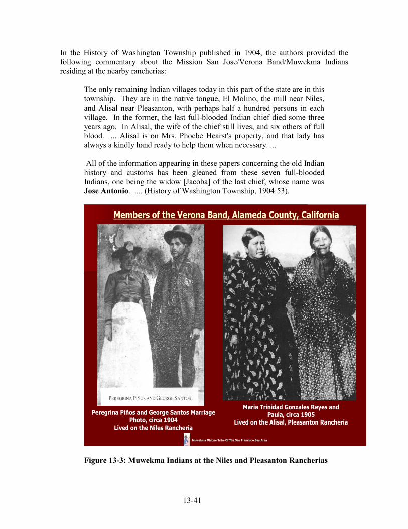
13-41
In the History of Washington Township published in 1904, the authors provided the following commentary about the Mission San Jose/Verona Band/Muwekma Indians residing at the nearby rancherias:
The only remaining Indian villages today in this part of the state are in this township. They are in the native tongue, El Molino, the mill near Niles, and Alisal near Pleasanton, with perhaps half a hundred persons in each village. In the former, the last full-blooded Indian chief died some three years ago. In Alisal, the wife of the chief still lives, and six others of full blood. ... Alisal is on Mrs. Phoebe Hearst's property, and that lady has always a kindly hand ready to help them when necessary. ... All of the information appearing in these papers concerning the old Indian history and customs has been gleaned from these seven full-blooded Indians, one being the widow [Jacoba] of the last chief, whose name was Jose Antonio. .... (History of Washington Township, 1904:53).
Maria Trinidad Gonzales Reyes andPaula, circa 1905
Lived on the Alisal, Pleasanton Rancheria
Peregrina Piños and George Santos Marriage Photo, circa 1904
Lived on the Niles Rancheria
Members of the Verona Band, Alameda County, California
Muwekma Ohlone Tribe Of The San Francisco Bay Area
Figure 13-3: Muwekma Indians at the Niles and Pleasanton Rancherias

13-42
From the interviews conducted between 1925-1930 with Muwekma Elders Jose Guzman and Maria de los Angeles Colos, Bureau of American Ethnology linguist John Peabody Harrington, was able to learn that Capitan Jose Antonio‘s Indian name was Hu'ská (Harrington Field Notes 1921-1934). Jose Antonio was a great-great-grand relation to the some current generation of the Muwekma Elders and ex-council members such as Lawrence Marine, Jr. and his younger brother Marvin Lee Marine are directly descended from him and Jose Guzman. Jose Guzman had married Jose Antonio‘s daughter Augusta. After his death in 1897, Jose Antonio‘s wife Jacoba, who was a mayen (meaning the wife of a captain or a female chief), directed that the ceremonial sweat-lodge (or tupentak in Chocheño) be torn down, in keeping with tradition (Galvan 1968). A new tupentak was not constructed, as it would have been in previous times, because the community did not formally select a new captain. Apparently, the political power was inherited by Jacoba through marriage as well as her descendency from her parents Capitan Taurino and Joaquina. According to Muwekma oral tradition, it was Raphael Marine, husband of Avelina Cornates Marine who was tasked to take down the old ceremonial Tupentak roundhouse. Interestingly, just two years prior to his death, Capitan Jose Antonio and his wife Jacoba served as godparent to Raphael and Avelina‘s fourth daughter, Mercedes Marine (co-authors Monica V. Arellano and Gloria Gomez‘s great-grandmother) who after the death of her mother, in 1904, was raised on the Alisal rancheria by Jacoba. (1910 Federal Indian Population Census, ―Indian Town,‖ Pleasanton Township, Alameda County.) Also raised by Jacoba was Catherine Peralta who was identified on the 1900 Federal Indian Census (Washington Township); Kelsey's 1905-1906 Special Indian Census; (Heizer 1971); and the 1910 Federal Indian Population Census (Pleasanton Township) as an Indian resident of the Alisal Rancheria in Alameda County (Figure 13-4).

13-43
Washington Township (Niles Rancheria) Indian Population Census - June 4, 1900Alameda County, California
Muwekma Ohlone Tribe Of The San Francisco Bay Area
Figure 13-4: 1900 Indian Population Census, Niles, Washington Township, Alameda Just before the turn of the 20th century (1897) there were still at least eleven casitas (houses) and the Tupentak (temescal) still standing on or near the Alisal Rancheria. During this critical period of time, the Guzman, Armija, Santos, Pinos, Marine, Nichols, Inigo (Alaniz), and other interrelated Muwekma (Verona Band) families remained in Pleasanton or near the original Alisal Rancheria until fire destroyed the remaining houses due to work along the Western Pacific Railroad tracks sometime around 1916. The house of Catherine Peralta (granddaughter of Jose Guzman) and Dario Marine (eldest son of Avelina Cornates Marine) which was originally owned by Jacoba and Jose Antonio had burned down as a result of that fire. Prior to the fire, Catherine and Dario had raised their first four children, Beatrice (born 1909), Josephine (b. 1911), Evelyn (b. 1914) and Filbert Marine (b. 1915) on the rancheria. By the time their fifth child, Lawrence Domingo Marine was born in 1919, they had moved to 544 Alvarado-Centerville Road in Centerville now part of the City of Fremont (see 1900 and 1910 Indian Censuses and 1920 Census, Washington Township; Harrington field notes; Olsen, Leventhal and Cambra 1985; 1928-1933 California Enrollment Applications # 10298 and 10675; 1910, 1920 and 1930 Federal Censuses).
13-44
After the Alisal Rancheria was abandoned, the various surviving Muwekma families continued to work locally in the East Bay, residing on ranches, vineyards, hopyards and renting homes in Niles (e.g., Shinn property), Newark, Centerville, Fremont, Milpitas, Pleasanton, Sunol, Livermore, Alameda and elsewhere. The Muwekmas continued to live peaceably near the Alisal Rancheria as long as they could and had continued to visit and use the locality as best they could. Avelina Marine's children [Dario, Dolores, Elizabeth (Belle), Ramona, Mercedes, Victoria, Lucas and Trina] along with the Nichols, Guzman, Binoco, Pinos, Santos, Inigo, Juarez, Armija and other Muwekma families, had to readapt and relocate to other nearby residences in order to work and maintain their families. Some of the men worked for Southern Pacific Railroad, Spring Valley Water Company, Leslie Salt, and on the local orchards, ranches, and farms. During the 20th century Muwekma families continued to marry and baptize their children at Mission San Jose, St. Augustine's Church in Pleasanton, Corpus Christi in Niles, and St. Edwards in Newark. Photographic and other records showing life around the Alisal Rancheria and neighboring areas from the early 1900s, WW I, the depression, and WW II survive. Kelsey Special Indian Census 1905-1906, Congressional Homeless California Indian Act of 1906, and the Federal Recognition of the Muwekma/Verona Band of Alameda County In 1905, as a result of the discovery of the 18 unratified California Indian Treaties (which were negotiated between 1851-1852) from the U. S. Senate Archives, Mr. Charles E. Kelsey of San Jose, who was affiliated as the Secretary of the Northern Association for California Indians was appointed Special Indian Agent to California by the Commissioner of Indian Affairs (Indian Service Bureau/Bureau of Indian Affairs) in Washington, D.C. In 1905, Agent Kelsey was charged by the Bureau to conduct a Special Indian Census, and identify all of the landless and homeless California tribes and bands residing from north of Los Angeles to the Oregon border. Based upon the results of Kelsey‘s Special Indian Census, and the discovery of the 18 unratified California Indian treaties from the secret Senate archives, Congress passed multiple Appropriation Acts beginning in 1906 on through 1937, for the purpose of purchasing ―home sites‖ for the many surviving California Indian tribes and bands. One of the bands officially identified by Special Indian Agent Kelsey was the Verona Band of Alameda County residing between Pleasanton, Sunol and Niles (as well as other areas and ranches surrounding Mission San Jose). The direct ancestors of the present-day Muwekma Tribe who comprised the Verona Band became Federally Acknowledged by the U.S. Government through the Appropriation Acts of Congress beginning in 1906. Between the years 1906 and 1927, the Verona Band fell under the direct jurisdiction of the Indian Service Bureau in Washington, D.C., and by 1914, the Tribe‘s jurisdiction was transferred to the Reno Agency, and later again, transferred over to the Sacramento Agency (sometime after 1923). During this time, U. S. Government

13-45
Indian Service Bureau agents attempted to purchase land for many of the Federally Recognized, but still landless, California Indian tribes and bands. To this effort, both the Indian Service Bureau agents and the Indian bands were faced with two major problems:
1) Many Californian landowners did not want Indians living next to or near them, so they would not sell suitable parcels of land
2) Others who were willing to sell parcels to the government wanted greatly inflated prices, usually at prices much higher than what was either allocated to purchase lands, or above the actual value of the land.
After the Congressional Appropriation Acts of 1906, 1908 and ensuing years (as late as 1937) many Indians in California obtained trust lands as members of tribes which had not abandoned their respective tribal areas, and these homesites became known as Indian ―rancherias.‖ [see the Indian Homestead Act of March 3, 1875 (18 Stat. L. 420), 25 U. S. C. 334, 336, Feb.. 8, 1887, Ch.. 119, Sec. 4, and other statutes, (34 Stat. 325, June 24, 1906 and 35 Stat. 70, April 30, 1908), and using an added set aside of $10,000 under the Joint Resolution of March 4, 1915 (CR 6122, March 4, 1915)]. The evidence of previous Federal Recognition of virtually all the present-day unacknowledged tribal groups in California and especially in this case, the Verona Band of Alameda County, is found in the Federal records at the National Archives (Record Group 75. California Consolidated Files, Cal. Special, file # 12026113-032, filed with 114202-13-032; Map, accompanying Letter of October 41 1913, Special Indian Agent for California C. E. Kelsey to Commissioner in response to request for information from 2nd Dist. Congressman John Raker, 9/22/1913. See file # 114202) (Figure 13-5 – Special Indian Agent Kelsey’s Map of Indian Rancherias – Verona Band).

13-46
Map of CaliforniaShowing location of Indians
By C.E. Kelsey, Special Agent for the California Indians
July 1, 1910
Alameda County
* Verona 30*MissionSan Jose
Muwekma Ohlone Tribe Of The San Francisco Bay Area
Indian Rancherias
Figure 13-5: Indian Agent Kelsey’s Map of Indian Rancherias – Verona Band By 1913, being exhausted and personally in debt over $18,000, Special Indian Agent C. E. Kelsey tendered his formal resignation. It was not until a year later that a new agent was selected to replace Kelsey. Writing to the Commissioner of Indian Affairs on Dec. 7, 1914, from the Reno, Nevada Indian Agency, Charles H. Asbury, already named Special Indian Agent for California, reported progress in his investigation of the character, location and need of landless California Indians. It is noteworthy that he called on his predecessor C. E. Kelsey for help in locating 30 individuals at Verona, and then proceeded to suggest that they receive assistance in a land purchase in his report to the Commissioner. However, a thorough investigation of the Indians of California not provided with land would have required a great deal of time and expense. Being understaffed and located in Reno, Special Agent Asbury was not able to accomplish anything on behalf of the landless California Indian bands and he was reassigned to the Indian Agency in the Southwest sometime in 1915. John Terrell was then selected as a replacement as Special Indian Agent for most of northern and central California by May 1915 and he continued to conduct on-site inspections and make censuses of many the bands that were under his jurisdiction. However, during Terrell‘s tenure between 1915 and 1919, his efforts were oriented towards ―needy‖ tribes and bands that were located in northern California counties (e.g., Mendocino and north) as

13-47
well as the Sacramento Valley and the Sierra. Those tribes that were located within the northern ―mission area‖ including the Muwekma (Verona Band of Alameda County), Amah Mutsun (San Juan Bautista Band), Esselen Nation (Monterey Band of Monterey County), the Salinan tribal communities (Pleyto, Milpitas and Jolon) centering around Missions San Miguel and San Antonio, as well as the Coast Miwok located at the towns of Bodega Bay, Marshall, and Fishman were all but ignored and neglected. After Terrell left the Indian Service, the jurisdiction fell to James Jenkins, Superintendent of the Reno Agency. Writing his Annual Report to the Commissioner of Indian Affairs in 1923, Superintendent Jenkins commented:
The jurisdiction of Reno Agency comprises the following named reservations and colonies, villages, camps, etc., in addition to all scattered bands of Indians in Nevada and California not under the jurisdiction of any other superintendency; also Indians whose allotments, homesteads, etc., are carried at the land offices located at Stockton, Sacramento, Visalia, San Francisco, Los Angeles, and Independence and Marysville, California, and Carson City and Elko, Nevada. …
… Other Indians in California under this jurisdiction but not occupying government lands are found in the localities named below: County Communities Estimated … Alameda Verona 30
(1923 Annual Report:3-5) Sometime after 1923, the jurisdiction of the landless Indians of northern central California had shifted to the Sacramento Agency under the aegis Colonel Lafayette A. Dorrington, who was a prison warden in the Philippines during the American occupation. Dorrington, who was probably a political appointee to the Sacramento Superintendency and was probably rewarded for his military service as a prison warden. In January 1927, Sacramento Superintendent Col. Lafayette A. Dorrington (1918-1930) received a detailed office directive from Assistant Commissioner E. B. Merritt for him to list by county all of the tribes and bands under his jurisdiction that had yet to obtain a land base for their ―home sites.‖ This directive was issued so that Congress could plan its allocation budget for fiscal year 1929. Dorrington, who was not an advocate for California Indians, was chronically derelict in his duties and he decided not to respond to this directive. He also decided not to respond to many of the other requests issued by the Washington, D. C. Office. By May 1927, under threat of investigation, Dorrington yet again received another strongly worded directive from the Assistant Commissioner E. B. Merritt.
13-48
To this second directive, Dorrington reluctantly responded on June 23, 1927 by generating a report, which in effect, illegally, unilaterally and administratively ―terminated‖ the existence and needs of approximately 135 tribes and bands throughout northern California from their Federally Acknowledged status. He did this by completely dismissing the needs of these identified homeless and landless tribal groups. The very first casualty on Dorrington‘s ―hit list” was the Verona Band of Alameda County. Without any benefit of any on-site visitation or needs assessment, which he was charged to conduct by the Assistant Commissioner, Dorrington opined:
There is one band in Alameda County commonly known as the Verona Band, … located near the town of Verona; these Indians were formerly those that resided in close proximity of the Mission San Jose. It does not appear at the present time that there is need for the purchase of land for the establishment of their homes. (Report dated June 23, 1927)
The fact that Dorrington makes mention that the Verona Band resided ―near the town of Verona‖ makes it clear that he never visited the Muwekma Tribal community. There is no town of Verona in Alameda County. Thus with the stroke of a pen and without benefit of any due process or direct communication with the tribe, the Muwekma/Verona Band along with the other 134 tribes and bands of California, apparently lost their formal status as Federally Recognized Tribes. These tribes were essentially knocked off the ―radar screen‖ of the Bureau of Indian Affairs and as a landless tribe were considered ineligible to organize as tribes under the 1934 Indian Reorganization Act. During the 20th Century, no other state within the United States had experienced the massive illegal termination of so many Federally Recognized tribal groups. This massive dismissal and removal was deliberate and due as a result of the callous actions and dereliction of duty by an incompetent Bureau of Indian Affairs agent. Three years later, Dorrington, still being prodded by BIA officials in Washington, D.C. about the needs of the landless and homeless Indians in California under his jurisdiction, offered insight to his actions and his personal beliefs in a letter he wrote to Commissioner Rhoads. In that letter dated April 23, 1930, Dorrington wrote:
…Kindly be respectfully advised that the matter of land purchase for homeless Indians has really been given constant and diligent attention throughout the current fiscal year to date and an earnest effort has been made to fully meet the needs of the Indians to the fullest extent without unnecessary or unjustified expenditure of funds, believing that to be the spirit of the law and your wishes in the premises. … It has been my opinion, and therefore my belief, for several years that the best interests of the Indians will be served through an arrangement whereby those concerned may be settled on the already acquired land instead of procuring additional which cannot be turned to beneficial
13-49
use and occupancy by the Indians in mind because of their inability financially to establish themselves thereon. …In its final analysis, Mr. Commissioner, kindly understand and know that additional land for homeless Indians of California is not required and therefore further demands on the appropriation for the fiscal year 1930 are not warranted or justified (Dorrington Letter to Commissioner Rhoads April 20, 1930). [Emphasis added]
By July 1931, Dorrington had either quit the Indian Service or was transferred or was fired and he was replaced by Oscar H. Lipps as Superintendent of the Sacramento Agency. Lipps, responding to an inquiry written by Assistant Commissioner J. Henry Scattergood offered specific concerns about the conditions of the homeless California Indians for whom land was purchased:
Receipt is acknowledged of your letter, dated June 30, 1931, relating to the matter of purchasing land for homeless Indians of California. …I am addressing this letter to you personally and calling the subject matter thereof to your special attention for the reason that there appears to be a grave lack of understanding in the Office regarding this whole matter of providing homes for homeless California Indians. …… I think it is all the more important that this matter be brought to your personal attention at this time in view of your recent visit to California with the Senate Committee and your familiarity with the sentiment and feeling in this State with respect to the past administration of the affairs of the California Indians. The conditions on some of these rancherias are simply deplorable. No one can view many of them and observe the conditions under which the Indians are trying to exist without the feeling that some one is guilty of gross neglect or inefficiency and that a cruel injustice has been meted out to a helpless people under the name of beneficent kindness… And yet there are those who say that I will never do to let the local authorities have charge of the affairs of the Indians lest the Indians be neglected and abuse. …I have not yet seen a single instance where the federal government has done anything like so much for the improvement of the homes and living conditions of the Indians under this jurisdiction as has been done by Sonoma County for the Indians residing on the Stewart‘s Point Rancheria. Now it seems to me that the thing for us to do is to look at the facts in the face and admit that in the past the Government has been woefully negligent and inefficient, and then start out with the determination, as far as possible, to rectify our past mistakes. It is difficult to locate the blame,

13-50
but somewhere along the line there appears to have been gross negligence or crass indifference. If Congress has been honestly and fully advised of conditions and has refused or failed to give relief asked for, then the Indian Bureau is not responsible for the neglect of the Indians. On the other hand, if Congress believed and intended by appropriating funds for the purchase of lands for homeless Indians and improvements thereon that good and suitable lands would be purchased and houses constructed and improvements made, then we have neglected to do our duty. [Emphasis added]
Although left completely landless, and in some instances completely homeless, between 1929 and 1932 all of the surviving Verona Band/Muwekma lineages enrolled with the BIA under the 1928 California Indian Jurisdictional Act which were approved by the Secretary of Interior in the pending claims settlement. Concurrently, during the first part of the 20th century (between 1884 and 1934), renowned anthropologists and linguists such as Jeremiah Curtin, Alfred Kroeber, E. W. Gifford, James Alden Mason, C. Hart Merriam and John Peabody Harrington interviewed the last fluent speakers of the ―Costanoan‖ and other Indian languages spoken at the East Bay rancherias. It was during this time period that Verona Band Elders still employed the linguistic term “Muwekma” which means “la Gente or the People” in Chocheño and Tamien Ohlone language spoken in the East and South San Francisco Bay region. A Call to War: Muwekma Men Enlist in the US Armed Forces during World War I Even before California Indians legally became citizens in 1924, prior to and at America‘s entrance into World War I, at least six Muwekma men served in the United States Armed Forces in the Army, Navy, and Marine Corps. These men enlisted through the San Francisco Presidio and Mare Island and four of them are buried at the Golden Gate National Cemetery: Antonio (Toney) Guzman, U.S. Army, Private, Battery F., 347th Field Artillery, 91st Division. Toney Guzman was born on March 27, 1890 either in Centerville or on the Niles Rancheria. He was the son of Muwekma Indians Francisca Nonessa and Jose Guzman. Toney enlisted in the U.S. Army and he fought in the Meuse-Argonne (September 26 to October 8, 1918), Ypres-Lys, and Lorraine campaigns in France. Toney served in the Army from April 29, 1918 and was honorably discharged at the San Francisco Presidio on April 26, 1919. The 91st Division was known as the "Wild West Division." The Division's shoulder patch was a green fir tree referring to its origin at Camp Lewis in the Pacific Northwest. The Division was deployed to France in August, 1918 and fought with great distinction. In the Ypres-Lys campaign, the Division served in the Flanders Army Group, under the command of the King of Belgium. The Division was headquartered adjacent to Flanders Field. Five members of the Division earned the Congressional Medal of Honor. The 347th Field Artillery Regiment was assigned 4.7" inch guns, and the 91st Division received the following Victory Medal Clasps: Ypres-Lys, St. Mihiel, Meuse-

13-51
Argonne and Defensive Sector. In October 1931, Toney Guzman and his brothers, enrolled with the Bureau of Indian Affairs under their mother‘s BIA Application #10293. On his WW II Registration Card dated April 27, 1942, Toney was identified as ―Indian”. Toney passed away on October 8, 1948 and was buried on October 12, 1948 at the Golden Gate National Cemetery (Section J, Grave 254).
Alfred (Fred) Guzman, U.S. Army, Private, Company “C,” 110th Infantry, 28th Division under Brigadier General T. W. Darrah. Alfred Guzman was born on the Pleasanton Rancheria on June 27, 1896 to Francisca and Jose Guzman. Prior to the declaration of War, Fred Guzman had served in the National Guard at Fort Mason in San Francisco in 1917. Afterwards he enlisted in the U.S. Army, and served in the 28th Division, 55th Brigade Infantry, 110th Infantry, Company “C” and fought in the major battles at Ourcq-Vesle (July 28, 1918), Second Battle of the Marne (July 15-August 5, 1918), Meuse-Argonne Offensive (September 26 to October 8, 1918), and Havrincourt (October 8 – November 11, 1918) in France. The 28th Division fought in the following campaigns: Champagne-Marne, Aisne-Marne, Oise-Aisne, Meuse-Argonne, Champagne (1918), Lorraine (1918). The cost in lives of these six campaigns was 4,183 casualties including 760 dead. The six fleurs-de-lis on the regimental insignia commemorates their World War I service. The 28th Infantry Division was a unit of the United States Army formed in 1917 at the outbreak of World War I. It was nicknamed the "Keystone Division", as it was formed from units of the Pennsylvania Army National Guard; Pennsylvania is known as the "Keystone State". It was also nicknamed the "Bloody Bucket" division by German forces in WWII, after its red insignia. Fred Guzman served from July 28, 1917 and was honorably discharged at San Francisco Presidio on May 31, 1919. On his WW II Registration Card dated April 25, 1942, Fred is identified as Indian. Fred Guzman died on November 3, 1961 and was buried at the Golden Gate National Cemetery (Section Y, Grave 1059). Joseph Aleas, U.S. Army, Sergeant, Company D, 21st MG BN, 7th Division. Joseph Aleas was born on the Alisal (Pleasanton) Rancheria on May 11, 1893 and was the son of Margaret Armija. He enlisted in the US Army on June 30, 1916. According to Armija-Thompson family recollections, he was a good horseman and wanted to fight against Pancho Villa had led approximately 1,500 Mexican raiders in a cross-border attack against Columbus, New Mexico, in response to the U.S. government's official recognition of the Carranza regime. Villa‘s troops attacked a detachment of the 13th U.S. Cavalry, seized 100 horses and mules, burned the town, killed 10 soldiers and eight of its residents, and made off with ammunition and weapons. President Woodrow Wilson responded by sending 6,000 troops under General John J. Pershing to Mexico to pursue Pancho Villa and his troops. This military mobilization was called the Punitive or Pancho Villa Expedition. Later, Joseph Aleas served in France in the 21st Machine Gun Battalion, 7th Division (its Hourglass insignia dates back to 1918). Organized originally to serve in the American Expeditionary Forces (AEF) during World War I, the U.S. Army's 7th Infantry Division was created at Camp Wheeler, Georgia on December 6, 1917 and it fought in Alsace-Lorraine, France during the war. The division also served as an occupation force

13-52
in the post-war period. On October 10-11, 1918 the 7th was shelled for the first time and later it encountered gas attacks in the Saint-Mihiel woods. Defensive occupation of this sector continued from October 10th to November 9th during which the infantry regiments of the 7th Division probed up toward Prény near the Moselle River, captured Hills 323 and 310, and drove the Germans out of the Bois-du Trou-de-la-Haie salient. After 33 days in the line of fire the 7th Division had suffered 1,988 casualties, of which three were prisoners of war. Thirty Distinguished Service Crosses were awarded members of the 7th Division. Joseph Aleas was honorably discharged at Camp Funston, Riley, Kansas on July 9, 1920 and was awarded the World War I Victory Medal and the Bronze Victory Button. Joseph Aleas enrolled with the Bureau of Indian Affairs in October 1931 (BIA Application # 10299). On May 24, 1955 Joseph enrolled during the second enrollment period with the Bureau of Indian Affairs. Joseph Francis Aleas passed away July 13, 1964 and was buried at the Gold Gate National Cemetery Plot Z, grave 2597 (See Figure 13-6). Henry Abraham Lincoln Nichols, U.S. Navy, Fireman 1st Class, Battleships USS
Arizona and USS Oklahoma. Henry Nichols was born in Niles on February 12, 1895 to Charles Nichols and Muwekma Ohlone Susanna Flores Nichols. Henry enlisted on May 23, 1917 and first served on the USS Albatross. By December 31, 1917 he was transferred to the Battleship USS Arizona, and later on March 26, 1918 he was transferred again to the Battleship USS Oklahoma. During World War I Henry Nichols served in the North Atlantic and was on escort duty in December 1918 when the Oklahoma was serving as escort during President Woodrow Wilson‘s arrival in France at the end of the war (November 11, 1918). The Oklahoma returned to Brest, France on June 15, 1919 to escort home President Wilson who was transported on the USS George Washington from his second visit to France. Henry Nichols was honorably discharged at Mare Island on August 14, 1919 and was issued the World War I Victory Medal. On Henry Nichols Draft Registration Card dated April 27, 1942 he is identified as Indian. Henry Nichols passed away on January 5, 1956 and was buried at the Golden Gate National Cemetery (Section L-5, Grave 7455). Franklin P. Guzman (Service # 87843) Sergeant, U.S. Second Marine Corps Division, Fourth Marine Infantry Brigade, Sixth Machine Gun Battalion, 81st “D” Company. Franklin was born on the Alisal Rancheria on January 15, 1898 and was the son of Pleasanton Indians Teresa Davis and Ben Guzman (who later died in 1907). He was also the nephew of Toney and Fred Guzman. Franklin was listed on the 1910 Federal Indian Population Census for ―Indian Town‖, Pleasanton Township. He enlisted on October 20, 1916 while working near Sacramento, reported for duty on October 25, 1916 and was assigned to Company “B” Marine Barracks, Navy Yard, Mare Island. On May 28, 1917 Franklin was promoted to the rank of Corporal. By March 31, 1918, he earned an Expert Rifleman Badge and a Marksman Badge and by April he was assigned to the 111th Company, 8th Regiment. In May, Franklin was transferred to the 150th Company 1st Machine Gun Replacement Battalion at Quantico, Virginia and he was promoted to Sergeant on May 22, 1918.

13-53
The 1st Machine Gun Replacement Battalion sailed on May 26, 1918 on the USS
Henderson and disembarked in France on June 8, 1918. The 1st Machine Gun Battalion was later renamed the 6th Machine Gun Battalion in France. From September 12 to 16, 1918 the brigade was engaged in the St. Mihiel offensive in the vicinity of Remenauville, Thiaucourt, Xammes, and Jaulny. On September 16, 1918, he was wounded in the left thigh and from September through December he was placed in various Field and Base Hospitals in France, and finally transferred back to the States on December 16, 1918. Franklin remained in recovery at the US Navy Hospital at Norfolk, Virginia until he was honorably discharged from service as a Sergeant on June 27, 1919. Franklin‘s Battalion participated in the Chateau-Thierry sector (capture of Hill 142, Bouresches, Belleau Wood) from June to July, 1918; Aisne-Marne (Soissons) offensive from July 18 to July 19, 1918; Marbache sector, near Pont-a-Mousson on the Moselle River from August 9 to August 16, 1918; St. Mihiel from September 12 to September 16, 1918; and later the Meuse-Argonne offensive (October 1 to 10, 1918, and November 1 to 10, 1918).. Franklin passed away on May 30, 1979 and was buried in the Riverside National Cemetery (Section 8, Grave 2826). John Michael Nichols was the older brother of Henry Nichols and he served in the U.S. Army from 1914 to1920. John enlisted on October 27, 1914 at Fort McDowell on Angel Island. He fought in France serving with the 59th Coast Artillery Corps. The 59th was engaged in the St. Mihiel offensive and the Meuse-Argonne offensive. John was discharged at Fort Winfield Scott at the SF Presidio on June 4, 1920. John M. Nichols was listed as an Indian on the 1930 Federal Census along with his son Alfred in Santa Cruz County. On John Nichols‘s Draft Registration Card dated April 27, 1942 he was identified as residing at the Veteran‘s Home in Napa (Yountville), California and he had resided there from 1941 to 1953. John Nichols died in April 1968 while living in Stockton, California.
Figure 13-6: Grave Sites of Joseph Aleas, Fred Guzman and Toney J. Guzman

13-54
Muwekma Enrollment with the Bureau of Indian Affairs (1928-1932): The California Indian Jurisdictional Act of 1928 In 1928, the United States Congress passed the California Indian Jurisdictional Act, which created a census of all eligible Indians who could prove that their ancestors resided in California at the time when the 18 unratified treaties were negotiated between1851-1852. Between the years 1928 and 1932 almost all of the Muwekmas enrolled as ―Ohlones‖ and/or ―Mission San Jose Tribe‖ under this act and their applications were approved by the Secretary of Interior, the BIA and Federal Court (Figures 13-7- 13-11: - Muwekma Ohlone BIA 1928-1932 Applications).
Figure 13-7: Lucas Marine BIA Application # 10298

13-55
Figure 13-8: Lucas Marine BIA Application Identifying His Tribe “Ohlones”

13-56
Figure 13-9: Francisca Guzman and Family BIA Application # 10293

13-57
Figure 13-10: Phoebe Alaniz BIA Application # 10301

13-58
Figure 13-11: Magdalena Thompson BIA Application # 10296
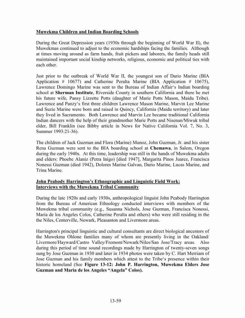
13-59
Muwekma Children and Indian Boarding Schools During the Great Depression years (1930s through the beginning of World War II), the Muwekmas continued to adjust to the economic hardships facing the families. Although at times moving around as farm hands, fruit pickers and laborers, the family heads still maintained important social kinship networks, religious, economic and political ties with each other. Just prior to the outbreak of World War II, the youngest son of Dario Marine (BIA Application # 10677) and Catherine Peralta Marine (BIA Application # 10675), Lawrence Domingo Marine was sent to the Bureau of Indian Affair‘s Indian boarding school at Sherman Institute, Riverside County in southern California and there he met his future wife, Pansy Lizzette Potts (daughter of Marie Potts Mason, Maidu Tribe). Lawrence and Panzy‘s first three children Lawrence Mason Marine, Marvin Lee Marine and Suzie Marine were born and raised in Quincy, California (Maidu territory) and later they lived in Sacramento. Both Lawrence and Marvin Lee became traditional California Indian dancers with the help of their grandmother Marie Potts and Nisenan/Miwuk tribal elder, Bill Franklin (see Bibby article in News for Native California Vol. 7, No. 3, Summer 1993:21-36). The children of Jack Guzman and Flora (Marine) Munoz, John Guzman, Jr. and his sister Rena Guzman were sent to the BIA boarding school at Chemawa, in Salem, Oregon during the early 1940s. At this time, leadership was still in the hands of Muwekma adults and elders: Phoebe Alaniz (Petra Inigo) [died 1947], Margarita Pinos Juarez, Francisca Nonessi Guzman (died 1942), Dolores Marine Galvan, Dario Marine, Lucas Marine, and Trina Marine. John Peabody Harrington’s Ethnographic and Linguistic Field Work: Interviews with the Muwekma Tribal Community During the late 1920s and early 1930s, anthropological linguist John Peabody Harrington from the Bureau of American Ethnology conducted interviews with members of the Muwekma tribal community (e.g., Susanna Nichols, Jose Guzman, Francisca Nonessi, Maria de los Angeles Colos, Catherine Peralta and others) who were still residing in the the Niles, Centerville, Newark, Pleasanton and Livermore areas. Harrington's principal linguistic and cultural consultants are direct biological ancestors of the Muwekma Ohlone families many of whom are presently living in the Oakland/ Livermore/Hayward/Castro Valley/Fremont/Newark/Niles/San Jose/Tracy areas. Also during this period of time sound recordings made by Harrington of twenty-seven songs sung by Jose Guzman in 1930 and later in 1934 photos were taken by C. Hart Merriam of Jose Guzman and his family members which attest to the Tribe‘s presence within their historic homeland (See Figure 13-12: John P. Harrington, Muwekma Elders Jose Guzman and Maria de los Angeles “Angela” Colos).

13-60
J. P. Harrington's field notes (dated October 12, 1929, October, 1934) provides information about the culture, history and languages spoken by the Verona Band/Mission San Jose Indians. Jose Guzman and Angela Colos shared the following information with him:
- The San Jose Indians were of many tribes gathered at the mission. They are called Chocheños. - I asked inf. how to say Abajeños, but inf. never heard the term. But inf. knows how to say arribenos.... when I asked if these were the Indians of Oakland, Inf. said no, that they were from [Martinez]. - Inf. does know one tribe, Halkin. It is the name of a tribe up San Rafael way. Liberato here was a Halkin, or was said to be one. [inf.] told him he was a Halkin, and Liberato got mad, denied it.... He [Jose Guzman] made a map, showing the location of "Hacienda Station" for Mrs. Hearst's place. - From Sunol, … he drew a line, indicating the former location of "Barona" [Verona] Station north of the San Jose Mission. Then, he noted under Roundhouse/Dancehouse: - Was a big temescal just up the road from here. Until recently could see the place. Door inside and a big hole & also a smaller hole in the roof. Tu'pentak, temescal. Used to have fiestas here.
Jose Guzman Maria De Los Angeles Colos
(circa 1934) (circa 1929)
J.P. HARRINGTONPRINCIPAL CHOCHENYO LANGUAGE INFORMANTS
1921 - 1930
John Peabody Harrington(1884 – 1961)
Muwekma Ohlone Tribe Of The San Francisco Bay Area
Figure 13-12: J. P. Harrington, Muwekma Elders Jose Guzman and Angela Colos

13-61
The Outbreak of World War II: Muwekma Men Again Answer the Call to War During World War II, almost all of the Muwekma men served in the United States Armed Forces both in the Pacific and European theaters and stateside. Hank A. Alvarez, Pfc. U.S. Army, 101st Airborne Division landed Utah Beach Normandy. Hank was born on February 27, 1922 in San Jose. He spent his childhood in Santa Cruz, Alvarado and Brentwood. While living in Brentwood, on March 18, 1932, his mother Dolores Marine enrolled herself and her children with the Bureau of Indian Affairs (BIA Application # 10681). Hank enlisted at the San Francisco Presidio and served from December 28, 1942 to December 15, 1945 in the 101st Airborne Division. He returned home from Europe with the 82nd Medical Battalion, 12th Armored Division. While serving in the 101st Airborne Division he landed at Utah Beach in Normandy, he was later reassigned to the 106th Infantry Division, 423rd Infantry Regiment, Company B and continued to fight in France, Belgium, Luxembourg and Germany. He regiment saw action at Saint Laurent sur Mer and Saint Nazaire, France, and near Malmedy, Belgium. Later, Hank was reassigned to the 326th Engineer Battalion during the Battle of the Bulge at Bastogne and at the Ramagen Bridge crossing the Rhine River in Germany. After landing in Europe Hank‘s units fought in the following campaigns with the 101st Airborne Division: Ardennes, Rhineland (GO 40 WD 45), and Northern France (GO 33 WD 45). Hank was issued the following medals and badges: Sharpshooter M1, WWII Victory Medal, and European African Middle East Campaign Medal. The 101st Airborne Division and the 106th Infantry Division earned Presidential Unit Citations. Hank was honorably discharged at Camp Beale, California on December 15, 1945. Hark enrolled himself and his family with the BIA on April 26, 1950 during the second enrollment period. During the early 1960s Hank served in a leadership position along with his brothers and sister to save the Tribe‘s Ohlone Indian Cemetery from destruction. Hank has served on the Muwekma Tribal Council since 1992 and is presently the oldest surviving member of the Verona Band of Alameda County and oldest veteran in the Tribe. John (Johnnie) Abraham Alvarez was the older brother of Hank Alvarez. John Alvarez was born on May 24, 1914 in San Jose and spent most of his life living in Santa Cruz. He was enrolled with his siblings with the BIA in March 1932. John enlisted in U.S. Army on October 22, 1941 just prior to America‘s Declaration of War against Japan, Germany and Italy and he served as a Pfc. in the U.S. Army Air Corps in the Pacific Theater. He was honorably discharged on November 20, 1945 and received the American Defense Service Medal, American Campaign Medal, WWII Victory Medal, and Honorable Service Lapel Button WWII. John Alvarez died on March 6, 2002. Francis Salvador “Sal” Samuel Dominic Piscopo, Sergeant Technical [E-7] U.S. Army, European Theater. Salvador was born in San Jose on October 1, 1923 and was a younger brother of Hank Alvarez. He went by the name of Samuel Dominic by the time he enlisted in the US Army. He was enrolled on March 18, 1932 with the Bureau of
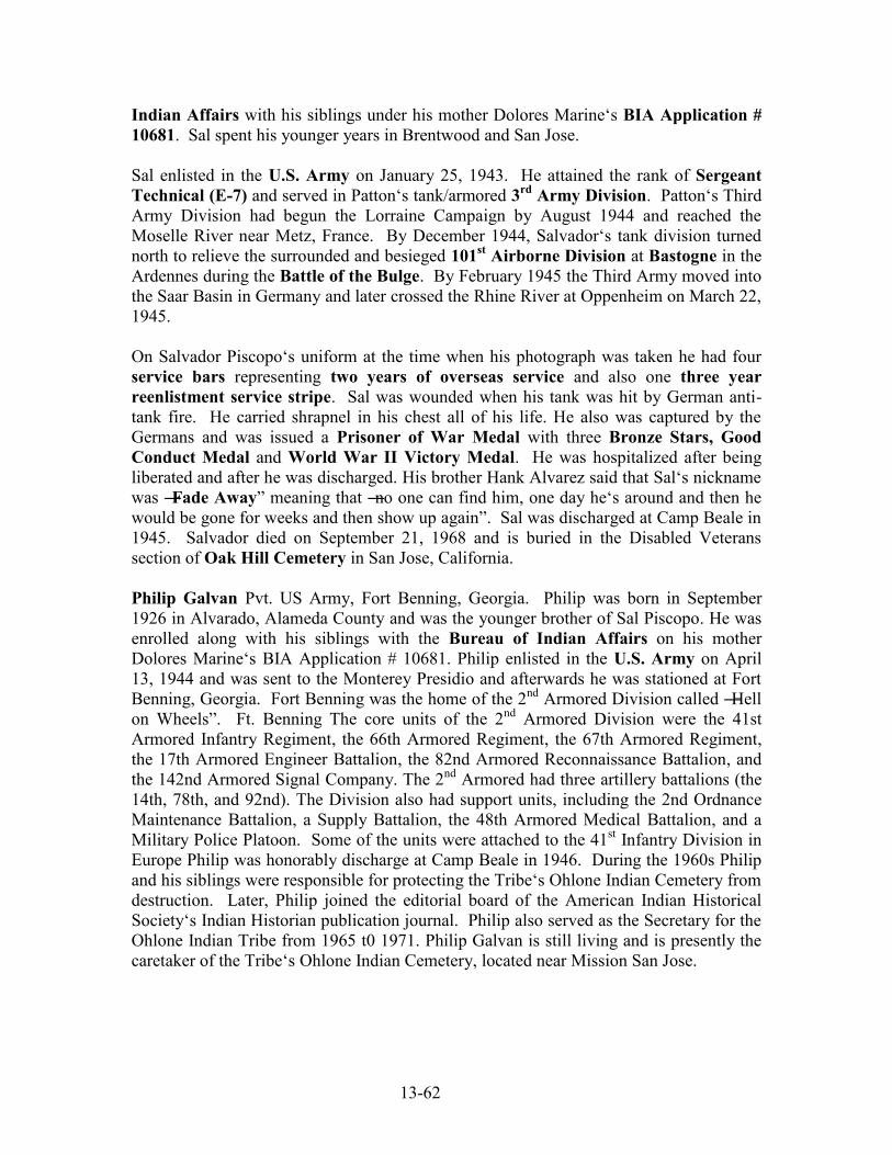
13-62
Indian Affairs with his siblings under his mother Dolores Marine‘s BIA Application # 10681. Sal spent his younger years in Brentwood and San Jose. Sal enlisted in the U.S. Army on January 25, 1943. He attained the rank of Sergeant Technical (E-7) and served in Patton‘s tank/armored 3rd Army Division. Patton‘s Third Army Division had begun the Lorraine Campaign by August 1944 and reached the Moselle River near Metz, France. By December 1944, Salvador‘s tank division turned north to relieve the surrounded and besieged 101st Airborne Division at Bastogne in the Ardennes during the Battle of the Bulge. By February 1945 the Third Army moved into the Saar Basin in Germany and later crossed the Rhine River at Oppenheim on March 22, 1945. On Salvador Piscopo‘s uniform at the time when his photograph was taken he had four service bars representing two years of overseas service and also one three year reenlistment service stripe. Sal was wounded when his tank was hit by German anti-tank fire. He carried shrapnel in his chest all of his life. He also was captured by the Germans and was issued a Prisoner of War Medal with three Bronze Stars, Good Conduct Medal and World War II Victory Medal. He was hospitalized after being liberated and after he was discharged. His brother Hank Alvarez said that Sal‘s nickname was ―Fade Away‖ meaning that ―no one can find him, one day he‘s around and then he would be gone for weeks and then show up again‖. Sal was discharged at Camp Beale in 1945. Salvador died on September 21, 1968 and is buried in the Disabled Veterans section of Oak Hill Cemetery in San Jose, California. Philip Galvan Pvt. US Army, Fort Benning, Georgia. Philip was born in September 1926 in Alvarado, Alameda County and was the younger brother of Sal Piscopo. He was enrolled along with his siblings with the Bureau of Indian Affairs on his mother Dolores Marine‘s BIA Application # 10681. Philip enlisted in the U.S. Army on April 13, 1944 and was sent to the Monterey Presidio and afterwards he was stationed at Fort Benning, Georgia. Fort Benning was the home of the 2nd Armored Division called ―Hell on Wheels‖. Ft. Benning The core units of the 2nd Armored Division were the 41st Armored Infantry Regiment, the 66th Armored Regiment, the 67th Armored Regiment, the 17th Armored Engineer Battalion, the 82nd Armored Reconnaissance Battalion, and the 142nd Armored Signal Company. The 2nd Armored had three artillery battalions (the 14th, 78th, and 92nd). The Division also had support units, including the 2nd Ordnance Maintenance Battalion, a Supply Battalion, the 48th Armored Medical Battalion, and a Military Police Platoon. Some of the units were attached to the 41st Infantry Division in Europe Philip was honorably discharge at Camp Beale in 1946. During the 1960s Philip and his siblings were responsible for protecting the Tribe‘s Ohlone Indian Cemetery from destruction. Later, Philip joined the editorial board of the American Indian Historical Society‘s Indian Historian publication journal. Philip also served as the Secretary for the Ohlone Indian Tribe from 1965 t0 1971. Philip Galvan is still living and is presently the caretaker of the Tribe‘s Ohlone Indian Cemetery, located near Mission San Jose.

13-63
“Ben” Michael Benjamin Galvan, Merchant Marines, U.S. Navy – (USS Enterprise), U.S. Army and Army Air Corps. Ben was born on June 23, 1927 in Alvarado and was the last ―formal‖ member of the Federally Recognized Verona Band of Alameda County. In March 1932, he was enrolled with the Bureau of Indian Affairs under his mother Dolores Marine Alvarez Piscopo Galvan‘s BIA Application 10681. After serving in the Merchant Marines because he was under aged, he served in the Navy on board the USS
Enterprise. The USS Enterprise participated in nearly every major engagement of the war against Japan, including the Battle of Midway, the Battle of the Eastern Solomons, the Battle of the Santa Cruz Islands, various other air-sea actions during the Battle of Guadalcanal, the Battle of the Philippine Sea, and the Battle of Leyte Gulf, as well as participating in the "Doolittle Raid" on Tokyo. USS Enterprise has the distinction of earning 20 battle stars, the most for any U.S. warship in World War II. After being injured during combat on the USS Enterprise, Ben requested to be transferred to the U.S. Army/Army Air Corps. At the end of his service, he reenlisted in the service on January 15, 1946 at Camp Beale, Marysville, California. On December 4, 1951 Ben enrolled himself and his family during the second BIA enrollment period. During the early 1960s he was involved is saving the Ohlone Indian Cemetery from destruction and in 1965 Ban became the first chairman of the Ohlone Tribe. Ben served as the chairman of the Ohlone Tribe for thirteen years from 1965 to 1978. He was issued another BIA number in 1968 as part of the California Indian Claims Judgment. Ben Galvan passed away on April 13, 1987. Thomas Joseph Garcia, Pfc. U.S. Army, Co. F. 358th Engineers GS Regiment. Joseph Garcia was born on December 12, 1912 on the Alisal Rancheria near Pleasanton. Both his mother Mercedes Marine and his father Joseph Armijo Garcia were Muwekma Ohlone Indians. After the death of his mother in 1914, Joseph was adopted by his godmother Phoebe Inigo Alaniz who was also a member of the Verona Band Indian Community. He enrolled with the Bureau of Indian Affairs with his step-mother Phoebe Alaniz on October 7, 1930 (Application # 10301) and spent most of his life in Livermore. Thomas Garcia enlisted on July 30, 1942 at the San Francisco Presidio and he served until November 27, 1945. On January 10, 1943 the 358th Engineers Regiment was activated at Camp Claiborne, Louisiana and they departed the U.S. for Europe on July 1, 1943. The Regiment landed in France on August 24, 1944 and crossed into Belgium November 27, 1944 and participated in the Normandy, Northern France, Rhineland, and Central Europe Campaigns. He was honorably discharge on November 27, 1945. On April 22, 1953, he enrolled during the second BIA enrollment period. Thomas Garcia passed away on February 9, 1956 and was buried Golden Gate National Cemetery (Section Q, Grave 59). Ben L. (Angel) Guzman, Pfc. U.S. Army. Bennie Guzman was born on October 2, 1922 in Niles. His father was Fred Guzman who had served in the 28th Infantry Division during WW I. Bennie enlisted on November 5, 1942 at San Francisco Presidio. He first went to Camp Niles, California and then onto Camp White, Oregon, and fought in the Asiatic Pacific Theater of Operations. His enlistment record identifies as an
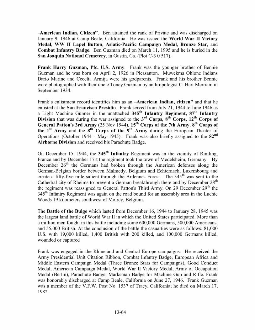
13-64
―American Indian, Citizen”. Ben attained the rank of Private and was discharged on January 9, 1946 at Camp Beale, California. He was issued the World War II Victory Medal, WW II Lapel Button, Asiatic-Pacific Campaign Medal, Bronze Star, and Combat Infantry Badge. Ben Guzman died on March 11, 1995 and he is buried in the San Joaquin National Cemetery, in Gustin, Ca. (Plot C-3 0 517). Frank Harry Guzman, Pfc. U.S. Army. Frank was the younger brother of Bennie Guzman and he was born on April 2, 1926 in Pleasanton. Muwekma Ohlone Indians Dario Marine and Cecelia Armija were his godparents. Frank and his brother Bennie were photographed with their uncle Toney Guzman by anthropologist C. Hart Merriam in September 1934. Frank‘s enlistment record identifies him as an ―American Indian, citizen” and that he enlisted at the San Francisco Presidio. Frank served from July 21, 1944 to June 1946 as a Light Machine Gunner in the unattached 345th Infantry Regiment, 87th Infantry Division that was during the war assigned to the 3rd Corps, 8th Corps, 12th Corps of General Patton's 3rd Army (25 Nov 1944), 15th Corps of the 7th Army, 8th Corps of the 1st Army and the 8th Corps of the 9th Army during the European Theater of Operations (October 1944 - May 1945). Frank was also briefly assigned to the 82nd Airborne Division and received his Parachute Badge. On December 15, 1944, the 345th Infantry Regiment was in the vicinity of Rimling, France and by December 17rt the regiment took the town of Medelsheim, Germany. By December 26th the Germans had broken through the American defenses along the German-Belgian border between Malmedy, Belgium and Echternach, Luxembourg and create a fifty-five mile salient through the Ardennes Forest. The 345th was sent to the Cathedral city of Rheims to prevent a German breakthrough there and by December 28th the regiment was reassigned to General Patton's Third Army. On 29 December 29th the 345th Infantry Regiment was again on the road bound for an assembly area in the Luchie Woods 19 kilometers southwest of Moircy, Belgium. The Battle of the Bulge which lasted from December 16, 1944 to January 28, 1945 was the largest land battle of World War II in which the United States participated. More than a million men fought in this battle including some 600,000 Germans, 500,000 Americans, and 55,000 British. At the conclusion of the battle the casualties were as follows: 81,000 U.S. with 19,000 killed, 1,400 British with 200 killed, and 100,000 Germans killed, wounded or captured Frank was engaged in the Rhineland and Central Europe campaigns. He received the Army Presidential Unit Citation Ribbon, Combat Infantry Badge, European Africa and Middle Eastern Campaign Medal (Three Bronze Stars for Campaigns), Good Conduct Medal, American Campaign Medal, World War II Victory Medal, Army of Occupation Medal (Berlin), Parachute Badge, Marksman Badge for Machine Gun and Rifle. Frank was honorably discharged at Camp Beale, California on June 27, 1946. Frank Guzman was a member of the V.F.W. Post No. 1537 of Tracy, California; he died on March 17, 1982.

13-65
Ernest Marine, Pfc. U.S. Army, 58th Field Artillery Battalion, 76th Division. Ernest Marine was the son of Muwekma Ohlone Indians Lucas Marine and Catherine Peralta. He was born on January 26, 1926 in Centerville. He was enrolled with his father with the Bureau of Indian Affairs on January 11, 1930 (BIA Application # 10299) and his mother had filled out a separate BIA enrollment (Application # 10675). His father had identified his mother and Ernest‘s mother as ―Ohlones‖ on his BIA Application. Ernest Marine enlisted on April 13, 1944 at the Monterey Presidio and he served in Europe in the 58th Field Artillery Battalion and Tank Battalion in the 76th Division and fought in the Rhineland (September 15, 1944 – March 21, 1945), Ardennes-Alsace (Battle of the Bulge, Bastogne, Belgium, December 16, 1944 – January 25, 1945) and Central Europe Campaigns (March 22, 1945 – May 11, 1945). Ernest enrolled with his father Lucas Marine during the second BIA enrollment period on December 23, 1950. Ernest Marine was honorably discharged at Camp Beale on June 15, 1946. After the war he spent most of his life living with his aunt Trina Thompson Ruano in Newark and he passed away on October 20, 1977 in Sacramento. Filbert S. Marine, U.S. Army, Pacific Theater. Filbert was the last child born on the Alisal Rancheria on December 31, 1915. Both of his parents Dario Marine and Catherine Peralta were Muwekma Ohlone Indians. His godparents were also Muwekma Ohlone Indians Franklin Guzman who served in the Marine Corps during WWI and Francisca Guzman. Filbert and his siblings were enrolled with the Bureau of Indian Affairs on their father‘s BIA Application # 10677 on March 11, 1932. Filbert enlisted in the Army on February 18, 1942 at the Presidio of Monterey. He fought in the Pacific Theater. His enlistment record identifies him as ―American Indian, citizen.‖ He died in Sacramento on March 31, 1953. Lawrence Domingo Marine, Staff Sergeant, U.S. Marine Corps (Serial # 299599). Domingo was the younger brother of Filbert Marine and he was born on May 4, 1919 in Centerville. He was one of the last Muwekma Ohlone Indians to be baptized at Mission San Jose. He was enrolled with the Bureau of Indian Affairs on his father‘s BIA Application # 10677 on March 11, 1932. He was also sent to Indian Boarding School at Sherman Institute, Riverside, California in 1931 and graduated from there in 1939. He also met his future wife Pansy Potts from the Maidu Tribe while attending Sherman Institute. After leaving Sherman Institute, Domingo returned to the Bay Area and enlisted in the U.S. Marine Corps in January 1940 in San Francisco. He was later assigned to the 2nd Marine Brigade and on August 2, 1942, Lawrence was promoted to a Line Sergeant. According to his son, Lawrence Marine, Jr., he was in the 1st Marine Division as a ―Para-Marine‖ or Marine paratrooper. Although his military records are not clear he was possibly assigned to the 1st Marine Parachute Regiment, 3rd Marine Parachute Battalion which was formed in early 1941 near San Diego). Although the Para-Marines were never dropped by parachute into combat, they were utilized during beach raids in

13-66
the Pacific Theater, including on August 7, 1942 on Guadalcanal and by amphibious landing craft on the island of Gavutu 20 miles to the north. Domingo was later assigned to anti-aircraft batteries and was engaged in the following major battles, engagements, and ports from January 2, 1942 – November 8, 1945: Hawaiian Islands Area, American Samoan Islands, Wellington, New Zealand, Guadalcanal, B.S.I (British Solomon Islands, New Georgia), Eniwetok, Marshall Islands, Ulithi, Caroline Islands, Okinawa, and Ryukyu (southern Japanese Islands). The Battle of Eniwetok was a battle of the Pacific campaign of World War II, fought February 17, 1944 - February 23, 1944 on Eniwetok Atoll in the Marshall Islands. The invasion of Eniwetok followed the American success in the battle of Kwajalein to the southeast. Capture of Eniwetok would provide an airfield and harbor to support attacks on the Mariana Islands to the northwest. Battle of Okinawa was the largest amphibious invasion of the Pacific campaign and the last major campaign of the Pacific War. More ships were used, more troops put ashore, more supplies transported, more bombs dropped, more naval guns fired against shore targets than any other operation in the Pacific. The fleet had lost 763 aircraft. Casualties totaled more than 38,000 Americans wounded and 12,000 [including nearly 5,000 Navy dead and almost 8,000 Marine and Army dead killed or missing], more than 107,000 Japanese and Okinawan conscripts killed, and perhaps 100,000 Okinawan civilians who perished in the battle. Lawrence Marine was honorable discharged at Treasure Island on November 20, 1946 after having an extended two year reenlistment. He received the Presidential Unit Citation, Good Conduct Medal, and Good Conduct Medal Bar No. (1), Honorable Discharge Button, Honorable Service Button. Lawrence Domingo Marine enrolled during the second BIA enrollment period on October 12, 1950. Domingo died on May 21, 1988 and was buried in Woodland, California. Henry Vernon Marshall, Sergeant, U.S. Marine Corps was born in Newark on June 27, 1925. He was the son of Muwekma Ohlone Indian Henry Marshall, Sr. who was the son of Magdalena Armija Marshall Thompson. Henry Marshall, Jr. was a member of the Verona band of Alameda County. His grandmother, Magdalena enrolled her children with the Bureau of Indian Affairs on October 7, 1930 (BIA Application # 10296). Henry Marshall, Jr. enlisted in the United States Marine Corps and was assigned to the 1st Marine Division (Guadalcanal). He fought in the Pacific Theater of Operations and was issued the Navy Presidential Unit Citation with one Bronze Star, American Campaign Medal, Asiatic Pacific Campaign Medal, Rifle Sharpshooter Badge, and a three tiered Weapons(?) qualifying badge. His father enrolled the family during the third BIA enrollment period on May 7, 1969 as part of the California Indian Claims Judgment. Henry passed away on September 24, 1986. Arthur M. Pena, Sergeant, U.S. Army, Company A, 155th Engineers Combat Battalion, Pacific Theater. Arthur was born in Crockett, California on September 4, 1924. His mother was Erolinda Santos (Juarez/Saunders) Pena Corral who was a member of the Muwekma Ohlone Verona Band Indian Community. Arthur was

13-67
enrolled along with his mother and siblings with the Bureau of Indian Affairs on his great-aunt Maggie Pinos Juarez‘s BIA Application # 10676 on March 18, 1932. Arthur Pena enlisted on April 13, 1943 at the San Francisco Presidio and served in the unattached 155th Engineering Combat Battalion in the Pacific Theater. He served in the Southern Philippines and Western Pacific Campaigns (Leyte October 17, 1944 – July 1, 1945 and Western Pacific June 15, 1944 – September 2, 1945) and his battalion was sent to Guadalcanal (August 12 – August 24, 1944). From Guadalcanal, the battalion went on to Palau, Ulithi, New Caledonia (February 20, 1945), Southern Philippines (May 16, 1945) and Japan (September 8, 1944 – September 25, 1945). Arthur Pena was honorably discharged at Camp Beale, Marysville, California on February 2, 1946 and he was issued the Philippines Liberation Ribbon, Asiatic Pacific Campaign Medal, American Campaign Medal, Good Conduct Medal and World War II Victory Medal. He reenlisted on August 7, 1946 and served in Germany in Company C 793rd Military Police Battalion and he also went through the European Command Intelligence School. He was honorably discharged on March 25, 1955 and then reenlisted again on March 26, 1955. After serving another two years, Arthur was discharged at Fort Leonard Wood, Missouri on December 9, 1957. Arthur was also issued the UN Service Medal, National Defense Service Medal, and Army of Occupation Germany Medal. On December 27, 1957, he enrolled his family with the Bureau of Indian Affairs during the second enrollment period. Robert P. Corral, U.S. Army, Pfc. Infantry, Head Quarters Regiment, Ft. Benning, GA. Robert was born in Crockett, California on June 1, 1926 and was the younger brother of Arthur Pena. His mother was Erolinda Santos (Juarez/Saunders) Pena Corral who was a member of the Muwekma Ohlone Verona Band Indian Community. Robert was enrolled along with his mother and siblings with the Bureau of Indian Affairs on his great-aunt Maggie Pinos Juarez‘s BIA Application # 10676 on March 18, 1932. Robert enlisted at the San Francisco Presidio on December 18, 1944 and was honorably discharged on November 13, 1946. At Fort Benning, Georgia Robert completed six parachute jumps and was awarded a Parachutist Badge, World War II Victory Medal, Good Conduct Medal, and American Campaign Medal. On May 16, 1955 Robert enrolled himself and his family during the second BIA enrollment period. During the third BIA enrollment period on April 30, 1969, Robert enrolled his family as ―Ohlone Indians‖ with the BIA as part of the California Indian Claims Judgment (Application # 21123). During the 1990s Robert P. Corral served as a Muwekma Ohlone Tribal Elder and he passed away on June 28, 1996 in Stockton. Enos Marine Sanchez, Pfc. U.S. Army, 89th Division, 1st Battalion, Co. M, 354th Infantry Regiment, (39 390 899). Enos Sanchez was born on February 1, 1910 near the Alisal Rancheria in Sunol and his birth certificate identified him as ―California Indian‖. Enos and his younger siblings were enrolled with the Bureau of Indian Affairs on March 18, 1932 (BIA Application # 10680). His mother was Ramona Marine who was a member of the Verona Band of Alameda County.
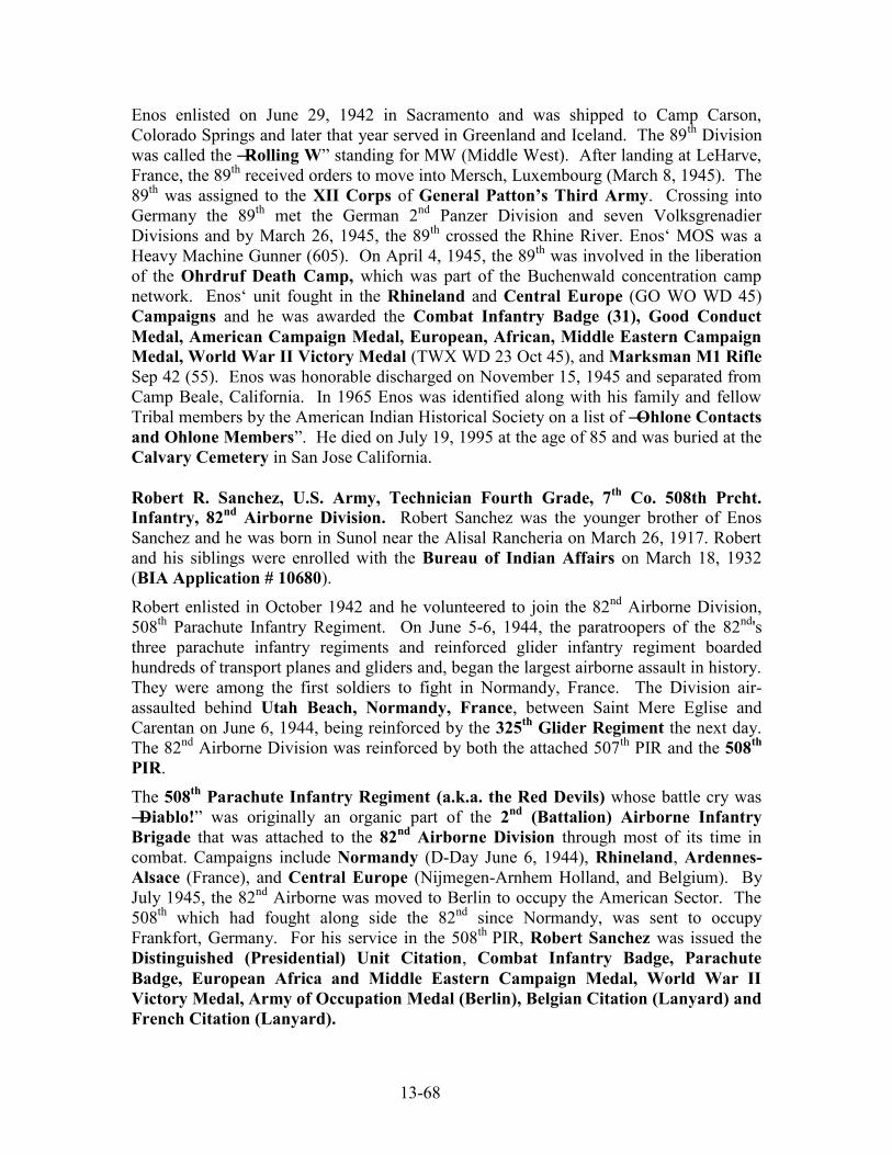
13-68
Enos enlisted on June 29, 1942 in Sacramento and was shipped to Camp Carson, Colorado Springs and later that year served in Greenland and Iceland. The 89th Division was called the ―Rolling W‖ standing for MW (Middle West). After landing at LeHarve, France, the 89th received orders to move into Mersch, Luxembourg (March 8, 1945). The 89th was assigned to the XII Corps of General Patton’s Third Army. Crossing into Germany the 89th met the German 2nd Panzer Division and seven Volksgrenadier Divisions and by March 26, 1945, the 89th crossed the Rhine River. Enos‘ MOS was a Heavy Machine Gunner (605). On April 4, 1945, the 89th was involved in the liberation of the Ohrdruf Death Camp, which was part of the Buchenwald concentration camp network. Enos‘ unit fought in the Rhineland and Central Europe (GO WO WD 45) Campaigns and he was awarded the Combat Infantry Badge (31), Good Conduct Medal, American Campaign Medal, European, African, Middle Eastern Campaign Medal, World War II Victory Medal (TWX WD 23 Oct 45), and Marksman M1 Rifle Sep 42 (55). Enos was honorable discharged on November 15, 1945 and separated from Camp Beale, California. In 1965 Enos was identified along with his family and fellow Tribal members by the American Indian Historical Society on a list of ―Ohlone Contacts and Ohlone Members‖. He died on July 19, 1995 at the age of 85 and was buried at the Calvary Cemetery in San Jose California. Robert R. Sanchez, U.S. Army, Technician Fourth Grade, 7th Co. 508th Prcht. Infantry, 82nd Airborne Division. Robert Sanchez was the younger brother of Enos Sanchez and he was born in Sunol near the Alisal Rancheria on March 26, 1917. Robert and his siblings were enrolled with the Bureau of Indian Affairs on March 18, 1932 (BIA Application # 10680). Robert enlisted in October 1942 and he volunteered to join the 82nd Airborne Division, 508th Parachute Infantry Regiment. On June 5-6, 1944, the paratroopers of the 82nd's three parachute infantry regiments and reinforced glider infantry regiment boarded hundreds of transport planes and gliders and, began the largest airborne assault in history. They were among the first soldiers to fight in Normandy, France. The Division air-assaulted behind Utah Beach, Normandy, France, between Saint Mere Eglise and Carentan on June 6, 1944, being reinforced by the 325th Glider Regiment the next day. The 82nd Airborne Division was reinforced by both the attached 507th PIR and the 508th PIR. The 508th Parachute Infantry Regiment (a.k.a. the Red Devils) whose battle cry was ―Diablo!‖ was originally an organic part of the 2nd (Battalion) Airborne Infantry Brigade that was attached to the 82nd Airborne Division through most of its time in combat. Campaigns include Normandy (D-Day June 6, 1944), Rhineland, Ardennes-Alsace (France), and Central Europe (Nijmegen-Arnhem Holland, and Belgium). By July 1945, the 82nd Airborne was moved to Berlin to occupy the American Sector. The 508th which had fought along side the 82nd since Normandy, was sent to occupy Frankfort, Germany. For his service in the 508th PIR, Robert Sanchez was issued the Distinguished (Presidential) Unit Citation, Combat Infantry Badge, Parachute Badge, European Africa and Middle Eastern Campaign Medal, World War II Victory Medal, Army of Occupation Medal (Berlin), Belgian Citation (Lanyard) and French Citation (Lanyard).

13-69
The 82nd Airborne Division and the 508th Parachute Infantry Regiment were issued the Distinguished (Presidential) Unit Citations for actions during the Normandy Campaign. "The 508th Parachute Infantry is cited for outstanding performance of duty in action against the enemy between 6 and 9 of June 1944, during the invasion of France. … The courage and devotion to duty shown by members of the 508th Parachute Infantry are worthy of emulation and reflect the highest traditions of the Army of the United States. The Netherlands Citation was issued by the Dutch Government to the 82nd Airborne and its attached divisions (508th PIR) on October 8, 1945 for airborne operations and combat actions in the central part of the Netherlands (Nijmegen) during the period from September 17, 1944 to October 4, 1944. The 82nd Airborne Division became the first non-Dutch military unit to be awarded the Militarie Willems Orde, Degree of Knight Fourth Class to wear the Orange Lanyard of the Royal Netherlands Army. The Belgian Citation (Lanyard) was issued by the Belgian Government to the 82nd Airborne Division with the 508th Parachute Infantry attached ―has distinguished itself particularly in the Battle of the Ardennes‖ from December 17, 1944 – December 31, 1944. The French Citation (Lanyard) was issued to the 508th Parachute Infantry by the Government of France. ―The President of the Provisional Government of the French Republic Cites to the Order of the Army: 508th Parachute Infantry Regiment: A magnificent unit, reputed for the heroism and spirit of sacrifice of its combatants and which made proof of the greatest military qualities during the battle of Normandy‖ (June 6, 1944 – June 20, 1944). This citation includes the award of the Croix de Guerre with
Palm. O. B. Hill from the 508th P.I.R. Association, 82nd Airborne Division wrote: ―2,056 men of the 508th Parachute Infantry Regiment (attached to the 82nd Airborne) jumped into Normandy on D-Day, and on July 15, 1,918 returned. The rest had been killed, captured or wounded‖. Robert was honorably discharged on February 2, 1948 and spent most his life in the greater Bay Area. Robert Sanchez was one of the early prime movers and active Elders in the Muwekma Ohlone Tribe. He passed away on April 26, 1999. Daniel G. Santos (Juarez), Technical Sergeant, U.S. Army, 41st Division – 1941-1945. Daniel Santos (Saunders/Juarez) was born in Sunol near the Alisal Rancheria on January 21, 1917. Both his parents Joseph Saunders and Erolinda Santos were members of the Verona Band of Alameda County. Daniel was enrolled with the Bureau of Indian Affairs along with his mother and siblings under his great-aunts‘ BIA Application (# 10676) on March 18, 1932. Daniel Juarez (Santos) received a draft notice dated March 14, 1941, from Local Board No. 36 located in Manteca, California. It was addressed to Mr. Dan George Juarez, Route, Box 29A, Tracy, California. The letter stated:
―We received a call for 70 men to be inducted from this area on March 27th 1941. it is probable that you will be included in the group, and we are therefore taking this opportunity of notifying you, before (?) official order is issued, so that you may make your plans accordingly.‖

13-70
Daniel enlisted on March 27, 1941 at Sacramento before the war was declared. The Jungleer or Sunset Division was Federalized on September 16, 1940. By December 7, 1941, the 41st Division was ready. It continued the series of "firsts" by being the first United States Division to deploy to the South Pacific. It became the first American Division sent overseas after Pearl Harbor, the first American Division trained in Jungle Warfare. It spent 45 months overseas (longer than any other Division), and earned the title of "Jungleers". The 41st Division left for Australia in March of 1942. Elements of the division landed January 23, 1943 in Dobodura, New Guinea. On the Island of Biak (May 27, 1944) the American Forces fought the first tank battle of the war against the Japanese destroying seven without loss. The division also fought in the Philippines (January 9, 1945) and fought on Palawan and Sulu Archipelago (March 10, 1945) and arrived in Japan on October 6, 1945. They participated in 3 campaigns (New Guinea, Luzon, and Southern Philippines) and suffered 4,260 casualties. Former Secretary of Defense Caspar W. Weinberger also served in the 41st Division as an officer. The 41st Division earned three Distinguished (Presidential) Unit Citations. Daniel Santos was honorably discharged in 1945. Daniel enrolled with the Bureau of Indian Affairs during the second BIA enrollment period on May 23, 1955. He worked at Leslie Salt Company in Newark and spent his life working on and racing cars. Daniel passed away on April 28, 1980.
Lawrence Thompson, Sr., Tech. Fifth Grade U.S. Army, 640th Tank Destroyer Battalion. Lorenzo Thompson, Sr. was born in Newark September 9, 1918. His mother Magdalena Armija Thompson was a member of the Verona Band of Alameda County. Lawrence and his siblings enrolled with their mother with the Bureau of Indian Affairs on October 7, 1930. The 640th Tank Destroyer Battalion was formed at Camp San Luis Obispo on December 19, 1941 as an element of the 40th Infantry Division, and served in the Pacific Theater of Operation. The 640th was activated on March 3, 1941 from National Guard Divisions from California and Utah and was sent overseas on August 23, 1942. The 640th Campaigns included: Bismarck Archipelago, Southern Philippines, and Luzon and were issued 3 Distinguished Unit Citations; Awards: MH-1; DSC-12; DSM-1; SS-245; LM-21; SM-30; BSM-1,036; AM-57. Lawrence Thompson enlisted at the age of 23 on September 10, 1941 at the San Francisco Presidio. At that time he was living at 2370 Pine St. in San Francisco. His MOS was Cannons S45 and he fought in the following campaigns: Aleutian Islands [Attu and Kiska Island with the 7th Infantry Division], Luzon and Southern Philippines and Eastern Mandates [Marshall Islands, Kwajalein, Eniwetok]. Initially deployed to Hawaii in September 1942, the 640th Tank Destroyer Battalion participated in combat landings at Guadalcanal (February 5, 1944), Cape Glouster, New Britain (May 3, 1944), Lingayen Gulf, Luzon, Commonwealth of the Philippines (January 9, 1945), and Los Negros Islands (March 29, 1945). The 640th Tank Destroyer Campaign Honors include: Bismarck Archipelago [islands of New Guinea] (December 15, 1943 – November 27, 1944), and Luzon and Southern Philippines [GO 33 WD 45] (December 15, 1944 – July 4, 1945). ―Seek, Strike, and Destroy" was the motto of the Tank Destroyers.

13-71
Lawrence Thompson was honorably discharged on October 2, 1945 at Camp Beale, Marysville, California and was issued the American Defense Service Medal, Asiatic Pacific Campaign Medal and Philippine Liberation Ribbon with Bronze Star. After the war Lawrence Thompson, Sr. and his son Lawrence Thompson, Jr. enrolled with the Bureau of Indian Affairs during the third BIA enrollment period on June 24, 1969. Later during the early 1990s Lawrence, Sr. served on the Muwekma Tribal Council. He passed away in November 1999. (Figures 13-13 to 13-14)
Muwekma Ohlone Tribe WWII Veterans 1941 - 1945Lawrence Domingo
Marine
Sergeant, U.S. Marine
Corps, Guadalcanal,
Eniwetok, Marshall Islands,
Okinawa, Ryukyu
1940–1946
WWII
Lawrence Thompson, Sr.(photo taken in 1997, 79 years old)Tech. Fifth Grade, U.S. Army, 640th
Tank Destroyer Battalion, Pacific Theater 1941-1945, WWII
Hank A. AlvarezU.S. Army,101st Airborne
Division1942-1945, WWII
Ernest Marine
Pfc. U.S. Army, 58th
Field Artillery Battalion,
1944-1946, WWII
Daniel Santos Juarez (center)
Sergeant, U.S. Army,
41st Division, WWII1944
Michael Benjamin Galvan(right)
U.S. Navy And Army
WWIIMuwekma Ohlone Tribe Of The San Francisco Bay Area
Figure 13-13: Some of the Muwekma Men Who Served During World War II

13-72
Muwekma Ohlone Tribe WWII Veterans 1941 - 1945
Frank H. GuzmanPfc, U.S.
Army 345th
Infantry, European Campaign,1944-1946, WWII
Ben Guzman,
U.S.
Army, WWII
(photo taken 1945)
Robert R. Sanchez
U.S. Army
Technician Fourth Grade,
508th Prcht. Infantry, 82nd
Airborne Division
1943-1948, WWII
Thomas Garcia,(photo taken 1946)U.S. Army,
WWIIBuried in theGolden GateNational Cemetery
Enos Sanchez(photo taken 1947)U.S. Army, Patton’s
Army Tank Command North Africa, WWII
Muwekma Ohlone Tribe Of The San Francisco Bay Area
Salvador PiscopoSergeant, US Army, European Theater,1942-1946, WWII
Figure13-14: Muwekma Men Who Served During World War II Post-World War II to the 1960s At the end of the war, the returning Muwekma men had to readjust to the peacetime economy and search for employment throughout the central California region. Work was difficult to find at times, but families helped each other and maintained tribal relations through religious and social mechanisms (e.g., compadrazo/godparenting and witnessing) that have long been established within the Muwekma families. After Word War II, in May 1947, Ernest Thompson, Jr. the son of Magdalena Armija Thompson, became a member of the Bay Area California Indian Council which represented the contractual interests for over one thousand California Indians residing in the Bay Area as a result of the 1928, 1944 and 1946 Indian Claims Acts and ensuing legal decisions by the Justice Department.

13-73
After 1950, those surviving Muwekma and other California Indians were issued checks for the sum of $150.00 per person as compensation for the value (with interest going back to 1852) for the 8.5 million acres of land and promised services that they never received. Deducted from the final lump sum was the cost of every military operation, Indian services and bullets spent so that the settlement would not be a burden to the American taxpayer. Community and tribal related activities fell under the leadership of Muwekma Elder, Margarita (Maggie) Pinos Juarez, and Dolores Marine Galvan and her brothers Dario Marine and Lucas Marine and her younger sister, Trina Marine Thompson Ruano (Ernest Thompson, Sr., had married Trina after the death of his first wife, Magdalena Armija Thompson). These tribal activities and revitalization were also spurred by communications with the BIA Sacramento Agency, which notified the Muwekma lineages of the expanded enrollment opportunities under the California Indian Jurisdictional Act for children born after May 28, 1928. Families contacted and helped each other go to Sacramento to enroll their children, nieces and nephews. After the California Indian Roll was approved on November 23, 1951, the Sacramento Area Office published a list of enrollees that identified forty Muwekmas as "Tribe Mission San Jose" (BIA list 1951). Also, during this period of time (from 1930s and 1950s), some of the families moved about seeking new employment opportunities and residential stability. The residence of Lucas Marine and Catherine Peralta (before her passing in 1934) on the Shinn Ranch in Niles became an important gathering place for the families and relations (see Harrington notes 1921-1934 regarding events between Liberato and Pedro Confessor prior to the turn of the century). Other important households were the residences of Dolores Marine Galvan in Brentwood and San Jose, Dario Marine in Centerville and later Woodland, and Margarita Pinos Juarez and Trina Marine Thompson Ruano in Newark where the families would gather for various occasions. Continuous Connections to the Tribe’s Sacred Sites: The Protection of the Ohlone Indian Cemetery, Fremont, California The Ohlone Indian Cemetery located on Washington Boulevard, one mile west of Mission San Jose in Fremont, was used for burial by members of the Guzman, Santos, Pinos, Marine, Armija (Thompson) and Nichols families until 1926, while the original Ohlone burial ground was located under the northern wing of the mission church. Martin Guzman (died October 4, 1925), Victorian Marine Munoz (died November 27, 1922) and her son Jose Salvador Munoz (died 1921) were some of the last Muwekma Ohlone Indians to be buried there. On Jose Salvador Munoz‘s death certificate it identifies his place of burial as ―Ohlone Cem‖[etery]. During the 1960‘s Muwekma families under the leadership of Dolores Marine Galvan, participated in securing the legal title to the Historic Ohlone Cemetery located on Washington Boulevard in the City of Fremont. In 1971, a board of directors for the Ohlone Indian Tribe, Inc. was established by Dolores Marine Galvan and her children
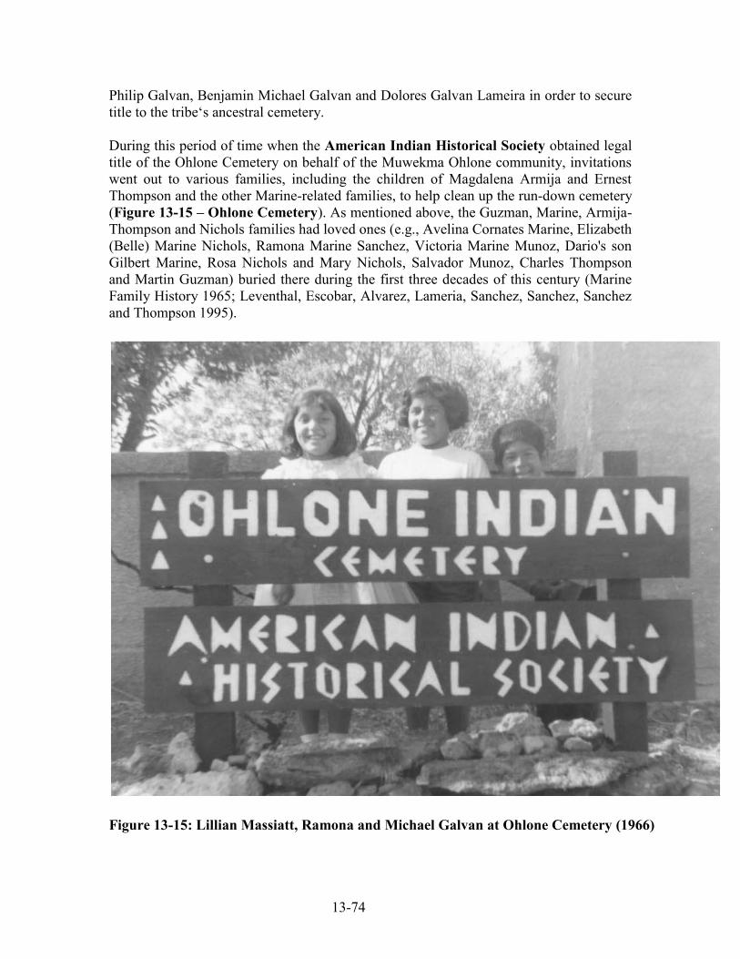
13-74
Philip Galvan, Benjamin Michael Galvan and Dolores Galvan Lameira in order to secure title to the tribe‘s ancestral cemetery. During this period of time when the American Indian Historical Society obtained legal title of the Ohlone Cemetery on behalf of the Muwekma Ohlone community, invitations went out to various families, including the children of Magdalena Armija and Ernest Thompson and the other Marine-related families, to help clean up the run-down cemetery (Figure 13-15 – Ohlone Cemetery). As mentioned above, the Guzman, Marine, Armija-Thompson and Nichols families had loved ones (e.g., Avelina Cornates Marine, Elizabeth (Belle) Marine Nichols, Ramona Marine Sanchez, Victoria Marine Munoz, Dario's son Gilbert Marine, Rosa Nichols and Mary Nichols, Salvador Munoz, Charles Thompson and Martin Guzman) buried there during the first three decades of this century (Marine Family History 1965; Leventhal, Escobar, Alvarez, Lameria, Sanchez, Sanchez, Sanchez and Thompson 1995).
Figure 13-15: Lillian Massiatt, Ramona and Michael Galvan at Ohlone Cemetery (1966)

13-75
Benjamin Michael Galvan was born on June 23, 1927 and was the last formal member of the historic Verona Band of Alameda County to be born into the Federally Recognized tribe. Ben was born the same day that BIA Superintendent Lafayette A. Dorrington decided in his report that the landless Verona Band tribe did not need any land. Ben served as the first chairman of the Ohlone Indian Tribe between 1965 and 1978. Since World War II, Dolores Marine's children have married and raised families and presently Henry Alvarez and Dolores "Dotty" Galvan Lameira are Muwekma Tribal Elders and have served as elected council members. Dotty Lameira‘s son Arnold Sanchez had served as an elected tribal councilman. The family of Benjamin and Jenny Galvan are also enrolled in the Tribe and their son, Albert Galvan, had also served as a tribal council member. The same is the case for the children and grandchildren of Victoria Marine (1928 BIA Application # 10678) and Ramona Marine's children (1928 BIA Application # 10680). Magdalena Armija had married Ernest Thompson, Sr. and their sons Edward Thompson and Lawrence Thompson, Sr. were elders, and Lawrence was a former elected tribal councilman of the tribe (1928 BIA Application # 10296). The children of Ernest Thompson, Jr. are also enrolled tribal members. As discussed earlier, Francisca Nonessi (1928 BIA Application 10293) was married to Jose Guzman, their son Jack Guzman (Sr.) had married Flora Freda Munoz (Victoria Marine's daughter), and their son John Guzman, Jr. (now deceased) and daughter, Rena Guzman Cerda and their respective children are Muwekma tribal members. In the late 1890s, George Santos (grandson of Hipolito Santos and Refugia Simon who were one of the founding families of the Niles rancheria) had married Peregrina Pinos (who was the daughter of Benedicta Guerrera and Manuel Pinos). Their eldest daughter, Erolinda Pinos Corral, enrolled with the BIA with her children along with her Aunt, Maggie Pinos Juarez, in 1932 (1928 BIA Application 10676). The children and grandchildren Alfonso Juarez, who was the eldest son of Erolinda Santos Juarez Pena Corral are enrolled members of the Muwekma Ohlone Tribe. Presently Carol Juarez Sullivan is a Muwekma tribal councilwoman (Figure 13-16).
Figure 13-16: Muwekma Elders Maggie Juarez and Erolinda Santos Juarez Corral

13-76
Muwekma Families Enroll with the BIA during the Second Enrollment 1948-1957 Under the Act of 1948, the many of the Muwekma Ohlone ―heads of household‖ enrolled with their families once again with during the second BIA Enrollment between 1950 and 1957. These Muwekma include: Dolores Marine Galvan, October 6, 1950; Domingo Lawrence Marine, October 12, 1950, Dario Marine, November 1, 1950, Flora Munoz Carranza, December 12, 1950, Lucas Marine, December 23, 1950, Henry Alvarez, April 7 & 26, 1951, Trina Marine Thompson Ruano, May 21, 1951 Maggie Pinos Juarez, July 19, 1951, Benjamin Galvan, December 4, 1951, Belle Stokes Olivares Nichols February 25, 1952, Ernest Thompson, April 16, 1952, Thomas Garcia, April 22, 1953, Flora Emma Martel Thompson, February 4, 1954, Erolinda Santos Juarez Pena Corral, May 16, 1955, Robert Corral, May 16, 1955, Edward Thompson, May 21, 1955, Daniel Santos, May 23, 1955, Joseph Francis Aleas, May 24, 1955, Albert Arrellano, June 18, 1955, Dolores “Dottie” Galvan Lameira, October 3, 1955, and Arthur Pena Corral, December 27, 1957. Third BIA Enrollment 1968-1971 Following the Act of 1964, between 1969 and 1971, the following Muwekma ―heads of households‖ and their families once again enroll during the third BIA Enrollment period with most of the applicants identifying themselves as ―Ohlone‖ on Question # 6 ―Name the California Tribe, Band or Group of Indians with which your ancestors were affiliated on June 1, 1852‖: Mary Munoz Mora Ramos Archuleta, January 10, 1969, ―Ohlone, Mission.‖ Mary Marine Galvan, January 27, 1969, ―Ohlone.‖ Ernest George Thompson,. February 20, 1969, ―Ohlone Tribe, Mission San Jose.‖ Patricia Ferne Thompson Brooks, March 27, 1969, ―Mission Indians.‖ Madeline Cynthia Thompson Perez, March 27, 1969, ―Mission Indians.‖ Karl Thompson, March 27, 1969, ―Mission Indians.‖ Robert P. Corral,. April 30, 1969, ―Ohlone Indian.‖ Henry Marshall, May 7, 1969, ―Ohlones.‖ Glenn Thompson, June 11, 1969, ―Mission Indian.‖ Lorenzo Thompson, June 24, 1969,. ―Costanoan.‖ Lawrence Thompson, Jr., June 24, 1969, ―Costanoan.‖ Rosemary Juarez Ferreira, July 15, 1969, ―Ohlone Indians.‖ Peter D. Juarez, July 23, 1969, ―Ohlone Indians.‖ Dolores Sanchez Martinez, August 11, 1969, ―Ohlone.‖ Margaret Martinez, August 21, 1969, ―Ohlone Mission Indian.‖ Joan Guzman, August 26, 1969, ―Ohlone Indian.‖ Belle Nichols, September 4, 1969, ―Mission.‖ John Paul Guzman, September 12, 1969, ―Ohlone Mission Indian.‖ Beatrice Marine, January 5, 1971, ―Costanoan.‖

13-77
Muwekma Service in the Armed Forces 1950s, Viet Nam War to Iraq During the 1950s, 1960s and 1970s Muwekma men served in Korea, Viet-Nam and elsewhere. Ruben Cota Arellano, Sr. Corporal, U.S. Army, Medical Corps, SP4 E4 HQ Battery 1st TGT ACQ Battalion, 25th Artillery, APO 2, July 5, 1960 – July 4, 1966, Korea. Lawrence Mason Marine served in the United States Marine Corps from 1959-1965 and was a Staff Sergeant serving in Viet-Nam, 3rd Marine Division, 3rd Tank Battalion, and 3rd Force Reconnaissance, Charlie Company (Viet-Nam) from 1960-1961. Lawrence also served on the Muwekma Tribal Council. Marvin Lee Marine (younger brother of Lawrence Mason Marine) also served in the Viet-Nam War in the U.S. Army‘s 173rd Airborne Division. Muwekma Elder Lawrence Mason Marine and his family are enrolled members of the Muwekma Tribe. Karl Thompson, SP5, U.S. Army, 43rd Engineer Bn. 931st Eng. Gp. Armed Forces Expeditionary Medal (Korea), May 8, 1968 – May 7, 1971. Tom M. Alvarez, Sr., U.S. Army, Medical Corps, 1965 – 1967, Vietnam, recipient of Soldier's Medal. Frank Y. Ruano, Sr., E4, U.S. Army, 56th Artillery, 1965 – July 25, 1971, Vietnam. Robert C. Martinez, Sr., Sergeant, Air Cavalry, 14th Cavalry Regiment U.S. Army, European, 7th Army Command, May 22, 1968 – May 14, 1970. Rick Martinez, Vietnam John A. Massiatt, Airman, U.S. Air Force January 1, 1968 - October 1, 1969. Thomas Joseph Marshall (U.S. Army Vietnam Era) [deceased] Richard A. Juarez, SP 4 – E-4, U.S. Army, 589th Transportation Co., Co. B 4H BN 2D BCT BDE, 1st Army, Fort Eustis, Virginia., January 25, 1971 – October 30, 1973. JayP Massiet, Staff Sergeant U.S. Air Force Van Nuys Air National Guard, June 1975 – January 1988 Michael F. Galvan, Jr., Sergeant, U.S. Air Force, 95th Recon Squadron, 1977 – 1997 (Desert Storm Campaign) Tracie Massiet Lents, U.S. Air Force, 1979 – 1983 Paul Guzman (Service Records n/a)

13-78
John J. Cambra, Jr., Pfc. U.S. Army Company C 4th Battalion 30th Infantry and Company B 2nd Battalion 159th Infantry, 1991 – 1994 David J. Splan, Lance Corporal, U.S. Marine Corps, 1993 – 2001 Cory Massiet, Airman 1st Class, U.S. Air Force, 1994 – 1997 In the 1990s, Michael Galvan, son of Benjamin and Jenny Galvan, and Thomas Alvarez, Jr. both served in Desert Storm. Presently, Jesse Calles, the grandson of Muwekma Elder Faye Thompson Frei is serving in the U.S. Army in Iraq since December 2005 in the Headquarters and Headquarters Battery Fires Brigade 41D Division (Mechanized), Awarded the Army Commendation Medal 2006. 2004 – Present. Jesse served in Baghdad, Iraq since December 2005. Angela Galvan, the granddaughter of Muwekma Elder Jenny Galvan had recently served in Iraq in the U.S. Marine Corps, Corporal/E-4, 1st Marine Logistics Group, 7th Engineer Support Battalion, Support Company Motor Transportation Platoon, May 27, 2003 - Presently serving in Iraq (twice deployed). Campaigns and Citations: OIF 2 Fallujah Campaign in Feb 2004 - Sept 2004 and OIF 3-6 Sept 2005 - Mar 2006, Combat Action Ribbon for operations on Michigan ASR (Alternative Supply Route) and an impact Navy Marine Corps Achievement Medal for operations in Haditha (December 2005); also involved during OIF 3-6. JayP Massiet, Jr. U.S. Army, Second Tour in Iraq; issued a Purple Heart. Muwekma Tribal Stewardship Over Their Ancestral Heritage and Culture Sites Since 1980 to the present, the Muwekma families have worked independently to establish the "Most Likely Descendant" (MLD) status of members of the Muwekma Tribe in their area with the Native American Heritage Commission of the State of California. Also in 1984 the Muwekma developed their own Cultural Resource Management firm, Ohlone Families Consulting Services (OFCS), which has been recognized since 1986 by the Department of the Interior as a Native American business under the Buy Indian Act. Since the establishment of OFCS many of the Muwekmas, as well as Amah-Mutsun and Esselen Nation tribal members, and Pomo, Sioux, Yokuts, Miwok, Wiyot and other tribal people have gone through archaeological training and obtained employment as field crew on various archaeological projects. OFCS has sought alternatives for indigenous people who are concerned about their ancestral past. Under these circumstances, the aboriginal tribal people have taken greater responsibility for their ancestral heritage by becoming fully engaged in the environmental and ensuing scientific processes that affect their ancestral sites as in the case of the burial recovery project conducted at the Katwáš Ketneyma Waréeptak (CA-SCL-869) site.

13-79
Muwekma Ohlone Tribe and its Reaffirmation as a Federally Recognized Tribe In 1989 the Muwekma Ohlone Tribe began the arduous process of petitioning the U.S. Government regarding its status clarification as a Federally Recognized tribe under 25 C.F.R. Part 83. Over the years, interfacing with the BIA‘s Office of Federal Acknowledgment has been a very difficult and acrimonious process. However, in face of the ―extinction‖ sentence issued by Alfred L. Kroeber in his 1925 California Handbook, and adversity by the BIA, the Muwekma Ohlone Tribe has nonetheless made great strides forward. In 1996, the Tribe shattered the myth that it was never Federally Recognized. On May 24, 1996, the United States Department of the Interior, Deborah Maddox, Director of the Office of Tribal Services for the Bureau of Indian Affairs, formally concluded in a letter sent to the Muwekma Ohlone Tribe that:
Based on the documentation provided, and the BIA's background study on Federal acknowledgment in California between 1887 and 1933, we have concluded ... that the Pleasanton or Verona Band of Alameda County was previously acknowledged between 1914 and 1927. The band was among the groups, identified as bands, under the jurisdiction of the Indian agency at Sacramento, California. The agency dealt with the Verona Band as a group and identified it as a distinct social and political entity (letter in response to the Muwekma Petition, Branch of Acknowledgment and Research, Bureau of Indian Affairs, Washington, D.C.).
In 2000 – U.S. District Court Justice Ricardo Urbina wrote in his Introduction of his Memorandum Opinion Granting the Plaintiff’s Motion to Amend the Court’s Order (July 28, 2000) and Memorandum Order Denying the Defendants’ to Alter or Amend the Court’s Orders (June 11, 2002) that:
The Muwekma Tribe is a tribe of Ohlone Indians indigenous to the present-day San Francisco Bay area. In the early part of the Twentieth Century, the Department of the Interior (―DOI‖) recognized the Muwekma tribe as an Indian tribe under the jurisdiction of the United States. (Civil Case No. 99-3261 RMU D.D.C.)
On October 30, 2000, the BIA‘s Office of Federal Acknowledgment and Tribal Services Division responded to Justice Urbina‘s Court Order regarding the Muwekma Ohlone Tribal enrollment and their descendency from the Verona Band of Alameda County:
… . When combined with the members who have both types of ancestors), 100% of the membership is represented. Thus, analysis shows that the petition‘s membership can trace (and, based on a sampling, can document) its various lineages back to individuals or to one or more
siblings of individuals appearing on the 1900, ―Kelsey‖, and 1910 census enumerations described above.

13-80
On June 30, 2005, Congressman Richard Pombo, Chair of the House Resources Committee wrote to Secretary of Interior Gail Norton supporting a settlement of the Muwekma lawsuit against Interior:
Dear Secretary Norton: As part of my Committee's oversight of the procedures for federal recognition of Indian Tribes, I have heard testimony in a hearing earlier this year of the protracted litigation concerning the recognition of the Muwekma Ohlone Tribe. The Tribe informs me that the Department of the Interior has determined that Muwekma is a previously recognized tribe, federally recognized until 1927, also that no formal action by the Department and no Act of Congress removed it from recognition and that 99% of the members of the current tribe are direct descendants of the members of the recognized tribe. The Muwekma Tribe raises the issue that, in a very similar situation, the Department reaffirmed the federally-recognized status of the Lower Lake Koi Tribe and the Ione Band of Miwok in California by a letter signed by the then Assistant Secretary of the Interior restoring them to recognized status without making them go through.forma1 recognition procedures. I understand that in December of 2003 the Tribe explored with the Department a possible settlement, including a rehearing that might lead to reaffirmation of the Tribe, or, according to the Tribe, at the suggestion of a Department attorney, the organization of the half-blood members of the Tribe as a new Tribe under the Indian Reorganization Act. Despite numerous calls and letters from the Tribe, I understand these efforts at settlement have been largely ignored. I urge you to bring to resolution this dispute with the Muwekma Ohlone Tribe if possible. My concerns stem from the fact that in continuing this litigation, only unnecessary time and expense will result and some settlement along the lines your Department has already considered may be the best result. Therefore, I would suggest, if possible, that the Department meet with the Tribe to pursue settlement opportunities. …
After the Office of Federal Acknowledgement ―declined‖ to extend, and therefore reaffirm the Tribe‘s Federally Acknowledged status on September 6, 2002, the Muwekma Tribe had to pursue its second lawsuit against the Department of the Interior.

13-81
Muwekma Tribe’s Present Litigation against the Department of Interior On September 21, 2006, U.S. District Court Justice, Reginald B. Walton in Muwekma Ohlone Tribe v. Dirk Kempthorne, Secretary of the Interior, et al., Civil Action No. 03-1231 (RBW) issued a favorable Court Opinion on the side of the Muwekma Tribe stating:
The following facts are not in dispute. Muwekma is a group of American Indians indigenous to the San Francisco Bay area, the members of which are direct descendants of the historical Mission San Jose Tribe, also known as the Pleasanton or Verona Band of Alameda County (―the Verona Band‖). … From 1914 to 1927, the Verona Band was recognized by the federal government as an Indian tribe. … Neither Congress nor any executive agency ever formally withdrew federal recognition of the Verona Band. … Nevertheless, after 1927, the federal government no longer acknowledged the Verona Band, or any past or present-day incarnation of the plaintiff, as a federally recognized tribal entity entitled to a government-to-government relationship with the United States … (alleging that ―sometime after 1927 the Department began to simply ignore the Tribe for many purposes and substantially reduced the benefits and services provided to the Tribe‖) … (pages 2-3) …
The Present Litigation Muwekma brought this action on June 6, 2003, seeking reversal of the Final Determination, placement on the Department‘s list of federally recognized tribes, and other injunctive relief. ... On July 13, 2005, Muwekma moved for summary judgment, alleging, inter alia, that the Department violated the APA and the Equal Protection Clause when it required Muwekma to petition for acknowledgment of its tribal status pursuant to the ―lengthy and thorough‖ regulatory procedures of Part 83, …, despite administratively reaffirming the status of similarly situated tribes without requiring those tribes to undertake the Part 83 process and without sufficient explanation for the disparate treatment. ... Specifically, Muwekma contends that ―[t]he Department returned Lower Lake and Ione to the list of recognized tribes outside of the [Part 83] procedures [while] requir[ing] Muwekma to complete the Part 83 process and then, applying a greater evidentiary burden, denied Muwekma recognition despite [its] significantly stronger case for recognition.‖ … (pages 10-11) …
If the Department were compelled to require tribes seeking federal recognition to complete petitions under Part 83—that is, if it had no discretion to exempt certain tribes from the Part 83 procedures—then its argument that ―federal acknowledgment regulations specifically take into account demonstrations of previous acknowledgment,‖ … Here, however, the Secretary of the Interior is expressly empowered to ―waive or make

13-82
exceptions to [the Department‘s regulations] in all cases where permitted by law,‖ if the Secretary makes a finding that ―such waiver or exception is in the best interest of the Indians.‖ 25 C.F.R. § 1.2; ... Thus, if the Department is ―permitted by law‖ to waive or except the Part 83 tribal acknowledgment procedures when it is ―in the best interest of the Indians,‖ 25 C.F.R. § 1.2, and if it appears that it has waived the acknowledgment procedures in other, ostensibly similar instances, then it is incumbent upon the Department to explain to Muwekma ―why it has exercised its discretion in a given manner‖ in this instance, State Farm, 463 U.S. at 48-49. ... This it has not done. (pages 18-20) …
In addition, the Department‘s representation to Muwekma that it lacked the authority to confer federal recognition on the tribe outside of the Part 83 acknowledgment process, see Answer at 23 (admitting that ―[n]otwithstanding the Department actions to the contrary with respect to the Ione Band and Lower Lake, [Department] staff repeatedly advised [Muwekma] that the Assistant Secretary [of Indian Affairs] lacked authority to administratively reaffirm tribal status‖), appears from the Department‘s own admission to be patently false, ... (footnote 12, page 21) … Upon remand, the Department must provide a detailed explanation of the reasons for its refusal to waive the Part 83 procedures when evaluating Muwekma‘s request for federal tribal recognition, particularly in light of its willingness to ―clarif[y] the status of [Ione] . . . [and] reaffirm[] the status of [Lower Lake] without requiring [them] to submit . . . petition[s] under . . . Part 83.‖ … At issue for the purpose of this remand is not whether the Department correctly evaluated Muwekma‘s completed petition under the Part 83 criteria, but whether it had a sufficient basis to require Muwekma to proceed under the heightened evidentiary burden of the Part 83 procedures in the first place, given Muwekma‘s alleged similarity to Ione and Lower Lake. In addition, the Department shall express its position regarding whether it is permitted, under 25 C.F.R. § 1.2 or otherwise, to waive or make exceptions to the Part 83 acknowledgment procedures, and whether this waiver or exception imposes a lesser evidentiary burden on petitioning tribes than the completion of a Part 83 petition. (pages 31-32) … IV. Conclusion When an agency provides a statement of reasons insufficient to permit a court to discern its rationale, or states no reasons at all, the usual remedy is a ‗remand to the agency for additional investigation and explanation.‘‖ ... Here, the Court is unable to discern the Department‘s rationale for requiring Muwekma to proceed through the Part 83 tribal acknowledgment procedures while allowing other tribes that appear to be

13-83
similarly situated to bypass the procedures altogether, an issue which is dispositive of Muwekma‘s Equal Protection Act and APA claims. Accordingly, it will remand this matter to the Department for the limited purpose of supplementing the administrative record in a manner consistent with this Opinion. During this time, the case shall be administratively closed. The Court shall retain jurisdiction over this matter and shall require the Department to complete its evaluation and submit a supplement to the administrative record by November 27, 2006. In light of the Department‘s past delays, and given the narrow purpose for which this matter is being remanded, the Court will look extremely skeptically on motions for extensions of time. …. (page 32)
On September 30, 2008 the US District Court in Washington, D.C. handed the Muwekma Tribe another victory. Judge Reginald B. Walton opined:
These arguments, and the explanation from the Department giving rise to them, seemingly cannot be reconciled with the Court‘s September 21, 2006, memorandum opinion. In that opinion, the Court noted that the defendants opposed the plaintiff‘s initial motion for summary judgment on three grounds, two of which concerned whether the plaintiff was similarly situated to Ione and Lower Lake for purposes of the plaintiff‘s constitutional and APA arguments. Specifically, ―the defendants argue[d] that the Department ha[d] not treated like cases differently because by their very nature, federal acknowledgment decisions require highly fact-specific determinations,‖ and ―claim[ed] that [the plaintiff] was not treated differently than similarly situated petitioners because groups demonstrating or alleging characteristics similar to [the plaintiff] are regularly required to proceed through the federal acknowledgment process. The Court rejected both of these arguments. It dismissed the defendants‘ ―hand-waving reference to ‗highly fact-specific determinations,‘‖ which, in the Court‘s estimation, ―[did] not free the defendants‖ of their obligation to justify the decision to treat the plaintiff differently from Ione and Lower Lake based on the administrative record for the plaintiff‘s petition. Further, the Court found the argument ―that groups such as [the plaintiff] have been regularly and repeatedly required to submit Part 83 petitions‖ insufficient ―to refute [the plaintiff‘s] claim that the Department has treated it differently from similarly situated tribal petitioners without sufficient justification. The Court further noted in a footnote that the defendants ―obliquely‖ provided a ―basis for distinguishing [the plaintiff] and Lower Lake in their reply to [the plaintiff‘s] opposition to their cross-motion for summary judgment,‖ but also found this argument wanting. Specifically, the Court explained that:

13-84
First, and most obviously, [the defendants‘ argument] pertain[ed] only to a difference between [the plaintiff] and one of the tribes with whom it [was] claiming to be similarly situated. The defendants [did] not assert any ―highly fact-specific determination[]‖ that would explain why [the plaintiff] is not similarly situated to Ione in such a way as to require a reasoned explanation of the Department‘s disparate actions. Second, the Department [did] not contend, here or in the administrative record, that it required [the plaintiff] and not Lower Lake to undergo the Part 83 procedure because the latter, unlike the former, had received land in trust and had participated in an election. Having rejected all of the defendants’ arguments on the issue of similarity of circumstances, the Court proceeded to find that ―the Department . . . ha[d] never provided a clear and coherent explanation for its disparate treatment of [the plaintiff] when compared with Ione and Lower Lake,‖ nor had it ever ―articulated the standards that guided its decision to require [the plaintiff] to submit a petition and documentation under Part 83 while allowing other tribes to bypass the formal tribal recognition procedure altogether.‖ Because there was ―virtually nothing‖ in the administrative record that would ―allow the Court to determine whether [the Department‘s] judgment . . . reflect[ed] reasoned decisionmaking,‖ the Court concluded that it was ―necessary to remand [the] case to allow the Department to supplement the administrative record in this regard. In other words, the Court determined in its prior memorandum opinion that the defendants‘ arguments to the effect that the plaintiff was not similarly situated to Ione and Lower Lake were without merit, and remanded the case to the Department so that the Department could explain why it treated the plaintiff differently than other, similarly situated tribes. The necessary implication of both conclusions is that the Court found the plaintiff to be similarly situated to Ione and Lower Lake. … Here, the Department‘s explanation and the defendants‘ arguments in defense of that explanation and in support of summary judgment in their favor would appear to run afoul of the law of the case established in this Court‘s prior memorandum opinion. The Court concluded, implicitly if not explicitly, that the plaintiff is similarly situated to Ione and Lower Lake, and remanded the case to the Department for the sole purpose of ascertaining a reason as to why the plaintiff was treated differently. Yet, the defendants do not even acknowledge that their arguments are inconsistent with the law-of-the-case, let alone provide a ―compelling reason to depart‖ from it.

13-85
The defendants‘ insouciance regarding the law-of-the-case is particularly troubling because they appear to rely at least in part on administrative records for Ione and Lower Lake that were not considered when the Department initially considered the plaintiff‘s petition for recognition. This tactic harkens back to the defendants‘ reply memorandum in support of their initial cross-motion for summary judgment, where they argued ―that because the full body of administrative records regarding Ione and Lower Lake [was] not before the Court, [the plaintiff] [could not] establish a violation of the Equal Protection Clause or the APA simply by alleging that it ha[d] been treated differently than those tribes. The Court rejected that argument, explaining that ―[w]hat matter[ed] . . . [was] whether the Department sufficiently justified in the administrative record for [the plaintiff‘s] tribal petition its decision to treat [the plaintiff] differently from Ione and Lower Lake. The Court remanded this case to the Department so it could explain why it treated similarly situated tribes differently, not so that it could construct post-hoc arguments as to whether the tribes were similarly situated in the first place. It certainly did not remand the case so that the Department could re-open the record, weigh facts that it had never previously considered, and arrive at a conclusion vis-à-vis the similarity of the plaintiff‘s situation to those of Ione and Lower Lake that it had never reached before. The Court would therefore be well within its discretion to reject the defendants’ arguments outright, grant the plaintiff summary judgment with respect to its equal protection claim, and bring this case to a close. [Emphasis added]
Based upon the failure of the BIA and Justice Department to respond to the Judge Walton‘s Court Order, the Tribe is now waiting for this Court to remand a final order back to the Department of Interior to have Muwekma restored and placed back onto the list of Federally Recognized Tribes once again. When this is accomplished this year, it will be 103 years after the Tribe obtained its Federally Recognized status and will once again be eligible for funding, services and finally a land base that will help the ensuing generations of Muwekma children to maintain their rich Indian identity and heritage, as well as establishing equal standing with the other Acknowledged tribes in the United States. Concluding Remarks The Muwekma Ohlone Tribe of the San Francisco Bay Area has moved both its legal history and efforts seeking reaffirmation as Federally Recognized tribe almost to full circle, thus completing its century-long journey since the Tribe first became Federally Acknowledged through the Congressional Homeless Indian Acts beginning in 1906.

13-86
Katwáš Ketneyma Waréeptak (The Four Matriarchs Site), CA-SCL-869 as well as the many other archaeological projects that the Tribe has worked on have also served as important ―bridges‖ to the Tribe‘s long historical and pre-contact ancestral past. This archaeological work has been exceedingly important and meaningful to the Tribal membership by providing a forum -- in the form of the present study and its evolving ethnohistorical ties to the Tribe‘s larger territory -- thus allowing the Muwekma Tribe to finally have a voice in telling part of its story after being completely disenfranchised for so many decades by public agencies and policy makers (Figures 13-17 – 13-19). This present ethnohistory study has provided ethnographic, ethnohistoric and legal background information about the ancestral Muwekma Ohlone Indians – the aboriginal and historic tribal people of the greater circum-San Francisco Bay region -- in both a historic and contemporary context. Furthermore, this chapter was structured using contemporary anthropological and historical frameworks with two major research goals in mind: 1) to present herein, ethnohistoric and historic information that addresses the biological and cultural continuation of the aboriginal Muwekma Ohlone Tribal people from the San Francisco Bay region and thus identifying and discussing those ―vital‖ cultural linkages between the living people and their ancestors and ancestral sites, and; 2) to bring forward an interpretive understanding about the lifways of the four elderly ancestral Ohlone women who were buried at Katwáš Ketneyma Waréeptak (The Four Matriarchs Site) CA-SCL-869, and bring closure to this project with the reburial honoring ceremony of these people by placing them back into the earth, within the original cemetery site from which they were laid to rest by their people between 1650 and 1750 years ago. All seven individuals including the Four Elderly women have been respectfully re-interred by the Tribe back into the warep (the earth) where hopefully they will never again be disturbed by future development.

13-87
Cedar Group CampsitesDel Valle Regional Park, Livermore, CA
June 17-24, 2001
Photo taken at the “BIG FEAST BBQ” – June 23, 2001
Muwekma Ohlone Tribe Cultural CampoutMuwekma Ohlone Tribe Cultural Campout
Camp MuwekmaCamp Muwekma 20012001
Muwekma Ohlone Tribe Of The San Francisco Bay Area
Figure 13-17: Muwekma Ohlone Tribe Campout and Big Feast 2001

13-88
Muwekma Ohlone Tribe Of The San Francisco Bay Area
MUWEKMA OHLONE TRIBEČOČENYO HIŠMET TUUXI ŠAWWENIKMA - CHOCHENYO CHRISTMAS CHOIR 2005
Figure 13-18: Muwekma Christmas Choir in Front of Mission San Jose

13-89
Muwekma Ohlone Tribe Of The San Francisco Bay Area
MUWEKMA OHLONE TRIBE ANNUAL CHRISTMAS PARTY & HOLIDAY GATHERINGStanford University, December 10, 2005
Figure 13-19: Muwekma Christmas Gathering at Stanford University

14-1
Chapter 14:
Reburial of the Muwekma Ohlone Tribe’s Ancestral Remains at Fire Station #12: Katwáš Ketneyma Waréeptak (Four Matriarchs) Site, CA-SCL-869 and
Final Site Management Recommendations
Rosemary Cambra, Alan Leventhal, Charlene Nijmeh, Norma Sanchez, and Diane DiGiuseppe
Reburial Honoring Ceremony at Katwáš Ketneyma Waréeptak CA-SCL-869 On Saturday October 25, 2008, the remains of the seven individuals recovered from Katwáš Ketneyma Waréeptak (The Four Matriarchs Site) CA-SCL-869 were reburied within the original cemetery area. After consultation between the Muwekma Tribal leadership and City of San Jose and Fire Station #12 Fire personnel, a suitable landscaped area adjacent to the fence line and located behind the Fire Station 12 building was selected as the place to return the Muwekma Ohlone Tribe’s ancestral dead (see Appendix G - Reburial Forms). Fire Station 12 personnel under the direction of Fire Captain J.P. Santos and Fire Captain Robert “Buck” Martone (Construction Liaison) decided to obtain large serpentine boulders as part of the overall landscaping ambience. One of these large boulders was set aside as a commemorative marker at the reburial location.
The following people from the City of San Jose Fire Department were in attendance for the reburial honoring ceremony: Fire Capt. J. P. Santos, Fire Capt. Robert “Buck” Martone; Fire Capt. Steve Bennett, Fire Capt. Mike Kahn, F/E Rob Cone, F/E Craig Black, F/E Rick Bygdnes, F/E Greg Alameda, F/E Scott Walker, F/E Paul Stamm, F/F Betsy Toffey, F/F Tom Newland, F/F Kevin Stidham. Also Mr. David O’Neil Printy, Senior Architect – Public Safety CSA Team, City of San Jose, Department of Public Works, City Facilities Architectural Services Division and his daughter and Ms. Laura K. Wada, A.I.A., Project Manager, Safety Bond Group, CFAS Division, Public Works, City of San Jose were also in attendance.
The Reburial Honoring Ceremony was conducted by Chairwoman Rosemary Cambra and Tribal Administrator Norma Sanchez from the Muwekma Ohlone Tribe. Muwekma Tribal Member and project monitor, Charlene Nijmeh, also attended. OFSC Staff Archaeologist Alan Leventhal and OFCS staff Osteologist/Archaeologist Diane DiGiuseppe, along with three graduate and undergraduate students Vanessa Potter. Silke Higgins and Nicole Lyons from San Jose State University also were involved in the reburial honoring ceremony.

14-2
Figure 14-1: San Jose State University Students Preparing Burials for Reburial
Figure 14-2: Fire Station # 12 Sign

14-3
Figure 14-3: Front of Fire Station # 12 (5912Cahalan Avenue)
Figure 14-4: Fire Personnel Fire Station # 12 Observing Reburial and Honoring the Muwekma Ohlone Tribe and their Ancestors [Fire Capt. Buck Martone (right)]

14-4
Figure 14-5: Chairwoman Rosemary and Tribal Member Charlene Nijmeh
Figure 14-6: Tribal Administrator Norma Sanchez Purifying Chairwoman Cambra and Alan Leventhal with Sage and Estafiate
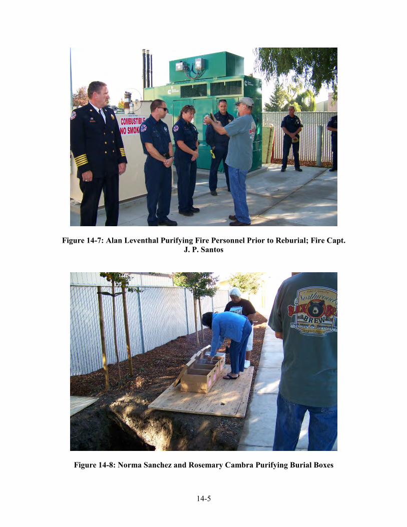
14-5
Figure 14-7: Alan Leventhal Purifying Fire Personnel Prior to Reburial; Fire Capt. J. P. Santos
Figure 14-8: Norma Sanchez and Rosemary Cambra Purifying Burial Boxes

14-6
Figure 14-9: Requested to Cleanse the Reburial Pit, Alan Leventhal Using Sage
Figure 14-10: Placement of Sage and Estafiate in the Four Corners of Pit

14-7
Figure 14-11: Placement of Burial Boxes within Reburial Pit
Figure 14-12: Rosemary Cambra, Norma Sanchez and Alan Leventhal Washing with Water after Placing Burial Boxes in the Reburial Area
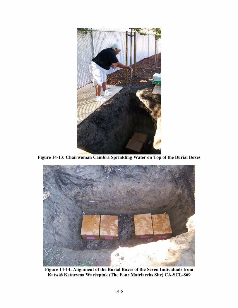
14-8
Figure 14-13: Chairwoman Cambra Sprinkling Water on Top of the Burial Boxes
Figure 14-14: Alignment of the Burial Boxes of the Seven Individuals from
Katwáš Ketneyma Waréeptak (The Four Matriarchs Site) CA-SCL-869

14-9
Final Site Management Recommendations Only a representative portion of the Katwáš Ketneyma Waréeptak (The Four Matriarchs Site) CA-SCL-869 was mitigated within the area designated as the construction site for Fire Station #12. It is OFCS staff’s professional opinion that the areas adjacent to this parcel, to the east and south of the construction site, should still be considered as highly “sensitive” and may still contain human remains and other important archaeological features. These two areas are presently owned by Santa Teresa Catholic Church and should any future construction work be planned within these two adjacent areas, then OFCS recommends that a monitoring program be implemented for all tree removal and subsurface heavy equipment excavation and pavement removal. Furthermore, these areas should be carefully inspected for potential sub-surface features, including burials, and an archaeological data/controlled excavation recovery program should be implemented in order to add to the database presented in this Final Report.
Figure 14-15: Honoring all the Men and Women who Serve in the City of San Jose Fire Department
REFERENCES CITED: CA-SCL-869
REFERENCES-1
Alsop III, Fred J.
2001 Birds of North America. Doling Kindersley Limited Ambrose, S. H. and L. Norr
1993 Experimental Evidence for the Relationship of the Carbon Isotope Ratios of Whole Diet and Dietary Protein to Those of Bone Collagen and Carbonate. In Prehistoric Human Bone: Archaeology at the Molecular Level, edited by J. B. Lambert and G. Grupe, pp. 1-37. Springer-Verlag, New York.
Anderson, M. Kat
2006 Tending the Wild: Native American Knowledge and the Management of California’s Natural Resources. University of California Press. Berkeley.
Anderson S, Bankier AT, Barrel BG, DeBulin MHL, Coulson AR, Drouin J, Eperon IC,
Nierlich DP, Roe BA, Sanger F, Schreier PH, Smith AH, Staden R, and Young IG 1981 Sequence and Organization of the Human Mitochondrial Genome. Nature
290:457-465. Applegate, Richard B.
1978 ?Atishwin: The Dream Helper in South-Central California. Ballena Press
Anthropological Papers No. 13. Edited by Lowell J. Bean and Thomas Blackburn. Ballena Press.
Arbuckle, Clyde
1968 Santa Clara County Ranchos. Harlan-Young Press. San Jose. Arroyo de la Cuesta, Felipe
1976 Reply to the Interrogatory of 1812 from Mission San Juan Bautista. May 1, 1814. In As the Padres Saw Them: California Indian Life and Customs as Reported by
the Franciscan Missionaries, 1813-1815. Edited by Maynard Geiger and Clement Meighan. Santa Barbara Archives, Santa Barbara.
Bancroft, Hubert H.
1886 History of California, Volumes II, III and IV. This History Company. San Francisco.
Barrantes R, Smouse PE, Mohrenweiser HW, Gershowitz H, Azofeifa J, Arias TD, Neel JV
1990 Microevolution in Lower Central America: Genetic Characterization of the Chibcha-Speaking Groups of Costa Rica and Panama, and a Consensus Taxonomy Based on Genetic and Linguistic Affinity. American Journal of Human Genetics 46:63-84.

REFERENCES CITED: CA-SCL-869
REFERENCES-2
Bartelink, E. J. 2006 Resource Intensification in Pre-Contact Central California: A Bioarchaeological
Perspective on Diet and Health Patterns among Hunter-gatherers from the Lower Sacramento Valley and San Francisco Bay. Doctoral dissertation, Texas A&M University, College Station, TX
Basgall, M. E.
1987 Resource Intensification Among Hunter-Gatherers: Acorn Economies in Prehistoric California. In Research in Economic Anthropology, edited by B. L. Isaac, pp. 21-52. vol. 9. JAI Press, Greenwich, Connecticut.
Bass, W.M.
1995 Human Osteology: A Laboratory and Field Manual. 4th Edition, Missouri Archaeological Society, Inc.
Bates, Craig D.
1982 Feathered Regalia of Central California: Wealth and Power. Occasional Papers
of the Redding Museum No. 2. Redding. Baumhoff, M. A.
1963 Ecological Determinants of Aboriginal California Populations. University of
California Publications in American Archaeology and Ethnology 49(2):155-235. Bean, Lowell J.
1975 Power and Its Applications in Native California. Journal of California
Anthropology 2(1):25-33.
1976 Social Organization in Native California. In, Native Californians: A Theoretical
Retrospective, L. J. Bean and T. C. Blackburn, eds., pp. 99-123. Ballena Press. Socorro.
1978 Social Organization. In California, edited by Robert F. Heizer, pp. 673-682.
Handbook of North American Indians, Vol. 8, William C. Strutevant, general editor. Smithsonian Institution, Washington, D.C.
1992 Indians of California: Diverse and Complex Peoples. In California History, edited
by Richard Orsi and Lowell Bean, pp. 302-322. Fall 1992. Vol.LXXI No.3.
Bean, Lowell J, and Thomas Blackburn, eds. 1976 Native Californians: A Theoretical Retrospective. Socorro: Ballena Press.
Bean, Lowell J, and Thomas King, eds.
1974 ?Antap: California Indian Political and Economic Organization. Ballena Press
Anthropological Papers 2. Ramona.
REFERENCES CITED: CA-SCL-869
REFERENCES-3
Bean, Lowell J. and Harry Lawton 1976 Some Explanations for the Rise of Cultural Complexity in Native California with
Comments on Proto-Agriculture and Agriculture. In Native Californians: A
Theoretical Retrospective. pp. 19-48. Lowell Bean and Thomas Blackburn, eds. Ballena Press. Menlo Park.
Bean, Lowell J and Sylvia B. Vane
1978 Cults and Their Transformations. In Handbook of North American Indians, pp 37-57, Vol. 8, California, ed. by Robert F. Heizer, Smithsonian Institution, Washington D.C.,
Beaton, J. M.
1991 Extensification and Intensification in Central California Prehistory. Antiquity
65(249):946-952.
Beeler, Madison S. 1961 Northern Costanoan. International Journal of American Linguistics. 27:191-197.
Bellifemine, Viviana
1997 Mortuary Variability in Prehistoric Central California: A Statistical Study of the Yukisma Site, CA-SCL-38. Unpublished Master’s thesis, Social Sciences Program, San Jose State University, San Jose, California.
Bennyhoff, James A.
1977 Ethnogeography of the Plains Miwok. Center for Archaeological Research at Davis Publication 5. University of California, Davis.
Bennyhoff, James A. and Richard Hughes
1987 Shell Bead and Ornament Exchange Networks Between California and the Western Great Basin. Anthropological Papers of the American Museum of Natural History. 64(2):79-175.
Blackburn, T. C.
1976 "Ceremonial integration and social interaction in aboriginal California". In, Native Californians: a Theoretical Retrospective, ed. by Lowell John Bean and Thomas C. Blackburn.
Bolnick DA, and Smith DG
2003 Unexpected Patterns of Mitochondrial DNA Variation Among Native Americans from the Southeastern United States. American Journal of Physical Anthropology 122:336-354.
Bolton, H. E., ed.
1926 "Historical memoirs of New California by Fray Francisco Palou," O.F.M. 4 vols. University of California Press, Berkeley, California.
REFERENCES CITED: CA-SCL-869
REFERENCES-4
1930 "Anza's California Expeditions". 5 volumes. Berkeley: University of California Press.
Bibby, Brian
1993 Still Going: Bill Franklin and the Revival of Miwuk Traditions. In News for
Native California. Summer, Vol. 7, No. 3, pp. 21-36. Binford, Lewis R.
1962 Archaeology as Anthropology. American Antiquity 28 (2):217-225. 1971 Mortuary Practices: Their Study and Their Potential. In Approaches to the Social
Dimensions of Mortuary Practices, J. A. Brown (editor). Memoir No. 25, Society for American Archaeology. Washington, DC.
1982 The Archaeology of Place. Journal of Anthropological Archaeology 1(1) 5-31.
Blackburn, Thomas 1976 Ceremonial Integration and Social Interaction in Aboriginal California. In Native
Californians: A Theoretical Retrospective, Lowell J. Bean and Thomas C. Blackburn, eds. Ballena Press. Socorro, New Mexico.
Bocek, Barbara R.
1984 Ethnobotany of Costanoan Indians, California, Based on Collections by John P. Harrington. Economic Botany 38:240-255.
Bolton, Herbert E. (Editor)
1911 Expedition to San Francisco Bay in 1770: Diary of Pedro Fages. Academy of
Pacific Coast History Publications 2(3): 141-159.
1926 Historical Memoirs of New California by Fray Francisco Palou, O.F.M. 4 vols. University of California Press. Berkeley, California.
1927 Fray Juan Crespi, Missionary Explorer on the Pacific Coast, 1769-1774.
University of California Press. Berkeley, California.
1930 Anza's California Expeditions. 5 volumes. University of California Press. Berkeley, California.
Book of Funerals at Mission San Jose
1859-1908 Funeral Records on file at the Mission San Jose, Fremont, California. Breschini, Gary, T. Haversat and J. Erlandson
1984 California Radiocarbon Dates, 3rd Edition. Coyote Press. Salinas. Broek, J.O.M
1932 The Santa Clara Valley, California: A Study in Landscape Changes. Utrecht.

REFERENCES CITED: CA-SCL-869
REFERENCES-5
Broughton, J. M. 1994 Declines in Mammalian Foraging Efficiency During the Late Holocene, San
Francisco Bay, California. Journal of Anthropological Archaeology 13(4):371-401.
Broughton, J. M.
1999 Resource Depression and Intensification During the Late Holocene, San
Francisco Bay. University of California Publications: Anthropological Records
32. University of California Press, Berkeley. Brown, Alan K.
1975 Pomponio's World. The San Francisco Westerners Argonaut, Number 6.
1994 The European Contact of 1772 and Some Later Documentation. In The Ohlone: Past and Present Native Americans of the San Francisco Bay Region, edited by Lowell Bean. Ballena Press Anthropological Papers No. 42.
Brown MD, Hosseini SH, Torroni A, Bandelt H-J, Allen JC, Schurr TG, Scozzari R,
Cruciani F, and Wallace DC 1998 MtDNA Haplogroup X: An Ancient Link between Europe/Western Asia and
North America? American Journal of Human Genetics 63:1852-1861. Brown WM, Jr. MG, and Wilson AC
1979 Rapid Evolution of Animal Mitochondrial DNA. Proceedings of the National Academy of Science USA 74:1967-1971.
Buikstra J.E., Ubelaker, D.H.
1994 Standards: For Data Collection from Human Skeletal Remains. Arkansas
Archeological Survey Research Series No. 44. Cambra, Rosemary, Alan Leventhal, Laura Jones, J. Hammett, Les Field, and N. Sanchez
1996 Archaeological Investigations at Kaphan Umux (Three Wolves) Site, CA-SCL-
732: A Middle Period Prehistoric Cemetery on Coyote Creek in Southern San
Jose, Santa Clara County, California. On File at the Northwest Information Center, Sonoma, State University, Rohnert Park, Ca.
Carlyle SW, Parr RL, Hayes MG, and O'Rourke DH
2000 Context of Maternal Lineages in the Greater Southwest. American Journal of Physical Anthropology 113:85-101.
Cartier, Robert and Cynthia James
1990a Archaeological Site Record Form for Prehistoric Site: CA-SCL-706. On file at the Northwest Information Center, Sonoma State University, Rohnert Park, Ca.

REFERENCES CITED: CA-SCL-869
REFERENCES-6
Cartier, Robert 1990b Archaeological Excavations at CA-SCL-6W The Lick Mill Boulevard Site.
Report Prepared for the City of Santa Clara. Castillo, Ed
1978 The Impact of Euro-American Exploration and Settlement. In Handbook of North
American Indians, Vol. 8 California. Pp. 99-127. Robert F. Heizer, ed., Smithsonian Institution, Washington, D.C. Los Angeles.
Chandler-Ezell, K., D. Pearsall and J. Zeidler
2006 Root and Tuber Phytoliths and Starch Grains Document Manioc (Manihot
esculenta), Arrowroot (Maranta arundinacea), and Lleren (Calathea sp.) at the Real Alto Site, Ecuador. Economic Botany 60(12):103-120.
Chartkoff, Joseph L. and Kerry K. Chartkoff
1983 Excavations at the Patrick Site (4-Butte-1). In, The Archaeology of Two Northern California Sites. Monograph 22, Institute of Archaeology. University of California, Los Angeles.
1984 The Archaeology of California. Stanford University Press, Stanford.
Clark, J. C.
1970 Geological map of the Southwestern Santa Cruz Mountains, California. U.S.G.S. open file map, San Francisco.
Coberly, Mary B.
1973 The Archaeology of the Ryan Mound, Site Ala-329, a Central California Coastal Village Site. University of Northern Colorado, Museum of Anthropology, Occasional Publications in Anthropology and Archaeology Series 4.
Coil, J., M. A. Korstanje, S. Archer and C. Hastorf
2003 Laboratory Goals and Considerations for Multiple Microfossil Extraction in Archaeology. Journal of Archaeological Science 30(8):991-1008.
Cook, S. F.
1943 The Conflict Between the California Indians and White Civilization. Ibero-Americana, Vol. 21. Berkeley: University of California Press.
1957 The Aboriginal Population of Alameda and Contra Costa Counties, California.
University of California Anthropological Records 16(4):131-156. Berkeley.
1960 Colonial Expeditions to the Interior of California: Central Valley, 1800-1820.University of California Anthropological Records 16(6):239-292. Berkeley.
1976a The Conflict Between the California Indian and White Civilization. University of
California Press. Berkeley.

REFERENCES CITED: CA-SCL-869
REFERENCES-7
1976b The Population of the California Indians, 1769-1970. University of California Press. Berkeley.
Coon, C. S.
1971 The hunting peoples. Atlantic Monthly Press, Little, Brown and Company. Boston and Toronto.
Crespi, Juan
1769-1774 {see Bolton, Herbert 1927 above) Curtin, Jeremiah
1884 Linguistic Field Notes: California. Recording the Indian languages spoken at Niles and Pleasanton, California. [Filed under “Yukian”] ms #1456. National Anthropological Archives, Smithsonian Institution, Washington, DC.
Curtis, Edward S. 1907-1930 The North American Indian. [California 1924] Norwood Press. Davis, Lee
1992 Mt. Diablo: Captain of Central California. Paper presented at the Scholar's Conference: The Ohlone Indians of the Bay Area: a Continuing Tradition, C.E. Smith Museum of Anthropology, Cal State University, Hayward. Nov. 14, 1992.
Davis, Lee, Suzanne Stewart and Richard Hitchcock
1994 Native American History of the Los Vaqueros Project Area, Alameda and Contra
Costa Counties, California. Report prepared for the Contra Costa Waster District, Concord, Ca.
DeNiro, M. J. and S. Epstein
1978 Influence of Diet on Distribution of Carbon Isotopes in Animals. Geochimica et
Cosmochimica Acta 42(5):495-506. Derbeneva OA, Sukernik RI, Volodko NV, Hosseini SH, Lott MT, and Wallace DC
2002 Analysis of Mitochondrial DNA Diversity in the Aleuts of the Commander Islands and its Implications for the Genetic History of Beringia. American Journal of Human Genetics 71:415-421.
Dietz, Stephen A., W. Hildebrandt, and T. Jones
1988 Archaeological Investigations at Elkhorn Slough: Ca-Mnt-229. A Middle Period Site on the Central California Coast.
Dixon, R. B.
1905 "The northern Maidu". New York: American Museum of Natural History Bulletin 17: 119-346.
REFERENCES CITED: CA-SCL-869
REFERENCES-8
Dobyns, Henry F. 1966 Estimating Aboriginal American Population: an Appraisal of Techniques with a
New Hemispheric Estimate. Current Anthropology, Vol. 7:395-416; 440-444.
Don RH, Cox PT, Wainwright BJ, Baker K, and Mattick JS 1991 Touchdown PCR to Circumvent Spurious Priming during Gene Amplification.
Nucleic Acids Research 19:4008. Dorrington, Lafayette A.
1927 Report to the Commissioner of Indian Affairs, June 23, 1927. Roseberg Files, RG 75: the 1907-1939 Bureau of Indian Affairs Classified Files. National Archives, Washington, D.C.
1930 Letter from Sacramento Superintendent L. A. Dorrington to Indian Commissioner
Rhoads dated April 30, 1930. Roseberg Files, RG 75: the 1907-1939 Bureau of Indian Affairs Classified Files. National Archives, Washington, D.C.
Driver, H. E.
1961 Indians of North America. Chicago. University of Chicago Press. DuBois, Cora A.
1939 The 1870 Ghost Dance. University of California Anthropological Records. 3(1):1-151. Berkeley.
Echo-Hawk, Roger C.
1996 Requote by Roger C. Echo-Hawk in Society for American Archaeology 11(4). In California Indians and Archaeology A Special Report, Ray Moisa and Malcolm Margolin, eds. Printed by News for Native California. Berkeley.
Elsasser, Albert B.
1978a Development of Regional Prehistoric Cultures. In Handbook of North American
Indians, Pp 37-57, Vol. 8, California, ed. by Robert F. Heizer, Smithsonian Institution, Washington D.C.
1978b Basketry. In Handbook of North American Indians, Pp 37-57, Vol. 8, California,
ed. by Robert F. Heizer, Smithsonian Institution, Washington D.C.
1986 Part I: Review of the Prehistory of the Santa Clara Valley Region, California. Coyote Press Archives of California Prehistory Number 7.
Eshleman JA
2002a Mitochondrial DNA and Prehistoric Population Movements in Western North America. Dissertation, University of California, Davis.

REFERENCES CITED: CA-SCL-869
REFERENCES-9
2002b Analysis of Ancient and Modern Mtdna Sequence Variability from California's Central Valley. Dissertation, University of California, Davis.
Eshleman JA, Malhi RS, Johnson JR, Kaestle FA, Lorenz J, and Smith DG
2004 Mitochondrial DNA and Prehistoric Settlements: Native Migrations on the Western Edge of North America. Human Biology 76:55-75.
Eshleman JA, Malhi RS, and Smith DG
2003 Mitochondrial DNA Studies of Native Americans: Conceptions and Misconceptions of the Population Prehistory of the Americas. Evolutionary Anthropology 12:7-18.
Fages, Pedro
1911 Expedition to San Francisco Bay in 1770: Diary of Pedro Fages. Herbert E. Bolton, ed. Publications of the Academy of Pacific Coast History 2(3): 141-159. Berkeley, California.
1937 A Historic, Political, and Natural Description of California, by Pedro Fages,
Soldier of Spain [1775]. Translated by Herbert I. Priestley. Berkeley: University of California Press. (Reprinted: Ballena Press, Ramona, Calif., 1972).
Federal Census
1900 (Twelfth Census/Indian Population Census Washington and Murray Townships, Alameda County, California), 1910 (Thirteenth Census/ Indian Population Census Pleasanton Township, Alameda County, California), 1920 (Fourteenth Census, Alameda and Santa Clara Counties), 1930 (Fifteenth Census, Alameda, Contra Costa, and Santa Clara Counties)
Field, Les, Alan Leventhal, Dolores Sanchez, and Rosemary Cambra
1992 A Contemporary Ohlone Tribal Revitalization Movement: A Perspective from the Muwekma Ohlone Indians of the San Francisco Bay. In California History:
Indians of California Vol. LXXI (3) Fall. California Historical Society. San Francisco.
2004 A Contemporary Ohlone Tribal Revitalization Movement: A Perspective from the
Muwekma Ohlone Indians of the San Francisco Bay. In Archaeological
Investigations at CA-SCL-690, Tamien Station. Mark Hylkema, editor. Caltrans, District 4.
2007 A Contemporary Ohlone Tribal Revitalization Movement: A Perspective from the Muwekma Ohlone Indians of the San Francisco Bay. In Santa Clara Valley
Prehistory: Archaeological Investigations at CA-SCL-690, Tamien Station. Mark Hylkema, editor. Center for Archaeological Research at Davis Publication No. 15.

REFERENCES CITED: CA-SCL-869
REFERENCES-10
Font, Pedro 1930 Font's Complete Diary of the Second Anza Expedition. Vol. 4 of Anza's
California Expeditions. H. Bolton, ed. University of California Press. Berkeley. Forbes, Jack
1969 Native Americans of California and Nevada: A Handbook. Naturegraph Publishers. Healdsberg, California.
Forster P, Harding R, Torroni A, and Bandelt H-J
1996 Origin and Evolution of Native American MtDNA Variation: A Reappraisal. American Journal of Human Genetics 59:935-945.
Fox, C., J. Juan and R. Albert
1996 Phytolith Analysis on Dental Calculus, Enamel Surface, and Burial Soil: Information about Diet and Paleoenvironment. American Journal of Physical
Anthropology 101:101-113. Fredrickson, David A.
1968 Archaeological Investigation at CCo-30 near Alamo Contra Costa County, California.
1973 Early Cultures of the North Coast Ranges, California. PhD. Dissertation,
Department of Anthropology, University of California at Davis.
1974 Social Change in Prehistory: A Central California Example. In ?Antap:
California Indian Political and Economic Organization., Edited by L. J. Bean and T. F. King. Ballena Press. Ramona Press Anthropological Papers 2:57-73.
Fried, Morton
1967 The Evolution of Political Society. Random House. New York. Fried, M. N. and M. H. Fried
1980 Transitions: Four Rituals in Eight Cultures. Penguin Books Fry B.
2006 Stable Isotope Ecology. Springer Science, New York. Galindo, Nasario
1959 Early Days at Mission Santa Clara. California Historical Society Quarterly 38(2):101-111 [1883].
Galvan P. Michael
1968 People of the West: The Ohlone Story. The Indian Historian 1(2):9-13. Galvin, John
1971 The First Spanish Entry into San Francisco Bay, 1775. Howell Books. S.F.

REFERENCES CITED: CA-SCL-869
REFERENCES-11
Gilbert, B. Miles, Larry D. Martin, and Howard G. Savage 1996 Avian Osteology, Missouri Archaeological Society, Inc.
Gayton, Anna H.
1930a Yokuts and Mono Chiefs and Shamans. University of California Publications in
American Archaeology and Ethnology 24(8): 361-420. Berkeley. 1930b The Ghost Dance of 1870 in South Central California. University of California
Publications in American Archaeology and Ethnology 28(3):57-82. Berkeley. 1935 Areal Affiliation of California Folktales. American Anthropologist 37(4):582-
599. 1936 Estudillo Among the Yokuts: 1819. In Essays in Anthropology, Presented to A.
L. Kroeber in Celebration of his Sixtieth Birthday. Edited by Robert H. Lowie, pp. 67-85. University of California Press. Berkeley.
1945 Yokuts and Western Mono Social Organization. American Anthropologist 47(3):
409-426. 1948 Yokuts and Western Mono Ethnography. University of California
Anthropological Records 10(1-2): 1-302. Berkeley. Geiger, Maynard and Clement Meighan
1976 As the Padres Saw Them : California Indian Life and Customs as Reported by the
Franciscan Missionaries, 1813-1815. Santa Barbara Mission Archive Library,Glendale, Calif.
Genoves, Santiago.
1967 “Proportionality of the Long Bones and their Relation to Stature among Mesoamericans”. American Journal of Physical Anthropology, 26: 67-78.
Gerow, Bert A. with Roland Force
1968 An Analysis of the University Village Complex with a Reappraisal of Central California Archaeology. Stanford Press.
Gifford, Edwin W.
1914 Central Miwok Shamans. Unpublished Fieldnotes. Ethnological Documents Collection, University Archives, University of California, Berkeley. CU-23.1 No. 179.
1915 Yokuts Moieties. Unpublished Fieldnotes. Ethnological Documents Collection,
University Archives, University of California, Berkeley. CU-23.1 no. 178. 1916a Miwok Moieties. University of California Publications in American Archaeology
and Ethnology 12(4):139-194. Berkeley.
REFERENCES CITED: CA-SCL-869
REFERENCES-12
1916b Dichotomous Social Organization in South Central California. University of
California Publications in American Archaeology and Ethnology 11(5):291-296. Berkeley.
1917 Miwok Myths. University of California Publications in American Archaeology
and Ethnology 12(8):283-338. Berkeley. 1926 Miwok Cults. University of California Publications in American Archaeology
and Ethnology 18(3):391-408. Berkeley. 1927 Southern Maidu Religious Ceremonies. American Anthropologist 29(3):214-257. 1940 California Bone Artifacts. University of California Anthropological Records
3(2):153-237. Berkeley. 1944 Miwok Lineages. American Anthropologist 46 (3):376-381. 1947 Californian Shell Artifacts. University of California Anthropological Records 9
(1). Berkeley. 1955 Central Miwok Ceremonies. University of California Anthropological Records
14(4):261-318. Berkeley. Gilbert, B. Miles.
1980 Mammalian Osteology. B. Miles Gilbert, Laramie Giles RE, Blanc H, Cann HM, and Wallace DC
1980 Maternal Inheritance of Human Mitochondrial DNA. Proceedings of the National Academy of Sciences USA 77:6715-6719.
Goldschmidt, Walter
1948 Social Organization in Native California and the Origin of Clans. American
Anthropologist 50(3):444-456. 1951 Nomlaki Ethnography. University of California Publications in American
Archaeology and Ethnology 42(4): 303-443. Berkeley.
Gonzalez-Oliver A, Marquez-Morfin L, Jimenez JC, and Torre-Blanco A 2001 Founding Amerindian Mitochondrial DNA Lineages in Ancient Maya from
Xcaret, Quintana Roo. American Journal of Physical Anthropology 116:230-235. Grady, Diane L., Kate A. Latham, and Valerie A. Andrushko
2001 Archaeological Investigations at CA-SCL-674, the Rubino Site San Jose, Santa
Clara County, California. Vol. II Human Skeletal Biology of CA-SCL-674. Coyote Press Archives of California Prehistory, No. 50.

REFERENCES CITED: CA-SCL-869
REFERENCES-13
Gray, Nicholas 1855 Map No. 234ND, 747. On file Bancroft Library, University of California,
Berkeley. Published in Draft Report of Archaeological Test Excavations of CA-
ALA-60 Located on Route 580, Castro Valley, Alameda County ,California, George R. Miller, ed. 1980. California State University at Hayward.
Griffin, Mark C.
2007 Laboratory Manual for Human Osteology and Forensic Anthropology. San Francisco State University. San Francisco.
Groza, Randall G.
2002 AMS Chronology for Central California Olivella Shell Beads. Unpublished Master’s Thesis, Department of Anthropology, San Francisco State University.
Gutierrez, Ramon 1991 When Jesus Came, the Corn Mothers Went Away. Stanford Press.
Hall, Frederic 1871 : with Biographical Sketches of Early
Settlers. San Francisco : A.L. Bancroft and Co.
Hammett, Julia E. 1991 The Ecology of Sedentary Societies Without California: Paleoethnobotanical
Indicators from Native California. Unpublished Ph.D. Dissertation, Department of Anthropology, University of North Carolina-Chapel Hill.
Hanni C, Brousseau T, Laudet V, and Stehelin D
1995 Isopropanol Precipitation Removes PCR Inhibitors from Ancient Bone Extracts. Nucleic Acids Research 23:881-882.
Harrington, John P.
1921-1939 Manuscript Field Notes on Costanoan: Chochenyo, Mutsun and Rumsen
Linguistics available on microfilm at San Jose State University Library. Kraus International Publications. New York.
1930 Twenty-Seven Wax Cylinder Songs/Recordings of Jose Guzman. Recorded
March 14-15, 1930 at Pleasanton. Cylinder Nos.1307-1333. Federal Cylinder Project Library of Congress, American Folklife Center, Archive of Folk Culture, Washington, DC.
1933 Report of Fieldwork on Indians of Monterey and San Bernardino Counties. In
49th Annual Report of the Bureau of American Ethnology for the Years 1931-1932, pp. 2-3. Washington D. C.
1942 Culture Element Distributions, XIX: Central California Coast. University of
California Anthropological Records 7(1):1-46. Berkeley.

REFERENCES CITED: CA-SCL-869
REFERENCES-14
Heizer, Robert F. 1949 The Archaeology of Central California I: The Early Horizon. University of
California Anthropological Records 12(1):1-84. 1952 California Indian Linguistic Records: The Mission Indian Vocabularies of
Alphonse Pinart. University of California Anthropological Records 15(1):1-84. 1971 Census of Non-reservation California Indians, 1905-1906. R. F. Heizer, editor,
Miscellaneous Publications of the University of California Archaeological
Research Facility. Berkeley. 1972 The Eighteen Unratified Treaties of 1851-1852 Between the California Indians
and the United States Government. University of California Archaeological
Research Facility. Berkeley. 1974 The Costanoan Indians. Local History Studies volume 18. California History
Center, DeAnza College. Cupertino, California. 1978a Handbook of North American Indians Vol. 8: California, W. C. Sturtevant,
General Editor. Smithsonian Institution. Washington, D.C. 1978b Trade and Trails. In Handbook of North American Indians, Vol. 8:690-693,
California. R. F. Heizer, ed. Smithsonian Institution. Washington, D.C. 1979 Federal Concern about Conditions of California Indians, 1853-1913: Eight
Documents. Ballena Press Publications in Archaeology, Ethnology and History Number 13. Menlo Park, California.
Heizer, Robert F. and Albert B. Elsasser.
1980 The Natural World of the California Indians. University of California Press, Berkeley.
Heizer, Robert F. and Adan E. Treganza
1949 Mines and Quarries of the Indians of California. Sacramento: California Journal
of Mines and Geology 40(3):291-359
Hester, T. R.
1978 "Salinan". In, R. F. Heizer, ed. Handbook of North American Indians. Vol. 8, California. Washington D.C. Smithsonian Institution.
Hildebrandt, William R.
1983 Archaeological Research of the Southern Santa Clara Valley Project. Report on file with Caltrans, District 04, San Francisco.

REFERENCES CITED: CA-SCL-869
REFERENCES-15
Hildebrandt, William and Laureen Swenson. 1983 Environmental Setting and Site Catchment Analysis. In Final Report,
Archaeological Research of the Southern Santa Clara Valley Project, edited by William Hildebrandt, pp. 1-35 to 1-57. Report on file Caltrans, District 4, San Francisco.
History of Washington Township
1904 Women's Research Committee on Washington Township, History of Washington
Township. Compiled and Written by: The Country Club of Washington Township Research Committee, 1904. Second Edition 1950.
Holterman, Jack
1970 The Revolt of Estanislao. The Indian Historian 3(1):43-54.
Hoopes, Chad 1975 Domesticate or Exterminate. Redwood Coast Publications.
Horai S, Kondo R, Nakagawa-Hattori Y, Hayashi S, Sonoda S, and Tajima K 1993 Peopling of the Americas, Founded by Four Major Lineages of Mitochondrial
DNA. Molecular Biology and Evolution 10:23-47. Höss M, and Pääbo S
1993 DNA Extraction from Pleistocene Bones by a Silica-Based Purification Methods. Nucleic Acids Research 21.
Hughes, Richard E. and Randall Milliken
2007 Prehistoric Material Conveyance. In: California Prehistory: Colonization, Culture
and Complexity. Edited by Terry L. Jones and Kathryn A. Klar. AltaMira Press.
Hurtado, Albert L. 1988 Indian Survival on the California Frontier. Yale University Press, New Haven.
Hylkema, Mark 1990 Archaeological Site Record Form for Prehistoric Site: CA-SCL-690. On file at
the Northwest Information Center, Sonoma State University, Rohnert Park, Ca. 1991 Prehistoric Native American Adaptations Along the Central California Coast of
San Mateo and Santa Cruz Counties. Unpublished Masters Thesis, Department of Social Sciences, San Jose State University, California.
1995 Archaeological Investigations at the Third Location of Mission Santa Clara
DeAsis: The Murguiá Mission, 1781-1818 (CA-SCL-30/H). Report prepared for Caltrans District 4, Oakland, California.
2004 Archaeological Investigations at Tamien Station: Site CA-SCL-690 edited by
Mark Hylkema. Caltrans District 4, Oakland, California.

REFERENCES CITED: CA-SCL-869
REFERENCES-16
2007 Santa Clara Valley Prehistory: Archaeological Investigations at CA-SCL-690,
Tamien Station. Mark Hylkema, editor. Center for Archaeological Research at Davis Publication No. 15.
Jackson, Robert 1992 Patterns of Demographic Change in Alta California Missions: The Case of Santa
Ines. In California History: Indians of California Volume LXXI (3) Fall. California Historical Society. San Francisco.
James, Steven R. and Susan Graziani.
1975 California Indian Warfare. Contributions of the California Research Facility, Ethnographic Interpretations: No. 12-13. University of California, Berkeley.
Jenkins, James
1923 Annual Report of the Reno Agency, James Jenkins, Superintendent. RG 75, Reno Indian Annual Narrative and Statistical Reports 1912-1924. Box 6;Folder “[Annual Narrative Reports 1923 Reno Indian Agency]” pp. 1-31.: National Archives, Washington, D.C.
Jones, T. L. and L. M. Raab (editors)
2004 Prehistoric California: Archaeology and the Myth of Paradise. University of Utah Press, Salt Lake City.
Kaestle FA, and Smith DG
2001 Ancient Mitochondrial DNA Evidence for Prehistoric Population Movement: The Numic Expansion. American Journal of Physical Anthropology 115:1-12.
Kelly, Isabel. T.
1932 Ethnographic Field Notes on the Coast Miwok Indians. Manuscript. On file at the Bancroft Library. University of California. Berkeley.
1978 Coast Miwok. In Handbook of North American Indians, Vol. 8: 414-425,
California. Edited by R. F. Heizer. Smithsonian Institution. Washington, D.C. 1991 Interviews with Tom Smith and Maria Copa: Ethnographic Notes on the Coast
Miwok Indians of Marin and Southern Sonoma Counties, California. Edited by Mary Collier and Sylvia Thalman. MAPOM Occasional Papers Number 6.
Kellner C and Schoeninger M.J.
2008. A Simple Carbon Isotope Model for Reconstructing Prehistoric Human Diet. American Journal of Physical Anthropology 133:1112-1127.
Kelman LM, and Kelman Z
1999 The Use of Ancient DNA in Paleontological Studies. Journal of Vertebrate Paleontology 19:8-20.
REFERENCES CITED: CA-SCL-869
REFERENCES-17
Kelsey, C. E. 1906 Report of the Special Agent for California Indians. Printed by Carlisle Indian
School. National Archives, Washington D.C. 1971 Census of Non-reservation California Indians, 1905-1906. Robert F. Heizer, ed.
Miscellaneous Publications of the University of California Archaeological
Research Facility. Berkeley.
Kemp BM, Resendez A, Roman Berrelleza AR, Malhi RS, and Smith DG (Forthcoming) An Analysis of Ancient Aztec mtDNA from Tlatelcoc: Pre-Columbian
Relations and the Spread of Uto-Aztecan. In DM Reed (ed.): Biomolecular Archaeology: Genetic Approaches to the Past. Carbondale, IL: Southern Illinois University.
Kemp BM, and Smith DG
(Forthcoming) Use of Bleach to Eliminate Contaminating DNA from the Surfaces of Bones and Teeth. Forensic Science International.
King, Chester D.
1974 Northern Santa Clara Ethnography. In Environmental Impact Report, San Felipe
Water Distribution System, Archaeological Resources by T. King and G. Berg: Appendix I. Report prepared for Santa Clara Valley Water District.
1976 Chumash Inter-Village Economic Exchange. In Native Californians: A
Theoretical Retrospective Lowell J. Bean and Thomas C. Blackburn (editors). Ramona: Ballena Press.
1977 Matalan Ethnohistory. In Final Report of Archaeological Test Excavations for
Construction of Freeway 04-SCl-101 Post Miles 17.2/29.4. by S.A. Dietz. Chapter IV. Report prepared by Archaeological Consulting and Research Services for Caltrans, District 04, San Francisco.
1978a The Historic Indian Settlements of San Jose. In Archaeological Investigations at
CA-SCL-128: The Holiday Inn Site by J. C. Winter, ed. Chapter XI. Report prepared for the Redevelopment Agency, City of San Jose.
1978b Almaden Valley Ethnogeography. In The Archaeological Mitigation of 4-SCl-132
Alamitos Creek, San Jose, CA. Robert Cartier, editor. Report on file City of San Jose.
1990 Evolution of a Chumash Society. Garland Press. New York. 1994 Central Ohlone Ethnohistory. In The Ohlone: Past and Present Native
Americans of the San Francisco Bay Region edited by Lowell Bean. Ballena
Press Anthropological Papers No. 42.

REFERENCES CITED: CA-SCL-869
REFERENCES-18
King, Linda B. 1982 Medea Creek Cemetery: Late Inland Chumash Patterns of Social Organization,
Exchange and Warfare. Unpublished PhD. dissertation, Department of Anthropology, University of California, Los Angles.
King, Thomas. F.
1970 The Dead at Tiburon. Northwest California Archaeological Society, Occasional
Papers 2. 1974 The Evolution of Status Ascription Around San Francisco Bay. In ?Antap:
California Indian Political and Economic Organization edited by L. J. Bean and T. F. King. Pp. 35-54. Ballena Press Anthropological Papers 2.
Kolman CJ, and Bermingham E
1997 Mitochondrial and Nuclear DNA Diversity in the Choco and Chibcha Amerinds of Panama. Genetics 147:1289-1302.
Kolman CJ, Bermingham E, Cooke R, Ward RH, Arias TD, and Guionneau-Sinclair F
1995 Reduced mtDNA diversity in the Ngobe Amerinds of Panama. Genetics 140:275-283.
Kroeber, Alfred L. 1904 The Languages of the Coast of California South of San Francisco. University of
California Publications in American Archaeology and Ethnology 2(2):29-80. Berkeley.
1907 Indian Myths of South Central California. University of California Publications
in American Archaeology and Ethnology 4(4):167-250. Berkeley. 1908 A Mission Record of the California Indians. University of California
Publications in American Archaeology and Ethnology 8(1):1-27. Berkeley. 1910 The Chumash and Costanoan Languages. University of California Publications
in American Archaeology and Ethnology 9:237-271. Berkeley. 1925 Handbook of the Indians of California. Bureau of American Ethnology Bulletin
78. Washington. 1932 The Patwin and Their Neighbors. University of California Publications in
American Archaeology and Ethnology 29(4):253-423. Berkeley.
1939 Cultural and Natural Areas of Native North America. University of California
Publications in American Archaeology and Ethnology 38:1-240. Berkeley.
REFERENCES CITED: CA-SCL-869
REFERENCES-19
1962 The Nature of Land-Holding Groups in Aboriginal California, pp. 19-58 in Two Papers on the Aboriginal Ethnography of California. D. H. Hymes and R. Heizer, eds. University of California Archaeological Survey Reports No. 56. Berkeley.
Laffey, Glory Anne
1986 Report About the Discovery of Indian burials at California Canners and Growers Facility (Prehistoric Site: CA-SCL-690). On file at the Northwest Information
Center, Sonoma State University, Rohnert Park, Ca.
Lalueza-Fox C 1996 Analysis of Ancient Mitochondrial DNA from Extinct Aborigines from Tierra del
Fuego-Patagonia. Ancient Biomolecules 1:43-54. Lalueza-Fox C, Gilbert MTP, Martinez-Fuentes AJ, Calafell F, and Bertranpetit J
2003 Mitochondrial DNA from Pre-Columbian Ciboneys from Cuba and the Prehistoric Colonization of the Caribbean. American Journal of Physical Anthropology 121:97-108.
Lalueza-Fox C, Luna Calderon F, Calafell F, Morera B, and Bertranpetit J
2001 MtDNA from Extinct Tainos and the Peopling of the Caribbean. Annals of Human Genetics 65:137-151.
Langsdorff, George H. von
1968 Voyages and Travels in Various Parts of the World During the Years 1803, 1804,
1805, 1806, and 1807 (1813-1814). 2 vols. (Bibliotheca Australiana 41) Da Capo Press. New York.
Latta, Frank
1949 Handbook of Yokuts Indians. Kern County Museum. Bakersfield.
Lentfer, C. and W. Boyd 2000 Simultaneous Extraction of Phytoliths, Pollen, and Spores from Sediments.
Journal of Archaeological Science 27(5):363-372.
Leventhal, Alan M. 1993 A Reinterpretation of Some Bay Area Shellmound Sites: A View from the
Mortuary Complex at Ca-Ala-329, the Ryan Mound. Unpublished Master's thesis, Department of Social Sciences, San Jose State University.
Leventhal, Alan, R. Cambra, A, Miranda, J. Mondragon, A. Slagle and I. Zwierlein
1992 Anthropology -- A Continued Process of Colonialism or California Indians Are
Still Only Objects of Study. Paper presented in the Ohlone Symposium, at the Southwestern Anthropological Association 63rd Annual Meeting. Berkeley, California.

REFERENCES CITED: CA-SCL-869
REFERENCES-20
Leventhal, Alan., Lorraine Escobar, Hank Alvarez, Dottie Lameira, Dolores Sanchez, Enos Sanchez, Robert Sanchez, Sr., and Lawrence Thompson, Sr.
1995 Historical and Genealogical Information on the Muwekma Ohlone Lineages that
Descend from the Aboriginal Tribes of the Greater San Francisco Bay and from
the Historic Indian Rancherias that Comprised the Verona Band. Documents submitted to the Branch of Acknowledgment and Research, Bureau of Indian Affairs, Department of the Interior. Washington , D.C.
Leventhal, Alan, Les Field, Henry Alvarez, and Rosemary Cambra
1994 The Ohlone: Back From Extinction. In The Ohlone: Past and Present Native Americans of the San Francisco Bay Region, edited by Lowell Bean. Ballena
Press Anthropological Papers No. 42.
Leventhal, Alan M. 1988 Analysis of the 1983 Flaked Stone and Ground Stone Assemblage from the
Scott's Valley Site: CA-SCR-177. In, The Scott's Valley Site Report 1983 and 1987. R. Cartier ed.
Leventhal, A. M., R. Cambra and N. Sanchez
1987 Final Report of the Archaeological Recovery Program of a Portion of Prehistoric Site: CA-ALA-479, Union City, California. Report on file at the Northwest Information Center, Sonoma State University.
Leventhal, A. M., R. Cambra and B. Ananian
1988 Subsurface Archaeological Test Excavations and Soils Report on Prehistoric Site: CA-SCL-343, Lands of Oyama, San Jose, California. Report on file at Ohlone Families Consulting Services, San Jose, California.
Leventhal, A. M., R. Cambra, N. Sanchez and B. Domenech
1988 Final Report on the Archaeological Data Recovery Program on the Southern Portion of Prehistoric Site: CA-SCL-581, Lands of Oki, San Jose, California. Report on file at the Northwest Information Center, Sonoma State University.
Leventhal, Alan M., G. Seitz
1989 Experimental Archaeology Mortar Replication Study: Description and Analysis. In Results of the General Development Plan Archaeological Test Excavation Conducted at CA-MNT-185/H. California Parks and Recreation, Sacramento.
Leventhal, Alan M., G. Seitz and M. Hylkema
1986 A Report on Biface Manufacturing Stages from Site: CA-SMA-218, Año Nuevo, the Harris collection. Paper presented at the Society for California Archaeology Annual Meetings. Santa Rosa, Ca. March 28.
Levy, Richard.
1976 Costanoan Internal Relationships. Contributions of the Archaeological Research Facility, Department of Anthropology, University of California. Berkeley.

REFERENCES CITED: CA-SCL-869
REFERENCES-21
1978 Costanoan. In Handbook of North American Indians, Vol. 8, California, edited by
Robert F. Heizer, pp. 485-495. Smithsonian Institution. Washington.
Lewis Henry T. 1973 Patterns of Indian Burning in California: Ecology and Ethnohistory. Ballena
Press Anthropological Papers 1:1-101. Ramona, California.
Lindahl T 1993 Instability and Decay of the Primary Structure of DNA. Nature (London)
362:709-715. Lipps, Oscar H.
1930 Letter from Sacramento Superintendent Oscar Lipps to Assistant Indian Commissioner J. Scattergood dated June 30, 1931. Roseberg Files, RG 75: the 1907-1939 Bureau of Indian Affairs Classified Files. National Archives, Washington, D.C.
Loeb, Edwin M
1932 Western Kuksu Cult. University of California Publications in American
Archaeology and Ethnology 33(1):1-137. Berkeley 1933 Eastern Kuksu Cult. University of California Publications in American
Archaeology and Ethnology 33(2):139-232. Berkeley Lorenz JG, and Smith DG
1996 Distribution of Four Founding mtDNA Haplogroups among Native North Americans. American Journal of Physical Anthropology 101:307-323.
Lorenz JG, and Smith DG
1997 Distribution of Sequence Variation in the mtDNA Control Region of Native North Americans. Human Biology 69:749-776.
Lovejoy, CO, RS Meindi, TR Pryzbeck, and RP Mensforth
1985 Chronological Metamorphosis of the Auricular Surface of the Ilium: A New Method for the Determination of Adult Skeletal Age at Death. American Journal
of Physical Anthropology 68:15-26. Luby, Edward
1991 Social Organization and Symbolism at the Patterson Mound Site, CA-ALA-328, Alameda County, California. California Anthropologist 18(2):45-52.

REFERENCES CITED: CA-SCL-869
REFERENCES-22
Maddox, Deborah 1996 Letter to Rosemary Cambra, Chairwoman of the Muwekma Ohlone Tribe
Regarding Formal Determination of “Previous Unambiguous Federal Recognition” under 25 CFR 83.8. Letter dated May 24, 1996. On file Muwekma Tribal Office and Department of Interior, BIA, Office of Federal Acknowledgment, Washington, DC.
Malhi RS
2001 Investigating Prehistoric Population Movements in North America with Ancient and Modern DNA. Dissertation, University of California, Davis.
Malhi RS, Breece KE, Shook BAS, Kaestle FA, Chatters JC, Hackenberger S, and Smith DG 2004 Patterns of mtDNA Diversity in Northwestern North America. Human Biology
76:33-54. Malhi RS, Eshleman JA, Greenberg JA, Weiss DA, Schultz Shook BA, Kaestle FA, Lorenz
JG, Kemp BM, Johnson JR, and Smith DG ( 2002 The structure of Diversity within New World Mitochondrial DNA Haplogroups:
Implications for the Prehistory of North America. American Journal of Human Genetics 70:905-919.
Malhi RS, Mortenson HM, Eshleman JA, Kemp BM, Lorenz JG, Kaestle FA, Johnson JR,
Gorodezky C, and Smith DG 2003 Native American mtDNA Prehistory in the American Southwest. American
Journal of Physical Anthropology 120:108-124. Marine, Dario
1965 Marine Family History Notes: Interview with Dario Marine About the Ohlone
Cemetery. Notes transcribed by Philip Galvan. On file at the Muwekma Tribal office, San Jose, California
Mason, J. Alden
1912 The Ethnology of the Salinan Indians. University of California Publications in
American Archaeology and Ethnology 10(4): 97-240. Berkeley. 1916 The Mutsun Dialect of Costanoan Based on the Vocabulary of de la Cuesta.
University of California Publications in American Archaeology and Ethnology 11(7): 399-472. Berkeley.
1918 The Language of the Salinan Indians. University of California Publications in
American Archaeology and Ethnology 14(1):1-154. Berkeley.
Matthiesen, Diana G. and Raj B. Guruswami-Naidu 1979 A Preliminary Report on Bird and Mammal Remains from CA-SCl-300 and CA-
SCl-302. In the Archaeological Resources of the Wade Ranch by Robert Cartier, Principal, pp.110-141. Report prepared for the City of San Jose.

REFERENCES CITED: CA-SCL-869
REFERENCES-23
Mayfield, D. W. 1978 Ecology of the Pre-Spanish San Francisco Bay Area. Unpublished Master's
Thesis, Department of Geography, San Francisco State University. 1980 Ecology of a Discovered Land. Pacific Discovery 33(5): 12-20. California
Academy of Sciences. San Francisco.
McCarthy, Francis C. 1958 History of Mission San Jose, California 1797-1835. Academy Library Guild.
Fresno. Merriam, C. Hart
1902-1930 Mewuk (Sierra Miwok) and Miwok (Plains Miwok) Tribes and Villages. Manuscript on file at the University of California, Bancroft Library, C. Hart Merriam Collection. Berkeley.
1934 Photographs of Jose Guzman, Niles and Morrison Canyon, 1934. 1955 Studies of California Indians. Edited by the Staff of the Department of
Anthropology of the University of California. University of California Press. 1967 Ethnographic Notes on California Indian Tribes, III: Central California Indian
Tribes, Robert Heizer, ed. University of California Archaeological Survey
Reports 68(3). Berkeley.
Merriwether DA, Clark AG, Ballinger SW, Schurr TG, Soodyall H, Jenkins T, Sherry ST, and Wallace DC
1991 The Structure of Human Mitochondrial DNA Variation. Journal of Molecular Evolution 33:543-555.
Merriwether DA, and Ferrell RE
1996) The Four Founding Lineage Hypothesis for the New World: A Critical Reevaluation. Molecular Phylogenetics and Evolution 5:241-246.
Milliken, Randall T.
1978 Ethnohistory of the Lower Napa Valley. In Report of Archaeological Excavations
at the River Glen Site (CA-NAP-261), pp. 2.1-2.43, Thomas Jackson, editor. U.S. Army Corps of Engineers, San Francisco District
1982 An Ethnographic Study of the Clayton area, contra Costa County, California. In
Cultural Resource Evaluation of Keller Ranch, Clayton, California, by Miley Holman and Matthew Clarke.
1983 The Spatial Organization of Human Population On Central California's San
Francisco Peninsula at the Spanish Arrival. Unpublished Master's thesis, Interdisciplinary Studies: Cultural Resources Management Sonoma State University.

REFERENCES CITED: CA-SCL-869
REFERENCES-24
1990 Ethnogeography and Ethnohistory of the Big Sur District, California State Park
System During the 1770-1810 Time Period. Report submitted to the Department of Parks and recreation, Sacramento, Ca.
1991 An Ethnohistory of the Indian People of the San Francisco Bay Area from 1770-
1810. Ph.D. dissertation, Department of Anthropology, University of California, Berkeley.
1993 Historic Overview of the San Felipe Sink Area (Part 1) and Native Peoples (Part
2). Chapters in Archaeological Test Excavations at Fourteen Sites Along
Highways 101 and 152, Santa Clara and San Benito Counties, California, Vol., 2: History, Ethnohistory, and Historic Archaeology. Far Western Anthropological Research Group. Report submitted to Caltrans District 4, Oakland.
1994 The Costanoan-Yokuts Language Boundary in the Contact Period. In The
Ohlone: Past and Present Native Americans of the San Francisco Bay Region, edited by Lowell Bean. Ballena Press Anthropological Papers No. 42.
1995 A Time of Little Choice: The Disintegration of Tribal culture in the San Francisco
Bay Area 1769-1810. Menlo Park: Ballena Press. 2004 The Ohlone People of the Santa Clara Valley in the 1770s. In Archaeological
Investigations at CA-SCL-690, Tamien Station. Mark Hylkema, editor. Caltrans, District 4.
2007 The Ohlone People of the Santa Clara Valley in the 1770s. In Santa Clara Valley
Prehistory: Archaeological Investigations at CA-SCL-690, Tamien Station. Mark Hylkema, editor. Center for Archaeological Research at Davis Publication No. 15.
2008 Native Americans at Mission San Jose. Malki-Ballena Press. Banning. Ca.
Milliken, R. T., Alan Leventhal and Rosemary Cambra
1987 Interpretive Recommendations and Background Report for the Coyote Hills
Museum. Submitted to the East Bay regional Park District, Oakland. Milliken, Randall, Richard T. Fitzgerald, Mark G. Hylkema, Randy Groza, Tom Origer, David G. Bieling, Alan Leventhal, Randy S. Wiberg, Andrew Gottsfield, Donna Gillette, Viviana Bellifemine, Eric Strother, Robert Cartier, and David A. Fredrickson
2007 Punctuated Culture Change in the San Francisco Bay Area. In: California
Prehistory: Colonization, Culture and Complexity. Edited by Terry L. Jones and Kathryn A. Klar. AltaMira Press.
Mission San Jose Baptismal Records 1797-1859 Mission San Jose Libro de Bautismos. Archives of the Archdiocese of San
Francisco, Mountain View, California.

REFERENCES CITED: CA-SCL-869
REFERENCES-25
Molner, S.
1971 Human Tooth Wear, Tooth Function, and Cultural Variability. American Journal
of Physical Anthropology, 34:175-190.
Monroe, Cara, Alan Leventhal, Rosemary Cambra and Brian Kemp 2009 Ancient Human DNA Analysis from CA-SCL-287/CA-SMA-263
Burials: New Insights Regarding California Prehistory. Paper presented at the Society for California Archaeology Meetings. Fresno, Ca. March.
Monroy, Douglas 1990 Thrown Among Strangers. University of California Press, Berkeley.
Moratto, Michael J. 1984 California Archaeology. Academic Press, New York.
Northwest Information Center
2007 Archival Literature Search for 5931 Cahalan Avenue, San Jose, Santa Clara County, California, (CA-SCL-869). Assigned NWIC File # 06-1888.
Olsen, Nancy, Alan Leventhal and Rosemary Cambra
1985 A Brief Ethnohistory and Genealogy of the Muwekma Mission San Jose and Pleasanton Rancheria Ohlone Families. In Results of an Archaeological Testing
Program at CA-ALA-343, edited by Jeff Hall. Report on file, Department of Anthropology, San Jose State University. San Jose.
Olsen, Stanley J.
1973 Mammal Remains From Archeological Sites, Part 1 Southeastern and Southwestern United States. Papers of the Peabody Museum of Archeology and
Ethnology, Harvard University, 56 (1) Olsen, William H. and Norman L. Wilson
1964 The Salvage Archaeology of the Bear Creek Site (SJO-112): A Terminal Central California Early Horizon Site. Sacramento Anthropological Society. Paper # 1.
Ortiz, Beverly
1994a Chochenyo and Rumsen Narrative: A Comparison. In The Ohlone: Past and Present Native Americans of the San Francisco Bay Region edited by Lowell Bean. Ballena Press Anthropological Papers No. 42.
1994b Sacred Geography of the Los Vaqueros Project Area. Native American History of
the Los Vaqueros Project Area, Alameda and Contra Costa Counties, California. Report prepared for the Contra Costa Waster District, Concord, CA.
Pääbo S
1990 Amplifying Ancient DNA. In MA Innis (ed.): PCR Protocols: A Guide to Methods and Applications. San Diego: Academic Press, pp. 159-166.

REFERENCES CITED: CA-SCL-869
REFERENCES-26
Parr RL, Carlyle SW, and O'Rourke DH
1996 Ancient DNA Analysis of Fremont Amerindians of the Great Salt Lake Wetlands. American Journal of Physical Anthropology 99:507-518.
Phillips, G. H. 1981 The Enduring Struggle: Indians in California History. Boyd and Fraser. San
Francisco.
Piperno, D. 2004 Phytoliths: A Comprehensive Guide for Archaeologists and Paleoecologists.
Rowman & Littlefield Publishers, Inc. Piperno, D., I. Holst and L. Wessel-Beaver
2002 Evidence for the Control of Phytolith Formation in Cucurbita Fruits by the Hard Rind (Hr) Genetic Locus: Archaeological and Ecological Implications. Proceedings of the National Academy of Sciences of the United States of America 99(16): 10923-10928.
Pombo, Richard W.
2005 Letter dated June 30, 2005 from Congressman Richard Pombo, Chairman of the House Resources Committee to Secretary of Interior Gale A. Norton requesting settlement opportunities with the Muwekma Ohlone Tribe relative to the Tribe’s lawsuit against the DOI. Letter on file Muwekma Tribal Office and DOI, Washington, DC.
Powell, John W.
1877 Linguistics. In Appendix to Stephen Powers, Tribes of California. Contributions
to North American Ethnography 3:439-613 Washington: U.S. Geographical and Sociological Survey of the Rocky Mountain Region.
Powers, Stephen
1877 Tribes of California. Contributions to North American Ethnography 3. Washington: U.S. Geographical and Sociological Survey of the Rocky Mountain Region.
Ragir, S.
1972 The Early Horizon in Central California Prehistory. Contributions of the University of California Archaeological Research Facility 15. University of California Press, Berkeley.
Rappaport, Joanne
1990 The Politics of Memory: Native Historical Interpretations in the Colombian
Andes. Cambridge: Cambridge University Press.
REFERENCES CITED: CA-SCL-869
REFERENCES-27
Rawls, James J. 1986 Indians of California: The Changing Image. University of Oklahoma Press,
Norman.
Robbins, Chandler S, Bertel Bruun, and Herbert S. Zim 1983 A Guide to Field Identification, Birds of North America, Western Publishing
Company, Inc. Racine Roop, William C.
1976 Adaptation on Ben Lomond Mountain: excavations at CA-SCR-20. Unpublished Master's Thesis, Department of Anthropology, San Francisco State University.
Rosen, A. and S. Weiner
1994 Identifying Ancient Irrigation: a New Method Using Opaline Phytoliths from Emmer Wheat. Journal of Archaeological Science 21(1):125-132.
Salomon, Frank
1981 Weavers of Odavalo. In Peoples and Cultures of Native South America. Daniel Gross, ed., pp. 463-492. New York: Natural History Press.
Sarris, Greg
1993 Keeping Slug Woman Alive. University of California Press. Berkeley
Sawyer, Eugene T. 1922 History of Santa Clara County, California. Historic Record Company. Los
Angeles, California.
Schenck, W. E. and E. J. Dawson 1929 Archaeology of the northern San Joaquin valley. University of California
Publications in American Archaeology and Ethnology. 25(4)
Schmid, Elisabeth 1972 Atlas of Animal Bones. Elsevier Publishing Co., Amsterdam-London-New York.
Schoeninger, M. J., M. J. Deniro and H. Tauber 1983 15N/14N Ratios of Bone-Collagen Reflect Marine and Terrestrial Components of
Prehistoric Human Diet. American Journal of Physical Anthropology 60(2):252.
Schonewald-Cox, Christine M., Jonathan W. Bayless, and Jaqueline Schonewald 1985 Studied Geographic Patterns of Phenetic Variation Using Morphometric Analysis
of Cranial Characters, Journal of Mammalogy, 66(1) 63-74 Schultz BA, Malhi RS, and Smith DG
2001 Examining the Proto-Algonkian Migration: Analysis of MtDNA. In JD Nichols (ed.): Papers of the 32nd Algonquian Conference. Winnipeg: University of Manitoba.

REFERENCES CITED: CA-SCL-869
REFERENCES-28
Schurr TG
2004 The Peopling of the New World: Perspectives from Molecular Anthropology. Annual Review of Anthropology 33:551-583.
Schurr TG, Ballinger SW, Gan Y-Y, Hodge JA, Merriwether DA, Lawrence DN, Knowler WC, Weiss KM, and Wallace DC
1990 Amerindian Mitochondrial DNAs Have Rare Asian Mutations at High Frequencies, Suggesting They Derived from Four Primary Maternal Lineages. American Journal of Human Genetics 46:613-623.
Schwarcz, H. P. and M. J. Schoeninger
1991 Stable Isotope Analyses in Human Nutritional Ecology. Yearbook of Physical
Anthropology 34:283-321.
Schoeller, D. A. 1999 Isotope Fractionation: Why Aren't We What We Eat? Journal of Archaeological
Science 26(6):667-673.
Scott, E.C. 1979 Dental Wear Scoring Technique. American Journal of Physical Anthropology
51:213-218.
Service, Elman 1962 Primitive Social Organization: An Evolutionary Perspective. New York: Random
House. 1975 Origins of the State and Civilization: The Process of Cultural Evolution. New
York: Norton. 1978 Profiles in ethnology. Harper and Row Company. New York.
Shanks, Ralph and Lisa Woo Shanks
2006 Indian Baskets of Central California: Art, Culture and History. Costaño Books/MAPOM Publication Number 8.
Sharsmith, Helen K.
1982 Flora of the Mount Hamilton Range of California. California Native Plant Society Special Publication Number 6. Berkeley: University of California Press.
Shields GF, Schmeichen AM, Frazier BL, Redd A, Voevoda MI, Reed JK, and Ward RH
1993 MtDNA Sequences Suggest a Recent Evolutionary Divergence for Beringian and Northern North American Populations. American Journal of Human Genetics 53:549-562.

REFERENCES CITED: CA-SCL-869
REFERENCES-29
Slagle, Allogan, Alan Leventhal, Les Field and Neil Hampton 1995 The Muwekma Tribe of Costanoan/Ohlone Indians: Petition for Status
Clarification, or Federal Acknowledgment. Prepared for Submission to the United States Department of Interior, Bureau of Indian Affairs. On file with the Muwekma Ohlone Tribe and Branch of Acknowledgment and Research, BIA. Washington, D.C.
Slagle, Allogan, with assistance by Alan Leventhal
1996 Unfinished Justice II: A Study of Common and Particular California Indian
Historical Factors and Conditions.. Report submitted to the Advisory Council on California Indian Policy, Sacramento. (Report to be forwarded to US Congress as mandated under HR 2144).
Smith, B. H.
1984 Patterns of Molar Wear in Hunter-Gatherers and Agriculturalists. American
Journal of Physical Anthropology 63:39-59.
Smith DG, Malhi RS, Eshleman J, Lorenz JG, and Kaestle FA 1999 Distribution of mtDNA Haplogroup X among Native North Americans. American
Journal of Physical Anthropology 110:271-284.
Smith, Emma 1923. Recollections of a Pioneer Mother Mary Ann Harlan Smith. In, Grizzly Bear May
1923 [History of George Harlan. Ms #852]. Oakland Public Library California Room.
Soil Survey: Santa Clara Area, California
1958 U.S. Department of Agriculture, Soil Conservation Service. Series 1941, No. 17.
Spier, Robert F. G. 1978 "Foothill Yokuts". In, R.F. Heizer, ed., Handbook of North American Indians,
Vol. 8, California. Washington, D.C., Smithsonian Institution. Stewart, Omar
1978 Litigation and Its Effects. In Handbook of North American Indians, Vol. 8:705-712, California. R. F. Heizer, editor Smithsonian Institution. Washington, D.C.
Stoffle, Richard, David Halmo, John Olmsted, Michael Evans
1990 Native American Cultural Resources at Yucca Mountain, Nevada. Institute for Social Research, University of Michigan. Ann Arbor.
Stone AC, and Stoneking M
1993 Ancient DNA from a Pre-Columbian Amerindian Population. American Journal of Physical Anthropology 92:463-471.
REFERENCES CITED: CA-SCL-869
REFERENCES-30
Stone AC, and Stoneking M 1996 Genetic Analysis of an 8000 Year-Old Native American Skeleton. Ancient
Biomolecules 1:83-87. Stone AC, and Stoneking M
1998 MtDNA Analysis of a Prehistoric Oneota Population: Implications for the Peopling of the New World. American Journal of Human Genetics 62:1153-1170.
Thomas, David H.
1970 Archaeology's Operational Imperative: Great Basin Projectile Points as a Test Case. University of California Archaeological Survey Annual Repot 12. Los Angeles
Thompson and West
1876 Historical Atlas Map of Santa Clara County. Thompson and West. San Francisco.
Tieszen, L. L. and T. Fagre
1993 Effect of Diet Quality and Composition on the Isotopic Composition of Respiratory CO2, Bone Collagen, Bioapatite, and Soft Tissues. In Prehistoric Human Bone: Archaeology at the Molecular Level, edited by J. B. Lambert and G. Grupe, pp. 121-155. Springer-Verlag, New York.
Timbrook, Jan, John R. Johnson and David D. Earle.
1982 Vegetation Burning by the Chumash. Journal of California and Great Basin
Anthropology 4(2):162-186.
Torrence, R. and H. Barton 2006 Ancient Starch Research. Left Coast Press, Walnut Creek, California.
Torroni A, Chen Y-S, Semino O, Silvana A, Santachiara B, Scott CR, Lott MT, Winter M, and Wallace DC
1994 MtDNA and Y-Chromosome Polymorphisms in Four Native American Populations from Southern Mexico. American Journal of Human Genetics 54:303-318.
Torroni A, Schurr TG, Cabell MF, Brown MD, Neel JV, Larsen M, Smith DG, Vullo CM,
and Wallace DC 1993 Asian Affinities and Continental Radiation of the Four Founding Native
American mtDNAs. American Journal of Human Genetics 53:563-590. Torroni A, Schurr TG, Yang C-C, Szathmary EJE, Williams RC, Schanfield MS, Troup GA,
Knowler WC, Lawrence DN, Weiss KM, and Wallace DC 1992 Native American Mitochondrial DNA Analysis Indicates that the Amerind and
the Nadene Populations were Founded by Two Independent Migrations. Genetics 130:153-162.

REFERENCES CITED: CA-SCL-869
REFERENCES-31
Ubelaker, Douglas
1978 Human Skeletal Remains: Excavation, Analysis and Interpretation. Chicago: Aldine.
Urbina, Richardo (Justice) 2000-2002 Introduction of his Memorandum Opinion Granting the Plaintiff’s Motion to
Amend the Court’s Order (July 28, 2000) and Memorandum Order Denying the Defendants’ to Alter or Amend the Court’s Orders (June 11, 2002). Muwekma Ohlone Tribe v. Bruce Babbitt, Secretary of Interior, et. al.. U.S. District Court, Washington, DC.
Vayda, Andrew P.
1967 Pomo Trade Feasts. In Tribal and Peasant Economies: Readings in Economic
Anthropology; pp. 494-500. Edited by George Dalton, Published for the American Museum of Natural History. The Natural History Press. Garden City, New York.
Walkinsaw, Robert
1852 Statement of Petitioner Robert Walkinsaw, March 23, 1852. Land Case 410 ND. On file at the Bancroft Library, University of California. Berkeley.
Wallace, Edith
1978 Sexual Status and Role Differences. In Handbook of North American Indians. Vol. 8, pp. 690-693, California. Robert F. Heizer, editor. Smithsonian Institution, Washington, DC.
Walton, Reginald B. (Justice)
2006 U.S. District Court Justice, Reginald B. Walton in Muwekma Ohlone Tribe, v. Dirk Kempthorne, Secretary of the Interior, et al., Civil Action No. 03-1231 (RBW). September 21, 2006. U.S. District Court, Washington, DC.
Weber, David J.
1992 The Spanish Frontier in North America. Yale University Press. New Haven.
Weigel, Lawrence E. 1993 Prehistoric Burning in Northwestern California. In There Grows a Green Tree:
Papers in Honor of David A. Fredrickson, pp. 237-241. Center for Archaeological Research at Davis Publication No. 11.
Weir, Walter W. and R. Earl Storie
1947 Soils of Santa Clara County, California. University of California, College of Agriculture, Agricultural Experimental Station, Berkeley, California.
Weiss DA
2001 Mitochondrial DNA Diversity among Native Americans from the Southeastern United States. American Journal of Physical Anthropology Supplement:163.

REFERENCES CITED: CA-SCL-869
REFERENCES-32
Wiberg, Randy Scott
1984 The Santa Rita Village Mortuary Complex: Evidence and Implications of a
Meganos Intrusion. Unpublished Master’s thesis, Department of Anthropology, San Francisco State University.
Wilson, Glen B. 2004 Obsidian Hydration Values: A Listing of the Obsidian Hydration Determinations
Made at the San Jose State University Hydration Laboratory. Coyote Press
Archives of California Prehistory. Number 52. Winter, Joseph C.
1978a Archaeological Investigations at Ca-SCl-128: The Holiday Inn Site. Report prepared for the Redevelopment Agency of the City of San Jose.
1978b Tamien: 6000 Years in an American City. Report to the City of San Jose
Redevelopment Agency. San Jose.
Wohlgemuth, E. 1996 Resource Intensification in Prehistoric Central California: Evidence from
Archaeobotanical Data. Journal of California and Great Basin Anthropology 18(1):81-103.
Wood, M. W.
1883 History of Alameda County, California. Published by M. W. Wood, Oakland.
Wrischnik LA, Higuchi RG, Stoneking M, and Erlich HA 1987 Length Mutations in Human Mitochondrial DNA: Direct Sequencing of
Enzymatically Amplified DNA. Nucleic Acids Research: 529-542.
www.birds.cornell.edu/AllAboutBirds/BirdGuide/Brant's _Cormorant_.html

APPENDIX A
ARTIFACT RECORD CATALOG
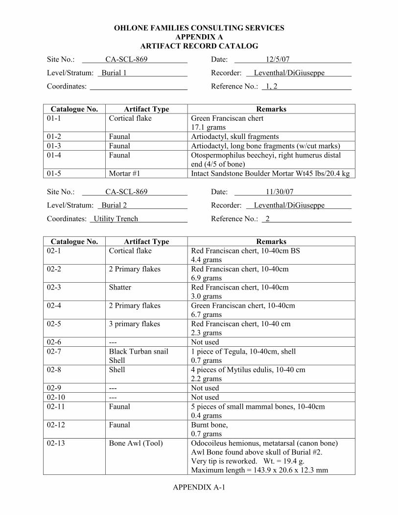
OHLONE FAMILIES CONSULTING SERVICES APPENDIX A
APPENDIX A-1
ARTIFACT RECORD CATALOG
Site No.: CA-SCL-869 Date: 12/5/07
Level/Stratum: Burial 1 Recorder: Leventhal/DiGiuseppe
Coordinates: Reference No.: 1, 2
Catalogue No. Artifact Type Remarks
01-1 Cortical flake Green Franciscan chert 17.1 grams
01-2 Faunal Artiodactyl, skull fragments 01-3 Faunal Artiodactyl, long bone fragments (w/cut marks) 01-4 Faunal Otospermophilus beecheyi, right humerus distal
end (4/5 of bone) 01-5 Mortar #1 Intact Sandstone Boulder Mortar Wt45 lbs/20.4 kg Site No.: CA-SCL-869 Date: 11/30/07
Level/Stratum: Burial 2 Recorder: Leventhal/DiGiuseppe
Coordinates: Utility Trench Reference No.: 2
Catalogue No. Artifact Type Remarks
02-1 Cortical flake Red Franciscan chert, 10-40cm BS 4.4 grams
02-2 2 Primary flakes Red Franciscan chert, 10-40cm 6.9 grams
02-3 Shatter Red Franciscan chert, 10-40cm 3.0 grams
02-4 2 Primary flakes Green Franciscan chert, 10-40cm 6.7 grams
02-5 3 primary flakes Red Franciscan chert, 10-40 cm 2.3 grams
02-6 --- Not used 02-7 Black Turban snail
Shell 1 piece of Tegula, 10-40cm, shell 0.7 grams
02-8 Shell 4 pieces of Mytilus edulis, 10-40 cm 2.2 grams
02-9 --- Not used 02-10 --- Not used 02-11 Faunal 5 pieces of small mammal bones, 10-40cm
0.4 grams 02-12 Faunal Burnt bone,
0.7 grams 02-13 Bone Awl (Tool) Odocoileus hemionus, metatarsal (canon bone)
Awl Bone found above skull of Burial #2. Very tip is reworked. Wt. = 19.4 g. Maximum length = 143.9 x 20.6 x 12.3 mm
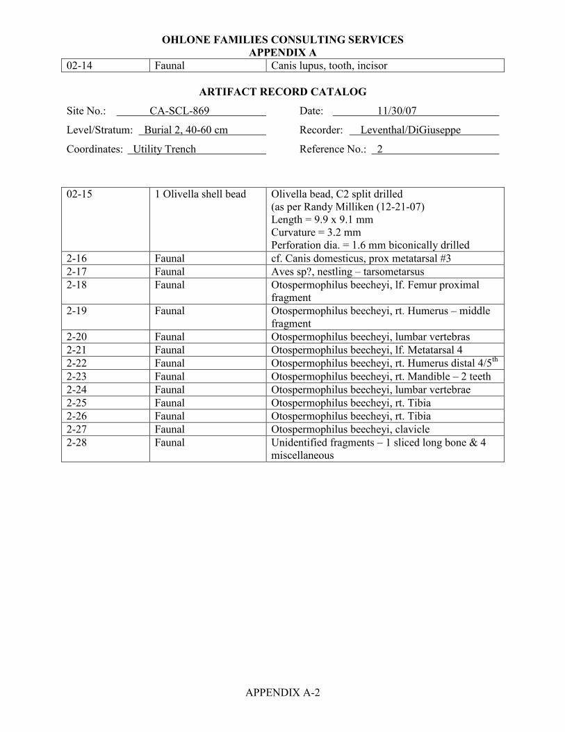
OHLONE FAMILIES CONSULTING SERVICES APPENDIX A
APPENDIX A-2
02-14 Faunal Canis lupus, tooth, incisor
ARTIFACT RECORD CATALOG
Site No.: CA-SCL-869 Date: 11/30/07
Level/Stratum: Burial 2, 40-60 cm Recorder: Leventhal/DiGiuseppe
Coordinates: Utility Trench Reference No.: 2
02-15 1 Olivella shell bead Olivella bead, C2 split drilled
(as per Randy Milliken (12-21-07) Length = 9.9 x 9.1 mm Curvature = 3.2 mm Perforation dia. = 1.6 mm biconically drilled
2-16 Faunal cf. Canis domesticus, prox metatarsal #3 2-17 Faunal Aves sp?, nestling – tarsometarsus 2-18 Faunal Otospermophilus beecheyi, lf. Femur proximal
fragment 2-19 Faunal Otospermophilus beecheyi, rt. Humerus – middle
fragment 2-20 Faunal Otospermophilus beecheyi, lumbar vertebras 2-21 Faunal Otospermophilus beecheyi, lf. Metatarsal 4 2-22 Faunal Otospermophilus beecheyi, rt. Humerus distal 4/5th 2-23 Faunal Otospermophilus beecheyi, rt. Mandible – 2 teeth 2-24 Faunal Otospermophilus beecheyi, lumbar vertebrae 2-25 Faunal Otospermophilus beecheyi, rt. Tibia 2-26 Faunal Otospermophilus beecheyi, rt. Tibia 2-27 Faunal Otospermophilus beecheyi, clavicle 2-28 Faunal Unidentified fragments – 1 sliced long bone & 4
miscellaneous

OHLONE FAMILIES CONSULTING SERVICES APPENDIX A
APPENDIX A-3
ARTIFACT RECORD CATALOG
Site No.: CA-SCL-869 Date: 11/30/07
Level/Stratum: Burial 3 Recorder: Leventhal/DiGiuseppe
Coordinates: Reference No.: 3
Catalogue No. Artifact Type Remarks
03-1 Faunal 17 pieces un-burnt bone of small mammal 5.5 grams
03-2 Faunal 2 pieces burnt faunal bones, one large mammal 1.9 grams
03-3 --- Not used 03-4 --- Not used 03-5 Pismo Clam shell frag. 1 clam shell fragment, (Tivela stultorum)
0.5 grams 03-6 Shell 10 pieces of Mytilus edulis
2.2 grams 03-7 --- Not used 03-8 --- Not used 03-9 --- Not used 03-10 Assayed cobble assayed cobble of pillow basalt (green stone)
Maximum length = 63.0 mm Width = 59.7 mm Thickness = 35.5 mm Weight = 202.4 grams
03-11 Assayed cobble Assayed angular pebble of Red Franciscan chert Maximum length – 69.3 mm Width = 32.1 mm Thickness =17.1 mm Weight = 40 grams
03-12 2 cortical flakes Red Franciscan chert Weight 21. 3 grams
03-13 3 primary flakes Red Franciscan chert Weight = 15.5 grams
03-14 1 shatter Green Franciscan chert Weight 1.1 grams
03-15 1 cortical flake Rhyolite Weigh = 0.1 grams
03-16 1 primary flake High grade serpentine Weight 2.2 grams
03-17 1 piece of charcoal From under the radius

OHLONE FAMILIES CONSULTING SERVICES APPENDIX A
APPENDIX A-4
ARTIFACT RECORD CATALOG
Site No.: CA-SCL-869 Date: 03/04/08
Level/Stratum: Burial 4 Recorder: Leventhal/DiGiuseppe
Coordinates: Reference No.: 4
Catalogue No. Artifact Type Remarks
04-1 2 cortical shatter Red Franciscan chert Weight 21.9 grams
04-2 2 primary flakes Red Franciscan chert Weight 2.2 grams
04-3 2 primary flakes Green Franciscan chert Weight 8.2 grams
04-4 2 pieces vitrified clay Or burnt siltstone Weight = 11.6 grams
04-5 4 thermally affected Sandstone cobble fragments Weight = 101.7 grams
04-6 13 + shell fragments Mostly Mytilus edulis Weight = 4.4 grams
04-7 Mortar #3 Large intact Sandstone Boulder Mortar Wt. 43 lbs/ 19.5kg
Site No.: CA-SCL-869 Date: 03/04/08
Level/Stratum: N/A Recorder: Leventhal/DiGiuseppe
Coordinates: Reference No.: 5 and 6 not used

OHLONE FAMILIES CONSULTING SERVICES APPENDIX A
APPENDIX A-5
ARTIFACT RECORD CATALOG
Site No.: CA-SCL-869 Date: 11/13/07
Level/Stratum: Test Unit 1, 0-20 cm Recorder: Leventhal, DiGiuseppe
Coordinates: Terminus of Test Trench #6 Reference No.: 7
Catalogue No. Artifact Type Remarks
07-1 Primary Flake Possibly bipolar green Franciscan chert; 1.7 grams 07-2 Angular cortical
fragment Basalt, off basalt core; wt. 130.6 grams
07-3 Utilized flake Red Franciscan chert, unifacial nibbling on the distal edge ventral view, expanding flake Bulbar length = 16.7 x 19.4 x 5.5 mm Edge unit length = 9.9 mm P.E. Angle = 28° D.E. Angle = 41° Wt. 1.6 grams
07-4 Borer tool On Green/Red modeled Franciscan chert Maximum length = 37.9 x 20.2 x 14.5 mm Maximum length of the bit = 16.0 mm Made on a thermally annealed triangular cross-section flake and exhibits on three of the edges on the bit crushing, stepped fractures and gloss Wt. 9.4 grams
07-5 Black Turban snail Shell
3 pieces of Tegula
07-6 Bay Mussel Shell 4 pieces of Mytilus edulis 07-7 Pismo Shell 2 pieces of clam, Tivela stultorum 07-8 Cortical flake fragment Red Franciscan chert
1.7 grams 07-9 4 primary flakes Red Franciscan chert
7.6 grams 07-10 1 core rejuvenation
flake Green Franciscan chert 17.0 grams
07-11 3 primary flakes Mottled Green/Red Franciscan chert 7.3 grams
07-12 Human bone Cranial frag. sub-adult Burial #6 at 20 cm BS 07-13 Faunal Odocoileus hemionus, distal fragment medial
articulation

OHLONE FAMILIES CONSULTING SERVICES APPENDIX A
APPENDIX A-6
ARTIFACT RECORD CATALOG
Site No.: CA-SCL-869 Date: 11/13/07
Level/Stratum: Test Unit 1, 20-40 cm Recorder: Leventhal, DiGiuseppe
Coordinates: Feature # 1 (35-40 cm) Reference No.: 8
Catalogue No. Artifact Type Remarks
08-1 Obsidian flake Pressure flake, Casa Diablo Obsidian, hydration 3.3 microns (Bulbar length) = 9.0 x 9.6 x 1.8 mm 2.0 grams
08-2 Utilized Secondary core/Flake core
Red Franciscan chert covered in caliche, also utilized with evidence of unifacial nibbling and nibbling located adjacent to striking platform on the upper left lateral edge, dorsal view. (Bulbar length) = 65.8 x 47.1 x 23.8 mm, Edge unit length = 13.2 mm P.E.A. = range from 49-50° D.E.A. = 68° 82.7 grams
08-3 2 cortical flakes Red Franciscan chert 1.4 grams
08-4 6 primary flakes Red Franciscan chert 31.4 grams
08-5 3 flake fragments Red Franciscan chert 4.6 grams
08-6 1 thermally spalled flake
Red Franciscan chert 1.7 grams
08-7 2 cortical flakes Green Franciscan chert 4.0 grams
08-8 3 primary flakes Green Franciscan chert, 6.0 grams
08-9 1 thinning flake Rhyolite 0.4 grams
08-10 1 utilized flake (spokeshave)
Andesite, primary flake; it is an expanding primary flake with cortex; on the left distal edge is the edge unit and it displays unidirectional striation and rounding, slight polish; ventral view. (Bulbar length) = 47.1 x 72.2 x 14.2 mm, Edge unit length = 14.3 mm Pristine Edge Angle = 42° Damage Edge Angle range = 56-59° 44.3 grams
08-11 --- Not used 08-12 Shell 1 Tegula (intact) 08-13 Shell 4 fragments of Mytilus edulis (bay mussel) 08-14 Shell 1 fragment of Ostrea lurida (oyster)

OHLONE FAMILIES CONSULTING SERVICES APPENDIX A
APPENDIX A-7
ARTIFACT RECORD CATALOG
Site No.: CA-SCL-869 Date: 11/13/07
Level/Stratum: Test Unit 1, 20-40 cm Recorder: Leventhal, DiGiuseppe
Coordinates: Feature # 1 (35-40 cm) Reference No.: 8
Catalogue No. Artifact Type Remarks
08-15 --- 08-16 Faunal 2 long bone fragment, both large mammal, largest
bone is burnt 08-17 Faunal Bird talon 08-18 Faunal Cf. canis domesticus, lf. mandible, socket for C1,
P1, tooth P2 – ½ socket B 08-19 Faunal Sciurus niger, sternum – segment 1 08-20 Faunal Otospermephilus beecheyi, rt. humerus complete 08-21 Faunal Sciurus griseus, sacrum 2 pieces 08-22 Faunal Otospermephilus beecheyi, lf. innominate 08-23 Faunal Otospermephilus beecheyi, rt. mandible – caudal
½ 08-24 Faunal cf. Steganopus tricolor, similar to Wilson’s
phalarope, but it’s not – distal tibia (shore bird) 08-25 Faunal Thomomys bottae, lf. femur shaft imm. 08-26 Faunal Sciurus griseus, auditory bullae 08-27 Faunal Unidentified occipital condyle and palate? 08-28 Faunal Sciurus niger, T1 08-29 Faunal Sciurus niger, T7 08-30 Faunal Thomomys bottae, mandibles and teeth 08-31 Faunal Unidentified fragments 08-32 Faunal Sciurus niger, T13 fragment 08-33 Faunal Sciurus sp., tooth

OHLONE FAMILIES CONSULTING SERVICES APPENDIX A
APPENDIX A-8
ARTIFACT RECORD CATALOG
Site No.: CA-SCL-869 Date: 11/28/07
Level/Stratum: Test Unit 1, 40-60 cm Recorder: Leventhal/DiGiuseppe
Coordinates: Feature # 1 Reference No.: 9
Catalogue No. Artifact Type Remarks
09-1 Obsidian Flake Either primary flake or impact fracture off of a biface/point, Napa Valley Obsidian, hydration = 4.4 microns (Bulbar length) = 14.6 x 9.1 x 4.6 mm, 0.7 grams
09-2 Pebble Core Large pebble core of Red Franciscan chert, flake scars on the dorsal face and multiple scars on the ventral face, slight vitreous luster Maximum length = 56.1 x 45.8 x 36.5 mm 136.5 grams
09-3 Exhausted Core Red Franciscan chert, exhibits bipolar bulbar scars and pot-lidding indicating exposure to fire and thermal annealing Maximum length = 37.1 x 19.7 x 17.1 mm 11.4 grams
09-4 Pebble Core Green Franciscan chert, high quality Maximum length = 44.4 x 38.3 x 24.2 mm 65.1 grams
09-5 Modified Cortical Flake
Green Franciscan chert, high quality, thermally annealed and also has caliche on the dorsal surface Maximum length = 43.0 x 35.0 x 19.8 mm 27.8 grams
09-6 5 primary flakes Red Franciscan chert 12.4 grams
09-7 1 shatter Red Franciscan chert 12.6 grams
09-8 2 primary flakes Green Franciscan chert 1.3 grams
09-9 Thermal Shatter Green Franciscan chert 5.9 grams
09-10 Cortical flake White chert 0.9 grams
09-11 3 primary flakes Monterey chert 7.8 grams
9-12 Thinning flake Gray Franciscan chert 0.4 grams
09-13 --- Not used 09-14 --- Not used

OHLONE FAMILIES CONSULTING SERVICES APPENDIX A
APPENDIX A-9
ARTIFACT RECORD CATALOG
Site No.: CA-SCL-869 Date: 11/13/07
Level/Stratum: Test Unit 1, 40-60 cm Recorder: Leventhal, DiGiuseppe
Coordinates: Feature # 1 Reference No.: 9
Catalogue No. Artifact Type Remarks
09-15 Human bone Assigned to Burial # 6 1st metacarpal, sub-adult at 47 cm BS
09-16 3 Faunal bone Calcined and burned of medium to large mammal 0.6 grams
09-17 4 Faunal bone Unburnt and one possible a bird bone 0.2 grams
09-18 --- Not used 09-19 --- Not used 09-20 2 shells Cerithedia
1.5 grams 09-21 12 shell fragments of Mytilus edulis (bay mussel)
3.5 grams 09-22 Human bone 1 unidentified cranial fragment, Burial #6, sub-
adult at 43 cm BS 09-23 Historic material Shell button
0.8 grams 09-24 to 09-27 Not used Not used 09-28 Faunal Cervus nannodes, L1, complete except transverse
process adult 09-29 Faunal Odocoileus hemionus, auditory meatus 09-30 Faunal bone Cervus nannodes, lf. femur fragment, lesser
trochanter 09-31 Faunal bone Cervus nannodes, L1 epiphysis fragment, probably
posterior 09-32 Faunal bone Bubo virginianus (Great-horned Owl), left ulna
complete (2 pieces) 09-33 Faunal bone Sciurus griseus (Grey squirrel) lf mandible 09-34 Faunal bone Otospermophitus beecheyi – left mandible 09-35 Faunal bone Thomomys bottae – left mandible 09-36 Faunal bone Sciurus griseus – left distal humerus fragment 09-37 Faunal bone Thomomys bottae – right femur 1 mm 09-38 Faunal bone Otospermophilus beecheyi – caudal vertebrae prob
2 or 3 09-39 Faunal bone Thomomys bottae – left tibia 09-40 Faunal bone Sciurus griseus – T4 09-41 Faunal bone Thomomys bottae – right mandible 09-42 Faunal bone Cf. Cervus Canadensis, metacarpus – unfused

OHLONE FAMILIES CONSULTING SERVICES APPENDIX A
APPENDIX A-10
ARTIFACT RECORD CATALOG
Site No.: CA-SCL-869 Date: 11/28/07
Level/Stratum: Test Unit 1, 40-60 cm Recorder: Leventhal/DiGiuseppe
Coordinates: Feature # 1 Reference No.: 9
Catalogue No. Artifact Type Remarks
09-43 Faunal bone Possible bald eagle? Lf. tarsometatarsus distal, lateral
09-44 Faunal bone Sciurus griseus – left innominate acetabulum 09-45 Faunal bone Lepus californicus – caudal vert 1 09-46 Faunal bone Thomomys bottae – P1 09-47 Faunal bone Thomomys bottae – left I1 09-48 Faunal bone Thomomys bottae – right maxilla with incisor 09-49 Faunal bone Otospermophilus beecheyi – caudal vertebrae #1 09-50 Faunal bone Thomomys bottae – left femur prox 2/3 09-51 Faunal bone Thomomys bottae – right humerus distal 2/3 09-52 Faunal bone Sciurus niger – left innominate acetabulum frag. 09-53 Faunal bone Thomomys bottae – left humerus prox 2/3 09-54 Faunal bone Sciurus griseus – T3 09-55 Faunal bone Otospermophilus beecheyi – right mandible
fragment and P1 09-56 Faunal bone Otospermophilus beecheyi – right mandible with
tooth + 2 beechyi teeth 09-57 Faunal bone Canis latrans – left M2 09-58 Faunal bone Phalacrocorax penicillatus – rib fragment distal
end 09-59 Faunal bone Lepus californicus – right tibia frag, just prox to
fibula fusion 09-60 Faunal bone Sciurus griseus – right mandible fragment
ascending ramus 09-61 Faunal bone Sylvilagus prob. bachmani not audoboni - right
mandible fragment 09-62 Faunal bone Sylvilagus sp. audoboni or bachmani – right
mandible fragment 09-63 Faunal bone Fulica americana, (American coot) shaft fragment
lf. humerus 09-64 Faunal bone Cervus nannodes – T6 or T7 fragment burnt bone

OHLONE FAMILIES CONSULTING SERVICES APPENDIX A
APPENDIX A-11
ARTIFACT RECORD CATALOG
Site No.: CA-SCL-869 Date: 11/28/07
Level/Stratum: Test Unit 1, 40-60 cm Recorder: Leventhal/DiGiuseppe
Coordinates: Feature # 1 Reference No.: 9
Catalogue No. Artifact Type Remarks
09-67 Faunal bone Thomomys bottae – right tibia fragment 09-68 Faunal bone Sciurus griseus – right distal radius shaft fragment 09-69 Faunal bone Crab claw burnt 09-70 Faunal bone Lepus californicus – left ulna fragment midshaft
burnt? 09-71 Faunal bone Lepus californicus – right transverse process L4 09-72 Faunal bone Thomomys bottae – right mandible incisor socket 09-73 Faunal bone Otospermophilus beecheyi – right side maxilla
with M1 & M2 09-74 Faunal bone Thomomys bottae – teeth 09-75 Faunal bone 13 unidentified fragments

OHLONE FAMILIES CONSULTING SERVICES APPENDIX A
APPENDIX A-12
ARTIFACT RECORD CATALOG
Site No.: CA-SCL-869 Date: 11/28/07
Level/Stratum: Test Unit 1, 60-80 cm Recorder: Leventhal/DiGiuseppe
Coordinates: Feature # 1 Reference No.: 10
Catalogue No. Artifact Type Remarks
10-1 Obsidian flake Primary expanding flake, Napa Valley, hydration 3.6 Bulbar length: 12.7 x 23.1 x 4.1 mm 1.19 grams
10-2 1 primary flake High grade gray serpentine found at 69 cm in south wall below the femur (human?) Maximum length: 55.5 x 41.6 x 13.8 mm 21.8 grams
10-3 Mano fragment Unifacial, unshaped mano of sandstone Maximum length: 86.1 x 50.7 x 47.1 mm Utilized face displays flattening and ground surface. wt. 266.3 grams
10-4 Unmodified cobble Sandstone, found in the southeast portion of test unit one at 60 cm 334.4 grams
10-5 Sandstone cobble Flat sandstone cobble fragment, possible griddle stone with blackening on the exterior found at 65 cm next to the burn feature 909.6 grams
10-6 2 cortical flakes Red Franciscan chert 18.9 grams
10-7 8 primary flakes Red Franciscan chert 20.3 grams
10-8 6 thinning flakes Red Franciscan chert 1.9 grams
10-9 2 cortical flakes Green Franciscan chert 11.6 grams
10-10 Primary flake Gray Franciscan chert 1.0 grams
10-11 Cortical shatter Chalcedony 1.0 grams
10-12 --- Not used 10-13 --- Not used 10-14 2 shell Mytilus edulis (bay mussel) fragments
0.2 grams 10-15 --- Not used 10-16 --- Not used 10-17 Faunal bone Burnt large mammal
1.1 grams
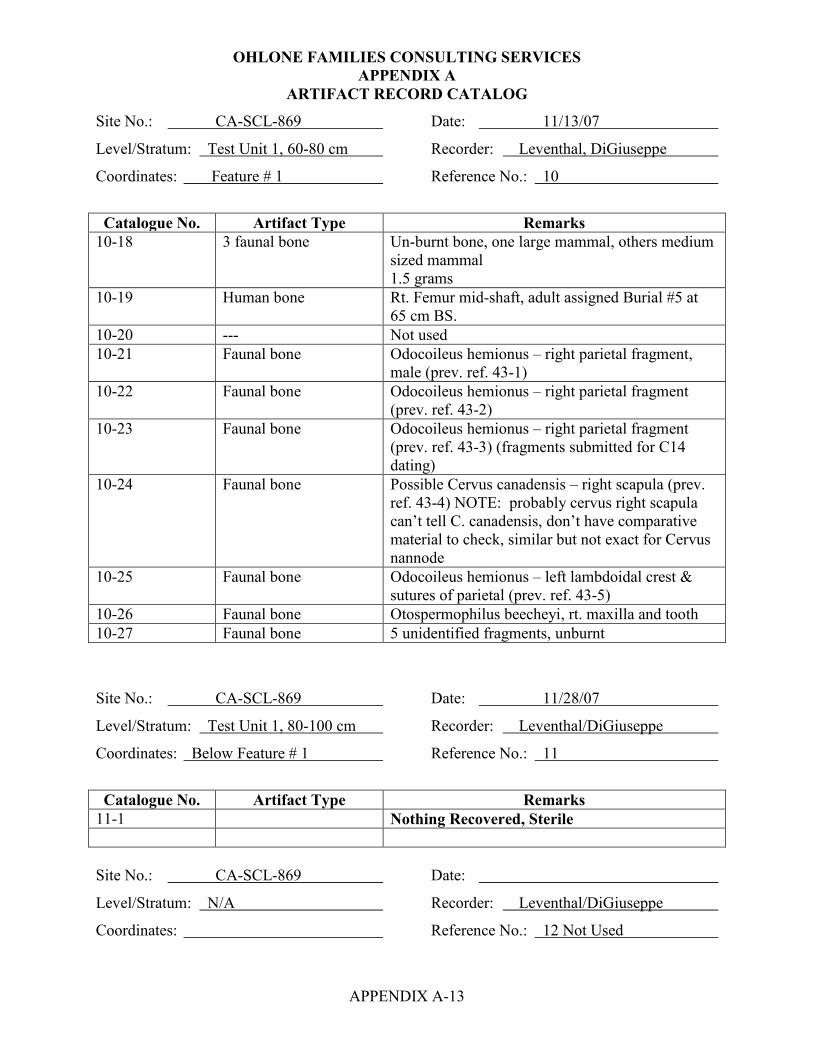
OHLONE FAMILIES CONSULTING SERVICES APPENDIX A
APPENDIX A-13
ARTIFACT RECORD CATALOG
Site No.: CA-SCL-869 Date: 11/13/07
Level/Stratum: Test Unit 1, 60-80 cm Recorder: Leventhal, DiGiuseppe
Coordinates: Feature # 1 Reference No.: 10
Catalogue No. Artifact Type Remarks
10-18 3 faunal bone Un-burnt bone, one large mammal, others medium sized mammal 1.5 grams
10-19 Human bone Rt. Femur mid-shaft, adult assigned Burial #5 at 65 cm BS.
10-20 --- Not used 10-21 Faunal bone Odocoileus hemionus – right parietal fragment,
male (prev. ref. 43-1) 10-22 Faunal bone Odocoileus hemionus – right parietal fragment
(prev. ref. 43-2) 10-23 Faunal bone Odocoileus hemionus – right parietal fragment
(prev. ref. 43-3) (fragments submitted for C14 dating)
10-24 Faunal bone Possible Cervus canadensis – right scapula (prev. ref. 43-4) NOTE: probably cervus right scapula can’t tell C. canadensis, don’t have comparative material to check, similar but not exact for Cervus nannode
10-25 Faunal bone Odocoileus hemionus – left lambdoidal crest & sutures of parietal (prev. ref. 43-5)
10-26 Faunal bone Otospermophilus beecheyi, rt. maxilla and tooth 10-27 Faunal bone 5 unidentified fragments, unburnt
Site No.: CA-SCL-869 Date: 11/28/07
Level/Stratum: Test Unit 1, 80-100 cm Recorder: Leventhal/DiGiuseppe
Coordinates: Below Feature # 1 Reference No.: 11
Catalogue No. Artifact Type Remarks
11-1 Nothing Recovered, Sterile Site No.: CA-SCL-869 Date:
Level/Stratum: N/A Recorder: Leventhal/DiGiuseppe
Coordinates: Reference No.: 12 Not Used

OHLONE FAMILIES CONSULTING SERVICES APPENDIX A
APPENDIX A-14
ARTIFACT RECORD CATALOG
Site No.: CA-SCL-869 Date: 11/28/07
Level/Stratum: Test Unit 2, 0-20 cm Recorder: Leventhal/DiGiuseppe
Coordinates: North of Burial 2 Reference No.: 13
Catalogue No. Artifact Type Remarks 13-1 Nothing Recovered
Site No.: CA-SCL-869 Date: 11/28/07
Level/Stratum: Test Unit 2, 20-40 cm Recorder: Leventhal/DiGiuseppe
Coordinates: North of Burial 2 Reference No.: 14
Catalogue No. Artifact Type Remarks
14-1 Faunal bone Cervus sp.?, antler fragment – 2 pieces 14-2 Faunal bone Cervus canadensis, lf. humerus distal fragment
lateral condyle 14-3 Faunal bone Otospermophilus beecheyi, lf. femur subadult 14-4 Faunal bone Otospermophilus beecheyi, occipital and right
occipital condyle fragment 14-5 Faunal bone Otospermophilus beecheyi, rt. auditery bulla,
similar to S. niger but fits with #4 14-6 Faunal bone Otospermophilus beecheyi, lf. ischium and pubis 14-7 Faunal bone Otospermophilus beecheyi, lf. humrus distal
fragment 14-8 Faunal bone Otospermophilus beecheyi, lf. tibia distal fragment 14-9 Faunal bone Otospermophilus beecheyi, lf. maxilla w/2 teeth 14-10 Faunal bone Otospermophilus beecheyi, lumbar vertebra 14-11 Faunal bone Otospermophilus beecheyi, caudal vertebrae 14-12 Faunal bone Otospermophilus beecheyi, rt. maxilla w/2 teeth 14-13 Faunal bone Otospermophilus beecheyi, lf. mandible w/4 teeth 14-14 Faunal bone Otospermophilus beecheyij, lf. maxilla (dorsal) 2
incisors 14-15 Faunal bone Otospermophilus beecheyi, squamosal (skull) 14-16 Faunal bone Otospermophilus beecheyi, rt. squamosal fragment 14-17 Faunal bone Otospermophilus beecheyi, sacrum 14-18 Faunal bone Otospermophilus beecheyi, sacrum – prox. frag 14-19 Faunal bone Otospermophilus beecheyi, rt. femur –
disarticulated epiphysis 14-20 Faunal bone Otospermophilus beecheyi, rt. innominate 14-21 Faunal bone Otospermophilus beecheyi, lf. humerus 14-22 Faunal bone Otospermophilus beecheyi, lf. ulna – 2 pieces 14-23 Faunal bone Otospermophilus beecheyi, rt. ulna proximal ½ -
different individual from 14-22

OHLONE FAMILIES CONSULTING SERVICES APPENDIX A
APPENDIX A-15
ARTIFACT RECORD CATALOG
Site No.: CA-SCL-869 Date: 11/28/07
Level/Stratum: Test Unit 2, 20-40 cm Recorder: Leventhal/DiGiuseppe
Coordinates: North of Burial 2 Reference No.: 14
14-24 Faunal bone Otospermophilus beecheyi, rt. tibia distal – 2
pieces 14-25 Faunal bone Otospermophilus beecheyi, rt. tibia distal 14-26 Faunal bone Otospermophilus beecheyi, lf. tibia proximal ½ 14-27 Faunal bone Otospermophilus beecheyi, L-7? 14-28 Faunal bone Otospermophilus beecheyi, lf. rib 6 or 7 14-29 Faunal bone Otospermophilus beecheyi, lf. squamosal fragment 14-30 Faunal bone Otospermophilus beecheyi, rt. maxilla fragment 14-31 Faunal bone Otospermophilus beecheyi, lf. astragalus 14-32 Faunal bone Otospermophilus beecheyi, T13 14-33 Faunal bone Otospermophilus beecheyi, T12 14-34 Faunal bone Otospermophilus beecheyi, T11 14-35 Faunal bone Otospermophilus beecheyi, pelvic bone towards
acetabulum 14-36 Faunal bone Bird? Sp? Robin to small hawk size – humerus? 2
pieces 14-37 Faunal bone Peromyscus californicus (California mouse), rt.
mandible fragment and incisor 14-38 Faunal bone Unidentified faunal bone – unburnt large and small
39 fragments 14-39 --- Not used 14-40 Bipolar pebble core Red Franciscan chert
Maximum length = 39.5 x 31.4 x 22.2 mm 26.9 grams
14-41 2 cortical flake Red Franciscan chert fragments 4.4 grams
14-42 4 primary flakes Red Franciscan chert 3.9 grams
14-43 2 bipolar flakes Red Franciscan chert 13.9 grams
14-44 3 flake fragments Red Franciscan chert 3.8 grams
14-45 3 bipolar flakes Green Franciscan chert 7.7 grams
14-46 2 primary flakes Green Franciscan chert 1.7 grams
14-47 1 primary flake Possibly serpentine (example of high grade) 6.5 grams
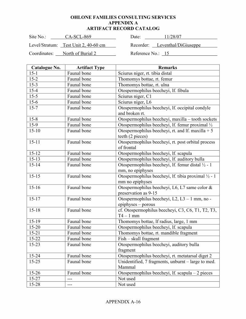
OHLONE FAMILIES CONSULTING SERVICES APPENDIX A
APPENDIX A-16
ARTIFACT RECORD CATALOG
Site No.: CA-SCL-869 Date: 11/28/07
Level/Stratum: Test Unit 2, 40-60 cm Recorder: Leventhal/DiGiuseppe
Coordinates: North of Burial 2 Reference No.: 15
Catalogue No. Artifact Type Remarks
15-1 Faunal bone Sciurus niger, rt. tibia distal 15-2 Faunal bone Thomomys bottae, rt. femur 15-3 Faunal bone Thomomys bottae, rt. ulna 15-4 Faunal bone Otospermophilus beecheyi, lf. fibula 15-5 Faunal bone Sciurus niger, C1 15-6 Faunal bone Sciurus niger, L6 15-7 Faunal bone Otospermophilus beecheyi, lf. occipital condyle
and broken rt. 15-8 Faunal bone Otospermophilus beecheyi, maxilla – tooth sockets 15-9 Faunal bone Otospermophilus beecheyi, lf. femur proximal ½ 15-10 Faunal bone Otospermophilus beecheyi, rt. and lf. maxilla + 5
teeth (2 pieces) 15-11 Faunal bone Otospermophilus beecheyi, rt. post orbital process
of frontal 15-12 Faunal bone Otospermophilus beecheyi, lf. scapula 15-13 Faunal bone Otospermophilus beecheyi, lf. auditory bulla 15-14 Faunal bone Otospermophilus beecheyi, lf. femur distal ½ - 1
mm, no epiphyses 15-15 Faunal bone Otospermophilus beecheyi, lf. tibia proximal ½ - 1
mm no epiphyses 15-16 Faunal bone Otospermophilus beecheyi, L6, L7 same color &
preservation as 9-15 15-17 Faunal bone Otospermophilus beecheyi, L2, L3 – 1 mm, no -
epiphyses – porous 15-18 Faunal bone cf. Otospermophilus beecheyi, C3, C6, T1, T2, T3,
T4 – 1 mm 15-19 Faunal bone Thomomys bottae, lf radius, large, 1 mm 15-20 Faunal bone Otospermophilus beecheyi, lf. scapula 15-21 Faunal bone Thomomys bottae, rt. mandible fragment 15-22 Faunal bone Fish – skull fragment 15-23 Faunal bone Otospermophilus beecheyi, auditory bulla
fragment 15-24 Faunal bone Otospermophilus beecheyi, rt. metatarsal diget 2 15-25 Faunal bone Unidentified, 7 fragments, unburnt – large to med.
Mammal 15-26 Faunal bone Otospermophilus beecheyi, lf. scapula – 2 pieces 15-27 --- Not used 15-28 --- Not used

OHLONE FAMILIES CONSULTING SERVICES APPENDIX A
APPENDIX A-17
ARTIFACT RECORD CATALOG
Site No.: CA-SCL-869 Date: 11/28/07
Level/Stratum: Test Unit 2, 40-60 cm Recorder: Leventhal/DiGiuseppe
Coordinates: North of Burial 2 Reference No.: 15
15-29 --- Not used 15-30 Primary flake Obsidian, from Napa Valley, cortex on dorsal face
hydration = 3.5 microns, Bulbar length = 16.0 x 15.3 x 4.8 mm 1.2 grams
15-31 Bipolar core Red Franciscan chert Maximum length = 49.8 x 29.8 x 28.3 mm 44.0 grams
15-32 Primary flake Red Franciscan chert 1.0 grams
15-33 Modified bipolar flake Green Franciscan chert; modification is unifacial flaking along the right lateral edge ventral view Bulbar length = 27.4 x 17.8 x 8.9 mm 4.0 grams
Site No.: CA-SCL-869 Date: 11/28/07
Level/Stratum: Test Unit 2, 60-80 cm Recorder: Leventhal/DiGiuseppe
Coordinates: North of Burial 2 Reference No.: 16 [17 and 18 Not Used]
16-1 --- NOT EXCAVATED
Site No.: CA-SCL-869 Date: 11/28/07
Level/Stratum: Test Unit 3, 0-20 cm Recorder: Leventhal/DiGiuseppe
Coordinates: West of Test Unit 2 Reference No.: 19
19-1 --- Nothing recovered

OHLONE FAMILIES CONSULTING SERVICES APPENDIX A
APPENDIX A-18
ARTIFACT RECORD CATALOG
Site No.: CA-SCL-869 Date: 11/28/07
Level/Stratum: Test Unit 3, 20-40 cm Recorder: Leventhal/DiGiuseppe
Coordinates: West of Test Unit 2 Reference No.: 20
Catalogue No. Artifact Type Remarks
20-1 4 pieces of shatter Red Franciscan chert from shattered core; possibly impacted during excavation 38.6 grams
Site No.: CA-SCL-869 Date: 11/28/07
Level/Stratum: Test Unit 3, 40-60 cm Recorder: Leventhal/DiGiuseppe
Coordinates: West of Test Unit 2 Reference No.: 21
Catalogue No. Artifact Type Remarks
21-1 3 primary flakes Red Franciscan chert 2.9 grams
21-2 1 primary flake Green Franciscan chert 1.5 grams
21-3 2 primary flake High grade Serpentine 9.6 grams
21-4 --- Not used 21-5 --- Not used 21-6 Faunal bone Burnt bone
0.3 grams 21-7 Faunal bone Undetermined fragments probably from atlas,
possibly artiodactyls 21-8 Faunal bone Sylvilagus bachmani, tibia fragment 21-9 Faunal bone Unidentified, unburnt 26 fragments, large and
medium mammal Site No.: CA-SCL-869 Date:
Level/Stratum: N/A Recorder: Leventhal/DiGiuseppe
Coordinates: Reference No.: 22, 23, and 24 Not Used

OHLONE FAMILIES CONSULTING SERVICES APPENDIX A
APPENDIX A-19
ARTIFACT RECORD CATALOG
Site No.: CA-SCL-869 Date: 11/28/07
Level/Stratum: Test Unit 4, 0-20 cm Recorder: Leventhal/DiGiuseppe
Coordinates: North of Test Unit 2 Reference No.: 25
Catalogue No. Artifact Type Remarks
25-1 Primary flake Black chert 6.3 grams
25-2 Primary flake Green Franciscan chert 0.8 grams
25-3 Faunal bone Burnt bone 1.1 grams
25-4 Faunal bone Cervus sp. 25-5 Faunal bone Unidentified, 9 large mammal unburnt 25-6 Faunal bone Unidentified, 1 rodent tooth - unburnt
Site No.: CA-SCL-869 Date: 11/28/07
Level/Stratum: Test Unit 4, 20-40 cm Recorder: Leventhal/DiGiuseppe
Coordinates: North of Test Unit 2 Reference No.: 26 [27 - 30 Not Used]
26-1 --- Nothing Recovered
Site No.: CA-SCL-869 Date: 11/28/07
Level/Stratum: Test Unit 5, 0-20 cm Recorder: Leventhal/DiGiuseppe
Coordinates: East of Test Unit 2 Reference No.: 31 Catalogue No. Artifact Type Remarks
31-1 Angular pebble core Green Franciscan chert; possibly bipolar Maximum length = 45.0 x 33.6 x 19.5 mm 35.4 grams
31-2 Exhausted core (shattered)
Red Franciscan chert (high quality) Maximum length = 29.8 x 23.0 x 18.8 mm 10.2 grams
31-3 Shattered fragment Red Franciscan chert 2.2 grams
31-4 Faunal bone Unidentified, 6 fragments of large mammal, unburnt

OHLONE FAMILIES CONSULTING SERVICES APPENDIX A
APPENDIX A-20
ARTIFACT RECORD CATALOG
Site No.: CA-SCL-869 Date: 11/28/07
Level/Stratum: Test Unit 5, 20-40 cm Recorder: Leventhal/DiGiuseppe
Coordinates: East of Test Unit 2 Reference No.: 32 Catalogue No. Artifact Type Remarks
32-1 Faunal bone Otospermophilus beecheyi, lf. tibia 32-2 Faunal bone Sciurus niger, lf. scapula (complete) 32-3 Faunal bone Sciurus niger, lf. scapula fragment 32-4 Faunal bone Otospermophilus beecheyi, sacrum – distal 2/3 32-5 Faunal bone Sciurus niger, lf. femur distal epiphyses 32-6 Faunal bone Thomomys bottae, lf. mandible & incisor &
premolar fragment 32-7 Faunal bone Thomomys bottae, lf. mandible – small fragment,
separate incisor 32-8 Faunal bone Thomomys bottae, maxilla fragment 32-9 Faunal bone cf. Odocoileus hemionus, 5 tooth frag., cf. PM2&3 32-10 Faunal bone cf. Odocoileus hemionus, cf. frontal by lacrimal 32-11 Faunal bone Possible II-1 32-12 Faunal bone Unidentified long bone fragment 32-13 Faunal bone Squirrel sp.? – auditory bullae fragment. 32-14 --- Not used 32-15 Shatter Green Franciscan chert pebble core
10.7 grams 32-16 3 primary flakes Red Franciscan chert
2.3 grams 32-17 --- Not used 32-18 --- Not used 32-19 Shell Mytilus edilus (bay mussel)
0.4 grams

OHLONE FAMILIES CONSULTING SERVICES APPENDIX A
APPENDIX A-21
ARTIFACT RECORD CATALOG
Site No.: CA-SCL-869 Date: 11/28/07
Level/Stratum: Test Unit 5, 40-60 cm Recorder: Leventhal/DiGiuseppe
Coordinates: East of Test Unit 2 Reference No.: 33 [34, 35, 36 Not Used]
Catalogue No. Artifact Type Remarks 33-1 Assayed pebble Red Franciscan chert
Max. length = 29.8x25.5x18.1 mm 18.6 grams
33-2 6 primary flakes Red Franciscan chert 5.2 grams
33-3 4 primary flakes Green Franciscan chert 4.8 grams
33-4 --- Not used 33-5 --- Not used 33-6 Faunal bone Un-burnt mammal
0.4 grams
Site No.: CA-SCL-869 Date: 11/30/07
Level/Stratum: Test Unit 6, 0-20 cm Recorder: Leventhal/DiGiuseppe
Coordinates: East End of Transformer Pad Reference No.: 37
Catalogue No. Artifact Type Remarks
37-1 3 bipolar cortical shatter
Red Franciscan chert 19.4 grams
37-2 3 bipolar shatter Red Franciscan chert 6.3 grams
37-3 6 primary flakes Red Franciscan chert 27.0 grams
37-4 Modified flake/orange wedge
Modified orange wedge/flake of Green Franciscan chert, probably bipolar, triangular cross-section, three flake scars appear on one face Wt. 14.4 g. Maximum length = 37.1 x 29.2 x 18.6 mm
37-5 2 primary flakes Green Franciscan chert 3.8 grams
37-6 2 pieces of shatter Green Franciscan chert – they fit together 29.0 grams
37-7 --- Not used 37-8 --- Not used 37-9 Faunal Burnt bone – large mammal
0.5 grams 37-10 Faunal bone Otospermophilus beecheyi, at least 2 individuals,
many bones 37-11 Faunal bone Unidentified, 60 small mammal and 4 large
mammal, unburnt

OHLONE FAMILIES CONSULTING SERVICES APPENDIX A
APPENDIX A-22
ARTIFACT RECORD CATALOG
Site No.: CA-SCL-869 Date: 11/30/07
Level/Stratum: Test Unit 6, 20-40 Recorder: Leventhal/DiGiuseppe
Coordinates: East End of Transformer Pad Reference No.: 38
Catalogue No. Artifact Type Remarks
38-1 Faunal bone Bos, C1 cauda articular surface fragment 38-2 Faunal bone Otospermophilus beecheyi, rt. innominate 38-3 Faunal bone Otospermophilus beecheyi, rt. femur distal end 38-4 Faunal bone Otospermophilus beecheyi, lf. tibia complete 38-5 Faunal bone Otospermophilus beecheyi, T1 38-6 Faunal bone Thomomys bottae, premaxilla & maxilla (palatal)
+ 2 incisors +2 premolars 38-7 Faunal bone Thomomys bottae, lf. mandible fragment 38-8 Faunal bone Otospermophilus beecheyi, caudal vertebrae (5) 38-9 Faunal bone Thomomys bottae, rt jugal fragment 38-10 Faunal bone Otospermophilus beecheyi, clavicle 38-11 Faunal bone Otospermophilus beecheyi, rt. tibia 38-12 Faunal bone Unidentified large mammal, 5 unburnt fragments 38-13 --- Not used 38-14 --- Not used 38-15 Angular pebble core Green Franciscan chert
Maximum length = 49.8 x 42.2 x 26.7 mm 60.0 grams
38-16 2 primary flakes Green Franciscan chert 19.2 grams
38-17 Cortical flake Green Franciscan chert 6.3 grams
38-18 3 bipolar shatter Red Franciscan chert 9.8 grams
38-19 3 primary flakes Red Franciscan chert 9.4 grams
38-20 Assayed pebble Yellow Franciscan chert Maximum length = 46.2 x 25.7 x 19.0 mm 23.8 grams
38-21 Distal end of shaped pestle
Pestle frag. has been subjected to fire, thermally blackened, of sandstone; highly polished along the lateral edges and due to exposure to fire the veneer is exfoliating; distal end exhibits heavy use wear patterns, rounding, polish and striations Maximum length = 53.9 x 55.4 x 45.3 mm 200.3 grams

OHLONE FAMILIES CONSULTING SERVICES APPENDIX A
APPENDIX A-23
ARTIFACT RECORD CATALOG
Site No.: CA-SCL-869 Date: 11/30/07
Level/Stratum: Test Unit 6, 40-60 cm Recorder: Leventhal/DiGiuseppe
Coordinates: East End of Transformer Pad Reference No.: 39
Catalogue No. Artifact Type Remarks
39-1 Primary flake Green Franciscan chert 4.9 grams
39-2 2 primary flakes Red Franciscan chert 4.1 grams
39-3 --- Not used 39-4 --- Not used 39-5 Faunal Large mammal
0.8 grams 39-6 Faunal bone Unidentified mammal, 5 unburnt fragments – large
mammal
Site No.: CA-SCL-869 Date: 11/30/07
Level/Stratum: Test Unit 6, 60-80 cm Recorder: Leventhal/DiGiuseppe
Coordinates: East End of Transformer Pad Reference No.: 40
Catalogue No. Artifact Type Remarks
40-1 --- Nothing recovered
Site No.: CA-SCL-869 Date: 11/28/07
Level/Stratum: Trench 2, 0-60 cm Recorder: Leventhal/DiGiuseppe
Coordinates: Test Trench #2 Reference No.: 41, 42, 43
Catalogue No. Artifact Type Remarks
41-1, 42-1, 43-1 --- Nothing Recovered except unmod. cobble frags

OHLONE FAMILIES CONSULTING SERVICES APPENDIX A
APPENDIX A-24
ARTIFACT RECORD CATALOG
Site No.: CA-SCL-869 Date: 11/28/07
Level/Stratum: Trench 2, 60-80 cm Recorder: Leventhal/DiGiuseppe
Coordinates: Test Trench #2 Reference No.: 44
Catalogue No. Artifact Type Remarks
44-1 Utilized flake Red Franciscan chert, that is triangular in cross-section, looks like a borer, has three modified edges with one utilized edge Maximum length = 36.0 x 14.3 x 11.1 mm Utilized edge on the lower right lateral edge, dorsal view; marked by unifacial step fractures and crushing E.U. length = 10.5 mm P.E.A. = 59° D.E.A = 71° 5.1 grams
44-2 Primary flake Red Franciscan chert 1.8 grams
44-3 Primary flake Green Franciscan chert 9.6 grams
44-4 Thinning flake Monterey chert 0.4 grams
44-5 Faunal bone Cervus canadensis (Roosevelt Elk), antler fragment
44-6 Faunal bone Cervus, cf. nannodes (by size), calcaneus fragment – small
44-7 1 Shell Mytilus edulis (bay mussel) fragment 0.2 grams
44-8 Faunal bone Artiodactyl, skull fragment - 3+ 44-9 Faunal bone Otospermophilus beecheyi, rt. femur proximal end
fragment 44-10 Faunal bone 33 unidentified fragments, long bone of large
mammal

OHLONE FAMILIES CONSULTING SERVICES APPENDIX A
APPENDIX A-25
ARTIFACT RECORD CATALOG
Site No.: CA-SCL-869 Date: 11/28/07
Level/Stratum: Trench 3, 40-60 cm Recorder: Leventhal/DiGiuseppe
Coordinates: Test Trench #3 Reference No.: 45
Catalogue No. Artifact Type Remarks
45-1 Faunal bone Artiodactyl, 5 skull fragments 45-2 Faunal bone Unidentified faunal – 6 fragments unburnt 45-3 Shell 3 Mytilus edulis fragments
Site No.: CA-SCL-869 Date: 11/28/07
Level/Stratum: Trench 4, 40-60 cm Recorder: Leventhal/DiGiuseppe
Coordinates: Test Trench #4 Reference No.: 46
Catalogue No. Artifact Type Remarks
46-1 Faunal bone 17 Artiodactyl fragments, unburnt
Site No.: CA-SCL-869 Date: 11/28/07
Level/Stratum: Trench 5, 60-80 cm Recorder: Leventhal/DiGiuseppe
Coordinates: Test Trench #5 Reference No.: 47
Catalogue No. Artifact Type Remarks
47-1 Hammer stone Red Franciscan chert with some end battering Maximum length = 77.1 x 66.1 x 48.4 mm 269.2 grams
47-2 Bipolar flake Green Franciscan chert; found in cobble layer of fire affected rocks, 64-70 cm 4.6 grams
47-3 Pebbles 2 Red ochre pebbles, possibly cinnabar; found at 68 cm below surface
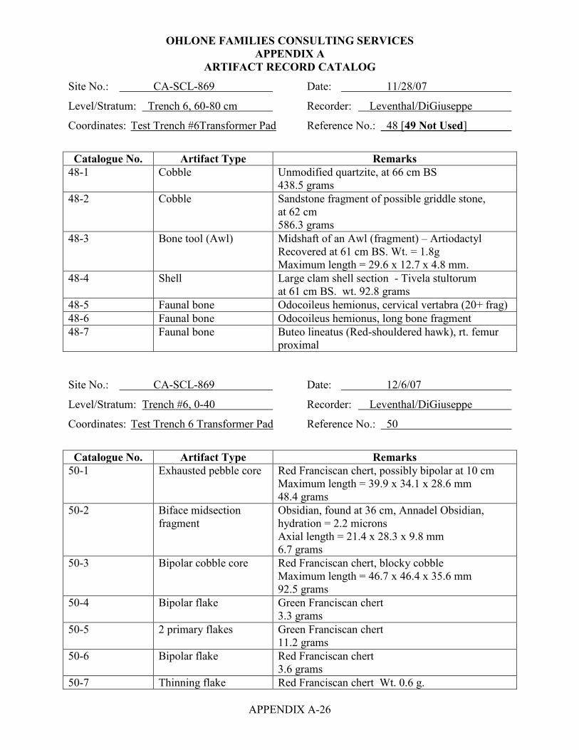
OHLONE FAMILIES CONSULTING SERVICES APPENDIX A
APPENDIX A-26
ARTIFACT RECORD CATALOG
Site No.: CA-SCL-869 Date: 11/28/07
Level/Stratum: Trench 6, 60-80 cm Recorder: Leventhal/DiGiuseppe
Coordinates: Test Trench #6Transformer Pad Reference No.: 48 [49 Not Used]
Catalogue No. Artifact Type Remarks
48-1 Cobble Unmodified quartzite, at 66 cm BS 438.5 grams
48-2 Cobble Sandstone fragment of possible griddle stone, at 62 cm 586.3 grams
48-3 Bone tool (Awl) Midshaft of an Awl (fragment) – Artiodactyl Recovered at 61 cm BS. Wt. = 1.8g Maximum length = 29.6 x 12.7 x 4.8 mm.
48-4 Shell Large clam shell section - Tivela stultorum at 61 cm BS. wt. 92.8 grams
48-5 Faunal bone Odocoileus hemionus, cervical vertabra (20+ frag) 48-6 Faunal bone Odocoileus hemionus, long bone fragment 48-7 Faunal bone Buteo lineatus (Red-shouldered hawk), rt. femur
proximal Site No.: CA-SCL-869 Date: 12/6/07
Level/Stratum: Trench #6, 0-40 Recorder: Leventhal/DiGiuseppe
Coordinates: Test Trench 6 Transformer Pad Reference No.: 50
Catalogue No. Artifact Type Remarks
50-1 Exhausted pebble core Red Franciscan chert, possibly bipolar at 10 cm Maximum length = 39.9 x 34.1 x 28.6 mm 48.4 grams
50-2 Biface midsection fragment
Obsidian, found at 36 cm, Annadel Obsidian, hydration = 2.2 microns Axial length = 21.4 x 28.3 x 9.8 mm 6.7 grams
50-3 Bipolar cobble core Red Franciscan chert, blocky cobble Maximum length = 46.7 x 46.4 x 35.6 mm 92.5 grams
50-4 Bipolar flake Green Franciscan chert 3.3 grams
50-5 2 primary flakes Green Franciscan chert 11.2 grams
50-6 Bipolar flake Red Franciscan chert 3.6 grams
50-7 Thinning flake Red Franciscan chert Wt. 0.6 g.
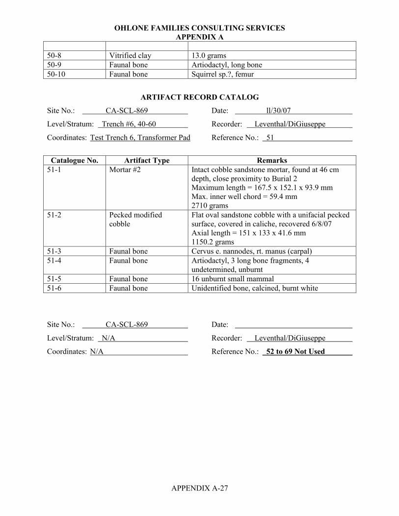
OHLONE FAMILIES CONSULTING SERVICES APPENDIX A
APPENDIX A-27
50-8 Vitrified clay 13.0 grams 50-9 Faunal bone Artiodactyl, long bone 50-10 Faunal bone Squirrel sp.?, femur
ARTIFACT RECORD CATALOG
Site No.: CA-SCL-869 Date: ll/30/07
Level/Stratum: Trench #6, 40-60 Recorder: Leventhal/DiGiuseppe
Coordinates: Test Trench 6, Transformer Pad Reference No.: 51
Catalogue No. Artifact Type Remarks
51-1 Mortar #2 Intact cobble sandstone mortar, found at 46 cm depth, close proximity to Burial 2 Maximum length = 167.5 x 152.1 x 93.9 mm Max. inner well chord = 59.4 mm 2710 grams
51-2 Pecked modified cobble
Flat oval sandstone cobble with a unifacial pecked surface, covered in caliche, recovered 6/8/07 Axial length = 151 x 133 x 41.6 mm 1150.2 grams
51-3 Faunal bone Cervus e. nannodes, rt. manus (carpal) 51-4 Faunal bone Artiodactyl, 3 long bone fragments, 4
undetermined, unburnt 51-5 Faunal bone 16 unburnt small mammal 51-6 Faunal bone Unidentified bone, calcined, burnt white Site No.: CA-SCL-869 Date:
Level/Stratum: N/A Recorder: Leventhal/DiGiuseppe
Coordinates: N/A Reference No.: 52 to 69 Not Used
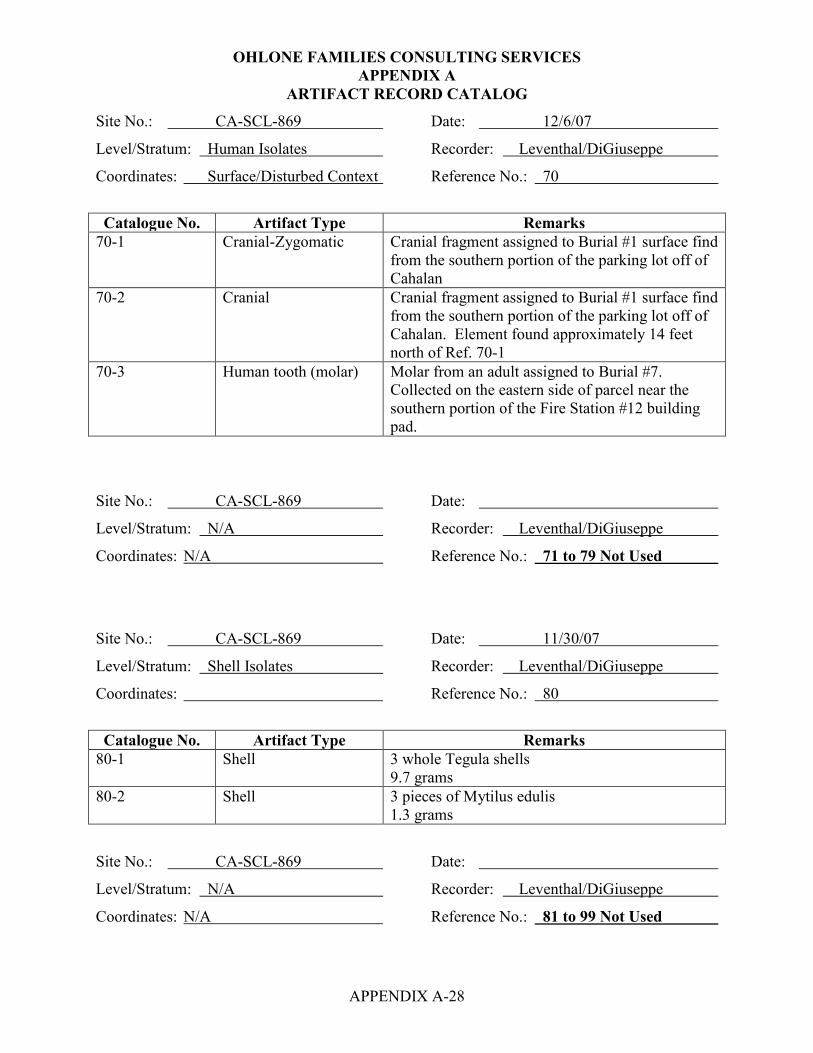
OHLONE FAMILIES CONSULTING SERVICES APPENDIX A
APPENDIX A-28
ARTIFACT RECORD CATALOG
Site No.: CA-SCL-869 Date: 12/6/07
Level/Stratum: Human Isolates Recorder: Leventhal/DiGiuseppe
Coordinates: Surface/Disturbed Context Reference No.: 70
Catalogue No. Artifact Type Remarks
70-1 Cranial-Zygomatic Cranial fragment assigned to Burial #1 surface find from the southern portion of the parking lot off of Cahalan
70-2 Cranial Cranial fragment assigned to Burial #1 surface find from the southern portion of the parking lot off of Cahalan. Element found approximately 14 feet north of Ref. 70-1
70-3 Human tooth (molar) Molar from an adult assigned to Burial #7. Collected on the eastern side of parcel near the southern portion of the Fire Station #12 building pad.
Site No.: CA-SCL-869 Date:
Level/Stratum: N/A Recorder: Leventhal/DiGiuseppe
Coordinates: N/A Reference No.: 71 to 79 Not Used
Site No.: CA-SCL-869 Date: 11/30/07
Level/Stratum: Shell Isolates Recorder: Leventhal/DiGiuseppe
Coordinates: Reference No.: 80
Catalogue No. Artifact Type Remarks
80-1 Shell 3 whole Tegula shells 9.7 grams
80-2 Shell 3 pieces of Mytilus edulis 1.3 grams
Site No.: CA-SCL-869 Date:
Level/Stratum: N/A Recorder: Leventhal/DiGiuseppe
Coordinates: N/A Reference No.: 81 to 99 Not Used

OHLONE FAMILIES CONSULTING SERVICES APPENDIX A
APPENDIX A-29
ARTIFACT RECORD CATALOG
Site No.: CA-SCL-869 Date: 11/30/07
Level/Stratum: Lithic Isolates Recorder: Leventhal/DiGiuseppe
Coordinates: Various Locations Around Site Reference No.: 100
Catalogue No. Artifact Type Remarks
100-1 Exhausted core Red Franciscan chert Maximum length = 26.5 x 24.2 x 17.1 mm 11.8 grams
100-2 Exhausted core Red Franciscan chert Maximum length – 25.0 x 24.8 x 19.5 mm 9.3 grams
100-3 Cortical flake Red Franciscan chert 9.8 grams
100-4 2 primary flakes Red Franciscan chert 3.4 grams
100-5 Bipolar flake Green Franciscan chert 6.8 grams
100-6 Core fragment Monterey chert (mostly white diatomaceous chert) 21.4 grams
100-7 Bipolar core rejuvenation flake
Green Franciscan chert, Pine tree removal area 14.9 grams
100-8 1 primary flake Red Franciscan chert, Pine tree removal area 3.5 grams
100-9 1 primary flake Diatomaceous chert, Pine tree removal area 4.0 grams
100-10 Angular chunk High grade serpentine with diatomaceous portion, Pine tree removal area 21.3 grams
100-11 Chopper/cobble core Red Franciscan chert, south end near pine trees Maximum length = 100.1 x 89.0 x 61.7 mm Chopper core utilized edge length = 46.5 mm 668.3 grams
100-12 Assayed pebble Green Franciscan chert Maximum length = 73.0 x 54.2 x 29.1 mm 125.7 grams
100-13 Exhausted core Green Franciscan chert Maximum length = 41.4 x 32.2 x 27.7 mm 45.6 grams
100-14 Assayed cobble High grade serpentine Maximum length = 95.7 x 54.1 x 42.0 mm 154.5 grams
100-15 Primary flake Red Franciscan chert 10.9 grams
100-16 Primary flake Red Franciscan chert, From second driveway 1.1 grams

OHLONE FAMILIES CONSULTING SERVICES APPENDIX A
APPENDIX A-30
ARTIFACT RECORD CATALOG
Site No.: CA-SCL-869 Date:
Level/Stratum: N/A Recorder: Leventhal/DiGiuseppe
Coordinates: N/A Reference No.: 101 to 109 Not Used
Site No.: CA-SCL-869 Date: 11/30/07
Level/Stratum: Various Surface Isolates -Faunal Recorder: Leventhal/DiGiuseppe
Coordinates: Reference No.: 110
Catalogue No. Artifact Type Remarks
110-1 Faunal bone Probably Cervus canadensis (Roosevelt Elk), left manus (carpal) 2nd digit
110-2 Faunal bone Odocoileus hemionus, antler fragment 110-3 Faunal bone 6 unidentified human bone fragments, possibly
ilium crest 110-4 Faunal bone Cervus nannodes, rt. radius distal shaft fragment 110-5 Faunal bone Bos. (cow), ulna - distal 110-6 Faunal bone Unidentifiable bone 110-7 Faunal bone Odocoileus hemionus; rt. innominate fragment
Site No.: CA-SCL-869 Date:
Level/Stratum: N/A Recorder: Leventhal/DiGiuseppe
Coordinates: N/A Reference No.: 111 to 119 Not Used
Site No.: CA-SCL-869 Date: 11/30/07
Level/Stratum: Historic Isolates Recorder: Leventhal/DiGiuseppe
Coordinates: Reference No.: 120
Catalogue No. Artifact Type Remarks
120-1 Historic toothbrush Tooth brush, proximal end, made of bone 120-2 Button Historic shell button
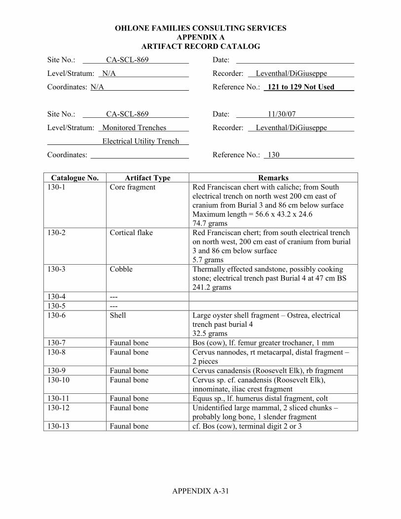
OHLONE FAMILIES CONSULTING SERVICES APPENDIX A
APPENDIX A-31
ARTIFACT RECORD CATALOG
Site No.: CA-SCL-869 Date:
Level/Stratum: N/A Recorder: Leventhal/DiGiuseppe
Coordinates: N/A Reference No.: 121 to 129 Not Used
Site No.: CA-SCL-869 Date: 11/30/07
Level/Stratum: Monitored Trenches Recorder: Leventhal/DiGiuseppe
Electrical Utility Trench
Coordinates: Reference No.: 130
Catalogue No. Artifact Type Remarks
130-1 Core fragment Red Franciscan chert with caliche; from South electrical trench on north west 200 cm east of cranium from Burial 3 and 86 cm below surface Maximum length = 56.6 x 43.2 x 24.6 74.7 grams
130-2 Cortical flake Red Franciscan chert; from south electrical trench on north west, 200 cm east of cranium from burial 3 and 86 cm below surface 5.7 grams
130-3 Cobble Thermally effected sandstone, possibly cooking stone; electrical trench past Burial 4 at 47 cm BS 241.2 grams
130-4 --- 130-5 --- 130-6 Shell Large oyster shell fragment – Ostrea, electrical
trench past burial 4 32.5 grams
130-7 Faunal bone Bos (cow), lf. femur greater trochaner, 1 mm 130-8 Faunal bone Cervus nannodes, rt metacarpal, distal fragment –
2 pieces 130-9 Faunal bone Cervus canadensis (Roosevelt Elk), rb fragment 130-10 Faunal bone Cervus sp. cf. canadensis (Roosevelt Elk),
innominate, iliac crest fragment 130-11 Faunal bone Equus sp., lf. humerus distal fragment, colt 130-12 Faunal bone Unidentified large mammal, 2 sliced chunks –
probably long bone, 1 slender fragment 130-13 Faunal bone cf. Bos (cow), terminal digit 2 or 3

OHLONE FAMILIES CONSULTING SERVICES APPENDIX A
APPENDIX A-32
ARTIFACT RECORD CATALOG
Site No.: CA-SCL-869 Date: 11/30/07
Level/Stratum: Monitored Trench -- Recorder: Leventhal/DiGiuseppe
Main Storm Drain
Coordinates: Reference No.: 131
Catalogue No. Artifact Type Remarks
131-1 Modified flake Monterey chert (All white diatomaceous chert), found in the Main Storm Water Trench at 60 cm, 6/12/07 Maximum length = 30.1 x 26.5 x 13.4 mm 12.5 grams
131-2 Bipolar core Green Franciscan chert, from backdirt from storm water trench – possibly part of burial 2? 13.0 grams
131-3 Primary flake Green Franciscan chert from backdirt from storm water trench – possibly part of burial 2? 1.7 grams
131-4 Bipolar flake Gray Franciscan chert from backdirt from storm water trench – possibly part of burial 2? 4.6 grams
131-5 Primary flake Siltstone from backdirt from storm water trench – possibly part of burial 2? 4.7 grams
131-6 Unifacial mono Unshaped unifacial mono of sandstone, originally heavily covered in caliche and the caliche dissolved using CLR and the cleaned utilized face shows clear evidence of use wear including beveling at one end of the mono. Maximum length = 101.8 x 91.6 x 70.9 mm Area of wear = 66.5 x 46.7 mm 897.7 grams

OHLONE FAMILIES CONSULTING SERVICES APPENDIX A
APPENDIX A-33
ARTIFACT RECORD CATALOG
Site No.: CA-SCL-869 Date: 12/5/07
Level/Stratum: Monitored Trench – SW Recorder: Leventhal/DiGiuseppe
Coordinates: Reference No.: 132
Catalogue No. Artifact Type Remarks
132-1 2 bipolar flakes Red Franciscan chert 5.9 grams
132-2 4 primary flakes Red Franciscan chert 6.2 grams
132-3 1 thinning flake Red Franciscan chert 0.6 grams
132-4 1 primary flake Monterey chert 2.6 grams
132-5 1 primary Basalt/green stone 2.8 grams
132-6 Faunal bone 10 fragments, small mammal Site No.: CA-SCL-869 Date: 12/5/07
Level/Stratum: Monitored Trench Recorder: Leventhal/DiGiuseppe
Coordinates: Water Line Trench Reference No.: 133
Catalogue No. Artifact Type Remarks
133-1 1 bipolar shatter Red Franciscan chert, north section 7.4 grams

OHLONE FAMILIES CONSULTING SERVICES APPENDIX A
APPENDIX A-34
ARTIFACT RECORD CATALOG
Site No.: CA-SCL-869 Date: 12/5/07
Level/Stratum: Monitored Trench - Recorder: Leventhal/DiGiuseppe
Coordinates: Fire Line Trench Reference No.: 134
Catalogue No. Artifact Type Remarks
134-1 Secondary core Red Franciscan chert, west side Maximum length = 42.6 x 39.7 x 24.5 mm 47.7 grams
134-2 1 bipolar flake Yellow Franciscan chert, west side 3.2 grams
134-3 2 shatter Red Franciscan chert, west side 3.1 grams
134-4 Bipolar flake Red Franciscan chert, south side 1.3 grams
134-5 1 primary flake Green Franciscan chert, south side 4.3 grams
134-6 1 bipolar flake Red Franciscan chert, southern margin of foundation 1.7 grams
134-7 1 thinning flake Red Franciscan chert, southern margin of foundation 0.5 grams
134-8 Unmodified stone Sandstone banana stone, eastern side Maximum length = 108.8 x 30.2 x 22.5 mm 113 grams
134-9 Assayed pebble Green Franciscan chert, reddened due to exposure to fire, from SE corner of foundation Maximum length = 62.1 x 45.0 x 30.1 mm 83.5 grams

OHLONE FAMILIES CONSULTING SERVICES APPENDIX A
APPENDIX A-35
ARTIFACT RECORD CATALOG
Site No.: CA-SCL-869 Date: 12/5/07
Level/Stratum: Monitored trench Recorder: Leventhal/DiGiuseppe
Coordinates: North Wall Sewer Line Reference No.: 135
Catalogue No. Artifact Type Remarks
135-1 Shatter Green Franciscan chert 20.6 grams
135-2 Faunal bone Cervus nannodes, 1 ilium fragment Site No.: CA-SCL-869 Date: 12/5/07
Level/Stratum: Monitored Trench Recorder: Leventhal/DiGiuseppe
Coordinates: Comcast Trench Reference No.: 136
Catalogue No. Artifact Type Remarks
136-1 Cobble Thermally effected sandstone, possibly cooking stone from north side of site by redwood trees 436.4 grams
136-2 Shatter Green Franciscan chert from north side of site by redwood trees Wt. 19.8 g
136-3 Proto-pestle Sandstone, made on an oblong river cobble and exhibits pecking for shaping along the medial to distal on lateral edge, no use-wear, abandoned in the state of manufacture, north side of site by redwood trees Wt. 2220 g. Maximum length = 231.6 x 105.5 x 76.2 mm Pecked area length on lateral = 134.0 mm
Site No.: CA-SCL-869 Date: 12/5/07
Level/Stratum: Monitored Trench - Recorder: Leventhal/DiGiuseppe
Coordinates: DWV Trench Reference No.: 137
Catalogue No. Artifact Type Remarks
137-1 2 Cortical shatter Red Franciscan chert 23.2 grams
137-2 Bipolar cortical flake Red Franciscan chert 6.0 grams
137-3 Cortical flake Red Franciscan chert 11.5 grams
137-4 3 primary flakes Red Franciscan chert 2.9 grams
137-5 Faunal bone Small and large mammal, unburnt

APPENDIX B
HUMAN SKELETAL INVENTORY
FORMS

APPENDIX B - HUMAN SKELETAL INVENTORY
APPENDIX B-1
Site CA-SCL-869 Burial No. 1 Date 4-18-08 Recorder Atwood
Metrics Rt. Humerus = 311 mm max. length; Lf. Femur = 421 mm max length, Rt. humerus 42.02 mm
max. diameter; lf. femur = 41.7 mm max. diameter
Sex (criteria used) Female = greater sciatic notch is wide, femoral and humeral head diameters within
female range
Age (criteria used) 40+ auricular surface = 40-50; long bones fused; teeth present score = 7 & 8 attrition;
osteoporosity present
Condition of Skeleton 30% present, fragmentary, bone cortext poor and bone density low
Cranium Fragmentary (3 maxillary = two frags have teeth in situ)
Cribra Orbitalia: (L) X (R) X
Mandible X
Teeth Permanent-Loose I2, LC , LI1 In-situ RM1, RM2, RM1
Deciduous-Loose X In-situ X
Hyoid X Sternum X
Vertebrae:
Cervical X
Thoracic X
Lumbar 2 lumbar present, unknown #s, 1 = C(4), 1 = (F2)
Sacrum x
Indeterminate
Os Coxae: LEFT RIGHT INDT
Mature F(4) X X
Immature: Pubis
Ilium
Ischium

OHLONE FAMILIES CONSULTING SERVICES
APPENDIX B-2
Ribs: No. Complete (L) X (R) X No. Incomplete X
LEFT RIGHT INDT LEFT RIGHT INDT
Clavicle X X X Scapula X X X
Humerus X C(1) X Femur C(1) X X
Radius X X X Patella X X X
Ulna X I(2) F(1) Tibia I(1) X X
Fibula X X X
Carpals: Tarsals:
Navicular X X X Calcaneus X X X
Lunate X X X Talus X X X
Triquetral X X X Cuboid X X X
Pisiform X X X Navicular X X X
Grt. Mult. X X X 1st Cuneiform X X X
Lsr. Mult. X X X 2nd Cuneiform X X X
Capitate X X X 3rd Cuneiform X X X
Hamate X X X
Metacarpals: Metatarsals:
MC 1 X X X MT 1 X X X
MC 2 X X X MT 2 X X X
MC 3 X X X MT 3 X X X
MC 4 X X X MT 4 X X X
MC 5 X X X MT 5 X X X
Phalanges: Hand X Foot X
Indeterminate X
Additional Notes X
KEY: C (1) = complete (2/3 of element with articulating surfaces) I (1) = incomplete (less than 2/3 of element but more than 1/3 with articulating surface) F (1) = fragmentary (less than 1/3 of element or shafts only) X = absent Ribs = complete indicates that the vertebral end is present as well as completely present. If element is complete but in pieces, indicate thus: C (3) for number of pieces If epiphyses present on subadult’s long bone indicate thus: p Femur C (1) D
Site CA-SCL-869
Burial No. 1

OHLONE FAMILIES CONSULTING SERVICES
APPENDIX B-3
SEXING DETERMINATION
Site: CA-SCL-869 Recorder: Atwood
Burial: 1 Date: 4-18-08
Pelvis: Male Female
Symphysis high or low X X
Sub-pubic Angle V or U shaped X X
Foramen large or small X X
Acetabulum large or small X X
Sciatic Notch close or wide X wide
Prearicular Sulcus absent or present X X
Skull: Nuchal Crest robust, muscle markings X X
Mastoid Process size (large or small) X X
Supraorbital Margin rounded or sharp margin X X
Supraorbital Ridge glabella none or prominent X X
Mental Eminence none to massive projection X X
AGEING DETERMINATION
Yes No
Dental (all erupted) 7-8 X
Long bone fusion YES X
Pubic symphysis X X
Auricular Surface 40+ X
Osteoarthritis X X
Comments

OHLONE FAMILIES CONSULTING SERVICES
APPENDIX B-4
DENTAL PATHOLOGIES TOOTH WEAR wear other pathologies wear other pathologies Upper: Lower: RM3 X RM3 X
RM2 X RM2 X
RM1 X RM1 X
RP2 X RP2 X
RP1 X RP1 X
RC● X RC● X
RI2 X RI2 X
RI1 X RI1 X
LI1 X LI1 X
LI2 X LI2 X
LC● X LC● X
LP1 X LP1 X
LP2 X LP2 X
LM1 X LM1 X
LM2 X LM2 X
LM3 X LM3 X
Periodontal Disease: All teeth (3) loose & (3) in situ, but small mandibular & maxillary frags.
Present: I2, I1, C , RM1, RM2, RM1 = score 7 and 8 attrition
KEY: X = absent CAL = calculi XU = absent/unerupter SS = shovel shaped (single or double) A/U = ante-mortem tooth loss HY = hypoplasis F = fragmentary (non-diagnostic) DM = dental modification C = caries CAR = carabelli’s cusp A = abscesses W = winging PSI = peg shaped incisors SSS = single shovel-shaped DSS = double shovel-shaped
Site CA-SCL-869
Burial No. 1

OHLONE FAMILIES CONSULTING SERVICES
APPENDIX B-5
PATHOLOGIES
Element Involved Description of Lesion Differential Diagnosis Lf. Tibia -- Medial diaphysis – patch of -- periosteal reaction active,
periosteal reaction on medial aspect rough, vertical lines of bone
of tibial crest, patch = 18.2 mm width growth
& 22.6 mm in height @ mid-diaphysis
-- Proximal diaphysis possible patch -- periosteal reaction, active,
of periosteal reaction on medial rough, porosity
aspect
-- Lateral diaphysis periosteal reaction
27.5 mm height
4.7 mm width patch on diaphysis
lateral to crest and just below inferior
margin of medial periosteal patch
4/18 – look @ lf. femur linea aspera 5/2 – possible, but post-mortem
damage makes impossible to
determine, also osteoporosis
may have aided in present
appearance (more susceptible
to p/m damage)
Notes
Site CA-SCL-869
Burial No. 1

OHLONE FAMILIES CONSULTING SERVICES HUMAN SKELETAL INVENTORY
APPENDIX B-6
DEGENERATIVE JOINT DISEASE – UPPER PERIPHERAL SKELETON Left Notes Right Notes TEMPORO-MANDIBULAR JOINT Glenoid Fossa X X Mand. Condyle X X Total Joint Score X X Notes: SHOULDER Scapula (Glenoid) X X Proximal Humerus X 1-2 Total Joint Score X 1-2 Notes: ELBOW Distal Humerus X X p/m damage Proximal Ulna X 1 Proximal Radius X X Total Joint Score X 1 Notes: WRIST Distal Ulna X X Distal Radius X X Carpals X X Total Joint Score X X Notes: HAND Proximal Metacarpals X X Distal Metacarpals X X Phalanges X X Total Joint Score X X Notes:
Site CA-SCL-869
Burial No. 1

OHLONE FAMILIES CONSULTING SERVICES HUMAN SKELETAL INVENTORY
APPENDIX B-7
DEGENERATIVE JOINT DISEASE – LOWER PERIPHERAL SKELETON
HIP Left Notes Right Notes
Acetabulum 1 X
Proximal Femur 1 X
Total Joint Score 1 X
Notes:
KNEE Distal Femur X p/m damage X
Proximal Tibia X X
Proximal Fibula X X
Total Joint Score X X
Notes:
ANKLE Distal Tibia X X
Distal Fibula X X
Tarsals X X
Total Joint Score X X
Notes:
FOOT Proximal Metacarpals X X
Distal Metacarpals X X
Phalanges X X
Total Joint Sccore X X
Notes:
Site CA-SCL-869
Burial No. 1

OHLONE FAMILIES CONSULTING SERVICES HUMAN SKELETAL INVENTORY
APPENDIX B-8
DEGENERATIVE SPINAL DISEASE BODY INTERVERTEBRAL JOINTS SUPERIOR INFERIOR NOTES SUPERIOR INFERIOR NOTES
L R L R
C1 dens facet X X X X X
C2 dens X X X X X X
C3 X X X X X X
C4 X X X X X X
C5 X X X X X X
C6 X X X X X X
C7 X X X X X X
C indet. X X X X X X
T1 X X X X X X
T2 X X X X X X
T3 X X X X X X
T4 X X X X X X
T5 X X X X X X
T6 X X X X X X
T7 X X X X X X
T8 X X X X X X
T9 X X X X X X
T10 X X X X X X
T11 X X X X X X
T12 X X X X X X
T indet. X X X X X X
L1 X X X X X X
L2 X X X X X X
L3 X X X X X X
L4 X X X X X X
L5 X X X X X X
L indet. * * * * * *
Sacrum:
Notes: *2 fragmented lumbar verts present = pieces score 1-2, but post-portem damage makes it
impossible to definitively determine lumbar OA
Site CA-SCL-869
Burial No. 1

OHLONE FAMILIES CONSULTING SERVICES HUMAN SKELETAL INVENTORY
APPENDIX B-9
POSTCRANIAL MEASUREMENTS: Clavicle: maximum length X
Clavicle: sagittal diameter at midshaft X
Clavicle: vertical diameter at midshaft X
Humerus: maximum length 311 mm
Humerus: epicondylar breadth 54 mm
Humerus: vertical diameter of head 42.1 mm
Humerus: maximum diameter at midshaft 22.7 mm
Humerus: minimum diameter at midshaft 15.2 mm
Femur: maximum head diameter 41.7
Femur: epicondylar breadth X (p/m damage)
Tibia: maximum proximal @ nutrient foramen 33.2 mm
Femur: maximum length 427.0 mm
Site CA-SCL-869
Burial No. 1

OHLONE FAMILIES CONSULTING SERVICES HUMAN SKELETAL INVENTORY
APPENDIX B-10
Site CA-SCL-869 Burial No. 2 Date 6-26-07 Recorder Atwood
Metrics Humeral length = 261 mm, humeral ipicondylar breadth = 51 mm, humeral vertical diameter of
head = 34.25 mm, radius max. length = 198 mm, see additional measurement sheet
Sex (criteria used) Female = see attached sexing determination sheet
Age (criteria used) 40+: auricular surface, osteoarthritis, osteoporosis poss. (low bone density), high
attrition (7 & 8 scores), high tooth loss/abscesses
Condition of Skeleton poor, very fragmented, bone density is poor (possible osteoporosis?)
Cranium C(53) = all elements present and complete, but highly fragmented
Cribra Orbitalia: (L) Yes (R) Yes
Mandible C(3)
Teeth Permanent-Loose 2 incisors (attrition = 8) In-situ RP2, RC , RI2, RI1, LI1, LC
LP2, LP1, LC , LI2, RC , RP1
Deciduous-Loose X In-situ X
Hyoid X Sternum F(2)
Vertebrae:
Cervical C6 = C(1); C7 = C(2)
Thoracic T1=C(3); T2=I(2); T3=I(2), T4=C(2); T5=C(2); T6=C(2); T7=C(3); T8=C(2); T9=C(2);
T10=C(1); T11=C(1); T12=C(1)
Lumbar L1 = C(1); L2 = C(1); L3 = C(1); L4 = C(1); L5 = C(2)
Sacrum C(3) = anterior side of S2 and S3 fractured off and coccyx is present
Indeterminate
Os Coxae: LEFT RIGHT INDT
Mature F(7) C(2) X
Immature: Pubis X X X
Ilium X X X
Ischium X X X

OHLONE FAMILIES CONSULTING SERVICES
APPENDIX B-11
Ribs: No. Complete (L) 5 (R) 11 No. Incomplete F(26)
LEFT RIGHT INDT LEFT RIGHT INDT
Clavicle I(2) C(1) Scapula F(1) spine frag. C(4)
Humerus F(1) dis.end C(2) Femur C(3) C(7)
Radius C(2) C(1) Patella X C(1)
Ulna F(1) dis epip C(2) dis epip Tibia I(1) F(2)
Fibula C(1) F(1) shaft only
Carpals: Tarsals:
Navicular X X Calcaneus C(1) X
Lunate X X Talus X X
Triquetral X X Cuboid C(1) X
Pisiform X X Navicular C(1) X
Grt. Mult. X F(1) 1st Cuneiform C(1) X
Lsr. Mult. X X 2nd Cuneiform C(1) X
Capitate X X 3rd Cuneiform C(1) X
Hamate X X
Metacarpals: Metatarsals:
MC 1 X C(1) MT 1 C(1) X
MC 2 X C(2) MT 2 X X
MC 3 X X MT 3 X X
MC 4 X X MT 4 C(1) X
MC 5 X X MT 5 C(1) X
Phalanges: Hand C(3 prox.), C(1 mid), C(2 term.) Foot 2 C prox. phalanges
Indeterminate
Additional Notes Additional distal right ulna found in back dirt. Originally thought to belong to B #2, it is
to long and the bordrs of the fracture do not completely match the right ulnar diaphysis of B#2 (too much bone)
KEY: C (1) = complete (2/3 of element with articulating surfaces) I (1) = incomplete (less than 2/3 of element but more than 1/3 with articulating surface) F (1) = fragmentary (less than 1/3 of element or shafts only) X = absent Ribs = complete indicates that the vertebral end is present as well as completely present. If element is complete but in pieces, indicate thus: C (3) for number of pieces If epiphyses present on subadult’s long bone indicate thus: p Femur C (1) d
dis. diap. absent
dis. epip. absent
Site: CA-SCL-869
Burial No.: 2
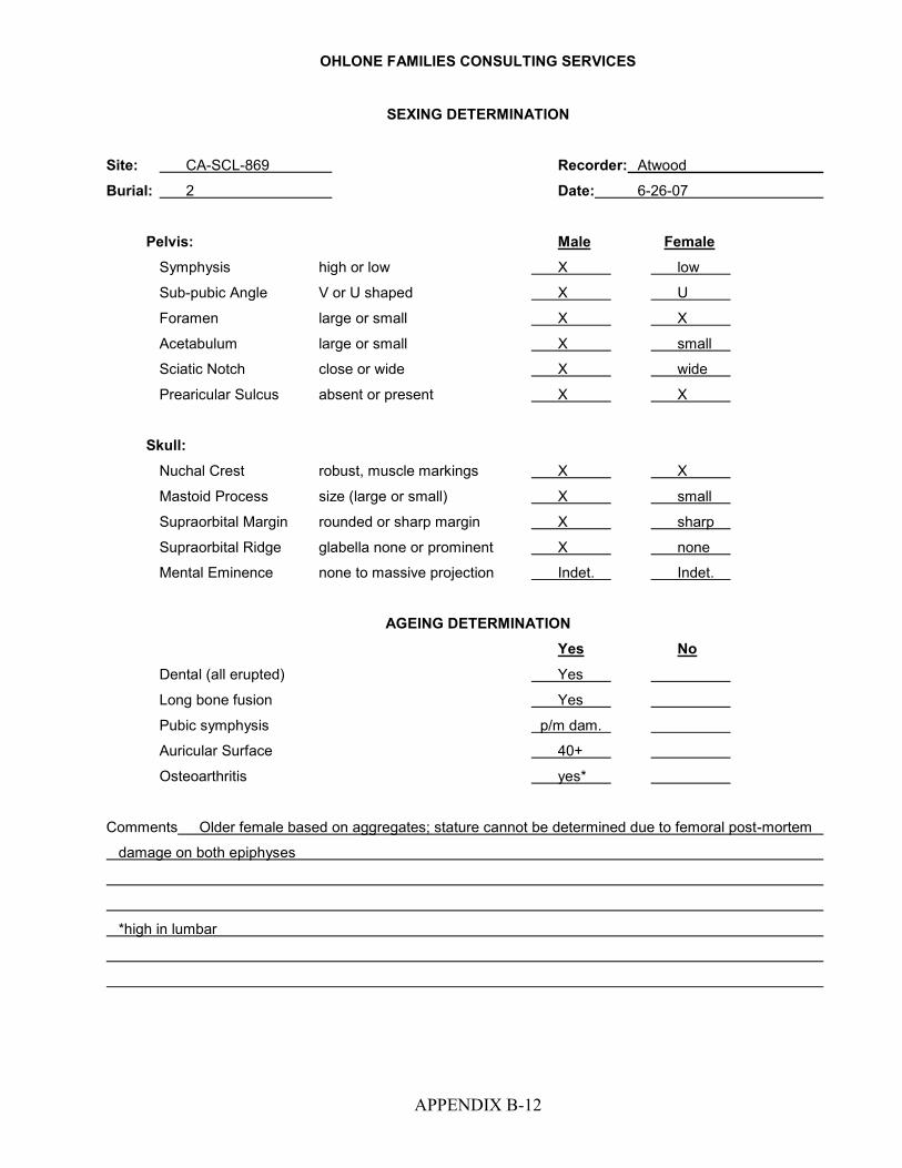
OHLONE FAMILIES CONSULTING SERVICES
APPENDIX B-12
SEXING DETERMINATION
Site: CA-SCL-869 Recorder: Atwood
Burial: 2 Date: 6-26-07
Pelvis: Male Female
Symphysis high or low X low
Sub-pubic Angle V or U shaped X U
Foramen large or small X X
Acetabulum large or small X small
Sciatic Notch close or wide X wide
Prearicular Sulcus absent or present X X
Skull: Nuchal Crest robust, muscle markings X X
Mastoid Process size (large or small) X small
Supraorbital Margin rounded or sharp margin X sharp
Supraorbital Ridge glabella none or prominent X none
Mental Eminence none to massive projection Indet. Indet.
AGEING DETERMINATION
Yes No
Dental (all erupted) Yes
Long bone fusion Yes
Pubic symphysis p/m dam.
Auricular Surface 40+
Osteoarthritis yes*
Comments Older female based on aggregates; stature cannot be determined due to femoral post-mortem
damage on both epiphyses
*high in lumbar

OHLONE FAMILIES CONSULTING SERVICES
APPENDIX B-13
DENTAL PATHOLOGIES TOOTH WEAR wear other pathologies wear other pathologies Upper: Lower: RM3 X advanced healing RM3 X genetically missing
RM2 X p/m RM2 7 present
RM1 7 RM1 X A/U, advanced healing
RP2 7 RP2 8
RP1 X A/U, completely healed RP1 6/5
RC● 8 RC● 7/5
RI2 8 RI2 X p/m loss
RI1 X RI1 X p/m loss
LI1 7 LI1 8/7
LI2 X LI2 8/5
LC● 8 LC● 7-8/5
LP1 X A/U, advanced healing LP1 7/5
LP2 X A/U, advanced healing LP2 5-6/4
LM1 X A/U, advanced healing LM1 X p/m loss
LM2 X advanced healing LM2 7 active apical abscess
LM3 X advanced healing LM3 X genetically missing
Periodontal Disease: severe periodontitis in mandible and maxilla. Abscesses present
No caries seen; calculi is present
KEY: X = absent CAL = calculi XU = absent/unerupter SS = shovel shaped (single or double) A/U = ante-mortem tooth loss HY = hypoplasis F = fragmentary (non-diagnostic) DM = dental modification C = caries CAR = carabelli’s cusp A = abscesses W = winging PSI = peg shaped incisors SSS = single shovel-shaped DSS = double shovel-shaped
Site: CA-SCL-869
Burial No.: 2

OHLONE FAMILIES CONSULTING SERVICES
APPENDIX B-14
PATHOLOGIES
Element Involved Description of Lesion Differential Diagnosis NONE SEEN
Notes
Site: CA-SCL-869
Burial No.: 2

HUMAN SKELETAL INVENTORY
APPENDIX B-15
INFECTIOUS DISEASE
Element Involved Description of Lesion Differential Diagnosis NONE SEEN
Notes
Site: CA-SCL-869
Burial No.: 2

HUMAN SKELETAL INVENTORY
APPENDIX B-16
DEGENERATIVE JOINT DISEASE – UPPER PERIPHERAL SKELETON Left Notes Right Notes TEMPORO-MANDIBULAR JOINT Glenoid Fossa X X Mand. Condyle 0 0 Total Joint Score 0 0 Notes: SHOULDER Scapula (Glenoid) X 1 Proximal Humerus X 0-1 Total Joint Score X 1 Notes: ELBOW Distal Humerus X 1 Proximal Ulna X 1 Proximal Radius X X Total Joint Score X 1 Notes: WRIST Distal Ulna 1 X Distal Radius 1 1 Carpals X X Total Joint Score 1 1 Notes: HAND Proximal Metacarpals X 1 Distal Metacarpals X 0 Phalanges X 0-1 Total Joint Score X 0-1 Notes:
Site: CA-SCL-869
Burial No.: 2
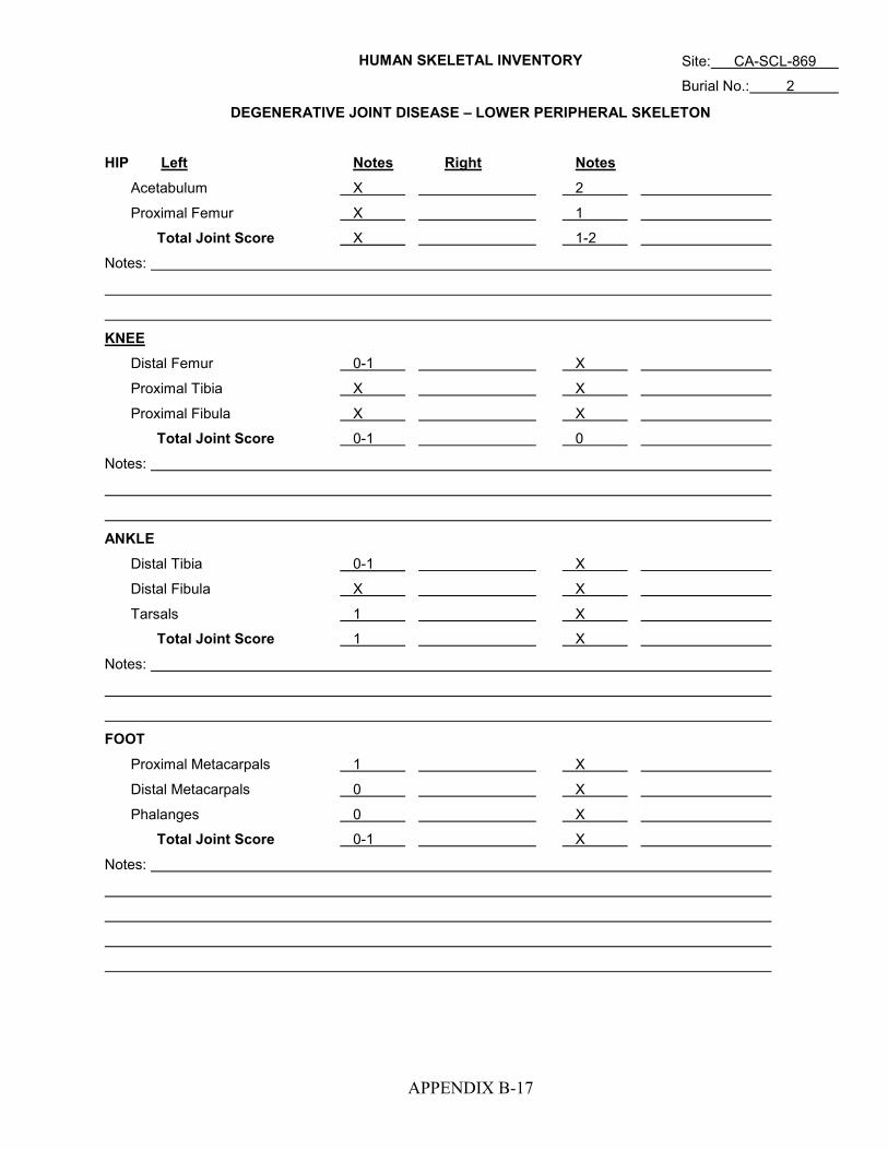
HUMAN SKELETAL INVENTORY
APPENDIX B-17
DEGENERATIVE JOINT DISEASE – LOWER PERIPHERAL SKELETON
HIP Left Notes Right Notes
Acetabulum X 2
Proximal Femur X 1
Total Joint Score X 1-2
Notes:
KNEE Distal Femur 0-1 X
Proximal Tibia X X
Proximal Fibula X X
Total Joint Score 0-1 0
Notes:
ANKLE Distal Tibia 0-1 X
Distal Fibula X X
Tarsals 1 X
Total Joint Score 1 X
Notes:
FOOT Proximal Metacarpals 1 X
Distal Metacarpals 0 X
Phalanges 0 X
Total Joint Score 0-1 X
Notes:
Site: CA-SCL-869
Burial No.: 2

HUMAN SKELETAL INVENTORY
APPENDIX B-18
DEGENERATIVE SPINAL DISEASE
BODY INTERVERTEBRAL JOINTS SUPERIOR INFERIOR NOTES SUPERIOR INFERIOR NOTES
L R L R
C1 dens facet X X X X X
C2 dens X X X X X
C3 X X X X X X
C4 X X X X X X
C5 X X X X X X
C6 1 0 X 1 X 0
C7 1 1 1 1 1 X
C indet.
T1 X X too much p/m dam. 1 1 1 1
T2 1 1 X X 0-1 0-1
T3 1 1 X X X X
T4 1 1 0 1 1 1
T5 1 1 1 1 1 1
T6 1 0 X 0 1 1
T7 1 0 X 0 1 X
T8 X X p/m dam. 1 0 X X
T9 X X p/m dam. 1 1 2 2
T10 X X p/m dam. 1 0 1 1
T11 X X p/m dam. 2 2 2 1
T12 X X p/m dam. 1 2 1 1
T indet.
L1 1 0 1 1 1 1
L2 3 1 1 1 1 1
L3 1 1 1 1 1 X
L4 1 1 1 1 1 1
L5 2 3 3 2 2 2
L indet. Sacrum: S1 superior body = 2
Notes: The anterior bodies of the thoracic and lumbar spine have high levels of post-mortem breakage.
The bone density is poor.
Site: CA-SCL-869
Burial No.: 2

HUMAN SKELETAL INVENTORY
APPENDIX B-19
CRANIAL AND POSTCRANIAL MEASUREMENT RECORDING FORM: ADULT REMAINS CRANIAL MEASUREMENTS:
Maximum cranial length
Maximum cranial breadth
Bizygomatic diameter
Crania base length
Basion-prosthion length
Basion-bregma height
Biauricular breadth
Upper facial height
Minimum frontal breadth
Upper facial breadth
Nasal breadth
Biorbital breadth
Intraorbital breadth 15.6 mm
Orbital breadth 37.2 mm
Orbital height 31.1 mm
Foramen magnum max length
Foramen magnum max brdth
Mastoid length
Site: CA-SCL-869
Burial No.: 2

HUMAN SKELETAL INVENTORY
APPENDIX B-20
POSTCRANIAL MEASUREMENTS: Clavicle: maximum length (rt.) 111.0 mm
Clavicle: sagittal diameter at midshaft (rt.) 9.8 mm
Clavicle: vertical diameter at midshaft (rt.) 7.4 mm
Humerus: maximum length (rt.) 261.0 mm
Humerus: epicondylar breadth (rt.) 51.0 mm
Humerus: vertical diameter of head (rt.) 34.3 mm
Humerus: maximum diameter at midshaft (rt.) 17.1 mm
Humerus: minimum diameter at midshaft (rt.) 16.4 mm
Radius: maximum length (rt.) 198.0 mm
Femur: maximum head diameter
Femur: epicondylar breadth
Femur: maximum length @ nutrient foramen
Tibia: maximum proximal epiphyseal breadth
Site: CA-SCL-869
Burial No.: 2

HUMAN SKELETAL INVENTORY
APPENDIX B-21
Site CA-SCL-869 Burial No. 3 Date 8-19-07 Recorder Atwood
Metrics rt. ulna = 231 mm; rt. radius = 213 mm; lf. humerus = 294 mm (approx humerus is very fragmentary)
Sex (criteria used) Female: based on the morphology of the os coxae, wide greater sciatic notch,
presence of the pre-auricular sulcus, gracile skeleton
Age (criteria used) 40+ : all teeth erupted, all long bones fused, auricular surface, severe attrition and
Tooth loss, moderate to severe OA on thoracic vertebrae
Condition of Skeleton fragmentary, 70% present, poor bone density and volume (probably osteoporosis)
Cranium C(61) all elements present, but very fragmentary: Frontal C(1), both parietals, lf temporal C(1),
rt. temporal F(1), occipital C(1)-glued, maxilla C(1)
Cribra Orbitalia: (L) X (R) X
Mandible C(3): complete left side, rt side ½ of alveola from mental eminence and ascending ramus
Teeth Permanent-Loose LP2, LC•, RC•, PR1, 2 indet. Incisors, In-situ LPM1, LM1, LM2,LPM2, LM3
2 indet. premolars & 5 indet. molars
Deciduous-Loose X In-situ X
Hyoid X Sternum C(3): C(2) manubirum, I(1) body
Vertebrae:
Cervical C1=C(1); C2=C(1); C3=C(3); C4=C(2), C5=C(1), C6=C(1), C7=C(1)
Thoracic T1=C(3); T2=C(3); T3=C(2); T4=C(2); T5=I(1); T6=C(1); T7=C(1); T8=C(1); T9=C(2);
T10=C(1); T11=C(2); T12=C(1)
Lumbar L1=C(1); L2=C(1); L3=C(2); L4=F(2); L5=C(1)
Sacrum F(1) = S1 with left wing present with coccyxgeal vertebra
Indeterminate
Os Coxae: LEFT RIGHT INDT
Mature I(2) – missing pubis X X
Immature: Pubis X X X
Ilium X X X
Ischium X X X

OHLONE FAMILIES CONSULTING SERVICES
APPENDIX B-22
Ribs: No. Complete (L) 11 (R) 10 No. Incomplete F(79)
LEFT RIGHT INDT LEFT RIGHT INDT
Clavicle C(1) I(1) X Scapula F(2) X F(2)_
Humerus C(2) I(4) X Femur I(7) I(5) F(1) head
Radius I(1) C(3) X Patella X X X
Ulna X C(3) X Tibia F(3) C(4) X
Fibula F(1) I(3) F(1) diaph.
Carpals: Tarsals:
Navicular X X X Calcaneus X X X
Lunate X X X Talus X X X
Triquetral X X X Cuboid X X X
Pisiform X X C(1) Navicular X X X
Grt. Mult. X X X 1st Cuneiform X X X
Lsr. Mult. X X X 2nd Cuneiform X X X
Capitate X X X 3rd Cuneiform X X X
Hamate X X X
Metacarpals: Metatarsals:
MC 1 X X X MT 1 X C(1) X
MC 2 X X X MT 2 X X X
MC 3 X X X MT 3 X X X
MC 4 X X X MT 4 X X X
MC 5 X X X MT 5 X X X
Phalanges: Hand 3 – 1 proximal, 2 mid Foot X
Indeterminate Bag of indet. fragments
Additional Notes T7 & T8 are fused along the anterior margins of the vertebral bodies; no signs of trauma
except for fusion, but bone quality has been adversely affected by burial, excavation and probable
osteoporosis and that may be hiding additional signs of trauma; F(1) MC diaphysis
KEY: C (1) = complete (2/3 of element with articulating surfaces) I (1) = incomplete (less than 2/3 of element but more than 1/3 with articulating surface) F (1) = fragmentary (less than 1/3 of element or shafts only) X = absent Ribs = complete indicates that the vertebral end is present as well as completely present. If element is complete but in pieces, indicate thus: C (3) for number of pieces If epiphyses present on subadult’s long bone indicate thus: p Femur C (1) D
Site CA-SCL-869
Burial No. 3

OHLONE FAMILIES CONSULTING SERVICES
APPENDIX B-23
SEXING DETERMINATION
Site: CA-SCL-869 Recorder: Atwood
Burial: 3 Date: 8-19-07
Pelvis: Male Female
Symphysis high or low X X
Sub-pubic Angle V or U shaped X X
Foramen large or small X X
Acetabulum large or small X X
Sciatic Notch close or wide X wide
Prearicular Sulcus absent or present X present
Skull: Nuchal Crest robust, muscle markings X X
Mastoid Process size (large or small) X small
Supraorbital Margin rounded or sharp margin X sharp
Supraorbital Ridge glabella none or prominent X none
Mental Eminence none to massive projection X none
AGEING DETERMINATION
Yes No
Dental (all erupted) yes X
Long bone fusion yes X
Pubic symphysis X X
Auricular Surface 40+ X
Osteoarthritis yes* X
Comments *OA is moderate to severe on the thoracic vertebrae and the C2 dens process, but
L1, L2, L3 and L5 show little to no OA.

OHLONE FAMILIES CONSULTING SERVICES
APPENDIX B-24
DENTAL PATHOLOGIES TOOTH WEAR wear other pathologies wear other pathologies Upper: Lower: RM3 X portion of maxilla absent RM3 7 bone absent
RM2 X portion of maxilla absent RM2 7 bone absent
RM1 6 portion of maxilla absent RM1 7 bone absent
RP2 X portion of maxilla absent RP2 X p/m loss
RP1 7 RP1 7
RC● 6 RC● 6
RI2 X active healing RI2 X p/m loss
RI1 X signs of healing RI1 X A/U, well-healed
LI1 X post-mortem loss LI1 X A/U, well-healed
LI2 4 LI2 X
LC● 4 LC● 7
LP1 6 LP1 7 apical abscess
LP2 6 LP2 7
LM1 8 hole into root canal LM1 X p/m loss
LM2 8 LM2 X A/U, advanced healing
LM3 8 LM3 6/7
Periodontal Disease: severe periodontitis
KEY: X = absent CAL = calculi XU = absent/unerupter SS = shovel shaped (single or double) A/U = ante-mortem tooth loss HY = hypoplasis F = fragmentary (non-diagnostic) DM = dental modification C = caries CAR = carabelli’s cusp A = abscesses W = winging PSI = peg shaped incisors SSS = single shovel-shaped DSS = double shovel-shaped
Site CA-SCL-869
Burial No. 3

OHLONE FAMILIES CONSULTING SERVICES
APPENDIX B-25
DENTAL/PERIODONTAL PATHOLOGIES – ADDITIONAL NOTES
Roof of right palate exhibits a lesion measuring 18.07 mm A/P and 17.73 M/L (the M/L measure is
approximate because the right latero-posterior maxilla has been broken off p/m. The lesion was active
at the time of death and partly intrudes into the left palate with some bony reaction (porous, bony
hypertrophy) seen. The lesion is circular and has created a bony-rimmed crater within the right palate.
The bone is highly porous and remodeling was active at time of death.
Differential Diagnosis = cyst or neoplasm
See Dr. Yellich consult
Site CA-SCL-869
Burial No. 3

OHLONE FAMILIES CONSULTING SERVICES
APPENDIX B-26
PATHOLOGIES
Element Involved Description of Lesion Differential Diagnosis
Left acetabulum lytic lesion measures approx. 36.12 Trauma probable due to the
mm in height, width measures 17.23 location of the lesion
mm, but the central area of the
acetabulum has been broken off p/m.
The left femoral head is unaffected.
Size and reactivity of lesion = had for
some time
Fused T7 & T8 T7 & T8 have fused along the anterior Trauma probable, fusion is
Edge of the vertebral bodies. Severe localized to these two vertebra,
osteoarthritis is also seen along the although surrounding thoracic
superior T7 body and the inferior T8 verts do evince increased OA
superior apophyseal facet is not fused when compared to cervical &
to the inferior T7 apophyseal facet, even lumbar.
but the facets on the right do appear
to be fused, although this may be due
to the encrusted dirt matrix still
surrounding portions of the vertebrae.
Extent of fusion = had for some time
Notes
Site CA-SCL-869
Burial No. 3

OHLONE FAMILIES CONSULTING SERVICES HUMAN SKELETAL INVENTORY
APPENDIX B-27
PATHOLOGIES – ADDITIONAL NOTES: T5 right inferior apophyseal facet: lytic lesion seen on medial portion (lateral portion broke off p/m).
Measures 11.12 mm in height and 6.66 mm in width. Bony reaction still evident and in process at time
of death. Margins of facet have been obliterated and bon is still coarse with bony spicules. Related to
probable injury: see explanation of T7 and T8 fusion.
See dental/periodontal pathology sheep for description of lytic lesion seen on the right palate and
Dr. Yellich consult
See Dr. Yellich consult for naso-maxillary dx of bony growth seen
Site CA-SCL-869
Burial No. 3

OHLONE FAMILIES CONSULTING SERVICES HUMAN SKELETAL INVENTORY
APPENDIX B-28
INFECTIOUS DISEASE
Element Involved Description of Lesion Differential Diagnosis NONE SEEN
Notes
Site CA-SCL-869
Burial No. 3
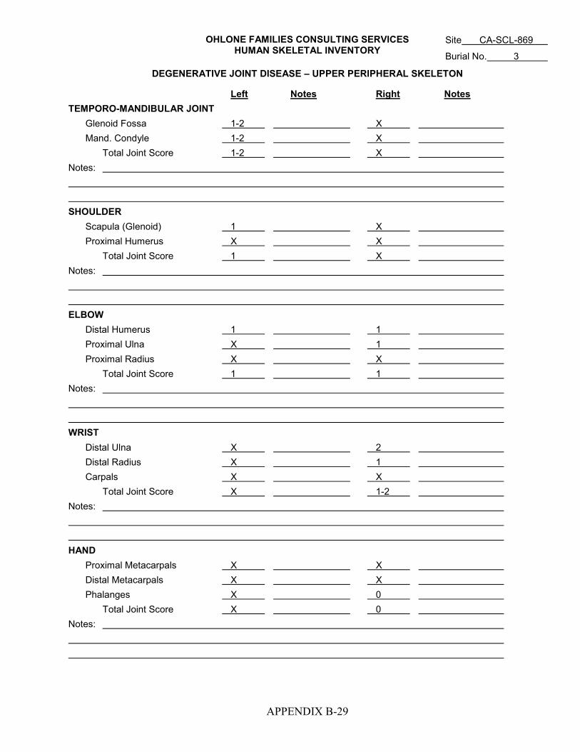
OHLONE FAMILIES CONSULTING SERVICES HUMAN SKELETAL INVENTORY
APPENDIX B-29
DEGENERATIVE JOINT DISEASE – UPPER PERIPHERAL SKELETON
Left Notes Right Notes TEMPORO-MANDIBULAR JOINT Glenoid Fossa 1-2 X Mand. Condyle 1-2 X Total Joint Score 1-2 X Notes: SHOULDER Scapula (Glenoid) 1 X Proximal Humerus X X Total Joint Score 1 X Notes: ELBOW Distal Humerus 1 1 Proximal Ulna X 1 Proximal Radius X X Total Joint Score 1 1 Notes: WRIST Distal Ulna X 2 Distal Radius X 1 Carpals X X Total Joint Score X 1-2 Notes: HAND Proximal Metacarpals X X Distal Metacarpals X X Phalanges X 0 Total Joint Score X 0 Notes:
Site CA-SCL-869
Burial No. 3
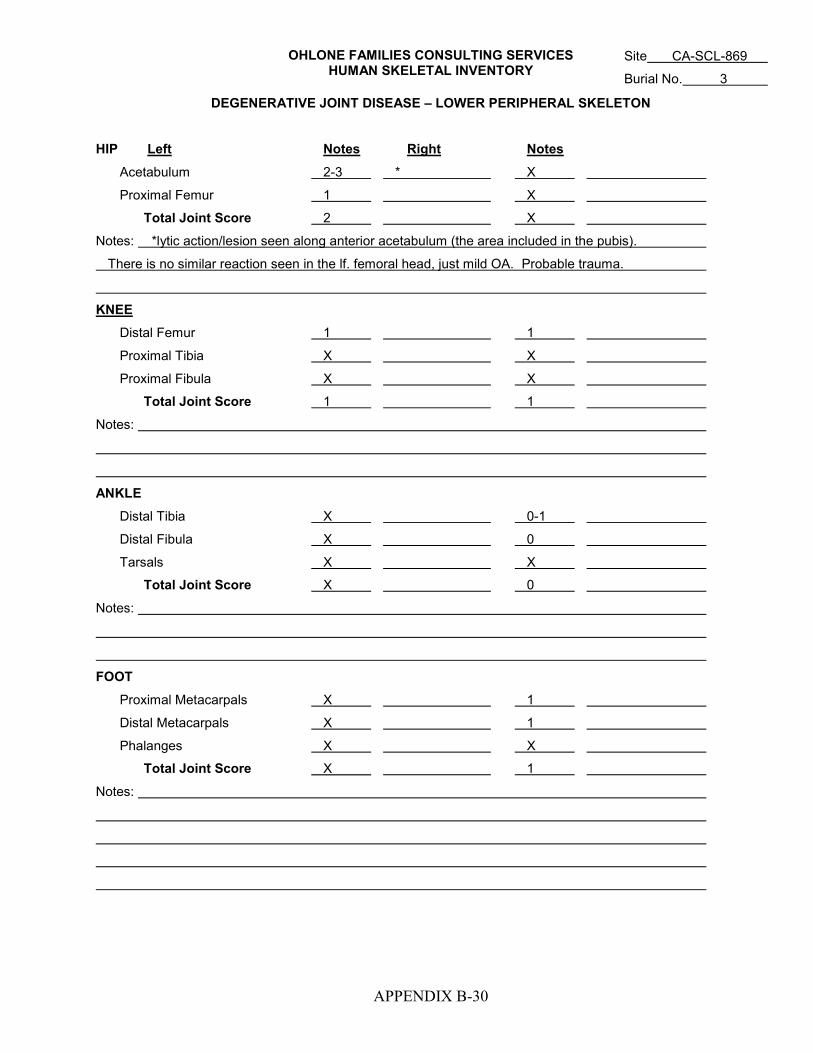
OHLONE FAMILIES CONSULTING SERVICES HUMAN SKELETAL INVENTORY
APPENDIX B-30
DEGENERATIVE JOINT DISEASE – LOWER PERIPHERAL SKELETON
HIP Left Notes Right Notes
Acetabulum 2-3 * X
Proximal Femur 1 X
Total Joint Score 2 X
Notes: *lytic action/lesion seen along anterior acetabulum (the area included in the pubis).
There is no similar reaction seen in the lf. femoral head, just mild OA. Probable trauma.
KNEE Distal Femur 1 1
Proximal Tibia X X
Proximal Fibula X X
Total Joint Score 1 1
Notes:
ANKLE Distal Tibia X 0-1
Distal Fibula X 0
Tarsals X X
Total Joint Score X 0
Notes:
FOOT Proximal Metacarpals X 1
Distal Metacarpals X 1
Phalanges X X
Total Joint Score X 1
Notes:
Site CA-SCL-869
Burial No. 3

OHLONE FAMILIES CONSULTING SERVICES HUMAN SKELETAL INVENTORY
APPENDIX B-31
DEGENERATIVE SPINAL DISEASE
BODY INTERVERTEBRAL JOINTS SUPERIOR INFERIOR NOTES SUPERIOR INFERIOR NOTES L R L R C1 dens facet 3 1 1 1 1
C2 dens 3 3 1 1 1 1
C3 3 2 1 1 1 1
C4 0 0 0-1 0-1 0-1 0-1
C5 0 1 0-1 0-1 0-1 0-1
C6 0 0 0 0 0 0
C7 0 0 1 X 0-1 0-1
C indet.
T1 X X 0 0 0 0
T2 2 X X X 1 1
T3 X X 1 X 1 1
T4 2 3 0 0 1 1
T5 3 3 1 1 1 * *
T6 2 3 2 1 1 1
T7 3 fused to T8 1 1 X X **
T8 fused to T7 3 X X 1 1 ** AND ***
T9 3 3 1 1 1 1
T10 2 2 1 1 2 2
T11 2 2 1-2 1-2 1 1
T12 X X 1 1 1-2 1-2
T indet.
L1 1 1 X X 1 1
L2 1 1 1 X 2 2
L3 1-2 1 1 1 1 1
L4 X X 1 1 1 X
L5 2 2 1 1 2 1
L indet. Sacrum:
Notes: * rt. inferior apo. Facet has lesion measuring 11.12 mm in height & 6.66 in width. The right lateral
portion of the facet has broken off p/m so the lesion may have measured wider.
** T7 inferior and T8 superior facets fused
*** small lytic lesion in center of T8 left inferior facet, but it may be congenital
Site CA-SCL-869
Burial No. 3
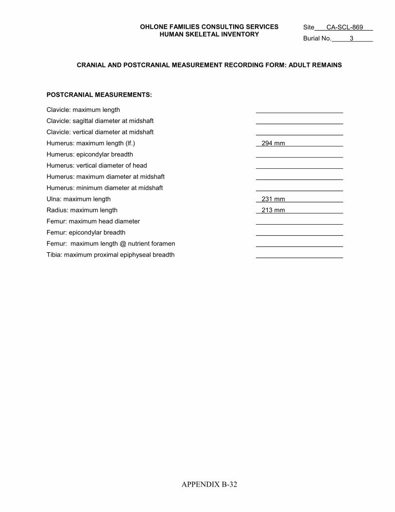
OHLONE FAMILIES CONSULTING SERVICES HUMAN SKELETAL INVENTORY
APPENDIX B-32
CRANIAL AND POSTCRANIAL MEASUREMENT RECORDING FORM: ADULT REMAINS POSTCRANIAL MEASUREMENTS: Clavicle: maximum length
Clavicle: sagittal diameter at midshaft
Clavicle: vertical diameter at midshaft
Humerus: maximum length (lf.) 294 mm
Humerus: epicondylar breadth
Humerus: vertical diameter of head
Humerus: maximum diameter at midshaft
Humerus: minimum diameter at midshaft
Ulna: maximum length 231 mm
Radius: maximum length 213 mm
Femur: maximum head diameter
Femur: epicondylar breadth
Femur: maximum length @ nutrient foramen
Tibia: maximum proximal epiphyseal breadth
Site CA-SCL-869
Burial No. 3

OHLONE FAMILIES CONSULTING SERVICES HUMAN SKELETAL INVENTORY
APPENDIX B-33
Site CA-SCL-869 Burial No. 4 Date 10/4/07 Recorder DiGiuseppe
Metrics Rt. humeral head vertical = 39.2 mm. Rt. humeral length = 288 mm – for stature, used Trotter’s
Regression formula for Mexican males (none offered for females) = 158 cm or 5’2”. Or 160 cm from
Mongoloid have 5’3”
Sex (criteria used) Female; wide greater sciatic notch, preauricular sulcus, metric measurement of humerus
indicates female
Age (criteria used) 50-59; Phase 7 of auricular surface from standards
Condition of Skeleton fair, most of the cortex has post mortem erosion of the elements; skeleton is fairly
fragmented with few elements complete, vertebrae are extremely porous and deteriorated. All elements have
indications of weathering. It appears that this individual has possible osteoporous
Cranium C(29+) – cranium partially reconstructed; complete occipital, both parietals, both temporals (with
the right side complete including petrous portion), complete frontal, facial (including both zygomatics, orbital,
complete maxilla, sphenoid frags, and nasal fragments Cribra Orbitalia: (L) -- (R) --
Mandible C(3) – only missing the left condyle
Teeth Permanent-Loose RI2, RI1, LI1, LI2, LC , LP1, LM1, In-situ RC , RPM1, RPM2, RM3, LC , LPM1
RM2, LPM2, LM3
Deciduous-Loose In-situ
Hyoid X Sternum X
Vertebrae:
Cervical C(2): of which C1 is present and other is one of the C3 to C7
Thoracic C(9): T1 and T2 present, others indeter location due to p/m erosion; I(1), F(2)
Lumbar C(3): L5 present; F(1) body
Sacrum I(6): S1 present
Indeterminate F(5) body, F(5) neural arch, F(25+) indeter
Os Coxae: LEFT RIGHT INDT
Mature I(3) – ischium, ilium, pubis I(2) – ischium, ilium F(20) – fragile
Immature: Pubis
Ilium
Ischium

OHLONE FAMILIES CONSULTING SERVICES
APPENDIX B-34
Ribs: No. Complete (L) 10 V, 1 S (R) 4 V No. Incomplete 4 V (ind side), 44 frags
LEFT RIGHT INDT LEFT RIGHT INDT
Clavicle C(1) C(1) X Scapula I(1) I(1) F(5)
Humerus C(3) C(1) X Femur C(4) C(2) X
Radius C(3) C(2) X Patella X X X
Ulna C(3) C(4) X Tibia C(2) C(2) F(3)
Fibula C(1) I(1) X
Carpals: Tarsals:
Navicular X C(1) X Calcaneus C(1) I(1) X
Lunate X X X Talus C(1) C(1) X
Triquetral X X X Cuboid C(1) X X
Pisiform X X X Navicular I(1) F(1) X
Grt. Mult. X X X 1st Cuneiform C(1) X X
Lsr. Mult. X X X 2nd Cuneiform X X X
Capitate X X X 3rd Cuneiform X X X
Hamate X C(1) X
Metacarpals: Metatarsals:
MC 1 C(1) X X MT 1 C(1) X X
MC 2 C(1) X X MT 2 X X X
MC 3 X C(1) X MT 3 I(1) X X
MC 4 X X X MT 4 X X X
MC 5 C(1) C(1) X MT 5 X C(1) X
Phalanges: Hand 8 (4 prox, 2 mid, 2 distal) Foot X
Indeterminate Frag of MT4 (side unknown); 3 MC or MT diaphysis indeter.; 1 phalanx frag;
Additional Notes Both os coxae are very porous, possibly from osteoporous; the auricular surfaces on both are
very granular and porous, the retro-auricular area has large holes, both post mortem and anti-mortem.
May indicate extreme age or disability. Ribs have severe p/m erosion to the cortex, no evidence of rib
fractures, have one vertebral rib end with deep facet on the posterior margin between connecting facets to the
vertebrae and is porotic inside facet.
KEY: C (1) = complete (2/3 of element with articulating surfaces) I (1) = incomplete (less than 2/3 of element but more than 1/3 with articulating surface) F (1) = fragmentary (less than 1/3 of element or shafts only) X = absent Ribs = complete indicates that the vertebral end is present as well as completely present. If element is complete but in pieces, indicate thus: C (3) for number of pieces If epiphyses present on subadult’s long bone indicate thus: p Femur C (1) d
Site CA-SCL-869
Burial No. 4
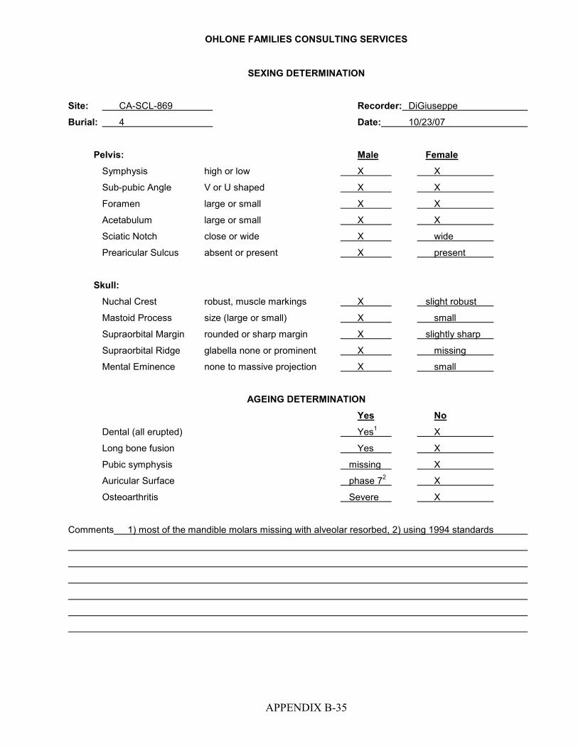
OHLONE FAMILIES CONSULTING SERVICES
APPENDIX B-35
SEXING DETERMINATION
Site: CA-SCL-869 Recorder: DiGiuseppe
Burial: 4 Date: 10/23/07
Pelvis: Male Female
Symphysis high or low X X
Sub-pubic Angle V or U shaped X X
Foramen large or small X X
Acetabulum large or small X X
Sciatic Notch close or wide X wide
Prearicular Sulcus absent or present X present
Skull: Nuchal Crest robust, muscle markings X slight robust
Mastoid Process size (large or small) X small
Supraorbital Margin rounded or sharp margin X slightly sharp
Supraorbital Ridge glabella none or prominent X missing
Mental Eminence none to massive projection X small
AGEING DETERMINATION
Yes No
Dental (all erupted) Yes1 X
Long bone fusion Yes X
Pubic symphysis missing X
Auricular Surface phase 72 X
Osteoarthritis Severe X
Comments 1) most of the mandible molars missing with alveolar resorbed, 2) using 1994 standards

OHLONE FAMILIES CONSULTING SERVICES
APPENDIX B-36
DENTAL PATHOLOGIES TOOTH WEAR wear other pathologies wear other pathologies Upper: Lower: RM3 X A/U RM3 6
RM2 X A/U RM2 8 Open root canal
RM1 X A/U RM1 X A/U
RP2 6 RP2 X A/U
RP1 7 RP1 X A/U
RC● 7 RC● X A/U healed apical abscess
RI2 7 RI2 X A/U
RI1 7 RI1 X A/U
LI1 8 LI1 X A/U
LI2 8 LI2 X A/U
LC● X LC● 8
LP1 X A/U in process of resorp. LP1 8
LP2 8 LP2 8 apical abscess buccal
LM1 8 LM1 X A/U
LM2 X A/U LM2 X A/U
LM3 X A/U LM3 6 caries on buccal occlusal
Periodontal Disease: Maxilla LM1 and PM1; mandible LM1, LM2, and RM3
Note: Apical abscess where the RC on buccal side was, ante-mortem tooth loss; approximately 16 teeth
have been resorbed from ante-mortem tooth loss; slight mandibular torus bilateral from lf and rt PM2 back
beyond the M3 for both sides – Maximum expression for left side opposite M3 is 2.7 mm and length is 49 mm;
palatine torus is bilateral of suture (specifically runs down the center of palate) is 1 mm high – maximum
expression is 16 mm wide – mound type length is 25 mm
KEY: X = absent CAL = calculi XU = absent/unerupter SS = shovel shaped (single or double) A/U = ante-mortem tooth loss HY = hypoplasis F = fragmentary (non-diagnostic) DM = dental modification C = caries CAR = carabelli’s cusp A = abscesses W = winging PSI = peg shaped incisors SSS = single shovel-shaped DSS = double shovel-shaped
Site CA-SCL-869
Burial No. 4
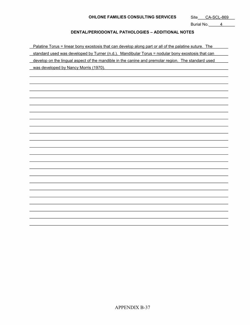
OHLONE FAMILIES CONSULTING SERVICES
APPENDIX B-37
DENTAL/PERIODONTAL PATHOLOGIES – ADDITIONAL NOTES Palatine Torus = linear bony exostosis that can develop along part or all of the palatine suture. The
standard used was developed by Turner (n.d.). Mandibular Torus = nodular bony exostosis that can
develop on the lingual aspect of the mandible in the canine and premolar region. The standard used
was developed by Nancy Morris (1970).
Site CA-SCL-869
Burial No. 4

OHLONE FAMILIES CONSULTING SERVICES
APPENDIX B-38
PATHOLOGIES
Element Involved Description of Lesion Differential Diagnosis Rt. Os Coxae Depressions on the lateral portion The etiology may only be age
of the element, one approximately related, since no indication of
45 mm from the center of the greater trauma is present. Also, a similar
sciatic notch, the second 40 mm from depression was found in CA-Ala-
the center of greater sciatic notch, 329, Burial 147, with one of their
note that the largest depression depressions ending in the
measures 19.0 x 8.7 mm (with the nutrient foramen – it could be
length compromised because it is muscular due to age or muscle
broken, may have been longer.) pull due to location of muscle
Depth is 3.55 mm for the depression. attachments
Rt. & Lf. Os Coxa Moderate lipping around the auricular OA
surface. Retro-auricular surfaces
extremely porous and deteriorated
Rt. & Lf. Os Coxa Deep grooves between the auricular Indeterminate etiology - possible
and retro-auricular surfaces on both, lesions, similar lesions seen on
at apical area margin worn and see burial 5 of CA-SCL-38.
spread into the cortex of medial
portion
Rt. Femur On lateral portion of diaphysis, under Slight periosteal reaction, may
the lesser trochanter have roughened be caused by muscle pull along
bone layered over cortex, along the linea aspera that wraps around
linea aspera wrapping around to element to the lateral side
lateral side Note – p/m breakage and erosion
on bone makes diagnosis
difficult
Severe lipping around the fovea Indication of OA or trauma to
capitis that is distal to center hip area, possibly related to
grooves found on rt. os coxae.
Site: CA-SCL-869
Burial No.: 4

OHLONE FAMILIES CONSULTING SERVICES
APPENDIX B-39
PATHOLOGIES (continued)
Element Involved Description of Lesion Differential Diagnosis Lf. Femur Have spicules present in the This area is the location for attach-
trochanteric fossa, possibly present ment of the obturator externus
on the Rt. Femur, but this area is muscle . This muscle helps with
partially missing and what is there has lateral rotation of the thigh, this
evidence of spicules. may indicate possible age-related
stress to the hip area. Etiology
of asteophytes caused by OA.
(T. White states individuals over
60 exhibit these arthritic features.)
Chew marks on the medial margin Rodent activity
of the diaphysis
Lf. Scapula Chew marks along the axuillary Rodent activity
margin, 48 mm below glenoid fossa
Two small pits (not associated with indeterminate etiology
foramen), in body, 15 mm below the
acromion process neck.
Center Frontal Are possible chew marks or cutmarks Under microscopic analysis using
present, measures 26.3 to 37.8 mm 10.5x, it looks as if these marks
from the coronal suture, directly are caused by a rodent, there is
central to the sagittal suture a double scoop for each line,
though, there is no indication of
anchoring necessary for the
rodent to hold the bone in place
this could be because it was hold-
ing on in the suture mark which is
difficult to see into. Second
opinion is necessary.
Site: CA-SCL-869
Burial No.: 4

OHLONE FAMILIES CONSULTING SERVICES
APPENDIX B-40
PATHOLOGIES (continued)
Element Involved Description of Lesion Differential Diagnosis
Vertebrae All bodies are extremely porotic and Individual is elderly with age
have indications of moderate to related problems
severe OA
Notes
Site: CA-SCL-869
Burial No.: 4

HUMAN SKELETAL INVENTORY
APPENDIX B-41
ADDITIONAL NOTES
1. The Rt. humerus deltoid tuberosity is robust, with roughened surface, is larger than the bilateral element.
2. In the foot have severe OA on both calcaneus and talus facets, moderate OA on left navicular, rest of the
foot elements are indeterminate due to erosion around the facets
3. In the hands have severe OA of right navicular and hamate, left MC2 distal has severe OA, right MC2
proximal has moderate OA
4. none of the bones show indications of eburnation, reason is due to the p/m erosion of cortex and light
weight condition of the elements due to possible osteoporous
Site: CA-SCL-869
Burial No.: 4

HUMAN SKELETAL INVENTORY
APPENDIX B-42
DEGENERATIVE SPINAL DISEASE
BODY INTERVERTEBRAL JOINTS
SUPERIOR INFERIOR NOTES SUPERIOR INFERIOR NOTES L R L R
C1 dens facet 2 3 3 3 3
C2 dens X X X X X X
C3 X X X X X X
C4 X X X X X X
C5 X X X X X X
C6 X X X X X X
C7 X X X X X X
C indet. 2 2 1 1 2 2
T1 2 2 2 3 2 2
T2 2 3 2 2 2 2
T11 3 2 2 2 2 2
T indet. 2 2 1 1 2 2
T indet. 2 2 1 1 2 2
T indet. 2 2 1 1 X X
T indet. 2 2 1 1 2 2
T indet. X 1 1 1 21 2
T indet. 3 3 1 1 2 2
T indet. 2 2 X X X X
T indet. X X X X X X
L1 X X X X X X
L2 X X X X X X
L3 X X X X X X
L4 X X X X X X
L5 3 3 3 3 3 3
L indet. 32 32 X 3 3 3
L indet. 33 33 X 3 24 24
Sacrum: S1: left superior margin 3+ due to large hypertrophic boney growth, extremely damaged p/m, is
osteoporotic bone, very light weight; besides S1, only have fragments of other portions, surface of superior
body very eroded.
Notes: All of the bodies central portions are eroded and porous. 1) partially missing p/m, 2) surface and most
of the superior margin eroded, only partial right rim present to identify OA, 3) missing right superior margin,
4) missing most of inferior portion of facet
Site: CA-SCL-869
Burial No.: 4

APPENDIX C
DENTAL WEAR PATTERNS AND SCORING
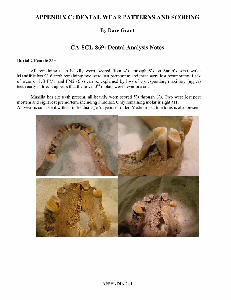
APPENDIX C: DENTAL WEAR PATTERNS AND SCORING
APPENDIX C-1
By Dave Grant
CA-SCL-869: Dental Analysis Notes
Burial 2 Female 55+ All remaining teeth heavily worn, scored from 4’s, through 8’s on Smith’s wear scale. Mandible has 9/16 teeth remaining; two were lost premortem and three were lost postmortem. Lack of wear on left PM1 and PM2 (6’s) can be explained by loss of corresponding maxillary (upper) teeth early in life. It appears that the lower 3rd molars were never present.
Maxilla has six teeth present, all heavily worn scored 5’s through 8’s. Two were lost post
mortem and eight lost premortem, including 5 molars. Only remaining molar is right M1. All wear is consistent with an individual age 55 years or older. Medium palatine torus is also present

APPENDIX C: DENTAL WEAR PATTERNS AND SCORING
APPENDIX C-2
CA-SCL-869 Cahalan Burial 2 Mandible
LC. LI2 LI1 RC.
Wear Score 5 Wear Score 5 Wear Score7 Wear Score 5 LM2 LPM2 LPM1 RPM1 RPM2 RM2
Wear Score 8 Wear Score 5 Wear Score 5 Wear Score 5 Wear Score 8 Wear Score 7

APPENDIX C: DENTAL WEAR PATTERNS AND SCORING
APPENDIX C-3
CA-SCL-869: Burial 2 - Mandibular Abscess Form
Right Buccal View: No Abscess Present
Left Buccal View: Active Abscess LM3
Front Buccal View: No Abscess Present
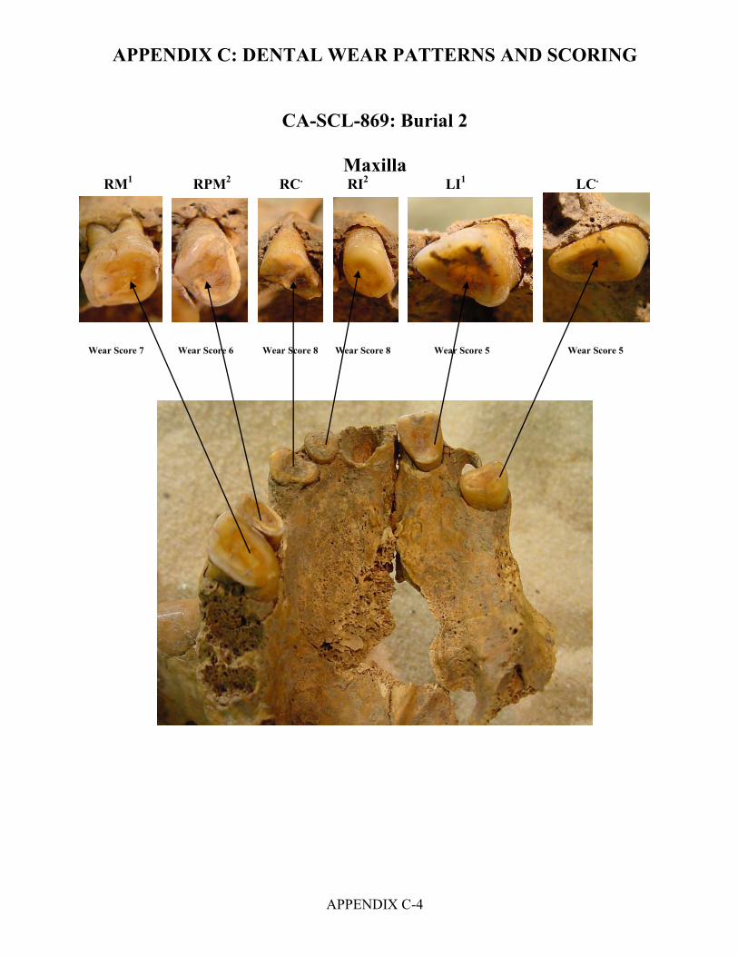
APPENDIX C: DENTAL WEAR PATTERNS AND SCORING
APPENDIX C-4
CA-SCL-869: Burial 2
Maxilla
RM1 RPM2 RC. RI2 LI1 LC.
Wear Score 7 Wear Score 6 Wear Score 8 Wear Score 8 Wear Score 5 Wear Score 5
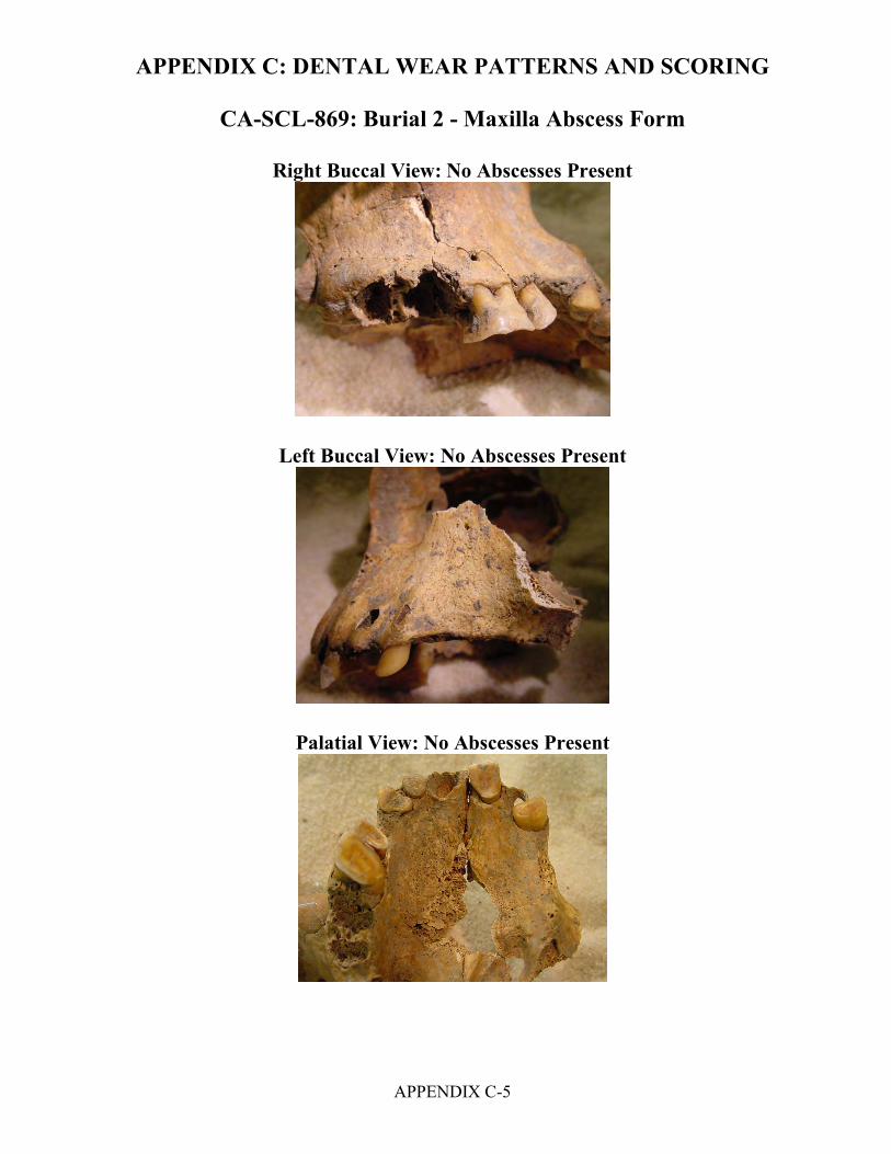
APPENDIX C: DENTAL WEAR PATTERNS AND SCORING
APPENDIX C-5
CA-SCL-869: Burial 2 - Maxilla Abscess Form
Right Buccal View: No Abscesses Present
Left Buccal View: No Abscesses Present
Palatial View: No Abscesses Present

APPENDIX C: DENTAL WEAR PATTERNS AND SCORING
APPENDIX C-6
CA-SCL-869: Burial 3 Burial 3 Female 55+ All remaining teeth are heavily worn with mostly 8’s on Smith’s scale. Mandible has 9/16 remaining teeth with unusual wear on the three right molars, with wear pattern slants of 60º-80º on right M1,M2 and M3, indicating severe malocclusion and impaired mastication processes. Of the seven missing teeth one was lost postmortem and six were lost premortem. Maxilla has nine remaining teeth, all heavily worn, of the seven missing, three lost premortem, one lost postmortem; and the right side of the maxillary arch is broken and missing with a loss of corresponding occlusion information. It also appears that there is severe malformation of the palatine suture with sharp bony extosis which would have also impaired normal mastication (chewing). All wear is consistent with an individual 55 years or older. Please see Dr Yellich’s analysis for additional information.

APPENDIX C: DENTAL WEAR PATTERNS AND SCORING
APPENDIX C-7
CA-SCL-869: Burial 3
Mandible
LM3 LPM2 LPM1 LC. RC. RPM1 RM1 RM2 RM3
Wear Score 6 Wear Score 7 Wear Score 7 Wear Score 8 Wear Score 7 Wear Score 8 Wear Score 8 Wear Score 8 Wear Score 8

APPENDIX C: DENTAL WEAR PATTERNS AND SCORING
APPENDIX C-8
CA-SCL-869: Burial 3 - Mandibular Abscess Form Right Buccal View
Left Buccal View
Abscess LC. LPM2
Frontal View

APPENDIX C: DENTAL WEAR PATTERNS AND SCORING
APPENDIX C-9
CA-SCL-869: Burial 3
Maxilla
LI2 LC. LPM1 LPM2
Wear Score 4 Wear Score 4 Wear Score 6 Wear Score 6 RM1 RPM1 RC. LM1 LM2 LM3
Wear Score 6 Wear Score 7 Wear Score 6 Wear Score 8 Wear Score 8 Wear Score 8

APPENDIX C: DENTAL WEAR PATTERNS AND SCORING
APPENDIX C-10
CA-SCL-869: Burial 3 - Maxilla Abscess Form
Right Buccal View: No Abscesses Present
Left Buccal View: No Abscesses Present
Palatial View: No Abscesses Present
Bony Extosis Growth

APPENDIX C: DENTAL WEAR PATTERNS AND SCORING
APPENDIX C-11
CA-SCL-869: Burial 4 Burial 4 Female 55+
All teeth heavily worn and exhibiting wear scores of 6’s and 8’s on Smith’s wear scale. Mandible has 6/16 teeth remaining. Excluding the 2 M3’s all other teeth are 8’s, the ten missing teeth are all missing premortem, most with complete resorption of the aveolar sockets.
Maxilla has 9/16 remaining, one lost postmortem and six lost premortem. All remaining teeth are 6’s, 7’s and 8’s by Smith’s wear scale. All premortem missing teeth have completely resorbed sockets. Anolomous wear pattern present with working groove present between maxillary right I2, and right Canine. Individual also has medium to large palatine torus present.

APPENDIX C: DENTAL WEAR PATTERNS AND SCORING
APPENDIX C-12
CA-SCL-869: Burial 4
Mandible
LM3 LPM2 LPM1 LC. RM2 RM3
Wear Score 6 Wear score 8 Wear score 8 Wear Score 8 Wear Score 8 Wear Score 6
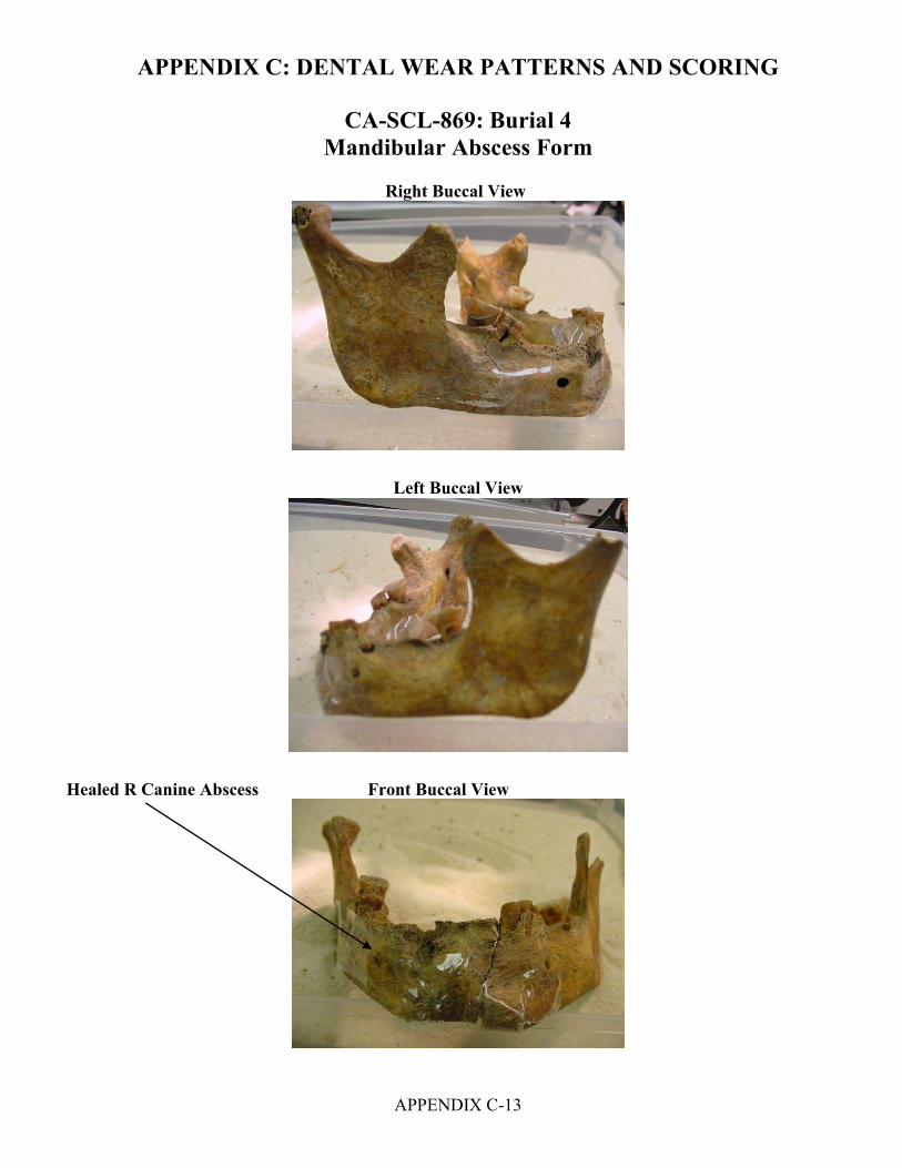
APPENDIX C: DENTAL WEAR PATTERNS AND SCORING
APPENDIX C-13
CA-SCL-869: Burial 4 Mandibular Abscess Form
Right Buccal View
Left Buccal View
Healed R Canine Abscess Front Buccal View

APPENDIX C: DENTAL WEAR PATTERNS AND SCORING
APPENDIX C-14
CA-SCL-869: Burial 4
Maxilla RPM 1 RC. RI2 RI1 LI1 LI2 Wear Score 7 Wear Score 7 Wear Score 7 Wear Score 7 Wear Score 8 Wear Score 8
RPM2
LPM2 LM1
Wear Score 6 Wear Score 8 Wear score 8

APPENDIX C: DENTAL WEAR PATTERNS AND SCORING
APPENDIX C-15
CA-SCL-869: Burial 4 Maxilla Abscess Form
Left Maxilla Buccal View: No Abscesses Present
Right Maxilla Buccal View: No Abscesses Present
Palatal View: No Abscesses Present

APPENDIX D
FAUNAL ELEMENT CHART
DISTRIBUTION OF AVES AND FAUNA BY RECOVERY CONTEXT

APPENDIX D - FAUNAL ELEMENT CHART: CA-SCL-869
skul
l
toot
hm
axilla
man
dibl
ehu
mer
usra
dius
ulna
met
acar
pal
met
atar
sal
cann
on b
one
carp
alta
rsal
phalange
antle
r
scap
ula
verte
brae
cerv
ical
thor
acic
lum
bar
inno
min
ate
fem
urtib
ialo
ng b
one
rib Tota
ls
AVES
Phalacrocorax 1 1 penicillatus
Buteo 1 1 lineatus
Fulica 1 1 americana
cf.Steganopus 1 1 tricolor
Bubo 1 1 virginianus
nestling 1 1large bird 1 * 1 2med. Bird 1 1
MAMMALIA
Sylvilagus 1 1 1 3 bachmani
Sylvilagus 1 1 sp.
Lepus 1 cd 1 1 4 californicus
Canis 1 1 latrans
Canis 1 1 lupus
Canis 1 1 2 domesticus
Canis 1 sp.
Cervus 1 1 1 1 1 1 5e. roosevelti
Cervus 1 1 1 1 1 2 1 1 9e. nannodes
Cervus 1 1 1 sp.
Odocoileus 5 5 2 1 1 1 1 1 1 18 hemionus
artiodactyl 3 6 1 1 6 17large mammal 1 5 6
Totals 78Notes: * bird- tarsometatarsuscd= caudal cannon bone-fused metacarpals or metatarsals
APPENDIX D-1
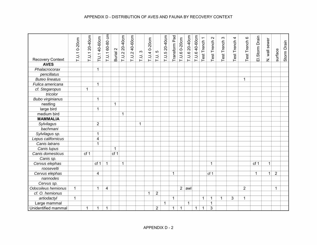
APPENDIX D - DISTRIBUTION OF AVES AND FAUNA BY RECOVERY CONTEXT
Recovery Context T.U
.1 0
-20c
m
T.U
.1 2
0-40
cm
TU.1
40-
60cm
T.U
.1 6
0-80
cm
Buria
l 2
T.U
.2 2
0-40
cm
T.U
.2 4
0-60
cm
T.U
. 3
T.U
.4 0
-20c
m
T.U
. 5
T.U
.5 2
0-40
cm
Tran
sfor
m P
ad
T.U
.6 0
-20c
m
T.U
.6 2
0-40
cm
T.U
.6 4
0-60
cm
Test
Tre
nch
1
Test
Tre
nch
2
Test
Tre
nch
3
Test
Tre
nch
4
Test
Tre
nch
6
El.S
torm
Dra
in
N. w
all s
ewer
surfa
ce
Stor
m D
rain
AVESPhalacrocorax 1
pencillatus
Buteo lineatus 1Fulica americana 1
cf. Stegaropus 1 tricolor
Bubo virginianus 1nestling 1
large bird 1medium bird 1MAMMALIASylvilagus 2 1 bachmani
Sylvilagus sp. 1Lepus californicus 4
Canis latrans 1Canis lupus 1
Canis domesticus cf 1 cf 1Canis sp.
Cervus elephas cf 1 1 1 1 cf 1 1 roosevelti
Cervus elephas 4 1 cf 1 1 1 2 nannodes
Cervus sp.
Odocoileus hemionus 1 1 4 2 awl 2 1cf. O. hemionus 1 2
artiodactyl 1 1 1 1 1 3 1Large mammal 1 1 1
Unidentified mammal 1 1 1 2 1 1 1 1 3
APPENDIX D - 2

APPENDIX E
RESULTS FROM AMS DATING
BETA ANALYTIC RADIOCARBON DATING LABORATORY


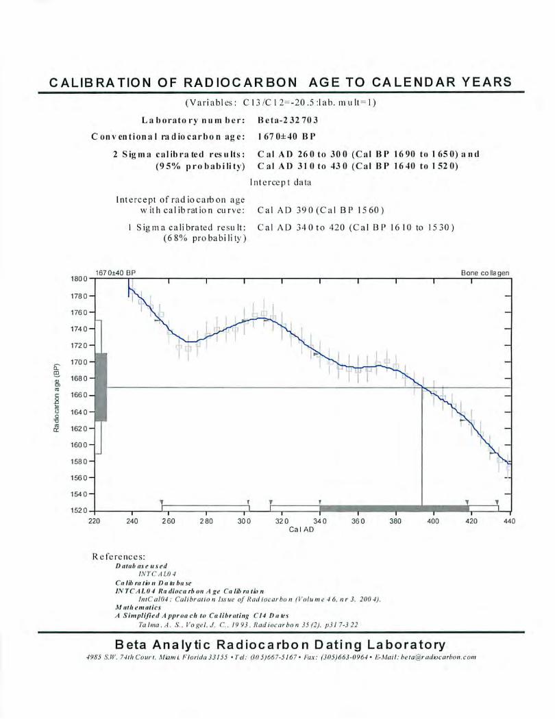
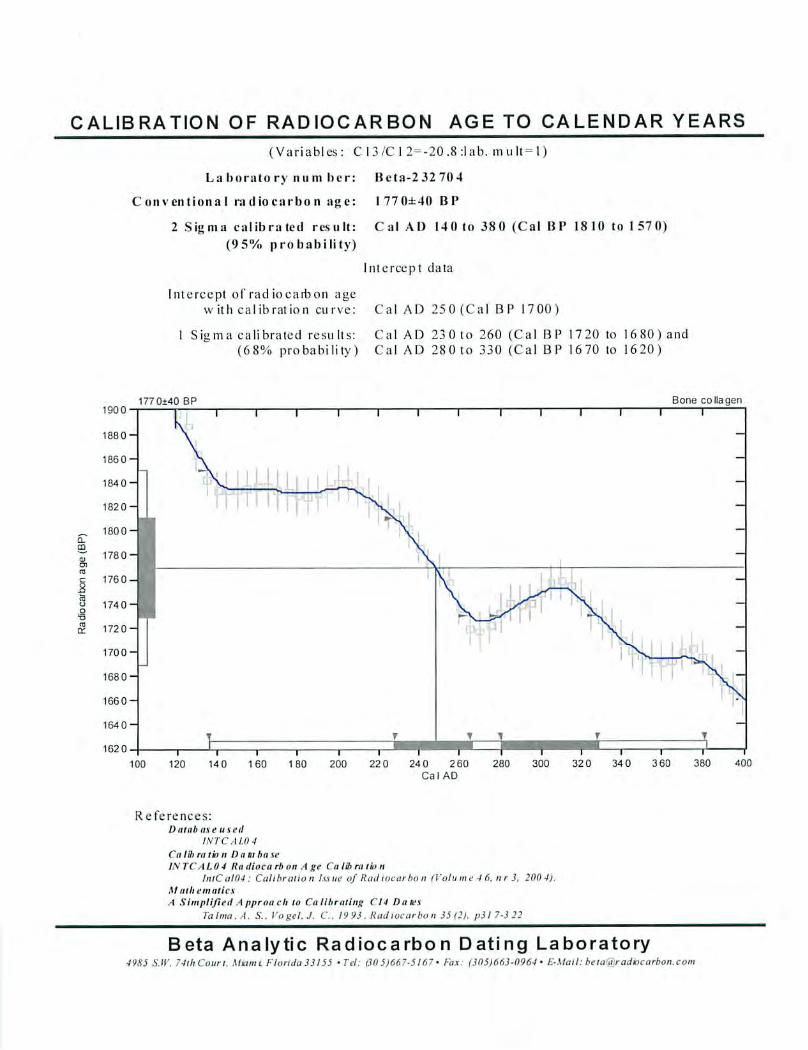

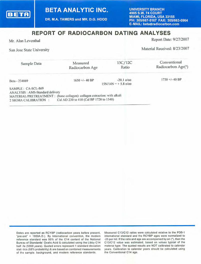


APPENDIX F
OBSIDIAN HYDRATION TOM ORIGER LABORATORY 2007
OBSIDIAN XRF SOURCING
RICHARD HUGHES GEOCHEMICAL RESEARCH
LABORATORY 2007