Final Programmatic Damage Assessment and Restoration Plan
367
Final Programmatic Damage Assessment and Restoration Plan and Final Programmatic Environmental Assessment for the ExxonMobil Pipeline Company July 1, 2011 Yellowstone River Oil Spill Prepared by State and Federal Trustees State of Montana and U.S. Department of the Interior January 2017
-
Upload
khangminh22 -
Category
Documents
-
view
0 -
download
0
Transcript of Final Programmatic Damage Assessment and Restoration Plan

Final Programmatic Damage Assessment and Restoration Plan
and Final Programmatic Environmental Assessment
for the ExxonMobil Pipeline Company July 1, 2011 Yellowstone River Oil Spill
Prepared by State and Federal Trustees
State of Montana and U.S. Department of the Interior
January 2017


Final
Programmatic Damage Assessment and Restoration Plan
And
Final Programmatic Environmental Assessment
for the
ExxonMobil Pipeline Company July 1, 2011 Yellowstone River Oil Spill
Prepared by: State and Federal Trustees
State of Montana
and
U.S. Department of the Interior
January 2017


i
EXECUTIVE SUMMARY
On or about July 1, 2011, a 12-inch diameter pipeline (Silvertip Pipeline) owned by ExxonMobil Pipeline Company ruptured near Laurel, Montana, resulting in the discharge of crude oil into the Yellowstone River and floodplain. The discharge is estimated to have been approximately 63,000 gallons (about 1,500 barrels) of oil. The discharge occurred during a high-flow event, with oil affecting approximately 85 river miles and associated floodplain. The discharge, along with associated response activities, adversely affected natural resources within the jurisdictions of the United States and the State of Montana, the Yellowstone River and adjoining shorelines, including, but not limited to, the floodplain, shoreline, wetlands and other riparian areas, islands, fields, pastures, bottomlands, grasslands and shrublands. This final Programmatic Damage Assessment and Restoration Plan and Environmental Assessment for the ExxonMobil Pipeline Company July 1, 2011 Yellowstone River Oil Spill (restoration plan) has been prepared by the State of Montana and the U.S. Department of the Interior, collectively acting as Trustees for the restoration of natural resources and public use services that were exposed and/or injured by the Yellowstone River oil spill. This document is intended to inform the public about the natural resource injuries caused by the oil spill and potential restoration projects that could compensate for those injuries. The natural resource damage assessment is being performed pursuant to the Oil Pollution Act of 1990 (OPA) (33 USC §§ 2701, et seq.), by the U.S. Department of the Interior (DOI), represented by the Bureau of Land Management (BLM) and the U.S. Fish and Wildlife Service (USFWS), and the Governor of the State of Montana, collectively known as the Trustees. The BLM and State of Montana are co-lead administrative Trustees. This final restoration plan includes several restoration project types to be undertaken on the Yellowstone River and related area. This final restoration plan also serves as an environmental assessment under the National Environmental Policy Act (NEPA) (42 USC §§ 4321, et seq.) and the Montana Environmental Policy Act (MEPA) (75-1-102, MCA, et seq.). This document addresses the potential impact of the Trustees’ proposed restoration actions on the quality of the physical, biological, and cultural environment. INJURED RESOURCES AND RESTORATION ALTERNATIVES Oil from the spill, along with spill response and cleanup activities, harmed fish, wildlife and their habitats and other natural resources in and around the Yellowstone River. The spill also impacted the recreational use of the river and public sites along the river. Categories of injuries include:
Injuries to terrestrial/riparian habitat and supported biota, through exposure to oil and disturbance caused by response activities.
Injuries to large woody debris piles, through exposure to oil and disturbance by response activities.
Injuries to riverine aquatic habitat and supported biota, including fish injuries, caused by exposure to oil.

ii
Injuries to birds through exposure to oil and disturbance by response activities, specifically injuries to cavity-nesters and American white pelican.
Human service losses, including recreational angling and park use. The Trustees evaluated a range of restoration alternatives comprised of primary and/or compensatory restoration components that address specific injuries associated with the oil spill, and in total would make the environment and public whole. Primary restoration actions directly restore the natural resources and services to pre-spill conditions on an accelerated timeframe compared to natural recovery. Compensatory restoration actions would provide resource services to compensate the public for losses pending recovery of resources injured by the oil spill. The Trustees have identified preferred restoration alternatives designed to address the resource injuries. Project types include:
Acquiring terrestrial/riparian bottomland to conserve terrestrial habitat and bird resources
Acquiring and restoring terrestrial/riparian habitat
Controlling invasive woody species on state and federal lands
Acquiring channel migration or other easements or fee title land acquisitions to provide areas for large woody debris recruitment
Removing flanked riprap from the river
Removing side channel blockages and reactivating old oxbows and backchannels
Providing fish passage around fish barriers
Restoring and stabilizing river banks using soft bank restoration techniques
Increasing American white pelican production through improvement of breeding and nesting areas
Improving city parks and public lands bordering the Yellowstone River
Improving urban fishing opportunities adjacent to the Yellowstone River
Developing additional access locations or preserving existing access on the Yellowstone River
Table ES-1 summarizes the injuries and restoration alternatives considered by the Trustees. DOCUMENT SUMMARY This final restoration plan presents information about the release, response, legal authorities, proposed settlement with the responsible party ExxonMobil Pipeline Company, and public involvement (Chapter 1), information about the affected environment (Chapter 2), the Trustees’

iii
estimates of exposure and/or injury and service losses to natural resources caused by the oil spill (Chapter 3) and the Trustees’ proposed preferred restoration alternatives (Chapter 4). Analysis of the restoration alternatives under OPA selection criteria is in Chapter 5. Analysis of the proposed Trustee actions pursuant to NEPA and MEPA is provided in Chapter 6. A restoration implementation plan, including project selection, is included in Chapter 7. Preparers and entities consulted are listed in Chapter 8, applicable laws and policies are listed in Chapter 9. References are included in Chapter 10. Maps are located after the references. Seven technical appendices are also attached: Appendix A is an environmental assessment checklist template; Appendix B is a list of scientific and common names of species on the Yellowstone River, including Montana species of concern; Appendix C summarizes terrestrial/riparian, large woody debris, and riverine aquatic injuries; Appendix D summarizes bird injuries; Appendix E provides analysis of the lost recreational uses; Appendix F contains a more detailed explanation of the process the State Trustee will use to implement projects; and Appendix G contains the public comments received on the draft restoration plan and the Trustees’ responses to comments. PUBLIC COMMENT Public review of the draft restoration plan is an integral component of the restoration planning process. The Trustees encouraged public input on the draft restoration plan. The public comment period was 41 days, and was announced when the plan was released. The public comment period was announced via a press release, and the document was posted on the Montana Department of Justice web page (https://dojmt.gov/lands/yellowstone-river-oil-spill/) and BLM web page (http://www.blm.gov/mt/st/en/fo/billings_field_office.html). Written comments on the draft restoration plan were sent via e-mail to: [email protected] with “Yellowstone restoration plan comment” in the subject line. Or by U.S. mail to: Natural Resource Damage Program Attn: Yellowstone Restoration Plan PO Box 201425 Helena, MT 59620-1425 The Trustees reviewed and considered comments received during the public comment period while preparing the final restoration plan. All comments submitted during the period for public comment were considered by the Trustees prior to finalizing the restoration plan. The public comment period for the draft restoration plan ran from September 21, 2016 through 5:00 PM on October 31, 2016. Starting on September 21, the document was available electronically through the Montana Natural Resource Damage Program website: https://dojmt.gov/lands/yellowstone-river-oil-spill-July-2011/. The Trustees held a press conference in Laurel, Montana on September 21, 2016, to announce a proposed settlement between the federal and State governments and Exxon, and availability of the draft restoration plan. The press event and document release resulted in several articles in local and nationally established media outlets. The availability of the draft and comment opportunity were referenced in a Federal Register Notice of Availability published on September 28, 2016, and legal notices published on September 28, 2016 in the Billings Gazette, Helena Independent Record, Missoula’s Missoulian, and Butte’s Montana Standard newspapers. On September 22, 2016, the Trustees sent notices of the draft restoration plan comment opportunity to over 50 individuals and entities on its mailing list. On October 12, 2016, the Trustees presented the draft

iv
restoration plan at a public meeting in Billings and took verbal comments. Over 30 people attended the meeting. The public meeting was advertised on Tuesday, October 11, 2016 in a display ad in the Billings Gazette. The plan was presented to the Billings Parks and Recreation Board at their meeting on October 12, 2016, to the Yellowstone County Commission on October 20, 2016, to the Montana Watershed Coordination Council on October 25, 2016, and to the Laurel City Commission on October 25, 2016. The Trustees received a total of 28 letters or emails during the public comment period and eight individuals gave verbal testimony at the public meeting in Billings on October 12, 2016. The public comments received and Trustees’ responses are included in Appendix G. In Appendix G, see Attachment A to the responses for a list of commenters (written and oral). Each commenter was assigned a number. Topics addressed in the comments are also listed, each identified by a letter. Attachment B to the responses provides copies of the comment letters, also available on the NRDP website at: https://dojmt.gov/lands/yellowstone-river-oil-spill-july-2011/ and the BLM website at https://www.blm.gov/mt/st/en/info/yellowstonespill.html. The responses to comments summarize the comments received and provide the Trustees’ responses. Where appropriate, changes were made to the text of the restoration plan to reflect the responses to comments, as noted in Appendix G. The public comments and responses are included in Appendix G.

v
Tab
le E
S-1
S
um
mar
y o
f P
refe
rred
Res
tora
tio
n
P
roje
ct T
ype
Pro
ject
Exa
mp
le
Allo
cati
on
*
Dam
age
Ca
teg
ory
: T
erre
stri
al /
Rip
aria
n H
abit
at (
incl
ud
es h
abit
at r
esto
rati
on
fo
r ca
vity
nes
tin
g b
ird
s)
Con
serv
atio
n ea
sem
ents
or
fee
title
land
acq
uisi
tions
Indi
vidu
al o
r m
ultip
le e
asem
ents
or
fee
title
land
acq
uisi
tions
to p
rote
ct a
nd
rest
ore
terr
estr
ial/r
ipar
ian
area
s an
d co
tton
woo
d bo
ttom
land
s a
nd a
reas
with
co
mpl
ex u
nder
stor
y fo
r ca
vity
nes
ting
bird
s.
$3,5
60,0
00
Res
tora
tion
of p
rope
rtie
s w
ithin
or
adja
cent
to
BLM
rec
reat
ion
area
s or
Sta
te
land
s C
ontr
ol o
f inv
asiv
e w
ood
y sp
ecie
s R
emo
val o
n ne
arby
BL
M la
nds
such
as
Bun
dy Is
land
, Pom
peys
Pill
ar,
Sun
danc
e an
d F
WP
or
DN
RC
sta
te-o
wne
d la
nds
Dam
age
Ca
teg
ory
: L
arg
e W
oo
dy
Deb
ris
Pile
s
Cha
nnel
mig
ratio
n or
oth
er
ease
men
ts o
r fe
e tit
le la
nd
acqu
isiti
on
Rec
ruit
larg
e w
oody
de
bris
thro
ugh
chan
nel m
igra
tion
zone
or
othe
r ea
sem
ents
or
fee
titl
e la
nd a
cqui
sitio
ns o
n co
tton
woo
d bo
ttom
land
$2
,090
,000
Riv
er f
unct
ion
rest
orat
ion
Cha
nnel
mig
ratio
n ea
sem
ents
R
emo
ve fl
anke
d rip
rap
from
mid
-cha
nnel
are
as
Rem
ove
non
-fun
ctio
nal b
ank
ripra
p R
emov
e si
de c
hann
el b
lock
ages
, re
activ
ate
old
oxbo
ws
and
back
chan
nels
Dam
age
Ca
teg
ory
: R
iver
ine
Aq
uat
ic H
abit
at
Fis
h pa
ssag
e im
prov
em
ent
Res
tore
fis
h pa
ssag
e in
Yel
low
ston
e R
iver
trib
utar
ies
$2,6
40,0
00
Sof
t ba
nk s
tabi
lizat
ion
Sof
t ba
nk s
tabi
lizat
ion
rath
er t
han
hard
sta
biliz
atio
n to
pro
tect
infr
astr
uctu
re o
n S
tate
land
R
esto
re r
iver
ine
habi
tat
Rem
ove
flan
ked
ripra
p an
d si
de c
hann
el b
lock
ages
Dam
age
Ca
teg
ory
: A
mer
ican
wh
ite
pel
ican
Fen
cing
, and
wat
er le
vel
man
agem
ent f
or p
reda
tor
cont
rol a
t N
atio
nal W
ildlif
e R
efug
es
Act
ions
on
Am
eric
an w
hite
pel
ican
bre
edin
g ar
eas
(Bow
doin
Nat
iona
l Wild
life
Ref
uge
and
Med
icin
e La
ke N
atio
nal W
ildlif
e R
efug
e)
$400
,000

vi
Pro
ject
Typ
e P
roje
ct E
xam
ple
A
lloca
tio
n*
Dam
age
Ca
teg
ory
: R
ecr
eati
on
al H
um
an U
se
Dev
elop
and
impr
ove
boa
t la
unch
site
s M
otor
ized
boa
t la
unch
at
Bill
ings
Riv
erfr
ont
Par
k, h
and
laun
ch s
ite a
t Bill
ings
R
iver
fron
t Par
k, in
stal
l vau
lt to
ilet a
t Lau
rel R
iver
side
Par
k bo
at la
unch
$2
,410
,000
Nat
ure
trai
ls
Pav
e a
hiki
ng a
nd b
ikin
g na
ture
tra
il at
Bill
ings
Riv
erfr
ont P
ark
Oth
er p
ark
impr
ove
men
ts
Dev
elop
a M
aste
r P
lan
for
Laur
el R
iver
side
Par
k to
iden
tify
and
prio
ritiz
e ad
ditio
nal p
roje
cts
Impl
emen
t pro
ject
s in
Riv
ersi
de P
ark
Mas
ter
Pla
n
Rec
reat
ion
area
im
prov
em
ents
R
epai
r fa
cilit
ies
at S
unda
nce
Rec
reat
ion
Are
a an
d P
ompe
ys P
illar
Nat
iona
l M
onum
ent
Urb
an f
ishi
ng o
ppor
tuni
ty
impr
ove
men
t La
ke J
osep
hine
– d
evel
op a
nd im
plem
ent a
fish
man
agem
ent
pla
n a
nd h
abita
t im
prov
emen
ts a
t B
illin
gs R
iver
fron
t Par
k La
urel
Pon
d –
dred
ge a
nd im
prov
e ha
bita
t fea
ture
s, d
evel
op h
andi
capp
ed
acce
ss a
nd s
hore
line
fishi
ng o
ppor
tuni
ties
Dev
elop
a n
ew fi
shin
g ac
cess
site
or
pres
erve
ac
cess
to e
xist
ing
site
s
Acq
uire
and
dev
elop
a fi
shin
g ac
cess
site
bet
wee
n La
urel
and
the
Hun
tley
Div
ersi
on o
r pr
eser
ve in
fras
truc
ture
to e
xist
ing
fishi
ng a
cces
s si
tes
Pro
vide
saf
e ac
cess
to th
e riv
er
Hun
tley
Div
ersi
on a
cces
s ac
ross
rai
lroad
trac
ks o
r in
oth
er a
reas
Tot
al:
$12
,000
,000
N
otes
: *A
n ad
ditio
nal $
900,
000
is a
lloca
ted
to T
rust
ees’
nat
ural
res
ourc
e da
mag
e as
sess
men
t cos
ts.

vii
ABBREVIATIONS and ACRONYMS
BLM Bureau of Land Management CEQ Council on Environmental Quality CFR Code of Federal Regulations cfs cubic feet per second COE U.S. Army Corps of Engineers CWA Clean Water Act DEQ Montana Department of Environmental Quality DOI U.S. Department of the Interior DNRC Montana Department of Natural Resources and Conservation EA Environmental Assessment EIS Environmental Impact Statement EPA U.S. Environmental Protection Agency ESA Endangered Species Act FONSI Finding of No Significant Impact FWP Montana Department of Fish, Wildlife and Parks HEA Habitat Equivalency Analysis MBTA Migratory Bird Treaty Act MCA Montana Code Annotated MEPA Montana Environmental Policy Act MOA Memorandum of Agreement NCP National Contingency Plan NEPA National Environmental Policy Act NOAA National Oceanic and Atmospheric Administration NPL National Priorities List NRDA Natural Resource Damage Assessment NRDP Montana Natural Resource Damage Program OPA Oil Pollution Act PAH Polycyclic aromatic hydrocarbons ROD Record of Decision REA Resource Equivalency Analysis SCAT Shoreline Cleanup and Assessment Team SIM Selective Ion Monitoring USC United States Code USDA United States Department of Agriculture USFWS United States Fish and Wildlife Service YRCDC Yellowstone River Conservation District Council Cover page photo credits: Fish Lesion: Montana FWP, Response: Montana DEQ, Oil at Confluence: Larry Mayer, Cleaning Oiled Bird: International Bird Rescue


viii
TABLE OF CONTENTS Executive Summary ....................................................................................................................... i Abbreviations ............................................................................................................................... vii 1. INTRODUCTION ............................................................................................................ 1-1
1.1 Purpose and Need for Restoration ..................................................................... 1-1 1.2 Summary of ExxonMobil Pipeline Company Silvertip Oil Discharge .................. 1-2 1.3 Summary of Response Actions .......................................................................... 1-2 1.4 Oil Pollution Act (OPA) ....................................................................................... 1-3
1.4.1 National Environmental Policy Act and Montana Environmental Policy Act Compliance....................................................................................... 1-6
1.4.2 Coordination with Responsible Party ...................................................... 1-7 1.4.3 Public Participation ................................................................................. 1-8 1.4.4 Watershed and Master Plans ................................................................. 1-9 1.4.5 Public Comment ..................................................................................... 1-9 1.4.6 Administrative Record........................................................................... 1-10
1.5 Proposed Settlement ........................................................................................ 1-10 1.6 Trustees’ Preferred Restoration Alternatives .................................................... 1-11 1.7 Implementation ................................................................................................. 1-12
2. AFFECTED ENVIRONMENT ........................................................................................ 2-1
2.1 Physical Environment ......................................................................................... 2-1 2.2 Biological Environment ....................................................................................... 2-2
2.2.1 Riparian/Floodplain Habitat .................................................................... 2-2 2.2.2 Riverine Aquatic Habitat and Fish Resources ........................................ 2-3 2.2.3 Bird Resources ....................................................................................... 2-4
2.3 Threatened and Endangered Species and Montana Species of Concern ......... 2-5 2.4 Historic and Cultural Resources ......................................................................... 2-5 2.5 Human Use Services .......................................................................................... 2-5
3. INJURY ASSESSMENT AND QUANTIFICATION ........................................................ 3-1
3.1 Impact Surveys and Studies ............................................................................... 3-2 3.2 Injury Assessment Methods ............................................................................... 3-3
3.2.1 Habitat Equivalency Analysis .................................................................. 3-3 3.2.2 Resource Equivalency Analysis .............................................................. 3-3 3.2.3 Trustees’ Informed Judgment ................................................................. 3-4 3.2.4 Benefits Transfer Approach .................................................................... 3-4 3.2.5 Other Quantification Methods ................................................................. 3-4
3.3 Injury Assessment Results ................................................................................. 3-5 3.3.1 Injuries to Terrestrial/Riparian Habitat and Biota and Quantification ...... 3-5 3.3.2 Injuries to Large Woody Debris Piles ...................................................... 3-7 3.3.3 Injuries to Riverine Aquatic Habitat ....................................................... 3-12 3.3.4 Injuries to Birds (includes cavity nesting birds and American white
pelican) ................................................................................................. 3-15 3.3.5 Injuries to Human Use/Recreational Use .............................................. 3-18
4. RESTORATION OF NATURAL RESOURCES: ALTERNATIVES ............................... 4-1
4.1 Restoration Strategy for Primary and Compensatory Restoration ..................... 4-1 4.2 OPA Requirements and Restoration Project Selection Criteria .......................... 4-1 4.3 NEPA/MEPA Statement of Purpose and Need .................................................. 4-2 4.4 Approach to Developing and Evaluating Alternatives under OPA and
NEPA/MEPA ...................................................................................................... 4-2 4.5 Restoration Alternative 1 Description: No-Action/Natural Recovery ................... 4-3

ix
4.6 Restoration Alternative 2 Description: Projects Addressing All Injury Categories .......................................................................................................... 4-3 4.6.1 Terrestrial/Riparian Injuries (includes cavity nesting bird habitat)
Project Types .......................................................................................... 4-3 4.6.1.1 Terrestrial/Riparian Habitat Conservation Easements and
Fee Title Land Acquisitions ...................................................... 4-4 4.6.1.2 Terrestrial/Riparian Restoration of Altered or Developed
Habitat ...................................................................................... 4-4 4.6.1.3 Control of Invasive Woody Species ......................................... 4-5
4.6.2 Large Woody Debris Injuries Project Types ........................................... 4-6 4.6.2.1 Cottonwood Bottomland Acquisition in the Channel
Migration Zone ......................................................................... 4-6 4.6.2.2 River Function Restoration ...................................................... 4-7
4.6.3 Riverine Aquatic Project Types ............................................................... 4-8 4.6.3.1 Fish Passage Improvement ..................................................... 4-8 4.6.3.2 Soft Bank Stabilization ........................................................... 4-10 4.6.3.3 Riverine Habitat Restoration .................................................. 4-12
4.6.4 American White Pelican Project Types ................................................. 4-12 4.6.5 Recreational Human Use Project Types ............................................... 4-13
4.6.5.1 Public Parks and Recreation Areas Improvement ................. 4-14 4.6.5.2 Urban Fishing Opportunities Improvement ............................ 4-15 4.6.5.3 Increase or Maintain Fishing Access to Yellowstone River ... 4-16
4.7 Alternatives Considered But Dismissed ........................................................... 4-17 5. EVALUATION OF ALTERNATIVES UNDER OPA ....................................................... 5-1 6. EVALUATION OF ALTERNATIVES UNDER NEPA AND MEPA ................................ 6-1
6.1 Direct and Indirect Impacts Considered by Trustees .......................................... 6-1 6.2 Injured Natural and Human Resources .............................................................. 6-1
6.2.1 Terrestrial/Riparian Habitat ..................................................................... 6-2 6.2.2 Large Woody Debris Piles ...................................................................... 6-2 6.2.3 Riverine Aquatic Habitat ......................................................................... 6-3 6.2.4 American White Pelican .......................................................................... 6-3 6.2.5 Recreational Human Use........................................................................ 6-4
6.3 Other Natural and Human Resources Considered by Trustees ......................... 6-4 6.3.1 Construction, Sound, and Air Pollution ................................................... 6-4 6.3.2 Federally Threatened, Endangered, and Candidate Species and
Montana Species of Concern ................................................................. 6-4 6.3.3 Water Quality and Sediment ................................................................... 6-4 6.3.4 Visual Resources ................................................................................... 6-5 6.3.5 Archaeological and Cultural Resources .................................................. 6-5 6.3.6 Other Resources (soil, geology, energy use, land use, transportation,
pipeline crossings) .................................................................................. 6-5 6.3.7 Regulatory Restrictions Analysis ............................................................ 6-5 6.3.8 Climate Change ...................................................................................... 6-5
6.4 Cumulative Impacts ............................................................................................ 6-6 6.5 NEPA/MEPA Comparison of All Restoration Alternatives Considered by
Trustees ............................................................................................................. 6-7 7. IMPLEMENTATION PLAN ................................................................................................ 7-1 8. PREPARERS, AGENCIES, AND PERSONS CONSULTED ........................................ 8-1
8.1 Preparers ............................................................................................................ 8-1 8.2 Agencies and persons consulted ....................................................................... 8-1
x
9. COMPLIANCE WITH OTHER AUTHORITIES .............................................................. 9-1 9.1 Laws ................................................................................................................... 9-1
9.1.1 Federal Laws and Policies ...................................................................... 9-1 9.1.2 State Laws .............................................................................................. 9-5 9.1.3 Local Laws .............................................................................................. 9-6
10. REFERENCES ............................................................................................................. 10-1 LIST OF TABLES Table ES-1 Summary of Preferred Restoration Alternatives .................................................... v Table 1-1 Summary of Restoration Alternative 2 Preferred Alternative ............................ 1-13 Table 3-1 Floodplain Oiling as Characterized by SCAT ..................................................... 3-6 Table 3-2 Terrestrial HEA Spatial Extent ............................................................................ 3-7 Table 3-3 Amount of Restoration Required to Offset Injuries ............................................. 3-7 Table 3-4 Important Ecological Functions provided by LWD ............................................ 3-10 Table 3-5 Dead Birds Collected during the ExxonMobil Silvertip Pipeline Break ............. 3-16 Table 3-6 Oiled Birds, by Species and River Division Where Observed .......................... 3-17 Table 3-7 Summary of Recreational Use Losses ............................................................. 3-20 Table 5-1 Evaluation of Alternatives According to OPA Criteria ......................................... 5-2 Table 6-1 Environmental Impact Analysis Summary .......................................................... 6-8 LIST OF FIGURES Figure 3-1 Oil Inundated Floodplain Areas .......................................................................... 3-6 Figure 3-2 Two Examples of Undisturbed Large Woody Debris Piles in the Area
Affected by the Spill ............................................................................................ 3-9 Figure 3-3 Heavily Oiled Debris Pile Near the Spill Site .................................................... 3-10 Figure 3-4 Pre-response (Panel A, photograph from 2011 before the spill) and
Post-response (Panel B, photograph from 2013) Aerial Photographs of the Same Large Woody Debris Piles ..................................................................... 3-11
Figure 3-5 Photograph of External Lesion on Redhorse Sucker ....................................... 3-15 Figure 4-1 Fish Passage Example ....................................................................................... 4-9 Figure 4-2 Example of Soft Bank Stabilization Project ...................................................... 4-11 APPENDICES Appendix A EA Checklist Template Appendix B Animal Species Along Yellowstone River Appendix C Yellowstone Summary of Terrestrial HEA, Large Woody Debris REA, and Fish
Health Studies Appendix D Bird Injury Assessment Appendix E Recreational Lost Use Analysis Appendix F State Trustee Project Implementation Process Appendix G Response to Public Comments on Draft Restoration Plan LIST OF MAPS Map 1-1 Yellowstone River Basin Map 1-2 July 1, 2011 Oil Spill Injured Area Map 2-1 Clarks Fork Yellowstone River and Pryor Creek Map 2-2 Public Lands Map 4-1 Parks and Recreation Areas


1-1
1.0 INTRODUCTION 1.1 Purpose and Need for Restoration This Final Programmatic Damage Assessment and Restoration Plan and Final Environmental Assessment for the ExxonMobil Pipeline Company July 1, 2011 Yellowstone River Oil Spill (restoration plan) is intended to inform the public about the natural resource injuries caused by the July 1, 2011 Yellowstone River oil spill and potential restoration projects that could address and compensate for those injuries. This document is part of a natural resource damage assessment being performed pursuant to the Oil Pollution Act of 1990 (OPA) (33 USC §§ 2701, et seq.), by the U.S. Department of the Interior (DOI), represented by the Bureau of Land Management (BLM) and the U.S. Fish and Wildlife Service (USFWS), and the Governor of the State of Montana, through the Montana Department of Justice, Natural Resource Damage Program (NRDP), collectively known as the Trustees. The State of Montana also has natural resource damage authority pursuant to the Comprehensive Environmental Cleanup and Responsibility Act, 75-10-701, MCA, et seq. OPA regulations provide that if an incident affects the interests of multiple trustees, the trustees should act jointly to ensure that full restoration is achieved without double recovery of damages. For joint assessments, Trustees must designate one or more lead administrative trustee(s) to act as coordinators. The DOI and State of Montana are co-lead administrative trustees. The Trustees invited the Crow Nation to participate in the natural resource damage assessment, but the tribe has not participated to date. The restoration plan includes several restoration project types to be undertaken on the Yellowstone River and related area. This final restoration plan also serves as an environmental assessment under the National Environmental Policy Act (NEPA) (42 USC §§ 4321, et seq.) and the Montana Environmental Policy Act (MEPA) (75-1-102, MCA, et seq.). This document addresses the potential impact of the Trustees’ proposed restoration actions on the quality of the physical, biological, and cultural environment. The purpose of this restoration plan is to make the public whole for injuries to natural resources and natural resource services resulting from the oil spill by returning the injured natural resources and natural resource services to their “baseline” condition (i.e., the condition that would have occurred but for the spill) and compensating for associated interim losses. The regulations for conducting a natural resource damage assessment to achieve restoration are found at 15 Code of Federal Regulations (CFR) Part 990. These regulations were promulgated pursuant to the OPA to determine the nature and extent of natural resource injuries, select appropriate restoration projects, and implement or oversee restoration. This final restoration plan presents information about the affected environment (Chapter 2), the Trustees’ estimates of exposure and/or injury and service losses to natural resources caused by the oil spill (Chapter 3) and the Trustees’ proposed preferred restoration alternatives (Chapter 4). Analysis of the restoration alternatives under OPA selection criteria is in Chapter 5. Analysis of the proposed Trustee actions pursuant to NEPA and MEPA is provided in Chapter 6. A restoration implementation plan is included in Chapter 7. Preparers and entities consulted are listed in Chapter 8, applicable laws and policies are listed in Chapter 9. References are included in Chapter 10.

1-2
1.2 Summary of ExxonMobil Pipeline Company Silvertip Oil Discharge On or about July 1, 2011, a 12-inch diameter pipeline (Silvertip Pipeline) owned by ExxonMobil Pipeline Company ruptured near Laurel, Montana, resulting in the discharge of crude oil into the Yellowstone River and floodplain (Map 1-1).The discharge is estimated to have been approximately 63,000 gallons (about 1,500 barrels). It occurred at the peak (70,600 cfs) of an extended period of high water which lasted through the third week of July, 2011, with oiling affecting approximately 85 river miles and associated floodplain (Map 1-2). This size of flood event is estimated to occur only once every 35 years. The discharged oil affected the Yellowstone River and its adjoining shorelines including the floodplain, wetlands and other riparian areas, islands, fields, pastures, bottomlands, grasslands and shrublands and oiling approximately 5,500 acres of terrestrial/riparian habitat and supported biota, large woody debris piles, riverine resources such as fish, and birds. Human service losses also occurred by preventing park and fishing access site use and preventing angling. Montana Department of Fish, Wildlife, and Parks (FWP) was unable to obtain fish samples from the Yellowstone River for fish consumption analysis until July 18, 2011, due to hazardous flow conditions. FWP issued a fish consumption advisory on July 21, 2011, advising anglers to be cautious about eating fish between the Buffalo Mirage fishing access site and the mouth of the Bighorn River. The fish consumption advisory was lifted on August 24, 2011. 1.3 Summary of Response Actions Immediately after the spill, response actions were initiated to remove oil from the floodplain and river. The U.S. Environmental Protection Agency (EPA) led the response, in accordance with the OPA and National Contingency Plan, which was undertaken by the responsible party ExxonMobil Pipeline Company under EPA order, and in coordination with other federal agencies and the State of Montana. A unified command consisting of EPA, ExxonMobil Pipeline Company, and the State of Montana was established at the beginning of the spill. An incident command center was operated in Billings to manage and coordinate response activities from July through September 2011. Response activities involved over 1,000 personnel at the height of cleanup activities and shoreline assessment of approximately 11,000 acres along 85 river miles. In addition, approximately 60 boats, including four airboats, were in use on the Yellowstone River associated with the cleanup and shoreline assessment activities. The airboats were used for a short period of time because of the noise and disturbance they created. ExxonMobil Pipeline Company established numerous staging areas along the river to provide boat launching capability and access for the cleanup and shoreline assessment crews. During response activities, a number of public properties, including parks and fishing access sites were used as staging grounds or experienced cleanup activities and were closed to the public, some for significant periods of time. Within the floodplain, response actions included cutting and removing oiled live vegetation and deadwood (including large woody debris), cleaning oiled surfaces with sorbent pads or by flushing with water, covering oiled surfaces with dust, and leaving the oil to attenuate naturally. Mechanized equipment (all-terrain vehicles, skidsteers, excavators, etc.) was used, and staging grounds, footpaths, temporary roads, and vehicle tracks were also created throughout the surveyed 11,000 acres as part of the spill response activities (ARCADIS 2011). Main resources

1-3
deployed for response include 52,380 feet of sorbent boom, and 217 sorbent rolls, 314 viscous sweeps, 1,372 bales of individual sorbent pads, and 300 oil booms. In September 2011, the site transitioned from EPA emergency cleanup into long-term monitoring, assessment and reclamation, under the direction of the Montana Department of Environmental Quality (DEQ). Pursuant to a DEQ administrative order on consent, the ExxonMobil Pipeline Company performed revegetation, monitored ground water in certain locations along the river, monitored for natural attenuation of remaining residual oil staining, and additional tasks. Response activities effectively ended in mid-October 2011, though some cleanup occurred in November 2011. ExxonMobil tracked volumes of waste (used sorbent materials, cut vegetation, and others) generated during response, but did not track the overall volume of oil recovered, which is expected to be a relatively small amount of the total spill volume. 1.4 Oil Pollution Act (OPA) The primary goal of OPA is to make the environment and public whole for injuries to natural resources and services resulting from an incident involving an oil discharge. OPA makes each party responsible for a vessel or facility from which oil is discharged liable (among other things) for removal costs and for damages for injury to, destruction of, loss, or loss of use of, natural resources, including the reasonable cost of assessing the damage. Under OPA regulations (15 CFR Part 990), the natural resource injuries for which responsible parties are liable include injuries resulting from the oil discharge and those resulting from response actions or substantial threat of a discharge. OPA specifies that Trustees responsible for representing the public’s interest (for example, state and federal agencies) must be designated to act on behalf of the public to assess the injuries and to address those injuries. Under OPA (15 CFR 990.10), Trustees with jurisdiction over resources affected by an oil release may conduct a natural resource damage assessment to determine whether natural resources have been injured and then plan restoration to address those injuries. The natural resource damage assessment consists of three phases:
1) preassessment; 2) restoration planning; and 3) restoration implementation.
The natural resource damage assessment includes assessment of natural resources that may have been injured and assessment of natural resource services impaired as a result of the discharge of oil. Trustees are authorized to:
Assess natural resource injuries resulting from a discharge of oil or the substantial threat of a discharge and response activities, and
Develop and implement a plan for restoration of such injured resources pursuant to Section 1006 of the OPA, 33 USC §§ 2701, et seq., § 311(f) of the Clean Water Act, 33 USC § 1321(f), and other applicable Federal and State statutory and common law, including but not limited to, the National Oil and Hazardous Substances Pollution Contingency Plan (NCP), 40 CFR Part 300, Subpart G, and the OPA Natural Resource Damage Assessment Regulations (Regulations), 15 CFR Part

1-4
990, as well as Executive Order 12580, 52 Federal Register (Fed. Reg.) 2923 (January 23, 1987), as amended by Executive Order 12777, 56 Fed. Reg. 54757 (October 19, 1991), Executive Order 13016, 61 Fed. Reg. 45871 (August 28, 1996), and Executive Order 13286, 68 Fed. Reg. 10619 (February 28, 2003), and applicable State laws and authorities, including, without limitation, the Comprehensive Environmental Cleanup and Responsibility Act, 75-10-701, MCA, et seq.
Trust resources include those that belong to, are managed by, held in trust by, appertain to, or are otherwise controlled by the U.S., a State, an Indian Tribe, or a foreign government. See Section 1001(20) of the OPA, 33 USC § 2701(20). By undertaking a natural resource damage assessment, the Trustees consider the extent of injuries to natural resources, including the functions and services provided by the injured resource, while determining the appropriate ways of restoring the injured resources and compensating for these injuries. Trustees use the information obtained during the natural resource damage assessment to develop and implement plans for the “restoration, rehabilitation, replacement, or acquisition of the equivalent of the natural resources under their trusteeship.” The Trustees may seek damages for these injuries, including the reasonable costs of the assessment. (See OPA § 1002(b)(2)(A), 33 USC § 2702(b)(2)(A)). Federal Trustees are designated pursuant to the NCP, 40 CFR § 300.600 and Executive Orders 12580 and 12777. For this incident, the federal Trustee is the DOI, as represented by the BLM and the USFWS. The State Trustee is the Governor of the State of Montana, in accordance with 40 CFR 300.605. OPA regulations provide specific definitions for the following terms:
“Injury” is “an observable or measurable adverse change in a natural resource or impairment of a natural resource service”;
“Natural resources” are “land, fish, wildlife, biota, air, ground water, drinking water supplies, and other such resources belonging to, managed by, held in trust by, appertaining to, or otherwise controlled by the United States, any state or local government or Indian tribe”; and
“Natural resource services” are “functions performed by a natural resource for the benefit of another resource and/or the public.”
During the preassessment phase, the Trustees determined that the provisions and determinations of OPA applied to this discharge including:
1) one or more incidents had occurred; 2) the discharge was not from a public vessel 3) the discharge was not from an onshore facility subject to the Trans-Alaska Authority
Act; 4) the discharge was not permitted under federal, state, or local law; and 5) public trust natural resources and/or services may have been injured as a result of
the discharge.

1-5
On the basis of those determinations, on October 31, 2013, the Trustees issued a Notice of Intent to Conduct Restoration Planning for the natural resource damage assessment associated with the oil spill (Montana and BLM 2013). In the restoration planning phase, the Trustees evaluated and quantified the nature and extent of injuries to natural resources and services, and determined the need for, type of, and scale of appropriate restoration actions. State and federal agencies were engaged through contact with the Trustees and the Trustees’ technical work groups established under the natural resource damage assessment process. The technical work groups evaluated the categories of injuries and extent of injury and service losses. They also developed a suite of restoration projects and project types for each injury category to address injury and compensate for the service losses due to the oil spill. Many of the projects are consistent with the locally developed plans discussed below. Using the information developed during the restoration planning phase, the Trustees developed this final restoration plan. The injuries from the oil spill are divided into the following categories:
1) terrestrial/riparian habitat and biota (including cavity nesting birds) 2) large woody debris piles 3) riverine aquatic habitat and biota 4) American white pelican, and 5) human recreational uses.
A description of injuries to each category of natural resources is presented in Chapter 3. Although additional assessment work may have assisted in confirming the extent of injuries to natural resources and natural resource services, the Trustees decided to move more expeditiously toward the goal of restoration. The Trustees’ assessment used validated data from the Trustees, ExxonMobil Pipeline Company, U.S. EPA and other sources. The Trustees’ assessment produced relevant information that the Trustees considered in determining the nature and extent of injuries to natural resources. This information is provided in Chapters 2 and 3. Considering the nature and extent of exposure and injuries to natural resources caused by the spill, the Trustees developed a plan for restoring the injured resources and services, set forth in this final restoration plan. In this plan, the Trustees identify a reasonable range of restoration alternatives, evaluate those alternatives, and using the criteria at 15 CFR § 990.54, select a preferred alternative. Chapter 4 describes the restoration alternatives the Trustees analyzed for returning the resources injured by the oil spill to their baseline condition and to compensate the public for the interim losses. Chapter 4 also describes how these alternatives were developed under OPA and NEPA/MEPA. A summary of the restoration alternatives, project goals, project types, project examples, and allocated costs is included in Table 1-1. In proposing their preferred restoration alternative, the Trustees considered all of the criteria outlined in the OPA regulations (See Chapter 5). As a part of this process, the Trustees considered the extent to which the restoration alternatives would provide benefits to more than one natural resource and/or service. As described in more detail in Chapter 5 of this final

1-6
restoration plan, many of the preferred restoration alternatives proposed by the Trustees benefit multiple resources and/or resource services. Overall, the Trustees are proposing selection of the least expensive, most practicable alternatives that are expected to provide the restoration benefits required by these criteria. 1.4.1 National Environmental Policy Act and Montana Environmental Policy Act
Compliance Any restoration of natural resources under OPA must comply with NEPA, as amended (42 USC 4321 et seq.), and its implementing regulations (40 CFR § 1500-1508) with respect to federal actions that may significantly impact the human environment. In addition, restoration actions undertaken in the State of Montana must comply with MEPA (75-1-102, MCA, et seq.). NEPA and MEPA require:
A statement of the purpose and need for the proposed action A description of the environment that could be affected A description of the proposed action and a set of alternatives An analysis of the direct, indirect, and cumulative environmental impacts of each
alternative and appropriate mitigations. MEPA requires that State agencies conduct thorough analysis and disclosure of State actions that impact Montana’s human environment. NEPA requires that the environmental impacts of a proposed federal action be considered before implementation. Generally, under both NEPA and MEPA, if it is uncertain whether an action would have a significant impact, agencies begin the planning process by preparing an environmental assessment (EA). State and federal agencies may then review public comments prior to making a final determination. Depending on whether an impact is considered significant, an environmental impact statement (EIS) or a Finding of No Significant Impact (FONSI) is issued. In undertaking their analysis, the Trustees evaluated the potential significance of proposed actions, considering both context and intensity. For the actions considered in this final restoration plan, the appropriate context for considering potential significance of the action is at the local or regional level, as opposed to national, or worldwide. This final restoration plan is intended to accomplish NEPA and MEPA compliance by summarizing the current environmental setting of the proposed restoration, describing the purpose and need for restoration action, identifying alternative actions, assessing the preferred action’s environmental consequences, and providing opportunities for public participation in the decision process. This final restoration plan is designed to allow the Trustees to meet the public involvement requirements of OPA, NEPA, and MEPA concurrently. After considering NEPA and MEPA requirements, the Trustees believe that the selected project types described in this final restoration plan will not cause significant negative impacts to the environment, nor to natural resources or the services they provide. None of the selected project types to be implemented is controversial. None of the proposed preferred types of projects has highly uncertain impacts or risks or is likely to violate any environmental protection laws. Environmental analyses for similar projects in the Yellowstone drainage (channel migration easements, boat ramp or fishing access development, fish passage, or control of woody invasive species, for example) have all been addressed in similar contexts with an EA.

1-7
Further, the Trustees do not believe the preferred types of projects would adversely affect the quality of the human environment or pose any significant adverse environmental impacts. Instead, habitat restoration would benefit species by restoring natural habitat functions. Likewise, the selected restoration actions would provide positive benefits for human recreational use. As no new information was made available during the public review process that affected the evaluations made in the draft restoration plan, the Trustees make a Finding of No Significant Impact for the suite of selected projects types described in Chapter 4. More information on the Trustees’ analysis of the proposed actions relative to NEPA and MEPA is provided in Chapter 6. In this document, the Trustees are providing a specific environmental assessment for some projects that are already defined. This document also provides a programmatic environmental assessment that evaluates broad (as opposed to project-specific) restoration alternatives for prioritized projects that are still in development. This programmatic document describes the process for subsequent restoration planning to select specific projects for implementation. Additional specific restoration plans will be consistent with this final restoration plan and integrated with supplemental NEPA or MEPA analysis, as needed, tiered from this EA. A tiered environmental analysis is a project-specific analysis that focuses on project-specific issues, and summarizes or references (rather than repeats) the broader issues discussed in this EA. A template for a tiered EA is included in Appendix A. Because they are part of existing plans, some projects have already completed NEPA or MEPA compliance. In compliance with NEPA and MEPA, this final restoration plan describes the purpose and need for action, summarizes the current environmental setting in the areas of the proposed restoration, identifies alternative actions, assesses their applicability and environmental consequences, and summarizes opportunities for public participation in the decision-making process. The final restoration plan was finalized after public comment was received and considered. Responses to public comments are provided in Appendix G. No major changes occurred to any of the restoration project types proposed for selection in this final restoration plan. If necessary, these requirements typically require a supplemental analysis be prepared if new information arises that would substantively impact previous decision-making or if there is a significant change to a selected restoration project (40 CFR § 1502(9)(c)). The decision as to whether a change is significant considers both the context and intensity of the proposed change (40 CFR § 1508.27). Project changes that are not deemed significant could be outlined in a supplemental information report for posting to the administrative record. 1.4.2 Coordination with Responsible Party The identified responsible party for this oil spill, as defined by OPA, is the ExxonMobil Pipeline Company. The OPA regulations require the Trustees to invite the responsible party to participate in the damage assessment process. Accordingly, the Trustees worked with the responsible party to participate in the damage assessment process. The Trustees and ExxonMobil Pipeline Company signed a Letter Agreement, dated September 30, 2011, by which the company agreed to provide initial funding for natural resource damage assessment activities. The OPA regulations also provide that the Trustees and responsible party should consider entering into agreements to facilitate their interactions and resolve disputes during assessment. In August 2012, the Trustees and ExxonMobil Pipeline Company entered into a Memorandum of Agreement (MOA) to provide a framework for the development of natural resource damage assessment cooperative tasks, and to provide for further funding. The Trustees and ExxonMobil Pipeline Company coordinated certain data collection activities, and provided each other collected data and related information. The MOA was extended to the end

1-8
of March 2013 by mutual agreement, after which time the company declined to extend the MOA, and it expired. In October 2013, the Trustees formally invited the company’s participation in the natural resource damage assessment, in a letter to ExxonMobil Pipeline Company enclosing the Trustees’ “Notice of Intent and an invitation for ExxonMobil Pipeline Company to Participate in the Natural Resource Damage Assessment.” In November 2013, ExxonMobil Pipeline Company wrote to the Trustees noting its interest in participating in the natural resource damage assessment, and proposing that the Trustees and the company should discuss the company’s potential involvement. In June 2014, after unsuccessful discussions following the notice to participate, the Trustees presented ExxonMobil Pipeline Company with a partial claim for past and future natural resource damage assessment costs. In September 2014, ExxonMobil Pipeline Company declined to pay these costs, but encouraged the continuation of discussions between the Trustees and ExxonMobil Pipeline Company for settlement of natural resource damages. A proposed settlement was reached contemporaneously with the completion of this final restoration plan, which would allow the Trustees to receive the funding needed to implement the restoration plan. The potential settlement is discussed in Section 1.5. 1.4.3 Public Participation The Trustees have engaged the public, local groups and organizations, and State and federal agencies since starting this natural resource damage assessment. The Trustees established and periodically updated websites which describe the spill and natural resource damage assessment activities. http://www.blm.gov/mt/st/en/info/yellowstonespill.html and https://dojmt.gov/lands/yellowstone-river-oil-spill-july-2011/. The BLM web site also contains the administrative record for preassessment, restoration planning, and natural resource damage assessment data. Shortly after the spill, the Trustees met with the Yellowstone River Conservation District Council (YRCDC) during their August 2011 public meeting, to explain the natural resource damage assessment process. The Trustees then had several meetings with representatives of the City of Billings and the City of Laurel and other interested parties to discuss the spill’s impacts to Riverfront Park, Coulson Park and Norm’s Island in Billings and Riverside Park in Laurel. Representatives from several user groups associated with Riverside Park were contacted individually to determine the extent and type of loss. These user groups included the local 4-H club, the Laurel Trap Club, the Horseshoe Club, Hunter Education Instructors, and the Laurel Rod & Gun Club. The Montana Audubon Center immediately adjacent to Riverfront Park in Billings was also contacted. The Trustees conducted a phone survey of area anglers to determine the effect of the oil spill on their angling activities on the Yellowstone River in the vicinity of the oil spill during summer and fall 2011. Representatives from the City of Billings and City of Laurel were again contacted in 2016 as the Trustees analyzed restoration projects to compensate the public for the public human use service losses that occurred at the affected park sites. A Notice of Intent to Conduct Restoration Planning was issued on October 31, 2013. Public notice and a press release accompanied the release of the Notice of Intent, and were posted on the Trustees’ websites. A Presentment letter and partial claim for natural resource damage assessment costs were issued on June 24, 2014, and posted on Trustees’ websites. Public notice and a press release for this restoration plan were also issued, with notice provided in local papers.

1-9
1.4.4 Watershed and Master Plans The Trustees had the benefit of reviewing several existing local master plans and watershed plans in the development of the restoration plan. The Trustees have adapted several of the project types specified in the plans, and included them as part of the restoration alternatives analysis. The Trustees limited inclusion in the restoration plan alternatives to those project types which would return the injured resources and services to baseline condition and compensate for interim losses, as well as comply with other requirements of OPA, NEPA, and MEPA, and provide for actions for which a non-federal governmental agency would normally not be responsible or that would receive funding in the normal course of events. The Trustees also paid attention to scaling the project types to the expected natural resources or services that will be provided. Some project types and projects identified in this final restoration plan are from the City of Billings Riverfront Park Master Plan prepared in 2009. The master plan went through an extensive public participation and review process during its development and adoption. Other project types and projects were identified from the U.S. Army Corps of Engineers (COE) and YRCDC Cumulative Effects Analysis (COE and YRCDC 2016) and Yellowstone River Recommended Practices (YRCDC 2015). The cumulative effects analysis and recommended practices also went through an extensive public review process. Throughout the development of the document, the COE and YRCDC held council meetings and technical advisory meetings to discuss all aspects of the development of the analysis. During the development of the recommended practices, meetings were held in each of the counties along the river. The COE and YRCDC held three public meetings in October 2015 to accept comments on the draft cumulative effects analysis and recommended practices. In March 2016, the COE and YRCDC held an end-of-study symposium to hear an overview of the cumulative effects analysis and recommended practices development process and invite discussion about the product. 1.4.5 Public Comment The public comment period for the draft restoration plan ran from September 21, 2016 through 5:00 PM on October 31, 2016. Starting on September 21, the document was available electronically through the Montana Natural Resource Damage Program website: https://dojmt.gov/lands/yellowstone-river-oil-spill-July-2011/. The Trustees held a press conference in Laurel, Montana on September 21, 2016, to announce a proposed settlement between the federal and State governments and Exxon, and availability of the draft restoration plan. The press event and document release resulted in several articles in local and nationally established media outlets. The availability of the draft and comment opportunity were noted in a Federal Register Notice of Availability published on September 28, 2016, and legal notices published on September 28, 2016 in the Billings Gazette, Helena Independent Record, Missoula’s Missoulian, and Butte’s Montana Standard newspapers. On September 22, 2016, the Trustees sent notices of the draft restoration plan comment opportunity to over 50 individuals and entities on its mailing list. On October 12, 2016, the Trustees presented the draft restoration plan at a public meeting in Billings and took verbal comments. Over 30 people attended the meeting. The public meeting was advertised on Tuesday, October 11, 2016 in a display ad in the Billings Gazette. The plan was presented to the Billings Parks and Recreation Board at their meeting on October 12, 2016, to the Yellowstone County Commission on October 20, 2016, to the Montana Watershed Coordination Council on October 25, 2016, and to the Laurel City Commission on October 25, 2016. The Trustees received a total of 28 letters or emails during the public comment period and eight individuals gave verbal testimony at the public meeting in Billings on October 12, 2016. The

1-10
public comments received and Trustees’ responses are included in Appendix G. In Appendix G, see Attachment A to the responses for a list of commenters (written and oral). Each commenter was assigned a number. Topics addressed in the comments are also listed, each identified by a letter. Attachment B to the responses provides copies of the comment letters, also available on the NRDP website at: https://dojmt.gov/lands/yellowstone-river-oil-spill-july-2011/ and the BLM website at https://www.blm.gov/mt/st/en/info/yellowstonespill.html. Where appropriate, changes were made to the text of the restoration plan to reflect the responses to comments and noted in Appendix G. Selected terrestrial/riparian, large woody debris, and riverine habitat projects will undergo additional public review and NEPA/MEPA analysis (as applicable) tiered to the restoration plan on an as-needed basis. The public will have an opportunity to comment on these project(s) when they are further developed. The selection of recreation projects will undergo an additional public review process as described in Chapter 7 and in Appendix F. The projects will also undergo additional public review and MEPA analysis tiered to the restoration plan on an as-needed basis. As needed, the Trustee(s) will hold additional public meetings in the restoration area. The Trustees will also provide periodic notices and annual reports to the public on the progress of the restoration plan implementation. 1.4.6 Administrative Record The Trustees have maintained records to document the information considered by the Trustees in developing this final restoration plan. These records are compiled in an administrative record, which is available to the public online and at the address listed below. The administrative record facilitates public participation in the assessment and implementation process and will be available for use in any future administrative or judicial review of Trustee actions to the extent provided by federal or state law. Additional information and documents, including public comments received on the draft restoration plan, and other related restoration planning documents will become a part of the administrative record. The administrative record for this document consists of the references cited in Chapter 10 along with the administrative record for the oil spill natural resource damage assessment case as a whole that is available for inspection online at: http://www.blm.gov/mt/st/en/info/yellowstonespill.html or at the BLM Billings Field Office, 5001 Southgate Drive, Billings, MT 59101. 1.5 Proposed Settlement The Trustees have used available information, field data, focused studies, and expert scientific judgment to arrive at their best estimate of the injuries. The funding for injured resources and services contained in the final restoration plan is based on the Trustees’ determinations for making the public whole for loss of natural resources and services. The Trustees and ExxonMobil Pipeline Company have had ongoing discussions about the possibility of reaching a potential settlement, within the parameters set forth by OPA. A proposed settlement was reached contemporaneously with the completion of this restoration plan, which would allow the Trustees to receive the funding needed to implement the restoration plan. Under OPA, there are different possible scenarios for the Trustees to receive the funding needed to implement restoration. In one scenario, the Trustees can prepare a draft and final restoration plan and present a written demand to the responsible parties to either implement the

1-11
restoration or provide the funding necessary for restoration implementation (15 CFR § 990.62). If the responsible parties reject the demand, the Trustees can then file a lawsuit in an attempt to win a judgment for the cost of restoration, or the Trustees can seek funding for restoration from the federal government’s Oil Spill Liability Trust Fund (15 CFR § 990.64). This litigation scenario typically results in long delays and has an uncertain outcome with respect to the amount of funding that may be gained for restoration. A second scenario under OPA is a settlement scenario. The OPA regulations provide that “Trustees may settle claims for natural resource damages . . . at any time, provided that the settlement is adequate in the judgment of the trustees to satisfy the goal of OPA and is fair, reasonable, and in the public interest” (15 CFR 990.25). A settlement avoids the risks and delays of litigation and provides the Trustees with certainty about the amount of funding available for restoration. This is the Trustees’ preferred scenario. A proposed consent decree between the Trustees and ExxonMobil Pipeline Company was filed in federal district court in Billings concurrently with issuance of the draft restoration plan. In that proposed consent decree, ExxonMobil Pipeline Company commits to pay $12 million in order to resolve its liability for natural resource damages, including assessment costs, associated with the oil spill. The proposed consent decree was subject to its own public comment process regarding the sufficiency of the settlement or other terms. After careful consideration of the comment received, the Trustees requested that the Court enter the consent decree as a final order of the Court. The Court entered the consent decree on December 12, 2016. Absent an appeal within 60 days, the settlement funds are distributed as set forth in the consent decree. The Trustees believe that both the settlement and the final restoration plan are appropriate for the following reasons. The Trustees have jointly examined and assessed the extent of injury and the proposed restoration alternatives with particular consideration of approaches to restoring, replacing, rehabilitating, or acquiring the equivalent of the injured natural resources and services. If the proposed decree becomes final, and if the funding available for restoration is expended in conformance with the final restoration plan, the Trustees will be satisfied that the resulting efforts will make the public whole for the loss in natural resources and services suffered. The Trustees paid particular consideration to the adequacy of the settlement to restore, replace, rehabilitate, or acquire the equivalent of the injured natural resources and services. Sums recovered in settlement, other than reimbursement of Trustees’ costs, may only be expended in accordance with the restoration plan. The Trustees have considered, among other things: the nature and extent of the specific injuries that have been identified and studied and the uncertainties attached to those injuries; the uncertainties as to other injuries not fully studied; the potential benefits (and detriments) of ecosystem-level habitat restoration, and the uncertainties attached to those restoration options; the remoteness of the possibility of unknown conditions significantly impacting the natural resources in the future; the further degradation to the environment that would occur as restoration is delayed while further study is undertaken to narrow uncertainties; the further degradation to the environment that would occur as restoration is delayed during the litigation process; and the benefits of starting restoration sooner rather than litigating. 1.6 Trustees’ Preferred Restoration Alternatives Chapter 4 describes the restoration alternatives the Trustees analyzed for returning the resources injured by the oil spill to their baseline condition and to compensate the public for the interim losses. Chapter 4 also describes how these alternatives were developed under OPA and

1-12
NEPA/MEPA. A summary of the restoration alternatives, project goals, project types, project examples, and allocated costs is included in Table 1-1. Based on the Trustees’ experience implementing restoration projects and resource management programs, the Trustees believe that the $12,000,000 in restoration funds, as allocated, would provide appropriate and sufficient restoration to compensate for the natural resource injuries described in Chapter 3. 1.7 Implementation Since the settlement has been approved by the Court, and the restoration plan finalized, the Trustees will proceed with implementation of the restoration plan upon receipt of the settlement funds. OPA regulations provide that upon settlement, Trustees should consider certain actions to facilitate implementation of restoration, including establishing a memorandum of understanding to coordinate between the Trustees, developing more detailed work plans to implement restoration, monitoring and overseeing restoration, and evaluating restoration success and the need for corrective action. The Trustees will separately manage implementation of the project types and projects contained in this final restoration plan, but will coordinate their activities on a programmatic level, and seek State, federal, local, and private partners to help develop, design, manage, provide additional funding, and/or implement identified projects. Restoration plan implementation is discussed in Chapter 7. Preparers and entities consulted are listed in Chapter 8, applicable laws and policies are listed in Chapter 9, and references are included in Chapter 10. Maps are located after the references. Seven technical appendices are also attached: Appendix A is an environmental assessment checklist template; Appendix B is a list of all scientific and common names of species on the Yellowstone River, including Montana species of concern; Appendix C summarizes terrestrial/riparian, large woody debris, and riverine aquatic injuries; Appendix D summarizes bird injuries; Appendix E provides analysis of the lost recreational uses; In addition, Appendix F contains a more detailed explanation of the process the State Trustee will use to implement projects, and Appendix G contains the public comments received on the draft restoration plan and the Trustees’ responses to comments.

1-13
Tab
le 1
-1
Su
mm
ary
of
Res
tora
tio
n A
lter
nat
ive
2 P
refe
rre
d A
lter
nat
ive
P
roje
ct G
oal
P
roje
ct T
ype
Pro
ject
Exa
mp
le
Allo
cati
on
*
Dam
age
Ca
teg
ory
: T
erre
stri
al /
Rip
aria
n H
abit
at (
incl
ud
es h
abit
at r
esto
rati
on
fo
r ca
vity
nes
tin
g b
ird
s)
Con
serv
e an
d re
stor
e te
rres
tria
l/ rip
aria
n ha
bita
t (i
nclu
des
habi
tat
rest
orat
ion
for
cavi
ty n
estin
g bi
rds)
Con
serv
atio
n ea
sem
ents
or
fee
titl
e la
nd
acqu
isiti
ons
Indi
vidu
al o
r m
ultip
le e
asem
ents
or
fee
title
land
acq
uisi
tions
to
prot
ect
and
rest
ore
terr
estr
ial/r
ipar
ian
area
s an
d co
tton
woo
d bo
ttom
land
s an
d ar
eas
with
com
plex
und
erst
ory
for
cavi
ty n
estin
g bi
rds.
$3,5
60,0
00
Res
tora
tion
of p
rope
rtie
s w
ithin
or
adja
cent
to
BLM
rec
reat
ion
area
s or
Sta
te la
nds
Con
trol
of i
nvas
ive
woo
dy s
peci
es
Rem
ova
l on
near
by B
LM
land
s su
ch a
s B
undy
Isla
nd, P
ompe
ys
Pill
ar, S
unda
nce
and
FW
P o
r D
NR
C s
tate
-ow
ned
land
s
Dam
age
Ca
teg
ory
: L
arg
e W
oo
dy
Deb
ris
Pile
s
Res
tore
loss
es
to la
rge
woo
dy
debr
is p
iles
and
natu
ral r
iver
fu
nctio
n
Cha
nnel
mig
ratio
n or
ot
her
ease
men
ts o
r fe
e tit
le la
nd a
cqui
sitio
ns
Rec
ruit
larg
e w
oody
de
bris
thro
ugh
chan
nel m
igra
tion
zone
or
othe
r ea
sem
ents
or
fee
title
land
acq
uisi
tions
on
cotto
nwoo
d bo
ttom
land
$2,0
90,0
00
Riv
er f
unct
ion
rest
orat
ion
Cha
nnel
mig
ratio
n ea
sem
ents
R
emo
ve fl
anke
d rip
rap
from
mid
-cha
nnel
are
as
Rem
ove
non
-fun
ctio
nal b
ank
ripra
p R
emo
ve s
ide
chan
nel b
lock
ages
, rea
ctiv
ate
old
oxbo
ws
and
back
chan
nels
D
amag
e C
ate
go
ry:
Riv
erin
e A
qu
atic
Hab
itat
E
nhan
ce
aqua
tic h
abita
t fo
r fis
h pr
oduc
tion
and
othe
r aq
uatic
or
gani
sms
Fis
h pa
ssag
e im
prov
em
ent
Res
tore
fish
pas
sage
in Y
ello
wst
one
Riv
er tr
ibut
arie
s $2
,640
,00
0
Sof
t ba
nk s
tabi
lizat
ion
Sof
t ba
nk s
tabi
lizat
ion
rath
er t
han
hard
sta
biliz
atio
n to
pro
tect
in
fras
truc
ture
on
Sta
te la
nd
Riv
erin
e ha
bita
t re
stor
atio
n R
emo
ve fl
anke
d rip
rap
and
side
cha
nnel
blo
ckag
es

1-14
Pro
ject
Go
al
Pro
ject
Typ
e P
roje
ct E
xam
ple
A
lloca
tio
n*
Dam
age
Ca
teg
ory
: A
mer
ican
Wh
ite
Pel
ican
Rep
lace
pel
ican
po
pula
tions
F
enci
ng, a
nd w
ater
leve
l m
anag
emen
t for
pre
dato
r co
ntro
l at
Nat
iona
l W
ildlif
e R
efug
es
Act
ions
on
Am
eric
an w
hite
pel
ican
bre
edin
g ar
eas
(Bow
doin
N
atio
nal W
ildlif
e R
efug
e an
d M
edic
ine
Lake
Nat
iona
l Wild
life
Ref
uge)
$400
,000
Dam
age
Ca
teg
ory
: R
ecre
atio
nal
Hu
man
Use
Impr
ove
pub
lic
park
s an
d re
crea
tion
area
s
Dev
elop
and
impr
ove
boat
laun
ch s
ites
Mot
oriz
ed b
oat l
aunc
h at
Bill
ings
Riv
erfr
ont P
ark,
han
d la
unch
site
at
Bill
ings
Riv
erfr
ont P
ark,
inst
all v
ault
toile
t at L
aure
l Riv
ersi
de
Par
k bo
at la
unch
$2,4
10,0
00
Nat
ure
trai
ls
Pav
e a
hiki
ng a
nd b
ikin
g na
ture
tra
il at
Bill
ings
Riv
erfr
ont P
ark
Oth
er p
ark
impr
ove
men
ts
Dev
elop
a M
aste
r P
lan
for
Laur
el R
iver
side
Par
k to
iden
tify
and
prio
ritiz
e ad
ditio
nal p
roje
cts
Impl
emen
t pro
ject
s in
Riv
ersi
de P
ark
Mas
ter
Pla
n
Rec
reat
ion
area
im
prov
em
ents
R
epai
r fa
cilit
ies
at S
unda
nce
Rec
reat
ion
Are
a an
d P
ompe
ys P
illar
N
atio
nal M
onum
ent
Impr
ove
urb
an
fishi
ng
oppo
rtun
ities
Urb
an f
ishi
ng o
ppor
tuni
ty
impr
ove
men
t La
ke J
osep
hine
– d
evel
op a
nd im
plem
ent a
fish
man
agem
ent
pl
an a
nd h
abita
t im
prov
emen
ts a
t Bill
ings
Riv
erfr
ont P
ark
Laur
el P
ond
– dr
edge
and
impr
ove
habi
tat f
eatu
res,
dev
elop
ha
ndic
appe
d ac
cess
and
sho
relin
e fis
hing
opp
ortu
nitie
s In
crea
se a
nd
mai
ntai
n fis
hing
ac
cess
to t
he
Yel
low
ston
e R
iver
Dev
elop
a n
ew fi
shin
g ac
cess
site
or
pres
erve
ac
cess
to e
xist
ing
site
s
Acq
uire
and
dev
elop
a fi
shin
g ac
cess
site
bet
wee
n La
urel
and
the
Hun
tley
Div
ersi
on o
r pr
eser
ve in
fras
truc
ture
to e
xist
ing
fishi
ng
acce
ss s
ites
Pro
vide
saf
e ac
cess
to
the
river
H
untle
y D
iver
sion
acc
ess
acro
ss r
ailro
ad tr
acks
or
in o
ther
are
as Tot
al:
$12
,000
,000
N
otes
: *A
n ad
ditio
nal $
900,
000
is a
lloca
ted
to T
rust
ees’
nat
ural
res
ourc
e da
mag
e as
sess
men
t cos
ts.

2-1
2.0 AFFECTED ENVIRONMENT NEPA requires a description of the existing environment that has the potential to be affected by the alternatives under consideration, with emphasis commensurate with the importance of the impact on those resources (40 CFR 1502.15). This chapter presents an overview of the ecosystem setting. The main geographic focus of this natural resource damage assessment is the Yellowstone River from the spill site near Laurel to below Pompeys Pillar because this is the area that was most heavily impacted by the spill (injured area) (Map 1-2). Initial surveys continued past Pompeys Pillar, as far downstream as the mouth of the Big Horn River. Restoration projects will take place in an area greater than the injured area and will include the Yellowstone River upstream, within and downstream of the injured area, tributaries to the Yellowstone River, and Medicine Lake and Bowdoin National Wildlife Refuges (affected environment or restoration area). Projects that take place outside the most heavily impacted areas will be considered on a project-specific basis for their potential to meet the restoration plan goals. Chapter 3 describes the injured resources and resource services affected by the oil spill and provides important information on the existing environment in which proposed restoration will be conducted. Implementation of this draft restoration plan would have the greatest impact on these resources. 2.1 Physical Environment The Yellowstone River originates in northwest Wyoming in Yellowstone National Park and flows 678 miles in a generally north eastward direction before entering the Missouri River at Buford, North Dakota. The river drains over 70,000 square miles of land. The Yellowstone River enters Montana at Gardiner and leaves Montana at the North Dakota border 543 miles downstream (Map 1-1). The nearly 700-mile long Yellowstone River is the largest tributary to the Missouri River. Its mean annual discharge at Billings is 6,944 cubic feet per second (cfs) (USGS 2016). While roughly half of the land area drained by the Yellowstone lies in Wyoming, the Yellowstone River itself is contained almost entirely within Montana (COE and YRCDC 2016). As a national and State resource, the Yellowstone River is without parallel (COE and YRCDC 2016). The Yellowstone River is unique in that it is the longest free flowing river in the lower 48 states, as there are no major dams or reservoirs on the mainstem river. As such, it retains its natural hydrograph and the fluvial geomorphology and ecology associated with free flowing rivers. The Yellowstone River has an active channel migration zone, the floodplain area where the river moves side to side in its floodplain. The COE and YRCDC (2016) mapped the channel migration zone for the Yellowstone River. An important feature of the Yellowstone River is the production of large woody debris and accumulation in large woody debris piles that influence channel morphology and provide fish and wildlife habitat. The injury to large woody debris from the oil spill is discussed in more detail in Chapter 3. In addition to an abundance of fish and wildlife, the Yellowstone River supports a wide variety of agriculture, domestic, industrial and recreational uses. The Yellowstone River is in a wide agricultural valley near the City of Laurel. The river valley then narrows due to rimrock exposures near Billings and is heavily urbanized in areas. Near Huntley the valley widens and then narrows again near Pompeys Pillar (COE & YRCDC 2016). Major tributaries to the Yellowstone River in Montana include the Shields, Boulder, Stillwater, Clarks Fork, Bighorn, Tongue and Powder rivers. The spill occurred in the Yellowstone River approximately 2.5 miles upstream from the mouth of the Clarks Fork River near Laurel. Two major tributaries enter the Yellowstone in the injured area: the Clarks Fork River and Pryor

2-2
Creek. Pryor Creek enters the Yellowstone River near the town of Huntley. Cities immediately adjacent to the Yellowstone River include Gardiner, Livingston, Big Timber, Columbus, Laurel, Billings, Forsyth, Miles City, Glendive and Sidney. The city of Billings, located close downstream to the spill site, is the largest metropolitan area in the state. The majority of the injured area is located within an area identified as the middle Yellowstone (COE and YRCDC 2016). The river in the middle Yellowstone area includes extensive urban development by Billings. 2.2 Biological Environment The Yellowstone River is one of the last free-flowing large rivers in the continental U.S. The river is one of the most important fish and wildlife habitats in Montana (FWP and MARS 2016). The riparian and wetland communities support high concentrations of plants and animals. These animals are identified in Montana’s Comprehensive Fish and Wildlife Conservation Strategy (FWP 2015). Biologic resources in the affected environment are discussed below. Injuries to those resources are described in more detail in Chapter 3. 2.2.1 Riparian/Floodplain Habitat The Yellowstone River has various habitat types including cottonwood forest, riparian shrub, gravel bar, and grassland, each of which supports different wildlife species with different habitat preferences. Different habitat types in the floodplain are created and sustained by the movement of the river within its floodplain. In general, the riverside vegetation is dominated by riparian cottonwood forest wherever the river meanders and forms sand bars and other land forms that are near water level. Flood events in the basin influence cottonwood establishment on the floodplain (Jean and Crispin 2001). The mainstem riparian plant community transitions from narrowleaf/black cottonwood to plains cottonwood to green ash (COE and YRCDC 2016). In the injured and restoration areas, the Yellowstone is a braided river with riparian habitat heavily vegetated with herbaceous scrub shrub understory with hundred-year-old cottonwoods. The riparian area includes the banks of the river and many vegetated islands. Some of the key habitat types found in the Yellowstone River floodplain include bottomland cottonwood gallery forests, and riparian grasslands and shrublands, sedge meadows, willow bottoms, and large woody debris piles. These habitats support a diverse array of species that rely on riparian habitats (USGS 1999; Jean and Crispin 2001). Because the Yellowstone River has remained un-dammed and historical ecosystem processes continue to function, most of the habitat types and wildlife that would have been present before European settlement in the area are still present today (Abt Associates 2016). The reaches of the river immediately above and at the spill site contain more cottonwood forest that most other reaches in the same area, and are likely important forest habitat within the area (COE and YRCDC 2016). Surveys conducted during the response actions to delineate the distribution of oil in the floodplain showed that the dominant habitat type in the injured area is riparian/forested wetland, followed by grassland/shrubs. The Yellowstone River riparian zone and floodplain in the injured and restoration areas support a wide variety of terrestrial and riparian wildlife species. Wildlife include game species such as elk, white-tail deer, mule deer, antelope, and black bear as well as game birds, waterfowl, pelicans, raptors, passerines, and small mammal species (see Appendix B for a complete list). Riparian habitat and associated bird resources injured by the oil spill are described in more detail in Chapter 3.

2-3
Flooding influences the Yellowstone River landscape and provides habitats for species adapted to these disturbances. The processes that influence population persistence function today for most species because the landscape is still relatively intact. Wide-ranging animals continue to move between populations and influence the genetic diversity of local populations that might have been isolated in a more altered landscape. (Jean and Crispin 2001). The cottonwood gallery forests and terraces are important habitat for raptors, including bald eagles as well as great blue heron (Jean and Crispin 2001). Riparian cottonwood forests, shrubs, and grassy meadows are all key components of terrestrial habitat in the Yellowstone River riparian area. The COE & YRCDC (2016) analysis of riparian cover along the Yellowstone River between 1950 and 2001 shows that the classes of riparian cover have changed over time, in part due to the changes in riparian vegetation succession caused by natural channel migration and development. In the injured area, since the 1950s, about 8% of the woody riparian land cover has changed to urban, exurban, transportation, or irrigated uses (COE & YRCDC 2016). In the riparian areas near Billings, in the injured area, the analysis shows that almost 50% of the woody riparian acres have been converted to these other uses (COE & YRCDC 2016) since the 1950s. If past development trends continue, the remaining terrestrial/riparian lands in this reach are at risk of further development. 2.2.2 Riverine Aquatic Habitat and Fish Resources The Yellowstone River riverine aquatic habitat and resources included in this environmental assessment are the Yellowstone River main stem and side channels and tributaries and fish, aquatic insects, amphibians, and reptiles. The Yellowstone River enters Montana at Gardiner and joins the Missouri River 558 river miles downstream. Over this length, the fish populations change from predominantly cold water fish species in the upper reaches above Laurel to those dominated by warm water species in the lower reaches below the mouth of the Bighorn River. In the injured area, between the Clarks Fork confluence and the Bighorn River confluence, the river is within a biological transition zone, with both cold and warm water fish species present (COE and YRCDC 2016) (Map 2-1). The transition zone contains a mix of both warm and cold water fish species with the cold water species becoming less abundant as one goes downstream and the warm water species becoming more abundant. The spill occurred in the Yellowstone River approximately 2.5 miles upstream from the mouth of the Clarks Fork River near Laurel. A major change occurs when the Clarks Fork River enters the Yellowstone at river mile 379 with warmer water and an increase in sediment and turbidity and contributes significantly to the change in fish species composition (Ann Marie Reinhold pers. comm.). Once the Clarks Fork River enters the Yellowstone River, the number of cold water species rapidly declines. The fish species injured by the spill in the Yellowstone River were largely warm water species in the transition zone of the Yellowstone River. The fish species assemblage found in the lower Clarks Fork River is very similar to the Yellowstone River fish assemblage in the transition zone below its confluence with the Clarks Fork River. The predominantly cold water species in the upper reach include Yellowstone cutthroat, rainbow and brown trout, mountain whitefish and mottled sculpin. The warm water reach includes a much more diverse fish assemblage including such fish as channel catfish, shovelnose and pallid sturgeons, paddlefish, sauger, walleye, smallmouth bass, goldeye, ling, freshwater drum, blue sucker, river carpsucker and others. Pallid sturgeons are not in the injured area. Some species such as the longnose, white, mountain and short head redhorse suckers and a variety of minnow species are found in both the cold and warm water reaches and throughout the transition zone with both numbers and diversity increasing as one progresses downstream.

2-4
Warm water fish in large river systems like the Yellowstone River frequently travel long distances to reach spawning, feeding and overwintering areas (L. Peterman, personal communication). Spawning can take place in the mainstem, in side channels or in tributary streams, depending on the species and habitat suitability. In the Yellowstone River, fish frequently use tributary streams for spawning. Further discussion of riverine aquatic habitat and fish and injuries from the oil spill is included in Chapter 3. Some projects for riverine aquatic habitat may take place in the Clarks Fork of the Yellowstone or Pryor Creek. The Clarks Fork River is located in southcentral Montana and northwestern Wyoming. The Clarks Fork of the Yellowstone River is located in south-central Montana and northwestern Wyoming (Map 2-1). The river drains an area of approximately 2,783 square miles extending from the northwestern corner of Yellowstone National Park northeastward to its confluence with the Yellowstone approximately 2.5 river miles below the highway 212 bridge near Laurel where the oil pipeline break occurred. The distance from the Montana-Wyoming border to the Yellowstone River is 72.6 river miles (Ruff et al. 1972). The Clarks Fork River has an average annual discharge of 934 cfs and contributes large amounts of sediment to the Yellowstone River. The stretch of the river in Montana had 18 species of cold and warm water fish when sampled in 1980s and 1990s. This stretch also contains 11 irrigation structures (Thomas 1993). Pryor Creek enters the Yellowstone River near the town of Huntley (Map 2-1). The creek drains about 600 square miles of land to the south of the Yellowstone River. For nearly 100 years, fish passage up Pryor Creek was blocked by man-made structures (Yellowstone Conservation District 2012). In the early 1900s, the Huntley Canal was constructed to carry water from the Yellowstone River to farms along the valley. The canal crossed nearly perpendicular to Pryor Creek just upstream of the confluence with the Yellowstone River. This canal has blocked upstream fish passage from the Yellowstone River into Pryor Creek since its construction. In 2011, the catastrophic flood caused significant channel changes and instability in lower Pryor Creek and breached the Huntley canal where it crossed Pryor Creek. The Bureau of Reclamation and the Huntley Project Irrigation District repaired the severely damaged irrigation infrastructure by replacing the canal crossing with a siphon. This removed a major fish barrier at the confluence of Pryor Creek and the Yellowstone River, however, Pryor Creek still has a fish barrier several miles upstream from the confluence with the Yellowstone River (Yellowstone Conservation District 2012). 2.2.3 Bird Resources Bird resources potentially impacted by the oil spill included 53 species that were identified in The Wildlife Response Plan for Yellowstone River, Silvertip Pipeline Incident, Laurel, Montana, 2011 (Wildlife Branch, Silvertip Pipeline Incident). This list of species includes a variety of passerines, raptors, waterfowl, and shorebirds. Many species breed along the Yellowstone River and some rely on the Yellowstone River as a foraging area. For example, American white pelicans feed and rest extensively on the Yellowstone River, though they do not breed on the river. Two important nesting areas for the American white pelicans in Montana are the Medicine Lake National Wildlife Refuge and the Bowdoin National Wildlife Refuge, located in northeast Montana (USFWS 2016 a; 2016b). Radio-band studies of pelicans show that a portion of the birds breeding at Medicine Lake use the Yellowstone River for feeding and based on this known foraging distance, it is likely that a portion of pelicans breeding at Lake Bowdoin also forage along the Yellowstone River (Restani and Madden, 2005). Restoration projects for pelican recovery are proposed to take place at Medicine Lake and Bowdoin National Wildlife Refuges. Additional restoration projects for other bird species injured can take place near the spill site

2-5
along the Yellowstone River. Further discussion of bird resources, injuries from the oil spill, and restoration approach is included in Chapter 3. 2.3 Threatened and Endangered Species and Montana Species of Concern There are no federally listed endangered or threatened species in the Yellowstone River and its immediate floodplain from Laurel to the mouth of the Bighorn River (restoration area), nor in the locations of possible fish passage projects on the Clarks Fork of the Yellowstone or in Pryor Creek. Both Medicine Lake and Bowdoin National Wildlife Refuges have the following federally listed species: piping plover, threatened, whooping crane, listed endangered, and red knot shorebird, listed threatened. A complete list of fish, birds, mammals, and Montana Species of Concern in the restoration area is included in Appendix B. 2.4 Historic and Cultural Resources Human hunter gatherers have lived in the Yellowstone River valley for approximately the last 11,000 years. They hunted wild game, fished in the rivers and lakes, and gathered wild plant foods from the mountains, prairies and river bottoms of the drainage. Those early hunters have living ancestors in the region today; the Crow, Northern Cheyenne, Sioux, Gros Ventre, Assiniboine, Blackfeet, Salish, Kootenai, Pend d’Oreille, Nez Perce and Shoshone Peoples all count the Yellowstone drainage as part of their homeland. The Crow, Northern Cheyenne, and Wind River Shoshone (in Wyoming) have reservations in the Yellowstone drainage today. The archaeological evidence of these people takes the form of stone circle sites, bison kills, rock art sites, campsites and burials, all common along the Yellowstone and its tributaries (Lahren 2006, Aaberg et. al 2011, Rasmussen et al 2014). The Yellowstone River and its floodplain have provided human use services to tribal communities for generations. The river is known to both the Crow and the Northern Cheyenne as the Elk River. The river is an important part of tribal histories. The tribes view the Yellowstone River and its tributaries as interrelated through its water with the plants, wildlife and human cultural practices. The first Euroamericans to traverse the region were with William Clark in early July 1806. Clark floated down the Yellowstone on the expedition’s return from the Pacific Ocean (Devoto 1953). Pompeys Pillar bears the signature of William Clark, signed on his journey home following the expedition (National Park Service 2014b). Thereafter, the river saw use by a succession of fur traders, trappers, miners, soldiers, railroad employees and homesteaders (Malone and Roeder 1984). 2.5 Human Use Services The Yellowstone River provides a variety of human use services to people along the river. Along the stretch of river impacted by the oil spill, there are traditional agricultural uses such as ranching and farming, and irrigated lands. The stretch also includes the towns of Laurel, Huntley, and Custer and the major urban area of Billings, an important economic center with industrial, municipal, and other land uses. The river is used for municipal water supplies and industrial uses in these urban areas. The river and floodplain provide important recreational services year round. Public land along the stretch include seven fishing access sites: Duck Creek Bridge (river mile 375), South Hills (river mile 366), East Bridge (river mile 361), Gritty Stone (river mile 337), Voyager’s Rest (river mile 335), Bundy Bridge (river mile 328), and Captain Clark (river mile 311). Other public lands include Laurel Riverside Park, Billings

2-6
Riverfront Park, Billings Coulsen Park, Yellowstone County Halfmoon Park, BLM Sundance Lodge Recreation Area, other BLM properties such as Tower Island and Bundy Island, and BLM’s Pompeys Pillar National Monument. The Montana DNRC also owns land along the Yellowstone River (Map 2-2). In addition, the public may use Montana rivers and streams for recreational purposes up to the high water mark. Water-based recreational activities include fishing, motor-boating, paddling, floating, swimming and boat-based hunting and trapping. Shoreline-based activities include general recreational activities at parks or other recreational areas along the shoreline such as walking, running, cycling, nature and wildlife observation, photography, horsebackriding, environmental education, hunting, picnicking, camping, and sightseeing. Recreational fishing in this stretch of the river is primarily for warmwater species including sauger, ling, channel catfish, smallmouth bass, goldeye, largemouth bass, as well as the occasional rainbow trout, brown trout and mountain whitefish. Transportation and utility corridors are an existing land use in the restoration area. Major transportation features are Interstate 90 and the railroad. In 2012, the YRCDC mapped 17 pipeline crossings of the Yellowstone River in Yellowstone County (YRCDC 2012).

3-1
3.0 INJURY ASSESSMENT AND QUANTIFICATION The Trustees initiated preassessment activities in July 2011. Preassessment activities focused primarily on collecting ephemeral data. Preassessment activities, as defined by OPA, focused on collecting ephemeral data essential to determine whether: (1) injuries had resulted, or were likely to result, from the discharges of oil; (2) response actions adequately addressed, or were expected to address, such injuries; and (3) feasible restoration actions exist to address the potential injuries. Trustees assessed injuries to natural resources resulting from the discharges of oil into the Yellowstone River and the adjoining floodplain. At the end of the preassessment phase, the Trustees determined that there were natural resources and services that were, or were likely to be, injured as a result of the incident. The Trustees next determined what injuries resulted from the oil spill. The Trustees evaluated whether injured natural resources had been exposed to the discharged oil, and whether a pathway could be established from the discharge to the exposed natural resource, and whether an injury to a natural resource or impairment of a natural resource service occurred as a result of response activities. For injuries resulting from a discharge of oil, the Trustees evaluated and established that natural resources were exposed, either directly or indirectly, to the discharged oil from the spill, and estimated the amount and spatial and temporal extent of the exposure, as well as a pathway linking the oil spill to the injuries. For injuries resulting from response activities, the Trustees determined whether an injury or an impairment of a natural resource service occurred as a result of the incident. In addition to determining injuries that resulted from the oil spill, the Trustees also quantified the degree, and spatial and temporal extent of the injuries relative to baseline. The Trustees also estimated the time for natural recovery without restoration, including any response activities. Trustees assessed injuries to natural resources resulting from the discharges of oil. Based on information collected, the Trustees determined that natural resources and services have been injured and that response activities were not expected to fully address the injuries. In addition to the Trustees’ surveys and studies described below, throughout the injury assessment and restoration planning process, the Trustees used available information, expert scientific judgment, information generated through response activities, shoreline assessments, and literature on the fate and effects of oil spills and the effects of the response to arrive at the best estimate of the injuries caused by the oil spill. The Trustees assessed two broad categories of injuries and losses: 1) ecological and 2) human use service losses. For both of these categories, the Trustees evaluated injuries and service losses caused by the oil spill, as well as injuries and losses as a result of response activities undertaken because of the oil spill. Ecological injuries and service losses reviewed include terrestrial/riparian habitat and biota, large woody debris piles, riverine aquatic habitat and biota, and injuries to birds. Human use loss assessment focused on recreational service losses including those as a result of closure of river access sites and parks to all public use due to response activities, as well as issuance of a fish consumption advisory. Also, angling opportunities were lost as a result of response activities, closure of fishing access sites, and issuance of the fish consumption advisory. As discussed throughout this section, the Trustees believe that the magnitude of the injuries caused by the spill has been sufficiently delineated so as to be sufficient to identify appropriate

3-2
restoration. While there is some uncertainty inherent in the assessment of impacts from oil spills, and while collecting more information may increase the precision of the estimate of the impacts, the Trustees believe that the type and scale of potential restoration actions would not substantially change as a result of more research. The Trustees have sought to balance the desire for more information with the reality that further research would be costly and would delay the implementation of the restoration projects. 3.1 Impact Surveys and Studies The Trustees conducted surveys and studies and also gathered information relevant to natural resource damage assessment beginning shortly after the spill to support preassessment activities and ultimately, damage assessment and restoration planning. The Trustees also gathered information that was relevant to the natural resource damage assessment process from the EPA, DEQ, FWP, ExxonMobil Pipeline Company and others. The Trustees conducted three fish health studies: one in September 2011, followed by a second study in April 2012 and a final study in September 2012. In September 2011, approximately 90 days after the spill, the Trustees collected fish to investigate general fish health and exposure to oil contaminants. This study was conducted in segments delineated during response, Divisions A through C, and at an upriver reference area located approximately 6 miles upstream of the spill site (Map 1-2). In April 2012, the Trustees conducted a second fish health study near the spill site (approximately 5 river miles downriver from the spill site) prior to the annual high-water flow. In September 2012, the Trustees conducted a cooperative fish health study with ExxonMobil Pipeline Company in Divisions A through C (extending approximately 50 river miles downriver of the spill site), and two reference sites, located 6 and 30 miles upriver from the spill site (Map 1-2). For injuries to large woody debris the Trustees examined SCAT data, conducted field surveys of large woody debris piles and conducted two aerial flights to obtain detailed photographic documentation of injury to large woody debris. The Trustees conducted two large woody debris surveys in the spring and fall 2012 to document examples of the types of response activities that were taken at large woody debris piles. The Trustees also conducted a review of aerial imagery to identify piles that were affected by oiling and subsequent response activities, based on pre- and post- spill imagery. The Trustees conducted several sediment and soil sampling surveys to characterize remaining oil constituents, rate of weathering and locations. These surveys were conducted during October, November and December 2011 and April 2012. A cooperative Trustee and ExxonMobil Pipeline Company sampling event was conducted during September 2012. In addition, the Trustees deployed semi-permeable membrane devices during May and June 2012 in river locations downstream of oiled large woody debris to see if high water resulted in oil getting into the river again. The Trustees surveyed local, state, and federal representatives, surveyed anglers, and local groups and talked to members of the public to assess the impact of the spill on recreational human use activities. The Trustees specifically surveyed the cities of Billings and Laurel and various local groups to assess the impact of the spill on activities at their respective city parks adjacent to the river. State and federal agencies were surveyed to determine the extent of public human use service losses which occurred at federal recreation areas and state fishing access sites. In addition,

3-3
FWP conducted a phone survey of area anglers on behalf of the Trustees to determine the effect of the oil spill on their angling activities on the Yellowstone River in the vicinity of the oil spill during summer and fall 2011. 3.2 Injury Assessment Methods The Trustees assessed injuries to habitat in the injured portion of the Yellowstone River floodplain using standard natural resource damage assessment analysis techniques described here, including habitat equivalency analysis (HEA), resource equivalency analysis (REA), Trustees’ best professional judgment, and other methods. In the case of fish and other aquatic riverine resources, it was not possible to assess the extent and magnitude of a fish kill resulting from the spill due to the indeterminate nature of fish kills and the extended period of high water which made fish sampling extremely hazardous. Instead, the Trustees relied on their best professional judgment to determine the extent and duration of injury to fish and riverine resources based upon oil in the aquatic environment and fish health studies. 3.2.1 Habitat Equivalency Analysis HEA is a technique used by natural resource trustees to quantify the amount of restoration needed to compensate for injuries to natural resources (Unsworth and Bishop 1994). The trustees assess injuries to natural resources and identify appropriate restoration techniques to compensate for them, and a HEA can then be used to determine how much restoration is needed for compensation. In this technique, trustees identify restoration type(s) that can appropriately compensate, or offset, the injuries and losses that have occurred, and the HEA is used to balance the gains from the restoration with the injuries and losses (NOAA 2000). Specifically, a HEA quantifies habitat injury in terms of geographical area, timeframe, and the severity of the impact that has occurred, discounted over time. Similarly, a HEA quantifies the amount of restoration needed to offset (or balance) the injuries, taking into consideration the ecological benefits of the restoration, the geographical extent, and timeframe over which the benefits occur, discounted over time. A commonly used unit of measurement for HEAs is the discounted service-acre year. Similarly, a HEA computes the value of a habitat restoration project in terms of discounted service-acre years to represent the geographic scope and duration of the benefits it provides, modified by the time the project requires to reach full function, and discounted over time. The Trustees used a HEA to ensure restoration projects chosen adequately address and compensate for the injuries. The approach is briefly described here but full reports are contained in Appendices C and D. The Trustees used this approach for terrestrial/riparian habitat and biota (Appendix C) and cavity nesting birds (Appendix D). 3.2.2 Resource Equivalency Analysis REA is a restoration scaling technique based on the same conceptual framework as HEA. A REA may be used for specific resources that recover at a significantly different rate than their habitat, or that may have had injuries that are not well represented by the level of injury to habitat, or that require unique restoration. Natural resource trustees can use REAs to estimate the amount of restoration needed to compensate for injuries to a single natural resource, in this case large woody debris, rather than a habitat or ecosystem. REA inputs that may be used include:

3-4
Resource type injured and being restored Number or amount (e.g., volume in the case of large woody debris) of injured
resource and number or amount (volume) provided by the restoration action(s) Timeframe of the injury and the restoration benefits Amount of loss (injury) and gain (restoration) Discount rate.
The REA calculations quantified the amount of injury that occurred to large woody debris and determined the amount of restoration that was required to restore the resource to pre-spill conditions. The Trustees used this approach for large woody debris injuries. The approach is briefly described here but the full report is contained in Appendix C. 3.2.3 Trustees’ Informed Judgment To make all the determinations required to fulfill their trust responsibilities, the Trustees must exercise informed judgment in light of expert opinion to address remaining uncertainties and unresolvable data gaps. The result, reflected in this document, is a series of critical decisions based on a combination of the best available scientific information, agency expertise, and extensive experience gained from other cases. These uncertainties are best addressed by restoration approaches that are designed to address the injuries. 3.2.4 Benefits Transfer Approach A benefit transfer analysis transfers value estimates from one context to estimate economic values in a different context. For the recreational use losses, the Trustees used a benefits transfer approach (see Appendix E). Significant impact to human uses occurred because of the presence of the spilled oil and because of the closure of facilities and river access due to response activities. The Trustees used information developed by surveys of the cities of Billings and Laurel, various recreational/user groups, state and federal agencies, the FWP biennial angler pressure survey, and a targeted local angler survey to determine the amount of the lost recreational use due to the Yellowstone River oil spill. The number of user days lost was compiled and a benefits transfer method was used to estimate the value of the lost recreational use. Economic values used in the benefits transfer analysis were derived from a study conducted for the U.S. Department of Agriculture (Rosenburger and Loomis, 2001). This study examined over 1,200 estimates of recreational values collected from studies conducted over a period of about 35 years. The values are included in Appendix E. 3.2.5 Other Quantification Methods For American white pelican losses, the Trustees used direct observations of dead and oiled pelicans and assumed an 85% mortality rate for oiled birds. Multipliers were applied for searcher efficiency, carcass persistence and unsearched areas to calculate an estimated total number of dead American white pelicans. Tagging data from previous studies (Restani & Madden 2005) was used to determine the percentage of pelican that use the Yellowstone River to feed, but nest on the Medicine Lake National Wildlife Refuge.

3-5
3.3 Injury Assessment Results 3.3.1 Injuries to Terrestrial/Riparian Habitat and Biota and Quantification The Trustees developed a HEA for the oil spill to address injuries to terrestrial/riparian habitat. Appendix C includes a summary of the HEA. For the purposes of the Yellowstone River HEA, the Trustees measured loss in terms of the “services” provided by the injured habitat areas over time, where services refer to a collected set of ecological functions provided by the affected habitats. The Trustees used their best professional judgment and information available from the literature in their assessment of service losses and injury timeframes. Two broad types of injuries and ecological service losses were caused by the oil spill in the terrestrial/riparian habitat:
1. Injuries and losses from the adverse effects of oil, and 2. Injuries and losses from response activities.
Two primary terrestrial/riparian habitat types were injured by the oil spill and response activities:
1. Bottomland/riparian habitat, which includes cottonwood stands (sometimes referred to as “galleries”), and open sand/gravel bars that serve as cottonwood regeneration habitat.
2. Grassland/shrubland habitat, which includes sedge meadows and willow bottoms in addition to riparian grasslands and riparian shrublands.
In addition, the Trustees identified two distinct time periods of injury related to the spill. The first period was from the time of the discharge and lasted for approximately four months after the discharge while active response activities occurred. The second time period followed the period of active response activities, and covered the time required for the affected habitats to recover to baseline. The post response time period varies from three to twenty years, depending on the level of oiling, type of habitat, and type of response activities (Appendix C). Oil Distribution: The distribution of oil in the floodplain was delineated by the response team using modified shoreline cleanup and assessment technique (SCAT) surveys (Figure 3-1 – oil in inundated floodplain). The Trustees used information from these surveys to estimate the amount and degree of oiling in the floodplain. The SCAT process consisted of a standard methodology for the identification, documentation, and description of oiled shorelines. The SCAT results were used as part of response to develop a tailored shoreline cleanup plan for affected segments. As a part of the SCAT surveys, the floodplain was divided into three “divisions” – Divisions A, B, and C (Map 1-2):
Division A started at the point of the spill and extended 10 miles downstream; Division B extended from approximately 10 to 28 miles downstream from the spill
site; and Division C extended from approximately 28 to 85 miles downstream from the spill
site to the mouth of the Big Horn River.

3-6
Areas or “zones” with different degrees of visible oiling were delineated within the divisions during the surveys. In total, approximately 5,500 acres of oiled habitat were categorized by the degree of oiling, with categories ranging from “no oil observed” to “heavy oil” (Table 3-1). Figure 3-1. Oil in Inundated Floodplain Areas. Note visible oil on water and vegetation along water’s edge. Photo credit: Larry Mayer
Table 3-1. Floodplain Oiling as Characterized by SCAT
SCAT oiling category Oiled acres
No oil observed 5,495
Very light oil 4,282
Light oil 939
Moderate oil 255
Heavy oil 11
Total area impacted by oil ~ 5,500
Total area surveyed ~ 11,000
Source: Exxon database received February 2012.
Response Activities: Response activities started shortly after the spill to remove the oil from the floodplain and are described in Section 1.3 and Appendix C. Response activities adversely affected floodplain habitats by trampling and crushing of vegetation by mechanized equipment, cutting and removing grasses and woody vegetation, as well as the physical disturbance caused by the presence of crews and machinery.

3-7
Compiled treatment recommendations consisted of implementing one or more of ten approved treatment methods established for the response by the unified command (ARCADIS 2011b). The approved treatment methods were tailored to remediate each segment or group of river segments based on the material affected and degree of impact as determined by SCAT surveys. The approved treatment methods consisted of: (1) cutting of vegetated and shrub/shrub shorelines, floodplains, and riverbanks (non-high use public access areas); (2) dead (unattached) oiled vegetation and small oiled debris removal; (3) large woody debris/other hard surfaces; (4) soil/sediment removal; (5) sorbent use guidelines; (6) mechanized equipment oiled debris removal; (7) natural attenuation; (8) reference cleanup recommendations or decision to Technical Advisory Group; (9) treatment with dust fixative; and (10) light mechanical equipment use in the riparian zone (Arcadis 2011). Based on the Trustees’ assessment, injury to natural resources occurred downstream of the spill site where oil and response activities affected terrestrial/riparian floodplain habitat. The injury occurred in all of Divisions A and B (2,884 acres). The injury also included the part of Division C where response activities occurred (approximately 6,112 acres, or roughly 75% of Division C; Table 3-2). The Trustees selected habitat types for restoration that were similar to these injured habitats. Additional information is provided in Appendix C. Table 3-2. Terrestrial HEA Spatial Extent: Geographical areas that were injured as a result of oiling and response activities
Geographic area Acres
Corresponding SCAT oiling categories
Oiled areas where response activities occurred, including vegetation removal and heavy foot and vehicular traffic
267 Heavy oil Moderate oil
Oiled areas where response activities occurred, including vegetation removal and moderate foot and vehicular traffic
4,984 Light oil Very light oil
Areas with no oil that were disturbed by lighter foot and vehicle traffic during response activities
3,745 No oil observed
The amount of restoration in terrestrial/riparian habitat required to offset injuries is summarized in Table 3-3.
Table 3-3. Amount of Restoration Required to Offset Injuries Restoration concept Acres of restoration required to offset injuries
Bottomland/riparian restoration 299
Grassland/shrubland restoration 42
Mature bottomland preservation 142
Total 483
Note: mature bottomland preservation also provides benefits for cavity-nesting birds.
3.3.2 Injuries to Large Woody Debris Piles The oil spill occurred during a 35-year flood event (USGS 2011). As the longest undammed river in the continental U.S. (COE and YRCDC), the Yellowstone River is a natural river system that has retained much of the historical habitat characteristics and flows (National Research Council 2002). In an undammed river, such as the Yellowstone River, large woody debris is

3-8
mobilized and distributed during flood events. The dynamic nature of large woody debris distribution is important to ecological, geomorphological, and fluvial dynamics of the river (see Section 2; Abbe and Montgomery 1996, and Appendix C). Large woody debris piles are distributed throughout the reach of the Yellowstone River downstream of the spill site (Figure 3-2), and these piles play an integral role in geomorphic fluvial and ecological processes in large, free-flowing, braided river systems such as the Yellowstone River. The fluvial-geomorphic importance of large woody debris piles includes support of island formation and reduction of erosion on islands and along the riverbanks (Abbe and Montgomery 1996). Large woody debris piles are also an important and unique source of shelter and food for fish, invertebrates, small mammals (e.g., mink), birds, reptiles, and amphibians; and provide surface area for the growth of aquatic invertebrates, which are an important food source for fish (Culp et al. 1996; Jacobson et al. 1999). Large woody debris piles are also a source of organic material and nutrients in both aquatic and terrestrial settings, which are released as the debris breaks down and decomposes (Table 3-4; Bilby and Likens 1980; Hilderbrand et al. 1996). Finally, large woody debris piles create depositional habitat exposed to sunlight that supports cottonwood regeneration and protection from ice-scouring in winter. All of these are important ecological functions on the Yellowstone River (Lytle and Merritt 2004; Mitchell et al. 2008). Injuries Due to Oiling and Response Activities The presence of oil on large woody debris piles adversely affected the ecological functions they provide and directly harmed biota that used or came into contact with oiled large woody debris (Figure 3-3). Many of the biological receptors that rely upon these piles, including birds, reptiles/amphibians, and invertebrates, were exposed to oil from the spill. For example, most of the oiled toads that were collected during wildlife recovery were found at large woody debris piles. A large number of large woody debris piles were oiled as a result of the spill, and these piles were subsequently targeted for removal and other cleanup activities during the response activities. Accordingly, the Trustees evaluated injuries to the large woody debris piles, focusing mainly on the impacts of response activities, because removal of debris and other cleanup activities likely had the most severe and long-lasting impact on the piles. The Trustees conducted two large woody debris surveys in the spring and fall 2012 to document examples of the types of response activities that were taken at large woody debris piles. The Trustees also conducted a review of aerial imagery to identify piles that were affected by oiling and subsequent response activities, based on pre- and post- spill imagery. Based on observations made by the Trustees during the surveys and from the aerial imagery, at least 28 piles between the spill point and the City of Billings (a distance of approximately 15 miles) were oiled and targeted during response activities. Response disturbance ranged from cutting and hauling away oiled debris, to disassembling piles using heavy equipment. Branches and debris were removed, and large logs were cut into smaller pieces, resulting in permanent damage (Figure 3-4). Debris was removed using helicopters, dump trucks, boats, UTVs and other equipment. Removing large woody debris material reduced the size and value of habitat provided by the remaining large woody debris. Dismantled and scattered piles provide less cover, and thus, lower quality habitat than intact piles; biota inhabiting these piles are more vulnerable to predation and other environmental stressors. Further, disassembling a pile changes its physical structure (e.g., anchoring, complexity, ability to trap/recruit new material, ability to remain anchored in place in subsequent

3-9
events) and thus its geomorphological functions, such as ability to retain sediment and prevent erosion, and the creation of pools and velocity refugia. Figure 3-2. Two Examples of Undisturbed Large Woody Debris Piles in the Area Affected by the Spill. Panel A shows a close-up of an undisturbed large woody debris pile, and Panel B shows an aerial view of an undisturbed large woody debris complex in the Yellowstone River. Photo credit: Panel (A) USFWS, Panel (B) Response
(A)
(B)

3-10
Table 3-4. Important Ecological Functions Provided by Large Woody Debris
Type of service Services provided
Terrestrial ecological services Shelter
Food
Organic material
Habitat (small invertebrates and small mammals)
Aquatic ecological services Fish-rearing habitat
Surface area for aquatic invertebrates
Organic material
Flow refugia
Shade/shelter
Geomorphological services Water pools
Island formation
Cottonwood regeneration
Erosion reduction
Channel morphology alteration
Figure 3-3. Heavily Oiled Debris Pile Near the Spill Site. This very large pile on an island just downstream of the pipeline break was cut and disassembled using mechanized equipment to remove pooled oil and oiled debris. Photo credit: Montana DEQ

3-11
Figure 3-4. Pre-response (Panel A, photograph from 2011 before the spill) and Post-response (Panel B, photograph from 2013) Aerial Photographs of the Same Large Woody Debris Piles. In the post-response image, materials from both piles in the yellow circles had been cut, scattered, or removed. Photo credit: Google Earth USDA Farm Services Agency, modified by Beau Downing, NRDP.
(A)
(B)

3-12
Finally, removing material and disassembling piles likely had a negative effect on cottonwood regeneration in 2011. The summer 2011 flood was a significant event for cottonwood regeneration, and while this injury was not formally quantified by the Trustees, the loss of large woody debris may have reduced the amount of suitable cottonwood regeneration habitat in the affected geographic area. A complete discussion of the large woody debris REA process and calculations can be found in Appendix C. 3.3.3 Injuries to Riverine Aquatic Habitat The riverine aquatic habitat and supported biota were adversely affected as a result of the spill. Sediment and surface water sampling conducted by the Trustees and ExxonMobil Pipeline Company confirmed the presence of polycyclic aromatic hydrocarbons (PAH) and other oil constituents in the river system downstream of the spill site. Oil constituents such as PAHs can be toxic to fish. The Trustees used a different sample analysis method than the one used by the response crews to analyze the samples for PAHs. The Trustees’ samples were analyzed using EPA Method 8270, with extended alkylated PAHs by selective ion monitoring (SIM), a method that provides high resolution measurements of 50 individual PAHs. Response samples were analyzed using methods that sample a much smaller number of PAHs and therefore concentrations measured in the samples collected by the response crews likely under-represented the total PAH exposure to affected natural resources. Based on wildlife recovery data collected during response activities, 83 fish, 121 amphibians, 13 snakes, and 2 turtles were oiled or dead subsequent to the spill (DEQ 2012). Observations of external lesions on fish collected by state agency personnel after the spill prompted the Trustees to conduct fish health studies. Agency personnel and Montana State University researchers who have surveyed the river for multiple years had not previously made observations of such lesions when sampling fish in this stretch of the Yellowstone River. Three fish health studies were conducted: fall 2011, spring 2012, and fall 2012. For damage assessment purposes, the Trustees selected fish as a representative species for instream injuries. Fish were chosen because the Trustees have the most robust dataset for fish compared to other species. Based on a review of the literature, many of the adverse effects observed in collected fish are consistent with exposure to oil and oil constituents, such as PAHs. PAHs have also been associated with many other adverse effects, in addition to those that were observed in the field fish health studies. For example, toxicity studies have shown that exposure to PAHs decreases survival, increases mortality, deforms embryos, reduces swim performance, reduces fecundity, and causes other adverse effects contributing to increased mortality in fish (Deepwater Horizon Natural Resource Damage Trustees 2016; Brannon et al. 2006; Carls et al 2008; Carls et al. 2005; Carls et al., 1999; Mager et al 2014; Wu et al.2012; Marty et al. 1997; Heintz et al. 2000; Hoffmann and Oris 2006). Fish are a key component of the ecosystem, and fish are excellent indicators of instream ecosystem health. Acute Event. The Trustees believe there was a significant fish kill as a result of the spill that could have easily gone undetected. Based on wildlife recovery data, 83 dead fish were recovered subsequent to the spill (DEQ 2012). The Trustees believe this represents only a small fraction of the total fish killed. Due to high flows, crews searching for fish and wildlife were not able to gain access to the river and begin searching for fish and other wildlife until two weeks after the spill. Flows in the Yellowstone River at the time of the spill were 70,000 cfs and high flows lasted for an extended period of time. Further, no formal fish kill survey was performed at the site. Even if a fish kill survey had been performed in the hours after the spill, only a fraction of the fish that were killed would likely have been found. According to Southwick and Loftus (2003, p. 18), “Estimates of losses based on countable dead fish will be

3-13
conservative. Very seldom will the counts represent more than a modest fraction of the fish killed.” For example, in simulated fish kill tests conducted in the East Fork Poplar Creek, Oakridge, Tennessee, only to 5 to 30% of the fish were recovered after 24 hours, depending upon flow conditions, where the flow ranged from 3.5 to 28 cfs (Ryon et al., 2000). At the Beaver Butte Creek, Warm Springs, Oregon gasoline spill site, where 404 Chinook yearlings were recovered, the Trustees for the site ultimately estimated that a total of 44,741 yearlings died as a result of the spill (NOAA 2004). At the Cantara spill near Dunsmuir, California, where 586 fish were found dead in fish kill surveys conducted starting four days after the spill, the total estimated number of killed fish was 312,508 (Hankin and McCanne 2000) (see Appendix C). Hence, given the very high flows and long interval between the spill and the time fish recovery would have begun, and the fact that only a small fraction of fish are typically ever recovered at fish kills, the 83 recovered fish likely represents only a small fraction of the total fish that died. The total number of dead fish could very reasonably have been several orders of magnitude higher. Long-term injury to fish. The results of the three fish health studies conducted by the Trustees in fall 2011, spring 2012, and fall 2012 confirmed that the spill resulted in adverse effects to fish in the year after the spill. The Trustees also conducted a literature review on the histology factors. The literature review confirmed that the gross external abnormalities and pathology changes observed in fish collected after the oil spill are consistent with exposure to PAHs in laboratory and field exposure studies. In particular, abnormalities were observed in skin (e.g., external lesions), gill, kidney, liver, and blood samples (see Appendix C). Significant findings from histopathological assessments include:
External lesions and scars: In fall 2011, lesions were observed at greater frequency at downriver sites than upriver sites (see Figure 3-5). Other fish sampling conducted by FWP in September 2011 observed that approximately 20% of all fish captured contained lesions (Peterman 2013). Lesion formation is associated with fish exposed to oil (Sved et al., 1997; Steyermark et al., 1999; Hargis, 2000; Aas et al., 2001; Khan, 2003, 2013). The lesions were deep with underlying skin inflammation, and were not associated with bacteria, viruses, or fungi. By fall 2012, lesions were rare and mostly small. Scars (i.e., dark to light grey blotches or areas of abnormal, regenerating scales on the bodies of collected fish) were observed on fish in the spring and fall 2012 studies, suggesting that these fish may have been exposed to oil and were recovering.
Kidneys: There was widespread destruction of red blood cells and cellular debris within kidney tissues in downstream samples in fall 2011. Degeneration of kidney tubules and other tissues was also observed and more prevalent in downstream samples than upstream samples. These tubule changes have been associated with slight increases in mortality and significant decrease in growth and condition factors after exposure to polycyclic aromatic hydrocarbons (PAH) (Vethaak et al., 1994; Kakkar et al., 2011) or other toxicants (Tashjian et al., 2006). By fall 2012, red blood cell destruction and degenerative kidney changes were not observed.
Liver: Necrosis (tissue death) of liver bile ducts was observed in fish collected in the fall of 2011. The liver is the primary organ for metabolism and excretion of toxic components of oil; PAHs (Tuvikene 1995). Other cellular changes were also observed that previous studies have associated with oil exposure in fish livers

3-14
(Agamy 2012; Biuke et al. 2013). In fall 2012, bile duct necrosis was no longer observed in the collected fish samples.
Blood: In spring 2012 (blood samples were not collected in fall 2011), hemocytoblasts and high numbers of immature red blood cells were observed. Hemocytoblasts are not observed in healthy fish (Clauss et al., 2008) and were not observed in any upriver fish. There were significantly fewer immature red blood cells and no hemocytoblasts observed in fall 2012.
Gills: Observations of fused gill filament tips were documented in fish at downriver sites in the fall of 2011. Fusion of the gill filaments in fish is a known response to exposure to toxicants such as oil (Pacheco and Santos 2002; Nero et al. 2006; Camargo and Martinez 2007; Santos et al. 2011; Khan 2013). In fish, gill filaments are the primary surface where respiration (intake of oxygen) occurs. Fish with fused filament tips have a compromised respiratory system, which may result in reduced growth and reproduction (Khan 2013).
These results are consistent with a response in fish health to the spill event. During the summer and fall 2011 the presence of lesions and the results of the fish health survey indicated fish injury. During the fall 2012 fish health survey, there was evidence of fish recovery and far fewer lesions observed. See Appendix C for additional details on fish sampling and results. Additionally, as discussed previously, many of these factors have also been associated with adverse effects such as reduced survival, growth, and reproduction in peer-reviewed toxicology literature (Deepwater Horizon Natural Resource Damage Trustees 2016; Brannon et al. 2006; Carls et al 2008; Carls et al. 2005; Carls et al., 1999; Mager et al 2014; Wu et al.2012; Marty et al. 1997; Heintz et al. 2000; Hoffmann and Oris 2006).
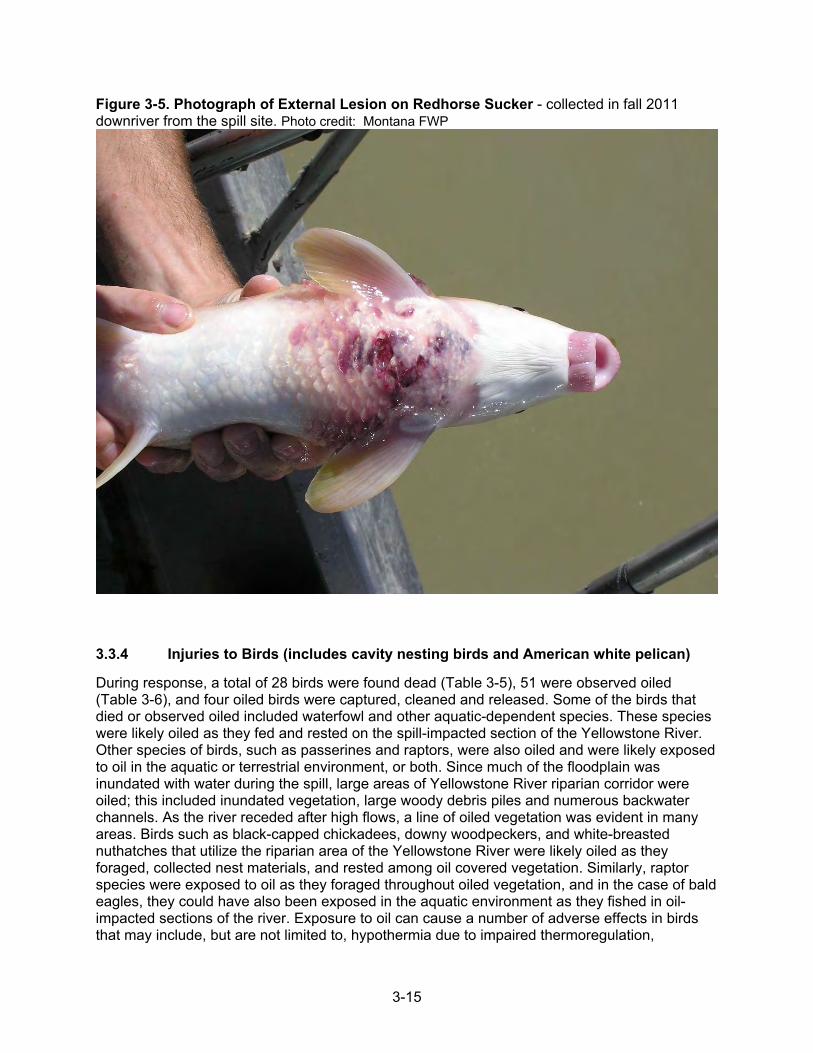
3-15
Figure 3-5. Photograph of External Lesion on Redhorse Sucker - collected in fall 2011 downriver from the spill site. Photo credit: Montana FWP
3.3.4 Injuries to Birds (includes cavity nesting birds and American white pelican)
During response, a total of 28 birds were found dead (Table 3-5), 51 were observed oiled (Table 3-6), and four oiled birds were captured, cleaned and released. Some of the birds that died or observed oiled included waterfowl and other aquatic-dependent species. These species were likely oiled as they fed and rested on the spill-impacted section of the Yellowstone River. Other species of birds, such as passerines and raptors, were also oiled and were likely exposed to oil in the aquatic or terrestrial environment, or both. Since much of the floodplain was inundated with water during the spill, large areas of Yellowstone River riparian corridor were oiled; this included inundated vegetation, large woody debris piles and numerous backwater channels. As the river receded after high flows, a line of oiled vegetation was evident in many areas. Birds such as black-capped chickadees, downy woodpeckers, and white-breasted nuthatches that utilize the riparian area of the Yellowstone River were likely oiled as they foraged, collected nest materials, and rested among oil covered vegetation. Similarly, raptor species were exposed to oil as they foraged throughout oiled vegetation, and in the case of bald eagles, they could have also been exposed in the aquatic environment as they fished in oil-impacted sections of the river. Exposure to oil can cause a number of adverse effects in birds that may include, but are not limited to, hypothermia due to impaired thermoregulation,

3-16
inflammation of the gastrointestinal lining, liver and kidney disorders, and impaired reproduction (Friend and Frason 2001). Table 3-5. Dead birds collected during the ExxonMobil Silvertip Pipeline Break
SPECIES SEGMENT A SEGMENT B TOTAL
American robin 1 1 American white pelican 1 1 Bald eagle 2 2 Canada goose 1 1 2 Cedar waxwing 1 1 Coopers hawk 2 2 European starling* 1 1 Great blue heron 2 2 Great horned owl 2 2 Catbird 2 2 Lazuli bunting 1 1 Mallard 1 1 Mourning dove 1 1 Ring-billed gull 1 1 Red-tailed hawk 1 1 Bird (unidentified) 1 1 Duck (unidentified) 1 1 wild turkey 3 1 4 Wood duck 1 1 TOTAL 17 11 28 Notes: * Introduced species, but included in estimates as a small bird. Source: IEc analysis of database of wildlife field observations from the ExxonMobil Silvertip pipeline break, collected July 4 to September 22, 2011; provided to IEc by the USFWS.

3-17
Table 3-6 Oiled Birds, by Species and River Division Where Observed
Species Division A Division B Division C Unknown Total
American robin 1 1 2
American white pelican 1 4 5
Bald eagle 3 3 Black-capped chickadee 2 2
Canada goose 6 6 12
Downy woodpecker 1 1
Duck (unidentified) 1 3 4
Great blue heron 1 1
Mallard 1 2 3
Pheasant 2 2
Red-tailed hawk 1 1
Shoveler 1 1
Song sparrow 1 1
Spotted sandpiper 3 3 White-breasted nuthatch 1 1
Wood duck 3 3
Yellow warbler 2 2
Common merganser 4 4
TOTAL 26 20 4 1 51 Source: IEc analysis of database of wildlife field observations from the ExxonMobil Silvertip pipeline break, collected July 4 to September 22, 2011; provided to IEc by the Service. The numbers of observed birds affected by the spill are an underestimation of the birds actually injured as a result of the spill. Aerial wildlife search operations did not begin until seven days after the spill and due to unsafe river conditions, limited boat operations did not begin until eight days after the spill. A dedicated Wildlife Operations boat was not provided until 14 days after the spill. Moreover, it is generally recognized that the actual number of birds injured exceeds the number of bird carcasses collected for several reasons including, but not limited to: movement by oiled birds away from the area; transport of dead birds by winds and current; sinking of dead birds; frequency of searches; searchers’ ability to locate birds (searcher efficiency); and the length of time a bird carcass is available to be observed by searchers (carcass persistence). For example, bird carcasses can disappear due to scavenging, either in the water body where the spill occurs or wherever the carcass subsequently becomes stranded along the shore. The Trustees also assumed that 85% of the oiled birds died as a result of coming into contact with oil. Because of these reasons, a multiplier was developed and applied to the number of birds collected or observed oiled to estimate the total number of birds injured as a result of the spill. The formula for calculating the actual number of birds that died as a result of the spill is provided below.

3-18
Where SE is searcher efficiency rate, CP is carcass persistence rate, (SE x CP) is the probability a carcass will be found, or SE-CP Factor, and SF is the frequency of searches,
Total Dead Birds = (Observed Dead Birds ÷ SE-CP Factor x SF Multiplier) +
(Observed Oiled Birds x % Oiled Birds Estimated Dead x SF Multiplier)
The Trustees developed projects for injuries to birds focusing on projects that would benefit breeding habitat. For those species that breed along the Yellowstone River, several require tree cavities for nesting and roosting. The death of cavity-nesting birds has created a natural resource debit that that Trustees choose to express in terms of lost natural resource services: bird production in cottonwood bottomland habitat. The Trustees have calculated that the preservation of similar habitat with its associated services would offset the natural resource debit caused by the oil spill. This type of habitat is at risk of development (Thatcher, T., B. Swindell and K. Boyd 2008). The cavity-nesting habitat targeted for this restoration, mature cottonwood bottomland, will also benefit most of the remaining bird species not addressed by the American white pelican projects (described below). The only species of bird injured as a result of the spill that does not breed within the Yellowstone River basin is the American white pelican. The Trustees proposed a separate project to benefit pelicans on their nearest known nesting areas in northeast Montana (Medicine Lake National Wildlife Refuge and Bowdoin National Wildlife Refuge). These projects will benefit American white pelicans through predator reduction using fencing on a peninsula at Medicine Lake NWR and water purchases to add water to Bowdoin Lake to minimize land bridges to nesting areas that would otherwise form in dry years. In addition to replacing the lost American white pelicans, these projects will also benefit injured species that share similar habitat requirements like great blue herons, Canada geese, mallards, northern shovelers, and ring-billed gulls. A more detailed discussion of injury quantification and restoration scaling for both of these bird projects can be found in Appendix D. 3.3.5 Injuries to Human Use/Recreational Use The Trustees identified several categories of injury and human and ecological service losses that occurred as a result of the spill and response activities. Major impacts to human uses occurred for several months because of the presence of the spilled oil and because of the closure of facilities and river access due to response activities. Recreational activities considered in the analysis included recreational fishing, city parks use, and other recreational activities conducted along the river, such as boating and camping. Map 2-2 shows public lands along the Yellowstone River in the spill affected area. Fishing: The Yellowstone River downstream from the spill site near Laurel begins a transition zone from a cold water fishery to a warm water fishery and provides a variety of fishing opportunities. Every two years the State of Montana conducts a statewide fishing effort survey and produces estimates of fishing pressure by water body and month. Of particular interest is the reach of the Yellowstone River beginning at the mouth of the Stillwater River, approximately 25 miles above the spill site, and extending to the mouth of the Bighorn River, approximately 70 miles below the spill site. Within this reach are three sections. The first section extends from the mouth of the Stillwater River and extends downstream to the mouth of the Clarks Fork River. The second section extends from the mouth of the Clarks Fork River and downstream to the Huntley Diversion. The third sections extends from the Huntley Diversion to the mouth of the Bighorn River.

3-19
The total fishing pressure for the months of July, August, and September 2007, 2009, and 2011 for these three river reaches was estimated by the State of Montana at 17,399, 27,839, and 14,547 angler days, respectively. While the high flows during the spill event may have discouraged fishing for a short period, the presence of response activities and the closure of fishing access sites even after the river returned to lower flows is likely to have reduced fishing pressure. Fishing efforts on the Yellowstone River between the mouth of the Stillwater River and the mouth of the Bighorn River dropped by 13,292 angler days between 2009 and 2011. However, if we assume that the high flows in July 2011 precluded fishing for a period, lost fishing trips could be confined to the months of August and September. The fishing pressure estimates for these months only indicate that fishing pressure dropped by 7,409 angler days between 2009 and 2011. Billings’ parks: The City of Billings has several parks located along the Yellowstone River downstream from the spill site. Several of these parks were closed either because of the spill or response activities. Managers for these parks estimated that closures of various lengths at Coulsen Park, Riverside Park, and Norm’s Island resulted in the loss of 7,320 visits. These parks are used for a variety of recreational activities, including hiking, biking, picnicking and dog walking. Bundy Bridge River access: The Bundy Bridge River access was closed to the public for 20 days. This site provides public access to the Yellowstone River and a ramp for launching boats. Car count data collected by the State of Montana indicate that this site averages 40.4 visitors per day during the months of July–September. A closure of 20 days is estimated to result in a loss of 808 visitor days. East Bridge River access: The East Bridge River access was closed to the public for a period of 20 days. This site provides a concrete ramp for boat launching. Car count data collected by the State of Montana indicate that this site is estimated to average 55.5 visitors per day during the months of July–September. A closure of 20 days is estimated to result in a loss of 1,111 visitor days. Duck Creek River access: The Duck Creek River access was closed to the public from the beginning of the spill through the end of September 2011. This site also provides a ramp for boat launching. Based on car count data, it is estimated that this site would normally provide 4,403 visitor days during the months of July-September 2011. The closure of this site during those three months is therefore estimated to have resulted in a loss of 4,403 visitor days. Sundance Lodge Recreation Area: This area is operated by the Bureau of Land Management (BLM) and is located about 2 miles downstream of the spill site. BLM staff reported that public access to this site was not available for about 30 days because of the oil spill. BLM staff also report that about 25 visitors normally use the area each day. The 30 days of closure are estimated to have resulted in about 750 lost visitor days. Riverside Park in Laurel: The historic Riverside Park is located on the northwest bank of the Yellowstone River immediately adjacent to and downstream from the spill site. The park was closed from July 1, 2011 through January 15, 2012 because it was used as a staging area for response activities and was used to remove the old pipeline and for boring, and connecting the new pipeline. The Yellowstone River flows on the north side of the park and offers fishing opportunities. The park is shaded with large cottonwood trees. Over time, the park has offered

3-20
RV camping, tent camping, fishing, horseshoes, picnicking and a playground. The buildings have been used for civic events, 4H activities and private functions. Because of its location, this park typically receives substantial use by people passing through the area. City personnel familiar with usage patterns estimated that general recreation users would have made 17,033 visits to the park. Also, the park would have likely hosted approximately 784 campers in the absence of the spill. The park is used for activities by several specific local user groups. The closure of the park was estimated to have resulted in the loss of 1,000 days of youth 4-H activities, 879 user days at a trap shooting range, 144 days of hunter education activities, and 198 days of recreation by participants in an annual horseshoe tournament. Combined, the closure of Riverside Park in Laurel resulted in the loss of 20,038 days of various types of recreational activities. See Appendix E for further discussion. Table 3-7 summarizes recreational use losses. Table 3-7 Summary of Recreational Use Losses Activity Lost user days Fishing 7,409 Parks General Recreation 26,882 Parks Camping 784 State River Access Sites General Recreation 1,821 State River Access Sites Floating/Canoeing/Kayaking 1,541 State River Access Sites Power Boating 389 BLM General Recreation 750
Total 39,576

4-1
4.0 RESTORATION OF NATURAL RESOURCES: ALTERNATIVES This chapter describes the restoration alternatives the Trustees analyzed for restoring, replacing, and acquiring the equivalent natural resources injured by the oil spill to their baseline condition and to compensate the public for the interim losses. As discussed in Chapter 3, the five natural resources most impacted by the oil spill were: terrestrial/riparian habitat (including habitat for cavity nesting birds), large woody debris piles, riverine aquatic habitat, American white pelican, and recreational resources. This chapter includes a brief outline of the OPA requirements and restoration project selection criteria (discussed in detail in Chapter 5). NEPA and MEPA also apply to restoration actions taken or directed by the federal and state Trustees, respectively. To reduce transaction costs and avoid delays in restoration the OPA regulations encourage the Trustees to conduct the NEPA process concurrently with the development of the draft restoration plan. A brief introduction to the purpose and need for analysis under NEPA and MEPA is presented here and discussed in detail in Chapter 6. Chapter 7 describes the Trustees’ proposed project implementation plan. 4.1 Restoration Strategy for Primary and Compensatory Restoration The goal of restoration under OPA is to compensate the public for injuries to natural resources and their associated services from an oil spill. OPA requires that this goal be achieved by returning injured resources to their baseline condition and compensating for any interim losses of natural resources and services during the period of recovery to baseline. To develop restoration alternatives, the Trustees must consider both primary and compensatory restoration options (15 CFR 990.53). Active primary restoration actions work to directly restore injured natural resources and services to baseline on an accelerated time frame (15 CFR 990.53). Compensatory restoration actions are intended to compensate the public for the loss of natural resources and services during the “interim” time period between the start of injury and the eventual recovery of the resource or service (15 CFR 990.53). Several of the restoration alternatives included in this section are based on designs that may require additional detailed engineering design work or operational plans. Therefore, details of specific projects may require additional refinements or adjustments to reflect site conditions or other factors. Restoration project designs also may change to reflect public comments and further Trustee analysis. If a proposed project becomes infeasible for some reason, the Trustees will consider substituting a similar project and evaluate whether this decision requires additional public review under OPA, NEPA or MEPA. 4.2 OPA Requirements and Restoration Project Selection Criteria NRDA regulations under OPA require consideration of six criteria when evaluating restoration options (15 CFR 990.54(a) and (b)).
1) Project cost and cost effectiveness The cost of a project, both implementation cost, long term maintenance, and monitoring will be considered against the relative benefits of a project to the injured natural resources and service losses. Projects that return the greatest and longest lasting benefits for the cost will be preferred. The Trustees will also consider the time necessary before the project benefits are achieved, and the sustainability of those benefits. Projects will be reviewed for their public acceptance and support, and additional consideration given to projects that leverage the financial resources of partner organizations.

4-2
2) Project goals and objectives
This criterion considers the extent to which each restoration project helps to return injured natural resources and services to at least baseline conditions that were present prior to the oil spill or compensate for interim service loss. Projects should demonstrate a clear relationship to the resources and services injured. Projects located within the area affected by the spill are preferred, but projects located within the Yellowstone River watershed that provide benefit to the resources injured in the affected area will also be considered. With regard to the American white pelican, projects located outside of the Yellowstone River watershed will be considered if they provide benefits to the American white pelicans that use the affected area of the Yellowstone River.
3) Likelihood of project success The Trustees will consider the technical feasibility of each project in achieving the restoration project goals and the risk of failure or uncertainty that the goals can be met and sustained. The Trustees will generally not support projects or techniques that are unproven or projects that are designed primarily to test or demonstrate unproven technology.
4) Avoidance of Adverse Impact Projects will be evaluated for the extent to which they prevent future injury as a result of the oil spill and avoid collateral injury as a result of implementing the alternative. All projects shall be lawful and likely to receive any necessary permits or other approvals prior to implementation.
5) Multiple Resource and Service Benefits Projects that provide benefits that address multiple resource injuries or service losses, or that provide ancillary benefits to other resources or resource uses are preferred.
6) Public Health and Safety This criterion is used to ensure that the projects will not pose unacceptable risks to public health and safety.
Information supporting the Trustees’ selections of restoration alternatives is provided throughout the remainder of this chapter.
4.3 NEPA/MEPA Statement of Purpose and Need The purpose of the restoration is to make the public whole for injuries to natural resources and natural resource services resulting from the oil spill. To meet the purpose of restoring extensive and complex injuries to natural resources and services resulting from this spill, the Trustees identified the need for a comprehensive restoration plan consistent with OPA to restore these injured natural resources and services (see 15 CFR 990.10). The purpose and need for this document is outlined in more detail in Section 1.1. 4.4 Approach to Developing and Evaluating Alternatives under OPA and
NEPA/MEPA The Trustees started meeting with members of the public, local governments, State agencies, and federal agencies affected by the spill immediately after it occurred. Public involvement is

4-3
described in detail in Section 1.4.4. The Trustees considered comments and input from these entities, together with OPA and NEPA and MEPA considerations outlined above, to develop goals for the restoration of each of the Yellowstone River resources that was injured by the oil spill. These goals will guide the future restoration actions and selection of the alternatives like those outlined below. Certain projects within project types have been identified as priority projects by local resource managers. If these projects cannot move forward at this time, the Trustees, in consultation with local resource managers, may select other projects that achieve the same goals. 4.5 Restoration Alternative 1 Description: No-Action/Natural Recovery MEPA and NEPA require the Trustees to evaluate an alternative in which no actions are taken by a State or Federal agency to restore the Yellowstone River affected by the oil spill. Under the no-action alternative, the Trustees would not prepare a restoration plan nor implement restoration projects under NRDA. The Trustees would allow natural recovery processes to occur, which could result in one of four outcomes for injured resources: 1) gradual recovery, 2) partial recovery, 3) no recovery, or 4) further deterioration. Although injured resources could presumably recover to at or near baseline conditions, recovery would take much longer compared to a scenario in which restoration actions were undertaken. Additionally, the interim losses of natural resources would not be compensated under a no-action alternative. If Trustees selected this alternative, the public would not be compensated for the substantial losses in natural resources and services caused by the oil spill. OPA establishes Trustee authority to seek compensation for such interim losses, which would continue during the extended recovery periods associated with this alternative. Given that technically feasible restoration approaches are available to compensate for interim natural resource and service losses, the Trustees would reject the no-action alternative. 4.6 Restoration Alternative 2 Description: Projects Addressing All Injury
Categories 4.6.1 Terrestrial/Riparian Injuries (includes cavity-nesting bird habitat) Project Types Three possible primary and compensatory restoration types were identified for terrestrial/ riparian resource losses including: 1) acquiring and preserving mature bottomland forest habitat, which will address terrestrial habitat injury and provide benefits to cavity-nesting birds, 2) acquiring and restoring cottonwood regeneration habitat in the bottomland/riparian areas, and 3) acquiring and restoring degraded grasslands/shrublands. GOAL: Conserve and restore terrestrial/riparian habitat (includes habitat for cavity-nesting birds) OBJECTIVES:
Obtain conservation easements and/or fee title land acquisitions on mature cottonwood bottomland to compensate for the bottomland habitat and cavity nesting birds injured by oil and response activities
Restore injured terrestrial/riparian and grassland/shrubland to compensate for bottomland impacted by oil and response activities
Remove invasive woody plants to restore bottomland to a more native suite of plants for improved habitat

4-4
4.6.1.1 Terrestrial/Riparian Habitat Conservation Easements and Fee Title Land Acquisitions
Mature cottonwood bottomland with intact complex understory would be protected through one or more conservation easements and fee title land acquisitions in the Yellowstone River valley in and near the injured area, including further upstream and downstream of the injured area (the area most heavily impacted by the spill). Projects that are outside the injured area will be considered on a project-specific basis for their potential to meet the restoration plan goals. The preservation of these habitats will provide benefits for the terrestrial habitat and cavity nesting birds that were injured both as a result of the spill and as a result of response activities. The properties would be selected in mature cottonwood bottomland habitat that meet the habitat requirements of primary excavators, those birds that create cavities in trees. About 142 acres of cottonwood bottomland habitat would be sought for these primary excavator birds. These acquisitions would be spatially distributed along the Yellowstone River to protect multiple bird territories. Required acreage was based on known rates of habitat loss due to development along the Yellowstone River (COE & YRCDC 2016). Acreage required was calculated based on the habitat requirements for primary excavator birds and the number of impacted cavity dependent species discussed in Chapter 3. The projects may include conservation easement or fee title land acquisition. Projects may include quiet title actions in limited circumstances to provide certainty of State ownership in desired terrestrial/riparian habitat areas. The title would likely be held by one of the Trustees or a third party. Conservation easements or fee title land acquisitions are an accepted method used to conserve important habitat areas and protect them from development or overgrazing. A monitoring plan will be developed with the implementation of each project. Monitoring will be used to ensure that the restoration project performance criteria will be met. The party that holds the land title or easement would likely be responsible for monitoring, reporting, and enforcement of habitat preservation, although those responsibilities may be shared among the partners. The duration and frequency of monitoring will be detailed at the time of acquisition. Most likely inspections would occur on an annual basis through a combination of hiking and driving, but aerial monitoring or monitoring by boat may also be needed for areas with limited access. Habitats specifically preserved for cavity nesting birds would be monitored using point counts during the breeding season for population trend analyses or other methods. The land management will be compared to the easement provisions and management goals and documented with photographs. Terrestrial/riparian land easements and fee title land acquisitions are consistent with the YRCDC’s Yellowstone River recommended practices (YRCDC 2016). Possible project partners could include Montana FWP, USFWS, BLM, local government entities, and non-government organizations that are interested in or whose mission is land conservation and/or river restoration. 4.6.1.2 Terrestrial/Riparian Restoration of Altered or Developed Habitat Terrestrial/ riparian habitat would be restored through one or more conservation easements or fee title land acquisitions along the Yellowstone River which contain developed or altered terrestrial and riparian lands. The altered riparian lands would be located either in the injured area or nearby and may be within or contiguous with other public property, including further upstream and downstream of the injured area (the area most heavily impacted by the spill). Projects that are outside the injured area will be considered on a project-specific basis for their potential to meet the restoration plan goals. Properties would be selected for the presence of injured habitat types: terrestrial/riparian habitat (including bottomland cottonwood galleries and

4-5
riparian grasslands and shrublands, sedge meadows, and willow bottoms). The projects may include conservation easement or fee-title land acquisition. The title would likely be held by one of the Trustees or a third party. About 341 acres would be sought for restoration projects. The developed or altered riparian lands would be restored or habitat quality would be enhanced. Restoration might include installing fencing to reduce grazing pressure, planting and seeding riparian vegetation species, maintenance, wetland restoration, floodplain connecting projects, invasive woody species control, or other commonly accepted land restoration practices in riparian areas. Terrestrial/riparian restoration is compatible with the YRCDC’s recommended practices for the Yellowstone River (YRCDC 2016). The recommended practices document prioritizes areas with more than 5% of the floodplain isolated by dikes, berms or levees for restoration. These Yellowstone River recommended practices (YRCDC 2016) priorities would be one component considered in the project selection. Possible project partners may include Montana FWP, USFWS, BLM, local government entities, and non-government organizations that are interested in or whose mission is land conservation and/or river restoration. Controlled grazing, replanting, seeding, wetland restoration projects, floodplain connecting projects, and invasive woody species control are all accepted and common techniques of land management, so have a high likelihood of achieving the project goals. Monitoring will be used to ensure that the restoration project performance criteria will be met. The duration and frequency of monitoring will be detailed at the time of acquisition. The party that holds the land title or easement would likely be responsible for monitoring, reporting, and enforcement of habitat preservation, although those responsibilities may be shared among the partners. Most likely inspections would occur on an annual basis through a combination of hiking and driving, but aerial monitoring or monitoring by boat may also be needed for areas with limited access. The land management will be compared to the easement provisions and management goals and documented with photographs. 4.6.1.3 Control of Invasive Woody Species The YRCDC mapped over 494 acres of Russian olive (Elaeagnus angustifolia) within the injured area river stretch from Laurel to the Yellowstone County border in 2008. Salt cedar (genus Tamarix) has not been systematically mapped in this stretch, but FWP land managers have reported that it is present and may be contributing to degraded habitat conditions. Large invasive woody species can compete with native plants, reduce forage, impact wildlife habitat and influence the river channel. Yet infestation can be successfully limited through removal of invasive woody plants. The YRCDC identifies an invasive woody plant control prioritization approach (YRCDC 2016) in which they emphasize high priority sites as those with new infestations, upstream infestations, areas of special biological or historical concern, and public access areas. Secondary priorities are those areas with less than 5% infestation and areas with confined channel types. Invasive woody plants pose a long-term threat to the ecological value to the Yellowstone River riparian and wetland plant communities (YRCDC 2016). Russian olive and salt cedar would be removed from federal and state lands located in the injured area or nearby. BLM has identified Bundy Island Special Recreation Management Area, Pompeys Pillar National Monument, and Sundance Lodge Special Recreation Management Area as high priority sites for invasive woody vegetation removal on federal lands along the river. Removal in these areas would be consistent with the BLM Billings Field Office Approved Resource Management Plan, Chapter 3

4-6
(BLM 2015). Locations for woody plant removal would be selected in consultation with local, state, and federal land managers. Projects may also occur upstream and downstream from the injured area (the area most heavily impacted by the spill) to restore, replace, rehabilitate, or acquire the equivalent of the injured resources. Projects that are outside the injured area will be considered on a project-specific basis for their potential to meet the restoration plan goals. Project partners for invasive woody plant removal could include the BLM, the Natural Resources Conservation Service, FWP, DNRC, the Yellowstone County Conservation District, the Yellowstone County Weed District, and the YRCDC. Monitoring will be used to ensure that the restoration project performance criteria will be met. The duration and frequency of monitoring will be detailed at the time of project implementation. For monitoring, project managers would take photographs each year, inspect contractor work for meeting contract requirements and any non-target damage, and assess if previous treatments are meeting performance criteria before starting additional treatments in subsequent years. They would do this by walking the site, noting whether performance criteria for percent cover of native and invasive non-native species were being met. Contractors could then adjust their planned treatments accordingly. 4.6.2 Large Woody Debris Injuries Project Types Easements and fee title land acquisition of property were identified as primary restoration to compensate for the lost and disturbed large woody debris. GOAL: Recruit large woody debris to the river and restore natural river function to re-establish large woody debris piles in areas where they were dismantled or disturbed by response actions. OBJECTIVES:
Obtain easements/fee title land acquisitions on upstream cottonwood bottomland, or use other land management methods, to produce a quantity of large woody debris to compensate for that removed by response actions.
Further enhance the naturally functioning river system by removing unnatural or man-made restrictions to natural fluvial processes and/or channel migration and function.
4.6.2.1 Cottonwood Bottomland Acquisition in the Channel Migration Zone Intact mature cottonwood bottomland would be acquired through one or more channel migration zone easements, other easements, deed restrictions, term contracts, or fee title land acquisitions in the Yellowstone River bottomlands in and above the injured area. Projects may include quiet title actions in limited circumstances to provide certainty of State ownership in desired intact mature cottonwood bottomland areas. These properties would be selected for their potential to erode and contribute large woody debris to the system. Purchase of these lands would allow for the recruitment of debris to the system through natural erosional processes to replace the 28 injured large woody debris piles. The rate of natural recruitment of large woody debris was estimated based on values from the literature for the rate of bank erosion in the area likely to erode and contribute large woody debris (the channel migration zone), and the density of trees and average tree volume in that area. Analysis in Chapter 3 and included in Appendix C determined that approximately 958 acres of restoration on cottonwood bottomland habitat would have to occur to offset the injuries. Therefore, approximately this much acreage would be sought.

4-7
The area targeted for easements or fee title land acquisition would have the habitat needed to replace the volumes damaged and removed in the injured area. Conservation easements or fee title land acquisitions of cottonwood bottomland in the channel migration zone would be sought primarily from Reed Point to Billings to supply large woody debris to the impacted area, including further upstream and downstream of the injured area (the area most heavily impacted by the spill), or in the lower Clarks Fork of the Yellowstone. Projects that are outside the injured area will be considered on a project-specific basis for their potential to meet the restoration plan goals. Channel migration zone easements, other easements, and fee title land acquisitions are consistent with the YRCDC’s Yellowstone River recommended practices (YRCDC 2016) and channel migration zone maps. Possible project partners could include Montana FWP, USFWS, BLM, YRCDC, Yellowstone CD, Carbon CD, and non-government organizations interested in river restoration. Channel migration zone easements and fee title land acquisitions are an accepted method used to conserve riparian areas and allow the river’s natural erosive processes to continue (FWP 2016; YRCDC 2016). Channel migration zone easements are already being employed along the Yellowstone River for this purpose (FWP 2016). Monitoring will be used to ensure that the restoration project performance criteria will be met. The duration and frequency of monitoring will be detailed at the time of property acquisition. The party that holds the land title or easement would likely be responsible for monitoring, reporting, and enforcement of habitat preservation, although those responsibilities may be shared among the partners. Most likely inspections would occur on an annual basis through a combination of hiking and driving, but aerial monitoring or monitoring by boat may also be needed for areas with limited access. The land management will be compared to the easement provisions and management goals and documented with photographs. 4.6.2.2 River Function Restoration Projects would be conducted that would allow natural river function and erosion to occur. Several types of projects may be considered, such as flanked riprap removal, side channel blockage removal, or berm removal to restore river function. Projects may also occur upstream and downstream from the injured area (the area most heavily impacted by the spill), or in the lower Clarks Fork of the Yellowstone. Projects that are outside the injured area will be considered on a project-specific basis for their potential to meet the restoration plan goals. Channel Migration Easements Channel migration easements will also be used as a tool to restore natural flows and flooding regimes (FWP and MARS 2016). Flanked Mid-Channel Riprap Removal Failed bank armor and flanked flow deflectors sometimes end up as rubble in the active river channel. This rubble will often deflect the current into the bank, thereby accelerating the bank erosion it was originally intended to stop. It also creates a safety hazard for boaters and recreationists and is a potential liability for the landowner (YRCDC 2016). The YRCDC recommends that failed bank armoring and flow deflectors be removed from the active channel (YRCDC 2016).
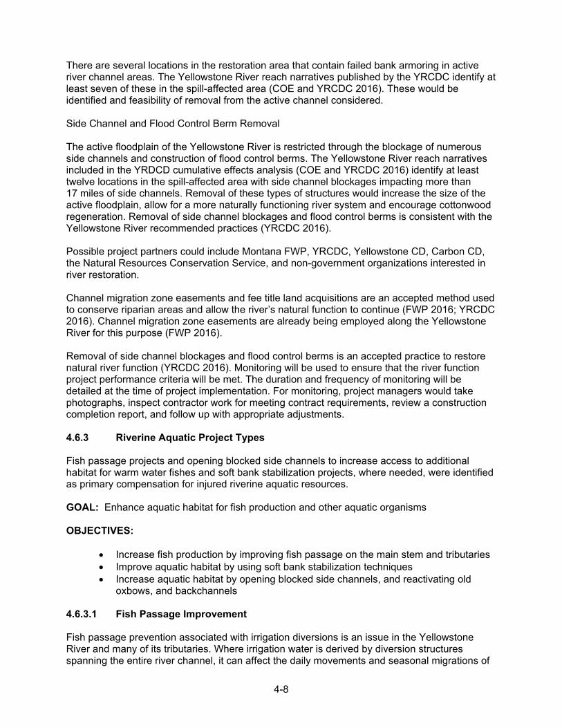
4-8
There are several locations in the restoration area that contain failed bank armoring in active river channel areas. The Yellowstone River reach narratives published by the YRCDC identify at least seven of these in the spill-affected area (COE and YRCDC 2016). These would be identified and feasibility of removal from the active channel considered. Side Channel and Flood Control Berm Removal The active floodplain of the Yellowstone River is restricted through the blockage of numerous side channels and construction of flood control berms. The Yellowstone River reach narratives included in the YRDCD cumulative effects analysis (COE and YRCDC 2016) identify at least twelve locations in the spill-affected area with side channel blockages impacting more than 17 miles of side channels. Removal of these types of structures would increase the size of the active floodplain, allow for a more naturally functioning river system and encourage cottonwood regeneration. Removal of side channel blockages and flood control berms is consistent with the Yellowstone River recommended practices (YRCDC 2016). Possible project partners could include Montana FWP, YRCDC, Yellowstone CD, Carbon CD, the Natural Resources Conservation Service, and non-government organizations interested in river restoration. Channel migration zone easements and fee title land acquisitions are an accepted method used to conserve riparian areas and allow the river’s natural function to continue (FWP 2016; YRCDC 2016). Channel migration zone easements are already being employed along the Yellowstone River for this purpose (FWP 2016). Removal of side channel blockages and flood control berms is an accepted practice to restore natural river function (YRCDC 2016). Monitoring will be used to ensure that the river function project performance criteria will be met. The duration and frequency of monitoring will be detailed at the time of project implementation. For monitoring, project managers would take photographs, inspect contractor work for meeting contract requirements, review a construction completion report, and follow up with appropriate adjustments. 4.6.3 Riverine Aquatic Project Types Fish passage projects and opening blocked side channels to increase access to additional habitat for warm water fishes and soft bank stabilization projects, where needed, were identified as primary compensation for injured riverine aquatic resources. GOAL: Enhance aquatic habitat for fish production and other aquatic organisms OBJECTIVES:
Increase fish production by improving fish passage on the main stem and tributaries Improve aquatic habitat by using soft bank stabilization techniques Increase aquatic habitat by opening blocked side channels, and reactivating old
oxbows, and backchannels 4.6.3.1 Fish Passage Improvement Fish passage prevention associated with irrigation diversions is an issue in the Yellowstone River and many of its tributaries. Where irrigation water is derived by diversion structures spanning the entire river channel, it can affect the daily movements and seasonal migrations of

4-9
various fish species. Fish may become entrained when water is withdrawn from the river either via gravity diversions or pumps. Researchers have established that the distributions and movements of many Yellowstone River fish species are affected by low-head irrigation diversions dams. Researchers have suggested that blockage of seasonal migrations for spawning and feeding may be a leading cause of the decline in fishes native to large river systems (Trenka 2000; Helfrich et al. 1999; Elser et al. 1977). Across the U.S. and locally, fish passage and entrainment protection measures have been used effectively to prevent loss of fish, restore connectivity with habitat, and increase fish abundance without negatively affecting agricultural practices. Examples of these types of projects in the Yellowstone Basin include the recently completed T & Y dam bypass project (Figure 4-1) (McKoy 2013), the DH dam removal on the Tongue River (FWP 2016), and the recently modified fish passage at the Huntley Diversion on the Yellowstone River and improving fish passage on the lower portion of Pryor Creek (YRCDC 2012; COE and YRCDC 2016). Fish passage improvement projects may take place on the main stem of the Yellowstone River or in tributaries, including further upstream and downstream of the injured area (the area most heavily impacted by the spill), or in tributaries. Projects that are outside the injured area will be considered on a project-specific basis for their potential to meet the restoration plan goals. Tributaries to the Yellowstone River in the vicinity of the spill that have opportunities for increasing fish recruitment to the mainstem fish populations that were injured by the spill are the Clarks Fork of the Yellowstone and Pryor Creek. The Clarks Fork River has irrigation diversions that block fish movement and migrations from the Yellowstone River. Pryor Creek has a fish barrier several miles up from the confluence with the Yellowstone River. Figure 4-1. Fish Passage Example (Montana FWP photograph)

4-10
The Clarks Fork River is the uppermost warm water tributary to the Yellowstone River and has significant potential as a spawning area for Yellowstone River fish; however, there are 11 irrigation diversions over its 73-mile length in Montana and several present significant fish passage problems. Currently, fish are prevented from migrating further than about 16 miles up the Clarks Fork River due to fish passage issues. If fish passage can be provided at key irrigation diversions, Yellowstone River fish could access an additional 42 miles of river for spawning and rearing. Pryor Creek is a tributary to the Yellowstone River near the town of Huntley. Several miles upstream a barrier to upstream fish passage occurs at the Siewert Irrigation Diversion Dam. The weir style diversion dam is about 4 feet high and blocks upstream fish passage at all times. (Mefford 2007). Removing this fish passage barrier would provide fish access to the entire length of Pryor Creek and benefit several Montana species of concern found in this section of the Yellowstone River, either by providing spawning and rearing habitat in Pryor Creek itself or by improving forage fish production out of the creek (Yellowstone Conservation District 2012). Historically, this section of the Yellowstone River and possibly Pryor Creek itself, provided habitat for key native species such as burbot, sauger and channel catfish. If Pryor Creek can provide unlimited fish passage, it would likely become a key sauger and catfish spawning tributary for this section of the Yellowstone River. Many of the native fish species in this part of the Yellowstone River, such as white and longnose suckers, flathead chub, emerald shiners, and fathead and western silvery minnows depend on tributary streams for spawning and as winter habitat to escape ice flows in the main river. Many of these species provide the forage necessary to maintain game fish populations in the main Yellowstone River. Now that the siphon is installed and Pryor Creek is reconnected to the Yellowstone River, providing fish passage at the Siewert Irrigation Diversion Dam would provide important spawning potential for Yellowstone River fish. The Yellowstone Conservation District has project final designs available and has been working to secure match funding for this project. If the projects on Pryor Creek and the Clarks Fork River do not move forward, the State will consult with local government agencies and resource managers to identify similar projects that meet the same goals. Fish passage projects are consistent with the Yellowstone River recommended practices (YRCDC 2016). Project partners could include FWP, the YRCDC, Yellowstone Conservation District, Carbon Conservation District, DNRC, and irrigation companies. Fish passage projects are recognized as a method to help fish to re-populate habitat that has been blocked. Warm water fish are already using portions of Pryor Creek that were formerly blocked after removal of another barrier. The benefits are long term because they remove a physical barrier. Monitoring will be used to ensure that the fish passage project performance criteria will be met. The duration and frequency of monitoring will be detailed at the time of project implementation. Methods for monitoring fish barrier projects will use commonly accepted practices such as fish population surveys, fish tagging, and monitoring above and below the fish passage structure. The structures will likely be monitored for at least two years to determine if they are functioning as designed. 4.6.3.2 Soft Bank Stabilization In areas where bank stabilization must occur to protect existing infrastructure, soft bank stabilization is preferred to provide improved habitat for fish (Figure 4-2). Soft bank stabilization techniques conserve riparian areas while still allowing infrastructure to be protected. Soft bank stabilization uses a bio-engineering technique called soil lifting. The method uses natural

4-11
material (bank material and top soil) and vegetation (willows and riparian vegetation) to stabilize the bank. (Figure 4-2). Soft bank stabilization creates natural aquatic shoreline habitat as well as riparian vegetation.
FWP has identified possible soft bank stabilization project locations, although they are also exploring project ideas for moving the infrastructure at those locations so that bank stabilization would not be required. If a soft bank stabilization project moves forward, FWP could also use it as a demonstration project for other locations on private property along the Yellowstone River. Projects may also occur upstream and downstream from the injured area (the area most heavily impacted by the spill). Projects that are outside the injured area will be considered on a project-specific basis for their potential to meet the restoration plan goals. Figure 4-2. Example of Soft Bank Stabilization Project (Montana FWP Photograph)
Project partners include FWP. Soft bank stabilization is recognized as an accepted practice for conserving riparian areas while still allowing for active management. Monitoring will be used to ensure that the soft bank stabilization performance criteria will be met. The duration and frequency of monitoring will be detailed at the time of project implementation. Monitoring parameters will be determined when the projects are implemented, but will use commonly accepted practices such as photographs, monitoring of vegetation establishment, and bank stability.

4-12
4.6.3.3 Riverine Habitat Restoration Projects would be conducted that would restore riverine habitat. Several types of projects may be considered, such as flanked riprap removal, side channel blockage removal, and reactivation of old oxbows and backchannels to restore riverine habitat. Projects would take place in and near the injured area, including further upstream and downstream of the injured area (the area most heavily impacted by the spill). Projects that are outside the injured area will be considered on a project-specific basis for their potential to meet the restoration plan goals. Flanked Mid-Channel Riprap Removal Failed bank armor and flanked flow deflectors sometimes end up as rubble in the active river channel. This rubble will often deflect the current into the bank, thereby accelerating the bank erosion it was originally intended to stop and negatively impacting riverine habitat. It also creates a safety hazard for boaters and recreationists and is a potential liability for the landowner (YRCDC 2016). The YRCDC recommends that failed bank armoring and flow deflectors be removed from the active channel (YRCDC 2016). There are several locations in the restoration area that contain failed bank armoring in active river channel areas. The Yellowstone River reach narratives published by the YRCDC identify at least seven of these in the spill-affected area (COE and YRCDC 2016). These would be identified and feasibility of removal from the active channel considered. Removal of Side Channel Blockages and Reactivation of Old Oxbows and Back Channels Removal of side channel blockages would be used to create more aquatic side channel habitat along the Yellowstone River. The COE and YRCDC (2016) mapped almost 17 miles of blocked side channels in the reach of the Yellowstone River between Laurel and the Big Horn River confluence. Reactivation of old oxbows and back channels will provide other habitat restoration opportunities. Monitoring will be used to ensure that the aquatic side channel habitat is functional. The duration and frequency of monitoring will be detailed at the time of project implementation. For monitoring, project managers would take photographs, inspect contractor work for meeting contract requirements, review a construction completion report, and follow up with appropriate adjustments. 4.6.4 American White Pelican Project Types The Trustees identified the following project as primary compensation for injured pelican populations. GOAL: Replace oiled pelicans that died as a result of the oil spill by increasing productivity through predator exclusion to breeding areas. OBJECTIVES:
Reduce predation of American white pelican chicks on breeding grounds to offset those pelicans that were oiled during the Yellowstone River oil spill
Medicine Lake National Wildlife Refuge: The American white pelican colony on Medicine Lake is the largest breeding colony in Montana, and in an effort to reduce mammalian predation activity on Bridgerman Point, a long narrow peninsula jutting out into Medicine Lake, a predator exclusion fence was constructed in 1988. This project would include tearing out the existing
4-13
wire, but leaving the existing posts. Welded wire, mesh, electric wire and charger would be replaced following the design in Lokemoen and Woodward (1993). Modifying the fence design would significantly reduce maintenance costs and should ensure the fence works properly for many more years. In addition, weed mat would be installed and covered with gravel extending two feet on either side of the fence to prevent vegetation from grounding out the electric wire. Lastly, construction of additional fence extensions (wing fences) would be completed that could be pushed further out into the lake on years when the water is low. Monitoring would include pelican breeding pair and nest numbers as well as predator use of the point using game cameras. Monitoring would take place the year before fence replacement and for 2 years following fence replacement, and modifications would be made to ensure that the project is meeting project goals and objectives. Bowdoin National Wildlife Refuge: Bowdoin Lake on the refuge has a large colony of nesting pelicans with the average nests numbering over 1,300 and have ranged from a minimum of 272 (in 1972), and maximum 2882 (in 1993) nests. Over 95% of the pelicans at Bowdoin nest on Woody Island and South Woody Island. Island nesting is a breeding strategy used by pelicans to reduce predation when young are vulnerable. Water is a barrier to terrestrial predators, but once water is shallow enough or absent (land bridge), access is uninhibited making young birds easy meals to primarily meso-predators (raccoon, coyote, skunk, etc.). In Lake Bowdoin a water level elevation below 2,209 feet creates land bridges out to Woody and South Woody islands. The refuge currently purchases excess water from the Malta Irrigation District at $7.00 per acre-foot. Water levels typically need to be raised to 2,210 foot stage, before 15 May of each year, which is the cut off to limit impacts to any over water nesters. Water purchases could vary, but to raise the lake two feet, 6,276 acre-feet of water would need to be purchased from the Malta Irrigation District at $7.00 per acre-foot, totaling $43,932 dollars (price based on 2012 data). The refuge does not have the funding necessary to buy needed water every year, so this funding would allow water purchases when normal allocations would not cover needs. This project would reduce predation in dryer years. There are many predators that could exploit the American white pelican colonies at these refuges. Madden and Restani (2005) reported that predation was present in the American white pelican colony on Medicine Lake. The Trustees believe that these projects would have a high likelihood of meeting project goals, as the predator exclusion would boost pelican survival when chicks are young and vulnerable. 4.6.5 Recreational Human Use Project Types Several project types were identified as compensatory restoration for interim losses of human use services due to the spill. The approach is to provide a suite of in-kind restoration projects to increase recreational opportunities similar to those that were lost due to the oil spill and subsequent response activities. These enhanced recreational opportunities would occur as close to the areas impacted by the spill as practicable, and provide for actions for which a non-federal governmental agency would normally not be responsible or that would receive funding in the normal course of events. Projects would take place in and near the injured area, including further upstream and downstream of the injured area (the area most heavily impacted by the spill), or in urban ponds or tributaries. Projects that are outside the injured area will be considered on a project-specific basis for their potential to meet the restoration plan goals. The projects identified would be implemented as part of the restoration plan. However, if certain projects do not move forward, the State would meet with local government agencies and resource managers to identify similar projects with similar purposes. Project types would not include maintenance activities.

4-14
GOAL: Provide additional human use recreational opportunities to offset those lost due to the oil spill. OBJECTIVES:
Improve public parks and recreation areas Improve urban fishing opportunities Increase fishing access to the Yellowstone River
4.6.5.1 Public Parks and Recreation Areas Improvement Riverfront Park: The Riverfront Park Complex is a City of Billings park located along the Yellowstone River adjacent to South Billings Boulevard (Map 4-1). With over 600 acres, it is one of the most popular parks in Billings. The city of Billings completed a Master Plan for Riverfront Park in December 2008 (Billings Parks and Recreation 2008). This plan identified several priority projects including:
Water access: Water access is limited along the Yellowstone River. Riverfront Park has two different access points that may be viable for the development of water access. Both points are at locations along existing or former roadways. Motorized boat launch project: The City of Billings would like to install a motorized boat launch at Riverfront Park and is exploring suitable locations. Non-motorized Boat Launch Project: A hand boat launch at the South Billings Boulevard Parking lot would allow for an additional water access to the Yellowstone River. The launch would only be accessible to non-motorized water craft. The parking lot would serve as an additional trail head for the main park trail. Trails: Another priority project for Riverfront Park is paving of a City of Billings loop trail that passes through the park. The base preparation is completed and with minor grading and preparation, the trail would be ready for paving.
Coulsen Park: Coulsen Park is an almost 50 acre City of Billings park located on the left (northwestern) bank of the Yellowstone River. The park presently has little development. The master plan for the park identified the need for parking and sanitary facilities as well as other park improvements (Billings Parks and Recreation 1995). The City Parks and Recreation Department has identified these as priority projects for Coulsen Park. Projects that would take place at Riverfront Park and Coulsen Park would be consistent with the City of Billings Riverfront Park and Coulsen Park master plans and other City planning. Work could be implemented or overseen by the City of Billings Parks and Recreation Department. Riverside Park: The City of Laurel’s Riverside Park is located on the right (south) bank of the Yellowstone River immediately east of Highway 212 (Map 2-2). The pipeline ruptured along the boundary of Riverside Park and the park was not only impacted by oil, but also by the high water event of 2011 that resulted in flooding, bank erosion and the loss of the boat ramp. Several restoration projects could be done at Riverside Park to compensate for the lost recreational opportunities due the park closure.

4-15
The City of Laurel has identified installation of sanitation facilities as its first priority at Riverside Park. The park lacks sanitary facilities although it receives heavy use, especially at the boat ramp, a key location for river access. This boat ramp provides a take-out point for floaters coming from Columbus or Buffalo Mirage fishing access site and a launch site for those floating downstream to Duck Creek fishing access site or Billings. The boat ramp also accommodates access for motorized craft which can go either up or downstream. The addition of a vault toilet, similar to those used at other fishing access sites, would be a significant benefit to the river users and Riverside Park. Laurel has also identified the need to prepare a master plan for park development. The master plan would consider any number of projects including:
Development of an interpretive walking/biking trail through the riparian area and perimeter of the park. This would include a path for walking/ running/ biking and provide opportunities to interpret the history of the park, its natural areas and significant events.
There is an old dump located within the perimeter of Riverside Park. A master plan would consider the feasibility of removal of the dump material and restoration of the site to provide additional natural area space within the park and opportunity for expansion of a trail system.
Renovation of the youth recreational building that was damaged by the flood. Renovation of this structure would allow recreation-oriented community activities to resume.
Possible project partners could include the City of Laurel Public Works Department or local community organizations. Recreation Area Improvements: Facilities at Sundance Recreation Area were closed during the spill. Pompeys Pillar National Monument is within the impacted reach. Funds would be used for improvements and maintenance of existing facilities to compensate for the loss of use during the oil spill. Improvements in public parks and recreation would be demonstrated by completion of the projects as compensation for the lost recreational services and completion reports submitted by the project managers. Specific monitoring and reporting requirements would be determined at the time of project implementation. 4.6.5.2 Urban Fishing Opportunities Improvement Lake Josephine – Riverfront Park, Billings: Lake Josephine supports a moderately used but important local fishery located in Riverside Park in Billings. It currently provides a mixed species fishery. The fishery in Lake Josephine is not providing maximum angling opportunities due to shallow water and poor shoreline habitat. There are opportunities to enhance the fishery in Lake Josephine by deepening the pond, enhancing shoreline habitat and improving access. This can be accomplished through the development of a fisheries management plan and a habitat restoration plan. These plans would identify actions to improve the fishery and develop costs for implementation of habitat improvements and future management and implementation.

4-16
Projects that would take place at Riverfront Park would be consistent with the City of Billings Riverfront Park Master Plan. Work would likely be implemented by the City of Billings Parks and Recreation Department and FWP. Methods for monitoring urban fishery improvement projects for meeting project goals will be detailed when the projects are selected and would include a project implementation report. Laurel Pond – Laurel: Laurel Pond is located on the west side of Laurel adjacent to Interstate 90. The pond suffers from a number of problems. The pond is shallow and frequently suffers fish kills during the fall turnover period, limiting the fishery potential and consistent fishing opportunities. The pond is managed as a rainbow trout and largemouth bass fishery. The fish kill problems can be corrected by excavating pond-bottom sediments which would provide cooler water temperatures and improved fish habitat. Projects focused on enhancing shoreline habitat and spawning areas could be completed to improve fish production and survival. The Laurel Lions Club attempted a similar project in the past but was not able to complete it. Pond sediment could be excavated to improve fish habitat of the pond and spawning structures could be built on the bottom to facilitate largemouth bass production. Improvements in providing access for anglers will also improve the angling experience. Fishing opportunities can be enhanced by providing a handicapped accessible fishing pier and providing fishing platforms at various locations around the pond. The fishery would be managed through the development of a fishery management plan which would include fish species, stocking rates, stocking times, monitoring of the water quality and maintenance of the pond and structures. Possible project partners could include FWP or local community organizations. Methods for monitoring urban fishery improvement projects and meeting project goals will be detailed when the projects are selected and will include a project implementation report. 4.6.5.3 Increase or Maintain Fishing Access to Yellowstone River Acquire and Develop a Fishing Access Site: This project type includes acquisition of and development of a fishing access site between Laurel and the Huntley Diversion, but the area for fishing access development or improvement may be upstream and downstream on a project-specific basis to restore, replace, rehabilitate, or acquire the equivalent of the injured resources. This project could be implemented or overseen by FWP. Maintain Fishing Access to the River: This project type may include projects such as access preservation. The Captain Clark fishing access location access road is eroding into the river. Preservation of this access would be implemented by FWP. Provide Safe Access to the River: The Huntley Irrigation Diversion is located 15 miles downstream from Billings. The land below the diversion is managed by the U.S. Bureau of Reclamation. In the past, it has been a popular spot to fish for ling, channel catfish, sauger, smallmouth bass and goldeye. Access requires crossing two railroad tracks with limited site distance. Access has been controversial in the past. Currently the access is closed. Access to the site below the Huntley Diversion would require agreement with the irrigation district, the U.S. Bureau of Reclamation and BNSF or Montana Rail Link. In addition, an improved crossing with lights and cross arms and modification of the approach would be required. There are implementation and cost-effectiveness concerns that would need to be addressed for this project to move forward.

4-17
4.7 Alternatives Considered But Dismissed The Trustees convened technical working groups shortly after the spill occurred for each of the injured resources. The technical working groups met periodically and developed and vetted restoration project alternatives and made recommendations to the Trustees. The Trustees considered and analyzed the alternatives developed by the technical working groups further, which led to some of the alternatives being eliminated from further consideration. Additional Terrestrial/Riparian Restoration projects: Wetland Development The Trustees considered a wetland development project at Pompeys Pillar National Monument. This project was eliminated from further consideration when BLM determined that it was unimplementable. Additional Large Woody Debris Restoration Projects: Constructed Large Woody Debris The Trustees considered construction of large woody debris piles. Lost and/or disturbed large woody debris piles would be rebuilt using logs and woody debris from off-site locations. The large woody debris piles mapped and labeled LWD1 and LWD2 were closest to the spill location and heavily injured. These locations would be prioritized for large woody debris pile construction. This alternative was rejected because although the piles could be constructed more quickly than allowing natural river processes to rebuild them, the few examples of construction of large woody debris piles has been limited to small tributaries and not large rivers like the Yellowstone River, so likelihood of success is unknown. Construction of large woody debris piles would take place in the 100 year floodplain and would require floodplain permits for construction, requiring hard piles to be constructed to withstand 100 year flow forces thereby hindering natural flow processes. Access to the selected locations would pose challenges, perhaps requiring helicopters or boats to bring materials and equipment to the sites. In addition, constructed piles could fail and cause downstream damage. Construction of woody debris piles would also need to go through additional planning and NEPA or MEPA review, which could help reduce collateral impacts during construction. Constructed woody debris piles would not be compatible with the flow processes on the river, so would not meet the project goal of restoring natural river function and would be an undesirable man-made influence on the Yellowstone River natural fluvial processes. In addition, constructed piles would not likely be as cost-effective as channel migration zone or other easement or fee title land acquisitions in the long term. Larger area for riprap and channel blockage removals The Trustees considered removing riprap and channel blockages from Greycliff to Reed Point but determined it would not be as cost effective as restoring river function in stretches closer to the injured area. Similarly, projects located further away would not meet the Trustees’ goals because they are not close enough to injured area. Riprap removal or berm removal from side channel would require conventional construction practices so would likely be easy to implement. These project types are included in the Yellowstone River recommended practices (YRCDC 2016).

4-18
Additional Riverine Aquatic Habitat Restoration Projects: Tributary Rehabilitation The Trustees considered rehabilitation of the tributary stream located at Pompeys Pillar National Monument, Canyon Creek. This project is technically feasible and is within the injured area, but it is not close to the oil spill location. The tributary restoration project discussed at Pompeys Pillar would cost between $1 million and $2 million (Sparks 2016). This project is not in the immediate area of the spill and was rejected as not cost-effective considering the degree of restoration to the spill-injured resources for the dollar amount. In addition, this project would not meet the project goal of restoring river fish losses due to warm water fish injury. Fish Passage on cold water tributaries The Trustees considered fish passage projects on tributary streams to the Yellowstone River with cold water fisheries. Fish passage projects on cold water fisheries are also demonstrated to be successful in restoring fish populations, but these projects would not directly address the injured populations of warm water fish on the Yellowstone River. In addition, this project would not meet the project goal of restoring river fish losses due to warm water fish injury. Additional Pelican Restoration Projects The Trustees considered building an island in Bowdoin Lake within Bowdoin National Wildlife Refuge. This is one of two breeding locations for American white pelicans that forage on the Yellowstone River reach impacted by the oil spill. The island proposal was removed from consideration when it was determined that risk of having the island taken over by species not impacted by the spill was too high. The island project would have likely ended up benefiting species other than pelicans.

5-1
5.0 EVALUATION OF ALTERNATIVES UNDER OPA Natural resource damage assessment regulations under OPA require consideration of six criteria when evaluating restoration options (15 CFR 990.54). These OPA requirements and the restoration project selection criteria are discussed in more detail in Section 4.2. The selection criteria are:
1. Project cost and cost effectiveness
2. Project is expected to meet Trustees’ goals and objectives
3. Likelihood of success
4. Project will prevent future injury and not cause collateral damage
5. Project will benefit more than one resource
6. Effect of alternative on public health and safety After developing the range of restoration alternatives, the Trustees evaluated the alternatives according to the six evaluation criteria set out in OPA regulations. This comparison is supported by the Trustees’ consideration of the environmental consequences of the alternatives, presented in Chapter 6. Table 5-1 presents the Trustees’ evaluation of the alternatives and project types, according to OPA regulations and project selection criteria.

5-2
Tab
le 5
-1. E
valu
atio
n o
f A
lter
nat
ives
Acc
ord
ing
to
OP
A C
rite
ria
Alt
ern
ativ
e 1
No
Act
ion
/Nat
ura
l Rec
ove
ry
Dam
age
Cat
ego
ry
OP
A E
valu
atio
n C
rite
ria
Ter
rest
rial/R
ipar
ian
habi
tat (
incl
udes
ha
bita
t for
cav
ity n
estin
g bi
rds)
1.
Co
st e
ffec
tive
nes
s: W
ould
not
cos
t any
thin
g be
caus
e no
act
ive
rest
orat
ion
nor
com
pen
satio
n pr
ojec
ts
wou
ld b
e co
mpl
eted
. Tec
hnic
ally
fea
sibl
e an
d co
st-e
ffect
ive
proj
ect a
ltern
ativ
es e
xist
for
all i
njur
ed
reso
urce
s.
2.
Mee
t g
oal
s an
d o
bje
ctiv
es:
Wou
ld n
ot m
eet T
rust
ees’
goa
ls b
ecau
se r
ecov
ery
wou
ld ta
ke m
uch
long
er
com
pare
d to
a s
cena
rio in
whi
ch r
esto
ratio
n ac
tions
wer
e un
dert
aken
, and
int
erim
loss
es s
uffe
red
by
the
natu
ral r
esou
rces
wou
ld n
ot b
e co
mpe
nsat
ed. O
PA
est
ablis
hes
the
Tru
stee
s’ r
espo
nsib
ility
to s
eek
com
pens
atio
n fo
r in
terim
loss
es p
endi
ng r
ecov
ery
of th
e na
tura
l res
ourc
es.
3.
Lik
elih
oo
d o
f su
cces
s: N
atur
al r
ecov
ery
wou
ld o
ccur
ove
r a
long
per
iod
of ti
me
but w
ould
not
su
cces
sful
ly c
ompe
nsat
e fo
r in
terim
loss
es.
4.
Pre
ven
t fu
ture
inju
ry:
No
proj
ects
wou
ld b
e im
plem
ente
d to
spe
ed u
p re
cove
ry, s
o fu
ture
inju
ry d
urin
g na
tura
l rec
over
y w
ould
not
be
prev
ente
d. W
ould
not
cau
se c
olla
tera
l inj
ury
durin
g im
plem
enta
tion.
5.
B
enef
it m
ore
th
an o
ne
reso
urc
e: W
ould
ben
efit
the
inju
red
reso
urce
s ov
er th
e lo
ng te
rm. N
o po
pula
tion
sour
ces
wou
ld b
e im
prov
ed to
pro
vide
sou
rces
for
inju
red
fish
or p
elic
an p
opul
atio
ns.
6.
Eff
ect
on
pu
blic
hea
lth
an
d s
afet
y: W
ould
not
affe
ct p
ublic
hea
lth a
nd s
afet
y bu
t wou
ld n
ot im
prov
e fis
hing
acc
ess
safe
ty n
or r
emov
e un
safe
flan
ked
ripra
p in
the
rive
r as
in th
e pr
efer
red
alte
rnat
ive.
Larg
e W
oody
Deb
ris P
iles
Riv
erin
e A
quat
ic H
abita
t
Am
eric
an w
hite
pel
ican
Rec
reat
iona
l Hum
an U
se
A
lter
nat
ive
2 P
refe
rred
Alt
ern
ativ
e P
roje
ct T
ype
Pro
ject
Exa
mp
le
OP
A E
valu
atio
n C
rite
ria
Dam
age
Cat
ego
ry:
Ter
rest
rial
/ R
ipar
ian
Hab
itat
(in
clu
des
hab
itat
fo
r ca
vity
nes
tin
g b
ird
s)
Pro
ject
go
als:
Co
nse
rve
and
res
tore
ter
rest
rial
/rip
aria
n h
abit
at
Con
serv
atio
n ea
sem
ents
or
fee
title
land
ac
quis
ition
s
Indi
vidu
al o
r m
ultip
le
ease
men
ts o
r fe
e tit
le
land
acq
uisi
tions
to
prot
ect a
nd r
esto
re
terr
estr
ial/r
ipar
ian
area
s, c
otto
nwoo
d bo
ttom
land
s an
d ar
eas
with
com
plex
un
ders
tory
for
cavi
ty
nest
ing
bird
s
1.
Co
st e
ffec
tive
nes
s: L
ikel
y co
st e
ffect
ive
in th
e lo
ng te
rm a
nd s
usta
inab
le. E
asem
ents
and
fee
title
land
ac
quis
ition
s w
ould
be
in in
jure
d ar
ea a
nd d
irect
ly r
elat
ed to
the
inju
red
reso
urce
s to
mak
e th
e m
ost
effe
ctiv
e us
e of
ava
ilabl
e do
llars
. Con
serv
atio
n ea
sem
ents
or
fee
title
acq
uisi
tions
wou
ld o
nly
be
appr
oved
whe
re th
e pr
ice
to b
e pa
id fo
r th
e pr
oper
ty is
equ
al to
or
less
than
the
fair
mar
ket v
alue
. F
ollo
w-u
p an
alys
is o
f cos
t-ef
fect
iven
ess
wou
ld b
e in
clud
ed in
pro
ject
sel
ectio
n. S
ome
fund
s w
ould
be
requ
ired
for
long
-ter
m m
anag
emen
t and
mon
itorin
g. R
esto
ratio
n pr
actic
es w
ould
use
met
hods
that
are
co
mm
only
acc
epte
d an
d ea
sy to
impl
emen
t and
mai
ntai
n su
ch a
s fe
ncin
g, p
lant
ing
and
seed
ing.
P
oten
tial f
or fu
nds
and/
or
in-k
ind
serv
ices
from
the
land
man
ager
(ex
., B
LM, D
NR
C, F
WP
or
priv
ate)
.
2.
Mee
t g
oal
s an
d o
bje
ctiv
es:
Sin
ce th
e ha
bita
t tar
gete
d fo
r co
nser
vatio
n ea
sem
ents
and
fee
title
land
ac
quis
ition
s is
with
in th
e in
jure
d ar
ea, a
clo
se li
nk e
xist
s be
twee
n se
rvic
es lo
st a
nd s
ervi
ces
rest
ored
. W
ould
mee
t Tru
stee
s’ g
oal o
f ret
urni
ng in
jure
d na
tura
l res
ourc
es b
y co
nser
ving
terr
estr
ial/r
ipar
ian
habi
tat a
nd m
atur
e co
ttonw
ood
botto
mla
nd w
ith in
tact
com
plex
und
erst
ory
habi
tat i
n an
d ne
ar th
e sp
ill
site
. Pas
t dev
elop
men
t tre
nds
indi
cate
that
thes
e te
rres
tria
l/ rip
aria
n ar
eas
are
at r
isk
of b
eing
dev
elop
ed
(see
Cha
pter
6).
Sel
ectio
n cr
iteria
for
ease
men
ts a
nd fe
e tit
le la
nd a
cqui
sitio
ns w
ould
incl
ude
a va
riety
of
habi
tat s
ervi
ces,
incl
udin
g st
ruct
ural
ly d
iver
se c
otto
nwoo
d bo
ttom
land
hab
itats
with
com
plex
und
erst
ory
for
cavi
ty n
estin
g bi
rds.
Rip
aria
n ea
sem
ents
are
incl
uded
in th
e Y
RC
DC
’s r
ecom
men
ded
prac
tices
(Y
RC
DC
201
6). S
ome
proj
ects
wou
ld in
clud
e ac
tive
rest
orat
ion
such
as
plan
ting
and
seed
ing
nativ
e

5-3
Alt
ern
ativ
e 2
Pre
ferr
ed A
lter
nat
ive
Pro
ject
Typ
e P
roje
ct E
xam
ple
O
PA
Eva
luat
ion
Cri
teri
a ve
geta
tion,
fenc
ing,
nox
ious
wee
d co
ntro
l, in
vasi
ve w
oody
wee
d re
mov
al, a
nd o
ther
met
hods
that
wou
ld
be s
peci
fied
in a
land
man
agem
ent p
lan.
3.
Lik
elih
oo
d o
f su
cces
s: C
onse
rvat
ion
ease
men
ts o
r fe
e tit
le la
nd a
cqui
sitio
ns to
pro
tect
or
rest
ore
terr
estr
ial /
rip
aria
n co
ttonw
ood
botto
mla
nds
are
likel
y to
be
succ
essf
ul b
ecau
se th
ey w
ould
onl
y be
m
ade
with
will
ing
land
owne
rs a
nd a
re fl
exib
le in
wha
t can
be
incl
uded
in th
e ea
sem
ent.
The
are
a ch
osen
fo
r se
lect
ing
ease
men
ts o
r fe
e tit
le la
nd a
cqui
sitio
ns is
larg
e e
noug
h to
find
sui
tabl
e pr
oper
ties.
M
anag
emen
t pla
ns o
r ea
sem
ent t
erm
s w
ould
incl
ude
prov
isio
ns to
enh
ance
the
quan
tity,
qua
lity
and
char
acte
r of
terr
estr
ial/
ripar
ian
habi
tat.
Pub
lic o
wne
rshi
p an
d m
anag
emen
t wou
ld m
aint
ain
or e
nhan
ce
the
terr
estr
ial/r
ipar
ian
habi
tat a
nd s
peci
es th
roug
h th
e im
plem
enta
tion
of th
ese
adap
tive
man
agem
ent
plan
s. R
esto
ratio
n pr
actic
es w
ould
use
met
hods
that
are
com
mon
ly a
ccep
ted
and
easy
to im
plem
ent
and
mai
ntai
n su
ch a
s fe
ncin
g, p
lant
ing
and
seed
ing,
or
othe
r re
com
men
ded
prac
tices
from
the
cons
erva
tion
dist
ricts
(Y
RC
DC
201
6) o
r ot
her
land
man
agem
ent a
genc
ies.
Mon
itorin
g cr
iteria
wou
ld b
e de
velo
ped
for
each
site
and
man
agem
ent a
dapt
ed to
act
ual c
ondi
tions
to e
nsur
e th
at th
e pr
ojec
t is
tren
ding
tow
ard
over
all p
roje
ct g
oals
.
4.
Pre
ven
t fu
ture
inju
ry:
Wou
ld s
peed
up
reco
very
, so
wou
ld p
reve
nt fu
ture
inju
ry a
s a
resu
lt of
the
inci
dent
. Sho
rt-t
erm
neg
ativ
e im
pact
s fr
om r
esto
ratio
n ac
tions
wou
ld b
e m
inim
ized
. Wou
ld n
ot c
ause
co
llate
ral i
njur
y du
ring
impl
emen
tatio
n.
5.
Ben
efit
mo
re t
han
on
e re
sou
rce:
Wou
ld b
enef
it te
rres
tria
l/rip
aria
n ha
bita
t and
cav
ity n
estin
g bi
rds.
S
ome
prop
ertie
s m
ay a
lso
bene
fit la
rge
woo
dy d
ebris
, riv
erin
e aq
uatic
res
ourc
es, o
r re
crea
tiona
l hum
an
use.
6.
Eff
ect
on
pu
blic
hea
lth
an
d s
afet
y: W
ould
not
affe
ct p
ublic
hea
lth a
nd s
afet
y.
Con
trol
of
inva
sive
woo
dy
spec
ies
Inva
sive
woo
dy w
eed
rem
oval
on
BLM
land
s su
ch a
s B
undy
Isla
nd,
Pom
peys
Pill
ar,
Sun
danc
e an
d F
WP
or
DN
RC
sta
te-o
wne
d la
nds
1.
Co
st e
ffec
tive
nes
s: L
ikel
y co
st e
ffect
ive
in lo
ng te
rm a
nd s
usta
inab
le. R
esto
ratio
n pr
ojec
ts u
nder
take
n on
pub
lic la
nds
have
the
pote
ntia
l for
mat
ch fu
ndin
g an
d/or
in-k
ind
serv
ices
from
the
land
man
ager
(ex
., B
LM, D
NR
C, o
r F
WP
).
2.
Mee
t g
oal
s an
d o
bje
ctiv
es:
Pro
ject
met
hods
wou
ld b
e sp
ecifi
ed in
a w
eed
rem
oval
pla
n to
ens
ure
proj
ect g
oals
and
obj
ectiv
es a
re m
et.
3.
Lik
elih
oo
d o
f su
cces
s: T
he c
ontr
ol o
f woo
dy in
vasi
ve p
lant
spe
cies
has
bee
n a
focu
s ar
ea o
f the
Y
ello
wst
one
Cou
nty
Wee
d D
istr
ict s
ince
200
7. T
he w
eed
dist
rict i
s kn
owle
dgea
ble
abou
t woo
dy w
eed
rem
oval
met
hods
and
loca
tions
nee
ding
trea
tmen
t, so
this
pro
ject
wou
ld h
ave
a hi
gh li
kelih
ood
of b
eing
su
cces
sful
and
mee
ting
proj
ect g
oal o
f res
torin
g te
rres
tria
l/rip
aria
n ha
bita
t.
4.
Pre
ven
t fu
ture
inju
ry:
Wou
ld s
peed
up
reco
very
so
wou
ld p
reve
nt fu
ture
inju
ry a
s a
resu
lt of
the
inci
dent
. Sho
rt-t
erm
neg
ativ
e im
pact
s fr
om r
esto
ratio
n ac
tion
wou
ld b
e m
inim
ized
. Wou
ld n
ot c
ause
co
llate
ral i
njur
y du
ring
impl
emen
tatio
n.
5.
Ben
efit
mo
re t
han
on
e re
sou
rce:
Wou
ld b
enef
it te
rres
tria
l/rip
aria
n an
d riv
erin
e ha
bita
t
6.
Eff
ect
on
pu
blic
hea
lth
an
d s
afet
y: W
ould
not
affe
ct p
ublic
hea
lth a
nd s
afet
y.

5-4
Alt
ern
ativ
e 2
Pre
ferr
ed A
lter
nat
ive
Pro
ject
Typ
e P
roje
ct E
xam
ple
O
PA
Eva
luat
ion
Cri
teri
a D
amag
e C
ateg
ory
: L
arg
e W
oo
dy
Deb
ris
Pile
s P
roje
ct g
oal
s: R
esto
re lo
sses
to
larg
e w
oo
dy
deb
ris
pile
s an
d r
esto
re n
atu
ral r
iver
fu
nct
ion
Cha
nnel
m
igra
tion
zone
, ot
her
ease
men
ts, o
r fe
e tit
le
acqu
isiti
on
Rec
ruit
larg
e w
oody
de
bris
thro
ugh
chan
nel m
igra
tion
zone
or
othe
r ea
sem
ents
on
cotto
nwoo
d bo
ttom
land
1.
Co
st e
ffec
tive
nes
s: C
hann
el m
igra
tion
zone
, oth
er e
asem
ents
, or
fee
title
land
acq
uisi
tions
are
like
ly to
be
cos
t effe
ctiv
e in
the
long
term
and
sus
tain
able
to p
rovi
de la
rge
woo
dy d
ebris
sou
rces
. Eas
emen
ts
and
fee
title
acq
uisi
tions
wou
ld b
e up
stre
am o
f the
inju
red
area
in a
reas
that
wou
ld b
enef
it re
crui
tmen
t of
larg
e w
oody
deb
ris to
mak
e th
e m
ost e
ffect
ive
use
of a
vaila
ble
dolla
rs. C
onse
rvat
ion
ease
men
ts o
r fe
e tit
le la
nd a
cqui
sitio
ns w
ould
onl
y be
app
rove
d w
hen
the
pric
e to
be
paid
for
the
prop
erty
is e
qual
to o
r le
ss th
an th
e fa
ir m
arke
t val
ue. F
ollo
w-u
p an
alys
is o
f cos
t-ef
fect
iven
ess
wou
ld b
e in
clud
ed in
pro
ject
se
lect
ion.
Som
e fu
nds
wou
ld b
e re
quire
d fo
r lo
ng-t
erm
man
agem
ent a
nd m
onito
ring.
Cos
t effe
ctiv
e al
so
beca
use
ease
men
ts a
nd fe
e tit
le la
nd a
cqui
sitio
ns w
ould
pro
vide
a s
ourc
e ar
ea fo
r m
ater
ial a
nd th
en
allo
w th
e riv
er’s
nat
ural
pro
cess
es to
form
the
pile
s.
2.
Mee
t g
oal
s an
d o
bje
ctiv
es:
Wou
ld m
eet T
rust
ees’
goa
l of r
etur
ning
inju
red
natu
ral r
esou
rces
by
prov
idin
g so
urce
are
as fo
r la
rge
woo
dy d
ebris
in c
otto
nwoo
d bo
ttom
land
in a
nd a
bove
the
inju
red
area
. C
hann
el m
igra
tion
ease
men
ts a
nd o
ther
eas
emen
ts a
re in
clud
ed in
the
loca
l con
serv
atio
n di
stric
t re
com
men
ded
prac
tices
pub
licat
ion
(YR
CD
C 2
016)
.
3.
Lik
elih
oo
d o
f su
cces
s: C
hann
el m
igra
tion
zone
eas
emen
ts, o
ther
eas
emen
ts, o
r fe
e tit
le la
nd
acqu
isiti
ons
to p
rote
ct c
hann
el m
igra
tion
zone
s ar
e lik
ely
to b
e su
cces
sful
bec
ause
they
wou
ld o
nly
be
mad
e w
ith w
illin
g la
ndow
ners
and
are
flex
ible
in w
hat c
an b
e in
clud
ed in
the
ease
men
t. A
FW
P a
naly
sis
of a
cha
nnel
mig
ratio
n ea
sem
ent o
n th
e lo
wer
Yel
low
ston
e R
iver
, the
firs
t of i
ts k
ind
in M
onta
na, l
iste
d m
ultip
le b
enef
its fo
r a
varie
ty o
f nat
ural
res
ourc
es, i
nclu
ding
land
res
ourc
es, a
ir qu
ality
, veg
etat
ion,
fish
an
d w
ildlif
e, a
nd a
esth
etic
s, a
nd o
ther
s (F
WP
and
MA
RS
201
6). C
onse
rvat
ion
ease
men
ts a
nd fe
e tit
le
acqu
isiti
on p
roje
cts
are
likel
y to
mee
t the
pro
ject
goa
ls b
ecau
se th
ey w
ould
incl
ude
ease
men
t ter
ms
and
cond
ition
s an
d es
tabl
ish
man
agem
ent p
lans
des
igne
d to
allo
w th
e r
iver
to e
rode
the
mat
ure
cotto
nwoo
d bo
ttom
land
s an
d pr
ovid
e a
sour
ce o
f lar
ge w
oody
deb
ris. M
onito
ring
crite
ria w
ould
be
deve
lope
d fo
r ea
ch s
ite a
nd m
anag
emen
t ada
pted
to a
ctua
l con
ditio
ns to
ens
ure
that
the
proj
ect i
s tr
endi
ng to
war
d ov
eral
l pro
ject
goa
ls. T
he a
rea
chos
en fo
r se
lect
ing
ease
men
ts a
nd fe
e tit
le la
nd a
cqui
sitio
ns a
nd
rest
orat
ion
is la
rge
enou
gh to
find
sui
tabl
e pr
oper
ties.
4.
Pre
ven
t fu
ture
inju
ry:
Wou
ld s
peed
up
reco
very
so
wou
ld p
reve
nt fu
ture
inju
ry a
s a
resu
lt of
the
inci
dent
. Wou
ld n
ot c
ause
col
late
ral i
njur
y du
ring
impl
emen
tatio
n.
5.
Ben
efit
mo
re t
han
on
e re
sou
rce:
Wou
ld b
enef
it la
rge
woo
dy d
ebris
pile
s. P
rope
rtie
s th
at p
rovi
de
cotto
nwoo
d bo
ttom
land
for
larg
e w
oody
deb
ris s
ourc
es m
ay a
lso
incl
ude
habi
tat t
o be
nefit
te
rres
tria
l/rip
aria
n re
sour
ces,
riv
erin
e aq
uatic
res
ourc
es, a
nd c
avity
nes
ting
bird
s. M
ay b
enef
it re
crea
tiona
l hum
an u
se.
6.
Eff
ect
on
pu
blic
hea
lth
an
d s
afet
y: W
ould
not
affe
ct p
ublic
hea
lth a
nd s
afet
y.

5-5
Alt
ern
ativ
e 2
Pre
ferr
ed A
lter
nat
ive
Pro
ject
Typ
e P
roje
ct E
xam
ple
O
PA
Eva
luat
ion
Cri
teri
a R
esto
re r
iver
fu
nctio
n C
hann
el m
igra
tion
ease
men
ts, r
emov
e fla
nked
rip
rap
from
m
id-c
hann
el a
reas
, re
mov
e no
n-fu
nctio
nal
bank
rip
rap,
and
re
mov
e si
de c
hann
el
bloc
kage
s
1.
Co
st e
ffec
tive
nes
s: W
ould
be
cost
effe
ctiv
e in
the
long
term
sin
ce a
fter
the
ripra
p or
blo
ckag
es a
re
rem
oved
the
rest
orat
ion
wou
ld b
e pe
rman
ent.
Pos
sibl
e m
atch
fund
s or
in-k
ind
serv
ices
from
YR
CD
C.
2.
Mee
t g
oal
s an
d o
bje
ctiv
es:
Wou
ld m
eet T
rust
ees’
goa
l of r
esto
ring
larg
e w
oody
deb
ris p
iles
by
rem
ovin
g im
pedi
men
ts to
nat
ural
fluv
ial p
roce
sses
, so
that
larg
e w
oody
deb
ris in
the
syst
em c
an b
e m
oved
and
dep
osite
d na
tura
lly.
3.
Lik
elih
oo
d o
f su
cces
s: L
ikel
y to
be
succ
essf
ul b
ecau
se r
ipra
p re
mov
al o
r be
rm r
emov
al fr
om s
ide
chan
nels
req
uire
s co
nven
tiona
l con
stru
ctio
n pr
actic
es. P
roje
cts
wou
ld u
se a
ccep
ted
engi
neer
ing
and
cons
truc
tion
tech
niqu
es a
nd s
tand
ard
prac
tices
. The
se p
roje
ct ty
pes
are
incl
uded
in th
e lo
cal
cons
erva
tion
dist
rict r
ecom
men
ded
prac
tices
pub
licat
ion
(YR
CD
C 2
016)
. Ana
lysi
s of
cha
nnel
mig
ratio
n ea
sem
ents
at o
ther
loca
tions
on
the
Yel
low
ston
e R
iver
has
det
erm
ined
that
the
ease
men
ts w
ould
co
ntrib
ute
to r
esto
ring
natu
ral f
low
s an
d flo
odin
g re
gim
es (
FW
P a
nd M
AR
S 2
016)
. 4.
P
reve
nt
futu
re in
jury
: W
ould
spe
ed u
p re
cove
ry s
o w
ould
pre
vent
futu
re in
jury
as
a re
sult
of th
e in
cide
nt. S
hort
-ter
m n
egat
ive
impa
cts
durin
g co
nstr
uctio
n w
ould
req
uire
per
mits
and
wou
ld m
inim
ize
adve
rse
impa
cts.
Wou
ld n
ot c
ause
col
late
ral i
njur
y du
ring
impl
em
enta
tion.
5.
B
enef
it m
ore
th
an o
ne
reso
urc
e: In
add
ition
to b
enef
iting
larg
e w
oody
deb
ris, w
ould
ben
efit
river
ine
habi
tat f
or n
ativ
e fis
h as
wel
l as
habi
tat f
or w
ildlif
e, a
mph
ibia
ns, a
nd r
eptil
es. W
ould
ben
efit
recr
eatio
nal
hum
an u
se b
y re
stor
ing
river
flow
. 6.
E
ffec
t o
n p
ub
lic h
ealt
h a
nd
saf
ety:
Wou
ld im
prov
e pu
blic
hea
lth a
nd s
afet
y by
rem
ovin
g da
nger
ous
isol
ated
rip
rap
in th
e m
iddl
e of
the
river
and
red
ucin
g th
e po
tent
ial f
or fu
ture
flan
king
.
Dam
age
Cat
ego
ry:
Riv
erin
e A
qu
atic
Hab
itat
P
roje
ct g
oal
s: E
nh
ance
aq
uat
ic h
abit
at f
or
fish
pro
du
ctio
n a
nd
oth
er a
qu
atic
org
anis
ms
Res
tore
fish
pa
ssag
e an
d ha
bita
t
Yel
low
ston
e R
iver
tr
ibut
arie
s 1.
C
ost
eff
ecti
ven
ess:
Cos
t effe
ctiv
e in
the
long
term
by
perm
anen
tly r
emov
ing
phys
ical
bar
riers
. Mat
ch
fund
s or
in-k
ind
serv
ices
cou
ld b
e po
ssib
le fr
om ir
rigat
ion
com
pani
es, F
WP
or
cons
erva
tion
dist
ricts
. F
ollo
w-u
p an
alys
is o
f cos
t effe
ctiv
enes
s w
ould
be
incl
uded
in s
peci
fic p
roje
ct s
elec
tion.
2.
M
eet
go
als
and
ob
ject
ives
: W
ould
mee
t the
Tru
stee
s’ g
oal o
f res
torin
g ha
bita
t (sp
awni
ng a
nd r
earin
g ar
eas)
for
war
m w
ater
fish
to h
elp
Yel
low
ston
e R
iver
fish
pop
ulat
ions
rec
over
; is
dire
ctly
rel
ated
to th
e re
sour
ce in
jury
to w
arm
wat
er fi
sh.
3.
Lik
elih
oo
d o
f su
cces
s: F
ish
pass
age
proj
ects
hav
e be
en d
emon
stra
ted
to b
e su
cces
sful
at i
ncre
asin
g fis
h po
pula
tions
by
incr
easi
ng s
paw
ning
and
rec
ruitm
ent a
reas
(F
WP
201
6). L
ikel
y to
be
succ
essf
ul a
s si
mila
r pr
ojec
ts b
uilt
on o
the
r tr
ibut
arie
s to
the
Yel
low
ston
e R
iver
hav
e be
en s
ucce
ssfu
l in
retu
rnin
g w
arm
wat
er fi
sh to
hab
itat p
revi
ousl
y bl
ocke
d (F
WP
201
6). S
ince
rem
oval
of t
he b
lock
at t
he m
outh
of
Pry
or C
reek
in 2
011,
war
m w
ater
fish
hav
e be
en r
epop
ulat
ing
the
low
er p
ortio
ns o
f Pry
or C
reek
whe
re
they
hav
e no
t had
acc
ess
for
clos
e to
100
yea
rs (
YR
CD
C 2
012)
. Mon
itorin
g cr
iteria
wou
ld b
e de
velo
ped
to e
nsur
e th
at th
e pr
ojec
t is
tren
ding
tow
ard
over
all p
roje
ct g
oals
. Pro
ject
s w
ould
use
acc
epte
d en
gine
erin
g an
d co
nstr
uctio
n te
chni
ques
and
sta
ndar
d pr
actic
es.
4.
Pre
ven
t fu
ture
inju
ry:
Wou
ld s
peed
up
reco
very
so
wou
ld p
reve
nt fu
ture
inju
ry a
s a
resu
lt of
the
inci
dent
. Sho
rt-t
erm
neg
ativ
e im
pact
s du
ring
cons
truc
tion
wou
ld r
equi
re p
erm
its a
nd w
ould
min
imiz
e ad
vers
e im
pact
s. W
ould
not
cau
se c
olla
tera
l inj
ury
durin
g im
ple
men
tatio
n.

5-6
Alt
ern
ativ
e 2
Pre
ferr
ed A
lter
nat
ive
Pro
ject
Typ
e P
roje
ct E
xam
ple
O
PA
Eva
luat
ion
Cri
teri
a 5.
B
enef
it m
ore
th
an o
ne
reso
urc
e: P
roje
cts
wou
ld b
enef
it riv
erin
e aq
uatic
hab
itat a
nd u
ltim
atel
y be
nefit
fis
hing
rec
reat
ion
whi
ch w
as in
jure
d by
the
spill
. 6.
E
ffec
t o
n p
ub
lic h
ealt
h a
nd
saf
ety:
Wou
ld n
ot a
ffect
pub
lic h
ealth
and
saf
ety.
S
oft b
ank
stab
iliza
tion
rath
er th
an h
ard
stab
iliza
tion
to p
rote
ct
infr
astr
uctu
re o
n st
ate
land
, rem
oval
of
flank
ed r
ipra
p an
d si
de
chan
nel b
lock
ages
.
1.
Co
st e
ffec
tive
nes
s: C
ost e
ffect
ive
in th
e lo
ng te
rm, p
ossi
ble
mat
ch fu
nds
or in
-kin
d se
rvic
es a
vaila
ble
from
FW
P fo
r pr
ojec
ts o
n st
ate
land
or
YR
CD
C.
2.
Mee
t g
oal
s an
d o
bje
ctiv
es:
Wou
ld m
eet t
he T
rust
ees’
goa
l of r
epai
ring
inju
ry to
riv
erin
e ha
bita
t by
stab
ilizi
ng b
anks
usi
ng s
oft t
echn
ique
s an
d re
tain
ing
fish
habi
tat c
ompo
nent
s; is
rel
ated
to th
e re
sour
ce
inju
ry to
war
m w
ater
fish
. Rem
oval
of f
lank
ed r
ipra
p an
d si
de c
hann
el b
lock
ages
wou
ld in
crea
se fi
sh
habi
tat.
3.
Lik
elih
oo
d o
f su
cces
s: P
roje
cts
wou
ld u
se s
tand
ard
engi
neer
ing
and
cons
truc
tion
tech
niqu
es. L
ikel
y to
be
suc
cess
ful o
n si
de c
hann
els
to th
e Y
ello
wst
one
as s
oft b
ank
tech
niqu
es h
ave
been
dem
onst
rate
d to
be
suc
cess
ful i
n pr
eser
ving
hab
itat w
here
infr
astr
uctu
re p
rote
ctio
n m
ust t
ake
plac
e. F
ish
have
bee
n do
cum
ente
d us
ing
reac
tivat
ed s
ide
chan
nels
in o
ther
riv
er r
esto
ratio
n pr
ojec
ts (
Bur
eau
of R
ecla
mat
ion
and
Bon
nevi
lle P
ower
Adm
inis
trat
ion
2013
). A
ppro
xim
atel
y 17
mile
s of
sid
e ch
anne
ls h
ave
alre
ady
been
id
entif
ied
as b
lock
ed in
the
inju
red
stre
tch
of r
iver
. Rea
ctiv
atio
n of
old
oxb
ows
and
back
chan
nels
will
pr
ovid
e ot
her
oppo
rtun
ities
for
habi
tat r
esto
ratio
n.
4.
Pre
ven
t fu
ture
inju
ry:
Wou
ld s
peed
up
reco
very
so
wou
ld p
reve
nt fu
ture
inju
ry a
s a
resu
lt of
the
inci
dent
. Sho
rt-t
erm
neg
ativ
e im
pact
s du
ring
cons
truc
tion
wou
ld r
equi
re p
erm
its a
nd w
ould
min
imiz
e ad
vers
e im
pact
s. W
ould
not
cau
se c
olla
tera
l inj
ury
durin
g im
ple
men
tatio
n. W
ould
ben
efit
river
ine
habi
tat
for
fish
in a
reas
req
uirin
g in
fras
truc
ture
pro
tect
ion
whi
le d
evel
opin
g ha
bita
t to
bene
fit r
ipar
ian
wild
life
spec
ies.
5.
Ben
efit
mo
re t
han
on
e re
sou
rce:
Sof
t ban
k st
abili
zatio
n w
ould
als
o be
nefit
terr
estr
ial/
ripar
ian
habi
tat.
Wou
ld b
enef
it riv
erin
e ha
bita
t for
fish
in s
ide
chan
nels
by
reac
tivat
ing
form
er h
abita
t now
blo
cked
off
from
the
mai
n riv
er a
nd m
ay b
enef
it la
rge
woo
dy d
ebris
.
6.
Eff
ect
on
pu
blic
hea
lth
an
d s
afet
y: R
emov
al o
f fla
nked
rip
rap
wou
ld im
prov
e sa
fety
for
boat
ers.

5-7
Alt
ern
ativ
e 2
Pre
ferr
ed A
lter
nat
ive
Pro
ject
Typ
e P
roje
ct E
xam
ple
O
PA
Eva
luat
ion
Cri
teri
a D
amag
e C
ateg
ory
: A
me
rica
n w
hit
e p
elic
an
Pro
ject
go
als:
Rep
lace
pel
ican
po
pu
lati
on
s R
educ
e ne
stlin
g pr
edat
ion
Pre
dato
r co
ntro
l fe
ncin
g, a
nd
pred
ator
con
trol
us
ing
wat
er le
vel
man
agem
ent a
t N
atio
nal W
ildlif
e R
efug
es
Act
ions
on
Am
eric
an
whi
te p
elic
an b
reed
ing
area
s at
Bow
doin
N
atio
nal W
ildlif
e R
efug
e an
d M
edic
ine
Lake
Nat
iona
l Wild
life
Ref
uge
1.
Co
st e
ffec
tive
nes
s: C
ost e
ffect
ive
with
in-k
ind
serv
ices
pos
sibl
e fr
om U
SF
WS
.
2.
Mee
t g
oal
s an
d o
bje
ctiv
es:
Wou
ld r
esto
re p
elic
ans
by p
rote
ctin
g ne
stlin
gs fr
om p
reda
tion
at r
efug
es
outs
ide
the
Yel
low
ston
e R
iver
Bas
in, b
ut w
ho u
se th
e Y
ello
wst
one
Riv
er a
s a
feed
ing
area
.
3.
Lik
elih
oo
d o
f su
cces
s: L
ikel
y to
suc
ceed
, use
s m
etho
ds s
ucce
ssfu
l at o
ther
loca
tions
with
oth
er b
ird
spec
ies
(Hal
l 199
4).
4.
Pre
ven
t fu
ture
inju
ry:
Wou
ld s
peed
up
reco
very
so
wou
ld p
reve
nt fu
ture
inju
ry a
s a
resu
lt of
the
inci
dent
. Bow
doin
Nat
iona
l Wild
life
Ref
uge
only
pur
chas
es e
xces
s irr
igat
ion
wat
er.
5.
Ben
efit
mo
re t
han
on
e re
sou
rce:
Wou
ld b
enef
it pe
lican
s an
d ot
her
wat
erfo
wl s
peci
es.
6.
Eff
ect
on
pu
blic
hea
lth
an
d s
afet
y: W
ould
not
affe
ct p
ublic
hea
lth o
r sa
fety
.
Dam
age
Cat
ego
ry:
Rec
reat
ion
al H
um
an U
se
Pro
ject
go
als:
Pro
vid
e ad
dit
ion
al r
ecre
atio
nal
op
po
rtu
nit
ies
to c
om
pen
sate
fo
r th
ose
lost
du
e to
th
e sp
ill b
y im
pro
vin
g p
arks
an
d r
ecre
atio
n
area
s, im
pro
vin
g u
rban
fis
hin
g o
pp
ort
un
itie
s, a
nd
incr
easi
ng
an
d m
ain
tain
ing
fis
hin
g a
cces
s to
th
e Y
ello
wst
on
e R
iver
D
evel
op a
nd
impr
ove
boat
la
unch
site
s
Mot
oriz
ed b
oat l
aunc
h at
Bill
ings
Riv
erfr
ont
Par
k, h
and
laun
ch s
ite
at B
illin
gs R
iver
fron
t P
ark,
inst
all v
ault
toile
t at
Lau
rel R
iver
side
P
ark
boat
laun
ch
1.
Co
st e
ffec
tive
nes
s: C
ost e
ffect
ive
with
pot
entia
l fo
r m
atch
fund
s or
in-k
ind
serv
ices
from
the
citie
s of
B
illin
gs a
nd L
aure
l, B
LM, S
tate
, or
loca
l non
prof
it tr
ails
or
oth
er o
rgan
izat
ions
.
2.
Mee
t g
oal
s an
d o
bje
ctiv
es:
Wou
ld m
eet T
rust
ees’
goa
l of c
ompe
nsat
ing
for
lost
rec
reat
iona
l use
se
rvic
es th
at o
ccur
red
durin
g th
e in
cide
nt.
3.
Lik
elih
oo
d o
f su
cces
s: P
roje
cts
wou
ld u
se a
ccep
ted
engi
neer
ing
and
cons
truc
tion
tech
niqu
es a
nd
stan
dard
pra
ctic
es. P
roje
cts
in B
illin
gs’ p
arks
hav
e be
en in
clud
ed in
City
par
k m
aste
r pl
ans
and
othe
r ci
ty p
lann
ing
effo
rts
and
vette
d in
the
com
mun
ity. T
he C
ity o
f Lau
rel m
ay w
ant t
o pr
epar
e a
mas
ter
plan
at
Riv
ersi
de P
ark
to p
riorit
ize
othe
r pa
rk im
prov
emen
ts. A
t pas
t mee
tings
to d
iscu
ss r
esto
ratio
n, B
illin
gs,
Laur
el, a
nd F
WP
exp
ress
ed v
erba
l sup
port
for
com
plet
ing
the
urba
n la
ke a
nd p
ond
impr
ovem
ent
proj
ects
. Pas
t pla
ns th
at w
ere
neve
r co
mpl
eted
are
ava
ilabl
e fo
r La
urel
Pon
d.
4.
Pre
ven
t fu
ture
inju
ry:
Wou
ld c
ompe
nsat
e fo
r lo
sses
dur
ing
the
spill
and
res
pons
e pe
riod,
but
wou
ld n
ot
prev
ent f
utur
e in
jury
. Sho
rt-t
erm
neg
ativ
e im
pact
s du
ring
cons
truc
tion
wou
ld r
equi
re p
erm
its a
nd w
ould
m
inim
ize
adve
rse
impa
cts.
Wou
ld n
ot c
ause
col
late
ral i
njur
y du
ring
impl
emen
tatio
n.
5.
Ben
efit
mo
re t
han
on
e re
sou
rce:
Wou
ld c
ompe
nsat
e fo
r lo
st r
ecre
atio
nal u
se.
6.
Eff
ect
on
pu
blic
hea
lth
an
d s
afet
y: S
ome
proj
ects
may
impr
ove
publ
ic h
ealth
and
saf
ety
by b
uild
ing
sa
fe a
cces
s po
ints
, im
prov
ing
sani
tatio
n, o
r ot
her
faci
litie
s.
Nat
ure
trai
ls
Pav
e a
hiki
ng/b
ikin
g na
ture
trai
l at B
illin
gs
Riv
erfr
ont P
ark
Oth
er p
ark
impr
ovem
ents
D
evel
op a
Mas
ter
Pla
n fo
r La
urel
Riv
ersi
de
Par
k to
iden
tify
and
prio
ritiz
e ad
ditio
nal
proj
ects
Im
plem
ent p
roje
cts
in
Riv
ersi
de P
ark
Mas
ter
Pla
n R
ecre
atio
n ar
ea
impr
ovem
ents
R
epai
r fa
cilit
ies
at
Sun
danc
e R
ecre
atio
n A
rea
and
Pom
peys
P
illar
Nat
iona
l M
onum
ent

5-8
Alt
ern
ativ
e 2
Pre
ferr
ed A
lter
nat
ive
Pro
ject
Typ
e P
roje
ct E
xam
ple
O
PA
Eva
luat
ion
Cri
teri
a U
rban
pon
d re
habi
litat
ion
Lake
Jos
ephi
ne,
Bill
ings
Riv
erfr
ont P
ark
-dev
elop
and
im
plem
ent a
fish
m
anag
emen
t pla
n an
d ha
bita
t im
prov
emen
ts
Laur
el P
ond
– im
prov
e ha
bita
t, de
velo
p A
DA
ac
cess
and
sho
relin
e fis
hing
opp
ortu
nitie
s D
evel
op a
new
fis
hing
acc
ess
site
and
/ or
pres
erve
acc
ess
to e
xist
ing
site
s
Acq
uire
and
dev
elop
a
fishi
ng a
cces
s si
te
betw
een
Laur
el a
nd
the
Hun
tley
Div
ersi
on
and/
or
pres
erve
in
fras
truc
ture
to
exis
ting
fishi
ng a
cces
s si
tes
1.
Co
st e
ffec
tive
nes
s: W
ould
be
cost
effe
ctiv
e w
ith p
oten
tial f
or m
atch
fund
ing
and
in-k
ind
serv
ices
from
F
WP
.
2.
Mee
t g
oal
s an
d o
bje
ctiv
es:
Wou
ld m
eet T
rust
ees’
goa
l of c
ompe
nsat
ing
for
lost
rec
reat
iona
l ser
vice
s.
3.
Lik
elih
oo
d o
f su
cces
s: L
ikel
y to
suc
ceed
in p
artn
ersh
ip w
ith F
WP
. FW
P h
as s
taff
who
wor
k w
ith fi
shin
g si
te a
cqui
sitio
n. P
roje
cts
wou
ld u
se a
ccep
ted
engi
neer
ing
and
cons
truc
tion
tech
niqu
es a
nd s
tand
ard
pra
ctic
es.
4.
Pre
ven
t fu
ture
inju
ry:
Wou
ld c
ompe
nsat
e fo
r lo
sses
dur
ing
the
spill
and
res
pons
e pe
riod,
but
wou
ld n
ot
prev
ent f
utur
e in
jury
. Wou
ld n
ot c
ause
col
late
ral i
njur
y du
ring
impl
emen
tatio
n.
5.
Ben
efit
mo
re t
han
on
e re
sou
rce:
Wou
ld c
ompe
nsat
e fo
r lo
st r
ecre
atio
nal u
se.
6.
Eff
ect
on
pu
blic
hea
lth
an
d s
afet
y: W
ould
impr
ove
safe
acc
ess
to th
e Y
ello
wst
one
Riv
er fo
r an
gler
s.
Pro
vide
saf
e ac
cess
to th
e riv
er
Hun
tley
Div
ersi
on
acce
ss a
cros
s ra
ilroa
d tr
acks
Not
es:
AD
A =
Am
eric
ans
with
Dis
abili
ties
Act
B
LM =
Bur
eau
of L
and
Man
agem
ent
CE
A =
Cum
ulat
ive
Effe
cts
Ana
lysi
s
D
NR
C =
Dep
artm
ent o
f Nat
ural
Res
ourc
es a
nd C
onse
rvat
ion
FW
P =
Fis
h W
ildlif
e an
d P
arks
YR
CD
C =
Yel
low
ston
e R
iver
Con
serv
atio
n D
istr
ict C
ounc
il

6-1
6.0 EVALUATION OF ALTERNATIVES UNDER NEPA AND MEPA This section addresses the potential overall impacts and other factors to be considered under the National Environmental Policy Act (NEPA) regulations (42 USC § 4321 et seq.; 40 CFR Parts 1500-1508) and the Montana Environmental Policy Act (MEPA) (75-1-102, MCA, et seq.). This chapter addresses the impacts and factors systematically by category under NEPA and MEPA. A table summarizing this information is included at the end of the chapter. A summary of the Trustees’ analysis follows. 6.1 Direct and Indirect Impacts Considered by the Trustees This analysis addresses direct, indirect and cumulative effects of conducting the restoration projects. Direct effects are those caused by the actions proposed and can occur at the same time and place of the action. Indirect effects are caused by the actions proposed and may include effects related to changes in patterns of land use, population density, or growth rate and related effects on air and water and other natural systems. This final restoration plan describes and evaluates both potential adverse and beneficial impacts on the natural and human environments. The analysis considers the magnitude of the potential impacts (minor, moderate, and major), the area of the impacts (context), and the likely intensity of the impacts. The analysis is based on a review of available data, reference material and professional judgment. Minor impacts are generally those that might be detectable but, in their context, may nonetheless not be measurable because any changes they cause are so slight as to be impossible to detect. Moderate impacts are those that are more detectable and, typically, more quantifiable or measureable than minor impacts. Major impacts are those that, in their context and due to their severity, have the potential to meet the thresholds for significance set forth in Council on Environmental Quality (CEQ) regulations (40 CFR 1508.27) and, thus, warrant heightened attention and examination for potential benefit of mitigation. 6.2 Injured Natural and Human Resources For all injured resource areas, Alternative 1, the no action alternative would not meet project goals of restoring natural resources and compensating for natural resource losses from the oil spill. Losses of natural resources and their services were, and continue to be, suffered during the period of recovery from the oil spill. These losses would continue for decades under a scenario where natural attenuation is relied upon to recover injured natural resources and the services they provide. Technically feasible project alternatives exist to compensate for the natural resource losses including injuries and losses to terrestrial/riparian habitat, large woody debris, riverine aquatic resources, and both migratory and resident birds. Technically feasible project alternatives also exist to compensate for lost human recreational services due to the oil discharge. Therefore, the Trustees reject the “no-action” alternative and instead have selected the appropriately scaled restoration projects described in this final restoration plan.

6-2
6.2.1 Terrestrial/Riparian Habitat Under Alternative 2, conservation of terrestrial/riparian habitat through conservation easements, fee title land acquisitions, and restoration of land in the immediate area of and below the spill site would directly protect the riparian area. Riparian cottonwood forests, shrubs, and grassy meadows are all key components of terrestrial habitat in the Yellowstone River riparian area. The COE & YRCDC (2016) analysis of riparian cover along the Yellowstone River between 1950 and 2001 shows that the classes of riparian cover have changed over time, in part due to the changes in riparian vegetation succession caused by natural channel migration and development. In the injured area, since the 1950s, about 8% of the woody riparian land cover has changed to urban, exurban, transportation, or irrigated uses (COE & YRCDC 2016). In the riparian areas near Billings, in the injured area, the analysis shows that almost 50% of the woody riparian acres have been converted to these other uses (COE & YRCDC 2016) since the 1950s. If past development trends continue, the remaining terrestrial/riparian lands in this reach are at risk of development. The analysis of injuries summarized in Chapter 3 and included in Appendix C determined that approximately 483 acres of restoration on terrestrial/ riparian and grassland/shrubland habitat types would need to occur to offset the injuries. Over time, protection and management would indirectly improve the riparian area. All of the properties along the riparian area of the Yellowstone are at some risk of development. Some conservation easements and fee title land acquisitions would aim to preserve the mature cottonwood bottomland habitat with intact complex understory. By protecting habitat at risk of development, more primary excavator birds would remain on the landscape and create needed cavities for many species of cavity dependent birds. Some properties in the terrestrial/riparian areas may be selected for restoration projects. Restoration may include fencing, planting and seeding, or practices recommended by the local conservation district (YRCDC 2016) and would be expected to improve native vegetation. Removal of invasive woody species would also improve native vegetation. With these active restoration projects, the terrestrial/riparian habitat would recover more quickly than under Alternative 1. The Trustees’ best professional judgment is that degraded conditions would take between 20 and 60 years to reach full benefits of repair (see Appendix B). Habitats that were injured and that would be conserved include terrestrial/riparian habitat, grassland/shrubland, and mature bottomland. Mature cottonwood bottomland acquisitions would protect intact mature cottonwood habitat required by primary excavator bird species and allow cavity nesting bird population recovery to occur more quickly due to the avoided loss (Appendix C). Properties would be selected in or near the injured area. 6.2.2 Large Woody Debris Piles Under Alternative 2, acquisition of cottonwood bottomlands in the channel migration zone through channel migration zone easements, other easements, or fee title land acquisitions would provide sources for large woody debris to the system. Properties would be selected primarily from Reed Point to Billings, up river and in the upper reaches of the impacted area, to provide sources for the large woody debris pile area that was most affected, but the area will be expanded upstream and downstream or in the Clarks Fork drainage on a project-specific basis, to restore, replace, rehabilitate, or acquire the equivalent of the injured resources. Although analysis of the vegetation upstream from Reed Point showed that there is limited cottonwood forest habitat in the upper reaches of the Yellowstone River (COE & YRCDC 2016), expanding the area for conservation easement or fee title land acquisitions up stream of Reed Point may be necessary to meet the Trustees’ project goal of providing a source of large woody debris.

6-3
The easements or fee title land acquisitions would focus on mature cottonwood bottomlands in the channel migration zone and be aimed at preventing bank stabilization and logging, but may not preclude grazing, farming or other agricultural practices. Providing sources of large woody debris to the system would directly support faster recovery of large woody debris piles. Large woody debris piles provide multiple geomorphic and ecological services that include island formation, reduced erosion on islands and along river banks, providing shelter and food for fish, invertebrates, small mammals, birds, reptiles, and amphibians, and can serve as substrate for aquatic invertebrates, which are an important food source for fish. Moreover, large woody debris can provide organic material and nutrients in both aquatic and terrestrial environments. Lastly, restoration of large woody debris piles would provide depositional habitat exposed to sunlight that supports cottonwood regeneration and protection from ice-scouring in winter (See Appendix C). Removal of other hindrances to natural fluvial processes on the river such as flanked riprap and channel blockages or reactivation of old oxbows or back channels would also allow the natural riverine system to function in a manner that incudes recruitment and distribution of large woody debris. 6.2.3 Riverine Aquatic Habitat Alternative 2 would result in improved access to spawning and rearing habitat for warm water fishes through fish passage projects and improved habitat in the river through soft bank stabilization in areas that need to protect infrastructure. Across the U.S. and locally, fish passage and entrainment protection measures have been shown to effectively prevent loss of fish, restore connectivity with habitat, and increase fish abundance, without negatively affecting agricultural practices (DOI and COE 2016; FWP 2016). Since removal of the blockage at the mouth of Pryor Creek in 2011, warm water fish have been repopulating the lower portions of Pryor Creek where they have not had access for close to 100 years (YRCDC 2012). Similar success is expected with the removal of other fish barriers on the Clarks Fork of the Yellowstone would expect to have similar success. Recovery of populations is anticipated to be quicker than under Alternative 1. Soft bank stabilization in areas requiring infrastructure protection would benefit riverine habitat for fish while developing habitat to benefit riparian wildlife species. Removal of flanked riprap would preserve and create riparian habitat. Removal of channel blockages in side channels of the Yellowstone, reactivation of old oxbows and backchannels would create more aquatic side channel habitat along the Yellowstone River. Seventeen or more miles may be reactivated. 6.2.4 American White Pelican Under Alternative 2, protection of nests from predation through water purchases and fencing, would result in pelicans having a greater likelihood of nesting success and thus successful replacement of the injured population and recovery of the Yellowstone River pelican population.

6-4
6.2.5 Recreational Human Use Under Alternative 2, after recreation projects are completed, the public would expect to have greater recreational activity and fishing opportunities in city and urban parks and public recreation areas. The public would also have more and safer access points to the Yellowstone River. 6.3 Other Natural and Human Resources Considered by Trustees Overall, the preferred restoration alternatives included in alternative 2, would enhance the functionality of the ecosystem by improving aquatic connectivity, water quality, and restoring native species. There could be some short-term, direct and localized negative impacts, though not significant, from the selected restoration projects, as described below. 6.3.1 Construction, Sound, and Air Pollution Machinery and equipment used during construction and other restoration activities could generate sound that could temporarily directly disturb wildlife and humans near the construction activity. As discussed in more detail in the previous sections, there could be additional short-term negative impacts on fish and wildlife species as a result of construction activities. In accordance with State and Federal permit conditions, in-water work would be timed and conducted in a manner to minimize impacts to fish and other aquatic life. Impacts on mobile species (e.g., birds, mammals) are expected to be minor, consisting of short-term displacement and timing of construction would be considered regarding breeding and nesting periods of migratory birds. Overall, construction of fencing in terrestrial/riparian habitat, removal of invasive woody species, and the construction of the riverine aquatic habitat projects as part of the preferred alternatives would provide long-term benefits to fish and wildlife species that depend on these types of habitat. Construction of recreation projects would be short term and minor. 6.3.2 Federally Threatened, Endangered, and Candidate Species and Montana
Species of Concern Most projects would occur in Yellowstone County, and some in Carbon County, Phillips County, and Sheridan County. Federally listed endangered, threatened, and candidate species occur in Yellowstone, Carbon, Phillips and Sheridan counties but are unlikely to occur at the location of the proposed conservation easement, fee title land acquisition, fish passage, river function, pelican, and recreation projects. These proposed projects would be unlikely to affect candidate, threatened, and endangered species, including projects proposed for Bowdoin and Medicine Lake National Wildlife Refuges. However, coordination with the USFWS would be completed pursuant to Section 7 of the Endangered Species Act if it is determined that affects may occur. Montana species of concern may also be present in the restoration areas. When the projects are selected, coordination would occur with FWP. 6.3.3 Water Quality and Sediment Temporary and localized direct adverse impacts may occur as a result of increases in erosion, turbidity and sedimentation related to construction activities associated with certain riverine restoration projects. However, the use of best management practices along with

6-5
other avoidance and mitigation measures required by the regulatory agencies would be employed to minimize any adverse water quality and sedimentation impacts. 6.3.4 Visual Resources There may be temporary and localized adverse direct minor visual impacts during construction of some of the restoration projects. Completion of the restoration projects is generally expected to result in improved viewscapes. 6.3.5 Archeological and Cultural Resources Because the proposed projects occur in riverine systems or occur in existing road right-of-ways, and do not disturb terrestrial soils, the Trustees believe there are no known archaeological sites or sites of cultural significance that would be disturbed. As appropriate, the Trustees would work with project managers during the permitting process to ensure that they consult with the State Historical Preservation Office (SHPO) to confirm that there are no known archeological and cultural sites within the project areas. If sites are discovered, the Trustees would work with the project manager to redesign projects so as to minimize or not adversely affect any known archaeological sites or sites of cultural significance, or a similar project in a different location in the watershed would be substituted. Removal of invasive woody species and protection of native vegetation along the riparian area would protect any culturally important riparian areas. If the Pryor Creek fish passage project moves forward, native fish would have access to Pryor Creek on the Crow Reservation. 6.3.6 Other Resources (soil, geology, energy use, land use, transportation, pipeline
crossings) No significant adverse effects are anticipated to soil, geologic conditions, energy consumption, wetlands, or floodplains. The selected restoration projects would have minimal adverse social or economic impacts on local neighborhoods or communities, with restoration integrated with existing agricultural uses to the extent practicable. The Trustees expect that all of these projects would provide ecological benefits and some would also improve recreational use for hiking, biking, boating, fishing, and wildlife observation. The proposed restoration project types would not likely affect the existing Interstate 90 and railroad transportation corridors. During construction of some projects, traffic may temporarily be increased in the immediate area. For large woody debris project land acquisitions, consideration would be given to whether a proposed acquisition is near to a pipeline crossing. 6.3.7 Regulatory Restrictions Analysis Although conservation or channel migration easements may restrict private land use, projects would only be undertaken with willing landowners and would not impose any additional regulatory restrictions. 6.3.8 Climate Change Council on Environmental Quality (CEQ) released Final Guidance for Federal Departments and Agencies on Consideration of Greenhouse Gas Emissions and the Effects of Climate Change in

6-6
NEPA National Environmental Policy Act Reviews (August 1, 2016). The guidance recommends that federal agencies should consider 1) the potential effects of a proposed action on climate change as indicated by assessing greenhouse gas emissions, including, where applicable, carbon sequestration; and 2) the effects of climate change on a proposed action and its environmental impacts. The Trustees believe it is possible that the net effect of ecosystem restoration actions resulting in short-term biogenic emissions may lead to long-term reductions of atmospheric greenhouse gas emissions concentrations through increases in carbon stocks or reduced risks of future emissions. For ecosystem restoration projects, agencies should include a comparison of estimated net greenhouse emissions, including biogenic emissions, and carbon stock changes that are projected to occur with and without implementation of proposed actions. When agencies do not quantify an action’s projected greenhouse gas emissions because tools, methodologies, or data inputs are not reasonably available to support calculations for a quantitative analysis, CEQ recommends that agencies include a qualitative analysis in the NEPA document and explain the basis for determining that quantification is not warranted. Reasonableness and proportionality would be used to determine the extent of the analysis. Due to the programmatic nature of this restoration plan, as additional planning proceeds, and subsequent NEPA review is necessary, quantitative estimates may be generated and made available in tiered restoration plans and NEPA analyses led by federal trustees. As part of planning ecological restoration projects, the federal trustees will use existing climate change planning tools during design, maintenance, and monitoring phases. In addition, USFWS will follow the framework set forth in the USFWS document entitled “Rising to the Urgent Challenge: Strategic Plan for Responding to Accelerating Climate Change,” to help ensure the sustainability of fish, wildlife, plants and habitats in the face of accelerating climate change (See: http://www.fws.gov/home/climatechange /pdf/CCStrategicPlan.pdf). As required, USFWS will use Stein (et al. 2014) to determine what constitutes “good” climate adaptation, how to recognize those characteristics in existing work, as well as how to design new interventions when necessary. USFWS policy requires offices to evaluate and address the impacts of climate change; by incorporating climate change adaptation measures in planning and decision-making so that the agency can more effectively manage fish, wildlife, plants, and associated ecological processes to achieve its mission. 6.4 Cumulative Impacts Cumulative environmental impacts are those combined effects on the quality of the human environment that result from the incremental impact of the alternative when added to other past, present, and reasonably foreseeable future actions (40 CFR 1508.7, 1508.25(a) and 1508.25(c)). In March 2016 the YRCDC completed a comprehensive cumulative effects analysis of the entire Yellowstone River corridor, including the restoration area (COE and YRCDC 2016). The study looked at past and ongoing human impacts to the Yellowstone River from agricultural development, transportation development, urban and exurban development. The cumulative effects analysis also included trends in impacts, if development continues similarly, and resulted in a number of recommended practices for activities on the river to address the major impacts identified (YRCDC 2016) and to promote an ecologically sustainable river for preserving the long-term economic viability of the communities who rely on the Yellowstone River. This restoration plan incorporates some of the recommended practices as project types. The cumulative effects analysis (COE and YRCDC 2016) observes that agriculture has had the largest overall effect on the physical and biological condition of the river with riparian clearing, irrigation infrastructure and development, flow diversions and bank armoring. The proposed

6-7
project types would not be expected to have major effects on agricultural land uses or operations in the restoration area. Transportation land uses have resulted in floodplain isolation and bank armoring. In the restoration area, urban and exurban development near Billings has contributed substantially to bank armoring and reduced channel migration. In the reaches near Billings, 930 acres of the mapped channel migration zone are developed as urban or exurban (YRCDC 2016). The proposed project types would not be expected to have major impacts to transportation networks. Overall, proposed preferred projects would result in a long-term net improvement in river ecosystem function in the Yellowstone River protecting terrestrial/riparian areas at risk of future development, by improving wildlife habitat with restoration projects, by providing fish passage and habitat, and by removing hindrances to natural fluvial processes in the injured area. The projects would also compensate for human recreational injuries that occurred because of the oil spill. As the proposed preferred projects are intended to achieve recovery of injured natural resources, the cumulative environmental consequences would be largely beneficial for birds, wildlife, habitat, aquatic resources, and the human environment. All the anticipated adverse impacts would be short-term and localized, would occur during project construction, and would be minimized at the time of project implementation. For example, local effects at construction sites would be minimized by silt fencing and other erosion control techniques. The permit process required for work in streams, rivers, floodplains, and wetlands would ensure that these projects are reviewed in the context of any similar projects that might be implemented in the area, including those by the federal agencies, state, county, conservation districts, or others. Any unanticipated negative cumulative adverse effect identified before project implementation would result in reconsideration of the project by the Trustees. Active habitat restoration or land transactions would be conducted with willing landowners. The overall quality of life for the surrounding communities would improve with these restoration alternatives, through increased economic and recreational opportunities, especially considering the improved opportunities for fishing and wildlife viewing. 6.5 NEPA/MEPA Comparison of All Restoration Alternatives Considered by
Trustees Table 6-1 outlines the impact of each restoration alternative on the injured resources and other natural and human resources considered by the Trustees.

6-8
Tab
le 6
-1 E
nvi
ron
men
tal I
mp
act
An
alys
is S
um
mar
y R
eso
urc
e A
lter
nat
ive
1 –
No
Act
ion
/Nat
ura
l R
eco
very
A
lter
nat
ive
2 –
Tru
ste
es’ P
refe
rred
Pro
ject
s A
dd
ress
ing
All
Inju
ry C
ateg
ori
es
Ter
rest
rial/R
ipar
ian
habi
tat (
incl
udes
hab
itat
for
cavi
ty n
estin
g bi
rds)
Long
-ter
m r
ecov
ery
of r
ipar
ian
vege
tatio
n, n
o co
mpe
nsat
ion
for
lost
ser
vice
s du
ring
the
reco
very
, no
prot
ectio
n of
com
plex
und
erst
ory
for
cavi
ty n
estin
g bi
rds.
Ter
rest
rial/r
ipar
ian
habi
tat w
ould
rec
over
mor
e qu
ickl
y w
ith p
rote
ctio
n of
and
res
tora
tion
of
terr
estr
ial/r
ipar
ian
habi
tat,
gra
ssla
nd/s
hrub
land
hab
itat,
and
cotto
nwoo
d bo
ttom
land
(in
clud
es p
rote
ctio
n of
com
plex
und
erst
ory
for
cavi
ty n
estin
g b
irds)
that
are
pre
sent
ly a
t ris
k of
dev
elop
men
t or
are
curr
ently
deg
rade
d. P
rote
ctio
n of
thes
e pr
oper
ties
wou
ld b
e as
sure
d ov
er th
e lo
ng te
rm b
ecau
se th
e pr
oper
ties
wou
ld b
e pu
t int
o co
nser
vatio
n ea
sem
ent o
r ac
quire
d. S
ome
proj
ects
wou
ld in
clud
e on
ly h
abita
t pr
eser
vatio
n, b
ut o
ther
s w
ould
incl
ude
activ
e re
stor
atio
n su
ch a
s pl
antin
g an
d se
edin
g na
tive
vege
tatio
n, fe
ncin
g,
noxi
ous
wee
d co
ntro
l, in
vasi
ve w
oody
wee
d re
mov
al, a
nd o
ther
met
hods
that
wou
ld b
e sp
ecifi
ed in
a la
nd m
anag
emen
t pla
n. P
ublic
ow
ners
hip
and
man
agem
ent w
ould
mai
ntai
n or
enh
ance
the
terr
estr
ial/r
ipar
ian
habi
tat a
nd s
peci
es th
roug
h th
e im
plem
enta
tion
of th
ese
adap
tive
man
agem
ent p
lans
. Con
serv
atio
n ea
sem
ents
and
land
man
age
men
t pla
ns w
ill
incl
ude
term
s an
d co
nditi
ons
to p
rote
ct a
nd e
nhan
ce th
e qu
antit
y, q
ualit
y an
d ch
arac
ter
of
the
terr
estr
ial/r
ipar
ian
habi
tat.
Som
e la
rge
woo
dy d
ebris
pro
ject
s m
ay b
enef
it te
rres
tria
l/rip
aria
n ha
bita
ts.
Larg
e W
oody
Deb
ris
Pile
s Lo
ng-t
erm
rec
over
y of
larg
e w
oody
de
bris
pile
s, b
ut n
o pr
otec
tion
of
sour
ce a
reas
.
Larg
e w
oody
deb
ris p
iles
wou
ld b
e fo
rmed
by
natu
ral p
roce
sses
in th
e riv
er. F
aste
r re
cove
ry o
f pile
s an
d riv
er fu
nctio
ns th
ey p
rovi
de (
supp
ortin
g is
land
form
atio
n an
d he
lpin
g to
red
uce
eros
ion
on is
land
s an
d al
ong
river
ban
ks, p
rovi
ding
she
lter
and
food
for
fish,
in
vert
ebra
tes,
sm
all m
amm
als,
bird
s, r
eptil
es, a
nd a
mph
ibia
ns, p
rovi
de s
urfa
ce a
rea
for
the
grow
th o
f aqu
atic
inve
rteb
rate
s, p
rovi
de a
sou
rce
of o
rgan
ic m
ater
ial a
nd n
utrie
nts
in
both
aqu
atic
and
terr
estr
ial s
ettin
gs, p
rovi
de d
epos
ition
al h
abita
t exp
osed
to s
unlig
ht th
at
supp
orts
cot
tonw
ood
rege
nera
tion
and
prot
ectio
n fr
om ic
e-sc
ouri
ng in
win
ter)
. The
se
bene
fits
wou
ld b
e ac
com
plis
hed
by s
ecur
ing
a lo
ng-t
erm
sou
rce
of w
ood
for
the
larg
e w
oody
deb
ris p
iles
in s
uita
ble
area
s in
and
imm
edia
tely
ups
trea
m fr
om th
e in
jure
d ar
ea.
Res
torin
g na
tura
l fun
ctio
n th
roug
h ch
anne
l mig
ratio
n ea
sem
ents
, rem
oval
of n
on-
func
tioni
ng r
ipra
p an
d re
activ
atin
g si
de c
hann
els
wou
ld h
elp
larg
e w
oody
deb
ris b
e di
strib
uted
and
re-
esta
blis
h pi
les.
Riv
erin
e/A
quat
ic H
abita
t Lo
ng-t
erm
rec
over
y of
riv
erin
e/aq
uatic
hab
itat.
No
miti
gatio
n of
loss
es to
war
m w
ater
fis
h.
Impr
oved
acc
ess
to s
paw
ning
and
rea
ring
habi
tat f
or w
arm
wat
er fi
shes
thro
ugh
fish
pass
age
proj
ects
, bet
ter
habi
tat i
n riv
er th
roug
h so
ft ba
nk s
tabi
lizat
ion
in th
e im
med
iate
ar
ea. R
ecov
ery
of p
opul
atio
ns is
ant
icip
ated
to o
ccur
soo
ner
than
und
er A
ltern
ativ
e 1.
S
oft b
ank
stab
iliza
tion
wou
ld b
enef
it riv
erin
e ha
bita
t for
fish
req
uirin
g in
fras
truc
ture
pr
otec
tion
whi
le d
evel
opin
g ha
bita
t to
bene
fit r
ipar
ian
wild
life
spec
ies.
Rem
oval
of f
lank
ed
ripra
p w
ould
pre
serv
e an
d cr
eate
rip
aria
n ha
bita
t. R
emov
al o
f sid
e ch
anne
l blo
ckag
es,
and
reac
tivat
ing
old
oxbo
ws
and
back
chan
nels
wou
ld c
reat
e m
ore
aqua
tic s
ide
chan
nel
habi
tat.

6-9
Res
ou
rce
Alt
ern
ativ
e 1
– N
o A
ctio
n/N
atu
ral
Rec
ove
ry
Alt
ern
ativ
e 2
– T
rus
tees
’ Pre
ferr
ed P
roje
cts
Ad
dre
ssin
g A
ll In
jury
Cat
ego
ries
Am
eric
an W
hite
Pel
ican
N
o m
itiga
tion
to im
prov
e ne
stin
g su
cces
s of
pel
ican
s us
ing
the
Yel
low
ston
e R
iver
.
Gre
ater
like
lihoo
d of
nes
ting
succ
ess
and
thus
rep
lace
men
t of i
njur
ed p
opul
atio
n.
Rec
reat
ion
No
impr
ovem
ent o
f Yel
low
ston
e R
iver
acc
ess,
no
impr
ovem
ent o
f ur
ban
park
s or
fish
ing
oppo
rtun
ities
.
Afte
r re
crea
tion
proj
ects
are
com
plet
ed, t
he p
ublic
wou
ld e
xpec
t to
have
gre
ater
re
crea
tiona
l act
ivity
and
fish
ing
oppo
rtun
ities
in c
ity a
nd u
rban
par
ks a
nd a
t rec
reat
ion
area
s al
ong
the
Yel
low
ston
e R
ive
r, a
nd s
afer
acc
ess
poin
ts to
the
Yel
low
ston
e R
iver
.
Con
stru
ctio
n, S
ound
and
A
ir P
ollu
tion
No
impa
cts
Sho
rt te
rm n
oise
from
con
stru
ctio
n pr
ojec
ts c
ould
ne
gativ
ely
impa
ct w
ildlif
e an
d hu
man
s ne
ar th
e ac
tivity
. The
re c
ould
be
shor
t-te
rm, m
inor
, neg
ativ
e im
pact
s on
fish
and
wild
life
spec
ies.
Lon
g-te
rm b
enef
its to
fish
and
wild
life
spec
ies
wou
ld r
esul
t fro
m c
onst
ruct
ion
proj
ects
.
Thr
eate
ned
and
End
ange
red
Spe
cies
an
d M
onta
na S
peci
es o
f C
once
rn
No
impa
cts,
no
thre
aten
ed a
nd
enda
nger
ed s
peci
es d
irect
ly in
the
inju
red
area
.
No
thre
aten
ed a
nd e
ndan
gere
d sp
ecie
s in
inju
red
area
; con
stru
ctio
n pr
ojec
ts w
ould
not
lik
ely
affe
ct th
reat
ened
and
end
ange
red
spec
ies
or M
onta
na s
peci
es o
f con
cern
, but
se
lect
ed p
roje
cts
wou
ld b
e co
ordi
nate
d w
ith U
SF
WS
or
FW
P, a
s ap
prop
riate
. Pro
pose
d pr
ojec
ts w
ould
be
unlik
ely
to a
ffect
can
dida
te, t
hrea
tene
d, a
nd e
ndan
gere
d sp
ecie
s,
incl
udin
g pr
ojec
ts p
ropo
sed
for
Bow
doin
and
Med
icin
e La
ke N
atio
nal W
ildlif
e R
efug
es.
How
ever
, coo
rdin
atio
n w
ith th
e U
SF
WS
wou
ld b
e co
mpl
eted
pur
suan
t to
Sec
tion
7 of
the
End
ange
red
Spe
cies
Act
if it
is d
eter
min
ed th
at a
ffect
s m
ay o
ccur
.
Wat
er Q
ualit
y an
d S
edim
ent
No
impa
cts
Loca
l effe
cts
of c
onst
ruct
ion
proj
ects
wou
ld b
e m
inim
ized
by
use
of b
est m
anag
emen
t p
ract
ices
.
Vis
ual
No
impa
cts
Afte
r pr
ojec
ts r
equi
ring
cons
truc
tion
are
com
plet
ed, s
hort
-ter
m v
isua
l res
ourc
es a
re
expe
cted
to im
prov
e.
Arc
heol
ogic
al a
nd
Cul
tura
l Res
ourc
es
Nat
ive
land
scap
es w
ould
not
be
rest
ored
with
rem
oval
of i
nvas
ive
vege
tatio
n. F
ish
pass
age
wou
ld n
ot
be im
prov
ed fo
r w
arm
wat
er
fishe
ries
in tr
ibut
arie
s.
As
appr
opria
te, t
he T
rust
ees
will
wor
k w
ith p
roje
ct m
anag
ers
durin
g th
e pe
rmitt
ing
proc
ess
to e
nsur
e th
at th
ey c
onsu
lt w
ith th
e S
tate
His
toric
al P
rese
rvat
ion
Offi
ce (
SH
PO
) to
con
firm
that
ther
e ar
e no
kno
wn
arch
eolo
gica
l and
cul
tura
l site
s th
at w
ould
be
dist
urbe
d. If
site
s ar
e di
scov
ered
, the
Tru
stee
s w
ould
wor
k w
ith th
e pr
ojec
t man
ager
to
rede
sign
pro
ject
s so
as
to m
inim
ize
or n
ot a
dver
sely
affe
ct a
ny k
now
n ar
chae
olog
ical
site
s or
site
s of
cul
tura
l sig
nific
ance
, or
a si
mila
r pr
ojec
t in
a di
ffere
nt lo
catio
n in
the
wat
ersh
ed
wou
ld b
e su
bstit
uted
. Rem
oval
of i
nvas
ive
woo
dy s
peci
es a
nd p
rote
ctio
n of
nat
ive
vege
tatio
n al
ong
the
ripar
ian
area
wou
ld p
rote
ct c
ultu
rally
imp
orta
nt r
ipar
ian
area
s. If
the
Pry
or C
reek
pro
ject
mov
es fo
rwar
d, fi
sh p
assa
ge fo
r w
arm
wat
er fi
sh w
ould
be
open
ed o
n th
e C
row
Res
erva
tion.
Eco
nom
ic, H
isto
ric, L
and
Use
and
Tra
nspo
rtat
ion
Res
ourc
es
Acc
ess
to Y
ello
wst
one
Riv
er a
nd
recr
eatio
nal a
reas
wou
ld n
ot b
e im
prov
ed.
Ove
rall
qual
ity o
f life
wou
ld im
prov
e th
roug
h in
crea
sed
econ
omic
and
rec
reat
iona
l op
port
uniti
es, e
spec
ially
thro
ugh
bette
r op
port
uniti
es fo
r fis
hin
g, h
ikin
g, b
ikin
g, r
ecre
atio
n an
d w
ildlif
e vi
ewin
g.

6-10
Res
ou
rce
Alt
ern
ativ
e 1
– N
o A
ctio
n/N
atu
ral
Rec
ove
ry
Alt
ern
ativ
e 2
– T
rus
tees
’ Pre
ferr
ed P
roje
cts
Ad
dre
ssin
g A
ll In
jury
Cat
ego
ries
Reg
ulat
ory
Res
tric
tions
N
o im
pac
t to
regu
lato
ry r
estr
ictio
ns.
Alth
ough
eas
emen
ts m
ay r
estr
ict l
and
use,
pro
ject
s w
ould
onl
y be
und
erta
ken
with
will
ing
land
owne
rs a
nd w
ould
not
impo
se a
ny a
dditi
onal
reg
ulat
ory
rest
rict
ions
.
Clim
ate
Cha
nge
No
impa
ct to
clim
ate
chan
ge
The
net
effe
ct o
f eco
syst
em r
esto
ratio
n ac
tions
wou
ld r
esul
t in
shor
t-te
rm b
ioge
nic
emis
sion
s an
d le
ad to
long
-ter
m r
educ
tions
of a
tmos
pher
ic g
reen
hous
e ga
s em
issi
ons
conc
entr
atio
ns th
roug
h in
crea
ses
in c
arbo
n st
ocks
or
redu
ced
risks
of f
utur
e em
issi
ons.
Cum
ulat
ive
Impa
cts
No
shor
t ter
m im
pact
s du
ring
cons
truc
tion
of p
roje
cts
beca
use
no
proj
ects
wou
ld b
e co
mpl
eted
. No
long
-ter
m b
enef
its to
fish
and
w
ildlif
e, n
or to
rec
reat
iona
l acc
ess.
As
the
prop
osed
pre
ferr
ed p
roje
cts
are
inte
nded
to a
chie
ve r
eco
very
of i
njur
ed n
atur
al
reso
urce
s, th
e cu
mul
ativ
e en
viro
nmen
tal c
onse
quen
ces
wou
ld b
e la
rgel
y be
nefic
ial f
or
bird
s, w
ildlif
e, h
abita
t, aq
uatic
res
ourc
es, a
nd th
e hu
man
env
ironm
ent.
All
the
antic
ipat
ed
adve
rse
impa
cts
wou
ld b
e sh
ort-
term
and
loca
lized
, wou
ld o
ccur
dur
ing
proj
ect
cons
truc
tion,
and
wou
ld b
e m
inim
ized
at t
he ti
me
of p
roje
ct im
plem
enta
tion.
Im
plem
enta
tion
of p
ropo
sed
proj
ects
wou
ld r
esul
t in
long
-ter
m im
prov
emen
ts to
fish
and
w
ildlif
e ha
bita
t in
the
inju
red
area
. Ove
rall
qual
ity o
f life
sho
uld
impr
ove
with
incr
ease
d ae
sthe
tics
and
recr
eatio
nal o
ppor
tuni
ties.

7-1
7.0 Implementation Plan This section explains the process that would be followed in the restoration plan project selection, development, design and implementation. The Trustees plan to implement the project types described in the restoration plan within five years. Some projects will still require monitoring after five years, and the timeframe for restoration plan completion will depend on the specific project requirements. General implementation process OPA regulations provide that trustees should consider certain actions to facilitate implementation of restoration, including establishing a memorandum of understanding to coordinate between the trustees; developing more detailed work plans to implement restoration; monitoring and overseeing restoration; and evaluating restoration success and the need for corrective action. The Trustees will separately manage implementation of the project types and projects contained in the final restoration plan, but will coordinate their activities on a programmatic level, and will seek State, federal, local, and private partners to help develop, design, manage, provide additional funding, and/or implement identified projects. As described below, certain projects and project types will be implemented by either the State Trustee or federal Trustee, and will follow parallel implementation processes. The Trustees plan to work with project partners such as, but not limited to, local, state, and federal agencies, conservation districts, weed districts, nonprofit organizations, and landowners. The specifics of implementation will depend, in part, on particulars of each project type or project included in this restoration plan, and methods for project implementation will vary based on the type of project and identified project partners. Below are some general implementation categories, followed by some examples. Project-specific administration and oversight costs for project management will be included in project implementation budgets, and will be provided on a reimbursement basis to any partners. Restoration plan projects can generally be divided into those that involve property acquisitions and those that involve planning, design, and construction. For property acquisitions and conservation easements, the Trustees will work with project partners and/or landowners to determine fair market value of the property. Acquisition can occur if the property interests are offered at or below fair market value and meet the goals and objectives of the restoration plan. Project implementation which involves construction will generally be completed and reported in the following phases, where applicable: engineering and design, construction, monitoring, long-term maintenance, and project completion. Engineering and design will be completed by the implementing Trustee or its partner(s). When that phase is complete, the project will move into the construction phase. During construction, the implementing Trustee and/or its partner will monitor construction activities to assure consistency with the restoration plan and any scope of work, as well as monitor for compliance with any required regulatory permits and consultations in order to avoid environmental impacts. When the construction phase is complete, the project will move into the monitoring phase. Reports on the outcomes of construction and as-built documentation will be produced as applicable. Specific monitoring and adaptive management plans will be developed for each project concurrent with its development and implementation. The project management and monitoring plans will include measurable restoration objectives that are specific to the injury and the Trustees’ restoration goals, and performance criteria that will be used to determine project success or the need for corrective actions. Restoration project monitoring plans will address

7-2
duration and frequency, sampling level, reference sites (as needed), and its reasonable costs. Adaptive management will include corrective actions, as needed, in order to adhere to the restoration plan. The implementing Trustee will ensure that appropriate long-term maintenance activities likely to be required for each project are identified, and that appropriate budgets and agreements are established to maintain each project over its intended lifespan. The implementing Trustee may identify a partner as a long-term steward of a completed project, and project funds may be allocated for that involvement. A project is complete after all activities and expenditures have been accomplished for that project per the restoration plan, including monitoring, long-term maintenance, and final reports. Any excess project funds will be returned to the account and will remain dedicated to the same restoration category as that associated with the completed project. If the implementing Trustee determines that a project should be terminated, the remaining funds that would have been spent on that project will remain dedicated to the same restoration category. For Federal Lead Projects: For conservation easements or acquisitions, the USFWS will focus on protecting or restoring habitat suitable for cavity nesting birds that were injured as a result of the spill. To accomplish this, the USFWS will develop a ranking table to help prioritize the selection of conservation easements and acquisitions so that the properties that are being pursued are achieving the most benefits and are protecting or restoring the injured resource. For instance, certain habitat features will be included in the ranking table to ensure that the appropriate cavity nesting habitat is preserved when selecting easement lands for cavity nesting bird projects. Important habitat features for property selection and restoration implementation for the federal lead cavity nesting bird projects are explained in the attached Appendix D. In coordination with project partners such as DNRC and the Yellowstone County Weed District, BLM will implement invasive woody plant removal on BLM-managed properties. For the American white pelican and associated waterfowl project, the USFWS will implement these projects at Bowdoin and Medicine Lake National Wildlife Refuges. At Bowdoin National Wildlife Refuge, projects will focus on protecting American white pelicans and associated waterfowl that utilize Woody and South Woody Islands for breeding. Funding will be provided to the refuge to purchase water from the Malta Irrigation District to maintain water levels at a 2,210-foot stage when normal refuge allocations would not cover these costs. This would eliminate the formation of land bridges that occur during dry years and maintain a barrier to many predators. At Medicine Lake National Wildlife Refuge, the project will focus on protecting American white pelicans and associated waterfowl that utilize Bridgerman Point, a long narrow peninsula jutting out into Medicine Lake. This project will remove a degraded fence and an electric mesh welded wire fence and charger will be installed (following the design in Lokemoen and Woodward (1993)). Additionally, weed mat would be installed and covered with gravel extending two feet on either side of the fence to prevent vegetation from grounding out the electric wire. Construction of additional fence extensions (wing fences) would be completed that could be pushed further out into the lake on years when the water is low. Further details of the federal lead pelican project can be found in the attached Appendix D. For State Lead Projects: For State lead projects, the projects will be implemented through the NRDP. As provided for in the 2016 consent decree, NRDP administrative costs incurred by the State related to the implementation of this plan will be funded from Yellowstone restoration funds. These costs will

7-3
include design, implementation, oversight, operation and maintenance, monitoring, permitting, MEPA analysis and other related activities, as needed, in order to restore, replace, rehabilitate or acquire the equivalent of the natural resources injured by the spill. For projects involving project partners and construction, NRDP will endeavor to negotiate a contract with the project partners to specify a scope, schedule and budget for completion of the project. NRDP may share some of the project tasks with the project partner, or may contract out some tasks. The contract must be completed before work can occur on the project. For projects with project partners:
Project partner costs for project administration activities will be capped at 5% of the total estimated project development and design costs.
As part of the project development efforts, project partners should pursue opportunities to obtain matching funds or in-kind services for the full project to increase the project’s cost-effectiveness.
Procurement for all projects must meet or exceed State procurement requirements, including legal procurement for all environmental consulting, engineering and design activities.
If a project is completed under budget, the remainder funds will be used for the same restoration project type. Some projects may not reach implementation phase, depending on the results of the project development phase.
All restoration work on private land will require landowner agreement to protect projects for a specific length of time.
Specific projects may require additional MEPA review and public participation during project development and implementation.
Entities contracted for project implementation must obtain all required permits.
Projects selected will be required to initiate implementation within two years of the plan finalization. The implementation would take place over a period not to exceed 5 years.
The implementation will include necessary oversight and review by NRDP, with funds distributed to project partners on a reimbursement basis.
The specifics of implementation will depend, in part, on particulars of each project type included in this restoration plan, and the methods for project implementation will vary on the type of project and any identified project partners. State Lead Projects - Selection Process The allocation of funds to projects should address the highest priority projects in the injured area. Restoration implementation for State lead projects, including the selection process and criteria, is explained further and attached in Appendix F. The core principle for selection of terrestrial/riparian, large woody debris, and riverine projects will be to base decisions in sound scientific information that will lead to achievement of the goals for each injury category. Information sources for all project types include local resource managers such as Fish, Wildlife and Parks, Department of Natural Resources and

7-4
Conservation, Bureau of Land Management, U.S. Fish and Wildlife Service, the conservation district or other local government or non-government entities; the injury assessment; the Yellowstone River Cumulative Effects Analysis; the Yellowstone River Recommended Practices, local master plans, and other information deemed necessary. In general, the NRDP will consult with local resource managers and other resource specialists to help identify, evaluate, and prioritize potential restoration projects that will have the greatest ability to achieve the goals of the restoration plan. Each identified project will be evaluated using the six criteria required by the Oil Pollution Act, as well as other legal and Montana policy criteria where pertinent. For land acquisitions, additional criteria will be considered. To achieve restoration plan goals for each injury category, the NRDP proposes to address the factor(s) that most limit the injured resources first, then implement projects that reduce or eliminate the next most limiting factor(s). For conservation easements or acquisitions, NRDP will develop a ranking table prior to significant purchases to help prioritize conservation easements and acquisitions so that properties achieving the most benefits are pursued. NRDP will work with project partners such as FWP and nonprofit organizations and with area landowners to help identify properties suitable to meet the project goals of conservation or restoration of cottonwood bottomland, or altered terrestrial riparian land and for large woody debris recruitment. NRDP may work with nonprofit land conservation organizations to secure the properties or easements. Acquisition may only be approved when the price to be paid for the property is equal to or less than the fair market value. An independent appraisal by a qualified appraiser which complies with the Uniform Standards of Professional Appraisal Practice will be required to verify the property’s value. For terrestrial/riparian restoration projects, NRDP will work with state, federal, local and private project partners to help identify potential sites for terrestrial/riparian restoration. For invasive woody plant removal, NRDP will work with project partners such as FWP, DNRC, and the Yellowstone County Weed District to help identify areas on State-owned lands. NRDP will work with FWP and the local conservation districts to help identify projects to restore river function. NRDP will work with FWP and the local conservation districts or irrigation companies to help identify locations in tributaries to restore fish passage. NRDP will work with FWP and the local conservation districts or private entities to help identify locations to restore or create aquatic habitat. Human Use (recreation) projects: For recreation projects, the State plans to convene a short-term, locally-based ad hoc Recreation Advisory Committee to recommend, for approval by the Governor, which recreation projects will receive funding. The Recreation Advisory Committee will consist of seven individuals: five appointed by a combination of local community officials, and two by the Governor. The NRDP proposes that the representatives selected by local officials not be members of their local government, but instead be members of the public who are informed and interested in the injured area’s overall recreational resources. The Recreation Advisory Committee will solicit, evaluate, and rank recreation projects and prepare a draft Recreation Project Plan. The plan will reflect the community’s priorities in recreation use projects within and near the injured area for services lost due to the spill. The committee will provide an opportunity for public comment on the draft plan before submitting it to the Governor. The Governor will consider the recommendations of the Recreation Advisory Committee, the public, and the NRDP, and will approve the Recreation Project Plan to be implemented.

7-5
Public Outreach The Trustees provided a public comment period on the restoration plan in October 2016. Selected terrestrial/riparian habitat, large woody debris, and riverine habitat projects will undergo additional public review and NEPA/MEPA analysis tiered to the restoration plan, but focused on the specific project, on an as-needed basis. The public will have an opportunity to comment on these project(s) when they are further developed. An EA checklist template is included in Appendix A. The selection of recreation projects will undergo an additional public review process as described above and in Appendix F. The projects will also undergo additional public review and MEPA analysis tiered to the restoration plan on an as-needed basis. As needed, the Trustee(s) will hold additional public meetings in the restoration area. The Trustees will also provide periodic notices and annual reports to the public on the progress of the restoration plan implementation.


8-1
8.0 PREPARERS, AGENCIES, AND PERSONS CONSULTED 8.1 Preparers Montana Department of Justice, Natural Resource Damage Program Alicia Stickney Doug Martin Mary Capdeville U.S. Department of the Interior Karen Nelson Dave Rouse John Isanhart Ann Umphres LP Consulting LLC Larry Peterman Abt Associates Kaylene Ritter Allison Ebbets Michael Carney 8.2 Agencies and persons consulted Federal Agencies U.S. Fish and Wildlife Service, Helena, MT Bureau of Land Management, Billings, MT State Agencies Montana Department of Environmental Quality Montana Department of Fish, Wildlife and Parks Montana Department of Natural Resources and Conservation Local Government City of Billings City of Laurel Yellowstone County Conservation District Yellowstone River Conservation District Council Tribes Crow Nation


9-1
9.0 COMPLIANCE WITH OTHER AUTHORITIES 9.1 Laws The following federal, state, and local laws, regulations, and policies may affect implementation of the restoration projects. Any project sponsors that receive natural resource damage funding will be responsible for obtaining necessary permits and complying with relevant federal, state, and local laws, policies, and ordinances. 9.1.1 Federal Laws and Policies Bald and Golden Eagle Protection Act, 16 USC, 668-668c. The Bald and Golden Eagle Protection Act (16 U.S.C. 668-668c), enacted in 1940, and amended several times since then, prohibits anyone, without a permit issued by the Secretary of the Interior, from “taking” bald eagles, including their parts, nests, or eggs. The Act defines “take” as “pursue, shoot, shoot at, poison, wound, kill, capture, trap, collect, molest or disturb.” “Disturb” means: “to agitate or bother a bald or golden eagle to a degree that causes, or is likely to cause, based on the best scientific information available, 1) injury to an eagle, 2) a decrease in its productivity, by substantially interfering with normal breeding, feeding, or sheltering behavior, or 3) nest abandonment, by substantially interfering with normal breeding, feeding, or sheltering behavior.” Federal Water Pollution Control Act, 33 USC,1251, et seq. (also known as the Clean Water Act or CWA) The CWA is intended to protect surface water quality, and regulates discharges of pollutants into waters of the United States. All proposed restoration projects will comply with CWA requirements, including obtaining any necessary permits for proposed restoration actions. Restoration projects that move material in or out of waterways and wetlands, or result in alterations to a stream channel, typically require CWA Section 404 permits. Dam removal actions also require 404 permits. Projects will be required to obtain the appropriate permits before restoration work begins. As part of the Section 404 permitting process, consultation under the Fish and Wildlife Coordination Act, 16 USC § 661, et seq. generally occurs. This act requires that federal agencies consult with the USFWS, the National Marine Fisheries Service (NMFS), and state wildlife agencies to minimize the adverse impacts of stream modifications on fish and wildlife habitat and resources. Consultation with NMFS is not applicable to this restoration plan for an inland watershed in Montana. Compliance with the Rivers and Harbors Act, 33 USC § 401, et seq., generally occurs as part of the Section 404 permitting process. The Rivers and Harbors Act prohibits unauthorized obstruction or alteration of navigable waters. Any required permits under the Rivers and Harbors Act are generally included with the Section 404 permitting process. Clean Air Act (CAA) of 1970, as amended, 42 USC § 7401, et seq. The CAA regulates air emissions from stationary and mobile sources to protect human health and the environment. Any activities associated with the restoration projects that result in air emissions (such as construction projects) will be in compliance with the CAA and any local air quality ordinances.

9-2
Federal Endangered Species Act (ESA) of 1973, as amended, 16 USC §§ 1531, et seq. The federal ESA was designed to protect species that are threatened with extinction. It provides for the conservation of ecosystems upon which these species depend and provides a program for identification and conservation of these species. Federal agencies are required to ensure that any actions are not likely to jeopardize the continued existence of a threatened or endangered species. Federally listed endangered, threatened, and candidate species occur in Yellowstone, Carbon, Phillips, and Sheridan counties but are unlikely to occur at the location of the proposed projects. Coordination with the USFWS will be completed pursuant to Section 7 of the ESA. Consultation is also incorporated into the CWA Section 404 and 401 permitting process noted above. Fish and Wildlife Conservation Act, 16 USC § 2901, et seq. The Fish and Wildlife Conservation Act authorizes financial and technical assistance to state governments to develop, revise, and implement conservation plans and programs for nongame fish and wildlife. The Trustees will seek to coordinate their restoration efforts with relevant conservation plans and programs in the State of Montana. Fish and Wildlife Coordination Act, 16 USC § 661, et seq. The Fish and Wildlife Coordination Act authorizes the involvement of the USFWS in evaluating impacts to fish and wildlife from proposed water resource development projects. Federal agencies that construct, license, or permit water resource development projects are required to consult with the USFWS, and in some instances with NMFS, concerning the impacts of a project on fish and wildlife resources and potential measures to mitigate these impacts. The Trustees will engage in coordination if relevant to any of their projects. Information Quality Act of 2001 (guidelines issued pursuant to Public Law 106-554) As the lead federal natural resources Trustee for this document, BLM confirms that this information product meets its Information Quality Act guidelines, which are consistent with those of the DOI and the Office of Management and Budget. Migratory Bird Treaty Act of 1918, as amended, 16 USC §§ 703-712 The Migratory Bird Treaty Act protects all migratory birds and their eggs, nests, and feathers and prohibits the taking, killing, or possession of migratory birds. The proposed restoration actions would not result in the taking, killing, or possession of any migratory birds. Migratory Bird Conservation Act, 16 USC § 715, et seq. The Migratory Bird Conservation Act established a commission and conservation fund to promote the conservation of migratory waterfowl and offset or prevent serious loss of important wetlands and other waterfowl habitat. The Migratory Bird Conservation Fund could potentially provide a source of additional funding to expand on Trustee efforts to conserve or restore migratory waterfowl habitat. National Historic Preservation Act (NHPA) of 1966, as amended, 16 USC §§ 470, et seq. NHPA is intended to preserve historical and archaeological sites. Compliance with the NHPA would be undertaken through consultation with the Montana State Historic Preservation Office. If an eligible historic property is within the area of the proposed restoration project, then an analysis will be made to determine whether the project would have an adverse effect on this historic property. If the project will have an adverse effect on historic properties, then the agency proposing the restoration project will consult with the State Historic Preservation Office to minimize the adverse effect.

9-3
National Environmental Policy Act (NEPA) 42 USC § 4321, et seq. Preparation of an environmental assessment will fulfill partial compliance with NEPA. Full compliance shall be noted at the time of Finding of No Significant Impact or Record of Decision is issued. The Trustees have integrated this draft restoration plan with the NEPA process to comply, in part, with those requirements. This integrated process allows the Trustees to meet the public involvement requirements of OPA and NEPA concurrently. The final restoration plan will accomplish compliance by summarizing the current environmental setting, describing the purpose and need for the restoration actions, identifying alternative actions, assessing the preferred actions’ environmental consequences, and summarizing opportunities for public participation in the decision process. Occupational Safety and Health Act (OSHA) of 1970, as amended, 29 USC §§ 651, et seq. OSHA governs the health and safety of employees from exposure to recognized hazards, such as exposure to toxic chemicals, excessive noise, mechanical dangers, and unsanitary conditions. All work conducted on the proposed restoration actions will comply with OSHA requirements, where applicable. Oil Pollution Act of 1990 (OPA), 33 USC 2701-2706, et seq., 15 CFR Part 990 OPA establishes a liability regime for oil spills that injure or are likely to injure natural resources and/or the services that those resources provide to the ecosystem or humans. OPA provides a framework for conducting sound natural resource damage assessments that achieve restoration. The process emphasizes both public involvement and participation by the Responsible Parties. The Trustees have conducted this assessment in accordance with OPA regulations. Watershed Protection and Flood Prevention Act as amended, 16 USC 1001, et seq. Floodplain impacts will be considered prior to selection of final projects plans. The following federal policies and Presidential Executive Orders may be relevant to the proposed restoration projects in the proposed alternative: USFWS Mitigation Policy (Fish and Wildlife Service Manual, 501 FW 2) This policy of the USFWS seeks to ensure “no net loss” of fish and wildlife habitat as a result of USFWS actions. The Trustees do not anticipate that any of the proposed projects will result in adverse impacts to habitat. Executive Order 11514 – Protection and Enhancement of Environmental Quality, as Amended by Executive Order 11911 Relating to Protection and Enhancement of Environmental Quality These Executive Orders require federal agencies to monitor, evaluate, and control their activities to protect and enhance the quality of the Nation’s environment. These Executive Orders also require agencies to inform the public about these activities and to share data on environmental problems or control methods, as well as to cooperate with other governmental agencies. The actions described in this restoration plan/environmental assessment address the intent of these Executive Orders. Executive Order 11593 – Protection and Enhancement of the Cultural Environment
Coordination with the State Historic Officer will signify compliance. Consultation is incorporated into the CWA Section 404 and 401 permitting process.

9-4
Executive Order 11988, 24 May 1977 amended by Executive Order 12148, 20 July 1979 – Floodplain Management This Executive Order directs federal agencies to avoid the occupancy, modification, and development of floodplains, when there is a practical alternative. For all projects, the Trustees will work to ensure that any floodplain impacts are minimized. Public notice of the availability of this report or public review fulfills the requirements of Executive Order 11988, Section 2(a) (2). Consultation is incorporated into the CWA Section 404 and 401 permitting process. Executive Order 11990 – Protection of Wetlands This Executive Order instructs federal agencies to avoid adverse impacts associated with destruction or modification of wetlands. The Trustees will work to ensure that projects minimize any wetlands impacts. Public notice of the availability of this report for public review fulfills the requirements of Executive Order 11990, Section 2 (b). Consultation is incorporated into Sec. 404 and 401 permitting process. Executive Order 12898 – Environmental Justice This Executive Order instructs federal agencies to assess whether minority or low-income populations would be disproportionately impacted by agency actions. The proposed projects are not expected to adversely affect the environment or human health for any environmental justice populations in the vicinity of the proposed projects. Executive Order 12962 – Aquatic Systems and Recreational Fisheries This Executive Order requires that federal agencies, where practicable and permitted by law, work cooperatively to improve the quantity, function, sustainable productivity, and distribution of aquatic resources for increased recreational fishing opportunities. The Trustee agencies worked cooperatively to identify potential projects that would benefit aquatic resources and recreational fishing opportunities, in compliance with the intent of this Executive Order. Executive Order 13007 – Accommodation of Sacred Sites This Executive Order is not applicable unless on Federal lands, then agencies must accommodate access to and ceremonial use of Indian sacred sites by Indian religious practitioners, and avoid adversely affecting the physical integrity of such sacred sites. Executive Order 13045 – Protection of Children from Environmental Health Risks and Safety Risks The proposed projects in this draft restoration plan would not create a disproportionate environmental health or safety risk for children. Executive Order 13112 – Invasive Species This Executive Order requires that federal agencies, where practicable and permitted by law, should identify any actions that may affect the status of invasive species and take actions to address the problem within their authorities and budgets. Agencies also are required not to authorize, fund, or carry out actions that they believe are likely to cause or promote the introduction or spread of invasive species, unless a determination is made that the benefits of actions outweigh potential harms and measures are taken to minimize harm. None of the proposed preferred restoration projects would promote the introduction or spread of invasive species and several will reduce invasive species. Executive Order 13186 – Protection of Migratory Birds This Executive Order requires federal agencies to evaluate the effects of their actions on migratory birds, to take actions to avoid or minimize the impacts of their actions on migratory

9-5
birds, and to help promote conservation of migratory birds if actions are likely to have a measurable negative effect on migratory bird populations. None of the projects proposed here are expected to have a negative effect on migratory bird populations. Executive Memorandum on the Analysis of Impacts on Prime or Unique Agricultural Lands in Implementing NEPA (11 August, 1980) Not applicable since the proposed preferred projects do not involve or impact prime or unique agricultural lands. DOI Departmental Manual, Parts 517 and 609 – Pesticides and Weed Control Implementation of any of the projects described in this restoration plan/environmental assessment will be consistent with DOI policy to use integrated pest management strategies for control of insect and weed pests. Pesticides or herbicides will only be used after a full consideration of other control alternatives; the material selected and method of application will be the least hazardous of available options. DOI Departmental Manual, Part 518 – Waste Management If implementation of any alternatives generates waste, the Trustees will comply with all relevant DOI directives and policies. DOI Departmental Manual, Part 602 – Land Acquisition, Exchange, and Disposal If the federal government acquires any real property through implementation of these restoration projects, appropriate pre-acquisition standards – particularly the American Society for Testing and Materials standard for Environmental Site Assessments for Commercial Real Estate – will be complied with. 9.1.2 State Laws Montana Floodplain and Floodway Management (76-5-100, MCA, et seq.) Applicants proposing new construction within designated floodplains must obtain this permit. All required local, state, and federal permits must be issued before a floodplain permit can be issued. An applicant may be required to hire a professional engineer. Prior to submitting an application, the applicant must also contact the local floodplain administrator at the city or county office. Montana Land Use License or Easement on Navigable Waters (77-1-11, MCA, et seq.) Any entity proposing a project below the low water mark that includes construction, placement, maintenance, or modification of a structure or improvements in, over, below, or above a navigable river must apply for a land-use license or easement. Montana Natural Streambed and Land Preservation Act (310 Permit) (75-7-101, MCA, et seq.) Any private, nongovernmental individual, or entity that proposes to work in or near a stream on public or private land for any activity that will physically alter or modify the bed or banks of a perennially flowing stream must obtain a permit from the local conservation district office. Some of the project types proposed in this draft restoration plan may require a 310 permit. Montana Water Quality Act (318 Authorization) (75-5-318, MCA, et seq.) Any public or private entity initiating a construction activity that will cause short term or temporary violations of state surface water quality standards must get a permit. State water

9-6
includes any body of water, irrigation system or drainage system, either surface or underground, including wetlands, except for irrigation water where the water is used up within the irrigation system and the water is not returned to other state water. Some of the proposed project types in this draft restoration plan may require a 318 permit. Montana Streambed Protection Act (124 permit) (75-7-101, MCA, et seq.) Any agency or subdivision of State, county or city government proposing a project that may affect the bed or banks of any stream in Montana needs to get a permit. Federal agencies may comply with a MOU or a general agreement. This permit pertains to construction of new facilities or the modification, operation, and maintenance of an existing facility that may affect the natural existing shape and form of any stream or its banks or tributaries. Some of the proposed project types in this draft restoration plan may require a 124 permit. Montana Water Use Act (Title 85, MCA, et seq.) Any private or public entity intending to acquire new or additional water rights or change an existing water right in the state must apply for a water right permit or change authorization or be exempted. Any government entity may apply to reserve water for existing or future beneficial uses or to maintain a minimum flow, lever or quality of water. Water reservations were allocated in the Yellowstone River Basin in 1978. Montana Pollution Discharge Elimination System (MPDES) General Permit (Title 75, MCA, et seq.) Any person, agency or entity, either public or private, proposing an activity that has a discharge, including storm water, into surface waters must obtain a permit. Activities requiring permits include construction that will disturb one or more total acres, defined industrial activity with discharges, industrial activities, and small municipal systems. The proposed restoration projects will consider and comply with other relevant state policy directives. 9.1.3 Local Laws As appropriate, restoration actions will consider and comply with local plans and ordinances or policies and directives. Relevant local plans could include shoreline and growth management plans. Relevant ordinances could include zoning, construction, noise, and wetlands, or others. City or County Floodplain Permit Any project involving new development, placement of fill, roads, bridges, culverts, transmission lines, irrigation facilities, equipment storage, excavation, new construction or development, placement of manufactured homes, and construction work on residential and commercial buildings in the designated Special Flood Hazard Areas must get a permit.

10-1
10.0 REFERENCES Aaberg, Stephen A., Chris Crofutt, Dylan Haymans, Jayme Green, William Eckerle, Sasha
Taddie and Aaron Geery. (2011). Airport Road Archaeological and Geoarchaeological Investigations and Data Recovery at 24YL1607 (Alkali Creek Site) in the City of Billings, Yellowstone County, Montana. Report prepared by Aaberg Cultural Resource Consulting Service, for DOWL-HKM Engineering, Billings, Montana.
Aas, E., J. Beyer, G. Jonsson, W.L Reichert, and O.K Andersen. (2001). Evidence of uptake,
biotransformation and DNA binding of polyaromatic hydrocarbons in Atlantic cod and corkwing wrasse caught in the vicinity of an aluminium works. Marine Environmental Research 52(3):213–229.
Abbe, T.B. and D.R. Montgomery. (1996). Large woody debris jams, channel hydraulics and
habitat formation in large rivers. Regulated Rivers: Research & Management, 12:201–221.
Abt Associates. (2016). Memorandum from Kaylene Ritter, Allison Ebbets, and Michael Carney
to 2011 Yellowstone River Oil Spill Trustees. April 15. Agamy, E. (2012). Histopathological changes in the livers of rabbit fish (Siganus canaliculatus)
following exposure to crude oil and dispersed oil. Toxicologic Pathology, 40:1128–1140. Available: http://tpx.sagepub.com/content/40/8/1128.full/. Accessed 4/13/2016.
ARCADIS. (2011). Summary of Assessment and Oil Removal Activities. Prepared for
ExxonMobil. Bilby, R.E. and G.E. Likens. (1980). Importance of organic debris dams in the structure and
function of stream ecosystems. Ecology, 61(5):1107–1113. Billings Parks and Recreation. (1995). Coulsen Park Master Plan. Prepared by Wirth Design
Associates. February. Billings Parks and Recreation. (2008). Riverfront Park Master Plan. Prepared by Peaks to Plains
for City of Billings, Parks, Recreation and Public Lands. December 15. Biuki, N.A., A. Savari, M.S. Mortazavi, H. Zolgharnein, and N. Salamat. (2013). Liver
histopathological changes in milkfish (Chanoschanos) exposed to petroleum hydrocarbon exposure. World Applied Sciences Journal, 28 (11):1627–1632. Available: http://www.idosi.org/wasj/wasj28(11)13/21.pdf. Accessed 4/13/2016.
Brannon, E.L., K.M. Collins, J.S. Brown, J.M. Neff, K.R. Parker, and W.A. Stubblefield. 2006.
Toxicity of weathered Exxon Valdez crude oil to pink salmon embryos. Environmental Toxicology and Chemistry 25:962–972.
Bureau of Land Management. (2015). Billings Field Office Approved Resource Management
Plan. September. Bureau of Reclamation and Bonneville Power Administration. (2013). More Fish Use
Reconnected Side Channel near Elbow Coulee, Methow River, Washington. May. Available: http://www.usbr.gov/pn/fcrps/rme/methowimw/elbowcouleestudy052913.pdf. Accessed 6/9/2016.
10-2
Camargo, M.P. and C.B.R. Martinez. (2007). Histopathology of gills, kidney and liver of a
neotropical fish caged in an urban stream. Neotrop. ichthyol. 5(3):Porto Alegre July/Sept.
Carls, M.G., S. Rice, and J. Hose. 1999. Sensitivity of fish embryos to weathered crude oil: Part I. low-level exposure during incubation causes malformations, genetic damage, and mortality in larval Pacific herring (Clupea pallasi). Environmental Toxicology and Chemistry 18:481–493.
Carls, M.G., R.A. Heintz, G.D. Marty, and R.D. Rice. 2005. Cytochrome P4501A induction in oil-
exposed pink salmon Oncorhynchus gorbuscha embryos predicts reduced survival potential. Marine Ecology Progress Series 301:235–265.
Carls, M.G., L. Holland, M. Larsen, T.K. Collier, N.L. Scholz, and J.P. Incardona. 2008. Fish
embryos are damaged by dissolved PAHs, not oil particles. Aquatic Toxicology 88(2):121–127.
Clauss, T.M., A. Dove, and J.E. Arnold. (2008). Hematological disorders in fish. Veterinary
Clinics Exotic Animal Practice 11:445–462. Available: https://www.researchgate.net/publication/230801423_Hematologic_disorders_of_fish. Accessed 4/13/2016.
Collins, B.D., Montgomery, D.R., Fetherston, K.L., and T.B. Abbe. (2012). The floodplain large-
wood cycle hypothesis: A mechanism for the physical and biotic structuring of temperate forested alluvial valleys in the North Pacific coastal ecoregion. Geomorphology, 139-140, 460-470
Culp, J.M., G.J. Scrimgeour, and G.D. Townsend. (1996). Simulated fine woody debris
accumulations in a stream increase rainbow trout fry abundance. Transactions of the American Fisheries Society, 125:472–479.
Deepwater Horizon Natural Resource Damage Assessment Trustees. 2016. Deepwater Horizon
Oil Spill: Final Programmatic DamageAssessment and Restoration Plan and Final Programmatic Environmental Impact Statement. Deepwater Horizon Natural Resource Damage Assessment Trustees. Available: http://www.gulfspillrestoration.noaa.gov/restoration-planning/gulf-plan. Accessed 3/7/2016.
Devoto, Bernard, ed. (1953). The Journals of Lewis and Clark. Houghton Mifflin Company,
Boston. DOI and COE. (2016). Lower Yellowstone Intake Diversion Dam Fish Passage Project,
Montana, Draft Environmental Impact Statement. Elser, A. A., R. C. McFarland, D. Schwehr. (1977). The Effects of altered streamflow on fish of
the Yellowstone and Tongue Rivers, Montana. Technical report No. 8. Yellowstone Impact Study. Montana Department of Natural Resources, Helena.
Friend, M. and Frason, J. C. (2001). Field Manual of Wildlife Diseases: General Field Procedures and Diseases of Birds. Madison: USGS report.

10-3
Gilbertz, Susan, Horton, Christi, and Damon Hall. (2006). Yellowstone River Cultural Inventory – 2006. Sponsored by the YRCDC. Funded by U.S. Army COE.
Hall, N.E., "Effects of striped skunk removal on duck nest success in the Mission Valley
Montana." (1994). Theses, Dissertations, Professional Papers. Paper 6949. Hankin, D.G. and D. McCanne. (2000). Estimating the number of fish and crayfish killed and the
proportions of wild and hatchery rainbow trout in the Cantara spill. California Fish and Game, 86(1):4–20.
Hargis, W. (2000). Dermal ulcerations and mortalities of estuarine fishes as indicators of
environmental problems. Marine Environmental Research 50(1–5):487. Heintz, R.A., S.D. Rice, A.C. Wertheimer, R.F. Bradshaw, F.P. Thrower, J.E. Joyce, and J.W.
Short. 2000. Delayed effects on growth and marine survival of pink salmon Oncorhynchus gorbuscha after exposure to crude oil during embryonic development. Marine Ecology Progress Series 208:205–216.
Helfrich, L. A., C. Liston, S. Hiebert, M. Albers, and K. Frazer. (1999). Influence of low-head
dams on fish passage, community composition, and abundance in the Yellowstone River, Montana. Rivers, 7 (1):21-32.
Hilderbrand, R.H., A.D. Lemly, C.A., Dolloff, and K.L. Harpster. (1996). Effects of large woody
debris placement on stream channels and benthic macroinvertebrates. Canadian Journal of Fisheries and Aquatic Sciences, 54:931–939.
Hoffmann, J.L. and J.T. Oris. 2006. Altered gene expression: a mechanism for reproductive
toxicity in zebrafish exposed to benzo[a]pyrene. Aquatic Toxicology 78(4):332–340. Jacobson, P.J., K.M. Jacobson, P.L. Angermeier, and D.S. Cherry. (1999). Transport, retention,
and ecological significance of woody debris within a large ephemeral river. Journal of the North American Benthological Society, 18(4):429–444.
Jean, C., and S. Crispin. (2001). Inventory of Important Biological Resources in the Upper
Yellowstone River Watershed. Report to the Environmental Protection Agency. Montana Natural Heritage Program, Helena Montana. 26 pp. plus appendices.
Jones, W. M. (2001). Ecologically significant wetlands in the upper Yellowstone River
watershed, including the Boulder, Clark’s Fork Yellowstone, Shields, and Stillwater River drainages. Draft report to the Montana Department of Environmental Quality. Montana Natural Heritage Program, Helena, MT.
Kakkar, P.H., R.M. Saxena, and M. Pandey. (2011). Chronic toxicity of petroleum hydrocarbons
on fresh water fish Channa Punctatus with special reference to biological parameters. New York Science Journal 4(8).
Khan, R.A. (2003). Health of flatfish from localities in Placentia Bay, Newfoundland,
contaminated with petroleum and PCBs. Arch Environ Contam Toxicol 44:485–492. Khan, R.A. (2013). Effects of polycyclic aromatic hydrocarbons on sexual maturity of Atlantic
cod, Gadus morhua, following chronic exposure. Environment and Pollution, 2(1).

10-4
Knopf, F., and R. Evans. (2004). American White Pelican (Pelecanus erythrorhynchos). The Birds of North America Online. 57: 1-20. Available at: http://bna.birds.cornell.edu/bna/
Lahren, Larry. (2006). Homeland: An Archaeologist’s View of Yellowstone Country’s Past
Cayuse Press, Livingston, Montana. Lokemoen and Woodward. (1993). An assessment of predator barriers and predator control to
enhance duck nest success on peninsulas. Wildlife Society Bulletin 21(3): 275-282. Lytle, D.A. and D.M. Merritt. (2004). Hydrologic regimes and riparian forests: A structured
population model for cottonwood. Ecology, 85: 2493–2503. Madden & Restani. (2005). History and breeding ecology of the American White Pelican at
Medicine Lake National Wildlife Refuge, Montana. Waterbirds 28: (Special Publication 1). 23–26
Mager, E.M., A.J. Esbaugh, J.D. Stieglitz, R. Hoenig, C. Bodinier, J.P. Incardona, N.L. Scholz,
D.D. Benetti, and M. Grosell. 2014. Acute embryonic or juvenile exposure to Deepwater Horizon crude oil impairs the swimming performance of mahi-mahi (Coryphaena hippurus). Environmental Science and Technology 48(12):7053–7061.
Marty, G.D., J.W. Short, D.M. Dambach, N.H. Willits, R.A. Heintz, S.D. Rice, J.J. Stegeman,
and D.E. Hinton. 1997. Ascites, premature emergence, increased gonadal cell apoptosis, and cytochrome P4501A induction in pink salmon larvae continuously exposed to oil-contaminated gravel during development. Canadian Journal of Zoology 75:989–1007.
Malone, Michael P., and Richard B. Roeder. (1984). Montana A History of Two Centuries
University of Washington Press Seattle. McKoy, Kevin. (2013). Montana FWP Job Progress Report – Southeast Montana Warmwater
Investigation, Survey and Inventory of Streams, April 1, 2010 through September 30, 2012.
Mefford, Brent W. (2007). Lower Pryor Creek Fish Passage Assessment Study. U.S.
Department of the Interior Bureau of Reclamation, Denver, CO. March. Mitchell, W., J. O’Neil, and A. Webb. (2008). Cottonwoods of the Midwest: A Community Profile.
Technical Note. Prepared by Engineer Research and Development Center Vicksburg MS Geotechnical and Structures Lab. May. Available: file:///C:/Users/ebbetsa/Downloads/ADA482000.pdf. Accessed 4/11/2016.
Montana DEQ. (2012). Silvertip Pipeline Crude Oil Release: Site Update. Montana DEQ.
January. Available: http://deq.mt.gov/StateSuperfund/silvertipoilspill/default.mcpx. Accessed October 2012. Montana FWP and MARS. (2016). Navratil Channel Migration Easement (Richland County).
Prepared and Proposed by Montana FWP and Montana Aquatic Resources Services, Inc. January.

10-5
Montana FWP. (2015). Montana’s Comprehensive Fish and Wildlife Conservation Strategy. Helena, MT.
Montana FWP. (2016). Montana’s Statewide Fisheries Management Plan, Part II-H. Available:
http://fwp.mt.gov/fishAndWildlife/management/fisheries/statewidePlan/. Accessed June 20, 2016.
Montana, State of, and BLM. (2013). Notice of Intent to Conduct Restoration Planning (Pursuant
to 15 CFR Section 990.44) July 1, 2011 Yellowstone River Oil Spill. October 31. National Park Service. (2014b). Lewis and Clark Expedition. Accessed online April 20, 2014, at
http://www.nps.gov/nr/travel/lewisandclark/pom.htm. National Oceanic and Atmospheric Administration. (2000). Habitat Equivalency Analysis: An
Overview. Prepared by the National Oceanic and Atmospheric Administration Damage Assessment and Restoration Program. March 21, 1995. Revised October 4, 2000.
National Oceanic and Atmospheric Administration. (2004). ATI Beaver Creek Spill Natural
Resource Damage Assessment and Restoration Summary. National Oceanic and Atmospheric Administration. July. Available: http://www.darrp.noaa.gov/northwest/beavercreek/pdf/Beaver_Creek_damage_assessment.pdf. Accessed 5/30/2013.
National Park Service. (1997). Environmental Contaminants Encyclopedia Crude Oil Entry.
National Park Service, Water Resources Divisions, Water Operations Branch, Fort Collins, CO.
National Research Council. (2002). Ecological dynamics on Yellowstone's northern range.
National Academy Press, Washington, D.C., USA. Nero, V., A. Farwell, A. Lister, G. Van Der Kraak, L.E.J. Lee, T. Van Meer, M.D. MacKinnon,
and D.G. Dixon. (2006). Gill and liver histopathological changes in yellow perch (Perca flavescens) and goldfish (Carassius auratus) exposed to oil sands process-affected water. Ecotoxicology and Environmental Safety, 63:365–377.
Pacheco, M. and M.A. Santos. (2002). Biotransformation, genotoxic, and histopathological
effects of environmental contaminants in European eel (Anguilla anguilla L.). Ecotoxicology and Environmental Safety, 53(3):331–347.
Peterman, Larry. (2013). Yellowstone River Fish Sampling during August & September, 2011.
Prepared by LP Consulting, LLC. June 28. Rasmussen, M., S.L. Anzick, M.R. Waters, P. Skoglund, M. DeGiorgio, T.W. Stafford Jr., S.
Rasmussen, I. Moltke, A. Albrechtsen, S. M. Doyle, G.D. Poznik, V. Gudmundsdottir, R.Yadav, A-S. Malaspinas, S.S. White, V.M.E. Allentoft, O.E. Cornejo, K. Tambets, A. Eriksson, P.D. Heintzman, M. Karmin, T.S. Korneliussen, D.J. Meltzer, T.L. Pierre, J. Stenderup, L. Saag, V.M. Warmuth, M.C. Lopes, R.S. Malhi, S. Brunak, T. Sicheritz-Ponten, I. Barnes, M. Collins, L. Orlando, F. Balloux, A. Manica, R. Gupta, M. Metspalu, C.D. Bustamante, M. Jakobsson, R. Nielsen, and E. Willerslev. (2014). The genome of a Late Pleistocene human from a Clovis burial site in western Montana. Nature, 506:225-29.

10-6
Restani, M. and E.M. Madden. (2005). Movements of White Pelicans breeding at Medicine Lake National Wildlife Refuge, Montana. Refuge Report DCN: 61530-1-J026. 52 pp.
Rosenberger, R.S. and J.B. Loomis. (2001). Benefit Transfer of Outdoor Recreation Use
Values: A Technical Document Supporting the Forest Service Strategic Plan (2000 Revision). Gen. Tech. Rep. RMRS-GTR-72. U.S. Department of Agriculture, Forest Service, Rocky Mountain Research Station, Fort Collins, CO.
Ruff, J.F., M.M. Skinner, J.W. Keyes, D Waugaman. (1972). A Remote Sensing Study of
Sediment in the Clarks Fork Yellowstone River. Prepared for Bureau of Reclamation, Department of the Interior, Denver, CO.
Ryon, M.G., J.J. Beauchamp, W.K. Roy, E., Schilling, B.A. Carrico, and R.L. Hinzman. (2000).
Stream dispersal of dead fish and survey effectiveness in a simulated fish kill. Transactions of the American Fisheries Society, 129(1):89–100.
Santos, T.C.A., V. Gomes, M.J. Passos, A.J.S. Rocha, R.B. Salaroli, and P. Van Ngan. (2011).
Histopathological alterations in gills of juvenile Florida pompano Trachinotus carolinus (Perciformes, Carangidae) following sublethal acute and chronic exposure to naphthalene. Pan-American Journal of Aquatic Sciences, 6(2):109–120.
Southwick, R.I. and A.J. Loftus. (2003). Investigation and Monetary Values of Fish and
Freshwater Mussel Kills. American Fisheries Society Special Publication 30. Bethesda, MD.
Sparks, J. (2016). Email RE: Fish subgroup call, from James Sparks, BLM to Larry Peterman,
LP Consulting. February 23. Stein, B.A., P. Glick, N. Edelson, A. Staudt (eds.). 2014. Climate-Smart Conservation: Putting
Adaptation Principles into Practices. National Wildlife Federation, Washington, D.C. Steyermark, A.C., J.R. Spotila, D. Gillette, and H. Isseroff. (1999). Biomarkers indicate health
problems in brown bullheads from the industrialized Schuylkill River, Philadelphia. Transactions of the American Fisheries Society 128(2):238–338.
Sved, D.W., M.H. Roberts Jr., and P.A. Van Veld. (1997). Toxicity of sediments contaminated
with fractions of creosote. Water Research 31(2):294–300. Tashjian, D.H., S.J. Teh, A. Sogomonyan, and S.S.O. Hung. (2006). Bioaccumulation and
chronic toxicity of dietary L-selenomethionine in juvenile white sturgeon (Acipenser transmontanus). Aquatic Toxicology 79:401–409.
Thatcher, T, B Swindell and K. Boyd. (2008). Yellowstone River Riparian Vegetation Mapping.
Prepared for the Custer County Conservation District and the Yellowstone River Conservation District Council. 62 pp.
Thomas, Ginger. (1993). Biological Assessment of Introducing Smallmouth Bass into the Clarks
Fork of the Yellowstone River, Montana. Prepared for Montana Department of Fish, Wildlife and Parks. August.
Trenka, R. (2000). Community Structures and Habitat Associations of Fishes of the Lower
Tongue and Powder Rivers. Master’s Thesis. Montana State University, Bozeman.

10-7
Tuvikene, A. (1995). Responses of fish to polycyclic aromatic hydrocarbons (PAHs). Annales
Zoologici Fennici, 32(3):295–309. Available: http://www.annzool.net/PDF/anzf32/anz32-295-309.pdf. Accessed 4/13/2016.
U.S. Army Corps of Engineers and Yellowstone River Conservation District Council. (2015).
Yellowstone River Cumulative Effects Analysis. U.S. Army Corps of Engineers Omaha District. Omaha, NE.
USFWS. (2016a). Bowdoin National Wildlife Refuge: About the Refuge. Available:
http://www.fws.gov/refuge/bowdoin/. Accessed April 25, 2016. USFWS. (2016b) Medicine Lake National Wildlife Refuge: About the Refuge. Available:
http://www.fws.gov/refuge/medicine_lake/. Accessed April 25, 2016. US Geological Survey. (2016). National Water Information System: Web Interface. Water–Year
Summary for Site USGS 06214500. Available: http://waterdata.usgs.gov/nwis/wys_rpt?dd_parm_cds=006_00060&wys_water_yr=2015&site_no=06214500&agency_cd=USGS&adr_water_years=2006%2C2007%2C2008%2C2009%2C2010%2C2011%2C2012%2C2013%2C2014%2C2015&referred_module=. Accessed May 25, 2016.
US Geological Survey. (1999). Environmental Setting of the Yellowstone River Basin, Montana,
North Dakota, and Wyoming. Water-Resources Investigations Report 98-4269. By R.B. Zelt, G. Boughton, K.A. Miller, J.P. Mason, and L.M. Gianakos. United States Geological Survey.
Unsworth, R.E., Bishop, R.C., (1994). Assessing natural resource damages using environmental annuities. Ecological Economics. 11, 35–41. Vethaak, A.D., J.G. Jol, A. Meijboom, M.L. Eggens, T. Rheinallt, P.W. Wester, T. van de Zande,
A. Bergman, N. Dankers, F. Ariese, R.A. Baan, J.M. Everts, A. Opperhuizen, and J.M. Marquenie. (1994). Skin and liver diseases induced in flounder (Platichthys flesus) after long-term exposure to contaminated sediments in large-scale mesocosms. Environ Health Perspect. 104(11).
Wu, D., Z. Wang, B. Hollebone, S. McIntosh, T. King, and P.V. Hodson. 2012. Comparative
toxicity of four chemically-dispersed and undispersed crude oils to rainbow trout embryos. Environmental Toxicology and Chemistry 31:754–765.
Yellowstone Conservation District. (2012). Lower Pryor Creek Stabilization and Restoration
Project grant application to Montana Reclamation and Development Grants Program. May 15.
Yellowstone River Conservation District Council. (2012). Yellowstone River Pipeline Risk
Assessment and Floodplain Reclamation Planning Project, Final Report. September 21. Yellowstone River Conservation District Council. (2016). Yellowstone River Recommended
Practices & Position Statements – Practical Applications. Prepared by Stream & Watershed Consulting for the Yellowstone River Conservation District Council. March 1.


Appendix A
EA Checklist


EA
CH
EC
KL
IST
App
lican
t
P
roje
ct T
itle
Proj
ect D
escr
iptio
n
Pe
rson
Pre
parin
g C
heck
list
P
hone
Pl
ease
atta
ch sh
ort,
writ
ten
com
men
ts to
the
chec
klis
t if y
ou w
ant t
o ex
plai
n w
hy y
ou c
hose
“M
ajor
, Mod
erat
e, M
inor
, Non
e, o
r Unk
now
n.”
PO
TE
NT
IAL
IM
PA
CT
S O
N T
HE
PH
YS
ICA
L E
NV
IRO
NM
EN
T
(Che
ck th
e ap
prop
riate
col
umn.
Sta
te w
heth
er th
e im
pact
is a
dver
se o
r ben
efic
ial.)
MA
JOR
M
OD
ER
AT
E
MIN
OR
N
ON
E
UN
KN
OW
N
CO
MM
EN
TS
To
pogr
aphy
G
eolo
gy: S
tabi
lity
Soils
: qua
lity,
qua
ntity
, di
strib
utio
n
Wat
er: q
ualit
y, q
uant
ity,
dist
ribut
ion
Air:
qua
lity
Terr
estri
al, a
vian
, and
aqu
atic
: sp
ecie
s and
hab
itats
Veg
etat
ion:
qua
ntity
, qua
lity,
sp
ecie
s
Agr
icul
ture
, gra
zing
, cro
ps,
prod
uctio
n
Uni
que,
end
ange
red,
frag
ile o
r lim
ited
envi
ronm
enta
l re
sour
ces
Dem
ands
on
envi
ronm
enta
l re
sour
ces o
f lan
d, w
ater
, ai
r, an
d en
ergy
His
toric
al a
nd a
rcha
eolo
gica
l si
tes
Aes
thet
ics

E
AC
HE
CK
LIS
T (
con
t.)
PO
TE
NT
IAL
IM
PA
CT
S O
N T
HE
HU
MA
N E
NV
IRO
NM
EN
T
(Che
ck th
e ap
prop
riate
col
umn.
Sta
te w
heth
er th
e im
pact
is a
dver
se o
r ben
efic
ial.)
MA
JOR
M
OD
ER
AT
E
MIN
OR
N
ON
E
UN
KN
OW
N
CO
MM
EN
TS
So
cial
Stru
ctur
es &
mor
e
C
ultu
ral u
niqu
enes
s, di
vers
ity
Popu
latio
n: q
uant
ity a
nd
dist
ribut
ion
Hou
sing
: qua
ntity
and
di
strib
utio
n
Hum
an h
ealth
and
safe
ty
Com
mun
ity a
nd p
erso
nal
inco
me
Empl
oym
ent:
quan
tity,
and
di
strib
utio
n
Tax
base
: loc
al a
nd st
ate
G
over
nmen
t ser
vice
s: d
eman
d on
Indu
stria
l, co
mm
erci
al, a
nd
agric
ultu
ral a
ctiv
ities
Rec
reat
ion
and
wild
erne
ss
Envi
ronm
enta
l pla
ns a
nd
goal
s, lo
cal a
nd re
gion
al
Dem
ands
for e
nerg
y
Tr
ansp
orta
tion
netw
orks
and
tra
ffic
flow
s
List
all
grou
ps o
r age
ncie
s con
tact
ed a
nd th
e co
ntac
t per
son’
s pho
ne n
umbe
r.

Appendix B Animal Species Along
Yellowstone River


COMMON AND SCIENTIFIC NAMES
Fish Species found in the Middle Yellowstone River (from Region 5 FWP) Goldeye Hiodon alosoides Shorthead Redhorse Moxostoma macrolepidotum White Sucker Catostomus commersoni Longnose Sucker Catostomus catostomus Mountain Sucker Catostomus platyrhynchus River Carpsucker Carpiodes carpio Common Carp Cyprinus carpio Longnose Dace Rhinichthys cataractae Lake Chub Couesius plumbeus Flathead Chub Platygobio gracilis Fathead Minnow Pimephales promelas Western Silvery Minnow Hybognathus argyritis Plains Minnow Hybognathus placitus Emerald Shiner Notropis atherinoides Rainbow Trout Oncorhynchus mykiss Brown Trout Salmo trutta Mountain Whitefish Propopium williamsoni Channel Catfish Ictalurus punctatus Stonecat Noturus flavus Burbot Lota Lota Smallmouth Bass Micropterus dolomieu Largemouth Bass Micropterus salmoides Freshwater Drum Aplodinotus grunniens Walleye Stizostedion vitreum Sauger Stizostedion canadense

MONTANA BIRD AND MAMMAL SPECIES – YELLOWSTONE RIVER CORRIDOR (Observations from 1960 or later)
Montana Natural Heritage Program (March 8, 2016)
COMMON NAME SCIENTIFIC NAME
Common Loon Gavia immer Pied-billed Grebe Podilymbus podiceps Western Grebe Aechmophorus occidentalis American White Pelican Pelecanus erythrorhynchos Double-crested Cormorant Phalacrocorax auritus Great Blue Heron Ardea herodias Cattle Egret Bubulcus ibis Green Heron Butorides virescens White-faced Ibis Plegadis chihi Tundra Swan Cygnus columbianus Greater White-fronted Goose Anser albifrons Snow Goose Chen caerulescens Ross's Goose Chen rossii Canada Goose Branta canadensis Cackling Goose Branta hutchinsii Wood Duck Aix sponsa Green-winged Teal Anas crecca Mallard Anas platyrhynchos Northern Pintail Anas acuta Blue-winged Teal Anas discors Cinnamon Teal Anas cyanoptera Northern Shoveler Anas clypeata Gadwall Anas strepera American Wigeon Anas americana Canvasback Aythya valisineria Redhead Aythya americana Ring-necked Duck Aythya collaris Lesser Scaup Aythya affinis Common Goldeneye Bucephala clangula Barrow's Goldeneye Bucephala islandica Bufflehead Bucephala albeola Hooded Merganser Lophodytes cucullatus Common Merganser Mergus merganser Red-breasted Merganser Mergus serrator Ruddy Duck Oxyura jamaicensis Turkey Vulture Cathartes aura Osprey Pandion haliaetus Bald Eagle Haliaeetus leucocephalus Northern Harrier Circus cyaneus

COMMON NAME SCIENTIFIC NAME
Sharp-shinned Hawk Accipiter striatus Cooper's Hawk Accipiter cooperii Northern Goshawk Accipiter gentilis Broad-winged Hawk Buteo platypterus Swainson's Hawk Buteo swainsoni Red-tailed Hawk Buteo jamaicensis Ferruginous Hawk Buteo regalis Rough-legged Hawk Buteo lagopus Golden Eagle Aquila chrysaetos American Kestrel Falco sparverius Merlin Falco columbarius Peregrine Falcon Falco peregrinus Gyrfalcon Falco rusticolus Prairie Falcon Falco mexicanus Gray Partridge Perdix perdix Ring-necked Pheasant Phasianus colchicus Ruffed Grouse Bonasa umbellus Greater Sage-Grouse Centrocercus urophasianus Sharp-tailed Grouse Tympanuchus phasianellus Wild Turkey Meleagris gallopavo Virginia Rail Rallus limicola Sora Porzana carolina American Coot Fulica americana Sandhill Crane Grus canadensis Whooping Crane Grus americana Black-bellied Plover Pluvialis squatarola Semipalmated Plover Charadrius semipalmatus Killdeer Charadrius vociferus Black-necked Stilt Himantopus mexicanus American Avocet Recurvirostra americana Greater Yellowlegs Tringa melanoleuca Lesser Yellowlegs Tringa flavipes Solitary Sandpiper Tringa solitaria Willet Tringa semipalmata Spotted Sandpiper Actitis macularius Upland Sandpiper Bartramia longicauda Long-billed Curlew Numenius americanus Marbled Godwit Limosa fedoa Red Knot Calidris canutus Semipalmated Sandpiper Calidris pusilla Least Sandpiper Calidris minutilla Baird's Sandpiper Calidris bairdii Pectoral Sandpiper Calidris melanotos

COMMON NAME SCIENTIFIC NAME
Stilt Sandpiper Calidris himantopus Short-billed Dowitcher Limnodromus griseus Long-billed Dowitcher Limnodromus scolopaceus Wilson's Snipe Gallinago delicata Wilson's Phalarope Phalaropus tricolor Franklin's Gull Leucophaeus pipixcan Ring-billed Gull Larus delawarensis California Gull Larus californicus Caspian Tern Hydroprogne caspia Common Tern Sterna hirundo Forster's Tern Sterna forsteri Black Tern Chlidonias niger Rock Pigeon Columba livia Eurasian Collared-Dove Streptopelia decaocto Mourning Dove Zenaida macroura Black-billed Cuckoo Coccyzus erythropthalmus Yellow-billed Cuckoo Coccyzus americanus Eastern Screech-Owl Megascops asio Great Horned Owl Bubo virginianus Snowy Owl Bubo scandiacus Burrowing Owl Athene cunicularia Barred Owl Strix varia Long-eared Owl Asio otus Short-eared Owl Asio flammeus Northern Saw-whet Owl Aegolius acadicus Common Nighthawk Chordeiles minor Common Poorwill Phalaenoptilus nuttallii Chimney Swift Chaetura pelagica White-throated Swift Aeronautes saxatalis Calliope Hummingbird Selasphorus calliope Rufous Hummingbird Selasphorus rufus Belted Kingfisher Megaceryle alcyon Red-headed Woodpecker Melanerpes erythrocephalus Red-naped Sapsucker Sphyrapicus nuchalis Downy Woodpecker Picoides pubescens Hairy Woodpecker Picoides villosus Northern Flicker Colaptes auratus Northern Flicker (Yellow-shafted) Colaptes auratus auratus Northern Flicker (Red-shafted) Colaptes auratus cafer Olive-sided Flycatcher Contopus cooperi Western Wood-Pewee Contopus sordidulus Willow Flycatcher Empidonax traillii Least Flycatcher Empidonax minimus

COMMON NAME SCIENTIFIC NAME
Dusky Flycatcher Empidonax oberholseri Cordilleran Flycatcher Empidonax occidentalis Eastern Phoebe Sayornis phoebe Say's Phoebe Sayornis saya Western Kingbird Tyrannus verticalis Eastern Kingbird Tyrannus tyrannus Scissor-tailed Flycatcher Tyrannus forficatus Horned Lark Eremophila alpestris Tree Swallow Tachycineta bicolor Violet-green Swallow Tachycineta thalassina Northern Rough-winged Swallow Stelgidopteryx serripennis Bank Swallow Riparia riparia Cliff Swallow Petrochelidon pyrrhonota Barn Swallow Hirundo rustica Steller's Jay Cyanocitta stelleri Blue Jay Cyanocitta cristata Pinyon Jay Gymnorhinus cyanocephalus Clark's Nutcracker Nucifraga columbiana Black-billed Magpie Pica hudsonia American Crow Corvus brachyrhynchos Common Raven Corvus corax Black-capped Chickadee Poecile atricapillus Mountain Chickadee Poecile gambeli Red-breasted Nuthatch Sitta canadensis White-breasted Nuthatch Sitta carolinensis Pygmy Nuthatch Sitta pygmaea Brown Creeper Certhia americana Rock Wren Salpinctes obsoletus Canyon Wren Catherpes mexicanus House Wren Troglodytes aedon Marsh Wren Cistothorus palustris American Dipper Cinclus mexicanus Golden-crowned Kinglet Regulus satrapa Ruby-crowned Kinglet Regulus calendula Mountain Bluebird Sialia currucoides Townsend's Solitaire Myadestes townsendi Veery Catharus fuscescens Swainson's Thrush Catharus ustulatus Hermit Thrush Catharus guttatus Wood Thrush Hylocichla mustelina American Robin Turdus migratorius Varied Thrush Ixoreus naevius Gray Catbird Dumetella carolinensis

COMMON NAME SCIENTIFIC NAME
Sage Thrasher Oreoscoptes montanus Brown Thrasher Toxostoma rufum American Pipit Anthus rubescens Sprague's Pipit Anthus spragueii Bohemian Waxwing Bombycilla garrulus Cedar Waxwing Bombycilla cedrorum Northern Shrike Lanius excubitor Loggerhead Shrike Lanius ludovicianus European Starling Sturnus vulgaris Yellow-throated Vireo Vireo flavifrons Warbling Vireo Vireo gilvus Red-eyed Vireo Vireo olivaceus Plumbeous Vireo Vireo plumbeus Solitary Vireo Vireo solitarius Orange-crowned Warbler Oreothlypis celata Nashville Warbler Oreothlypis ruficapilla Yellow Warbler Setophaga petechia Chestnut-sided Warbler Setophaga pensylvanica Magnolia Warbler Setophaga magnolia Black-throated Blue Warbler Setophaga caerulescens Yellow-rumped Warbler Setophaga coronata Yellow-rumped Warbler (Audubon's) Setophaga coronata auduboni Palm Warbler Setophaga palmarum Blackpoll Warbler Setophaga striata Black-and-white Warbler Mniotilta varia American Redstart Setophaga ruticilla Ovenbird Seiurus aurocapilla Northern Waterthrush Parkesia noveboracensis Common Yellowthroat Geothlypis trichas Wilson's Warbler Cardellina pusilla Canada Warbler Cardellina canadensis Yellow-breasted Chat Icteria virens Summer Tanager Piranga rubra Scarlet Tanager Piranga olivacea Western Tanager Piranga ludoviciana Rose-breasted Grosbeak Pheucticus ludovicianus Black-headed Grosbeak Pheucticus melanocephalus Lazuli Bunting Passerina amoena Indigo Bunting Passerina cyanea Painted Bunting Passerina ciris Green-tailed Towhee Pipilo chlorurus Spotted Towhee Pipilo maculatus American Tree Sparrow Spizelloides arborea

COMMON NAME SCIENTIFIC NAME
Chipping Sparrow Spizella passerina Clay-colored Sparrow Spizella pallida Brewer's Sparrow Spizella breweri Field Sparrow Spizella pusilla Vesper Sparrow Pooecetes gramineus Lark Sparrow Chondestes grammacus Lark Bunting Calamospiza melanocorys Savannah Sparrow Passerculus sandwichensis Grasshopper Sparrow Ammodramus savannarum Le Conte's Sparrow Ammodramus leconteii Fox Sparrow Passerella iliaca Song Sparrow Melospiza melodia Lincoln's Sparrow Melospiza lincolnii White-throated Sparrow Zonotrichia albicollis White-crowned Sparrow Zonotrichia leucophrys Harris's Sparrow Zonotrichia querula Dark-eyed Junco Junco hyemalis Dark-eyed Junco (Slate-colored) Junco hyemalis hyemalis / cismontanus Dark-eyed Junco (Montana) Junco hyemalis montanus McCown's Longspur Rhynchophanes mccownii Lapland Longspur Calcarius lapponicus Snow Bunting Plectrophenax nivalis Bobolink Dolichonyx oryzivorus Red-winged Blackbird Agelaius phoeniceus Western Meadowlark Sturnella neglecta Yellow-headed Blackbird Xanthocephalus xanthocephalus Rusty Blackbird Euphagus carolinus Brewer's Blackbird Euphagus cyanocephalus Common Grackle Quiscalus quiscula Brown-headed Cowbird Molothrus ater Baltimore Oriole Icterus galbula Bullock's Oriole Icterus bullockii Northern Oriole Icterus galbula Black Rosy-Finch Leucosticte atrata Gray-crowned Rosy-Finch Leucosticte tephrocotis Pine Grosbeak Pinicola enucleator Purple Finch Haemorhous purpureus Cassin's Finch Haemorhous cassinii House Finch Haemorhous mexicanus Red Crossbill Loxia curvirostra White-winged Crossbill Loxia leucoptera Common Redpoll Acanthis flammea Hoary Redpoll Acanthis hornemanni

COMMON NAME SCIENTIFIC NAME
Pine Siskin Spinus pinus American Goldfinch Spinus tristis Evening Grosbeak Coccothraustes vespertinus House Sparrow Passer domesticus Masked Shrew Sorex cinereus Hayden's Shrew Sorex haydeni Myotis Spp Myotis Spp. Little Brown Myotis Myotis lucifugus Long-eared Myotis Myotis evotis Long-legged Myotis Myotis volans Western Small-footed Myotis Myotis ciliolabrum Silver-haired Bat Lasionycteris noctivagans Big Brown Bat Eptesicus fuscus Hoary Bat Lasiurus cinereus Spotted Bat Euderma maculatum Yellow-pine Chipmunk Tamias amoenus Yellow-bellied Marmot Marmota flaviventris Black-tailed Prairie Dog Cynomys ludovicianus Eastern Fox Squirrel Sciurus niger Beaver Castor canadensis Western Harvest Mouse Reithrodontomys megalotis Deer Mouse Peromyscus maniculatus White-footed Mouse Peromyscus leucopus Bushy-tailed Woodrat Neotoma cinerea Meadow Vole Microtus pennsylvanicus Montane Vole Microtus montanus Prairie Vole Microtus ochrogaster Muskrat Ondatra zibethicus Porcupine Erethizon dorsatum Coyote Canis latrans Red Fox Vulpes vulpes Black Bear Ursus americanus Raccoon Procyon lotor Badger Taxidea taxus Striped Skunk Mephitis mephitis Northern River Otter Lontra canadensis Canada Lynx Lynx canadensis Bobcat Lynx rufus Mountain Lion Puma concolor Mule Deer Odocoileus hemionus White-tailed Deer Odocoileus virginianus Pronghorn Antilocapra americana

Montana Species of Concern in the Yellowstone River Corridor
Source: FWP Region 5 COMMON NAME SCIENTIFIC NAME Common Loon Gavia immer American White Pelican Pelecanus erythrorhynchos Great Blue Heron Ardea herodias White-faced Ibis Plegadis chihi Northern Goshawk Accipiter gentilis Ferruginous Hawk Buteo regalis Golden Eagle Aquila chrysaetos Peregrine Falcon Falco peregrinus Greater Sage-Grouse Centrocercus urophasianus Sharp-tailed Grouse Tympanuchus phasianellus Whooping Crane Grus americana Black-necked Stilt Himantopus mexicanus Long-billed Curlew Numenius americanus Franklin's Gull Leucophaeus pipixcan Caspian Tern Hydroprogne caspia Common Tern Sterna hirundo Forster's Tern Sterna forsteri Black Tern Chlidonias niger Black-billed Cuckoo Coccyzus erythropthalmus Yellow-billed Cuckoo Coccyzus americanus Burrowing Owl Athene cunicularia Red-headed Woodpecker Melanerpes erythrocephalus Pinyon Jay Gymnorhinus cyanocephalus Clark's Nutcracker Nucifraga columbiana Brown Creeper Certhia americana Veery Catharus fuscescens Varied Thrush Ixoreus naevius Sage Thrasher Oreoscoptes montanus Sprague's Pipit Anthus spragueii Loggerhead Shrike Lanius ludovicianus Green-tailed Towhee Pipilo chlorurus Brewer's Sparrow Spizella breweri Le Conte's Sparrow Ammodramus leconteii McCown's Longspur Rhynchophanes mccownii Bobolink Dolichonyx oryzivorus Black Rosy-Finch Leucosticte atrata Gray-crowned Rosy-Finch Leucosticte tephrocotis Cassin's Finch Haemorhous cassinii Evening Grosbeak Coccothraustes vespertinus Little Brown Myotis Myotis lucifugus Hoary Bat Lasiurus cinereus Spotted Bat Euderma maculatum Black-tailed Prairie Dog Cynomys ludovicianus Canada Lynx Lynx canadensis


Appendix C Yellowstone River Summary
of Terrestrial HEA
Large Woody Debris REA and
Fish Health Studies


memorandum
Abt Associates Inc. 14148 May 26, 2016 | pg 1
Environment and Natural Resources
Date: 5/26/2016
To: 2011 Yellowstone River Oil Spill Trustees
From: Kaylene Ritter, PhD; Allison Ebbets, MS; and Michael Carney, MEM; Abt Associates
Subject: Summary of Terrestrial HEA, Large Woody Debris REA, and Fish Health Studies
The State of Montana (the State) and its co-Trustees, the U.S. Fish and Wildlife Service and the Bureau of Land Management, conducted a natural resource damage assessment (NRDA) for the July ExxonMobil Pipeline Company’s (EMPCo’s) 2011 pipeline rupture that discharged approximately 63,000 gallons of oil into the Yellowstone River near Billings, Montana. Abt Associates (Abt) provided support to the State on multiple aspects of the NRDA, and some of the NRDA activities were conducted cooperatively with EMPCo. We assisted with evaluating injury to habitat in the affected portion of the Yellowstone River floodplain, including developing a terrestrial Habitat Equivalency Analysis (HEA). We also assisted with evaluating injury to Large Woody Debris (LWD) piles that were oiled and dismantled during response cleanup activities, including developing a LWD Resource Equivalency Analysis (REA). In addition, we assisted the Trustees with designing and implementing three fish health studies, and analyzed the resulting fish health data to help evaluate injury to aquatic resources.
The Trustees are now preparing a Damage Assessment and Restoration Plan (DARP), and the State has requested that Abt prepare the following for inclusion in the DARP:
A summary of the terrestrial HEA A description of the LWD REA An overview of the fish health injury studies and data analyses.
Accordingly, we provide these requested summaries in this memorandum. Section 1 summarizes the terrestrial HEA, Section 2 summarizes the LWD REA, and Section 3 summarizes the fish health injury studies and data analyses.
1. Terrestrial HEA
Here we describe the terrestrial HEA. We first briefly describe impacts of the oil spill and the subsequent response activities to terrestrial habitats in the floodplain (Section 1.1). We then provide a brief overview of HEA (Section 1.2), and describe the HEA’s debit input parameters and injury quantification (Section 1.3), followed by the credit input parameters and scaling (Section 1.4).
1.1 Overview of Terrestrial Habitat Injuries due to Oil and Response Activities
Following the spill, the Trustees assessed injuries to habitats within the affected portion of the Yellowstone River floodplain. Some of the key habitat types found in the Yellowstone River

Memorandum
Abt Associates Inc. 14148 May 26, 2016 | pg 2
floodplain include bottomland cottonwood gallery forests, and riparian grasslands and shrublands, which include sedge meadows, willow bottoms, and wet aspen. These habitats support a diverse array of birds and other biota that rely on riparian habitats (USGS, 1999; Jean and Crispin, 2001). Because the Yellowstone River has remained un-dammed and historical ecosystem processes continue to function, most of the habitat types and wildlife that would have been present before European settlement are still present today.
Two broad types of injuries and ecological service losses occurred to the floodplain habitat as a result of the oil spill: (1) injuries and losses from the adverse effects of oil, and (2) injuries and losses from response activities.
As a part of the response actions, the distribution of oil in the floodplain was delineated using the modified Shoreline Cleanup and Assessment Technique (SCAT) surveys. The Trustees used information from these surveys to estimate the amount and degree of oiling in the floodplain. As a part of the SCAT surveys, the floodplain was divided into three “Divisions” – Divisions A, B, and C. Division A started at the point of the spill and extended 10 miles downstream; Division B extended from approximately 10–28 miles downstream from the spill site; and Division C extended from approximately 28–50 miles downstream from the spill site. Locations or “zones” with different degrees of visible oiling were delineated within the Divisions during the surveys.
Across the three Divisions, approximately 5,500 acres of oiled habitat were categorized by the degree of oiling, with categories ranging from “no oil observed” to “heavy oil” (Table 1). Figures 1 and 2 show examples of oiled habitat and biota. Generally, the heaviest oiling was observed in Divisions A and B, closest to the spill site, with less oiling in Division C. Oil may adversely affect vegetation and wildlife dependent on riparian habitats due to toxicological effects, as well as physical fouling (NPS, 1997; Douben, 2003; Pakova et al., 2006.)
Table 1. Floodplain oiling as characterized by SCAT
SCAT oiling category Oiled acres – pre-response
No oil observed 5,495
Very light oil 4,282
Light oil 939
Moderate oil 255
Heavy oil 11
Total acres impacted by oil ~ 5,500
Total acres surveyed ~ 11,000
Source: Exxon database received February 2012.

Me
mo
ran
du
m
Ab
t A
ss
oc
iate
s In
c.
1414
8 M
ay 2
6,
20
16
| p
g 3
Fig
ure
1. F
rog
sit
tin
g in
oil
ed
wate
r an
d v
eg
eta
tio
n f
ollo
win
g t
he s
pill.
Pho
to c
redi
t: M
T FW
P.

Me
mo
ran
du
m
Ab
t A
ss
oc
iate
s In
c.
1414
8 M
ay 2
6,
20
16
| p
g 4
Fig
ure
2. O
il in
th
e in
un
da
ted
flo
od
pla
in c
oate
d t
he v
eg
eta
tio
n a
nd
flo
od
pla
in s
oils a
s t
he f
loo
dw
ate
r re
ced
ed
. N
ote
visi
ble
oil o
n w
ater
, as
wel
l as
on v
eget
atio
n al
ong
the
wat
er’s
edg
e. P
hoto
cre
dit:
Larr
y, M
ayer
, pro
vide
d by
MT
Nat
ural
Res
ourc
e D
amag
e Pr
ogra
m.

Memorandum
Abt Associates Inc. 14148 May 26, 2016 | pg 5
Immediately after the spill, response actions were initiated to remove the oil from the floodplain and river (Figure 3). Response actions began on July 11, 2011 and ended in mid-October 2011 (though there was some cleanup that occurred in November 2011). Within the floodplain, response actions included cutting and removing oiled live vegetation and deadwood (“debris”), cleaning oiled surfaces with sorbent pads or by flushing with water, covering oiled surfaces with dust, and leaving the oil to attenuate naturally. Heavy equipment (all-terrain vehicles, bobcats, excavators, etc.) was used, and staging grounds, footpaths, temporary roads, and vehicle tracks were also created throughout the surveyed 11,000 acres as part of the spill response activities (ARCADIS, 2011). As a result, response activities adversely affected floodplain habitats, through, for example, trampling and crushing vegetation by heavy equipment, cutting and removing grasses and woody vegetation, as well as the physical disturbance caused by the presence of crews and machinery.
The Trustees considered both the adverse effects of oil, as well the impacts of response activities to floodplain habitats and vegetation, in developing the HEA described below.
1.2 HEA
HEA is a restoration scaling technique often used by natural resource Trustees to quantify the amount of restoration needed to compensate for injuries to natural resources. In this technique, Trustees identify restoration type(s) that can appropriately offset the injuries and losses that have occurred, and the HEA is used to scale (balance) the gains from the restoration with the injuries and losses (NOAA, 2000), using appropriate scaling metric(s), which are identified by the Trustees.
Although Trustees have discretion in the development of restoration scaling approaches depending on the specific conditions being assessed, and the context in which the assessment is being undertaken, parameters that are often incorporated into a HEA include:
Habitat type injured and being restored Spatial extent of the injury and the restoration action(s) Time and duration of the injury and the restoration benefits Quantum of injury (sometimes referred to as “debit”) and gains from restoration (“credit”) Discount rate.
On the injury (i.e., debit) side, the spatial extent of the injured area may be comprised of different subareas, depending upon the need to distinguish between different habitat types and the nature and extent of the injuries. The time and duration of injury refers to the period of time from the onset of the loss until baseline (i.e., the condition of the resource or habitat but for the discharge of oil) conditions are achieved, whether through natural recovery or remediation/response activities, or a combination of the two.
Similarly, HEA “credit” quantification includes consideration of the spatial extent over which restoration benefits occur, and the time period required for restoration(s) to be achieved and the duration for which the restoration continues to provide the relevant natural resource benefits.

Me
mo
ran
du
m
Ab
t A
ss
oc
iate
s In
c.
1414
8 M
ay 2
6,
20
16
| p
g 6
Fig
ure
3.
Resp
on
se c
rew
s u
sin
g s
orb
en
t p
ad
s t
o c
lean
up
oil v
isib
le in
th
e w
ate
r an
d f
loo
dp
lain
. P
hoto
cre
dit:
Res
pons
e Te
am, p
rovi
ded
by M
T N
atur
al R
esou
rce
Dam
age
Prog
ram
.

Memorandum
Abt Associates Inc. 14148 May 26, 2016 | pg 7
Finally, HEA incorporates a discount rate (typically 3%) that allows for the compounding (in the past) and discounting (in the future) of losses and gains over time. The discount rate accounts for the fact that benefits from restoration conducted in the future are less valuable to the public than if they were available today, and vice versa for past losses from injury. One common unit of measurement for HEA that has been used by Trustees is a discounted-service-acre-year (DSAY), where service-acre-year refers to the quantum of injury that occurred over the spatial and temporal extent of loss. In order to quantify how much restoration is required to offset injuries, the HEA model balances the discounted debit with the discounted restoration credit that accrues through implementation of the Trustees’ preferred restoration alternatives.
1.3 Terrestrial HEA Debit Input Parameters
This section presents the HEA debit input parameters, and summarizes the resulting quantification of injury (debit). Specifically, we describe the spatial extent, habitat types, timeframe, and service loss for injuries that occurred in the floodplain. The Trustees used the standard 3% discount rate for their HEA calculations.
Spatial Extent
Based on their assessment, the Trustees concluded that injury to natural resources occurred downstream of the spill site where oil and response activities affected floodplain habitat. This included all of Divisions A and B (2,884 acres). It also included the part of Division C where response activities occurred (approximately 6,112 acres, or roughly 75% of Division C; Table 2). Specifically:
“Heavy oil” and “moderate oil” SCAT zones, where response actions included cutting oiled vegetation, heavy foot traffic, vehicular traffic, and heavy equipment use.
“Light oil” and “very light oil” SCAT zones where response actions included some combination of vegetation cutting and moderate foot or vehicular traffic.
“No oil observed” SCAT zones where response actions included light foot and vehicular traffic.
Table 2. Terrestrial HEA spatial extent: Geographical areas that were injured as a result of oiling and response activities
Geographic area Acresa Corresponding SCAT
oiling categories
Oiled areas where response activities occurred, including vegetation removal and heavy foot and vehicular traffic
267 Heavy oil Moderate oil
Oiled areas where response activities occurred, including vegetation removal and moderate foot and vehicular traffic
4,984 Light oil Very light oil
Areas with no oil that were disturbed by lighter foot and vehicle traffic during response activities
3,745 No oil observed
a. These acres do not correspond to the acres reported in Table 1 because the Trustees only included a subset of Division C in the HEA, and there were slight differences in geographic information system (GIS) layers used during the response and the NRDA.

Memorandum
Abt Associates Inc. 14148 May 26, 2016 | pg 8
Habitat Types
Two primary habitat types were injured by the oil spill and response activities within the geographical areas described above:
1. Bottomland/riparian habitat, which includes cottonwood stands (sometimes referred to as “galleries”), and open sand/gravel bars that serve as cottonwood regeneration habitat
2. Grassland/shrubland habitat, which includes sedge meadows, willow bottoms, and wet aspen, in addition to riparian grasslands and riparian shrublands.
The Trustees selected habitat types for restoration scaling (described in Section 1.4) that were similar to these injured habitats.
Timeframe and Quantum of Injury
The Trustees identified two distinct time periods of injury related to the spill. The first period (Time period 1) is the period when active response activities occurred, which lasted for approximately four months after the spill. The second time period (Time period 2) follows the period of active response activities, and covers the time required for the affected habitats to recover to baseline. For the purposes of the Yellowstone River HEA, the Trustees expressed the quantum of loss in terms of the “services” provided by the injured habitat over time, where services refer to a collected set of ecological functions provided by the affected habitats. The Trustees used their best professional judgement and information available from the literature in their assessment of service losses and injury timeframes.
Time period 1: In the four months immediately after the spill, while response activities were underway, there was a very high level of injury and service loss due to the oil and the response actions. While the most severe impacts occurred in locations that were most heavily oiled and located nearer the spill site, there was a high level of disturbance across all the SCAT-surveyed habitat, due to the physical disturbances of human presence and the use of heavy equipment during response activities.
Accordingly, the Trustees concluded that the highest service loss occurred in Divisions A and B in heavily to lightly oiled habitats where there was the greatest oiling, as well as the greatest disturbance due to response activities (75% service loss; Table 3). This was followed by habitat with very light oil in Divisions A and B and habitat with moderate or light oiling in Division C (50% service loss; Table 3). Finally, the Trustees found that the least-severe impacts occurred in Division C in areas where there was very light oil or no oil observed, and were mainly associated with physical impacts and disturbances due to response activities (25% service loss; Table 3).
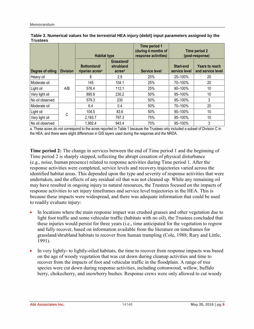
Memorandum
Abt Associates Inc. 14148 May 26, 2016 | pg 9
Table 3. Numerical values for the terrestrial HEA injury (debit) input parameters assigned by the Trustees
Degree of oiling Division
Habitat type
Time period 1 (during 4 months of response activities)
Time period 2 (post-response)
Bottomland/ riparian acresa
Grassland/ shrubland
acresa Service level Start-end
service level Years to reach
end service level
Heavy oil
A/B
8 2.9 25% 25–100% 20
Moderate oil 145 104.1 25% 70–100% 20
Light oil 576.4 112.1 25% 90–100% 10
Very light oil 895.8 230.2 50% 95–100% 10
No oil observed 579.3 230 50% 95–100% 3
Moderate oil
C
6.4 0.4 50% 70–100% 20
Light oil 104.5 83.6 50% 90–100% 10
Very light oil 2,183.7 797.3 75% 95–100% 10
No oil observed 1,992.4 943.4 75% 95–100% 3
a. These acres do not correspond to the acres reported in Table 1 because the Trustees only included a subset of Division C in the HEA, and there were slight differences in GIS layers used during the response and the NRDA.
Time period 2: The change in services between the end of Time period 1 and the beginning of Time period 2 is sharply stepped, reflecting the abrupt cessation of physical disturbance (e.g., noise, human presence) related to response activities during Time period 1. After the response activities were completed, service levels and recovery trajectories varied across the identified habitat areas. This depended upon the type and severity of response activities that were undertaken, and the effects of any residual oil that was not cleaned up. While any remaining oil may have resulted in ongoing injury to natural resources, the Trustees focused on the impacts of response activities to set injury timeframes and service level trajectories in the HEA. This is because these impacts were widespread, and there was adequate information that could be used to readily evaluate injury:
In locations where the main response impact was crushed grasses and other vegetation due to light foot traffic and some vehicular traffic (habitats with no oil), the Trustees concluded that these injuries would persist for three years (i.e., time anticipated for the vegetation to regrow and fully recover, based on information available from the literature on timeframes for grassland/shrubland habitats to recover from human trampling (Cole, 1988; Rury and Little, 1991).
In very lightly- to lightly-oiled habitats, the time to recover from response impacts was based on the age of woody vegetation that was cut down during cleanup activities and time to recover from the impacts of foot and vehicular traffic in the floodplain. A range of tree species were cut down during response activities, including cottonwood, willow, buffalo berry, chokecherry, and snowberry bushes. Response crews were only allowed to cut woody

Memorandum
Abt Associates Inc. 14148 May 26, 2016 | pg 10
vegetation that was up to one inch in diameter as a part of the removal of oiled vegetation. Based on a review of the literature, a one-inch diameter tree may range in age from 7 to 20 years for the affected tree species (Marquis, 1990; Overton, 1990; Tahvanainen, 1996; Lesica and Miles, 2001; Willms et al., 2006; Agriculture and Agri-Food Canada, 2011; Garden Guides, 2013a, 2013b). The Trustees set the recovery period based on the time for woody vegetation to regrow to a 1-inch diameter trunk size and the time for vegetation and soils to recover from impacts caused by heavier foot and vehicle traffic (Cole, 1988; Efroymson et al., 2003 and references therein), and used an intermediate value of 10 years (Table 3).
In moderate to heavy oiled habitats, the Trustees concluded that the more extensive response activities, including the impacts of multiple staging grounds, temporary roads, and vehicular tracks in floodplain habitats would require a longer recovery period, and accordingly set the injury timeframe to 20 years in the HEA, based on a review of the literature on these types of impacts in similar habitats (Table 3; Cole, 1988; Efroymson et al., 2003 and references therein).
Service levels at the start of Time period 2 were set based on the Trustees’ review of the available response information and data, and their best professional judgement on the severity of the impacts to habitat vegetation (Table 3). The service level at the end of Time period 2 for all habitats was set to 100%, representing the Trustees’ understanding that at this time, the habitats would return to baseline conditions. Given the service losses, acreages, and timeframes in Table 3, the total terrestrial debit associated with injuries in the Yellowstone River floodplain is 3,239 DSAYs.
1.4 Terrestrial HEA Credit Input Parameters
Here we describe the HEA credit input parameters and scaled restoration.
Restoration Types
The Trustees identified three types of restoration that could provide benefits to appropriately offset the losses that occurred in the Yellowstone River floodplain. These restoration types were used in the HEA to quantify how much restoration was needed to compensate for the habitat losses associated with the oil spill and response actions in the floodplain:
Bottomland/riparian habitat restoration concept: Acquire and restore cottonwood regeneration habitat degraded by grazing practices and invasive species, with “moderate” and “high” intensity restoration options ˗ High-intensity restoration includes installing fencing to reduce grazing pressure and
noxious weed control ˗ Moderate-intensity restoration includes noxious weed control (assumed to occur in
locations where grazing does not affect cottonwood regeneration habitat)
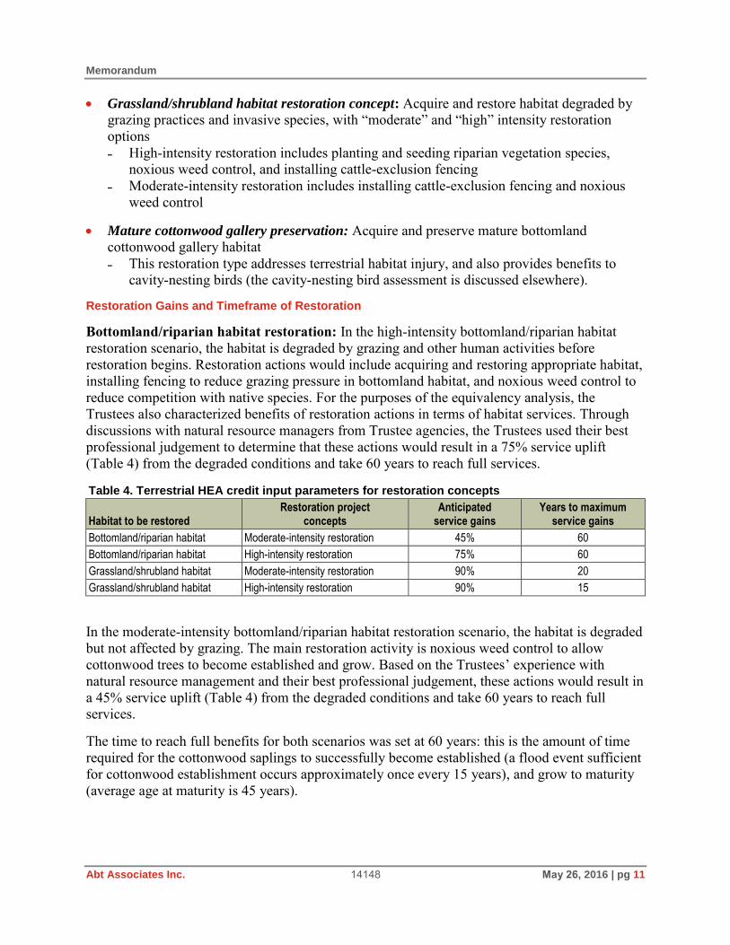
Memorandum
Abt Associates Inc. 14148 May 26, 2016 | pg 11
Grassland/shrubland habitat restoration concept: Acquire and restore habitat degraded by grazing practices and invasive species, with “moderate” and “high” intensity restoration options ˗ High-intensity restoration includes planting and seeding riparian vegetation species,
noxious weed control, and installing cattle-exclusion fencing ˗ Moderate-intensity restoration includes installing cattle-exclusion fencing and noxious
weed control
Mature cottonwood gallery preservation: Acquire and preserve mature bottomland cottonwood gallery habitat ˗ This restoration type addresses terrestrial habitat injury, and also provides benefits to
cavity-nesting birds (the cavity-nesting bird assessment is discussed elsewhere).
Restoration Gains and Timeframe of Restoration
Bottomland/riparian habitat restoration: In the high-intensity bottomland/riparian habitat restoration scenario, the habitat is degraded by grazing and other human activities before restoration begins. Restoration actions would include acquiring and restoring appropriate habitat, installing fencing to reduce grazing pressure in bottomland habitat, and noxious weed control to reduce competition with native species. For the purposes of the equivalency analysis, the Trustees also characterized benefits of restoration actions in terms of habitat services. Through discussions with natural resource managers from Trustee agencies, the Trustees used their best professional judgement to determine that these actions would result in a 75% service uplift (Table 4) from the degraded conditions and take 60 years to reach full services.
Table 4. Terrestrial HEA credit input parameters for restoration concepts
Habitat to be restored Restoration project
concepts Anticipated
service gains Years to maximum
service gains
Bottomland/riparian habitat Moderate-intensity restoration 45% 60
Bottomland/riparian habitat High-intensity restoration 75% 60
Grassland/shrubland habitat Moderate-intensity restoration 90% 20
Grassland/shrubland habitat High-intensity restoration 90% 15
In the moderate-intensity bottomland/riparian habitat restoration scenario, the habitat is degraded but not affected by grazing. The main restoration activity is noxious weed control to allow cottonwood trees to become established and grow. Based on the Trustees’ experience with natural resource management and their best professional judgement, these actions would result in a 45% service uplift (Table 4) from the degraded conditions and take 60 years to reach full services.
The time to reach full benefits for both scenarios was set at 60 years: this is the amount of time required for the cottonwood saplings to successfully become established (a flood event sufficient for cottonwood establishment occurs approximately once every 15 years), and grow to maturity (average age at maturity is 45 years).

Memorandum
Abt Associates Inc. 14148 May 26, 2016 | pg 12
Grassland/shrubland habitat restoration: For the high-intensity grassland/shrubland restoration scenario, the starting land condition is active or former agricultural land that provides minimal ecological services. The restoration actions would include acquiring and protecting land, planting and seeding native vegetation species, noxious weed control, and installing cattle-exclusion fencing. Based on their experience with natural resource management and best professional judgement, the Trustees concluded that these actions would result in a 90% service uplift (Table 4) from the starting conditions and take 15 years to achieve full restoration benefits.
For the moderate-intensity grassland/shrubland habitat restoration scenario, the starting land condition is active or former agricultural land that provides minimal ecological services. Restoration actions would include acquiring and protecting land, installing cattle-exclusion fencing, and noxious weed control. Based on the Trustees’ experience with natural resource management and their best professional judgement, these actions will result in a 90% service uplift (Table 4) from the starting conditions. The Trustees concluded that without active vegetation planting, it will take 20 years to achieve full restoration benefits for this scenario.
Mature cottonwood gallery preservation: The Trustees based their quantification of benefits from preserving mature cottonwood gallery habitat on an avoided risk of development of 7%. The avoided risk of 7% over 41 years was based on the likelihood of timber harvesting, as reported by DTM Consulting and Boyd (2008). The recovery timeframe of 41 years is based on the time over which closed timber habitat degradation was observed along the affected reach of the Yellowstone River (DTM Consulting and Boyd, 2008). This restoration type was specifically included in the terrestrial HEA because the preservation of standing dead trees within mature cottonwood gallery habitat also provides benefits to cavity-nesting birds, and these benefits were quantified to offset avian injuries (described elsewhere).
Scaled Restoration
The amount of restoration required to offset injuries is summarized in Table 5. In the HEA, the Trustees applied a 50/50 mix of the moderate and high-intensity restoration scenarios for the bottomland and grassland/shrubland restoration options.
Table 5. Amount of restoration required to offset injuries
Restoration concept Acres of restoration required to offset injuries
Bottomland/riparian restoration 299
Grassland/shrubland restoration 42
Mature cottonwood gallery preservation 142
Total 483
a. This restoration also provides benefits for cavity-nesting birds, which are discussed elsewhere.
Using the injury input parameters described in Section 1.3 (Table 3) and the restoration input parameters described in this section (Table 4), the Trustees’ analysis showed that a total of 483 acres of restoration (299 acres of bottomland/riparian restoration, 42 acres of grassland/shrubland restoration, and 142 acres of mature cottonwood gallery preservation) is

Memorandum
Abt Associates Inc. 14148 May 26, 2016 | pg 13
needed to offset the terrestrial debit of 3,239 DSAYs associated with injuries in the Yellowstone River floodplain (Table 5). Specifically, the bottomland/riparian restoration offsets 2,160 DSAYs, the grassland/shrubland restoration offsets 865 DSAYs, and the mature cottonwood gallery preservation offsets 214 DSAYs.
2. LWD REA
Here we describe the LWD REA that the Trustees developed to quantify injuries to LWD and scale restoration. We briefly describe the role of LWD in the Yellowstone River system and the impacts of the spill and response activities to LWD piles (Section 2.1). We then provide a brief overview of REA (Section 2.2), followed by a description of the LWD REA debit input parameters and injury quantification (Section 2.3), and the credit input parameters and scaling (Section 2.4).
2.1 Overview of LWD and Injuries due to Oil and Response Activities
A large number of LWD piles were oiled as a result of the spill, and these piles were subsequently targeted for removal and other cleanup actions during response activities. Accordingly, the Trustees evaluated injuries to the LWD piles, focusing mainly on the impacts of response activities, because removal of debris and other cleanup actions likely had the most severe and long-lasting impact on the piles.
LWD piles are distributed throughout the reach of the Yellowstone River downstream of the spill site (Figure 4), and these piles play an integral role in geomorphic fluvial and ecological processes in large, free-flowing, braided river systems such as the Yellowstone River. The fluvial-geomorphic importance of LWD piles includes that they support island formation and help to reduce erosion on islands and along the riverbanks (Abbe and Montgomery, 1996). LWD piles are also an important and unique source of shelter and food for fish, invertebrates, small mammals (e.g., mink), birds, reptiles, and amphibians; and provide surface area for the growth of aquatic invertebrates, which are an important food source for fish (Culp et al., 1996; Jacobson et al., 1999). LWD piles are also a source of organic material and nutrients in both aquatic and terrestrial settings, which are released as the debris breaks down and decomposes (Table 6; Bilby and Likens, 1980; Hilderbrand et al., 1996). Finally, LWD piles provide depositional habitat exposed to sunlight that supports cottonwood regeneration and protection from ice-scouring in winter; these are important ecological functions on the Yellowstone River (Lytle and Merritt, 2004; Mitchell et al., 2008).
Injuries due to Oiling
The presence of oil on LWD piles reduced the quality of the ecological services they provide, and directly harmed biota that used or came into contact with oiled LWD (Figure 5). Many of the biological receptors that rely upon these piles, including birds, reptiles/amphibians, and invertebrates, were exposed to oil from the spill. For example, most of the oiled toads that were collected during wildlife recovery were found at LWD piles.

Memorandum
Abt Associates Inc. 14148 May 26, 2016 | pg 14
Figure 4. Two examples of undisturbed LWD piles downstream of the spill site. Panel A shows a close-up of an undisturbed LWD pile, and Panel B shows an aerial view of an undisturbed LWD complex in the Yellowstone River. Photo credit: USFWS (A) and Response Team (B), provided by MT Natural Resource Damage Program.
(A)
(B)

Memorandum
Abt Associates Inc. 14148 May 26, 2016 | pg 15
Table 6. Important ecological functions provided by LWD
Type of service Services provided
Terrestrial ecological services Shelter
Food
Organic material
Habitat (small invertebrates and small mammals)
Aquatic ecological services Fish-rearing habitat
Surface area for aquatic invertebrates
Organic material
Flow refugia
Shade/shelter
Geomorphological services Water pools
Island formation
Cottonwood regeneration
Erosion reduction
Channel morphology alteration
Figure 5. Heavily oiled debris pile near the spill site. This very large pile on an island just downstream of the pipeline break was cut and disassembled using heavy equipment to remove pooled oil and oiled debris. Photo credit: MDEQ.

Memorandum
Abt Associates Inc. 14148 May 26, 2016 | pg 16
Injuries to LWD Related to Response Actions
LWD piles were also injured by response actions. The Trustees conducted two LWD surveys in the spring and fall of 2012 to document examples of the types of response actions that were taken at LWD piles. The Trustees also conducted a review of aerial imagery to identify piles that were affected by oiling and subsequent response activities, based on pre- and post- spill imagery. Based on observations made by the Trustees during the surveys and from the aerial imagery, there were 28 piles between the spill point and the City of Billings (a distance of approximately 15 miles) that were oiled and targeted during response activities.
Disturbance ranged from cutting and hauling away oiled debris, to disassembling piles. Branches were removed, and large logs were cut into smaller pieces, resulting in permanent damage (Figure 6). Removing LWD material reduced the size and value of habitat provided by the remaining LWD, and also caused adverse changes in the geomorphic and fluvial services provided by LWD piles, such as increased erosion, reduced sediment retention, and lost aquatic habitat (e.g., fewer pools or velocity refugia). Dismantled and scattered piles provide less cover and, thus, lower-quality habitat than intact piles; biota inhabiting these piles are more vulnerable to predation and other environmental stressors. Further, disassembling a pile changes its physical structure (e.g., anchoring, complexity, ability to trap/recruit new material, ability to remain anchored in place in subsequent events) and thus its geomorphological functions.
Finally, removing material and disassembling piles negatively affected cottonwood regeneration in 2011. The summer 2011 flood was a significant event for cottonwood regeneration, and while this injury was not formally quantified by the Trustees, the loss of LWD may have reduced the amount of suitable cottonwood regeneration habitat downstream of the spill site.
2.2 REA
REA is a restoration scaling technique based on the same conceptual framework as HEA, described in Section 1.2. Natural resource Trustees can use REAs to estimate the amount of restoration needed to compensate for injuries to a single natural resource rather than a habitat or ecosystem. REA calculations quantify injuries and restoration credits on a resource unit-basis, such as the number of injured individuals. Like HEA, REA can incorporate change in the conditions of a resource over time to address the temporal component of both injury debit and restoration credit.
REA inputs that may be used include:
Resource type injured and being restored Number or amount (e.g., volume in the case of LWD) of injured resource and number or
amount (volume) provided by the restoration action(s) Timeframe of the injury and the restoration benefits Quantum of loss (injury) and gain (restoration) Discount rate.

Memorandum
Abt Associates Inc. 14148 May 26, 2016 | pg 17
Figure 6. Pre-response (Panel A, photograph from 2011 before the spill) and post-response (Panel B, photograph from 2013) aerial photographs of the same LWD piles. In the post-response image, materials from both piles in the yellow circles had been cut, scattered, or removed. Photo credit: USDA 2009 Basemap, modified by Beau Downing, MT Natural Resource Damage Program.
(A)
(B)

Memorandum
Abt Associates Inc. 14148 May 26, 2016 | pg 18
In the case of the LWD REA, the Trustees based the REA on the volume of LWD injured and restored. Like with a HEA, on the debit side, the timeframe covers the full time period over which the injuries occur: losses accrue from the onset of the injury and continue until baseline conditions are achieved, whether through natural recovery, response activities, or a combination of the two. On the credit side, the timeframe covers the time required for restoration to be achieved and the duration for which the restoration continues to generate resources. Finally, like HEA, REA incorporates a discount rate (typically 3%) that compounds (past) and discounts (future) of losses and gains over time.
The typical unit of measurement for REA is expressed as a discounted-resource unit-year, where the “unit” is the quantified resource metric. In the case of LWD, the Trustees quantified the volume of LWD as 28 piles that were injured by the oil spill and response actions, and the unit of measure was a discounted-m3-year (DMY). In order to determine how much restoration is required to offset injuries, the REA model balances the number of injury units with the number of units accrued by restoration projects.
2.3 LWD REA Debit Input Parameters
This section presents the LWD REA debit input parameters and summarizes the resulting injury quantification (debit). Specifically, we describe the amount of the resource (LWD) injured, the timeframe, and the service loss for injuries that occurred in the floodplain. The Trustees used the standard 3% discount rate for their REA calculations.
Amount (Volume) of Injured LWD
As described above, 28 LWD piles located downstream of the spill site were injured by the oil spill and by response actions. The Trustees calculated the amount of LWD injured based on the volume of LWD piles affected. Injuries were quantified based on two categories of LWD pile losses: (1) LWD material that was removed altogether from the system during response activities; and (2) LWD piles that were disassembled and cut up during response activities, and were therefore no longer able to function as piles.
Amount of LWD removed from the river system (m3): The Trustees concluded that the LWD material removed from the piles and hauled away for offsite disposal was a 100% loss to the system. The amount of material permanently removed was estimated using available response data, which included the number and type of bags filled with oily debris that were hauled away for disposal. The removed volume of LWD was calculated for each bag type by multiplying the volume of the bag by the number of bags, and then summing across all bag types. The total estimated volume of removed LWD was 2,624 m3 (Table 7). This amount represents the minimum amount of LWD materials that was removed, as the ARCADIS (2011) report that summarized response activities indicated that the records of bags of debris removed were incomplete. In particular, removals during the first few days of response activities were not recorded.

Memorandum
Abt Associates Inc. 14148 May 26, 2016 | pg 19
Table 7. Estimated minimum volume of LWD permanently removed during response actions
Bag type Bag volume
(m3) Total number of bags that contained LWD
Total volume (m3)
Super sack 0.765 119 91
Oily debris bag 0.132 18,483 2,443
Woodchip bag 0.133 135 18
Contaminated wood bag 0.132 544 72
Total estimated volume removed 2,624
Amount of LWD that was affected by dismantling piles (m3): In order to estimate the total volume of LWD that remained in the fluvial system but was adversely affected by response activities, the Trustees used information they gathered during their 2012 field surveys. During these field surveys, the field crews measured the dimensions of 13 disturbed LWD piles and used those observations to estimate the average volume for an individual pile (816.5 m3). The average per-pile volume was multiplied by 28, which results in a total disturbed volume of 22,862 m3.
Based on field observations and aerial imagery, the Trustees concluded that roughly 40% of the woody debris from the dismantled piles (9,145 m3) would be reincorporated into LWD piles in the future, but that 60% of the debris (13,718 m3) was cut into such short, “clean” pieces (short lengths, side branches cut off, etc.), that it would no longer function as pile material, and therefore was effectively a 100% loss to the system (see Figure 5).
Injury Timeframe
The LWD material that was hauled away for disposal and permanently removed from the river system (2,624 m3) was treated as a permanent loss in perpetuity in the REA calculation.
The LWD in disturbed piles had two different fates. The 60% that was permanently lost was treated as a 100% loss in perpetuity in the REA. For the remaining 40%, the Trustees concluded, based on their observations from previous flood events on the river and a review of historical aerial photographs, that a 15-year flood event (corresponding to approximately 63,000 cfs; USGS, 2016) would be sufficient to transport and redistribute the disturbed debris back into LWD piles. The Trustees estimated that it would take two such events to ensure that all disturbed wood was recruited into piles, for a total recovery period of 30 years.
Given the LWD losses and timeframes described above, the total injury DMYs are 623,976: permanently removed material accounts for 84,756 DMYs and disturbed material accounts for 539,220 DMYs.
2.4 LWD REA Credit Input Parameters
The Trustees identified one primary restoration concept that would compensate for the lost and disturbed LWD. This concept includes obtaining erosion and logging conservation easements on cottonwood bottomland habitat. The purpose of the easement is to allow natural fluvial erosional

Memorandum
Abt Associates Inc. 14148 May 26, 2016 | pg 20
processes to occur that will provide a source of LWD pile material to the system through falling trees in the future. The easement could be placed on actively eroding shorelines to preserve the naturally occurring erosional process or on locations with hard armoring and rip-rap. In the latter case, the restoration would include removing the hard armoring and rip-rap to allow erosional processes to resume. These easements would specifically focus on erosion and logging; they would not preclude grazing, farming, or other agricultural practices, and thus would not be considered habitat easements.
The volume of LWD restored was determined by developing a LWD loading rate (volume of LWD/acre/year) for the floodplain. This loading rate was used to calculate the number of habitat acres required to produce (over time) the volume of LWD piles necessary to offset the injuries. The number of cottonwood trees that would fall into the river was calculated using a literature-based shoreline erosion rate and literature-based values for the density of cottonwood stands. The shoreline erosion rates are from the State of Montana Channel Mitigation Zone (CMZ) report for the reach upstream of Billings (Yellowstone River Conservation District Council, 2009). The cottonwood density calculation was based on data collected from the Missouri River in Montana, which supports cottonwood habitat similar to that along the Yellowstone River (Scott et al., 1997). Using this approach, the LWD loading rate used in the REA was 28 m3/acre/year.
The restoration timeframe is based on the understanding that LWD will likely enter the river in a pulsed fashion, during flood events of a magnitude that occurs approximately every 15 years (corresponding to approximately 63,000 cfs; USGS, 2016). Thus, in the credit calculation, LWD material was added to the system in 7 discrete events: once every 15 years over 100 years (Swanson and Lienkaemper, 1980; Gottesfeld and Gottesfeld, 1990). The volume of material contributed was used to determine the number of acres of restoration required to offset the injuries.
Using these REA input parameters, the Trustees determined that 958 acres of restoration would be required to offset LWD injuries. This amount of restoration would offset the calculated debit of 623,976 DMYs.
3. Fish Health Injury Studies and Data Analyses
Based on wildlife recovery data collected during response activities, many aquatic biological resources were adversely affected by the spill. This included 83 fish, 121 amphibians, 13 snakes, and 2 turtles that were oiled or dead subsequent to the spill (MDEQ, 2012). The Trustees selected fish as a representative species for their instream assessment. Fish were chosen because the Trustees had the most robust dataset for fish compared to other species, and fish are a key component of the ecosystem and are excellent indicators of instream ecosystem health.
To assess injuries to fish, the Trustees completed three fish health study investigations. Section 3.1 summarizes the fish health studies and Section 3.2 summarizes the data analysis and results from those studies.

Memorandum
Abt Associates Inc. 14148 May 26, 2016 | pg 21
3.1 Summary of Fish Health Studies
The Trustees conducted three fish health studies: one in September 2011, followed by a second study in April 2012, and a final study in September 2012.
In September 2011, approximately 90 days after the spill, the natural resource Trustees collected fish to investigate general fish health and exposure to oil contaminants. This study was conducted in Divisions A through C and at an upriver reference area located approximately 6 miles upstream of the spill site. In April 2012, the Trustees conducted a second fish health near the spill site in Division A (approximately 5 river miles downriver from the spill site) prior to the annual high-water flow. In September 2012, the Trustees conducted a cooperative fish health study with EMPCo in Divisions A through C (extending approximately 50 river miles downriver of the spill site), and two reference sites, located 6 and 30 miles upriver from the spill site.
In the September 2011 study, fish were collected using boat-mounted electrofishing equipment. The species targeted for the study included:
Brown trout (Salmo trutta) Goldeye (Hiodon alosoides) Longnose sucker (Catostomus catostomus) Mountain whitefish (Prosopium williamsoni) Rainbow trout (Oncorhynchus mykiss) Shorthead redhorse (Moxostoma macrolepidotum).
Gross observations (such as length, general condition, frayed fins, lesions) were made for all fish collected. Samples from the target species were collected and analyzed for bacteriology, virology, and histology. Specifically, gill, liver, kidney, gonad, skin, and muscle tissue samples were collected for histological assessments. Tissue samples were also collected from the liver, gonad, and bile for chemical analyses if there was enough remaining after the histology samples were collected.
The Trustees conducted the second fish health study between the ice-off and the spring high water, on April 25 and May 11, 2012. This was an abridged study that focused on two collection locations: one reach in Division A between the spill site to 5 miles downriver, and one reach upriver in a reference area 15 miles upstream of the spill site. This study targeted two fish species: shorthead redhorse and rainbow trout. For this sampling effort, the Trustees collected blood smears for hematology, otoliths for microchemistry, and liver tissue for CYP1A expression analysis in addition to the fish and tissue samples collected during the fall 2011 sampling effort described above.
The final fish health study was a cooperative effort between the Trustees and EMPCo conducted between September 19 and 27, 2012. This study encompassed a larger geographical extent than the two previous fish health studies and expanded on the types of samples collected. Fish were collected at a reference location approximately 30 miles upstream of the spill site and as far as 50 miles downstream of the spill site. During this study, adult and sub-adult fish were collected
Memorandum
Abt Associates Inc. 14148 May 26, 2016 | pg 22
using boat-mounted electrofishing equipment and small rough and forage fish were collected from shallow-water habitats using backpack electrofishing equipment. The same types of samples were collected and analyses were performed on the fish as in the spring of 2012.
3.2 Fish Health Studies Data Analysis and Results
Results of the three fish health studies confirmed that the oil resulted in adverse effects to fish in the Yellowstone River downstream of the spill site (Table 8).
In particular, abnormalities were observed in skin (e.g., external lesions), gill, kidney, liver, and blood samples that have been associated with exposure to oil in studies reported in the literature (Table 8). Significant findings from histopathological assessments include:
External lesions and scars: In the fall of 2011, lesions were observed at a greater frequency at downriver sites than upriver sites (Table 8). The lesions were deep with underlying dermal inflammation, and were not associated with bacteria, viruses, or fungi (Figure 7). Fish exposure to oil has been shown to be associated with the formation of lesions in published toxicological studies (Sved et al., 1997; Steyermark et al., 1999; Hargis, 2000; Aas et al., 2001; Khan, 2003, 2013). Some studies have shown that fish with lesions may have compromised immune systems (Esteban, 2012); and fish with lesions may also have reduced survival, growth, and reproduction potential (Benejam et al., 2010; Khan, 2013). By the fall of 2012, lesions were rare and mostly small. Scars (i.e., dark to light grey blotches or areas of abnormal, regenerating scales on the bodies of collected fish; Figure 6) were observed on some fish in the spring and fall 2012 studies, suggesting that these fish may have been exposed to the oil, and were recovering.
Kidneys: Observations in kidney histology samples from fish collected downstream of the spill site in the fall of 2011 included elevated macrophage aggregates and regeneration of kidney tubules (Table 8). An increase in macrophage aggregates indicates elevated red blood cell death. Kidney tubules are involved in ion exchange and are important in maintaining internal salt and water balance in freshwater fish (Jobling, 1995). Fish have the ability to regenerate new tubules when damaged or stressed. Therefore, an observation of increased tubule regeneration is consistent with exposure to toxicants like oil. Observations were also made of sclerotic glomeruli in the kidney nephrons. The presence of sclerotic glomeruli indicates damage to the nephrons. Damage to tubules and nephrons can interfere with ion exchange, reduce clearance of waste products from the bloodstream, and injure surrounding kidney tissues (McKee and Wingert, 2015). By the fall of 2012, these observations were rare. Tubule pathology changes have been associated with slight increases in mortality and significant decrease in growth and condition factors after exposure to polycyclic aromatic hydrocarbons (PAHs; Vethaak et al., 1994; Kakkar et al., 2011) or other toxicants (Tashjian et al., 2006).

Me
mo
ran
du
m
A
bt
As
so
cia
tes
In
c.
1414
8 M
ay 2
6,
20
16
| p
g 2
3
Tab
le 8
. S
um
mary
of
fish
healt
h s
tud
y h
isto
log
y r
esu
lts
Eff
ect
Fal
l 201
1 S
pri
ng
201
2 F
all 2
012
Up
rive
r,
Bu
ffal
o
Mir
age
Div
. A
Div
. B
Div
. C,
Eas
t B
rid
ge
Up
rive
r,
Par
k C
ity
D
iv. A
U
pri
ver,
C
olu
mb
us
Up
rive
r,
Bu
ffal
o
Mir
age
Div
. A
Div
. B
Div
. C,
Eas
t B
rid
ge
Div
. C,
Bu
nd
y B
rid
ge
Ext
erna
l les
ions
0.
9%
12
%
2.2
%
21%
0.
0%
2.
2%
0.
7%
0.
5%
0.
8%
1.
3%
1.1
%
3.0
%
Kid
ney
mac
roph
age
aggr
egat
es
8.7
%
20%
50
%
36%
11
%
55%
0.
0%
0.
0%
0.
0%
0.
0%
0.
0%
0.
0%
Scl
erot
ic g
lom
erul
i in
kidn
ey n
eph
rons
4.
3%
37
%
25%
32
%
0.0
%
27%
33
%
18%
67
%
67%
25
%
52%
Reg
ener
atin
g ki
dney
tubu
les
4.3
%
26%
42
%
41%
0.
0%
41
%
8.3
%
9.1
%
13%
4.
2%
8.
3%
0.
0%
Ple
omor
phic
hep
atoc
yte
nucl
ei in
the
liver
0.
0%
23
%
36%
17
%
0.0
%
26%
0.
0%
0.
0%
0.
0%
0.
0%
4.
2%
0.
0%
Live
r bi
le d
uct n
ecro
sis
4.
3%
23
%
7.1
%
30%
4.
8%
22
%
0.0
%
0.0
%
0.0
%
0.0
%
8.3
%
0.0
%
Hem
ocyt
obla
sts
(ave
rage
num
ber
of b
last
ce
lls c
ount
ed o
n bl
ood
smea
rs)
Not
sam
pled
0.
0 5.
4 0.
0 0.
0 0.
0 0.
0 0.
0 0.
0
Imm
atur
e re
d bl
ood
cells
(av
erag
e nu
mbe
r of
cel
ls c
ount
ed o
n bl
ood
smea
rs)
Not
sam
pled
10
80
7.
2 4.
2 9.
4 6.
3 16
5.
2

Memorandum
Abt Associates Inc. 14148 May 26, 2016 | pg 24
Figure 7. Photograph of an external lesion observed on a shorthead redhorse collected in summer 2011 downriver from the spill site (A), and scarring/regenerating scales observed on a shorthead redhorse collected in spring 2012 downriver from the spill site (B). Photo credit: MT FWP.
(A)
(B)

Memorandum
Abt Associates Inc. 14148 May 26, 2016 | pg 25
Liver: Necrosis (tissue death) of bile ducts was observed in fish collected in the fall of 2011 (Table 8). The liver is the primary organ for metabolism and excretion of toxic components of oil; PAHs (Tuvikene, 1995). Tissue damage occurs during metabolism when PAHs are transformed into toxic metabolites and reactive oxygen species are produced. Changes in liver hepatocytes were also observed and included pleomorphic nuclei (variation in the size and shape of cell nucleus) and vacuolation (cellular swelling). These observations have been previously associated with oil exposure in fish livers (Agamy, 2012; Biuki et al., 2013). The lack of glycogen or fat storage was observed in all species. In the fall of 2012, bile duct necrosis was no longer remarkable in the collected fish samples.
Blood: In the spring of 2012 (blood samples were not collected in fall 2011), hemocytoblasts and high numbers of immature red blood cells were observed (Table 8). These pathology changes indicate damage to blood cells. Hemocytoblasts in particular are not observed in healthy fish (Clauss et al., 2008). Hemocytoblasts were not observed in any upriver fish. There were significantly fewer immature red blood cells and no blast cells observed in the fall of 2012.
Gills: Anecdotal observations of fused gill lamellae tips were also made at downriver sites in the fall of 2011 (Figure 8). This is significant, because fusion of the gill lamellae in fish is a known response to exposure to toxicants such as oil (Pacheco and Santos, 2002; Nero et al., 2006; Camargo and Martinez, 2007; Santos et al., 2011; Khan, 2013). In fish, gill lamellae are the primary surface where respiration (intake of oxygen) occurs. Fish with fused lamellae tips have a compromised respiratory system, and are therefore potentially less fit and may have reduced growth and reproduction potential (Khan, 2013).
Finally, while a major fish kill was not observed, 83 fish were collected subsequent to the spill, and it is possible that many more fish died but were not detected. Flows in the Yellowstone River at the time of the spill were 70,000 cfs and high flows lasted for an extended period of time. Due to these high flows, crews searching for fish and wildlife were not able to gain access to the river and begin searching for fish and other wildlife until two weeks after the spill.
Further, no formal fish kill survey was performed at the site, though dead fish were recovered opportunistically. Even if a fish kill survey had been performed in the hours after the spill, only a fraction of the fish that were killed would likely have been found. According to Southwick and Loftus (2003, p. 18), “Estimates of losses based on countable dead fish will be conservative. Very seldom will the counts represent more than a modest fraction of the fish killed.” For example, in simulated fish kill tests conducted in the East Fork Poplar Creek in Oakridge, Tennessee, only 5–30% of the fish were recovered after 24 hours, depending upon flow conditions, where the flow ranged from 3.5 to 28 cfs (Ryon et al., 2000). At the Beaver Butte Creek, Warm Springs, Oregon gasoline spill site, where 404 chinook yearlings were recovered, the Trustees for the site ultimately estimated that a total of 44,741 yearlings died as a result of the spill (NOAA, 2004). At the Cantara spill near Dunsmuir, California, where 586 fish were found dead in fish kill surveys conducted starting 4 days after the spill, the total estimated number of killed fish was 312,508 (Hankin and McCanne, 2000).
Hence, given the very high flows and long interval between the spill and the time fish recovery began, and the fact that only a small fraction of fish are typically ever recovered at fish kills, the 83 recovered fish may represent only a small fraction of the total fish that died as a result of the oil spill.

Memorandum
Abt Associates Inc. 14148 May 26, 2016 | pg 26
Figure 8. Photomicrograph of fused gill lamellae from a fish collected downriver from the spill site in fall 2011 (a); and normal, non-fused gill lamellae collected upriver from the spill site in fall 2011 (b). Photo credit: Headwater Fisheries, LLC.
(a)
(b)

Memorandum
Abt Associates Inc. 14148 May 26, 2016 | pg 27
References
Aas, E., J. Beyer, G. Jonsson, W.L Reichert, and O.K Andersen. 2001. Evidence of uptake, biotransformation and DNA binding of polyaromatic hydrocarbons in Atlantic cod and corkwing wrasse caught in the vicinity of an aluminium works. Marine Environmental Research 52(3):213–229.
Abbe, T.B. and D.R. Montgomery. 1996. Large woody debris jams, channel hydraulics and habitat formation in large rivers. Regulated Rivers: Research & Management 12:201–221.
Agamy, E. 2012. Histopathological changes in the livers of rabbit fish (Siganus canaliculatus) following exposure to crude oil and dispersed oil. Toxicologic Pathology 40:1128–1140. Available: http://tpx.sagepub.com/content/40/8/1128.full/. Accessed 4/13/2016.
Agriculture and Agri-Food Canada. 2011. Trees and Shrubs for Agroforestry on the Prairies: Choke Cherry. Available: http://www4.agr.gc.ca/AAFC-AAC/display-afficher.do?id=1235600629132&lang=eng#a02-2. Accessed 4/26/2013.
ARCADIS. 2011. Summary of Assessment and Oil Removal Activities. Prepared for ExxonMobil Pipeline Company by ARCADIS G&M of North Carolina, Inc., Cary. November.
Benejam, L, J. Benito, and E. García-Berthou. 2010. Decreases in condition and fecundity of freshwater fishes in a highly polluted reservoir. Water Air Soil Pollut. 210:231–242. Available: http://cebcat-labalca.cat/documents/Benejam_etal_Flix.pdf. Accessed 4/1/2016.
Bilby, R.E. and G.E. Likens. 1980. Importance of organic debris dams in the structure and function of stream ecosystems. Ecology 61(5):1107–1113.
Biuki, N.A., A. Savari, M.S. Mortazavi, H. Zolgharnein, and N. Salamat. 2013. Liver histopathological changes in milkfish (Chanoschanos) exposed to petroleum hydrocarbon exposure. World Applied Sciences Journal 28(11):1627–1632. Available: http://www.idosi.org/wasj/wasj28(11)13/21.pdf. Accessed 4/13/2016.
Camargo, M.P. and C.B.R. Martinez. 2007. Histopathology of gills, kidney and liver of a neotropical fish caged in an urban stream. Neotrop. ichthyol. 5(3):Porto Alegre July/Sept.
Clauss, T.M., A. Dove, and J.E. Arnold. 2008. Hematological disorders in fish. Veterinary
Clinics Exotic Animal Practice 11:445–462. Available: https://www.researchgate.net/publication/230801423_Hematologic_disorders_of_fish. Accessed 4/13/2016.
Cole, D.N. 1988. Disturbance and Recovery of Trampled Montane Grassland and Forests in Montana. Research Paper INT-389. United States Department of Agriculture Forest Service, Intermountain Research Station, Ogden, UT. March.
Culp, J.M., G.J. Scrimgeour, and G.D. Townsend. 1996. Simulated fine woody debris accumulations in a stream increase rainbow trout fry abundance. Transactions of the American
Fisheries Society 125:472–479.
Douben, P.E.T. (ed.). 2003. PAHs: An Ecotoxicological Perspective. John Wiley & Sons Ltd., England.

Memorandum
Abt Associates Inc. 14148 May 26, 2016 | pg 28
DTM Consulting and K. Boyd. 2008. Yellowstone River Riparian Vegetation Mapping. Prepared for Custer County Conservation District and Yellowstone River Conservation Council. Available: ftp://ftp.geoinfo.msl.mt.gov/Documents/Projects/Yellowstone_River_Clearinghouse/Riparian_Full_River_Final_Report_082608.pdf. Accessed 4/14/2016.
Efroymson, R.A., J.P. Nicolette, and G.W. Suter II. 2003. A Framework for Net Environmental Benefit Analysis for Remediation or Restoration of Petroleum-Contaminated Sites. Prepared for the U.S. Department of Energy by Oak Ridge National Laboratory managed by UT-Battelle, LLC for the U.S. Department of Energy. January.
Esteban, M.A. 2012. An overview of the immunological defenses in fish skin. International
Scholarly Research Network Immunology 2012 (Article ID 853470). Available: http://www.hindawi.com/journals/isrn/2012/853470/. Accessed 4/13/2016.
Garden Guides. 2013a. Russet Buffaloberry (Canadensis). Available: http://www.gardenguides.com/taxonomy/russet-buffaloberry-shepherdia-canadensis/. Accessed 4/26/2013.
Garden Guides. 2013b. Western Chokecherry (Demissa). Available: http://www.gardenguides.com/taxonomy/western-chokecherry-prunus-virginiana-var-demissa/. Accessed 4/26/2013.
Gottesfeld, A.S. and L.M.J. Gottesfeld. 1990. Floodplain dynamics of a wandering river, dendrochronology of the Morice River, British Columbia, Canada. Geomorphology 3:159–179.
Hankin, D.G. and D. McCanne. 2000. Estimating the number of fish and crayfish killed and the proportions of wild and hatchery rainbow trout in the Cantara spill. California Fish and Game 86(1):4–20.
Hargis, W. 2000. Dermal ulcerations and mortalities of estuarine fishes as indicators of environmental problems. Marine Environmental Research 50(1–5):487.
Hilderbrand, R.H., A.D. Lemly, C.A. Dolloff, and K.L. Harpster. 1996. Effects of large woody debris placement on stream channels and benthic macroinvertebrates. Canadian Journal of
Fisheries and Aquatic Sciences 54:931–939.
Jacobson, P.J., K.M. Jacobson, P.L. Angermeier, and D.S. Cherry. 1999. Transport, retention, and ecological significance of woody debris within a large ephemeral river. Journal of the North
American Benthological Society 18(4):429–444.
Jean, C. and S. Crispin. 2001. Inventory of Important Biological Resources in the Upper Yellowstone River Watershed. Report to the Environmental Protection Agency. Montana Natural Heritage Program. June. Available: http://mtnhp.org/plants/reports/Yellowstone.pdf. Accessed 1/4/2012.
Jobling, M. 1995. Environmental Biology of Fishes. Chapman and Hall, Fish and Fisheries Series 16, London, UK.

Memorandum
Abt Associates Inc. 14148 May 26, 2016 | pg 29
Kakkar, P.H., R.M. Saxena, and M. Pandey. 2011. Chronic toxicity of petroleum hydrocarbons on fresh water fish Channa Punctatus with special reference to biological parameters. New York
Science Journal 4(8).
Khan, R.A. 2003. Health of flatfish from localities in Placentia Bay, Newfoundland, contaminated with petroleum and PCBs. Arch Environ Contam Toxicol 44:485–492.
Khan, R.A. 2013. Effects of polycyclic aromatic hydrocarbons on sexual maturity of Atlantic cod, Gadus morhua, following chronic exposure. Environment and Pollution 2(1).
Lesica, P. and S. Miles. 2001. Natural history and invasion of Russian olive along eastern Montana rivers. Western North American Naturalist 61(1):1–10.
Lytle, D.A. and D.M. Merritt. 2004. Hydrologic regimes and riparian forests: A structured population model for cottonwood. Ecology 85:2493–2503.
Marquis, D.A. 1990. Prunus serotina Ehrh. Black cherry. In Silvics of North America. Volume 2. Hardwoods. Agriculture Handbook 654. Forest Services, U.S. Department of Agriculture. December. pp. 594–604. Available: http://books.google.com/books?id=bMnRqCA3uzwC&pg=PA41&lpg=PA41&dq=boxelder+ronald+p+overton&source=bl&ots=Jfhmp2faqt&sig=jveUDcYKe3T0K1N3_Qi_yw7cfxE&hl=en&sa=X&ei=Su04UcL3BsKU0QHCnIHoAg&ved=0CD0Q6AEwAw. Accessed 4/14/2016.
McKee, R.A. and R.A. Wingert. 2015. Zebrafish renal pathology: Emerging models of acute kidney injury. Curr Pathobiol Rep 3(2):171–181. Available: http://www.ncbi.nlm.nih.gov/pmc/articles/PMC4419198/. Accessed 4/13/2016.
MDEQ. 2012. Silvertip Pipeline Crude Oil Release: Site Update. Montana Department of Environmental Quality. January. Available: http://deq.mt.gov/StateSuperfund/silvertipoilspill/default.mcpx. Accessed 10/2012.
Mitchell, W., J. O’Neil, and A. Webb. 2008. Cottonwoods of the Midwest: A Community Profile. Technical Note. Prepared by Engineer Research and Development Center Vicksburg MS Geotechnical and Structures Lab. May. Available: file:///C:/Users/ebbetsa/Downloads/ADA482000.pdf. Accessed 4/11/2016.
Nero, V., A. Farwell, A. Lister, G. Van Der Kraak, L.E.J. Lee, T. Van Meer, M.D. MacKinnon, and D.G. Dixon. 2006. Gill and liver histopathological changes in yellow perch (Perca
flavescens) and goldfish (Carassius auratus) exposed to oil sands process-affected water. Ecotoxicology and Environmental Safety 63:365–377.
NOAA. 2000. Habitat Equivalency Analysis: An Overview. Prepared by the National Oceanic and Atmospheric Administration Damage Assessment and Restoration Program. March 21, 1995. Revised October 4, 2000.
NOAA. 2004. ATI Beaver Creek Spill Natural Resource Damage Assessment and Restoration Summary. National Oceanic and Atmospheric Administration. July. Available: http://www.darrp.noaa.gov/northwest/beavercreek/pdf/Beaver_Creek_damage_assessment.pdf. Accessed 5/30/2013.

Memorandum
Abt Associates Inc. 14148 May 26, 2016 | pg 30
NPS. 1997. Environmental Contaminants Encyclopedia Crude Oil Entry. National Park Service, Water Resources Divisions, Water Operations Branch, Fort Collins, CO.
Overton, R.P. 1990. Acer negundo L. Boxelder. In Silvics of North America. Volume 2. Hardwoods. Agriculture Handbook 654. Forest Services, U.S. Department of Agriculture. December. pp. 41–45. Available: http://books.google.com/books?id=bMnRqCA3uzwC&pg=PA41&lpg=PA41&dq=boxelder+ronald+p+overton&source=bl&ots=Jfhmp2faqt&sig=jveUDcYKe3T0K1N3_Qi_yw7cfxE&hl=en&sa=X&ei=Su04UcL3BsKU0QHCnIHoAg&ved=0CD0Q6AEwAw. Accessed 4/14/2016.
Pacheco, M. and M.A. Santos. 2002. Biotransformation, genotoxic, and histopathological effects of environmental contaminants in European eel (Anguilla anguilla L.). Ecotoxicology and
Environmental Safety 53(3):331–347.
Pakova, V., K. Hilscherova, M. Feldmannova, and L. Blaha. 2006. Toxic effects and oxidative stress in higher plants exposed to polycyclic aromatic hydrocarbons and their N-heterocyclic derivatives. Environmental Toxicology and Chemistry 12:3238–3245.
Rury, P.M. and A.D. Little. 1991. Vegetated wetland regeneration along pipelines: Is replanting necessary? In Proceedings of the Eighteenth Annual Conference on Wetlands Restoration and
Creation, F.J. Webb (ed.). May 16–17.
Ryon, M.G., J.J. Beauchamp, W.K. Roy, E., Schilling, B.A. Carrico, and R.L. Hinzman. 2000. Stream dispersal of dead fish and survey effectiveness in a simulated fish kill. Transactions of
the American Fisheries Society 129(1):89–100.
Santos, T.C.A., V. Gomes, M.J. Passos, A.J.S. Rocha, R.B. Salaroli, and P. Van Ngan. 2011. Histopathological alterations in gills of juvenile Florida pompano Trachinotus carolinus
(Perciformes, Carangidae) following sublethal acute and chronic exposure to naphthalene. Pan-
American Journal of Aquatic Sciences 6(2):109–120.
Scott, M.L., G.T. Auble, and J.M. Friedman. 1997. Flood dependency of cottonwood establishment along the Missouri River, Montana, USA. Ecological Application 7(2):677–690.
Southwick, R.I. and A.J. Loftus. 2003. Investigation and Monetary Values of Fish and Freshwater Mussel Kills. American Fisheries Society Special Publication 30. Bethesda, MD.
Steyermark, A.C., J.R. Spotila, D. Gillette, and H. Isseroff. 1999. Biomarkers indicate health problems in brown bullheads from the industrialized Schuylkill River, Philadelphia. Transactions of the American Fisheries Society 128(2):238–338.
Sved, D.W., M.H. Roberts Jr., and P.A. Van Veld. 1997. Toxicity of sediments contaminated with fractions of creosote. Water Research 31(2):294–300.
Swanson, F.J. and G.W. Lienkaemper. 1980. Interactions among fluvial processes, forest vegetation, and aquatic ecosystems, South Fork Hoh River, Olympic National Park, Washington. In Proceedings of the 2d Conference on Scientific Research in the National Parks, 26–30 November 1979, San Francisco, CA. pp. 23–34.
Tahvanainen, L. 1996. Diameter growth models induced by competition for four Salix clone monocultures. Biomass and Bioenergy 11(2/3):167–175.

Memorandum
Abt Associates Inc. 14148 May 26, 2016 | pg 31
Tashjian, D.H., S.J. Teh, A. Sogomonyan, and S.S.O. Hung. 2006. Bioaccumulation and chronic toxicity of dietary L-selenomethionine in juvenile white sturgeon (Acipenser transmontanus). Aquatic Toxicology 79:401–409.
Tuvikene, A. 1995. Responses of fish to polycyclic aromatic hydrocarbons (PAHs). Annales
Zoologici Fennici 32(3):295–309. Available: http://www.annzool.net/PDF/anzf32/anz32-295-309.pdf. Accessed 4/13/2016.
USGS. 1999. Environmental Setting of the Yellowstone River Basin, Montana, North Dakota, and Wyoming. Water-Resources Investigations Report 98-4269. By R.B. Zelt, G. Boughton, K.A. Miller, J.P. Mason, and L.M. Gianakos. United States Geological Survey.
USGS. 2016. Montana Flood Frequency and Basin Characteristic Data. Available: http://wy-mt.water.usgs.gov/freq?page_type=site&site_no=06214500. Accessed 5/11/2016.
Vethaak, A.D., J.G. Jol, A. Meijboom, M.L. Eggens, T. Rheinallt, P.W. Wester, T. van de Zande, A. Bergman, N. Dankers, F. Ariese, R.A. Baan, J.M. Everts, A. Opperhuizen, and J.M. Marquenie. 1994. Skin and liver diseases induced in flounder (Platichthys flesus) after long-term exposure to contaminated sediments in large-scale mesocosms. Environ Health Perspect. 104(11).
Willms, C.R., D.W. Pearce, and S.B. Rood. 2006. Growth of riparian cottonwoods: A developmental pattern and the influence of geomorphic context. Trees 20:210–218.
Yellowstone River Conservation District Council. 2009. Yellowstone River Channel Migration Zone Mapping. Final Report. Billings, MT. Revised February 20.


Appendix D Bird Injury Assessment

1
AppendixDBirdInjuryAssessmentAftertheoilspill,atotalof28birdswerefounddead,51wereobservedoiled,andfouroiledbirdswerecaptured,cleanedandreleased.Someofthebirdsthatdiedorobservedoiledincludedwaterfowlandotheraquatic‐dependentspecies.Thesespecieswerelikelyoiledastheyfedandrestedonthespill‐impactedsectionoftheYellowstoneRiver.Otherspeciesofbirdssuchaspasserinesandraptorsthatwerealsooiledandwerelikelyexposedtooilintheaquaticorterrestrialenvironment,orboth.Sincemuchofthefloodplainwasinundatedwithwaterduringthespill,largeareasofYellowstoneRiverripariancorridorwasoiled,thisincludedinundatedvegetation,largewoodydebrispilesandnumerousbackwaterchannels.Astheriverrecededafterhighflows,alineofoiledvegetationwasevidentinmanyareas.Birdssuchasblack‐cappedchickadees,downywoodpeckers,andwhite‐breastednuthatchesthatutilizetheriparianareaoftheYellowstoneRiverwerelikelyoiledastheyforaged,collectednestmaterials,andrestedamongoilcoveredvegetation.Similarly,raptorspecieswereexposedtooilastheyforagedthroughoutoiledvegetationandinthecaseofbaldeagles,theycouldhavealsobeenexposedintheaquaticenvironmentastheyfishedinoil‐impactedsectionsoftheriver.Exposuretooilcancauseanumberofadverseeffectsinbirdsthatmayinclude,butarenotlimitedtohypothermiaduetoimpairedthermoregulation,inflammationofthegastrointestinallining,liverandkidneydisorders,andimpairedreproduction.1Becauseofthevarietyofspeciesimpactedbytheoilspill,theTrusteesdevelopedtwoseparateprojects.OnetoaddresstheonlyspeciesofbirdinjuredasaresultofthespillthatdoesnotbreedalongtheYellowstoneRivercorridor,theAmericanwhitepelicanandassociatedspecies.Allotherspeciesofbirdsinjuredwereaddressedwithanotherprojectforcavitynestingspecies.TheTrusteesestimatethatpelicaninjurieswouldbeoffsetbyreducedpredationatbreedingsiteselsewhereinMontana,andproposeatwoormoreyearprogramof:
Waterpurchases, Predatorreductionthroughfencing,and MonitoringasspecifiedintheDARP.
TheTrusteesestimatethattheinjurytocavitynestersandassociatedspecieswouldbeoffsetbypermanentprotectionofcottonwoodbottomlandhabitatsuitableforwoodpeckersandproposeaprogramof:
Conservationeasementsofsuitablehabitat,and Restorationofdegradedhabitat.
1Friend,MandJ.C.Franson.(eds.)1999.FieldManualofWildlifeDiseases:GeneralFieldProceduresandDiseaseofBirds.U.S.GeologicalSurvey,BiologicalResourcesDivisionInformationandTechnologyReport1999‐2001,RestonVirginia

2
PelicansForthepelicans,theTrusteesproposereducingpredationatnestingareasinnortheastMontana(MedicineLakeNWR,BowdoinNWR)throughfencingandwaterpurchases.WateradditionscanpreventlandbridgestoislandsfromformingindryyearsatBowdoinLake.OnlyaportionofthepelicansproducedinthesenestingareasspendtheirsecondandsubsequentyearsalongtheYellowstoneRiver.Aradio‐bandstudyatMedicineLakeNWR2reportedthattwooutoffiveradio‐taggedbirdsfledgedatMedicineLakeNWR(40%)laterappearedalongtheYellowstone.3PelicansbandedatBowdoinNWRshowedsimilarmigratorypatternstothosefromMedicineLakeNWR,thustheTrusteesassumethatlikewise40%ofBowdoinNWRpelicanswouldappearalongtheYellowstoneRiver.TheTrusteedata(shownforpelicansandassociatedbirdsinTable1)includeonecollecteddeadpelican,andfiveobservedoiledpelicans.Assumingan85%mortalityrateforoiledbirds4andapplyingmultipliersforsearcherefficiency,carcasspersistenceandunsearchedareas,theTrusteesestimateatotalof36deadpelicans.Assumingthatthese36pelicansintheYellowstonerepresent40%ofacohortfledgedelsewhere,theTrusteesseektoreplaceatotalof90adultpelicansatthebreedingareas.Basedonaveragereportedhatchingandfledglingsuccessrates,itisestimatedthat25%ofnestswilleachproduceanadultbird.5Thus,replacing90adultpelicanswouldrequireavoidingpredationfor365nests.TheAnnualNarrativefromMedicineLakeNWR6documentedreducedAmericanwhitepelicannestingfromthepresenceofacoyoteden.Thisresultedina75%reductioninnests,eitherthroughpredationornestabandonment.Thus,theTrusteesassumethatexcludinglargepredators,suchascoyotesfromthecolonyduringagivenbreedingseasonwouldavoidthe75%reductioninneststhatwouldotherwisehappen.Amuchsmallerreductioninnestswouldberealizedfromremovalsofraccoonsorskunks.
2Thiscolonyhasbeenbreedingsince1939,andisthelargestinMontanaandanimportantcontributortotheeasternmetapopulation.3Restani,M.andE.M.Madden.2005.MovementsofWhitePelicansbreedingatMedicineLakeNationalWildlifeRefuge,Montana.RefugeReportDCN:61530‐1‐J026.52pp.4ChalkPoint–FinalrestorationplanandenvironmentalassessmentfortheApril7,2000OilSpillatChalkPointonthePatuxentRiver,Maryland.November,2002.pp86.5Knopf,F.,andR.Evans.2004.AmericanWhitePelican(Pelecanuserythrorhynchos).TheBirdsofNorthAmericaOnline,57:1‐20.6U.S.FishandWildlifeService.1979.MedicineLakeNationalWildlifeRefuge,LamesteerNationalWildlifeRefuge,AnnualNarrativeReport,MedicineLake,MT.

3
ThenumberofnestsatBowdoinNWRvarieswidelyfromyeartoyear.Comparingthesepotentialavoidedlossestothe365nestsrequiredtoproduce90adultpelicansattherefugeindicatesthatforallbutthelowest‐occupancyyears(yearswithfewerthan487nests),asingleseasonofcoyoteexclusionwouldachievetherestorationgoal.7Asavailabledatashownoperiodsoftwoconsecutiveyearswithfewerthan487nests,theTrusteesassumethatatwo‐yearprogramofwater‐purchases,predatorexclusionasnecessary,andmonitoringwouldhaveahighlikelihoodofachievingtherestorationgoalof90adultpelicansattherefuge,ofwhich36areexpectedtoreturntotheYellowstoneRiverarea.Theproposedprojectswouldlikelybenefitotherinjuredspeciesinadditiontopelicans,includinggreatblueherons,Canadageese,mallards,northernshovelers,andring‐billedgulls.Table1.Spill‐RelatedBirdMortality:PelicansandAssociatedSpecies
Species CollectedDead ObservedOiled AssumedDead*Americanwhitepelican 1 5 36Greatblueheron 2 1 37Canadagoose 2 12 79Mallard 1 3 28Northernshoveler 0 1 4Ring‐billedgull 1 0 17*TheTrusteesassumean85%mortalityrateforoiledbirdsandapplymultipliersforsearcherefficiency,carcasspersistenceandunsearchedareas.CavitynestersSeveraloftheindividualsinjuredinthespillrequiretreecavitiesfornestingandroosting.Table2presentsasummaryofTrusteedataonthesebirds.Table2.Spill‐RelatedBirdMortality:Cavity‐nestingSpecies
Species CollectedDead ObservedOiled AssumedDead*Downywoodpecker 0 1 4Black‐cappedchickadee 0 2 8White‐breastednuthatch 0 1 4Greathornedowl 2 0 33Commonmerganser 0 4 15Woodduck 1 0 28*TheTrusteesassumean85%mortalityrateforoiledbirdsandapplymultipliersforsearcherefficiency,carcasspersistenceandunsearchedareas.Onlyadultbirds(andnottheiroffspringwereaccountedforbecausetheTrusteesusedahabitatequivalencyanalysisapproachinsteadofaresourceequivalencyanalysis,thelatterapproachtypicallyaccountingforbothavianadultandoffspringmortality).
7Excludingonlypredatorssmallerthancoyoteswouldlikelyresultinalowernumberofavoidedlosses.

4
TheTrusteesproposerestoringtheselostindividualsbypreservingsuitablehabitat,assumingthatadditionalacresofhabitatwillsupportincreasednumbersofthesespecies.Inparticular,theproposedprojectswillpreservecottonwoodbottomlandareasatriskofbeinglosttodevelopmentoragriculture.Inaddition,theTrusteesknowthatseveralcavity‐nestingtreeswerecutdownduringresponse,butdonotknowtheextentoftheseactivities.Thisadditionallossofcavitieswasnotincludedincalculatingtheinjury.Areasofinterestwouldprovidesuitablehabitatfor“primaryexcavators”oftreecavities.AlongtheimpactedreachoftheYellowstoneRiverthemainprimaryexcavatorsincludewoodpeckersandthenorthernflicker(collectively,woodpeckers).8TheTrusteesassumethatpreservinghabitatforprimaryexcavatorswillallowthesebirdstocreatemorecavitiesthanwouldotherwisebeavailableforthetargetspecies.Modelassumptions–PrimaryexcavatorsHabitatsuitabilityinformationwasmostreadilyavailableforthedownyandhairywoodpeckersastheTrusteesdevelopedaninitialestimateofthenumberofpreservedacresnecessarytosupporttherequirednumberofprimaryexcavators.Apairofwoodpeckersrequiresaterritoryof4hectares(about10acres).Eachbirdwilllikelyproducetwocavitiesannuallyinexcessofitsownneeds,foratotalof4availablecavitiesper4‐hectareterritoryperyear.TheTrusteesassumethat100%ofthecavitiescreatedbywoodpeckersareeventuallysuitableforusebyotherbirds.TheTrusteesalsoassumethateachterritoryiscontinuouslyoccupiedbyapairofwoodpeckers;ifonepairdiesormovesaway,anewpairwillmovein.TheTrusteesassumethatonceestablished,afullyfunctioningripariancottonwoodecosystemwillallowprimaryexcavatorstocontinuouslyproducenewcavities.TheTrustees’assumptionsimplythatafteroneyear,aterritorywouldsupportapproximatelyfourcavity‐nestingbirds9ofvariousspecies(inadditiontotheprimaryexcavators),providedthatthesespecies’habitatrequirementsallowthemtocohabitatewithina4‐hectarearea.Cavitieswillbeenlargedovertime,bytheactionofdecayandtheworkofsecondaryexcavators(e.g.,chickadees,nuthatches).TheTrusteesassumethatcavitiessufficientforlargerbirds(owls,woodducks,mergansers)takefiveyearstoform.Thisimpliesthatduringtheinitialyearsfollowingrestorationimplementation,newcavitieswillbeavailableforsmallerbirds,whilelargerbirdswillusecavitiesthatwerealreadyin‐place.Fiveyearsintoaproject,therewillbenewcavitiesforlargerbirdsaswell.
8JonesandHansen(2009);MontanaNaturalHeritageProgram(2012)DivisionsAandB.9TheTrusteeshavemadethesimplifyingassumptionthatcavitydecayratesaresuchthattheaveragecavitypersistsforthelifetimeofthecavity’sinhabitant.

5
Therearemanycavity‐nestingspeciesalongtheYellowstoneRiver,bothavianandmammalian.Forsimplicity,theTrusteesignorecompetitionfrommammalianspecies.Onthebasisofspeciesrichness,thetargetbirdspeciesrepresent26%ofallaviancavitynestersinthearea.TheTrusteesassumethatthetargetspecieswillfacecompetitionforcavitiesfromtheseotherspecies,whichmustalsobeaccommodatedbytheproposedprojects.CalculatingadebitforcavitynestersThedeathofthecavity‐nestingbirdslistedinTable2hascreatedanaturalresourcedebit:certainbirdsmissingfromtheYellowstoneRiverecosystemforacertainperiodoftime.TheTrusteesestimatethisdebitandexpresstheresultintermsoflostnaturalresourceservices:birdproductionincottonwoodbottomlandhabitat.ThisapproachallowstheTrusteestochooseasarestorationprojectthepreservationofsimilarhabitatwithitsassociatedservices,andtoscaletheprojectsuchthatproject‐associatedcreditsoffsetthesizeofthedebit.10Therelativelylargenumberofgreathornedowlsinjured,alongwiththisspecies’habitatrequirementssuggestusingowlhabitatasabasisforestimatingtheinjurytoallcavity‐nestingtargetspecies.TheTrusteesassumethatrestoringthemissingowlswouldbesufficienttorestoretherestofthemissingcavity‐nestingbirdcommunity.Conversely,aninjurytocavity‐nesterhabitatthatremovestheseowlsfromthesystemwouldlikelyalsoremovetheotherspeciestotheextentshowninTable2.Greathornedowlsaretypicallyeitherpartofaterritorial,monogamousbreedingpair,ornon‐territorial,non‐breeding“floaters.”11TheTrusteesmodeledthe33missingowls(fromTable2)as16pairsandonefloater,allatthemid‐pointofanaverage6‐yearlifespan.12TheTrusteesassumethattheinjuryassociatedwithremovingtheseowlsisequivalenttotheinjuryassociatedwithremovingtheirrequiredhabitat.TheTrusteesmodeltheseowls’requiredhabitatasanareathatsupportsprimaryexcavatorscreatingcavitiesthattheowlscaninhabit.Asdiscussedintheprevioussection,apairofwoodpeckersrequiresa10‐acreterritory.Thus,removingapairofowlsthreeyearsbeforetheendoftheirlifespanisequivalenttoremovinga10‐acrewoodpeckerterritoryforthreeyears.Owlterritoriesareconsiderablylargerthan
10CottonwoodbottomlandhabitatisindeclineintheYellowstoneRiverarea.Creditsassociatedwithproposedrestorationprojectsarisefromavoidedlossofhabitatandtheassociatedservicesovertime.11Theproportionoffloatersinapopulationfluctuateswiththeavailabilityofprey,fromzerotooverhalf(Rohner,1997).12OhioDivisionofWildlifereportsthatgreathornedowlsinthewildhaveanaverageadultlifespanof6to7years.“LifeHistoryNotes;GreatHornedOwl.”OhioDivisionofWildlife.Publication182(1099).

6
woodpeckerterritories,sotheTrusteesmodeltherelationshipasaseriesofnon‐overlappingowlterritories,eachcenteredonawoodpeckerterritory.Assumingadiscountrateofremovingtheservicesassociatedwithwoodpeckerhabitatforacertainamountoftimefollowingthespillcreatesadebitofdiscountedservice‐acreyears(DSAYs).Thisis,ineffect,ahabitatequivalencyanalysisapproach,focusingonlyonthehabitatservicesthatsupportedthespeciesofinterest,ratherthantryingtotallybird‐yearsassociatedwiththevariousspecieskilled(andtheiroffspring).Thisapproachassumesthattheinjuryassociatedwiththeoffspringisoffsetbythecontinuedproductionofnewcavitiesinthepreservedareas.CalculatingacreditforavoidedhabitatlossTheYellowstoneRiverConservationDistrictCouncilreport“YellowstoneRiverRiparianVegetationMapping”13usedaerial photography from the 1950s, 1976-1977, and 2001todescribethemajorvegetationtypespresentalongtheriver,andtoevaluate general trends over time.Theareainjuredinthespillfallswithinthereport'sRegionB,whichrunsalongtheYellowstoneRiverfromtheconfluencewiththeClarksForkoftheYellowstoneRiver14totheconfluencewiththeBighornRiver.15From1950to2001SegmentBhada5%reductioninareaswithlandcoverclassifiedas“ClosedTimber.”Reasonsforlossofthishabitatincludeagriculturaldevelopment,road/Interstatedevelopment,andurbangrowth.11Ofthefourlandcovertypestrackedinthereport(Herbaceous,Shrub,OpenTimber,andClosedTimber),onlyClosedTimberappearstomatchthehabitatrequirementsofprimaryexcavatorsandassociatedcavity‐nestingbirds,asdescribedbelowinthesectionRestorationprojectsiting–Excavatorhabitatneeds.Thus,theTrusteesassumethatintheareaaffectedbythespill,habitatsuitableforthetargetspeciesdeclinedoverthe41yeartimeperiodandassumedthataportionofthisservicelosswillcontinueintothefuture.TheTrusteesalsoassumethatwhenappliedoverarelativelylargearea,alossrateexpressedasaproportionofhabitatacresperyearisequivalenttoalossrateofabsolutehabitatservicesperyear.Thatis,onaverage,anygivenareainSegmentBlosesaportionofthearea’sabilitytosupportprimaryexcavators.Usingtheseinputs,theTrusteesdeterminedtheamountofsuitablehabitat(listedinTable3‐3oftheRestorationPlan)thatwouldneedtobeprotectedfromdevelopmenttogeneratesufficientavoided‐losscreditstooffsetthebird‐killdebit.
13DTMConsulting,Inc.2008.YellowstoneRiverriparianvegetationmapping.Bozeman,MT.14UpstreamfromBillings.15AttheborderbetweenYellowstoneCountyandTreasureCounty,midwaybetweenBillingsandMilesCity.

7
Modelassumptions–NumberofrestoredcavitiesrequiredTheTrusteesassumethateachcavity‐nestingbirdtobereplacedwillrequireitsowncavity.Althoughapairmayshareacavityduringnestingseason,theTrusteesassumethatformostspecieseachbirdrequiresitsowncavityforroosting,overwintering,avoidingpredatorsandsevereweather.16Althoughsomeofthetargetspeciesaremigratory,theTrusteesassumethatallspeciesinjuredinthespillhaveindividualsthatvisittheYellowstoneRiveryear‐round,andwillthereforerequireallofthevariousservicesprovidedbytreecavities.Somespecies(owls,woodducks,mergansers)willusecavitiesformedbystochasticoccurrences(e.g.,lightningstrikes,windbreaks),ornestsabandonedbyotherspecies(crow,magpie,hawk,eagle).Owlsmayalsousealedgeorlargebranch,butonestudyinMontana17located18greathornedowlnests,15ofwhichwereincottonwoods.Thisaffinityforcottonwoodskeepsowlsincloseproximitytowater‐sourcesliketheYellowstoneRiver,wherethesetreesaremostplentiful.AsshowninTable2,theTrusteesseektoreplaceatotalof33greathornedowls,andassumeacompositionof16pairsand1non‐territorial“floater.”TheTrusteesassumethattheseowlscouldbeaccommodatedby16primaryexcavatorterritories,withoneexcavatorterritorylocatedwithineachowlterritory.TheTrusteesalsoassumethattheseprojectswouldbenefittheotherspecieslistedinTable2.TheTrusteesassumethat25%(or8.25)ofthecavitiesrequiredbytheowlswillbecreatedbyprimaryexcavators,andtheremainderwillbenaturalcavities,stick‐nestscreatedbyotherbirds,etc.Asdiscussedabove,primaryexcavatorsareassumedtocreate4cavitiesperyear;thisleaves3cavitiesperyearwithineachowlterritorytobeoccupiedbyfloatersandother(non‐owl)species.Otherspeciesbenefitingfromprimaryexcavatorsincludewoodducksandmergansers.Onestudyreportsthat17%ofwoodduckcavitieswerecreatedbyprimaryexcavators.18Mergansersareknowntousesimilarhabitattowhatwoodducksuse.TheTrusteesassumethatasforwoodducksandmergansers,17%ofcavitiesarecreatedbyprimaryexcavators.Thesespeciesuseonecavityperbreedingpair.AsshowninTable2,theTrusteesseektoreplaceatotalof43woodducksandmergansers(21.5pairs),requiring3.7cavitiestobecreatedbyprimaryexcavators.TheTrusteesestimatethatthe16woodpecker/owlterritoriesdescribedabovewillhavesufficientextracavitiestosupportthesewoodducksandmergansers.16Woodduckandmerganserbreedingpairswillshareasinglecavity.17Seidensticker,JohnC.,IV,andHarryV.ReynoldsIII.TheNesting,ReproductivePerformance,andChlorinatedHydrocarbonResiduesintheRed‐TailedHawkandGreatHornedOwlinSouth‐CentralMontana.TheWilsonBulletin,Vol.83,No.4(Dec.,1971),pp.408‐418.18DentonJ.C.,C.L.Roy,G.J.Soulliere,andB.A.Potter.2012.ChangeindensityofducknestcavitiesatforestsinthenorthcentralUnitedStates.JournalofFishandWildlifeManagement3(1):76–88.

8
TheTrusteesalsoseektoreplace12chickadeesandnuthatches.Chickadeesandnuthatchesareweakexcavators;theycanenlargeacavitytomeettheirneeds,butcannotfullycreatetheirownroostingornestingcavity,andsorelyonprimaryexcavatorstostarttheircavities.Thus,theTrusteesassumethat12cavitiesforchickadeesandnuthatchesmustbecreatedbyprimaryexcavators,bringingthetotalto24.19TheTrusteesestimatethatthe16woodpecker/owlterritoriesdescribedabovewillhavesufficientextracavitiestosupportthesechickadeesandnuthatches.AsexplainedaboveinthesectioncalledModelassumptions–cavityexcavators,only26%ofthesupportedbirdswouldbefromthetargetspecies,basedonspeciesrichnessamongcompetingaviancavitynesters.Thus,the24primary‐excavatorcavitiesrequiredforthetargetspeciesrepresent26%of92.3totalcavities(roundedupto93)requiredtosupportthefullcommunityofcavity‐nestingbirdsexpectedtousethepreservedhabitat.AsshownaboveinthesectionCalculatingacreditforavoidedhabitatloss,protectionofsuitableprimaryexcavatorhabitatwilloccurthroughpurchaseoflandorthroughconservationeasements.TheTrusteesestimatethattheareaprotectedwillbeabletosupportthefullcommunityofcavity‐nestingbirdsexpectedtousethepreservedhabitat.Thus,therequiredacreagedevelopedwithanowl‐basedinjuryassessmentappearstobesufficienttooffsettheinjurytoallofthecavity‐nestingbirdsaffected.Restorationprojectsiting–OwlhabitatneedsStudies20,21havereportedthataveragegreathornedowlterritoriesrangefromaround4.8to5.6km2.ThissuggeststhattheprojectsintendedtodevelopowlterritoriesmustbespatiallydistributedalongtheYellowstoneRivertoavoidoverlappingadjacentowl‐pairterritories.Assumingtheaverageowlterritoryis5km2(1,300to1,400acres),projectareasshouldbeatleast1.6milesapart.Researchhasshownthatvacantowlterritoriesarereadilyre‐colonizedbyotherowls,typicallybynon‐territorial,non‐breeding“floaters.”Beforecolonizingandbeginningtodefendaterritory,floaterstypicallylivesecretivelivesoftenventuringintotherangesofotherterritorialbirds.18InsouthwesternYukon,floatersmadeupavaryingproportionofthepopulation,fromzerotooverhalf,dependingoncyclesofpreyavailability. 198.25cavitiesforowls,3.7forwoodducksormergansers,and12forchickadeesornuthatches.20Rohner,C.1996.ThenumericalresponseofGreatHornedOwlstothesnowshoeharecycle:consequencesofnon‐territorial‘floaters’ondemography.JournalofAnimalEcology.65:359‐370.21Rohner,Christoph.(1997)Non‐territorialFloatersinGreatHornedOwls(Bubovirginianus).In:Duncan,JamesR.;Johnson,DavidH.;Nicholls,ThomasH.,eds.BiologyandconservationofowlsoftheNorthernHemisphere:2ndInternationalsymposium.Gen.Tech.Rep.NC‐190.St.Paul,MN:U.S.Dept.ofAgriculture,ForestService,NorthCentralForestExperimentStation.347‐362.

9
Restorationprojectsiting–ExcavatorhabitatneedsEachoftheterritoriestobepreservedmustmeetthehabitatneedsoftheprimaryexcavatorsexpectedtoinhabitthem.Primaryexcavatorsrequirecanopy,structuralcomplexity,andspecifictreesizesandstandareas.Areaswithsparsetreecoverarelesslikelytodevelopthenecessarycavities.Hairywoodpeckers,forexample,requireawoodedareaatleast40meterswideanddownywoodpeckersreachedhighestdensitiesindeciduouswoodlandsthatincludedsmalltreeswithlowcanopyheights.22,23,24OnestudyinOregonestimatedthatdownywoodpeckersrequire7.4snagsperha(3snags/acre),15.2cm(6inches)ormoreindiameteratbreast‐height(dbh).25Thisestimateisbasedonaterritorysizeof4ha(10acres),aneedfortwocavitiesperyearperpair,andthepresenceof1useablesnagwithacavityforeach16snagswithoutacavity.Adownywoodpeckers’optimalnestsiteisalivetreewithabrokenoffdeadtop.26ConclusionsTheTrusteesassumethattheimplementationoftheprojectsoutlinedinthesectionwillcompensatefortheinjuriestobirdsresultingfromtheoilspill.Theseprojectshaveahighprobabilityofsuccess,andwillnothavenegativeimpacts.
22Foss,C.R.1994.AtlasofbreedingbirdsinNewHampshire.Foss,C.R.ed.AudubonSoc.ofNewHampshire,Dover.23Lemieux,S.1996.DownyWoodpeckerPicoidespubescens.Pages648‐649inThebreedingbirdsofQuebec:atlasofthebreedingbirdsofsouthernQuébec.(Gauthier,J.andY.Aubry,Eds.)Assoc.québecoisedesgroupesd'ornithologues,Prov.ofQuebecSoc.fortheprotectionofbirds,Can.Wildl.Serv.,Environ.Canada,QuébecRegion,Montréal.24Winternitz,B.L.1998.DownyWoodpeckerPicoidespubescens.Pages260‐261inColoradobreedingbirdatlas.(Kingery,H.E.,Ed.)ColoradoBirdAtlasPartnershipandColoradoDiv.Wildl.Denver.25Thomas,J.W.,R.G.Anderson,C.Maser,andE.L.Bull.1979.Snags.Pages60‐77inJ.W.Thomas,ed.Wildlifehabitatinmanagedforests—theBlueMountainsofOregonandWashington.U.S.Dept.Agric,For.Serv.Agric.Handb.553.512pp.26Kilham,L.1974.EarlybreedingseasonbehaviorofDownyWoodpeckers.WilsonBull.86:407‐418.


Appendix E Recreational Lost Use
Analysis


memorandum
Abt Associates Inc. 14194 May 31, 2016 | pg 1 Confidential
Environment and Natural Resources
Date: 5/31/2016
To: Doug Martin, Montana Natural Resource Damage Program
From: Kaylene Ritter, PhD, Abt Associates
Subject: Recreational Lost Use Analysis, for the 2011 Yellowstone River Oil Spill
This memorandum summarizes the assessment of recreational lost uses that staff at Stratus Consulting Inc. (now merged with Abt Associates) performed in 2012, on behalf of the State of Montana and co-Trustees for the Yellowstone River 2011 oil spill Natural Resource Damage Assessment (NRDA).
1. Background Information and Benefits Transfer Approach to the Assessment of Recreational Lost Uses
The State of Montana and co-Trustees conducted NRDA activities in the Yellowstone River and floodplain, as a result of the oil spill that occurred July 1–2, 2011. The spill occurred near Billings, Montana, and resulted in the discharge of approximately 63,000 gallons of oil to the Yellowstone River and floodplain. The spill occurred during a high flow event and, as a result, oil was distributed throughout the inundated floodplain, extending as far as approximately 70 miles downstream of the point of discharge (MT-DEQ, 2012). Response actions, including characterization of the extent of the discharged oil and cleanup activities, were initiated shortly after the spill and were completed by mid-October 2011 (MT-DEQ, 2012). The Trustees identified several categories of potential injury and human and ecological service losses that occurred as a result of the spill and response activities. Significant impacts to human uses occurred because of the presence of the spilled oil and because of the closure of facilities and river access due to response activities.
Recreational activities considered in the analysis include recreational fishing and other recreational activities conducted along the river, such as boating and camping. These losses occurred either because of the presence of oil and/or the closure of sites along the river. In each case, lost recreation activity is presented and then an economic value is attached to these lost recreational opportunities.
A benefit transfer approach was used in this recreational damage analysis. Benefit transfer can be defined as “the transfer of existing economic values estimated in one context to estimate economic values in a different context…. In the case of natural resource and environmental policies and projects, benefit transfer involves transferring value estimates from a ‘study site’ to a ‘policy site’ where sites can vary across geographic space and or time” (Bergstrom and De Civita, 1999, p. 79). The advantage of the benefit transfer methodology is that the costs of conducting an original study are avoided.
Benefit transfer is an accepted methodology under federal regulations and in the field of economics. Federal regulations at 43 CFR Part 11 include benefit transfer as a valuation

Memorandum
Abt Associates Inc. 14194 May 31, 2016 | pg 2 Confidential
methodology that can be used in the damage determination phase for an NRDA. Furthermore, government agency guidelines for economic analyses discuss the application of benefit transfer (OMB, 2003; U.S. EPA, 2010). It is a widely used methodology in the field of economics, and there is a well-developed base of scientific literature on the topic (Rosenberger and Loomis, 2001).
We used economic values in the benefits transfer analysis from a study conducted for the U.S. Department of Agriculture (Rosenburger and Loomis, 2001). This study examined over 1,200 estimates of recreational values collected from studies conducted over a period of about 35 years. Table 1 provides an overview of the value per user day of activity for recreational activities reported by Rosenberger and Loomis (2001) for the Intermountain West region. These are the values we used in our analysis.
Table 1. Average economic value of recreational activities in the Intermountain West
Activity Number of studies Average economic value per trip (user day)
(adjusted to 2012$)
Camping 21 43.25 Fishing 48 64.22 Float boating/rafting canoeing 22 84.34 General recreation 12 60.37 Motor boating 7 66.87 Source: Rosenberger and Loomis, 2001.
2. Results of the Benefits Transfer Analysis
Here we summarize the results of the performed analyses, including recreational fishing losses, municipal park use losses at parks in Billings and Laurel and at the Audubon Center, losses at state river access points, and losses at the Sundance Bureau of Land Management (BLM) recreational site. Finally, we provide a summary of the total damages resulting from these lost recreational uses.
2.1 Fishing
The Yellowstone River downstream from the spill site at Laurel begins a transition zone from a coldwater fishery to a warmwater fishery and provides a variety of fishing opportunities. Every two years the State of Montana conducts a fishing effort survey and produces estimates of fishing effort by water body and month. Of particular interest are three sections of the Yellowstone River beginning at the mouth of the Stillwater River, approximately 25 miles above the spill site, and extending to the mouth of the Bighorn River, approximately 70 miles below the spill site.
The total fishing pressure for the months of July, August, and September 2007, 2009, and 2011 for these three river reaches was estimated by the State of Montana at 17,399, 27,839, and 14,547 angler days, respectively. While the high flows during the spill event may have discouraged fishing for a short period, the presence of response activities and the closure of fishing access sites even after the river returned to lower flows are likely to have reduced fishing pressure.

Memorandum
Abt Associates Inc. 14194 May 31, 2016 | pg 3 Confidential
Fishing efforts on the Yellowstone River between the mouth of the Stillwater River and the mouth of the Bighorn River dropped by 13,292 angler days between 2009 and 2011. However, if we assume that the high flows in July 2011 precluded fishing for a period, lost fishing trips could be confined to the months of August and September. The fishing pressure estimates for these months only indicate that fishing pressure dropped by 7,409 angler days between 2009 and 2011.
As shown in Table 1 the economic value of fishing is $64.22 per user day. Therefore, the 7,409 lost angler days results in a recreation fishing loss of $475,806.
2.2 Park Use: General Recreation and Camping
Here we provide a summary of lost general recreation and lost camping trips at local municipal parks in Billings and Laurel, and at the Audubon Center:
City parks in Billings: The City of Billings has several parks located along the Yellowstone River downstream from the spill site. Several of these parks were closed either because of the spill or response activities, including closures of various lengths of time at Coulsen Park, Riverfront Park, and Norm’s Island.
Riverside Park, Town of Laurel: Riverside Park is located immediately downstream from the spill site. This park was closed to all public uses from the time of the spill through January 15, 2012, because of its use as a staging area for response activities and activities related to the removal and replacement of the ruptured pipeline. Because of its location, this park typically receives substantial use by people passing through the area. In addition, Riverside Park also provides facilities for camping and, therefore, there were also lost camping days as a result of the spill.
Audubon Center: This facility was not closed as a result of the spill or response activities. However, some of the programming for day camp attendees had to be relocated away from areas near the river where camp activities would have otherwise been conducted. While these user days were not lost, they were presumably of a lower quality since activities could not be conducted at the preferred locations. We estimated that the value of these user days was reduced to 25% of their full value (a 75% loss).
We obtained information from facility managers on the daily usage of these sites, and found there was a total loss of 26,882 general recreation trips and 784 lost camping trips as a result of the oil spill, with a value of $60.37 and $43.25 per trip, respectively (see Table 1). Of the general recreation trips, the losses at the Audubon Center (725 user days) were estimated to be a 75% loss (a user day value of $15.01). These user days were of decreased value because they were not fully lost, but were relocated to less-preferred locations. Therefore, total damages were found to be $1,590,040 for general recreation and $33,908 for camping.
2.3 State River Access Points: General Recreation, Floating/Canoeing/ Kayaking, and Power Boating
Here we summarize recreational losses at river access points managed by the State that were affected by the spill:

Memorandum
Abt Associates Inc. 14194 May 31, 2016 | pg 4 Confidential
Bundy Bridge River access: The Bundy Bridge River access was closed to the public for 20 days. This site provides public access to the Yellowstone River and a ramp for launching boats.
East Bridge River access: The East Bridge River access was closed to the public for 20 days. This site provides a concrete ramp for boat launching.
Duck Creek River access: The Duck Creek River access was closed to the public from the beginning of the spill through the end of September 2011, for approximately 90 days. This site also provides a ramp for boat launching.
These sites are used for general recreation, non-motorized boat trips (including floating, canoeing, and kayaking), and power boating trips. Based on information provided by the State on daily usage at these sites, we found that the closures resulted in a loss of 1,821 general recreation user days, 1,541 floating/canoeing/kayaking (non-motorized boat) user days, and 389 power boating user days. Based on the values per user day provided in Table 1, this resulted in damages of:
General recreation: $109,934 Floating/canoeing/kayaking: $129,968 Power boating: $26,012.
2.4 BLM Site: General Recreation
Sundance Lodge recreation area: This area is operated by the BLM and is located about 2 miles downstream of the spill site. BLM staff reported that public access to this site was not available for about 30 days because of the oil spill. BLM staff also report that about 25 visitors normally use the area each day. The 30 days of closure are estimated to have resulted in about 750 lost visitor days. Valued at the general recreation value reported in the Rosenberger and Loomis (2001) study ($60.37; Table 1), the loss associated with these user days is $45,278.
2.5 Summary
Based on the information discussed above, total recreational losses due to the spill was found to be $2.41 million (Table 2).
Table 2. Summary of damages
Activity Lost visits (user days) Value Damages
Fishing 7,409 $64.22 $475,806
Parks
General recreationa 26,882 $60.37 $1,590,040
Camping 784 $43.25 $33,908
State river access sites
General recreation 1,821 $60.37 $109,934
Floating/canoeing/kayaking 1,541 $84.34 $129,968
Power boating 389 $66.87 $26,012
BLM – general recreation 750 $60.37 $45,278
Total 39,576 $2,410,946
a. The 725 Audubon Center trips were estimated to be reduced to 25% (i.e., a 75% loss).

Memorandum
Abt Associates Inc. 14194 May 31, 2016 | pg 5 Confidential
References
Bergstrom, J.C. and P. De Civita. 1999. Status of benefits transfer in the United States and Canada: A review. Canadian Journal of Agricultural Economics 47:79–87.
MT-DEQ. 2012. Silvertip Pipeline Crude Oil Release: Site Update. Montana Department of Environmental Quality. January. Available: http://deq.mt.gov/StateSuperfund/silvertipoilspill/default.mcpx. Last accessed October 2012.
OMB. 2003. Circular A-4: To the Heads of Executive Agencies and Establishments. Office of Management and Budget. September 17.
Rosenberger, R.S. and J.B. Loomis. 2001. Benefit Transfer of Outdoor Recreation Use Values: A
Technical Document Supporting the Forest Service Strategic Plan (2000 Revision). Gen. Tech. Rep. RMRS-GTR-72. U.S. Department of Agriculture, Forest Service, Rocky Mountain Research Station, Fort Collins, CO.
U.S. EPA. 2010. Guidelines for Preparing Economic Analyses. EPA 240-R-10-001. U.S. Environmental Protection Agency. December.


Appendix F State Trustee Project
Implementation Process


F1‐1
Process Plan for Creating a Recreation Advisory Committee
and
Preparing a Draft Recreation Projects Plan
This process plan provides for the creation of a short‐term, locally‐based ad hoc Recreation Advisory
Committee to recommend, for approval by the Governor, how approximately $2.3 million in natural
resource damage settlement funds, plus interest, earmarked to the human use (recreation) injury
category, would be spent on recreation projects on the Yellowstone River related to the spill. The
Recreation Advisory Committee will consist of seven individuals: five appointed by a combination of
local community officials, and two by the Governor. The Governor, after considering the
recommendations of the Recreation Advisory Committee and the Natural Resource Damage Program
(NRDP), will approve the Recreation Project Plan to be implemented.
In the Programmatic Damage Assessment and Restoration Plan (restoration plan), the Trustees
identified several categories of injury and human and ecological service losses that occurred as a result
of the spill and response activities. Major impacts to human uses occurred due to the presence of the
spilled oil and because of the closure of facilities and river access due to response activities.
Recreational activities included recreational fishing, city parks use, and other recreational activities
conducted along the river, such as boating and camping. Injuries to human use/recreational use are set
forth in Section 3.3.5 of the restoration plan. Recreational human use restoration project types and
examples are discussed in Section 4.6.5 of the restoration plan, and include improving public parks and
recreation areas, improving urban fishing opportunities, and increasing fishing access to the Yellowstone
River. These recreational opportunities would occur within the injured area or as close to the injured
areas as practicable.
This process plan will guide the formation of a Recreation Advisory Committee and the preparation of a
draft Recreation Project Plan based on local community needs, opportunities, and priorities reflective of
services lost due to the spill. The NRDP may modify this plan, as necessary, to meet the restoration plan
goals.
Recreation Project Plan Goal
Fully allocate approximately $2.3 million to recreation projects that provide human use recreational
opportunities to compensate for those lost due to the oil spill.
Recreation Advisory Committee Role and Responsibilities
The Recreation Advisory Committee and its members would have the following specific roles and
responsibilities:
Serve as the primary voice of the citizens within the injured area and Montana on matters
related to restoration of the injured recreation services of the Yellowstone River due to the
oil spill.

F1‐2
Facilitate public dialogue on and promote public understanding of the selection of recreation
projects reflective of services lost due to the oil spill.
Within one year of convening, develop a draft Recreation Project Plan, including a prioritized
list of recreation projects to be implemented.
The Recreation Advisory Committee and its members would exist for a maximum of three years or until
such time that all funds allocated to this injury category are expended. If after three years the funds are
not all allocated, committee members may request that the committee be continued, and request to be
reappointed or resign. If a member resigns, the entity who selected the resigning member shall make
another appointment.
NRDP proposes that the representatives selected by local officials not be members of their local
government, but instead be members of the public who are informed and interested in the area’s overall
recreational resources.
Members:
1‐One representative appointed by Laurel Mayor or City Council
1‐One representative appointed by Billings Mayor or City Council
3‐Three representatives appointed by Yellowstone County Commissioners
2‐Two representatives appointed by Governor.
Development of a Recreation Project Plan
This process plan specifies the following principles regarding the development of a Recreation Project
Plan:
1) The committee, with assistance from NRDP, will develop a draft Recreation Project Plan for how
to spend approximately $2.3 million allocated to human use in the restoration plan. Development
of the draft Recreation Project Plan will include soliciting, evaluating, and ranking recreation
projects prior to submission to the Governor.
2) The draft Recreation Project Plan will reflect the community’s priorities in recreation projects
within and near the injured area described in the restoration plan that are reflective of services
lost due to the spill, and recommend a ranked list of projects consistent with the restoration plan
that meet, at a minimum, the project selection criteria listed below.
3) The NRDP recommends that approximately $300,000 be set aside for the State to develop one or
more new fishing access sites, as described in section 4.6.5.3 of the restoration plan. The
committee will assist the State in determining the location(s) of these fishing access sites.
4) Projects implemented under the approved Recreation Project Plan will not address all the
recreational needs identified in the injured area; they will only address a subset of those needs,

F1‐3
as they are reflective of interim services lost due to the spill. The allocation of funds to recreation
projects should address the highest priority projects in the injured area that meet the criteria.
The draft Recreation Project Plan will be subject to review by the public and the NRDP prior to submitting
it to the Governor for final approval, as further described below.
Project Review and Approval Steps
The Recreation Project Advisory Committee, with assistance from the NRDP, will develop an application
process for soliciting projects from the community for consideration. The committee will also consider
recreation projects already submitted during the public comment period on the restoration plan,
however, entities who proposed a project during the restoration plan comment period would need to
apply using the application process developed by the committee. At a minimum, the committee will use
the project selection criteria to rank projects and determine the recreation plan priorities. The
committee can, at its choosing, apply other considerations such as a match requirement. After
identifying the priority projects and their ranking, the committee will provide an opportunity for public
comment on the draft Recreation Project Plan, before submitting the recommended plan to the
Governor.
Following consideration of public comment and the recommendations of the Recreation Project
Advisory Committee and the NRDP, the Governor will make the final decision on the Recreation Project
Plan. Once approved, any future substantive change to the plan would be subject to the same review
and public comment steps prior to a final decision by the Governor.
The draft Recreation Project Plan will provide the following information:
1) A description of each project proposed to be implemented, the project sponsor, the project type, and
the project location. Only a project description and general location are needed.
2) A description of how each project meets the individual project selection criteria.
3) The estimated costs for the projects, broken down to indicate contracted engineering or construction
services, materials/supplies, and other miscellaneous costs, and any matching funds.
4) The timeframe for implementing each project.
5) A description of any related monitoring activities, such as monitoring tied to project effectiveness.
6) A summary analysis of the projects collectively for the project selection criteria.
7) A ranking of priorities.
8) A plan for any remainder dollars.
NRDP Role
The NRDP, administratively attached to the Montana Department of Justice, manages and oversees
restoration work at certain injured areas in Montana. During the formation of the Recreation Advisory
Committee and during development of the Recreation Project Plan, the NRDP will provide staff support
for the committee. Staff support will include technical, legal and administrative support, as needed, to
form and operate the committee. The NRDP will also be responsible for implementation of projects and
F1‐4
integrating the Recreation Project Plan with restoration projects for other injured resources and services
developed pursuant to the restoration plan. Some recreation projects may include components that
benefit other injured resources or services set forth in the restoration plan. The NRDP will determine
the extent to which the projects in the Recreation Project Plan integrate with projects addressing other
resources or services.
Recreation Project Plan Implementation
General project implementation processes are described in Chapter 7 of the restoration plan. Projects
would be required to initiate implementation within two years of the Recreation Project Plan finalization.
The implementation would take place over a period not to exceed 5 years.
Public Participation in Recreation Project Plan Development
The development of the draft Recreation Project Plan provides multiple opportunities for meaningful
public participation. First, because the committee members are to represent the community, input
from the Recreation Advisory Committee will serve as an avenue of public input. In addition, the public
will have an opportunity to submit projects for consideration and to provide public input at the
meetings of the Recreation Advisory Committee when the projects are considered. In addition, the
Recreation Advisory Committee will solicit public comment on decisions being proposed prior to
issuance of the draft Recreation Project Plan.
The public will also have access to information pertaining to this recreation planning and the overall
restoration effort via the NRDP Internet site at https://dojmt.gov/lands/. Included on the web site will
be draft and final documents, status reports, and information related to Recreation Advisory Committee
meetings. The NRDP has established an electronic mailing address ([email protected]) to enhance the
public’s ability to communicate with the NRDP.

F1‐5
Project Selection Criteria
The selection of recreation projects must comply with the Oil Pollution Act regulations. This section
identifies and discusses the criteria that will be used to analyze recreation projects and to decide on the
preferred projects. These criteria are discussed further in Chapters 4 and 7 of the restoration plan and
in Appendix F. The criteria are either legal criteria or policy criteria. Criteria 1‐7 are legal criteria derived
from the Oil Pollution Act natural resource damage assessment regulations. The regulations describe
specific project evaluation criteria. Criterion 8 is a policy factor the State has used for funding decisions
at other natural resource damage sites in the State of Montana and is consistent with Oil Pollution Act
requirements regarding cost‐benefit and cost‐effectiveness.
Note: Any property acquisitions must be at or below fair market value. The NRDP must determine if the
land, easements, or other property interests proposed to be acquired are being offered for sale at or
below fair market value. The NRDP will make this determination before proceeding with an acquisition
set forth in the Recreation Project Plan.
In applying these criteria to evaluate proposed recreation projects, the criteria will be evaluated
qualitatively rather than quantitatively. The importance of each criterion as applied to individual
projects will vary depending upon the nature of the project and the unique issues it raises. Given the
wide array of potential restoration projects, the State and Recreation Advisory Committee must not be
unduly constrained in their ability to evaluate what is best for the injured resource services. A non‐
quantitative process in which the criteria and the proposed projects are balanced and ranked against
each other allows greater flexibility in selecting projects with the highest probability of success to
address natural resource injuries and impaired services related to the injured area.
Oil Pollution Act Legal Criteria
Natural Resource Damage Assessment regulations under the Oil Pollution Act require consideration of
six criteria when evaluating restoration options (15 Code of Federal Regulations 990.54(a) and (b)).
1) Project cost and cost effectiveness
The cost of a project, both implementation cost, long term maintenance, and monitoring will be
considered against the relative benefits of a project to the injured natural resource service losses.
The State and committee will evaluate whether the project accomplishes its goal in the most cost
effective way possible. Projects that return the greatest and longest lasting benefits for the cost will
be preferred. The State and committee will also consider the time necessary before the project
benefits are achieved, and the sustainability of those benefits. Using the Recreation Advisory
Committee and the Montana Environmental Policy Act public review process, projects will be
reviewed for their public acceptance and support. Additional consideration will be given to projects
that leverage other financial resources.

F1‐6
2) Project goals and objectives
This criterion considers the extent to which each restoration project helps to compensate for
interim service losses. Projects should demonstrate a clear relationship to the recreational use
services injured. Projects located within the area affected by the spill are preferred, but projects
located within the Yellowstone River watershed that provide benefit to the resource services injured
in the affected area will also be considered.
3) Likelihood of project success
The State and committee will consider the technical feasibility of each project in achieving the
restoration project goals, including the likelihood the project will be implemented as proposed, and
the risk of failure or uncertainty that the goals can be met and sustained. The State trustee will
generally not support projects or techniques that are unproven or projects that are designed
primarily to test or demonstrate unproven technology.
4) Avoidance of Adverse Impact
Projects will be evaluated for the extent to which they prevent future injury as a result of the oil spill
and avoid collateral injury as a result of implementing the alternative. All projects shall be lawful
and likely to receive any necessary permits or other approvals prior to implementation.
5) Multiple Resource and Service Benefits
Projects that provide benefits that address multiple resource injuries or service losses, or that
provide ancillary benefits to other resources or resource uses are preferred.
6) Public Health and Safety
This criterion is used to ensure that the projects will not pose unacceptable risks to public health
and safety.
Other Legal Considerations
7) Policies, Rules, and Laws
Oil Pollution Act regulations require compliance with worker safety and natural resource protection
laws. The State and committee will also consider the degree to which the project is consistent with
applicable policies of the State of Montana. In addition, projects must be implemented in
compliance with all applicable laws and rules, including the consent decree.
Montana Policy Criteria
8) Normal Government Function
The State will not fund activities for which a governmental agency would normally be responsible or
that would receive funding in the normal course of events. With this criterion, the State evaluates
whether a particular alternative would be implemented if recovered natural resource damages were
not available. The settlement funds may be used to augment funds normally available to
government agencies to perform a particular action if such cost sharing would result in the

F1‐7
implementation of a restoration action that would not otherwise occur through normal agency
function.
The committee will use the following table to summarize evaluations for each project:
Oil Pollution Act Legal Criteria
1‐Project cost and cost effectiveness
2‐Project goals and objectives
3‐Likelihood of project success
4‐Avoidance of Adverse Impact
5‐Multiple Resource and Service Benefits
6‐Public Health and Safety
Other Legal Considerations
7‐Applicable Policies and Laws
Montana Policy Criteria
8‐Normal Government Functions
Land Acquisition Criteria – to be applied by NRDP if acquisition is part of plan
Price

F1‐8
Recreation Advisory Committee Voting and Meeting Procedures and Guiding Principles
Committee Voting Procedures
There are seven members on the committee. Of those, five are appointed by the local governments and
two are appointed by the Governor.
A quorum requires the presence of four voting members of the committee, or as established by the
committee.
A simple majority of the committee members present and voting determines motions. The Recreation
Advisory Committee Chairperson will be determined by a simple majority, and may rotate, if desired.
All members are voting members. A member can abstain from voting.
There are no provisions for proxy votes or alternates for the members of the committee; however,
members can vote via teleconferencing, provided they have had the opportunity to consider the public
input and participate in the Recreation Advisory Committee deliberations occurring at the meeting at
which the vote is taken.
Any committee member who will miss a vote can provide his/her input to the committee chairperson,
who can then share this input during meeting discussions.
If a tie vote occurs on a motion, the motion fails.
The meeting procedures are otherwise to be governed by “Robert’s Rules of Order.”
Conflict of Interest Disclosure: The Recreation Advisory Committee will follow the general conflict of
interest standards that are reflected in Montana Code of Ethics (2‐2‐101 et. seq. MCA). In short, the
statute establishes that public officers cannot benefit personally or financially from their position. Any
Recreation Advisory Committee member who may have a potential personal or financial gain, real or
perceived, associated with a proposed decision/action of the Recreation Advisory Committee is
expected to disclose this potential conflict of interest to the Recreation Advisory Committee.
Committee Meeting Procedures
Listed below are the basic procedures that will be routinely followed at committee meetings, unless
otherwise directed by the Chairperson.
Recreation Advisory Committee members and NRDP staff will seek recognition by the
chairperson before speaking.
Committee questions/comments on presentations will be handled first and then the chairperson
opens the questions to audience members.

F1‐9
Public comments will be allowed prior to the Recreation Advisory Committee’s vote on all
matters of a substantive, non‐procedural nature. Public comments from the audience will be
indicated on the agenda tied to specific topics. Additional public comment may be allowed at
the end of the meeting on topics that were not previously covered at the discretion of the
chairperson.
Requests to be on the agenda of the Recreation Advisory Committee can be made directly to a
Recreation Advisory Committee member or NRDP staff. An item can be placed on the agenda of
an upcoming meeting by a majority vote of the committee. The chairperson will review and
approve the final agenda prior to each meeting.
Members of audience will ask questions/comments during designated times only and seek
recognition by the chairperson prior to speaking. Questions should be related to the topics
being discussed.
No generic time limit on public comment during committee meetings will be set. The need to
limit public comment by any individual to a set amount will be determined by the chairperson as
the agenda topic/meeting timeframe dictates.


F2‐1
Process Plan for Project Selection:
Terrestrial/Riparian, Large Woody Debris and Riverine Projects
In the Programmatic Damage Assessment and Restoration Plan (restoration plan), the Trustees
identified project types for each injury category to address the injury and compensate for the service
losses due to the oil spill. This process plan will guide the State’s selection of terrestrial, large woody
debris, and riverine aquatic habitat restoration projects that are most likely to contribute successfully to
restoration and replacement of the injured resources. The Natural Resource Damage Program (NRDP)
may modify this plan, as necessary, to meet the restoration plan goals.
The core principle for terrestrial/riparian, large woody debris, and riverine project selection will be to
base decisions in sound scientific information that will lead to achievement of the goals for each injury
category consistent with Oil Pollution Act requirements. Information sources for all project types
include local resource managers such as Fish, Wildlife and Parks, Department of Natural Resources and
Conservation, Bureau of Land Management, U.S. Fish and Wildlife Service, the conservation district or
other local government or non‐government entities; the injury assessment; the Yellowstone River
Cumulative Effects Analysis; the Yellowstone River Recommended Practices, local master plans, and
other information deemed necessary.
In general, the NRDP will consult with local resource managers and other resource specialists or
organizations to help identify, evaluate, and prioritize potential restoration projects that will have the
greatest ability to achieve the goals of the restoration plan. Each identified project will be evaluated
using six criteria required by the Oil Pollution Act, as well as other legal and Montana policy criteria. For
land acquisitions, additional criteria will be considered. The criteria are discussed and attached below.
Although all the criteria listed below are important, criterion #5, Multiple Resource and Service Benefits,
in some cases will be weighed greater than other criteria in order to achieve the restoration plan goals
with the limited funds available.
To achieve the restoration plan goals, the NRDP proposes to address the factor(s) that most limit the
injured resources first, then implement projects that reduce or eliminate the next most limiting
factor(s). For example, to improve riverine habitat resources, eliminating a fish passage barrier on or
close to the Yellowstone River will be implemented prior to removal of barriers further upstream in
tributaries, if recommended by the local resource managers. Or, for example, to replace large woody
debris within the injured area, a property with a large old growth cottonwood stand with a diverse
vegetative understory at Park City would be prioritized over the same type of property at Reed Point.
Likewise a property with a large old growth cottonwood stand with a diverse vegetative understory at
Reed Point would be prioritized over a property with a small, young cottonwood stand near Laurel.
Projects implemented under the restoration plan will not address all the restoration needs identified in
the injured area; they will only address a subset of those needs, as they are reflective of natural resources
and services lost due to the spill. The allocation of funds to projects should address the highest priority
projects in the injured area.


F2‐2
Terrestrial/Riparian Habitat Projects
The goal of terrestrial/ riparian projects is to conserve and restore terrestrial and riparian habitat,
including habitat for cavity nesting birds. The restoration plan identified three types of projects to
accomplish this goal: 1) obtaining conservation easements and/or fee title land acquisitions on mature
cottonwood bottomland, 2) restoring injured terrestrial /riparian and grassland /shrubland, and 3)
controlling invasive woody species.
The NRDP will consult with local resource managers to help identify priority terrestrial / riparian
projects. Some of the key habitat types include bottomland/riparian habitat, which includes
cottonwood stands (sometimes referred to as “galleries”), and open sand/gravel bars that serve as
cottonwood regeneration habitat, and grassland/shrubland habitat, which includes sedge meadows,
willow bottoms, and riparian grasslands and riparian shrublands. Terrestrial habitat restoration projects
on these areas could take place along the main stem of the river within the injured area or nearby.
Projects may extend upstream or downstream on a project specific basis, to restore, replace,
rehabilitate, or acquire the equivalent of the injured resources.
Large Woody Debris Projects
The goal of large woody debris projects is to recruit large woody debris to the river and restore natural
river function to allow natural re‐establishment of large woody debris piles in areas where they were
dismantled or disturbed by response actions. The restoration plan identified two types of projects to
accomplish this goal: 1) obtaining channel migration easements or fee title land acquisitions on
upstream cottonwood bottomlands and 2) removing unnatural or man‐made restrictions on flow or
channel migration function. The NRDP will consult with the local resource managers to identify intact
mature cottonwood bottomland in and above the injured area with potential to erode and contribute
large woody debris to the system. The NRDP will also consult the injury assessment, the Yellowstone
River Cumulative Effects Analysis and supporting documentation and local resource managers to identify
locations with good potential for channel reactivation with geomorphologic benefit. Side channel
reactivation would benefit the ecological, geomorphological, and fluvial dynamics of the river and
improve large woody debris distribution helping to restore natural river function.
Riverine Habitat Projects
The goal of the riverine aquatic habitat restoration projects is to enhance aquatic habitat for fish
production and other aquatic organisms to restore the populations to the baseline condition that would
have existed absent the oil spill. The restoration plan identified three types of projects to accomplish
this goal: 1) improving fish passage on tributaries and the main stem, 2) opening blocked side channels,
and 3) using soft bank stabilization in side channels of the main river if infrastructure needs to be
protected. The NRDP will consult the injury assessment and local resource managers on priority riverine
habitat resource areas. Aquatic resources, including habitat and biota, were directly injured along the
main stem of the Yellowstone River. Aquatic habitat restoration projects could take place along the
main stem of the river within the injured area or nearby or in tributaries. Projects will be considered in
tributaries, if local resource managers believe the injured fish resources will benefit from them and the
projects will meet the plan’s riverine aquatic habitat restoration goals. The NRDP will also consult with

F2‐3
local resource managers on fish populations and habitat in the main stem and for the potential to
reactivate side channels, oxbows, and backchannels, or to use soft bank stabilization to restore fish
populations and aquatic habitat to meet the Yellowstone River riverine aquatic habitat restoration goal.
The NRDP will work with local resource managers to narrow project focus to the projects with greatest
potential to activate high quality habitat.
Project Selection Criteria:
The selections must comply with Oil Pollution Act regulations. This section identifies and discusses the
criteria that will be used to analyze potential restoration projects and to decide on the preferred
projects. These criteria are discussed further in Chapters 4 and 7 of the restoration plan. The criteria
are either legal criteria or policy criteria. Criteria 1‐6 are legal criteria derived from the Oil Pollution Act
natural resource damage assessment regulations. The regulations describe specific project evaluation
criteria. Criteria 7 and 8 are legal and policy factors the State has used for funding decisions at other
natural resource damage sites in the State of Montana. Additional criteria will be applied specifically for
property purchases or easements.
In applying these criteria to evaluate potential restoration projects, the criteria will be evaluated
qualitatively rather than quantitatively. The importance of each criterion as applied to individual
projects will vary depending upon the nature of the project and the unique issues it raises. Given the
wide array of potential restoration projects, the State must not be unduly constrained in its ability to
evaluate what is best for the injured resources. A non‐quantitative process in which the criteria and the
proposed projects are balanced and ranked against each other allows greater flexibility in selecting
projects with the highest probability of success to address natural resource injuries and impaired
services related to the injured area.
Oil Pollution Act Legal Criteria
Natural resource damage assessment regulations under the Oil Pollution Act require consideration of six
criteria when evaluating restoration options (15 Code of Federal Regulations 990.54(a) and (b)).
1) Project cost and cost effectiveness
The cost of a project, both implementation cost, long term maintenance, and monitoring will be
considered against the relative benefits of a project to the injured natural resources and service
losses. The State will evaluate whether the project accomplishes its goal in the most cost effective
way possible. Projects that return the greatest and longest lasting benefits for the cost will be
preferred. The State will also consider the time necessary before the project benefits are achieved,
and the sustainability of those benefits. Using the Montana Environmental Policy Act public review
process, projects will be reviewed for their public acceptance and support. Additional consideration
will be given to projects that leverage other financial resources.
2) Project goals and objectives
This criterion considers the extent to which each restoration project helps to return injured natural
resources and services to at least the estimated baseline conditions that were present prior to the
F2‐4
oil spill or compensate for interim service loss. Projects should demonstrate a clear relationship to
the resources and services injured. Projects located within the area affected by the spill are
preferred, but projects located within the Yellowstone River watershed that provide benefit to the
resources injured in the affected area will also be considered.
3) Likelihood of project success
The State will consider the technical feasibility of each project in achieving the restoration project
goals, including the likelihood the project will be implemented as proposed, and the risk of failure or
uncertainty that the goals can be met and sustained. The State will generally not support projects or
techniques that are unproven or projects that are designed primarily to test or demonstrate
unproven technology.
4) Avoidance of Adverse Impact
Projects will be evaluated for the extent to which they prevent future injury as a result of the oil spill
and avoid collateral injury as a result of implementing the project. All projects shall be lawful and
likely to receive any necessary permits or other approvals prior to implementation.
5) Multiple Resource and Service Benefits
Projects that provide benefits that address multiple resource injuries or service losses, or that
provide ancillary benefits to other resources or resource uses are preferred.
6) Public Health and Safety
This criterion is used to ensure that the projects will not pose unacceptable risks to public health
and safety.
Other Legal Considerations
7) Natural Recovery Potential
The review will consider the injury assessment in estimating natural recovery potential for injured
resources addressed by the project. For projects that involve actual restoration of natural resources
and, consequently, services, this criterion aims at determining just how well the project enhances
the recovery period – does it significantly hasten that recovery? This criterion also takes into
account the potential for natural recovery of an injured resource. If a resource is expected, on its
own, to recover in a short period of time, a restoration action may not be justified.
8) Policies, Rules, and Laws
The Oil Pollution Act regulations require compliance with worker safety and natural resource
protection laws. The State will also consider the degree to which the project is consistent with
applicable policies of the State of Montana. In addition, projects must be implemented in
compliance with all applicable laws and rules, including the consent decree.

F2‐5
Montana Policy Criteria
9) Normal Government Function
The State will not fund activities for which a governmental agency would normally be responsible or
that would receive funding in the normal course of events. With this criterion, the State evaluates
whether a particular project would be implemented if recovered natural resource damages were not
available. The settlement funds may be used to augment funds normally available to government
agencies to perform a particular action if such cost sharing would result in the implementation of a
restoration action that would not otherwise occur through normal agency function.
For property purchases or easements
Since acquisitions or easements for terrestrial/ riparian habitat projects and large woody debris projects
will have different purposes, the State will use the following criteria, as appropriate, to meet the
restoration plan goals, consistent with Oil Pollution Act requirements. Combined, the following key
elements translate to a preference for projects that have a large conservation footprint, that adjoin
public lands or lands under conservation easement, that target several habitats, and that complement
other restoration plan goals. However, projects that cover small areas can be of high value if they
provide, enhance or protect key habitats (for example, cavity nesting bird habitat) or provide sources of
large woody debris.
1) Price
The State will evaluate whether the land, easements, or other property interests proposed to be
acquired are being offered for sale at or below fair market value.
2) Habitat Size
Large projects are generally preferred to many smaller projects because of the lower cost per area
and large footprint on the landscape. Clustering of projects may improve their effectiveness. This
criterion will be applied to terrestrial/ riparian habitat projects. It will be applied to large woody
debris projects as appropriate.
3) Connectivity to Public or Conserved Lands
Other things being equal, projects adjacent to public lands or conservation easements are preferred
to projects surrounded by unprotected private land or isolated from good quality targeted habitat
by large expanses of compromised habitats.
4) Vegetation Quality and Diversity
Projects that provide protection and enhancement of more than one targeted habitats are generally
preferred over projects that only contain a single habitat. Example: Vegetation quality for large
woody debris projects will mean intact, mature cottonwood bottomland with potential to erode and
contribute large woody debris to the system.

F2‐6
5) Wildlife Values and Diversity
Projects that provide protection and enhancement of more than one targeted habitats are generally
preferred over projects that only contain a single habitat. This criterion will be applied to terrestrial/
riparian habitat projects. It will be applied to large woody debris projects as appropriate.
6) Other values (ex. multiple resource values)
Other things being equal, projects that result in multiple resource benefits are preferred to projects
that lack multiple resource benefits. For example, a project that includes a property with intact,
mature cottonwood bottomland, cavity nesting bird habitat, the potential to reactivate a blocked
side channel, and public access for fishing would be preferred over a project that has terrestrial/
riparian grassland and mature cottonwood bottomland only.
7) Recreation benefits and public access
Other things being equal, projects that also replace lost opportunities for recreational activities such
as fishing, city parks use, and other recreational activities conducted along the river, such as fishing,
boating and camping will be given priority.
8) Cavity nesting bird habitat
Other things being equal, projects that meet some or all of the cavity nesting bird habitat
restoration goals are preferred to projects that lack benefits to cavity nesting birds.
The Natural Resource Damage Program will use the following ranking table for each project:
Oil Pollution Act Legal Criteria
1‐Project cost and cost effectiveness
2‐Project goals and objectives
3‐Likelihood of project success
4‐Avoidance of Adverse Impact
5‐Multiple Resource and Service Benefits
6‐Public Health and Safety
Other Legal Considerations
7‐Natural Recovery Potential
8‐Applicable Policies and Laws
Montana Policy Criteria
9‐Normal Government Functions
Land Acquisition Criteria
1‐Price
2‐Habitat Size
3‐Connectivity to Public Lands
4‐Vegetation quality and diversity

F2‐7
Oil Pollution Act Legal Criteria
5‐Wildlife values and diversity
6‐Other values (multiple resource)
7‐Recreation benefits and public access
8‐Habitat for cavity nesting birds
Public Participation in Project Implementation
The State provided a public comment period on the draft restoration plan in October 2016. For
terrestrial/riparian, large woody debris, and riverine habitat project types, specific projects selected will
undergo additional public review and Montana Environmental Policy Act analysis tiered to this
restoration plan on an as‐needed basis. The public will have an opportunity to comment on these
project(s) when they are further developed.
As needed, the Trustee(s) will hold additional public meetings in the restoration area. The Trustees will
also provide periodic notices and annual reports to the public on the progress of the restoration plan
implementation.

Appendix G Responses to Public Comments on Draft
Restoration Plan


Response to Public Comments on Draft Programmatic Damage Assessment and Restoration Plan and Draft Programmatic
Environmental Assessment for the ExxonMobil Pipeline Company July 1, 2011 Yellowstone River
Oil Spill
Prepared by State and Federal Trustees
State of Montana and U.S. Department of the Interior
January 2017


i
Table of Contents Section I. Introduction ................................................................................................ 1 Section II: Comment Summary and Response by Topic .............................................. 2
Topic A: Comments in Support of the Draft Restoration Plan ....................................... 2 Topic B: Comments Offering to Work with Trustees ...................................................... 2 Topic C: Comments on Project Prioritization and Selection ........................................... 2 Topic D: Comments about Monitoring Plans .................................................................. 3 Topic E: Comments Suggesting Methods for Accomplishing Restoration Plan Goals ... 4 Topic F: Comments about Restoration Area .................................................................. 4 Topic G: Comments on River Access ............................................................................... 5 Topic H: Comments Supporting Other Park Improvements ........................................... 6 Topic I: Comments Supporting Channel Migration Easements..................................... 6 Topic J: Comments Supporting Mainstem Fish Passage Projects .................................. 6 Topic K: Comments Offering a Specific Parcel for Purchase .......................................... 7 Topic L: Comments Requesting Bank Stabilization on Private Property........................ 7 Topic M: Comments Supporting Yellowstone River Research ........................................ 7 Topic N: Comments Supporting General Weed Control ................................................. 8 Topic O: Comments Stating Settlement Dollar Amount is too Low ................................ 8 Topic P: Comments about Pelican Projects .................................................................... 9 Topic Q: Comments about Large Woody Debris Projects ............................................... 9 Topic R: Comments about Normal Government Services ............................................ 10 Topic S: Comments Requesting More Remediation Work ........................................... 10 Topic T: Comments Suggesting Other Ideas for Uses of Funds .................................... 11
Section III. Summary of Changes to Document .......................................................... 12 Attachment A: Comments Received and Comment Topics .............................................. 14 Attachment B: Copies of Comment Letters ...................................................................... 16


1
Section I. Introduction On September 21, 2016, the U.S. Department of the Interior (DOI), acting through the Bureau of Land Management (BLM) and the Fish and Wildlife Service (FWS), and the State of Montana (State) (collectively, the Trustees) issued for public comment a Draft Programmatic Damage Assessment and Restoration Plan and Draft Programmatic Environmental Assessment (draft restoration plan) for the ExxonMobil Pipeline Company July 1, 2011 Yellowstone River Oil Spill. The public comment period for the draft restoration plan ran from September 21, 2016 through 5:00 PM on October 31, 2016. Starting on September 21, the document was available electronically at the Montana Natural Resource Damage Program website: https://dojmt.gov/lands/yellowstone‐river‐oil‐spill‐July‐2011/. The Trustees held a press conference in Laurel, Montana on September 21, 2016, to announce a proposed settlement between the federal and State governments and Exxon, and availability of the draft restoration plan. The press event and document issuance resulted in several articles in local and national media outlets. The availability of the proposed consent decree and opportunity to comment were published in the Federal Register on September 28, 2016. The Federal Register notice also referenced the availability of the draft restoration plan and opportunity to comment. Legal notices for the draft restoration plan were published on September 28, 2016 in the Billings Gazette, the Helena Independent Record, the Missoulian in Missoula, and the Butte Montana Standard newspapers. On September 22, 2016, the Trustees sent notices of the draft restoration plan comment opportunity to over 50 individuals and entities on its mailing list. On October 12, 2016, the Trustees presented the draft restoration plan at a public meeting in Billings and took verbal comments. Over 30 people attended the meeting. The public meeting was advertised on Tuesday, October 11, 2016 in a display ad in the Billings Gazette. The draft restoration plan was presented to the Billings Parks and Recreation Board at their meeting on October 12, 2016, to the Yellowstone County Commission on October 20, 2016, to the Montana Watershed Coordination Council on October 25, 2016, and to the Laurel City Commission on October 25, 2016. The Trustees received a total of 28 letters or emails during the public comment period, and eight individuals gave verbal testimony at the public meeting in Billings on October 12, 2016. See Attachment A to this Appendix for a list of topics addressed in the comments, identified by a letter. Each commenter’s name is also listed, and identified by a number that serves as a reference to the comment throughout this document. Attachment B provides copies of the comment letters. Copies of comment letters are also available on the NRDP website at: https://dojmt.gov/lands/yellowstone‐river‐oil‐spill‐july‐2011/. These responses to comments summarize the comments received and provide the Trustees’ responses. Where appropriate, changes were made to the text of the draft restoration plan to reflect the responses to comments. Those changes are identified in Section III of this document. The Governor and the BLM State Director, Montana make the final decision on the draft restoration plan.


2
Section II. Comment Summary and Response by Comments Topic A: Comments in support of the draft restoration plan Comments: Nine written comments (#1, #2, #6, #7, #10, #12, #13, #16, #28) and three verbal comments (#V2, #V4, #V6) indicated general support for the draft restoration plan. One comment stated a preference for Alternative 2 (#2). Comments #6 and #7 supported the terrestrial/riparian habitat and riverine projects, including conservation easements or fee title land acquisitions to protect and restore those areas and cottonwood bottomlands with complex understory for nesting birds, restoration projects on properties within and adjacent to public lands, woody weed removal on public lands, fish passage improvements in the tributaries, and river function restoration in the mainstem. One comment requested that a percent of the funds go to fish and wildlife preservation (#28). Comment #V6 supported riverine projects and access. Response: The Trustees acknowledge these comments and appreciate the support for the draft restoration plan. Alternative 2 is the preferred alternative and the one selected for implementation. Implementation of the draft restoration plan would restore fish and wildlife habitat more quickly, and preserve habitat and thus result in fish and wildlife recovery as well as preservation. Topic B: Comments offering to work with the Trustees Comments: Six written comments (#9, #10, #11, #13, #19, #20) and two verbal comments (#V1, #V7) offered to work with the Trustees to help plan and implement various aspects of the draft restoration plan, including terrestrial/riparian habitat acquisitions and restoration, control of invasive woody species on state and federal lands, acquiring channel migration easements or other easement or fee title land acquisitions to provide areas for large woody debris recruitment, removing flanked rip rap from the river, removing side channel blockages, improving fish passage at fish barriers, restoring and stabilizing river banks using soft bank restoration techniques, assistance with access, and recreation. Response: The Trustees appreciate the offers of help and will be looking for ways to partner with local entities as much as possible. Topic C: Comments on project prioritization and selection Comments: Twelve written comments (#6, #7, #9, #10, #11, #12, #13, #14, #15, #16, #20, and #23) and three verbal comments (#V3, #V4, #V6) requested more information on how the Trustees will prioritize and select projects. Five comments requested that local agencies, organizations, and landowners be included in the prioritization and selection of projects (#9, #10, #13, #14, #15, #20). Two comments (#6 and #7) stated that with a lack of sufficient funds, only a few projects can be pursued and fully completed. Two comments (#10, #15) stated that projects addressing those lands directly affected by the spill should have priority. Three comments (#12 and #16, #V6) stated that before fixing tributary fish passages, main stem river fish passage projects should be prioritized. Verbal comment #V6 stated that the draft restoration plan includes a lot of projects between Laurel and Billings but not many downriver from Billings.

3
One comment (#13) requested that the project prioritization should be based on science‐based principles. Response: The OPA regulations state that trustees should develop more detailed work plans to implement restoration. 15 CFR 990.66(a)(2). The Trustees have developed more detailed implementation plans describing how projects will be prioritized and selected using science based decisions working with local resource managers. The plans are described in Chapter 7, Implementation Plan and in Appendix D and Appendix F. Chapter 7 has been revised to explain more fully restoration implementation, including project selection. Further details of the federal lead pelican project can be found in Appendix D. Appendix F provides further information on the process the State Trustee will use to select and implement projects. Topic D: Comments about monitoring plans Comment: Two verbal comments (#V7, #V8) asked about long term project monitoring plans. Comment #V7 asked about what will be the length of time of land protections for easements. Comment #V8 asked how much money will be allocated for continued riparian area and river aquatic species monitoring, and how long monitoring would take place. The comment asked if the monitoring would be in addition to routine monitoring on the river. Comment #V3 asked how the Trustees know “what river we’re trying to restore it back to.” Response: The OPA regulations state that each project should be monitored to document restoration effectiveness and include performance criteria that will be used to determine the success of restoration or need for interim corrective action (15 CFR 990.55 (b)(1)(vii)). Specific monitoring and adaptive management plans, as necessary, will be developed for each project concurrent with its development and implementation. Restoration project monitoring plans will address duration and frequency, sampling level, reference sites (as needed), and reasonable costs. More information on monitoring is included in Chapter 7, Implementation Plan. As part of its regular activities, FWP monitors the biologic resources in the Yellowstone River and riparian areas. The Trustees may fund FWP to add monitoring of specific resources related to specific restoration projects in order to gauge the progress, performance, and success of the restoration actions developed under the restoration plan (15 CFR 990.5(b)(3)). The dollar amount allocated to long term monitoring of projects has not yet been determined, as it will depend on the specifics of the projects. Easement terms will be determined on a case by case basis. Terms will be long enough to accomplish the restoration plan and project goals. The overall restoration plan goal is to return the river to its pre‐release condition. Each restoration project type described in Chapter 4 has identified specific goals that will guide the selection, development, implementation, monitoring, and completion of projects. Determining when these goals have been accomplished will be based on the professional judgment of the local resource managers, working with Trustees, that the projects have met identified measurable restoration objectives.

4
Topic E: Comments suggesting methods for accomplishing restoration plan goals Comments: Three written comments suggested methods that were not considered in the draft restoration plan to accomplish certain restoration plan goals (#10, #13, #19). Comment #10 suggested use of quiet title searches to ascertain State ownership of land along or within the Yellowstone River. Comment #13 suggested use of deed restrictions as an alternative to channel migration easements to meet large woody debris project goals. Comment #19 suggested use of deed restrictions and term contracts as an alternative to channel migration easements to meet large woody debris project goals. Response: In accordance with the OPA criteria, the Trustees will use methods that are technically feasible to accomplish the restoration plan goals. The above mentioned methods are technically feasible and the Trustees will consider applying them to projects. Chapter 4 has been clarified to allow quiet title searches for State properties in limited instances. Chapter 4, section 4.6.2.1, has been clarified to include deed restrictions and term contracts. Topic F: Comments about restoration area Comments: Two written comments (#12, #16) and two verbal comments (#V5, #V6) questioned the connection to the injury of the restoration area. Comments #12, #16, #V6 stated that there was no loss of use to Laurel Pond or Riverfront Park during the spill but that the loss of use occurred on the Yellowstone River mainstem, that fish passage projects should take place on the mainstem and that the draft restoration plan includes a lot of projects between Laurel and Billings but not many downriver from Billings. Comment #V5 pertained to pelicans and is addressed in Topic P. Response: To clarify the restoration area for terrestrial/riparian habitat projects, large woody debris projects, riverine habitat projects and recreational human use projects, text has been added to Chapter 4, under the description of each project type, that the area where projects may take place includes upstream and downstream from the injured area (the area most heavily impacted by the spill ‐ see Section 2.0), or in other specified locations such as tributaries or urban ponds. Projects that are outside the injured area will be considered on a project‐specific basis for their potential to meet the restoration plan goals.
The comments are not correct that there was no loss of use at urban ponds (Laurel Pond and Lake Josephine). Riverfront Park, including access to Lake Josephine, was closed for some days during the spill response. Appendix E summarizes the loss of use at recreation areas along the Yellowstone River. Compensatory restoration actions are intended to compensate the public for the loss of natural resources and services during the “interim” time period between the start of injury and the eventual recovery of the resource or service (15 CFR 990.53). The urban pond project examples would be compensatory restoration. In general, restoration projects will take place in an area slightly greater than and including the injured area and will include the Yellowstone River upstream, within and downstream of the injured area, tributaries to the Yellowstone River, and Medicine Lake and Bowdoin National Wildlife Refuges (referred to in Section 2.0 as the affected environment or restoration area).

5
Laurel Pond and Lake Josephine are included in the draft restoration plan as example projects. The draft restoration plan specifies that recreation projects will occur as close to the areas impacted by the spill as practicable. The Yellowstone River area between Laurel and Billings was heavily impacted by the spill. The area targeted for restoration includes upstream and downstream from the directly injured area on a project specific basis. A more detailed explanation of how the Trustees will prioritize and select restoration projects is in Chapter 7, implementation plan, and in Appendix D and Appendix F. Chapter 7 has been revised to explain more fully restoration implementation and project selection. Further details of the federal lead pelican project can be found in Appendix D. Appendix F provides further information on the process the State Trustee will use to select projects. The OPA selection criteria require the Trustees to consider the extent to which restoration projects will help to return injured natural resources and services to at least baseline conditions that were present prior to the oil spill or compensate for interim service loss. Projects will need to demonstrate a clear relationship to the resources and services injured. Projects located within the area affected by the spill are preferred, but projects located within the Yellowstone River watershed that provide benefit to the resources injured in the affected area can also be considered. The restoration area for fish passage projects was chosen to include tributaries because the fish species injured by the spill in the Yellowstone River were largely warm water species in the transition zone of the Yellowstone River. The fish species assemblage found in the lower Clarks Fork River is very similar to the Yellowstone River fish assemblage in the transition zone below its confluence with the Clarks Fork River. Warm water fish in large river systems like the Yellowstone River frequently travel long distances during their life cycles to reach spawning, feeding and overwintering areas. These activities can take place in the mainstem, in side channels or in tributary streams, depending on the species and habitat suitability. In the Yellowstone River, fish frequently use tributary streams for spawning. See section 2.2.2 in the restoration plan for more information. See Appendix F for an explanation of how projects will be selected. The restoration area for pelicans is discussed in Topic P. The restoration area as it pertains to private party damages is addressed in Topic L. Topic G: Comments on river access Comments: Thirteen written comments (#6, #7, #9, #10, #12, #16, #18, #20, #21, #22, #25, #26, #27) and two verbal comments (#V2, #V6) indicated support of projects that would provide additional and improved fishing access to the Yellowstone River. Two comments mentioned a need to preserve and maintain existing fishing access points (#6, #7). Two comments supported general access to the river for floating and fishing (#10, #18). Two comments (#9, #20) and verbal comment #V2 indicated a need to identify additional public lands along the river to improve public access and suggested development of a computer app to help identify public lands. Three comments supported a new fishing access below Huntley diversion dam (#12, #16, #V6). Two comments supported a new fishing access at the Blue Creek Bridge (#9, #20). One comment supported new fishing access at the confluence of the Yellowstone River with the Clarks Fork

6
(#21), and one supported fishing access for walk in (#22). One comment supported new fishing access between Columbus and Buffalo Mirage (#25). Two comments supported additional or improved fishing access at Riverfront Park (#26, #27). Response: The Trustees appreciate the identification of specific potential fishing access sites for maintenance or acquisition. The State Trustee will work with local resource managers to identify locations where restoration work could occur to improve access to fishing access sites. (See also the response to Topic R). Selection of specific new fishing access locations will depend on the process described in Chapter 7, Implementation Plan and in Appendix F. Chapter 7 has been revised to explain more fully the restoration implementation, including project selection. Appendix F provides further information on the process the State Trustee will use to select projects. Topic H: Comment supporting other park improvements Comments: Four written comments supported other park improvements such as trail paving from Zoo Montana to Riverfront Park (#3), general improvements at Riverside Park buildings because the public cannot use the park to the degree it was being used before the flood and damage (#8), and a water remediation project to clean up storm water at Dover Park (#9, #20). Response: The process that will be used to select specific recreation projects is described in Chapter 7, Implementation Plan and in Appendix F. Chapter 7 has been revised to explain more fully restoration implementation, including project selection. Appendix F provides further information on the process the State Trustee will use to select projects. Topic I: Comments supporting channel migration easements Comments: Three written comments (#11, #13, #19) and two verbal comments (#V3 and #V7) expressed support for or offered technical knowledge of channel migration easement projects. Response: The State Trustee will use channel migration easements as appropriate and will look for opportunities to use local expertise. Topic J: Comments supporting mainstem fish passage projects Comments: Three comments offered support for main stem river fish passage projects (#12, #16 and verbal comment #V6). Response: Mainstem fish passage projects will be considered along with tributary fish passage projects to determine which projects would best meet the restoration plan goal of enhancing aquatic habitat for fish production and other aquatic organisms. Please also see the response to Topic F. The process by which the fish passage projects will be selected is outlined in more detail in Chapter 7, Implementation Plan and in Appendix F. Chapter 7 has been revised to explain more fully restoration implementation, including project selection. Appendix F provides further information on the process the State Trustee will use to select projects. Section 4.6.3 has been modified to clarify that fish passage projects may take place on the main stem of the Yellowstone.

7
Topic K: Comments offering a specific parcel for purchase Comments: Three comments (#21, #22, #24) offered specific properties for purchase. One comment offered a property for purchase upstream from the confluence with the Clarks Fork (#22). Another offered a property at the confluence with the Clarks Fork (#21). Another comment requested purchase of Dover Island (#24). Response: Selection of specific properties to meet restoration plan goals will be guided by the process and criteria described in Chapter 7, Implementation Plan and in Appendix F. Chapter 7 has been revised to explain more fully restoration implementation, including project selection. Appendix F provides further information on the process the State Trustee will use to select projects. Topic L: Comments requesting bank stabilization on private property Comments: Two comments (#15, verbal comment #V4) requested that the funds be used to stabilize the eroding banks on their properties. Comment #V4 requested that the Trustees “concentrate some of that money on people that were really affected personally and not just hand it out to special interest groups” and that the dollars may be used “for things that may not even be connected with the actual damage to landowners.” Response: Private claims are distinct from natural resource damages under the Oil Pollution Act. Natural resource damage funds recovered by the Trustees must be used to restore, replace, rehabilitate, or acquire the equivalent of the natural resources injured or lost due to the spill, for those natural resources belonging to, managed by, held in trust by, appertaining to, or otherwise controlled by the Trustees. Disbursing settlement funds to individuals affected would not meet these natural resource damage requirements. For instance, bank stabilization on private property for private party benefit would not meet this requirement. Private claimants have separate recovery under the Oil Pollution Act, such as for landowners with private property damage. Selection of specific projects to meet restoration plan goals will be guided by the OPA process and by the criteria for natural resource damages described in Chapter 7, Implementation Plan, and in Appendix F. Chapter 7 has been revised to explain more fully restoration implementation, including project selection. Appendix F provides further information on the process the State Trustee will use to select projects. Topic M: Comments supporting Yellowstone River research Comments: Seven written comments (#1, #4, #5, #6, #7, #9, #20) and two verbal comments (#V2, #V3) requested funding for or mentioned the need for research on the natural resources of the Yellowstone River. Comments #6 and #7 stated that part of the funds should go to FWP to conduct a study of what is in the river and riparian areas. Several comments (#1, #4, #9, #20, #V2) supported an allocation of funds to the Rocky Mountain College Yellowstone River Research Center. Comment #5 requested funding for a study on spiny softshell turtles and snapping turtles. One comment mentioned the need for good baseline data for species along the river and specifically, lack of data on turtles and amphibians (verbal comment #V3). The comment stated “it would be really nice to know what’s in our river.” Three comments (#6, #7, and #V3) stated the need for Yellowstone River biological baseline data in the event of a future spill.

8
Response: As part of its regular activities, FWP monitors the biologic resources in the Yellowstone River and riparian areas. The Trustees may fund FWP to add monitoring of specific resources related to specific restoration projects in order to gauge the progress, performance, and success of the restoration actions developed under the restoration plan. New scientific research on post‐spill conditions of natural resources in the Yellowstone River is not baseline information because the resources have already been injured. Scientific research tied to monitoring a specific restoration action, with the intent of documenting or improving the effect of the restoration, may provide useful information on the resources and services injured, and demonstrate how the restoration action will help to return the injured natural resources and services to baseline conditions. However, scientific research, undertaken more generally, and not tied to a particular restoration action or project would not meet the OPA selection criteria. Preparation for a future spill is not within the purpose of restoration under the Oil Pollution Act. Baseline data collected now on the river may not be in the correct location, or obsolete by the time a future event occurs. FWP conducts annual surveys of the riparian and terrestrial biota along the river and other sources of information on the existing environment of the Yellowstone River such as the Yellowstone River Cumulative Effects Analysis and supporting reports document the river’s current condition. Monitoring of restoration projects will potentially provide useful information by documenting conditions on the river during recovery, but cannot be the purpose of the action. Topic N: Comments supporting general weed control Comments: One written comment (#9) and one verbal comment (#V2) requested use of funds for leafy spurge or knapweed control. Response: Use of restoration funds for weeds on a landscape scale would not meet the OPA criterion for likelihood of project success. Weed control may be included in specific restoration projects on an as needed basis. Though the use of restoration funds set forth above is very limited, there are other external sources of funds for general weed control. Topic O: Comments stating settlement dollar amount is too low Comments: Three written comments (#6, #7, #17) and one verbal comment (#V3) stated that the settlement dollars are not sufficient to fully restore the river and floodplain from the damage caused by the spill. Response: As stated in section 1.5 of the restoration plan, the Trustees believe that both the settlement and the restoration plan are appropriate for the following reasons. The Trustees have jointly examined and assessed the extent of injury and the proposed restoration alternatives with particular consideration of approaches to restoring, replacing, rehabilitating, or acquiring the equivalent of the injured natural resources and services. If the funding available for restoration is expended in conformance with the restoration plan, the Trustees will be satisfied that the resulting efforts will restore, replace, rehabilitate, or acquire the equivalent for the loss in natural

9
resources and services suffered. Sums recovered in settlement, other than reimbursement of Trustees’ costs, may only be expended in accordance with the restoration plan. The Trustees have considered, among other things: the nature and extent of the specific injuries that have been identified and studied and the uncertainties attached to those injuries; the uncertainties as to other injuries not fully studied; the potential benefits (and detriments) of ecosystem‐level habitat restoration, and the uncertainties attached to those restoration options; the remoteness of the possibility of unknown conditions significantly impacting the natural resources in the future; the further degradation to the environment that would occur as restoration is delayed while further study is undertaken to narrow uncertainties; the further degradation to the environment that would occur as restoration is delayed during the litigation process; and the benefits of starting restoration sooner rather than litigating. The Trustees have analyzed the injuries applying the factors set forth in the regulations, 15 C.F.R. Part 990, and believe that the settlement amount is adequate to restore, replace, rehabilitate, and/or acquire the equivalent of the injured natural resources, and therefore will compensate the public for the injuries to natural resources the spill caused. Based on the Trustees’ experience implementing restoration projects and resource management programs, the Trustees believe that the $12,000,000 in restoration funds, as allocated, would provide appropriate and sufficient restoration to compensate for the natural resource injuries described in Chapter 3. See section 1.5 in the restoration plan for more information. In addition, the Trustees will work with project partners, to the extent practicable, to leverage matching funds from other sources to accomplish further benefit to the natural resources and services within the injured area. Topic P: Comments about pelican projects Comments: One verbal comment (#V5) stated that the pelicans on Tongue River Reservoir are not being included in the draft restoration plan and wondered if some of the pelicans on the Yellowstone River are breeding on Tongue River Reservoir and if so, should they be included in restoration efforts. The commenter also wondered where the pelicans on the river are coming from and if they really are coming from northern Montana. Response: There is no evidence of pelican breeding on the Tongue River Reservoir, as indicated by the Montana Natural Heritage Program. In a study conducted by Restani and Madden (2005), a portion of pelicans using the Yellowstone River breed at Medicine Lake, and based on known foraging distances of American white pelicans (>320 kilometers round trip), it is likely that a portion of pelicans breeding at Bowdoin National Wildlife Refuge are foraging on the Yellowstone River as well. Further details of the federal lead pelican project can be found in Appendix D. Topic Q: Comments about large woody debris projects Comments: Two comments (#12, #16) opposed using restoration dollars to build clean woody debris piles downstream, as the river will do this naturally.

10
Response: The draft restoration plan does not propose to build large woody debris piles manually downstream from upstream sources. That alternative was considered but dismissed (see section 4.7 in the restoration plan for more information). The funds for restoration of large woody debris piles would be used for acquiring channel migration easements, other easements, or fee title land that can erode into the river naturally and recruit large woody debris to the river (see Section 4.6.2 in the restoration plan). Other projects to benefit the large woody debris on the river would further enhance the naturally functioning river system by removing unnatural or man‐made restrictions to natural fluvial processes and/or channel migration and function. Topic R: Comments about normal government services Comments: One comment (#14) stated that maintenance of existing fish access sites is already funded by hunting and fishing licenses as well as vehicle registration. Response: The State Trustee agrees that those activities which are part of normal government function, such as routine maintenance at existing fishing access sites, are not an appropriate use of restoration funds, and will not be funded by restoration dollars. Project types that may occur at existing fishing access sites would be outside of the normal routine maintenance at these sites and would be directly related to the goals of the restoration plan. For example, FWP may identify a fishing access site that currently only has a hand boat launch and propose the construction of a boat ramp for all types. The construction of a new boat ramp would be considered as augmenting, but not replacing, normal government function since FWP oversees the construction of fishing access sites, but does not have the funding for construction. Topic S: Comments requesting more remediation work Comments: One comment stated that the draft restoration plan should include additional remediation work at Riverside Park (#8). The comment refers to damage to the park and buildings and lost use. Two comments (#12, #16) stated that all contaminated woody debris needs to be removed so that it does not continue to contaminate other parts of the river as it moves around each spring during high water. Another comment (#25) expressed opposition to additional cleanup of large woody debris piles. Response: The draft restoration plan does not include additional remediation work. This would include Riverside Park. The dollars are allocated for natural resources restoration, not remediation. A summary of the response action (remediation) is included in section 1.3 of the restoration plan. However, the restoration plan has identified recreational human use project types that are not remediation, some of which may be undertaken in Riverside Park. The process for selection of specific recreation projects is described in Chapter 7, Implementation Plan and in Appendix F. Chapter 7 has been revised to explain more fully restoration implementation, including project selection. Appendix F provides further information on the process the State Trustee will use to select projects. The restoration plan activities do not include additional cleanup of large woody debris piles. A summary of the response action is included in section 1.3 of the restoration plan. In September

11
2014, the Montana Department of Environmental Quality determined that oil from the pipeline release did not pose an unacceptable risk to public health, welfare or safety, and the environment via surface water. The Department of Environmental Quality concluded work associated with the oil spill on October 28, 2015. Topic T: Comments suggesting other ideas for use of funds Comments: One comment requested that a percent of the funds be used for cancer patients (#28). Two comments (#1, #4) requested funding directly for the Yellowstone River Research Center located at Rocky Mountain College. Specifically, comment #1 requested $10,000 per year for 10 years to be allocated to the research center to support ongoing center activities. The same comment suggested the funds could be used for annual river trash cleanup efforts at fishing access sites and city parks, for field based research for undergraduates at Rocky Mountain College, and for Rocky Mountain College staff and students to conduct community outreach to educate the public about river health and riparian ecosystems (#1). Comment #17 suggested the Trustees set aside a fund of 20 percent for unforeseen cleanup‐issues. Response: The OPA regulations require that settlement dollars be allocated for restoration of natural resources injured by the oil spill. The funding cannot be used for cancer patients. The State Trustee will consider education and outreach projects on a project‐specific basis, if they are related to a primary restoration project and restoration plan goals. Research is addressed further under Topic M. A proposal for an annual river trash cleanup project may be submitted to the recreation advisory committee discussed in Chapter 7, Implementation Plan and Appendix F. OPA requires that the restoration funds be specifically designated for natural resource restoration. The funds cannot be used for unforeseen cleanup‐issues. A summary of cleanup response actions is included in section 1.3 of the restoration plan. Cleanup concerns resulting from new information or unknown conditions would be addressed by either Montana Department of Environmental Quality or U.S. Environmental Protection Agency under response authorities.

12
Section III. Summary of Changes to Document Chapter 1 Chapter 1 was modified to reflect that the restoration plan is no longer a draft, but now is a final. References were added to two new appendices:
Appendix F State Trustee Project Implementation Process Appendix G Responses to Public Comments on Draft Restoration Plan
Section 1.4.1 presents the Trustees’ assessment that the final restoration plan will not cause significant impacts to the environment. Section 1.4.5 includes a discussion of public comment on the draft restoration plan. Table 1‐1 was updated to reflect changes in Chapter 4. Chapter 2 Section 2.0 was changed to provide additional clarification of the restoration area. Chapter 4 Chapter 4 changes include a number of technical clarifications.
The discussion under each of the project types was modified to clarify where restoration projects would take place.
Sections 4.6.1.1 and 4.6.2.1 were modified to allow quiet title actions in limited circumstances to provide certainty in desired terrestrial/riparian habitat and intact mature cottonwood bottomland stand areas.
Section 4.6.2 was modified to clarify that additional land management tools such as deed restriction or term contracts could also be employed to meet restoration plan goals.
Section 4.6.2.2 was modified after review by resource managers to clarify that the use of channel migration easements are included as a tool for improving natural river function.
Section 4.6.3 was modified to clarify that fish passage projects may take place on the main stem. Resource managers also recommended including reactivation of old oxbows and backchannels for increasing aquatic habitat.
Section 4.7 was modified to remove the discussion of a larger acquisition area for large woody debris projects. Resource managers did not want to preclude looking at a larger area if, on a project‐specific basis, additional properties were needed to restore, replace, rehabilitate, or acquire the equivalent of the injured resources.

13
Chapter 5 Chapter 5 was modified to include analysis of the technical changes described in Chapter 4, such as use of additional land management tools. Chapter 6 Section 6.2.2 was modified to explain the rationale for expanding the restoration area for large woody debris. Chapter 7 Chapter 7 was modified to reflect that the Trustees plan to implement the project types described in the restoration plan within 5 years, with a longer timeframe for monitoring. Additional information on standard NRDP oversight of contracts was also included. Some information was added to explain the process the State Trustee will use to select individual projects. Some information was added on additional opportunities for public involvement. Figures Figures were modified to make the restoration area clearer.

14
Attachment A: Comments Received and Comment Topics
Topic A: Comments Supporting Plan Topic B: Comments Offering to Work with Trustees Topic C: Comments on Project Prioritization and Selection Topic D: Comments about Monitoring Plans Topic E: Comments Suggesting Methods for Achieving Goal Topic F: Comments about Restoration Area Topic G: Comments on River Access Topic H: Comments Supporting Other Park Improvements Topic I: Comments in Support of Channel Migration Easements Topic J: Comments Supporting Fish Passage in Main Stem Topic K: Comments Offering Property to Purchase Topic L: Comments Requesting Riverbank Stabilization Topic M: Comments Supporting Yellowstone River Research Topic N: Comments Supporting General Weed Control Topic O: Comments Stating Dollar Amount is too Low Topic P: Comments about Pelican Projects Topic Q: Comments about Large Woody Debris Projects Topic R: Comments about Normal Government Services Topic S: Comments Requesting More Remediation Work Topic T: Comments Suggesting Other Miscellaneous Uses of the Funds Topic U: Comments Requesting Use of Funds on People Affected Personally
2011 ExxonMobil Pipeline Yellowstone Oil Spill Written Comments Received
Comment # Commenter Organization Comment Topic
1 Megan Poulette Rocky Mountain College A, M, T
2 Yellowstone County Commissioners
Yellowstone County Commission
A
3 Lora Mattox City of Billings and Yellowstone County Planning Dept.
H
4 Dr. Dan Albrecht Rocky Mountain College M
5 Kayhan Ostovar Rocky Mountain College M
6 John Bradley Montana Wildlife Federation A, C, F, G, M, O
7 Dave Chadwick Montana Wildlife Federation A, C, F, G, M, O
8 Mark Mace Mayor, City of Laurel H, S
9 Dana Lariviere Our Montana B, C, G, H, M, N, T
10 Matt Wolcott DNRC Southern Land Office A, B, C, E, G

15
2011 ExxonMobil Pipeline Yellowstone Oil Spill Written Comments Received
Comment # Commenter Organization Comment Topic
11 Wendy Weaver Montana Aquatic Resources Services
B, C, D, I
12 Brad Cole C, F, G, Q, S
13 Don Youngbauer Yellowstone River Conservation District Council
A, B, C, E, I
14 Darryl Wilson C, R
R15 Jerome and Carol Fachner
C, L
16 Eric Wolff Big Sky Coil C, F, G, Q, S
17 LeeAnn Bennet O, T
18 Al Hayes G
19 Wendy Weaver Montana Aquatic Resources Services
B, E, I
20 Mike Penfold Our Montana, Inc. B, C, G, H, M, N, T
21 Marvin Brown for College Park LLP
Rocky Mountain Ranch Realty G, K
22 Marvin Brown for James E. Edwards
Rocky Mountain Ranch Realty G, K
23 Lauren Alleman C
24 Darryl Wilson Yellowstone River Parks Association
K
25 Mac Clark Beartooth Oil and Gas G, Q
26 Chris Stinson G
27 Brit Barnes G
28 Larry Downer A, T
2011 ExxonMobil Pipeline Yellowstone Oil Spill Verbal Comments October 12, 2016 Meeting
Comment # Commenter Organization Category
V1 Darryl Wilson Yellowstone River Parks Association
B
V2 Mike Penfold Our Montana, Inc A, G, M, O, T
V3 Alexis Bonogofsky C, D, I, M, O
V4 Steve Lehenbauer A, L
V5 Richard Herr F, P, Q
V6 Eric Wolff A, C, F, G
V7 Wendy Weaver Montana Aquatic Resources, Inc
B, I
V8 Brian Corcoran D

16
Attachment B Copies of Comment Letters


1

M
A
T
M
cj4869
Line
cj4869
Line
cj4869
Line

M
T
cj4869
Line
cj4869
Line
cj4869
Line


2

A
cj4869
Line
cj4869
Line

3
H
cj4869
Line
cj4869
Line


4
M


5
M


6
O
cj4869
Line
cj4869
Line

C
M
A
G
C
cj4869
Line
cj4869
Line
cj4869
Line
cj4869
Line
cj4869
Line
cj4869
Line


7

O
C
M
A
cj4869
Line
cj4869
Line
cj4869
Line
cj4869
Line

G
C
cj4869
Line
cj4869
Line
cj4869
Line


8
T
H
cj4869
Line
cj4869
Line
cj4869
Line


9
B
cj4869
Line
cj4869
Line

A
G
G
cj4869
Line
cj4869
Line
cj4869
Line

G
M
T
N
H
cj4869
Line
cj4869
Line
cj4869
Line
cj4869
Line


10
A
C
B
E
C
cj4869
Line
cj4869
Line
cj4869
Line
cj4869
Line
cj4869
Line
cj4869
Line


11
B
I
cj4869
Line
cj4869
Line

C
B
cj4869
Line
cj4869
Line
cj4869
Line

12
S
Q
C
J
F
A
cj4869
Line
cj4869
Line
cj4869
Line
cj4869
Line
cj4869
Line

G
C
cj4869
Line
cj4869
Line

13
B
A
cj4869
Line
cj4869
Line

C
E
C
B
cj4869
Line
cj4869
Line
cj4869
Line
cj4869
Line
cj4869
Line

14
C
R
C
cj4869
Line
cj4869
Line
cj4869
Line
cj4869
Line


15

L
cj4869
Line
cj4869
Line

16
S
Q
C
J
F
G
C
A
cj4869
Line
cj4869
Line
cj4869
Line
cj4869
Line
cj4869
Line
cj4869
Line


17
T
O
cj4869
Line
cj4869
Line


18
G


19

B
I
E
B
cj4869
Line
cj4869
Line
cj4869
Line

20
A
G
G
cj4869
Line
cj4869
Line
cj4869
Line
cj4869
Line
cj4869
Line

G
M
T
N
H
cj4869
Line
cj4869
Line
cj4869
Line
cj4869
Line
cj4869
Line


ROCKY MOUNTAIN RANCH REALTY 2110 Overland Ave, Ste 122
October 12, 2016
Montana Fish, Wildlife & Parks 2300 Lake Elmo Billings, MT 59105
Billings, Montana 59102
406-259-6666 • Fax: 406-259-2133
RECelVEJJ OCT 12 2016
NATUD"l DAM~ RESOURCE
AGEPROG~4M
On behalf of the owner, College Park LLP, Rocky Mountain Ranch Realty does hereby offer the attached exhibited property for your consideration to be acquired as part of the Exxon settlement for damages along the Yellowstone River frontage.
This parcel covers approximately 26 acres at the confluence of the Clarks Fork and the Yellowstone River. The property has access along Thiel River Road and would make an excellent fishing and quiet water boat launch area.
Please contact me about further information and details as questions arise.
Best regards,
21
K
G
cj4869
Line
cj4869
Line
cj4869
Line

~3
1 ""
>-'
NO
i O
z
0-
·
..JI
D02
709
---'i
D
0271
9'
01
2867
~~~~t\
f.
--ij
-1 1 1
0 Ii
--\ ~---
~ ,,,
-VN
.
I 8 [/
/
... 1'2.?
, /
oo ..
.. · ./~
t ---
-T
<:)
'
..i-
I ::J
I ~
f-·
,.
_
0
D02
710
D02
717
c.,
: 0
I ;g
1--T
' ·z
1
-·-
~ ~
I '..J
i"·-
--.
J
t ·-
--
--,
,.
\ 01
0::
D0
2700
~h ~--~
-r 1· 1·
( '"
-, ...
, Z
1·
...
...
T_s
\ ;:5
LL 1.
TH
IEIJ
RD
·,
, 1
.Ji'
--
NO
c:
, :
~ 0
I z
... l.)r.
N
~
..J
I.)'!.-"
' I
0 0
C/)
0
0 o
-
D0
2 ~3
--
D02
903 ~
-.
~ z
I g
3 D
0290
1 II
w
N
Cl
g ~--
-I
..J--
-L
_
--
0 J:
(.) z,,
D
0290
9
;~--1·-
---
---,
.39n
-. Th
l1 d
ocum
ent
l1 ln
tond
11d
for
lnfo
rmat
lona
l
~1
a,
. ~, I O
· D
029
11
i l_
purp
oeea
cnly
1nd
11 n
otgu
aron
tccd
D
029
12
1Dba
racc
urat
aor
cu1T
11nl.
Dat
a: 1
on12
01e
YE
LLO
WS
TON
E C
OU
NTY
GIS
<()
\ aJ
I
<()
0 "'
.....
a,
,-a
, N
I §
I N
0
0
0 a
, I
! J_
---
·-I I I I
X00
048
i I i I -1
I I
D02
700
1-
-·----
-I
D02
701
a 0:: z w
Cl)
C
l)
..J
w
·---
(!)
<( :E
Cl)
D02
692B
___ _
_I
I I
( I
j. // I
----
'·· ·,
... ,, __ --
.....
. _____
/
X00
048
---/ /
D02
921
{;v-e
efV
D0
26
89
D0
29
28
~/
;'
,,. ...
/
/ /,
,
/ / \ \
X00
04:~
-~
1.)
I _
J
I , . Olr>
-c-f?
,,. '~Jr
D
0293
1 0 0.
05
0.1
Mile
s
0.2
Eel
v.->
.::t
...A
d ..s
f
1/'CJP
·
t~k
. e,,
)/e/e

./ --- --r--·--- --
--.. .... __ _ ........
2S25E
'"-.,_,"·,_
'--.._ Or Cr-e>,
·19
--- ~. \ 0-

Property Record Card
Summary
Primary Information
Property Category: RP
Geocode: 03-0821-23-1-09-01-0000
Primary Owner:
COLLEGE PARK LLP
Subcategory: Real Property
Assessment Code: 0000029200
PropertyAddress: 3001 THIEL RD
LAUREL, MT 59044 100 N 27TH ST STE 320
BILLINGS, MT 59101-2054 COS Parcel: 1
NOTE: See the Owner tab for all owner information
Certificate of Survey: 1750
Subdivision:
Legal Description:
S23, T02 S, R24 E, C.O.S. 1750, PARCEL 1
Last Modified: 9/26/2016 7:49:57 PM
General Property Information
Neighborhood: 004.1
Living Units: 0
Zoning:
Linked Property:
Property Type: VR - Vacant Land Rural
Levy District: 03-2970-07L
Ownership % : 100
No linked properties exist for this property
Exemptions:
No exemptions exist for this property
Condo Ownership:
General: 0
Property Factors
Topography: 1
Utilities: 7, 8
Access: 2
Location: 0 - Rural Land
Land Summary
Land Type
Grazing
Fallow
Irrigated
Continuous Crop
Wild Hay
Farmsite
ROW
NonQual Land
Total Ag Land
Total Forest Land
Total Market Land
Deed Information:
Limited: 0
Fronting: 8 - Frontage Road
Parking Type: 1 - Off Street
Parking Quantity: 2 - Adequate
Parking Proximity: 3 - On Site
Acres
0.000
0.000
0.000
0.000
0.000
0.000
0.000
27.610
27.610
0.000
0.000
Value
00.00
00.00
00.00
00.00
00.00
00.00
00.00
1,229.00
1,229.00
00.00
00.00

Deed Date 7/3/2006 3/2/1998 3/8/1996
Book Page 0033 83717 0019 12620 0018 19830
Recorded Date Document Number Document Type
Owners
Party #1
Default Information:
Ownership%:
Primary Owner:
Interest Type:
Last Modified:
Other Names
Name
Appraisals
Appraisal History
COLLEGE PARK LLP
100 N 27TH ST STE 320
100
"Yes"
Conversion
11/6/2007 9:25:03 PM
Type
Tax Year Land Value Building Value 2016 1229 0 2015 1229 0 2014 1596 0
Market Land
Market Land Info No market land info exists for this parcel
Dwellings
Existing Dwellings No dwellings exist for this parcel
Other Buildings/Improvements
Outbuilding/Yard Improvements
No other buildings or yard improvements exist for this parcel
Commercial
Existing Commercial Buildings No commercial buildings exist for this parcel
Ag/Forest Land
Ag/Forest Land Item #1
Acre Type: NQ - Non Qualified Ag Land
Class Code: 1701
Other Addresses
Total Value Method 1229 COST 1229 COST 1596 COST
Irrigation Type:
Timber Zone:

Productivity
Quantity: 0
Units: Non Qual
Valuation
Acres: 27.61
Value: 1229
Commodity:
Per Acre Value: 44.53
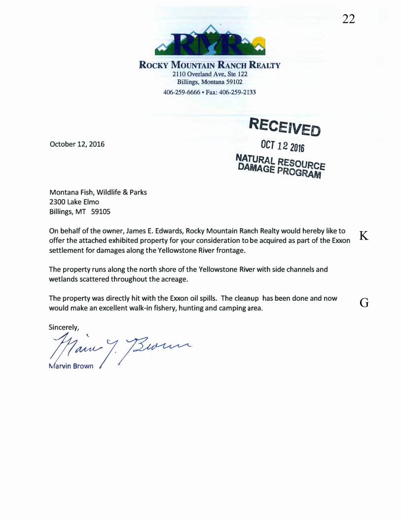
ROCKY MOUNTAIN RANCH REALTY 2110 Overland Ave, Ste 122
October 12, 2016
Montana Fish, Wildlife & Parks
2300 Lake Elmo
Billings, MT 59105
Billings, Montana 59102
406-259-6666 • Fax: 406-259-2133
REce,veoOCT 12 2016
NATURA.LR DAMAGI: p��g:�e
On behalf of the owner, James E. Edwards, Rocky Mountain Ranch Realty would hereby like to
offer the attached exhibited property for your consideration to be acquired as part of the Exxon
settlement for damages along the Yellowstone River frontage.
The property runs along the north shore of the Yellowstone River with side channels and
wetlands scattered throughout the acreage.
The property was directly hit with the Exxon oil spills. The cleanup has been done and now
would make an excellent walk-in fishery, hunting and camping area.
Sincerely,
!Zf::7
22
K
G
cj4869
Line
cj4869
Line
cj4869
Line
cj4869
Line

'<l'3
11 ..- ~ i
ll __
JI
0027
191
0027
09 D
027
10
0128
67 .
--,
/.,
----
D02
717
ooi1
1-~
/.-~
;/·<1.
'<I" .,
,·
--
Jr
co
~ I
co
co I
I
~ _!
T
Lz~
-·
·
~
Cl
0::
0027
00
~ 3
. J
;..JUJ!
. 1_ ~ _
ri=
. 00
2897
.,_
u
( -1
· ~
,.._.
I ,_
-
-~
11 ·u
r
r· .
-1 (
-, .. ,
, I
.z -
.. . S
i_
_t'.5~
1-L
1_,
TH
IEiJ
RD
''-·,
! -1 ;
; · F
~
0 .
CJ
. I
/ 0 "' (Q 0 0
zl ,,o
J:ib
. ...
I o<
::i"'
V,
-I i==
_
0029
03!:
:
D02
90~
_1 _
~ ~
-·__i
~I
81
0029
09
-: D
0291
1
'1 .
-1'-
---
--L
-Do
· -.
;,?sn
-. ·
lhl1
doe
umen
l Is
Inte
nd
ed fo
r lnf
an
n~
lon
al
purp
oses
on
lyan
dls
notg
uara
n1oe
d D
0291
2 to
be
accu
rate
or c
urre
nt.
Dat
e: 1
0n12
01e
YE
LLO
WS
TON
E C
OU
NTY
GIS
'o
'° ~
I .,,
0 Cl)
,-
. T
""
N
°' I
°' 0
N
N
0 0
0
1-°-l
~~
I · X
0004
8
I -
I ! I I
·-
D02
700
0027
01
X00
048
D02
921
\ \ \
--1
0 0:: zl
00
26
92
8
UJ
...I
.
~l --~ -
--
__
J <
( ::lE
U) I I
', ..
/'1·'.
_...,.~
.,/
/ ]
.. (e~
w
Cve
efl
/ --
D02
689
__ ,,, ..
. ,'
/ /
D02
928
/ ( (
/ /
I i _
_ __I
/
/
Dfi>
y Cf?
/:'
'~I(
0
0293
1 0 0.
05
0.1
Mile
s
,/
0.2
Eel
v-> ~
a .s
f l
fC,f
, t~
k.
uY
)/e/e

J 22 23,
___ !.
~J


23
C
cj4869
Line
cj4869
Line


24
K
cj4869
Line
cj4869
Line


25
Q
G
cj4869
Line
cj4869
Line


26
G
cj4869
Line
cj4869
Line


27
G


28
T A
cj4869
Line
cj4869
Line

TRANSCRIPT OF PUBLIC COMMENT
MONTANA DEPARTMENT OF ENVIRONMENTAL QUALITY
ExxonMobil Pipeline Company July 1, 2011
Yellowstone River Oil Spill Restoration Plan
Page 1
Pursuant to Notice, a hearing for public comment
on the ExxonMobil Pipeline July 1, 2011 Yellowstone
River Oil Spill Plan, was held on October 12, 2016 at
the 2300 Lake Elmo Driver, Fish Wildlife and Parks
Region 5 Office. Billings, Montana, starting at
6:00 p.m.
APPEARANCES:
DOUGLAS H. MARTIN Environmental Impact Specialist Natural Resource Damage Program Montana Department of Justice 1301 East Lockey Helena, Montana 59620-1425
Also Present:
ALICIA STICKNEY Environmental Scientist Specialist Natural Resource Damage Program Montana Department of Justice 1301 East Lockey Helena, Montana 59620-1425

P R O C E E D I N G S 1
2
3
4
5
6
PRESENTION GIVEN (not reported)
* * * * * * * * * *
7
8 PUBLIC COMMENTS:
9
Page 2
10 DARRYL WILSON: My name is Darryl Wilson.
11 D-A-R-R-Y-L; W-I-L-S-0-N.
12 And I wanted to say that I'm the president of
13 Yellowstone River Parks Association, and I would like
14 to my have name put on as a partner to be contacted in
15 regards to the Restoration Plan.
16 That's it.
17 MR. MIKE PENFOLD: Mike Penfold.
18 P-E-N-F-0-L-D.
19 And I do volunteer work with a group called
20 "Our Montana".
21 Generally we like the tone of the Restoration
22 Plan. We give you high marks for doing that.
23 Our Montana has been working on developing,
24 trying to encourage the development of a cooperative
25 rivering trail program for several years for the under
B
1
2
A
V
V
cj4869
Line
cj4869
Line
cj4869
Line
cj4869
Line

Page 3
1 700 miles of the Yellowstone River.
2 Projects that we are working on and would
3 like to partner with these various agencies -- I've got
4 a list of them just to touch upon a few.
5 One is, we have developed a website called
6 "exploretheyellowstoneriver.org", and it's the most
7 robust recreation data that exists for the 700 miles of
8 the Yellowstone River.
9 On that, it has all the fishing websites, all
10 the public access sites within communities.
11 It's got good areas where you can bird
12 watch. It's got all the pub'lic land that we've been
13 able to identify along the Yellowstone River.
14 It's got on it recreation providers who will
15 provide, and probably been damaged by the oil spill per
16 boat rentals and fishing -- fly fishing sites, and
17 museums and trails along communities and good bird
18 watching areas. Very robust.
19 But we really would like to partner
20 with somebody to turn that website into an app.
21 So, there's people who are on the river, or in the
22 Yellowstone River corridor with easy access to
23 everything on there.
24 So, when you go by a Clark site on
25 the Yellowstone, you can read what happened at the
G
cj4869
Line
cj4869
Line

Page 4
1 Clark's Camp because that information is on there.
2 So, that's the type of thing we'd like to partner
3 with.
4 Another one has to do with our research on
5 islands of th.e Yellowstone River. What we have
6 discovered is that there's a huge amount of unclaimed
7 islands, public islands owned by the State, some quite
8 often by the State that are not identified in terms of
9 ownership.
10 If we have a 700-mile-long recreation trail
11 people need to know where public land is where they can
12 legally stop. ,
13 These islands are really important for
14 outdoor recreation, hunting, places to fish. They're
15 good for catching woody debris. They have good
16 environmental resources except for weeds, which is
17 another project that we would like to cooperate on.
18 We think that the conservation groups in the
19 area would be really good partners with the various
20 agencies - DNRC, BLM, communities to at least do a
21 fleet bill spread in some of these areas that are so
22 concentrated with spotted knapweed we think that would
23 be a good partnership to sponsor.
24 Another idea in the material that I'm going
25 to give you, one, just to touch on that is there's a
N
G
M
cj4869
Line
cj4869
Line
cj4869
Line
cj4869
Line
Page 5
1 good research entity in Rocky Mountain College.
2 They're doing very good work on various projects that
3 affect the Yellowstone River.
4 Their problem is that they're undergraduate
5 work and they short, year-end projects. And they need
6 to have multi-year projects and some kind of a fund to
7 stretch over several years to do these projects. So,
8 we would support that.
9 There is a fishing access site at South
10 Billings Boulevard. The Department has tried to get
11 that developed. It's an excellent site. We'd like to
12 see them try that again.
13
14
15
16
17
much.
for us?
So, those are a few things. Thank you very
MS. STICKNEY: And you have written comments
MR. PENFOLD: And I even wrote it down.
18 MS. STICKNEY: Thank you very much.
19 MS. ALEXIS BONOGOFSKY: Hi. I am Alexis
20 Bonogofsky. I am a landowner along the Yellowstone
21 River that was impacted by the oil spill.
22 First of all, I'm disappointed by the
23 amount.
24 In 2011, Exxon made $5 million profit every
25 hour. So, to have $12 million be the amount of the
O
G
T
M
V3
cj4869
Line
cj4869
Line
cj4869
Line
cj4869
Line
cj4869
Line

Page 6
1 restoration -- and like you said, it's probably not the
2 actual damages of the river, but it is what Exxon is
3 willing to pay.
4 And I'm frustrated that we allow this to
5 happen continually. This is just sort of the way we do
6 business now. If something happens to the environment,
7 the company then negotiates a settlement instead of
8 looking at the.actual damages and what it would cost to
9 restore the river. We take what we can get.
10 So, I'm frustrated by the amount.
11 I think there's a lpt of good projects in
12 here, but I think that you are trying to do too much
13 with too little. So, what I would like to see is a
14 prioritization on what you think would benefit the
15 river the most.
16 And to me, that would be probably the channel
17 migration easements, and maybe even looking at some
18 baseline surveys. I saw the article in the "Gazette"
19 where Bob Gibson talked about, you know, there was not
20 really good baseline data.
21 So, how do we know what we are restoring the
22 river to if we don't have good ba~eline data?
23 What do we know about counting turtles? How
24 many amphibians? How many of those species that we
25 don't really think about very often because they're not
C
I
M
M
cj4869
Line
cj4869
Line
cj4869
Line

Page 7
1 as charismatic as trout and walleye.
2 So, what kind of information do we have on
3 the Yellowstone River prior to this oil spill, and do
4 we know what river we're trying to restore it back to,
5 or is this just sort of like, "Here's some good
6 projects that would benefit the river''? That language
7 that we use about "making the river whole again" kind
8 of rubs me wrong a little bit because I don't think we
9 actually know what that means statistically. So, I
10 would like to see a collection of robust data set for
11 the species along the river.
12 Looking back, Exxon spent $135 million on the
13 cleanup. They recovered less than 1% the oil.
14 If I had to do it all over again, I wouldn't
15 have let them on our property. Most of the damage from
16 the oil spill came from their cleanup.
17 We have 50 acres of wheat. We have a river
18 bottom that has weeds in it now that we've never had
19 before from their equipment. So, it was not a fun part
20 of our life.
21 Soi I would like to see the projects narrowed
22 down to something that's actually achievable and not
23 necessarily just a negotiation between agencies on who
24 gets what money.
25 There is a lot of work to be done on the
M
C
cj4869
Line
cj4869
Line
cj4869
Line

Page 8
1 Yellowstone. Anything focusing on channel migration
2 easements and baseline data would be really important.
3 We just saw with the Yellowstone River fish
4 kill out by Livingston that there wasn't real good
5 baseline data on the whitefish.
6 Before the Fish Wildlife & Parks was saying
7 that a lot of that survey work had maybe overestimated
8 fish population, so it would be really nice to know
9 what's in our river.
10 So, yeah, I appreciate you taking my
11 comments, and I'll be submitting more detailed written
12 comments in the future.
13 But, I know the likelihood of it changing
14 from 12 million is probably not possible, but I would
15 have liked to see a little bit more money for the
16 river.
17
18
MS. STICKNEY: Thank you for your comments.
If you want to leave those with us, or later?
19 MS. BONOGOFSKY: Oh, I'll submit them later.
20 MR. LEHENBAUER: I'm Steve Lehenbauer.
21 L-E-H-E-N-B-A-0-E-R.
22 I also have property right on the Yellowstone
23 River. I have fish property that's right at the Clark
24 Forks and Yellowstone where it comes together right
25 there.
IM
M
V4
cj4869
Line
cj4869
Line
cj4869
Line
cj4869
Line

1
2
3
4
5
6
7
8
9
10
11
12
13
14
15
16 .
17
18
19
20
21
22
23
24
25
Page 9
I would like to maybe partner with some soft
shore type restoration as a project.
So, I also know there is going to be a lot of
special interests groups. It sounds like there's two
or three in here right now wanting money for things
that may not even be connected with the actual damage
to landowners, like this gal here.
I would like to make sure that you guys try
to concentrate some of that money on people that were
really affected personally and not just hand it out to
special interest groups for a project that may not be
~- yon know, that was not affected directly by the
spill.
So, just, yeah, I would like to be.contacted
about maybe a project or something.
MR. RICHARD HERR: My name is Richard Herr.
I am a Councilman at Laurel, Laurel City.
And I really have studied. I don't know how
many of you have read this book, but I have read it
three times. · ·,
I don't agree with it all. There are lots of
things that are going on, and they will all work out
good for you, I'm sure.
I don't want to be saying ''Laurel needs all
this money", because they don't. There is a park down
V5
L
cj4869
Line
cj4869
Line
cj4869
Line

Page 10
1 there that was damaged. There's soft bank. There's
2 woody debris that you talk about.
3 I've lived in Laurel since 1975. If you
4 go out to the river in May and June, there is wood
5 floating down that river, a tremendous amount. And
6 huge cottonwoods, they're coming from upriver.
7 Why do we have to spend money upriver that's
8 already coming. We need to help you with your work.
9 We need damage control, yes, I agree.
10 Laurel has some things it needs we'd like
11 some money for. We're going the fight Billings. And
12 you know who wins? The big city. I mean, we will do
13 what we can.
14 I appreciate the work that's been done.
15 Fish and Game is here.
16 I have a question about this. The white
17 pelicans, what are the white pelicans doing on Tongue
18 River, on the Tongue River Reservoir? Are they
19 breeding down there? They are not being included.
20 Just the pelicans up north. They are not on the
21 ·. Yellowstone. We need our monies to go to the
22 Yellowstone.
23 Now, 400,000 to the pelicans is fine. That's
24 a small amount of money. But, is there enough money
25 here already?
Q
C
F
cj4869
Line
cj4869
Line
cj4869
Line
cj4869
Line

Page 11 '
1 Those birds up at Malta, and over at
2 Culbertson area, four years ago, they didn't supply
3 maybe.
4 But in the past years, they's hundreds of
5 pelicans on the river. Where are they coming from?
6 Maybe from up there, they're getting bred,
7 but does that mean that fox are eating those, all those
8 little ones? Because we're gaining some. We're
9 getting back to normal.
10 We are doing a water project over in Laurel.
11 It associated with, but not with this project.
12 The river right now, if they did not riprap
13 with large rock on the south side of the Laurel bridge,
14 that whole park that we have down there would be
15 inundated.
16 Two years ago, it took out about 30% -- or a
17 percentage of the dyke that we have. We had to get
18 back and re-riprap higher.
19 The Corps of Engineers allowed us. We had to
20 go back in for more permission.
21 We did it. We saved the bank.
22 But they already planted -- and I think we
23 talked earlier -- several hundred trees, soft bank.
24 And a lot of them went down the river before they could
25 save them.
cj4869
Line

Page 12
1 We have re-planted, but it's an extra cost.
2 It more cost to the City. We've done it.
3 I just appreciate what you have done.
4 Thank you.
5
6
MS. STICKNEY: Other comments?
ERIC WOLFF: My name is Eric Wolff.
7 I'd like to see some of this money be used
8 for Yellowstone Billings and downstream.
9 Montana's famous for taking care of all the
10 trout areas o{ the river. And there's a lot in here
11 that's Laurel to Billings, and really nothing
12 downstream of Billings. A lot of this river below
13 Billings was affected.
14 So, you know, I fish the Yellowstone a lot,
15 all below Billings, since 2005. The three years after
16 the oil spill were the worst three years I've ever
17 seen. Just unreal how bad it was.
18 And I fish with guys that are extremely good
19 fishermen, and none of us could find any fish. A lot
20 of little fish. It was reJlly bad. It's finally
21 starting to get back a little bit.
22 .So, my comments are really based on just a
23 couple of area.
24 Fish passages. We only have one on the
25 Yellowstone that works around our diversion dams. All
J
C
F
V6
cj4869
Line
cj4869
Line
cj4869
Line
cj4869
Line

Page 13
1 the big diversion darns, there's only one that works.
2 So, before we fix any passages on the
3 tributaries, the fish that are stuck between those
4 diversion darns, they can't move anywhere. They can't
5 get to those tributaries alone. So, I'd like to maybe
6 see some of that money go to fixing the passages on the
7 diversion darns that we have.
8 And then the other area is just access. They
9 take .really good care of all our accesses upstream of
10 Billings. Nothing ever goes to our accesses downstream
11 of Billings.
12 They have in here for a motorized access at
13 Riverfront. You got one like two miles up the river at
14 Duck Creek. You've got one another two, three miles
15 down at Coulson. Those are both motorized. Why do we
16 need another right there?
17
18 Darn.
We have nothing below the Huntley Diversion
So, if you do have another spill, how do you get
19 access for the Diversion Darn? It has to be all through
20 private land.
21 You have your few at Road 18, but those don't
22 work in low water conditions. 27th Street doesn't work
23 in low water conditions.
24 So, you know what, an access, a motorized
25 access below the Huntley Diversion Darn might be money
C
G
cj4869
Line
cj4869
Line

Page 14
1 better spent than putting another one in an area that
2 already has plenty of them.
3 Nonmotorized can still get in and out right
4 there, but motorized, they're going to go more than two
5 miles. They can run the extra two miles to another
6 access.
7 Then I guess I just really have a hard time
8 with Lake Josephine and Laurel Pond. They weren't
9 really affected. You know, the City of Billings, the
10 park stuff, we didn't lose any use of the properties.
11 We lost the use of the river. We lost the use of our
12 landings. We had really poor fishing for years.
13 I mean, you lost decades of fish in that
14 spill, and it would be nice if yon saw more of that
15 money used towards fixing things.
16 I mean, our diversion dams are horrible on
17 that river, really. If they did one thing to the
18 river, they should fix the diversion dams.
19 I saw the Corps show up one day with a whole
20 bunch of fancy jet boats. They said they were to going
21 run to Forsyth. I said, you guys are going .to make it
22
23
24
about six miles when you hit the diversion dam.
Oh, no, we can go around th.ere.
None of them worked. They only work on a
25 really high water year.
F
cj4869
Line
cj4869
Line
cj4869
Line

1
Page 15
Well, the fish can't get up. They're stuck.
2 It's amazing that we have as good of fishing
3 as we do.
4 So, that's all I got say. I'd like to see
5 more in fish passages and an access below Huntley.
6 So, thank you.
7
8
MS. STICKNEY: Are there any more comments?
And, of course, you don't have to speak
9 tonight. You can submit comments in writing until
10 October 31st. So, don't feel that you need to stand up
11 and speak if that's not your thing.
12 MS. WENDY WEAVER: Hello. My name is Wendy
13 Weaver, W-E-A-V-E-R.
14 I'm the Executive Director for Montana
15 Aquatic Resource Services. We are a nonprofit founded
16 in 2011 in response to the rapid loss of aquatic
17 resources in Montana.
18 So, one of the reasons we are here today is
19 our primary program that we have, which is tied
20 directly into the damage from the oil spill is our
21 Yellowstone Channel Migration Easement Program.
22 So the program is a unique type of
23 conservation easement where willing landowners sell in
24 perpetuity their rights to stabilize river banks. So,
25 riprap, no levees or any form of bank stabilization.
B
V7
Page 16
1 So, this program was started partly because
2 of the hard work of the YRCDC and the cumulative
3 effects analysis that was on the river, which is just
4 coming to an end, hopefully finalizing this year.
5 And one of their reconunendations from that
6 study was channel migration easements.
7 So, I guess what I would like to say about
8 the program is, we are positioned really well, along
9 with other partner agencies and other conservation
10 organizations to deliver projects. That addresses 8
11 out of 12 project types listed in the Restoration
12 Plan.
13 So the program places under protection the
14 channel migration zoned land along the Yellowstone. So
15 we currently closed on our first project outside of
16 Sidney in April. We are about to close on the next one
17 outside of Forsyth by the end of this year, and we have
18 a number of other projects, landowners working with
19 additional projects.
20 So, I would like to offer that and have you
21 consider, I believe it's one of the OPA's criteria for
22 addressing a number of issues. So, I feel like with
23 the protection of a channel migration zone, it address
24 woody debris, reconnects flood plain side channel
25 blockages and a number of other things.
I
B
cj4869
Line
cj4869
Line
cj4869
Line
cj4869
Line

1
2
3
Page 17
So, thank you.
Oh, one other question I had.
Have you guys talked about or discussed what
4 type of length you want the land protections to he? Is
5 that perpetuity, or have you had any discussion along
6 that line?
7 MS. STICKNEY: We can answer -- since we are
8 doing the hearing, you know, a court reporter now, we
9 will answer that in your comments.
10 So, just ask Fran.
11 MS. WEAVER: You got that?
12 THE REPORTER: Yes.
13 MS. STICKNEY: Are there any other
14 comments?
15 MR. BRIAN CORCORAN: My name is Brian
16 Corcoran, C-O-R-C-0-R-A-N.
17 At the conclusion of the life-year project,
18 or proposed, I-would like to know how much money will
19 be allocated for the continuation of monitoring to the
20 riparian areas.and the aquatic species within the
21 river, and if that would be a projection of a set
22 amount of time, or until the funds run out, and see if
23 there would be any increased to what you folks already
24 do, or if that will just be for the duration of the
25 projects?
D
D
V8
cj4869
Line
cj4869
Line
cj4869
Line
cj4869
Line

1 MS. STICKNEY: We will answer that.
m
Page 18 I 2 Any other questions or comments?
3 I guess I would say that if you have not
4 spoken up tonight, please do .submit written comments to
5 us by October 31st, and we will do our best to address
6 your comments.
7 MR. MARTIN: And with that, I guess we will
8 the close the hearing. We will be around if anybody
9 has any questions.
10 (Whereupon, the public comments was concluded
11 at 7:15 p.m.)
12
13
14
15
16
17
18
19
20
21
22
23
24
25
I

1
2
REPORTER'S CERTIFICATE
Page 19
3 CASE TITLE: Yellowstone River Restoration Plan
4 HEARING DATE: October 12, 2016
5 LOCATION: Billings, Montana
6 I hereby certify that the proceedings and
7 evidence herein are contained fully and accurately on
8 the stenographic notes reported by me at the hearing in
· 9 the above matter, and that this is a true and correct
10 transcript of the same.
11
12
13
14
15
16
17
18
19
20
21
22
23
24
DATE: October 18, 2016
Frances L. Mock Big Sky Reporting 2308 Interlachen Circle Billings, Montana 59105


Maps


P
P
PP
P
P
P
P
P
P
P
P
P
P
P
P
P
P
P
P
P
P
P
PP
P
P
P
k
IDAHO
WYOM
ING
MONT
ANA
MONT
ANA
NORT
H DA
KOTA
MONTANAWYOMING
SOUT
H DA
KOTA
WYOM
ING
WYOMINGUTAH
WYOM
ING
NEBR
ASKA
WYOMINGCOLORADO
NEBRASKACOLORADO
Yel l o
w s t o ne
R i v e r P ow d e r
Riv
er
B i g h or n
R i ve r
Yellow
stone
Riv er
Clarks F
orkYel
lowsto
ne Rive
r T o ngu
eR i v e r
BowdoinNational
Wildlife Refuge
MedicineLake National
Wildlife Refuge
SHERIDAN
GLACIER
DANIELS
VALLEY
TOOLE
PHILLIPSLIBERTY
BLAINE
HILL
ROOSEVELTPONDERA
CHOUTEAU RICHLAND
MCCONE
GARFIELD DAWSONFERGUS
PETROLEUMWIBAUXJUDITH
BASINPRAIRIE
MEAGHER
CUSTER
ROSEBUDBROADWATERFALLON
MUSSELSHELLWHEATLANDGOLDENVALLEY
YELLOWSTONE
TREASURE
CARTER
SWEETGRASS
GALLATIN
PARKSTILLWATER
BIG HORNPOWDERRIVER
CARBON
CASCADE
MADISON
JEFFERSON
TETON
LEWIS& CLARK
Tongu e River
Pow
der R
iver
S hoshone River
Wind Ri v er
YellowstoneNational Park
Baker
Basin
Big Timber
Broadus
BuffaloCody
Columbus
Forsyth
Glendive
Hardin
Hysham
Lander
Livingston
Miles City
Red Lodge
Sheridan
Sidney
Terry
Thermopolis
Worland
Billings
OilSpillSite
Map 1-1 Yellowstone River Basin
Bighorn MountainsOwl Creek Mountains
Wind River Range
Absaroka Range
BeartoothMountains
Map by Montana State Library- 2016: 16DOJ0001k
July 1, 2011 spillExxonMobilPipeline Company¹0 10050
Miles

P
P
P
P
P
P
P
P
P
k
YELL
OWST
ONE
STILL
WATE
R
BIG H
ORN
CARB
ON
Pryor CreekPryorCreek
PryorCre
ek
Stillw
aterR
iver
Clar
ksForkYellowstoneRiver
FlyCre
ek
Fly Creek Bighor
nRiver
BighornRiver
Yellow
stone
River
Yellow
sto
neRiver
Park
City
Billin
gs
£ ¤212
£ ¤87
§̈ ¦94
§̈ ¦90
§̈ ¦90
§̈ ¦90
Big La
ke
Coon
eyRe
servo
ir
Bigho
rn La
ke
Colum
bus
Hard
inLa
urel
Reed
Point
Pomp
eys
Pillar
Custe
r
Hunt
ley
Oil S
pill
Map 1
-2 Ju
ly 1,
2011
Oil S
pill In
jured
Area
Pryo
rMo
untai
ns
kJu
ly 1,
2011
spill
Exxo
nMob
ilPip
eline
Com
pany
Oil S
pill In
jured
Area
Yello
wston
e Rive
r
Divisi
on Bo
unda
ry
PCit
y/Tow
n
Inters
tate
US H
ighwa
y
Monta
na H
ighwa
y
River
Coun
ty
010
205
Miles
¹Ma
p Prod
uced
by M
ontan
a Stat
e Libr
ary - M
ay 20
16: 1
7DOJ
0002
Divis
ion ADi
vision B
Divis
ion C

P
P
P
P
k
YELLOWSTONE
STILLWATER
BIG HORNCARBON
Big LakeWMA
Billings
Laurel
Park City
Huntley
Oil Spill
Pryor Creek
YellowstoneRiver
Clarks
ForkYe
llowsto
neRiv
er
kJuly 1, 2011 spillExxonMobilPipeline Company
P City/TownOil Spill Injured AreaYellowstone RiverRivers
Interstate
US HighwayMontanaHighwayMFWP WildlifeManagement AreaCounty
US ForestServiceUS Bureau of LandManagementUS Fish andWildlife ServiceUS Bureau ofReclamationMontanaState LandsLocalGovernment
Map 2-1 Clarks Fork Yellowstone River and Pryor Creek
Clarks
Fork
Yel lo
wston
eRive
r
0 5.5 112.75Miles ¹Map by Montana State Library - May 2016: 16DOJ0004

k
BigHornRiver
Clark
s For
kYe
llows
tone R
iver
PryorCreek
Yellowstone River
Fly
Creek
Ka ise rCree k
Yellowsto
neRiver
£ ¤310
£ ¤87
" )3
§̈ ¦94
§̈ ¦90§̈ ¦90MU
SSEL
SHEL
L
YELL
OWST
ONE
BIG
HORN
Yello
wston
eWM
A
Sund
ance
Lodg
eRe
creati
onAr
ea
Pomp
eys P
illar
Custe
r
Voya
gers
Rest
Gritty
Ston
e
Gene
ralCu
ster
Two L
eggin
sGran
t Mars
h
Manu
elLis
a
Bund
y Brid
ge
East
Bridg
e
Capta
in Cla
rk
South
Hills
Duck
Cree
kBr
idge
Arap
ooish
Oil
Spill
Hardi
nLa
urel
Custe
r
Huntl
ey
Billin
gs
Map 2
-2 Pu
blic L
ands
kJu
ly 1,
2011
spill
Exxo
nMob
ilPip
eline
Com
pany
Oil S
pill In
jured
Area
Yello
wston
e Rive
rFis
hing
Acce
ss S
ite
Inters
tate
US H
ighwa
y
Rivers
MFWP
Wild
lifeMa
nage
ment
Area
Coun
tyUS
Burea
u of L
and
Mana
geme
ntUS
Fish
and
Wildl
ife S
ervice
US Bu
reau o
fRe
clama
tion
Monta
na S
tate
Land
sLo
cal
Gove
rnmen
t
010
205
Miles
¹Ma
p Pro
duce
d by M
ontan
a Stat
e Libr
ary - M
ay 20
16: 1
7DOJ
0003

k
XX
X
X
X
Laur
el
Billin
gs
£ ¤310
£ ¤87
£ ¤212
" )3
§̈ ¦90
Buffa
loMi
rage
East
Bridg
e
South
Hills
Duck
Cree
kBr
idge
Wes
tW
ets
Cre e
k
Pry
orCreek
Li n e Cr e e k
East B
uckeye
Creek
D a v i s C re e k
Wes
tBuc
key e
Cree
kE a s t
For k
D uck
C r eek
Cove
C re ek
D ry
Cr e
e k
Little
BasinCre
ek
DirtCr
eek
New
man C r ee k
Dry
Creek
BasinCreek
LittleCo
v eC re e k
D ry
Cre e k
DuckCreek
A lk ali Cre e
k
B i
t t e r C r ee k
BlueCre
ek
Can
y on
Cre ek
Ye
llowstone
Rive
r
Yellow
ston
e
River
Oil S
pill
Rive
rfron
tPa
rkNo
rm's
Islan
d
Couls
en Pa
rk
Rive
rside
Park
Sund
ance
Lodg
eRe
creati
on A
rea
kJu
ly 1,
2011
spill
Exxo
nMob
ilPip
eline
Com
pany
Oil S
pill In
jured
Area
Yello
wston
e Rive
r
XPa
rksRe
creati
on Ar
eaFis
hing
Acce
ss Si
te
Area
Park
sUS
Burea
u of L
and
Mana
geme
ntMo
ntana
State
Land
Loca
lGo
vernm
ent
04
82
Miles
¹Ma
p Pro
duce
d by M
ontan
a Stat
e Libr
ary - M
ay 20
16: 1
7DOJ
0005
ClarksForkYe
llowsto
neRiver
Map 4
-1 Pa
rks an
d Rec
reatio
n Area
s Betw
een L
aurel
and B
illings
Laur
elPo
nd
Lake
Jose
phine